Get Zoning Data
On-Demand with
our APIs

The most comprehensive coverage of zoning, permitted land use, and controls data available for integration via our Zoning API.

Sign Up
zoning-reports-2
line divider
APIs Trusted byIndustry Leaders

We are helping 1000s of end-users in key global markets solve their zoning data workflows.

OurData Attributes
Our APIs give access to key data attributes that can enrich and empower your applications through integration.
Zoning Data
Information about the zoning classification and characteristics of an address, such as the zoning code, district, and type. 
Permitted Land Uses
The types of development and activities allowed at an address according to the zoning classification.
Building Controls
The specific requirements and standards for building design and construction that apply to an address according to the zoning classification.
Overlays
A district that imposes additional regulations on top of another existing zoning district.
Parking
Details about Parking at a property including the minimum and maximum parking spaces, restrictions, parking lot dimensions, and permitted uses.
Parcels
This data includes Parcel boundaries, Ownership details and Parcel Identification Numbers.
Explore API Products with Sandbox
Use API Sandbox to try out our APIs directly from the browser. This helps developers test out API calls and learn how they fit together.
v2/zoneDetail

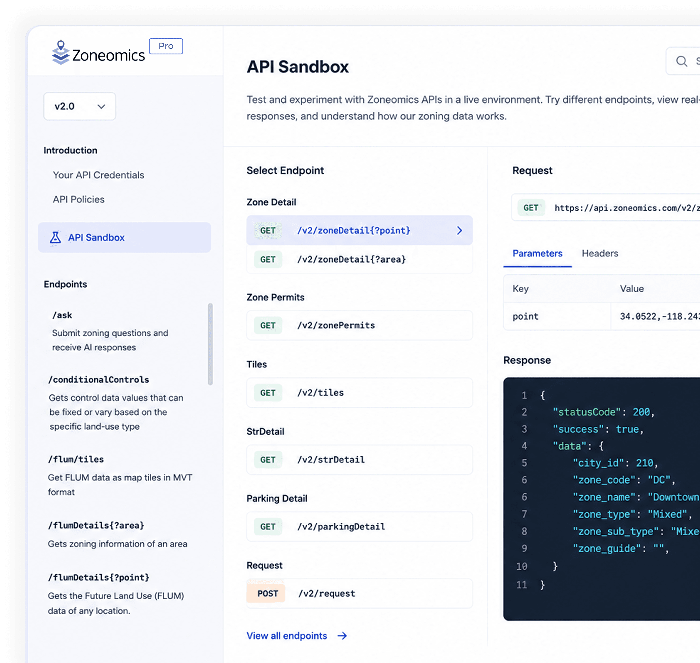
Gets zoning information of a specific location

zoneDetail API lets you access the zoning data of any location in the USA and Canada. You can search for zoning data using the Point and Polygon spatial elements.

Provide values for either of the parameter groups listed below. output_fields can be provided with each group.
Note: In the Sandbox, the APIs will return zoning data only from a limited area, so please ensure that the coordinates you pass in the API requests fall within the boundaries of Redondo Beach, LA County, USA.

output_fields

This parameter is optional and can have any of these values: zoning, plu, plu-tags, controls, gde-controls, parcels

string

address

A valid address of the zone, for example, 109 Paseo De La Playa, Redondo Beach, CA 90277, USA.

string

lat

Latitude of the zone, for example lat= 33.8158919

number

lng

Longitude of the zone, for example lng= -118.3888138

number

group_plu

This parameter is optional and can have any of the mentioned values: True/False

string
https://sanbox-api.zoneomics.com/v2/zoneDetail
OurAPI Products
Zoneomics offers a  (growing) variety of Zoning Data API products to suit every unique need and budget:
Zoning Map Tiling Service
Add engaging Zoning Map overlays to your applications and systems with the Tiling Service, with 100,000 free API calls.
Starter
An ideal package for users to start with all kinds of zoning details for an address of over an entire Zip code.
Pro
A package most suitable for mid-sized organizations looking to provide details zoning data attributes and insight to their clients.
Growth
A perfect package for growing organizations seeking details national zoning coverage.
Seeking an Enterprise API Plan?
If you need some guidance on your API implementation with Zoneomics, consult with our team to get guidance.

First Name *

Last Name *

Email *

Job Title *

Phone *

How did you hear about Zoneomics? *

Message *

Kindly fill this Captcha

How Sidewalk Labs by Google powers their operations with Zoneomics’ Zoning Data APIs

Sidewalk Labs is an urban planning and infrastructure subsidiary of Google. The company offers technology tools to help commercial buildings make their energy-use more efficient, developers and urban designers to discover optimal design choices for neighborhood projects, as well as tools to help manage parking in cities.

In order to accurately offer its users with an understanding of Permitted Land Uses and Development Standards, the organization needed access to crucial zoning data.

The solution: Integration with Zoneomics’ API to get instant, detailed and accurate zoning guidelines and development standards for properties at scale, easily pulled into their systems and tools, and utilized for insight and visualizations via their portfolio of platforms. This allows Google to model development designs that comply with zoning restrictions.

FAQS

Most common questions

Who we are, how we work and how we can help you - You will find your most important questions here.