
Acton Township Meeker County
City Zoning Code
City Zoning Code
ARTICLE 22
- PERFORMANCE STANDARDS
Sec. 22.01.- Purpose.
The performance standards established in this section are designed to encourage high standards of development while protecting the public health of county residents, protect the quality and quantity of water resources, conserving the natural and scenic beauty of the county and minimizing environmental pollution. The standards are designed to prevent and eliminate those conditions, which cause blight and provide assurance that neighboring land uses will be compatible. All future development in all districts shall be required to meet these standards and the standards shall also apply to existing development where so stated.
Before any land use permit is approved, the zoning administrator shall determine whether the proposed use will conform to the applicable performance standards. The developer and/or landowner shall supply all data deemed necessary to demonstrate such conformance. The county board of commissioners shall be responsible for enforcing the standards.
Sec. 22.02. - Access, access drives and driveways.
A.
Building access.
1.
Every building erected, moved or structurally altered shall be on a lot or parcel having direct physical access for emergency vehicles along the frontage of the lot or parcel from an existing dedicated public roadway or an existing private roadway approved by the county board or township board.
B.
Access drives.
1.
Access drives/driveways onto any public road shall require a review and approval and/or a permit by the road authority. Access drives/driveways onto county roads shall require a review by the county engineer. The county engineer shall determine the appropriate location, size and design of such access drive and may limit the number access drives in the interest of public safety and efficient traffic flow. Access drives/driveways onto township roads shall be approved by the appropriate township board. Access drives/driveways onto state highways shall be reviewed and approved by the state district highway engineer. It is the responsibility of the property owner to obtain said approval from the proper road authority and provide documentation to Meeker County Planning and Zoning prior to being issued a permit in which a new access/driveway is necessary.
Sec. 22.03. - Accessory buildings and uses.
Accessory buildings and uses customarily incidental to that of the main building may be erected or established upon a lot or tract of land, provided they comply with the following regulations:
A.
All districts.
1.
Two accessory buildings may be constructed or developed on a lot prior to construction of the dwelling.
2.
No accessory building shall be used for dwelling purposes except by interim use permit during construction of the principal dwelling.
3.
In case an accessory building is attached to the principal building, it shall be made structurally a part of the principal building and shall comply in all respects with the requirements of this ordinance as applicable to the principal building.
4.
All accessory buildings shall be sited on the same lot or tract.
5.
A detached accessory building shall not be located in any required front or side yard except as provided otherwise by this ordinance.
6.
An accessory building shall not be closer than five feet to the principal building.
7.
A detached accessory building on a corner lot shall not project beyond the front yard setback requirement of the principal building.
8.
A mobile/manufactured home or any parts of them, a semi-trailer or any parts of them, and/or a recreational vehicle or any parts of them shall not be used as an accessory building or to construct an accessory building. Up to two shipping containers under nine feet six inches in height and under 380 square feet in area may be allowed on an A-1 Agricultural Preservation District property provided they are set back from the centerline of roads 150 feet and setback from property lines 100 feet.
9.
One detached storage building may be constructed and/or moved onto the site without a permit, provided it does not exceed ten feet in height, and has 200 square feet or less of floor area. This detached storage building may be as close as five feet from the side lot line but must meet all the other required setbacks, including front yard, rear yard, ordinary high water line, bluff, wetland, etc., as stated in the Meeker County Zoning Ordinance.
B.
Residential and shoreland districts.
1.
No accessory building shall be located in the minimum side or rear lot line setbacks in said district.
2.
Detached accessory buildings shall not:
a.
Exceed 20 feet in height.
b.
Occupy more than 30 percent of the area of any rear yard.
c.
Be used as a dwelling, except by interim use.
3.
No private garage, storage, or accessory building shall:
a.
No detached private garage, storage, or accessory building shall exceed the following total combined maximum square footage for the permitted two accessory buildings. The total square footage area of all floors with a ceiling height of seven feet or more shall not exceed the maximum square footage as stated herein.
1.
The above-listed maximum size accessory buildings denote the total combined allowed square footage for the permitted two detached accessory buildings allowed on a site. The maximum allowed square footage is subject to all setbacks, impervious surface coverage standards and all building standards set forth in the Meeker County Zoning Ordinance of 1992.
2.
In addition to the two permitted accessory buildings detached from the principal dwelling unit, each parcel may have one storage building that is 200 square feet or less in total area and shall meet the requirements as stated in section 22.03.A.9 of this ordinance.
3.
Contain an access door or other opening exceeding 14 feet in height.
4.
Accessory structures located on lake or stream frontage lots may be located between the public road and the principal structure provided it is clearly demonstrated that physical conditions require such a location.
5.
Farm storage bins or farm equipment storage building adjacent to a farm building site shall be exempt from section 22.03.B, provided said structure is located at least 300 feet from the ordinary high water level of all public water basins.
6.
Commercially zoned property in a shoreland district shall be exempt from section 22.03.B, provided said structure is located at least 300 feet from the ordinary high water level of all water basins.
C.
Commercial and industrial districts.
1.
Accessory buildings and uses may occupy any of the lot area which the principal building is permitted to occupy.
2.
No accessory building shall exceed the height of the principal building except by conditional use permit.
3.
Accessory buildings such as buildings for parking attendants, guard shelters, gate houses and transformer buildings may be located in front or side yards setbacks in the I-1 district.
Sec. 22.03.1. - Airport.
The Meeker County Board of Commissioners considers it necessary for the purpose of promoting public health, safety, order, convenience, and general welfare by protecting the lives and property of users of the Litchfield Municipal Airport and of owners and occupants of land in its vicinity to adopt airport zoning regulations as authorized by Minnesota Laws 1953, sections 360.061 through 360.074 inclusive.
A.
Definitions. As used in this chapter, unless the context otherwise requires:
1.
Airport. Litchfield Municipal Airport.
2.
Airport hazard. Any structure or tree or use of land which obstructs the airspace required for the flight of aircraft in landing or taking off at the airport or is otherwise hazardous to such landing or taking off of aircraft.
3.
Nonconforming use. Any structure, tree, or use of land which does not conform to a regulation prescribed in this chapter or an amendment thereto, as of the effective date or such regulation.
4.
Structure. Any object constructed or installed by man, including but without limitation, buildings, towers, smokestacks, and over-head transmission lines.
5.
Tree. Any object of natural growth.
6.
Airport turning zones. Comprise all land under the horizontal and conical surfaces not within an approach or transition zone.
7.
Airport transition zones. Comprise all land under the transitional surfaces.
8.
The airport reference point. A point selected and marked at the approximate center of the airport landing area as shown and described on the map of zones.
9.
Datum plane. The horizontal plane or surface, which includes the surface point of airport elevation established to be and at 1,116 feet above mean sea level.
B.
Zones; description of surfaces and airspace. An airport approach area is established at both ends of the strip.
1.
Approach surfaces: The approach surface is an inclined plane located directly above the approach area. The dimensions of the approach area are measured horizontally.
a.
Length: Such area has a length of 10,000 feet beginning 200 feet outward from the end of each strip and extending outward, ending at a point 10,200 feet from the end of the strip on the extended center line of the strip.
b.
Width: The approach area has a total width at the end adjacent to each strip, and the approach end respectively as follows: 250 feet and 2,250 feet.
c.
Slope: The slope of the approach surface beginning at a point 200 feet from the end of each strip extended is 20:1 until a height of 150 feet is reached; then horizontally until the conical surface is intersected; at this point resuming a 20:1 slope for the remainder of the 10,000-foot section.
2.
Horizontal surface: The horizontal surface is a plane, circular in shape with its height 150 feet above the datum plane and having a radius from the airport reference point of 5,000. (See Map A)
3.
Conical surface: The conical surface extends upward and outward from the periphery of the horizontal surface with a slope of 20:1 measured in a vertical plane passing through the airport reference points. Measuring radially outward, from the outer limits of the horizontal surface, the conical surface extends for a horizontal distance of three 3,000 feet. (See Map B)
4.
Transition zone: A transition zone is hereby established which shall consist of the area described as follows:
a.
Beginning with a line running parallel to, at the same elevation as, 150 feet from the center line of each strip, and from such line extending upward at a slope of 7:1 until a height of 150 feet is reached.
b.
Beginning at the edge of the approach zone to the strip and extending upward from the top of such approach zone at a slope of 7:1 until a height of 150 feet is reached.
C.
Height limits. Except as otherwise provided in this ordinance and except as required, necessary and incidental to airport operations or recommended by or in accordance with the rules of the Civil Aeronautics Authority, no structure shall be constructed, altered, or maintained, and no tree shall be allowed to grow so as to project above the landing area or any of the airport's reference imaginary surfaces described above.
D.
Use restrictions. Notwithstanding the provisions of section 22.03.1.C hereof, no use may be made of land in an airport approach or turning zone in such a manner as to create electrical interference with radio communication between the airport and aircraft, make it difficult for pilots to distinguish between airport lights and others, result in glare in the eyes of pilots using the airport, impair visibility in the vicinity of the airport, or otherwise endanger the landing, taking off or maneuvering of aircraft.
E.
Nonconforming uses. The regulations prescribed in section 22.03.1.C and 22.03.1.D hereof shall not be construed to require the removal, lowering, or other change or alteration of any nonconforming use, or otherwise interfere with the continuance of any nonconforming use, except as otherwise provided in section 22.03.1.G.2 hereof.
F.
Variances. Any person desiring to erect or increase the height of any structure or permit the growth of any tree, or otherwise use his property not in accord with the regulations prescribed in this ordinance may apply to the Board of Adjustment for a variance from the regulation in question. Such variance shall be allowed where a literal application or enforcement of the regulations would result in practical difficulty or unnecessary hardship and the relief granted would not be contrary to the public interest but do substantial justice and be in accordance with the spirit of the regulations; provided, any variance may be allowed subject to any reasonable condition that the Board of Adjustment may deem necessary to effectuate the purposes of this ordinance.
G.
Permits.
1.
Future Uses: No material change shall be made in the use of land, no structure shall be erected, altered, or moved, and no tree shall be planted in any zone created in section 22.03.1.B hereof without a permit therefore. Application for such permit shall be made to the Zoning Administrator, and shall indicate the use for which the permit is desired with sufficient particularity to permit it to be determined whether such use would conform to the regulations herein prescribed. If such determination is in the affirmative, the Zoning Administrator shall issue the permit applied for.
2.
Nonconforming Uses: Before any nonconforming structure or tree may be replaced, substantially altered or repaired, rebuilt or replanted, a permit shall be secured authorizing such replacement, change or repair. No such permit shall be granted that would allow the structure or tree to be made higher or become a greater hazard to air navigation than it was when the applicable regulation was adopted; and whenever the Zoning Administrator determines that a nonconforming structure or tree has been abandoned or more than 80 percent torn down, physically deteriorated or decayed: 1) no permit shall be granted that would allow such a structure or tree to exceed the applicable height limit or otherwise deviate from the zoning regulations; and 2) whether application is made for a permit under this subsection or not, the Zoning Administrator may by appropriate action compel the owner of the nonconforming structure or tree, at his own expense, to lower, remove, reconstruct, or equip such object as may be necessary to conform to the regulations or, if the owner of the nonconforming structure or tree shall neglect to refuse to comply with such an order after ten days' notice thereof, the County may proceed to have the object so lowered, removed, reconstructed or equipped, and assess the cost and expense thereof upon the object or the land whereon it is or was located.
H.
Hazards, marking, lighting. Any permit granted under section 22.03.1.F and 22.03.1.G may, if such action is deemed advisable to effectuate the purposes of this ordinance and reasonable in the circumstances, be so conditioned as to require the owner of the structure or tree in question to obtain a permit from Meeker County, at its own expense to install, operate, and maintain thereon such markers and lights as may be necessary to indicate to flyers the presence of an airport hazard.
I.
Administration. It shall be the duty of Zoning Administrator to enforce this ordinance through appropriate channels. All applications for permits shall be made to the Zoning Administrator. Those applications which are by this ordinance to be decided by the appropriate Board shall be promptly considered and granted or denied
J.
Appeals and review. The Board of Adjustment shall have the exclusive power to hear and decide appeals where it is alleged that there is an error in any order, requirement, decision or determination made by any administrative office in the interpretation or enforcement of this ordinance. The Board of Adjustment does not hear an appeal for the conditional use or variance decision. An appeal made to the Board of Adjustment may be initiated by any person, firm or corporation aggrieved, or by any office, department, board or bureau of a town, municipality, county or state in accordance with Minnesota Statutes section 360.072.
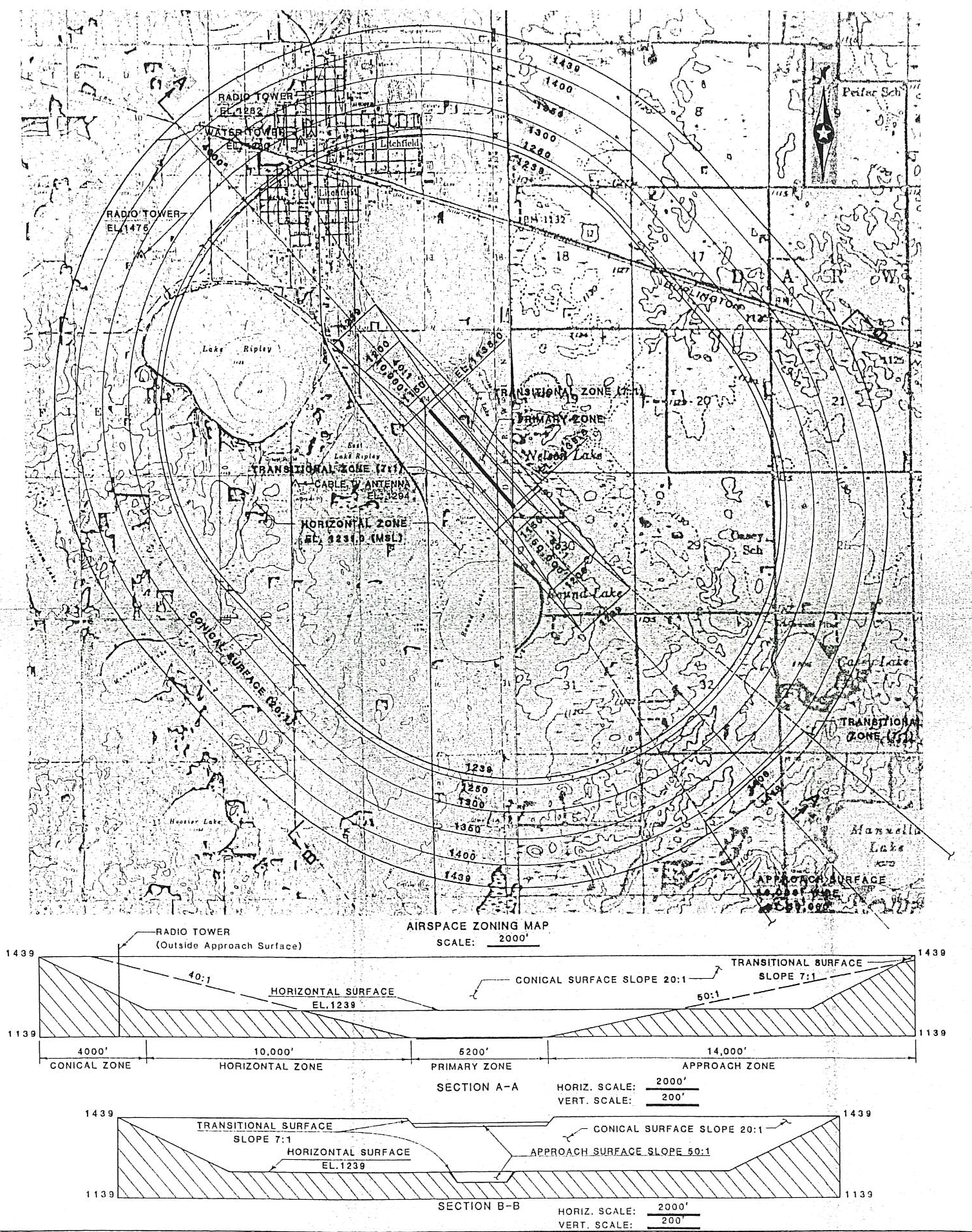
Map A
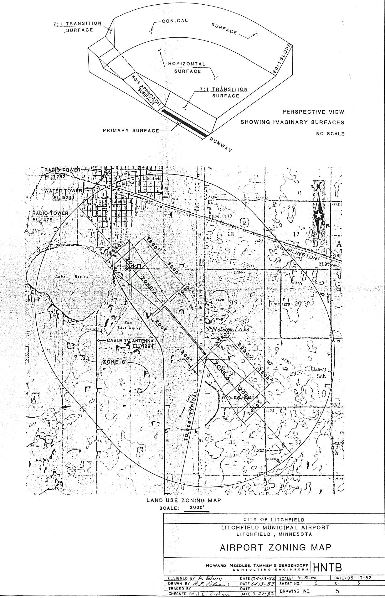
Map B
(Ord. of 6-2-2020)
Sec. 22.04. - Auto service stations.
The following standards shall be applicable to auto and truck service stations in all districts:
A.
A surface water drainage system, subject to approval by the county engineer, shall be constructed.
B.
The developed area site other than that taken up by a structure or planting, shall be surfaced with a dust-free material approved by the planning commission.
C.
Each service station shall have at least two driveways.
D.
No vehicles shall be parked on the premises other than those utilized by employees or awaiting service.
E.
Exterior storage besides vehicles shall be limited to service equipment and items offered for sale on pump islands.
F.
All areas utilized for the storage or disposal of trash, debris, discarded parts and similar items shall be fully screened.
G.
When adjacent to residential zoned property, there shall be a screening fence.
Sec. 22.05. - Building relocation.
An inspection by the Meeker County Building Official along with one zoning staff member and an approved building relocation permit from Meeker County Planning and Zoning shall be required for all permanent relocation of structures to be used as a dwelling which have been constructed more than five years previous, except new structures moved from the manufacturer's construction site. Any conditions deemed necessary by the Meeker County Building Official or Meeker County Zoning Administrator regarding the condition and placement of the structure shall be appropriate to be placed on that application as conditions of approval. An interim use permit shall be required for all temporary relocation of structures to be used as temporary dwellings. All persons shall obtain such permit before rising, holding up or moving any building to be used as a dwelling. An application for such a permit shall include the following:
A.
The origin and destination of the building to be moved.
B.
Photographs showing all sides of the building to be moved.
C.
Site plan of the lot on which the structure is to be relocated including proposed location of the structure, dimensions of the lot and the setback distances.
D.
Map indicating surrounding land uses and location of structures.
E.
The route over which it is to be moved and the time during which it shall be moved.
F.
Any such building or structure shall conform to all the provisions of this ordinance in the same manner as a new building or structure. If, at the discretion of the Meeker County Assessor or his/her designee, it is determined that the relocation of the building would substantially depreciate the value of the buildings or lots surrounding the lot upon which it is to be moved, then the permit shall be denied.
Sec. 22.06. - Disposal of petroleum-contaminated soils.
A.
Applicant shall comply with all requirements of the Minnesota Pollution Control Agency and shall have obtained their permit, subject to county approval, prior to any public hearing held in conjunction with the conditional use permit application.
B.
Applicant shall, along with a completed application, also submit to the zoning administrator at the time of application:
1.
A detailed site plan on a minimum scale of one inch to 100 feet and contoured at two-foot levels showing the proposed disposal site and the area surrounding same for a distance of 2,000 feet, which plan shall show, at a minimum:
a.
Specific location of all buildings and labeling same.
b.
Specific location of all surface waters including lakes, rivers, streams, ditches, ponds and wetlands as defined by the Minnesota Department of Natural Resources.
c.
Specific location of proposed disposal site.
d.
Detailed plans of the disposal site and locations of any dams, berms or other drainage controls.
e.
Current use of the property and brief description of general history of past use.
f.
Locations of all access points to underground water including wells and sandpoints, together with their depth.
g.
Locations of all borings and test sites.
2.
Baseline test data prior to the application for the following areas:
a.
All wells in the site plan area for levels of contaminants.
b.
If there are no wells in the site plan area less than 40 feet in depth, at least one sample shall be drawn from the disposal site at 40 feet.
c.
Soil borings on site at the rate of one for every five acres for groundwater levels and contaminants in the groundwater. Two tests shall be conducted prior to application, one in April and one in November.
(1)
Soil borings will also test soil types and contaminants, including topsoil depth and types.
d.
All testing done hereunder shall be performed by an independent laboratory or testing service certified by the Minnesota Pollution Control Agency (MPCA) and shall be conducted in accordance with MPCA rules and regulations regarding methodology.
e.
All test data and results shall be provided to the Meeker County Zoning Administrator along with the application.
3.
Copies of any MPCA permits or applications therefore in the possession of the applicant.
4.
A resume of the applicant and any related individuals or businesses reciting their financial viability, their past history of engaging in the business of disposal of hazardous or solid waste and an operational plan for the site. Included shall be a listing of prior MPCA permits received or denied.
C.
Minimum site characteristics. To be eligible for a conditional use permit, a proposed site for the disposal or treatment of petroleum-contaminated soil must meet the following minimum characteristics:
1.
The outermost boundaries must be located a minimum of 1,000 feet from any open body of water including lakes, rivers, streams, ditches, ponds or wetlands.
2.
The outermost boundaries must be located a minimum of 1,000 feet from any open tile, open well or sandpoint casing, or septic or drainage system.
3.
Said minimum outermost boundaries may be reduced by making specific application therefore to the members of the planning commission, and after specific recommendation by the planning commission as part of the conditional use permit herein.
4.
Minimum depth for groundwater at the site shall be six feet, or ten feet in sandy soils as the governing body requires.
5.
The site shall be diked or bermed in such a manner that there will be no surface runoff and/or run-on during heavy rains equal to a "25-year" rain.
D.
When applying petroleum-impacted soils to approved sites, the following minimum requirements shall apply to all conditional use permits granted hereunder:
1.
For each approved site, the maximum number of individual leak sites that may be treated is ten and the maximum amount of soil that may be deposited is 2,000 cubic yards.
2.
Once soil has been used for disposal of petroleum-contaminated soils, it may not be reused for the same purpose. Soil may be used to treat petroleum-contaminated soil only once.
3.
Application of the soils shall be at a maximum rate of two inches, unless lower levels are recommended by MPCA.
4.
All application sites shall be tilled at least every two weeks during the growing season through September 1, thereafter a cover crop shall be administered if possible to prevent wind erosion.
5.
Application and tilling may only occur between sunrise and sunset. No application may be performed during the remaining hours.
6.
Only petroleum-impacted soils may be treated. No industrial or other hazardous wastes may be disposed of or treated pursuant to this section.
7.
Contaminated soils must be applied as soon as possible after delivery to the disposal site. Stockpiling of contaminated soil will only be allowed when field conditions prevent spreading. All stockpiled soils must be set on and covered by at least six mil plastic. All tears must be repaired immediately.
8.
Stockpiling of contaminated soils is not permitted between November 1 and the following April 1.
9.
All plots where contaminated soil is placed must be mapped and a log kept of the test results of the contaminated soils, its origin and the amounts placed. A copy of said log and map shall be forwarded to the county zoning administrator within five working days of the application.
10.
All spreading shall be accomplished using methods approved by the planning commission and capable of providing uniform spreading at the required level.
11.
Upon completion of the treatment process, all rock four inches in diameter or greater, and all other foreign material shall be removed from the soil.
E.
Testing. Before, during and after application, representatives of the county may conduct whatever soil and water testing they deem proper. Said testing shall be conducted by persons selected by the county through its zoning administrator. Applicant shall reimburse the county for the cost of said testing; making payment within five days of demand either before, during or after testing is conducted. Failure to allow testing, or to pay for same upon demand, shall be cause for immediate suspension of the conditional use permit at the option of the zoning administrator. Thereafter, said permit may be revoked by the county in accordance with the conditions herein.
1.
Testing by the county under the provisions herein may continue until such time as the soil's original baseline levels have been achieved.
2.
Applicant shall notify county ten working days in advance of the date and time contaminated soil is scheduled for delivery to a disposal site. County may conduct testing of the soil prior to application to determine its content. If testing shows discrepancy between soils and MPCA permits or certificates of origin, the disposal of the soil may be immediately halted until the discrepancies are rectified.
3.
Applicant shall forward all test results it is required to take by MPCA regulations to the zoning administrator within five days of receipt. Test results conducted by Applicant must be accompanied by a chain of custody document showing who took the sample, where it was taken from, when it was taken, and who analyzed it.
F.
Performance bond and insurance.
1.
No application for a conditional use permit shall become effective until such time as the applicant posts a bond, surety, or letter of credit (collectively referred to as "bond") in favor of the county guaranteeing that the applicant will follow all federal, state, and local laws, rules and regulations in the application, treatment, and disposal of petroleum-contaminated soils. In the event the applicant shall fail to perform as required, the county may, at its sole discretion, complete performance of proper disposal and testing and make claim against said bond for reimbursement of any costs connected therewith. The minimum amount of said bond shall equal the sum of $25,000.00 or an amount as determined by and at the discretion of the planning commission and approved by the county board during the public hearing process that is based on the size and scope of the project. Said bond shall remain in effect for a period of two years after disposal. Said bond shall be in a form approved by the county attorney.
2.
No application for a conditional use permit shall become effective until such time as the applicant procures a policy of liability insurance in favor of the county. Said liability insurance shall be payable to county in the event applicant is responsible for treating and cleaning any soil or water contamination resulting from the disposal of petroleum-impacted soil. Additionally, any private citizen may make claim against said liability policy, subject to first priority in governmental agencies, for any damages incurred as a result of said contamination. The amount of said insurance policy shall be $1,000,000.00. The county shall be named beneficiary on the policy, and shall be notified directly by the insurer of any cancellation or failure to make premium payments. Said policy shall remain in effect for a period of four years after disposal.
3.
Cancellation of either the bond or insurance policy shall result in the immediate revocation of the conditional use permit. The county shall have the option of continuing to make premiums for the bond or insurance, at its sole discretion, in the event of cancellation, which costs shall be recoverable from the applicant, bond, or policy.
G.
[Recording.] Applicant shall record with the county recorder every conditional use permit issued hereunder within five days of the granting of the permit. Said recording shall constitute notice of the use of the property as a decontamination site.
H.
Access to site. County authorities are hereby granted access to the disposal site whenever they deem necessary.
I.
[Fee.] The fee for a conditional use permit of this type shall be the sum of $1,000.00.
J.
[Disposal of hazardous waste, etc.] No person may dispose of any hazardous waste or petroleum-impacted soils unless the terms of this ordinance are complied with. In the event of a violation, the county zoning administrator or his designees may order an immediate suspension of the conditional use permit and shall notify the planning commission of his recommendation to revoke, reinstate or modify the conditional use permit.
1.
Once suspended, no further disposal of contaminants may continue without approval from the zoning administrator.
2.
Applicant may appeal the decision to suspend the conditional use permit to the planning commission, then to the county board, if necessary. Pending appeals, the conditional use permit shall be suspended.
3.
Once suspended, and after a violation is found to exist after hearing, the conditional use permit may be reinstated, revoked or amended after recommendation of the planning commission and subsequent action of the county board.
4.
Hearings before the planning commission shall be held within 30 days of the suspension of the permit. A decision must then be rendered within 15 days. A hearing before the county board must be scheduled within 30 days of the decision rendered by the planning commission, with a decision due within 15 days of the hearing. At the hearings, applicant will be allowed the opportunity to present evidence in support of his position, as will other interested parties in the discretion of the commission or board.
5.
In the event of contamination that is in need of immediate response, the zoning administrator is empowered to arrange for and commence corrective action immediately, with all costs being the responsibility of the applicant and subject to the claim against the bond.
K.
Severability. In the event any of the provisions of this ordinance are deemed unenforceable, said ruling shall not affect the remaining terms.
L.
[Term.] The term of a conditional use permit herein is specifically limited to two years from date of issue. Thereafter, an application for renewal to continue application of petroleum-impacted soil must be made in the same manner as the original application. A new application may be made or the original application updated with the required information.
M.
[Expiration, suspension, revocation.] In the event a conditional use permit expires, is suspended or revoked, applicant must still perform whatever measures are necessary to ensure completion of the soil disposal on soil that has previously been placed on site, as well as continue testing requirements.
N.
[Previous violations.] In addition to the considerations contained herein and in article 6A of this ordinance, the prior history of the applicant or any person or entity involved in the disposal process relating to compliance with federal, state and local laws relating to disposal of hazardous or solid waste is a consideration in the granting or denial of the conditional use permit. A conditional use permit may be denied solely due to previous violations by said parties.
O.
Exception to conditional use requirement.
1.
Regardless of what other provisions of this ordinance require, a conditional use permit shall not be required, and disposal of petroleum-contaminated soils shall be a permitted use in A-1 classified land as indicated in this paragraph.
2.
The treating site cannot accept more than 1,500 cubic yards of contaminated soil per one quarter section of land and must be no closer than one-quarter mile to any other land treatment site.
3.
During disposal and treatment, all requirements of the Minnesota Pollution Control Agency shall be complied with, including those contained in Guidance Documents 11, and 24-28, issued in May 1992, and their successors.
4.
All soil to be disposed of and/or treated hereunder shall originate in Meeker County.
Sec. 22.07. - Drive-in businesses.
A conditional use permit shall be required for development and construction of any drive-in business in any district. An application for such a permit shall include the following information.
A.
Location and legal description of proposed site.
B.
Name and address of developer and owner of the property.
C.
Map indicating surrounding land uses and location of structures.
D.
Floor plans and elevation drawings of the proposed building.
E.
Site plan of the lot on which the structure will be built showing all proposed developments and meeting the following requirements:
1.
The entire developed area other than that occupied by structures or planting shall be surfaced with a hard surface material which will control dust and drainage. The drainage shall be approved by the county engineer.
2.
The site plan shall clearly indicate suitable storage containers for all waste materials. All commercial refuse containers shall be screened.
3.
A landscaping plan shall be included and shall set forth complete specifications for plant materials and other features.
4.
Adequate area shall be designated for snow storage such that clear visibility shall be maintained from the property and any public street.
5.
The design of any structure shall be compatible with other structures in the surrounding area.
6.
Electronic devices such as loudspeakers, automobile service order devices, drive-in theater car speakers and similar instruments shall not be located within 200 feet of any residential zoning district.
7.
No service shall be rendered, deliveries made or sales conducted within the required front yard. Customers served in vehicles shall be parked to the sides and/or rear of the principal structure.
8.
No permanent or temporary signs visible from the public street shall be erected without specific approval in the permit.
9.
No plan shall be approved which will in any way constitute a hazard to vehicular or pedestrian circulation. No access drive shall be within 50 feet of intersecting street curb lines.
10.
A fence or screen of acceptable design not over six feet in height or less than four feet shall be constructed along the property line abutting a residential district and such fence or screen shall be adequately maintained. The fence shall not be required in front of the setback line. In the case of a drive-in theater, a solid fence not less than eight feet in height and extending at least to within two feet of the ground may be required to be constructed around the property.
11.
The lighting shall be designed so as to have no direct source of light visible from the public right-of-way or adjacent land in residential use.
12.
Each food or beverage drive-in business shall place refuse receptacles at all exits.
F.
The following additional regulations shall apply to drive-in businesses:
1.
Any drive-in business serving food or beverages may also provide, in addition to vehicular service areas, an indoor food and beverage service seating area.
2.
The hours of operation shall be set forth as a condition of the conditional use permit for drive-in business.
3.
Each drive-in business serving food may have outside seating.
Sec. 22.08. - Essential services.
Essential service facilities shall be regulated according to the procedures described herein. Required maintenance or rebuilding of any essential service facility, when such maintenance or rebuilding does not change, expand the capacity or change the capability of the existing facility, shall be exempt from the regulation of this section.
A.
Applications for locating any essential service line or essential service structure in any zoning district shall require a conditional use permit prior to any condemnation action or construction in addition to being governed by the following procedures. Pipelines as defined in Minnesota Statutes 116I.06, Subdivision 3 (1979 supplement) shall conform to procedures identified in 116I.02-.05 in addition to this section. No conditional use permit shall be required for high voltage transmission lines under the control of the environmental quality board pursuant to Minnesota Statutes, section 116C.61. No conditional use permit shall be required if the essential services are included in an application for a plat, in which case the plat application shall be subject to this section. No conditional use permit shall be required if the essential service has a maximum capacity of serving two dwellings, subject to maintaining all performance standards as set forth herein.
1.
The applicant shall file an application in duplicate with the zoning administrator on forms provided by the county. The application shall include such maps indicating location, alignment and type of service proposed, together with the status of any applications made or required to be made under state or federal law to any state or federal agency. The application shall provide the name, address and telephone number of a contact person to which post construction inquiries related to exact location and depth of essential service facilities may be addressed. The application, in the case of pipelines other than water, shall outline a contingency plan including steps to be taken in the event of a failure, leak or explosion occurring during operation of the pipeline. The operator of the pipeline shall demonstrate its capability and readiness to execute the contingency plan. The county planning commission shall have 60 days from the date of initial completed application to accept, reject or modify the application.
2.
One set of the above information shall be furnished to the county engineer, who shall review the information and forward his comments and recommendations to the county planning commission and county board of commissioners.
3.
The maps and accompanying data shall be submitted to the county planning commission for review and recommendations regarding the relationship to urban growth, land uses, drainage facilities, highways and recreation and park areas.
4.
Following such review, the planning commission shall make a report of its findings and recommendations on the proposed essential service line and essential service structures and shall file such report with the county board of commissioners.
5.
Upon receipt of the report of the planning commission on the essential service line or structures, the county board shall consider the application, maps and accompanying data and shall indicate to the applicant its approval, disapproval or recommend modifications considered desirable to carry out the intent of this section.
6.
The following conditions and standards are established as minimum requirements in the construction of essential service lines and facilities.
a.
All drainage facilities and patterns shall be repaired to preconstruction condition as soon as possible after construction.
b.
Rocks, slash and other construction debris shall be removed from each individual section of land where construction takes place within 30 working days of the commencement of major essential service construction on that individual section of land. "Section of land" is defined as a numbered section as defined by the government land survey or a portion thereof. For purposes of this section, working days are defined as all days except days between November 15 and April 15 or any day when more than one-half inch of precipitation has fallen.
c.
Shelterbelts, windbreaks, fences and vegetation shall be restored to preconstruction condition with the following exceptions.
(1)
Shelterbelt and windbreak replacement shall be replaced with transplant nursery stock to preconstruction density and may allow for operation and maintenance of essential service lines.
(2)
Critical areas (slopes greater than 12 percent, drainage ditch banks and areas subject to severe erosion) shall be seeded and mulched as soon as possible after construction. Drainage ditch banks shall be seeded and mulched a minimum of 16½ feet in width from the top of the ditch spoil banks on each side of the ditch.
d.
If preliminary engineering, surveys or other documentation is provided, modifications to accommodate future drainage or roadway construction activities may be required.
e.
Essential service construction activities shall be conducted in such a manner as to minimize impacts on livestock movements, access to agricultural fields or the economical operation of an existing operating farm.
f.
Where proposed essential service lines are located in or traverse the recreation river district, the standards and criteria of MN Rules, parts 6105.0170 and 6105.0180 shall apply.
g.
Minimum standards: See table in this section.
7.
Waiver of depth requirement. In any easement granting right-of-way for a pipeline over agricultural land, the grantor of the easement may waive the minimum depth of cover with respect to all or part of the pipeline to be buried under that land. Such waiver of the minimum depth of cover shall be effective only if the waiver:
a.
Is separately and expressly stated in the easement agreement and includes an express statement by the grantor acknowledging that he has read and understood the waiver and is signed by the grantor.
8.
Variances. Variances from standards established may be granted upon showing that:
a.
A depth or height less than that required is reasonably necessary to allow transition from this county to a bordering county.
b.
A variance is reasonably necessary to allow for a transition in depth from agricultural land for which a variance has been granted to adjoining parcels of land or rights-of-way.
c.
A variance is reasonably necessary for the installation of necessary essential service structures or appurtenances and the variance is for the immediate vicinity of the essential service structure.
No variance shall be granted so as to allow the essential service line to be placed at a depth less than the minimum depth established in this section for drainage facilities or the right-of-way of roads.
9.
Inspections. The board may require that a qualified inspector be on the site of installation of essential service lines or structures. The board will establish a fee schedule for inspections consistent with applicable state laws and county policies. Before beginning construction, a person proposing to construct a pipeline other than a water pipeline shall pay an inspection fee to the county treasurer. The fee shall be an amount for each mile or fraction of a mile of pipeline that will be constructed in the county and shall be established by the county board of commissioners. With respect to pipelines the following shall apply:
a.
The county board shall designate an inspector who shall conduct on-site inspections of the construction to determine whether the pipeline is constructed in compliance with the provisions of this ordinance.
b.
The inspector shall promptly report to the county board any failure or refusal to comply with the provisions of this section and shall issue a written notice to the person constructing the pipeline specifying the violation and the action to be taken in order to comply.
c.
During on-site inspections, the inspector shall maintain a written log which shall include a record of comments and complaints concerning the pipeline construction made by owners and lessees of land crossed by the pipeline and by local officials. The log shall note in particular any complaints concerning failure to settle damage claims by any owner or lessee or failure to comply with the terms of an easement agreement. The log, reports and other records of the inspector shall be preserved by the county board.
B.
Permits. Permits granted shall be valid for one year and all conditions of this section shall be complied with within a one-year period unless otherwise specified.
Sec. 22.09. - Exterior storage.
Open storage of materials shall be regulated as follows:
A.
Residential districts.
1.
All materials and equipment not stored within a building shall be fully screened so as not to be visible from adjoining properties except for the following:
a.
Recreational equipment or watercraft owned by a person leasing, renting or owning real estate. Also one additional recreational camping vehicle as defined in section 23.97 and one additional watercraft as defined in section 23.134 not owned by person leasing, renting or owning real estate may be parked on said lot.
b.
Construction and landscaping materials and equipment temporarily being used on the premises, unless such materials and equipment is associated with a home occupation of the said premises. Material and equipment associated with a home occupation shall conform to the provisions set forth in section 22.12 of this ordinance.
c.
Agricultural equipment and materials if used or intended for use on the premises.
d.
Off-street parking of passenger automobiles and pick-up trucks.
2.
Unless otherwise provided in this ordinance, motor vehicles, recreational camping vehicles, watercraft and trailer, or trailers of any kind or type without current license shall not be parked or stored except in a completely enclosed building.
3.
No commercial vehicles or equipment exceeding 9,000 pounds gross weight shall be parked, stored or otherwise contained in a residential district unless in a completely enclosed structure or unless they are being used in conjunction with a legitimate service being rendered for the benefit of the residential premises.
B.
Commercial and industrial districts. Open storage of materials in any required front, side or rear yard shall be prohibited. Any other outdoor storage shall be screened so as not to be visible from any class of residential district.
C.
All districts; bulk storage. All uses associated with the bulk storage of oil, gasoline, liquid fertilizer, chemicals and similar liquids in excess of 2,500 gallons, shall require a conditional use permit in order that the county board may have some assurance that fire, explosion or water or soil contamination hazards are not present that would be detrimental to the public health, safety and general welfare. The county board shall require the development of diking around said tanks. Diking shall be suitably sealed and shall hold a leakage capacity to 115 percent of the largest tank capacity. Any existing storage tank that, in the opinion of the county board, constitutes a hazard to the public safety, shall discontinue operations within five years following enactment of this ordinance.
D.
Existing storage compliance. Existing uses shall comply with the above provisions within 12 months following enactment of this ordinance. The county board may require a conditional use permit for any exterior storage if it is demonstrated that such storage is or may become a hazard to the public health, safety, convenience, morals or has a depreciating effect upon nearby property values, or impairs scenic views or constitutes threat to living amenities.
Sec. 22.10. - Feedlots.
Every animal feedlot located, enlarged, constructed or operated after the effective date of this ordinance shall comply with the requirements of this section.
A.
Intent and purpose.
1.
The production of farm animals and other agricultural products is an important part of the history, environment, and economy of Meeker County. Livestock, poultry, dairy products, and other agricultural commodities are produced within the county for consumption in Minnesota, the United States, and foreign countries. The continued health of the agricultural community and the production of these products are essential to the economic well-being of the county and its residents.
The county also contains a wealth of natural resources including an abundance of surface water and groundwater. These resources must be protected from pollution to ensure the health of the public and to maintain safe, high quality water for recreational, residential, agricultural, and commercial use. The following regulations have been established to protect natural resources and the quality of life in Meeker County while recognizing the importance of animal agriculture and the beneficial uses of animal manure in the production of agricultural crops.
It is the intent and purpose of this ordinance to allow for the continued production of agricultural commodities and to maintain a healthy agricultural community within the county while ensuring that animal feedlots and animal wastes are properly managed to protect the health of the public and the county's natural resources.
2.
At all times, all animal feedlots, manure storage areas, structures, facilities and manure application sites in the county shall be operated and maintained in a manner consistent with their registration, feedlot construction short-form permit, interim feedlot permit, conditional use permit, variance, state disposal system permit, national pollution discharge elimination system permit, this ordinance, Minnesota Rules chapter 7020; or successor rules, and Minnesota Statutes section 116.07 subd. 71; or successor statutes.
B.
Administration.
1.
County feedlot officer. This section of the ordinance shall be administered by the Meeker County Planning and Zoning Office (at the discretion of the Meeker County Board of Commissioners and the Meeker Soil and Water Conservation District Board of Supervisors) with the assistance of the Meeker Soil and Water Conservation District. The Meeker County Board of Commissioners shall appoint a county feedlot officer to discharge the duties of this department.
2.
Duties and powers. The Meeker County Feedlot Officer and/or their designee shall have the following duties and powers:
a.
Administer and enforce the Meeker County Feedlot Ordinance (section 22.10).
b.
Receive applications and/or registration material and issue construction short form permits and interim feedlot permits.
c.
Receive and forward applications for state administered permits together with county recommendations to the MPCA.
d.
Supervise the keeping of all necessary records including those related to feedlot and manure management and construction of manure storage and runoff control structures and/or practices.
e.
Consult with SWCD, NRCS, MPCA and private consultants as necessary to ensure construction standards are followed on manure handling and runoff control structures.
f.
Maintain records of all feedlot permits and registration materials.
g.
Provide and maintain a public information bureau relative to this section of the ordinance (section 22.10).
h.
Educate the public and feedlot operators to issues of this ordinance such as potential feedlot pollution problems.
i.
Oversee the inspection of feedlot operations to ensure compliance with this ordinance.
j.
Investigate possible violations and complaints.
k.
Consult with other county departments, state and federal agencies, and private consultants as needed to discharge these duties.
l.
Fulfill the requirements of a county feedlot pollution control officer as set out in Minnesota Rules part 7020.1600, subpart 2.
3.
Administered by the county. The county feedlot officer and/or their designee shall review applications and process as follows:
a.
All permit applications shall be processed in accordance with the Minnesota Rules part 7020.1600, subpart 4a and this ordinance.
b.
Applications for state administered feedlots shall be first submitted to the county feedlot officer and/or their designee. After review, the application and comments shall be forwarded to the MPCA.
c.
No land use permits directly related to the confined feeding, breeding, raising or holding of animals, or the handling or storage of manure shall be issued until any applicable feedlot permits have been issued by MPCA or Meeker County.
4.
Administered by the state. The county feedlot officer and/or their designee shall forward to the MPCA, with recommendations and comments, all animal feedlot permit applications which fall within one or more of the following categories:
a.
Animal feedlots that are required to obtain a permit under Minnesota Rules 7020.0405, subpart 1A and B. This includes all feedlots of 1,000 animal units or more.
b.
Animal feedlots where manure is not used as a domestic fertilizer.
c.
Animal feedlots for which further technical review is deemed necessary by the county feedlot officer and/or their designee.
C.
Registration.
1.
Registration and re-registration shall be required every four years for animal feedlots with ten or more animal units or a manure storage area, structure or facility with the manure produced by ten or more animal units following the provisions of Minnesota Rules part 7020.0350; or successor rules. Registration shall also be required every four years for all animal feedlots of less than ten animal units if they are located in the shoreland district.
a.
A registration form shall be made available by the county feedlot officer and/or their designee and will include the information required under Minnesota Rules part 7020.0350, subpart 1.
b.
Any person owning or operating an existing animal feedlot without a current registration or feedlot from Meeker County or the MPCA shall register the feedlot operation with the county feedlot officer and/or their designee.
c.
A registered animal feedlot shall secure all applicable county, state, and/or federal permits when required.
D.
Animal feedlot requirements.
1.
Feedlot approval. No person shall permit or allow their land or property under their control to be used for animal feedlots, and no animal manure from any animal feedlot shall be applied on land within Meeker County, unless that operation has been approved in accordance with the provisions of this ordinance and Minnesota Rules chapter 7020; or successor rules.
2.
Potential pollution hazard.
a.
No animal feedlot, manure storage area, structure, facility, or manure application site shall be constructed, located, operated, or maintained so as to create a potential pollution hazard.
b.
The owner of any animal feedlot will be required to apply for a county or state interim feedlot permit if the animal feedlot creates or maintains a potential pollution hazard regardless of the size of the animal feedlot.
3.
A proposed new animal feedlot or a manure storage area must not be constructed within the shoreland district, a floodplain, 300 feet of a sinkhole, 100 feet of a private well, or 1,000 feet of a community water supply well or other wells serving a public school as defined under Minnesota Statutes section 120A.05, a private school excluding home school sites, or a licensed child care center where the well is vulnerable.
4.
An existing animal feedlot or manure storage area located in the shoreland district:
a.
That has been unused for ten years or more must is not allowed to resume operation.
b.
That has been unused for less than ten years and/or is a pollution hazard and may resume operation after applying for and obtaining an interim feedlot permit (7020.2005, subp. 1A).
c.
May not expand to a capacity of 1,000 animal units or more or the manure produced by 1,000 animal units or more.
d.
Expanding in the shoreland district shall not locate any portion of the expanded feedlot or the manure storage area closer to the ordinary high water mark than any existing portion of the animal feedlot or manure storage area (7020.2005, subp. 2).
5.
An existing animal feedlot or manure storage area located in a floodplain may not expand (7020.2005, subp. 3).
6.
Permit requirements. Any person owning or operating a proposed or existing animal feedlot having ten animal units or more in the shoreland district, or 50 animal units or more outside the shoreland district, shall make application to the county feedlot officer and/or their designee for a feedlot permit when any of the following conditions exist:
a.
A new animal feedlot is proposed.
b.
A change in operation of an existing animal feedlot is proposed if said proposal meets any or all of the criteria listed in 22.10.D.4 and 5; a change in operation includes:
1.
A change in the construction or operation of an animal feedlot that would affect the storage, handling, utilization, or disposal of animal manure.
2.
An increase beyond the current registered number of animal units.
3.
Any construction of a building or the expansion of a dirt or concrete lot that contains livestock.
4.
An increase in the number of animal units to ten or more which are confined at an unregistered feedlot.
c.
A national pollution discharge elimination system (NPDES) or state disposal system (SDS) permit application is required under state or federal rules and regulations.
d.
An inspection by MPCA staff or the county feedlot office and/or their designee determines that the animal feedlot creates or maintains a potential pollution hazard.
e.
A county feedlot permit shall be required for construction, expansion, or modification of animal feedlots based on the following:
1.
Types of county permits required:
CSF - County construction short-form permit
CUP - Conditional use permit
IUP - Interim use permit
For any of the above, a CUP may be required per section 22.10.D.6.e.2 of this ordinance.
1 A new or expanding feedlot with ten or more animal units in the A-1 district shall be located on a minimum of ten acres of contiguous land owned by the feedlot owner.
2 New or expanding feedlots located on less than ten acres of land in the A-1 Agricultural Preservation District shall follow section 11.06.P of this ordinance.
3 An IUP shall be required for a maximum of two animal units for each residential building site located outside of the shoreland district in the R-2 Rural Residential District (sections 14.02.1.F and 14.04.K).
2.
The change of ownership of an existing feedlot will not require a conditional use permit, but all proposed or existing animal feedlots proposing a change in operations shall require a conditional use permit if:
a.
Any part of the feedlot will be located less than 2,640 feet of a school, active church, municipality, a community or county park, or a residential R-1 or R-2 district.
b.
Any part of the feedlot will be located less than 1,000 feet from another residence.
c.
Any part of the feedlot is located less than 1,000 feet from a lake or within 300 feet of a continuous flowing river or stream as identified in section 19.03A of this ordinance.
d.
The feedlot has a capacity of 300 or more animal units or a manure storage area holding manure from 300 or more animal units.
e.
The feedlot will be located within 100 feet of the centerline of a public road.
f.
A variance is required.
7.
New waste storage structures; lagoon or earthen basin for non-ruminant animals. A feedlot permit shall include a requirement that all lagoons, earthen basins or similar structure designed to store liquid waste or manure from non-ruminant animals either built or expanded after the effective date of this provision, excluding under building ventilated pits, shall either be:
a.
Completely covered using one of the following methods as approved by planning commission/county board and/or the county feedlot officer and/or their designee:
1.
A synthetic, floating cover; or
2.
A completely enclosed wooden, steel, concrete, or glass lined steel structure that is not capable of venting to outside air except through a controlled release designed to discharge dangerous gases.
b.
Shall use an aerobic manure and state handling system that is approved by the planning commission/county board and/or the county feedlot officer and/or their designee.
E.
Feedlot permit application.
1.
Construction short form or interim feedlot permit application shall include the following:
a.
Owner and operator's name and address.
b.
Location or proposed location of the animal feedlot and any waste storage structures.
c.
Animal types and maximum number of animals of each type which will be confined at the feedlot.
d.
Description of the geological conditions, soil types, groundwater elevations, topography and drainage pattern(s) of the site and surrounding area.
e.
A map or aerial photograph at a sufficient scale dimensions of the feedlot and showing all existing dwellings, buildings, existing waste storage areas and/or structures, lakes, ponds, watercourses, roads and wells within 1,320 feet of the proposed feedlot and/or waste storage structure for Class A, B, B-h, C and C-h feedlots, and 5,280 feet for class D and D-h feedlots. The county feedlot officer and/or their designee may, at their discretion, request a full survey to be completed by a licensed land surveyor or licensed engineer registered in the State of Minnesota if deemed necessary for the scope of the project.
f.
Plans for buildings and structures as required by this ordinance and/or other county and state ordinances and regulations.
g.
A facility operation and manure and waste management plan including:
1.
A completed manure management plan including the following information:
a.
Manure handling and application techniques including transfers and application equipment, planned times of transfer, and planned periods of land application ad incorporation techniques, if applicable.
b.
Planned manure storage system.
c.
Land available for manure application.
d.
Agreements allowing the applicant to apply manure on land not owned by the applicant.
2.
Methods and techniques for the disposal of dead animals.
h.
Applications and techniques for the disposal of dead animals.
i.
Any environmental impact statements (EIS) or environmental assessment worksheets (EAW) that may be required by the other federal and state agencies.
j.
Such additional information as contained in the application or as requested by the county feedlot officer and/or their designee.
F.
Conditional use permits.
1.
A conditional use permit application for an animal feedlot shall include the following information as part of the application in addition to the information required in section 22.10.E.1 of this ordinance:
a.
A survey completed by a licensed land surveyor drawn at a sufficient scale indicating the dimensions of the feedlot and showing all existing dwellings, buildings, existing waste storage areas and/or structures, lakes, ponds, watercourses, roads and wells within 1,320 feet of the proposed feedlot and/or waste storage structure for Class A, B, B-h, C and C-h feedlots, and 5,280 feet for class D and D-h feedlots.
b.
How the odor will be managed during waste storage, waste transfer, land application and building ventilation.
c.
A listing of involvement in feedlot operations, in excess of 300 animal units, in the United States in the past five years including location position within the organization and the current owners, including name and address.
d.
Certification that the applicant has not had a feedlot permit revoked by the MPCA within the past five years.
e.
Provisions addressing general facility management and neighbor relations issues described as follows:
1.
Minimizing visibility of the production site.
2.
Any concerns relating to the distance and direction of neighbors and communities from the site.
3.
Locating the facilities to accommodate land application of manure.
4.
Maintenance of facilities.
5.
Education of the public regarding expansion or modification plans.
6.
Evaluation of current or proposed farm sites for potential environmental hazards.
7.
Responding to complaints of citizens and governmental entities relating to the operation of the facility.
f.
Such additional information as contained in the application or as requested by the planning commission and/or the county board.
2.
The proposed conditional use permit shall not be approved unless the following findings are applicable:
a.
The requirements of this section have been met and can be adhered to.
b.
All other applicable requirements of this ordinance have been met.
c.
At the discretion of the planning commission, a certificate of compliance or permit from the MPCA is obtained pursuant to Minnesota Rules chapter 7020.
3.
The county may impose, in addition to the standards and requirements expressly specified by this ordinance, additional conditions which the planning commission considers necessary including conditions relating to any of the management practices and other items required to be submitted with the application.
4.
Any change involving structural alterations, enlargement, intensification of use or similar change not specifically permitted in the conditional use permit shall be considered only as a new application for a conditional use permit, unless the zoning administrator and planning commission determines the change to be inconsequential, following which the existing conditional use permit may be amended.
5.
Conditional use permits shall be in effect only as long as the land specified for spreading purposes is available for such purpose and as regulated otherwise by this ordinance, the owner shall have obtained and possess a valid certificate of compliance or permit from the MPCA pursuant Minnesota Rules chapter 7020 or any successor rules or regulations, and subject to any time limitation the planning commission or county board may recommend.
6.
All conditional use permits issued under prior ordinance provisions that are not in conformity with the provisions herein shall remain in full force and effect, and must be adhered to until such time as there is a change in operation or discontinuance of the nonconforming use pursuant to article 4 of this ordinance.
7.
All conditional use permits issued for the proposed construction and/or change shall be valid for the entire feedlot and shall continue to be valid if the proposed construction and/or change does not occur and must be adhered to until such time as there is a need to re-apply for a conditional use permit or until a discontinuance of the feedlot operation occurs.
G.
Setback provisions and location restrictions.
1.
The classes of feedlots are as follows:
a.
Class A: any feedlot consisting of 299 animal units or less.
b.
Class B: a feedlot consisting of between 300 and 1,000 animal units no more than 30 percent of which are swine.
c.
Class B-h: a feedlot consisting of between 300 and 1,000 animal units more than 30 percent of which are swine.
d.
Class C: a feedlot consisting of between 1,001 and 2,000 animal units no more than 15 percent of which are swine.
e.
Class C-h: a feedlot consisting of between 1,001 and 2,000 animal units more than 15 percent of which are swine.
f.
Class D: a feedlot consisting of more than 2,000 animal units no more than 15 percent of which are swine.
g.
Class D-h: a feedlot consisting of more than 2,000 animal units more than 15 percent of which are swine.
2.
Feedlots and waste storage structures shall be prohibited within:
a.
Wetlands, as defined by U.S. Fish and Wildlife Circular 28, Types 3—8, any size.
b.
Floodplains.
c.
Areas of excessive slope (12 percent or greater) adjacent to and uphill of lakes, rivers, streams, drainage ditches, or other water conveyance system.
d.
Setback distances established by Minnesota Public Health Rules chapter 4725 or their successor's rules.
e.
Shoreland districts.
f.
Within 300 feet of a sinkhole.
g.
Within 100 feet of a private well, or 1,000 of a community water supply well or other wells serving a public school as defined under Minnesota Statutes section 120A.05.
h.
A private school excluding home school sites.
i.
A licensed child care center where the well is vulnerable.
j.
Setback distances defined as follows:
Class A feedlot: within 100 feet of a property line within 1,000 feet of a non-owner/operator residence, municipal border, school, park, active church, or a residential R-1 or R-2 zoned district, all existing on the date of the application.
Class B feedlot: within one-quarter mile of a non-owner/operator residence or a municipal well or within one-half mile of a municipal border, school, park, active church, or a residential R-1 or R-2 zoned district, all existing on the date of the application, of which 150 feet must be on the property owned by applicant/operator.
Class B-h feedlot: within one-quarter mile of a non-owner/operator residence or a municipal well or within 1½ miles of a municipal border, school, park, active church, or a residential R-1 or R-2 zoned district, all existing on the date of the application, of which 150 feet must be on the property owned by applicant/operator.
Class C feedlot: within one-quarter mile of a non-owner/operator residence or a municipal well or within one mile of a municipal border, school, park, active church, or a residential R-1 or R-2 zoned district, all existing on the date of the application, of which 150 feet must be on the property owned by applicant/operator.
Class C-h feedlot: within one-half mile of a non-owner/operator residence or a municipal well or within two miles of a municipal border, school, park, active church, or a residential R-1 or R-2 zoned district, all existing on the date of the application, of which 150 feet must be on the property owned by applicant/operator.
Class D feedlot: within one-quarter mile of a non-owner/operator residence or a municipal well or within 1½ miles of a municipal border, school, park, active church, or a residential R-1 or R-2 zoned district, all existing on the date of the application, of which 150 feet must be on the property owned by applicant/operator.
Class D-h feedlot: within one-half mile of a non-owner/operator residence or a municipal well or within three miles of a municipal border, school, park, active church, or a residential R-1 or R-2 zoned district, all existing on the date of the application, of which 150 feet must be on the property owned by applicant/operator.
For the purposes of this section, "owner/operator residence" includes any residence where an adult owner of the property has an ownership interest in the feedlot or is employed by the feedlot on at least a 0.50 full-time equivalent basis.
Additionally, the setback requirements for non-owner/operator residences may be waived on an individual, but only with the specific written consent of the owners of the property and shall be recorded with the Meeker County Recorder.
H.
If an animal confinement structure on an existing feedlot is destroyed by any means, including, but not limited to, natural occurrences such as wind, flood, lightning, tornado, snow or storm, said feedlot shall be allowed to replace said building without obtaining a new conditional use permit and/or feedlot permit if it meets the following:
1.
The feedlot has a valid conditional use permit and/or feedlot permit and is following all conditions.
2.
The feedlot has a valid registration or permit from pursuant to Minnesota Rules chapter 7020 and this ordinance.
3.
There will be no increase in the number of animal units allowed by the conditional use permit and/or feedlot permit to be housed at the feedlot.
4.
There will be no change in how manure is stored, handled, transferred or applied.
5.
Each structure will be constructed to the same square footage or less as the previous structure.
6.
The structure will not encroach closer on any setbacks.
7.
The reconstruction is completed within 18 months of such happenings.
8.
A written notice shall be given to the county feedlot officer and/or their designee prior to commencing reconstruction. This notice shall include the date the structure was destroyed and plans for replacement.
I.
Land application of manure.
1.
All animal manure shall be stored, transported and disposed of in accordance with the applicable state rules and regulations and the following:
a.
Unless incorporated within four hours of application, there shall be no spreading of liquid animal manure within 500 feet, if surface applied, of a residential R-1 or R-2 zoned district, active church, school, park, city, or municipal limits.
b.
Unless incorporated within four hours of application, there shall be no spreading of solid manure within 300 feet of a residential R-1 or R-2 zoned district, active church, school, park, city, or municipal limits.
c.
There shall be no spreading of liquid manure by the process of irrigation within 1,000 feet of a residential R-1 or R-2 zoned district, active church, school, park, city, or municipal limits.
d.
Manure shall be stockpiled a minimum of 1,000 feet from a non-owner/operator dwelling. The setback requirement herein may be waived on an individual basis with the express written consent of the dwelling unit owner/owners. Said written consent shall be filed with the county feedlot officer and/or their designee.
e.
The land application of manure or process wastewater from livestock and poultry operations shall follow Minnesota Rules part 7020.2225 for minimum state requirements.
f.
There shall be no spreading or storing of manure within the rights-of-way of public roads.
g.
Minimum manure application setbacks (in feet) near sensitive features:
*Intermittent streams and ditches pertain to those identified on United States Geological Survey (U.S.G.S) quadrangle maps, excluding drainage ditches with berms that protect from runoff into the ditch and segments of intermittent streams which are grassed waterways. U.S.G.S. quadrangle maps can be found at County Soil and Water Conservation District Offices or can be viewed on the Internet at http://terraserver.microsoft.com/default.asp (Type in nearest town and state click "go." Then select "U.S.G.S. topo map.")
**Wetland setbacks pertain to all protected wetlands identified on Department of Natural Resources protected waters and wetlands maps (these maps are often located in County Soil and Water Conservation District offices and typically include all wetlands over ten acres).
***The open-tile intake setbacks do not take effect for solid manure applications until the year 2005.
(Distances derived from "Applying Manure in Sensitive Areas," a publication of the MPCA and NRCS, also table 3 of the "Feedlot Ruler Summary, May 2001.)
J.
Containment abatement. In the event any feedlot is determined to be the cause of a public health nuisance, as defined herein; and there is a requirement to abate the public health nuisance that is issued by any governmental agency; then the permit holder, owner, and/or occupant, jointly and severally, shall be responsible for taking, and paying for, all actions necessary to comply with the order. In the event the permit holder, owner, and/or occupant fail to comply with the order, the county board of public health may take action pursuant to Minnesota Statutes chapter 145A and its successors, and, pursuant to that chapter, assess all costs against the property. The costs assessed may also include any costs incurred by the governmental agencies that perform duties the board of health may perform herein.
1.
The term "public nuisance" includes pollution and contamination of ground and surface water and air, as well as any activity or failure to act that adversely affects public health.
2.
The procedure for assessing costs shall be pursuant to Minnesota Statutes 145A.04 subd. 8.
3.
The Meeker County Board of Commissioners is specifically authorized to act on behalf of, or in lieu of, the board of health with regards to this section.
4.
Nothing in this section shall be construed to place a duty on Meeker County or any of its agencies to assume responsibility for abating the nuisances described herein.
K.
Closure and abandonment.
1.
Owners or operators of abandoned or closed animal feedlots shall have all liability for clean-up, closure or remediation of the animal feedlot site.
2.
Owners or operators proposing to close a liquid manure storage area or permanent stockpile shall submit a written notice to the county feedlot officer and/or their designee at least three days prior to commencing closure.
L.
Reporting of spills and accidental discharges. Owners and operators of animal feedlots shall immediately report to the Meeker County Feedlot Officer and/or their designee any accidental discharge of animal manure from any manure storage area, structure or facility.
M.
Enforcement.
1.
Stop work orders. Whenever any construction or animal feedlot activities is being done contrary to the provisions of this ordinance, the Meeker County Feedlot Officer and/or their designee or zoning administrator may order the work stopped by written notice personally served upon the owner or operator of the feedlot. Such construction or animal feedlot activities shall cease and desist until subsequent authorization to precede is received from the Meeker County Feedlot Officer and/or their designee or zoning administrator.
2.
Revocation or suspension. Whenever any animal feedlot is operated in violation of the conditions set forth on the permit, interim feedlot permit or certificate of compliance, said permit may be subject to revocation or suspension upon written notice personally served upon the owner or operator of the feedlot.
3.
Interference prohibited. No person shall hinder or otherwise interfere with the Meeker County Feedlot Officer and/or their designee in the performance of duties and responsibilities required pursuant to this ordinance.
4.
Access to premises. Upon the request of the Meeker County Feedlot Officer and/or their designee, the applicant, permittee, or any other person shall allow access at any reasonable time to the affected premises for the purposes of administering and enforcing this ordinance. Refusal to allow reasonable access to the Meeker County Feedlot Officer shall be deemed a violation of this ordinance, whether or not any other specific violations are cited.
5.
Injunctive relief and other remedies. In the event of a violation of this ordinance, the Meeker County Feedlot Officer and/or their designee or the zoning administrator may request that the county attorney institute appropriate actions or proceedings, including the seeking of injunctive relief, to prevent, restrain, correct or abate such violations. All costs incurred for such enforcement action may be recovered by the county in a civil action in any court of competent jurisdiction. These remedies may be imposed upon the owner, operator, applicant, permittee, installer, or other responsible person either in addition to or separate from the other enforcement actions.
Sec. 22.11. - Fences.
The following regulations shall apply to all fences in all districts except the agricultural districts and as otherwise provided in this ordinance.
A.
All boundary line fences in any district shall be entirely located upon the private property of the person, firm, or corporation constructing or causing the construction of such fence, unless the owner of the property adjoining agrees, in writing, that such fence may be erected on the division line of the respective properties. No setback requirement shall apply.
B.
No fence shall be constructed on the road right-of-way line or within the road right-of-way in all zoning districts.
C.
Privacy/solid fences in all zoning districts shall meet the required structure setback to the road centerline or right-of-way line as indicated in the appropriate article of this ordinance.
D.
Fences in the residential districts shall not exceed six feet in height in the side and rear yards and shall not exceed 42 inches in height in the front yard.
E.
Privacy/solid fences in the shoreland district shall meet the required structure setback from the ordinary high water level for the respective lake classification. Split rail or chain link fences may extend down to the ordinary high water level provided they are not more than 42 inches in height.
F
Fences in the commercial and industrial districts shall not exceed six feet in height except security fences, which shall not exceed eight feet in height including barbed wire toppings. A fence shall be permitted, to be constructed on the right-of-way line in the commercial and industrial districts provided it is a chain link fence or a type similar to a chain link fence.
G.
No fences shall be constructed within utility easements unless provisions exist or can be made for access by the utility company.
H.
All fences shall be constructed in such a manner that the person, firm or corporation owning said fence can maintain the fence.
I.
All junkyards, salvage yards and open storage yards screened by a fence shall submit plans for the erection of such fence to the planning commission for approval.
Sec. 22.12. - Home occupations.
The purpose of this classification is to prevent competition with business districts, protect the natural resources of the county and provide a means through the establishment of specific standards and procedures by which home occupations can be conducted without jeopardizing the health, safety and general welfare of surrounding uses.
A.
Level 1 home occupation.
1.
[Defined.] A Level 1 home occupation is defined as a business, profession, occupation or trade conducted entirely within a residential building which use is accessory, incidental and secondary to the use of the building for dwelling purposes and does not change the essential residential character or appearance of such building.
2.
Level 1 home occupation criteria. A Level 1 home occupation shall be allowed as a permitted use in agriculture and residential districts provided that it meets the requirements of this ordinance herein and the following:
a.
Such use shall be conducted only within the principal accessory building or structure. Attached or detached private garages may be used for storage of supplies, equipment or items associated with the home occupation if sufficient room is maintained for the number of vehicles for which the garage is designed.
b.
The occupation is to be conducted solely by the permanent occupants of the dwelling in which it is located except that one accessory person necessary to the occupation may be employed.
c.
Such use shall be clearly incidental and secondary to the use of the residence as a dwelling and shall not change the character thereof.
d.
Such use shall not occupy an area of more than 25 percent of the total floor area of the principal dwelling.
e.
There shall be only the sale of products made at the home occupation or of products associated with said occupation and such sale shall be conducted within the principal dwelling.
f.
Except for the allowed vehicles, equipment, materials and sign for a home occupation allowed in this section, and as expressly authorized by this ordinance, there shall be no evidence of the occupation, activity or business use visible, audible or with an odor detectable from the exterior of the dwelling.
g.
Such home occupation shall not require external alterations or involve construction features not customarily found on dwellings.
h.
A Level 1 home occupation shall not include the repair of internal combustion engines, motor vehicle repair, automobile body shops, machine shops, welding, ammunition, manufacturing or any other objectionable uses as determined by zoning administrator. Machine shops are defined as places where raw metal is fabricated, using machines that require more than 110 voltage.
B.
Level 2 home occupation.
1.
[Defined.] A Level 2 home occupation is defined as a business, profession, occupation or trade conducted entirely within an accessory building or structure which use is accessory, incidental and secondary to the principal dwelling located on the site and does not change the essential residential character or appearance of the property.
2.
Level 2 home occupation criteria. A Level 2 home occupation shall be allowed as an interim use in an agricultural and residential district provided that it meets the requirements of this ordinance herein and the following:
a.
Such use shall be conducted only within an accessory building or structure that is accessory to a principal dwelling. The home occupation may not be conducted in a principal dwelling or an attached private garage. Attached or detached private garages may be used for storage of supplies, equipment or items associated with the home occupation if sufficient room is maintained for the number of vehicles for which the garage is designed.
b.
The occupation is to be conducted solely by the permanent occupants of the dwelling located on the property on which it is located except that three accessory persons necessary to the occupation may be employed.
c.
Such use shall be clearly incidental and secondary to the use of the property for residential purposes and shall not change the character thereof.
d.
An accessory structure shall not contain a floor area of over 1,400 square feet in residential districts. Accessory structures within 300 feet of an ordinary high water line shall not exceed 1,040 square feet of floor area. There shall be no size restrictions in agriculture districts, except home occupation accessory buildings in agriculture districts that are located within 500 feet of a residential district shall not exceed 2,000 square feet of floor area.
e.
There shall be only the sale of products made at the home occupation or of products associated with said occupation and such sale shall be conducted within the accessory building.
f.
Except for the allowed vehicles, equipment, materials and sign for a home occupation allowed in this section, and as expressly authorized by this ordinance, there shall be no evidence of the occupation, activity or business use visible, audible or with an odor detectable from the exterior of the accessory building.
g.
A Level 2 home occupation in a residential district shall not include the repair of internal combustion engines, motor vehicle repair, automobile body shops, machine shops, welding, ammunition, manufacturing or any other objectionable uses as determined by the zoning administrator. Machine shops are defined as places where raw metal is fabricated, using machines that require more than 110 voltage. A Level 2 home occupation in an agriculture district may include these uses, subject to being issued an interim use permit and the requirements otherwise provided in this ordinance.
h.
Accessory structures shall be similar in facade to a single-family dwelling, private garage, shed, barn or other structure normally expected in a rural or residential area and shall be specifically compatible in design and scale with other development in the area.
i.
As an interim use, a Level 2 home occupation may be required to conform to additional standards as determined by the planning commission.
C.
General restrictions. The following requirements are for both Level 1 and 2 home occupations in residential or agriculture districts:
1.
Said use shall not create odor, dust, smoke, heat, noise, electrical disturbances, light, glare or vibrations noticeable or extending beyond the property line.
2.
The existence of a home occupation shall not be used as a justification for a zone change.
3.
Junk and scrap yards are prohibited home occupations.
4.
One non-illuminated sign measuring not more than eight square feet in area and mounted flat against the primary dwelling or home occupation accessory building is allowed for home occupations in residential districts. A home occupation in a residential district may also place signs for the home occupation off the premises of the home occupation in an A-1, R-2, C-1, C-2 or I-1 zoning district provided said sign conforms to the provisions of section 22.23 of this ordinance. A home occupation in an agriculture district shall be permitted to place signs in conformance with the provisions of section 22.23 of this ordinance.
5.
The use of dumpsters in conjunction with a home occupation is prohibited in residential districts. No more than one dumpster is allowed for home occupations in agriculture districts.
6.
No business activity may be conducted which is illegal or prohibited under any other county ordinance or applicable law.
D.
Residential district restrictions. The following apply to home occupations located in a residential district:
1.
Storage on the premises of materials or equipment used in connection with the home occupation in residential districts shall be within an enclosed building.
2.
Traffic shall not be generated which significantly affects the rural or residential character of the area. No more than three vehicles related to the home occupation, including customer, supply and delivery vehicles, shall be parked on the property outside an enclosed building in a residential district. Such vehicles shall be parked off-street in conformance with the off-street parking provisions of this ordinance.
3.
In residential districts, a use associated with the home occupation may be made of a backyard for activities not involving manufacturing, assembly or fabricating if such use occurs no more than two consecutive days or eight days in a calendar month and does not create a nuisance or violate other county and state ordinances and standards.
4.
Customer visits related to a home occupation in a residential district shall be allowed only during the hours 7:00 a.m. and 10:00 p.m.
Sec. 22.12.1. - Kennels.
The following standards shall be applicable to all kennels located within Meeker County:
A.
Operation of a kennel is only allowed with an approved conditional use permit in the A-1 Agricultural Preservation District. A conditional use permit application for a kennel must include the following information:
1.
Legal description of the property;
2.
A survey of the property completed by a licensed land surveyor;
3.
Location and square footage of all buildings;
4.
Location of all outside runs for dogs, drawn to scale;
5.
A business plan for the kennel operation, including, but not limited to, hours of operation, septic facilities, signage, number of employees, etc.;
6.
An appropriate plan for disposing of the animal waste and mortalities;
7.
Certification from a veterinarian that adequate care will be established and maintained under his or her supervision; and
8.
Any other information deemed necessary by the planning commission or county board.
B.
All new kennels, shelters and dog runs established after the effective date of this article, May 11, 2017, may not be located within 500 feet of an existing residence except that of the kennel owner;
C.
No more than 20 dogs over six months of age may be kept on a kennel operation, unless the kennel owner has applied for and been granted a variance regarding the number of dogs on site prior to applying for a conditional use permit;
D.
The owner of the kennel shall establish and maintain an effective program for the control of insects, ectoparasites, rodents and other pests;
E.
All kennels shall be operated in accordance with all federal, state and local rules, regulations, statutes and ordinances;
F.
All kennels with an approved conditional use permit after the effective date of this ordinance, May 11, 2017, shall be subject to periodic inspection by county staff if deemed appropriate during the conditional use permit process and placed on said application as a condition of approval.
Sec. 22.13. - Subsurface sewage treatment systems.
Every subsurface sewage treatment system installed, replaced, altered, extended or repaired after the effective date of this ordinance shall comply with the requirements of this section. Systems shall be designed and conform with Minnesota Rule chapter 7080—7081 regulating subsurface sewage treatment systems and the Meeker County Zoning Ordinance. This ordinance is adopted pursuant to Minnesota Statutes, section 115.55; Minnesota Statutes, section 145A.01 through 145A.08; Minnesota Statutes, section 375.51; or successor statutes, and Minnesota Rules, chapter 7080, chapter 7081, chapter 7082; or successor rules.
A.
Licensing. All individual sewage treatment system installers, pumpers, site evaluators, designers and inspectors must be licensed by the MPCA and keep the license current along with any other requirements listed in this section. No person, firm or corporation shall engage in the business of installing and constructing sewage treatment systems or pumping and hauling sewage within the county without first obtaining a license from the MPCA. Any installation, replacement, construction, alteration or repair of a sewage treatment system by a licensee in violation of the provisions of this section or refusal on the part of the licensee to correct such defective work performed by such licensee shall be cause for reporting to the State of Minnesota licensing Department and or the MPCA.
1.
License exemption. Property owners doing own work:
a.
An individual who may be permitted to construct or repair SSTS on their own property shall be exempted from providing proof of a state license but shall be required to execute a signed indemnification agreement pursuant to section 22.13.A.1.a(1). The person that conducts the site evaluation and design must have a designer or advanced designer license from the Minnesota Pollution Control Agency. The designer shall be responsible to verify this installation per design and be present at the time of the inspection. Pressurized systems cannot be constructed by anyone other than a licensed installer. Property owners doing their own work must comply with all other provisions of this ordinance.
(1)
Indemnification agreement. The permittee shall provide a signed agreement to the zoning administrator which indemnifies and saves the county, holding it harmless from all losses, damages, costs and charges that may be incurred by the county due to the failure of the permittee to conform to and comply with the provisions of this ordinance.
b.
An individual who performs labor or services under a licensee.
c.
A farmer who pumps sewage waste from individual sewage treatment systems from dwellings owned by the farmer and disposes of those wastes on land that is owned or leased by the farmer.
d.
A property owner who personally gathers information, evaluates, or investigates the SSTS on or serving the property to provide disclosure information required by MN Stat. 115.55, subd. 6.
B.
[Management plans.] Management plans are required for all new or replacement SSTS. The management plan shall be submitted to Meeker County Planning and Zoning with the construction permit application for review and approval. Meeker County Planning and Zoning shall be notified of any system modifications made during construction and the management plan revised and resubmitted at the time of final construction certification.
1.
Management plans shall be required for any system requiring a permit for repair, modification or expansion; and
2.
For systems without a management plan when a property is transferred.
a.
Management plans shall follow Minnesota Rules, chapter 7082.0600, subp. 1 and include:
(1)
Operating requirements describing tasks that the owner can perform and tasks that a licensed service provider or maintainer must perform;
(2)
Monitoring requirements;
(3)
Maintenance requirements including maintenance procedures and a schedule for routine maintenance;
(4)
Statement that the owner is required to notify Meeker County Planning and Zoning when the management plan requirements are not being met;
(5)
Disclosure of the location and condition of the additional soil treatment and dispersal area on the owner's property or a property serving the owner's residence.
(6)
A description of the system and each component;
(7)
A plot plan of the system;
(8)
Equipment specifications;
(9)
Emergency operating procedures in the event of a malfunction;
(10)
A troubleshooting guide;
(11)
Other requirements as determined by Meeker County Planning and Zoning.
C.
Permits. No person, firm or corporation shall install, replace, alter, repair or extend any individual sewage treatment system without first obtaining a permit from the zoning administrator for the specific installation, replacement, alteration, repair or extension. At the time of applying for said permit, a fee established by the county board of commissioners shall be paid. Such permits shall be valid for a period of 12 months from the date of issue.
Permits shall not be required for repair or replacement of a crushed pipe, pump, floats or other electrical devices of the pump, baffles in a septic tank, septic tank access cover or extension ring(s), or inspection pipes.
1.
Applications for permits shall be made in writing upon forms furnished by the zoning administrator and containing the following information:
a.
Name, address and phone number of the property owner, legal description of the property on which the construction or installation is to take place.
b.
Site plan illustrating the:
(1)
Location of existing and proposed buildings, roads, etc.
(2)
Location of existing water supply facilities, which may be affected.
(3)
Lot boundaries and proposed setbacks.
(4)
System layout, property lines, lakes, wells and their depths within 100 feet of the SSTS, etc.
(5)
Lots created after January 23, 1996, must be able to support two Type I soil treatment systems.
(6)
Please note it is the responsibility of the SSTS designer and the homeowner to protect the primary and secondary soil treatment areas. Both areas must be protected by staking, fencing, posting, or other effective method to prevent any type of construction traffic or other compaction or disruption that would render the sites worthless for an SSTS soil treatment area.
c.
Name, address, phone number and state SSTS license number of person, firm or corporation who designed the system and who is to install or repair the system.
d.
Proposed system components and sustaining data including:
(1)
Size of septic tank.
(2)
Type and size of distribution system.
(3)
Soils data for the site.
e.
Evidence that the approval of said plans and specifications has been secured from the appropriate state agencies as applicable.
f.
Any other information as deemed necessary by zoning administrator to assure compliance with this section.
2.
Application review and approval. If, after consideration of the application for a permit, a qualified employee or authorized licensee of the zoning administrator shall be satisfied that the work contemplated conforms to and complies with the provisions of this section, the zoning administrator shall issue a written permit granting preliminary approval authorizing initiation of construction of the system as designed. The septic permit fee must be paid before review and approval of the design. Any changes to the approved design either before or during installation shall cause the construction permit to be suspended until a revised design is submitted and approved. If a change is made to a design before or during installation a separate permit revision fee shall be charged. Said fee shall be $50.00, or the actual cost to the county, whichever is greater.
3.
Application review and denial. If, after consideration of the application for a permit, the zoning administrator shall be satisfied that the work contemplated will not conform to or comply with the provisions of this section; the zoning administrator shall deny the application of a permit. Notice of such denial shall be served on the applicant or permittee. The notice shall state the reason for denial. The permit application may be revised or corrected and resubmitted to the zoning administrator at any reasonable time for reconsideration.
D.
Operating permit. An operating permit shall be required of all owners of new Type IV and V systems or MSTS or any other system deemed by Meeker County Planning and Zoning to require operational oversight. Sewage shall not be discharged to a holding tank or MSTS until Meeker County Planning and Zoning certifies that the MSTS or holding tank was installed in substantial conformance with the approved plans, received the final record drawings of the MSTS, and a valid operating permit is issued to the owner.
1.
Application for an operating permit shall be made on a form provided by the Meeker County Planning and Zoning Office and shall include:
(a)
Owner name, mailing address, telephone, and e-mail address.
(b)
Construction permit reference number and date of issue.
(c)
As built drawings of the treatment system.
(d)
Owners of holding tanks must submit a copy of a valid executed monitoring and disposal contract with a licensed maintenance business.
2.
Monitoring and disposal. Owners of holding tanks shall provide to the Meeker County Planning and Zoning Department a copy of a valid monitoring and disposal contract executed between the owner and a licensed maintenance business, which guarantees the removal of the holding tank contents in a timely manner that prevents an illegal discharge in accordance with Minnesota Rules chapter 70820.0100, subp. 3G. This requirement is waived if the owner is a farmer who is exempt from licensing under Minnesota Statutes, section 115.56, subdivision 3, paragraph (b), clause (3). However, all rules from title 40, part 503 Standards for Land Application of Sewage must be followed.
3.
Department response. The Meeker County Planning and Zoning Office shall review the record drawings, operation and maintenance manual, management plan, maintenance and servicing contract, and any other pertinent documents as appropriate for accuracy and completeness. If any deficiencies are identified, the operating permit shall be denied until the deficiencies are corrected to the satisfaction of Meeker County Planning and Zoning. If the submitted documents fulfill the requirements, the Meeker County Planning and Zoning Office shall issue an operating permit within ten working days of receipt of the permit application.
4.
Operating permit terms and conditions. The operating permit shall include the following (see Minnesota Rules, chapter 7082.0600, subp. 2.B):
(a)
System performance requirements.
(b)
System operating requirements.
(c)
Monitoring locations, procedures and recording requirements.
(d)
Maintenance requirements and schedules.
(e)
Compliance limits and boundaries.
(f)
Reporting requirements.
(g)
Department notification requirements for noncompliant conditions.
(h)
Valid contract between the owner and a licensed maintenance business.
(i)
Disclosure, location and condition of acceptable soil treatment and dispersal system site.
(j)
Descriptions of acceptable and prohibited discharges.
5.
Permit expiration and renewal. Operating permits shall be valid for the specific term stated on the permit as determined by Meeker County Planning and Zoning.
(a)
An operating permit must be renewed prior to its expiration. If not renewed, Meeker County Planning and Zoning may require the system to be removed from service or operated as a holding tank until the permit is renewed. If not renewed within 90 calendar days of the expiration date, the county may require that the system be abandoned in accordance with Minnesota Rules 7080.2500, System Abandonment.
(b)
Meeker County Planning and Zoning shall notify the holder of an operating permit at least 90 calendar days prior to expiration of the permit. The owner must apply for renewal at least 30 calendar days before the expiration date.
(c)
Application shall be made on a form provided by Meeker County Planning and Zoning which includes:
1.
Applicant name, mailing address and phone number.
2.
Reference number of previous owner's operating permit.
3.
Any and all outstanding compliance monitoring reports as required by the operating permit.
4.
Certified treatment system inspection signed and/or sealed by a certified maintenance contractor, or operator at the discretion of the county.
5.
Any revisions made to the operation and maintenance manual
6.
Amendments to existing permits not allowed. Meeker County Planning and Zoning may not amend an existing permit to reflect changes in this ordinance until the permit term has expired and is renewed, unless an amendment is necessary to eliminate an imminent threat to public health or safety.
7.
Transfers. The operating permit may not be transferred. A new owner shall apply for an operating permit in accordance with 22.13.D of this ordinance. Meeker County Planning and Zoning shall not terminate the current permit until 60 calendar days after the date of sale unless an imminent threat to public health and safety exists. To consider the new owner's application, Meeker County Planning and Zoning may require a performance inspection of the treatment system certified by a licensed inspector or qualified employee.
8.
Suspension or revocation.
(a)
Meeker County Planning and Zoning may suspend or revoke any operating permit issued under this section for any false statements or misrepresentations of facts on which the operating permit was issued.
(b)
Notice of suspension revocation and the reasons for revocation shall be conveyed in writing to the owner.
(c)
If suspended or revoked, Meeker County Planning and Zoning may require that the treatment system be removed from service, operated as a holding tank, or abandoned in accordance with Minnesota Rules 7080.2500, System Abandonment.
(d)
At the discretion of Meeker County Planning and Zoning, the operating permit may be reinstated or renewed upon the owner taking appropriate corrective actions.
9.
Compliance monitoring.
(a)
Performance monitoring of a SSTS shall be performed by a licensed inspection business or licensed service provider hired by the holder of the operating permit in accordance with the monitoring frequency and parameters stipulated in the permit.
(b)
A monitoring report shall be prepared and certified by the licensed inspection business or licensed service provider. The report shall be submitted to Meeker County Planning and Zoning on a form provided by Meeker County Planning and Zoning on or before the compliance reporting date stipulated in the operating permit. The report shall contain a description of all maintenance and servicing activities performed since the last compliance monitoring report as described below:
1.
Owner name and address.
2.
Operating permit number.
3.
Average daily flow since last compliance monitoring report.
4.
Description of type of maintenance and date performed.
5.
Description of samples taken (if required), analytical laboratory used, and results of analyses.
6.
Problems noted with the system and actions proposed or taken to correct them.
7.
Name, signature, license, and license number of the licensed professional who performed the work.
E.
General requirements. The system shall consist of an approved SSTS. The system shall be located and designed:
1.
Requirements for systems not operated under a management plan (Minnesota Rules, chapter 7082.0100, subp. 3.(L)). SSTS that are not operated under a management plan or operating permit must have treatment tanks inspected and provide for the removal of solids if needed every three years. Solids must be removed when their accumulation meets the limit described in Minnesota Rules, chapter 7080.2450.
2.
So that all sewage generated in unsewered areas of Meeker County shall be treated and dispersed by an approved SSTS that is sited, designed, installed, operated, and maintained in accordance with the provisions of this ordinance and Minnesota Rules, chapters 7080 and 7081 or by a system that has been permitted by the MPCA.
3.
Class V injection wells. All owners of a SSTS that are considered to be Class V injection wells, as defined in the Code of Federal Regulations, title 40, part 144, are required by the federal government to submit SSTS inventory information to the Environmental Protection Agency as described in 40 CFR part 144. Further, owners are required to identify all Class V injection wells in property transfer disclosures.
4.
The top of sewage tanks for both new and existing dwellings may be buried deeper than four feet but must not exceed manufacturers maximum designed depth for burial of the tank.
5.
To receive all sewage from the dwelling, building or other establishment served, including laundry waste and basement floor drainage. Footing or roof drainage shall not enter any part of the system.
6.
To prevent raw sewage, septic tank effluent or seepage from an SSTS being discharged to the ground surface, into abandoned wells, surface water bodies, rock formations or any structure, which is not conducive to purification of water by filtration.
7.
So that, with reasonable maintenance, it will function in a sanitary manner and will not create a nuisance or endanger the safety of any domestic water supply nor pollute or contaminate any waters of the county. In determining a suitable location for the system, consideration shall be given to the size and shape of the lot, slope of natural and finished grade, soil permeability, high groundwater elevation, geology, proximity to existing or future water supplies, accessibility for maintenance and possible expansion of the system. The following rules and regulations shall apply to individual sewage treatment system site requirements:
a.
The lot size shall be as required by this ordinance or larger if not sufficient to permit installation of the individual sewage treatment system in accordance with all legal setback requirements from existing and proposed buildings and property lines; water supply wells, buried water pipes and utility lines; the ordinary high water mark of lakes, rivers, streams, flowages; the location of all individual systems and water supply wells on adjoining lots.
b.
No part of the system shall be located so that it is nearer to any water supply than outlined hereinafter or so that surface drainage from its location may reach any domestic water supply.
c.
Installations of individual sewage treatment systems shall not be made in low swampy areas or areas, which may be subject to flooding.
d.
Percolation tests, soil tests and test borings in areas of shallow groundwater level, and in areas of disturbed soils shall be conducted as outlined in chapter 7080-81. Data from such tests shall be submitted to the zoning administrator for approval prior to issuance of an individual sewage treatment system and/or land use permit. In all cases, a site evaluation shall be conducted following standards contained in chapter 7080-81. Percolation tests may be required at the discretion of the zoning administrator. It is the responsibility of the site evaluator to utilize the proper professional methods, tools and judgments, and number of soil observations to verify that Minnesota Rules chapter 7080-81 standards will be met and that the site evaluation is a true and correct representation of the soils and site using table 1xa from MN Rules chapter 7080.2150, subp. 3(E).
e.
In areas of shallow groundwater, the depth of the water table shall be determined. No individual sewage treatment system shall be installed in an area where the water table is at any time less than three feet below the bottom of the drainfield.
f.
Holding tanks may be allowed only as replacements for: 1.) existing failing systems; 2.) systems which pose an imminent threat to public health or safety, or on; 3.) existing lots as of January 23, 1996, and only where it can conclusively be shown that a Type I system as described in chapter 7080, cannot be installed. In no case shall holding tanks be allowed for new structures. New structures include a building in which or from which sewage may be generated. A holding tank for existing structures may also be allowed with the approval of the zoning administrator in situations where the cost of a Type I, II, III, IV system or other system as allowed by the MPCA would be greater than 20 percent of the assessed market valuation (unlimited) of the property used by local governments for property tax purposes. Sizing and installation of tanks shall be to chapter 7080 standards. Holding tanks need a signed pumping agreement with an MPCA certified, licensed pumper and must be pumped a minimum of one time per year with the records being sent to Meeker County annually or within 30 days of Meeker County Planning and Zoning requesting said records.
g.
When installing a replacement SSTS the existing SSTS must be abandoned in accordance with Minnesota [Rules] chapter 7080.2500. If the old existing system is to be used for the discharge of the water softener, then the old tank must be pumped and cleaned of all sewage, and the plumbing connection to the new SSTS must be inspected by Meeker County to insure that no sewage is discharging into the old existing system.
h.
Septic tank effluent shall not be discharged into an agricultural tile line, drainage ditch or other water resource.
i.
It is unlawful for any person to construct, maintain, or use any SSTS system regulated under this ordinance that results in raw or partially treated wastewater seeping to the ground surface or flowing into any surface water. Any surface discharging system must be permitted under the national pollutant discharge elimination system program by the MPCA.
j.
Disputes between SSTS professionals shall be resolved as per Minnesota Rules 7082.0700, subp. 5.
k.
Sizing. The soil treatment system shall be dependent on the daily sewage flow, soil sizing factor and/or the percolation rate of the soil for a drainfield. The soil treatment system shall be designed in accordance with Minnesota Rules chapter 7080.
(1)
Table IX from Minnesota Rules, chapter 7080.2150, subp. 3 (E) entitled "Loading Rates for Determining Bottom Absorption Area for Trenches and Seepage Beds for Effluent Treatment Level C and Adsorption Ratios for Determining Mound Absorption Areas Using Detail Soil Descriptions" and herein adopted by reference shall be used to determine the hydraulic loading rate and infiltration area for all SSTS permitted under this ordinance.
(2)
All systems for commercial and for four unit dwellings or more shall maintain accurate records of water usage for a minimum of three years.
(3)
Minimum sewage tank capacities in gallons:
(a)
Over three bedrooms with a pressurized drainfield must have an additional minimum 1,000-gallon pump tank.
l.
Location and setbacks.
(a)
Subsurface disposal fields, sewage treatment mound or other permitted treatment systems shall be located such as to provide not less than the stated distances from the following:
*Setbacks from buried water pipes and water supply wells are governed by Minnesota
Rules, chapters 4715 and 4725, respectively.
**The setback can be reduced from 50 to 20 feet if the buried sewer is air tested and approved piping is used.
***These setbacks may be reduced if necessary due to site conditions (as determined by the department), but in no case shall any part of the individual sewage treatment system be located under or within a structure. In no case shall a sewer tank be located less than five feet from a footing or an absorption area less than ten feet from an occupied building.
****These setbacks may be reduced if necessary due to site conditions (as determined by the zoning administrator). Infringement on property line setbacks requires written permission from affected property owner(s), written agreement on location of property lines between affected parties and approval of the department.
F.
Inspection requirements.
1.
General requirements.
a.
SSTS built before April 1, 1996, outside of areas designated as shoreland areas, wellhead protection areas, or SSTS providing sewage treatment for food, beverage, or lodging establishments must have at least two feet of vertical separation between the bottom of the dispersal system and seasonal saturation bedrock. SSTS built after March 31, 1996, or SSTS located in a shoreland area, wellhead protection area, or serving a food, beverage, or lodging establishment as defined under Minnesota Rules, chapter 7080.1100, subp. 84 shall have a three-foot vertical separation between the bottom infiltrative surface and the periodically saturated soil and/or bedrock. Existing systems that have no more than a 15 percent reduction in this separation distance (a separation distance no less than 30.6 inches) to account for settling of sand or soil, normal variation of separation distance measurements and interpretation of limiting layer characteristics may be considered compliant under this ordinance. The vertical separation measurement shall be made outside the area of system influence but in an area of similar soil. (Minnesota Rules, chapter 7080.1500, subp. 4.)
b.
Compliance inspection. Compliance inspections for construction, replacement, alteration or repair work on an SSTS shall be conducted by a qualified employee or under a licensee authorized by the zoning administrator who is independent of the owner and the installer.
c.
Access to premises and records. Upon the request of the zoning administrator, the applicant, permittee or any other person shall allow access at any reasonable time to the affected premises as well as any related records, for the purposes of regulating and enforcing this section.
d.
Interference prohibited. No person shall hinder or otherwise interfere with the zoning administrator in the performance of said duties and responsibilities pursuant to this section. Refusal to allow reasonable access to the zoning administrator shall be deemed a separate and distinct offense, whether or not any other specific violations are cited.
2.
Inspections. The permittee or contractor shall notify the zoning administrator prior to the completion and covering of the SSTS. The installation and construction of the SSTS shall be in accordance with the permit requirement and application design. If any SSTS component is covered before being inspected and approved by the zoning administrator, it shall be uncovered upon the direction of the zoning administrator. Proposals to alter the permitted construction shall be reviewed and the proposed change accepted by the zoning administrator prior to construction. Inspections shall be conducted at least once during the construction of the SSTS at such time as to assure that the system has been constructed per submitted and approved design.
3.
Notifications for inspections.
a.
It shall be the duty of the permittee or contractor to notify the zoning administrator on the workday proceeding the normal workday the inspection is desired. Notification to the zoning administrator for inspections shall not be construed as an obligation to appear for an inspection unless prearranged by the inspector at least 24 hours before the inspection time.
b.
If the permittee or contractor provides proper notice as described above and the zoning administrator does not appear for an inspection within two hours after the time set, the installation may be completed. The permittee or contractor shall then file a signed As-Built (drawing of the SSTS), including photographs of the system prior to covering, with the zoning administrator within five working days. The as-built shall include a certified statement that the work was installed in accordance with the submitted design and permit conditions and that it was free from defects.
4.
Inspection report. A certificate of compliance or notice of noncompliance shall be prepared by the zoning administrator following an inspection or review of as-built plans submitted in accordance with section 22.13.D.3.b. A certificate of compliance or notice of noncompliance must include a signed statement by the inspector identifying the type of SSTS inspected and whether the system is in compliance with Minnesota Rules chapter 7080-7081. A copy of the certificate of compliance or notice of noncompliance shall be provided to the property owner after the compliance inspection and a copy kept on file in the zoning administrator s office.
G.
Inspection requirements for existing systems. Only a qualified employee or authorized licensee or licensed Designer I or inspector independent of the owner and the installer shall conduct an inspection when a compliance inspection is required for an existing SSTS. A copy of the certificate of compliance or notice of noncompliance resulting from a compliance inspection shall be provided to the property owner and the zoning administrator within 15 days of the inspection.
H.
Existing sewer information shall be on forms furnished by the zoning administrator. Inspections shall be valid for three years, except that where a new on-site system has been installed; the information shall be valid for five years unless an imminent health threat is identified.
I.
Mandatory compliance inspections of existing systems. An SSTS shall require a compliance inspection when any one of the following conditions occur:
1.
Any time that a permit or variance is applied for in a shoreland management area;
2.
When a transfer of land occurs pursuant to section 4.08 herein;
a.
If the seller fails to provide a Certificate of Compliance, or if a compliance inspection indicates a notice of noncompliance or if the seller is unable to complete a compliance inspection due to frozen soil conditions, the seller or buyer shall provide sufficient security in the form of an escrow agreement to assure the installation of the complying SSTS. The security shall be placed in an escrow with a licensed real estate closer, licensed attorney at law, or federal or state-chartered financial institution. The amount escrowed shall be equal to 120 percent of a written estimate to install a complying SSTS provided by a licensed installation business or certified installer or if a written estimate cannot be completed due to frozen soil conditions, the amount escrowed shall be equal to 120 percent of the annual average cost of a mound system as determined by the Department. The escrow agreement shall list Meeker County as having the "release authority" of the escrow monies which shall not be released until a Certificate of Compliance is issued by the Department or its agent. After a complying SSTS has been installed and a Certificate of Compliance issued, the Department shall provide the escrow agent a copy of the Certificate of Compliance which shall cause the escrow to be released. A copy of the escrow agreement and written estimate must be submitted to the Department.
3.
Addition of a bedroom on the property, or a variance issued in accordance with Minnesota Rules chapter 7082.0100, subp. 3 (General Requirement for Local Units of Government);
a.
If a request for an additional bedroom or variance is received between November 1 and April 30 the county may issue a permit or variance immediately with the requirement that a compliance inspection be completed by the following June 1 and the applicant submits a certificate of compliance by the following September 30.
b.
If a system constructed between May 27, 1989, and January 23, 1996, does not comply with applicable requirements, and is not an imminent public health threat, a property owner applying for a land use permit to construct a bedroom addition has five years from the date of issuance of such land use permit to bring the system into compliance.
J.
Type II and III systems.
1.
Type II systems are allowed only in areas where a Type I system cannot be installed or is not the most suitable treatment. Standards for Type II systems are specified in Minnesota Rules chapter 7080.2250 for the following conditions:
a.
Rapidly permeable soils (Minnesota Rules chapter 7080.2260).
b.
Floodplain areas (Minnesota Rules chapter 7080.2270).
c.
Privies (Minnesota Rules chapter 7080.2280).
d.
Holding tanks (Minnesota Rules chapter 7080.2290).
2.
Type III systems may be used in areas where a Type I system cannot be installed. Standards for Type III systems are specified in Minnesota Rules chapter 7080.2300.
K.
Land application of septage.
1.
Intent. Septage is a resource containing nutrients and can be of beneficial use when properly applied on crop, pasture or forest land. Septage can be utilized as a fertilizer and proper application techniques will protect ground and surface waters and prevent nuisance conditions. Conversely, the improper disposal of septage can lead to pollution of ground and surface waters, cause public health hazards, and create nuisance conditions. The purpose of this ordinance is to protect the surface waters and groundwaters of the state and to promote the public health and general welfare.
a.
This ordinance is intended to apply only to persons who remove septage from septic or holding tanks or other parts of an individual sewage treatment system which receive domestic waste such as that from homes, campgrounds, resorts, restaurants, laundromats, and the sanitary facilities of businesses and industry for the proper disposal of said septage.
b.
This ordinance is not intended to cover the proper removal of septage, but is intended to address the proper application and utilization. Proper removal of septage is addressed in Minnesota Rules chapter 7080.2450.
2.
Land spreading location.
a.
The land spreading site must be located such that the minimum setback distances designated in Table I below are maintained.
These minimum setback distances will be maintained unless written permission is obtained
from the owners and occupants to decrease the separation distances from d, e, f, g,
and k.
b.
Separation from surface waters. The following setback distances from surface waters and drainage ditches must be observed.
*Land spreading will not be allowed without immediate incorporation so that runoff
will not occur.
**All setback distances may be reduced by 50 percent if septage is immediately incorporated, except where land spreading is not allowed without immediate incorporation.
3.
Suitable soil conditions.
a.
A soil profile shall be of sufficient depth to provide at least three inches of available water-holding capacity above bedrock and/or the water table.
b.
In no case shall the soil depth be less than three feet above bedrock and/or the water table.
c.
Where septage is injected or incorporated into the soil, the three inches of water-holding capacity and the three-foot separation distance shall exist between the bottom of the injection or incorporation zone and the water table and/or bedrock.
d.
For the purpose of a., a perched water condition, in which a zone of saturated soil exists between zones of unsaturated soil in the upper five feet of the soil profile, shall not be considered a water table.
e.
For the purpose of a., the depth to subsurface drainage tiles shall be considered the depth to the seasonal high water table for tile drainage systems that are designed according to or equivalent to NRCS engineering standards and criteria.
f.
If, according to available information such as NRCS web soil surveys and soil interpretation sheets, the required three inches of available water-holding capacity is not provided in the upper five feet of soil for any given soil type, a boring shall be made to the depth in which three inches of available water-holding capacity would be provided. If indication of a water table or bedrock is found before this depth is accomplished, that soil type shall not be used for land spreading.
g.
The soil texture by the United States Department of Agriculture soil textural classification system, at the zone of septage application shall be one of the following: fine sand, loamy sand, sandy loam, loam, silt loam, silt, sandy clay loam, sandy clay, clay loam, silt clay loam, silty clay, or clay.
h.
Septage shall not be spread on soils with surface permeability slower than 0.2 inch/hour unless the septage is immediately incorporated.
i.
Surface application of septage shall not be allowed on land with a slope greater than 12 percent unless the area is covered with a hay or equivalent crop in which case the slope may not exceed 18 percent.
4.
Land spreading practices and rates.
a.
Septage must not be applied on soils classified as coarse sands, gravels, or on peat or muck soils which have not been adequately drained.
b.
Septage shall not be applied such that ponding or runoff occurs.
c.
Septage must not be applied on soils unless the soil has dried adequately from previous application or rainfall so that saturated soil conditions or ponding does not occur.
d.
Incorporation of septage shall be conducted as necessary to prevent nuisance conditions and excessive accumulation of septage solids on the soil surface.
e.
Provisions such as additional setbacks shall be made to prevent aerosol drift from the application site.
f.
Annual septage application amounts shall not exceed the agronomic rates as found in Table III.
g.
Septage shall be spread as uniformly as possible over the area to which the septage is applied.
h.
Total daily surface applications of septage shall not exceed the following:
(1)
For coarse textured soil, one inch of liquid (27,000 gallons per acre).
(2)
For medium textured soil, one-half inch of liquid (13,500 gallons per acre).
(3)
For fine textured soil, one-fourth inch of liquid (7,000 gallons per acre).
i.
Soils that are wetter than the plastic limit shall not be used for land spreading.
j.
Septage shall not be applied on or into any fractured bedrock, cave, sinkhole, or wetland.
k.
Septage shall not be applied on any land without the permission of the responsible party.
l.
Septage land spreading sites must be identified as such if required by the permitting authority.
m.
Septage land spreading sites must not be used for the growth of crops for direct human consumption for at least two calendar years after the last septage application.
n.
Septage land spreading sites must not be used for the growth of food chain crops for at least 30 days and within seven days following the cutting of hay for harvest.
o.
Septage land spreading sites must not be used for the growth of pasture crops for at least one year after the last spreading date.
Maximum Amounts of Septage (gallons per acre)
That Can be Land Spread Annually on Non-
Cropped, Non-Harvested Land, with Vegetative Cover
5.
Other septage disposal methods and regulations.
a.
In accordance with Minnesota Rules chapter 7035 (1500 to 1900) septage must not be disposed of in a sanitary landfill.
b.
Septage may be disposed of in a municipal sewage treatment plant only with written authorization by the municipality owning said plant and by the plant operator.
6.
Land spreading site requirements.
a.
Information included with the soil survey map or obtained from actual on-site investigations should include the following items for each soil type present at the land-spreading site:
(1)
Texture and thickness of each soil horizon to 60 inches of depth.
(2)
Permeability of each soil horizon to 60 inches of depth.
(3)
Available water-holding capacity of each soil horizon to 60 inches in depth.
(4)
Soil depth required to obtain six inches of available water-holding capacity.
(5)
Depth to seasonal high water table.
(6)
Flooding hazard.
(7)
Depth of bedrock.
(8)
Slope of land surface.
b.
The application should also include a copy of a United States Geological Service quadrangle map or aerial photo which shows the location of and distance to each of the following features, if within one-quarter mile of the land spreading site:
(1)
Lakes and ponds.
(2)
Rivers and streams.
(3)
Wetlands.
(4)
Intermittent streams.
(5)
Ten-year floodplain if existing information is available.
(6)
Sinkholes and fractured bedrock outcrop.
(7)
Water supply wells.
(8)
Places of habitation.
(9)
Residential developments.
(10)
Commercial developments.
(11)
Recreational areas.
(12)
Road rights-of-way.
(13)
Drainage tile surface inlets.
(14)
Property lines.
(15)
Airports within 5,000 feet.
(16)
Drainage ditches.
c.
The application should include a legal description of the land spreading site, including township, range, section, quarter section, township or city name, and county.
d.
Site management. Applications should include site management. This includes the following:
(1)
A description of the proposed method or methods of septage application.
(2)
The name and address of the person who will apply septage to the proposed land spreading site.
(3)
The maximum annual application rate in gallons of septage per acre per year.
(4)
A description of the crop to be grown or dominant vegetation at the site and intended use of the crop.
(5)
A description of how public access to the site is proposed to be controlled.
(6)
Months and approximate dates when septage will be land spread.
(7)
The acreage of the land-spreading site.
(8)
The name and address of the landowner and any renter, leasee or occupier of the land-spreading site.
7.
Septage application requirements for annual land spreading.
a.
The purpose of these requirements is the annual application of the generator's residential septage on the generator's property.
(1)
The site for one-time land spreading of septage cannot be used for crops that are directly consumed by humans or considered a root crop.
(2)
The site for one-time land spreading of septage cannot be in a drainage way or a river bottom with a frequent flooding hazard.
(3)
The slope requirements for the site to be used for land spreading of septage for November through April would be six percent or less and for May through October, 12 percent or less, except as allowed in section K.3.i.
(4)
The site to be used for land spreading of septage must have a cultivated crop or, if pastureland is used, the septage must be applied uniformly directly behind the truck.
(5)
The site to be used for land spreading of septage must meet all the required setback criteria in Tables I and II.
(6)
The application rate will not exceed ten pounds of nitrogen per acre (6,700 gallons per acre).
(Amend. of 3-3-2020)
Sec. 22.14. - Land alterations, grading and filling.
In order to prevent erosion and siltation of public waters, impairment of fish and aquatic life, and minimize the possible adverse effects on neighboring properties, the following standards are established regulating land alterations, grading and filling.
A.
All districts.
1.
A conditional use permit shall be required in all cases where excavation, grading and/or filling of any land which, in the opinion of the zoning administrator, would:
a.
Result in a substantial alteration of the existing landscape or ground contour. Substantial alteration shall mean the extraction, grading or filling of land involving movement of each and materials in excess of 1,000 cubic yards, except that the following shall not be considered a substantial alteration.
(1)
Drainage tile installation and related activities such as terracing and/or waterway installation and ditch cleaning in agricultural districts.
(2)
That excavation, grading and filling normally necessary for the construction and development of a permitted or conditional use.
b.
Change existing drainage patterns and result in significant soil erosion, vegetation destruction or drainage damage to adjoining properties.
c.
Deprive an adjoining property owner of adequate lateral ground support.
d.
Destroy the present ground cover resulting in a less beneficial cover for present and proposed development or future uses.
2.
An application for a land alteration conditional use permit shall include the following information:
a.
A full legal description of the land proposed to be altered.
b.
Nature of the proposed alteration, rough grade estimates and future use of the property.
c.
The type of fill material proposed to be used.
d.
The specific time when the proposed alteration is to begin and will be completed.
e.
The names of all owners of the land to be altered.
f.
The names and addresses of all owners of the adjoining lands which may be affected by the proposed land alteration.
g.
Scale map illustrating the relationship to surrounding land uses, present contours and proposed contours.
h.
The planning commission may require the applicant to prepare a soil conservation plan if, in their judgment, significant soil erosion, vegetation destruction or drainage damage may occur during the project. This plan shall consist of specific written recommendations approved by the local soil conservation district on how to protect the soil, vegetation and drainage patterns during the project.
3.
The land alteration work shall be subject to the following conditions:
a.
The smallest amount of bare ground shall be exposed for as short a time as feasible.
b.
Methods to prevent erosion and trap sediment shall be employed.
c.
Fill shall be stabilized to accepted engineering standards, dependent on the proposed use of the property and future development.
d.
Where construction of homes or other buildings is being done over an extended period of time, temporary ground cover, such as mulch, shall be used on those areas subject to erosion.
e.
All original cover that has been removed shall be replaced by seeding or sodding within 30 days after completion of grading.
f.
The site shall be maintained to control nuisances and dangerous situations during the land alteration, with fences if necessary or required.
g.
The time period allowed to complete the proposed project shall be the minimum necessary, provided work is carried out in a timely manner.
4.
The county board may, in addition to all other remedies available for violation of this ordinance, institute proceedings necessary to complete any work not meeting reasonable standards of health and safety and assess all costs and expenses thereof against the property.
5.
The county may require the applicant for a land alteration conditional use permit to provide a performance bond, sufficient to cover the expense of the completion of the proposed work in order to bring the project to a safe grade and elevation and to provide adequate drainage so as to not create a public nuisance or dangerous situation.
6.
The county shall not require a conditional use permit for road construction projects supervised by the federal, state, county or local governments providing they have in writing all required easements for the project. This exemption does not apply to gravel pits or bituminous plants opened or used for a construction project.
B.
Shoreland overlay district.
1.
Grading and filling in shoreland areas or any alterations of the natural topography where the slope of the land is toward a public water shall require a conditional use permit.
a.
A conditional use permit shall not be required for steep slopes and shore and bluff impact zones that are allowed in section 19A.04.C.2.c(1) and (2).
C.
Recreation river overlay district.
1.
Grading and filling in of the natural topography which is not accessory to a permitted or conditional use shall not be permitted in the recreation river overlay district.
2.
Grading and filling which is accessory to a permitted or conditional use shall be performed in a manner which minimizes earth moving, erosion, vegetation removal, and the destruction of natural amenities.
D.
Clearwater River Watershed overlay district.
1.
Grading and filling in of the natural topography which is not accessory to a permitted or conditional use shall not be permitted in the Clearwater River Watershed overlay district.
2.
Grading and filling which is accessory to a permitted or conditional use shall be performed in a manner which minimizes earth moving, erosion, vegetation removal, and the destruction of natural amenities.
E.
Conservation overlay district (if included in this ordinance).
1.
Grading and filling in of the natural topography which is not accessory to a permitted or conditional use shall not be permitted in the conservation overlay district.
2.
Grading and filling which is accessory to a permitted or conditional use shall be performed in a manner which minimizes earth moving, erosion, vegetation removal, and the destruction of natural amenities.
Sec. 22.15. - Mineral and material extraction.
Any person, firm or corporation desiring to commence, expand or enlarge a commercial mining, processing or similar activity shall comply with the requirements of this section (22.15). This includes, but is not limited to, the following types of commercial or processing operations:
I.
Sand;
II.
Gravel;
III.
Crushing;
IV.
Washing;
V.
Other minerals or earthen materials;
VI.
Any similar production or manufacturing process related to the above activities.
A.
Interim use permit.
1.
No person, firm, or corporation shall dig, excavate, enlarge, or maintain an operation listed above in section 22.15, subsections I—VI, upon property owned or used by said person, firm or corporation without an interim use permit (article 6B). An interim use permit shall not be required if the operation consists only of aggregate mining, the mining consists of 1,000 cubic yards or less of material per calendar year and all cubic yards of material shall be used on property owned by the individual doing said aggregate mining and who owns said aggregate mining pit.
2.
An interim use permit shall not be required for the operation of a borrow pit utilized in conjunction with a federal, state or local road construction project. Said borrow pit shall be open no longer than six months, the borrow pit shall meet all of the requirements of section 22.15 of the Meeker County Zoning Ordinance and the applicant shall complete and submit all of the information required in the Meeker County Mining and Reclamation Permit Application portion of the zoning ordinance a minimum of 20 business days prior to commencing operation of said borrow pit.
3.
Persons requesting an interim use permit for a mining operation shall submit the following information as part of the application:
a.
A complete mining and reclamation plan application as provided by the zoning administrator (see letter I of section 22.15). This application must be signed by both the primary applicant (landowner) and secondary applicant (operator); however, the ultimate responsibility for executing the mining and reclamation plan and the interim use permit rests with the landowner.
b.
The mapping and site plan requirements of the mining and reclamation plan application shall be used in place of the mapping and site plan requirements of the interim use permit as found in article 6B of this ordinance.
4.
Notice. All property owners of record within one-half mile of the affected property, or to the ten properties nearest to the affected property, whichever is greatest, shall be provided with a written notice of the time, place and purpose of the public hearing on the proposed interim use permit.
5.
Application revisions. In the event the applicant finds the characteristics of the mining area to be different than what was previously determined, changes may be made in the original mining and reclamation plan by mutual consent of the applicant, operator and the county board. Such changes shall preserve, as much as possible, the original reclamation plan, and shall also provide for the previously unknown variables.
6.
Change of landowner. All gravel mining interim use permits expire once a property changes ownership. The new landowner must receive a new interim use permit if any gravel mining activities occur on the property. However, all reclamation and other responsibilities identified in the expired interim use permit are transferred to the new landowner.
7.
Change of operator. A landowner who has a gravel mining interim use permit may change operators on said property without obtaining a new interim use permit provided:
a.
The new operator fulfills all of the requirements set forth in the mining and reclamation application; and
b.
The new operator meets all the requirements and/or conditions of the site's interim use permit.
B.
Time limit.
1.
All mining and reclamation activities shall be completed within six years from the issuance of the interim use permit. A new interim use permit and mining and reclamation application must be approved to continue any mining activity beyond the six year time limit. Reclamation activities may continue after the permit expires with written permission from the planning and zoning administrator for a period of time not to exceed one year.
a.
There shall be an inspection by Meeker County Planning and Zoning which shall occur at approximately three or mid-point of the duration of the permit whichever is least.
C.
Use restrictions. Activities other than the initial mining, crushing, washing and screening of material shall be considered as a separate interim use as required in section 22.29 of this ordinance. Such uses shall include but are not limited to the following:
1.
Concrete block, drain tile or similar concrete product manufacture;
2.
Production or manufacture of ready-mixed concrete;
3.
Hot mix plant, including related bituminous recycling;
4.
Concrete/bituminous recycling; and
5.
Any similar production or manufacturing processes related to the mining operation.
Exception for existing gravel pits operating with a conditional/interim use permit. The stockpiling of recycled bituminous may be allowed if it is to be used within one calendar year after obtaining written permission from the zoning administrator. If stockpiling occurs for over one calendar year or if the combined total of recycled bituminous exceeds 1,000 cubic yards, an interim use permit is required as per section 22.29.
D.
General requirements.
1.
Setback. Mining operations shall not be conducted within the following minimum distances:
a.
Within 500 feet of R-1, R-2, C-1, C-2 zoned property, a COD (Conservation Subdivision Overlay District) or within 500 feet of a residential structure located in any other zoned property.
(1)
Except the residential structure of the owner or operator of the mining operation.
b.
65 feet to the centerline of any existing or platted street, road, or highway; but at least 30 feet from the right-of-way line, provided the slope is at least four feet horizontal to one foot vertical.
c.
100 feet to the property line of any other adjoining property.
d.
All equipment and stockpiling must be at least 100 feet from the centerline of any existing or platted township or county road; at least 130 feet from the centerline of any existing or platted state or federal highway; or where such use may create traffic or line-of-site problems.
2.
Clearing. Clearing of the mining site shall conform to the development and reclamation plan. Existing trees and shrubs shall not be prematurely removed. The amount of overburden to be removed shall not be in excess of that required to undertake operations in an economically feasible manner and in no instance shall this be greater than ten acres at any one time.
3.
Screening. Adequate planting, fencing or berming sufficient to screen the operation from public view shall be provided along all public roads adjacent to the property involved. Where possible, existing trees and ground cover along public road frontage shall be preserved, maintained and supplemented for the depth of the required road setback except where traffic safety requires cutting and trimming.
4.
Safety fencing. Any mining operation adjacent to a residential district or within 300 feet of two or more residential structures shall comply with the following requirements:
a.
A fence at least four feet high shall be placed around all collections of water that are 1½ feet or more in depth, occupy an area of 700 square feet or more, and exist for any period of at least one month.
b.
A fence of at least four feet in height shall bar access to all excavated slopes steeper than one foot vertical to three feet horizontal existing for a period of one month or more.
5.
Access roads. Ingress and egress access points from or onto any road or highway shall be clearly indicated, and only those indicated access points shall be utilized. The location of the intersection of mining access roads with any public roads shall be selected so that traffic on access roads will have a sufficient distance of the public road in view so that any turns onto the public road can be completed with a margin of safety. All access points must be approved by the appropriate highway agency having jurisdiction, and shall preferably be located along a secondary road.
6.
Nuisances.
a.
The mining operation shall not be allowed to interfere with surface water drainage beyond the boundaries of the mining operation.
b.
The mining operation shall not adversely affect the quality of surface or subsurface water resources.
c.
All equipment used for mining operations shall be constructed, maintained and operated in such a manner as to minimize, as far as practical, noises and vibrations which are injurious or substantially annoying to persons living in the vicinity.
d.
All access roads from mining operations to public highways shall be paved or otherwise maintained so as to minimize dust conditions.
e.
Precautions shall be taken to minimize the deposit of dirt and mineral material from truck tires and spillage onto the public roads or highways. Any spillage resulting from overloading or from adhering to truck tires shall be removed from road surfaces at regular intervals.
7.
Hours of operation. Those portions of the mining operation consisting of excavating, stockpiling, processing or hauling shall be conducted only between the hours of 6:00 a.m. to 9:00 p.m., Monday through Friday and 6:00 a.m. to 6:00 p.m. on Saturdays, and no processing or stockpiling on Sunday or holidays. The Meeker County Board may authorize different hours of operation, either more or less restrictive, if proven to be necessary on a case-by-case basis.
8.
Dust control.
a.
The owner/operator must construct, maintain and operate all equipment in such a manner as to minimize on-site and off-site dust conditions. All operations shall meet the standards of the Minnesota Pollution Control Agency. The driveway access to the sand and gravel operation must be set back at least 25 feet from neighboring property lines.
b.
The owner/operator shall take all appropriate actions to minimize the amount of dust generated by the mining operation, provided that the treatment produces no potential pollution hazards to the ground and surface waters of the area. In addition, all gravel pit access roads shall be provided and maintained by the owner/operator with an approved method. Access roads shall also be constructed and maintained in such a manner that the deposit of earth materials on public roads is minimized. With township board approval, the county board may require a hard-surfaced road at the owner/operators expense if the operation is dependent upon a township road for hauling.
c.
If a gravel tax is implemented and collected by the county for over one year, the county or appropriate township may help control dust on public roads used for hauling.
9.
Disposal. Any waste generated from the mining operation, including sewage, hazardous waste or waste from vehicle or equipment maintenance, shall be disposed of in accordance with federal, state and county requirements.
10.
Trucking operations. The operator shall ensure all loads leaving any pit regulated by this ordinance are loaded so as to comply with state law.
11.
Fuel storage. All on-site storage of fuel must meet federal, state and local standards.
12.
Miscellaneous. All mining operations shall be conducted in compliance with the applicable laws of the State of Minnesota, the federal government, local ordinances and resolutions and any conditions made a part of the interim use permit.
E.
Reclamation. All mining sites shall be rehabilitated within one year after mining operations cease according to the mining and reclamation plan application. The following standards shall apply:
1.
All peaks and depressions of the area shall be graded and backfilled to a surface which will result in a gently rolling topography in substantial conformity to the land area immediately surrounding. To minimize erosion no slope shall exceed 23 percent in grade.
2.
Graded and backfilled areas shall be covered with sufficient topsoil to provide re-vegetation of ground cover, trees, shrubs, etc.
3.
Trees, shrubs, legumes, grasses or other ground cover shall be planted upon the area in accordance with the approved reclamation plan. Such planting shall adequately retard soil erosion.
4.
The finished rehabilitation shall restore the mining site to a condition whereby it can be utilized for the type of land use proposed to occupy the site after mining operations cease.
5.
Upon completion of excavation, all buildings, plants and equipment shall be dismantled and removed. A temporary variance to this provision may be granted for those buildings, plants and equipment required to process previously mined materials stored on the site.
6.
Within 60 days of completion of the reclamation of the mining site the property owner shall notify Meeker County Planning and Zoning of said reclamation. An inspection shall take place by the zoning administrator or his/her designee upon notification of completion of said reclamation to ensure reclamation has been completed appropriately.
F.
Environmental assessment worksheets, environmental impact statements and other permits.
1.
A mandatory environmental assessment worksheet shall be required for development of a facility for the extraction or mining of sand, gravel, stone or other nonmetallic minerals which will excavate 40 or more acres of land to a mean depth of ten feet or more during its existence. Meeker County will be the responsible governmental unit for the preparation of the environmental assessment worksheet. Costs associated with the preparation of an environmental assessment worksheet shall be borne by the applicant.
2.
A mandatory environmental impact statement shall be required for the development of a facility for the extraction or mining of sand, stone or other nonmetallic minerals, which will excavate 160 acres of land or more to a mean depth of ten feet or more during its existence. Meeker County will be the responsible governmental unit for the preparation of the environmental impact statement. Costs associated with the preparation of an environmental impact statement shall be borne by the applicant.
3.
All provisions of the Minnesota Environmental Quality Board Environmental Review Program must be complied with.
4.
Protection of water tables. The maximum depth of excavation may be established by the county board so that groundwater quality can be protected when such concerns arise during the application process. This depth of excavation shall be based, in part, upon soil characteristics, depth to water table, nature of mining proposed, local use of the aquifer and in all cases, expert advice. Mining shall not occur in confined aquifers. Excavation into unconfined aquifers must be closely monitored and conducted according to the conditions of the permit.
5.
Permits from the Minnesota Pollution Control Agency may be required for a mining operation in relation to air and water quality. An air quality permit may be necessary for smokestack discharges from processing plants or fugitive dust from operating areas. If the mining operation discharges water (from pit dewatering and/or gravel washing), a state disposal system permit or a national pollution discharge elimination permit may be necessary from the Minnesota Pollution Control Agency. As a condition of any permit issued pursuant to this ordinance, no mining will be allowed until evidence is shown the operator has obtained these permits or that none are necessary.
6.
Permits from the Minnesota Department of Natural Resources may be required in the event any type of work is proposed in public waters or if there is a need for de-watering the pit to gain access to sand, gravel and rock. A permit may also be needed for well in connection with a washing facility. As a condition of any permit issued pursuant to this ordinance, no mining will be allowed until evidence is shown the operator has obtained these permits or that none are necessary.
7.
Any mining operation having access from a state or county highway must obtain an access permit from the respective agency. A turn lane and/or bypass lane may be required by the respective agency to reduce the risk of traffic safety hazards. The cost of construction of a turn or bypass lane shall be the sole expense of the operator.
8.
Abandoned wells must be sealed in accordance with state and county requirements.
G.
Gravel tax. All aggregate producers, contractors and retailers in Meeker County are subject to the aggregate material production tax as provided in Minnesota State Statutes § 298.75, upon action by the Meeker County Board.
H.
Existing mining operations.
1.
Existing mining operations operating with a valid conditional use permit issued prior to the adoption of this ordinance, may continue operating under the terms and conditions of the conditional use permit, but are subject to the following provisions:
a.
The operation shall not be permitted to expand, either in size or use, beyond the limits set forth in the approved and recorded conditional use permit without first obtaining a new interim use permit.
b.
The operation shall be required to follow the general requirements of this article (section 22.15, subsection D) in order for the county to best manage the public's safety, health and general welfare.
2.
Existing mining operations operating with a conditional use permit that was issued without a time limit condition should complete a mining and reclamation plan application to be filed with the original conditional use permit within two years from the adoption of this ordinance in order for the county to best manage the public's safety, health and general welfare.
I.
Meeker County mining and reclamation permit application. The following application shall be completed as part of the process to obtain an interim use permit for the activities identified in this article (section 22.15):
Meeker County Mining and Reclamation Permit Application
Part One: General Information
1.
Name of Primary Applicant (Landowner)
Street Address
City, State, Zip Code
Phone No.
2.
Name of Secondary Applicant (Operator)
Street Address
City, State, Zip Code
Phone No.
3.
Describe the business relationship between landowner and the mining operator/company.
4.
Attach a copy of the leasing agreement, contract or proof of ownership of the land to be mined and reclaimed herein.
5.
Provide the legal description of the mining site including section, township and range.
6.
Specify total area (in acres) to be affected by this project. Include areas for future expansion, stockpiling, processing, haul roads, settling basins, buildings and parking facilities.
7.
Provide a general location map including roads and other pertinent landmarks.
8.
Is environmental review required for this project?
9.
List other permits necessary for this project, indicate status and provide a copy.
Part Two: Pre-mining Conditions
10.
Describe current land uses within and adjacent to the project area.
11.
Is proposed project area within 1,000 feet of a shoreline of a lake or within 300 feet from either bank of a watercourse or the landward extent of a floodplain designated by local ordinance?
12.
Indicate the observed or estimated (circle one) groundwater elevation in the project area and reference depth to a permanent bench mark. _______ feet
13.
Provide a map of the pre-mining conditions as they currently exist both inside the project area and within 1,320 feet of the property at a scale of not less than one inch equals 200 feet that includes the following information:
a)
An estimate of the shape and extent of the gravel deposit.
b)
Location of boundary stakes delineating the project area referenced to a bench mark.
c)
Ownership within and adjacent to the project area.
d)
Location of all existing structures within and adjacent to the project area and the purpose for which each structure is used, including buildings, pipelines, cables, railroads and powerlines.
e)
Contours within the project area at intervals no larger than two feet.
f)
Existing vegetation within and adjacent to the project area.
g)
The location of all streams, lakes, wetlands, ditches, waterways and drainage patterns located within or adjacent to the project area.
h)
Location of previous excavations in the project area.
i)
Location of wells in the vicinity of the project area.
j)
Location of known or inferred cultural resources within the project area.
k)
Location of known or inferred threatened or endangered species within and adjacent to the project.
l)
Location of roads and rights-of-way.
m)
The vertical profile of the area to be excavated.
Part Three: Mitigating Impacts
14.
List resources that may be impacted by this project, identify impacts and describe measures that will be taken to mitigate those impacts.
15.
Describe measures that will be taken to screen the operation from view of surrounding land uses or an explanation of why such measures are not needed.
16.
Describe erosion control practices that will be used during mining. If no measures will be used, explain why none are needed.
Part Four: Description of Mining Activities
Proposed Mining Methods
17.
Describe the sand and gravel products that will be mined from the project area.
18.
Describe how the sand and gravel will be mined and what equipment will be used.
19.
Describe how the material will be transported from the site, the proposed route of transport, and, if known, the normal final destination.
20.
Describe the methods that will be used to dispose of brush and other vegetative debris.
21.
Describe the methods that will be used to retain topsoil.
22.
Estimate the volume of material in cubic yards to be mined in the period covered by this permit. _______ cubic yards.
23.
List the commencement and completion date (provide month, day, year) of mining activities and the calendar months, days of the week and hours of the day in which mining activities are expected to occur. All mining interim use permits have a five-year time limit.
Commencement Date:
Completion Date:
Calendar Months:
Days of the week:
Hours of the day:
24.
Describe measures that will be taken to control soil erosion, sedimentation, runoff, dust and noise.
25.
Identify the number of employees expected to work at the site and the facilities that will be provided.
26.
Describe dewatering activities and estimate volumes of water to be discharged from the site.
27.
Identify the maximum height of all stockpiles and structures.
28.
Provide mining plan maps at a scale of no less than one inch equals 100 feet that include:
a)
Sequential phases of mining (plan view) with haul roads, equipment, machinery, storage areas, spoil piles, mined material piles and processing areas identified.
b)
Cross sectional drawings of any water impoundments, high wall reduction, benching or terracing, and erosion control practices.
c)
Structures to be erected.
d)
Location and depths of proposed excavations.
e)
Location of vehicle parking.
f)
Location of stored explosives.
g)
Location of washwater ponds and the location of disposal materials (if applicable).
Proposed Processing Methods
29.
Describe the processing methods that will be used at the site.
30.
List the proposed calendar months, days of the week and hours of the day for the operation of the processing facilities.
Calendar months:
Days of the week:
Hours of the day:
31.
Describe the volume of water needed for gravel washing activities, the source of the water, how the ponds will be maintained and how the washwater will be disposed.
32.
Describe how chemical substances will be stored on the site.
Part Five: Staging of Operations
33.
Provide a schedule of the projected life of the operation including beginning and ending of operations and any phases or stages.
34.
Describe progressive reclamation activities that will occur over the life of the operation.
35.
Indicate which stages of the operation will be mined by the landowner, operator (if different than the landowner), and which stages will be mined by subsequent operators.
36.
Describe the methods that will be used at the cessation of seasonal operations to stabilize slopes from erosion.
37.
Describe the interim reclamation methods that will be used if the site will become inactive at the close of current operations for an unspecified period of time.
Part Six: Proposed Reclamation
38.
List the approximate commencement and completion date (provide month, day, year) of reclamation activities.
Commencement Date:
Completion Date:
39.
Describe the type of fill that will be used and depth of restored topsoil.
40.
Describe proposed reclamation including final slopes, high wall reduction, benching, terracing and other structural slope stabilization measures and when they will take place.
41.
Describe anticipated topography, water impoundments, artificial lakes and future land use of the site.
42.
Describe plans for the disposition of surface structures, roads and related facilities after completion of mining and when these activities will occur.
43.
Describe the methods proposed for the disposal or reclamation of oversize and undersize material.
44.
Describe or attach a copy of a seeding, planting or re-vegetation plan that includes types, densities and methods of tree plantings, seed bed preparation, seed mixtures, seeding rates, mulching and other techniques needed to accomplish site stabilization.
45.
Describe long-term maintenance needed to support reclamation and when it will need to occur.
46.
Provide an estimate of the reclamation cost of each phase of the project or the entire site if phasing is not planned.
47.
Provide a reclamation plan map at a scale of no less than one inch equals 100 feet that includes:
(a)
Final grade of the site with elevations and contour lines at two foot intervals.
(b)
The location of any benching, terracing, water impoundments, artificial lakes, vegetative plantings and anticipated future land uses.
Part Seven: Other Information Required
48.
The applicant shall provide any other information and exhibits as required by the Meeker County Planning Commission or County Board necessary to make findings, recommendations and dispositions on the application.
To the best of my knowledge, I certify that the information provided on this application and accompanying documents is true and accurate. As Primary applicant (landowner), I assume the ultimate responsibility in executing the provisions provided for in this application herein.
To the best of my knowledge, I certify that the information provided on this application and accompanying documents is true and accurate.
(Amend. of 2-5-2019)
Sec. 22.16. - Manufactured home parks.
It shall be unlawful for any person to establish, maintain, enlarge or operate a manufactured home park unless such person holds a valid permit from the county and a license from the Minnesota Department of Health subject to the provisions of this ordinance and Minnesota Statutes, chapter 327 and all amendments thereof.
All applications for a conditional use permit shall be made to the zoning administrator. The county board shall approve a conditional use permit upon compliance by the applicant with the provisions of this ordinance. A permit hereunder shall be issued only upon the filing with the county auditor of a performance bond or certified check in an amount as determined by the county board of commissioners as being sufficient to guarantee the satisfactory performance of the terms for which the permit is granted. Form and execution of said bond or check shall be approved by the county attorney. Said bond or check may run jointly in favor of the county and any other governmental subdivision or private individual.
A.
Permit application. A conditional use permit application shall be filed with the zoning administrator and shall contain the following information:
1.
Name and address of developer and land owner.
2.
Location and legal description of the proposed park property.
3.
Site plan with survey and engineering information including distances with angles, bearings, lengths and legal description of property involved. This shall be shown on drawings with a scale no smaller than one inch equals 50 feet and including the following information:
a.
Location and size of the manufactured home park.
b.
Location and size of each manufactured home lot with dimensions and boundary lines.
c.
Limits and location of proposed or existing streets, cartways, curbs, driveways, sidewalks, easements and rights-of-way.
d.
Road construction plans and specifications.
e.
Location of off-street parking facilities.
f.
Plans for sanitary sewer collection, water systems and stormwater drainage system.
g.
Plans for electrical services, telephone services, fuel systems and garbage collection.
h.
Detailed landscaping plans and specifications.
i.
Plans for an overhead street lighting system.
j.
Location and construction plans for park structures such as auxiliary sanitary facilities, laundries, utility buildings and storm shelters.
k.
Location of required park and/or recreation site including type of equipment.
4.
The method of disposing of garbage and waste.
5.
Detailed description of maintenance procedures and grounds supervision.
6.
Details as to whether all of the area will be developed at once or whether it will be developed a portion at a time.
7.
Such other information as may be requested by the zoning administrator or planning commission in order to determine if the proposed park will comply with all requirements included in this ordinance.
B.
Design requirements. The following general design requirements and regulations shall be incorporated into the manufactured home park site plan and application.
1.
General manufactured home park requirements.
a.
The manufactured home park shall be located on a well-drained site suitable for the purpose. The manufactured home stands shall not heave, shift or settle unevenly under the weight of the manufactured home, due to frost action, inadequate drainage, vibration or other forces acting upon the structure.
b.
A manufactured home park shall be large enough to contain not less than 40 fully developed, manufactured home sites located on a minimum lot size of ten acres and shall not exceed a gross density of five manufactured homes per acre. A minimum of 15 sites, together with all required auxiliary buildings and areas, must be fully developed before any manufactured home can be sited.
c.
All manufactured home parks shall have one or more recreational areas which shall be easily accessible to all park residents. At least ten percent of the land area within each manufactured home park shall be designated for development for recreational use (tennis courts, play areas, etc.). No recreation area shall contain less than 12,000 square feet. Such space shall be of appropriate design and provided with appropriate equipment and maintained by the owner of the park at his expense.
d.
Each manufactured home park shall have one or more central community buildings with central heating which must be maintained in a safe, clean and sanitary condition. Said buildings shall be adequately lighted during all hours of darkness and shall contain laundry washers, dryers and public telephones, in addition to public toilets for each sex.
e.
All manufactured home parks shall have an area or areas set aside for dead storage. Boats, boat trailers, hauling trailers and all other equipment not generally stored within the manufactured home or within the utility enclosed shall be stored in a separate place provided and maintained by the park owner. This storage place shall be screened. Such equipment shall not be stored upon a manufactured home lot which is occupied by a manufactured home nor upon the streets within the manufactured home park but may be stored in a designated vehicle parking site with the permission of the park operator.
f.
Each manufactured home lot shall be permanently staked and numbered. Permanent identification markers for each lot shall be clearly visible from the street.
g.
Each manufactured home site shall be provided with a storage structure not less than 500 cubic feet in volume.
2.
Minimum lot and setback requirements.
a.
Each manufactured home lot shall have a minimum area of 6,600 square feet.
b.
Minimum lot width shall be 60 feet.
c.
Minimum lot depth shall be 110 feet.
d.
Each manufactured home shall have a minimum 15-foot side yard.
e.
Each manufactured home shall maintain a front yard setback of 25 feet from the travel portion of interior streets in the park.
f.
There shall be a minimum rear yard of 15 feet.
g.
Each manufactured home lot shall be so designed that automobiles may not be parked within five feet of the side of any manufactured home or within five feet of the front or back of the manufactured home.
h.
Manufactured home park lots that are adjacent to public streets or roads shall conform to all setbacks, side yard and rear yard requirements of the zoning district in which said lot is located.
i.
No manufactured home lot, off-street parking space or structure shall be located within 35 feet of the exterior boundary of any manufactured home court or park.
j.
No building or structure, hereafter erected or altered in a manufactured home park, shall exceed 25 feet or 1½ stories in height.
k.
The occupied area of a manufactured home lot, inclusive of manufactured home, off-street parking, accessory buildings and extensions of the manufactured home, shall not exceed 50 percent of the total area of the lot.
3.
Roads and parking.
a.
Entrances to a manufactured home park shall be so designed as to permit a minimum number of ingress and egress points to control traffic movement, and to keep additional traffic out of the park.
b.
Entrances and exits from county or state highways shall have prior written approval of the highway authority having jurisdiction over said roads.
c.
All manufactured home lots shall front only on, and be provided access to, interior roadways.
d.
Interior roadways shall be constructed of at least six inches of gravel or aggregate, stabilized to prevent dust and mud and designed to provide adequate surface drainage. Such streets shall be private streets used by the inhabitants of the park and maintained by the owner thereof.
e.
Interior roads shall be not less than 30 feet in width for two lane roads where no parking is desired. Six feet of additional width shall be required per each side where roadside parking is desired.
f.
Cul-de-sacs shall be limited in length to 500 feet and shall be provided at the closed end with a turnaround having a radius of 60 feet.
g.
The street system shall be lighted to provide for safe movement of pedestrians or vehicles at night.
h.
Grades and plans for each road within a manufactured home park shall be approved by the county engineer prior to construction.
i.
Each manufactured home site shall have off-street parking for at least two automobiles and shall be 20 feet wide.
j.
Each manufactured home park shall maintain an off-street overload parking lot for guests of occupants in the amount of one space for each four home sites and located within 300 feet of the unit to be served.
4.
Utilities and services.
a.
An adequate and safe sanitary sewage system shall be provided in all manufactured home parks for conveying and disposing of all sewage. Such system shall be designed, constructed and maintained in accordance with the state department of health standards and regulations and those contained in this ordinance.
b.
An accessible, adequate, safe and potable supply of water shall be provided in each manufactured home park. When a satisfactory public water supply system is not available, a private water supply system may be developed and used as approved by the State of Minnesota until such time as a public supply system becomes available.
c.
The ground surface in all parts of every manufactured home park shall be graded and equipped to drain all surface water in a safe, efficient manner. All installations for disposal of surface stormwater shall be approved by the county engineer.
d.
The source of fuel for cooking, heating or other purposes at each manufactured home site shall be installed and maintained in accordance with applicable codes and regulations governing such systems. The storage of fuel for cooking and/or heating shall be in containers with connections approved by the state fire marshal.
e.
All utilities, such as sewer, water, fuel, electric, telephone and television antenna lead-ins, shall be buried to a depth specified by the county engineer, and there shall be no overhead wires or support poles except those essential for street lighting.
f.
Artificial light sufficient to control vandalism shall be maintained over the entire occupied manufactured home park or court area during all hours of darkness.
5.
Landscaping and aesthetics.
a.
A properly landscaped area of 30 feet shall be maintained around each manufactured home park. All manufactured home parks shall be screened with a fence or natural screen planting along the property boundary lines separating the park from residential and non-residential uses to protect adjoining property owners.
b.
The area beneath all manufactured homes shall be enclosed with a skirting material that shall be generally uniform and in accordance with the decor of the manufactured home through the entire manufactured home park. Such an enclosure must be so constructed that it does not impede inspection of plumbing, electrical facilities and related manufactured home equipment.
c.
The yards shall be landscaped except for the necessary driveway and sidewalk needs which shall not exceed one-half the width of the site. Landscaping shall include at least one tree.
6.
Environmental, health and safety regulations.
a.
Soil conditions, groundwater level, drainage and topography shall not create hazards to the property or health and safety of the occupants.
b.
Each manufactured home park shall provide a building which is structurally suitable to serve as a storm shelter with sufficient space to accommodate all of its residents. Such building may also supply office, laundry and recreation facilities.
c.
Every structure in the manufactured home park shall be developed and maintained in a safe, approved and substantial manner.
d.
Portable fire extinguishers rated for electrical and liquid fires shall be kept in all service buildings and other locations conveniently and readily accessible for use by all occupants.
e.
The manufactured home stand shall be provided with anchors and tie-downs, such as cast-in-place concrete foundations or runways, screw augers, arrowhead anchors or other devices providing for stability of the manufactured home.
f.
Parks shall be maintained free of accumulations of debris. All refuse containing garbage shall be collected at least once a week.
g.
The growth of brush, weeds and grass shall be controlled. Parks shall be so maintained as to prevent the growth of noxious weeds considered detrimental to health.
h.
Exposed ground surfaces in all parts of every manufactured home park shall be paved or covered with stone, screenings or other solid material or protected with a vegetative growth that is capable of preventing soil erosion and of eliminating objectionable dust.
7.
Additional regulations.
a.
The person to whom a license for a manufactured home park is issued shall operate the park in compliance with this ordinance and shall provide adequate supervision to maintain the park, and keep its facilities and equipment in good repair and in a clean and sanitary condition.
b.
The park management shall notify park occupants of all applicable provisions of this ordinance and inform them of their duties and responsibilities under this ordinance.
c.
No manufactured home shall be located in the manufactured home park that does not conform to the requirements of the most current Minnesota State Uniform Manufactured Home Standards Code and has the state seal of compliance affixed to it.
d.
Land in the manufactured home park shall be used for residential purposes only. No commercial operation shall be conducted within the park other than those necessary to the operation thereof. A common laundering facility is an allowed use. Commercial sales lots for manufactured homes are prohibited within the manufactured home park. There shall be no outdoor camping anywhere in the trailer park except by park residents or their guests.
e.
In addition to the foregoing, the planning commission may impose such other conditions, requirements or limitations concerning the design, development and operation of each manufactured home park as it may deem necessary for the protection of adjacent properties and the public interest.
C.
Administration.
1.
It shall be the duty of the zoning administrator to ensure that an approved manufactured home park permit is followed by the owner and/or developer. No departure from the approved manufactured home park permit shall be made without the express written permission of the planning commission. The procedure for review and approval or disapproval of changes shall be the same as for the initial application.
2.
The zoning administrator is hereby authorized and directed to make such inspections as are necessary to determine satisfactory compliance with this ordinance. The zoning administrator shall have the power to enter at reasonable times upon any private or public property for the purpose of inspecting and investigation conditions relating to the enforcement of this ordinance.
3.
Whenever, upon inspection of any manufactured home park, the zoning administrator finds that conditions or practices exist which are in violation of any provision of this ordinance, the zoning administrator shall give notice in writing to the person to whom the license was issued that conditions or practices shall be corrected within a 30-day period. At the end of such period of time the zoning administrator shall re-inspect such manufactured home park and, if such conditions or practices have not been corrected, the planning commission will give notice in writing of such suspension, and such person to whom the license is issued. Upon receipt of notice of suspension, such person shall cease operation of such manufactured home park.
4.
Any enlargement or extension to any existing manufactured home park shall require application for a permit as if it were a new establishment. Permits shall not be transferred. A request for transfer of the permit shall be treated in the same manner as an original application for a permit.
Sec. 22.17. - Nuisances.
In order to create a compatible relationship of land uses, certain standards are established to protect the public health and safety, adjacent property values and preserve aesthetic values. No noise, odors, vibrations, smoke, air pollution, liquid or solid wastes, heat, glare, dust or other such adverse influences shall be permitted in any district that will in any way have an objectionable effect upon adjacent or nearby property, except as provided otherwise.
Standards listed herein shall be construed as minimum standards and the county board may require adherence to approved or suggested State of Minnesota Standards.
Detailed plans relating to the proposed use and operation may be required before issuance of a permit required by this ordinance to ensure compliance with these regulations.
A.
Nuisances. Creating, maintaining or allowing a nuisance shall not be permitted. All nuisances shall be subject to abatement as provided herein. Nuisances include, but are not limited to, those set forth in this section:
1.
Animal manure. Stockpiling manure in a shoreland district or one-fourth mile from any residence and the accumulation of manure in a quantity that creates an odor detectible from a neighboring property in an R-2 district shall be considered a nuisance. The county board of commissioners may order the owner of any such animals to apply for or revoke a conditional use permit if it is deemed to be in the interest of the public health, safety or general welfare.
2.
Exterior lighting and light glare. Any lighting used to illuminate an off-street parking area, sign or other structure shall be arranged to deflect light away from any adjoining properties and public streets. Direct or sky-reflected glare, whether from floodlights, high intensity lighting or from high temperature processes such as combustion or welding directed into any adjoining property shall also be a nuisance. The source of light constituting a nuisance shall be hooded, directed or controlled in some manner so as not to light adjacent property.
3.
Fumes, gases and odors. Fumes or gases emitted at any point in concentrations that are toxic, noxious or corrosive shall be considered a nuisance. Detailed plans for the elimination of fumes or gases may be required prior to commencement of operation. These regulations shall not apply to farm operations. All uses causing the emission of odorous matter of such quantity as to be readily detectable at any point beyond the lot line of the site on which such use is located shall be a nuisance. Detailed plans for the prevention of odors crossing property lines may be required before the issuance of a land use permit except odors from agricultural land uses.
4.
Explosives. Every operation involving explosives carried on without reasonable precautions against fire and explosion hazards shall be a nuisance. No activity involving the storage, utilization or manufacture of materials or products such as TNT or dynamite which could decompose by detonation shall be permitted except as regulated by the State of Minnesota Statutes.
5.
Noise. Noise that is or becomes objectionable due to intermittence, beat frequency, shrillness or intensity shall be a nuisance.
6.
Rodent control. Conditions which are conducive to the harborage or breeding of vermin shall be considered a nuisance. All property shall be maintained in such a manner as not to attract or harbor rodents or other vermin in such numbers as to cause damage to property or present a health threat or nuisance to adjoining properties. Vermin infestations include, but are not limited to rats, mice, skunks, bats, grackles, starlings, pigeons, bees, wasps, cockroaches, or flies.
7.
Noxious weeds. The uncontrolled or excessive growth of noxious weeds shall be a nuisance. The growth of noxious weeds shall be controlled to the greatest degree possible. Each property owner shall be responsible to maintain the area adjacent to the dwelling unit or commercial structure. Enforcement of this provision shall be coordinated with the office of county agricultural inspector.
8.
Smoke, dust and particulate matter. Any use emitting smoke or particulate matter to the degree that it is detrimental to or shall endanger the public safety, health, comfort or general welfare of the public or not meeting the minimum requirements of the Minnesota Pollution Control Agency for the emission of smoke or other particulate matter shall be considered a nuisance.
9.
Solid waste. In all districts, all debris, refuse, garbage or waste material, except crop residues, not kept in an enclosed building or properly contained in a closed container designed for such purposes shall be a nuisance. The owner of the land shall not permit refuse, noxious substances, or hazardous wastes to be pooled, accumulated, left, piled, deposited, buried, discharged upon, or flowing from any property, structure, or vehicle. All solid waste containing garbage shall be disposed of in such facilities designated by the county board of commissioners in compliance with the county landfill regulations. It shall be unlawful for any person to dispose of solid waste in any other manner unless prior approval is obtained from the county board and such disposal does not provide breeding grounds for rodents or produce noxious effects on adjoining property.
10.
Hazards. Any thing or condition which may contribute to injury of any person present on the property, including but not limited to open holes, open foundations, open wells and abandoned refrigerators shall be considered a nuisance.
11.
Unlicensed vehicles.
a.
It shall be unlawful for any person to store or keep outside of an enclosed building any unlicensed or inoperative vehicle whether such vehicle is dismantled or not, except as provided herein.
b.
Two unlicensed vehicles shall be allowed to be kept outside of an enclosed building in the agriculture district. More than two unlicensed vehicles in an agriculture district shall be stored in an enclosed building.
c.
One unlicensed vehicle may be kept within an enclosed building in residential districts.
d.
Within the agriculture, commercial and industrial districts, any number of unlicensed vehicles may be kept in an enclosed building provided they are not being used for the sale of parts, scrap metal or other components in commercial quantities. The sale of parts, scrap metal or other components from an unlicensed vehicle in commercial quantities shall be considered a junkyard.
e.
An unlicensed vehicle intended for use, or already has participated, in a race, demolition derby or similar event may occasionally be removed from an enclosed building, so as to prepare the vehicle for the race, derby or event it is intended for provided the said vehicle is returned to the enclosed building as required herein for storage.
12.
Junkyards. It shall be unlawful to create or maintain a junkyard or vehicle-dismantling yard except as provided herein.
a.
A junkyard must be completely enclosed within a building, fence, screening or vegetative planting of adequate height and density to screen the junkyard completely from the public's view on adjoining roads and property.
b.
The planning commission and board of county commissioners have the authority to determine the types of materials or plantings to be used in each screening and the types of building materials necessary to erect buildings and fences to completely enclose a junkyard from the public's view on adjoining roads or property.
13.
Vehicle sales. It shall be unlawful to offer for sale more than one vehicle within sight of any road right-of-way, unless the responsible party has the necessary permit required herein and is licensed as a motor vehicle dealer by the State of Minnesota.
14.
Public health and safety. The following are declared to be nuisances affecting public health or safety:
a.
The effluent from any septic tank, drain field or other types of human sewage disposal system, discharging upon the surface of the ground or dumping the contents thereof at any place except as authorized.
b.
The pollution of any water well or cistern, groundwater, stream, lake, canal or natural body of water by sewage, industrial waste or other substance.
15.
Statutes and common law nuisances. Any thing or condition on property, which is otherwise defined by law, the Statutes of Minnesota or the ordinances of Meeker County as a nuisance.
B.
Violations.
1.
No person shall, directly or indirectly, by act or omission, create or permit a nuisance as defined in this ordinance.
2.
No owner of any truck, trailer, railroad car or flat, or other vehicle shall leave the vehicle standing on or along any street, highway, railroad track, or other property within the County of Meeker carrying or containing any refuse, noxious substance or hazardous waste, except for normal operations, and in no case for more than 24 hours.
3.
No owner or responsible party shall permit a nuisance to remain upon or in any property or structure under his or her control.
Sec. 22.18. - Off-street parking.
In all districts and in connection with all uses, there shall be provided at the time any use or building is erected, enlarged, expanded or increased, off-street parking spaces for vehicles of employees, residents, and/or patrons in conformity with the following requirements:
A.
Site plan. Any application for a permit required by this ordinance shall include a detailed site plan drawn to scale and dimensioned showing on-site parking and loading space to be provided in compliance with this Section and meeting the following design and construction requirements. Off-street parking requirements will be considered met only when actual spaces meeting the requirements following are provided and maintained as follows:
1.
Minimum space. Each space shall average a minimum area of not less than 300 square feet, including access drives. Individual spaces shall maintain a width of not less than 8½ feet and a depth of not less than 20 feet. Each space shall be adequately served by access drives. All loading spaces shall be sufficient to meet the requirements of each use and shall provide adequate space for storage and maneuvering of the vehicle they are designed to serve. Each loading space shall contain a minimum area of not less than 500 square feet.
2.
Access. Adequate ingress and egress shall be provided from a public right-of-way. The number and width of access drives shall be so located as to minimize traffic congestion and traffic hazards. Frontage roads or service roads may be required when, in the opinion of the county planning commission, such service roads are necessary to maintain traffic safety. Vehicular access to commercial or industrial uses across property in any residential or shoreland district shall be prohibited.
3.
Location. Required on-site parking space shall be provided on the same lot as the principal building or use, except as provided otherwise herein and except that no off-street parking shall be required within the neighborhood commercial district.
4.
Setback. On-site parking and loading facilities shall not be subject to the front yard, side yard or rear yard regulations for the use district in which parking is located, except that:
a.
In any commercial or industrial district, no parking or loading space shall be located within ten feet of any property line which abuts a road or highway right-of-way, or any residential, shoreland or agricultural district.
5.
Signs. Signing and surface markings for vehicular traffic flow to, from and within the parking area shall be in accordance with the Minnesota Manual of Uniform Traffic Control Devices. No other signs shall be located in any parking area.
6.
Lighting. All lighting used to illuminate any off-street parking area shall be arranged to reflect the light away from adjoining premises in any agricultural, residential or shoreland district.
7.
Surface. In all commercial and industrial districts, off-street parking area shall be improved with a durable and dustless surface on an adequate gravel base. Such areas shall be graded and drained so as to dispose of all surface water without damage to adjoining property. These requirements shall apply also to open sales lots for cars, trucks, farm machinery and other equipment.
8.
Curbing and screening. All open off-street parking areas designed to have head-in parking along the property line shall provide a bumper curb so as to maintain the required setback. Necessary curbs or other protections against damage to adjoining properties, streets and sidewalks shall be provided and maintained. All open automobile parking areas containing more than four parking spaces shall be effectively screened on each side adjoining or fronting on any property situated in a residential or shoreland district, or any institutional premises by a wall, fence or densely planted compact hedge not less than four feet in height. However, the board of adjustment may waive this requirement if the closest point of such parking area is at least 75 feet from the nearest residential or institutional property line. The screening and landscaping plan shall show plant materials, bed location and other necessary information.
9.
Space computing requirements. In computing the required number of off-street parking spaces, the following rules shall govern:
a.
"Floor area," in the case of offices, merchandising or service types of uses, shall mean the gross floor area used or intended to be used for services to the public as customers, patrons, clients or patients as tenants, including areas occupied for fixtures and equipment used for display or sale of merchandise.
b.
When units or measurements used in determining the number of required parking spaces result in the requirement of a fractional space, one additional space shall be required.
c.
The amount of required off-street parking spaces for new uses or buildings, additions thereto and additions to existing buildings shall be determined in accordance with the following requirements and the space so required shall be irrevocably reserved for such use. In the case of any building structure or premises, the use of which is not specifically mentioned herein, the provisions for a use, which is mentioned and to which said use is similar shall apply as determined by the planning commission. On-site parking areas of sufficient size to provide for parking for patrons, customers, suppliers, visitors and employees shall be provided on the premises of each use. An adequate number of parking stalls for handicapped persons shall be designated and reserved for handicapped use only, as determined by the Minnesota State Building Code, chapter 55. The minimum number of required on-site parking spaces for the following uses shall be as follows:
(1)
One-family dwelling—two parking spaces.
(2)
Multiple dwelling or manufactured home park—two parking spaces per dwelling unit, apartment unit or manufactured home berth.
(3)
Convalescent or nursing home—one parking space for each four beds for which accommodations are offered, plus one parking space for each employee on the major shift.
(4)
Churches—one parking space for each four seats, based on the design capacity of the main seating area.
(5)
Golf course, golf clubhouse, country club, swimming club, tennis club and public swimming pool—20 spaces, plus one space for each 500 square feet of floor area in the principal structure.
(6)
Professional offices and animal hospitals—four parking spaces per professional person, plus one parking space for each 500 square feet of floor area over 1,000 square feet of floor area.
(7)
Automobile service station—four parking spaces, plus two parking spaces for each service stall. Such parking spaces should be in addition to parking space required for gas pump areas.
(8)
Auto sales, trailer sales, marine and boat sales, implement sales, garden supply store, building materials sales and auto repair—six parking spaces plus one space for each 500 square feet of floor area over 1,000 square feet of floor area.
(9)
Drive-in restaurant—ten parking spaces or one space for each 40 square feet of floor area, whichever is greater.
(10)
Motel or hotel—one parking space for each rental room or suite, and one space for each employee on the major shift.
(11)
Miniature golf course, archery range or golf driving range—ten parking spaces.
(12)
Restaurant, cafe, nightclub, tavern or bar—one parking space for each 75 square feet of customer floor area, plus one space for each employee on the major shift.
(13)
Retail stores and service establishments—one parking space for each 150 square feet of floor area, plus one space for each employee on the major shift.
(14)
Storage, wholesale or warehouse establishments—one parking space for each employee on the major shift or one space for each 2,000 square feet of floor area, whichever is greater, plus one space for each company motor vehicle when customarily kept on the premises.
(15)
Manufacturing or processing plant—one off-street parking space for each two employees on the major shift or one off-street parking space for each 1,000 square feet of gross floor area within the building, whichever is greater, plus one space for each company motor vehicle when customarily kept on the premises.
B.
Reduction of parking spaces. On-site parking facilities existing at the effective date of this ordinance shall not subsequently be reduced to an amount less than that required under this ordinance for a similar new building or use. On-site parking facilities provided to comply with the provisions of this ordinance shall not subsequently be reduced below the requirements of this ordinance.
C.
Expansion of use. Whenever a use requiring off-street parking is increased in floor area and such use is located in a building existing on or before the effective date of this ordinance, additional parking space for the additional floor area shall be provided and maintained in amounts hereafter specified for that use. Nothing in this section shall prevent the extension of, or an addition to, a building or structure into an existing parking area which is required for the original building or structure when the same amount of space taken by the extension or addition is provided by an enlargement of the existing parking area.
D.
Joint facilities. Nothing in this section shall be construed to prevent collective provisions of off-street parking facilities for two or more buildings or uses in the commercial or industrial districts, provided collectively such facilities shall not be less than the sum of the requirements for the various individual uses computed separately. Such spaces shall be provided directly adjacent to the property(ies) collectively providing the parking. If required off-street parking facilities are provided elsewhere than on the lot, which the principal use is located, a written agreement, lease or other document shall be drawn and executed by the parties concerned, assuring their retention for said off-street parking purposes. This agreement shall be approved in form by the county attorney and filed with the zoning administrator.
E.
Maintenance. It shall be the joint or separate responsibility of the operator and owner of the principal use, uses and/or building to maintain, in a neat and adequate manner, the parking space, access ways, landscaping and required fences. Such parking lots shall be maintained in useable dustproof conditions and shall be kept graded and drained to dispose of surface water.
F.
Other uses. Loading space as required by this ordinance shall not be construed as supplying off-street parking space. Required off-street parking space in any district shall not be utilized for open storage of goods or for the storage of vehicles that are inoperable or for sale or for rent.
Sec. 22.19. - On-site loading spaces.
On the premises with every building, structure or part thereof, erected and occupied for manufacturing, storage, warehouse goods display, department store, wholesale store, market, hotel, hospital, mortuary, laundry, dry cleaning or other uses similarly involving receipt or distribution of vehicles or materials or merchandise, there shall be provided and maintained on the lot adequate space for standing, loading and unloading services in order to avoid undue interferences with public use of the streets or alleys.
Such space shall be sufficient for the proposed use. Such spaces may occupy all or part of any required yard or open space except where adjoining a residential district; it shall be set back so as to allow sufficient and effective screen plantings.
The minimum number of off-street loading and unloading spaces are as follows:
A.
Retail stores, service establishments and office buildings—one space for the first 10,000 square feet of gross floor area or fraction thereof, and one space for each additional 50,000 square feet of gross floor area.
B.
Restaurants—one space for each structure over 10,000 square feet of gross floor area.
C.
Manufacturing, fabrication, warehousing, storage, etc.—one space for each 30,000 square feet of gross floor area or fraction thereof.
Sec. 22.19.1. - Paintball ranges.
A field or property on which players use compressed-gas powered guns to fire pellets containing paint "paintballs" at opposing players. Paintball ranges usually consist of several fields of play within a single complex or property. The fields generally have staging and spectator areas separated from the playing field by netting or other physical barriers.
A.
The minimum lot size for each outdoor paintball range shall be ten acres.
B.
A minimum 20-foot buffer zone between the property line of the outdoor paintball range and the playing, staging, and spectator areas shall be maintained.
C.
A minimum 12-foot-high, nylon mesh screen or other barrier shall be installed to separate the playing areas from the 20-foot buffer zone. This screen shall be anchored at the bottom and secure by a non-stretchable cable at the top and bottom. If a nylon mesh screen is not incorporated into fencing, a 200-foot buffer zone between the property lines and the playing areas shall be maintained unless other agreements exist with adjacent landowners.
D.
No outdoor lighting shall be allowed other than for building access, parking area, driveway and signage. Nighttime use of a paintball range may be permitted if in the opinion of the planning commission such use will not be disruptive to the surrounding area. In these cases, playing, staging, and spectator areas will be required to be lighted per section 22.17.A.2.
E.
Only non-toxic paintballs shall be used at the paintball facility.
F.
A description on the procedures for storage, maintenance and use of CO 2 and other compressed air fuel stations. No long-term outside storage of CO 2 and other compressed air fuel equipment shall be allowed.
G.
The outdoor paintball range operator shall carry field liability insurance and a copy of the insurance shall be filed with the planning department.
H.
Any vehicles brought onto the range for use as props shall require prior approval by the planning department and the applicant shall submit a surety, at a type and amount determined by the planning department, to insure the vehicles are removed when the conditional/interim use permit is expired or terminated.
I.
Off-street parking shall be provided.
Sec. 22.20. - Pornography.
A.
Regulated uses. In the development and execution of this ordinance, it is recognized that there are some uses which, because of their very nature, are recognized as having serious objectionable operations characteristics, particularly when several of them are concentrated under certain circumstances thereby having a deleterious effect upon the adjacent areas. Special regulation of these uses is necessary to ensure that these adverse effects will not contribute to the blighting or downgrading of the surrounding neighborhood or property. These special regulations are itemized in this section. The primary control or regulation is for the purpose of preventing a concentration of these uses in any one area (i.e., not more than two such uses within 1,000 feet of each other which would create such adverse effects).
B.
Locations.
1.
Adult establishments and adult entertainment uses are prohibited within the area circumscribed by a circle which has a radius consisting of the following distances from the following-specified uses or zones:
a.
Within, or within 1,000 feet of, any residential zone, known as R-1 or R-2, or any single-family or multiple-family residential use.
b.
Within, or within 1,000 feet of, any school.
c.
Within, or within 1,000 feet of, any church or other religious facility or institution.
d.
Within, or within 1,000 feet of, any youth facility or area zoned for a youth facility.
2.
The distances provided in this section shall be measured by following a straight line, without regard to intervening buildings, from the nearest point of the property parcel upon which the proposed use is to be located, to the nearest point of the parcel of property or the land use district boundary line from which the proposed land use is to be separated.
C.
Conditional uses. Adult establishments and adult entertainment uses shall not be permitted in any district unless a conditional use permit for such use has been obtained. Requirement for a conditional use permit shall be in addition to all other requirements of the zoning ordinance, and shall be in addition to all other requirements of all other applicable ordinances. Any person desiring a conditional use permit for any use specified in this section shall apply in the manner provided by ordinance for a conditional use plus provide the following information:
1.
Applications. In addition to such applicable information as the county may require, an application required by this section shall include the following information:
a.
The name, residence, phone number and birth date of the applicant, if an individual; and if a corporation, the names, residences, phone number and birth dates of those owners holding more than five percent of the outstanding stock of the corporation.
b.
The name, address, phone number and birth date of the manager of such operation, if different from the owners.
c.
The premises wherein the adult use is to be located.
d.
A statement detailing each gross misdemeanor or felony relating to a sex offense and/or the operation of adult uses and related activities of which the applicant or, in the case of a corporation, the owners of more than five percent of the outstanding stock of the corporation, have been convicted, and whether or not the applicant has ever applied for or held a license to operate a similar type of business in other communities.
e.
The activities and types of business to be conducted.
f.
The house of operation.
g.
The provisions made to restrict access by minors.
h.
A building plan of the premises detailing all internal operations and activities.
2.
[Permit expiration.] Conditional use permits issued under this section shall expire five years after issuance, and may be renewed by the same procedure that an original conditional use permit is granted.
3.
[Permit non-transferable.] Each permit shall be issued to the applicant only and shall not be transferable to another holder. Each permit shall be issued only for the premises described in the application. No permit shall be transferred to another place without the approval of the county board.
4.
Persons ineligible for permit. No permit shall be granted to or held by any person:
a.
Under 21 years of age;
b.
Who has been convicted of a felony or of violating any law of this state or local ordinance relating to sex offenses and/or adult use; or
c.
Who is not the proprietor of the establishment for which the permit is issued.
5.
Places ineligible for permit.
a.
No permit shall be granted for adult uses on any premises where a permittee has been convicted of a violation of this chapter, or where any permit hereunder has been revoked for cause, until one years has elapsed after such conviction or revocation.
b.
Except for uses lawfully existing at the time of the adoption of this section, no permit shall be granted for any adult use that is not in compliance with the county's zoning regulations.
c.
No sexually oriented business shall locate in any place that is also used to dispense or consume alcohol.
6.
Building standards.
a.
No commercial building, structure, premises, or part thereof, or facilities therein used by a sexually oriented business classified as an adult use-principal shall be so constructed, used, designed or operated for the purpose of engaging in, or permitting persons to engage in sexual activities as defined in this ordinance.
b.
No person shall own, operate, manage, rent, lease, or exercise control of any commercial building, structure, premises, or portion or part thereof, which contains:
(1)
Partitions between subdivisions of a room, portion or part of a building, structure or premises having an aperture that is designed or constructed to facilitate sexual activity between persons on either side of the partition.
(2)
Booths, stalls, or partitioned portions of a room, or individual rooms, used for adult uses, having doors, curtains or portal partitions, unless such booths, stalls, partitioned portions of a room, or individual rooms so used shall have at least one side open to an adjacent public room so that the area inside is visible to persons in the adjacent public room. Such areas shall be lighted in a manner that the persons in the area used for adult uses are visible from the adjacent public rooms, but such lighting shall not be of such intensity as to prevent the viewing of motion pictures or other offered adult uses.
c.
All viewing areas or booths in movie arcades shall be accessible from a continuous main aisle.
d.
All viewing areas or booth shall be located together along a continuous main aisle to eliminate the possibility of secluded booths elsewhere on the premises.
e.
No more than one person shall be permitted to enter or remain in a viewing area or booth at any time.
f.
The viewing areas or booth shall be maintained at all times in a clean and sanitary manner.
g.
All entrances to the business, with the exception of emergency fire exits not usable to enter the business, shall be visible from a public right-of-way.
h.
All performances shall be on a raised stage. The stage must be raised from the surrounding floor by at least two feet.
i.
All persons viewing any performance shall be at least three feet from the stage.
7.
Conditions of conditional use permit.
a.
Every conditional use permit shall be granted subject to all of the conditions of this ordinance, and of any other applicable county, state or federal law.
b.
All conditional use permitted premises shall have the permit posted in a conspicuous place at all times.
c.
No minor shall be permitted on the permitted premises. Provisions to restrict access by minors shall prohibit any entry or view into the portion of the premises in which the sexually oriented business is carried on.
d.
Any designated inspection officer of the county shall have the unqualified right to enter and inspect all public areas of the premises of a permittee during regular business hours and during non-business hours to determine compliance with this ordinance.
e.
Every permittee shall be responsible for the conduct of the place of business and shall maintain conditions of order.
f.
No person to whom a conditional use permit has been issued shall permit to be or remain in any adult entertainment establishment any obviously intoxicated person.
8.
Hours of operation. Sexually oriented businesses adult use-principal operations shall be restricted from operating between the hours of 1:01 a.m. and 6:00 a.m. The permittee shall not permit any patron to be in the place of business between the hours of 1:30 a.m. and 6:00 a.m.
9.
Existing permittees compliance. All existing businesses shall be required to conform to this section on or before June 1, 1995. Failure to comply will result in the permit being revoked effective 12:00 midnight June 1, 1995.
10.
[Additional factors.] In addition to the findings normally required for a conditional use, the following factors may be considered:
a.
That the proposed use will not be contrary to the public interest or injurious to nearby properties, and that the spirit and intent of this ordinance will be observed.
b.
That the proposed use will not enlarge or encourage the development of a "skid row" area.
c.
That the establishment of an additional regulated use in the area will not be contrary to any program of neighborhood conservation, nor will it interfere with any program of urban renewal.
d.
That all applicable regulations of the ordinance, other county ordinances, state and federal law will be observed.
Sec. 22.21. - Recreational camping areas.
The provisions of Minnesota State Acts, sections 327.10—327.28 and by the Minnesota Department of Health or other authority having jurisdiction shall be complied with in addition to the regulations set forth in this ordinance.
A.
Any recreational camping area established after the effective date of this ordinance shall contain not less than ten camping sites and must be at least 40,000 square feet in area.
B.
Access to a recreational camping area shall abut upon a public street.
C.
Recreational camping sites shall be set back 25 feet from front and rear property lines and 12 feet from side property lines.
D.
The minimum lot area per campsite within a recreational camping area shall be 2,000 square feet.
E.
Recreational camping vehicles not equipped with water and/or sewer facilities shall be located not more than 400 feet from a community utility building, which shall provide separate toilet and shower facilities.
F.
Commercial operations necessary to the operation of the campgrounds and for the convenience of the campers shall be allowed.
G.
It shall be unlawful for any person to establish, maintain or operate a recreational camping area unless such person shall first procure a permit from the appropriate state and county agencies.
H.
Any enlargement or extension to any existing recreational camping area shall require application for a permit as if it were a new establishment.
(Amend. of 3-3-2020)
Sec. 22.21.1. - Recreational camping vehicles/storage of recreational camping vehicles.
Recreational camping vehicles shall be permitted only:
1.
In established recreational camping areas; or
2.
Stored on a lot that has an existing building eligibility.
a.
A recreational camping vehicle, whether occupied or not, shall be permitted on a lot with an existing building eligibility for no more than 30 days unless a permit is approved to allow for said placement.
b.
A recreational camping vehicle shall be permitted to remain on a property with a building eligibility for more than 30 days annually for a maximum of five years with an administrative permit approved by the Meeker County Zoning Administrator or their designee. Said camper placement shall meet all required setbacks as per [section] 22.21.1.e. All SSTS and well requirements as per section 22.21.1.c shall be followed. If an individual proposes to have continued placement of said camper on their site beyond the five years approved administratively they must apply for and be granted a interim use permit for said use prior to the expiration of their administrative permit.
c.
If any recreational camping vehicle, whether occupied or not, seeks to remain on a lot with an existing building eligibility for more than 30 days annually beyond the first five years as is allowed by an approved administrative permit in section 22.21.1.b of the zoning ordinance the owner of the vehicle must obtain an interim use permit. On any lot with a domestic water well a Type I, II or III SSTS system or holding tank must be installed to serve said recreational camping vehicle unless it is conclusively shown that a septic system cannot be installed due to site limitations.
d.
Storage of recreation camping vehicles. No more than one recreational camping vehicle, as defined in section 23.97, may be stored outside for another person on any lot and may remain on said lot for storage no longer than 30 continuous days yearly. Longterm storage of one recreational camping vehicle shall only be permitted on a lot that has an existing dwelling on it and said recreational camping vehicle must be owned by the owner of said dwelling. A recreational camping vehicle shall not be considered or utilized as an accessory, structure or facility.
e.
Occupied and/or unoccupied recreational camping vehicles, while not considered structures, shall be placed where they meet all structure setbacks and/or are no closer to any lot line or road than the existing dwelling, whichever is less, except in permitted recreational camping areas.
(Amend. of 5-1-2018(1); Amend. of 2-5-2019)
Sec. 22.21.2. - Rural tourism business.
Rural tourism businesses are businesses which attract travelers or visitors to areas historically or traditionally used for agricultural purposes, which are generally small-scale, low-impact, and entertainment, recreation, and/or education-focused
A.
Purpose. In accordance with the stated goals of the Meeker County Comprehensive Land Use Plan, it is the purpose of this subdivision to:
1.
Preserve and celebrate Meeker County's archaeological properties, rural and agricultural heritage, and historical landscapes;
2.
To recognize Meeker County's scenic features, exceptional rural ambience, historic sites as desirable local amenities which will draw outside revenue from visitors, that is vital to the local economy.
3.
Enhance Meeker County's appeal to visitors who are drawn to its rural atmosphere;
4.
Provide opportunities for new economic growth through rural tourism businesses;
a.
Assist the county's citizens in the transition from primarily agricultural land uses, to an expanded variety of rural business opportunities as active family farming continues to diminish in Meeker County.
B.
Standards. Rural tourism businesses shall meet the following standards:
1.
Rural tourism businesses shall be located within the A-1 Agricultural Preservation District;
2.
Rural tourism businesses shall require an interim use permit in accordance with article 6B of this ordinance;
3.
Rural tourism businesses shall be shown to have a unique and demonstrable relationship with Meeker County or its region, and its history, culture, traditions, arts, crafts, lore, natural resources, or other features and amenities, in accordance with the above stated purposes.
C.
Rural tourism businesses. Rural tourism businesses shall include but not be limited to such things as farm or other historical heritage attractions, single family residential rental properties for day visits, picnics, weddings, receptions, small-scale, low impact special events or music festivals, hay rides, corn mazes, holiday celebrations and harvest festivals, country-craft/antique shops, unique local venues providing for the sale and serving of locally produced raw and/or value-added agricultural products, goods and services, and other reasonably related merchandise, leased multi-user individual garden plots, and other uses determined by the Meeker County Planning and Zoning to be similar in nature and scope.
D.
Code compliance. An existing structure or SSTS which is subjected to a change in occupancy or GPD loading as a result of an approved IUP for a rural tourism business shall be retrofitted and/or upgraded to conform to current code requirements. All existing buildings proposed for use in association with the business shall be certified by an architect or licensed engineer to be in compliance with current structural standards for the new occupancy prior to any use of the structure.
Sec. 22.22. - Screening and landscaping.
Screening and landscaping shall be required and/or maintained as follows, except as provided otherwise by this ordinance. The screening required in this Section may consist of a fence, trees, shrubs and berms not less than five feet high but shall not extend within 15 feet of any street or driveway. The screening shall be placed along property lines or in case of screening along a street, 15 feet from the street right-of-way with landscaping between the screening and pavement. The screening shall not block direction vision. Planting of a type approved by the planning commission may also be required in addition to or in lieu of fencing.
A.
Screening shall be required in any residential, shoreland or recreation river district where:
1.
Any off-street parking area contains more than four parking spaces and is within 30 feet of an adjoining residential use or zone.
2.
The driveway to a parking area of more than six parking spaces is within 15 feet of an adjoining residential use or zone.
B.
Where commercial or industrial use (structure, parking or storage) is adjacent to property zoned or developed for residential use, that business or industry shall provide screening along the boundary of the residential property. Screening shall also be provided where a business, parking lot or industry is across the street from a residential district, but not on that side of a business or industry to be the front. All exterior storage shall also be screened except for:
1.
Merchandise being displayed for sale.
2.
Materials and equipment presently being used for construction on the premises.
3.
Merchandise located on service station pump islands.
C.
All junkyards, salvage yards and open storage yards shall be screened with buffer planting or screen fences. Plans of such screens shall be submitted for approval by the planning commission.
D.
Landscaping. All required yards shall either be landscaped or be left in a natural state. If any yards are to be landscaped, they shall be landscaped attractively with lawn, trees, shrubs, etc. Any areas left in a natural state shall be properly maintained in a sightly and well-kept condition.
E.
In all districts, all structures requiring landscaping, screening and/or fencing shall be constructed and maintained so as not to be unsightly or present harmful health or safety conditions.
Sec. 22.23. - Signs and billboards.
The size, placement and type of all signs and billboards shall be regulated according to this section. All permanent signs and billboards must obtain a building permit. For purposes of this section, signs shall be considered as advertising the business on or off the property whereon they are located and billboards shall be considered as advertising a business or product at a location other than the property location of the billboard.
A.
Signs and billboards are allowed in the following zoning districts:
1.
The applicant/property owner must comply with all state and federal rules, regulations, statutes, and other laws regarding signs and billboards.
2.
Signs are allowed in the A-1, R-2, C-1, C-2 and I-1 zoning districts except that signs for home occupation shall be allowed according to the home occupation performance standards. Signs may be located on or off the property they are advertising or directing attention to.
3.
Billboards are allowed in the C-1, C-2 and I-1 zoning districts. Billboards may not be located on the property they are advertising or directing attention to.
B.
The surface area of signs and billboards shall not exceed the following:
1.
The total surface area of any one side of a sign in an A-1 or R-2 district shall not exceed 40 square feet per business and there shall be no more than three signs per tract, except as otherwise provided in this ordinance. The total surface area of any one side of a sign in a C-1, C-2 or I-1 district shall not exceed 70 square feet per business and there shall be no more than three signs per tract, except as otherwise provided in this ordinance.
2.
The total surface area of any one side of a billboard shall not exceed 300 square feet.
C.
Signs and billboards shall not be allowed to be higher than the allowed height for buildings in the applicable zoning district.
D.
All permanent signs shall be non-moving and shall not contain intense colors such as neon or chartreuse or reflective materials on more than 50 percent of the total surface area of the sign unless said sign is being used for vehicular traffic control or roadway construction and the placement of such sign is done by an authorized unit of government or their designated representative. Illuminated signs shall be non-flashing and shall not create a nuisance for vehicular traffic or for adjacent properties.
E.
Temporary signs attached or temporarily painted to a window, door or wall are permitted in all districts provided they do not exceed 50 percent of the area of said window, door or wall and are removed immediately after the termination of such event which they are advertising.
F.
Temporary signs and other outdoor advertising devices, including, but not limited to, plaques, banners, pennants and streamers are permitted for a period of not more than 60 days after the opening of a new business.
G.
All signs and billboards shall be placed a minimum of one foot off the road right-of-way and five feet from property lines and easements.
H.
Should any section, subsection, paragraph, subparagraph, clause, word, or provision of this chapter be declared by the courts to be unconstitutional or invalid, the decision shall not affect the validity of the ordinance as a whole or any part thereof other than the part so declared to be unconstitutional or invalid.
Sec. 22.24. - Soil erosion and sediment control.
The following standards shall apply to all activity that necessitates the grading, stripping, cutting, filling or exposure of soils to wind, rain and/or other forces of nature:
A.
All development shall conform to the natural limitations presented by topographic and soil conditions, thereby creating the least potential for soil erosion.
B.
Whenever possible, natural vegetation shall be retained and protected in those areas subject to erosion when disturbed by man's activity.
C.
When soil is exposed, the exposure shall be for the shortest time period feasible. No exposure, excepting that required for intensive agricultural cropping, shall be planned to exceed four months. Said time period shall be extended only if the zoning administrator is satisfied that adequate protection measures have been established and will remain in place.
D.
Erosion and siltation control measures shall be coordinated with the different stages of development. Appropriate control measures shall be installed prior to development when necessary to control erosion.
E.
Land shall be developed in increments of workable size so that adequate erosion and siltation controls can be provided as construction progresses.
F.
The smallest practical area of land shall be exposed at any one period of time. Exposed slopes shall be protected by whatever means will effectively prevent erosion considering the degree of slope, soils material, amount of exposure and period of exposure. Erosion control and slope protection may consist of:
1.
Mulch, sheets of plastic, burlap, jute netting, filter fabric or sod blankets properly anchored to slopes to avoid slippage or undermining.
2.
Temporary seedings of fast growing annual grasses.
3.
Contour plowing.
4.
Channels, berms, flow aprons, drop chutes or other structural measures.
5.
Any other measure not specifically listed if it can be demonstrated that they will protect exposed slopes effectively.
G.
The natural drainage system shall be used as much as feasible for the flow and storage of runoff. The drainage system shall be constructed and operational as quickly as possible, but not more than 30 days, during construction. Above-ground runoff disposal waterways may be constructed to augment the natural drainage system.
H.
Stormwater drainage shall be discharged to marshlands, swamps, retention basins or other treatment facilities. Diversion of water to natural water bodies and drainage ditches shall not contribute to sediment loading of the receiving waters. Consideration shall be given to:
1.
Temporary storage areas, retention areas and sediment traps to reduce sediment flow to the existing drainage system.
2.
Temporary pervious traps such as bales of straw serving as temporary sediment control during construction.
3.
Peak flows.
I.
Construction of runoff waterways shall include the consideration of the following design standards so that the waterway shall function effectively:
1.
Width of the waterway shall be sufficiently large to channel the runoff from a ten-year storm.
2.
The banks of the waterway shall be protected with permanent turf vegetation.
3.
The banks of the waterway shall not exceed five feet horizontal to one foot vertical in slope.
4.
The bed of the waterway shall be protected with sod, concrete or asphalt. If necessary, riprap may be used if limited to quarried rock; field stone or concrete chunks and is properly sized.
5.
The gradient of the waterway bed should not exceed a grade that will result in a velocity causing waterway bank erosion.
6.
If the gradient results in a velocity such that bank erosion occurs and said velocity cannot be reduced via velocity control structure, rip rap may be allowed to prevent erosion at these points.
J.
All erosion and sedimentation control areas and structures shall be maintained in a condition that will insure continuous functioning according to the provisions of this section.
K.
The areas utilized for runoff waterways and sediment basins shall not be allowed to exist in an unsightly or nuisance condition. The banks of the sediment basins and waterways shall be landscaped and precautions necessary to protect the public shall be taken.
Sec. 22.24.1. - Solar energy ordinance.
This ordinance is established to set forth processes for permitting large and small solar energy systems, and to regulate the installation and operation of a solar energy system within Meeker County, outside the incorporated limits of municipalities, pursuant to Minnesota Statutes chapters 216C.25, 500.30 and Minnesota Rules chapter 1325.1100, as amended.
A.
Interpretation. In interpreting and applying the provisions of this ordinance, they shall be held to be the minimum requirements for the promotion of the public health, safety, and general welfare. Where the provisions of this ordinance impose greater restriction than those of any statute, other ordinance or regulations, the provisions of this ordinance shall be controlling. Where the provisions of any statute, other ordinance or regulation impose greater restrictions than this ordinance, the provisions of such statute, other ordinance or regulation shall be controlling.
B.
Definitions.
1.
Accessory use. A use clearly incidental or subordinate to the principle use of a lot or a building located on the same lot as the principle use.
2.
Array (solar). Any number of solar photovoltaic modules or panels connected together to provide a single electrical output.
3.
Eligible energy technology. As defined in Minnesota Statutes § 216B.1691.
4.
Large solar energy system. A solar farm, where the primary land use of the parcel is for a solar array. Solar farms are composed of multiple solar panels on multiple mounting systems (poles or racks), and generally have an alternating AC rated capacity of 300 kilowatts or greater.
5.
Module (solar). A number of individual solar cells connected together in an environmentally protected housing producing a standard output voltage and power. Multiple modules/panels can be assembled into an array for increased power and/or voltage.
6.
Photovoltaic array. A group of solar photovoltaic modules connected together to increase voltage and/or power to the level required for a given system.
7.
Photovoltaic device. A system of components that generate electricity from incident sunlight by means of the photovoltaic effect, whether or not the device is able to store the energy produced for later use.
8.
Power purchase agreement. A legally enforceable agreement between two or more persons where one of more of the signatories agrees to provide electrical power and one or more of the signatories agrees to purchase the power.
9.
Small solar energy system. A solar array that is an accessory use that has a rated capacity of less than 100 kilowatts.
10.
Solar cell. The basic unit of a photovoltaic solar panel.
11.
Solar easement. A right, whether or not stated in the form of a restriction, easement, covenant, or condition, in any deed, will, or other instrument executed by or on behalf of any owner of land or solar sky space for the purpose of ensuring adequate exposure of a solar energy system as defined in Minnesota Statutes section 216C.06, subdivision 17, to solar energy. Required contents of a solar easement are defined in Minnesota Statutes section 500.30.
12.
Solar energy system. "Solar energy system" means a set of devices whose primary purpose is to collect solar energy and convert and store it for useful purposes including heating and cooling buildings or other energy-using processes, or to produce generated power by means of any combination of collecting, transferring, or converting solar-generated energy.
13.
Tracking solar array. A solar array that follows the path of the sun during the day to maximize the solar radiation it receives.
C.
Permitted and conditional uses for solar energy systems. Solar farms will be permitted, conditionally permitted, or not permitted based on the generating capacity and land use district as established in the table below (P = Permitted, C = Conditionally Permitted, NP = Not Permitted).
D.
Permit application for solar energy systems. Building permits, land use permits, conditional use permits and variances shall be applied for and reviewed under the procedures established in the Meeker County Zoning Ordinance and Minnesota Statutes chapter 394, except where noted below. An application to the county for a permit under this section is not complete unless it contains the following:
1.
A site plan of existing conditions showing the following:
a.
Existing property lines and property lines extending 100 feet from the exterior boundaries, including the names of the adjacent property owners and current use of those properties.
b.
Existing public and private roads, showing widths of the roads and associated easements.
c.
Location and size of any abandoned wells, sewage treatment systems and dumps.
d.
Existing buildings and any impervious surface.
e.
Topography at two-foot intervals and source of contour interval. A contour map of the surrounding properties may also be required.
f.
Existing vegetation (list type and percent of coverage, i.e., grassland, farmed field, wooded areas, etc.)
g.
Waterways, watercourses, lakes and public water wetlands.
h.
Delineated wetland boundaries within 100 feet of the array.
i.
The 100-year flood elevation and regulatory flood protection elevation, if applicable.
j.
Floodway, flood fringe, and/or general floodplain district boundary, if applicable.
k.
The shoreland district boundary, if any portion of the project is located in the shoreland district.
l.
In the shoreland district, the ordinary high water level and the highest known water level.
m.
In the shoreland district, the toe and top of any bluffs within the project boundaries, if applicable.
n.
Surface water drainage patterns.
o.
Upon the request of the zoning administrator, planning commission, or county board, the applicant shall submit any other information or exhibits as necessary to make findings, recommendations and disposition on the conditional use permit application.
2.
Site plan of proposed conditions.
a.
Location and spacing of solar panels.
b.
Location of access roads.
c.
Planned location of underground or overhead electric lines connecting the solar farm to the building substation or other electric load.
d.
New electrical equipment other than at the existing building or substation that is the connection point for the solar farm.
e.
Proposed erosion and sediment control measures.
f.
Proposed stormwater management measures.
g.
Sketch elevation of the premises accurately depicting the proposed solar energy conversion system and its relationship to structures on adjacent lots (if any).
3
Manufacturer's specifications and recommended installation methods for all major equipment, including solar panels, mounting systems and foundations for poles or racks.
4.
The number of panels to be installed.
5.
A description of the method of connecting the array to a building or substation.
6.
A copy of the interconnection agreement with local electric utility or a written explanation outlining why an interconnection agreement is not necessary.
7.
A decommissioning plan shall be required to ensure that facilities are properly removed after their useful live. Decommissioning of solar panels must occur in the event they are not in use for 12 consecutive months. The plan shall include provisions for removal of all structures and foundations, restoration of soil and vegetation and a plan ensuring financial resources will be available to fully decommission the site. Disposal of structures and/or foundations shall meet the provisions of the Meeker County Solid Waste Ordinance, or successor ordinance. The board may require the posting of a bond, letter of credit or the establishment of an escrow account to ensure proper decommissioning.
8.
If reflectors are proposed to be utilized as part of a project, that applicant must submit a plan to reduce glare off said reflectors.
E.
Standards for large solar farms.
1.
[Generally.] Solar farms are composed of multiple solar panels on multiple mounting systems (poles or racks), and generally have an alternating current (AC) rated capacity greater than 300 kilowatts.
2.
[Stormwater management and erosion and sediment control.] Stormwater management and erosion and sediment control shall meet the requirements of the MPCA construction stormwater permit requirements.
3.
Foundations. The manufacturer's engineer or another qualified engineer shall certify that the foundation and design of the solar panels are within accepted professional standards, given local soil and climate conditions.
4.
Other standards and codes. All solar farms shall be in compliance with any applicable local, state and federal regulatory standards, including the State of Minnesota Uniform Building Code, as amended; and the National Electric[al] Safety Code, as amended.
5.
[Requirements for a signed waiver.] Any setback distance within 1320 feet of a non-owner residence and 1,320 feet from an incorporated municipality for the construction of a 300 kilowatt rated alternating current AC capacity or larger solar project requires a signed waiver from the non-owner residence or from the municipality. The signed waiver shall be recorded as part of the Conditional Use Permit with the Meeker County Recorder.
6.
At no time will a large solar system be allowed within 200 feet of a residence.
7.
The fencing setback shall be 150 feet from private and township roads and 200 feet from CSAH and state roads.
8.
Setbacks from side and rear property lines is a minimum of 30 feet.
9.
Setbacks from drainage ditches and wetlands is a minimum of 50 feet.
10.
No more than ten percent of land per township in the A-1 Agricultural Preservation District shall be utilized for solar energy.
11.
Substations and transformers shall meet the same minimum setback distance from a non-owner residence as the solar farm it services.
F.
Standards for solar energy systems, accessory. Solar energy systems are a permitted accessory use in all zoning districts, subject to the following standards:
1.
Accessory building limit. Solar systems, either roof or ground-mounted, do not count as an accessory building for the purpose of meeting limits on the number of accessory structures allowed per residential lot or the coverage limits, as set forth in the Meeker County Zoning Ordinance.
2.
Height. Active solar systems are subject to the following height requirements:
a.
Building- or roof-mounted solar systems shall not exceed the maximum allowed height in any zoning district. For purposes of height measurement, solar systems other than building-integrated systems shall be considered to be mechanical devices and are restricted consistent with other building-mounted mechanical devices for the zoning district in which the system is being installed.
b.
Ground- or pole-mounted solar systems shall not exceed the maximum allowed height for the zoning district in which it is located when oriented at maximum tilt.
3.
Location within lot. Solar systems must meet the accessory structure setback for the zoning district.
a.
Roof-mounted solar systems. In addition to the building setback, the collector surface and mounting devices for roof-mounted solar systems that are parallel to the roof surface shall not extend beyond the exterior perimeter of the building on which the system is mounted or built. The collector and racking for roof-mounted systems that have a greater pitch than the roof surface shall be set back from all roof edges by at least two feet. Exterior piping for solar hot water systems shall be allowed to extend beyond the perimeter of the building on a side yard exposure not more than two feet six inches.
b.
Ground-mounted solar systems. Ground-mounted solar energy systems may not extend into the side yard, rear, or road right-of-way setback when oriented at minimum design tilt.
c.
Large ground-mounted systems. Ground-mounted solar systems that result in the creation of one or more acres of impervious surface, must comply with the MPCA construction stormwater permit requirements.
4.
Maximum coverage. Roof- or building-mounted solar systems, excluding building-integrated systems, shall not cover more than 80 percent of any portion of the roof upon which the panels are mounted unless the property owners submits a written report from a qualified engineer licensed by the State of Minnesota which indicates the structure is constructed to standards that will handle the weight and/or wind load of the solar array.
a.
The total collector surface area of pole or ground mount systems in non-agricultural district shall not exceed one percent of the lot area.
5.
Approved solar components. Electric solar system components must be listed.
6.
Compliance with state electric[al] code. All photovoltaic systems shall comply with the Minnesota State Electric[al] Code.
7.
Utility and state electrical notification. No grid or off grid-intertie photovoltaic system shall be installed until evidence has been given to the department that the owner has notified the utility company and the state electrical inspector of the customer's intent to install an interconnected customer-owned generator.
8.
Enforcement, violations, remedies, and penalties. Enforcement of this ordinance shall be done in accordance with process and procedures established in section 3.06 of the Meeker County Zoning Ordinance.
G.
Validity. Should any section or provisions of this ordinance be declared by a court of competent jurisdiction to be invalid, such decision shall not affect the validity of the ordinance as a whole or any part thereof other than the part so declared to be invalid.
Sec. 22.25. - Surface water runoff.
No land shall be developed, altered or used in any manner that would result in surface water runoff of such magnitude as to cause flooding or erosion or deposit of materials on adjacent properties or in public waters. The provisions of section 22.25 herein do not apply to drainage systems authorized under Minnesota Statutes chapter 103E, or its successors, or to land subject to recorded drainage or wetland easements and agreements. Drainage or surface water runoff shall be removed and/or disposed of in the following manner:
A.
Surface water shall not be artificially removed from upper land to and across lower land without adequate provision being made on the lower land for its passage.
B.
All persons shall be permitted to dispose into a natural watercourse all that surface water which would normally flow there.
C.
The natural flow of surface water shall not be artificially obstructed so as to cause an overflow onto the property of others.
The zoning administrator, upon inspection of any site, which has or could create surface water runoff problems as a result of new development, may require the owner of said site to apply for a land alteration conditional use permit. Additionally, the owner may be required by the zoning administrator to obtain recommendations from the department of natural resources, the soil conservation service, the affected watershed district and/or the county engineer.
Sec. 22.26. - Temporary buildings and uses.
It shall be necessary to obtain a temporary land use permit to temporarily site buildings and uses in any district as follows:
A.
Time limit. Unless otherwise provided herein, the planning commission shall determine the duration of any temporary land use or building permit issued for any building or use in any district. The duration of a temporary land use permit shall not exceed two years. Temporary land use permits shall conform to the regulations of this ordinance herein. Temporary land use permits are not transferable.
B.
Recreational camping vehicles. No occupied recreational camping vehicle shall be temporarily sited on any lot, field or tract of land within the county, not specifically licensed for the purpose, except that nothing herein contained shall prohibit the parking, without charge therefore, for not more than one occupied recreational camping vehicle as a visitor on the premises of any occupied dwelling, provided that the operator of such recreational camping vehicle, within ten days after arrival, shall make application to the zoning administrator for a temporary permit, which permit shall limit the time of such parking to a period of 30 days from date of application. A permit shall not be issued unless the recreational camping vehicle is currently licensed and provided adequate sewer and water facilities exist on the lot whereon the recreational camping vehicle will be located. Said permit is not transferable.
Sec. 22.27. - Vegetative establishment adjacent to highway right-of-way.
In order to provide for future right-of-way needed for construction and to limit potential maintenance and traffic problems, certain standards are established regulating the establishment of trees, bushes and other ornamental vegetation adjacent to the roadway and located in all zoning districts.
A.
All roads and highways.
1.
Trees, bushes and other ornamental vegetation shall be setback from the centerline of all public rights-of-ways not less than:
a.
60 feet for township and county state-aid roads.
b.
100 feet for state and federal highways.
B.
Setback from ditches. Subject to the following exception, no building, structures, or trees shall hereafter be erected or planted within 75 [feet] from the centerline of any county or judicial ditch.
a.
Exception. A property owner may plant trees to within 16.5 feet of the top of the ditch within 100 feet of the ditch's inlet or outlet from a lake as measured from the lake's ordinary high water level.
Sec. 22.28. - Vegetative removal and cutting.
In order to prevent erosion and to preserve shoreland and forest land aesthetics, certain standards are established regulating the cutting and removal of natural vegetation. All removal and cutting of natural vegetation shall be subject to the following regulations:
A.
All districts.
1.
Natural vegetation shall be preserved insofar as practical and reasonable to retard surface runoff and soil erosion, to utilize excess nutrients in the soil to alleviate pollution problems, and to protect important segments of the natural landscape of the county.
2.
Selective tree cutting may occur on any lot or parcel of land provided that:
a.
The ultimate purpose is not to accomplish clear cutting over a period of time.
b.
An adequate stand of trees at least three inches in diameter, is maintained over at least 75 percent of the area containing trees on the effective date of this ordinance.
c.
Adequate safeguards to protect against erosion are implemented.
d.
Setback from ditches. Subject to the following exception, no building, structures, or trees shall hereafter be erected or planted within 75 from the centerline of any county or judicial ditch.
1.
Exception. A property owner may plant trees to within 16.5 feet of the top of the ditch within 100 feet of the ditch's inlet or outlet from a lake as measured from the lake's ordinary high water level.
3.
Clear cutting of natural vegetation on any lot or parcel of five acres or more shall be prohibited, except upon issuance of a conditional use permit, unless provided for otherwise by this section. An application for such a permit shall include the following:
a.
A full description of the land where the clear cutting operation is proposed to take place.
b.
A statement of the purpose of the clear cutting operation, intent of replanting, disposal program and program of land restoration and use.
c.
The estimated time when the clear cutting is to begin and will be completed.
d.
Description of measures to be taken to protect against soil erosion, fire hazards and damages to public roads.
e.
Site analysis addressing soil characteristics and suitability for the proposed use compiled by the district SCS office.
4.
Nothing in this section shall be deemed to prevent:
a.
The removal of diseased or insect-infested trees, or of rotten or damaged trees that present safety hazards.
b.
Pruning understory vegetation, shrubs, plants, bushes, grasses or from harvesting crops.
c.
Cutting suppressed trees or trees less than three inches in diameter at four feet height.
B.
Shoreland overlay district.
1.
The removal of natural vegetation shall be restricted to prevent erosion into public waters, to consume nutrients in the soil, and to preserve shoreland aesthetics.
2.
Clear cutting shall be prohibited, except as necessary to placing public roads, utilities, structures, and parking areas.
3.
Selective cutting of trees and underbrush shall be allowed as long as sufficient cover is left to:
a.
Screen motor vehicles, dwellings and other structures (except boathouses) when viewed from the water during summer leaf on conditions.
b.
Retard surface water runoff thereby preventing erosion and sedimentation in the waters.
4.
Natural vegetation shall be restored insofar as reasonable and feasible after any construction project.
5.
Setback from ditches. Subject to the following exception, no building, structures, or trees shall hereafter be erected or planted within 75 from the centerline of any county or judicial ditch.
1.
Exception. A property owner may plant trees to within 16.5 feet of the top of the ditch within 100 feet of the ditch's inlet or outlet from a lake as measured from the lake's ordinary high water level.
C.
Recreation river management overlay district.
1.
On lands within 100 feet of the normal high water mark of the North Fork of the Crow River, or 20 feet landward of the bluffline the following standards shall apply:
a.
Clear cutting shall not be permitted except for any allowed public services such as roads and utilities.
b.
Selective cutting of trees in excess of four inches in diameter is permitted provided that cutting is spaced in several cutting operations and a continuous tree cover is maintained, uninterrupted by large openings.
2.
Clear cutting on lands anywhere in the recreation river management overlay district are subject to the following regulations:
a.
Clear cutting shall not be used as a cutting method where soil, slope or other watershed conditions are fragile and subject to injury.
b.
Clear cutting shall be conducted only where clear-cut blocks, patches or strips are, in all cases, shaped and blended with the natural terrain.
c.
The size of the clear-cut blocks, patches or strips shall be kept at the minimum necessary.
d.
A conditional use permit, as required in this section, must be procured if the parcel to be clear-cut is five acres or larger.
e.
All clear cutting shall be conducted between September 15 and May 15.
f.
If natural regeneration will not result in adequate vegetative cover, the clear-cut area shall be replanted to prevent erosion and to maintain the aesthetic quality of the area. Replanting shall occur as soon as feasible and practical, but not to exceed one year.
Sec. 22.29. - Hot mix plant, concrete manufacture and concrete/bituminous recycling.
Any person, firm or corporation desiring to commence, expand or enlarge the following types of operation shall comply with the requirements of this section (22.29):
I.
Concrete block, drain tile or similar concrete product manufacture;
II.
Production or manufacture of ready-mixed concrete;
III.
Hot mix plant, including related bituminous recycling;
IV.
Concrete/bituminous recycling; and
V.
Any similar production or manufacturing process related to the above activities.
A.
Interim use permit.
1.
No person, firm, or corporation shall conduct an operation listed above in section 22.29 subsection I—V upon property owned or used by said person, firm or corporation without an interim use permit (article 6B), with the following exceptions:
a.
Concrete/bituminous recycling activities may occur without an interim use permit if they meet all of the following conditions:
(1)
All related activities take place in an existing gravel mining operation that has a valid conditional use permit or interim use permit; and
(2)
All related activities take place within one calendar year; and
(3)
Related stockpiling does not exceed 1,000 cubic yards; and
(4)
Written permission is obtained from the county zoning administrator.
2.
Persons requesting an interim use permit for an operation shall submit the following information as part of the application:
a.
All materials as required in article 6B of this ordinance to obtain an interim use permit.
b.
A statement regarding the duration of the intended operation (see "Time Limits" in section 22.29, subsection B).
c.
All completed state permits required to conduct the activity.
d.
Reclamation plan. The zoning administrator, planning commission, and/or the county board may require a reclamation plan and map as part of the application. The reclamation plan and map requirements could contain, but is not limited to, the following information:
(1)
Type of fill that will be used.
(2)
Type of planting or re-vegetation.
(3)
Depth of restored topsoil.
(4)
Estimated progress and completion dates.
(5)
Proposed reuse of the reclaimed area.
(6)
Map of the reclaimed sites drawn at a scale of one inch equals 100 feet illustrating:
(a)
Final grade of site with elevations and contour lines at two-foot intervals.
(b)
Schedule of development of area to be mined illustrating start and completion dates.
e.
Any other information and exhibits as required for interim use permits or by the planning commission or county board, necessary to make findings, recommendations and disposition on the application.
3.
Notice. All property owners of record within one-half mile of the affected property, or to the ten properties nearest to the affected property, whichever is greatest, shall be provided with a written notice of the time, place and purpose of the public hearing on the proposed interim use permit.
4.
Change of landowner. All interim use permits expire once a property changes ownership. The new landowner must receive a new interim use permit to continue with any similar activity.
5.
Change in operator. A new interim use permit is not required with a change in operator; however, the new operator shall meet all the operator-related requirements of the existing interim use permit.
B.
Time limits.
1.
Interim use permits with a duration for up to six years can be issued for the following activities:
a.
Concrete block, drain tile or similar concrete product manufacture;
b.
Production or manufacture of ready-mixed concrete.
2.
Interim use permits with a duration for up to three years can be issued for the following activities:
a.
Hot mix plant, including related bituminous recycling;
b.
Any similar production or manufacturing process related to the above activities (22.29.B, subsection 1, letters a and b).
3.
Interim use permits with a duration for up to six years can be issued for the following activities:
a.
Concrete/bituminous recycling.
1.
An inspection by Meeker County Planning and Zoning shall occur at approximately three years or mid-point of the duration of the permit whichever is least.
C.
General requirements.
1.
Setbacks. Operations shall not be conducted within the following minimum distances:
a.
1,000 feet to the boundary of any district where such operations are not permitted by interim use permit.
b.
1,320 feet to any residential structure.
(1)
Except the residential structure of the owner or operator of the mining operation.
c.
All equipment and stockpiling must be at least 100 feet from the centerline of any existing or platted township or county road; at least 130 feet from the centerline of any existing or platted state or federal highway; or where such use may create traffic or line-of-site problems.
d.
500 feet to the property line of any other adjoining property.
1.
100 feet to the property line of any other adjoining property for concrete/bituminous recycling.
e.
All parts of the operation shall be at least three feet above the ordinary high groundwater table.
f.
Exception. Hot mix plants and related bituminous recycling operations can be temporarily located outside 500 feet of R-1, R-2, C-1, C-2 zoned property, a C-O-D (Conservation Subdivision Overlay District) or within 500 feet of a residential structure located in any other zoned property with the following conditions:
(1)
The operation needs to receive an interim use permit with a condition not to exceed 30 consecutive days, including setup and removal of equipment.
(2)
The operation cannot receive more than one interim use permit per site per year related to the hot mix plant and/or related bituminous recycling activities.
(3)
Except the residential structure of the owner or operator of the mining operation.
(4)
All other setbacks requirements shall be the same as identified in section 22.29, subsection C, number 1.
2.
Size. No operation shall be conducted on parcels of less than ten acres in size.
3.
Screening. Adequate planting, fencing or berming sufficient to screen the operation from public view may be required along all public roads adjacent to the property involved. Where possible, existing trees and ground cover along public road frontage shall be preserved, maintained and supplemented for the depth of the required road setback except where traffic safety requires cutting and trimming.
4.
Access roads. Ingress and egress access points from or onto any road or highway shall be clearly indicated, and only those indicated access points shall be utilized. The location of the intersection of access roads with any public roads shall be selected so that traffic on access roads will have a sufficient distance of the public road in view so that any turns onto the public road can be completed with a margin of safety. All access points must be approved by the appropriate highway agency having jurisdiction, and shall preferably be located along a secondary road.
5.
Nuisances.
a.
Recycling operations shall not be allowed to interfere with surface water drainage beyond the boundaries of the recycling operation.
b.
Recycling operations shall not adversely affect the quality of surface or subsurface water resource.
c.
All equipment used for recycling operations shall be constructed, maintained and operated in such a manner as to minimize, as far as practical, noises and vibrations which are injurious or substantially annoying to persons living in the vicinity.
d.
All access roads from recycling operations to public highways shall be paved or otherwise maintained so as to minimize dust conditions.
e.
Precautions shall be taken to minimize the deposit of dirt and other material from truck tire and spillage onto the public roads or highways. Any spillage resulting from overloading or from adhering to truck tires shall be removed from road surfaces at regular intervals.
6.
Hours of operation. The hours of operation are 6:00 a.m. to 9:00 p.m., Monday through Friday and 6:00 a.m. to 6:00 p.m. on Saturdays, and no operation on Sunday and holidays. The Meeker County Board may authorize different hours of operation, either more or less restrictive, if proven to be necessary on a case-by-case basis.
7.
Dust control.
a.
The owner/operator must construct, maintain and operate all equipment in such a manner as to minimize on-site and off-site dust conditions. All operations shall meet the standards of the Minnesota Pollution Control Agency. The driveway access to the sand and gravel operation must be set back at least 25 feet from neighboring property lines unless property owners agree to a lesser distance.
b.
The owner/operator shall maintain all ways and roads within the site in a dust-free condition, providing such surfacing or other treatment as may be deemed necessary by the planning commission or the county board, provided that the treatment produces no potential pollution hazards to the ground and surface waters of the area. All access roads shall be provided and maintained with an approved method. Access roads shall also be constructed and maintained in such a manner that the deposit of earth materials on public roads is minimized. The county board may require a blacktopped road if deemed necessary.
8.
Disposal. Any waste generated from the operation, including sewage, hazardous waste or waste from vehicle or equipment maintenance, shall be disposed of in accordance with federal, state and county requirements.
9.
Trucking operations. The operator shall ensure all loads leaving the operation regulated by this ordinance are loaded so as to comply with state law.
10.
Fuel storage. All on-site storage of fuel must meet federal, state and local standards.
11.
Miscellaneous. All mining operations shall be conducted in compliance with the applicable laws of the State of Minnesota, the federal government, local ordinances and resolutions and any conditions made a part of the interim use permit.
D.
Reclamation (if required).
1.
All sites shall be rehabilitated within one year after operations cease according to the submitted reclamation plan as required in the interim use process.
2.
The following reclamation standards shall apply:
a.
All peaks and depressions of the area shall be graded and backfilled to a surface which will result in a gently rolling topography in substantial conformity to the land area immediately surrounding. To minimize erosion no slope shall exceed 23 percent in grade.
b.
Graded and backfilled areas shall be covered with sufficient topsoil to provide re-vegetation of ground cover, trees, shrubs, etc.
c.
Trees, shrubs, legumes, grasses or other ground cover shall be planted upon the area in accordance with the approved reclamation plan. Such planting shall adequately retard soil erosion.
d.
The finished rehabilitation shall restore the mining site to a condition whereby it can be utilized for the type of land use proposed to occupy the site after mining operations cease.
e.
Upon completion of excavation, all buildings, plants and equipment shall be dismantled and removed. A temporary variance to this provision may be granted for those buildings, plants and equipment required to process previously mined materials stored on the site.
f.
Within 60 days of completion of the reclamation of the mining site the property owner shall notify Meeker County Planning and Zoning of said reclamation. An inspection shall take place by the zoning administrator or his/her designee upon notification of completion of said reclamation to ensure reclamation has been completed appropriately.
E.
Existing operations.
1.
Existing operations operating with a valid conditional use or interim use permit issued by Meeker County prior to the adoption of this ordinance which remain in compliance with the terms and conditions of the said permit shall be permitted to continue following the provisions set forth in this article, but shall not be permitted to expand, either in size or use, beyond the limits set forth in the approved and recorded permit without first obtaining a new interim use permit.
2.
Existing operations operating with a valid conditional use permit prior to the adoption of this ordinance shall be required to follow the general provisions of this article 22 section 29 (section 22.29), if the provisions pertain to the public's safety, health and general welfare.
Sec. 22.30. - Second dwelling for a caregiver.
A.
A temporary second dwelling shall be permitted as an interim use on a parcel of land if the purpose of one of the dwellings is to house an individual who is engaged in the day to day care of a family member with a disability who resides in the other dwelling, subject to the terms herein.
B.
To qualify for disability status, the applicant must provide a written statement from a licensed physician stating that the applicant, or family member residing with them and for whom they are responsible for care, needs assistance on a day to day basis with their basic living needs.
C.
The applicant must own a minimum 60,000 square foot parcel, have adequate room and soil conditions to support the second dwelling, together with its water and sewage treatment requirements, and meet all setbacks, and other lot requirements. The sewage treatment system must be a conforming system for both dwellings at the time the second dwelling is placed on the parcel.
D.
The placement of the second dwelling shall be temporary and may continue only during such time as the person being cared for resides on the premises and requires day-to-day care. Temporary placement in a medical or care facility shall not cause termination of the permit. The second dwelling permitted herein shall be removed within 90 days of the date residency ceases or from the date the resident no longer requires day-to-day care.
E.
The permit shall be granted to, and subject to, all conditions permitted by article 6B of this ordinance.
Sec. 22.31. - Family adult day care; adult foster care.
All facilities shall comply with Minn. Stat. § 245A.11 subd. 2a and 2b including being licensed and with a maximum capacity of five individuals and Minn. Stat. § 245A.11 subd. 3 including being licensed and with a maximum capacity of 16 individuals. A licensed residential program with licensed capacity greater than 16 persons shall require a conditional use permit.
Sec. 22.32. - Recycling facility.
In addition to the terms established pursuant to article 6 herein, the following conditions shall apply:
A.
A yearly inspection shall be conducted by the Meeker County Planning and Zoning Office. The permit grantee shall allow this inspection to occur and grant access to all areas of the property.
B.
Screening sufficient to hide the use from public view shall be required in such type as the planning commission directs.
C.
The total maximum area allowed for the facility shall be 12,000 square feet.
D.
No hazardous waste material shall be stored on site.
Sec. 22.33. - Cellular telecommunications, commercial wireless telecommunications, personal wireless communications services and tower facilities and all other similarly related tower uses and facilities.
This subsection addresses performance standards for siting, design and installation of towers and antennas.
Purpose
This section is adopted in order to accommodate the communication needs of residents and businesses while protecting the public health, safety, and general welfare. The Meeker County board of Commissioners finds these regulations are necessary in order to:
1.
Maximize the use of existing and approved towers and buildings in order to reduce the number of new towers necessary in order to provide wireless telecommunications service in the community;
2.
Ensure wireless communication towers are designed, sited, and constructed in a manner consistent with the protections of the public health safety and general welfare; and
3.
Require tower sites to be secured in order to discourage trespassing and vandalism.
A.
Cellular telecommunication, commercial wireless communications, personal wireless communication services towers and facilities and all other similarly related tower uses and facilities. Cellular telecommunication and personal communication services towers and facilities are listed as conditional uses in the A-1, C-1, and I-1 districts. The use of property for the installation or construction of cellular telecommunication and personal communication services towers and facilities shall conform to the following standards:
1.
Co-location requirements.
a.
Before an applicant wishing to locate a new tower in the county is given permission by the county board to construct said tower, they must provide documentation proving that it is impractical to co-locate on existing structures because of technical performance, system coverage, interference with existing or planned equipment on tower, structural/system capacity, or the lease rate of an existing structure is not rate reasonable. Rate reasonable shall mean that the co-location lease rate is not more than 110 percent of the co-location rate for towers within five miles for which such lease rate information can be obtained. The determination that location on an existing structure is not practical, because of technical performance, system coverage or system capacity, shall be supported by findings from a qualified engineer licensed by the State of Minnesota.
b.
New towers shall be designed and constructed to permit the future co-location of other commercial wireless telecommunications services, according to the following criteria:
c.
In satisfying co-location requirements, the owner of the tower must provide adequate access to the tower site and space within the owned or leased area to accommodate co-location user's equipment. Nothing in these regulations shall prevent the owner of the tower from requiring remuneration from a co-location user, provided that such remuneration is rate reasonable, as specified in section 22.33.A.1.a. The owner of the tower may also establish reasonable technical requirement for co-location to protect the owner's investment and guarantee effective telecommunication service. The owner of the tower shall have the authority to review all plans for co-location uses and require reasonable modifications for such plans to ensure safe and efficient operation of the communications services and protect the owner's investment.
2.
Tower and antenna design.
a.
A lattice style, self-supporting, or guyed tower is recommended for all towers unless it is determined that an alternative design would be appropriate for the particular site or circumstance.
b.
Documentation demonstrating that the tower facility has been designed to conform to applicable state structural building standards and accepted electrical engineering methods and practices as specified in applicable provisions of the State and International Uniform Building Code accompanied by a signed, sworn statement that following completion of construction the tower facility will be inspected at the applicant's expense by a qualified engineer licensed by the State of Minnesota.
3.
Tower setbacks.
a.
All towers shall maintain a 660-foot setback from any existing one- or two-family dwelling unit and/or property subdivided and/or zoned residential, or the height of the tower plus ten feet, whichever is larger.
b.
All towers shall maintain a setback of the height of the tower plus ten feet from all property boundary lines in districts that are commercial, industrial, and agricultural.
c.
If the tower is adjacent to a road, the tower must maintain a setback of the height of the tower plus ten feet to the road right-of-way as it is at the time that the tower is constructed.
d.
These setbacks shall apply only to the tower structure itself, not including the support anchors. Support anchors must meet all other ordinance setbacks.
e.
The county may waive or modify setback requirements for an antennae proposed to be co-located on an existing tower or structure.
f.
The setbacks herein are minimums. The setbacks may be expanded, at the discretion of the planning commission.
g.
No tower facility shall be located within the shoreland district.
h.
The setback requirements herein may be waived on an individual basis at the discretion of the planning commission or county board as part of the conditional use permit process, but only with the express written consent of the dwelling unit owners and/or adjacent property owners.
4.
Lighting. The tower facility owner shall reduce the impact of current and future obstruction lighting requirements, as much as technology, and FAA and FCC rules will allow. Visual impact shall be reduced by the use of techniques such as, but not limited to, directional lighting, tilting, shields, etc. Maximum intensity of lighting, if necessary, shall be the minimum required by FAA and/or FCC. In order of preference, a tower facility shall have:
a.
Only incandescent red lighting at night, both side and beacon lights;
b.
Minimum required intensity white strobe lighting daytime; red incandescent nighttime lighting;
c.
If the nighttime incandescent red lighting fails, the white strobe lighting may come back on at 2,000 candela power; and
d.
The light source for any necessary security lighting shall feature down-directional, sharp cut-off luminaries to direct, control, screen or shade in such a manner as to ensure that there is no spillage of illumination off site. Whenever reasonable, motion sensitive lights can be required.
e.
Lighting complaints. Should the lighting draw complaints from the neighbors, the owner shall make adjustments to the lighting within the scope of FAA regulations and use reasonable efforts to resolve the complaints.
5.
Security. The site area for new or modified commercial wireless telecommunications towers shall be adequately secured to discourage access by unauthorized persons. The county shall review and approve or modify all plans for security measures.
6.
Accessory structures. The applicant shall submit site plans, elevation and construction details for all towers, antennae, and accessory structures to be located on a site. All equipment must be enclosed within a building. The county may require that any accessory structure be designed compatible with surrounding structures or natural environment and may require that landscaping materials be provided to screen accessory structures or equipment. Co-location users must construct buildings compatible with existing buildings on the premises.
7.
Signs. Signs, other than warning signs, equipment labels, emergency information or owner identification, are prohibited on any towers, antennae, or accessory structure of equipment. No permitted sign shall exceed four square feet in area.
8.
Interference. The issue of radio frequency interference (RFI) is, pursuant to federal law, the sole responsibility of the Federal Communications Commission. This ordinance, and the permitting process under it, cannot address RFI issues. If a property owner has a complaint regarding the above-mentioned interference, the tower owner shall make a good faith effort to resolve this matter.
9.
Construction requirements. All wireless communication towers, antennae, and accessory uses shall be designed and constructed in accordance with all provisions of this ordinance and all applicable state and federal codes. All plans must be certified by a licensed engineer registered in the State of Minnesota.
a.
A soil survey of the site and the test data relating to the strength of the concrete test cylinders must be submitted to the building official.
10.
Other requirements. The county may require additional information from the applicant and impose additional standards and regulations in approving plans or wireless telecommunications services to ensure and protect the public health, safety and welfare.
11.
Abandonment.
a.
All towers and antennae not used for the purpose of radio transmission and/or which are in breach of their lease/rental agreement for a period of 12 consecutive months shall be considered abandoned and shall be removed unless a future use plan is developed and submitted to and deemed acceptable and appropriate by the Meeker County Zoning Administrator. The future use plan shall outline the steps and schedule for returning the tower to service. Said future use plan shall indicate a plan of returning to service and/or satisfying said lease/rental agreement no more than five years from the initial date of abandonment. The applicant must furnish a copy of the relevant portion of an executed lease, which identifies the applicant's obligation to remove abandoned or unused towers, concrete footings and anchors to a three feet depth below ground surface, supporting equipment and antennae. The site must be brought back into the condition that existed prior to the issuance of a conditional use permit to erect a tower prior to the issuance of a conditional use permit to erect a tower.
b.
The county shall require financial assurances including bonds in an amount equal to ten percent of the cost of the original dollar amount to construct the tower, sufficient to cover costs of removal of towers, buildings, concrete footings, anchors, supporting equipment, and antennae and the site shall be restored to the conditions that existed prior to the construction of the tower. The concrete footings and anchors shall be removed to a three-foot depth below ground surface.
12.
Compliance. In order to ensure compliance with the performance standards set forth above, the county board of commissioners may require the owner or operator of any conditional use to have made such investigations and tests as may be required to show adherence to the performance standards.
B.
Conditional use permit applications. Application for a conditional use permit shall be submitted pursuant to the requirements of article 6A of this ordinance and shall be accompanied by the following:
1.
Graphic scale of the plan, not less than one inch to 30 feet specifying the location of the tower facility; including space for future co-location facilities, support structures, transmission buildings and/or other accessory uses, access, parking, fences, signs, lighting, landscaped areas and all adjacent land uses within a minimum of 240 feet of the base, or the tower height plus 50 feet, whichever is greater:
2.
North directional arrow;
3.
Documentation of the height above grade for all potential mounting positions for co-located antennas and the minimum separation distances between antennas;
4.
Information stating the towers capacity, including the number and type of antennas that it can accommodate;
5.
For all commercial wireless telecommunications service towers, a letter of intent committing the tower owner and his or her successors to allow the shared use of the tower if and when additional users agree in writing to meet reasonable terms and conditions for shared use;
6.
Locations and size of the proposed tower facility, support structures, accessory buildings, access driveways, public roads, parking fences, signs, and landscaped areas;
7.
A copy of the FAA determination or a signed statement that the proposed tower facility has not been found to be a hazard to air navigation under part 77, Federal Aviation Regulations, or that no compliance with part 77 is required, and the reasons therefore;
8.
A copy of the FCC's license or a signed statement from the proposed operator of the tower facility attesting to the fact that the tower facility complies with current FCC regulations, including compliance with the regulations of the FCC with regard to maximum radio frequency and electromagnetic frequency emissions, or a statement from the applicant that no such compliance is necessary, and the reasons therefor;
9.
Building setback lines;
10.
Elevation drawing of "before" and "after" simulating and specifying ground levels, the location and height of antenna(s), support structures, equipment buildings and/or accessory uses, fences and signs of the tower facility. The before drawing shall show contour intervals of not more than two feet using sea level datum;
11.
The location of water courses, ravines, bridges, lakes, wetlands, wooded areas, rock outcroppings, bluffs, steep slopes and other geological features within the site;
12.
An aerial photo of the site;
13.
The applicant/owner must have voltage input and balancing as recommended by the power company serving the tower site to prevent stray voltage;
14.
Proposed surface drainage diagram for the site;
15.
Proposed removal of natural vegetation;
16.
The applicant and all co-locators must submit a report addressing FCC rules on hazardous radiation, prepared and signed accordingly, to Meeker County. The applicant and all co-locators need to comply with FCC standards and also place radiation warning signs as required by the FCC;
17.
A map showing the search radius for the antenna location and the proposed broadcast coverage obtained by the tower facility, including a narrative describing a search radius of not less than one mile for the requested site, clearly explaining why the site was selected, identifying and locating landing and takeoff areas of aircraft within the search radius, locating all existing tower facilities, and identifying all other structures that may be potential co-locations sites;
18.
A vicinity map showing land uses and existing residences and business within one mile of the proposed tower;
19.
A temporary benchmark, using sea level datum, must be established for a reference point during construction;
20.
A copy of a certificate of insurance for liability and workers compensation insurance that required notification to Meeker County Planning and Zoning Office prior to cancellation will be furnished. This insurance shall be kept in effect until the tower facility is removed. The minimum liability insurance limit shall be $500,000.00 per occurrence;
21.
A copy of the National Environmental Protection Act (title 47, paragraph 1.1301 Code of Federal Regulations) study required by the Federal Communications Commission. No antenna shall be installed on any tower facility until a Federal Communications license is issued for that antenna;
22.
A sworn statement signed by applicant that the communications equipment for the proposed tower cannot be accommodated on an existing tower or building within a two-mile radius of the proposed tower due to one or more of the following reasons:
a.
The planned equipment would exceed the structural capacity of the existing or approved tower or building, as documented by a qualified, licensed registered structural engineer specializing in communications, and the existing or approved tower cannot be reinforced or modified to accommodate planned equipment at a reasonable cost.
b.
The planned equipment would cause interference materially impacting the usability of other existing or planned equipment at the tower or building as documented by a qualified and licensed professional engineer, and the interference cannot be prevented at a reasonable cost.
c.
No existing or approved towers or commercial/industrial building within a two-mile radius meet the radio frequency (RF) design criteria.
d.
Existing or approved towers and commercial/industrial buildings within a two mile radius cannot accommodate the planned equipment at a height necessary to function reasonable as documented by a qualified and licensed professional radio frequency (RF) engineer.
e.
In spite of the best efforts, the applicant is unable to negotiate reasonable business terms regarding the lease or purchase of space on an existing tower. The applicant must demonstrate that a good faith effort to co-locate on existing towers and structures within a two-mile radius was made, but an agreement could not be reached.
C.
Routine maintenance.
1.
All tower facilities shall be maintained in a safe and clean manner. All tower facilities shall be subject to periodic inspections to ensure continuing compliance with all conditions of the application submitted and approval requirements.
D.
Modification of an existing wireless tower.
1.
Any request for a modification of an existing, permitted, wireless tower or base station that does not substantially change the physical dimensions of such tower or base station and is not deemed a substantial change by definition shall be approved by Meeker County. A substantial change shall be defined:
a.
For towers outside public rights-of-way: increases in height by more than 20 feet or ten percent, whichever is greater.
b.
For towers in the pubic rights-of-way: increases in height of the tower by ten percent or ten feet, whichever is greater;
c.
For towers outside of public rights-of-way: protrudes from the edge of the tower more than 20 feet or more than the width of the tower at the level of appurtenance;
d.
For tower inside the public rights-of-way and all base stations: protrudes from the edge of the structure more than six feet;
e.
Involves the installation of more than the standard number of new equipment cabinets for the technology involved, but not to exceed four cabinets;
f.
Entails excavation or deployment outside current site of tower or base station;
g.
Defeats stealth elements of the tower or base station; or
h.
Does not comply with existing conditions associated with prior approval of the tower or base station.
2.
Meeker County Planning and Zoning must respond to any requests for modification of an existing, permitted, wireless tower or base station within 60 days of said written request being submitted to said department. If said tower or base station was constructed or deployed without proper review or was not required to undergo siting review, Meeker County is not obligated to grant a collocation application. The 60-day requirement may be tolled by mutual agreement or upon notice that an application is incomplete. Said notice of an incomplete application must be given within 30 days of the application submission.
3.
Modifications of an existing wireless tower or base station include, but are not limited to the following:
a.
Co-location of new transmission equipment.
b.
Removal of transmission equipment (e.g., antennas).
c.
Replacement of transmission equipment.
1.
Modifications to an existing wireless tower does not include replacement of the underlying structure.
4.
Exemption for temporary towers. FCC previously required that owners of a proposed temporary tower give 30 days' notice for public comment on the proposed tower's environmental effects. FCC now codifies previously granted waivers in this regard—temporary towers no longer need to provide local government 30 days for comment. Temporary towers that are exempt include those that:
a.
Will be in place for 60 days or less;
b.
Require notice of construction to the Federal Aviation Administration (FAA);
c.
Will not require marking or lighting under FAA regulations;
d.
Will be less than 200 feet above ground level; and
e.
Will involve minimal or no ground excavation.
E.
Poles less than or equal to 130 feet in height in the A-1 agricultural preservation district. The zoning administrator may issue an administrative permit for any pole structure equal to or less than 130 feet in height in the A-1 Agricultural Preservation District. Said pole must be setback the height of the pole plus ten feet from all existing one or two family dwelling units, side lot lines and rear lot lines unless a waiver to said setbacks have been signed and recorded by all affected property owners. Said pole shall be located outside of all road rights-of-way. An application for a pole administrative permit must include a site sketch or, if required by the zoning administrator, a survey completed by a licensed land surveyor that shows setback requirements are satisfied; engineering for wind load; and sufficient structural information to allow for the issuance of a building permit. If the zoning administrator finds that the information submitted does not properly address all of the requirements of this chapter, he or she may require a conditional use permit upon providing the applicant a written summary of the reasons for this finding. No poles of this nature shall be permitted within the Shoreland District. Said pole shall be removed from any site after a maximum of 12 months on non-use for its intended purpose.
F.
Personal towers and antennas. Personal towers and antennas are permitted in all districts, except residential districts where a conditional use permit is required if the top of the tower and/or antennae is more than 40 feet in height, and shall not require any permit provided the following standards are met:
1.
Any personal tower and/or antenna not located on a building shall be located in the lot no closer to any property line than the height of the tower plus ten feet. The total height of the structure shall include the total vertical height of a tower, antenna or tower and antenna connected or mounted together.
2.
Any personal tower, antenna or personal tower and antenna connected or mounted together located in a residential district shall not exceed 40 feet in total vertical height as measured from ground level. The total height of a tower, antenna or tower and antenna connected or mounted together on a building shall include the vertical height of the said tower, antenna or connected tower and antenna and the vertical height of the building to ground level from where the said tower, antenna or connected tower and antenna is mounted to the building.
(Amend. of 2-5-2019)
Sec. 22.34. - Wind power management ordinance 100 KW or less.
The purpose of this section is to set forth a process for permitting wind energy conversion systems (WECS), which are 100 KW or less. Please note the definitions that apply to this section are stated in [section] 22.35.1.
A.
Procedures.
1.
Applicants requesting a construction site permit for a WECS shall furnish the department the following information: a site plan showing lot lines, the accurate location of all buildings and structures on the site and on each adjacent lot, the proposed location of the WECS and any related guy wires, poles or anchors and a sketch elevation of the premises accurately depicting the proposed WECS and its relationship to structures on adjacent lots;
2.
An analysis of the impact of the proposed WECS locations on the ability of the adjoining property owners to site WECS on their property;
3.
For WECS 100 KW or less, the department will send notification to all property owners within one-quarter mile of the proposed WECS if a conditional use permit is required. No WECS shall be constructed as to interfere with county or Minnesota Department of Transportation microwave transmissions. The burden of proof shall be placed on the applicant to document that the proposed WECS will not interfere with the line of sight of other towers;
4.
Location of existing or proposed access roads;
5.
Manufacturer's description of all equipment;
6.
Location of wetlands, scenic and natural areas and shoreland within 1,320 feet of the proposed WECS;
7.
An acoustical analysis;
8.
A decommissioning plan and a statement that the landowner is responsible for the removal;
9.
A signed statement indicating that the property owner assumes all the risks, liability and workers compensation issues for the proposed WECS;
10.
A description of potential impacts on nearby WECS or communication equipment.
B.
District regulations.
1.
WECS that are under 100 KW or less shall be allowed as follows:
2.
All WECS 100 KW or less shall adhere to the setbacks established in the table below.
*A recorded fall zone easement acceptable to the department may be allowed in lieu of the required setback, provided all other setbacks are met.
**The setbacks for an occupied dwelling shall be reciprocal. For the purposes of the section, an occupied dwelling shall include, but is not limited to, structures such as residential dwelling units, schools, churches and places of business. In instances where the fall zone easement has been recorded, the occupied dwelling setback is not required.
C.
Requirements and standards.
1.
Safety design standards.
(a)
Engineering certification. The manufacturer's engineer or another qualified engineer shall certify that the turbine, foundation and tower design of the WECS is within accepted professional standards, given local soil and climate conditions.
(b)
Clearance. Rotor blades or airfoils must maintain at least 25 feet of clearance between their lowest point and the ground.
(c)
All WECS utilizing a tower as the support structure shall be guarded against unauthorized climbing. The first 12 feet of the tower shall be unclimbable by design or be enclosed by a six-foot-high unclimbable fence with a secured access.
(d)
Maintenance. All WECS must have routine maintenance as recommended by the manufacturer and at a minimum of once every three years. A copy of the maintenance report shall be filed with the department. Maintenance must be completed by a qualified individual acceptable to the department.
2.
Total height. All WECS that are 100 KW or less must be 150 feet or less in total height.
3.
Tower configuration.
(a)
All WECS that are 100 KW or less must use self-supporting towers. The base for such towers shall be designed to anchor and support the tower for the site.
4.
Lighting. Lighting, including lighting intensity and frequency of strobe, shall adhere to but not exceed requirements established by Federal Aviation Administration permits and regulations; Red strobe lights are preferred for nighttime illumination to reduce impacts on migrating birds. Red pulsating incandescent lights should be avoided.
5.
Signage. All signage on site include the manufacturers or owner's company name and/or logo may be placed upon the nacelle, compartment containing the electrical generator, of the WECS.
6.
Feeder lines. All communications and feeder lines equal to or less than 34.5 KV in capacity, installed as part of a WECS shall be buried (where reasonably feasible). Feeder lines installed as part of a WECS shall not be considered an essential service. This standard applies to all feeder lines subject to Meeker County authority.
7.
Waste disposal. Solid and hazardous wastes, including but not limited to crates, packaging materials, damaged or worn parts, as well as used oils and lubricants, shall be removed from the site promptly and disposed of in accordance with all applicable local, state and federal regulations.
8.
Discontinuation and decommissioning. A WECS shall be considered a discontinued use after one year without energy production, unless a plan is developed and submitted to the Meeker County Zoning Administrator outlining the steps and schedule for returning the WECS to service. All WECS and accessory facilities shall be removed four feet below ground level within 90 days of the discontinuation of use.
9.
[Decommissioning plan.] Each commercial WECS shall have a decommissioning plan outlining the anticipated means and cost of removing WECS at the end of their serviceable life or upon becoming a discontinued use. The cost estimates shall be made by a competent party; such as a professional engineer registered in the State of Minnesota, a contractor capable of decommissioning or a person with suitable expertise or experience with decommissioning. The plan shall also identify the financial resources that will be available to pay for the decommissioning and removal of the WECS and accessory facilities.
10.
Orderly development. Upon issuance of a conditional use permit, all commercial WECS shall notify the Environmental Quality Board Power Plant Siting Act program staff of the project location and details on the survey form specified by the department of commerce office of energy security energy facility permitting.
11.
Other applicable standards.
(a)
Noise. All WECS shall comply with Minnesota Rules 7030, as amended, governing noise.
(b)
Electrical codes and standards. All WECS and accessory equipment and facilities shall comply with the National Electrical Code and other applicable standards.
(c)
Federal Aviation Administration. All WECS shall comply with FAA standards and permits.
12.
Interference. The applicant shall minimize or mitigate interference with electromagnetic communications, such as radio, telephone, microwaves, or television signals cause by any WECS. The applicant shall notify all communication tower operators within five miles of the proposed WECS location upon application to the county for permits. No WECS shall be constructed so as to interfere with county or Minnesota Department of Transportation microwave transmissions.
13.
Avoidance and mitigation of damages to public infrastructure.
(a)
Roads. Applicants shall:
(1)
Identify all county, city or township roads to be used for the purpose of transporting WECS, substation parts, cement, and/or equipment for construction, operation or maintenance of the WECS and obtain applicable weight and size permits from the impacted road authority(ies) prior to construction.
(2)
Conduct a pre-construction survey, in coordination with the impacted local road authority(ies) to determine existing road conditions. The survey shall include photographs and a written agreement to document the conditions of the public facility.
(3)
Be responsible for restoring or paying damages as agreed to by the applicable road authority(ies) sufficient to restore the road(s) and bridges to preconstruction conditions.
14.
Drainage system. The applicant shall be responsible for the immediate repair of damage to public and private drainage systems stemming from construction, operation or maintenance of the WECS.
Sec. 22.35. - Wind power management ordinance 100.01 KW or greater and less than 25 MW.
This ordinance is established to regulate the installation and operation of wind energy conversion systems (WECS) with a rated capacity of 100.01 KW or greater and less than 25,000 KW or 25 megawatts (MW) and to regulate the installation and operation of WECS within Meeker County not otherwise subject to siting and oversight by the State of Minnesota pursuant to Minnesota Statutes chapter 216F, Wind Energy Conversion Systems, as amended.
1.
Definitions. These definitions pertain to sections 22.34 and 22.35.
Aggregated project. Aggregated projects are those which are developed and operated in a coordinated fashion, but which have multiple entities separately owning one or more of the individual WECS within the larger project. Associated infrastructure such as power lines and transformers that service the facility may be owned by a separate entity but are also included as part of the aggregated project.
Board of adjustment. An officially constituted quasi-judicial body appointed by the county board whose principal duties are to hear appeals from decision of the zoning administrator and, where appropriate, grant variances from the strict application of this ordinance.
C-BED project. A C-BED Project is a community based energy development project that must have local owners; no single owner may be allowed to own more than 15 percent of a project; must have a local resolution of support; and the power purchase agreement must ensure levelized cash flow to the project owners. Based on their total nameplate generating capacity, C-BED projects are considered micro-WECS, non-commercial WECS or commercial WECS as defined in this section.
Commercial WECS. A WECS is greater than 100 KW in total nameplate generating capacity.
Conditional use. A land use or development as is defined by the Meeker County Zoning Ordinance that would not be appropriate generally but may be allowed with appropriate restrictions as provided by official controls upon the findings that:
(1)
Certain conditions as detailed in the zoning ordinance exist; and
(2)
Use or development conform to the comprehensive plan of the county; and
(3)
Is compatible with the existing neighborhood.
County. Meeker County, Minnesota.
County board. Includes the county commissioners, the board of county commissioners or any other word or words meaning the Meeker County Board of Commissioners.
Fall zone. The area, defined as the furthest distance from the tower base, in which a guyed tower will collapse in the event of a structural failure. This area is less than the total height of the structure.
Feeder line. Any power line that carries electrical power from one or more wind turbines or individual transformers associated with individual wind turbines to the point of interconnection with the electric power grid, in the case of interconnection with the high voltage transmission systems the point of interconnection shall be the substation serving the WECS.
Generator nameplate capacity. The maximum rated output of electrical power production of a generator under specific conditions designated by the manufacturer with a nameplate physically attached to the generator.
High-voltage transmission line. A conductor of electric energy and associated facilities designed for and capable of operation at a nominal voltage of 100 kilovolts and is greater than 1,500 feet in length.
Meteorological tower. For the purposes of this wind energy conversation system ordinance, meteorological towers are those towers, which are erected primarily to measure wind speed and directions plus other data relevant to siting WECS. Meteorological towers do not include towers and equipment used by airports, the Minnesota Department of Transportation, or other similar applications to monitor weather conditions.
Micro-WECS. Micro-WECS are WECS of one KW nameplate generating capacity or less and utilizing supporting towers of 40 feet or less.
Native prairie plan. The plan shall address steps to be taken to identify native prairie with the project area, measures to avoid impacts to native prairie, including foundations, access roads, underground cable and transformers, shall not be place in native prairie unless addressed in the prairie protection and management plan.
Non-commercial WECS. A WECS that is 100 KW or less in total nameplate generating capacity.
Power purchase agreement. A legally enforceable agreement between two or more persons where one or more of the signatories agrees to provide electrical power and one or more of the signatories agrees to purchase the power.
Project boundary/property line. The boundary line of the area over which the entity applying for a WECS permit has legal control for the purposes of installation of a WECS. This control may be attained through fee title ownership, easement, or other appropriate contractual relationship between the project developer and landowner.
Public conservation lands. Land owned in fee title by state or federal agencies and managed specifically for [grassland] conservation purposes, including but not limited to state wildlife management areas, state parks, state scientific and natural areas, federal wildlife refuges and waterfowl production areas. For the purposes of this section public conservation lands will also include lands owned in fee title by non-profit conservation organizations. Public conservation lands do not include private lands upon which conservation easements have been sold to public agencies or non-profit conservation organizations.
Rotor diameter. The diameter of the circle described by the moving rotor blades.
Substations. Any electrical facility designed to convert electricity produced by wind turbines to a voltage greater than 35,000 volts (35 KV) for interconnection with high voltage transmission lines shall be located outside of the road right-of-way.
Total height. The highest point, above ground level, reached by a rotor tip or any other part of the WECS.
Total nameplate capacity. The total of the maximum rated output of the electrical power production equipment for a WECS project.
Tower. Towers include vertical structures that support the electrical generator, rotor blades, or meteorological equipment.
Tower height. The total height of the WECS exclusive of the rotor blades.
Transmission line. Those electrical power lines that carry voltages of at least 69,000 volts (69 KV) and are primarily used to carry electric energy over medium to long distances rather than directly interconnecting and supplying electric energy to retail customers.
Wake loss. The loss of wind resource downwind of an operating wind turbine.
Wake loss study. A study of potential impacts to the wind resource downwind of operating wind turbines.
WECS - Wind energy conversion system. An electrical generating facility comprised of one or more wind turbines and accessory facilities, including, but not limited to, power lines, transformers, substations and meteorological towers, that operate by converting the kinetic energy of wind into electrical energy. The energy maybe used on site or distributed into the electrical grid.
Wind access buffer. Setback from land and/or wind rights not under permittee's control. Wind turbine towers shall not be placed less than five rotor diameters (RD) from all boundaries of developer's site control area (wind and land rights) on the predominant wind axis (typically north-south axis) and three rotor diameters (RD) on the secondary wind axis (typically east-west axis). This setback applies to all parcels for which the permittee does not control land and wind rights including public land.
Wind turbine. A wind turbine is any piece of electrical generating equipment that converts the kinetic energy of blowing wind into electrical energy through the use of airfoils or similar devices to capture the wind.
Zoning ordinance. The Meeker County Zoning Ordinance.
2.
Procedures. Building permits, conditional use permits and variances shall be applied for and reviewed under the procedures established in the Meeker County Zoning Ordinance, except where noted below. The application for all WECS shall include the following information:
A.
Letter from the state agency responsible for size determination of a project, pursuant to Minnesota Statutes, chapter 216F.011, as amended.
B.
The names and addresses of project applicant.
C.
The names and addresses of the project owner. For C-BED projects, must provide percent of ownership for each of the project owners.
D.
The legal description and address of the project.
E.
A description of the project including: number, type, nameplate generating capacity, tower height, rotor diameter, and total height of all wind turbines and means of interconnecting with the electrical grid.
F.
Site layout, including the location of project area boundaries (purchased wind rights), property lines determined by a licensed land surveyor, wind turbines, roads, electrical wires, interconnection points with the electrical grid, and all related accessory structures. The site layout shall include distances, be drawn to scale and shall include all related engineering plans in a digital format (DXF file in county coordinates) compatible with county requirements.
G.
Documentation of land ownership or legal control of the property.
*H.
A report from a microwave search firm identifying which FCC licensed microwave paths shall pass through the proposed wind farm.
*I.
A report from a registered professional engineer with radio experience showing that the microwaves will pass unaffected through the farm.
*J.
A report indicating if any critical communications circuits are planned or existing, whether they are FCC licensed or not, and if it can be registered in a GIS file along with the precise location of the planned or existing windmills.
K.
The latitude and longitude and county coordinates of individual wind turbines.
L.
A topographical survey with two foot contours within 150 feet of each WECS, and two-foot contours to the road right-of-way line and/or property line if the proposed WECS is within 400 feet of the road right-of-way and/or property line with the remaining area in USGS topographical map, or map with similar data, of the property and surrounding area, including any other WECS within ten rotor diameters of the proposed WECS.
M.
Location of wetlands, scenic and natural areas including bluffs, all and all rights-of-way within 1,320 feet of the proposed WECS.
N.
FAA permit application, as amended.
O.
Copies of all permits or documentation that indicates compliance with all other applicable state and Federal Regulatory Standards, including but not limited to the Uniform Building Code, as amended; the National Electric Code, as amended; the Minnesota Pollution Control Agency (MPCA)/Environmental Protection Agency (EPA), as amended; and an acoustical analysis.
P.
Location of all known communications towers within two miles of the proposed WECS.
Q.
Location of all known public or private airports or heliports within five miles of the proposed WECS.
R.
Detailed decommissioning plan including how decommissioning costs would be covered. Applicant may be required to establish an escrow account to fund decommissioning costs.
S.
Description of potential impacts on nearby WECS and wind resources on adjacent properties. A wake loss study may be required if the county determines the proposed project may have a significant impact on nearby WECS.
T.
Identification of haul routes to be utilized for material transportation and construction activities: state, federal, county and/or township roads. Must provide written documentation that all haul routes have been approved by each of the road authorities with jurisdiction.
U.
Locations and site plans for all temporary, non-residential construction sites and staging areas.
V.
A copy of a certificate of insurance for liability and workers compensation insurance that requires notification to Meeker County Planning and Zoning Office prior to cancellation will be furnished. This insurance shall be kept in effect until the tower facility is removed. The minimum liability insurance limit shall be $500,000.00 per occurrence.
W.
Supplemental data: Upon request of the zoning administrator, planning commission or county board the applicant shall submit any other information or exhibits as necessary to make findings, recommendations and disposition on the conditional use permit application.
*These reports may be combined if possible.
3.
Aggregated projects - Procedures. Aggregated projects may jointly submit a single application and be reviewed under joint proceedings, including notices, hearings, reviews and as appropriate approvals. Permits will be issued and recorded separately. Aggregated projects having a combined capacity equal to or greater than the threshold for state oversight as set forth in Minnesota Statutes, as amended, 116C.691 through 116C.697 shall be regulated by the State of Minnesota.
4.
District regulations.
C = Conditional; NP = Not permitted
5.
Setbacks - Wind turbines and meteorological towers.
***The setback shall be measured from future rights-of-way if a planned changed or expanded right-of-way is known.
6.
Additional setback requirements.
A.
Based on their total nameplate generating capacity, C-BED projects are considered micro-WECS, non-commercial WECS or commercial WECS as defined in this ordinance, and will follow the setbacks established for the category for which they fall under, as listed in section 22.35.5 of this ordinance.
B.
Native prairie. Turbines and associated facilities shall not be placed in native prairie unless approved in the native prairie protection plan. Native prairie protection plan shall be submitted if native prairie is present. The permittee shall, with the advice of the DNR and any others selected by the permittee, prepare a prairie protection and management plan and submit it to the county and DNR commissioner 60 days prior to the start of construction.
C.
Sand and gravel operations. No turbines or associated facilities in active sand and gravel operations.
D.
Aviation (public and private airports). No turbines, towers or associated facilities shall be located so as to create an obstruction to navigable airspace or public and private airports in Meeker County. Setbacks or other limitations determined in accordance with MnDOT Department of Aviation and Federal Aviation Administration (FAA) requirements.
E.
The setback for new dwellings shall be reciprocal in that no dwelling shall be constructed within the same setback as a new turbine would need to meet to an existing dwelling.
F.
Accessory facilities minimum setback standards shall be determined in the permitting process.
G.
Substations and transformers shall meet the same minimum setback distance from a non-owner residence as the wind turbine it services.
7.
Requirements and standards.
A.
Power purchase agreement.
1.
Applicant must provide a signed copy of the power purchase agreement or documentation that the power will be utilized on-site for review to Meeker County Planning and Zoning prior to being issued a building permit and commencing construction.
B.
Safety design standards.
1.
Engineering certification. For all WECS, a professional engineer shall certify that the design of the turbine and tower of the WECS is within accepted professional standards and a professional engineer registered in the State of Minnesota shall certify that the foundation design of the WECS is within accepted professional standards, given local soil and climate conditions.
2.
Clearance. Rotor blades or airfoils must maintain at least 30 feet of clearance between their lowest point and the ground.
3.
Warnings.
(a)
For all commercial WECS, a sign or signs shall be posted on the tower, transformer and substation warning of high voltage. Signs with emergency contact information shall also be posted on the turbine or at another suitable point.
(b)
For all guyed towers, visible and reflective objects, such as plastic sleeves, reflectors or tape, shall be placed on the guy wire anchor points and along the outer and innermost guy wires up to a height of eight feet above the ground. Visible fencing shall be installed around anchor points of guy wires.
(c)
Consideration shall be given to painted aviation warning on metrological towers of less than 200 feet. All FAA requirements shall be met and satisfied.
C.
Standards.
1.
Total height. Non-commercial WECS shall have a total height of less than 150 feet.
D.
Tower configuration.
1.
[Generally.] All wind turbines, which are part of a commercial WECS, shall be installed with a tubular, monopole type tower.
2.
[Guys.] Meteorological towers may be guyed.
3.
Color and finish. All wind turbines and towers that are part of a commercial WECS shall be white, gray or another non-obtrusive color. Blades may be black in order to facilitate deicing. Finishes shall be matte non-reflective. Exceptions may be made by the zoning administrator for metrological towers where concerns exist relative to aerial spray applicators.
4.
Lighting. Lighting, including lighting intensity and frequency of strobe, shall adhere to but not exceed requirements established by Federal Aviation Administration permits and regulations, Red strobe lights are preferred for nighttime illumination to reduce impacts on migrating birds. Red pulsating incandescent lights should be avoided. Exceptions may be made by the zoning administrator for metrological towers where concerns exist relative to aerial spray applicators.
5.
Other signage. All signage on site shall include the manufacturers or owner's company name and/or logo may be placed upon the nacelle, compartment containing the electrical generator, of the WECS.
6.
Feeder lines. All communications and feeder lines equal to or less than 34.5 KV in capacity, installed as part of a WECS shall be buried (where reasonably feasible). Feeder lines installed as part of a WECS shall not be considered an essential service. This standard applies to all feeder lines subject to Meeker County authority.
7.
Waste disposal. Solid and hazardous wastes, including but not limited to crates, packaging materials, damaged or worn parts, as well as used oils and lubricants, shall be removed from the site promptly and disposed of in accordance with all applicable local, state and federal regulations.
8.
Discontinuation and decommissioning. A WECS shall be considered a discontinued use after one year without energy production, unless a plan is developed and submitted to the Meeker County Zoning Administrator outlining
the steps and schedule for returning the WECS to service. All WECS and accessory facilities shall be removed four feet below ground level within 90 days of the discontinuation of use.
9.
[Decommissioning plan.] Each commercial WECS shall have a decommissioning plan outlining the anticipated means and cost of removing WECS at the end of their serviceable life or upon becoming a discontinued use. The cost estimates shall be made by a competent party; such as a professional engineer registered in the State of Minnesota, a contractor capable of decommissioning or a person with suitable expertise or experience with decommissioning. The plan shall also identify the financial resources that will be available to pay for the decommissioning and removal of the WECS and accessory facilities. The plan shall also address road maintenance during and after completion of the decommissioning.
10.
Orderly development. Upon issuance of a conditional use permit, all commercial WECS shall notify the Public Utilities Commission Environmental Plant Siting Act program staff of the project location and details on the survey form specified by the public utilities commission.
E.
Other applicable standards.
1.
Noise. All WECS shall comply with Minnesota Rules 7030, as amended, governing noise.
2.
Electrical codes and standards. All WECS and accessory equipment and facilities shall comply with the National Electrical Code and other applicable standards.
3.
Federal Aviation Administration. All WECS shall comply with FAA standards and permits.
F.
Interference. The applicant shall minimize or mitigate interference with electromagnetic communications, such as radio, telephone, microwaves, or television signals cause by any WECS. The applicant shall notify all communication tower operators within five miles of the proposed WECS location upon application to the county for permits. No WECS shall be constructed so as to interfere with county or Minnesota Department of Transportation microwave transmissions.
G.
Avoidance and mitigation of damages to public infrastructure.
1.
Roads. Applicants shall:
(a)
Identify all county, city or township roads to be used for the purpose of transporting WECS, substation parts, cement, and/or equipment for construction, operation or maintenance of the WECS and obtain applicable weight and size permits from the impacted road authority(ies) prior to construction.
(b)
Conduct a pre-construction survey, in coordination with the impacted local road authority(ies) to determine existing road conditions. The survey shall include photographs and a written agreement to document the conditions of the public facility.
(c)
Contact the road authority for road closures, road signage re-locating, road signage restoring, moving permits, culverts, access/driveway permits, tile outlet permits, widening road intersections, standard utility permits and any other road activities that may require permits.
(d)
Contact the Meeker County Highway Department prior to any road closures for the re-routing of emergency vehicles during the closure.
(e)
Contact the road authority to conduct an inspection of the road conditions of the haul routes prior to and after construction.
(f)
Provide a performance bond to be held by the county until the township and/or county road authority(ies) have provided the county auditor with a written release that all haul routes within their jurisdiction in Meeker County have been returned to pre-construction condition.
(g)
Be responsible for restoring or paying damages as agreed to by the applicable road authority(ies) sufficient to restore the road(s) and bridges to preconstruction conditions.
2.
Drainage system. The applicant shall be responsible for immediate repair of damage to public and private drainage systems stemming from construction, operation or maintenance of the WECS.
H.
Pre-construction meeting. Applicant will conduct a pre-construction meeting prior to construction commencement with a written notice sent the following individuals a minimum of one week prior to said meeting:
a.
Township chairman.
b.
Meeker County Highway Engineer.
c.
Meeker County Sheriff.
d.
Meeker County Zoning Administrator.
e.
Area Hydrologist, Minnesota Department of Natural Resources.
f.
Minnesota Pollution Control Agency.
g.
United States Farm Service Agency.
h.
Meeker County Soil and Water Conservation District.
i.
U.S. Fish and Wildlife Service.
j.
Minnesota State Historical Society.
k.
Two planning commission members: chair and one other member.
l.
MnDOT.
Sec. 22.36. - Energy storage systems.
Energy storage for solar and wind energy. This section is established to regulate the installation and operation of energy storage systems with a rated capacity of 40 Kilowatts or greater. A conditional use permit is required for any energy storage system capable of storing more than 40 Kilowatts of power. Energy storage systems greater than 40 Kilowatts will be prohibited in the shoreland district. This section is established to set forth processes for permitting energy storage systems for solar and wind energy systems, and to regulate the installation and operation of energy storage systems within Meeker County, outside of the incorporated limits of municipalities, pursuant to Minnesota Statutes chapters 216B.24225.f, and Minnesota Rules chapter 1325.1100, as amended.
Sec. 22.36.1. - Definition.
Energy storage system means a commercially available technology that: uses mechanical, chemical, or thermal processes to: store energy, including energy generated from renewable resources and energy that would otherwise be wasted, and deliver the stored energy for use at a later time; or stores thermal energy for direct use for heating or cooling at a later time in a manner that reduces the demand for electricity at a later time; is composed of stationary equipment; if being used for electric grid benefits, is operationally visible and capable of being controlled by the distribution or transmission entity managing it, to enable and optimize the safe and reliable operation of the electric system.
Sec. 22.36.2. - Procedures.
A.
Permit applications for energy storage systems. Building permits, land use permits, conditional use permits and variances shall be applied for and reviewed under the procedures established in the Meeker County Zoning Ordinance and Minnesota Statutes chapter 394, except where noted below. An application to the county for a permit under this section is not complete unless it contains the following:
1.
A site plan of existing conditions showing the following:
a.
Existing property lines and property lines extending 100 feet from the exterior boundaries, including the names of the adjacent property owners and current use of those properties.
b.
Existing public and private roads, showing widths of the roads and associated easements.
c.
Location and size of any abandoned wells, sewage treatment systems and dumps.
d.
Existing buildings and any impervious surface.
e.
Topography at two-foot intervals and source of contour interval. A contour map of the surrounding properties may also be required.
f.
Existing vegetation (list type and percent of coverage, i.e., grassland, farmed field, wooded areas, etc.)
g.
Waterways, watercourses, lakes and public water wetlands.
h.
Delineated wetland boundaries within 100 feet of the array.
i.
The 100-year flood elevation and regulatory flood protection elevation, if applicable.
j.
Floodway, flood fringe, and/or general floodplain district boundary, if applicable.
k.
Surface water drainage patterns.
l.
Upon the request of the zoning administrator, planning commission, or county board, the applicant shall submit any other information or exhibits as necessary to make findings, recommendations and disposition on the conditional use permit application.
2.
Site plan of proposed conditions.
a.
Location of energy storage system.
b.
Location of access roads.
c.
Planned location of underground or overhead electric lines connecting the solar farm or wind energy system to the building substation or another electric load.
d.
New electrical equipment other than at the existing building or substation that is the connection point for the solar farm or wind energy system.
e.
Proposed stormwater management measures and erosion and sediment control measures.
f.
The plan shall address road maintenance during and after completion of construction on the site.
3.
Description of the method of connecting the array to a building or substation.
4.
Copy of the interconnection agreement with local electric utility or a written explanation outlining why an interconnection agreement is not necessary.
5.
A decommissioning plan shall be required to ensure that facilities are properly removed after their useful life. Decommissioning of the energy storage system must occur in the event they are not in use for 12 consecutive months. The plan shall include provisions for removal of all structures and foundations, restoration of soil and vegetation and a plan ensuring financial resources will be available to fully decommission the site. The board shall require the posting of a bond, letter of credit or the establishment of an escrow account to ensure proper decommissioning.
Sec. 22.36.3. - Other requirements.
A.
If the Renewable Energy System consists of some form of energy storage, adequate design must be provided to ensure all local, state, and federal requirements regulating energy storage have been met.
B.
Safety design standards, engineering certification required. For all energy storage systems, a professional engineer shall certify that the design of the energy storage system is within accepted professional standards and a professional engineer registered in the State of Minnesota shall certify that all safety and construction is within accepted professional standards, given local soil and climate conditions.
C.
All energy storage structures greater than 40 kilowatts must meet the same setback requirements as large solar or wind energy systems.
D.
Local EMS must have adequate information supporting how to handle a medical, environmental or fire emergencies at the energy storage facility.
E.
Depending on the site, conditions may be put on the permit requiring heavy metal soil sampling for Resource Conservation and Recovery Act metals at the planned energy storage site prior to start of construction and at intervals after construction completion.
Sec. 22.37.1. - Administration.
The planning commission shall have the authority and power to grant or deny an application pursuant to this ordinance, and to impose any conditions on the applicant or licensee related to the granting of the permit.
The Planning and Zoning Administrator or designee shall receive all applications for permit, facilitate the departmental review and approval for each application, issue the permit granted by the authority upon payment of fees required and upon approval of the appropriate licensing authority.
A.
Findings and Purpose.
1.
Meeker County makes the following legislative findings:
a.
The purpose of this ordinance is to implement the provisions of Minnesota Statutes, chapter 342, which authorizes the County to protect the public health, safety, welfare of Meeker County residents by regulating cannabis businesses within the legal boundaries of Meeker County.
b.
Meeker County finds and concludes that the proposed provisions are appropriate and lawful land use regulations for Meeker County, that the proposed amendments will promote the community's interest in reasonable stability in zoning for now and in the future, and that the proposed provisions are in the public interest and for the public good.
c.
Before applying Meeker County recommends preparing your proposed business plan, security plan, and business capitalization table, as well as standard operating procedures for: quality assurance; inventory control, storage, and diversion prevention; and accounting and tax compliance.
B.
Authority and Jurisdiction.
1.
Meeker County has the authority to adopt this ordinance pursuant to:
a.
Minn. Stat. 152.0263, Subd.5, regarding the use of cannabis in public places.
b.
Minn. Stat. 342.13c, regarding the authority of a local unit of government to adopt reasonable restrictions of the time, place, and manner of the operation of a cannabis business provided that such restrictions do not prohibit the establishment or operation of cannabis businesses.
c.
Minn. Stat. 342.22, regarding the local registration and enforcement requirements of state-licensed cannabis retail business and lower-potency hemp edible retail businesses.
d.
Minn. Stat. 462.357, regarding the authority of a local authority to adopt zoning ordinances.
C.
Severability.
1.
If any section, clause, provision, or portion of this ordinance is adjudged unconstitutional or invalid by a court of competent jurisdiction, the remainder of this ordinance shall not be affected thereby.
D.
Enforcement.
1.
The Meeker County Sheriff's Department is responsible for the administration and enforcement of this ordinance. Any violation of the provisions of this ordinance or failure to comply with any of its requirements constitutes a misdemeanor and is punishable as defined by law. Violations of this ordinance can occur regardless of whether or not a permit is required for a regulated activity listed in this ordinance.
E.
Definitions. Unless otherwise noted in this section, words and phrases contained in Minn. Stat. 342.01 and the rules promulgated pursuant to any of these acts, shall have the same meanings in this ordinance.
1.
Cannabis Cultivation. A cannabis business licensed to grow cannabis plants within the approved amount of space from seed or immature plant to mature plant; harvest cannabis product from mature plants, package and label immature plants and seedlings and cannabis products for sale to other cannabis businesses, transport cannabis products to a cannabis manufacturer located on the same premises, and perform other actions approved by the office.
2.
Cannabis Retail Businesses. A retail location and the retail location(s) of a mezzo business with a retail operations endorsement, microbusinesses with a retail operations endorsement, medical combination businesses operating a retail location, and lower-potency hemp edible retailers.
3.
Cannabis Retailer. Any person, partnership, firm, corporation, or association, foreign or domestic, selling cannabis product to a consumer and not for the purpose of resale in any form.
4.
Daycare. A location licensed with the Minnesota Department of Human Services to provide the care of a child in a residence outside the child's own home for gain or otherwise, on a regular basis, for any part of a 24-hour day.
5.
Lower-potency Hemp Edible. As defined under Minn. Stat. 342.01 subd. 50.
6.
Office of Cannabis Management. Minnesota Office of Cannabis Management, referred to as "OCM" in this ordinance.
7.
Place of Public Accommodation. A business, accommodation, refreshment, entertainment, recreation, or transportation facility of any kind, whether licensed or not, whose goods, services, facilities, privileges, advantages or accommodations are extended, offered, sold, or otherwise made available to the public.
8.
Preliminary License Approval. OCM pre-approval for a cannabis business license for applicants who qualify under Minn. Stat. 342.17.
9.
Public Place. A public park or trail, public street or sidewalk; any enclosed, indoor area used by the general public, including, but not limited to, restaurants; bars; any other food or liquor establishment; hospitals; nursing homes; auditoriums; arenas; gyms; meeting rooms; common areas of rental apartment buildings, and other places of public accommodation.
10.
Residential Treatment Facility. As defined under Minn. Stat. 245.462 subd. 23.
11.
Retail Registration. An approved registration issued by the Meeker County to a state licensed cannabis retail business.
12.
School. A public school as defined under Minn. Stat. 120A.05 or a nonpublic school that must meet the reporting requirements under Minn. Stat. 120A.24.
13.
State License. An approved license issued by the State of Minnesota's Office of Cannabis Management to a cannabis retail business.
14.
Microbusiness. Allows the license holder to grow cannabis plants up to 5,000 square feet of plant canopy indoors and one-half acre of mature plants outdoors; extract tetrahydrocannabinol and other raw materials from cannabis flower; manufacture cannabis products for public consumption, purchase cannabis products; package cannabis products; sell cannabis products; operates an establishment that permits on-site consumption of edibles.
15.
Mezzo business. Allows the license holder to grow cannabis plants up to 15,000 square feet of plant canopy indoors and one acre of mature plants outdoors; extract tetrahydrocannabinol and other raw materials from cannabis flower; manufacture cannabis products for public consumption, purchase cannabis products; package cannabis products; sell cannabis products; operates an establishment that permits on-site consumption of edibles.
F.
A separate Conditional Use Permit shall be required for each of the seven Cannabis Ordinance specific businesses and for each geographic location.
Permitted and conditional uses for cannabis related businesses. Cannabis businesses will be permitted, conditionally permitted, or not permitted based on the land use district as established in the table below (C=Conditionally Permitted, NP=Not Permitted).
Sec. 22.37.2. - Retail cannabis, microbusiness or mezzo business.
A Conditional Use Permit is only allowed and required in the A-1, C-1, C-2 and I-1 districts for the selling of immature cannabis plants and seedlings, adult-use cannabis flower, adult-use cannabis products, lower-potency hemp edibles, hemp-derived consumer products, and other products authorized by law to customers.
1.
Retail Permit requirements.
a.
Only applications with a Minnesota Office of Cannabis preliminary approval for a cannabis Retail, Microbusiness or Mezzo business will be accepted.
b.
Legal description, certification of ownership and local address of the property involved.
c.
The permit requirement set forth in this section shall be in addition to, and not in lieu of, any other licensing and permitting requirements imposed by any other federal, state, and local laws.
d.
Only one cannabis retail business allowed in Meeker County per 12,500 residence.
e.
All applicants must pass background checks. If a felony is found, only felons with social equity related charges are allowed to apply for a retail permit.
f.
Applicants shall follow all rules of MN Statutes 2023 Sec. 342.27 and 342.32, Cannabis retail sales.
g.
Submittal of the security plan. All permits shall file a written security plan with the county sheriff's department. The security plan should contain: A floor plan of the cannabis establishment detailing the locations of the following; All entrances and exits to the establishment; The location of any windows, skylights, and roof hatches; The location (number) of all cameras, and their field of view; The location (proof) of all alarm inputs (door contacts, motion detectors, duress/hold up devices) and alarm sirens; (Spec Information for) digital video recorder and alarm control panel, including the location of the off-site storage or network service provider for storage of the required copies of surveillance recordings; and restricted and public areas.
h.
Submittal of the operating plan demonstrating the proposed layout of the facility, including a diagram of ventilation and filtration systems. Other operating plan items will be: Hours of Operation. Set times, days of sales; policies to avoid entrance and sales to individuals who are under 21 years of age; identification of restricted storage areas and theft prevention. All permits shall file the written operating plan and with the county sheriff's department.
i.
No application for a permit or for a change of location shall be granted which proposes a permitted premises within 500 feet of a day care, 500 feet of a treatment facility, 500 feet of a public park, including playground or athletic field, 1,000 feet of a residentially zoned area, 1,000 feet of any school, 1,000 feet of any church or religious facility, 1,000 feet of any youth facility.
j.
A cannabis retailer may operate up to two retail locations in one county.
k.
A cannabis retailer may hold a cannabis delivery or event organizer license.
l.
That the proposed use will not be contrary to the public interest.
m.
Other conditions put on by the commissioners may be imposed on the Retail cannabis business.
Sec. 22.37.3. - Cannabis cultivator business.
A Conditional Use Permit is required for a producer growing more than eight plants. Indoor facilities must be less than 30,000 square feet. Outdoor growing locations must be less than two acres, but can be permitted up to four acres from the state with special approval. A business licensed or authorized to cultivate cannabis may cultivate cannabis plants indoors or outdoors, subject to the security, fencing, lighting, and any other requirements deemed necessary.
A cannabis cultivator permit entitles the license holder to: Grow cannabis plants from seed or immature plant to mature plant and harvest cannabis flower from a mature plant; make cannabis concentrate; make hemp concentrate, including hemp concentrate with a delta-9 tetrahydrocannabinol concentration of more than 0.3 percent as measured by weight.
1.
Cultivator Permit Requirements.
a.
Only applications with a Minnesota Office of Cannabis preliminary approval for cannabis cultivation will be accepted.
b.
All applicants must pass background checks. If a felony is found, only felons with social equity related charges are allowed to apply for a cultivator permit.
c.
Submittal of the security plan. According to MN Statute 2023 Sec. 342.25 Subd.7; Sec. 342.27 Subd.9; Subd.10; indoor and outdoor cultivator businesses are subject to security, fencing, lighting, and any other requirements established by state administrative rules. The security plan will be protected from public disclosure. The security plan should contain: A floor plan of the cannabis establishment detailing the locations of the following; All entrances and exits to the establishment; The location of any windows, skylights, and roof hatches; The location (number) of all cameras, and their field of view; The location (proof) of all alarm inputs (door contacts, motion detectors, duress/hold up devices) and alarm sirens; (Spec Information for) digital video recorder and alarm control panel, including the location of the off-site storage or network service provider for storage of the required copies of surveillance recordings; and restricted and public areas. All permits shall file a written security plan and with the county sheriff's department.
d.
Submittal of the operating plan. According to MN Statute 2023 Sec. 342.28 Subd.3 an applicant for a cultivator license must submit to the state: an operating plan demonstrating the proposed size and layout of the cultivation facility; plans for wastewater and waste disposal for the cultivation facility; plans for providing electricity, water and other utilities necessary for the normal operation of the cultivation facility. All buildings and structures are subject to state building code, federal environmental and workplace safety.
e.
Submittal of ventilation and filtration plan. MN Statute 2023 Sec. 324.24 Subd. 4, a cannabis business must maintain a ventilation and filtration system sufficient to meet the requirements for odor control established by state administrative rules.
f.
Submittal of the solid waste plan. MN Statute 2023 Sec. 342.25 Subd.4, a cannabis business must prepare and execute a solid waste disposal plan. MN Statute 2023 Sec. 342.08 Subd.3 note administrative rules will be created for appropriate disposal of cannabis plant matter, packaging, and other solid waste of all cannabis businesses.
g.
No application for a permit or for a change of location shall be granted which proposes a permitted premises within 500 feet of a day care, 500 feet of a treatment facility, 500 feet of a public park, including playground or athletic field, 1,000 feet of a residentially zoned area, 1,000 feet of any school, 1,000 feet of any church or religious facility, 1,000 feet of any youth facility.
h.
Other conditions put on by the commissioners may be imposed on the cultivator business.
Sec. 22.37.4. - Cannabis manufacturer business.
A Conditional Use Permit is required for the manufacturing of cannabis derived products and other hemp-derived consumer products, and other products authorized by law to customers.
A manufacturer license entitles the license holder to: Purchase cannabis flower, cannabis products, hemp plant parts, hemp concentrate, and artificially derived cannabinoids from a cannabis business, a cannabis cultivator, another cannabis manufacturer, or a cannabis wholesaler. Make cannabis concentrate; make hemp concentrate, including hemp concentrate with a delta-9 tetrahydrocannabinol concentration of more than 0.3 percent as measured by weight; manufacture artificially derived cannabinoids; manufacture adult-use cannabis products, lower-potency hemp edibles, and hemp-derived consumer products for public consumption; package and label adult-use cannabis products, lower-potency hemp edibles, and hemp-derived consumer products for sale to customers; sell cannabis concentrate, hemp concentrate, artificially derived cannabinoid cannabis products, lower-potency hemp edibles, and hemp-derived consumer product to other cannabis businesses.
1.
Manufacturer Permit Requirements.
a.
Only applications with a Minnesota Office of Cannabis preliminary approval for cannabis manufacturing will be accepted.
b.
All applicants must pass background checks. If a felony is found, only felons with social equity related charges are allowed to apply for a manufacturer permit.
c.
Submittal of the security plan. According to MN Statute 2023 Sec. 342.25 Subd.7; Sec. 342.27 Subd.9; Subd.10; indoor and outdoor manufacturer businesses are subject to security, fencing, lighting, and any other requirements established by state administrative rules. The security plan will be protected from public disclosure. The security plan should contain: A floor plan of the cannabis establishment detailing the locations of the following; All entrances and exits to the establishment; the location of any windows, skylights, and roof hatches; the location (number) of all cameras, and their field of view; the location (proof) of all alarm inputs (door contacts, motion detectors, duress/hold up devices) and alarm sirens; (Spec Information for) digital video recorder and alarm control panel, including the location of the off-site storage or network service provider for storage of the required copies of surveillance recordings; and restricted and public areas. All permits shall file a written security plan and with the county sheriff's department.
d.
Submittal of the operating plan. According to MN Statute 2023 Sec. 342.28 Subd.3 an applicant for a manufacturer license must submit to the state: an operating plan demonstrating the proposed size and layout of the manufacturer facility; plans for wastewater and waste disposal for the manufacturing facility; plans for providing electricity, water and other utilities necessary for the normal operation of the cultivation facility. All buildings and structures are subject to state building code, federal environmental and workplace safety.
e.
Submittal of ventilation and filtration plan. MN Statute 2023 Sec. 324.24 Subd.4, a cannabis manufacturer business must maintain a ventilation and filtration system sufficient to meet the requirements for odor control established by state administrative rules.
f.
Submittal of the solid waste plan. MN Statute 2023 Sec. 342.08 Subd.3 note administrative rules will be created for appropriate disposal of cannabis plant matter, packaging, and other solid waste of all cannabis businesses.
g.
No application for a permit or for a change of location shall be granted which proposes a permitted premises within 500 feet of a day care, 500 feet of a treatment facility, 500 feet of a public park, including playground or athletic field, 1,000 feet of a residentially zoned area, 1,000 feet of any school, 1,000 feet of any church or religious facility, 1,000 feet of any youth facility.
h.
A cannabis manufacturer may hold a cannabis cultivator or event organizer license.
i.
That the proposed manufacturing will not be injurious to the public.
j.
Other conditions put on by the commissioners may be imposed on the manufacturer business.
Sec. 22.37.5. - Cannabis wholesale/warehouse business.
A Conditional Use Permit is required for the storage and wholesaling of cannabis derived products and other hemp-derived consumer products, and other products authorized by law to customers.
1.
A cannabis wholesaler license entitles the license holder to:
a.
Purchase immature cannabis plants and seedlings, cannabis flower, cannabis products, lower-potency hemp edibles, and hemp-derived consumer products from cannabis businesses, cannabis cultivators and cannabis manufacturers. Purchase hemp plant parts and propagules from permitted industrial hemp growers. Purchase hemp concentrate from permitted industrial hemp processor, sell immature cannabis plants and seedlings, cannabis flower, cannabis products, lower-potency hemp edibles, and hemp-derived consumer products, to cannabis businesses, cannabis manufacturers, and cannabis retailers. Sell lower-potency hemp edibles to lower-potency hemp edible retailers. Import hemp-derived consumer products and lower-potency hemp edibles that contain hemp concentrate or artificially derived cannabinoids that are derived from hemp plants or hemp plant parts; and perform other actions approved by the office.
b.
A cannabis wholesaler may purchase and sell other products or items for which the cannabis wholesaler has a license or authorization or that do not require a license or authorization. Products for which no license or authorization is required include but are not limited to industrial hemp products.
2.
Wholesale/Warehouse Permit Requirements.
a.
Only applications with a Minnesota Office of Cannabis preliminary approval for cannabis wholesale will be accepted.
b.
All applicants must pass background checks. If a felony is found, only felons with social equity related charges are allowed to apply for a wholesale/warehouse permit.
c.
Submittal of the security plan. According to MN Statute 2023 Sec. 342.25 Subd.7; Sec. 342.27 Subd.9; Subd.10; indoor wholesale/warehouse businesses are subject to security, fencing, lighting, and any other requirements established by state administrative rules. The security plan will be protected from public disclosure. The security plan should contain: A floor plan of the cannabis establishment detailing the locations of the following; All entrances and exits to the establishment; The location of any windows, skylights, and roof hatches; The location (number) of all cameras, and their field of view; The location (proof) of all alarm inputs (door contacts, motion detectors, duress/hold up devices) and alarm sirens; (Spec Information for) digital video recorder and alarm control panel, including the location of the off-site storage or network service provider for storage of the required copies of surveillance recordings; and restricted and public areas. All permits shall file a written security plan and with the county sheriff's department.
d.
Submittal of the operating plan. According to MN Statute 2023 Sec. 342.28 Subd.3 an applicant for a wholesale license must submit to the state: an operating plan demonstrating the proposed size and layout of the warehouse facility; plans for wastewater and waste disposal for the manufacturing facility; plans for providing electricity, water and other utilities necessary for the normal operation of the cultivation facility. All buildings and structures are subject to state building code, federal environmental and workplace safety.
e.
Submittal of ventilation and filtration plan. MN Statute 2023 Sec. 324.24 Subd.4, a cannabis wholesale business must maintain a ventilation and filtration system sufficient to meet the requirements for odor control established by state administrative rules.
f.
Submittal of the solid waste plan. MN Statute 2023 Sec. 342.08 Subd.3 note administrative rules will be created for appropriate disposal of cannabis plant matter, packaging, and other solid waste of all cannabis businesses.
g.
No application for a permit or for a change of location shall be granted which proposes a permitted premises within 500 feet of a day care, 500 feet of a treatment facility, 500 feet of a public park, including playground or athletic field, 1,000 feet of a residentially zoned area, 1,000 feet of any school, 1,000 feet of any church or religious facility, 1,000 feet of any youth facility.
h.
A cannabis wholesaler may hold a cannabis transporter, delivery or event organizer license.
i.
Other conditions put on by the commissioners may be imposed on the Wholesale/Warehouse business.
Sec. 22.37.6. - Cannabis transport/delivery business.
A Conditional Use Permit is required for a business that transports or delivers cannabis derived products and other hemp-derived consumer products, and other products authorized by law to customers.
A.
A cannabis transporter/delivers license entitles the license holder to: Transport immature cannabis plants and seedlings, cannabis flower, cannabis products, artificially derived cannabinoids, hemp plant parts, hemp concentrate, lower-potency hemp edibles, and hemp-derived consumer products from cannabis microbusinesses, mezzo business, cannabis businesses, cannabis cultivators, cannabis manufacturers, cannabis wholesalers, lower-potency hemp edible manufacturers, medical cannabis retailers, medical cannabis processors, and industrial hemp growers to cannabis business, cannabis manufacturers, cannabis testing facilities, cannabis wholesalers, cannabis retailers, lower-potency hemp edible retailers, medical cannabis processors, medical cannabis retailers, and medical cannabis combination businesses and perform other actions approved by the office.
1.
Transport/Delivery Permit Requirements.
a.
Only applications with a Minnesota Office of Cannabis preliminary approval for transport or delivery will be accepted.
b.
All applicants must pass background checks. If a felony is found, only felons with social equity related charges are allowed to apply for a Transport/Delivery permit.
c.
Submittal of a security plan. The plan should contain a floor plan showing all entrances and exits to the establishment; The location of any windows, skylights, and roof hatches; The location (number) of all cameras, and their field of view; The location (proof) of all alarm inputs (door contacts, motion detectors, duress/hold up devices) and alarm sirens; (Spec Information for) digital video recorder and alarm control panel, including the location of the off-site storage or network service provider for storage of the required copies of surveillance recordings; and restricted and public areas. All permits shall file a written security plan and with the county sheriff's department.
d.
Submittal of the operating plan. According to MN Statute 2023 Sec. 342.28 Subd.3 an applicant for a transport license must submit to the state: an operating plan demonstrating the proposed size and layout of the transportation facility. All buildings and structures are subject to state building code, federal environmental and workplace safety.
e.
Submittal of ventilation and filtration plan. MN Statute 2023 Sec. 324.24 Subd.4, a cannabis transport business must maintain a ventilation and filtration system sufficient to meet the requirements for odor control established by state administrative rules.
f.
Submittal of the solid waste plan. MN Statute 2023 Sec. 342.08 Subd.3 note administrative rules will be created for appropriate disposal of cannabis plant matter, packaging, and other solid waste of all cannabis businesses.
g.
No application for a permit or for a change of location shall be granted which proposes a permitted premises within 500 feet of a day care, 500 feet of a treatment facility, 500 feet of a public park, including playground or athletic field, 1,000 feet of a residentially zoned area, 1,000 feet of any school, 1,000 feet of any church or religious facility, 1,000 feet of any youth facility.
h.
A cannabis transporter may hold a wholesaler, delivery or event organizer license.
i.
A cannabis delivery service may hold a retailer, wholesaler, transporter, event organizer and a medical cannabis retailer license.
j.
Submit a list of all vehicles to be used in the transportation and delivery of cannabis products.
k.
All Minnesota Rules 4770.1100 must be met.
l.
Other conditions put on by the commissioners may be imposed on the transport/delivery business.
Sec. 22.37.7. - Cannabis testing facility.
A.
A cannabis testing facility license entitles the license holder to obtain and test immature cannabis plants and seedlings, cannabis flower, cannabis products and hemp products.
1.
Testing Facility Permit Requirements.
a.
Only applications with a Minnesota Office of Cannabis preliminary approval for testing will be accepted.
b.
All applicants must pass background checks. If a felony is found, only felons with social equity related charges are allowed to apply for a Testing Facility permit.
c.
A cannabis testing facility must comply with all applicable federal, state, and local laws related to the subjects of cannabis testing.
d.
An applicant of a cannabis testing facility license may not own, operate or be employed by any other cannabis or hemp business.
e.
Submittal of the operating plan. According to MN Statute 2023 Sec. 342.28 Subd.3 and applicant for a testing license must submit to the state: an operating plan demonstrating the proposed size and layout of the transportation facility. All buildings and structures are subject to state building code, federal environmental and workplace safety.
f.
Submittal of ventilation and filtration plan. MN Statute 2023 Sec. 324.24 Subd.4, a cannabis testing facility must maintain a ventilation and filtration system sufficient to meet the requirements for odor control established by state administrative rules.
g.
Submittal of accreditation by a laboratory accrediting organization approved by the OCM.
h.
Submittal of the solid waste plan. MN Statute 2023 Sec. 342.08 Subd.3 note administrative rules will be created for appropriate disposal of cannabis plant matter, packaging, and other solid waste of all cannabis businesses.
i.
No application for a permit or for a change of location shall be granted which proposes a permitted premises within 500 feet of a day care, 500 feet of a treatment facility, 500 feet of a public park, including playground or athletic field, 1,000 feet of a residentially zoned area, 1,000 feet of any school, 1,000 feet of any church or religious facility, 1,000 feet of any youth facility.
j.
Other conditions put on by the commissioners may be imposed on the Testing business.
Sec. 22.37.8. - Cannabis event organizer licensing.
Cannabis events are prohibited in Meeker County.
Sec. 22.37.9. - Cannabis other information.
A.
All permits are non-transferable. Each permit shall be issued to the applicant only and shall not be transferable to another holder. Each permit shall be issued only for the premises described in the application.
1.
Revocation of permit.
a.
Evidence the licensed premises have been operated in a manner that adversely affects the public health, safety, or the general welfare of the county or the immediate neighborhood where the establishment is located, which evidence may include a continuing pattern of violations of the terms and conditions of a license issued, a continuing pattern of unlawful or violent activity occurring in the location and in association with the operation of the business, or other violations is a good cause, for purposes of refusing or denying a license renewal.
b.
Under no circumstances shall Planning and Zoning approve any application for local licensing of a cannabis establishment in circumstances where the state has failed to act in accordance of the state constitution, it being the intent of this chapter that no cannabis establishment may lawfully exist in the county absent the issuance of a state license and full regulatory oversight of the establishment as a retail cannabis store by the state as well as the county.