
Alabaster City Zoning Code
ARTICLE III
ZONING DISTRICTS
Sec. 111-66.- A Agriculture District.
(a)
Intent. The purpose of the A Agriculture District is to establish and preserve areas for agricultural, low density residential and outdoor recreation uses without permitting an intensity of development which would require the provision of urban facilities and services.
(b)
Permitted uses. Uses permitted in the A Agriculture District include the following:
(1)
Single-family dwellings;
(2)
Day care homes;
(3)
Tourist homes;
(4)
Bed and breakfasts;
(5)
Greenhouses;
(6)
Home occupations;
(7)
Municipal public safety buildings and facilities;
(8)
The raising and keeping of livestock, except commercial feed lots, poultry houses and the raising and keeping of swine;
(9)
The raising of crops, roadside stands for the sale only of fruit and vegetables grown on the premises.
(c)
Special exception uses. Special exception uses in the A Agriculture District include the following:
(1)
Agricultural uses that are not a permitted use in this district.
(2)
Group day care homes.
(3)
Group homes.
(4)
Inns.
(5)
Private kennels for more than five dogs, provided that open pens or runs are located at least 100 feet from any lot line.
(6)
Stables and riding academies.
(7)
Utility uses such as electric substations, water storage tanks and above-ground pumping stations.
(d)
Prohibited uses. Prohibited uses in the A Agriculture District include the following:
(1)
All commercial and industrial uses, except as specified in subsections (b) and (c) of this section.
(2)
All permitted uses in the I Institution District.
(3)
Duplex or two-family dwellings.
(4)
Manufactured homes.
(5)
Mobile homes.
(6)
Multifamily dwellings.
(7)
Townhouses.
(8)
Community living facility.
(e)
Area and dimensional regulations. Area and dimensional regulations in the A Agriculture District include the following:
(f)
Buffer regulations. All special exception uses, except group homes and inns, shall provide a buffer which is at least 12 feet wide on all rear and side property lines which abut an agricultural or residential district.
(g)
Additional regulations.
(1)
A minimum lot area of three acres is required in order to house or raise any livestock or animals other than those permitted in the residential districts of the city.
(2)
Provision must be made to dispose of manure and other organic wastes in such a manner as to avoid pollution of groundwater or any lake or stream.
(3)
All structures, cages, pens and other facilities used for the feeding or housing of any livestock or animals which are not permitted within the residential districts of the city must be set back a minimum of 50 feet from the side and rear property lines, 75 feet from the front property line and 100 feet from any residential dwelling other than the principal single-family dwelling located on the premises.
(4)
Wireless telecommunications facilities regulations are as set forth in article V of this chapter.
(5)
Off-street parking and loading regulations are as set forth in article VI of this chapter.
(6)
Sign regulations are as set forth in article VII of this chapter.
(7)
Landscaping and buffer regulations are as set forth in article VIII of this chapter.
(Code 2005, § 122-91; Ord. No. 99-010, art. VI, § 1.0, 9-21-1999; Ord. No. 05-Z07, 6-6-2005; Ord. No. 24-197, § 2.a, 4-8-2024)
Sec. 111-67. - E Single-Family Estate Residential District.
(a)
Intent. The intent of the E Single-Family Estate Residential District is to provide minimum density and maximum open space and privacy for single-family housing, free from other uses which are not compatible with low density residential use.
(b)
Permitted uses. Permitted uses in the E Single-Family Estate Residential District include the following:
(1)
Single-family dwellings;
(2)
Day care homes;
(3)
Home occupations;
(4)
Municipal police, fire and emergency medical stations.
(c)
Special exception uses. The following special exception uses, except utility uses, in the E Single-Family Estate Residential District shall only be permitted on lots which front a public street with paving at least 22 feet in width:
(1)
Bed and breakfasts;
(2)
Group day care homes;
(3)
Group homes;
(4)
Tourist homes;
(5)
Utility uses such as electric substations, water storage tanks and above-ground pumping stations.
(d)
Prohibited uses. Prohibited uses in the E Single-Family Estate Residential District include the following:
(1)
All industrial uses and commercial uses, except those specified as a special exception use.
(2)
All permitted uses in the I Institution District.
(3)
Duplex or two-family dwellings.
(4)
Manufactured homes and mobile homes.
(5)
Multifamily dwellings.
(6)
Private kennels for more than five dogs.
(7)
Townhouses.
(8)
Community living facility.
(e)
Area and dimensional regulations. Area and dimensional regulations in the E Single-Family Estate Residential District include the following:
(f)
Buffer regulations. All special exception utility uses in the E Single-Family Estate Residential District shall provide a buffer which is at least 12 feet wide on all rear and side property lines which abut a residential district.
(g)
Additional regulations. Additional regulations in the E Single-Family Estate Residential District include the following:
(1)
Wireless telecommunications facilities regulations are as set forth in article V of this chapter.
(2)
Off-street parking and loading regulations are as set forth in article VI of this chapter.
(3)
Sign regulations are as set forth in article VII of this chapter.
(4)
Landscaping and buffer regulations are as set forth in article VIII of this chapter.
(5)
Horses are permitted subject to the following:
a.
Minimum lot area of three acres is required.
b.
Maximum of one horse per acre is required.
(Code 2005, § 122-92; Ord. No. 99-010, art. III, § 2.0, 9-21-1999; Ord. No. 05-Z07, 6-6-2005; Ord. No. 24-197, § 2.b, 4-8-2024)
Sec. 111-68. - R-1 Single-Family Residential District.
(a)
Intent. The intent of the R-1 Single-Family Residential District is to provide low density, open space and privacy for single-family housing, free from other uses which are not compatible with low density residential use.
(b)
Permitted uses. Permitted uses in the R-1 Single-Family Residential District include the following:
(1)
Single-family dwellings.
(2)
Day care homes.
(3)
Home occupations.
(4)
Municipal police, fire and emergency medical stations.
(c)
Special exception uses. Special exception uses in the R-1 Single-Family Residential District are the same special exception uses as in the E Single-Family Estate Residential District, subject to the same conditions.
(d)
Prohibited uses. Prohibited uses in the R-1 Single-Family Residential District are the same prohibited uses as in the E Single-Family Estate Residential District, subject to the same conditions.
(e)
Area and dimensional regulations. Area and dimensional regulations in the R-1 Single-Family Residential District are as follows:
(f)
Buffer regulations. Buffer regulations in the R-1 Single-Family Residential District are the same as the E Single-Family Estate Residential District.
(g)
Additional regulations. Additional regulations in the R-1 Single-Family Residential District include the following:
(1)
Wireless telecommunications facilities regulations are as set forth in article V of this chapter.
(2)
Off-street parking and loading regulations are as set forth in article VI of this chapter.
(3)
Sign regulations are as set forth in article VII of this chapter.
(4)
Landscaping and buffer regulations are as set forth in article VIII of this chapter.
(5)
Minimum exterior design standard.
(Code 2005, § 122-93; Ord. No. 99-010, art. III, § 3.0, 9-21-1999; Ord. No. 05-Z07, 6-6-2005; Ord. No. 23-182, § 2, 8-14-2023)
Sec. 111-69. - R-2 Single-Family Residential District.
(a)
Intent. The intent of the R-2 Single-Family Residential District is to provide medium density single-family housing free from other uses which are not compatible with medium density residential use.
(b)
Permitted uses. Permitted uses in the R-2 Single-Family Residential District include the following:
(1)
Home occupations;
(2)
Municipal police, fire and emergency medical stations;
(3)
Single-family dwellings.
(c)
Special exception uses. Special exception uses in the R-2 Single-Family Residential District include the same special exception uses as in the E Single-Family Estate Residential District, except bed and breakfasts and tourist homes, subject to the same conditions.
(d)
Prohibited uses. Prohibited uses in the R-2 Single-Family Residential District include the same prohibited uses as in the E Single-Family Estate Residential District, subject to the same conditions.
(e)
Area and dimensional regulations. Area and dimensional regulations in the R-2 Single-Family Residential District include the following:
(f)
Buffer regulations. Buffer regulations in the R-2 Single-Family Residential District are the same as the E Single-Family Estate Residential District.
(g)
Additional regulations. Additional regulations in the R-2 Single-Family Residential District include the following:
(1)
Wireless telecommunications facilities regulations are as set forth in article V of this chapter.
(2)
Off-street parking and loading regulations are as set forth in article VI of this chapter.
(3)
Sign regulations are as set forth in article VII of this chapter.
(4)
Landscaping and buffer regulations are as set forth in article VIII of this chapter.
(5)
Minimum exterior design standard.
(Code 2005, § 122-94; Ord. No. 99-010, art. III, § 4.0, 9-21-1999; Ord. No. 23-182, § 2, 8-14-2023)
Sec. 111-70. - R-3 Single-Family Residential District.
(a)
Intent. The intent of the R-3 Single-Family Residential District is to provide medium density single-family housing free from other uses which are not compatible with medium density residential use.
(b)
Permitted uses. Permitted uses in the R-3 Single-Family Residential District include the following:
(1)
Single-family dwellings.
(2)
Day care homes.
(3)
Home occupations.
(4)
Municipal police, fire and emergency medical stations.
(c)
Special exception uses. Special exception uses in the R-3 Single-Family Residential District include the same special exception uses as in the E Single-Family Estate Residential District, except bed and breakfasts and tourist homes, subject to the same conditions.
(d)
Prohibited uses. Prohibited uses in the R-3 Single-Family Residential District include the same prohibited uses as in the E Single-Family Estate Residential District, subject to the same conditions.
(e)
Area and dimensional regulations. Area and dimensional regulations in the R-3 Single-Family Residential District include the following:
(f)
Buffer regulations. Buffer regulations in the R-3 Single-Family Residential District are the same as the E Single-Family Estate Residential District.
(g)
Additional regulations. Additional regulations in the R-3 Single-Family Residential District include the following:
(1)
Wireless telecommunications facilities regulations are as set forth in article V of this chapter.
(2)
Sidewalk regulations are as set forth in section 111-114.
(3)
Off-street parking and loading regulations are as set forth in article VI of this chapter.
(4)
Sign regulations are as set forth in article VII of this chapter.
(5)
Landscaping and buffer regulations are as set forth in article VIII of this chapter.
(6)
All utilities shall be installed underground.
(7)
Minimum exterior design standard.
(Code 2005, § 122-95; Ord. No. 99-010, art. III, § 5.0, 9-21-1999; Ord. No. 05-Z07, 6-6-2005; Ord. No. 23-182, § 2, 8-14-2023)
Sec. 111-71. - R-4 Residential Patio/Garden Home District.
(a)
Intent. The intent of the R-4 Residential Patio/Garden Home District is to provide high density, single-family detached housing free from other uses which are not compatible with high density detached residential use.
(b)
Permitted uses. Permitted uses in the R-4 Residential Patio/Garden Home District include the following:
(1)
Single-family dwellings.
(2)
Day care homes.
(3)
Home occupations.
(4)
Municipal police, fire and emergency medical stations.
(c)
Special exception uses. Special exception uses in the R-4 Residential Patio/Garden Home District include the same special exception uses as in the E Single-Family Estate Residential District, except bed and breakfasts and tourist homes, subject to the same conditions.
(d)
Prohibited uses. Prohibited uses in the R-4 Residential Patio/Garden Home District include the same prohibited uses as in the E Single-Family Estate Residential District, subject to the same conditions.
(e)
Area and dimensional regulations. Area and dimensional regulations in the R-4 Residential Patio/Garden Home District include the following:
(f)
Buffer regulations. Buffer regulations in the R-4 Residential Patio/Garden Home District are the same as the E Single-Family Estate Residential District.
(g)
Additional regulations. Additional regulations in the R-4 Residential Patio/Garden Home District include the following:
(1)
Wireless telecommunications facilities regulations are as set forth in article V of this chapter.
(2)
Sidewalk regulations are as set forth in section 111-114.
(3)
Off-street parking and loading regulations are as set forth in article VI of this chapter.
(4)
Sign regulations are as set forth in article VII of this chapter.
(5)
Landscaping and buffer regulations are as set forth in article VIII of this chapter.
(6)
All utilities shall be installed underground.
(7)
An opaque fence or wall shall be erected along all side and rear property lines which abut an E, R-1, R-2 or R-3 district boundary.
(8)
Minimum exterior design standard.
(Code 2005, § 122-96; Ord. No. 99-010, art. III, § 6.0, 9-21-1999; Ord. No. 05-Z07, 6-6-2005; Ord. No. 23-182, § 2, 8-14-2023)
Sec. 111-72. - R-5 Two-Family Residential District.
(a)
Intent. The intent of the R-5 Two-Family Residential District is to provide low density two-family housing free from other uses which are not compatible with low density two-family residential use.
(b)
Permitted uses. Permitted uses in the R-5 Two-Family Residential District include the following:
(1)
Home occupations.
(2)
Municipal police, fire and emergency medical stations.
(3)
Two-family dwellings.
(c)
Special exception uses. Special exception uses in the R-5 Two-Family Residential District include the same special exception uses as in the E Single-Family Estate Residential District, except bed and breakfasts and tourist homes, subject to the same conditions.
(d)
Prohibited uses. Prohibited uses in the R-5 Two-Family Residential District include single-family dwellings, multifamily dwellings and all commercial and industrial uses unless otherwise stipulated in subsection (c) of this section.
(e)
Area and dimensional regulations. Area and dimensional regulations in the R-5 Two-Family Residential District include the following:
(f)
Buffer regulations. Buffer regulations in the R-5 Two-Family Residential District are the same as the E Single-Family Estate Residential District.
(g)
Additional regulations. Additional regulations in the R-5 Two-Family Residential District include the following:
(1)
Sidewalk regulations are as set forth in section 111-114.
(2)
Wireless telecommunications facilities regulations are as set forth in article V of this chapter.
(3)
Off-street parking and loading regulations are as set forth in article VI of this chapter.
(4)
Sign regulations are as set forth in article VII of this chapter.
(5)
Landscaping and buffer regulations are as set forth in article VIII of this chapter.
(6)
All utilities shall be installed underground.
(7)
Minimum exterior design standard.
(Code 2005, § 122-97; Ord. No. 99-010, art. III, § 7.0, 9-21-1999; Ord. No. 23-182, § 2, 8-14-2023; Ord. No. 24-197, § 2.c, 4-8-2024)
Editor's note— Ord. No. 24-197, § 2.c, adopted April 8, 2024, called out the addition of community living facility as a prohibited use under subsection (d) of this section. This additional prohibited use is inferred within the language of said subsection.
Sec. 111-73. - R-6 Multifamily District.
(a)
Intent. The intent of the R-6 Multifamily District is to provide areas for multifamily residential uses which are free from uses which are not compatible with low density multifamily residential uses.
(b)
Permitted uses. Permitted uses in the R-6 Multifamily District include the following:
(1)
Assisted living facilities.
(2)
Multifamily dwellings, including apartments and condominiums.
(c)
Special exception uses. Special exception uses in the R-6 Multifamily District include the same special exception uses as in the E Single-Family Estate Residential District, plus:
(1)
Inns.
(2)
Utility uses such as electric substations, water storage tanks, and above-ground pumping stations.
(d)
Prohibited uses. Prohibited uses in the R-6 Multifamily District include the following:
(1)
All industrial uses and all commercial uses which are not a special exception use.
(2)
All permitted uses in the I Institution District.
(3)
Single-family dwellings.
(4)
Community living facility.
(e)
Area and dimensional regulations. Area and dimensional regulations in the R-6 Multifamily District include the following:
(f)
Buffer regulations. When any permitted or special exceptional use in a R-6 Multifamily District is located wholly or partially adjacent to a single-family or two-family residential district or an agricultural district, said use shall provide a buffer which is at least 20 feet wide on all rear and side property lines which abut said districts.
(g)
Additional regulations. Additional regulations in the R-6 Multifamily District include the following:
(1)
Sidewalks, meeting the regulations set forth in section 111-114, shall be provided throughout the development for interconnectivity of buildings, parking areas and common areas.
(2)
Wireless telecommunications facilities regulations are as set forth in article V of this chapter.
(3)
Off-street parking and loading regulations are as set forth in article VI of this chapter.
(4)
Sign regulations are as set forth in article VII of this chapter.
(5)
Landscaping and buffer regulations are as set forth in article VIII of this chapter. Each building group shall provide interior landscaping in the form of a ten-foot strip separating buildings from parking areas. Sidewalks may be located within the landscape strip.
(6)
All utilities shall be installed underground.
(7)
For developments containing more than 20 units, a minimum of 15 percent of the total area shall be dedicated to common space providing either passive or recreation uses.
(8)
Appearance:
a.
Buildings shall have masonry exteriors. Acceptable exteriors include brick and stone. CMU and stucco may be used as accent materials (less than ten percent of the exterior wall).
b.
Buildings shall be articulated, using such architectural features as columns, cornices, and wall recesses to provide depth and interest.
(9)
Placement of buildings fronting public streets is prohibited. All buildings shall be accessed from an interior street. Parking shall be located to the side and/or rear of the building.
(10)
Dumpsters shall not be located where visible from a public right-of-way and shall be screened with an opaque material compatible with the exterior of the main buildings.
(11)
Mechanical equipment shall be located at sides or rear of buildings and screened appropriately. Satellite dishes must be located at the rear of the building.
(12)
Stormwater management facilities shall be designed as required by the City of Alabaster Subdivision and Development Regulations. Low impact design methods such as bio-retention/rain gardens and swales are encouraged. Stormwater retention area can be applied to the open space requirement, if incorporated as a community amenity, for instance, by installing a fountain or landscaping/trails along the perimeter.
(13)
Minimum exterior design standard.
(Ord. No. 190506-082, § 1, 5-6-2019; Ord. No. 23-182, § 2, 8-14-2023; Ord. No. 24-197, § 2.d, 4-8-2024)
Editor's note— Ord. No. 190506-082, § 1, adopted May 6, 2019, repealed the former section and enacted a new section as set out herein. The former section pertained to similar subject matter and derived from Code 2005, § 122-98; Ord. No. 99-010, art. III, § 8.0, 9-21-1999.
State Law reference— Group homes, Code of Ala. 1975, § 11-52-75.1.
Sec. 111-74. - R-7 Townhouse District.
(a)
Intent. The intent of the R-7 Townhouse District is to provide townhouse residential areas which are free from uses which are not compatible with townhouse residential uses.
(b)
Permitted uses. Permitted uses in the R-7 Townhouse District include townhouse dwellings complying with subpart g.
(c)
Special exception uses. Because of the unique nature of townhouse developments and small lot sizes, no use other than townhouse dwellings is permitted in the R-7 Townhouse District.
(d)
Prohibited uses. Prohibited uses in the R-7 Townhouse District include any use other than townhouse dwellings and accessory structures.
(e)
Area and dimensional regulations. Area and dimensional regulations in the R-7 Townhouse District include the following:
(f)
Buffer regulations. A townhouse development in the R-7 Townhouse District shall provide a buffer which is at least 25 feet wide along all rear and side property lines which abut a single-family or two-family residential district or agricultural district.
(g)
Townhouse developments shall comply with the following:
(1)
There shall be no more than 8 attached units within one group of homes.
(2)
The units within each group shall vary in height, depth and architectural elements.
(3)
All sides shall be a masonry exterior to include brick, stone, stucco or fiber cement siding, or combination. Other materials may be used, in a decorative, accent manner, however no vinyl, aluminum or metallic siding may be used.
(4)
Long, unbroken lines of row housing will not be allowed. Each group shall be staggered, singularly or in pairs, not less than three feet or more than 12 feet.
(5)
All townhouses shall have rear-access two-car garages. The garages shall be used for the parking and storage of vehicles and may not be enclosed to provide for additional residential space. This shall be noted on the subdivision plat and development plan.
(6)
For developments containing more than 20 units, a minimum of 15 percent of the total area shall be dedicated to common space providing either passive or recreation uses.
(6)
The development shall be constructed and governed in conformity with the requirements of the Alabama Condominium Act. A declaration of condominium shall be submitted in compliance with this act.
(7)
All developments containing eight or more units shall form a homeowner's association to ensure upkeep and maintenance of front yards and common areas including fencing, landscaping, amenities and buffers, and shall include architectural oversight for the development.
(8)
The development shall be constructed in accordance with the City of Alabaster Subdivision and Development Regulations.
(h)
Additional regulations. Additional regulations in the R-7 Townhouse District include the following:
(1)
Sidewalk regulations are as set forth in section 111-114.
(2)
Wireless telecommunications facilities regulations are as set forth in article V of this chapter.
(3)
Off-street parking and loading regulations are as set forth in article VI of this chapter.
(4)
Sign regulations are as set forth in article VII of this chapter.
(5)
Landscaping and buffer regulations are as set forth in article VIII of this chapter.
(6)
Each townhouse shall be located on a separate lot and designed and constructed to enable the sale of each as a separate housing unit.
(7)
All utilities shall be installed underground.
(9)
Minimum exterior design standard.
(Code 2005, § 122-99; Ord. No. 99-010, art. III, § 9.0, 9-21-1999; Ord. No. 05-Z07, 6-6-2005; Ord. No. 190506-082, § 2, 5-6-2019; Ord. No. 23-182, § 2, 8-14-2023; Ord. No. 24-197, § 2.e, 4-8-2024)
Editor's note— Ord. No. 24-197, § 2.e, adopted April 8, 2024, called out the addition of community living facility as a prohibited use under subsection (d) of this section. This additional prohibited use is inferred within the language of said subsection.
Sec. 111-75. - R-8 Manufactured and Mobile Home Residential District.
(a)
Intent. The intent of the R-8 Manufactured and Mobile Home Residential District is to establish areas for manufactured or mobile homes and single-family dwellings free from uses which are not compatible with medium density residential uses.
(b)
Permitted uses. Permitted uses in the R-8 Manufactured and Mobile Home Residential District include the following:
(1)
Single-family dwellings.
(2)
Day care homes.
(3)
Manufactured homes.
(4)
Mobile homes.
(5)
Home occupations.
(6)
Municipal police, fire and emergency medical stations.
(c)
Special exception uses. Special exception uses in the R-8 Manufactured and Mobile Home Residential District include the same special exception uses as in E Single-Family Estate Residential District, except bed and breakfasts and tourist homes, subject to the same conditions.
(d)
Prohibited uses. Prohibited uses in the R-8 Manufactured and Mobile Home Residential District include the same prohibited uses as in the E Single-Family Estate Residential District, except manufactured homes and mobile homes, subject to the same conditions.
(e)
Area and dimensional regulations. Area and dimensional regulations in the R-8 Manufactured and Mobile Home Residential District include the following:
(f)
Buffer regulations. Buffer regulations in the R-8 Manufactured and Mobile Home Residential District are the same as the E Single-Family Estate Residential District.
(g)
Supplemental requirements. Supplemental requirements for single-family dwellings and manufactured and mobile homes include the following:
(1)
All manufactured and mobile homes shall have underpinning which extends from the ground to the bottom of the exterior wall and surrounds the entire dwelling. The underpinning shall be material designed specifically for that use.
(2)
Each manufactured or mobile home shall be blocked and anchored in compliance with applicable law, rule or regulations.
(3)
Axles, trailer tongues, wheels, tires and tail lights shall be removed or hidden from view.
(4)
All dwellings shall have permanent steps, porches or decks on all outside doorways, the supports for which shall be permanently anchored in the ground.
(5)
The applicant shall submit proof that there are no restrictive covenants preventing the placement of a manufactured or mobile home on the subject property.
(6)
Manufactured or mobile homes shall be installed as provided in the rules of the Alabama Manufactured Housing Commission Administrative Procedures Code.
(h)
Additional regulations. Additional regulations in the R-8 Manufactured and Mobile Home Residential District include the following:
(1)
Wireless telecommunications facilities regulations are as set forth in article V of this chapter.
(2)
Sidewalk regulations are as set forth in section 111-114.
(3)
Off-street parking and loading regulations are as set forth in article VI of this chapter.
(4)
Sign regulations are as set forth in article VII of this chapter.
(5)
Landscaping and buffer regulations are as set forth in article VIII of this chapter.
(Code 2005, § 122-100; Ord. No. 99-010, art. III, § 10.0, 9-21-1999; Ord. No. 05-Z07, 6-6-2005; Ord. No. 24-197, § 2.f, 4-8-2024)
Editor's note— Ord. No. 24-197, § 2.f, adopted April 8, 2024, called out the addition of community living facility as a prohibited use under subsection (d) of this section. This additional prohibited use is inferred within the language of said subsection.
Sec. 111-76. - I Institution District.
(a)
Intent. The intent of the I Institution District is to establish areas for institution uses which are neither residential nor commercial in nature.
(b)
Permitted uses. Permitted uses in the I Institution District include the following:
(1)
Business colleges or vocational schools.
(2)
Cemeteries.
(3)
Churches or other places of worship.
(4)
Colleges or universities.
(5)
Hospitals.
(6)
Lodges and fraternal orders wherein alcoholic beverages are not consumed or sold.
(7)
Nursing homes.
(8)
Post offices.
(9)
Public and private schools.
(10)
Public buildings and facilities, except those which are listed as a permitted use in the M-1 and M-2 districts.
(11)
Public park and recreation facilities.
(12)
Ambulance services.
(c)
Special exception uses. There are no specified special exception uses in the I Institution District.
(d)
Prohibited uses. Prohibited uses in the I Institution District include any use which is not a permitted use.
(e)
Area and dimensional regulations. Area and dimensional regulations in the I Institution District include the following:
(f)
Buffer regulations. All uses in the I Institution District shall provide a buffer which is at least 12 feet wide on all rear and side property lines which abut a residential or agricultural district. Uses which feature outdoor activity, such as parks and playgrounds, shall provide a 20-foot-wide buffer along all side and rear property lines which abut said districts.
(g)
Additional regulations. Additional regulations in the I Institution District include the following:
(1)
High-traffic corridor regulations are as set forth in section 111-117.
(2)
Wireless telecommunications facilities regulations are as set forth in article V of this chapter.
(3)
Off-street parking and loading regulations are as set forth in article VI of this chapter.
(4)
Sign regulations are as set forth in article VII of this chapter.
(5)
Landscaping and buffer regulations are as set forth in article VIII of this chapter.
(6)
Because of the unique nature of institution uses and their need to be located in proximity to residential areas, the use of each lot or parcel in the I Institution District shall be limited to those uses and configurations shown on the site development plan approved as part of the rezoning process. Amendments to the approved site development plan must be approved by the city according to the procedures set forth in section 111-13(a).
(7)
Because of the unique nature of institution uses, rezoning applications for the I Institution District shall include the submittal of a site development plan which includes all of the information required in section 111-13(a), plus the location and dimensions of the following:
a.
Buffers and fences.
b.
Buildings and structures.
c.
Exterior lighting and signs.
d.
Outside storage areas.
e.
Parking and loading areas.
(8)
The following regulations are applicable when an I Institution District is adjacent to a residential district:
a.
Each principal building shall have a service yard adequate for the handling of wastes and garbage. Such service yard shall be paved, have access to a public street or alley, be located to the side or rear of the principal building and be enclosed on four sides with a permanent wall or fence at least six feet tall and adequate to conceal the service yard from visibility off the premises.
b.
No exterior lighting fixture, including lighting for parking areas, walkways, general illumination or any other purposes, except signs, shall extend more than 12 feet in height, measured from the ground. All exterior lighting fixtures shall be constructed to direct the light below the horizontal plane of the fixture and shall reflect away from any adjacent residential areas.
(Code 2005, § 122-101; Ord. No. 99-010, art. III, § 11.0, 9-21-1999; Ord. No. 160411-021, § 3, 4-11-2016)
Sec. 111-77. - B-1 Office District.
(a)
Intent. The intent of the B-1 Office District is to establish areas for office buildings which are compatible with nearby residential areas.
(b)
Permitted uses. Permitted uses in the B-1 Office District include the following:
(1)
Any use prohibited in the I Institution District.
(2)
Assisted living facilities.
(3)
Business offices, professional offices, government offices and offices of public or private nonprofit organizations.
(4)
Medical clinics.
(5)
Office uses which are similar to the above-stated uses and comply with the intent of this district.
(c)
Special exception uses. Special exception uses in the B-1 Office District include the following:
(1)
Research and testing laboratories.
(2)
Utility uses such as electric substations, water storage tanks, and above-ground pumping stations.
(d)
Prohibited uses. Prohibited uses in the B-1 Office District include the following:
(1)
All prohibited uses in the I Institution District.
(2)
Any use, or any use which is similar to a use, which is a permitted use in the B-2, B-3, B-4, M-1 and M-2 districts.
(3)
Except as permitted in subsections (b) and (c) of this section, any office, business or establishment wherein retail or wholesale trade is conducted or wherein any commodity, merchandise or product is manufactured or stored.
(4)
Residential dwellings.
(e)
Area and dimensional regulations. Area and dimensional regulations in the B-1 Office District include the following:
(f)
Buffer regulations. All uses in the B-1 Office District shall provide a buffer which is at least 12 feet wide along all rear and side property lines which abut a residential or agricultural district.
(g)
Additional regulations. Additional regulations in the B-1 Office District include the following:
(1)
High-traffic corridor regulations are as set forth in section 111-117.
(2)
Wireless telecommunications facilities regulations are as set forth in article V of this chapter.
(3)
Off-street parking and loading regulations are as set forth in article VI of this chapter.
(4)
Sign regulations are as set forth in article VII of this chapter.
(5)
Landscaping and buffer regulations are as set forth in article VIII of this chapter.
(6)
The following regulations are applicable when a B-1 district is adjacent to a residential district:
a.
Each principal building shall have a service yard adequate for the handling of wastes and garbage. Such service yard shall be paved, have access to a public street or alley, be located to the side or rear of the principal building and be enclosed on four sides with a permanent wall or fence at least six feet tall and adequate to conceal the service yard from visibility off the premises.
b.
No exterior lighting fixture, including lighting for parking areas, walkways, general illumination or any other purposes, except signs, shall extend more than 12 feet in height, measured from the ground. All exterior lighting fixtures shall be constructed to direct the light below the horizontal plane of the fixture and shall reflect away from any adjacent residential areas.
(Code 2005, § 122-102; Ord. No. 99-010, art. III, § 12.0, 9-21-1999; Ord. No. 06-Z07, § 1, 5-1-2006)
Sec. 111-78. - B-2 Neighborhood Business District.
(a)
Intent. The intent of the B-2 Neighborhood Business District is to establish and preserve areas for neighborhood retail and service uses which serve and are compatible with surrounding residential areas.
(b)
Permitted uses. Establishments in the B-2 Neighborhood Business District may display merchandise outdoors, but shall not have any outside storage of materials, merchandise, equipment or supplies. Permitted uses in the B-2 Neighborhood Business District shall include the following:
(1)
Any use permitted in the B-1 district.
(2)
Banks or lending institutions.
(3)
Barbershops, beauty shops and similar personal service shops.
(4)
Child or adult care centers.
(5)
Coin-operated laundries.
(6)
Convenience stores, provided that gasoline pumps shall be located at least 200 feet from a residential district boundary.
(7)
Dance, gymnastics, martial arts and music schools.
(8)
Day care centers.
(9)
Drugstores.
(10)
Dry cleaning and laundry outlets.
(11)
Hardware stores.
(12)
Inns.
(13)
Mail and packaging services.
(14)
Off-premises sales of beer and wine.
(15)
Photocopy centers.
(16)
Photograph developing and processing shops.
(17)
Restaurants.
(18)
Retail and service uses which are similar to the uses stated in this subsection and comply with the intent of this district.
(19)
Shopping centers.
(20)
Specialty shops, including, but not limited to, antiques, art and school supplies, art galleries and studios, books, cosmetics, stationary, cameras, glassware, clothing, coins, stamps, florists, gifts, novelties, hobbies, arts and crafts, jewelry, leather, magazines, photography studios, picture framing, shoes, sporting goods, tailoring, toys, upholstery shops and variety stores.
(21)
Videotape rentals.
(c)
Special exception uses. Special exception uses in the B-2 Neighborhood Business District include utility uses such as electric substations, water storage tanks, and above-ground pumping stations.
(d)
Temporary uses. A church/place of worship may apply for a temporary use in the B-2 Neighborhood Business District, as long as the planning staff feels this is compatible with the zone under certain conditions.
(e)
Prohibited uses. Prohibited uses in the B-2 Neighborhood Business District include the following:
(1)
All permitted uses in the I Institution District.
(2)
Any retail establishment which requires outside storage of equipment, commodities or other materials.
(3)
Any use, or any use which is similar to a use, which is a permitted use in the B-3, B-4, M-1 and M-2 districts.
(4)
Live entertainment.
(5)
Off-premises sales of liquors.
(6)
On-premises sales of alcoholic beverages.
(7)
Residential dwellings.
(8)
Wholesale establishments.
(f)
Area and dimensional regulations. Area and dimensional regulations in the B-2 Neighborhood Business District include the following:
(g)
Buffer regulations. All uses in the B-2 Neighborhood Business District shall provide a buffer which is at least 20 feet wide along all rear and side property lines which abut a residential or agricultural district.
(h)
Additional regulations. Additional regulations in the B-2 Neighborhood Business District include the following:
(1)
High-traffic corridor regulations are as set forth in section 111-117.
(2)
Wireless telecommunications facilities regulations are as set forth in article V of this chapter.
(3)
Off-street parking and loading regulations are as set forth in article VI of this chapter.
(4)
Sign regulations are as set forth in article VII of this chapter.
(5)
Landscaping and buffer regulations are as set forth in article VIII of this chapter.
(6)
The following regulations are applicable when a B-2 district is adjacent to a residential district:
a.
Each principal building shall have a service yard adequate for the handling of wastes and garbage. Such service yard shall be paved, have access to a public street or alley, be located to the side or rear of the structure and be enclosed on four sides with a permanent wall or fence at least six feet tall and adequate to conceal the service yard from visibility off the premises.
b.
No exterior lighting fixture, including lighting for parking areas, walkways, general illumination or any other purposes, except signs, shall extend more than 12 feet in height, measured from the ground. All exterior lighting fixtures shall be constructed to direct the light below the horizontal plane of the fixture and shall reflect away from any adjacent residential areas.
(Code 2005, § 122-103; Ord. No. 99-010, art. III, § 13.0, 9-21-1999; Ord. No. 06-Z02, 1-3-2006; Ord. No. 06-Z07, § 2, 5-1-2006)
Sec. 111-79. - B-3 Community Business District.
(a)
Intent. The intent of the B-3 Community Business District is to provide areas for retail and service businesses which serve a communitywide market and are generally not compatible in proximity to, nor within, residential areas.
(b)
Permitted uses. Permitted uses in the B-3 Community Business District include the following:
(1)
Any use permitted in the B-2 district.
(2)
Automobile dealerships and used car lots.
(3)
Bakeries.
(4)
Bowling alleys.
(5)
Brewpubs.
(6)
Business services such as blueprinting, duplicating and computer and copier sales and service.
(7)
Carwashes.
(8)
Catering shops.
(9)
Discount and department stores.
(10)
Equipment and vehicle rental businesses, provided that all service work is done within an enclosed building and all outdoor storage is screened from view from all public rights-of-way and residential districts.
(11)
Fraternal orders and lodges wherein alcoholic beverages are sold or consumed.
(12)
Funeral homes.
(13)
Gasoline service stations.
(14)
Grocery stores.
(15)
Home furnishing establishments, including carpet, furniture and appliances.
(16)
Home improvement centers and retail lumber yards.
(17)
Hotels and motels.
(18)
Indoor flea markets.
(19)
Manufactured home sales and service.
(20)
Minor automobile repairs, provided that all service work is done within an enclosed building, all vehicles are stored within an enclosed building or a yard which is paved with a concrete or asphalt surface and screened from view from off the premises, and no vehicle shall be stored on the premises for more than 30 days.
(21)
On-premises and off-premises sales of alcoholic beverages.
(22)
Outdoor, commercial recreation uses such as miniature golf, par three golf, golf driving ranges, batting cages, go-cart tracks, paintball courses and similar uses.
(23)
Paint, wallpaper and home decorating stores.
(24)
Pawnshops.
(25)
Plant nurseries and greenhouses.
(26)
Power equipment sales and service centers, provided that all service work is done within an enclosed building and all storage is screened from view from all public rights-of-way and residential districts.
(27)
Radio or television broadcasting studios.
(28)
Repair service for such items as appliances, electronics, shoes, watches or jewelry.
(29)
Research and testing laboratories.
(30)
Restaurants, drive-up.
(31)
Retail and service uses which are similar to the uses stated in this subsection and comply with the intent of this district.
(32)
Self-service storage facilities.
(33)
Shopping centers.
(34)
Skating rinks.
(35)
Taxidermies.
(36)
Theaters and drive-in theaters.
(37)
Vehicle towing services, with no vehicle storage on-premises.
(38)
Veterinarians, with no outdoor kennels.
(39)
Video arcades.
(40)
Vision centers.
(c)
Special exception uses. Special exception uses in the B-3 Community Business District include the following:
(1)
Live entertainment.
(2)
Self-service storage facilities.
(3)
Utility uses such as electric substations, water storage tanks and above-ground pumping stations.
(d)
Temporary use. A church/place of worship may apply for a temporary use in the B-2 Neighborhood Business District, as long as the planning staff feels this is compatible with the zone under certain conditions.
(e)
Prohibited uses. Prohibited uses in the B-3 Community Business District include the following:
(1)
All permitted uses in the I Institution District.
(2)
Any industrial, manufacturing, storage or other use not in accordance with the intent of this district, including any use, or any use which is similar to a use, which is a permitted use in the B-4, M-1 and M-2 districts.
(3)
Any residential dwelling.
(4)
Any wholesale establishment.
(f)
Area and dimensional regulations. Area and dimensional regulations in the B-3 Community Business District include the following:
(g)
Buffer regulations. All uses shall provide a buffer which is at least 20 feet wide along all rear and side property lines which abut a single-family or two-family residential district or agricultural district.
(h)
Additional regulations. Additional regulations in the B-3 Community Business District include the following:
(1)
High-traffic corridor regulations are as set forth in section 111-117.
(2)
Gasoline service stations regulations are as set forth in section 111-118.
(3)
Self-service storage regulations are as set forth in section 111-122.
(4)
Off-street parking and loading regulations are as set forth in article VI of this chapter.
(5)
Sign regulations are as set forth in article VII of this chapter.
(6)
Landscaping and buffer regulations are as set forth in article VIII of this chapter.
(7)
Wireless telecommunications facilities regulations are as set forth in article V of this chapter.
(8)
No materials, supplies or equipment shall be stored in any area on a site, except within an enclosed building, or behind a visual barrier screening such areas so that they are not visible from neighboring properties and public streets. Said visual barrier shall be either a planting screen of evergreen shrubs or a wall or fence constructed of material similar to and compatible with that of the principal building.
(Code 2005, § 122-104; Ord. No. 99-010, art. VI, § 14.0, 9-21-1999; Ord. No. 05-Z07, 6-6-2005; Ord. No. 06-Z02, 1-3-2006; Ord. No. 06-Z07, § 3, 5-1-2006; Ord. No. 161024-032, § 4, 10-24-2016)
Sec. 111-80. - B-4 General Business District.
(a)
Intent. The intent of the B-4 General Business District is to establish areas for wholesale trade, warehousing and service and repair businesses which are not appropriate in a retail environment and where all business activity and storage is conducted within an enclosed building or a yard which is screened from view from off the premises.
(b)
Permitted uses. Permitted uses in the B-4 General Business District include the following:
(1)
Service and repair businesses including heating and cooling, plumbing, electrical, glass, flooring, painting and pest control.
(2)
Major automobile repair.
(3)
Self-service storage facilities.
(4)
Warehouse.
(5)
Office-warehouse.
(6)
Recycling collection point for household items.
(7)
Theater and drive-in theater.
(8)
Wholesale business and factory representatives.
(9)
Similar service and storage uses which comply with the intent of this district.
(c)
Special exception uses. Special exception uses in the B-4 General Business District include the following:
(1)
Utility uses such as electric substations, water storage tanks, and above-ground pumping stations.
(2)
Veterinarian clinics and pet boarding establishments with outside kennels.
(3)
Ambulance services.
(d)
Prohibited uses. Prohibited uses in the B-4 General Business District include the following:
(1)
All permitted uses in the I Institution District.
(2)
Any residential dwelling.
(3)
Retail sales, except in conjunction with a permitted use, any industrial, manufacturing, storage or other use not in accordance with the intent of this district, including any use, or any use which is similar to a use, which is a permitted use in the M-1 and M-2 districts.
(e)
Area and dimensional regulations. Area and dimensional regulations in the B-4 General Business District include the following:
(f)
Buffer regulations. All uses in the B-4 General Business District shall provide a buffer which is at least 30 feet wide along all rear and side property lines which abut a single-family or two-family residential district or agricultural district. All uses shall provide a buffer which is at least 12 feet wide along all rear and side property lines which abut an R-6, I or B-1 district.
(g)
Additional regulations. Additional regulations in the B-4 General Business District include the following:
(1)
High-traffic corridor regulations are as set forth in section 111-117.
(2)
Self-service storage regulations are as set forth in section 111-122.
(3)
Wireless telecommunications facilities regulations are as set forth in article V of this chapter.
(4)
Off-street parking and loading regulations are as set forth in article VI of this chapter.
(5)
Sign regulations are as set forth in article VII of this chapter.
(6)
Landscaping and buffer regulations are as set forth in article VIII of this chapter.
(7)
All business activity and storage of equipment and materials shall be within an enclosed building or a yard which is screened from view from off the premises.
(Code 2005, § 122-105; Ord. No. 99-010, art. VI, § 15.0, 9-21-1999; Ord. No. 05-Z07, 6-6-2005; Ord. No. 06-Z07, § 4, 5-1-2006; Ord. No. 160411-021, § 4, 4-11-2016)
Sec. 111-81. - B-5 Central Business District.
(a)
Intent. The intent of the B-5 Central Business District is to protect the core of the central business district from uses which are detrimental to the retail shopping environment.
(b)
Permitted uses. Permitted uses in the B-5 Central Business District include the following:
(1)
Art and school supply stores.
(2)
Art galleries and studios.
(3)
Bakeries.
(4)
Banks or lending institutions.
(5)
Barbershops and beauty shops.
(6)
Business service shops such as blueprinting, accounting, duplicating or employment agency.
(7)
Business, music or dancing schools.
(8)
Catering shops.
(9)
Department stores.
(10)
Drug stores.
(11)
Eyeglass and vision centers.
(12)
Food stores.
(13)
Fraternal orders and lodges wherein alcoholic beverages are sold or consumed.
(14)
Furniture stores.
(15)
Hardware stores.
(16)
Mail and packaging services.
(17)
On-premises sale of alcoholic beverages.
(18)
Offices.
(19)
Paint, wallpaper and home decorating stores.
(20)
Pawn shops.
(21)
Photocopy centers.
(22)
Photograph developing and processing shops.
(23)
Photographer or artist's studios.
(24)
Fraternal organizations.
(25)
Repair service for such items as electronics, shoes, watches or jewelry.
(26)
Restaurants, except drive-in restaurants.
(27)
Secondhand stores.
(28)
Specialty shops, including, but not limited to: antiques, books, cosmetics, stationery, camera, glassware, clothing, coins, stamps, florist, gifts, novelties, hobbies, arts and crafts, jewelry, leather, magazines, picture framing, shoes, sporting goods, tailoring, toys and variety stores.
(29)
Video arcades.
(30)
Videotape rental.
(31)
Vision centers.
(32)
Other retail and service uses which comply with the intent of the B-5 district.
(c)
Special exception uses. Special exception uses in the B-5 Central Business District include utility uses such as electric substations, water storage tanks, above-ground pumping stations, and ambulance services.
(d)
Prohibited uses. Any use that is not a permitted use is prohibited in the B-5 district.
(e)
Area and dimensional regulations. Area and dimensional regulations in the B-5 Central Business District include the following:
(f)
Off-street parking and loading regulations. There shall be no off-street parking and loading requirements in the B-5 Central Business District.
(g)
Buffer regulations. There shall be no buffer regulations in the B-5 Central Business District.
(h)
Additional regulations. Additional regulations in the B-5 Central Business District include the following:
(1)
High-traffic corridor regulations are as set forth in section 111-117.
(2)
Sign regulations are as set forth in article VII of this chapter.
(Code 2005, § 122-106; Ord. No. 99-010, art. VI, § 16.0, 9-21-1999; Ord. No. 05-Z07, 6-6-2005; Ord. No. 160411-021, § 5, 4-11-2016)
Sec. 111-82. - M-1 Light Industrial District.
(a)
Intent. The intent of the M-1 Light Industrial District is to provide areas for light manufacturing and storage uses which do not create any danger to health or safety in surrounding areas and which do not create any objectionable noise, vibration, smoke, dust, odor, heat or glare.
(b)
Permitted uses. Permitted uses in the M-1 Light Industrial District include the following:
(1)
More than one building per lot is allowed, provided that all buildings have interrelated, integral purposes and the total amount of impervious surface, on the lot, is less than or equal to 80 percent of the total lot area.
(2)
Above-ground storage of liquid motor fuels, provided that loading platforms shall be set back from the closest property line a minimum of 150 feet. All above-ground storage tanks shall be provided with separate containment reservoirs, each reservoir being of sufficient capacity to ensure containment of the storage tank contents when completely full in the event of rupture or leak. Such reservoirs shall be set back from the closest property line at least 200 feet.
(3)
Airports.
(4)
Any use permitted in the B-4 General Business District.
(5)
Brewery.
(6)
Contractor or construction yards.
(7)
Crematoriums.
(8)
Governmental public works facilities.
(9)
Heavy equipment sales and service.
(10)
Major and minor automobile and truck repairs.
(11)
Manufacturing, fabricating, processing or assembling uses.
(12)
Truck terminals.
(13)
Utility uses such as electric substations, water storage tanks, and above-ground pumping stations.
(14)
Vehicle towing services, with vehicle storage which is screened from view from off the premises.
(15)
Veterinarian clinics and pet boarding establishments with outside kennels.
(16)
Similar light industrial uses which comply with the intent of this district.
(17)
Ambulance services.
(c)
Special exception uses. There are no specified special exception uses in the M-1 Light Industrial District.
(d)
Temporary uses. A church/place of worship or theatre/fine arts group may apply for a temporary use in the M-1 Light Industrial District, as long as the planning staff feels this is compatible with the zone under certain conditions.
(e)
Prohibited uses. Prohibited uses in the M-1 Light Industrial District include the following:
(1)
Any residential dwelling.
(2)
All permitted uses in the I, B-1, B-2 and B-3 districts.
(3)
Retail sales except in conjunction with a permitted use, any use which is permitted, or any use which is similar to a use which is permitted in the M-2 district, and other uses which are detrimental to property or to the health and safety beyond the district by reason of the emission of odor, dust gas, fumes, smoke, noise, vibration or waste material.
(f)
Area and dimensional regulations. Area and dimensional regulations in the M-1 Light Industrial District include the following:
*30 feet when a side or rear property line abuts a residential or agricultural district.
(g)
Buffer regulations. All uses in the M-1 Light Industrial District shall provide a buffer which is at least 30 feet wide along all rear and side property lines which abut a residential or agricultural district. All uses shall provide a buffer which is at least 20 feet wide along all rear and side property lines which abut a business district. All uses shall provide a buffer which is at least 12 feet wide along all rear and side property lines which abut an I Institution or B-1 Office District.
(h)
Additional regulations. Additional regulations in the M-1 Light Industrial District include the following:
(1)
High-traffic corridor regulations are as set forth in section 111-117.
(2)
Self-service storage regulations are as set forth in section 111-122.
(3)
Industrial park regulations are as set forth in section 111-123.
(4)
Wireless telecommunications facilities regulations are as set forth in article V of this chapter.
(5)
Off-street parking and loading regulations are as set forth in article VI of this chapter.
(6)
Sign regulations are as set forth in article VII of this chapter.
(7)
Landscaping and buffer regulations are as set forth in article VIII of this chapter.
(Code 2005, § 122-107; Ord. No. 99-010, art. VI, § 17.0, 9-21-1999; Ord. No. 05-Z07, 6-6-2005; Ord. No. 06-Z02, 1-3-2006; Ord. No. 160411-021; § 6, 4-11-2016; Ord. No. 161024-032, § 5, 10-24-2016)
Sec. 111-83. - M-2 Heavy Industrial District.
(a)
Intent. The intent of the M-2 Heavy Industrial District is to establish and preserve areas for heavy industrial uses.
(b)
Permitted uses. Permitted uses in the M-2 Heavy Industrial District include the following:
(1)
More than one building per lot is allowed, provided that all buildings have interrelated, integral purposes and the total amount of impervious surface, on the lot, is less than or equal to 80 percent of the total lot area.
(2)
Above-ground storage of flammable or combustible liquids, provided that loading platforms shall be set back at least 150 feet from all property lines. All above-ground storage tanks shall be provided with separate containment reservoirs, each reservoir being of sufficient capacity to ensure containment of the storage tank contents when completely full in the event of rupture or leak. Such reservoirs shall be set back at least 200 feet from all property lines and 1,000 feet from any residential district boundary.
(3)
Any use permitted in the M-1 Light Industrial District.
(4)
Automobile salvage and dismantling.
(5)
Cement plants.
(6)
Central mixing plants for cement, mortar, plaster or paving materials.
(7)
Fixed plants for processing stone, chert, gravel and clay.
(8)
Foundries.
(9)
Manufacture of brick, tile and concrete blocks.
(10)
Railroad yards.
(11)
Salvage yards and processing of recycled materials.
(12)
Sawmills.
(13)
Vehicle towing services with vehicle storage.
(14)
Wastewater treatment plants.
(15)
Similar heavy industrial manufacturing uses which comply with the intent of this district.
(c)
Special exception uses. Special exception uses within the M-2 Heavy Industrial District include, except as otherwise permitted in subsection (b) of this section, any use or process which involves volatile materials or which emits obnoxious odors, including, but not limited to, sanitary landfills and solid waste transfer stations.
(d)
Prohibited uses. Prohibited uses in the M-2 Heavy Industrial District include the following:
(1)
Any residential dwelling.
(2)
Permitted uses in the I, B-1, B-2 and B-3 districts.
(3)
Retail sales except in conjunction with a permitted use.
(4)
Uses which are detrimental to property or to the health and safety beyond the district by reason of the emission of odor, dust gas, fumes, smoke, noise, vibration or waste material.
(e)
Area and dimensional regulations. Area and dimensional regulations in the M-2 Heavy Industrial District include the following:
(f)
Buffer regulations. Buffer regulations in the M-2 Heavy Industrial District are the same as the M-1 district.
(g)
Additional regulations. Additional regulations in the M-2 Heavy Industrial District include the following:
(1)
Self-service storage regulations are as set forth in section 111-122.
(2)
Industrial park regulations are as set forth in section 111-123.
(3)
Wireless telecommunications facilities regulations are as set forth in article V of this chapter.
(4)
Off-street parking and loading regulations are as set forth in article VI of this chapter.
(5)
Sign regulations are as set forth in article VII of this chapter.
(6)
Landscaping and buffer regulations are as set forth in article VIII of this chapter.
(Code 2005, § 122-108; Ord. No. 99-010, art. VI, § 18.0, 9-21-1999; Ord. No. 05-Z07, 6-6-2005; Ord. No. 06-Z02, 1-3-2006)
Sec. 111-84. - PDD Planned Development District.
(a)
Intent. Planned development is a method of development which permits more than one use to be developed on a tract of land according to an approved master development plan, the intent of which is to:
(1)
Create a community which features a variety of residential densities and land uses in a manner which connects those neighborhoods and uses by a coordinated system of commonly owned open space, pedestrian ways and public streets.
(2)
Permit flexibility and consequently more creative and imaginative design to accommodate planned associations of uses developed as integral land use units.
(3)
Promote the efficient use of land to facilitate a more economic arrangement of uses, buildings, pedestrian and vehicular circulation systems and utilities.
(4)
Combine and coordinate uses, building forms, building relationships, architectural styles and circulation systems within the Planned Development District.
(5)
Preserve and enhance the significant natural features of the site.
(b)
Standards. Standards within a Planned Development District include the following:
(1)
Except when an existing approved Planned Development District is amended to include additional area, any tract of land to be zoned Planned Development District shall have a minimum of 50 acres.
(2)
Twenty percent of the gross tract acreage of a Planned Development District shall be devoted to commonly owned open space. At least one-half of that amount shall be comprised of tree save and natural areas. All commonly owned open space shall be incorporated throughout the Planned Development District to form a continuous network of open space which enhances scenic quality and pedestrian circulation within the Planned Development District.
(3)
The Planned Development District shall have an architecturally unified design theme which runs throughout the community. The design theme shall be accomplished by unified design of entrance features, landscaping, lighting, color, architecture, right-of-way treatments, signs and similar elements that are common throughout the community.
(4)
The average maximum residential density of a Planned Development District shall be three dwelling units per gross tract acre of property zoned for residential use. Although some areas may exceed this density, the average density of property zoned for residential use in the Planned Development District shall be three dwelling units per acre.
(5)
Each lot and parcel of land in the Planned Development District, which is devoted to uses other than detached single-family residential uses, shall not exceed 80 percent impervious surfaces. Impervious surfaces include, but are not limited to, buildings, parking areas, paved drainage structures, walkways and other surfaces which are impervious to water.
(6)
Every Planned Development District shall feature a variety of land uses. If it is not appropriate to have commercial or industrial land uses in a Planned Development District, land use variety shall be accomplished by providing a variety of residential densities. Every Planned Development District shall feature a variety of residential densities.
(7)
All of the property within the Planned Development District shall be allocated to one or more of the following zoning districts:
a.
PRD-1 Planned Single-Family Residential District.
b.
PRD-2 Planned Attached Residential District.
c.
POD Planned Office and Institution District.
d.
PCD-1 Planned Neighborhood Commercial District.
e.
PCD-2 Planned Commercial District.
f.
PID Planned Industrial District.
(8)
Each Planned Development District shall establish an entity which owns and is responsible for the perpetual maintenance of all commonly owned property and improvements.
(9)
Every lot or parcel in a Planned Development District shall front a public street and all public improvements shall comply with the city's subdivision regulations (see appendix A).
(10)
All structures shall be located so as to conform to the International Building Code, the National Fire Code and International Fire Code.
(11)
The following standards shall apply to all property in the Planned Development District, except PRD-1 districts:
a.
Service and loading areas, outdoor storage areas, trash receptacles, utility equipment, mechanical units and similar appurtenances shall be located so as to minimize visibility from public property and shall be visually screened from view from public property. Trash receptacles shall be located within a four-sided structure which completely conceals the trash receptacle. The color and architecture of the structure shall be compatible with that of the building which it serves.
b.
The intensity, location and design of exterior lighting shall be such that light is not cast upon adjacent property or the public right-of-way. Light fixtures shall be designed to cast light downward. Where necessary, cutoff devices shall be used to minimize glare off the premises. Exterior lights shall not exceed 24 feet in height and the fixtures and poles shall be compatible with the architecture of the buildings on the premises.
c.
Article VII of this chapter, pertaining to sign regulations, shall apply to all Planned Development Districts, except that freestanding signs shall not exceed 12 feet in height or the maximum height permitted in article VII of this chapter for the subject sign, whichever height is less.
(c)
Application requirements. Planned Development District zoning applications shall be reviewed in compliance with the procedures set forth in section 111-13(a). Planned Development District zoning applications shall also include the following information:
(1)
A development plan, drawn to a scale of not more than one inch equals 100 feet, which shows the following:
a.
Boundary of the Planned Development District in relation to surrounding property, and public streets and highways.
b.
Boundary of each Planned Development District zoning district.
c.
Conceptual public street plan and pedestrian circulation plan for the Planned Development District and the manner in which the proposed streets will connect to the existing street system of the surrounding area.
d.
Proposed lot layout for the Planned Development District.
e.
The location of all existing and proposed bodies of water, easements and rights-of-way, rivers, streams, railroads, tree save areas, commonly owned open space, proposed public use sites, pedestrian ways, buffers intended to separate the Planned Development District from surrounding land uses, and similar features and improvements.
(2)
A topography map of the Planned Development District in not less than ten-foot contour intervals.
(3)
Development criteria, including a written text which addresses the following planning issues:
a.
A legal description of the total site proposed for the Planned Development District and a legal description of each Planned Development District zoning district.
b.
A general description of the surrounding area, including current zoning and/or land uses.
c.
A statement of planning objectives to be achieved by the Planned Development District, and a description of the character of the proposed development.
d.
A development schedule indicating the estimated date when construction of the Planned Development District or stages of the Planned Development District can be expected to begin.
e.
Provisions and/or plans for providing necessary utilities to and within the Planned Development District.
f.
Protective and/or restrictive covenants which shall encumber the property and establish standards pursuant to subsection (b)(3) of this section.
g.
A comprehensive traffic study, prepared by a registered professional engineer, which estimates the projected traffic to be generated by each component of the Planned Development District, and the effect of the projected traffic attributed to the Planned Development District upon the city.
h.
Total acreage of the Planned Development District and for each Planned Development District zoning district.
i.
Average density of development, expressed in units per acre for residential property, and gross floor area per acre for other land uses.
j.
The amount of commonly owned open space and the percent distribution of open space within each Planned Development District zoning district.
(d)
PRD-1 Planned Single-Family Residential District.
(1)
Intent. The intent of the PRD-1 Planned Single-Family Residential District is to provide areas for detached single-family residential dwellings which are connected to all other parts of the planned community by a network of commonly owned open space, pedestrian ways and public streets.
(2)
Permitted uses. Permitted uses in the PRD-1 Planned Single-Family Residential District include the same permitted uses as in the E Single-Family Estate Residential District, subject to the same conditions.
(3)
Special exception uses. Special exception uses in the PRD-1 Planned Single-Family Residential District include the same special exception uses as in the E Single-Family Estate Residential District, subject to the same conditions.
(4)
Prohibited uses. Prohibited uses in the PRD-1 Planned Single-Family Residential District include the same prohibited uses as in the E Single-Family Estate Residential District, subject to the same conditions.
(5)
Area and dimensional regulations. Area and dimensional regulations in the PRD-1 Planned Single-Family Residential District include the following:
(6)
Buffer regulations. Buffer regulations in the PRD-1 Planned Single-Family Residential District are the same as in the E Single-Family Estate Residential District.
(7)
Additional regulations. Additional regulations in the PRD-1 Planned Single-Family Residential District are the same as in the E Single-Family Estate Residential District.
(e)
PRD-2 Planned Attached Residential District.
(1)
Intent. The intent of the PRD-2 Planned Attached Residential District is to provide areas for attached dwellings which are connected to all other parts of the planned community by a network of commonly owned open space, pedestrian ways and public streets.
(2)
Permitted uses. Permitted uses in the PRD-2 Planned Attached Residential District include the same permitted uses as in the R-5, R-6 and R-7 districts, subject to the same conditions.
(3)
Special exception uses. Special exception uses in the PRD-2 Planned Attached Residential District include the same special exception uses as in the R-5, R-6 and R-7 districts, subject to the same conditions.
(4)
Prohibited uses. Prohibited uses in the PRD-2 Planned Attached Residential District include the same prohibited uses as in the R-5, R-6 and R-7 districts, subject to the same conditions.
(5)
Area and dimensional regulations. Area and dimensional regulations in the PRD-2 Planned Attached Residential District include the following:
(6)
Buffer regulations. Buffer regulations in the PRD-2 Planned Attached Residential District include the following:
a.
Two-family dwellings: Same as in the R-5 district.
b.
Townhouse dwellings: Same as in the R-7 district.
c.
Multiple dwellings: Same as in the R-6 district.
(7)
Additional regulations. Additional regulations in the PRD-2 Planned Attached Residential District are the same as the R-6 district.
(f)
POD Planned Office and Institution District.
(1)
Intent. The intent of the POD Planned Office and Institution District is to provide areas for office and institution uses which are connected to all other parts of the planned community by a network of commonly owned open space, pedestrian ways and public streets.
(2)
Permitted uses. Permitted uses in the POD Planned Office and Institution District include the same permitted uses as in the I Institution District and the B-1 district, subject to the same conditions.
(3)
Special exception uses. Special exception uses in the POD Planned Office and Institution District include the same special exception uses as in the I Institution District and B-1 district, subject to the same conditions.
(4)
Prohibited uses. Prohibited uses in the POD Planned Office and Institution District include the same prohibited uses as in the I Institution District and B-1 district, subject to the same conditions.
(5)
Area and dimensional regulations. Area and dimensional regulations in the POD Planned Office and Institution District include the following:
(6)
Buffer regulations. Buffer regulations in the POD Planned Office and Institution District are the same as in the B-1 district.
(7)
Additional regulations. Additional regulations in the POD Planned Office and Institution District are the same as in the B-1 district.
(g)
PCD-1 Planned Neighborhood Commercial District.
(1)
Intent. The intent of the PCD-1 Planned Neighborhood Commercial District is to establish and preserve areas for neighborhood commercial facilities which serve and are compatible with surrounding residential areas and are connected to all other parts of the planned community by a network of commonly owned open space, pedestrian ways and public streets.
(2)
Permitted uses. Permitted uses in the PCD-1 Planned Neighborhood Commercial District are the same permitted uses as in the B-2 district, subject to the same conditions.
(3)
Special exception uses. Special exception uses in the PCD-1 Planned Neighborhood Commercial District are the same special exception uses as in the B-2 district, subject to the same conditions.
(4)
Prohibited uses. Prohibited uses in the PCD-1 Planned Neighborhood Commercial District are the same prohibited uses as in the B-2 district, subject to the same conditions.
(5)
Area and dimensional regulations. Area and dimensional regulations in the PCD-1 Planned Neighborhood Commercial District include the following:
(6)
Buffer regulations. Buffer regulations in the PCD-1 Planned Neighborhood Commercial District are the same as in the B-2 district.
(7)
Additional regulations. Additional regulations in the PCD-1 Planned Neighborhood Commercial District are the same as in the B-2 district.
(h)
PCD-2 Planned Commercial District.
(1)
Intent. The intent of the PCD-2 Planned Commercial District is to provide areas for retail and service businesses which serve a communitywide market and are generally not compatible within residential neighborhoods, but are connected to all other parts of the planned community by a network of commonly owned open space, pedestrian ways and public streets.
(2)
Permitted uses. Permitted uses in the PCD-2 Planned Commercial District include the same permitted uses as in the B-3 district, subject to the same conditions.
(3)
Special exception uses. Special exception uses in the PCD-2 Planned Commercial District include the special exception uses as in the B-3 district, subject to the same conditions.
(4)
Prohibited uses. Prohibited uses in the PCD-2 Planned Commercial District are the same prohibited uses as in the B-3 district, subject to the same conditions.
(5)
Area and dimensional regulations. Area and dimensional regulations in the PCD-2 Planned Commercial District include the following:
(6)
Buffer regulations. Buffer regulations in the PCD-2 Planned Commercial District are the same as in the B-3 district.
(7)
Additional regulations. Additional regulations in the PCD-2 Planned Commercial District are the same as in the B-3 district.
(i)
PID Planned Industrial District.
(1)
Intent. The intent of the PID Planned Industrial District is to provide areas for manufacturing and storage which do not create any danger to health or safety in surrounding areas and which do not create any objectionable noise, vibration, smoke, dust, odor, heat or glare, and which may be connected to all other parts of the planned community by a network of commonly owned open space, pedestrian ways and public streets.
(2)
Permitted uses. Permitted uses in the PID Planned Industrial District include the following:
a.
Any use permitted in the B-4 General Business District.
b.
Manufacturing, fabricating, processing or assembling uses.
c.
Utility uses such as electric substations, water storage tanks, and above-ground pumping stations.
d.
Vehicle towing services, with vehicle storage which is screened from view from off the premises.
e.
Veterinarian clinics and pet boarding establishments with outside kennels.
f.
Similar light industrial uses which comply with the intent of this district.
(3)
Special exception uses. There are no specified special exception uses in the PID Planned Industrial District.
(4)
Prohibited uses. Prohibited uses in the PID Planned Industrial District include the following:
a.
All permitted uses in the I Institution District.
b.
Any residential dwelling.
c.
Any use which is permitted, or any use which is similar to a use which is permitted, in the M-2 district.
d.
Retail sales, except those associated with a permitted or special exception use.
e.
Other uses which are detrimental to property or to the health and safety beyond the district by reason of the emission of odors, dust gases, fumes, smoke, noise, vibrations, or waste materials.
(5)
Area and dimensional regulations. Area and dimensional regulations in the PID Planned Industrial District include the following:
(6)
Buffer regulations. Buffer regulations in the PID Planned Industrial District are the same as in the M-1 district.
(7)
Additional regulations. Additional regulations in the PID Planned Industrial District are the same as in the M-1 district.
(j)
Mixed uses. In the PCD-1 and PCD-2 districts, residential uses may be located on building floors above commercial uses. Such mixed uses shall be designated on the approved Planned Development District development plan and described in the planning criteria. All such dwellings shall count toward the maximum permitted residential density of three dwelling units per acre.
(k)
Amendments.
(1)
The following changes to the development criteria or approved development plan shall require approval by the planning commission:
a.
Any change to the conceptual street plan which would:
1.
Any reduction of or increase to the number of streets.
2.
Change the intent or function of the pedestrian circulation system or commonly owned open space network.
3.
A reduction or increase of any use greater than five percent of the established plan.
4.
Any change in PDD district boundaries greater than 50 feet from the established plan.
b.
Any change in the development criteria approved as part of the Planned Development District.
(2)
The following minor changes to the development plan may be approved by the zoning coordinator or zoning official:
a.
Relocation of a planned street due to topography or infrastructure requirements.
b.
Relocation of a building or part of a planned district area by not greater than 50 feet from its planned location.
(3)
Any variance to zoning ordinance provisions which apply to a Planned Development District and are not part of this section must be approved by the board of zoning adjustment.
(Code 2005, § 122-109; Ord. No. 99-010, art. VI, § 19.0, 9-21-1999; Ord. No. 05-Z07, 6-6-2005; Ord. No. 24-194, § 1, 2-12-2024)
Sec. 111-85. - MHD Manufactured and Mobile Home Park and Subdivision District.
(a)
Intent. The intent of the MHD Manufactured and Mobile Home Park and Subdivision District is to provide areas for mobile home parks and subdivisions which are free from incompatible land uses and meet the minimum requirements set forth herein. All manufactured or mobile home parks and subdivisions created or established after the effective date of the ordinance from which this chapter is derived shall conform to the specifications and requirements as set forth herein. Any additions or alterations to existing manufactured home parks or subdivisions hereinafter established shall be in conformity with the provisions of this chapter and in compliance with chapter 109.
(b)
Permitted uses. Permitted uses in the MHD Manufactured and Mobile Home Park and Subdivision District include the following:
(1)
Manufactured homes.
(2)
Mobile homes.
(3)
Uses which are accessory to each dwelling and uses which are accessory to the manufactured or mobile home community, such as recreation facilities for the common use of residents and owners, laundromats, business offices, resident manager dwellings and similar accessory uses.
(c)
Special exception uses. There are no specified special exception uses in the MHD Manufactured and Mobile Home Park and Subdivision District.
(d)
Prohibited uses. Prohibited uses in the MHD Manufactured and Mobile Home Park and Subdivision District include any use which is not a permitted use.
(e)
Subdivision regulations. Subdivision regulations in the MHD Manufactured and Mobile Home Park and Subdivision District include the following:
(1)
Minimum land area of six acres shall be required in order to establish a manufactured or mobile home subdivision.
(2)
All manufactured or mobile homes shall be located on a separate lot and each lot shall front and have direct vehicular access to a public street.
(3)
The subdivision shall comply with the city's subdivision regulations.
(4)
Area and dimensional regulations are as follows:
(f)
Park regulations. Park regulations in the MHD Manufactured and Mobile Home Park and Subdivision District include the following:
(1)
Minimum land area of ten acres shall be required to establish a manufactured or mobile home park.
(2)
The boundary of each manufactured or mobile home space shall be clearly delineated on the ground by the use of corner posts.
(3)
Each space shall front and have direct vehicular access to the manufactured or mobile home park access drive.
(4)
The location, width and configuration of the access drive shall be approved by the city and the fire chief as part of the zoning approval process in order to ensure public safety access to each space.
(5)
The access drive shall be paved with either concrete or bituminous pavement at least 28 feet wide, in order to accommodate on-drive parking for visitors.
(6)
Each space shall have two parking spaces which meet the minimum standards of this chapter. Such spaces shall be configured such that vehicular parking does not interfere with vehicular traffic on the access drive.
(7)
A resident manager shall be on duty at all times to keep the manufactured or mobile home park, its facilities and equipment in a clean, orderly and sanitary condition.
(8)
Area and dimensional regulations in the MHD Manufactured and Mobile Home Park and Subdivision District are as follows:
(g)
Park and subdivision regulations. Park and subdivision regulations in the MHD Manufactured and Mobile Home Park and Subdivision District include the following:
(1)
The city engineer must approve all stormwater drainage plans for the facility, including any stormwater retention or detention ponds.
(2)
Maximum height of any structure shall be 20 feet.
(3)
Each manufactured or mobile home shall have permanent stairs or porches which are constructed in compliance with the building code, and each lot or space shall have an accessory storage building.
(4)
Each manufactured or mobile home shall be installed upon a pad which contains a minimum of four inches of compacted gravel, or other suitable pavement material.
(5)
All manufactured or mobile homes shall have permanent underpinning which extends from the ground to the bottom of the exterior wall and surrounds the entire dwelling, and the underpinning material shall be the same color as the exterior walls of the manufactured or mobile home.
(6)
Manufactured or mobile homes shall be installed as provided in the rules of the Alabama Manufactured Housing Commission Administrative Procedures Code, Ala. Admin. Code r 535-x-10-.01 et seq.
(7)
Manufactured or mobile homes shall be blocked and anchored in compliance with applicable laws, rules or regulations.
(8)
A 35-foot-wide buffer shall be installed along the MHD boundary which abuts a single-family residential district, and a ten-foot-wide buffer shall be installed along all other MHD boundaries.
(9)
Each manufactured or mobile home shall be provided with a connection to a sanitary sewer line or to a sewer system approved by the health department.
(10)
An adequate, safe and potable supply of water approved by the health officer shall be provided to each manufactured or mobile home.
(11)
Refuse storage, collection and disposal shall be in conformity with the laws and regulations prescribed by the health department.
(12)
Recreation areas that equal or exceed an area having a minimum of 150 square feet for each manufactured or mobile home lot or space shall be provided. Such areas shall be consolidated into usable areas convenient to all residents of the park or subdivision.
(13)
Only factory prefabricated portable attachments or awnings may be attached to or become a part of any manufactured or mobile home. No permanent addition of any kind shall be built onto nor become a part of any manufactured or mobile home.
(h)
Zoning application requirements. An MHD zoning application shall consist of the information required in section 111-13(a), and the following:
(1)
Proposed use of buildings shown on the site.
(2)
The location and dimensions of all manufactured or mobile home lots and spaces.
(3)
An internal traffic circulation plan and the location of all points of ingress and egress to surrounding public streets.
(4)
The location of all required buffers.
(5)
The location of all exterior light poles and fixtures.
(6)
The location, dimensions and materials of all walls and fences.
(7)
The location of all off-street parking spaces and vehicle maneuvering areas.
(8)
A time schedule for development, which shall demonstrate the applicant's readiness and ability to implement the proposed plan.
(9)
Storm drainage plan.
(10)
Other information that may be necessary to determine compliance with this section.
(Code 2005, § 122-110; Ord. No. 99-010, art. VI, § 20.0, 9-21-1999; Ord. No. 24-197, § 2.g, 4-8-2024)
Editor's note— Ord. No. 24-197, § 2.g, adopted April 8, 2024, called out the addition of community living facility as a prohibited use under subsection (d) of this section. This additional prohibited use is inferred within the language of said subsection.
Sec. 111-86. - MR Municipal Reserve District.
(a)
Intent. The intent of the MR Municipal Reserve District is to maintain the current use of property annexed into the city prior to the passage of this division.
(b)
Permitted uses. Any use that existed on the premises at the time of annexation is a permitted use in the MR Municipal Reserve District and may lawfully continue.
(c)
Special exception uses. There are no special exception uses in the MR Municipal Reserve District.
(d)
Prohibited uses. Any use other than the use that existed at the time of annexation is a prohibited use in the MR Municipal Reserve District.
(e)
Additional regulations. New construction shall not be permitted in the MR Municipal Reserve District. Prior to issuance of a building permit for property designated as MR, the owner shall file a petition to rezone the property in accordance with section 111-13.
(Ord. No. 05-Z07, art. VI, § 21.0, 6-6-2005; Ord. No. 190122-81, § 3, 1-22-2019)
Sec. 111-87. - MXD Mixed Use District.
(a)
Intent. The MXD Mixed Use District is intended to combine commercial, institution, public and residential uses within a unified development concept that is diverse, compact and pedestrian oriented; with attributes sufficient to justify the application of a land use and development plan that may not comply in certain respects with other requirements of this chapter.
(b)
Permitted uses. Any use permitted in the B-2 district is permitted in the MXD Mixed Use District, except the sale of gasoline, plus the following uses:
(1)
Bakeries.
(2)
Catering shops.
(3)
Discount and department stores.
(4)
Dwellings, except that no dwelling may be located in the basement or the first floor of a building.
(5)
Fraternal orders and lodges wherein alcoholic beverages are sold or consumed.
(6)
Grocery stores.
(7)
Home furnishing establishments including carpet, furniture and appliances.
(8)
Hotels and motels.
(9)
On- and off-premises sale of alcoholic beverages.
(10)
Paint, wallpaper and home decorating stores.
(11)
Repair service for such items as appliances, electronics, shoes, watches or jewelry.
(12)
Theaters.
(13)
Video arcades.
(14)
Vision centers.
(15)
Retail and service uses which are similar to the above-stated uses and comply with the intent of this district.
(16)
Accessory uses, buildings and structures customarily incidental to the uses specifically permitted in this section.
(c)
Special exception uses. Utility uses such as electric substations, water storage tanks and above-ground pumping stations are special exception uses in the MXD Mixed Use District.
(d)
Prohibited uses. Any use that is not a permitted use is prohibited in the MXC Mixed Use District.
(e)
Area and dimensional regulations. Because of the unique nature of mixed use development, area and dimensional regulations shall be established for each mixed use development as part of the development plan review process as required in subsection 22.8.
(f)
Buffer regulations. Because of the unique nature of mixed use development, area and dimensional regulations shall be established for each mixed use development as part of the development plan review process as required in subsection 22.8(h) of this section.
(g)
Additional regulations.
(1)
Wireless telecommunication regulations are as set forth in article VIII of this chapter.
(2)
Because of the unique nature of mixed use development, article IX of this chapter, pertaining to off street parking and loading requirements, article X of this chapter, pertaining to sign regulations, and article XI of this chapter, pertaining to landscaping and buffers shall not apply to a MXD Mixed Use District. Requirements for parking and loading, signs and landscaping and buffers shall be established for each mixed use development as part of the development plan review process as required in subsection 22.8(h) of this section.
(3)
Refuse and garbage service yards. Each service yard shall be located so as to be conveniently accessible by vehicles collecting such refuse and to occupants of the building served by such yard. Each service yard shall be paved with asphalt or concrete and shall be enclosed with an opaque wall or fence of permanent construction at least six feet in height, and designed and constructed so as to conceal such storage area from visibility from outside such wall or fence. Each entrance to the service yard shall be screened with a gate constructed of an opaque material, which gate must be at least six feet but not more than eight feet in height.
(4)
Exterior lighting. Exterior lighting shall be arranged so as to shine and reflect away from any adjacent residential areas and away from any adjacent streets. No light fixtures used for any parking area shall be elevated more than 14 feet above the ground. Each light fixture shall be designed and installed so as to direct its beam of light below the horizontal plane of such lighting fixture.
(5)
At least 20 percent of the gross land area of the MXD Mixed Use District shall be devoted to functional open space which may include landscaping, sidewalks, courtyards, plazas and other congregation areas; and open space that is part of the pedestrian network.
(h)
Zoning application. A development plan containing the following information and the following additional items and information shall be filed with each application for a MXD Mixed Use District. The following requirements are in addition to, and not in lieu of, the requirements of section 111-13:
(1)
Development plan. The following information shall be shown on the development plan, except that where necessary for a clear explanation of such information, the site plan may be accompanied by supplemental material:
a.
Size, area, boundary lines, dimensions and street frontage of the subject property;
b.
Location of proposed land uses;
c.
Location of parking areas and means of vehicular ingress and egress;
d.
The location, size and dimensions of functional open space and buffers;
e.
Location and dimensions of service yards;
f.
Location, height, other dimensions and floor area of buildings;
g.
Pedestrian circulation network;
h.
Exterior lighting, fire hydrants and stormwater retention and detention facilities;
i.
Outside appearance and exterior finishes of buildings;
j.
The distance between each building and the front, rear and side building setbacks;
k.
The percentage of the parcel devoted to each proposed use, including functional open space;
l.
Building height and number of floors in each building;
m.
The number of parking spaces and dimensions of all parking areas; and
n.
Parking, driveway and sidewalk paving materials.
(2)
Additional items and information.
a.
A current survey and legal description of the subject property.
b.
The proposed density of land use for the subject property with tabulations by acreage and the percentage of the property to be occupied by each use, including functional open space.
c.
A copy of any covenants or restrictions to which the property is subject.
d.
A copy of any proposed covenants or restrictions which will be imposed upon the property or any improvements thereon.
e.
A development schedule indicating the approximate commencement and completion dates of the development, and any phases thereof if the development is to be developed in phases.
f.
A landscaping and buffer plan that shows the location and dimensions of all buffers and landscaping areas, as well as the type and size of plant material proposed for those areas.
g.
Proposed sign regulations and a signage plan that shows the type, size and location of all building wall and freestanding signs proposed for the mixed use development.
h.
When required by the city, a comprehensive traffic analysis indicating the probable effect of the proposed development on traffic patterns and capacities of adjacent streets in the immediate area, prepared by a registered professional engineer.
i.
A fire protection plan, showing the location of all proposed fire hydrants and fire access lanes, as well as a description of all fire protection measures and devices for structures.
j.
Text and drawings that describe the unified development concept for the MXD Mixed Use District, including the design and appearance of the streetscape, buildings, outdoor lighting, outdoor seating and congregation areas, pedestrian oriented open space and signs.
k.
Designation of the architectural review committee and review process that shall govern the construction of all improvements in the MXD Mixed Use District.
(i)
Zoning approval procedures. For the purposes of this subsection, the term "development plan" shall include the development plan and all accompanying information that comprises the MXD Mixed Use District zoning application. The city council may:
(1)
Approve the development plan;
(2)
Disapprove the development plan;
(3)
Make suggestions for revisions to the development plan and, with the approval of the applicant, continue its consideration of the development plan to a future meeting of the city council; or
(4)
Approve the development plan subject to the applicant making certain specified minor revisions, which revisions would be subject to the approval of the building official.
(j)
Application approval. Property which is the subject of an approved MXD Mixed Use District zoning application shall be developed in compliance with the development plan and additional items and information approved by the city as part of the MXD Mixed Use District zoning process.
(k)
Approved development plan amendment. An approved development plan may be amended by the planning commission, provided the procedure specified in subsection (i)(3) of this section for MXD Mixed Use District zoning is followed.
(l)
Minor changes procedures. Minor changes in the location, siting, elevation or character of buildings and structures shown on the final development plan may be authorized by the zoning coordinator. No change authorized by the zoning coordinator under this section may increase the size of any building or structure by more than ten percent, nor change the location of any building or structure by more than ten feet in any direction; provided that, notwithstanding anything in the foregoing, the building official may not permit changes beyond the minimum or maximum requirements set forth in the MXD Mixed Use District zoning approval.
(m)
Plans for improvements submittal. Prior to the issuance of a building permit for improvements and/or structures in the MXD Mixed Use District, the plans and specifications for the improvements and/or structures shall be submitted to and approved by the architectural review committee identified for the MXD Mixed Use District in the zoning application.
(Ord. No. 05-Z07, art. VI, § 22.0, 6-6-2005; Ord. No. 24-194, § 2, 2-12-2024; Ord. No. 24-197, § 2.h, 4-8-2024)
Editor's note— Ord. No. 24-197, § 2.h, adopted April 8, 2024, called out the addition of community living facility as a prohibited use under subsection (d) of this section. This additional prohibited use is inferred within the language of said subsection.
Sec. 111-88. - PCO Peavine Creek Overlay District.
(a)
District definition. The PCO Peavine Creek Overlay District shall be defined as all properties in the corporate limits of the city immediately east and north of the city's Weatherly Subdivision and bordered on the west by I-65, and the east by the corporate limit line adjoining the City of Pelham's corporate line. Additionally, the north limit line goes east along the railroad track from I-65 along the north corporate limit line, to County Road 11, hence north along said County Road 11 to the city corporate limit line going east to the railroad track.
(b)
Intent. The intent of the PCO Peavine Creek Overlay District is to establish uses for this unique area that are compatible with the existing residential and industrial/commercial businesses there. This area has a very busy traffic pattern complicated by a congested railroad track crossing, a two-lane county road and an odd topography of the land.
(c)
General requirements. The following requirements shall apply to all areas located within the PCO Peavine Creek Overlay District, unless otherwise specifically exempted by these regulations:
(1)
Modifications to the setbacks required by this chapter may be approved by the city approving authority when it is clearly demonstrated that the modification is in the best interest of the city, enhances the functionality and aesthetics of the project and shall not cause an adverse impact on adjacent properties.
(2)
All buildings and parking facilities located upon the site shall be designed to ensure the free and safe flow of pedestrian and bicycle traffic both within and around the site. To this end, pedestrian and/or bicycle interconnections between building sites shall be provided as an integral element of the overall development plan as well as pedestrian friendly amenities such as benches, pedestrian landings, drinking fountains, bicycle racks, pedestrian lighting, open space, etc.
(3)
Off-site pedestrian/bicycle improvements within the rights-of-way adjacent to the subject site shall be connected with those improvements made on the site to create an overall pedestrian circulation plan.
(4)
Right-of-way landscaping for County Road 11 shall be provided as part of the overall development plan.
(5)
Existing trees and vegetation located within unopened rights-of-way or existing easements shall be preserved to the extent practicable as determined by the city.
(6)
Due to the mixed use nature of the PCO Peavine Creek Overlay District, all proposed development shall incorporate appropriate buffering and screening techniques to minimize the potential for incompatibility between adjacent uses.
(7)
Development within this district shall occur within planned areas having a minimum land area of three acres. All applications shall be accompanied by a narrative provided by the developer or owner fully describing the character and intended uses of the land areas proposed for development and how the proposed development plan is consistent with the intent of this district.
(d)
Subarea. The PCO Peavine Creek Overlay District is divided into subareas for the purpose of regulating land use and is designed as part of a comprehensive district development strategy. In general, this subarea system concentrates the highest density and highest intensity uses towards the railroad area of the district, thus lessening the impact of development on properties located on the adjacent residential developments processing westward and southward. Subareas identify geographic areas of like zoning within the overall district.
(1)
Subarea 1. All properties located within subarea 1 (includes all properties within the district west of County Road 11) shall conform to the regulations of the M-1 district, with the exception of the following uses:
a.
Airports where any use that requires an air effluent or water quality permit from ADEM.
b.
Truck terminals.
(2)
Subarea 2. All properties within subarea 2 (this area will run parallel and east of County Road 11 and for 500 feet all the way to the railroad track and hence includes all the property in the district north of the railroad track) shall conform to the use regulations of the B-4 district.
a.
Additional regulations. Any entrance way on County Road 11 to any residential area that is in this subarea shall be separated by curbs and gutters from the commercial development area. Entrances from such road will be allowed into the commercial area.
b.
Exceptions. With the exception of the following uses:
1.
Any use with nighttime outdoor activities;
2.
Automobile dealerships;
3.
Major automobile repair;
4.
Manufactured home sales and service;
5.
Recycling collection point.
(3)
Subarea 3. All properties located within subarea 3 (this area includes the property south of the railroad track to Peavine Creek) shall conform to the use regulations of the R-6 district. Additional regulations include the following:
a.
Extensive buffering is to be provided along the railroad track edge of the development with solid minimum eight-foot fencing and landscaping.
b.
Apartments/condominiums located within this area shall have at least one amenity such as swimming pools, tennis courts, shuffleboard courts, gardens, etc., in order to ensure a higher quality project.
c.
There shall be at least 20 percent preservation of existing trees to the extent possible to provide an appropriate buffering of at least 30 feet from adjacent properties along the south and east edge of the project.
d.
Apartment/condominium buildings in the area shall not exceed five stories in height.
e.
Connecting walkways/parking areas shall be installed so as to provide continuity to all the buildings throughout the project.
(4)
Subarea 4. All properties located in the subarea 4 (this area includes the property south of Peavine Creek and boarded on the west and south of the Weatherly Subdivision and on the east by the joint corporate limit line of the city and the City of Pelham) shall conform to the use regulations of the R-3 district. Additional regulations include preservation of the existing lake area.
(Ord. No. 06-Z01, art. VI, § 23.0, 1-3-2006)
Sec. 111-89. - MOD Mountain Overlay District.
(a)
Intent.
(1)
The MOD Mountain Overlay District is intended to protect those resources characteristic of or dependent on the mountainous regions of the city, and includes protecting water quality and public drinking reservoir capacity, promoting soil conservation and the conservation of forest resources, plant habitat, animal habitat and scenic values associated with the mountains of the city, protecting and promoting the economic impact of these resources and tourism, and promoting public safety by, among other things, controlling land disturbing activities in mountain areas that can contribute to or be impacted by debris flows. For the purposes of this ordinance, the Mountain Overlay District shall include the ridge area, defined as all elevations above 600 feet above sea level, and areas of critical slope.
(2)
In establishing the MOD Mountain Overlay District, the city council finds that mountain areas are unique and distinct from the lower elevations of the city that also may contain critical slopes because mountains, by their nature, are a system of slopes that extend far greater distances than critical slopes at lower elevations and which may be considerably steeper.
(b)
Definitions.
(1)
Ridge: The chain of mountains or hills forming a continuous elevated crest, including areas 100 vertical feet below the elevation of the crest.
(2)
Ridgeline: The lines along the crest formed by the highest points, with the terrain dropping on either sides.
(3)
Critical slope: Those areas where the slope is greater than 25 percent.
(c)
Establishment of district boundaries. The boundaries of the MOD Mountain Overlay District, the ridge areas, and the ridgelines are identified on, and established by, the official zoning map approved by the city council and administered by the planning and zoning administrator.
(d)
Permitted uses. The following uses are permitted in the MOD Mountain Overlay District:
(1)
By right. The uses identified as being permitted by right in the underlying zoning district shall be allowed in the MOD Mountain Overlay District by right.
(2)
By special use permit. The uses identified as being allowed by a special exception in the underlying zoning district shall be allowed in the MOD Mountain Overlay District by right.
(e)
Location of lots and building sites.
(1)
Development within the Mountain Overlay District is subject to article IX, Architectural Review.
(2)
Each lot created within the MOD Mountain Overlay District shall comply with the following:
a.
No lot shall be entirely within a ridge area.
b.
The building site shall be located outside the ridge area.
c.
The building site shall be located outside of the MOD Mountain Overlay District of a building site existing thereto.
(3)
Each existing lot which is within, in whole or in part, the MOD Mountain Overlay District shall comply with the following:
a.
The building site shall be located outside the ridge area unless:
1.
The lot is entirely within the ridge area, or the lot is both within and without the ridge area, but the only building site is within the ridge area; and
2.
The building site is for the first single-family dwelling on the lot.
b.
The building site shall be located outside of the mountain overlay district unless:
1.
The lot is entirely within the MOD Mountain Overlay District; or
2.
The lot is both within and without the MOD Mountain Overlay District, but the only building site is within the MOD Mountain Overlay District.
(4)
Subsection (d)(2) of this section notwithstanding, the building site on a lot may be permitted by special exception to be within the ridge area or MOD Mountain Overlay District upon demonstration by the applicant that the building site would better meet the intent of this section by being located within, rather than outside, of the ridge area or the MOD Mountain Overlay District and the building site satisfies the criteria of subsection (a) of this section.
(f)
Exempt structures. The following structures within the MOD Mountain Overlay District shall be exempt from any requirements of subsection (d) of this section:
(1)
An accessory building of less than 400 square feet of interior floor area not including porches;
(2)
A structure, which is not a building, less than 20 feet in height;
(3)
A tower or pole used for the sole purpose of supporting one or more antenna and associated necessary equipment, for radio, television, microwave or wireless telecommunications, subject to article V, Wireless Telecommunications Facilities, when appropriate concealment methods are used.
(g)
Relief from district requirements. A lot, or any part thereof, shown on the map approved by the city council pursuant to subsection (b) of this section to be within the MOD Mountain Overlay District or the ridge area shall not be subject to the requirements of this subsection (d) of this section, if the lot owner demonstrates to the satisfaction of the city engineer that it is below the applicable minimum elevation or outside the ridge area, as provided herein.
(1)
In order to make such a demonstration, the owner shall submit to the city a certificate from a licensed land surveyor that the lot, or part thereof, is below the applicable minimum elevation of the MOD Mountain Overly District, or outside the ridge area.
(2)
The certification shall be based upon datum which coincides with the United States Geological Survey 1927 North American datum, with a benchmark acceptable to the city engineer.
(h)
Building permit procedure. For individual pre-existing lots, the zoning administrator shall review each application for a building permit to ensure that the proposed structure complies with the requirements of this chapter.
(1)
Each applicant shall submit the following information for review prior to issuance of a building permit:
a.
If no part of the lot to be built upon is within the MOD Mountain Overlay District, a copy of the most recent plat of record of the lot, unless no such plat exists, in which case the applicant shall provide a copy of the most recent deed description of the lot.
b.
If the lot is located within, in whole or in part, the MOD Mountain Overly District:
1.
Evidence which establishes that the location of the building structure on the lot complies with subsections (c) and (d) of this section. Evidence demonstrating compliance shall be either:
(i)
A final plat approval pursuant to the subdivision regulations (see appendix A); or
(ii)
If the lot was created prior to the date of adoption of the subdivision regulations, then a depiction on a boundary survey prepared by a professional engineer or land surveyor which shows the location of the building site on the lot; the boundary survey shall be accompanied by written verification signed by a professional engineer or land surveyor stating that the building site upon which the structure will be constructed complies with all of the building site requirements of this chapter.
2.
Approval of an erosion and sediment control plan or an agreement in lieu of a plan has been approved, or documentation to support that neither is required.
c.
Any other information which the building official or zoning administrator may deem necessary for consideration of the application.
(2)
No permit to construct, reconstruct, enlarge, extend, expand or structurally alter a structure shall be issued:
a.
For any construction for which a site plan is required to be approved in accordance with this subsection (h), unless and until the site plan is approved. Thereafter, any item shown on the plan as approved shall be deemed prima facie to be in compliance with the requirements of this chapter; or
b.
For any construction on a lot which is within, in whole or in part, the MOD Mountain Overlay District, unless and until the applicant demonstrates compliance with this chapter, and in particular subsection (c) and (d) of this section and any tree protection ordinance. In determining compliance, the building official shall consult with the city engineer, city planner and public works department who will advise as to whether the requirements of this chapter have been satisfied. The public works department shall also advise the building official as to whether the requirements of the tree protection ordinance have been satisfied, if applicable.
(3)
If the proposed structure and use is in conformity with the provisions of this chapter, a permit shall be issued by the building official to the applicant. One copy of the drawings shall be returned to the applicant with the permit.
(Ord. No. 06-Z13, art. VI, § 24.0, 8-21-2006; Ord. No. 19-91, § 1, 8-5-2019)
Sec. 111-90. - Medical Mile Overlay District.
(a)
District definition. The Medical Mile Overlay District shall be defined as all properties in the corporate limits of the city located within the following described boundaries:
The area shall be 1,000 feet from the centerline of the following roads, streets and alleys:
(1)
Highway 31, from Hillwood Lane to Simmsville Road.
(2)
5th Ave Northeast.
(3)
2nd Street North East.
(4)
7th Ave Northeast from Highway 31 to 3rd Street Northeast.
(5)
Industrial Road from Short Street to Highway 31.
Notwithstanding the foregoing, said district shall not extend any further west of Highway 31 than the western most right-of-way of the CSX rail line, nor further north than Hillwood Lane, nor further south than Simmsville Road.
(b)
Intent. The intent of the Medical Mile Overlay District is to establish uses for this unique area that are compatible and complementary with the medical businesses located there, to promote redevelopment of existing non-conforming structures/premises, and to improve the aesthetics of the corridor.
(c)
Permitted Uses. In addition to the requirements set forth by the zoning district of the individual parcel, within the Medical Mile Overlay District, no business license shall be issued, nor shall any building, structure, or land be used or structure shall hereafter be erected, structurally altered, or enlarged except for one or more of the permitted uses herein cited and subject to the conditions stated herein:
(1)
Federal, state, county, or city owned or operated buildings and uses.
(2)
General and private hospitals.
(3)
Hospital and surgical facilities.
(4)
Medical or dental clinics.
(5)
Physical therapy, rehabilitation, and therapy clinics.
(6)
Nursing homes, rest homes, and convalescent homes.
(7)
Medical educational institutions, including dormitories.
(8)
Medical research, experimental and testing laboratories.
(9)
General office uses and office buildings.
(10)
Professional services (such as attorneys, accountants, engineers, architects).
(11)
Personal care services (such as barbershops, dry cleaners, hair salons, alteration shops).
(12)
Medical, surgical and dental supply houses.
(13)
Apothecaries, drugstores.
(14)
Ambulance services.
(15)
Doctors' and nurses' quarters.
(16)
Retail sales and consumer service establishments accessory to any permitted use, provided that such commercial use shall not occupy more than 15 percent of the total floor area of the building in which such use is located.
(17)
Accessory structures and uses to those permitted herein.
(18)
Artificial limb and brace, therapeutic establishments.
(19)
Florist shops.
(20)
Optical firms.
(21)
Book shops.
(22)
Gift shops, specialty shops.
(23)
Restaurants, sandwich shops, coffee shops.
(24)
Hotels.
(25)
Gasoline sales/convenience stores.
(26)
Houses of worship.
(27)
Banks and credit unions.
(d)
Uses allowed by special exception.
(1)
Pop-up retail for any use listed in subsection c.
(2)
Business office/services compliant with section 111-90(f).
(e)
Uses not permitted.
(1)
Temporary vendors (excluding mobile food trucks, pop-up retail).
(2)
Any use not specifically enumerated in subsection (c) of this section.
(3)
Tobacco/Vape Products/CBD Oil sales exceeding ten percent of gross sales as defined by the City of Alabaster's revenue code, and as defined by the State Code of Alabama regulation of tobacco products.
(f)
Development guidelines. The Medical Mile Overlay District is established to serve as an overlay to the established base zoning district. Base districts within the Medical Mile Overlay District include, but not limited to, B-1, B-2, B-3, B-4, B-5 and Institution. Except as modified by the MMOD, the provisions of the base district shall apply to all development within the boundary MMOD. In the event the regulations conflict, the applicable MMOD shall prevail.
(1)
Applicability of MMOD design guidelines. New construction and reconstruction of property within the overlay shall be in conformance with design standards as set out in the Medical Mile Overlay District Guidelines, as approved the City of Alabaster Planning Commission.
(2)
Required yards and landscaped areas. The required front yard of all developed parcels shall be landscaped and maintained in a manner as to be neat in appearance when viewed from any street and consistent with all MMOD requirements and landscape ordinances of the City of Alabaster.
(3)
As part of the board of zoning adjustment review of an exterior storage special exception, the board shall require such exterior storage of materials to be contained by fencing in such a manner as to be neat in appearance when viewed from any street. No exterior storage or display of materials, whether for sale or not, is permitted in the required front yard.
(4)
Underground wiring requirement. All power, communication, and other wiring hereafter installed to service structures in Medical Mile District shall be placed underground.
(g)
Medical Mile District Plan. Prior to the issuance of any business license, building permit, or any subdivision or resurvey of existing property, each person, business, applicant, or property owner desiring to locate a business, build or alter a structure, or subdivide or develop land within the Medical Mile District must submit to the building official for approval a development and/or business plan for each parcel or tract of land proposed to be developed or utilized. Such development plan shall conform to the MMOD Design Guidelines and have shown thereon the following information:
(1)
The specific location or the tract of property within the Medical Mile.
(2)
Names and addresses of all landowners whose property adjoins said parcel or tract, as shown in the Tax Assessor's Records of Shelby County, Alabama.
(3)
The location of all buildings proposed to be constructed within the tract, or the existing structures intended to be utilized.
(4)
Existing and proposed access ways and roads, public and private.
(5)
A generalized drainage plan showing existing and proposed drainage.
(6)
Location of all existing and proposed public utilities as the same relates to the development of the property.
(7)
Location of all off-street parking spaces and loading facilities.
(8)
Location of proposed screen planting, walls, and garbage storage facilities.
(9)
Location of all existing and proposed easements.
(10)
Location of all sidewalks.
The building official, after certifying the applicant's compliance with this district together with all Zoning Regulations and Building Codes of the City of Alabaster, shall approve said application or development plan for a specified Medical Mile District improvement or business license, upon finding that the same complies with these regulations.
(h)
Nonconforming Uses. All non-conforming existing developments and businesses in the Medical Mile District on the effective date of the ordinance from which this section is derived shall be continued and approved without resubmission, provided that:
(1)
No change shall be permitted to allow any other non-conforming business type, building, or new business of a different non-conforming use; and
(2)
A non-conforming use that has been abandoned for a continuous period of more than 180 days shall thereafter be required to comply with this section.
(Ord. No. 160411-021, § 8, 4-11-2016; Ord. No. 19-91, § 3, 8-5-2019)
Sec. 111-91. - State Route 119 Overlay District.
(a)
Establishment of districts.
(1)
The State Route 119 Overlay District boundaries are assigned according to the map shown in Figure 1. The overlay district includes all lots, parcels, and tracts within this boundary as of the enactment of this ordinance amendment.
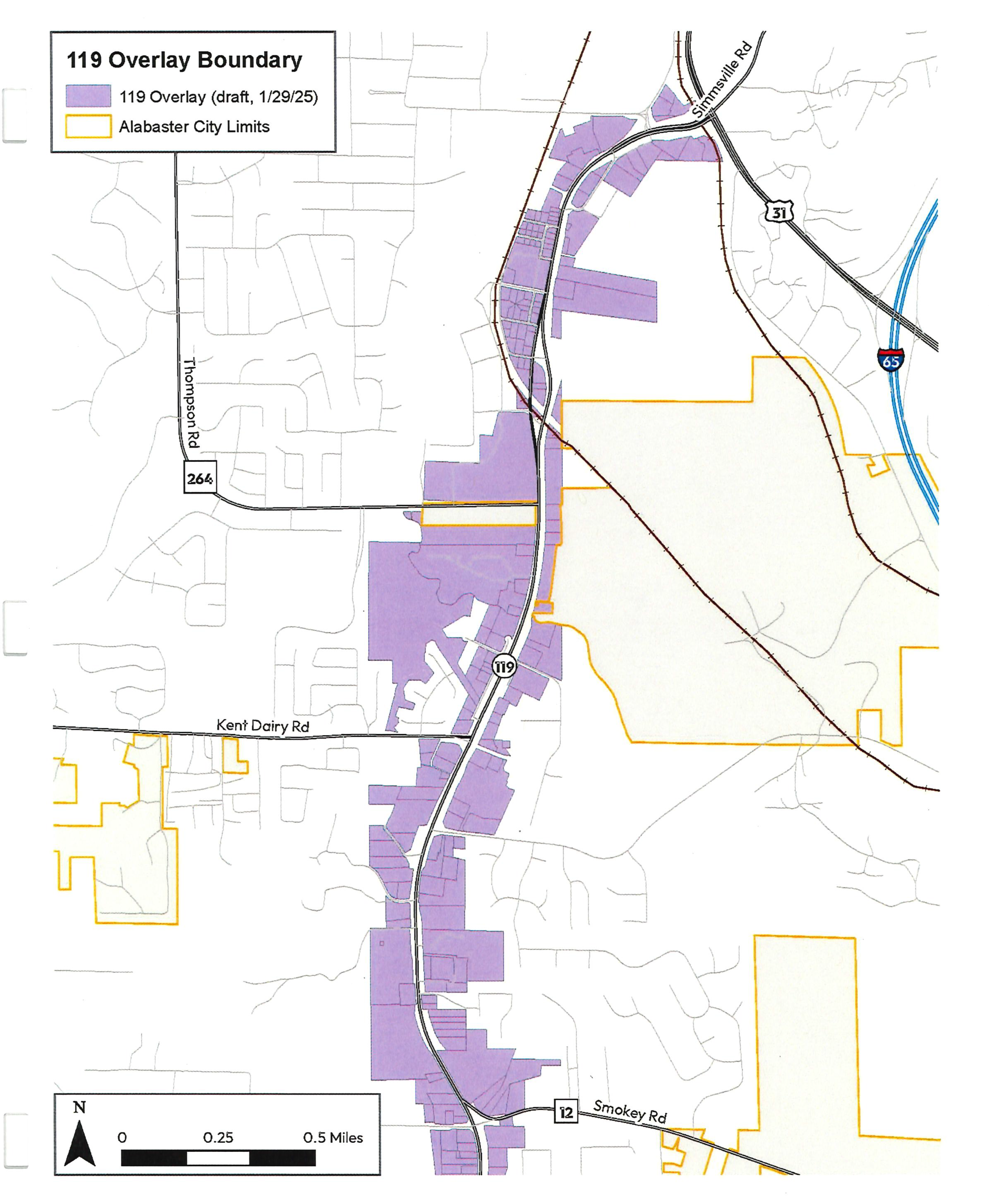
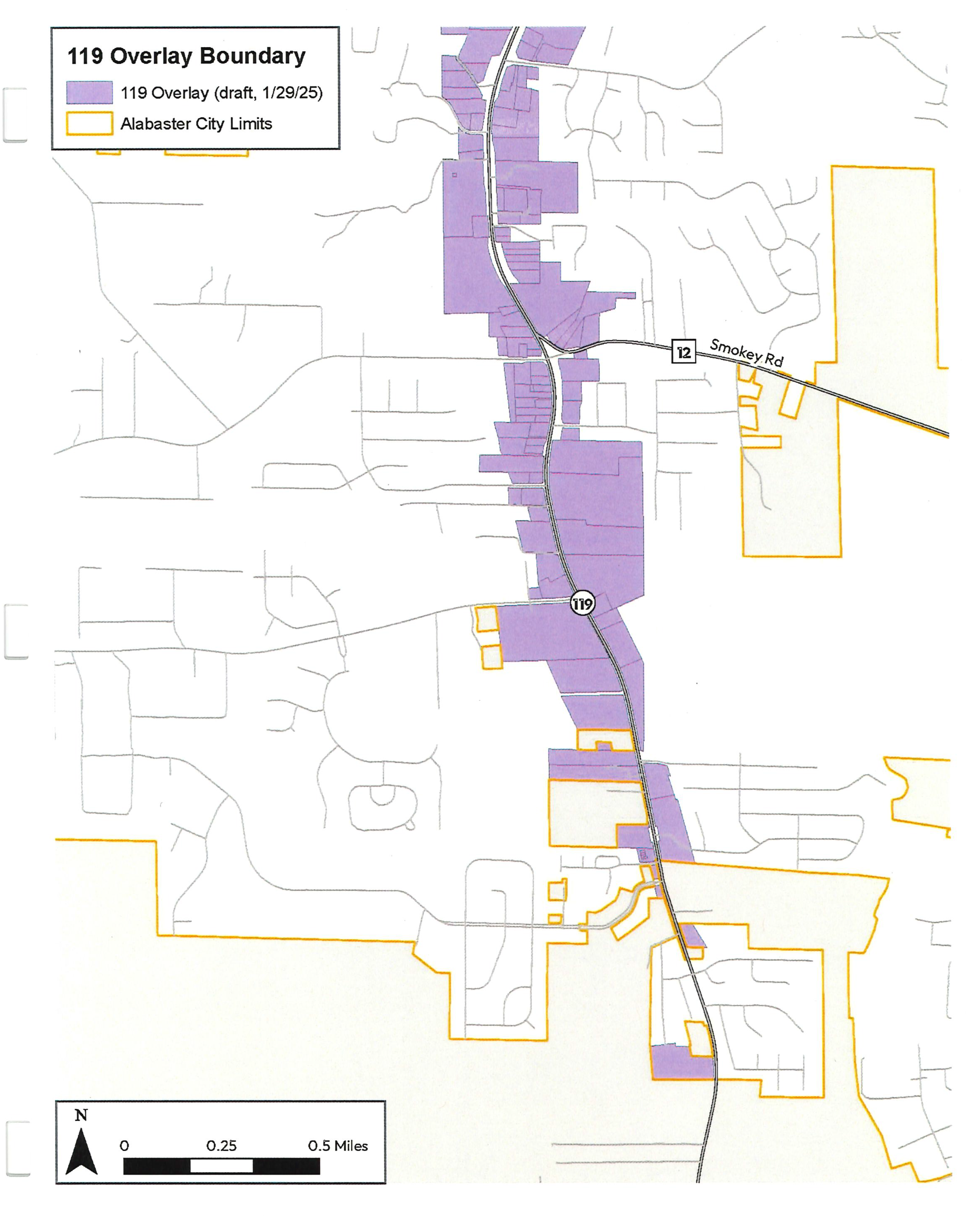
(2)
This map may be amended from time to time by the addition or subtraction of property from the district during the course of rezoning without the necessity of updating the map in this section.
(b)
Intent.
(1)
The regulations in this State Route 119 Overlay District are designed for the following purposes:
a.
To promote the general health, safety and welfare of the community;
b.
To improve the architectural and visual appearance of the State Route 119 corridor by establishing minimum development standards and regulations for properties within the overlay district;
c.
To promote small, incremental development, alongside larger developments;
d.
To promote infill redevelopment and new development that results in a walkable, vibrant, and diverse commercial corridor;
e.
To provide unique places for people to live, work, shop, play and learn; and
f.
To provide small-scale mixed-use development adjacent to otherwise residential areas.
(c)
Applicability.
(1)
Where there appears to be a conflict between these standards and any other sections of the zoning ordinance or subdivision standards, the requirements in this article prevail. Development must comply with all relative federal, state, and local regulations and ordinances regarding health and safety.
(d)
Conflicting ordinances.
(1)
Except as modified by the State Route 119 Overlay District, the provisions of the base zoning district shall apply to all development within the boundary of the State Route 119 Overlay District. Where there appears to be a conflict between these standards and any other sections of the zoning ordinance or subdivision standards, the requirements in this article prevail.
(e)
Compliance.
(1)
The standards and guidelines apply to all new construction and redevelopment improvements in the State Route 119 Overlay District that require building permits, as well as any other parcel that is aggregated for development with a parcel shown in Figure 1.
(2)
These provisions shall not apply to public schools, nor to previously approved projects regarding preliminary site development plans or construction plans.
(3)
Overlay compliance will be based on two triggers—the physical expansion/renovation of the building and the value of building improvements:
a.
Physical expansion/renovation—the percentage of increase of the building(s) total gross floor area in relation to the existing square footage. A renovation is any structural alteration, expansion, enlargement or remodeling; or
b.
Value of improvements—the percentage of the value of building improvements in relation to the assessed values of all buildings.
c.
NOTE: Repairs or reconstruction to existing building components, including AC repairs, water/wastewater/drainage repairs, and roof repairs do not account to be considered as expansion/value of improvements.
Compliance with the State Route 119 Overlay District standards and regulations shall be required as shown in Table 1.
Table 1: Compliance and Applicability
(f)
Nonconformities.
(1)
Nonconformities. Within the districts established by this article there exist lots, structures, and uses of land, which were lawful when established, but which would be prohibited or restricted under the terms of this section or could be prohibited or restricted under the terms of any future amendment. These nonconformities may continue until they are removed or abandoned (as "abandonment" is defined hereinafter). Nonconformities may not be increased, enlarged, expanded or extended in any way which increases the structure's non-conformity (as "modifications" is defined hereinafter).
(2)
Continuance. A nonconforming use lawfully existing at the effective date of this article may be continued, although it does not conform with the provisions of this article.
(3)
Restoration to safe condition. Nothing in this article prevents the restoration of any building or structure to a safe or sanitary condition when required by the proper authorities.
(4)
Restoration after damages. Other than single-family dwellings, no nonconforming building or structure which has been damaged by fire or other causes to more than 50 percent of its current replacement value prior to the time of such damage, in accordance with current International Code Council construction costs, may be rebuilt or restored except in conformity with the provisions of this article.
(5)
Modifications. Nonconforming structures can be maintained, repaired and modified, provided such maintenance, repairs or modifications do not increase, enlarge or alter the non-conforming structure in any way which increases the structure's non-conformity.
(6)
Abandonment. Any non-conforming use that has been abandoned for a continuous period of more than 90 days, or whose business license has expired and was not timely renewed, shall thereafter be required to comply with this section. Applicants shall reference the SR 119 Overlay District requirements regarding more specific guidance on non-conforming developments.
(7)
Change in use. A nonconforming use cannot be changed to another nonconforming use. A nonconforming use which is changed to a conforming use will not be permitted to revert to a nonconforming use.
a.
A change in use to a conforming use must adhere to the standards and regulations outlined in the Adaptive Reuse Section of Table 1 in this section.
(8)
Grandfathered dwelling units. The provisions of this section shall not apply to any single-family dwelling unit legally existing on the effective date of the ordinance from which this section is derived. Such a dwelling unit shall not be deemed nonconforming because of its inability to meet the requirements of this section. Nonconforming single-family dwellings may be enlarged, expanded, and structurally altered.
a.
No new single-family dwellings are permitted.
(g)
Development plan.
(1)
An applicant should meet with the zoning administrator to discuss a proposed site plan for general conformance with the State Route 119 Overlay District and the Alabaster Comprehensive Plan prior to preparation and submission of a site plan.
(2)
Prior to issue of a building permit, business license, or any subdivision or resurvey of existing property, each person, business, applicant or property owner desiring to locate a business, build or alter a structure, or subdivide or develop land within the State Route 119 Overlay District must submit to the zoning administrator for approval a development and/or business plan for each parcel or tract of land proposed to be developed or utilized.
(3)
A development plan containing the following information and the following additional items and information shall be filed with each application for the State Route 119 Overlay District.
a.
The specific location or the tract of property within the State Route 119 Overlay District.
b.
Names and addresses of all landowners whose property adjoins said parcel or tract, as shown in the tax assessor's records of Shelby County, Alabama.
c.
The location of all buildings proposed to be constructed within the tract, or the existing structures intended to be utilized.
d.
Existing and proposed access ways and roads, both public and private, including means of vehicular ingress and egress from the public or private roads.
e.
The number of parking spaces and dimensions of all parking areas.
f.
The location, size and dimensions of functional open space and buffers.
g.
The location, building height, number of floors, and floor area of all buildings.
h.
The distance between each building and the front, rear and side building setbacks.
i.
Exterior lighting, fire hydrants and stormwater retention and detention facilities.
j.
Location of all existing and proposed public utilities as the same relates to the development of the property.
k.
Location and dimensions of all off-street parking spaces and loading facilities.
l.
Location of proposed screening, walls, fences and garbage storage facilities.
m.
Location of all existing and proposed easements.
n.
Location of all sidewalks or multi-use trail (if applicable).
o.
Parking, driveway and sidewalk paving materials.
p.
Sufficient information and detail to clearly demonstrate that all applicable requirements and standards of the State Route 119 Overlay District are fully satisfied.
(4)
The development plan shall include the following written statements and other matters and shall be included on site plan(s) where locations are requested:
a.
A current survey and legal description of the subject property.
b.
The proposed density of land use for the subject property with tabulations by acreage and the percentage of the property to be occupied by each use, including functional open space.
c.
A landscaping and buffer plan that shows the location and dimensions of all buffers and landscaping areas, as well as the type and size of plant material proposed for those areas.
d.
Proposed sign regulations and a signage plan that shows the type, size and location of all building wall and freestanding signs proposed for the development.
e.
When required by the city, a comprehensive traffic analysis indicating the probable effect of the proposed development on traffic patterns and capacities of adjacent streets in the immediate area, prepared by a registered professional engineer.
f.
A fire protection plan, showing the location of all proposed fire hydrants and fire access lanes, as well as a description of all fire protection measures and devices for structures.
g.
Written certification from the appropriate county department regarding the adequacy of sanitary sewage disposal for the site.
h.
Deed restrictions and/or covenants must be deposited with the office of the probate judge of Shelby County and copies provided to the zoning administrator.
(5)
The zoning administrator, after certifying the applicant's compliance with these regulations together with all Zoning Regulations and Building Codes of the City of Alabaster, shall approve said development plan, upon finding that the same complies with these regulations.
(h)
Modifications to development plan.
(1)
It is the intent of this section to provide for flexibility in the development of the property submitted for the 119 Overlay District, and to approve minor modifications administratively. Any standard within the State Route 119 Overlay District may be modified, so long as:
a.
The intent of the standard is being met,
b.
The modification results in better urban design for the corridor as a whole, and
c.
The modification does not impede or burden existing or future development of adjacent properties.
(2)
Modifications shall be defined as:
a.
Major modification: A "major modification" in the development plan shall be defined as any deviation of ten percent or more from that which was shown on the final development plan, or any change in the location of any building or structure by more than ten feet in any direction.
b.
Minor modification: A "minor modification" in the development plan shall be defined as any deviation of up to ten percent from that which was shown on the final development plan, or any change in the location of any building or structure by up to ten feet in any direction.
(3)
Approval of modifications.
a.
Major modifications shall be approved by the planning and zoning commission if compliant with the regulations and intent set forth in this overlay district and all other applicable regulations.
b.
Minor modifications shall be approved administratively by the zoning administrator if compliant with the regulations and intent set forth in this overlay district and all other applicable regulations. At the discretion of the zoning administrator, minor modifications may be referred to the planning and zoning commission to determine compliance. The planning and zoning commission shall then be responsible for determining compliance and issuing approval or disapproval of the proposed modification.
(i)
Use regulations.
(1)
Any existing single-family dwellings are permitted and may be altered or expanded. No new single-family dwellings are permitted.
(2)
Permitted uses. In addition to the requirements set forth by the base zoning district of the individual parcel, within the State Route 119 Overlay District no business license shall be issued, nor shall any building, structure, or land be used or structure shall be erected, structurally altered, or enlarged except for one or more of the permitted uses herein cited and subject to the conditions stated herein:
a.
Art gallery.
b.
Art studio.
c.
Art/hobby supply.
d.
Assisted living establishments.
e.
Bakery/confections/candy.
f.
Banking/finance.
g.
Barber/beauty shop.
h.
Bookshop.
i.
Business office.
j.
Child care/adult care center.
k.
Coffee shop/tea room.
l.
Dance/gymnastics/martial arts/music academy.
m.
Discount/department store.
n.
Drugstore/pharmacy.
o.
Dry cleaning pickup.
p.
Dwellings when part of a mixed-use development.
q.
Furnishings (flooring/furniture).
r.
Gift shop.
s.
Government office.
t.
Grocery store (less than 10,000 square feet).
u.
Hardware store.
v.
Home decorating shop.
w.
Hotel/motel.
x.
Indoor recreation.
y.
Mail and packaging service.
z.
Medical/dental clinic.
aa.
Mixed use buildings (multiple permitted uses, including residential, may be mixed within one building).
bb.
Off-premises alcoholic beverage sales.
cc.
Photography shop/supply.
dd.
Places of Worship
ee.
Professional office.
ff.
Public/private non-profit.
gg.
Research/laboratory/testing.
hh.
Restaurant, drive-thru.
ii.
Restaurant, seated in.
jj.
Restaurant, takeout.
kk.
Retail.
ll.
Shoe shop/repair.
mm.
Shopping center.
nn.
Sporting goods.
oo.
Stationary, stamps.
pp.
Tailor/seamstress.
qq.
Toy shop.
rr.
Upper story residential.
(3)
Special exception uses in the State Route 119 Overlay District include the following:
a.
Bed and breakfast.
b.
Catering.
c.
Climate-controlled storage units.
d.
Commercial greater than 35,000 square feet.
e.
Convenience store/gas station.
f.
Dwelling (multifamily, townhouse)
g.
Funeral home.
h.
Gold or silver object dealer.
i.
On-premises alcoholic beverage sales (bars/lounges).
j.
Outdoor recreation.
k.
Retail with outdoor storage.
l.
Radio/TV broadcast studio.
m.
Self-serve laundromat
n.
Thrift stores.
o.
Utilities (electric/gas, etc.).
p.
Use not listed that otherwise could meet the intent of the overlay.
(4)
Prohibited uses. Prohibited uses in the State Route 119 Overlay District include the following:
a.
Alternative financial services.
b.
Auto repair (major/minor).
c.
Automobile dealerships and used car lots (new/used).
d.
Body art establishment.
e.
Body piercing establishment.
f.
Carwash.
g.
Dwellings (single-family, two-family).
h.
Flea markets.
i.
Massage parlors.
j.
Medical cannabis dispensary.
k.
Newsstand/magazines.
l.
Pawn shop.
m.
Radio/TV antennae.
n.
Tattoo establishment.
o.
Temporary vendors (does not include mobile food vendors).
p.
Tobacco/vape products/CBD oil product sales exceeding ten percent gross sales.
q.
Use not listed that otherwise could not meet the intent of the overlay.
(j)
Access standards.
(1)
Cross access.
a.
Cross access, facilitating vehicular passage between properties without utilizing the public right-of-way, is mandated.
b.
Non-residential developments with parking lots directly accessing State Route 119 must establish at least one vehicular connection to adjacent properties (cross access), unless:
1.
Access is determined unfeasible or unsuitable due to topographical or physical constraints, as assessed by the city engineer.
2.
Access is unattainable due to conflicts with neighboring properties or owners. In such instances, installation of a driveway to the adjacent property and provision of a recorded easement ensuring future access suffices.
(2)
Joint access.
a.
Encouragement of joint access, characterized by a shared driveway facilitating access to multiple properties.
b.
A recorded easement agreement, granting mutual right of ingress and egress for all property owners involved, must be deposited with the office of the probate judge of Shelby County.
c.
The easement agreement must be referred to in the final plat, and any restrictive covenants must be cited on the final plat.
(k)
New streets. The requirements of this section govern all new streets built within the Overlay District. These regulations supersede any conflicting requirements in the Alabaster Subdivision Regulations.
(1)
Streets must connect to other streets, forming a network. The city engineer is authorized to permit a deviation to this requirement, permitting a dead-end street terminating in a cul-de-sac.
(2)
Connectivity for pedestrians must be created and maintained, even when there is no vehicular connectivity; and
(3)
Streets must be designed as follows:
a.
Streets must have a sidewalk on both sides of the street, and it must be a minimum of five feet in width.
b.
Streets must have a landscaped planting strip with street trees between the sidewalk and the curb. The landscaped planting strip must be a minimum of four feet in width. Street trees must be planted at a maximum spacing of 30 feet on center.
c.
Streets must have parking on at least one side of the street, and it may be parallel or diagonal. Parallel parking must not exceed eight feet in width.
(4)
Intersection curb radii shall be 15 feet or as recommended by the city engineer.
(l)
Pedestrian access.
(1)
Developments shall provide a continuous walkway connection at least five feet in width from the public sidewalk or right-of-way to the customer entrances of all principal buildings on the site.
(2)
For properties fronting State Route 119, a public access easement with a minimum width of 20 feet shall be required for the construction of multi-use trails to enhance pedestrian and non-vehicular connectivity between developments.
(3)
Developments adjacent to multi-use trails shall provide a direct connection from the trail to the development's internal pedestrian circulation system.
(4)
For trails and sidewalks that are proposed in the comprehensive plan, the Alabaster Trails and Sidewalk Study, or any other adopted city document but not yet constructed, the development plan shall make provisions for a connection to the trail or sidewalk and the applicant shall be responsible for constructing the connection.
a.
A grassy swale or landscape planting area shall be located to provide a separation between the edge of pavement or curb to the trail. The minimum separation shall be ten feet, except in cases where the city engineer deems that placement of the trail adjacent to a concrete curb is warranted, based on similar facilities in the immediate vicinity, constraints with available rights-of-way or conflicts with existing buildings.
b.
The city engineer may approve a payment of a fee (see fees-in-lieu pedestrian access installation program below) instead of installation of the multi-use trail or sidewalk if the installation is impractical because:
1.
A stormwater drainage ditch or similar utility prevents the installation of the multi-use trail or sidewalk, and neither the pedestrian facility nor the utility can be reasonably relocated to accommodate the pedestrian facility and the utility;
2.
The topography would require the construction of a retaining wall more than two feet high to accommodate the multi-use trail or sidewalk;
3.
Impending road widening;
4.
Other unusual circumstances that would make the installation requirement of a multi-use trail or sidewalk unreasonable.
(5)
Multi-building developments shall provide clear and safe walkways of at least five feet in width that connect all buildings on the site. Buildings not intended for routine customer access or intended solely for drive-up services are excluded from this requirement.
(6)
Where the required walkways are specified in this article cross drives, parking aisles, or other vehicular ways, the crosswalks shall be distinguished from driving surfaces by the use of durable, low-maintenance surface materials such as concreate or brick pavers; or scored, colored concreated. Painted concrete is not acceptable in this application.
(7)
Pedestrian connections to adjacent developments shall be provided. If adjacent properties are undeveloped, the development plan shall indicate how future connections will be provided.
(8)
Fees-in-lieu pedestrian access installation program.
a.
The fee-in-lieu shall be equal to the cost of the multi-use trail or sidewalk improvements that would otherwise have been required, as determined by the city engineer.
b.
The applicant must be informed of the amount to be paid upon issuance of the building permit and payment shall be made prior to the issuance of the certificate of occupancy.
c.
A fee paid under this section must be used to install a multi-use trail, sidewalk, or curb ramp within the State Route 119 Overlay District.
d.
The city may refund the fee to the applicant if it is not spent within ten years of the date of its collection.
(m)
Site standards.
(1)
Setbacks. Buildings must be set back from lot boundaries according to Table 2: Building Standards Table by Building Type.
(2)
Buffers. A 20-foot landscape buffer is required when abutting a residential district.
(n)
Building standards. The requirements of this section apply to all building permit applications.
(1)
Buildings should not exceed the height of 60 feet and must have a minimum first floor height of 12 feet. Building height should be measured from the average grade at the building setback.
(2)
The main building entrance must face a street, and be accessible by public sidewalk, along the street on which the building fronts.
(3)
One functional entry must be provided for every 80 feet of façade and must lead to habitable space.
(4)
Building façades facing side streets are exempt from entry frequency requirements if the side façade is under 50 feet in length.
(5)
Ground floor of building façades must be configured as follows:
a.
Clear glass is required on all façades fronting State Route 119, as determined by Table 2: Building Standards Table by Building Type. The glazing area is calculated between two feet and ten feet above the adjacent sidewalk.
b.
On corner lots with frontage on State Route 119, the glazing shall turn the corner facing the secondary street a minimum of 20 feet in length along the property frontage.
(6)
Building materials.
a.
Building façades must use durable materials. Durable materials include aluminum composite material (ACM), brick, insulated metal panels, stone, stucco (EIFS is not permitted within 36 inches of finished grade), heavy timber, cementitious siding, wood, slate, metal roofing, tile. Vinyl is not considered a durable material.
b.
Primary exterior building materials shall not change at outside corners and shall wrap the corner a minimum of ten feet.
(7)
Façade elements above the ground floor may project into yards.
(8)
Commercial activities, including food service and seating, may occupy yards.
Table 2: Building Standards Table by Building Type
1 Exceptions to front setback: exceptions may be made for recesses up to five feet for articulation of the building façade and up to 20 feet for seating areas.
2 Exceptions to side setbacks: side setbacks with street frontage, on corner lots, shall follow front setbacks.
3 Exception to rear setbacks: development abutting property with an existing residential use shall comply with the applicable landscaping and buffer standards of article VIII of the City of Alabaster Zoning Ordinance.
4 Corner lot glazing: On corner lots with frontage on State Route 119, the glazing shall turn the corner facing the secondary street a minimum of 20 feet in length along the property frontage.
5 The glazing area is calculated between two feet and ten feet above the adjacent sidewalk.
(o)
Parking standards.
(1)
Minimum required vehicular parking (as required by article VI of the City of Alabaster Zoning Ordinance) may be fulfilled in the following locations:
a.
New parking spaces provided on-site shall be located behind or beside the buildings on all properties.
b.
One module of parking (two rows of stalls and a two-way drive aisle) is permitted between the building and the street.
1.
Buildings of 35,000 square feet or more are omitted from this on-street parking location requirement with approval from the zoning administrator.
c.
Parking spaces that are provided on-street must correspond to the lot frontages.
1.
On-street parking may be restricted in proximity to intersections, driveways, fire hydrants, and other utilities.
d.
Parking spaces leased from a public or private facility.
1.
A shared parking agreement (access agreement) with the parking facility owner is required.
(2)
A ten percent decrease in the total number of parking spaces is allowable when parking spaces are shared among several interconnected sites with an officially documented shared use parking agreement (access easement).
(3)
Parking access.
a.
Where parking access is only available from the front lot line, driveways are limited to 20 feet in width.
(4)
Businesses requiring delivery vehicles must have a separate area for these vehicles, with no parking allowed in the required parking spaces for customers, in accordance with the requirements for specific uses set forth in section 111-191 of the City of Alabaster Zoning Ordinance (Loading areas).
(5)
Parking lot landscaping. This section applies to all off-street parking and loading areas; vehicular storage areas, display areas, maneuvering and washing areas; and areas where the dispensing of motor fuels is permitted. Parking lots must comply with section 111-265 of the City of Alabaster Zoning Ordinance (Landscaping requirements for vehicular areas in high-traffic corridors), with the following exceptions and additions that are required by this section:
a.
Each vehicular area shall have interior landscaping covering no less than five percent of the total vehicular area, or the vehicular area shall have landscape islands of at least seven feet in width required between every ten contiguous parking spaces, whichever is greater.
b.
Parking islands including trees, flowers, ground cover, and shrub shall be provided at vehicular access points to external streets.
c.
An additional five percent reduction in parking requirements will be allowed for developments that include bio-retention techniques as a part of the design.
(6)
Parking lot lighting.
a.
No exterior lighting fixtures shall exceed 20 feet in height measured from grade level and shall be designed and installed as to direct the beam of light away from any adjacent residential areas and onto the property it serves.
(p)
Screening standards.
(1)
All outdoor electrical, plumbing, and mechanical equipment must be located on the roof, in the rear or side of the building, or concealed from the street view with a screen or wall. These facilities may not encroach into any required yard.
a.
Outdoor electrical, plumbing, and mechanical equipment located on the roof shall be screened from abutting streets with parapets or other types of visual screening.
(2)
Any garbage/refuse service areas shall be located to the rear or side of the principal building or complex it serves. It must be located within a four-sided structure which completely conceals the trash receptacle. The enclosure shall be a minimum height of two feet taller than the highest point of the waste/grease container, compactor, or dumpster, to conceal the facilities from public view, and covered if a sewer drain is required in the dumpster facility.
(3)
Loading and service areas. Building orientation shall be such that loading and service areas do not face the street right-of-way, except in the case of double frontage lots, where such areas must be located in a rear or side yard which faces the right-of-way. All loading and service areas shall be screened from view from off the premises.
(4)
All outdoor storage areas shall be located behind the front building line and screened, as necessary, from the public view.
(5)
When fences and walls are used as screening, they must comply with [sub]section (q) below.
(q)
Fence and wall standards. When in conflict, this article supersedes section 111-107 (Fences and walls) of the City of Alabaster Zoning Ordinance.
(1)
No wall or fence will exceed four feet in height for front yards.
(2)
When erected on a lot line, all of the fence and any of its supporting structures must be contained within the lot.
(3)
The supporting members and post must be on the insides, and smooth or flat faces on the outside. If two faces are used, each face must be in the same type and finish.
(4)
Prohibited materials include chain link, barb wire, transparent/see-thru fencing, plastic, vinyl, or temporary materials. Construction sites with temporary fencing are exempt.
(5)
Wood fences must be painted or stained.
(6)
Retaining walls which exceed eight feet in height and are visible from public property shall be visibility screened with vegetation covering no less than 50 percent of the retaining wall.
(r)
Signs. Signs must comply with article VII of the City of Alabaster Zoning Ordinance, with the following exceptions and additions that are required by this section.
(1)
No sign will be regulated for content or type as assigned by content. Signs will only be regulated for size, structural type, number, and location.
(2)
General requirements. All on-premises signs in the State Route 119 Overlay District must conform with the following regulations:
a.
Permitted sign types are limited by land use and the following restrictions according to Table 3: General Sign Restrictions, Table 4: Specific Freestanding Sign Regulations, and Table 5: Specific Attached Sign Regulations.
b.
Clearance. All signs must meet the following clearance to the lowest portion of the sign:
1.
Minimum eight feet above sidewalks; or
2.
Minimum 14 feet clear above vehicular area
c.
Double sided. All signs may be double-sided by right if the configuration of the sign permits. The second sign does not affect the calculation of height and width.
Table 3: General Sign Restrictions
(3)
Freestanding sign requirements.
a.
Additional sign restrictions apply per sign type according to this section and Table 4: Specific Freestanding Sign Regulations. Freestanding signs must be separated from all driveways, parking aisles, loading aisles, parking spaces, and loading spaces. Freestanding signs must be securely fastened to the ground so that there is no danger that either the sign or the supportive structure may be moved and cause injury to persons or property.
b.
The maximum area and height for each freestanding sign is according to Table 3: General Sign Restrictions and Table 4: Specific Freestanding Sign Regulations.
c.
Monument signs may contain areas for manual changeable copy or electronic message centers (EMCs), provided such sign area does not exceed 50 percent of the sign face area. EMCs subject to the regulations set forth in section 111-235 (Electronic message center signs) in the City of Alabaster Zoning Ordinance, with the following exceptions and additions that are required by this section:
1.
EMCs are prohibited within the State Route 119 Overlay District, except for properties with direct frontage on State Route 119.
d.
The following signs are prohibited: Cabinet (box signs), off-premises business signs, and pole signs.
Table 4: Specific Freestanding Sign Regulations
| Monument Sign | ||
| Requirements |
Signs must be set back so that it does not obstruct the view of motor vehicle operators
entering a public roadway from any parking area, service drive, alley, or other thoroughfare.
In no case shall a monument sign be set back less than five (5) feet.
Monument signs must be constructed of durable materials. The sign must be attached directly to the ground by its entire base. The sign must have a minimum of 50 square feet of landscaped area at the base of the sign. If the sign is located in a median, the median must be a minimum of 10 feet wide and 50 feet long. | 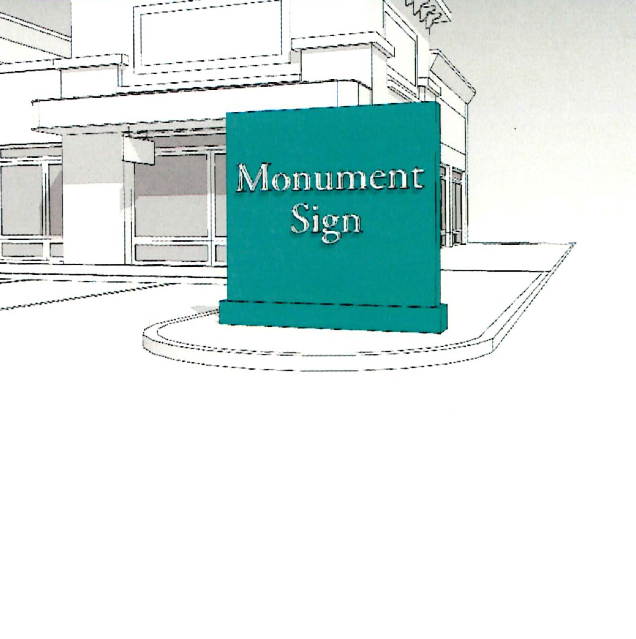 |
(4)
Attached sign requirements.
a.
Additional sign restrictions apply per sign type according to this section and the requirements of Table 5: Specific Attached Sign Regulations and Illustrations. Attached signs must be securely fastened to the building or to some other substantial supportive structure attached to the building so that there is no danger that either the sign or the supportive structure may be moved and cause injury to persons or property. Any signage material placed over an existing sign is considered temporary and subject to the conditions of section 111-233 of the City of Alabaster Zoning Ordinance (Permit exceptions; exempt and temporary signs).
b.
Maximum number of attached signs. Except as provided for exempt signs, attached signs are restricted to building façades facing a public street or a customer parking lot. The maximum number of attached signs per building façade are as follows:
1.
One roof sign or wall sign or one canopy sign or marquee sign per tenant;
2.
One awning sign per ground floor window;
3.
One projecting sign per tenant or one sculptural sign per tenant; and
4.
Except as provided for neon signs displayed in windows in subsection (e.i) below no limit on the number of window signs.
c.
Wall signs. The maximum area and height for each wall sign is according to Table 5: Specific Attached Sign Regulations and Illustrations and the following requirements.
1.
Wall signs may not project more than 12 inches from the building wall and may not extend beyond the limits of the building.
d.
Window signs. In addition to Table 5: Specific Attached Sign Regulations and Illustrations window signs are subject to the following requirements.
1.
Neon signs are limited to one per tenant, require an electrical permit and must comply with Underwriters Laboratory (UL) or equivalent standards. Neon signs are prohibited in the residential, institutional, B-1 Business District.
Table 5: Specific Attached Sign Regulations and Illustrations
| Wall Sign | ||
| Requirements |
a. Signs may not project more than one foot from the building.
b. The maximum sign area is limited to 30% of the façade. c. Wall signs may be externally illuminated. d. Fixtures must be shielded to prevent glare. e. Conduit, raceways and wiring may not be exposed. | 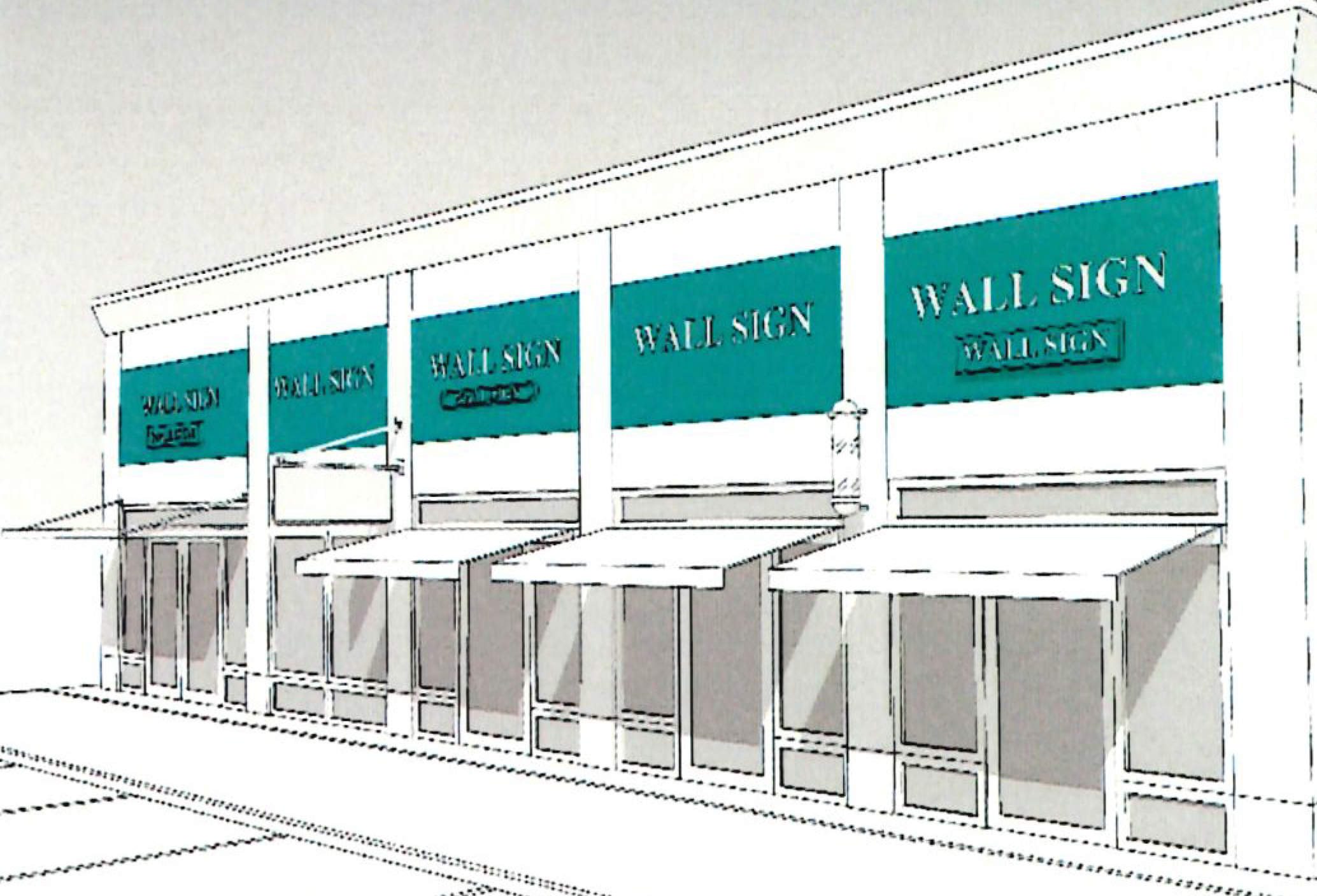 |
| Canopy Sign | ||
| Requirements |
a. Canopy signs may be externally illuminated.
b. Fixtures must be shielded to prevent glare. c. Conduit, raceways and wiring may not be exposed to view from the sidewalk. | 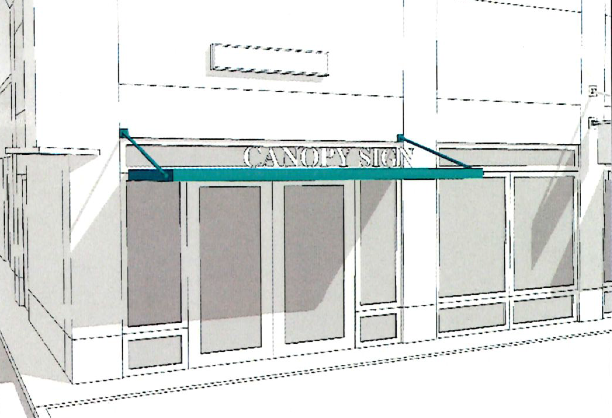 |
| Awning Sign | ||
| Requirements | a. Signs on awning valences must maintain a one-inch border. | 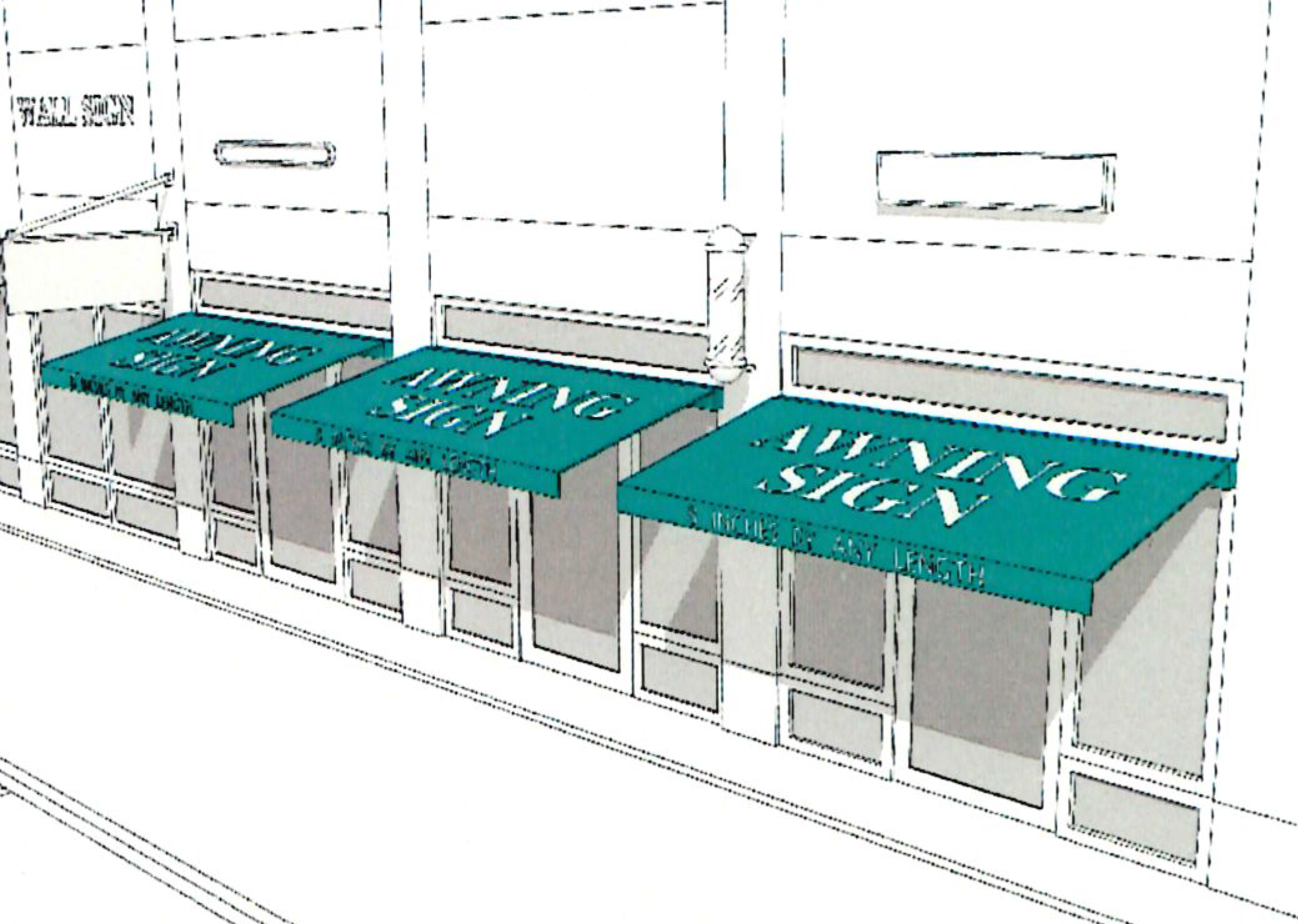 |
| Marquee Sign | ||
| Requirements |
a. Marquee signs may occur parallel to the façade or at the corner of the building
on buildings over one story in height.
b. Sign may extend up to 6 feet above the parapet. c. Bottom of the sign must be 12 feet above the sidewalk. | 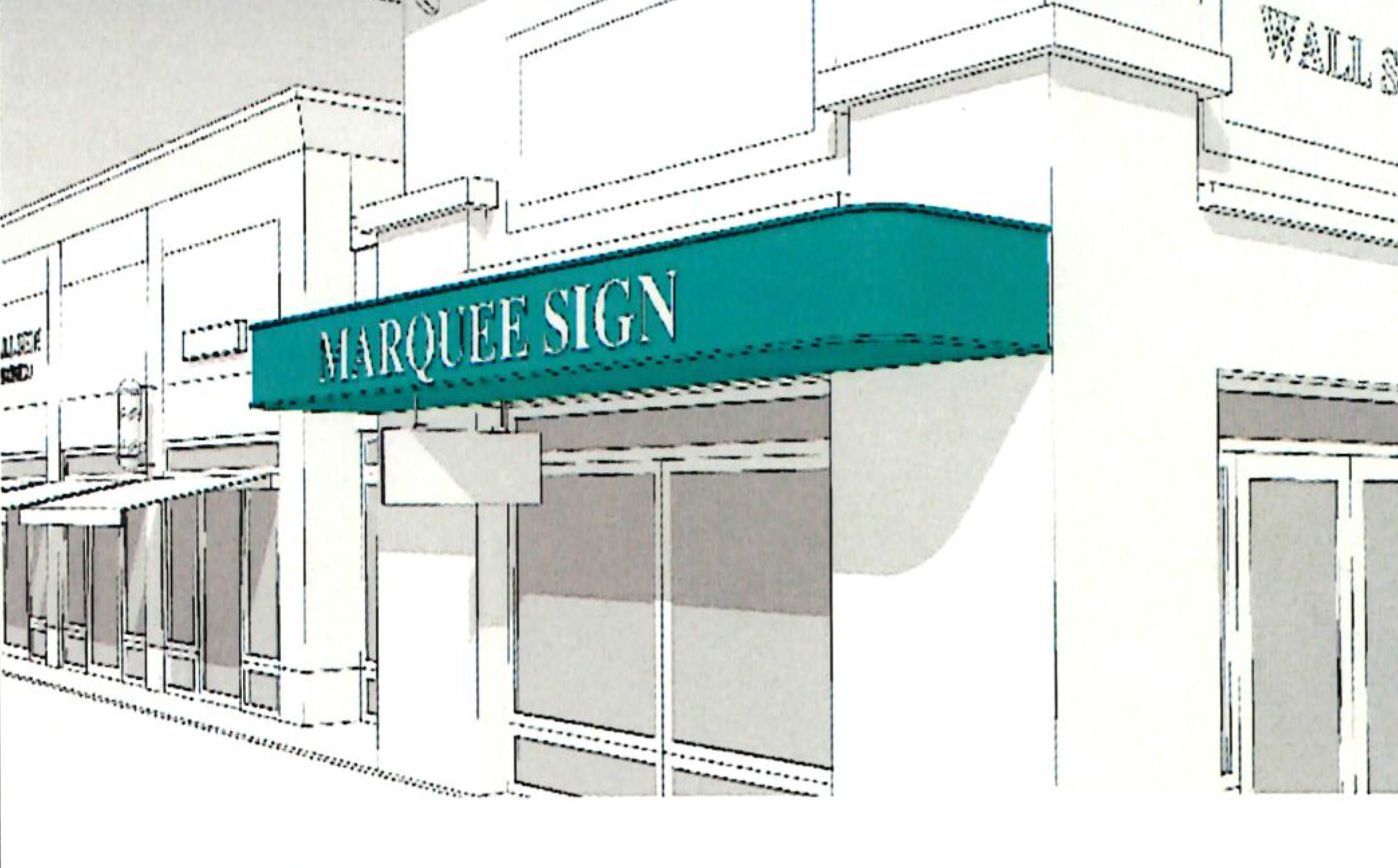 |
| Window Sign | ||
| Requirements |
a. The following window signs are permitted: letters painted directly on the window,
hanging signs behind the glass, and vinyl applique letters applied to the window.
Appliques must consist of individual letters or graphics with no visible background.
b. Window signs shall cover no more than 20% of any one window. c. Window glass must permit at least ninety (90) percent light transmission on the first floor and at least seventy-five (75) percent light transmission on all upper floors. | 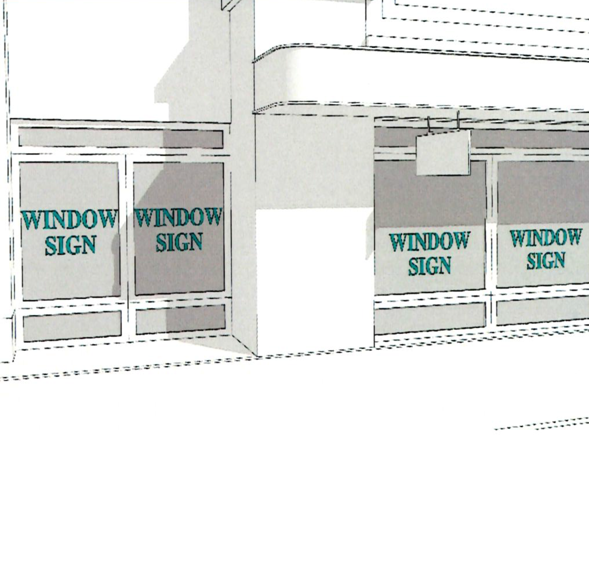 |
| Projecting Sign | ||
| Requirements |
a. Projecting signs may project up to three feet from the façade.
b. Cabinet signs are prohibited. |  |
| Sculptural Sign | ||
| Requirements |
a. Signs may include painted, vinyl or extruded copy or graphics on a sculptural object.
b. Signs may be attached to wall, parapet or roof of a building and must include a supporting structure which is not computed as part of the allowable sign area. c. The bottom of sign must be a minimum of 8 feet above the sidewalk. |  |
(5)
Signs within the State Route 119 Overlay District are regulated independently by two use categories: (1) single tenant, and (2) multiple tenant buildings and campuses.
a.
Single tenants may choose to utilize any two of the following types of signs and are subject to the requirements of Table 3 except for the following:
1.
Attached signs.
i.
No sign on a building façade may exceed 80 feet in length.
2.
Monument signs.
i.
Lots having less than 150 feet of street frontage may have one monument sign per street frontage. The maximum surface area is 30 square feet per side, with a total area of 60 square feet. The maximum height of the monument sign is ten feet.
ii.
Lots having more than 150 feet of street frontage may have two monument signs per street frontage. There must be 200 feet between signs for lots with more than 200 feet of street frontage. The maximum surface area is 30 square feet per side, with a total area of 60 square feet. The maximum height of the monument sign is ten feet.
3.
Shopping center bonus. Each shopping center, or multiple business located on a single parcel, may have one monument sign for each 500 feet of road frontage with the following dimensions. Individual businesses may not have separate monument signs.
i.
Maximum height is 20 feet.
ii.
Maximum width is 15 feet.
iii.
Maximum surface area is 160 square feet, or 80 square feet per side.
iv.
When a shopping center is located on a corner, an additional monument sign, not to exceed ten feet in height, nor 48 square feet in surface area, is allowed which will be a monument style sign identifying the name of the shopping center only.
(6)
Multiple tenant buildings and campuses may utilize the following types of signs. The sign may be located along any street or highway frontage.
a.
Monument signs.
1.
One monument sign is permitted per frontage. If the street frontage exceeds 500 feet, a second sign may be permitted. The maximum area for all monument signs is 80 square feet per side. The maximum height is 20 feet.
2.
Each vehicular entrance to the property may have one monument sign not exceeding 80 square feet per side.
b.
Maximum allowable area.
1.
For sites with 500 feet or less of road frontage, the maximum sign area per frontage is 300 square feet.
2.
For sites with more than 500 feet of road frontage, the maximum sign area per frontage is 600 square feet.
3.
Individual businesses within a shopping center or multiple tenant building may erect wall signs and projecting signs per the standards of Table 2 and Table 4. Individual businesses may not have separate monument signs.
(7)
No illuminated sign is permitted within 100 feet of any residential district. No sign located within 300 feet of a residential district may be illuminated between the hours of 10:00 p.m. and 6:00 a.m.
(s)
Additional regulations.
(1)
Artisan manufacturing standards.
a.
Outdoor storage. Any activity storing materials outdoors shall construct an opaque fence to screen the ground-level view from any public right-of-way or of any residential or retail use. Materials shall not be piled or staked higher than the opaque fence.
(2)
Gold or silver object dealers.
a.
Purpose. It is recognized that the services offered by gold and silver object dealers may provide an opportunity for individuals to potentially transfer stolen property. Therefore, the general purpose and intent of these regulations are to provide separation, development and operational standards for gold or silver object dealers in the City of Alabaster in order to mitigate the negative impacts associated with such businesses and to serve the public safety and welfare of residents and businesses within the city.
b.
Applicability. For the purposes of this section, the standards of this section apply to new establishments of gold or silver object dealers. An establishment is considered new when no previous gold or silver object dealer existed at that location for a period of 90 consecutive days or greater immediately preceding the filing date of an application for permit under this section. Any properly licensed gold or silver object dealer legally operating at the effective date of the ordinance from which this section is derived shall be considered a legal nonconforming use and shall be subject to the provisions of section 111-39 of the Alabaster City Code of Ordinances (Nonconforming uses of land and buildings).
c.
Discontinuance and termination. Any gold or silver object dealer, whether existing or subsequently granted under this section, that voluntarily discontinues active operation for more than 90 consecutive days; does not maintain a valid city business license for more than 90 consecutive days; or ceases to be licensed by the State of Alabama or any other applicable licensing authority, shall be considered a termination of the use and all privileges and rights held therein.
d.
Locational requirements.
1.
No gold or silver object dealer (as described and detailed within this section) established after the date of this section shall be located within 2,500 linear feet of any other gold or silver object dealer or pawnshop. The method of measurement that shall be used is a straight line measured from the property line of the site of the proposed business to the closest property line that is already occupied by these businesses.
2.
No gold or silver object dealer shall be located within 500 feet of a residentially zoned district, as measured by a straight line from the property line of the site of the proposed business to the property line of the closest residentially zoned property.
3.
No gold or silver object dealer shall be located within 500 feet of a public building, public or private school, day care center, nursery, preschool, park or playground, church or place of worship, as measured by a straight line from the property line of the site of the proposed business to the property line of the property that is occupied by one of the uses.
4.
No gold or silver object dealer shall be located within 2,500 feet of a pawnshop, as measured by a straight line from the property line of the site of the proposed business to the property line of the closest pawnshop business.
e.
Development and operational standards.
1.
Hours of operation. The hours of operation shall be limited to the hours between 9:00 a.m. and 6:00 p.m.
f.
Other requirements.
1.
All gold and silver object dealers are required to obtain a special exception use issued by the board of zoning adjustment, which shall be required prior to the issuance of a business license for said use and prior to occupancy of the premises regarding said use.
(3)
Thrift stores.
a.
Purpose. The general purpose and intent of these regulations are to provide separation, development and operations standards for thrift stores, since they can have a deleterious impact on neighboring properties by lowering property values and adversely affecting rental rates of nearby commercial properties.
b.
Applicability. For the purposes of this section, the standards of this section apply to new establishments of thrift stores. An establishment is considered new when no previous thrift store existed at that location for a period of 90 consecutive days or greater immediately preceding the filing date of an application for permit under this section. Any properly licensed thrift store legally operating at the effective date of the ordinance from which this section is derived that is not in compliance with this section shall be considered a legal nonconforming use and shall be subject to the section 111-39 of the Alabaster City Code of Ordinances (Nonconforming uses of land and buildings).
c.
Discontinuance and termination. Any thrift store, whether existing or subsequently granted under this section, that voluntarily discontinues active operation for more than 90 consecutive days; does not maintain a valid city business license for more than 90 consecutive days; or ceases to be licensed by the State of Alabama or any other applicable licensing authority, shall be considered a termination of the use and all privileges and rights held therein.
d.
Locational requirements.
1.
No thrift store (as described and detailed within this section) established after the date of this section shall be located within 2,500 linear feet of any other thrift store. The method of measurement that shall be used is a straight line measured from the property line of the site of the proposed business to the closest property line that is already occupied by these businesses.
e.
Development and operational standards.
1.
A thrift store shall be a minimum of 12,000 square feet of total gross floor area and operated by a single tenant.
2.
A designated area inside the building, not visible from the retail area, shall be established for the receipt, sorting, processing, and storage of goods. Donated goods shall be accepted only inside the building and during regular business hours; no donated goods shall be left outside.
3.
Collection areas must be screened and no accumulation of collections or outside storage shall be permitted; they shall be located at the side or rear of the building and not be visible from residentially zoned properties or primary street right-of-way.
4.
Signage prohibiting dumping of merchandise during non-business hours shall be installed in conspicuous locations to the satisfaction of the planning and zoning commission. Signage shall include daytime collection hours for donated goods.
5.
Outdoor storage or display of donated goods or merchandise shall not be permitted.
6.
Donation boxes/bins are not permitted on the premises.
f.
Other requirements.
1.
All thrift stores are required to obtain a special exception use issued by the board of zoning adjustment, which shall be required prior to the issuance of a business license for said use and prior to occupancy of the premises regarding said use.
(4)
Underground wiring requirement.
a.
All power, communication and other wiring hereafter installed to service structures in the State Route 119 Overlay District shall be placed underground.
(5)
Gasoline service stations regulations as set forth in section 111-118 the City of Alabaster Zoning Ordinance
(6)
Wireless telecommunications facilities regulations as set forth in article V of the City of Alabaster Zoning Ordinance
(7)
Landscaping and buffering regulations as set forth in article VIII of the City of Alabaster Zoning Ordinance
a.
Except for mixed use development, where the requirements will be established for each mixed use development as part of the development plan review process.
(t)
Definitions.
(1)
Alternative financial services means any business, excluding those licensed by an appropriate state or federal agency as a bank, saving and loan association, or credit union, that operates as a check cashing business, pawnshop/pawnbroker, payday loan (deferred presentment) business, or title loan business.
(2)
Artisan production means the shared or individual use of hand-tools, mechanical tools and electronic tools for the manufacture of finished products or parts including design, processing, fabrication, assembly, treatment, and packaging of products; as well as the incidental storage, sales and distribution of such products. Typical artisan manufacturing uses include, but are not limited to, electronic goods, food and bakery products; beverages; household appliances; leather products; jewelry and clothing/apparel; metal work; furniture; glass or ceramic production.
(3)
Body art establishment means any establishment, place or premises in which body piercing or tattooing is offered or performed.
(4)
Body piercing establishment means any establishment, place or premises in which body piercing is performed.
(5)
Cabinet sign (also known as a box sign) means a sign with text or symbols printed on a plastic or acrylic sheet that is mounted on a cabinet or box that houses the lighting source and equipment.
(6)
Certificate of occupancy means a document issued by the City of Alabaster certifying a building's compliance with applicable building codes and other laws. The certificate of occupancy indicates the structure is in a condition suitable for occupancy.
(7)
Cladding means a covering or coating on the structure.
(8)
Cross access means properties utilize a connection between parking lots to allow for traffic flow on-site on off the major road.
(9)
Curb cut means a ramp or driveway leading down from a development/sidewalk to the street.
(10)
Easement means a legal term used to grant the right to cross or otherwise use another's land for a specific purpose. Easements can be granted for a number of things including: sidewalk easements, utilities easements, cross and joint access easements. Easements are often granted for sidewalks, cross access, and joint access.
(11)
Donation box/bin means a container, trailer, receptacle or similar device used to temporarily store items or charitable gifts that have been solicited and/or donated from the public.
(12)
Street frontage means properties fronting (facing) State Route 119.
(13)
Frontage means the spacing between the building's façade and the public right-of-way.
(14)
Glazing means the amount of glass or transparency on a façade. Glazing enables pedestrians to see activity on the inside of the building, and patrons to see the activity on the street.
(15)
Gold or silver object means any object that contains gold or silver in any amount whatsoever.
(16)
Gold or silver object dealer means any person engaged in the business of buying or selling tangible objects in gold or silver, or other precious metals of any kind or description, from members of the general public. Included in this definition are buyers of second-hand jewelry and gems. This category does not include coin dealers or antique stores.
(17)
Grassed swales means a linear vegetated ditch used to treat and reduce flow velocities of storm water runoff. Grass swales are applicable nearly everywhere and they are especially effective at receiving runoff from highways and residential areas, due to their linear nature.
(18)
Joint access means properties share an access point creating a unified entrance/exit for multiple properties.
(19)
Makerspace means a work, studio, and/or retail space for artisans, craftsmen, and small-scale manufacturers to work in an individual or communal setting, where the activities produce little to no vibration, noise, fumes, or other nuisances more typical in industrial or manufacturing uses.
(20)
Massage parlor means any building, room, place or establishment, other than a regularly licensed hospital or dispensary, where nonmedical, nonsurgical, non-osteopathic and non-chiropractic manipulative exercises, massages or procedures are practiced upon the human body or any part thereof, for other than cosmetic or beautifying purposes, with or without the use of mechanical or other devices, by anyone not a physician, surgeon, osteopath, chiropractor, or certified massage therapist certified by the state in accordance with the Alabama Massage Therapy Licensure Act of 1996.
(21)
Overhang means a projecting upper portion of a building, such as a roof or balcony.
(22)
Pole signs means an on-premises freestanding sign not meeting all of the characteristics of a monument sign. Pole signs are prohibited in the city.
(23)
Public right-of-way means an easement granted or reserved over the land for transportation purposes, in this case State Route 119.
(24)
Tattoo establishment means any place in which is offered or practiced the placing of designs, letters, scrolls, figures, symbols or any other marks upon or under the skin of any person with ink or any other substance, resulting in the permanent coloration of the skin, including permanent make-up or permanent jewelry, by the aid of needles or any other instrument designed to touch or puncture the skin.
(25)
Thrift store means a store in which the items sold (or given away to the needy) have been obtained through donations or gifts and where the donor receives no monetary compensation upon the sale (or gift) of such merchandise to a thrift shop customer, and where the use is designed to sell donated merchandise at a price below reasonable market value, or where the revenue received from selling same is retained by a charitable or not-for-profit organization or institution.
(Ord. No. 170327-040, 3-27-2017; Ord. No. 19-91, § 4, 8-5-2019; Ord. No. 25-220, § 1, 5-12-2025)
Sec. 111-92. - Conditional Overlay District regulations.
(a)
Purpose. The purpose of the "CO" (conditional overlay) district is to provide for additional regulation of commercial, industrial, or residential uses of land and structures in order that uses and development of said land, buildings and structures will be harmonious and compatible with and not have an undesirable or detrimental impact on surrounding development. The conditional overlay district is also designed to protect the public welfare and the property value of surrounding property by securing an appropriate development that is in harmony with the objectives of the City of Alabaster Comprehensive Plan as adopted by the Alabaster Planning and Zoning Commission.
In order to achieve the above stated purposes, provision is hereby made that in consideration of a change of zoning classification, the subject property shall be limited in such manner that it may not be utilized for all uses and standards ordinarily permitted in a particular zoning classification, may be limited in architectural type, materials, size, and design, and development of said subject property shall conform to specific conditions as determined by the planning commission and the city council. In such cases, the ordinance changing the zoning classification of the property in question shall place it in a "CO" (conditional overlay) zoning district. The "CO" (conditional overlay) classification shall be indicated in the rezoning ordinance passed by the city council (example: a B-2, general business classification with a conditional overlay would be listed as B-2/CO) and designated on the official zoning map.
(b)
Zoning districts that may be combined with a "CO"—conditional overlay classification. Property proposed to be classified as a conditional overlay district must be combined with an existing zoning classification and may be used in combination with all zones as defined in the Zoning Ordinance of the City of Alabaster.
(c)
Uses permitted in a conditional overlay district. The uses, designs, and structures and materials permitted under a conditional overlay classification shall be limited to those determined by the planning commission and city council during the zoning review process outlined in these regulations.
(d)
Application process. The application process for the creation of a conditional overlay district shall be the same as a standard zoning application to be reviewed by the planning commission and city council as outlined in these regulations.
(e)
Review standards for a conditional overlay district. In addition to permitted uses as determined by the planning commission and city council, the conditional overlay ordinance recommended by the planning commission and passed by the city council may impose standards on the subject property with respect to set-backs, build-to lines, buffers (may include required solid fencing, brick or decorative masonry walls), ingress and egress, architectural controls, architectural designs, materials, structure size, site development plan, signage, parking and maneuvering, common areas, landscaping, drainage, and environmental plans as well as other considerations that are determined to be necessary to make the proposed development compatible with surrounding land use and existing zoning. All applicable limitations and/or standards within the conditional overlay classification shall be considered to apply permanently to the site and specific uses permitted.
(f)
Recording of a development plan for a conditional overlay district. A site development plan as proposed under conditional overlay criteria, and approved by the planning commission and city council with all conditions and permitted uses as set forth during the review process, shall be in a form for recording, (24 inches by 36 inches) with standard plat signature certificates. The site plan/plat shall also include a signature line for the city council which will reference the ordinance number for the creation of the conditional overlay designation.
The site development plan designated with permitted land use shall be recorded in the office of the Probate Judge of Shelby County. The official zoning map of the City of Alabaster shall designate the conditional overlay and the planning department shall file a copy of the record plat.
If the proposal for a conditional overlay classification includes the request for subdivision approval, there will be two plats required; the conditional overlay plat dealing with land use and site planning, etc.; and a plat as required by the subdivision regulations of the City of Alabaster. Required plats shall be recorded within three months of final approval.
The development of the site shall be in strict accordance with all aspects of the approved plans and permitted land uses.
(g)
Expiration of development plan (time limit on development). In the event that construction in accordance with a development plan has not begun within two years from the date of approval by the city council of the conditional overlay, said development plan shall become null and void. The planning commission and city council may, upon application, consider extending the time frame for development. An application for extension may require additional conditions for the development if there is a change in circumstances in surrounding properties or a change in regulations.
If no construction has begun, or there is no application is submitted for an extension of the time limit for development, the planning commission may consider recommending an amendment to the city council for the reclassification of the property to its original zone.
(h)
Amendments to an approved conditional overlay district. In the event that a change in the site development plan or more permitted uses than those set forth in the conditional overlay rezoning ordinance as recommended by the planning commission and passed by the city council are desired for the subject property, the proposed plan/uses must be re-submitted to the planning commission. The planning commission will consider the application in accordance with normal policy and procedures for rezoning and recommend the additional uses or change in site plan to the city council who shall, after proper notification, hold a public hearing on the matter to determine the validity of the application. Upon a denial of the application by the planning commission for a change in the plan or additional uses, the applicant has the option to proceed to the city council to request a hearing to approve or deny the proposal.
Proposed amendments pertaining only to minor aspects of the plan such as building orientation, parking layout, and so forth that will not impact adjoining properties, may be approved internally by departmental reviews. All changes shall be designated on a revised site plan and/or subdivision plat, as appropriate, and recorded in the office of the probate judge of Shelby County.
(i)
Application and recording fees. Standard zoning and/or subdivision fees shall be required at the time the application is submitted to the planning commission.
The applicant shall be responsible for all fees related to the advertising and recording of the final plan and ordinance in the office of the probate judge of Shelby County.
(Ord. No. 1602716-029, § 2, 6-27-2016)
Editor's note— Ord. No. 1602716-029, § 2, adopted June 27, 2016, set out provisions intended for use as 111-90. Because § 111-90 already exists in the Code and at the editor's discretion, these provisions have been included as 111-92.
Sec. 111-93. - Aria at Siluria Active Adult Community MXD District.
(a)
District boundaries.
The following description shall create the boundaries of the district:
Description begin at a nail in a wooden fence, locally accepted as the southeast corner of the northeast quarter of the northwest quarter of Section 35, Township 20 South, Range 3 West, Shelby County, Alabama; thence west along the south line of said quarter section for a distance of 660.35 feet to a crimped pipe; thence deflect 00°06'04' left and run 609.58 feet to a right-of-way monument on the east margin of Shelby County Highway 95, also known as 9th Street SW; thence deflect 93°44'08" right and run north along said right-of-way a distance of 351.81 feet to a right-of-way marker; thence deflect 07°20'21" left and continue along said right-of-way for a distance of 184.12 feet to a right-of-way marker on the corner of Shelby County Highway 95 and Industrial Road; thence deflect 90011'57" right and run east along the south margin of Industrial Road for a distance of 180.64 feet to a right-of-way marker; thence deflect 07°06'46" left and continue along said right-of-way for a distance of 253.51 feet to a right-of-way monument; thence deflect 10°14'51" right and continue along said right-of-way for a distance of 816.20 feet to a 5/8' rebar; thence deflect 89°10'48" right leaving said right-of-way and run south for a distance of 545.29 feet to a 1" crimped pipe; thence deflect 01 36'58" left for a distance of 51.69 feet to the point of beginning, said property containing 16.68 acres, more of less.
(b)
General intent. The district shall be primarily a residential cottage district for senior adult persons over the age of 62 years compliant with the federal Housing Older People Act, a qualified and certificated memory care facility for those with Alzheimer's, dementia, and other memory related diseases and traumas regardless of age, and a neighborhood boutique retail center.
(c)
Definitions. The following definitions shall be used herein:
Boutique retail center shall mean retail space the totality of which shall not exceed 20,000 square feet in the district boundaries.
Cottage(s) shall mean any single-family residential unit intended for senior adults aged 62 and over.
Dual unit senior adult cottages shall mean single story residential buildings intended to house no more than two family units per building.
Memory care facility shall mean any building, hospital, or health care facility intended for short- and long-term care of Alzheimer's, dementia, and other memory related diseases and trauma and issued a certificate of need from the Alabama State Health Planning and Development Agency.
Occupant(s) shall mean any person residing in any unit of the cottages or memory care facility for more than 14 days in a calendar year.
(d)
Zoning classification. The district shall be governed by section 111-87 of the Alabaster Code of Ordinances (MXD) except as modified as follows:
(1)
Cottages.
a.
No more than 32 dual unit senior adult cottages (for a total of 64 units) shall be built for lease and tenancy on the property.
b.
No individual cottage shall contain more than two bedrooms nor more than one bathroom.
c.
No occupant of any cottage shall be below the age of 62 years of age except for:
1.
A live-in aides, nurses or other healthcare providers who might need to live with a tenant as a "reasonable accommodation" based on the disability of a tenant, and certified as necessary by a medical professional;
2.
An employee under 62 whose duties require that the person must live on the property; and
3.
Occupants who because of mental or physical disability are under legal guardianship of an eligible tenant;
d.
The owner of the cottages shall maintain and update at least every two years written verification of the age of each occupant that shall be available for inspection by city zoning officials upon reasonable notice and request. A summary of the most current occupancy survey shall be available to any citizen;
e.
The owner of the cottages shall publish on its website and adhere to rules of occupancy of the cottages;
f.
Access to the cottages by vehicle shall be gated to extent practical and allowed by the Alabaster Fire Department.
(2)
Memory care facility.
a.
The memory care facility shall be one building with no more than 32 residential units for memory care patients and occupants, and care-givers, together with all necessary and attendant features for staff, adult daycare facilities, recreation and exercise, crafts and dining.
b.
The facility may house other day activities for senior adults from the surrounding community and act as a community center for the development.
(3)
Boutique retail center.
a.
No individual retail space shall exceed 4,000 square feet.
b.
The center shall be located in such a way that it may be accessed by the general public without creating traffic through the cottage areas.
c.
The stores shall be unique style stores or supportive of area residents such as pharmacies, specialty restaurants, health care supply stores, medical providers, clothing, hardware, and gifts stores.
(4)
General design principles.
(1)
Access to CR95, if at all, shall be limited to right-in/right-out only.
(2)
The placement of lighting, refuse collection, and garbage collection shall be done in such a way as to have minimal impact upon the neighboring existing residential area.
(3)
Minimum buffer size shall be no less than 30 feet from existing residential areas.
(4)
No building permits shall be issued until the final design plan, including architectural review, has been approved by the planning and zoning commission, which shall comply with all other building code, zoning, and landscaping requirements of the City of Alabaster.
(e)
Violations. Any person found to occupy a unit in violation of this section, and any person found to have permitted such violation, or fails to maintain records of compliance herewith, shall be charged and punished as set forth in section 1-12. Each day shall be a new violation.
(Ord. No. 22-149, § 1, 1-10-2022)