
Ann Arbor Township City Zoning Code
ARTICLE V
- SUPPLEMENTARY DISTRICT REGULATIONS
Sec. 74-581.- Intent.
Schedules of specifications, regulations, and standards governing land uses have been incorporated into this chapter for each zoning district. There are, however, at times, unusual conditions attendant upon land uses and zoning classifications which justify elaboration of the application of these specifications, regulations and standards.
(Comp. Ords. 1990, § 130.1101)
Sec. 74-582. - Public sanitary sewage treatment and disposal systems; private community wastewater disposal systems.
(a)
Public sanitary sewage treatment and disposal systems. In addition to the requirements established by the MDEQ and the State Department of Health, the following site development and use requirements shall apply to all public sewage treatment and disposal plants:
(1)
All operations shall be completely enclosed by a fence not less than six feet high.
(2)
All operations and structures shall be surrounded on all sides by a buffer strip at least 200 feet wide within which grass, trees and shrubs, and structural screens shall be placed to enhance the appearance of the installation. The Planning Commission shall have the authority to review and approve the design and treatment of all buffer strips.
(3)
No device for the collection, treatment, and/or disposal of sewer wastes shall be installed or used without approval of the County Health Department, the MDEQ, State Department of Health and other applicable governmental authorities.
(b)
Private community wastewater disposal systems. Any proposal to install, construct or operate a private community wastewater disposal system in the Township, as such term is defined in section 70-357, shall conform with all requirements of the article III, division 3, subdivision II of this chapter and shall be considered a conditional land use pursuant to article II, division 3 of this chapter, subject to the notice, public hearing, standards, findings, conditions and other requirements of article II, division 3 of this chapter, and the site plan standards set forth in section 70-364; provided a PWS included in a planned unit development under section 74-542 shall not require a separate conditional use permit under article II, division 3 of this chapter, but instead shall be subject to the notice, public hearing, standards, findings, conditions and other requirements under section 74-542, and the site plan standards of section 70-364.
(Comp. Ords. 1990, § 130.1102; Ord. No. 2-2006, § 130.801, 8-21-2006)
Sec. 74-583. - Storage of materials.
(a)
The following provisions pertaining to the storage of materials shall apply:
(1)
Garbage, trash, and similar refuse to be stored outside a building in an R-5, R-6, R-7, R-8, R-9, and all business and industrial districts shall be stored within containers approved by the County Health Department and such containers shall be stored within a screened enclosure. The enclosure shall be constructed of an opaque material, such as wood, concrete blocks, or brick, and shall be enclosed on at least three sides. The fourth side may be open for access or access may be provided by one or more gates. The storage area shall have a concrete floor at least four inches thick.
(2)
The location or storage of abandoned, discarded, unused, unusable, or inoperative appliances, furniture, equipment, or materials (but not including inoperative vehicles), shall be regulated as follows, except for junkyards, in which case the regulations set forth in article II of chapter 18 and in section 74-588 shall apply.
a.
On any lot or parcel in any recreation-conservation, agricultural, residential, commercial, or office district, the owner or tenant shall locate and store such materials within a completely enclosed building. Such storage shall be for future transfer to other premises and shall not be for the purpose of hire or sale.
b.
On any lot or parcel in any wholesale and warehouse, research and development, or industrial district, the owner or tenant shall locate and store such materials:
1.
Within a completely enclosed building, where required; or
2.
Where outdoor storage is permitted, within an area surrounded by a solid, unpierced fence or wall at least seven feet in height and not less in height than the materials located or stored therein, and not closer to the lot lines than the minimum yard requirements for such districts.
Such storage shall be for future transfer to other premises and shall not be for the purpose of hire or sale.
(Comp. Ords. 1990, § 130.1103)
Sec. 74-584. - Parking and storage of vehicles.
The following shall not be parked or stored in any district in the Township except in a completely enclosed structure, unless otherwise permitted by this chapter:
(1)
Motor vehicles or trailers which are not properly licensed for use upon the highways of the State for a period in excess of 30 days, except the following:
a.
Recreational vehicles which shall be regulated as set forth in section 74-591;
b.
Farm vehicles or trailers or property maintenance vehicles or trailers, which are not otherwise required to be licensed for use on the highways of the State;
c.
Unlicensed vehicles kept as stock in trade of a regularly licensed and established new or used automobile dealer at a parcel properly zoned for such purpose;
(2)
Motor vehicles or trailers which are inoperable for any reason, for a period in excess of 30 days, which shall also be governed by chapter 26, article II, blight;
(3)
Motor vehicles, machinery or equipment used for construction purposes, unless located on a construction site at which properly authorized construction activities are currently taking place.
(Comp. Ords. 1990, § 130.1104; Ord. No. 7-2003, 5-19-2003; Ord. No. 3-2021, 2-15-2021)
Sec. 74-585. - Preservation of environmental quality.
The following provisions pertaining to the preservation of environmental quality shall apply:
(1)
In any zoning district no river, stream, watercourse, or drainage way, whether filled or partly filled with water or dry in certain seasons, shall be obstructed or altered in any way at any time by any person, except when done in conformance with State and Federal law and standards.
(2)
No person shall alter, change, transform or otherwise vary the edge, bank, or shore of any lake, river, or stream except as provided in the Inland Lakes and Streams Act, part 301 of the Natural Resources and Environmental Protection Act (MCL 324.30101 et seq.).
(3)
No person shall drain, remove, fill, change, alter, transform or otherwise vary the area, water level, vegetation, or natural conditions of a marsh, swamp, or wetland of one acre or larger, except after receiving approval of a site plan therefor from the Planning Commission in accordance with article II, division 4, site plan review. Any such alterations shall conform to applicable State and Federal requirements.
(Comp. Ords. 1990, § 130.1105)
Sec. 74-586. - Landscaping and transition strips.
(a)
Intent. The intent of this section is to promote the public's health, safety, and general welfare by:
(1)
Improving and enhancing the character of the site; screening or filtering views, where necessary; helping to unify the various parts of the site; blending inharmonious land uses; and buffering incompatible uses.
(2)
Controlling soil erosion; moderating harsh or unpleasant sounds; removing air pollutants; controlling glare and reflection; slowing the effects of erosive winds or water and promoting stormwater retention, thereby helping to prevent flooding; and blocking, diverting or channeling winds.
(3)
Moderating the effects of climate and creating a more desirable microclimate.
To the greatest extent possible, applicants are encouraged to satisfy ordinance requirements through the preservation of existing trees and natural vegetation. Where appropriate, the use of a diverse mix of landscape materials native to Washtenaw County is encouraged.
(b)
Application. These requirements shall apply to all buildings, structures and uses for which site plan review is required under section 74-172 and for which subdivision plat review is required under section 58-72.
(c)
Landscape plan required. A separate sheet showing the landscape plan shall be submitted as part of the final site plan review plan set for projects requiring a site plan as set forth in section 74-176(b)2c and this section 74-586. A separate sheet showing the landscape plan shall be submitted as part of the preliminary plat review plan set for projects requiring subdivision plat approval as set forth in section 58-73(b)(20) and this section 74-586. Landscape plans shall be prepared by a qualified professional, as required in section 74-174(a)(1). The landscape plan shall meet all of the following requirements and include all of the following information:
(1)
Prepared in a scale that properly illustrates the landscape plan concept and that the requirements of this section 74-586 are met.
(2)
Existing and proposed topography, by contours correlated with the grading plan.
(3)
Location of all proposed improvements, including utilities, as shown on the site plan.
(4)
Location of proposed plant materials; a planting list of proposed materials, showing sizes, height, quantity, botanical and common names, spacing, and root type (bare root or balled and burlapped).
(5)
A vegetation inventory showing the species and location of trees, shrubs and ground cover within 300 feet of the proposed disturbance to be saved, moved, or removed; proposed means of protecting existing plant materials during construction.
(6)
Sections, elevations, plans, and details of landscape elements, such as berms, walls, ponds, retaining walls and tree wells.
(7)
Planting and staking details, in text or graphic form, explaining the method of installation, type and depth of mulch, and any special planting requirements.
(8)
Identification of existing wetlands, forested areas, trees and vegetative cover including those to be preserved.
(9)
Identification of grass and other ground cover and method of planting.
(10)
Proposed planting dates.
(11)
Irrigation system plan for watering and draining landscape areas, if used.
(12)
Such additional information as the Planning Commission determines is necessary to properly locate and identify existing conditions and proposed landscaping changes.
(d)
Additional areas or plantings. The Planning Commission may require more or larger landscape areas, more plant materials, or any combination thereof, than may otherwise be required by this section or by article IV or elsewhere in this chapter, if the Planning Commission finds that the nature or concept of the proposed development, the relationship to existing natural features, or the relationship to neighboring properties indicates a need for such additional landscaping.
(e)
Transition strips.
(1)
Landscaping materials. The transition strip shall be landscaped with living plant materials; such materials shall be planted within six months of the date of issuance of the certificate of occupancy.
(2)
Compliance with section. A transition strip, when required under article IV, District Regulations, shall be provided in accordance with this Section. Where permitted, a decorative wood screen or masonry wall, four to six feet high, may be substituted for the transition strip if the Planning Commission determines that such screen or wall will equal the performance of the transition strip and where such lot is too limited in dimension or area to reasonably permit the installation of such strip.
(3)
Hedge as substitute. A hedge may also be substituted for a transition strip, provided that it will obtain a height of at least three feet at the end of the first growing season, and if the Planning Commission determines that such hedge will equal the performance of the transition strip. A screen, wall, hedge, or strip shall be adequately maintained at all times.
(f)
Parking lot landscaping.
(1)
Interior areas. Each separate landscaped area within a parking lot shall be adequately planted and maintained and shall be located in such a manner as to promote the following principles: divide and break up the expanse of pavement; define parking areas; and designate vehicular circulation. The following specific standards shall apply:
a.
No more than a row of 15 spaces in residential districts, and no more than a row of 20 spaces in commercial, office, and industrial districts shall be permitted without being interrupted by landscaping or a landscape island. Where required landscape areas within parking lots would prevent maintenance or impede traffic flow as a result of the size or configuration of a parking lot, the Planning Commission may require that the parking lot be reconfigured or may approve alternative landscaping along the perimeter of the parking lot.
b.
Each parking lot shall provide a landscaped area equal to a minimum of five percent of the paved surface area of the parking lot for the purpose of planting shade trees and other landscape materials. Greater than five percent interior landscape area may be required by the Planning Commission where the Planning Commission determines that a greater landscape areas is needed to provide visual and climatic relief.
c.
There shall be one canopy tree meeting the minimum size requirements set forth in this chapter for every eight parking spaces or fraction thereof. Landscaped islands within a designated parking area shall be a minimum of 150 square feet in area and ten feet in width.
d.
A minimum distance of three feet shall be established between proposed tree or shrub plantings and the backside of the curb or edge of pavement.
e.
Surfaces of islands and medians in driveways shall be turf grass, other ground cover, or low growing shrubs.
(2)
Perimeter areas. In order to reduce the visual impact of a parking lot, minimize conflicts between neighboring uses, and reduce the effect of headlight glare and parking lot lighting on adjacent uses and public roadways, the perimeter of parking lots shall be screened in accordance with the following standards:
a.
Screening may be required between parking areas and adjacent streets, sidewalks, or properties. Screening may be provided by berms, elevation changes, trees and shrubs, flowering plants, decorative fences or walls, or a combination of these features. Evergreen trees and/or shrubs may be required in such areas.
b.
Canopy trees shall be provided along the perimeter of a parking lot at a minimum rate of one tree per each 40 feet of lot perimeter, but the trees need not be planted on 40 foot centers. Additional canopy trees may be required by the Planning Commission to effectively shade the parking lot or adjoining properties. Trees required for shading purposes shall be canopy trees. Flowering deciduous trees and evergreen trees may also be used but shall not substitute for or replace any of the canopy trees required by these standards.
c.
A minimum of three-foot wide landscape strips (not including vehicle overhangs) should be provided between paved parking surfaces and buildings, fences, and property lines wherever possible. Trees and shrubs shall be planted clear of the vehicle overhang area.
(3)
Stormwater management. The use of parking lot islands and perimeter areas for stormwater infiltration facilities, where possible, is encouraged. Design for stormwater management facilities is described in the Stormwater Management Ordinance, Chapter 26, Article VII of the Township's Code of Ordinances, section 26-501 et seq.
(g)
Street trees. Trees shall be provided in the margins on both sides of all streets, whether public or private in all residential developments including but not limited to site condominiums or subdivisions, and such trees shall be provided at a minimum rate of one tree per 60 linear feet of lot frontage. Trees may also be required in pedestrian ways, at the same rate. Trees to be installed in street margins shall be the large deciduous type, such as oak, maple, and sycamore. However, ornamental trees may be installed in street margins, but shall not count toward the minimum street tree requirement. Both large deciduous and ornamental trees may be planted in pedestrian ways.
(h)
Outdoor trash storage. Trash storage shall be provided either within a building or in containers located in an enclosure outside the building. If storage is inside a building, trash shall be handled and stored in compliance with all applicable codes. Outside trash containers shall not be permitted unless located within enclosures, and subject to the following standards:
(1)
Outdoor trash disposal containers shall be screened on all sides with an opaque screen made of wood or masonry materials, which shall be at least as high as the container, but not less than six feet in height. Wire fences or fences with plastic, aluminum, or other filler strips shall not be used as enclosures. Enclosures shall be constructed of materials similar to or compatible with the materials used on the outside faces of the principal buildings on the site.
(2)
Containers shall be consolidated to minimize the number of collection sites.
(3)
Containers and enclosures shall meet all required setbacks, shall be located behind the front face of the building, and shall be located away from public view insofar as possible. Enclosures shall not be located in any yard required adjacent to a public or private street or in a required transition strip, or pose any fire hazards to buildings.
(4)
Containers and enclosures shall be situated so that they do not create a public nuisance or result in unsightly or offensive conditions affecting neighboring uses or occupants. Tree and shrub screening may be required to screen the enclosure from view and to provide shade to reduce odors during summer months.
(5)
Enclosures shall be designed and located for safe and convenient access for both the user and the trash hauling company. They shall not be placed in any location that will interfere with the use of any parking space, with vehicle or pedestrian flow, with public safety, or with ingress and egress to and from a building, or with access to a fire hydrant.
(6)
Concrete pads of appropriate size and construction shall be provided for containers or groups of containers. Concrete aprons shall be provided for loading of bins.
(7)
The trash enclosure area and pad shall be sized to accommodate storage of recyclable or compostable materials and related containers.
(8)
Screening and gates shall be of a durable construction. Gates shall be constructed of heavy-gauge metal or of a heavy-gauge metal frame with covering of wood or other suitable material. Gates shall be secured with sturdy hinges or sliders, and latches. If the enclosure is situated directly adjacent to parking spaces or drives, it shall be protected at its base by concrete curb blocks.
(i)
Miscellaneous landscape requirements. The following minimum standards shall apply to all required landscaping:
(1)
Quality. Plant and grass materials shall be of varieties and species hardy in Washtenaw County, and shall conform to the current minimum standards of the American Nursery and Landscape Association, and shall have passed any inspections required under State or Federal regulations. Artificial plant materials are prohibited.
(2)
Composition. A mixture of plant materials (evergreen and deciduous trees and shrubs) is required as a protective measure against insect and disease infestation.
(3)
Berms. Berms shall be constructed with slopes no greater than one (1) foot vertical for each three-foot horizontal, with at least a two-foot wide, generally flat top. The highest point of the berm, extending along the length of the berm, shall be sufficiently rounded to avoid scalping by maintenance equipment. Berm slopes shall be protected with grass, shrubs or other form of natural ground cover.
(4)
Mulch. Mulching material for planted trees, shrubs, and vines shall be a minimum of four-inch-deep shredded hardwood mulch. Decorative materials, such as stone chips, woodchips, mulch, or cobblestones within planting beds and areas shall be placed on a permeable landscape fabric that allows passage of water and air to the soil below. Polyethylene or plastic films shall not be used for this purpose.
(5)
Walls, fences and paving materials. Walls shall be constructed of stone, brick or similar materials. Fences for landscaping purposes shall be constructed of wood. Chain link or other metal fences shall not be used for landscaping purposes. Walls, landscape fences, and paving materials shall be coordinated with buildings in terms of design and materials, and with the character of the site.
(6)
Existing plant material. Healthy plant materials existing on a site prior to its development shall be incorporated into the landscape plan if such materials meet the requirements of this section.
Plant materials labeled "to remain" on a final site plan or a preliminary plat shall be protected from construction activities. Fences or other barriers shall be placed no closer to the tree or shrub than its dripline. No vehicle or other construction equipment, and no soil deposits or any material may be parked or stored within the dripline of such trees or shrubs.
Any tree designated on the site plan or plat as "to remain" that is cut down, destroyed, damaged, or excavated behind the dripline during construction, as determined by the Township, shall be replaced by the owner or applicant with trees that are either equivalent in size, or that constitute the total diameter at breast height (dbh) of the trees that have been damaged or removed. Mitigation of removal of landmark trees or other protected trees shall be in accordance with applicable Township ordinances or land development standards.
(7)
Installation, maintenance, and completion.
a.
All landscaping required by this section shall be planted within six months after issuance of the certificate of occupancy.
b.
An amount equal to the installed cost of landscaping shall be deposited with the Township in accordance with section 74-178 as security for installation of the landscaping ("landscaping deposit"). The Township is authorized to retain 30 percent of the landscaping deposit for a period of three years after the date of issuance of a certificate of occupancy, to insure replacement of dead or dying landscaping, under the terms of an escrow agreement described in section 178(e). It shall be the responsibility of the property owner (or any applicable owner's association) to maintain the landscaping in good condition in accordance with its intended purpose and subsections e and g below.
c.
Landscaping operations, including planting of trees and shrubs, shall not damage any utility or interrupt any utility service, and shall not damage or create a nuisance affecting adjacent property, public streets, or sidewalks.
d.
Plant and grass materials shall be installed according to generally accepted planting procedures.
e.
Landscaping materials that are unsightly, dead, dying, or that become unhealthy because of damage, neglect, drainage problems, disease, insect infestation, or other causes shall be replaced within one year, or the next planting period, whichever occurs first. Replacement materials shall meet all standards of the original installation.
f.
All landscaped areas shall be provided with an adequate water supply.
g.
The property owner (or any applicable owner's association) shall be responsible to ensure the proper care and maintenance of landscape areas, including keeping all landscape materials in a healthy and growing state. All landscape elements such as, but not limited to, fences, screens, walls, or lighting shall be kept in good repair.
h.
Topsoil removed during construction shall be stockpiled in an appropriate manner to prevent erosion, and shall be redistributed on re-graded surfaces to be landscaped, to provide a minimum of four inches of even cover. The topsoil shall then be permanently stabilized by grass, ground cover, or other plantings.
(8)
Prohibited plants. Installation of the following plants do not satisfy these requirements and are prohibited:
a.
Species of trees whose roots are known to cause damage to streets, sidewalks, utility lines, or other public facilities; are brittle; are particularly susceptible to insect damage or disease; or are short lived should not be used in any required landscape area.
(9)
Minimum size and spacing requirements. Where landscaping is required, the following sets forth minimum size and spacing requirements for representative landscape materials:
a.
Large evergreen trees, such as Fir, Douglas Fir, Spruce, Pine, and Hemlock shall be at least six feet in height at the time of planting. When used for screening purposes, large evergreen trees shall be planted not more than 12 feet on center. Plantings in two or more rows, on staggered centers, may be required for adequate screening.
b.
Narrow evergreen trees, such as Red Cedar, Arborvitae and Juniper, shall be at least five feet in height at the time of planting. When used for screening purposes, narrow evergreen trees shall be planted not more than five feet on center. Plantings in two or more rows, on staggered centers, may be required for adequate screening.
c.
Large deciduous canopy trees such as Oak, Maple, Beech, Linden, Ginkgo (male only), Honeylocust, Birch and Sycamore, shall be at least 2.5 inches in caliper at the time of planting. When used for screening purposes, large deciduous trees shall be planted not more than 25 feet on center. Plantings in two or more rows, on staggered centers, may be required for adequate screening.
d.
Small deciduous ornamental trees, such as Dogwood, Pear, Cherry, Hawthorn (thornless), Redbud, Magnolia, Crabapple, Serviceberry and Hornbeam, shall be at least two inches in caliper at the time of planting. When used for screening purposes, small deciduous trees shall be planted not more than 12 feet on center. Plantings in two or more rows, on staggered centers, may be required for adequate screening.
e.
Large evergreen shrubs, such as Irish, Hicks, Upright or Spreading Yews, Pfitzer or Savin Juniper, and Mugho Pine, shall be at least three (3) feet in spread at the time of planting. When used for screening purposes, upright evergreen shrubs shall be planted not more than two feet on center. Spreading evergreen shrubs shall be planted not more than four feet on center. Plantings in two or more rows, on staggered centers, may be required for adequate screening.
f.
Small evergreen shrubs, such as Brown's Ward's, or Sebian Yews, Dwarf Spreading Juniper, and Dwarf Mugho Pine, shall be at least two feet in spread at the time of planting. When used for screening purposes, small evergreen shrubs shall be planted not more than four feet on center. Plantings in two or more rows, on staggered centers, may be required for adequate screening.
g.
Large deciduous shrubs, such as Lilac, Sumac, Weigelia, Flowering Quince, Crabapple, Red Osier and Gray Dogwood, and Viburnum, shall be at least four feet in height at the time of planting. When used for screening purposes, large deciduous shrubs shall be planted not more than six feet on center. Plantings in two or more rows, on staggered centers, may be required for adequate screening.
h.
Small deciduous shrubs, such as Potentilla or Fragrant Sumac, shall be at least two feet in height if they have an upright habit, or two feet in spread if they have a spreading habit, at the time of planting.
i.
Containers for groundcovers such as Pachysandra, shall be a 2-inch peat pot, at a minimum. Containers for vines, such as Virginia Creeper, or Wisteria, shall be a two-gallon container, at a minimum. Groundcovers shall be planted in such a manner as to present a finished appearance and reasonably complete coverage after one complete growing season, at a rate of at least three plants per square foot.
(j)
Planning Commission modification. The Planning Commission may modify the landscaping requirements of this Section upon finding that:
(1)
The topographic features or special characteristics of the site create conditions such that the strict application of the provisions of this section will result in less effective screening and landscaping than alternative landscape designs.
(2)
That the public benefit intended to be secured by this section will exist with different landscaping or screening than required by this section.
(Comp. Ords. 1990, § 130.1106; Ord. No. 1-2011, 3-21-2011; Ord. No. 8-2011, 8-15-2011)
Sec. 74-587. - Automobile service and repair stations.
In addition to other regulations set forth in this chapter, all automobile gasoline service and repair stations and other automotive service and repair facilities shall conform to the following requirements:
(1)
Sidewalks shall be separated from vehicular parking or circulation areas by curbs, wheel stops, or traffic islands. The portion of the property used for vehicular traffic shall be separated from landscaped areas by a curb.
(2)
The entire area used for vehicle service shall be paved.
(3)
Hydraulic hoists, service pits, lubricating, greasing, washing and repair equipment and operations shall be located within a completely enclosed structure.
(4)
The maximum width of all driveways at the right-of-way lines shall be no more than 30 feet.
(5)
The angle of a driveway intersection with the street from the curb line to lot line shall be not less than 60 degrees.
(6)
The distance of any driveway from any property line shall be at least 20 feet, measured at the tangent points of the drive edge and the street curb return.
(7)
The distance between curb cuts shall be no less than 40 feet, measured between the tangent points of the drive edges and the street curb returns.
(8)
Outdoor storage of trash, including new or discarded vehicle parts, shall be contained within a solid, unpierced enclosure.
(9)
Storage of vehicles rendered inoperative, either through damage or disrepair or any other cause, and vehicles without current license plates, shall be limited to a period of not more than 30 days, and then only for the purpose of temporary storage pending transfer to a junkyard. Such storage shall not be sold or advertised for sale on the premises.
(10)
Sales of used cars and other motorized vehicles shall be prohibited.
(Comp. Ords. 1990, § 130.1107)
Sec. 74-588. - Junkyards.
In addition to other regulations set forth in this chapter, all junkyards shall conform to the following requirements:
(1)
The junkyard shall be located on a public arterial street, or equivalent major public street as defined in the master plan.
(2)
Travel routes for trucks entering and leaving the junkyard shall be shown on a map of the Township at the time of application for the conditional use permit. Such routes except arterial streets or their equivalent shall not pass through residential areas.
(3)
A site plan shall be provided at the time of the conditional use permit application and shall meet all requirements of article II, division 4 of this chapter, site plan review. The site plan shall also contain a description of the location and nature of any material processing operations to be conducted within the junkyard, and the location and nature of equipment for such operations.
(4)
Junk materials shall be stored in organized rows with open intervals at least 20 feet wide between rows for purposes of fire protection access and visitor safety.
(5)
Junk materials shall not be stored in piles higher than the top of the fence surrounding the junkyard. Automobiles, trucks, and other vehicles shall not be stacked so as to prohibit fire protection and to protect the safety of visitors.
(6)
The junkyard shall be maintained in such a manner as to prevent the breeding or harboring of rats, insects, or other vermin.
(7)
The junkyard, when established and located within 1,000 feet of any existing residential district, as measured on a straight-line distance, shall not be open for business and shall not operate at any time other than between the hours of 7:00 a.m. and 6:00 p.m. on weekdays; between 7:00 a.m. and 12:00 noon on Saturdays, and shall not be open for business or otherwise operate on Sundays or legal holidays.
(8)
Burning shall be prohibited except within an enclosed incinerator, and only if the burning operation and incinerator are approved by the Township Fire Chief, or other designated fire official, the Township Building Inspector, and the County Health Department.
(9)
All flammable liquids contained in automobiles and other vehicles shall be drained from same immediately after such vehicles are brought to the junkyard. Such liquids are to be stored in containers approved by the Township Fire Chief, or other designated fire official, the Township Building Inspector, and the County Health Department.
(10)
All drives, parking areas, and loading-unloading areas shall be paved, oiled, watered, or chemically treated so as to limit nuisances caused by windborne dust on neighboring properties and public roads.
(11)
There shall be not more than one entranceway from each public street which adjoins the junkyard.
(12)
Fencing shall be required as follows:
a.
A solid, screen-type fence or wall at least seven feet high as measured from grade at each post in the case of a fence, or at ten-foot intervals in the case of a wall, shall be provided along each public street frontage. The fence or wall shall be located on the rear line of the required front yard. Gates shall also be made of solid, opaque material. The front yard shall be landscaped and continuously maintained as a lawn.
b.
Where the junkyard is adjacent to a rural, rural and urban residence, business, or R-D district, a solid, screen-type fence or wall, at least seven feet high as measured in subsection (12)a of this section, shall be provided on any side or rear property line or portion thereof, adjoining such lots.
c.
Where the junkyard is adjacent to a lot in the I-1 district, a chain-link fence six feet high as measured from grade level at each fence post shall be provided on any side or rear property line or portion thereof, adjoining such lots.
d.
Strips of metal, plastic, or other materials inserted into wire fences shall not fulfill the requirements of subsections (12)a. and b. of this section.
(13)
Wrecking and processing operations are permitted in a junkyard but shall be described in the application for the conditional use permit.
(Comp. Ords. 1990, § 130.1108)
Sec. 74-589. - Drive-in theaters.
In addition to other regulations set forth in this chapter, all drive-in theaters shall conform to the following requirements:
(1)
Drive-in theaters shall be enclosed for their full periphery with a solid, screen-type fence or wall at least seven feet in height. Fences and walls shall be of sound construction, painted or otherwise neatly and inconspicuously finished.
(2)
All fences or walls shall be set back at least 100 feet from any front street or front property line, with the area between the fence and the street or front property line to be landscaped and continuously maintained as lawn.
(3)
All ingress or egress shall be on a public arterial street or equivalent public major street as defined in the master plan. All traffic movement shall be accommodated within the site so that entering and exiting vehicles will make normal and uncomplicated movements between the site and the public streets. All points of entrance or exit for vehicles shall be located no closer than 500 feet from the intersection of any two streets or highways.
(4)
A site plan shall be approved in accordance with article II, division 4 of this chapter, site plan review.
(Comp. Ords. 1990, § 130.1109)
Sec. 74-590. - Commercial kennels.
Commercial kennels shall be subject to the following requirements:
(1)
The minimum lot size shall be ten acres.
(2)
Structures or pens shall not be located less than 300 feet from a public right-of-way or less than 100 feet from a side or rear lot line.
(3)
The kennel shall be established and maintained in accordance with all applicable County and Township sanitation regulations.
(4)
A site plan shall be approved in accordance with article II, division 4 of this chapter, site plan review.
(5)
The kennel owner shall obtain a conditional use permit from the Township, and a kennel license from the County.
(Comp. Ords. 1990, § 130.1110)
Sec. 74-591. - Storage of recreational equipment.
Recreational vehicles, boats and boat trailers, snowmobiles, trail cycles, all-terrain vehicles, and similar equipment, and trailers, cases, and boxes used for transporting recreational equipment, whether occupied by such equipment or not, shall not be parked or stored in front of the front building line or any vacant lot in a residential district; provided, however, that such equipment may be parked anywhere in a driveway or parking area on residential premises for a period not to exceed 72 hours during loading or unloading. Such equipment shall not be used for living, sleeping, or housekeeping purposes when parked or stored on a residential lot, or in any location not approved for such use. Storage of such equipment, when permitted in a commercial district as a principal use of a lot, shall be located behind all required lot lines with all required yards to be landscaped and properly and regularly maintained. The storage area shall have a gravel or paved surface, treated regularly to prevent erosion and blowing of dust. The storage area shall be fenced for security purposes, by at least a six-foot-high cyclone-type fence.
(Comp. Ords. 1990, § 130.1111)
Sec. 74-592. - Ann Arbor Charter Township Mineral Mining Ordinance.
(a)
Purpose and authority.
(1)
Exportation of non-metallic minerals and importation of fill materials. The Township recognizes that sand, gravel and other non-metallic minerals within the Township's boundaries are nonrenewable natural resources necessary and beneficial to the welfare of its inhabitants and the surrounding region. To provide for utilization of these resources in a manner compatible with nearby residential uses, to protect human health and the environment, and to ensure complete reclamation for another land use at the conclusion of the extraction operation, it is necessary to regulate and provide procedures and standards for extraction of non-metallic minerals and for the reclamation of the land at the conclusion of the operation. These regulations are required because extraction operations and related activities, such as the importation of fill material, can cause unique and substantial impacts upon the environment and the welfare of adjacent properties and the community as a whole. They can disrupt the environment, impair water quality and quantity, cause noise and dust nuisances, damage roads and create conditions dangerous to Township residents.
(2)
Preservation of wetlands, water bodies and groundwater. Wetlands are indispensable and fragile natural resources that provide many public benefits, including maintenance of water quality through nutrient cycling and sediment trapping, and by serving as biological and chemical oxidation basins; flood and storm water runoff control through temporary water storage; groundwater recharge; and by providing open space, passive outdoor recreation opportunities, and fish and wildlife habitat. Preservation of Township wetlands, water bodies, aquifers and ground water in a natural condition is necessary to maintain hydrological, economic, recreational, and aesthetic natural resource values for existing and future Township residents.
(3)
Applicability. Subject to compliance with all other applicable statutes, ordinances, rules and regulations, this Ordinance does not apply to the following activities:
a.
Ordinary and necessary grading of land for the tilling and cultivation of soils for the growing of crops and trees.
b.
Ordinary and necessary grading or excavation for construction of buildings, structures or related septic systems pursuant to all required permits from the Township and any other governmental authority having jurisdiction over such activities.
c.
Ordinary and necessary grading, excavation, or maintenance within a public right-of-way by any governmental authority having jurisdiction over that public right-of-way road or drainage easement.
d.
Remediation of environmental contamination.
e.
Construction of solid waste disposal facilities in accordance with Michigan Department of Environment, Great Lakes and Energy (EGLE) permits.
(b)
Definitions.
(1)
Applicant/owner/operator means a person who submits an application under the Ann Arbor Charter Township Mineral Mining Ordinance. The terms "applicant", "owner", and "operator" shall include the tenants, lessees, agents, servants or assigns thereof.
(2)
Application means an application for a conditional use permit pursuant to the Ann Arbor Charter Township Mineral Mining Ordinance.
(3)
Application fee means a sum to be paid by the applicant to the Township which is fixed by resolution of the Township Board of Trustees.
(4)
Aquifer means a saturated permeable geologic unit capable of yielding a significant amount of groundwater to a well or spring.
(5)
Base document(s) means a document required to be submitted under the Ann Arbor Charter Township Mineral Mining Ordinance.
(6)
Beneficiation means to process the extracted materials for any of the following purposes: (i) Regulating the grain size of the desired product; (ii) Removing unwanted constituents; and (iii) Improving the quality and purity of the desired product.
(7)
Commencement date means the date a conditional use permit issued under the Ann Arbor Charter Township Mineral Mining Ordinance is signed by the Township Supervisor and Chairperson of the Planning Commission.
(8)
De-watering means the use of a well, pump or other mechanism to remove water from a surface or subsurface area as part of a mineral mining operation to lower the groundwater or surface water elevation.
(9)
Discharge means the discharge of process water out of the extraction area either onsite or off site.
(10)
Dredging means the extracting and removing of minerals carried out via a scoop or bucket or similar mechanism which are underwater or partially underwater and in which minerals are extracted and removed without de-watering.
(11)
Escrow account means a sum paid by the applicant to the Township to be held by the Township in an account and drawn upon to defray reasonable actual costs and expenses incurred by the Township to review an application and/or administer a permit and includes (but not limited to) costs for engineering, geologic, hydrologic, land use planning, legal, and other expert assistance and analysis; testing; inspections; publications, mailings; recording fees; special meetings; and road maintenance.
(12)
Extraction means the digging, dredging, quarrying, excavation, or other removal of sand, gravel, soil, or other non-metallic minerals from a site.
(13)
Extraction area means the area, as depicted on a topographical map, from which earth materials are removed or are intended to be removed including where processing occurs.
(14)
Fill means soil, rocks, sand, clay, that adds to or displaces soil or water or reduces water retention potential.
(15)
Fines means materials mined from the site passing 200 mesh sieve opening as defined by the National Standard Sieve Size (ASTM-E11) that are a by-product of any extraction operations at the site.
(16)
Groundwater means water below the land surface in a zone of saturation.
(17)
Groundwater elevation means the elevation of the water table above mean sea level at any selected location.
(18)
Groundwater recharge means the process involved in the addition of water to the zone of saturation or the amount of water added.
(19)
Groundwater recharge area means any area on the ground that facilitates the addition of water to the zone of saturation; generally, it is that portion of the drainage basin where the direction of groundwater flow near the surface is downward.
(20)
Inert materials means a substance that will not decompose, dissolve, or in any other way form a contaminated leachate upon contact with water or other liquids, determined by the Township or EGLE as likely to be found at the fill area, percolating through the substance.
(21)
Mineral mining operation means extraction from the earth of mineral aggregates or non-metallic minerals for sale or use by the operator and includes the use of mining equipment or techniques to remove materials from the in-place non-metallic mineral deposit, as well as associated activities such as excavation, grading, dredging, loading and unloading. Also, it includes processes carried out at a non-metallic mineral mining site that are related to the preparation or processing of the mineral aggregates or non-metallic minerals obtained from the non-metallic mineral mining site, such as, but not limited to, stockpiling of materials, blending mineral aggregates or non-metallic minerals with other mineral aggregates or non-metallic minerals, grading, crushing, screening, and scalping.
(22)
Monitoring well means also, "test" or "observation" well. Means a well constructed with the purpose of obtaining information about groundwater. This includes wells to quantify water levels, wells to collect samples for analysis, and observation wells for pumping tests.
(23)
Non-metallic minerals means a product, commodity or material consisting principally of naturally occurring, organic or inorganic, non-metallic, non-renewable material. Non-metallic minerals include, but are not limited to, stone, sand, gravel, clay, peat, and topsoil.
(24)
Normal routes means gravel roads and those paved roads that are subject to normal load and dimension maximums as defined by statute.
(25)
Notice of reclamation means a document recorded with the Washtenaw County Register of Deeds, signed by the titleholder(s), which provides notice that a site is subject to a reclamation plan.
(26)
Operator means an owner and/or lessee of mineral rights or any other person engaged in or preparing to engage in extraction activities with respect to mineral rights within an existing or proposed extraction area.
(27)
Ordinance means the Ann Arbor Charter Township Mineral Mining Ordinance, as amended.
(28)
Overburden means earth materials situated below the layer of topsoil and above the mineral deposit to be extracted from the site which must be removed prior to mining.
(29)
Permit means a document issued pursuant to the Ann Arbor Charter Township Mineral Mining Ordinance which authorizes the extraction of natural resources.
(30)
Person means any individual, corporation, limited liability company, partnership, or other legally recognized entity, or combination thereof.
(31)
Process water means any water used in processing of extracted materials from the Extraction Area, or water from de-watering operations.
(32)
Processing means the washing, sorting, crushing, aggregating, grinding, blending, mixing, or cutting of extracted material from the extraction site.
(33)
Reclamation means the reconditioning, rehabilitating or restoring of the extraction area and associated property, or portions thereof, to a self-sustaining, long term useful purpose which is compatible with contiguous land uses, which protects the natural resources, including controlling of erosion and the preventing of land or rock slides and air and water pollution, and which includes the re-establishing of vegetation, soil stability and establishing of safe conditions appropriate to the intended use of the land in accordance with the Township's Master Plan and the permit conditions allowing for excavation and/or processing on the site.
(34)
Runoff means water from rain, snowmelt, irrigation, or other source that flows over the land surface.
(35)
Sediment (or settling) ponds means a series of ponds that are designed to remove fine particles from water used for processing materials extracted from the site.
(36)
Site means a parcel of land in the Township upon which activities are conducted subject to the Ordinance.
(37)
Surface water means water that is on the earth's surface, such as in a stream, river, lake or reservoir.
(38)
Topsoil means the fertile, dark-colored surface soil; the upper layer of soil, usually richer than the subsoil; generally, the "A" horizon.
(39)
Water table means the surface of unconfined groundwater at which the pressure is atmospheric. The water table is found at the level at which water stands in wells that penetrate the unconfined groundwater zone.
(40)
Wetland means a land or water feature, commonly referred to as a bog, swamp, or marsh, inundated or saturated by water at a frequency and duration sufficient to support, and that under normal circumstances does support, hydric soils and a predominance of wetland vegetation or aquatic life.
(c)
Conditional use permit required. Mineral mining shall require a conditional use permit, as described in Chapter 74, Article II, Division 3, as amended.
(d)
Required information.
(1)
Comprehensive plan. The applicant shall submit a comprehensive plan that provides the following information:
a.
All information required under Chapter 74, Article II, Division 3, Conditional Use Permits, and Chapter 74, Article II, Division 4, Site Plan Review.
b.
Property Use Plan. A property use plan that provides the following information:
1.
Boundary lines of the property; dimensions and bearings of the property lines, correlated with the legal description;
2.
Aerial photo, showing property and adjacent areas, location and outline of wooded areas, streams, marshes, and other natural features;
3.
Existing site improvements such as buildings, drives, wells, and drain fields;
4.
Existing topography at contour intervals of two feet;
5.
Location and description of soil types;
6.
Tree areas and other natural features to be retained, and/or impacted;
7.
Location and width of driveways from the site and sight distances on public roads at intersections with these driveways;
8.
Extent of future mining areas and depth thereof;
9.
Location and nature of structures, including pipes for water movement, and stationary equipment to be located on the site during mining operations; these structures shall also be shown on preliminary and final site plans;
10.
An estimate of the kind and amount of material to be withdrawn from the site and the expected termination date of mining operations;
11.
Description of all operations to be conducted on the premises, including the phasing of such operations, such as, but not limited to, loading and unloading, excavating, crushing, sorting, and washing operations, and the type, size, power source and nature of equipment to be used with each operation;
12.
Description of pollution and erosion control measures;
13.
Certified statement by a qualified engineer, with supporting data and analyses, concerning expected impact on the water table and water supply wells in the vicinity of the site; and
14.
Map showing truck transportation routes to and from the site.
c.
Market Analysis. The applicant shall submit a report prepared by a geologist or other experts with credentials satisfactory to the Township Board to demonstrate that the natural resources to be extracted are valuable, and the applicant can receive revenue and reasonably expect to profit from the proposed mineral mining operation. The applicant shall also provide documentation to demonstrate that there is a need for the natural resources to be mined by either the applicant or in the market served by the applicant.
d.
Reserve/Exploration map. A Reserve/Exploration map and cross sections shall be prepared by an engineer or geologist and certified to the Township as true and accurate showing the extent, location and nature of all subsurface materials on the proposed extraction site on a topographic map including:
1.
Estimated areal extent of deposit limits of materials to be mined;
2.
Depth and lowest elevations of exploration (e.g., drill holes) and the claimed deposit of materials to be extracted from the site;
3.
Groundwater elevations;
4.
Estimated quantity of reserves;
5.
Depth and estimated quantity of topsoil to be stripped;
6.
Depth, lower elevations and estimated quantity of overburden to be stripped; and
7.
Ten foot contour intervals indicating the anticipated vertical and horizontal extent of excavation below the existing surface elevations.
e.
Site Natural Features Inventory Map. The applicant shall provide a map and associated narrative describing the location and type of natural features on or adjacent to the site, including wetlands, watercourses, 100-year floodplains, woodlands, landmark trees, steep slopes, endangered species habitat as identified by the Michigan Department of Natural Resources, and groundwater recharge areas. This map shall be consistent with that required for the preliminary site plan pursuant to Section 74-175.
f.
Hydrogeological Work Plan and Pre-study Meeting. Prior to commencement of the hydrogeological study required in subsection g. below, a hydrogeological work plan shall be prepared and submitted to the Township to communicate aspects of the hydrogeological study. A pre-study meeting shall be held with the Applicant and the Township and relevant consultants to discuss the work plan and the parameters of the proposed hydrogeological study. The hydrogeological work plan shall contain:
1.
A brief assessment of geology and existing hydrogeological data within one mile of the proposed mining site. This may be based upon readily available literature and online references;
2.
Identify applicable permits required from the United States, State of Michigan, County or other governmental entity, and any applications, correspondence or conversations pertaining to the same;
3.
A description of the proposed drilling methodology and monitoring well installation methods to evaluate groundwater presence and flow direction;
4.
A table summarizing the number of proposed soil borings and monitoring wells, the likely depth of drilling, along with corresponding rationale;
5.
A table summarizing the number of surface water gauging locations;
6.
A map or description showing the proposed surface water gauging, soil boring, and monitoring well locations;
7.
A map showing the property boundary and the conceptual or anticipated direction of groundwater flow;
8.
A table summarizing the frequency to collect water level and quality measurements;
9.
A description of proposed monitoring well construction; and
10.
A description of the survey methodology for determining groundwater and surface water elevations.
g.
Hydrogeological Study. A hydrogeological study shall be prepared by a certified professional geologist or professional engineer who specializes in hydrogeology and who certifies the accuracy of the contents and findings of the study. The Planning Commission may have the study reviewed by the Township's consultant at the applicant's expense. The hydrogeological study is intended to document the hydrogeological conditions on site and within the influence of the site and assess any impact the proposed mining operation may have on the water resources of the Township (both on and off-site). The applicant's consultant shall provide a report addressing the following minimum hydrogeological data and evaluation requirements (the hydrogeological report shall be a "stand alone" document). Some of the following information may be reduced at the discretion of the Township based upon the evaluation of the hydrogeological work plan described in subsection f.:
1.
Site and Mineral Mining Operation Description.
i.
Site location map(s) showing the regional setting. At a minimum, the map should cover an area with a two-mile radius measured in all directions from the center of the property. Depending on specific conditions for a particular site the Township may require an increase in the geographic area covered by this map. The site location map must show the following features:
(1)
Township name;
(2)
Township and range numbers;
(3)
Scale and north arrow;
(4)
Section lines and numbers;
(5)
Highways and roads;
(6)
Location of existing lakes, streams, drainage ditches, surface impoundments and wetlands within the geographic area covered by this map;
(7)
Boundaries for the property where the proposed mineral mining operation will occur;
(8)
Proposed limits of excavation;
(9)
Location and identification of any previous soil borings and wells, including abandoned and destroyed wells, and surface water monitoring points.
ii.
A detailed site map that covers an area that extends at least 2,000 feet beyond the property boundaries of the permit applicant. This map must depict:
(1)
Scale and north arrow;
(2)
Applicant's property boundaries;
(3)
Boundaries and owner names for all adjoining land parcels;
(4)
Based on available public information, provide the location of all existing lakes, streams, drainage ditches, and wetlands on-site and within 2,000 feet of the property boundaries;
(5)
Based on available public information, provide water surface elevation for all existing lakes, streams, drainage ditches, and wetlands located on-site and within 2,000 feet of the property boundaries.
(6)
Wetlands expected to be impacted by the extraction operation;
(7)
Boundaries of proposed extraction area; and
(8)
Land surface elevations for the property shown by appropriately selected contour intervals.
iii.
Describe the existing land use, site conditions and the basic scope of the operation.
2.
Field Investigations.
i.
Test borings must be drilled to determine the subsurface geology. A minimum of four test borings shall be located outside the perimeter of the proposed Mineral Mining Operation. At least one boring shall be near the center of the proposed Extraction Area. These borings must be drilled to a depth sufficient to ascertain the geology of the aquifer systems that could be impacted by the Mineral Mining Operation. The locations of these borings must be clearly shown and labeled on the detailed site map. Descriptive logs for each boring should be prepared by a geologist using the Unified Soil Classification System ("USCS") to describe the different layers. Boring logs must contain the following minimum information:
(1)
Boring name;
(2)
Land surface elevation;
(3)
Depth of boring;
(4)
Description of different layers encountered to the bottom of the boring;
(5)
Construction details;
(6)
Depth to water.
ii.
Permanent monitoring wells shall be installed on site near the perimeter of the site and outside of any proposed excavation or construction. If more than one aquifer is encountered in the test borings, separate monitoring wells must be screened in each aquifer to determine the vertical head gradient between aquifers, groundwater flow direction, and water quality in each aquifer, and to calculate the impacts from lowering the head in one aquifer and raising the head in the other aquifer. The monitoring well construction logs shall be included in the report appendix. Monitoring wells shall be constructed to requirements of the United States EPA, EGLE and Washtenaw County Environmental Health. Applicant shall not abandon or remove permanent monitoring wells without the prior approval of the Township. The groundwater monitoring system shall consist of a sufficient number of wells at appropriate locations and depths to collect groundwater samples that provide the required information. Such monitoring system shall accurately measure the quality and levels of background groundwater that has not been affected by mining. Such monitoring system shall also accurately measure the quality and levels of groundwater passing the downgradient boundary of the property which ensures detection of groundwater contamination or changes in water chemistry in the subject aquifer and other aquifers potentially affected by the Mineral Mining Operation. In addition, the monitoring system must include a minimum of one upgradient (highest groundwater elevation on site) and three downgradient (lowest groundwater elevation on site) monitoring wells; however, additional monitoring wells must be installed as necessary to accurately represent the quality of background groundwater and the quality of groundwater leaving the property boundary.
iii.
Water levels and water quality in the monitor wells and on-site wetlands, streams, and lakes shall be measured. All static water levels shall be related to a common USGS datum and elevations shown on a map and in a report table. Water quality parameters shall be collected in accordance with the process outlined in the baseline water quality section below.
3.
Baseline Water Quality.
i.
Groundwater Monitor Wells. All monitor wells shall be sampled and analyzed in accordance with EGLE sampling and analysis protocols prior to commencing extraction operations to establish background groundwater quality. A minimum of two sampling events are required (four or more are preferred), one event during a high groundwater elevation period and the other during a low groundwater elevation period. All laboratory testing shall be conducted in conformance with the most sensitive current applicable U.S. Environmental Protection Agency Test Method available, and data shall be compared to EGLE Generic Residential Cleanup Criteria and Screening Levels promulgated or issued under Part 201 of the Michigan Natural Resources and Environmental Protection Act, MCL 324.20101 et seq., as amended. Testing shall include the following indicator parameters:
(1)
Static water level elevation;
(2)
Groundwater temperature;
(3)
Specific conductance;
(4)
pH;
(5)
Dissolved oxygen;
(6)
Redox potential;
(7)
Total dissolved solids (TDS);
(8)
The concentrations of each the following: chloride, sodium, calcium, sulfate, bicarbonate, magnesium, manganese, iron, potassium, phosphorus, and nitrate nitrogen;
(9)
Resource Conservation and Recovery Act (RCRA) metals, and
(10)
Total petroleum hydrocarbons (TPH);
(11)
If TPH is detected, then the following testing is also required:
(a)
Polycyclic aromatic hydrocarbons (PAH);
(b)
Volatile organic compounds (VOCs) and Semi- volatile organic compounds (SVOCs);
(c)
Methyl tert-butyl ether (MTBE).
ii.
Surface Water. After conferring with the applicant's consultant, the Township's consultant shall determine, the number, type and location of surface water samples necessary to identify potential surface water impacts from extraction operations. Each river, stream and other readily flowing body of water shall be sampled in locations, subject to obtaining rights of access, to be determined in consultation with the Township's consultant for the following parameters:
(1)
Water elevation;
(2)
Base/bed elevation;
(3)
pH;
(4)
Conductivity;
(5)
Total dissolved solids (TDS); and
(6)
Total suspended solids (TSS).
(7)
RCRA metals;
(8)
Total petroleum hydrocarbons (TPH);
(9)
If TPH is detected, then the following testing is also required:
(a)
PAHs;
(b)
VOCs and SVOCs
(c)
MTBE.
4.
Site Characterization.
i.
Site conceptual model (written and illustrative) showing conceptual groundwater flow at the site shall be provided for each aquifer within the extraction zone or potentially affected by the extraction operation. The following site characterization data shall be provided:
(1)
Description of geologic units. The composition, structure and distribution of each layer, and the range of variation in each including the soil or rock description and classification;
(a)
A map showing the location of geologic cross-sections;
(b)
Multiple geologic cross-sections passing through the proposed Extraction Operation and all areas of concern (e.g., wetlands, streams, lakes, residential wells, etc.) to a distance of approximately two miles from the center of the site. On these cross-sections, show the following information:
a.
Vertical and horizontal scale;
b.
Existing land surface elevations;
c.
Boundaries and depth of any proposed excavation;
d.
Well locations and logs used to prepare the cross-sections;
e.
Thickness and extent of the subsurface geologic strata;
f.
Location and depth of all water supply wells, wetlands, streams, and lakes falling on and near the cross-section; and
g.
Static water level elevations.
(2)
Description of hydrogeologic units. Descriptions of the hydrogeologic units within the saturated zone including their thickness, hydraulic properties, such as transmissivity and storage coefficient or specific yield; descriptions of the role of each as confining beds, aquifers, or perched saturated zones; and their actual or potential use as water supply aquifers.
(a)
Brief discussion of the regional and local hydrogeology.
(b)
A contour map of the water table elevations, including water-level elevation measurements from on-site wetlands, streams, and lakes and that depicts the site boundaries.
(c)
Description of the Flow System. Description of the groundwater flow system, illustrated with potentiometric contour lines and streamlines on appropriate plans, and specifically describing the following and discussing their significance with respect to groundwater:
a.
Direction and rates of groundwater movement within the identified hydrogeologic units, including the vertical components of flow. Seasonal or other temporal fluctuations in potentiometric head. The change in recharge rates that will occur due to the presence of the proposed mining operation, or for renewal plans the change in recharge rates that may have occurred
b.
The role of confining beds with regard to limiting downward or upward movement of groundwater.
(d)
Tabulate and summarize water quality data with tools such as tables that highlight detection of organic compounds and graphics such as piper and stiff diagrams that highlight the distribution of cations and anions. Analytes shall be compared to water quality standards.
(e)
The applicant shall provide a numerical model of the area within a radius of two-miles from the site if deemed necessary by Township consultants, or Planning Commission, based on the nature of proposed operations, the potential for contamination, or known or anticipated declines in water levels. The parameters of the numerical model shall be agreed to by the Township.
5.
Potential Environmental Impacts. A narrative that documents existing site conditions and identifies potential short-term and long-term impacts on the Township water resources during and after the proposed Extraction Operations shall be provided. At a minimum, this section must contain the following elements:
i.
Description of present land use and the relationship of the site to surrounding properties. The site location map shall be used for this description.
ii.
Discussion of the proposed Extraction Operation and schedule, along with the intended future use of site. The topographic map showing proposed extent of the Extraction Operation and different phases, if applicable.
iii.
Water quality impacts on existing surface water and groundwater quality and quantity, and an analysis and conclusion discussing the expected impacts;
iv.
If applicable, prepare maps and cross-sections showing the nature and extent of the hydrogeologic impact(s), (e.g. water-level decline or increase).
v.
Elevations of groundwater (e.g. project water level decline/rise in each aquifer) and surface water bodies on and proximate to the site, considering both short-term and long- term potential impacts.
vi.
If the Mineral Mining Operation creates or enlarges an excavated lake, the evaporation impact shall be analyzed through a water budget analysis using EGLE 's applicable guidance for how to perform this analysis.
6.
Additional Hydrogeological Data. The Planning Commission may require additional data related to the site, including, but not limited to, the following:
i.
If the applicant is applying to dewater, the applicant shall provide a numerical model of the area within a radius of two-miles from the site to determine water-level decline over the life of the mine at various distances from the center of the Mineral Mining Operation. The parameters of the numerical model shall be agreed to with the Township.
ii.
Surface Water Diversions. Additional investigations may be needed to demonstrate that no diversion of surface water will impact existing surface water bodies or wetlands located on-site or very near the proposed Mineral Mining Operation. Site operation, stockpiling, and reclamation plans must be evaluated for the potential to divert water toward an excavation and away from an existing surface water body or wetland.
h.
Reclamation Lake Creation. Where lakes are proposed as part of site reclamation a hydrogeological investigation, consistent with what is required under Part 301 of the Michigan Natural Resources and Environmental Protection Act, MCL 324.30101 et seq., as amended must be provided.
i.
Transportation Routes. The Township may, as a condition of the conditional use permit, designate which public roads within the Township that trucks or any other vehicle accessing the site may use. Any entrances and exits to and from the site shall be adjacent to all-season primary road, if possible. Transportation routes through the Township shall minimize truck traffic through residential areas. Trucks used to transfer the natural resources shall follow a route that poses the least interference with other traffic, minimizes traffic through residential areas, and uses public streets constructed for high volumes of heavy truck traffic. The applicant must submit a proposed transportation route plan including:
1.
The route to be used for the proposed operation, accompanied by a letter of preliminary comments from the road commission impacted by the transportation route.
2.
A description of all proposed transportation routes to be used to transport natural resources from the mining area to all freeways or state trunk line highways proposed to transport natural resources to destinations, other than for local deliveries.
3.
Estimated type, size, number, and hourly count of trucks leaving the site daily, during peak season and annually;
j.
Mining Plan. A mining plan shall be provided that contains the following:
1.
Topographical map;
2.
Nature of operation, including:
i.
Methods of excavating, including excavation equipment;
ii.
Methods of transporting material from mine site to processing plant, including earth handling equipment to be used on-site;
iii.
Types of processing activities, such as screening, washing, crushing, etc.;
iv.
Estimated quantity, use and disposal of material fines;
v.
Size of settling ponds;
vi.
Estimated annual production in tons;
vii.
The contemplated phasing for the operations as well as a date for completing the mineral mining operation, such date to be based upon the estimated volume of material to be extracted and an average annual extraction rate; and
viii.
If the proposed extraction activity includes beneficiation or treatment of the extracted material, the application documents shall include specific plans depicting the methods, techniques, and manufacturer's material safety data sheets on all chemicals, or other additives that are not natural to the site, that will be utilized in the process. The operator shall also obtain all applicable state and federal permits prior to beginning the beneficiation process.
k.
Noise control plan. A noise control plan prepared by a qualified professional estimating the noise levels at the property boundaries containing the Mineral Mining Operation, at successive stages of the operation and along the transportation route shall be provided. See 74-592(f)(15).
l.
Erosion control plan. An erosion control plan shall be provided which provides a complete description of all the soil erosion measures, including (but not limited to) all erosion strategies and control measures such as silt fences, vegetation screens, sediment basins, and settling ponds; location of control measures particularly on bare surfaces including steep slopes; time schedule and installation description for each control measure; all temporary and permanent measures and maintenance of each. The plan shall conform to any and all requirements of soil erosion and sedimentation requirements promulgated by Federal, State and County government as well as the Township soil erosion and sedimentation requirements pursuant to Section 58-119. The applicant shall submit this plan to the appropriate County agency for approval. The plan approved by the Township shall be incorporated into the extraction permit issued under this Ordinance.
m.
Pollution prevention plan. A pollution control plan containing a complete description of proposed pollution prevention methods based on National Fire Protection Association, State of Michigan and Washtenaw County pollution prevention laws shall be provided. The plan must address all sediment, storm water and settling basins, as well as any probable impacts from processor activities or on-site fuel or chemical storage;
n.
Lighting plan. A lighting plan showing the location of exterior lighting on the site including a photometric plan shall be provided. Exterior lighting shall conform to Section 74-606 of this ordinance.
o.
Environmental impact analysis (EIA). Applicant shall prepare an environmental impact analysis addressing the impact the operation will have on the site's natural features, flora, fauna as well as impacts on human and natural environments on adjacent lands and along the transportation route. Applicant shall identify any mitigation measures needed to eliminate or minimize these impacts.
1.
At a minimum the statement should address the following: noise; dust; mud; drainage; erosion; sedimentation; views of the mine site from adjacent roads and properties; wetlands; floodplains; special habitats; threatened or endangered species; areas and features of historic, archeological and natural significance; truck traffic and access to and from the site; traffic study; compatibility with adjacent land uses; impacts to residents adjacent to site and along transportation route; changes in social patterns and/or economic conditions of residents; and any additional items that the applicant, Planning Commission or Board of Trustees deems significant. This section is intended to provide an environmental impact analysis using the assembled data identified in the previous sections. The applicant should analyze how the various data interrelate and how the proposed operation will affect the human and natural environments. Environmental impacts identified in the hydrogeological study should be incorporated into the EIA and related to the discussions of other impacts; although the hydrogeological support data does not have to be re-stated, it should be referenced in the environmental impact analysis.
2.
In addition to the items in section immediately above, the EIA shall address the following issues:
i.
An inventory of the physical environmental elements of the proposed site;
ii.
A description of the quality of the environment as it exists prior to commencement of mining activity or, for a renewal, as it exists at the time of renewal;
iii.
A description of the environment as projected at the end of mining activity;
iv.
Compatibility of the proposed extraction activity with adjacent existing land uses and future land use plans/Township Master Plan;
v.
Impact of the proposed extraction activity on flora and wildlife habitats;
vi.
Economic impact of the proposed extraction activity on the surrounding area;
vii.
Effects of the proposed extraction activity on groundwater supply, level, quality, and flow on site and within two miles of the proposed extraction activity;
viii.
Effects of the proposed activity on adjacent surface water resources;
ix.
Effect of the proposed activity on air quality within 1,000 feet of the proposed extraction; and
x.
Whether the proposed activity is located within 1,000 feet of a residence, 2,000 feet of a school, and/or 500 feet of a commercial development.
p.
Property value impact analysis. Applicant shall provide a report on the impact of the applicant's Mining Operation use on property values in the vicinity of the mineral mining property and along the proposed transportation route serving the property.
q.
Reclamation plan. A reclamation plan showing that the entire property will be left in a form for development with uses that are permitted in the district, relating such reuse to existing uses or probable uses for surrounding properties, shall be provided and shall include the following elements:
1.
All rehabilitation activity shall comply with soil erosion and sedimentation requirements of Part 91 of the Michigan Natural Resources and Environmental Protection Act, MCL 324.9101 et seq., as amended.
2.
Proposed topography at contour intervals to provide adequate grading information, subject to the Township engineers recommendation, with two feet being the minimum. Such grade and slope designations shall be included with respect to areas proposed to be beneath the surface of permanent water areas.
3.
Schedule of progressive rehabilitation: The plan should provide that after mining is completed on one specified area, reclamation shall commence in that area before mining continues on other areas of the site. The plan shall provide that as mining areas are worked out or abandoned they are progressively rehabilitated to a condition of being entirely lacking in hazards, inconspicuous, and blended with the general surrounding ground form so as to appear natural.
4.
Proposed ground cover and other plantings to stabilize the soil surface and to beautify the restored area, as well as to protect from erosion and siltation.
5.
Concept plan(s) for the proposed end use of the site when restored drawn to scale, and prepared by a professional engineer, or licensed landscape architect, registered in the State of Michigan. The concept plan shall include:
i.
The proposed circulation system, including the location of internal roads and connection to the external road network.
ii.
Delineation of drainage patterns, identification of lakes, flood plains, wetlands, and, if residential use is proposed, conceptual layout of lots.
iii.
A description of the permits and other legal steps that would be required to implement the proposed end-use.
6.
A landfill or other disposal or refuse site will not be considered a suitable or satisfactory use.
7.
A description of the construction and rehabilitation techniques that will be used, including:
i.
A description of methods and materials to be used in restoring the site.
ii.
The proposed date for completing all extraction operations and handling of all spoils and extraneous materials.
iii.
The date for completing the final reclamation.
iv.
A list of all seeding and planting materials, which must include native stock.
(e)
Conditional use permit standards and review criteria.
(1)
Conditional use permit required. Mineral mining shall require a conditional use permit, as described in Section 74-131. It shall be a violation of this Ordinance for any person or entity to engage in the extraction of natural resources without an approved conditional use permit approved by the Township, or to engage in mining activity that is not expressly authorized in an approved conditional use permit.
(2)
Conditional use permit standards. If the Township finds any of the following, it shall not grant a conditional use permit: (i) there are no valuable natural resources located on the property; (ii) that there is not a need for the natural resources by the applicant or in the market served by the applicant; or (iii) a very serious consequence would occur from the proposed mining activity or (iv) if requirements of this ordinance have not been met. The burden of demonstrating competent, material and substantial evidence meeting each standard is on the applicant. The applicant's failure to provide sufficient information, data or documentation necessary to meet a standard is a basis for denial of the application. In determining if "very serious consequences" would occur, the applicant and Township must consider the cumulative impacts of all adverse impacts. The following factors shall be considered in making that determination that a very serious consequence would occur:
a.
The relationship of extraction and associated activities with existing land uses.
b.
The impact on existing land uses in the vicinity of the property.
c.
The impact on property values in the vicinity of the property and along any proposed transportation route serving the property, based on credible evidence.
d.
The impact on pedestrian and traffic safety in the vicinity of the property and along any proposed transportation route serving the property, including:
1.
The average and maximum number of loaded trucks per day anticipated to leave the proposed operation during the operating season.
2.
The impact on motorized and non-motorized vehicular and pedestrian traffic, resulting from the number, size, weight, noise, and fumes of vehicles, vehicular control, braking, and vehicular movements in relation to routes of traffic flow, proximity and relationship to intersections, adequacy of sight distances, location and driveways and other means of access, off- street parking and provisions for pedestrian traffic.
3.
Overall, the impact of the proposed use, including transportation route(s), on children, older persons, and handicapped/disabled persons, with consideration to be given to the extent to which such persons shall be required to forgo or alter their activities.
e.
The impact on other identifiable health, safety, and welfare interests in the township.
f.
The overall public interest in the extraction of the specific natural resources on the property.
g.
The impact on other important natural resources, such as wetlands, lakes, watercourses, aquifers, natural habitats and similar environmental resources, the preservation of which is necessary for the public health, safety and welfare of the Township.
(3)
In addition to the above standards, the proposed use must also meet the standards for all conditional use permits, Section 74-136 and 74-137, and for preliminary site plans, Section 74-175b and where applicable, final site plans, section 74-176c.
(4)
Detailed mining requirements. Mining operations shall meet the following requirements:
a.
Side slopes around the active extraction-area perimeter shall have a grade not exceeding one vertical foot per four horizontal feet. The banks adjacent to any submerged areas shall have a grade not exceeding one vertical foot per six horizontal feet, out to a depth of six feet.
b.
Extraction areas which are inactive for over one year must be stabilized and slopes reduced to 1:4.
c.
The post-reclamation use proposed in the concept plan must be acceptable based on a review of the zoning district, Township master plan, surrounding land uses, and site characteristics.
d.
Upland Slope. All upland reclamation grades for extraction operations shall have a slope not steeper than one foot vertical rise in a four foot horizontal plane, except that the Planning Commission may approve plans that allow steeper reclaimed slopes in order to provide a smoother transition to undisturbed topographic features or the protection of existing environmental features.
e.
Submerged slope. All submerged grades established by the excavation of material below the water table and the creation of a water body shall have underwater slopes as follows:
1.
For water bodies the submerged grades shall be one foot vertical rise in a six foot horizontal plane, or flatter, to a depth of six feet, unless designated for future public access or the future use is not specified.
2.
For all water bodies where the future use is not specified and/or the reclamation plan designates a final use after mining as public access, the area designated for public access shall have submerged grades of one foot vertical rise in a ten foot horizontal plane, or flatter, to a depth of six feet as measured from the low water elevation.
f.
Wetlands. Mining in wetlands is discouraged. In instances where mining in a wetland is proposed, a township wetland use permit is required. If the wetland use permit has been approved by the Township, mitigation may be required.
g.
Surface Water. Before disturbing the surface of the site and removing topsoil, all necessary measures for diversion and drainage of runoff from the site to prevent pollution of waters of the state shall be installed in accordance with approved site reclamation plans. Diverted or channeled runoff resulting from reclamation may not adversely affect neighboring properties. Site reclamation shall be conducted and completed in a manner that assures compliance with the EGLE water quality standards for surface waters.
h.
Groundwater. The site shall be reclaimed in a manner that does not cause a permanent lowering of the water table resulting in adverse effects on surface waters or a significant reduction in the quantity or quality of groundwater reasonably available for future users of groundwater. Site reclamation shall be conducted in a manner which does not degrade groundwater quality in the aquifers. Where on-site lakes or ponds are connected to the groundwater, to ensure that future on-site uses adjacent to these lakes and ponds do not lead to degradation of the quality of the groundwater, enforceable conditions that protect groundwater quality must be provided in a restrictive covenant or master deed to run with the land.
i.
Endangered Species. If threatened or endangered species are identified within the extraction area boundaries, the extraction and reclamation plan shall indicate how the threatened or endangered species shall be protected.
j.
Setbacks. A 200 foot minimum setback distance from the property line to the reclamation area boundary line shall be provided on all reclamation plans. The Township may approve plans requiring more than the minimum setback to protect public health, safety, welfare, and the natural environment.
k.
Road track out control plan to alleviate mud, soils, dust and other materials from the under carriage, and wheels of trucks resulting from the mining operation, which may include sweeping; spraying the under carriage, wheels and wheel wells; or other best management practices. The plan shall include proposed management practices on both access roads and public roads, beyond normal maintenance of the road commission(s). This plan is to be reviewed annually by the Township Board;
l.
Dust control plan to alleviate dust resulting from mining operations, which may include sweeping, paving, spraying water, windbreaks, strategic placement of stockpiles, or other best management practices. The plan shall include proposed management practices on both access roads and public roads, beyond normal maintenance of the road commission(s). This plan is to be reviewed annually by the Township Board;
m.
Prior to coming on-site, all imported fill materials shall meet the following specifications: (i) Materials shall be inert materials; (ii) Materials shall be free of contaminants, (iii) meet the definition of fill provided in this ordinance. Ann Arbor Township may require imported materials be inspected and tested, at the applicant's expense, to determine that the materials are inert and free of contaminants. If the applicant, or persons associated with the applicant, seeks authorization from any federal, state or county governmental body or agency related to the importation of materials on a site, the applicant shall simultaneously file a copy of that application with the Township.
(f)
Specific operating conditions.
(1)
De-watering. Mineral Mining Operations shall not include de-watering operations for extraction or any other processing of natural resources unless all of the following conditions are met to the satisfaction of the Township:
a.
The hydrogeological study required under 74-592(d)(1)g. demonstrates with a high degree of confidence and to the satisfaction of the Township that no adverse impacts, when considered alone or in combination with other adverse impacts that may occur from the mining operations, will result in very serious consequences due to the proposed de-watering operations, including but not limited to, adverse impacts to domestic water supply wells or natural resources;
b.
An aquifer monitoring plan, including monitoring wells installed and monitored at the operator's expense, is provided for Township review and, if satisfactory to the Township, approval; and
c.
The Conditional Use Permit specifically states that if there is any evidence of adverse impact to water resources, as determined by the Township, de-watering operations shall immediately cease. The applicant shall immediately report any such known adverse impacts to the Township Supervisor and mitigate the same. De-watering operations may not resume until a plan to address the adverse impact has been submitted by the applicant and approved by the Township.
d.
When de-watering or discharge is proposed, the public notice must include that de-watering or discharge has been requested.
(2)
Discharge. Mineral Mining Operations shall not include discharge of process water out of the extraction area unless all of the following conditions are met to the satisfaction of the Township:
a.
The comprehensive hydrogeological study required under 74-592(d)(1)g. demonstrates with a high degree of confidence and to the satisfaction of the Township that: (i) any discharge out of the extraction area returns water directly and in a substantially undiminished volume to any aquifer affected by an approved de-watering operation; and (ii) this discharge has no adverse impacts, when considered alone or in combination with other adverse impacts that may occur from the mining operations, that will result in very serious consequences to the quality and quantity of water feeding water supply wells that draw from the affected aquifer, wetlands, water bodies, or other natural features.
b.
The Conditional Use Permit specifically states that if there is any evidence of adverse impact to water resources, as determined by the Township, discharge operations shall immediately cease. The applicant shall immediately report any such known adverse impacts to the Township Supervisor and mitigate the same. Discharge operations may not resume until a plan to address the adverse impact has been submitted by the applicant and approved by the Township.
(3)
Blasting. Mining operations shall not include blasting operations for extraction of natural resources unless all of the following conditions are met to the satisfaction of the Township:
a.
A comprehensive blasting plan and impact analysis demonstrates that, with a high degree of confidence and to the satisfaction of the Township that no adverse impacts, when considered alone or in combination with other adverse impacts that may occur from the mining operations, will result in very serious consequences due to the proposed blasting operations including but not limited to, adverse impacts to schools or residences within one mile of the mineral mining operation property line. Adverse impacts include sound greater than 85dB at the property line or at residential or educational properties within one mile, vibrations, dust that can be discerned at the property line or at residential or educational properties within one mile of the boundary of the Mineral Mining Operation site.
b.
Blasting may not occur within 1500 ft of an adjacent residence.
c.
Blasting shall be underground.
d.
Blasting may only occur between the hours of 1:00 and 3:00 p.m., one day per week and not on a Saturday, Sunday or legal holiday.
e.
Blasting shall not produce debris outside the excavation area.
f.
For each occurrence of blasting, at least one week notice of blasting shall be provided to the township and all residents within one mile of the mineral mining operation boundary.
g.
A blasting monitoring plan, including noise and vibration measurements which shall be installed and monitored at the operator's expense, is provided for Township review and, if satisfactory to the Township, approval.
h.
The Conditional Use Permit specifically states that if there is any evidence of adverse impact due to the blasting activity, blasting operations shall immediately cease. The applicant shall immediately report any such know adverse impacts to the Township Supervisor and mitigate the same. Blasting may not resume until a plan to address the adverse impact has been submitted by the applicant and approved by the Township.
(4)
Access. There shall be no more than one access point from a public road to such lot for each 660 feet of front lot line. Such entrance shall be located not less than 500 feet from an intersection of two or more public roads.
(5)
Hours of operation. Unless further limited by other sections of the Ann Arbor Charter Township Mineral Mining Ordinance, Mineral Mining Operations shall be permitted only between the hours of 8:00 a.m. and 5:00 p.m., Monday through Friday, and between 8:00 a.m. and 12:00 noon on Saturday. Operations shall not be permitted on Sunday or legal holidays.
(6)
Setbacks. The following setbacks shall be required:
a.
A setback of the extraction area from the nearest public road right-of-way or adjoining property line of not less than 100 feet, and not less than 500 feet from the nearest residential dwelling on adjacent property as of the date of submittal of the plan for extraction. Additional mitigation requirements for dust and noise may be required at the discretion of the Township.
b.
The following minimum setbacks of fixed machinery, equipment and buildings, and equipment used for screening, crushing and washing:
1.
Not less than 300 feet from the nearest public road right of way.
2.
Not less than 300 feet from the nearest adjoining property line.
c.
A setback of 150 feet from the perimeter of the site to internal roads, and 300 feet from the perimeter of the site to all stockpiles.
(7)
All roads, driveways, parking lots, and loading and unloading areas within 100 feet of any lot line shall be paved or treated in an environmentally sensitive manner so as to limit the impact of windborne dust on adjoining lots and public roads.
(8)
The operator shall be held responsible for all public roads upon which trucks transport materials from the mineral mines to keep those roads in a drivable condition at least equal to that which existed prior to the beginning of mineral mining operations; and to keep the roads dust free and to clean any and all spillage of material and dirt, rock, mud, and any other debris carried onto the roads by these trucks or other equipment. Trucks must be limited to those that are within load and dimensional limits for County Normal Routes including seasonal load limits, and trucks shall not be operated from the mine when conditions along the route are unsafe due to rainy or icy conditions.
(9)
Any noise, odors, smoke, fumes, or dust generated on the site by any excavating, loading, or processing operation and able to be borne by the wind shall be confined within the boundary lines of such site as much as possible so as not to impact any adjoining lot or public road and shall comply with any applicable Township ordinances.
(10)
Truck loads shall be fully secured before leaving the site, and trucks shall not idle or queue outside of the extraction area or on public roads.
(11)
All areas within a mineral mine shall be progressively rehabilitated in accordance with the reclamation plan.
(12)
Only equipment owned or leased by the operator of the mineral mining operation and used in the operation of the mineral mine shall be stored overnight or for longer periods anywhere on the premises. Storage of any other equipment on the premises shall be prohibited.
(13)
Operator shall have obtained approval of a potable water supply and sanitary sewage disposal systems by the Washtenaw County Health Department.
(14)
All materials that are transported from the site must have been mined on site. No materials may be brought to the site for subsequent sale or transportation from the site.
(15)
Concrete, cement, or asphalt production shall not be allowed as part of a mineral mining operation.
(16)
Perimeter berms. Prior to the commencement of any extraction operations under any conditional use permit the applicant/owner/operator shall have completed construction of a berm in accordance with the approved site plan, seeded to prevent erosion around those areas of the site where adjacent properties are exposed to the views and noise of the extraction operation and as provided in the approved site plan. The berm shall be of variable height with the top and outside sides of the berm varying in slope from four feet horizontal to one foot vertical to ten feet horizontal to one foot vertical. The berms shall not be uniform or geometric in shape and shall be blended into the natural landscape. The lower or "valley" parts of the berm shall be heavily planted with a mix of evergreen and deciduous trees and shrubs to create an effective visual screen and as provided in the approved site plan. Each berm shall be constructed so as to prevent surface water running off the berm onto any property adjacent to the site. The location of the berm shall be noted in the approved site plan. Exterior facing berms for settling ponds or similar structures are considered perimeter berms and shall meet this standard.
(17)
Noise. Noise levels at the boundary of the site shall not exceed 65dB. Noise levels caused by applicant's truck traffic along the transportation route shall not exceed 82dB in a single occurrence, or 74dB based upon the arithmetic average of daily readings of maximum sound levels from truck traffic events during permitted hours of operations, such readings taken from noise monitors approved by the Township installed by the applicant at each entrance and exit to the site, and at off-site locations chosen at the discretion of the Township and installed by the Township at the expense of the applicant along the designated route. The applicant's noise control plan referenced in Section 74-592(d)(1)(k) shall include the acknowledgment and agreement that if such average readings due to truck traffic to and from the site exceed 74 dB at any noise monitoring location, the applicant shall reduce the amount of daily trips to and from the mine until such noise readings fall within the permitted daily average limit of 74 dB, and the applicant shall reduce such trips accordingly upon each such occurrence.
(18)
The applicant shall demonstrate compliance with all of the provisions of Section 74-594, Performance Standards, as amended.
(19)
The Township shall require a schedule of water sampling, the frequency of which shall be determined by the Township. At a minimum, monitor wells shall be sampled and analyzed annually for the indicator parameters and two times per year for the full list of chemical parameters identified in Section 74-592(d)(1)g.3.i., and compared to the EGLE Generic Residential Cleanup Criteria and Screening Levels promulgated or issued under Part 201 of the Michigan Natural Resources and Environmental Protection Act, MCL 324.20101 et seq., as amended, as well as baseline water quality data for the site, if available. At the option of the Township, annual residential and public water supply well sampling shall commence at a time based on consideration of groundwater flow rate, direction, and distance from the site boundaries. Water supply wells shall be sampled and analyzed for the parameters identified for baseline water quality data including water levels. The Township, at the expense of the applicant, may require additional testing frequency and/or analyses for additional parameters to better assess any potential water quality or quantity risks or concerns. The results of such water testing shall be provided to the Township as soon as they are available.
(20)
The applicant shall have an analysis of any water samples performed at a state-certified water quality laboratory. Tests shall be performed on water supply and monitor wells in accordance with standards and parameters jointly established by the Township's expert and the applicant's expert taking into consideration the type and level of extractive activities which have and/or which will occur on the site. In the event the Township's expert and applicant's expert disagree, then the Township's expert shall make the determination.
(21)
The Township shall be entitled to split at any time any samples taken by the applicant. The Township, at the expense of the applicant, may cause tests to be performed on the split samples. Results of such tests shall be provided to the applicant.
(g)
Reports and inspections.
(1)
Annual report. Each year at the anniversary of approval of the Conditional Use Permit by the Township Board of Trustees, the applicant/owner/operator shall submit a report to the Township, which shall be considered by the Township at the next meeting of the Township Board that is at least 30 days after the date of submission of the report. The report shall include the following information:
a.
Tonnage and cubic yards of sand, gravel, and other materials removed from the mineral mining site.
b.
Description of reclamation activities undertaken during the year.
c.
Description of landscaping activities undertaken during the year.
d.
Total acres of unrestored, disturbed land from one annual inspection date to the next, including processing plant area, un-seeded berms and slopes, un-reclaimed areas, un-reclaimed shorelines, areas stripped of topsoil, and water areas where active extraction is occurring.
e.
Total acres of land reclaimed during the year, include amount and types of reclaimed land (e.g., acres of open water, acres of uplands, etc.) and total acres reclaimed since operations began at site.
f.
Summary of truck trips. A truck trip is a one-way trip in or out of the mining site:
1.
Daily truck trip log with loaded truck weights broken out by axle counts for each operating day of the year
2.
An annual trip log containing weekly and monthly trip averages and weekly and monthly average truck weights broken out by axle counts.
g.
As part of the annual report applicant shall provide a narrative summary of results of all water testing.
h.
Statement and location of planned extraction and reclamation activities for the next year.
i.
Statement regarding conformance to the approved mineral mining operations and reclamation plans and compliance with required State and Federal regulations including but not limited to the volume of material excavated and removed from the site, the volume of restoration material stockpiled on site, and the sufficiency of the stockpiled material to restore the then excavated site pursuant to the approved Reclamation Plan.
j.
Description of any complaints received during the prior calendar year and procedures used to resolve the complaints.
k.
A list of all equipment that is located on and used at the site, whether temporary or permanent.
l.
An aerial photograph of the entire site on a scale not smaller than one inch equals 200 feet, taken prior to the date of the Annual Report required under this Ordinance. In addition to the aerial photograph, upon recommendation from the Township Engineer, the Board of Trustees may require the submission of an aerial topographic photograph.
m.
List of all road improvements paid for by the applicant.
n.
Written evidence that the financial guaranties and liability insurance required pursuant to the Ordinance are in full force for a period of not less than 12 months from the date of the Annual Report.
o.
Copies of applicable permits and/or reports that may be required from other governmental agencies.
p.
Documentation of any enforcement actions whether pending or concluded, as well as, the disposition.
q.
Applicant shall provide a list of fill materials deposited on the site stating:
1.
The nature of the materials;
2.
Location from which the materials were imported;
3.
Quantity of materials deposited from each such location; and
4.
The location on the site where the materials were deposited. The Township may perform, at the expense of the applicant, such reasonable tests on the material to ensure that the materials do not pose a threat to health, safety or welfare of the public.
r.
Any other information deemed necessary by the Township to evaluate compliance of the CUP.
(2)
Additional meeting(s). Following receipt of the annual report, the Ann Arbor Charter Township Board of Trustees may require additional reports, presentations and/or meetings with representatives of the CUP holder to review the annual report and to discuss any existing or anticipated issues associated with the extraction operation.
(3)
Inspections.
a.
Inspections and Testing. The Township, at the expense of the applicant paid from the escrow account, may conduct periodic inspections and cause or perform such tests as are reasonable to ensure the activities conducted on the site comply with the Ann Arbor Charter Township Mineral Mining Ordinance, other applicable ordinances, rules and regulations.
b.
Annual Inspection.
1.
The Township Board of Trustees shall set an annual inspection date for the site. The Township Board of Trustees shall provide the applicant(s) written notice of an annual inspection at least 14 days before the annual inspection.
2.
A representative from the applicant(s) may accompany the Township representatives on the annual inspection.
3.
The Township shall take photographs of the site to establish a historic record of activities and changes on the site. The photographs shall be submitted to the Board of Trustees with a print to be submitted to the applicant. The photographs and prints shall be dated and signed by the person taking the photographs.
4.
The Township, at the expense of the applicant to be paid from the escrow account, shall prepare a report to include the following:
i.
An evaluation of the Annual Report submitted by the applicant,
ii.
An evaluation of the site and operations in terms of its compliance with the conditional use permit, to include (but not limited to) conditions, base documents and reclamation plan, the Ann Arbor Charter Township Mineral Mining Ordinance and other applicable ordinances, rules and regulations;
iii.
An evaluation of the water quality parameters, and
iv.
Analysis and recommendation as to the appropriateness of the amount of the financial guarantees in light of the present circumstances. The report shall include the following:
(1)
Set forth any observed deviation from the base documents and non-compliance with a condition set forth in the permit,
(2)
Render an opinion whether the applicant is in compliance with the terms and provisions of the permit, Ann Arbor Charter Township Mineral Mining Ordinance, and other applicable ordinance, and
(3)
Make recommendations as deemed appropriate. The report shall be signed and dated by the person(s) preparing the report and submitted to the Board of Trustees, with a copy to the applicant.
(h)
Renewal. The conditional use permit shall not be issued for a period to exceed five years from commencement date. Any extension of operations beyond that date shall require a new conditional use permit. Such renewal conditional use permit shall be processed as provided for in this Ordinance and may only be applied for upon proof by the applicant that restoration of areas that are no longer actively mined has begun. Applications for CUP Renewal shall include the same information required in 74-592 (d) and (g). To the extent such information was previously provided in complete form as part of an initial application, the previously submitted information may be updated in the discretion of the Township. Applications for renewal of a conditional use permit shall be made not later than six months nor sooner than 18 months prior to the expiration date of the current CUP.
(i)
Financial guarantee and insurance.
(1)
Financial guarantees.
a.
Guarantee Performance. To ensure compliance with the provisions of the Ann Arbor Charter Township Mineral Mining Ordinance and the permit, to include (but not limited to) compliance with the systematic site reclamation, the applicant shall furnish a financial guarantee prior to the commencement of the extraction operation. The guarantee shall be set by the Township Board in an amount to cover applicant's obligations and contingencies under the permit and the Arbor Charter Township Mineral Mining Ordinance. The guarantee may be revised from time to time to reflect the amount necessary to cover the obligations and contingencies.
b.
Form. Guarantees shall be in the form of a letter of credit or surety bond payable to Ann Arbor Charter Township executed by the applicant and a reputable surety company. The letter of credit or surety bond must be issued by a corporate surety licensed to do business in the State of Michigan and rated AAA, as provided by the current Best's Key Rating Guide. Ann Arbor Charter Township must be named as obligee. The letter of credit or surety bond must be renewed at least 60 days prior to its expiration. In the event the guarantee is not renewed within 60 days of its expiration, the Township may make a demand on all or some of the guarantee. If a guarantee lapses, all excavation activities on the site shall immediately cease and full reclamation commence.
(2)
Site insurance. Applicant shall provide a specific liability insurance policy of not less than $5,000,000.00 per incident for all liability claims arising out of the site issued by an insurer rated AAA, as provided by the current Best's Key Rating Guide. The adequacy of this amount shall be subject to yearly review by the Ann Arbor Charter Township Board of Trustee. The liability insurance shall be in an amount and form approved by the Ann Arbor Charter Township Board of Trustees, naming Ann Arbor Charter Township, its elected officials and appointed officials as additional named insureds and provide a copy of this policy to the Township Clerk. Said insurance shall provide an endorsement that provides that the general aggregate limit of the operations commercial and general liability applies separately to the site, and that Ann Arbor Charter Township shall be sent a notice of intent to cancel the insurance not less than 30 days before the cancellation thereof. Failure of the operator, or any persons, firm or corporation named in the policy to maintain the insurance shall cause immediate suspension of the conditional use permit.
(Ord. No. 7-2024, § 2, 10-21-2024)
Editor's note— Ord. No. 7-2024, § 1, adopted Oct. 21, 2024, repealed the former § 74-592, and enacted a new § 74-592 as set out herein. The former § 74-592 pertained to mineral mining and derived from Comp. Ords. 1990, § 130.1112; Ord. No. 5-2017, adopted Nov. 20, 2017; and Ord. No. 2-2024, adopted Jan. 22, 2024.
Editor's note— Ord. No. 7-2024, § 2, adopted Oct. 21, 2024, set out provisions intended for use as 74-592a. For purposes of classification, and at the editor's discretion, these provisions have been included as 74-592.
Sec. 74-593. - Mobile home parks.
(a)
Sale of mobile homes. The business of selling new and/or used mobile homes as a commercial operation in connection with the operation for mobile home development shall be prohibited. New or used mobile homes located on lots within the mobile home development to be used and occupied on that site may be sold by a licensed dealer and/or broker. This section shall not prohibit the sale of a used mobile home by a resident of the mobile home development provided the development permits the sale.
(b)
Commercial and service establishments. Commercial and service establishments may be permitted in a mobile home park, provided all the following requirements are met:
(1)
The establishments are of such nature, size, and location within the mobile home park so as to serve only residents within the mobile home park.
(2)
The establishments are designed, improved, and located to protect the character of the mobile home park and the surrounding neighborhood.
(3)
Similar facilities and services are not conveniently available in the neighboring area.
(c)
Signs. Signs shall be permitted in a mobile home park in accordance with the following regulations:
(1)
Not more than one identification sign, not exceeding 18 square feet in area, shall be permitted at each principal vehicular entrance to the mobile home park.
(2)
Not more than one sign, not exceeding six square feet, stating "Vacancy" or "No Vacancy" or similar terminology shall be permitted at each principal vehicular entrance to the mobile home park.
(3)
One identification sign, not exceeding 18 square feet in area, shall be permitted for each principal building for a nonresidential use permitted in this district as a permitted or conditional use.
(d)
Yards. Yards required along the perimeter of a mobile home park and principal nonresidential structures of a mobile home park (section 74-463) may be used to satisfy site area and spacing requirements for individual dwellings, but shall not contain carports, recreation shelters, storage shelters, any other structures, parking spaces, or active recreation areas. Drives may cross, but shall not occupy, required yards.
(e)
Distances from a mobile home unit. The following minimum distances shall be provided and maintained from a mobile home unit, and shall be measured from the face, side, and back of the mobile home unit. If the mobile home has an attached or add-on structure, the applicable distances shall be measured from the face, side, and back of the attached structure.
(1)
Twenty feet between mobile home units or an attached structure of another mobile home used for living purposes.
(2)
Ten feet from an on-site parking space on an adjacent site.
(3)
Ten feet from an attached or detached structure or accessory which is not used for living purposes.
(4)
Ten feet from an attached accessory structure that is not used for living purposes.
(5)
Fifty feet from any permanent building.
(6)
Ten feet from the edge of an internal road.
(7)
Twenty feet from the right-of-way line of a public street within the mobile home park.
(8)
Seven and one-half feet from a parking bay.
(9)
Seven feet from a common pedestrian walkway.
(f)
Attachment of mobile home structures. Notwithstanding the requirements of subsection (e) of this section, two or more mobile home units may be attached along common walls if these walls contain no windows, doors or other openings, and are constructed to meet standards issued by the U.S. Department of Housing and Urban Development.
(g)
Attachment of accessory structures. Notwithstanding the requirement of subsection (e) of this section, carports, recreation shelters, storage buildings and similar accessory structures on adjacent sites may be attached across site lines, provided they do not impede visibility at intersections of streets or of driveways with streets, or increase fire hazards.
(h)
Maximum height of structures. The maximum height of structures in a mobile home park shall be as follows:
(1)
Principal structures: 35 feet.
(2)
Accessory structures: 15 feet. The height of storage buildings on individual mobile home sites shall not exceed the lesser of 15 feet or the height of the mobile home.
(i)
Parking requirements.
(1)
Notwithstanding any conflicting requirement in this chapter a minimum of two parking spaces shall be provided for each mobile home site. The minimum number of parking spaces for conditional uses permitted in a mobile home park may be reduced to two-thirds the number required for such uses as set forth in article VIII of this chapter as part of the conditional use permit approval.
(2)
The required parking spaces for a mobile home site may be provided either on the mobile home site or in parking bays within 100 feet of the site.
(3)
Additional parking facilities shall be provided as follows:
a.
For storage of maintenance vehicles.
b.
At the office location for office visitors.
c.
For general visitor parking, at the ratio of one parking space for every three mobile home sites in the park, in a convenient location with respect to the mobile home sites served thereby.
(j)
Streets.
(1)
Vehicular access to a mobile home park shall be provided by at least one hard surface public road.
(2)
Only streets within the mobile home park shall provide vehicular access to individual mobile home sites within the mobile home park.
(3)
Two-way streets within a mobile home park shall have a minimum width of 21 feet where no parallel parking is permitted, 31 feet where parallel parking is permitted along one side of the street, and 41 feet where parallel parking is permitted along both sides of the street.
(4)
It is the intent of this chapter to discourage one-way streets in a mobile home park. If one-way streets are to be provided, each such street shall serve not more than 30 mobile home dwelling units. The minimum width of a one-way street shall be 13 feet where no parallel parking is permitted, 23 feet where parallel parking is permitted along one side, and 33 feet where parallel parking is permitted along both sides.
(5)
A dead-end street shall have a turning area adequate for turning the Township firefighting vehicles, and shall have a maximum length of 300 feet, measured to the center of the turnaround area. If a turning circle is used, it shall have a minimum outside radius of 50 feet.
(k)
Water and sanitary sewer services. Within a mobile home park, every mobile home unit and every building that has plumbing facilities shall be connected to the Township water and sanitary sewer service lines, where available, or where not available, to facilities approved by the MDEQ and the Township.
(l)
Outdoor storage. Common storage areas for the storage of boats, motorcycles, recreation vehicles, and similar equipment may be provided in a mobile home park, but shall be limited to use only by residents of the mobile home park. The location of such storage areas shall be shown on the preliminary site plans required by this chapter. No part of such storage area shall be located in any yard required on the perimeter of the mobile home park. Such storage areas shall be screened from view from adjacent residential properties.
(m)
Site constructed buildings. All buildings constructed on site within a mobile home park shall be constructed in compliance with the State Construction Code. Any addition to a mobile home unit that is not certified as meeting the standards of the U.S. Department of Housing and Urban Development for mobile homes shall comply with the State Construction Code. Certificates and permits shall be required as provided in article II of this chapter. A final site plan shall be approved prior to construction of any principal structure, not including mobile home units, in accordance with article II, division 4 of this chapter, site plan review.
(n)
Television antennas. Exterior television antennas on individual mobile home units are prohibited.
(o)
Placement of a mobile home unit.
(1)
It shall be unlawful to park a mobile home unit so that any part of such unit will obstruct any road or pedestrian walkway within a mobile home park.
(2)
A building permit shall be issued by the Township Building Inspector before a mobile home may be placed on a site in a mobile home park.
(p)
Occupancy. A mobile home in a mobile home park shall not be occupied until all required approvals have been obtained from the State.
(q)
Required site plan review. Construction of a mobile home park shall require prior approval of a preliminary and final site plan by the Planning Commission pursuant to Township Code sections 74-171 through 74-184 inclusive, as may be amended. The preliminary site plan shall show the location and size of proposed water, sanitary sewer, and storm sewer lines and appurtenances; location and type of any wastewater treatment facilities in the mobile home park; location of water supply wells for the mobile home park; location of fire hydrants; points of connection to Township water and sanitary sewer lines; proposed drainage patterns; location and outline of stormwater retention ponds; and the location of proposed electricity, telephone, and other cable lines outside the mobile home park, and other information required by Township Code sections 74-174 and 74-175.
(Comp. Ords. 1990, § 130.1114; Ord. of 4-14-1986; Ord. of 3-21-1994; Ord. No. 1-2020, 1-20-2020)
Sec. 74-594. - Performance standards.
No lot, building, or structure in any district shall be used in any manner so as to create any dangerous, injurious, noxious, or otherwise objectionable element or condition so as to adversely affect the surrounding area or adjoining premises. Uses in all districts shall comply with the following performance standards:
(1)
Fire hazard.
a.
Does not constitute a fire hazard per se;
b.
Complies with the fire Prevention Code (MCL 29.1 et seq.) and the rules and regulations promulgated thereunder by all authorized agencies, State and local;
c.
Is protected by adequate and proper fire suppression and firefighting equipment;
d.
Provides isolated and approved storage for all flammable, explosive and corrosive materials and substances.
(2)
Water pollution.Conforms to the applicable laws of the State, (i.e., Natural Resources and Environmental Protection Act (MCL 324.101 et seq.)) and rules and regulations promulgated thereunder by all authorized agencies, State and local.
(3)
Air pollution.
a.
Conforms to the applicable laws of the State (i.e., Natural Resources and Environmental Protection Act (MCL 324.101 et seq.).
b.
Does not emit or cause fumes, gas, mist, odor, smoke, vapor, dust, including road or other earth dust, or any combination thereof in excess of minimum standards established under the authority of the laws of the State, or in such volume as to create a public nuisance.
(4)
Noise abatement.
a.
Is provided with noise abatement materials and equipment;
b.
Will not generate unpleasant and objectionable noise greater in volume or intensity than the average of traffic noises at exterior property lines.
(5)
Vibrations. No vibrations shall be permitted which are discernible without instruments on any adjoining lot or property.
(6)
Glare. No direct or reflected glare shall be permitted which is visible from any property, or from any public street, road, or highway.
(7)
Radioactive hazards. Any use or operation which involves the use, possession, or transportation of any form of radioactive materials or substances is expressly prohibited unless the use is in conformity to specifications, regulations, and standards promulgated by the Atomic Energy Commission of the United States and by the State Department of Public Health.
(8)
Electrical disturbances. Manufacturing and processing machinery, other equipment and domestic appliances using electrical power which generates radio frequency interferences at levels in excess of those approved by the Federal Communications commission are prohibited.
(9)
Erosion. No erosion, by either wind or water, shall be permitted which will carry objectionable substances onto neighboring properties, lakes, ponds, rivers, or streams. Any use of land shall be in accordance with the provisions of Part 91 of the Natural Resources Act (MCL 324.9101 et seq.).
(Comp. Ords. 1990, § 130.1116)
Sec. 74-595. - Setbacks on arterial roads.
(a)
No building or structure shall be located less than a distance equal to the sum of 60 feet and the required minimum front yard of the district in which located, from the existing right-of-way centerline of any of the following roads:
(1)
Whitmore Lake Road;
(2)
Nixon Road;
(3)
Plymouth Road;
(4)
Dixboro Road;
(5)
Geddes Road;
(6)
Joy Road;
(7)
Maple Road;
(8)
Clark Road;
(9)
Hogback Road;
(10)
Huron River Drive;
(11)
Earhart Road;
(12)
Warren Road, between Pontiac Trail and Whitmore Lake Road;
(13)
Pontiac Trail;
provided, however, notwithstanding the foregoing, for purposes of placement of signs and fences, the additional 60-foot distance shall not be included in the calculation of the required front yard.
(b)
Reference to arterial roads in this chapter shall be deemed to include all of the roads listed in this section 74-595.
(Comp. Ords. 1990, § 130.1117; Ord. No. 4-2003, 5-19-2003; Ord. No. 6-2024, 6-17-2024)
Sec. 74-596. - Sanitary landfill.
In addition to other regulations set forth in this chapter, all sanitary landfills shall conform to the following requirements:
(1)
The sanitary landfill shall be located on a paved public arterial street, or equivalent paved major public street as defined in the master plan.
(2)
Travel routes for trucks entering and leaving the sanitary landfill shall be shown on a map of the Township at the time of application for the conditional use permit. Such routes except arterial streets or their equivalent shall not pass through residential areas.
(3)
Prior to the beginning of a sanitary landfill operation a license shall be secured from the State Public Health Department.
(4)
The dumping of industrial wastes shall be prohibited unless prior approval for the dumping of such wastes has been granted by the County Health Department.
(5)
No such use shall be exercised on a land area of less than ten continuous acres in one ownership.
(6)
The operational area shall be enclosed by a fence of not less than six feet in height, designed and constructed to bar entry to the area. The fence shall be located not less than 50 feet from the fill operation.
(7)
The area shall be operated and treated in a manner approved by the County Health Department for the control and elimination of rodents and pests.
(8)
The area shall be closed and no operations shall be permitted except in the period between the hours of 7:00 a.m. and 7:00 p.m., and operations shall be prohibited on Sundays and legal holidays; provided, however, that a completely enclosed structure shall be made available for the depositing of inorganic materials by individual users.
(9)
There shall be not more than one point of vehicular ingress and egress in any 1,200 feet of frontage on any public street or highway.
(10)
All interior unpaved roads shall be regularly treated to control the generation of dust and to prevent its escape from the premises.
(11)
The fill area and all public access roads shall be kept free from refuse and debris attributable, directly or indirectly, to the operation.
(12)
The premises shall be adequately drained and regularly graded to prevent the collection of standing water.
(13)
An annual permit shall be required and an annual fee in an amount as determined by resolution of the Township Board shall be paid to the Township Clerk in such amount as the Township Board may deem adequate to defray the cost of inspection and all other public costs which may be attributable, directly or indirectly, to the operation.
(14)
The Zoning Officer and agents of the County Health Department shall have the right of entry and inspection at their discretion.
(15)
A site plan shall be provided at the time of the conditional use permit application and shall meet all of the requirements of article II, division 4 of this chapter, site plan review. The site plan shall also contain the following:
a.
A detailed description of the types of waste and refuse for which the landfill is to be used;
b.
A description of the machinery and processes essential to the proposed use;
c.
Aerial photo, showing property and adjacent areas, location and outline of wooded areas, streams, marshes, and other natural features;
d.
Extent of future landfill areas;
e.
Location and nature of structures and stationary equipment to be located on the site during landfill operations;
f.
Location and description of soil types;
g.
Location and width of drives, sight distances; lane widenings on public roads at intersections of same with drives;
h.
Tree areas and other natural features to be retained;
i.
Description of pollution and erosion control measures.
(16)
The applicant shall file a plan for restoring the site to a safe, attractive, and usable condition. The plan shall be filed at the time of application for the conditional use permit, and shall provide the following information:
a.
Boundary lines of the property, dimensions and bearings of the property lines, correlated with the legal description.
b.
Location and extent of all natural features to be retained during landfill operations.
c.
Contour lines at intervals of two feet of the proposed restored surface, clearly showing connection to existing undisturbed contour lines.
d.
Schedule and areas of progressive rehabilitation.
e.
Proposed ground cover and other plantings to stabilize the soil surface and to beautify the restored area.
f.
Sketch plan of the proposed use of the site when restored.
g.
Description of methods and materials to be used in restoring the site.
(17)
The applicant shall provide security deposits in the forms and amounts acceptable to the Planning Commission, to guarantee restoration of the site and to cover the costs of the Township Engineer in certifying conformance.
(Comp. Ords. 1990, § 130.1118)
Sec. 74-597. - Underground wiring.
All lines for telephone, electrical, television, and other services distributed by wire or cable shall be placed underground throughout a subdivision or multiple-family residential development. Overhead lines may be permitted upon recommendation of the Planning Commission and approval by the Township Board at the time of tentative approval of the preliminary plat or approval of the preliminary site plan where it is determined that such lines will not impair the health, safety, general welfare, design, appearance, and character of the subdivision. This section shall not be construed to prohibit the construction above the ground of surface equipment associated with an underground distribution system, such as surface mounted transformers, power terminal pedestals, meters and meter boxes, streetlights, and street light poles.
(Comp. Ords. 1990, § 130.1119)
Sec. 74-598. - Distances between grouped buildings.
(a)
In addition to other regulations set forth in this chapter, the following minimum distance shall be provided between two or more residential buildings on a lot:
(1)
Where buildings are front to front or front to rear, three times the height of the taller building, but not less than 70 feet.
(2)
Where buildings are side to side, one and one-half times the height of the taller building, but not less than 20 feet.
(3)
Where buildings are front to side, rear to side, or rear to rear, two times the height of the taller building but not less than 45 feet.
(b)
In applying the above regulations, the front of the building shall mean that face of the building having the greatest length; the rear shall be that face opposite the front; and the side shall be the face between the front and rear faces.
(Comp. Ords. 1990, § 130.1120)
Sec. 74-599. - Group foster care homes.
In addition to other regulations set forth in this chapter, all group foster care homes shall conform to the following requirements and all applicable State requirements. In the event of conflict between any of these requirements and applicable State requirements, the more stringent requirements shall control.
(1)
Shall not provide resident services to more than six persons.
(2)
The following lot area shall be provided for each resident including resident counselors:
a.
R-7 District: 2,910 square feet.
b.
R-8 District: 1,940 square feet.
c.
R-9 District: 1,450 square feet.
(3)
Public Act No. 218 of 1979 (MCL 400.701 et seq.).
(4)
All applicable Township codes and ordinances.
(5)
All regulations and requirements of the zoning district where located.
(6)
Be so constructed, arranged, and maintained as to provide adequately for the health and safety and welfare of all occupants.
(7)
The atmosphere and routine shall be such that a resident may spend the majority of his nonsleeping hours outside his bedroom.
(8)
A toilet, lavatory, and bathing or showering facility shall be provided for each six persons. At least one toilet and lavatory shall be provided on each floor having resident bedrooms.
(9)
Provide distinct living and sleeping areas. All areas shall be well lighted, heated, and ventilated.
(10)
Provide a living or dayroom area which affords privacy for use by a resident and his visitors.
(11)
The living and sleeping areas for each resident shall not be in noncontiguous wings, units, or buildings.
(12)
A living room, dining room, or other room not designed nor ordinarily used for sleeping shall not be used for sleeping purposes.
(13)
A room shall not be used as a bedroom where more than one-half the room height is below grade except where the ceiling of such portion of a building is located five feet or more above grade for more than 25 percent of the perimeter measurement of the room.
(14)
Bedrooms shall have at least one window with a minimum sash area of eight square feet.
(15)
A single-occupancy bedroom shall have at least eight square feet of usable floor area.
(16)
A multiple-occupancy bedroom shall have at least 70 square feet of usable floor area per person with a maximum of four beds and persons per bedroom.
(17)
A group foster care home shall be inspected and approved for fire safety prior to the issuance of an occupancy permit and shall be inspected at least annually.
(18)
The number of off-street parking spaces for a group foster care home shall be established by the Planning Commission when the conditional use permit is issued based on the number or type of residents. All off-street parking areas shall conform to the provisions of article VIII of this chapter.
(19)
A group foster care home shall provide a minimum of two adult resident counselors residing permanently in the home who provide care and guidance to the residents.
(20)
Group foster care homes shall not be located closer than 1,000 feet to one another.
(Comp. Ords. 1990, § 130.1121)
State Law reference— Restriction on zoning of certain facilities, MCL 125.3206.
Sec. 74-600. - Fence regulations.
(a)
General requirement. It shall be unlawful for any person, firm, or corporation to construct or cause to be constructed any fence on any property in the Township except in accordance with these regulations. Reference specific land uses or development requirements in this chapter for additional requirements.
(b)
Permit requirements. Any person, firm, or corporation desiring to construct or cause to be constructed a perimeter fence or an interior fence eight-feet tall or taller that is subject to these regulations shall first obtain a fence permit from the Zoning Officer. The application for a fence permit shall contain all information, including drawings, that is necessary to determine compliance with these regulations. A permit shall not be required for a fence that is to be constructed for the purpose of enclosing farmland.
(c)
Fee. The fee for a fence permit shall be established, and may be amended, by resolution of the Township Board. The fee shall be paid to the Township at the time of application for the permit.
(d)
Location of fences; location of gates across a driveway.
(1)
All fences shall be located entirely on the property of the owner of the fence, and outside of any public or private road right-of-way. Owners of adjoining property may jointly apply for a fence permit for the purpose of constructing a perimeter fence on the common property line. In any event, the owner of the fence shall be responsible for maintaining the fence, as outlined in section 74-600(l).
(2)
Perimeter fences may be located in any required yard, and internal fences may be located in any non-required yard, unless provisions in this section to accommodate emergency vehicles specify otherwise. The graphic below shows the location of a required yard (gray shading), and the location of a non-required yard (green shading).
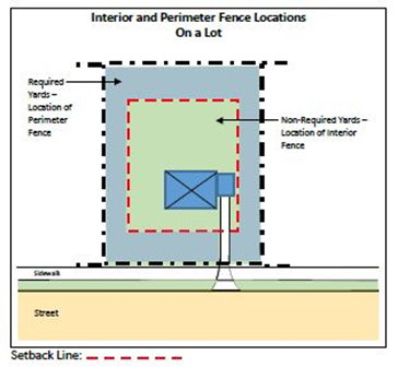
(3)
No fence or fence post, and no gate or gate post, or other structure that serves as a fence or gate, shall conflict with the turning radii of any emergency vehicle apparatus.
(4)
For all fences located in a required front yard that abuts a public or private street, and that contain a gate across a driveway:
a.
The gate shall be located no closer to the street than the front setback line to accommodate parking of vehicles on the driveway outside of the gate.
b.
A front-yard fence containing a gate across a driveway shall be located parallel to the driveway on only one side of the driveway; the fence on the other side of the driveway shall be located no closer to the street than the front setback line to provide a staging area on the lot for emergency vehicles, as illustrated below. The section of fence parallel to the driveway may be on either side of the driveway as long as a staging area acceptable to the Ann Arbor Township Fire Chief, pursuant to the International Fire Code (IFC) and the National Fire Protection Association (NFPA), is provided. The staging area shall be free from impediments, such as vegetation, slopes, structures, posts, and other impediments that make it unsuitable as a staging area.
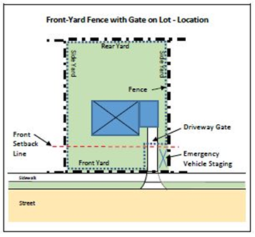
(e)
Height regulations.
(1)
All fences located on residentially-used lots in any zoning district shall comply with the following regulations:
a.
Perimeter fences located in a required front yard or in any other required yard (i.e., the yard between the property line and setback line) that abuts a public or private street shall not exceed four feet in height.
b.
Perimeter fences located in a required side or rear yard (i.e., the yard between the property line and setback line) that does not abut a public or private street shall not exceed a height of six feet.
(2)
Perimeter fences on a lot in a business district and located in any required yard, shall not exceed six feet in height.
(3)
Perimeter fences on a lot in an industrial district and located in any required yard shall not exceed a height of 12 feet.
(4)
All fences enclosing farmland shall be exempt from the regulations of this subsection.
(5)
Interior fences on a lot in any zoning district that are not located in any required yard (i.e., the yard between the property line and setback line) of that lot shall not exceed ten feet in height.
(6)
In determining the height of the perimeter fence that separates two adjoining lots and that is located within two feet of a common lot line, the maximum permitted height at any point shall be measured from the highest grade at that point within two feet on either side of the common lot line.
(7)
The height regulations in this section may be modified or waived for a perimeter fence on a common property line by written agreement between the fee simple owners of the adjoining lots. The agreement shall specify the location and height of the perimeter fence. The agreement shall be signed by such owners and shall be filed with the Zoning Officer before a permit may be issued.
(f)
Vehicular gates across private driveways. Vehicular gates across private driveways accessing individual lots are permitted if they meet the requirements of section 74-600, or other applicable sections within this chapter. If the site conditions cannot meet these requirements, then a vehicular gate across the driveway will not be permitted.
(1)
Combined entry and exit ways shall provide a minimum unobstructed width of 20 feet to accommodate emergency vehicles and apparatus, in addition to the emergency vehicle staging area. Entry and exit ways separated by landscape medians, guard houses, or other obstructions shall provide a minimum unobstructed width of 12 feet. Entry and exit ways shall have a minimum unobstructed vertical clearance of not less than 13 feet six inches.
(2)
It shall be identified if the gates are to be manual or electrical in operation.
(3)
All vehicular gates (manual and electrical) shall be designed as follows:
a.
Gates shall be a maximum 50 percent opaque to allow for clear vision through the gate and of vehicle travel ways beyond each side of the gate.
b.
Gates shall swing in, or roll/slide to the side. Gates shall not be permitted to lift up, swing out toward the roadway, or move in any other way other than permitted here.
c.
Gates shall be maintained in good condition and working order to be fully operational under any weather conditions. This includes clearing all vegetation, snow, or other conditions that may impede the operation of the gate.
d.
When fully opened, gates shall not obstruct the path of travel for vehicles or pedestrians, whether emergency or non-emergency.
e.
If the gate is locked, it shall be provided with a Knox Box mounted near the gate.
f.
Gates shall be designed to remain fully open during an emergency event with a gate-capturing device.
(4)
All electrical vehicular gates:
a.
Shall be provided with a failsafe open device in the event of power failures. The Fire Chief may remove this requirement if secondary power is provided by battery back-up or generator.
b.
Shall be designed to remain fully open during an emergency event until reset. A "Hold Open" code or override feature must be included in the design and functioning of the gate to allow gates to remain open so that multiple fire apparatus can enter without having to wait for intermittent opening of the gate(s).
c.
In business and industrial districts, the electrical gate shall interface with the building fire alarm system and also have an emergency vehicle siren controlled override to automatically open the gate for emergency access, in addition to a Knox Box described above.
(5)
If there are two or more gates in a single lot, all gates shall operate in the same fashion.
(6)
Gate activation shall not be altered or placed out of service without prior notification to the Ann Arbor Township Fire Department, Ann Arbor Township Building Department, and Washtenaw County Sheriff Department.
(g)
Vision clearance. All fences and gates shall comply with section 74-8, Visibility at intersections. A fence that is located at the intersection of a driveway and a public sidewalk, or a sidewalk along a private street, shall not obstruct vision between the driveway and sidewalk. In addition, gates shall meet the opacity requirement in section 74-600(f)(3)(a) above.
(h)
Safety regulations.
(1)
On residentially-zoned or used lots, no spikes, nails, barbed wire or other pointed objects or sharp protrusions shall be placed on, attached to, or permitted to remain on any fence. On non-residentially-zoned or used lots, no spikes, nails, barbed wire, or other pointed objects or sharp protrusions shall be placed on, attached to, or permitted to remain on, any fence below a height of ten feet, except in the case of fences that enclose farmland, in which case barbed wire may be permitted at any height of the fence.
(2)
Perimeter fences shall not contain any electric charge or current, except for electrically-operated gates across driveways and electric fences to enclose farmland. Perimeter electric fences that enclose farmland shall be permitted, provided that they are clearly identified at intervals of not less than 100 feet with warning signs that read: "Warning: Electric Fence" along the portion of the fence that abuts a public right-of-way, or is within 200 feet of a residential structure on an abutting property. Internal fences on any property may contain an electric charge or current. All electric fences shall be of a type and make approved by Underwriters Laboratories. Underground electric pet containment fences are excluded from the regulations of this section.
(3)
Gates spanning a driveway, and associated openers, must be installed pursuant to the International Fire Code (IFC) and be approved by the Township Fire Chief.
(i)
Retaining walls. A retaining wall shall be regulated as a fence if the wall projects more than 18 inches above the ground being retained.
(j)
Temporary construction fences. Temporary construction fences, and fences required for protection around excavations, shall comply with the State Construction Code. Such fences shall be removed promptly after one year from the date of the fence permit, unless a time extension is approved by the Township Building Official.
(k)
Public utility fences. Fences that enclose public utility installations shall not be located in any required yard, where the lot is located in a residential district. Such fences may be located in any required yard where the lot is located in any other zoning district. Such fences shall comply with all other regulations of this section.
(l)
Maintenance. Fences shall be maintained by the owner of the fence so as not to endanger life or property. Any fence which, through lack of repair, type of construction, or other condition that endangers life or property, is a nuisance. If an unsafe fence exists, the Zoning Officer shall serve written notice to the owner, agent, or person in control of the property on which the fence is located. The notice shall describe the unsafe condition, shall specify the repairs or changes required to make the fence safe, or shall require an unsafe fence or part thereof to be removed. The notice shall provide a time limit for such repairs, changes, or removal to be made.
If a fence is located within a recorded easement, and the fence is removed or damaged due to work in the easement, then it is the fence owner's responsibility to replace or repair the fence.
(m)
Fences in special districts. Fences located on a lot in a PUD, RRA, OP, or other special zoning district shall be exempt from the regulations of this section, but shall be regulated as provided in the approved petition for that lot.
(Comp. Ords. 1990, § 130.1122; Ord. No. 1-89, 4-17-1989; Ord. No. 6-2024, 6-17-2024)
Sec. 74-601. - Site condominium review.
(a)
Approval required. Pursuant to authority conferred by section 141 of the Condominium Act (MCL 559.241), preliminary and final site plans for all site condominiums shall be approved by the Planning Commission.
(b)
General requirements.
(1)
No permits for erosion control, building construction, grading, or installation of water or sanitary sewerage facilities shall be issued for property in a site condominium development until a final site plan therefor has been approved by the Planning Commission and is in effect. However, the Planning Commission may, at its discretion, and with appropriate conditions attached, authorize the Building Inspector to issue permits for grading and foundation work on the basis of the approved preliminary site plan. This requirement shall include contractible, conversion, and expandable site condominiums.
(2)
If a building, structure, or use to be placed on a condominium lot requires site plan approval under section 74-172, a site plan for that building, structure, or use shall be approved in accordance with article II, division 4 of this chapter, before a certificate of zoning compliance may be issued.
(3)
The Planning Commission shall have the authority to review and approve or deny preliminary and final site plans for site condominiums.
(4)
Preliminary and final site plans shall be submitted, reviewed, and approved or denied in accordance with article II, division 4 of this chapter; provided however, that preliminary and final site plans shall not be combined for site condominiums. A dimensionally stable copy of the as-built drawings shall be submitted to the Township Clerk and a second dimensionally stable copy shall be recorded with the County Register of Deeds.
(5)
Each condominium unit shall be located within a zoning district that permits the proposed use.
(6)
For the purposes of this section, each condominium unit shall be considered equivalent to a single lot and shall comply with all regulations of the zoning district in which it is located. In the case of a site condominium containing single-family detached dwelling units, not more than one dwelling unit shall be located on a condominium lot, nor shall a dwelling unit be located on a condominium lot with any other principal structure or use, except in a PUD district. Required yards shall be measured from the boundaries of a condominium lot. Lot coverage and floor area ratio shall be calculated using the land area of the condominium lot.
(7)
Each condominium unit shall be connected to the Township's water and sanitary sewer facilities, where available, or shall have a well, septic tank, and drainfield approved by the County Health Department, where Township water and sanitary sewer services are not available. The well, septic tank, and drainfield serving a condominium lot shall be located within that lot, as described in the master deed, except in a special district, in which case this requirement may be waived by the Township Board as a part of its approval of the PUD district rezoning petition.
(8)
Relocation of boundaries between adjoining condominium lots, if permitted in the condominium documents, as provided in section 48 of the Condominium Act (MCL 559.148), shall comply with all regulations of the zoning district in which they are located and shall be approved by the Zoning Officer. These requirements shall be made a part of the bylaws and recorded as part of the master deed.
(9)
Each condominium lot that results from a subdivision of another condominium lot, if such subdivision is permitted by the condominium documents, as provided in section 49 of the Condominium Act (MCL 559.149), shall comply with all regulations of the zoning district in which it is located and shall be approved by the Zoning Officer. These requirements shall be made a part of the condominium bylaws and recorded as part of the master deed.
(10)
All information required by this chapter shall be updated and furnished to the Zoning Officer until applicable certificates of zoning compliance have been issued, as provided in section 74-54.
(c)
Preliminary site plan requirements.
(1)
A preliminary site plan shall be filed for approval at the time the notice of proposed action is filed with the Township.
(2)
The preliminary site plan shall include all land that the developer intends to include in the site condominium project.
(3)
The preliminary site plan shall include all information required in section 74-173(b) except that, in the case of a development that consists only of condominium lots and not buildings or other structures at the time of plan review, the location and dimensions of the condominium lots rather than individual buildings or other structures, and required yards shall be shown on the preliminary site plan.
(d)
Final site plan requirements.
(1)
A final site plan shall be filed for review for each phase of development shown on the approved preliminary site plan.
(2)
A final site plan for any phase of development shall not be filed for review by the Planning Commission unless a preliminary site plan has been approved by the Planning Commission and is in effect.
(3)
A final site plan shall include all information required by section 66 of the Condominium Act (MCL 559.166), the Condominium Subdivision Plan, and the master deed and bylaws. The final site plan shall also include all information required in 74-174(b), except that, in the case of a development that consists only of condominium units rather than buildings or other structures at the time of plan review, the location and dimensions of the condominium units, rather than individual buildings or other structures, and required yards shall be shown on the final site plan.
(4)
The applicant shall provide proof of approvals by all County and State agencies having jurisdiction over improvements in the site condominium development, including, but not limited to, the County Road Commission, County Drain Commissioner, County Health Department, and the State Department of Environmental Quality. The Planning Commission shall not approve a final site plan until each County or State agency having such jurisdiction has approved that portion of the final site plan that is subject to its jurisdiction.
(e)
Revision of condominium subdivision plan. If the condominium subdivision plan is revised, the final site plan shall be revised accordingly and submitted for review and approval or denial by the Planning Commission before any building permit may be issued, where such permit is required.
(f)
Amendment of master deed or bylaws. Any amendment to a master deed or bylaws that affects the approved preliminary or final site plan, or any conditions of approval of a preliminary or final site plan, shall be reviewed and approved by the Planning Commission before any building permit may be issued, where such permit is required. The Planning Commission may require its review of an amended site plan if, in its opinion, such changes in the master deed or bylaws require corresponding changes in the approved site plan.
(g)
Relation to subdivision ordinance. The provisions of divisions 3 and 4 of chapter 58, subdivisions and land division, shall apply to site condominiums and are incorporated herein by reference. In applying the design and development standards of division 3 and the improvement requirements of division 4 of chapter 58, the standards and requirements that are intended to apply to lots in a subdivision shall apply instead to condominium lots. Nothing in this section shall be construed as requiring a site condominium to obtain plat approval under chapter 58 or the Land Division Act (MCL 560.101 et seq.).
(h)
Development agreement. The Planning Commission may require, as a condition of approval, that the applicant enter into a development agreement with the Planning Commission and the Township, incorporating therein the terms and conditions of final site plan approval, and record the same in the County Office of the Register of Deeds.
(i)
Application for building permit. Any application for a building permit for construction to be located in a general common element shall include written authorization for the application by the condominium association.
(j)
Monuments and lot irons.
(1)
Monuments shall be set at all boundary corners and deflection points and at all road right-of-way intersection corners and deflection points. Lot irons shall be set at all condominium lot corners and deflection points of condominium lot lines.
(2)
The Township Engineer may grant a delay in the setting of required monuments or irons for a reasonable time, but not to exceed one year, on condition that the developer deposit with the Township Clerk cash, a certified check, or an irrevocable bank letter of credit running to the Township, whichever the developer selects, in an amount as determined from time to time by resolution of the Township Board. Such deposit shall be returned to the developer upon receipt of a certificate by a surveyor registered in the State that the monuments and irons have been set as required, within the time specified. If the developer defaults, the Township Board shall promptly require a registered surveyor to set the monuments and irons in the ground as shown on the condominium site plans, at a cost not to exceed the amount of the security deposit.
(k)
Road rights-of-way; easements. Road rights-of-way shall be described separately from individual condominium lots, and shall be accurately delineated by bearings and distances on the condominium subdivision plan and the final site plan. The right-of-way shall be for roadway purposes and for the purposes of locating, installing, maintaining, and replacing of public utilities. The developer shall dedicate easements to the Township for all public water and sanitary sewer lines and appurtenances.
(l)
Improvements. All improvements in a site condominium shall comply with the design specifications as adopted by the Township Board and any amendments thereto.
(m)
Private streets. Any private street in a site condominium shall comply with chapter 50, article II, private roads.
(Comp. Ords. 1990, § 130.1123; Ord. No. 8-89, 8-21-1989)
Sec. 74-602. - Bed and breakfast operations.
(a)
A bed and breakfast operation shall be permitted only in a single-family detached dwelling unit that is the principal dwelling unit on the property. A dwelling unit containing a bed and breakfast operation shall be the principal residence of the operator, and the operator shall live in the principal dwelling unit during the time the bed and breakfast operation is active.
(b)
A dwelling unit containing a bed and breakfast operation shall comply with State regulations for bed and breakfast operations, and applicable fire safety regulations, and shall be regularly maintained so as to remain in compliance with all applicable codes and regulations. The applicant for a bed and breakfast conditional use permit shall provide written evidence of inspection and compliance with applicable codes and regulations to the Township before a certificate of occupancy is granted.
(c)
A dwelling to be used for a bed and breakfast operation shall have a minimum floor area of 2,000 square feet, excluding basement and garage floor areas. Each sleeping room shall have a minimum floor area of 144 square feet and shall not have more than two occupants. Not more than six rooms shall be provided for bed and breakfast operations in one single-family detached dwelling. If the applicant cannot comply with off-street parking, as required by subsection (m) of this section, and the other provisions of this chapter, the number of rooms for bed and breakfast operations shall be reduced to that number which is served by off-street parking. The Planning Commission may reduce the number of rooms under this subsection if it determines that the use of the site for off-street parking to meet the requirements of the section would adversely affect the residential character of the site within the particular zoning district.
(d)
Lavatories, toilets, and bathing facilities shall be available within the principal structure to all persons using the bed and breakfast operation in that structure. One bathroom, containing a lavatory, toilet, and a bathtub or shower shall be provided for each two sleeping rooms. Each such bathroom shall be physically separated from the living quarters of the resident family. Bathrooms required under this subsection for guests shall be in addition to the facilities utilized by the resident family. Sharing of bathrooms between guests and the resident family shall not be permitted.
(e)
A single-family detached dwelling unit that contains a bed and breakfast operation shall not have, or be converted to, more rental rooms than the number of bedrooms that existed on the date of adoption of this amendment. Any addition to a dwelling for the purpose of increasing the number of bed and breakfast rooms shall be prohibited. For purpose of application of this subsection, bedrooms shall include rooms used on a regular basis for sleeping by the inhabitants prior to the conversion of the single-family detached dwelling to bed and breakfast operations, such rooms which have dual purposes as bedrooms are sometimes known or used as dens/bedrooms, studies/bedrooms, libraries/bedrooms.
(f)
No kitchen or other food preparation area or facilities shall be provided in or available to the rooms in a bed and breakfast operation. Cooking facilities in a dwelling containing a bed and breakfast operation shall be limited to the residential kitchen.
(g)
No meals or food service shall be provided to a guest except the following: breakfast, snacks, coffee and tea service.
(h)
Service of alcoholic beverages in a bed and breakfast operation shall be prohibited.
(i)
One sign, not more than three square feet in area, shall be permitted for each bed and breakfast operation. The sign shall be wall mounted and shall meet all applicable regulations of article IX of this chapter.
(j)
A single-family detached dwelling unit containing a bed and breakfast operation shall have no outside appearance of the presence of the operations, except the sign permitted in this section.
(k)
Bed and breakfast facilities shall not be used for receptions, weddings and similar celebrations and parties.
(l)
The maximum length of stay for any occupant of a bed and breakfast operation shall be 14 days in any period of 90 consecutive days.
(m)
One off-street parking space shall be provided for each bedroom in a bed and breakfast operation. Parking spaces for bed and breakfast registrants shall be in addition to spaces required for the dwelling unit and shall comply with regulations of article VIII of this chapter.
(n)
A property survey, drawn to scale, with dimensions, and showing property lines and all structures and other improvements shall be submitted with the application for a conditional use permit. If the proposed use involves changes to the site outside the building, the Planning Commission may require that the applicant submit a final site plan, as required in article II, division 4 of this chapter or portions of a final site plan that are applicable to the proposed changes and be reviewed and approved by the Planning Commission before the conditional use permit may be issued.
(o)
An approved conditional use permit for a bed and breakfast operation shall not become effective, and a bed and breakfast operation shall not be opened for business, until all licenses required therefor have been issued.
(Comp. Ords. 1990, § 130.1124)
Sec. 74-603. - Child care facilities.
(a)
A group day care home or child care center shall be appropriately licensed by the State agency having jurisdiction.
(b)
A child care center shall not be located within 1,500 feet from any of the following:
(1)
Another licensed group day care home.
(2)
Another adult foster care small group home or large group home licensed under the Adult Foster Care Facility Licensing Act (MCL 400.701 et seq.).
(3)
A facility offering substance abuse treatment and rehabilitation service to seven or more people licensed under article 6 of the Public Health Code (MCL 333.6101 et seq.).
(4)
A community correction center, resident home, halfway house, or other similar facility which houses an inmate population under the jurisdiction of the State Department of Corrections.
(c)
All outdoor play areas shall be enclosed by a fence not less than four feet nor more than six feet in height and capable of containing the children within the play area.
(d)
Signs are permitted as regulated in article IX of this chapter.
(e)
Off-street parking shall be provided for employees. Parking for dropoff and pickup of children shall also be provided.
(f)
The group day care home or child care center shall be inspected for compliance prior to the issuance of a certificate of occupancy.
(g)
A group day care home shall not require the modification of the exterior of the dwelling nor the locations of playground equipment in the front yard.
(h)
The Planning Commission may establish additional conditions if necessary.
(Comp. Ords. 1990, § 130.1125)
State Law reference— Restrictions of zoning of day care facilities, MCL 125.3206.
Sec. 74-604. - Wind energy conversion systems.
(a)
Intent. It is the intent of the Township to permit the effective and efficient use of wind energy conversion systems (WECS) by regulating the siting, design, and installation of such systems to protect the public health, safety, and welfare, and to ensure compatibility of land uses in the vicinity of WECS. This section does not establish or guarantee air or light or wind rights or establish access to the air, light, or wind.
(b)
Approval required. It shall be unlawful to construct, erect, install, alter, or locate any TMT or WECS within the Township except in compliance with the section. A building permit is required for any TMT or WECS pursuant to Chapter 14 and this section.
(c)
Conditional use, on-site. On-site WECS or TMT shall be considered a conditional use in all zoning districts and shall be subject to the provisions of this Section and Chapter 74, Article II, Division 3, Conditional Use Permits. Applications for an on-site WECS shall meet all of the requirements for a conditional use permit application in accordance with section 74-133, except that a complete site plan shall only be required in the circumstances described in subsection (h) below. Submittal requirements for an on-site WECS are established in subsection 74-604 h).
(d)
Conditional use, commercial. Commercial WECS and TMT shall be considered a conditional use in the following districts and shall be subject to the provisions of this Section and Chapter 74, Article II, Division 3, Conditional Use Permits: R-C, A-1, O, OP, R-D, I-1, PL, RRA. Applications for a commercial WECS or TWM shall require a complete conditional use permit application in accordance with section 74-133, including a complete site plan in accordance with Article II, Division 4 of this chapter.
(e)
Planned unit development. If an applicant proposes a WECS or TMT in an initial application for a planned unit development under section 74-542, this section (together with section 74-542) shall apply to the proposal, except that the applicant need not apply for a conditional use permit. If an applicant proposes a WECS or TMT in a PUD district after approval of the final site plan for the PUD (or, in the case of a PUD developed in phases, after approval of the final site plan for the phase in which the WECS or TMT will be located), this section (including the requirement of a conditional use permit) will apply to the proposal; however, the applicant need not comply with section 74-542(i) (governing amendment to approved area plans and approved site plans in PUD districts).
(f)
Schedule of uses. The following chart displays the schedule of use regulations pertaining to WECS within the zoning districts of Ann Arbor Township. A blank box indicates that the use is not permitted in that district.
(g)
Application. The application for any WECS or temporary meteorological tower shall include, at a minimum, the following:
(1)
Applicant Information; Fees. Name, address and contact information, together with the fee established by the Township Board.
(2)
Project description. A general description of the proposed project as well as a legal description (property identification number) of the property on which the project would be located.
(3)
Plot plan and documentation. The plot plan shall include maps showing the physical features and land uses of the project area, both before and after construction of the proposed project. The plot plan shall include:
a.
The project area boundaries.
b.
The location, height and dimensions of all existing and proposed structures and fencing.
c.
Distance of proposed structure from all property lines and permanent structures.
d.
The location, grades and dimensions of all temporary and permanent on-site access roads.
e.
Existing topography.
f.
Water bodies, waterways, wetlands, and drainage ditches (county drains).
g.
All new infrastructure above ground related to the project.
h.
The location of all overhead utility wires.
(4)
Additional documentation.
a.
Insurance: Proof of the applicant's appropriate liability insurance.
b.
Sound pressure level: Documentation of the manufacturers designed sound pressure levels (decibels) for unit to be installed.
c.
Certifications: Certification that applicant has complied or will comply with all applicable state and federal laws and regulations.
d.
Grant of authority: The applicant shall provide evidence of ownership of the land which the WECS or temporary meteorological tower is to be located and the written consent of the land owner if different from the applicant. If the applicant is leasing land the applicant shall provide a copy of the lease agreement and the land owner's written authorization for the applicant to construct the structure.
(5)
Compliance with laws and regulations. The applicant, operator of the WECS or TMT, and owner of the land on which the WECS or TMT is located are each responsible for ensuring that the installation, operation, use and removal of the WECS or TMT complies with all applicable state, federal and local laws, ordinances and regulations, and shall submit proof of such compliance to the township upon request. Further, such applicant, operator and owner and shall each defend, indemnify and hold harmless the Township from and against any and all loss, liability, cost or expense including injury to persons or property as a result of any failure of the WECS or TMT to comply with applicable laws, ordinances or regulations. Notwithstanding the foregoing, the Township shall have full authority, at its option, to defend, compromise, or settle any claim of violation of applicable laws, ordinances or regulations at the expense of the applicant, owner or operator.
(h)
Application—On-site WECS conditional use. The application for an on-site WECS or temporary meteorological tower when permitted as a conditional use shall, in addition to the information required above, meet all of the requirements for a conditional use permit application, except that a complete site plan shall not be required unless (i) the proposed WECS or TMT involves changes to the site outside the footprint of the WECS or TMT, or (ii) the Planning Commission finds that the scale or character of the project or other factors, including the nature of the surrounding area warrant a complete site plan. If a complete site plan is not required by the Planning Commission, the applicant shall submit the information described in (g)(3) above or such other information as the Planning Commission may determine.
(i)
Application—Commercial WECS conditional use. The application for a commercial WECS shall meet all of the requirements for a conditional use permit application and shall include a complete site plan in accordance with Article II, Division 4 of this chapter.
(j)
Standards and requirements. All on-site WECS, commercial WECS and temporary meteorological towers shall meet the standards and findings of 74-136 and the following additional standards and requirements:
(1)
Property setbacks.
a.
The distance between a WECS or TMT and the nearest property line shall be at least the 1.5 times the height of the WECS or TMT.
b.
No part of the WECS or TMT structure, including guy wire anchors, may extend closer than ten feet to the owner's property line.
(2)
Height. On-site and commercial WECS and TMT shall be less than 200 feet in height. Height shall be measured from the existing grade to the tip of the turbine blade at its highest point for a horizontal axis turbine, and to the highest point of a vertical axis turbine. Height for on-site WECS mounted to a structure shall also be measured from grade to the tip of the turbine blade at its highest point for a horizontal axis turbine, and to the highest point of a vertical axis turbine. The applicant shall demonstrate compliance with all FAA regulations and the Michigan Tall Structures Act as part of the approval process, if applicable.
(3)
Other Required Setbacks.
a.
The distance between a WECS or temporary meteorological tower and a road or a public right-of-way shall be at least 1.5 times the height of the WESC or TMT.
b.
Distance between. The distance between a WECS and any other on-site or commercial WECS shall be at least three times the height of the taller of the two WECS.
(4)
Noise; sound pressure level.
a.
Audible noise or the sound pressure level of an on-site WESC or commercial WECS shall not exceed 50 dB(A) (A-weighted decibels) at the property line closest to the WECS. For commercial WECS, modeling and analysis of sound pressure shall be required in accordance with subsection 74-604(p)(8) below.
b.
This sound pressure level shall not be exceeded by more than five dB(A) for more than three minutes in any hour of the day.
(5)
Lighting. No WECS or TMT shall be artificially lighted.
(k)
Construction codes, towers and interconnections standards:
(1)
Every WECS and TMT shall comply with all applicable State construction codes and local building permit requirements.
(2)
Every WECS and TMT shall comply with Federal Aviation Administration requirements, the Michigan Airport Zoning Act (PA 23 of 1950), The Michigan Tall Structures Act (PA 259 of 1959), and any other applicable State or Federal laws or regulations.
(3)
An on-site WECS or Commercial WECS that is tied to the electrical grid shall comply with Michigan Public Service Commission and utility interconnection requirements. Off-grid WECS are exempt from this requirement.
(l)
Safety:
(1)
Design safety certification. The safety of the design of every WECS or TMT shall be certified by the applicant's professional engineer registered in the State of Michigan and reviewed by the Township. The standard for certification shall be included with the permit application. If WECS or TMT construction is approved, the professional engineer shall certify that the construction and installation of the WECS or TMT meets or exceeds the manufacturer's construction and installation standards, and any applicable State and Federal laws and regulations prior to operation.
(2)
Controls and brakes. Every WECS or TMT shall be equipped with manual and automatic controls to limit rotation of blades to a speed not to exceed the designed limits of the WECS or TMT. The applicant's professional engineer must certify that the rotor and overspeed control design and fabrication conform to applicable design standards. No changes or alterations from certified design shall be permitted unless accompanied by a professional engineer's statement of certification approved by the Township.
(3)
Lightning. Every WECS or TMT shall have lightning protection.
(4)
Guy wires. If an on-site WECS or TMT is supported by guy wires, the wires shall be clearly visible to a height of a least six feet above the guy wire anchors. Every commercial WECS must be of a freestanding monopole design and guy wires shall not be used.
(5)
Grade clearance. The minimum vertical blade tip clearance from grade shall be 25 feet for any horizontal-axis WECS or from any moving component of a vertical-axis wind energy conversion system.
(6)
Electromagnetic interference. No WECS or TMT shall be installed in any location where its proximity to existing fixed broadcast, retransmission, or reception antennae for radio, television, or wireless phone or other personal communication systems or emergency broadcast system would produce electromagnetic interference with signal transmission or reception unless the applicant provides a replacement signal to the affected party that will restore reception to at least the level present before operation of the wind energy system. Such replacement signal shall be subject to Township approval. No WECS or TMT shall be installed in any location within the line of sight of an existing microwave communications link where operation of the wind energy system is likely to produce electromagnetic interference in the link's operation unless the interference is insignificant.
(7)
Color. Towers and blades shall be painted a non-reflective neutral color designated on the application and approved by the Township or as otherwise required by law.
(8)
Climb Prevention. Every WECS or TMT must be protected by anti-climbing devices 12 feet from base of pole.
(m)
Removal of abandoned on-site WECS or temporary meteorological towers. In the event an on-site WECS or temporary meteorological tower is abandoned or unused for a period of 180 days, or if a WECS or temporary meteorological tower is damaged, the owner of the tower or the land shall promptly remove the tower and all related equipment. Failure to remove the tower and related equipment in accordance with the foregoing shall subject the tower owner and land owner to fines established by the Township Board. In addition, by accepting a permit for the on-site WECS or TMT, the applicant and land owner agree that in the event the tower and equipment is not removed as required, after 30 days notice from the Township, the Township may undertake such removal and bill the costs to the applicant and land owner plus an administrative fee of 15 percent which if not paid within 30 days shall be assessed against the land on which the tower and equipment is located and collected in the same manner as delinquent taxes.
(n)
Additional requirements for commercial WECS. The following standards and requirement shall apply to every commercial WECS:
(1)
Warnings. A visible warning sign of High Voltage shall be placed at the base of every Commercial WECS. The sign must have at least six (6") inch letters with ¾-inch stroke. Such signs shall be located a maximum of three hundred (300) feet apart and at all points of site ingress and egress.
(2)
Signage. In addition to warning signs and signs required by law, every Commercial WECS shall be equipped with a sign containing owner identification and contact information. No advertising is permitted.
(3)
Liability Insurance. The owner or operator of a Commercial WECS shall maintain a current commercial liability and property damage insurance policy with coverage limits acceptable to the Township pertaining to installation and operation of the Commercial WECS. The amount and terms of the policy shall be established as a condition of conditional use permit approval. The Township and land owner shall be named as additional insured. Certificates of insurance shall be provided to the Township annually.
(4)
Security. The application shall include a description of security to be posted at the time of receiving a building permit for the WECS to ensure removal of the WECS when it has been abandoned or is no longer needed, as provided in subsection 10 below. The security shall be the form of: (i) cash; (ii) letter of credit; or, (iii) an escrow agreement, in an amount approved by the Township engineer and in a form approved by the Township Attorney providing for timely removal of the Commercial WECS as required under this Section, and payment of any costs and attorney fees incurred by the Township in connection with such removal.
(5)
Visual Appearance; Powerlines. The design of the WECS buildings and related structures shall, to the extent reasonably possible, use materials, colors, textures, screening and landscaping that will blend WECS components with the natural setting and existing environment. The electrical collection system shall be placed underground within the interior of each parcel at a depth designed to accommodate any existing land use to the maximum extent practicable. The collection system may be place overhead adjacent to public roadways, at points of interconnection to the electric grid or in other areas as necessary.
(6)
Threatened and Endangered Species. The applicant shall submit an endangered and threatened species survey conducted by a qualified professional, such as an ecologist or zoologist, describing the potential impact of the WECS on any species listed as threatened or endangered by the federal government or the state of Michigan, including but not limited to migratory birds or bats. Permits shall not be issued unless the study determines that there shall be no negative effect on such species. Alternatively, the applicant may submit an endangered species permit from the State of Michigan to fulfill this requirement.
(7)
Annual Inspection; Maintenance. The WECS and surrounding area shall be maintained in accordance with industry standards including painting and landscaping. Every Commercial WECS must be inspected annually by an authorized factory representative or professional engineer to certify that the WECS is in good working condition and is not a hazard to persons or property. Certification records shall be submitted annually to the Township.
(8)
Sound Pressure Level. As part of the application and prior to installation of any Commercial WECS, the applicant shall provide modeling and analysis to Ann Arbor Township that will confirm that the Commercial WECS will not exceed the maximum permitted sound pressure levels. Modeling and analysis shall conform to IEC (International Electrotechnical Commission) 61400, which establishes structural and performance safety provisions for wind energy conversion systems, and ISO (International Organization for Standardization) 9613, which describes a method for calculating the attenuation of sound during propagation outdoors in order to predict the levels of environmental noise at a distance from a variety of sources. After installation of the Commercial WECS, sound pressure level measurements shall be done by a third party, qualified professional according to the procedures in the most current version of ANSI S12.18, which provides an alternative method of measurement of sound pressure levels in the outdoor environment, considering the effects of the ground, the effects of refraction due to wind and temperature gradients, and the effects due to turbulence. All sound pressure levels shall be measured with a sound meter that meets or exceeds the most current version of ANSI S1.4 specifications for a Type II sound meter. Documentation of the sound pressure level measurements shall be provided to the local government within 60 days of the operation of the project.
(9)
Shadow Flicker. The applicant shall conduct a four-season analysis of potential shadow flicker. The analysis shall identify the locations of shadow flicker that may be caused by the project and the expected durations of the flicker at these locations from sun-rise to sun-set over the course of a year. The analysis shall identify all areas where shadow flicker may affect occupants or users of the structures or properties. The analysis shall describe measures that will be taken to eliminate or mitigate adverse effects.
(10)
Removal. A commercial WECS shall be removed by the owner of the WECS or land when the commercial WECS has been abandoned or unused for 180 days ("non-use period"). For purposes of this section, the damage, destruction or removal of any part of WECS equipment, or the cessation of operations shall be considered as the beginning of a non-use period. The WECS owner or applicant shall notify the Township of the beginning of any non-use period or any removal of equipment. The end of the non-use period may be sooner than 180 days after commencement if the WECS or any portion of the facility becomes a nuisance or is dangerous to the public health, safety and welfare.
a.
At the end of the non-use period, the owner of the WECS or the land shall immediately apply for and obtain any applicable demolition or removal permit, and shall immediately proceed with and complete the demolition and removal of the WECS and restoration of the land to the condition existing prior to installation, to the extent reasonably feasible.
b.
If the required demolition, removal and restoration of the WECS has not been lawfully completed within 60 days after the end of the non-use period, then after 15 days' prior written notice to the land owner and the WECS owner, the Township may remove or secure the removal of the WECS and related equipment and the Township's costs, expenses, attorneys fees and consultants fees, plus a 15-percent administrative charge may be drawn and collected from the security described in (4) above, and any costs and fees in excess of the amount of the security shall constitute a lien on the land on which the WECS is located and may be collected in the same manner as delinquent taxes.
(Ord. No. 3-2010, 2-15-2010)
Sec. 74-605. - Tree and woodland resource preservation.
(a)
Introduction and purpose. Trees and woodlands provide for a number of public benefits, including environmental, social, and aesthetic benefits. Uncontrolled development or tree removal could result in unnecessary removal of trees, woodlands and related natural resources. Therefore, it is the intent of this section to:
(1)
Encourage the preservation of trees and related natural resources of the Woodland ecosystem on undeveloped land and in connection with the development of land;
(2)
Prohibit clear cutting of Woodland areas prior to or in anticipation of development without prior approval from the Planning Commission;
(3)
Prohibit removal of protected trees or woodlands without a permit when required by this section;
(4)
Provide for the protection, preservation, proper maintenance and use of trees and Woodlands to minimize damage from erosion and siltation, loss of wildlife and vegetation, and/or from the destruction of the natural habitat;
(5)
Provide for the paramount public concern for these natural resources in the interest of the health, safety and general welfare of the residents of the Township, in keeping with article IV, section 52 of the Michigan Constitution of 1963 and the intent of the Michigan Natural Resources and Environmental Protection Act, PA 451 of 1994.
(b)
Applicability. This section shall apply to all land located in the Township, unless exempt pursuant to subsection (d) below, including parcels that are in the process of being annexed to the City of Ann Arbor until the date that such annexation is final and notice of such official annexation is provided to the Township by the State of Michigan.
(c)
Prohibitions.
(1)
Clear cutting of woodlands, including grubbing, on parcels covered by this section is prohibited without first obtaining a tree/woodland removal permit. Clear cutting as a long term forestry management practice for long term regrowth of the woodland and not prior to or in anticipation of development of land is allowed without a tree/woodland removal permit if consistent with a woodland stewardship plan described in subsection (m) below that has been reviewed, approved and is on file with the Township prior to the start of any forestry management practices or operations.
(2)
Removal of protected trees or woodlands without a permit when required by subsection (g) below is prohibited.
(d)
Exemptions. Tree and Woodland removal associated with the following shall be exempt from the requirements of this section:
(1)
Parcels that are not subject to site plan review or subdivision plat review as defined in article II, and:
a.
Are three acres or less.
b.
Are greater than three acres, but where no more than 100 dbh inches of protected trees are removed within 12 months.
(2)
Farming operations, as defined by the Right to Farm Act, which are lawfully existing and operating in accordance with Generally Accepted Agricultural Management Practices as adopted by the Michigan Department of Agriculture.
(3)
Forestry operations conducted in compliance with a woodland stewardship plan that has been filed with the Township Building Official and has been reviewed and approved by the Township Environmental Consultant prior to the start of any forestry management practices or operations.
(4)
Installation, repair or maintenance of public utilities lawfully operating in the township in accordance with an operating permit or right-of-way permit issued by the township but only to the extent that such tree or woodland removal is necessary for protection of utility lines and the public health, safety and welfare.
(5)
Work within an existing public road right-of-way or an existing private road easement but only to the extent necessary for safe access along such right of way or private road easement and to protect the public health, safety and welfare in accordance with an operating permit or right-of-way permit issued by the Township.
(6)
Any trees which are demonstrated by the property owner to the satisfaction of the Township Building Official, in consultation with the Township Environmental Consultant, to have a health and condition standard factor of less than 50 percent based upon the standards established by the International Society of Arboriculture.
(7)
Any tree that poses a safety hazard, whose removal will prevent injury or damage to persons or property, and provided that removal is accomplished through the use of accepted standard forestry practices.
(e)
Authorization. Under certain conditions defined in this section, a tree/woodland removal permit may be authorized by the Planning Commission to allow limited removal of tree/woodland resources, or construction, activity, use, or operations within a woodland area, if preservation techniques described in this section have been applied to the greatest extent practical, and tree and/or woodland removal is found by the Planning Commission to be unavoidable.
(f)
Filing of application; fee; amendment. Application for proposed tree/woodland removal permit shall be made by filing an application form and required fee with the Township Clerk. The fees shall be set by resolution of the Township Board. In addition, when this section requires or permits review, approval and filing of a woodland stewardship plan, the plan shall be filed with the Township Clerk on an application form provided by the Township and the required fee. The fee for review of the woodland stewardship plan shall be set by resolution of the Township Board. Any request for amendment to a tree/woodland removal permit shall be made by filing an application form with the Township and the required fee. The fee for amendment to a tree/woodland removal permit shall be set by the Township Board. Any amendment to a tree/woodland removal permit shall be processed in the same manner as the initial permit, and the amendment request and the amended plan submittals shall highlight the proposed changes, including any additional tree/woodland removal proposed, the reasons for such changes, and any additional mitigation proposed, unless otherwise required by the Township environmental consultant in consultation with the Planning Commission due to the nature of the proposed amendment.
(g)
Application procedure for tree/woodland removal permit. The provisions of this section shall apply to all parcels in the Township that (1) require site plan review or subdivision plat review as defined in Article II, or (2) are greater than three acres in area (unless exempted in (c) or (d)(1)(b) above). The procedure for review and approval of a tree/woodland removal permit is as follows:
(1)
When site plan or subdivision plat review is required. If protected trees or woodlands are proposed for removal as part of a development proposal, the following are required as a component of the preliminary site plan submission pursuant to section 74-175, or the preliminary plat, tentative approval pursuant to section 58-72.
a.
A Tree/woodland survey.
b.
A tree replacement plan (see tree replacement options section 74-605 (n)).
The planning commission shall review the tree/woodland survey, any tree replacement plan, and all information required by this section and the site plan or plat review sections, as applicable. The planning commission shall approve, approve with conditions or deny the applicant's tree/woodland removal permit in accordance with the standards set forth in this section and the site plan or plat review sections, as applicable.
(2)
When site plan or subdivision plat review is not required. If protected trees or woodlands are proposed for removal and are not part of a development proposal, the Planning Commission shall conduct a review of permit applications in the following situations:
a.
For parcels that are greater than three acres in area, when more than 100 DBH inches of protected trees are to be removed within 12 months (unless exempt pursuant to (c) or (d)(1)(b) above).
b.
The Planning Commission may require a tree/woodland survey in circumstances where the Commission determines that it would be helpful in understanding the number and/or sizes of trees proposed for removal. At a minimum, a plot plan, as defined in subsection 74-605(l) of this section, shall be submitted that provides the location, size and type of all protected trees and/or woodlands to be removed as well as a tree replacement plan and tree protection method where necessary.
The Planning Commission, in consultation with any appropriate consultants if needed, shall approve or deny the applicant's tree/woodland removal permit in accordance with the standards set forth in this section.
(h)
Review criteria. In determining whether the proposed disturbance or removal of trees and/or woodlands is limited to the minimum necessary to allow a reasonable use of the land, the Planning Commission shall apply the following criteria:
(1)
The importance and overall value of the trees/woodlands on the site. In general, the importance of trees/woodlands increases with rarity, size, and age.
(2)
The existence of overlapping natural features such as wetlands, 100-year flood plains, woodlands, landmark trees, steep slopes or endangered species in one area. Overlapping natural features increase the importance and overall value for preservation of the area.
(3)
The impact of the proposed disturbance on the integrity of ecological systems or the continuity between natural features. Wherever possible, ecological systems and continuity between natural features should be preserved.
(4)
The amount of disturbance in relation to the scale of the proposed development.
(5)
The adequacy of the tree replacement plan or other mitigation plan.
(6)
The justification for forestry management practices, the benefits of the proposed disturbance and proposed coordination with the recommendations in the woodland stewardship plan.
(i)
Invasive trees. The following species are considered invasive and shall not be considered a protected tree under this section.
(j)
Landmark trees. The following species that meet the minimum size (DBH) requirement are considered landmark trees.
(k)
Tree/woodland survey. A Tree/woodland survey shall meet the following requirements:
(1)
Plan requirements. If a tree/woodland survey is required as part of the site plan or subdivision plat review process, then the scale of the survey shall be the same as the site plan or the subdivision plat. In any other case, a tree/woodland survey shall be a scaled drawing which shall not exceed 100 feet to the inch.
(2)
Plan contents. In all cases a tree/woodland survey shall show all protected trees and woodlands to be removed and to remain. (Note that the phrase "protected trees" includes "landmark trees.") The survey shall contain the following:
a.
Location of all protected trees and woodlands accurately plotted;
b.
Common and botanical names of all protected trees, their size in inches at their DBH, and a description of each tree's health
c.
Ecological characterization report, prepared by a professional or professionals qualified in the areas of ecology, botany, wildlife biology or other relevant discipline that includes, at a minimum, the following information.
1.
The plant species, plant communities/associations (paying particular attention to Michigan endangered, threatened, and special concern species) that the Woodland contains;
2.
The wildlife use and habitat (paying particular attention to Michigan endangered, threatened, and special concern species) showing the species using the woodland, wildlife movement corridors, the times or seasons that the woodland is used by those species and the "functions" (meaning feeding, watering, cover, nesting, roosting, and/or perching) that the woodland provides for such wildlife species;
3.
The boundary of wetlands that are located within, either partially or wholly, the woodland and a description of the vegetation and ecological functions provided by those wetlands;
4.
The pattern, species, and location of native trees, native tree stands, and other native site vegetation including their relationship to adjacent areas;
5.
The top of the bank or shoreline of any inland lake or stream located, either partially or wholly, within the woodland; and
6.
The general ecological functions provided by the woodland and its features.
7.
Other information necessary or advisable for a proper evaluation of the site and proposed tree removal.
If the proposed activity or proposed woodland impacts are minimal as determined by the Planning Commission, and as assisted by the Building Official, environmental consultant, or others, the Planning Commission may, in its discretion, waive the requirement for an ecological characterization Report.
(3)
Tree tags. All protected trees shall be numbered and non-corrosive tags bearing that number shall be attached to each respective tree.
(4)
Professional qualifications. The tree/woodland survey must be sealed by a forester registered in the State of Michigan, an International Society of Arboriculture certified arborist, or a forester certified by the Society of American Forestry. The ecological characterization report that is part of the Tree/Woodland Survey must be signed by the ecologist, botanist, wildlife biologist or other, stating their qualifications to prepare such report.
(5)
Extent of survey. In the case of large or heavily wooded parcels, plotting of protected trees that are more than 100 feet outside of the edge of the area to be disturbed may be waived by the Planning Commission at the request of the applicant and upon a recommendation by the Township environmental consultant.
(l)
Plot plan. When this section requires a plot plan, the plan shall include the following information:
(1)
Scale, date, and north directional arrow.
(2)
Location map showing major intersections, and dimensioned diagram of the parcel.
(3)
Dimensioned location, outline, and dimensions of all existing and proposed structures, and the location and extent of all uses not involving structures.
(4)
Location, species, size, and condition of protected trees and woodlands to be removed.
(5)
Additional information as required by the Planning Commission for the purposes of determining compliance with the provisions of this chapter.
(m)
Woodland stewardship plan. When a woodland stewardship plan is being proposed, it must be reviewed and approved by the Township environmental consultant prior to the start of any forestry management practices or operations. The plan shall meet the following requirements:
(1)
Plan contents. The contents of a woodland stewardship plan must comply with the requirements established by the State of Michigan's Forest Stewardship Program (FSP) including:
a.
Property identification and overview: Landowner and plan writer's names, addresses, phone numbers and signatures; acreage under the stewardship plan; date; landowners goals; location of site and directions to property; cover page with FSP logo, date, etc.; completed landowner assessment form; interaction with surrounding landscape.
b.
Property maps and location information: General property description; forest type map; activity map; soils map, legend, and soils description.
c.
Resource descriptions: Narrative description of management unit; stands described by cover type and acreage; major species; stand size class, density soil type, site quality; stand quality, including age, health, growth rate, volume, timber quality, threatened and endangered species database checked, habitat class information, cultural heritage data, stand history, wildlife habitat quality and uses, timber production potential, recreational opportunities, wetlands and water quality issues, and aesthetics.
d.
Prescriptions/recommendations: Schedule of prescribed activities for the next ten years; stand/management unit specific goals statement; how prescriptions use the appropriate best management practices to minimize damage to the resources in each management unit; long-range silvicultural objectives for each stand or cover type clearly stated and related to landowners' goals.
(2)
Professional qualifications. All woodland stewardship plans must be prepared by a certified forester. Certified foresters are foresters registered with the State of Michigan or a conservation district forester.
(3)
Purpose. The purpose of the woodland stewardship plan shall be for long term forest management and regrowth of the woodland and not prior to or in anticipation of development of the land.
(4)
Review and approval by State of Michigan Forest Stewardship Program (FSP). Prior to filing the woodland stewardship plan with the Township, the applicant shall obtain and provide evidence of approval of the plan pursuant to the State of Michigan Forest Stewardship Program or its successor.
(5)
Compliance with Generally Accepted Forest Management Practices (GAFMP). The woodland stewardship plan shall comply with GAFMP adopted by the Michigan Department of Natural Resources or its successor.
(n)
Tree replacement options and requirements. The tree replacement requirements herein can be met in part or in whole by the landscape requirements set forth in section 74-586, Landscaping and transition strips.
(1)
Protected tree replacement. For every one inch DBH of protected trees removed, one-half inch DBH of replacement trees shall be planted on the parcel, each of which replacement trees shall have a 2.0-inch minimum caliper for deciduous trees, or six feet in height for coniferous trees. To compensate for the disparity between DBH and caliper inch measurements, replacement trees using caliper measurements must be provided at 140 percent of the DBH removed. Replacement trees shall be species native to Michigan, and non-sterile varieties. If more than 20 replacement trees are required, a mixture of three more species must be used.
EXAMPLE:
Trees to be removed in woodland area greater than three (3) acres = 200 DBH inches
(200 DBH x 140%) × .5 = 140 caliper inches of replacement trees 140 / 2.0 = 70 replacement trees at 2.0 caliper inch required
(2)
Tree replacement and woodland stewardship plans. If removal of protected trees is conducted in compliance with a woodland stewardship plan, then replacement trees are not required.
(3)
Tree replacement plan contents.
a.
Plan requirements. If a tree replacement plan is required as part of the site plan review or subdivision plat review process as set forth in 74-605(g)(1), then the scale of the tree replacement plan shall be the same as either the site survey, the site plan, and/or the subdivision plat. If a tree replacement plan is required for other woodland or protected tree removal as set forth in 74-605(g)(2), the tree replacement plan, if required, shall be a scaled drawing and the scale shall not exceed 100 feet to the inch.
b.
Plan contents. In all cases a tree replacement plan shall contain the following:
1.
Property boundaries, existing and proposed buildings and structures, pavement, overhead and underground utilities, and other permanent features of the property.
2.
Existing natural features such as edges of woodlands, protected trees to remain, wetlands, water courses and water features (ponds, lakes, etc.).
3.
Location, size, species (common and botanical names), and number of all proposed trees;
(4)
Tree removal without permission. If protected trees are removed without the required review and approval, or without filing any required woodland stewardship plan, then, in addition to sanctions for violation of this chapter, each one (1) inch DBH removed must be replaced with two DBH inches in replacement trees. Replacement trees shall meet the same minimum size, species, and diversity requirements as noted in (1) and (2) above. Plans showing the location, size, species, and other relevant information regarding tree mitigation and replacement as required by this subsection shall be submitted to the Township Building Official for review and approval, in consultation with the Township's Environmental Consultant if needed.
(5)
Transplanting trees. Where native woodland species are being displaced by development, smaller sized native trees transplanted from the disturbed area of the site may be used to fulfill tree replacement requirements. Transplanted trees shall be native species, no less than 1.0" caliper for deciduous trees or three feet tall for evergreen trees, and the total number of plants used adds up to the size requirements for a single species. For example, two rescued 1.0" caliper oaks can be used instead of 1, 2.0" caliper oak. Native species transplanted from the site shall not be removed from undisturbed areas of the site, or areas designated as preservation or conservation areas. Federal and state laws protecting native plant species designated as endangered, threatened or of special concern must be adhered to and under no circumstances shall these plants be damaged, destroyed or removed from the site.
(6)
Woodland restoration. If deemed appropriate by the Planning Commission, woodland areas disturbed by development activities may be mitigated by the creation of an area planted with a native plant community appropriate to the area. The proposed plant community shall be illustrated on a tree replacement plan, including information about all proposed plant material. In reviewing such a proposal, the Planning Commission shall apply the following standards:
a.
The use of existing Woodland soils from the site to establish necessary soil conditions for Woodland plants to establish themselves.
b.
The native species diversity proposed for tree, understory and groundlayer plants.
c.
The age diversity of the proposed tree canopy. (Native trees and shrubs of various ages and sizes are appropriate for this type of planting. Therefore the minimum tree size requirements do not apply here.)
d.
The use of plants with local genotypes, including rescued plants from the disturbed portion of the site, seed, and propagates from the local plant populations.
e.
The habitat values created by the proposed mitigation, including plant species proposed adjacent to other site features, such as contiguous woodlands, tree rows, wetlands, streams, or other features.
(7)
Security. After issuance of a permit under this section the applicant shall deposit with the Township security in the form of cash, or letter of credit, in an amount recommended by the Township environmental consultant and approved by the Planning Commission, and in a form approved by the Township Building Official and Township attorney to ensure proper installation and survival of replacement trees, transplanted trees, and/or woodland plants for a period of three years after the later of (i) planting, (ii) issuance of a certificate of occupancy for the project, or (iii) final approval of the tree/woodland removal permit or any amendment. The tree replacement plan shall include a description of the proposed amount and type of security to be posted. The applicant and the Township shall enter into an escrow agreement pertaining to the conditions for release of the security in a form approved by the Township attorney and building official at the time the security is posted.
(8)
Alternative mitigation measures. The planning commission shall be authorized to waive a portion of the tree replacement requirements of this section when site factors, tree condition or development requirements make conformity to the tree replacement requirements of this section difficult or undesirable. In such case, the applicant shall propose either (i) a plan for planting a portion of the required replacement trees or other plantings in other areas of the Township, or (ii) a monetary contribution to the Township Woodlands/Natural Features Fund, which contribution shall be in an amount reasonably related to the cost of the tree replacement requirement waived. The Planning Commission shall review such proposal and may request revisions to the proposal and may approve, approve with modifications and conditions, or deny such proposal for waiver of tree replacement requirements.
The Township Woodlands/Natural Features Fund shall be a separate Township fund which shall serve as the depository for all monetary contributions as provided in this subsection.
The Township Board shall administer and use the Township Woodlands/Natural Features Fund for the public purposes of planting and maintaining trees, Woodlands, and other natural features within the Township, and for other public purposes related to stewardship, preservation and restoration of natural features, trees or woodlands in the Township in accordance with specific programs developed by the Planning Commission and approved by the Township Board. Such programs may include but are not limited to the following, all to be conducted within the Township: (i) invasive species removal, (ii) stream bank restoration, (iii) park path way restoration, (iv) assessment, mapping or surveys of waterways, (v) replacement of dead ash trees along roads, or (vi) installation of trees as windbreaks.
(o)
Preservation of existing trees and woodlands. Protected trees, landmark trees and woodlands shall be preserved to the greatest extent practicable through the use of site development techniques including but not limited to the following:
(1)
In general, landmark trees should not be removed for development. Site design should consider any landmark tree on a site as an important design element. Removal of landmark trees should occur rarely and should be considered only after alternatives are studied and found to be not feasible.
(2)
Locate development in areas of the site that are already disturbed or cleared of trees and woody vegetation.
(3)
Minimize clearing and grading of the site by working with the site's existing topography. Grading, roads, walkways, utility lines, and all other aspects of soil disturbance shall be minimized to the extent possible considering standards of sound design and public safety. Clearing for buildings should be limited to the smallest area needed for safe and effective building work. Excavated soil and materials from basements and grading shall not be spread in the Woodland area. Careful handling of trees and use of adequate tree protection measures should be undertaken, especially for trees near the building envelope.
(4)
Use retaining walls and other techniques to minimize grade changes near trees.
(5)
Provide tree and understory/groundlayer protection during all construction phases of the project. Woodland areas excluded from development should be protected from all intrusions during development by well-maintained barrier fencing. (See subsection (p), Tree protection during construction below for minimum requirements.) If construction or grading is to occur within a portion of woodlands those woodland areas excluded from development should be clearly marked and/or fenced off during development. Unpermitted intrusions include any activity that could adversely affect the plants (trees, shrubs, and herbaceous/groundlayer plants) within the fenced-off woodland including, but not limited to, the following: driving vehicles and/or heavy equipment; stockpiling, storage or parking of any soils, materials, equipment or vehicles; spreading excess fill/soil; dumping of construction or landscaping wastes; and clearing/removal of the understory or groundlayer of vegetation within the woodland.
(6)
Minimize the building/construction footprint on individual lots to preserve trees within lot boundaries.
(7)
Maintain grades and moisture conditions within the critical root Zone (CRZ) of trees. Many of the native hardwood trees: oaks, hickories, maples and beeches, for example, and most old trees do not adapt to environmental changes brought about by construction. Grading changes should not occur within the CRZ of a tree. In addition, grading on a site should neither increase or decrease moisture conditions within a tree's CRZ. The area of concern around an important tree may be significantly larger than the CRZ. The drip line of the tree shall be used for comparison, and if larger than the CRZ, the dripline should be used to determine how best to protect an important tree.
(8)
Locate utility lines away from trees to be retained. If this is not possible, install utility lines through bored tunnels instead of trenches.
(9)
Conduct any necessary excavation around trees by hand.
(p)
Tree protection during construction.
(1)
Critical root zone. No disturbance or construction activities may occur within the critical root zone of any protected or landmark tree designated to remain as shown on the Tree/Woodland survey, site plan, or subdivision plat.
(2)
Protected barrier. The applicant, and the applicant's agents and successors shall erect and maintain suitable barriers as approved by the Township to protect trees designated to remain as shown on the approved site plan or subdivision plat. Protected barriers shall be placed at the outer limits of the critical root zone, or drip line if larger and if required by the planning commission to provide greater protection for an important tree, and shall remain in place until the Township authorizes removal based on tree protection factors or issues a final certificate of zoning compliance, whichever occurs first.
(3)
Inspections. The Township shall have the right to periodically inspect the site during site plan or subdivision plat review, land clearing, and/or construction to ensure compliance with this section.
(4)
Construction damage. Any woodland, protected tree or landmark tree that is determined to be dead, dying or severely damaged due to construction activity within three years after the later of issuance of a certificate of occupancy or final permit approval for development authorized by an approved site plan, subdivision plat, or tree/woodland removal permit shall be replaced by the applicant in the amount specified in the requirements for mitigation of woodlands. Plans showing the location, size, species, and other relevant information regarding tree mitigation shall be submitted to the Township Building Official for review and approval, in consultation with the Township's environmental consultant.
(q)
Appeals and variances. All appeals or requests for variances from the provisions of this section shall be made to the Ann Arbor Township Zoning Board of Appeals. Any appeal must be received in writing by the Township Clerk within 28 days after the date of the meeting at which the Planning Commission made its decision.
(r)
Violations and penalties.
(1)
Any person found in violation of the provisions of this section shall be subject to the provisions in Article II, Division 2 of this chapter, and may be cited for each day of violation. The Township, in addition to other remedies, may institute any appropriate action or proceeding to prevent, abate or restrain the violation.
(2)
In addition to the provisions contained in this Section, the Planning Commission, at a regular or special meeting, shall have the authority to direct the Zoning Officer or other designated person to notify the Township Supervisor that a stop work order (or stop construction order as described in section 74-98) shall be issued upon any project subject to this Section, with the concurrence of the Township Supervisor, when it is determined that a violation has occurred.
(Ord. No. 4-2011, 5-16-2011; Ord. No. 4-2017, 10-16-2017)
Sec. 74-606. - Exterior lighting.
(a)
Purpose. The purpose of this section is to protect the general health, safety and welfare by allowing sufficient but not excessive lighting for parking areas, walkways, driveways, building entrances, loading areas, and common areas; to minimize the adverse effects of inappropriate lighting; and to provide for the safety and security of people and property in the Township.
(b)
Scope. This section shall apply to all projects that require site plan review as set forth in Chapter 74, Article II, Division 4 or that require subdivision plat review as set forth in Chapter 58, Article II, Division 2.
(c)
General standards.
(1)
Exterior lighting shall be located and maintained to minimize the reflection and glare of light so that it does not create a nuisance or safety hazard to operators of off-site motor vehicles, off-site pedestrians, and neighboring land uses. Glare is a condition in which the direct light source is visible, and the contrast between the light source and the immediate area surrounding the light source is indistinguishable. Glare exists when a light source is unprotected and bright enough to create a distraction or nuisance.
(2)
Exterior lighting shall be designed, installed, and maintained to control glare and light trespass, to conserve energy and resources, and minimize the degradation of the nighttime visual environment.
(d)
Specific standards.
(1)
All exterior lighting, including parking, building, sign and ornamental lighting, shall be shown on the site plan or preliminary plat in sufficient detail with appropriate photometric studies to allow a determination of compliance with section 74-606 (d)(3).
(2)
Only fully shielded and downward directed lighting that utilizes cutoff housings, louvers, glare shields, optics, reflectors or other measures to minimize off-site glare and minimize light pollution shall be permitted.
(3)
Where lighting is required for safety and security, maximum light levels, at any time after installation of the lighting fixtures, shall not exceed ten foot-candles directly beneath a light fixture and 0.1 foot-candles along any property line or street right-of-way line. Lighting levels shall not exceed three foot-candles as measured at the midpoint between two fixtures. The Planning Commission may allow for an increased level of lighting above maximum permissible levels when the Planning Commission determines that the applicant has demonstrated that such lighting is necessary for safety and security purposes.
(4)
Light levels shall be measured on the horizontal plane at grade level within the site, and on the vertical plane of any property line boundary or street right-of-way line at a height of five feet above grade level.
(5)
The lighting of building surfaces intended to attract attention to the building or use and not designed for security purposes is not permitted.
(6)
The maximum overall height (as measured from grade level to the highest point of the fixture) for all freestanding pole mounted lighting fixtures shall be:
a.
Fifteen feet high, where such fixtures are located within 50 feet of a residential district or residential use.
b.
Twenty feet high, where such fixtures are located more than 50 feet but within 150 feet of a residential district or residential use.
c.
Twenty-five feet high, where such fixtures are located more than 150 feet from a residential district or residential use.
(7)
The Planning Commission may approve alternative, non-shielded light fixtures as an alternative to shielded fixtures, provided that such fixtures would enhance the aesthetics of the site and would not cause off-site glare or light pollution.
(8)
The design and/or screening of parking areas shall minimize direct light from vehicle headlights visible from an adjacent property.
(9)
Lighting within 200 feet of a residential property line shall be turned off from 11:00 p.m. until 6:00 a.m. each day. The Planning Commission may waive or modify this limitation if the Planning Commission determines that the applicant has demonstrated that lighting during all or a portion of these hours is necessary for purposes of safety and security of persons or property.
(Ord. No. 3-2011, 4-18-2011; Ord. No. 7-2011, 8-15-2011)
Sec. 74-607. - Keeping of animals.
(a)
Standards; application; purpose. This section establishes standards for keeping of Class I animals, Class II animals or Class III animals in residential districts including residential planned unit developments. Animals may be kept only by the resident owner of the parcel and the owner's immediate family members who reside at the parcel or by a tenant or occupant with written permission of the owner of the parcel. The purpose of this section is to ensure that the keeping of animals is compatible with adjacent land uses, to maintain the residential character of the neighborhood, and to protect the public health, safety and welfare. This section does not apply to farming operations, public riding stables, or commercial kennels.
(b)
Cross references. A commercial kennel as defined in section 74-2 may be operated in rural districts in accordance with section 74-590 and an approved conditional use permit. A public riding stable as defined in section 74-2 may be operated in accordance with an approved conditional use permit in rural districts.
(c)
Specific regulations.
(1)
Class I Animals may be kept in any zoning district, subject to subsections (c)(4) and (5) below.
(2)
Where Class II animals or Class III animals are kept as part of a farming operation, such animals shall be exempt from the requirements of this section so long as the farming operation is conducted in accordance with a GAAMP as adopted and published by the Michigan Department of Agriculture, or its successor, and as amended from time to time.
(3)
Where Class II animals and Class III animals are not kept in connection with a farming operation, then the following regulations shall apply:
a.
Class II animals may be kept subject to the following conditions:
1.
The minimum lot area required to keep Class II animals is three acres as follows:
(a)
Up to two Class II animals shall be permitted on a three acre parcel; and
(b)
One additional Class II animal shall be permitted for each full one acre in excess of three acres.
2.
There shall be adequate fencing, or other restraining device, for keeping animals within the restricted areas provided for in this section.
3.
Structures housing Class II animals shall be located no nearer than 100 feet to any dwelling that exists on an adjacent lot and no nearer than fifty feet to any adjacent lot line. Fenced areas shall be located no nearer than fifty feet from any dwelling that exists on an adjacent lot.
4.
The manure, refuse and wastes resulting from the keeping of animals shall be controlled upon the premises, and shall be cared for or disposed of regularly to minimize health hazards including odors and other offensive effects upon neighboring people and uses.
5.
All feed and other substances and materials for the keeping of animals shall be stored to not attract rats, mice, vermin or other pests.
b.
Class III animals may be kept subject to the following conditions:
1.
The minimum acreage required for the keeping of Class III animals shall be 0.5 acres, regardless of the zoning category.
2.
No more than four Class III animals may be kept.
3.
The principal use of the property must be single family residential.
4.
No roosters shall be kept.
5.
Class III animals will be provided with a covered enclosure and must be kept in the covered enclosure or a fenced enclosure at all times.
6.
Structures housing Class III animals shall be located no nearer than 50 feet to any dwelling which exists on an adjacent lot and no nearer than ten feet to any adjacent lot line.
7.
There shall be adequate fencing, or other restraining device, for the purpose of keeping animals within the owner's parcel in a manner that does not create a disturbance to neighboring owners and occupants.
8.
The manure, refuse and wastes resulting from the keeping of animals shall be controlled upon the premises, and shall be cared for or disposed of regularly to minimize hazards of health and odors or other offensive effects upon neighboring people and uses.
9.
All feed and other substances and materials on the premises for the keeping of animals shall be stored so as to minimize attraction of rats, mice, vermin or other pests.
(4)
On any premises upon which animals are kept in the Township, garbage, refuse, offal, and the like shall not be brought upon the premises and fed to animals. Animal waste shall be properly disposed of so as to not create a health hazard.
(5)
Keeping of animals shall not endanger the public health, safety or welfare, nor create a health hazard nor result in offensive odors, noises or other disturbances that unreasonably interfere with the quiet enjoyment by owners or occupants of neighboring parcels ("disturbance"). The owner of the land on which animals are kept and the person keeping such animals, if different, shall be responsible for ensuring compliance with this Section, including this subsection (5).
a.
A disturbance or other violation of this Section may be determined upon the inspection by the Zoning Officer, or other Township Ordinance Enforcement Officer in accordance with Article II, Division 2 of Chapter 74, section 74-96, et seq.
b.
If a disturbance or other violation of this section is found, a written notice shall be given by the Zoning Officer or other Township Ordinance Enforcement Officer to the person keeping animals and the owner of the premises, stating in the notice that it appears that a disturbance or other violation of this section arising from keeping of animals exists on the premises, describing the disturbance or other violation of this section, and directing the person keeping the animals and the owner of the premises to abate the disturbance or other violation of this section within ten days of the date of the notice.
c.
If the disturbance or other violation of this section persists after expiration of the ten-day period, the Zoning Officer or other Township Ordinance Officer may issue a civil infraction in accordance with Article II, Division 2 of Chapter 74section 74-96 et. seq., and take other action to abate the violation.
(Ord. No. 10-2010, 12-20-2010)
Sec. 74-608. - Agricultural processing and food storage.
The following provisions apply to agricultural processing and food storage buildings, structures, and uses:
(a)
Review by township. Buildings and structures (or areas within buildings and structures) that are used, in whole or in part, for agricultural processing or food storage shall be subject to review by the Township, either administratively by the Township Zoning Official as described in subsections (1) and (2) below or as part of the site plan review as described in subsection (3) below for compliance with this section and other applicable ordinances prior to issuance of a building permit or commencement of use.
(1)
Administrative review. Administrative review is required for:
a.
Agricultural processing buildings and structures (or areas within buildings and structures) that occupy an area of 2,500 square feet or less.
b.
Agricultural food storage buildings and structures (or areas within buildings and structures) that occupy an area of 5,000 square feet or less.
The building or structure area applies whether the building or structure is existing, new, or an addition to an existing building or structure.
(2)
Administrative review process. The administrative review process shall be conducted as follows:
a.
A property survey or plot plan drawn to scale with dimensions, and showing property lines and all existing or proposed buildings or structures, and other improvements and uses, shall be submitted to the Township with an application for a certificate of zoning compliance for the buildings and structures (or areas within buildings and structures) proposed to be used in whole or in part for agricultural food processing or food storage.
b.
The Zoning Official shall review the application and supporting materials, using the standards of this section and other applicable ordinance provisions. The Zoning Official shall provide the applicant with written approval or denial within 135 days from the date the complete application was submitted. If the application is denied, the Zoning Official shall notify the applicant in writing of such action and reasons for such denial.
(3)
Site plan review. Site plan review is required for buildings and structures (or areas within buildings or structures) that are used, in whole or in part, for agricultural processing or food storage that exceed the area thresholds for administrative review (as set forth in Section 74-608(a)(1) above), in accordance with the provisions of Section 74-171, Site Plan Review and this section, and shall be subject to review by the Planning Commission.
(4)
Review standards. If a site plan review is required by (3) above, site plan review standards shall control in the event of a conflict with the following:
a.
Maximum building size. Buildings and structures (or areas within buildings or structures) located on a single parcel used for either agricultural processing or food storage, or for both uses together, as defined herein, shall not exceed 20,000 square feet in floor area.
b.
Locally/regionally grown materials. Raw agricultural products processed or stored at an agricultural processing and food storage facility shall be locally/regionally grown and obtained from Michigan farms within a radius of no more than 100 miles from the facility.
c.
Setbacks. Agricultural processing and food storage buildings, structures and uses shall be setback a minimum of 100 feet from any adjacent residential structure.
d.
Parking. Parking areas and surfaces shall be adequate to accommodate anticipated traffic and vehicles on site. No parking or maneuvering lanes shall be permitted within any road right-of-way.
e.
Hours of operation. An agricultural processing and food storage facility shall operate any time between the hours of 7:00 a.m. to 8:00 p.m.
f.
Lighting. Lighting used for agricultural processing or food storage operations shall be downward facing and shielded to minimize light trespass onto adjacent properties. Lights, other than those needed only for security, shall be turned off when the agricultural processing or food storage operations are not in use.
g.
Nuisances. The agricultural processing or food storage operation shall not create a nuisance for adjacent property owners. Such nuisances include, but are not limited to, amplified music or sounds, excessive dust or odors, and/or traffic that cannot be accommodated on site.
h.
Other permits. All other permits required by applicable local, state and federal laws and regulations shall be obtained prior to commencement of construction, user operation.
(Ord. No. 7-2012, 10-15-2012)
Editor's note— Ord. No. 7-2012, adopted Oct. 15, 2012, added provisions numbered as §§ 74-607—74-609. In order to avoid conflicts in section numbering the editor has renumbered these added provisions as §§ 74-608—74-610.
Sec. 74-609. - Community supported agriculture (CSA) distribution site and U-pick/pick your own (PYO) operation distribution site.
The following provisions pertaining to community supported agriculture distribution site, or u-pick/pick your own (PYO) operation distribution site shall apply:
(1)
Administrative review process. The administrative review process shall be conducted as follows:
a.
A property survey or plot plan drawn to scale with dimensions, and showing property lines and all existing or proposed buildings, structures, and other improvements or uses, shall be submitted to the Township with an application for a certificate or zoning compliance for the proposed buildings, structures or uses.
b.
The Zoning Official shall review the application and supporting materials, using the standards of this section and other applicable ordinance provisions. The Zoning Official shall provide the applicant with written approval or denial within 135 days from the date the complete application was submitted. If the application is denied, the Zoning Official shall notify the applicant in writing of such action and reasons for such denial.
(2)
Locally/regionally grown farm products. Agriculture products distributed or sold at a CSA distribution site or u-pick/pick your own (PYO) distribution site shall be locally/regionally grown and obtained from Michigan farms within a radius of no more than 100 miles from the Township. For value-added products sold at any CSA distribution site or u-pick/pick your own (PYO) distribution site, at least 50% of the products' "namesake" ingredient must be produced by a Michigan farm within 100 miles of the Township.
(3)
Setbacks. Buildings, structures, facilities or areas used for a CSA distribution site or U-pick (PYO) distribution site shall be setback a minimum of 100 feet from any adjacent residential structure.
(4)
Parking. Adequate parking for the maximum number of expected patrons must be provided on site and outside of any road right-of-way. Parking lot and maneuvering lane surfaces shall be adequate for the number and types of vehicles accessing the facility.
(5)
Hours of operation. The facility shall operate any time between the hours of 7:00 a.m. to 8:00 p.m.
(6)
Lighting. Lighting used in the operation of the CSA distribution site, or U-pick/pick your own (PYO) operation distribution site shall be downward facing and shielded to minimize light trespass onto adjacent properties. Lights, other than those needed only for security, shall be turned off when the CSA distribution site or u-pick/pick your own (PYO) operation distribution site is not in use.
(7)
Nuisances. The CSA distribution site, or U-pick/pick your own (PYO) operation distribution site shall not create a nuisance for adjacent property owners. Such nuisances include, but are not limited to, amplified music or sounds, excessive dust or odors, and/or traffic that cannot be accommodated on site.
(8)
Other permits. All other permits required by applicable local, state and federal laws and regulations shall be obtained.
(Ord. No. 7-2012, 10-15-2012)
Note— See the editor's note following § 74-608.
Sec. 74-610. - Farm market/roadside stand.
(a)
The following provisions pertaining to a farm market/roadside stand:
(1)
A farm market/roadside stand occupying less than 2,500 square feet in area; administrative review process. Administrative review is required for a farm market/roadside stand occupying less than 2,500 square feet in area. The administrative review process shall be conducted as follows:
a.
A property survey or plot plan drawn to scale with dimensions, and showing property lines and all existing or proposed buildings, structures and other improvements shall be submitted to the Township with an application for a certificate of zoning compliance for the proposed buildings, structures or uses.
b.
The Zoning Official shall review the application and supporting materials, using the standards of this section and other applicable provisions of the Zoning Ordinance. The Zoning Official shall provide the applicant with written approval or denial within 135 days from the date the complete application was submitted. If the application is denied, the Zoning Official shall notify the applicant in writing of such action and reasons for such denial.
(2)
Farm markets occupying 2,500 square feet or more in area; site plan review. Site plan review is required for a farm market/roadside stand occupying 2,500 square feet or more in area in accordance with section 74-171, Site plan review and this section, and shall be subject to review by the Planning Commission.
(3)
Review Standards. If a site plan review is required by subsection (2) above, site plan review standards shall control in the event of a conflict with the following:
a.
Setbacks. Buildings, structures, or areas used for a farm market/roadside stand shall be setback a minimum of 100 feet from any adjacent residential structure.
b.
Parking. Adequate parking for the maximum number of expected patrons must be provided on site and outside of any road right-of-way. Parking lot and maneuvering lane surfaces shall be adequate for the number and types of vehicles accessing the facility.
c.
Hours of operation. The farm market/roadside stand shall operate any time between the hours of 7:00 a.m. to 8:00 p.m.
d.
Lighting. Lighting used in the operation of the farm market/roadside stand shall be downward facing and shielded to minimize light trespass onto adjacent properties. Lights, other than those needed only for security, shall be turned off when the farm market/roadside stand is not in use.
e.
Other permits. All other required permits shall be obtained prior to commencement of construction or use.
(Ord. No. 7-2012, 10-15-2012)
Note— See the editor's note following § 74-608.
Sec. 74-611. - Agricultural commercial kitchen.
(a)
An agricultural commercial kitchen shall be permitted only on a farm as an activity incidental to the production or processing of farm products and shall meet the following standards:
(1)
Purpose of agricultural commercial kitchen. The purpose of the agricultural commercial kitchen use shall be to allow a small-scale facility that supports the local agricultural community. This type of kitchen is intended for use by local farmers and other local producers of agricultural products to create small volumes of value-added products, as defined in section 74-2, made from local fruits, vegetables, and other locally-raised food.
(2)
No associated eating establishment. The site of the agricultural commercial kitchen shall not contain an associated eating establishment for consumption on site, such as a restaurant, coffee shop, snack bar or similar establishment, catering service, or mobile food vendor; however, it can be associated with a farm market/roadside stand as defined in this section 74-2 for sale to customers for consumption off-site.
(3)
Setbacks. Minimum setback from an adjacent street shall be the same as required for the main building on the site.
(4)
Vehicular access. Shall have ingress and egress on a public road and shall be designed so as to avoid traffic congestion and hazards. All connections to public roads shall meet the driveway permit requirements of the Washtenaw County Road Commission.
(5)
Nuisances. An agricultural commercial kitchen shall not create a nuisance for adjacent property owners. Such nuisances include, but are not limited to, amplified music or sounds, excessive dust, odors, light and/or traffic that cannot be accommodated on site.
(6)
Preservation of agricultural land. Construction and use of the agricultural commercial kitchen shall minimize the removal of areas potentially useable for growing agricultural crops or grazing.
(7)
Maximum size. The total combined floor area of all agricultural commercial kitchen facilities located on a farm (including associated storage areas) shall not exceed 15,000 square feet.
(8)
Locally/regionally grown farm products. Raw agricultural products processed at an agricultural commercial kitchen shall be locally/regionally grown and obtained from Michigan farms within a radius of no more than 100 miles from the facility. For value-added products, at least 50 percent of the products' "namesake" ingredient must be produced by a Michigan farm within 100 miles of the Township.
(9)
Other permits. All other permits required by applicable local, state and federal laws and regulations shall be obtained prior to commencement of construction, use or operation.
(b)
Minor agricultural commercial kitchen. Buildings, structures and facilities used, in whole or in part, as a minor agricultural commercial kitchen, that meet the standards listed in section 74-611(a)(1) through (9) shall be reviewed administratively as set forth in section 74-611(b)(1) below. In these instances, site plan review is not required.
(1)
Administrative review process: The administrative review process shall be conducted as follows:
(i)
A description of the proposed location, purpose and use of the agricultural commercial kitchen, including a property survey, drawn to scale with dimensions, shall be submitted to the Township Building and Zoning Official along with an application for zoning compliance and evidence of compliance with the standards listed in section 74-611(a)(1) through (9) above.
(ii)
The application, property survey, and other supporting materials, shall provide the following information:
a.
Property lines of the farm parcel on which the agricultural commercial kitchen is located.
b.
Existing buildings, structures and facilities, vehicular circulation, utility lines, wells, septic tanks/fields, stormwater facilities, and other existing site improvements.
c.
Proposed buildings, structures and facilities, vehicular circulation, utility lines, wells, septic, stormwater facilities and other proposed improvements.
d.
The intended location, purpose and use of the agricultural commercial kitchen.
(iii)
The Township Building and Zoning Official shall review the application and supporting materials, using the standards of this section and other applicable provisions of the Zoning Ordinance. The Township Building and Zoning Official shall approve or deny the application within 135 days from the date the complete application is received. The Township Building and Zoning Official shall notify the applicant in writing of the decision and if approved, any conditions of approval and if denied, the reasons for denial.
(c)
Major agricultural commercial kitchen. Buildings, structures and facilities used, in whole or in part, for major agricultural commercial kitchens, shall be subject to a modified conditional use permit review process, as described in subsection (1) below to be reviewed by the Planning Commission and Township Board in accordance with article II, division 3 of this chapter including the standards set forth in section 74-136.
(1)
All information set forth in section 74-611(b) shall be submitted with the application for a conditional use permit. The Planning Commission may require that the applicant submit a final site plan, as required in article II, division 4 of this chapter, or portions of a final site plan that are applicable to the proposed changes to be reviewed and approved by the Planning Commission as part of the conditional use permit approval. Such review shall include consideration of the standards set forth in this section 74-610.
(Ord. No. 2-2013, 6-17-2013; Ord. No. 2-2020, 1-20-2020; Ord. No. 1-2023, 3-20-2023)
Editor's note— Ord. No. 2-2013, adopted June 17, 2013, added provisions numbered as §§ 74-610, 75-611. In order to avoid conflicts in section numbering the editor has renumbered these sections as §§ 74-611, 74-612.
Sec. 74-612. - Agricultural education.
(a)
Agricultural education uses, shall be permitted only on a farm and shall be conducted as an activity incidental to the production or processing of farm products and shall be subject to the requirements and standards below:
(1)
Purpose of agricultural education facility. An agricultural education facility shall offer educational services for the purpose of furthering the understanding of farm operations, agricultural crop or livestock production, and processing, distribution and/or marketing of farm products.
(2)
Setbacks. Minimum setback from an adjacent street shall be the same as required for the main building on the site.
(3)
Vehicular access. Shall be located on a public road or a private road if there is a recorded maintenance agreement executed by all lot owners served by the private road. All connections to public roads shall meet the driveway permit requirements of the Washtenaw County Road Commission.
(4)
Nuisances. The operation of an agricultural education facility shall not create a nuisance for adjacent property owners. Such nuisances include, but are not limited to, amplified music or sounds, excessive dust, odors, light and/or traffic that cannot be accommodated on site.
(5)
Preservation of agricultural land. Construction and use of the agricultural education facility shall minimize the removal of areas potentially useable for growing agricultural crops and grazing.
(6)
Other. The agricultural education facility shall be operated by the owner or occupant (lessee) of the farm on which the facility is located.
(7)
Other permits. All other permits required by applicable local, state and federal laws and regulations shall be obtained prior to commencement of construction, use or operation. Such permits may include, without limitation, a special event permit pursuant to sections 10-26 through 10-28 of the Township Code, if the agricultural education facility is an outdoor assembly at which more than 300 people are expected to attend.
(b)
Agricultural education, minor facility. Existing buildings, structures and facilities used, in whole or in part, for agricultural education, minor facility shall be reviewed administratively as set forth in section 74-612(b)(1) below. In these instances, site plan review is not required.
(1)
Administrative review process: The administrative review process shall be conducted as follows:
(i)
A description of the proposed location, purpose and use of the agricultural education facility, including a property survey, drawn to scale with dimensions, shall be submitted to the Township Building and Zoning Official along with an application for zoning compliance, and evidence of compliance with the standards set forth in section 74-612(a)(1)—(7) above.
(ii)
The application, property survey, and supporting materials, shall provide the following information:
a.
Property lines of the farm parcel on which the agricultural education facility is located.
b.
Existing buildings, structures and facilities, vehicular circulation, utility lines, wells, septic tanks/fields, stormwater and other existing site improvements.
c.
Proposed buildings, structures, facilities, vehicular circulation, utility lines, wells, septic tanks/fields, stormwater and other existing site improvements.
d.
The intended location, use and purpose and use of the agricultural education facility.
(iii)
The Township Building and Zoning Official shall review the application and supporting materials, using the standards of this section and other applicable provisions of the Zoning Ordinance. The Township Building and Zoning Official shall approve or deny the application within 135 days from the date the complete application is received. The Township Building and Zoning Official shall notify the applicant in writing of the decision and if approved, any conditions for approval and if denied, the reasons for denial.
(c)
Agricultural education, major facility. Buildings, structures and facilities used, in whole or in part, for agricultural education, major facility, shall be subject to a modified conditional use permit review process, as described in (1) below to be reviewed by the Planning Commission and Township Board in accordance with Article II, Division 3 of this Chapter including the standards set forth in section 74-136.
(1)
All information set forth in 74-612(b) shall be submitted with the application for a conditional use permit. The Planning Commission may require that the applicant submit a final site plan, as required in Article II, division 4 of this chapter, or portions of a final site plan that are applicable to the proposed changes to be reviewed and approved by the Planning Commission as part of the conditional use permit approval. Such review shall include consideration of the standards set forth in this section 74-612.
(Ord. No. 2-2013, 6-17-2013)
Note— See editor's note to § 74-611.
Sec. 74-613. - Medical marijuana grow operation.
(a)
Medical marijuana grow operations shall require conditional use approval subject to the procedures and standards set forth in article II Administration and Enforcement, division 3 Conditional Use Permits, being section 74-131 et seq. of the Township Zoning Code. Notwithstanding any other provision of the foregoing, or other Township ordinance to the contrary, the Township shall not grant more than one valid, conditional use permit for a medical marijuana grow operation for any single parcel or lot. Further, the Township shall not grant a conditional use permit to the lessee or land contract vendee of a parcel or lot, unless the lessee or vendee establishes in its application that it has the parcel's or lot's owner's or owners' approval of the application.
(b)
It shall be unlawful to operate or cause to be operated a medical marijuana grow operation within 500 feet of any of the following:
(1)
A church, synagogue or other place of worship.
(2)
A primary school, secondary school, child care center or day care center.
(c)
For the purpose of this section, measurements shall be made in a straight line in all directions without regard to intervening structures or objects, from the closest part of the structure or enclosure used in conjunction with the medical marijuana grow operation to the closest point on a property boundary or right-of-way associated with any of the land use(s) identified in subsection 2 above.
(d)
A property survey, drawn to scale, with dimensions, and showing property lines and all existing and proposed structures and other improvements, including parking areas and service drives, may be submitted with the application for a conditional use permit in lieu of any site plan, unless submission of a site plan or plans is otherwise required under article II division 4 section 74-172. If, however, the proposed use involves changes to the outside of an existing building, or includes construction of a new building or structure, the Planning Commission may require submission of a preliminary site plan, or portions of a preliminary site plan that are applicable to the proposed changes or new building or structure, to be reviewed and approved by the Planning Commission before the conditional use permit may be issued.
(e)
Medical marijuana grow operations are conditional uses in the R-C, A-1, A-R, R-1 and I-1 zoning districts only and are not permitted, conditional or accessory uses in any other zoning district.
(Ord. No. 4-2016, 10-17-2016)
Sec. 74-614. - Marijuana provisioning center or dispensaries.
Marijuana provision center or dispensary is not a permitted, conditional or accessory use in any zoning districts.
(Ord. No. 4-2016, 10-17-2016)
Sec. 74-615. - Small medical marijuana grow operation.
Small medical marijuana grow operation is a permitted use in all zoning districts, subject to all applicable building codes, ordinances, laws and regulations.
(Ord. No. 4-2016, 10-17-2016)
Sec. 74-616. - Other marijuana grow operations.
Operations for the growing, cultivation, or planting of 73 or more marijuana plants are not a permitted, conditional or accessor use in any zoning districts.
(Ord. No. 4-2016, 10-17-2016)
Sec. 74-617. - Campgrounds.
(a)
Campgrounds, other than temporary campgrounds, as defined in this ordinance, shall be subject to the following:
(1)
The minimum site area shall be 20 acres.
(2)
A minimum 100-foot setback shall be established as a buffer around the perimeter of the property that is adjacent to residentially-zoned or -used properties. The perimeter buffer shall be kept in its natural state. Where natural vegetation or land contours are insufficient to buffer a campground in relation to surrounding properties, the township may require additional setback, landscaping or berming.
(3)
Mobile homes shall not be permitted to be located within a campground.
(4)
The use and occupancy of a campground shall be in strict compliance with the current laws and requirements of the State of Michigan agency governing such uses. Under no circumstances shall campers stay for more than 15 consecutive nights in any one campground. Reservations cannot be combined to exceed the 15-night limit.
(5)
No more than two vehicles in addition to the primary camping shelter are allowed for one camp site.
(6)
Amplified music or other outdoor broadcasting is not allowed.
(b)
Temporary campgrounds shall be permitted on parcels of three acres or more with a valid permit from the Washtenaw County Health Department.
(Ord. No. 5-2017, 11-20-2017)
Editor's note— Ord. No. 5-2017, adopted November 20, 2017, added provisions intended for § 74-613; in as much as § 74-613 already exists in the Code, said provisions have been redesignated as § 74-617 at the discretion of the editor.
Sec. 74-618. - Solar energy systems.
(a)
Intent. It is the intent of the Township to permit the effective and efficient use of solar energy systems (SES) by regulating the siting, design, and installation of such systems to protect the public health, safety, and welfare, and to ensure compatibility of land uses in the vicinity of SES. This section does not establish or guarantee air or light or wind or view rights or establish access to the air, light, wind, or views. Solar energy systems shall comply with the provisions of this section and all other applicable ordinances, and are only permitted as authorized by this section.
(b)
Approval required. It shall be unlawful to construct, erect, install, alter, or locate any SES within the Township except in compliance with this section.
(c)
Small-scale SES—Ground mounted and building-mounted.
(1)
Districts permitted. Small-scale SES shall be permitted as an accessory use/structure in all zoning districts.
(2)
Certificate of zoning compliance. Small-scale SES requires a certificate of zoning compliance issued by the Building Official, except in the following situations:
a.
The installation of building-mounted SES, including poles and other structures, with a total solar collector surface area of less than eight square feet used to power incidental lighting or other fixtures on site.
b.
The installation of ground-mounted SES with a height less than six feet and a solar collector surface of less than eight square feet used to power incidental lighting and other fixtures on site.
c.
Repair or replacement of existing SES and ancillary solar equipment, provided that there is no expansion to the size or coverage area of the solar energy system.
(3)
Application—Building-mounted small-scale SES. For installation of SES on an existing building or structure, an application for a certificate of zoning compliance shall include, at a minimum, the following:
a.
An application form completed and submitted by the property owner where the SES will be located.
b.
Renderings and/or specifications of the proposed solar energy system, including elevations showing the height of the SES as measured from the ground surface grade surrounding the SES.
c.
Certification by a professional engineer that the roof structure can support the proposed SES.
d.
The property owner's letter certifying to the Township Building and Zoning Official that the owner has notified any Home Owners Association, Condominium Association or Subdivision Association with jurisdiction or control over construction of structures on the property ("HOA"), of the proposed SES, and a description of the response from the HOA, including a copy of any letter from the HOA approving or disapproving construction of the SES. If there is no HOA with jurisdiction over construction of the SES, or if the HOA has failed to respond to the owner's request for approval of the SES within the time required by the HOA restrictions (or if no time limit is specified in the HOA restrictions, within 60 days of the owner's written request), the owner shall include in owner's certification a statement that there is no HOA with jurisdiction or a description of the HOA's lack of response. If the HOA disapproves construction of the SES, but the owner wishes to proceed with obtaining a permit for construction of the SES from the Township anyway, the owner shall provide a written acknowledgement to the Township that (i) owner is proceeding at owner's own risk; (ii) the Township will have no liability or obligation to owner for any private action that may be taken by the HOA against owner, including any action by the HOA to require removal of any SES constructed without HOA approval; and (iii) owner will defend, indemnify and hold harmless Township from any action by the HOA against Township related to Township's approval of the SES.
(4)
Application—Ground-mounted small-scale SES. For installation of SES mounted on a free-standing structure, located on the ground, and constructed solely for this purpose, an application for a certificate of zoning compliance shall include, at a minimum, the following:
a.
The information described in subsection 74-618(3)(a) and (b) above.
b.
A plot plan or survey, drawn and printed to scale, to indicate where the SES is to be installed on the property. The plot plan shall include:
1.
Property lines;
2.
Project area boundaries;
3.
The following information that is located in the project boundary limits and/or within 25 feet of the edge of the boundary:
i.
The location, height and dimensions of all existing and proposed structures and fencing.
ii.
Distance of proposed SES facilities or structure from all property lines and permanent structures.
iii.
The location of all temporary and permanent access roads, driveways or other travel ways, such as walks or trails.
iv.
Existing topography at two-foot intervals.
v.
Water bodies, waterways, wetlands, drainage ditches, county drains, all trees that are diameter at breast height (DBH) of six inches or greater within 25 feet of the perimeter of the SES, and farmland that meets the definition of "prime farmland."
vi.
The location of all overhead and underground utility wires and lines above or below the footprint of the SES.
4.
All new infrastructure, both above ground and underground, related to the project, including a graphic representation of the footprint of the SES and the total square footage of the solar collector surface area.
5.
A description of the screening to be provided for the ground-mounted SES, if applicable.
c.
The property owner's letter certifying to the Township Building and Zoning Official that the owner has notified any Home Owners Association, Condominium Association or Subdivision Association with jurisdiction or control over construction of structures on the property ("HOA"), of the proposed SES, and a description of the response from the HOA, including a copy of any letter from the HOA approving or disapproving construction of the SES. If there is no HOA with jurisdiction over construction of the SES, or if the HOA has failed to respond to the owner's request for approval of the SES within the time required by the HOA restrictions (or if no time limit is specified in the HOA restrictions, within 60 days of the owner's written request), the owner shall include in owner's certification a statement that there is no HOA with jurisdiction or a description of the HOA's lack of response. If the HOA disapproves construction of the SES, but the owner wishes to proceed with obtaining a permit for construction of the SES from the Township anyway, the owner shall provide a written acknowledgement to the Township that (i) owner is proceeding at owner's own risk; (ii) the Township will have no liability or obligation to owner for any private action that may be taken by the HOA against owner, including any action by the HOA to require removal of any SES constructed without HOA approval; and (iii) owner will defend, indemnify and hold harmless Township from any action by the HOA against Township related to Township's approval of the SES.
(5)
Standards for building-mounted small-scale SES. Small-scale SES mounted onto an existing building or structure shall be subject to the following standards:
a.
Setbacks. A building-mounted small-scale SES shall comply with division 3. Schedule of area, placement and height regulations (section 74-501 through section 74-505) related to setbacks for principal buildings of the zoning district in which the SES is located, or comply with section 74-426(d) related to setbacks for accessory buildings, as applicable to the placement of the SES.
b.
Height. SES that are mounted on the roof of a building shall not project more than five feet above the highest point of the roof and, in any circumstances, shall not exceed the maximum building height limitation for the zoning district in which it is located, or the maximum height of an accessory structure, as specified in section 74-426(d). The SES shall not project beyond the eaves of the roof.
c.
Wall-mounted SES. Wall-mounted SES shall not exceed the height of the building wall to which they are attached.
d.
Weight. SES mounted on the roof of a building shall be only of such weight as can safely be supported by the roof. If deemed necessary by the Building Official, proof thereof, in the form of certification by a professional engineer, shall be submitted.
e.
Attachment. SES that are roof- or wall-mounted or are otherwise attached to a building shall be permanently and safely attached to the building. Proof of the safety and reliability of the means of attachment shall be submitted.
f.
Visual impact. Any parts of the SES that are visible from a street or road or adjacent properties, shall, to the maximum extent reasonably feasible, use materials, colors, textures, screening and landscaping that will blend SES components with the building, and use materials and be located to minimize glare on adjacent properties and roadways.
(6)
Standards for ground-mounted small-scale SES. Ground-mounted small-scale SES, as defined by this section, shall be considered an accessory structure and subject to the following standards:
a.
Accessory standards. A ground-mounted small-scale SES shall comply with the accessory building standards listed in section 74-426(d) of the zoning district in which the SES is located, except that the SES on any non-rural residential property (R-2, R-3, R-3A, R-4, R-5, R-6, R-7, R-8, and R-9) shall be setback from the side or rear lot line a minimum of five feet.
b.
Ground floor coverage. A ground-mounted small-scale SES shall count toward the maximum ground floor coverage of the zoning district in which the SES is located.
c.
Natural resources. Ground-mounted small-scale SES shall not be constructed within a natural feature setback, as defined in section 74-683 of this chapter, county drain easement or drainage ditch, or on prime farmland. Provided, ground-mounted small-scale SES may be permitted on prime farmland if the parcel is located within a Farmland Preservation Easement conveyed to the Township, and renewable energy generation is permitted, and such use is in accordance with the approved easement agreement.
d.
Visual impact. Any parts of the SES that are visible from a street, road or adjacent properties, shall, to the maximum extent reasonably feasible, use materials, colors, textures, screening and landscaping that will blend SES components with the natural setting, existing environment, and neighborhood character, and use materials and be located to minimize glare on adjacent properties and roadways.
(7)
Additional standards for small-scale SES—Building-mounted and ground-mounted. The following additional standards apply to both building-mounted and ground-mounted small-scale SES:
a.
Installation and maintenance. SES shall be installed, maintained and used only in accordance with the manufacturer's specifications.
b.
Compliance with additional codes. SES, and the installation and use thereof, shall comply with the Building Code, the Electrical Code, and any other applicable state codes. Installation of an SES shall not commence until all necessary permits have been issued.
(d)
Large-scale SES—Building-mounted and ground-mounted.
(1)
Districts prohibited; districts permitted. Large-scale SES, both building-mounted and ground-mounted, are:
a.
Prohibited on prime farmland and prime farmland if drained, on any properties that are within the AG Preservation Overlay area identified in the Township Master Plan, or subject to a conservation easement under the Township's PDR Ordinance. Notwithstanding anything contained herein to the contrary, large scale SES, both building mounted and ground-mounted shall be permitted on land designated as prime farmland or prime farmland if drained, provided that the applicant or owner is able to prove through site soil analysis that the soils on the site do not constitute prime farmland or prime farmland if drained.
b.
Except as prohibited in (a) above, considered a conditional use in the following districts and shall be subject to the provisions of this section and chapter 74, article II, division 3, conditional use permits: R-C, A-1, O, OP, R-D, I-1, PL, RRA. Applications for a large-scale SES shall require a complete conditional use permit application in accordance with section 74-133, including a complete site plan in accordance with article II, division 4 of this chapter. In addition, if natural features or protected trees will be affected by the large-scale SES, an appropriate natural features permit and woodland removal permit shall be required.
(2)
Planned unit development. A proposed large-scale SES as part of an application for a planned unit development shall be subject to approval as part of the PUD petition pursuant to section 74-542, and the standards and requirements of section 74-542 and this section, except that no conditional use permit application shall be required. A large-scale SES proposed as an amendment to an existing PUD shall be considered a major change and processed in accordance with section 74-542(i), and in compliance with this section.
(3)
Application—Large-scale SES conditional use. The application for a large-scale SES shall meet all of the requirements for a conditional use permit application and shall include a complete site plan in accordance with article II, division 4 of this chapter, and other applicable permits and approvals. In addition, written evidence of compliance with recorded restrictions shall be provided, including a current title search and copies of all applicable restrictions.
(4)
Standards and requirements. All large-scale SES shall meet the standards and findings of section 74-136, the standards for a preliminary and final site plan, and the following additional standards and requirements:
a.
Standards for building-mounted large-scale SES.
1.
Building-mounted large-scale SES shall comply with the requirements of section 74-618(c)(5).
b.
Standards for ground-mounted large-scale SES.
1.
Area, placement and height. Large-scale SES shall meet the lot area, lot width, ground floor coverage (GFC), floor area ratio (FAR), and height standards of the zoning district in which it is located. Large-scale SES panels shall be placed such that the concentration of radiation or solar glare shall not be directed onto nearby properties or roadways. The Planning Commission may require a report from a registered engineer or other professional confirming compliance with this requirement.
2.
Property setbacks. Large-scale SES shall be setback from all property lines a distance at least equal to the yard requirement of the district in which the SES is located, or 50 feet, whichever is greater.
3.
Natural resources. Ground-mounted large-scale SES shall not be constructed within a natural feature setback, as defined in section 74-683 of this chapter, county drain easement or drainage ditch, or on prime farmland and prime farmland if drained on properties that are within the AG Preservation Overlay area as identified in the Township Master Plan, or subject to a recorded conservation easement under the Township's PDR Ordinance.
4.
Visual impact. Any parts of the SES that are visible from a street, road or adjacent properties, shall, to the maximum extent reasonably feasible, use materials, colors, textures, screening and landscaping that will blend SES components with the natural setting and existing environment, and use materials and be located to minimize glare on adjacent properties and roadways.
5.
Cement footings. Cement footings shall not be used for the securing, installation and erection of ground-mounted large scale SES.
c.
Additional standards for large-scale SES—Building-mounted and ground-mounted.
1.
Minimum lot area. The minimum lot area for large-scale SES shall conform to the minimum standards of the zoning district in which it is located.
2.
Location. Every large-scale SES shall be located on the site in a manner designed to minimize its effect on protected trees, prime farmland and natural resources.
3.
Lighting. On-site lighting shall meet the performance standards of section 74-606. Lighting shall be limited to that required for safety and operational purposes, and shall be directed downward and shielded from abutting properties.
4.
Signage. Signs shall comply with the requirements of article IX of the Township Code of Ordinances.
5.
Utility connections. All utility lines and connections from the SES shall be placed underground, unless the Planning Commission determines that site conditions and requirements of the utility provider create extenuating circumstances warranting certain overhead lines.
6.
Screening. When a large-scale SES is adjacent to a residentially-zoned, planned or used property, front, side and rear yard screening may be required in addition to that required by section 74-618(d)(4), as determined by the Planning Commission, based on the location of the SES and adjacent uses.
7.
Installation and maintenance. SES shall be installed, maintained and used only in accordance with the manufacturer's specifications.
8.
Compliance with additional codes. SES, and the installation and use thereof, shall comply with the Building Code, the Electrical Code, and any other applicable state codes. Installation of an SES shall not commence until all necessary permits have been issued.
9.
Site control. The applicant shall submit documentation of actual or prospective access and control of the project site sufficient to allow for construction and operation of the proposed installation.
10.
Emergency services. The owner and operator of the large-scale SES shall cooperate with local emergency services in developing an emergency response plan. All means of shutting down the SES shall be clearly marked. The owner and operator shall identify a responsible person for public inquiries throughout the life of the installation and provide such information to the Township. An information sign shall be posted and maintained at the entrance(s) which lists the name and contact information (24/7 phone, e-mail address, and mailing address) of the operator and current contact person. Such contact person shall be available 24 hours per day, seven days per week to handle emergency calls.
11.
SES maintenance and inspection. The large-scale SES owner/operator shall maintain the facility and site in good operating condition in accordance with industry standards and all state, federal, and Township laws, codes and regulations. Maintenance shall include, but not be limited to, painting, structural repairs, site maintenance, and integrity of security measures. Site access shall be maintained to a level acceptable to local emergency response personnel and the Township. The owner/operator shall be responsible for the cost of maintaining the SES installation, ancillary solar equipment, site, and access road(s). Every large-scale SES must be inspected annually by an authorized factory representative or professional engineer to certify that the SES is in good working condition and is not a hazard to persons or property. Proof of approved certification records shall be submitted annually to the Township.
12.
Site clearing. Clearing of vegetation shall be avoided if possible, and limited to only that area necessary for construction, operation, and maintenance of the SES installation, ancillary solar equipment, and access road(s).
13.
Vegetation requirements and management. For ground-mounted off-site SES projects with generating capacity of more than 40 kilowatts, the project site design shall include installation and establishment of native perennial prairie vegetation mix of low-growing, flowering herbaceous plants and grasses. The purpose of this vegetation is to:
• Significantly reduce wind and soil erosion.
• Significantly reduce fertilizer, herbicide, and pesticides applications, resulting in improved water quality.
• Provide food and habitat for pollinating insects, and cover and nesting habitat for mammals, birds, reptiles and amphibians.
• Increase organic matter and water holding capacity of soils. The result is higher quality soils for farming when the site is decommissioned.
• Improve the aesthetic look of the solar facility.
The Planning Commission may require a cash deposit or irrevocable letter of credit, in such form and amount as determined necessary by the Planning Commission, in consultation with the Township Natural Features Consultant, Supervisor, and Attorney, to ensure compliance with this requirement.
(5)
Ancillary solar equipment. Where feasible, ancillary solar equipment shall be located inside a building or be screened from public view. All ancillary solar equipment shall be screened to the maximum extent reasonably feasible without compromising the effectiveness of the solar collectors. When solar storage batteries are included as part of the solar collector system, they must be placed in a secure container or enclosure meeting the requirements of the Building Code, and when no longer in use, shall be disposed of in accordance with applicable laws and regulations. The design of any buildings and related structures shall, to the maximum extent reasonably feasible, use materials, colors, textures, screening and landscaping that will blend with the natural setting and existing environment.
(6)
Security. The application shall include a description of security to be deposited with the Township prior to receiving a building permit for the SES to ensure removal of the SES when it has been abandoned or is no longer needed, as provided in subsection (7) below. The security shall be the form of: (i) cash or (ii) renewable letter of credit and an escrow agreement, in an amount approved by the Township engineer and in a form approved by the Township Attorney providing for timely removal of the SES as required under subsection (7) below, and payment of any costs and attorney fees incurred by the Township in connection with such removal.
(7)
Abandonment or decommissioning.
a.
Removal. A large-scale SES shall be removed by the owner of the SES or land when the large-scale SES has been abandoned or unused for 180 days ("non-use period"). For purposes of this section, the damage, destruction or removal of any part of SES equipment, or the cessation of operations shall be considered as the beginning of a non-use period. The SES owner or applicant shall notify the Township of the beginning of any non-use period or any removal of equipment. The end of the non-use period may be sooner than 180 days after commencement if the SES or any portion of the facility becomes a nuisance or is dangerous to the public health, safety and welfare.
b.
At the end of the non-use period, the owner of the SES or the land shall immediately apply for and obtain any applicable demolition or removal permit, and shall immediately proceed with and complete the demolition and removal of the SES and restoration of the land to the condition existing prior to installation, to the extent reasonably feasible.
c.
If the required demolition, removal and restoration of the SES has not been lawfully completed within 60 days after the end of the non-use period, then after 15 days' prior written notice to the land owner and the SES owner, the Township may remove or secure the removal of the SES and related equipment and the Township's costs, expenses, attorney fees and consultant fees, plus a 15 percent administrative charge may be drawn and collected from the security described in subsection (6) above, and any costs and fees in excess of the amount of the security shall constitute a lien on the land on which the SES is located and may be collected in the same manner as delinquent taxes.
(Ord. No. 4-2019, 12-16-2019)