
Astatula City Zoning Code
ARTICLE IV
- ZONING REGULATIONS
Sec. 59-4.1. - Applicability.
The Town of Astatula is divided into zoning districts. All lands in the Town shall have a zoning designation and all development shall conform to the standards set forth for the applicable zoning district and other applicable requirements of this code.
4.1.1.
Mapping District. The boundaries of the various districts are shown on the official zoning map adopted concurrent with this code which shall be maintained by the Town. The map shall be by reference a part hereof. All changes to the district boundaries, as approved by the Town Council shall be noted on the map, dated and signed by the Mayor. A log shall also be maintained to support the map. The log shall indicate the date of the zoning and the ordinance adopting the change. The map may be supplemented from time to time by the Town Council.
Sec. 59-4.2. - Interpretation and application.
4.2.1.
Interpretation of District Boundaries. Except as otherwise specifically provided, a district symbol or name shown within district boundaries on the official zoning map indicates that district regulations pertaining to the district extend throughout the whole area surrounded by the boundary line. Where uncertainty exists as to the boundaries of any district, the following rules shall apply:
1.
The boundaries shall be determined by the ordinance establishing the boundaries.
2.
Where boundaries are indicated as approximately following street and alley lines, land lot lines, military district lines or lot lines, such lines shall be construed to be such boundaries.
3.
In unsubdivided property or tracts, where a district boundary divides a lot, the location of such boundaries, unless same are indicated by dimension, shall be determined by use of the scale of the map.
4.
Where the public road, street or alley is officially vacated or abandoned, the regulations applicable to the property to which it is reverted shall apply to such vacated or abandoned road, street, or alley.
5.
Where boundaries are so indicated that they are approximately parallel to the centerlines or street lines of streets or to the centerlines of alleys for the centerlines or right-of-way lines of highways, such boundaries shall be construed as being parallel thereto and at such distance therefrom as indicated on the zoning maps. If no distance is given, such dimension shall be determined from supporting maps or by use of the scale of the map.
4.2.2.
Application of District Regulations. The regulations herein set out within each district shall be minimum or maximum limitations and shall be applied uniformly to each class or kind of structure or use on land or water, except as otherwise provided.
1.
Zoning affects use or occupancy. No building structure, land or water shall be used or occupied, and no building, structure or part shall be erected, constructed, reconstructed, located, moved, or structurally altered except in conformity with the regulations specified for the district in which it is or will be located.
2.
Multiple use of required open space prohibited. No part of a required yard or other required open space, required off-street or loading space, provided in connection with one building, structure, or use shall be included as meeting the requirements for any other building, structure or use, except as allowed by these regulations.
3.
Reduction of lot area prohibited. No lot or yard existing at the effective date of these zoning regulations shall be reduced in size, dimension or area of less than the minimum requirements set out herein, except for public purposes such as road widening. Lots or yards created after the effective date of these zoning regulations shall meet at least the minimum requirements established.
Sec. 59-4.3. - Procedures for rezoning.
See article I, section 1.6.
Sec. 59-4.4. - Procedures for annexation.
See article I, section 1.3.
Sec. 59-4.5. - Procedures for small scale comprehensive plan amendment (less than ten acres).
See article I, section 1.4.
Sec. 59-4.6. - Procedures for large scale comprehensive plan amendment (larger than ten acres).
See article I, section 1.5.
Sec. 59-4.7. - Procedures for conditional use permits.
See article I, section 1.9.
Sec. 59-4.8. - Procedures for variances.
See article I, section 1.10.
Sec. 59-4.9. - Establishment of districts.
In order to classify and regulate the uses of land, water, buildings and structures, to regulate the height and bulk of buildings; to regulate the area of yards and other spaces around buildings; and to regulate the intensity of land use, the Town of Astatula is divided into the following zoning districts:
4.9.1.
A Agriculture.
1.
Description of District. The Agriculture zoning district is intended to retain the open character of the land. To that end, permitted and permissible uses are limited to agricultural uses, rural residential, conservation, recreation and with certain limitations, other uses not contrary to the character of this district. It is intended and anticipated that certain portions of this district may eventually be required for more intensive uses. It is the intention of these zoning regulations that such lands not be rezoned to more intensive uses without a clear showing of conformity with surrounding properties and the Comprehensive Plan of the Town of Astatula.
2.
Permitted Uses.
a)
Agricultural uses, including Backyard Chickens, Fruit/Vegetable Stands and agricultural accessory structures, and uses incidental to agricultural activity; provided structures for keeping and raising of livestock and poultry, except for Chicken Coops as regulated in [section] 4.10.6, shall not be located within 100 feet of any lot line.
b)
Single-family residences with a minimum floor area of 1,200 square feet.
Note: Minimum floor area per dwelling unit shall not include areas of basements, open breezeways and porches, attached garages or detached utility rooms.
c)
Yard sales are not to exceed a period of 72 hours per sale.
d)
Carports with a proper zoning clearance, site plan, and building permit showing the location on the property to ensure setbacks are met.
e)
A temporary structure. On-site use of these units with permission initially from the Town Clerk and then from the Town Council.
3.
Conditional Uses. Conditional uses are those uses which are permitted only after Public Notice and Hearing and Approval by the Town Council.
a)
House of Worship.
b)
Public or semi-public facilities or structures owned or operated by The Town of Astatula, Lake County, the State of Florida or the Federal Government.
c)
Utility facilities, including electric transformers, gas regulator stations, telephone switching equipment, gas pipelines, transmission lines and poles.
d)
Dude ranch, riding academy or boarding stable, provided no building for the housing of animals shall be located within 100 feet of any lot line.
e)
Cemeteries and Mausoleums.
f)
Golf Courses.
g)
Limited Commercial.
h)
Uses which after consideration by the Planning and Zoning Commission and approval of the Town Council, will not have a more adverse effect upon the public health, safety, and welfare than other permitted or conditional uses in the zoning district.
4.
Prohibited Uses. Any use not listed as a permitted or conditional use as outlined above.
5.
Site Development Standards.
a)
Minimum lot size: Five acres.
b)
Minimum lot width at building setback line: 150 feet.
c)
Maximum height of building: 35 feet.
d)
Minimum street frontage: 100 feet.
e)
Minimum street frontage at cul-de-sac: 75 feet.
f)
Minimum setback requirements:
1)
Front yard setback:
a)
Minor street: 30 feet.
b)
Collector street: 30 feet.
c)
Arterial street or state highway: 50 feet.
2)
Side yard setback for primary structure when adjoining:
a)
Another lot: Five feet.
b)
Minor street: 30 feet.
c)
Collector street: 30 feet.
d)
Major street: 50 feet.
3)
Rear yard setback: Five feet
g)
Maximum lot coverage shall not be more than 20 percent of the lot area covered by the principal building and accessory structures
h)
From normal high water line of a lake: 50 feet
i)
Landscaping and buffers. See article VIII, Landscape Standards.
j)
Signs. See article IX, Design Standards [article IX, Sign Standards].
k)
Access. See article VII, Design Standards.
4.9.2.
R-1 Single-Family Low Density Residential.
1.
Description of District. The R-1 Single-family Low Density Residential district is established as a zoning district in which the principal use of the land is for single-family dwellings in a low density environment. The specific intent of this district is to:
a)
Encourage the construction of, and the continued use of the land for low density housing;
b)
To prohibit business, commercial or industrial use of the land, and to prohibit any other use which would substantially interfere with development or maintenance of low density housing;
c)
To discourage any uses, which would create greater demands on facilities than if the site were developed as single-family low density residential.
2.
Permitted Uses.
a)
Single-family detached dwelling units having a minimum of living area of 1,200 square feet exclusive of garages, carports, and screened areas;
b)
Buildings, structures, or uses maintained or operated by the Town of Astatula;
c)
Hobbyist Commercial;
d)
Yard sales are not to exceed a period of 72 hours per sale;
e)
Accessory buildings/structures customarily used in connection with each permitted use with the following conditions:
□
Total shall not exceed 80 percent of the heated and cooled area of the primary structure and shall not be used as living area;
□
Tube and canvas structures shall be limited to 200 square feet in size;
□
Structures must be located on the same lot as the permitted principal use or structure, or on a contiguous lot in the same ownership;
□
Must not exceed the height of the primary structure or 25 feet, whichever is greater;
□
Must comply with all applicable standards and codes;
□
Must have a zoning clearance and building permit prior to installation;
□
Shall not be located closer than five feet from any property line and shall conform to the building setbacks adjacent to all rights of ways;
f)
Carports with a proper zoning clearance, site plan, and building permit showing the location on the property to ensure setbacks are met;
g)
A temporary structure. On-site use of these units with permission initially from the Town Clerk and then from the Town Council;
h)
Backyard Chickens as regulated in [section] 4.10.6;
i)
Chicken Coops as defined in chapter III.
3.
Conditional Uses.
a)
Public park and recreational facilities dedicated to Town;
b)
Public or semi-public facilities or structures owned or operated by the Town of Astatula, Lake County, the State of Florida or the Federal Government;
c)
Utility facilities, including electric transformers, gas regulator stations, telephone switching equipment, gas pipelines, transmission lines and poles;
d)
Cemeteries and mausoleums;
e)
Private recreation facilities including marinas;
f)
Uses which after consideration by the Planning and Zoning Commission and approval of the Town Council, will not have a more adverse effect upon the public health, safety, and welfare than other permitted or conditional uses in the zoning district.
4.
Prohibited Uses. Any use not listed as a permitted or conditional use as outlined above.
5.
Site Development Standards.
a)
Minimum lot size: 21,780 square feet.
b)
Minimum lot width at building: 100 feet.
c)
Maximum height of building: 35 feet.
d)
Minimum setback requirements (measured from building line to property line):
1)
Front yard setback:
a)
Minor street: 30 feet.
b)
Collector street: 30 feet.
c)
Arterial street or state highway: 50 feet.
2)
Side yard setback when adjoining:
a)
Another lot: Eight feet.
b)
Minor street: 30 feet.
c)
Collector street: 30 feet.
d)
Major street: 50 feet.
3)
Rear yard setback: 20 feet.
4)
Minimum street frontage: 100 feet.
Minimum street frontage on cul-de-sac: 75 feet.
5)
Where a front yard of lesser depth than specified exists in front of dwellings on more than 60 percent of lots of record on one side of the street in any one block in an R-1 District, the depth of the front yard for any building hereafter erected or replaced on any lot in such block need not be greater than the average depth of front yards of existing buildings.
6)
From normal high water line of a lake: 50 feet.
e)
Maximum lot coverage: 30 percent.
f)
Parking. See article VII, Design Standards.
g)
Landscaping and buffers. See article VIII, Landscape Standards.
h)
Signs. See article IX, Sign Standards.
i)
Access. See article VII, Design Standards.
6.
Single-Family Dwelling Design Standards. All newly constructed Single-Family Dwellings (not to include the replacement of existing Mobile Homes or Manufactured Housing dwellings) constructed after May 1, 2017, shall provide the following:
a)
The pitch of the main roof shall not be less than one foot of rise for each four feet of horizontal run.
b)
The minimum overhang shall not be less than six inches. Installed gutter may be counted as per of the six-inch overhang.
c)
A solid foundation or permanent skirting shall be required around the perimeter of the unit.
4.9.3.
R-2 Single-family Medium Density Residential District.
1.
Description of District. The Medium Density Residential District is established as a zoning district in which the principal use of land is for single-family and two-family dwellings in an environment with a middle range of residential densities.
2.
Permitted Uses.
a)
Detached single-family dwellings, two-family dwellings, multifamily dwellings and other;
b)
Single-family dwellings;
c)
Hobbyist Commercial;
d)
Yard sales are not to exceed a period of 72 hours per sale;
e)
Buildings, structures, or uses maintained or operated by the Town of Astatula;
f)
Accessory buildings/structures customarily used in connection with each permitted use as long as the following conditions are met:
□
Such uses must be customarily and clearly incidental and subordinate to the permitted or permissible uses for the zoning category;
□
Total shall not exceed 80 percent of the heated and cooled area of the primary structure and shall not be used as living area;
□
Tube and canvas structures shall be limited to 200 square feet in size;
□
Structures must be located on the same lot as the permitted principal use or structure, or on a contiguous lot in the same ownership;
□
Must not exceed the height of the primary structure or 25 feet, whichever is greater;
□
Must comply with all applicable standards and codes;
□
Must have a zoning clearance and building permit prior to installation;
□
Shall not be located closer than five feet from any property line and shall conform to the building setbacks adjacent to all right of ways;
g)
Carports with a proper zoning clearance, site plan, and building permit showing the location on the property to ensure setbacks are met;
h)
A temporary structure. On-site use of these units with permission initially from the Town Clerk and then from the Town Council;
i)
Parks and recreational uses;
j)
Backyard Chickens as regulated in [section] 4.10.6;
k)
Chicken Coops as defined in chapter III.
3.
Conditional Uses.
a)
Multifamily residential units;
b)
Public parks and recreational facilities dedicated to the Town;
c)
Golf courses;
d)
House of Worship;
e)
Public or semi-public facilities or structures owned or operated by the Town of Astatula, Lake County, the State of Florida or the Federal Government;
f)
Utility facilities, including electric transformers, gas regulator stations, telephone switching equipment, gas pipelines, transmission lines and poles;
g)
Nursing home, convalescent home, or orphanage;
h)
Private recreational facilities, including marinas;
i)
Uses which after consideration by the Planning and Zoning Commission and approval of the Town Council, will not have a more adverse effect upon the public health, safety, and welfare than other permitted or conditional uses in the zoning district.
4.
Prohibited Uses. Any use not listed as a permitted or conditional use as outlined above.
5.
Site Development Standards.
a)
Minimum lot size:
1)
Single-family dwelling (detached): 7,500 square feet.
2)
Two-family dwelling: 10,000 square feet.
3)
Multiple-family dwelling: 15,000 square feet.
b)
Minimum lot width at building:
1)
Single-family dwelling (detached):
a.
With central sewer and water: 60 feet.
b.
With individual well and septic tank: 100 feet.
2)
Two-family dwelling:
a.
With central sewer and water: 60 feet.
b.
With individual well and septic tank: 100 feet.
3)
Multiple-family dwelling: 100 feet.
c)
Minimum street frontage: 100 feet.
Minimum street frontage on cul-de-sac: 75 feet.
d)
Maximum lot coverage: 40 percent.
e)
Minimum setback requirements:
1)
Front yard setback:
a)
Minor street: 25 feet.
b)
Collector street: 35 feet.
c)
Arterial street or state highway: 50 feet.
2)
Side yard setback when adjoining:
a)
Another lot: Eight feet.
b)
Minor street: 25 feet.
c)
Collector street: 25 feet.
d)
Arterial or state road: 50 feet.
3)
Rear yard setback: 20 feet.
4)
Minimum street frontage: 100 feet.
Minimum street frontage on cul-de-sac: 75 feet.
5)
From normal high water line: 50 feet.
f)
Residential density:
1)
The maximum allowable residential density for multiple-family dwellings shall be computed as follows:
a.
A minimum of 4,500 square feet of lot area shall be provided for each dwelling unit.
2)
The area utilized for driveways and parking shall be considered lot area in determining maximum number of units permitted in a multifamily residential development.
g)
Minimum floor area in square feet:
1)
1,000 square feet of living area per dwelling unit
h)
Landscaping and buffers. See article VIII, Landscape Standards.
i)
Signs. See article IX, Sign Standards.
j)
Access. See article VII, Design Standards.
6.
Single-Family Dwelling Design Standards. All newly constructed Single-Family Dwellings (not to include the replacement of existing Mobile Homes or Manufactured Housing dwellings) constructed after May 1, 2017, shall provide the following:
a)
The pitch of the main roof shall not be less than one foot of rise for each four feet of horizontal run;
b)
The minimum overhang shall not be less than six inches. Installed gutter may be counted as per of the six-inch overhang;
c)
A solid foundation or permanent skirting shall be required around the perimeter of the unit.
4.9.4.
R-3 Manufactured Housing Park.
1.
Description of District. The purpose of this district is to provide for a manufactured housing urban environment in a rental or resident owned park where the dwelling unit and/or lot may or may not be owned by the tenant residing within the park
2.
Permitted Uses.
a)
One single-family dwelling unit of modular construction having a minimum living area of 1,000 square feet.
b)
Hobbyist Commercial.
c)
Yard sales are not to exceed a period of 72 hours per sale.
d)
Accessory buildings/structures customarily used in connection with each permitted use as long as the following conditions are met:
•
Such uses must be customarily and clearly incidental and subordinate to the permitted or permissible uses for the zoning category.
•
Total shall not exceed 80 percent of the heated and cooled area of the primary structure and shall not be used as living area.
•
Tube and canvas structures shall be limited to 200 square feet in size.
•
Structures must be located on the same lot as the permitted principal use or structure, or on a contiguous lot in the same ownership.
•
Must not exceed the height of the primary structure or 25 feet, whichever is greater.
•
Must comply with all applicable standards and codes.
•
Must have a zoning clearance and building permit prior to installation.
•
Shall not be located closer than five feet from any property line and shall conform to the building setbacks adjacent to all right of ways.
e)
Carports with a proper zoning clearance, site plan, and building permit showing the location on the property to ensure setbacks are met.
f)
A temporary structure. On-site use of these units with permission initially from the Town Clerk and then from the Town Council.
g)
Public park.
h)
Recreational facilities incidental to the manufactured home park.
i)
Self-service laundromats, provided, however, that this land is so situated within the park to be equally convenient to all residents of the manufactured home park, and also provided that it is intended for the use of the residents of the park only.
j)
Buildings, structures, or uses maintained or operated by the Town of Astatula.
k)
Backyard Chickens as regulated in [section] 4.10.6 but only where the lot size is a minimum of one-half acre.
l)
Chicken Coops as defined in chapter III but only where the lot size is a minimum of one-half acre.
3.
Conditional Uses. The following commercial uses are permitted upon site plan approval and when they are integrated into the park specifically for the purpose of serving the residents of the manufactured home park. Additionally, the site area for these facilities cannot exceed two percent of the overall land area in the manufactured home park.
a)
Parks and recreational facilities dedicated to the Town;
b)
Food and beverage store;
c)
Educational Institutions;
d)
House of Worship;
e)
Public or semi-public facilities or structures owned or operated by the Town of Astatula, Lake County, the State of Florida or the Federal Government;
f)
Uses which after consideration by the Planning and Zoning Commission and approval of the Town Council, will not have a more adverse effect upon the public health, safety, and welfare than other permitted or conditional uses in the zoning district.
4.
Prohibited Uses. Any use not listed as a permitted or conditional use as outlined above.
5.
Master Park Plan Permit (Single Ownership).
a)
A Park Permit is required. No construction, extension, alteration, or disturbance of the land or its natural features and vegetation is recommended, nor shall any building permit be issued prior to the Town Council reviewing and approving a Master Park Plan. Any additional approvals which are required (i.e., Rezoning, Comprehensive Plan Amendment, Conditional Use Permit, Variances, etc.) must be approved by the Town Council before a Master Park Plan or Permit are approved.
b)
Prior to the issuance of a Master Park Plan Permit, a Master Park Plan must be approved by the Town Council.
c)
The entire procedure for the preparation of a Master Park Plan is as follows:
1)
Upon completion of preliminary design plans, the developer/property owner shall contact the Town Clerk and arrange a pre-application conference between the developer/property owner and their consulting engineer and the Town's consulting planner and engineer.
2)
The Town Council shall review the preliminary design plans with the designer. When the preliminary plan receives approval from the Town Council, the developer/property owner may proceed with his engineering. An adequate setback, with or without vegetative buffers, may be required.
3)
Upon completion of the preliminary engineering plans in accordance with the approved preliminary design plans, the developer/property owner shall have his engineer proceed with final engineering design.
4)
After approval by the Town Council has been obtained, the developer/land owner may then submit the Master Park plan to the necessary County and State agencies to gain his permits and approvals.
5)
The Master Park Plan shall be prepared by an architect, surveyor or land planner together with an engineer and shall be submitted to the Town Clerk on a reproducible sheet, size 24 inches by 36 inches with two prints drawn to scale and shall contain the following information:
(a)
Name of park, park owner and address.
(b)
Exact dimensions of all existing and proposed buildings, structures, streets, driveways, off-street parking spaces, off-street loading spaces, and sidewalks.
(c)
The number of manufactured homes, existing and proposed.
(d)
The existing and proposed land use of all areas and structures within the park.
(e)
Any abutting public street, delineating both the location and the right-of-way and pavement.
(f)
Existing and proposed topography at one-foot contour intervals.
(g)
Complete legal description of the property.
(h)
Required permits and approvals for County and State agencies.
6)
The fee for review of the Master Park Plan and issuance of the Master Park Plan shall be as outlined in the Town's Schedule of Fees.
6.
Site Development Standards.
a)
Minimum lot size: 5,000 square feet.
b)
Minimum lot width at building: 50 feet.
c)
Minimum street frontage: 25 feet.
d)
Maximum lot coverage: 50 percent.
e)
Minimum setback requirements:
1)
Front yard setback:
a)
Interior paved street (single ownership park): 20 feet.
b)
Minor street with a two car carport: Ten feet.
c)
Minor street with a one car carport: 20 feet.
d)
Collector street: 40 feet.
e)
Arterial street or state highway: 50 feet.
2)
Side yard setback when adjoining:
a)
Another lot: Five feet.
b)
Minor street with a two car carport: Ten feet.
c)
Minor street with a one car carport: 20 feet.
d)
Collector street: 40 feet.
e)
Major street: 50 feet.
f)
Private street: 20 feet.
3)
Rear yard setback: Ten feet.
4)
Minimum street frontage: 50 feet.
Minimum street frontage on cul-de-sac: 75 feet.
5)
From normal high water line of a lake: 50 feet.
f)
Parking, other than uses. See article VII, Design Standards.
g)
Landscaping and buffers. See article VIII, Landscape Standards.
h)
Signs. See article IX, Sign Standards.
i)
Access. See article VII, Design Standards.
4.9.5.
PUD Planned Unit Development District (PUD).
1.
Description of District. This district is permitted within all land use categories shown on the Future Land Use Map of the Comprehensive Plan and is established to:
a)
Provide for planned residential communities containing a variety of residential structures and a diversity of building arrangements, with complimentary and compatible commercial uses; planned commercial centers with complimentary and compatible residential uses or with complimentary and compatible residential or commercial uses or both, developed in accordance with an approved final development plan.
b)
Allow diversification of uses, structures and open spaces in a manner compatible with existing and permitted land uses on abutting properties.
c)
Reduce improvement costs through a more efficient use of land and a smaller network of utilities and streets than is possible through the application of other zoning districts.
d)
Ensure that development will occur according to the limitations of use, design, density, coverage and phasing stipulated on an approved final development plan.
e)
Preserve the natural amenities and environmental assets of the land by encouraging the preservation and improvement of scenic and functional open areas.
f)
Encourage an increase in the amount of usable open space areas by permitting a more economical and concentrated use of building areas than would be possible through conventional subdivision practices.
g)
Provide the maximum opportunity for the application of innovative concepts of site planning in the creation of aesthetically pleasing living, shopping, and working environments on properties of adequate size, shape and location.
2.
Permitted Uses.
a)
Planned Residential Communities. Complimentary and compatible commercial/office uses may be included if they are compatibly placed within a planned unit development district. Nonresidential uses may comprise no more than 25 percent of the total land area.
b)
Planned Commercial/Office Center. Complimentary and compatible residential uses may be included if properly designed into the total commercial center within a planned unit development district. Residential uses may comprise no more than 25 percent of the land.
c)
Any other private, public or semipublic uses complimentary to, and compatible with, planned residential or commercial developments.
3.
Site Development Standards. Unless modified as provided for herein, the standards of conventional zoning districts and the design standards of this code shall apply. Revised standards may be approved for a PUD project to encourage creative development when the development proposal demonstrates increased protection of natural resources, improved living environment or increased efficiency of service delivery.
a)
A minimum site size of ten acres is required. For the purposes of the PUD, site size shall include only land above the 100-year floodplain. Division of uses shall likewise be measured by utilizing only land above the 100-year floodplain.
b)
A single use or any combination of uses may be approved. Site development standards shall be established for PUDs in order to ensure adequate levels of light, air and density to maintain and enhance locally recognized values of community appearance and design, to promote functional compatibility of uses, to promote the safe and efficient circulation of pedestrian and vehicular traffic, to provide for the orderly phasing of development, and otherwise protect the public health, environment, safety and general welfare.
c)
The criteria for establishing standards shall include:
1.
Compatibility with the zoning districts in the vicinity of subject property and with adopted Town development plans and policies.
2.
The preservation of natural features and historical and environmental assets of the site.
3.
The provision of landscaped common open spaces for the leisure and recreational uses of the occupants.
4.
The adequacy of public roads, storm water drainage facilities, utilities, public services and facilities required to serve the development.
d)
The proposed location and arrangement of structures should not be detrimental to existing or prospective adjacent land uses or to the existing or prospective development of the neighborhood.
4.
Approval Procedures. The review outlined in article V of this chapter shall be followed for a Preliminary Development Plan and then a Final Development Plan which shall be adopted by ordinance. The two steps are designed to allow the applicant to gain review and approval of general concepts prior to the preparation of detailed plans. Subdivision plans and/or site plans are required for each separate section of the PUD. The following items must be submitted for review:
a)
Preliminary Development Plan consisting of property identified exhibits and supporting materials, shall clearly indicate the following:
1.
The name, location map, legal description, acreage, type of planned unit development, identification of the present ownership and the developer of the project;
2.
The existing land use and the proposed development by phase of construction identifying each phase and the total development the proposed use, the number of dwelling units or the floor area of commercial use, the gross density, the density by number of dwelling units per net residential acre for each residential category and area (types of residential units and densities may be mixed as long as the overall gross density conforms to the Comprehensive Plan);
3.
The existing topography and other features including lakes, marshes or swamps, watercourses (USGS map acceptable) and soils, and a general description of the vegetation (natural features shall be preserved and utilized when possible through careful design);
4.
The maximum height of buildings and structures requested;
5.
Applicant's proposed standards for setbacks, landscaping, buffers, parking, signs, access control and other items as necessary for all portions of the PUD.
6.
The priority and phasing of the development and the manner in which each phase of development can exist as an independent unit capable of creating an environment of sustained desirability and stability;
7.
The location of collector and arterial streets and highways proposed in the development, the general location of access points to abutting arterial streets and highways, and projected traffic generation;
8.
The proposed method of providing for all necessary road improvements, sewerage systems, water supply, stormwater management systems and fire protection;
9.
The proposed location of any public uses, schools, open spaces and recreation spaces;
10.
Identification of consultants involved in plan preparation.
b)
Final Development Plan for portions of, or the total PUD, shall include the following submittals:
1.
Development report. An 8½-inch by 11-inch report with folded drawings, including the following information:
a.
A location map showing the relationship between the area proposed for development, the remainder of the area within the approved Preliminary Development Plan and the surrounding area;
b.
The legal description and gross acreage of the area submitted for final approval;
c.
The name, location, width and layout of existing streets, including abutting arterial highways, within 200 feet of the property in question;
d.
The names, locations, right-of-way width, width of pavement of proposed streets, easements, pedestrian ways, bicycle paths and watercourses;
e.
The locations, dimensions, design elevations or renderings, and uses of all buildings and structures, including proposed property lines, utilities, plants and permanent signs;
f.
The open space, recreation space and private outdoor living area;
g.
A landscaping and tree planting plan;
h.
The open and covered off-street parking areas, indicating landscaping and external lighting systems;
i.
The walls, fencing, or landscaping where required, between private and common areas, along streets or highways, drainage ways, railroads and along the periphery of the development;
j.
Any refuse storage areas and methods of solid waste disposal;
k.
The treatment of street lighting, external lighting and roof-mounted equipment;
l.
The identification of the present ownership and the developers of all land included in the development; and
m.
The identification of consultants involved in plan preparation.
2.
Design data.
a)
Proposed use;
b)
Number of dwelling units;
c)
Floor area of commercial uses;
d)
Gross residential density;
e)
Net residential density;
f)
Commercial floor area ratios;
g)
Building setbacks;
h)
Building separations;
i)
Maximum impervious surface lot coverage;
j)
Height of structures;
k)
Distance of buildings from vehicular access ways and parking areas.
3.
Preliminary engineering plans, to include provisions for:
a.
Roads.
b.
Water.
c.
Sewer.
d.
Fire protection.
e.
Water management.
f.
Environmental impact when required by the Town.
4.
Any covenants, conditions, restrictions, agreements and grants which govern the use, maintenance and continued protection of buildings, structures and landscaping within the planned unit development.
5.
A description of all methods and commitments to offset the impact of the project on public facilities and services, including any areas to be conveyed or dedicated, and improved for roadways, parks, parkways, playgrounds, school sites, utilities, public buildings and other similar public and public service uses including fire and police.
a)
Additional Approvals. Based on the scope of the PUD project and the level of detail and scope of the Final Development Plan, additional submittals in the form of a subdivision plat or site plan may be required for any section of the project before authorization can be given to proceed with development of that section. Procedures and submittals outlined in articles V through IX of this chapter apply. Combined or concurrent reviews may be allowed as previously described.
b)
Alterations to Preliminary or Final Development Plans.
6.
Substantial proposed changes in requested uses, density, phasing or other specifications of the preliminary development plan may be permitted only upon resubmittal to the Development Review Committee and the Planning and Zoning Commission.
7.
Substantial proposed changes in requested uses, density, phasing or other specifications of the final development plan may be permitted following review by the Development Review Committee, the Planning and Zoning Commission and approval by the Town Council.
8.
Substantial changes are generally considered to be those changes that may have an impact on neighboring properties, existing residents of the PUD, the environment or public service.
c)
Control of Development Following Completion.
1.
Upon the completion of the final development plan or any plans thereof, the Town shall certify the completion in the official zoning map.
2.
After such certification, the use of land and the construction, modification or alteration of any buildings or structures within the PUD will be in accordance with the Final Development Plan rather than with standard provisions of the zoning regulations.
3.
After certification, no changes may be made in the approved final development plan except under the procedure provided below:
a.
Minor extensions, alterations or modifications of existing buildings, structures or utilities which are consistent with the purposes and intent of the Final Development Plan they may be authorized by the Town's consulting planner.
b.
Uses not authorized by the Final Development Plan may be added to the Final Development Plan if approved by the Town Council.
c.
A building or structure that is totally or substantially destroyed may be reconstructed only in compliance with the Final Development Plan as approved under the provisions of this part.
d.
Approval Expiration.
1.
If a Final Development Plan for all or part of the Preliminary Development Plan has not been submitted within six months following the approval of the Preliminary Development Plan the Preliminary Development Plan approval shall be void. Upon request by the applicant prior to expiration the Town Council may review the Preliminary Development Plan and current conditions and determine whether the approved uses are still appropriate. Following this review the Town Council may take the following action:
a.
If there have been no changes in the surrounding area the Town Council may extend the approval for an additional six months.
b.
If changes have occurred in the area that make the approved uses inappropriate the Town Council may after public hearing and recommendations of the Planning and Zoning Commission:
1.
Revise the Preliminary Development Plan; or
2.
Change the zoning classification to a more appropriate district.
2.
Construction must begin within the Planned Unit Development within 12 months of approval of the Final Development Plan. If construction has not begun the Final Development Plan approval and any vesting which may be claimed thereby shall be void. The applicant may request a six-month extension prior to expiration to be approved by Town staff. If more than one extension is requested, the matter shall be brought to the Town Council for approval. Construction shall be deemed to commence upon receipt of a site development permit or building permit for the development. Lapse of said site development or building permit shall constitute a termination of construction. Upon a termination of construction, construction must recommence during that portion of the 12-month period which was not exhausted prior to commencement of construction. If recommencement does not occur in a timely manner, the final development plan approval and any vesting which may be claimed thereby shall be void.
e)
Bonds. Improvement bonds for facilities to be owned and maintained by the Town shall be posted before the issuance of building permits.
4.9.6.
C-1 Neighborhood Business District.
1.
Description of District. The Neighborhood Business District established in this article is intended to be one which permits the placement of a limited number of retail businesses and service activities in close proximity of residential neighborhoods. It is intended that relatively small and well defined shopping districts will be provided which are within walking distance or within a short automobile ride to the people they serve. In order to ensure that such business development does not exert an injurious effect upon the character of surrounding residential areas, uses are prohibited which would create offensive and loud noises, vibration, smoke, heavy truck traffic or late hours of operation. The Neighborhood Business District is especially for those products and services which are needed on a frequent basis and the sale of which will not have an injurious effect upon neighboring residential areas. It is the intent of this article that the Neighborhood Business Districts not evolve into strip business development along major streets.
2.
Permitted Uses.
a)
Antique shops;
b)
Shops or stores for the sale of art supplies, alcoholic beverages, flowers, gifts, hardware, jewelry, leather goods, periodicals and books, sporting goods, stamps and coins, stationary, sundry small household articles, sheet music or records, tobacco, fruits and vegetables, and clothing;
c)
Bakeries and bake shops, providing that floor area used for bakery production shall be limited to 500 square feet per establishment;
d)
Banks and savings and loan institutions;
e)
Barber shops, beauty shops and similar personal service establishments;
f)
Bicycle rental or repair shops;
g)
Public assembly building (i.e., churches, religious institutions, etc.), subject to the requirement of the general provisions;
h)
Clothing stores and costume rentals;
i)
Convalescent and nursing homes;
j)
Coffee house;
k)
Copy/Blueprinting shops;
l)
Custom dressmaking, millinery and tailoring;
m)
Delicatessen;
n)
Drugstores;
o)
Grocery stores;
p)
Hobby shop;
q)
Laundromat;
r)
Laundry or dry cleaning establishment, occupying not more than 1,500 square feet of floor space;
s)
Libraries and museums;
t)
Medical or dental offices and clinics;
u)
Photography studio, including facilities for the developing and printing of photographs;
v)
Private clubs and lodges; community centers;
w)
Public utility buildings, limited to office uses;
x)
Shops for the repair of shoes, watches, locks, household appliances, radios and televisions;
y)
Restaurants-defined as an establishment serving food and/or beverages, whether or not paid floor shows or other forms of paid entertainment are provided for customers as part of the commercial enterprise and whether or not drive-in facilities are provided;
z)
Retail sales of fruit and vegetables;
aa)
Taverns, bars and cocktail lounges;
bb)
Childcare centers, defined as a place, home, building or location where four or more children under the age of seven years, not related to the operator, are cared for within a 24-hour period or less, for either a direct money consideration, or for indirect benefit to the owner. Childcare centers must meet the requirements of Florida Statutes chapter 402, section 305, Licensing Standards for Childcare Facilities.
3.
Conditional Uses.
a)
Public or semi-public facilities or structures owned or operated by Astatula, Lake County, the State of Florida or the Federal Government.
b)
Uses similar to those itemized under Permitted Uses for C-1 zoning subject to the following restrictions:
1)
All business establishments shall be retail or service establishments dealing directly with consumers. All goods produced on the premises shall be sold at retail on the premises.
2)
All business, servicing or processing, except for off-street parking or loading, shall be conducted within completely enclosed buildings.
c)
Temporary open air markets.
d)
Uses which after consideration by the Planning and Zoning Commission and approval of the Town Council, will not have a more adverse effect upon the public health, safety, and welfare than other permitted or conditional uses in the zoning district.
4.
Prohibited Uses. Any use not listed as a permitted or conditional use as outlined above.
5.
Site Development Standards.
a)
Minimum lot size: No minimum, subject to provision of sanitary sewer service or to septic tank approval criteria.
b)
Minimum lot width at building: No minimum.
c)
Minimum street frontage: 100 feet.
d)
Minimum building setbacks:
1)
Front yard setbacks when fronting on:
(a)
A Minor street: 25 feet.
(b)
A collector, arterial or state highway: 50 feet.
2)
Side yard setbacks:
(a)
The side yard setback shall be ten feet from adjoining lots not under common ownership or a planned development.
(b)
Corner lot (street side).
(1)
Minor street: 25 feet.
(2)
Arterial/collector: 50 feet.
3)
Rear yard setback:
(a)
15 feet when abutting a nonresidential zoning district.
(b)
20 feet when abutting a residential zoning district. This setback shall also apply when an alley or other right-of-way separates the residential zoning district from the C-1 zoning district.
4)
Minimum street frontage: 100 feet.
Minimum street frontage on cul-de-sac: 75 feet.
5)
Maximum building height: 40 feet.
6)
From normal high water line of a lake: 50 feet.
e)
Parking. See article VII, Design Standards.
f)
Landscape and buffers. See article VIII, Landscape Standards.
g)
Signs. See article IX, Design Standards [article IX, Sign Standards].
h)
Access. See article VII, Design Standards.
i)
Site Plan Review and Approval:
1)
All commercial structures shall be required to have an approved Site Plan, subject to the requirements and procedures of article V, Site Plan Regulations of the Town of Astatula.
4.9.7.
C-2 General Business District.
1.
Description of District. The C-2 zoning district is intended to provide a wider variety of retail businesses.
2.
Permitted Uses.
a)
Any retail business, office service establishment, or other nonresidential use itemized in the C-1 zoning district;
b)
Ambulance services;
c)
Auditoriums or other places of public assembly;
d)
Automobile driving school;
e)
Automobile repair garage, for major engine overhaul and other mechanical repairs. (See article III, Definitions);
f)
Automobile service stations (See article III, Definitions);
g)
Automobile, truck or trailer rental agency;
h)
Bank, with or without drive-in facilities;
i)
Blueprinting and copy shops;
l)
Bowling alley and roller skating rinks;
m)
Building contractor office; outside storage of lumber, sand gravel and other building materials is prohibited;
n)
Business schools and colleges;
o)
Bus stations and terminals;
p)
Catering establishments;
q)
Public assembly (i.e. churches, religious institutions, etc.), subject to the requirements of the General Provisions;
r)
Clothing stores and costume rentals;
s)
Department stores and discount houses, provided that associated storage warehouse facilities utilize no more than 40 percent of the building;
t)
Drive-in restaurants;
u)
Electrical glazing, painting, paper hanging, plumbing, roofing or ventilation contractor's office;
v)
Establishments for the sale of new automobile accessories and parts, commonly identified as "Tire, Battery and Accessory Stores";
w)
Garden shops, greenhouses, retail garden centers, for the retail sale of trees and shrubbery;
x)
Buildings, structures, or uses maintained or operated by the Town of Astatula, Lake County, State or Federal offices;
y)
Hotels and motels;
z)
Upholstery shops;
aa)
Veterinary establishments, animal hospitals and commercial kennels, provided that no building is closer than 150 feet to a residential area and no outside boarding of animals;
bb)
Billiard and pool halls;
cc)
Hospitals;
dd)
Car washes, including self-service car washes.
3.
Conditional Uses.
a)
Uses similar to those itemized under Permitted Uses for C-2 zoning subject to the following restrictions:
(1)
All business establishments shall be of retail or service establishments, dealing directly with consumers. All goods produced on the premises shall be sold at retail on the premises.
(2)
All business, servicing or processing, except for off-street parking or loading shall be conducted within completely enclosed buildings.
4.
Site development standards.
a.
Minimum lot size: No minimum, subject to provision of sanitary sewer service or septic tank approval criteria.
b.
Minimum lot width at building: No minimum.
c.
Minimum street frontage: 100 feet.
d.
Minimum building setbacks:
1)
Front yard setbacks when fronting on:
(a)
A Minor street: 25 feet.
(b)
A collector, arterial or state highway: 50 feet.
2)
Side yard setbacks:
(a)
The side yard setback shall be ten feet from adjoining lots not under common ownership or a planned development.
(b)
Corner lot (street side).
(1)
Minor street: 25 feet.
(2)
Arterial/collector: 50 feet.
3)
Rear yard setback:
(a)
15 feet when abutting a nonresidential zoning district.
(b)
20 feet when abutting a residential zoning district. This setback shall also apply when an alley or other right-of-way separates the residential zoning district from the C-1 zoning district.
4)
Maximum building height: 40 feet.
e)
Off-street parking requirements. See article VII, Design Standards.
f)
Landscaping and buffers. See article VIII, Landscape Standards.
g)
Signs. See article IX, Sign Standards.
h)
Access. See article VII, Design Standards.
4.9.8.
I-1 Light Industrial.
1.
Description of District. The intent of this section is to permit certain industries which are of light manufacturing or warehousing character to locate. The district is intended to be lower impact than the I-2 District (Heavy Industrial) to the point that the district could be near or adjacent to residential areas if sufficient buffering is provided. The district can serve as a transitional district between heavy industrial uses and commercial and residential uses. So that such uses may be integrated with other land uses, limitations are placed upon the degree of noise, smoke, glare, waste and other features of industrial operations. The purpose of the district is to provide areas for job creation that are within close proximity to residential opportunities. Locations appropriate for the district would be at major intersections and along arterial or collector highways. Industrial Performance Standards and special design techniques are designed to minimize the adverse effects upon neighboring residential or commercial areas which these uses may cause.
2.
Permitted Uses.
a)
Baking establishments, commercial or wholesale;
b)
Bottling and distribution plants;
c)
Fruit and vegetable packing and processing;
d)
Primary light industries:
(1)
Appliance manufacturing;
(2)
Bakeries, wholesale, large scale preparation;
(3)
Boat manufacturing;
(4)
Dairy processing;
(5)
Fish processing;
(6)
Food processing;
(7)
Glass manufacturing;
(8)
Millwork;
(9)
Woodworking;
e)
Secondary industrial service uses:
(1)
Auto paint and body shop;
(2)
Business office;
(3)
Cold storage;
(4)
Contractors storage yard;
(5)
Dry cleaning plant;
(6)
Engraving;
(7)
Lumber yard;
(8)
Machinery shop;
(9)
Meat cutting and wholesale;
(10)
Storage;
(11)
Moving and Storage;
(12)
Open Storage;
(13)
Printing and publishing;
(14)
Upholstery shop;
(15)
Warehouse;
(16)
Welding shop;
(17)
Wholesale;
(18)
Tire recapping;
f)
Service stations;
g)
Restaurants.
3.
Conditional Uses.
a)
Uses considered by the Town Council as compatible with those itemized in [section] 4.9.8.
b)
A living quarters for a watchman or caretaker which may be of either conventional or mobile construction.
c)
Public utility and service and accessory building and structures.
d)
Telecommunication towers.
4.
Site Development Standards.
a.
Minimum lot size: No minimum, subject to provision of sanitary sewer service or to septic tank approval criteria.
b.
Minimum lot width at building: No minimum.
c.
Minimum street frontage: 100 feet.
d.
Maximum lot coverage: No maximum.
e.
Minimum building setbacks:
1)
Front yard setbacks when fronting on:
(a)
A Minor street: 25 feet.
(b)
A collector, arterial or state highway: 50 feet.
2)
Side yard setbacks:
(a)
The side yard setback shall be ten feet from adjoining lots not under common ownership or a planned development.
(b)
Corner lot (street side):
(1)
Minor street: 25 feet.
(2)
Arterial/collector: 50 feet.
3)
Rear yard setback:
(a)
15 feet when abutting a nonresidential zoning district.
(b)
20 feet when abutting a residential zoning district. This setback shall also apply when an alley or other right-of-way separates the residential zoning district from the I-1 zoning district.
4)
Maximum building height: 40 feet.
f.
Parking, Other Uses. See article VII, Design Standards.
g.
Signs. See article VII, Design Standards [article IX, Sign Standards].
h.
Access. See article VII, Design Standards.
i.
Site Plan Review and Approval.
1)
All commercial structures shall be required to have an approved Site Plan, subject to the requirements and procedures of article VI, Site Plan Regulations.
4.9.9.
I-2 Heavy Industrial.
1.
Description of District. The intent of this section is to permit certain industries which are of medium to heavy manufacturing character. So that such uses may be integrated with other land uses, limitations are placed upon the degree of noise, smoke, glare, waste and other features of industrial operations. It is further intended that these uses include assembling, fabrication and manufacturing nature which require good access by rail and/or highway. Industrial Performance Standards and special design techniques are designed to minimize the adverse effects upon neighboring residential or commercial areas which these uses may cause. The district is intended to contain higher impact uses than allowed in the I-1 District and, therefore, the district is intended to be segregated from residential areas by transitional districts such as I-1 or C-2.
2.
Permitted Uses.
a)
Bulk storage of flammable liquid;
b)
Baking establishments;
c)
Distribution plants;
d)
Fruit and vegetable packing and processing;
e)
Primary light industries:
(1)
Appliance manufacturing;
(2)
Bakeries, wholesale, large scale preparation;
(3)
Boat manufacturing;
(4)
Dairy processing;
(5)
Fish processing;
(6)
Food processing;
(7)
Glass manufacturing;
(8)
Millwork;
(9)
Woodworking;
f)
Secondary industrial service uses:
(1)
Auto paint and body shop;
(2)
Business office;
(3)
Cold storage;
(4)
Contractors storage yard;
(5)
Dry cleaning plant;
(6)
Engraving;
(7)
Lumber yard;
(8)
Machinery shop;
(9)
Meat cutting and wholesale;
(10)
Storage;
(11)
Moving and Storage;
(12)
Open Storage;
(13)
Printing and publishing;
(14)
Upholstery shop;
(15)
Warehouse;
(16)
Welding shop;
(17)
Wholesale;
(18)
Tire recapping;
g)
Asphalt and concrete mixing and product manufacturing;
h)
Mobile home manufacturing and repairs;
3.
Conditional Uses.
a)
Uses considered by the Town Council as compatible with those itemized in [section] 4.9.8;
b)
Service stations;
c)
Restaurants;
d)
A living quarters for a watchman or caretaker which may be of either conventional or mobile construction;
e)
Public utility and service and accessory building and structures.
4.
Site Development Standards.
a)
Minimum lot size: No minimum, subject to provision of sanitary sewer service or to septic tank approval criteria;
b)
Minimum lot width at building: No minimum;
c)
Minimum street frontage: 100 feet;
d)
Maximum lot coverage: No maximum;
e)
Minimum building setbacks:
1)
Front yard setbacks when fronting on:
(a)
A Minor street: 25 feet.
(b)
A collector, arterial or state highway: 50 feet.
2)
Side yard setbacks:
(a)
The side yard setback shall be ten feet from adjoining lots not under common ownership or a planned development.
(b)
Corner lot (street side).
(1)
Minor street: 25 feet.
(2)
Arterial/collector: 50 feet.
3)
Rear yard setback:
(a)
15 feet when abutting a nonresidential zoning district.
(b)
20 feet when abutting a residential zoning district. This setback shall also apply when an alley or other right-of-way separates the residential zoning district from the PF zoning district.
4)
Maximum building height: 40 feet.
g.
Parking, Other Uses. See article VII, Design Standards.
h.
Signs. See article VII, Design Standards [article IX, Sign Standards].
i.
Access. See article VII, Design Standards.
j.
Site Plan Review and Approval:
1)
All commercial structures shall be required to have an approved Site Plan, subject to the requirements and procedures of article VI, Site Plan Regulations [article VI, Subdivision Regulations].
4.9.10.
PF Public Facilities.
1.
Description of District. The PF zoning district is designed to allow the construction of public facilities (i.e., municipal buildings, schools, etc.) within a specific zoning district.
2.
Permitted Uses.
a)
Public facilities or structures owned or operated by Astatula, Lake County, the Lake County School Board, the State of Florida and/or the Federal Government;
b)
Buildings, structures or uses maintained or operated by the Town of Astatula;
c)
Classrooms, auditoriums, dormitories, gymnasiums, laboratories, cafeterias, athletic fields, administration buildings, libraries, and other buildings or structures incidental to or related to the operation and maintenance of a school;
d)
Accessory buildings and structures customarily used in connection with any permitted use.
3.
Conditional Uses.
a)
Public assembly buildings (i.e. churches, religious institutions, etc.);
b)
Open Air Market;
c)
Cemeteries;
d)
Uses which after consideration by the Planning and Zoning Commission and approval of the Town Council, will not have a more adverse effect upon the public health, safety, and welfare than other permitted or conditional uses in the zoning district;
e)
Utility facilities, including electric transformers, gas regulator stations, telephone switching equipment, gas pipelines, transmission lines and poles, and telecommunication towers.
4.
[Site Development Standards.] The following are the minimum lot, height, and yard requirements in the Public Facilities zoning district:
a)
Minimum lot size: No minimum, subject to provision of sanitary sewer service or to septic tank approval criteria.
b)
Minimum lot width at building: No minimum.
c)
Minimum street frontage: 100 feet.
d)
Maximum lot coverage: No maximum.
e)
Minimum building setbacks:
1)
Front yard setbacks when fronting on:
(a)
A Minor street: 25 feet.
(b)
A collector, arterial or state highway: 50 feet.
2)
Side yard setbacks:
(a)
The side yard setback shall be ten feet from adjoining lots not under common ownership or a planned development.
(b)
Corner lot (street side).
(1)
Minor street: 25 feet.
(2)
Arterial/collector: 50 feet.
3)
Rear yard setback:
(a)
15 feet when abutting a nonresidential zoning district.
(b)
20 feet when abutting a residential zoning district. This setback shall also apply when an alley or other right-of-way separates the residential zoning district from the PF1 zoning district.
4)
Maximum building height: 40 feet.
f)
Parking. See article VII, Design Standards.
g)
Landscaping and buffers. See article VIII, Landscape Standards.
h)
Signs. See article IX, Sign Standards.
i)
Access. See article VII, Design Standards.
4.9.11.
CON Conservation.
1.
Description of District. The Conservation zoning district is designed to provide green, undeveloped areas and to protect floodplains, wetlands, natural resources, and agricultural uses. Areas of the Town in which this category is most appropriate are designated as "Conservation" on the Future Land Use Map of the Comprehensive Plan; however, this district is also permitted within all other land use designations.
2.
Permitted Uses.
a)
Groves and farms;
b)
Swamps, wetlands and forests;
c)
Private and public gardens;
d)
Pastures;
e)
Nature preserves.
3.
Conditional Uses.
a)
Private and public parks;
b)
Single-family homes and customary accessory uses;
c)
Golf courses;
d)
Retail or wholesale plant production, nurseries, and greenhouses;
e)
Fishing clubs and marinas;
f)
Environmental study centers;
g)
Riding stables;
h)
Public utility and service facilities;
i)
Cemeteries;
j)
House of Worship.
4.
Site Development Standards.
a)
Minimum lot size: One acre.
b)
Minimum lot width at building: 200 feet.
c)
Minimum street frontage: 100 feet.
d)
Maximum lot coverage: *Ten percent.
If allowed by Comprehensive Plan.
e)
Minimum building setbacks:
Front yard: 100 feet.
Side yard: 25 feet.
Rear yard: 50 feet.
f)
Maximum building height: Two stories or 35 feet.
g)
Parking. See article VII, Design Standards.
h)
Landscaping and buffers. See article VIII, Landscape Standards.
i)
Signs. See article IX, Sign Standards.
j)
Access. See article VII, Design Standards.
4.9.12.
U Utilities.
1.
Description of District. The Utilities zoning district is designed to allow the construction of municipal or private utilities
2.
Permitted Uses.
a)
Utility facilities, including electric transformers, gas regulator stations, telephone switching equipment, gas pipelines, transmission lines and poles, and telecommunication towers.
b)
Accessory buildings and structures customarily used in connection with any permitted use.
3.
The following structures, buildings, and uses shall be permitted only with a Conditional Use Permit approved by the Town Council:
a)
Uses which after consideration by the Planning and Zoning Commission and approval of the Town Council, will not have a more adverse effect upon the public health, safety, and welfare than other permitted or conditional uses in the zoning district.
b)
Power generating stations.
c)
Any type of gas, propane, or LP storage facility which will also be required to meet all applicable fire code requirements.
4.
The minimum lot, height, and yard requirements in the Utility zoning district will be set at the time of site plan review and will be based on the type of use proposed for the site.
4.9.13.
TCOD Town Center Overlay District.
1.
Purpose and Intent of District. The purpose and intent of the Town Center Overlay District is to provide additional opportunities and development guidelines within a portion of the 561 and 48 corridor through the Town. The underlying uses in the corridor remain undisturbed by the creation of the overlay zone. The overlay zone is meant to encourage development and commerce within the district. The location of the overlay district has been established by the Town and is based on the need for special protective measures in the established area. The District provides for a compact, multiuse and mixed-use development area of retail and service establishments to support the growth and development of the Town. It is the intent of this section that adequate flexibility be provided to attract and accommodate the purposes and style of development described in the Town Center Overlay District. A Map of the Town Center Overlay District is attached to this article.
2.
Definition and Description of the Town Center Overlay District.
a)
An overlay district is a zoning district which encompasses one or more underlying zones and imposes additional requirements beyond those required for the underlying zone.
b)
In addition to the regulations and standards set forth by this article, certain additional regulations and standards shall apply within areas identified as the Town Center Overlay District.
3.
Overlay District Area.
a)
The provisions of this section shall apply within the area identified on the Official Zoning Map of the Town of Astatula, but are identified as 320 feet on either side of the right-of-way of County Road 561 from Virginia Avenue south to Maryland Avenue, 350 feet on the west side of the right-of-way of Monroe Street from Virginia Avenue south to Vermont Avenue, the area east of Monroe and west of CR 561 between Virginia Avenue and Georgia Avenue, and 320 feet on either side of CR 48 from Monroe Street to 180 feet west of Alamanda Drive. The industrial zoned properties on the east side of County Road 561 are all included within the Town Center Overlay District.
b)
Proposed developments within the "Town Center Overlay District" will require a Comprehensive Plan Amendment if the intended use is other than what the current Future Land Use Designation allows.
4.
Town Center Overlay District information relating to specific zoning districts.
5.
Permitted Uses in the Town Center Overlay District regardless of the underlying zoning and subject to the Town of Astatula Comprehensive Plan:
□
Alterations, dressmaking and tailoring shops;
□
Ambulance services;
□
Auditoriums or other places of public assembly;
□
Automobile driving school;
□
Automobile repair garage;
□
Automobile service stations;
□
Automobile, truck or trailer rental agency;
□
Antique shops;
□
Art gallery;
□
Bakeries;
□
Banks or savings and loan establishments with or without drive through facilities;
□
Barber shops, beauty shops, tanning facilities and nail salons;
□
Bicycle sales, rental and repair shops;
□
Billiard and pool halls;
□
Book stores;
□
Boutique/specialty shops;
□
Bowling alley and roller skating rinks;
□
Building contractor office; outside storage of lumber, sand, gravel and other building materials is prohibited;
□
Business schools and colleges;
□
Bus stations and terminals;
□
Car washes, including self-service car washes;
□
Catering establishments;
□
Childcare centers, defined as a place, home, building or location where four or more children under the age of seven years, not related to the operator, are cared for within a 24-hour period or less, for either a direct money consideration, or for indirect benefit to the owner. Childcare centers must meet the requirements of Florida Statutes chapter 402, section 305, Licensing Standards for Childcare Facilities;
□
Coffee shops;
□
Convalescent and nursing homes;
□
Convenience store, with or without gas pumps;
□
Copy/blueprinting shops;
□
Custom dressmaking, millinery and tailoring;
□
Delicatessen;
□
Department stores and discount houses, provided that associated storage warehouse facilities utilize no more than 40 percent of the building;
□
Drug store;
□
Electrical glazing, painting, paper hanging, plumbing, roofing or ventilation contractor's office;
□
Establishments for the sale of new automobile accessories and parts, commonly identified as "Tire, Battery and Accessory Stores";
□
Farmers Market;
□
Florist shop;
□
Garden shops, greenhouses, retail garden centers for the sale of trees, shrubbery, plants and flowers;
□
Grocery store;
□
Hardware stores (provided no items are on display in front of the store but in a designated area that can be closed and locked after hours);
□
Hobby shop;
□
Hospitals;
□
Hotels and motels;
□
Ice cream shop;
□
Indoor recreation;
□
Institutional/public uses;
□
Laundromat;
□
Laundry or dry cleaning establishment, occupying not more than 1,500 square feet of floor space;
□
Libraries;
□
Medical offices;
□
Museum;
□
Music store;
□
Outside cafes;
□
Paycheck advance facilities, and other personal credit institutions as defined by Industry No. 6141 of the Standard Industrial Code (1987);
□
Photography studio, including facilities for the developing and printing of photographs;
□
Post office;
□
Private clubs and lodges, community centers;
□
Public utility buildings, limited to office uses;
□
Professional offices;
□
Restaurants, defined as an establishment serving food and/or beverages, whether or not paid floor shows or other forms of paid entertainment are provided for customers as part of the commercial enterprise and whether or not drive-in facilities are provided;
□
Retail establishments or stores for the sale of art supplies, alcoholic beverages, flowers, gifts, hardware, jewelry, leather goods, periodicals and books, sporting goods, stamps and coins, stationary, sundry small household articles, sheet music or records, tobacco, fruits and vegetables, and clothing, clothing, costume rentals;
□
Retail sales of fruits and vegetables;
□
Shoe repair;
□
Shops for the repair of shoes, watches, locks, household appliances, radios and televisions;
□
Sporting goods stores;
□
Taverns, bars and cocktail lounges;
□
Temporary Open Air Market;
□
Upholstery shops;
□
Veterinary establishments, animal hospitals and commercial kennels, provided that no building is closer than 150 feet to a residential area and there is no outside boarding of animals.
6.
Conditional Uses in the Town Center Overlay District.
□
Automobile and truck sales;
□
Bed and breakfast establishment;
□
Civic Clubs and lodges;
□
Convention center, reception or concert hall;
□
Copy and print shops;
□
Day care;
□
Dry cleaning facility;
□
Educational training facilities;
□
Hotels;
□
Industrial uses;
□
Miniature golf;
□
Public assembly (i.e. churches, religious institutions, etc.);
□
Public facilities/utilities;
□
Public/private sports facilities;
□
Savings and loan establishments;
7.
Site Development Standards.
a)
Minimum lot size: No minimum, subject to sanitary sewer and well criteria.
b)
Minimum lot width at building: No minimum.
c)
Minimum street frontage: 100 feet.
d)
Maximum lot coverage: *40 percent.
If allowed by Comprehensive Plan.
e)
Minimum building setbacks:
(a)
Front yard when abutting 561: 40 feet.
(b)
Front yard when local streets: 25 feet.
(c)
Front yard when arterial streets: 50 feet.
Side yard: Ten feet.
Side yard when abutting a local street: 15 feet.
1)
Rear yard (when not abutting residential): Ten feet.
2)
Rear yard (when abutting residential): 30 feet.
f)
Maximum building height: Two stories or 35 feet.
g)
Parking. See article VII, Design Standards.
h)
Landscaping and buffers. See article VIII, Landscape Standards.
i)
Signs. See article IX, Sign Standards.
j)
Access. See article VII, Design Standards.
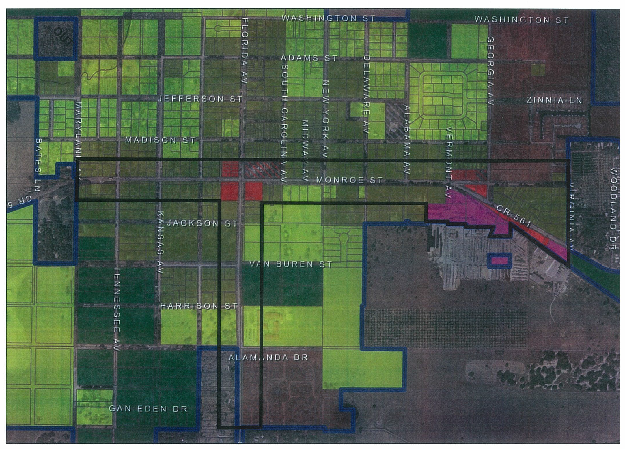
Town Center Overlay District
(Ord. No. 2021-27, § 3, 12-13-2021)
Sec. 59-4.10. - Supplemental regulations.
4.10.1.
Measurement of Setbacks.
A)
Setbacks shall be measured on a perpendicular to the property line to the first vertical plane which intersects any portion of the structure other than a nominal roof overhang.
4.10.2.
Location of Accessory Buildings and Uses in Residential Districts.
A)
When an accessory building is attached to a main structure by a breezeway, passage or otherwise, it shall comply with setback requirements of the main building.
B)
Accessory buildings shall conform to the applicable zoning setbacks from all right of ways.
C)
Temporary storage structures shall be limited to 60 days and shall be ten feet from all property lines.
4.10.3.
Building Height.
A)
Building heights may not exceed 40 feet; however, chimneys, water, fire, radio and television towers, church spires, elevator bulkheads, smokestacks, and similar structures and their necessary mechanical appurtenances may exceed forty (40) feet, subject to the restrictions herein and any height limitations placed on such structures by the Federal Aviation Administration. No building or other structure shall exceed any height limitations placed on such structures by the Federal Aviation Administration.
4.10.4.
Gas, Propane, or LP Storage Facility.
A.
Any gas, propane, or LP storage tank or facility must obtain a conditional use permit in any zoning category unless a tank is for residential use.
Any other gas, propane, or LP storage tank or facility must apply for a conditional use permit. Setbacks and special conditions will be considered and adopted during the conditional use approval process.
4.10.5.
Demolition Permit.
A.
Demolition of Buildings or Structures.
1.
Permit Required. It shall be unlawful for any person, firm or corporation to wreck or demolish any building or structure in the Town without first securing a permit as provided by this section and paying the fees outlined in a Fee Ordinance adopted by the Town.
2.
Permit Application and Fees. Application for a permit to wreck or demolish a building or structure in the Town shall be in writing to and on the forms prescribed by the Town. The application shall include the following:
a.
Demolition contractor's name and address, certification or competency card number; property owner's name and address; location of the building or structure; legal description of the property, and date demolition is to begin. Exception: An owner-occupier of a single-family residence may demolish his home, garage or shed type structure without securing an occupational license or certificate of competency. However, a permit is required for structures greater than 120 square feet. It shall be unlawful to employ any person, firm or corporation to assist that does not first produce a current occupational license and house wrecker's competence card. Such owner-occupier must comply with all other provisions of this section, including pulling a permit and paying required fees.
3.
Notarized authorization of owners and proof of ownership is required.
4.10.6.
Backyard Chickens. General Requirements. Chickens, other than roosters, shall be allowed for personal use as an accessory use within the Agricultural (AG), Single-family Low Density Residential (R-1), Single-family Medium Density Residential (R-2) Districts.
A.
Any person keeping, harboring, raising or maintaining chickens as an accessory to an occupied dwelling unit shall be subject to the following restrictions:
1.
No more than five chickens may be kept;
2.
No slaughtering of chickens shall be done in public view;
3.
Chickens must be secured within the chicken coop or fenced enclosure at all times;
4.
All feed and other items associated with the keeping of chickens that are likely to attract or to become infested with rodents or other pests shall be kept in a rodent and pest-proof container;
5.
No manure shall be allowed to accumulate on the floor of the coop or ground. A fly-tight bin for storage of manure shall be utilized; the size shall be sufficient to contain all accumulations or manure. The fly-tight bin shall be kept at least 20 feet away for all property; and
6.
Composting of chicken manure shall be allowed in an enclosed bin. The composting bin shall be kept at least 20 feet away from all property lines.
B.
Chicken coop or fenced enclosure used to house chickens. Any chicken coop or fenced enclosure used to house chickens shall:
1.
Not be located in the front or side yards; and
2.
Be set back a minimum of 20 feet from all property lines.
(Ord. No. 2019-08, § 2, 7-8-2019)