
Athens City Zoning Code
ARTICLE I
- ZONING
CHAPTER 9-1.- PREAMBLE, PURPOSE, AND REPEALER CLAUSE
Sec. 9-1-1. Preamble.
Sec. 9-1-2. Purpose.
Sec. 9-1-3. Short title.
Sec. 9-1-4. Enactment and effect.
Sec. 9-1-5. Repealer.
Sec. 9-1-6. Severability.
Sec. 9-1-7. Effective date.
CHAPTER 9-3.- OFFICIAL MAPS
Sec. 9-3-1. Compliance required.
Sec. 9-3-2. Classification of districts.
Sec. 9-3-3. Official zoning map.
Sec. 9-3-4. District boundaries.
Sec. 9-3-5. Digital mapping.
Sec. 9-3-6. Changes to map; located in clerk's office; clerk to be final authority.
Sec. 9-3-7. Replacement of official zoning map.
CHAPTER 9-4.- PROCEDURES
Sec. 9-4-1. Purpose.
Sec. 9-4-2. Types of procedures.
Sec. 9-4-3. Type I procedure—General provisions.
Sec. 9-4-4. Type II procedure—General provisions.
Sec. 9-4-5. Type III procedure—General provisions.
Sec. 9-4-6. Type IV procedure—General provisions.
Sec. 9-4-7. Staff permit procedures—General provisions.
Sec. 9-4-8. Appeals.
Sec. 9-4-9. Public notice.
Sec. 9-4-10. Administrative hearings.
Sec. 9-4-11. Resubmittal of applications.
Sec. 9-4-12. Limited withdrawal of amendment after hearing.
Sec. 9-4-13. Conditional zoning procedure.
Sec. 9-4-14. Final dates of zoning decisions.
Sec. 9-4-15. Applications and deadlines.
Sec. 9-4-16. Fees.
Sec. 9-4-17. Ordinance interpretations.
Sec. 9-4-18. Similar uses.
CHAPTER 9-5.- AGRICULTURAL RESIDENTIAL (AR) DISTRICT
Sec. 9-5-1. Purpose.
Sec. 9-5-2. Permitted uses.
Sec. 9-5-3. General regulations.
Sec. 9-5-4. Conservation subdivision.
Sec. 9-5-5. Subdivision of a single lot.
Sec. 9-5-6. Density bonus.
Sec. 9-5-7. Large lot residential subdivision.
CHAPTER 9-6.- INSTITUTIONAL (IN) DISTRICT
Sec. 9-6-1. Purpose.
Sec. 9-6-2. Permitted uses.
Sec. 9-6-3. General regulations.
Sec. 9-6-4. Institutional uses—Parking.
Sec. 9-6-5. Developments of community significance.
Sec. 9-6-6. Design standards.
Sec. 9-6-7. Institutional (IN) development approval procedure.
CHAPTER 9-7.- SINGLE-FAMILY RESIDENTIAL (RS) DISTRICTS
Sec. 9-7-1. Purpose.
Sec. 9-7-2. Permitted uses.
Sec. 9-7-3. General regulations.
Sec. 9-7-4. Density.
Sec. 9-7-5. Design for individual ownership of units required.
Sec. 9-7-6. Open space.
Sec. 9-7-7. Grading and retaining walls.
CHAPTER 9-8.- MIXED DENSITY RESIDENTIAL (RM) DISTRICTS
Sec. 9-8-1. Purpose.
Sec. 9-8-2. Permitted uses.
Sec. 9-8-3. General regulations.
Sec. 9-8-4. Reserved.
Sec. 9-8-5. Reserved.
Sec. 9-8-6. Special yards—Distance between buildings.
Sec. 9-8-7. Outdoor recreation space.
CHAPTER 9-9.- GOVERNMENT AND PARKS (G, P) DISTRICTS[2]
Sec. 9-9-1. Purpose.
Sec. 9-9-2. Reserved.
Editor's note— Section 6 of an ordinance of August 1, 2006, amended the title of ch. 9-9. Formerly, ch. 9-9 was entitled "Government (G) District."
CHAPTER 9-10.- COMMERCIAL (C) DISTRICTS
Sec. 9-10-1. Purpose.
Sec. 9-10-2. Permitted uses.
Sec. 9-10-3. General regulations.
Sec. 9-10-4. Downtown district—Required Parking.
Sec. 9-10-5. Developments of community significance.
Sec. 9-10-6. Design standards for "C-D" zone.
CHAPTER 9-12.- SPECIAL DISTRICT OVERLAYS
Sec. 9-12-1. Purpose and intent.
Sec. 9-12-2. General standards.
Sec. 9-12-3. Creation of special district overlay.
Sec. 9-12-4. Relationship to Athens-Clarke County Historic Preservation Ordinance.
Sec. 9-12-5. Mixed Density Residential—Limited (RM-LTD) Special District Overlay.
Sec. 9-12-6. Gaines School Road Corridor Special District Overlay (GSRC).
Sec. 9-12-7. Milledge Avenue Corridor Special District Overlay.
Sec. 9-12-8. West Broad Street Special District Overlay.
CHAPTER 9-12A.- 78/316 SPECIAL DISTRICT OVERLAY
Sec. 9-12A-1. Purpose.
Sec. 9-12A-2. Boundaries and Applicability.
Sec. 9-12A-3. Special District Overlay Amendment and Boundary Alteration Procedure—General provisions.
Sec. 9-12A-4. Development Concept Review Submittals.
Sec. 9-12A-5. Permit Application Requirements.
Sec. 9-12A-6. Applicability.
Sec. 9-12A-7. Application and Permitting Procedure for Development Sites located in two or more jurisdictions.
Sec. 9-12A-8. Definitions.
Sec. 9-12A-9. Permitted uses.
Sec. 9-12A-10. General regulations.
Sec. 9-12A-11. Screening and Buffering.
Appendix A: Definitions
Sec. 9-12A-12. Definitions.
Appendix B: Environmental Areas Protection and Review
Sec. 9-12A-13. Environmental Areas Protection and Review.
CHAPTER 9-13.- AIRPORT OVERLAY (A) DISTRICT[3]
Editor's note— Ord. of 5-5-2009, § 4, deleted the former Ch. 9-13, §§ 9-13-1—9-13-7, and enacted a new Ch. 9-13 as set out herein. The former Ch. 9-13 pertained to Airport Overlay (A) District and derived from Ord. of 12-5-2000, § 1.
CHAPTER 9-14.- PLANNED DEVELOPMENT (PD) DISTRICT
Sec. 9-14-1. Intent
Sec. 9-14-2. General provisions
Sec. 9-14-3. "PD" approval procedures.
Sec. 9-14-4. Reserved.
Sec. 9-14-5. Elderly Residential Multifamily (ERM) Planned Developments.
CHAPTER 9-14A.- CONSERVATION SUBDIVISION PLANNED DEVELOPMENT (CSPD) DISTRICT
Sec. 9-14A-1. Purposes.
Sec. 9-14A-2. Applicable land use districts.
Sec. 9-14A-3. Minimum subdivision acreage in the AR zone.
Sec. 9-14A-4. Authority of health department.
Sec. 9-14A-5. Approval procedure.
Sec. 9-14A-6. Pre-planning site visit.
Sec. 9-14A-7. Pre-planning site conference.
Sec. 9-14A-8. Sketch plan.
Sec. 9-14A-9. (Optional) Health department review of sketch plan.
Sec. 9-14A-10. Density determination.
Sec. 9-14A-11. Conceptual plans.
Sec. 9-14A-12. Conservation subdivision development and design standards.
Sec. 9-14A-13. Open space.
Sec. 9-14A-14. Sanitary sewer service provisions.
Sec. 9-14A-15. Homeowner's association.
Sec. 9-14A-16. Applicability.
Sec. 9-14A-17. Violation.
CHAPTER 9-16.- MANUFACTURED HOUSING DEVELOPMENTS
Sec. 9-16-1. Purpose.
Sec. 9-16-2. General provisions.
Sec. 9-16-3. Procedure for approval.
Sec. 9-16-4. Setback requirements.
Sec. 9-16-5. Design standards.
Sec. 9-16-6. Manufactured housing standards.
Sec. 9-16-7. Roadway, parking and sidewalk standards.
Sec. 9-16-8. Non-conforming manufactured housing developments.
Sec. 9-16-9. Special conditions.
CHAPTER 9-17.- UTILITY SUBSTATIONS
Sec. 9-17-1. Generally.
CHAPTER 9-18.- STANDARDS FOR TELECOMMUNICATIONS TOWERS AND ANTENNAS
Sec. 9-18-1. Definitions.
Sec. 9-18-2. Purpose.
Sec. 9-18-3. Registration required.
Sec. 9-18-4. Exclusions.
Sec. 9-18-5. Placement by zoning district.
Sec. 9-18-6. General provisions.
Sec. 9-18-7. Procedures for special use permits.
Sec. 9-18-8. Administrative procedures for tower and antenna building permit.
Sec. 9-18-9. Annual operating permit required.
Sec. 9-18-10. Pre-existing towers/nonconforming uses/structures.
Sec. 9-18-11. Expiration of permits.
Sec. 9-18-12. Coordination with federal law.
Sec. 9-18-13. Appeals.
Sec. 9-18-14. Severability.
CHAPTER 9-19.- OUTDOOR LIGHTING AND GLARE STANDARDS
Sec. 9-19-1. Purpose.
Sec. 9-19-2. Definitions.
Sec. 9-19-3. Applicability.
Sec. 9-19-4. Outdoor lighting standards.
Sec. 9-19-5. Variances.
Sec. 9-19-6. Compliance and other remedies.
CHAPTER 9-20.- SPECIAL USES
Sec. 9-20-1. Special use permits generally.
Sec. 9-20-2. Reserved.
Sec. 9-20-3. Procedure.
Sec. 9-20-4. Plan requirements.
Sec. 9-20-5. Action by the mayor and commission.
Sec. 9-20-6. Conditions.
Sec. 9-20-7. Revocation; abandonment.
CHAPTER 9-21.- VARIANCES
Sec. 9-21-1. Variances—Purpose.
Sec. 9-21-2. Application.
Sec. 9-21-3. Variances—Standards.
CHAPTER 9-22.- ENFORCEMENT
Sec. 9-22-1. Zoning permits.
Sec. 9-22-2. Maintenance of minimum requirements.
Sec. 9-22-3. Revocation—Permit expiration.
Sec. 9-22-4. Duties of officer.
Sec. 9-22-5. Interpretation.
Sec. 9-22-6. Violations—Nuisance.
Sec. 9-22-7. Conditions of approval.
Sec. 9-22-8. Penalties.
Sec. 9-22-9. Complaints.
CHAPTER 9-25.- SITE DESIGN AND USE STANDARDS
Sec. 9-25-1. Purpose and intent.
Sec. 9-25-2. Application.
Sec. 9-25-3. Approval process.
Sec. 9-25-4. Plans required.
Sec. 9-25-5. Transportation impact analysis required.
Sec. 9-25-6. Storm water management impact analysis.
Sec. 9-25-7. Criteria for approval.
Sec. 9-25-8. Site design standards.
Sec. 9-25-9. Power to amend plans.
Sec. 9-25-10. Site use standards.
Sec. 9-25-11. Drive-through uses.
Sec. 9-25-12. Reserved.
Sec. 9-25-13. Landscaping maintenance.
Sec. 9-25-14. Reserved.
Sec. 9-1-1.- Preamble.
This article establishes comprehensive zoning regulations for Athens-Clarke County, Georgia.
(Ord. of 12-5-2000, § 1)
Sec. 9-1-2. - Purpose.
Pursuant to the 1983 Constitution of the State of Georgia, Article IX, Section II, Paragraph IV, the mayor and commission of Athens-Clarke County hereby enact into law the following zoning ordinance of Athens-Clarke County, Georgia, for the purposes of promoting the health, safety and general welfare of the present and future inhabitants of Athens-Clarke County, Georgia; improving Athens-Clarke County's appearance; lessening congestion in the streets; furthering traffic safety; securing safety from fire, panic and other dangers; providing adequate light and air; preventing the overcrowding of land; avoiding both undue concentration of population and urban sprawl; facilitating the adequate provision of transportation, water, sewerage, schools, parks and other public requirements; protecting property against blight and depreciation; encouraging the most appropriate use of land, buildings and other structures throughout Athens-Clarke County; securing economy in government expenditures; and for other purposes, all in accordance with the adopted Comprehensive Plan, dated June 1999, as amended July 2008, and as amended from time to time, pursuant to the Official Code of Georgia, Title 36, Chapter 70, Article I.
In recognition of the changing needs and dynamic economy of a growing community, the mayor and commission of Athens-Clarke County finds that periodic updates of this zoning ordinance will be necessary to maintain a proper relationship between the provisions of the article and various community plans. In order to fulfill the above-stated purposes to the best of its abilities, the Athens-Clarke County Commission commits not only to the enforcement of this zoning ordinance, but to its maintenance and updating as the community's normal planning and review process may dictate.
(Ord. of 12-5-2000, § 1; Ord. of 11-7-2012, § 1)
Sec. 9-1-3. - Short title.
This article shall be known as "The Zoning Ordinance of Athens-Clarke County, Georgia."
Sec. 9-1-4. - Enactment and effect.
A.
This title, and its provisions, shall apply to all applications received on or after its effective date. Any application received prior to its effective date shall be processed under the provisions of any ordinances in effect on the date that the application was received and deemed complete. However, for any application pending at the time of the effective date of this title, the Athens-Clarke County Planning Director will change the zoning classification applied for to the most appropriate zoning classification under the new ordinance based on a comparison of the permitted uses associated with the two zoning classifications.
B.
Structure permit. Nothing contained in this title shall require any change in plans, construction, alteration, or designated use of a structure for which a complete application for a building permit has been filed with the appropriate Athens-Clarke County authorities prior to the effective date of this title.
C.
Any preliminary plat for a subdivision approved prior to the effective date of this title will be null and void 18 months following the effective date of this title, unless approval of a final plat for any portion of the subdivision is secured.
D.
Any planned development approved prior to the effective date of this title will be subject to prompt rezoning by Athens-Clarke County two years following the effective date of this title pursuant to section 9-14-4. Athens-Clarke County will make application to rezone the subject property to the underlying zoning classification of the planned development or to another appropriate zoning classification, unless a building permit has been obtained for any portion of the approved planned development.
E.
The conditions for approval of any rezoning, variance, or conditional use approved by the commission under any prior ordinance shall remain in full force and effect and enforceable under the procedures of this title.
(Ord. of 12-5-2000, § 1; Ord. of 11-6-2002, § 1)
Sec. 9-1-5. - Repealer.
Upon the effective date of this title, that certain ordinance known as "The Zoning Ordinance of Athens-Clarke County, Georgia," 1992, as amended, shall be expressly repealed. There is expressly saved from repeal the following:
A.
Except for the zoning classifications provided for therein, all binding zoning master site plans, binding zoning master plan reports and binding conditions of zoning associated with all planned developments existing prior to the date of adoption of this title and indicated on the official zoning map;
B.
Except for the zoning classifications provided for therein, all binding site plans, binding written reports and binding conditions of zoning associated with conditional uses existing prior to the date of adoption of this title and indicated on the official zoning map;
C.
Except for the zoning classifications provided for therein, all binding conditions of zoning contained in ordinances rezoning certain parcels of land existing prior to the adoption of this title and indicated on the official zoning map;
D.
The "Protected Environmental Areas" ordinance, chapter 8-6;
E.
The "Soil Erosion and Sedimentation Control" ordinance, chapter 8-3 of the Athens-Clarke County Code;
F.
The "Floodplain Protection" ordinance, chapter 8-2 of the Athens-Clarke County Code;
G.
All chapters in title 7 ("Buildings and Construction") of the Athens-Clarke County Code; and
H.
The "Stormwater Management Ordinance," chapter 5-4 of the Athens-Clarke County Code.
Except as expressly repealed or expressly saved from repeal herein, all ordinances and parts thereof in conflict with this title are hereby repealed.
(Ord. of 12-5-2000, § 1)
Sec. 9-1-6. - Severability.
In the event any one or more of the provisions of this title shall for any reason be held to be illegal or invalid by a court of competent jurisdiction, it is the intention of the mayor and commission of Athens-Clarke County that such illegality or invalidity shall not affect any other provision hereof, but this title shall be construed and enforced as if such illegal or invalid provision had not been contained herein.
(Ord. of 12-5-2000, § 1)
Sec. 9-1-7. - Effective date.
This title shall become effective after adoption upon signature by the mayor pursuant to the provisions of the Charter of Athens-Clarke County section 2-204.
(Ord. of 12-5-2000, § 1)
Sec. 9-2-1.- General.
For the purpose of this title, those certain words and terms defined herein shall be defined and interpreted as follows. All other words and terms not expressly defined herein shall have their general meaning, as interpreted by the planning director. Appeals of staff interpretations of this title shall be heard as a Type IV Procedure.
Acceleration/deceleration: One or more paved traffic lanes traversing the frontage of a property for the purpose of allowing traffic to accelerate or decelerate outside of higher speed traffic lanes.
Access: The ability and right to enter a property.
Accessory dwelling unit: A detached residential unit, other than a Class "A" or Class "B" manufactured home, designed for one family only. The structure must be accessory and subordinate to a single-family dwelling (see definition of "dwelling, single-family"), and conform to the standards for the district in which it is located.
Accessory structure: A structure on the same lot with, and of a size and nature customarily incidental and subordinate to, the principal structure. Examples of accessory structures include, but are not limited to, the following: detached garages and/or carports; storage structures and/or barns; freestanding greenhouses; aboveground swimming pools and pool houses; tennis courts; satellite dish antennas; freestanding workshops; freestanding decks and gazebos; radio and/or TV antenna structures not attached to the principal structure; paved areas other than driveways and walkways; and property identification signs not associated with or attached to a mailbox.
Accessory use: A use on the same lot with, and of a nature customarily incidental and subordinate to, the principal use.
Active recreation space: A common area designated on the final plans of a development that is set aside for leisure activities that are usually formal in nature and intended for group participation. Such activities typically require equipment and take place at prescribed places, sites, or fields, including, but not limited to, swimming pools, tennis, volleyball, and basketball courts, and baseball, soccer, or other playing fields. Areas with slopes greater than five percent, wetlands, stormwater detention areas, and/or dense vegetation are not suitable for use as active recreation areas.
Advertising sign (billboard): Any structure or portion thereof on which lettered, figured, or pictorial matter is displayed for advertising purposes, except for the name and occupation of the user of the premises or the products primarily sold or manufactured on the premises or noncommercial messages, and having an area of 100 square feet or more. Any signboard carrying a message excepted in this definition which also carries extraneous advertising of 100 square feet or more shall be considered a billboard.
Agricultural structures: Structures intended primarily or exclusively for support of an agricultural function, and exemplified by, but not restricted to, barns, silos, water towers, windmills, greenhouses.
Agriculture: The production, raising, breeding or maintenance of plants and animals including, but not limited to: forage and sod crops; grain and seed crops; dairy animals and dairy products; poultry and poultry products; livestock, including beef cattle, sheep, swine, horses, or goats, game animals, exotics, fish, and any mutations or hybrids thereof, including the breeding and grazing of any or all such species; bees and apiary products; fur animals; trees and forest products; fruits of all kinds, including grapes, nuts, and berries; vegetables; nurseries; florals; ornamental and greenhouse products; or lands devoted to a soil conservation or forestry management program. This does not include the commercial slaughter of poultry, livestock, or other animals. Nothing herein shall preclude any person from growing, maintaining or harvesting trees, fruits, vegetables, or florals or other ornamental plants, or the keeping of bees or fish, or the keeping of chickens in accordance with the provisions of Section 9-15-25 as accessory uses to a permitted principal use and for only non-commercial purposes on property in a zoning district in which agriculture is prohibited.
Alley: A narrow street, 20 feet or less in width, through a block primarily for vehicular service access to the back or side of properties otherwise abutting on another street.
Alter: To modify or change, generally without creating something entirely different.
Apartment, studio or efficiency: One room which is designed or intended for occupancy by, or which is occupied by, one family doing its cooking therein or by one or more related persons doing their or their own cooking therein. For zoning purposes, a studio or efficiency apartment shall be regarded as a dwelling unit and a structure containing three or more such apartments shall be regarded as a multiple dwelling.
Architectural projection: Eaves, decorative extensions, bay windows having no floor space, or other portions of a structure having no living space nor key structural value.
Athens-Clarke County: The Unified Government of Athens-Clarke County.
Athens-Clarke County Facility: A public service or facility provided, owned and controlled by Athens-Clarke County.
Attached single-family: See "dwelling, single-family attached."
Auto wrecking yards: See "junk yards, salvage yards, and auto wrecking yards."
Automobile and RV sales: A structure and/or lot dedicated to the retail sale of new or used motor vehicles.
Bakery: A place for baking or selling baked goods.
Bar: An establishment that is devoted to the serving of alcoholic beverages for consumption by guests on the premises and in which the serving of food is only incidental to the consumption of those beverages, including, but not limited to, taverns, nightclubs, cocktail lounges, and cabarets.
Basal area: The combined cross-sectional area of the trunks of all trees on an acre at 4.5 feet above the ground.
Basic utilities: Infrastructure services and the structures necessary to provide those services including electricity, natural gas, telephone, water, or sewer. The gross area of these services and associated structures shall not exceed 5,000 square feet. Telecommunications towers, or any structure associated with the operation of a telecommunications tower, are not included under this definition.
Battery exchange station: A facility where an electric vehicle with a swappable battery can enter and exchange its depleted battery with a fully charged battery through a fully automated process.
Bed and breakfast facilities: A detached dwelling in which only individual rooms or suites are rented to transient guests on an overnight basis. No more than 15 bedrooms may be rented on an overnight basis and no more than 30 guests are allowed at one time. Meals may be served only to overnight guests. Additionally, such facilities must meet the criteria outlined in this title.
Bedroom: Any room other than a living room, family room, dining room, kitchen, bathroom, closets, or utility room, for the purpose of this title, shall be considered a bedroom. Dens, studies, etc. with or without closets and similar areas which may be used as bedrooms shall be counted as bedrooms for the purposes of this title.
Block: The land surrounded by streets and other right-of-way other than an alley, or land which is designated as a block on any recorded subdivision map.
Board: The hearings board of Athens-Clarke County, Georgia.
Boarding house or rooming house: Any residential structure, supervised or not, used as living and sleeping arrangements for more than four unrelated individuals and up to 15. To be a boarding house or rooming house, it is usually intended for individuals to reside in the residential structure for more than 30 consecutive days and/or for the residents of the residential structure to be students of the same educational institution (e.g., college, university, or boarding school), to work for the same employer, or to have some other similar common relationship to an institution or organization. Residents may share the common areas of the home and provision for meals may be made, provided cooking is done in a central kitchen and not in individual rooms or suites. For purposes of zoning, a rooming and boarding house shall not be a fraternity or sorority house. If the accommodations are for more than 15 persons, see "dormitory." The landlord shall not provide supervision of person, supervision of medications, assistance with activities of daily living, or nursing services. Otherwise, the home would fall under the requirements for a personal care home or community living arrangement and require a permit by the State of Georgia.
Bottling plant: A manufacturing facility for the bottling of liquids such as water, soft drinks, wine, beer, etc.
Breezeway: A roofed passageway for the purpose of connecting the principal structure to another building or structure.
Broadcasting or production studios: A structure designed for making and transmitting programs for radio or television or for the production/editing of films, videos, commercials, etc.
Buildable area: The portion of a lot remaining and available for construction of a structure or related facilities after required setbacks, yards, and buffers have been provided. Buildable area cannot contain any setback areas, easements, and similar building restrictions, and cannot contain any land that is identified as floodplain areas, riparian buffer areas, except as otherwise provided in this title.
Building envelope: An area within the property boundaries of a lot or space within which a permitted manufactured housing or structure can be placed.
Building official: The official appointed by the Athens-Clarke County Manager and charged with the responsibility of permit and certificate of occupancy issuance.
Business or trade school: A secondary school offering instruction in a professional, vocational, or technical field.
Business sign: An identification sign containing the name of the business or other accessory information located on the same premises.
Caretaker quarters: A dwelling unit which houses an individual or family who is employed by the primary user of the property to guard and protect the property and structure(s) from fire, vandalism, theft, etc. Such structure is not to be used for dwelling purposes other than as a caretaker unit.
Carport: A partially enclosed structure used for the housing of motor vehicles, the property of, and for use only by the occupants of the lot upon which such structure is located. For purposes of zoning, a carport attached to a principal structure shall be regarded as part of that principal structure and not as an accessory structure. A detached carport shall be classified as an accessory structure.
Cemetery: Place or area set apart for interment of the dead; includes not only lots for depositing remains of the deceased, but also pedestrian and vehicular thoroughfares, landscaping, and structures associated with the operation and maintenance of the cemetery.
Certificate of occupancy: A permit issued by the building official indicating that a structure has been constructed in accordance with all codes and that the structure or land is in conformity with provisions of this title or that there has been a legal variance granted as provided by this title.
Church: A structure consecrated to the honor of God or other supreme being or beings for religious purposes; or an assembly of persons united by the profession of the same religious faith, meeting together routinely for religious worship.
Clustering: The process of arranging the total number of residential units permitted on a given property onto 50 percent or less of the gross area of the property.
College or university: An institution of higher learning providing facilities for teaching and research and authorized to grant academic degrees.
Commercial or commercial use: Any activity involving the sale of goods or services for profit.
Commercial incinerator: Establishments primarily engaged in the collection and disposal of refuse by processing or destruction for profit. Examples would be furnaces or similar devices for the burning to ash of trash.
Commercial outdoor recreation: Outdoor commercial uses which by their nature are recreational such as golf courses, driving ranges, miniature golf courses, outdoor swimming pools, tennis courts, basketball courts, and recreational camps.
Commercial parking lots: An area devoted to the standing, maneuvering, and circulation of motor vehicles in commercial areas.
Commission: The mayor and commission of Athens-Clarke County, Georgia.
Community garden: A principal use of a parcel of land involving the cultivation and harvesting of food crops and/or non-food ornamental crops, such as flowers, by an organized neighborhood or non-profit group for personal use, consumption, donation or occasional sale, and meeting the standards outlined in section 9-15 of this title.
Community service: A structure or group of structures for a community's governmental, social, educational, and/or recreational activities. Community service facilities include federal, state, county, and local government activities.
Conditional zoning: The granting or adoption of zoning for a property subject to compliance with restrictions as to use, size, project design or timing of development stipulated by the Athens-Clarke County Commission to mitigate adverse impacts that could be expected without the imposition of such conditions.
Condominium: A type of ownership of attached or detached dwelling units, offices, or other space within a structure, as defined by the provisions of Title 44, Chapter 3, Article III, of the Official Code of Georgia Annotated (O.C.G.A. § 44-3-70 et seq.) in which each unit is independently owned and financed by the occupant but in which all lands are commonly owned.
Conservation subdivision: Subdivision of more than two lots in which a minimum of 50 percent of the acreage is retained as "open space" and the remaining 50 percent or less is subdivided into individual lots.
Construction materials sales: A business involved in the sale of structure supplies and services including lumber, plywood, drywall, siding, windows, molding, cabinets, insulation, etc.
Convenience store: A retail store with a floor area of less than 2,500 square feet that sells groceries and may also sell gasoline and/or provide electric vehicle charging stations; does not include automotive service stations or vehicle repair shops. Any retail store that exceeds 2,500 square feet and also sells gasoline shall be considered as a "quick vehicle servicing" use as defined in this chapter.
Corner lot: See "lot, corner."
Coverage, lot or site: Total area of all structures, paved driveways, or other soil disturbances that will not allow normal water infiltration. The coverage is expressed as a percentage of such area in relation to the total gross area of the lot or site. Landscaping shall not be deemed part of the lot or site coverage.
Critical root zone: The circular area above and below the ground around the trunk of a tree with a radius equivalent to the distance to the dripline, or 1.5 feet for every inch in trunk diameter at 4.5 feet above the ground, whichever is greater.
Day care: A public or private facility operated for the supervision and care of three or more unrelated individuals less than 24 hours per day, without transfer of legal custody, whose parents or guardians do not reside at the place of business.
Dead storage: The storage of unused or seldom used items in a warehouse or other similar location for an indefinite period of time, not associated with a manufacturing or production process.
Decibel (dB): The physical unit commonly used to measure noise levels; the unit of level such as the sound pressure level.
Deed restrictions/private covenants: Private stipulations usually pertaining to residential subdivisions which govern lot size, minimum floor area, uses permitted and, in some instances, architectural design. These may be stricter than provisions included in this title.
Dense evergreen foliage: A large quantity of vegetation per unit of area which retains its leaves throughout the year and of such opacity as to block one's vision through it.
Density: The quantity of an item per unit area; for example, the number of dwelling units per gross area or, for certain multi-family uses within this title, the number of bedrooms in a multi-family dwelling per gross area.
Depot: A structure or portion thereof used to receive, organize, and distribute merchandise. May also contain storage of materials that are flammable or explosive or that present hazards or conditions commonly recognized as offensive. A depot can be a specified structure for storing specified products or materials for a later use, such as a storage tank or grain elevator.
Diameter breast height (dbh): The outside diameter of the trunk of a tree, measured four and one-half feet above ground level.
Disc antenna: A device incorporating a reflective surface that is solid, open mesh, or bar configured and is the shape of a shallow dish, cone, horn, or cornucopia. Such devices may be used to transmit and/or receive radio or electromagnetic waves between terrestrially and/or orbitally based uses. This definition includes, but is not limited to, satellite earth stations and microwave antennas.
Distribution center: A structure or a portion thereof used as the center for goods or materials as they change mode of transport that do not directly ship to consumers.
District: An area, region, or section with a distinguishing character; i.e., a zoning district.
Dormitory: A building or space in a building in which group sleeping accommodations are provided for more than 15 unrelated persons in one room or a series of closely associated rooms under joint occupancy and single management, with or without meals, but without individual cooking facilities. To be a dormitory, it is usually intended for individuals to reside in the building for more than 30 consecutive days and/or for the residents of the building to be students of the same educational institution (e.g., college, university, or boarding school), to work for the same employer, or to have some other similar common relationship to an institution or organization. If the accommodations are for fewer than 15 persons, see "boarding house and rooming house."
Double frontage lot: See "lot, double frontage."
Drainage systems: Physical provisions to accommodate and regulate stormwater runoff to preclude excessive erosion and sedimentation and to control and regulate the rate of flow.
Dripline: A line extending down to the ground from the greatest horizontal extent of a tree's branches, more or less forming a circle around the tree.
Drive-through use: A facility or structure that is designed to allow drivers to remain in their vehicles before and during an activity on the site. Drive-through facilities are a type of site development that is usually found in conjunction with a quick vehicle servicing use or other retail sales and service use. Examples include, but are not limited to, drive-through windows, menu boards, car wash facilities, and quick lube or quick oil change facilities.
Driveway: An access way serving a single dwelling unit or parcel of land, and no greater than 50 feet travel distance in length. A flag drive serving a flag lot shall not be a driveway. Single dwelling or parcel accesses greater than 50 feet in length shall be considered as a flag drive, and subject to all of the development requirements thereof.
Driving surface: A paved access capable of supporting up to 44,000 pounds gross vehicle weight. Surface to be of minimum width as required by ordinance. Width shall be increased on turns where necessary to ensure fire apparatus remain on a paved surface during travel.
Drug rehabilitation center or other facility for treatment of drug dependency: A structure or land used for therapy or rehabilitation for substance-dependent individuals.
Duplex: See "dwelling, two-family."
Dwelling: A structure or portion thereof which is designed or used exclusively for residential purposes, including single-family, two-family, multifamily dwellings, rooming and boardinghouses, fraternities, sororities, dormitories, manufactured homes, and modular dwellings, but not including hotels or motels.
Dwelling loft: A residential unit located on the second floor or higher of a structure whose first and primary use is nonresidential. A loft shall contain no more than two units and shall be treated as a multifamily unit for purposes of parking and minimum floor area.
Dwelling, manufactured home: A structure transportable in one or more sections that is built on a permanent chassis and designed to be used as a dwelling unit with or without permanent foundation when connected to the required utilities and has plumbing, heating, air conditioning, and electrical systems contained therein. When a manufactured home is erected in a manufactured housing park, it may be a Class "A" or "B" manufactured home but when erected on any other site it must be a Class "A" manufactured home.
Dwelling, manufactured home, "Class A": A dwelling unit fabricated in an off-site facility for installation or assembly at the structure site, bearing a label certifying it is constructed in compliance with the National Manufactured Housing Construction and Safety Standards and meeting other development standards outlined in this title.
Dwelling, manufactured home, "Class B": A dwelling unit fabricated in an off-site facility for installation or assembly at the structure site, bearing a label certifying it is constructed in compliance with Federal Manufactured Home Construction and Safety Standards, but does not satisfy the criteria necessary to qualify the house as a Class "A" manufactured home.
Dwelling, modular: A modular home is a factory-fabricated, transportable structure consisting of units designated to be incorporated at a structure site on a permanent foundation into a structure to be used for residential purposes. For purposes of this title, a modular home is permitted anywhere a detached single-family structure is permitted.
Dwelling, multifamily: A structure or portion thereof providing complete independent living facilities for three or more dwelling units, including permanent provisions for living, sleeping, eating, cooking, and sanitation.
Dwelling, single-family: An attached or detached residential unit other than a Class "A" or Class "B" manufactured home, hotel or motel, located on a single lot functioning as the only residential unit and designed for and occupied by one family only.
Dwelling, single-family attached: A single family dwelling attached to at least one other single family dwelling by a common vertical wall functioning as the property line, with each dwelling located on a separate lot.
Dwelling, townhouse: A type of dwelling that is one or more stories in height which has outside, individual front and rear entrances, is separated from other dwellings by fire-rated common walls extending from the foundation to the roof decking, and is part of a contiguous group of at least three but not more than ten such townhouses, and shall be considered a multifamily structure.
Dwelling, townhouse, fee simple: A townhouse unit, as defined above, that has the common wall or walls between it and the adjoining townhouse unit or units as its property line, that has individual meters for all utilities, that has access to a public street, and meets the standards outlined in this title.
Dwelling, two-family: A detached residential structure containing two dwelling units, designed for occupancy by not more than two families living independent of each other.
Dwelling unit: One room, or rooms connected together, constituting a separate, independent housekeeping establishment, containing independent cooking, sleeping and toilet facilities and which are physically separated from any other dwelling units which may be in the same structure.
Easement: A grant of the right to use a strip of land for specific purposes.
Electric vehicle charging station: A public or private parking space that is served by electric vehicle supply equipment that has as its primary purpose the transfer of electric energy (by conductive or inductive means) to a battery in an electric vehicle.
Elementary school: A school established for grades 1-5 but that may also include a kindergarten.
Equestrian facilities: A structure or area for horseback riding activities including boarding, training, lessons, and shows.
Fabricating: The process of assembling using standardized parts.
Family: Two or more persons residing in a single dwelling unit where all members are related by blood, marriage, or adoption up to the second degree of consanguinity, or by foster care. For the purposes of this definition, "consanguinity" means only the following persons are related within the second degree of consanguinity: Husbands and wives, parents and children, grandparents and grandchildren, brothers and sisters, aunts and uncles, nephews and nieces, and first cousins. For the purposes of this definition, a person shall be considered to reside in a dwelling unit if he or she stays overnight in a dwelling unit for more than 30 days within a 90-day period. The term "family" does not include any organization or institutional group. For regulations see section 9-15-18.
Any nonconforming use created by the adoption of this definition of "family" which was a legal use at the time of adoption shall be permitted to continue through July 31, 2002. After which date, the use of such dwelling shall be in compliance herewith. Any use established prior to or subsequent to the adoption of this definition of "family," which use did violate and continues to violate the standards of this chapter, is illegal, not nonconforming, and shall be handled in accordance with section 9-22-8 (Enforcement—Penalties).
Family day care homes: A place in which care is given in a family home for three to six children, which number would include the operator's own preschool age children, for more than four hours and less than 24 hours per day. Outdoor play area shall be enclosed on all sides to a height of at least four feet by a fence. The principal structure of such use shall meet yard requirements (setbacks, lot size) in the district in which it is located.
Fast food restaurant: A drive-through restaurant serving food from an ordering counter. Food can either be consumed on or off of the premises.
Fence height: The height of a fence measured from the finish grade to the highest point of the fence structure.
Fence, semi-open: A fence that is 40 to 80 percent permeable to light and air when viewed perpendicular to the plane of the fence.
Flag lot: See "lot, flag."
Floor area: The floor area is the gross horizontal area of the one or more floors of a structure, excluding interior parking spaces. Residential floor space shall be exclusive of carport, basement, attic, patios and open porches. Same as "gross leasable floor space."
Floor area ratio (FAR): The ratio which is the result of dividing the total floor area of a structure by the area of the lot on which it is located. For example, a structure with a floor area of 20,000 square feet, located on a lot of 40,000 square feet has a floor area ratio (FAR) of 0.5.
Food processing facilities: Industrial operations in which raw food is made suitable for consumption, cooking or storage. Such facilities include commercial slaughterhouses for poultry, livestock, or other animals, and egg farms.
Forested area: An area which contains more than 100 trees of greater than six inches dbh per acre, and which is more than 70 percent covered in tree canopy at full leaf-out.
Forested buffer: An area that is characterized by the dense growth of mature evergreen or deciduous trees. The density of this growth is such that views through the buffer area are obscured by the trees and/or understory growth.
Fraternity or sorority: Establishments chartered by national, state or local organizations and affiliated currently or in the past with an educational or other institutions to which they relate. Such establishments provide social and recreational facilities primarily for members (with visits by alumni) and may provide lodging and meals. For regulatory purposes, student centers operated under the auspices of church, other charitable institutions, or other student organizations shall be construed to fall under the same zoning controls as fraternities and sororities.
Frequency: Number of complete oscillations or cycles per unit of time. The unit of frequency often used is the hertz (Hz).
Front lot line: See "lot line, front."
Front yard: See "yard, front."
Fulfillment center: A structure or a portion thereof that serves as a center for logistics processes. Goods and products in this structure typically are removed after an order has been fulfilled from a customer for a specific good or product. This fulfillment typically is based upon an individual's retail transaction.
Future development map: That certain land use plan as described in Section 8-1-4 of the Code of Athens-Clarke County, Georgia. For the purposes of this title, this phrase is intended to be synonymous with the phrase "Future Land Use Map" as found in the rules and regulations of the Georgia Department of Community Affairs, Chapter 110-12-1 of the Official Compilation of the Rules and Regulations of the State of Georgia.
Future street right-of-way: Proposed or potential rights-of-way that need protection from future development so as to allow the widening of a road without destroying the principle structure or use of the property. The widths of such future rights-of-way shall be determined by either the transportation plan or an approved right-of-way plan. If not indicated on either one, widths shall be determined by the table listed within each zoning classification.
Garage, private: A structure for the private use of the owner or occupant of a principle structure for the storage of motor vehicles with no facilities for mechanical service or repair of a commercial or public nature.
Garage sale: A temporary activity conducted on the premises of a private residence for the purpose of disposal of goods or belongings of the residents of the dwelling. Such activity shall have a duration of not more than two days, nor shall it occur more than twice within any 365-day period. Such activity shall not be accompanied by any off-premises signage. For the purposes of this title, "garage sales" shall not be considered a commercial activity.
General business: Commercial uses providing a wide range of retail goods and services to meet the needs of a large segment of the community.
Grade or ground level: The average of the finished ground level at the center of all walls of the structure. In case a wall is parallel to and within five feet of a sidewalk, the ground level shall be measured at the sidewalk.
Gravel pit: An open land area where sand, gravel, and/or rock fragment are mined or excavated for sale or off-site use. Gravel pit includes sifting, crushing, and washing as part of the primary operation. To excavate the rock, blasting also may be necessary.
Grocery store: A retail store that sells food, beverages, and other household implements and supplies, but does not sell gasoline.
Gross acreage: The total acreage of a lot prior to making site improvements.
Gross leasable floor space: The floor area is the gross horizontal area of the one or more floors of a structure, excluding interior parking spaces. Residential floor space shall be exclusive of carport, basement, attic, patios and open porches. Same as "floor area."
Ground coverage: The area of a lot occupied by all structures and parking expressed as a percentage of the gross area of the lot. Driveways should not be included in the percent coverage but parking pads or areas, porches, decks, patios, pools, tennis courts, sheds, walkways and other accessory uses shall be included.
Ground level: See "grade or ground level."
Group home: See definition of "personal care home."
Guest house: Accessory structure to a single-family dwelling provided there are no kitchen cooking facilities in the guesthouse.
Half street: See "street, half."
Halfway house: A group facility occupied and used for the business purpose of providing transitional offender rehabilitation or similar purposes, whether for profit or nonprofit, and whether or not required to have a state or federal permit, provided that the majority of the residents shall meet one of the following criteria:
(1)
On parole or probation, or has been ordered to reside in such type of facility as a condition of parole or probation; or
(2)
Has been convicted of a felony and has completed his or her sentence; or
(3)
Has been convicted of a criminal offense and has been ordered to reside in such type of facility as part of the criminal sentencing.
Heavy manufacturing: Uses engaged in the basic processing and manufacturing of materials or products predominately from extracted or raw materials, or a use engaged in storage of or manufacturing processes using flammable or explosive materials, or storage or manufacturing processes that potentially involve hazardous or commonly recognized offensive conditions that include, but are not limited to, smoke, steam, noise, soot, dirt, vibration, odor, or any other by-product of the manufacturing process that is known to be detrimental to the human or natural environment. These activities may involve outdoor operations as part of their manufacturing process. Heavy manufacturing uses include, but are not limited to, storage of petroleum products, concrete or cement fabrication where raw materials and finished products are stored outside, pulpwood processing, asphalt manufacturing, landfills, recycling processes, outdoor storage of solid waste, and other uses similar in nature.
Height of structure: See "structure, height of."
Heritage trees: Trees greater than 150 years of age as determined by planting or other records or an arborist's or forester's opinion. In general, the following size specifications apply when identifying heritage trees: trees greater than 18 inches in diameter for small-sized trees, 24 inches in diameter for medium-sized trees, and 36 inches in diameter for large trees. Heritage trees may also be those of an unusual or exceptional species, form, or character; trees that are part of an historic or neighborhood-wide planting project that affect the greater landscape beyond the property on which they grow; or tree associated with an historic event, person, or community landmark.
Hertz: Unit of frequency equal to one cycle per second.
High school: A school established for grades 9—12 or 10—12.
Home occupation: An occupation commonly carried on within a residential dwelling by the residents occupying the dwelling, secondary to the residential use, and subject to the requirements of this title.
Homeowners' association: A homeowners' association is an organization formed for the maintenance and operation of the common areas of the development. The membership in the association must be automatic with the purchase of a dwelling unit or other property in the planned development. The association's principal source of funds shall be an assessment levied against each dwelling unit or other property, which assessment shall be enforceable as a lien against the property.
Horticulture: The cultivation of row crops, a garden, or an orchard for noncommercial purposes.
Hospital: An establishment which provides sleeping and eating facilities to persons receiving medical, obstetrical, or surgical care and nursing service on a continuous basis.
Hostel: Any establishment having beds rented or kept for rent on a daily basis to travelers for a charge or fee paid or to be paid for rental or use of facilities and which are operated, managed or maintained under the sponsorship of a non-profit organization which holds a valid exemption from federal income taxes under the Internal Revenue Code of 1954, as amended.
Hotel: A facility offering transient lodging accommodations to the general public at a daily rate or weekly rate for a period of continuous guest occupancy not to exceed 30 days, and providing additional services, such as restaurants, meeting rooms, and recreational facilities. Guest quarters are accessible through a main entrance and by hallways.
Indoor recreation: Indoor commercial uses which by their nature are recreational. Examples include bowling alleys, skating rinks, health clubs, racquetball courts, indoor swimming pools, video arcades, pool halls, etc.
Industrial or industrial use: An activity related to the manufacture, production or storage of products to be transported elsewhere for retail sale.
Inoperative vehicle: Any motorized vehicle incapable of immediately being driven.
Institutional or institutional use: A non-profit or quasi-public use, such as a religious institution, private school, hospital, medical center, nursing home, cemetery, as well as the ancillary uses directly affiliated with these institutional uses.
Interior lot: See "lot, interior."
Intermediate care facilities: A convalescent home or other recuperative facility for use by persons subsequent to hospital confinement, who are not yet ready to resume home life.
Junk yards, salvage yards, and auto wrecking yards: A place where waste, discarded or salvaged metals, structure materials, paper, textiles, used plumbing fixtures, used vehicles or equipment in inoperative condition, or similar items are bought, sold, exchanged or stored, baled or cleaned.
Kennels: Facility for the boarding (overnight) of domestic animals, usually limited to dogs and cats. Breeding and training of dogs and cats and the sale to the public of puppies and kittens is classified as a kennel activity.
Land disturbing activity: Alteration of the land surface by:
(1)
Any grading, scraping, excavating, dredging, transporting or filling of land;
(2)
Any clearing of vegetation;
(3)
Any construction, rebuilding, or alteration of a building, road, driveway, parking area, or other structure, not including routine maintenance such as painting, repair, or reconstruction of existing structures or surfaces;
(4)
Any substantial activity or use which may result in soil erosion from water or wind and the movement of sediments into waters or lands protected by this title;
(5)
It shall not include activities such as ordinary maintenance and landscaping operations, individual home gardens, repairs, additions or minor modifications of an existing single-family dwelling, and the cutting of firewood for personal use.
Land use plan: The Future Land Use Map adopted by the Athens-Clarke County Commission in conjunction with the Athens-Clarke County Comprehensive Plan. For purposes of this title, this phrase is intended to be synonymous with the phrase "future development map."
Landscaping: A planted area containing trees, shrubs, and groundcovers providing a transition between structures on a site and the property line, adjacent structures, and/or street rights-of-way.
Laundry facilities: A commercial laundering establishment which cleans clothing, carpeting, drapes, and other cloth or synthetic fiber materials using a chemical process. Such establishments may also include self-service laundering facilities.
Light manufacturing: Enterprises primarily engaged in the processing, manufacturing, compounding, assembly, packaging, treatment, or fabrication of materials and products, from processed or previously manufactured materials, or materials fully encapsulated in a sealed container, including but not limited to, jars, cans, drums, or other container of a similar nature, to be stored inside. Light manufacturing is capable of operation in such manner as to control the external effects of the manufacturing process that is known to be detrimental to the human or natural environment. Light manufacturing uses include, but are not limited to, machine shops, manufacturing of apparel, electrical appliances, electronic equipment and computer components, camera and photographic equipment, ceramic products, cosmetic and toiletries, business machines, food, paper products (excluding the manufacture of paper from pulpwood), medical appliances, tools or hardware, plastic products (excluding the processing of raw materials), pharmaceutical or optical goods, and any other product of a similar nature.
Livestock: Establishments that are primarily engaged in the fattening of livestock in a confined area for at least 30 days, either for their purposes or on a fee or contractual basis for the expressed purpose of slaughter, sale or increasing the value of the livestock. Poultry facilities and egg producing facilities shall be included in this definition.
Loading space, off-street: Space logically and conveniently located for bulk pickups and deliveries, scaled to delivery vehicles expected to be used, design standards for which are contained in this title.
Lot: A unit of land created by a subdivision, which complies with all applicable laws at the time such lots were created.
Lot area: The total horizontal area within the lot lines of a lot, said area to be exclusive of street right-of-way.
Lot, corner: A lot abutting the intersection of two or more streets other than an alley.
Lot depth: The horizontal distance from the midpoint of the front lot line to the midpoint of the rear lot line except on flag lots, where the depth shall be measured at the midpoint of the main body of the lot and does not include the pole or access portion.
Lot, double frontage: A lot having frontage on two nonintersecting streets, as distinguished from a corner lot.
Lot, flag: Any lot not having standard legal access to an Athens-Clarke County street, and which is provided with access by a driveway parallel to the lot line of a lot having standard access.
Lot frontage: That portion of a lot adjacent to a street.
Lot, interior: A lot other than a corner lot or a through lot.
Lot line: A boundary of a lot. "Lot line" is synonymous with "property line."
Lot line, front: In the case of an interior lot, the lot line separating the lot from the street other than an alley. A corner lot shall have one street line considered the front lot line. The narrower street frontage shall be the front lot line except when the planning director determines topographical or access problems make such a designation impractical.
Lot line, rear: A lot line which is opposite and most distant from the front lot line, and in the case of an irregular, triangular, or other shaped lot, a line ten feet in length within the lot parallel to and at a maximum distance from the front lot line.
Lot line, side: Any lot line not a front or rear lot line.
Lot of record: An individual lot or a lot which is a part of a subdivision, the map of which has been legally recorded in the office of the clerk of the superior court of Athens-Clarke County, Georgia; or a parcel of land the deed of which has been recorded in the office of the clerk of the superior court of Athens-Clarke County.
Lot, reversed corner: A corner lot, the side street line of which is substantially a continuation of the front line of the first lot to its rear.
Lot, through: An interior lot having frontage on two parallel or approximately parallel streets other than alleys. Such a lot shall have one front yard fronting on the primary public street.
Lot width: The horizontal distance between the side lot lines, ordinarily measured parallel to the front lot line. The lot width shall be measured beginning at the front lot line, except for lots entirely fronting turnaround areas of cul-de-sacs, where the lot width shall be measured at the minimum required front setback line.
Major event entertainment: A structure or area with a capacity of greater than 1,000 seats for public performances and sporting events. Major event entertainment facilities include movie theaters, concert halls, stadiums, and arenas.
Manufacture of non-odiferous foods: Industrial operations for the manufacturing of non-odiferous foods.
Manufactured home: See "dwelling, manufactured home."
Manufactured home development: A tract of land that is used, designated, maintained, or held out for rent to accommodate four or more manufactured homes. Manufactured homes located in a manufactured home park are used only to provide living, cooking, and sleeping accommodations; a manufactured home park does not include an automobile or manufactured home sales lot on which unoccupied manufactured homes are parked for inspection or sale.
Map: A diagram or drawing of a partition or subdivision or any other land use or land development matter.
Mechanical equipment: Equipment or devices installed for a use appurtenant to the primary use. Such equipment shall include heating and air conditioning equipment, solar collectors, parabolic antennas, disc antenna, radio or TV receiving or transmitting antennas, and any power generating devices. The following equipment or devices are exempt:
(1)
Private, non-commercial radio and television antennas not exceeding a height of 70 feet above grade or 30 feet above an existing structure, whichever height is greater. No part of such antenna shall be within the yards required by this chapter. A structure permit shall be required for any antenna mast, or tower over 50 feet above grade or 30 feet above an existing structure when the same is constructed on the roof of the structure.
(2)
Parabolic antennas under three feet in diameter.
Medical center: A walk-in facility for medical, obstetrical, or surgical care limited to day use only.
Middle school: A school established for grades 6—8 or 6—9.
Mine:
(1)
A cavity in the earth from which minerals and ores are extracted; and
(2)
The act of removing minerals and ores.
Minimum structure separation: A required open space between any two structures on the same lot or adjacent lots which are used for nonresidential and multifamily residential purposes.
Mining: The extraction of minerals or earth products, including solids, such as coal and ores; liquids, such as crude petroleum; and gases, such as natural gases. The term mining includes quarrying; ground-water diversion; soil removal or dredging; milling, such as crushing, screening, washing, and flotation; and other preparation customarily done at the mine site as part of a mining activity.
Modular dwelling: See "dwelling, modular."
Mortuary: A place in which dead bodies are kept until burial.
Motel: A structure or group of structures on the same lot containing individual guest units for rental to transients, with separate exterior entrances, and consisting of individual sleeping quarters, detached or in connected rows, with or without cooking facilities.
Multifamily: See "dwelling, multifamily."
Node: Crossing or convergence of intersecting roadways, concentrations of a particular use in close proximity to one another in a well-defined geographic area, or other significant destination along a given roadway.
Nonconforming use or structure: Any structure or use of land lawful at the time of passage or amendment of this title which does not conform, after the passage or amendment of this title, with the regulations of the district in which it is located.
Nursery: See "day care."
Nursing home: A home for the aged, chronically ill, or incurable persons who are unable to care for themselves and in which three or more persons not of the immediate family are kept or provided with food and shelter or care for compensation; but not including hospitals, clinics, or other similar institutions devoted primarily to the diagnosis and treatment of the sick or injured.
Off-street loading space: See "loading space, off-street."
Official map: A map officially adopted by the governing body of Athens-Clarke County, Georgia.
Official zoning map: A map officially adopted by the governing body of Athens-Clarke County that illustrates the various zoning districts of Athens-Clarke County, Georgia.
Open space: A common area designated on the final plans of the development, permanently set aside for the common use of the residents of the development and, if so designated, for the use of the community as a whole. The open space may be landscaped and/or left with natural vegetative cover, and in which area no thoroughfares, parking areas, or improvements other than recreational facilities or specifically permitted underground utilities are located. This definition shall apply to all developments except conservation subdivisions, which shall use the definition for "Open space, conservation subdivision" provided herein and in Chapter 9-14A.
Open space, conservation subdivision: As required in conservation subdivision development, open space is defined as the portion of the conservation subdivision that has been set aside for permanent protection for the common use of the residents of the development and, if so designated, for the use of the community as a whole. The land designated as open space shall be in single ownership, and shall not be divided among any number of the constituent developable lots of the subdivision. Activities within the open space are restricted in perpetuity through the use of an approved legal instrument and are subject to the terms of this chapter. The permitted and prohibited uses, and permanent protection and management, of this open space shall comply with the terms of Chapter 9-14A.
Outdoor storage: The storage of large quantities of materials or products associated with an industry or business, typically outside a structure, in a yard or open lot. Unenclosed, roofed structures may be used.
Parking, principal use: A lot of record devoted to the parking of motor vehicles as its main or primary use. Such use may include electric vehicle charging stations.
Parking space: A rectangle not less than 18 feet long and nine feet wide together with access and maneuvering space sufficient to permit a standard automobile to be parked within the rectangle without the necessity of moving other vehicles, said rectangle to be located off of the street right-of-way.
Parking tandem: Parking spaces that are arranged one behind another. Each parking space shall meet the dimension requirements of a full-size car on a one-way aisle.
Parks and open areas: An area free of structures, parking, paved areas, and other uses, the purpose of which is to provide a balanced relationship between buildable area and lot size. Such area can be utilized for active or passive recreational pursuits or for the enhancement of lot aesthetics. Includes botanical and zoological gardens.
Passive recreation space: A common area designated on the final plans of a development permanently set aside for the use by the residents and/or the public that accommodates activities such as walking, jogging, biking, sitting, picnicking, and any activity that does not require improved structures or formal recreation fields. Areas with slopes greater than 15 percent, wetlands, stormwater detention areas, and/or dense vegetation are not suitable for use as passive recreation areas.
Peak particle velocity: Unit of measurement that identifies, in inches per seconds, the rate of speed in which particles suspended in water are moving.
Pedestrian path: A graded, cleared way for individuals who travel on foot. When located along any improved street or parking area, these paths shall be adjacent to the curb at curb level.
Pedestrian way: A right-of-way for pedestrian traffic.
Permitted use: That use of a lot which is among the uses allowed as a matter of right under the zoning classifications.
Person: An individual, firm, partnership, association, corporation, estate, receiver, syndicate, branch of government, social or fraternal organization, or any other group or combination acting as a legal entity, and including any trustee, assignee, or other representative thereof.
Personal care home: A profit or nonprofit facility, home, or structure for the protective care of two or more persons, who need a watchful environment, but do not have an illness, injury, or disability, which requires chronic or convalescent care, including medical and nursing services. Protective care and watchful oversight includes, but is not limited to, a daily awareness by management of the residents' whereabouts, the asking and reminding of residents of their appointments for medical checkups, the ability and readiness of management to intervene if a crisis arises for a resident, and supervision by management in areas of nutrition, medication, and actual provision of transient medical care, with a 24-hour responsibility for the well-being of residents of the facility. For regulations governing "personal care homes" see section 9-15-19 of this title. Personal care homes shall be classified in one of the following ways:
(1)
Individual: Two to three clients
(2)
Family: Four to six clients
(3)
Group: Seven to 15 clients
(4)
Congregate: Sixteen or more clients
Planned development: A development on land under unified control according to comprehensive plans and a single development plan for uses and structures related to the character of the district with a program for operation and maintenance of common areas.
Planning action: Any action requiring review in accordance with the provisions of section 9-4-2 of this title.
Planning commission: The Athens-Clarke County Planning Commission.
Planning staff: The staff of the Athens-Clarke County Planning Department.
Plat: A diagram, drawing or re-plat containing all the descriptions, locations, specifications, dedications, provisions and information concerning a subdivision.
Prescribed grazing: The application of sheep or goats as a landscape management technique to control invasive or unwanted plant species at a specific location and specific intensity for a defined length of time. For purposes of this section, goats and sheep used for prescribed grazing purposes are not considered to be livestock or agriculture uses.
Principal structure: See "structure, principal."
Printing/publishing: An establishment where printed material is produced, reproduced and/or copied by either a printing press, photographic reproduction techniques, or other similar techniques.
Private access drive: A drive serving as the exclusive access for not more than two landlocked parcels of land, which is not owned or maintained by Athens-Clarke County. Private easements cannot be used to meet the right-of-way requirement.
Private garage: See "garage, private."
Private street: A street which serves several lots over which the general public has no right of use as opposed to a driveway which is meant to serve one lot.
Private way: A private easement or ownership established by deed for vehicular access to property.
Professional services and offices: Offices used for the conduct of business-related activities, excluding the sale of merchandise or storing of merchandise on the premises.
Public street: A street which is owned and/or maintained by Athens-Clarke County.
Quarry: A mine where rock, ore, stone, and similar materials are excavated for sale or for off-site use. Quarry includes rock crushing, asphalt plants, the production of dimension stone, and similar activities.
Quick vehicle servicing: A business providing service to the motoring public. Such uses can include gasoline sales, electric vehicle charging stations, battery exchange stations, light repair, tune-ups, and oil changes to automobiles or light trucks. No overnight outside storage of any automobiles or materials, such as tires, auto parts, etc., is allowable. The sale of motor vehicles shall be prohibited.
Rear lot line: See "lot line, rear."
Rear yard: See "yard, rear."
Recreational vehicle: A motorized vehicle, designed and/or maintained for use as a temporary dwelling or sleeping place for travel or recreation purposes exclusively, having no foundation other than wheels or jacks.
Recreational vehicle park: A parcel of land which is used solely for the rental or lease of lots for transient campers, trailers, motor homes, or temporary parking of any other recreational vehicle that is not a manufactured home.
Reserve strip: A nonpermanent dead-end street intended to be extended in conjunction with the subdivision and development of the adjacent undeveloped land. Also known as a street stub or a street plug.
Residential or residential use: Any activity, as contrasted with commercial and industrial activities, which involves the peaceful, private conduct of pursuits related to the living environment.
Restaurant: An establishment that prepares and serves food to customers at least one meal per day and which derives at least 50 percent of its total annual gross food and beverage sales from the sale of prepared meals or food. For the purposes of this title, this definition may include sit-down, fast food, drive-through, and drive-in facilities.
Retail sales and service: A business established for the sale of goods or services to consumers, usually in small quantities (as opposed to wholesale). Gasoline sales are not included is this definition.
Retaining wall: A wall or terraced combination of walls used at a grade to change or hold soil or other earth material at a higher position. Retaining walls may be attached to or independent from other structures, but do not include the foundations of structures or buildings.
Reversed corner lot: See "lot, reversed corner."
Right-of-way: Access over or across a particularly described property for a specific purpose.
Rural events facility: A facility located on land zoned AR (Agricultural Residential) that provides a commercial facility for use by various private groups, not exceeding 300 persons, for meetings, weddings, receptions, and other similar events.
Sales of products grown on-site: Roadside stands or other temporary structures constructed for the sale of agricultural or horticultural products raised substantially on the premises.
Salvage yards: See "junk yards, salvage yards, and auto wrecking yards."
Sand pit: A surface mine or excavation used for the removal of sand, gravel, or fill dirt for sale or for use off-site.
Sanitary landfills: A system of trash and garbage disposal in which the waste is buried between layers of earth.
Satellite earth stations: Are considered to be accessory structures and are defined as a combination of:
(1)
An antenna or dish antenna whose purpose is to receive communication or other signals from orbiting satellites and other extraterrestrial sources;
(2)
A low-noise amplifier (LNA) which is situated at the focal point of the receiving component and whose purpose is to magnify and transfer signals;
(3)
A coaxial cable whose purpose is to carry the signals into the interior of the structure; and
(4)
The station must be located to the side or rear of the structure unless a usable satellite signal cannot be obtained; in which case, the property owner may request a variance from the requirement through the hearings board. Ground-mounted stations shall be no more than ten feet above the maximum height requirement of the district in which they are located.
Science research and development: A facility focused primarily on the business of scientific research and the development of new products, with a limited application in production. The facility accommodates the following, but is not limited to: research facilities; laboratories; clean rooms; offices; prototype production facilities that manufacture a limited amount of a product in order to fully investigate the merits of such product; and, pilot plants used to test manufacturing processes planned for use in productions elsewhere.
Scrap metal processor: One who, from a fixed location, utilizes machinery and equipment for processing and manufacturing iron, steel or nonferrous metallic scrap into prepared grades and whose principal product is scrap iron, scrap steel, or nonferrous metallic scrap for sale for remelting purposes.
Screening: The establishment of an opaque fence or barrier for the purpose of obscuring from sight a use.
Self-service storage: A structure or a portion thereof, where customer access is required, used for dead storage, mainly of the excess personal property or an individual or family, but also of small amounts of goods or merchandise for businesses or individuals.
Semi-public halls, clubs or lodges: A structure or facility owned or operated for special educational or recreational purposes, but not primarily for profit or to render a service that is customarily carried on for gain, not including fraternity or sorority.
Setback line: The minimum required distance from the street right-of-way line or any other property line that the principal structure must observe.
Shopping center: A group of commercial establishments planned, developed, and managed as a unit, related in location, size and type of shops to the trade area that the unit serves, and providing on-site parking.
Short-term rental: An accommodation for transient guests where, in exchange for compensation of any type or amount, a residential dwelling unit is rented or otherwise provided for lodging for any period of time less than 31 consecutive days. Such accommodations are usually, but not exclusively, advertised through websites such as Airbnb.com, Booking.com, Hometogo.com, and VRBO.com. Such accommodations may or may not include an on-site manager. For the purposes of this definition, a residential dwelling unit shall include all housing types (non-exclusive examples of which include homes, duplexes, apartments, condominiums, townhomes, accessory dwelling units, or a room or a portion of any of the foregoing) and shall exclude group personal care homes or other lodging uses which are provided incidental to other services, such as health care. This term may also be abbreviated as "STR" in Title 9 of the Code of Athens-Clarke County, Georgia. Unless otherwise stated, this phrase is intended to encompass both commercial short-term rentals and home occupation short-term rentals, as defined in this section 9-2-1. Unless otherwise expressly permitted in a particular zoning district, an STR shall consist of no more than one individual accommodation per parcel, and is therefore intended to exclude bed and breakfast facilities, hotels, motels, hostels, boarding houses, rooming houses, and dormitories, as all such terms are defined in this section 9-2-1.
Short-term rental, commercial: Any short-term rental (STR) that is rented by a person or entity other than the owner-occupant or the primary resident of the residential dwelling unit and the sole or primary use of the residential dwelling unit is as an STR, standards for which are found in section 9-15-28. For the purposes of Title 9 of the Code of Athens-Clarke County, Georgia, the phrase "dedicated use short-term rental" shall be synonymous with the phrase "commercial short-term rental."
Short-term rental, home occupation: Any short-term rental (STR) which is rented by the owner-occupant or the primary resident of the residential dwelling unit. For the purposes of this definition, a person must apply for and receive a home occupation permit (and comply with all requirements of the permit) to have a home occupation short-term rental. As it applies to short-term rentals, an "owner-occupant" is a person who is an owner of record of a parcel and occupies the parcel as the person's primary residence.
Side lot line: See "lot line, side."
Side yard: See "yard, side."
Signs: Any device designed to inform or attract the attention of the public.
Single-family dwelling: See "dwelling, single-family."
Sorority house: See "fraternity or sorority house."
Special use: A use which is not automatically permitted by right, but which may be permitted within a zoning district subject to meeting specific conditions contained in this title.
Stable, private: A stable with a capacity of not more than two horses, mules or other draught animals.
Stable, public: A stable, other than a private stable, with a capacity of more than two horses or mules or other draught animals.
Stand inventory: An inventory of trees in a forest stand or woodland to determine their frequency (number of trees) by species and dbh (by two-inch classes); inventory methods may include measuring only a sample (a certain percentage of the trees) or all trees (100 percent inventory). When only a sample is taken the total number of trees by species and diameter is calculated by expanding the sample data statistically to estimate the total per acre and then multiplying by the number of acres in the stand or woodland.
Stand table: A table summarizing information obtained during a stand inventory regarding the total number of trees in the forest stand or woodland by species, diameter, and basal area. For Athens-Clarke County purposes, a stand table shall be prepared by a registered landscape architect or a registered forester and shall include an estimate of the number of trees by species and by two-inch dbh (diameter at breast height) classes using standard, professionally accepted sampling methods.
State waters: Includes any and all rivers, streams, creeks, branches, lakes, reservoirs, ponds, drainage systems, springs, wells, and other bodies of surface or subsurface water, natural or artificial, lying within or forming a part of the boundaries of the state, which are not entirely confined and retained completely upon the property of a single individual, partnership, or corporation.
Story: That portion of a structure included between the surface of any floor and the surface of the floor next above it, or if there is no floor above it, the space between the floor and the ceiling above it; provided, that a room, suite, or story with more than one-half of its height below grade shall not be considered a story for the purposes of height regulations.
Street: A public right-of-way for roadway, sidewalk, and utility installation including the terms "road", "highway", "land", "place", "avenue" "alley", or other similar designations. The entire width between the right-of-way lines of every way which provides for public use for the purpose of vehicular and pedestrian traffic. Various classifications of streets shall be defined as follows:
(1)
Arterial: A street which is used as a direct connection between nodes.
(2)
Major collector: A street which carries traffic from activity centers and minor collector streets to arterial streets and streets of higher classification.
(3)
Minor collector: A street which carries traffic from residential collectors and local streets to major collectors and arterial streets.
(4)
Residential collector: Principal entrance streets to subdivisions and the main streets for circulation within a subdivision which serve a network of four or more local streets. Residential collector streets are designed so that traffic circulation in a subdivision would cause such a street to be used as a link between local streets and major collector or arterial streets.
(5)
Local: A street used primarily in residential subdivisions for access to abutting properties as opposed to the collection and dispersion of traffic.
Street, cul-de-sac: A short dead-end street terminated by a vehicle turnaround.
Street, half: A portion of the width of a street, usually along the edge of a subdivision, where the remaining portion of the street could be provided in another subdivision.
Street, marginal access: A minor street parallel and adjacent to a major arterial street providing access to abutting properties but protected from through traffic.
Street frontage. That portion of a lot contiguous to a street.
Structure: Any structure attached to the ground which has a roof and which is designed for the shelter, housing or enclosure of persons, animals or property of any kind. That which is built or constructed; an edifice or structure of any kind or any piece of work artificially built up or composed of parts joined together in some definite manner and which requires location on, in, or above the ground or which is attached to something having a location on, in or above the ground.
Structure envelope: An area, within the property boundaries of a parcel, within which a permitted structure can be placed.
Structure, overall height of: The vertical distance between the proposed average finished grade and the proposed average roof elevation. The average roof elevation shall be measured at the highest point of the coping of a flat roof or the deck line of a mansard roof, or at the midpoint between the highest eave and the highest ridgeline elevations for pitched or hipped roofs. The proposed average finished grade shall be measured as the arithmetic mean of the finished grade elevations taken at each corner of the building footprint. Any height limitation of this title shall not apply to church spires, belfries, cupolas and domes not intended for human habitation, monuments, water towers, silos, chimneys, rooftop mechanical equipment, elevator equipment housing, flag poles, except as may be limited in the "A" Airport overlay zone.
Structure, true elevation height of: The vertical distance between the proposed average finished grade and the highest point of the vertical plane. When used to determine a setback, the architectural elevations facing an associated lot line shall be used to determine the setback from that lot line. The proposed average finished grade associated with the architectural elevation being measured shall be measured as the arithmetic mean of the finished grade elevations taken at each corner of that architectural elevation. Any height limitation of this title shall not apply to church spires, belfries, cupolas and domes not intended for human habitation, monuments, water towers, silos, chimneys, flag poles, except as may be limited in the "A" Airport overlay zone.
Structure line: A line on a plat indicating the limit beyond which structures or structures may not be erected. Similar to building envelope.
Structure, principal: A structure in which is conducted the main or principal use of the lot upon which such structure is situated. Structures which are attached to the principal structure, either directly by complete and heated enclosure or by a breezeway not to exceed 15 feet in length, shall be considered part of the principal structure.
Structural alteration: A change to the supporting members of a structure including foundations, bearing walls or partitions, columns, beams or girders, or the roof.
Subdivide land: To divide an area or tract of land into lots.
Subdivision: An act of subdividing land or a tract of land into lots.
Surface mining: Includes, but is not limited to, any activity consisting all or parts of a process for the removal of minerals, ores, earth products, and other solid matter for sale or for processing or for consumption in the regular operation of a business.
Swale: A broad linear depression, ditch-like, grassed, and designed to carry runoff water.
Temporary structure: A structure without any foundation or footings which is attached to the ground or other structure in some nonpermanent fashion. Temporary structures shall require a permit from the building inspection department and shall be removed from the site when the designated time period, activity, or use for which the temporary structure was established has ceased, but not exceeding 90 days in duration unless an extension is obtained from the building inspection department upon just cause. For the purposes of this title, temporary structures shall not be classified by definition as accessory structures. Temporary structures shall be approved by staff permit, with such conditions as the planning staff deems necessary in light of the standards associated with the underlying zoning.
Temporary special events: A temporary public performance, festival, meeting, sporting event, or similar activity, which is not part of the normal use of the subject property and which is not otherwise permitted on the site.
Temporary use: A short-term, seasonal, or intermittent use. Such use shall be approved by staff permit, with such conditions as the planning staff deems necessary in light of the standards associated with the underlying zoning. Temporary uses are granted for 90 days, with the option for a one-time renewal not to exceed an additional 90 days. This definition shall apply to all temporary uses except "Temporary special events" provided herein.
Terminal (Passenger): A structure or a portion thereof, typically associated with transit, with the primary purpose of transferring people over period of time that are 30 days or less.
Terminal (Materials): A structure or portion thereof that is primarily used for the transfer or discharge of goods from one mode to another. Goods must typically be on location for 30 days or less.
Theaters: A structure, portion of a structure, or area devoted to the presentation of motion pictures, concerts, dramatic, dance, musical, or other live performances.
Through lot: See "lot, through."
Townhouse: See "dwelling, townhouse."
Townhouse, fee simple: See "dwelling, townhouse, fee simple."
Tract of land: A unit, or contiguous units, of land under single ownership.
Trailer: A non-motorized vehicle, pulled by an automobile or truck designed and/or maintained for use as a temporary dwelling or sleeping place for travel or recreation purposes exclusively.
Transfer station: A temporary storage facility for the consolidation and eventual transfer of solid waste to a landfill.
Truck: A tractor, semi-trailer, or tractor-trailer combination unit or trailer having a weight greater than ten (10) tons. Trucks are defined per the guidelines established in section 3-3-19 of this Code.
Two-family dwelling: See "dwelling, two-family."
Unbuildable area: All areas outside of building envelopes and within open space.
Unified government: The Unified Government of Athens-Clarke County, Georgia.
Use: The purpose or purposes for which land or a structure is designed, arranged, or intended, or to which such land or structure is occupied, maintained, or leased.
Utility substation: Facility incorporating minor buildings or fencing relating to power transmission, natural gas, telephone, telecommunications, water, or sewer that are located outside of the right-of-way. Equipment that is located off the right-of-way but that is self-contained (e.g., pad-mounted transformers, cross-boxes, etc.) is not included in this definition, and is allowed in any district and exempt from any requirements listed in chapter 9-17.
Variance: A variance is a relaxation of the terms of this title where such variance will not be contrary to the public interest and where, owing to conditions peculiar to the property and not the result of the actions of the applicant, a literal enforcement of the title would result in unnecessary and undue hardship, and practical difficulties.
Vehicle repair: A business providing vehicle repair and body work to the motoring public. Overnight outside storage of automobiles and materials, such as tires, auto parts, etc., is allowable if not visible from a street and not located either in a front yard or in a side yard abutting a street.
Veterinary clinic: Facility for the temporary boarding and treatment of domestic animals, operated under the supervision of a licensed veterinarian.
Village green: An open space area available for unstructured recreation that is fronted on the majority of its sides by structures or roadways. Landscaping in such areas shall consist primarily of open lawn with trees and landscape beds arranged at the perimeter. Paved pedestrian facilities may be provided along the perimeter of the area, with limited axial pedestrian facilities crossing the area.
Vision clearance area: A triangular area on a lot at the intersection of two streets or a street and a railroad, two sides of which are lot lines measured from the corner intersection of the lot lines for a distance specified in these regulations. The third side of the triangle is a line across the corner of the lot joining the ends of the other two sides. Where the lot lines or intersections have rounded corners, the lot lines will be extended in a straight line to a point of intersection.
Warehouse: A structure or a portion thereof used for the long-term and/or dead storage of goods, products, cargo, and materials.
Wholesale nurseries: An area where plants are grown for transplanting, for use as stocks for budding and grafting, or for sale in large quantities for resale purposes.
Wholesale sales: A business engaged in the sale of goods in large quantities for resale purposes.
Wholesale storage: The long-term storage of large quantities of goods and merchandise that is manufactured off-premises for later shipment to retail or wholesale distributors.
Wildlife corridor: A strip of wildlife habitat of variable width and length that connects two larger parcels of wildlife habitat.
Wildlife habitat: The arrangement of food, water, shelter, or cover, and space suitable to animal's needs.
Yard: A required open space located on the same lot as the principal structure, unoccupied and unobstructed except for accessory uses and landscaping.
Yard, front: A yard extended across the full width of and situated between the front lot line and the principal structure line projected to the side lines of the lot, the depth of which shall be the least horizontal distance between the front lot line and the structure line.
Yard, rear: A yard extending across the full width of the lot between the rearmost line of the principal structure projected to the side lines of the lot and the rear lot line, the depth of which shall be the least horizontal distance between the rear line of the principal structure and the rear lot line. In all cases, the rear yard shall be at the opposite end of the lot from the front yard.
Yard, side: A yard between the principal structure and the side lot line, extending from the front yard to the rear yard. The width of the required side yard shall be measured horizontally from the nearest point of the side lot line to the principal structure. A corner lot shall have one front yard and one side yard.
Zoning: The power of local governments to provide within their respective territorial boundaries for the zoning or districting of property for various uses and the prohibition of other or different uses within such zones or districts and for the regulation of development and the improvement of real estate within such zones or districts in accordance with the uses of property for which such zones or districts were established.
Zoning enforcement officer: The individual designated by the Athens-Clarke County Manager whose duty it shall be to enforce the provisions of this title.
Zoning permit: A permit issued by planning staff stating that a structure has been constructed in accordance with the zoning ordinance and that use of a structure and/or land is in conformity with provisions of this title or that there has been a legal variance granted as provided by this title.
(Ord. of 12-5-2000, § 1; Ord. of 3-6-2001, §§ 1, 2; Ord. of 6-5-2001, § 1; Ord. of 6-5-2001, § 1; Ord. of 6-5-2001, § 9; Ord. of 9-4-2001, § 1; Ord. of 5-7-2002, § 1; Ord. of 9-3-2002, § 1; Ord. of 7-1-2003; Ord. of 10-7-2003, § 1; Ord. of 12-2-2003, § 1; Ord. of 12-2-2003, § 1; Ord. of 12-2-2003, § 1; Ord. of 10-5-2004, § 1; Ord. of 8-1-2006, § 1; Ord. of 8-1-2006, § 1; Ord. of 2-6-2007, § 1; Ord. of 7-1 2008, § 1; Ord. of 2-3-2009, § 1; Ord. of 4-7-2009, § 1; Ord. of 5-5-2009, § 1; Ord. of 12-7-2010, § 1; Ord. of 4-5-2011, § 1; Ord. of 10-2-2012, § 1; Ord. of 12-4-2012, § 1; Ord. of 2-5-2013, § 1; Ord. of 2-5-2013, § 1; Ord. of 10-1-2013, §§ 1—3; Ord. of 2-4-2014, § 1; Ord. of 6-3-2014, § 1; Ord. of 3-3-2015, § 1; Ord. of 5-5-2015(1), § 1; Ord. of 8-2-2016(2), § 1; Ord. of 2-7-2017(2), §§ 1, 2; Ord. of 7-5-2017(3), § 1; Ord. of 12-5-2017(2), § 1; Ord. of 7-3-2018(2), §§ 2, 3; Ord. of 7-3-2018(3), §§ 1, 2; Ord. of 8-7-2018(2), § 1; Ord. of 2-2-2021(1), § 1; Ord. of 12-12-2022(3), §§ 1, 2; Ord. of 2-6-2024(3), § 2; Ord. of 12-5-2023(4), § 1)
Sec. 9-3-1.- Compliance required.
No structure or lot shall hereafter be used or occupied, and no structure or part thereof shall be created, moved, reconstructed, extended, enlarged, or altered, contrary to the provisions of this title.
(Ord. of 12-5-2000, § 1)
Sec. 9-3-2. - Classification of districts.
For the purpose of this title, Athens-Clarke County is divided into zoning districts designated as follows:
(Ord. of 12-5-2000, § 1; Ord. of 6-5-2001, § 1; Ord. of 6-5-2001, § 2; Ord. of 10-7-2003, §§ 2, 3; Ord. of 4-6-2010, § 1; Ord. of 9-4-2012, § 1; Ord. of 2-5-2019(2), § 1)
Sec. 9-3-3. - Official zoning map.
A.
The following maps are adopted contemporaneously with the text of this title and shall be considered an integral part of this title:
1.
The location and boundaries of the districts designated in Section 9-3-2 and the design areas for the C-D district designated in section 9-10-6 are established as shown on the map entitled the "Official Zoning Map of Athens-Clarke County" (hereinafter referred to as the "zoning map"), dated as of the adoption date of this ordinance, February 6, 2024, and signed by the Athens-Clarke County Mayor and Clerk of Commission, with the following certification: "This is to certify that this is the Official Zoning Map referred to in the Zoning Ordinance of Athens-Clarke County, Georgia. Pursuant to section 9-3-7 of such ordinance, this map supersedes the Official Zoning Map adopted July 2, 2019 and certified July 9, 2019." Said map is made a part of this title by reference and incorporation as if fully set forth herein.
2.
Future Development Map, adopted on July 3, 2018, as an integral component of the Athens-Clarke County Comprehensive Plan, and signed by the Athens-Clarke County Mayor and Clerk of Commission, with the following certification: "This is to certify that this is the Official Future Land Use Map of Athens-Clarke County referred to and incorporated in the Zoning Ordinance of Athens-Clarke County, Georgia." This map supersedes the Official Future Development Map adopted February 4, 2014, and certified February 6, 2014. Said map is made a part of the Athens-Clarke County Comprehensive Plan by reference herein and a part of Title 9 of the Code of Athens-Clarke County by reference and incorporation as if fully set forth herein.
B.
The signed originals of said maps shall be maintained on file in the office of the clerk of the Athens-Clarke County Commission and, by reference, are made a part of this title as if fully incorporated herein.
C.
Exemplified copies of said maps may also be maintained in the office of the Athens-Clarke County Planning Department for public inspection. Distribution copies shall be available for sale in the planning department at such cost as from time to time established by resolution of the Athens-Clarke County Commission.
(Ord. of 12-5-2000, § 1; Ord. of 9-2-2003, § 2; Ord. of 2-7-2006, § 3; Ord. of 2-7-2006, § 3; Ord. of 6-5-2007, § 2; Ord. of 7-1-2008, § 2; Ord. of 5-5-2009, § 3; Ord. of 2-2-2010, § 2; Ord. of 4-6-2010, § 11; Ord. of 9-4-2012, § 3; Ord. of 12-4-2012, § 1; Ord. of 12-4-2012, § 2; Ord. of 2-4-2014, § 1; Ord. of 2-4-2014, § 2; Ord. of 7-3-2018(2), § 4; Ord. of 7-2-2019(3), § 1; Ord. of 2-6-2024(1), § 1)
Sec. 9-3-4. - District boundaries.
When uncertainty exists with respect to the location of the boundaries of any zoning district in Athens-Clarke County, Georgia, the following rules shall apply:
A.
Where a zoning district boundary line is shown as approximately following the Athens-Clarke County line; a corporate limits line; a militia district line; a lot line; the centerline of a street, a public road, a state highway, an interstate highway; or a railroad right-of-way or such lines extended, then such lines shall be construed to be the zoning district boundary line. Where a zoning district boundary line is shown as following the right-of-way boundary of an existing or abandoned street, public road, state highway, interstate highway, or railroad, the existing or abandoned centerlines of such rights-of-way shall be construed as the zoning district boundary line. In those cases where only a portion of a right-of-way has been abandoned, the new centerline of the remaining right-of-way shall be construed as the zoning district boundary line.
B.
Where a zoning district boundary line is shown as being set back from a street or a railroad right-of-way, and approximately parallel thereto, then such zoning district boundary line shall be construed as being the noted distance, or failing such a note, the scaled distance from the centerline of the street or railroad right-of-way and as being parallel thereto.
C.
Where a zoning district boundary line divides a lot, the location of the line shall be the noted distance, or failing such a note, the scaled distance from the lot lines. If a district boundary divides a lot into two districts, the entire lot shall be placed in the district that accounts for the greater area of the lot by the adjustment of the district boundary, provided the boundary adjustment is for a distance not to exceed 20 feet.
D.
Where zoning district boundaries are in doubt, the planning department staff shall identify such boundaries using the appropriate scale from the official zoning map.
E.
In those cases where only a portion of a lot is within a zoning district, required setbacks shall be measured from the property line and not the zoning district boundary.
F.
Whenever a zoning district boundary line divides a structure, the use of the entire structure shall either be those uses permitted in the less intensive district, or if more than 50 percent of the heated area of the structure and lot are located in the more intensive district and has its street frontage and access located in the more intensive district, the entire structure may be used for any use permitted in the more intensive district. This clause only applies to the use of the structure and not the surrounding property. The use of the surrounding property or expansion of the structure must follow the requirements of the district in which it is located. In addition, the heated floor space of such structure cannot be increased (if less than 50 percent of the structure is located in the more intensive district) so as to increase the percentage of the structure located in the more intensive district above 50 percent. If a structure is more than 50 percent located in the more intensive district, expansion of the structure for nonresidential use may only occur in the more intensive district. If such structure is used for any nonresidential use, front, rear, and side yard buffer requirements are applicable with the necessary buffer/screening requirements situated on the property lines and not the zoning boundary. Lot coverage, whether residential or nonresidential, may be calculated using the entire area of the lot; however, no development from the more intensive district can occur within the less intensive district. Lots split by a zoning boundary which do not involve a structure are restricted to the uses and standards outlined in each district. Lots involving structures that are split by a zoning boundary which do not have at least 50 percent of the heated floor space of the structure in the more intensive zoning classification are not eligible for any extensions and must abide by the regulations of the two districts.
(Ord. of 12-5-2000, § 1; Ord. of 6-6-2006, § 1)
Sec. 9-3-5. - Digital mapping.
Digital maps, created through the use of geographic information system technology, containing registration points recorded on the Georgia State Plane Coordinate System of 1985, as amended, may be used in the administration and enforcement of this title, but shall not replace the paper originals of official maps required by this title, as referenced in section 9-3-3.
(Ord. of 12-5-2000, § 1)
Sec. 9-3-6. - Changes to map; located in clerk's office; clerk to be final authority.
A.
If, in accord with the provisions of this title, changes are made in district boundaries portrayed on the official zoning map, the date of such changes shall be promptly noted on the official zoning map after the amendment has been approved by the mayor and commission of Athens-Clarke County and duly noted in the minutes of the commission meeting.
B.
No changes of any nature shall be made to the official zoning map except in conformity with the procedures set forth in this title.
C.
Regardless of the existence of purported copies of the official zoning map which may from time to time be made or published, the official zoning map shall at all times be located in the office of the clerk of Athens-Clarke County Commission, and the clerk shall be the final authority as to the current zoning status of Athens-Clarke County.
(Ord. of 12-5-2000, § 1)
Sec. 9-3-7. - Replacement of official zoning map.
In the event that the official zoning map becomes damaged, destroyed, lost or difficult to interpret because of the nature or number of changes and additions, the mayor and commission of Athens-Clarke County may by ordinance adopt a new official zoning map which shall supersede the prior official zoning map. The new official zoning map may correct drafting or other errors or omissions in the prior official zoning map, but no such correction shall have the effect of amending the official zoning map, except in accordance with the procedures of this title.
(Ord. of 12-5-2000, § 1)
Sec. 9-4-1.- Purpose.
The purpose of this chapter shall be to establish procedures for the decision making process of all zoning decisions and the administration of the zoning ordinance in Athens-Clarke County.
(Ord. of 12-5-2000, § 1)
Sec. 9-4-2. - Types of procedures.
All zoning or planning actions shall be subject to processing by one of the five following procedures:
• Type I procedure: Requiring action by the Athens-Clarke County Mayor and Commission.
• Type II procedure: Requiring action by the Athens-Clarke County Mayor and Commission.
• Type III procedure: Requiring action by the planning commission.
• Type IV procedure: Requiring action by the hearings board.
• Staff permit procedure: requiring action by Athens-Clarke County staff.
(Ord. of 12-5-2000, § 1)
Sec. 9-4-3. - Type I procedure—General provisions.
A.
The following actions shall follow the Type I procedure:
1.
The adoption of a zoning ordinance;
2.
The adoption of an amendment to the zoning ordinance which changes the text of the zoning ordinance;
3.
The adoption of an amendment to the zoning ordinance which rezones property from one zoning map classification to another, which is not in conformance with the future development map, as established in table 9.4, compatibility matrix; or
4.
The adoption of an amendment to the zoning ordinance which initially zones property to be annexed into the unified government;
5.
The adoption of an amendment to the zoning ordinance, either by changing the text or by rezoning property from one map classification to another, or the grant of a special use permit, which relates to or will allow the location or relocation of a halfway house, drug rehabilitation center, or other facility for treatment of drug dependency in accordance with the provisions set forth in O.C.G.A. § 36-66-4;
6.
The adoption of an amendment to the Athens-Clarke County Comprehensive Plan; or
7.
The adoption of an amendment to the Official Future Development Map of Athens-Clarke County, adopted under subsection 9-3-3-A2.
8.
Special Uses in the Airport Overlay Zone, to be evaluated under the review criteria established in Section 9-13-4, or rezoning property in the Airport Overlay Zone, which results in an increase of maximum allowed residential density or maximum allowed building height, or a Planned Development application that includes a waiver request of a requirement of Chapter 9-13, not otherwise prohibited as a variance in said Chapter.
9.
Special Uses that are not in conformance with the future development designation of the subject property.
B.
Type I zoning or planning actions—Generally:
1.
Scope—Every Type I application shall address the impact of the proposed change on the following as applicable:
a.
The future development map and its intended outcome, the general plans for the physical development of Athens-Clarke County, and any master plan or portion thereof adopted by the mayor and commission per Section 9-4-3;
b.
The proposed rezoning or special use will not adversely affect the balance of land uses in Athens-Clarke County.
c.
Public facility elements of the comprehensive plan and how the proposed change will affect the provision of the services anticipated in the plan.
d.
The proposed use meets all objective criteria set forth for that use provided in the zoning ordinance and conforms to the purpose and intent of the comprehensive plan and all its elements.
2.
Except for special uses, which are subject to chapter 9-20, actions in subsection 9-4-3 A. shall be further evaluated under the following factors to balance the interest in promoting the public health, safety, morality, or general welfare against the right to the unrestricted use of the property in issue:
a.
The existing land use pattern surrounding the property in issue;
b.
The possible creation of an isolated district unrelated to adjacent and nearby districts;
c.
The population density pattern and possible increase or over-taxing of the load on public facilities, including, but not limited to, schools, utilities, and streets;
d.
The cost of the Unified Government and other governmental entities in providing, improving, increasing or maintaining public utilities, schools, streets and other public safety measures;
e.
The possible impact on the environment, including, but not limited to, drainage, soil erosion and sedimentation, flooding, air quality and water quantity;
f.
Whether the proposed zoning amendment will be a deterrent to the value or improvement of development of adjacent property in accordance with existing regulations;
g.
Whether there are substantial reasons why the property cannot be used in accordance with existing zoning; provided, however, evidence that the economic value of the property as currently zoned is less than its economic value if rezoned as requested will not alone constitute a significant detriment;
h.
The aesthetic effect of existing and future use of the property as it relates to the surrounding area; and
i.
Whether there are other existing or changing conditions affecting the use and development of the property which give supporting grounds for either approval or disapproval of the zoning proposal.
C.
Type I procedure:
1.
Initiation of a Type I action may be made by:
a.
Recommendation of the planning commission or any department of Athens-Clarke County.
b.
Recommendation of the Athens-Clarke County Mayor and Commission.
c.
Application of property owner. In case of an amendment to the zoning ordinance that rezones property from one zoning classification to another, application shall be executed by all property owners, including holders of deeds to secure debt, as recorded in the official records of the superior court of Athens-Clarke County, or their authorized agents.
2.
Unless initiated by one of the bodies in subsections 1.a. or 1.b. above, complete applications must be submitted at least 90 days prior to the first meeting of the planning commission at which the application is to be considered.
3.
If the applicant contends that the current zoning classification of the property in issue constitutes an unconstitutional taking, written notice of such contention, and a written evaluation using the factors set forth in subsection 9-4-3 B. supporting the contention, must be filed with the application; otherwise, the applicant shall be deemed to have waived such contention. Affidavits of fact, appraisals, and related studies shall be filed with the application, in support of applicant's position.
4.
A public hearing shall be held before the planning commission in accordance with its adopted rules of procedure. The planning staff shall present their report, followed by the applicant's presentation. The planning commission shall then entertain comments from other proponents or opponents. The planning commission shall adopt and publish written rules governing its hearing procedures, which shall be available for distribution at the hearing.
5.
Following the public hearing before the planning commission, the planning commission shall make a report of its findings and recommendations on the proposed action. Such report shall be forwarded to the Athens-Clarke County Mayor and Commission within 15 days of the planning commission's final decision on the proposed action. Failure to timely file a report shall create no presumption either in favor or against the proposed action. The recommendation of the planning commission shall be of an advisory nature and not be binding on the mayor and commission of Athens-Clarke County.
6.
Following receipt of the planning commission report, the mayor will set the zoning action on the agenda of the mayor and commission. At the agenda setting session of the mayor and commission preceding the public hearing at the regular business session, the Athens-Clarke County Mayor and Commission shall first hear a summary of the application and relief sought, together with the recommendation of the planning commission, as related by the planning director, or his/her designee. In addition, the applicant(s) or their authorized agent may appear, and answer any questions the mayor and commissioners may have.
7.
At the public hearing, all persons supporting or opposing a proposed rezoning or Special Use may take either one of two different opportunities to address the mayor and commission at the final public hearing on the proposed rezoning or Special Use, as follows:
a.
Proponents shall first present their ten-minute argument and evidence in support of the proposed rezoning, and opponents shall then present their ten-minute argument and evidence in opposition to the proposed rezoning.
b.
Neither side will be required to use all of its ten-minute argument period.
c.
Either side may allocate its ten-minute argument period among any number of speakers, provided that the presentation by all speakers for each side shall not exceed ten minutes per side.
d.
All persons wishing to speak longer than three minutes during one side's ten-minute argument period must register their intent to do so with the clerk of commission not later than the time of the meeting of the mayor and commission at which the final public hearing on the proposed rezoning is to be conducted is first called to order.
e.
In the event that all persons wishing to speak longer than three minutes as a part of one side's ten-minute argument are not able to agree how that side's ten-minute argument period shall be allocated, they shall inform the mayor of their disagreement before either side begins its ten-minute argument, in which event the mayor shall decide and announce the manner in which that side's ten-minute argument period shall be allocated. Any commissioner dissatisfied with the mayor's allocation of that side's ten-minute argument shall have the right to appeal the mayor's allocation decision to the commission before either side begins its ten-minute argument.
f.
After the supporters and opponents of the proposed rezoning or Special Use have concluded their ten-minute arguments, any person who has not yet spoken either for or against the proposed rezoning or Special Use shall be allowed to address the mayor and commission concerning the proposed rezoning or Special Use for no longer than three minutes per person.
8.
After closing the public hearing, the Athens-Clarke County Mayor and Commission may:
a.
Vote to approve both the amendment to the Official Future Development Map of Athens-Clarke County and the rezoning or Special Use with conditions or without conditions; or
b.
Vote to deny the rezoning or Special Use and approve amendment to the Official Future Development Map of Athens-Clarke County; or
c.
Vote to send the rezoning or Special Use back to the planning commission and to approve the amendment to the Official Future Development Map of Athens-Clarke County; or
d.
Vote to deny both the amendment to the Official Future Development Map of Athens-Clarke County and the rezoning or Special Use; or
e.
Hold without action for no more than 40 days; or
f.
Rezone the subject property to the most appropriate zoning classification consistent with the Official Future Development Map of Athens-Clarke County, pursuant to the public notice provisions found in subsection 9-4-9E.3.a.
g.
For zoning ordinance text amendments, the mayor and commission may vote to approve the text amendment, approve the text amendment with conditions or modifications, deny the text amendment, or remand the text amendment to the planning commission with comments from the mayor and commission for the planning commission's consideration. If a text amendment is remanded to the planning commission, it must be placed on the next available regular meeting agenda of the planning commission (in compliance with all applicable procedural requirements of this Code and state law) for the planning commission's consideration. The remanded text amendment, together with the comments from the mayor and commission, must then be considered by the planning commission in accordance with the usual procedures for text amendments.
9.
Approval of all Type I zoning actions shall be by ordinance only.
(Ord. of 12-5-2000, § 1; Ord. of 9-3-2002, § 1; Ord. of 7-1-2008, §§ 3—5; Ord. of 5-5-2009, § 2; Ord. of 2-7-2012, § 1; Ord. of 12-4-2012, § 2; Ord. of 2-3-2015, §§ 1—3; Ord. of 1-4-2022(4), § 1; Ord. of 4-2-2024(2), § 1)
Sec. 9-4-4. - Type II procedure—General provisions.
A.
The following actions shall follow the Type II procedure:
1.
The adoption of an amendment to the zoning ordinance which rezones property from one zoning classification to another, which conforms to the Official Future Development Map of Athens-Clarke County, which was adopted under subsection 9-3-3-A2 of this zoning ordinance, as established in table 9-4, compatibility matrix;
2.
Special uses as permitted in this zoning ordinance.
B.
Type II planning actions—Generally:
1.
Actions in subsection 9-4-4 A. may be approved when the following standards are met:
a.
The proposed rezoning or special use conforms to the future development map, the general plans for the physical development of Athens-Clarke County, and any master plan or portion thereof adopted by the mayor and commission; and
b.
The proposed special use meets all objective criteria set forth for that use provided in the zoning ordinance and conforms to the purpose and intent of the comprehensive plan and all its elements; and
c.
Public services, which include physical facilities and staff capacity, exist sufficient to service the proposed rezoning or special use; and
d.
The proposed rezoning or special use will not adversely affect the balance of land uses in Athens-Clarke County.
2.
Except for special uses, which are subject to chapter 9-20, actions in subsection 9-4-4 A. shall be further evaluated under the following factors to balance the interest in promoting the public health, safety, morality, or general welfare against the right to the unrestricted use of the property in issue:
a.
Existing land use pattern surrounding the property in issue;
b.
Possible creation of an isolated district unrelated to adjacent and nearby districts;
c.
Population density pattern and possible increase or over-taxing of the load on public facilities, including, but not limited to, schools, utilities, and streets;
d.
The cost of the Unified Government and other governmental entities in providing, improving, increasing or maintaining public utilities, schools, streets and other public safety measures;
e.
The possible impact on the environment, including, but not limited to, drainage, soil erosion and sedimentation, flooding, air quality and water quantity;
f.
Whether the proposed zoning amendment will be a deterrent to the value or improvement of development of adjacent property in accordance with existing regulations;
g.
Whether there are substantial reasons why the property cannot be used in accordance with existing zoning; provided, however, evidence that the economic value of the property as currently zoned is less than its economic value if rezoned as requested will not alone constitute a significant detriment;
h.
The aesthetic effect of existing and future use of the property as it relates to the surrounding area; and
i.
Whether there are other existing or changing conditions affecting the use and development of the property which give supporting grounds for either approval or disapproval of the zoning proposal.
C.
Type II procedure:
1.
Initiation of a Type II action may be made by:
a.
Recommendation of the planning commission or any department of Athens-Clarke County.
b.
Recommendation of the Athens-Clarke County Mayor and Commission.
c.
Application of property owner. In case of an amendment to the zoning ordinance that rezones property from one zoning classification to another, application shall be executed by all property owners, including holders of deeds to secure debt, as recorded in the official records of Superior Court of Athens-Clarke County, or their authorized agents.
2.
Unless initiated by one of the bodies in subsections 1.a. or 1.b. above, complete applications must be submitted at least 30 days prior to the next regularly scheduled planning commission meeting.
3.
If the applicant contends that the current zoning classification of the property in issue constitutes an unconstitutional taking, written notice of such contention, and a written evaluation using the factors set forth in subsection 9-4-4 B. supporting the contention, must be filed with the application; otherwise, the applicant shall be deemed to have waived such contention. Affidavits of fact, appraisals, and related studies shall be filed with the application, in support of applicant's position. A public hearing shall be held before the planning commission in accordance with its rules of procedure. The applicant shall make its presentation, followed by the staff evaluation. The planning commission shall then entertain comments from other proponents or opponents. Before concluding the hearing, the chair shall recognize the applicant for a brief rebuttal. The planning commission shall adopt and publish written rules governing its hearing procedures, which shall be available for distribution at the hearing.
4.
Following the final decision of the planning commission, the planning commission shall make a written report of its findings and recommendations on the proposed action. Such report shall be forwarded to the Athens-Clarke Mayor and Commission within 15 days of the final decision of the planning commission. Failure to timely file the report shall constitute no presumption in favor of or against the proposal. The recommendation of the planning commission shall be of an advisory nature and not be binding on the mayor and commission of Athens-Clarke County.
5.
Following receipt of the planning commission report, the mayor will set the zoning action on the agenda of the mayor and commission. At the agenda setting session of the mayor and commission preceding the public hearing at the regular business session, the Athens-Clarke County Mayor and Commission shall first hear a summary of the application and relief sought, together with the recommendation of the planning commission, as related by the planning director, or his/her designee. In addition, the applicant(s) or their authorized agent may appear, and answer any questions the mayor and commissioners may have.
6.
The public hearing before the mayor and commission shall be conducted according to the Type I provisions of subsection 9-4-3 C.7.
7.
After closing the public hearing, the Athens-Clarke County Mayor and Commission may approve, approve with conditions, hold without action for no more than 40 days, vote to send the application back to the Planning Commission, deny the application, or rezone the subject property to the most appropriate zoning classification. Voting to send the application back to the Planning Commission can only occur once.
8.
Approval of Type II actions shall be by ordinance only.
(Ord. of 12-5-2000, § 1; Ord. of 8-7-2007, § 1; Ord. of 7-1-2008, § 6, 7; Ord. of 2-3-2015, § 4)
Sec. 9-4-5. - Type III procedure—General provisions.
A.
The following actions shall follow the Type III procedure:
1.
Review concept plans;
2.
Appeals of staff permit for preliminary plat for subdivisions of five or more lots;
3.
Appeals of Type IV decisions;
4.
Other actions specifically permitted in this title as Type III.
B.
Type III procedure.
1.
Complete applications must be submitted at least 40 days prior to the next regularly scheduled planning commission meeting.
2.
An administrative hearing shall be held before the planning commission in accordance with the requirements of section 9-4-10, and for appeals, section 9-4-8. At such hearing, after receipt of evidence, the planning commission may approve; approve with conditions; deny the request; or for appeals, remand to the hearings board for further development of the record. The planning commission may also continue the public hearing to a time certain to allow for the submittal of additional information for consideration in the decision. At the public hearing, the date, time, and location for the continuance of the public hearing shall be announced. After such announcement, no additional public notice or advertisement shall be required.
3.
The decision of the planning commission shall be in writing and shall contain findings and conclusions based upon the criteria found in this Title. A decision may be appealed to the Athens-Clarke County Mayor and Commission pursuant to the provisions of section 9-4-8.
(Ord. of 12-5-2000, § 1; Ord. of 6-5-2001, § 1; Ord. of 6-6-2023(6), § 1, eff. 7-1-2023)
Sec. 9-4-6. - Type IV procedure—General provisions.
A.
The following actions shall follow the Type IV procedure:
1.
All variances not subject to the staff review process;
2.
Reserved.
3.
Reserved.
4.
Any appeal of a staff decision or interpretation;
5.
All actions specifically permitted in this title as Type IV.
B.
Type IV procedure:
1.
Complete applications must be submitted at least 40 days prior to the next regularly scheduled planning commission meeting.
2.
On the assigned date, an administrative hearing will be conducted by the hearings board in accordance with the procedures set forth in section 9-4-10.
a.
The hearings board shall make a written report containing findings and conclusions based upon the applicable criteria found in chapter 9-21 (variances) and other applicable regulations found in this title.
b.
The hearings board's report shall be rendered within five business days after the administrative hearing, with proposed conditions of approval attached as appropriate. The hearings board shall make written findings and conclusions for each action requested.
(Ord. of 12-5-2000, § 1; Ord. of 6-5-2001, § 2; Ord. of 4-5-2005, § 1; Ord. of 2-7-2006, § 1; Ord. of 2-3-2009, § 1; Ord. of 6-6-2023(7), § 1, eff. 7-1-2023)
Sec. 9-4-7. - Staff permit procedures—General provisions.
A.
The following actions shall follow the staff permit procedure:
1.
Administrative waivers to the following design standards when determined by the Planning Director that unique or unusual site conditions exists:
a.
Up to ten percent reduction in the number of required parking spaces.
b.
Up to five percent reduction in minimum lot width and depth requirements.
c.
Up to ten percent reduction in building or parking setback requirements.
d.
When rights-of-way or real property or interests therein are acquired or condemned by an agency of the State of Georgia for public road purposes and a documentation of a conflict (as defined in O.C.G.A. § 32-3-3.2) has been issued to a property owner, the Planning Director may grant a minimum degree of administrative waiver from land use or land disturbance permitting standards for the remaining property or parcel to the property owner or the property's owner successor(s) in interest. Such waiver may be granted upon the submission and review of an application that must include satisfactory production of proof of the transfer of title of the acquired or condemned property or interests in property to the condemning authority, the documentation of a conflict, and any other information required by O.C.G.A. § 32-3-3.2, as it now exists or may hereinafter be amended; provided, however, that application for any such waiver must be made no later than five (5) years after the pertinent transfer of property or interests in property to an agency of the State of Georgia. The Planning Director is authorized to develop an application form with procedures and instructions for such administrative waivers.
2.
Recombination of platted lots or tracts;
3.
Site review for all new development and expansion of existing uses;
4.
Preliminary plat for subdivisions of five or more lots;
5.
Subdivisions of four or fewer lots;
6.
Environmental buffer review permits;
7.
Extension of time limits for approved planning actions;
8.
Minor amendments to conditions of approval established by the planning commission;
9.
Review of exterior demolition or relocation applications for compliance with section 9-4-15C (Procedures for review of exterior demolition or relocation applications);
10.
Interpretations of this zoning ordinance; and
11.
Other actions specifically permitted in this title as staff permit.
(Ord. of 12-5-2000, § 1; Ord. of 6-5-2001, § 3; Ord. of 2-7-2006, § 2; Ord. of 3-2-2010, § 1; Ord. of 12-5-2023(2), § 1)
Sec. 9-4-8. - Appeals.
A.
Actions subject to appeal:
1.
Staff permit decisions made under the authority of section 9-4-7 of this title. The decision of the Administrative Hearing Officer shall be the final decision of Athens-Clarke County on all staff permit decisions and interpretations.
2.
Type IV planning actions. The decision of the planning commission shall be the final decision of Athens-Clarke County on all planning actions subject to the Type IV planning procedure, except when initially considered by the planning commission as a Type III procedure, which may be appealed to the Athens-Clarke County Mayor and Commission in accordance with procedures set forth below.
3.
Type I, II and III planning actions. The decision of the Athens-Clarke County Mayor and Commission shall be the final decision of the unified government on all planning actions subject to the Type I, II, or III planning procedure.
B.
Appeal procedures:
1.
Appeals of staff permit decisions made pursuant to section 9-4-7, shall be heard and decided by the Administrative Hearing Officer of Athens-Clarke County in accordance with the procedures set forth in Chapter 1-5 of the Athens Clarke County Code.
a.
The appeal shall be filed within five business days after the final decision, as defined in section 9-4-14, is rendered.
b.
The appeal shall be in writing and filed with the Athens-Clarke County Planning Department pursuant to the procedure set forth in section 9-4-8 B.2. a. and b.
c.
The standards for any such appeal shall be governed by the provisions of Chapter 1-5 of the Code of Athens-Clarke County, Georgia.
2.
Appeals of Type IV decisions shall be heard and decided by the Athens-Clarke County Planning Commission.
a.
The appeal shall be filed within five business days after the final decision is rendered, as defined in section 9-4-14.
b.
The appeal shall be in writing and filed with the Athens-Clarke County Planning Department. Such appeal shall include the appellant's name, address, and specifically state the grounds for which the hearings board's decision should be overturned, based on the applicable criteria or procedural irregularity.
c.
The appeal hearing shall be scheduled for a regular Athens-Clarke County Planning commission meeting. Notice of such meeting shall be published in a newspaper of general circulation in Athens-Clarke County at least 30 days, but not more than 45 days prior to the hearing, and shall contain the location of the property, by street address and tax map number, the date, time, place, and purpose of the appeal hearing.
d.
The planning commission shall receive a complete record of the hearings board's action, including all information presented by the applicant, proponents, and opponents, prior to the appeal hearing. Such record shall also include the adopted findings and conclusions of the hearings board.
e.
The hearing before the Athens-Clarke County Planning Commission shall be confined to a review of the record of the administrative hearing for error based on insufficiency of evidence to support the findings and conclusions of the hearings board that applicable criteria were or were not met, or based on procedural irregularity. At such hearing, the Athens-Clarke County Planning Commission shall first hear argument from the appellant, then from the appellee, followed by a brief rebuttal from the appellant. Each side shall be confined to ten minutes, with appellant's rebuttal not to exceed three minutes. No new evidence shall be admitted or considered. After concluding the hearing, the Athens-Clarke County Planning Commission may affirm the original planning decision, affirm the decision with conditions, deny the original planning decision, or remand the planning action back to the hearings board for further development of the record.
3.
Appeals of Type III planning commission decisions shall be heard and decided by the Athens-Clarke County Mayor and Commission. Payment of the standard appeal fee shall be required as part of the application.
a.
The appeal shall be filed within 15 days after the final decision is rendered, as defined in section 9-4-14.
b.
The appeal shall be in writing and filed in the office of the Athens-Clarke County Clerk of Commission. Such appeal shall include the appellant's name, address, and specifically state the grounds for which the planning commission's decision should be overturned, based on the applicable criteria or procedural irregularity.
c.
The appeal hearing shall be scheduled for a regular Athens-Clarke County Mayor and Commission meeting allowing adequate time to meet the public notice requirements of section 9-4-9.
d.
The commission shall receive a complete record of the planning commission's action, including all information presented by the applicant, proponents, and opponents, prior to the appeal hearing. Such record shall also include the adopted findings and conclusions of the planning commission.
e.
The hearing before the Athens-Clarke County Mayor and Commission shall be confined to a review of the record of the administrative hearing for error based on insufficiency of evidence to support the findings and conclusions of the planning commission that applicable criteria were or were not met, or based on procedural irregularity. At such hearing, the Athens-Clarke County Mayor and Commission shall first hear argument from the appellant, then from the appellee, followed by a brief rebuttal from the appellant. Each side shall be confined to ten minutes, with appellant's rebuttal not to exceed three minutes. After concluding the hearing, the Athens-Clarke County Mayor and Commission may affirm the original planning decision, affirm the decision with conditions, deny the original planning decision, or remand the planning action back to the planning commission for further development of the record.
4.
Judicial review of Type I and Type II Athens-Clarke County Mayor and Commission decisions may be taken to a court of competent jurisdiction, within the time allowed by law.
C.
Appeals or petitions for judicial review may only be filed by parties to the planning action. "Parties" shall be defined as the following:
1.
The applicant. Parties fitting this description may appeal all planning decision types (Types I—IV and staff permits).
2.
Adjoining property owners and owners of properties that are affected by the proposed change differently than the general public as determined by standards set forth in Georgia law. Parties fitting this description may challenge planning decision Types I—IV only.
3.
The unified government. The Athens-Clarke Mayor and Commission may appeal all final decisions made by the hearings board.
D.
Certiorari.
1.
Authority to Approve Certiorari Documents. In order to comply with O.C.G.A. § 36-66-5.1(c), the Mayor of Athens-Clarke County, the Chair of the Planning Commission and/or the Chair of the Hearings Board, as appropriate, is authorized to issue certiorari bonds and certificates of costs upon confirmation with County staff that such approvals are appropriate.
2.
Authority to Accept Service. For purposes of certiorari proceedings, the Mayor of Athens-Clarke County, the Chair of the Planning Commission and/or the Chair of the Hearings Board, as appropriate, is authorized to accept service on behalf of the Respondent.
(Ord. of 12-5-2000, § 1; Ord. of 6-5-2001, § 3.1; Ord. of 9-1-2020(2), § 1; Ord. of 2-6-2024(2), §§ 4—7; Ord. of 6-6-2023(8), § 1, eff. 7-1-2023; Ord. of 6-6-2023(9), § 1, eff. 7-1-2023)
Sec. 9-4-9. - Public notice.
Public notice regarding all planning actions shall be given as follows:
A.
Every zoning or planning action pursuant to this zoning ordinance shall be entered in a registry available to the public in the planning department, setting forth:
1.
The location of property affected, by street address, tax map number or other easily understood geographic reference to the subject property;
2.
The date of the hearing or conference; and the date the decision will be final;
3.
A description of the decision to be made.
4.
A copy of the application, all documents and evidence relied upon by the applicant and applicable criteria will be made available for inspection at no cost and copies will be provided at a standardized per-page cost to be determined by Athens-Clarke County.
B.
Public notice for staff-permitted variances and preliminary plats for subdivisions of five or more lots:
1.
Notice shall be published in a newspaper of general circulation in Athens-Clarke County at least seven days, but not more than 45 days, before the date of the staff conference with the applicant, and shall contain the location of the property by street address and tax map number, the date, time, place, and purpose of the staff conference, and the Planning Department contact information.
C.
Type IV public notice.
1.
Notice shall be published in a newspaper of general circulation in Athens-Clarke County at least 30 days before the date on which the hearings board hearing shall be held, and shall contain the location of the property by street address, and with additional notice being mailed to the owner of the property that is the subject of the proposed action. The notice shall state the date, time, place and purpose of the hearing before the hearings board.
2.
For Type IV variance requests, notice containing the same information required above shall be posted on the subject property by the planning department at least 30 days, but not more than 45 days, prior to the date of the public hearing before the Athens-Clarke County Hearings Board.
D.
Type III public notice:
1.
Notice of the hearing shall be published in a paper of general circulation in Athens-Clarke County at least 15 days, but not more than 45 days prior to the hearing, and also shall be conspicuously posted at the Athens-Clarke County Planning Department.
2.
The notice shall contain the following information:
a.
The location of the property by street address;
b.
The date, time, place and purpose of the public hearing.
E.
Type I and Type II public notice:
1.
Notice of the public hearing shall be published in a paper of general circulation in Athens-Clarke County at least 15 days, but not more than 45 days, prior to the public hearing, and also shall be conspicuously posted in the Athens-Clarke County Planning Department.
2.
The notice shall contain the following information:
a.
The date, time, place and purpose of the public hearing.
b.
If the planning action is for the rezoning of property or for a special use permit, the notice shall state both the present zoning classification and the proposed zoning classification.
c.
If the rezoning or special use permit application is initiated by a party other than Athens-Clarke County, then the notice shall also contain the location of the property by street address and tax map number."
3.
If the rezoning or special use permit application is initiated by a party other than Athens-Clarke County, then, in addition to the required legal ad, notice shall be posted on the subject property by the planning department at least 15 days, but not more than 45 days, prior to the date of the public hearing before the Athens-Clarke County Mayor and Commission.
a.
The posted notice required above shall contain the following information:
1.
The date, time, place and purpose of the public hearing.
2.
The present zoning classification and the proposed zoning classification.
3.
The location of the property by street address and tax map number.
4.
The planning department contact information.
b.
The posted notice shall be on a sign placed conspicuously on the property at the right- of-way so as to be visible to the public. The planning department employee posting the sign shall certify, for the record of the hearing, that the posting was accomplished. Such signs shall remain posted until final action has been taken by the Mayor and Commission of Athens-Clarke County. Athens-Clarke County will use its best efforts to replace any removed or fallen sign that has been reported. The failure of the posted sign to remain on the property shall not invalidate the proceedings.
4.
Whenever the proposed amendment is a map change initiated by a public agency or department of Athens-Clarke County or the planning commission, the Athens-Clarke County Planning Department shall, in addition to the required legal ad, provide for further public notification utilizing, but not limited to, at least two of the following forms of communication with the general public:
1.
Signage, as described above;
2.
Newspaper advertisement (non-legal);
3.
Press release;
4.
Radio and/or TV public service announcement;
5.
Notice mailing to neighborhood associations, chamber of commerce, other public groups or associations;
6.
Neighborhood public informational meetings;
7.
Brochure or flyer distribution.
(Ord. of 12-5-2000, § 1; Ord. of 6-5-2001, §§ 4, 5; Ord. of 10-4-2005, § 1; Ord. of 7-7-2009, § 1; Ord. of 4-4-2017(1), §§ 1, 2; Ord. of 5-7-2019(1), § 1; Ord. of 6-6-2023(1), § 1, eff. 7-1-2023; Ord. of 6-6-2023(10), § 1, eff. 7-1-2023)
Sec. 9-4-10. - Administrative hearings.
A.
Administrative hearings shall be conducted for Type III and Type IV planning actions. The purpose of an administrative hearing is to apply the zoning ordinance to factual situations pursuant to which a permit or approval is sought. The burden shall be upon the applicant to demonstrate by clear and convincing evidence that all criteria for issuance of the requested action has been satisfied.
B.
In Type III proceedings, the planning commission shall conduct the hearing and act as decision-maker. A quorum shall consist of a majority of the total members on the planning commission. A majority vote of the planning commission members present and eligible to vote is required for action. In the event of a planning commission member's abstention based on conflict or other disqualification, the abstention shall count as if that member were absent and the number of persons necessary for a majority shall be reduced accordingly without affecting the quorum.
C.
Administrative hearings shall be conducted informally, but in such a manner as to preserve decorum at all times. The chairman, or in his/her absence the acting chairman, may administer oaths and compel the attendance of witnesses by subpoena. The board shall keep minutes of its proceedings showing the vote of each member upon each question, or if absent or failing to vote, indicating such fact, and shall keep records of its examinations and other official actions, which shall be of public record. A written record of the hearing shall be prepared, either from notes taken by the secretary of the planning commission or hearings board, or by recording the proceedings. The record shall be an accurate account of the proceedings, including a listing of all documents considered, a summary of testimony presented, and any rulings upon motions or objections raised. The applicant or any other party to the proceeding may have a verbatim transcript prepared by an official court reporter, certified in the State of Georgia, at his or her own expense; provided, however, a copy of the transcript shall be filed with the secretary of the planning commission or hearings board and copies made available to other parties at actual cost. The planning commission or hearings board shall make the decision on the requested action based on the criteria found in the zoning ordinance and development ordinance.
D.
A written decision shall be issued by the planning commission or hearings board, containing findings and conclusions, either approving, approving with conditions, or denying the application. A decision shall be rendered within 10 business days after completion of the hearing, except the hearings board shall render its report within five business days.
E.
The planning commission members shall be governed by the provisions of O.C.G.A. § 36-67A-1 et seq., (chapter 67A, Conflict of Interest in Zoning Actions). The hearings board shall adopt similar conflict of interest provisions in their by-laws.
F.
In Type IV proceedings, the hearing shall be conducted by a hearings board, who shall act as decision-maker. A hearings board shall be composed of seven members. Members shall be appointed by the Athens-Clarke County Mayor and Commission. The term of office of the members of the board shall be four years or until their successors are appointed. No one may serve on the board more than two consecutive terms. In order to achieve staggered terms, initial appointments shall be: two members for two years; two members for three years; and three members for four years. Members of the board shall be removed for just cause by the commission upon written charges and after a public hearing. Vacancies caused by resignation or for other reasons shall be filled for the unexpired term in the same manner as for a full term. None of the members of the board shall be employees or elected officials of Athens-Clarke County. Members of the board shall be reimbursed for travel expenses associated with their duties at a rate of $10.00 per meeting attended. The board shall elect one of its members as chair, who will serve for one year or until a successor is elected. The chair shall not serve more than two consecutive one-year terms as chair. The chair shall be a voting member, and a minimum of four affirmative votes by the membership of the board present and voting is needed to affirm a motion. To constitute a quorum for the transaction of business, there shall be required to be present at any meeting of the board at least five members. The Athens-Clarke County Planning Director or lawful designee shall serve as the board's secretary. The board shall adopt rules of procedure and by-laws not in conflict with the provisions of this title. Meetings of the board shall be held at the call of the chair and at such other times as the board may determine. Regular meetings of the hearings boards shall be held monthly. Called meetings may be held as needed.
(Ord. of 12-5-2000, § 1; Ord. of 6-5-2001, §§ 6—8; Ord. of 6-7-2005, § 1; Ord. of 2-3-2009, § 2)
Sec. 9-4-11. - Resubmittal of applications.
In case an application for rezoning of property under Type I or Type II is denied by the Athens-Clarke County Mayor and Commission, then the subject property shall not be eligible for resubmittal for 12 months from the date of said denial.
(Ord. of 12-5-2000, § 1)
Sec. 9-4-12. - Limited withdrawal of amendment after hearing.
A Type 1 or Type II application may not be withdrawn or amended by the applicant after the advertising for public hearing required by this chapter has been submitted to a newspaper of general circulation in Athens-Clarke County for publication. However, the mayor and commission of Athens-Clarke County may by a majority vote allow an application to be withdrawn without causing the petition to comply with the designated waiting period prior to a rehearing as specified above.
(Ord. of 12-5-2000, § 1; Ord. of 5-7-2019(2), § 1)
Sec. 9-4-13. - Conditional zoning procedure.
The planning staff or the planning commission may make a recommendation to the mayor and commission of Athens-Clarke County that certain conditions be added to a rezoning request so as to offset any adverse impacts to the community that may result from an approval. Such conditions shall be imposed when it benefits the neighbors or community as a whole as it would ameliorate the effects of the zoning change. These conditions shall relate to the land use plan and/or lessen the impact on public services and/or protect the health, safety, and welfare of the community.
The planning staff's or planning commission's report may recommend amendments to the applicant's request which would reduce the land area, change the district requested, and/or recommend conditions of rezoning which are deemed advisable so that the purpose of this title will be served and that health, safety and welfare of the public is secured.
The mayor and commission may also amend an application prior to acting thereon. Such amendment may reduce the land area for which the application is made, change the district requested, and add or delete conditions of rezoning so that the purpose of this title will be served and that the health, safety, and welfare of the public is secured.
In the event that the mayor and commission should determine that they will consider a zoning classification other than the classification requested by the applicant, then they shall cause legal notice to be given to the public of the zoning classification to be considered pursuant to the requirements of subsection 9-4-9 E.3.a. of this chapter. The public hearing on the request shall be continued until the next regular meeting of the mayor and commission.
(Ord. of 12-5-2000, § 1)
Sec. 9-4-14. - Final dates of zoning decisions.
A.
A zoning decision is determined to be final as follows:
1.
Staff permit—Decision becomes final five business days after the date of decision, should no request for administrative hearing before a hearings board be filed.
2.
Type IV—Decision becomes final five business days after the date of decision, should no request for administrative hearing before the planning commission be filed. Decisions regarding appeals of staff permit decisions become final upon approval of a motion by the planning commission.
3.
Type III—The decision is made by approval of a motion by the planning commission. The decision becomes final 15 days after the meeting date, should no request for an appeal hearing be filed, except that decisions regarding appeals of Type IV decisions become final upon approval of a motion by the planning commission.
4.
Type I and Type II (approval)—The decision is final and effective when the ordinance is adopted, according to the requirements of the Athens-Clarke County Charter.
5.
Type I and Type II (denial)—In the event a request for rezoning is denied by the mayor and commission, said denial is subject to reconsideration by the mayor and commission under its rules of procedure. If the application is reconsidered as provided for herein, the decision will be final upon adoption of the ordinance according to the requirements of the Athens-Clarke County Charter or upon approval of a motion to deny the application.
B.
No structure or zoning permit shall be issued for any action under this title until the decision has become final, as defined above, or, in the case of Type I or Type II actions, until the ordinances relating to the approval are adopted and become effective.
(Ord. of 12-5-2000, § 1)
Sec. 9-4-15. - Applications and deadlines.
A.
Type I, Type II, Type III, and Type IV—Completed applications shall be submitted to the planning department by the appropriate application deadlines.
1.
Complete applications shall include all of the required information for the specific action requested, on a signed application form, and tender of the appropriate application fee. Any application involving the need to accurately depict property dimensions or property line locations, as determined by the Planning Director, shall be accompanied by a site plan prepared and sealed by a licensed surveyor, architect, landscape architect, or engineer.
2.
Incomplete applications are subject to return to the applicant and removal from the applicable agenda. The planning staff will notify the applicant of deficiencies in the application within ten working days of the application deadline. The applicant has 30 days from notification in which to submit a complete application, which may, at the planning director's discretion, be placed on the agenda for the next regularly scheduled meeting, rather than the current agenda. Failure to resubmit a complete application within 30 days will require a new application including, but not limited to, a new fee for application.
3.
No application shall be deemed accepted until the planning director, or his/her designee, has certified that it is complete.
4.
After review and recommendation by the planning commission, the petitioner must submit the plan to the planning department by noon Monday of the week preceding the week during which the mayor and commission will meet (the third Tuesday of the month). The composition and number of plan copies to be submitted for consideration of the application by the mayor and commission shall be determined by the planning department.
B.
All applicants for Type I, Type II, and Type III planning actions shall have completed a pre-application conference for the project within a two-week to six-month time period preceding the application date. The planning director may waive this requirement if in his/her opinion the information to be gathered in a pre-application conference already exists in the final application.
C.
Procedures for review of exterior demolition or relocation applications:
1.
Prior to submittal of an exterior demolition or relocation permit, all requests which include exterior demolitions or relocations shall first obtain approval of an exterior demolition or relocation review application from the Planning Department.
2.
For applications that do not involve manufactured homes and structures locally designated as part of a historic district or as an individually designated landmark, complete applications shall include all of the information requested on the application form, including photographs of all affected exterior elevations, a site plan indicating the structure(s) and a floor plan, if partial demolition is proposed, indicating the portions thereof affected, and information pertaining to the age of the structure (if available).
3.
Within ten days of receipt of a complete application the Planning Department staff shall make a determination of eligibility for a review not to exceed 90 days.
4.
An exterior demolition or relocation application shall be considered eligible for a complete 90-day review if staff determines that the application meets one of the two following criteria:
a.
The property is listed on the National Register of Historic Places as part of a historic district or as an individually listed property; or
b.
The structure appears to have been constructed over 50 years ago as determined by the Planning staff using available resources.
5.
The following applications shall be exempt from the 90-day review period:
a.
Accessory structures of less than 500 square feet of gross floor area;
b.
Any structure determined by the Chief Building Official to be hazardous; or
c.
Any structure located within E-O (Employment-Office); E-I (Employment-Industrial), or I (Industrial) zones.
6.
Within ten days of the receipt of a complete application, the Planning Director shall send written notice of a proposed demolition considered eligible for a complete 90-day review to the Athens-Clarke County Commissioner in whose district the affected property is located.
7.
Within 25 days of the receipt of a complete application, the Athens-Clarke County Commissioner in whose district the affected property is located must submit written direction to the Planning Director in order to continue the review for a period not to exceed 90 days. If such written direction is received, the Planning Director shall post notice on the subject property and provide written notification of the proposed demolition or relocation to all owners of property located within 400 feet of the subject property. The review period shall continue until the complete 90-day period has elapsed, or until the said Athens-Clarke County Commissioner provides subsequent direction to approve the application, or until official action is taken by the Mayor and Commission regarding the demolition or relocation, whichever comes first. If such written direction to continue the review is not received by the Planning Director within the initial 25-day period, the application shall be deemed as approved by the said Athens-Clarke County Commissioner.
8.
In the event of a vacant position on the Commission for the district in which the affected property lies, the Planning Director shall send written notice of the proposed demolition to the Mayor as set forth above, and for the purposes of this Subsection C, the Mayor shall perform the duties of the Athens-Clarke County Commissioner for that district until such time as the vacant position is filled in accordance with the Charter.
9.
Approval of any exterior demolition or relocation review application granted in accordance with the terms of this title shall expire if not used within 24 months from date of approval. Said approval shall not be deemed used until a demolition or relocation permit has actually been issued, if applicable, and the approved demolition or relocation completed.
D.
Developments of Regional Impact (DRI): If an application is submitted for a planning action to the Athens-Clarke County Planning Department or a permit application is submitted to the Athens-Clarke County Building Inspection Department and it is determined that pursuant to O.C.G.A. § 50-8-7.1(b)(3), the proposed application is required to follow the State of Georgia's Developments of Regional Impact (DRI) process, then all processing time deadlines imposed by local ordinances are suspended until the date the results of the DRI review process are received by the Athens-Clarke County Planning Department or 30 days from date of suspension, whichever event shall occur first. Once the DRI results are received or 30 days have passed, the suspended processing time requirements shall be reinstated.
E.
Staff permit: Completed applications shall be submitted to the planning department by the appropriate application deadlines.
1.
Complete applications shall include all of the required information for the specific action requested, on a signed application form, and tender of the appropriate application fee.
2.
Incomplete applications are subject to return to the applicant and removal from the appropriate agenda.
3.
If no applicant activity has occurred on an application for six months after review comments have been received from Athens-Clarke County staff, the Planning staff shall notify the applicant in writing that the application has become inactive. The applicant shall be granted an additional six months upon written request. If an extension is not requested within 30 days of the notice of inactivity, the application shall be deemed withdrawn and the file shall be closed. If the file is closed, then a subsequent application shall be considered a new application.
(Ord. of 12-5-2000, § 1; Ord. of 4-5-2005, §§ 1, 2; Ord. of 2-7-2006, § 1; Ord. of 2-7-2006, § 1; Ord. of 2-3-2009, §§ 1, 2; Ord. of 3-2-2010, § 2; Ord. of 5-6-2014, § 1; Ord. of 2-3-2015, § 5; Ord. of 4-3-2018, §§ 1—6)
Sec. 9-4-16. - Fees.
A.
Fees for applications under this title shall be set by resolution of the Athens-Clarke County Mayor and Commission, as from time to time amended.
B.
A decision by the planning director to process a staff permit as a Type IV permit, or to process a Type IV action as a Type III action, will not affect the fee charged. The fee will be based on the lowest type of hearing a planning action can be processed as, according to this title.
(Ord. of 12-5-2000, § 1)
Sec. 9-4-17. - Ordinance interpretations.
The planning staff director, hearings board, planning commission, or Athens-Clarke County Mayor and Commission, as the case may be, have the power to interpret the intent of the zoning ordinance, whenever an ambiguity appears in said ordinance. For purposes of interpretation, words shall be given their common meaning or ordinary significance, unless specially defined in this title. Also the zoning ordinance shall be interpreted to meet the intent of the mayor and commission.
(Ord. of 12-5-2000, § 1)
Sec. 9-4-18. - Similar uses.
Where a particular use is not listed as permitted or a special use in a given zone, the planning director may, after appropriate analysis, determine that the use is similar to those listed in type, kind and function, and therefore properly allocated to that zone. The decision will be subject to the staff permit procedure, as defined in this title.
(Ord. of 12-5-2000, § 1)
TABLE 9.4 COMPATIBILITY MATRIX
X = Future Land Use Designation is compatible with the zoning district.
(Ord. of 12-5-2000, § 1; Ord. of 6-5-2001, § 4; Ord. of 10-7-2003, § 5; Ord. of 7-1-2008, § 8; Ord. of 7-5-2011, § 1; Ord. of 7-3-2018(2), § 5)
Sec. 9-5-1.- Purpose.
The purpose of the Agricultural Residential (AR) district is to maintain an area of rural use and character within Athens-Clarke County, to preserve a working agricultural landscape in these areas, to conserve environmentally sensitive resources, to stabilize and protect single-family characteristics of the districts, and to promote and encourage a suitable environment for family life. Application of the zone will ensure that the farming, pasture, and forestry uses, and the scenic values associated with these, and the single-family residential character of these areas, are protected from incompatible development that could result in the degradation of these values. Clustered housing is permitted and encouraged in the form of conservation subdivisions, leaving large amounts of land in agricultural use and open space. Recreational, institutional, and limited commercial uses are also appropriate for these districts.
(Ord. of 12-5-2000, § 1; Ord. of 10-7-2003, § 6)
Sec. 9-5-2. - Permitted uses.
The following uses and their accessory uses are permitted as contained in the use table below:
The following uses and their accessory uses are permitted as contained in the use table below:
Legend:
P = Permitted outright
S = Subject to approval under the special use procedures section
N = Prohibited use
L(1) = Limited to no more than ten guest units. Special use permit for any facility with more than ten guest units.
L(2) = Limited to a retail sales area of no more than 2,500 square feet without special use approval. No convenience stores or gas stations are permitted. A rural events facility, as defined in section 9-2-1, is permitted only as a special use permit. Refer to section 9-15-26 for regulations governing a rural events facility.
L(3) = Limited to sit down only, no drive up or take out service permitted. Limited to no more than 100 seats and no more than 2,500 square feet of restaurant area.
L(4) = A maximum of one detached residential unit, designed for and occupied by one family only. The structure must be accessory and subordinate to a single-family dwelling and located on a tract of land that is at least ten acres in size, and conforms to the standards outlined in this title. The accessory dwelling structure must: (1) be located entirely in the rear yard of the principal residential structure; (2) have gross square footage that is 50% or less of the habitable square footage of the principal residential structure; and (3) have fewer bedrooms than the principal residential structure.
L(5) = Class "A" Manufactured Homes are not permitted within approved or platted subdivisions of ten or more lots that have a common subdivision scheme on file in the Athens-Clarke County Planning Department, unless 60 percent or more of the existing dwellings are either Class "A" or Class "B" Manufactured Homes. Where permitted, the placement of Class "A" Manufactured Homes shall be subject to the following criteria:
1.
The portion of the lot upon which the manufactured home is to be located shall not exceed a slope of ten percent following excavation or fill.
2.
The manufactured home shall be multi-sectional, no less than 24 feet in width, and have a minimum enclosed floor area of 1,000 square feet.
3.
The manufactured home shall have a roof pitch of a minimum of three feet in height for each 12 feet in width.
4.
The manufactured home shall have no metal siding and shall have wood, wood-product, or vinyl siding and composition or metal roofing.
5.
The manufactured home shall be placed on an excavated and back-filled foundation, and the foundation shall be fully enclosed.
6.
The foundation area of the manufactured home shall be fully skirted in masonry.
L(6) = Refer to section 9-15-19 for regulations governing personal care homes.
L(7) = Temporary special events, as defined in section 9-2-1, are subject to, but not limited to, the following conditions:
1.
The boundary of the temporary special event, as described on the approved site plan, shall not be located within 300 feet of any RS (Single-Family Residential) zone or RM (Mixed Density Residential) zone.
2.
A temporary special event shall have a duration of not more than 72 consecutive hours, including setup and breakdown of the event.
3.
No more than two temporary special events may occur for any one property in each calendar year; a temporary special event shall not occur more frequently than once in a three-month period on the subject property.
4.
Sufficient improved or unimproved off-street parking, to be approved by the Planning Director, with access to be approved by the Department of Transportation and Public Works, shall be provided.
5.
All temporary special events shall apply for and obtain, if required, an Athens-Clarke County Special Events Permit per Chapter 6-5 and shall comply with all applicable local, state, and federal regulations.
L(8) = No halfway house is permitted in an "AR neighborhood" as defined in section 9-15-18. Refer to section 9-15-21 for more information concerning halfway houses.
L(9) = Short-Term Rental, Commercial uses are not eligible for consideration as a special use in an "AR neighborhood," as that phrase is defined in section 9-15-18. Refer to section 9-15-28 for more information concerning Short-Term Rental, Commercial uses.
(Ord. of 12-5-2000, § 1; Ord. of 10-7-2003, § 7; Ord. of 12-2-2003, § 1; Ord. of 8-1-2006, § 2; Ord. of 8-1-2006, § 2; Ord. of 4-3-2007, § 1; Ord. of 2-3-2009, § 2; Ord. of 4-5-2011, § 2; Ord. of 12-4-2012, § 3; Ord. of 2-5-2013, § 2; Ord. of 2-4-2014, § 2; Ord. of 8-7-2018(2), § 2; Ord. of 12-5-2023(4), § 2; Ord. of 2-6-2024(3), § 3)
Sec. 9-5-3. - General regulations.
General regulations for the AR zone are contained in the table below:
1 Except for lots entirely fronting turnaround areas of cul-de-sacs, the lot width shall be measured beginning at the front lot line and maintained for the entire minimum lot depth. For lots entirely fronting turnaround areas of cul-de-sacs, the lot width shall be measured beginning at the minimum required front setback line and maintained for the remaining portion of the minimum lot depth.
2 The lot width shall be measured beginning at the front lot line and maintained for the entire depth of the front yard, except for lots entirely adjoining turnaround areas of cul-de-sacs, where the lot width shall be measured at the minimum required front setback line.
(Ord. of 12-5-2000, § 1; Ord. of 11-6-2001, § 2; Ord. of 10-7-2003, § 8; Ord. of 6-3-2008, § 1; Ord. of 12-7-2010, § 2; Ord. of 5-1-2012, § 1)
Sec. 9-5-4. - Conservation subdivision.
Conservation subdivision development within the AR zone is permitted pursuant to the provisions of Chapter 9-14A (Conservation Subdivision Planned Development).
(Ord. of 12-5-2000, § 1; Ord. of 2-6-2001, § 1; Ord. of 3-6-2001, § 3; Ord. of 10-7-2003, § 9)
Sec. 9-5-5. - Subdivision of a single lot.
The subdivision of one additional lot, no less than one acre in size, from a parent tract remaining at least ten acres in size may be requested no more than once every two years. Such additional lots, if less than two acres in size, must meet the minimum lot width and lot depth requirements for lots in the RS-40 zoning district per section 9-7-3 and also shall comply with the RS-40 zoning district standards for minimum setback, minimum lot coverage, and maximum building height in section 9-7-3.
(Ord. of 12-5-2000, § 1; Ord. of 10-7-2003, § 10; Ord. of 2-3-2009, § 1; Ord. of 5-1-2012, § 2)
Sec. 9-5-6. - Density bonus.
In the AR zone, the permitted development density may be increased to one unit per five acres if the property is developed in accordance with Chapter 9-14A as a conservation subdivision. With the granting of such a bonus, the maximum average density shall be one unit per five acres, and the permitted lot size to be used for calculating lot yield in accordance with section 9-14A-10, shall be reduced to five acres. The bonus density shall be used to determine the base number of units permitted in the conservation subdivision development, in accordance with Chapter 9-14A.
(Ord. of 10-7-2003, § 11)
Sec. 9-5-7. - Large lot residential subdivision.
A.
In the AR zone, subdivision of more than two lots is permitted outright if the lot sizes are ten acres in size or greater. Developments in which all lots are ten acres in size or greater shall not be subject to the provisions of Chapter 9-14A (conservation subdivision planned development). Large lot residential subdivision development shall comply with all of the applicable standards identified in section 9-5-3 (general regulations) and Chapter 9-26 (subdivision regulations).
B.
If open space is dedicated as part of a large lot residential subdivision, the dedication of such open space shall comply with section 9-14A-13. Adequate guarantee shall be provided for the permanent retention as "open space" for the dedicated open space area. The guarantee shall be in the form of private reservation for the use of project residents through permanent conservation easements or equivalent legal tools that provide permanent protection, if approved by Athens-Clarke County, or as land held in a common undivided interest dedicated to a recognized land trust. The care and maintenance of such private open space areas shall be similarly provided for.
(Ord. of 10-7-2003, § 12)
Sec. 9-6-1.- Purpose.
The Institutional (IN) District is intended to recognize and permit the creation of defined areas for the unified and orderly development of cultural, educational, medical and quasi-public institutions in order to support and enhance their benefit to the community. The district allows flexibility in planning and development and provides a process for evaluating and accommodating incremental growth and change, thereby assuring compatibility with adjacent, noninstitutional districts.
(Ord. of 6-5-2001, § 5)
Sec. 9-6-2. - Permitted uses.
The following uses and their accessory uses are permitted as provided for in the use table below:
Legend:
P = Permitted outright
S = Subject to approval under the special use procedures section
N = Prohibited use
L(1) = Permitted support uses or structures owned or operated by, leased by or to, or otherwise controlled by, the institutional user, which directly provide service to the institution and its patrons, and when such support use or structure is physically integrated into the physical plan of this institution. This provision shall include, but not be limited to, leasing of office space by a hospital or health care facility to independent physicians or other health care providers. Residential uses must be owned or operated by the institutional user with a primary use other than residential. Refer to section 9-15-19 for regulations governing personal care homes. Refer to section 9-15-21 for more information concerning halfway houses. Refer to section 9-15-28 for more information concerning Short-Term Rentals.
L(2) = Temporary special events, as defined in section 9-2-1, are subject to, but not limited to, the following conditions:
1.
The boundary of the temporary special event, as described on the approved site plan, shall not be located within 300 feet of any RS (Single-Family Residential) zone or RM (Mixed Density Residential) zone.
2.
A temporary special event shall have a duration of not more than 72 consecutive hours, including setup and breakdown of the event.
3.
No more than two temporary special events may occur for any one property in each calendar year; a temporary special event shall not occur more frequently than once in a three-month period on the subject property.
4.
Sufficient improved or unimproved off-street parking, to be approved by the Planning Director, with access to be approved by the Department of Transportation and Public Works, shall be provided.
5.
All temporary special events shall apply for and obtain, if required, an Athens-Clarke County Special Events Permit per Chapter 6-5 and shall comply with all applicable local, state, and federal regulations.
(Ord. of 6-5-2001, § 5; Ord. of 8-1-2006, § 3; Ord. of 8-1-2006, § 3; Ord. of 4-3-2007, § 2; Ord. of 4-5-2011, § 3; Ord. of 12-4-2012, §§ 4, 5; Ord. of 2-5-2013, § 3; Ord. of 2-4-2014, § 3; Ord. of 12-5-2023(4), § 3; Ord. of 2-6-2024(3), § 4)
Sec. 9-6-3. - General regulations.
General regulations for all Institutional (IN) zones are contained in the table below:
1 If an existing institutional use has building(s) that are greater in height than 65 feet, the maximum building height of new construction permitted for the existing institutional use shall be equal to or less than the height of the existing building.
2 Unless otherwise specified in section 9-15-9.
3 Except for lots entirely fronting turnaround areas of cul-de-sacs, the lot width shall be measured beginning at the front lot line and maintained for the entire minimum lot depth. For lots entirely fronting turnaround areas of cul-de-sacs, the lot width shall be measured beginning at the minimum required front setback line and maintained for the remaining portion of the minimum lot depth.
(Ord. of 6-5-2001, § 5; Ord. of 11-6-2001, § 2; Ord. of 9-3-2002, § 2; Ord. of 12-7-2010, § 3)
Sec. 9-6-4. - Institutional uses—Parking.
In all areas within the IN district, all uses are required to provide off-street parking or loading areas in accordance with the parking standards established in chapter 9-30 of this title. Residential uses associated with the institutional use are required to comply with the parking standards established in section 9-30-2. Leasing of parking facilities for uses other than residential uses in an amount sufficient to meet the requirements of this title is permitted as long as the parking facilities are no more than 1,500 feet from the institutional use.
(Ord. of 6-5-2001, § 5)
Sec. 9-6-5. - Developments of community significance.
The purpose of reviewing developments of community significance is to provide for detailed review of institutional (IN) uses which have the potential for significant impact to the environment, to the value and use of the adjacent properties, public water and sewer services, roadway capacity and traffic patterns, the economy of Athens-Clarke County, or the public health, safety, and general welfare of Athens-Clarke County residents. This review is designed to ensure that future land uses are suitable to the demands and needs of the residents of Athens-Clarke County.
A.
Application of section. The provisions of this section shall apply to uses in the Institutional (IN) zone that result in developments totaling 200,000 square feet or more; or uses that result in a single building of 100,000 square feet or more of gross area, whether by new construction or by expansion of existing uses; or land disturbance of five acres or more; and are determined to exceed additional thresholds defined in section 9-10-5 C.
B.
Submittal requirements. The following information shall be submitted in addition to the other submittal information required in section 9-25-4 and other applicable provisions of this title:
1.
A detailed description of the proposed project and its design features;
2.
Potential impact on existing and projected traffic conditions;
3.
Impact on utilities and public services, including water, sewage, storm drains, solid waste disposal, police and fire protection, emergency services, schools, and other public services;
4.
Impact on the physical and ecological characteristics of the site and surrounding land, including wetlands, floodplain, vegetation, wildlife habitat, and other environmental conditions;
5.
Impact on the community, including but not limited to, scenic, historic, or archaeological conditions, with regard to scale, placement, lighting, landscaping, signage, parking, use of open space and design of buildings and structures.
C.
Review thresholds for developments of community significance. Developments of community significance within this section will be reviewed based on the following thresholds.
1.
Level I uses are those that do not exceed the following criteria or do not require publicly funded infrastructure improvements; these are reviewed using the staff permit procedure.
a.
Water. If the following threshold is exceeded, the use shall be reviewed as a Level II:
(1)
Peak demand total of 100 GPM (gallons per minute); or
(2)
100,000 GPD (gallons per day);
(The above figures are not to be used for fire protection flow rates.)
b.
Wastewater. If any of the following thresholds are exceeded, the use shall be reviewed as a Level II:
(1)
Per requirements of the unified government of Athens-Clarke County Sewer Use Ordinance; or
(2)
Demand exceeding 100,000 GPD (gallons per day).
c.
Traffic. If the following are exceeded, the proposed use, within this category, must be reviewed as Level II:
(1)
Site allocation, as denoted on the traffic volume inventory located in the Athens-Clarke County Planning Department. All allocations are based on roadway capacity at level of service "D" for the road or street; or, lacking any site specific information, the following standards will be used:
(2)
750 peak hour trip ends; or
(3)
6,000 average weekday trip ends; or
(4)
Truck traffic comprising more than two percent of the site generated average weekday trip ends. Traffic generation rates will be based on the Institute of Traffic Engineers Trip Generation Manual (current edition).
d.
Stormwater. If stormwater runoff exceeds thresholds established by Athens Clarke County stormwater management policies, the use shall be reviewed as Level II.
2.
Level II. All uses that exceed one of the locally specified criteria (water, wastewater, traffic, and stormwater) or that require locally funded infrastructure improvements. Level II uses shall be reviewed as a Type II procedure based on one of the following:
a.
Review by staff to determine if proposed use is within capacity ranges and does not necessitate additional governmental expenditure or use reserve capacity; or
b.
Review by staff resulting in a determination that the proposed use does exceed capacities or use reserves and is forwarded to government officials for decision and an agreed upon financing plan between the government and the petitioner.
(Ord. of 6-5-2001, § 5; Ord. of 2-7-2006, § 2)
Sec. 9-6-6. - Design standards.
Developments in an Institutional (IN) district shall comply with the applicable commercial design standards outlined in chapter 9-25. Waivers from the commercial design standards outlined in chapter 9-25 may be requested by the petitioner as part of the master development plan process. These waivers may be granted by the mayor and commission as part of the approval of the master development plan.
(Ord. of 6-5-2001, § 5)
Sec. 9-6-7. - Institutional (IN) development approval procedure.
A.
The application for the Institutional (IN) development shall be executed by all property owners, including holders of deeds to secure debt, as recorded in the official records of the superior court of Athens-Clarke County, or their authorized agents.
B.
Any request pertaining to the establishment of an IN zoning district shall be considered an amendment to the zoning ordinance and shall be administered and processed as a Type I or Type II procedure as defined in chapter 9-4 of the zoning ordinance, depending upon the agreement of the proposed zoning classification with the future development map.
C.
Concept plan and application.
1.
A petition for IN zoning must be accompanied by a concept plan and preliminary written report of the project and will only be accepted after a pre-application conference. It is intended that this step in the process will provide an opportunity for the owner and planning commission to arrive at a conceptual agreement on the project prior to the preparation of more detailed plans. Any actions taken by the planning commission will constitute a tentative recommendation to the application and will not be binding.
2.
The planning director may waive this step (concept plan) of the process for amendments to previously approved developments in the IN zone that are clearly consistent with adopted community plans and whose adverse impacts are clearly insignificant.
D.
Master development plan. Following the planning commission's review of the concept plan, the owner shall submit a master development plan for consideration as a Type II planning action. If approved by the governing body, the requirements of the master development plan shall be in addition to and amend the requirements associated with the Institutional (IN) district for the properties included within the master development plan. A master development plan shall contain all information required for a site review (chapter 9-25) and a preliminary plat for subdivisions (chapter 9-26).
E.
After review and recommendation by the planning commission, the petitioner must submit the plan to the planning department by noon Monday of the week preceding the week during which the mayor and commission will meet (the Thursday after the third Tuesday of the month). The composition and number of plan copies to be submitted for consideration of the application by the mayor and commission shall be determined by the planning department.
F.
Additionally after review and recommendation by the planning commission, any adjustment or amendment to preliminary or master development plans submitted by the petitioner, beyond those recommended by the planning commission or the governing body, shall be considered a new application and cause the original rezoning request to be returned to the planning commission for reconsideration. The planning commission, if necessary, may take up to 60 days to review the new application. All fees normally associated with a rezoning request shall also be applicable.
G.
If the planning commission recommends changes to the master development plan, and petitioner decides to include such changes to his or her request, then said petitioner must make appropriate changes to the binding site plan, submit said plan to the planning department by noon Monday of the week preceding the week during which the mayor and commission will meet (the Thursday after the third Tuesday of the month), and will include on the plan a statement signed by the preparer outlining the changes and stating that no other changes have been made except those requested.
H.
Phase site plan.
1.
Following the approval of the master development plan, the owner shall submit a detailed site plan of each project phase to the planning director for approval prior to the issuance of any permits. The planning director may refer, at his/her discretion, and shall refer, upon the request of the owner, approval of the site plan to the full planning commission. If the project will not be phased over time, the owner may submit the detailed site plan for consideration by the planning director with the master development plan, subject to the governing body ultimately approving the master development plan. If the project is to be phased, the owner may submit the site plan for the first phase for similar consideration by the planning director with the master development plan.
2.
The detailed site plan shall be drawn to scale, fully dimensioned, and shall include the same information as required for a final plat of the subdivision regulations (chapter 9-26) and a site review (chapter 9-25).
3.
The planning director shall approve, and may only approve, the phase site plan if it conforms to the master development plan. Any deviation from the master plan shall be grounds for denial of the site plan and shall necessitate the petitioning for approval of an amendment of the master development plan before the site plan can be approved. Approval will be through a staff permit procedure.
4.
The approval of the site plan and related information for each phase shall allow the owner to proceed with the installation of improvements and submit (when appropriate) a final subdivision plat for approval, all in accordance with the procedures set forth in chapter 9-26.
I.
Compliance. In any event where it is determined by the Athens-Clarke County Mayor and Commission, after receipt of a recommendation from the planning commission, that portions of the recommended Institutional (IN) master development plan are not in accordance with this section, the mayor and commission may place parts or all of the property in its prior zoning classification or any other appropriate classification.
J.
Application of regulations:
1.
Institutional (IN) developments shall normally be located on a street having a minimum functional classification of "minor collector."
2.
If any open space is provided for in the master development plan, then adequate guarantee shall be provided for the permanent retention of said "open space." The guarantee shall be in the form of private reservation for the use of project residents through covenants, deed restrictions, master development plans, or similar documents, or through dedication as common open space, or as land held in a common undivided interest dedicated to a recognized land trust. The care and maintenance of such private open space areas shall be similarly provided for.
3.
To ensure adequate and proper construction of the following facilities listed below in a. through e., the mayor and commission may require that the owner submit a performance bond or other financial guarantee. Such guarantee, if required, shall be in an amount set by the mayor and commission and sufficient to allow Athens-Clarke County to construct the stipulated facilities. In addition, the owner shall be required to grant right-of-entry to Athens-Clarke County to construct such improvements where a bond is required. The bonding requirements shall be the same as required of a subdivision (section 9-26-5).
a.
Recreation lands and appurtenances;
b.
Streets and sidewalks;
c.
Drainage facilities;
d.
Grading improvements;
e.
Sewer, water, and other utilities.
K.
The violation of any provision of the approved master development plan shall constitute a violation of this chapter.
L.
The planning director shall not change any condition or restriction that has been imposed by the planning commission or the mayor and commission nor grant any changes to the lot regulations that would be less restrictive than those set by the underlying district regulations. Variance and waiver requests shall be in writing to the planning director. The planning director may request any additional information or documents deemed necessary to make a determination on the requested action.
(Ord. of 2-7-2006, § 2; Ord. of 7-1-2008, § 9)
Sec. 9-7-1.- Purpose.
The purpose of the RS district is to stabilize and protect the owner occupied housing characteristics of the district and to promote and encourage a suitable environment for family life.
Sec. 9-7-2. - Permitted uses.
The following uses and their accessory uses are permitted as contained in the use table below:
Legend:
P = Permitted outright.
S = Subject to approval under the special use procedures section.
N = Prohibited use.
L(1) = The keeping of livestock, except swine, provided that:
1.
No livestock shall be kept on any lot less than one acre in area.
2.
No more than two head of livestock over the age of six months may be maintained per acre.
3.
Barns, stables, and other buildings and structures to house said livestock shall not be located closer than 50 feet to any property line.
L(2) = Up to two units may be attached by a common wall if part of a subdivision of two acres or more, if they are developed as attached single-family units, as defined in chapter 9-2, the lots which contain the attached structures are not within 100 feet of the perimeter lots lines of a subdivision, the individual common wall units are on separate lots designed to be sold individually.
L(3) = Up to four units may be attached by a common wall if part of a subdivision of two acres or more, if they are developed as attached single-family units, as defined in chapter 9-2, the lots which contain the attached structures are not within 100 feet of the perimeter lots lines of a subdivision, the individual common wall units are on separate lots designed to be sold individually.
L(4) = Class "A" Manufactured Homes are limited to individual lots that are part of an approved or platted subdivision of ten or more lots that have a common subdivision scheme on file in the Athens-Clarke County Planning Department where 60 percent or more of the existing dwellings are either Class "A" or Class "B" Manufactured Homes. Placement of Class "A" Manufactured Homes within approved areas are subject to the following criteria:
1.
The portion of the lot upon which the manufactured home is to be located shall not exceed a slope of ten percent following excavation or fill.
2.
The manufactured home shall be multi-sectional, no less than 24 feet in width, and have a minimum enclosed floor area of 1,000 square feet.
3.
The manufactured home shall have a roof pitch of a minimum of three feet in height for each 12 feet in width.
4.
The manufactured home shall have no metal siding and shall have wood, wood-product, or vinyl siding and composition or metal roofing.
5.
The manufactured home shall be placed on an excavated and back-filled foundation, and the foundation shall be fully enclosed.
6.
The foundation area of the manufactured home shall be fully skirted in masonry.
L(5) = Reserved.
L(6) = Refer to section 9-15-19 for regulations governing personal care homes.
(Ord. of 12-5-2000, § 1; Ord. of 12-2-2003, § 2; Ord. of 8-1-2006, § 4; Ord. of 8-1-2006, § 2; Ord. of 4-3-2007, § 3; Ord. of 4-5-2011, § 4; Ord. of 12-4-2012, § 6; Ord. of 2-5-2013, § 4; Ord. of 2-4-2014, § 4; Ord. of 12-5-2023(4), § 4; Ord. of 2-6-2024(3), § 5)
Sec. 9-7-3. - General regulations.
General regulations of the RS zone are contained in the table below:
1 Unless otherwise specified in section 9-15-9.
2 The lot width shall be measured beginning at the front lot line and maintained for the entire depth of the front yard, except for lots entirely adjoining turnaround areas of culs-de-sac, where the lot width shall be measured at the minimum required front setback line. Preliminary plats for residential subdivisions with ten or more lots may have a maximum of ten percent of such lots exempted from the minimum lot width and continuous linear street frontage requirements through the utilization of private drives and/or narrow lot widths and street frontages.
3 Unless otherwise specified in section 9-15-22.
4 Except for lots entirely fronting turnaround areas of culs-de-sac, the lot width shall be measured beginning at the front lot line and maintained for the entire minimum lot depth. For lots entirely fronting turnaround areas of culs-de-sac, the lot width shall be measured beginning at the minimum required front setback line and maintained for the remaining portion of the minimum lot depth.
5 In all cases, building setbacks shall allow adequate depth and/or width for required parking to be entirely within the private property per 9-30-8(E).
6 In all cases, when measuring overall structure height and architectural elevation structure height, retaining wall height shall be incorporated as provided for in Section 9-7-7(B).
7 Lots of record existing prior to February 7, 2017 and lots included on subdivision sites review applications approved prior to February 7, 2017 shall be eligible to have a minimum rear setback of 10 feet.
(Ord. of 12-5-2000, § 1; Ord. of 11-6-2001, § 2; Ord. of 2-6-2007, § 2; Ord. of 4-3-2007, § 1; Ord. of 4-7-2009, § 2; Ord. of 12-7-2010, § 1; Ord. of 12-7-2010, § 4; Ord. of 2-7-2017(2), § 3; Ord. of 12-1-2020(1), § 1; Ord. of 6-1-2021(1), § 1; Ord. of 12-2-2021(1), § 1)
Sec. 9-7-4. - Density.
A.
Density, subdivisions of more than two acres. For subdivisions of more than two acres, density shall be calculated by multiplying the number of lots allowed by the adjusted development acreage. For subdivisions of two acres or less, the general regulations regarding lot dimensions set forth in Table 9-7-3 shall apply. For the purposes of this chapter, the following areas shall not be included in the adjusted development acreage.
1.
Land within the 100-year floodplain.
2.
Bodies of open water.
3.
Jurisdictional wetlands that meet the definition of the Army Corps of Engineers pursuant to the Clean Water Act.
4.
Land lying within the 100-foot or 75-foot riparian buffers identified on the Environmental Areas Map, and land lying within the state-mandated 25-foot riparian buffer.
5.
Areas with slopes equal to or greater than 25 percent which are at least 5,000 square feet contiguous area. These areas must remain undisturbed with the exception of easements for drainage access and underground utilities.
B.
Density bonus. The permitted base density shall be increased by the percentage gained through bonus points.
1.
The maximum bonus permitted shall be 25 percent.
2.
Provision of common open space. For developments of ten units or greater which provide greater than five percent open space, a one-percent bonus shall be awarded for each one percent of the total adjusted development acreage in common open space over the required five percent. The purpose of the density bonus for common open space is to permit areas that could otherwise be developed, or sold as individual lots, to be retained in their natural state or to be developed as a recreational amenity. It is not the purpose of this provision to permit density bonuses for incidental open spaces which have no realistic use by project residents on a day to day basis. No bonus points shall be awarded for the minimum five percent required open space of the adjusted development acreage, as specified in section 9-7-4 of this title.
(Ord. of 12-5-2000, § 1; Ord. of 10-5-2004, § 1)
Sec. 9-7-5. - Design for individual ownership of units required.
All units developed in this zone shall be designed for individual ownership of each unit meeting the definition of "dwelling, single-family" or "dwelling, single-family attached", as defined in this title.
(Ord. of 12-5-2000, § 1)
Sec. 9-7-6. - Open space.
Common open spaces may be provided in the form of natural areas, playgrounds, active or passive recreational areas, and similar areas in common ownership. All developments with a base density of ten units or greater shall be required to provide a minimum of five percent of the adjusted development acreage in open space that is not subject to bonus point calculations. Common open space set aside within the adjusted development acreage area shall count towards base density. A density bonus shall be awarded only to that open space area within the adjusted development acreage area in excess of five percent required for developments of ten units or greater. Open space shall be optional for all developments less than ten units.
(Ord. of 12-5-2000, § 1; Ord. of 10-5-2004, § 1)
Sec. 9-7-7. - Grading and retaining walls.
A.
Grading. No grading resulting in a finished slope of more than three horizontal units to one vertical unit will be allowed in RS zone setbacks, unless pre-development grade exceeds three horizontal units to one vertical unit and the grading associated with the development will result in a slope reduction.
B.
Retaining walls. No retaining wall greater than four feet in height shall be located within any required setback. Retaining walls within five feet of any structure shall be included in the height calculation for the associated structure. The lowest point of the finished grade along the retaining wall shall be used to calculate the average finished grade for use in the associated height calculation.
(Ord. of 2-7-2017(2), § 4)
Sec. 9-8-1.- Purpose.
This district is designed to provide an environment suitable for urban living. The RM district is intended for residential uses and appurtenant community services. This district is designed in such a manner that it can be applied to a wide range of areas due to the range of residential densities possible.
Sec. 9-8-2. - Permitted uses.
The following uses and their accessory uses are permitted according to the following matrix:
Legend:
P = Permitted outright.
S = Subject to approval under the special use procedures section.
N = Prohibited use.
L(1) = Class "A" manufactured homes on individual lots are permitted, subject to the following criteria:
1.
The portion of the lot on which the manufactured home is to be located shall not exceed a slope of ten percent following excavation or fill on the parcel.
2.
The manufactured home shall be multi-sectional, no less than 24 feet in width, and have a minimum enclosed floor area of 1,000 square feet.
3.
The manufactured home shall have a roof pitch of a minimum of 14 degrees (three feet in height for each 12 feet in width).
4.
The manufactured home shall have no metal siding or roofing, and shall have wood, wood-product, or vinyl siding and composition roofing, or approved equivalent.
5.
The manufactured home shall be placed on an excavated and back-filled foundation and fully enclosed. The foundation area of the manufactured home shall be fully skirted with masonry.
L(2) = Class "B" manufactured homes are only permitted in manufactured housing developments of at least five acres in size, developed under the manufactured home development section [chapter] 9-16.
L(3) = Bed and breakfast accommodations are permitted, provided that:
1.
That all residences used for travelers' accommodation be business-owner occupied. The business-owner shall be required to reside on the property occupied by the accommodation, and occupancy shall be determined as the travelers' accommodation location being the primary residence of the owner during operation of the accommodation. "Business-owner" shall be defined as a person or persons who own the property and accommodation outright or who have entered into a lease agreement with the property owner(s) allowing for the operation of the accommodation. Such lease agreement to state specifically that the property owner is not involved in the day to day operation or financial management of the accommodation, and that the business-owner is wholly responsible for all operations associated with the accommodation, and has actual ownership of the business.
2.
That each accommodation unit shall have one off-street parking space, and the owners shall have two parking spaces. All spaces shall be in conformance with the requirements of the off-street parking section of this title.
3.
That only one ground or wall sign, constructed of a non-plastic material, non-interior illuminated of six square feet maximum size be allowed. Any exterior illumination of signage shall be installed such that it does not directly illuminate any residential structures adjacent or nearby the travelers' accommodation.
4.
That the number of accommodation units allowed shall be proportional to the permitted density of the zone. Each traveler's accommodation unit shall be counted as 0.6 units for the purpose of calculating the permitted number of traveler's accommodations.
5.
All traveler's accommodations shall be within 200 feet of an arterial. Street designations shall be as determined by the Athens-Clarke County Unified Government Comprehensive Plan. Distances shall be measured via a public street or alley access to the site from the arterial.
6.
Excluding the business-owner's unit and the area of the structure it will occupy, there must be at least 400 square feet of gross interior floor space remaining per unit.
7.
Traveler's accommodations are limited to no more than ten guest units.
L(4) = All restrictions of L(3), but limited to, no more than 15 guest units.
L(5) = Gross floor area not to exceed 2,500 square feet.
L(6) = Refer to section 9-15-19 for regulations governing personal care homes.
L(7) = A maximum of one detached residential unit, designed for and occupied by one family only. The structure must be accessory and subordinate to a single-family dwelling and located on a tract of land that is at least twice the minimum lot size for the district in which it is located, and conforms to the standards outlined in this title. The accessory dwelling structure must: (1) be located entirely in the rear yard of the principal residential structure; (2) have gross square footage that is 50% or less of the habitable square footage of the principal residential structure; and (3) have fewer bedrooms than the principal residential structure.
L(8) = Refer to section 9-15-21 for more information concerning halfway houses.
(Ord. of 12-5-2000, § 1; Ord. of 5-7-2002, § 1; Ord. of 8-1-2006, § 5; Ord. of 8-1-2006, § 4; Ord. of 4-3-2007, § 4; Ord. of 2-3-2009, § 3; Ord. of 2-3-2009, § 1; Ord. of 4-5-2011, § 5; Ord. of 12-4-2012, § 7; Ord. of 2-5-2013, § 5; Ord. of 2-4-2014, § 5; Ord. of 12-5-2023(4), § 5; Ord. of 2-6-2024(3), § 6)
Sec. 9-8-3. - General regulations.
General regulations of the RM zones are contained in the table below:
1 For the purposes of calculating RM density, unit values are determined by counting the number of bedrooms, as defined in Chapter 9-2, using the following method:
Studio/1 bedroom = 1 unit.
2 bedrooms = 2 units.
3 bedrooms = 3 units.
4 bedrooms = 4 units.
If the result of this calculation yields a fractional unit amount, only the whole number portion of the unit measurement shall be used to determine the total development density.
No more than 25% of the total number of dwellings within a multifamily development shall have four or more bedrooms per dwelling unit.
Lots of record existing prior to December 7, 2010 and proposed lots on subdivision plats submitted for approval prior to December 7, 2010 with calculated density less than three bedrooms shall be eligible to contain a maximum of three bedrooms provided that the lot meets the minimum lot size of 5,000 sq. ft. All other lots existing prior to December 7, 2010 which do not meet the minimum 5,000 sq. ft. lot size shall be eligible to contain a maximum of two bedrooms.
For subdivisions of two or more acres and five lots or more, in lieu of individual lot density calculation, the maximum density allowed for the entire development shall be calculated by multiplying the number of bedroom units allowed per gross acre by the total development acreage.
2 Unless otherwise specified in section 9-15-9.
3 The lot width shall be measured beginning at the front lot line and maintained for the entire depth of the front yard, except for lots entirely adjoining turnaround areas of cul-de-sacs, where the lot width shall be measured at the minimum required front setback line. Preliminary plats for residential subdivisions with ten or more lots may have a maximum of ten percent of such lots exempted from the minimum lot width and continuous linear street frontage requirements through the utilization of private drives and/or narrow lot widths and street frontages.
4 Unless otherwise specified in section 9-15-22.
5 Except for lots entirely fronting turnaround areas of cul-de-sacs, the lot width shall be measured beginning at the front lot line and maintained for the entire minimum lot depth. For lots entirely fronting turnaround areas of cul-de-sacs, the lot width shall be measured beginning at the minimum required front setback line and maintained for the remaining portion of the minimum lot depth.
(Ord. of 12-5-2000, § 1; Ord. of 6-5-2001, § 10; Ord. of 11-6-2001, § 2; Ord. of 9-3-2002, § 2; Ord. of 12-2-2003, § 2; Ord. of 12-6-2006, § 1; Ord. of 2-3-2009, § 2; Ord. of 4-7-2009, § 3; Ord. of 12-7-2010, § 2; Ord. of 12-7-2010, § 5; Ord. of 12-1-2020(2), § 1)
Sec. 9-8-4. - Reserved.
Editor's note— Ord. of 2-3-2009, § 3, repealed § 9-8-4, which pertained to minimum lot size for small developments and derived from Ord. of 12-5-2000, § 1; Ord. of 2-6-2007, § 3.
Sec. 9-8-5. - Reserved.
Editor's note— An ordinance adopted Dec. 2, 2003, § 3, deleted former § 9-8-5 in its entirety, which pertained to bonus point calculations and derived from an ordinance adopted Dec. 5, 2000, § 1.
Sec. 9-8-6. - Special yards—Distance between buildings.
A.
The distance between any principal building and accessory building shall be a minimum of ten feet.
B.
An inner court providing access to a double-row dwelling group shall be a minimum of 20 feet.
C.
The distance between principal buildings shall be at least one-half the height of the tallest buildings; provided, however, that in no case shall the distance be less than 12 feet. This requirement shall also apply to portions of the same buildings separated from each other by a court or other open space.
(Ord. of 12-5-2000, § 1)
Sec. 9-8-7. - Outdoor recreation space.
For developments of two or more acres, at least 15 percent of the lot area shall be dedicated to any combination of passive and/or active recreation space in RM-1 and RM-2 zones. The passive and active recreation space dedicated shall be included as part of the overall landscaping requirements.
(Ord. of 12-5-2000, § 1; Ord. of 12-2-2003, § 4)
Sec. 9-9-1.- Purpose.
This district is composed of certain lands in Athens-Clarke County owned by Athens-Clarke County (including mixed use developments wherein Athens-Clarke County owns the underlying fee simple interest in a parcel and other entities own related air rights or condominium interests), the State of Georgia, the United States, and their instrumentalities, and as such shall be used in accordance with such regulations as may be prescribed or established by contract by the government or instrumentality thereof using the same. If Government-zoned or Park-zoned property is sold to a private individual or individuals (or, in the case of such mixed use developments, when Athens-Clarke County no longer owns the underlying fee simple interest or any other interest in a parcel), such property shall be rezoned to a classification that is compatible with the Future Development Map designations of the subject property and/or surrounding area.
(Ord. of 12-5-2000, § 1; Ord. of 2-2-2010, § 1)
Sec. 9-9-2. - Reserved.
Editor's note— Ord. of Feb. 2, 2010, § 2, deleted § 9-9-2, which pertained to permitted uses and derived from Ord. of 12-5-2000, § 1; Ord. of 8-1-2006, § 7; Ord. of 8-1-2006, § 2.
Sec. 9-10-1.- Purpose.
This district is designed to stabilize, improve and protect the characteristics of those areas providing commercial commodities and services.
Sec. 9-10-2. - Permitted uses.
The following uses and their accessory uses are permitted as shown in the use table below:
Legend:
P = Permitted outright
S = Subject to approval under the special use procedures section
N = Prohibited use
L(1) = Permitted only on second story and above or in the basement level of the structure. At least 50 percent of the ground floor shall be leasable commercial space not used for parking, none of the ground floor shall be used for self-service storage, and the commercial space shall be accessed only through a publicly accessible building entrance. Access to residential dwellings shall not be through the designated area comprising the minimum 50% commercial space. Multifamily residential uses arranged in any other manner on a commercially-zoned property are permitted only as a special use permit. For C-D zone properties in the North Downtown Design Area, ground floor dwellings are permitted subject to the associated design standards and limitations found in section 9-10-6(D)(7) and are not subject to the commercial standards noted above in L(1).
L(2) = Uses are limited to no more than 2,500 square feet of gross floor area per lot.
In addition, Retail Sales and Service uses in the Milledge Avenue Corridor Special District Overlay shall be permitted only on lots with Milledge Avenue street frontage equal to or greater than the minimum lot width and only in buildings with primary orientation toward Milledge Avenue.
L(3) = Uses are limited to no more than 10,000 square feet of gross floor area per lot, except grocery stores, science research and development facilities, and colleges, which may have 36,000 square feet of gross floor area per lot; provided however multifamily dwellings and dwellings above businesses are permitted under L(1) above. Any development exceeding these parameters shall be subject to approval under the special use procedure section.
L(4) = Uses are limited to no more than 10,000 square feet of gross floor area per lot.
L(5) = Parking in more than 50 percent of the ground floor in a parking structure is not permitted.
L(6) = Light manufacturing of products sold on site permitted, area of manufacture not to exceed 1,500 square feet.
L(7) = Drive-through facilities are not permitted in these zones when located on Level One corridors, based on the Athens-Clarke County Corridor Designations Chart, as provided in section 9-25-8 J.
L(8) = Parking areas are permitted between the building and the street, provided that landscaping is included adjacent to the street pursuant to subsection 9-30-9 E.6. of this title.
L(9) = No more than 25 percent of required parking spaces are permitted between the building and the street.
L(10) = Class "A" Manufactured Homes on individual lots are permitted, subject to the following criteria:
1.
The portion of the lot upon which the manufactured home is to be located shall not exceed a slope of ten percent following excavation or fill.
2.
The manufactured home shall be multi-sectional, no less than 24 feet in width, and have a minimum enclosed floor area of 1,000 square feet.
3.
The manufactured home shall have a roof pitch of a minimum of three feet in height for each 12 feet in width.
4.
The manufactured home shall have no metal siding and shall have wood, wood-product, or vinyl siding and composition or metal roofing.
5.
The manufactured home shall be placed on an excavated and back-filled foundation, and the foundation shall be fully enclosed.
6.
The foundation area of the manufactured home shall be fully skirted in masonry.
L(11) = Shall follow the general regulations found in table 9-7-3 under the RS-5 zoning regulations, RS-5 tree canopy standards found in 8-7-15, RS-5 standards found in 9-26-3, and reviewed under 9-25-8.B standards. Lots of record existing prior to February 6, 2007 and subdivision plats submitted for approval prior to February 6, 2007 shall be exempt from the special use requirement.
L(12) = Refer to section 9-15-19 for regulations governing personal care homes.
L(13) = Special use approval in the Milledge Avenue Corridor Special District Overlay is not required for expansion of less than 40% of the heated floor space existing on April 6, 2010 for existing legal nonconforming uses on existing lots of record. Multiple expansions over time shall be added together to determine the percentage of expansion. The exception for expansion of less than 40% does not apply to currently existing special uses with binding site plans. In addition to the approval criteria for special uses provided in section 9-20-5, in evaluating the effect of a 40% or more expansion of an existing use or establishment of a new use in the Milledge Avenue Corridor Special District Overlay, the proximity to similar uses shall be a relevant factor to be considered in review of the proposed use.
L(14) = Temporary special events, as defined in section 9-2-1, are subject to, but not limited to, the following conditions:
1.
The boundary of the temporary special event, as described on the approved site plan, shall not be located within 300 feet of any RS (Single-Family Residential) zone or RM (Mixed Density Residential) zone.
2.
A temporary special event shall have a duration of not more than 72 consecutive hours, including setup and breakdown of the event.
3.
No more than two temporary special events may occur for any one property in each calendar year; a temporary special event shall not occur more frequently than once in a three-month period on the subject property.
4.
Sufficient improved or unimproved off-street parking, to be approved by the Planning Director, with access to be approved by the Department of Transportation and Public Works, shall be provided.
5.
All temporary special events shall apply for and obtain, if required, an Athens-Clarke County Special Events Permit per Chapter 6-5 and shall comply with all applicable local, state, and federal regulations.
L(15) = Refer to section 9-15-21 for more information concerning halfway houses.
L(16) = A bar, as defined in Section 9-2-1, is a permitted use if the maximum occupancy, as determined by the fire marshal, is 100 or fewer persons. A proposed bar occupancy exceeding this maximum occupancy shall be subject to approval under the Special Use procedures section.
(Ord. of 12-5-2000, § 1; Ord. of 5-7-02, § 1; Ord. of 4-1-2003, § 1; Ord. of 12-2-2003, § 3; Ord. of 8-2-2005, § 1; Ord. of 8-1-2006, § 8; Ord. of 8-1-2006, § 5; Ord. of 12-06-2006, § 1; Ord. of 2-6-2007, § 1; Ord. of 4-3-2007, § 5; Ord. of 6-5-2007, § 1; Ord. of 6-3-2008, § 1 Ord. of 4-6-2010, §§ 2, 3; Ord. of 4-5-2011, § 6; Ord. of 7-5-2011, § 1; Ord. of 10-2-2012, § 2; Ord. of 12-4-2012, § 8; Ord. of 2-5-2013, § 6; Ord. of 2-4-2014, § 6; Ord. of 2-3-2015, § 1; Ord. of 7-3-2018(3), § 3; Ord. of 12-4-2018(6), § 1; Ord. of 10-6-2020(1), § 1; Ord. of 2-2-2021(1), § 2; Ord. of 12-12-2022(4), §§ 1, 2; Ord. of 2-6-2024(3), § 7; Ord. of 12-5-2023(4), § 6; Ord. of 6-5-2024(1), § 1)
Sec. 9-10-3. - General regulations.
General regulations for all C zones are contained in the table below:
1 Unless otherwise specified in section 9-15-9.
2 Except for lots entirely fronting turnaround areas of cul-de-sacs, the lot width shall be measured beginning at the front lot line and maintained for the entire minimum lot depth. For lots entirely fronting turnaround areas of cul-de-sacs, the lot width shall be measured beginning at the minimum required front setback line and maintained for the remaining portion of the minimum lot depth.
3 No more than 25% of the total number of dwellings within a multifamily development shall have four or more bedrooms per dwelling unit.
(Ord. of 12-5-2000, § 1; Ord. of 6-5-2001, § 11; Ord. of 11-6-2001, § 2; Ord. of 9-3-2002, § 2; Ord. of 12-6-2006, § 1; Ord. of 12-7-2010, § 6; Ord. of 12-4-2018(6), § 2)
Sec. 9-10-4. - Downtown district—Required Parking.
In all areas within the C-D district, all uses other than residential and hotel uses are not required to provide off-street parking or loading areas. Residential uses are required to provide one space per dwelling unit for one and two bedroom dwelling units. Three and four bedroom dwelling units shall comply with the parking standards established in chapters 9-25 and 9-30. Hotel uses are required to provide one space per guestroom. Leasing of parking facilities for residential and hotel uses in an amount sufficient to meet the requirements of this title is permitted as long as the parking facilities are no more than 1,500 feet from the residential or hotel use.
(Ord. of 12-5-2000, § 1; Ord. of 6-5-2001, § 11.1; Ord. of 6-5-2007, § 4)
Sec. 9-10-5. - Developments of community significance.
The purpose of reviewing developments of community significance is to provide for detailed review of commercial uses which have the potential for significant impact to the environment, to the value and use of the adjacent properties, public water and sewer services, roadway capacity and traffic patterns, the economy of Athens-Clarke County, or the public health, safety, and general welfare of Athens-Clarke County residents. This review is designed to ensure that future land uses are suitable to the demands and needs of the residents of Athens-Clarke County.
A.
Application of section. The provisions of this section shall apply to uses in the Commercial-General (C-G) zone that result in commercial developments totaling 200,000 square feet or more of gross leasable area; or uses that result in a building of 150,000 square feet or more of gross leasable area, whether by new construction or by expansion of existing uses; or land disturbance of 20 acres or more; and are determined to exceed additional thresholds defined in section 9-10-5 C.
B.
Submittal requirements. The following information shall be submitted in addition to the other submittal information required by this title:
1.
A detailed description of the proposed project and its design features;
2.
Potential impact on existing and projected traffic conditions;
3.
Impact on utilities and public services, including water, sewage, storm drains, solid waste disposal, police and fire protection, emergency services, schools, and other public services;
4.
Impact on the physical and ecological characteristics of the site and surrounding land, including wetlands, floodplain, vegetation, wildlife habitat, and other environmental conditions;
5.
Impact on the community, including but not limited to scenic, historic, or archaeological conditions, with regard to scale, placement, lighting, landscaping, signage, parking, use of open space and design of buildings and structures.
C.
Review thresholds for developments of community significance. Developments of community significance within this section will be reviewed based on the following thresholds.
1.
Level I uses are those that do not exceed the following criteria or do not require publicly funded infrastructure improvements; these are reviewed using the staff permit procedure.
a.
Water. If the following threshold is exceeded, the use shall be reviewed as a Level II:
(1)
Peak demand total of 100 GPM (gallons per minute); or
(2)
100,000 GPD (gallons per day).
(The above figures are not to be used for fire protection flow rates.)
b.
Wastewater. If any of the following thresholds are exceeded, the use shall be reviewed as a Level II:
(1)
Per requirements of the Unified Government of Athens-Clarke County Sewer Use Ordinance; or
(2)
Demand exceeding 100,000 GPD (gallons per day).
c.
Traffic. If the following are exceeded, the proposed use, within this category, must be reviewed as Level II:
(1)
Site allocation, as denoted on the traffic volume inventory located in the Athens-Clarke County Planning Department. All allocations are based on roadway capacity at level of service "D" for the road or street; or, lacking any site specific information, the following standards will be used:
(2)
1,000 peak hour trip ends; or
(3)
8,000 average weekday trip ends; or
(4)
Truck traffic comprising more than two percent of the site generated average weekday trip ends. Traffic generation rates will be based on the Institute of Traffic Engineers Trip Generation Manual (current edition).
d.
Stormwater. If stormwater runoff exceeds thresholds established by Athens-Clarke County stormwater management policies, the use shall be reviewed as Level II.
2.
Level II. All uses that exceed one of the locally specified criteria (water, wastewater, traffic, and stormwater) or that require locally funded infrastructure improvements. Level II uses shall be reviewed as a Type II procedure based on one of the following:
a.
Review by staff to determine if proposed use is within capacity ranges and does not necessitate additional governmental expenditure or use reserve capacity; or
b.
Review by staff resulting in a determination that the proposed use does exceed capacities or use reserves and is forwarded to government officials for decision and an agreed upon financing plan between the government and the petitioner.
D.
Design standards. Developments of community significance shall comply with the applicable commercial design standards outlined in chapter 9-25.
(Ord. of 12-5-2000, § 1)
Sec. 9-10-6. - Design standards for "C-D" zone.
A.
Design areas. For the purpose of this title, the C-D zone is divided into design areas as described in the "Alternative Compliance Guidelines for the CD Zone - Athens-Clarke County, Georgia," (hereinafter "Alternative Compliance Guidelines"), dated June 5, 2007, adopted herein by reference, and available for public inspection in the offices of the Athens-Clarke County Planning Department and the Clerk of Commission.
Downtown Historic District
West Downtown
East Downtown
Dougherty Street
River
West End
North Downtown
B.
Design area boundaries. The location and boundaries of the design areas in the Commercial-Downtown (C-D) zoning district listed in paragraph (A.) above are delineated on the Official Zoning Map of Athens-Clarke County, Georgia. The Official Zoning Map of Athens-Clarke County, Georgia, constituting the component part of the Zoning Ordinance of Athens-Clarke County, Georgia, by virtue of and in compliance with section 9-3-3 and section 9-3-6 thereof, is hereby amended by adding the boundaries of said design areas within the C-D zoning district to the Zoning Map, adopted contemporaneously herewith. When uncertainty exists with respect to the location of the boundaries of any design area in the C-D zone, the rules of section 9-3-4, concerning zoning district boundary lines, shall apply in determining design area boundary lines. The boundary limits of individual design areas shall be completely contained within the C-D zone. In the event that a parcel is rezoned to the C-D designation, the Mayor and Commission contemporaneously with such rezoning shall assign a design area to such parcel. Such determination shall be based upon the parcel's proximity to an existing design area and characteristics of the existing design area that are similar to those of the rezoned parcel.
C.
Site design standards.
1.
Maximum building setbacks. The maximum building setback from a property line adjacent to all street rights-of-way (not including alleys) shall be as follows:
1 The minimum percentage of the front wall plane between the street right-of-way and the maximum building setback line. The maximum length of a wall, set at an angle not exceeding 45 degrees to the street right-of-way and set back further than the maximum front setback line, shall not exceed 50 feet.
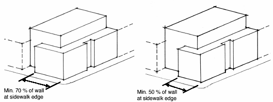
2.
Parking structures. Any structured parking shall have leasable and occupiable commercial or residential uses between the property line and parking at street level. These other uses shall extend a minimum of 70 percent of the linear street frontage of the structure.
3.
Surface parking lots.
a.
Accessory surface parking areas shall not be located in the front yard or the side yard adjacent to a street (not including alleys).
b.
A surface parking lot as a principal property use shall comply with the following setback requirements:
c.
A landscape buffer shall have a minimum depth of 10 feet between a street right-of-way (not including alleys) and the parking area. The landscape buffer shall incorporate a sight-obscuring hedge screen, which shall grow to be at least 24 inches and no more than 42 inches higher than the finished grade of the parking area, except for required vision clearance areas. Screen plantings shall be of such size and number to provide the required screening within 12 months after installation. Adequate provisions shall be made to protect plant materials from being damaged by vehicles using the parking area.
d.
Surface parking areas shall be shaded by trees in accordance with section 8-7-15(J).
e.
Raised pedestrian walkways shall be installed through surface parking areas of 50 or more spaces or more than 100 feet in average width or depth.
f.
Surface parking lots with 50 spaces or more shall be divided into separate areas divided by landscaped areas or walkways at least ten feet in width or by a group of buildings.
4.
Public sidewalks shall be provided adjacent to a public street along the street frontage.
5.
Trash storage areas, mechanical equipment, and similar areas shall be screened from view from adjacent public rights-of-way.
6.
Outdoor storage areas and loading facilities shall be screened from view from adjacent public rights-of-way.
7.
Transit amenities, bus shelters, and pullouts shall be required in accordance with the Athens-Clarke County Transit Service.
8.
Retaining walls in a front yard, rear yard, or side yard adjacent to a public right-of-way or private street shall be set back from a public right-of-way a minimum of two feet for every foot of wall height above three feet in height, as measured parallel to the right-of-way and accounting for any linear changes in height. No portion of a retaining wall shall exceed ten feet in height. A terrace is required between a lower retaining wall and an upper wall and the terrace area shall have a minimum five-foot depth as measured from the upper grade of the lower retaining wall to the base of the upper retaining wall. Retaining walls over five feet in height shall be screened by a landscape buffer meeting the standards of section 9-10-6-D-(4)(b)(3); however, wall art, including murals, sculptural or other decorative treatment of exterior walls may extend for a maximum of 50 percent of the wall length. Acceptable exterior finish materials include, but are not limited to, stucco, split face blocks, brick, stone, glass blocks, curved interlock blocks, wood, tubular steel, wrought iron bars or other grill work, textural or scored poured concrete, engineered "green" or vegetative wall as approved by the planning director, or a combination of these materials. Exposed flat-face CMU blocks and EIFS stucco are prohibited.
9.
Chain-link and opaque wood fencing are not allowed in any yard adjacent to a street.
D.
Building design standards.
1.
Horizontal definition of the building facade. First and second floor levels of a wall of a building that faces a public street shall be horizontally defined with clearly distinguishable horizontal details, which shall extend for a minimum of 70 percent of the wall length. A horizontal element shall define the first floor and the second floor. The required horizontal articulation may be achieved by using one of the following methods:
a.
A molding, ornamental trim, window casing or sill that projects a minimum of three inches from the primary wall surface, and/or
b.
A setback in the primary wall plane at the second and/or third floor level, a minimum of five feet from the floor below, and/or
c.
A permanently affixed canopy, extending a minimum of four feet from the building face, and/or
d.
A horizontal fascia that defines floor structure between the first and second floors, and/or
e.
An eave of a porch, portico, or other similar element, which extends a minimum of 18 inches from the building face.
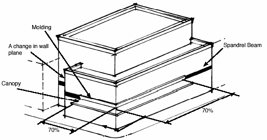
Examples of horizontal definition achieved through use of moldings, changes in wall plane, canopies and a spandrel beam. The moldings and canopies shown would each independently meet the requirement for horizontal articulation extending 70 percent of the wall length.
2.
Vertical definition of building modules. Vertical definition shall be provided at a minimum of every 40 feet of facade length, using one or more of the following methods:
a.
A molding, ornamental trim, or window casing projecting a minimum of three inches from the primary wall surface and is a minimum of three inches wide, and/or
b.
A setback in the primary wall plane a minimum of three feet from the building face and for a minimum width of three feet.
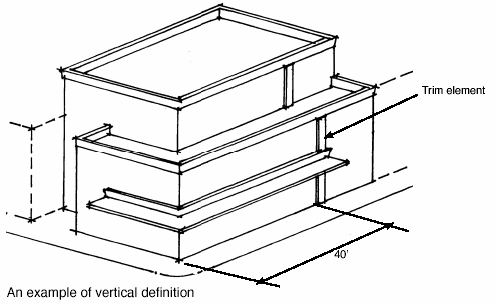
3.
Primary entrance. The primary public entrance of a building and/or each ground floor tenant space facing a street shall be directly linked to a public sidewalk. For ground-floor dwellings facing a street, a maximum allowance of two tenant spaces may share the same direct link. The primary entrance shall be positioned no more than five feet above the finished grade at the front of the building.
a.
Buildings shall incorporate lighting and changes in mass, surface or finish to give emphasis to entrances.
b.
Building shall incorporate arcades, roofs, alcoves, porticoes and/or awnings at public entrances that protect pedestrians from the rain and sun.
4.
Transparency. A minimum percentage of any wall facing a public street shall have openings accounting for the percentages provided below and use transparent glass in those openings, unless directly associated with open unenclosed parking structures:
a.
Transparency at the ground floor level shall be measured from the finished building grade at the street to ten feet above grade for the entire width of the wall.
b.
The following alternative design treatments may be used, singularly or in combination, to meet half of the transparency requirement per elevation at the street level:
(1)
A display case, defined as a box with transparent glass facing the street with a solid panel behind for display of products and images of goods and services offered in the area.
(2)
Wall art, including murals, sculptural and other decorative treatment of exterior walls.
(3)
Landscaping, which is to be at least three feet high at the time of planting and of a type that will produce an opaque, evergreen planting screen capable of growing to a height of at least six feet within three years.
c.
Windows must allow views into working areas or lobbies, pedestrian entrances or display areas.

5.
Building materials. No more than 25 percent of a wall surface, singularly or in combination, may be of plaster, stucco, or metal sheet siding. Metal siding shall be prohibited on the first floor, except for fabricated architectural metal siding panels with a gauge value of 24 or less and without exposed fasteners after installation is complete.
Plain concrete block (CMU), synthetic stucco (e.g., EFIS), mirror glass, and tinted glass with a tint of 20 percent gray or greater are prohibited exterior building materials.
6.
All properties in the "C-D" zone shall have a minimum floor area (FAR) ratio of 0.40. Expansions of existing development for which at least 50 percent of the original structure is retained are exempt from the minimum FAR. Plazas and pedestrian areas, conforming to the standards of section 9-25-8-F.2, shall count as floor area for the purpose of meeting the minimum FAR. Reductions of the lot area calculation shall be allowed for flood plain, bodies of open water, wetlands, riparian buffers, slopes greater than 25 percent, buffers required by section 9-15-3, and public utility easements, if these areas remain vegetative or landscaped.
7.
Ground-floor dwellings are permitted in the North Downtown Design Area without a special use permit, subject to the following standards:
A.
Each ground-floor dwelling with an exterior elevation facing a street shall have direct pedestrian access to the street and public sidewalk.
B.
Ground-floor dwellings shall be a minimum distance of 50 feet from the street listed below, as measured from the nearest wall of the residential unit to the nearest street right-of-way, and have leasable and occupiable nonresidential space between the dwellings and right-of-way of such streets at street level, which shall extend a minimum of 70 percent of the linear street frontage of the structure.
College Avenue
E.
Alternative compliance. Except for properties within the Downtown Historic District, applicants may request alternatives to compliance with the design standards of this section through a design review process guided by the separate Alternative Compliance Guidelines for the C-D Zone. Applications for alternative compliance will be processed through the Type III procedure described in Chapter 9-4 (Procedures). The Planning Commission shall review alternative compliance applications in light of any comments received from the public, the intent of the standards of this section, and the applicable design guidelines. An alternative compliance application may be approved upon a finding by the Planning Commission that:
1.
The request would result in public benefits greater than any negative impacts; and
2.
The request is consistent with the goals, objectives, and policies set forth in the Comprehensive Plan of Athens-Clarke County; and
3.
The request is consistent with the attributes of the Downtown and of the Design Area described in the Alternative Compliance Guidelines; and
4.
The request conforms to the relevant Alternative Compliance Guidelines.
Projects located within the Downtown Historic District shall be reviewed by the Athens-Clarke County Historic Preservation Commission and be subject to their approval as well as meeting the criteria established in this title. In the event of a conflict between C- D Zone Design Standards and the decision of the Historic Preservation Commission, the historic preservation ordinance shall apply.
(Ord. of 6-5-2007, § 5; Ord. of 2-3-2009, §§ 1, 2; Ord. of 2-2-2021(1), §§ 3—10)
Sec. 9-11-1.- Purpose.
The purpose of this district is to provide for a variety of uses such as office or manufacturing in an aesthetic environment and having a minimal impact on surrounding uses.
(Ord. of 12-5-2000, § 1)
Sec. 9-11-2. - Permitted uses.
The following uses and their accessory uses are permitted as follows in these districts:
Legend:
P = Permitted outright.
S = Subject to approval under the special use procedures section.
N = Prohibited use.
L(1) = Uses are limited to no more than 10,000 square feet of gross floor area per lot. Shopping centers are not permitted.
L(2) = When within 200 feet of a residential zone, approval of this use is subject to a special use process.
L(3) = Total residential square footage shall not exceed 20 percent of the total square footage of the development. Site design criteria, pursuant to chapter 9-25 included herein, shall apply to residential uses.
L(4) = Agriculture and the keeping of livestock, except swine, is permitted provided that:
1.
No livestock shall be kept on any lot less than one acre in area.
2.
No more than two head of livestock over the age of six months may be maintained per acre.
3.
Barns, stables, and other buildings and structures to house said livestock shall not be located closer than 50 feet to any property line.
4.
The property has not previously been developed with a use permitted by an underlying zoning classification other than AR.
L(5) = Parking areas are permitted between the building and the street, provided that landscaping is included adjacent to the street pursuant to sections 9-11-6(D) and 9-30-9(E)(6).
L(6) = Commercial Outdoor Recreation uses that involve overnight accommodations, such as camping and RV parks, are subject to the special use process.
L(7) = A maximum of one detached residential unit, designed for and occupied by one family only. The structure must be accessory and subordinate to a single-family dwelling and located on a tract of land that is at least twice the minimum lot size for the district in which it is located, and conforms to the standards outlined in this title. The accessory dwelling structure must: (1) be located entirely in the rear yard of the principal residential structure; (2) have gross square footage that is 50% or less of the habitable square footage of the principal residential structure; and (3) have fewer bedrooms than the principal residential structure.
L(8) = Temporary special events, as defined in section 9-2-1, are subject to, but not limited to, the following conditions:
1.
The boundary of the temporary special event, as described on the approved site plan, shall not be located within 300 feet of any RS (Single-Family Residential) zone or RM (Mixed Density Residential) zone.
2.
A temporary special event shall have a duration of not more than 72 consecutive hours, including setup and breakdown of the event.
3.
No more than two temporary special events may occur for any one property in each calendar year; a temporary special event shall not occur more frequently than once in a three-month period on the subject property.
4.
Sufficient improved or unimproved off-street parking, to be approved by the Planning Director, with access to be approved by the Department of Transportation and Public Works, shall be provided.
5.
All temporary special events shall apply for and obtain, if required, an Athens-Clarke County Special Events Permit per Chapter 6-5 and shall comply with all applicable local, state, and federal regulations.
(Ord. of 12-5-2000, § 1; Ord. of 5-7-2002, § 2; Ord. of 8-5-2003, § 1; Ord. of 2-3-2004, § 1; Ord. of 8-1-2006, § 9; Ord. of 8-1-2006, § 2; Ord. of 6-3-208, § 1; Ord. of 2-3-2009, § 4; Ord. of 4-5-2011, § 7; Ord. of 12-4-2012, § 9; Ord. of 2-4-2014, § 7; Ord. of 12-12-2022(5), § 1; Ord. of 12-5-2023(4), § 7; Ord. of 2-6-2024(3), § 8)
Sec. 9-11-3. - Special uses.
The following uses and their accessory uses are permitted when authorized in accordance with the chapter on special use permits:
A.
Shopping centers or department stores on parcels not located on an arterial street as designated in Athens-Clarke County's Comprehensive Plan.
B.
Any use in an E-O zone which involves outside storage of merchandise, raw materials, or other material associated with the primary use on the site.
C.
There shall be no manufacturing, retailing, or other activity on the site which is not entirely conducted within a building, except in the I zone, and except as specifically permitted through the Special Use process.
(Ord. of 12-5-2000, § 1)
Sec. 9-11-4. - General regulations.
1 Unless otherwise specified in section 9-15-9.
2 Except for lots entirely fronting turnaround areas of cul-de-sacs, the lot width shall be measured beginning at the front lot line and maintained for the entire minimum lot depth. For lots entirely fronting turnaround areas of cul-de-sacs, the lot width shall be measured beginning at the minimum required front setback line and maintained for the remaining portion of the minimum lot depth.
(Ord. of 12-5-2000, § 1; Ord. of 11-6-2001, § 2; Ord. of 6-3-2008; § 1; Ord. of 12-7-2010, § 7)
Sec. 9-11-5. - E-I (Employment-Industrial) and I (Industrial) performance standards for industrial category uses.
A.
Industrial uses. Performance standards for uses in the E-I (Employment-Industrial) and the I (Industrial) zones are designed to accomplish the intent of these districts. That intent protects both the community and proposed uses from abuse and negative impacts, while encouraging appropriate development to occur. To that end, industrial uses in the E-I (Employment-Industrial) and the I (Industrial) zones are determined to be permitted through several thresholds. Three threshold levels exist that will be reviewed either as a site review or special use permit. Level I uses are those that do not exceed specified criteria and do not require governmental funded infrastructure improvements; these are reviewed as site reviews. Level II uses are those that have exceeded the minimum thresholds for Level I or require governmental funding of infrastructure improvements; this is a site review decision. Level III uses are those that are specifically listed within this section or uses that exceed Level II requirements, and will be reviewed as a special use permit. Uses which exceed any of the thresholds are not automatically prohibited, but instead require additional review by the assigned decision-maker, according to level.
1.
Level I. All uses are permitted, provided that they do not exceed the following criteria, do not require governmental funded infrastructure improvements and are not defined in Level III.
a.
Water. If the following threshold is exceeded, the use shall be reviewed as a Level II:
(1)
Peak demand total of 200 GPM (gallons per minute); or
(2)
250,000 GPD (gallons per day).
(The above figures are not to be used for fire protection flow rates.)
b.
Wastewater. If any of the following thresholds are exceeded, the use shall be reviewed as a Level II:
(1)
Site specific allocations; or
(2)
Per requirements of the Unified Government of Athens-Clarke County Sewer Use Ordinance; or
(3)
Demand exceeding 100,000 GPD (gallons per day).
c.
Vibration (ground or air transmitted). If the following standards are exceeded, the proposed use(s), within this category, must be reviewed as Level II:
(1)
Adjacent to nonresidential properties:
Frequency
Peak Particle Velocity
>40 hz
¾" per sec.*
>40 hz
2" per sec.*
*Measured at the property line
(2)
Adjacent to residential properties: Peak particle velocity 0.25" per second or 115 dbl (decibel peak linear), measured outside at ground level at closest residential structure. It is the intent of this section to regulate ground or air vibration in such a manner as to prohibit structural damage to adjacent uses.
d.
Fire and explosion. Per requirements of current local and state fire regulations.
e.
Traffic. If the following are exceeded, the proposed use, within this category, must be reviewed as Level II:
(1)
Site allocation, as denoted on the traffic volume inventory located in the Athens-Clarke County Planning Department. All allocations are based on roadway capacity at level of service "D" for the road or street; or, lacking any site specific information, the following standards will be used:
(2)
100 peak hour trip ends; or
(3)
Truck traffic comprising fifty percent or more of the site generated average weekday trip ends.
Traffic generation rates will be based on the Institute of Traffic Engineers Trip Generation Manual (current edition).
f.
Solid waste generation. Site specific criteria or 2,000 pounds per day of solid waste transported to landfill(s) under management of Athens-Clarke County.
g.
Odor. No use shall be operated so as to produce the emission of objectionable or offensive odors in such concentration as to be readily perceptible at any point along the lot line of the property on which the use is located. It is the intent of this section to regulate odor in a manner to prohibit it from exceeding levels that would become a nuisance or hazard to adjacent property.
h.
Noise. Noise levels shall comply with the following:
Noise levels are measured as constant, consistent sounds and not intermittent noise. All measurements shall be taken at property lines. It is the intent of this section to regulate noise in a manner to prohibit it from exceeding levels of sound that could become a nuisance or hazard to adjacent property.
i.
Glare. Glare or light from any operation and all lighting for parking areas or for the external illumination of buildings or grounds shall be directed or located in a manner such that direct or indirect illumination from the source of light shall not exceed one-half foot-candle measured at any residential lot line. Outside lights for nonresidential properties/uses must be made up of a light source and reflector so that acting together the light beam is controlled and not directed across an adjacent property. It is the intent of this section to prevent light from spilling over to adjacent properties in amounts that can create negative impacts.
j.
Stormwater. Regulated by Athens Clarke County stormwater management policies.
2.
Level II. All uses, except those outlined in Level III, that exceed one of the locally specified criteria (water, wastewater, vibration, fire and explosion, traffic, solid waste, odor, noise, glare and stormwater) or that require locally funded infrastructure improvements. The decision as to whether it is an allowable use will be based on one of the following:
a.
Review by staff to determine if proposed use is within capacity ranges and does not necessitate additional governmental expenditure or use reserve capacity; or
b.
Reviewed by staff and does exceed capacities or use reserves and is forwarded to government officials for decision and an agreed upon financing plan between the government and the potential industry.
3.
Level III.
a.
Uses. Uses in Level III will be those uses not covered by Levels I and II plus those principle uses listed below:
(1)
Airports and landing fields;
(2)
Reserved;
(3)
Reserved;
(4)
Explosives, including fire works manufacture or storage in bulk quantities;
(5)
Garbage, offal, dead animal reduction or dumping;
(6)
Reserved;
(7)
Reserved;
(8)
Reserved;
(9)
Stock yards, commercial;
(10)
Conversion of energy by nuclear fusion or fission;
(11)
Reserved.
The aforementioned uses shall only be permitted by review through the special use procedure in chapter 9-20.
(Ord. of 12-5-2000, § 1; Ord. of 9-4-2001, § 2; Ord. of 8-1-2006, § 10; Ord. of 12-5-2023(4), § 8)
Sec. 9-11-6. - E-I (Employment-Industrial) and I (Industrial) design standards.
A.
All outside storage must be completely screened from view from adjacent properties and the street(s).
B.
Loading docks must be located to the side or rear of the building unless the loading area is completely screened from the street.
C.
Site must be designed to permit on-site maneuvering of all vehicles (no backing in from street).
D.
Front yard landscaping. A minimum of 25 percent of the designated front yard set back shall be landscaped with a combination of trees, shrubs, and ground cover. The remainder of the front yard set back shall be vegetated, which may be grass or other ground cover.
E.
Riparian buffers for the I (Industrial) zone. Developments in the I (Industrial) zone must observe a minimum buffer of 150 feet (measured horizontally from uppermost part of the river, stream or lake bank usually marked by a break in slope) from all perennial rivers, lakes, and streams identified on the Athens-Clarke County Environmental Areas Map. Buffers are to be maintained in accordance with section 8-6-8, "Land Disturbing Activity Standards for Riparian Buffer Areas," of the Code of Athens-Clarke County, Georgia.
(Ord. of 12-5-2000, § 1; Ord. of 9-4-2001, § 3)
Sec. 9-12-1.- Purpose and intent.
The mayor and commission of Athens-Clarke County hereby enacts into law the following special district overlays for the following purposes:
A.
Promote the health, safety and general welfare of the present and future inhabitants of Athens-Clarke County, Georgia;
B.
Improve Athens-Clarke County's appearance;
C.
Provide adequate light, air, and vistas;
D.
Prevent urban sprawl, and to protect against blight and depreciation;
E.
Encourage the most appropriate use of land, buildings and other structures;
F.
Encourage the development of an economically sound and stable community so as to help conserve and protect the natural, economic and scenic resources of Athens-Clarke County;
G.
Protect and enhance certain specific lands and structures which, by virtue of their type or location, have characteristics which are distinct from lands and structures outside such special districts, permitting, insofar as possible, those uses and structures which would otherwise be permitted, provided that reasonable and necessary conditions are met which insure the protection and enhancement of said lands and structures;
H.
Secure economy in government expenditures;
I.
Other purposes, all in accordance with the Official Future Development Map of Athens-Clarke County; and
J.
Specifically protect and enhance the following:
K.
Special district overlays, as adopted by the mayor and commission.
(Ord. of 12-5-2000, § 1; Ord. of 7-1-2008, § 10)
Sec. 9-12-2. - General standards.
The special district overlays established in this title operate by establishing design guidelines to effectuate the purpose of the district. In the event of a conflict between the underlying zoning designation and the special district overlay, the provisions of the special district overlay shall apply.
Land lying within a special district shall remain part of the underlying zoning designation established by other provisions of the Athens-Clarke County Zoning Ordinance, and may, in addition, lie in one or more overlay districts in accordance with the designation of each.
(Ord. of 12-5-2000, § 1)
Sec. 9-12-3. - Creation of special district overlay.
Amendments to this title, or to the zoning map, shall be adopted as a type I procedure. Every recommendation for the creation of a special district overlay, or addition of land thereto, shall address the following, as applicable:
A.
A statement of purpose shall specify the nature of the special and substantial public interest and public welfare involved and objectives to be promoted by creation of the special district overlay and imposition of the regulations and design guidelines proposed therefore.
B.
Proposed district boundaries shall be depicted on one or more maps, including the official zoning map of Athens-Clarke County, which shall also display all other zoning districts, applicable to the property proposed for inclusion in the district.
C.
Regulations or design guidelines proposed to promote the special purposes of the special district.
D.
Regulations or design guidelines for any special district shall be designed to reasonably promote the purposes of the district, and may require or address any of the following, in addition to or in lieu of other regulations affecting property within the special district.
1.
Protection of features designated as being of special concern within the district;
2.
Mixtures or limitations or permitted uses;
3.
Special performance standards and development regulations;
4.
Other matters as appropriate to promote the special public interests of the district.
E.
Development plans for any proposed project within a special district overlay require review and approval by the director of the Athens-Clarke County Planning Department. The director shall review the plans in consultation with other departments of Athens-Clarke County or state agencies to ensure compliance of the plans with all applicable regulations, ordinances, and laws.
F.
Application contents. All applications and materials for review of development plans by the director of the Athens-Clarke County Planning Department must be submitted to the Athens-Clarke County Planning Department. Following the submission of a complete application form, the director of the Athens-Clarke County Planning Department within 15 days shall reach a decision. In order to be considered three copies of a complete application and three copies of a binding development plan for proposed construction must be approved. The binding development plan must contain the following:
1.
Project name.
2.
Project owner. All corporate owners having ten or fewer shareholders shall list the names of all stockholders. If a named stockholder therein is another corporation, the same information shall be given for the stockholding corporation. All corporate owners shall also list the names of the officers of the corporation. All partnerships, limited partnerships, or limited liability companies shall list the names of the partners and managers of the business entity.
3.
Project owners' address.
4.
Date, scale and north arrow on all submitted plans and drawings.
5.
Property lines and dimensions and bearings.
6.
Required setbacks.
7.
Location of all existing and proposed buildings.
8.
Elevation drawings for all proposed alterations to existing buildings, including drawings of architectural details and materials.
9.
Location, name and width of all existing or proposed streets.
10.
Topography at five-foot contour intervals.
11.
Location of all driveways and off-street parking serving the project.
12.
Location and plans for all proposed buffers, screening materials, or other landscape features.
13.
Location of creeks, streams, ponds, lakes, and other waterways.
14.
Dumpster locations.
15.
Location, height fixture type and wattage of site lighting.
16.
Heights of existing and proposed buildings.
17.
Any other information or data requested by the director of the Athens-Clarke County Planning Department or identified in the specific special overlay district in order to understand and evaluate the project.
G.
After review and approval by the director of the Athens-Clarke County Planning Department, any adjustment or amendment submitted to the binding development plans by the petitioner, beyond those recommended by the director of the Athens-Clarke County Planning Department, shall be considered a new application. If the director of the Athens-Clarke County Planning Department recommends changes to the binding development plan, and the applicant decides to include such changes to his or her request, then the said petitioner must make appropriate changes to the binding development plan and submit said plans to the Athens-Clarke County Planning Department staff for review and approval.
H.
The denial of an application for a development plan shall be binding upon any Athens-Clarke County official charged with issuing permits related to said plan, and, in such a case, no permit shall be issued or approval given.
I.
Upon approval of a special district overlay, a map of the district boundaries shall be incorporated into the zoning maps of Athens-Clarke County.
(Ord. of 12-5-2000, § 1)
Sec. 9-12-4. - Relationship to Athens-Clarke County Historic Preservation Ordinance.
Projects located within a district or area designated under the Athens-Clarke County Historic Preservation Ordinance shall be reviewed by the Athens-Clarke County Historic Preservation Commission and be subject to their approval as well as meeting the criteria established by the special overlay district. In the event of a conflict between special overlay district regulations and the decision of the historic preservation commission, the historic preservation ordinance shall apply.
(Ord. of 12-5-2000, § 1)
Sec. 9-12-5. - Mixed Density Residential—Limited (RM-LTD) Special District Overlay.
The mayor and commission of Athens-Clarke County hereby enacts into law the following special district overlay for the following purposes:
A.
Purpose.
1.
Promote the health, safety and general welfare of the present and future inhabitants of Athens-Clarke County, Georgia;
2.
Protect certain single-family, single-family attached, and two-family residences on existing lots of record which were previously approved and developed in compliance with the terms, regulations, and standards which were in effect at the time of approval.
B.
General standards. The RM-LTD Special District Overlay established in this title operates by establishing permitted uses that are designed to effectuate the purpose of this special overlay district. In the event of a conflict between the underlying zoning designation and the special district overlay, the terms of the underlying zoning designation shall apply unless in conflict with the uses permitted herein.
C.
Permitted uses. The following uses are permitted in the RM-LTD Special Overlay District.
1.
This district is intended to permit the reconstruction of single-family, single-family attached, and two-family residences on existing lots of record within the building footprint of the pre-existing structure as previously permitted in the repealed RG zoning districts.
2.
Any single-family, single-family attached, or two-family residences on existing lots of record approved and constructed prior to the date of adoption of this title, or reconstructed in accordance with the terms of the RM-LTD Special Overlay District, shall be exempt from the definition of family restrictions in AR and RS zones per Section 9-15-18.
(Ord. of 12-5-2000, § 1; Ord. of 6-4-2013, § 1)
Sec. 9-12-6. - Gaines School Road Corridor Special District Overlay (GSRC).
The mayor and commission of Athens-Clarke County hereby enacts into law the Gaines School Road Corridor Special District Overlay (GSRC) for the following purposes:
A.
Purpose and intent. The purpose of the Gaines School Road Corridor Special District Overlay is to address issues of public safety, health, and general welfare, including controlling the visual and architectural character of the Gaines School Road corridor through the use of design requirements in order that new development is visually compatible with the existing residential neighborhoods adjacent to Gaines School Road Corridor and that the permitted uses are compatible with the adjacent neighborhoods. While the underlying zoning district designation generally provides for the allowed uses, the district overlay requires that new construction maintain residential character within the corridor by limiting the mass of proposed structures, encouraging building groups, providing for landscaped yards and open areas.
B.
The Gaines School Road Corridor Special District Overlay (GSRC) boundaries are established to include those properties with frontage on Gaines School Road at the time of the adoption of this ordinance. The boundaries of this special use district are from the intersection of Gaines School Road with Cedar Shoals Drive south to and including the tracts of land located at 175 Gaines School Road on the southern side of the right-of-way and 180 Gaines School Road on the northern side of the right-of-way, all as more specifically designated on the Official Zoning Map of Athens-Clarke County, Georgia, as shown on Attachment A hereto. The Official Zoning Map of Athens-Clarke County, constituting the component part of the Zoning Ordinance of Athens-Clarke County, Georgia, by virtue of and in compliance with section 9-3-3 and section 9-3-6 thereof, is hereby amended by adding the GSRC (Gaines School Road Corridor Special District Overlay) as a zoning district to the legend to said map, as shown on Attachment A hereto. The date of this amendment to the Official Zoning Map of Athens-Clarke County as shown by Attachment A shall be noted on said Official Zoning Map in the clerk of commission's office and duly noted in the minutes of the commission meeting.
C.
Permitted uses.
1.
Retail sales and service. The following would be permitted in the Gaines School Road Corridor Special District Overlay:
a.
Arts and crafts shops.
b.
Book, stationary, card, and gift shops.
c.
Barber shops, beauty parlors and other similar personal service establishments.
d.
Flower shops.
e.
Garden supply and greenhouses.
f.
Interior decorator.
g.
Travel agencies.
h.
Small appliance repair shops.
i.
Other uses as may be determined by the planning director and/or planning commission to be similar and compatible with the above listed permitted uses.
All other retail uses in the Gaines School Road Corridor Special District Overlay will require a special use permit pursuant to the provisions of chapter 9-20 (Special Uses) as a Type II procedure for approval by the Athens-Clarke County Mayor and Commission to insure compatibility with the surrounding neighborhoods and satisfaction of all other requirements of chapter 9-20.
2.
Exceptions. The following uses are not permitted in the Gaines School Road Corridor Special District Overlay:
a.
Convenience store;
b.
Laundry facilities.
D.
General standards.
1 Except for lots entirely fronting turnaround areas of cul-de-sacs, the lot width shall be measured beginning at the front lot line and maintained for the entire minimum lot depth. For lots entirely fronting turnaround areas of cul-de-sacs, the lot width shall be measured beginning at the minimum required front setback line and maintained for the remaining portion of the minimum lot depth.
E.
Gaines School Road Corridor Special District Overlay buffer requirements: Landscape buffers shall be utilized to protect the residential neighborhoods surrounding the Gaines School Road Corridor Special District Overlay from the allowed uses within that special district overlay.
1.
Within the Gaines School Road Corridor Special District Overlay, buffers shall be installed on the lot with the more intensive or nonresidential use along the common lot lines for the following:
a.
Any non-residential use, with the exception of agriculture, abutting any residential use or residential zoning district with the exception of the Agricultural Residential (AR) Districts.
b.
Any development of a multi-family dwelling or dwellings adjacent to single-family dwellings or any Single Family Residential (RS) Districts.
2.
Within the Gaines School Road Corridor Special District Overlay, one of the following types of buffer or a combination of the following types of buffers, shall be utilized to provide the required buffer:
a.
Landscape buffer strip: A buffer strip at least 30 feet wide, densely planted with a mix of trees and shrubs a minimum of three feet high at the time of planting, of a type that will possess growth characteristics of such a nature as to produce a dense, compact evergreen planting screen capable of growing to a height of at least six feet within three years. A landscape plan identifying all plants to be incorporated in the buffer strips must be approved by planning staff prior to any site construction. Planning staff may require additional planting to acquire a uniform buffer strip.
b.
Landscape buffer wall: A buffer strip at least 15 feet wide, containing an opaque wall or barrier or uniformly painted fence at least six feet in height. The framework for newly constructed fences and walls shall face toward the builder's property. Buffer strips shall have eight feet of landscape plantings on the exterior, finished side of the wall and shall be planted with appropriate trees, shrubs, and ground cover as to provide a transition from the wall to both edges of the buffer strip. A landscape plan identifying the location and construction of the wall or barrier and all plants to be incorporated in the buffer strip must be approved by planning staff prior to any site construction. Planning staff may require additional planting to acquire a uniform buffer strip.
3.
Prescribed fences and walls may not be waived; the provisions for such waivers found in section 9-15-3 C.1. of the Zoning Code of Athens-Clarke County, shall not apply within the Gaines School Road Corridor Special District Overlay.
F.
Lighting requirements. Where any non-residential use is proposed within the Gaines School Road Corridor Special District Overlay and the subject parcel abuts a single family dwelling, multi-family dwelling, a Single-Family Residential (RS) District or a Mixed Density (RM) District, then any lighting utilized on the subject parcel (where the non-residential uses is to be established) shall be fully shielded and directed so as to protect the adjacent residential use or district from direct or reflected glare.
G.
Architectural standards. In addition to design requirements found within this title, buildings are subject to the following site design requirements:
1.
Buildings shall utilize at least two of the following design features to provide visual relief along the front (facade) of the structure:
a.
Dormers
b.
Gables
c.
Recessed entries
d.
Covered front porches
e.
Pillars or posts
f.
Bay window (min. 24-inch projection).
2.
Primary entries shall be accessed directly from the public street and sidewalk.
3.
Windows shall be provided with trim and molding. Windows shall not be flush with the exterior wall treatment.
4.
The pitch of a structure's roof shall have a minimum vertical rise of 2½ feet for every 12 feet of horizontal run, and the roof is finished with a type of shingle that is commonly used in standard residential construction or a standing seam metal roof.
5.
Exceptions. The site design requirements found in section 9-25-8 E.1.i do not apply in the Gaines School Road Corridor Special District Overlay.
(Ord. of 6-5-2001, § 2; Ord. of 9-3-2002, § 2; Ord. of 8-2-2005, § 2; Ord. of 12-7-2010, § 8)
Editor's note— Attachment A of an ordinance adopted June 5, 2001, which is referred to in section 9-12-6 above, has not been included in this Code, but may be found attached to said ordinance, on file in the office of the clerk of commission.
Sec. 9-12-7. - Milledge Avenue Corridor Special District Overlay.
A.
Purpose and intent. The purpose of the Milledge Avenue Corridor Special District Overlay is to address issues of public safety, health, and general welfare, including controlling the visual and architectural character of the Milledge Avenue Corridor Special District Overlay. The use of design requirements will help to ensure that new development is visually compatible with the existing historic character of Milledge Avenue and the adjacent residential neighborhoods and that the permitted uses are compatible with the adjacent neighborhoods. Special use requirements will help provide a balanced mix of uses within the Milledge Avenue Corridor and help ensure that the future establishment of or expansion of institutional residential uses or boarding house or dormitory uses will not overly-dominate the character of the Milledge Avenue Corridor and will help ensure future compatibility of these uses with adjacent residential neighborhoods. While the underlying zoning district designation generally provides for the allowed uses, the district overlay requires that new construction maintain residential character within the corridor by limiting the location of parking and stormwater management facilities, as well as providing for landscaped yards and open areas.
B.
Boundaries. The Milledge Avenue Corridor Special District Overlay (MAC) boundaries include those properties with frontage on Milledge Avenue or parcels adjacent to properties with frontage on Milledge Avenue at the time of the adoption of this ordinance. The boundaries of this special district overlay begin at the intersection of South Milledge Avenue and West Broad Street and continue south to the intersection of South Milledge Avenue and South Lumpkin Street, and are specifically designated on the Official Zoning Map of Athens-Clarke County, Georgia, as shown on Attachment A hereto. The Official Zoning Map of Athens-Clarke County, constituting the component part of the Zoning Ordinance of Athens-Clarke County, Georgia, by virtue of and in compliance with section 9-3-3 and section 9-3-7 thereof, is hereby amended by adding the MAC (Milledge Avenue Corridor Special District Overlay) as a zoning district to the legend of said map, as shown on Attachment A hereto. The date of this amendment to the Official Zoning Map of Athens-Clarke County as shown by Attachment A shall be noted on said Official Zoning Map in the Clerk of Commission's office and duly noted in the minutes of the Mayor and Commission meeting.
C.
Uses. Uses in the Milledge Avenue Corridor Special District Overlay are permitted according to the use table in Section 9-10-2.
D.
General standards.
1 Except for lots entirely fronting turnaround areas of cul-de-sacs, the lot width shall be measured beginning at the front lot line and maintained for the entire minimum lot depth. For lots entirely fronting turnaround areas of cul-de-sacs, the lot width shall be measured beginning at the minimum required front setback line and maintained for the remaining portion of the minimum lot depth.
Legend:
L(1) = 1. The minimum front yard setback shall not be less than the existing front
yard setback that is closest to the public right-of-way on an abutting property.
2. The maximum front yard setback shall not exceed the existing front yard setback
that is furthest from the public right-of-way on an abutting property.
3. If a subject property abuts an undeveloped tract, public street, private way, or
alley, the front yard setback distance of the next adjacent property that fronts Milledge
Avenue shall be used to determine minimum and maximum front yard setback distances.
(Sec. 9-15-9)
E.
Off-Site Parking. The required parking facilities for fraternities, sororities, semi-public halls, clubs, and lodges may be located on another parcel of land, provided said parcel is within 1,000 feet of the use it is intended to serve. The distance from the parking lot to the use shall be measured in walking distance from the nearest parking space to an access to the building housing the use, along a sidewalk or other pedestrian path separated from street traffic. The off-site parking facilities shall be established in accordance with the procedures set forth in section 9-30-8.
F.
Parking Standards.
1.
No less than 20 percent of the required parking spaces and any additional parking shall be constructed of dust-free pervious paving materials pursuant to section 9-30-9(E) of this title.
2.
Parking areas shall be located behind the building. No parking shall be located in the front yard or in a side yard adjacent to a street.
G.
Location of stormwater management facilities. Stormwater management facilities shall not be located in the front yard or in a side yard adjacent to a street, except for vegetated, natural facilities, such as a bio-filtration facility. Approval of a landscape plan identifying all plants to be incorporated in the vegetative stormwater facility shall be obtained prior to any site construction.
H.
Preservation of Mature Tree Canopy.
1.
The Milledge Avenue Corridor Special District Overlay shall have a Tree Preservation Area. This area shall extend across the full width of and be situated between the front lot line and the principal structure line projected from the primary front facade corners to the side property lines parallel to the right-of-way. Trees within this area shall be conserved to the greatest extent and in accordance with section 8-7-15. If the property is undeveloped, then the Tree Preservation Area shall be the minimum front yard established in Table 9-12-7.
2.
All trees 8" dbh (diameter breast height) and greater within the Milledge Avenue Tree Preservation Area meeting the definition of a "conservable tree" per section 8-7-6 shall be conserved.
3.
No administrative waiver of tree conservation per section 8-7-15(f) shall be granted within the overlay established within this section. Any request for tree removal within the Milledge Avenue Tree Preservation Area shall follow the standards set forth in section 8-7-13.
(Ord. of 4-6-2010, § 4; Ord. of 12-7-2010, § 9; Ord. of 7-5-2011, § 2; Ord. of 5-2-2017(2), § 1)
Sec. 9-12-8. - West Broad Street Special District Overlay.
A.
Purpose and intent. The purpose of the West Broad Street Special District Overlay is to address issues of public safety, health, and general welfare, including controlling the visual and architectural character of the West Broad Street Special District Overlay. The use of design requirements will help to ensure that new development is visually and functionally compatible with the unique character of the transition area containing commercial, residential and institutional uses.
B.
Boundaries. The West Broad Street Special District Overlay (WBS) boundaries include those properties within the block surrounded by West Broad Street, North Milledge Avenue, Reese Street, and North Chase Street. The boundaries of this special district overlay are specifically designated on the Official Zoning Map of Athens-Clarke County, Georgia, as shown on Attachment A hereto. The Official Zoning Map of Athens-Clarke County, constituting the component part of the zoning ordinance of Athens-Clarke County, Georgia, by virtue of and in compliance with section 9-3-3 and section 9-3-7 thereof, is hereby amended by adding the WBS (West Broad Street Special District Overlay) as a zoning district to the legend of said map, as shown on Attachment A hereto. The date of this amendment to the Official Zoning Map of Athens-Clarke County as shown by Attachment A shall be noted on said Official Zoning Map in the office of the Clerk of Commission and shall be duly noted in the appropriate minutes of the Mayor and Commission.
C.
Unless specifically addressed by this section, the uses and standards established by the underlying C-G (Commercial-General) zoning district shall be in effect. In any case where the provisions of the West Broad Street Special District Overlay conflict with those of the underlying zoning district or with other provisions of this title, the standards and requirements of this overlay district shall govern. Unless specifically addressed by the West Broad Street Special District Overlay ordinance, the uses and standards established by Title 9 of the Code of Athens-Clarke County, Georgia as of the date of adoption of the West Broad Street Special District Overlay shall remain in effect, regardless of subsequent amendments to the same.
D.
Uses. Uses are permitted according to the use table in Section 9-10-2, except for the following additional prohibited uses:
(1)
Quick vehicle servicing
(2)
Vehicle repair
(3)
Auto and RV sales
(4)
Distribution center
(5)
Self-service storage
(6)
Construction materials sales
(7)
Kennels
(8)
Mortuary
E.
Residential density. The maximum residential density shall be 50 bedrooms per gross acre.
F.
Minimum building setbacks. The required minimum building setbacks shall be according to Section 9-10-3, with the following exceptions:
1.
The minimum building setback for North Milledge Avenue shall be 15 feet, and the minimum building setback on the segment of North Chase Street that begins 150 feet northerly of its intersection with West Broad Street and extends in a northerly direction to the intersection of Reese Street shall be 15 feet.
2.
One foot of setback shall be provided for each foot of true elevation height of a vertical plane facing Reese Street.
G.
Building height. The maximum building height shall be 65 feet, with the following exceptions:
1.
Within 50 feet of North Milledge Avenue the maximum building height shall be 40 feet, and within 50 feet of the segment of North Chase Street that begins 150 feet northerly of its intersection with West Broad Street and extends in a northerly direction to the intersection of Reese Street, the maximum building height shall be 40 feet.
2.
Within 50 feet of Reese Street the maximum building height shall be 30 feet.
H.
Access. Vehicular access to Reese Street shall be restricted to residential, office, and institutional uses.
I.
Buffer. Whenever any nonresidential use abuts a residential use on a separate parcel, a vegetative buffer at least 20 feet wide, densely planted per the specifications of Section 9-15-3(A)(2), shall be provided.
J.
Parking structure. No more than ten percent of a parking structure's exterior wall surface visible from a public right-of-way, singularly or in combination, may be of plaster, stucco, exposed concrete, or metal sheet siding. Plain concrete block, synthetic stucco, mirror glass, and glass with less than 60 percent VLT (Visual Light Transmission) are prohibited exterior building materials. Any ground-floor parking visible from any public right-of-way shall be screened from the street by a combination of evergreen plant material and trees to be approved by the Planning Director.
K.
Multifamily standards.
1.
Ground-floor dwellings shall only be permitted within 100 feet of Reese Street.
2.
Multifamily dwellings shall have no more than two full baths per dwelling.
3.
Multifamily dwellings shall have a maximum of two and one-half parking spaces per dwelling.
(Ord. of 2-5-2019(2), § 2)
Sec. 9-12A-1.- Purpose.
The purpose of the 78/316 Special District Overlay is to recognize that the area generally bounded by Ga. Highway 316, U.S. Highway 78 and Atlanta Highway lying within Athens-Clarke County, Oconee County, and the City of Bogart is uniquely suitable for industrial, manufacturing, commercial and office development at a high density, regional scale, to encourage and promote such regional scale development in a manner that is coordinated by and among those jurisdictions with a uniform procedure for review and approval of projects. This Special District Overlay Zone (the "District") will ensure that development and structures are consistent with the vision, recommendations and goals of the Future Land-use plans and Future Development Plans of Athens-Clarke County, Oconee County and the City of Bogart. Further, this district is established to promote and protect the health, safety and welfare of the citizens of Athens-Clarke County, Oconee County and the City of Bogart, respectively.
(Ord. of 9-4-2012, § 2)
Sec. 9-12A-2. - Boundaries and Applicability.
A.
The 78/316 Special District Overlay boundaries shall be as designated on the Official Zoning Map of Athens-Clarke County, Georgia, as shown on Attachment A hereto. The Official Zoning Map of Athens-Clarke County is hereby amended by adding the 78/316 Special District Overlay as a zoning district to the legend to said map, as shown on Attachment A hereto.
B.
In any case where the provisions of the 78/316 Special District Overlay conflict with those of the underlying zoning district or with other provisions of the Athens-Clarke County Code of Ordinances, the standards and requirements of the 78/316 overlay district shall govern.
C.
The conditions for approval of any rezoning, variance, or conditional use approved by the governing jurisdiction under any prior ordinance shall remain in full force and effect and enforceable under the procedures of this Special District Overlay.
D.
If aspects of a development are not expressly regulated by the standards associated with the 78/316 Special District Overlay, the development standards associated with the underlying zoning designation and all other applicable development regulations administered by the jurisdiction in which the development is located shall apply.
(Ord. of 9-4-2012, § 2)
Sec. 9-12A-3. - Special District Overlay Amendment and Boundary Alteration Procedure—General provisions.
A.
Changing needs and a dynamic economy of a growing community may from time to time require periodic updates of this Special District Overlay ordinance to maintain consistency between the provisions of the article and various community plans. In order to fulfill the above-stated purposes, the governing authorities of Athens-Clarke County, Oconee County, and the City of Bogart commit not only to the enforcement of this zoning ordinance but to its ongoing maintenance and updating as typical planning and review processes may dictate.
B.
Special District Overlay Amendment or Boundary Alteration - Generally
1.
Scope—Every application to amend the Special District Overlay shall address the impact of the proposed change on the following:
a.
The comprehensive plan for the jurisdiction that is receiving the application;
b.
The future development map for the jurisdiction that is receiving the application;
c.
The balance of land uses within the jurisdiction that is receiving the application;
d.
Public facility elements of such jurisdiction's comprehensive plan and service delivery plan, and how the proposed change will affect the provision of services anticipated in such plan.
2.
Amendments shall be further evaluated under the following factors to balance the interest in promoting the public health, safety, morality, or general welfare against the right to the unrestricted use of the property in issue:
a.
The existing land use pattern surrounding the property in issue;
b.
The possible creation of an isolated district unrelated to adjacent and nearby districts;
c.
The population density pattern and possible increase or over-taxing of the load on public facilities including, but not limited to, schools, utilities, and streets;
d.
The cost to each of the governmental entities in providing, improving, increasing or maintaining public utilities, schools, streets and other public safety measures;
e.
The possible impact on the environment, including but not limited to, drainage, soil erosion and sedimentation, flooding, air quality and water quantity;
f.
Whether the proposed zoning amendment will be a deterrent to the value or improvement of development of adjacent property in accordance with existing regulations;
g.
Whether there are substantial reasons why the property cannot be used in accordance with existing zoning; provided, however, evidence that the economic value of the property, as currently zoned, is less than its economic value if rezoned as requested will not alone constitute a significant detriment;
h.
The aesthetic effect of existing and future use of the property as it relates to the surrounding area.
C.
78/316 Special District Overlay Amendment or Boundary Alteration—Procedure
1.
Initiation of an amendment or boundary alteration may be made by:
a.
Recommendation of the planning commission or any department of a jurisdiction that is a party to the Special District Overlay as to property that lies within that jurisdiction.
b.
Recommendation of the governing authority of any jurisdiction that is a party to the Special District Overlay as to property that lies within that jurisdiction.
c.
Application of property owner. In case of an amendment to the zoning ordinance that rezones property from one zoning classification to another, application shall be executed by all property owners, including holders of deeds to secure debt, as recorded in the official records of the Superior Court of Athens-Clarke County, or the property owner's authorized agent. The application shall be submitted to the jurisdiction where the property lies.
2.
Complete applications must be submitted to the planning department that has the authority for the subject property or area on which the request is located at least 90 days prior to the first public meeting at which the item will be heard. Such jurisdiction will submit a complete copy of the application and all exhibits to the planning departments of the other participating jurisdictions within ten days after receiving a completed application.
a.
A jurisdiction or jurisdictions that is a party to the Special District Overlay which does not have authority over the subject property or subject area associated with the amendment or boundary alteration shall provide review comments to the Planning Director of the jurisdiction that does have authority over the subject property or subject area within 30 days of receipt of the application. These review comments shall be included in the report and analysis prepared by the planning staff that has authority for the subject property or area on which the request is located.
b.
If the applicant contends that the current zoning classification of the property in issue constitutes an unconstitutional taking, written notice of such contention, a written evaluation supporting the contention must be filed with the application; otherwise, the applicant shall be deemed to have waived such contention. Affidavits of fact, appraisals, and related studies shall be filed with the application, in support of applicant's position.
3.
Public hearings shall be held in accordance with rules of procedure. At each public hearing, the planning staff that has authority for the subject property or area on which the request is located shall present their report, followed by the applicant's presentation. Comments from proponents or opponents shall be heard. Each jurisdiction shall conduct the hearings in accordance with the rules governing their respective hearing procedures.
4.
Following the public hearing before the planning commission that has authority for the subject property or area on which the request is located, the planning commission shall make a report of its findings and recommendations on the proposed action. Such report shall be forwarded to the planning directors serving each of the jurisdictions that are party to the Special District Overlay within 15 days of the planning commission's final recommendation on the proposed action. Failure to timely file a report shall create no presumption either in favor or against the proposed action. The recommendation of the planning commission shall be of an advisory nature and not be binding on the local governing authority considering the request.
5.
Following receipt of the planning commission report, the jurisdiction or jurisdictions that are party to the Special District Overlay and do not have authority over the subject property or subject area associated with the amendment or boundary alteration shall provide review comments, if any, to the Planning Director serving the jurisdiction in which the subject property or area is located within five days of receipt of the planning commission report. Comments received shall be communicated to the local governing authority considering the request.
6.
After closing the public hearing at which the request is being considered, and following deliberation, the governing authority serving the jurisdiction in which the subject property or area is located may:
a.
Vote to approve Special District Overlay Amendment and/or Boundary Alteration with conditions or without conditions; or
b.
Vote to deny the Special District Overlay Amendment and/or Boundary Alteration; or
c.
Vote to send the Special District Overlay Amendment and/or Boundary Alteration back to the planning commission for further study and recommendation; or
d.
Hold without action for no more than 40 days; or
e.
For zoning ordinance text amendments, the mayor and commission may vote to approve or deny the text amendment.
7.
Approval of all Special District Overlay Amendment and/or Boundary Alteration actions shall be by ordinance only. Copies of the approved ordinances associated with a Special District Overlay Amendment and/or Boundary Alteration action shall be forwarded to the planning directors serving each of the jurisdictions that are party to the Special District Overlay within five days of the effective date of the ordinance.
(Ord. of 9-4-2012, § 2)
Sec. 9-12A-4. - Development Concept Review Submittals.
A.
Applicants may request a Development Concept Review prior to making application for site plan and/or construction plan review. Concept Review comments will be offered by appropriate development review staff. The staff comments shall be non-binding and serve only as advisory input based on the information provided by the applicant. Requests for Development Concept Review shall be submitted to the planning department serving the jurisdiction in which the development is proposed.
B.
Development Concept Review Plan contents. In order to facilitate the review, plans submitted for Development Concept Review shall include the following information.
1.
Boundaries of the tract or tracts included within the proposed development site.
2.
Identification of proposed land uses and the intensity of each use proposed.
3.
Existing and proposed street alignment.
(Ord. of 9-4-2012, § 2)
Sec. 9-12A-5. - Permit Application Requirements.
A.
Completed applications for development permits shall be submitted to the planning department serving the jurisdiction in which the development is proposed. Such applications shall be submitted following the appropriate application procedures, submittal requirements, and deadlines associated with the affected jurisdiction's development permits.
1.
Complete applications shall include all of the required information for the specific action requested, on a signed application form, and tender of the appropriate application fee.
2.
Incomplete applications are subject to return to the applicant and removal from the appropriate agenda.
3.
If no applicant activity has occurred on an application for six months after review comments have been received by the applicant from the reviewing agency staff, the reviewing agency staff shall notify the applicant in writing that the application has become inactive. The applicant shall be granted an additional six months upon written request. If an extension is not requested within 30 days of the notice of inactivity, the application shall be deemed withdrawn and the file shall be closed. If the file is closed, then a subsequent application shall be considered a new application.
B.
Notification shall be provided to all jurisdictions within the 78/316 Special District Overlay when applications for development are received. Such notification shall be provided prior to the issuance of any permits associated with the proposed development.
C.
Developments of Regional Impact (DRI): If an application is submitted for a planning action or a permit application is submitted and it is determined by the responsible department serving the jurisdiction in which the development is proposed that pursuant to O.C.G.A. § 50-8-7.1(b)(3), the proposed application is required to follow the State of Georgia's Developments of Regional Impact (DRI) process, then all processing time deadlines imposed by local ordinances are suspended until the date the results of the DRI review process are received or 30 days from date of suspension, whichever event shall occur first. Once the DRI results are received or 30 days have passed, the suspended processing time requirements shall be reinstated.
D.
Environmental Areas Protection and Review. See Appendix B.
E.
Site Plan Review and Permitting for the City of Bogart. For all sites within this Overlay District, and for so long as an intergovernmental agreement with Oconee County is in effect so providing, all reviews, inspections, approvals and permitting will be performed by either the Oconee County Planning Department or the Oconee County Code Enforcement Department acting as an agent of the City of Bogart in accordance with the procedures set out in this Article.
(Ord. of 9-4-2012, § 2)
Sec. 9-12A-6. - Applicability.
A.
All properties within the boundaries of the 78/316 Special Overlay District as defined in Sec. 9-12A-2 shall be required to adhere to the development standards and regulations associated with the 78/316 Special District Overlay.
B.
In the event that aspects of a development are not specifically regulated by the standards associated with the 78/316 Special District Overlay, the development standards associated with the underlying zoning designation and all other applicable development regulations administered by the jurisdiction in which the development is located shall apply.
(Ord. of 9-4-2012, § 2)
Sec. 9-12A-7. - Application and Permitting Procedure for Development Sites located in two or more jurisdictions.
Development sites that lie within more than one jurisdiction within the 78/316 Special District Overlay shall first adhere to the regulations and standards associated with the 78/316 Special District Overlay. In the event that aspects of a development are not specifically regulated by the standards associated with the 78/316 Special District Overlay, the development standards associated with the underlying zoning in which a given portion of the development is located shall apply. The zoning boundary for the underlying zones shall follow the boundary of the adjoining jurisdictions.
(Ord. of 9-4-2012, § 2)
Sec. 9-12A-8. - Definitions.
See Appendix A.
(Ord. of 9-4-2012, § 2)
Sec. 9-12A-9. - Permitted uses.
A.
The following uses and their accessory uses are permitted in the 78/316 Special District Overlay:
B.
The following uses and their accessory uses are not permitted in the 78/316 Special District Overlay: residential (irrespective of type: single-family, multi-family, personal care or nursing homes, manufactured housing, boarding or rooming housing or dormitories), crematoria, mortuaries, cemeteries, churches, concrete or cement fabrication where raw materials and finished products are stored outside, pulpwood processing, asphalt manufacturing, landfills, recycling processes, outdoor storage of solid waste.
(Ord. of 9-4-2012, § 2)
Sec. 9-12A-10. - General regulations.
(Ord. of 9-4-2012, § 2)
Sec. 9-12A-11. - Screening and Buffering.
1.
Side and rear yard buffers. Whenever the developed portion of any nonindustrial use is within 200 feet of the developed area associated with an existing industrial use, one of the following buffers shall be installed on the lot with the nonindustrial use in the areas adjacent to the industrial use. Whenever an outdoor storage area is visible from the right-of-way or adjacent to a residential use, one of the following buffers shall be installed on the lot with the industrial use:
a.
Natural buffer strip: A strip at least 100 feet wide, having an existing natural growth equivalent to a densely planted evergreen screen. The planning staff may require additional planting to acquire a uniform buffer strip. Berms or other grading measures and topographic considerations may be considered as contributing to the buffer area if the vegetative conditions are not adversely impacted.
b.
Landscape buffer strip: A strip at least 50 feet wide, densely planted with an appropriate mix of trees and shrubs at least three feet high at the time of planting, of a type that will possess growth characteristics of such a nature as to produce a dense, compact evergreen planting screen capable of growing to a height of at least six feet within three years. A landscape plan identifying all plants to be incorporated in the buffer strips must be approved by planning staff prior to any site construction. Planning staff may require additional planting to acquire a uniform buffer strip. Berms or other grading measures and topographic considerations may be considered as contributing to the buffer area if the vegetative conditions are not adversely impacted.
c.
Landscape buffer wall: A buffer strip at least 20 feet wide, containing an opaque wall or barrier or uniformly painted fence at least six feet in height. Buffer strips shall have five feet of landscape plantings on the exterior side of the wall and shall be planted with appropriate trees, shrubs, and ground cover as to provide a transition from the wall to both edges of the buffer strip. A landscape plan identifying the location and construction of the wall or barrier and all plants to be incorporated in the buffer strip must be approved prior to any site construction. Additional planting may be required to acquire a uniform buffer strip. This section will allow any of these three buffers or a combination thereof to provide flexibility in design. Berms or other grading measures and topographic considerations may be considered as contributing to the buffer area if the vegetative conditions are not adversely impacted.
2.
Front yard buffers. The following front yard buffer requirements apply in all cases:
a.
A ten-foot minimum front yard landscaped buffer containing trees, shrubs, and ground cover must be placed between the right-of-way line and any structure or front yard parking lot, planted in a uniformly distributed manner. Selection of shrubs and ground cover should be such that no shrub or ground cover should grow higher than four feet.
b.
All front yard buffers shall follow the sight distance triangle requirements established by the Transportation and Public Works Departments representing the jurisdiction in which the development is located.
c.
Property or business identification signs may be incorporated into the front yard buffers.
(Ord. of 9-4-2012, § 2)
Sec. 9-13-1.- Purpose.
The purpose of the Airport Overlay (A) Zone is to protect the public health, safety, and welfare by assuring that development within areas impacted by airport operations is appropriately planned to mitigate the impact of such operations. Further, this overlay zone is intended to prevent the establishment of air space obstructions in air approaches through height restrictions and other land use controls, as deemed essential to protect the public health, safety, and welfare consistent with Federal Aviation Regulations (FAR) Part 77. This overlay zone is intended to be applied to properties which lie within close proximity to the Athens-Ben Epps Airport where aircraft are likely to be flying at relatively low elevations. This overlay zone is further intended to identify noise corridors which should be planned to regulate future airport encroachment by inappropriate land uses and to minimize the effects of airport noise.
Within the Airport Overlay Zone there are established three subzones in which specific airport standards and requirements shall apply to each property within the subzones in addition to the standards and requirements of the underlying zoning district. In case of conflicting standards and requirements, the more stringent standards and requirements shall apply. Application of a subzone does not alter the requirements of the underlying zone except as specifically provided herein. The Airport Overlay Zone and its subzones are shown on the Official Athens-Clarke County Zoning Map adopted under Section 9-3.
(Ord. of 5-5-2009, § 4)
Sec. 9-13-2. - Airport Overlay (A) Zone.
The "A" (Airport) zone is an overlay zone that overrides any conflicting provisions of the underlying zoning district.
A.
Definitions. Definitions contained in Chapter 9-2, and not in conflict with the definitions below, shall apply. Definitions of any additional aviation terms not in conflict herewith will be defined by the Federal Aviation Administration (FAA) and applicable Federal Aviation Regulations (FAR) or advisory circulars. For the purposes of the Airport Overlay Zone, the following definitions apply:
Airport. Means the airport facility known as the Athens-Ben Epps Airport.
Approach, Transitional, and Runway Protection Zones. These zones are set forth in Paragraph B below.
Established Airport Elevation. 807.7 feet above mean sea level.
Hazard to Air Navigation. An obstruction determined to have an adverse effect on the safe and efficient utilization of the navigable airspace.
Height. For the purpose of determining the height limits in all zones set forth in this Chapter and shown on the zoning map, the datum shall be mean sea level elevation unless otherwise specified.
Obstruction. Any structure, tree, or other object, including a mobile object, which exceeds a limiting height set forth in Section 9-13-3.
Place of Public Assembly. A structure which is designed to accommodate more than 50 persons at one time for such purposes as deliberation, education, worship, shopping, entertainment, or amusement.
Runway. A defined area on an airport prepared for landing and take-off of aircraft along its length.
Larger than Utility Runway. A runway that is constructed for and intended to be used by propeller driven aircraft of greater than 12,500 pounds maximum gross weight and jet powered aircraft.
Nonprecision Instrument Runway. A runway with an existing or planned instrument approach procedure utilizing air navigation facilities with only horizontal guidance, or area type navigation equipment, for a straight-in nonprecision instrument approach.
Precision Instrument Runway. A runway having an existing precision instrument approach procedure. It also means a runway for which a precision approach procedure is planned and is so indicated on an approved airport layout plan or any other planning document.
Utility Runway. A runway that is constructed for and intended to be used by propeller-driven aircraft of 12,500 pounds maximum gross weight and less.
Visual Runway. A runway intended solely for the operation of aircraft using visual approach procedures.
Structure. An object, including a mobile object, constructed or installed by man, including but without limitation, buildings, towers, cranes, smokestacks, earth formation, and overhead transmission lines.
Surfaces. The following imaginary surfaces exist in the Airport Overlay zone.
Approach Surface. A surface longitudinally centered on the extended runway centerline, extending outward and upward from the end of the primary surface and at the same slope as the approach zone height limitation slope set forth in Paragraph B below. In plan the perimeter of the approach surface coincides with the perimeter of the approach zone.
Conical Surface. A surface extending outward and upward from the periphery of the horizontal surface at a slope of 20 to one for a horizontal distance of 4,000 feet.
Horizontal Surface. A horizontal plane 150 feet above the established airport elevation, the perimeter of which in plan coincides with the perimeter of the horizontal zone.
Primary Surface. A surface longitudinally centered on an existing runway. When the runway has a specially prepared hard surface, the primary surface extends 200 feet beyond each end of that runway. When the runway has no specially prepared hard surface or planned hard surface, the primary surface ends at each end of that runway. The width of the primary surface is set forth in Paragraph B below. The elevation of any point on the primary surface is the same as the elevation of the nearest point on the runway centerline.
Transitional Surfaces. These surfaces extend outward at 90 degree angles to the runway centerline and the runway centerline extended at a slope of seven feet horizontally for each foot vertically from the sides of the primary and approach surfaces to where they intersect the horizontal and conical surfaces.
Tree. Any object of vegetative growth.
B.
Airport Overlay Zone (A) with subzones established. The Airport Overlay Zone is hereby divided into the following subzones which represent different levels of impact based on proximity to the airport. These established subzones include the land lying beneath the associated airspace surface which includes the approach surfaces and transitional surfaces. The geographic boundaries of the subzones are shown on the Athens-Clarke County Official Zoning Map. Collectively these subzones compose the "Airport Overlay (A) Zone." An area located in more than one of the following subzones is considered to be only in the subzone with the more restrictive height limitation. The subzones are hereby established and defined as follows:
(1)
Approach Zones:
a.
Precision Approach Zone (AZ1). The inner edge of this approach zone coincides with the width of the primary surface and is 1,000 feet wide. The approach zone expands outward uniformly to a width of 16,000 feet at a horizontal distance of 50,000 feet from the primary surface. Its centerline is the continuation of the centerline of the runway. The Precision Approach Zone is applicable to the approach end of Runway 27 at the Athens-Ben Epps Airport.
b.
Larger than Utility Runway Nonprecision Approach Zone (AZ2). The inner edge of this approach zone coincides with the width of the primary surface and is 1,000 feet wide. The approach zone expands outward uniformly to a width of 3,500 feet at a horizontal distance of 10,000 feet from the primary surface. Its centerline is the continuation of the centerline of the runway. The Larger Than Utility Non- precision Approach Zone is applicable to the approach end of Runway 9 at the Athens-Ben Epps Airport.
c.
Utility Runway Nonprecision Approach Zone (AZ3). The inner edge of this approach zone coincides with the width of the primary surface and is 500 feet wide. The approach zone expands outward uniformly to a width of 2,000 feet at a horizontal distance of 5,000 feet from the primary surface. Its centerline is the continuation of the centerline of the runway. The Utility Runway Nonprecision Approach Zone is applicable to both ends of Runway 2/20.
(2)
Transitional Zones (TZ). The transitional zones are the areas beneath the transitional surfaces.
(3)
Runway Protection Zone (formerly "Clear Zone") (RPZ). The Runway Protection Zone coincides with the Airport Approach Zone for a horizontal distance of 1,700 feet from the end of the primary surface of Runway 9 with inner width of 1,000 feet and outer width of 1,510 feet; 2,500 feet from the end of the primary surface for Runway 27 with inner width of 1,000 feet and outer width of 1,750 feet; and 1,000 feet from the end of the primary surface of Runways 2 and 20 with inner width of 500 feet and outer width of 700 feet. The function of the Runway Protection Zone is to enhance the protection of people and property on the ground.
(4)
Primary Surface Zone (PSZ). The Primary Surface Zone expands outward uniformly from the centerline of each runway and a 200-foot continuation of the centerline from the end of each runway to a width of 1,000 feet for Runway 9 and Runway 27 and 500 feet for Runway 2/20.
(Ord. of 5-5-2009, § 4)
Sec. 9-13-3. - General Regulations.
A.
Building Permit.
(1)
Existing uses. No permit shall be granted that would allow the establishment or creation of an obstruction or permit a legal nonconforming use, structure, or tree to become a greater hazard to air navigation than it was on the effective date of this Chapter, or any amendments thereto, or than it is when the application for a permit is made. Except as indicated, all applications for such a permit shall be granted.
(2)
The building inspection department shall advise the Airport Director of any applications for building permits for properties within the airport approach zones. The Airport Director shall determine what, if any, FAA determinations must be obtained for such construction. Any construction or alterations of greater height than an imaginary surface extending outward and upward at a slope of 100:1 for a horizontal distance of 20,000 feet from the nearest point of the nearest runway requires notification to the FAA as provided in FAR Part 77.
B.
Airport Noise; Agreement and Waiver of rights. All planning actions will require as a condition of approval that the applicant sign an agreement with the Unified Government of Athens-Clarke County agreeing that airport noise is likely to increase in the future and that they waive all rights to complain about airport noise. The agreement shall be evidenced by an Affidavit of Facts Effecting Title recorded in the real estate records of Athens-Clarke County. Such Agreement shall at a minimum contain the following provisions:
(1)
Any building constructed within the Airport Overlay Zone should at a minimum meet the Georgia Power Good Cents insulation requirements to minimize aircraft noise in the building.
(2)
All deeds transferring property within the Airport Overlay Zone shall contain the following:
"This property is in an area in the Airport Overlay Zone and is subject to civilian and military overflights using Athens-Ben Epps Airport. As a result, residents in the Airport Overlay Zone may be subject to some inconvenience, annoyance or discomfort arising from the noise of such operations. Residents of property near a public use airport should therefore be prepared to accept such inconvenience, annoyance, and discomfort from normal airport operations or growth in the amount of air traffic and covenant to a waiver of rights to complain about airport noise from normal operations."
C.
Use Restrictions. Notwithstanding any other provisions of this Chapter, no use shall be made of land or water within any of the subzones established in this Chapter in such a manner as to create electrical interference with navigational signals or radio communication between airport and aircraft, make it difficult for pilots to distinguish between airport lights and other lights, result in glare in the eyes of pilots using the airport, impair visibility in the vicinity of the airport, create bird strike hazards, or otherwise in any way endanger or interfere with the landing, takeoff, or maneuvering of aircraft intending to use or using the airport. Additionally, no fuel storage facilities shall be allowed in the Runway Protection Zone. No variance may be granted to allow any of these uses in the Airport Overlay Zone.
D.
Height Restrictions.
(1)
Except as otherwise provided in this Chapter, no structure shall be erected, altered, or maintained in any zone created by this Chapter to a height in excess of the applicable height herein established for such zone. No structure shall be permitted with a height that penetrates any of the airport overlay subzones.
(2)
Athens-Clarke County may top any tree which is in excess of those maximum heights provided for in section 9-13-3, or locate appropriate lights or markers on those trees as a warning to the operators of aircraft.
(3)
For any structure 200 feet or higher above ground level in Athens-Clarke County, form 7460-1 must be filed with the FAA and approval from the FAA shall be required for such construction.
E.
Architectural and Site Restrictions.
(1)
Roofing material shall be non-glare.
(2)
Dwellings shall not have open-hearth fireplaces with chimneys. For purposes of this subparagraph, a chimney is defined as a structure containing one or more vertical or nearly vertical passageways for conveying flue gases to the outside atmosphere.
(3)
All exterior lighting shall be fully shielded and amber in color. In addition, exterior lighting shall be limited to the following lighting systems:
• Ground level sidewalk lights.
• Architectural flush mount wall lights.
• Canopy lights.
• Under eave lights.
• Low profile parking lot/street light poles.
(4)
Any detention pond shall be a dry detention pond.
F.
Reserved.
(Ord. of 5-5-2009, § 4; Ord. No. 2-7-2012, § 2; Ord. of 2-1-2022(2), § 1)
Sec. 9-13-4. - Approach Zones and Transition Zone.
A.
Use Restrictions. In addition to the restrictions stated above in section 9-13-3, the use restrictions set forth below shall apply within airport approach and transition zones unless otherwise approved as special uses by the Mayor and Commission of Athens-Clarke County.
B.
Permitted Uses. Permitted uses are hereby established for the Approach Zones and Transition Zones to include all permitted uses in underlying zones, not otherwise restricted in section 9-13-3 and 9-13-4. All uses are subject to the restrictions in subsection 9-13-3(E).
C.
Special Uses. The following use restrictions shall apply within airport approach and transition zones in addition to those provisions stated for the underlying zoning district affected by airport overlay zones. To protect the airport from encroachment by incompatible uses and to minimize the effects of noise and safety hazards associated with airport operations, the following uses shall be prohibited unless otherwise approved as special uses by the Mayor and Commission of Athens-Clarke County in accordance with this section, the review criteria set forth in Paragraph D below, the Type I procedures set forth in subsection 9-4-3(C), and the provisions of Chapter 9-20, with the exception of sections 9-20-2 and 9-20-5. The Airport Authority shall be given an opportunity to review the planning staff's report and to recommend in writing either approval or denial of the special use to the Planning Commission. The Planning Commission shall forward the Airport Authority's recommendation to the Mayor and Commission along with the Planning Commission's recommendation. The Airport Authority's recommendation shall be advisory only and shall not be binding on the Planning Commission or on the Mayor and Commission.
(1)
Churches, schools, stadiums, lodges and clubs, and other similar places of public assembly;
(2)
Multi-family dwellings;
(3)
Hospitals, public and private institutions and other uses where concentrations of persons are customary;
(4)
Industrial and/or heavy commercial uses which emit smoke, dust, flame, or glare of such magnitude as to constitute a hazard to aircraft;
(5)
Restaurants or bars that provide seating for customers;
(6)
Theaters and outdoor theaters; or
(7)
Other similar uses deemed by the airport director or designated representative which may constitute a hazard to aircraft or affects the FAA-approved instrument approach to the runways by means of height, type of construction, interference with radio navigation signals, visual distraction, or other means without conditions imposed as a result of special use approval.
D.
Review Criteria for Special Uses in the Airport Overlay District. In evaluating and deciding any application for a special use permit in the Airport Overlay (A) District, the approval authority shall apply the following review criteria:
(1)
Whether the proposed use is compatible in view of the use and development of the airport;
(2)
Whether the proposed use will adversely affect the airport and whether the airport will adversely affect the proposed use;
(3)
Whether permitted uses in the airport overlay zone are available and appropriate for the subject property;
(4)
Whether the proposed use will or could cause an excessive or burdensome use of existing streets, transportation facilities, utilities, or schools;
(5)
Whether the proposed use is in conformity with the policy and intent of the comprehensive plan; and
(6)
Other factors found to be relevant by the hearing authority for review of the proposed use.
E.
Height Restrictions. Height limitations are hereby established for the Approach Zones and the Transition Zones, as follows:
(1)
Approach Zones:
a.
Precision Approach Zone - Slopes 50 feet outward for each foot upward beginning at the end of and at the same elevation as the primary surface and extending to a horizontal distance of 10,000 feet along the extended runway centerline; thence slopes outward 40 feet horizontally for each foot vertically to an additional horizontal distance of 40,000 feet along the extended runway centerline.
b.
Larger than Utility Runway Nonprecision Approach Zone - Slopes 34 feet outward for each foot upward beginning at the end of and at the same elevation as the primary surface and extending to a horizontal distance of 10,000 feet along the extended runway centerline.
c.
Utility Runway Nonprecision Approach Zone - Slopes 20 feet outward for each foot upward beginning at the end of and at the same elevation as the primary surface and extending to a horizontal distance of 5,000 feet along the extended runway centerline.
(2)
Transitional Zones - Slope seven feet outward for each foot upward beginning at the sides of and at the same elevation as the primary surface and the approach surface, and extending to a height of 150 feet above the airport elevation. In addition to the foregoing, there are established height limits sloping seven feet outward for each foot upward beginning at the sides of and the same elevation as the approach surface, and extending to where they intersect the conical surface.
(3)
Variances in the Approach and Transition Zones. No variance shall be allowed for the height restrictions listed in this section.
(Ord. of 5-5-2009, § 4; Ord. of 6-1-2010, § 1; Ord. of 2-7-2012, § 3; Ord. of 12-5-2023(1), §§ 1, 2)
Sec. 9-13-5. - Runway Protection Zone.
A.
Use Restrictions. In addition to the use restrictions stated in Section 9-13-3, no expansion in height, in the footprint or in the intensity of public assembly is permitted for any existing legal nonconforming use or for any new use on the same site as a legal nonconforming use in the Runway Protection Zone.
B.
Permitted Uses. Within the Runway Protection Zone, only the following uses and activities are permitted without a variance:
(1)
Agricultural use that does not attract wildlife, excluding any permanent structures or objects;
(2)
Roadways, parking areas, and open storage areas which do not include any permanent structures or objects, and which are located in such a manner that vehicle lights will not make it difficult for pilots to distinguish between landing lights and vehicle lights or result in glare, or in any way impair visibility in the vicinity of the land approach;
(3)
Underground utilities;
(4)
Nonconforming uses only as provided in Paragraph A above; or
(5)
Construction of a single-family dwelling with a maximum gross floor area of 1,200 sq. ft. and a maximum height of 20 feet as measured to the highest point of the ridgeline on an existing lot of record.
C.
Variances in the RPZ. No variance shall be allowed for the use and height restrictions provided for in Section 9-13-3. In addition, unless already existing as a legal nonconforming use, no variance shall be allowed in the Runway Protection Zone for a use listed in 9-13-4(B). Except as specifically prohibited herein, any person desiring to erect any structure or increase the height or footprint of any structure, or change the use of property, not in accordance with the regulations prescribed herein, may apply to the Hearings Board for a variance from such regulations in accordance with Section 9-13-8. The prohibitions of this paragraph concerning variances in the RPZ shall supersede any conflicting variance provisions of this Code for variance requests in the RPZ.
(Ord. of 5-5-2009, § 4)
Sec. 9-13-6. - Height Restrictions in the Horizontal and Conical Zones established in the Airport Master Plan.
In addition to the height restrictions in the Airport Overlay Zone, the following height restrictions apply to the Conical Zone and Horizontal Zone as more particularly described in Drawing Number 4, Drawing Name "Airport Airspace Plan," dated August 2003, and found in the Master Plan Update Final Report - Athens-Ben Epps Airport, (hereinafter Airport Master Plan), dated September 2003, prepared for Athens-Clarke County Athens-Ben Epps Airport by the LPA Group Aviation Consultants, which Drawing is on file and available for public inspection in the Athens-Clarke County Planning Department and is incorporated herein by reference as if fully set forth herein. The Airport Master Plan is on file and available for public inspection in the Office of the Director of Athens-Ben Epps Airport.
A.
Horizontal Zone. The horizontal zone in the Airport Master Plan is established by swinging arcs of 10,000 feet from the center of each end of the primary surface of each runway and connecting the adjacent arcs by drawing lines tangent to those arcs. The horizontal zone does not include the approach and transitional zones. Except as provided below for temporary structures, no structure shall penetrate the Horizontal Zone established at 150 feet above the airport elevation or at a height of 957.7 feet above mean sea level for the Athens-Ben Epps Airport.
Temporary Structures within the Horizontal Zone of 150 feet above the lowest runway elevation must file notice with the FAA on form 7460-1, with notification of the application to the Airport Authority, and receive approval from the Airport Director, or his/her designated representative, for such construction. In addition should the Airport Director deny approval for construction, an appeal may be made to the Hearings Board, as a Type IV procedure. The decision of the Hearings Board shall be the final decision of Athens-Clarke County, subject to appeal to a court of competent jurisdiction.
B.
Conical Zone. The conical zone in the Airport Master Plan is established as the area that commences the periphery of the horizontal zone and extends outward there from a horizontal distance of 4,000 feet. The conical zone slopes 20 feet outward for each foot upward beginning at the periphery of the horizontal zone and at 150 feet above the airport elevation and extending to a height of 350 feet above the airport elevation. No structure with a height that penetrates the Conical zone shall be permitted.
(Ord. of 5-5-2009, § 4)
Sec. 9-13-7. - Nonconforming Uses and Structures.
A.
Regulations not retroactive. The regulations prescribed in this Chapter shall not be construed to require the removal, lowering, or other change or alteration of any structure not conforming to the regulations as of the effective date of this Chapter or otherwise interfere with the continuance of a legal nonconforming use. Nothing contained herein shall require any change in the construction, alteration, or intended use of any structure, the construction or alteration of which was begun prior to the effective date of this Chapter, and is diligently pursued and completed within the time allowed by the building code.
B.
Obstruction Marking and Lighting. Notwithstanding the preceding provision of this Section, the owner of any existing nonconforming structure or tree is hereby required to permit the installation, operation, and maintenance thereon of such markers and lights as shall be deemed necessary by the Planning Director and the Airport Director to indicate to the operators of aircraft in the vicinity of the airport the presence of such airport obstructions. See FAA Advisory Circular 70-7460-1K for further guidance. Such markers and lights shall be installed, operated, and maintained at the expense of the airport.
(Ord. of 5-5-2009, § 4)
Sec. 9-13-8. - Variances in the Airport Overlay.
Except as otherwise prohibited in this chapter, the Hearings Board may authorize a variance from the terms of these regulations in this chapter as will not be contrary to the public interest where, owing to special conditions, a literal enforcement of provisions of this title will, in an individual case, result in unnecessary hardship. No variance shall be granted for any structure with a height that penetrates any of the airport overlay subzones established in Section 9-13-2 or the conical or horizontal zones established in 9-13-6.
In addition to following Type IV procedure, the application for a variance shall be accompanied by a determination from the Federal Aviation Administration as to the effect of the proposed variance on the operation of air navigation facilities and the safe and efficient use of navigable airspace. Notwithstanding such FAA determination, such variance may be granted in such individual case of unnecessary hardship upon deliberation of the evidence and a finding by the Hearings Board that:
(1)
There are extraordinary and exceptional conditions pertaining to this particular piece of property in question because of its size, shape, character, or topography that do not apply generally to other land in the vicinity; and
(2)
The strict application of the provisions of this Title to this particular piece of property would create an undue and unnecessary hardship so that the grant of the variance is necessary for the preservation and enjoyment of a property right and not merely to serve as a convenience to the applicant; and
(3)
The special conditions and circumstances do not result from the actions of the applicant; and
(4)
The benefits of granting the variance will be greater than any negative impacts on the development of the adjacent uses and will further the purpose and intent of this Title and the Comprehensive Plan of Athens-Clarke County; and
(5)
The variance, if granted, will represent the minimum variance that will afford relief from the identified hardship and will represent the least deviation possible from the zoning regulation and from the comprehensive plan; and
(6)
The relief requested will not create a hazard to air navigation or impede the operation of the airport.
Additionally, no application for a variance to the requirements of this Chapter may be considered by the Hearings Board unless a copy of the application has been furnished to the Airport Authority for their review and their consideration based on the above standards. The written recommendation of the Airport Authority shall be sent to the Hearings Board. The written recommendation of the Airport Authority is not binding on the Hearings Board.
(Ord. of 5-5-2009, § 4; Ord. of 2-7-2012, § 4; Ord. of 2-1-2022(2), § 2)
Sec. 9-13-9. - Planned Development Waivers of Airport Overlay Standards.
A Planned Development (PD) application may include a waiver request of a requirement of this Chapter that is not otherwise prohibited as a variance in this chapter. Such a request shall follow the Type I procedures set forth in Section 9-4-3(C), the procedures and requirements set forth in Chapter 9-14, and the review criteria in Section 9-13-4(D). The Airport Authority shall be given an opportunity to review the planning staff's report and to recommend in writing either approval or denial of the requested waiver to the Planning Commission. The Airport Authority recommendation and the Planning Commission recommendation shall be forwarded together to the Mayor and Commission for the final decision. The Airport Authority recommendation shall be advisory only and shall not be binding on the Planning Commission or on the Mayor and Commission.
(Ord. of 2-1-2022(2), § 3)
Sec. 9-14-1.- Intent
It is the intent of this district to encourage development of compatible land uses on a scale larger than that of individual small parcels. This district is designed to be an overlay appended to a residential, commercial, or industrial district to provide greater latitude with regard to the internal site planning considerations of a planned development. Individual uses and structures in a planned development need not comply with the specific building location, height, type, building size, lot size, and other space limits of the underlying basic district provided that the spirit and intent of such requirements are complied with in the total development plan approved for such project.
(Ord. of 12-5-2000, § 1)
Sec. 9-14-2. - General provisions
Any area may be rezoned as a planned development district if any one of the following conditions are met:
A.
More than one principal land use is proposed for development on a single or multiple ownership.
B.
Separate land uses, which would not otherwise be permitted to locate within the same zoning district, are proposed for development on one or more adjacent parcels under single or separate ownership.
C.
Exceptions or variations to the size, dimensional changes in standards required, or other requirements of the zoning ordinance or community tree management ordinance are being sought to provide design flexibility.
(Ord. of 12-5-2000, § 1; Ord. of 5-1-2012, § 3)
Sec. 9-14-3. - "PD" approval procedures.
A.
The application for the planned development shall be executed by all property owners, including holders of deeds to secure debt, as recorded in the official records of the superior court of Athens-Clarke County, or their authorized agents.
B.
Any request pertaining to the establishment of a "PD" zoning district shall be considered an amendment to the zoning ordinance and shall be administered and processed as a Type I or Type II procedure as defined in chapter 9-4 of the zoning ordinance, depending upon the agreement of the proposed zoning classification with the future development map.
C.
Preliminary development plan and application.
1.
A petition for "PD" zoning must be accompanied by a preliminary site plan and preliminary written report of the project and will only be accepted after a pre-application conference. It is intended that this step in the process will provide an opportunity for the planning commission to comment on the project prior to the preparation of the master development plan. Any comments by the planning commission are for the benefit of the applicant in drafting the master development plan and shall not be binding. The application shall include a report addressing the approval criteria of Chapter 9-4 and a development plan prepared and sealed by a licensed surveyor, architect, landscape architect, or engineer, and including the following information:
1.
Vicinity map.
2.
North arrow.
3.
Depiction and names of all streets within and abutting the subject property, including right-of-way and pavement widths.
4.
Depiction of the subject property, including the dimensions of all lot lines.
5.
Location and use of all buildings existing and proposed on the subject property.
6.
Location of all parking areas, parking spaces, and ingress, egress and traffic circulation for the subject property.
7.
Schematic landscaping plan showing area and type of landscaping proposed.
8.
For any proposed structural or site improvement, a topographic map of the site showing contour intervals of five feet or less.
9.
Approximate location of all existing natural features in areas which are planned to be disturbed, including, but not limited to, all existing vegetation, any natural drainage ways, ponds or wetlands, any substantial outcroppings of rocks or boulders, and protected environmental buffer zones.
10.
Project name and designation of the plan as either a "preliminary" or "master" plan, as applicable.
11.
Scale (plan must be drawn to a standardized engineering scale).
12.
Date of plan origination and latest revision.
13.
Tax parcel identification numbers and zoning designations of the subject property and adjacent properties.
14.
Existing and proposed public water, sanitary sewer, and access easements, and stormwater management facilities.
15.
Total acreage, the area and percentage of lot coverage, the total number of parking spaces, sufficient information for required parking determination for each non-residential use, and the total number of dwelling units (including the number of bedrooms in each dwelling unit for multifamily development).
In addition to the site plan, a planned development application shall include the following:
16.
Tree management plan in accordance with section 8-7-17, if required by said section.
17.
Traffic Impact Analysis for projects that may be expected to generate 100 vehicle trips within a single hour or 1,000 vehicle trips per day, per the specifications of the Athens-Clarke County traffic engineer.
18.
Water and sanitary sewer demands per specifications of the Athens-Clarke County Public Utilities Department.
19.
Schematic architectural elevations of proposed structures and/or photographs of existing structures, as applicable, with the existing or proposed maximum height denoted.
20.
Written description of proposed stormwater management.
21.
If the project is to be built in phases, a description of the areas contained in each phase.
D.
Master development plan.
1.
Within 30 days following the planning commission's review of the preliminary development plan, the owner shall submit a master development plan for consideration as a Type II planning action. The planning commission shall accept a request from the applicant for a maximum additional 90 days to submit the master plan if a written request is received by the Planning Department prior to expiration of the initial 30-day period. If the request for additional time to submit the master plan is not received prior to expiration of the initial 30-day period, or, if such a request is duly received but the master plan is not submitted within the additional 90-day period, then the application shall be deemed as withdrawn and a subsequent new application shall be made before further consideration shall be undertaken.
2.
If the master plan is approved by the governing body, the planned development regulations shall become the zoning for the property. A master plan shall contain all information required for a preliminary development plan.
E.
After review and recommendation by the planning commission, the petitioner must submit the plan to the planning department by noon Monday of the week preceding the week during which the mayor and commission will meet (the Thursday after the third Tuesday of the month). The composition and number of plan copies to be submitted for consideration of the application by the mayor and commission shall be determined by the planning department.
Additionally, after review and recommendation by the planning commission, any adjustment or amendment submitted to binding site plans by the petitioner, beyond those recommended by the planning commission, shall be considered a new application and cause the original rezoning request to be returned to the planning commission for reconsideration. The planning commission, if necessary, may take up to 60 days to review the new application. All fees normally associated with a rezoning request shall also be applicable.
F.
If the planning commission recommends changes to the binding site plan, and petitioner decides to include such changes to his or her request, then said petitioner must make appropriate changes to the binding site plan, submit said plan in accordance with the provisions of paragraph E above, and will include on the plan a statement signed by the preparer outlining the changes and stating that no other changes have been made except those requested.
G.
Phase site plan.
1.
Following the approval of the master development plan, the owner shall submit a detailed site plan of each project phase to the planning director for approval prior to the issuance of any permits. The planning director may refer, at his/her discretion, and shall refer, upon the request of the owner, approval of the site plan to the full planning commission. If the project will not be phased over time, the owner may submit the detailed site plan for consideration by the planning director with the master development plan, subject to the governing body ultimately approving the master development plan. If the project is to be phased, the owner may submit the site plan for the first phase for similar consideration by the planning director with the master development plan.
2.
The detailed site plan shall be drawn to scale, fully dimensioned, and shall include the same information as required for a final plat of the subdivision regulations (chapter 9-26) and/or a site review (chapter 9-25), as applicable.
3.
The planning director shall approve, and may only approve, the phase site plan if it conforms to the master development plan. Any deviation from the master plan shall be grounds for denial of the site plan and shall necessitate the petitioning for approval of an amendment of the master development plan and "PD" zoning before the site plan can be approved. Approval will be through a staff permit procedure.
4.
The approval of the site plan and related information for each phase shall allow the owner to proceed with the installation of improvements and submit (when appropriate) a final subdivision plat for approval, all in accordance with the procedures set forth in chapter 9-26.
H.
Compliance. In any event where it is determined by the Athens-Clarke Mayor and Commission, after referral and/or receipt of a recommendation from the planning commission, that the development of an approved planned development project is not in accordance with this section, the mayor and commission, after holding a public hearing, may amend the zoning ordinance to place parts or all of the property in the planned development district in its prior zoning classification or any other appropriate classification.
I.
Application of regulations:
1.
If any exceptions or variations to the requirements of the zoning ordinance or tree management ordinance are being sought in connection with the planned development, then the application must contain the applicant's requests for such exceptions or variations for hearing, consideration, and decision by the mayor and commission in conjunction with the planned development.
2.
Planned developments shall normally be located on a street having a minimum functional classification of "collector."
3.
Uses permitted in a "PD" district shall include all uses permitted in the underlying district. In the case of an underlying residential district, retail and service uses designed and located within the project primarily for the benefit and convenience of the residents of the project shall be permitted; but shall be limited to no more than ten percent of the total project acreage. Permitted retail and service uses serving a residential "PD" shall include any use permitted in the "C-N" District. Total commercial space shall be limited to 50 square feet per residential unit.
4.
Total project residential density shall be compatible with that normally permitted in the underlying district, including any density transfers or density bonuses.
5.
Adequate guarantee shall be provided for the permanent retention as "open space" for all of the residual open land area resulting from the planned development approval. The guarantee shall be in the form of private reservation for the use of project residents through covenants, deed restrictions, or similar documents, or through dedication as common open space, or as land held in a common undivided interest dedicated to a recognized land trust, or dedicated to Athens-Clarke County. The care and maintenance of such private open space areas shall be similarly provided for.
6.
To ensure adequate and proper construction of the following facilities listed below in "a" through "e," the mayor and commission may require that a performance bond or other financial guarantee be submitted by the owner. Such guarantee, if required, shall be in an amount set by the mayor and commission and sufficient to allow Athens-Clarke County to construct the stipulated facilities. In addition, the owner shall be required to grant right-of-entry to Athens-Clarke County to construct such improvements where a bond is required. The bonding requirements shall be the same as required of a subdivision (9-26-5).
a.
Recreation lands and appurtenances;
b.
Streets and sidewalks;
c.
Drainage facilities;
d.
Grading improvements;
e.
Sewer, water, and other utilities.
J.
The violation of any provision of the approved master development plan shall constitute a violation of this title.
K.
The planning director shall have the authority to grant waivers and variances to those restrictions and conditions of planned developments that the applicant has established instead of or in addition to the underlying district regulations using the staff permit procedure. The planning director shall not change any condition or restriction that has been imposed by the planning commission or the mayor and commission nor grant any changes to the lot regulations that would be less restrictive than those set by the underlying district regulations. Variance and waiver requests shall be in writing to the planning director. The planning director may request any additional information or documents deemed necessary to make a determination on the requested action.
L.
The approved master development plan constitutes a binding site plan unless specifically stated in the master development plan or report to the contrary.
(Ord. of 12-5-2000, § 1; Ord. of 6-5-2001, §§ 12, 13; Ord. of 2-7-2006, § 3; Ord. of 6-3-2008, § 1; Ord. of 7-1-2008, § 11; Ord. of 2-3-2015, §§ 1—4)
Sec. 9-14-4. - Reserved.
Editor's note— Ord. of 2-2-2009, § 1, deleted § 9-14-4, which pertained to "Sunset clause" provision and derived from Ord. of 12-5-2000, § 1; Ord. of 11-6-2002, § 2; Ord. of 12-6-2006, § 1; Ord. of 8-7-2007, § 1; Ord. of 7-1-2008, § 12.
Sec. 9-14-5. - Elderly Residential Multifamily (ERM) Planned Developments.
The following provisions contained in any formerly existing ERM Elderly Multifamily Residential District are hereby incorporated into the currently existing underlying planned developments:
A.
Occupancy. The occupancy of the residences defined herein shall be confined to those persons described as "elderly" as defined in the Federal Fair Housing Act of 1988, Subpart E, Housing for Older Persons.
B.
Special development standards.
1.
In all districts, the density for the development of multifamily housing for the elderly shall not exceed 50 dwelling units per acre, for studio, one-bedroom, and two-bedroom units.
2.
A density bonus may be allowed for those facilities providing additional communal open space with recreational facilities. The bonus of one square foot of additional dwelling unit floor area may be added for each one square foot of communal open space with recreational facilities provided. Such open space may be provided in roof or balcony terraces, gardens, or internal courtyards as well in outer yards. No single open space of less than 300 square feet may qualify for the density bonus. The maximum density bonus that may be earned is 100 percent for a density cap of 100 dwelling units per acre.
3.
The maximum percentage of ground coverage shall be specified in the schedule for district regulations except in those districts where no ground coverage maximum is specified. In those districts, the percentage of ground coverage shall not exceed 50 percent.
4.
Facilities providing housing for the elderly shall provide five-tenths parking space per dwelling unit, plus one space for each employee on the largest shift. One loading space shall be provided for each elderly housing facility.
5.
For those districts in which the maximum allowable building height is less than 75 feet, a request for additional height, up to a maximum of 75 feet, may be made to the planning commission. Such additional height may be approved, only if one foot of additional yard space is provided in each yard for each additional one foot of height over the maximum allowable in the district.
(Ord. of 12-5-2000, § 1)
Sec. 9-14A-1.- Purposes.
The purposes of this chapter are as follows:
A.
Provide a residential zoning district that permits flexibility of design in order to promote environmentally sensitive and efficient uses of the land.
B.
Preserve in perpetuity unique or sensitive natural resources such as groundwater, floodplains, wetlands, streams, steep slopes, woodlands and wildlife habitat.
C.
Preserve important historic and archaeological sites.
D.
Permit clustering of houses and structures on less environmentally sensitive soils which will reduce the amount of infrastructure, including paved surfaces and utility extensions, necessary for residential development.
E.
Reduce erosion and sedimentation by minimizing land disturbance and removal of vegetation in residential development.
F.
Require interconnected greenways and corridors throughout the Athens-Clarke community.
G.
Require contiguous permanent open space between adjacent parcels.
H.
Encourage interaction in the community by clustering houses and orienting them closer to the street, providing public gathering places and encouraging use of open space, play areas and community facilities as focal points in the neighborhood.
I.
Encourage street designs that reduce traffic speeds and reduce reliance on arterial roads.
J.
Conserve scenic views and reduce perceived density by maximizing the number of houses with direct access to, and views of, dedicated open space.
K.
Protect prime agricultural land and preserve farming as an economic activity.
L.
Protect the character of surrounding neighborhoods and the quality of life of adjacent residents.
M.
Promote other purposes of the zoning ordinance, subdivision regulations, soil erosion and sedimentation control ordinance, protected environmental areas ordinance, greenway network plan, and other ordinances and policies of Athens-Clarke County.
(Ord. of 10-7-2003, § 13)
Sec. 9-14A-2. - Applicable land use districts.
A.
In the AR zoning districts, subdivisions that are not designed as large lot subdivisions (pursuant to section 9-5-7) shall be designed and developed as a conservation subdivision in accordance with the provisions of this chapter.
B.
Applicant shall comply with all other provisions of the zoning ordinance of Athens-Clarke County, Georgia, except those that are incompatible with the provisions contained herein or with other applicable laws.
(Ord. of 10-7-2003, § 13)
Sec. 9-14A-3. - Minimum subdivision acreage in the AR zone.
The site proposed for a conservation subdivision must contain a gross area of ten acres or more in order to meet the requirements of this chapter.
(Ord. of 10-7-2003, § 13)
Sec. 9-14A-4. - Authority of health department.
Nothing contained in these regulations shall be construed as preventing the Health Department from adopting additional or more stringent requirements governing subdivision development.
(Ord. of 10-7-2003, § 13)
Sec. 9-14A-5. - Approval procedure.
A.
The application for the conservation subdivision planned development shall be executed by all property owners, including holders of deeds to secure debt, as recorded in the official records of the Superior Court of Athens-Clarke County, or their authorized agents.
B.
Any request involving the approval of a conservation subdivision planned development shall be considered an amendment to the zoning ordinance, and final approval of the conceptual plan associated with a proposed conservation subdivision planned development shall be administered, processed, and considered as a Type II planning action pursuant to the Type II procedure as defined in Chapter 9-4 of the zoning ordinance. If approved by the governing body, the conservation subdivision planned development regulations shall become the zoning for the property.
C.
Exceptions or variations in the general regulations and standards associated with the underlying zoning district, or exceptions or variations to other applicable requirements of the zoning ordinance, may be requested as part of the preparation and review of the conservation subdivision planned development submittal. Such requests may be approved if the spirit and intent of such requirements are complied with in the total development plan approved for the conservation subdivision planned development.
D.
Conservation subdivision planned development submittals shall be prepared in accordance with the requirements outlined in this chapter.
E.
Approval of the conservation subdivision concept plan shall constitute preliminary plat approval. Procedures for the preparation of the final plat shall comply with section 9-26-2 B.
F.
After review and recommendation by the planning commission, the petitioner must submit the plan to the planning department by noon Monday of the week preceding the week during which the mayor and commission will meet (the Thursday after the third Tuesday of the month). The composition and number of plan copies to be submitted for consideration of the application by the mayor and commission shall be determined by the planning department.
Additionally after review and recommendation by the planning commission, any adjustment or amendment submitted to binding site plans by the petitioner, beyond those recommended by the planning commission, shall be considered a new application and cause the original rezoning request to be returned to the planning commission for reconsideration. All fees normally associated with a rezoning request shall also be applicable.
G.
If the planning commission recommends changes to the binding site plan, and petitioner decides to include such changes to his or her request, then said petitioner must make appropriate changes to the binding site plan, submit said plan in accordance with the provisions of paragraph F above, and will include on the plan a statement signed by the preparer outlining the changes and stating that no other changes have been made except those requested.
H.
Phase site plan.
1.
If the project is to be developed in phases, following the approval of the concept plan, the owner shall submit a detailed site plan of each project phase to the planning director for approval prior to the issuance of any permits. The planning director may refer, at his/her discretion, and shall refer, upon the request of the owner, approval of the site plan for each phase to the full planning commission.
2.
The detailed site plan of each project phase shall be drawn to scale, fully dimensioned, and shall include the same information as required for a final plat of the subdivision regulations (Chapter 9-26) and a site review (Chapter 9-25).
3.
The planning director shall approve, and may only approve, the phase site plan if it conforms to the approved concept plan. Any deviation from the concept plan shall be grounds for denial of the phase site plan and shall necessitate the petitioning for approval of an amendment of the concept plan and "CSPD" zoning before the phase site plan can be approved. Approval of the phase site plan will be through a staff permit procedure.
4.
The approval of the phase site plan and related information for each phase shall allow the owner to proceed with the installation of improvements and submit (when appropriate) a final subdivision plat for approval, all in accordance with the procedures set forth in Chapter 9-26.
I.
Compliance. In any event where it is determined by the Athens-Clarke mayor and commission, after referral and/or receipt of a recommendation from the planning commission, that the development of an approved planned development project is not in accordance with this section, the mayor and commission, after holding a public hearing, may amend the zoning ordinance to place parts or all of the property in the planned development district in its prior zoning classification or any other appropriate classification.
J.
Application of regulations:
1.
For the purposes of zoning compliance, a planned development property shall be treated as one lot.
2.
Total project residential density shall be compatible with that normally permitted in the underlying district, including any density transfers or density bonuses.
3.
To ensure adequate and proper construction of the following facilities listed below in "a" through "e," the mayor and commission may require that the owner submit a performance bond or other financial guarantee. Such guarantee, if required, shall be in an amount set by the mayor and commission and sufficient to allow Athens-Clarke County to construct the stipulated facilities. In addition, the owner shall be required to grant right-of-entry to Athens-Clarke County to construct such improvements where a bond is required. The bonding requirements shall be the same as required of a subdivision (9-26-5).
a.
Recreation lands and appurtenances;
b.
Streets and sidewalks;
c.
Drainage facilities;
d.
Grading improvements;
e.
Sewer, water, and other utilities.
K.
The planning director shall have the authority to grant waivers and variances to those restrictions and conditions of planned developments that the applicant has established instead of or in addition to the underlying district regulations using the staff permit procedure. The planning director shall not change any condition or restriction that has been imposed by the planning commission or the mayor and commission nor grant any changes to the lot regulations that would be less restrictive than those set by the underlying district regulations. Variance and waiver requests shall be in writing to the planning director. The planning director may request any additional information or documents deemed necessary to make a determination on the requested action.
L.
The approved concept plan constitutes a binding site plan, unless specifically stated in the approved ordinance establishing the conservation subdivision planned development.
(Ord. of 10-7-2003, § 13; Ord. of 2-7-2006, § 4)
Sec. 9-14A-6. - Pre-planning site visit.
The applicant shall schedule a pre-planning site visit to obtain advice and assistance prior to preparing layouts or designs for the proposed subdivision. this consultation shall occur at the site of the proposed subdivision, and shall be attended by applicant, applicant's designer, planning department staff, Athens-Clarke County Community Forester, and at least two but no more than five members of the planning commission. County commissioners representing the commission districts in which the property is located shall also be notified of the date, time and location for the pre-planning site visit. A representative from each qualified land trust of the applicant's choosing that is active in the protection of land in Athens-Clarke County shall also be invited to attend the pre-planning site visit.
The purpose of this visit is to discuss the applicant's objectives, review the applicant's documentation and analysis of existing conditions, and discuss optional concepts for subdivision layout and location of open space. Applicant shall prepare and bring to this meeting the information listed below:
A.
Review of planning staff's findings regarding total lot yield as determined using the calculation method in accordance with section 9-14A-10 A.
B.
Site context map: Map shall show location of subdivision within its neighborhood context. For sites under 100 acres, map shall be at a scale not less than 1 inch = 200 feet, and shall show the relationship of the subject property to existing natural and human-made features within 1,000 feet of the site, including all existing structures, topography, streams, wetlands, woodlands over one-half acre in area, ridge lines, land protected by conservation easements, public rights-of-way and roads, and public land including existing greenway facilities and lands identified in the greenway network plan. Maps of sites 100 acres or more in area shall be drawn at a scale of 1 inch = 400 feet and shall show the relationships listed above within 2,000 feet of the site. The date that the site context map was prepared shall be included on the map.
C.
Existing resources and site analysis map. Map shall identify and provide a comprehensive analysis of existing conditions on the development site, and within 500 feet of site. Conditions beyond the parcel boundaries may be described on the basis of existing published data available from governmental agencies and from aerial photography. This map typically may be prepared at a scale of 1 inch = 100 feet or a scale that allows a map size of 24 inches × 36 inches. Existing resources and site analysis map shall be prepared by a registered architect, registered landscape architect, and/or registered engineer, and shall depict the following information:
1.
Aerial photograph at a scale not less than 1 inch = 400 feet, with site boundaries clearly marked;
2.
Topography with five-foot contour intervals, unless a smaller interval is required by the planning director following the pre-planning site visit. Slopes between 15 and 25 percent and those exceeding 25 percent shall be clearly indicated. For major subdivisions (four or more lots), topography shall be prepared by a professional land surveyor or professional engineer from an actual field survey of the site or from stereoscopic aerial photography coordinated with official USGS benchmarks or may be obtained from the planning department.
3.
Ponds, streams, ditches, drainage swales, 100-year flood hazard zone, 100-year floodplain, springs and wetlands. Additional areas of wetlands on the subdivision parcel also shall be indicated as evident from visual inspection, testing, or the presence of wetland vegetation.
4.
Vegetative cover such as cultivated land, grasslands, meadows, pastures, old cropfields, woodlands, hedgerows, and the actual canopy line of trees and woodlands. Describe vegetative types by plant community, and condition.
5.
Stands of trees that comprise a contiguous area of one-half acre or greater shall be delineated and identified. For each stand, a stand table shall be prepared by a registered landscape architect or a registered forester. The stand table shall provide estimates of the number of trees by species and by two-inch dbh classes using standard, professionally accepted sampling methods. The applicant shall also provide an estimate of the average basal area per acre for each stand.
6.
Soil series, types and phases as mapped by US Department of Agriculture, Natural Resources Conservation Service in the published soil survey for the county, and accompanying data published for each soil relating to its suitability for construction and, in unsewered areas, for septic suitability.
7.
Ridgelines and watershed boundaries.
8.
View corridors showing location and extent of views into the property from public roads.
9.
Geologic formations including rock outcroppings, cliffs.
10.
All existing human-made features such as streets, driveways, farm roads, forest trails, buildings, foundations, walls, wells, drainage fields, dumps, utilities and utility easements, fire hydrants, storm and sanitary sewers.
11.
All public lands or easements, including existing greenway facilities and lands identified in the greenway network plan.
12.
Locations of all historically significant sites or structures such as stone walls, earthworks, burial graves, barns, and farmhouses.
13.
Existing zoning classification of the subdivision land and all land within 500 feet of property.
14.
Name and address of owners of adjoining parcels as appears on current tax records.
15.
Easements and other encumbrances of the property.
16.
Total acreage of the tract.
17.
The date that the existing resources and site analysis map was prepared shall be included on the map.
(Ord. of 10-7-2003, § 13)
Sec. 9-14A-7. - Pre-planning site conference.
Following the pre-planning site visit, the applicant shall schedule a pre-planning site conference to obtain advice and assistance prior to preparing layouts or designs for the proposed subdivision. This consultation shall occur in the planning department offices, and shall be attended by applicant, applicant's designer, and planning department staff. The Athens-Clarke County Community Forester may also attend. County commissioners representing the commission districts in which the property is located shall also be notified. Owners of properties abutting the proposed development and owners of properties across any street from the proposed development shall be invited to attend the pre-planning site conference. A representative from each qualified land trust of the applicant's choosing active in the protection of land in Athens-Clarke County shall also be invited to attend the pre-planning site conference.
The applicant shall provide to the planning department the names and addresses on stamped envelopes of all abutting property owners adjacent to the subject property. The owners of record shall be as shown on the Athens-Clarke County Tax Assessor's records. The applicant shall provide these envelopes to the planning department no later than 21 days prior to the pre-planning site conference. The planning department shall use the addressed and stamped envelopes to send a letter by regular mail giving notice of the pre-planning site conference. Notification shall be mailed by the planning department to the neighboring property owners no later than 14 days prior to the pre-planning site conference.
The purpose of this conference is to discuss the Applicant's objectives, review the applicant's documentation and analysis of existing conditions, and discuss optional concepts for subdivision layout and location of open space. Applicant shall prepare and bring to this meeting the information listed below:
A.
Review of planning staff's findings regarding total lot yield as determined using the calculation method in accordance with section 9-14A-10 A.
B.
Site context map. Map shall show location of subdivision within its neighborhood context. For sites under 100 acres, map shall be at a scale not less than 1 inch = 200 feet, and shall show the relationship of the subject property to existing natural and human-made features within 1,000 feet of the site, including all existing structures, topography, streams, wetlands, woodlands over one-half acre in area, ridge lines, land protected by conservation easements, public rights-of-way and roads, and all public lands including existing greenway facilities and lands identified in the greenway network plan. Maps of sites 100 acres or more in area shall be drawn at a scale of 1 inch = 400 feet and shall show the relationships listed above within 2,000 feet of the site. If the applicant prepares an amended site context map following the pre-planning site visit, the most recent amended site context map shall be used.
C.
Existing resources and site analysis map. Map shall identify and provide a comprehensive analysis of existing conditions on the development site, and within 500 feet of site. Conditions beyond the parcel boundaries may be described on the basis of existing published data available from governmental agencies and from aerial photography. Existing resources and site analysis map shall be prepared by a registered architect, registered landscape architect, and/or registered engineer, in accordance with the criteria set forth in section 9-14A-6 C. This map typically may be prepared at a scale of 1 inch = 100 feet or a scale that allows a map size of 24 inches × 36 inches. If the applicant prepares an amended existing resources and site analysis map following the pre-planning site visit, the most recent amended existing resources and site analysis map shall be used.
(Ord. of 10-7-2003, § 13)
Sec. 9-14A-8. - Sketch plan.
Applicant shall submit a sketch plan for review by the planning commission following the completion of the pre-planning site visit and the pre-planning site conference, and prior to preparing the conceptual plan. The sketch plan shall be submitted at least 14 days prior to the planning commission meeting at which the Sketch Plan is to be discussed. Any actions taken by the planning commission regarding the sketch plan are non-binding and shall constitute a tentative recommendation only. The sketch plan shall be prepared by a registered architect, registered landscape architect, and/or registered engineer, and shall depict the following information. The sketch plan may be prepared as a simple overlay sheet placed on top of the "Existing Resources and Site Analysis Map," diagrammatically indicating initial thoughts about how the special or noteworthy features of the site may be preserved while providing for the allowed density. The sketch plan shall be designed following the four-step design process described in section 9-14A-8 A. and shall include all information required in section 9-14A-8 B. The applicant is strongly encouraged to review the sketch plan with abutting property owners prior to its submittal to the planning commission. For the purposes of planned development review, the sketch plan shall serve as the preliminary development plan.
A.
The four phase design process: All preliminary plans shall be prepared using a four-phase design process when determining the layout of the proposed open space, house sites, streets and lot lines, as described below. Applicants shall submit four separate sketch maps, drawn at a consistent scale, indicating the findings of each of the following steps of the design process.
1.
Delineation of open space: Percentages and acreages shall be calculated in accordance with these regulations, and shall be designated using the existing resources and site analysis map as a base map and complying with section 9-14A-13.
2.
Alignment of streets: Upon designating house sites, following topography and other natural features, design a street plan that minimizes impacts on proposed open space. Street layouts should generally minimize use of cul-de-sacs, and should maximize current or future access to and from adjoining parcels.
3.
Location of house sites: Using proposed open space lands as a base map, as well as other relevant data from the site analysis map such as topography and soils, locate potential house sites. House sites should generally be located no closer than 100 feet from primary conservation areas and 50 feet from secondary conservation areas, and should be located in a manner that reduces any negative impact on adjacent properties.
4.
Drawing in lot lines: Draw lot lines delineating boundaries of individual residential lots. Lots shall be drawn to satisfy the general development regulations associated with the underlying zone.
B.
The sketch plan shall include the following:
1.
Name and address of landowner and applicant.
2.
Name and address of the professional land planner, architect, landscape architect, or engineer responsible for preparing the plan.
3.
Graphic scale not greater than 1 inch = 200 feet (although dimensions on this plan need not be exact), north arrow and date.
4.
Approximate tract boundaries, acreage of land to be subdivided, zoning district, utilities, easements, streets on and adjacent to tract both existing and proposed.
5.
Location map.
6.
Existing natural features shown on the "Existing Resources and Site Analysis Map," highlighting notable features of natural or cultural significance.
7.
Schematic layout of open spaces, house lots, streets, and other improvements.
8.
All public lands or easements, including existing greenway facilities and lands identified in the greenway network plan, general description of proposed method of water supply, sewage disposal and stormwater management.
9.
The date that the sketch plan was prepared.
(Ord. of 10-7-2003, § 13)
Sec. 9-14A-9. - (Optional) Health department review of sketch plan.
For proposed subdivisions not intended to be served by public sewer, applicants are strongly encouraged to request an informal sketch plan review meeting with the health department. Applicant should bring to this meeting soils survey data for the entire property, in addition to the sketch plan, and a concept for wastewater treatment.
(Ord. of 10-7-2003, § 13)
Sec. 9-14A-10. - Density determination.
The maximum number of lots in the conservation subdivision shall be determined using a calculation method described herein.
A.
Calculation method.
1.
The maximum number of lots is determined by dividing the adjusted tract acreage by the minimum lot size specified in either the underlying zoning or local health department standards, whichever is greater. The calculation plan shall be prepared in accordance with preliminary plat standards as defined in section 9-26-2 A., and shall be capable of being constructed given site features and all applicable regulations. The following areas shall not be included in the total area of the parcel for which the yield calculation is being made:
a.
Land within the 100-year floodplain.
b.
Bodies of open water.
c.
Wetlands that meet the definition of the Army Corps of Engineers pursuant to the Clean Water Act.
d.
Land lying within the 100-foot or 75-foot riparian buffers identified on the Athens-Clarke County Environmental Areas Map. For state waters not identified on the Environmental Areas Map, land lying within the state-mandated 25-foot riparian buffer shall be subtracted from the total area of the parcel when determining the adjusted development acreage.
e.
Land with slopes greater than 25 percent, of at least 5,000 square feet contiguous area.
2.
The minimum requirement for restricted open space shall comprise at least 50 percent of the adjusted tract acreage. Open space shall include primary conservation areas, as identified in section 9-14A-13 B., and may include secondary conservation areas, as identified in section 9-14A-13 C., or other areas of the subject tract. Adjusted tract acreage is defined as the total area of the parcel less following areas:
a.
Land within the 100-year floodplain.
b.
Bodies of open water over 5,000 square feet contiguous area.
c.
Wetlands that meet the definition of the Army Corps of Engineers pursuant to the Clean Water Act.
d.
Land lying within the 100-foot or 75-foot riparian buffers identified on the Athens-Clarke County Environmental Areas Map. For state waters not identified on the Environmental Areas Map, land lying within the state-mandated 25-foot riparian buffer shall be subtracted from the total area of the parcel when determining the adjusted development acreage.
e.
Land with slopes greater than 25 percent, of at least 5,000 square feet contiguous area.
3.
Maximum lot yield is determined by dividing the area of the adjusted tract acreage by the minimum lot size specified in either the underlying zoning or local health department standards, whichever is greater.
(Ord. of 10-7-2003, § 13)
Sec. 9-14A-11. - Conceptual plans.
A.
Conceptual plan submittal requirements: Following the planning commission's review of the sketch plan, the applicant shall submit a conceptual plan for consideration as a Type II planning action. For the purposes of conservation subdivision planned development review, the conceptual plan shall serve as the master development plan. Conceptual plan shall be prepared by a registered architect, registered landscape architect, and/or registered engineer, and shall depict the following information. If approved by the governing body, the requirements associated with the approval of the conservation subdivision development shall be in addition to, and shall amend, the requirements associated with the underlying zoning district. Submittals shall include the following items:
1.
Final calculation method findings.
2.
Final site context map, and existing conditions and site analysis map.
3.
Conceptual plan, indicating the following information:
a.
Property boundaries.
b.
All streams, rivers, lakes, ponds, wetlands, floodways, floodplains, and other hydrologic features, including land subject to periodic ponding, flooding or overflow.
c.
Topography with five-foot contour intervals, unless a smaller interval is required by the planning director following the pre-planning site visit.
d.
All primary and secondary conservation areas labeled by type, as described in section 9-14A-10.
e.
All environmental areas defined in Chapter 8-6, Protected Environmental Areas, and buildable areas as defined in Chapter 8-6.
f.
Tree and soil protection areas.
g.
General vegetation characteristics.
h.
General soil types.
i.
Existing roads and structures within the proposed development, with the roads and structures that are to be removed indicated. Existing roads and structures within 160 feet of the development shall also be shown.
j.
Location, alignment, width and tentative names of all proposed streets and street rights-of-way, alleys and lanes, walkways, and parking facilities.
k.
Preliminary-engineered typical cross-section of proposed streets showing natural and finished grades.
l.
Location of proposed and existing drainage swales, drainage easements, and stormwater management facilities.
m.
Blocks and locations of proposed lot lines, with dimensions, prepared by a registered land surveyor and/or registered engineer.
n.
General areas of cuts and fill.
o.
Building envelopes, with setback dimensions if not typical, within each proposed lot that show area and maximum height of improvement.
p.
Feasible connections to existing or proposed public utility systems and any proposed improvements requested of the county.
q.
Proposed and existing utility layouts, with covenants and other documents intended to be part of a sales contract.
r.
Public uses, including schools, parks, playgrounds, and trails.
s.
Where community or individual sewage service, or central or individual water service, is to be permitted, the conceptual layout of proposed systems must be shown. Water service must satisfy all fire flow requirements.
t.
Location of all soils suitability tests, failed and approved.
u.
Limits of clearing and grubbing of vegetation.
v.
Location and dimensions of open space, and layout of proposed playgrounds or other facilities to be located in the open space.
w.
Potential connections with existing greenspace and trails on adjoining parcels.
x.
Public land or easements, including existing greenway facilities and lands identified in the greenway network plan.
y.
If the project is to be built in phases, the areas contained in each phase shall be indicated on the plan.
4.
If requested by the planning director, up to two cross-section drawings shall be prepared indicating the existing contours of the property, and the resulting grading of the property if developed as proposed.
5.
Preliminary open space ownership and management plan as described in section 9-14A-13 H.
6.
Certification by the registered landscape architect, architect, surveyor, or engineer responsible for the subdivision design verifying that the proposed plan meets Athens-Clarke County's current regulations.
7.
A written statement which will contain an explanation of:
a.
The present ownership for all of the land included within the development.
b.
The proposed time schedule and a phasing plan of the development.
c.
The maintenance program for common buildings, private thoroughfares, private septic systems, stormwater facilities, utility easements, and for common open areas not included in the preliminary open space ownership and management plan as described in section 9-14A-13 H.
8.
The process for approving concept plans shall comply with the standards set forth in section 9-14A-5.
(Ord. of 10-7-2003, § 13)
Sec. 9-14A-12. - Conservation subdivision development and design standards.
A.
In addition to the standards found in section 9-4-4 B.1, 2, Conservation subdivision development submittals will be evaluated using the following criteria:
1.
That the development meets all applicable ordinance requirements of Athens-Clarke County, and is compatible with the zoning requirements of the zone or zones in which the subdivision will take place.
2.
That adequate key Athens-Clarke County facilities can be provided including water, sewer, paved access to and through the development, electricity, urban storm drainage, and adequate transportation; and that the development will not cause an Athens-Clarke County facility to operate beyond capacity.
3.
That there are adequate provisions for the maintenance of open space and common areas, if required or provided, and that if developments are done in phases that the early phases have the same or higher ratio of amenities as proposed in the entire project.
4.
That the proposed density meets the base and bonus density standards established under the applicable zoning.
5.
That the existing and natural features of the land, such as wetlands, floodplain corridors, ponds, heritage trees and other large trees, rock outcroppings, lands identified in the greenway network plan, etc., have been identified in the plan of the development and significant features have been included in the open space, common areas, and unbuildable areas.
B.
Streets.
1.
Streets shall not cross wetlands, as defined by the Corp of Engineers, unless other access is not practically feasible,
2.
Streets shall not traverse slopes greater than a 20 percent grade. If the applicant can demonstrate a hardship created by this requirement, then the planning commission may approve such crossings.
3.
Interconnection of the proposed subdivision with adjoining properties is required. If interconnection of the proposed subdivision with adjoining properties cannot be completed due to the lack of roadway facilities or dedicated right-of-way on an adjacent property at the time that the application is submitted, the future right-of-way required to develop this interconnection shall be dedicated and shown on the final plat in lieu of construction of the interconnecting roadway to the property line.
C.
Right-of-way design. All rights-of-way shall be constructed in accordance with either the urban local or rural local street classifications found in section 9-26-3.
D.
Cul-de-sac length waiver. Cul-de-sac length requirements found in section 9-26-3 of this title may be waived if the applicant can demonstrate that such a waiver is needed in order to accommodate the conservation subdivision development.
E.
Street trees. Street trees shall be planted in accordance with section 8-7-15(K).
F.
Building setbacks. General development regulations dictating lot coverage, building height, structure separation, lot area, and density shall comply with the standards associated with the underlying zoning.
G.
Tree and soil protection areas. Areas designated for tree and soil protection that are located outside of the dedicated open space shall be identified on the site plan. These areas shall include the critical root zone and greatest extent of the dripline for the trees included in the area to be protected. The method of protection shall be indicated on the plan, including fencing or other protection methods. The method of protection shall be installed prior to the issuance of a land disturbance activity permit.
H.
Lot size. Lots smaller than 15,000 square feet shall be located immediately adjacent to the dedicated open space.
I.
Perimeter buffer. Conservation Subdivisions shall have a 200 foot undisturbed or planted buffer along all public roads that abut the development site. All lots and structures adjacent to the buffer area, and lots or structures that front onto an interior street that is parallel with and immediately adjacent to the buffer area, shall not have a rear orientation toward the buffer area.
J.
Compatibility with existing adjacent residential developments. In order to promote compatibility with existing residential developments that are immediately adjacent to the proposed development site, the applicant shall use one of the following measures:
1.
A forested, or re-forested, buffer designed to screen the proposed new development from the existing development, and is a minimum of 100 feet in depth, shall be provided between the existing adjacent residential development and the proposed new lots; or
2.
A vegetative buffer, which may be forested, that is a minimum of 200 feet in depth shall be provided between the existing adjacent residential development and the proposed new lots.
K.
Construction envelope. Clearing and grading of forests, natural vegetation, and existing topography should be limited to the minimum amount required to create buildable lots, construct roadways, install required infrastructure including on-site septic systems, and allow reasonable access for construction equipment. For this reason, a construction envelope shall be established and denoted on all preliminary and final site designs and construction documents. The construction envelope shall not exceed 30 feet beyond the building footprint.
(Ord. of 10-7-2003, § 13; Ord. of 6-7-2005, § 1)
Sec. 9-14A-13. - Open space.
A.
Definition. For the purposes of this chapter, open space is defined as the portion of the conservation subdivision that has been set aside for permanent protection for the common use of the residents of the development, or for the use of the community as a whole if so designated. The land designated as open space shall be in single ownership, and shall not be divided among any of the constituent lots of the subdivision. The open space may be left or restored with native vegetative cover. Activities within the open space are restricted in perpetuity through the use of an approved legal instrument and are subject to the terms of this chapter.
B.
Primary conservation areas. The following are considered primary conservation areas and are required to be included within the open space:
1.
The 100-year floodplain.
2.
Bodies of open water over 5,000 square feet contiguous area.
3.
Land lying within the 100-foot or 75-foot riparian buffers identified on the Athens-Clarke County Environmental Areas Map. For state waters not identified on the Environmental Areas Map, land lying within the state-mandated 25-foot riparian buffer.
4.
Areas with slopes equal to or greater than 25 percent which are at least 5,000 square feet contiguous area.
5.
Wetlands that meet the definition used by the Army Corps of Engineers pursuant to the Clean Water Act.
6.
Populations of rare, endangered or threatened wildlife species, or habitat for such species, or rare, endangered or threatened plant species.
7.
Archaeological sites, cemeteries and burial grounds.
C.
Secondary conservation areas. The following are considered secondary conservation areas and should be included within the open space to the maximum extent feasible:
1.
Important historic sites and structures.
2.
Important wildlife habitat and corridors.
3.
Existing healthy, native forests, woodlands, or fields in early stages of succession, with a contiguous area of at least one-half acre.
4.
Stands of trees that comprise a contiguous area of one-half acre or greater. These stands shall be identified and evaluated individually through the preparation of a stand table, in accordance with section 9-14A-6 C.5.
5.
Individual existing and healthy "heritage trees", not included as part of a larger stand of trees.
6.
Other significant natural features and scenic viewsheds such as ridge lines, peaks and rock outcroppings, particularly those that can be seen from public roads.
7.
Prime agricultural lands of at least five acres contiguous area.
8.
Existing trails that connect the tract to neighboring areas.
9.
Lands identified in the greenway network plan.
10.
Areas with slopes equal to 15 percent or less than 25 percent of at least 5,000 square feet contiguous area.
11.
Septic system drain fields.
D.
Open space design standards.
1.
In using the calculation method to determine lot yield, the minimum requirement for restricted open space shall comprise at least 50 percent of the adjusted tract acreage as defined in section 9-14A-10 B.
2.
Parcels that qualify toward the open space requirement shall be at least one acre in size, have a length to width ratio of no less than 4:1, and a minimum permitted width of 75 feet. Village greens, as defined in this title, at least one-half acre in size may also qualify toward the open space requirement. Maintenance of village greens shall be similarly provided for in the open space management plan.
3.
At least 75 percent of the open space shall be contiguous. Contiguous open space may be bisected by dedicated street right-of-way. At the point where the open space is bisected by the street right-of-way, the open space must be at least 75 feet in width.
4.
The open space shall adjoin any neighboring areas of open space, other protected areas, or non-protected natural areas that would be candidates for inclusion as part of a future area of protected open space.
5.
Above-ground utility easements, street right-of-way, and recreational areas may be included within the protected open space but cannot be counted towards the minimum open space acreage requirement (exception: historic structures and existing trails may be counted).
6.
The open space shall be immediately adjacent to the lot lines of at least 75-percent of the lots within the subdivision. Non-adjoining lots shall be provided with safe, convenient access to the open space. Such access shall be provided outside of the driving lane portion of the dedicated right-of-way.
7.
All required buffers shall qualify toward the open space requirement.
E.
Permitted uses of open space.
1.
Conservation of natural, archeological or historical resources.
2.
Meadows, woodlands, wetlands, wildlife corridors, game preserves, or similar conservation-oriented areas.
3.
Walking or bicycle trails, provided they are constructed of porous paving materials.
4.
Passive recreation areas, such as open fields.
5.
Active recreation areas, provided that they are limited to no more than ten percent of the total open space and are not located within primary conservation areas. These areas must be clearly indicated on all submitted plans. Active recreation areas in excess of this limit must be located outside of the protected open space. Active recreation areas located in the protected open space may not include impervious surfaces.
6.
Agricultural uses, including but not limited to, timber harvesting, raising of livestock, crop growth, provided that all applicable best management practices are used to minimize environmental impacts, and such activities are not conducted within primary conservation areas.
7.
Landscaped stormwater management facilities and impoundments. Such facilities shall be located outside of primary conservation areas.
8.
Community wastewater disposal systems and individual wastewater disposal systems located on soils particularly suited to such uses. Such facilities shall be located outside of primary conservation areas.
9.
Easements for drainage, access, and underground utility lines.
10.
Other conservation-oriented uses compatible with the purposes of this ordinance.
F.
Prohibited uses of open space.
1.
Golf courses.
2.
Parking lots and impervious surfaces, unless otherwise permitted in this chapter.
3.
Agricultural activities, including but not limited to, timber harvesting, raising of livestock, crop growth, that are not conducted according to accepted best management practices.
4.
Planting of invasive exotic plant species, such as kudzu, Chinese privet, and Japanese honeysuckle.
5.
Active recreation areas, except as allowed in section 9-14A-13 E. including but not limited to tennis courts, basketball courts, or swimming pools.
6.
Other activities as determined by the applicant and recorded on the legal instrument providing for permanent protection.
G.
Ownership of open space. The following methods may be used to own open space land and all common facilities:
1.
Homeowners association. A homeowners association representing residents of the conservation subdivision may own the open space. Membership in the association shall be mandatory and automatic for all homeowners of the subdivision and their successors. The homeowners association shall have lien authority to ensure the collection of dues from all members. The responsibility for maintaining the open space and any facilities located thereon shall be borne by the homeowners association.
2.
Private conservation organization. With approval by the Athens-Clarke County Planning Director, fee simple title of the open space or easements on the open space may be transferred to a private nonprofit conservation organization provided that the conservation organization meets the following criteria set forth herein. The organization shall have a letter from the Internal Revenue Service stating that it is exempt under section 501(a) of the Internal Revenue Code as an organization described in section 501(c)(3a), and is a qualified conservation organization as defined by the U.S. Treasury Regulations (1.170A-14(c)) intended to exist indefinitely. The organization should also adhere to the Land Trust Alliance's current Statement of Land Trust Standards and Practices and be able to demonstrate such adherence to the Athens-Clarke County Planning Director on request. The conveyance shall contain appropriate provisions for proper reverter or retransfer in event the organization becomes unwilling or unable to continue carrying out its functions.
3.
Fee simple dedication to Athens-Clarke County. Athens-Clarke County may, but shall not be required to, accept any portion of the common facilities, provided that there is no cost of acquisition to Athens-Clarke County and Athens-Clarke County agrees to and has access to maintain such facilities.
H.
Open space management plan. At the time of submittal of the conceptual plan, applicant shall submit a draft open space management plan that addresses the issues identified below. Included in the draft open space management plan shall be a draft conservation easement and documentation regarding the organization of the homeowner's association (as required in section 9-14A-15), which shall be subject to legal review for content and form. Prior to final plat approval, applicant shall submit a final open space management plan for the management of open space and common facilities that:
1.
Identifies the use(s), restrictions on use(s), ownership, maintenance, and perpetual preservation of the open space areas.
2.
Allocates responsibility and guidelines for the maintenance and operation of the open space and any facilities located thereon, including provisions for ongoing maintenance and for long-term capital improvements.
3.
Estimates the costs and staffing requirements needed for maintenance and operation of, and insurance for, the open space and outlines the means by which such funding will be obtained or provided.
4.
Provides that any amendments to the open space management plan be approved by the Athens-Clarke County Planning Director.
5.
Provides for enforcement of the open space management plan.
I.
Default on maintenance of open space. In the event the party responsible for maintenance of the open space fails to maintain all or any portion in reasonable order and condition, and in the event that other legal remedies available under the open space management plan have failed, Athens-Clarke County may, but shall not be required to, assume responsibility for its maintenance and may enter the premises and take corrective action, including the provision of extended maintenance. The costs of such maintenance may be charged to the homeowners association, or to the individual property owners that make up the homeowners association, and may include administrative costs and penalties. Such costs shall become a lien on all subdivision properties.
J.
Permanent protection of open space. An instrument of permanent protection, such as a conservation easement as described below, shall be placed on the open space concurrent with or prior to the issuance of a land disturbance permit. The open space shall be protected in perpetuity by a binding legal instrument that is recorded with the deed. The instrument shall be one of the following:
1.
A permanent conservation easement in favor of either:
a.
A land trust or similar qualified conservation organization that meets the requirements in section 9-14A-13 G.2.; or
b.
A governmental entity with an interest in pursuing goals compatible with the purposes of this title. If the entity accepting the easement is not Athens-Clarke County, then a third party right of enforcement favoring Athens-Clarke County shall be included in the easement.
c.
In no case shall the holder of the conservation easement be the owner of the open space protected by said conservation easement.
2.
An equivalent legal tool that provides permanent protection, if approved by Athens-Clarke County as part of the conservation subdivision planned development.
K.
Open space use restrictions. The instrument for permanent protection shall include clear restrictions on the use of the open space. These restrictions shall include all restrictions contained in this section, as well as any further restrictions the applicant chooses to place on the use of the open space.
(Ord. of 10-7-2003, § 13)
Sec. 9-14A-14. - Sanitary sewer service provisions.
A.
Limitations on individually-owned off-lot septic facilities. Land in the open space parcel that houses any component of an individually-owned off-lot wastewater treatment facility shall be secured by easement, fully described on the subdivision plat, and clearly marked by iron pins or signs placed by a registered surveyor from commencement of construction until occupancy of the corresponding house. Septic tanks shall be located on the individual lots that they serve, and their location must be shown on the final plat. The use of shared trenches for conveyance piping between houselots and absorption fields is encouraged so long as piping from not more than three houses is placed in the same trench.
B.
List of possible wastewater systems. The selection of wastewater treatment technique shall be based upon the following prioritized list of preferred wastewater treatment options. All wastewater collection systems shall be constructed to Athens-Clarke County standards.
1.
Public off-site sewer system.
2.
On-site individual septic system.
3.
Off-lot individual septic system developed in compliance with standards set by the Clarke County Health Department and the Athens-Clarke County Public Works Department, if an acceptable on-site alternative is not feasible.
4.
Public on-site sewer system.
C.
Public maintenance of community or individually-owned off-lot wastewater facilities. With permission of the Clarke County Health Department, the Athens-Clarke County Public Utilities Department may accept easements for maintenance of community wastewater facilities or individually owned off-lot wastewater treatment facilities.
(Ord. of 10-7-2003, § 13)
Sec. 9-14A-15. - Homeowner's association.
In all cases, a homeowner's association shall be established. Membership shall be automatic and mandatory for all lot owners in the subdivision and their successors. The homeowner's association shall have the power to file liens to collect dues and assessments. The homeowner's association shall be formed under the provisions of O.C.G.A. § 44-3-220 et seq. (the "Georgia Property Owners' Association Act"). Documentation organizing the homeowner's association shall be provided to the Athens-Clarke County Attorney's Office for review in conjunction with the submittal of the draft open space management plan. Approval of the organizing documentation must be received prior to final plat approval.
(Ord. of 10-7-2003, § 13)
Sec. 9-14A-16. - Applicability.
The applicant shall adhere to all other applicable requirements of the underlying zoning district and the zoning ordinance of Athens-Clarke County, Georgia.
(Ord. of 10-7-2003, § 13)
Sec. 9-14A-17. - Violation.
The approved conceptual plan constitutes a binding site plan. The violation of any provision included within the approved conservation subdivision planned development shall constitute a violation of this title.
(Ord. of 10-7-2003, § 13)
Sec. 9-15-1.- Fences.
Except as otherwise specifically provided in other sections of this Code, fences and free-standing walls are allowed subject to the following standards:
A.
For uses in any RS districts, or single family residential uses in any other district, the following standards apply:
1.
A fence of any type in any required front yard provided the fence does not exceed 48 inches in height.
2.
A fence or wall of any type in any rear or side yard provided the fence or wall does not exceed eight feet in height.
3.
The height of fences or walls in rear or sideyard setback areas abutting a public right-of-way shall be 48 inches or less if said fences or walls are within ten feet of any public right-of-way except an alley, except as otherwise required by the Athens-Clarke County Building Code.
4.
The framework for newly constructed fences and walls shall face toward the builder's property, except where fences are jointly constructed.
5.
Fences shall lean at an angle from the vertical plane no greater than five percent.
B.
Except as otherwise provided in paragraph A. above, for uses in any RM, C, IN, I, or E zone, or approved as part of a special use or planned development the following standards apply:
1.
In any front yard and side or rear yard adjacent to a public right-of-way, or adjacent to a private drive or street, a semi-open fence may not exceed eight feet in height. Chain-link fencing is not allowed in any front yard.
2.
Landscaping should be installed on both sides of a fence in any front yard or yard adjacent to a public right-of-way, or adjacent to a private drive or street.
3.
An opaque fence that exceeds 48 inches and is no taller than eight feet is permitted in any yard adjacent to a public right-of-way, or adjacent to a private drive or street if it is set back from the right-of-way line by no less than 15 feet and is landscaped with a mix of shrubs, trees, and ground covers on the exterior.
4.
An opaque fence may be installed in any rear or side yard that is not adjacent to a public right-of-way, or adjacent to a private drive or street, provided it does not exceed eight feet in height and does not extend past the front wall of the primary structure into the front yard.
5.
The framework for newly constructed fences and walls shall face toward the builder's property, except where fences are jointly constructed.
6.
Fences shall lean at an angle from the vertical plane no greater than five percent.
(Ord. of 12-5-2000, § 1; Ord. of 6-5-2001, § 14; Ord. No. 12-2-2003, § 2; Ord. of 10-5-2004, §§ 1, 2)
Sec. 9-15-2. - Vision clearance area.
Vision clearance areas shall be provided as specified in Title 7, Chapter 2, of this Code and the Transportation and Public Works Department Technical Standards. The vision clearance area shall contain no plantings, fences, walls, structures, or temporary or permanent obstructions exceeding 2½ feet in height, measured from the top of the curb, except that street trees exceeding this height may be located in this area, provided all branches and foliage are removed to a height of eight feet above the grade.
(Ord. of 12-5-2000, § 1; Ord. of 7-7-2009, § 1)
Sec. 9-15-3. - Buffer requirements.
A.
Side and rear yard buffers. Whenever any nonresidential use, other than agricultural, abuts a residential zoning district other than "AR" or when multifamily residences are adjacent to single-family residences or districts, or a manufactured home park or subdivision, one of the following buffers shall be installed on the lot with the more intensive or nonresidential use along the common lot lines:
1.
Natural buffer strip: A strip at least 50 feet wide, having an existing natural growth equivalent to a densely planted evergreen screen. The planning staff may require additional planting to acquire a uniform buffer strip.
2.
Landscape buffer strip: A strip at least 20 feet wide, densely planted with an appropriate mix of trees and shrubs at least three feet high at the time of planting, of a type that will possess growth characteristics of such a nature as to produce a dense, compact evergreen planting screen capable of growing to a height of at least six feet within three years. A landscape plan identifying all plants to be incorporated in the buffer strips must be approved by planning staff prior to any site construction. Planning staff may require additional planting to acquire a uniform buffer strip.
3.
Landscape buffer wall: A buffer strip at least ten feet wide, containing an opaque wall or barrier or uniformly painted fence at least six feet in height. Buffer strips shall have five feet of landscape plantings on the exterior side of the wall and shall be planted with appropriate trees, shrubs, and ground cover as to provide a transition from the wall to both edges of the buffer strip. A landscape plan identifying the location and construction of the wall or barrier and all plants to be incorporated in the buffer strip must be approved by planning staff prior to any site construction. Planning staff may require additional planting to acquire a uniform buffer strip. This title will allow any of these three buffers or a combination thereof to provide flexibility in design.
B.
Street frontage buffers. Except in the C-D zone, all nonresidential and multifamily uses must abide by the following street frontage buffer requirements for those portions of the property directly across a local street from a single-family district:
1.
A 15-foot minimum landscaped street frontage buffer containing trees, shrubs, and ground cover must be placed between the right-of-way line and any structure or parking lot, planted in a uniformly distributed manner. Selection of shrubs and ground cover should be such that no shrub or ground cover should grow higher than four feet.
2.
All street frontage buffers shall follow the sight distance triangle requirements as stated in Section 9-15-2, Section 7-2-7, and the Transportation and Public Works Department Technical Standards.
3.
Property or business identification signs may be incorporated into the street frontage buffers.
C.
Exceptions to buffering requirements. The landscaping and buffering requirements set forth herein shall be subject to the following exceptions:
1.
Prescribed fences or walls may be waived if a building, fence, or wall of at least equivalent height, opacity, and maintenance exists immediately abutting and on the opposite side of such lot line.
2.
An earthen berm not exceeding two feet in height may count towards the prescribed height of any fence, wall, or dense landscaping.
3.
At no time should the buffering of a side or rear lot line come closer than 20 feet to any street line.
D.
Maintenance of buffers. All required plantings shall be permanently maintained in good growing condition and, whenever necessary, replaced with new plant materials to ensure continued compliance with applicable landscaping requirements. All required fences and walls shall be permanently maintained in good condition and whenever necessary repaired or replaced.
(Ord. of 12-5-2000, § 1; Ord. of 6-5-2007, § 6; Ord. of 7-7-2009, § 2; Ord. of 5-1-2012, § 4)
Sec. 9-15-4. - Yard measurements.
All yard measurements to and between buildings or structures or for the purpose of computing coverage or similar requirements shall be made to the building and shall be unobstructed from the ground upward, except for those projections allowed in Section 9-15-9.
(Ord. of 12-5-2000, § 1; Ord. of 4-7-2009, § 1)
Sec. 9-15-5. - Screening of junk yards.
A.
Certain uses such as junk yard or salvage yard operations and other commercial and industrial operations requiring the storage of inoperative equipment or vehicles for prolonged periods of time could present unsightly views or health hazards. To preclude this from occurring, owners of such properties shall completely enclose such operations by a fence which completely obscures views of the property from adjacent sidewalks and streets, built to a height greater than that of the height of the highest piece of equipment or vehicle stored on the property, provided that no fence shall be less than eight feet nor more than 20 feet in height when measured from the crown of the adjacent street(s). Such fences shall be constructed of solid materials. Construction of cyclone fencing which utilizes metal inserts as screening shall be prohibited. Fencing along street frontages shall be located not closer than 90 feet from the centerline of the adjacent street.
B.
Many operations which involve the stacking of inoperative or obsolete equipment or vehicles pose a direct health hazard to the public. All such operations are subject to an annual inspection by the health department. The results of any such inspections shall be delivered to planning staff for review. If a business fails to pass such inspection, it shall have 30 days to comply or it shall cease operations until such time that compliance is effected.
C.
All uses listed herein shall be operated in strict conformance with the following regulations:
1.
The minimum land area for a junk salvage yard shall be five acres; provided further that the mayor and commission of Athens-Clarke County upon recommendation of the building official may authorize a licensed automobile salvage yard to maintain less area if all other provisions of the zoning ordinance are observed and a smaller area would best serve the public interest; provided, however, that in no case will an automobile yard contain less than one acre.
2.
No automobile salvage yard or used parts dealer shall store more than 50 automobile bodies per net storage acre. For the purpose of enforcing this title, a "net storage acre" is 75 percent of an acre, provided that the formula for determining maximum storage density to individual automobile salvage yards is:
A×0.75×50 (automobile bodies)
A = Total Contiguous Acreage
3.
All junk yards, salvage yards, and related uses shall be located on well-drained areas; provided that no drainage channel or watercourse shall traverse storage and dismantling operations areas; provided further, that all drainage channels terminating in public watercourses or public lakes or reservoirs shall be constructed in accordance to the specifications provided by the public works department and chief building official and shall be approved by the Athens-Clarke County Health Department.
(Ord. of 12-5-2000, § 1)
Sec. 9-15-6. - Land surveys.
Before any action is taken pursuant to this title which would cause adjustments or realignment of property lines, required yard areas, or setbacks, the exact lot lines shall be validated by location of official survey pins or by a survey performed by a licensed surveyor.
(Ord. of 12-5-2000, § 1)
Sec. 9-15-7. - Single-Family Residential Standards.
New construction of single-family residential dwellings, with the exception of manufactured homes, in subdivisions platted with an overall density exceeding 2.5 dwelling units per acre or on residential lots less than 8,000 square feet shall comply with the design standards established in section 9-25-8-B.
(Ord. of 12-7-2010, § 1)
Sec. 9-15-8. - Nonconforming uses and structures.
A.
A nonconforming structure may not have the element of its nonconformity enlarged or extended unless a variance is issued in accordance with chapter 9-21. A legal, nonconforming structure shall otherwise be maintained and repaired or structurally altered, under permit, in accordance with all pertinent building codes and ordinances. Failure to maintain a non-conforming structure in minimal compliance with applicable codes and ordinances, such that the general condition of the structure constitutes dilapidation or significant disrepair, shall create a rebuttable presumption of the owner or occupier's intent to abandon the nonconforming structure. Revocation of a structure's certificate of occupancy for a period in excess of 12 months shall also evidence the owner or occupier's intent to abandon the nonconforming structure.
B.
Except as otherwise specifically provided in this title, a legal non-conforming use, in active existence on the effective date of this title, may be continued without interference until such time as the property owner or occupier intentionally relinquishes its right to maintain such use, as evidenced by an overt act, or failure to act, sufficient to support a finding of such intent. For purposes of this section, discontinuance of the use for a period of 12 months or more shall create a rebuttable presumption of the owner or occupier's intent to abandon the non-conforming use. Discontinuance includes the absence of any or all required local permits, for example, an alcoholic beverage license or occupation tax certificate.
C.
Discontinuance of a use or structure following its destruction by fire or other natural hazard shall not evidence intent to abandon if the owner applies for a permit to rebuild the structure, or otherwise reactivate the use, within six months of the occurrence; provided, however, this period may be extended for a period not to exceed an additional six months if the owner demonstrates to the planning director that he or she has a substantial investment of time, effort and money in the property.
D.
It shall be the objective of Athens-Clarke County that whenever feasible, legal nonconforming uses be rendered conforming through the issuance of special use permits, in accordance with chapter 9-20. Conditions imposed on such permits shall strive to ameliorate the impact of such use on adjacent or nearby properties and uses permitted by the zoning classification.
E.
Manufactured homes. The following restrictions shall apply to the replacement of manufactured homes permitted prior to December 2003 and located within a zoning district that otherwise restricts or prohibits the placement of manufactured homes:
1.
A replacement permit shall be issued by the Athens-Clarke County Building Permits and Inspection Department for a Class "B" Manufactured Home if the existing dwelling has been occupied in the previous 12 months, the building setbacks of the zoning district can be met, and the manufactured home complies with building regulations specified in section 7-1-604 of the Code of Athens-Clarke County.
2.
A building permit shall be issued by the Athens-Clarke County Building Permits and Inspection Department for a Class "A" Manufactured Home when replacing a Class "A" or Class "B" Manufactured Home if the existing dwelling has been occupied in the previous 12 months, the building setbacks of the zoning district can be met, and the manufactured home complies with building regulations specified in section 7-1-604 of the Code of Athens-Clarke County.
(Ord. of 12-5-2000, § 1; Ord. of 12-2-2003, § 4; Ord. of 8-1-2006, § 1; Ord. of 7-3-2018(3), § 4)
Sec. 9-15-9. - Yard—General exception.
A.
If there are dwellings or accessory buildings on both abutting lots (even if separated by an alley or private way) with front yards of less than the required depth for the district, and with front elevations equal to or greater than the height of the front elevation height for the proposed structure, the front yard for the lot with the proposed structure need not exceed the average front yard of the abutting structures.
B.
If there is a dwelling or accessory building on one abutting lot with a front yard of less than the required depth for the district and with a front elevation equal to or greater than the height of the front elevation height for the proposed structure, the front yard for the lot with the proposed structure need not exceed a depth one-half way between the depth of the abutting lot and the required front yard depth.
C.
Enclosed architectural projections, such as eaves, bay windows having no floor space, and chimneys, may intrude 24 inches in the yard requirement. Non-habitable unenclosed architectural projections such as porches, stairs, stoops, and awnings may extend 7.5 feet into a required front yard setback, or 24 inches into a required side or rear yard setback.
D.
Ramps, lifts and access facilities for the handicapped may project into a required setback area.
E.
Milledge Avenue front yard setbacks. The front yard setback distances for properties fronting Milledge Avenue in the area between the intersection of Milledge Avenue with Prince Avenue and the intersection of Milledge Avenue with South Lumpkin and Milledge Circle shall be determined in the following manner:
1.
The minimum front yard setback shall not be less than the existing front yard setback that is closest to the public right-of-way on an abutting property.
2.
The maximum front yard setback shall not exceed the existing front yard setback that is furthest from the public right-of-way on an abutting property.
3.
If a subject property abuts an undeveloped tract, public street, private way, or alley, the front yard setback distance of the next adjacent property that fronts Milledge Avenue shall be used to determine minimum and maximum front yard setback distances.
(Ord. of 12-5-2000, § 1; Ord. of 11-6-2001, § 1; Ord. of 4-7-2009, § 2; Ord. of 2-7-2017(2), § 5)
Sec. 9-15-10. - Utilities.
The erection, construction, alteration, or maintenance by public utility or municipal or other governmental agencies of underground or overhead gas, electrical, steam or water transmission or distribution systems, collection, communication, supply or disposal systems, including poles, towers, wires, mains, drains, sewers, pipes, conduits, cables, fire alarm boxes, police equipment and accessories in connection therewith, but not including buildings and satellite disc antennas, shall be permitted in any district, subject to the normal permit process. Utility transmission and distribution lines, poles and towers may exceed the height limits otherwise provided for in this title, except in the Airport Overlay District.
(Ord. of 12-5-2000, § 1)
Sec. 9-15-11. - Lot size requirements—General exception.
A.
If a lot held in single ownership and recorded in the office of the clerk of superior court at the time of passage of the ordinance codified herein, has an area or dimension which does not meet the lot size requirements of the district in which the property is located, the lot or aggregate holdings may be occupied by a use permitted outright in the district subject to all other requirements, provided it complied with all ordinances when it was recorded.
B.
The boundaries between contiguous nonconforming lots may be adjusted if the result does not enlarge or extend the element of nonconformity by creating any of the following conditions:
1.
Additional lots;
2.
Additional nonconforming lots by area or dimension; or
3.
Lot sizes less than the smallest lot size or dimensions (i.e., width, depth) less than the shortest such dimension that existed prior to recombination.
(Ord. of 12-5-2000, § 1; Ord. of 2-6-2018, § 1)
Sec. 9-15-12. - Accessory buildings and structures.
Accessory buildings and structures shall comply with all requirements for the principal use except where specifically modified by this title and shall comply with the following limitations:
A.
A greenhouse or hothouse may be maintained accessory to a dwelling in any RS or RM districts.
B.
A guesthouse may be maintained accessory to a single-family dwelling provided there are no kitchen cooking facilities in the guesthouse.
C.
Mechanical equipment shall be subject to the provisions of this section. Such equipment shall not be located between the main structure on the site and any street adjacent to a front or sideyard, and every attempt shall be made to place such equipment so that it is not visible from adjacent public streets. Any installation of mechanical equipment shall require a building permit.
D.
Regardless of the side and rear yard requirements of the district, in a residential district a side or rear yard may be reduced to three feet for an accessory structure, including swimming pools, erected more than 50 feet from any street other than alleys, provided the structure is detached and separated from other buildings and structures by ten feet or more, and is no more than 12 feet in height.
E.
Exclusive of swimming pools, no more than three accessory structures per lot with a single-family dwelling or two-family dwelling principal use are permitted in any RS, RM or C zone. The aggregate square footage of all accessory structures on the lot may not total more than the total square footage of the principal structure on the lot or the maximum square footage denoted in the following table, whichever is less. The contiguous roofed portion of the principal structure, including covered porches, garages, and carports shall be included in this calculation. The total square footage shall be exclusive of attics, crawl spaces, and similar storage areas. No individual accessory structure shall be equal to or exceed the size of the principal structure.
F.
Except in the A-R zone, an accessory structure for a single-family residence is not permitted in a front yard, unless erected more than 100 feet from the front street right-of-way.
G.
Signs, fences, parking, driveways, accessory dwellings, and temporary structures are not subject to the provisions of this section.
(Ord. of 12-5-2000, § 1; Ord. of 8-2-2005, § 1; Ord. of 8-2-2016(2), § 2)
Sec. 9-15-13. - Driveway design.
All driveways shall be designed in accordance with Athens-Clarke County Code Chapter 7-2 and the Transportation and Public Works Department Technical Standards and approved prior to issuance of a certificate of occupancy for new construction. If required by the Athens-Clarke County Unified Government, the developer or owner shall provide certification of driveway grade by a licensed land surveyor.
(Ord. of 12-5-2000, § 1; Ord. of 7-7-2009, § 3)
Editor's note— Ord. of 7-7-2009, § 3, changed the title of § 9-15-13 from driveway grades to driveway design.
Sec. 9-15-14. - Minimum lot sizes for residences using septic tank disposal systems.
No single-family residence of any type shall be permitted on a lot of less than 25,500 square feet unless served by public sanitary sewer, regardless of the zoning district classification. Lots served by individual well and septic tank shall be no less than 51,000 square feet. With respect to existing platted lots, the health department will evaluate each individual request for a permit on a case-by-case basis. This restriction on lot size does not apply to residential development served by community or alternative sewer systems approved by Athens-Clarke County.
(Ord. of 12-5-2000, § 1)
Sec. 9-15-15. - Minimum floor area requirements.
The minimum heated floor area requirement for single-family dwellings, including modular homes, or any Class "A" manufactured home in any zoning district is 1,000 square feet per unit. Class "B" manufactured homes, single-family dwellings in the RS-5 and RM districts must have at least 600 square feet of floor area per unit. Multifamily dwellings must have at least 450 square feet or floor space per unit. The minimum floor area required is not to include porches, patios, garages, or carports.
(Ord. of 12-5-2000, § 1)
Sec. 9-15-16. - Home occupations.
The purpose of this section is to permit minimal business practices while maintaining residential character. Such business practices shall not be readily discernible from those activities typically occurring at a solely domestic residence. The following provisions shall apply to home occupations:
A.
Dwelling. The occupation carried on within the dwelling unit shall be restricted to the heated floor space and shall not occupy an excess of 25 percent of the heated floor space within the structure unless otherwise noted below. The occupation shall be conducted entirely within the dwelling.
B.
Restriction on sales. The occupation shall not involve direct sales on the premises, except in the case of sales which are customarily accessory and incidental to a provided service home occupation. Mail order, on-line sales, or home marketing services with off-premise sales are allowable.
C.
Employees. The occupation shall be conducted by those who are living in the residence. Provided, however, that a maximum of one non-resident employee may work on the premises.
D.
External display of products. There shall be no external display of products or storage of equipment or any other externally visible evidence whatsoever of the occupation, business or profession.
E.
Signage. There shall be no signs on the property advertising the home occupation, except for those on a business-related vehicle.
F.
Nuisance. There shall be no emission of smoke, dust, odor, fumes, glare, noise, vibration, electrical or electronic disturbance detectable at the lot line or beyond exceeding a normal residential level.
G.
Prohibited equipment and materials. There shall be no chemical, mechanical or electrical equipment on the premises other than that normally found in a purely domestic residence. This includes any chemicals and pharmaceuticals of a type or in volumes not normally found in a domestic residence without a home occupation.
H.
Parking and business-related vehicles (vehicles either marked or equipped commercially). No on-street parking of business-related vehicles, including occupants of an STR, shall be permitted at any time. No business-related vehicles larger than a van, panel truck, or pickup truck shall be permitted to park overnight on the premises. The number of business-related vehicles on the premises shall be limited to one, except as otherwise specifically permitted in section 9-15-28(a)(5). No repair or detailing of vehicles owned by non-residents shall be done on the premises.
I.
Sale of garden produce. The above-listed requirements of a home occupation shall not be construed to restrict the sale of garden produce grown on the premises within the AR (Agricultural/Residential) District, provided this exception shall not extend to allow the operation of a commercial greenhouse or nursery or the existence of stands or booths for display of such produce.
J.
Animals. Except as specifically permitted herein, activities involving live or dead animals, including without limitation kennels, pet sitting or boarding, animal breeding, butchering, and taxidermy are prohibited.
K.
Medical practice. No medical practice required to obtain a medical license by the State of Georgia shall be permitted.
L.
Food service. No food service regulated by the Department of Health shall be permitted.
M.
Definition of "on the premises." "On the premises," except as otherwise specifically permitted herein, and as it pertains to home occupations, shall be defined as the actual dwelling structure plus the lot on which such structure is located.
N.
Permitted home occupations. Home occupations shall be permitted by staff upon determination that all above criteria have been met.
O.
Permitted home occupations with limitations or exceptions to specific criteria. The following specific home occupations are allowed subject, however, to the below-prescribed limitations or exceptions to the general provisions of this section:
1.
In-home daycare for no more than six individuals under care at a time, excluding the family members of the resident caregiver, with the allowance to occupy a maximum of 50 percent of the heated floor space within the structure and for outdoor recreational activity.
2.
Tutoring of all types for no more than four pupils at one time.
3.
Musician's and artist's studio, which may have equipment other than that normally found in a purely domestic residence.
4.
Barber and beauty shops. The business shall consist of no more than one beauty/barber chair, and no more than two customers shall be permitted at one time.
5.
Cottage food industry with proof of license from the Georgia Department of Agriculture.
6.
Animal grooming. No more than two non-resident animals shall be permitted on the premises at one time. No non-resident animals shall be kept overnight.
7.
Short-term rental, home occupation. Either the principal residential structure or an accessory structure can be utilized as a short-term rental; however, only one structure on the same parcel may be utilized as a short-term rental at any given time. In either case, a portion of the structure or the entirety of the structure can be utilized as a short-term rental, notwithstanding the default limitation that home occupations must only utilize 25 percent of the dwelling.
P.
Planning Department approval. It shall be unlawful for a person to operate a home occupation without first obtaining a home occupation permit. A proposed home occupation shall be reviewed and approved by the Planning Department per the standards of this section at the time of the issuance of a business occupation tax certificate. For those home occupations not specifically allowed or prohibited by this section, the planning director may, per the authority granted by Chapter 9-4 of this title, determine whether the proposed home occupation meets the standards of this section.
Q.
Permission of property owner. An applicant shall be either the property owner of record of the premises on which the home occupation shall be located and the property must serve as their primary residence or a resident who shall have obtained written permission from such property owner, which shall be submitted with the application.
R.
State or federal compliance. Home occupations shall comply with the more stringent standards and requirements of all applicable local, state, and federal laws.
S.
Parking. Adequate off-street parking must be provided for the residents, employees, and business visitors.
(Ord. of 12-5-2000, § 1; Ord. of 10-1-2013, §§ 4—14; Ord. of 9-1-2020(1), § 1; Ord. of 2-6-2024(3), § 9)
Sec. 9-15-17. - Relocation of residential structures.
A.
No person shall relocate a residential structure to a site within Athens-Clarke County, whether the structure originates from another location within Athens-Clarke County or from without Athens-Clarke County, unless that person first obtains from the building official a building relocation permit.
B.
Applications for such building relocation permit shall be made on forms specified by the building official and shall include detailed plans and specifications for the completion of the structure. The building official shall examine and review the structure and the submitted plans and specifications and shall issue the building relocation permit if the structure will, when completed:
1.
Comply with the applicable zoning ordinance, building code, electrical code, plumbing code, gas code, and all other applicable ordinances; and
2.
Meet the standards and requirements set forth in any restrictive covenants of record pertaining to the proposed relocation site, whether such covenants are in effect at the time of application or have previously expired. If the structure and proposed renovation thereof do not meet the foregoing requirements, the building official shall deny the building relocation permit and such denial may be appealed to the hearings board in the same manner as other decisions of the building official. If the building relocation permit is issued, relocation of the building must be accomplished promptly, and the building shall be renovated or completed in accordance with the submitted plans and specifications no later than 90 days following the date of issuance of the building relocation permit.
C.
The application for a building relocation permit shall be accompanied by security for the renovation and completion of the structure in accordance with the plans and specifications in an amount estimated by the applicant and approved by the building official as being sufficient therefor and shall be conditioned upon satisfactory completion within 90 days of issuance of the building permit. Such security may be in the form of:
1.
A security bond from a surety bonding company authorized to do business in the State of Georgia, payable to Athens-Clarke County.
2.
A deposit of cash or other instrument readily convertible to cash at face value either with Athens-Clarke County or in escrow with a financial institution with the use of any instrument other than cash; and in the case of an escrow account, the bank with which the funds are to be deposited, being subject to the approval of Athens-Clarke County. In the case of an escrow account, the applicant shall file with Athens-Clarke County an agreement between the financial institution and himself/herself specifying that the funds of the escrow account shall be held in trust until released by Athens-Clarke County and may not be used or pledged by him as security in any other matter during that period and that, in the case of failure to complete the building in accordance with the plans and specifications within 90 days from issuance of the permit, then the bank shall immediately make the funds available to Athens-Clarke County for use of completion of the structure.
3.
A letter of credit from a financial institution in a form approved by Athens-Clarke County providing that the financial institution does guarantee funds in an amount equal to the aforementioned cost of completion and that in the event the applicant fails to complete the structure in accordance with the plans and specifications within 90 days of issuance of the permit, the financial institution shall pay Athens-Clarke County immediately and without further action, such funds as necessary to finance the completion of the structure up to the amount specified in the letter of credit.
D.
The provisions of this section shall not apply to the relocation of any manufactured home or modular dwelling, as defined in chapter 9-2 of this title.
(Ord. of 12-5-2000, § 1)
Sec. 9-15-18. - Definition of family restrictions in AR and RS zones.
A.
For the purposes of this section the following definitions shall apply:
AR neighborhood: Properties in any AR (Agricultural Residential) zoning district which are in proximity of ten or more single family dwelling units, not separated by other uses or vacant property.
Family: Two or more persons residing in a single dwelling unit where all members are related by blood, marriage, or adoption up to the second degree of consanguinity, or by foster care. For the purposes of this definition, "consanguinity" means only the following persons are related within the second degree of consanguinity: Husbands and wives, parents and children, grandparents and grandchildren, brothers and sisters, aunts and uncles, nephews and nieces, and first cousins. For the purposes of this definition, a person shall be considered to reside in a dwelling unit if he or she stays overnight in a dwelling unit for more than 30 days within a 90-day period. The term "family" does not include any organization or institutional group.
Minor child: A person under the age of 19 living with a parent or other legal guardian or in foster care.
B.
It shall be unlawful for the occupants residing in or for the owner of any single dwelling unit located in any RS zoning district or any "AR neighborhood" to have more than two unrelated individuals residing therein, nor shall any family as defined in this section have, additionally, more than one unrelated individual residing with such family. For the purposes of this paragraph B, one unrelated individual residing with a family shall include the minor children of such unrelated individual residing with him or her.
C.
The provisions of this ordinance shall not apply to maternity supportive housing residences as defined in O.C.G.A. § 49-5-3 and registered pursuant to the requirements in O.C.G.A. § 49-5-25.
D.
Any nonconforming use created by the definition of "family" adopted June 5, 2001 and the regulations related thereto which was a legal use at the time of adoption shall be permitted to continue through July 31, 2002. After which date, the use of such dwelling shall be in compliance herewith. Any use established prior to or subsequent to the adoption of this definition of "family," which use did violate and continues to violate the standards of this chapter, is illegal, not nonconforming, and shall be handled in accordance with section 9-22-8 (Enforcement—Penalties).
E.
Non-conforming uses created in the former AR, AS, or RG zoning districts. Any legal use in an "RS" or "AR" zone rendered non-conforming by the adoption of this title on December 5, 2000 or by the adoption of the Baxter-Broad Street/Brooklyn Creek area rezoning ordinance on November 6, 2001 (that rezoned parcels of land to Single Family Residential that were zoned General Residential prior to December 5, 2000) shall be permitted to continue with occupancy per dwelling unit of no more than four unrelated individuals pursuant to the restrictions listed below:
1.
Any owner of property zoned in the AR, AS, or RG zoning districts existing prior to the adoption of this article on December 5, 2000, claiming a non-conforming use, which was rendered a legal non-conforming use at the time of adoption of this article on December 5, 2000 (hereinafter referred to as the "first registration group") or at the time of the adoption of the rezoning of the above-described parcels of land on November 6, 2001(hereinafter referred to as the "second registration group") shall register such legal non-conforming use with Athens-Clarke County Planning Department within six months from said effective date of the December 5, 2000 adoption for the first registration group or six months from the date of adoption of the November 6, 2001 rezoning for the second registration group, whichever date is applicable to the property being registered. Such registration shall constitute a rebuttable presumption that said owner enjoys the protection afforded to non-conforming uses provided for herein. A zoning permit shall be issued by the planning department for all registered legal non-conforming uses.
2.
Failure to register as required hereunder shall constitute a rebuttable presumption that said owner does not enjoy the protection afforded to non-conforming uses in this definition.
3.
In the event of the sale or other conveyance of the property within five years of the date of adoption of this article on December 5, 2000 for the first registration group or within five years from the date of adoption of the November 6, 2001 rezoning for the second registration group, whichever date is applicable to the property being conveyed, the new property owner shall make application to transfer the zoning permit for the registered legal non-conforming use to the purchaser in order that the purchaser may enjoy the same protection afforded to non-conforming uses provided for herein.
4.
In the event of the abandonment of use for 12 consecutive months, the zoning permit for the registered legal non-conforming use shall be null and void and the above definition of "family" shall apply.
5.
In the event of the sale or other conveyance of the property at any time after five years from the date of adoption of this article on December 5, 2000 for the first registration group or after five years from the date of adoption of the November 6, 2001 rezoning for the second registration group, whichever date is applicable to the property being conveyed, the zoning permit for the registered legal non-conforming use shall be null and void and the above definition of "family" shall apply.
6.
Corporate ownership provision and other business entities. All registering owners who are corporations having ten or less stockholders shall list the names and addresses of all stockholders and the percentage of stock owned by each. If a named stockholder therein is another corporation, the same information shall be given for the stockholding corporation. If the identity of the stockholders or their percentage of ownership should change, that information shall be sent to the director of planning or his designated representative for processing. Any change in 30 percent or more of the voting stock of the corporation shall constitute a conveyance for the purposes of this section.
All other registering owners who are business entities shall list the names and addresses of the partners and/or managers with an ownership interest in the business entity. For partnerships, limited partnerships, limited liability partnerships, and limited liability companies, any transaction in which 30 percent or more of an ownership interest is transferred from one person or group of persons to one person or group of persons so that control in interest of the grantee is transferred or assigned to another person or group of persons shall constitute a conveyance for the purposes of this section.
7.
Trust provision. Any change in a beneficial interest in a trust agreement shall constitute a conveyance for the purposes of this section.
(Ord. of 12-5-2000, § 1; Ord. of 6-5-2001, § 2; Ord. of 11-6-2001, § 1; Ord. of 9-2-2003, §§ 1, 2; Ord. of 10-2-2012, § 1; Ord. of 6-6-2023(5), § 1)
Sec. 9-15-19. - Personal care homes.
Personal care homes are subject to, but not limited to, the following conditions:
1.
The personal care home must show evidence of all required State permits prior to operation.
2.
At least one employee staffing the personal care home shall be on-site at all times when clients are present.
3.
The personal care home shall have a business occupation tax certificate from Athens-Clarke County prior to operation.
4.
Personal care homes with more than three clients shall be adequately screened and buffered from residential-zoned properties in compliance with the standards of section 9-15-3, buffer requirements.
5.
Personal care homes are exempt from the definition of family restrictions in AR and RS zones in Section 9-15-18.
(Ord. of 12-5-2000, § 1; Ord. of 4-3-2007, § 6; Ord. of 10-2-2012, § 3; Ord. of 2-5-2013, § 7; Ord. of 12-5-2017(2), § 2)
Sec. 9-15-20. - Maximum residential density calculation.
For the purposes of this title, maximum residential density shall be calculated by multiplying the permitted units per acre for each zone by the total acreage for the property being developed. Only the whole number portion of the resulting amount shall be used to determine the number of units permitted.
(Ord. of 12-5-2000, § 1)
Sec. 9-15-21. - Halfway houses.
A.
Halfway houses are subject to, but not limited to, the following conditions:
1.
The facility must show evidence of all required state or federal permits.
2.
An application for a zoning decision for a halfway house shall follow the Type I procedure in chapter 9-4 and the hearing provisions set forth in O.C.G.A. § 36-66-4.
B.
The maximum number of residents in halfway houses shall be limited as follows:
*On-site managers and/or staff are counted as residents.
(Ord. of 12-4-2012, § 10; Ord. of 8-7-2018(3), § 1)
Sec. 9-15-22. - Structure height—General exception.
Structure or building height in the RS and RM zones may be increased beyond the maximum permitted height by up to ten feet if the following condition(s) are met:
A.
Side and rear minimum building setbacks are at least 30 feet; or
B.
The lot on which the structure is proposed is immediately adjacent to a lot of the same primary orientation and street frontage with an existing residential structure of equal or greater height. This condition must be demonstrated by the applicant with verification information certified by a licensed surveyor, engineer, architect or landscape architect; or
C.
The lot on which the structure is proposed is part of an approved or platted subdivision of ten or more lots that have a common subdivision scheme on file in the Athens-Clarke County Planning Department where 60 percent or more of the existing dwellings have homes of equal or greater height than the proposed structure. This condition must be demonstrated by the applicant with verification information certified by a licensed surveyor, engineer, architect or landscape architect; and
D.
For lots at the perimeter of a subdivision as described in 9-15-22 C, criteria of both 9-15-22 A and C must be met.
(Ord. of 4-7-2009, § 4; Ord. of 2-7-2017(2), § 6)
Sec. 9-15-23. - Community garden.
The following provisions apply to a community garden:
A.
Permitted zoning districts. A community garden is a permitted use in all zoning districts.
B.
Size limitation. A community garden may not be greater than one acre in size, measured as the area enclosing the garden and all ancillary uses.
C.
Front setback. Crops shall be set back a minimum of ten feet from the front property line, or comply with the minimum front yard setback of the applicable zoning district, whichever is greater.
D.
Structures.
1.
Buildings and structures shall not be located closer than 50 feet to any property line.
2.
In RS, RM and C-D districts, no more than three buildings and/or structures are permitted, which may not exceed a combined 250 square feet in floor area. In all other districts, the combined square footage of all structures shall not exceed ten percent of the minimum lot area per the applicable zoning district.
E.
Fences. Fences shall comply with the standards of section 9-15-1 of this title.
F.
Livestock. Livestock is subject to the standards and restrictions of an agriculture use in the applicable zoning district.
G.
On-site sales. A maximum of three sales events may be held on property on which a community garden is located each calendar year. A temporary use permit for the sale of flowers, vegetables or other crops grown on the property is required for such sales events. Each event may not exceed two days in duration. A single temporary use permit may be issued to cover multiple events scheduled in the same calendar year.
H.
Signs. A community garden in a residential zone shall be restricted to one identification sign not exceeding eight square feet and four feet in height, and set back a minimum of five feet from the front and side property lines. In all other zoning districts, signs shall comply with the restrictive standards for a permanent sign in the applicable zoning district per Chapter 7-4 of the Code of Athens-Clarke County, Georgia.
I.
Parking. Any provided on-site parking shall comply with the standards of Chapter 9-30 of this Title.
J.
Storage and screening. Trash storage areas, mechanical equipment, compost and mulch piles, and similar areas shall be screened so that they are not visible from the street or from adjacent properties.
K.
Maintenance. A community garden shall be maintained in a manner that provides regular maintenance of all plants, groundcovers and turf; removal of the exposed parts of dead plant material from the property on which a community garden is located, or to on-site compost areas after the harvesting of edible, ornamental, plantable, or otherwise useful materials; and proper maintenance of all structures and parking areas.
L.
Initial permit application fee and annual permit renewal fees. It shall be unlawful for a community garden to be established without first obtaining a permit for such use. The initial application fee for such permit shall be $50.00. For each year thereafter that a community garden is in active operation, an annual renewal fee of $10.00 shall be paid no later than January 31st of that year.
(Ord. of 2-4-2014, § 8)
Sec. 9-15-24. - Prescribed grazing.
The following provisions apply to prescribed grazing:
A.
Permitted zoning districts. Prescribed grazing is permitted in all zoning districts.
B.
Stocking rate limit. Stocking rate refers to the total number of grazing animals permitted on a property. There shall be no more than one prescribed grazing animal per 2,500 square feet of lot size at any time. Animals less than six months of age that accompany an adult female animal of the same species shall not be included in stocking rate calculations. Any stocking rate calculation that results in a fractional unit amount shall be rounded down to the next whole number portion of the calculation to determine the number of allowable prescribed grazing animals allowed on site.
C.
Duration. Prescribed grazing shall not be permitted for more than 30 consecutive days at a time on a property. No more than two permits for prescribed grazing may be issued per calendar year. There shall be a minimum of 60 consecutive days between the expiration of one permit and the issuance of the next.
D.
Proper enclosure. The prescribed grazing activity shall be fully and properly enclosed at all times. Proper enclosure refers to any combination of temporary or permanent fences or structures designed to prevent the escape of the prescribed grazing animals and to protect the prescribed grazing animals from the intrusion of other animals. All sides of the enclosure(s) shall be of sufficient height and the bottom of the enclosures shall be constructed or secured in a manner as to prevent prescribed grazing animals from escaping over or under the enclosure(s).
1.
Permanent fences and structures shall comply with the regulations for the zoning district in which the prescribed grazing is located and shall be permitted separately from the prescribed grazing activity.
2.
Temporary fencing and structures for the sole purpose of enclosing prescribed grazing animals shall comply with the regulations for the zoning districts in which the prescribed grazing is located, and can be permitted in association with the prescribed grazing activity. Temporary fences may be electric or electrified and are exempted from landscape buffering requirements as required in certain zoning districts.
E.
Animal welfare. The welfare of the prescribed grazing animals must be ensured by the owners of the prescribed grazing animals.
1.
Supervision. A 24-hour contact must be provided to the planning department for someone who can take responsibility for removing the prescribed grazing animals as required in a timely manner.
2.
Health. Prescribed grazing animals must receive proper veterinary treatment and regular deworming. In the event that a prescribed grazing animal becomes ill, hurt, or perishes, the owner of the prescribed grazing animal(s) must provide immediate on-site care or remove the animal(s) from the property promptly if immediate on-site care cannot be provided.
3.
Neutering. Male goats used for prescribed grazing must be neutered. Male goats less than six months of age that accompany an adult female goat shall be exempt from the neutering requirement.
F.
Storage and screening. Any trash storage areas, mechanical equipment, compost and mulch piles, and similar areas are not permitted to be visible from the street or from adjacent properties. Any feed for the prescribed grazing animals must be securely stored so as not to encourage vermin or other pests.
G.
Environmental management. If prescribed grazing is proposed within an environmental area as delineated by the Athens-Clarke County Environmental Areas Map, an environmental areas permit must be obtained before issuance of a prescribed grazing permit. Prescribed grazing shall be permitted within environmental areas provided all of the following conditions are met:
1.
Compliance with the best management practices established for agricultural production and management by the Georgia Soil and Water Conservation Commission.
2.
No impairment of the quality of the water as defined by the Federal Clean Water Act.
3.
Compliance with all regulations promulgated by the Georgia Department of Agriculture, all state laws, and all federal laws, including the best management practices established by the Natural Resources Conservation Service.
Temporary structures in association with a prescribed grazing use are subject to all the requirements of section 8-6, protected environmental areas.
H.
Signage.
1.
Electric fences. Any electric or electrified fence in association with a prescribed grazing activity must have a warning sign posted on every boundary of the enclosure and every 300 feet along each side of the fence. The warning signs shall not exceed four square feet in sign area, must be clearly visible on the approach to the fence, and be posted on or within one foot of said fence.
2.
Notice. A single sign, not to exceed four square feet in size and not to exceed four feet in height if freestanding, shall be erected and visible from the nearest public right-of-way, but not in the public right-of-way, for the duration of the prescribed grazing activity with the temporary permit number for the issued permit and the phone number for the 24-hour contact for the prescribed grazing animals.
I.
Temporary zoning permit. A temporary zoning permit shall be required for each prescribed grazing duration.
(Ord. of 6-3-2014, § 2)
Editor's note— Ord. of 6-3-2014, § 2, set out provisions intended for use as § 9-15-23. To avoid duplication of section numbers, and at the editor's discretion, these provisions have been included as § 9-15-24.
Sec. 9-15-25. - Urban agriculture.
A.
Keeping Chickens. The following provisions apply to the keeping of chickens:
1.
Permitted zoning districts.
a.
The keeping of chickens is permitted in all zoning districts. Nothing herein shall abrogate any prohibitions or restrictions contained in private neighborhood covenants, such covenants not being subject to investigation or enforcement by Athens-Clarke County.
2.
Number and type of chickens allowed.
a.
No more than six chickens are allowed per parcel.
b.
Roosters and any other crowing chickens are prohibited.
3.
Noncommercial use only.
a.
Chickens, chicken products and/or by-products shall not be sold on the property.
4.
Enclosures.
a.
A covered enclosure must be provided for roosting and protection. Chicken coops, chicken houses, and/or roosting structures shall be situated in the rear yard. Chickens must at all times be kept within a fenced or enclosed area and no person shall fail to prevent his or her chickens from straying from the property of the owner or keeper, or going upon the property of any other person, or upon any public rights-of-way.
b.
All chicken houses and enclosures must be maintained in a clean and sanitary condition at all times, must be positioned at least 10 feet from the property line in all RM zones and RS-5 zones, 16 feet from the property line in RS-8 zones, 30 feet from the property line in RS-15 zones, and 50 feet from the property line in RS-25 and RS-40 zones, and in all cases such structures must be positioned at least 20 feet from residential structures on neighboring parcels. In no case shall a resident be provided with less than a 10 foot by 10 foot opportunity for a structure at the center of the back yard.
c.
Structures greater than 25 square feet will be considered an accessory structure and shall comply with the standards of section 9-15-12 of this title.
d.
Fences shall comply with the standards of section 9-15-1 of this title.
5.
Predators, rodents, insects and parasites.
a.
Feed must be stored in a fully enclosed, rodent-proof container.
(Ord. of 5-5-2015(2), § 1)
Sec. 9-15-26. - Rural events facility.
A rural events facility, as defined in section 9-2-1, shall be subject to approval under the special use procedures section and the following conditions:
A.
The rural events facility shall have direct frontage on and access from an arterial or collector street.
B.
Rental of overnight accommodations shall be prohibited.
C.
Restaurants, bars, and commercial kitchens shall be prohibited; however, catering is allowed and a space may be provided for caterers to store and clean dishware and to warm and serve food items. A properly-licensed caterer may serve alcohol during an event, provided that the caterer complies in all aspects with Chapter 6-3 of this Code and the laws of the State of Georgia.
D.
Events shall be restricted to hours between 8:00 a.m. and 11:00 p.m.
E.
The rural events facility shall be exempt from the site design and use standards in Chapter 9-25 of this Code and the parking standards in Chapter 9-30 of this Code, except for the following requirements:
1.
Trash storage area and dumpster enclosures, mechanical equipment, and similar areas are not permitted to be visible from the street nor are permitted between the building and the street. Dumpsters and refuse or recycling containers shall be screened with a gated enclosure constructed of wood or masonry that must at least be the height of the dumpsters and refuse or recycling containers. Gated enclosures are required in order to conceal the containers and assist in controlling any loose debris.
2.
Accessible parking shall be provided per section 9-30-4.
3.
Parking areas shall be provided with adequate aisles or turn-around areas so that all vehicles may enter the street in a forward manner. In no case shall a two-way driveway be less than 20 feet in width, nor a one-way driveway less than 12 feet in width.
(Ord. of 8-7-2018(2), § 3)
Sec. 9-15-27. - Naming streets.
A.
No street name shall be used which will duplicate or be confused with the names of existing streets in Athens-Clarke County and vicinity except for extensions of existing streets. Streets that are an extension of, or are in alignment with, existing streets shall have the same name as existing streets, unless the renaming does not impact any existing street addresses.
B.
All requests to rename a public or private street in Athens-Clarke County shall be made in writing and directed to the attention of the Planning Director. Such request shall include:
1.
A supporting petition signed by not less than 75 percent of all individuals and/or entities who own property abutting the street being considered or a recommendation from the Athens-Clarke County Mayor and Commission, with no individual and/or entity having more than one signature, regardless of the number of parcels owned;
2.
The present official name of the street;
3.
The proposed new name;
4.
The specific location of the street or roadway;
5.
The name, address and telephone number of the person requesting the name change;
6.
A statement of reasons supporting the renaming request;
7.
A thorough discussion regarding the history of the street, including all prior names associated therewith; and
8.
An endorsement by the Mayor and the Commissioner(s) representing the district in which the street is located.
C.
Requests for a street name change shall follow the Type II procedures as set forth in Chapter 9-4 of this title.
D.
Staff will provide written notification of the proposed street name change to all property owners and occupants adjacent to the street no less than ten days prior to the Planning Commission meeting.
(Ord. of 6-1-2021(2), § 1; Ord. of 8-1-2023(2), § 1)
Sec. 9-15-28. - Short-term rentals.
(a)
The following standards shall apply to all Commercial Short-Term Rentals (STRs):
(1)
The business owner shall post emergency contact information (police, fire, hospital) and show renters the location of fire extinguishers in the Short-Term Rental.
(2)
A business owner must provide the name, address, and phone number for the managing agent or local contact to all property owners within 300 feet of the property boundary. The business owner shall provide certified mailed notice to all property owners within 300 feet of the property boundary within ten days of a change in the managing agent or local contact's information.
(3)
A business owner must disclose in writing to the renters of an STR the following information:
(A)
The managing agent or local contact's name, address, and phone number.
(B)
The maximum number of guests allowed at the property as determined by the appropriate officials of the State of Georgia or Athens-Clarke County, such as the Fire Marshal or Chief Building Official.
(C)
The maximum number of vehicles allowed at the property and where they are to be parked.
(D)
Applicable provisions of the Code of Athens-Clarke County, Georgia, governing noise and parking.
(4)
Additional occupancy by use of recreational vehicles, tents, or accessory structures is not permitted, except at legally permitted accessory dwelling units or guest houses.
(5)
There shall be a maximum of one car per bedroom plus two additional spaces for management and/or guest parking. Vehicles shall be located outside of any and all easements, and shall not encroach on any public or private streets, right-of-way, or sidewalks.
(b)
The following shall apply to all Short-Term Rentals (STRs) and the status of an STR as a conforming or a legal non-conforming use:
(1)
If an STR is permitted outright in a certain zoning district and meets all applicable code standards, it shall be considered a conforming use.
(2)
If an STR is allowed as a special use in a certain zoning district, it shall be considered a conforming use if a special use permit has been issued, and shall remain a conforming use for so long as the special use permit is not expired, terminated, or revoked.
(3)
If the STR is a home occupation STR and has a valid home occupation permit, it shall be considered a conforming use for so long as the home occupation permit is valid. For the purposes of home occupation STRs, there shall be a presumption that the home occupation permit is no longer valid if the premises has not been rented as an STR for a period of 12 consecutive months or longer.
(4)
Any other STR shall be considered a legal non-conforming STR, if the STR satisfies one of the two following conditions:
(A)
As soon as practicable after the effective date of this section 9-15-28, the Unified Government of Athens-Clarke County shall develop a list of properties identified as having operated as an STR at some point during the 12 months prior to September 19, 2023. For the purposes of this section 9-15-28, this list shall be known as the "Legal Non-Conforming STR List." Once finalized, the Legal Non-Conforming STR List shall be published on the official website of the Unified Government of Athens-Clarke County and shall be available to the public in the office of the Athens-Clarke County Planning Department during normal business hours. The parcels listed on the Legal Non-Conforming STR List will be deemed to be legal non-conforming upon publication of the Legal Non-Conforming STR List (or upon addition thereto as described elsewhere in this code section) and may continue said use until such time that the legal non-conforming use becomes null and void as described elsewhere in this code section.
(B)
Property owners whose parcels are not identified on the Legal Non-Conforming STR List and who wish to be considered for addition on said list shall have six months from the publication date of the Legal Non-Conforming STR List to submit an application with documentation to the Athens-Clarke County Planning Department verifying use of their parcel as an STR during the appropriate time period. The Athens-Clarke County Planning Director shall have the authority to develop and issue standard forms and instructions for such applications. These applications will be reviewed by the Planning Department to determine whether the submitted documents substantiate that the parcel was used as an STR during the 12 months prior to September 19, 2023. Staff of the Planning Department may seek assistance from the Athens-Clarke County Attorney's Office for the review of any such applications. After review, the Planning Department shall issue a written determination to the property owner(s) concerning whether the parcel will be included on the Legal Non-Conforming STR List. If the Planning Department determines that a parcel is appropriate for inclusion on the Legal Non-Conforming STR List, it will be added thereto and considered a legal non-conforming use. Any property owner dissatisfied with the written determination of the Planning Department shall have the right to appeal the determination in the same manner as described in section 9-4-8 for staff permit decisions.
(5)
The following shall apply to all legal non-conforming STR uses described in this code section:
(A)
In the event of the sale or other conveyance of the parcel at any time after the effective date of this section 9-15-28, the legal non-conforming use shall be null and void.
(B)
In the event of the abandonment of the use for 12 consecutive months, the legal non-conforming use shall be null and void.
(C)
Any business entity owning a parcel with an STR use shall list the names and addresses of the stockholders, unit holders, partners, members, or other such persons with an ownership interest in the business entity. Any change in 30 percent or more in the ownership of the voting stock of the corporation owning a parcel with a legal non-conforming STR use shall constitute a conveyance for the purposes of this code section. For partnerships, limited partnerships, limited liability partnerships, and limited liability companies, any transaction in which 30 percent or more of an the ownership or equity interest in the business entity owning a parcel with a legal non-conforming STR use is transferred from one person or group of persons to another person or group of persons so that control in interest of the grantee is transferred or assigned to another person or group of persons shall constitute a conveyance for the purposes of this code section. This provision shall not apply if a business entity's corporate stock or other ownership interest is listed on the stock exchange or available for over-the-counter sales and subject to regulation by federal and state securities laws.
(D)
Any change in a beneficial interest in a trust owning a parcel with a legal non-conforming STR use shall constitute a conveyance for the purposes of this code section.
(E)
Unless otherwise considered null and void because of another event described in this code section, the legal non-conforming status of an identified STR use that is included on the final Legal Non-Conforming STR List shall be permitted to continue for a period of 24 months, as measured from the date that the final parcel was added to the list (if any), after which time all legal non-conforming STR uses shall be null and void.
(c)
It is the express intent of the Mayor and Commission of Athens-Clarke County that the provisions of this code section shall be severable, as further described in section 1-1-4 of the Code of Athens-Clarke County, Georgia.
(Ord. of 2-6-2024(3), § 10)
Sec. 9-16-1.- Purpose.
The purpose of this chapter is to encourage the most appropriate use of land for manufactured housing development purposes, to encourage design standards which will create pleasing appearances, to provide sufficient open space for light, air and recreation, to provide adequate access to and parking for manufactured housing sites, and to refer minimum utility service facilities to appropriate Athens-Clarke County ordinances.
(Ord. of 12-5-2000, § 1)
Sec. 9-16-2. - General provisions.
A.
No person shall establish, operate, manage, maintain, alter or enlarge any manufactured housing development contrary to the provisions of this title.
B.
Manufactured housing developments shall be subject to regulations of this chapter and shall be located only on sites approved for use under the provisions of such chapter.
C.
Manufactured housing developments may be located or relocated only in RM-1 and RM-2 zones.
(Ord. of 12-5-2000, § 1)
Sec. 9-16-3. - Procedure for approval.
A.
Outline plan.
1.
Application for subdivision approval under this chapter shall be accompanied by a proposed outline plan. For developments of less than ten lots, the outline plan may be filed concurrently with the final plan, as that term is defined in 9-16-3(B)(4). However, for developments of ten lots or more a prior outline plan approval is mandatory.
2.
A Type IV procedure, as defined in this title, shall be used for the approval of the outline plan.
3.
Contents. The contents for an outline plan shall be as follows:
a.
A topographic map showing contour intervals of five feet.
b.
The proposed land uses and approximate locations of the existing buildings to be retained, the proposed structures on the site, the proposed and existing property lines and easements on the site, and existing buildings, structures, and trees greater than six inches in diameter measured at breast height on the properties adjacent to the site, and all buildings within 160 feet of the site boundaries.
c.
The locations of all proposed thoroughfares, walkways, and parking facilities.
d.
Public uses, including schools, parks, playgrounds, open spaces and trails.
e.
Public or private utilities.
f.
General areas of cut and fill.
g.
The location of natural features such as rock outcroppings, marshes, wooded areas, and isolated preservable trees.
h.
The location and direction of all watercourses and areas subject to flooding.
i.
Lots or areas for the location of the manufactured housing, with building envelopes showing the permissible location of the dwelling unit.
j.
Architectural elevations of proposed structures other than manufactured homes, if any. The elevation should be to scale and should include the approximate dimensions of the proposed structures and all attached exterior hardware for heating and cooling.
k.
A written statement which will contain an explanation of:
(1)
The character of the proposed development and the manner in which it has been designed to comply with the site design and use standards.
(2)
The proposed manner of financing.
(3)
The present ownership of all the land included within the development.
(4)
The method proposed to maintain common open areas, buildings and private thoroughfares.
(5)
The proposed time schedule of the development.
(6)
The findings of the applicant showing that the development meets the criteria set forth in this title and Athens-Clarke County's Comprehensive Plan.
l.
Tree management plan in accordance with section 8-7-17.
4.
The hearings board shall approve the outline plan when it finds the following criteria have been met:
a.
That the development meets all applicable ordinance requirements of Athens-Clarke County.
b.
That adequate Athens-Clarke County facilities can be provided including water, sewer, paved access to and through the development, electricity, urban storm drainage, and adequate transportation; and that the development will not cause an Athens-Clarke County facility to operate beyond capacity.
c.
That the existing and natural features of the land, such as wetlands, floodplain corridors, ponds, large trees, rock outcroppings, etc., have been identified in the plan of the development and significant features have been included in the open space, common areas, and unbuildable areas.
d.
That the development of the land will not prevent adjacent land from being developed for the uses shown in the comprehensive plan.
e.
That there are adequate provisions for the maintenance of open space and common areas, if required or provided, and that if developments are done in phases that the early phases have the same or higher ratio of amenities as proposed in the entire project.
f.
That the proposed density meets the base and bonus density standards established under this chapter.
5.
Approval of the outline plan.
a.
The hearings board may approve or disapprove the outline plan and application or require changes, or impose conditions of approval that it finds necessary to conform to the standards of this title and the purpose of this chapter. Approval of the outline plan and application, and conditions of approval are final to all issues resolved at that time unless appealed.
b.
After an outline plan, which has had a public hearing, is approved, the developer may then file a final plan in phases or in its entirety. However, a final plan may not be filed until the Athens-Clarke Mayor and Commission adopts any zone change necessary for the development.
c.
If an outline plan is phased, 50 percent of the value of the recreational amenities shall be provided in the first phase and all recreational amenities shall be provided when two-thirds of the units are finished.
B.
Final plan.
1.
Procedure for approval. Staff permit procedure, as defined in this title, shall be used for approval of final plans, unless an outline plan has been filed, in which case Type IV procedure shall be used, and the criteria for approval of an outline plan shall also be applied.
2.
The final plan may be filed in phases as approved on the outline plan.
3.
If the final plan or the first phase of the outline plan is not approved within nine months from the date of the approval of the outline plan, then the approval of the plan is terminated and void and of no effect whatsoever. Extensions may be granted as a staff permit procedure.
4.
Contents. The final plan shall contain a scale map or maps and a written document showing the following for the development:
a.
A topographic map showing contour intervals of five feet.
b.
Location of all thoroughfares and walks, their widths and nature of their improvements, and whether they are to be public or private.
c.
Road cross sections and profiles, clearly indicating the locations of final cuts and fills, and road grades.
d.
The location, layout, and servicing of all off-street parking areas.
e.
The property boundary lines.
f.
The individual lot lines of each parcel that are to be created for separate ownership.
g.
The location of easements for water lines, fire hydrants, sewer and storm sewer lines, and the location of the electric, gas lines, telephone lines, telephone cable and lighting plans.
h.
Landscaping plan and a tree management plan in accordance with section 8-7-17.
i.
Common open areas and spaces, and the particular uses intended for them.
j.
Areas proposed to be conveyed, dedicated, reserved or used for parks, scenic ways, playgrounds, schools or public buildings.
k.
A plan showing the following for each existing or proposed building or structure for all sites except manufactured housing on approved sites and single-family, detached housing which meets the parent zone setbacks:
(1)
Its location on the lot and within the development.
(2)
Its intended use.
(3)
The number of dwelling units in each residential building.
(4)
Elevation drawings of all proposed structures except manufactured homes and single-family, detached residences that meet parent zone setback requirements. The drawings shall be accurate and to scale, including all attached exterior hardware for heating and cooling.
l.
Manner of financing.
m.
Development time schedule.
n.
If individual lots are to be sold in the manufactured housing development, a final plat is required, containing the same information as required for subdivisions in chapter 9-26 of this title.
o.
Final plans for location of water, sewer, drainage, electric and cable TV facilities and plans for street improvements and grading or earth-moving improvements.
p.
The location of all trees over six inches diameter at breast height, which are to be removed by the developer. Such trees are to be tagged with flagging at the time of final plan approval.
5.
Criteria for final plan approval. Final plan approval shall be granted unless it is found that it fails to substantially conform to the outline plan, and conditions, previously approved. Nothing in this provision shall limit reduction in the number of dwelling units or increased open space provided that, if this is done for one phase, the number of dwelling units shall not be transferred to another phase, nor the open space reduced below that permitted in the outline plan. This substantial conformance provision is intended solely to facilitate the minor modifications from one planning step to another. Substantial conformance with reference to the matters below listed shall be deemed to exist when comparison of the outline plan with the final plan shows that:
a.
The number of dwelling units vary no more than ten percent of those shown on the approved outline plan, but in no case shall the number of units exceed those permitted in the outline plan.
b.
The yard depths and distances between main buildings vary no more than ten percent of those shown on the approved outline plan, but in no case shall these distances be reduced below the minimum established within this title.
c.
The open spaces vary no more than ten percent of that provided on the outline plan.
d.
The building size does not exceed the building size shown on the outline plan by more than ten percent.
e.
The building elevations and exterior materials are in conformance with the purpose and intent of this title and the approved outline plan.
f.
That the additional standards which resulted in the awarding of bonus points in the outline plan approval have been included in the final plan with substantial detail to ensure that the performance level committed to in the outline plan will be achieved.
6.
Any substantial amendment to an approved final plan shall follow a Type IV procedure and be reviewed in accordance with the above criteria.
(Ord. of 12-5-2000, § 1; Ord. of 6-7-2005, §§ 2, 3)
Sec. 9-16-4. - Setback requirements.
A.
Exterior setbacks. Manufactured housing sites along the exterior boundary of the court shall be so designed so that any part of a manufactured housing unit shall be set back at least 20 feet from any street or exterior property line.
B.
Interior front yard setbacks. There shall be a front yard on each manufactured home lot or space of at least ten feet.
C.
Interior side and rear yard setbacks. There shall be side or rear yards of at least six feet. There shall be a minimum separation of 12 feet between manufactured housing units.
(Ord. of 12-5-2000, § 1)
Sec. 9-16-5. - Design standards.
A.
Minimum court size. A manufactured housing development shall occupy a site of not less than two acres in size.
B.
Density. The maximum density permitted shall be eight manufactured housing units per acre of developed court area.
C.
Manufactured housing sites or lots. All manufactured housing sites or lots must be at least 2,000 square feet in size, at least 35 feet wide, and at least 40 feet deep.
D.
Lot coverage. Maximum lot coverage of any individual manufactured housing lot or site shall be 65 percent in the RM-2 zone and 55 percent in the RM-1 zone. In addition, the general lot coverage requirements of the parent zone shall also be complied with for the entire project site.
E.
Landscaping.
1.
All areas of the development not occupied by paved roadways, pathways, parking areas, or not occupied by other facilities shall be landscaped. Areas that contain significant natural vegetation may be left in a natural state, if approved on the final landscaping plans.
2.
Manufactured housing developments located in an RM-1 zone shall have 45 percent of the entire site landscaped. Developments located in the RM-2 zone shall have 35 percent of the entire site landscaped.
F.
Fencing. Fencing shall comply with all fencing requirements as per section 9-15-1.
G.
Utilities. Provisions for electric, water and sanitary service shall be made in accordance with established Athens-Clarke County procedures and laws, including number, size, quality and location of fixtures, connections and facilities. Telephone and electric lines shall be placed underground.
H.
All developments are required to provide a minimum of five percent of the total lot area in open space.
(Ord. of 12-5-2000, § 1)
Sec. 9-16-6. - Manufactured housing standards.
All manufactured housing units located in approved manufactured housing developments shall comply with the following requirements:
A.
Class B manufactured housing units shall be a minimum of 650 square feet in size.
B.
Class B manufactured housing units shall be at least 12 feet wide.
C.
Manufactured housing units shall meet all standards set by the U.S. Department of Housing and Urban Development. The manufactured housing unit shall be inspected by the Athens-Clarke County Building Official, and occupancy shall be approved only if the building official has determined that the manufactured housing unit has a valid insignia of compliance and has not deteriorated beyond an acceptable level of compliance.
D.
Class A manufactured housing units shall be placed on permanent foundations, with wheels and hitches removed, and shall have no uncovered open spaces except for vents of sufficient strength to support the loads imposed by the manufactured housing unit, based on accepted engineering design standards, as approved by the building official.
E.
Manufactured housing units shall be provided with electricity, telephone, and Athens-Clarke County water, sewer, and storm drainage, with easements dedicated where necessary.
F.
Manufactured housing units shall have a deck or patio area adjacent to the home. The deck or patio shall be constructed of a permanent material and shall be at least 80 square feet in size, with a minimum width of eight feet in its least dimension.
G.
Each manufactured housing unit shall have one parking space located on or adjacent to the unit space. The parking space shall be setback at least 20 feet from the street.
H.
The class A home has a length not to exceed three times its width, measured at the most narrow point, and have a minimum floor area of 1,000 square feet.
I.
The pitch of a class A home's roof has a minimum vertical rise of 2½ feet for every 12 feet of horizontal run, and the roof is finished with a type of shingle that is commonly used in standard residential construction or a standing seam metal roof.
J.
The exterior siding consists of wood, hardboard, or aluminum (vinyl covered or painted, but in no case exceeding the reflectivity of gloss white paint) comparable in composition, appearance, and durability to the exterior siding commonly used in standard residential construction.
K.
Utility meters for a class A manufactured home are to be mounted to the structure rather than on a utility pole.
(Ord. of 12-5-2000, § 1)
Sec. 9-16-7. - Roadway, parking and sidewalk standards.
A.
Street standards. Public streets shall comply with the design standards contained in chapter 9-26.
B.
Private streets shall be a minimum of 20 feet in width, and constructed to the same standards as specified for an alley by the Athens-Clarke County Public Works Department. A private street may be a dead-end street no more than 300 feet in depth from a higher order road. Adequate turn-around shall be provided according to standards established by the hearings board.
C.
Sidewalk standards. Every manufactured housing development shall have a permanent pedestrian walkway at least 48 inches wide connecting all manufactured housing units to public or private streets, common open spaces, recreational areas and commonly-owned buildings and facilities.
D.
Off-street parking standards. Each manufactured housing unit shall be provided with one off-street parking space on each manufactured housing site, setback 20 feet from the street. In addition, guest parking facilities of one parking space for each manufactured housing site shall also be provided on the project site, within 200 feet of the units they are intended to serve, either adjacent to the road or in an off-street parking lot. Parking space construction, size, landscaping and design requirements shall be according to chapters 9-25 (site design and use standards) and 9-30 (off-street parking).
(Ord. of 12-5-2000, § 1)
Sec. 9-16-8. - Non-conforming manufactured housing developments.
A manufactured housing development and an individual manufactured housing unit utilized for living purposes on the effective date of this title or of amendments thereto, which do not conform to the regulations of this chapter, shall be deemed to be non-conforming and may be continued, subject to the following regulations:
A.
Routine maintenance and repairs may be performed within the manufactured housing development or upon individual manufactured housing units.
B.
No non-conforming manufactured housing development shall be enlarged, remodeled or modernized except in conformance with all requirements of this chapter, except that an area of less than two acres for a development to be enlarged, remodeled or modernized may be approved through the special use permit procedure contained in this title.
C.
No manufactured housing unit shall be located on the site of, or substituted for, a non-conforming manufactured housing unit, the use of which has been discontinued, except within a manufactured housing development holding a certificate of sanitation issued by the Athens-Clarke County Board of Health, issued prior to the effective date of this chapter.
D.
If a non-conforming manufactured housing development holding a certificate of sanitation issued by the Clarke County Board of Health, ceases operation for a period of six months or more, said development shall be considered abandoned and shall be required to conform with the requirements of this chapter and chapter 9-20.
(Ord. of 12-5-2000, § 1)
Sec. 9-16-9. - Special conditions.
A.
For the mitigation of adverse impacts, Athens-Clarke County may impose conditions. Restrictions may include, but are not limited to, the following:
1.
Require view-obscuring shrubbery, walls or fences.
2.
Require retention of specified trees, rocks, water ponds or courses, or other natural features.
B.
No manufactured housing developments may be located within a locally designated historic district.
(Ord. of 12-5-2000, § 1)
Sec. 9-17-1.- Generally.
Utility substations are allowed in any zoning district, with the exception of residential districts. When located in a residential district, the use is permitted if located on a parcel that is one-quarter acre or less, but shall require a special use permit if located on a parcel greater than one-quarter acre. When located in an office, commercial, or industrial district, the size of the parcel is unlimited. Such use, regardless of district, shall be secured within a building or shall be completely fenced with locked gate(s) to a height of eight feet; shall not involve the storage of vehicles or service equipment; shall be surrounded by a five-foot-wide vegetative screen, at least six feet in height within a three-year period; and shall be exempt from the minimum lot and width requirements, but shall follow the setback requirements of the district in which it is located. Open areas shall be maintained and free of weeds and debris. Any lighting on the property shall be such that it does not cause glare to occur on adjacent properties or streets. Parcels located within an industrial district shall be exempt from the aforementioned screening requirements.
(Ord. of 12-5-2000, § 1)
Sec. 9-18-1.- Definitions.
A.
Definitions. As used in this chapter 9-18, terms shall have the meanings indicated below:
1.
Alternative tower structure: Man-made trees, clock towers, bell steeples, light poles, and similar alternative design mounting structures that camouflage or conceal the presence of antennas or towers (such alternative design structures are also known as "stealth design").
2.
Antenna: Any exterior apparatus designed for wireless telecommunication, radio, or television communications through the sending and/or receiving of electromagnetic waves.
3.
Co-location: The placement of antennas of two or more service providers on a single tower or alternative tower structure.
4.
Governing authority: The governing authority of Athens-Clarke County, Georgia.
5.
Monopole tower: A telecommunications tower consisting of a single pole, constructed without lattice-work and without guy wires or ground anchors.
6.
Nonresidential district: Any commercial, employment, or industrial zone.
7.
Residential district: Any agricultural residential, residential-single family, residential-mixed use zone.
8.
Temporary telecommunications tower: Mobile wireless telecommunications towers mounted upon trailers, operated temporarily. Also known as "cellulars on wheels."
9.
Tower: Any structure that is designed and constructed primarily for the purpose of supporting one or more antennas, including self-supporting lattice towers, guy towers, or monopole towers, radio and television transmission towers, microwave towers, common carrier towers, cellular telecommunications towers, alternative tower structures, and other similar structures.
10.
Tower height: The distance measured from base level of the tower to the highest point on the tower including antennas.
11.
Wireless telecommunications facilities: All buildings, cabinets, structures and facilities, including generating and switching stations, repeaters, antennas, transmitters, receivers, towers and all other buildings and structures relating to low-power mobile voice transmission, data transmission, video transmission, and radio transmission, or wireless transmission; accomplished by linking a wireless network of radio wave transmitting devices (including, but not limited to, wire, cable, fiber optics, laser, microwave, radio, satellite, portable phones, pagers, mobile phones, or similar facilities) to the conventional ground-wired communications system (including but not limited to telephone lines, video and microwave transmission) through a series of short range, contiguous cells that are part of an evolving grid.
(Ord. of 12-5-2000, § 1)
Sec. 9-18-2. - Purpose.
These regulations are designed and intended to balance the interests of the residents of Athens-Clarke County, telecommunications providers, and telecommunications customers in the siting of telecommunication towers and antennas within Athens-Clarke County so as to protect the welfare, safety, character and integrity of residential neighborhoods and the overall community; provide the appropriate location and development of telecommunications facilities to serve the residents of Athens-Clarke County; protect the environment by promoting compatible design standards for telecommunication facilities; minimize adverse visual impacts of telecommunications facilities through careful design, siting, landscape screening, and innovative camouflaging techniques; avoid potential damage to adjacent properties from tower or antenna failure through engineering and careful siting of telecommunications towers and antennas; maximize use of any new and existing telecommunications towers so as to minimize the need to construct new towers and minimize the total number of towers throughout Athens-Clarke County; maximize and encourage use of alternative tower structures and co-location of antennas as a primary option rather than construction of single use towers; provide for location of new telecommunications facilities in areas which are not zoned residential; and provide for the removal of all towers and antennas that are either abandoned or fail to meet the requirements set forth in these regulations.
(Ord. of 12-5-2000, § 1)
Sec. 9-18-3. - Registration required.
In order to provide the governing authority with accurate and current information concerning the telecommunications providers who offer or provide wireless telecommunications services within Athens-Clarke County or who own or operate telecommunications facilities within Athens Clarke County; to assist the governing authority in enforcement of the zoning ordinance of Athens Clarke County; to assist the governing authority in the collection and enforcement of any fees or charges that may be due Athens-Clarke County; and to assist the governing authority in monitoring compliance with local, state, and federal laws, all owners of telecommunications towers and/or antennas that offer or provide any telecommunications service within Athens-Clarke County, Georgia, from telecommunications facilities within Athens-Clarke County, Georgia, shall register with the Athens-Clarke County Planning Department for a registration fee of $30.00, on forms to be provided by the Athens-Clarke County Planning Department, which form shall include the following:
A.
The identity and legal status of the registrant, including any affiliates;
B.
The name, address, and telephone number of the officer, agent, or employee responsible for the accuracy of the registrant's information;
C.
A description of the telecommunications service the registrant intends to offer or provide, or is currently offering or providing, to persons, firms, businesses, or institutions within Athens-Clarke County;
D.
Information sufficient to determine whether the registrant has applied for and received any construction permit, operating license, or other approvals required by the Federal Communications Commission to provide telecommunication services or facilities within Athens-Clarke County;
E.
A copy of the applicant's tower construction plan for servicing the entire community as projected for at least five years, and a copy of the proposed fees or rate formulas to be charged by applicant for co-location on applicant's towers. The information requested by this subsection shall be updated at any time that the information provided is no longer current;
F.
A narrative and map description of the applicant's existing and proposed wireless telecommunication facilities towers that are either within Athens-Clarke County or within one mile of the border thereof, including specific information about the location, height, and design of each tower. The governing authority may share such information with other applicants applying for administrative approvals or Special use permits under this section or with other organizations seeking to locate antennas within the jurisdiction of Athens-Clarke County; provided, however, that the governing authority is not, by sharing such information, in any way representing or warranting that such sites are available or suitable. Any loss of use, increase in use, or change in use of existing antennas or towers must be reported at the time the change occurs; and
G.
Such other information as the Athens-Clarke County governing authority may reasonably require; and
H.
Failure to register as required and to truthfully report all information required in the annual registration shall be an offense and a conviction for violation thereof shall be punished as provided in section 1-1-5 of the Code of Athens-Clarke County.
(Ord. of 12-5-2000, § 1)
Sec. 9-18-4. - Exclusions.
A.
The following will be exempt from these regulations:
1.
Any tower and antenna less than 70 feet in total height and owned and operated by an amateur radio operator licensed by the Federal Communications Commission or any receive only antenna designed for over-the-air reception of television broadcast signals, multi-channel multipoint distribution services or direct broadcast satellite service;
2.
Antennas or towers located on property owned, leased, or otherwise controlled by Athens-Clarke County and used for governmental purposes unless otherwise directed by the local governing authority and further provided that a license or lease authorizing such antenna or tower has been approved by the governing authority of Athens-Clarke County, Georgia.
(Ord. of 12-5-2000, § 1)
Sec. 9-18-5. - Placement by zoning district.
A.
Telecommunications towers and antennas shall be authorized in the zoning districts of the zoning ordinance of Athens-Clarke County, Georgia, as follows:
1.
Not permitted. Except as otherwise provided for in this subsection, or in subsection (2) and (3) below, telecommunications towers or antennas shall not be permitted in residential districts RS-25, RS-15, RS-8, RS-5, RM-1, RM-2 and RM-3; the Airport Hazard Overlay District (A); the Commercial-Downtown (C-D); or towers along any corridors described below:
a.
Properties that have any "C" District and front the following streets: Alps Road, Barnett Shoals Road, Baxter Street, Boulevard, Cedar Shoals Drive, North Chase Street, South Chase Street, College Station Road, Danielsville Road, Epps Bridge Parkway, Gaines School Road, Hawthorne Avenue, Jennings Mill Road, Lexington Road, North Lumpkin Street, South Lumpkin Street, North Milledge Avenue, South Milledge Avenue, Milledge Circle, North Avenue, Peter Street, South Peter Street, Prince Avenue, Timothy Road, Whitehead Road unless the tower is a monopole at least 200 feet from the roadway and separated from other towers at least 1200 feet in all directions.
2.
Permitted uses. The placement and installation of towers and antennas are specifically permitted without a special use permit by application for a building permit pursuant to the provisions of subsection h., as follows:
a.
Towers and antennas up to 300 feet in total height will be permitted in the Industrial District (I), upon application for a building permit.
b.
Monopole towers and antennas up to 100 feet in total height will be permitted in the Commercial General (C-G) zoning district upon application for a building permit. Provided that such tower and antenna are set back at least a distance of the total height of the tower plus 400 feet in all directions from any single-family residential districts or historic districts or landmarks, as measured radially from the tower base to the district boundaries; also provided that the design of the monopole tower shall be compatible with the surrounding area. It is the intent of this requirement to make all monopole towers as unobtrusive as possible; therefore, alternative tower structures designed to camouflage with the surrounding area shall be preferred options.
c.
Antennas attached to buildings will be permitted in the RM-1 or RM-2 district; provided, however, that antennas will add no more than 20 feet to the height of the building and will be installed on any building in such a way as to minimize the visual impact of the installation from public streets to the absolute minimum; to minimize visual impacts of the antenna from habitable living areas of residential units which directly face the antenna within 100 feet horizontal distance; if back up equipment is installed on any roof, the back up facility shall be low-lying and set back or otherwise located to minimize visibility, especially from public places and from the street; and no building-mounted antenna shall extend more than four horizontal feet from the building;
d.
In any nonresidential district, installation of an antenna on any existing towers, buildings, alternative tower structures, or other existing structure such as a sign, light pole, water tower, or similar freestanding structure of any height, so long as the addition of the antenna adds no more than 20 feet to the height of the existing tower, building or structure. Such specific permitted use shall also include the placement of any additional building or other supporting equipment used in connection with the antenna; provided, however, the additional building or equipment shall be consistent in type of exterior material and quality of design and construction with any other building on the premises and provided the number and location of antennas, or other receiving or transmitting devices located on a single structure is not excessive and does not adversely affect adjacent properties and views.
e.
Monopole towers (or alternative tower structures of stealth design) and antennas no greater than 100 feet in total height along the protected corridors set forth in subsection A.1., provided the tower and antenna is setback from said roadways at least 200 feet and is separated from all other towers at least 1200 feet in all directions. Antennas on existing structures will be permitted along the protected corridors in the manner described in subparagraph A.2.d. above.
f.
Installation of a temporary telecommunications tower for a period not to exceed 90 days shall be allowed in any nonresidential district provided height does not exceed district requirements and provided the temporary tower is setback from any protected corridors set forth in subsection A.1. a distance of at least 200 feet from the road right-of-way. A temporary permit, however, must be obtained.
g.
An applicant for a permitted use may request deviation from the standards in this subsection in accordance with chapter 9-21 of the zoning Ordinance.
h.
Any person aggrieved by any decision to deny a building permit or by any Athens-Clarke County official having authority over the issuance of building permits may appeal following the procedure below:
If a request for an administrative hearing is received within five business days of the decision, an appeal hearing shall be scheduled for the next regular hearing calendar before the hearings board, allowing an adequate notice period, subject to all of the requirements of the Type IV procedure, except that the notice procedure shall be the same as for a staff permit. The hearings board's decision shall be in writing based on substantial evidence contained in a written record.
3.
Special use. Except as provided for in subsections A.1. and A.2., the placement and installation of all towers and antennas shall be special uses in the following zoning districts:
a.
Towers and antennas greater than 300 feet in total height in the Industrial (I) and Employment-Industrial (E-I) Districts;
b.
Towers and antennas in Agricultural/Residential District (AR) and Employment-Office (E-O) Districts;
c.
Monopole towers and antennas more than 100 feet in total height in the Commercial General (C-G) zone;
d.
Monopole towers and antennas in Commercial Office (C-O) or Commercial Neighborhood (C-N).
4.
Prohibitions. No new cell may be established if there is a technically suitable space available on an existing tower within the search area that the new cell is to serve. For the purpose of this subparagraph, the search area is defined as the grid for the placement of the antenna.
5.
Preferred location sites. Any telecommunications towers being used for transmitting or receiving analog, digital, microwave, cellular, telephone, personal wireless service or similar forms of electronic communication and any existing structure shall be a preferred location site for antenna where located within RM or nonresidential districts; provided, however, that locations which meet these criteria shall be subject to the design and siting components of this section.
(Ord. of 12-5-2000, § 1)
Sec. 9-18-6. - General provisions.
A.
The following provisions are applicable to all towers and antennas regardless of location unless context limits application to towers only:
1.
Landscaping and maintenance. Except for monopole not exceeding 100 feet in height, tower facilities shall be landscaped with a buffer of plant materials that effectively screens the view of the tower compound from adjacent properties. As such, a landscaping buffer consisting of evergreen material that is at least six feet in height, xeriscape (drought) tolerant, or irrigated, shall be planted on all sides of the site. Said landscaping plan shall be submitted to the planning department when the building permit is applied for. Said buffer shall be maintained and any loss of vegetation within the buffer shall be replaced by the applicant. Existing mature tree growth and natural land forms on the site shall be preserved to the maximum extent possible. In some cases, such as towers sited on large, wooded lots, natural growth around the property perimeter may provide a sufficient buffer. Native vegetation on the site shall be preserved to the greatest practical extent. The applicant shall provide a site plan showing existing significant vegetation to be removed, and vegetation to be replanted to replace that lost. The landscaping maintenance set forth herein shall be a required condition for approval of the annual operating permit. No more than two parking spaces per facility shall be allowed, and a ten-foot-wide turnaround drive with an all-weather surface shall be required if parking spaces are provided.
2.
Lighting. Towers and antennas shall not be artificially lighted, unless required by the Federal Aviation Administration or other applicable authority. If lighting is required, the governing authority may review the available lighting alternatives and approve the design that would cause the least disturbance to the surrounding area and views, or the tower shall use a dual lighting system consisting of a strobe light during the day and a slow flashing red light at night unless otherwise required by the Federal Aviation Administration.
3.
Removal of abandoned towers and antennas. After a continuous period of 12 months during which an antenna or tower is not used for its original purpose, it shall be considered abandoned, and the owner of such antenna or tower shall remove same within 90 days of receipt of notice from Athens-Clarke County notifying the owner of such abandonment. The owner may request a three-month extension prior to the end of the 12-month period. Said three-month extension may be granted administratively by the planning department if the request is received in writing by the planning department prior to the end of the 12-month period. If a three-month grace period is granted, then a notice of abandonment will be given to the owner at the end of the three-month period. If any abandoned antenna or tower is not removed by the owner within said 90 days after notice of abandonment, then the governing authority may remove such antenna or tower at the owner's expense. If there are two or more users of a single tower, then this provision shall not become effective for the tower until all users cease using the tower. Within 30 days of the owner's receipt of said notice of abandonment, any owner aggrieved by said notice of abandonment may file a written request for a hearing before the hearings board pursuant to chapter 9-4 of the Code of Athens-Clarke County, Georgia.
In addition, prior to the issuance of any tower construction permit, the applicant shall submit security for the costs of removal of the structure in an amount estimated by the applicant and approved by the building official as sufficient to cover the costs of removal. Such security may be in the form of:
a.
An 18-month security bond from a surety bonding company authorized to do business in the State of Georgia, payable to Athens-Clarke County; the security bond shall be renewed at the time the annual operating permit is renewed in an amount sufficient to cover the costs of removal at the time of renewal. Such renewal bond must be approved by the building official.
b.
A deposit of cash with Athens-Clarke County or an escrow of any other instrument readily convertible to cash at face value with a financial institution; and in case of an escrow account, the bank with which the funds are deposited, being subject to the approval of Athens-Clarke County. In the case of an escrow account, the applicant shall file with Athens-Clarke County an agreement between the financial institution and the applicant specifying the funds that are in the escrow account shall be held in trust until released by Athens-Clarke County and may not be used or pledged by the applicant as security in any other matter during that period and that, in the case of the applicant's failure to remove the tower and antennas in accordance with the terms set forth above, then the bank shall immediately make the funds available to Athens-Clarke County for use of completion of the removal of the structure. Said deposit of cash shall be kept current to cover the actual costs of removal.
c.
A letter of credit from a financial institution in a form approved by Athens-Clarke County providing that the financial institution does guarantee funds in an amount equal to the aforementioned cost of removal and that in the event the applicant fails to remove the structure in accordance with the terms set forth above, the financial institution shall pay to Athens-Clarke County immediately and without further action, such funds as necessary to finance the removal of the structure up to the amount specified in the letter of credit. Such amount shall be kept current to cover the actual costs of removal.
4.
Setbacks and separation. All property necessary to satisfy the setback requirements set forth herein covering the total height of the tower shall be under the ownership or control of the applicant. The requirement for control may be satisfied by lease or easement approved by the local governing authority. Multiple towers on the same site are allowed provided they meet all setback and separation requirements. The following setbacks and separation requirements shall apply to all towers.
a.
Freestanding towers must be set back a distance equal to the total height of the tower from adjacent property lines, as measured radially from the base of tower to the property line of the subject property; and
b.
Freestanding towers must also be set back from all single and two-family residential districts and historic districts or historic landmarks, a distance of the total height of the tower plus 400 feet in all directions, as measured radially from the base of the tower to the district boundaries or landmark boundaries; and
c.
Guy wires and accessory facilities associated with towers must satisfy the minimum zoning district setback requirements for buildings.
d.
All lattice or guy-wired towers constructed after the effective date of this section shall conform to the following minimum tower separation requirements as set out in chart form below. Antennas mounted on rooftops, monopole towers, or alternative tower structures shall be exempt from these minimum separation distances as set out in chart form below. Except in the industrial district, monopole towers shall be separated from any other tower at least a distance equal to twelve hundred feet in all directions. In the Industrial District the separation distance between monopole towers shall equal the height of the tallest tower adjacent to the monopole tower. All freestanding towers which are alternative in design (stealth design) shall be separated from any other towers a minimum distance of the height of the tallest tower to which it is adjacent.
5.
Tower color. The color of the tower shall be either painted gray or left in its natural gray metallic state unless otherwise required by the Federal Aviation Administration.
6.
Insurance. Commercial general liability insurance shall be required with combined single limits
of liability coverage of $1,000,000.00 per occurrence, for bodily injury and property
damages, with respect to the construction, use of the property, maintenance, operation,
or other liabilities associated with a telecom-
munication tower. An adequately funded self-insurance program will be considered as
a substitute for commercial insurance, if approved and subject to any condition imposed
by the governing authority.
7.
Federal and state requirements. All towers and antennas must meet or exceed current standards and regulations of the Federal Aviation Administration, the Federal Communications Commission, and any other agency of the federal government or state government with the authority to regulate towers and antennas. If such standards and regulations are changed, then the owner of the towers and antennas governed by this section shall bring such towers and antennas into compliance with such revised standards and regulations within the compliance schedule mandated by the controlling federal or state agency. Failure to bring towers and antennas into compliance with such revised standards and regulations shall constitute grounds for removal of the tower or antenna by the owner or by the local governing authority at the owner's expense. Any such removal by the governing authority shall be in the manner provided in subsection (A)(3) above.
8.
Building codes and safety standards. To insure the structural integrity of towers, the owner of a tower shall ensure that it is maintained in compliance with standards contained in applicable local building codes and the applicable standards for towers that are published by the latest edition of the Electronic Industries Association, as amended from time to time. A professional engineer shall certify that all antennas, towers, and wireless telecommunications equipment are erected and installed so as to comply with said codes and standards.
9.
Security fence. All towers shall have a security fence of not less than six feet in height with anti-climbing devices on the fence. A sign no larger than four square feet in size shall be placed on the security fence or other outermost structural element of the telecommunication facility; which sign shall state the name and telephone number of a person responsible for the safety and maintenance of said facility. No other signs, symbols, or advertisements shall be allowed on the security fence or on any monopole, tower, or antenna.
10.
Noise. The intensity level of sound from the wireless telecommunications facility, including temporary generators used during power outages, measured at the property line of abutting property zoned for residential use shall not at any time exceed 70 decibels from 7:00 a.m. to 10:00 p.m. and 55 decibels from 10:00 p.m. to 7:00 a.m.; and abutting property zoned for nonresidential use the same shall not exceed 80 decibels at any time.
11.
Maintenance of telecommunication facilities. Towers must be properly and routinely maintained in good and safe condition and in a manner that complies with all applicable federal, state and local requirements. Estimated life of construction must be included in submittal information. The owner shall provide the Athens-Clarke County Building Inspection Department with a certified copy of the engineer's inspection report, which includes, but is not limited to, the condition of the grounding system, the structural integrity of the facility, any damage incurred over the past year, the condition of the bolts, and a plan to correct any deficiencies. Tower owners shall conduct periodic inspections of communications towers at least once every three years to ensure structural integrity. Inspections shall be conducted by a structural engineer licensed to practice in Georgia. The results of such inspection shall be provided to Athens-Clarke County Building Inspections Department. If, upon inspection, the Athens-Clarke County Building Inspections Department concludes that a tower fails to comply with such codes and standards and constitutes a danger to persons or property, then upon notice being provided to the owner of the tower, the owner shall have 30 days from the date of the mailing of such notice, to bring such tower into compliance with such standards. If the owner fails to bring such tower into compliance within said 30 days, the governing authority may remove such tower at the owner's expense. Any such removal by the governing authority shall be in the manner provided in subsection A.3. above.
12.
Fire prevention. All telecommunication facilities shall be designed and operated in such a manner so as to minimize the risk of igniting a fire or intensifying one that otherwise occurs. To this end all of the following measures shall be implemented for all telecommunication facilities when determined necessary by the fire marshal. Demonstration of compliance with requirements "a" through "e" listed below shall be evidenced by a certificate signed by the fire marshal on the building plans submitted.
a.
At least one-hour fire-resistant interior surfaces shall be used in the construction of all building;
b.
Monitored automatic fire extinguishing systems approved by the fire marshal shall be installed in all equipment buildings and enclosures;
c.
Rapid entry (KNOX) systems shall be installed as required by the fire marshal;
d.
Type and location of vegetation and other materials within ten feet of the facility and all new structures, including telecommunication towers, shall have review for fire safety purposes by the fire marshal. Requirements established by the fire marshal shall be followed; and
e.
All tree trimmings and trash generated by construction of the facility shall be removed from the property and properly disposed of prior to building permit finalization or commencement of operation, whichever comes first.
13.
Co-location. Each telecommunications tower application shall be required by affidavit of the applicant to make a good faith effort to substantially demonstrate that no existing or planned towers can accommodate the applicant's proposed antenna/transmitter as described below:
a.
The applicant shall contact the owners of all existing or planned towers of a height roughly equal to or greater than the height necessary to accommodate the applicant's antenna. Such contact shall be by certified mail/return receipt requested. The applicant shall provide a list of all owners contacted, the date of such contact, the form and content of such contact, and a copy of the return receipt of the certified mail.
b.
The applicant shall request the following information from each owner contacted:
(1)
Identification of the site by location, tax map and parcel number, existing uses on or adjacent to the site, and tower height;
(2)
Whether each such tower could structurally accommodate the antenna proposed by the applicant without requiring structural changes be made to the tower. To enable the owner to respond, the applicant shall provide each such owner with the height, length, weight, and other relevant data about the proposed antenna;
(3)
Whether each such tower could structurally accommodate the proposed antenna if structural changes were made, not including totally rebuilding the tower. If so, the owner shall specify in general terms what structural changes would be required;
(4)
If structurally able, would shared use on such existing tower be precluded for reasons related to RF interference. If so, the owner shall describe in general terms what changes in either the existing tower or antenna(s) or the proposed antenna would be required to accommodate the proposed antenna, if at all; and
(5)
If shared use is possible, the fee an owner of an existing tower would charge for such shared use.
c.
Such request shall be made at least one month prior to the filing of an application for a building permit or special use. Responses to such request shall also be included.
(1)
Failure of a listed owner to respond shall not be relevant if a timely, good faith effort was made to obtain one. However, where an existing or planned tower is known to have capacity for additional antennas of the sort proposed, that application for a new tower shall not be complete until the response of such owner is filed, or in the case of a failure to respond, proof of the applicant's attempted contact with the correct owner to the correct address by certified mail/return receipt requested is filed by the applicant.
(2)
The governing authority shall maintain and provide, on request, records of responses from each owner.
(3)
Once an owner demonstrates an antenna of the sort proposed by the application cannot be accommodated on the owner's tower, the owner need not be contacted by future applicants for antennas of the sort proposed.
d.
The governing authority may consider expert testimony to determine whether the fee for shared use and the costs to adapt the existing and proposed uses to a shared tower are reasonable. Costs exceeding new tower development are presumed unreasonable. Shared use is not precluded simply based on fee and cost structures, unless found to be unreasonable by the local governing authority.
If the owner of an approved or pre-existing tower refuses to allow co-location, an affidavit shall be required that states the reason for the refusal. An unreasonable refusal by the owner of a tower to allow for co-location not supported by the required engineering evidence shall be a reason for the governing authority to refuse to renew the annual operating permit of said approved or pre-existing tower.
In addition, evidence submitted by the applicant based on a report by a certified engineer to demonstrate that no existing tower or structure can accommodate the applicant's proposed antenna shall be required and shall consist of the following:
(1)
No existing towers or structures are located within the geographic area required to meet the applicant's engineering requirements;
(2)
Existing towers or structures are not of sufficient height to meet the applicant's engineering requirements;
(3)
Existing towers or structures do not have sufficient structural strength to support the applicant's proposed antenna and related equipment;
(4)
The applicant's proposed antenna would cause electromagnetic interference with the antenna on the existing towers or structures, or the antenna on the existing towers or structures would cause interference with the applicant's proposed antenna;
(5)
The fees, costs, or contractual provisions required by the owner in order to share an existing tower or structure are in excess of the cost of new tower development and location to the extent that co-location would impose a significant financial burden on the applicant;
(6)
The applicant demonstrates there are other limiting factors that render existing towers or structures unsuitable.
If co-location on an existing tower or structure is not possible as set forth above, and a new tower is deemed appropriate, then the new tower must be constructed to allow co-location of antennas and the applicant must agree to accommodate the co-location of other antennas on the new tower, according to the following: for towers up to 100 feet in height, the tower and fenced compound shall be designed to accommodate at least two users; for towers up to 125 feet in total height, the tower and fenced compound shall be designed to accommodate at least three users; and for towers more than 125 feet in height, the tower and fenced compound shall be designed to accommodate at least four users, unless the proposed tower is an alternative tower structure of stealth design.
(Ord. of 12-5-2000, § 1)
Sec. 9-18-7. - Procedures for special use permits.
A.
The following provisions shall govern the application for and consideration of special use permits for towers and antennas:
1.
Special use permits shall be applied for and considered in accordance with Type II procedures under Chapter 9-4 of the zoning ordinance of Athens-Clarke County, Georgia. When appropriate in achieving the purposes of this section, the governing authority may waive or reduce any requirements or standards during the special use process. Athens-Clarke County shall make a final decision on an application for a special use pursuant to this section within a reasonable time. In determining a reasonable time, 150 days from the date of filing a complete application by the applicant shall be considered presumptively reasonable. Athens-Clarke County shall have 30 days from the date of filing of the application to review the application for completeness. The time it takes for an applicant to respond to a request for additional information will not count toward the 150 days only if Athens-Clarke County notifies the applicant within the first 30 days that its application is incomplete. The presumptively reasonable time period may be extended beyond 150 days by mutual written consent of the applicant and the Planning Director.
2.
Additional fees shall be charged to cover the actual cost to the local government of obtaining expert opinion and studies in reviewing applications for special use. The initial deposit for such additional fees shall cover a minimum of ten hours of an expert consultant's hourly rate to provide consultation to Athens-Clarke County. If the actual cost to the government is greater than the initial deposit, the applicant shall be billed for the difference and shall pay the bill in full prior to the hearing before the mayor and commission. If the actual cost to the government is less than the initial deposit, the actual cost will be deducted from the initial deposit and the remainder of the deposit will be refunded to the applicant within ten working days following the hearing before the mayor and commission. In addition to the requirements of chapter 9-20, the planning staff shall provide to the planning commission substantial evidence contained in a written record in support of the planning staff's written recommendation regarding the petition for consideration by the planning commission at its regularly scheduled meeting. In addition to the requirements of chapter 9-20, the planning commission's written recommendation to the mayor and commission shall be based on substantial evidence contained in a written record provided to the mayor and commission.
3.
Any engineering information, whether civil, mechanical, or electrical, that an applicant submits shall be certified by a licensed professional engineer.
4.
If an environmental assessment is required by the Federal Communications Commission (FCC), a copy of the assessment, as well as documentation of the FCC's subsequent approval thereof, must be submitted at the time of application. In addition, the applicant shall be required to submit documentation that the proposed wireless telecommunications facility complies with current Federal Communications Commission standards for radio frequency emissions, as adopted by the FCC at the time of application.
5.
In considering a special use permit, the governing authority may impose conditions, to the extent necessary, to minimize any adverse effects the proposed tower or antenna may have on the adjoining properties if after considering all of the factors required, the governing authority decides conditions can reduce such adverse impacts upon adjoining properties to an acceptable and reasonable level.
6.
The governing authority shall consider the following factors in determining whether to issue a special use permit; provided, however, the governing authority may consider additional factors if the governing authority concludes that the goals of this section are better served thereby:
a.
Height and setbacks of the proposed antenna and tower;
b.
Proximity of the antenna and tower to other structures and zoning district boundaries;
c.
Nature of the uses on adjacent and nearby properties;
d.
Surrounding topography;
e.
Surrounding tree coverage and foliage;
f.
Design of the antenna or tower, with particular reference to design features that have the effect of reducing or eliminating visual obtrusiveness;
g.
Availability of suitable existing antennas or towers or other structures for antenna co-location;
h.
Proximity of the antenna or tower to other antennas or towers;
i.
Impact of the tower and antenna upon scenic views and upon visual quality of surrounding areas; and
j.
Such other and additional standards of review as set forth in chapter 9-20 concerning special uses, of the zoning ordinance of Athens-Clarke County, Georgia.
7.
Any decision to deny a special use permit shall be in writing and supported by substantial evidence contained in a written record. No decision to deny a special use permit for a wireless telecommunications tower or antenna shall be based either on the environmental effects of radio frequency emissions to the extent such facilities comply with the Federal Communications Commission's regulations concerning such emissions or solely on the fact that wireless service is available from other service providers in Athens-Clarke County. A decision to deny a special use permit based on the availability of adequate co-location opportunities is not a decision based solely on the presence of other service providers in Athens-Clarke County.
8.
Public notice for location of towers. In addition to the requirements of chapter 9-20 and chapter 9-4 of the Athens-Clarke County Zoning Ordinance, the following additional public noticing shall be provided for towers more than 150 feet in total height to be located within 1200 feet of any residential district: at least 15 days and not more than 45 days prior to the required public hearing, the applicant shall cause to be floated from the proposed tower site a balloon of the standard size used in aerial line of sight surveys. Said balloon shall be floated to the height of the proposed tower for a period of three days during a five-day business week period so that the visibility of the tower from locations surrounding the proposed tower site can be viewed by the public prior to the required hearing. In addition, the required legal notices shall explain the presence of and the purpose of said balloon. The applicant shall also provide to the planning department the names and addresses on stamped envelopes of all abutting property owners and all owners of residentially zoned parcels lying in whole or in part within a distance of 1200 feet of the proposed tower as measured from the base of the tower to the subject property lines. The owners of record shall be as shown on the Athens-Clarke County Tax Commissioner's records. The planning department shall use the addressed and stamped envelopes to send a letter by regular mail giving notice of the public hearing and of the purpose of the balloon. After the three-day period required herein, the balloon shall be taken down permanently by the applicant. In addition, during the three-day period the balloon shall be taken down every day at sunset and refloated at sunrise.
The planning department, in addition to meeting the posting requirements for special use required by the zoning ordinance of Athens-Clarke County, shall also post the purpose of the balloon. Said sign shall be erected, in a conspicuous location, on or adjacent to the proposed tower site.
The applicant shall also provide for inspection by the public at the planning department, a computer simulated study of any proposed tower more than 100 feet in total height, showing a view of the tower taken from any adjacent residential or historic properties, from any adjacent roads, and from all sides of the tower at a distance of 600 feet from the base of the tower.
(Ord. of 12-5-2000, § 1; Ord. of 2-2-2010, §1)
Sec. 9-18-8. - Administrative procedures for tower and antenna building permit.
A building permit issued by the building official is required in advance of the initiation of construction, erection, moving or alteration of any tower or antenna permitted pursuant to section 9-18-5 above.
All telecommunication facilities whether permitted outright or which have received special use approval shall obtain a building permit and be required to submit to the Athens-Clarke County Plans Review Process. A copy of the Athens-Clarke County Plans Review Process is available in the building inspections department.
If an environmental assessment is required by the Federal Communications Commission (FCC), a copy of the assessment, as well as documentation of the FCC's subsequent approval thereof, must be submitted at the time of application. In addition, the applicant shall be required to submit documentation that the proposed wireless telecommunications facility complies with current Federal Communications Commission standards for radio frequency emissions, as adopted by the FCC at the time of application.
Athens-Clarke County shall make a final decision on an application for a co-location of an antenna pursuant to this section within a reasonable time period. In determining a reasonable time period, 90 days from the date of filing a complete application by the applicant shall be considered presumptively reasonable. Athens-Clarke County shall have 30 days from the date of filing of the application to review the application for completeness. The time it takes for an applicant to respond to a request for additional information will not count toward the 90 days only if Athens-Clarke County notifies the applicant within the first 30 days that its application is incomplete. The presumptively reasonable time period may be extended beyond 90 days by mutual written consent of the applicant and the Planning Director.
For all other applications pursuant to this section, Athens-Clarke County shall make a final decision within a reasonable time period, and in determining a reasonable time period, 150 days from the date of filing a complete application by the applicant shall be considered presumptively reasonable. Athens-Clarke County shall have 30 days from the date of filing of the application to review the application for completeness. The time it takes for an applicant to respond to a request for additional information will not count toward the 150 days only if Athens-Clarke County notifies the applicant within the first 30 days that its application is incomplete. The presumptively reasonable time period may be extended beyond 150 days by mutual written consent of the applicant and the Planning Director.
(Ord. of 12-5-2000, § 1; Ord. of 2-2-2010, § 2)
Sec. 9-18-9. - Annual operating permit required.
All wireless telecommunication facilities must obtain an operating permit on or before April 1 of each calendar year. The operating permit shall be issued by the planning department after written application to the operating permit officer on a form to be supplied by the planning department. Any change in the five-year buildout plan must be submitted with the application for the operating permit. Within 90 days of receiving a complete application for a renewal permit, the planning department shall issue a written determination granting or denying the operating permit in whole or in part, based on the applicant's compliance with the requirements of this Code section. If the application is denied, the written determination shall include the reasons for denial.
No operating permit shall be renewed until any ongoing violations or defaults in the permittee's performance under the requirements of this chapter have been cured, or a plan detailing the corrective actions to be taken by the permittee has been approved by the planning department.
The fee for the operating permit shall be $100.00 annually for each operating permit issued pursuant to this section and shall be submitted with the application for the operating permit. The fee for the operating permit is intended to reimburse the local governing authority for costs in connection with reviewing, inspecting, and supervising performance under this Code section.
In order to provide the local governing authority with current information concerning nonconforming towers and in order to enforce the provisions of this section that will apply to nonconforming towers upon adoption of this section, the owners of nonconforming towers shall be required to obtain an annual operating permit at the time the structure becomes nonconforming by adoption of this section.
(Ord. of 12-5-2000, § 1)
Sec. 9-18-10. - Pre-existing towers/nonconforming uses/structures.
All pre-existing towers that do not satisfy the requirements of this chapter shall be considered nonconforming uses and/or structures, according to the provisions of section 9-15-8 of the Zoning Ordinance of Athens-Clarke County. All nonconforming towers shall be subject to the standards set forth in section 9-18-6 A.3., 6., 7., 8., 10., 11., and 13. at the time of adoption of this section. Any unreasonable refusal by an owner of a nonconforming tower to allow for co-location as set forth in section 9-18-6 A.13. shall be cause for revocation of the annual operating permit for the nonconforming tower.
If an additional antenna is co-located upon a pre-existing tower after the adoption of this section, then fencing and landscaping requirements of section 9-18-6 A.1. and A.9. shall be met as part of the permitting process.
Notwithstanding any other provision of the zoning ordinance, for the purposes of this subsection, abandonment of the nonconforming use or structure shall occur if the tower is not used for telecommunication purposes at any time. Removal of such abandoned towers shall be required according to the provisions of section 9-18-6 A.3.
(Ord. of 12-5-2000, § 1)
Sec. 9-18-11. - Expiration of permits.
If substantial construction on the telecommunications facilities has not begun within six months of the granting of the special use, then the special use permit shall expire, and the applicant shall be required to resubmit an application for special use based on the latest technical and development requirements in the zoning ordinance. If substantial construction on the telecommunications facilities has not begun within six months of issuance of building permit, then the building permit shall expire, and the applicant shall be required to resubmit an application based on the latest technical and development requirements in the zoning ordinance.
(Ord. of 12-5-2000, § 1)
Sec. 9-18-12. - Coordination with federal law.
Whenever the governing authority finds that the application of this chapter would unreasonably discriminate among providers of functionally equivalent personal wireless telecommunication services or prohibit or have the effect of prohibiting the provision of personal wireless telecommunication services, a special use permit waiving any of the provisions of this chapter may be granted. Any decision by the local governing authority to deny a request pursuant to this subsection shall be in writing and supported by substantial evidence contained in a written record. If a final decision by Athens-Clarke County is not made within 90 days after the date of filing a complete application for co-location of antennas under this chapter or within 150 days of the date of filing any other complete applications under this chapter, then the applicant may file a claim for relief in court as provided by federal law within 30 days of the expiration of the 90 days or of the 150 days, whichever is applicable. The reasonable time period may be extended beyond 90 or 150 days by mutual written consent of the applicant and the Planning Director and in such cases the commencement of the 30-day period for filing suit will be tolled.
(Ord. of 12-5-2000, § 1; Ord. of 2-2-2010, § 3)
Sec. 9-18-13. - Appeals.
Any person aggrieved by any official of Athens-Clarke County or affected by any decision of a zoning official related to the issuance, denial, revocation, or suspension of any permit governed by this chapter may request a hearing in writing within 30 days of the date of said decision before the hearings board. The decision of the hearings board shall be in writing based on substantial evidence contained in a written record. Appeals from any decision by the local governing authority shall be made according the provisions of chapter 9-4.
(Ord. of 12-5-2000, § 1)
Sec. 9-18-14. - Severability.
If any subsection, section, sentence, clause, phrase, or portion of this chapter is for any reason held invalid or unconstitutional by any court of competent jurisdiction, such portion shall be deemed a separate, distinct and independent provision and such holding shall not affect the validity of the remaining portions hereof.
(Ord. of 12-5-2000, § 1)
Sec. 9-19-1.- Purpose.
The purpose of this Chapter is to promote public safety, nighttime vision, natural-resource conservation, community values and aesthetics by establishing standards for the design and application of outdoor-lighting sources and fixtures for nighttime use.
Accordingly, the specific regulatory objectives of this Chapter are as follows.
A.
Promote nighttime visibility by directing appropriate levels of illumination upon intended targets.
B.
Redress the disabling visual effects of glare and excessive illumination, and the extreme contrasts between brightly lighted areas and the lower ambient levels of adjacent areas.
C.
Limit light trespass across property lines, and its intrusive and devaluing effects upon nearby private and public property.
D.
Protect air and water quality, and conserve natural resources.
E.
Limit light pollution for the following purposes:
1.
Restore natural cycles of light and dark to the indigenous natural environment, thereby redressing a cause of impaired vegetative growth and wildlife habitat; and
2.
Darken the night sky by reducing the unnecessary transmission of upward light—both directly from an unshielded light source and indirectly from ground-level reflections of excessive downward light.
(Ord. of 4-7-2009, § 1)
Sec. 9-19-2. - Definitions.
Direct burial ground fixture: Upward directed lighting assembly that is installed such that the lens or outermost portion of the fixture is flush with the grade of the ground or surrounding surface in which it is installed.
Direct light: Light or illumination emitted directly from a fixture's light source, including the lens and globes associated with the fixture
Fixture: Complete lighting assembly consisting of a lamp or lamps, together with the parts designed to power, position, house, and protect the lamp; and other parts (such as a lens, reflector, or globe) which function together with the lamp as a light source to emit, control, direct, and disperse light. Not included is the support assembly (pole, arm, or mounting bracket) to which the lighting unit is attached. If multiple lighting units are attached to a common support assembly, each unit shall be considered to be an individual lighting fixture. A fixture with multiple lamps comprises only a single fixture.
Floodlights: Fixtures that project light in a broad, directed beam, typically of two lamp types: simple lamps whose supporting optic elements are part of the fixture casement, having wide beam angles up to 110 degrees; or sealed-beam lamps with internal parabolic reflectors, having narrower beam-spread angles of 25 to 55 degrees.
Fluorescent Lighting: A lamp that produces visible light by fluorescence, especially a glass tube whose inner wall is coated with a material that fluoresces when an electrical current causes a vapor within the tube to discharge electrons.
Full-cutoff fixture: Class of lighting fixture defined by the Illuminating Engineering Society of North America (IESNA) according to technical photometric criteria. Included among those design criteria is a pattern of light distribution which does not permit any light to project at or above the horizontal plane from the lowest light emitting point of the lighting fixture—either dispersed directly from the lamp source or an integrated diffusing element, or indirectly from an integrated reflector surface, refractive lens, or refractive globe. These fixtures are also often referred to as "horizontally cutoff fixtures."
Footcandle: Measure of illumination equivalent to one lumen produced uniformly on a surface of one square foot, as measured by a light meter.
Fully shielded fixture: Lighting application that is designed, constructed, and installed to meet all glare and light-trespass standards of this Chapter. In most instances, a fully shielded lighting application will include a horizontally cutoff fixture, but in all instances must be shielded so as to meet all light-containment provisions of this Chapter with respect to glare and light trespass. Any part providing this shielding shall be permanently attached to the lighting fixture.
Glare: Effect caused by light sufficiently greater than that to which the eye is readily adapted, such that annoyance, physical discomfort, or visual impairment is experienced by an observer.
IESNA: Abbreviation for Illuminating Engineering Society of North America, a professional society of individuals, academics, and businesses engaged in the lighting industry.
Lamp: Component, tube, or bulb of a lighting fixture that produces the light. Multiple lamps within a single fixture are lumen-rated cumulatively as if a single lamp.
Light pollution is a general expression for any and all uncontained light, both directed and reflected, that increases ambient light.
Light source: the point of origin from which illumination emanates; usually a lamp.
Light trespass: Intrusion of direct light projected from one property or roadway onto another property or roadway.
Lumen: Unit of illumination measuring the rate at which a lamp emits light where one lumen per square foot is one footcandle.
Non-constant lighting: Light fixtures meant not to operate continuously, and operated only briefly, irregularly, intermittently, or occasionally by a switching device. Fixture activation by a motion sensor may provide non-constant lighting.
Outdoor lighting: Illumination of an exterior area. Included are open air spaces which are under a roof or other cover and not fully enclosed, such as a canopy, pavilion, drive-through bay, or parking deck.
Roadway: Street, including the right-of-way, as defined elsewhere in Chapter 9-2, whether for public or private use.
Spotlights: Fixtures that project light in a narrow beam, contained and centered on a directional axis. Related lamps typically are sealed-beam with internal parabolic reflectors and beam-spread angles of 9 to 15 degrees.
Top-shielded fixture: A lighting fixture that, either by its top-most shielding or by its sheltered placement under a soffit, cornice, roof, canopy, or other structural element, limits light at or above the horizontal plane.
Tube lighting: Gas-filled glass tube that becomes luminescent in a color characteristic of the particular gas used, such as neon, argon, krypton, etc. Excluded from this lighting class are common fluorescent tubes.
(Ord. of 4-7-2009, § 1)
Sec. 9-19-3. - Applicability.
A.
New or altered installation. Except as specified otherwise herein, the provisions of this Chapter shall apply to all affixed (non-mobile), outdoor lighting fixtures as follows:
1.
Fixtures newly permitted and installed after the effective date of this chapter;
2.
Existing fixtures if electrically altered with respect to lamp type to provide an increase in wattage, or lumen output, or if structurally modified, replaced, repaired, or relocated after the effective date of this ordinance; and
3.
All fixtures illegally installed at any time.
4.
Any lighting, existing or new, must comply with this Chapter when proposed in association with additional structural or site improvement square footage added to an existing structure or site improvement in any AR, RS, RM, C, IN, E or I zone that is greater than twenty-five percent of the existing building square footage for structural improvements or twenty-five percent of the existing site improvement square footage for site improvements.
B.
Resumption of Use after Abandonment. All applicability provisions of Section 9-15-8, relating to abandonment or discontinued use of nonconforming uses and structures, shall apply herein; and all outdoor lighting on the site shall be reviewed and brought into compliance with this Chapter before use of the structure or its site is permitted to be resumed.
(Ord. of 4-7-2009, § 1)
Sec. 9-19-4. - Outdoor lighting standards.
A.
Glare and directional control.
1.
Full shielding required. All outdoor lighting fixtures shall be horizontally cutoff or otherwise fully shielded, and shall comply with the terms of this Chapter with respect to lighting intensity, glare, and trespass, except as specified otherwise herein.
2.
Non-constant lighting exception. Full shielding is not required for non-constant fixtures, provided all of the following conditions are met:
a.
Fixture is top-shielded;
b.
Spot- or flood-light fixtures have centerline beam aimed no more than 45 degrees above the horizontal plane.
3.
Diffused-light exception in residential zones. Full shielding to control glare and light trespass is not required in residential zones, provided the fixture is top shielded, emits its light through a frosted, matte, or other translucent, light-diffusing material.
4.
Diffused-light exception in non-residential zones. Full shielding to control glare and light trespass is not required in non-residential zones for the following lighting fixtures or applications:
a.
Top-shielded tube-fluorescent fixture;
b.
Tube lighting and internally illuminated signs.
5.
Upward-light, excluding sign illumination. Full shielding to control glare is required for illumination of architectural elements, building facades, landscaping features, commercial displays, or other vertical structures, and shall meet the following light-containment standards:
a.
The source of the light shall be located in such a way that no pedestrian ways are located between the light source and the targeted area. An exception would be when the light source is not visible from a pedestrian way.
b.
All light from an upward-directed fixture shall be contained from projecting beyond the targeted surface, such as by a building façade, roof overhang, or landscape feature and the light source shall not be visible from any roadway or adjacent property.
c.
When total light output for all upward-directed fixtures exceeds 2200 lumens per application, a staff permit as provided for in Section 9-4-7 shall be required for which the applicant shall provide manufacturer specifications, photometric, or other evidence demonstrating compliance with the provisions of this Chapter.
B.
Light trespass. The following light-trespass standard shall apply to all outdoor fixtures not located within a public right-of-way. The standard can be achieved by means of fixture design, metal shielding, lamp type and lumen output, mounting height, location, or natural or constructed barriers on the subject property.
1.
Light-trespass standard. Outdoor-lighting fixtures shall be shielded such that light of 1 footcandle or greater is not transmitted over the property line of the subject property by more than 10 feet in residential zones, by no more than 20 feet in any other zone, or to the wall of the nearest structure on the immediately adjacent property if located at a distance that is less than those listed in this section.
C.
Intensity of illumination. Outdoor sites shall not be illuminated in excess of the standards for lighting levels specified in Table 1 below for specific zones and classes of use or application, measured in footcandle units and based upon the initial lumen-output rating of the fixture lamps. Compliance shall be demonstrated by detailed descriptions, specifications, and photometric plans or studies, as determined by the Planning Director.
Table 1. Maximum Allowable Light Standards.
For classes of outdoor use, in footcandles by zoning districts, based upon initial lumen-output rating of fixture lamps.
D.
Sign Illumination. Except as otherwise specified herein, the following provisions shall apply to all outdoor signs, advertising billboards, or other commercial or informational displays.
1.
External illumination of outdoor signs. External sign illumination shall be designed and installed to meet the glare and trespass objectives of this Chapter, and that the light source is not visible from any roadway or adjacent property, as follows.
2.
Luminous-tube signs are exempt from the above restrictions applicable to sign illumination.
E.
Specific exceptions. Specific exemptions to the standards of this Code Section shall apply to the following applications, but should be implemented in a manner consistent with the general purposes of this Chapter.
1.
Temporary lighting for occasional events, such as outdoor sporting contests, concerts, theater, festivals, carnivals, social gatherings, celebrations, special promotions, or similar occasional events not exceeding a time period of five days and permitted by Athens-Clarke County.
2.
Celebratory lighting for seasonal and holiday observances that does not violate the prohibitions of Section 9-19-4(G), below.
3.
Flags of the United States and the State of Georgia are encouraged to be flown only during daylight hours. But nighttime display of flags is permitted, provided illumination is by no more than two spotlight fixtures not exceeding 3,000 lumens in total. The spotlight can be either a direct burial ground fixture or a pole-mounted fixture, aimed upward and placed as close to the flag as reasonably possible. Wall-mounted fixtures are permissible, with the same maximum wattage. All fixtures should be mounted such that the light source is not visible from pedestrian pathways.
4.
Decorative, architectural fixtures, such as acorn or lantern styles, are permitted, provided their
a.
Electrical draw does not exceed 75 watts, and
b.
Upward-emitted light is refractive only, not direct, and does not exceed 2% of their total light output.
5.
Tube lighting. Neon or other luminous-tube lighting shall be illuminated only during the operating hours of the associated use or business, but is otherwise exempt from the provisions of this Chapter.
6.
Safety lighting is exempt from the provisions of this ordinance, provided it is required for aviation, navigation, tower identification, vehicular-traffic control, emergency response, or any other governmental purpose related to public safety.
7.
Contingency lighting is exempt from the provisions of this Chapter, provided it is for public emergencies or construction activities authorized by a government agency, such illumination is temporary, and its duration does not extend beyond the period of the permitted activity.
F.
Flood and spotlight fixtures: directional adjustments.
1.
Vertical angle of illumination. The directional angle of light from applicable fixtures shall be vertically downward, or above the vertical plane at an inclination angle not to exceed 45 degrees.
2.
Horizontal angle of illumination adjacent to public roadways.
a.
Applicable fixtures within 100 feet of a public right-of-way shall also conform to either of the following glare-abatement standards:
i.
The light-trespass provisions of Section 9-19-4(B); or
ii.
The fixture's directional axis of light shall be away from the nearest roadway, and aimed on a horizontal plane at an angle from the roadway not less than 45 degrees, or 90 degrees minus the distance (in feet) between the fixture's location and the right-of-way, whichever is greater.
b.
In those instances where multiple roadways are impacted by a fixture's glare, the Planning Director shall determine the appropriate horizontal angle, shielding, or other remedy which maximizes public safety.
G.
Prohibitions. Except for uses specifically permitted elsewhere herein, the following applications of outdoor lighting shall be prohibited and shall be in violation of this Chapter:
1.
Light which is flashing, pulsing, moving, rotating, flickering, chasing, or changing in intensity or color;
2.
Searchlights, beacons, laser-source, or other high-intensity lights;
3.
Bare lamps with illumination ratings exceeding 50 lumens, or 20 lumens if clear glass, that are not housed and protected within a light fixture, and are visible anywhere from beyond the property on which they are located;
4.
Fixtures that may be confused with or construed as a traffic-control or other public-safety device;
5.
Lighting found by reason of attraction, intensity, glare, or trespass to be a public-safety hazard that rises to the level of a public or private nuisance;
6.
Installation, repair, or lamp replacement of any mercury-vapor light fixture.
(Ord. of 4-7-2009, § 1)
Sec. 9-19-5. - Variances.
Granting of variances to the provisions of this Chapter may be authorized in accordance with the purpose, applications, and standards of Chapter 9-21.
(Ord. of 4-7-2009, § 1)
Sec. 9-19-6. - Compliance and other remedies.
A.
Compliance as a condition of permitting. Except for individual, single-family residential properties, an applicant for any construction, use, or occupancy permit whose site includes outdoor lighting and to which this Chapter is applicable shall demonstrate that the proposed lighting and implementation plans comply with all provisions of this Chapter. The submission of specific descriptions, specifications, and photometric plans or studies may be required, as determined by the Planning Director and the Transportation and Public Works Director.
B.
Other remedies. Nothing in this Chapter shall prevent relief from a public or private nuisance or other remedies pursuant to other law, nor shall any permit approval preclude pursuit of relief from a public or private nuisance for intrusive lighting.
(Ord. of 4-7-2009, § 1)
Sec. 9-20-1.- Special use permits generally.
Certain uses are permitted in each zoning district only as special uses. No specially permitted use may be established, enlarged or altered unless the Athens-Clarke County Mayor and Commission first issues a special use permit in accordance with the provisions of this chapter.
(Ord. of 12-5-2000, § 1; Ord. of 2-3-2015, § 1)
Sec. 9-20-2. - Reserved.
Editor's note— Ord. of 2-3-2015, § 2, repealed § 9-20-2, which pertained to special uses definitions and derived from Ord. of 12-5-2000, § 1.
Sec. 9-20-3. - Procedure.
A.
An application for a special use permit shall be submitted by the owner of the subject property or authorized agent on a form prescribed by Athens-Clarke County and accompanied by the required filing fee.
B.
The application shall include a development plan meeting the plan requirements of section 9-20-4 and a report addressing section 9-20-5. The application shall be processed as provided in Chapter 9-4 of this title.
C.
If any variances are sought by the applicant in connection with the proposed special use, then the application must also contain all of the applicant's requests for variances or waivers from the strict application of this title or Chapter 8-7 for hearing, consideration, and decision by the mayor and commission in conjunction with the special use. All requests for variances or waivers shall be evaluated pursuant to the standards set forth in section 9-21-3 (Variances-Standards) or section 8-7-20 , concerning Variances for community tree management, as applicable.
D.
The development plan and report associated with the special use, once approved, constitute a binding development plan and report. Violation of any provision of the approved development plan shall constitute a violation of this title.
(Ord. of 12-5-2000, § 1; Ord. of 7-2-2002, § 1; Ord. of 12-2-2003, § 1; Ord. of 4-5-2005, § 1; Ord. of 5-1-2012, § 5; Ord. of 2-3-2015, § 3)
Sec. 9-20-4. - Plan requirements.
A.
Any application involving the need to accurately depict property dimensions or property line locations, as determined by the Planning Director, shall be accompanied by a site plan prepared and sealed by a licensed surveyor, architect, landscape architect, or engineer, and shall include the following information:
1.
Vicinity map.
2.
North arrow.
3.
Depiction and names of all streets within and abutting the subject property, including right-of-way and pavement widths.
4.
Depiction of the subject property, including the dimensions of all lot lines.
5.
Location and use of all buildings existing and proposed on the subject property.
6.
Location of all parking areas, parking spaces, and ingress, egress and traffic circulation for the subject property.
7.
Schematic landscaping plan showing area and type of landscaping proposed.
8.
For any proposed structural or site improvement, a topographic map of the site showing contour intervals of five feet or less.
9.
Approximate location of all existing natural features in areas which are planned to be disturbed, including, but not limited to, all existing vegetation, any natural drainage ways, ponds or wetlands, any substantial outcroppings of rocks or boulders, and protected environmental buffer zones.
10.
Project name.
11.
Scale (plan must be drawn to a standardized engineering scale).
12.
Date of plan origination and latest revision.
13.
Tax parcel identification numbers and zoning designations of the subject property and adjacent properties.
14.
Existing and proposed public water, sanitary sewer, and access easements, and stormwater management facilities.
15.
Total acreage, the area and percentage of lot coverage, the total number of parking spaces, sufficient information for required parking determination for each non-residential use, and the total number of dwelling units (including the number of bedrooms in each dwelling unit for multifamily development).
In addition to the site plan, a special use application shall include the following:
16.
A tree management plan in accordance with section 8-7-17, if required by said section.
17.
Traffic impact analysis for projects that may be expected to generate 100 vehicle trips within a single hour or 1,000 vehicle trips per day, per the specifications of the Athens-Clarke County traffic engineer.
18.
Water and sanitary sewer demands per specifications of the Athens-Clarke County Public Utilities Department.
19.
Schematic architectural elevations of proposed structures and/or photographs of existing structures, as applicable, with the existing or proposed maximum height denoted.
20.
Written description of proposed stormwater management.
21.
If the project is to be built in phases, a description of the areas contained in each phase.
B.
An application for a special use permit may, but need not be, made concurrently with any required application for site design approval under Chapter 9-25. The provisions of paragraph A. above are not intended to alter the detailed site plan requirements of section 9-25-4 for site design approval.
(Ord. of 12-5-2000, § 1; Ord. of 6-7-2005, § 4; Ord. of 2-3-2015, § 4)
Sec. 9-20-5. - Action by the mayor and commission.
The Athens-Clarke County mayor and commission shall consider the following:
A.
Is the proposed use in conformance with all standards within the zoning district in which the use is proposed to be located, and in conformance with relevant comprehensive plan policies implemented by Athens-Clarke County and with all state or federal laws? The governing authority during the special use process may concurrently review related variance requests to waive or reduce zoning and development standards as they pertain to specific building location, height, and size, lot size, and other space limits of the underlying basic district provided that the spirit and intent of such requirements are complied with in the total plan for the special use. Such variance requests may be authorized after deliberation of the evidence and a finding that all of the circumstances set forth in section 9-21-3 exist.
B.
Is there adequate capacity of Athens-Clarke County facilities for water, sewer, paved access to and through the development, electricity, urban storm drainage, and adequate transportation that can and will be provided to and through the subject property?
C.
Will the zoning proposal have an adverse impact on the surrounding area? When evaluating the effect of the proposed use on the surrounding area, the following factors shall be considered:
1.
Similarity in scale, bulk, and coverage.
2.
Character and volume of traffic and vehicular parking generated by the proposed use and the effects on surrounding streets. Increases in pedestrian, bicycle, and mass transit use are considered beneficial regardless of capacity of facilities.
3.
Architectural compatibility with the surrounding area.
4.
The possible impact on the environment, including, but not limited to, drainage, soil erosion and sedimentation, flooding, air quality and water quality, including the generation of smoke, dust, odors, or environmental pollutants.
5.
Generation of noise, light, and glare.
6.
The development of adjacent properties compatible with the future development map and the zoning district.
7.
Impact on future transportation corridors.
8.
Impact on the character of the neighborhood by the establishment or expansion of the proposed use in conjunction with similar uses.
9.
Other factors found to be relevant by the hearing authority for review of the proposed use.
(Ord. of 12-5-2000, § 1; Ord. of 7-2-2002, § 2; Ord. of 8-1-2006, § 12; Ord. of 7-1-2008, § 13;Ord. of 2-3-2015, §§ 5—8; Ord. of 12-5-2017(2), § 3)
Sec. 9-20-6. - Conditions.
The conditions which the approval authority may impose include, but are not limited to, the following:
A.
Regulation and limitation of uses.
B.
Special yards, spaces.
C.
Fences and walls.
D.
Dedications, including the present or future construction of streets and sidewalks, and bonds for such construction.
E.
Regulation of points of vehicular and pedestrian ingress and egress.
F.
Reserved.
G.
Regulation of building materials, textures, colors and architectural features.
H.
Landscaping, including screening and buffering where necessary to increase compatibility with adjoining uses.
I.
Regulation of noise, vibration, dust, odors or similar nuisances.
J.
Regulation of hours of operation and the conduct of certain activities.
K.
The period of time within which the proposed use shall be developed.
L.
Duration of use.
M.
Preservation of natural vegetative growth and open space.
N.
Any condition permitted by chapter 9-25, site design and use standards.
O.
Such other conditions as will make possible the development of Athens-Clarke County in an orderly and efficient manner and in accordance with the provisions of this title.
(Ord. of 12-5-2000, § 1; Ord. of 7-7-2009, § 1;Ord. of 2-3-2015, § 9)
Sec. 9-20-7. - Revocation; abandonment.
Unless a longer period is specifically allowed by the approval authority, any special use permit approved under this section shall be deemed revoked if a building permit for the proposed use is not issued within five years of the date of approval. If no building permit is required, then a zoning permit must be issued within the same five-year time period. A written request may be filed with the Planning Director before the expiration date for a five-year extension, which shall be granted upon a determination that a good faith attempt has been made to obtain approval of a building permit within the initial five-year approval period. Only one such extension shall be allowed.
If the specially permitted use is discontinued for a period exceeding 12 months, or the specially permitted use is replaced by a use otherwise permitted in the zoning district, it shall be deemed abandoned and the special use permit shall be deemed revoked.
(Ord. of 12-5-2000, § 1; Ord. of 6-5-2001, § 15; Ord. of 12-6-2006, § 1; Ord. of 4-7-2009, § 1)
Sec. 9-21-1.- Variances—Purpose.
Where practical difficulties, unnecessary hardships, and results inconsistent with the general purpose of this title may result from the strict application of certain provisions thereof, variance may be granted as provided in this chapter. This chapter may not be used to allow a use that is not in conformity with the uses specified by this title for the district in which the land is located. In granting a variance, the hearings board may impose conditions similar to those provided for special uses to protect the best interests of the surrounding property and property owners, the neighborhood, or the community as a whole.
(Ord. of 12-5-2000, § 1)
Sec. 9-21-2. - Application.
Except as otherwise specifically provided for in this title, variances shall be a Type IV procedure. Such application shall be accompanied by a legal description of the property and plans and elevations necessary to show the proposed development. Any application involving the need to accurately depict property dimensions or property line locations, as determined by the Planning Director, shall be accompanied by a professionally sealed site plan per section 9-4-15. A. 1. Also to be included with such application shall be a statement and evidence showing that all of the circumstances set forth in section 9-21-3 exist.
(Ord. of 12-5-2000, § 1; Ord. of 10-4-2005, § 1; Ord. of 2-3-2015, § 1)
Sec. 9-21-3. - Variances—Standards.
A.
The hearings board may authorize such a variance from the terms of these regulations as will not be contrary to the public interest where, owing to special conditions, a literal enforcement of provisions of this title will, in an individual case, result in unnecessary hardship. Such variance may be granted in such individual case of unnecessary hardship upon deliberation of the evidence and a finding by the hearings board that:
1.
There are extraordinary and exceptional conditions pertaining to this particular piece of property in question because of its size, shape, character, or topography that do not apply generally to other land in the vicinity; and
2.
The strict application of the provisions of this title to this particular piece of property would create an undue and unnecessary hardship so that the grant of the variance is necessary for the preservation and enjoyment of a property right and not merely to serve as a convenience to the applicant; and
3.
The special conditions and circumstances do not result from the actions of the applicant; and
4.
The benefits of granting the variance will be greater than any negative impacts on the development of the adjacent uses and will further the purpose and intent of this title and the comprehensive plan of Athens-Clarke County; and
5.
The variance, if granted, will represent the minimum variance that will afford relief from the identified hardship and will represent the least deviation possible from the zoning regulation and from the comprehensive plan.
B.
No variance shall be granted for the use of land or building that is prohibited by this title, nor shall it be granted for a variance from residential densities.
C.
In granting a variance, the board may attach conditions which it finds necessary to protect the best interest of the surrounding property or neighborhood and to otherwise achieve the purposes of this title. The conditions to an authorized variance shall also be a part of the public record and be a part of the requirements for an issuance of a building permit.
D.
Reserved.
E.
No petition for the same variance involving the same parcel of land once heard and acted upon by the board shall be accepted for a rehearing until the expiration of at least 12 months immediately following the decision by the board.
(Ord. of 12-5-2000, § 1; Ord. of 12-6-2005, § 1; Ord. of 12-6-2006; Ord. of 2-3-2009, § 3)
Sec. 9-22-1.- Zoning permits.
Zoning permits or approval shall be required for all buildings and structures hereinafter erected, constructed, altered, repaired, or moved within or into any district established by this title, and for the use of vacant land or for a change in the character of the use of land or buildings, within any district established by this title. Such permit may be a part of the building permit.
Site plans for new single-family dwelling construction and for additions to single-family dwellings that total 50% or greater of the square footage of the existing structure shall be prepared and sealed by a licensed surveyor, architect, landscape architect, or engineer. For all structures with two stories or more and for all structures that are to exceed 20 feet in height, site plans and permit applications shall indicate existing grade elevations at each corner of the building envelope, as well as proposed eave and ridgeline elevations.
(Ord. of 12-5-2000, § 1; Ord. of 4-7-2009, § 5)
Sec. 9-22-2. - Maintenance of minimum requirements.
No lot area, yard, or other open space, or required off-street parking or loading area existing on or after the effective date of the ordinance codified herein shall be reduced in area, dimension, or size below the minimum required herein, nor shall any lot area, yard, or other open space or off-street parking or loading area which is required by this title for one use be used as the lot area yard, or other open space of off-street parking or loading area requirement for any other use.
(Ord. of 12-5-2000, § 1)
Sec. 9-22-3. - Revocation—Permit expiration.
Any zoning permit granted in accordance with the terms of this title shall be deemed revoked if not used within one year from date of approval. Said permit shall not be deemed used until the permittee has actually obtained a building permit, and commenced construction thereunder, or has actually commenced the permitted use of the premises. The planning director may grant an extension to this time period subject to the staff permit procedure set forth in section 9-4-7 of this title.
(Ord. of 12-5-2000, § 1; Ord. of 7-6-2010, § 1)
Sec. 9-22-4. - Duties of officer.
All departments, officials, and employees of Athens-Clarke County vested with the duty or authority to issue permits shall conform to the provisions of this title and shall issue no permit, certificate, or license for uses, buildings or purposes in conflict with the provisions of this title; and any permits issued contrary to the provision of this title, intentionally or otherwise, are null and void. It shall be the duty of the building official or planning director to enforce the provisions of this title pertaining to the erection, construction, reconstruction, moving, conversion, alteration, or addition to any building or structure and the use of any land, building, or premises.
(Ord. of 12-5-2000, § 1)
Sec. 9-22-5. - Interpretation.
Where the conditions imposed by a provision of this title are less restrictive than comparable conditions imposed by any other provision of this title or of any other ordinance, resolution or regulation, the provisions which are more restrictive shall govern.
(Ord. of 12-5-2000, § 1)
Sec. 9-22-6. - Violations—Nuisance.
Any building or structure set up, erected, constructed, altered, enlarged, converted, moved or maintained contrary to the provisions of this title, and any use of land, building, or premise established, conducted, operated, or maintained contrary to the provisions of this title, shall be and the same is hereby declared to be unlawful and a public nuisance, and the Athens-Clarke County Attorney may, or upon order of the Athens-Clarke County Mayor and Commission, shall immediately commence action or proceedings for the abatement and removal and enjoinment thereof in the manner provided by law, and may take such other steps and apply to such courts as may have jurisdiction to grant such relief as will abate and remove such buildings or prevent any person from setting up, erecting, building, maintaining, or using any such building or structure or using property contrary to the provisions of this Title. The remedies provided for herein shall be cumulative and not exclusive.
(Ord. of 12-5-2000, § 1)
Sec. 9-22-7. - Conditions of approval.
The planning director, the planning commission, the hearings board, or the Athens-Clarke County Mayor and Commission, when acting as the hearing authority, may impose conditions of approval on any action taken pursuant to the authority that is granted in this title to modify that action to comply with the criteria of approval or to comply with other applicable Athens-Clarke County ordinances. Such conditions shall be binding on the approved action, and a violation of a condition imposed by the hearing authority shall be a violation of this title, and subject to all the penalties thereof.
(Ord. of 12-5-2000, § 1)
Sec. 9-22-8. - Penalties.
Any person, firm or corporation, whether as principal, agent employee, or otherwise, violating or causing the violation of any of the provisions of this title has committed an infraction, and upon conviction thereof is punishable as prescribed in section 1-1-5 of the Athens-Clarke County Code. Such person, firm, or corporation is guilty of a separate violation for each and every day during any portion of which any violation of this title is committed or continued by such person, firm or corporation.
(Ord. of 12-5-2000, § 1)
Sec. 9-22-9. - Complaints.
Complaints concerning violations of this title can be initiated by: (1) written complaint filed by an affected citizen; (2) any Athens-Clarke County departmental official responsible for the enforcement of this code; or (3) the Athens-Clarke County Mayor or Athens-Clarke County Attorney.
(Ord. of 12-5-2000, § 1)
Sec. 9-25-1.- Purpose and intent.
The purpose and intent of this chapter is to regulate the manner in which land in Athens-Clarke County is used and developed, to minimize adverse effects on surrounding property owners or the general public, and ensure that high quality development is maintained throughout the Athens-Clarke County community.
(Ord. of 12-5-2000, § 1)
Sec. 9-25-2. - Application.
The standards of this chapter shall apply to:
A.
Any new structure that contains two or more dwelling units or the use of a lot of record for more than one dwelling that does not comply with the accessory dwelling unit standards of this title.
B.
Any new non-residential use, structure, or site improvement in any AR, RS, or RM zones.
C.
New construction that includes a non-residential structure or site improvement of greater than 1,000 square feet in any C, IN, or E zone.
D.
Except for single-family uses, any additional structural or site improvement square footage added to an existing structure or site improvement in any AR, RS, RM, C (other than C-G on an undesignated corridor as described in Sec. 9-25-8. J), IN, or E zone that is greater than ten percent of the existing building square footage for structural improvements or ten percent of the existing site improvement square footage for site improvements.
E.
Except for single-family uses, any additional structural or site improvement square footage added to an existing structure or site improvement in any C-G zone on an undesignated corridor as described in Sec. 9-25-8. J that is greater than 25 percent of the existing building square footage for structural improvements or 25 percent of the existing site improvement square footage for site improvements.
F.
Any new construction in an I zone within 500 feet of any RS or RM zone as measured from the zone boundary.
G.
Any preliminary plat that:
1.
Contains more than ten lots; or
2.
Covers more than two acres; or
3.
Contains attached single-family units; or
4.
Creates lots equal to or less than 8,000 square feet; or
5.
Creates residential subdivisions platted with an overall density exceeding 2.5 dwelling units per acre.
(Ord. of 12-5-2000, § 1; Ord of 6-5-2001, § 6; Ord. of 6-5-2001, § 16; Ord. of 5-7-2002, § 2; Ord. of 6-3-2008, § 1; Ord. of 5-1-2012, § 6; Ord. of 5-2-2017(1), § 1)
Sec. 9-25-3. - Approval process.
A.
A site review permit, as provided for in section 9-4-7, is needed for any development to which the requirements of this chapter apply.
B.
The staff permit procedure, as defined in chapter 9-4, will be used to process a request for a site review permit, except that subdivision site review shall be processed under section 9-26-2.
(Ord. of 12-5-2000, § 1)
Sec. 9-25-4. - Plans required.
The following information shall be required for all developments requiring a site review permit. It may be submitted in one or several maps and written material, as deemed appropriate by the planning director.
A.
A site plan containing the following:
1.
Project name.
2.
Vicinity map.
3.
Scale.
4.
North arrow.
5.
Date.
6.
Street names and locations of all existing and proposed streets within or on the boundary of the proposed development, pavement widths, sidewalks, and bikeways, and all existing and proposed transit stops.
7.
Lot layout with dimensions for all lot lines.
8.
Zoning designations of the proposed development.
9.
Zoning designations adjacent to the proposed development.
10.
Location and use of all proposed and existing buildings, fences and structures within the proposed development. Indicate which buildings are to remain and which are to be removed.
11.
Location and size of all existing and proposed public utilities in and adjacent to the proposed development with the locations shown of:
a.
Water lines and diameters.
b.
Sewers, manholes and clean-
outs.
c.
Storm drains and catch basins.
d.
Electric and gas.
e.
Telecommunication.
12.
The proposed location of:
a.
Connection to the water system.
b.
Connection to the sewer system.
c.
The proposed method of drainage of the site.
d.
The proposed method of erosion and sedimentation control.
13.
Location of drainage ways, environmental buffer zones, or public utility easements in and adjacent to the proposed development.
14.
Locations, sizes and uses of contemplated and existing public areas within the proposed development.
15.
Fire hydrants proposed to be located within the site.
16.
A topographic map of the site at a contour interval equal to that provided by the Athens-Clarke County Planning Department.
17.
Location of all parking areas and all parking spaces, ingress and egress on the site, and on site circulation.
18.
Use designations for all areas not covered by buildings, parking, or landscaping.
19.
Locations of all significant landscape features including, but not limited to, any existing healthy trees of a caliper greater than 18 inches, generally forested areas, and creeks, wetlands, 100-year floodplains, or ponds existing on the site. Indicate any planned modifications to a natural feature.
20.
A landscape plan showing in detail the location, type, and size of the proposed landscaping and plantings.
21.
The elevations, surface area in sq. ft., illumination type, height, and construction (material and style), and locations of all proposed signs for the development.
22.
Architectural elevations for all buildings proposed on the property. Such plans shall indicate the material, windows, doors, and other design features of the building, including all visible mechanical equipment, such as for heating and cooling. Elevations shall be submitted drawn to scale of one inch equals ten feet or greater. In the case of subdivisions which contain attached units or lots of less than 8,000 square feet, plans for homes which may be built on lots may be submitted without specifying which lot the unit is to be located on; however, building envelopes on the lot must be sufficient to accommodate the units planned for the lot. In lieu of plans, the subdivision may adopt design standards as part of the covenants of the development that will assure compliance with these regulations.
23.
A written summary showing the following:
a.
For commercial and industrial developments:
(1)
The total area contained in the area proposed to be developed.
(2)
The area and percentage of the lot covered by structures.
(3)
The area and percentage of the lot covered by other impervious surfaces.
(4)
The total number of parking spaces.
(5)
The total area of all landscaped areas.
(6)
A tree management plan in accordance with section 8-7-17.
b.
For residential and institutional developments:
1.
The total area in the development.
2.
The number of dwelling units in the development (include the units by the number of bedrooms in each unit, e.g., ten one-bedroom, 25 two-bedroom, etc.).
3.
Area and percentage of lot coverage by:
aa.
Structures.
bb.
Streets, roads, and alleys.
cc.
Sidewalks.
dd.
Recreation areas.
ee.
Landscaping.
ff.
A tree management plan in accordance with section 8-7-17.
gg.
Parking areas.
24.
For development of residential lots under .025 acre and associated with a preliminary plat, a grading plan showing building pad locations and final grades indicating drainage patterns on each lot.
(Ord. of 12-5-2000, § 1; Ord of 6-5-2001, § 7; Ord. of 6-7-2005, §§ 5, 6; Ord. of 1-4-2022(1), § 1)
Sec. 9-25-5. - Transportation impact analysis required.
A.
Transportation impact analysis shall be required for any proposed site development that can be reasonably expected to generate more than 1,000 vehicle trip ends during a single day and/or more than 100 vehicle trip ends during a single hour.
B.
The transportation impact analysis shall address at least the following areas:
1.
All proposed site access points.
2.
All intersections bordering or adjacent to the site frontage including the closest intersecting collector or arterial street.
3.
Any road segment or intersection where the proposed development can be expected to generate more than 25 additional vehicle trips during a single hour.
4.
Any road segment or intersection where the additional traffic volumes created by the proposed development are greater than ten percent of the current traffic volume (for road segments) or the current entering volume (for intersections).
C.
The analysis shall include the following study time frames: existing conditions, full site buildout conditions, and a five-year forecast.
D.
The TIA report shall include those items required by the Athens-Clarke County Traffic Impact Report Standards, adopted by the Athens-Clarke County Mayor and Commission by resolution. The final scope of the traffic study may be administratively adjusted by the traffic engineer based on the current or projected traffic conditions on the roads in the vicinity of the proposed development or if the development includes a land use change.
(Ord. of 12-5-2000, § 1)
Sec. 9-25-6. - Storm water management impact analysis.
A.
A storm water management impact analysis/report shall be required for any land development or redevelopment project that will impact the nature, condition, direction, and/or magnitude (rate and volume) of storm water runoff entering and/or leaving the site.
B.
The analysis/report shall be accompanied by a plan and, at minimum, include the following:
1.
Locations and description of all surface and subsurface water features and flood hazard zones on site.
2.
Location, description and hydrologic and hydraulic analysis of all storm water runoff contributions to site. A map shall be provided clearly showing off-site contributing drainage basin.
3.
Locations, description and hydrologic and hydraulic analysis of all proposed storm water management facilities.
C.
The analysis/report shall be prepared pursuant to all requirements of the Athens-Clarke County Storm Water Management, Flood Protection, and the Soil Erosion and Sediment Control Ordinance, and the Athens-Clarke County Design Standards.
D.
A professional engineer or landscape architect licensed to practice in the State of Georgia shall prepare the analysis/report.
(Ord. of 12-5-2000, § 1)
Sec. 9-25-7. - Criteria for approval.
The following criteria shall be used to approve or deny a site plan:
A.
All applicable Athens-Clarke County ordinances have been met and will be met by the proposed development.
B.
All requirements of the site design chapter have been met.
C.
That adequate capacity of public or private facilities for water, sewer, paved access to and through the development, electricity, urban storm drainage, and adequate access can and will be provided to and through the subject property.
(Ord. of 12-5-2000, § 1)
Sec. 9-25-8. - Site design standards.
The following site design standards must be met.
A.
Landscaping requirements.
1.
Each project shall provide the amount of landscaping required by that zone as set forth in the table below.
The following percentages of landscaping are required for all properties that require a site review permit:
2.
Landscaped areas include all areas that are planted. Areas that are retained in a natural state may be included if they are comprised of native or non-invasive species.
3.
A tree management plan is required in accordance with section 8-7-17.
4.
Landscaping in the adjacent public right-of-way may be counted toward meeting the overall landscaping requirements of this Code.
5.
For all single-family subdivision developments in RS zones, a buffer of at least 20 feet in depth, shall be required on the perimeter edge of the development site adjacent to adjoining developed parcels, not including street rights-of-way. The buffer is to remain undisturbed for the duration of construction activity, except for those areas with planned street, water, sanitary sewer and stormwater management improvements. The buffer may be removed after recording of the final plat.
B.
Design standards for subdivisions platted with an overall density exceeding 2.5 dwelling units per acre or for any residential lots of less than 8,000 square feet, or any attached houses in any zone:
1.
Buildings shall utilize at least two of the following design features to provide visual relief along the front of the residence:
a.
Dormers.
b.
Gables.
c.
Recessed entries.
d.
Covered front porches.
e.
Cupolas.
f.
Pillars or posts.
g.
Bay window (min. 24-inch projection)
2.
The front facade area of the garage shall not occupy more than 40 percent of the total front facade area for the building. The front facade area of the garage shall mean the total external surface area of the facade containing the primary garage bay opening that faces a public right-of-way. The front facade area of the garage square footage shall be defined by the internal width and height of the space used for the garage. The total front facade area for the building shall be exclusive of roofing. This measurement does not apply to garages facing an alley.
3.
No adjacent single family homes or contiguous groups of attached single family homes may be of the same design and floor plan.
4.
Walls which face a street other than an alley must contain at least 20 percent of the wall space in windows or doors.
5.
Primary entries shall be accessed directly from the public street and sidewalk.
6.
Windows shall be provided with trim. Windows shall not be flush with exterior wall treatment. Windows shall be provided with an architectural surround at the jamb.
7.
Flat roofs are not permitted on the primary structure.
8.
Exterior finishes shall be primarily horizontal wood or wood product siding, brick, stucco or other decorative masonry.
9.
Each unit, whether attached or detached, must be built on a lot that is at least the square footage of the unit constructed on the lot or the lot must be 150 percent of the footprint of the unit constructed on the lot, whichever is greater.
C.
Residential design standards for RM (Mixed Density), C (Commercial), IN (Institutional) and E-O (Employment—Office) Zones.
1.
Orientation requirements.
a.
A minimum of 50 percent of the buildings shall have a front entrance facing a public or private street articulated with a covered front entry porch. The size of the front entry porches shall be a minimum of five feet deep from the front wall of the dwelling to the enclosed porch rail.
b.
All buildings located within 75 feet of a public or private street must include front entry porches oriented towards the street and provide direct access to said street.
c.
Buildings which are located within 75 feet of a front yard property line or 20 feet of any yard adjacent to a public or private street shall have at least 25 percent of the wall facing the street in functional window and functional door areas.
d.
Parking areas shall not be located in the front yard (unless otherwise noted in section 9-10-2 of this title).
2.
Public sidewalks shall be provided adjacent to a public right-of-way along the street frontage in accordance with Athens-Clarke County Transportation and Public Works standards.
3.
Block size. A project may not contain a block of greater than three acres. Projects larger than three acres shall develop a public or private street system that creates blocks of three acres or less.
4.
Private streets shall be required to contain sidewalks and street trees, but public street setbacks shall not apply.
5.
Streetscape.
a.
Street trees shall be planted in accordance with section 8-7-15(K).
b.
This street tree requirement is required for private internal streets as well as public streets.
c.
Front yard landscaping shall contain a mixture of ground cover, shrubs and trees. Pine straw, bark chips, granite chips, gravel and other similar ground cover may not exceed 50 percent of the mature landscaping.
6.
Landscaping.
a.
Landscaping shall be designed so that 100 percent of the required landscaping occurs in accordance with the approved development plan.
b.
Landscaping design shall include a variety of deciduous and evergreen trees and shrubs and flowering plant species well adapted to the local climate.
c.
Landscaped areas of at least ten feet in width shall buffer buildings adjacent to public or private streets.
d.
Parking areas shall be shaded by large broadleaf canopied trees in accordance with section 8-7-15(J). Trees shall be selected from the Athens-Clarke County Tree Species List.
7.
Open space.
a.
An area equal to at least eight percent of the lot area shall be dedicated to open space for recreation for use by the tenants of the development in RM-1 and RM-2 zones.
b.
Areas covered by shrubs, pine straw, bark mulch and other ground covers which do not provide a suitable surface for human use may not be counted toward this requirement.
c.
Common areas with decks, patios, and similar areas are eligible for open space criteria. Play areas for children are required for projects of greater than 20 units that are not designed as age limited or student housing.
8.
Special standards for large scale multifamily developments (greater than 30 units).
a.
Building frontages greater than 100 feet in length shall have offsets or other distinctive changes in the building facade.
b.
The same exterior design may not be used for more than 30 units in a project. A variety of prominent architectural features, such as door and window openings, porches, rooflines, should be used.
9.
Proposed street names shall meet the criteria established by section 9-15-27(A).
D.
Non-residential design standards for "E" zones and the "I" zone not on corridor types on the Athens-Clarke County Corridor Designations Chart, as provided in section 9-25-8-J.
1.
Orientation and scale.
a.
Buildings shall have their primary orientation toward the street. Except for property in an E-I zone more than 500 feet from any RS or RM zone as measured from the zone boundary, public sidewalks shall be provided adjacent to a public street along the street frontage.
b.
Trash storage areas, mechanical equipment, and similar areas are not permitted to be visible from the street nor are permitted between the building and the street.
2.
Streetscape.
a.
Street trees shall be planted in accordance with section 8-7-15(K).
b.
Landscaping shall be designed so that 100 percent of the required landscaping occurs in accordance with the approved development plan.
c.
Outdoor storage areas shall be screened from view from adjacent public rights-of-way, except in "I" zones. Outdoor storage areas and loading facilities shall be screened and buffered when adjacent to residentially zoned land.
d.
Landscaping design shall include a variety of deciduous and evergreen trees and shrubs and flowering plant species well adapted to the local climate.
e.
Landscaped areas of at least ten feet in width shall buffer buildings adjacent to public and/or private streets, unless another section requires a more intensive buffer.
3.
Parking.
a.
No more than 25 percent of the total number of required parking spaces shall be located between the building facade and the street.
b.
Parking areas shall be shaded by trees in accordance with section 8-7-15(J) and shall be adequately screened and buffered from adjacent uses.
4.
Designated creek protection and environmental buffer areas.
a.
Designated stream protection areas shall be considered positive design elements and incorporated in the overall design of a given project.
b.
When a creek area is disturbed or without vegetation, native riparian plant materials shall be planted in and adjacent to the creek to enhance the creek habitat.
E.
Non-residential design standards for all "C" (other than C-D) and "IN" zones, and also for "E" and "I" zones located on Level One or Level Two corridor types based on the Athens-Clarke County Corridor Designations Chart, as provided in section 9-25-8-J. These standards shall also apply to any non-residential use other than agricultural buildings in any "AR," "RS," or "RM" zone.
1.
Orientation and scale.
a.
Buildings shall have their primary orientation toward the street. Public sidewalks shall be provided adjacent to a public street along the street frontage.
b.
Trash storage areas, mechanical equipment, and similar areas are not permitted to be visible from the street, or are permitted between the building and the street.
c.
Reserved.
d.
Development of properties in "C" zones and abutting a Level One corridor type shall have a minimum floor area ratio of 0.25. Development of properties in "C" zones and abutting a Level Two corridor type shall have a minimum floor area ratio of 0.15. Plazas conforming to the standards of section 9-25-8 F.2. may count toward a maximum of 20 percent of the minimum floor area ratio square footage. Reductions of the lot area calculation shall be allowed for floodplain, bodies of open water, wetlands, riparian buffers, slopes greater than 25 percent, buffers required by section 9-15-3 and public utility easements, if these areas remain vegetative or landscaped. For properties with frontage on more than one street, the minimum floor area ratio shall apply if the primary building orientation faces a designated corridor.
e.
Building frontages greater than 100 feet in length shall have offsets, or other distinctive changes in the building facade.
f.
Any wall which is facing toward and within 75 feet of a street shall contain at least 30 percent of the wall area at the first level of the building and 20 percent of the wall area at upper levels of the building in display areas, windows or doorways. The first level shall be measured from the finished building grade to ten feet above grade for the entire width of the wall. Windows must allow views into working areas or lobbies, pedestrian entrances or display areas. Display means the displaying of goods, merchandise or products that are readily available for sale at retail on the same lot.
g.
Buildings shall incorporate lighting and changes in mass, surface or finish to give emphasis to entrances.
h.
Buildings shall incorporate arcades, roofs, alcoves, porticoes and/or awnings at public entrances that protect pedestrians from the rain and sun.
i.
Reserved.
2.
Streetscape.
a.
Except for the CD zone, street trees shall be planted in accordance with section 8-7-15K.
b.
Hardscape (paving material) shall be utilized to designate public areas. Sample materials may include, but are not limited to, unit masonry, scored and colored concrete, grasscrete, or combinations of the above.
3.
Parking and on-site circulation.
a.
Parking areas shall not be located in the front yard with the following exceptions:
1.
As allowed for specific uses in section 9-10-2 of this code, or
2.
As allowed in section 9-25-8.F.4., or
3.
C-G zones not adjacent to a designated corridor per section 9-25-8.J. where:
a.
Front yard parking shall not exceed a single two-way aisle serving one row of parking spaces on both side of the aisle, and
b.
The development shall comply with the screening standards of section 9-30-9.E.6. of this code, and
c.
Internal vehicular and pedestrian circulation shall be designed and installed to allow for two-way interparcel access with adjacent commercial zone properties. If the neighboring property does not have an existing vehicular or pedestrian stub feasible for tie-in, then such stubs shall be constructed at the point where the connection to the abutting parcel is expected to occur in the future. This requirement may be waived by the Planning Director if site circumstances make interparcel access impractical, such as natural grades in excess of 15 percent, sensitive environmental areas, incompatible uses, or excessive distances. If reciprocal access rights are granted by the subject property owners, then permanent cross-access easements shall be recorded and the easement reflected on any subsequent plat and deed of both properties to allow for through traffic.
b.
Parking areas shall be shaded by large broadleaf canopied trees and shall be adequately screened and buffered from adjacent uses. Trees shall be selected from the Athens-Clarke County Tree Species List.
c.
Raised pedestrian walkways shall be installed through parking areas of 50 or more spaces or more than 100 feet in average width or depth.
d.
Parking lots with 50 spaces or more shall be divided into separate areas and divided by landscaped areas or walkways at least ten feet in width, or by a building or group of buildings.
e.
Developments of two acres or more must provide a pedestrian circulation plan for the site. Pedestrian walkways shall be directly linked to entrances.
f.
Connections shall be made when feasible to any streets adjacent to the property and to any pedestrian facilities that connect with the property.
4.
Buffering and screening.
a.
Landscape buffers and screening shall be located between incompatible uses on an adjacent lot. Those buffers can consist of either plant material or building materials and must be compatible with proposed buildings.
b.
Parking lots shall be buffered from the main street, cross streets and screened from residentially zoned land.
5.
Lighting. Lighting shall include adequate lights so that pedestrian areas are illuminated with at least one half-foot candle of illumination. Light may not directly illuminate property beyond the development, except for the public right-of-way.
6.
Building materials. Building facades if visible from the front or side yard adjacent to a street may not be clad in non-architectural metal siding, plain concrete block, or plain concrete walls. Fabricated architectural building materials are permitted for architectural detailing or for wall, fascia and soffit applications so long as such materials have a gauge value of 24 or less and have no exposed fasteners after installation is complete. Provided, however, that fabricated architectural metal siding panels may be used as wall cladding for building façades only if such metal cladding makes up less than 40 percent of an individual façade. Decorative concrete block or concrete walls with textured surface materials are permitted.
a.
Building frontages greater than 100 feet in length shall have offsets or other distinctive changes in the building facade.
b.
Buildings may not incorporate glass for more than 70 percent of the building exterior.
7.
Transit amenities. Transit amenities, such as bus stops, benches, shelters, bus bays, and other transit-related improvements, and easements for future transit amenities, shall be required if deemed necessary by the Athens-Clarke County Transit Director or authorized designee.
F.
Additional standards for large scale developments. Developments (1) involving a gross floor area in excess of 60,000 square feet, and (2) located in any "C" zone other than C-D (Commercial Downtown) or "IN" zone, shall, in addition to complying to the basic site design standards contained in section 9-25-8, conform to the following standards:
1.
Orientation and scale.
a.
No new buildings or contiguous groups of buildings shall exceed a combined contiguous building length of 300 feet.
b.
All on-site circulation systems shall incorporate a streetscape, which includes curbs, sidewalks, pedestrian scale light standards, and street trees.
2.
Plazas.
a.
One square foot of plaza or public space shall be required for every ten square feet of gross floor area.
b.
Plazas shall be designed to encourage pedestrian use and activity, shall serve as a link between a development and the public right-of-way, and shall meet the following standards:
(1)
The plaza shall be at least 100 square feet in area with minimum width and length dimensions of ten feet, and
(2)
The plaza shall consist of one contiguous space to be located between and connecting the public right-of-way to which the primary building is oriented and the public entrance on such facade, unless the planning director determines that access problems make such contiguity impractical, with any resulting separate areas connected by a raised pedestrian walkway, and
(3)
The plaza shall be accessible per the Georgia Accessibility Code and shall be demarcated by the application of distinctive hardscape (paving material) consisting of unit pavers or concrete with special textures, patterns and/or decorative features, and
(4)
The plaza shall provide no less than one sitting space for each 100 square feet of plaza area, and plaza seating shall not be used for, nor count towards, restaurant seating, and
(5)
The plaza shall provide shading relief by either incorporating trees in accordance with the Athens-Clarke County tree management ordinance, or a permanent overhead structural element, such that the shaded area is equivalent to 15 percent of the provided plaza area, and
(6)
In addition to the required seating, the plaza shall incorporate at least two of the following elements: dining table, art work, water feature, planters, or trees at a minimum of one tree per 800 square feet, and
(7)
The plaza shall have an illumination level of at least 1.0 foot candle, and
(8)
The plaza area shall not be used for product display areas, product advertising or product sales.
3.
Transit amenities. Transit amenities, such as bus stops, benches, shelters, bus bays, and other transit-related improvements, and easements for future transit amenities, shall be required if deemed necessary by the Athens-Clarke County Transit Director or authorized designee.
4.
Parking standards.
a.
No more than 50 percent of the total number of required parking spaces shall be located between the building facade and the street.
b.
No less than 20 percent of the required parking spaces shall be constructed of dust-free pervious paving materials pursuant to section 9-30-9(E) of this title.
G.
Parking lot landscaping and screening standards. Parking lots, which for purposes of this section shall be defined only as those areas designated for parking and its directly associated maneuvering, and/or loading, shall be landscaped and screened as follows. The parking lot standards of this paragraph shall not apply to driveways and/or private streets.
1.
Screening at required yards.
a.
Parking abutting a required landscaped front or exterior yard shall incorporate a sight obscuring screen into the required landscaped yard.
b.
The screen shall grow to be at least 36 inches higher than the finished grade of the parking area, except for required vision clearance areas.
c.
The screen height may be achieved by a combination of earth mounding and plant materials.
2.
Screening Parking abutting property lines. Except in the C-D zone, a ten-foot-deep buffer shall be required when parking abuts a property line not adjacent to a public and/or private street. A sight obscuring hedge screen, measuring 36 inches in height at time of installation, shall be incorporated as part of the buffer. Where a similar buffer and/or screening is required under a separate section, the buffer and/or screening will not be an additional requirement. The more intensive buffer and/or screening requirement shall apply.
3.
Landscape and tree canopy cover standards:
a.
Parking lot landscaping shall comply with the standards of this Chapter and Chapter 8-7.
b.
In addition to the required landscape area, tree canopy cover in parking areas shall be met in accordance with section 8-7-15(J).
4.
Residential Buffering. Parking areas adjacent to first-floor residential dwellings shall be set back at least eight feet from the building.
5.
Other screening. Other screening and buffering shall be provided as follows:
a.
Refuse container screen: Refuse containers or disposal areas shall be screened from view by placement of a solid wood fence or masonry wall from five to eight feet in height. All refuse materials shall be contained within the refuse area.
b.
Service corridor screen: When adjacent to residential uses, commercial and industrial service corridors shall be screened. Siting and design of such service areas shall reduce the adverse effects of noise, odor and visual clutter upon adjacent residential uses.
c.
Light and glare screen: Artificial lighting shall be so arranged and constructed as to not produce direct illumination on adjacent residential properties.
H.
Street tree standards. Except in the C-D zone, all developments adjacent to public or private streets shall be required to plant street trees in accordance with section 8-7-15(K).
1.
Reserved.
2.
Reserved.
3.
Replacement of street trees. Existing street trees removed by development projects shall be replaced by the developer with those from the Athens-Clarke County Tree Species List.
I.
Standards for subdivisions requiring site review. In addition to the building design standards contained in this section, subdivisions shall comply with the following standards:
1.
Lot coverage standards of the zone shall be complied with. In the case of developments which have actual building footprints, lot coverage shall be calculated using the footprint of the buildings and the impervious area of other improvements, including streets, driveways, and sidewalks. If building envelopes are provided, impervious area shall be calculated assuming that the building footprint is one-third the area of the building envelope, or 2,500 square feet, whichever is smaller.
2.
The development of the subdivision shall incorporate the natural features of the land to the extent practical, including topography, important stands of trees, streams, wetlands, ponds, and other areas. Open space areas shall incorporate these features where feasible, or they shall be protected by conservation easements, or other suitable means of protection of the natural features of the land.
J.
Athens-Clarke County corridor designations. The following chart identifies corridor types for specific streets and street sections within Athens-Clarke County. All other streets within Athens-Clarke County are considered as "undesignated corridors." Corridors designated as Level One or Level Two are subject to additional building mass standards in order to encourage pedestrian accessibility and to reinforce the relationship between the built environment and the adjacent major transportation corridors. Corridors not in the "C-D" zone and not designated shall follow design guidelines that typically result in less restrictive building mass requirements.
K.
C-D zone standards. In addition to the requirements of this chapter, all development in the C-D zone shall comply with the regulations and design standards of Chapter 9-10 "Commercial (C) Districts".
(Ord. of 12-5-2000, § 1; Ord of 6-5-2001, §§ 8—13; Ord. of 8-7-2001, § 1; Ord. of 5-7-2002, § 1; Ord. of 7-1-2003, §§ 1—5; Ord. of 12-2-2003, § 5; Ord. of 12-2-2003, §§ 1, 2; Ord. of 8-3-2004, § 1; Ord. of 6-7-2005, §§ 8—14; Ord. of 8-2-2005, §§ 3—6; Ord. of 2-6-2007, § 1; Ord. of 6-5-2007, §§ 7—11; Ord. of 6-3-2008, § 1; Ord. of 6-3-2008, §§ 1—3; Ord. of 2-2-2010, §§ 1—6; Ord. of 12-7-2010, § 2; Ord. No. 10-4-2011, § 1; Ord. of 2-7-2012, § 1; Ord. of 5-1-2012, §§ 7—11; Ord. of 11-5-2013, §§ 1, 2; Ord. of 3-3-2015, §§ 1—5; Ord. of 9-6-2016(2), §§ 1—3; Ord. of 3-7-2017(3), §§ 1—3; Ord. of 6-1-2021(3), § 1; Ord. of 1-4-2022(1), § 2)
Editor's note— Section 3 of an ordinance adopted Aug. 3, 2004, amended the Athens-Clarke County Tree Species List, referred to section 9-25-8 above and furthermore provided that the "Athens-Clarke County Tree Species List, as amended herein, shall replace the Athens-Clarke County Tree Species List as amended August 7, 2000 and shall be on file and available for public inspection in the Office of the Planning Department of Athens-Clarke County, located at 120 West Dougherty Street, Athens, Georgia. The date of this amendment to said Tree Species List shall be noted thereon.
Sec. 9-25-9. - Power to amend plans.
When approving an application for a site design and use, the hearing authority designated by this title may include any or all of the following conditions if they find it necessary to meet the intent and purpose and the criteria for approval of this title:
A.
Require the retention of existing trees, rocks, water ponds or courses and other natural features.
B.
Require the modification or revision of the placement, design or remodeling of new structures, signs, accessory buildings, etc., to be consistent with the standards.
C.
Require the type and placement or shielding of lights for outdoor circulation and parking.
D.
Require new developments which produce more than 1,000 vehicle trips per day to provide traffic mitigation by means of traffic signals, traffic controls and turning islands, landscaping, or any other means necessary to insure the viability, safety and integrity of the major street as a through corridor, based on the results of the traffic impact assessment.
E.
Require developments to provide access to improved Athens-Clarke County streets and, where possible, provide access to the lower order street rather than a major collector or arterial street.
F.
Grant minor changes as a Type IV procedure to required design standards if applicant can show that the change will meet the purpose and intent of this chapter.
(Ord. of 12-5-2000, § 1)
Sec. 9-25-10. - Site use standards.
A.
Access, parking and circulation standards.
1.
Controlled access. Prior to division of property in a commercial site review, controlled access standards shall be applied and, if necessary, cross easements shall be required so that access to all properties created by the subdivision can be made from one or more points.
2.
Reserved.
3.
Pedestrian access. All buildings on properties adjoining an existing or required street frontage sidewalk shall provide at least one accessible pedestrian access from the street to the building frontage. Such pedestrian access shall minimize conflicts with automobiles by such means as sidewalks.
4.
Access requirements for developments with multi-family dwellings. All developments with multi-family dwellings which will have automobile trip generation in excess of 250 vehicle trips per day shall provide at least two driveway access points to the development. Trip generation shall be determined by the methods established by the Institute of Traffic Engineers.
5.
Where a "C", "E", or "I" zone abuts a "RS" or "RM" zone, no portion of the residentially zoned land shall be traversed by commercial or industrial vehicles.
(Ord. of 12-5-2000, § 1; Ord. of 12-6-2006, § 1; Ord. of 7-7-2009, § 4; Ord. of 5-1-2012, § 12; Ord. of 11-5-2013, § 3)
Sec. 9-25-11. - Drive-through uses.
Any establishment which by design, physical facilities, service, or by packing procedures encourages or permits customers to receive services, obtain goods, or be entertained while remaining in their motor vehicles, shall be subject to the following conditions:
A.
Drive-through uses may be approved only where permitted in the zoning article.
B.
Approvals of drive-through uses are subject to the following criteria:
1.
The applicants must demonstrate that the average waiting time in line for each vehicle will not exceed five minutes.
2.
All facilities providing drive-through service shall provide at least two designated parking spaces immediately beyond the service window or provide other satisfactory methods to allow customers requiring excessive waiting time to receive service while parked.
3.
All drive-through uses shall provide a means of egress for vehicular customers who wish to leave the waiting line.
4.
The grade of the stacking area to the drive-through shall be within five percent of level.
5.
Establishments having drive-throughs shall provide sufficient stacking area to ensure that public rights-of-way are not obstructed.
6.
The sound level of communications systems shall not exceed 55 decibels at the property line and shall otherwise comply with the Athens-Clarke County Code regarding sound levels.
7.
Drive-through uses for food service are not permitted on a Level One Corridor, based on the Athens-Clarke County Corridor Designations Chart, as provided in section 9-25-8 J.
(Ord. of 12-5-2000, § 1; Ord. of 8-2-2005, § 7)
Sec. 9-25-12. - Reserved.
Editor's note— Ord. of 4-7-2009, § 1, deleted § 9-25-12 which pertained to Light and glare performance standards and derived from Ord. of 12-5-2000, § 1.
Sec. 9-25-13. - Landscaping maintenance.
All landscaped areas required by this chapter must be maintained according to the approved landscaping plans.
(Ord. of 12-5-2000, § 1)
Sec. 9-25-14. - Reserved.
Editor's note— An ordinance adopted Oct. 7, 2003, added new provisions to the Code as Ch. 9-14A, §§ 9-14Q-1—9-14A-17, which in effect superseded provisions formerly set out as § 9-25-14 of the Code. Former § 9-25-14 pertained to conservation subdivision development standards for AR zone and derived from § 4 of an ordinance adopted March 6, 2001.
Sec. 9-12A-12. - Definitions.
For the purpose of this Overlay, those certain words and terms defined herein shall be defined and interpreted as follows. All other words and terms not expressly defined herein shall have their general meaning determined by the planning director representing the jurisdiction in which the subject site is located. Appeals of staff interpretations of this Overlay shall be heard pursuant to the procedures adopted by the jurisdiction in which the subject property or subject area is located.
24-hour distribution center: A distribution facility, frequented by one or more trucks a week between the hours of 11:00 p.m. and 6:00 a.m.
Accessory structure: A structure on the same lot with, and of a size and nature customarily incidental and subordinate to, the principal structure.
Accessory use: A use on the same lot with, and of a nature customarily incidental and subordinate to, the principal use.
Administrative or research facilities: A facility used for the management of an enterprise or research and development activities such as improving technologies, developing products and scientific research.
Agricultural structures: Structures intended primarily or exclusively for support of an agricultural function, and exemplified by, but not restricted to, barns, silos, water towers, windmills, greenhouses.
Agriculture: The production, raising, breeding or maintenance of plants and animals including, but not limited to: forage and sod crops; grain and seed crops; dairy animals and dairy products; poultry and poultry products; livestock, including beef cattle, sheep, swine, horses, or goats, game animals, exotics, fish, and any mutations or hybrids thereof, including the breeding and grazing of any or all such species; bees and apiary products; fur animals; trees and forest products; fruits of all kinds, including grapes, nuts, and berries; vegetables; nurseries; florals; ornamental and greenhouse products; or lands devoted to a soil conservation or forestry management program. This does not include the commercial slaughter of poultry, livestock, or other animals.
Athens-Clarke County: The Unified Government of Athens-Clarke County, Georgia, a body politic and corporate, and a political subdivision of the state.
Athens-Clarke County Facility: A public service or facility provided, owned and controlled by Athens-Clarke County.
Auto wrecking yards: See "junk yards, salvage yards, and auto wrecking yards."
Automobile and RV sales: A structure and/or lot dedicated to the retail sale of new or used motor vehicles.
Bakery: A place for baking or selling baked goods.
Bar: An establishment in which alcoholic drinks are served. For the purposes of the 78/316 Special District Overlay, such establishments are permitted when associated with and located within a hotel, motel, or restaurant use.
Basic utilities: Infrastructure services and the structures necessary to provide those services including electricity, natural gas, telephone, water, or sewer. The gross area of these services and associated structures shall not exceed 5,000 square feet. Telecommunications towers, or any structure associated with the operation of a telecommunications tower, are not included under this definition.
Bed and breakfast facilities: A detached dwelling in which rooms are rented to transient guests on an overnight basis. No more than 15 bedrooms may be rented on an overnight basis and no more than 30 guests are allowed at one time. Meals may be served only to overnight guests. Additionally, such facilities must meet the criteria outlined in this Overlay.
Bogart, City of: The City of Bogart, Georgia, a Georgia municipal corporation.
Bogart Facility: A public service or facility owned and controlled by the City of Bogart.
Bottling plant: A manufacturing facility for the bottling of liquids such as water, soft drinks, wine, beer, etc.
Broadcasting or production studios: A structure designed for making and transmitting programs for radio or television or for the production/editing of films, videos, commercials, etc.
Buildable area: The portion of a lot remaining and available for construction of a structure or related facilities after required setbacks, yards, and buffers have been provided. Buildable area cannot contain any setback areas, easements, and similar building restrictions, and cannot contain any land that is identified as floodplain areas, riparian buffer areas, except as otherwise provided in this Overlay.
Building envelope: An area within the property boundaries of a lot or space within which a permitted manufactured housing or structure can be placed.
Building official: The official appointed by the governments of Athens-Clarke County, Oconee County, or the City of Bogart, respectively, and charged with the responsibility of permit and certificate of occupancy issuance for each respective jurisdiction.
Business or trade school: A secondary school offering instruction in a professional, vocational, or technical field.
Carport: A partially enclosed structure used for the housing of motor vehicles, the property of, and for use only by the occupants of the lot upon which such structure is located. For purposes of zoning, a carport attached to a principal structure shall be regarded as part of that principal structure and not as an accessory structure. A detached carport shall be classified as an accessory structure.
Cemetery: Place or area set apart for interment of the dead; includes not only lots for depositing remains of the deceased, but also pedestrian and vehicular thoroughfares, landscaping, and structures associated with the operation and maintenance of the cemetery.
Certificate of occupancy: A permit issued by the building official indicating that a structure has been constructed in accordance with all codes and that the structure or land is in conformity with provisions of this Overlay or that there has been a legal variance granted as provided by this Overlay.
Church: A structure consecrated to the honor of God or other supreme being or beings for religious purposes; or an assembly of persons united by the profession of the same religious faith, meeting together routinely for religious worship.
College or university: An institution of higher learning providing facilities for teaching and research and authorized to grant academic degrees.
Commercial or commercial use: Any activity involving the sale of goods or services for profit.
Commercial incinerator: Establishments primarily engaged in the collection and disposal of refuse by processing or destruction for profit. Examples would be furnaces or similar devices for the burning to ash of trash.
Commercial outdoor recreation: Outdoor commercial uses which by their nature are recreational such as golf courses, driving ranges, miniature golf courses, outdoor swimming pools, tennis courts, basketball courts, and recreational camps.
Commercial parking lots: An area devoted to the standing, maneuvering, and circulation of motor vehicles in commercial areas.
Community service: A structure or group of structures for a community's governmental, social, educational, and/or recreational activities. Community service facilities include federal, state, county, and local government activities.
Condominium: A type of ownership of attached or detached dwelling units, offices, or other space within a structure, as defined by the provisions of Title 44, Chapter 3, Article III, of the Official Code of Georgia Annotated (O.C.G.A. § 44-3-70 et seq.) in which each unit is independently owned and financed by the occupant but in which all lands are commonly owned.
Construction materials sales: A business involved in the sale of structure supplies and services including lumber, plywood, drywall, siding, windows, molding, cabinets, insulation, etc.
Convenience store: A retail store with a floor area of less than 2,500 square feet that sells groceries and may also sell gasoline; does not include automotive service stations, or vehicle repair shops. Any retail store that exceeds 2,500 square feet and also sells gasoline shall be considered as a "quick vehicle servicing" use as defined in this chapter.
Coverage, lot or site: Total area of all structures, paved driveways, or other soil disturbances that will not allow normal water infiltration. The coverage is expressed as a percentage of such area in relation to the total gross area of the lot or site. Landscaping shall not be deemed part of the lot or site coverage.
Crematoria: A furnace or establishment for the reduction of corpses to ash.
Day care, nursery or kindergarten: A school or care center, public or private, established for the purpose of caring for and supervising the activity of five or more children for no more than 12 hours per day where the student-to-staff ratio is ten to one or less.
Decibel (dB): A logarithmic unit that indicates the ratio of a sound level (power, intensity, pressure) to a specified reference level.
Decibel, A-weighted (dBA): A method of sound measurement commonly used in industrial, environmental, and aircraft noise measurements designed to approximate human hearing. A-weighting is the most commonly used of a family of curves defined in the International standard IEC 61672:2003 and various national standards relating to the measurement of sound pressure level. The weighting is employed by arithmetically adding a table of values, listed by octave or third-octave bands, to the measured sound pressure levels in dB. The resulting octave band measurements are usually added (logarithmic method) to provide a single A-weighted value describing the sound; the units are written as dB(A).
Dense evergreen foliage: A large quantity of vegetation per unit of area which retains its leaves throughout the year and of such opacity as to block one's vision through it.
Diameter breast height (dbh): The outside diameter of the trunk of a tree, measured four and one-half feet above ground level.
Drive-through use: A facility or structure that is designed to allow drivers to remain in their vehicles before and during an activity on the site. Drive-through facilities are a type of site development that is usually found in conjunction with a quick vehicle servicing use or other retail sales and service use. Examples include, but are not limited to, drive-through windows, menu boards, car wash facilities, and quick lube or quick oil change facilities.
Easement: A grant of the right to use a strip of land for specific purposes.
Equestrian facilities: A structure or area for horseback riding activities including boarding, training, lessons, and shows.
Equivalent Sound Pressure Level (Leq): Time averaged sound pressure level commonly used to describe noise exposure over a specified length of time.
Fabricating: The process of assembling using standardized parts.
Fast food restaurant: A drive-through restaurant serving food from an ordering counter. Food can either be consumed on or off of the premises.
Fence height: The height of a fence measured from the finish grade to the highest point of the fence structure.
Fence, semi-open: A fence that is 40 to 80 percent permeable to light and air when viewed perpendicular to the plane of the fence.
Finished Products Display Area: A site designated for the outdoor display of goods manufactured within the 78/316 Special District Overlay, or similarly created district.
Fixture: Complete lighting assembly consisting of a lamp or lamps, together with the parts designed to power, position, house, and protect the lamp; and other parts (such as a lens, reflector, or globe) which function together with the lamp as a light source to emit, control, direct, and disperse light. Not included is the support assembly (pole, arm, or mounting bracket) to which the lighting unit is attached. If multiple lighting units are attached to a common support assembly, each unit shall be considered to be an individual lighting fixture. A fixture with multiple lamps comprises only a single fixture.
Floodlights: Fixtures that project light in a broad, directed beam, typically of two lamp types: simple lamps whose supporting optic elements are part of the fixture casement, having wide beam angles up to 110 degrees; or sealed-beam lamps with internal parabolic reflectors, having narrower beam-spread angles of 25 to 55 degrees.
Floor area: The floor area is the gross horizontal area of the one or more floors of a structure, excluding interior parking spaces. Same as "gross leasable floor space."
Fluorescent Lighting: A lamp that produces visible light by fluorescence, especially a glass tube whose inner wall is coated with a material that fluoresces when an electrical current causes a vapor within the tube to discharge electrons.
Food processing facilities: Industrial operations in which raw food is made suitable for consumption, cooking or storage. Such facilities include commercial slaughterhouses for poultry, livestock, or other animals, and egg farms.
Footcandle: Measure of illumination equivalent to one lumen produced uniformly on a surface of one square foot, as measured by a light meter.
Frequency: Number of complete oscillations or cycles per unit of time. The unit of frequency often used is the hertz (Hz).
Front lot line: See "lot line, front."
Front yard: See "yard, front."
Fully shielded fixture: Lighting application that is designed, constructed, and installed to meet all glare and light-trespass standards of this Chapter. In most instances, a fully shielded lighting application will include a horizontally cutoff fixture, but in all instances must be shielded so as to meet all light-containment provisions of this Chapter with respect to glare and light trespass. Any part providing this shielding shall be permanently attached to the lighting fixture.
Full-cutoff fixture: Class of lighting fixture defined by the Illuminating Engineering Society of North America (IESNA) according to technical photometric criteria. Included among those design criteria is a pattern of light distribution which does not permit any light to project at or above the horizontal plane from the lowest light emitting point of the lighting fixture - either dispersed directly from the lamp source or an integrated diffusing element, or indirectly from an integrated reflector surface, refractive lens, or refractive globe. These fixtures are also often referred to as "horizontally cutoff fixtures."
Glare: Effect caused by light sufficiently greater than that to which the eye is readily adapted, such that annoyance, physical discomfort, or visual impairment is experienced by an observer.
Gross leasable floor space: The floor area is the gross horizontal area of the one or more floors of a structure, excluding interior parking spaces. Residential floor space shall be exclusive of carport, basement, attic, patios and open porches. Same as "floor area."
Ground coverage: The area of a lot occupied by all structures and parking expressed as a percentage of the gross area of the lot. Driveways should not be included in the percent coverage but parking pads or areas, porches, decks, patios, pools, tennis courts, sheds, walkways and other accessory uses shall be included.
Heavy manufacturing: Uses engaged in the basic processing and manufacturing of materials or products predominately from extracted or raw materials, or a use engaged in storage of or manufacturing processes using flammable or explosive materials, or storage or manufacturing processes that potentially involve hazardous or commonly recognized offensive conditions that include, but are not limited to, smoke, steam, noise, soot, dirt, vibration, odor, or any other by-product of the manufacturing process that is known to be detrimental to the human or natural environment. These activities may involve outdoor operations as part of their manufacturing process. Heavy manufacturing uses include, but are not limited to, storage of petroleum products, concrete or cement fabrication where raw materials and finished products are stored outside, pulpwood processing, asphalt manufacturing, landfills, recycling processes, outdoor storage of solid waste, and other uses similar in nature.
Height of structure: See "structure, height of."
Hertz: Unit of frequency equal to one cycle per second.
Hospital: An establishment which provides sleeping and eating facilities to persons receiving medical, obstetrical, or surgical care and nursing service on a continuous basis.
Hotel: A facility offering transient lodging accommodations to the general public at a daily rate or weekly rate for a period of continuous guest occupancy not to exceed 30 days, and providing additional services, such as restaurants, meeting rooms, and recreational facilities. Guest quarters are accessible through a main entrance and by hallways.
Indoor recreation: Indoor commercial uses which by their nature are recreational. Examples include bowling alleys, skating rinks, health clubs, racquetball courts, indoor swimming pools, video arcades, pool halls, etc.
Industrial or industrial use: An activity related to the manufacture, production or storage of products to be transported elsewhere for retail sale and including without limitation the Light Manufacturing and Heavy Manufacturing uses defined herein.
Institutional or institutional use: A non-profit or quasi-public use, such as a religious institution, private school, hospital, medical center, nursing home, cemetery, as well as the ancillary uses directly affiliated with these institutional uses.
Interior lot: See "lot, interior."
Intermediate care facilities: A convalescent home or other recuperative facility for use by persons subsequent to hospital confinement, who are not yet ready to resume home life.
Junk yards, salvage yards, and auto wrecking yards: A place where waste, discarded or salvaged metals, structure materials, paper, textiles, used plumbing fixtures, used vehicles or equipment in inoperative condition, or similar items are bought, sold, exchanged or stored, baled or cleaned.
Kennels: Facility for the boarding (overnight) of domestic animals, usually limited to dogs and cats. Breeding and training of dogs and cats and the sale to the public of puppies and kittens are classified as a kennel activity.
Lamp: Component, tube, or bulb of a lighting fixture that produces the light. Multiple lamps within a single fixture are lumen-rated cumulatively as if a single lamp.
Land disturbing activity: Alteration of the land surface by:
(1)
Any grading, scraping, excavating, dredging, transporting or filling of land;
(2)
Any clearing of vegetation;
(3)
Any construction, rebuilding, or alteration of a building, road, driveway, parking area, or other structure, not including routine maintenance such as painting, repair, or reconstruction of existing structures or surfaces;
(4)
Any substantial activity or use which may result in soil erosion from water or wind and the movement of sediments into waters or lands protected by this Overlay;
(5)
It shall not include activities such as ordinary maintenance and landscaping operations, individual home gardens, repairs, additions or minor modifications of an existing single-family dwelling, and the cutting of firewood for personal use.
Landscaping: A planted area containing trees, shrubs, and groundcovers providing a transition between structures on a site and the property line, adjacent structures, and/or street rights-of-way.
Laundry facilities: A commercial laundering establishment which cleans clothing, carpeting, drapes, and other cloth or synthetic fiber materials using a chemical process. Such establishments may also include self-service laundering facilities.
Light manufacturing: Enterprises primarily engaged in the processing, manufacturing, compounding, assembly, packaging, treatment, or fabrication of materials and products, from processed or previously manufactured materials, or materials fully encapsulated in a sealed container, including but not limited to, jars, cans, drums, or other container of a similar nature, to be stored inside. Light manufacturing is capable of operation in such manner as to control the external effects of the manufacturing process that is known to be detrimental to the human or natural environment. Light manufacturing uses include, but are not limited to, machine shops, manufacturing of apparel, electrical appliances, electronic equipment and computer components, camera and photographic equipment, ceramic products, cosmetic and toiletries, business machines, food, paper products (excluding the manufacture of paper from pulpwood), medical appliances, tools or hardware, plastic products (excluding the processing of raw materials), pharmaceutical or optical goods, and any other product of a similar nature.
Light source: the point of origin from which illumination emanates; usually a lamp.
Light trespass: Intrusion of direct light projected from one property or roadway onto another property or roadway.
Livestock: Establishments that are primarily engaged in the fattening of livestock in a confined area for at least 30 days, either for their purposes or on a fee or contractual basis for the expressed purpose of slaughter, sale or increasing the value of the livestock. Poultry facilities and egg producing facilities shall be included in this definition.
Lot: A unit of land created by a subdivision, which complies with all applicable laws at the time such lots were created.
Lot area: The total horizontal area within the lot lines of a lot, said area to be exclusive of street right-of-way.
Lot, corner: A lot abutting the intersection of two or more streets other than an alley.
Lot depth: The horizontal distance from the midpoint of the front lot line to the midpoint of the rear lot line except on flag lots, where the depth shall be measured at the midpoint of the main body of the lot and does not include the pole or access portion.
Lot, double frontage: A lot having frontage on two nonintersecting streets, as distinguished from a corner lot.
Lot frontage: That portion of a lot adjacent to a street.
Lot, interior: A lot other than a corner lot or a through lot.
Lot line: A boundary of a lot. "Lot line" is synonymous with "property line."
Lot line, front: In the case of an interior lot, the lot line separating the lot from the street other than an alley. A corner lot shall have one street line considered the front lot line. The narrower street frontage shall be the front lot line except when the planning director determines topographical or access problems make such a designation impractical.
Lot line, rear: A lot line which is opposite and most distant from the front lot line, and in the case of an irregular, triangular, or other shaped lot, a line ten feet in length within the lot parallel to and at a maximum distance from the front lot line.
Lot line, side: Any lot line not a front or rear lot line.
Lot of record: An existing individual lot or a lot which is a part of a subdivision, the map of which has been legally recorded in the office of the clerk of the superior court responsible for the jurisdiction in which the property is located; or a parcel of land the deed of which has been recorded in the office of the clerk of the superior court responsible for the jurisdiction in which the property is located.
Lot, reversed corner: A corner lot, the side street line of which is substantially a continuation of the front line of the first lot to its rear.
Lot, through: An interior lot having frontage on two parallel or approximately parallel streets other than alleys. Such a lot shall have one front yard fronting on the primary public street.
Lot width: The horizontal distance between the side lot lines, ordinarily measured parallel to the front lot line. The lot width shall be measured beginning at the front lot line, except for lots entirely fronting turnaround areas of cul-de-sacs, where the lot width shall be measured at the minimum required front setback line.
Lumen: Unit of illumination measuring the rate at which a lamp emits light where one lumen per square foot is one footcandle.
Major event entertainment: A structure or area with a capacity of greater than 1,000 seats for public performances and sporting events. Major event entertainment facilities include movie theaters, concert halls, stadiums, and arenas.
Manufacture of non-odiferous foods: Industrial operations for the manufacturing of non-odiferous foods.
Mechanical equipment: Equipment or devices installed for a use appurtenant to the primary use. Such equipment shall include heating and air conditioning equipment, solar collectors, parabolic antennas, disc antenna, radio or TV receiving or transmitting antennas, and any power generating devices. The following equipment or devices are exempt:
(1)
Private, non-commercial radio and television antennas not exceeding a height of 70 feet above grade or 30 feet above an existing structure, whichever height is greater. No part of such antenna shall be within the yards required by this chapter. A structure permit shall be required for any antenna mast, or tower over 50 feet above grade or 30 feet above an existing structure when the same is constructed on the roof of the structure.
(2)
Parabolic antennas under three feet in diameter.
Medical center: A walk-in facility for medical, obstetrical, or surgical care limited to day use only.
Mine: (1) A cavity in the earth from which minerals and ores are extracted; and (2) The act of removing minerals and ores.
Minimum structure separation: A required open space between any two structures on the same lot or adjacent lots which are used for nonresidential and multifamily residential purposes.
Mining: The extraction of minerals or earth products, including solids, such as coal and ores; liquids, such as crude petroleum; and gases, such as natural gases. The term mining includes quarrying; ground-water diversion; soil removal or dredging; milling, such as crushing, screening, washing, and flotation; and other preparation customarily done at the mine site as part of a mining activity.
Mortuary: A place in which dead bodies are kept until burial.
Motel: A structure or group of structures on the same lot containing individual guest units for rental to transients, with separate exterior entrances, and consisting of individual sleeping quarters, detached or in connected rows, with or without cooking facilities.
Nonconforming use or structure: Any structure or use of land lawful at the time of passage or amendment of this Overlay which does not conform, after the passage or amendment of this Overlay, with the regulations of the district in which it is located.
Non-constant lighting: Light fixtures meant not to operate continuously, and operated only briefly, irregularly, intermittently, or occasionally by a switching device. Fixture activation by a motion sensor may provide non-constant lighting.
Nursery school: See "day care, nursery, kindergarten".
Nursing home: A home for the aged, chronically ill, or incurable persons who are unable to care for themselves and in which three or more persons not of the immediate family are kept or provided with food and shelter or care for compensation; but not including hospitals, clinics, or other similar institutions devoted primarily to the diagnosis and treatment of the sick or injured.
Oconee County: Oconee County, Georgia, a political subdivision of the State of Georgia.
Oconee County Facility: A public service or facility owned and controlled by the government of Oconee County, Georgia.
Off-street loading space: See "loading space, off-street."
Official map: A map officially adopted by the governing body of a given jurisdiction.
Official zoning map: A map or atlas officially adopted independently, and which are amended from time to time, by the governing bodies of Athens-Clarke County, Oconee County, and the City of Bogart, Georgia, respectively, that illustrates the various zoning districts within each jurisdiction.
Outdoor lighting: Illumination of an exterior area. Included are open air spaces which are under a roof or other cover and not fully enclosed, such as a canopy, pavilion, drive-through bay, or parking deck.
Outdoor storage: The storage of especially large quantities of materials or products associated with an industrial use. Although typically outside, such storage may include a separate structure or structures designed for and/or devoted to the containment of items related to the industrial use, such as oil storage tank or grain elevator. If located at the rear of an industrial structure and if not visible from the right-of-way, outdoor storage areas can be surfaced in gravel in lieu of paving.
Parking space: A rectangle not less than 18 feet long and nine feet wide together with access and maneuvering space sufficient to permit a standard automobile to be parked within the rectangle without the necessity of moving other vehicles, said rectangle to be located off of the street right-of-way.
Parks and open areas: An area free of structures, parking, paved areas, and other uses, the purpose of which is to provide a balanced relationship between buildable area and lot size. Such area can be utilized for active or passive recreational pursuits or for the enhancement of lot aesthetics. Includes botanical and zoological gardens.
Peak particle velocity: Unit of measurement that identifies, in inches per seconds, the rate of speed in which particles suspended in water are moving.
Principal structure: See "structure, principal."
Printing/publishing: An establishment where printed material is produced, reproduced and/or copied by either a printing press, photographic reproduction techniques, or other similar techniques.
Private access drive: A drive serving as the exclusive access for not more than two landlocked parcels of land, which is not owned or maintained by Athens-Clarke County, Oconee County, and/or the City of Bogart, Georgia within the 78/316 Special District Overly. Private easements cannot be used to meet the right-of-way requirement.
Professional services and offices: Offices used for the conduct of business-related activities, excluding the sale of merchandise or storing of merchandise on the premises.
Quarry: A mine where rock, ore, stone, and similar materials are excavated for sale or for off-site use. Quarry includes rock crushing, asphalt plants, the production of dimension stone, and similar activities.
Quick vehicle servicing: A business providing service to the motoring public. Such uses can include gasoline sales, light repair, tune-ups, oil changes, transmission or drive train repairs to automobiles or light trucks. No outside storage of any automobiles or materials such as tires, auto parts, etc., is allowable. The sale of motor vehicles shall be prohibited.
Rear lot line: See "lot line, rear."
Rear yard: See "yard, rear."
Recreational vehicle: A motorized vehicle, designed and/or maintained for use as a temporary dwelling or sleeping place for travel or recreation purposes exclusively, having no foundation other than wheels or jacks.
Recreational vehicle park: A parcel of land which is used solely for the rental or lease of lots for transient campers, trailers, motor homes, or temporary parking of any other recreational vehicle that is not a manufactured home.
Residential or residential use: Any activity, as contrasted with commercial and industrial activities, which involves the peaceful, private conduct of pursuits related to the living environment.
Restaurant: A structure that prepares and serves food to customers, including sit down, fast food, drive-through, and drive-in facilities.
Retail sales and service: A business established for the sale of goods or services to consumers, usually in small quantities (as opposed to wholesale). Gasoline sales are not included is this definition.
Roadway: Street, including the right-of-way, as defined elsewhere in Chapter 9-2, whether for public or private use.
Sales of products grown on-site: Roadside stands or other temporary structures constructed for the sale of agricultural or horticultural products raised substantially on the premises.
Salvage yards: See "junk yards, salvage yards, and auto wrecking yards."
Sand pit: A surface mine or excavation used for the removal of sand, gravel, or fill dirt for sale or for use off-site.
Sanitary landfills: A system of trash and garbage disposal in which the waste is buried between layers of earth.
Scrap metal processor: One who, from a fixed location, utilizes machinery and equipment for processing and manufacturing iron, steel or nonferrous metallic scrap into prepared grades and whose principal product is scrap iron, scrap steel, or nonferrous metallic scrap for sale for remelting purposes.
Screening: The establishment of an opaque fence or barrier for the purpose of obscuring from sight a use.
Self-service storage: A structure or portion thereof used for dead storage, mainly of the excess personal property of an individual or family, but also of small amounts of goods or merchandise for businesses or individuals.
Semi-public halls, clubs or lodges: A structure or facility owned or operated for special educational or recreational purposes, but not primarily for profit or to render a service that is customarily carried on for gain, not including fraternity or sorority.
Setback line: The minimum required distance from the street right-of-way line or any other property line that the principal structure must observe.
Side lot line: See "lot line, side."
Side yard: See "yard, side."
Sound pressure level (SPL): The logarithmic measure of the effective sound pressure relative to a reference value of 20 micro-Pa RMS. 0 dB SPL = 20 micropascals.
Spotlights: Fixtures that project light in a narrow beam, contained and centered on a directional axis. Related lamps typically are sealed-beam with internal parabolic reflectors and beam-spread angles of 9 to 15 degrees.
State waters: Includes any and all rivers, streams, creeks, branches, lakes, reservoirs, ponds, drainage systems, springs, wells, and other bodies of surface or subsurface water, natural or artificial, lying within or forming a part of the boundaries of the state, which are not entirely confined and retained completely upon the property of a single individual, partnership, or corporation.
Street frontage. That portion of a lot contiguous to a street.
Structure: Any combination of materials assembled to give support or shelter, and attached to the ground which has a roof and which is designed for the housing or enclosure of persons, animals or property of any kind. That which is built or constructed; an edifice of any kind or any piece of work artificially built up or composed of parts joined together in some definite manner and which requires location on, in, or above the ground or which is attached to something having a location on, in or above the ground.
Structure envelope: An area, within the property boundaries of a parcel, within which a permitted structure can be placed.
Structure, height of: The vertical distance between the proposed average finished grade and the proposed average roof elevation. The average roof elevation shall be measured at the highest point of the coping of a flat roof or the deck line of a mansard roof, or at the midpoint between the highest eave and the highest ridgeline elevations for pitched or hipped roofs. The proposed average finished grade shall be measured as the arithmetic mean of the finished grade elevations taken at each corner of the building footprint. For the purposes of establishing the minimum rear setback only, the proposed average finished grade shall be measured as the arithmetic mean of the rear corner finished grade elevations. Any height limitation of this Overlay shall not apply to church spires, belfries, cupolas and domes not intended for human habitation, monuments, water towers, silos, chimneys, flag poles.
Structure line: A line on a plat indicating the limit beyond which structures may not be erected. Similar to building envelope.
Structure, principal: A structure in which is conducted the main or principal use of the lot upon which such structure is situated.
Surface mining: Includes, but is not limited to, any activity consisting all or parts of a process for the removal of minerals, ores, earth products, and other solid matter for sale or for processing or for consumption in the regular operation of a business.
Telecommunications Tower: Any structure that is designed and constructed primarily for the purpose of supporting one or more antennas, including self-supporting lattice towers, guy towers, or monopole towers, radio and television transmission towers, microwave towers, common carrier towers, cellular telecommunications towers, alternative tower structures, and other similar structures.
Temporary structure: A structure without any foundation or footings which is attached to the ground or other structure in some nonpermanent fashion. Temporary structures shall require a permit from the building inspection department and shall be removed from the site when the designated time period, activity, or use for which the temporary structure was established has ceased, but not exceeding 90 days in duration unless an extension is obtained from the building inspection department upon just cause. For the purposes of this Overlay, temporary structures shall not be classified by definition as accessory structures. Temporary structures shall be approved by staff permit, with such conditions as the planning staff deems necessary in light of the standards associated with the underlying zoning.
Temporary special events: A temporary public performance, festival, meeting, sporting event, or similar activity, which is not part of the normal use of the subject property and which is not otherwise permitted on the site.
Temporary use: A short-term, seasonal, or intermittent use. Such use shall be approved by staff permit, with such conditions as the planning staff deems necessary in light of the standards associated with the underlying zoning. Temporary uses are granted for 90 days, with the option for a one-time renewal not to exceed an additional 90 days. This definition shall apply to all temporary uses except "Temporary special events" provided herein.
Theaters: A structure, portion of a structure, or area devoted to the presentation of motion pictures, concerts, dramatic, dance, musical, or other live performances.
Top-shielded fixture: A lighting fixture that, either by its top-most shielding or by its sheltered placement under a soffit, cornice, roof, canopy, or other structural element, limits light at or above the horizontal plane.
Transfer station: A temporary storage facility for the consolidation and eventual transfer of solid waste to a landfill.
Tube lighting: Gas-filled glass tube that becomes luminescent in a color characteristic of the particular gas used, such as neon, argon, krypton, etc. Excluded from this lighting class are common fluorescent tubes.
Unbuildable area: All areas outside of building envelopes and within open space.
Use: The purpose or purposes for which land or a structure is designed, arranged, or intended, or to which such land or structure is occupied, maintained, or leased.
Utility substation: Facility incorporating minor buildings or fencing relating to power transmission, natural gas, telephone, telecommunications, water, or sewer that are located outside of the right-of-way. Equipment that is located off the right-of-way but that is self-contained (e.g., pad-mounted transformers, cross-boxes, etc.) is not included in this definition, and is allowed in any district and exempt from any requirements listed in Chapter 9-17.
Variance: A variance is a relaxation of the terms of this Overlay where such variance will not be contrary to the public interest and where, owing to conditions peculiar to the property and not the result of the actions of the applicant, a literal enforcement of the Overlay would result in unnecessary and undue hardship, and practical difficulties.
Veterinary clinic: Facility for the temporary boarding and treatment of domestic animals, operated under the supervision of a licensed veterinarian.
Vehicle repair: A business providing vehicle repair and body work to the motoring public.
Vision clearance area: A triangular area on a lot at the intersection of two streets or a street and a railroad, two sides of which are lot lines measured from the corner intersection of the lot lines for a distance specified in these regulations. The third side of the triangle is a line across the corner of the lot joining the ends of the other two sides. Where the lot lines or intersections have rounded corners, the lot lines will be extended in a straight line to a point of intersection.
Wholesale nurseries: An area where plants are grown for transplanting, for use as stocks for budding and grafting, or for sale in large quantities for resale purposes.
Wholesale sales: A business engaged in the sale of goods in large quantities for resale purposes.
Wholesale storage and distribution: The storage and distribution of goods and merchandise produced or manufactured off-premises for later shipment to retail or wholesale distributors.
Yard: A required open space located on the same lot as the principal structure, unoccupied and unobstructed except for accessory uses and landscaping.
Yard, front: A yard extended across the full width of and situated between the front lot line and the forward most plane of the principal structure projected to the side lines of the lot, the depth of which shall be the least horizontal distance between the front lot line and the structure.
Yard, rear: A yard extending across the full width of the lot between the rearmost line of the principal structure projected to the side lines of the lot and the rear lot line, the depth of which shall be the least horizontal distance between the rear line of the principal structure and the rear lot line. In all cases, the rear yard shall be at the opposite end of the lot from the front yard.
Yard, side: A yard between the principal structure and the side lot line, extending from the front yard to the rear yard. The width of the required side yard shall be measured horizontally from the nearest point of the side lot line to the principal structure. A corner lot shall have one front yard and one side yard.
Zoning: The power of local governments to provide within their respective territorial boundaries for the zoning or districting of property for various uses and the prohibition of other or different uses within such zones or districts and for the regulation of development and the improvement of real estate within such zones or districts in accordance with the uses of property for which such zones or districts were established.
(Ord. of 9-4-2012, § 2)
Sec. 9-12A-13. - Environmental Areas Protection and Review.
1.
An environmental areas review to ensure compliance with the provisions of this section shall be conducted in conjunction with the review of the following applications for activity that is proposed to occur within the 100-year floodplain, riparian buffer areas, including protected rivers, wetlands, or significant groundwater recharge areas.
a.
Plats combining the full extent of two or more lots to create a single lot.
b.
Preliminary subdivision plats.
c.
Any proposed change of use of any property. Change of use, as used herein, shall be defined in a manner consistent with that employed in the administration of the zoning and development ordinances for each jurisdiction in which the property is located.
d.
Any proposed water treatment facility, purification facility, or stormwater management facility.
e.
Road and utility construction.
f.
Excavation and fill where the fill or excavation combined is equal to or greater than ten cubic yards.
g.
Any work requiring a zoning permit or land disturbance activity permit, but not for work that only requires permits for ordinary repair and maintenance or work that occurs entirely within the interior of a building or structure but does not entail a change of the use of the building or structure.
h.
Any substantial clearing of vegetation which alters the nature and characteristics of the existing vegetation on site unless the clearing meets the definition of timber production or agriculture.
i.
Any increase in impervious surface equal to or more than either ten percent of the existing impervious surface on the existing lot of record or 10,000 square feet, whichever is less.
j.
Construction of a dam or any other impoundment.
2.
An environmental areas review permit is not required for the following activities:
a.
Ordinary maintenance of buildings and yards, planting and maintenance of non-commercial home gardens and the cutting of firewood for personal use provided that no live trees are removed within 25 feet of a stream bank. (i.e., fewer than two cords of wood per year). Routine repair and maintenance of existing roadways and utility facilities.
b.
Timber production, surface mining, granite quarry. Although not requiring an Environmental Areas Review Permit, all activities associated with timber production shall comply with the best management practices as specified in Georgia's Best Management Practices for Forestry available from the Georgia Forestry Commission. All activities associated with timber production, surface mining, or granite quarry shall not impair the quality of the water as defined by the Federal Clean Water Act, and shall comply with all state and federal laws and all regulations promulgated by the Georgia Forestry Commission.
c.
Any action taken by a governmental entity in an emergency to mitigate an existing or potential hazard.
d.
Any land-disturbing activities conducted by any electric membership corporation or any public utility under the regulatory jurisdiction of the Public Service Commission.
e.
Agricultural production and management. Although not requiring an environmental areas review permit, all agricultural production and management shall comply with the best management practices established by the Georgia Soil and Water Conservation Commission, shall not impair the quality of the water as defined by the Federal Clean Water Act, and shall comply with all state and federal laws and all regulations promulgated by the Georgia Department of Agriculture, including the best management practices established by the Natural Resources Conservation Service.
f.
Existing buildings, structures or on-going land-use activities do not require an environmental areas review as long as at the time of construction the existing building or structures obtained the appropriate construction related permits (i.e., building permits). An environmental areas review permit shall be required if the previously permitted land-use activities have ceased for a period of more than one year.
3.
Application and plans required. A complete application and the following plans are required for any activity that meets the thresholds established above:
a.
A site plan containing the following information:
i.
The location and extent of environmental areas, as established herein. Plans shall indicate the extent and boundaries of floodplain, riparian buffers, wetlands, or significant groundwater recharge areas. The applicant may request the department to field verify the applicant's delineation of protected streams and buffers. The field review by the department will be valid for up to six months.
ii.
The location and extent of topography, with areas having slopes greater than 25 percent delineated.
iii.
The location and extent of all existing non-natural features including buildings, structures, foundations, parking areas, driveways, walls, and fences.
iv.
The location and extent of any easements or other physical encumbrances on the property.
v.
The location and extent of all proposed construction including clearing, construction of buildings, impervious surfaces (driveways, paving, patios and sidewalks), roads, walls, fences and other accessory structures.
vi.
Buildable area.
b.
As part of the application process, the boundaries of all environmental areas shall be clearly marked in the field for review during routine site inspections and shall remain clearly marked for the duration of the proposed activity. Ongoing activities shall be marked in a manner approved by staff.
c.
The application and plans shall clearly demonstrate how the proposed activity within the environmental areas meets the requirements of this chapter.
d.
Criteria for approval. An application for an environmental areas review permit shall be issued by the planning director when the applicant demonstrates the following:
i.
That all environmental areas have been properly identified and indicated on the plans submitted.
ii.
That the proposed activity is in compliance with the requirements of this section.
4.
Riparian Buffers.
a.
Riparian buffers within the 78/316 Special District Overlay zone must observe a minimum buffer of 75 feet (measured horizontally from uppermost part of the river, stream or lake bank usually marked by a break in slope) from all perennial and intermittent rivers, lakes, and streams.
b.
Permitted activities.
i.
Subdivisions of land: All lots modified by lot line adjustments or new lots created from existing lots which contain protected environmental areas must demonstrate that the proposed lots contain a buildable area of sufficient size to accommodate a single-family dwelling, regardless of the extent of the uses allowed by the underlying zoning. The demonstration of the buildable area does not establish or secure the ability of the owner or subsequent owners to construct on the site.
ii.
Stormwater treatment facilities or purification facilities.
iii.
The restoration or enhancement of riparian buffers must meet the federal and state standards and be conducted in accordance with state and federal standards and guidelines.
iv.
Measures to remove or abate nuisances or any other violation of state or federal statute, administrative rule or local ordinance must demonstrate that manner of removal or abatement does not create a further negative impact on the riparian buffers or violate additional local ordinances.
v.
New transportation or utility stream crossings must meet the following criteria:
a)
Water and sewer lines must run parallel to existing streams and rivers. The location of water and sewer lines shall be located as far from the bank as the physical constraints of the site allows.
b)
All crossings shall be made at a right angle unless demonstrated that a right angle is not feasible.
c)
The installation and maintenance of the facility shall be conducted in such a manner as to protect the integrity of the floodplain area. An installation and maintenance plan shall accompany the environmental areas review application.
d)
Construction of transportation and utilities shall meet all requirements of the Erosion and Sedimentation Control Act as amended.
e)
Utilities shall not impair the drinking quality of the water, as defined by the Federal Clean Water Act, as amended.
vi.
Criteria for clearing vegetation within the riparian buffer for permitted activities:
a)
Native vegetation shall be retained, protected, and supplemented within the environmental area. Limited non-mechanical clearing of vegetation is allowed within riparian buffer, provided that the vegetation removed is less than six-inch (DBH) and is not within 25 feet of the stream bank.
b)
No removal of living trees within 25 feet of the stream bank.
c.
Prohibited activities within riparian buffers.
i.
Any new structures, land disturbance activities, or impervious surfaces other than those specifically permitted in this chapter.
ii.
Handling areas for the receiving and storage of hazardous waste as defined by the State of Georgia.
iii.
Hazardous waste and solid waste landfills.
iv.
Agricultural waste pits.
v.
Parking lots.
vi.
Those activities not specifically listed in the preceding section.
(Ord. of 9-4-2012, § 2)