
Austin City Zoning Code
CHAPTER 25
2. - ZONING.
ARTICLE 10. - COMPATIBILITY STANDARDS. [3]
Editor's note—Ord. No. 20240516-004, Pt. 1, effective July 15, 2024, repealed the former Art. 10, §§ 25-2-1051, 25-2-1052, 25-2-1061—25-2-1068, 25-2-1081, 25-2-1082, and enacted a new Art. 10 as set out herein. The former Art. 10 pertained to similar subject matter and derived from Sections 13-2-25(2), 13-2-731, 13-2-733—13-2-739; Ord. 990225-70; Ord. 000309-39; Ord. 000406-81; Ord. 010329-18; Ord. 010607-8; Ord. 031211-11; Ord. 041202-16; Ord. 20050519-008; Ord. 20060216-043; Ord. 20060309-058; Ord. 20060504-039; Ord. 20060622-022; Ord. 20060928-022; Ord. 20061130-064; Ord. 20080618-093; Ord. 20090212-070; Ord. 20101209-075; Ord. 20131017-046; Ord. No. 20160922-080, Pt. 1, 10-3-16; Ord. No. 20231019-052, Pt. 9, 10-30-23; Ord. No. 20231102-028, Pt. 22, 11-13-23.
SUBCHAPTER E: - DESIGN STANDARDS AND MIXED USE.
Editor's note:
Background: On February 26, 2004, the Austin City Council directed the City Manager by resolution "… to prepare recommendations for citywide design standards for commercial and retail development. These recommended citywide design standards shall constitute the best practices of the standards adopted by communities around the nation and shall require design standards that reflect Austin's unique historic, landscape and architectural character…"
In order to implement the Council's direction, a specially appointed Task Force met over several months to consider research and input from the public, various stakeholder groups, and individuals. The Task Force sought to understand the preferences of Austin citizens and the design regulations of other cities prior to developing a recommendation.
The Task Force produced, and in May 2005 the City Council adopted, a policy report entitled "Raising the Design Standards in Austin, Texas." The Task Force report identified a number of areas where regulatory improvements are necessary in order to raise the bar of development quality in Austin. The general intent was to develop regulations that will foster a built environment of aesthetic and sustainable value, enhance economic development efforts, promote Austin's unique character and natural environment, and ensure an efficient development review process.
The proposals for new standards were intended to raise the level of quality for all non-residential and mixed-use development, but within a regulatory structure offering options and flexibility, not strict requirements. New development would be subject to a set of minimum site and building design standards, recognizing that all new development, regardless of size, should be subject to minimum standards. The following topics were addressed in the Task Force report: Development orientation; Parking; Land use; Signs; Stormwater management; Connectivity; Exterior lighting; Screening and compatibility; and Building design.
In each of these topic areas, the Task Force report discussed the key issue generally and proposed regulatory language to address the issue. In a few areas, specific ordinance language was proposed, but in most areas the proposed language recommended general approaches rather than actual ordinance language. In some areas, the proposed new standards would be new for Austin, while in other areas the proposed standards would require amendments to the Austin Code.
This Subchapter is intended to implement the Task Force report by establishing a clear, user-friendly, and legally enforceable ordinance that will result in improved development quality in Austin. This Subchapter is officially known as Subchapter E of Chapter 25-2 of the City Code. This Subchapter was adopted on August 31, 2006, and will become effective on January 13, 2007. The Task Force recommends reviewing this Subchapter once it has been in place for one year.
How to use this Subchapter:
Applicability is Based on Adjacent Roadway and Type of Development: This Subchapter recognizes that development should reflect and respond to its location within the city. For example, a commercial development in a suburban location can (and often should) look and function differently than a commercial development in downtown Austin. Because roadways provide both access to a site and define the urban design framework of the city, roadway types have been used as an organizing tool to establish many of the new development standards in this Subchapter. This approach is intended to help ensure a cohesive development pattern along Austin's streets and remove some of the inconsistency that arises from having a variety of zoning districts fronting a single roadway.
Because many of the standards in this Subchapter are defined based on roadway type(s) near the property, an important first step in the development process is to determine the roadway types that are adjacent to a site. The size of the site and the type of development (residential, commercial, mixed use, etc.) also need to be considered, since different standards may apply. The applicability chart in Article 1 summarizes the applicability of all the standards in this Subchapter, based on type of adjacent roadways and development activity.
The following different types of roadways are identified in this Subchapter:
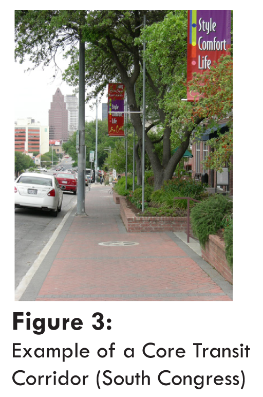
Core Transit Corridors include roadways that have or will have a sufficient population density, mix of uses, and transit facilities to encourage and support transit use. Existing Core Transit Corridors have been designated and are defined in Article 5 and shown on Figure 1. Examples include South Congress Avenue (north of Stassney Lane) and Anderson Lane (between Burnet Road and Mopac). Additional Core Transit Corridors may be designated in the future through neighborhood planning processes.
Hill Country Roadways are those roadways identified in Section 25-2-1103, such as RM 2222 and Southwest Parkway. Standards in this Subchapter that reference the Hill County Roadway designation apply to all properties within 1000 feet of these roadways.
Highways include all freeways, parkways, expressways, and frontage roads identified in the Austin Area Metropolitan Transportation Plan, except for Core Transit Corridors.
Internal Circulation Routes are public streets or private drives edged by a curb within a development.
Suburban Roadways are roads outside the Urban Roadway Boundary, defined below and shown on Figure 2, that are not Core Transit, Hill Country, or Highway Roadways.
Urban Roadways are roads other than those designated as Core Transit Corridors and Highways located within the following boundaries, as shown on Figure 2:
183 from Burnet to Hwy 71
Hwy 71 from 183 to Loop 1
Loop 1 from Hwy 71 to Lake Austin
Lake Austin from Loop 1 to Exposition
Exposition from Lake Austin to 35th
35th from Exposition to Loop 1
Loop 1 from 38th to RM 2222
RM 2222 from Loop 1 to Mesa
Mesa from RM 2222 to Spicewood Springs Road
Spicewood Springs Road from Mesa to 360
360 from Spicewood Springs Road to Great Hills Trail
Great Hills Trail from 360 to 183
183 from Great Hills Trail to Braker
Braker from 183 to Burnet
Burnet from Braker to 183
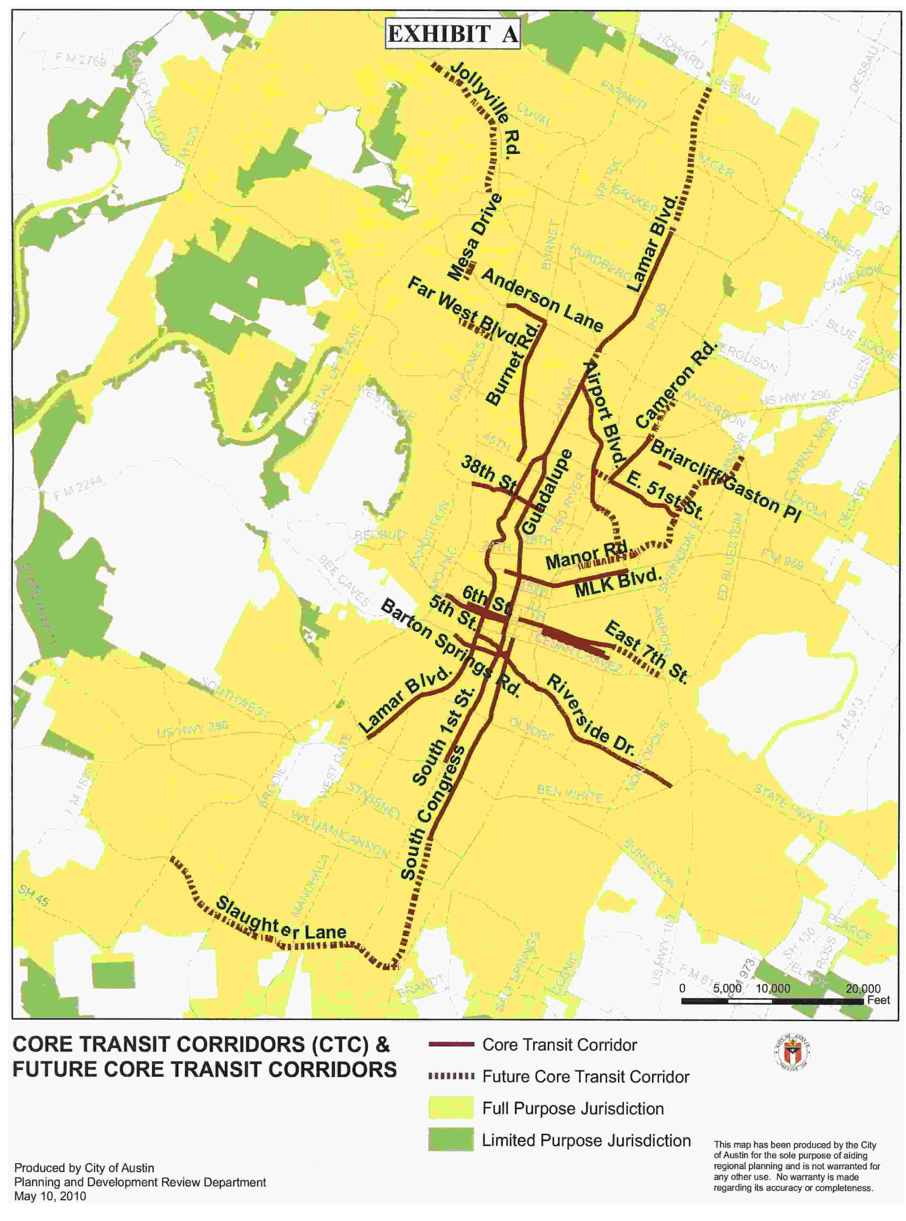
Figure 1: Core Transit Corridors (CTC) and Future Core Transit Corridors Map (May
10, 2010)

Figure 2: Urban/Suburban Roadways Map
How this Subchapter is organized:
This Subchapter is divided into five Articles.
Article 1 includes General Provisions that should be reviewed for all development and redevelopment projects. Most importantly, a chart summarizes the applicability of the various standards based on roadway types and development types.
To allow flexibility in administering this Subchapter, this Article includes a "minor modification" provision that allows for City staff to approve small deviations from otherwise applicable standards in order to protect natural or historic features or to address unique site conditions.
The Article also encourages creativity and innovative design by allowing an applicant to propose an alternative approach to meeting the standards of the Subchapter through the "alternative equivalent compliance" provision.
Article 2 includes Site Development Standards intended to ensure that buildings relate appropriately to surrounding developments and streets, promote efficient pedestrian and vehicle circulation, and provide parking in safe and appropriate locations, while creating a unique and identifiable image for development in Austin. In particular, standards in this Article address the following:
Relationship of buildings to streets and walkways (based on roadway type);
Connectivity (based on roadway type);
Exterior lighting;
Screening of equipment and utilities; and
Private common open space and pedestrian amenities.
Article 3 includes Building Design Standards intended to address the physical appearance of buildings subject to this Subchapter. Included are:
General requirements for glazing and shading to ensure that building façades are pedestrian-friendly; and
Additional options to improve building design. An applicant may choose which of these options to meet from a flexible, point-based menu. All buildings subject to this section must reach a minimum number of points, with additional points required for certain building types (e.g., buildings with trademarked design features, large buildings or long façades, and buildings using a large percentage of certain building materials.)
Article 4 includes standards and incentives for Mixed Use development. This Article includes descriptions and standards for the Mixed Use Combining District and the Vertical Mixed Use Overlay District. This Article also includes standards and incentives for the development of Vertical Mixed Use (VMU) buildings.
Article 5 includes Definitions for terms used in this Subchapter.
Source: Ord. No. 20231102-028, Pt. 27, 11-13-23.
APPENDIX A. - BOUNDARIES OF THE CAPITOL VIEW CORRIDORS.
(A)
In this appendix:
(1)
TEXAS PLANE COORDINATE means the Central Zone of the Texas State Coordinate Systems as defined by the U.S. Coast and Geodetic Survey, dated 1945 and revised in March 1978.
(2)
CAPITOL DOME means the part of the State Capitol located more than 653 feet above sea level at Texas Plane Coordinate X-2818555.07, Y-230595.65, being the center of the dome.
(B)
The capitol view corridors and boundaries are:
(1)
The South Mall of the University of Texas corridor includes the area below he plane formed by connecting the following two lines:
(a)
the first line begins at an elevation of 594 feet above sea level at Texas Plane Coordinate X-2818794.86 Y-234376.98 and extends along a bearing of S 2° 7′ 0.0″ W for a distance of 3,790.248 feet to a point 100 feet from the center of the Capitol Dome and located at Texas Plane Coordinate X-2818654.87, Y-230589.32; and
(b)
the second line begins at an elevation of 594 feet above sea level at Texas Plane Coordinate X-2818628.71, Y-234341.64, and extends along a bearing of S 2° 39′ 17.7″ W for a distance of 3,748.053 feet to a point 100 feet from the center of the Capitol dome and located at Texas Plane Coordinate X-2818455.09, Y-230597.61.
(2)
The Waterloo Park corridor includes the area below the plane formed by connecting the following two lines:
(a)
the first line begins at an elevation of 496 feet above sea level at Texas Plane Coordinate X-2820189.70, Y-230799.91, and extends along a bearing of S 86° 21′ 3.1″ W for a distance of 1,650.373 feet to a point 100 feet from the center of the Capitol dome and located at Texas Plane Coordinate X-2818542.67, Y-230694.87; and
(b)
the second line begins at an elevation of 480 feet above sea level at Texas Plane Coordinate X-2820300.13, Y-229756.25, and extends along a bearing of N 67° 16′ 4.1″ W for a distance of 1,939.019 feet to a point 100 feet from the center of the Capitol dome and located at Texas Plane Coordinate X-2818511.73, Y-230505.53.
(3)
The Woolridge Park corridor includes the area below the plane formed by connecting the following two lines:
(a)
the first line at an elevation of 515 feet above sea level at Texas Plane Coordinate X-2816727.54, Y-229659.96, and extends along a bearing of N 60° 5′ 58.0″ E for a distance of 2,055.569 feet to a point 100 feet from the center of the Capitol dome and located at Texas Plane Coordinate X-2818509.50, Y-230684.66; and
(b)
the second line begins at an elevation of 536 feet above sea level at Texas Plane Coordinate X-2816925.57, Y-229291.91, and extends along a bearing of N 54° 4′ 50.4″ E for a distance of 2,089.263 feet to a point 100 feet from the center of the Capitol dome and located at Texas Plane Coordinate X-2818617.55, Y-230517.56.
(4)
The French Legation corridor includes the area below the plane formed by connecting the following two lines:
(a)
the first line begins at an elevation of 539 feet above sea level at Texas Plane Coordinate X-2821177.01, Y-227894.81, and extends along a bearing of N 42° 37′ 44.3″ W for a distance of 3,765.605 feet to a point 100 feet from the center of the Capitol dome and located at Texas Plane Coordinate X-2818626.83, Y-230665.30; and
(b)
the second line begins at an elevation of 539 feet above sea level at Texas Plane Coordinate X-2821144.99, Y-227833.18, and extends along a bearing of N 44° 39′ 68.5″ W for a distance of 3,787.992 feet to a point 100 feet from the center of the Capitol dome and located at Texas Plane Coordinate X-2818482.12, Y-230527.25.
(5)
The Lamar Bridge corridor includes the area below the plane formed by connecting the following two lines:
(a)
the first line begins at an elevation of 460 feet above sea level at Texas Plane Coordinate X-2813589.52, Y-227457.92, and extends along a bearing of N 56° 44′ 9.5″ E for distance of 5,874.699 feet to a point 100 feet from the center of the Capitol dome and located at Texas Plane Coordinate X-2818596.90, Y-230686.48; and
(b)
the second line begins at an elevation of 460 feet above sea level at Texas Plane Coordinate X-2813419.55, Y-226934.03, and extends along a bearing of N 55° 25′ 10.4″ E for a distance of 6,308.017 feet to a point 100 feet from the center of the Capitol dome and located at Texas Plane Coordinate X-2818613.13, Y-230514.22.
(6)
The South Congress at East Live Oak corridor includes the area below the plane formed by connecting the following two lines:
(a)
the first line begins at an elevation of 574 feet above sea level at Texas Plane Coordinate X-2814945.42, Y-218622.48, and extends along a bearing of N 16° 19′ 7.6″ E for a distance of 12,505.861 feet to a point 100 feet from the center of the Capitol dome and located at Texas Plane Coordinate X-2818459.22, Y-230624.51; and
(b)
the second line begins at an elevation of 574 feet above sea level at Texas Plane Coordinate X-2815051.19, Y-218649.13, and extends along a bearing of N 16° 48′ 23.4″ E for a distance of 12,450.162 feet to a point 100 feet from the center of the Capitol dome and located at Texas Plane Coordinate X-2818651.03, Y-230567.50.
(7)
The MoPac Bridge corridor includes the area below the plane formed by connecting the following two lines:
(a)
the first line begins at an elevation of 498 feet above sea level of Texas Plane Coordinate X-2808602.196, Y-229824.15, and extends along a bearing of N 86° 08′ 29.3″ E for a distance of 10,331.327 feet to a point 100 feet from the center of the Capitol dome and located at Texas Plane Coordinates X-2818562.808, Y-230495.95; and
(b)
the second line begins at an elevation of 485 feet above sea level at Texas Plane Coordinate X-2808930.31, Y-230333.64, and extends along a bearing of N 87° 50′ 44.3″ E for a distance of 9,628.852 feet to a point 100 feet from the center of the Capitol dome and located at Texas Plane Coordinate X-2818552.35, Y-230695.61.
(8)
The South Lamar at La Casa Drive corridor includes the area below the plane formed by connecting the following two lines:
(a)
the first line begins at an elevation of 656 feet above sea level at Texas Plane Coordinate X-2806422.18, Y-219725.23, and extends along a bearing of N 47° 47′ 22.8″ E for a distance of 16,290.678 feet to a point 100 feet from the center of the Capitol dome and located at Texas Plane Coordinate X-2818488.35, Y-230670.13; and
(b)
the second line begins at an elevation of 656 feet above sea level at Texas Plane Coordinate X-2806443.28, Y-219708.55, and extends along a bearing of N 48° 24′ 0.0″ E for a distance of 16,286.017 feet to a point 100 feet from the center of the Capitol dome and located at Texas Plane Coordinate X-2818621.93, Y-230521.28.
(9)
The Barton Creek Pedestrian Bridge corridor includes the area below the plane formed by connecting the following two lines:
(a)
the first line begins at an elevation of 445 feet above sea level at Texas Plane Coordinate X-2810872.3, Y-227047.993 and extends along a bearing of N 64° 30′ 13.9″ E for a distance of 8,465.138 feet to a point 100 feet from the center of the Capitol dome and located at Texas Plane Coordinate X-2818513.104, Y-230686.414; and
(b)
the second line begins at an elevation of 460 feet above sea level at Texas Plane Coordinate X-2812177.38, Y-227545.58, and extends along a bearing of N 65° 15′ 5.2″ E for a distance of 7,070.209 feet to a point 100 feet from the center of the Capitol dome and located at Texas Plane Coordinate X-2818598.22, Y-230505.43.
(10)
The Pleasant Valley Road at Lakeshore Drive corridor includes the area below the plane formed by connecting the following two lines:
(a)
the first line begins at an elevation of 450 feet above sea level at Texas Plane Coordinate X-2826332.31, Y-219396.73, and extends along a bearing of N 34° 21′ 30.0″ W for a distance of 13,634.929 feet to a point 100 feet from the center of the Capitol dome and located at Texas Plane Coordinate X-2818637.21, Y-230652.69; and
(b)
the second line begins at an elevation of 450 feet above sea level at Texas Plane Coordinate X-2826129.04, Y-218986.86, and extends along a bearing of N 33° 32′ 6.6″ W for a distance of 13,861.422 feet to a point 100 feet from the center of the Capitol dome and located at Texas Plane Coordinate X-2818471.32, Y-230541.00.
(11)
The East Eleventh Street Threshold corridor includes the area below the plane formed by connecting the following two lines:
(a)
the first line begins at an elevation of 517 feet above sea level at Texas Plane Coordinate X-281382.21, Y-228956.12, and extends along a bearing of N 61° 38′ 31.4″ W for a distance of 3,269.672 feet to a point 100 feet from the center of the Capitol dome and located at Texas Plane Coordinate X-2818504.91, Y-230509.14; and
(b)
the second line begins at an elevation of 517 feet above sea level at Texas Plane Coordinate X-2821418.78, Y-228980.65 and extends along a bearing of N 58° 60′ 12.7″ W for a distance of 3,289.227 feet to a point 100 feet from the center of the Capitol dome and located at Texas plane Coordinate X-2818604.20, Y-230682.75.
(12)
The North-Bound Lanes of IH-35 between the Municipal Police and Courts Building and West Tenth Street corridor includes the area below the plane formed by connecting the following two lines:
(a)
the first line begins at an elevation of 501 feet above sea level at Texas Plane Coordinate X-2820624.99, Y-227858.68, and extends along a bearing of N 38° 3,433.34 feet to a point 100 feet from the center of the Capitol dome and located at Texas Plane Coordinate X-2818475.11, Y-230535.59; and
(b)
the second line begins at an elevation of 491 feet above sea level at Texas Plane Coordinate X-2820738.78, Y-228232.855, and extends along a bearing of N 49° 33′ 37.2″ W for a distance of 3,219.746 feet to a point 100 feet from the center of the Capitol dome and located at Texas Plane Coordinate X-2818627.946, Y-230664.138.
(13)
The South-Bound Lanes of the Upper Deck of IH-35 between Concordia College and the Martin Luther King Boulevard Overpass corridor includes the area below the plane formed by connecting the following two lines:
(a)
the first line begins at an elevation of 618 feet above sea level at Texas Plane Coordinate X-2822432.77, Y-233117.96, and extends along a bearing of S 55° 43′ 8.2″ W for a distance of 4,627.079 feet to a point 100 feet from the center of the Capitol dome and located at Texas Plane Coordinate X-2818609.48, Y-230511.74; and
(b)
the second line begins at an elevation of 648 feet above sea level at Texas Plane Coordinate X-2823639.09, Y-235471.26, and extends along a bearing of S 47° 0′ 43.0″ W for a distance of 7,045.415 feet to a point 100 feet from the center of the Capitol dome and located at Texas Plane Coordinate X-2818485.40, Y-230667.38.
(14)
The North-Bound Lanes of IH-35 between Waller Creek Plaza and the Municipal Police and Court Building corridor includes the area below the plane formed by connecting the following two lines:
(a)
the first line begins at an elevation of 498 feet above sea level of Texas Plane Coordinate X-2820389.72, Y-226977.21, and extends along a bearing of N 28° 17′ 53.1″ W for a distance of 4,058.419 feet to a point 100 feet from the center of the Capitol dome and located at Texas Plane Coordinate X-2818465.79, Y-230550.62; and
(b)
the second line begins at an elevation of 498 feet above sea level at Texas Plane Coordinate X-2820450.80, Y-227277.98, and extends along a bearing of N 28° 14′ 42.1″ W for a distance of 3,823.132 feet to a point 100 feet from the center of the Capitol dome and located at Texas Plane Coordinate X-2818641.53, Y-230645.90.
(15)
The North-Bound Lanes of IH-35 between Third Street and the Waller Creek Plaza corridor includes the area below the plane formed by connecting the following two lines:
(a)
the first line begins at an elevation of 482 feet above sea level at Texas Plane Coordinate X-2820010.77, Y-225710.94, and extends along a bearing of N 17° 43′ 6.5″ W for a distance of 5,098.378 feet to a point 100 feet from the center of the Capitol dome and located at Texas Plane Coordinate X-2818459.13, Y-230567.46; and
(b)
the second line begins at an elevation of 495 feet above sea level at Texas Plane Coordinate X-2820205.46, Y-226432.65, and extends along a bearing of N 20° 20′ 46.9″ W for a distance of 4,479.853 feet to a point 100 feet from the center of the Capitol dome and located at Texas Plane Coordinate X-2818647.84, Y-230632.99.
(16)
The East Seventh Street Bridge Over the Texas-New Orleans Railroad corridor includes the area below the plane formed by connecting the following two lines:
(a)
the first line begins at an elevation of 476 feet above sea level at Texas Plane Coordinate X-2829646.58, Y-224957.77, and extends along a bearing of N 62° 35′ 42.1″ W for a distance of 12,442.553 feet to a point 100 feet from the center of the Capitol dome and located at Texas Plane Coordinate X-2818600.39, Y-230684.79; and
(b)
the second line begins at an elevation of 476 feet above sea level at Texas Plane Coordinate X-2829633.60, Y-224932.05, and extends along a bearing of N 63° 23′ 0.0″ W for a distance of 12,442.674 feet to a point 100 feet from the center of the Capitol dome and located at Texas Plane Coordinate X-2818509.56, Y-230506.61.
(17)
The Longhorn Shores corridor includes the area below the plane formed by connecting the following two lines:
(a)
the first line begins at an elevation of 435 feet above sea level at Texas Plane Coordinate X-2823082.973, Y-219866.265, and extends along a bearing of N 22° 23′ 17.7″ W for a distance of 11,647.863 feet to a point 100 feet from the center of the Capitol dome and located at Texas Plane Coordinate X-2818646.489, Y-230636.201; and
(b)
the second line begins at an elevation of 435 feet above sea level at Texas Plane Coordinate X-2822949.654, Y-219866.561, and extends along a bearing of N 22° 46′ 44″ W for a distance of 11,594.666 feet to a point 100 feet from the center of the Capitol dome and located at Texas Plane Coordinate X-2818462.531, Y-230557.772.
(18)
The Zilker Clubhouse corridor includes the area below the plane formed by connecting the following two lines:
(a)
the first line begins at an elevation of 561 feet above sea level at Texas Plane Coordinate X-2807259.05, Y-230056.68, and extends along a bearing of N 86° 45′ 42.0″ E for a distance of 11,309.321 feet to a point 100 feet from the center of the Capitol dome and located at Texas Plane Coordinate X-2818550.31, Y-230695.53; and
(b)
the second line begins at an elevation of 561 feet above sea level at Texas Plane Coordinate X-2807248.18, Y-229969.74, and extends along a bearing of N 87° 20′ 15.0″ E for distance of 11,324.650 feet to a point 100 feet from the center of the Capitol dome and located at Texas Plane Coordinate X-2818560.60, Y-230495.80.
(19)
The Red Bud Trail corridor includes the area below the plane formed by connecting the following two lines:
(a)
the first line begins at an elevation of 684 feet above sea level at Texas Plane Coordinate X-2801662.96, Y-236155.75, and extends along a bearing of S 72° 6′ 10.9″ E for a distance of 17,783.936 feet to a point 100 feet from the center of the Capitol dome and located at Texas Plane Coordinate X-2818586.34, Y-230690.63; and
(b)
the second line begins at an elevation of 684 feet above sea level at Texas Plane Coordinate X-2801187.25, Y-236038.78, and extends along a bearing of S 71° 35′ 16.8″ E for a distance of 17,534.371 feet to a point 100 feet from the center of the Capitol dome and located at Texas Plane Coordinate X-2818524.03, Y-230500.59.
(20)
The Enfield Road corridor includes the area below the plane formed by connecting the following two lines:
(a)
the first line begins at an elevation of 534 feet above sea level at Texas Plane Coordinate X-2814317.00, Y-232540.28, and extends along a bearing of S 64° 7′ 24.8″ E for a distance of 4,664.000 feet to a point 100 feet from the center of the Capitol dome and located at Texas Plane Coordinate X-2818513.37, Y-230504.76; and
(b)
the second line begins at an elevation of 534 feet above sea level at Texas Plane Coordinate X-2814166.24, Y-23616.36, and extends along a bearing of S 66° 27′ 47.8″ E for a distance of 4,8 2.718 feet to a point 100 feet from the center of the Capitol dome and located at Texas plane Coordinate X-2818596.90, Y-230686.48.
(21)
The Capitol of Texas Highway corridor includes the area below the plane formed by connecting the following two lines:
(a)
the first line begins at an elevation of 850 feet above sea level at Texas Plane Coordinate X-2793153.22, Y-246055.75, and extends along a bearing of S 58° 62′ 1.6″ E for a distance of 29,736.832 feet to a point 100 feet from the center of the Capitol dome and located at Texas Plane Coordinate X-2818607.06, Y-230681.07; and
(b)
the second line begins at an elevation of 850 feet above sea level at Texas Plane Coordinate X-2792663.44, Y-245928.13, and extends along a bearing of S 59° 10′ 35.3″ E for a distance of 30,091.057 feet to a point 100 feet from the center of the Capitol dome and located at Texas Plane Coordinate X-2818504.12, Y-230509.60.
(22)
The 38th Street at Red River corridor includes the area below the plane formed by connecting the following two lines:
(a)
the first line begins at an elevation of 609 feet above sea level at Texas Plane Coordinate X-2823695.84, Y-238333.37, and extends along a bearing of S 34° 12′ 57.2″ W for a distance of 9,290.302 feet to a point 100 feet from the center of the Capitol dome and located at Texas Plane Coordinate X-2818471.78, Y-230650.98; and
(b)
the second line begins at an elevation of 609 feet above sea level at Texas Plane Coordinate X-2823785.05, Y-238418.94, and extends along a bearing of S 33° 9′ 15.9″ W for a distance of 9,410.983 feet to a point 100 feet from the center of the Capitol dome and located at Texas Plane Coordinate X-2818638.21, Y-230540.07.
(23)
The Robert Mueller Airport corridor includes the area below the plane formed by connecting the following two lines:
(a)
the first line begins at an elevation of 603 feet above sea level at Texas Plane Coordinate X-2831475.74, Y-237087.29, and extends along a bearing of S 62° 55′ 39.9″ W for a distance of 14,460.117 feet to a point 100 feet from the center of the Capitol dome and located at Texas Plane Coordinate X-2818599.97, Y-230506.29; and
(b)
the second line begins at an elevation of 603 feet above sea level at Texas Plane Coordinate X-2831203.80, Y-237067.65, and extends along a bearing of S 63° 18′ 20.5″ W for a distance of 14,208.702 feet to a point 100 feet from the center of the Capitol dome and located at Texas Plane Coordinate X-2818509.52, Y-230684.67.
(24)
The Martin Luther King Jr. Boulevard at IH-35 corridor includes the area below the plane formed by connecting the following two lines:
(a)
the first line begins at an elevation of 570 feet above sea level at Texas Plane Coordinate X-2821822.13, Y-232059.98, and extends along a bearing of S 64° 15′ 51.7″ W for a distance of 3,582.5 feet to a point 100 feet from the center of the Capitol dome and located at Texas Plane Coordinate X-2818595.97, Y-230504.39; and
(b)
the second line begins at an elevation of 570 feet above sea level at Texas Plane Coordinate X-2821665.89, Y-232039.68, and extends along a bearing of S 66° 46′ 10.3″ W for a distance of 3,431.901 feet to a point 100 feet from the center of the Capitol dome and located at Texas Plane Coordinate X-2818512.97, Y-230686.35.
(25)
The Oakwood Cemetery corridor includes the area below the plane formed by connecting the following two lines:
(a)
the first line begins at an elevation of 662 feet above sea level at Texas Plane Coordinate X-2823518.05, Y-231483.66, and extends along a bearing of S 78° 43′ 9.6″ W for a distance of 5,042.788 feet to a point 100 feet from the center of the Capitol dome and located at Texas Plane Coordinate X-2818572.69, Y-230497.21; and
(b)
the second line begins at an elevation of 662 feet above sea level at Texas Plane Coordinate X-2823496.42, Y-231576.82, and extends along a bearing of S 79° 54′ 22.8″ W for a distance of 5,038.813 feet to a point 100 feet from the center of the Capitol dome and located at Texas Plane Coordinate X-2818535.60, Y-230693.73.
(26)
The East 12th Street at IH-35 corridor includes the area below the plane formed by connecting the following two lines:
(a)
the first line begins at an elevation of 525 feet above sea level at Texas Plane Coordinate X-2821503.64, Y-229689.85, and extends along a bearing of N 74° 46′ 47.0″ W for a distance of 3,086.184 feet to a point 100 feet from the center of the Capitol dome and located at Texas Plane Coordinate X-2818525.71, Y-230500.05; and
(b)
the second line begins at an elevation of 523 feet above sea level at Texas Plane Coordinate X-2821304.47, Y-229769.21, and extends along a bearing of N 71° 16′ 29.8″ W for a distance of 2,872.654 feet to a point 100 feet from the center of the Capitol dome and located at Texas Plane Coordinate X-2818583.86, Y-230691.41.
Source: Section 13-2-145(b) and (c); Ord. 990225-70; Ord. 031211-11.
APPENDIX B. - BOUNDARIES OF THE WATERFRONT OVERLAY DISTRICT.
The Waterfront Overlay district includes the property located in the following subdistricts:
(1)
University/Deep Eddy subdistrict, which includes the property bounded by Lake Austin Boulevard on the north, the Town Lake shoreline on the south, MoPac Boulevard on the east, and Tom Miller Dam on the west;
(2)
Lamar subdistrict, which includes the property bounded by the Missouri Pacific rail lines on the north, the Town Lake shoreline on the south, Lamar Boulevard on the east, and MoPac Boulevard on the west;
(3)
North Shore Central subdistrict, which includes the property within the following boundaries:
(a)
Eastern Area: beginning at the intersection of Cesar Chavez Street and Waller Creek, south along Waller Creek to Town Lake, west along Town Lake to a point due south of Colorado Street, north to and along Colorado Street to Second Street, east along Second Street to Trinity Street, south along Trinity Street to Cesar Chavez Street, and east along Cesar Chavez Street to the point of beginning; and
(b)
Western Area: beginning at the intersection of the Town Lake shoreline and Lamar Boulevard, north along Lamar Boulevard to the Missouri Pacific rail lines, east along the Missouri Pacific rail lines to Nueces Street, south and east along Nueces Street to San Antonio Street, south along San Antonio Street to Cesar Chavez Street, due south to the Town Lake shoreline, and west along the Town Lake shoreline to the point of beginning;
(4)
Rainey Street subdistrict, which includes the property bounded by First Street on the north, the Town Lake shoreline on the south, IH-35 on the east, and Waller Creek on the west;
(5)
Festival Beach subdistrict, which includes the property bounded by the Town Lake shoreline on the south, Pleasant Valley Road on the east, IH-35 on the west, and Holly Street from IH-35 to Canadian Street, then north on Canadian Street to Willow Street, then east on Willow Street to Pleasant Valley Road on the north;
(6)
Red Bluff subdistrict, which includes the property bounded by East First Street on the north, the Colorado River shoreline on the south, US 183 on the east, and Pleasant Valley Road on the west, except the portion of the property described as Lots 1 through 11 of the Bridgeview Business and Industrial Plaza subdivision, as shown on the plat recorded in Volume 77, pages 361-363, of the Plat Records of Travis County, Texas;
(7)
Montopolis/River Terrace subdistrict, which includes the property bounded by the Colorado river shoreline on the north, the extension of Lakeshore Boulevard on the south, Highway 183 on the east, and Pleasant Valley Road on the west;
(8)
South Lakeshore subdistrict, which includes the property bounded by the Town Lake shoreline on the north, the various and respective southern boundaries of all legal lots existing as of July 16, 1986, that abut the south public right-of-way of South Lakeshore Boulevard on the south, Pleasant Valley Road on the east, and the extension of Parker Lane on the west;
(9)
East Riverside subdistrict, which includes the property bounded by the Town Lake shoreline on the north, Riverside Drive on the south, the extension of Parker Lane on the east, and IH-35 on the west;
(10)
Travis Heights subdistrict, which includes the property bounded by the Town Lake shoreline on the north, the various and respective southern boundaries of all legal lots existing as of July 17, 1986, that abut the south public right-of-way of East Riverside Drive on the south, IH-35 on the east, and East Bouldin Creek on the west;
(11)
South Shore Central subdistrict, which includes the property bounded by the Town Lake shoreline on the north, East Bouldin Creek on the south and east, and South First Street on the west;
(12)
Auditorium Shores subdistrict, which includes the property bounded by the Town Lake shoreline on the north, the various and respective southern boundaries of all legal lots existing as of July 17, 1986, that abut the south public right-of-way of Barton Springs Road on the south, South First Street on the east, and Lee Barton Drive on the west;
(13)
Butler Shores Subdivision which includes the property bounded by the Town Lake shoreline on the north, the various and respective southern boundaries of all legal lots existing as of July 17, 1986, that abut the south public right-of-way of Barton Springs Road on the south, Lee Barton Drive on the east, and the centerline of Barton Creek on the west;
(14)
Zilker Park subdistrict, which includes the property located within the boundaries of Zilker Park;
(15)
Balcones Rock Cliff subdistrict, which includes the property bounded by the Town Lake shoreline on the north, Stratford Drive and Bee Creek Preserve on the south, Zilker Park on the east, and Tom Miller Dam on the west; and
(16)
City Hall subdistrict, which includes the property bounded on the south by the Town Lake shoreline, on the north by Second Street, on the east by Colorado Street and a line extending south from Colorado Street to Town Lake, and on the west by San Antonio Street and a line extending south from San Antonio Street to Town Lake.
Source: 13-2-160(b); Ord. 990225-70; Ord. 990715-115; Ord. 031211-11.
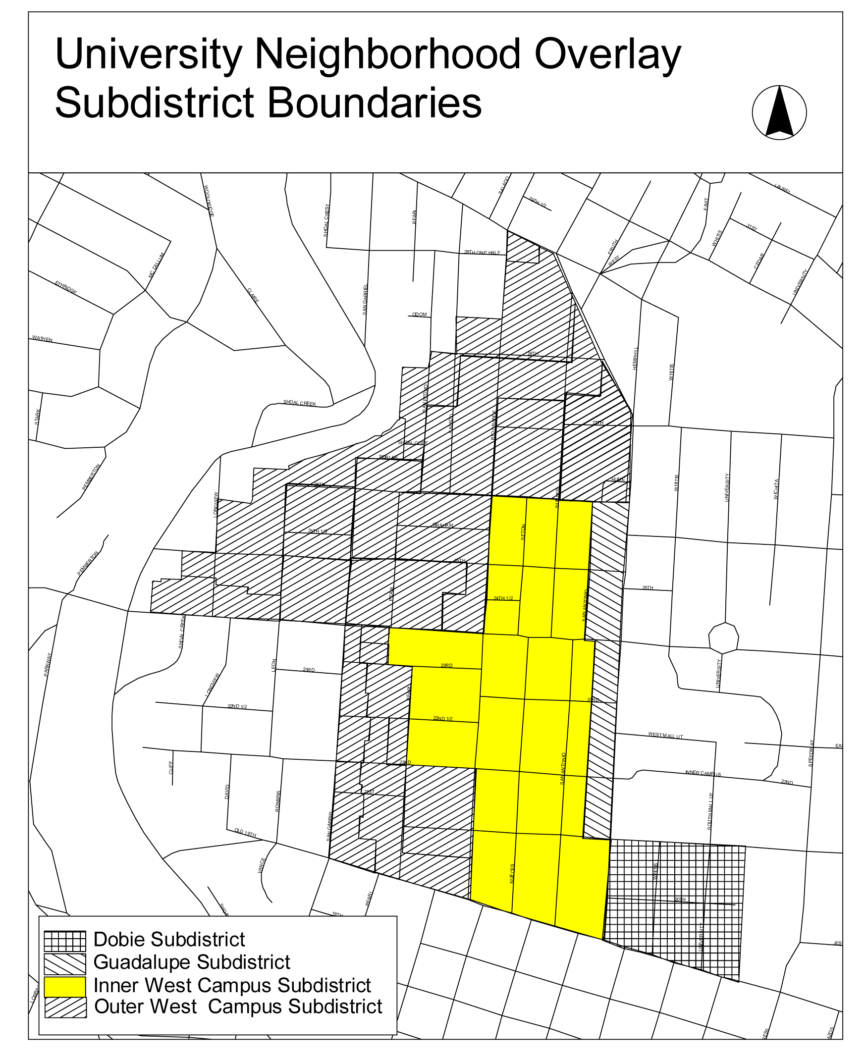
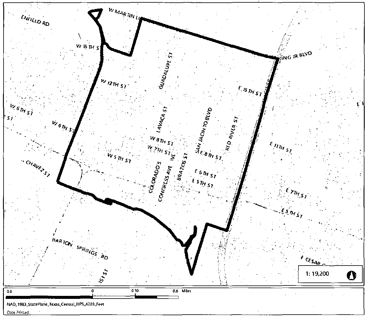
APPENDIX C. - UNIVERSITY NEIGHBORHOOD OVERLAY DISTRICT BOUNDARIES, SUBDISTRICT BOUNDARIES, HEIGHT LIMITS, AND ADDITIONAL HEIGHT AND AFFORDABILITY University Neighborhood Overlay District Boundaries
The university neighborhood overlay district is indicated on the subdistrict boundaries map and includes the area bounded:
(1)
on the north by a line along West 29th Street from Rio Grande Street to Guadalupe Street;
(2)
on the east by a line along Guadalupe Street from West 29th Street to West 21st Street; West 21st Street from Guadalupe Street to the eastern ally of University Avenue; the eastern alley of University Avenue from West 21st Street to West MLK Jr. Boulevard;
(3)
on the south by a line along West MLK Jr. Boulevard from the eastern alley of University Avenue to San Gabriel Street; and
(4)
on the west by a line along San Gabriel Street to West 24th Street; west along West 24th Street to the western lot line of lot One of the Resubdivision of a Portion of Outlot Forty-Three; north along the western lot line of lot One of the Resubdivision of a Portion of Outlot Forty-Three to the alley between Lamar Boulevard and Longview Street; north along the alley to West 25th Street; east along West 25th Street to Longview Street; north along Longview Street to the northern lot line of lot Fifteen, Block Five of the Subdivision of Outlots Forty-Three, Forty-Four, Forty-Five and Fifty-Five; east along the northern lot line of lot Fifteen, Block Five of the Subdivision of Outlots Forty-Three, Forty-Four, Forty-Five and Fifty-Five to the alley between Longview Street and Leon Street; north along the ally to the northern lot line of lot Twenty-Three, Block Four of the Subdivision of Outlots Forty-Three, Forty-Four, Forty-Five and Fifty-Five; east along the northern lot line of lot Twenty-Three, Block Four of the Subdivision of Outlots Forty-Three, Forty-Four, Forty-Five and Fifty-Five to the northern lot lines of lots Twenty-Nine, Thirty, Thirty-One, Thirty-Two, and Three of the Harwood Subdivision; along the northern lot lines of lots Twenty-Nine, Thirty, Thirty-One, Thirty-Two, and Three of the Harwood Subdivision to San Gabriel Street; north along San Gabriel Street to the northern lot line of the Graham Subdivision of Outlots Fifty-Nine, Sixty, Sixty-Four, and the North Half of Fifty-Two; along the northern lot line of the Graham Subdivision of Outlots Fifty-Nine, Sixty, Sixty-Four, and the North Half of Fifty-Two to a point 160' east of San Pedro Street of the southern lot line of lot One of the Gortons Addition; from this point north to a point 160' east of San Pedro Street on the northern lot line of lot Four of the Gortons Addition; east along the northern lot line of lot Four of the Gortons Addition to San Pedro Street; north along San Pedro Street to West 28th Street; west along 28th Street to Salado Street; north along Salado Street to an alley on the northern lot line of Outlot 67, Division D of the Graham Subdivision; east along the alley to Rio Grande Street; north along Rio Grande Street to West 29th Street.
Source: Ord. 040902-58; Ord. 20080925-039; Ord. No. 20191114-067, Pt. 5, 11-25-19.
Source: Ord. No. 20190523-041, Pt. 1, 6-3-19.
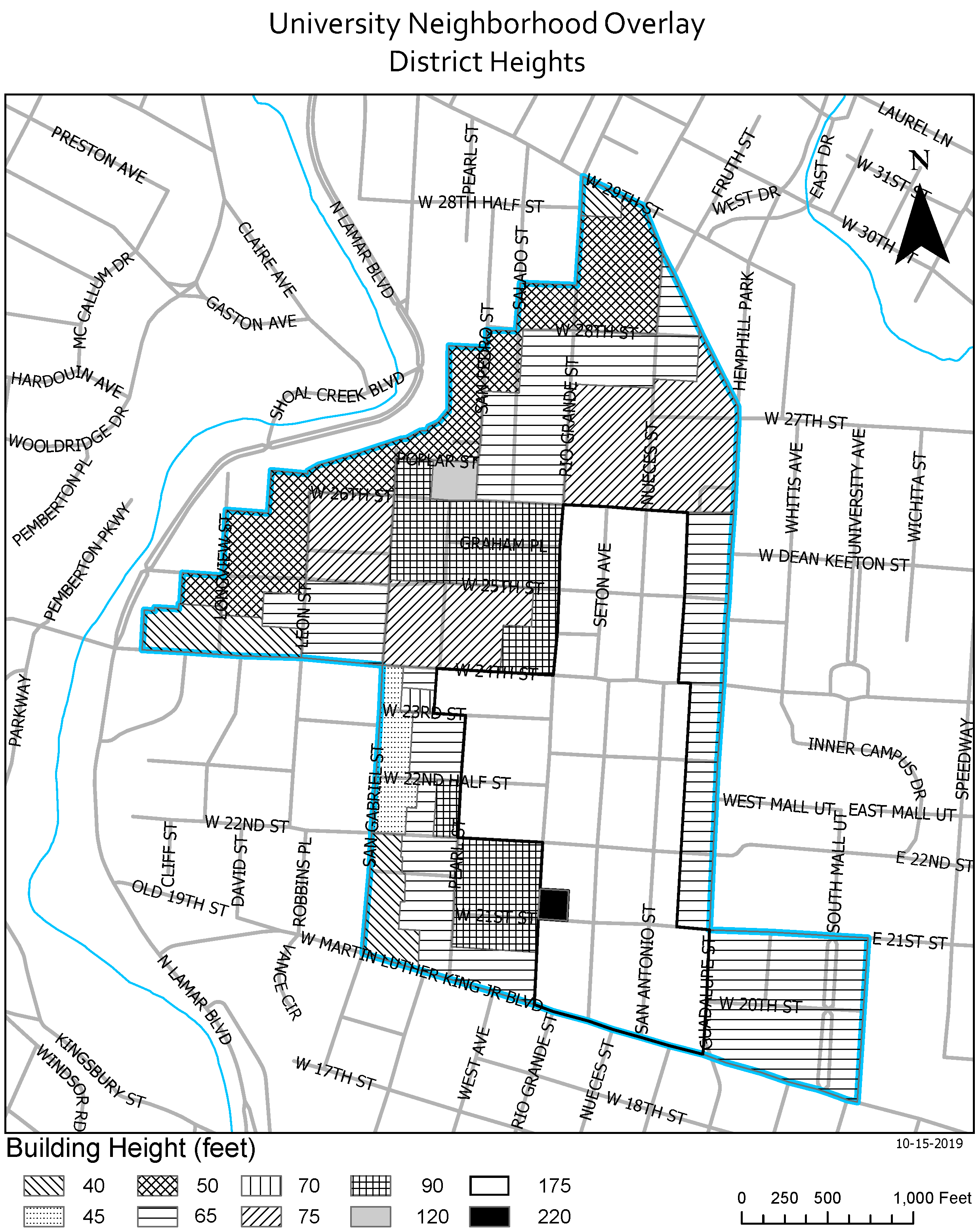
University Neighborhood Overlay
Additional Height & Affordability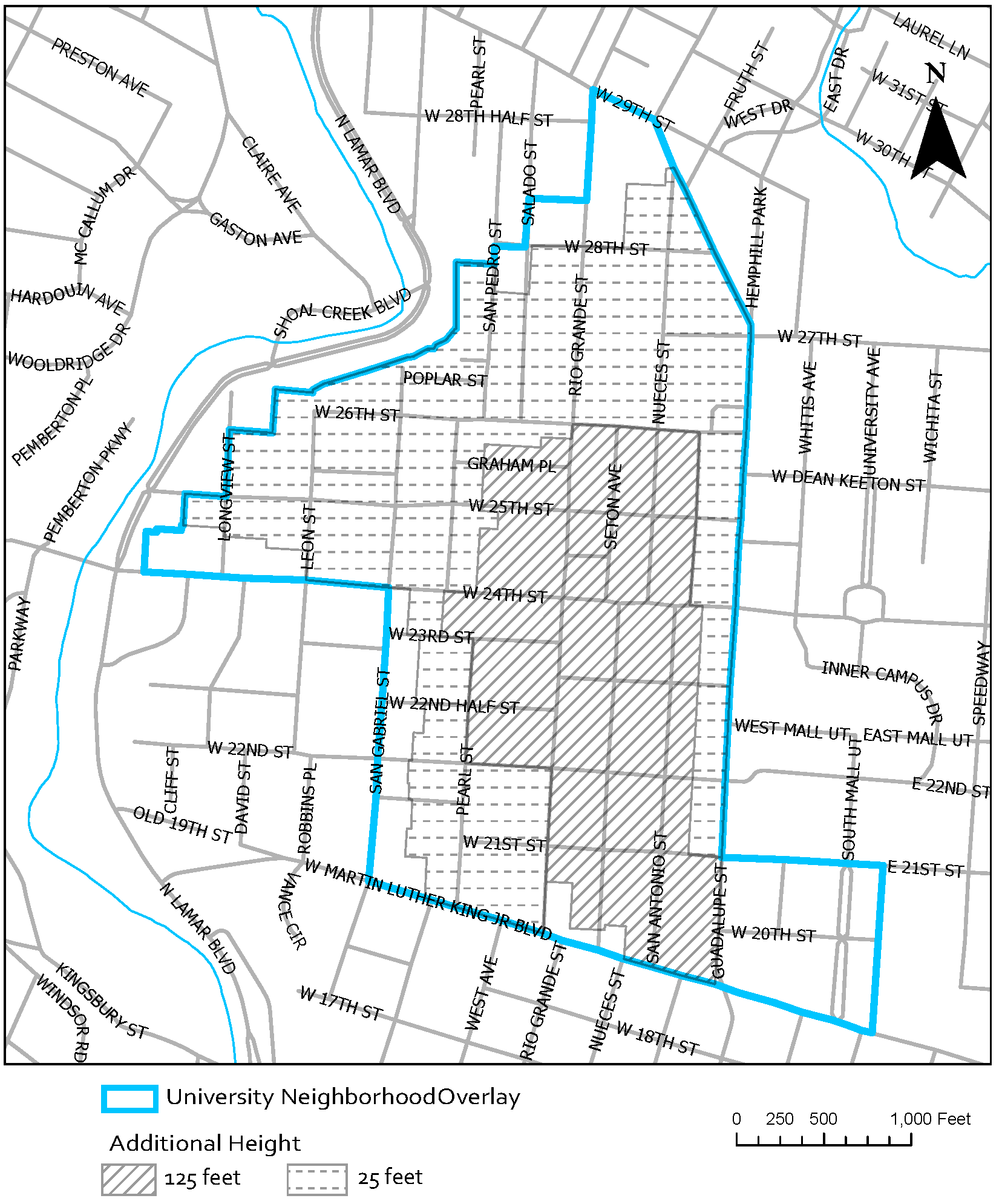
(Ord. No. 20191114-067, 11-25-19)
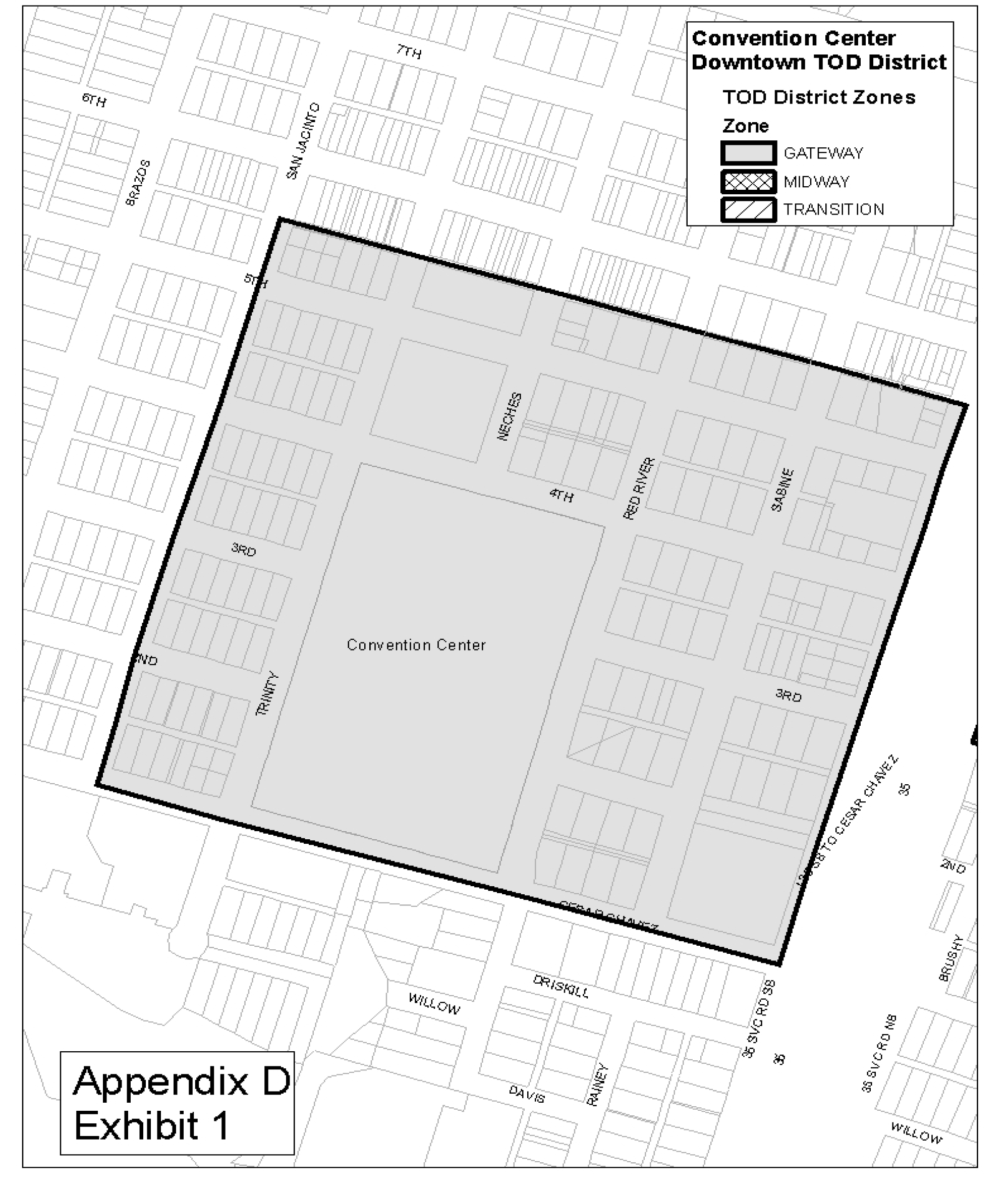
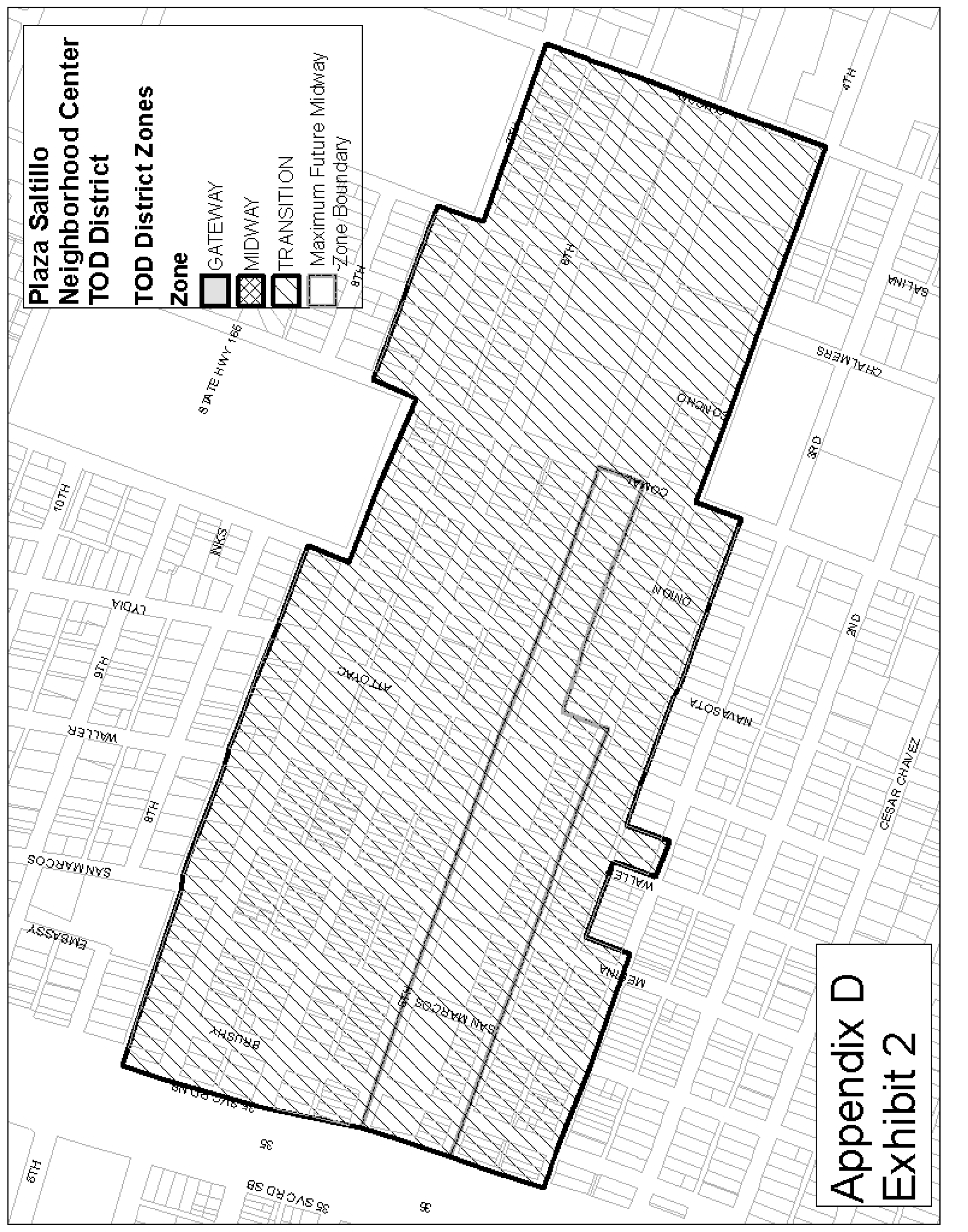
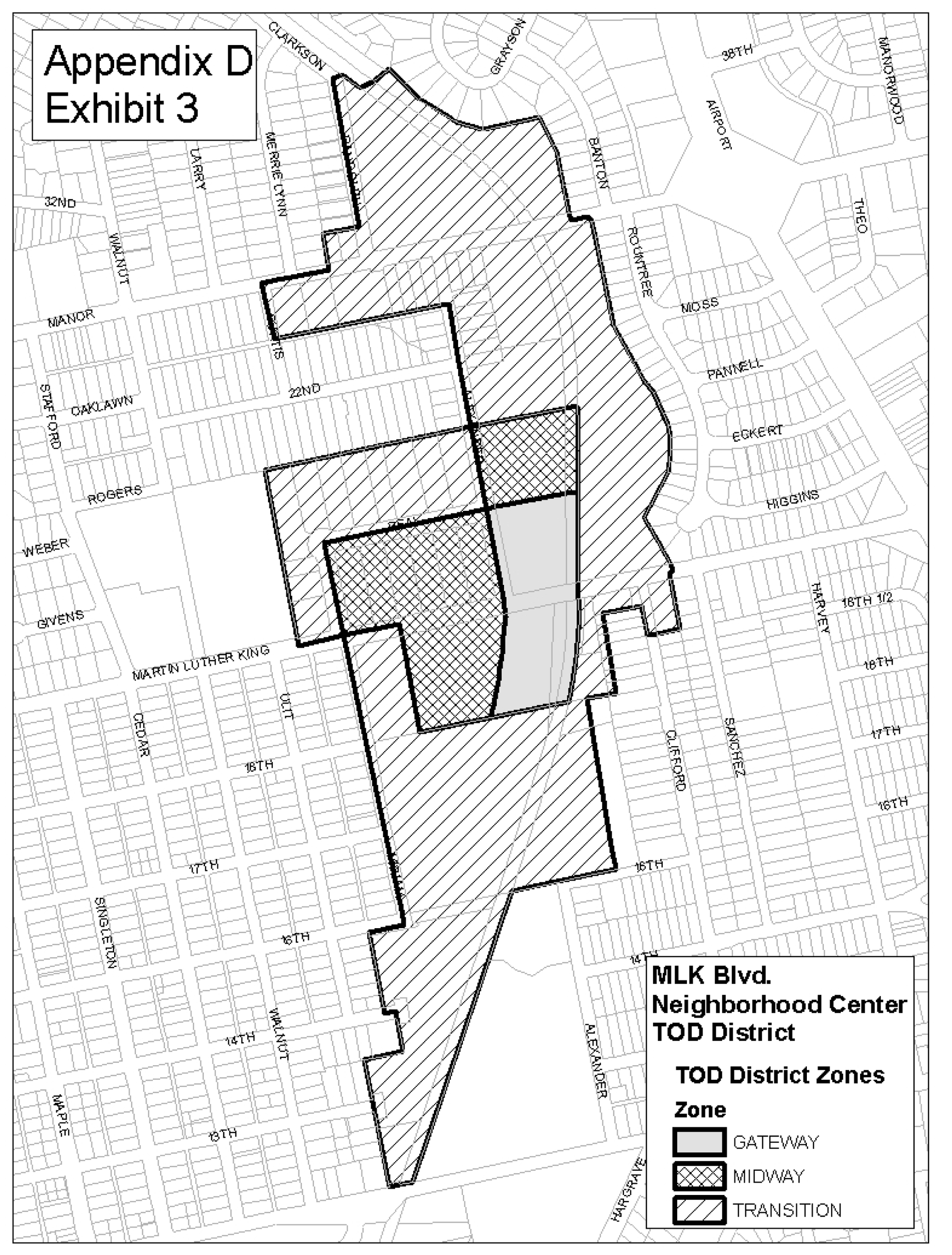
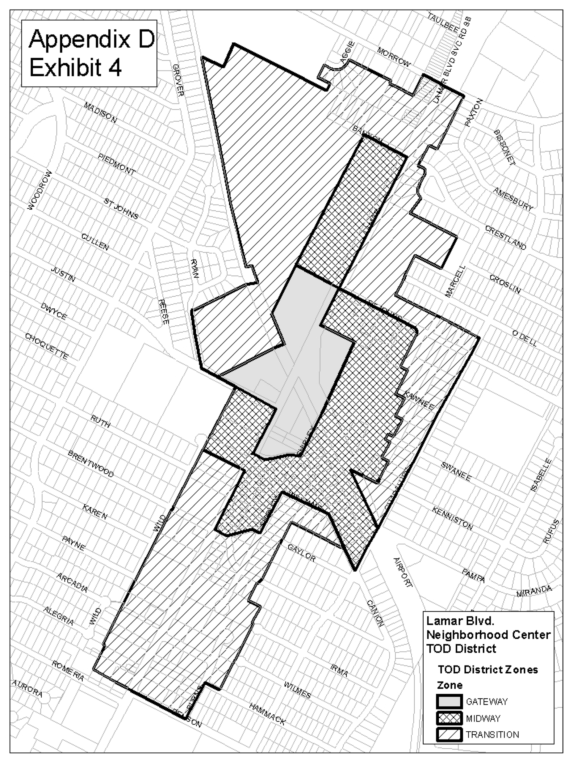
APPENDIX D. - TRANSIT ORIENTED DEVELOPMENT DISTRICTS
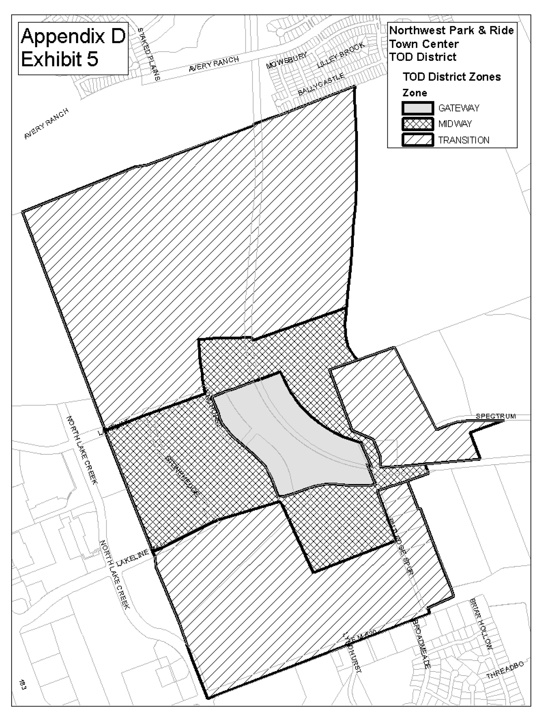
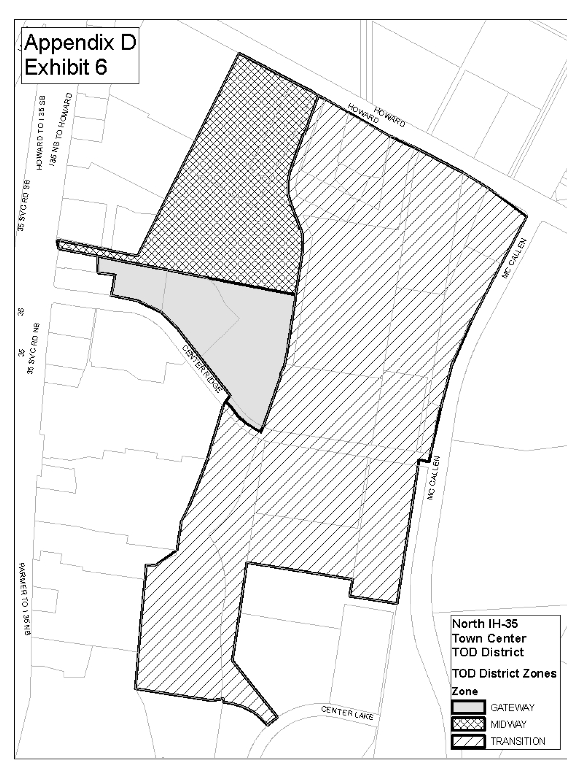
Source: Ord. 20050519-008.
Exhibit 7
Oak Hill TOD District Boundaries And Zones
The boundaries and zones of the Oak Hill TOD district have not been established. After Capital Metropolitan Transportation Authority selects a transit center site, the boundaries and zones of the TOD district are to be determined through the neighborhood planning process and established by council.
Source: Ord. 20060309-057.
Exhibit 8
Highland Mall TOD District Boundaries And Zones
The boundaries and zones of the Highland Mall TOD district have not been established. The boundaries and zones of the TOD district are to be determined during the preparation of the station area plan and established by council.
Source: Ord. 20061005-052.
Exhibit 9
South IH-35 Park and Ride TOD District Boundaries and Zones
The boundaries and zones of the South IH-35 Park and Ride TOD District have not been established. The boundaries and zones of the TOD district are to be determined during the preparation of the station area plan and established by council.
Source: Ord. 20061005-052; Ord. 20061207-003.
APPENDIX E. - NORTH BURNET/GATEWAY (NBG) ZONING DISTRICT BOUNDARIES SUBDISTRICT MAP.
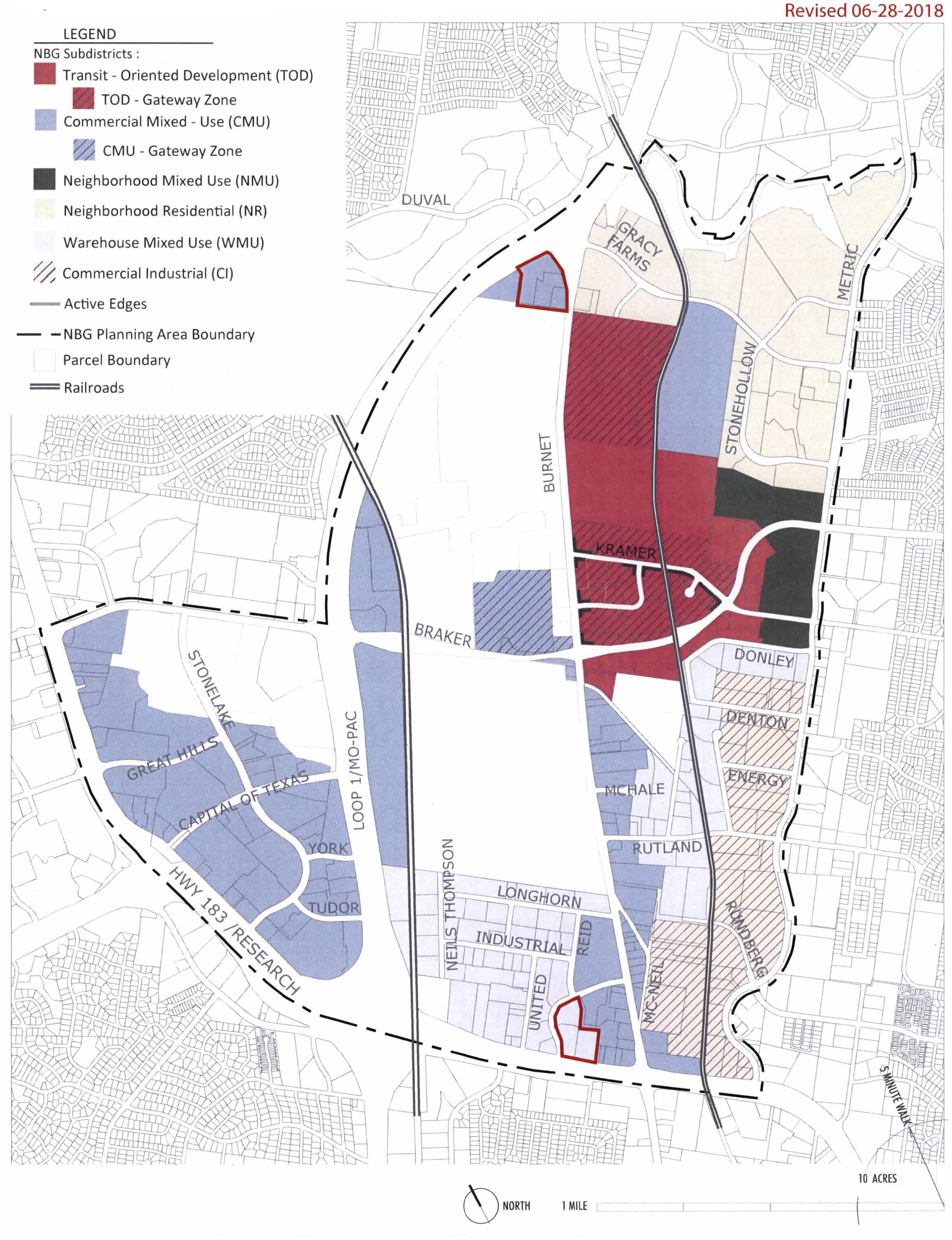
Source: Ord. 20071101-052; Ord. No. 20190808-101, Pts. 1, 2, 8-19-19.
APPENDIX F. - CENTRAL URBAN REDEVELOPMENT (CURE) COMBINING DISTRICT BOUNDARIES.
(Ord. No. 20180322-096, Pt. 3(Exh. A), 4-2-18)
APPENDIX G. - ETOD BOUNDARIES
Source: Ord. No. 20240516-005, Pt. 6, 7-15-24.
§ 25-2-471 - INTERPRETATION GUIDELINES.
The Planning Commission may, by resolution, adopt guidelines for the interpretation by the building official of yard and setback requirements in instances where geometric shape, dimensions, or topography make the literal interpretation of the requirements impractical.
Source: Section 13-2-613; Ord. 990225-70; Ord. 031211-11.
§ 25-2-472 - BOARD OF ADJUSTMENT VARIANCE AUTHORITY.
The Board of Adjustment shall hear and decide a request for a variance from a requirement of this chapter, or a Neighborhood Conservation Combining District adopted under this chapter, except as otherwise provided by the Code.
Source: Section 13-2-833 (1); Ord. 990225-70; Ord. 031211-11; Ord. 20101216-095.
§ 25-2-473 - VARIANCE REQUIREMENTS.
(A)
A variance from the requirements of this chapter, or a Neighborhood Conservation Combining District adopted under this chapter, may be granted under this division if, because of special circumstances of a property, the strict application of this chapter deprives the property owner of privileges that are enjoyed by another person who owns property in the area that has the same zoning designation as the property for which the variance is requested.
(B)
A variance to a regulation may not grant special privileges that are inconsistent with the limitations on other properties in the area or on the district in which the property is located.
Source: Section 13-2-830; Ord. 990225-70; Ord. 031211-11; Ord. 20101216-095.
§ 25-2-474 - REQUIRED FINDINGS.
(A)
The Board of Adjustment may grant a variance from a requirement if it determines that:
(1)
the requirement does not allow for a reasonable use of property;
(2)
the hardship for which the variance is requested is unique to the property and is not generally characteristic of the area in which the property is located; and
(3)
development under the variance does not:
(a)
alter the character of the area adjacent to the property;
(b)
impair the use of adjacent property that is developed in compliance with the City requirements; or
(c)
impair the purposes of the regulations of the zoning district in which the property is located.
(B)
The Board may grant a variance from a loading facility or off-street parking design requirements if, in addition to the findings required by Subsection (A), the Board determines that:
(1)
current or anticipated traffic volume generated by the use of the property or a nearby property does not reasonably require strict compliance with and enforcement of the requirement from which a variance is requested;
(2)
development under the variance does not result in parking or loading on public streets that interferes with the free flow of traffic on the streets; and
(3)
development under the variance does not create a safety hazard or any other condition that is inconsistent with the objectives of the Code.
(C)
A variance granted under Subsection (B) applies only to the use for which the variance was granted and does not run with the land on which the use is located.
(D)
A variance granted under Subsection (B) shall not apply to bicycle parking. An applicant may also seek a waiver pursuant to Code Section § 25-6-477(F) (Bicycle Parking) to waive bicycle parking.
Source: Section 13-2-834; Ord. 990225-70; Ord. 031211-11; Ord. 20130523-104; Ord. No. 20231102-028, Pt. 8, 11-13-23.
§ 25-2-475 - APPEALS.
A person may appeal a decision of the building official regarding a site development regulation prescribed by this subchapter, or by a Neighborhood Conservation Combining District adopted under this chapter, to the Board of Adjustment. After an appeal is filed, the building official shall provide the board with a copy of documents regarding the matter that has been appealed.
Source: Section 13-2-835; Ord. 990225-70; Ord. 010329-18; Ord. 031211-11; Ord. 20101216-095.
§ 25-2-476 - SPECIAL EXCEPTIONS.
(A)
The Board of Adjustment shall grant a special exception for an existing residential structure, or portion of an existing structure, that violates a setback required under Chapter 25-2 (Zoning) if the board finds that the special exception meets the requirements of this section.
(B)
The Board shall grant a special exception under Subsection (A) of this section if:
(1)
the residential use for which the special exception is sought is allowed in an SF-3 or more restrictive zoning district;
(2)
the building official performs an inspection and determines that the violation does not pose a hazard to life, health, or public safety; and
(3)
the Board finds that:
(a)
the violation has existed for:
(i)
at least 25 years; or
(ii)
at least 10 years, if the application for a special exception is submitted on or before June 6, 2017;
(b)
the use is a permitted use or a nonconforming use;
(c)
the structure does not share a lot with more than one other primary residence; and
(d)
granting a special exception would not:
(i)
alter the character of the area;
(ii)
impair the use of adjacent property that is developed in compliance with city code; or
(iii)
grant a special privilege that is inconsistent with other properties in the area or in the district in which the property is located.
(C)
A special exception granted under this section:
(1)
applies only to the structure, or portion of a structure, for which the special exception was granted and does not run with the land;
(2)
may not authorize an increase in the degree of noncompliance or excuse compliance with minimum health and safety requirements; and
(3)
may not authorize a remodel or addition to the existing structure, except to the extent required by the building official to meet minimum life and safety requirements.
(D)
A structure granted a special exception under this section shall be treated as a non-complying structure under Chapter 25-2, Article 8 (Noncomplying Structures).
Source: Ord. 20110526-098; Ord. 20121108-091; Ord. 20130822-126; Ord. No. 20160519-057, Pt. 2, 5-30-16.
Division 13. - Reserved[1]
Editor's note— Ord. No. 20240229-070, Pt. 1, effective March 11, 2024, repealed §§ 25-2-769.01—25-2-769.06, which pertained to Corridor Overlay and derived from Ord. No. 20221201-056, Pt. 3, 12-12-22; Ord. No. 20230608-088, Pts. 1, 2, 6-19-23.
Subpart C. - Reserved.[2]
Editor's note—Ord. No. 20250227-039, Pt. 1, effective October 1, 2025, repealed §§ 25-2-788—25-2-799, which pertained to requirements for short-term rental uses and derived from Ord. 20120802-122; Ord. 20130926-144; Ord. No. 20151119-080, Pts. 4—7, 11-30-15; Ord. No. 20151217-098, Pt 1, 12-28-15; Ord. No. 20160223-A.1, Pts. 1, 2, 3-5-16; Ord. No. 20231207-001, Pts. 10, 11, 12-18-23.
§ 25-2-891 - ACCESSORY USES GENERALLY.
An accessory use is a use that:
(1)
is incidental to and customarily associated with a principal use;
(2)
unless otherwise provided, is located on the same site as the principal use; and
(3)
may include parking for the principal use.
Source: Section 13-2-1; Ord. 990225-70; Ord. 031211-11.
§ 25-2-892 - APPLICABLE REGULATIONS.
The regulations applicable to a principal use apply to an accessory use, except as otherwise provided in this division.
Source: Section 13-2-301; Ord. 990225-70; Ord. 031211-11.
§ 25-2-893 - ACCESSORY USES FOR A PRINCIPAL RESIDENTIAL USE.
(A)
For a principal residential use, this section prescribes the requirements for an accessory use.
(B)
This subsection provides for vehicle storage as an accessory use.
(1)
Not more than one motor vehicle for each licensed driver residing on the premises may be stored on the premises.
(2)
Notwithstanding the limitation of Subsection (B)(1), a private garage for the storage of not more than four motor vehicles is permitted.
(3)
Except for an antique vehicle or recreational vehicle, a motor vehicle with a capacity of one ton or greater is prohibited.
(4)
Not more than one commercial vehicle may be stored on the premises.
(5)
Except as provided in Subsection (B)(6), an inoperable motor vehicle may not be stored on an adjacent public right-of-way. A motor vehicle is inoperable if, for more than 72 hours, the vehicle:
(a)
does not have license plates or has license plates that have been expired for more than 90 days;
(b)
does not have a motor vehicle safety inspection sticker or has a motor vehicle inspection safety sticker that has been expired for more than 90 days; or
(c)
cannot be started or legally operated in a public right-of-way.
(6)
The prohibition of Subsection (B)(5) does not apply to:
(a)
an antique or recreational vehicle stored at an owner's residence; or
(b)
a vehicle under repair for less than 60 days, if not more than one other vehicle is also under repair.
(7)
Up to two vehicles that are either antique or recreational vehicles may be stored on the premises, if the storage area is not a health hazard and is either in an enclosed building or screened from public view with a solid wood or masonry fence at least six feet high.
(C)
The following are permitted as accessory uses:
(1)
recreational activities and recreational facilities for use by residents;
(2)
religious study meetings;
(3)
playhouses, patios, cabanas, porches, gazebos, and household storage buildings;
(4)
radio and television receiving antenna and dish-type satellite receivers;
(5)
solar collectors;
(6)
home occupations that comply with Section 25-2-900 (Home Occupations);
(7)
on-site sales as authorized by Section 25-2-902 (Residential Tours) or Section 25-2-903 (Garage Sales);
(8)
the keeping of dogs, cats, and similar small animals as household pets; and
(9)
child care services (limited) use.
(D)
A residential convenience service is permitted if the principal use is a multifamily use or a mobile home park use. A residential convenience service is a commercial use that is operated as an integral part of the principal use, is not identifiable from outside the site, and is intended to be patronized solely by the residents of the principal use.
(E)
A dock is permitted as an accessory use if the requirements of this subsection are met.
(1)
A dock may be located off-site.
(2)
A dock may not include habitable space or living quarters or other elements not necessary to the function of a dock, such as space conditioning, sinks, toilets, or wastewater or potable water lines or connections.
(3)
A dock may include only the following as appurtenances and means of access:
(a)
a storage closet that meets the requirements of Subsection (A);
(b)
a roof;
(c)
a second floor;
(d)
marine lockers;
(e)
railings;
(f)
a non-potable water pump and hose bib;
(g)
electrical connections;
(h)
lighting and fans;
(i)
non-mechanized access, including a staircase, pedestrian bridge, gangway, and gates;
(j)
non-mechanized recreational equipment, such as slides or swings; and
(k)
accessories or slips that may accommodate the mooring or storage of boats in compliance with the requirements of Section 25-2-1176 (Site Development Regulations for Docks, Marinas, and Other Lakefront Uses).
(4)
Only one dock is permitted for a principal residential use, even if the use is located on more than one lot.
(F)
A use other than one described in this section is permitted as an accessory use if the director determines that the use is necessary, customary, appropriate, incidental, and subordinate to a principal use.
(G)
An accessory use may generate not more than ten guest vehicles trips a day or 30 guest vehicles trips a week.
Source: Sections 13-2-1 and 13-2-302; Ord. 990225-70; Ord. 010329-18; Ord. 031211-11; Ord. 20110922-087; Ord. No. 20140626-113, Pt. 3, 7-7-14; Ord. No. 20231019-052, Pt. 5, 10-30-23; Ord. No. 20231207-001, Pts. 13, 14, 12-18-23.
§ 25-2-894 - ACCESSORY USES FOR A PRINCIPAL COMMERCIAL USE.
(A)
For a principal commercial use, this section prescribes the requirements for an accessory use.
(B)
A commercial or industrial use that is otherwise prohibited in the zoning district is permitted as an accessory use if the use:
(1)
is operated primarily for the convenience of employees, clients, or customers of the principal use;
(2)
occupies less than 10 percent of the total floor area of the use;
(3)
is an integral part of the principal use; and
(4)
for an industrial use, is not located in an NO, LO or LR zoning district or within 100 feet of a residential zoning district.
(C)
A parking facility is permitted as an accessory use.
(D)
One dwelling unit is permitted as an accessory use if not more than 50 percent of the building is used for the dwelling unit. An occupant is not required to be engaged in the principal use.
(E)
A child care service (limited) use is permitted as an accessory use if the child care services (limited) use is operated primarily for the convenience of employees, clients, or customers of the principal use.
Source: Section 13-2-303; Ord. 990225-70; Ord. 031211-11; Ord. No. 20231019-052, Pt 6, 10-30-23.
§ 25-2-895 - ACCESSORY USES FOR A COMMERCIAL RECREATION DISTRICT.
(A)
The provisions of this section supersede the requirements of Section 25-2-894 (Accessory Uses for a Principal Commercial Use) to the extent of conflict.
(B)
The following are permitted as accessory uses in a commercial recreation zoning district:
(1)
food sales;
(2)
general retail sales (convenience);
(3)
personal improvement services;
(4)
restaurant (limited) without drive-in service;
(5)
day care services (general);
(6)
day care services (limited); and
(7)
safety services.
(C)
An accessory use described in Subsection (B) may occupy not more than 50 percent of the site area or of the gross floor area of the structures on the site.
Source: Section 13-2-304; Ord. 990225-70; Ord. 031211-11; Ord. 031211-41.
§ 25-2-896 - ACCESSORY USES FOR A PRINCIPAL INDUSTRIAL USE.
(A)
For a principal industrial use, this section prescribes the requirements for an accessory use.
(B)
A commercial use that is otherwise prohibited in the zoning district is permitted as an accessory use if the use:
(1)
is operated primarily for the convenience of employees, clients, or customers of the principal use;
(2)
occupies less than 25 percent of the total floor area of the use;
(3)
is an integral part of the principal use.
(C)
A parking facility is permitted as an accessory use.
(D)
A major utility facility is permitted as an accessory use if the facility is operated as an integral part of the principal use, and the facility is not a public utility under the Texas Public Utility Regulatory Act.
(E)
For a warehouse use, a dwelling unit is permitted as an accessory use if the dwelling unit is occupied by a person engaged in security, leasing, or management for the principal use, and not more than 25 percent of the building is used for the dwelling unit.
Source: Section 13-2-305; Ord. 990225-70; Ord. 031211-11.
§ 25-2-897 - ACCESSORY USES FOR A PRINCIPAL CIVIC USE.
For a principal civic use, the following are accessory uses:
(1)
a dwelling unit that is occupied only by a family that has at least one member employed on-site for security, maintenance, management, supervision, or personal service;
(2)
refreshment stands and convenience food or beverage sales that serve a public assembly use;
(3)
cafeterias, dining halls, and similar food services that are primarily for the convenience of employees, residents, clients, patients, or visitors;
(4)
gift shops, news stands, and similar commercial activities primarily for the convenience of employees, residents, clients, patients, or visitors;
(5)
parking facilities, except a facility located in an SF-6 or more restrictive zoning district may not exceed the former minimum parking requirements included in Appendix A (Tables of Off-Street Loading Requirements and Former Off-Street Parking Requirements) to Chapter 25-6 (Transportation);
(6)
a child care services (limited) use; and
(7)
a columbarium that:
(a)
is affiliated with a religious assembly use;
(b)
occupies not more than 10 percent of the site area or 10,000 square feet, whichever is less;
(c)
is oriented to the interior to the site; and
(d)
is not visible from public rights-of-way.
Source: Section 13-2-306; Ord. 990225-70; Ord. 031211-11; Ord. No. 20231019-052, Pt. 7, 10-30-23; Ord. No. 20231102-028, Pt. 18, 11-13-23.
§ 25-2-898 - ACCESSORY USE FOR A PRINCIPAL AGRICULTURAL USE.
For a principal agricultural use, accessory uses that are necessarily and customarily associated with the purpose and function of the agricultural use are permitted.
Source: Section 13-2-307; Ord. 990225-70; Ord. 031211-11.
§ 25-2-899 - FENCES AS ACCESSORY USES.
(A)
Except as otherwise provided in this chapter, a fence:
(1)
is permitted as an accessory use in any zoning district; and
(2)
must comply with the requirements of this section.
(B)
In this section:
(1)
an ornamental fence is a fence with an open design that has a ratio of solid material to open space of not more than one to four; and
(2)
a solid fence is a fence other than an ornamental fence.
(C)
The height restrictions of this section do not apply to an ornamental fence.
(D)
Except as otherwise provided in this section, a solid fence constructed along a property line may not exceed a height of six feet measured from the natural grade up.
(E)
If there is a change in grade of at least one foot measured along any run of a solid fence along a property line, then the portion of the fence where the grade change occurs may be constructed to a maximum height of seven feet.
(F)
A solid fence along a property line may be constructed to a maximum height of eight feet if each owner of property that adjoins a section of the fence that exceeds a height of six feet files a written consent to the construction of the fence with the building official, and:
(1)
there is a change in grade of at least two feet within 50 feet of the boundary between adjoining properties; or
(2)
a structure, including a telephone junction box, exists that is reasonably likely to enable a child to climb over a six foot fence and gain access to a hazardous situation, including a swimming pool.
(G)
A solid fence may be constructed to a maximum of eight feet in height if the fence is located on or within the building setback lines.
(H)
A solid fence may be constructed to a height of eight feet if the fence is located between a residential use and:
(1)
property zoned as a commercial or industrial base district;
(2)
property used for a commercial or industrial use; or
(3)
an alley that separates a residential use and:
(a)
property zoned as a commercial or industrial base district; or
(b)
property used for a commercial or industrial use.
(I)
Except as provided in Paragraph (1), a fence shall be constructed in accordance with this subsection.
(1)
This subsection does not apply to a fence that:
(a)
was constructed before July 31, 2023; or
(b)
is more than six feet in height and located on a property with a non-residential use.
(2)
When more than 50 percent of the total linear distance of an existing fence is replaced, the entire fence must comply with this subsection.
(3)
For new or replacement fences that follow historic design standards, this subsection will control if there is a conflict with the historic design standards.
(4)
A fence may not include:
(a)
spiked pickets, spiked bars, or other spiked decorative elements above the top horizontal backer rail;
(b)
vertical pickets above the top horizontal backer rail if the vertical pickets are separated by more than two inches and less than nine inches;
(c)
razor-like wire; or
(d)
barbed wire unless the fence is enclosing an airport or other landing area for aircraft and the use of barbed wire is required by Federal Aviation Administration regulation.
(5)
A fence that creates a substantial risk of entrapment or impalement is prohibited.
(6)
A solid chain link fence shall use knuckle selvage.
(J)
A fence used as a swimming pool barrier shall comply with Chapter 25-12, Article 14 (Swimming Pool and Spa Code).
Source: Section 13-2-308; Ord. 990225-70; Ord. 031211-11; Ord. 050127-64; Ord. No. 20141120-181, Pt. 1, 12-1-14; Ord. No. 20230720-156, Pt. 2, 7-31-23.
§ 25-2-900 - HOME OCCUPATIONS.
(A)
A home occupation is a commercial use that is accessory to a residential use. A home occupation must comply with the requirements of this section.
(B)
A home occupation must be conducted entirely within the dwelling unit or an accessory structure.
(C)
Participation in Home Occupation.
(1)
Except as otherwise provided in this subsection, participation in a home occupation is limited to occupants of the dwelling unit.
(2)
A person who does not reside on-site may participate in a home occupation if the home occupation is:
(a)
a medical, professional, administrative, or business office;
(b)
an art workshop or gallery;
(c)
a music, dance, or photography studio; or
(d)
handicraft or hobby instruction.
(D)
The residential character of the lot and dwelling must be maintained. A home occupation that requires a structural alteration of the dwelling to comply with a nonresidential construction code is prohibited. This prohibition does not apply to modifications to comply with accessibility requirements.
(E)
A home occupation may not generate more than three vehicle trips each day of customer-related vehicular traffic.
(F)
Except for materials and equipment used in an art workshop, equipment or materials associated with the home occupation must not be visible from locations off the premises.
(G)
A home occupation may not produce noise, vibration, smoke, dust, odor, heat, glare, fumes, electrical interference, or waste run-off outside the dwelling unit or accessory structure.
(H)
Parking a commercial vehicle on the premises or on a street adjacent to residentially zoned property is prohibited.
(I)
Advertising a home occupation by a sign on the premises is prohibited, except as provided under Section 25-10-156 (Home Occupation Signs). Advertising the street address of a home occupation through signs, billboards, television, radio, or newspapers is prohibited.
(J)
The following are prohibited as home occupations:
(1)
animal hospitals, animal breeding;
(2)
clinics, hospitals;
(3)
hospital services;
(4)
contractors yards;
(5)
scrap and salvage services;
(6)
massage parlors other than those employing massage therapists licensed by the state;
(7)
restaurants;
(8)
cocktail lounges;
(9)
rental outlets;
(10)
equipment sales;
(11)
adult oriented businesses;
(12)
recycling centers;
(13)
drop-off recycling collection facilities;
(14)
an activity requiring an H-occupancy under Chapter 25-12, Article 1 (Uniform Building Code);
(15)
automotive repair services; and
(16)
businesses involving the repair of any type of internal combustion engine, including equipment repair services.
Source: Section 13-2-260; Ord. 990225-70; Ord. 990520-38; Ord. 031211-11; Ord. 20090827-032; Ord. No. 20230914-097, Pt. 4, 9-25-23; Ord. No. 20231102-028, Pt. 19, 11-13-23.
§ 25-2-901 - RESERVED.
Editor's note— Ord. No. 20231207-001, Pt. 15, effective December 18, 2023, repealed § 25-2-901, which pertained to accessory apartments and derived from Sections 13-2-1 and 13-2-251; Ord. 990225-70; Ord. 031120-44; Ord. 031211-11.
§ 25-2-902 - RESIDENTIAL TOURS.
(A)
Participation on an annual or semi-annual tour is allowed as an accessory residential use subject to the requirements of this section and all other applicable regulations.
(B)
As authorized by this section, a tour is an organized event in which multiple residential properties are opened to members of the public for any lawful purpose, including:
(1)
the appreciation and study of architecture; and
(2)
the production and incidental sale of artwork by an individual responsible for making or producing the artwork.
(C)
To qualify as an accessory use under this section, a residential tour that includes the production or sale of art must comply with the requirements of this subsection.
(1)
A tour organizer must provide the dates of the tour and the address of all participating properties to the City of Austin Cultural Arts Division.
(2)
A tour may not take place on more than six days per calendar year.
(3)
A residential property may not:
(a)
participate on a tour more than 12 days per calendar year;
(b)
participate in more than three tours per calendar year;
(c)
participate in a tour more than three days per week;
(d)
include more than six guest artists, in addition to the primary artist; or
(e)
include a garage sale.
Source: Ord. 20110922-087; Ord. 20121018-024.
§ 25-2-903 - GARAGE SALES.
(A)
A garage sale is allowed as an accessory residential use subject to the requirements of this section.
(B)
A garage sale includes yard sales, carport sales, or similar types of sales involving:
(1)
the sale of used or secondhand tangible property customarily found at a residence; and
(2)
the production and incidental sale of artwork by an individual responsible for making or producing the artwork.
(C)
A garage sale must be conducted entirely on a property used as the seller's principal residence.
(D)
A garage sale may not be held at the same property more than four days per calendar year or at a property participating in a residential tour under Section 25-2-902 (Residential Tours).
Source: Ord. 20110922-087; Ord. 20121018-024.
§ 25-2-904 - SHORT-TERM RENTAL USE.
(A)
Short-term rental use is subject to the requirements of this section and is allowed as an accessory use to a residential use in all base zoning districts, special purpose districts, and combining and overlay districts.
(B)
Short-term rental use cannot be prohibited.
(C)
A person must obtain an operator's license as set out in Chapter 4-23 (Short-Term Rentals).
(D)
This section controls over a conflicting provision in City Code or an uncodified ordinance.
(E)
An advertisement promoting the availability of a short-term rental in violation of the section is prima facie evidence of a violation and is cause to issue an administrative citation for a violation of this section.
(Ord. No. 20250227-039, Pt. 6, 10-1-25)
§ 25-2-921 - TEMPORARY USES DESCRIBED.
(A)
The following may be permitted by the building official as temporary uses under this division:
(1)
model homes or apartments and related real estate services, if the use is located within the residential development to which the use pertains;
(2)
a circus, carnival, rodeo, fair, or similar activity, if the use is located at least 200 feet from a dwelling and located in a CS or less restrictive zoning district;
(3)
an outdoor art or craft show or exhibit, if the use is located in an LR or less restrictive zoning district;
(4)
Christmas tree sales;
(5)
an on-site construction field office, if the use is located in a portable structure and conducted for not more than 6 months;
(6)
seasonal retail sale of agricultural or horticultural products, if the use is located at least 200 feet from a dwelling and located in an LR or less restrictive zoning district;
(7)
seasonal day care, if the use is conducted for not more than eight hours a day and not more than 30 days a year; and
(8)
temporary day care, if the use is conducted for not more than eight hours a day and not more than 12 hours a week.
(B)
A sales office for a new subdivision may be permitted as a temporary use under this division if the sales office is located within the subdivision and at least 200 feet from existing dwellings outside the subdivision.
(1)
A sales office for a new subdivision may not be operated after:
(a)
the expiration of four years from the date the first construction permit issued in the subdivi sion; or
(b)
the date by which 95 percent of the lots are sold.
(2)
The board of adjustment may grant an extension of the deadlines described in this subsection.
(C)
An outdoor public, religious, patriotic, or historic assembly or exhibit, including a festival, benefit, fund raising event, or similar use that typically attracts a mass audience may be permitted as a temporary use under this division if:
(1)
for a gathering of not more than 50 persons, the use is located in an SF-4 or less restrictive zoning district;
(2)
for a gathering of more than 50 persons, the use is located in an LO or less restrictive zoning district; or
(3)
for an exhibit, the use is located in a GR or less restrictive zoning district.
(D)
A single dwelling located in a mobile structure on a construction site may be permitted as a temporary use under this division if the building official determines that the dwelling is required to provide security against nighttime theft or vandalism. The building official may allow the use for a period of up to 6 months and, if requested by the applicant, may extend that period for an additional 6 months. An applicant may appeal to the board of adjustment a denial of the use by the building official.
(E)
An outdoor special sale, including a swap meet, flea market, parking lot sale, or similar activity may be permitted as a temporary use under this division if the use is located in a commercial or industrial zoning district. An outdoor special sale may be conducted on not more than three days in the same week and not more than five days in the same month.
(F)
Within the Central Business District (CBD) or Downtown Mixed Use (DMU) zoning districts, retail services may be permitted as a temporary use in accordance with the requirements of this subsection.
(1)
The retail use must:
(a)
be located within an enclosed fire area, as defined by the Building Code, that does not require structural changes to accommodate the use; and
(b)
have an approved certificate of occupancy or temporary certificate of occupancy.
(2)
The retail use may not exceed 12,000 square feet in area unless an approved sprinkler system has been installed in accordance with the Fire Code;
(3)
The following uses and activities may not be permitted as a temporary retail use under this subsection:
(a)
personal services;
(b)
food preparation or the sale or consumption of alcoholic beverages;
(c)
a portable toilet serving the retail use, whether located inside or outside of the use; or
(d)
storage of hazardous materials as defined by the Fire Code.
(4)
A permit for a temporary retail use under this subsection may be issued for up to 45 days and renewed once, for a total operating period not to exceed 90 days.
(G)
This section applies to an urban farm.
(1)
An urban farm may apply for and be permitted to hold a temporary use permit under this section no more than six times per year.
(2)
The limitations set forth above in Subsections (C)(1), (C)(2) and (C)(3) do not apply to a temporary use permit on an urban farm.
(H)
The building official may permit other temporary uses that are similar to those described in this section.
Source: Section 13-2-321; Ord. 990225-70; Ord. 031211-11; Ord. 20111103-075; Ord. 20131121-105, Pt. 5.
§ 25-2-922 - APPLICATION; APPROVAL; AND EXTENSION.
(A)
A person may file an application to conduct a temporary use with the building official. The person must file the application at least ten days before the requested date for beginning the temporary use.
(B)
An application must include a diagram and description of the use and all additional information required by the building official to make a determination under this division.
(C)
After making a determination under Section 25-2-923 (Determinations), the building official shall approve, conditionally approve under Section 25-2-924 (Conditions of Approval), or deny an application for a temporary use not later than the 10th day after the date the application is filed.
(D)
If the building official approves or conditionally approves a temporary use, the building official shall issue a building permit, certificate of occupancy, or temporary use permit.
(E)
Except as provided in Subsection (F), the building official may renew or extend an authorization for a temporary use if requested by the applicant.
(F)
Unless further limited by the requirements of this division, a temporary use may continue for not more than one year. An applicant must file a new application to continue a temporary use beyond that period.
Source: Sections 13-2-324 and 13-2-325; Ord. 990225-70; Ord. 031211-11.
§ 25-2-923 - DETERMINATIONS.
The building official may permit a temporary use after determining that the temporary use:
(1)
will not impair the normal, safe, and effective operation of a permanent use on the same site;
(2)
will be compatible with nearby uses;
(3)
will not adversely affect public health, safety, or convenience;
(4)
will not create a traffic hazard or congestion; and
(5)
will not interrupt or interfere with the normal conduct of uses and activities in the vicinity.
Source: Section 13-2-323; Ord. 990225-70; Ord. 031211-11.
§ 25-2-924 - CONDITIONS OF APPROVAL.
The building official may condition the approval of a temporary use on compliance with additional requirements that the building official determines are necessary to ensure land use compatibility and minimize adverse effects on nearby uses, including requirements for hours of operation, frequency of use, parking design, traffic circulation, screening, enclosure, site restoration, and cleanup.
Source: Section 13-2-322(b); Ord. 990225-70; Ord. 031211-11; Ord. No. 20231102-028, Pt. 20, 11-13-23.
§ 25-2-925 - SITE RESTORATION.
On termination of a temporary use, the person engaging in the temporary use shall remove all debris, litter, and other evidence of the use from the site.
Source: Section 13-2-322(a); Ord. 990225-70; Ord. 031211-11.
§ 25-2-941 - NONCONFORMING USE DEFINED.
NONCONFORMING USE means a land use that does not conform to current use regulations, but did conform to the use regulations in effect at the time the use was established.
Source: Section 13-2-331; Ord. 990225-70; Ord. 031211-11.
§ 25-2-942 - USES CONFORMING ON MARCH 1, 1984.
The use of a building, structure, or property that conformed with the zoning regulations in effect on March 1, 1984 is a conforming use notwithstanding the requirements of this chapter.
Source: Section 13-2-340; Ord. 990225-70; Ord. 031211-11.
§ 25-2-943 - SUBSTANDARD LOT.
(A)
A substandard lot may be used for a nonresidential use that is permitted in the zoning district in which the lot is located if, except for minimum lot area, the use and development complies with the requirements of this title.
(B)
A substandard lot may be used for a single-family residential use if the use is permitted in the zoning district in which the lot is located and the lot complies with the requirements of this subsection.
(1)
A substandard lot recorded in the county real property records before March 15, 1946 must:
(a)
have an area of not less than 4,000 square feet; and
(b)
be not less than 33 feet wide at the street or at the building line, or have access to a street by an easement that is:
(i)
not less than ten feet wide if it serves one lot, or not less than 18 feet wide if it serves more than one lot;
(ii)
not more than 150 feet in length; and
(iii)
maintained for access by the property owner.
(2)
A substandard lot recorded in the county real property records after March 14, 1946 must:
(a)
have an area of not less than 5,750 square feet; and
(b)
be not less than 50 feet wide at the street or at the building line.
(C)
If a substandard lot is used with one or more contiguous lots for a single use or unified development, the requirements of this chapter apply to the aggregation of lots as if the aggregation were a single lot.
(D)
A substandard lot that is aggregated with other property to form a site may not be disaggregated after August 6, 2007 to form a site that is smaller than the minimum lot area requirement.
Source: Sections 13-2-334, 13-2-335, and 13-2-336; Ord. 990225-70; Ord. 031211-11; Ord. 20070726-131.
§ 25-2-944 - DAMAGED STRUCTURE USED FOR A NONCONFORMING USE.
(A)
A damaged structure used for a nonconforming use may be repaired and the nonconforming use continued if the building official determines that the cost of repair does not exceed 90 percent of the value of the structure immediately before the damage.
(B)
Approval of a site plan is not required to repair a structure under Subsection (A) unless the building official determines that:
(1)
a substantial change to the structure is proposed; and
(2)
a site plan is otherwise required by this title for initial construction of a structure similar to the structure after the proposed repairs.
Source: Section 13-2-341; Ord. 990225-70; Ord. 031211-11.
§ 25-2-945 - ABANDONMENT OF NONCONFORMING USE.
(A)
A person abandons a nonconforming use if:
(1)
the person changes the use of property from a nonconforming use to a conforming use; or
(2)
the person discontinues the nonconforming use for 90 consecutive days.
(B)
A seasonal discontinuance of a use, or a temporary discontinuance of a use for maintenance or repair, is excluded from a calculation of the 90 day period described in Subsection (A)(2).
(C)
A person may not resume an abandoned nonconforming use.
Source: Sections 13-2-342 and 13-2-343; Ord. 990225-70; Ord. 031211-11.
§ 25-2-946 - DETERMINATION OF NONCONFORMING USE REGULATION GROUP.
(A)
The table in this section determines whether a nonconforming use must comply with the nonconforming use regulations of Group "A", Group "B", Group "C", or Group "D" as prescribed by Section 25-2-947 (Nonconforming Use Regulation Groups).
(B)
To use the table:
(1)
find the column with the zoning district in which the nonconforming use is located;
(2)
find the row that describes the nonconforming use; and
(3)
find the nonconforming use regulation group for the nonconforming use at the intersection of the column and the row.
(C)
In the table, the phrase "allowed in" includes permitted and conditional uses.
NONCONFORMING USE TABLE
Source: Section 13-2-345; Ord. 990225-70; Ord. 031211-11.
§ 25-2-947 - NONCONFORMING USE REGULATION GROUPS.
(A)
A Group "A" nonconforming use must comply with the regulations described in this subsection.
(1)
Except as provided in Subsections (B)(1) and (2), a Group "A" nonconforming use must comply with Group "B" nonconforming use regulations.
(2)
A person shall discontinue a nonconforming use not later than 10 years after the date the use becomes nonconforming, if the use occurs:
(a)
outside a structure; or
(b)
in a structure valued at less than $10,000.
(3)
Maintenance or improvement of a structure is limited to that required by law to comply with minimum health and safety requirements. The value of an improvement described in this paragraph may not be used in determining the value of a structure.
(B)
A Group "B" nonconforming use must comply with the regulations described in this subsection.
(1)
A person may continue a nonconforming use and maintain an associated structure, except the person may not:
(a)
increase the floor space or site area of a nonresidential use; or
(b)
make a change that increases the amount of required accessible spaces.
(2)
A person may improve, enlarge, or structurally alter a structure if the cost does not exceed 20 percent of the value of the structure before the improvement.
(3)
An improvement required by law to meet minimum health and safety requirements, or an improvement to a portion of a structure used solely for a conforming use may not be used in determining valuations under Subsection (B).
(C)
A Group "C" nonconforming use must comply with the regulations described in this subsection.
(1)
A person may continue a nonconforming use and maintain an associated structure.
(2)
A person may expand the portion of a structure or site that is used for a nonconforming use, except:
(a)
an expansion of the portion of the site must be on the same lot and may occur only one time; and
(b)
an expansion may not increase the amount of off-street parking that was required prior to November 13, 2023, to more than 120 percent of that required for the use on the later of March 1, 1984 or the date the use became nonconforming.
(3)
If a structure is used for a nonconforming conditional use that the Land Use Commission has not approved, a person may annually expend not more than 20 percent of the value of the structure to improve, enlarge, or structurally alter the structure.
(D)
A Group "D" nonconforming use must comply with the regulations described in this subsection.
(1)
A Group "D" nonconforming use must comply with Group "C" nonconforming use regulations.
(2)
A nonconforming conditional use approved by the Land Use Commission may be replaced by a similar nonconforming conditional use if the Land Use Commission:
(a)
reviews traffic generation, noise, hours of operation, number of employees, and other appropriate performance measures;
(b)
determines that the replacement use will not more adversely affect surrounding uses than does the original use; and
(c)
approves the replacement use.
(E)
Except as provided in Subsections (A)(3) and (B)(3), the value of a structure is the value established by the tax appraisal district.
Source: Sections 13-1-333 and 13-2-344; Ord. 990225-70; Ord. 010607-8; Ord. 031211-11; Ord. No. 20231102-028, Pt. 21, 11-13-23.
§ 25-2-948 - CERTAIN USES NEAR HAZARDOUS PIPELINES.
(A)
This section applies to a use that is nonconforming because of its proximity to a hazardous pipeline under Section 25-2-516(B) (Development Near a Hazardous Pipeline).
(B)
Proximity to a hazardous pipeline does not cause a structure or area to be noncomplying under Article 8 (Noncomplying Structures).
(C)
Except as provided by Subsection (C), the use is governed by Group "D" regulations prescribed by Section 25-2-947 (Nonconforming Use Regulation Groups).
(D)
If there is a conflict between the regulations prescribed by this section and the regulations as determined by Section 25-2-946 (Determination of Nonconforming Use Regulation Group), the more restrictive regulations apply.
Source: Ord. 030410-12; Ord. 031211-11.
§ 25-2-949 - CERTAIN USES IN A TRANSIT ORIENTED DEVELOPMENT DISTRICT.
(A)
This section applies to a use that is nonconforming under Section 25-2-766.12 (Use Regulations).
(B)
Except as provided by Subsection (C), the use is governed by Group "D" regulations prescribed by Section 25-2-947 (Nonconforming Use Regulation Groups).
(C)
If there is a conflict between the regulations prescribed by this section and the regulations as determined by Section 25-2-946 (Determination of Nonconforming Use Regulation Group), the more restrictive regulations apply.
Source: Ord. 20050519-008.
§ 25-2-950 - RESERVED.
Editor's note— Ord. No. 20250227-039, Pt. 1, effective February 27, 2025, repealed § 25-2-950, which pertained to discontinuance of nonconforming short-term rental (type 2) uses and derived from Ord. No. 20160223-A.1, Pt. 5, 4-1-2017.
§ 25-2-961 - NONCOMPLYING DEFINED.
NONCOMPLYING means a building, structure, or area, including off-street parking or loading areas, that does not comply with currently applicable site development regulations for the district in which it is located, but did comply with applicable regulations at the time it was constructed.
Source: Section 13-2-331; Ord. 990225-70; Ord. 031211-11.
§ 25-2-962 - STRUCTURES COMPLYING ON MARCH 1, 1984.
(A)
A structure that complied with the site development regulations in effect on March 1, 1984, is a complying structure notwithstanding the requirements of this chapter.
(B)
A structure that complies with the site development regulations does not become a noncomplying structure as the result of a change in the use, zoning, or development of adjacent property.
Source: Section 13-2-820; Ord. 990225-70; Ord. 031211-11.
§ 25-2-963 - MODIFICATION AND MAINTENANCE OF NONCOMPLYING STRUCTURES.
(A)
Except as provided in Subsections (B), (C), and (D) of this section, a person may modify or maintain a noncomplying structure.
(B)
The following requirements must be met in order to modify, maintain, or alter a non-complying residential structure:
(1)
Demolition or removal of walls must comply with the following requirements:
(a)
No more than fifty percent of exterior walls and supporting structural elements of the existing structure may be demolished or removed, including load bearing masonry walls, and in wood construction, studs, sole plate, and top plate. For purposes of this subsection, exterior walls and supporting structural elements are measured in linear feet and do not include the roof of the structure or interior or exterior finishes.
(b)
Replacement or repair of structural elements, including framing, is permitted if required by the building official to meet minimum health and safety requirements.
(2)
Replacement or alteration of an original foundation may not change the finished floor elevation by more than one foot vertically, in either direction.
(3)
For any residential use other than a single-family use in an SF-3 or more restrictive zoning district, the following requirements must be met in order to add square footage or convert accessory space into conditioned or habitable space:
(a)
If the lot is non-complying with current lot size or lot width requirements, the cost of improvements may not exceed 20 percent of the value of the structure before the improvements.
(b)
Compliance with current parking and occupancy regulations is required.
(4)
If a noncomplying portion of a structure is demolished, it loses its noncomplying status and may only be rebuilt in compliance with current code.
(C)
Except as provided in Subsections (E) and (F), a person may not modify or maintain a noncomplying structure in a manner that increases the degree to which the structure violates a requirement that caused the structure to be noncomplying.
(D)
The following requirements must be met in order to repair, reinforce, modify, or maintain a non-complying dock, bulkhead, or shoreline access as defined in Section 25-2-1172 (Definitions):
(1)
the use must be an accessory use in compliance with Section 25-2-893(G) (Accessory Uses for a Principal Residential Use);
(2)
except as allowed under Section 25-8-652 (Restrictions on Development Impacting Lake Austin, Lady Bird Lake, and Lake Walter E. Long):
(a)
the location and footprint may not be altered; and
(b)
the degree of noncompliance may not be increased;
(3)
a survey of existing conditions must be included with the site plan or building permit application and must depict current elevations, contours, trees, and any other information required by the building official;
(4)
demolition is subject to the limitation in Subsection (B)(4) of this section;
(5)
dock structural components, including load bearing beams, walls, piers, and roofs, may be altered or replaced without reducing the legally existing length, height, or horizontal footprint of the dock, provided that the dock complies with:
(a)
the limitation in Subsections (D)(7)—(8) of this section; and
(b)
all other applicable regulations of Article 13 (Docks, Bulkheads, and Shoreline Access) and Section 25-2-893 (Accessory Uses for a Principal Residential Use);
(6)
no increase is allowed to:
(a)
the number of walls;
(b)
the height, width or depth; or
(c)
the number of slips or mooring capacity; and
(7)
for a dock, bulkhead, or shoreline access constructed after January 1, 1984, the applicant must provide evidence of a prior permit authorizing the construction; and
(8)
for a dock, bulkhead, or shoreline access constructed prior to January 1, 1984, no unpermitted additions or alterations that occurred after January 1, 1984 are allowed.
(E)
A person may increase the height of a building that is a noncomplying structure based on a height requirement of this title if:
(1)
the increase is made to a portion of the building that:
(a)
does not exceed the existing maximum height of the building; and
(b)
complies with the yard setback requirements of this title;
(2)
the increase does not exceed 15 percent of the existing maximum height of the building; and
(3)
after modification, the height of the modified portion of the building does not exceed the existing maximum height of the building.
(F)
A person may modify a building that is a noncomplying structure based on a yard setback requirement of this title if:
(1)
the modified portion of the building:
(a)
does not extend further into the required yard setback than the existing noncomplying portion of the building, except for a vertical change in finished floor elevation allowed under Subsection (B)(2) of this section;
(b)
unless located in a street side yard, is not greater in height than the existing noncomplying portion of the building, except for a vertical change in finished floor elevation allowed under Subsection (B)(2) of this section; and
(c)
complies with the height requirements of this title; and
(2)
the additional length of a modified portion of the building does not exceed the lesser of 50 percent of the length of the noncomplying portion of the building or 25 feet measured from the existing building and parallel to the lot line.
(G)
Subsection (F) applies to each yard setback requirement with which the existing building does not comply.
(H)
A person may modify a noncomplying building once under Subsection (E) and once under Subsection (F). This section does not prohibit a person from modifying a building along more than one yard setback as part of a single project.
Source: Sections 13-2-820 and 13-2-823; Ord. 990225-70; Ord. 031211-11; Ord. 20060216-043; Ord. 20060309-058; Ord. 20060622-022; Ord. 20060928-022; Ord. 20100624-149; Ord. 20101209-075; Ord. No. 20140626-113, Pt. 4, 7-7-14.
§ 25-2-964 - RESTORATION AND USE OF DAMAGED OR DESTROYED NONCOMPLYING STRUCTURES.
(A)
A person may restore a noncomplying structure that is damaged or destroyed by fire, explosion, flood, tornado, riot, act of the public enemy, or accident of any kind if the restoration begins not later than 12 months after the date the damage or destruction occurs.
(B)
Except as provided in Section 25-2-963 (Modification and Maintenance of Noncomplying Structures):
(1)
a structure restored under this section is limited to the same building footprint, gross floor area, and interior volume as the damaged or destroyed structure; and
(2)
a noncomplying portion of the structure may be restored only in the same location and to the same degree of noncompliance as the damaged or destroyed structure.
(C)
This section does not apply to loss of land resulting from wave action behind a bulkhead on Lake Austin.
Source: Section 13-2-821; Ord. 990225-70; Ord. 031211-11; Ord. 20060216-043; Ord. 20060309-058; Ord. 20060622-022; Ord. 20060928-022; Ord. No. 20140626-113, Pt. 5, 7-7-14.
§ 25-2-1171 - APPLICABILITY.
(A)
This article applies to a structure or development:
(1)
in Lake Austin, Lady Bird Lake, or Lake Walter E. Long;
(2)
along the shore of Lake Austin in the area below 504.9 feet above mean sea level;
(3)
along the shore of Lady Bird Lake below 435 feet above mean sea level;
(4)
along the shore of Lake Walter E. Long; or
(5)
used for access to areas described in this Subsection.
(B)
The director of the Planning and Development Review Department shall implement and enforce this article.
Source: Section 13-2-791(a) and (d); Ord. 990225-70; Ord. 031211-11; Ord. 20101209-075; Ord. 20131017-079; Ord. No. 20140626-113, Pt. 6, 7-7-14.
§ 25-2-1172 - DEFINITIONS.
In this article:
(1)
BULKHEAD means a revetment or wall constructed for the purpose of stabilizing or modifying the shoreline.
(2)
CLUSTER DOCK means a dock not used for commercial purposes that is associated with:
(a)
dwelling units in a multifamily development with lake frontage; or
(b)
principal residential structures in a subdivision with perpetual use rights to a common area that fronts a lake.
(3)
CONSTRUCT includes placing or replacing a structure and structurally altering an existing structure.
(4)
DOCK includes a wharf, pier, float, floating dock, island, boat dock, boat slip, boat lift, stationary platform, or other similar structure.
(5)
MOTORBOAT means a watercraft propelled by an internal combustion engine or electric motor.
(6)
NORMAL POOL ELEVATION means:
(a)
for Lake Austin, 492.8 feet above mean sea level;
(b)
for Lady Bird Lake, 429 feet above mean sea level; and
(c)
for Lake Walter E. Long, 554.5 feet above mean sea level.
(7)
PERSONAL WATERCRAFT includes jet skis and means a type of motorboat specifically designed to be operated by a person or persons sitting, standing or kneeling on the vessel rather than in the conventional manner of sitting or standing inside the vessel and that is less than 13 feet in length.
(8)
SHORELINE means the line where the edge of the water meets the land at normal pool elevation.
(9)
SHORELINE ACCESS means improvements constructed to provide a means of approaching the shoreline such as stairs, lifts, trams, incline elevators or escalators.
(10)
SHORELINE FRONTAGE means the total linear distance of the shoreline.
Source: Section 13-2-790; Ord. 990225-70; Ord. 031211-11; Ord. 20101209-075; Ord. No. 20140626-113, Pt. 7, 7-7-14; Ord. No. 20160922-048, Pt 2, 10-3-16.
§ 25-2-1173 - PERMIT REQUIRED FOR CONSTRUCTION.
(A)
A person may not modify a shoreline or construct or modify a dock, bulkhead, or shoreline access unless the person first obtains a site plan, except as otherwise allowed under Section 25-5-2 (Site Plan Exemptions), and building permit and pays the applicable fees established by ordinance. A site plan required under this section must be signed and sealed by a licensed professional engineer and must include all information required by the director responsible for administering this chapter.
(B)
A permit obtained under this section shall be prominently displayed at the construction site until the final inspection and approval by the building official.
(C)
If a permit is required under this section and is not obtained before construction begins, the required fee is increased by an amount established by ordinance. Payment of the additional fee does not relieve a person from complying with the requirements of this title.
(D)
Where an inspection is required by state law, neither a Certificate of Compliance nor a final inspection may be issued for shoreline access unless the applicant has submitted an inspection report, signed by a QEI-1 inspector registered with the Texas Department of Licensing and Regulation, stating that all applicable state regulations have been met.
Source: Sections 13-2-791 and 13-2-794; Ord. 990225-70; Ord. 031211-11; Ord. 20101209-075; Ord. 20131017-079; Ord. No. 20140626-113, Pt. 8, 7-7-14.
§ 25-2-1174 - STRUCTURAL REQUIREMENTS.
(A)
In addition to other applicable requirements of this title, a dock must:
(1)
comply with the requirements of Chapter 25-12 (Technical Codes), including Article 1 (Building Code), Article 7 (Fire Code), and the Building Criteria Manual;
(2)
be designed and constructed in a manner that does not pose a hazard to navigation safety;
(3)
be braced to withstand pressure of wind and water when boats are tied to the dock; and
(4)
if the dock is a floating dock, be supported by solid displacement flotation devices, with durable nonferrous protective coverings that are securely attached to the dock and capable of withstanding prolonged exposure to wave action and weather.
(B)
A bulkhead with a greater than 45 degree vertical slope for any portion greater than one foot in height is not permitted on or adjacent to the shoreline of a lake that is subject to this article, unless the shoreline is located within an existing man-made channel.
Source: Section 13-2-792; Ord. 990225-70; Ord. 031211-11; Ord. 20101209-075; Ord. 20121018-024; Ord. No. 20140626-113, Pt. 9, 7-7-14.
§ 25-2-1175 - LIGHTING AND ELECTRICAL REQUIREMENTS.
(A)
A dock must be lighted as provided in this section and in compliance with Chapter 25-12, Article 4 (Electrical Code). This section does not apply to a dock located on an inlet or slough, unless the dock is on Bee Creek or Bull Creek.
(B)
This subsection applies to a dock that extends more than eight feet from the shoreline. In this subsection, the distance that a dock extends from a shoreline is measured perpendicular to the shoreline.
(1)
A dock must be continuously lighted with amber lights between sunset and sunrise each day.
(2)
A dock must have at least one light station. Except as otherwise provided in this subsection, the light station must be located on the end of the dock and on the side that is farthest from and parallel to the shoreline. The light must be visible to a properly approaching watercraft.
(3)
A dock that extends 30 feet or more from the shoreline, or that has a shoreline frontage of 25 feet or more, must have at least one light station on each side of the dock that does not face the shoreline.
(4)
The requirements of this paragraph apply if the director determines that a dock described in Subsection (B)(3) may be a navigational hazard between sunset and sunrise.
(a)
A dock that extends less than 50 feet from the shoreline must have a light station halfway between the shoreline and the end of the dock that is farthest from the shoreline.
(b)
A dock that extends 50 feet or more from the shoreline must have light stations from the shoreline to the end of the dock at intervals of not more than 25 feet, except that a light station may not be located within 8 feet of the shoreline.
(c)
A dock that has a shoreline frontage of at least 25 feet but less than 50 feet must have a light station located at each end of the dock on the side farthest from the shoreline.
(d)
A dock that has a shoreline frontage of 50 feet or more must have light stations located at intervals of not more than 25 feet along its frontage.
(e)
Light stations are required at each end of the dock on the side farthest from the shoreline.
(C)
A light station required by this section must have a two-bulb fixture, with two working light bulbs that emit at least 112 lumens and not more than 400 lumens. Light bulbs or bulb covers must be amber, and white light may not radiate from the fixture. Weatherproof lamp holders and junction boxes are required. Each light fixture must be wired with a switch operated by a photoelectric cell so that the lights will operate automatically during the hours that the dock is required to be lighted by this section.
(D)
Wiring on a dock must be enclosed in rigid conduit or weatherproof flexible conduit with appropriate fittings.
(E)
If lights other than those required by this section are installed on a dock, only an amber navigation light may cast a beam of light outward from the dock.
(F)
A dock that requires lights under this section must provide temporary navigation lights that meet the requirements of this section during construction and until the permanent navigation lights installed on the dock are working.
(G)
If a dock does not comply with this section, the building official or other authorized city official shall post notice on the dock and shall notify the owner by mail of the violation. An offense under this section is punishable by a fine of not less than $200.
Source: Section 13-2-793; Ord. 990225-70; Ord. 031211-11; Ord. 20131017-079; Ord. No. 20140626-113, § 10, 7-7-14; Ord. No. 20160922-048, Pt. 3, 10-3-16.
§ 25-2-1176 - SITE DEVELOPMENT REGULATIONS FOR DOCKS, MARINAS, AND OTHER LAKEFRONT USES.
(A)
A dock or similar structure must comply with the requirements of this subsection.
(1)
A dock may extend up to 30 feet from the shoreline, except that the director may require a dock to extend a lesser or greater distance from the shoreline if deemed necessary to ensure navigation safety.
(2)
No portion of a dock shall extend more than 20% of a channel width as measured by a line that is perpendicular to the centerline of the channel and that extends from the shoreline where the dock is located to the opposite shoreline.
(3)
A dock may not be constructed closer than 10 feet to the side property line, regardless of the side-yard setback generally applicable within the base zoning district.
(4)
The width of a dock measured parallel to the shoreline of the lot or tract where the dock is proposed, and including all access and appurtenances, may not exceed:
(a)
20 percent of the shoreline frontage, if the shoreline width exceeds 70 feet;
(b)
14 feet, if the shoreline frontage is no greater than 70 feet.
(5)
The footprint of a dock, including the portion of a cut-in slip, attached access structures, or roof overhang, may not exceed:
(a)
1,200 square feet for a dock that is accessory to a principal residential use;
(b)
for a cluster dock, 600 square feet multiplied by:
(i)
the number of dwelling units in a multifamily development; or
(ii)
the number of principal residential structures in a subdivision, if:
the dock will be located in a common area that fronts Lake Austin or Lady Bird Lake; and
lots within the subdivision have perpetual use rights to the common area.
(6)
A dock may not exceed 30 feet in height as measured from the highest point of the structure above the normal pool elevation of the lake.
(7)
No portion of a dock may be enclosed, except for an enclosed storage closet that is:
(a)
limited to no more than 48 square feet for each principal residential use associated with the dock; and
(b)
oriented to minimize cross sectional area perpendicular to flow.
(8)
The dock must be designed and constructed to meet the following requirements:
(a)
except for storage closets permitted under Paragraph (7), all solid structural supports and other materials used for enclosure, including lattice, wire panels, seat walls, and screening, must be at least 66 percent open, except that mesh for insect screening that is at least 66 percent open will not count toward the total enclosure percentage;
(b)
no framing materials that are capable of being converted to support walls or windows may be used; and
(c)
percentage of required openness is calculated per side, with the assumed height of eight feet per floor when no roof is proposed.
(9)
The number of motorboats anchored, moored, or stored on a dock may not exceed:
(a)
two, for a principal residential use utilizing an individual dock that is not part of a cluster dock; or
(b)
the number of single-family or multifamily residential units that:
(i)
have a perpetual right to use of a cluster dock located in a common area of the residential subdivision or multi-family development; and
(ii)
do not utilize a dock other than a cluster dock.
(10)
For purposes of determining the total number of motorboats that may be anchored, moored, or stored on a dock or over water, one personal watercraft is equivalent to one-half of a motorboat.
(B)
A marina area or cluster dock must comply with the requirements of this subsection.
(1)
A parking lot or permanent structure, other than a dock or a combined storage area on the water's edge, must be set back at least 100 feet from the shoreline.
(2)
Sanitation facilities must be provided in accordance with the following requirements.
(a)
Permanent sanitation facilities are required for a marina or common area with 10 or more boat slips.
(b)
Temporary or permanent sanitation facilities are required for a marina or common area with fewer than 10 boat slips.
(3)
A facility operator must:
(a)
remove garbage in a timely manner and provide for the on-site collection of garbage at a marina or common area; and
(b)
provide at least one garbage can with a capacity of at least 32 gallons for each four picnic units and for each four boat slips.
(C)
A fence may not extend into the water beyond the shoreline unless the fence:
(1)
was part of a commercial livestock operation, other than raising domestic pets, existing on April 17, 1994:
(2)
is constructed of smooth wire or mesh;
(3)
extends no more than 40 feet beyond the shoreline;
(4)
includes a navigation buoy indicating "DANGER", in accordance with the Texas Water Safety Act, installed at the end of the fence, unless the fence does not extend further beyond the shoreline than an immediately adjacent dock; and
(5)
must be removed if the livestock operation ceases.
(D)
Construction of a boat ramp is prohibited, unless the boat ramp is constructed on public land and dedicated for public use.
(E)
A person constructing shoreline access, as that term is defined in Section 25-2-1172 (Definitions), shall screen the shoreline access from the view of a property with at least one dwelling unit but less than four dwelling units and is zoned urban family residence (SF-5) district or more restrictive.
(1)
A person may comply with this subsection by providing vegetation and tree canopy as prescribed by rule and may supplement compliance with other screening methods prescribed by rule.
(2)
The owner must maintain the screening required by this section.
Source: Section 13-2-795; Ord. 990225-70; Ord. 031120-44; Ord. 031211-11; Ord. 20101209-075; Ord. 20131017-079; Ord. No. 20140626-113, Pt. 11, 7-7-14; Ord. No. 20160922-048, Pt. 4, 10-3-16; Ord. No. 20240516-004, Pt. 3, 7-15-24.
§ 25-2-1177 - CITY LICENSING REQUIREMENTS FOR DOCKS, MARINAS AND OTHER LAKEFRONT USES.
(A)
A license agreement from the City is not required for a dock located along Lake Austin, Lady Bird Lake, or Lake Walter E. Long, regardless of any easements or other ownership rights held by the City.
(B)
No living quarters or business, including a marina, may be constructed into or above a lake that is subject to this article, unless the city council approves a license agreement for the use after receiving a recommendation from the Land Use Commission.
Source: Section 13-2-796; Ord. 990225-70; Ord. 031211-11; Ord. 20101209-075; Ord. No. 20140626-113, Pt. 12, 7-7-14.
§ 25-2-1178 - RESERVED.
Editor's note— Ord. No. 20140626-113, Pt. 13, effective July 7, 2014, repealed § 25-2-1178, which pertained to fire protection. See References to Ordinances for complete derivation.
§ 25-2-1179 - ENVIRONMENTAL PROTECTION.
(A)
In addition to other applicable requirements of this title, a dock, bulkhead, or shoreline access must be designed, constructed, and maintained in accordance with the applicable requirements of this subsection.
(B)
A marine fuel facility or service station must comply with the requirements of Chapter 6-2 (Hazardous Materials) and shall be designed, maintained, and operated in a manner that prevents the spilling or leaking of fuel or petroleum products into the water.
(C)
The maintenance and repair of watercraft shall be performed in a manner that prevents discharge of fuel, oil, or other pollutants into the water.
(D)
Containers of hazardous materials, fuel, oil, herbicides, insecticides, fertilizers or other pollutants may not be stored on docks extending into or above Lake Austin, Lady Bird Lake, or Lake Walter E. Long.
(E)
Construction of shoreline access structures must minimize disturbance to woody and herbaceous vegetation, preserve the tree canopy, and replace herbaceous ground cover to the extent practicable.
(F)
A marina or marine fuel service facility or service station must provide adequate fire protection approved by the Fire Chief of the Austin Fire Department in accordance with the Fire Code and National Fire Protection Association standards for marinas and boatyards.
Source: Section 13-2-798; Ord. 990225-70; Ord. 031211-11; Ord. 20101209-075; Ord. No. 20140626-113, Pt. 13, 7-7-14; Ord. No. 20221027-045, Pt. 3, 11-7-22.
§ 25-2-1180 - ENFORCEMENT AND REGISTRATION.
(A)
On a determination by a city official or employee that a dock has become or is in imminent danger of becoming structurally unsound, the building official:
(1)
shall take action to declare the dock a hazard;
(2)
shall abate the hazard under Chapter 25-12, Article 9 (Property Maintenance Code), at the owner's expense; and
(3)
may impose a lien on the affected property to recover the cost of abatement.
(B)
An applicant must place a registration tag on a boat dock in a manner prescribed by the director of the Code Compliance Department. A person may not remove a tag required to be placed on a dock under this subsection.
(C)
In addition to the actions authorized under this section, the building official may take any other authorized action to enforce the requirements of this article.
ARTICLE 5: - DEFINITIONS.
Many terms used in this Document are defined in the Land Development Code (LDC). Definitions are only included here if not defined in the LDC, or if the definition for this Document differs from the LDC.
A
Awning
A shade device at least 4 feet deep by the width of the entry being served.
B
Building Façade Line
A line that is parallel to a lot line or internal circulation route curb line, as applicable, and the same distance from the lot line or curb line as the closest portion of a building.
C
Civic Buildings
For purposes of this Subchapter, civic buildings shall consist of the following:
• College or University Facilities
• Community Recreation (Public)
• Cultural Services
• Local Utility Services
• Parks and Recreation Services (General)
• Postal Services
• Public Primary Education Facilities
• Public Secondary Education Facilities
• Safety Services
• Transportation Terminal
Clear Zone
The area dedicated for an unobstructed sidewalk.
Commercial Use
A use that appears in Section 25-2-4, (Commercial Uses Described), of the Land Development Code.
Core Transit Corridors
Core Transit Corridors are the following roadways:
1.
South First Street, north of Ben White Boulevard;
2.
East Seventh Street, west of Pleasant Valley Road;
3.
East Fifth Street, from I-35 to Pleasant Valley Road;
4.
West Fifth Street, from Guadalupe Street to Mopac Expressway;
5.
East Sixth Street, from I-35 to Pleasant Valley Road;
6.
West Sixth Street, from Guadalupe Street to Pressler Street;
7.
West Thirty-Fifth Street, from Mopac Expressway eastward until becoming West Thirty-Fifth Street Cutoff, and continuing eastward until becoming West Thirty-Eighth Street, and continuing eastward to Guadalupe Street;
8.
Airport Boulevard from Lamar Boulevard to I-35;
9.
Anderson Lane, from Burnet Road to Mopac Expressway;
10.
Barton Springs Road, east of Robert E. Lee Drive;
11.
Burnet Road, from 45th Street to Anderson Lane;
12.
South Congress Avenue, north of Stassney Lane;
13.
Guadalupe Street;
14.
Lamar Boulevard, from Banyon Street to Ben White Boulevard;
15.
Martin Luther King, Jr. Boulevard, from Pearl Street to Airport Boulevard;
16.
Riverside Drive from Lamar Boulevard to E. Ben White Boulevard/Highway 71;
17.
Cameron Road, from 51st Street to U.S. Highway 290;
18.
Fifty-first Street, from Cameron Road to Manor Road;
19.
Gaston Place, from Westminster Drive to Wellington Drive;
20.
Briarcliff Boulevard, from Berkman Drive to Westminster Drive; and
Core Transit Corridors, Future
For purposes of Section 4.2.2. of this Subchapter, the following roadways are considered "future core transit corridors" (including all lots with frontage on the listed intersections):
1.
South Congress Avenue from Stassney Lane to Slaughter Lane;
2.
Slaughter Lane from I-35 to Mopac;
3.
Seventh Street from Pleasant Valley Road to U.S. Highway 183;
4.
North Lamar Boulevard from Banyon Street to Howard Lane;
5.
Manor Road from Dean Keaton Street to 183;
6.
Airport Boulevard from Manor Road to I-35;
7.
Fifty-First Street from Cameron Road to Airport Boulevard;
8.
Far West Boulevard from Mopac to western side of Chimney Corner;
9.
Cameron Road from U.S. Highway 290 to U.S. Highway 183;
10.
Mesa Drive from Spicewood Springs to Steck;
11.
Jollyville Road from Great Hills Trail to U.S. Highway 183.
D
Director
Unless otherwise specified, the Director of the Watershed Protection and Development Review Department, or his or her designee.
E
F
Façade Relief
Other non-glass materials that differ in texture from the adjacent façade material and made to be set in frames, as in windows and doors. Examples include, but are not limited to, metal panels, shutters, glass block, and wood panels.
Fully-Shielded Light Fixture
A lighting fixture constructed in such a manner that the light source is not visible when viewed from the side and all light emitted by the fixture, either directly from the lamp or a diffusing element, or indirectly by reflection or refraction from any part of the luminaire, is projected below the horizontal as determined by photometric test or certified by the manufacturer. Any structural part of the light fixture providing this shielding must be permanently affixed.
Full Cut-off
A luminaire light distribution where zero candela intensity occurs at or above an angle of 90 above nadir. Additionally, the candela per 1000 lamp lumens does not numerically exceed 100 (10%) at or above a vertical angle of 80 above nadir. This applies to all lateral angles around the luminaire.
G
Glazing
The panes or sheets of glass set in frames, as in windows or doors. Glass includes tinted, fritted, vision, spandrel, and other forms of sheet formed glass. Vegetative screening is permitted only if approved by Director, and may not be used on front façade.
Greenfield Development
Development on an undeveloped parcel located outside the Urban Roadway boundary.
H
Hardscape
Nonliving components of a streetscape or landscape design, such as paved walkways, walls, sculpture, patios, stone and gravel areas, benches, fountains, and similar hard-surface areas and objects.
Highways
All freeways, parkways, expressways, and frontage roads identified in the Austin Area Metropolitan Transportation Plan, except for Core Transit Corridors described in this Subchapter.
Hill Country Roadways
This roadway type applies on all properties within 1000 feet of those roadway identified in Section 25-2-1103.
I
Internal Block
One or more lots, tracts, or parcels of land bounded by Internal Circulation Routes, railroads, or subdivision boundary lines.
Internal Circulation Route
A public street or a publicly-accessible private drive that is constructed to satisfy the requirements in Section 2.2.5 (Internal Circulation Routes: Connectivity, Parking, and Sidewalk Requirements for Large Sites) of this Subchapter.
J
K
L
LDC
The City of Austin Land Development Code.
Light Fixture
The complete lighting assembly (including the lamp, housing, reflectors, lenses and shields), less the support assembly (pole or mounting bracket); a light fixture.
Liner Store
A commercial use on the ground floor of a building located not more than 30 feet from the street right-of-way with an entrance facing the street.
M
Maximum Extent Feasible
No feasible and prudent alternative exists, and all possible efforts to comply with the regulation or minimize potential harm or adverse impacts have been undertaken. Economic considerations may be taken into account but shall not be the overriding factor in determining "maximum extent feasible."
Maximum Extent Practicable
Under the circumstances, reasonable efforts have been undertaken to comply with the regulation or requirement, that the costs of compliance clearly outweigh the potential benefits to the public or would unreasonably burden the proposed project, and reasonable steps have been undertaken to minimize any potential harm or adverse impacts resulting from the noncompliance.
N
Net Frontage Length
Determined by subtracting required Internal Circulation Routes, side or compatibility setbacks, easements, drive aisles, sidewalks, and stairs that occur at the building perimeter from the total property length, as measured along the front lot line from property line to property line. (See Figure 48.) In the case of a curved corner, the Director may determine the end point for purposes of measuring net frontage.
(See Figure 48 set forth in Exhibit A attached to Ord. 20130606-088; the diagram (in Figure 45) provides an example for determining Net Frontage Length. The net frontage length along the Principal Street for the example above would be the total sum of lengths A and B. Required Internal Circulation Routes, drive aisles, and perimeter sidewalks are not included.
Nonresidential Zoning Districts
The following are the City of Austin nonresidential zoning districts for purposes of this Subchapter:
• NO
• P
• LO
• GO
• CR
• LR
• GR
• W/LO
• CS
• CS-1
• CH
• IP
• MI
• LI
• R&D
O
P
Pad-Site Building
A building that is intended for a single commercial use and that is physically separate from the other buildings on the site. Typically used in the context of retail shopping center development, a building or building site that is physically separate from and smaller than the principal building and reserved for free-standing commercial uses. Typical pad site uses include, by way of illustration only, free-standing restaurants, banks, and service stations.
Planting Zone
An area adjacent to the curb in which street trees are planted and street furniture such as benches, bicycle racks, and newspaper boxes are placed.
Portico
See awning.
Principal Building
A building in which is conducted the principal use of the lot on which it is located.
Principal Entrance
The place of ingress and egress most frequently used by the public.
Principal Street
In this Subchapter, the principal street of a lot or site is the street with the highest priority that is adjacent to the lot or site. Street priorities are as follows, from highest to lowest:
• Core Transit Corridor;
• Internal Circulation Route;
• Urban Roadway;
• Suburban Roadway; and
• Highway or Hill Country Roadway (Unless the higher road runs parallel to the highway and is within 660 feet of the Highway or within 1,000 feet of the Hill Country Roadway (i.e., a highway development would not have to orient to the Urban/Suburban Roadway next to a highway).
If a lot is adjacent to more than one street of equally high priority, the principal street is: the street with the highest level of transit service, as determined by the Director; or, if the streets do not have transit service or the level of transit service is equal, the street designated by the lot owner.
Q
R
S
Significant Stand of Trees
Three or more Class 1 or Class 2 tree specimens with a minimum measurement of two-inch Diameter at Breast Height, meeting the standards outlined within Section 3.5.2 of the Environmental Criteria Manual, and a minimum of 150 sq. feet of critical root zone preserved.
Street-Facing Façade
A wall of a building that is within 60 degrees of parallel to a street lot line; and is not behind another wall, as determined by measuring perpendicular to the street lot line. The length of a street-facing façade is measured parallel to the street lot line.
Suburban Roadways
All roadways that are not Transit, Hill Country, Highway, or Urban Roadways.
Supplemental Zone
An area between the clear zone and the building edge for active public uses such as a plaza, outdoor cafe or patio.
T
Trademarked Design Feature
An external design feature, including colors, shapes, and materials, of a building that is trademarked by a building occupant.
Urban Roadways
Urban Roadways are roads located within the following boundaries other than those designated as Core Transit Corridors and Highways:
• 183 from Burnet to Hwy 71
• Hwy 71 from 183 to Loop 1
• Loop 1 from Hwy 71 to Lake Austin
• Lake Austin from Loop 1 to Exposition
• Exposition from Lake Austin to 35th
• 35th from Exposition to Loop 1
• Loop 1 from 38th to RM 2222
• RM 2222 from Loop 1 to Mesa
• Mesa from RM 2222 to Spicewood Springs Road
• Spicewood Springs Road from Mesa to 360
• 360 from Spicewood Springs Road to Great Hills Trail
• Great Hills Trail from 360 to 183
• 183 from Great Hills Trail to Braker
• Braker from 183 to Burnet
• Burnet from Braker to 183
V
Vertical Mixed Use (VMU) Building
A building that meets the requirements set forth in Section 4.3. of this Subchapter.
W
X
Y
Z
Source: Ord. 20060831-068; Ord. 20070809-058; Ord. 20100225-079; Ord. 20100408-049; Ord. 20100624-113; Ord. 20130606-088.
§ 25-2-1 - USE CLASSIFICATIONS.
This article describes and classifies uses in the zoning jurisdiction. The major use categories are residential, commercial, industrial, civic, and agricultural.
Source: Sections 13-2-2 through 13-2-6; Ord. 990225-70; Ord. 031211-11.
§ 25-2-2 - DETERMINATION OF USE CLASSIFICATION.
(A)
The director of the Planning and Development Review Department shall determine the appropriate use classification for an existing or proposed use or activity.
(B)
If a particular use is not classified within a zoning category or land use definition, the director shall determine the appropriate use classification based on the characteristics of the proposed use and the similarities, if any, of the use to other classified uses.
(C)
If a use requires a determination under Subsection (B) of this section, a person may request that the director issue a formal use determination stating how the use is classified under existing use regulations. A use determination may be appealed to the Board of Adjustment under Section 25-1-197 (Use Determinations).
(D)
The director shall notify the Planning Commission and the Zoning and Platting Commission of the filing of an appeal within 30 days of the filing, and of the disposition of the appeal within 30 days of disposition.
(E)
The director shall maintain a list of determinations made under this section.
Source: Section 13-2-7; Ord. 990225-70; Ord. 010329-18; Ord. 010607-8; Ord. 031211-11; Ord. 20120426-122.
§ 25-2-3 - RESIDENTIAL USES DESCRIBED.
(A)
Residential uses include the occupancy of living accommodations on a nontransient basis. Residential uses exclude institutional living arrangements providing 24-hour skilled nursing or medical care and those providing forced residence, including mental hospitals and prisons.
(B)
Residential use classifications are described as follows:
(1)
BED AND BREAKFAST RESIDENTIAL use is the use of a residential structure to provide rooms for temporary lodging for overnight guests on a paying basis.
(2)
CONDOMINIUM RESIDENTIAL use is the use of a site for attached or detached condominiums, as defined in the Texas Property Code.
(3)
CONSERVATION SINGLE FAMILY RESIDENTIAL use is the use of a site for multiple detached dwelling units with each dwelling unit located on an individual lot and the remainder of the site being jointly-owned and preserved as open space.
(4)
DUPLEX RESIDENTIAL use is the use of a site for two dwelling units within a single building, other than a mobile home.
(5)
GROUP RESIDENTIAL use is the use of a site for occupancy by 16 or more adults and a third party prepares or provides food for the occupants on a weekly or longer basis. This use includes fraternity and sorority houses, dormitories, residence halls, and boarding houses.
(6)
MOBILE HOME RESIDENTIAL use is the use of a site for occupancy of mobile homes on a weekly or longer basis. This use includes mobile home parks and mobile home subdivisions.
(7)
MULTIFAMILY RESIDENTIAL use is the use of a site for four or more dwelling units, within one or more buildings, and includes condominium residential use.
(8)
RETIREMENT HOUSING (LARGE SITE) use is the use of a site for more than 12 dwelling units designed and marketed specifically for the elderly, the physically handicapped, or both.
(9)
RETIREMENT HOUSING (SMALL SITE) use is the use of a site for 3 to 12 dwelling units designed and marketed specifically for the elderly, the physically handicapped, or both.
(10)
SHORT-TERM RENTAL use is the rental of a housing unit or a portion of a housing unit for a period of less than 30 consecutive days. The use does not include an extension for less than 30 consecutive days of a previously existing rental agreement of 30 consecutive days or more or a rental between the parties to the sale of that housing unit.
(11)
SINGLE-FAMILY ATTACHED RESIDENTIAL use is the use of a site for two dwelling units, each located on a separate lot, that are constructed with common or abutting walls or connected by a carport, garage, or other structural element.
(12)
SINGLE-FAMILY RESIDENTIAL use is the use of a site for only one dwelling unit, other than a mobile home.
(13)
SMALL LOT SINGLE-FAMILY RESIDENTIAL use is the use of a small lot for only one dwelling unit, other than a mobile home.
(14)
TOWNHOUSE RESIDENTIAL use is the use of a site for townhouses.
(15)
THREE-UNIT RESIDENTIAL use is the use of a lot for three dwelling units other than a mobile home.
(16)
TWO-UNIT RESIDENTIAL use is the use of a lot for two dwelling units, each in a separate building, other than a mobile home.
Source: Section 13-2-2; Ord. 990225-70; Ord. 990520-38; Ord. 031211-11; Ord. 041118-57; Ord. 20100819-064; Ord. 20120802-122; Ord. No. 20231207-001, Pt. 2, 12-18-23; Ord. No. 20240516-006, Pt. 3, 5-27-24; Ord. No. 20250227-039, Pt. 4, 10-1-25.
§ 25-2-4 - COMMERCIAL USES DESCRIBED.
(A)
Commercial uses include the sale, rental, servicing, and distribution of goods, and the provision of services, other than those classified as industrial or civic uses.
(B)
Commercial use classifications are described as follows:
(1)
ADMINISTRATIVE AND BUSINESS OFFICES use is the use of a site for the provision of executive, management, or administrative services. This use includes:
(a)
administrative offices and services, including real estate, insurance, property management, investment, personnel, travel, secretarial, telephone answering, and photocopy and reproduction; and
(b)
business offices for public utilities, organizations, associations, and other use classifications if the service rendered is customarily associated with administrative office services.
(2)
AGRICULTURAL SALES AND SERVICES use is the use of a site for the on-site sale of feed, grain, fertilizers, pesticides and similar goods, or the provision of agricultural services with incidental storage of goods off-site. This use includes hay, feed, and grain stores and tree service firms.
(3)
ALTERNATIVE FINANCIAL SERVICES BUSINESSES use is the use of a site for a check cashing business, payday advance or loan business, money transfer business, motor vehicle title loan business, or a credit access business as defined in this section.
(a)
This use excludes:
(1)
a state or federally chartered bank, savings and loan association or credit union, or a pawnshop, and
(2)
a convenience store, supermarket, or other retail establishment where consumer retail sales constitute at least 75% of the total gross revenue generated on site.
(b)
A check cashing business is an establishment that provides one or more of the following:
(1)
an amount of money that is equal to the face of a check or the amount specified in a written authorization for an electronic transfer of money, less any fee charged for the transaction;
(2)
an agreement not to cash a check or execute an electronic transfer of money for a specified period of time; or
(3)
the cashing of checks, warrants, drafts, money orders, or other commercial paper for compensation by any other person or entity for a fee.
(c)
A payday advance or loan business is an establishment that makes small consumer loans of $2,500 or less, usually backed by postdated check or authorization to make an electronic debit against an existing financial account, where the check or debit is held for an agreed-upon term or until a customer's next payday and then cashed unless the customer repays the loan to reclaim the check or debit. Such establishments may charge a flat fee or other service charge and/or a fee or interest rate based on the size of the loan amount.
(d)
A motor title loan business is an establishment that makes small consumer loans of $2,500 or less that leverage the equity value of a car or other vehicle as collateral where the title to such vehicle is owned free and clear by the loan applicant and any existing liens on the vehicle cancel the application. Failure to repay the loan or make interest payments to extend the loan allows the lender to take possession of the vehicle.
(e)
A credit access business has the same meaning as defined in Section 393.601 of the Texas Finance Code.
(4)
ART GALLERY use is the use of a site for the display or sale of art.
(5)
ART WORKSHOP use is use of a site for the production of art or handcrafted goods, and it includes the incidental sale of the art produced.
(6)
AUTOMOTIVE RENTALS use is the use of a site for the rental of automobiles, noncommercial trucks, trailers, or recreational vehicles, including incidental parking and servicing of vehicles. This use includes auto rental agencies, trailer rental agencies, and taxicab parking and dispatching.
(7)
AUTOMOTIVE REPAIR SERVICES use is the use of a site for the repair of automobiles, noncommercial trucks, motorcycles, motor-homes, recreational vehicles, or boats, including the sale, installation, and servicing of equipment and parts. This use includes muffler shops, auto repair garages, tire sales and installation, wheel and brake shops, body and fender shops, and similar repair and service activities, but excludes dismantling or salvage.
(8)
AUTOMOTIVE SALES use is the use of a site for sale or rental of automobiles, noncommercial trucks, motorcycles, motor-homes, recreational vehicles, or boats, including incidental storage, maintenance, and servicing. This use includes new and used car dealerships, motorcycle dealerships, and boat, trailer, and recreational vehicle dealerships.
(9)
AUTOMOTIVE WASHING use is the use of a site for washing and cleaning of passenger vehicles, recreational vehicles, or other light duty equipment.
(10)
BAIL BOND SERVICES use is the use of a site by a licensed bail bond surety to provide bail bond services regulated by Texas Occupations Code Chapter 1704. The use does not include bail bond services that are provided by an attorney and that are exempt from the state licensure requirements under Texas Occupations Code Section 1704.163.
(11)
BUILDING MAINTENANCE SERVICES use is the use of a site for provision of maintenance and custodial services to firms rather than individuals. This use includes janitorial service, landscape maintenance, and window cleaning services.
(12)
BUSINESS OR TRADE SCHOOL use is the use of a site for provision of education or training in business, commerce, language, or other similar activity or occupational pursuit that is not otherwise described as a home occupation, college, university, or public or private educational facility.
(13)
BUSINESS SUPPORT SERVICES use is the use of a site for sale, rental, or repair of equipment or supplies used by office, professional, or service establishments, but excludes automotive, construction, and farm equipment. This use includes office equipment and supply firms, small business machine repair shops, and hotel equipment and supply firms.
(14)
CAMPGROUND use is the use of a site for provision of camping or parking areas and incidental services for travelers in recreational vehicles or tents. This use includes recreation vehicle parks.
(15)
CARRIAGE STABLE use is the use of a site for housing of horses used solely to pull carriages, but excludes uses permitted in the description of stable.
(16)
COCKTAIL LOUNGE use is the use of a site for retail sale of alcoholic beverages for consumption on the premises, including taverns, bars, and similar uses, other than a restaurant use as that term is described in this section.
(17)
COMMERCIAL BLOOD PLASMA CENTER use is the use of a site as a facility for the donation or sale by individual donors of blood plasma and other blood products, with the exception of whole blood. A "blood bank" as defined by Texas Health and Safety Code Section 162.001 is not a commercial blood plasma center.
(18)
COMMERCIAL OFF-STREET PARKING use is the use of a site for the parking of motor vehicles on a temporary basis within a privately owned off-street parking facility. This use includes commercial parking lots and garages and excludes parking as an accessory use.
(19)
COMMUNICATIONS SERVICES use is the use of a site for the provision of broadcasting or information relay services through electronic and telephonic mechanisms, but excludes major utility facilities. This use includes television, film, or sound recording studios, telecommunication service centers, and telegraph service offices.
(20)
CONSTRUCTION SALES AND SERVICES use is a use involving construction activities, the incidental storage of materials on sites other than construction sites, and the on-site sale of materials used in the construction of buildings or other structures, other than retail sale of paint, fixtures and hardware. This use includes building materials stores, tool and equipment rental or sales, and building contractor businesses, but excludes automobile sales, automobile rentals, automobile washing, automotive repair services, commercial off-street parking, equipment repair services, equipment sales, service stations, and vehicle storage.
(21)
CONSUMER CONVENIENCE SERVICES use is the use of a site for the provision of convenient and limited services to individuals in access-controlled facilities that make twenty-four hour operation possible. This use includes the renting of private postal and safety deposit boxes to individuals and automated banking machines.
(22)
CONSUMER REPAIR SERVICES use is the use of a site for the provision of repair services to individuals or households rather than firms. This use includes appliance repair shops, watch or jewelry repair shops, and musical instrument repair shops, and excludes automotive repair services, equipment repair services, and service stations.
(23)
CONVENIENCE STORAGE use is storage services primarily for personal effects and household goods within enclosed storage areas having individual access. This use includes mini-warehouses, and excludes workshops, hobby shops, manufacturing, and commercial activity.
(24)
DROP-OFF RECYCLING COLLECTION FACILITY use is a facility used for the collection and transfer, but not the actual processing, of recyclable materials. Recyclable materials include glass, paper, plastic, cans, or other source-separated, nonputrescible materials, and excludes motor oil, chemicals, household appliances, tires, automobiles, automobile parts, and putrescible materials.
(25)
ELECTRIC VEHICLE CHARGING use is the use of a site for the charging of an electric vehicle, including battery charging stations and rapid charging stations, each as defined by the United States Department of Energy.
(26)
ELECTRONIC PROTOTYPE ASSEMBLY use is the use of a site for the assembly of prototype electrical and electronic components for computers, computer peripherals, scientific or medical measuring or analyzing instruments, radio, telephone, and similar equipment. This use excludes the production of goods for sale to customers, and chip, wafer, or semiconductor prototype assembly.
(27)
ELECTRONIC TESTING use is the use of a site for testing an electrical or electronic component for a computer, computer peripheral, radio, telephone, scientific or medical instrument, or similar equipment. The use excludes the manufacture or assembly of a product.
(28)
EQUIPMENT REPAIR SERVICES use is the use of a site for the repair of trucks of one ton or greater capacity, tractors, construction equipment, agricultural implements, or similar heavy equipment. This use includes truck repair garages, tractor and farm implement repair services, and machine shops, but excludes dismantling and salvage activity.
(29)
EQUIPMENT SALES use is the use of a site for the sale or rental of trucks of one ton or greater capacity, tractors, construction equipment, agricultural implements, mobile homes, or similar heavy equipment, including incidental storage, maintenance, and servicing. This use includes truck dealerships, construction equipment dealerships, and mobile home sales establishments.
(30)
EXTERMINATING SERVICES use is the use of a site for the eradication or control of rodents, insects, or other pests with incidental storage on sites other than where the service is rendered.
(31)
FINANCIAL SERVICES use is the use of a site for the provision of financial and banking services. This use includes banks, savings and loan institutions, stock and bond brokers, loan and lending activities, and similar services. This use excludes alternative financial services businesses uses as defined in this section.
(32)
FOOD PREPARATION use is the use of a site for the production of prepared food for wholesale distribution in a structure with not more than 5,000 square feet of gross floor area. The use includes wholesale bakeries, commercial kitchens, and specialty food processing or packaging shops, but excludes the on-site slaughter of animals and the commercial production of ice.
(33)
FOOD SALES use is the use of a site for the retail sale of food or household products for home consumption. This use includes grocery stores, delicatessens, meat markets, retail bakeries, and candy shops.
(34)
FUNERAL SERVICES use is the use of a site for the preparation human dead for burial or arranging or managing funerals. This use includes funeral homes and mortuaries.
(35)
GENERAL RETAIL SALES (CONVENIENCE) use is the use of a site for the sale or rental of commonly used goods and merchandise for personal or household use, but excludes uses classified more specifically in this section. This use includes the provision of household cleaning and maintenance products, drugs, cards, stationery, notions, books, tobacco products, cosmetics, specialty items, apparel, jewelry, fabrics, cameras, photography services, household electronic equipment, records, sporting equipment, kitchen utensils, small home appliances, art supplies and framing, arts and antiques, paint, interior decorating services, office supplies, and bicycles.
(36)
GENERAL RETAIL SALES (GENERAL) use is the use of a site for the sale or rental of commonly used goods for personal or household use, but excludes uses classified more specifically in this section. This use includes department stores, furniture stores, and establishments providing home furnishings, appliances, wallpaper, floor-covering, or automotive parts and accessories (excluding service and installation).
(37)
HOTEL-MOTEL use is the use of a site for the provision of rooms for temporary lodging. This use includes hotels, motels, and transient boarding houses.
(38)
INDOOR ENTERTAINMENT use is a predominantly spectator use conducted within an enclosed building. This use includes meeting halls and dance halls.
(39)
INDOOR SPORTS AND RECREATION use is a recreational use conducted within an enclosed building. This use includes bowling alleys, billiard parlors, ice and roller skating rinks, penny arcades, electronic video arcades, and indoor racquetball courts.
(40)
KENNELS use is the use of a site for the boarding and care of dogs, cats, or similar small animals. This use includes boarding kennels, pet motels, and dog training centers.
(41)
LAUNDRY SERVICES use is the use of a site for the provision of laundering, dry cleaning, or dyeing services other than those classified as personal services. This use includes bulk laundry and cleaning plants, diaper services, and linen supply services.
(42)
LIQUOR SALES use is the use of a site for the retail sale of alcoholic beverages for off-premises consumption. This use includes liquor stores and bottle shops.
(43)
MARINA use is:
(a)
the wet or dry storage or docking of seaworthy watercraft, including ramps and hoists for boats, for profit; or
(b)
the provision of docks, wharves, piers, floats, or similar structures for the anchoring, mooring, housing, or storing of more than three watercraft.
(44)
MEDICAL OFFICES use is the use of a site for the consultation, diagnosis, therapeutic, preventative, or corrective personal treatment by doctors, dentists, medical or dental laboratories, or similar practitioners of medical and healing arts for humans, licensed for practice by the state. The use includes a compounding pharmacy that does not exceed 3,000 square feet of gross floor area. A compounding pharmacy may prepare and sell prescription drugs and also sell non-prescription drugs, medical supplies, and other health products. The sale of other merchandise is permitted only as an accessory use.
(45)
MONUMENT RETAIL SALES use is the use of a site primarily for the retail sale of monuments for placement on graves. This use includes the sale, storage, and delivery of headstones, footstones, markers, statues, obelisks, cornerstones, and ledgers.
(46)
OFF-SITE ACCESSORY PARKING use is the use of a site for the provision of parking spaces, together with driveways, aisles, turning and maneuvering areas, clearances, and similar features, located on a different site from the principal use.
(47)
OUTDOOR ENTERTAINMENT use is a predominantly spectator use conducted in open, partially enclosed, or screened facilities. This use includes sports arenas, racing facilities, and amusement parks.
(48)
OUTDOOR SPORTS AND RECREATION use is a recreational use conducted in open, partially enclosed, or screened facilities. This use includes driving ranges, miniature golf courses, golf courses, swimming pools, tennis courts, and outdoor racquetball courts.
(49)
PAWN SHOP SERVICES use is the use of a site for the lending of money on the security of property pledged in the keeping of the pawnbroker, and the incidental sale of the property.
(50)
PEDICAB STORAGE AND DISPATCH use is the use of a site for the staging, storage, and dispatch of non-motorized vehicles, including incidental parking and servicing of these vehicles.
(51)
PERFORMANCE VENUE use is the use of a site for presentation of plays, motion pictures, or other performances that includes the retail sale of alcoholic beverages for consumption on the premises. This use also includes live music performances.
(52)
PERSONAL IMPROVEMENT SERVICES use is the use of a site for the provision of informational, instructional, personal improvement, and similar services. This use includes music studios, martial arts studios, photography studios, driving schools, health or physical fitness studios, reducing salons, dance studios, and handicraft or hobby instruction.
(53)
PERSONAL SERVICES use is the use of a site for the provision of periodically needed services of a personal nature. This use includes beauty or barber shops, seamstress or tailor services, shoe repair shops, and dry cleaning pick-up station services.
(54)
PET SERVICES use is the use of a site for the retail sale of small animals customarily used as household pets, or the provision of veterinary, grooming, or boarding services, totally within a building. This use includes pet stores, small animal clinics, and pet grooming shops, but excludes uses for livestock and large animals.
(55)
PLANT NURSERY use is the use of a site for sale of plants or related goods or services. This use includes garden centers and tree service firms.
(56)
PRINTING AND PUBLISHING use is the use of a site for the bulk reproduction, printing, cutting, or binding of written or graphic material.
(57)
PROFESSIONAL OFFICE use is the use of a site for the provision of professional or consulting services in the fields of law, architecture, design, engineering, accounting, or similar professions.
(58)
RECREATIONAL EQUIPMENT MAINTENANCE AND STORAGE use is the use of a site for the maintenance, service, or storage of sports equipment, watercraft, watercraft motors, trailers, motorcycles, or motor-homes.
(59)
RECREATIONAL EQUIPMENT SALES use is the use of a site for the sale or rental of sports equipment, watercraft, watercraft motors, trailers, motorcycles, or motor-homes, and includes incidental storage, maintenance, and servicing.
(60)
RESEARCH ASSEMBLY SERVICES use is the use of a site for the assembly of products related to research services and used by the owners of the research establishment or affiliated entities in the delivery of services performed by the owner or affiliated entities. This use excludes the mass production of products for general sale to customers.
(61)
RESEARCH SERVICES use is research of an industrial or scientific nature. This use includes electronics research laboratories, space research or development firms, and pharmaceutical research labs, and excludes product testing.
(62)
RESEARCH TESTING SERVICES use is research activity that may be permitted only with the approval of the council within a planned development area district.
(63)
RESEARCH WAREHOUSING SERVICES use is the use of a site for enclosed or screened storage of materials or equipment related to research services, and excludes bulk warehousing or permanent storage of hazardous or toxic substances, except as authorized by a planned development area district ordinance.
(64)
RESTAURANT (GENERAL) use is the use of a site for the preparation and retail sale of food and beverages and includes the sale and on-premises consumption of alcoholic beverages as an accessory use.
(65)
RESTAURANT (LIMITED) use is the use of a site for the preparation and retail sale of food and beverages and excludes the sale of alcoholic beverages for on-premises consumption.
(66)
SCRAP AND SALVAGE SERVICES use is the use of a site for the storage, sale, dismantling or other processing of used or waste materials that are not intended for re-use in their original forms. This use includes automotive wrecking yards, junk yards, and paper salvage yards.
(67)
SERVICE STATION use is the use of a site for the provision of fuel, lubricants, parts and accessories, or incidental services to motor vehicles.
(68)
SOFTWARE DEVELOPMENT use is the use of a site for development or testing of computer software packages including magnetic disks, tapes, and associated operating manuals. This use excludes printing, distribution, and software manufacturing.
(69)
SPECIAL USE HISTORIC is a use that complies with the requirements of Section 25-2-807 (Special Use In Historic Districts).
(70)
STABLE use is the use of a site for boarding, breeding or raising of horses not owned by the occupants of the premises, or the rental of horses for riding. This use includes boarding stables or public stables.
(71)
THEATER use is the use of a site for presentation of plays, motion pictures, or other performances within a building. This use also includes live music performances.
(72)
VEHICLE STORAGE use is the use of a site for long term storage for vehicles. This use includes storage of vehicles towed from private parking areas and impound yards, but excludes dismantling or salvage.
(73)
VETERINARY SERVICES use is the use of a site for provision of veterinary services and hospitals for animals. This use includes pet clinics, dog and cat hospitals, and veterinary hospitals for livestock and large animals.
Source: Section 13-2-3; Ord. 000309-39; Ord. 010426-48; Ord. 020627-Z34; Ord. 031211-11; Ord. 031211-41; Ord. 040617-Z-1; Ord. 20060928-107; Ord. 20120426-139; Ord. 20121101-057; Ord. No. 20230914-097, Pt. 1, 9-25-23; Ord. No. 20240516-007, Pt. 1, 5-27-24.
§ 25-2-5 - INDUSTRIAL USES DESCRIBED.
(A)
Industrial uses include the on-site extraction or production of goods by non-agricultural methods, and the storage and distribution of products.
(B)
Industrial use classifications are described as follows:
(1)
BASIC INDUSTRY use is the use of a site for:
(a)
the basic processing and manufacturing of materials or products predominately from extracted or raw materials;
(b)
storage or manufacturing processes that involve flammable or explosive materials; or
(c)
storage or manufacturing processes that involve hazardous or commonly recognized offensive conditions, including poultry processing.
(2)
CUSTOM MANUFACTURING use is the use of a site for on-site production of goods by the use of hand tools, domestic mechanical equipment not exceeding five horsepower, or a single kiln not exceeding 12 kilowatts, and the incidental sale of those goods. This use includes candle-making shops and custom jewelry manufacturing.
(3)
GENERAL WAREHOUSING AND DISTRIBUTION use is open-air storage, distribution, or handling of materials or equipment. This use includes monument or stone yards, grain elevators, and open storage yards.
(4)
LIGHT MANUFACTURING use is the use of a site for manufacture, predominantly from previously prepared materials, of finished products or parts, including processing, fabrication, assembly, treatment, and packaging of the products, and incidental storage, sales, and distribution of the products. This use excludes basic industrial processing.
(5)
LIMITED WAREHOUSING AND DISTRIBUTION use is the use of a site for provision of wholesaling, storage, or warehousing services within an enclosed structure. This use includes wholesale distributors, storage warehouses, and moving or storage firms.
(6)
RECYCLING CENTER use is the use of a site for collection, transfer, or processing of recyclable materials. Recyclable materials include glass, paper, plastic, cans, or other source-separated, nonputrescible materials. This use excludes bulk or single-feed reverse vending machines.
(7)
RESOURCE EXTRACTION use is the use of a site for on-site extraction of surface or sub-surface mineral products or natural resources. This use includes quarries, borrow pits, sand or gravel operations, oil or gas extraction, and mining operations.
(8)
STOCKYARDS use is the use of a site for temporary keeping of livestock for slaughter, market, or shipping. This use includes stockyards, animal sales, and auction yards.
Source: Section 13-2-4; Ord. 990225-70; Ord. 031211-11; Ord. 040617-Z-1.
§ 25-2-6 - CIVIC USES DESCRIBED.
(A)
Civic uses include the performance of utility, educational, recreational, cultural, medical, protective, and governmental functions, and other uses that are strongly vested with public or social importance.
(B)
Civic use classifications are described as follows:
(1)
ADMINISTRATIVE SERVICES use is the use of a site for provision of offices or administrative, clerical, or public contact services, together with incidental storage and maintenance of necessary vehicles. This use includes offices and courthouses serving federal, state, county, and city government.
(2)
ADULT CARE SERVICES (GENERAL) use is the use of a site for the provision of care for less than 24 hours per day for more than 6 persons who are 18 years of age or older.
(3)
ADULT CARE SERVICES (LIMITED) use is the use of a site for the provision of care for less than 24 hours per day for 6 or fewer persons who are 18 years of age or older.
(4)
AVIATION FACILITIES use is the use of a site for provision of landing fields, aircraft parking and service facilities, and related facilities for operation, service, fueling, repair, storage, charter, sales, or rental of aircraft, including activities directly associated with the operation and maintenance of airport facilities.
(5)
CAMP use is the use of a site for provision of indoor or outdoor activities for children, including sports, arts and crafts, entertainment, recreation, educational activities, swimming, fishing, horseback riding, and incidental food service. If incidental to the camp use, camp facilities may be used to provide meeting, recreation, or social facilities for a private association or group.
(6)
CEMETERY is the use of land that is dedicated for cemetery purposes for the burial of the dead, including columbariums, crematoriums, mausoleums, and mortuaries.
(7)
CHILD CARE SERVICES (GENERAL) use of a site for the provision of care for less than 24 hours per day for more than 12 persons who are less than 18 years of age or are eligible to utilize child care under federal or state laws. This use includes nursery schools, preschools, day care centers for children, and similar uses, and excludes public and private primary or secondary educational facilities.
(8)
CHILD CARE SERVICES (LIMITED) use of a site for the provision of care for less than 24 hours for 12 or fewer persons who are less than 18 years of age or are eligible to utilize child care under federal or state laws. This use includes nursery schools, preschools, day care centers for children, and similar uses, and excludes public and private primary or secondary educational facilities.
(9)
CLUB OR LODGE use is the use of a site for provision of meeting, recreational, or social facilities by a private or nonprofit association, primarily for use by members and guests. This use includes private social clubs and fraternal organizations.
(10)
COLLEGE AND UNIVERSITY FACILITIES use is the use of a site as an educational institution of higher learning that offers a course of study designed to culminate in the issuance of a degree in accordance with the Texas Education Code.
(11)
COMMUNICATION SERVICE FACILITIES use is the use of a site for the transmission, transfer, or distribution of telephone service and related activities.
(12)
COMMUNITY EVENTS use is a use described in Local Government Code Chapter 334 as permitted for an "approved venue project", except for a hotel, zoological park, museum, or aquarium. The use includes the sale of alcoholic beverages.
(13)
COMMUNITY RECREATION (PRIVATE) use is the use of a site for the provision of an indoor or outdoor recreational facility for use by residents or guests of a residential development, planned unit development, church, private primary or secondary educational facility, club or lodge, or non-profit organization.
(14)
COMMUNITY RECREATION (PUBLIC) use is the use of a site for the provision of an indoor or outdoor recreational facility for use by the general public, but not for economic gain.
(15)
CONGREGATE LIVING use is the use of a site for the provision of 24 hour supervision and assisted living for more than 15 residents not needing regular medical attention. This use includes personal care homes for the physically impaired, mentally retarded, developmentally disabled, or persons 60 years of age or older, basic child care homes, maternity homes, and emergency shelters for victims of crime, abuse, or neglect.
(16)
CONVALESCENT SERVICES use is the use of a site for the provision of bed care and in-patient services for persons requiring regular medical attention. This use excludes the provision of surgical or emergency medical services and the provision of care for alcoholism, drug addiction, mental disease, or communicable disease.
(17)
CONVENTION CENTER use is the use of a site for the provision of space or facilities owned or managed by the City for conventions, meetings, exhibitions, shows, gatherings, presentations, or celebrations, including related incidental facilities for office and administrative use, food and beverage preparation and service, and on-site and off-site parking facilities.
(18)
COUNSELING SERVICES use is the use of a site for the provision of daytime counseling to neglected or abused children, 15 years of age or younger, or their managing conservators, who are referred by a governmental entity or other counseling service providers.
(19)
CULTURAL SERVICES use is the use of a site for a library, museum, or similar facility.
(20)
DETENTION FACILITIES use is the use of a site for the provision by a public agency of housing and care for legally confined individuals.
(21)
EMPLOYEE RECREATION use is the use of a site for the provision of an indoor or outdoor recreational facility for use by employees of a business engaged in basic industry, commercial services, manufacturing, administrative activities, or research and development services, that is located on property reserved by the business for future expansion.
(22)
GUIDANCE SERVICES use is the use of a site for the provision of daytime counseling, guidance, recuperative, or similar services to persons requiring rehabilitation assistance as a result of mental illness, alcoholism, detention, drug addiction, or similar condition.
(23)
HOSPITAL SERVICES (GENERAL) use is the use of a site for the provision of medical, psychiatric, or surgical services on an in-patient basis, and includes ancillary facilities for out-patient and emergency treatment, diagnostic services, training, research, administration, and services to patients, employees, and visitors.
(24)
HOSPITAL SERVICES (LIMITED) use is the use of a site for the provision of medical, psychiatric, or surgical services on an out-patient basis, and includes emergency treatment, diagnostic services, training, administration, and services to out-patients, employees, and visitors.
(25)
LOCAL UTILITY SERVICES use is the use of a site for the provision of services that are necessary to support the development in the area and involve only minor structures including lines and poles.
(26)
MAINTENANCE AND SERVICE FACILITIES use is the use of a site for the provision of maintenance, repair, vehicular or equipment servicing, material storage, or similar activities, and includes equipment service centers and similar uses having characteristics of commercial services, contracting, or industrial activities.
(27)
MAJOR UTILITY FACILITIES use is the use of a site for the provision of generating plants, electrical switching facilities or primary substations, refuse collection or disposal facilities, water or wastewater treatment plants, or similar facilities.
(28)
MILITARY INSTALLATIONS use is the use of a site for the provision of military facilities by the federal or state government.
(29)
PARKS AND RECREATION SERVICES (GENERAL) use is the use of a site for the provision of parks, playgrounds, recreation facilities, or open spaces available to the general public and under the management or control of a public agency.
(30)
PARK AND RECREATION SERVICES (SPECIAL) use is the use of a site for the sale of beer or wine in a building that is located in a park or recreation facility under the management or control of a public agency.
(31)
POSTAL FACILITIES use is the use of a site for the provision of postal services and includes post offices, bulk mail processing, and sorting centers operated by the United States Postal Service.
(32)
PRIVATE PRIMARY EDUCATIONAL FACILITIES use is the use of a site for a private or parochial school offering instruction at the elementary school level in the branches of learning and study required to be taught in the public schools of the state.
(33)
PRIVATE SECONDARY EDUCATIONAL FACILITIES use is the use of a site for a private or parochial school offering instruction at the junior and senior high school levels in the branches of learning and study required to be taught in the public schools of the state.
(34)
PUBLIC PRIMARY EDUCATIONAL FACILITIES use is the use of a site for a public school offering instruction at the elementary school level in the branches of learning and study required to be taught in the public schools of the state. The term includes an open enrollment charter school as defined under the Texas Education Code.
(35)
PUBLIC SECONDARY EDUCATIONAL FACILITIES use is the use of a site for a public school offering instruction at the junior and senior high school levels in the branches of learning and study required to be taught in the public schools of the state. The term includes an open enrollment charter school as defined under the Texas Education Code.
(36)
QUALIFIED COMMUNITY GARDEN use is a garden that complies with the requirements of Chapter 8-4 (Qualified Community Garden) of the City Code.
(37)
RAILROAD FACILITIES use is the use of a site for provision of railroad yards, equipment servicing facilities, or terminal facilities.
(38)
RELIGIOUS ASSEMBLY use is regular organized religious worship or religious education in a permanent or temporary building. The use excludes private primary or secondary educational facilities, community recreational facilities, day care facilities, and parking facilities. A property tax exemption is prima facie evidence of religious assembly use.
(39)
RESIDENTIAL TREATMENT use is 24 hour supervision, counseling, or treatment for more than 15 residents not needing regular medical attention. This use includes alcohol and chemical dependency rehabilitation facilities, facilities to which persons convicted of alcohol or drug-related offenses are ordered to remain under custodial supervision as a condition of probation or parole, and residential care facilities and halfway houses for the emotionally ill.
(40)
SAFETY SERVICES use is the use of a site for provision of public safety and emergency services, and includes police and fire protection services and emergency medical and ambulance services.
(41)
TELECOMMUNICATION TOWER use is the use of a site for provision of a structure built exclusively to support one or more antennae for receiving or transmitting electronic data or telephone communications.
(42)
TRANSITIONAL HOUSING use is the use of a site for the supervision or detention of more than 15 residents who are making the transition from institutional to community living. This use includes pre-parole detention facilities and halfway houses for juvenile delinquents and adult offenders, and overnight shelters for the homeless.
(43)
TRANSPORTATION TERMINAL use is the use of a site for the provision of a facility for the loading, unloading, or interchange of passengers, baggage, or incidental freight or package express between modes of transportation, and includes bus terminals, railroad stations, airport terminals, and public transit facilities.
(C)
This subsection applies to a provision of this code or other ordinance, resolution, or rule that was in effect before October 30, 2023.
(1)
Daycare services (commercial) use or daycare services (general) use has the same meaning as adult care services (general) use or child care services (general) use as defined in Subsection (B).
(2)
Daycare services (limited) use has the same meaning as adult care services (limited) use or child care services (limited) use as defined in Subsection (B).
Source: Section 13-2-5; Ord. 990225-70; Ord. 990902-57; Ord. 031211-11; Ord. No. 20160623-090, Pt. 1, 7-4-16; Ord. No. 20190207-050, Pt. 1, 2-18-19; Ord. No. 20231019-052, Pts. 1, 2, 10-30-23; Ord. No. 20231207-001, Pt. 3, 12-18-23.
§ 25-2-7 - AGRICULTURAL USES DESCRIBED.
(A)
Agricultural uses include the on-site production of plant and animal products by agricultural methods.
(B)
Agricultural use classifications are described as follows:
(1)
ANIMAL PRODUCTION use is the use of a site for the raising of animals or production of animal products including eggs and dairy products, on an agricultural or commercial basis. This use includes grazing, ranching, dairy farming, and poultry farming.
(2)
AQUAPONIC SYSTEM is the symbiotic cultivation of fish and plants in a recirculation system.
(3)
COMMUNITY GARDEN use is the use of a site for growing or harvesting food crops or ornamental crops on an agricultural basis, by a group of individuals for personal or group use, consumption or donation.
(4)
CROP PRODUCTION use is the use of a site for the raising and harvesting of tree crops, row crops, or field crops on an agricultural or commercial basis, including packing and processing.
(5)
HORTICULTURE use is the use of a site for the growing of horticultural or flora cultural specialties, including flowers, shrubs, and trees intended for ornamental or landscaping purposes, but excluding retail sales. This use includes wholesale plant nurseries and greenhouses.
(6)
SUPPORT HOUSING use is the use of a site for living accommodations by agricultural employees or their families.
(7)
URBAN FARM use is the use of a site that can consist of multiple contiguous parcels that is at least one acre in size cultivated primarily for the sustainable production of agricultural products to be sold for profit and may provide agricultural education activities. Agricultural education activities include volunteer programs, farm tours, youth programs and farming classes.
(8)
MARKET GARDEN use is the use of a site that is less than one acre in size cultivated primarily for the sustainable production of agricultural products to be sold for profit and may provide agricultural education activities. Agricultural education activities include volunteer programs, farm tours, youth programs and farming classes.
(9)
INDOOR CROP PRODUCTION use is the use of a site for the raising and harvesting indoors of tree crops, row crops, or field crops on an agricultural or commercial basis, including packing and processing.
Source: Section 13-2-6; Ord. 990225-70; Ord. 000406-86; Ord. 031211-11; Ord. 20110210-018; Ord. 20131121-105, Pt. 1, 3-21-14.
§ 25-2-191 - ZONING MAP.
(A)
The boundaries of all zoning districts are depicted on the zoning map. The zoning map is incorporated by reference into this section.
(B)
The city clerk shall maintain in the City's files the original zoning map and all zoning map amendments. The director of the Neighborhood Planning and Zoning Department and the building official shall retain a copy of the current zoning map.
(C)
The zoning map may be divided into sections or include a supplemental map.
Source: Section 13-2-22; Ord. 990225-70; Ord. 010329-18; Ord. 031211-11.
§ 25-2-192 - DETERMINATION OF DISTRICT BOUNDARIES.
(A)
If a site is divided by a zoning district boundary, the regulations of each zoning district apply to the portion of the site located in that zoning district.
(B)
The boundary of a zoning district shown on the zoning map is determined in accordance with this subsection.
(1)
If a zoning district boundary is shown as approximately following a street, alley, or property boundary, the zoning district boundary coincides with the street, alley, or property boundary.
(2)
If a zoning district boundary is shown to be within a street, alley, right-of-way, or creek, the center line of the street, alley, right-of-way, or creek is the zoning district boundary.
(3)
If a zoning district boundary divides a parcel, the location of the zoning district boundary shall be determined:
(a)
by the dimensions shown on the zoning map; or
(b)
if the dimensions are not shown, by use of the scale appearing on the zoning map.
(4)
If a public street, alley, or right-of-way is vacated or abandoned, the zoning regulations applicable to the abutting property apply out to the centerline of the vacated or abandoned street, alley, or right-of-way.
(5)
The director of the Neighborhood Planning and Zoning Department shall determine the location or meaning of a boundary or other feature on the zoning map.
Source: Section 13-2-23; Ord. 990225-70; Ord. 010329-18; Ord. 031211-11.
§ 25-2-491 - PERMITTED, CONDITIONAL, AND PROHIBITED USES.
(A)
The table in Subsection (C) provides the permitted and conditional uses for each base district. "P" means a use is a permitted use, "C" means a use is a conditional use, and "X" means a use is prohibited. Endnotes provide additional information.
(B)
The requirements of other provisions of this subchapter modify and supersede the requirements of this section, to the extent of conflict.
(C)
Table of permitted, conditional, and prohibited uses.
Source: Sections 13-2-220 and 13-2-221; Ord. 990225-70; Ord. 990520-38; Ord. 990715-114; Ord. 990902-57; Ord. 990930-100; Ord. 991104-46; Ord. 020627-Z34; Ord. 000302-36; Ord. 000309-39; Ord. 000406-86; Ord. 000511-108; Ord. 010426-48; Ord. 031211-11; Ord. 031211-41; Ord. 040617-Z-1; Ord. 041118-57; Ord. 20080131-135; Ord. 20090423-089; Ord. 20100819-064; Ord. 20110210-018; Ord. 20111110-107; Ord. 20120426-139; Ord. 20120802-122; Ord. 20121101-057; Ord. 20130411-061; 20130620-092; Ord. 20131017-081; Ord. 20130926-144; Ord. 20131121-105, Pt. 2, 3-21-14.
Source: Ord. No. 20150212-085, Pt. 1, 2-23-15; Updated 3-5-15; Ord. No. 20160223-A.1, Pt. 4, 4-1-17; Ord. No. 20160623-090, Pt. 2, 7-4-16; Ord. No. 20190207-050, Pt. 2, 2-18-19; Ord. No. 20230914-097, Pt. 2, 9-25-23; Ord. No. 20231019-052, Pt. 3, 10-30-23; Ord. No. 20231207-001, Pt. 4, 12-18-23; Ord. No. 20240516-006, Pt. 4, 5-27-24; Ord. No. 20250227-039, Pt. 5, 10-1-25.
§ 25-2-492 - SITE DEVELOPMENT REGULATIONS.
(A)
The table in Subsection (D) establishes the principal site development regulations for each zoning district.
(B)
Except as provided in Subsection (C), if a requirement of Subsection (D) conflicts with another provision of this title, the more restrictive regulation governs.
(C)
The requirements of the other provisions of this subchapter supersede the requirements of Subsection (D), to the extent of conflict.
(D)
Site development regulation table.
Source: Section 13-2-630; Ord. 990225-70; Ord. 991104-46; Ord. 000511-109; Ord. 030731-53; Ord. 031211-11; Ord. 041118-57; Ord. 20100819-064; Ord. No. 20251023-063, Pt. 1, 11-3-25.
1 See Section 25-2-551 (Lake Austin District Regulations).
2 See Section 25-2-556 (Family Residence District Regulations).
3 See Section 25-2-780 (Conservation Single Family Residential Use).
4 See Section 25-2-779 (Small Lot Single-Family Residential Uses) and Section 25-4-232 (Small Lot Subdivisions).
5 See Section 25-2-558 (Single-Family Residence Condominium Site District Regulations).
6 See Section 25-2-559 (Urban Family Residence District of Townhouse and Condominium Residence District Retirement Housing Use).
7 See Section 25-2-561 (Multifamily Residence Low Density District Regulations).
8 See Section 25-2-562 (Multifamily Residence Medium Density District Regulations).
9 See Section 25-2-563 (Multifamily Residence Moderate-High Density and Multifamily Residence High Density District Regulations).
10 See Section 25-2-581 (Central Business District Regulations).
11 See Section 25-2-584 (Warehouse/Limited Office (W/LO) District Regulations).
12 See Section 25-2-582 (Commercial Highway District Regulations).
13 See Section 25-2-601 (Industrial Park, Major Industry, And Limited Industrial Service District Regulations).
14 See Section 25-2-603 (Research And Development Regulations).
15 See Section 25-2-623 (Aviation Services District Regulations).
16 See Section 25-2-621 (Agricultural District Regulations).
17 See Section 25-2-625 (Public District Regulations).
Source: Ord. No. 20231207-001, Pt. 5, 12-18-23; Ord. No. 20251023-063, Pt. 1, 11-3-25.
§ 25-2-511 - RESERVED.
Editor's note— Ord. No. 20231207-001, Pt. 6, effective December 18, 2023, repealed § 25-2-511, which pertained to dwelling unit occupancy limit and derived from Section 13-2-1; Ord. 990225-70; Ord. 030605-49; Ord. 031211-11; Ord. 0411118-59; Ord. 20100923-127; Ord. 20140320-062, Pts. 1, 3, 3-31-14; Ord. No. 20160223-A.1, Pt. 3, 3-5-16.
§ 25-2-512 - LOT SIZE MINIMUM.
(A)
Except as provided in Subsections (B) and (C), a lot may not be reduced in area, width, or depth to less than the minimum requirements.
(B)
This subsection applies to the remainder of a lot if a portion of the original lot is acquired for public use. Notwithstanding other provisions of this article, the remainder of the lot complies with the lot size requirements of this article if:
(1)
before the acquisition, the lot complied with the lot size requirements of this article;
(2)
the remainder of the lot contains a rectangular space at least 30 feet by 40 feet in size and usable for a building, excluding required yards;
(3)
the remainder of the lot contains an area that is not less than 50 percent of the minimum area requirement; and
(4)
the remainder of the lot has at least 40 feet of street frontage.
(C)
For a lot that is used exclusively for a public building, or by a public or quasi-public agency for a nonresidential use, the entity responsible under Chapter 25-5 (Site Plans) for approving a site plan for the use may reduce the lot size requirements of this article.
Source: Section 13-2-603; Ord. 990225-70; Ord. 031211-11.
§ 25-2-513 - OPENNESS OF REQUIRED YARDS.
(A)
Except as otherwise provided in this section, a required yard must be open and unobstructed from finished grade to the sky. This restriction does not apply to a yard or part of a yard that is not required by this article.
(B)
A window sill, belt course, cornice, flue, chimney, eave, box window, or cantilevered bay window may project two feet into a required yard. The two foot limitation does not apply to a feature required for a passive energy design.
(C)
Uncovered steps or a porch or stoop that is not more than three feet above ground level may project three feet into a required yard.
(D)
A parking area may be located in a required yard, unless prohibited by Article 10 (Compatibility Standards).
(E)
In a townhouse and condominium residence (SF-6) or more restrictive district, a pool, including a swimming pool, reflecting pool, or fountain, may be located in a required yard.
(F)
Landscaping may be located in a required yard.
(G)
This subsection applies to a building located in a multifamily residence medium density (MF-3) or more restrictive district. A covered porch that is open on three sides may project five feet into a required front yard, a street side yard, or both.
(H)
A ramp for a new or an existing single-family or duplex residential unit may be constructed in a required yard if:
(1)
a person with a disability requires access to a dwelling entrance that meets the requirements of the Residential Code, Section R320.6 (Visitable dwelling entrance);
(2)
the ramp:
(a)
is no wider than 48 inches, except that any portion of a landing for the ramp required for turns may be no wider than 60 inches;
(b)
may have a hand railing, but may not have a roof or walls; and
(c)
the building official determines that the ramp will not pose a threat to public health and safety; and
(3)
encroachment into the required yard:
(a)
is the minimum amount necessary to provide access for a person with a disability;
(b)
does not extend more than three feet into a side yard setback; and
(c)
is not located in a rear yard setback unless:
(i)
the dwelling is located on a corner lot;
(ii)
access is from an alley; or
(iii)
another requirement of this title prohibits location of the ramp in the front or side yard.
Source: Section 13-2-610; Ord. 990225-70; Ord. 031211-11; Ord. 040826-67; Ord. No. 20140522-078, Pt. 1, 6-2-14; Ord. No. 20151217-093, Pt. 1, 12-28-15.
§ 25-2-515 - REAR YARD OF THROUGH LOT.
For a through lot, a rear yard must comply with the minimum requirements applicable to a front yard.
Source: Section 13-2-612; Ord. 990225-70; Ord. 031211-11.
§ 25-2-516 - DEVELOPMENT NEAR A HAZARDOUS PIPELINE.
(A)
In this section:
(1)
HAZARDOUS PIPELINE means a pipeline designed for the transmission of a "hazardous liquid", as defined by Title 49, Code of Federal Regulations, Section 195.2, with an inside diameter of eight inches or more.
(2)
NEW CONSTRUCTION means the construction after April 20, 2003 of a structure intended for human occupancy, and includes the construction of a new structure, the construction of an addition to an existing structure and the reconstruction of a portion of an existing structure. The term excludes an addition to or the reconstruction or replacement of a structure existing on April 21, 2003 used for:
(a)
single-family residential use;
(b)
small lot single-family residential use;
(c)
single-family attached residential use;
(d)
duplex residential use;
(e)
two-family residential use;
(f)
mobile home residential use; or
(g)
in a neighborhood plan combining district:
(i)
cottage special use;
(ii)
urban home special use; or
(iii)
secondary apartment special use.
(3)
RESTRICTED PIPELINE AREA includes an area within 25 feet of a hazardous pipeline and an area within a hazardous pipeline easement.
(4)
USE REQUIRING EVACUATION ASSISTANCE includes the following uses:
(a)
congregate living;
(b)
convalescent services;
(c)
detention facilities;
(d)
day care services (commercial);
(e)
hospital (general);
(f)
hospital (limited);
(g)
medical offices exceeding 5,000 square feet of gross floor area;
(h)
private primary educational facilities;
(i)
private secondary educational facilities;
(j)
public primary educational facilities;
(k)
public secondary educational facilities; and
(l)
retirement housing (large site).
(B)
A use requiring evacuation assistance is prohibited in a structure intended for human occupancy that is located within 500 feet of a hazardous pipeline. This prohibition does not apply to a structure that is located between 200 and 500 feet of a hazardous pipeline if by resolution the council determines, after receiving a recommendation from the fire chief, that:
(1)
the structure has a performance-based design that provides an adequate time period for occupant evacuation to a safe place in the event of a pipeline leak or fire associated with the pipeline, after considering:
(a)
the requirements of Chapter 25-12, Article 7 (Uniform Fire Code) and the 2000 edition of the National Fire Protection Association 101 Life Safety Code;
(b)
the site and structure design;
(c)
the structure's building materials;
(d)
the structure's distance from the pipeline;
(e)
the use of radiant energy barriers;
(f)
access to the site and the structure by emergency responders;
(g)
available on-site resources for emergency responders;
(h)
the topography and other natural features;
(i)
the use of the structure; and
(j)
the evacuation capability of the occupants;
(2)
the structure incorporates a system for the early detection and notification of a pipeline leak, if the fire chief determines that an appropriate system is commercially available; and
(3)
the performance-based design for occupant evacuation and the early detection and notification system are certified and sealed by an engineer registered in Texas.
(C)
A person may not build new construction within 200 feet of a hazardous pipeline unless:
(1)
the fire chief determines that:
(a)
the new construction has a performance-based design that provides a minimum one-hour time period for occupant evacuation to a safe place in the event of a pipeline leak or a fire associated with the pipeline, in accordance with Chapter 25-12, Article 7 (Uniform Fire Code) or the 2000 edition of the National Fire Protection Association 101 Life Safety Code;
(b)
the new construction incorporates a system for the early detection and notification of a pipeline leak, if the fire chief determines that an appropriate system is commercially available; and
(c)
the performance-based design for occupant evacuation and the early detection and notification system are certified and sealed by an engineer registered in Texas; or
(2)
the new construction complies with the standards for construction near a pipeline prescribed by the Fire Criteria Manual.
(D)
A person may not place a structure or excavate within a restricted pipeline area.
(1)
This prohibition does not apply to:
(a)
the pipeline or an appurtenance;
(b)
a facility that produces, consumes, processes, or stores the product transported by the pipeline, including a power generation facility;
(c)
a utility line that crosses the restricted pipeline area, including an appurtenance to the line;
(d)
a utility service connection;
(e)
a road;
(f)
a surface parking lot; or
(g)
a structure or excavation that the director determines does not disturb the pipeline or impede its operation.
(2)
Before a person may place a road, surface parking lot, or utility line in a restricted pipeline area, the person must deliver to the director a certification by a registered engineer stating that the proposed construction activity and structure are designed to prevent disturbing the pipeline or impeding its operation.
Source: Ord. 030410-12; Ord. 031211-11.
§ 25-2-517 - REQUIREMENTS FOR AMPHITHEATERS.
(A)
Construction of an amphitheater that is associated with a civic or residential use requires a site plan approved under Section 25-5, Article 3 (Land Use Commission Approved Site Plans), regardless of whether the amphitheater is part of a principal or accessory use. Review of the site plan is subject to the criteria in Section 25-5-145 (Evaluation Criteria) and the notice requirements of Section 25-5-144 (Public Hearing and Notice).
(B)
A decision by the Land Use Commission on an application for an amphitheater is subject to appeal under Section 25-5-149 (Appeal to Council).
(C)
A lawfully constructed amphitheater may be expanded one time without obtaining the approval required under Subsection (A) of this section, provided that the expansion is consistent with the applicable site development regulations and does not expand the total area of the amphitheater by more than ten percent.
Source: Ord. 20130228-074.
§ 25-2-518 - QUALIFYING DEVELOPMENT.
(A)
In this section, a qualifying development is a development certified under Section 25-1-724 (Certification) and participating in the Affordability Unlocked Bonus Program.
(B)
Notwithstanding any ordinance or City Code provision to contrary, a qualifying development is a permitted use under Section 25-2-491 (Permitted, Conditional, and Prohibited Uses) in:
(1)
a residential base zoning district;
(2)
a commercial base zoning district;
(3)
a special purpose base zoning district, except on a site designated:
(a)
agricultural (AG),
(b)
aviation (AV); or
(4)
a combining and overlay district.
(C)
No more than 25 percent of the gross floor area of the qualifying development may be comprised of commercial uses. The permitted commercial uses are determined using the base zoning district.
(D)
A qualifying development is not required to comply with:
(1)
the height and setback requirements of Article 10 (Compatibility Standards) except to maintain side setbacks as required by the base zoning district;
(2)
the maximum floor-to-area ratio for the applicable base zoning district under Section 25-2-492 (Site Development Regulations);
(3)
Subchapter F (Residential Design and Compatibility Standards) except to maintain side setbacks as required by the base zoning district;
(4)
Section 25-2-773 (Duplex, Two-Unit and Three-Unit Residential Uses); or
(5)
minimum site area requirements.
(E)
This subsection applies to a qualifying development located in urban residence (SF-5) or more restrictive zoning district and the height of the development exceeds 35 feet or three stories.
(1)
A qualifying development must comply with:
(a)
Section 25-2-1066 (Screening Requirements); and
(b)
Subsections (A) and (B) in Section 25-2-1067 (Design Regulations).
(2)
A person must enclose a refuse receptacle, including a dumpster.
(3)
The location of and access to a refuse receptacle is subject to review and approval by the accountable official.
(4)
A person may not collect or allow another to collect refuse receptacles between 10:00 p.m. and 7:00 a.m.
Source: Ord. No. 20190509-027, Pt. 3, 5-20-19; Ord. No. 20231207-001, Pt. 18, 12-18-23.
§ 25-2-519 - RESERVED
Editor's note— Ord. No. 20240229-070, Pt. 1, adopted March 11, 2024, repealed § 25-2-519, which pertained to Commercial-Residential Development and derived from Ord. No. 20221201-055, Pt. 2, 12-12-22; Ord. No. 20231102-028, Pt. 9, 11-13-23.
§ 25-2-531 - HEIGHT LIMIT EXCEPTIONS.
(A)
This section provides exceptions to zoning district height limits.
(B)
Subsection (C) applies to:
(1)
parapet walls, chimneys, vents, and mechanical or safety features including fire towers, stairways, elevator penthouses, heating or cooling equipment, solar installations, and protective covers; and
(2)
ornamental towers, cupolas, domes, and spires that are not designed for occupancy.
(C)
A structure described in Subsection (B) may exceed a zoning district height limit by the greater of:
(1)
15 percent;
(2)
the amount necessary to comply with a federal or state regulation;
(3)
for a stack or vent, the amount necessary to comply with generally accepted engineering standards; or
(4)
for a spire, 30 percent.
(D)
The height of a home radio or television receiving antenna or a flagpole may not exceed the lesser of:
(1)
a 50 feet; or
(2)
if attached to a building, 25 feet above the building; or
(3)
if located on the ground, 125 percent of the zoning district height limit.
(E)
A radio tower operated by a licensed amateur radio operator may not exceed a height of 60 feet plus 15 feet for antennae. The Land Use Commission may approve a greater height as a conditional use.
(F)
An antenna located on a building in a non-residential zoning district may exceed the zoning district height limit by not more than 20 feet.
(G)
A fly tower that is constructed within a performing arts theater that seats 300 or more people may be up to 80 feet in height, regardless of the zoning district height limit, unless a lower height limit is required by City Code Chapter 25-2, Article 10 (Compatibility Standards). The fly tower must be:
(1)
located on land owned by the City of Austin; and
(2)
designed and used for moving set pieces, lights, microphones, and other equipment on and off stage.
Source: Section 13-2-608; Ord. 990225-70; Ord. 010607-8; Ord. 031211-11; Ord. 040826-67; Ord. 20080724-082; Ord. 20100923-132.
§ 25-2-532 - IMPERVIOUS COVER LIMIT EXCEPTIONS.
(A)
This section applies to property that had existing development or that was included in a released site plan on March 10, 1996.
(B)
Development may exceed the impervious cover limits of this article if the director determines that the amount of impervious cover proposed is the minimum necessary to comply with the accessibility standards of the Americans with Disabilities Act or Chapter 25-12, Article 1 (Uniform Building Code).
Source: Section 13-2-630; Ord. 990225-70; Ord. 031211-11.
§ 25-2-533 - STREET YARD EXCEPTIONS IN CERTAIN COMMERCIAL AREAS.
(A)
The council may, by ordinance, designate a location in a neighborhood commercial (LR), community commercial (GR), general commercial services (CS), commercial services - liquor sales (CS-1), or commercial highway services (CH) district where the minimum street yard requirement does not apply. To make a designation under this section, the council must determine that:
(1)
the location contains at least two nonresidential uses that were developed as a neighborhood shopping or business center under previous regulations;
(2)
the construction of a new building in compliance with current street yard requirements would be incompatible with the existing buildings;
(3)
at least half of the total lot area that is developed is used for nonresidential uses; and
(4)
at least half of the total street frontage that is developed with structures does not comply with the current street yard requirements.
(B)
The director of the Neighborhood Planning and Zoning Department shall delineate an area designated under this section on the zoning map.
Source: Section 13-2-611; Ord. 990225-70; Ord. 010329-18; Ord. 031211-11.
§ 25-2-534 - QUALIFYING DEVELOPMENT EXCEPTIONS.
(A)
In this section, a qualifying development is a development certified under Section 25-1-724 (Certification) and participating in the Affordability Unlocked Bonus Program.
(B)
A qualifying development is not subject to Section 25-2-511 (Dwelling Unit Occupancy Limit).
(C)
Minimum lot size for a qualifying development is 2,500 square feet.
(D)
Minimum lot width for a qualifying development is 25 feet.
(E)
A Type I development may:
(1)
construct to a height that is the applicable base zoning district height limit multiplied by 1.25;
(2)
reduce front yard setbacks by 50 percent;
(3)
reduce rear setbacks by 50 percent; and
(4)
include six dwelling units if the existing zoning on the site is Single Family Residential Small (SF-4A), Single Family Residence Condominium Site (SF-4B), or more restrictive.
(F)
In addition to Subsection (E), a Type 2 development may:
(1)
construct to a height that is the applicable base zoning district height limit multiplied by 1.5; and
(2)
include eight dwelling units if the existing zoning on the site is Single Family Residential Small (SF-4A), Single Family Residence Condominium Site (SF-4B), or more restrictive.
(G)
If a qualifying development is also eligible to utilize a separate density bonus program that grants density bonuses for the provision of affordable dwelling units or for the payment of a fee-in-lieu for affordable housing, then the qualifying development may comply with the least restrictive site development requirements if all affordable dwelling units are provided on-site.
(H)
A qualifying development will comply with impervious cover as allowed by zoning.
Source: Ord. No. 20190509-027, Pt. 4, 5-20-19.
§ 25-2-551 - LAKE AUSTIN (LA) DISTRICT REGULATIONS.
(A)
In this section:
(1)
SHORELINE means the 492.8 topographic contour line along the shores of Lake Austin.
(2)
SHORELINE SETBACK means a line parallel to the shoreline and at a distance from the shoreline that is prescribed in this section.
(3)
SHORELINE SETBACK AREA means an area between the shoreline and the shoreline setback.
(B)
This subsection specifies shoreline setbacks in a Lake Austin (LA) district.
(1)
The shoreline setback is:
(a)
75 feet; or
(b)
25 feet, if:
(i)
the lot is located in a subdivision plat recorded before April 22, 1982, or is a legal tract exempt from the requirement to plat; and
(ii)
the distance between the shoreline and the front lot line, or the property line of a legal tract, is 200 feet or less.
(2)
A shoreline setback area is excluded from impervious cover calculations.
(3)
No structures are allowed in a shoreline setback area, except that:
(a)
a bulkhead, retaining wall, fence, dock, public boat ramp, non-mechanized pedestrian access facility, or marina may be constructed and maintained in accordance with applicable regulations of this title; and
(b)
an on-site sewage facility may be constructed and maintained in accordance with the applicable regulations of Chapter 15-5 (Private Sewage Facilities).
(C)
This subsection specifies lot width and impervious cover restrictions in a Lake Austin (LA) district.
(1)
If a lot fronts on a cul-de-sac and is included in a subdivision plat recorded after April 22, 1982 or is exempt from the requirement to plat it must have:
(a)
a chord width of not less than 33 feet at the front lot line;
(b)
a width of not less than 60 feet at the front yard setback line; and
(c)
a width of not less than 100 feet at all points 100 feet or more behind the front lot line.
(2)
For a lot included in a subdivision plat recorded after April 22, 1982, impervious cover may not exceed:
(a)
20 percent, on a slope with a gradient of 25 percent or less;
(b)
10 percent, on a slope with a gradient of more than 25 percent and not more than 35 percent; or
(c)
if impervious cover is transferred under Subsection (D), 30 percent.
(3)
For a lot included in a subdivision plat recorded before April 22, 1982, or a tract that is not required to be platted, impervious cover may not exceed:
(a)
35 percent, on a slope with a gradient of 15 percent or less;
(b)
10 percent, on a slope with a gradient of more than 15 percent and not more than 25 percent;
(c)
5 percent, on a slope with a gradient of more than 25 percent and not more than 35 percent; or
(d)
40 percent, if impervious cover is transferred under Subsection (D).
(D)
This subsection authorizes the transfer of impervious cover in a Lake Austin (LA) district.
(1)
Impervious cover may be transferred only:
(a)
between tracts within an LA district; and
(b)
from land with a gradient of 35 percent or less, to land with a gradient of 15 percent or less.
(2)
Land from which impervious cover is transferred must remain undisturbed, if the land exists in a natural condition, or be restored to a natural condition as prescribed by the Environmental Criteria Manual.
(3)
A transfer of impervious cover must be documented in a manner approved by the director and documented in the county deed records.
(E)
This subsection specifies additional development standards based on slope gradient in a Lake Austin (LA) district.
(1)
On a slope with a gradient of more than 15 percent:
(a)
vegetation must be restored with native vegetation, as prescribed by the Environmental Criteria Manual, if it is disturbed or removed as a result of construction; and
(b)
construction uphill or downhill from the slope must comply with the Environmental Criteria Manual.
(2)
On a slope with a gradient of more than 35 percent, development is prohibited except for the construction of a fence, driveway, road or utility that cannot be reasonably placed elsewhere, or a non-mechanized pedestrian facility, such as a foot path, sidewalk, or stairs.
(F)
In an LA district, a person may transfer impervious cover in accordance with this subsection.
(1)
Impervious cover may be transferred only:
(a)
between tracts within an LA district; and
(b)
from land with a gradient of 35 percent or less, to land with a gradient of 15 percent or less.
(2)
Land from which impervious cover is transferred may not be developed. The land must either remain undisturbed or be restored to a natural state.
(3)
A transfer of impervious cover must be described in a restrictive covenant that runs with the land, is approved by the city attorney, and is recorded in the county deed records.
Source: Section 13-2-631; Ord. 990225-70; Ord. 031211-11; Ord. No. 20140626-113, Pt. 2, 7-7-14; Ord. No. 20160922-048, Pt. 1, 10-3-16.
§ 25-2-552 - RURAL RESIDENCE (RR) DISTRICT REGULATIONS.
(A)
This section applies in a rural residence (RR) district.
(B)
A lot that fronts on a cul-de-sac must have:
(1)
a chord width of not less than 33 feet at the front lot line;
(2)
a width of not less than 60 feet at the front yard setback line; and
(3)
a width of not less than 100 feet at all points 100 feet or more behind the front lot line.
(C)
This subsection applies to lot clustering.
(1)
Lot clustering is a conditional use that requires Land Use Commission approval before a final plat may be approved.
(2)
Lot clustering requires a minimum of five lots.
(3)
An average lot size of not less than one acre is required.
(4)
Each lot must contain a building site not less than 3,000 square feet in area that is located on land with a gradient of not more than 25 percent.
(5)
Development on land with a gradient greater than 35 percent is prohibited.
(6)
The subdivider shall provide for maintenance of common areas. The maintenance provisions must be included in a homeowners association agreement, unless the Land Use Commission approves a different method when the subdivision is approved.
Source: Sections 13-2-222 and 13-2-632; Ord. 990225-70; Ord. 010607-8; Ord. 031211-11.
§ 25-2-553 - SINGLE-FAMILY RESIDENCE LARGE LOT (SF-1) DISTRICT REGULATIONS.
In a single-family residence large lot (SF-1) district, the rear yard setback is five feet for an accessory building that is not more than one story or 15 feet in height.
Source: Section 13-2-633; Ord. 990225-70; Ord. 031211-11.
§ 25-2-554 - SINGLE-FAMILY RESIDENCE STANDARD LOT (SF-2) DISTRICT REGULATIONS.
In a single-family residence standard lot (SF-2) district, the rear yard setback is five feet for an accessory building that is not more than one story or 15 feet in height.
Source: Section 13-2-634(a); Ord. 990225-70; Ord. 031211-11.
§ 25-2-555 - FAMILY RESIDENCE (SF-3) DISTRICT REGULATIONS.
(A)
This section applies in a family residence (SF-3) district.
(B)
The rear yard setback is five feet for an accessory building that is not more than one story or 15 feet in height.
(C)
For a retirement housing (small site) use:
(1)
the minimum site area is 18,675 square feet;
(2)
a site may be developed with not more than 122 dwelling units;
(3)
at least 6,225 square feet of site area is required for each dwelling unit; and
(4)
except for a parking space in a driveway, a parking space may not be located in a front street yard.
Source: Section 13-2-635; Ord. 99025-70; Ord. 030605-49; Ord. 031211-11; Ord. No. 20231207-001, Pt. 7, 12-18-23.
§ 25-2-556 - ADDITIONAL IMPERVIOUS COVER IN SINGLE-FAMILY STANDARD LOT (SF-2) AND FAMILY RESIDENCE (SF-3) DISTRICTS.
(A)
In a single-family standard lot (SF-2) or family residence (SF-3) district, the building official may approve impervious cover of up to 55 percent on a lot after determining that the requirements of this section are satisfied.
(B)
The principal use of the lot must be a residential use.
(C)
The lot must be included in a plat that was recorded before January 2, 1989.
(D)
The lot must adjoin open space, including a golf course or regional park, and the open space:
(1)
must not contain a significant amount of impervious cover;
(2)
must not be likely to be developed with a significant amount of impervious cover;
(3)
must contain at least twice the area of the adjacent lots; and
(4)
must not be separated from the lot by an impervious barrier, including street pavement or a paved plaza.
(E)
A variance from a required building setback on the lot must not have been granted or requested, and the owner of the lot must agree not to request a variance from a required building setback.
(F)
A development intensity transfer affecting the open space must not have been granted.
Source: Sections 13-2-634(b) and 635(d); Ord. 990225-70; Ord. 031211-11.
§ 25-2-558 - SINGLE-FAMILY RESIDENCE CONDOMINIUM SITE (SF-4B) DISTRICT REGULATIONS.
(A)
This section applies in a single-family residence condominium site (SF-4B) district.
(B)
A site must be not less than one acre and not more than five acres.
(C)
For the portion of a site facing a public right-of-way on one side, at least 40 feet of site width is required for each building.
(D)
For the portion of a site facing a public right-of-way on two sides, at least 50 feet of site width is required for each building.
(E)
At least 3,600 square feet of site area is required for each dwelling unit.
(F)
At least 2,800 square feet of site area is required for each building.
(G)
Except as provided in Subsection (H), the maximum height of a building is two stories. A story may not exceed a plate height of 10 feet.
(H)
Attic living space is permitted above a second floor if:
(1)
the attic walls along the building perimeter do not exceed a height of three feet; and
(2)
the floor area of the attic does not exceed 50 percent of the floor area of the second floor.
(I)
If a building faces a public right-of-way:
(1)
the minimum front yard setback is 25 feet; and
(2)
the minimum side street yard setback is 15 feet.
(J)
The minimum distance between structures is 10 feet.
(K)
The minimum rear yard setback is 15 feet.
(L)
The minimum setback between a rear access easement and a building or fence is 10 feet.
Source: Section 13-2-637; Ord. 990225-70; Ord. 031120-44; Ord. 031211-11; Ord. 041118-57.
§ 25-2-559 - URBAN FAMILY RESIDENCE (SF-5) DISTRICT OR TOWNHOUSE AND CONDOMINIUM RESIDENCE (SF-6) DISTRICT RETIREMENT HOUSING USE.
(A)
In an urban family residence (SF-5) or townhouse and condominium residence (SF-6) district, a retirement housing use must comply with the requirements of this section.
(B)
The minimum site area is 10,500 square feet.
(C)
At least 3,500 square feet of site area is required for each dwelling unit.
(D)
Except for a parking space in a driveway, a parking space may not be located in a front street yard.
Source: Section 13-2-639; Ord. 990225-70; Ord. 031211-11.
§ 25-2-560 - MULTIFAMILY RESIDENCE LIMITED DENSITY (MF-1) DISTRICT REGULATIONS.
(A)
This section applies in a multifamily residence limited density (MF-1) district.
(B)
The minimum site area for each dwelling unit is:
(1)
2,500 square feet, for an efficiency dwelling unit;
(2)
3,000 square feet, for a one bedroom dwelling unit; and
(3)
3,500 square feet, for a dwelling unit with two or more bedrooms.
Source: Section 13-2-638; Ord. 990225-70; Ord. 031211-11; Ord. 20111215-096.
§ 25-2-561 - MULTIFAMILY RESIDENCE LOW DENSITY (MF-2) DISTRICT REGULATIONS.
(A)
This section applies in a multifamily residence low density (MF-2) district.
(B)
The minimum site area for each dwelling unit is:
(1)
1,600 square feet, for an efficiency dwelling unit;
(2)
2,000 square feet, for a one bedroom dwelling unit; and
(3)
2,400 square feet, for a dwelling unit with two or more bedrooms.
Source: Section 13-2-640; Ord. 990225-70; Ord. 031211-11; Ord. 20111215-096.
§ 25-2-562 - MULTIFAMILY RESIDENCE MEDIUM DENSITY (MF-3) DISTRICT REGULATIONS.
(A)
This section applies in an MF-3 district.
(B)
The minimum site area for each dwelling unit is:
(1)
1,200 square feet, for an efficiency dwelling unit;
(2)
1,500 square feet, for a one bedroom dwelling unit; and
(3)
1,800 square feet, for a dwelling unit with two or more bedrooms.
Source: Section 13-2-641; Ord. 990225-70; Ord. 031211-11; Ord. 20111215-096.
§ 25-2-563 - MULTIFAMILY RESIDENCE MODERATE-HIGH DENSITY (MF-4) AND MULTIFAMILY RESIDENCE HIGH DENSITY (MF-5) DISTRICT REGULATIONS.
(A)
This section applies in a multifamily residence moderate-high density (MF-4) or multifamily residence high density (MF-5) district.
(B)
The minimum site area for each dwelling unit is:
(1)
800 square feet, for an efficiency dwelling unit;
(2)
1,000 square feet, for a one bedroom dwelling unit; and
(3)
1,200 square feet, for a dwelling unit with two or more bedrooms.
Source: Sections 13-2-642 and 13-2-643; Ord. 990225-70; Ord. 031211-11; Ord. 20111215-096.
§ 25-2-565 - SPECIAL SETBACK REQUIREMENTS FOR CERTAIN RESIDENTIAL PROPERTY.
(A)
This section applies to a lot that is located in a rural residence (RR), single-family large lot (SF-1), single-family standard lot (SF-2), family residence (SF-3), single-family residence small lot (SF-4A), single-family residence condominium site (SF-4B), urban family (SF-5), or townhouse and condominium residence (SF-6) district that:
(1)
was annexed after December 1, 1997; and
(2)
is included in a plat that:
(a)
was recorded when the lot was outside the zoning jurisdiction; or
(b)
before September 7, 1998.
(B)
If the plat establishes a front yard setback, the minimum front yard setback is the greater of:
(1)
the setback established on the plat; or
(2)
15 feet.
(C)
If the plat establishes a street side yard setback, the minimum street yard setback is the greater of:
(1)
the setback established on the plat; or
(2)
10 feet.
Source: Section 13-2-645; Ord. 990225-70; Ord. 031211-11.
§ 25-2-566 - SPECIAL REQUIREMENTS FOR AFFORDABLE HOUSING IN CERTAIN SINGLE FAMILY DISTRICTS.
(A)
This section applies in a single family residence standard lot (SF-2) district or family residence (SF-3) district.
(B)
A development may comply with single-family residence small lot (SF-4A) district site development regulations if:
(1)
the development is on three or more acres of previously unsubdivided land; and
(2)
the director of the Neighborhood Housing and Community Development Department certifies that the development complies with the City's S.M.A.R.T. Housing Program.
Source: Ord. 20080131-132.
§ 25-2-567 - SPECIAL REQUIREMENTS FOR AFFORDABLE HOUSING IN CERTAIN MULTIFAMILY DISTRICTS.
(A)
This section applies in a multifamily residence low density (MF-2) district, multifamily residence medium density (MF-3) district, multifamily residence moderate-high density (MF-4) district, or multifamily residence high density (MF-5) district on property that either has not been developed or that has been developed only with an agricultural use.
(B)
Except as provided in Subsection (C), a development may comply with multifamily residence highest density (MF-6) district site development regulations if the director of the Neighborhood Housing and Community Development Department certifies that the development complies with the City's S.M.A.R.T. Housing Program, and:
(1)
for a rental development, ten percent of the residential units in the development are reserved as affordable for a minimum of 40 years following the issuance of a certificate of occupancy for rental by a household earning not more that 60 percent of the median family income for the Austin metropolitan statistical area; or
(2)
for an owner-occupied development:
(a)
five percent of the residential units in the development are reserved as affordable for a minimum of 99 years following the issuance of a certificate of occupancy for ownership and occupancy by a household earning not more than 80 percent of the median family income for the Austin metropolitan statistical area; and
(b)
five percent of the residential units in the development are reserved as affordable for a minimum of 99 years following the issuance of a certificate of occupancy for ownership and occupancy by a household earning not more than 100 percent of the median family income for the Austin metropolitan statistical area.
(C)
Development under this section must comply with the height regulations established in other provisions of this code.
Source: Ord. 20080131-132.
§ 25-2-581 - CENTRAL BUSINESS DISTRICT (CBD) DISTRICT REGULATIONS.
(A)
This section applies in a central business (CBD) district.
(B)
Notwithstanding any other provision of this chapter, the requirements of Article 10 (Compatibility Standards) do not apply.
(C)
This subsection applies to a convention center use.
(1)
council approval is required for a site plan for a convention center use. Approval of a site plan:
(a)
establishes the site development regulations; and
(b)
waives regulations that are inconsistent with the site plan, if any.
(2)
A public hearing is required for each site plan considered under this subsection.
(3)
The director shall give notice of a public hearing required by this subsection in accordance with Section 25-1-132(C) (Notice of Public Hearing).
(D)
Commercial off-street parking is a permitted use when it constitutes less than 50 percent of the parking spaces in a parking structure.
Source: Section 13-2-661; Ord. 990225-70; Ord. 031211-11; Ord. 20130411-061.
§ 25-2-582 - COMMERCIAL HIGHWAY (CH) DISTRICT REGULATIONS.
(A)
This section applies in a commercial highway (CH) district.
(B)
Except as provided in Subsection (C), the maximum height permitted for a building is:
(1)
60 feet, if the impervious cover on the site is more than 80 percent and not more than 85 percent;
(2)
80 feet, if the impervious cover on the site is more than 75 percent and not more than 80 percent;
(3)
100 feet, if the impervious cover on the site is more than 70 percent and not more than 75 percent;
(4)
110 feet, if the impervious cover on the site is more than 65 percent and not more than 70 percent; and
(5)
120 feet, if the impervious cover on the site is not more than 65 percent.
(C)
This subsection applies in a zoning district that combines a CH base district with a PDA combining district. If there is a conflict between the requirements of Subsection (B) and the zoning ordinance establishing the CH-PDA district, the zoning ordinance governs.
Source: Section 13-2-663; Ord. 990225-70; Ord. 031211-11; Ord. No. 20230518-058, Pt. 2, 5-29-23.
§ 25-2-583 - COMMERCIAL RECREATION (CR) DISTRICT REGULATIONS.
(A)
This section applies in a commercial recreation (CR) district.
(B)
In this section, SHORELINE means:
(1)
for Lake Austin, the 492.8 topographic contour line along the shores of Lake Austin; and
(2)
for Lake Travis, the 681 topographic contour line along the shores of Lake Travis.
(C)
This subsection applies to property located within 1000 feet horizontally of the shoreline of Lake Austin.
(1)
The areas within 75 feet of the shoreline are excluded from impervious cover calculations.
(2)
Development is prohibited on land with a gradient that exceeds 35 percent. This prohibition does not apply to a fence, driveway, road or utility that cannot be reasonably placed elsewhere, or a pedestrian facility.
(3)
Impervious cover may not exceed:
(a)
20 percent, on a slope with a gradient of 25 percent or less;
(b)
10 percent, on a slope with a gradient of more than 25 percent and less than 35 percent; or
(c)
if impervious cover is transferred under Subsection (C)(4), 30 percent.
(4)
A person may transfer impervious cover in accordance with this subsection.
(a)
Impervious cover may be transferred only:
(i)
between tracts within a CR district; and
(ii)
from land with a gradient of 35 percent or less, to land with a gradient of 15 percent or less.
(b)
Land from which impervious cover is transferred may not be developed. The land must either remain undisturbed or be restored to a natural state.
(c)
A transfer of impervious cover must be described in a restrictive covenant that runs with the land, is approved by the city attorney, and is recorded in the county deed records.
(D)
A permanent improvement is prohibited within 75 feet of the shoreline of Lake Austin or Lake Travis, except for a retaining wall, pier, wharf, boathouse, or marina, or a driveway to the structures.
(E)
Outdoor storage of merchandise, material, or equipment is permitted if:
(1)
the outdoor storage is incidental to a use located on the premises;
(2)
the storage area is located on the rear 50 percent of the site;
(3)
the storage area does not exceed:
(a)
20 percent of the site; or
(b)
for a marina use, recreational equipment sales use, or recreational equipment maintenance and storage use, 50 percent of the site; and
(4)
the storage area is screened in accordance with the Environmental Criteria Manual and, except for watercraft, the stored items do not exceed the height of the screen.
(F)
Except along a property line of a lot zoned for a residential use, the following merchandise may be displayed outdoors:
(1)
artwork or pottery;
(2)
flowers or plants;
(3)
food products;
(4)
handcrafted goods; and
(5)
recreational equipment, including roller skates, bicycles, windsurf boards, and watercraft.
(G)
Merchandise other than that described in Subsection (F) may be displayed outdoors during business hours if screened from view off-premises.
(H)
At least 40 percent of a site, excluding dedicated right-of-way, must be left in a natural state. Up to 25 percent of a natural area may be used as a sewage disposal field. A natural critical area identified in the Comprehensive Plan must be left in a natural state.
(I)
Landscaped areas at least ten feet wide are required adjacent to public streets and property zoned for residential use. Landscaped areas must contain trees, shrubs, and ground cover.
(J)
Medians at least 5 feet wide are required between rows of parking spaces. Each median must contain either existing native trees or densely massed installed trees.
(K)
The noise level of live music may not exceed 70 decibels, measured at the property line.
Source: Section 13-2-660; Ord. 990225-70; Ord. 031211-11; Ord. 20090521-017.
§ 25-2-584 - WAREHOUSE/LIMITED OFFICE (W/LO) DISTRICT REGULATIONS.
(A)
This section applies in a warehouse/limited office (W/LO) district.
(B)
The building must include an office use. The minimum floor area for the office use is the lesser of:
(1)
20 percent; or
(2)
1,000 square feet.
(C)
A truck loading dock may not be located on the same building face as an office entrance.
(D)
An office use must face the street that provides primary access.
(E)
A construction sales and service use may not exceed 10,000 square feet of gross floor area.
(F)
The Land Use Commission may approve, in accordance with the applicable provisions of Chapter 25-5, Article 3 (Land Use Commission Approved Site Plans), the following modifications to the site development regulations:
(1)
a lot that contains at least 21,780 square feet, but less than 43,560 square feet;
(2)
a structure with a height greater than 25 feet, but not more than 35 feet; or
(3)
a structure with a floor area ratio of more than 0.25, but not more than 0.50.
Source: Section 13-2-662; Ord. 990225-70; Ord. 991104-46; Ord. 010607-8; Ord. 031211-11.
§ 25-2-585 - SPECIAL REQUIREMENTS FOR BUILDINGS IN CERTAIN COMMERCIAL DISTRICTS.
(A)
This section applies to a building in a general office (GO), neighborhood commercial (LR), general commercial services (CS), or commercial services - liquor sales (CS-1) district that:
(1)
is located on property adjacent to an Lake Austin residence (LA), rural residence (RR), or single-family residence large lot (SF-1) district; and
(2)
exceeds a height of 35 feet.
(B)
A building's exterior glass is required to be either clear or lightly tinted.
(C)
Exterior light illuminating a building above the second floor is prohibited.
Source: Section 13-2-607; Ord. 990225-70; Ord. 031211-11.
§ 25-2-586 - DOWNTOWN DENSITY BONUS PROGRAM.
(A)
Definitions. In this section:
(1)
BONUS AREA means the greater of:
(a)
The gross floor area that exceeds the maximum allowable floor-to-area ratio allowed with the site's primary entitlements; or
(b)
The gross floor area contained within the portion of a structure that exceeds the maximum height allowed under the site's primary entitlements.
(2)
COMMUNITY BENEFIT is a public amenity that exceeds the Gatekeeper Requirements of the Downtown Density Bonus Program as described in (C)(1) of this section and that is provided by an applicant in order to obtain bonus area.
(3)
CULTURAL USES are uses that are eligible to participate in the City of Austin Core Cultural Funding Program.
(4)
DAY CARE SERVICES is the provision of one of the adult or child care services defined in Section 25-2-6 (Civic Uses Described) of the City Code.
(5)
DEVELOPMENT BONUS FEE means the dollar amount an applicant pays to the City per square foot of bonus area.
(6)
DIRECTOR means director of the Planning and Development Review Department.
(7)
DWELLING UNIT means a single unit providing complete, independent living facilities for one or more persons, including permanent provisions for living, sleeping, eating, cooking and sanitation.
(8)
FAMILY-FRIENDLY ELIGIBLE BEDROOM is any bedroom over one bedroom within a dwelling unit that provides on-site affordable housing that complies with all of the affordability requirements of Subsection (G) of this section.
(9)
GREAT STREETS STREETSCAPE STANDARDS means design standards for streets within the boundaries of the Great Streets Master Plan.
(10)
LIVE MUSIC USE is the performance of live music at least four days a week in an indoor public or private facility of at least 2,500 square feet that is open to the general public and readily equipped with sound, staging, lighting and safety accoutrements to accommodate professional and semi-professional live music needs on a daily basis.
(11)
MIXED-USE PROJECT means a project that has 25 percent or more of its floor area in a use different from a predominant use.
(12)
NON-RESIDENTIAL PROJECT means a project for which the predominant use is not listed in Section 25-2-3 (Residential Uses Described), and which has less than 25 percent of its floor area devoted to uses described in Section 25-2-3 (Residential Uses Described).
(13)
PRIMARY ENTITLEMENT means the height and floor-to-area ratio entitlement that a site derives from its current zoning. That entitlement may be derived from the base zoning or from a previous modification to the base zoning.
(14)
PUBLICLY ACCESSIBLE ON-SITE PLAZA is a publicly-accessible area provided by an applicant as a community benefit that complies with the Downtown Public Plaza Standards adopted by administrative rule.
(15)
RESIDENTIAL PROJECT means a project for which the predominant use is within one or more of the classifications described in Section 25-2-3 (Residential Uses Described).
(16)
URBAN DESIGN GUIDELINES means guidelines for public streetscapes, plazas, open space and buildings in a dense area, adopted by City Council.
(B)
Downtown Density Bonus Maps and Table.
(1)
The downtown district boundaries are shown on the Downtown Districts Map (Figure 1). Properties in the downtown district that are eligible for density bonuses under this section are shown on the Eligibility, Floor-to-Area Ratio and Height Maps (Figure 2).
(2)
Properties in the Rainey Street Subdistrict may participate in the Downtown Density Bonus Program only for floor-to-area ratio that exceeds 8:1 or height above 350 feet. To achieve floor-to-area ratio up to 8:1 or height between 41 feet and 350 feet, properties in the Rainey Street Subdistrict must comply with Subsection (C)(4) of Section 25-2-739 (Rainey Street Subdistrict Regulations) of the City Code.
(3)
The amount of floor-to-area ratio or height that may be achieved by a downtown density bonus for a site is limited by the maximum height or Floor-to-Area Ratio identified on Figure 2.
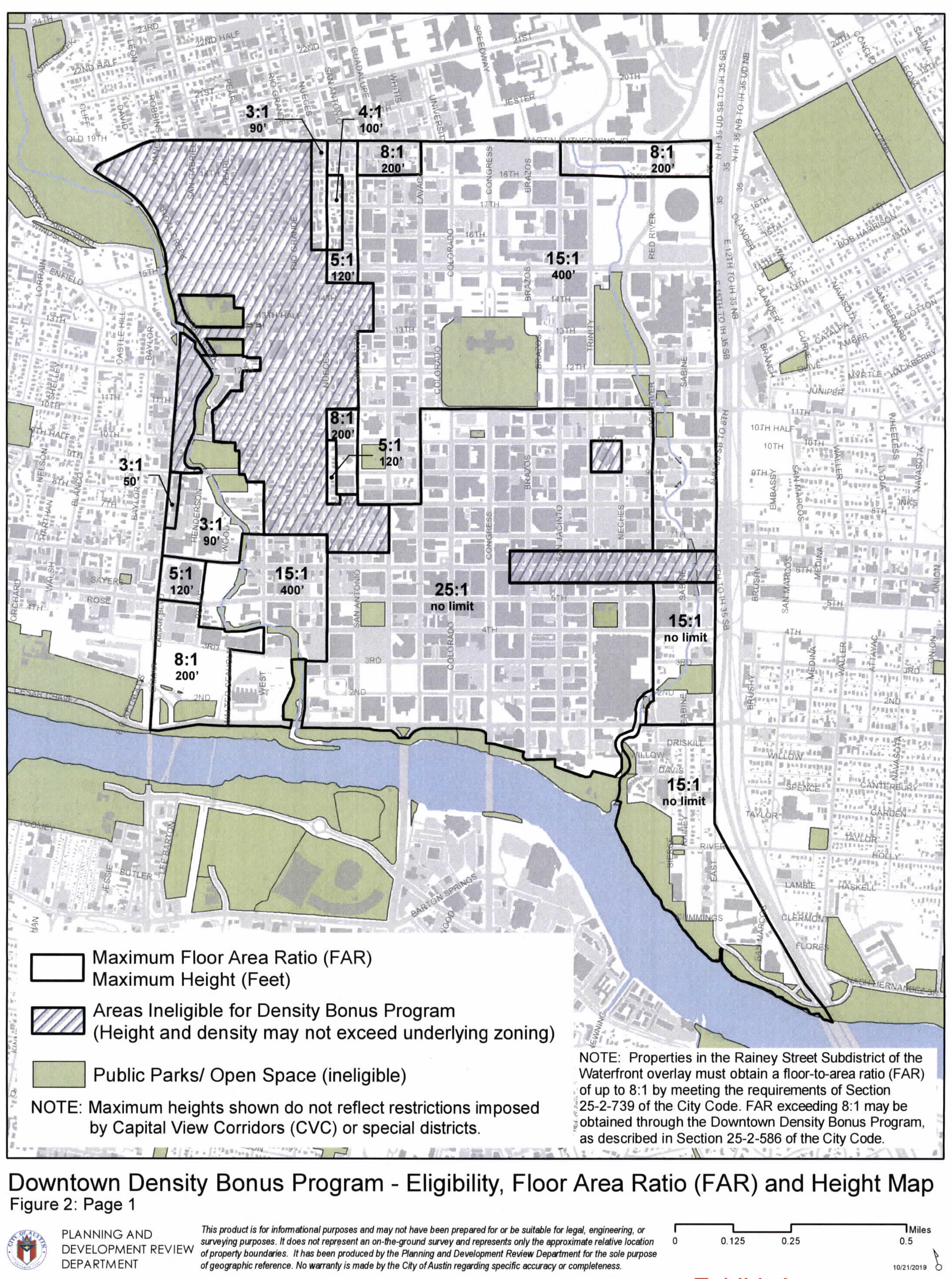
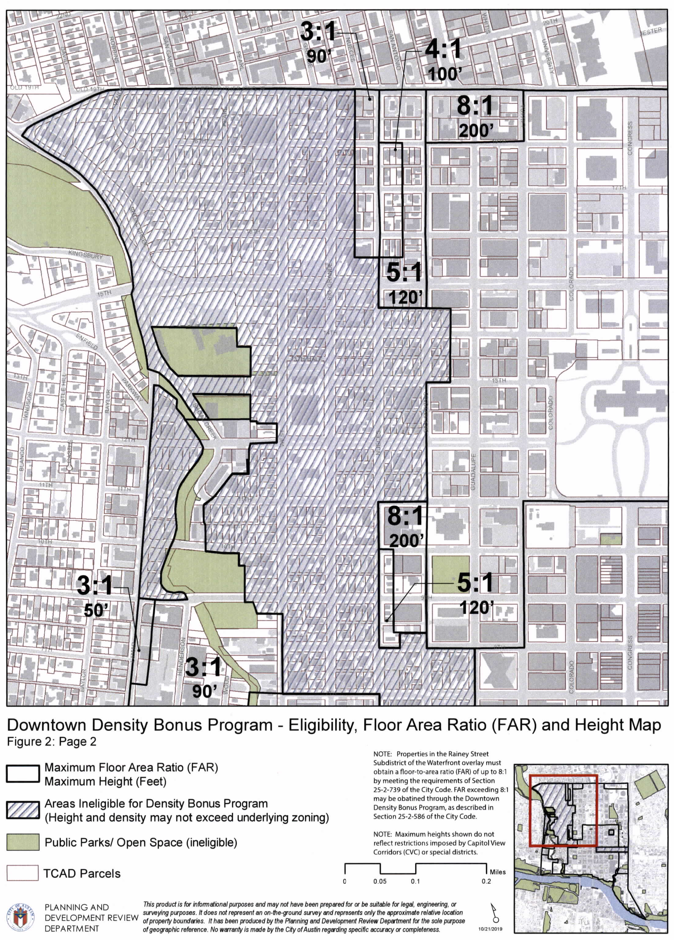
(4)
The maximum heights and maximum floor-to-area ratios on Figure 2 do not modify a site's primary entitlement. If the maximum height or maximum floor-to-area ratio allowed under a primary entitlement exceeds the height or floor-to-area ratio on Figure 2, the bonus area is calculated by using the site's primary entitlement that does not exceed the maximums shown on Figure 2.
(5)
The development bonus fee may vary by use and downtown district. The applicable development bonus fee within each of the nine districts is established by ordinance.
(6)
Notwithstanding the limitation provided for in Subsection (B)(3) of this section, the city council may grant additional floor-to-area ratio or height that exceeds the maximum floor-to-area ratio or height in Figure 2 if:
(a)
The applicant wants to exceed floor-to-area ratio or height and has already achieved the maximum shown in Figure 2 by participating in the Downtown Density Bonus Program;
(b)
The applicant submits a written request and rationale for the additional floor-to-area ratio or height to the director;
(c)
The director makes a written recommendation on the application and then submits the recommendation to the Planning Commission for its review and recommendation; and
(d)
The city council determines that the additional floor-to-area ratio or height should be granted because:
(i)
The applicant has offered additional community benefits described in Subsections (E)(1)—(12) above and beyond those offered to achieve the floor-to-area ratio or height in Figure 2;
(ii)
The applicant agrees to use the same methodology and bonus area granted for each community benefit as described in the downtown density bonus program to achieve the desired bonus area;
(iii)
The city council determines that awarding the additional floor-to-area ratio or height substantially furthers the goals and objectives of the Downtown Austin Plan and the Imagine Austin Comprehensive Plan; and
(iv)
The applicant has agreed that any residential parking space shall be offered separately from the dwelling unit.
(7)
A property described in the downtown district boundary (Figure 1) and subject to Section 25-2-161 (Capitol Dominance Overlay District) is eligible for density bonuses shown on the Eligibility, Floor-to-Area Ratio and Height Maps (Figure 2).
(8)
A property described in the downtown district boundary (Figure 1) and subject to Section 25-2-162 (Capitol View Corridor Overlay District) is eligible for density bonuses shown on the Eligibility, Floor-to-Area Ratio and Height Maps (Figure 2) that do not conflict with the height limitations established in Section 25-2-642 (Capitol View Corridor Overlay District Regulations).
(C)
Program Requirements.
(1)
Gatekeeper Requirements.
(a)
To receive bonus area, the director must determine that the project substantially complies with the Urban Design Guidelines.
(i)
The applicant must submit to the director a schematic level site plan, building elevations, and other drawings, simulations or other documents necessary to fully describe the urban design character of the project and relationship of the project to its surroundings.
(ii)
The Design Commission shall evaluate and make recommendations regarding whether the project complies with the Urban Design Guidelines and the director shall consider comments and recommendations of the Design Commission.
(b)
Except as provided in Subsection (C)(1)(c), the applicant shall execute a restrictive covenant committing to provide streetscape improvements along all public street frontages, consistent with the Great Streets Standards.
(c)
For a property located on a Texas Department of Transportation frontage, an applicant provides for Great Streets streetscape improvements along all public street frontages if the applicant pays a fee-in-lieu set by separate ordinance and a one-time maintenance obligation fee set by separate ordinance. The director of the Transportation and Public Works Department may spend a fee paid under this subsection for Great Streets capital improvement projects within the Downtown area.
(d)
The applicant shall execute a restrictive covenant committing to achieve a minimum two star rating under the Austin Energy Green Building program using the ratings in effect at the time the project is registered with the Austin Energy Green Building program. The applicant shall also provide the director with a copy of the project's signed Austin Energy Green Building Letter of Intent before the director may approve bonus area for a site.
(2)
After the director determines the applicant meets the gatekeeper requirements, the applicant shall provide sufficient written information so that the director can determine:
(a)
the site's primary entitlement;
(b)
the amount of bonus area that the applicant is requesting;
(c)
the total dollar amount the applicant will pay if the applicant chooses to obtain the entire bonus area exclusively by paying a development bonus fee, and the amount of the fee to be dedicated to each community benefit; and,
(d)
the community benefits the applicant proposes to provide to obtain bonus area if the bonus area will not be obtained exclusively by paying a development bonus fee.
(D)
Changes in Design of Proposed Building. If the design of a building changes after a bonus is granted under this section, the director shall review the new design for substantial compliance with the Urban Design Guidelines prior to building permit approval. A building permit for a final design will not be approved until the design substantially complies with the gatekeeper requirements and the restrictive covenants are amended to reflect new or revised community benefits.
(E)
Community Benefits. A person may achieve bonus area by providing community benefits outlined in this subsection. If the applicant chooses to achieve 100 percent of the desired bonus area by providing community benefits described in Subsections (E)(1)—(12), the director may approve the bonus area administratively.
(1)
Affordable Housing Community Benefits.
(a)
Affordable Housing Community Benefit. An applicant may use one or more of the following.
(i)
On-site affordable housing. A project may achieve bonus area by providing on-site affordable housing within the project. The amount of bonus area that may be achieved for each one square foot of dwelling unit space that is devoted to on-site affordable housing is established by ordinance.
(ii)
Family-friendly housing. A project providing on-site affordable housing may achieve additional bonus area by providing one or more family-friendly eligible bedrooms. The amount of bonus area that may be achieved for each family-friendly eligible bedroom is established by ordinance.
(iii)
Development bonus fee for affordable housing. The project may achieve bonus area by paying a development bonus fee at the dollar per square foot amount set by ordinance. The fee will be paid into the Affordable Housing Trust Fund.
(b)
Affordable housing community benefit percentages.
(i)
A project must achieve at least 50 percent of the desired bonus area by providing affordable housing community benefits.
(ii)
For any portion of the desired bonus area not achieved by providing affordable housing benefits, the applicant shall achieve bonus area by providing one or more of the community benefits described in Subsections (E)(2)—(12) below.
(2)
Rainey Street Subdistrict Historic Preservation Community Benefit.
(a)
A project may achieve bonus area for each historically significant building that is:
(i)
rehabilitated; and
(ii)
preserved on site, relocated to a site within the Rainey Street Subdistrict, or relocated to a location within the city limits as determined appropriate by the Historic Landmark Commission.
(b)
The amount of bonus area that may be achieved for on-site improvements for Rainey Street Subdistrict historic preservation is established by ordinance.
(c)
Buildings eligible for this community benefit include those buildings within the Rainey Street National Historic Register District that the City's historic preservation officer has determined contribute to the historic character of the Rainey Street National Historic Register District.
(d)
Requirements:
(i)
Development using this community benefit option shall maintain the architectural integrity of the building as determined by the Historic Landmark Commission (HLC) whether or not the building is zoned H-Historic or HD-Local Historic District.
(ii)
The HLC must review and approve modifications to a building before the City may grant a density bonus.
(iii)
Development may use this option only in cases where a substantial percentage of the external walls and internal structure remain intact at project completion.
(iv)
An applicant must provide a description of the rehabilitation that describes the existing conditions of the building and the proposed work. The applicant must submit photographs showing the major character-defining features of the building prior to the start of work.
(v)
Before the director may issue any type of certificate of occupancy, an applicant must submit documentation verifying that the work has been completed as proposed. The documentation must be submitted in a format similar to the Description of Rehabilitation portion of the United States Department of the Interior National Park Service Historic Preservation Certification Application.
(vi)
An applicant who cannot complete restoration as proposed must pay into the Historic Preservation Fund the applicable development bonus fee for the bonus area initially granted for this community benefit. The applicant's payment will be based on the development bonus fee in effect at the time the applicant pays the fee.
(3)
Day Care Services Community Benefit.
(a)
A project may achieve bonus area by providing day care services within the project. The amount of bonus area that may be achieved for each square foot of day care services that are provided is established by ordinance.
(b)
Requirements:
(i)
The applicant must execute a restrictive covenant that requires compliance with all relevant requirements of this section and that ensures continuation of operations and maintenance of the facility with the specified community benefit use for a period of at least 10 years, which is the life of the agreement.
(ii)
City of Austin must approve of the operator and the lease terms, which shall be for no less than ten years.
(iii)
The facility must comply with applicable state and local codes.
(iv)
The facility must be open during normal business hours at least five days each week and fifty weeks each calendar year.
(v)
The facility must be maintained and kept in a good state of repair throughout the life of the agreement.
(vi)
If the day care services use is non-operational for more than 180 consecutive days or for 180 days in any 365 day period, the owner must pay into the Affordable Housing Trust Fund the applicable development bonus fee for the bonus area initially granted for this community benefit. The payment will be a pro-rated amount based on the time left in the term of the agreement and based on the development bonus fee in effect when the owner pays.
(4)
Cultural Uses Community Benefit.
(a)
A project may achieve bonus area by providing on-site cultural uses within the project. The amount of bonus area that may be achieved for each square foot of cultural uses provided is established by ordinance.
(b)
Requirements:
(i)
The applicant must execute a restrictive covenant that requires compliance with all requirements of this section and that ensures continuation of operations and maintenance of the facility with the specified community benefit use for a period of at least 10 years, which is the life of the agreement.
(ii)
City of Austin must approve of the operator and the lease terms, which shall be for no less than ten years.
(iii)
Use must meet the definition of cultural uses and the space must be leased to a 501(c) organization.
(iv)
If the required use is non-operational for more than 180 consecutive days or for 180 days in any 365 day period, the owner must pay into the Affordable Housing Trust Fund the applicable development bonus fee for the bonus area initially granted for this community benefit. The payment will be a pro-rated amount based on the time left in the term of the agreement and based on the development bonus fee in effect when the owner pays.
(5)
Live Music Community Benefit.
(a)
A project may achieve bonus area by providing an on-site live music use. The amount of bonus area that may be achieved for each square foot of live music use is established by ordinance.
(b)
Requirements:
(i)
The applicant must ensure continuation of operations and maintenance of the facility with the specified community benefit use for a period of at least 10 years, which is the life of the agreement.
(ii)
City of Austin must approve of the operator and the lease terms, which shall be for no less than ten years.
(iii)
The operator of the facility must maintain proper permitting and documentation to play amplified music in said space.
(iv)
The space must meet the City of Austin's sound-proofing specifications.
(v)
If the required use is non-operational for more than 180 consecutive days or for 180 days in any 365 day period, the owner must pay into the Affordable Housing Trust Fund the applicable development bonus fee for the bonus area initially granted for this community benefit. The payment will be a pro-rated amount based on the time left in the term of the agreement and based on the development bonus fee in effect when the owner pays.
(vi)
Venues may not charge an up-front fee to performing artists for the use of their facilities or require performing artists to guarantee a minimum attendance through pre-show ticket sales.
(6)
On-Site Improvements for Historic Preservation Community Benefit.
(a)
A project may achieve bonus area by providing on-site improvements for historic preservation. The amount of bonus area that may be achieved for on-site improvements for historic preservation is established by ordinance.
(b)
Buildings Eligible for On-Site Improvements for Historic Preservation Community Benefit include:
(i)
Buildings designated as City landmarks, Recorded Texas Historic Landmarks, State Antiquities Landmarks, or listed on the National Register of Historic Places;
(ii)
Contributing properties within National Register or Local Historic Districts;
(iii)
Buildings determined by the City's Historic Preservation Officer to be historically significant; or
(iv)
Buildings determined eligible for listing on the National Register of Historic Places by the State Historic Preservation Officer.
(c)
Requirements:
(i)
Development using this community benefit option for on-site improvements shall maintain the architectural integrity of the building, as determined by the Historic Landmark Commission (HLC) whether or not the building is zoned H-Historic or HD-Local Historic District.
(ii)
The HLC must review and approve modifications to a building before the City may grant a density bonus.
(iii)
A project may be granted bonus area for on-site improvements for historic preservation only in cases where a substantial percentage of the external walls and internal structure remain intact at project completion.
(iv)
Applicant must provide a description of rehabilitation that describes the existing condition of the building and the proposed work. The applicant must submit photographs showing the major character-defining features of the building prior to the start of work.
(v)
Before the director may issue any type of Certificate of Occupancy, an applicant must submit documents verifying that the work has been completed as proposed. The documents must be submitted in a format similar to the Description of Rehabilitation portion of the United States Department of the Interior National Park Service Historic Preservation Certification Application.
(vi)
If restoration cannot be completed as proposed, the owner must pay into the Historic Preservation Fund the applicable development bonus fee for the bonus area initially granted for this community benefit. The owner's payment will be based on the development bonus fee in effect at the time the owner pays the fee.
(7)
Development Bonus Fee for Off-Site Historic Preservation Community Benefit.
(a)
The project may achieve bonus area by paying a development bonus fee at the dollar per square foot amount set by ordinance based on the district in which the proposed development is located. The fee will be paid into the Historic Preservation Fund.
(b)
Requirements:
(i)
The City of Austin will administer the Historic Preservation Fund.
(ii)
This option cannot be used if developer is proposing to demolish all or a substantial percentage of a building the Historic Preservation Officer deems historically significant.
(8)
Green Building Community Benefit.
(a)
An applicant may achieve bonus area by constructing a project to green building standards that exceed the Gatekeeper requirements. The amount of bonus area that may be achieved for constructing a project to green building standards is established by ordinance.
(b)
Requirements:
(i)
The applicant shall execute a restrictive covenant committing to achieve a specified rating under the Austin Energy Green Building (AEGB) program using the ratings in effect at the time the ratings application is submitted for the project or Leadership in Energy & Environmental Design (LEED) program using the most recently launched version of the LEED for New Construction rating at the time of the project's registration.
(ii)
The applicant shall also provide the director with a copy of the project's signed Austin Energy Green Building Letter of Intent for projects seeking AEGB rating or a copy of the completed LEED registration for projects seeking LEED rating before the director may approve bonus area for a site.
(iii)
An applicant must submit an AEGB or LEED checklist indicating the measures the project intends to complete to meet the applicable green building requirement before the director may approve bonus area for a site.
(iv)
A project seeking an AEGB rating will be subject to at least one inspection during construction and an inspection at substantial completion. A project seeking LEED certification must submit the LEED design review results and an updated LEED checklist or scorecard indicating the project will be able to obtain LEED certification by substantial completion.
(v)
If the specified AEGB rating or LEED certification is not achieved within nine months from time of occupancy, an owner must pay into the Affordable Housing Trust Fund the applicable development bonus fee for the bonus area initially granted for this community benefit. The owner's payment will be based on the development bonus fee in effect when the owner pays.
(9)
Publicly Accessible On-Site Plaza Community Benefit.
(a)
A project may achieve bonus area by providing a publicly accessible on-site plaza. The amount of bonus area that may be achieved by providing a publicly accessible on-site plaza is established by ordinance.
(b)
Requirements:
(i)
If the required plaza is non-operational for more than 180 consecutive days or for 180 days in any 365 day period, the owner must pay into the Downtown Open Space Fund the applicable development bonus fee for the bonus area initially granted for this community benefit. The payment will be based on the development bonus fee in effect when the owner pays.
(10)
Off-Site Open Space Development Bonus Fee Community Benefit.
(a)
The project may achieve bonus area by paying a development bonus fee for off-site open space at the dollar per square foot amount set by ordinance based on the district in which the proposed development is located. The fee will be paid into the Downtown Open Space Fund.
(b)
Requirements:
(i)
City will administer the Downtown Open Space Fund.
(ii)
The development bonus fee option is only available for open space beyond what is already required by City Code.
(iii)
The applicant must deposit a nonrefundable cash payment with the City.
(11)
Green Roof Community Benefit.
(a)
A project may achieve bonus area by providing green roofs. The amount of bonus area that may be achieved for the construction of green roofs is established by ordinance.
(b)
Requirements:
(i)
Green Roofs must be built to the Vegetated ("Green") Roof Performance Standards in Appendix W of the Environmental Criteria Manual. The percent of vegetated roof cover is calculated as a portion of total roof area excluding mechanical equipment, photovoltaic panels, swimming pools, and skylights.
(ii)
If the green roof fails to meet the Vegetated ("Green") Roof Performance Standards for more than 180 consecutive days or for 180 days in any 365 day period, the owner must pay into the Downtown Open Space Fund the applicable development bonus fee for the bonus area initially granted for this community benefit. The payment will be based on the development bonus fee in effect when the owner pays.
(iii)
Green roof areas used to achieve bonus area through the Green Roof Community Benefit may not be used to achieve bonus area through the Publicly Accessible On-Site Plaza Community Benefit.
(12)
Other Community Benefits.
(a)
An applicant may offer to provide other community benefits not described in (E)(1) - (11). The applicant must provide sufficient information about the other community benefits for the director to determine whether the other community benefits serve a public and municipal purpose considering the criteria listed below.
(b)
The director will consider the following to make a determination:
(i)
if members of the general public will be able to enjoy the proposed other community benefit without paying for its access, use or enjoyment;
(ii)
if the proposed other community benefit will connect to and be accessible from public right-of-way or other publicly-accessible space;
(iii)
if the proposed other community benefit will provide a public amenity that is particularly lacking in the proposed location;
(iv)
if the proposed other community benefit will impose a significant burden on public resources for maintenance, management, policing, or other reasons; and,
(v)
any other information provided by the applicant that shows the other community benefit serves a public and municipal purpose and furthers the City's comprehensive planning goals.
(c)
If a proposed other community benefit provides a partial benefit to a project, it will not be disqualified; the director will allocate only the cost of the public portion of the benefit to the other community benefits.
(d)
If the director determines that the proposed benefit qualifies as a community benefit, the director shall:
(i)
quantify the monetary cost for the proposed other community benefit by using standard industry sources as well as locally based data on development costs to quantify the monetary cost, without mark-up, for the proposed other community benefit; and,
(ii)
determine the cost to be applied towards achieving the desired bonus area.
(e)
The amount determined by the director may be applied to achieve bonus area on the same basis as the development bonus fee applicable to the type and location of the project.
(f)
The director's recommendation concerning the proposed other community benefit and the monetary value that is applied to achieve the bonus area shall be presented to the planning commission for recommendation and the city council for approval.
(g)
If the applicant proposes to achieve bonus area by providing other community benefits, the value of the public portion of the proposed other community benefits must be equal to or greater than the total dollar amount the applicant would pay if the payment were based on the applicable development bonus fee required to earn that requested bonus area.
(F)
Community Benefit Calculations for Mixed-Use Projects. Mixed-use projects shall provide community benefits in proportion to the amount of floor area in the project that is devoted to different use categories.
(G)
Affordability Requirements. For purposes of this section, a unit is affordable for purchase or rental if, in addition to the other requirements of this section, the household is required to spend no more than 30 percent of its gross monthly income on mortgage or rental payments for the unit.
(1)
Affordability requirements for owner-occupied units.
(a)
On-site for sale affordable housing units shall be reserved, sold and transferred to an income eligible buyer subject to a resale restricted, shared equity agreement approved by the director of Neighborhood Housing and Community Development, for not less than 99 years from the date a certificate of occupancy is issued.
(b)
The units shall be made available for ownership and occupancy by households earning no more than 120 percent of the Annual Median Family Income for the City of Austin Metropolitan Statistical Area as determined by the director of Neighborhood Housing and Community Development.
(2)
Affordability requirements for rental units.
(a)
On-site rental affordability housing units shall be reserved as affordable for a minimum of 40 years following the issuance of the certificate of occupancy.
(b)
The units shall be made available for rental by households earning no more than 80 percent of the annual median family income for the City of Austin metropolitan statistical area as determined by the director of Neighborhood Housing and Community Development.
(c)
An applicant may not deny a prospective tenant affordable rental housing based solely on the prospective tenant's participation in the Housing Choice Voucher Program or in any other housing voucher program that provides rental assistance.
(3)
Rules. The Neighborhood Housing and Community Development Office shall conduct compliance and monitoring of the affordability requirements of this ordinance. The director of Neighborhood Housing and Community Development shall establish compliance and monitoring rules and criteria for implementing the affordability requirements of this ordinance.
(H)
Applicant's obligation. Before the director may issue any type of Certificate of Occupancy, an applicant must fulfill all obligations including but not limited to the payment of all fees and execution of restrictive covenants in order to ensure that the applicant provides all required community benefits. All approvals must be obtained and evidence of the approvals must be provided to the director prior to site plan submittal.
(I)
Director's approval. Once an applicant meets the submission requirements of the downtown density bonus program and executes the necessary restrictive covenants to ensure that the applicant provides all required community benefits, the director will issue a written notice of approval that indicates the project's allowable floor-to- area ratio and height.
(J)
Appeal.
(1)
An applicant may appeal to the city council the director's determination that the gatekeeper requirements have not been met.
(2)
An applicant must appeal the determination within 30 days from the date of the director's denial.
(3)
An appeal is subject to the procedures set forth in Section 25-2-282 (Land Use Commission Public Hearing and Recommendation) and Section 25-2-283 (City Council Zoning Hearing and Action) of the City Code.
Source: Ord. 20080131-132; Ord. 20130627-105; Ord. 20140227-054, Pts. 1, 3, 3-10-14; Ord. No. 20191031-037, Pt. 1, 11-11-19; Ord. No. 20230504-030, Pt. 1, 5-15-23; Ord. No. 20230504-031, Pt. 1, 5-15-23; Ord. No. 20231019-052, Pt. 4, 10-30-23; Ord. No. 20251023-063, Pts. 2, 3, 11-3-25.
§ 25-2-587 - REQUIREMENTS FOR CERTAIN USES IN A NEIGHBORHOOD COMMERCIAL (LR) DISTRICT.
(A)
This section applies in a neighborhood commercial (LR) district.
(B)
A personal improvement services use may not exceed 5,000 square feet of gross floor area.
(C)
This subsection applies to a general retail sales (general) use.
(1)
The gross floor area may not exceed 5,000 square feet.
(2)
Access to the site from a local street is prohibited.
(D)
This subsection applies to a restaurant (general) use.
(1)
The gross indoor floor area may not exceed 4,000 square feet.
(2)
A restaurant (general) use may operate only after 7:00 a.m. and before 11:00 p.m.
(3)
An outdoor seating area may not:
(a)
exceed 500 square feet of area; or
(b)
be located within 50 feet of property with a single-family use or property zoned as a townhouse and condominium residence (SF-6) or more restrictive district.
(4)
Outdoor entertainment as an accessory use is prohibited.
(5)
Outdoor amplified sound is prohibited.
(6)
A drive-through facility is prohibited.
Source: Ord. 20080131-135; Ord. 20090521-017; Ord. 20120614-055.
§ 25-2-588 - REQUIREMENTS FOR CERTAIN USES IN A LIMITED OFFICE (LO) DISTRICT.
(A)
This section applies in a limited office (LO) district.
(B)
A personal services use may not exceed 1,000 square feet of gross floor area.
Source: Ord. 20111110-107.
§ 25-2-589 - OFF-STREET ACCESSORY PARKING IN DOWNTOWN MIXED USE (DMU).
In the downtown mixed use (DMU) zoning district, commercial off-street parking is a permitted use when it constitutes less than 50 percent of the parking spaces in a parking structure.
Source: Ord. 20130411-061
§ 25-2-591 - APPLICABILITY.
This subpart applies to property zoned central business (CBD) or downtown mixed use (DMU).
Source: Ord. 030612-93; Ord. 990225-70; Ord. 031211-11.
§ 25-2-592 - DRIVE-IN SERVICES.
(A)
A business that offers a drive-in service must provide a similar service for a pedestrian that does not require the pedestrian to stand or walk in a vehicle lane.
(B)
For a drive-in service, the total width of the curb cuts on a block face may not exceed 30 feet.
Source: Ord. 990225-70; Ord. 030612-93; Ord. 031211-11.
§ 25-2-593 - SITE PLAN AND CONSTRUCTION REQUIREMENTS.
(A)
A site plan may not be approved unless the development complies with this section.
(B)
A building must achieve at least a one star rating under the Austin Green Building program, as prescribed by a rule adopted in accordance with Chapter 1-2 (Adoption of Rules).
(C)
A surface parking facility must be at least partially and periodically obscured from the street by landscaping, a berm, a wall, decorative fencing, or another structure.
(D)
This subsection prescribes screening requirements for a parking structure.
(1)
The headlights of automobiles in a parking structure may not be directly visible from an adjacent building or a building across a street, other than an alley, from the parking structure.
(2)
Automobiles in a parking structure must be screened from public view.
(3)
The building code requirements for an open parking garage supersede the requirements of this subsection to the extent of conflict.
(E)
This subsection prescribes additional screening requirements for all land uses except a major utility facilities use or a local utility services use.
(1)
A trash receptacle, air conditioning or heating equipment, loading area, or external storage must be screened from public view.
(2)
Equipment located on a roof must be screened from the view of a person standing on the farthest edge of an adjacent public street, other than an alley. The director of the Watershed Protection and Development Review Department may waive this requirement after determining that screening is not practical.
Source: Ord. 030612-93; Ord. 031211-11.
§ 25-2-594 - MAXIMUM SETBACK REQUIREMENT.
(A)
Except as provided in Subsection (B), a site plan may not be approved unless the development complies with this section.
(B)
This section does not apply to a site plan for:
(1)
property zoned as a historic landmark (H) or historic area (HD) combining district;
(2)
property designated as a historic landmark by the state or federal government;
(3)
property located in a National Register Historic District established by the federal government;
(4)
remodeling of or addition to an existing structure;
(5)
restoration of a damaged structure within one year of the date of damage;
(6)
a change of use;
(7)
property located in the area bounded by Seventh Street from San Antonio Street to Shoal Creek, Shoal Creek from Seventh Street to Fifteenth Street, Fifteenth Street from Shoal Creek to West Avenue, West Avenue from Fifteenth Street to Martin Luther King, Jr. Boulevard, Martin Luther King, Jr. Boulevard from West Avenue to San Antonio Street, San Antonio Street from Martin Luther King, Jr. Boulevard to Eleventh Street, Eleventh Street from San Antonio Street to Guadalupe Street, Guadalupe Street from Eleventh Street to Tenth Street, Tenth Street from Guadalupe Street to San Antonio Street, and San Antonio Street from Tenth Street to Seventh Street; or
(8)
the following uses:
(a)
carriage stable;
(b)
family home;
(c)
group home;
(d)
local utility services;
(e)
major utility facilities;
(f)
outdoor entertainment;
(g)
outdoor sports and recreation;
(h)
park and recreation services;
(i)
religious assembly;
(j)
safety services;
(k)
transitional housing; or
(l)
transportation terminal.
(C)
Except as provided in Subsection (D), for the first four stories of a building that are above grade:
(1)
the maximum front yard setback is ten feet; and
(2)
the maximum street side yard setback is ten feet.
(D)
The maximum setbacks prescribed by Subsection (C) do not apply to the portion of a building adjacent to a plaza or protected tree.
Source: Ord. 030612-93; Ord. 031211-11; Ord. 041202-16.
§ 25-2-601 - INDUSTRIAL PARK (IP), MAJOR INDUSTRY (MI), AND LIMITED INDUSTRIAL SERVICE (LI) DISTRICT REGULATIONS.
(A)
This section applies in an industrial park (IP), major industry (MI), or limited industrial services (LI) district.
(B)
The minimum interior yard setback and rear yard setback is:
(1)
50 feet, if adjacent to property zoned as or used for a use permitted in an LA, RR, SF-1, SF-2, SF-3, SF-4, SF-5, or SF-6 district;
(2)
25 feet, if adjacent to property zoned as or used for a use permitted in an MF-1, MF-2, MF-3, MF-4, MF-5, MF-6, or MH district;
(3)
15 feet, if adjacent to property zoned as or used for a use permitted in an NO, LO, GO, CR, LR, or GR district; and
(4)
10 feet, if adjacent to property zoned as or used for a use permitted in an L or less restrictive district.
(C)
Within the Limited Industrial Service (LI) District, public secondary educational facilities are limited to the senior high school level.
Source: Section 13-2-675; Ord. 990225-70; Ord. 031211-11; Ord. No. 20160623-090, Pt. 3, 7-4-16.
§ 25-2-602 - RESEARCH AND DEVELOPMENT (R&D) DISTRICT USES.
Uses permitted in a research and development (R&D) district are established by the zoning ordinance establishing the district.
Source: Section 13-2-225; Ord. 990225-70; Ord. 031211-11.
§ 25-2-603 - RESEARCH AND DEVELOPMENT (R&D) DISTRICT REGULATIONS.
(A)
This section applies in a research and development (R&D) district.
(B)
A site must be developed as a campus.
(C)
The minimum lot size is 5 acres.
(D)
The maximum lot size is 25 acres.
(E)
The maximum floor to area ratio is .25 to 1 in the following areas:
(1)
the Barton Creek watershed, as defined in Ordinance No. 810430-C;
(2)
the aquifer-related Williamson Creek watershed, as defined in Ordinance No. 801218-W;
(3)
the Lake Austin watershed, as defined in Ordinance No. 840301-G;
(4)
the Lake Austin watershed, as defined in Ordinance No. 840308-K; and
(5)
the Northwest Area, as defined in Ordinance No. 841206-H.
(F)
The maximum height is 45 feet, except that the height of a building may exceed 45 feet by one foot for each additional two feet that the building is set back beyond 100 feet from the front and side lot lines and beyond 50 feet from the rear lot line, up to a maximum height of 90 feet.
(G)
For the portion of a site within 100 feet of property zoned as or used for a use permitted in an LA, RR, SF-1, SF-2, SF-3, SF-4, SF-5, or SF-6 district:
(1)
the minimum street side yard setback is 100 feet;
(2)
the minimum interior side yard setback is 100 feet; and
(3)
the minimum rear yard setback is 50 feet.
(H)
For the portion of a site within 100 feet of property zoned as or used for a use permitted in an MF-1, MF-2, MF-3, MF-4, MF-5, MF-6, or MH district:
(1)
the minimum street side yard setback is 25 feet;
(2)
the minimum interior side yard setback is 25 feet; and
(3)
the minimum rear yard setback is 25 feet.
(I)
For the portion of a site within 100 feet of property zoned as or used for a use permitted in an NO, LO, GO, LR, or GR district:
(1)
the minimum interior side yard setback is 15 feet; and
(2)
the minimum rear yard setback is 15 feet.
(J)
For the portion of a site within 100 feet of property zoned as or used for a use permitted in an L or less restrictive district, the minimum rear yard setback is 10 feet.
(K)
The maximum impervious cover is 50 percent on land with a gradient of 15 percent or less. Impervious cover is prohibited on land with a gradient greater than 15 percent.
Source: Section 13-2-676; Ord. 990225-70; Ord. 031211-11.
§ 25-2-621 - AGRICULTURAL (AG) DISTRICT REGULATIONS.
(A)
This section applies in an agricultural (AG) district.
(B)
For a permitted use, the minimum front, side, and rear yard setbacks are 100 feet.
(C)
This subsection applies to a conditional use.
(1)
The minimum lot area is one acre.
(2)
The maximum lot area is 1.5 acres.
(3)
The minimum lot width is 100 feet.
(4)
Not more than one dwelling unit is permitted on each lot.
(5)
One lot for each 10 acres of site area may be approved for a conditional use.
(6)
The maximum distance from a rear lot line to the centerline of the nearest public road is 400 feet.
(7)
The minimum distance between driveways that serve conditional uses on the same site and on the same side of the road is 100 feet.
(8)
The maximum height is the lesser of three stories or 35 feet.
(9)
The minimum front yard setback is 40 feet.
(10)
The minimum street side yard setback is 25 feet.
(11)
The minimum interior side yard setback is 10 feet.
(12)
The minimum rear yard setback is 20 feet.
(13)
The maximum building cover is the lesser of 10,000 square feet or 20 percent of the lot area.
(14)
The maximum impervious cover is the lesser of 12,500 square feet or 25 percent of the lot area.
Source: Section 13-2-681; Ord. 990225-70; Ord. 031211-11.
§ 25-2-622 - AVIATION SERVICES (AV) DISTRICT USES.
In an aviation services (AV) district, the following are permitted uses if located on public property and conditional uses if located on private property:
(1)
aviation facilities;
(2)
commercial or industrial uses that are related to aviation and require direct access to an airport facility or aviation services, including assembly or sale of aircraft, air frames, air craft engines, aircraft parts or associated components, radios or navigational equipment, and similar products or services;
(3)
commercial or industrial uses that provide services to airport customers or aviation related uses, including passenger terminal facilities, air freight services, automobile service stations, automobile rental agencies, restaurants, lounges, convenience shopping, banking services, personal services, hotels and motels, and similar uses;
(4)
agricultural, recreational, or open space uses located within clear zones, approach areas, or lands reserved for future airport operations or related services;
(5)
communication service facilities; and
(6)
governmental, civic, public service, or public institutional uses, and related accessory uses.
Source: Section 13-2-226; Ord. 990225-70; Ord. 031211-11.
§ 25-2-623 - AVIATION SERVICES (AV) DISTRICT REGULATIONS.
(A)
For publicly owned land in an aviation services (AV) district, this title does not prescribe site development regulations.
(B)
For privately owned land in an AV district:
(1)
site development regulations are established by the approval of a conditional use site plan; and
(2)
approval of an aviation-related use may not be granted until the owner obtains an airport use operating agreement for the intended activity.
Source: Section 13-2-680; Ord. 990225-70; Ord. 031211-11.
§ 25-2-624 - PUBLIC (P) DISTRICT USES.
(A)
In a public (P) district, the following are permitted uses:
(1)
governmental, civic, public service, and public institutional uses;
(2)
residential uses associated with educational, military, medical, or similar public uses;
(3)
commercial or industrial uses that are accessory to or in support of a principal public use on the same site;
(4)
agricultural uses; and
(5)
temporary uses.
(B)
A telecommunication tower use is a permitted or conditional use, as determined in accordance with Section 25-2-839 (Telecommunication Towers).
Source: Section 13-2-227; Ord. 990225-70; Ord. 000302-36; Ord. 031211-11.
§ 25-2-625 - PUBLIC (P) DISTRICT REGULATIONS.
(A)
This section applies in a public (P) district, except for a community events use.
(B)
Entities described in Section 25-2-145 (Public (P) District Designation) must comply with the requirements of this section.
(C)
For a residential use, the site development regulations of the most comparable residential zoning district apply.
(D)
Except as provided in Subsection (E), this subsection applies to a nonresidential use.
(1)
For a site less than one acre, the site development regulations of an adjoining zoning district apply for a distance of 100 feet into the site. The minimum lot size requirement of an adjoining zoning district does not apply to a use by the City.
(2)
For a site of one acre or more, the site development regulations are established by the approval of a conditional use site plan.
(E)
This subsection applies to a parks and recreation services (special) use.
(1)
The minimum site area is 10 acres.
(2)
Except for the requirement of Subsection (D)(1), the site development regulations are established by the approval of a conditional use site plan.
(3)
Locations for the sale of beer or wine, if any, must be identified on the site plan.
(4)
The Land Use Commission may not consider a site plan until it receives a recommendation from the Parks and Recreation Board.
Source: Section 13-2-682; Ord. 990225-70; Ord. 990902-57; Ord. 010607-8; Ord. 031211-11.
§ 25-2-641 - CAPITOL DOMINANCE (CD) COMBINING DISTRICT REGULATIONS.
(A)
This section applies in the Capitol dominance (CD) combining district.
(B)
The maximum height of a structure is the lesser of:
(1)
the base district maximum height; or
(2)
a height that coincides with the 653 foot elevation above sea level, plus 0.04366 feet of height for each foot horizontally that the measurement point is separated from the center of the Capitol dome.
Source: Section 13-2-716; Ord. 990225-70; Ord. 031211-11.
§ 25-2-642 - CAPITOL VIEW CORRIDOR (CVC) OVERLAY DISTRICT REGULATIONS.
(A)
In the Capitol view corridor (CVC) combining district, the maximum height permitted is the lesser of:
(1)
the base district maximum height; or
(2)
the maximum height provided in this section.
(B)
In a Capitol view corridor, a structure may not exceed the elevation of the plane delineating the corridor. The height limitation exceptions of Section 25-2-531 (Height Limitation Exceptions) do not apply to this subsection.
Source: Section 13-2-710; Ord. 990225-70; Ord. 031211-11; Ord. 20060216-043; Ord. 20060309-058; Ord. 20060622-022; Ord. 20060928-022.
§ 25-2-643 - CONGRESS AVENUE (CA), EAST SIXTH/PECAN STREET (PS), DOWNTOWN PARKS (DP), AND DOWNTOWN CREEKS (DC) COMBINING DISTRICT REGULATIONS.
(A)
In the Congress Avenue (CA), East Sixth/Pecan Street (PS), downtown parks (DP), and downtown creeks (DC) combining districts:
(1)
glass used on the first floor of a structure must have a visible transmittance rating of 0.6 or higher; and
(2)
reflective surface building materials must not produce glare.
(B)
This subsection applies to new development on Congress Avenue or East 6th Street, on streets adjacent to a downtown park or Town Lake, and along a downtown creek.
(1)
Surface parking lots, curb cuts, and unscreened garage openings are prohibited.
(2)
The Land Use Commission may waive the prohibition of this subsection after determining that:
(a)
compliance with the prohibition is impractical;
(b)
the proposed project will not unreasonably impair pedestrian or vehicular movement; and
(c)
adequate precautions have been made for public safety, convenience, and the aesthetic values of the combining district.
(C)
This section applies to the PS overlay district.
(1)
Except as otherwise provided in this subsection, a structure may not exceed a height of 45 feet.
(2)
A structure located west of Brazos Street is subject to the height limit of the base zoning district.
(3)
An exterior sign must comply with the standards adopted by the Landmark Commission for the Sixth Street Historic District.
(4)
A structure may develop to a maximum height of 140 feet if:
(a)
located on the 500 block or 600 block of East Sixth Street between Neches Street and Sabine Streets; and
(b)
complying with the design standards established in Ordinance No. 20230720-160, as determined by the Historic Landmark Commission.
(D)
In the DP combining district:
(1)
a structure may not exceed a height of 120 feet; and
(2)
at least one entrance to a new development must face the park unless the new development is located diagonally across an intersection from the park.
(E)
In the DC combining district:
(1)
a structure may not exceed a height of 60 feet; and
(2)
storage, trash collection, loading, and associated facilities must be screened from view from a creek.
(F)
In the Congress Avenue (CA) combining district:
(1)
On the west side of Congress Avenue within 60 feet of Congress Avenue:
(a)
the minimum structure height is 30 feet; and
(b)
the maximum structure height is 90 feet.
(2)
On the east side of Congress Avenue within 40 feet of Congress Avenue:
(a)
the minimum structure height is 30 feet; and
(b)
the maximum structure height is 90 feet.
Source: Section 13-2-717; Ord. 990225-70; Ord. 010607-8; Ord. 030612-93; Ord. 031211-11; Ord. 20080618-097; Ord. No. 20141211-201, Pt. 1, 12-22-14; Ord. No. 20230720-160, Pt. 1, 7-31-23.
§ 25-2-644 - CONVENTION CENTER (CC) COMBINING DISTRICT REGULATIONS.
(A)
Commercial off-street parking is prohibited in the convention center (CC) combining district east of IH-35.
(B)
This subsection applies in the CC combining district to development for which an application for approval of commercial off-street parking is filed after November 18, 1990.
(1)
A commercial off-street parking use must be contained entirely within a structure and be screened.
(2)
A commercial off-site parking use must be separated at ground level from an adjacent street by an enclosed space designed for a pedestrian-oriented use described in Section 25-2-691 (Waterfront (WO) Overlay District Uses).
(3)
For a site that is less than one city block in length on a side, the Land Use Commission may waive the requirement of this subsection after determining that:
(a)
compliance with the regulation is physically impractical; or
(b)
the proposed project is located in an area that is not pedestrian-oriented.
Source: Sections 13-2-230.1 and 13-2-718; Ord. 990225-70; Ord. 010607-8; Ord. 031211-11.
§ 25-2-645 - EAST AUSTIN (EA) OVERLAY DISTRICT USE RESTRICTIONS.
(A)
This section applies to a use in the East Austin (EA) overlay district.
(B)
A use in a community commercial (GR), general commercial services (CS), commercial -liquor sales (CS-1), or limited industrial service (LI) base district is a conditional use if, under Section 25-2-491 (Permitted, Conditional, and Prohibited Uses) of the City Code, the use is:
(1)
permitted in the district; and
(2)
not permitted in a neighborhood commercial (LR) base district.
(C)
A medical office (not exceeding 5,000 square feet of gross floor area) use is a conditional use in a GR, CS, CS-1, and LI base district.
(D)
A service station use is a conditional use in a GR, CS, CS-1, and LI base district.
(E)
A guidance services use and a communication service facilities use are conditional uses in all base districts.
(F)
A pawn shop services use is prohibited in a GR, CS, CS-1, and LI base district.
Source: Section 13-2-191; Ord. 990225-70; Ord. 990520-70; Ord. 990520-70; Ord. 031211-11.
§ 25-2-647 - LAKE AUSTIN (LA) OVERLAY DISTRICT REGULATIONS.
Development within the Lake Austin (LA) overlay district must comply with the regulations applicable to the LA zoning district under Section 25-2-551 (Lake Austin (LA) District Regulations) and the minimum lot size, minimum lot width, and setbacks applicable to the LA zoning district under section 25-2-491 (Site Development Regulations).
Source: Ord. No. 20140626-114, Pt. 2, 7-7-14.
§ 25-2-648 - PLANNED DEVELOPMENT AREA (PDA) PERFORMANCE STANDARDS.
(A)
This section applies to a planned development area agreement or zoning district. The requirements of this section supersede conflicting provisions of a planned development area agreement or ordinance, if any. This section does not apply to a planned development area that does not contain an industrial use.
(B)
A planned area development may not produce a dangerous or objectionable element, as described in this section or a City administrative rule.
(C)
Dangerous or objectionable elements include dangerous, injurious, noxious, or objectionable noise, smoke, dust, odor, air pollution, heat, humidity, liquid or solid refuse or waste, light or glare, or other substance, condition, radiation, or element that adversely affects property or the use of property in the vicinity. This excludes resource recovery systems using solid waste.
(D)
A dangerous or objectionable element is measured in the manner prescribed by this subsection.
(1)
Noise, vibration, light, glare, odor, or radiation is measured at the point on the source property line that has the highest readings, or at any other point where the existence of the elements may be more apparent. Noise levels are determined in accordance with Information on Levels of Environmental Noise Requisite to Protect Public Health and Welfare with an Adequate Margin of Safety, Environmental Protection Agency, 1974.
(2)
Smoke or toxic or noxious matter is measured at the place of emission into the atmosphere.
(3)
For open industrial operations described in Subsection (E)(6), dust concentration is measured at ground level or a habitable elevation, and either at the property line or beyond it, whichever results in the highest measurement.
(E)
A dangerous or objectionable element may not exceed the limits prescribed by this subsection.
(1)
Except for noise from a transportation facility or construction work, noise may not exceed 55 decibels LAN during daylight hours and 45 decibels LAN during night time hours.
(2)
Earth borne vibrations may not exceed:
(a)
the limits in Column I below; or
(b)
if the point of measurement is a residential area boundary line or within 80 feet of a residential area boundary line that is located in a street right-of-way, the limits in Column II below.
(3)
A light or direct welding flash may not exceed 0.4 foot candles across the source property line. Light from these sources must be screened from an adjoining property.
(4)
Smoke may not be:
(a)
as dark or darker in shade as that designated as No. 0 on the Ringlemann Chart, as published by the United States Bureau of Mines; or
(b)
of an opacity that obscures an observer's view to a degree equal to or greater than smoke described in Subsection (E)(4)(a).
(5)
An emission of particulates for each one acre of property in a planned development area may not exceed:
(a)
for particulates that are 44 microns or smaller, one pound during any one hour; and
(b)
for particulates that are larger than 44 microns, 0.05 pounds during any one hour.
(6)
Open industrial operations that involve dust-producing equipment, including sandblasting, paint spraying, gravel and concrete batching, and similar operations, may not produce dust in a concentration that exceeds one million particles for each cubic foot at the point of measurement.
(F)
A planned development area must comply with the requirements for the storage, use, and manufacturing of explosives and hazardous materials in Chapter 6-2 (Hazardous Materials) and Chapter 25-12, Article 7 (Uniform Fire Code).
Source: Section 13-2-269; Ord. 990225-70; Ord. 000309-39; Ord. 031211-11; Ord. No. 20190523-042, Pt 1, 6-3-19.
§ 25-2-649 - PLANNED DEVELOPMENT AREA (PDA) APPROVED BEFORE JANUARY 1, 1985.
(A)
A planned development area approved before January 1, 1985, is a PDA combining district and is subject to the regulations in effect on the date of approval.
(B)
The director of the Neighborhood Planning and Zoning Department shall identify the area as a PDA combining district on the zoning map.
Source: Section 13-2-154; Ord. 990225-70; Ord. 010329-18; Ord. 031211-11.
§ 25-2-650 - CRIMINAL JUSTICE CENTER (CJC) OVERLAY DISTRICT REGULATIONS.
In the criminal justice center overlay district:
(1)
a bail bond services use, cocktail lounge use, or liquor sales use that would otherwise be a permitted use is a conditional use; and
(2)
a pawn shop services use is prohibited.
Source: Ord. 010426-48; Ord. 031211-11.
§ 25-2-651 - BARTON SPRINGS ZONE (BSZ) OVERLAY DISTRICT REGULATIONS.
(A)
Except as provided in Subsection (B), this section applies in the Barton Springs Zone (BSZ) overlay district.
(B)
This section does not apply to a retail use on property:
(1)
subject to a settlement agreement adopted by council before December 6, 2003 that prescribes development regulations;
(2)
zoned as a planned unit development before December 6, 2003; or
(3)
subject to a site plan approved as a condition of zoning before December 6, 2003.
(C)
In this section, RETAIL USE means:
(1)
agricultural sales and services use;
(2)
art gallery use;
(3)
art workshop use;
(4)
automotive repair services use;
(5)
automotive sales use;
(6)
construction sales and services use;
(7)
equipment sales use;
(8)
food sales use;
(9)
general retail services (convenience) use;
(10)
general retail sales (general) use;
(11)
liquor sales use;
(12)
monument retail sales use;
(13)
pawn shop services use;
(14)
pet services use;
(15)
plant nursery use;
(16)
recreational equipment sales use;
(17)
restaurant (drive-in, fast food) use;
(18)
restaurant (general) use;
(19)
restaurant (limited) use;
(20)
service station use;
(21)
special use historic use; or
(22)
veterinary services use.
(D)
Except as provided in Subsections (E) and (F), a principal retail use and its accessory uses may not exceed 50,000 square feet of gross floor area.
(E)
Except as provided in Subsection (F), a principal food sales use and its accessory uses may not exceed 100,000 square feet of gross floor area.
(F)
A principal retail use that exceeded the limitations of Subsection (D) or (E) on December 16, 2003 may be changed to another retail use if the existing impervious cover and gross floor area are not increased.
(G)
Subsections (C)(2) and (3) of Section 25-2-947 (Nonconforming Use Regulation Groups) do not apply to a use that exceeds the limitations in Subsections (D) or (E) on the effective date of the ordinance.
Source: Ord. 031204-57; Ord. 031211-11; Ord. 040617-Z-1.
§ 25-2-652 - DENSITY BONUS 90 (DB90) COMBINING DISTRICT REGULATIONS.
(A)
This section establishes the applicable regulations for DB90 zoning.
(B)
This section governs over a conflicting provision of this title or other ordinance.
(C)
Pre-Requisites.
(1)
To utilize the regulations described in Subsections (F) and (G), the site's zoning must include DB90 and an applicant must comply with Subsection (E).
(2)
To preserve reserved dwelling units, an applicant must comply with Division 1 (General Provisions), Article 2 (Density Bonus and Incentive Programs) of Chapter 4-18 and, when applicable, Section 4-18-32(A)(2)—(5) (Existing Multi-Family Structure) before applying for a building permit or site plan that relies on the regulations described in Subsections (F) and (G).
(3)
An applicant can request a waiver of the replacement requirement in accordance with Section 4-18-33 (Waiver of Replacement Requirement).
(D)
A DB90 combining district may be combined with the following base districts:
(1)
Commercial Liquor Sales (CS-1);
(2)
General Commercial Services (CS);
(3)
Community Commercial (GR);
(4)
Neighborhood Commercial (LR);
(5)
General Office (GO); and
(6)
Limited Office (LO).
(E)
Affordability Requirements.
(1)
Affordability Minimums - Ownership Units. If an applicant develops dwelling units for sale, this subdivision applies.
(a)
An applicant must reserve a minimum of 12 percent of the residential units as affordable for ownership and occupancy by households earning 80 percent or less of the current Austin-Round Rock Metropolitan Statistical Area Median Family Income as determined by the Housing Director.
(b)
An applicant for a proposed owner-occupied housing development may elect to meet the affordability requirement without providing income-restricted units onsite by paying a fee in-lieu to the Housing Trust Fund. At a minimum the fee-in-lieu shall be equivalent to the required percentage of the total residential units, including the mix of bedrooms required, at the rate set in the fee schedule at the time of final site plan submission.
(2)
Affordability Minimums - Rental Units. If an applicant develops dwelling units for lease, this subdivision applies. An applicant must reserve:
(a)
a minimum of 12 percent of the residential units as affordable for lease and occupancy by households earning 60 percent or less of the current Austin-Round Rock Metropolitan Statistical Area Median Family Income as determined by the Housing director; or
(b)
a minimum of ten percent of the residential units as affordable for lease and occupancy by households earning 50 percent or less of the current Austin-Round Rock Metropolitan Statistical Area Median Family Income as determined by the Housing director.
(F)
Development Standards and Mixed Use.
(1)
In a DB90 combining district, the following uses are permitted:
(a)
uses that are permitted in the base zoning district unless the use is restricted by a conditional overlay that applies to the property;
(b)
residential uses; and
(c)
in general office (GO) and limited office (LO) base zoning districts, the following additional uses are allowed:
(i)
consumer convenience services;
(ii)
food sales;
(iii)
general retail sales (convenience or general); and
(iv)
restaurant (limited or general) without drive-in service.
(2)
A development must comply with Article 2 (Site Development Standards) and Article 3 (Building Design Standards) in Subchapter E (Design Standards and Mixed Use) of this chapter except when those provisions conflict with this section.
(3)
Mix of Uses.
(a)
In this subdivision, PRINCIPAL STREET has the same meaning as principal street in and is applied consistent with Article 5 (Definitions) of Subchapter E (Design Standards and Mixed Use).
(b)
Pedestrian-Oriented Commercial and Civic Spaces. At least 75 percent of the building frontage along the principal street and on the ground floor of the building must be designed for one or more commercial or civic uses and must comply with the dimensional requirements found in Section 4.3.3.C in Subchapter E (Design Standards and Mixed Use) of this chapter. A lobby serving a use other than a pedestrian-oriented commercial or civic space is not counted as a pedestrian-oriented commercial or civic place.
(c)
If a building includes a mix of uses, a non-residential use:
(i)
may not be located above a residential use; and
(ii)
may not be located on or above the third story of the building.
(d)
An on-site amenity is a residential use when provided solely for use by the occupant, or the occupant's guests.
(e)
The ordinance zoning or rezoning a site as DB90 may modify the requirements in Subdivision (3)(b) if the site abuts one of the following roadways defined in Article 5 (Definitions) of Subchapter E (Design Standards and Mixed Use).
(i)
urban roadway;
(ii)
suburban roadway;
(iii)
highway; or
(iv)
hill country.
(4)
A building may exceed the maximum building height in the base zoning district by a maximum of 30 feet except that no building may exceed 90 feet in height.
(5)
A site is not required to comply with the base zoning district's:
(a)
minimum site area requirements (if applicable);
(b)
maximum floor area ratio;
(c)
maximum building coverage;
(d)
minimum street side yard setback and interior yard setback; and
(e)
minimum front yard setback; provided, however, that if the right-of-way is less than 60 feet in width, the minimum front yard setback for buildings three or more stories in height shall be 30 feet from the centerline of the street to ensure adequate Fire Department access.
(6)
Section 1.4 (Minor Modifications) and Section 1.5 (Alternative Equivalent Compliance) in Subchapter E (Design Standards and Mixed Use) of this chapter apply to a site developed under this section.
(G)
Compatibility Requirements.
(1)
A building is not required to comply with Article 10 (Compatibility Standards), Subchapter C.
(2)
In this subsection, a triggering property:
(a)
includes at least one dwelling unit but less than four dwelling units; and
(b)
is zoned Urban Family Residence (SF-5) or more restrictive.
(3)
Compatibility Buffer. A compatibility buffer is required along a site's property line that is shared with a triggering property.
(a)
The minimum width of a compatibility buffer is 25 feet.
(b)
A compatibility buffer must comply with Section 25-8-700 (Minimum Requirements for a Compatibility Buffer).
(4)
Exterior lighting must be hooded or shielded so that the light source is not visible from the site's property line or alleyway that is shared with a triggering property.
(5)
Mechanical equipment may not produce sound in excess of 70 decibels measured at the site's property line or alleyway that is shared with a triggering property.
(6)
A concrete slab used for a refuse receptacle may not be placed within 15 feet of triggering property.
(7)
Except for a multi-use trail, an on-site amenity that is available only to residents and occupants of the site and their guests may not be located within 25 feet of a triggering property.
(8)
Screening Requirements. Except when visible from or through a pedestrian or bicycle access point, the following objects shall be screened and may not be visible at the site's property line or alleyway that is shared with a triggering property:
(a)
vehicle lights from vehicles that use or are parked on a parking lot or in a parking structure located on the site;
(b)
ground floor and rooftop mechanical equipment;
(c)
outdoor storage;
(d)
refuse receptacles and collection areas; or
(e)
common areas for amenities, including outdoor decks, patios, or pools.
(9)
The screening required in Subdivision (8) may not impede pedestrian or bicycle access points.
(10)
Rooftop mechanical equipment may be screened by a parapet.
Source; Ord. No. 20240229-073, Pt. 3, 3-11-24; Ord. No. 20240829-158, Pt. 1, 9-9-24.
§ 25-2-653 - EQUITABLE TRANSIT-ORIENTED DEVELOPMENT (ETOD) COMBINING DISTRICT REGULATIONS.
(A)
This section applies to a property with equitable transit-oriented development (ETOD) combining district zoning.
(B)
This section governs over a conflicting provision of this title or other ordinance unless the conflicting provision is more restrictive.
(C)
An ETOD combining district may not be combined with any special purpose base districts or with any of the following zoning districts:
(1)
Lake Austin residence (LA);
(2)
rural residence (RR);
(3)
single-family residence large lot (SF-1);
(4)
single-family residence standard lot (SF-2);
(5)
family residence (SF-3);
(6)
single-family residence small lot (SF-4A);
(7)
single-family residence condominium site (SF-4B);
(8)
urban family residence (SF-5);
(9)
townhouse and condominium residence (SF-6);
(10)
mobile home residence (MH);
(11)
planned development area (PDA);
(12)
East Sixth/Pecan Street Overlay (PS); or
(13)
University Neighborhood Overlay (UNO).
(D)
The uses included in Table (D) are prohibited uses on a property with equitable transit-oriented development (ETOD) combining district zoning:
TABLE D. PROHIBITED USES
(E)
Conditional Uses.
(1)
The uses included in Table (E) are conditional uses on property with equitable transit-oriented development (ETOD) combining district zoning if the use is permitted by the zoning that applies to the property.
(2)
If electric vehicle charging is permitted by the zoning that applies to the property, electric vehicle charging is a conditional use on a site that is not:
(a)
an existing service station use; or
(b)
a discontinued service station use, if a subsequent use on the site did not include a restaurant (general) use, a restaurant (limited) use, or a residential use.
TABLE E. CONDITIONAL USES
(Ord. No. 20240516-005, Pt. 3, 7-15-24
§ 25-2-654 - DENSITY BONUS ETOD (DBETOD) COMBINING DISTRICT REGULATIONS.
(A)
This section applies to a property with density bonus ETOD (DBETOD) combining district zoning.
(B)
This section governs over a conflicting provision of this title or other ordinance.
(C)
Pre-Requisites.
(1)
To utilize the regulations described in Subsections (G) and (H), the site's zoning must include density bonus ETOD (DBETOD) combining district zoning and applicant must comply with Subsections (E) and (F).
(2)
To preserve reserved dwelling units and existing non-residential spaces, an applicant must comply with Article 2 (Density Bonus and Incentive Programs) of Chapter 4-18 before applying for a building permit or site plan that relies on the regulations described in Subsections (G) and (H).
(D)
Density bonus ETOD (DBETOD) combining district may only be combined with equitable transit-oriented development (ETOD) combining district.
(E)
Affordability Requirements - Dwelling Units.
(1)
Affordability Minimums - Ownership Units. If an applicant develops dwelling units for sale, this subdivision applies.
(a)
A development must provide a minimum of 12 percent of the residential units as affordable for ownership and occupancy by households earning 80 percent or less of the current Austin-Round Rock Metropolitan Statistical Area Median Family Income as determined by the director of the Housing Department.
(b)
An applicant for a proposed owner-occupied housing development may elect to meet the affordability requirement without providing income-restricted units onsite by paying a fee in-lieu to the Housing Trust Fund. At a minimum, the fee-in-lieu shall be equivalent to 125 percent of the required percentage of the total residential units, including the mix of bedrooms required. The fee-in-lieu shall be set by separate ordinance. The amount of fee-in-lieu due is determined using the fee schedule ordinance in effect at site plan submittal.
(2)
Affordability Minimums - Rental Units. If an applicant develops dwelling units for lease, this subdivision applies.
(a)
To achieve 60 feet or to utilize a development standard under DBETOD that is not height-related, a development must provide a minimum of 10 percent of the residential units as affordable for lease and occupancy by households earning 60 percent or less of the current Austin-Round Rock Metropolitan Statistical Area Median Family Income as determined by the director of the Housing Department.
(b)
To utilize 90 feet in height, a development must provide:
(i)
a minimum of 12 percent of the residential units as affordable for lease and occupancy by households earning 60 percent or less of the current Austin-Round Rock Metropolitan Statistical Area Median Family Income as determined by the director of the Housing Department; or
(ii)
a minimum of 10 percent of the residential units as affordable for lease and occupancy by households earning 50 percent or less of the current Austin-Round Rock Metropolitan Statistical Area Median Family.
(c)
To utilize 120 feet in height, a development must provide:
(i)
a minimum of 15 percent of the residential units as affordable for lease and occupancy by households earning 60 percent or less of the current Austin-Round Rock Metropolitan Statistical Area Median Family Income as determined by the director of the Housing Department; or
(ii)
a minimum of 12 percent of the residential units as affordable for lease and occupancy by households earning 50 percent or less of the current Austin-Round Rock Metropolitan Statistical Area Median Family.
(3)
Transit Supportive Infrastructure.
(a)
In this subdivision, TRANSIT SUPPORTIVE INFRASTRUCTURE includes appurtenances, facilities, and amenities related to a transit system project as defined in Ordinance No. 20221115-048.
(b)
If an applicant provides transit supportive infrastructure, the affordability requirement is reduced by two percent.
(c)
It is presumed that the value of the transit supportive infrastructure equals at least two percent of the minimum affordability.
(i)
The director of the Housing Department is authorized to reduce the affordability requirement by more than two percent if the director of the Housing Department and the Project Connect mobility officer agree that the value of the transit supportive infrastructure is greater than or equal to the value of the reduction.
(ii)
The director of the Housing Department may not reduce the affordability requirement to less than one residential unit or the equivalent of the fee-in-lieu for one ownership unit.
(d)
An applicant must submit a written request to the Project Connect mobility officer to provide transit supportive infrastructure.
(e)
If the applicant proposes transit supportive infrastructure that serves a community benefit, the Project Connect mobility officer must approve a request.
(f)
Before approving a request to provide transit supportive infrastructure, the Project Connect mobility officer must adopt rules under Chapter 1-2 (Administrative Rules) that establish when transit supportive infrastructure serves a community benefit.
(F)
Existing Non-Residential Spaces.
(1)
In this subsection,
(a)
CREATIVE SPACE means a use described in Chapter 25-2 (Zoning) that allows one or more of the following occupancies:
(i)
art gallery;
(ii)
art workshop;
(iii)
performance venue; or
(iv)
theater.
(b)
EXISTING NON-RESIDENTIAL SPACE means a:
(i)
adult care services use (general or limited) that has operated for a minimum of 12 continuous months;
(ii)
child care services use (general or limited) that has operated for a minimum of 12 continuous months;
(iii)
cocktail lounge use that has operated for a minimum of 10 continuous years;
(iv)
creative space use that has operated for a minimum of three continuous years;
(v)
food sales use that has operated for a minimum of 10 continuous years with a gross floor area of 20,000 square feet or less; or
(vi)
small format use that has operated for a minimum of 10 continuous years with a gross floor area of 5,000 square feet or less.
(c)
SMALL FORMAT USE means a use described in Chapter 25-2 (Zoning) that allows one or more of the following occupancies:
(i)
general retail sales;
(ii)
personal services;
(iii)
restaurant (general or limited).
(2)
If a site includes an existing non-residential space, the proposed development must replace each existing non-residential space with a space that is comparable in size for a period of 5 years.
(3)
This subsection establishes an existing non-residential space subject to Division 2 (Redevelopment Requirements), Article 2 of City Code Chapter 4-18.
(4)
A non-conforming use is not discontinued or abandoned under Section 25-2-945 (Abandonment of Nonconforming Use) if the non-conforming use qualifies as an existing non-residential space and is required to be replaced under this subsection.
(G)
Development Standards and Mixed Use.
(1)
The following uses are permitted on a property with density bonus ETOD (DBETOD) combining district zoning:
(a)
uses permitted by the zoning that applies to the property;
(b)
uses not prohibited by the equitable transit-oriented development (ETOD) combining district zoning; and
(c)
residential uses.
(2)
A development must comply with Article 2 (Site Development Standards) and Article 3 (Building Design Standards) in Subchapter E (Design Standards and Mixed Use) except when those provisions conflict with this section.
(3)
Except as modified by this section, a site with a residential base zoning district shall follow development standards applicable to the site's residential base zoning district and the residential use.
(4)
Mix of Uses.
(a)
This subdivision does not apply to a property with a residential base zoning district.
(b)
In this subdivision, PRINCIPAL STREET has the same meaning as principal street in and is applied consistent with Article 5 (Definitions) of Subchapter E.
(c)
Pedestrian-Oriented Commercial Spaces. When a site abuts a principal street, 75 percent of the building frontage along the principal street must contain one or more commercial or civic uses and must comply with the dimensional requirements found in Section 4.3.3.C in Subchapter E (Design Standards and Mixed Use).
(d)
Limitation on Mix of Uses.
(i)
The maximum number of floors that can include non-residential uses is two.
(ii)
A cocktail lounge or performance venue may only be located on the first or second story of the building.
(iii)
A residential use may not be located below a cocktail lounge or performance venue.
(e)
An on-site amenity is a residential use when provided solely for use by the occupant, or the occupant's guests.
(f)
The ordinance zoning or rezoning a site as density bonus ETOD (DBETOD) combining district may modify the requirements in Subdivision (4)(c).
(5)
Maximum Height.
(a)
Subdistricts.
(i)
In Subdistrict 1, a building may exceed the maximum building height in the base zoning district by 60 feet except that no building may exceed 120 feet in height;
(ii)
In Subdistrict 2, a building may exceed the maximum building height in the base zoning district by 30 feet except that no building may exceed 90 feet in height;
(b)
A building may exceed the maximum building height in the base zoning district but no building may exceed 60 feet if the minimum affordability requirements in Subsection (E)(2)(a) are met;
(c)
A building may exceed the maximum building height in the base zoning district but no building may exceed 90 feet if the minimum affordability requirements in Subsection (E)(2)(b) are met; or
(d)
A building may exceed the maximum building height in the base zoning district by 60 feet but no building may exceed 120 feet in height if the minimum affordability requirements in Subsection (E)(1) or Subsection (E)(2)(c) are met.
(6)
A site is not required to comply with the base zoning district's:
(a)
minimum site area requirements (if applicable);
(b)
maximum floor area ratio;
(c)
maximum building coverage;
(d)
maximum number of stories;
(e)
minimum street side yard setback and interior yard setback; and
(f)
minimum front yard setback; provided, however, that if the right-of-way is less than 60 feet in width, the minimum front yard setback for buildings three or more stories in height shall be 30 feet from the centerline of the street to ensure adequate Fire Department access.
(7)
Section 1.4 (Minor Modifications) and Section 1.5 (Alternative Equivalent Compliance) in Subchapter E apply to a site developed under this section.
(8)
This subsection governs over a conflicting provision of this title or other ordinance unless the provision is less restrictive.
(H)
Compatibility Requirements.
(1)
A building is not required to comply with Article 10 (Compatibility Standards) in Subchapter C.
(2)
In this subsection,
(a)
TRIGGERING PROPERTY means a site:
(i)
with at least one dwelling unit but less than four dwelling units; and
(ii)
is zoned urban family residence (SF-5) district or more restrictive; and
(b)
STRUCTURE includes a portion of a structure.
(3)
Any structure that is located less than 50 feet from any part of a triggering property may not exceed 60 feet.
(4)
Compatibility Buffer. A compatibility buffer is required along a site's property line that is shared with a triggering property.
(a)
The minimum width of a compatibility buffer is 25 feet.
(b)
A compatibility buffer must comply with Section 25-8-700 (Minimum Requirements for Compatibility Buffers).
(5)
Exterior lighting must be hooded or shielded so that the light source is not visible from the site's property line or alleyway that is shared with a triggering property.
(6)
Mechanical equipment may not produce sound in excess of 70 decibels measured at the site's property line or alleyway that is shared with a triggering property.
(7)
A concrete slab used for a refuse receptacle may not be placed within 15 feet of triggering property.
(8)
Except for a multi-use trail, an on-site amenity that is available only to residents and occupants of the site and their guests may not be located within 25 feet of a triggering property.
(9)
Screening Requirements. Except when visible from or through a pedestrian or bicycle access point, the following objects shall be screened and may not be visible at the site's property line or alleyway that is shared with a triggering property:
(a)
vehicle lights from vehicles that use or are parked on a parking lot or in a parking structure located on the site;
(b)
ground floor and rooftop mechanical equipment;
(c)
outdoor storage;
(d)
refuse receptacles and collection areas; and
(e)
common areas for amenities, including outdoor decks, patios, and pools.
(10)
The screening required in Subdivision (H)(9) may not impede pedestrian or bicycle access points.
(11)
Rooftop mechanical and equipment may be screened by a parapet.
(12)
Except for Subdivision (H)(4), this subsection governs over a conflicting provision of this title or other ordinance unless the provision is less restrictive.
(Ord. No. 20240516-005, Pt. 5, 7-15-24)
§ 25-2-655 - DENSITY BONUS CREATIVE SPACES (DBCS) COMBINING DISTRICT REGULATIONS.
(A)
This section applies to a property with density bonus creative space (DBCS) combining district zoning.
(B)
This section governs over a conflicting provision of this title or other ordinance.
(C)
Pre-requisites.
(1)
To utilize the supplemental standards and regulations described in Subsections (E) and (F), the site's zoning must include density bonus creative spaces (DBCS) combining district zoning and applicant must comply with Subsection (D).
(2)
To reserve affordable creative spaces and to preserve existing non-residential spaces, an applicant must comply with Article 2 (Density Bonus and Incentive Programs) of Chapter 4-18 (General Permitting Standards) before applying for a building permit or site plan that relies on the regulations described in Subsections (E) and (F).
(D)
Existing Non-Residential Spaces.
(1)
In this subsection,
(a)
AFFORDABLE CREATIVE SPACE means the rent for the space is the lesser of 50 percent of the average retail space rent within the city or a fixed ratio of annual revenues.
(b)
COCKTAIL LOUNGE means a cocktail lounge use described in Chapter 25-2 (Zoning) and established on or before October 31, 2024.
(c)
CREATIVE SPACE means a use described in Chapter 25-2 (Zoning) that allows one or more of the following occupancies:
(i)
art gallery;
(ii)
art workshop;
(iii)
cocktail lounge;
(iv)
cultural services;
(v)
performance venue;
(vi)
personal improvement services; or
(vii)
theater.
(d)
EXISTING NON-RESIDENTIAL SPACE means a creative space use that has operated for a minimum of 12 continuous months.
(2)
If a site includes an existing non-residential space, the proposed development must replace each existing non-residential space with a non-residential space that is comparable in size for a period of 10 years.
(3)
Affordable Creative Spaces.
(a)
At least 25 percent of the ground floor must be eligible to be leased to an operator of an affordable creative space.
(b)
The director of the Economic Development Department determines the fixed ratio of annual revenues, which will be based on the annual revenues considered typical of and sustainable for the type of creative space.
(c)
Rent for an affordable creative space tenant may not escalate more than 5 percent year-over-year.
(4)
An applicant for a proposed development may elect to meet the affordability requirements in Subsection (E)(3) without providing affordable creative spaces by paying a fee-in-lieu to a fund managed by the Economic Development Department for the purpose of preserving existing creative spaces or creating affordable creative spaces. At a minimum, the fee-in-lieu shall be equivalent to 100 percent of the required percentage of affordable creative space. The fee-in-lieu shall be set by separate ordinance. The amount of fee-in-lieu due is determined using the fee schedule ordinance in effect at the time of site plan submittal.
(5)
This subsection establishes an existing non-residential space subject to Division 2 (Redevelopment Requirements), Article 2 of Chapter 4-18 (General Permitting Standards).
(6)
A non-conforming use is not discontinued or abandoned under Section 25-2-945 (Abandonment of Nonconforming Use) if the non-conforming use qualifies as an existing non-residential space and is required to be replaced under this subsection.
(E)
Development Standards and Mixed Use.
(1)
The following uses are permitted on a property with density bonus creative spaces (DBCS) combining district zoning:
(a)
uses permitted by the zoning ordinance that applies to the property; and
(b)
creative spaces permitted in the ordinance designating the district.
(2)
A development must comply with Article 2 (Site Development Standards) and Article 3 (Building Design Standards) of Subchapter E (Design Standards and Mixed Use) except when those provisions conflict with this section.
(3)
Mix of Uses.
(a)
In this subdivision, PRINCIPAL STREET has the same meaning as principal street in and is applied consistent with Article 5 (Definitions) of Subchapter E (Design Standards and Mixed Use).
(b)
Pedestrian-Oriented Creative Spaces. When a site abuts a principal street, 30 percent of the building frontage along the principal street and on the ground floor must be designed for creative spaces and must comply with the requirements of Section 4.3.3.C (Pedestrian-Oriented Commercial Spaces) of Subchapter E (Design Standards and Mixed Use).
(4)
A building may exceed the maximum building height in the base zoning district by a maximum of 30 feet except that no building may exceed 90 feet in height.
(5)
A site is not required to comply with the base zoning district's:
(a)
minimum site area requirements (if applicable);
(b)
maximum floor area ratio;
(c)
maximum building coverage;
(d)
maximum number of stories;
(e)
minimum street side yard setback and interior yard setback; and
(f)
minimum front yard setback; provided, however, that if the right-of-way is less than 60 feet in width, the minimum front yard setback for buildings three or more stories in height shall be 30 feet from the centerline of the street to ensure adequate Fire Department access.
(6)
Section 1.4 (Minor Modifications) and Section 1.5 (Alternative Equivalent Compliance) of Subchapter E (Design Standards and Mixed Use) apply to a site developed under this section.
(7)
A site developed under this section shall comply with the supplemental standards that are established in the ordinance that created the applicable density bonus creative spaces (DBCS) combining district.
(F)
Compatibility Requirements.
(1)
A building is not required to comply with Article 10 (Compatibility Standards) in Subchapter C (Use and Development Regulations).
(2)
In this subsection,
(a)
TRIGGERING PROPERTY means a site:
(i)
with at least one dwelling unit but less than four dwelling units; and
(ii)
is zoned urban family residence (SF-5) district or more restrictive; and
(b)
STRUCTURE includes a portion of a structure.
(3)
Compatibility Buffer. A compatibility buffer is required along a site's property line that is shared with a triggering property.
(a)
The minimum width of a compatibility buffer is 25 feet.
(b)
A compatibility buffer must comply with Section 25-8-700 (Minimum Requirements for Compatibility Buffers).
(4)
Exterior lighting must be hooded or shielded so that the light source is not visible from the site's property line or alleyway that is shared with a triggering property.
(5)
Mechanical equipment may not produce sound in excess of 70 decibels measured at the site's property line or alleyway that is shared with a triggering property.
(6)
A concrete slab used for a refuse receptacle may not be placed within 15 feet of triggering property.
(7)
Except for a multi-use trail, an on-site amenity that is available only to residents and occupants of the site and their guests may not be located within 25 feet of a triggering property.
(8)
Screening Requirements. Except when visible from or through a pedestrian or bicycle access point, the following objects shall be screened and may not be visible at the site's property line or alleyway that is shared with a triggering property:
(a)
vehicle lights from vehicles that use or are parked on a parking lot or in a parking structure located on the site;
(b)
ground floor and rooftop mechanical equipment;
(c)
outdoor storage;
(d)
refuse receptacles and collection areas; and
(e)
common areas for amenities, including outdoor decks, patios, and pools.
(9)
The screening required in Subdivision (F)(9) may not impede pedestrian or bicycle access points.
(10)
Rooftop mechanical equipment may be screened by a parapet.
Source: Ord. No. 20241010-034, Pt. 4, 10-21-24.
§ 25-2-671 - TOWN LAKE PARK TERMS.
In Section 25-2-672 (Town Lake Park Regulations):
(1)
COMMUNITY PARK means a portion of Town Lake Park that is intended for city wide use and designed to accommodate large numbers of people involved in a variety of activities. The following areas in Town Lake Park are community parks:
(a)
tracts S-1, S-2, S-3A, S-4, S-6, S-7, S-8, S-9, N-1, N-2, N-3, N-4, N-5A, N-6, N-7, N-8, N-9, N-10, N-11, N-15, N-16A, and N-17A on the park classification map;
(b)
park land in the area bounded on the north by the Colorado River, on the west by Pleasant Valley Road, on the south by the proposed extension of Lakeshore Boulevard, and on the east by the crest of the bluff of Country Club Creek;
(c)
park land in the area bounded on the north by Lake Austin Boulevard, on the south by Town Lake, on the east by the MoPac Freeway, and on the west by the extension of the western boundary of Eilers Park;
(d)
the Holly Street Power Plant, when its current use ceases and it is dedicated as park land; and
(e)
park land within 50 feet of the shoreline of Town Lake.
(2)
CULTURAL PARK means a portion of Town Lake Park that is intended for cultural facilities, including museums, botanical gardens, and performance areas. The following areas in Town Lake Park are cultural parks:
(a)
tracts S-2D, S-3, S-4A, S-5, S-5A, S-5B, and S-5C on the park classification map;
(b)
park land in the area bounded on the east by Dawson Road, on the west by Lamar Boulevard, on the south by Barton Springs Road, and on the north by Riverside Drive;
(c)
park land in the area bounded on the north by Town Lake, on the south by Barton Springs Road, Barton Boulevard, and the westward extension of Linscomb Avenue, on the east by Lamar Boulevard, and on the west by Robert E. Lee Road and the hike and bike trail;
(d)
park land north of the intersection of River Street and Bierce Street, known as the City of Austin Street and Bridge Yard; and
(e)
the Seaholm Power Plant and the Green Water Treatment Plant, including the water intake structures, when the current uses cease and the plants are dedicated as park land.
(3)
NEIGHBORHOOD PARK means a portion of Town Lake Park that is small, informal, is less intensely used than the developed areas of Town Lake Park, and serves adjacent neighborhoods. The following areas in Town Lake Park are neighborhood parks:
(a)
tracts S-2A, S-10, N-5, N-16, and N-17 on the Park Classification Map;
(b)
park land in the area bounded on the north by Town Lake, on the west by East Bouldin Creek, on the east by Blunn Creek, and on the south by Riverside Drive; and
(c)
park land in the area bounded on the north by the Colorado River, on the east by Montopolis Drive, on the south by the extension of Grove Boulevard, and on the west by the crest of the bluff of Country Club Creek.
(4)
PARK CLASSIFICATION MAP means the map that is on file with the Parks and Recreation Department and that is Exhibit "B" to Ordinance No. 890126-P.
(5)
NATURAL AREA means that portion of Town Lake Park that is preserved as a natural environment with limited human activity. The following areas in Town Lake Park are natural areas:
(a)
tracts W-1, S-2B, S-2C, N-3A, and N-18 on the Park Classification Map;
(b)
park land located between the Colorado River shoreline and the crest of the bluff north of the Colorado River, from Longhorn Dam to U.S. 183 (Montopolis Bridge); and
(c)
park land northeast of Town Lake from Tom Miller Dam to the west boundary of Eilers Park and southwest of Town Lake from Tom Miller Dam to the Austin Nature Center.
(6)
TOWN LAKE PARK PLAN means the Town Lake Park Plan adopted by Ordinance No. 890126-P.
(7)
TOWN LAKE PARK means all the dedicated park land in the waterfront overlay zoning district.
(8)
URBAN WATERFRONT means that portion of Town Lake Park that is adjacent to high-density urban development. Tracts N-12, N-13, and N-14 on the park classification map are urban waterfront areas.
Source: Section 13-2-228.1; Ord. 990225-70; Ord. 031211-11.
§ 25-2-672 - TOWN LAKE PARK REGULATIONS.
(A)
Development of a natural area described in Section 25-2-671 (Town Lake Park Terms) is limited to:
(1)
nature trails with interpretive signs and facilities;
(2)
surface parking with pervious material;
(3)
maintenance and improvement of environmental quality, including fencing and wildlife and vegetation management; and
(4)
general park support and maintenance.
(B)
Development of a neighborhood park described in Section 25-2-671 (Town Lake Park Terms) is limited to:
(1)
walking, exercise, and bicycle trails;
(2)
surface parking and access roads;
(3)
picnic facilities;
(4)
general neighborhood park uses, including playing fields, ball courts, swimming pools, and playscapes;
(5)
concessions primarily serving an adjacent neighborhood, including food vending, bicycle rentals, and sports equipment rentals;
(6)
cultural facilities primarily serving an adjacent neighborhood;
(7)
maintenance and improvement of environmental quality, including stream bank stabilization, fencing, and wildlife and vegetation management; and
(8)
general park support and maintenance.
(C)
Development of a community park described in Section 25-2-671 (Town Lake Park Terms) is limited to:
(1)
development permitted in a neighborhood park;
(2)
municipal swimming pools and associated facilities;
(3)
concessions designed to attract individuals from throughout the city, including boat rentals, food vending, dining facilities, special sports facilities, and special recreational facilities;
(4)
surface parking and parking structures;
(5)
performance and special events facilities;
(6)
specialized facilities, including facilities that serve the handicapped, private nonprofit recreational facilities that serve the general public, and private park enhancement facilities;
(7)
an internal park road system, with grade-separated intersections if required;
(8)
athletic facilities, including multipurpose sports fields and exercise courses;
(9)
maintenance and improvement of environmental quality, including stream bank stabilization, fencing, and wildlife and vegetation management; and
(10)
general park support and maintenance.
(D)
Development of a cultural park described in Section 25-2-671 (Town Lake Park Terms) is limited to:
(1)
cultural facilities and special event and performance areas;
(2)
parking structures and limited surface parking;
(3)
concessions that are designed to attract people from throughout the city, that are mobile, temporary, or located in a building described in the Town Lake Park Plan, and that require a small amount of space, including pushcarts selling food or flowers, temporary vending stands for special events, and museum gift shops;
(4)
walking, exercise, and bicycle paths;
(5)
an internal park transportation system;
(6)
maintenance and improvement of environmental quality, including stream bank stabilization, fencing, and wildlife and vegetation management; and
(7)
general park support and maintenance.
(E)
Development of an urban waterfront described in Section 25-2-671 (Town Lake Park Terms) is limited to:
(1)
plazas for performances and special events;
(2)
wide sidewalks for walking, exercising, and bicycle riding;
(3)
concessions that are designed to attract people from throughout the city, are mobile, temporary, or located in a building described in the Town Lake Park Plan, and require a small amount of space, including pushcarts selling food or flowers, temporary vending stands for special events, and museum gift shops;
(4)
rowing facilities, boathouses, and similar water-related activities;
(5)
maintenance and improvement of environmental quality, including stream bank stabilization, fencing, and wildlife and vegetation management; and
(6)
general park support and maintenance.
(F)
Development of an area of Town Lake Park not included in a natural area, neighborhood park, community park, cultural park, or urban waterfront described in Section 25-2-671 (Town Lake Park Terms) is limited to:
(1)
walking, exercise, and bicycle trails;
(2)
picnic facilities;
(3)
surface parking of pervious material and park access roads; and
(4)
general park support and maintenance.
(G)
This section does not apply to a community events use.
Source: Section 13-2-228.1; Ord. 990225-70; Ord. 990902-57; Ord. 031211-11.
§ 25-2-691 - WATERFRONT OVERLAY (WO) DISTRICT USES.
(A)
This section applies to the waterfront overlay (WO) district, except for a community events use.
(B)
A residential use that is permitted in an MF-6 or more restrictive base district is also permitted in an NO or less restrictive base district.
(C)
A pedestrian-oriented use is a use that serves the public by providing goods or services and includes:
(1)
art gallery;
(2)
art workshop;
(3)
cocktail lounge;
(4)
consumer convenience services;
(5)
cultural services;
(6)
day care services (limited, general, or commercial);
(7)
food sales;
(8)
general retail sales (convenience or general);
(9)
park and recreation services;
(10)
residential uses;
(11)
restaurant (limited or general) without drive-in service; and
(12)
other uses as determined by the Land Use Commission.
(D)
Pedestrian oriented uses in an MF-1 or less restrictive base district:
(1)
are permitted on the ground floor of a structure; and
(2)
may be permitted by the Land Use Commission above the ground floor of a structure.
(E)
A determination by the Land Use Commission under Subsection (D)(1) may be appealed to the council. For the City Hall subdistrict, a determination by the Land Use Commission under Subsection (C)(11) may be appealed to council.
Source: Section 13-2-228; Ord. 990225-70; Ord. 990715-115; Ord. 990902-57; Ord. 010607-8; Ord. 031211-11; Ord. 031211-41; Ord. 040617-Z-1.
§ 25-2-692 - WATERFRONT OVERLAY (WO) SUBDISTRICT USES.
(A)
This subsection applies to the University/Deep Eddy subdistrict.
(1)
The following uses are prohibited:
(a)
automotive rentals;
(b)
automotive repair services;
(c)
automotive sales;
(d)
automotive washing;
(e)
commercial off-street parking; and
(f)
a use with a drive-in service.
(2)
The following are conditional uses:
(a)
hotel-motel;
(b)
service station;
(c)
local utility services.
(B)
In the North Shore Central subdistrict, not less than 50 percent of the net usable floor area of the ground level of a structure adjacent to Town Lake must be used for pedestrian-oriented uses. The Land Use Commission may allow an applicant up to five years from the date a certificate of occupancy is issued to comply with this requirement.
(C)
This subsection applies to the Red Bluff subdistrict.
(1)
The following uses are prohibited:
(a)
light manufacturing;
(b)
basic industry;
(c)
stockyards;
(d)
laundry services; and
(e)
resource extraction.
(2)
The following are conditional uses:
(a)
automotive rentals;
(b)
automotive repair services;
(c)
automotive sales;
(d)
automotive washing;
(e)
commercial off-street parking;
(f)
a use with a drive-in service; and
(g)
warehousing and distribution.
(D)
This subsection applies to the East Riverside subdistrict.
(1)
The following uses are prohibited:
(a)
automotive rentals;
(b)
automotive repair services;
(c)
automotive sales;
(d)
automotive washing;
(e)
basic industry;
(f)
commercial off-street parking;
(g)
a use with a drive-in service;
(h)
laundry services;
(i)
light manufacturing;
(j)
stockyards; and
(k)
warehousing and distribution.
(2)
The following are conditional uses:
(a)
hotel-motel;
(b)
service station; and
(c)
local utility service.
(E)
This subsection applies to the Travis Heights subdistrict.
(1)
The following uses are prohibited:
(a)
automotive rentals;
(b)
automotive repair services;
(c)
automotive sales;
(d)
automotive washing;
(e)
basic industry;
(f)
commercial off-street parking;
(g)
laundry services;
(h)
light manufacturing;
(i)
stockyards; and
(j)
warehousing and distribution.
(2)
The following are conditional uses:
(a)
hotel-motel;
(b)
service station; and
(c)
local utility service.
(F)
In the South Shore Central subdistrict, not less than 50 percent of the net usable floor area of the ground level of a structure adjacent to Town Lake must be used for pedestrian-oriented uses. The Land Use Commission may allow an applicant up to five years from the date a certificate of occupancy is issued to comply with this requirement.
(G)
This subsection applies to the Auditorium Shores subdistrict, except for a community events use.
(1)
Not less than 50 percent of the net usable floor area of the ground level of a structure adjacent to Town Lake must be used for pedestrian-oriented uses. The Land Use Commission may allow an applicant up to five years from the date a certificate of occupancy is issued to comply with this requirement.
(2)
Use of the area between the primary setback line and the secondary setback line is limited to:
(a)
cultural services;
(b)
day care services;
(c)
park and recreation services;
(d)
food sales; and
(e)
restaurant (limited) without drive-in service.
(H)
In the Butler Shores subdistrict, not less than 50 percent of the net usable floor area of the ground level of a structure adjacent to Town Lake must be used for pedestrian-oriented uses. The Land Use Commission may allow an applicant up to five years from the date a certificate of occupancy is issued to comply with this requirement.
(I)
Use of the Zilker Park subdistrict is limited to park-related structures.
(J)
In the City Hall subdistrict, at least 50 percent of the net usable floor area of the ground level of a structure adjacent to Town Lake must be used for pedestrian-oriented uses. The Land Use Commission may allow an applicant up to five years from the date a certificate of occupancy is issued to comply with this requirement. This requirement does not apply to a building used by the City for a governmental function.
(K)
Cocktail lounge is a conditional use within the Rainey Street subdistrict.
Source: Section 13-2-229; Ord. 990225-70; Ord. 990715-115; Ord. 990902-57; Ord. 010607-8; Ord. 031211-11; Ord. 031211-41; Ord. 20130228-076.
§ 25-2-710 - GOALS AND POLICIES.
Decisions by the accountable official and city boards regarding implementation of this Division shall be guided at all stages by the goals and policies of the Town Lake Corridor Study, including but not limited to the following:
(A)
Ensure that zoning decisions in the Colorado River corridor achieve the highest degree of land use compatibility by:
1.
eliminating industrial uses from the confluence of Longhorn Dam;
2.
phasing out resource extraction;
3.
providing the pubic visual and physical access to the Colorado River.
(B)
Protect, enhance, and interpret natural values and environmentally sensitive areas of the Colorado River Corridor through:
1.
appropriate mitigation for new development affecting identified landforms; and
2.
maintenance of natural shorelines and bluffs along the waterfront, except where otherwise required by subdistrict regulations or for necessary stabilization.
(C)
Recognize the potential of the waterfront as an open space connector, form-shaper of urban development, and focal point for lively pedestrian-oriented mixed uses as defined by the subdistrict goals of the Town Lake Corridor Study.
Source: Ord. 20090611-074.
§ 25-2-711 - APPLICABILITY.
(A)
This division applies in the waterfront overlay (WO) combining district.
(B)
The requirements of this division do not apply to:
(1)
a community events use; or
(2)
the construction or reconstruction of existing or proposed development for which:
(a)
a building permit was issued before July 18, 1986;
(b)
a certificate of occupancy was issued before July 18, 1986;
(c)
a site plan was approved before July 17, 1986, including a phased project or a special permit site plan;
(d)
a site plan was filed with the City before July 17, 1986 as a condition of zoning, and the site plan was previously approved by the council or Town Lake Task Force; or
(e)
building plans were filed with the City before July 17, 1986.
(C)
The requirements of this division supersede the other provisions of this title, to the extent of conflict.
Source: Sections 13-2-700 and 13-2-701; Ord. 990225-70; Ord. 990902-57; Ord. 031211-11.
§ 25-2-712 - DEFINITIONS.
In this part:
(1)
BASEWALL means the vertical surface of a building beginning at the finished grade up to a level defined by a setback or an architectural treatment, including a cornice line or similar projection or demarcation, that visually separates the base of the building from the upper portion of the building.
(2)
BOARD means the Small Area Planning Joint Committee of the Planning Commission and the Zoning and Platting Commission.
(3)
PRIMARY SETBACK AREA means the area between a primary setback line and the centerline of an identified creek, the shoreline of Town Lake, the shoreline of the Colorado River, or the boundary of an identified street, as applicable.
(4)
PRIMARY SETBACK LINE means a line that is a prescribed distance from and parallel to the centerline of an identified creek, the shoreline of Town Lake, the shoreline of the Colorado River, or the boundary of an identified street, as applicable.
(5)
SECONDARY SETBACK AREA means the area between a primary setback line and a secondary setback line.
(6)
SECONDARY SETBACK LINE means a line that is a prescribed distance from and parallel to a primary setback line.
(7)
TOWN LAKE CORRIDOR STUDY means the planning document published by the City of Austin in 1985 and formally approved by City Council Resolution No. 851031-19.
Source: Section 13-2-1; Ord. 990225-70; Ord. 031211-11; Ord. 20090611-074; Ord. No. 20141211-204, Pt. 25, 7-1-15.
§ 25-2-713 - VARIANCES.
(A)
An applicant may submit a request for a variance from the following requirements to the Small Area Planning Joint Committee of the Planning Commission and the Zoning and Platting Commission for review:
(1)
Section 25-2-692 (Waterfront Overlay (WO) Subdistrict Uses);
(2)
Section 25-2-721 (Waterfront Overlay (WO) Combining District Regulations); or
(3)
Subpart C (Subdistrict Regulations), except that no variance may be granted from restrictions on maximum height.
(B)
The board may recommend approval of the variance after determining that:
(1)
the proposed project and variance are consistent with the goals and policies of the Town Lake Corridor Study, including environmental protection, aesthetic enhancement, and traffic; and
(2)
the variance is the minimum required by the peculiarities of the tract.
(C)
The following requirements apply if the board recommends approval of a variance under Subsection (B) of this section:
(1)
The director shall forward the board's recommendation to the Land Use Commission, which shall consider the recommendation and the variance application at the next regularly scheduled meeting for which notice can be timely provided.
(2)
The Land Use Commission shall grant or deny the variance based on the criteria in Subsection (B) of this section.
(3)
An interested party may appeal the Land Use Commission's grant or denial of a variance to the council under the requirements of Chapter 25-1, Article 7, Division 1 (Appeals).
(D)
The following requirements apply if the Board recommends denial of a variance under Subsection (B) of this section:
(1)
The applicant may appeal the Board's recommendation to the city council under the requirements of Chapter 25-1, Article 7, Division 1 (Appeals). The council shall consider the Board's recommendation and the variance application at the next regularly scheduled meeting for which notice can be timely provided.
(2)
The council shall grant or deny the variance based on the criteria in Subsection (B) of this section.
Source: Section 13-2-704; Ord. 990225-70; Ord. 990715-115; Ord. 010607-8; Ord. 031211-11; Ord. 20070607-096; Ord. 20090611-074; Ord. No. 20141211-204, Pt. 25, 7-1-15.
§ 25-2-714 - ADDITIONAL FLOOR AREA.
(A)
In the WO combining district, a structure may exceed the maximum floor area permitted in the base district as provided by this section.
(1)
Additional floor area under Subsection (B) is limited to 60 percent of the base district maximum.
(2)
Additional floor area under Subsection (C), (D), (E), (F), (G), (H), or (I) is limited to 20 percent of the base district maximum.
(3)
Total additional floor area under this section is limited to 60 percent of the base district maximum.
(B)
For a structure in a neighborhood office (NO) or less restrictive base district, floor area for a residential use is permitted in addition to the maximum floor area otherwise permitted.
(C)
For a structure in a multifamily residence limited density (MF-1) or less restrictive base district, floor area for pedestrian-oriented uses is permitted in addition to the maximum floor area otherwise permitted, if the pedestrian-oriented uses are on the ground floor of the structure and have unimpeded public access from a public right-of-way or park land. The pedestrian-oriented uses required under Sections 25-2-692 (Waterfront Overlay (WO) Subdistrict Uses) and Subpart C (Subdistrict Regulations) are excluded from the additional floor area permitted under this subsection.
(D)
Except in the North Shore Central subdistrict:
(1)
an additional one-half square foot of gross floor area is permitted for each one square foot of gross floor area of a parking structure that is above grade; and
(2)
an additional one square foot of gross floor area is permitted for each one square foot of a parking structure that is below grade.
(E)
Additional gross floor area is permitted for each existing Category A tree, as determined by the Watershed Protection and Development Review Department's tree evaluation system, that is either left undisturbed or transplanted under the supervision of the city arborist.
(1)
A tree is considered undisturbed under this subsection if the area within a circle centered on the trunk with a circumference equal to the largest horizontal circumference of the tree's crown is undisturbed.
(2)
A tree may be transplanted off-site if the Land Use Commission determines that the character of the site is preserved and approves the transplanting.
(3)
The permitted additional gross floor area is calculated by multiplying the undisturbed area described in Subsection (E)(1) by the base district height limitation and dividing the product by 12.
(F)
Additional gross floor area is permitted for land or an easement dedicated to the City for public access to Town Lake or the Colorado River. The additional gross floor area is calculated by multiplying the square footage of the access area by the height limitation applicable to the property and dividing the product by 12.
(G)
Additional gross floor area is permitted for land that is restricted to create a side yard or restricted public access to Town Lake, the Colorado River, or a creek. The additional gross floor area is calculated by multiplying the square footage of the restricted area by the height limitation applicable to the property and dividing the product by 12.
(H)
An additional one square foot of gross floor area is permitted for each one square foot of area restricted to create a scenic vista of Town Lake, the Colorado River, or a creek.
(I)
For a proposal to develop less than the maximum allowable impervious cover, an additional one square foot of gross floor area is permitted for each one square foot of impervious cover less than the allowable maximum.
Source: Section 13-2-703; Ord. 990225-70; Ord. 010329-18; Ord. 010607-8; Ord. 031211-11.
§ 25-2-715 - REVIEW AND RECOMMENDATION OF THE SMALL AREA PLANNING JOINT COMMITTEE OF THE PLANNING COMMISSION AND THE ZONING AND PLATTING COMMISSION.
(A)
The Small Area Planning Joint Committee of the Planning Commission and the Zoning and Platting Commission shall provide a recommendation to the Land Use Commission regarding each of the following approvals required for a proposed development within the Waterfront Overlay combining district:
(1)
a site plan under Subsection 25-2-721(A) (Waterfront Overlay (WO) Combining District Regulations) or 25-5-142(1) (Land Use Commission Approval);
(2)
a zoning or rezoning application under Section 25-2-282 (Land Use Commission Public Hearing and Recommendation);
(3)
a proposed amendment to Title 25 that directly impacts the Waterfront Overlay combining district; and
(4)
a proposed amendment to the comprehensive plan that directly impacts the Waterfront Overlay combining district.
(B)
The board shall consider a request for review and recommendation under Subsection (A) at the earliest meeting for which notice can be timely provided and shall base its recommendation on the goals and policies of the Town Lake Corridor Study.
(C)
Copies of administrative site plans submitted within the Waterfront Overlay shall be provided to the board to assist in maintaining a comprehensive understanding of all development activity affecting the waterfront. Review and recommendation under Subsection (A) is not required for administrative site plans.
(D)
The board shall review a request for a variance from regulations applicable to the Waterfront Overlay combining district as required under Section 25-2-713 (Variances).
Source: Ord. 20090611-074; Ord. No. 20141211-204, Pt. 25, 7-1-15.
§ 25-2-721 - WATERFRONT OVERLAY (WO) COMBINING DISTRICT REGULATIONS.
(A)
This subsection provides requirements for review and approval of site plans.
(1)
Approval of a site plan by the Land Use Commission is required if an applicant requests a waiver from a requirement of this part under Section 25-2-713 (Variances).
(2)
Review of a site plan by the director of the Parks and Recreation Department is required before the site plan may be approved. The director of the Parks and Recreation Department shall determine:
(a)
whether the site plan is compatible with adopted park design guidelines; and
(b)
if significant historic, cultural, or archaeological sites are located on the property.
(3)
The Land Use Commission shall request a recommendation from the Small Area Planning Joint Committee of the Planning Commission and the Zoning and Platting Commission before approving or denying a site plan within the Waterfront Overlay combining district and shall consider the recommendation provided by the board. If the board fails to make a recommendation as required under Section 25-2-715 (Review and Recommendation of the Small Area Planning Joint Committee of the Planning Commission and the Zoning and Platting Commission), the Land Use Commission may approve or deny the site plan without a recommendation.
(4)
The Land Use Commission shall request a recommendation from the Environmental Board before approving or denying a site plan within the Waterfront Overlay combining district and shall consider the recommendation provided by the board. If the Environmental Board fails to make a recommendation, the Land Use Commission may approve or deny the site plan without a recommendation.
(B)
In a primary setback area:
(1)
except as otherwise provided in this subsection, parking areas and structures are prohibited; and
(2)
park facilities, including picnic tables, observation decks, trails, gazebos, and pavilions, are permitted if:
(a)
the park facilities are located on public park land; and
(b)
the impervious cover does not exceed 15 percent.
(C)
In a secondary setback area:
(1)
fountains, patios, terraces, outdoor restaurants, and similar uses are permitted; and
(2)
impervious cover may not exceed 30 percent.
(D)
This subsection provides requirements for parking areas.
(1)
Surface parking:
(a)
must be placed along roadways, if practicable; and
(b)
must be screened from views from Town Lake, the Colorado River, park land, and the creeks named in this part.
(2)
A parking structure that is above grade:
(a)
must be on a pedestrian scale and either architecturally integrated with the associated building or screened from views from Town Lake, the Colorado River, park land, and the creeks named in this part; and
(b)
if it is adjacent to Town Lake, the Colorado River, park land, or a creek named in this part, it must incorporate pedestrian oriented uses at ground level.
(3)
Setback requirements do not apply to a parking structure that is completely below grade.
(E)
This subsection provides design standards for buildings.
(1)
Exterior mirrored glass and glare producing glass surface building materials are prohibited.
(2)
Except in the City Hall subdistrict, a distinctive building top is required for a building that exceeds a height of 45 feet. Distinctive building tops include cornices, steeped parapets, hipped roofs, mansard roofs, stepped terraces, and domes. To the extent required to comply with the requirements of Chapter 13-1, Article 4 (Heliports and Helicopter Operations), a flat roof is permitted.
(3)
Except in the City Hall subdistrict, a building basewall is required for a building that fronts on Town Lake, Shoal Creek, or Waller Creek, that adjoins public park land or Town Lake, or that is across a street from public park land. The basewall may not exceed a height of 45 feet.
(4)
A building façade may not extend horizontally in an unbroken line for more than 160 feet.
(F)
Underground utility service is required, unless otherwise determined by the utility provider.
(G)
Trash receptacles, air conditioning or heating equipment, utility meters, loading areas, and external storage must be screened from public view.
Source: Section 13-2-700; Ord. 990225-70; Ord. 990715-115; Ord. 010607-8; Ord. 031211-11; Ord. 20090611-074; Ord. No. 20141211-204, Pt. 25, 7-1-15.
§ 25-2-722 - SPECIAL REGULATIONS FOR PUBLIC WORKS.
(A)
Development of public works in Town Lake Park, including utility construction, flood control channels, and bridge improvements, must be consistent with the Town Lake Park Plan.
(B)
The Watershed Protection and Development Review Department shall review an application for development of public works in Town Lake Park and shall work with the Parks and Recreation Department to implement applicable recommendations by the Comprehensive Watershed Ordinance Task Force that were approved by the council on May 22, 1986.
(C)
The Environmental Board shall review a project if the director determines that the project offers an opportunity for a major urban water quality retrofit. If Land Use Commission review is required, the Environmental Board shall forward its comments to the Land Use Commission.
Source: Section 13-2-700.1; Ord. 990225-70; Ord. 010329-18; Ord. 010607-8; Ord. 031211-11.
§ 25-2-723 - SPECIAL REGULATIONS FOR PUBLIC RIGHTS-OF-WAY.
(A)
For a right-of-way described in Subsection (B), development of the right-of-way, including street, sidewalk, and drainage construction, must be compatible with the development of adjacent park land and consistent with the Town Lake Park Plan. Factors to be considered in determining consistency with the Town Lake Park Plan include park land access, road alignment, utility placement, sidewalk design, railing design, sign design and placement, landscaping, and stormwater filtration.
(B)
Subsection (A) applies to:
(1)
public rights-of-way within or adjoining the boundaries of the WO combining district, including public rights-of-way for streets designated in the Transportation Plan;
(2)
Trinity Street, from Cesar Chavez Street to Fifth Street; and
(3)
Guadalupe Street and Lavaca Street, from Cesar Chavez Street to Fifth Street.
(C)
For a street described in Subsection (D), streetscape improvements that are consistent with the Town Lake Park Plan are required. A streetscape improvement is an improvement to a public right-of-way, and includes sidewalks, trees, light fixtures, signs, and furniture.
(D)
Subsection (C) applies to:
(1)
Barton Springs Road, from Congress Avenue to MoPac Freeway;
(2)
Cesar Chavez Street, from MoPac Freeway to IH-35;
(3)
Congress Avenue, from Riverside Drive to First Street;
(4)
Grove Boulevard, from Pleasant Valley Road to Montopolis Drive;
(5)
Guadalupe Street, from Cesar Chavez Street to Fifth Street;
(6)
Lakeshore Boulevard, from Riverside Drive to Montopolis Drive;
(7)
Lamar Boulevard, from the Union Pacific railroad overpass to Barton Springs Road;
(8)
Lavaca Street, from Cesar Chavez Street to Fifth Street;
(9)
South First Street, from Town Lake to Barton Springs Road; and
(10)
Trinity Street, from Cesar Chavez Street to Fifth Street.
Source: Section 13-2-700.2; Ord. 990225-70; Ord. 031211-11.
§ 25-2-731 - AUDITORIUM SHORES SUBDISTRICT REGULATIONS.
(A)
This section applies in the Auditorium Shores subdistrict of the WO combining district.
(B)
The primary setback line is located:
(1)
1,200 feet landward from the Town Lake shoreline for all properties located east of the Union Pacific Railroad; and
(2)
for all property located west of the Union Pacific Railroad with frontage on Riverside Drive, the primary setback covers the entire property.
(C)
The secondary setback line is the northern boundary of public right-of-way of Barton Springs Road for all properties located east of the Union Pacific Railroad.
(D)
This subsection applies to a nonresidential use in a building adjacent to park land adjoining Town Lake.
(1)
For a ground level wall that is visible from park land or a public right-of-way that adjoins park land, at least 60 percent of the wall area that is between 2 and 10 feet above grade must be constructed of clear or lightly tinted glass. The glass must allow pedestrians a view of the interior of the building.
(2)
Entryways or architectural detailing is required to break the continuity of nontransparent basewalls.
(E)
The maximum gross floor area at ground level is:
(1)
for a structure in the primary setback area, 2,000 square feet; and
(2)
for a structure in the secondary setback area, 75,000 square feet.
(F)
The maximum height is:
(1)
for structures located in the primary setback, the lower of 25 feet or the maximum height allowed in the base zoning district; and
(2)
for structures located in the secondary setback, the lower of 60 feet or the maximum height allowed in the base zoning district.
Source: Section 13-2-702(l); Ord. 990225-70; Ord. 031211-11; Ord. 20090611-074; Ord. 20130425-103.
§ 25-2-732 - BALCONES ROCK CLIFF SUBDISTRICT REGULATIONS.
(A)
This section applies in the Balcones Rock Cliff subdistrict of the WO combining district.
(B)
The primary setback line is located:
(1)
75 feet landward from Town Lake shoreline; or
(2)
50 feet landward from the Town Lake shoreline, for a single-family lot platted before July 17, 1986 that is either zoned RR or at least 20,000 square feet in size.
(C)
For an area not included in a primary setback area or a secondary setback area, the maximum impervious cover is 30 percent.
(D)
For the exterior of a building visible from park land adjacent to Town Lake, natural building materials are required.
(E)
For the portion of a structure that is visible from the Town Lake shoreline, at least 75 percent of the structure at grade level must be screened with trees and shrubs native to the Balcones Cliff subdistrict and approved by the city arborist.
(F)
The maximum height is the lower of 35 feet or the maximum height allowed in the base zoning district.
Source: Section 13-2-702(o); Ord. 990225-70; Ord. 031211-11; Ord. 20090611-074.
§ 25-2-733 - BUTLER SHORES SUBDISTRICT REGULATIONS.
(A)
This section applies in the Butler Shores subdistrict of the WO combining district.
(B)
The primary setback lines are located:
(1)
100 feet landward from the Town Lake shoreline;
(2)
35 feet south of the southern boundary of Toomey Road;
(3)
35 feet south of the southern boundary of Barton Springs Road;
(4)
35 feet north of the northern boundary of Barton Springs Road; and
(5)
100 feet from the Barton Creek centerline.
(C)
The secondary setback line is located 100 feet from the primary setback line of Town Lake.
(D)
Impervious cover is prohibited on land with a gradient that exceeds 25 percent.
(E)
This subsection applies to a nonresidential use in a building adjacent to park land adjoining Town Lake.
(1)
For a ground level wall that is visible from park land or a public right-of-way that adjoins park land, at least 60 percent of the wall area that is between 2 and 10 feet above grade must be constructed of clear or lightly tinted glass. The glass must allow pedestrians a view of the interior of the building.
(2)
Entryways or architectural detailing is required to break the continuity of nontransparent basewalls.
(3)
Except for transparent glass required by this subsection, natural building materials are required for an exterior surface visible from park land adjacent to Town Lake.
(F)
For a structure on property adjacent to and oriented toward Barton Springs Road, a building basewall is required, with a maximum height of:
(1)
45 feet, if north of Barton Springs Road; or
(2)
35 feet, if south of Barton Springs Road.
(G)
That portion of a structure built above the basewall and oriented towards Barton Springs Road must fit within an envelope delineated by a 70 degree angle starting at a line along the top of the basewall with the base of the angle being a horizontal plane extending from the line parallel to and away from the surface of Barton Springs Road.
(H)
The maximum height is:
(1)
for structures located north of Barton Springs Road, the lower of 96 feet or the maximum height allowed in the base zoning district; and
(2)
for structures located south of Barton Springs Road, the lower of 60 feet or the maximum height allowed in the base zoning district.
Source: Section 13-2-702(m); Ord. 990225-70; Ord. 031211-11; Ord. 20090611-074.
§ 25-2-734 - EAST RIVERSIDE SUBDISTRICT REGULATIONS.
(A)
This section applies in the East Riverside subdistrict of the WO combining district.
(B)
The primary setback line is located 100 feet landward from the Town Lake shoreline.
(C)
For an area not included in a primary setback area or a secondary setback area, the maximum impervious cover is 50 percent.
(D)
The maximum height is the lower of 96 feet or the maximum height allowed in the base zoning district.
Source: Section 13-2-702(i); Ord. 990225-70; Ord. 031211-11; Ord. 20090611-074.
§ 25-2-735 - FESTIVAL BEACH SUBDISTRICT REGULATIONS.
(A)
This section applies in the Festival Beach subdistrict of the WO combining district.
(B)
The primary setback line is located 100 feet landward from the Town Lake shoreline.
(C)
The secondary setback line is located 50 feet landward from the primary setback line.
(D)
For an area not included in a primary setback area or a secondary setback area, the maximum impervious cover is:
(1)
40 percent; or
(2)
70 percent, for a site that:
(a)
contains congregate care and retail uses on 15 or more acres;
(b)
is adjacent to 1.5 or more acres of parkland or publically accessible open space;
(c)
includes, within the congregate care use, at least:
(i)
310 rental housing units that serve residents earning at or below 60% of area median family income;
(ii)
40 rental housing units that serve residents earning at or below 30% of area median family income; and
(iii)
100 rental housing units that serve residents which are either:
• earning at or below 30% of the area median family income and receiving a rent subsidy; or
• earning at or below 50% of area median family income, without a rent subsidy, or with a rent subsidy that is required to be available under federal law to residents earning up to 50% of area median family income.
(d)
contains the following enhanced water quality features:
(i)
water quality treatment utilizing green water quality controls sized at ½-inch or greater, based on assumed impervious cover of 68%;
(ii)
at least 30,000 square feet of porous pavement for pedestrian areas;
(iii)
at least 8,126 cubic feet of rainwater harvesting sufficient to capture 1.3 inches of runoff from 75,000 square feet of impervious cover; and
(iv)
onsite water quality ponds sufficient to treat a minimum of 6,200 cubic feet of off-site drainage.
(E)
For purposes of Subsection (D)(2) of this section, the term "rent subsidy" means a project-based voucher issued by, or under the auspices of, an agency of the United States Government that provides a rental subsidy to the landlord for a particular rental housing unit in an amount equal to or exceeding the difference between 30% of the resident's income and the market rate for the residential housing unit.
(F)
If an applicant elects to develop a site at greater than 40% impervious cover, as authorized under Subsection (D)(2) of this section, a restrictive covenant or other legal instrument approved by the director must be executed prior to site plan release in order to ensure that the conditions in Subsection (D)(2)(a)—(d) are binding on the site plan and enforceable by the City.
(G)
The maximum height is the lower of 60 feet or the maximum height allowed in the base zoning district.
Source: Section 13-2-702(e); Ord. 990225-70; Ord. 031211-11; Ord. 20090611-074; Ord. No. 20160623-101, Pt. 1, 7-4-16.
§ 25-2-736 - LAMAR SUBDISTRICT REGULATIONS.
(A)
This section applies in the Lamar subdistrict of the WO combining district.
(B)
The primary setback lines are located:
(1)
100 feet landward from the Town Lake shoreline; and
(2)
90 feet from the Johnson Creek centerline.
(C)
The secondary setback line is located 100 feet landward from the primary setback line that is parallel to the Town Lake shoreline.
(D)
For a structure located within 140 feet of the Johnson Creek centerline, the maximum height is the lower of 35 feet or the maximum height allowed in the base zoning district. For all other structures, the maximum height is the lower of 60 feet or the maximum height allowed in the base zoning district.
(E)
Surface parking is prohibited, except for a parking area for buses, van pooling, the handicapped, or public access to park land.
(F)
A garage access point or curb cut is prohibited if the pattern or alignment of the surrounding, existing sidewalks would be disrupted.
Source: Section 13-2-702(b); Ord. 990225-70; Ord. 000309-39; Ord. 031211-11; Ord. 20090611-074.
§ 25-2-737 - MONTOPOLIS/RIVER TERRACE SUBDISTRICT REGULATIONS.
(A)
This section applies in the Montopolis/Riverside Terrace subdistrict of the WO combining district.
(B)
The primary setback line is located 150 feet landward from the 430 foot contour line along the Colorado River.
(C)
The secondary setback line is located 100 feet landward from the primary setback line.
(D)
The maximum height in the secondary setback is the lower of 60 feet or the maximum height allowed in the base zoning district.
Source: Section 13-2-702(g); Ord. 990225-70; Ord. 031211-11; Ord. 20090611-074.
§ 25-2-738 - NORTH SHORE CENTRAL SUBDISTRICT REGULATIONS.
(A)
This subsection applies in the North Shore Central subdistrict of the WO combining district.
(B)
The primary setback lines are located:
(1)
100 feet landward from the Town Lake shoreline;
(2)
60 feet from the Shoal Creek centerline; and
(3)
50 feet from the Waller Creek centerline.
(C)
Surface parking is prohibited, except for a parking area for buses, van pooling, taxis, delivery services, commercial loading, public transportation, the handicapped, or public access to park land.
(D)
The location of a garage access point or curb cut must minimize the disruption of pedestrian traffic on existing sidewalks.
(E)
A structure must fit within an envelope delineated by a 70 degree angle starting at a line 45 feet above the property boundary line nearest Town Lake, Shoal Creek, or Waller Creek, with the base of the angle being a horizontal plane extending from the line parallel to and away from the surface of Town Lake, Shoal Creek, or Waller Creek.
(F)
This subsection applies to a nonresidential use in a building adjacent to Town Lake.
(1)
For a ground level wall that is visible from park land or a public right-of-way that adjoins park land, at least 60 percent of the wall area that is between 2 and 10 feet above grade must be constructed of clear or lightly tinted glass. The glass must allow pedestrians a view of the interior of the building.
(2)
Entry ways or architectural detailing is required to break the continuity of nontransparent basewalls.
(3)
Except for transparent glass required by this subsection, natural building materials are required for an exterior surface visible from park land adjacent to Town Lake.
(G)
A building may not be constructed within 80 feet of the existing east curb line of Congress Avenue south of First Street.
Source: Section 13-2-702(c); Ord. 990225-70; Ord. 000309-39; Ord. 031211-11.
§ 25-2-739 - RAINEY STREET SUBDISTRICT REGULATIONS.
(A)
This section applies in the Rainey Street subdistrict of the WO combining district.
(B)
The primary setback lines are located:
(1)
150 feet landward from the Town Lake shoreline; and
(2)
50 feet from the Waller Creek centerline.
(C)
This subsection applies to property in the Rainey Street Subdistrict zoned central business district (CBD) after April 17, 2005.
(1)
For a building located on Red River Street from Cesar Chavez Street to Driskill Street or River Street from I-35 to River Street's western terminus, the development must have sidewalks not less than ten feet wide along the street frontage.
(2)
A use with a drive-in service is prohibited.
(3)
Except as provided in Subsection (C)(4) below, for a residential or mixed-use building the maximum building height is forty (40) feet.
(4)
An applicant may exceed the forty foot height limit and achieve a floor-to-area ratio of 8:1 if at least five percent of the square footage of dwelling units developed within that floor-to-area ratio of 8:1 is available to house persons whose household income is eighty percent or below the median family income in the Austin statistical metropolitan area, as determined by the director of the Neighborhood Housing and Community Development Office.
(a)
In meeting the five percent requirement, mixed-use projects shall provide on-site affordable housing in proportion to the amount of floor area in the project that is devoted to residential uses.
(b)
The affordability period for housing units shall be forty years for rental housing and ninety-nine years for on-site for sale housing. The affordability period begins on the date a certificate of occupancy is issued.
(c)
On-site affordable housing units offered for sale shall be reserved, sold, and transferred to an income eligible buyer subject to a resale restricted, shared equity agreement approved by the director of Neighborhood Housing and Community Development.
(d)
An applicant may not deny a prospective tenant affordable rental housing based solely on the prospective tenant's participation in the Housing Choice Voucher Program or in any other housing voucher program that provides rental assistance.
(e)
The bedroom count mix for the affordable units must be proportional to the overall bedroom count mix within an overall development.
(f)
A unit is affordable for purchase or rental if, in addition to the other requirements of this section, the household is required to spend no more than 30 percent of its gross monthly income on mortgage or rental payments for the unit.
(5)
Development in the Rainey Street Subdistrict may participate in the Downtown Density Bonus Program as provided below:
(a)
In order to achieve bonus area exceeding the floor-to-area ratio of 8:1 or height above 40 feet in the Rainey Street Subdistrict, development must comply with the requirements of Section 25-2-586 (Downtown Density Bonus Program) of the City Code. The requirements of the Downtown Density Bonus Program apply only to that portion of development that exceeds a floor-to-area ratio of 8:1 or height above 40 feet.
(b)
The maximum height and maximum floor-to-area ratio that development in the Rainey Street Subdistrict may achieve by participating in the Downtown Density Bonus Program are shown on Figure 2 of Section 25-2-586 (Downtown Density Bonus Program) of the City Code.
(c)
Austin Housing will conduct compliance and monitoring of the affordability requirements of the Downtown Density Bonus Program. The director of Austin Housing shall establish compliance and monitoring rules and criteria for implementing the affordability requirements of the Downtown Density Bonus Program.
Source: Section 13-2-702(d); Ord. 990225-70; Ord. 031211-11; Ord. 20050407-063; Ord. 20130523-106; Ord. 20140227-054, Pt. 2, 3-10-14; Ord. No. 20251023-063, Pt. 4, 11-3-25.
§ 25-2-740 - RED BLUFF SUBDISTRICT REGULATIONS.
(A)
This section applies in the Red Bluff subdistrict of the WO combining district.
(B)
The primary setback lines are located:
(1)
40 feet from the 450 foot contour line, from Pleasant Valley road to the extension of Shady Lane; and
(2)
40 feet from the 440 foot contour line from the extension of Shady Lane to US 183.
(C)
A secondary setback line is located 110 feet from the corresponding primary setback line.
(D)
For the exterior of a building adjacent to Town Lake, natural building materials are required on the exterior surface.
(E)
The maximum height within the secondary setback is the lower of 35 feet or the maximum height allowed in the base zoning district.
Source: Section 13-2-702(f); Ord. 990225-70; Ord. 031211-11; Ord. 20090611-074.
§ 25-2-741 - SOUTH LAKESHORE SUBDISTRICT REGULATIONS.
(A)
This section applies in the South Lakeshore subdistrict of the WO combining district.
(B)
The primary setback lines are located:
(1)
65 feet landward from the Town Lake shoreline; and
(2)
50 feet south of Lakeshore Boulevard.
(C)
The maximum height is the lower of 60 feet or the maximum height allowed in the base zoning district.
Source: Section 13-2-702(h); Ord. 990225-70; Ord. 031211-11; Ord. 20090611-074.
§ 25-2-742 - SOUTH SHORE CENTRAL SUBDISTRICT REGULATIONS.
(A)
This section applies in the South Shore Central subdistrict of the WO combining district.
(B)
The primary setback lines are located:
(1)
150 feet landward from the Town Lake shoreline;
(2)
80 feet from the East Bouldin Creek centerline; and
(3)
35 feet north of the northern public right-of-way boundary of Riverside Drive.
(C)
The secondary setback lines are located:
(1)
50 feet landward from the primary setback line parallel to the Town Lake shoreline; and
(2)
130 feet from the primary setback line parallel to the East Bouldin Creek centerline.
(D)
This subsection applies to a nonresidential use in a building adjacent to park land adjoining Town Lake.
(1)
For a ground level wall that is visible from park land or a public right-of-way that adjoins park land, at least 60 percent of the wall area that is between 2 and 10 feet above grade must be constructed of clear or lightly tinted glass. The glass must allow pedestrians a view of the interior of the building.
(2)
Entryways or architectural detailing is required to break the continuity of nontransparent basewalls.
(3)
Except for transparent glass required by this subsection, natural building materials are required for an exterior surface visible from park land adjacent to Town Lake.
(E)
For a structure property adjacent to and oriented toward Riverside Drive, a building basewall is required, with a maximum height of:
(1)
45 feet, if north of Riverside Drive; or
(2)
35 feet, if south of Riverside Drive.
(F)
That portion of a structure built above the basewall and oriented toward Riverside Drive must fit within an envelope delineated by a 70 degree angle starting at a line along the top of the basewall with the base of the angle being a horizontal plane extending from the line parallel to and away from the surface of Riverside Drive.
(G)
The maximum height is:
(1)
for structures located between the primary and secondary setback lines, the lower of 35 feet or the maximum height allowed in the base zoning district;
(2)
for structures located south of Riverside Drive between South Congress Avenue and East Bouldin Creek, the lower of 45 feet or the maximum height allowed in the base zoning district;
(3)
for structures located within 100 feet of the right-of-way of South Congress Avenue or South First Street, the lower of 60 feet or the maximum height allowed in the base zoning district; and
(4)
for structures located in all other areas of the subdistrict, the lower of 96 feet or the maximum height allowed in the base zoning district.
Source: Section 13-2-702(k); Ord. 990225-70; Ord. 031211-11; Ord. 20090611-074.
§ 25-2-743 - TRAVIS HEIGHTS SUBDISTRICT REGULATIONS.
(A)
This section applies in the Travis Heights subdistrict of the WO combining district.
(B)
The primary setback lines are located:
(1)
100 feet landward from the Town Lake shoreline;
(2)
80 feet from the East Bouldin Creek centerline; and
(3)
80 feet from the Blunn Creek centerline.
(C)
Section 25-2-714 (Additional Floor Area) applies only to structures located between Bouldin and Blunn Creeks.
(D)
For an area not included in a primary setback area or a secondary setback area, the maximum impervious cover is 50 percent.
(E)
The maximum height is:
(1)
for structures located between the shoreline of Lady Bird Lake and Riverside Drive, the lower of 45 feet or the maximum height allowed in the base zoning district; and
(2)
for structures located elsewhere in the subdistrict, the lower of 60 feet or the maximum height allowed in the base zoning district.
Source: Section 13-2-702(j); Ord. 990225-70; Ord. 031211-11; Ord. 20090611-074.
§ 25-2-744 - UNIVERSITY/DEEP EDDY SUBDISTRICT REGULATIONS.
(A)
This section applies in the University/Deep Eddy subdistrict of the WO combining district.
(B)
The primary setback lines are located:
(1)
200 feet landward from the Town Lake shoreline, between Tom Miller Dam and Red Bud Trail; and
(2)
300 feet landward from the Town Lake shoreline, between Red Bud Trail and MoPac Boulevard.
(C)
The secondary setback lines are located:
(1)
50 feet landward from the primary setback line, between Tom Miller Dam and Red Bud Trail; and
(2)
100 feet landward from the primary setback line, between Red Bud Trail and MoPac Boulevard.
(D)
For a primary setback area, a secondary setback area, or an area within 50 feet of a secondary setback line:
(1)
the maximum building height is 35 feet; and
(2)
the floor to area ratio may not be increased under Section 25-2-714 (Additional Floor Area).
(E)
For an area not included in a primary setback area or a secondary setback area, the maximum impervious cover is 40 percent.
(F)
The maximum height is the lower of 60 feet or the maximum height allowed in the base zoning district.
Source: Section 13-2-702(a); Ord. 990225-70; Ord. 031211-11; Ord. 20090611-074.
§ 25-2-745 - ZILKER PARK SUBDISTRICT REGULATIONS.
(A)
This section applies in the Zilker Park subdistrict of the WO combining district.
(B)
The primary setback line is located 100 feet landward from the Town Lake shoreline.
(C)
The secondary setback line is located 700 feet landward from the primary setback line.
(D)
For an area not included in a primary setback area or a secondary setback area, the maximum impervious cover is 40 percent.
(E)
(Reserved)
(F)
The maximum height is the lower of 45 feet or the maximum height allowed in the base zoning district.
Source: Section 13-2-702(n); Ord. 990225-70; Ord. 031211-11; Ord. 20090611-074.
§ 25-2-746 - CITY HALL SUBDISTRICT REGULATIONS.
(A)
This section applies in the City Hall subdistrict of the WO combining district.
(B)
The primary setback line is located 100 feet landward from the Town Lake shoreline.
(C)
A surface parking area located at or above grade is prohibited, except for a parking area for buses, van pooling, taxis, delivery services, commercial loading, public transportation, the handicapped, or public access to park land.
(D)
The location of a garage access point or curb cut must minimize the disruption of pedestrian traffic on existing sidewalks.
(E)
A structure:
(1)
must fit within an envelope delineated by a 70 degree angle starting at a line 45 feet above the property boundary line nearest Town Lake, with the base of the angle being a horizontal plane extending from the line parallel to and away from the surface of Town Lake; or
(2)
may not exceed a height of 100 feet.
(F)
This subsection applies to a nonresidential use in a building adjacent to Town Lake.
(1)
For a ground level wall that is visible from park land or a public right-of-way that adjoins park land, at least 60 percent of the wall area that is between 2 and 10 feet above grade must be constructed of clear or lightly tinted glass. The glass must allow pedestrians a view of the interior of the building.
(2)
Entry ways or architectural detailing is required to break the continuity of nontransparent basewalls.
(3)
Except for transparent glass required by this subsection, natural building materials are required for an exterior surface visible from park land adjacent to Town Lake.
Source: Ord. 990715-115; Ord. 031211-11.
§ 25-2-751 - APPLICABILITY.
This division applies to property in the university neighborhood overlay (UNO) district if the property owner files a site plan and an election for the property to be governed by this division.
Source: Ord. 040902-58.
§ 25-2-752 - CONFLICT OF LAW.
For property governed by this division, this division supersedes the other provisions of this title to the extent of conflict.
Source: Ord. 040902-58.
§ 25-2-753 - DEFINITIONS; LOCAL USES DESCRIBED.
(A)
In this division:
(1)
OCCUPANT SPACE means space in a building used for a use other than a parking facility or a mechanical facility.
(2)
STREET WALL AREA means the portion of an exterior wall of a building adjacent to a public street other than an alley and accessible from a pedestrian path that extends from the base of street level:
(a)
to a maximum height of 65 feet; or
(b)
for an accessory parking structure, to a maximum height of two stories.
(B)
In this division, a local use is a use that serves the public by providing goods or services in a manner readily accessible by pedestrians or the occupants of the structure in which the uses are located. Local uses include:
(1)
administrative and business offices;
(2)
art and craft studio;
(3)
art gallery;
(4)
art workshop;
(5)
business and trade school;
(6)
consumer convenience services;
(7)
consumer repair services;
(8)
counseling services;
(9)
custom manufacturing;
(10)
day care services (commercial, general, or limited);
(11)
financial services;
(12)
food preparation, in conjunction with food sales, general restaurant or limited restaurant accessory use;
(13)
food sales;
(14)
general retail sales (convenience or general);
(15)
guidance services;
(16)
indoor sports and recreation;
(17)
medical offices (under 5,000 square feet);
(18)
personal improvement services;
(19)
personal services;
(20)
pet services;
(21)
printing and publishing services;
(22)
professional office;
(23)
religious assembly;
(24)
restaurant (general or limited);
(25)
theater; and
(26)
a conditional use in the base zoning district that is approved by the land use commission.
(C)
A local use may not include a drive-through facility.
Source: Ord. 040902-58; Ord. 20050519-Z001; Ord. 20080925-039.
§ 25-2-754 - USE REGULATIONS.
(A)
In a nonresidential zoning base district, residential uses are permitted.
(B)
In any base zoning district, a hotel-motel use, a multifamily use, or a group residential use is permitted.
(C)
This subsection applies to a multifamily residential use.
(1)
Each building must achieve at least a one star rating under the Austin Green Building program.
(2)
All ground floor dwelling units must be:
(a)
adaptable for use by a person with a disability; and
(b)
accessible by a person with a disability from the on-site parking and common facility, if any.
(3)
At least 10 percent of the dwelling units must be accessible for a person with a mobility impairment.
(4)
At least two percent of the dwelling units must be accessible for a person with a hearing or visual disability.
(5)
Each multistory building must be served by an elevator, unless:
(a)
at least 25 percent of the site's dwelling units are located on the ground floor; or
(b)
for a site with fewer than 20 dwelling units, at least five percent of the site's dwelling units are located on the ground floor.
(6)
A parking space must be leased separately from a dwelling unit.
(D)
Local uses are permitted in any base district, subject to the limitations of this subsection.
(1)
In the outer west campus subdistrict, local uses are not permitted in a residential base district unless the property:
(a)
has a permitted building height of 50 feet or greater; or
(b)
is zoned historic and has a permitted building height of 65 feet or greater.
(2)
Except as provided in Paragraph (3), up to 20 percent of the gross floor area of a site may be used for local uses. At least one-half of the gross floor area of the local uses must be located at street level and accessible from a pedestrian path. In determining these percentages, a nonresidential use that is accessory to the principal residential use or located in a historic landmark is excluded from the gross floor area of the local uses.
(3)
Up to 100 percent of the gross floor area of a structure may be used for local uses if the structure:
(a)
is a historic landmark and is located entirely in a subdistrict having a permitted building height of 65 feet or greater;
(b)
was constructed before September 13, 2004, contains less than 10,000 square feet of gross floor area, is less than 65 feet in height, and is located in the inner west campus or Guadalupe subdistricts; or
(c)
is less than 65 feet in height and located on:
(i)
Guadalupe Street between Martin Luther King, Jr. Blvd. and 29th Street;
(ii)
Martin Luther King, Jr. Blvd. between Guadalupe Street and Rio Grande Street; or
(iii)
24th Street between Guadalupe Street and Rio Grande Street.
(E)
This subsection applies to commercial off-street parking.
(1)
Commercial off-street parking on a surface lot is prohibited.
(2)
Commercial off-street parking in a structure is:
(a)
permitted in any base zoning district in the Guadalupe, Dobie, or inner west campus subdistrict; and
(b)
prohibited in the outer west campus subdistrict.
(3)
The street level portion of a commercial off-street parking structure that is accessible from a pedestrian path must contain local uses for a depth of at least 18 feet. This requirement does not apply to a portion of the structure used for an entrance or exit.
(F)
A cocktail lounge is a conditional use if it is accessory to a hotel-motel use with at least 50 rooms.
(G)
On-site surface parking is prohibited, unless the director determines that:
(1)
the only building on the site has 6,000 or fewer square feet of gross floor area, and the building was constructed before September 13, 2004; and
(2)
the parking area is screened from the street by an six foot tall solid wall.
(H)
This subsection prescribes requirements for the ground floor of a building, including a parking garage.
(1)
The ground floor must include occupant space along not less than 75 percent of the net length of street frontage. Net length of street frontage is calculated by determining the cumulative length of the building at ground level adjacent to each street other than an alley, and then deducting the cumulative length of driveways, exit stairs, elevators, and utility equipment space.
(2)
For a site with frontage on more than one street, driveways, exit stairs and elevators must be located on a street that runs north and south, unless the director of the Neighborhood Planning and Zoning Department determines that those features cannot reasonably be located along that street because of topographical conditions.
(3)
The ground floor of a building may not be more than five feet higher or lower than an adjacent public street sidewalk. This does not apply to the ground floor adjacent to an alley.
(4)
The minimum distance between the finished ground floor of the building and the structural portion of the ceiling is 10 feet.
(5)
The minimum depth of occupant space is 18 feet, measured from the outside face of the front exterior wall to the outside face of the rear interior wall.
(I)
Off-site temporary construction staging is allowed within 500 feet of the construction site. The director may allow a staging area to be located more than 500 feet from the construction site if the director determines that a closer staging area is not reasonably available and that the location does not adversely affect public health or safety.
(J)
A hotel/motel use is treated as a local use under this division if it meets the following requirements:
(1)
The hotel-motel use must be located on property that:
(a)
has frontage on Martin Luther King, Jr. Blvd. and is located between Pearl Street and Guadalupe Street; or
(b)
has frontage on Guadalupe Street and is located between 22nd Street and Martin Luther King, Jr. Blvd.
(2)
The maximum height must be no greater than 85 feet, unless a greater height is allowed under Appendix C (University Neighborhood Overlay District Boundaries, Subdistrict Boundaries, and Height Limits) of this chapter.
(3)
If a new hotel-motel use includes, shares, or incorporates adjacent existing property, then both the new hotel-motel use and the adjacent property must be:
(a)
included in a single site plan; and
(b)
compliant with the streetscape requirements in Section 25-2-760 (Streetscape Improvements).
(4)
The hotel-motel use must comply with the affordability requirements for multi-family housing under Section 25-2-765 (Affordable Housing), with each square foot of net rentable floor area counted towards the fee provided for under Subsection (B) of that section.
(K)
A hotel/motel use may associated condominium residential, multifamily residential, retirement housing (small site), or retirement housing (large site) uses.
(L)
Existing structures constructed under the provisions of this division may convert non-accessible parking spaces to:
(1)
a multi-family residential use;
(2)
a group residential use;
(3)
local uses located above or adjacent to the street wall area;
(4)
an art gallery use and an art workshop use are limited to 1,500 square feet of floor area; and
(5)
an indoor crop production use or convenience storage use not located in or above a street wall area.
Source: Ord. 040902-58; Ord. 20050519-Z001; Ord. 20080925-039; Ord. 20121108-090; Ord. No. 20191114-067, Pts. 1, 2, 11-25-19.
§ 25-2-755 - MINIMUM LOT AREA.
The minimum lot area is 2,500 square feet.
Source: Ord. 040902-58.
§ 25-2-756 - HEIGHT.
(A)
Except as provided in Subsection (B), maximum heights for structures are prescribed by Appendix C (University Neighborhood Overlay District Boundaries, Subdistrict Boundaries, Height Limits, and Additional Height and Affordability).
(B)
This subsection applies in the outer west campus subdistrict, Guadalupe subdistrict, and inner west campus subdistrict.
(1)
Except as provided in Paragraph (2), a structure with a multi-family residential use or group residential use may exceed by 25 feet in the outer west campus subdistrict or the Guadalupe subdistrict the maximum height prescribed by Appendix C (University Neighborhood Overlay District Boundaries, Subdistrict Boundaries, Height Limits, and Additional Height and Affordability) if the structure is located in an area with a maximum height of at least 50 feet; or
(2)
A structure with a multi-family residential use or group residential use may exceed by 125 feet in the inner west campus subdistrict the maximum height prescribed by Appendix C (University Neighborhood Overlay District Boundaries, Subdistrict Boundaries, Height Limits, and Additional Height and Affordability) if the multi-family residential use or group residential use, for a period of not less than 40 years from the date a certificate of occupancy is issued, sets aside at least:
(a)
10 percent of the dwelling units or bedrooms on the site to house persons whose household income is at or below 60 percent of the median income in the Austin statistical metropolitan area, as determined by the director of the Neighborhood Housing and Community Development Office;
(b)
10 percent of the dwelling units or bedrooms on the site to house persons whose household income is at or below 50 percent of the median income in the Austin statistical metropolitan area, as determined by the director of the Neighborhood Housing and Community Development Office; and
(c)
The applicant:
1.
Pays into the University Neighborhood District Housing Trust Fund a fee of $0.50 for each square foot of net rentable floor area in the multi-family residential use or group residential use development; or,
2.
Provides an additional 10 percent of the dwelling units or bedrooms on the site to house persons whose household income is at or below 50 percent of the median income in the Austin statistical metropolitan area as determined by the director of the Neighborhood Housing and Community Development Office.
(3)
A building on a lot in the outer west campus subdistrict that has a common side lot line with a historic property may not exceed by more than 20 feet the maximum building height of the base district in which the historic property is located.
(4)
The fee in Subsection (b)(2)(c) above will be adjusted annually in accordance with the Consumer Price Index all Urban Consumers, US City Average, All Items (1982-84=100), as published by the Bureau of Labor Statistics of the United States Department of Labor or in accordance with any other similar, applicable standard as defined by the director of the Neighborhood Housing and Community Development Office. The city manager shall annually determine the new fee amounts for each fiscal year, beginning October 1, 2014 and report the new fee amounts to the city council.
Source: Ord. 040902-58; Ord. 20080925-039; Ord. 20140213-056, Pt. 1, 2-25-14; Ord. No. 20191114-067, Pt. 3, 11-25-19.
§ 25-2-757 - SETBACKS; COMPATIBILITY.
(A)
There are no minimum front yard or street side yard setbacks, except the minimum setbacks are 10 feet along Martin Luther King, Jr. Blvd. between Rio Grande Street and San Gabriel Street.
(B)
The maximum front yard setback and the maximum street side yard setback are 10 feet, except:
(1)
the maximum setbacks are 15 feet along 24th Street or along Martin Luther King, Jr. Blvd. between Rio Grande Street and San Gabriel Street;
(2)
the maximum setbacks are 45 feet for a public plaza or private common open space;
(3)
there are no maximum setbacks for a pedestrian entry court or an outdoor café;
(4)
the director of the Watershed Protection and Development Review Department may modify a maximum setback if the director determines that the modification is required to protect a historic structure or a tree designated as significant by the city arborist; and
(5)
as otherwise provided in Subsection (E).
(C)
There is no minimum or maximum interior side yard setback.
(D)
There is no minimum or maximum rear yard setback.
(E)
A building must be at least 12 feet from the front face of the curb of the adjacent street and at least 30 feet from the centerline of the adjacent street.
(F)
This subsection applies to the portion of a site that is subject to compatibility standards, as described in Section 25-2-763(A)(1) (Certain Regulations Inapplicable or Superseded) and Article 10 (Compatibility Standards). A building or a solid masonry wall that is at least six feet high is required between a public or common open space and the property that triggers the compatibility standards.
Source: Ord. 040902-58; Ord. 20080925-039.
§ 25-2-758 - BUILDING WALL HEIGHT, STEPBACKS, AND ENVELOPE.
(A)
An exterior building wall that faces a street must be at least 24 feet high.
(B)
Except as provided in Subsection (C):
(1)
if an exterior wall of a building is adjacent to a street other than an alley, at a height of 65 feet, the upper portion of the wall must be set back from the property line by a distance of at least 12 feet; and
(C)
A parapet may not extend more than five feet above the 65 foot stepback height described in Subsection (B) or more than five feet above the total building height.
(D)
Instead of complying with Subsections (A) and (B), a hotel/motel use in the outer west campus subdistrict must comply with the requirements of this subsection.
(1)
On property fronting Martin Luther King, Jr. Blvd., all buildings must fit with in an envelope delineated by a 45 degree angle starting at a height of 60 feet above the grade of the property line adjacent to Martin Luther King, Jr. Blvd. and extending to a maximum height of 85 feet.
(2)
If the property abuts a historic property as defined in Section 25-2- 756(B)(3), the property must have open space measuring at least 50 feet deep for at least 50 feet along the street frontage beginning at the common boundary with the historic property. The open space shall contain no buildings, but may contain paving, parking, fountains, fences, patios, terraces, canopies, trellises, and landscaping.
(3)
If parking is provided on the site, 75 percent of the spaces must be below grade.
Source: Ord. 040902-58; Ord. 20080925-039; Ord. No. 20191114-067, Pt. 4, 11-25-19.
§ 25-2-759 - STREET WALL AREA OCCUPANT SPACE.
(A)
At least 42 percent of the street wall area of a building must contain occupant space.
(B)
If a building has street wall areas on more than one street, at least 70 percent of the required occupant space must be on a street that runs east and west.
(C)
This section does not apply to a commercial off-street parking structure.
Source: Ord. 040902-58; Ord. 20080925-039.
§ 25-2-760 - STREETSCAPE IMPROVEMENTS.
(A)
A site owner shall install a sidewalk not less than 12 feet wide along each street frontage adjacent to the site.
(B)
Sidewalks must be level with the top of the curb of the adjacent street, except to the minimum degree necessary to provide for drainage.
(C)
A site owner shall plant and maintain trees along an adjacent street right-of-way.
(1)
Trees must be spaced to create a nearly contiguous canopy when the trees reach maturity.
(2)
A tree must be in scale with the adjacent building.
(3)
A tree planted in a sidewalk area must have a tree grating.
(D)
A site owner shall provide pedestrian-scale lighting and street furnishings along an adjacent street right-of-way.
(E)
The director of the Neighborhood Planning and Zoning Department shall adopt rules prescribing the requirements for tree planting and maintenance and the provision of pedestrian-scale lighting and street furnishings.
(F)
The director of the Watershed Protection and Development Review Department may require fiscal security to ensure compliance with this section.
Source: Ord. 040902-58; Ord. 20080925-039.
§ 25-2-761 - PLACEMENT OF EQUIPMENT AND TRASH RECEPTACLES.
(A)
Utility equipment, mechanical equipment, and large trash receptacles:
(1)
are prohibited in the area between a building and a street; and
(2)
must not be visible from a street.
(B)
This subsection applies to a site with frontage on an alley 20 feet or more wide.
(1)
A transformer room or utility vault must be adjacent to and accessible from the alley.
(2)
A pump room, sprinkler room, or other utility or mechanical room must be adjacent to and accessible from the alley unless the Fire Chief determines that placing the room in another location is required because of a fire safety issue.
Source: Ord. 040902-58; Ord. 20080925-039.
§ 25-2-762 - SITE ACCESS.
(A)
Vehicular access to a site from a public street that runs east and west is limited to one curb cut for each 140 feet of street frontage.
(B)
Vehicular access to a site from a public street that runs north and south is limited to two curb cuts.
(C)
Vehicular access to a corner lot must be from a public street or alley that runs north and south.
(D)
A site with access to an alley must use the alley or a parking structure for service and delivery access.
(E)
A site that does not have access to an alley must provide a service and delivery area that is at least 30 feet deep, measured from the front setback line or side setback line, as applicable.
(F)
A driveway turn radius may not exceed 15 feet unless the Fire Chief determines that a larger radius is required because of a fire safety issue.
(G)
The director of the Watershed Protection and Development Review Department may waive or modify a requirement of this section if the director determines that the waiver or modification is necessary for adequate traffic circulation or public safety.
Source: Ord. 040902-58; Ord. 20080925-039.
§ 25-2-763 - CERTAIN REGULATIONS INAPPLICABLE OR SUPERSEDED.
(A)
The following provisions of this subchapter do not apply:
(1)
maximum floor-to-area ratios;
(2)
maximum building coverage percentages;
(3)
Article 9 (Landscaping); and
(4)
Article 10 (Compatibility Standards), if the property is at least 75 feet from the boundary of the university neighborhood overlay district.
(B)
Impervious cover limitations of this subchapter are superseded by this subsection. Maximum impervious cover is:
(1)
100 percent in the inner west campus and Guadalupe subdistricts;
(2)
the greater of 90 percent or the percentage permitted in the base zoning district in the outer west campus subdistrict; and
(3)
the greater of 85 percent or the percentage permitted in the base zoning district in the Dobie subdistrict.
(C)
For a multi-family residential use, minimum site area and open space requirements of this subchapter do not apply.
(D)
Special regulations governing signs in university neighborhood overlay district are in Section 25-10-133 (University Neighborhood Overlay Zoning District Signs).
Source: Ord. 040902-58; Ord. 20070726-132.
§ 25-2-764 - DESIGN GUIDELINES.
(A)
A site plan must comply with the design guidelines prescribed by administrative rule. An applicant shall file with the site plan drawings of all building elevations and streetscapes that demonstrates substantial compliance with the design guidelines.
(B)
The director of the Neighborhood Planning and Zoning Department shall determine whether a site plan substantially complies with the design guidelines.
(C)
The director of the Neighborhood Planning and Zoning Department may waive a provision of the design guidelines if the director determines that the provision is unreasonable or impractical as applied to the site plan and that, with the waiver, the site plan will still substantially comply with the design guidelines. A waiver under this subsection must be the minimum departure from the provision necessary to avoid an unreasonable or impractical result.
(D)
An interested party may appeal to the land use commission:
(1)
a determination by the director of the Neighborhood Planning and Zoning Department that a site plan substantially complies with the design guidelines; or
(2)
a decision by the director of the Neighborhood Planning and Zoning Department granting or denying a waiver under Subsection (C).
Source: Ord. 040902-58; Ord. 20080925-039.
§ 25-2-765 - AFFORDABLE HOUSING.
(A)
A multi-family residential use or a group residential use established after February 24, 2014 must, for a period of not less than 40 years from the date a certificate of occupancy is issued, set aside at least:
(1)
10 percent of the dwelling units or bedrooms on the site to house persons whose household income is at or below 60 percent of the median income in the Austin statistical metropolitan area, as determined by the director of the Neighborhood Housing and Community Development Office; and
(2)
except as provided in Subsection (B), an additional 10 percent of the dwelling units or bedrooms on the site to house persons whose household income is at or below 50 percent of the median income in the Austin statistical metropolitan area, as determined by the director of the Neighborhood Housing and Community Development Office.
(B)
The University Neighborhood District Housing Trust Fund is established. Instead of complying with Paragraph (A)(2), a person may pay into the fund a fee of $1.00 for each square foot of net rentable floor area in the multi-family residential use or group residential use development and the fee will be adjusted annually in accordance with the Consumer Price Index all Urban Consumers, US City Average, All Items (1982-84=100), as published by the Bureau of Labor Statistics of the United States Department of Labor or in accordance with any other similar, applicable standard as defined by the director of the Neighborhood Housing and Community Development Office. The city manager shall annually determine the new fee amounts for each fiscal year, beginning October 1, 2014 and report the new fee amounts to the city council.
(C)
The director of the Neighborhood Housing and Community Development Office may allocate money from the University Neighborhood District Housing Trust Fund for housing development in the university neighborhood overlay district that provides at least 30 percent of its dwelling units or bedrooms to persons whose household income is at or below 50 percent of the median income in the statistical metropolitan area, as determined by the director of the Neighborhood Housing and Community Development Office, for a period of not less than 40 years from the date a certificate of occupancy is issued.
Projects qualifying for the University Neighborhood Overlay Affordable Trust Funds shall receive a 100 percent fee waiver as set forth in the S.M.A.R.T. Housing Policy.
(D)
Rents will be established annually by the director of Neighborhood Housing and Community Development Office as follows:
(1)
Rents for single occupancy rental units for households who are at or below 60 percent of the median family income may not exceed the Low HOME Rent Limit for one bedroom as established annually by the Texas Department of Housing and Community Affairs.
(2)
Rents for single occupancy rental units for households who are at or below 50 percent median family income households may not exceed the 40 percent Median Family Income HOME Rent Limit for an efficiency as established annually by the Texas Department of Housing and Community Affairs.
(3)
For existing UNO developments that opt in to leasing by the bedroom for the remainder of their commitment:
(a)
rents for single occupancy rental units for households who are at or below 60 percent of the median family income may not exceed the high HOME rent limit for a one bedroom as established annually by the Texas Department of Housing and Community Affairs; and
(b)
rents for single occupancy rental units for households who are at or below 50 percent of the median family income may not exceed the 40 percent MFI HOME rent limit for an efficiency as established annually by the Texas Department of Housing and Community Affairs.
(c)
The director may adopt administrative rules necessary to enforce these provisions.
(E)
For a hotel/motel use that has an associated condominium residential use, multifamily residential use, group residential use, retirement housing (small site) use, or retirement housing (large site) use, instead of complying with Subsection (A) a person may pay into the University Neighborhood Housing Trust Fund a fee of $2.00 for each square foot of the combined net square footage of the residential units and the hotel/motel units, if:
(1)
the number of residential units associated with a hotel/motel use does not exceed 40% of the number of hotel/motel units; and
(2)
the net square footage of the residential units does not exceed 45% of the net square footage of hotel/motel units.
Source: Ord. 040902-58; Ord. 20080925-039; Ord. 20140213-056, Pt. 2, 2-25-14.
§ 25-2-766.01 - CONFLICTS; NONAPPLICABILITY.
(A)
This division supersedes other requirements of Title 25 (Land Development) to the extent of conflict.
(B)
This division does not apply to property governed by a development plan approved by a special board of review, as prescribed by Natural Resources Code Sections 31.161 through 31.167.
Source: Ord. 20050519-008.
§ 25-2-766.02 - TRANSIT ORIENTED DEVELOPMENT DISTRICT CLASSIFICATIONS DESCRIBED.
(A)
A transit oriented development (TOD) district is classified according to its location, as described below.
(B)
A neighborhood center TOD district is located at the commercial center of a neighborhood. The average density is approximately 15 to 25 dwelling units for each acre. Typical building height is one to six stories. Uses include small lot single-family residential use, single-family residential use with an accessory dwelling unit, townhouse residential use, low-rise condominium residential use and multifamily residential use, neighborhood retail and office uses, and mixed-use buildings.
(C)
A town center TOD district is located at a major commercial, employment, or civic center. The average density is approximately 25 to 50 dwelling units for each acre. Typical building height is two to eight stories. Uses include townhouse residential use, low- and mid-rise condominium residential use and multifamily residential use, retail and office uses, and mixed-use buildings.
(D)
A regional center TOD district is located at the juncture of regional transportation lines or at a major commuter or employment center. The average density is more than 50 dwelling units for each acre. Typical building height is three to ten stories. Uses include mid-rise condominium residential use and multifamily residential use, major retail and office uses, and mixed-use buildings.
(E)
A downtown TOD district is located in a highly urbanized area. The average density is more than 75 dwelling units for each acre. Typical building height is six stories or more. Uses include mid- and high-rise condominium residential use and multifamily residential use, large retail and office uses, and mixed use buildings.
Source: Ord. 20050519-008.
§ 25-2-766.03 - TRANSIT ORIENTED DEVELOPMENT DISTRICT ZONES DESCRIBED.
(A)
A transit oriented development (TOD) district may be divided into zones of varying development intensity, as described in this section.
(B)
A gateway zone is the area immediately surrounding the station platform, where passengers enter or exit transit vehicles. Typically, this area includes land that is about 300 to 500 feet from the edge of the station platform. This zone has a high level of transit integration, including streetscapes that connect the station platform with the surrounding buildings, and buildings that are oriented toward the station platform and provide ground floor pedestrian-oriented uses and employment or residential uses in the upper floors. A gateway zone has the highest density and building height in a TOD district.
(C)
A midway zone is the area between a gateway zone and a transition zone, beginning at the outer boundary of the gateway zone and ending approximately 1,000 to 1,500 feet from the edge of the station platform. This zone is predominately residential, but it may also contain retail and office uses. The zone includes a variety of building types. A midway zone has density and building height that are lower than a gateway zone but higher than a transition zone.
(D)
A transition zone is the area at the periphery of the TOD district. Development intensity is compatible with the existing or anticipated future development adjacent to the TOD district. A transition zone has the lowest density and building height in a TOD district.
Source: Ord. 20050519-008.
§ 25-2-766.04 - TRANSIT ORIENTED DEVELOPMENT DISTRICTS ESTABLISHED AND CLASSIFIED.
(A)
Transit oriented development (TOD) districts are established and classified as follows:
(1)
The Convention Center TOD district is established as a downtown TOD district.
(2)
The Plaza Saltillo TOD district is established as a neighborhood center TOD district.
(3)
The Martin Luther King, Jr. Blvd. TOD district is established as a neighborhood center TOD district.
(4)
The Lamar Blvd./Justin Lane TOD district is established as a neighborhood center TOD district.
(5)
The Northwest Park and Ride TOD district is established as a town center TOD district.
(6)
The North IH-35 Park and Ride TOD district is established as a town center TOD district.
(7)
The Oak Hill TOD district is established as a town center TOD district.
(8)
The Highland Mall TOD district is established as a town center TOD district.
(9)
The South IH-35 Park and Ride TOD district is established as a town center TOD district.
(B)
The initial boundaries and zones of each TOD district are described in Appendix D (Transit Oriented District Boundaries And Zones). The final boundaries and zones of a TOD district are established by the ordinance adopting the station area plan, as provided in Section 25-2-766.22 (Adoption Of Station Area Plan). The official maps of the districts are on file with the director, who shall resolve uncertainty regarding the boundary of a district.
(C)
Council may establish additional TOD districts by amending Subsection (A) and Appendix D (Transit Oriented District Boundaries And Zones).
Source: Ord. 20050519-008; Ord. 20060309-057; Ord. 20061005-052; Ord. 20071108-120.
§ 25-2-766.05 - TRANSITION FROM OVERLAY DISTRICT TO BASE DISTRICT.
(A)
Until council approves a station area plan in accordance with Subpart C (Station Area Plan):
(1)
a transit oriented development (TOD) district functions as an overlay district; and
(2)
property within the TOD district:
(a)
is subject to Subpart B (Initial District Regulations); and
(b)
retains its base district zoning.
(B)
The approval by council of a station area plan in accordance with Subpart C (Station Area Plan) is a rezoning of the property as a TOD base district. After the rezoning, Subpart B (Initial District Regulations) does not apply.
Source: Ord. 20050519-008.
§ 25-2-766.11 - APPLICABILITY.
This subpart applies in a transit oriented development (TOD) district until council adopts a station area plan.
Source: Ord. 20050519-008.
§ 25-2-766.12 - USE REGULATIONS.
(A)
In a TOD district, the following uses are prohibited:
(1)
automotive sales;
(2)
automotive washing;
(3)
basic industry;
(4)
convenience storage;
(5)
equipment repair services;
(6)
equipment sales;
(7)
recycling center;
(8)
scrap and salvage services; and
(9)
vehicle storage.
(B)
In a gateway zone, the following uses are prohibited:
(1)
single-family residential;
(2)
single-family attached residential;
(3)
small lot single-family residential;
(4)
duplex residential;
(5)
two-family residential;
(6)
secondary apartment;
(7)
urban home; and
(8)
cottage.
(C)
In a midway zone, the following uses are prohibited:
(1)
single-family residential;
(2)
single-family attached residential;
(3)
duplex residential; and
(4)
two-family residential.
(D)
A use with a drive-in service is prohibited.
(E)
A transportation terminal use is a permitted use if:
(1)
it is operated by a governmental entity; and
(2)
the director determines that the transportation terminal:
(a)
uses urban design to enhance the community identity of the station area and to make it an attractive, safe, convenient, and interesting place;
(b)
creates convenient connections to and within the station area to promote pedestrian and bicycling activity;
(c)
enhances the existing transportation network to promote access to transit and other destinations within the station area;
(d)
manages the amount and location of parking so that it does not dominate the station area or create an unattractive environment or unsafe situation; and
(e)
makes the station area a unique place.
(F)
An automotive repair services use, automotive rentals use, or commercial off-street parking use that would otherwise be a permitted use is a conditional use.
(G)
A residential use is permitted above the first floor of a commercial building.
Source: Ord. 20050519-008; Ord. 20071108-120.
§ 25-2-766.13 - SITE DEVELOPMENT REGULATIONS.
(A)
This section applies to:
(1)
a new building; or
(2)
an addition to a building, if the addition:
(a)
exceeds 5,000 square feet of gross floor area; or
(b)
increases the gross floor area on the site by more than 50 percent.
(B)
The maximum front yard and street side yard setbacks are 15 feet, except the director of the Neighborhood Planning and Zoning Department may modify a maximum setback if the director determines that:
(1)
the modification is required to protect a historic structure or a tree designated as significant by the city arborist; or
(2)
the modification allows an alternative development design that is compatible with and supportive of public transit and a pedestrian-oriented environment and that complies with the TOD district principles and best practices established by administrative rule.
(C)
The minimum front yard and street side yard setbacks are the lesser of:
(1)
10 feet; or
(2)
the setbacks prescribed by Section 25-2-492 (Site Development Regulations).
(D)
This subsection applies in a gateway zone.
(1)
Building entrances are required:
(a)
on the principal street; and
(b)
on a street with transit service, if any.
(2)
This paragraph applies to a building that is constructed along a front yard or street side yard setback line.
(a)
For a depth of at least 20 feet, the minimum distance between the finished ground floor of the building and the structural portion of the ceiling is 15 feet.
(b)
This requirement does not apply if the building is subject to Article 10 (Compatibility Standards) or if the director of the Neighborhood Planning and Zoning Department determines that the requirement is impractical because of site constraints.
(c)
The director of the Neighborhood Planning and Zoning Department may modify this requirement if the director determines that the modification allows an alternative development design that is compatible with and supportive of public transit and a pedestrian-oriented environment and that complies with the TOD district principles and best practices established by administrative rule.
(3)
This paragraph applies to a commercial or mixed-use building.
(a)
For a ground level wall that faces a public street, at least 50 percent of the wall area that is between two and ten feet above grade must be constructed of glass with a visible transmittance rating of 0.6 or higher.
(b)
The director of the Neighborhood Planning and Zoning Department may modify this requirement if the director determines that the modification allows an alternative development design that is compatible with and supportive of public transit and a pedestrian-oriented environment and that complies with the TOD district principles and best practices established by administrative rule.
Source: Ord. 20050519-008; Ord. 20061005-052; Ord. 20061116-015; Ord. 20061214-080.
§ 25-2-766.14 - PARKING REGULATIONS.
(A)
For a building with a front yard setback of 15 feet or less, parking is prohibited in the area between the front lot line and the building. The director of the Neighborhood Planning and Zoning Department may modify this requirement if the director determines that:
(1)
the modification is required to protect a historic structure or a tree designated as significant by the city arborist; or
(2)
the modification allows an alternative development design that is compatible with and supportive of public transit and a pedestrian-oriented environment and that complies with the TOD district principles and best practices established by administrative rule.
(B)
For a rear parking lot on a site larger than three acres, the parking lot must be designed to permit future driveway and sidewalk connections with adjacent non-residential property. The director may waive this requirement if the director determines:
(1)
the connections are impractical because of site constraints;
(2)
the connections are inappropriate because of traffic safety issues; or
(3)
the site's land use is incompatible with the land use of the adjacent property.
Source: Ord. 20050519-008; Ord. 20061005-052; Ord. 20061116-015; Ord. 20061214-080; Ord. No. 20231102-028, Pt. 10, 11-13-23.
§ 25-2-766.21 - PREPARATION OF STATION AREA PLAN.
(A)
The director shall prepare a station area plan for each transit oriented development (TOD) district. Capital Metropolitan Transportation Authority, Austin San Antonio Inter-municipal Commuter Rail District, the neighborhood plan contact team, if any, neighborhood organizations, business-owners and property owners, and other affected persons may participate in the preparation of a station area plan.
(B)
The director may recommend that council modify the initial boundaries of a TOD district and may prepare a station area plan with the proposed boundary modification. In that event, the director must allow the persons affected by the proposed boundary modification to participate in the preparation of the plan.
(C)
A station area plan must be included in an adopted neighborhood plan, if any. An amendment to an adopted neighborhood plan to include a station area plan must be reviewed and approved in accordance with the neighborhood plan amendment process established by council, except that the director may propose and the council may enact an amendment to an adopted neighborhood plan to include a station area plan at any time.
(D)
This subsection applies in the Plaza Saltillo TOD district. A station area plan may not include a gateway zone or create a midway zone outside the approximately 11 acres included in the Saltillo District Redevelopment Master Plan.
Source: Ord. 20050519-008; Ord. 20071108-120.
§ 25-2-766.22 - ADOPTION OF STATION AREA PLAN.
(A)
Council by zoning ordinance may adopt a station area plan for a transit oriented development (TOD) district.
(B)
The council may modify the initial boundaries of a TOD district in the ordinance adopting the station area plan.
(C)
A station area plan:
(1)
establishes the permitted and conditional uses;
(2)
prescribes site development regulations, including maximum and minimum development parameters;
(3)
prescribes requirements for street, streetscape, and other public area improvements;
(4)
may modify or waive an identified requirement of this title;
(5)
may establish standards for administrative modification of the station area plan;
(6)
may change the location of or omit a gateway, midway, or transition zone depicted on Appendix D (Transit Oriented District Boundaries and Zones);
(7)
outside a community preservation and revitalization zone, shall include a housing affordability analysis and feasibility review that describes potential strategies for achieving a goal of:
(a)
at least 25 percent of new housing in each TOD to serve households at the following income levels: home ownership opportunities for households at or below 80 percent of median family income and rental housing opportunities for households at or below 60 percent of median family income;
(b)
for home ownership residential units, a goal of providing 10 percent of the units to households with an income of not more than 70 to 80 percent of median family income, 10 percent of the units to households with an income of not more than 60 to 70 percent of median family income, and five percent of the units to households with an income of not more than 60 percent of median family income; or
(c)
for rental residential units, a goal of providing 10 percent of the units to households with an income of not more than 40 to 60 percent of median family income, 10 percent of the units to households with an income of not more than 30 to 40 percent of median family income, and five percent of the units to households with an income of not more than 30 percent of median family income;
(8)
in a community preservation and revitalization zone established by council, shall include a housing affordability analysis and feasibility review that describes potential strategies for achieving an affordable housing goal of providing at least 25 percent of new housing to households at the following income levels:
(a)
home ownership residential units to households with an income of not more than 60 percent of median family income for the Austin area; and
(b)
for rental residential units, a goal of providing 10 percent of the units to households with an income of not more than 40 to 50 percent of median family income, 10 percent of the units to households with an income of not more than 30 to 40 percent of median family income, and five percent of the units to households with an income of not more than 30 percent of median family income;
(9)
shall include an analysis of the need for public parking; and
(10)
may include consideration of public and civic art in or near transit stations.
Source: Ord. 20050519-008; Ord. 20071108-120; Ord. 20090212-070.
§ 25-2-766.23 - AMENDMENTS TO STATION AREA PLAN.
(A)
Council may, by zoning ordinance, amend a station area plan at any time.
(B)
Amendments to a station area plan may be proposed by land owners at any time.
(C)
For a station area plan that is within an adopted neighborhood plan area, an amendment to the station area plan must be reviewed and approved in accordance with the neighborhood plan amendment process established by council.
(D)
The director may not accept an application to amend a station area plan until one year after adoption of the plan. After that date, the director may accept an application to amend the plan relating to an individual property at any time.
Source: Ord. 20050519-008; Ord. No. 20231214-078, Pt. 1, 12-25-23.
§ 25-2-767.01 - APPLICABILITY.
This division applies in the North Burnet/Gateway (NBG) district.
Source: Ord. 20071101-052; Ord. 20090312-035.
§ 25-2-767.02 - REGULATING PLAN.
(A)
Council by ordinance shall adopt and may at any time amend a regulating plan for the NBG district that:
(1)
establishes the permitted and conditional uses;
(2)
prescribes site development regulations, including maximum and minimum development parameters;
(3)
prescribes requirements for street, streetscape, and other public area improvements; and
(4)
establishes other appropriate regulations or modifies or waives a requirement of this title.
(B)
For property governed by this division, this division and a regulating plan adopted under this section supersedes the other provisions of this title to the extent of conflict.
(C)
The site development standards in Section 4.2 (General Development Standards) of the Regulating Plan are the only parts of the regulating plan that are requirements of Chapter 25-2 (Zoning) of the City Code for purposes of Section 25-2-472 (Board of Adjustment Variance Authority) of the City Code.
(D)
Except for amendments to Figure 1-2 (NBG Zoning District Subdistrict Map), amendments to the regulating plan are subject to the procedures prescribed by Section 25-1-502 (Amendment; Review) for amendments to Title 25 and not the procedures prescribed by Chapter 25-2, Subpart B (Zoning Procedures).
(E)
Amendments to Figure 1-2 (NBG Zoning District Subdistrict Map) of the regulating plan are subject to the procedures prescribed by Chapter 25-2, Subchapter B (Zoning Procedures). Approved amendments to Figure 1-2 will also be reflected as necessary in Figure 4-3 (Maximum Floor-to Area-Ratio (FAR) with Development Bonus) and Figure 4-5 (Maximum Height with Development Bonus) of the regulating plan.
Source: Ord. 20071101-052; Ord. 20090312-035; Ord. 20130425-102.
§ 25-2-768.01 - APPLICABILITY.
This division applies in the East Riverside Corridor (ERC) district.
Source: Ord. 20130509-039.
§ 25-2-768.02 - REGULATING PLAN.
(A)
Council by ordinance shall adopt and may at any time amend a regulating plan for the ERC district that:
(1)
establishes the permitted and conditional uses;
(2)
prescribes site development regulations, including maximum and minimum development parameters;
(3)
prescribes requirements for street, streetscape, and other public area improvements; and
(4)
establishes other appropriate regulations or modifies or waives a requirement of this title.
(B)
For property governed by this division, this division and a regulating plan adopted under this section supersedes the other provisions of this title to the extent of conflict.
(C)
The site development standards in Article 4.2 (General Development Standards) of the Regulating Plan are the only parts of the regulating plan that are requirements of Chapter 25-2 (Zoning) of the City Code for purposes of Section 25-2-472 (Board of Adjustment Variance Authority) of the City Code.
(D)
Except for amendments to Figure 1-2 (East Riverside Corridor Subdistrict Map), amendments to the regulating plan are subject to the procedures prescribed by Section 25-1-502 (Amendment: Review) for amendments to Title 25 and not the procedures prescribed by Chapter 25-2, Subpart B (Zoning Procedures).
(E)
Amendments to Figure 1-2 (East Riverside Corridor Subdistrict Map) of the regulating plan are subject to the procedures prescribed by Chapter 25-2, Subpart B (Zoning Procedures). Approved amendments to Figure 1-2 will also be reflected as necessary in Figure 1-7 (East Riverside Corridor Height Map) and Figure 1-8 (East Riverside Corridor Development Bonus Height Map) of the regulating plan.
(F)
The following process is applicable to amendments to Figure 1-1 (East Riverside Corridor Zoning Map), Figure 1-2 (East Riverside Corridor Subdistrict Map), Figure 1-6 (East Riverside Corridor Hub Map), Figure 1-7 (East Riverside Corridor Height Map), or Figure 1-8 (East Riverside Corridor Development Bonus Height Map) regarding an individual property.
(1)
The director shall provide notice of the filing of an application for amendment under Section 25-1-133 (Notice of Applications and Administrative Decisions).
(2)
The director shall conduct a community meeting on a proposed amendment prior to the date upon which the Planning Commission is scheduled to consider the amendment. The director shall give notice of the meeting under Section 25-1-132(A) (Notice of Public Hearing).
(3)
Before the date on which the Planning Commission is scheduled to consider a proposed amendment, the Neighborhood Plan Contact Team may submit a letter to the director stating its recommendation on the proposed amendment. The director shall provide a letter to the Planning Commission and to council prior to action on the proposed amendment.
(4)
Before the date on which the Planning Commission is scheduled to consider a proposed amendment, the Neighborhood Plan Contact Team may submit a letter to the director stating its recommendation on the proposed amendment. The director shall provide a letter to the Planning Commission and to council prior to action on the proposed amendment.
(5)
For a hearing before council, the director shall give notice under Section 25-1-132(B) (Notice of Public Hearing).
(6)
The applicant is responsible for the cost of the notice.
Source: Ord. 20130509-039; Ord. No. 20151015-086, Pt. 1, 10-26-15.
§ 25-2-770 - CONSERVATION SINGLE FAMILY RESIDENTIAL USE.
(A)
The conservation single family residential use is permitted only:
(1)
on properties zoned single family residence large lot (SF-1); and
(2)
within the drinking water protection zone.
(B)
For a conservation single family residential use, the base zoning district regulations are superseded by the requirements of this section.
(C)
Properties used for conservation single family residential use must be subdivided to create:
(1)
two or more residential lots, not to exceed the number of lots that would otherwise be allowed on the property under SF-1 zoning, of no less than 3,600 square feet and no more than 5,750 square feet in area;
(2)
a conservation lot consisting of the remainder of the property.
(D)
The following site development standards apply to the residential lots used for conservation single family residential use:
(1)
minimum district size of 20,000 square feet.
(2)
minimum residential lot size of 3,600 square feet.
(3)
maximum residential lot size of 5,750 square feet.
(4)
minimum lot width of 50 feet.
(5)
joint access driveways may be permitted as specified in Chapter 25-5, Article 5.
(6)
impervious cover maximum of 60% for each residential lot.
(7)
all other site standards as specified for single family residence large lot (SF-1) zoning.
(E)
A conservation lot must be jointly owned and maintained by the owners of the individual residential lots and preserved as undisturbed open space by means of a binding legal agreement, such as a conservation easement, approved by the City of Austin and a plat note approved by the City of Austin and added at the time of subdivision.
(F)
The total impervious cover for the property may not exceed maximum allowable impervious cover by watershed as specified in Chapter 25-8, including, but not limited to, Chapter 25-8, Article 12 (Save Our Springs Initiative).
(G)
Impervious cover shall be allocated among the individual lots within the property at the time of subdivision.
Source: Ord. 20130425-107.
§ 25-2-771 - SINGLE-FAMILY RESIDENTIAL USE IN A MULTIFAMILY DISTRICT.
A single-family residential use in a multi-family district must comply with the site development regulations for a family residence (SF-3) district prescribed by Section 25-2-492 (Site Development Regulations).
Source: Ord. 041118-57.
§ 25-2-772 - SINGLE-FAMILY ATTACHED RESIDENTIAL USE.
(A)
For a single-family attached residential use, the base zoning district regulations are superseded by the requirements of this section.
(B)
For a single-family residential use:
(1)
minimum site area is 7,000 square feet;
(2)
minimum lot area is 3,000 square feet; and
(3)
minimum lot width, for a distance of 25 feet measured from the front property line, is:
(a)
25 feet; or
(b)
on a cul-de-sac or curved street, 20 feet.
(C)
A lot may not contain more than one dwelling unit.
(D)
A site must contain two attached dwelling units.
(E)
Building coverage may not exceed 40 percent of the site.
(F)
Impervious cover may not exceed 45 percent of the site.
(G)
For a dwelling unit with fewer than six bedrooms, not more than two parking spaces may be located in the front yard.
(H)
For a dwelling unit with six or more bedrooms, not more than four parking spaces may be located in the front yard.
(I)
A fence is prohibited along the common lot line between attached single-family residential units for a distance of 25 feet measured from the front lot line.
(J)
A single-family attached residential use is prohibited on property that is subject to a deed restriction that limits use of the property to single-family detached dwellings or that requires a minimum lot size that is larger than the minimum lot size required by this section.
Source: Section 13-2-253; Ord. 990225-70; Ord. 031211-11; Ord. No. 20231102-028, Pt. 11, 11-13-23.
§ 25-2-773 - DUPLEX, TWO-UNIT, AND THREE-UNIT RESIDENTIAL USES.
(A)
To the extent of conflict, this section supersedes the base zoning district regulations.
(B)
For a duplex, two-unit, and three-unit residential use:
(1)
minimum lot area is 5,750 square feet;
(2)
minimum front yard setback is 15 feet;
(3)
minimum rear yard setback is:
(a)
the base zoning district minimum rear yard setback; or
(b)
five feet when the lot is adjacent to:
(i)
an alley; or
(ii)
another lot with a use that is permitted in a multifamily base zoning district or less restrictive base zoning district;
(4)
minimum street-side yard setback for a lot located on a corner and:
(a)
on a Level 1 street is the greater of five feet from the property line or 10 feet from curb, or in the absence of curbs, from the edge of the pavement; or
(b)
on a Level 2, Level 3, or Level 4 street is 10 feet from the property line;
(5)
minimum number of street-facing entrances is one;
(6)
maximum building coverage is 40 percent; and
(7)
maximum impervious cover is 45 percent.
(C)
Design Standards Applicable to Duplex, Two-Unit, and Three-Unit Residential Use.
(1)
Porches.
(a)
A porch that is open on three sides may project into the front yard and include a roof.
(b)
A porch that projects into the front yard must be at least 15 feet from the front lot line.
(c)
A porch roof or overhang must be at least 13 feet from the front lot line.
(2)
Impervious Cover and Parking Placement.
(a)
Impervious cover in a front yard may not exceed 40 percent.
(b)
The director may waive front yard impervious cover limitations if the director determines backing a motor vehicle onto the adjacent roadway is unsafe and that a circular driveway or turnaround in the front yard is required.
(c)
Not more than four parking spaces may be located in the front street yard, or for a corner lot, not more than four parking spaces may be located in the front street yard and side street yard combined.
(3)
Garage Placement.
(a)
In this subdivision,
(i)
BUILDING FACADE means the front-facing exterior wall or walls of the first floor of the residential structure closest to the primary street, and the term excludes the building facade of the portion of that structure designed or used as a parking structure. Projections from front-facing exterior walls, including but not limited to eaves, chimneys, porches, stoops, box or bay windows, and other similar features as determined by the building official, are not considered part of the building facade.
(ii)
PARKING STRUCTURE means an attached or detached garage or carport.
(b)
A parking structure may not be closer to the front lot line than the front-most exterior wall of the first floor of the building facade.
(c)
If a parking structure with an entrance that faces a front yard abutting public right-of-way is less than 20 feet behind the building facade, the width of the parking structure may not exceed the width of the building facade as measured parallel to the front lot line.
(D)
Reserved.
(E)
This subsection applies to the area established in Subsection 1.2.1 of Chapter 252, Subchapter F (Residential Design and Compatibility Standards).
(1)
In this subsection,
(a)
EXISTING DWELLING UNIT means a dwelling unit that is:
(i)
legally permitted and occupied before December 7, 2023; or
(ii)
described in an application for a residential permit that was submitted on or before December 7, 2023.
(b)
GROSS FLOOR AREA means the total enclosed area of all floors in a building with a clear height of more than six feet, measured to the outside surface of the exterior walls, except as provided in this subsection.
(2)
Gross Floor Area Exclusions.
(a)
For a property that includes an existing dwelling unit that was constructed on or before December 31, 1960, the property owner may exclude the preserved square footage from the gross floor area if the requirements in Subsection (F) are met.
(b)
For a property that includes an existing dwelling unit that was constructed on or after January 1, 1961, and is at least 20 years old, the property owner may exclude the preserved square footage from the gross floor area if the requirements in Subsection (F) are met.
(3)
Floor-to-area ratio for a duplex or two-unit residential use.
(a)
The maximum floor-to-area ratio for the site is the greater of 0.55 or 3,200 square feet.
(b)
Except for an existing dwelling unit, a dwelling unit may not exceed the greater of 0.4 or 2,300 square feet.
(4)
Floor-to-area ratio for three-unit residential use.
(a)
The maximum floor-to-area ratio for the site is the greater of 0.65 or 4,350 square feet.
(b)
Except for an existing dwelling unit, a dwelling unit may not exceed the greater of 0.4 or 2,300 square feet.
(c)
Except for two existing dwelling units.
(i)
two dwelling units may not exceed the greater of 0.55 or 3,200 square feet if an existing unit on the site is not preserved; or
(ii)
two dwelling units may not exceed the greater of 0.65 or 4,350 square feet if an existing unit on the site is preserved under Subsection (F).
(F)
Preserving Existing Dwelling Units. This subsection applies to an applicant who chooses to preserve an existing dwelling unit and wants the preserved square footage excluded from gross floor area as described in Subsection (E).
(1)
General.
(a)
In order to exclude the preserved square footage from the gross floor area, an applicant must comply with the requirements in this subsection and the rules adopted by the building official.
(b)
An applicant must submit a request on a form approved by the building official and include all of the information required by the building official.
(c)
The building official may adopt requirements for administering and enforcing this subsection. Because this program includes preserving existing dwelling units, the building official's requirements should incorporate the historic preservation officer's feedback as needed.
(2)
If the existing dwelling unit was constructed on or before December 31, 1960, the following applies:
(a)
The property owner must preserve at least 50 percent of the existing dwelling unit and 100 percent of the street-facing façade.
(b)
The property owner must limit alterations and remodels to the existing dwelling unit as described in this paragraph.
(i)
For a structure with a side-gabled, cross-gabled, hipped, or pyramidal roof form, the property owner must limit remodeling and alterations to the area behind the existing dwelling unit's roof ridgeline or peak.
(ii)
For a structure with a front-gabled, shed roof or flat roof form, the property owner must limit remodeling and alterations to the lesser of 15 feet from the front façade of the existing dwelling unit or one-half of the width of the front wall of the existing dwelling unit.
(c)
If the development requires a 15-foot clearance on the side of the existing dwelling unit to build other allowable dwelling units, an existing or converted carport or garage may be altered or removed to provide the clearance.
(d)
If the property is designated as a historic landmark or located within a historic district, the Historic Design Standards or applicable design standards apply and control over this subsection.
(3)
If the existing dwelling unit was constructed on or after January 1, 1961, and is at least 20 years old, the property owner must preserve at least 50 percent of the existing dwelling unit.
Source: Section 13-2-254; Ord. 990225-70; Ord. 000309-39; Ord. 030605-49; Ord. 031120-44; Ord. 031211-11; Ord. 20060216-043; Ord. 20060309-058; Ord. 20060622-022; Ord. 20060928-022; Ord. 20080618-093; Ord. No. 20231102-028, Pt. 12, 11-13-23; Ord. No. 20231207-001, Pt. 8, 12-18-23; Ord. No. 20250227-039, Pt. 2, 10-1-25; Ord. No. 20250424-073, Pt. 1, 5-5-25.
§ 25-2-774 - RESERVED.
Editor's note— Ord. No. 20231207-001, Pt. 9, effective December 18, 2023, repealed § 25-2-774, which pertained to Two-Family Residential Use and derived from Section 13-2-255; Ord. 990225-70; Ord. 000511-108; Ord. 000831-65; Ord. 031211-11; Ord. 041118-59; Ord. No. 20151119-080, Pt. 1, 11-30-15.
§ 25-2-775 - TOWNHOUSES.
(A)
Not more than one townhouse is permitted on a townhouse lot.
(B)
The minimum lot width for a townhouse is 20 feet.
(C)
At least 3,600 square feet of site area is required for each townhouse.
(D)
At least two connected townhouses are required on a townhouse site.
(E)
A townhouse lot must include a private yard that complies with the zoning district open space requirement. A wall or solid fence, not less than five feet in height, is required along a side lot line that adjoins a required private yard.
(F)
The width of a driveway that serves only one townhouse and that is located in the front yard of the townhouse lot may not exceed 50 percent of the lot width.
(G)
A driveway that serves more than one townhouse may include not more than 50 percent of the combined area of the required street yards of the townhouses served by the driveway. The driveway may have not more than two points of vehicular access to a public street.
(H)
This subsection applies in an SF-5 district.
(1)
A townhouse group with access to a local residential street:
(a)
must be located at least 100 feet from other townhouse groups with access to a local residential street; and
(b)
may include not more than six townhouses.
(2)
A townhouse group with access to a street other than a local residential street:
(a)
must be located at least 300 feet from other townhouse groups with access to a street other than a local residential street; and
(b)
may include not more than ten townhouses.
Source: Section 13-2-256; Ord. 990225-70; Ord. 000309-39; Ord. 031211-11.
§ 25-2-776 - CONDOMINIUM RESIDENTIAL USE.
(A)
For a condominium residential use in a SF-5, SF-6, or multi-family district, the base zoning district regulations are superseded by the requirements of this section.
(B)
The minimum site area for a condominium residential use is 14,000 square feet.
(C)
At least 3,500 square feet of site area is required for each condominium.
(D)
This subsection applies in an SF-5 district.
(1)
A condominium site must be at least 300 feet from other condominium sites in an SF-5 district.
(2)
A condominium use is prohibited on a site with access only to a local residential street.
(3)
A condominium site may include not more than ten condominium units.
(4)
A parking space may not be located in a required front street yard, except for a parking space in a driveway.
(E)
This subsection applies in an SF-6 district.
(1)
The building official may not issue a certificate of occupancy until the owner of the property has complied with state requirements concerning condominiums. A note regarding this requirement must be included on the site plan.
(2)
A parking space may not be located in a required front street yard, except for a parking space in a driveway.
(F)
A condominium use with 10 or more dwelling units in a building constructed after the effective date of this ordinance must comply with the open space requirements in Chapter 25-2, Subchapter E, Section 2.7 (Private Common Open Space and Pedestrian Amenities) except as provided by this subsection.
(1)
Compliance with the open space requirements in Chapter 25-2, Subchapter E, Section 2.7 (Private Common Open Space and Pedestrian Amenities) is not required if the development is:
(a)
located in:
(i)
the University Neighborhood Overlay and the applicant elects to comply with Subchapter C, Article 3, Division 9 (University Neighborhood Overlay District) of this chapter; or
(ii)
the central business district (CBD); or
(iii)
the downtown mixed use (DMU) district; or
(b)
certified under a local, state, or federal affordable housing program and located within ¼ mile safe pedestrian travel distance of an existing and developed public park or multi-use trail, measured from the boundary of the site to the nearest public entrance of the park or multi-use trail.
(2)
In evaluating safe pedestrian travel distances under Paragraph (1)(b), consideration shall be given to factors affecting the suitability of the area for pedestrian travel, including physical or topographic barriers, traffic volumes, pedestrian crosswalks, and accessible routes compliant with the Americans with Disabilities Act.
(G)
A condominium use with less than 10 dwelling units must provide private personal open space in accordance with the requirements of this subsection.
(1)
The open space must be a minimum of five percent of the gross site area of the property.
(2)
An area of private personal open space at ground level must contain at least 100 square feet and may not be less than ten feet across in each direction.
(3)
An area of private personal open space above ground level must contain at least 50 square feet and may not be less than five feet across in each direction.
(4)
The requirements of this subsection do not apply to a condominium use located within development that meets the requirements in Subsection (F)(1) of this section.
Source: Section 13-2-257; Ord. 990225-70; Ord. 000309-39; Ord. 031211-11; Ord. 20111215-096.
§ 25-2-777 - RETIREMENT HOUSING USE.
(A)
This subsection applies to a retirement housing use.
(B)
The following are required for a retirement housing use:
(1)
doors wide enough to accommodate wheelchairs in the areas normally open to residents;
(2)
ramps or elevators wherever steps are located in all areas normally open to residents;
(3)
structurally mounted grab bars around showers, tubs, and toilets;
(4)
emergency signal facilities located three to four feet above floor level in individual units and designed to register a signal that is continuously monitored at the property, a fire station, or a location that provides public emergency services;
(5)
electrical outlets located at least 24 inches above floor level;
(6)
cooking facilities without open flames;
(7)
nonskid floors or low pile carpeting in all areas normally open to residents;
(8)
lever handles on doors and plumbing fixtures;
(9)
windows placed that allow occupants views of the outside while seated; and
(10)
anti-scalding devices on showers, bathtubs, and sinks.
(C)
A retirement housing (small site) use in an SF-3 district must be at least 300 feet from other retirement housing (small site) uses. The distance is measured from lot line to lot line.
(D)
The owner of a retirement housing use shall register the use with the Austin Housing Authority and other local agencies that provide housing assistance to elderly or physically handicapped persons.
Source: Sections 13-2-259; Ord. 990225-70; Ord. 990520-38; Ord. 031211-11.
§ 25-2-778 - FRONT YARD SETBACK FOR CERTAIN RESIDENTIAL USES.
(A)
This section applies to a single-family residential use.
(B)
The minimum front yard setback is the lesser of:
(1)
the setback prescribed by Section 25-2-492 (Site Development Regulations); or
(2)
the setback prescribed by Subsection (D) or (E).
(C)
In making a determination under Subsection (D) or (E), only a side lot with a single-family residential use is considered.
(D)
This subsection applies to an interior lot.
(1)
If the lots on both sides of an interior lot are legally developed, the minimum front yard setback of the interior lot is equal to the average of the setbacks of the principal structures on the side lots.
(2)
If only one lot on a side of an interior lot is legally developed, the minimum front yard setback of the interior lot is equal to the setback of the principal structure on the side lot.
(E)
This subsection applies to a corner lot.
(1)
If the lot on the side of the corner lot is legally developed, the minimum front yard setback of the corner lot is equal to the setback of the principal structure on the side lot.
(2)
If the lot on the side of the corner lot is vacant, the minimum front yard setback of the corner lot is equal to the average setbacks of the principal structures on the other lots in the block on the same side of the street.
Source: Ord. 030925-64; Ord. 031211-11; Ord. No. 20231207-001, Pt. 17, 12-18-23.
§ 25-2-779 - SMALL LOT SINGLE-FAMILY RESIDENTIAL USE.
(A)
This section applies to a small lot single-family residential use.
(B)
This section supersedes the base zoning district regulations to the extent of conflict.
(C)
Only one dwelling unit is permitted on a lot.
(D)
This subsection applies to small lot single-family residential use on a property zoned single-family residence small lot (SF-4A) district or less restrictive.
(1)
The minimum lot size is:
(a)
3,600 square feet; or
(b)
for a corner lot, 4,500 square feet.
(2)
A lot that fronts on a cul-de-sac must have:
(a)
a chord width of not less than 33 feet at the front lot line;
(b)
a width of not less than 40 feet at the front yard setback line; and
(c)
a width of not less than 40 feet at all points 50 feet or more behind the front lot line.
(3)
The maximum height for a structure is 35 feet.
(4)
The minimum front yard setback is 15 feet.
(5)
The minimum street side yard setback is 10 feet.
(6)
The minimum interior side yard setback is three and one-half feet, except:
(a)
an interior side yard setback is not required if the interior side yard is adjacent to property zoned single-family residence small lot (SF-4A) district; and
(b)
the combined width of the interior side yards of a lot may not be less than seven feet.
(7)
The minimum rear yard setback is five feet, excluding easements.
(8)
The minimum setback between a rear access easement and a building or fence is 10 feet.
(9)
The maximum building coverage is 55 percent.
(10)
The maximum impervious cover is 65 percent.
(11)
A small lot single-family residential use must comply with the requirements of Section 25-4-232 (Small Lot Subdivisions).
(E)
Subsections (F) through (M) apply to small lot single-family residential use on property zoned family residence (SF-3) district or more restrictive.
(F)
Lot Standards.
(1)
A lot must be at least 1,800 square feet but less than 5,750 square feet.
(2)
Lot Width.
(a)
Except for a flag lot, a lot must be at least 15 feet wide.
(b)
Except for the portion of a flag lot that provides street access, a flag lot must be at least 20 feet wide.
(3)
A flag lot must comply with Section 25-4-177 (Flag Lots).
(4)
Except as provided in Subdivisions (5) and (6), the following setbacks apply:
(a)
The minimum street side yard setback:
(i)
on a Level 1 street is the greater of five feet from the property line or 10 feet from curb, or in the absence of curbs, from the edge of the pavement; or
(ii)
on a Level 2, Level 3, or Level 4 street is 10 feet from the property line.
(b)
The minimum side yard setback is:
(i)
five feet;
(ii)
zero feet if adjacent to the portion of a flag lot that provides street access; or
(iii)
zero feet for a side lot line that is shared with a lot that was subdivided to less than 5,750 square feet and was approved on or after August 16, 2024.
(c)
The minimum front yard setback is:
(i)
10 feet; or
(ii)
five feet if the lot is a flag lot;
(iii)
zero feet if the lot is a flag lot and the front lot line is shared with a lot that is shared with a lot that was subdivided to less than 5,750 square feet on or after August 16, 2024.
(d)
The minimum rear yard setback is:
(i)
five feet; or
(ii)
zero feet for a rear lot line that is shared with a lot that was subdivided to less than 5,750 square on or after August 16, 2024.
(5)
Except for a street side yard setback, when an attached dwelling unit abuts a property line, the minimum setback for that property line is zero.
(6)
Projections into Required Yards.
(a)
A windowsill, belt course, cornice, flue, chimney, eave, awning, box window, or cantilevered bay window may project two feet into a required yard. The two-foot limitation does not apply to a feature required for a passive energy design.
(b)
A one-story uncovered porch, stoop, or steps may project three feet into a required yard.
(G)
Building cover limits do not apply to a property zoned family residence (SF-3) district or more restrictive.
(H)
Impervious Cover.
(1)
The maximum impervious cover is the maximum allowed in the base zoning district regulations.
(2)
Except for a flag lot, the maximum front yard impervious cover for driveways and parking areas is 50 percent.
(I)
Subchapter F (Residential Design and Compatibility Standards) does not apply to a property zoned family residence (SF-3) district or more restrictive except as provided in Subsection (J).
(J)
Gross Floor Area.
(1)
This subsection applies to a property located within the area described in Subsection 1.2.1 of Subchapter F (Residential Design and Compatibility Standards).
(2)
GROSS FLOOR AREA means the total enclosed area of all floors in a building with a clear height of more than six feet, measured to the outside surface of the exterior walls, except as provided in this subsection.
(3)
The gross floor area may not exceed the greater of 1,650 square feet or a floor-to-area ratio of 0.55.
(4)
The maximum unit size is 2,300 square feet.
(K)
Design Standards.
(1)
This subsection does not apply to a flag lot.
(2)
The minimum number of street-facing entrances is one.
(3)
Garage Placement
(a)
In this subsection,
(i)
BUILDING FACADE means the front-facing exterior wall or walls of the first floor of the residential structure closest to the primary street, and the term excludes the building facade of the portion of that structure designed or used as a parking structure. Projections from front-facing exterior walls, including but not limited to eaves, chimneys, porches, stoops, box or bay windows, and other similar features as determined by the building official, are not considered part of the building facade.
(ii)
PARKING STRUCTURE means an attached or detached garage or carport.
(b)
A parking structure may not be closer to the front lot line than the front-most exterior wall of the first floor of the building facade.
(c)
If a parking structure with an entrance that faces a front-yard abutting public right-of-way is less than 5 feet behind the building facade, the width of the parking structure may not exceed the width of the building facade as measured parallel to the front lot line.
(L)
Access Requirements for Driveways.
(1)
For lot widths less than 20 feet, the site may only take vehicular access off an improved alley or from a side street.
(2)
For lot widths 20 feet or greater but less than 30 feet, the site may only take vehicular access off of an improved alley, from a side street, or through a joint-use driveway with adjoining lots.
(3)
For lot widths of 30 feet or greater, the site may take vehicular access off of an improved alley, through a joint-use driveway with adjoining lots, or by individual driveway.
(M)
Reserved.
Source: Ord. 041118-57; Ord. No. 20240516-006, Pt. 5, 5-27-24; Ord. No. 20250227-039, Pt. 2, 10-1-25.
§ 25-2-780 - MULTIFAMILY RESIDENTIAL USE.
(A)
A multifamily use with 10 or more dwelling units in a building constructed after the effective date of this ordinance must comply with the open space requirements of Chapter 25-2, Subchapter E, Section 2.7 (Private Common Open Space and Pedestrian Amenities) except as provided by this subsection.
(1)
Compliance with the open space requirements in Chapter 25-2, Subchapter E, Section 2.7 (Private Common Open Space and Pedestrian Amenities) is not required if the development is:
(a)
located in:
(i)
the University Neighborhood Overlay and the applicant elects to comply with Subchapter C, Article 3, Division 9 (University Neighborhood Overlay District) of this chapter; or
(ii)
the central business district (CBD); or
(iii)
the downtown mixed use (DMU) district; or
(b)
certified under a local, state, or federal affordable housing program and located within ¼ mile safe pedestrian travel distance of an existing and developed public park or multi-use trail, measured from the boundary of the site to the nearest public entrance of the park or multi-use trail.
(2)
In evaluating safe pedestrian travel distances under Paragraph (1)(b), consideration shall be given to factors affecting the suitability of the area for pedestrian travel, including physical or topographic barriers, traffic volumes, pedestrian crosswalks, and accessible routes compliant with the Americans with Disabilities Act.
(B)
A multifamily use with less than 10 dwelling units must provide private personal open space in accordance with the requirements of this subsection.
(1)
The open space must be a minimum of five percent of the gross site area of the property.
(2)
An area of private personal open space at ground level must contain at least 100 square feet and may not be less than 10 feet across in each direction.
(3)
An area of private personal open space above ground level must contain at least 50 square feet and may not be less than five feet across in each direction.
(4)
The requirements of this subsection do not apply to a multifamily use located within a development that meets the requirements in Subsection (A)(1) of this section.
(C)
This subsection applies to a multifamily use that is located in a transit-oriented development district or on a core transit corridor or future core transit corridor and that complies with the requirements in Subsection (C)(3).
(1)
The following site area and parking requirements apply to a dwelling unit that contains 500 square feet or less.
(a)
the minimum site area requirement is zero; and
(b)
parking is to be leased separately.
(2)
For a three-bedroom unit the minimum site area requirement is zero.
(3)
The site area and parking requirements in Subsection (C)(1) and the site area requirements in Subsection (C)(2) apply if the use meets the affordability requirements of this subsection.
(a)
For owner-occupied units, ten percent of the units 500 square feet or less, or three bedroom units, shall be reserved as affordable for ownership and occupancy by households earning no more than 80 percent of the current Annual Median Family Income for the City of Austin Metropolitan Statistical Area, for not less than 99 years from the date the first certificate of occupancy is issued for ownership and occupancy.
(b)
For rental units, ten percent of the units 500 square feet or less, or three bedroom units, shall be reserved as affordable for occupancy by households earning no more than 50 percent of the current Annual Median Family Income for the City of Austin Metropolitan Statistical Area, for not less than 40 years from the date the first certificate of occupancy is issued.
(4)
Notwithstanding the requirements stated in Subsection (C)(3), at least one unit must be reserved as affordable.
Source: Ord. 20111215-096; Ord. 20111215-096; Ord. No. 20141211-228, Pt. 1, 12-22-14; Ord. No. 20231102-028, Pt. 13, 11-13-23.
§ 25-2-781 - BED AND BREAKFAST RESIDENTIAL USE STRUCTURES CLASSIFIED.
(A)
A residential structure may be used as a bed and breakfast residential use only if it qualifies as a Group 1 or Group 2 bed and breakfast residential use structure.
(B)
Except as provided in Subsection (D), a Group 1 bed and breakfast residential use structure is a structure that contains not more than:
(1)
five rental units if the building in which the bed and breakfast residential use is located is more than 50 years old; or
(2)
three rental units if the building in which the bed and breakfast residential use is located is 50 years old or less.
(C)
Except as provided in Subsection (D), a Group 2 bed and breakfast residential use structure is a structure that contains not more than:
(1)
10 rental units if the building in which the bed and breakfast residential use is located is more than 50 years old; or
(2)
five rental units if the building in which the bed and breakfast residential use is located is 50 years old or less.
(D)
For an establishment that operated as a lodging house residential use on or before October 1, 1994:
(1)
a Group 1 bed and breakfast residential use structure is a structure that contains not more than five rental units; and
(2)
a Group 2 bed and breakfast residential use structure is a structure that contains not more than 10 rental units.
Source: Ord. 990520-38; Ord. 031211-11.
§ 25-2-782 - GENERAL REQUIREMENTS FOR A BED AND BREAKFAST RESIDENTIAL USE.
(A)
A person may own only one bed and breakfast residential use facility.
(B)
The owner must reside in the bed and breakfast residential use structure or in another residential structure on the lot on which the structure is located.
(C)
The owner of a bed and breakfast residential use structure must own the land on which the structure is located.
(D)
The owner must obtain a license to operate a bed and breakfast residential use structure. The license must be renewed annually.
(E)
The owner of a bed and breakfast residential use may employ one or more persons who do not permanently reside on the lot on which the use is located to assist in the operation of the bed and breakfast residential use if the total hours worked by the employees does not cumulatively total more than 40 hours per week.
(F)
Meal service is prohibited, except for breakfast service to an overnight guest.
(G)
A register of guests must be maintained.
(H)
A person may not structurally alter the exterior of a Group 1 residential use structure to change the existing residential character of the structure.
(I)
A bed and breakfast residential use must be more than 1,000 feet from an existing bed and breakfast residential use. A City council-adopted neighborhood plan that permits spacing of 1,000 feet or less supersedes this subsection.
(J)
A Group 1 bed and breakfast residential use must be located in the principal residential structure on the lot.
(K)
Each bed and breakfast residential use structure of a Group 2 bed and breakfast residential use facility must comply with this section and other applicable Code requirements.
Source: Ord. 990520-38; Ord. 031211-11.
§ 25-2-783 - NUMBER OF ROOMS.
(A)
A bed and breakfast residential use structure may contain:
(1)
one room for each 500 square feet of gross floor area within the structure if the owner resides in the structure; and
(2)
one room for each 700 square feet of gross floor area within the structure if the owner resides in another residential structure on the lot.
(B)
In this section, gross floor area does not include rooms occupied exclusively by the owner.
Source: Ord. 990520-38; Ord. 031211-11.
§ 25-2-784 - PARKING REQUIREMENTS.
(A)
Pervious pavers may be used as driveway and parking surface materials within the property boundaries.
(B)
Not more than 25 percent of the parking surface may be constructed of gravel.
(C)
A guest parking space is not permitted in the front yard of a bed and breakfast residential use structure.
Source: Ord. 990520-38; Ord. 031120-44; Ord. 031211-11.
§ 25-2-785 - CERTAIN ADVERTISING PROHIBITED.
Advertising the street address of a bed and breakfast residential use through signs, billboards, television, radio, or newspapers is prohibited.
Source: Ord. 990520-38; Ord. 031211-11.
§ 25-2-786 - RENTAL OF A BED AND BREAKFAST RESIDENTIAL USE FACILITY FOR GATHERINGS.
(A)
The use of a bed and breakfast residential use facility as a rented site for a gathering, including a wedding, is a conditional use.
(B)
A conditional use permit may be approved only if:
(1)
the bed and breakfast residential use structure is located in a multifamily residence (limited density) or less restrictive base district; and
(2)
a certificate of occupancy has been issued that authorizes the use of the site for a gathering.
(C)
The maximum number of attendees at a gathering held under this section equals four times the total of the number of parking spaces for rental units plus the number of spaces on the property that are not required for other uses on the property.
(D)
Amplified live outdoor music is prohibited at a gathering.
(E)
A gathering must end at 9:00 p.m. on Sunday through Thursday and at 10:30 p.m. on Friday and Saturday.
(F)
The Land Use Commission may not approve an increase of the maximum number of attendees, authorize amplified live outdoor music, or extend the hours of operation through the conditional use process.
(G)
The Land Use Commission may reduce the hours of operation.
Source: Ord. 990520-38; Ord. 010607-8; Ord. 031211-11.
§ 25-2-787 - WAIVERS.
(A)
The owner of an establishment that operated as a lodging house residential use on or before October 1, 1994, may submit to the director an application for a waiver of the requirements prescribed in Section 25-2-782(A), (B), (C), (E), (H), (I), and (J) (General Requirements), Section 25-2-783 (Number of Rooms), and Section 25-2-784 (Parking Requirements).
(B)
The director shall give notice of a waiver application under Section 25-1-133(A) (Notice of Application and Administrative Decisions).
(C)
Except as provided in Subsection (D), a waiver application shall be considered by the director. The director shall grant a waiver application if the director determines that the waiver will not harm the surrounding area. An applicant may appeal the denial of an application by the director to the Land Use Commission.
(D)
If an interested party files a protest of a waiver application, the application shall be considered by the Land Use Commission.
(E)
The Land Use Commission shall review a waiver application filed under this section in accordance with the conditional use process described in Chapter 25-5, Article 3 (Land Use Commission Approved Site Plans).
Source: Ord. 990520-38; Ord. 010607-8; Ord. 031211-11.
§ 25-2-801 - ADULT-ORIENTED BUSINESSES.
(A)
In this title:
(1)
ADULT ARCADE means a movie arcade, game arcade, or other business that primarily offers still or motion pictures or games that emphasize specified sexual activities or specified anatomical areas.
(2)
ADULT BOOKSTORE means a business:
(a)
that primarily offers books, magazines, films or videotapes, periodicals, or other printed or pictorial materials that emphasize specified sexual activities or specified anatomical areas; and
(b)
in which at least 35 percent of the gross floor area is devoted to offering merchandise described in Subsection (A)(2)(a).
(3)
ADULT CABARET means a business that primarily offers live entertainment that emphasizes specified sexual activities or specified anatomical areas.
(4)
ADULT LOUNGE means an adult cabaret that serves alcoholic beverages.
(5)
ADULT NOVELTY SHOP means a business that primarily sells products that emphasize specified sexual activities or specified anatomical areas, and in which at least 35 percent of the gross floor area is devoted to the sale of those products.
(6)
ADULT-ORIENTED BUSINESS means an adult arcade, adult bookstore, adult cabaret, adult lounge, adult novelty shop, adult service business, or adult theater.
(7)
ADULT SERVICE BUSINESS means an adult encounter parlor, adult retreat, nude modeling studio, or a commercial enterprise that holds itself out to be primarily in the business of offering a service that is distinguished or characterized by an emphasis on depicting, describing, or relating to specified sexual activities or specified anatomical areas.
(8)
ADULT THEATER means a business that primarily exhibits motion pictures that emphasize specified sexual activities or specified anatomical areas.
(9)
SPECIFIED SEXUAL ACTIVITIES means:
(a)
human genitals in a state of sexual stimulation or arousal;
(b)
acts of human masturbation, sexual intercourse, or sodomy; or
(c)
erotic touching of human genitals, the pubic region, the buttock, or the female breast.
(10)
SPECIFIED ANATOMICAL AREAS means:
(a)
less than completely and opaquely covered:
(i)
human genitals or pubic region;
(ii)
buttock;
(iii)
female breast below a point immediately above the top of the areola; or
(b)
human male genitals in a discernibly turgid state, even if completely and opaquely covered.
(B)
On-premises advertisements, displays, or other promotional materials for an adult-oriented business that emphasize specified sexual activities or specified anatomical areas must not be visible from public or semi-public places outside the business.
(C)
Except as provided in Subsection (E), an adult-oriented business other than an adult lounge is a permitted use in a CS, CS-1, or CH zoning district and is a conditional use in a CBD or DMU zoning district.
(D)
Except as provided in Subsection (E), an adult lounge is a conditional use in a CBD, DMU, CS-1, or CH zoning district.
(E)
An adult-oriented business may not be located on a lot:
(1)
that is within 1,000 feet of a lot on which another adult-oriented business is located;
(2)
that is within 1,000 feet of a lot on which a school, church, public park or playground, licensed day-care center, museum, or library is located; or
(3)
where 50 percent or more of the lots within a 1,000 foot radius are zoned or used for a residential use.
(F)
A radius or distance described in Subsection (E) is measured from the midpoint of a line joining the two most distant points on the boundaries of the lot.
(G)
For purposes of this section, "museum" means a building or site devoted to the acquisition, conservation, study, exhibition, or educational interpretation of objects having scientific, historic, or artistic value.
Source: Section 13-2-265; Ord. 990225-70; Ord. 031211-11; Ord. No. 20150416-029, Pt. 1, 4-27-15.
§ 25-2-802 - ART GALLERY AND ART WORKSHOP USES.
(A)
For an art gallery use in a general office (GO) or more restrictive district, the sale of art supplies, equipment, or accessories is prohibited.
(B)
This subsection applies to an art workshop use in a community commercial (GR) or more restrictive district.
(1)
The use may not:
(a)
exceed 5,000 square feet of gross floor area; or
(b)
produce external noise, vibration, smoke, dust, odor, heat, glare, fumes, electrical interference, or waste runoff.
(2)
The following are prohibited:
(a)
the outdoor storage of materials; and
(b)
the use of welding equipment, fiberglass, or epoxy.
Source: Ord. 040617-Z-1.
§ 25-2-803 - COMMERCIAL BLOOD PLASMA CENTER CONDITIONAL USE REQUIREMENTS.
A commercial blood plasma center is a conditional use if the use is within:
(1)
one-half mile of another commercial blood plasma center; or
(2)
540 feet of a lot zoned or used for a residence, church, public or private school, public park or playground, or day-care facility.
Source: Sections 13-2-233 and 13-2-333; Ord. 990225-70; Ord. 031211-11.
§ 25-2-804 - COMMUNICATION SERVICE FACILITIES.
(A)
For a communication service facilities use, the base zoning district regulations are superseded by the requirements of this section.
(B)
Base zoning district requirements for lot size, lot width, floor area ratio, and building coverage do not apply.
(C)
The minimum side yard width is the lesser of:
(1)
five feet; or
(2)
the width required by the site development regulations for the base district.
(D)
At least 50 percent of the yard areas must be landscaped, and one tree at least six feet in initial height is required in the front yard. The following landscaping requirements do not apply:
(1)
Subsection 25-2-983(B) (Final Inspection);
(2)
Subsections 25-2-1001(C) and (D) (Procedures);
(3)
Subsections 25-2-1003(B) and (C) (General Requirements);
(4)
Subsections 25-2-1005(C), (D), (E), and (F) (Trees);
(5)
Subsection 25-2-1006(A) (Visual Screening);
(6)
Section 25-2-1007 (Parking Lots); and
(7)
Section 25-2-1008 (Irrigation Requirements).
(E)
Impervious cover may not exceed the greater of the maximum percentage permitted by the applicable site development regulations for the base zoning district; or
(1)
for a site less than 2,500 square feet in size, 95 percent;
(2)
for a site at least 2,500 and not more than 3,600 square feet in size, 85 percent;
(3)
for a site at least 3,600 and not more than 5,000 square feet in size, 50 percent; or
(4)
for a site more than 5,000 square feet in size, 45 percent.
(F)
A structure may not exceed 12 feet in height and must be set back at least 25 feet from a front or side street if the structure is located:
(1)
in an SF-6 or more restrictive zoning district; or
(2)
across a street from or adjacent to property that is zoned or used for a use permitted in an SF-5 or more restrictive zoning district,
(G)
A structure's location must not create a visual obstruction to traffic.
Source: Section 13-2-268; Ord. 990225-70; Ord. 031211-11.
§ 25-2-805 - DROP-OFF RECYCLING COLLECTION FACILITIES.
(A)
A drop-off recycling collection facility must comply with the requirements of this subsection.
(1)
A facility must be located in an enclosed structure or enclosable trailer, or be screened on three sides by a solid fence or wall not less than six feet high. This requirement does not apply to a single-feed reverse vending machine.
(2)
A facility must be at least 100 feet from an adjoining property that is zoned or used for SF-5 or more restrictive use.
(3)
A sign that is visible to the public identifying the facility operator, its telephone number, its hours of operation, and the City of Austin Recycling Hotline telephone number is required.
(4)
A facility operator shall exchange a trailer that contains a facility for another trailer when the facility reaches its capacity. The operator shall place a replacement trailer in the exact location of the trailer it replaced, unless the trailer is in the fenced boundaries of a drop-off recycling collection facility site.
(5)
Storage containers that are marked to identify the materials to be deposited are required. Coverable containers for paper and plastic products are required for an unenclosed facility. A sign near the containers stating materials may only be deposited between the hours of 7:00 a.m. and 10:00 p.m. is required.
(6)
Storage and unloading areas must be paved.
(7)
The facility operator shall remove all deposited materials from the facility:
(a)
at least once a week; or
(b)
when the containers for a material are full.
(8)
A facility operator may not remove deposited materials between the hours of 8:00 p.m. and 8:00 a.m.
(9)
A facility operator shall keep the facility free of refuse and putrescible materials.
(10)
A facility operator may not use power driven processing equipment at an unenclosed facility. This limitation does not apply to a bulk or single-feed reverse vending machine.
(11)
A facility that shares a site with another use may not be designed or operated to interfere with the off-street parking, shared parking, traffic circulation, or access required by the other use.
(B)
The operator may seek a waiver of a requirement of Subsection (A) from the council. The waiver request must demonstrate that:
(1)
compliance with the requirement is an undue hardship on the applicant;
(2)
waiver of the requirement will not adversely affect surrounding properties; and
(3)
the facility substantially complies with requirements of this section.
Source: Sections 13-2-224 and 13-2-271; Ord. 990225-70; Ord. 031120-44; Ord. 031211-11; Ord. 050127-64.
§ 25-2-806 - PLANT NURSERIES.
(A)
This section applies to a plant nursery use.
(B)
In a neighborhood commercial (LR) district, the site area may not exceed one acre.
(C)
Storage areas for herbicides, pesticides, or fertilizers, if any, must be shown on the site plan.
(D)
This subsection applies to products that are required by the Environmental Protection Agency to be labeled "combustible", "corrosive", "danger", "flammable", "highly flammable", "poison", or "warning".
(1)
Storage or display of a product is required to be:
(a)
in an enclosed building; and
(b)
for a site larger than one acre, separated from property used or zoned for a residential use by at least 75 feet plus 20 feet for each acre of site area over one acre.
(2)
Total storage and display area:
(a)
is limited to 100 square feet for each acre, or portion of an acre, of site area; and
(b)
may not exceed 1,000 square feet.
(E)
A bulk storage area for soil, compost, or a similar product outside of an enclosed building:
(1)
may not exceed 10 percent of the site area;
(2)
must be at least 25 feet from property used or zoned for a residential use;
(3)
must be screened from view from adjacent property used or zoned for a residential use; and
(4)
may not cause noxious odors that are detectible from adjacent property used or zoned for a residential use.
Source: Section 13-2-274; Ord. 990225-70; Ord. 031211-11.
§ 25-2-807 - SPECIAL USE IN HISTORIC DISTRICT.
(A)
This section applies to a site if:
(1)
the structure and land are zoned as a historic landmark (H) or historic area (HD) combining district;
(2)
the property is owned and operated by a non-profit entity;
(3)
the property is directly accessible from a street with at least 40 feet of paving;
(4)
the site has at least one acre of contiguous land area;
(5)
at least 80 percent of the parking is on site;
(6)
a single commercial use does not occupy more than 25 percent of the gross floor area;
(7)
civic uses occupy at least 50 percent of the gross floor area; and
(8)
the property owner does not discriminate on the basis of race, color, religion, sex, national origin, sexual orientation, age, or physical disability in leasing the property.
(B)
If not otherwise permitted in the base district, the following are conditional uses on a site described in Subsection (A):
(1)
administrative and business offices;
(2)
general retail sales (convenience);
(3)
indoor entertainment;
(4)
restaurant (limited) without drive-in service; and
(5)
cultural services.
Source: Sections 13-2-1 and 13-2-234; Ord. 990225-70; Ord. 000309-39; Ord. 031211-11; Ord. 031211-41; Ord. 041202-16; Ord. No. 20231102-028, Pt. 14, 11-13-23.
§ 25-2-808 - RESTAURANTS AND COCKTAIL LOUNGES.
(A)
A restaurant (general) use must comply with the requirements of this subsection.
(1)
The restaurant must contain kitchen facilities that are adequate for the preparation of the food to be sold. The adequacy of the kitchen facilities is based on the seating capacity of the restaurant and the type of menu offered.
(2)
The menu must provide a variety of entrees, a list of all food items for sale, and the price of each item.
(B)
A restaurant (general) use that serves alcoholic beverages must comply with the requirements of this subsection.
(1)
At least 51 percent of the gross income of a restaurant must be derived from the sale of prepared food.
(2)
An area within a restaurant devoted to the preparation, sale, and consumption of alcoholic beverages may not be operated or advertised under a name different from the restaurant. An outside sign, separate identification, or advertising for the area within the restaurant devoted to the preparation, sale, and consumption of alcoholic beverages must be incidental to and in conjunction with the restaurant use.
(3)
Live entertainment is permitted if the amplified sound does not exceed 70 decibels, measured at the property line of the licensed premises. In this paragraph, "premises" has the meaning ascribed to it in the Texas Alcoholic Beverage Code.
(4)
The building official may order a verified audit that includes documents submitted to taxing authorities. A person's failure to timely produce requested documents is prima facie evidence of a violation of this chapter.
(C)
A restaurant that requires a late-hours permit from the Texas Alcoholic Beverage Commission is a conditional use if:
(1)
Article 10 (Compatibility Standards) applies to the restaurant; and
(2)
Article 10 (Compatibility Standards) is not waived in accordance with Article 10, Division 3 (Waivers).
(D)
For a cocktail lounge or a restaurant with a late-hours permit:
(1)
all parking must be shown on the site plan that is required for a conditional use permit or compatibility standards waiver; and
(2)
compliance with the parking area setback described in Section 25-5-146 (Conditions of Approval) is required.
Source: Section 13-2-263; Ord. 990225-70; Ord. 031211-11.
§ 25-2-809 - RESTAURANT (LIMITED) USE.
(A)
In a neighborhood commercial (LR) district, a restaurant (limited) use is:
(1)
a conditional use if it has drive-in service; and
(2)
prohibited if it exceeds 3,000 square feet of gross floor area, and the site abuts property:
(a)
zoned as an urban family residence (SF-5) or more restrictive district; or
(b)
on which a use permitted in a SF-5 or more restrictive district is located.
(B)
in a general office (GO), commercial recreation (CR), or neighborhood commercial (LR) district, the outdoor seating area, if any, for a restaurant (limited) use may not exceed 50 percent of the indoor seating area. Seating area is measured in square feet.
Source: Ord. 031211-41.
§ 25-2-810 - PRINTING AND PUBLISHING USE.
(A)
This section applies to a printing and publishing use in a community commercial (GR) or more restrictive district.
(B)
The use may not:
(1)
exceed 5,000 square feet of gross floor area; or
(2)
produce external noise, vibration, smoke, dust, odor, heat, glare, fumes, electrical interference, or waste runoff.
(C)
The following are prohibited:
(1)
the outdoor storage of materials; and
(2)
the wholesale distribution of goods.
(D)
The use is limited to printing equipment typically used in a business office.
Source: Ord. 040617-Z-1.
§ 25-2-811 - ELECTRONIC TESTING USE.
(A)
This section applies to an electronic testing use.
(B)
In this section, the terms "hazardous waste" and "conditionally exempt small quantity generator" have meanings assigned to them by Texas Administrative Code Title 30, Chapter 335.
(C)
An activity that generates hazardous waste is prohibited, unless the waste is generated by a conditionally exempt small quantity generator.
(D)
An electronic testing use must comply with the requirements for a planned development area prescribed by Section 25-2-648 (Planned Development Area Performance Standards).
(E)
An electronic testing use is a conditional use in DMU and CBD base zoning districts, unless the following requirements are met, in which case electronic testing is permitted:
(1)
the building in which the electronic testing use is located is a single-tenant building, but not including any pedestrian-oriented uses on the ground floor;
(2)
the building in which the electronic testing use is located is less than 90 feet in height;
(3)
the building in which the electronic testing use is located does not contain residential uses; and,
(4)
the proposed electronic testing use does not require Group H occupancy, per Chapter 25-12 Article 1 (Building Code).
Source: Ord. 020627-Z34; Ord. 20110804-008; 20130620-092.
§ 25-2-812 - MOBILE FOOD ESTABLISHMENTS.
(A)
In this section:
(1)
PERMIT HOLDER means the person to whom the health authority issues a permit for a mobile food establishment permit required by Chapter 10-3 (Food and Food Handlers) of the City Code.
(2)
MOBILE FOOD ESTABLISHMENT has the meaning established in Title 25, Part 1, Section 229.162 (Definitions) of the Texas Administrative Code and Section 10-3-1 (Definitions) of the City Code.
(3)
SOUND EQUIPMENT has the meaning established in Section 9-2-1 (Definitions) of the City Code.
(B)
A mobile food establishment is not permitted on private property except as provided in this section.
(C)
A mobile food establishment:
(1)
must be licensed by the health authority;
(2)
is permitted in all commercial and industrial zoning districts, except in a neighborhood office (NO), limited office (LO), or general office (GO) zoning district;
(3)
may not be located within 50 feet of a lot with a building that contains both a residential and commercial use;
(4)
may not operate between the hours of 3:00 a.m. and 6:00 a.m.; and
(5)
may not be located within 20 feet of a restaurant (general) or restaurant (limited) use.
(D)
The noise level of mechanical equipment or outside sound equipment used in association with a mobile food establishment may not exceed 70 decibels when measured at the property line that is across the street from or abutting a residential use.
(E)
A drive-in service is not permitted.
(F)
Exterior lighting must be hooded or shielded so that the light source is not directly visible to a residential use.
(G)
A mobile food establishment is limited to signs attached to the exterior of the mobile food establishment. The signs:
(1)
must be secured and mounted flat against the mobile food establishment; and
(2)
may not project more than six inches from the exterior of the mobile food establishment.
(H)
During business hours, the permit holder shall provide a trash receptacle for use by customers.
(I)
The permit holder shall keep the area around the mobile food establishment clear of litter and debris at all times.
(J)
A permanent water or wastewater connection is prohibited.
(K)
Electrical service may be provided only by:
(1)
temporary service or other connection provided by an electric utility; or
(2)
an onboard generator.
(L)
A request that the city council require a mobile food establishment in a neighborhood association area to comply with the additional distance requirements set forth in Subsection (N) may be made in accordance with this subsection.
(1)
The following persons may submit an application to the director requesting that the city council require mobile food establishments in a neighborhood association area to comply with Subsection (N):
(a)
for an area with an adopted neighborhood plan:
(i)
the chair of the official planning area contact team; or
(ii)
an officer of a neighborhood association if there is no official planning area contact team; or
(b)
for an area without an adopted neighborhood plan, an officer of a neighborhood association.
(2)
The director shall accept an application made under this subsection during February of each year. The council shall consider the applications annually.
(3)
Notice in English and Spanish of a public hearing on the application by the council is required. The City is responsible for the cost of the notice. The director shall give notice not later than the 16th day before the date of the public hearing by:
(a)
publishing notice in a newspaper of general circulation; and
(b)
mailing notice to:
(i)
each mobile food establishment licensed by the health authority; and
(ii)
each registered neighborhood association.
(4)
The director shall maintain a map that depicts the areas to which Subsection (O) applies.
(5)
A neighborhood association must be registered with the Public Information Office of the City.
(M)
The requirements of Subsection (N) may be added to an ordinance zoning or rezoning property as a neighborhood plan combining district in accordance with Section 25-2-1406 (Ordinance Requirements).
(N)
The subsection establishes additional distance requirements that may be applied under Subsections (L) or (M).
(1)
A mobile food establishment may not be less than 50 feet from property:
(a)
in a SF-5 or more restrictive district; or
(b)
on which a residential use permitted in a SF-5 or more restrictive district is located.
(2)
A mobile food establishment may operate between 6:00 a.m. and 10:00 p.m. if the mobile food establishment is more than 50 feet and not more than 300 feet from a property:
(a)
in a SF-5 or more restrictive district; or
(b)
on which a residential use permitted in a SF-5 or more restrictive district is located.
(3)
A mobile food establishment may operate between 6:00 a.m. and 3:00 a.m. if the mobile food establishment is more than 300 feet from a property:
(a)
in a SF-5 or more restrictive district; or
(b)
on which a residential use permitted in a SF-5 or more restrictive district is located.
(O)
A mobile food establishment must comply with Subsection (N) not later than the 60th day after the effective date of an ordinance adopted under Subsection (L) or (M).
(P)
This subsection applies to a mobile food establishment that is located on the same site as a restaurant (limited) or restaurant (general) use and serves food provided by the restaurant (limited) or restaurant (general) use. The mobile food establishment:
(1)
may only operate between the hours of 6:00 a.m. and 10:00 p.m. if the mobile food establishment is located 300 feet or less from property in a SF-5 or more restrictive district or on which a residential use permitted in a SF-5 or more restrictive district is located; and
(2)
must comply only with Subsections (D), (F), (G), (H), and (I).
(Q)
This ordinance does not apply to a mobile food establishment that is located on private property for three hours or less between the hours of 6:00 a.m. and 10:00 p.m.
(R)
A site plan, site plan exemption, or temporary use permit is not required for the operation of a mobile food establishment.
(S)
The permit holder shall comply with the section. A violation of this section is a Class C misdemeanor.
Source: Ord. 20060928-020; Ord. 20080131-134; Ord. 20110623-135; Ord. 20110804-008.
§ 25-2-813 - DRIVE-THROUGH FACILITY.
A business that has a drive-through facility but does not have walk-in service must provide safe and convenient access for pedestrians to the drive-through facility.
Source: Ord. 20060831-068; Ord. 20110804-008.
§ 25-2-814 - SERVICE STATION USE.
A service station use:
(1)
must be screened from the street by a building or a landscape buffer that includes shade trees;
(2)
may not have more than 16 fuel dispensers; and
(3)
may not have more than eight vehicle queue lanes.
Source: Ord. 20060831-068; Ord. 20110804-008.
§ 25-2-815 - LARGE RETAIL USES.
(A)
In this section, LARGE RETAIL USE means one of the following principal uses, including its accessory uses, with 100,000 square feet or more of gross floor area:
(1)
agricultural sales and services use;
(2)
art gallery use;
(3)
art workshop use;
(4)
automotive repair services use;
(5)
automotive sales use;
(6)
construction sales and services use;
(7)
equipment sales use;
(8)
food sales use;
(9)
general retail services (convenience) use;
(10)
general retail sales (general) use;
(11)
liquor sales use;
(12)
monument retail sales use;
(13)
pawn shop services use;
(14)
personal improvement services;
(15)
pet services use;
(16)
plant nursery use;
(17)
recreational equipment sales use;
(18)
restaurant (general) use;
(19)
restaurant (limited) use;
(20)
service station use;
(21)
special use historic use; or
(22)
veterinary services use.
(B)
A large retail use is a conditional use.
Source: Ord. 20070215-072; Ord. 20110804-008.
§ 25-2-816 - ALTERNATIVE FINANCIAL SERVICES BUSINESSES.
(A)
This section applies to an alternative financial services business use.
(B)
A use may not be located on a site that is:
(1)
within 1,000 feet of a site that contains another alternative financial services business use;
(2)
within 200 feet of a property in a base, combining or overlay district in which a residential use is allowed or in which a residential use is located;
(3)
within 500 feet of the rights-of-way of Interstate Highway 35, U.S. Highway 183, U.S. Highway 290, Texas State Highway Loop 360, Texas State Highway Loop 1, Texas State Highway 130, or Texas State Highway 45; or
(4)
within the waterfront overlay district, the university neighborhood overlay district, or the area bounded by Interstate Highway 35, Airport Boulevard, and Town Lake.
(C)
A use may be located only within a freestanding structure and may not be co-located in the same structure with other uses.
Source: Ord. 20120426-139.
§ 25-2-817 - ELECTRONIC PROTOTYPE ASSEMBLY USE.
(A)
An electronic prototype assembly use is a conditional use in DMU and CBD base zoning districts, unless the following requirements are met, in which case electronic prototype assembly is permitted:
(1)
the building in which the electronic prototype assembly use is located is a single-tenant building and does not include any pedestrian-oriented uses on the ground floor;
(2)
the building in which the electronic prototype assembly use is located is less than 90 feet in height;
(3)
the building in which the electronic prototype assembly use is located does not contain residential uses; and,
(4)
the proposed electronic prototype assembly use does not require Group H occupancy, per Chapter 25-12 Article 1 (Building Code).
Source: Ord. 20130620-092.
§ 25-2-818 - MOBILE RETAIL ESTABLISHMENTS.
(A)
Definitions. In this section:
(1)
MOBILE RETAIL ESTABLISHMENT means a retail establishment that sells non-food items and services to an end user consumer from a movable vehicle or trailer that routinely changes locations.
(2)
OPERATOR means a person who operates a mobile retail establishment.
(3)
RIGHT-OF-WAY means a public roadway and property dedicated or reserved for public pedestrian or vehicular travel.
(4)
SOUND EQUIPMENT has the meaning established in Section 9-2-1 (Definitions) of the City Code.
(B)
Applicability. This section does not apply to a mobile food establishment defined in Section 25-2-812 (Mobile Food Establishments) of the City Code or to a mobile retail establishment that is located on private property for three hours or less between the hours of 6 a.m. and 11 p.m.
(C)
Time Limit. A mobile retail establishment may not remain at the same location for more than 180 consecutive days.
(D)
Required Approvals.
(1)
A person may not operate a mobile retail establishment until the director of the Planning and Development Review Department approves the establishment.
(2)
The director of the Planning and Development Review Department shall approve an establishment if all of the following is provided by the operator:
(a)
the name and address of the mobile retail establishment owner;
(b)
proof of motor vehicle or trailer registration;
(c)
a description of the items that the mobile retail establishment sells;
(d)
proof of sales tax and use permit;
(e)
proof of Texas Department of Licensing and Regulation license(s), if applicable for Personal Services use;
(f)
an itinerary of the locations where sales occur;
(g)
if at one location more than two hours, a written agreement from a business within 150 feet of the location to allow employees of the mobile retail establishment to use flushable restrooms or other facilities approved by the health authority during hours of operation;
(h)
a fee, as established by separate ordinance; and
(i)
any other information reasonably required by the director of the Planning and Development Review Department to enforce this section.
(3)
A site plan, site plan exemption, or temporary use permit is not required for the operation of a mobile food establishment.
(E)
Items and Services to be Sold. An operator may only sell non-food retail items or services. Mobile retail establishments may only sell items or services permitted under a general retail sales (convenience) use, pet services use, and personal services use. All sales items and supplies must be stored within the mobile unit.
(F)
Zoning. A mobile retail establishment shall comply with the regulations in this section.
(1)
A mobile retail establishment is permitted in all commercial and industrial zoning districts except in a neighborhood office (NO), limited office (LO), or general office (GO) zoning district.
(2)
Unless located in a central business district (CBD) zoning district, a mobile retail establishment may not be located less than fifty feet from a lot with a building that contains both a residential and commercial use.
(3)
A mobile retail establishment may not be less than fifty feet from property:
(a)
in an SF-5 or more restrictive district; or
(b)
on which a residential use permitted in an SF-5 or more restrictive district is located.
(4)
A person may not operate a mobile retail establishment between the hours of 11:00 p.m. and 6:00 a.m.
(5)
A mobile retail establishment may not be located less than twenty feet from a general retail sales (convenience) use, general retail sales (general) use, pet services use, or personal services use.
(6)
A drive-in service is not permitted.
(7)
Exterior lighting must be hooded or shielded so that the light source is not directly visible to a residential use.
(8)
A mobile retail establishment may not be located within the right-of-way unless the mobile retail establishment obtains and possesses the permission required under Sections 14-8-2 (Permit Required; Waiver of Deadlines) and 14-9-21 (Street Vendor License Authorized) of the City Code.
(9)
A mobile retail establishment may not occupy or impede required accessible spaces or bicycle parking for another use.
(G)
Noise Level. The noise level of mechanical equipment or outside sound equipment used in association with a mobile retail establishment may not exceed seventy decibels when measured at the property line that is across the street from or abutting a residential use.
(H)
Signs. A mobile retail establishment is limited to signs attached to the exterior of the mobile retail establishment. The signs:
(1)
must be secured and mounted flat against the mobile retail establishment;
(2)
may not project more than six inches from the exterior of the mobile retail establishment;
(3)
may not use a flashing light source; and
(4)
may not use an LED message board.
(I)
Debris and Litter. During business hours a mobile retail establishment shall provide a trash receptacle for use by customers. The mobile retail establishment shall also keep the area around the mobile retail establishment clear of litter and debris at all times.
(J)
Utilities. A permanent water or wastewater connection is prohibited. Electrical service may be provided only by a temporary service or other connection provided by an electric utility or by an onboard generator.
(K)
Waste and Disposal. An operator must dispose of all waste generated by the mobile retail establishment in accordance with City Code regulations.
(L)
Mobility. An operator must demonstrate that the vehicle or trailer is readily moveable if requested by the directors of the Planning and Development Review Department or the Code Compliance Department.
(M)
Operations. An operator may not place sales items, equipment, or supplies that are part of its operations outside of the permitted unit and must conduct all of its operational activities within the mobile retail establishment.
(N)
Bad Actor.
(1)
The director may revoke an approved application granted under this section if an operator provides false information on an application or commits repeated violations of applicable law.
(2)
In determining whether to revoke an approved application, the director shall consider the frequency of any repeated violations, whether a violation was committed intentionally or knowingly, and any other information relevant to the degree to which an operator has endangered the public health, safety, or welfare.
(3)
An operator may appeal the director's decision to revoke an approved application to the Planning Commission.
(4)
An operator must file an appeal under this section with the director no later than the 20th day following the date of the director's decision. The appeal must be on a form approved by the director.
(5)
After notice and public hearing, the Planning Commission shall either uphold or overturn the decision of the director. In making its decision, the Planning Commission shall consider the criteria contained within this Subsection (N). The Planning Commission's decision shall be final on this matter.
(O)
Compliance Required; Offense. An operator shall comply with this section. A violation of this section is a Class C misdemeanor.
Source: Ord. No. 20140626-145, Pt. 1, 7-7-14; Ord. No. 20231102-028, Pt. 15, 11-13-23.
§ 25-2-819 - PERFORMANCE VENUES.
(A)
The purpose of the performance venue is to enhance the development and preservation of venues that support art, music, and culture; and contribute to the City's status as the Live Music Capital of the World.
(B)
Production Space.
(1)
A performance venue must allocate a minimum of 50 percent of the gross floor area for production and programming space.
(2)
Production and programming space includes stages, green rooms, box offices and ticketing booths, audience areas, and equipment dedicated to producing plays, motion pictures, or other performances.
(C)
Sale of Alcoholic Beverages.
(1)
A performance venue with a late-hours permit from the Texas Alcoholic Beverage Commission (TABC) is subject to Article 10 (Compatibility Standards) unless the venue is eligible for a waiver under Article 10, Division 3 (Waivers).
(2)
For a performance venue with a late-hours permit:
(a)
an applicant must show all of the proposed parking on a site plan that is required for a conditional use or compatibility standards waiver; and
(b)
the site is subject to the parking area setback described in Section 25-5-146 (Conditions of Approval).
(3)
During the Conditional Use Permitting Process, the Land Use Commission may:
(a)
reduce the amount of gross floor area that can be dedicated as audience space if the Land Use Commission determines that the surrounding uses support a reduced amount of gross floor area; and
(b)
allow an outdoor entertainment area.
(4)
The Land Use Commission shall identify the basis for its determination that surrounding uses support a reduced amount of gross floor area.
Source: Ord. No. 20230914-097, Pt. 3, 9-25-23.
§ 25-2-820 - ELECTRIC VEHICLE CHARGING USE.
(A)
This section applies to electric vehicle charging as a principal use.
(B)
This section does not apply to electric vehicle charging as an accessory use.
(C)
This section governs over a conflicting provision of this title or other ordinance unless the conflicting provision is more restrictive.
(D)
In this section:
(1)
a roadway description has the meaning assigned in Article 5 (Definitions) of Subchapter E; and
(2)
distance is measured from lot line to lot line.
(E)
Electric vehicle charging stations may be located one level below ground and above.
(F)
Electric vehicle charging use is a permitted use on a site with a commercial or industrial base zoning district and:
(1)
an existing service station use; or
(2)
a discontinued service station use, if a subsequent use on the site did not include a restaurant (general) use, a restaurant (limited) use, or a residential use.
(G)
Subject to the requirements of Subsections (H), (I), and (J), electric vehicle charging use is a permitted or conditional use on a site zoned:
(1)
general commercial services (CS);
(2)
commercial liquor sales (CS-1);
(3)
commercial highway (CH);
(4)
industrial park (IP);
(5)
major industry (MI);
(6)
limited industrial services (LI); or
(7)
research and development (R&D).
(H)
Electric vehicle charging use is a permitted use if:
(1)
the site is:
(a)
zoned with a base zoning district described in Subsection (G);
(b)
located at least 1,000 feet from another lot with electric vehicle charging use as its principal use;
(c)
25,000 square feet or less; and
(2)
the site front-faces or side-faces one of the following roadways:
(a)
a core transit corridor;
(b)
a future core transit corridor; or
(c)
an urban roadway.
(I)
Electric vehicle charging use is a permitted use if the site:
(1)
is zoned with a base zoning district described in Subsection (G); and
(2)
front-faces or side-faces one of the following roadways:
(a)
a suburban roadway;
(b)
a highway;
(c)
a hill country roadway; or
(d)
an internal circulation route.
(J)
Electric vehicle charging use is a conditional use if the site:
(1)
is zoned with a base zoning district described in Subsection (G); and
(2)
front-faces or side-faces a roadway type adopted in Chapter 25-2 (Zoning) other than a roadway described in Subdivision (I)(2); or
(3)
is located within 1,000 feet of a highway cap or stitch.
Source: Ord. No. 20240516-007, Pt. 2, 5-27-24.
§ 25-2-831 - COLLEGE OR UNIVERSITY.
(A)
This section applies to a college and university facilities use.
(B)
A site must be located on a street that has a paved width of at least 40 feet from the site to where it connects with another street that has a paved width of at least 40 feet.
(C)
If more than one dwelling unit is located on the site, the dwelling units must comply with the requirements of this title that are applicable to residential uses.
Source: Section 13-2-264; Ord. 990225-70; Ord. 031211-11; Ord. No. 20231102-028, Pt. 16, 11-13-23.
§ 25-2-832 - PRIVATE SCHOOLS.
This section applies to a public or private primary or secondary school.
(1)
A site must be located on a street that has a paved width of at least 40 feet from the site to where it connects with another street that has a paved width of at least 40 feet.
(2)
If more than one dwelling unit is located on the site, the dwelling units must comply with the requirements of this title that are applicable to residential uses.
Source: Section 13-2-261; Ord. 990225-70; Ord. 031211-11.
§ 25-2-833 - EDUCATIONAL FACILITY DEVELOPMENT STANDARDS.
(A)
Except as provided in Section 25-2-835(School District Development Agreements), this section applies to development of a public primary or secondary educational facility.
(B)
This subsection specifies the minimum setback required from a public primary or secondary educational facility and an adjoining residential, intensive recreational, or activity center use.
(1)
Within the boundaries of the Austin Independent School District, a public primary or secondary educational facility must be constructed within the setbacks required under the applicable regulations of this chapter.
(2)
Outside the boundaries of the Austin Independent School District, a public primary or secondary educational facility may not be constructed closer than 25 feet from an adjoining residential use.
(C)
This subsection specifies maximum height of a public primary or secondary educational facility.
(1)
Within the boundaries of the Austin Independent School District, the height of a public primary or secondary educational facility may not exceed the lesser of:
(a)
60 feet;
(b)
30 feet, if the facility is located within 50 feet of a single-family residential base district or a single-family use; or
(c)
40 feet, if the facility is located within 100 feet of a single-family residential district or a single-family use.
(2)
Outside the boundaries of the Austin Independent School District, the height of a public primary or secondary educational facility may not exceed the lesser of:
(a)
two stories or 30 feet, if the facility is located within 50 feet of a single-family residential base district or single-family use; or
(b)
three stories or 40 feet, if the facility is located within 100 feet of a single family residential base district or single family use.
(D)
A public primary or secondary educational facility:
(1)
is exempt from requirements of this chapter limiting floor-to-area ratio;
(2)
is subject to Chapter 25-2, Subchapter C, Article 10 (Compatibility) within the boundaries of the Austin Independent School District, except that no opaque fencing or screening around any building or shielding for security lighting is required; and
(3)
is exempt from Chapter 25-2, Subchapter C, Article 10 (Compatibility) outside the boundaries of the Austin Independent School District, but must comply the standards specified under this subsection.
(a)
An intensive recreational use associated with a public primary or secondary educational facility, excluding a multi-use trail and including a swimming pool, tennis court, ball court, or playground, may not be constructed 50 feet or less from adjoining property:
(i)
in an SF-5 or more restrictive zoning district; or
(ii)
on which a use permitted in an SF-5 or more restrictive zoning district is located.
(b)
Exterior lighting must be hooded or shielded so that the light source is not directly visible from adjacent property:
(i)
in an urban family residence (SF-5) or more restrictive zoning district; or
(ii)
on which a use permitted in an SF-5 or more restrictive zoning district is located.
Source: Ord. No. 20160623-090, Pt. 4, 7-4-16.
Editor's note— Ord. No. 20160623-090, Pt. 4, effective July 4, 2016, repealed the former § 25-2-833, and enacted a new § 25-2-833 as set out herein. The former § 25-2-833 pertained to public school facility standards. See References to Ordinances and Code Comparative Table for complete history.
§ 25-2-834 - FEE WAIVER FOR EDUCATIONAL FACILITIES.
Fees associated with review of a site plan or building permit application required for a public primary or secondary educational facility are waived.
Source: Ord. No. 20160623-090, Pt. 4, 7-4-16.
Editor's note— Ord. No. 20160623-090, Pt. 4, effective July 4, 2016, repealed the former § 25-2-834, and enacted a new § 25-2-834 as set out herein. The former § 25-2-834 pertained to public school facility waiver. See References to Ordinances and Code Comparative Table for complete history.
§ 25-2-835 - SCHOOL DISTRICT DEVELOPMENT AGREEMENTS.
Development of an independent school district educational facility site may be governed by an agreement authorized by Section 212.902 of the Local Government Code. If the City and an independent school district have executed an agreement, the terms of that agreement supersede the requirements of this title and the criteria manuals to the extent of conflict.
Source: Section 13-2-620; Ord. 990225-70; Ord. 031211-11.
§ 25-2-836 - CLUB OR LODGE IN RESIDENTIAL DISTRICT.
(A)
A club or lodge use that is located in a residential zoning district must comply with the requirements of this section.
(B)
Vehicular access from a dedicated street with a right-of-way at least 60 feet wide for the length of the adjacent block face is required.
(C)
The club or lodge must be operated as a nonprofit organization.
(D)
Service of food and beverages, including alcoholic beverages, must be limited to service that is incidental to the primary activity of the facility.
Source: Section 13-2-266; Ord. 990225-70; Ord. 031211-11.
§ 25-2-837 - COMMUNITY RECREATION.
(A)
A community recreation use must comply with the requirements of this section.
(B)
Vehicular access from a dedicated street with a right-of-way at least 60 feet wide for the length of the adjacent block face is required.
(C)
A community recreation use must be operated as a nonprofit organization.
(D)
Service of food and beverages must be limited to service that is incidental to the primary activity of the facility. Service of alcoholic beverages is prohibited if the majority of the participants in the primary activity are 18 years of age or younger.
(E)
If a community recreation use is a conditional use, baseball, softball and football fields and other similar outdoor athletic fields must be at least 300 feet from an SF-5 or more restrictive zoning district.
Source: Section 13-2-267; Ord. 990225-70; Ord. 031211-11.
§ 25-2-838 - EMPLOYEE RECREATION USE.
An employee recreation use must be located on property reserved by a business for future expansion.
Source: Section 13-2-232; Ord. 990225-70; Ord. 031211-11.
§ 25-2-839 - TELECOMMUNICATION TOWERS.
(A)
A tower used by a public agency exclusively for police, fire, emergency medical services, 911 or other public emergency communications is exempt from the requirements of this section and Section 25-2-840 (Special Requirements For Telecommunication Towers).
(B)
A telecommunication tower may exceed the height restrictions of the base zoning district and the compatibility standards in Article 10 (Compatibility Standards).
(C)
A telecommunication tower must be constructed in accordance with the most recent American National Standard Institute structural standards for steel antenna towers.
(D)
Notwithstanding the requirements of Subsections (E), (F), and (G), a telecommunication tower that complies with the requirements of this subsection is permitted in any zoning district.
(1)
The tower must be a replacement for a functioning:
(a)
utility pole or light standard within a utility easement or public right of way;
(b)
recreation facility light pole; or
(c)
telecommunication tower.
(2)
The tower, including antenna array, may not exceed the height of:
(a)
the original utility pole, light standard, or recreation facility pole by more than 10 feet; or
(b)
the original telecommunication tower and antenna array.
(3)
The tower may not obstruct a public sidewalk, public alley, or other public right of way.
(4)
The tower must be similar in appearance and function to the pole, standard, or tower that it replaces, except for the antennae.
(E)
A telecommunication tower described in Subsection (F) or (G) must comply with the requirements of this subsection.
(1)
The tower may not be located:
(a)
on or within 300 feet of property that is zoned as a historic landmark (H) or historic area (HD) combining district or included in a National Register District;
(b)
within 50 feet of a day care services (commercial) use; or
(c)
within 50 feet of a dwelling unit.
(2)
The tower must be of monopole construction and designed to accommodate at least two antenna array.
(3)
The antenna array may not exceed tower height by more than 10 feet.
(4)
Guys and guy anchors must be at least 20 feet from adjoining property.
(5)
The tower must be:
(a)
enclosed by security fencing; and
(b)
screened from street view by landscaping at least six feet high.
(6)
The tower must be identified by a sign visible from outside the screening. The sign must state in letters at least two inches high the name and telephone number of the tower manager and the Federal Communications Commission license number.
(F)
A telecommunication tower that complies with the requirements of this subsection is a permitted use in an SF-6 or less restrictive district, except for an MH district.
(1)
The tower must be at least 200 feet from an MH district or use or an SF-5 or more restrictive district or use.
(2)
The tower, excluding antenna array, may not exceed the following height:
(a)
75 feet, for a tower less than 250 feet from an MH district or use or SF-5 or more restrictive district or use;
(b)
100 feet, for a tower at least 250, but less than 540, feet from an MH district or use or an SF-5 or more restrictive district or use; or
(c)
120 feet, for a tower 540 feet or more from an MH district or use or an SF-5 or more restrictive district or use.
(3)
The director may waive a requirement of this subsection for a minimum separation distance between a tower and an MH use or an SF-5 or more restrictive use if the director determines that:
(a)
the tower will be located in a GO or less restrictive district;
(b)
not more than two uses that are MH uses or SF-5 or more restrictive uses are less than the prescribed separation distance from the tower base;
(c)
the MH uses or SF-5 or more restrictive uses that are less than the prescribed separation distance from the tower base, if any, are located in SF-6 or less restrictive zoning districts; and
(d)
the proposed tower location will not negatively affect a residential neighborhood.
(G)
A telecommunications tower that is not a permitted use under Subsection (F) is a conditional use in an SF-6 or less restrictive district, except for an MH district, if the tower complies with the requirements of this subsection.
(1)
The tower must be at least 75 feet from an MH district or use or an SF-5 or more restrictive district or use.
(2)
The tower, excluding antenna array, may not exceed the following height:
(a)
75 feet for a tower less than 100 feet from an MH district or use or an SF-5 or more restrictive district or use;
(b)
100 feet, for a tower at least 100, but less than 200, feet from an MH district or use or an SF-5 or more restrictive district or use;
(c)
120 feet, for a tower at least 200, but less than 300, feet from an MH district or use or an SF-5 or more restrictive district or use; or
(d)
a height set by the Land Use Commission, for a tower 300 feet or more from an MH district or use or SF-5 or more restrictive district or use.
(3)
The Land Use Commission may waive a requirement of this subsection for a minimum separation distance between a tower and an MH use or an SF-5 or more restrictive use if the Land Use Commission determines that:
(a)
the tower will be located in a GO or less restrictive district;
(b)
not more than two uses that are MH uses or SF-5 or more restrictive uses are less than the prescribed separation distance from the tower base;
(c)
the MH uses or SF-5 or more restrictive uses that are less than the prescribed separation distance from the tower base, if any, are located in SF-6 or less restrictive zoning districts; and
(d)
the proposed tower location will not negatively affect a residential neighborhood.
(H)
The distance from a tower to a zoning district or use is measured:
(1)
along a straight line from the center of the tower base to the nearest property line of the zoning district or use; or
(2)
for a distance prescribed by Paragraph (E)(1)(c), along a straight line from the center of the tower base to the nearest exterior wall of the dwelling unit.
(I)
In this section, a reference to an MH district or use or SF-5 or more restrictive zoning district or use does not include property that is:
(1)
vacant and unplatted;
(2)
used for a public or private primary or secondary educational facility;
(3)
used for a college or university educational facility;
(4)
owned by the United States, the State of Texas, a county, or the City, and not used for an MH or SF-5 or more restrictive residential use;
(5)
used primarily for religious assembly;
(6)
used for a cemetery;
(7)
used for a non-residential, nonconforming use; or
(8)
determined by the director to be used in a manner similar to the uses described in this subsection.
Source: Sections 13-2-235 and 13-2-273; Ord. 990225-70; Ord. 000302-36; Ord. 010607-8; Ord. 031211-11; Ord. 041202-16.
§ 25-2-840 - SPECIAL REQUIREMENTS FOR TELECOMMUNICATION TOWERS.
(A)
An application to construct a telecommunication tower described in Section 25-2-839(F) or (G) (Telecommunication Towers) must be accompanied by an affidavit that includes:
(1)
a description of the search area for the tower location;
(2)
the elevation required for the antenna array; and
(3)
the reasons that the antenna array cannot be located on an existing tower or other structure.
(B)
An applicant who prepares an affidavit required by Subsection (A) shall record the name and address of each person the applicant contacts in attempting to locate the antenna array on an existing tower or other structure. If requested by the city manager, the applicant shall disclose to the city manager the recorded information.
(C)
This subsection applies if a telecommunication tower described in Section 25-2-839(F) or (G) (Telecommunication Towers) ceases to be used for wireless communications.
(1)
The tower owner and the property owner shall notify the director that the tower is not being used for wireless communications within 30 days of the cessation of use.
(2)
If the tower is not used for wireless communications for a continuous one year period, the tower owner and the property owner shall remove the tower. The tower owner and the property owner shall finish the tower removal within 18 months of the date that wireless communications cease.
(D)
The director shall maintain a map of all telecommunication towers located within the planning jurisdiction.
Source: Ord. 000302-36; Ord. 031204-53; Ord. 031211-11.
§ 25-2-841 - RESERVED.
Editor's note— Ord. No. 20231207-001, Pt. 12, effective December 18, 2023, repealed § 25-2-841, which pertained to group and family homes and derived from Sections 13-2-232 and 13-2-262; Ord. 990225-70; Ord. 031211-11.
§ 25-2-842 - COMMUNITY EVENTS USE.
(A)
This section applies to a community events use.
(B)
A community events use is permitted only on:
(1)
City-owned land located within the area bounded on the north by the southern right-of-way of Riverside Drive, on the east by the western right-of-way of South First Street, on the south by the northern right-of-way of Barton Springs Road, and on the west by a line 1,500 feet west of and parallel to the western right-of-way of South First Street; and
(2)
City-owned land located with the area bounded on the north by a line 650 feet north of and parallel to the northern right-of-way of Toomey Road, on the east by the western right-of-way of South Lamar Boulevard, on the south by northern right-of-way of Toomey Road, and on the west by a line 700 feet west of and parallel to the western right-of-way of South Lamar Boulevard.
(C)
Council approval is required for a site plan for a community events use. Approval of a site plan:
(1)
establishes the site development regulations; and
(2)
waives regulations that are inconsistent with the site plan, if any.
(D)
A public hearing is required for each site plan considered under this section. The director shall give notice of the public hearing in accordance with Section 25-1-132(C) (Notice of Public Hearing).
Source: Ord. 990902-57; Ord. 031211-11; Ord. 20130228-078.
§ 25-2-861 - FACILITIES FOR HELICOPTERS AND OTHER NONFIXED WING AIRCRAFT.
(A)
The following are conditional uses in all commercial, industrial, and special purpose base districts:
(1)
a heli-facility or heliport, as defined in Chapter 13-1, Article 4 (Heliports and Helicopter Operations); and
(2)
except as provided in Subsection (B), a landing field for hot air balloons or nonfixed-wing aircraft.
(B)
An advertising or promotional event involving the use of a hot air balloon is a permitted use in all commercial, industrial, and special purpose base districts. The approval of the building official, the director, and the director of Aviation is required for the event.
Source: Section 13-2-270; Ord. 990225-70; Ord. 031211-11; Ord. 20130620-088.
§ 25-2-862 - RECYCLING CENTER.
(A)
This section applies to a recycling center.
(B)
A recycling center site must have at least 150 feet of frontage on a public street.
(C)
An outdoor unloading area for recyclable materials must be at least 50 feet from a more restrictive zoning district. This requirement does not apply to a portion of a site that abuts a railroad right-of-way.
(D)
The portion of a site used for truck maneuvering or the storage, bailing, processing, or other handling of recyclable material must be enclosed by a solid fence or wall with a nonglare finish not less than eight feet in height. This requirement does not apply to a portion of a site that abuts a railroad right-of-way.
(E)
A loading or unloading area or a truck maneuvering area must be paved.
(F)
A facility operator shall keep the facility free of refuse and putrescible materials.
(G)
A facility operator may not use chemical or heating processes on the recyclable materials.
Source: Section 13-2-272; Ord. 990225-70; Ord. 031211-11.
§ 25-2-863 - URBAN FARMS.
(A)
This section applies to an urban farm use.
(B)
An urban farm is allowed within the critical water quality zone if it meets the requirements in 25-8-261(B)(4) (Critical Water Quality Zone Development) for sustainable urban agriculture or a community garden.
(C)
A site area for an urban farm shall not be less than one acre and not more than five acres.
(D)
The number of dwelling units allowed on a site may not exceed the number of dwelling units allowed under the base zoning district regulations. Notwithstanding the foregoing, not more than two units are allowed on the site. Animal raising in accordance with Section 25-2-863(F) is not allowed without a dwelling on the site. Accessory structures are permitted without a dwelling.
(E)
Raising livestock is prohibited notwithstanding Chapter 3-2 of the City Code.
(F)
For properties not zoned residential, raising, slaughtering, processing and composting of fowl, rabbits, and aquatic foods using an aquaponic system is permitted in accordance with Chapter 3-2 (Restrictions on Animals) of the City Code. One animal (either fowl or rabbit) may be processed per 1/10 th of an acre per week. Composting, slaughtering or processing of animals must take place at least 50 feet from the nearest residential structure other than the structure associated with the use. Slaughtering and processing animals must take place out of public view.
For properties zoned residential, raising of fowl, rabbits, and aquatic foods using an aquaponic system is permitted in accordance with Chapter 3-2 (Restrictions on Animals) of the City Code. Slaughtering and processing of aquatics foods is permitted. Slaughtering, processing of fowl and rabbits is prohibited. Composting of animal parts is prohibited in residential zoning districts.
(G)
Water conservation practices must be followed, at minimum in accordance with Chapter 6-4 (Water Conservation) of the City Code.
(H)
The use of synthetic inputs is prohibited. An Integrated Pest Management Plan, developed in accordance with the Environmental Criteria Manual and approved by the Watershed Protection Department, must be followed.
(I)
Agricultural and value-added agricultural products raised by the farmer or produced within the State of Texas may be sold from the site or distributed off-site to buyers. Agricultural products and value-added agricultural products produced off-site by someone other than the farmer cannot exceed 20% of the retail space by area.
(J)
Employees are permitted. The maximum number of full-time, non-seasonal employees is two for each full acre, plus two for the remaining portion of an acre, if any. This does not include the property owner.
(K)
The residential character of the lot and dwelling must be maintained.
(L)
For an urban farm use, a sign is permitted in accordance with Chapter 25-10-155 (Urban Farm Sign).
(M)
Agricultural education activities as referenced in Chapter 25-2-7 (Agricultural Uses Described) do not require a temporary use permit.
Source: Ord. 000406-86; Ord. 031211-11; Ord. 20110210-018; Ord. 20131121-105, Pt. 3, 3-21-14.
§ 25-2-864 - MARKET GARDENS.
(A)
This section applies to a market garden use.
(B)
A market garden is allowed within the critical water quality zone if it meets the requirements in 25-8-261 (Critical Water Quality Zone Development) for sustainable urban agriculture or a community garden.
(C)
A site area for a market garden shall not be more than one acre.
(D)
A dwelling unit must be located on the site.
(E)
The number of dwellings units on a site may not exceed the number of dwelling units allowed under the base zoning district regulations. A market garden is a permitted use in all base zoning districts.
(F)
Raising of fowl, rabbits, and aquatic foods using aquaponic systems is permitted in accordance with Chapter 3-2 (Restrictions on Animals) of the City Code. On-site slaughtering, processing or composting of animals is not permitted.
(G)
The use of synthetic inputs is prohibited. An Integrated Pest Management Plan, developed in accordance with the Environmental Criteria Manual and approved by the director, must be followed.
(H)
Water conservation practices must be followed, at minimum in accordance with Chapter 6-4 (Water Conservation) of the City Code.
(I)
Agricultural products produced on-site may be sold from the site or distributed off-site to buyers. On-site farm stands are not permitted. Sales must be conducted out of sight of the general public on the property. No more than three customer-related trips per day are permitted.
(J)
Employees are permitted. The maximum number of full-time employees is one. This does not include the property owner.
(K)
The residential character of the lot and dwelling must be maintained.
(L)
For a market garden use, a sign is permitted in accordance with Chapter 25-10-155 (Urban Farm Sign).
(M)
Agricultural education activities do not require a temporary use permit.
Source: Ord. 20131121-105, Pt. 4, 3-21-14.
§ 25-2-865 - LIGHT MANUFACTURING USE.
(A)
This section applies to the following uses and zoning districts, where the principal use of the property is a brewery:
(1)
light manufacturing use with industrial park (IP) zoning district;
(2)
light manufacturing use with major industry (MI) zoning district;
(3)
light manufacturing use with limited industrial service (LI) zoning district;
(4)
light manufacturing use with North Burnet/Gateway (NBG) zoning district; or
(5)
limited warehousing and distribution use within North Burnet/Gateway (NBG) zoning district.
(B)
The sale of beer or ale produced on-site for on-site consumption:
(1)
is a permitted use, if the brewery is at least 540 feet from any single family residential use, as measured from lot line to lot line;
(2)
is a conditional use, if the brewery is less than 540 feet from any single family residential use, as measured from lot line to lot line; and
(3)
except as provided in Subsections (C), (D), and (E) of this section, shall not exceed 33 percent or 5,000 square feet of the total floor area of the principal developed use, whichever is less.
(C)
Beer and ale sold on-site may be consumed during a brewery tour in an area exceeding 33 percent or 5,000 square feet of the total floor area of the principal developed use, whichever is less.
(D)
Beer and ale sold on-site may be consumed in an area exceeding 33 percent or 5,000 square feet of the total floor area of the principal developed use, whichever is less, if the brewery is located in Airport Overlay zones AO-1, AO-2 or AO-3.
(E)
During the Conditional Use Permitting Process the Council on appeal or Planning Commission may increase the square footage allowed under Subsection B(3).
Source: Ord. 20140417-082, Pt. 1, 4-28-14; Ord. No. 20231102-028, Pt. 17, 11-13-23.
§ 25-2-981 - APPLICABILITY; EXCEPTIONS.
(A)
Except as provided in Subsection (B), this article applies in the city's zoning jurisdiction.
(B)
Division 2 (Requirements for a Site Plan) and Division 3 (Additional Site Plan Requirements in Hill Country Roadway Corridors) do not apply to:
(1)
property zoned central business district (CBD) or downtown mixed use district (DMU);
(2)
a lot containing one single-family residence;
(3)
a lot containing one duplex residence, unless the residence exceeds 4,000 square feet of gross floor area or has more than six bedrooms;
(4)
a two-unit residential use;
(5)
a secondary apartment special use;
(6)
a small lot single-family residential use on property zoned single-family residence large lot (SF-1) district, single family residence standard lot (SF-2) district, or family residence (SF-3) district;
(7)
substantial restoration of a building within one year after the building is damaged;
(8)
restoration of a building designated as a historic landmark; or
(9)
interior or façade remodeling, if the front and side exterior walls of the building remain in the same location.
(C)
Developed property, or property with an approved site plan, that is affected by right-of-way condemnation may be developed without compliance with this article, as provided by this subsection.
(1)
After condemnation, improvements shown on the remainder of an approved site plan may be constructed, and only the landscaping on the remainder of the approved site plan is required.
(2)
Improvements on developed properties that are lost through condemnation may be replaced. Only the area within the limits of construction for the replaced improvements must comply with this article, except an owner is not required to provide more landscaping than was in existence before the condemnation.
Source: Sections 13-7-56(a), (c), and (e), and 13-7-66(e); Ord. 990225-70; Ord. 000831-65; Ord. 030605-49; Ord. 031211-11; Ord. 041202-16; Ord. 20090618-077; Ord. No. 20240516-006, Pt. 6, 5-27-24.
§ 25-2-982 - CONFLICTS WITH OTHER PROVISIONS.
(A)
Except as provided by Subsection (B), if this article conflicts with other provisions of this title, this article prevails.
(B)
If this article conflicts with a provision of Chapter 25-6 (Transportation), Chapter 25-7 (Drainage), Chapter 25-8 (Environment), or another provision of this chapter, those provisions prevail.
Source: Section 13-7-56(d); Ord. 990225-70; Ord. 031211-11; Ord. 20131017-046.
§ 25-2-983 - FINAL INSPECTION.
(A)
The Watershed Protection and Development Review Department shall inspect each site to ensure compliance with this article. Before the Watershed Protection and Development Review Department may conduct a final landscape inspection, it must receive a letter, under seal, from a licensed professional engineer, architect, or landscape architect, stating that the project has been implemented in accordance with the approved plan.
(B)
The requirements for an automatic irrigation system under the Environmental Criteria Manual shall be noted on the development permit by the authority issuing the permit, and must be implemented by the owner before the final landscape inspection.
Source: Sections 13-7-58(c) and 13-7-62(e); Ord. 990225-70; Ord. 010329-18; Ord. 031211-11.
§ 25-2-984 - LANDSCAPE MAINTENANCE REQUIREMENTS.
(A)
This section applies to an owner who is responsible for property for which a site plan has been approved by the City.
(B)
An owner shall maintain required landscaped areas in accordance with the site plan and in healthy condition, free from diseases, pests, weeds, and litter, in accordance with generally accepted horticultural practice.
(C)
An owner who receives notification from the Watershed Protection and Development Review Department that plants on a site are dead, diseased, or severely damaged:
(1)
shall remove the plants not later than the 60th day after notification; and
(2)
replace the plants within six months after notification, or by the next planting season, whichever comes first.
(D)
An owner required to replace plants under Subsection (B) must use replacement plants that are the same size and species as shown on the approved site plan or must be of equivalent quality and size. The replacement of plants under this section is not an amendment to the approved plan.
Source: Section 13-7-63,(a), (c), and (d); Ord. 990225-70; Ord. 010329-18; Ord. 031211-11.
§ 25-2-1001 - PROCEDURES.
(A)
A site plan must comply with the requirements of this article.
(B)
The Land Use Commission or the Watershed Protection and Development Review Department may approve a site plan that proposes an alternative to compliance with this article if the Land Use Commission or the Watershed Protection and Development Review Department determines that the site plan adequately achieves, or is an improvement on, the intent of the landscaping requirements in this article.
(C)
In considering an alternative plan under Subsection (B), the Land Use Commission or the Watershed Protection and Development Review Department shall give special consideration to the preservation of large existing native trees.
Source: Section 13-7-56(b), 13-7-58(a) and (b), 13-7-65; Ord. 990225-70; Ord. 010329-18; Ord. 010607-8; Ord. 031211-11; Ord. 20101216-097.
§ 25-2-1002 - FISCAL SECURITY.
Before the City may approve a site plan, an applicant must post fiscal security to ensure that the applicant installs landscaping and irrigation systems in compliance with the Environmental Criteria Manual.
Source: Section 13-7-59; Ord. 990225-70; Ord. 031211-11.
§ 25-2-1003 - GENERAL REQUIREMENTS.
(A)
In this article, landscape yard means the area of a lot between the street right-of-way and a line that coincides with the front wall of the building and extends from the building corners to the side property lines.
(B)
At least 20 percent of the area of the landscape yard of a lot must be landscaped area.
(C)
Each square foot of permeable landscaped area under the canopy of a tree that has a trunk diameter of at least two inches, counts as one and one-fourth square feet of landscaped area for calculating compliance with Subsection (A). This credit applies only if:
(1)
at least 50 percent of the area under the canopy of the tree is permeable; and
(2)
the provisions of the Environmental Criteria Manual are met.
(D)
A required landscaped area may include planters, brick, stone, natural forms, water forms, aggregate, and other landscape features, if inorganic materials do not predominate over the plants. Smooth concrete or asphalt may not be included in a required landscaped area.
(E)
For a capital improvement project involving right-of-way, landscaping may not be installed until construction is finished.
Source: Sections 13-7-61(a), (c), (h)(4), and (j), and 13-7-64; Ord. 990225-70; Ord. 031211-11.
§ 25-2-1004 - PLANTS.
(A)
A required landscaped area, or a plant, that is adjacent to pavement must be protected with a concrete curb or an equivalent barrier.
(B)
A site plan must show how conditions adequate to sustain healthy plant growth will be achieved.
Source: Sections 13-7-61(f), (I); Ord. 990225-70; Ord. 031211-11.
§ 25-2-1005 - TREES.
(A)
In this article, the diameter of a tree trunk is measured at a height of 4½ feet above the ground, except as otherwise provided.
(B)
In this section:
(1)
a tree must be at least 6 feet in height and have a trunk diameter of one and one half inches measured 6 inches above the ground at the time it is counted; and
(2)
a tree that has a trunk diameter of at least eight inches, or a tree that has a trunk diameter of at least six inches and a height of at least 15 feet, is counted as two trees.
(C)
A landscape yard that measures less than 10,000 square feet in area must contain at least one tree for each 1,000 square feet, or fraction thereof.
(D)
A landscape yard that measures 10,000 or more square feet, but less than 110,000 square feet, must contain at least ten trees, plus at least one additional tree for each 2,500 square feet, or fraction thereof, over 10,000 square feet.
(E)
A landscape yard that measures 110,000 or more square feet must contain at least 50 trees, plus at least one additional tree for each 5,000 square feet, or fraction thereof, over 110,000.
(F)
A newly planted tree must be located in a landscaped area that is at least eight feet wide.
Source: 13-7-61 (b); Ord. 990225-70; Ord. 031211-11.
§ 25-2-1006 - VISUAL SCREENING.
(A)
The following features must be at least partially and periodically obscured from view from the street by landscaping, or by the use of landscaping along with berms, walls, or decorative fences:
(1)
a water quality control facility under Chapter 25-8, Subchapter A (Water Quality);
(2)
a stormwater drainage facility under Chapter 25-7 (Drainage); and
(3)
an area where motor vehicles are moved, loaded, parked, or stored.
(B)
Plants may not obstruct the view between the street and a driveway.
(C)
The Environmental Criteria Manual shall prescribe standards for screening in accordance with this subsection.
(1)
For a townhouse, condominium, multiple family, group, or mobile home residential use, screening is required at a property line that adjoins a residential district in which the use is not a permitted use.
(2)
For a commercial or industrial use, screening is required at a property line that adjoins a residential district.
(3)
For a civic use, screening is required at a property line that adjoins a more restrictive district in which the use is not permitted.
Source: Sections 13-7-61 (d), (e), and (g), 13-7-67(a); Ord. 990225-70; Ord. 000309-39; Ord. 031211-11.
§ 25-2-1007 - PARKING LOTS.
(A)
For each 12 parking spaces in a parking lot that is in a landscape yard, a minimum of 90 square feet of landscaped area are required within the parking lot.
(B)
For each 12 parking spaces in a parking lot that is not in a landscape yard, a minimum of 60 square feet of landscaped area are required within the parking lot.
(C)
A parking lot must have end islands landscaped with trees in accordance with the Environmental Criteria Manual.
(D)
Except as provided in Subsection (E), a parking space may not be located more than 50 feet from a landscaped area, or more than 50 feet from a tree.
(E)
In a parking lot that has more than three distinct modules for the parking of vehicles:
(1)
a landscaped median at least 10 feet wide and at least the length of the parking module is required for every second parking module for the parking of vehicles;
(2)
a tree must be located within 25 feet of each parking space adjacent to a median; and
(3)
end islands with trees are required.
(F)
A landscaped area that is required by this section:
(1)
may consist of non-contiguous portions, and may be in the form of features commonly referred to as medians, peninsulas, and islands;
(2)
must be evenly distributed throughout a parking lot, except that the distribution and location of landscaped area may accommodate existing trees or other natural features if the total area requirement is satisfied;
(3)
may count toward compliance with Section 25-2-1003(A) (General Requirements); and
(4)
must consider an edge-of-pavement treatment that allows overland flow of stormwater runoff across the landscape area except:
(a)
perimeter landscape areas that are not required to drain to a stormwater control measure;
(b)
impervious areas on which the land use or activity may generate highly contaminated runoff, as prescribed by the Environmental Criteria Manual; and
(c)
sites located within the Edwards Aquifer recharge zone.
Source: Section 13-7-61(e) - (g); Ord. 990225-70; Ord. 031211-11; Ord. 20090618-076; Ord. No. 20221027-045, Pt. 1, 11-7-22.
§ 25-2-1008 - IRRIGATION REQUIREMENTS.
(A)
No permanent irrigation is required for all or a portion of a required landscaped area that consists of:
(1)
undisturbed natural area; or
(2)
undisturbed existing trees;
(B)
Supplemental irrigation using irrigation methods described in Subsection (C) is required:
(1)
for the first two growing seasons for all or a portion of a newly planted required landscaped area without permanent irrigation;
(2)
permanently for all newly planted trees in a required landscape area; and
(3)
as prescribed by rule for all newly planted required landscaping located in medians, islands, or peninsulas.
(C)
Irrigation required under Subsection (B) may be provided only by one or more of the methods described below:
(1)
an automatic irrigation system;
(2)
a hose attachment, if:
(a)
the hose attachment is within 100 feet of the landscaped area or plant; and
(b)
there is not a road or parking pavement between the hose attachment and the landscaped area or plan; or
(3)
a temporary, above ground automatic irrigation system, if the system complies with the water conservation requirements in the Environmental Criteria Manual.
(D)
An irrigation method must:
(1)
provide a moisture level adequate to sustain growth of the plant materials on a permanent basis;
(2)
unless fiscal security is provided to the City for the installation of the system, be operational at the time of the final landscape inspection; and
(3)
be maintained and kept operational.
(E)
A site plan must show:
(1)
the drainage area(s) used to irrigate under Subsection (B), including notation of the land uses on impervious areas within the drainage area(s);
(2)
the nature and location of an irrigation system; and
(3)
that there is no disturbance to the critical root zone of an existing tree.
(F)
The director may grant an administrative variance to the requirements in this section. An applicant for a variance must demonstrate that:
(1)
strict compliance with this section is infeasible due to unique site conditions including but not limited to topography, size, shape, and location of existing features such as trees or previous development; and
(2)
the proposed irrigation plan is the minimal departure from the requirements of this section.
Source: Section 13-7-62; Ord. 990225-70; Ord. 031211-11; Ord. 20101216-097; Ord. No. 20221027-045, Pt. 2, 11-7-22.
§ 25-2-1021 - APPLICABILITY OF DIVISION.
The requirements of this division are cumulative, and apply to a site in a Hill Country roadway corridor described in Section 25-2-1103 (Hill Country Roadway Corridors Identified).
Source: Section 13-7-66; Ord. 990225-70; Ord. 031211-11.
§ 25-2-1022 - NATIVE TREES.
(A)
In this section:
(1)
NATIVE TREE means live oak, Spanish oak, cedar elm, shin oak, bald cypress, post oak, pecan, bur oak, or black walnut.
(2)
SMALL NATIVE TREE means Texas madrone, black cherry, Texas mountain laurel, evergreen sumac, Mexican buckeye, flameleaf sumac, or Texas persimmon.
(B)
A site plan must provide a sufficient number of native or small native trees to reasonably compensate for the removal of:
(1)
each small native tree;
(2)
each native tree with a trunk diameter greater than six inches; and
(3)
each cluster of three or more native trees located within ten feet of each other with trunk diameters greater than two inches.
Source: Section 13-7-66(a); Ord. 990225-70; Ord. 031211-11.
§ 25-2-1023 - ROADWAY VEGETATIVE BUFFER.
(A)
Except as otherwise provided by this section, vegetation within 100 feet of the dedicated right-of-way may not be cleared, unless the clearing is necessary to provide utilities and access to the site.
(B)
Except as otherwise provided by Subsection (D), in the roadway corridor along the Southwest Parkway:
(1)
vegetation within 50 feet of the dedicated right-of-way or drainage easement may not be cleared, unless the clearing is necessary to provide utilities and access to the site; and
(2)
a building must be at least 75 feet from the dedicated right-of-way or drainage easement.
(C)
The council may, after a public hearing, waive the requirements of Subsection (B) for a site if the owner dedicated the right-of-way or a drainage easement to the public at no cost.
(D)
Except as otherwise provided in Subsection (E), in a roadway corridor along a parkway identified in the Transportation Plan, other than Southwest Parkway:
(1)
vegetation within 25 feet of the dedicated right-of-way or drainage easement may not be cleared, unless the clearing is necessary to provide utilities and access to the site; and
(2)
a building must be at least 50 feet from the dedicated right-of-way or drainage easement.
(E)
An area described in this section in which clearing is prohibited may not exceed 20 percent of the acreage of an applicant's property.
Source: Sections 13-7-66(b)(2) and (3) and 13-2-781(d); Ord. 990225-70; Ord. 031211-11.
§ 25-2-1024 - RESTORING ROADWAY VEGETATIVE BUFFER.
(A)
If vegetation in an area in which clearing is prohibited by Section 25-2-1023 (Roadway Vegetative Buffer) has been substantially disturbed, it must be revegetated with native trees, shrubs, and grasses.
(B)
Not more than 50 percent of the area in which clearing is prohibited may be used for detention or sedimentation ponds or wastewater drain fields.
Source: Section 13-7-66(b)(1); Ord. 990225-70; Ord. 031211-11.
§ 25-2-1025 - NATURAL AREA.
(A)
At least 40 percent of a site, excluding dedicated right-of-way, must be left in a natural state. Natural areas within parking medians and in an area in which clearing is prohibited by Section 25-2-1023 (Roadway Vegetative Buffer) count toward this requirement.
(B)
In complying with this section, priority must be given to the protection of natural critical areas identified in the City's Comprehensive Plan.
(C)
If this section conflicts with another provision of this title, the conflict must be resolved with the minimum departure from the requirement of this section. The resolution must receive approval from the council. The council must receive a recommendation from the Land Use Commission.
(D)
If an area required to be kept in a natural state by this section is revegetated, not more than 25 percent of the area may be used for sewage disposal fields.
Source: Section 13-7-66(c); Ord. 990225-70; Ord. 010607-8; Ord. 031211-11.
§ 25-2-1026 - PARKING LOT MEDIANS.
A parking lot must have a median at least ten feet wide containing existing native trees or dense massing of installed trees between each distinct parking area.
Source: 13-7-66(d); Ord. 990225-70; Ord. 031211-11.
§ 25-2-1027 - VISUAL SCREENING.
Visual screening required by this article must:
(1)
use existing vegetation or installed landscaping;
(2)
include dense massing of trees, native understory vegetation, shrub massing, or berms; and
(3)
allow for topographic changes.
Source: Section 13-7-67(b); Ord. 990225-70; Ord. 031211-11.
§ 25-2-1031 - APPLICABILITY OF DIVISION.
The requirements of this division apply to a lot in a residential subdivision in the city's zoning jurisdiction. This division does not authorize removal of trees.
Source: Ord. 20090618-077.
§ 25-2-1032 - TREES REQUIRED.
(A)
Each single family lot in a residential subdivision shall contain:
(1)
at least two trees of at least two different species listed in the Environmental Criteria Manual, Appendix F (Descriptive Categories of Tree Species) if the lot is in a single family residence small lot (SF4a) zoning district;
(2)
at least three trees of at least two different species listed in the Environmental Criteria Manual, Appendix F (Descriptive Categories of Tree Species) if the lot is in any zoning district other than SF4a.
(B)
Trees required under this section must be planted or preserved in accordance with this division and the Environmental Criteria Manual.
Source: Ord. 20090618-077.
§ 25-2-1033 - TREES PLANTED.
(A)
A tree planted under this division shall:
(1)
be suitable, as defined in the Environmental Criteria Manual;
(2)
meet the spacing and location requirements in the Environmental Criteria Manual; and
(3)
be maintained in accordance with the Environmental Criteria Manual.
(B)
The size of a tree planted under this division shall be:
(1)
at least two inches in diameter measured six inches above root flare; or
(2)
if an understory tree, at least one inch in diameter measured six inches above root flare.
Source: Ord. 20090618-077.
§ 25-2-1034 - TREES PRESERVED
(A)
A tree required under this division may be satisfied by preserving an existing tree on the lot.
(B)
The city arborist may adjust the requirements in section 25-2-1032 (Trees Required) based on preservation of:
(1)
an existing tree of a species listed in the Environmental Criteria Manual, Appendix F (Descriptive Categories of Tree Species); or
(2)
a protected tree or heritage tree as defined in section 25-8-602 (Definitions).
(C)
To satisfy the tree requirement through preservation, the applicant must demonstrate, to the satisfaction of the city arborist, that the tree has not been damaged in a manner that could jeopardize its long-term survival.
(D)
A tree preserved under this division shall
(1)
meet the spacing and location requirements in the Environmental Criteria Manual; and
(2)
be maintained in accordance with the Environmental Criteria Manual.
(E)
The size of a tree preserved under this division shall be at least two inches in diameter measured four and a half feet above natural grade.
Source: Ord. 20090618-077.
§ 25-2-1036 - ALTERNATIVE COMPLIANCE.
A tree required under this division may be satisfied by preserving or planting a tree off-site, only if the Watershed Protection and Development Review Department director determines that:
(1)
due to special circumstances unique to a property, preserving or planting three trees on a particular single family lot is not feasible;
(2)
the proposed off-site tree will adequately achieve, or be an improvement on, the intent of this division; and
(3)
the proposed off-site tree will meet the requirements of section 25-2-1033 or 25-2-1034 and will be preserved or planted in the subdivision within which the particular single family lot is located.
Source: Ord. 20090618-077.
§ 25-2-1051 - APPLICABILITY.
Except as provided in Section 25-2-1052 (Exceptions) or another specific provision of this title, this article applies to a site that is:
(1)
zoned multi-family residence moderate-high density (MF-4) district or less restrictive district; and
(2)
located within 75 feet of a triggering property.
Source: Ord. No. 20240516-004, Pt. 1, 7-15-24.
§ 25-2-1052 - EXCEPTIONS.
This article does not apply to:
(1)
a structural alteration that does not increase the square footage, area, or height of a building;
(2)
a site zoned central business district (CBD) or downtown mixed-use (DMU); or
(3)
a site that is used for:
(a)
duplex use;
(b)
single-family attached residential use;
(c)
single-family residential use;
(d)
small lot single-family residential use;
(e)
two-unit residential use;
(f)
three-unit residential use;
(g)
adult care services use (limited or general); or
(h)
child care services use (limited or general).
Source: Ord. No. 20240516-004, Pt. 1, 7-15-24.
§ 25-2-1053 - TRIGGERING PROPERTY.
A triggering property is a site:
(1)
with at least one dwelling unit but less than four dwelling units; and
(2)
zoned urban family residence (SF-5) district or more restrictive.
Source: Ord. No. 20240516-004, Pt. 1, 7-15-24.
§ 25-2-1054 - SITE-SPECIFIC AMENDMENTS.
(A)
Except as provided in Subsection (B), council may grant site-specific amendments to height and compatibility buffers if council determines that an amendment is appropriate and will not harm the surrounding area.
(B)
A site is not eligible for a site-specific amendment if the site is:
(1)
zoned:
(a)
a special purpose base zoning district;
(b)
density bonus (DB) combining district; or
(2)
subject to the university neighborhood overlay (UNO).
(C)
A site-specific amendment to this article is considered a rezoning of property and is subject to the same requirements and procedures established for a rezoning application that changes the base district classification of a property.
(D)
A site-specific amendment may be initiated by:
(1)
council;
(2)
the Land Use Commission; or
(3)
the record owner.
Source: Ord. No. 20240516-004, Pt. 1, 7-15-24.
§ 25-2-1061 - COMPATIBILITY HEIGHT LIMITS.
(A)
In this section, structure means a portion of a structure.
(B)
Any structure that is located 75 or more feet from any part of a triggering property shall comply with the height limits established by the site's zoning ordinance.
(C)
Except as provided by a site-specific amendment to this section, any structure that is located:
(1)
at least 50 feet but less than 75 feet from any part of a triggering property may not exceed 60 feet; and
(2)
less than 50 feet from any part of a triggering property may not exceed 40 feet.
Source: Ord. No. 20240516-004, Pt. 1, 7-15-24.
§ 25-2-1062 - COMPATIBILITY BUFFERS AND SETBACKS.
(A)
This section does not apply to:
(1)
condominium residential use; or
(2)
townhouse residential use.
(B)
Compatibility Buffers.
(1)
Except as provided in Subdivision (B)(2), a compatibility buffer is required along a site's property line that is shared with a triggering property.
(2)
A compatibility buffer is not required if:
(a)
the site includes only residential uses and the number of dwelling units is 16 or fewer dwelling units; or
(b)
the site's zoning ordinance establishes a maximum height of 40 feet or less and the site is zoned:
(i)
neighborhood office (NO) district;
(ii)
limited office (LO) district; or
(iii)
neighborhood commercial (LR) district.
(3)
Except as provided in Subdivision (B)(5), the minimum width of a compatibility buffer is 25 feet.
(4)
A compatibility buffer must comply with Section 25-8-700 (Minimum Requirements for Compatibility Buffers).
(5)
The minimum width of a compatibility buffer is 15 feet for a site that is less than 75 feet wide when measured from site's property line that is shared with a triggering property.
(C)
Setbacks.
(1)
This subsection applies to a site's property line that is shared with a triggering property.
(2)
The minimum rear yard setback is 10 feet if the site is zoned:
(a)
neighborhood office (NO) district;
(b)
limited office (LO) district; or
(c)
neighborhood commercial (LR) district.
(3)
The minimum interior side-yard setback is five feet if the site is zoned neighborhood commercial (LR) district.
Source: Ord. No. 20240516-004, Pt. 1, 7-15-24.
§ 25-2-1063 - SCREENING, NOISE, AND DESIGN REQUIREMENTS.
(A)
Exterior lighting must be hooded or shielded so that the light source is not visible from the site's property line or alleyway that is shared with a triggering property.
(B)
Mechanical equipment may not produce sound in excess of 70 decibels measured at the site's property line or alleyway that is shared with a triggering property.
(C)
A concrete slab used for a refuse receptacle may not be placed within 15 feet of triggering property.
(D)
Except for a multi-use trail, an on-site amenity that is available only to residents and occupants of the site and their guests may not be located within 25 feet of a triggering property.
(E)
Screening Requirements. Except when visible from or through a pedestrian or bicycle access point, the following objects shall be screened and may not be visible at the site's property line or alleyway that is shared with a triggering property:
(1)
vehicle lights from vehicles that use or are parked on a parking lot or in a parking structure located on the site;
(2)
ground floor and rooftop mechanical equipment;
(3)
outdoor storage;
(4)
refuse receptacles and collection areas; and
(5)
common areas for amenities, including outdoor decks, patios, and pools.
(F)
The screening required in Subsection (E) may not impede pedestrian or bicycle access points.
(G)
Rooftop mechanical equipment may be screened by a parapet.
Source: Ord. No. 20240516-004, Pt. 1, 7-15-24.
§ 25-2-1101 - DEFINITIONS.
In this article:
SCENIC VISTA means a generally recognizable, noteworthy view of:
(1)
Barton Creek;
(2)
Bull Creek;
(3)
West Bull Creek;
(4)
Lake Austin;
(5)
Lake Travis;
(6)
a valley of the Colorado River; or
(7)
the downtown area of Austin.
Source: Section 13-2-783(b)(1); Ord. 990225-70; Ord. 031211-11.
§ 25-2-1102 - APPLICABILITY.
Except as provided in Section 25-2-1104 (Exceptions), this article applies to development on a site in a hill country roadway corridor.
Source: Section 13-2-782 ; Ord. 990225-70; Ord. 031211-11.
§ 25-2-1103 - HILL COUNTRY ROADWAY CORRIDORS IDENTIFIED.
A hill country roadway corridor is the land within the City's zoning jurisdiction located 1,000 feet or less from each side of the right-of-way of the following roadways:
(1)
Loop 360, from US 290 West to US 183;
(2)
RM 620, from SH 71 to Anderson Mill Road;
(3)
RM 2222, from Highland Hills Drive to RM 620;
(4)
RM 2244, from Loop 360 to SH 71; and
(5)
Southwest Parkway.
Source: Section 13-2-1; Ord. 990225-70; Ord. 031211-11.
§ 25-2-1104 - EXCEPTIONS.
(A)
This article does not apply to development that occurs 1,000 feet or less from the dedicated right-of-way of:
(1)
US 183; or
(2)
US 290 West.
(B)
This article does not apply to development that complies with a site plan approved by council before January 27, 1986 or to a modification of the approved site plan if a zoning change was approved to allow the modification.
(C)
This article does not apply to development that complies with a site plan for which a development permit was issued by the City before January 27, 1986.
(D)
This article does not apply to development that complies with a site plan that was submitted for approval before May 23, 1985, or that was recommended for approval by the Planning Commission before November 6, 1985. The development must comply with City requirements in effect on the date the site plan was submitted for approval.
(E)
This article does not apply to development that complies with a planned development area agreement approved by the council before January 26, 1986.
Source: Section 13-2-781(a), (b), (c), (e) and (f); Ord. 990225-70; Ord. 031211-11.
§ 25-2-1105 - WAIVERS.
(A)
Subject to Subsection (B), the Land Use Commission may approve the waiver of a provision in this article if the person applying for the waiver demonstrates that:
(1)
the provision imposes an undue hardship on a development because of the location, topography, or peculiar configuration of the tract; or
(2)
a proposed development incorporates the use of highly innovative architectural, site planning, or land use technique; and
(3)
if the waiver is approved, a proposed development will equal or exceed a development that is in compliance with this article in terms of:
(a)
environmental protection;
(b)
aesthetic enhancement;
(c)
land use compatibility; and
(d)
traffic considerations.
(B)
The Land Use Commission may waive a provision only to the extent necessary to allow the development to occur.
(C)
The approval or disapproval of a waiver by the Land Use Commission under this section may be appealed to the council.
Source: Section 13-2-785; Ord. 990225-70; Ord. 010607-8; Ord. 031211-11.
§ 25-2-1106 - VOLUNTARY COMPLIANCE.
(A)
This section applies to development that is:
(1)
on a site in a hill county roadway corridor; and
(2)
excepted from the application of this article.
(B)
The owner of a site may file a request with the director to apply this article to the development.
(C)
If an owner requests that this article apply to a development, the council may approve a waiver or a provision of this article.
(D)
The director shall recommend to the Land Use Commission and council each provision of this article that should be:
(1)
applied to the development; or
(2)
waived by the council.
(E)
The Land Use Commission shall review a request filed under Subsection (B) and shall prepare a recommendation on the request.
(F)
In making a recommendation under Subsection (D), the director shall take into consideration each existing land use approved for the site.
(G)
The council may approve a waiver of a provision of this article to the minimum extent necessary to allow development to occur, based on the recommendations of the director and the Land Use Commission.
Source: Section 13-2-781(g); Ord. 990225-70; Ord. 010607-8; Ord. 031211-11.
§ 25-2-1107 - HILL COUNTRY ROADWAY CORRIDOR FILES AND MAPS.
The Watershed Protection and Development Review Department shall maintain a file on the hill country roadway corridors. The file must contain:
(1)
a contour map of each corridor that shows each proposed or approved land use in a corridor;
(2)
a copy of each site plan submitted in connection with development in each corridor, whether the site plan was subsequently approved, disapproved, or withdrawn;
(3)
a map that shows each scenic vista or overlook in each corridor that the Watershed Protection and Development Review Department has identified; and
(4)
a map that shows each segment of a hill country roadway along which scenic vistas are prevalent.
Source: Sections 13-2-783(b)(1) and 13-2-784; Ord. 990225-70; Ord. 010329-18; Ord. 031211-11.
§ 25-2-1121 - INTENSITY ZONES.
(A)
Property is in a high intensity zone, if the property:
(1)
is along Loop 360 and within 3,500 feet of the intersection of Loop 360 with US 290; or
(2)
is within 1,000 feet of the right-of-way of two intersecting highways that are maintained by the state; and
(a)
has frontage on:
(i)
both highways; or
(ii)
one highway and an intersecting arterial or collector street.
(B)
Property is in a moderate intensity zone, if the property:
(1)
is not in a high intensity zone; and
(2)
has frontage on:
(a)
Loop 360, north of RM 2222 and south of RM 2244;
(b)
the segment of Loop 360 that is 1,200 feet or less from Westlake Drive;
(c)
the segment of RM 2222 that extends east from RM 620 for 2.1 miles;
(d)
the segment of RM 620 that extends from Comanche Trail to Anderson Mill Road;
(e)
the segment of RM 620 that extends from Lohman's Crossing to Steward Road; or
(f)
a segment of a roadway that would otherwise place the property in a low intensity zone, if access to the property is solely from an arterial or collector street that is not a hill country roadway.
(C)
Property is in a moderate intensity zone, if the property is not in a high intensity zone, has frontage on a hill country roadway and on an intersecting arterial or collector street, and is located 500 feet or less from the right-of-way boundary of the arterial or collector street. This subsection does not apply to an intersection on RM 2222 east of Loop 360.
(D)
Property is in a low intensity zone if the property is not in a high intensity zone or a moderate intensity zone.
Source: Section 13-2-782(1); Ord. 990225-70; Ord. 031211-11.
§ 25-2-1122 - FLOOR-TO-AREA RATIO OF A NONRESIDENTIAL BUILDING.
(A)
Except as provided in Subsection (B), the floor-to-area ratio of a nonresidential building may not exceed:
(1)
in a low intensity zone:
(a)
0.20 for a building on property with a slope gradient of 15 percent or less;
(b)
0.08 for a building on property with a slope gradient of more than 15 percent, but not more than 25 percent; or
(c)
0.04 for a building on property with a slope gradient of more than 25 percent, but not more than 35 percent;
(2)
in a moderate intensity zone:
(a)
0.25 for a building on property with a slope gradient of 15 percent or less;
(b)
0.10 for a building on property with a slope gradient of more than 15 percent, but not more than 25 percent; or
(c)
0.05 for a building on property with a slope gradient of more than 25 percent, but not more than 35 percent; or
(3)
in a high intensity zone:
(a)
0.30 for a building on property with a slope gradient of 15 percent or less;
(b)
0.12 for a building on property with a slope gradient of more than 15 percent, but not more than 25 percent; or
(c)
0.06 for a building on property with a slope gradient of more than 25 percent, but not more than 35 percent.
(B)
If the Land Use Commission grants a development bonus under Section 25-2-1128 (Development Bonuses), the floor-to-area ratio of a building on a slope that has a gradient of not more than 15 percent may not exceed:
(1)
0.25 if the property is a low intensity zone;
(2)
0.30 if the property is in a moderate intensity zone; or
(3)
0.35 if the property is in a high intensity zone.
(C)
If a portion of developed property or property covered by an approved site plan is condemned for right-of-way and if the development complies with other applicable requirements, the gross square footage permitted before the condemnation is the gross square footage permitted for the portion of the property remaining after the condemnation.
(D)
To calculate allowable floor area under this section, gross site area includes all land dedicated for right-of-way under Section 25-6-55 (Dedication Of Right-Of-Way) that is more than 60 feet from the centerline of a hill country roadway.
(E)
This section does not apply to property in the Southwest Parkway hill country roadway corridor.
Source: Section 13-2-782(2); Ord. 990225-70; Ord. 010607-8; Ord. 031211-11.
§ 25-2-1123 - CONSTRUCTION ON SLOPES.
(A)
Development of property in a hill country roadway corridor must comply with Chapter 25-8, Subchapter A, Article 7, Division 3 (Construction On Slopes) and this section. If a conflict exists between this section and another section of this title, the more restrictive provision applies.
(B)
A person who constructs a structure uphill of a slope with a gradient of 15 percent or more:
(1)
must use a pier and beam technique to construct the structure; and
(2)
may not extend a vertical wall below the lowest finished floor elevation of the structure, except as necessary to screen mechanical equipment.
(C)
A person who constructs a structure downhill of a slope with a gradient of 15 percent or more may not exceed a depth of eight feet for structural excavation.
(D)
To restore a cut or fill for a roadway, driveway, or structure, a person may construct a terraced wall and fill with a finished gradient of 100 percent. The wall may not exceed a height of four feet. More than one level of terracing may be constructed.
(E)
If a person does not use terracing to restore a cut or fill, the person must revegetate and restore the cut or fill to a slope have a finished gradient of 33 percent.
(F)
A cut or fill restored under Subsection (E) may not exceed eight feet in length. If additional restoration is required, a terrace that complies with Subsection (D) must be constructed between each eight-foot slope segment.
(G)
A person must place fill to blend with the natural contour of the slope.
Source: Section 13-2-782; Ord. 990225-70; Ord. 031211-11.
§ 25-2-1124 - BUILDING HEIGHT.
(A)
Except as provided in Subsection (C) or Section 25-2-1128 (Development Bonuses), a person may not construct a building that is more than 28 feet in height, if the building is:
(1)
200 feet or less from the nearest right-of-way boundary of a hill country roadway; or
(2)
in a low intensity zone.
(B)
If a building is more than 200 feet from the nearest right-of-way boundary of a hill country roadway, a person may construct a building that is not more than:
(1)
40 feet in height in a moderate intensity zone; or
(2)
53 feet in a high intensity zone.
(C)
The height of a building in the Southwest Parkway roadway corridor may not exceed the lesser of:
(1)
the height permitted by the zoning or the site plan approved for the property; or
(2)
60 feet.
Source: Section 13-2-782(4); Ord. 990225-70; Ord. 031211-11.
§ 25-2-1125 - LOCATION OF ON-SITE UTILITIES.
Each on-site utility must be located underground, unless otherwise required by the utility provider.
Source: Section 13-2-782(5); Ord. 990225-70; Ord. 031211-11.
§ 25-2-1126 - BUILDING MATERIALS.
(A)
Each building shall be designed to use, to the greatest extent feasible, building materials that are compatible with the environment of the hill country, including rock, stone, brick, and wood.
(B)
A person may not construct a building that has mirrored glass with a reflectance of more than 20 percent.
Source: Section 13-2-782(6); Ord. 990225-70; Ord. 031211-11.
§ 25-2-1127 - IMPERVIOUS COVER.
To calculate impervious cover under this article, gross site area includes all land dedicated for right-of-way under Section 25-6-55 (Dedication Of Right-Of-Way) that is more than 60 feet from the centerline of a hill country roadway.
Source: Section 13-2-782(2); Ord. 990225-70; Ord. 031211-11.
§ 25-2-1128 - DEVELOPMENT BONUSES.
(A)
The Land Use Commission shall grant a development bonus to a proposed development if the Land Use Commission determines that:
(1)
an unusual circumstance exists, as defined in Subsection (C); and
(2)
the proposed development as constructed will comply with at least 50 percent of the criteria identified in Section 25-2-1129 (Criteria For Approval Of A Development Bonus).
(B)
A development bonus approved by the Land Use Commission for a proposed development may:
(1)
for property on a slope with a gradient of 15 percent or less, increase the floor-to-area ratio up to .05 to 1;
(2)
increase building height up to:
(a)
40 feet in a low intensity zone;
(b)
53 feet in a moderate intensity zone; or
(c)
63 feet in a high intensity zone; or
(3)
reduce a required setback by 25 feet or less.
(C)
In Subsection (A), an unusual circumstance must involve:
(1)
an undue hardship caused by this article, or by the cumulative effects of this title, because of the configuration, topography, or location of the tract;
(2)
the demonstration of an innovative architectural, site planning, or land use design that:
(a)
has not been used in the Austin area before; and
(b)
will serve as an excellent example for a subsequent development; or
(3)
a condemnation for right-of-way, if a bonus allows the property owner to recapture square footage potential that was lost because of that condemnation.
(D)
Notwithstanding Subsection (A)(2), if an unusual circumstance exists, the Land Use Commission may approve a development bonus if the proposed development does not comply with at least 50 percent of the criteria in Section 25-2-1129 (Criteria For Approval Of A Development Bonus).
Source: Sections 13-2-783(a) and (c); Ord. 990225-70; Ord. 010607-8; Ord. 031211-11.
§ 25-2-1129 - CRITERIA FOR APPROVAL OF A DEVELOPMENT BONUS.
In determining whether to approve a development bonus for a proposed development, the Land Use Commission may consider criteria that reasonably relate to the development bonus, including if the proposed development:
(1)
preserves a scenic vista and provides a place where the public can view the scenic vista;
(2)
limits access to a roadway that is not a hill country roadway if use of the roadway does not increase traffic in a residential area;
(3)
reduces by at least 15 percent the amount of impervious cover otherwise required for the development;
(4)
increases landscaping or a setback by more than 50 percent above the amount required for the development or increases a natural area;
(5)
is a mixed-use development, particularly a mixed-use development that includes a residential use and community facility;
(6)
reduces building mass by breaking up buildings;
(7)
uses pervious pavers although the development is not entitled to receive an impervious cover credit;
(8)
consolidates small lots to create a parcel that has at least 300 feet of frontage on a hill country roadway;
(9)
uses pitched roof design features;
(10)
includes the construction or dedication of a public facility that is not required by a City ordinance, including a park, roadway and right-of-way, Police Department site, Fire Department site, emergency medical services facility site, or a regional drainage facility;
(11)
limits the construction of a building or parking area to an area with a slope that has a gradient of not more than 15 percent; or
(12)
uses an energy-conserving or a water-conserving device that reduces energy or water consumption below City requirements.
Source: Section 13-2-783(b); Ord. 990225-70; Ord. 010607-8; Ord. 031211-11.
§ 25-2-1201 - APPLICABILITY.
This division applies in the zoning jurisdiction.
Source: Section 13-2-933; Ord. 990225-70; Ord. 031211-11.
§ 25-2-1202 - DEFINITIONS.
In this division:
(1)
MOBILE HOME SPACE means an area in a mobile home park that is designed for and designated as the location for a single mobile home and the exclusive use of its occupants.
(2)
MOBILE HOME STAND means that portion of a mobile home space on which the mobile home is placed.
Source: Section 13-2-930; Ord. 990225-70; Ord. 031211-11.
§ 25-2-1203 - LICENSE.
(A)
A person may not operate a mobile home park without a mobile home park license issued by the director.
(B)
The director may not issue a mobile home park license unless:
(1)
the fire chief approves the fire-fighting appliances, water supply, access ways, and all fire safety requirements; and
(2)
the applicant holds a certificate of compliance with site plan improvements.
(C)
A license issued under this division is void on the revocation or expiration of the site plan.
(D)
A mobile home park licensee who sells, transfers, or disposes of an interest in or control of a mobile home park shall:
(1)
give written notice to the director not later than the 14th day after the sale, transfer, or disposition; and
(2)
not later than the 10th day after giving notice under this subsection, request that the director transfer the mobile home park license.
(E)
The director shall act on a license transfer request not later than the 10th day after receiving the request. The director shall approve a license transfer if the mobile home park complies with the requirements of this division.
(F)
A mobile home park license expires one year after the date issued.
Source: Sections 13-2-946; 13-2-947; 13-2-948; and 13-2-949; Ord. 990225-70; Ord. 031211-11.
§ 25-2-1204 - APPEAL FROM DENIAL.
An applicant whose application under this division is denied may appeal the denial to the council under Chapter 25-1, Article 7, Division 1 (Appeals).
Source: Section 13-2-950; Ord. 990225-70; Ord. 031211-11.
§ 25-2-1205 - SITE DEVELOPMENT REGULATIONS FOR MOBILE HOME PARKS.
A mobile home park must comply with the following requirements:
(1)
A park must have a minimum site area of 90,000 square feet and contain a minimum of 20 mobile home spaces.
(2)
A park must provide a minimum of 4,500 square feet of site area for each dwelling unit.
(3)
A mobile home must have a minimum street yard of at least 25 feet in length, and minimum interior yard at least 15 feet in length. A mobile home space may not be placed in a street yard.
(4)
A park must provide direct access to a public street with a right-of-way at least 60 feet wide.
(5)
A park must provide private, paved internal streets at least 30 feet wide for interior vehicular circulation. An internal street must be continuous and connect with other internal streets or with public streets, or provide a paved cul-de-sac having a diameter of at least 80 feet. An internal street ending in a cul-de-sac may not exceed 400 feet in length.
(6)
A mobile home space must contain a minimum area of 2,500 square feet that is adjacent to an internal street designed to provide adequate space for moving a mobile home into and out of the space.
(7)
If provided, all off-street parking spaces shall be located on a mobile home space or in a common parking area.
(8)
A mobile home and an attached accessory structure must be located at a distance of at least 10 feet from another mobile home or other structure.
(9)
A mobile home stand must be separated from the pavement of an internal street, common parking area, or other common areas by a minimum distance of 10 feet.
(10)
Except where the boundary of the park abuts a public right of way or the boundary of the park abuts another mobile home development, a barrier that is at least six feet high shall be erected and maintained along all boundaries of the park.
(11)
A mobile home chassis may not rest more than three feet above the ground elevation at the low end, measured at 90 degrees to the frame.
(12)
Except for necessary driveways and walkways providing access to the park, a required street yard shall be landscaped.
(13)
A park must provide pedestrian access to and from each mobile home space and all common facilities. A walkway that is designed separately from internal streets or parking areas must have a minimum paved width of two feet.
(14)
A park must contain a minimum of 300 square feet of open space for each dwelling unit, with at least 150 square feet being located on each mobile home space. Open space that is not located on a mobile home space may be located in common open space areas distributed throughout the park in a manner that provides reasonable and convenient access to each mobile home space.
(15)
The maximum height of a structure shall be 35 feet.
(16)
A mobile home park may consist of recreational vehicles if the mobile home park contains five or more manufactured homes. The provisions of Subsections (C), (D), (F), (G), and (I) of Section 25-2-1265 (Technical Requirements) apply to this section.
(17)
For purposes of meeting the five or more manufactured homes threshold in Subsection (16) above and tenant relocation requirements, recreational vehicles may be counted as manufactured homes if the mobile home space is providing a stay for thirty days or longer.
(18)
All residences in Mobile Home (MH) zoning must provide a stay for 30 days or longer.
Source: Section 13-2-931; Ord. 990225-70; Ord. 031120-44; Ord. 031211-11; Ord. No. 20190808-092, Pt. 1, 8-19-19; Ord. No. 20231102-028, Pt. 23, 11-13-23.
§ 25-2-1206 - SITE DEVELOPMENT REGULATIONS FOR MOBILE HOME SUBDIVISIONS.
A mobile home subdivision designed for the placement of mobile home dwellings on individually subdivided lots with frontage on a public street must comply with the site development regulations applicable to the SF-2 district.
Source: Section 13-2-932; Ord. 990225-70; Ord. 031211-11.
§ 25-2-1207 - LOCATION OF MOBILE HOMES OTHER THAN IN MOBILE HOME PARK.
(A)
Except as otherwise provided in this section, a person may not place, maintain, or occupy a mobile home in the city other than in a mobile home park that is licensed under this division, or in a mobile home subdivision.
(B)
This section does not apply to a mobile home that is:
(1)
located on a construction site and is used as a field office during construction;
(2)
a mobile home sales lot; or
(3)
a mobile home that is under construction or stored at a mobile home manufacturing plant.
Source: Section 13-2-934; Ord. 990225-70; Ord. 031211-11.
§ 25-2-1208 - TIE-DOWN OF MOBILE HOMES.
An occupant of a mobile home in a mobile home subdivision or park shall secure the mobile home in a manner that complies with the Buildings Criteria Manual.
Source: Section 13-2-935; Ord. 990225-70; Ord. 031211-11.
§ 25-2-1209 - SKIRTING, PORCHES, AND OTHER ADDITIONS.
(A)
An occupant of a mobile home in a mobile home subdivision or park shall maintain skirting, porches, awnings, and other additions in good repair.
(B)
The space immediately beneath a mobile home may be used for storage only if the storage area is supported by a base of impervious material and the stored items do not interfere with the inspection of the underside of the mobile home or the area underneath the mobile home.
Source: Section 13-2-936; Ord. 990225-70; Ord. 031211-11.
§ 25-2-1210 - OTHER RESPONSIBILITIES OF PARK MANAGEMENT.
(A)
A mobile home owner or licensee shall operate the park in compliance with this division and other applicable ordinances and shall provide adequate supervision to maintain the park, its facilities, and equipment in good repair and in a clean and sanitary condition.
(B)
The owner or licensee shall notify park occupants of the provisions of this division and their duties and responsibilities under this division.
(C)
The owner or licensee shall notify the building official of a violation of this division.
Source: Section 13-2-937; Ord. 990225-70; Ord. 031211-11.
§ 25-2-1211 - NOTICE TO CITY.
(A)
Not later than the 11th day of January of each year, a mobile home owner or licensee shall furnish to the appropriate county tax assessor a list of mobile homes located in the park on the first day of January, on a form prescribed by the tax assessor. The list shall include the name and address of the owner of the mobile home; the make, length, width, and year of manufacture of the mobile home; and mobile home identification number.
(B)
Not later than the 11th day of July of each year, the owner or licensee shall furnish to the appropriate tax assessor the information required under Subsection (A) for mobile homes that have been moved into the park after January 1. The owner or licensee shall also furnish to the tax assessor the information required under Subsection (A) for mobile homes that were moved out of the park after first January 1, including the date that the mobile home was moved out of the park and the destination of that mobile home.
Source: Section 13-2-938; Ord. 990225-70; Ord. 031211-11.
§ 25-2-1212 - OTHER RESPONSIBILITIES OF PARK OCCUPANTS.
An occupant of a mobile home located in a mobile home park shall comply with all requirements of this article and shall maintain the mobile home space, its facilities, and equipment in good repair and in a clean and sanitary condition. The occupant shall place the mobile home in its mobile home stand and install utility connections in accordance with the instructions of the park management and in compliance with applicable codes.
Source: Section 13-2-939; Ord. 990225-70; Ord. 031211-11.
§ 25-2-1213 - ANNUAL REGISTER.
(A)
A mobile home park owner or licensee shall maintain an annual register of park occupants that includes the following information:
(1)
the name and address of each park resident;
(2)
the resident's mobile home registration data, including make, length, width, year of manufacture, and identification number;
(3)
the location of each mobile home in the park by space or lot number and street address; and
(4)
the date of arrival and departure of each mobile home.
(B)
A register compiled under Subsection (A) shall be retained on the premises of the park for a period of at least three years after the close of the year for which it was compiled. An owner or licensee shall make a register available for inspection at all reasonable times by the building official, the health authority, the fire chief, the police chief, the county tax assessor, or other city official whose duties require access to the information contained in the register.
Source: Section 13-2-940; Ord. 990225-70; Ord. 031211-11.
§ 25-2-1214 - ACCESS FOR REPAIRS.
An occupant of a mobile home park shall provide to the owner or licensee access to any part of the park at reasonable times for the purpose of making the repairs or alterations necessary to comply with this division.
Source: Section 13-2-941; Ord. 990225-70; Ord. 031211-11.
§ 25-2-1215 - PERMANENT RESIDENTIAL STRUCTURES.
(A)
Except as otherwise provided Subsections (B) and (C), the building official may not issue a permit for the construction or occupancy of a permanent residential structure in a mobile home park.
(B)
An existing residential structure may be retained or a new residential structure may be constructed for the occupancy of the owner or operator of the park.
(C)
An existing residence may be converted to a clubhouse, community center, or service building for use by the park residents.
(D)
A person affected by the building official's denial of a permit to construct or occupy a permanent residential structure under this division may appeal the denial to the council.
Source: Sections 13-2-944 and 13-2-945; Ord. 990225-70; Ord. 031211-11.
§ 25-2-1216 - SITE REQUIREMENTS.
(A)
A mobile home stand in a mobile home park must be installed in a manner that prevents the stand from heaving, shifting, or settling unevenly in the event of frost, inadequate drainage, vibration, or other force acting on the super-structure.
(B)
The exposed ground surface in a park must be paved, covered with stone screening or other solid material, or protected with a vegetative growth that is capable of preventing soil erosion and eliminating dust.
(C)
The ground surface in a park must be graded and equipped to drain all surface water in a safe, efficient manner.
(D)
Unless provided in current mobile home models, a park may provide storage facilities with a minimum capacity of 200 cubic feet for each mobile home space on a mobile home space or in a compound located within 100 feet of a space. A storage facility provided by a park under this subsection shall be designed in a manner that enhances the appearance of the park and shall be faced with masonry, porcelainized steel, baked enamel steel or other material of equal fire resistance, durability and appearance. Storage outside the perimeter wall of a mobile home must be provided in the manner described in this subsection.
Source: Section 13-2-951; Ord. 990225-70; Ord. 031211-11.
§ 25-2-1217 - STREET CONSTRUCTION; TRAFFIC ACCESS AND CIRCULATION; PARKING.
(A)
A mobile home park owner or licensee shall construct and maintain internal streets in the park at the owner or licensee's expense.
(B)
A park owner or licensee shall install parking control signs, street name signs, and other traffic control devices in the park at the owner's or licensee's expense.
(C)
Internal streets shall be designed for safe and convenient access to each space and to the common-use facilities for park residents and internal streets shall be kept free of obstruction.
(D)
The Austin Police Department may issue a citation for a violation of this division and may impound vehicles occupying the park in violation of this division.
(E)
The owner or licensee shall erect metal signs indicating that parking is prohibited on all sections of internal streets on which parking is prohibited. The sign type, size, height, and location must be approved by the city manager before installation.
(F)
An internal street shall be designed by a licensed professional engineer in compliance with the Transportation Criteria Manual and must be approved by the director before construction. Internal streets shall be maintained by the owner or licensee free of cracks, holes, or other hazards.
(G)
An internal street must be designed and constructed in a manner that provides that no portion of a mobile home is more than 200 feet from the internal street.
(H)
All streets in a park shall be named and mobile home spaces numbered to conform with block numbers on adjacent public streets. All street name signs must be of a reflective material and shall be of a color and size contrasting with those on public streets. House numbers shall be of reflective material. All street signs and mobile home space numbers in a park shall be of standard size and placement to facilitate locating addresses by emergency vehicles.
(I)
Interior streets shall intersect adjoining public streets at approximately 90 degree angles and at locations that eliminate or minimize interference with traffic on the public streets.
Source: Section 13-2-952; Ord. 990225-70; Ord. 031211-11; Ord. 20060504-039.
§ 25-2-1218 - STREET LIGHTING.
The owner or licensee shall provide street lighting along all internal streets in the mobile home park.
Source: Section 13-2-953; Ord. 990225-70; Ord. 031211-11.
§ 25-2-1219 - FIRE SAFETY STANDARDS.
(A)
Liquefied petroleum gases may not be stored or dispensed in a mobile home park unless they are handled and stored in compliance with the requirements of applicable city codes.
(B)
Gasoline, fuel oil or other flammable liquids may not be stored or dispensed in a park unless they are handled and stored in compliance with the requirements of the city fire code.
(C)
Approaches to mobile homes shall be kept clear.
(D)
The owner or licensee shall instruct the park staff in the use of the fire protection equipment in the park and in their specific duties in the event of fire.
(E)
Water supply facilities for Fire Department operations shall be connected to the city public water supply system unless the council grants a special exception to use a private water supply system. If a private supply is used for service to the park, the private supply must be adequate for both domestic requirements and for fire fighting requirements established by the City. The Fire Chief shall determine the adequacy of the water supply for fire fighting requirements. A park owner or licensee may not use a private water supply unless it has sufficient volume and pressure to assure that the city water supply will not be required for fire fighting.
(F)
A park owner or licensee shall provide standard city fire hydrants located within 500 feet of all mobile home spaces, measured along the driveways and streets. The fire hydrants are subject to periodic inspection by the City Fire Department. A park owner or licensee shall immediately notify the City Fire Department of a fire hydrant in need of repair.
(G)
A park owner or licensee shall provide an adequate system for the collection and safe disposal of rubbish that is approved by the Fire Chief and the Health Authority.
(H)
A park owner or licensee shall maintain the entire area of the park free of dry bush, leaves, and weeds.
Source: Section 13-2-954; Ord. 990225-70; Ord. 031211-11.
§ 25-2-1220 - RECREATION AREAS.
(A)
A mobile home park shall have at least one recreation area.
(B)
The owner or licensee of a park shall provide a recreation area or recreational facility such as a playground, swimming pool, or community building for the use of the mobile home residents in the park.
(C)
If a playground space is provided, the owner or licensee of the park shall designate the area as playground and protect the playground from traffic, thoroughfares, and parking areas. A playground space shall be maintained in a sanitary condition and free of safety hazards.
Source: Section 13-2-955; Ord. 990225-70; Ord. 031211-11.
§ 25-2-1221 - POTABLE WATER SUPPLY.
The owner or licensee of a mobile home park shall provide an accessible, adequate, and safe potable water supply to the park. The owner or licensee must connect the water supply for the park to the public supply of water unless the council grants a special exception to use a private water supply system. If a private water supply is used for service to the park, the private water supply must be adequate for both domestic requirements and for fire fighting requirements established by the City.
Source: Section 13-2-956; Ord. 990225-70; Ord. 031211-11.
§ 25-2-1222 - WATER DISTRIBUTION SYSTEM.
(A)
The park's water supply system must be connected by pipes to all mobile homes, buildings, and other facilities requiring water.
(B)
The owner or licensee of the park shall construct and maintain water piping, fixtures, and other equipment of the water distribution system in compliance with applicable state and city codes.
Source: Section 13-2-957; Ord. 990225-70; Ord. 031211-11.
§ 25-2-1223 - STANDARDS FOR WATER RISER PIPES AND CONNECTIONS.
Individual water riser pipes and connections must be installed and maintained in compliance with the City's plumbing code.
Source: Section 13-2-958; Ord. 990225-70; Ord. 031211-11.
§ 25-2-1224 - SEWAGE DISPOSAL.
(A)
The owner or licensee of a mobile home park shall provide an adequate and safe sewerage system to convey and dispose of sewage.
(B)
The sewer system and any sewer lines for a park must be constructed in compliance with the City's plumbing code. A proposed sewage disposal facility must be approved by the Health Authority before construction. Unless specific prior approval is obtained from the Health Authority and the Texas Natural Resource Conservation Commission, sewage treatment effluent may not be discharged into any waters of the state.
(C)
The owner or licensee of a park shall provide each mobile home stand with one sewer riser pipe with a minimum diameter of four inches. The sewer riser pipe and other sewer connections shall be installed and maintained in compliance with the plumbing code. The sewer riser pipe must be located on a mobile home stand in a manner that causes the sewer connection to the mobile home drain outlet to approximate a vertical position. The owner or licensee of a park shall plug the sewer riser pipe on a mobile home space when no mobile home occupies the space and divert surface drainage away from the riser.
Source: Section 13-2-959; Ord. 990225-70; Ord. 031211-11.
§ 25-2-1225 - ELECTRICAL WIRING AND POWER LINES.
Electrical wiring and power distribution lines in a mobile home park shall be installed in compliance with the City's electrical code.
Source: Section 13-2-960; Ord. 990225-70; Ord. 031211-11.
§ 25-2-1226 - SERVICE BUILDINGS AND OTHER COMMUNITY SERVICE FACILITIES.
(A)
This section applies to management offices, repair shops, storage areas, sanitary facilities, laundry facilities, indoor recreation areas, commercial uses supplying essential goods or services for the benefit and convenience of park occupants, and other community service facilities.
(B)
A facility described in Subsection (A) must comply with all applicable city codes. The facility shall be properly protected from damage by ordinary uses and by decay, corrosion, termites, and other destructive elements. Exterior portions of the structure shall be constructed to prevent moisture from entering the structure.
(C)
The owner or licensee of a park shall furnish hot and cold water to every lavatory, sink, bathtub, shower, and laundry fixture and cold water to every water closet and urinal.
(D)
The owner or licensee of a park shall maintain service buildings at a comfortable temperature. Between October 1 and May 1, the owner or licensee shall use heating equipment that conforms to the requirements of Chapter 25-12, Article 9 (Property Maintenance Code), if necessary, to maintain a comfortable temperature.
(E)
A cooking shelter, barbecue pit, fireplace, wood-burning stove, or incinerator must be located, constructed, maintained and used in a manner that minimizes fire hazards and smoke nuisance in the park and on neighboring property. A person may not start or maintain an open fire in a park except in a facility constructed for that purpose. A person may not leave an open fire unattended. A person may not use a fuel or burn material in an open fire that emits dense smoke or objectionable odors.
Source: Section 13-2-961; Ord. 990225-70; Ord. 031211-11.
§ 25-2-1227 - REFUSE AND GARBAGE HANDLING.
The owner or licensee of a mobile home park shall provide for the storage, collection, and disposal of refuse in the park in a manner that does not create a health hazard, rodent harborage, an insect breeding area, an accident or fire hazard, or air pollution.
Source: Section 13-2-962; Ord. 990225-70; Ord. 031211-11.
§ 25-2-1228 - INSECT AND RODENT CONTROL.
(A)
The owner or licensee of a mobile home park shall maintain the grounds, buildings, and structures in a park free of insect and rodent harborage and infestation. The owner or licensee of a park may not use an extermination method or insect and rodent control that does not comply with the requirements of the Health Authority.
(B)
The owner or licensee of a park shall maintain the park free of accumulations of debris that may provide rodent harborage or insect breeding areas.
(C)
The owner or licensee of a park shall control the growth of brush, weeds, and grass in the park to prevent rodent and insect harborage or other pests, and the growth of noxious weeds detrimental to health. Open areas shall be maintained free of heavy undergrowth.
Source: Section 13-2-963; Ord. 990225-70; Ord. 031211-11.
§ 25-2-1229 - FUEL SUPPLY AND STORAGE.
(A)
A natural gas piping system installed in a mobile home park shall be installed underground and maintained in compliance with applicable codes. An owner or licensee that provides piped gas to a mobile home space shall cap the outlet in a manner that prevents the accidental discharge of gas and in compliance with the plumbing code when the outlet is not in use.
(B)
A liquefied petroleum gas system may not be installed in a park unless the available natural gas system is more than 1,000 feet from the park. A liquified petroleum gas system shall be maintained in compliance with applicable state statutes and city codes.
Source: Section 13-2-964; Ord. 990225-70; Ord. 031211-11.
§ 25-2-1261 - DEFINITIONS.
In this division:
(1)
RECREATIONAL VEHICLE PARK means a lot, tract, or parcel of land that provides accommodation for at least two recreational vehicles used by transients as living or sleeping quarters by the day, week, or month.
(2)
CAMP COTTAGE means a building or structure in a recreational vehicle park used by a single family as living or sleeping quarters.
(3)
UNIT means an area designated within a recreational vehicle park for one camp cottage or recreational vehicle.
Source: Section 13-2-981; Ord. 990225-70; Ord. 031211-11.
§ 25-2-1262 - APPLICABILITY OF HOTEL LAWS; REGISTRATION OF GUESTS.
A recreational vehicle park shall be operated in conformity with state law relating to hotels. A person engaging accommodations in a recreational vehicle park shall register and give to the manager, operator, or person in charge the person's name, residence address, and automobile license plate number and the state in which it is registered.
Source: Section 13-2-980; Ord. 990225-70; Ord. 031211-11.
§ 25-2-1263 - SITE PLAN APPROVAL.
Approval of a site plan by the Health Authority is required before the director may approve a site plan under this division.
Source: Sections 13-2-984 and 13-2-985; Ord. 990225-70; Ord. 031211-11.
§ 25-2-1264 - HEALTH AUTHORITY APPROVAL REQUIRED.
(A)
A person must obtain a permit from the Health Authority to establish, maintain, or operate a recreational vehicle park, whether or not a payment for use is required.
(B)
The Health Authority shall inspect and issue a permit, in writing, for the establishment, operation and maintenance of a recreational vehicle park, as applicable.
(C)
A permit issued under this division is nontransferable and expires one year from the date of issuance. The permit fee shall be set by a separate ordinance.
(D)
If the Health Authority denies an application for a permit under this section, the applicant may appeal to the council in accordance with the procedures established in Chapter 25-1, Article 7, Division 1 (Appeals).
Source: Sections 13-2-983, 13-2-985, 13-2-986, and 13-2-988; Ord. 990225-70; Ord. 031211-11.
§ 25-2-1265 - TECHNICAL REQUIREMENTS.
(A)
A recreational vehicle park must be located on land that is well-drained, free from heavy growth or brush or weeds, free from marsh, and graded or equipped with storm sewers to insure rapid drainage of rainwater.
(B)
An entrance or exit drive to a recreational vehicle park licensed under this division must:
(1)
be surfaced with a minimum width of 18 feet;
(2)
be well marked to designate roadway, parking, and unit boundaries, lighted at night; and
(3)
comply with the Fire Code.
(C)
A unit reserved for the accommodation of a recreational vehicle or camp cottage must:
(1)
have an area of not less than 576 square feet, excluding the driveway
(2)
be at least 24 feet wide, defined clearly by markers at each corner; and
(3)
be level, free from rock and weeds, and well drained.
(D)
The owner or licensee of a recreational vehicle park shall provide the park with a water supply that complies with the utility standards of this code and is approved by the Health Authority. If the owner or licensee proposes to provide water from a source other than the city water supply, the proposed water supply source must first be approved by the Health Authority. A water supply source provided under this section is subject to periodic examination by the Health Authority and the City.
(E)
The owner or licensee of a recreational vehicle park shall provide the park with a sewer system, either by connecting to the City sewerage system if available, or to a private on-site sewage facility, in compliance with the City code and regulations prescribed by the Health Authority.
(F)
The owner or licensee of recreational vehicle park shall provide the park with facilities for the collection and removal of waste and garbage.
(G)
The owner or licensee of a recreational vehicle park shall provide the park with a sewer system, either by connecting to the city sewer system if available, or to a private on-site sewage facility, in compliance with the City Code and regulations prescribed by the Health Authority.
(H)
An owner or licensee of a recreational vehicle park shall provide toilet facilities, wash basins, bathing facilities, slop basins, and water faucets and spigots in compliance with the Buildings Criteria Manual in a recreational vehicle park where two or more recreational vehicles or camp cottages are located and where private conveniences for each site or cottage are not provided. A toilet facility must be in room separate from a bathing facility, or partitioned in a manner that provides privacy and promotes cleanliness. A community toilet facility must provide private toilet stalls separated by a partition. The floor surface surrounding a toilet facility must be designed and constructed to prevent that area from draining on to a shower floor.
(I)
A recreational vehicle or other structure may not be placed or erected at a distance of less than five feet from the property line separating the court from the adjoining property, measuring from the nearest point of the recreational vehicle.
(J)
A sleeping room in a recreational vehicle park must contain not less than 1,000 cubic feet, and must have at least two well screened windows with a total window surface area of not less than 25 square feet. The greatest dimension of a single room may not be more than twice its minimum dimension, and the height from the floor to the top of the wall may not be less than seven feet.
Source: Sections 13-2-989 through 13-2-996; Ord. 990225-70; Ord. 031211-11.
§ 25-2-1401 - APPLICABILITY OF SUBCHAPTER.
This subchapter applies to property that is:
(1)
located in a neighborhood plan (NP) combining district; and
(2)
used or developed as a special use described in Section 25-2-1403 (Special Uses).
Source: Ord. 000406-81; Ord. 031211-11.
§ 25-2-1402 - SUPERSEDES OTHER REGULATIONS.
For property used or developed as a special use described in Section 25-2-1403, (Special Uses):
(1)
the regulations prescribed by this subchapter supersede the other provisions of Title 25 (Land Development) to the extent of conflict; and
(2)
the following regulations do not apply:
(a)
Section 25-2-514 (Open Space Standards);
(b)
Section 25-2-775 (Townhouses); and
(c)
Section 25-2-776 (Condominium Residential Use).
Source: Ord. 000406-81; Ord. 031211-11.
§ 25-2-1403 - SPECIAL USES.
(A)
This section describes special uses for a NP combining district.
(B)
In this subchapter:
(1)
NEIGHBORHOOD URBAN CENTER special use is the use of a designated area within a neighborhood for commercial uses and townhouse, condominium, and multifamily residential uses.
(2)
CORNER STORE special use is the use of a site to provide goods or services to local residents.
(3)
COTTAGE special use is the use of a site of limited size for a single-family residential dwellings on lots at least 2,500 square feet in size.
(4)
NEIGHBORHOOD MIXED USE BUILDING special use is the use of a building for both commercial and residential uses.
(5)
RESIDENTIAL INFILL special use is the use of a designated area within a neighborhood for predominately residential uses and limited commercial uses.
(6)
SECONDARY APARTMENT special use is the use of a developed single-family residential lot for a second dwelling.
(7)
URBAN HOME special use is the use of a site for a single-family residential dwelling on a lot at least 3,500 square feet in size.
Source: Ord. 000406-81; Ord. 031211-11.
§ 25-2-1404 - OPEN SPACE.
(A)
In this subchapter:
(1)
COMMUNITY OPEN SPACE means open space that is available for use by the public, and includes a plaza, square, park, playground, greenbelt or similar area.
(2)
PRIVATE OPEN SPACE means open space that is associated with a dwelling and intended to be used exclusively by the dwelling's residents.
(B)
This subsection prescribes community open space requirements.
(1)
Community open space must be located within the boundaries of the special use for which it is required.
(2)
The portion of a drainage or water quality facility that is usable by the public for recreational purposes, as determined by the director of the Neighborhood Planning and Zoning Department, may be designated as community open space.
(3)
The community open space requirements of this subchapter are in addition to the parkland dedication requirement of Chapter 25-4, Article 3, Division 5 (Parkland Dedication), if applicable.
(C)
This subsection prescribes private open space requirements.
(1)
An area of private open space on ground level must be at least 10 feet across in each direction.
(2)
An area of private open space above ground level must be at least five feet across in each direction.
Source: Ord. 000406-81; Ord. 010329-18; Ord. 031211-11.
§ 25-2-1405 - APPLICATION CONSOLIDATION; SPECIAL PROCEDURES.
(A)
The City may consolidate an application to designate a neighborhood as a NP combining district with an application to modify the zoning base district of an individual parcel within the neighborhood.
(B)
This subsection applies if the City elects to consolidate applications under Subsection (A).
(1)
The consolidated applications are considered one application for the purposes of notice and hearing.
(2)
For a zoning protest relating to a designation of a neighborhood as a NP combining district, the required percentage of land area is based on the boundaries and area of the entire proposed district.
(3)
For a zoning protest relating to a modification of the zoning base district of an individual parcel, the required percentage of land area is based on the boundaries and area of the individual parcel.
(4)
A separate council vote is required for:
(a)
a protest under Paragraph (2); and
(b)
each protest under Paragraph (3).
Source: Ord. 000406-81; Ord. 031211-11.
§ 25-2-1406 - ORDINANCE REQUIREMENTS.
An ordinance zoning or rezoning property as a NP combining district:
(1)
must prescribe the special uses described in Section 25-2-1403 (Special Uses) that are permitted in the district;
(2)
must describe the location of each residential infill special use, neighborhood urban center special use, or neighborhood mixed use building special use, if any;
(3)
may restrict the time of day during which a business in a neighborhood mixed use building special use may be open to the public;
(4)
may restrict a corner store special use, cottage special use, secondary apartment special use, or urban home special use, if any, to a designated portion of the district;
(5)
for a single-family residential use on an existing legal lot platted on or before August 15, 2024 or a secondary apartment special use on an existing legal lot:
(a)
may reduce the required minimum lot area to 2,500 square feet;
(b)
may reduce the required minimum lot width to 25 feet;
(c)
for a lot with an area of 4,000 square feet or less, may increase the maximum impervious coverage to 65 percent;
(d)
a lot that is aggregated with other property to form a site may not be disaggregated to satisfy this subsection; and
(6)
may apply the requirements of Section 25-2-1602 (Front Porch Setback), Section 25-2-1603 (Impervious Cover and Parking Placement Requirements), or Section 25-2-1604 (Garage Placement) to the district or a designated portion of the district;
(7)
may restrict front yard parking by including all or a portion of the district in the restricted parking area map described in Section 12-5-29 (Front or Side Yard Parking);
(8)
may apply the requirements of Section 25-2-812(N) (Mobile Food Establishments) to the district or a designated portion of the district;
(9)
may modify the following requirements of Subchapter F (Residential Design And Compatibility Standards) for the district or a designated portion of the district:
(a)
the maximum floor-to-area ratio and maximum square footage of gross floor area prescribed by Subchapter F (Residential Design And Compatibility Standards);
(b)
the maximum linear feet of gables or dormers protruding from the setback plane;
(c)
the height of the side and rear setback planes;
(d)
the minimum front yard setback requirement; and
(10)
may apply the requirements of Section 25-2-1407 (Affordable Housing) to the district or a designated portion of the district.
Source: Ord. 000406-81; Ord. 020718-83; 030424-57; Ord. 030925-64; Ord. 031211-11; Ord. 040325-Z-1; Ord. 20060216-043; Ord. 20060309-058; Ord. 20060622-022; Ord. 20060928-020; Ord. 20060928-022; Ord. 20080618-093; Ord. 20080807-091; Ord. No. 20160303-036, Pt. 2, 3-14-16; Ord. No. 20240516-006, Pt. 7, 5-27-24.
§ 25-2-1407 - AFFORDABLE HOUSING.
(A)
This section only applies to property that is subject to a NP combining district zoning or rezoning ordinance that applies the requirements of this section under Section 25-2-1406 (Ordinance Requirements).
(B)
A provision in this section applies only if:
(1)
the director of the Neighborhood Housing and Community Development Department certifies that the development complies with the City's S.M.A.R.T. Housing Program; and
(2)
ten percent or more of the dwelling units are reserved for a period of not less than 20 years for rental or purchase by an occupant whose gross household income does not exceed 60 percent of the median family income for the Austin metropolitan statistical area.
(C)
This subsection applies in a single family residence standard lot (SF-2) district or single family residence (SF-3) district.
(1)
The maximum impervious cover is 50 percent if the director of the Watershed Protection and Development Review Department determines that the development will not result in additional identifiable adverse flooding on other property.
(2)
A noncomplying structure may be replaced with a new structure if the new structure does not increase the existing degree of noncompliance with yard setbacks.
(D)
This subsection applies to a duplex residential use.
(1)
The minimum lot area is 5,750 square feet.
(2)
The maximum impervious cover is 50 percent if the director of the Watershed Protection and Development Review Department determines that the development will not result in additional identifiable adverse flooding on other property.
(3)
A maximum of eight bedrooms are permitted.
(E)
This subsection applies to a two family residential use.
(1)
The minimum lot area is 5,750 square feet.
(2)
The maximum impervious cover is 50 percent if the director of the Watershed Protection and Development Review Department determines that the development will not result in additional identifiable adverse flooding on other property.
(3)
The second dwelling unit may not exceed a gross floor area of 850 square feet. All of the allowed gross floor area may be on the second story, if any. The gross floor area limitation does not apply to a lot with 7,000 or more square feet of area.
(F)
This subsection applies to a secondary apartment special use.
(1)
The maximum impervious cover is 50 percent if the director of the Watershed Protection and Development Review Department determines that the development will not result in additional identifiable adverse flooding on other property.
(2)
The second dwelling unit may not exceed a gross floor area of 850 square feet. All of the allowed gross floor area may be on the second story, if any. The gross floor area limitation does not apply to a lot with 7,000 or more square feet of area.
Source: Ord. 20080807-091.
§ 25-2-1421 - APPLICABILITY OF ARTICLE.
This article applies to an urban home special use.
Source: Ord. 000406-81; Ord. 031211-11.
§ 25-2-1422 - URBAN HOME PERMITTED IN CERTAIN ZONING DISTRICTS.
An urban home special use is permitted in the following zoning districts:
(1)
family residence (SF-3) district;
(2)
urban family residence (SF-5) district;
(3)
townhouse and condominium residence (SF-6) district;
(4)
multifamily residence limited density (MF-1) district;
(5)
multifamily residence low density (MF-2) district;
(6)
multifamily residence medium density (MF-3) district;
(7)
multifamily residence moderate-high density (MF-4) district;
(8)
multifamily residence high density (MF-5) district;
(9)
multifamily residence highest density (MF-6) district; and
(10)
mixed use (MU) combining district.
Source: Ord. 000406-81; Ord. 031211-11; Ord. 041118-57.
§ 25-2-1423 - COMMUNITY OPEN SPACE.
For an urban home special use development of more than eight lots, 250 square feet of community open space for each lot is required.
Source: Ord. 000406-81; Ord. 031211-11.
§ 25-2-1424 - URBAN HOME REGULATIONS.
(A)
For an urban home special use:
(1)
the minimum lot size is 3,500 square feet;
(2)
the minimum lot width is 35 feet;
(3)
the maximum height of a structure is 35 feet;
(4)
the minimum street side yard setback is 10 feet;
(5)
the minimum interior side yard setback is 5 feet;
(6)
the minimum rear yard setback is 5 feet;
(7)
the maximum building coverage is 55 percent; and
(8)
the maximum impervious coverage is:
(a)
the percentage prescribed by the zoning base district site development regulations; or
(b)
for a lot with an area of not more than 4,000 square feet, 65 percent.
(B)
Except as otherwise provided in this subsection, the minimum front yard setback is 20 feet.
(1)
If urban home special uses are proposed for the entire length of a block face, the minimum front yard setback is 15 feet.
(2)
For an urban home special use that adjoins a legally developed lot with a front yard setback of less than 25 feet, the minimum front yard setback is equal to the average of the front yard setbacks applicable to adjoining lots.
(C)
For an urban home special use with a front driveway:
(1)
the garage, if any, must be at least five feet behind the front façade of the principal structure; and
(2)
for a garage within 20 feet of the front façade, the width of the garage may not exceed 50 percent of the width of the front façade.
(D)
The maximum driveway width in a front yard or street side yard is:
(1)
12 feet; or
(2)
if the driveway serves two or more dwelling units;
(a)
18 feet for a one-way driveway; or
(b)
24 feet for a two-way driveway.
(E)
Other than in a driveway, parking is not permitted in a front yard of an urban home special use.
(F)
The main entrance of an urban home special use must face the front lot line, except on a flag lot.
(G)
A covered front porch at entry level is required for an urban home special use, except on a flag lot.
(1)
The minimum depth of the porch is five feet.
(2)
The minimum width of the porch is 50 percent of the width of the building façade.
(H)
Two hundred square feet of private open space is required for each dwelling.
Source: Ord. 000406-81; Ord. 030424-57; Ord. 031211-11.
§ 25-2-1441 - APPLICABILITY OF ARTICLE.
This article applies to a cottage special use.
Source: Ord. 000406-81; Ord. 031211-11.
§ 25-2-1442 - COTTAGE PERMITTED IN CERTAIN ZONING DISTRICTS.
A cottage special use is permitted in the following zoning districts:
(1)
family residence (SF-3) district;
(2)
urban family residence (SF-5) district;
(3)
townhouse and condominium residence site (SF-6) district;
(4)
multifamily residence limited density (MF-1) district;
(5)
multifamily residence low density (MF-2) district;
(6)
multifamily residence medium density (MF-3) district;
(7)
multifamily residence moderate-high density (MF-4) district;
(8)
multifamily residence high density (MF-5) district;
(9)
multifamily residence highest density (MF-6) district; and
(10)
mixed use (MU) combining district.
Source: Ord. 000406-81; Ord. 031211-11; Ord. 041118-57.
§ 25-2-1443 - DEVELOPMENT REQUIREMENTS.
(A)
A cottage special use development may not exceed two acres in size.
(B)
For a cottage special use development of more than eight lots, 250 square feet of community open space is required for each lot. The community open space requirement is in addition to the parkland dedication requirement of Chapter 25-4, Article 3, Division 5 (Parkland Dedication).
Source: Ord. 000406-81; Ord. 030424-57; Ord. 031211-11.
§ 25-2-1444 - COTTAGE REGULATIONS.
(A)
For a cottage special use:
(1)
the minimum lot width is 30 feet;
(2)
the maximum height of a structure is 35 feet;
(3)
the minimum front yard setback is 15 feet;
(4)
the minimum street side yard setback is 10 feet;
(5)
the minimum interior side yard setback is 5 feet;
(6)
the minimum rear yard setback is 5 feet;
(7)
the maximum building coverage is 55 percent; and
(8)
the maximum impervious coverage is:
(a)
the percentage prescribed by the base zoning district site development regulations; or
(b)
for a lot with an area of not more than 4,000 square feet, 65 percent.
(B)
The minimum lot area for a cottage special use is:
(1)
2,500 square feet; or
(2)
3,500 square feet for a lot that is located in a SF-3 district; and
(a)
is a corner lot; or
(b)
adjoins a lot that is:
(i)
zoned SF-3;
(ii)
has a lot area of at least 5,750 square feet; and
(iii)
is developed as a single-family residence.
(C)
For a cottage special use with a front driveway, a garage, if any, must be at least five feet behind the front façade of the principal structure.
(D)
The maximum driveway width in a front yard or street side yard is:
(1)
12 feet; or
(2)
if the driveway serves two or more dwelling units:
(a)
18 feet for a one-way driveway; or
(b)
24 feet for a two-way driveway.
(E)
Other than in a driveway, parking is not permitted in a front yard of a cottage special use.
(F)
The main entrance of the principal structure must face the front lot line, except on a flag lot.
(G)
A covered front porch at entry level is required for a cottage special use, except on a flag lot.
(1)
The minimum depth of the porch is five feet.
(2)
The minimum width of the porch is 50 percent of the width of the front façade.
(H)
Two hundred square feet of private open space is required for each dwelling.
Source: Ord. 000406-81; Ord. 030424-57; Ord. 031211-11.
§ 25-2-1461 - APPLICABILITY OF ARTICLE.
This article applies to a secondary apartment special use.
Source: Ord. 000406-81; Ord. 031211-11.
§ 25-2-1462 - SECONDARY APARTMENT PERMITTED IN CERTAIN ZONING DISTRICTS.
A secondary apartment special use is permitted in the following zoning districts:
(1)
single-family residence large lot (SF-1) district;
(2)
single-family residence standard lot (SF-2) district;
(3)
family residence (SF-3) district;
(4)
urban family residence (SF-5) district;
(5)
townhouse and condominium residence (SF-6) district;
(6)
multifamily residence limited density (MF-1) district;
(7)
multifamily residence low density (MF-2) district;
(8)
multifamily residence medium density (MF-3) district;
(9)
multifamily residence moderate-high density (MF-4) district;
(10)
multifamily residence high density (MF-5) district;
(11)
multifamily residence highest density (MF-6) district; and
(12)
mixed use (MU) combining district.
Source: Ord. 000406-81; Ord. 031211-11; Ord. 041118-57.
§ 25-2-1463 - SECONDARY APARTMENT REGULATIONS.
(A)
A secondary apartment is not permitted in combination with a cottage or urban home special use.
(B)
A secondary apartment must be located in a structure other than the principal structure.
(C)
The secondary apartment:
(1)
must be contained in a structure other than the principal structure;
(2)
must be located:
(a)
at least 10 feet to the rear or side of the principal structure; or
(b)
above a detached garage;
(3)
may be connected to the principal structure by a covered walkway;
(4)
may not exceed a height of 30 feet, and is limited to two stories;
(5)
may not exceed:
(a)
1,100 total square feet or a floor-to-area ratio of 0.15, whichever is smaller; and
(b)
550 square feet on the second story, if any.
(D)
Impervious cover for the site may not exceed 45 percent.
(E)
Building cover for the site may not exceed 40 percent.
Source: Ord. 000406-81; Ord. 031120-44; Ord. 031211-11; Ord. 041118-59; Ord. No. 20151119-080, Pt. 2, 11-30-15; Ord. No. 20250227-039, Pt. 3, 10-1-25.
§ 25-2-1481 - APPLICABILITY OF ARTICLE.
This article applies to a corner store special use.
Source: Ord. 000406-81; Ord. 031211-11.
§ 25-2-1482 - CORNER STORE PERMITTED IN CERTAIN ZONING DISTRICTS.
A corner store special use is permitted in the following base districts:
(1)
family residence (SF-3) district;
(2)
urban family residence (SF-5) district;
(3)
townhouse and condominium residence (SF-6) district;
(4)
multifamily residence limited density (MF-1) district;
(5)
multifamily residence low density (MF-2) district;
(6)
multifamily residence medium density (MF-3) district;
(7)
multifamily residence moderate-high density (MF-4) district;
(8)
multifamily residence high density (MF-5) district; and
(9)
multifamily residence highest density (MF-6) district.
Source: Ord. 000406-81; Ord. 031211-11.
§ 25-2-1483 - CORNER STORE PERMITTED USES.
(A)
A corner store special use is limited to the following commercial uses:
(1)
art gallery;
(2)
consumer convenience services;
(3)
consumer repair services;
(4)
food sales;
(5)
general retail sales (convenience);
(6)
personal services;
(7)
restaurant (general); and
(8)
restaurant (limited).
(B)
A maximum of one dwelling unit is permitted in a corner store structure.
Source: Ord. 000406-81; Ord. 031211-11; Ord. 040617-Z-1.
§ 25-2-1484 - CORNER STORE LOCATION.
(A)
A corner store must be located at a street intersection.
(B)
A corner store may not be located within 600 feet of another corner store.
Source: Ord. 000406-81; Ord. 031211-11.
§ 25-2-1485 - CORNER STORE REGULATIONS.
(A)
For a corner store special use:
(1)
the minimum lot area is 5,750 square feet;
(2)
the minimum lot width is 50 feet;
(3)
the maximum building height is 35 feet;
(4)
the minimum front yard setback is 5 feet;
(5)
the maximum front yard setback is 15 feet;
(6)
the minimum street side yard setback is 10 feet;
(7)
the minimum interior side yard setback is 5 feet;
(8)
the minimum rear yard setback is 10 feet;
(9)
the maximum building coverage is the lesser of 55 percent or 3,000 square feet; and
(10)
the maximum impervious coverage is 65 percent.
(B)
A corner store may not include a drive through facility.
(C)
A corner store may not be open to the public between the hours of 11:00 p.m. and 6:00 a.m.
(D)
Exterior lighting:
(1)
must be hooded or shielded so that the light source is not directly visible across the source property line; and
(2)
may not exceed 0.4 foot candles across the source property line.
(E)
A building façade:
(1)
may not extend horizontally in an unbroken line for more than 30 feet;
(2)
must include windows, balconies, porches, stoops, or similar architectural features;
(3)
must have awnings along at least 50 percent of the length of the ground floor façade; and
(4)
at least 50 percent of the wall area of the ground floor façade must consist of doors or clear or lightly tinted windows.
(F)
A street yard of 1,000 square feet or less is not required to be landscaped, and a parking area with 12 or fewer parking spaces is not required to have landscaped islands, peninsulas, or medians.
(G)
The outdoor seating area, if any, for a restaurant (limited) use may not exceed 50 percent of the indoor seating area.
Source: Ord. 000406-81; Ord. 030424-57; Ord. 031211-11; Ord. 031211-41.
§ 25-2-1501 - APPLICABILITY OF ARTICLE.
This article applies to a neighborhood mixed use building special use.
Source: Ord. 000406-81; Ord. 031211-11.
§ 25-2-1502 - NEIGHBORHOOD MIXED USE BUILDING PERMITTED IN CERTAIN ZONING DISTRICTS.
A neighborhood mixed use building special use is permitted in the following zoning base districts:
(1)
limited office (LO) district;
(2)
general office (GO) district;
(3)
neighborhood commercial (LR) district;
(4)
community commercial (GR) district;
(5)
general commercial services (CS) district;
(6)
commercial-liquor sales (CS-1) district;
(7)
commercial highway services (CH) district; and
(8)
limited industrial services (LI) district.
Source: Ord. 000406-81; Ord. 031211-11.
§ 25-2-1503 - RESIDENTIAL USES IN NEIGHBORHOOD MIXED USE BUILDING.
(A)
A neighborhood mixed use building special use must contain a residential use.
(B)
A residential use in a neighborhood mixed use building special use may be located:
(1)
above the ground floor; and
(2)
in not more than 50 percent of the gross floor area of the ground floor.
(C)
For a multi-story building, not less than 50 percent of the gross floor area above the ground floor must be used for a residential use.
Source: Ord. 000406-81; Ord. 031211-11; Ord. 20080424-029.
§ 25-2-1504 - NEIGHBORHOOD MIXED USE BUILDING REGULATIONS.
(A)
For a neighborhood mixed use building special use:
(1)
the maximum site area is one acre;
(2)
the minimum lot size is 5,750 square feet;
(3)
the minimum lot width is 50 feet;
(4)
the minimum street side yard setback is 10 feet;
(5)
the minimum front yard setback is:
(a)
5 feet; or
(b)
for a LO or LR district, 10 feet; and
(6)
the maximum front yard setback is:
(a)
10 feet; or
(b)
for a LO or LR district, 15 feet.
(B)
For a neighborhood mixed use building special use adjacent to a roadway with not more than two lanes, the building height may not exceed 40 feet.
(C)
The building façade of a neighborhood mixed use building:
(1)
may not extend horizontally in an unbroken line for more than 30 feet;
(2)
must include windows, balconies, porches, stoops, or similar architectural features;
(3)
must have awnings along at least 50 percent of the length of the ground floor façade; and
(4)
at least 50 percent of the wall area of the ground floor façade must consist of doors or windows with a visible light transmittance rating of 0.6 or higher.
(D)
This subsection prescribes parking requirements:
(1)
Parking in front of a neighborhood mixed use building, other than on a street, is prohibited.
(2)
At least 50 percent of any parking that is provided must be located to the rear of the building.
(E)
Exterior lighting:
(1)
must be shielded so that the light source is not directly visible across the source property line; and
(2)
may not exceed 0.4 foot candles across the source property line.
(F)
A street yard of 1,000 square feet or less is not required to be landscaped, and a parking area with 12 or fewer parking spaces is not required to have landscaped islands, peninsulas, or medians.
(G)
A neighborhood mixed use building may not include a drive through facility.
Source: Ord. 000406-81; Ord. 030424-57; Ord. 031211-11; Ord. No. 20231102-028, Pt. 24, 11-13-23.
§ 25-2-1601 - APPLICABILITY.
A section in this article applies to a NP combining district or a designated portion of a district only if the ordinance establishing the district provides for applicability in accordance with Section 25-2-1406 (Ordinance Requirements).
Source: Ord. 030925-64; Ord. 031211-11.
§ 25-2-1602 - FRONT PORCH SETBACK.
(A)
This section applies to a single-family residential use, a duplex residential use, or a two-family residential use.
(B)
In this section, "porch" means a porch that is open on three sides and that may have a roof.
(C)
Subject to the limitations of this section, a porch may project into a front yard.
(D)
Except as provided in Subsection (E), the porch must be at least 15 feet from the front lot line.
(E)
A porch roof overhang or porch step must be at least 13 feet from the front lot line.
Source: Ord. 030925-64; Ord. 031211-11
§ 25-2-1603 - IMPERVIOUS COVER AND PARKING PLACEMENT RESTRICTIONS.
(A)
This section applies to a single-family residential use, a duplex residential use, or a two-family residential use.
(B)
Except as provided in Subsection (C), impervious cover in a front yard may not exceed 40 percent.
(C)
The director may waive Subsection (B) if the director determines backing a motor vehicle onto the adjacent roadway is unsafe and that a circular driveway or turnaround in the front yard is required.
(D)
Not more than four parking spaces may be located in the front street yard, or for a corner lot, not more than four parking spaces may be located in the front street yard and side street yard combined.
Source: Ord. 030925-64; Ord. 031211-11.
§ 25-2-1604 - GARAGE PLACEMENT.
(A)
This section applies to a single-family residential use, a duplex residential use, or a two-family residential use.
(B)
In this section:
(1)
BUILDING FAÇADE means the front-facing exterior wall or walls of the first floor of the principal structure on a lot, and the term excludes the building façade of the portion of the principal structure designed or used as a parking structure. Projections from front-facing exterior walls, including but not limited to eaves, chimneys, porches, stoops, box or bay windows, and other similar features as determined by the building official, are not considered part of the building façade.
(2)
PARKING STRUCTURE means a garage or carport, either attached or detached from the principal structure.
(C)
A parking structure with an entrance that faces the front yard abutting public right-of-way:
(1)
may not be closer to the front lot line than the front-most exterior wall of the first floor of the building façade; and
(2)
if the parking structure is less than 20 feet behind the building façade, the width of the parking structure may not exceed 50 percent of the width of the building façade, measured parallel to the front lot line, or the line determined by the building official if located on an irregular lot.
Source: Ord. 030925-64; Ord. 031211-11; Ord. No. 20160505-051, Pt. 1, 5-16-16.
§ 1.1. - GENERAL INTENT.
This Subchapter generally addresses the physical relationship between commercial and other nonresidential development and adjacent properties, public streets, neighborhoods, and the natural environment, in order to implement the City Council's vision for a more attractive, efficient, and livable community. The general purposes of this Subchapter include:
1.1.1.
To provide appropriate standards to ensure a high quality appearance for Austin and promote pedestrian-friendly design while also allowing flexibility, individuality, creativity, and artistic expression;
To strengthen and protect the image, identity, and unique character of Austin and thereby to enhance its business economy;
To protect and enhance residential neighborhoods, commercial districts, and other areas by encouraging physical development that is of high quality and is compatible with the character, scale, and function of its surrounding area;
To encourage developments that relate well to adjoining public streets, open spaces, and neighborhoods; and
§ 1.2. - APPLICABILITY.
1.2.1. General Applicability.
The applicability of this Subchapter varies by section and is dependent on the type of principal street that the subject lot or site faces and on the type of development activity proposed. Table A summarizes the applicability of each section of this Subchapter. Only those sites and projects that meet both the principal street and development type thresholds in the table are subject to the particular standard. General exemptions from the requirements of this Subchapter are listed in Subsection 1.2.4., and additional exemptions from specific standards are listed in subsequent sections of this Subchapter.
Unless exempted in Section 1.2.3 (Partial Compliance) or Section 1.2.4 (Exemptions), the following activity is subject to full compliance with this Subchapter:
A.
New construction on previously undeveloped land; and
B.
New construction or site development where the Director determines that all buildings on the site have been or will be demolished.
For a project that is not subject to Sections 1.2.2 (Full Compliance) or 1.2.4 (Exemptions), the Director shall determine which standards of this Subchapter apply to the project or a portion of the project in accordance with the following requirements:
A.
A new building, or building addition as defined by the adopted Existing Building Code must comply with:
1.
Article 2 unless compliance cannot be achieved due to:
a.
The location of existing buildings or other improvements retained on the site;
b.
The size or nature of the proposed building limits placement on the site;
c.
Topography, protected trees, or critical environmental features;
d.
The location of water quality or detention facilities; or
e.
A waiver from the requirements of Article 2 shall be to the minimum extent required based on the criteria of this subsection; and
2.
Article 3.
B.
A remodeled building or façade must comply with:
1.
Section 2.5 (Exterior Lighting); and
2.
Article 3 where the remodeled building is considered a "Level 3" Alteration or Addition as defined by the adopted Existing Building Code such that the work area exceeds 50 percent of the aggregate area of the building and the principal street façade.
A.
General Exemptions. Except as otherwise provided in this Subchapter, the following types of development are exempt from the requirements of this Subchapter:
1.
Development that does not require a site plan under Chapter 25-5, except that Section 2.5 (Exterior Lighting) shall apply;
2.
Development in the following zoning districts:
a.
Agricultural (AG) district;
b.
Aviation (AV) district; and
c.
Traditional neighborhood (TN) district;
3.
Development built pursuant to the overlay district provisions of the University Neighborhood Overlay (UNO) district;
4.
Development of a public primary or secondary educational facility;
5.
Development built pursuant to the Robert Mueller Municipal Airport Redevelopment Plan;
6.
Development of an industrial use or unmanned communication services, construction sales and service, drop-off recycling collection facility, equipment repair or scrap and salvage services use that is not located on a Core Transit Corridor;
7.
Interior remodeling of a building;
8.
Development for which public access is prohibited due to health, safety and welfare reasons;
9.
Development of a warehouse if less than 25 percent of the gross floor area is used for a non-industrial use;
10.
Sidewalk, shared use and urban trail projects managed by the City of Austin and processed under the City's General Permit program which are undertaken for the purpose of bringing existing facilities into compliance with the Americans With Disabilities Act;
11.
A public mobility project in the right-of-way; and
12.
Development built pursuant to any of the following adopted regulating plans:
a.
Transit-Oriented District Station Area Plan;
b.
North Burnet/Gateway (NBG) District;
c.
East Riverside Corridor;
d.
Waller Creek District;
e.
Downtown Austin Plan; or
f.
Airport Boulevard Corridor Plan.
Source: Ord. No. 20160623-090, Pt. 5, 7-4-16; Ord. No. 20220519-094, Pt. 3, 5-30-22.
1.2.5. Conflicting Provisions.
A.
If the provisions of this Subchapter are inconsistent with provisions found in other adopted codes, ordinances, or regulations of the City of Austin not listed in Subsection B. below, this Subchapter shall control unless otherwise expressly provided.
B.
The following provisions supersede the requirements of this Subchapter to the extent of conflict:
1.
The following provisions of Chapter 25-2:
a.
Subchapter C, Article 3 (Additional Requirements for Certain Districts);
b.
Subchapter C, Article 4 (Additional Requirements for Certain Uses);
c.
Subchapter C, Article 10 (Compatibility Standards);
d.
Provisions applicable to the Hill Country Roadways; and
2.
Regulations applicable to a:
a.
Barton Springs Zone overlay district;
b.
Conditional overlay (CO) combining district;
c.
Central urban redevelopment (CURE) combining district;
d.
Neighborhood conservation (NC) combining district;
e.
Neighborhood plan (NP) combining district;
f.
Planned development area (PDA) combining district;
g.
Planned unit development (PUD) district; or
h.
Waterfront overlay (WO) district.
Accessibility, integration and inclusion of people with disabilities are fundamental components of our vision for the future of the City of Austin. This Subchapter is not intended to supersede any applicable state or federal accessibility statutes and regulations. Administration and enforcement of this Subchapter shall comply with all such statutes and regulations.
All pedestrian routes constructed within the public right-of-way shall be constructed so as to provide legally accessible transitions to pedestrian routes on adjacent properties.
§ 1.3. - REVIEW PROCESS.
1.3.1. Standards Applicable During Site Plan Review.
The standards contained in the following sections of this Subchapter shall be applied in the normal review process for site plans as set forth in Chapter 25-5 of the Austin Code:
A.
Section 2.2, Relationship of Buildings to Streets and Walkways,
B.
Section 2.3, Connectivity Between Sites,
C.
Section 2.4, Building Entryways,
D.
Section 2.5, Exterior Lighting,
E.
Section 2.6, Screening of Equipment and Utilities,
F.
Section 2.7, Private Common Open Space and Pedestrian Amenities,
G.
Shade and Shelter, and
H.
Article 4, Mixed Use.
In addition to meeting the review criteria specified in Chapter 25-5, each site plan application shall evidence compliance with the standards listed above.
1.3.2. Standards Applicable During Building Permit Review.
The standards contained in the following sections of this Subchapter shall be applied in the normal review process for building permits as set forth in Chapter 25-11 of the Land Development Code:
A.
Section 2.5, Exterior Lighting,
B.
Section 2.6, Screening of Equipment and Utilities, and
C.
Article 3, Building Design Standards.
In addition to meeting the review criteria specified in Chapter 25-11, each building permit application shall evidence compliance with the standards listed above.
Source: Ord. 20060831-068; Ord. 20130606-088.
§ 1.4. - MINOR MODIFICATIONS.
1.4.1. Purpose and Scope.
"Minor modifications" are small deviations from otherwise applicable standards of this Subchapter that may be approved by the Director in order to protect natural or historic features or to address unusual site conditions. Minor modifications are to be used when the limited nature of the modification requested, and the unlikelihood of any adverse effects on nearby properties or the neighborhood, make it unnecessary to complete a formal variance process.
The Director may approve minor modifications of any numeric development standard in
this Subchapter up to a maximum of ten percent (or up to a maximum of 20 percent to
protect an existing natural site feature), provided that the applicable criteria in
Section 1.4.4 (Approval Criteria) are met.
For a Heritage Tree, the Director may approve modification of any numeric development
standard in this Subchapter to the minimum extent required to preserve the Heritage
Tree.
A modified development standard is calculated by applying the percentage of modification
allowed by the Director to the numeric requirement that would otherwise apply if the
development standard was not modified. For example, if a building façade is required
to have 40% glazing, which would equal 400 square feet glazing on a 1000-square foot
façade, then a 10% minor modification would decrease the amount of required glazing
by 40 square feet for a total of 360 square feet of required glazing. The minor modification
process may be used only to authorize a less restrictive standard and may not be used
to impose a standard on the subject property than is higher than otherwise provided
in this Subchapter. In no circumstance shall the Director approve a minor modification
that results in:
A.
An increase in overall project intensity, density, or impervious cover;
B.
A change in permitted uses or mix of uses;
C.
A change in the requirements of any of the following provisions:
1.
Subchapter C, Article 3 (Additional Requirements for Certain Districts);
2.
Subchapter C, Article 4 (Additional Requirements for Certain Uses);
3.
Subchapter C, Article 10 (Compatibility Standards); or
D.
A change in conditions attached to a subdivision plan, site plan, special use permit, or restrictive covenant approved by the City.
The Director may initiate or approve a minor modification allowed under this section at any time prior to submittal of the staff report on the application to another decision-making body or prior to final decision if the Director is the final decision-maker. The Director shall specify any approved minor modifications and the justifications for such modifications on the pending development application for which the modifications were sought.
The Director may approve a minor modification from the terms of this Subchapter only upon finding that the modification meets all of the criteria below:
A.
The requested modification is in general conformity with the stated purposes of this Subchapter;
B.
The requested modification meets all other applicable zoning, building, drainage, water quality, and safety code requirements;
C.
The requested modification will have no significant adverse impact on the health, safety, or general welfare of surrounding property owners or the general public, or such impacts will be substantially mitigated; and
D.
The requested modification is necessary to compensate for some practical difficulty or some unusual aspect of the site of the proposed development not shared by landowners in general.
Source: Ord. 20060831-068; Ord. 20100408-049; Ord. 20130606-088.
§ 1.5. - ALTERNATIVE EQUIVALENT COMPLIANCE.
1.5.1. Purpose and Scope.
To encourage creative and original design, and to accommodate projects where the particular site conditions or the proposed use prevent strict compliance with this Subchapter, alternative equivalent compliance allows development to occur in a manner that meets the intent of this Subchapter, yet through an alternative design that does not strictly adhere to the Subchapter's standards. The procedure is not a general waiver of regulations. Alternative equivalent compliance shall not be used when the desired departure from the standards of this Subchapter could be achieved using the minor modification process in Section 1.4.
The alternative equivalent compliance procedure shall be available only for the following sections of this Subchapter:
A.
Section 2.2, Relationship of Buildings to Streets and Walkways;
B.
Section 2.3, Connectivity Between Sites;
C.
Section 2.5, Exterior Lighting;
D.
Section 2.7, Private Common Open Space and Pedestrian Amenities;
E.
Section 2.8, Shade and Shelter; and
F.
Article 3, Building Design Standards.
The applicant may select at his or her discretion whether to seek an informal recommendation or a formal approval on a proposal for alternative compliance.
A.
Option One: Informal Recommendation.
1.
Pre-Application Conference Required. If an applicant desires only an informal response and recommendation as to a proposal for alternative compliance, he or she shall request and attend a pre-application conference prior to submitting the site plan and/or building permit application for the development. At the conference, the applicant shall provide a written summary of the project and the proposed alternative compliance, and the Director shall offer an informal, non-binding response and recommendation regarding the appropriateness of the proposed alternative. Based on that response, the applicant may prepare a site plan and/or building permit application that proposes alternative compliance, and such application shall include sufficient explanation and justification, in both written and graphic form, for the alternative compliance requested.
2.
Decision-Making Responsibility. Final approval of any alternative compliance proposed under this section shall be the responsibility of the decision-making body responsible for deciding upon the application. The final decision-making body for site plans is either the Director or the appropriate Land Use Commission, as specified in Chapter 25-5, and the building official for building permits.
3.
Decision by Director. If an Alternative Equivalent Compliance proposal is submitted under this subsection the Director shall review the concept plan for compliance with the criteria in Section 1.5.4. and shall approve, approve with conditions, or deny the concept plan in writing.
B.
Option Two: Formal Decision.
1.
Pre-Application Conference. If an applicant desires formal approval of a proposal for alternative compliance, he or she shall request and attend a pre-application conference prior to submitting the site plan and/or building permit application for the development.
2.
Alternative Compliance Concept Plan Required. At least ten days prior to the pre-application conference, the applicant shall submit an alternative compliance concept plan application to the Director, which shall include:
a.
A written description of and justification for the proposed alternative method of compliance, specifically addressing the criteria in Section 1.5.4.; and
b.
A concept plan that describes and illustrates, in written and graphic format, the intended locations and quantities of proposed buildings on the site, the layout of proposed vehicle and pedestrian access and circulation systems, and areas designated to meet requirements for open space, parking, on-site amenities, utilities, and landscape. The concept plan shall describe the site's topography and shall provide a general description of environmental characteristics to assist in determining compliance with this Subchapter. If alternative compliance is requested from the standards of Article 3, Building Design, the concept plan also shall include descriptions and illustrations of the proposed building design elements that would not comply with the standards of this Subchapter.
3.
Decision by Director. If an Alternative Equivalent Compliance proposal is submitted under this subsection the Director shall review the concept plan for compliance with the criteria in Section 1.5.4. and shall approve, approve with conditions, or deny the concept plan in writing.
4.
Expiration of Alternative Compliance Concept Plans.
a.
An approved alternative compliance concept plan shall expire if three years pass following its approval and no building permit that implements the concept plan has been issued.
b.
One, one-year extension may be issued by the Director provided that a written request has been received prior to the expiration of the concept plan, and the Director has determined that no major changes in the city's development standards, or changes in the development pattern of the surrounding properties, have occurred.
5.
Effect of Approval. Written approval of an alternative compliance concept plan does not authorize any development activity, but rather authorizes the applicant to prepare a site plan and/or building permit application that incorporates the approved alternative compliance, and authorizes the decision-making body (either the Land Use Commission or the Director for site plans, and the building official for building permits) to review the site plan and/or building permit application for compliance with the alternative compliance concept plan, in addition to all other applicable requirements. The site plan and/or building permit application shall include a copy of the approved alternative compliance concept plan.
6.
Amendments to Alternative Compliance Concept Plans.
a.
Minor amendments to any approved alternative compliance concept plan may be approved, approved with conditions, or denied administratively by the Director. For purposes of this provision, minor amendments are those that do not result in:
(i)
An increase of 10 percent or more in the amount of square footage of a land use or structure;
(ii)
A change in the types of uses in the project;
(iii)
An increase or decrease of 20 percent or more in the number of dwelling units in the project; or
(iv)
A change that would bring the project out of compliance with any requirement or regulation set forth in the City Code outside this Subchapter unless a variance to or waiver from such requirement or regulation is obtained.
b.
Amendments that are not determined by the Director to be minor amendments under subsection a. above shall be deemed major amendments. The applicant may seek approval of a major amendment by re-submitting the original approved plan along with the proposed amendment to the Director for review in the same manner prescribed in subsection B.2. above.
c.
If any site plan and/or building permit application includes a major amendment from the terms of the approved concept plan that has not been approved by the Director, the concept plan shall be void and the application shall be reviewed for compliance with the standards of this Subchapter and all other applicable requirements.
Alternative equivalent compliance may be approved only if the applicant demonstrates that the following criteria have been met:
A.
The proposed alternative achieves the intent of the subject Article of this Subchapter from which the alternative is sought; or
B.
The proposed alternative achieves the intent of the subject Article of this Subchapter from which the alternative is sought to the maximum extent practicable and is necessary because:
1.
Physical characteristics unique to the subject site (such as, but not limited to, slopes, size, shape, and vegetation) make strict compliance with the subject standard impracticable or unreasonable;
2.
Physical design characteristics unique to the proposed use or type of use make strict compliance with the subject standard impracticable or unreasonable; or
3.
An undue financial hardship would be created for a development less than 10,000 square feet without any exterior trademark design feature.
§ 1.6. - ADOPTION DATE AND EFFECTIVE DATE.
The adoption date of this Subchapter is August 31, 2006. The effective date of this Subchapter is January 13, 2007.
Source: Ord. 20060831-068; Ord. 20130606-088.
§ 2.1. - INTENT.
The standards of Article 2 are intended to use site planning and building orientation in order to:
2.1.1.
Ensure that buildings relate appropriately to surrounding developments and streets and create a cohesive visual identity and attractive street scene;
Ensure that site design promotes efficient pedestrian, bicycle and vehicle circulation patterns;
Ensure the creation of a high-quality street and sidewalk environment that is supportive of pedestrian, bicycle and transit mobility and that is appropriate to the roadway context;
Ensure that trees, sidewalks, and buildings - three of the major elements that make up a streetscape - are arranged in a manner that supports the creation of a safe, human-scaled, and well-defined roadway environment;
Ensure that trees or man-made shading devices are used to create a pedestrian- and bicycle-friendly environment both alongside roadways and connecting roadside sidewalks to businesses;
Ensure that buildings relate appropriately to their roadway context, allowing for easy pedestrian access to buildings and providing well-defined edges to the roadway environment;
Ensure that building entranceways are convenient to and easily accessible from the roadside pedestrian and bicycle system;
Provide opportunities for roadside uses that enliven and enrich the roadway, bicycle and pedestrian environment, such as outdoor dining, porches, patios, and landscape features;
Ensure that motor vehicle and bicycle parking is accommodated in a manner that enriches and supports, rather than diminishes, the roadside pedestrian and bicycle environment, that does not create a barrier between the roadside environment and the roadside buildings and that encourages bicycle use by locating bicycle parking in a visible area; and
§ 2.2. - RELATIONSHIP OF BUILDINGS TO STREETS AND WALKWAYS.
2.2.1. Overview of Roadway Types.
A.
Purpose. In this Subchapter, roadway types are used as an organizing tool for certain development standards. In this Section 2.2., sidewalk, building placement, and streetscape standards and building entryway location are determined by the roadway type that is adjacent to the site. The following five roadway types are listed from highest to lowest priority for purposes of this Subchapter (See Figures 3 - 5 set forth in Exhibit A attached to Ord. 20130606-088):
1.
Core Transit Corridor;
2.
Internal Circulation Route;
3.
Urban Roadway;
4.
Suburban Roadway; and
5.
Highway or Hill Country Roadway.
B.
Applicability. The roadway with the highest level of priority adjacent to the lot or site is considered the "principal street" for purposes of this Subchapter. For a lot or site that is adjacent to more than one roadway of equal priority, the development shall be subject to the standards associated with the roadway with the highest level of transit service, as determined by the Director, or if the roadways do not have transit service or the level of transit service is equal, the roadway designated by the lot owner.
For large sites subject to Section 2.2.5. or for sites abutting more than one roadway type, the Sidewalk and Supplemental Zone requirements (but not the Building Placement and Parking requirements) shall apply along all abutting streets or Internal Circulation Route frontages, with the applicable requirements determined by the roadway type.
2.2.2. Core Transit Corridors: Sidewalks and Building Placement.
A.
Applicability. The following table summarizes the applicability of this section:
(See Figure 3 set forth in Exhibit A attached to Ord. 20130606-088; Example of a Core Transit Corridor (South Congress)
(See Figure 4 set forth in Exhibit A attached to Ord. 20130606-088; Example of an Internal Circulation Route (Midtown Commons)
(See Figure 5 set forth in Exhibit A attached to Ord. 20130606-088; Example of Highway (1-35)
B.
Sidewalks. In order to create an environment that is supportive of pedestrian and transit mobility, public sidewalks shall be located along both sides of all Core Transit Corridors in accordance with the requirements of this section. Compliance with this section is required for all sites with frontage along a Core Transit Corridor regardless of principal street designation or building placement requirements, but a development located on one side of a street or right-of-way is not required to provide sidewalks on the opposite side of the street or right-of-way. A development that complies with the Great Streets standards adopted by Resolution No. 040205-14, as now or hereafter amended, is exempt from the requirements of this section and may seek any reimbursements available under the Great Streets Development program.
For development that is subject to the requirements of this section, no sidewalk shall be less than 15 feet in width, unless otherwise approved as part of the Alternative Equivalent Compliance process. The 15-foot minimum requirement shall apply regardless of the available right-of-way. Where required, the sidewalk shall extend onto private property to fulfill the 15-foot minimum requirement, with a sidewalk easement provided.
Sidewalks shall consist of two zones: a planting zone located adjacent to the curb, and a clear zone. (See Figures 6 - 9.) The following standards shall apply to these zones:
(See Figure 6 set forth in Exhibit A attached to Ord. 20130606-088; Core transit corridor sidewalk requirements. Street trees are required along core transit corridors with an average spacing not greater than 30 feet on center.)
(See Figure 7 set forth in Exhibit A attached to Ord. 20130606-088; Core transit corridor with underground utilities)
(See Figure 8 set forth in Exhibit A attached to Ord. 20130606-088; Core transit corridor with overhead utility zone)
(See Figure 9 set forth in Exhibit A attached to Ord. 20130606-088; Core transit corridor with overhead utility zone at curb)
1.
Planting Zone.
a.
The planting zone shall have a minimum width of eight feet (from face of curb) and shall be continuous and located adjacent to the curb.
b.
The zone shall be planted with street trees at an average spacing not greater than 30 feet on center. The director shall adopt a list of acceptable street trees for purposes of this section. The list shall emphasize shade trees; however, alternative trees may only be approved (pursuant to Section 2.2.2.B.3. below) where conflicts may arise because of overhead utility lines.
c.
In addition, the zone is intended for the placement of street furniture including seating, street lights, waste receptacles, fire hydrants, traffic signs, newspaper vending boxes, bus shelters, bicycle racks, public utility equipment such as electric transformers and water meters, and similar elements in a manner that does not obstruct pedestrian access or motorist visibility.
2.
Clear Zone. The clear zone shall be a minimum width of seven feet, shall be hardscaped, shall be located adjacent to the planting zone, and shall comply with ADA and Texas Accessibility Standards. The clear zone shall be unobstructed by any permanent or nonpermanent element for a minimum width of seven feet and a minimum height of eight feet.
3.
Utilities.
a.
All utility lines shall be underground from the building to the property line. Utility lines within the right-of-way shall be placed underground or relocated to the rear of the site to the maximum extent practicable.
b.
Where electric utilities remain overhead and are located behind the curb, an overhead utility zone shall be provided so that no portion of the building is located within a 10-foot radius of the energized conductor. This overhead utility zone shall be in addition to the minimum planting zone, clear zone, and supplemental zone (if provided). Options for street tree planting and sidewalk placement in combination with overhead utilities are illustrated in Figures 8 and 9.
(See Figures 8 and 9 set forth in Exhibit A attached to Ord. 20130606-088)
c.
On lots with a depth of 120 feet or less and where electric utilities remain overhead and are located behind the curb, alternative trees from the list identified in Section 2.2.2.B.1.b. above may be used so that the trees can be located beneath, rather than offset from, the overhead electric utilities.
4.
Alternative Requirements For Shallow Lots. On lots with a depth of 150 feet or less, the total sidewalk may be reduced to 12 feet, consisting of a seven-foot minimum planting zone and a five-foot clear zone.
C.
Supplemental Zone (Optional). A supplemental zone may be provided at the option of the applicant between the street-facing façade line and the required clear zone. (See Figures 10 - 11.) The following standards apply to supplemental zones:
(See Figures 10 and 11 set forth in Exhibit A attached to Ord. 20130606-088; Optional supplemental zone may be expanded to 30 feet for a maximum of 30 percent of the frontage.)
1.
If a supplemental zone is provided, up to 30 percent of the linear frontage of the supplemental zone may be a maximum of 30 feet wide, and the remainder of the supplemental zone shall be a maximum of 20 feet wide. (See Figures 10 - 11.)
2.
Elements that support active public uses can and should be located Within the supplemental zone, including one or more of the following:
a.
Accessory outdoor dining, provided that the dining area may be separated from the sidewalk only with planters, shrubs, or fencing with a maximum height of 42 inches (See Figure 12.);
(See Figure 12 set forth in Exhibit A attached to Ord. 20130606-088; Example of supplemental zone with outdoor dining.)
b.
Balconies, pedestrian walkways, porches, handicap ramps, and stoops; provided, however, that no such feature shall extend beyond the supplemental zone without a license agreement;
c.
Terraces, provided that they have a maximum finished floor height of 24 inches above the sidewalk elevation and shall be surrounded by a guardrail that meets city specifications;
d.
Landscape and water features;
e.
Plazas; and
f.
Incidental display and sales.
3.
Other improvements that support active uses as approved by the Director.
4.
Any features in the supplemental zone must not obstruct the open pedestrian connection between the building's primary entrance and the clear zone.
5.
A Transit Plaza adjacent to a Capital Metro, MetroRapid Station.
D.
Building Placement.
1.
General Building Placement Standard. Notwithstanding the minimum setback requirements of the base zoning districts, at least 75 percent of the net frontage length of the property along the Core Transit Corridor must consist of continuous building façade built up to the clear zone, or the supplemental zone if one is provided. (See Figure 13.) For purposes of this Subchapter, "net frontage length" is defined in Article 5. This minimum net frontage length requirement shall not apply if the site qualifies for one of the exceptions in this subsection.
(See Figure 13 set forth in Exhibit A attached to Ord. 20130606-088; Examples of permitted building placement along Core Transit Corridors. Parking is not permitted in the hatched area between the street-facing façade and the sidewalk.)
2.
Exception: Civic Buildings. In order to provide greater flexibility to create a distinctive architectural statement, civic buildings, as defined in Article 5, do not have to be built up to the clear zone (or supplemental zone if one is provided), so long as parking is not located between the building frontage facing the principal street and the street. (See Figure 14.)
(See Figure 14 set forth in Exhibit A attached to Ord. 20130606-088; The Austin City Hall is set back from the street in some areas, while other non civic buildings meet the street. This is a traditional urban design technique intended to emphasize the importance of civic uses.)
3.
Exception: Pad-site Building with Drive-In or Drive-Through. A lot or site containing a drive-in or drive-through building may include a circulation lane of up to 20 feet in width between the building and the curb if the site has only one point of access to a public roadway. The drive-in or drive-through building located behind the circulation lane need not be built up to the clear zone, but the circulation lane may not have parking and must contain an accessible and clearly marked walkway that crosses the circulation aisle and connects the clear zone to the building's principal entrance. (See Figure 15.)
(See Figure 15 set forth in Exhibit A attached to Ord. 20130606-088; Drive-through uses serviced by a single curb cut do not have to meet the building placement standards in order to allow for a circulation lane.)
4.
Exception: Alternative Equivalent Compliance. If the applicant applies for a modification of this building placement standard through the alternative equivalent compliance procedure in Section 1.5 because there will not be enough building frontage to meet the 75 percent net frontage length requirement, the Director may approve an alternative design provided one of the following is met, in addition to the criteria in Section 1.5.4.:
a.
On a site with a single principal building:
(i)
The longer side of the building must be built up to the clear zone (or supplemental zone if provided) (See Figure 16.), or
(ii)
At least one side of the building must be built up to the clear zone (or supplemental zone if provided) and the majority of the tenant spaces must have principal entrances facing the principal street (See Figure 17.)
(See Figures 16 and 17 set forth in Exhibit A attached to Ord. 20130606-088; Alternative building placement options.)
b.
On a site with more than one principal building, at least one building must be built to the clear zone (or supplemental zone), and:
(i)
The longer side of any building, any portion of which is within 100 feet of the principal street, must be built up to the clear zone (or supplemental zone if provided), or
(ii)
At least one side of any building, any portion of which is within 100 feet of the principal street, must be built up to the clear zone (or supplemental zone if provided) and the majority of tenant spaces in any such building must have principal entrances facing the principal street.
5.
Exemption for Restaurant or Service Station Redevelopment. The building placement standards in this subsection do not apply to the redevelopment of an existing pad site restaurant or service station use by the owner or buyer if:
a.
the use proposed is a restaurant or service station;
b.
the redevelopment occurs within the existing site configuration:
c.
sidewalks are provided in compliance with this section.
6.
Exception: Small Interior Lots. Development on interior lots with 65 feet or less of frontage on the principal street and with vehicular access only from the principal street is exempt from the building placement standards of this subsection.
E.
Off-Street Parking.
1.
Off-street parking is prohibited between the Core Transit Corridor and the corresponding street-facing façade line. (See Figure 18.)
(See Figure 18 set forth in Exhibit A attached to Ord. 20130606-088; Parking to the side of a building is permitted but screening is required between the parking and the sidewalk. No parking is permitted between the building and the sidewalk on a Core Transit Corridor.)
2.
Any off-street surface parking along a Core Transit Corridor shall have landscape buffering in accord with Section 25-2-1006 of the LDC between the clear zone (or the supplemental zone if provided) and the parking area. The buffering method chosen must include shade trees.
Sidewalks and Building Placement.
A.
Applicability. The following table summarizes the applicability of this section:
B.
Public sidewalks shall be located along both sides of all Urban Roadways in accordance with the requirements of this section. Compliance with this section is required for all sites with frontage along an Urban Roadway regardless of principal street designation or building placement requirements, but a development located on one side of a street or right-of-way is not required to provide sidewalks on the opposite side of the street or right-of-way. A development that complies with the Great Streets standards adopted by Resolution No. 040205-14, as now or hereafter amended, is exempt from the requirements of this section and may seek any reimbursements available under the Great Streets Development program.
For development that is subject to the requirements of this section, sidewalks shall be no less than 12 feet in width, unless otherwise approved as part of the Alternative Equivalent Compliance process. (See Figure 19.) The 12-foot minimum requirement shall apply regardless of the available right-of-way. Where required, the sidewalk shall extend onto private property to fulfill the 12-foot minimum requirement, with a sidewalk easement provided.
(See Figure 19 set forth in Exhibit A attached to Ord. 20130606-088; Urban roadway sidewalk width requirements. Note that street trees are optional on urban roadways.)
Sidewalks shall consist of two zones: a planting zone located adjacent to the curb, and a clear zone. The following standards apply:
1.
Planting Zone. The planting zone shall have a minimum width of seven feet and shall be continuous and located adjacent to the curb. In addition, the planting zone is intended for the placement of street furniture including seating, street lights, waste receptacles, fire hydrants, traffic signs, newspaper vending boxes, bus shelters, bicycle racks, public utility equipment such as electric transformers and water meters, and similar elements in a manner that does not obstruct pedestrian access or motorist visibility.
2.
Clear Zone. The clear zone shall be a minimum width of five feet, shall be hardscaped, shall be located adjacent to the planting zone, and shall comply with ADA and Texas Accessibility Standards. The clear zone shall be unobstructed for a minimum width of five feet and a minimum height of eight feet.
3.
Utilities. The standards for utility placement along core transit corridors shall also apply to utility placement along urban roadways. See Section 2.2.2.B.3. (See Figures 20 - 22.)
(See Figure 20 set forth in Exhibit A attached to Ord. 20130606-088; Underground utilities on an Urban Roadway.)
(See Figure 21 set forth in Exhibit A attached to Ord. 20130606-088; Above ground utilities at curb on an Urban Roadway.)
(See Figure 22 set forth in Exhibit A attached to Ord. 20130606-088; Above ground utilities on an Urban Roadway.)
C.
Supplemental Zone (Optional). A supplemental zone may be provided, at the applicant's option, between the street-facing façade line and the required clear zone. If provided, the supplemental zone shall be a maximum of 20 feet wide and shall comply with the standards above in Section 2.2.2.C. (See Figure 23.)
(See Figure 23 set forth in Exhibit A attached to Ord. 20130606-088; Urban Roadway with optional supplemental zone.)
D.
Building Placement.
1.
Notwithstanding the minimum setback requirements of the base zoning districts, at least 40 percent of the net frontage length along the Urban Roadway must consist of continuous building façade built up to the clear zone (or supplemental zone if provided). (See Figure 24.) Net frontage length is defined in Article 5.
(See Figure 24 set forth in Exhibit A attached to Ord. 20130606-088; Example of building placement on Urban Roadways. Parking is generally not permitted in the hatched area between the building façade and the sidewalk, except for shallow lots, as described in paragraph D.)
2.
Exception: Pad-site Building with Drive-In or Drive-Through. A lot or site containing a drive-in or drive-through building may include a circulation lane of up to 20 feet in width between the building and the curb if the site has only one point of access to a public roadway. The drive-in or drive-through building located behind the circulation lane need not be built up to the clear zone, but the circulation lane may not have parking and must contain an accessible and clearly marked walkway that crosses the circulation aisle and connects to the clear zone to the building's principal entrance. (See Figure 15.)
(See Figure 15 set forth in Exhibit A attached to Ord. 20130606-088; Drive-through uses serviced by a single curb cut do not have to meet the building placement standards in order to allow for a circulation lane.)
3.
Exception: Alternative Equivalent Compliance. If the applicant applies for a modification of this building placement standard through the alternative equivalent compliance procedure in Section 1.5 because there will not be enough building frontage to meet the 40 percent net frontage length requirement, the Director may approve an alternative design provided one of the standards in Section 2.2.2.D.4. is met, in addition to the criteria in Section 1.5.4.
4.
Exception: Restaurant or Service Station Redevelopment. The building placement standards in this subsection do not apply to the redevelopment of an existing pad site restaurant or service station use by the owner if:
a.
the use proposed is a restaurant or service station;
b.
the redevelopment occurs within the existing site configuration;
c.
the sidewalks are provided in compliance with this section.
5.
Exception: Small Interior Lots. Development on interior lots with 65 feet or less of frontage on the principal street and with vehicular access only from the principal street is exempt from the building placement standards of this subsection.
E.
Parking. Parking is prohibited between the building(s) and the property line adjacent to the Urban Roadway. However, on sites 400 feet deep or less, parking may be located between the street-facing façade line and the Urban Roadway if:
1.
At least 60 percent of the property's net frontage length along the Urban Roadway consists of continuous building façade (divided into no more than two buildings) (see Figure 25), or 40 percent of the net frontage length consists of continuous vertical mixed use building façade (divided into no more than two buildings), built up to the clear zone (or supplemental zone if provided); and
(See Figure 25 set forth in Exhibit A attached to Ord. 20130606-088; Parking is permitted between the building and the roadway on shallow lots less than 400 feet deep, when certain conditions are met.)
2.
Any surface parking along an Urban Roadway shall have landscape buffering in accord with Section 252-1006 of the LDC between the clear zone (or the supplemental zone if provided) and the parking area; and
3.
A sidewalk, 4 minimum width, planted with trees at an average spacing not greater than 30 on center or 4 awning, leads to the main customer entrance from the clear zone (or supplemental zone if provided). No more than one drive aisle can cross the sidewalk. For multi-tenant developments, there must be a shaded sidewalk to the street-facing building façade at least every 330 feet of Urban Roadway frontage. (See Figure 26.)
(See Figure 26 set forth in Exhibit A attached to Ord. 20130606-088; Examples of shaded sidewalks.)
F.
Corner Sites. All sites located on a corner and adjacent to at least one Urban Roadway shall comply with the corner-site standards in Section 2.2.4.E.
2.2.4. Suburban Roadways: Sidewalks and Building Placement.
A.
Applicability. The following table summarizes the applicability of this section:
B.
Sidewalks. Public sidewalks shall be located along both sides of all Suburban Roadways in accordance with the requirements of this section. Compliance with this section is required for all sites with frontage along an Suburban Roadway regardless of principal street designation or building placement requirements, but a development located on one side of a street or right-of-way is not required to provide sidewalks on the opposite side of the street or right-of-way. Sidewalks and supplemental zones shall comply with the standards for sidewalks along Urban Roadways in Section 2.2.3. above.
C.
Building Placement.
1.
On Suburban Roadways, parking is discouraged between the building and the street. (See Figure 27.) If the property meets the building placement requirements for Urban Roadways as set forth in Section 2.2.3.D. above and no parking is located between the principal street and any street-facing building elevation, the project is exempt from the connectivity requirements in Section 2.3.1.
(See Figure 27 set forth in Exhibit A attached to Ord. 20130606-088; Parking is discouraged between the building and the street on Suburban Roadways.)
2.
Exception: Pad-site Building with Drive-In or Drive-Through. A lot or site containing a drive-in or drive-through building may include a circulation lane of up to 20 feet in width between the building and the curb if the site has only one point of access to a public roadway. The drive-in or drive-through building located behind the circulation lane need not be built up to the clear zone, but the circulation lane may not have parking and must contain an accessible and clearly marked walkway that crosses the circulation aisle and connects the clear zone to the building's principal entrance. (See Figure 15.)
(See Figure 15 set forth in Exhibit A attached to Ord. 20130606-088; Drive-through uses serviced by a single curb cut do not have to meet the building placement standards in order to allow for a circulation lane.)
D.
Parking. Parking along the street frontage must have:
1.
Landscape buffering in accordance with Section 25-2-1006 of the LDC; and
2.
A sidewalk, planted with trees at an average spacing not greater than 30 on center, leading to the main customer entrance from the property line. No more than two drive aisles may cross the sidewalk. For multi-tenant developments, there must be a shaded sidewalk for at least every 330 feet of frontage along the suburban roadway frontage.
E.
Corner Sites. For sites located on a corner on Suburban Roadways:
1.
Surface parking is prohibited within the rectangular area formed by the setback lines as measured 100 feet back from the curb line corners (or the intersection of the curb line tangents), unless (See Figure 28.):
(See Figure 28 set forth in Exhibit A attached to Ord. 20130606-088; Corner Site on a Suburban Roadway (shown as "principal street"))
a.
Landscape buffering between the parking area and the sidewalk is provided in accordance with Section 25-2-1006 of the LDC; and
b.
One hundred percent of the building frontage that faces the principal street shall be built to the clear zone (or supplemental zone if provided).
2.
The development may not contain an auto-oriented use unless it meets option a. or b. in 2.2.4.E.1. above. For purposes of this provision, auto-oriented uses shall consist of the following: any use with a drive-through service facility; automotive rentals; automotive repair services; automotive sales; automotive washing; commercial off-street parking; equipment sales; off-site accessory parking; service station; and vehicle storage.
2.2.5. Internal Circulation Routes: Sidewalks and Building Placement Requirements for Large Sites.
A.
Applicability. The following table summarizes the applicability of this section:
B.
Internal Circulation Route. An Internal Circulation Route that establishes blocks and forms an interconnected, grid-like transportation system must be provided for development subject to this section. (See Figure 29.) An Internal Circulation Route must comply with the requirements of this subsection and should provide a safe and enjoyable walking environment overlooked by buildings that offer natural surveillance and contact from their occupants/users.
(See Figure 29 set forth in Exhibit A attached to Ord. 20130606-088; Example Internal Circulation Route system, blocks must not exceed 5 acres.)
C.
Block Standards.
1.
Maximum Block Size. Unless exempted by this subsection, a site shall be divided into internal blocks no larger than 5 acres. The maximum length of any block face, as measured from intersection to intersection, shall be 800 feet.
2.
Exemptions from Maximum Block Size.
a.
Sites Over 15 Acres. On sites 15 acres or larger, the site may contain one block with a maximum area of 10 acres for each 30 acres (i.e., one 10-acre block on a site of between 15 to 30 acres, two 10-acre blocks on a site of between 30 to 60 acres, etc.). The maximum length of any block face, as measured from intersection to intersection shall be 800 feet.
b.
Office Sites in Drinking Water Protection Zone or Water Supply Watershed. The maximum block length standard does not apply to any site in the Drinking Water Protection Zone or a Water Supply Watershed designated as a neighborhood office (NO), limited office (LP), or general office (GO) district.
c.
Sites on a Hill Country Roadway. Compliance with this Subsection is not required for the block front adjacent to a Hill Country Roadway to be divided in a manner inconsistent with Chapter 25-6, Article 6, Division 2 (Access to Hill Country Roadways) or state highway access spacing requirements.
3.
Subdivision of Internal Blocks. Internal blocks abutting Internal Circulation Routes may be subdivided to allow for the sale and development of individual blocks without frontage on a public street if the Director determines that the Internal Circulation Routes are equivalent to a public street in terms of utilities, pavement design, and vehicle access requirements. For the purpose of compliance with setback and minimum lot frontage requirements, an Internal Circulation Route is considered equivalent to a public street.
D.
Project Circulation Plan.
1.
Plan Requirements.
a.
A Project Circulation Plan depicting Internal Circulation Routes required by this section must be submitted with a site plan application for an area of 5 acres or larger.
b.
The Project Circulation Plan must demonstrate that the project:
(i)
meets the applicable requirements of this section and Section 2.3 (Connectivity) of this Subchapter;
(ii)
integrates with existing and planned streets, bicycle and pedestrian facilities, and trails in the surrounding area; and
(iii)
is consistent with area mobility goals, as contained in the Transportation Plan or an approved collector plan.
2.
Director Approval.
a.
A Project Circulation Plan must be reviewed and approved by the director under the requirements of this section.
b.
The Director may approve a Project Circulation Plan containing blocks bounded by railroad right-of-way, subdivision boundary lines, or natural features if no reasonable alternatives are available.
c.
Revisions to the Project Circulation Plan may be approved by the Director after considering the circulation characteristics of a proposed development plan, the need for access to adjoining properties, and the compatibility of surrounding development.
d.
The Director may waive the requirement for a Project Circulation Plan if the Director finds that a plan is not necessary due to the nature of the proposed development on the site, the existence of surrounding incompatible development, or other factors unique to the property which make strict compliance infeasible.
E.
Sidewalks.
1.
Sidewalk Requirements.
a.
Publicly accessible sidewalks shall be provided along both sides of all Internal Circulation Routes (whether built as public streets or as private drives) unless:
(i)
no buildable area exists on one side.
b.
On portions of the Internal Circulation Route with building frontage the sidewalks and supplemental zones shall:
(i)
comply with the applicable standards for Urban Roadways, as provided in Section 2.2.3 (Urban Roadways: Sidewalk and Building Placement), and
(ii)
The planting zone shall be planted with street trees at an average spacing not greater than 30 feet on center. (See Figure 30.)
c.
On portions of the Internal Circulation Route that do not contain building frontage a five-foot unobstructed sidewalk shall be provided, all of which shall be located within 12 feet of the curb. (See Figure 30.)
(See Figure 30 set forth in Exhibit A attached to Ord. 20130606-088; Required sidewalks on Internal Circulation Routes)
2.
Impervious Cover Credit.
a.
A project subject to the requirements of this section that is located outside the Barton Springs Zone may exceed watershed impervious cover limits by up to five percent if the excess impervious cover is attributable to sidewalks.
b.
Sidewalks or curbs that cause a project to exceed watershed impervious cover limits as allowed under this subsection may not exceed 15 feet in width and must be treated in accordance with current water quality standards and constructed with porous concrete or other materials approved by the Director under Section 2.2.2. (Core Transit Corridors: Sidewalks and Building Placement).
F.
Building Placement.
1.
Orientation of Building Frontage. Except as otherwise provided in this Section each building must be oriented along either an Internal Circulation Route or the adjacent public roadway of the highest priority. Each building must meet the building placement standards of the roadway to which it is oriented.
2.
Building Placement Along an Internal Circulation Route. The following standards apply where required building frontage is provided along an Internal Circulation Route:
a.
On a site with a single principal building:
(i)
The longer side of the building must be built up to the clear zone (or supplemental zone if provided), or
(ii)
At least one side of the building must be built up to the clear zone (or supplemental zone if provided) and the majority of the tenant spaces must have principal entrances facing the Internal Circulation Route.
b.
On a site with more than one principal building:
(i)
The longer side of any building, any portion of which is within 100 feet of the Internal Circulation Route, must be built up to the clear zone (or supplemental zone if provided), or
(ii)
At least one side of any building, any portion of which is within 100 feet of the Internal Circulation Route, must be built up to the clear zone (or supplemental zone if provided) and the majority of tenant spaces in any such building must have principal entrances facing the Internal Circulation Route.
G.
Parking.
1.
Off-street parking is prohibited between the Internal Circulation Route and the corresponding street-facing façade line.
2.
On-street parallel, head-in angle, and reverse angle parking are allowed on an Internal Circulation Route, subject to compliance with fire access standards, and, if the Internal Circulation Route is a public street, subject to approval of the Director of Public Works based on administrative criteria to be adopted. If the Internal Circulation Route is intended to accommodate bicycles, head-in and angle parking is not permitted.
H.
Joint Access. If necessary to ensure access to the Internal Circulation Route by the general public and transit vehicles, the director may require joint use driveways within the site to adjacent properties.
I.
On a suburban roadway, a residential only use on a site over 5 acres is exempt from Sections 2.2.5.A-G and must comply with the following:
1.
Sidewalks or pedestrian paths are required to connect all buildings and all amenities; and
2.
Internal circulation for vehicular connectivity is required. No internal block shall exceed a perimeter measurement of 2,700 linear feet.
Source: Ord. 20060831-068; Ord. 20100408-049; Ord. 20121018-024; Ord. 20130606-088.
§ 2.3. - CONNECTIVITY BETWEEN SITES.
2.3.1. Improvements to Encourage Pedestrian, Bicycle, and Vehicular Connectivity.
A.
Applicability. The following table summarizes the applicability of this section:
B.
Standards.
1.
Vehicular and Pedestrian Connections Between Sites. All sites or developments subject to this section shall:
a.
Provide private drive or public street connections to existing private drives or public streets on adjacent sites, or stub-outs if connections are not feasible; and
b.
Where a public street is adjacent to the property line, provide direct pedestrian and bicycle access from that street to a customer entrance. The pedestrian and bicycle access points must be fully accessible during operating hours. (See Figure 31.)
(See Figure 31 set forth in Exhibit A attached to Ord. 20130606-088; Example of a pedestrian/bicycle connection from sidewalk to building entrance.)
2.
Additional Measures to Improve Connectivity. All sites or developments subject to this section shall select and comply with at least two of the options in Table B below. However, if a site or development provides surface parking that amounts to more than 125 percent of the parking previously required in Appendix A (Tables of Off-Street Loading Requirements and Former Off-Street Parking Requirements) to Chapter 25-6 (Transportation), the site or development must select and comply with at least three of the options in Table B below.
Source: Ord. 20060831-068; Ord. 20130606-088; Ord. 20131017-046; Ord. No. 20231102-028, Pt. 28, 11-13-23; Ord. No. 20240201-035, Pt. 1, 2-12-24.
§ 2.4. - BUILDING ENTRYWAYS.
A.
Applicability. The following table summarizes the applicability of this section:
B.
Standards.
1.
At least one customer entrance must face and connect directly to the roadway or Internal Circulation Route where building frontage is provided consistent with the requirements of this Subchapter. A building entrance is not required under this subsection if the following requirements are met (See Figure 32.):
(See Figure 32 set forth in Exhibit A attached to Ord. 20130606-088; Requirements for a principal entrance that does not face the principal street.)
a.
At least 80 percent of the net frontage length along the principal street must consist of continuous building façade that is built up to the clear zone (or supplemental zone if provided) regardless of the applicable building frontage requirements of Sections 2.2.2 through 2.2.5;
b.
The building must have a continuous shaded sidewalk linking the principal street and the building's principal entrance;
c.
The entrance must be less than 100 feet from the street-facing façade line of the building; and
d.
A row of shade trees between the building and the parking area must be provided at an average spacing not greater than 30 feet on center.
2.
Building entrances should be located at intervals of no more than 75 feet along the elevation facing the principal street. If building entrances are located more than 75 feet apart (or there is a single entrance point on a façade greater than 150 feet in length), the areas between the entrances (or from pedestrian-friendliness of the building along the principal street. (See Figure 33.)
(See Figure 33 set forth in Exhibit A attached to Ord. 20130606-088)
3.
In no case shall this section require orienting building entryway toward a street with zoning of SF6 or lesser density.
Source: Ord. 20130606-088.
§ 2.5. - EXTERIOR LIGHTING.
2.5.1. Applicability.
The following table summarizes the applicability of this section:
A.
Submission of Plans and Evidence of Compliance. Building plan applications shall include a description of all lighting fixtures, both proposed and those that will remain on the site, as well as any existing or proposed fixtures to be located in adjacent right-of-ways after completion of the project. For new fixtures, the description may include, but is not limited to, catalog cuts and illustrations by manufacturers (including sections where required), that demonstrate compliance with the standards of this Subchapter.
B.
Fully Shielded or Full Cut-off Light Fixtures Required. The following outdoor lighting applications shall be illuminated by fixtures that are either fully-shielded or full cut-off: (See Figure 34.)
(See Figure 34 set forth in Exhibit A attached to Ord. 20130606-088; Examples of fully-shielded light fixtures.)
1.
Public street and pedestrian lighting;
2.
Parking lots;
3.
Pathways;
4.
Recreational areas;
5.
Billboards;
6.
Product display area lighting; and
7.
Building overhangs and open canopies.
C.
Lighting of Building Façades.
1.
Buildings and structures shall be illuminated by fixtures that are either fully-shielded or full cut-off and may only be used to highlight specific architectural features. However, existing building mounted fixtures that are not fully-shielded or full cut-off may be replaced with lighting that is fully-shielded or full cut-off. This provision shall not apply to buildings in the downtown that are at least 120 feet tall, so long as such buildings contain no trademarked design features (not including signage) located over 120 feet above ground level.
D.
Directional Luminaires. Directional luminaires that are not fully-shielded or full cut-off may be used to illuminate signs and flagpoles. Such luminaires shall be installed and aimed so that they illuminate only the specific object or area and do not shine directly onto neighboring properties, roadways, or distribute excessive light skyward.
E.
Lamp or Fixture Substitution. Should any outdoor light fixture or the type of light source therein be changed after site plan or building plan approval has been granted, a change request must be submitted to the Director for approval, together with adequate information to assure compliance with this Subchapter, which must be received prior to substitution.
Source: Ord. 20060831-068; Ord. 20130606-088.
§ 2.6. - SCREENING OF EQUIPMENT AND UTILITIES.
2.6.1. Applicability.
The following table summarizes the applicability of this section:
All development subject to this section shall comply with the following requirements:
A.
Solid waste collection areas and mechanical equipment, including equipment located on a rooftop but not including solar panels, shall be screened from the view of a person standing on the property line on the far side of an adjacent public street. (See Figure 35.)
(See Figure 35 set forth in Exhibit A attached to Ord. 20130606-088; Screening of mechanical equipment.)
B.
Loading docks, truck parking, outdoor storage, trash collection, trash compaction, and other service functions shall be incorporated into the overall design of the building and landscape so that the visual impacts of these functions are fully contained and out of view from adjacent properties and public streets. Screening materials for solid waste collection and loading areas shall be the same as, or of equal quality to, the materials used for the principal building. In the downtown, loading docks, truck parking, outdoor storage, trash collection, trash compaction, and other service functions may be placed alongside public alleys without the necessity of screening.
Source: Ord. 20060831-068; Ord. 20130606-088.
§ 2.7. - PRIVATE COMMON OPEN SPACE AND PEDESTRIAN AMENITIES.
2.7.1. Purpose.
Open air and semi-enclosed public gathering spaces can act as central organizing elements in a large development. They can also help to shape the relationship between different land uses and provide focal points and anchors for pedestrian activity. Goals and requirements for common open space and pedestrian amenities complement the Austin Code's requirements for dedicated public open space and parks, and serve similar purposes.
A.
Amenity Required. All development subject to this section shall devote a minimum of five percent of the gross site area to one or more of the following types of private common open space or pedestrian amenities:
1.
A natural and undeveloped private common open space, for use of the residents, employees, and visitors to the development.
2.
A landscape area other than one required by Subchapter C, Article 9 (Landscaping), provided such landscaped area has a minimum depth and width of 20 feet and a minimum total area of 650 square feet. The area shall include pedestrian amenities.
3.
A patio or plaza with outdoor seating areas, provided the patio or plaza has a minimum depth and width of 20 feet and a minimum total area of 650 square feet. The area shall include pedestrian amenities including fully or partially shaded spaces with flexible or permanent seating to support these places as gathering areas.
4.
A play area with amenities or equipment suitable for children under nine years of age, provided the play area has a minimum depth and width of 20 feet and a minimum total area of 650 square feet. Play areas shall comply with the most current Consumer Product Safety Commission guidelines for playgrounds as well as ASTM International standards as applicable and shall have impediments between the activity area and any nearby vehicular drives or parking areas to minimize the opportunities for young children to wander into traffic. Such impediments may include berms, fencing, landscaping or other barriers as appropriate to the site and which meet safety standards. Play areas shall include partially-shaded areas with flexible or permanent seating for adult supervision. A project which chooses this option may reduce the total amount of open space required by 10 percent.
5.
Spaces that provide educational, historic, or cultural features, or sensory experiences, such as culinary, therapeutic or sculptural gardens; soundscapes, and interactive water features.
6.
Swimming pools, wading pools, or splash pads.
7.
Water quality and storm water detention ponds designed as an amenity and approved by the Director.
8.
A multi-use trail connecting to or proposed in the City of Austin Trails Master Plan, Austin Parks and Recreation Long-Range Plan, Sidewalk Master Plan, or Bicycle Plan, or other trail connections as approved by the Director.
9.
Basketball, tennis, volleyball, or other sport courts or playing fields.
10.
A transit plaza, on private property, that is adjacent to a Capital Metro MetroRapid stop or station.
11.
A combination of the above-listed amenities. (See Figure 36.)
(See Figure 36 set forth in Exhibit A attached to Ord. 20130606-088; Examples of open space amenities.)
B.
Location Criteria. To the maximum extent feasible, where significant natural and scenic resource assets exist on a property, the developer shall give priority to their preservation as private common open space. In reviewing the proposed location of private common open space areas, the Director shall use all applicable plans, maps, and reports to determine whether significant resources exist on a proposed site that should be protected, with priority being given to the following areas (which are not listed in a particular order):
1.
Wetlands;
2.
Flood hazard areas;
3.
Lakes, rivers, and stream/riparian corridors;
4.
Tree preservation areas (See Figure 37.);
(See Figure 37 set forth in Exhibit A attached to Ord. 20130606-088; Example of tree preservation during construction.)
5.
Karst areas;
6.
Cultural or historically significant structures, landscapes, features, and/or places; and
7.
Agricultural lands used for cultivation of local produce.
Where private common open space areas, trails, parks, or other public spaces exist or are proposed in the City of Austin Trails Master Plan, Austin Parks and Recreation Long-Range Plan, Sidewalk Master Plan, or Bicycle Plan within or adjacent to the tract to be subdivided or developed, the private common open space or pedestrian amenity shall, to the maximum extent feasible, be located to adjoin, extend, and enlarge the presently existing or proposed trail, park, or other open area land. Public access easements may be required in order to guarantee public access to these facilities.
Where there is a BRT station adjacent to the tract to be developed, a portion of the private common open space or pedestrian amenity shall, to the maximum extent feasible, be located to adjoin, extend, and enlarge the presently existing or permitted station. For sites greater than one acre, the open space should be a minimum of 150 s.f. plus an additional 100 s.f. per acre over one, not to exceed 1,000 s.f. This will apply only outside the Central Business District (CBD) and downtown-mixed-use (DMU) zoning.
C.
Areas Not Credited. Lands within the following areas shall not be counted towards private common open space or pedestrian amenities required by this section:
1.
Open space in a required street yard;
2.
Public or private streets or rights of way;
3.
Off-street parking, loading areas, driveways, and service areas; and
4.
Water quality and storm water detention ponds, unless designed as an accessible amenity and approved by the Director.
D.
Design Criteria. Land set aside for private common open space or pedestrian amenities pursuant to this section shall meet the following design criteria, as relevant:
1.
Common open space areas shall be located so as to be readily accessible and useable by residents or visitors in various locations of the development, unless the lands are sensitive natural resources and access should be restricted.
2.
Open space areas shall be compact and contiguous unless the open space is used as a continuation of an existing trail, or specific or unique topographic features that are adjacent or adjoining require a different configuration. An example of such topographic features would be the provision of a trail or private open area along a riparian corridor.
3.
The surface of a required open space must be suitable for outdoor activities. A surface must consist of lawn, garden, flagstone, wood planking, concrete, or other serviceable, dust free material. Asphalt or similar surfacing may be used for designated recreation areas such as multi-purpose trails, tennis courts, and basketball courts. Decomposed granite may be used if approved by the Director and if accessibility requirements are met. A combination of different materials is encouraged.
4.
Except as provided in this subsection, not more than 30 percent of the required open space may be located on a roof, balcony, or other area above ground level. In determining the amount of open space on a roof, an area occupied by a vent, mechanical equipment or structure that does not enhance the usability of the space is excluded.
5.
Up to 50 percent of the required private common open space may be located on a roof, balcony, or other area above ground level if at least 50 percent of the open space above ground level is designed as a Vegetated or Green Roof. For the purpose of this section, a Vegetated or Green Roof is an assembly or system, over an occupied space, that supports an area of planted bed(s), built up on a waterproofed surface at any level that is contained separately from the natural ground by a human-made structure. A Vegetated or Green Roof must comply with the performance standards adopted by rule.
6.
Private common open space on a roof, balcony, or other area above ground level must be screened from the view of adjacent property that is in an urban residence (SF-5) or more restrictive zoning district, in accordance with the standards in Section 25-2-1066 (Screening Requirements).
7.
A project which allows public access during normal business hours to a private common open space above ground level may reduce the total amount of open space required by 10 percent.
8.
This subsection provides for the covering of a required open space.
(a.)
Not more than 50 percent of ground level open space may be covered by a fixed manmade obstruction, including a roof, balcony, or building projection. Roof gardens and sculptural elements that are accessible to the public are not to be considered manmade obstructions.
(b.)
Open space above ground level may be covered, but must have at least one exterior side open and unobstructed, except for railings or balustrades.
9.
In VMU and V zoning districts, streetscape improvements within the public right-of-way may be included in the calculation of open space except for the area within the Clear Zone as defined in this Subchapter. This provision does not apply to streetscape projects for which the City participates in the cost of the improvements or which are required to be constructed as a condition of CURE zoning.
E.
Maintenance. All private common open space or pedestrian amenity areas shall be permanently maintained by the owners of the development.
F.
Fee In Lieu.
1.
Instead of providing private common open space or pedestrian amenities as required in this section, the developer of a property located within the urban roadways boundary (as defined in Article 5 of this Subchapter) may request approval to deposit with the city a nonrefundable cash payment to be used for the acquisition or improvement of open space that will serve residents of the development.
2.
The criteria for approving payment of a fee and the formula for calculating the fee amount shall be adopted by the city council, with a recommendation from the Director.
3.
The Director shall review a request for payment of a fee based on the adopted criteria and accept or deny the request no later than 15 days following its receipt.
Source: Ord. 20060831-068; Ord. 20111215-096; Ord. 20130606-088.
§ 2.8 - SHADE AND SHELTER.
2.8.1. Purpose.
Austin's climate requires shade and shelter amenities in order to accommodate and promote pedestrian activity. These amenities will provide greater connectivity between sites and allow for a more continuous and walkable network of buildings.
The following table summarizes the applicability of this section:
A.
Standards. Projects subject to this section shall meet the following shade and shelter requirements:
1.
A shaded sidewalk must be provided alongside at least 50 percent of:
a.
the roadway or Internal Circulation Route where building frontage is provided under the requirements of this Subchapter; and
b.
any parking adjacent to the building.
2.
When adjacent to parking, the shaded sidewalk shall be raised above the level of the parking by way of a defined edge. ADA ramps alongside the building must also be shaded. (See Figure 38.)
(See Figure 38 set forth in Exhibit A attached to Ord. 20130606-088; Example of an ADA ramp with shade structure.)
3.
A shaded sidewalk must meet the following requirements:
a.
Along a roadway or Internal Circulation Route where building frontage is provided a shaded sidewalk shall comply with the applicable sidewalk standards for that roadway type. If not otherwise required, the shaded sidewalk shall provide trees planted no more than 30 feet on center or a 4′ awning.
b.
Along any parking adjacent to the building the shaded sidewalk shall consist of a minimum 5 foot clear zone and 5 foot planting zone, planted with trees no more than 30 feet on center, or a 5 foot clear zone with a minimum 5 foot wide weather protection.
4.
Building entrances and exits, other than those used solely for emergency purposes or for deliveries, shall be located under a shade device such as an awning or portico.
Source: Ord. 20130606-088.
§ 3.1. - INTENT.
These building design standards are intended to:
3.1.1.
Strengthen Austin's unique character and help buildings to better function in Austin's environment;
Ensure that buildings contribute to the creation of a pedestrian-friendly environment through the provision of glazing, shading, and shelter at the pedestrian level;
Lessen the impact of branded architecture that does not speak to the city's unique character and conditions; and
§ 3.2. - GLAZING AND FAÇADE RELIEF REQUIREMENTS.
3.2.1. Applicability.
The following table summarizes the applicability of this section:
3.2.2. Glazing and Façade Relief on Building Façades.
Glazing provides interest for pedestrians, connects the building exterior and interior, puts eyes on the street, promotes reusability, and provides a human-scale element on building façades. Projects subject to this section shall meet the following minimum requirements, but may provide additional glazing and façade relief beyond what is required under this section. Refer to Article 5 for definitions of Glazing and Façade Relief.
A.
On the façade facing the roadway or Internal Circulation Route where building frontage is provided under the requirements of this Subchapter:
1.
40 percent of the wall area below ten feet as measured from the finish floor level of this façade's entry shall consist of glazing unless topography, distance or other physical characteristics remove the façade from a close physical connection to the roadway or Internal Circulation Route (See Figure 39.); and
(See Figure 39 set forth in Exhibit A attached to Ord. 20130606-088; Glazing and façade relief requirements)
2.
25 percent of the wall area between ten feet and thirty feet as measured from the finish floor level of this façade's entry shall consist of glazing. (See Figure 39.)
B.
One façade shall be exempt from glazing and façade relief requirements. The exempt façade cannot face a public street or Internal Circulation Route.
C.
On all other façades, at least 25 percent of the wall area between two and ten feet as measured from the finish floor level of this façade's entry must consist of glazing or façade relief unless vegetative screening, which must be evergreen, is allowed if approved by the Director, and may not be used as glazing option on front-facing façade.
D.
Any façade that is built up to an interior mid-block property line is not required to have glazing on that façade if no prohibitions and no contractual or legal impediments exist that would prevent a building being constructed on the adjacent property up to the wall of the façade.
E.
At least one-half of the total area of all glazing on façades that face the principal street shall have a Visible Transmittance (VT) of 0.6 or higher.
F.
The requirements in this section may be reduced to the extent that the required level or location of glazing conflicts with the standards of the Adopted Energy Code, Building Code, LEED, or the Green Building Program.
Source: Ord. 20060831-068; Ord. 20100408-049; Ord. 20121018-024; Ord. 20130606-088.
§ 3.3. - OPTIONS TO IMPROVE BUILDING DESIGN.
3.3.1. Applicability.
The following table summarizes the applicability of this section:
3.3.2. Building Design Options.
A.
General Requirement.
1.
Each building subject to this section must earn one base point from Table C below, and may be required to earn additional points if certain design features are present.
2.
Developments with multiple buildings are required to earn the applicable number of points for each building. Points may be aggregated among buildings only if the development contains at least 100 lineal feet of VMU building frontage along the principal street.
B.
Additional Requirements for Certain Types of Development. The following shall earn points as specified below, in addition to the base point required in this section. Points in this section shall be earned cumulatively.
1.
A building with exterior trademarked design features shall earn additional points as follows:
a.
Three additional points from Table C if such features are located 12 feet or less above finished grade and there is no prototypical roof or parapet design;
b.
Five additional points from Table C, two of which must come from Group B, if such features are located more than 12 feet above finished grade.
2.
If the building plan depicts any of the design features listed below, one additional point must be earned for each design feature (except as noted):
a.
Building is one story and greater than 20 feet tall, floor to bottom of roof structure.
b.
Building façade exceeds 200 feet in width without entrances every 75 feet.
c.
Individual use is greater than 100,000 square feet.
d.
False fronts or shaped parapets are created to increase the apparent size of the building or house corporate signage or logos. If used, building parapets must not be greater than 50 percent higher than the distance of the building from grade to roof. (For example, a building that is 20 feet tall from the grade to the roof cannot have a parapet greater than 10 feet tall from roof to top of parapet.) (See Figure 40.)
(See Figure 40 set forth in Exhibit A attached to Ord. 20130606-088; Standards for height of false fronts or parapets.)
e.
Concrete block (not including split-faced concrete block) is used on more than 25 percent of a façade visible to the public.
f.
Concrete block (not including split-faced concrete block) is used on more than 75 percent of a façade visible to the public (must earn two additional points).
g.
EIFS is used as a material on the ground floor (below 10 feet).
h.
Pad building with drive-in or drive-through (on a site with a Core Transit Corridor as the principal street).
C.
Table of Design Options.
D.
Definitions of Options.
1.
Façade Articulation. For purposes of satisfying the requirements in subsections A. and B. above, "façade articulation" shall consist of one of the following design features, none of which can be trademarked design features (See Figures 41 and 42.):
(See Figure 41 and Figure 42 set forth in Exhibit A attached to Ord. 20130606-088; Examples of façade articulation)
a.
Changes in plane with a depth of at least 24 inches, either horizontally or vertically, at intervals of not less than 20 feet and not more than 100 feet; or
b.
Changes of color, texture, or material, either horizontally or vertically, at intervals of not less than 20 feet and not more than 100 feet; or
c.
A repeating pattern of wall recesses and projections, such as bays, offsets, reveals or projecting ribs, that has a relief of at least eight inches.
2.
Primary Entrance Design. For purposes of satisfying the requirements in subsections A. and B. above, "primary entrance design" shall consist of at least three of the following design elements at the primary entrance (none of which can be trademarked design features), so that the primary entrance is architecturally prominent and clearly visible from the abutting street:
a.
Architectural details such as arches, friezes, tilework, murals, or moldings.
b.
Integral planters or wing walls that incorporate landscape or seating.
c.
Enhanced exterior light fixtures such as wall sconces, light coves with concealed light sources, ground-mounted accent lights, or decorative pedestal lights.
d.
Prominent three-dimensional features, such as belfries, chimneys, clock towers, domes, spires, steeples, towers, or turrets.
e.
A repeating pattern of pilasters projecting from the façade wall by a minimum of eight inches or architectural or decorative columns.
3.
Roof Design. For purposes of satisfying the requirements in subsections A. and B. above, "roof design" shall consist of at least one of the following design elements, none of which can be trademarked design features:
a.
Parapets with horizontal tops having height changes of at least one foot occurring horizontally no less than every 100 feet. (See Figure 43.)
(See Figure 43 set forth in Exhibit A attached to Ord. 20130606-088; Examples of roof design)
(i)
Parapets that do not have horizontal tops must have pitched or rounded tops with a pattern that repeats or varies no less than every 100 feet.
(ii)
All parapets must have detailing such as cornices, moldings, trim, or variations in brick coursing.
b.
Sloping roofs with at least two of the following design elements:
(i)
Slope of at least 5:12.
(ii)
Two or more slope planes.
(iii)
Overhanging eaves extending at least three feet beyond the supporting wall.
4.
Sustainable Roof. For purposes of satisfying the requirements in subsections A. and B. above, a "sustainable roof" is roofing that has one of the following:
a.
For a minimum of 75 percent of the total roof surface, a Solar Reflectance Index (SRI) of 78 or higher for a roof with a slope of 2:12 or less, or 29 or higher for a roof with a slope greater than 2:12; or
b.
For a minimum of 50 percent of the total roof surface, a vegetated roof;
c.
For a minimum of 50 percent of the total roof surface, rainwater collection system; or
d.
For a minimum of 75 percent of the total roof surface, a combination of a vegetated roof with rainwater collection system and SRI- compliant roof meeting the SRI standards in subsection 4.a. above. (See Figure 44.)
(See Figure 44 set forth in Exhibit A attached to Ord. 20130606-088; Example of a sustainable roof)
5.
Building Materials. For purposes of satisfying the requirements in subsection 1, above, "building materials" are defined as limestone or brick. However, the brick color shall not be a trademarked design feature.
3.3.3. Alternatives to Section 3.3.2.
A.
Large Single-Story Buildings. Instead of complying with Section 3.3.2. above, a single-story commercial building that is 100,000 square feet or more in size may elect as a matter of right to comply with the following standards:
1.
The building façade shall consist of 75 percent masonry (not including concrete blocks), excluding the window area and rear service area on sides visible to the public;
2.
The use of trademarked design features above 12 feet and the use of trademarked roof and parapet design features is prohibited;
3.
The building meets the "façade articulation" requirements as defined in this section;
4.
The building has 40 percent glazing on the front façade and 25 percent glazing and cutouts on each side visible to the public with a Visible Transmittance (VT) of 0.6 or higher; and
5.
The building has a Green Building rating of at least 2 stars.
B.
Pad-site Buildings with Drive-In and/or Drive-Through Services. Instead of complying with Section 3.3.2. above, a pad-site building with a drive-in and/or drive-through services, or a single-use drive-in use not located on a Core Transit Corridor, may comply with the following standards:
1.
The use of trademarked design features (not including signs or paint colors) above 12 feet is prohibited; and
2.
The portion of the building below 12 feet consists of one of the following;
a.
Limestone; or
b.
Brick that has a different color than the trademarked brick color; or
c.
For a building that occupies a pad or portion of a building within a planned project or shopping center, the building has similar design characteristics as the rest of the shopping center. This includes use of similar materials, patterns, rhythms, and proportions to the rest of the center.
3.
Pad sites shall not have any parking located between the building and the street on Core Transit Corridors, Urban Roadways and Suburban Roadways.
Source: Ord. 20060831-068; Ord. 20130606-088.
§ 4.1. - INTENT.
This Article 4 is intended to provide for and encourage development and redevelopment that contains a compatible mix of residential, commercial, and institutional uses within close proximity to each other, rather than separating uses. The mixed use provisions define the uses of land and the siting and character of the improvements and structures allowed on the land in a manner that encourages a balanced and sustainable mix of uses. They promote an efficient pedestrian-access network that connects the nonresidential and residential uses and transit facilities. Redevelopment of underutilized parcels and infill development of vacant parcels should foster pedestrian-oriented residential and mixed use development. (See Figure 45.)
(See Figure 45 set forth in Exhibit A attached to Ord. 20130606-088; Examples of vertical mixed use)
Source: Ord. 20060831-068; Ord. 20130606-088.
§ 4.2. - MIXED USE ZONING DISTRICTS.
4.2.1. Mixed Use Combining District
A.
Purpose. The purpose of a mixed use (MU) combining district is to allow office, retail, commercial, and residential uses to be combined in a single development.
B.
Base Districts. A mixed use (MU) combining district may be combined with the following base districts:
1.
Neighborhood office, if the use of an MU combining district will further the purpose of the neighborhood office base district;
2.
Limited office;
3.
General office;
4.
Neighborhood commercial;
5.
Community commercial;
6.
General commercial services; and
7.
Commercial liquor sales.
C.
Uses Allowed. In the MU combining district, the following uses are permitted:
1.
Vertical mixed use buildings, subject to compliance with Section 4.3. of this Subchapter;
2.
Commercial uses that are permitted in the base district;
3.
Civic uses that are permitted in the base district;
4.
Townhouse residential;
5.
Multifamily residential;
6.
Single-family residential;
7.
Single-family attached residential;
8.
Small lot single-family residential;
9.
Two-family residential;
10.
Condominium residential;
11.
Duplex residential;
12.
Group residential;
13.
Group home, class I (limited);
14.
Group home, class I (general);
15.
Group home, class II; and
16.
Short-term rental.
D.
District Standards.
1.
A single-family residential use must comply with the site development regulations prescribed by Section 25-2-492 (Site Development Regulations) for a family residence (SF-3) district, except for the front yard setback. The use must comply with the front yard setback prescribed for the base district.
2.
A single-family attached residential use must comply with Section 25-2-772 (Single-Family Attached Residential Use).
3.
A small lot single-family residential use must comply with Section 25-2-779 (Small Lot Single-Family Residential Use).
4.
A two-family residential use must comply with Section 25-2-773 (Duplex, Two-Unit and Three-Unit Residential Uses).
5.
A duplex residential use must comply with Section 25-2-773 (Duplex, Two-Unit and Three-Unit Residential Uses).
6.
This subsection applies to a multifamily residential use, a townhouse residential use, a condominium residential use, a group residential use, or a group home use.
a.
In a mixed use (MU) combining district that is combined with a neighborhood office (NO) base district, the minimum site area for each dwelling unit is:
(i)
3,600 square feet, for an efficiency dwelling unit;
(ii)
4,000 square feet, for a one bedroom dwelling unit; and
(iii)
4,400 square feet, for a dwelling unit with two or more bedrooms.
b.
In an MU combining district that is combined with an limited office (LO) or neighborhood commercial (LR) base district, the minimum site area for each dwelling unit is:
(i)
1,600 square feet, for an efficiency dwelling unit;
(ii)
2,000 square feet, for a one bedroom dwelling unit; and
(iii)
2,400 square feet, for a dwelling unit with two or more bedrooms.
c.
In an MU combining district that is combined with a general office (GO), community commercial (GR), general commercial services (CS), or commercial services - liquor sales (CS-1) base district, the minimum site area for each dwelling unit is:
(i)
800 square feet, for an efficiency dwelling unit;
(ii)
1,000 square feet, for a one bedroom dwelling unit; and
(iii)
1,200 square feet, for a dwelling unit with two or more bedrooms.
4.2.2. Vertical Mixed Use Overlay District.
A.
Purpose. The purpose of a vertical mixed use (VMU) overlay district is to allow the development of vertical mixed use (VMU) buildings, subject to compliance with the standards in Section 4.3.
B.
Applicability. The VMU overlay district is established within each zoning district for all sites with a Core Transit Corridor or Future Core Transit Corridor as the principal street, subject to the following limitations:
1.
In areas subject to a Neighborhood Plan combining district, VMU buildings may not contain uses prohibited for that lot under the neighborhood plan and are limited to commercially zoned properties.
2.
In areas that have not undergone the neighborhood planning process, the VMU overlay is limited to commercially zoned properties.
3.
The VMU overlay district does not apply to properties zoned H (Historic) and properties that are "contributing" structures to a local or National Register Historic District.
C.
Uses Allowed. In a VMU Overlay district, the following uses are permitted:
1.
Uses that are permitted in the base district; and
2.
Vertical mixed use buildings, subject to compliance with Section 4.3. of this Subchapter.
Source: Ord. 20060831-068; Ord. 20120802-122; Ord. 20130606-088; Ord. No. 20231207-001, Pt. 18, 12-18-23; Ord. No. 20240229-070, Pt. 1, 3-11-24.
§ 4.3. - VERTICAL MIXED USE BUILDINGS.
4.3.1. Applicability.
The following table summarizes the applicability of this section:
City interpretation of existing technical criteria and development review policies shall be to achieve the policies of this section to promote vertical mixed use. Any technical criteria shall include consideration of pedestrian level of service and not solely automobile level of service and shall include traffic impact analyses methodologies for traffic capture rather than methodologies for disaggregated single-use developments.
A.
A VMU building is allowed on properties:
1.
Within the mixed use (MU) combining district;
2.
Within the Vertical mixed use (VMU) overlay district, subject to the limitations of Section 4.3.5.C; and
3.
That are not located within the MU combining district or VMU overlay, but which have:
a.
Opted-in under the process provided for under Section 4.3.5.C.3; or
b.
Obtained a conditional use permit for VMU, subject to the limitations in Section 4.3.2.B.
B.
In addition, for sites not in the MU combining district or the VMU overlay district, a VMU building may be allowed through the conditional use permit process on any site of three acres or more that has a Highway, Hill Country Roadway, Suburban Roadway, or Urban Roadway or Internal Circulation Route as the principal street, subject to the following requirements:
1.
In areas subject to a Neighborhood Plan combining district, a VMU building may not contain uses prohibited for that lot under the Neighborhood Plan combining district.
2.
In areas that have not undergone the neighborhood planning process, a VMU building is allowed only on commercially zoned properties.
3.
A VMU building allowed under this section may only contain uses permitted in the base zoning district, as modified by Section 4.3.3.C.2.
C.
This subsection applies to property in a VMU overlay district that is used exclusively for residential use and that is not designated as a MU combining district. A VMU building is allowed only:
1.
through the opt-in process described in Section 4.3.5.C.5; or
2.
through the conditional use permit process.
A VMU building shall meet the following requirements:
A.
Pre-Application Conference. Prior to filing any application for a development that will contain a VMU building, the developer shall request in writing a pre-application conference with the Director. The purpose of a pre-application conference is to provide an opportunity for an informal evaluation of the applicant's proposal and to familiarize the applicant and the city staff with the applicable provisions of this Subchapter such as the VMU affordability requirements, and other issues that may affect the applicant's proposal (e.g., accessibility requirements). The informal evaluation of the Director and staff provided at the conference are not binding upon the applicant or the city, but are intended to serve as a guide to the applicant in making the application.
B.
Mix of Uses. A use on the ground floor must be different from a use on an upper floor. The second floor may be designed to have the same use as the ground floor so long as there is at least one more floor above the second floor that has a different use from the first two floors. At least one of the floors shall contain residential dwelling units. (See Figure 46.)
(See Figure 46 set forth in Exhibit A attached to Ord. 20130606-088; Examples (not a comprehensive list) of use mixes that would meet these requirements.)
C.
Pedestrian-Oriented Commercial Spaces. Along at least 75 percent of the building frontage along the principal street, the building must be designed for commercial uses in ground-floor spaces that meet the following standards. A lobby serving another use in the VMU building shall not count as a pedestrian-oriented commercial space for purposes of this section.
1.
Dimensional Requirements. Each ground-floor commercial space must have: (See Figure 47.)
(See Figure 47 set forth in Exhibit A attached to Ord. 20130606-088; Pedestrian-Oriented Commercial Spaces.)
a.
A customer entrance that opens directly onto the sidewalk;
b.
A depth of not less than 24 feet;
c.
A height of not less than 12 feet, measured from the finished floor to the bottom of the structural members of the ceiling; and
d.
A front façade that meets the glazing requirements of Section 3.2.2. (See Figure 39.)
(See Figure 39 set forth in Exhibit A attached to Ord. 20130606-088; Glazing and façade relief requirements.)
2.
Ground-Floor Commercial Uses Allowed. Any commercial uses allowed in the base zoning district may be allowed at the ground-floor level in VMU buildings. In addition, in office districts the following additional uses may be allowed, except as provided in Section 4.3.5.:
a.
Consumer convenience services;
b.
Food sales;
c.
General retail sales (convenience or general);
d.
Restaurant (limited or general) without drive-in service.
D.
Compatibility and Neighborhood Standards. All VMU buildings are subject to the compatibility standards of Chapter 25-2, Article 10 if applicable.
In case of conflict between the compatibility standards and this Subchapter, the compatibility standards shall control.
1.
A VMU building that is located on a site that is adjacent to an urban family residence (SF-5) or more restrictive zoning district, or is adjacent to a property which contains a use permitted in an SF-5 or more restrictive zoning district, other than a dwelling permitted by Section 25-2-894 (Accessory Uses for a Principal Commercial Use) must comply with the following Table D (Neighborhood Design Standards).
(See Figure 47 set forth in Exhibit A attached to Ord. 20130606-088; Pedestrian-Oriented Commercial Spaces.)
E.
Dimensional Requirements.
1.
VMU buildings are subject to the height restrictions as provided in other sections of this Code.
2.
Except as provided in Section 4.3.5., a VMU building that meets the affordability requirements in subsection F. below is not subject to certain dimensional standards applicable in the base zoning district. These standards include the following:
a.
Minimum site area requirements (if applicable);
b.
Maximum floor area ratio;
c.
Maximum building coverage;
d.
Minimum street side yard setback and interior yard setback; and
e.
Minimum front yard setback; provided, however, that if the right-of-way is less than 60 feet in width, the minimum front yard setback for buildings three or more stories in height shall be 30 feet from the centerline of the street to ensure adequate Fire Department access.
3.
For all uses in a VMU building, the minimum off-street parking requirement shall be 60 percent of that prescribed by Appendix A (Tables of Off-Street Parking and Loading Requirements). This reduction may not be used in combination with any other parking reduction. Only the parking requirements for commercial uses are subject to modification through the opt-in/opt-out process in Section 4.3.5.
F.
Affordability Requirements. To be eligible for the dimensional or parking standards exemption in Subsection E of this section, the residential units in a VMU building shall meet the following affordability requirements, which shall run with the land. This ordinance does not amend or repeal graphics or pictures that are used to illustrate various code requirements in the published version of Chapter 25-2, Subchapter E (Design Standards and Mixed Use).
1.
Affordability Requirements for Owner-Occupied Units.
a.
Five percent of the residential units in the VMU building shall be reserved as affordable, for not less than 99 years from the date a certificate of occupancy is issued, for ownership and occupancy by households earning no more than 80 percent of the current Annual Median Family Income for the City of Austin Metropolitan Statistical Area as determined by the Director of Neighborhood Housing and Community Development Department.
b.
In addition, five percent of the residential units in the VMU building shall be reserved, for not less than 99 years from the date a certificate of occupancy is issued, for ownership and occupancy by households earning no more than 100 percent of the Annual Median Family Income.
c.
The City in its sole discretion may elect to subsidize an additional ten percent of the for-sale residential units in the building, at an affordability level consistent with criteria and procedures established by the Director.
2.
Affordability Requirements for Rental Units.
a.
Ten percent of the residential units in the VMU building shall be reserved as affordable, for a minimum of 40 years following the issuance of the certificate of occupancy, for rental by households earning no more than 80 percent of the Annual Median Family Income.
b.
As part of the one-time opt-in/opt-out process described in Section 4.3.5., an applicable neighborhood association or neighborhood planning team may request that the affordable rental units be available for renters earning a lower percentage of the annual median family income, to as low as 60 percent of the median family income. VMU projects that file zoning or site plan applications after the effective date of the first interim VMU ordinance and prior to September 1, 2006, will not be subject to this neighborhood affordability customization; and instead shall set aside affordable rental units as required by subsection 2.a. above or provide for affordable units as otherwise agreed to by an applicable neighborhood prior to September 1,2006, provided that VMU projects are allowed on the applicable site following the completion of the opt-in/opt-out process.
c.
The city may elect to subsidize an additional ten percent of the residential units in the building for rental purposes for residents at any level of affordability pursuant to criteria and procedures established by the Director.
3.
Affordability Definition. For purposes of this subsection, a unit is affordable for purchase or rental if the household is required to spend no more than 30 percent of its gross monthly income on utilities and mortage or rental payments for the unit as determined by the City's Neighborhood Housing and Community Development Department, based on the current Annual Median Family Income for the Austin Metropolitan Statistical Area.
4.
Fee for Upper-Level Nonresidential Space. The developers of VMU buildings that contain nonresidential uses above the ground-floor shall pay a fee as set by the City Council for all climate-controlled nonresidential space above the ground floor. At the same time that it sets the amount of the fee, the City Council shall also identify a means by which fees paid pursuant to this section shall be reserved only for expenditure within the area of the City from which they were collected.
5.
Monitoring and Enforcement. The City shall develop procedures to monitor and enforce this section.
G.
Mixed Use Buildings Other than VMU. If a building that otherwise meets the standards for VMU buildings may be developed using the site development standards of the underlying zoning category, and without the use of the dimensional standard waivers of Section 4.3.3.E., then that building need not comply with the standards (including affordability) that otherwise apply to VMU buildings.
4.3.4. Development Bonuses and Expedited Review of Residential Parking Permit Districts.
A.
Bonuses for VMU Buildings. A building that contains at least 100 lineal feet of VMU building frontage along the principal street is entitled to the following development bonuses:
1.
The queuing requirements of Chapter 25-6, Appendix A, shall be reduced by 50 percent for each drive-through service in the development, so long as sufficient on-site queuing space exists to ensure queuing does not occur within the public right-of-way.
2.
The number of connectivity options needed to comply with Section 2.3.1.B.2. of this Subchapter shall be reduced by two for each 100 lineal feet of VMU buildings.
3.
All buildings in the development may aggregate points for building design in Section 3.3 of this Subchapter, rather than each building needing the minimum number of points.
4.
Except for in the Barton Springs Zone or the Waterfront Overlay combining district, impervious cover existing as of the effective date of this Subchapter may be retained for redevelopment purposes for VMU buildings no taller than 60 feet and their accompanying structured parking, so long as the redevelopment meets current water quality standards and, for projects in the Drinking Water Protection Zone, the redevelopment incorporates the following measures to provide additional water quality benefits, pursuant to administrative rules to be developed by the director:
a.
Rainwater collection and reuse;
b.
Pervious pavement;
c.
Integrated pest management; and
d.
Native and adapted landscaping.
B.
Expedited Review for Residential Permit Parking Districts. Neighborhoods that do not opt out of the VMU overlay district pursuant to the process established in Section 4.3.5. shall receive expedited review of applications to establish Residential Permit Parking (RPP) districts, for blocks starting within 600 feet of the portion of the Core Transit Corridor or Future Core Transit Corridor within the VMU overlay. The application process shall proceed in accordance with the guidelines and procedures which are in effect at the time of the application except as described below:
1.
The applicable neighborhood association must endorse the resident's request for the Residential Permit Parking program.
2.
Requirements for conducting parking studies or collecting license plate information shall be waived.
3.
Following the collection of the required signatures and delivery of all necessary RPP request documentation to City staff, staff shall review and act on the application within two weeks. Notice shall be sent to affected residents and the applicable neighborhood association, and signs shall be installed, within six weeks of approval.
4.3.5. Individual Neighborhood Consideration of VMU Requirements ("Opt-in/Opt-out Process").
A.
Purpose. The purpose of this subsection is to establish a one-time process, which will begin following the adoption of this Subchapter, whereby individual neighborhoods may consider certain development characteristics of VMU buildings within their boundaries and communicate their preferences to the City Council. No property is eligible for an exemption from the dimensional standards (of Section 4.3.3.E.2.) or for the additional ground-floor uses otherwise authorized by Section 4.3.3.C.2. until the conclusion of the opt-in and opt-out processes described in this section.
B.
Procedure.
1.
Initiation. Upon the adoption date of this Subchapter, the Director shall identify neighborhood areas and notify each neighborhood planning team that the VMU neighborhood consideration process shall be initiated. If there is no neighborhood planning team, the applicable neighborhood associations in a neighborhood shall work together to develop an opt-in/opt-out application for the purposes of this section.
2.
Application. Each neighborhood planning team or neighborhood association shall review the VMU standards in Section 4.3.3. The planning team or applicable neighborhood association may, no later than 90 days after receiving written notice from the Director of this Subchapter's adoption, submit an opt-in/optout application to the City Manager concerning any of the items listed in subsection C. below. The planning team or neighborhood association may amend a timely filed application not later than August 9, 2007.
3.
Planning Commission Recommendation. The City Manager shall forward any opt-in/opt-out applications received to the Planning Commission, which shall review and make recommendations on all such applications to the City Council.
4.
City Council Decision. After considering the Planning Commission's recommendations, the Council may by ordinance approve, approve with conditions, or deny each opt-in/optout request. The Council may concurrently amend the appropriate neighborhood plan. The neighborhood plan amendment process does not apply to the amendment.
5.
Effect of Approval. Following completion of this one-time opt-in/opt-out process:
a.
The director shall indicate on the zoning map with map code "V" each property receiving an exemption from the dimensional standards under Section 4.3.3.E.2, additional ground floor commercial uses under Section 4.3.3.C.2, or a reduction in the median family income for affordable rental housing under Section 4.3.3.F.2.b. The "V" shall include properties receiving the exemption under Section 4.3.5.B.4. pursuant to Council action on an opt-out application, or under Section 4.3.5.C.l.b. if no application has been filed.
b.
Any subsequent amendments to the VMU standards in a neighborhood shall require amendment of the applicable neighborhood plan and neighborhood plan combining district.
c.
Any property owner or neighborhood association may submit an application to change the VMU rules on a specific property or properties by amending the applicable neighborhood plan and neighborhood plan combining district to opt-in to the exemption from the dimensional standards of Section 4.3.3.E.2 and/or the additional ground-floor uses identified by Section 4.3.3.C.2.
d.
Any property owner may file a zoning application for Vertical Mixed Use (V) or Mixed Use (MU) combining district, regardless of whether a neighborhood plan combining district has been adopted.
C.
Types of Opt-in/Opt-Out Applications. Only the following types of opt-in/opt-out applications may be submitted:
1.
VMU Overlay District: Opt-out.
a.
A neighborhood with properties in the VMU overlay district may request that the neighborhood "opt-out" of the dimensional standards exemption in Section 4.3.3.E.2., and/or the ground-floor commercial uses allowed in Section 4.3.3.C.2. for some or all of the properties within the VMU overlay district. If such an opt-out application is submitted and approved, the applicable standards shall not apply to affected VMU buildings within that neighborhood; instead, such buildings shall be required to comply with all dimensional and/or use standards applicable to the base zoning district. Such buildings also shall comply with the applicable minimum site area requirements in the MU combining district; see Section 4.2.1.D.6.
b.
If no opt-out application is submitted on a property, or an opt-out application is submitted and denied, the dimensional standard exemption in Section 4.3.3.E.2. and the ground-floor commercial use provisions in Section 4.3.3.C.2. shall apply to all VMU buildings on that property.
2.
MU-Designated Properties: Opt-in.
a.
A neighborhood with properties with the MU zoning designation may request to "opt-in" to the dimensional standards exemption in Section 4.3.3.E.2., and/or the ground floor commercial uses allowed in Section 4.3.3.C.2. for some or all of the properties with the MU zoning designation. If such an opt-in application is submitted and approved, the dimensional and/or use standards shall apply to VMU buildings on sites with the MU zoning designation within the applicable neighborhood boundaries.
b.
If no opt-in application is submitted for a property, or an opt-in application is submitted and denied, VMU buildings on a property designated MU shall comply with all dimensional and use standards applicable to the base zoning district and the MU combining district.
3.
Properties Not in VMU Overlay District and without MU Designation: Opt-in to VMU. Any neighborhood that desires to allow VMU buildings within its boundaries on commercially zoned properties that are not otherwise eligible for VMU buildings under this Subchapter may submit an "opt-in" application to allow such development. The application shall specify the properties on which the neighborhood wishes to allow VMU buildings, whether the ground-floor commercial listed in Section 4.3.3.C.2. should be allowed, and whether the dimensional standards exemption of Section 4.3.3.E.2. should apply.
4.
All Properties that Allow VMU Buildings: Affordability Standards. Also as part of the opt-in/opt-out process, for each neighborhood in which VMU buildings are allowed, the neighborhood association or neighborhood planning team may request that the affordable rental units be available for renters earning a lower percentage of the area median family income, to as low as 60 percent of the median family income, pursuant to Section 4.3.3.F.2.b.
5.
VMU Overlay District: Residential Opt-in. A neighbor-hood that desires to allow VMU buildings within its boundaries on property in a VMU overlay district that is used exclusively for residential use and that is not designated as a MU combining district may submit an application to allow the development. The application shall specify the properties on which the neighborhood wishes to allow VMU buildings, whether ground-floor commercial listed in Section 4.3.3.C.2 should be allowed, and whether the dimensional standards of Section 4.3.3.E.2 should apply.
6.
Removal from the VMU Overlay District. A neighborhood may request that the Council amend the boundaries of the VMU overlay district to remove a property from the overlay district.
Source: Ord. 20060831-068; Ord. 20070215-071; Ord. 20070621-027; Ord. 20070726-133; Ord. 20071129-098; Ord. 20090611-074; Ord. 20100408-049; Ord. 20130606-088; Ord. No. 20220609-080, Pts. 1—3, 6-20-22; Ord. No. 20231102-028, Pts. 29—32, 11-13-23; Ord. No. 20240229-070, Pt. 1, 3-11-24.
§ 1.1. - INTENT.
This Subchapter is intended to minimize the impact of new construction, remodeling, and additions to existing buildings on surrounding properties in residential neighborhoods by defining an acceptable buildable area for each lot within which new development may occur. The standards are designed to protect the character of Austin's older neighborhoods by ensuring that new construction and additions are compatible in scale and bulk with existing neighborhoods.
Source: Ord. 20060216-043; Ord. 20060309-058; Ord. 20060622-022; Ord. 20060928-022.
§ 1.2. - APPLICABILITY.
Except as provided in Section 1.3, this Subchapter applies to property that is:
1.2.1. Within the area bounded by:
A.
Highway 183 from Loop 360 to Ben White Boulevard;
B.
Ben White Boulevard from Highway 183 to South Interstate Highway 35;
C.
South Interstate Highway 35 from Ben White Boulevard to William Cannon Drive;
D.
William Cannon Drive from South Interstate Highway 35 to Manchaca Road;
E.
Manchaca Road from William Cannon Drive to Ben White Boulevard;
F.
Ben White Boulevard from Manchaca Road to Loop 360;
G.
Loop 360 from Ben White Boulevard to Loop 1;
H.
Loop 1 from Loop 360 to the Colorado River;
I.
The Colorado River from Loop 1 to Loop 360; and
J.
Loop 360 from the Colorado River to Highway 183; and
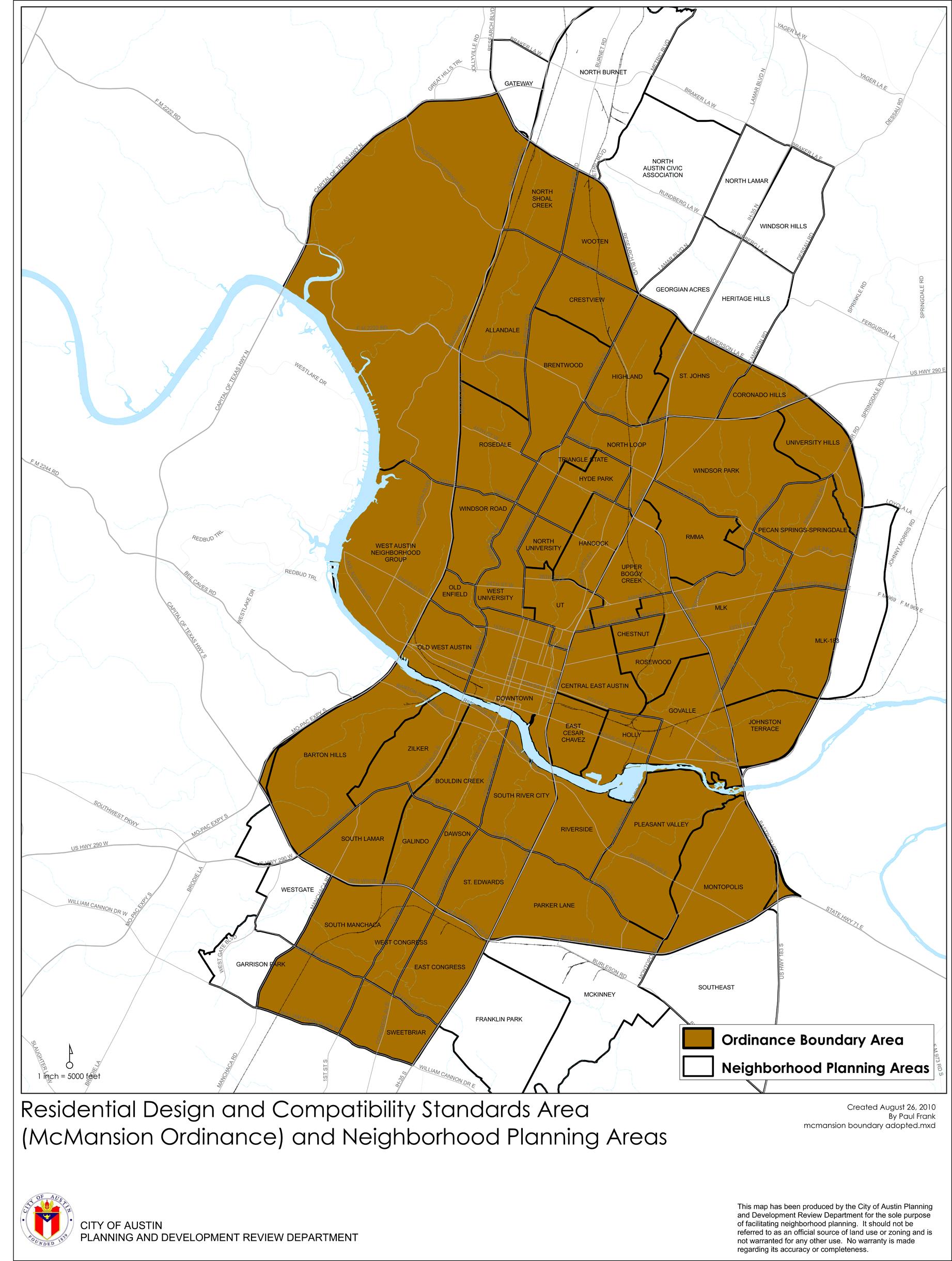
A.
Bed and breakfast (group 1) residential use;
B.
Bed and breakfast (group 2) residential use;
C.
Cottage special use;
D.
Secondary apartment special use;
E.
Single-family attached residential use;
F.
Single-family residential use;
G.
Small lot single-family residential use;
H.
Urban home special use;
I.
Club or lodge;
J.
Daycare services (general and limited);
K.
Condo residential;
L.
Retirement housing (small and large site); or
M.
Townhouse residential.
Source: Ord. 20060216-043; Ord. 20060309-058; Ord. 20060622-022; Ord. 20060928-022; Ord. 20080618-093; Ord. 20100805-051; Ord. No. 20231207-001, § 16, 12-18-23.
§ 1.3. - EXCEPTIONS.
1.3.1.
This Subchapter does not apply to a lot zoned as a single-family residence small lot (SF-4A) district unless the lot is adjacent to property zoned as a single-family residence standard lot (SF-1), single-family residence standard lot (SF-2) district, or family residence (SF-3) district.
This Subchapter does not apply to the approximately 698.7 acres of land known as the Mueller Planned Unit Development, which was zoned as a planned unit development (PUD) district by Ordinance Number 040826-61.
A use listed in Subsections 1.2.2(I)—(M) of Section 1.2 may comply with this subchapter or the requirements of Chapter 25-2, Article 10 (Compatibility Standards).
This Subchapter does not apply to a property zoned Downtown mixed use (DMU) district, Central business district (CBD), East Riverside Corridor (ERC) district, or transit oriented development (TOD) district.
Source: Ord. 20060216-043; Ord. 20060309-058; Ord. 20060622-022; Ord. 20060928-022; Ord. 20080618-093; Ord. No. 20150212-085, Pt. 2, 2-23-15; Ord. No. 20151015-071, Pt. 1, 10-26-15; Ord. No. 20240516-004, Pt. 2, 7-15-24.
§ 1.4. - CONFLICTING PROVISIONS.
1.4.1.
To the extent of conflict, this Subchapter supersedes:
A.
Section 25-1-21 (Definitions);
B.
Section 25-2-492 (Site Development Regulations);
C.
Section 25-2-555 (Family Residence (SF-3) District Regulations);
D.
Section 25-2-773 (Duplex, Two-Unit and Three-Unit Residential Uses);
E.
Section 25-2-778 (Front Yard Setback for Certain Residential Uses);
F.
Section 25-2-779 (Small Lot Single-Family Residential Uses); and
G.
Section 25-4-232 (Small Lot Subdivisions).
To the extent of conflict, the following provisions supersede this Subchapter:
A.
Section 25-2-1424 (Urban Home Regulations);
B.
Section 25-2-1444 (Cottage Regulations);
C.
Section 25-2-1463 (Secondary Apartment Regulations); or
D.
The provisions of an ordinance designating property as a:
1.
Neighborhood plan (NP) combining district;
2.
Neighborhood conservation (NC) combining district; or
3.
Historic area (HD) combining district.
Source: Ord. 20060216-043; Ord. 20060309-058; Ord. 20060622-022; Ord. 20060928-022; Ord. 20080618-093; Ord. No. 20231207-001, Pt. 18, 12-18-23.
§ 2.1. - MAXIMUM DEVELOPMENT PERMITTED.
The maximum amount of development permitted on a property subject to this Subchapter is limited to the greater of 0.4 to 1.0 floor-to-area ratio or 2,300 square feet of gross floor area, as defined in Section 3.3. Floor-to-area ratio shall be measured using gross floor area as defined in Section 3.3, except that the lot area of a flag lot is calculated consistent with the requirements of Section 25-1-22 (Measurements).
Source: Ord. 20060216-043; Ord. 20060309-058; Ord. 20060622-022; Ord. 20060928-022; Ord. 20080618-093.
§ 2.2. - BUILDING HEIGHT.
Except where these regulations are superseded, the maximum building height for development subject to this Subchapter is:
(A)
32 feet for development located outside the 100-year floodplain; and
(B)
35 feet for development located in the 100-year floodplain.
Section 25-2-531 (Height Limit Exceptions) does not apply to development subject to this Subchapter, except for a chimney, vent, antenna, or energy conservation or production equipment or feature not designed for occupancy. Building height shall be measured under the requirements defined in Section 3.4.
Source: Ord. 20060216-043; Ord. 20060309-058; Ord. 20060622-022; Ord. 20060928-022; Ord. No. 20191114-064, Pt. 1, 11-25-19.
§ 2.3. - FRONT YARD SETBACK.
A.
Minimum Setback Required. The minimum front yard setback required for development subject to this Subchapter is the lesser of:
1.
The minimum front yard setback prescribed by the other provisions of this Code; or
2.
The average front yard setback, if an average may be determined as provided in Subsection B. below.
B.
Average Front Yard Setback. The following rules apply for purposes of the setback calculation required by Paragraph A.2:
1.
A front yard setback is the distance between the front lot line and the closest front exterior wall or building façade of the principal residential structure located on the lot.
2.
Except as provided in paragraph 3, average front yard setback is determined using the front yard setback of the four principal residential structures that are: (a) built within fifty feet of the front lot line; and (b) closest to, and on the same side of the block, as the property subject to the setback required by this section.
3.
If less than four structures satisfy the criteria in paragraph B.2, average front yard setback is calculated using the number of existing residential structures on the same side of the street block as the property subject to the setback required by this section. If there are no structures on the same side of the block, average front yard setback is calculated using the front yard setbacks of the four structures on the opposite side of the block that are closest to the property subject to the setback required by this section. If there are less than four structures on the opposite side of the block, the lesser number of structures is used in the calculation. See Figure 1.
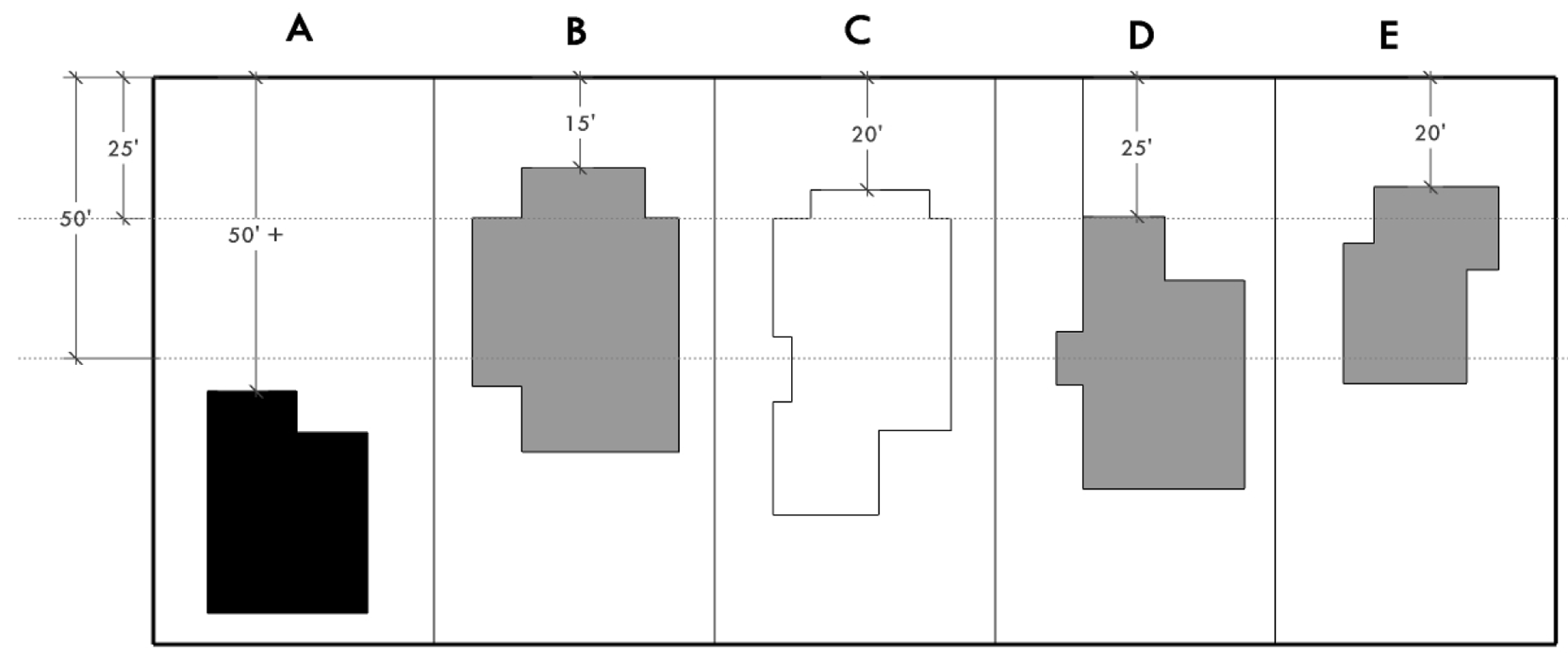
Figure 1: Average Front Yard Setback
In this example, the minimum required front setback in the underlying zoning district is 25 feet. However, because of the variety in existing setbacks of buildings on the same block face, new development on lot C may be located with a setback of only 20 feet, which is the average of the setbacks of lots B, D, and E. The building on lot A is not included in the average because it is located more than 50 feet from the property line.
Source: Ord. 20060216-043; Ord. 20060309-058; Ord. 20060622-022; Ord. 20060928-022; Ord. 20080618-093.
§ 2.4. - REAR YARD SETBACK.
The principal structure shall comply with the rear yard setback prescribed by other provisions of this Code. All other structures shall comply with the rear yard setback provisions of this Code, but the minimum rear yard setback of a second dwelling unit may be reduced to five feet if the rear lot line is adjacent to an alley. See Figure 2.
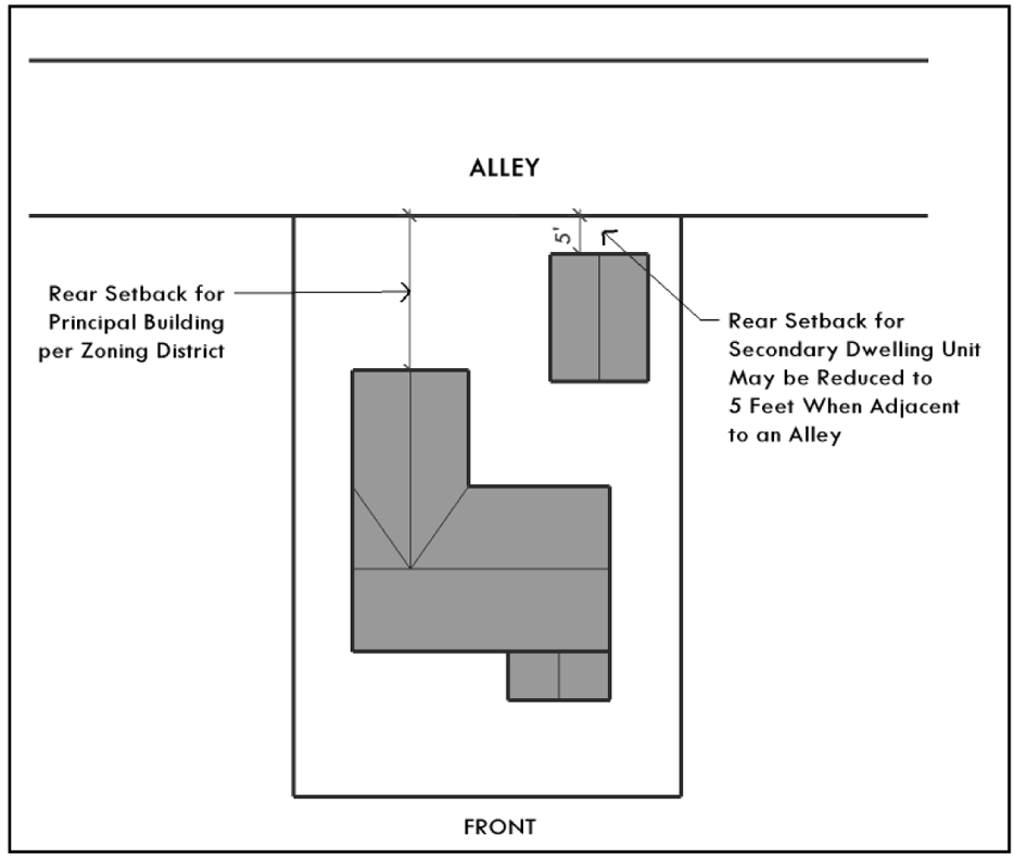
Figure 2: Rear Yard Setback
Source: Ord. 20060216-043; Ord. 20060309-058; Ord. 20060622-022; Ord. 20060928-022; Ord. 20080618-093.
§ 2.5. - SIDE YARD SETBACKS.
All structures shall comply with the side yard setbacks prescribed by other provisions of this Code.
Source: Ord. 20060216-043; Ord. 20060309-058; Ord. 20060622-022; Ord. 20060928-022.
§ 2.6. - SETBACK PLANES.
This subsection prescribes side and rear setback planes in order to minimize the impact of new development and rear development on adjacent properties. A structure may not extend beyond a setback plane except as authorized by subsection D. below. The height of a setback plane shall be measured under the requirements defined in Section 3.4.
A.
Side Setback Plane. Except as provided in subsection B. below, an inwardly sloping 45-degree angle side setback plane begins at a horizontal line 15 feet directly above the side property line. The 15-foot height of the horizontal line is established for 40-foot deep portions of the lot beginning at the building line and extending to the rear of the lot, except that the last portion at the rear of the lot may be less than 40 feet deep. See Figures 3 through 5.
1.
For the first portion, the 15-foot height of the horizontal line is measured at the highest of the elevations of the four intersections of the side lot lines, the building line, and a line 40 feet from and parallel to the building line.
2.
For successive portions other than the last portion, the 15-foot height of the horizontal line is measured at the highest of the elevations of the four intersections of the side lot lines and the appropriate two lines that are 40 feet apart and parallel to the building line.
3.
For the last portion, the 15-foot height of the horizontal line is measured at the highest of the elevations of the four intersections of the side lot lines, the appropriate line parallel to the building line, and the rear lot line.
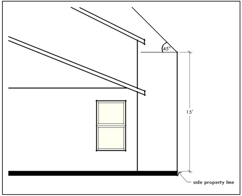
Figure 3: Side Setback Plane Measured From Side Property Line

Figure 4: (Elevation View) Dividing Lot into 40-foot Portions to Create Side Setback
Planes (Rear Setback Plane Not Shown)
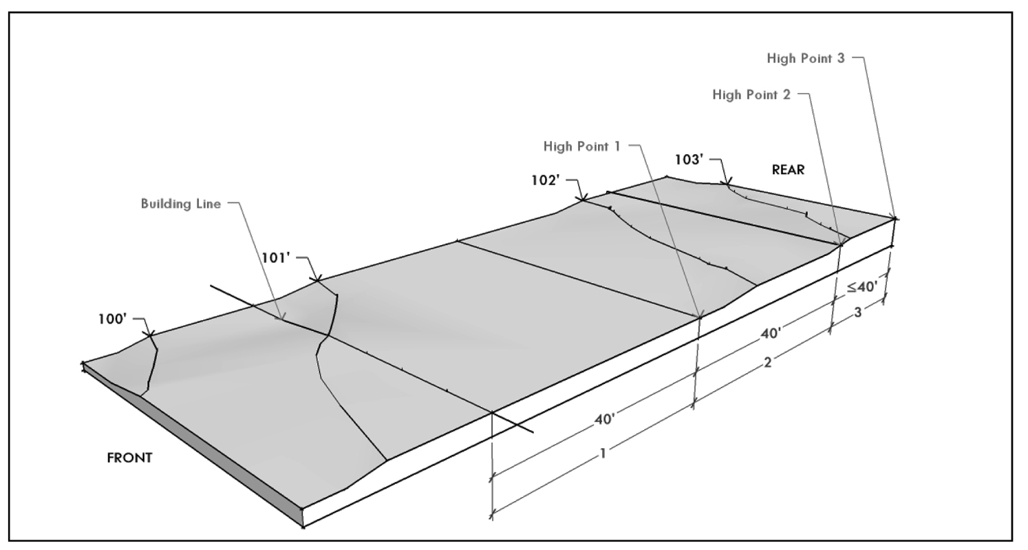
Figure 5: Determining High Points on a Sloping Lot
For each portion of the side setback plane, the 15-foot height of the horizontal line is measured starting from the highest point of the four intersections defining the portion. In this example, topography lines indicate that the lot is sloping downward from the rear to the front of the lot, and from the right to the left. The high points for Portions 1, 2, and 3 are indicated, along with the Building Line.
B.
Rear Setback Plane. Except as provided in subsection D., an inwardly sloping 45-degree angle rear setback plane begins at a horizontal line directly above the rear property line at the same elevation as the horizontal line for the last portion of the side setback plane established in paragraph A.3. See Figures 6 through 9.
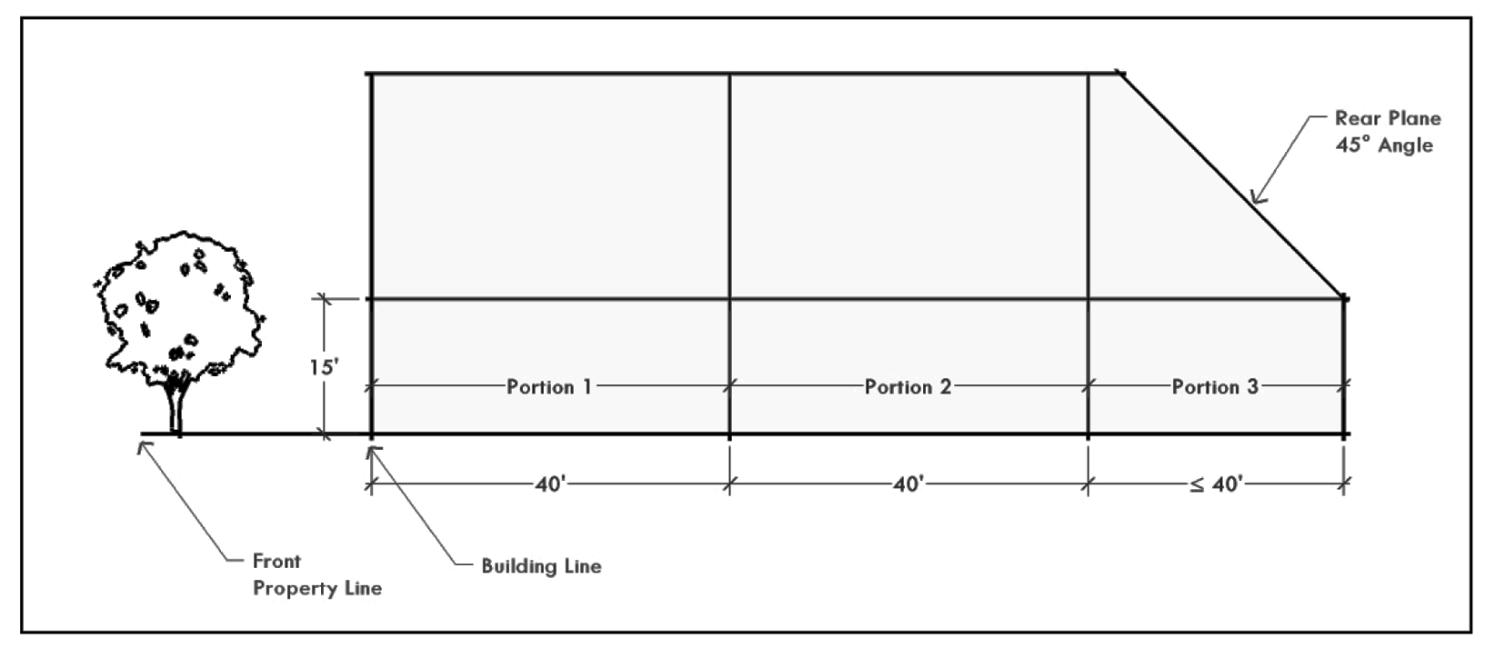
Figure 6: (Elevation View) Rear Setback Plane (Level Ground)
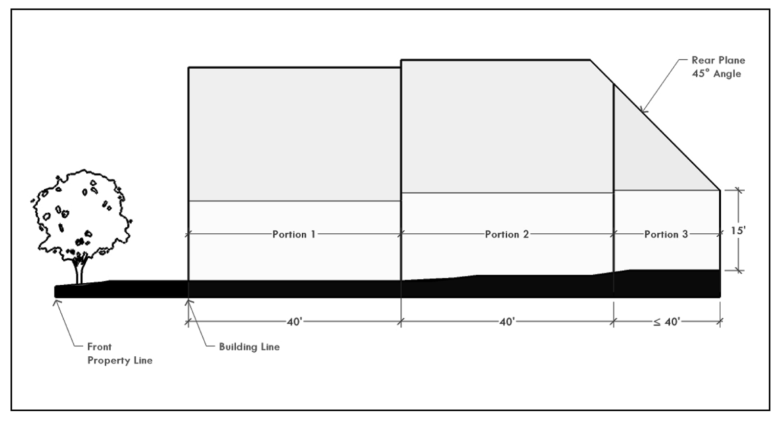
Figure 7: (Elevation View) Rear Setback Plane (Sloping Ground)
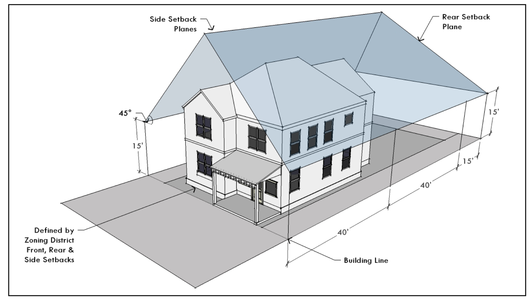
Figure 8: Side and Rear Setback Planes on Level Ground
The side and rear setback planes form a "tent" over the lot, rising from the property lines for 15 feet and then angling in at 45-degree angles from the side and rear. The required front, rear, and side yard setbacks are indicated by the darker shading on the ground.
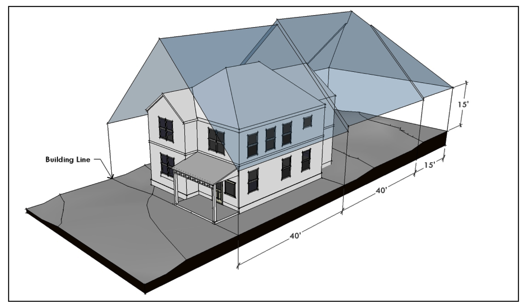
Figure 9: Side and Rear Setback Planes on Sloping Ground
C.
Buildable Area. The buildable area, as defined in Section 3.3., consists of the smallest area within the front, side, and rear yard setbacks; maximum height limit; and the combined side and rear setback planes. See Figures 10 and 11.
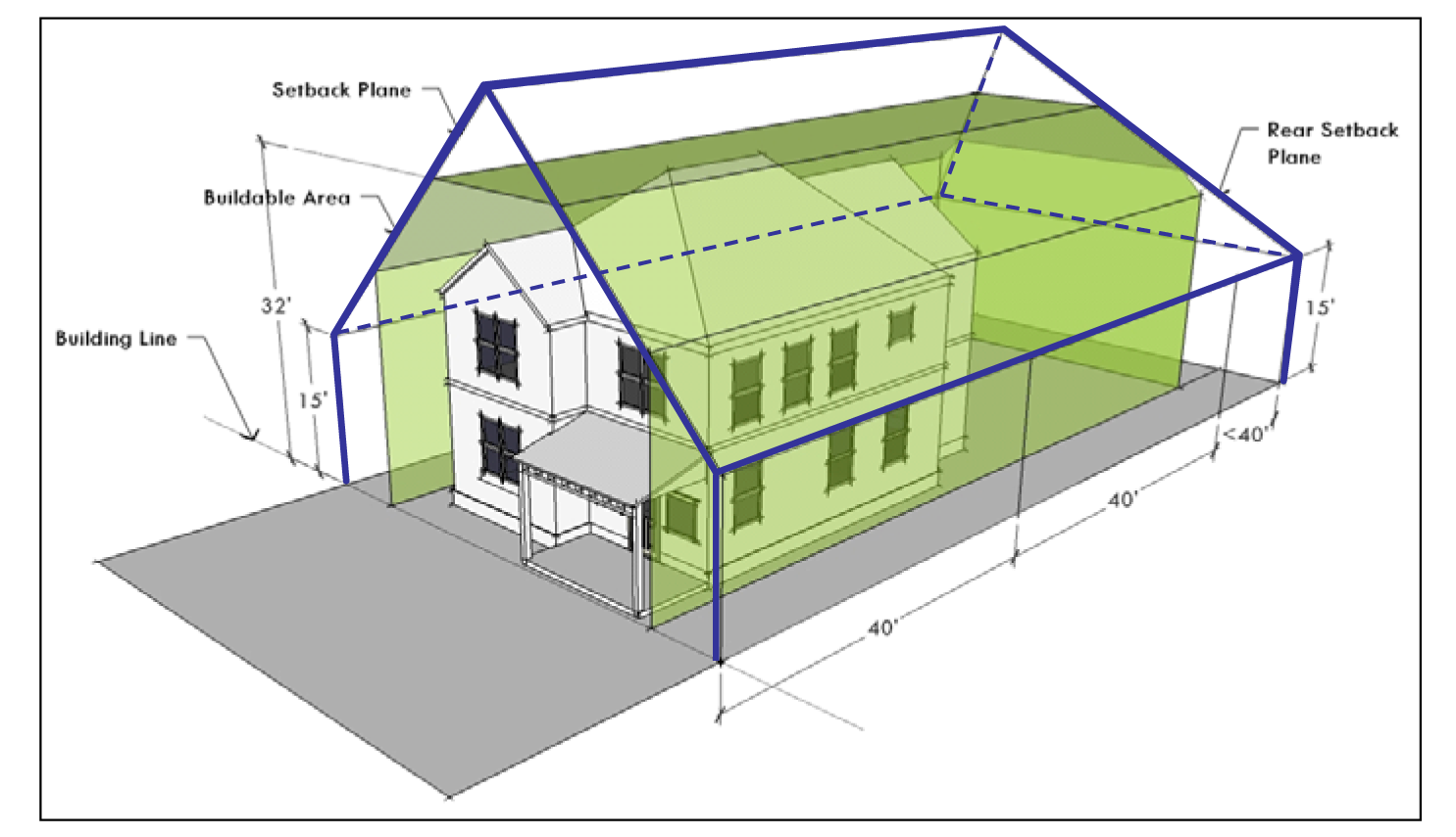
Figure 10: Buildable Area (Combination of Yard Setbacks, Maximum Height Limit, and
Setback Planes)
The heavy blue line indicates the "tent" formed by the side and rear setback planes. The buildable area is the smallest area included within the front, side, and rear yard setbacks; maximum height limit; and the combined side and rear setback planes (shown here as the green area).
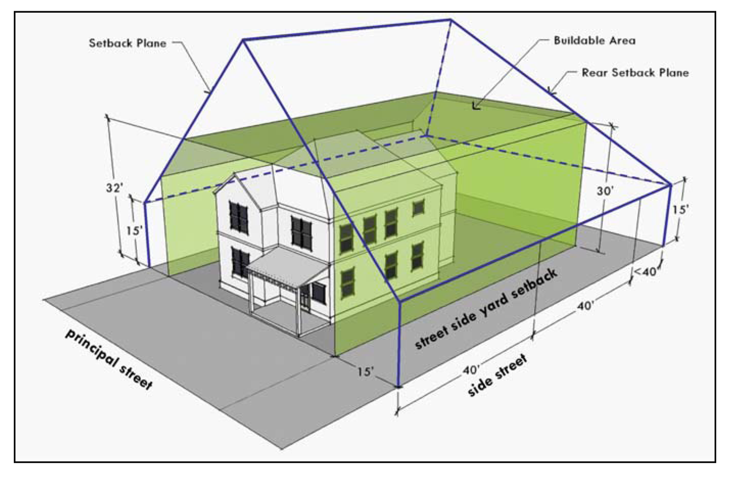
Figure 11: Buildable Area on Corner Lot
This figure shows the same concept illustrated in Figure 10 but for a corner lot that has a greater street side yard setback requirement. In this example, the minimum required street side yard setback in the underlying zoning district is 15 feet. Because the side setback plane is measured from the side property line, the height of the setback plane is 30 feet at the 15-foot street side yard setback line.
D.
Side and Rear Setback Plane Exceptions for Existing One-Story Buildings.
1.
Except as provided in paragraph 3 below, an applicant proposing to add a second story to a one-story building may choose either of the following side setback planes for the portion of the project that is within the building footprint originally constructed, or permitted for original construction, before October 1, 2006:
a.
The side setback plane required under subsection A.
b.
The inwardly sloping 45-degree angle side setback plane that begins at a horizontal line directly above the outermost side wall at a height equal to the height of the first floor wall plate that was originally constructed or received a building permit before October 1, 2006, plus 10 and one-half feet. See Figure 12. The wall plate is the lowest point of the existing first floor ceiling framing that intersects the exterior wall.
2.
Except as provided in paragraph 3 below, an applicant proposing to add a second story to a one-story building may choose either of the following rear setback planes for the portion of the project that is within the building footprint originally constructed, or permitted for original construction, before October 1, 2006:
a.
The rear setback plane required under subsection B.
b.
An inwardly sloping 45-degree angle rear setback plane that begins at a horizontal line directly above the rear property line at a height equal to the height of the first floor wall plate that was originally constructed or received a building permit before October 1, 2006, plus 10 and one-half feet.
3.
The side setback plane required under subsection A, and the rear setback plane required under subsection B, apply to:
a.
any portion of the proposed construction that is outside of the building footprint originally constructed, or permitted for original construction, before October 1, 2006; and
b.
the entire project, if any portion of the proposed construction requires the removal or demolition of exterior walls.

Figure 12: Side Setback Plane Exception for Existing Single-Story Buildings
The side setback planes for an existing single-story building are determined based on the height of the sidewall. In this example, the horizontal line that forms the base of the setback plane is placed ten feet and six inches above the sidewall height (12 feet). The revised plane rises above the standard setback plane within the area of the building footprint. The standard setback planes created in Sections 2.6. A. and B. apply outside of the existing footprint.
E.
Exceptions. A structure may not extend beyond a setback plane, except for:
1.
A roof overhang or eave, up to two feet beyond the setback plane;
2.
A chimney, vent, antenna, or energy conservation or production equipment or feature not designed for occupancy; and
3.
Either:
a.
30-Foot Side-Gabled Roof Exception. A side-gabled roof structure on each side of the building, with a total horizontal length of not more than 30 feet, measured from the building line along the intersection with the side setback plane (See Figure 13.); or
b.
Gables Plus Dormers Exception.
(i)
Gables or a shed roof, with a total horizontal length of not more than 18 feet on each side of the building, measured along the intersection with the setback plane (See Figures 14 and 17.); and
(ii)
Dormers, with a total horizontal length of not more than 15 feet on each side of the building, measured along the intersection with the setback plane. (See Figures 15 and 16.)
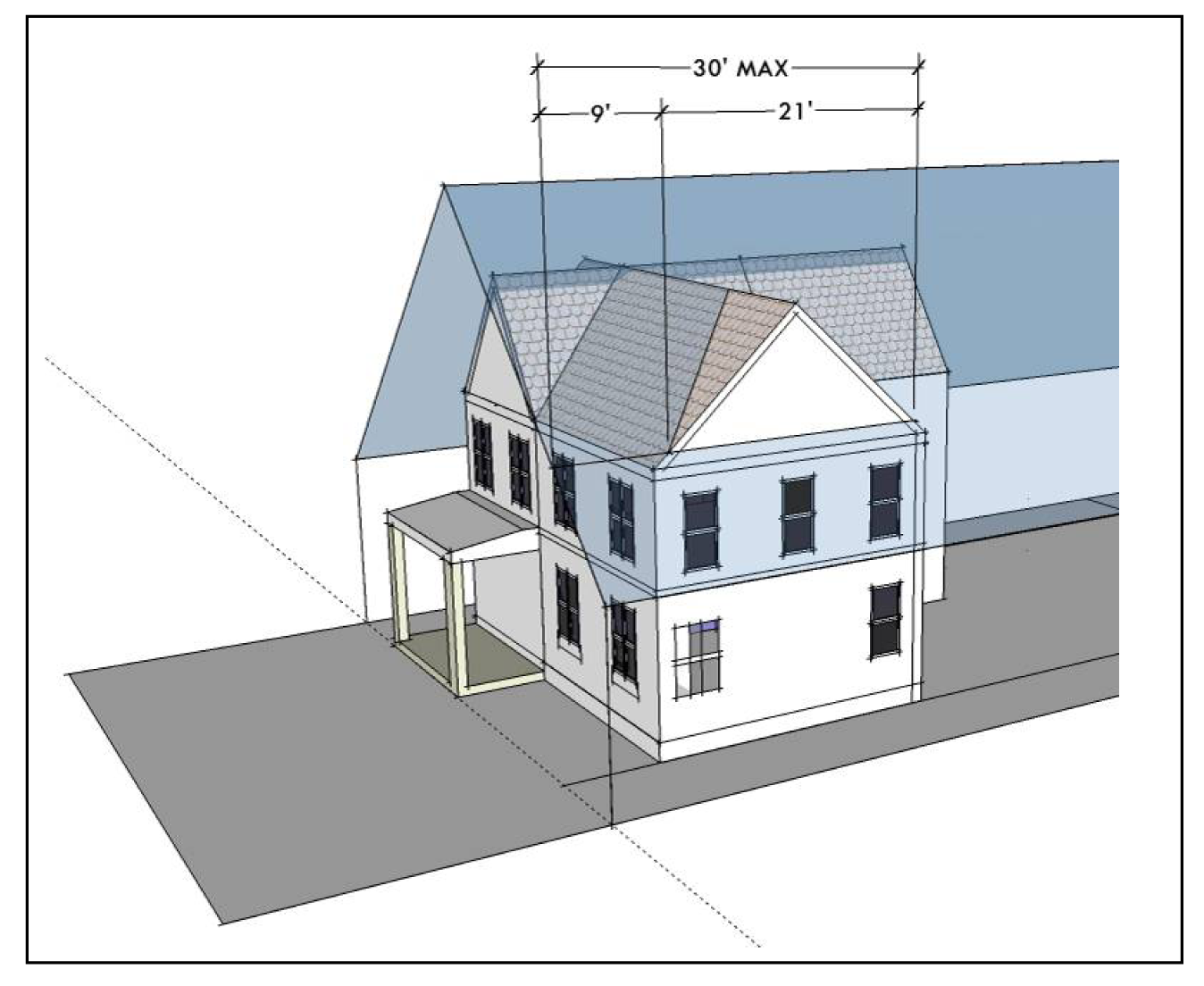
Figure 13: Side-Gabled Rood Exception
A side-gabled roof may project through the side setback plane for a horizontal distance of up to a maximum of 30 feet, measured from the building line. In this example, the gable intrudes into the setback plane beginning 9 feet behind the building line. Therefore, the maximum length of the gable intrusion would be 21 feet.
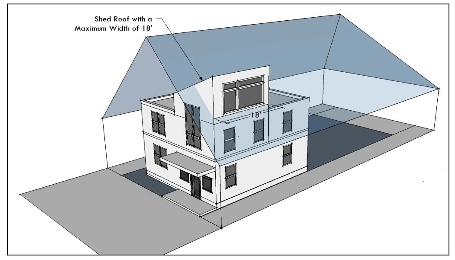
Figure 14: 18-foot Exception for Shed Roof
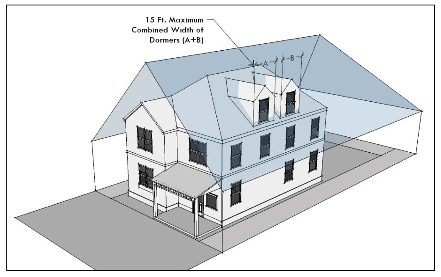
Figure 15: Dormer Exception (Gable or Shed)
One or more dormers with a combined width of 15 feet or less on each side of the roof may extend beyond the setback plane. The width of the dormer is measured at the point that it intersects the setback plane.
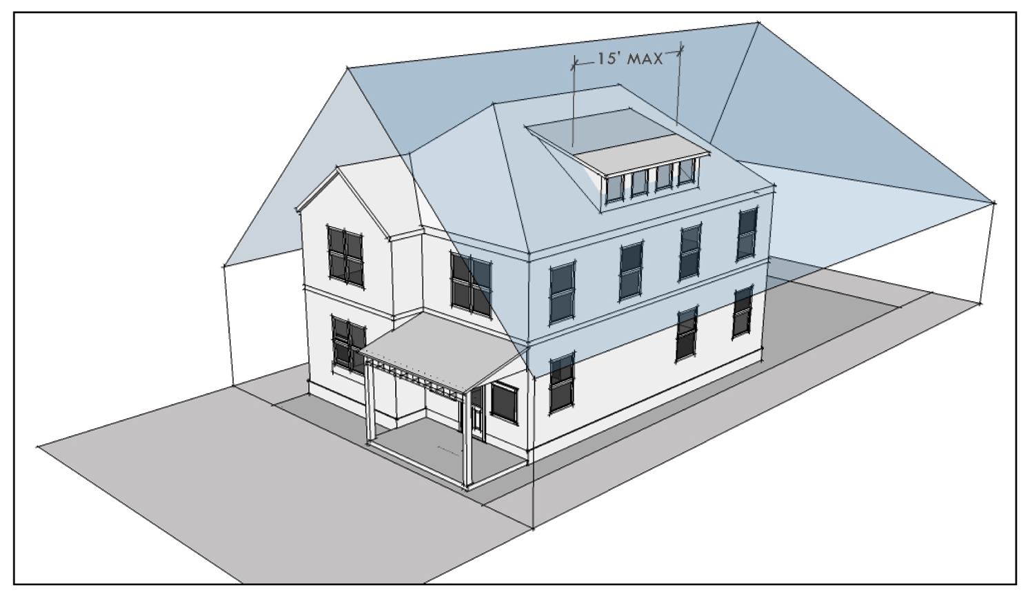
Figure 16: Dormer Exception (Gable or Shed)
One or more dormers with a combined width of 15 feet or less on each side of the roof may extend beyond the setback plane. The width of the dormer is measured at the point that it intersects the setback plane.
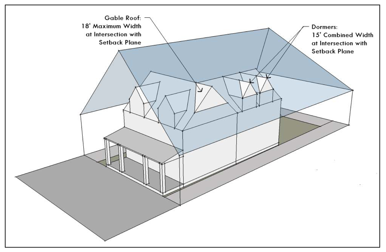
Figure 17: Combination of Roof and Dormer Exceptions
Source: Ord. 20060216-043; Ord. 20060309-058; Ord. 20060622-022; Ord. 20060928-022; Ord. 20080618-093; Ord. No. 20150507-042, Pt. 2, 5-18-15.
§ 2.7. - SIDE WALL ARTICULATION.
2.7.1.
Except as provided in subsection 2.7.2, if a side wall of a building is more than 15 feet high and is an average distance of less than nine feet from an interior lot line, the sidewall may not extend in an unbroken plane for more than 36 feet along a side lot line without a sidewall articulation that meets the requirements of this section.
A.
To beak the plane, a sidewall articulation must:
1.
be perpendicular to the side property line, at least four feet deep, and extend along the side property line for at least 10 feet, as shown in Figures 18 through 20;
2.
extend the entire height of the first floor of an addition to, or remodel of, an existing one-story building;
3.
extend the entire height of the second story of an addition to, or remodel of, a two or more story building;
4.
extend to the height of the top floor of a newly constructed building; and
5.
extend evenly upward for its entire height.
B.
A sidewall articulation cannot:
1.
create patios or decks or be screened from view; or
2.
serve as an eave or gutter.
C.
Sidewall articulation required under this section may be satisfied by horizontal articulation, such that each story above the first story is setback further from the property line by at least nine feet and extends along the side property line for at least 10 feet.
D.
For purposes of subsection 2.7.1, wall height:
1.
excludes side gables; and
2.
is measured from the lower of natural or finished grade adjacent to the structure up to the first floor wall plate, which is the lowest point of the existing first floor ceiling framing that intersects the exterior wall.
The requirements of this section do not apply to:
A.
Any side of a structure that is adjacent to a commercial use, unless the commercial use is occupying a residential structure.
B.
An addition to or remodel of an existing principal structure, or the construction of a new principal structure, provided that the resulting structure is less than 2,000 square feet in net building coverage and less than or equal to 32 feet in height.
C.
An addition to or remodel of an existing second structure, or the construction of a new second structure, provided that the principal structure is exempt under subsection 2.7.2.B and the resulting second structure:
1.
does not exceed 550 square feet;
2.
does not exceed the maximum height allowed in the base zoning district; and
3.
is either detached from the principal structure or connected by a covered breezeway that is open on all sides, with a walkway of no more than six (6) feet in width that is covered by a roof of no more than eight (8) feet in width.
D.
The addition of a second story to an existing one-story structure if the addition is directly above a portion of the existing one-story structure that was originally constructed, or received a permit for construction, before October 1, 2006.
E.
An extension of the second floor of an existing two-story structure, provided that the building footprint of the structure is not increased.

Figure 18: Side Wall Articulation (Existing Side Wall Exceeds 36 Feet)
Articulation is required for side walls on additions or new construction that are 15 feet or taller and located within 9 feet of the side lot line. No wall may extend for more than 36 feet without a projection or recession of at least 4 feet in depth and 10 feet in length.

Figure 19: Side Wall Articulation (Existing Side Wall Less Than or Equal to 36 feet)
An addition to an existing building may extend a side wall up to a maximum of 36′ in total length without articulation.

Figure 20: Side Wall Articulation (New Construction)
All new construction must meet the sidewall articulation standards.
Source: Ord. 20060216-043; Ord. 20060309-058; Ord. 20060622-022; Ord. 20060928-022; Ord. 20080618-093.
§ 2.8. - RESERVED.
Editor's note— Ord. No. 20150507-042, Pt. 3, effective May 18, 2015, repealed § 2.8, which pertained to modifications by the residential design and compatibility commission. See Code Comparative Table for complete derivation.
§ 2.9. - MODIFICATIONS WITHIN NEIGHBORHOOD PLAN (NP) COMBINING DISTRICTS.
Under Section 25-2-1406 of the Code, an ordinance zoning or rezoning property as a neighborhood plan (NP) combining district may modify certain development standards of this Subchapter.
Source: Ord. 20060216-043; Ord. 20060309-058; Ord. 20060622-022; Ord. 20060928-022.
§ 3.1. - BUILDABLE AREA.
In this Subchapter, BUILDABLE AREA means the area in which development subject to this Subchapter may occur, and which is defined by the side and rear setback planes required by this Subchapter, together with the area defined by the front, side, and rear yard setbacks and the maximum height limit.
Source: Ord. 20060216-043; Ord. 20060309-058; Ord. 20060622-022; Ord. 20060928-022.
§ 3.2. - BUILDING LINE.
In this Subchapter, BUILDING LINE means a line that is parallel to the front lot line and that intersects the principal residential structure at the point where the structure is closest to the front lot line, including any allowed projections into the front yard setback. See Figure 21.
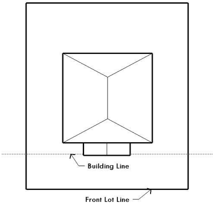
Figure 21: Building Line
Source: Ord. 20060216-043; Ord. 20060309-058; Ord. 20060622-022; Ord. 20060928-022.
§ 3.3. - GROSS FLOOR AREA.
In this Subchapter, GROSS FLOOR AREA has the meaning assigned by Section 25-1-21 (Definitions), with the following modifications:
3.3.1.
In this Subchapter, GROSS FLOOR AREA means all enclosed space, regardless of its dimensions, that is not exempted under subsections 3.3.2, 3.3.3, or 3.3.4.
Subject to the limitations in paragraph C below, the following parking areas and structures are excluded from gross floor area for purposes of this Subchapter:
A.
Up to 450 square feet of:
1.
A detached rear parking area that is separated from the principal structure by not less than 10 feet;
2.
A rear parking area that is 10 feet or more from the principal structure, provided that the parking area is either:
a.
detached from the principal structure; or
b.
attached by a covered breezeway that is completely open on all sides, with a walkway not exceeding 6 feet in width and a roof not exceeding 8 feet in width; or
3.
A parking area that is open on two or more sides, if:
i.
it does not have habitable space above it; and
ii.
the open sides are clear and unobstructed for at least 80% of the area measured below the top of the wall plate to the finished floor of the carport.
B.
Up to 200 square feet of:
1.
An attached parking area if it is used to meet the minimum accessible spaces requirement; or
2.
A garage that is less than 10 feet from the rear of the principal structure, provided that the garage is either:
a.
detached from the principal structure; or
b.
attached by a covered breezeway that is completely open on all sides, with a walkway not exceeding 6 feet in width and a roof not exceeding 8 feet in width.
C.
An applicant may receive only one 450-square foot exemption per site under paragraph A. An applicant who receives a 450-square foot exemption may receive an additional 200-foot exemption for the same site under paragraph B, but only for an attached parking area used to meet the minimum accessible spaces requirement.
Porches, basements, and attics that meet the following requirements shall be excluded from the calculation of gross floor area:
A.
A ground floor porch, including a screened porch, provided that:
1.
the porch is not accessible by automobile and is not connected to a driveway; and
2.
the exemption may not exceed 200 square feet if a porch has habitable space or a balcony above it.
B.
A habitable portion of a building that is below grade if:
1.
The habitable portion does not extend beyond the first-story footprint and is:
a.
Below natural or finished grade, whichever is lower; and
b.
Surrounded by natural grade for at least 50% of its perimeter wall area, if the habitable portion is required to be below natural grade under Paragraph 1.a.
2.
The finished floor of the first story is not more than three feet above the average elevation at the intersections of the minimum front yard setback line and the side property lines.
C.
A habitable portion of an attic, if:
1.
The roof above it is not a flat or mansard roof and has a slope of 3 to 12 or greater;
2.
It is fully contained within the roof structure;
3.
It has only one floor;
4.
It does not extend beyond the footprint of the floors below;
5.
It is the highest habitable portion of the building, or a section of the building, and adds no additional mass to the structure; and
6.
Fifty percent or more of the area has a ceiling height of seven feet or less.
An enclosed area shall be excluded from the calculation of gross floor area if it is five feet or less in height. For purposes of this subsection:
A.
Area is measured on the outside surface of the exterior walls; and
B.
Height is measured from the finished floor elevation, up to either:
1.
the underside of the roof rafters; or
2.
the bottom of the top chord of the roof truss, but not to collar ties, ceiling joists, or any type of furred-down ceiling.
An area with a ceiling height greater than 15 feet is counted twice.
Source: Ord. 20060216-043; Ord. 20060309-058; Ord. 20060622-022; Ord. 20060928-022; Ord. 20080618-093; Ord. 20130425-105; Ord. No. 20231102-028, Pt. 33, 11-13-23.
§ 3.4. - HEIGHT.
For purposes of this Subchapter, the HEIGHT of a building or setback plane shall be measured as follows:
3.4.1.
Height shall be measured vertically from the average of the highest and lowest grades adjacent to the building to:
A.
For a flat roof, the highest point of the coping;
B.
For a mansard roof, the deck line;
C.
For a pitched or hip roof, the gabled roof or dormer with the highest average height; or
D.
For other roof styles, the highest point of the building.
The grade used in the measurement of height for a building or setback plane shall be the lower of natural grade or finished grade, except height shall be measured from natural grade if the site is located in the 100-year floodplain.
The height of a structure other than a building is measured vertically from the ground level immediately under the structure to the top of the structure. The height of a fence on top of a retaining wall is measured from the bottom of the retaining wall.
A maximum height is limited by both number of feet and number of stories if both measurements are prescribed, regardless of whether the measurements are conjoined with "or" or "and."
The habitable portion of a basement that is below natural grade and the habitable portion of an attic do not count toward the number of stories for purposes of Section 25-2-773(B)(5) (Duplex, Two-Unit and Three-Unit Residential Uses) if the area satisfies the requirements for an exemption from gross floor area under subsections 3.3.2.B., C. of this Subchapter.
Source: Ord. 20060216-043; Ord. 20060309-058; Ord. 20060622-022; Ord. 20060928-022; Ord. 20080618-093; Ord. No. 20191114-064, Pt. 2, 11-25-19; Ord. No. 20231207-001, Pt. 18, 12-18-23.
§ 3.5. - NATURAL GRADE.
3.5.1.
In this Subchapter, NATURAL GRADE is:
A.
The grade of a site before it is modified by moving earth, adding or removing fill, or installing a berm, retaining wall, or architectural or landscape feature; or
B.
For a site with a grade that was legally modified before October 1, 2006, the grade that existed on October 1, 2006.
Natural grade is determined by reference to an on-ground survey, City-approved topographic map, or other information approved by the director. The director may require an applicant to provide a third-party report that shows the natural grade of a site.
Source: Ord. 20060216-043; Ord. 20060309-058; Ord. 20060622-022; Ord. 20060928-022.
§ 25-2-31 - PURPOSE OF DISTRICTS.
The zoning districts described in this chapter establish site development regulations and performance standards that are intended to promote compatible land use patterns.
Source: Section 13-2-20; Ord. 990225-70; Ord. 031211-11.
§ 25-2-32 - ZONING DISTRICTS AND MAP CODES.
(A)
This section provides the City's zoning districts and the corresponding zoning map codes. A zoning district may be referred to by its map code.
(B)
Residential base districts and map codes are as follows:
(1)
Lake Austin residence .....LA
(2)
rural residence .....RR
(3)
single-family residence large lot .....SF-1
(4)
single-family residence standard lot .....SF-2
(5)
family residence .....SF-3
(6)
single-family residence small lot .....SF-4A
(7)
single-family residence condominium site .....SF-4B
(8)
urban family residence .....SF-5
(9)
townhouse and condominium residence .....SF-6
(10)
multifamily residence limited density .....MF-1
(11)
multifamily residence low density .....MF-2
(12)
multifamily residence medium density .....MF-3
(13)
multifamily residence moderate-high density .....MF-4
(14)
multifamily residence high density .....MF-5
(15)
multifamily residence highest density .....MF-6
(16)
mobile home residence .....MH
(C)
Commercial base districts and map codes are as follows:
(1)
neighborhood office .....NO
(2)
limited office .....LO
(3)
general office .....GO
(4)
commercial recreation .....CR
(5)
neighborhood commercial .....LR
(6)
community commercial .....GR
(7)
lake commercial .....L
(8)
central business .....CBD
(9)
downtown mixed use .....DMU
(10)
warehouse limited office .....W/LO
(11)
general commercial services .....CS
(12)
commercial-liquor sales .....CS-1
(13)
commercial highway services .....CH
(D)
Industrial base districts and map codes are as follows:
(1)
industrial park .....IP
(2)
major industry .....MI
(3)
limited industrial services .....LI
(4)
research and development .....R&D
(E)
Special purpose base districts and map codes are as follows:
(1)
development reserve .....DR
(2)
aviation services .....AV
(3)
agricultural .....AG
(4)
planned unit development .....PUD
(5)
public .....P
(6)
traditional neighborhood .....TN
(7)
transit oriented development .....TOD
(8)
North Burnet/Gateway .....NBG
(9)
East Riverside Corridor .....ERC
(F)
Combining districts and map codes are as follows:
(1)
historic landmark .....H
(2)
historic area .....HD
(3)
conditional overlay .....CO
(4)
neighborhood conservation .....NC
(5)
planned development area .....PDA
(6)
waterfront overlay .....WO
(7)
mixed use .....MU
(8)
vertical mixed use .....VMU
(9)
vertical mixed use building .....V
(10)
Capitol view corridor .....CVC
(11)
Capitol dominance .....CD
(12)
Congress Avenue CA .....
(13)
East Sixth/Pecan Street .....PS
(14)
downtown parks .....DP
(15)
downtown creeks .....DC
(16)
convention center .....CC
(17)
central urban redevelopment .....CURE
(18)
East Austin .....EA
(19)
neighborhood plan .....NP
(20)
university neighborhood overlay .....UNO
(21)
density bonus 90 .....DB90
(22)
equitable transit-oriented development .....ETOD
(23)
density bonus ETOD .....DBETOD
(24)
density bonus creative spaces .....DBCS
Source: Section 13-2-21; Ord. 990225-70; Ord. 000309-39; Ord. 000406-81; Ord. 031211-11; Ord. 040902-58; Ord. 041202-16; Ord. 20050519-008; Ord. 20060831-068; Ord. 20071101-052; Ord. 20071129-098; Ord. 20090312-035; Ord. 20130509-039; Ord. No. 20221201-056, Pt. 1, 12-12-22; Ord. No. 20240229-070, Pt. 1, 3-11-24Ord. No. 20240229-073, Pt. 1, 3-11-24; Ord. No. 20240516-005, Pt. 1, 7-15-24; Ord. No. 20241010-034, Pt. 1, 10-21-24.
§ 25-2-33 - HIERARCHY OF BASE DISTRICTS.
(A)
The residential, commercial, and industrial base districts in Subsections (B), (C), and (D) of Section 25-2-32 (Zoning Districts And Map Codes) are arranged in a hierarchy that begins with the LA base district as the most restrictive district and ends with the LI base district as the least restrictive district.
(B)
A combining district is classified in the hierarchy of zoning districts according to the base district with which the combining district is combined.
(C)
Special purpose base districts are not included in the hierarchy described in this section.
Source: Section 13-2-25; Ord. 990225-70; Ord. 031211-11.
§ 25-2-51 - PURPOSES OF RESIDENTIAL DISTRICTS.
The purposes of the residential district designations are to:
(1)
reserve areas for residential occupancy and provide for a broad range of residential densities and variety of housing types consistent with the Comprehensive Plan and standards of public health, safety, and welfare;
(2)
ensure adequate light, air, privacy, and open space for each dwelling;
(3)
encourage compatibility between residential uses and other land uses;
(4)
facilitate the planning for and provision of infrastructure improvements to serve anticipated population, dwelling unit density, traffic generation, and public service requirements; and
(5)
promote energy conservation.
Source: Section 13-2-40; Ord. 990225-70; Ord. 031211-11.
§ 25-2-52 - RESIDENTIAL DISTRICT DESIGNATIONS GENERALLY.
There are 16 residential district designations. The designation established for a proposed use is based on:
(1)
density;
(2)
lot size;
(3)
terrain;
(4)
environmental conditions;
(5)
location;
(6)
surrounding uses;
(7)
public infrastructure; and
(8)
other factors determined to be relevant by the council.
Source: Sections 13-2-40 through 13-2-56; Ord. 990225-70; Ord. 031211-11.
§ 25-2-53 - LAKE AUSTIN RESIDENCE (LA) DISTRICT DESIGNATION.
Lake Austin residence (LA) district is the designation for a low density single-family residential use on a lot that is a minimum of one acre and that is located 1,000 feet or less, measured horizontally, from the 492.8 foot topographic contour line on either side of Lake Austin.
Source: Section 13-2-41; Ord. 990225-70; Ord. 031211-11.
§ 25-2-54 - RURAL RESIDENCE (RR) DISTRICT DESIGNATION.
Rural residence (RR) district is the designation for a low density residential use on a lot that is a minimum of one acre. An RR district designation may be applied to a use in an area for which rural characteristics are desired or an area whose terrain or public service capacity require low density.
Source: Section 13-2-42; Ord. 990225-70; Ord. 031211-11.
§ 25-2-55 - SINGLE FAMILY RESIDENCE LARGE LOT (SF-1) DISTRICT DESIGNATION.
Single-family residence large lot (SF-1) district is the designation for a low density single-family residential use on a lot that is a minimum of 10,000 square feet. An SF-1 district designation may be applied to a use on land with sloping terrain or environmental limitations that preclude standard lot size or to a use in an existing residential development on a lot that is 10,000 square feet or more.
Source: Section 13-2-43; Ord. 990225-70; Ord. 031211-11.
§ 25-2-56 - SINGLE FAMILY RESIDENCE STANDARD LOT (SF-2) DISTRICT DESIGNATION.
Single-family residence standard lot (SF-2) district is the designation for a moderate density single-family residential use on a lot that is a minimum of 5,750 square feet. An SF-2 district designation may be applied to a use in an existing single-family neighborhood that has moderate sized lots or to new development of single-family housing on lots that are 5,750 square feet or more.
Source: Section 13-2-44; Ord. 990225-70; Ord. 031211-11.
§ 25-2-57 - FAMILY RESIDENCE (SF-3) DISTRICT DESIGNATION.
Family residence (SF-3) district is the designation for a moderate density single-family residential use and a duplex use on a lot that is a minimum of 5,750 square feet. An SF-3 district designation may be applied to a use in an existing single-family neighborhood with moderate sized lots or to new development of family housing on lots that are 5,750 square feet or more. A duplex use that is designated as an SF-3 district is subject to development standards that maintain single-family neighborhood characteristics.
Source: Section 13-2-45; Ord. 990225-70; Ord. 031211-11.
§ 25-2-58 - SINGLE FAMILY RESIDENCE SMALL LOT (SF-4A) DISTRICT DESIGNATION.
Single-family residence small lot (SF-4A) district is the designation for a moderate density single-family residential use on a lot that is a minimum of 3,600 square feet. An SF-4A district use is subject to development standards that maintain single family neighborhood characteristics.
Source: Section 13-2-46; Ord. 990225-70; Ord. 031211-11.
§ 25-2-59 - SINGLE FAMILY RESIDENCE CONDOMINIUM SITE (SF-4B) DISTRICT DESIGNATION.
Single-family residence condominium site (SF-4B) district is the designation for a moderate density single-family residential use on a site surrounded by existing structures, most of which are single-family residences. An SF-4B district use is subject to development standards that maintain single family neighborhood characteristics. An SF-4B district designation may only be applied to a use at a proposed location if the existing use at the location is designated as an urban family (SF-5) or less restrictive district.
Source: Section 13-2-47; Ord. 990225-70; Ord. 031211-11.
§ 25-2-60 - URBAN FAMILY RESIDENCE (SF-5) DISTRICT DESIGNATION.
Urban family residence (SF-5) district is the designation for a moderate density single-family residential use on a lot that is a minimum of 5,750 square feet. A duplex, two-family, townhouse, or condominium residential use is permitted in an SF-5 district under development standards that maintain single family neighborhood characteristics. An SF-5 district designation may be applied to a use in an existing family residential neighborhood in a centrally located area of the City. An SF-5 district may be used as a transition between a single family and multifamily residential use or to facilitate the implementation of City affordable housing programs.
Source: Section 13-2-48; Ord. 990225-70; Ord. 031211-11.
§ 25-2-61 - TOWNHOUSE AND CONDOMINIUM RESIDENCE (SF-6) DISTRICT DESIGNATION.
Townhouse and condominium residence (SF-6) district is the designation for a moderate density single family, duplex, two-family, townhouse, and condominium use that is not subject to the spacing and location requirements for townhouse and condominium use in an SF-5 district. An SF-6 district designation may be applied to a use in an area with large lots that have access to streets other than minor residential streets. An SF-6 district may be used as a transition between a single family and multifamily residential use.
Source: Section 13-2-49; Ord. 990225-70; Ord. 031211-11.
§ 25-2-62 - MULTIFAMILY RESIDENCE LIMITED DENSITY (MF-1) DISTRICT DESIGNATION.
Multifamily residence limited density (MF-1) district is the designation for a multifamily use with a maximum density of up to 17 units per acre, depending on unit size. An MF-1 district designation may be applied to a use in a residential neighborhood that contains a mixture of single family and multifamily uses or in an area for which limited density multifamily use is desired. An MF-1 district may be used as a transition between a single family and higher intensity uses.
Source: Section 13-2-50; Ord. 990225-70; Ord. 031211-11.
§ 25-2-63 - MULTIFAMILY RESIDENCE LOW DENSITY (MF-2) DISTRICT DESIGNATION.
Multifamily residence low density (MF-2) district is the designation for a multifamily use with a maximum density of up to 23 units per acre, depending on unit size. An MF-2 district designation may be applied to a use in a multifamily residential area located near single family neighborhoods or in an area for which low density multifamily use is desired.
Source: Section 13-2-51; Ord. 990225-70; Ord. 031211-11.
§ 25-2-64 - MULTIFAMILY RESIDENCE MEDIUM DENSITY (MF-3) DISTRICT DESIGNATION.
Multifamily residence medium density (MF-3) district is the designation for multifamily use with a maximum density of up to 36 units per acre, depending on unit size. An MF-3 district designation may be applied to a use in a multifamily residential area located near supporting transportation and commercial facilities in a centrally located area or in an area for which medium density multifamily use is desired.
Source: Section 13-2-52; Ord. 990225-70; Ord. 031211-11.
§ 25-2-65 - MULTIFAMILY RESIDENCE MODERATE - HIGH DENSITY (MF-4) DISTRICT DESIGNATION.
Multifamily residence moderate - high density (MF-4) district is the designation for multifamily and group residential use with a maximum density of 36 to 54 units per acre, depending on unit size. An MF-4 district designation may be applied to high density housing in a centrally located area near supporting transportation and commercial facilities, in an area adjacent to the central business district or a major institutional or employment center, or in an area for which moderate to high density multifamily use is desired.
Source: Section 13-2-53; Ord. 990225-70; Ord. 031211-11.
§ 25-2-66 - MULTIFAMILY RESIDENCE HIGH DENSITY (MF-5) DISTRICT DESIGNATION.
Multifamily residence high density (MF-5) district is the designation for multifamily and group residential use with a maximum density of up to 54 units per acre, depending on unit size. An MF-5 district designation may be applied to a use in a centrally located area near supporting transportation and commercial facilities, an area adjacent to the central business district or a major institutional or employment center, or an area for which high density multifamily use is desired.
Source: Section 13-2-54; Ord. 990225-70; Ord. 031211-11.
§ 25-2-67 - MULTIFAMILY RESIDENCE HIGHEST DENSITY (MF-6) DISTRICT DESIGNATION.
Multifamily residence highest density (MF-6) district is the designation for multifamily and group residential use. An MF-6 district designation may be applied to a use in a centrally located area near supporting transportation and commercial facilities, an area adjacent to the central business district or a major institutional or employment center, or an area for which the high density multifamily use is desired.
Source: Section 13-2-55; Ord. 990225-70; Ord. 031211-11.
§ 25-2-68 - MOBILE HOME RESIDENCE (MH) DISTRICT DESIGNATION.
Mobile home residence (MH) district is the designation for a mobile home residence park and mobile home subdivision use. An MH use is subject to standards that promote a residential environment and compatibility with adjoining family residence neighborhoods.
Source: Section 13-2-56; Ord. 990225-70; Ord. 031211-11.
§ 25-2-91 - PURPOSES OF COMMERCIAL DISTRICTS DESIGNATIONS.
The purposes of the commercial district designations are to:
(1)
reserve areas for offices, retail stores, and service establishments that provide a broad range of goods and services to residents of Austin and the surrounding area;
(2)
promote the grouping of office and commercial uses that are convenient for the public and that benefit the uses in a district;
(3)
ensure adequate access and off-street loading for office and commercial uses and minimize traffic congestion and other adverse effects on nearby land uses;
(4)
encourage high standards of site planning, architecture, and landscape design for office and commercial development in the City;
(5)
facilitate the planning for and provision of infrastructure improvements to meet traffic, commercial, and public service needs generated by the residents of Austin; and
(6)
promote energy conservation.
Source: Section 13-2-60; Ord. 990225-70; Ord. 031211-11; Ord. No. 20231102-028, Pt. 2, 11-13-23.
§ 25-2-92 - COMMERCIAL DISTRICT DESIGNATIONS GENERALLY.
There are 13 commercial district designations. The designation established for a proposed commercial use is based on:
(1)
type of use;
(2)
customer base;
(3)
location;
(4)
surrounding uses;
(5)
traffic generation; and
(6)
other factors determined to be relevant by the council.
Source: Sections 13-2-60 through 13-2-73; Ord. 990225-70; Ord. 031211-11.
§ 25-2-93 - NEIGHBORHOOD OFFICE (NO) DISTRICT DESIGNATION.
Neighborhood office (NO) district is the designation for a small office use that serves neighborhood or community needs, is located in or adjacent to a residential neighborhood and on a collector street that has a width of 40 feet or more, and does not unreasonably affect traffic. An office in an NO district may contain not more than one use. Site development regulations applicable to an NO district use are designed to preserve compatibility with existing neighborhoods through renovation and modernization of existing structures.
Source: Section 13-2-61; Ord. 990225-70; Ord. 031211-11.
§ 25-2-94 - LIMITED OFFICE (LO) DISTRICT DESIGNATION.
Limited office (LO) district is the designation for an office use that serves neighborhood or community needs and that is located in or adjacent to residential neighborhoods. An office in an LO district may contain one or more different uses. Site development regulations and performance standards applicable to an LO district use are designed to ensure that the use is compatible and complementary in scale and appearance with the residential environment.
Source: Section 13-2-62; Ord. 990225-70; Ord. 031211-11.
§ 25-2-95 - GENERAL OFFICE (GO) DISTRICT DESIGNATION.
General office (GO) district is the designation for an office or commercial use that serves community and city-wide needs. A building in a GO district may contain one or more different uses.
Source: Section 13-2-63; Ord. 990225-70; Ord. 031211-11.
§ 25-2-96 - COMMERCIAL RECREATION (CR) DISTRICT DESIGNATION.
Commercial recreation (CR) district is the designation for a commercial or recreation use that serves visitors to major recreational areas, including Lake Travis and Lake Austin. Site development regulations applicable to a CR district use are designed to minimize visual and environmental disruptions of scenic views.
Source: Section 13-2-64; Ord. 990225-70; Ord. 031211-11.
§ 25-2-97 - NEIGHBORHOOD COMMERCIAL (LR) DISTRICT DESIGNATION.
Neighborhood commercial (LR) district is the designation for a commercial use that provides business service and office facilities for the residents of a neighborhood. Site development regulations and performance standards applicable to a LR district use are designed to ensure that the use is compatible and complementary in scale and appearance with the residential environment.
Source: Section 13-2-65; Ord. 990225-70; Ord. 031211-11.
§ 25-2-98 - COMMUNITY COMMERCIAL (GR) DISTRICT DESIGNATION.
Community commercial (GR) district is the designation for an office or other commercial use that serves neighborhood and community needs and that generally is accessible from major traffic ways.
Source: Section 13-2-66; Ord. 990225-70; Ord. 031211-11.
§ 25-2-99 - LAKE COMMERCIAL (L) DISTRICT DESIGNATION.
Lake commercial (L) district is the designation for a use located near Town Lake. An L district designation may be applied to a development that includes any combination of office retail, commercial, and residential uses. Use and site development regulations applicable to an L district use are designed to ensure that the use is compatible and complementary with the Town Lake environment.
Source: Section 13-2-67; Ord. 990225-70; Ord. 031211-11.
§ 25-2-100 - CENTRAL BUSINESS DISTRICT (CBD) DESIGNATION.
(A)
Central business district (CBD) is the designation for an office, commercial, residential, or civic use located in the downtown area.
(B)
Site development regulations applicable to a CBD district use are designed to:
(1)
ensure that a CBD use is compatible with the commercial, cultural, historical, and governmental significance of downtown and preserves selected views of the Capitol;
(2)
promote the downtown area as a vital commercial retail area;
(3)
create a network of pleasant public spaces and pedestrian amenities in the downtown area;
(4)
enhance existing structures, historic features, and circulation patterns in the downtown area; and
(5)
consider significant natural features and topography in the downtown area.
Source: Section 13-2-68; Ord. 990225-70; Ord. 031211-11.
§ 25-2-101 - DOWNTOWN MIXED USE (DMU) DISTRICT DESIGNATION.
Downtown mixed use (DMU) district is the designation for a use located on the periphery of an area that has a CBD designation. A DMU district designation may be applied to a development that includes any combination of office retail, commercial, and residential uses and that is compatible with the downtown area. A DMU district use with an intermediate density may be used as a transition between the downtown area and surrounding districts. A DMU district is suitable for an area to which the central business district may expand.
Source: Section 13-2-69; Ord. 990225-70; Ord. 031211-11.
§ 25-2-102 - WAREHOUSE/LIMITED OFFICE (W/LO) DISTRICT DESIGNATION.
Warehouse/limited office (W/LO) district is the designation for an office or warehouse use for a building trade or other business that does not require a highly visible location or generate substantial volumes of heavy truck traffic, that generates low or moderate vehicular trips, and that requires less access than a retail use. A W/LO district use may require special measures to be compatible with adjacent uses. A W/LO district use may be located on a site that is adjacent to or near an arterial or major nonresidential collector street, adjacent to a rail line, or near existing or proposed employment uses. A W/LO district use may also be located on a site that functions as a transition between commercial and industrial uses. A W/LO district use may be located adjacent to a residential use only if the density of the residential development is higher than a typical single-family density or if the physical conditions of the site allow for buffering and project design to mitigate potential adverse effects.
Source: Section 13-2-70; Ord. 990225-70; Ord. 031211-11.
§ 25-2-103 - GENERAL COMMERCIAL SERVICES (CS) DISTRICT DESIGNATION.
General commercial services (CS) district is the designation for a commercial or industrial use of a service nature that has operating characteristics or traffic service requirements that are incompatible with residential environments.
Source: Section 13-2-71; Ord. 990225-70; Ord. 031211-11.
§ 25-2-104 - COMMERCIAL-LIQUOR SALES (CS-1) DISTRICT DESIGNATION.
Commercial-liquor sales (CS-1) district is the designation for a commercial or industrial use of a service nature that has operating characteristics or traffic service requirements that are incompatible with residential environments. Liquor sales is one of the permitted uses in a CS-1 district.
Source: Section 13-2-72; Ord. 990225-70; Ord. 031211-11.
§ 25-2-105 - COMMERCIAL HIGHWAY SERVICES (CH) DISTRICT DESIGNATION.
(A)
Commercial highway services (CH) district is the designation for a use that has operating and traffic generation characteristics that require that the use be located at the intersection of state maintained highways other than scenic arterial roadways. A CH district designation may be applied to a single major mixed use development of a service nature that includes any combination of office, retail, commercial, and residential uses. A CH district may include a high density residential use. Site development regulations and performance standards applicable to a CH district are designed to ensure adequate access to and from all uses.
(B)
A CH district may be located along the following highway corridors:
(1)
IH-35;
(2)
US-183;
(3)
US-290 (including Ben White Boulevard);
(4)
SH-71;
(5)
FM-1325 north of US-183; and
(6)
Loop 1, at least 400 feet north of the northernmost right-of-way line of US 183.
Source: Section 13-2-73; Ord. 990225-70; Ord. 031211-11.
§ 25-2-121 - PURPOSES OF INDUSTRIAL DISTRICT DESIGNATIONS.
The purposes of the industrial district designation are to:
(1)
reserve areas for industrial use and protect the uses from intrusion by dwellings and other incompatible uses;
(2)
protect residential, commercial, and nuisance-free nonhazardous industrial uses from the adverse effects of certain industrial uses;
(3)
ensure adequate access and off-street loading and minimize traffic congestion and other adverse effects on nearby land uses; and
(4)
facilitate the planning for and provision of infrastructure improvements to meet traffic, commercial, and public service needs generated by the residents of the City.
Source: Section 13-2-80; Ord. 990225-70; Ord. 031211-11; Ord. No. 20231102-028, Pt. 3, 11-13-23.
§ 25-2-122 - INDUSTRIAL DISTRICT DESIGNATIONS GENERALLY.
There are four industrial district designations. The designation established for a proposed use is based on:
(1)
proposed use;
(2)
location;
(3)
site size; and
(4)
other factors determined to be relevant by the council.
Source: Sections 13-2-80 through 13-2-84; Ord. 990225-70; Ord. 031211-11.
§ 25-2-123 - INDUSTRIAL PARK (IP) DISTRICT DESIGNATION.
Industrial park (IP) district is the designation for a limited commercial service use, research and development use, administrative use, or manufacturing use that meets strict development and performance standards and is generally located on a large site or in a planned industrial center.
Source: Section 13-2-81; Ord. 990225-70; Ord. 031211-11.
§ 25-2-124 - MAJOR INDUSTRY (MI) DISTRICT DESIGNATION.
Major industry (MI) district is the designation for a commercial service use, research and development use, administrative use, or manufacturing use generally located on a large site planned for major industrial development.
Source: Section 13-2-82; Ord. 990225-70; Ord. 031211-11.
§ 25-2-125 - LIMITED INDUSTRIAL SERVICE (LI) DISTRICT DESIGNATION.
Limited industrial service (LI) district is the designation for a commercial service use or limited manufacturing use generally located on a moderately-sized site.
Source: Section 13-2-83; Ord. 990225-70; Ord. 031211-11.
§ 25-2-126 - RESEARCH AND DEVELOPMENT (R&D) DISTRICT DESIGNATION.
Research and development (R&D) district is the designation for a research use located on a site with a campus-style design. An R&D district designation may be applied to testing services, research warehousing services, or research assembly services. An R&D district use may not include fabrication, processing, manufacturing, refining, or resource extraction.
Source: Section 13-2-84; Ord. 990225-70; Ord. 031211-11.
§ 25-2-141 - AGRICULTURAL (AG) DISTRICT DESIGNATION.
Agricultural (AG) district is the designation for an agriculture use or an agriculture-related use. The purpose of the AG district designation is to preserve areas of prime agricultural soils, concentrate urban development in and around growth centers, promote compact urban development, and preserve the environment and open spaces.
Source: Section 13-2-92; Ord. 990225-70; Ord. 031211-11.
§ 25-2-142 - AVIATION SERVICES (AV) DISTRICT DESIGNATION.
Aviation services (AV) district is the designation for an airport-related use that requires direct access to airport facilities or that is compatible with or supports airport operations and services. An AV district designation may be applied to major public airport facilities, including airport-related uses on public lands and on private lands adjoining airport facilities.
Source: Section 13-2-91; Ord. 990225-70; Ord. 031211-11.
§ 25-2-143 - DEVELOPMENT RESERVE (DR) DISTRICT DESIGNATION.
(A)
Development reserve (DR) district is a designation for a temporary use or a use that will not commit land to a particular use pattern or intensity.
(B)
A DR district designation may be applied to a use located on land for which:
(1)
adequate public services or facilities are not available;
(2)
economic, demographic, and geographic data is not available; or
(3)
land use and urban development policies have not been completed.
Source: Section 13-2-90; Ord. 990225-70; Ord. 031211-11.
§ 25-2-144 - PLANNED UNIT DEVELOPMENT (PUD) DISTRICT DESIGNATION.
(A)
Planned unit development (PUD) district is the designation for a large or complex single or multi-use development that is planned as a single contiguous project and that is under unified control.
(B)
The purpose of a PUD district designation is to preserve the natural environment, encourage high quality development and innovative design, and ensure adequate public facilities and services for development within a PUD.
(C)
A PUD district designation provides greater design flexibility by permitting modifications of site development regulations. Development under the site development regulations applicable to a PUD must be superior to the development that would occur under conventional zoning and subdivision regulations.
(D)
A PUD district must include at least 10 acres of land, unless the property is characterized by special circumstances, including unique topographic constraints.
Source: Section 13-2-93; Ord. 990225-70; Ord. 031211-11.
§ 25-2-145 - PUBLIC (P) DISTRICT DESIGNATION.
Public (P) district is the designation for a governmental, civic, public service, or public institution use. A P district designation may be applied to a use located on property used or reserved for a civic or public institutional purpose or for a major public facility, regardless of ownership of the land on which the use is located. A P district designation may not be applied to government-owned property that is leased to a nongovernmental agency for a use other than a governmental service or for a use that supports a primary civic or public institutional use.
Source: Section 13-2-94; Ord. 990225-70; Ord. 031211-11.
§ 25-2-146 - TRADITIONAL NEIGHBORHOOD (TN) DISTRICT.
Traditional neighborhood (TN) district is the designation for a compact, mixed-use development that reflects the urban design practices that existed in the United States from colonial times until the 1940's. The TN district is governed by Chapter 25-3 (Traditional Neighborhood District).
Source: Section 13-2-95; Ord. 990225-70; Ord. 031211-11.
§ 25-2-147 - TRANSIT ORIENTED DEVELOPMENT (TOD) DISTRICT.
Transit oriented development (TOD) district is the designation for an identified transit station and the area around it. The district provides for development that is compatible with and supportive of public transit and a pedestrian-oriented environment.
Source: Ord. 20050519-008.
§ 25-2-148 - NORTH BURNET/GATEWAY (NBG) DISTRICT.
(A)
North Burnet/Gateway (NBG) district is the designation for an identified area of existing low density, auto-oriented commercial, warehouse, and industrial uses that is the subject of an approved master plan for redevelopment of the area into a higher density urban mixed-use neighborhood that is more pedestrian friendly and takes advantage of the links to commuter rail transit and the area's key position in the urban core.
(B)
An NBG designation may be applied only within the North Burnet/Gateway neighborhood plan area.
Source: Ord. 20090312-035.
§ 25-2-149 - EAST RIVERSIDE CORRIDOR (ERC) DISTRICT.
(A)
East Riverside Corridor (ERC) district is the designation for an identified area of existing auto-oriented commercial and multifamily uses that is the subject of an approved master plan for redevelopment of the area into an urban mixed-use neighborhood that is more pedestrian friendly and takes advantage of access to existing and future transit options and the area's key position in the urban core.
(B)
An ERC designation may be applied only within the boundaries identified in the East Riverside Corridor Regulating Plan.
Source: Ord. 20130509-039.
§ 25-2-161 - CAPITOL DOMINANCE (CD) OVERLAY DISTRICT PURPOSE AND BOUNDARIES.
(A)
The purpose of the Capitol dominance (CD) overlay district is to protect the visual and symbolic significance of the State Capitol by keeping buildings in close proximity to the Capitol from dominating the structure.
(B)
The CD overlay district applies to all property in a one-quarter mile radius of the State Capitol dome.
Source: Section 13-2-171; Ord. 990225-70; Ord. 031211-11.
§ 25-2-162 - CAPITOL VIEW CORRIDOR (CVC) OVERLAY DISTRICT PURPOSE.
(A)
The purpose of the Capitol view corridor (CVC) overlay district is to preserve the view of the State Capitol Building by limiting the height of structures located in the capitol view corridors.
(B)
The CVC overlay district applies to all property in the capital view corridors described in Appendix A of this chapter.
Source: Section 13-2-145 (a); Ord. 990225-70; Ord. 031211-11.
§ 25-2-163 - CENTRAL URBAN REDEVELOPMENT (CURE) COMBINING DISTRICT PURPOSE.
(A)
The purpose of a central urban redevelopment (CURE) combining district is to promote the stability of neighborhoods in the central urban area.
(B)
A CURE combining district may be used:
(1)
for sustainable redevelopment of homes, multifamily housing, and small businesses;
(2)
to accommodate high priority projects that enhance the stability of urban neighborhoods including the development of affordable housing and small businesses along principal transportation routes that serve a neighborhood;
(3)
to improve the natural environment; and
(4)
to encourage high quality development with architectural design and proportion compatible with the neighborhood.
Source: Section 13-2-180; Ord. 990225-70; Ord. 031211-11.
§ 25-2-164 - CONDITIONAL OVERLAY (CO) COMBINING DISTRICT PURPOSE.
(A)
The purpose of a conditional overlay (CO) combining district is to modify use and site development regulations to address the specific circumstances presented by a site.
(B)
A CO combining district may be used to:
(1)
promote compatibility between competing or potentially incompatible uses;
(2)
ease the transition from one base district to another;
(3)
address land uses or sites with special requirements; and
(4)
guide development in unique circumstances.
Source: Section 13-2-120; Ord. 990225-70; Ord. 031211-11.
§ 25-2-165 - CONGRESS AVENUE (CA) OVERLAY DISTRICT PURPOSE AND BOUNDARIES.
(A)
The purpose of the Congress Avenue (CA) overlay district is to protect the historic character and symbolic significance of Congress Avenue and to enhance the pedestrian environment of the area.
(B)
The CA overlay district applies to all property zoned CBD or DMU that is between the alleys on each side of and parallel to Congress Avenue from First Street to Eleventh Street.
Source: Section 13-2-172; Ord. 990225-70; Ord. 031211-11.
§ 25-2-166 - CONVENTION CENTER (CC) OVERLAY DISTRICT PURPOSE AND BOUNDARIES.
(A)
The purpose of the Convention Center overlay district is to protect and enhance the health, safety, and welfare of the public, to promote pedestrian activity and vitality in the Convention Center area, and to protect the existing character of the area.
(B)
Except as otherwise provided in Subsection (C), the Convention Center overlay district applies to the land bounded on the west by the boundary line for the Congress Avenue combining district; on the north by the boundary line for the East Sixth/Pecan Street combining district and extending eastward across IH-35 to Waller Street; on the east by Waller Street and an imaginary centerline of Waller Street, if that street were extended in a straight line south to intersect the shoreline of Town Lake; and on the south by the north Town Lake shoreline.
(C)
Property in the following areas is excluded from the Convention Center overlay district if the property was owned by a governmental entity on February 20, 1994 or is owned by a governmental entity at the time an application for a development permit is filed and if the property is used for a governmental tax-exempt purpose:
(1)
the land bounded by East 4th Street on the north, East 3rd Street on the south, Trinity Street on the west, and Red River Street on the east;
(2)
the land bounded by East 5th Street on the north, East 4th Street on the south, IH-35 on the west, and Waller Street on the east; and
(3)
the area bounded by East 2nd Street on the north, East 1st Street on the south, Red River Street on the west, and Sabine Street on the east.
Source: Section 13-2-176; Ord. 990225-70; Ord. 031211-11.
§ 25-2-167 - DOWNTOWN CREEKS (DC) OVERLAY DISTRICT PURPOSE AND BOUNDARIES.
(A)
The purpose of the downtown creeks (DC) overlay district is to promote public accessibility to the creeks, to promote pedestrian use of the creeks, and to protect and enhance the scenic character of the creek corridors.
(B)
The DC overlay district applies to property within 60 feet of the centerline of creeks that is located within the CBD or DMU base districts.
Source: Section 13-2-175; Ord. 990225-70; Ord. 031211-11.
§ 25-2-168 - DOWNTOWN PARKS (DP) OVERLAY DISTRICT PURPOSE AND BOUNDARIES.
(A)
The purpose of the downtown parks (DP) overlay district is to enhance the pedestrian use and vitality of downtown parks and to establish a unique urban design identity associated with the public open spaces.
(B)
The DP overlay district applies to property zoned CBD or DMU that is within:
(1)
60 feet of the public right-of-way surrounding Republic Square;
(2)
60 feet of the public right-of-way surrounding Brush Square; or
(3)
60 feet of the public right-of-way surrounding Wooldridge Square.
Source: Section 13-2-174; Ord. 990225-70; Ord. 030612-93; Ord. 031211-11.
§ 25-2-169 - EAST AUSTIN (EA) OVERLAY DISTRICT PURPOSE AND BOUNDARIES.
(A)
The purpose of the East Austin (EA) overlay district is to reduce the concentration of intensive commercial and industrial uses in close proximity to residential areas in East Austin and to mitigate the effect of commercial and industrial uses on nearby residential uses.
(B)
Except as provided in Subsection (C), the EA overlay district applies to property located in the area bounded by Interregional Highway 35, Airport Boulevard, and Town Lake.
(C)
The EA overlay district does not apply to land included in a neighborhood plan combining district.
Source: Section 13-2-190; Ord. 990225-70; Ord. 000406-81; Ord. 031211-11.
§ 25-2-170 - EAST SIXTH/PECAN STREET (PS) OVERLAY DISTRICT PURPOSE AND BOUNDARIES.
(A)
The purpose of the East Sixth/Pecan Street (PS) overlay district is to protect the historic character of East Sixth/Pecan Street and to enhance the pedestrian environment of the area.
(B)
The PS overlay district applies to all property zoned CBD or DMU that is located between the alleys and the extension of alley lines on each side of and parallel to East Sixth Street from IH-35 to the first alley east of and parallel to Congress Avenue.
Source: Section 13-2-173; Ord. 990225-70; Ord. 031211-11.
§ 25-2-171 - HISTORIC LANDMARK (H) COMBINING DISTRICT AND HISTORIC AREA (HD) COMBINING DISTRICT PURPOSES.
(A)
The purpose of a historic landmark (H) combining district is to protect, enhance, and preserve individual structures or sites that are of architectural, historical, archaeological, or cultural significance.
(B)
The purpose of a historic area (HD) combining district is to protect, enhance, and preserve areas that include structures or sites that are of architectural, historical, archaeological, or cultural significance.
Source: Section 13-2-1 and 13-2-100; Ord. 990225-70; Ord. 031211-11; Ord. 041202-16.
§ 25-2-172 - MIXED USE (MU) COMBINING DISTRICT AND VERTICAL MIXED USE (VMU) OVERLAY DISTRICT.
Mixed use (MU) combining districts and vertical mixed use (VMU) overlay districts are described and governed by Subchapter E, Article 4 (Mixed Use).
Source: Sections 13-2-165; Ord. 990225-70; Ord. 031211-11; Ord. 20060831-068.
§ 25-2-173 - NEIGHBORHOOD CONSERVATION (NC) COMBINING DISTRICT PURPOSE.
The purpose of a neighborhood conservation (NC) combining district is to preserve neighborhoods with distinctive architectural styles that were substantially built out at least 30 years before the date an application for an NC combining district classification is filed.
Source: Section 13-2-130; Ord. 990225-70; Ord. 031211-11.
§ 25-2-174 - PLANNED DEVELOPMENT AREA (PDA) COMBINING DISTRICT PURPOSE.
The purpose of a planned development area (PDA) combining district is to:
(1)
provide for industrial and commercial uses in certain commercial and industrial base districts; or
(2)
incorporate the terms of a planned development area agreement into a zoning ordinance following annexation of a property that is subject to a planned development area agreement.
Source: Section 13-2-150; Ord. 990225-70; Ord. 031211-11.
§ 25-2-175 - WATERFRONT OVERLAY (WO) DISTRICT PURPOSE AND BOUNDARIES.
(A)
The purpose of the waterfront overlay (WO) district is to promote the harmonious interaction and transition between urban development and the park land and shoreline of Town Lake and the Colorado River.
(B)
The WO district applies to all property in its boundaries.
(C)
The boundaries of the WO district are identified in Appendix B of this chapter.
Source: Section 13-2-160(a); Ord. 990225-70; Ord. 031211-11.
§ 25-2-176 - NEIGHBORHOOD PLAN (NP) COMBINING DISTRICT PURPOSE.
The purpose of a neighborhood plan (NP) combining district is to allow infill development by implementing a neighborhood plan that has been adopted by the council as an amendment to the comprehensive plan.
Source: Ord. 000406-81; Ord. 990225-70; Ord. 031211-11.
§ 25-2-177 - CRIMINAL JUSTICE CENTER OVERLAY DISTRICT PURPOSE AND BOUNDARIES.
(A)
The purpose of the criminal justice center (CJC) overlay district is to mitigate the effects of the criminal justice center on the surrounding neighborhood by restricting certain land uses.
(B)
The CJC overlay district applies to the area generally bounded on the north by 13th Street, on the east by Guadalupe Street, on the south by 7th Street, and on the west by Shoal Creek Boulevard. The official map of the district is on file with the director of the Neighborhood Planning and Zoning Department, who shall resolve uncertainty regarding the boundary of the district.
Source: Ord. 010426-48; Ord. 031211-11.
§ 25-2-178 - BARTON SPRINGS ZONE OVERLAY DISTRICT PURPOSE AND BOUNDARIES.
(A)
The purpose of the Barton Springs Zone (BSZ) overlay district is to preserve the natural beauty of the Hill Country, protect the image and character of the neighborhoods in the district, and reduce the negative effects of urbanization by restricting the scale and intensity of retail development.
(B)
The BSZ overlay district applies to the portion of the Barton Springs Zone, as described in Section 25-8-2 (Descriptions of Regulated Areas), that is within the city's zoning jurisdiction.
Source: Ord. 031204-57; Ord. 031211-11.
§ 25-2-179 - UNIVERSITY NEIGHBORHOOD OVERLAY (UNO) DISTRICT PURPOSE AND BOUNDARIES.
(A)
The purpose of the university neighborhood overlay (UNO) district is to promote high density redevelopment in the area generally west of the University of Texas campus, provide a mechanism for the creation of a densely populated but livable and pedestrian friendly environment, and protect the character of the predominantly single-family residential neighborhoods adjacent to the district.
(B)
The UNO district consists of the following subdistricts:
(1)
inner west campus subdistrict;
(2)
outer west campus subdistrict;
(3)
Guadalupe subdistrict; and
(4)
Dobie subdistrict.
(C)
The boundaries of the UNO district and each subdistrict are identified in Appendix C (University Neighborhood Overlay District Boundaries, Subdistrict Boundaries, And Height Limits) of this chapter.
Source: Ord. 040902-58.
§ 25-2-180 - LAKE AUSTIN (LA) OVERLAY DISTRICT.
(A)
The purpose of the Lake Austin (LA) overlay district is to protect the scenic, recreational, and environmental benefits of Lake Austin by restricting the scale and intensity of development near the lake.
(B)
The boundaries of the Lake Austin (LA) overlay district include land that is located within 1,000 feet of the shoreline of Lake Austin, as defined under Section 25-2-551 (Lake Austin (LA) District Regulations) and is:
(1)
located within the Lake Austin (LA), Interim Lake Austin (I-LA), Development Reserve (DR), Planned Unit Development (PUD), Rural Residential (RR), or Interim Rural Residential (I-RR) base zoning district on or after June 24, 2014; or
(2)
located on a site of one acre or more that is:
(i)
comprised of two or more lots aggregated on or after June 24, 2014; and
(ii)
zoned or rezoned single family residence large lot (SF-1), single family residence standard lot (SF-2), family residence (SF-3), single family residence small lot (SF-4A), single family residence condominium site (SF-4A), urban family residence (SF-5), or townhouse and condominium residence (SF-6) base zoning district.
(C)
In the event of a conflict, the regulations applicable to a Planned Unit Development (PUD) zoning district control over the regulations prescribed in Section 25-2-647.
(D)
The official map of the Lake Austin Overlay district is on file with the Planning and Development Review Department, which shall resolve any uncertainty regarding the boundary of the district.
Source: Ord. No. 20140626-114, Pt. 1, 7-7-14.
§ 25-2-181 - DENSITY BONUS COMBINING DISTRICTS.
(A)
Density bonus (DB) combining districts authorize a particular property to participate in a voluntary density bonus or incentive program that provides modifications to development regulations or other regulatory-related benefits in exchange for community benefits.
(B)
DB 90 Combining District allows residential uses on sites with certain commercial base zoning districts, modifies compatibility requirements, and grants additional height in exchange for income-restricted housing.
(C)
DBETOD Combining District allows residential uses, preserves certain existing residential and non-residential uses, modifies compatibility standards and site development regulations, and grants additional building height in exchange for income-restricted housing.
(D)
DBCS Combining District allows for resiliency and posterity for centers of art and live music while encouraging affordable creative spaces in new developments.
Source: 20240229-073, Pt. 2, 3-11-24; Ord. No. 20240516-005, Pt. 4, 7-15-24; Ord. No. 20241010-034, Pt. 2, 10-21-24.
Editor's note— Ord. No. 20240229-070, Pt. 1, effective March 11, 2024, repealed § 25-2-181, which pertained to Corridor Overlay (COR) District Purpose And Boundaries and derived from Ord. No. 20221201-056, Pt. 2, 12-12-22; Ord. No. 20231102-028, Pt. 4, 11-13-23.
§ 25-2-182 - EQUITABLE TRANSIT-ORIENTED DEVELOPMENT (ETOD) COMBINING DISTRICT PURPOSE AND BOUNDARIES.
(A)
The purpose of the equitable transit-oriented development (ETOD) combining district is to enhance transit-supportive uses, encourage more intentional and equitable land stewardship with increased bicycle, pedestrian, and transit connectivity, housing options and opportunities, public realm activation, and new economic opportunities near public transit.
(B)
The boundaries of the ETOD district are identified in Appendix G (ETOD Boundaries) of this chapter.
Source: Ord. No. 20240516-005, Pt. 2, 7-15-24.
§ 25-2-221 - DISTRICT DESIGNATION REQUIREMENTS.
(A)
All land within the zoning jurisdiction shall be designated as a named zoning base district in accordance with the procedures of state law and this subchapter. Different portions of a site may be designated as different zoning base districts, but only one zoning base district designation may apply to any portion of a site.
(B)
A zoning combining district designation may be applied to property in addition to the zoning base district designation.
Source: Section 13-2-24; Ord. 990225-70; Ord. 031211-11.
§ 25-2-222 - DESIGNATION OF ANNEXED LAND.
(A)
Annexed property shall be zoned in accordance with the procedures required by state law and this chapter.
(B)
From the date of annexation until the property is zoned, annexed property is designated as an interim rural residence (RR) district except as otherwise provided in this subsection.
(1)
Property that is subject to a planned development area agreement is designated as an interim limited industrial services (LI) district and regulated by the planned development area agreement.
(2)
Property that is included in an approved preliminary plan or final plat for a planned unit development subdivision is designated as an interim planned unit development (PUD) district regulated by the approved plan.
(3)
Property that is located within 1,000 feet landward, measured horizontally, on either side of Lake Austin, from and parallel to the 492.8 foot topographic contour line, is designated as an interim Lake Austin (LA) district.
(4)
Property included in a final plat or an unexpired preliminary plan for a small lot subdivision that was approved under Chapter 25-4 (Subdivision) or Chapter 30-2 (Subdivision Requirements) is designated as an interim single-family residence small lot (SF-4A) district.
(5)
A lot is designated as an interim single-family residence standard lot (SF-2) district if the lot:
(a)
is smaller than one acre;
(b)
included in a final plat or unexpired preliminary plan approved under Chapter 25-4 (Subdivision) or Chapter 30-2 (Subdivision Requirements); and
(c)
does not meet the criteria in Subsection (B)(1) through (B)(4) of this section.
(6)
The director of the Planning & Development Review Department may not collect a base zoning application fee between the date of approval of an annexation ordinance and a date one year following the effective date of annexation for property formerly in the ETJ and within the annexed area that:
(a)
has an existing use or planned use as defined by Texas Local Government Code Section 43.002(a) that is not allowed by the interim zoning designated for the property under this Section; and
(b)
is smaller than 25 acres in size.
Source: Section 13-2-26; Ord. 990225-70; Ord. 010607-8; Ord. 031211-11; Ord. 20091210-091; Ord. 20110609-056.
§ 25-2-241 - DISTINCTION BETWEEN ZONING AND REZONING.
(A)
Zoning is the initial classification of property as a particular zoning base district. Zoning amends the zoning map to include property that was not previously in the zoning jurisdiction or that was not previously included in the boundaries of a base district.
(B)
Rezoning amends the zoning map to change the base district classification of property that was previously zoned.
Source: Section 13-1-401; Ord. 990225-70; Ord. 031211-11.
§ 25-2-242 - INITIATION OF ZONING OR REZONING.
Zoning or rezoning of property may be initiated by the:
(1)
Council;
(2)
Land Use Commission;
(3)
Record owner;
(4)
Historic Landmark Commission, if the property is, or is proposed to be, designated as a historic landmark (H) combining district or a historic area (HD) combining district; or
(5)
For a proposed historic area (HD) combining district:
(a)
petition of:
(i)
the owners of at least 51 percent of the land, by land area, in the proposed district; or
(ii)
at least 51 percent of the owners of individual properties in the proposed district.
(b)
property owned by the City of Austin or other governmental entities shall be fully excluded from the area subject to petition of the owners, except such property may be included in support if it contains structures or features that contribute to the historic character of the district, as determined by the Historic Landmark Commission. The amount of such property to be calculated as supporting shall not exceed one-third of the 51% of the land in the proposed district.
Source: Section 13-1-400; Ord. 990225-70; Ord. 010607-8; Ord. 031211-11; Ord. 041202-16; Ord. 20060622-128; 20090806-068; Ord. 20091210-092; Ord. 20111215-091.
§ 25-2-243 - PROPOSED DISTRICT BOUNDARIES MUST BE CONTIGUOUS.
(A)
Except as provided in Subsection (B), the boundaries of the districts proposed in a zoning or rezoning application must be contiguous.
(B)
The boundaries of the districts proposed in a zoning application may be noncontiguous if the zoning is initiated by the Council or the Land Use Commission.
Source: Section 13-1-402; Ord. 990225-70; Ord. 031211-11; Ord. 20110609-056.
§ 25-2-244 - REZONING TO REPLACE A PUBLIC RESTRICTIVE COVENANT WITH A CONDITIONAL OVERLAY.
(A)
An applicant may file a rezoning application to request that restrictions identical to those contained in a public restrictive covenant be included in a rezoning ordinance as a conditional overlay.
(B)
A vote by council to amend the zoning designation of a property as requested in an application filed under Subsection (A) constitutes the consent of the council to terminate the public restrictive covenant on the property.
(C)
The director of the Neighborhood Planning and Zoning Department may not collect an application fee for an application filed under Subsection (A).
Source: Section 13-1-431; Ord. 990225-70; Ord. 010329-18; Ord. 031211-11.
§ 25-2-245 - CONCURRENT PROCESSING OF MULTIPLE APPLICATIONS.
If an applicant files multiple applications for zoning or rezoning of separate properties in a single development under common ownership or control, the director of the Neighborhood Planning and Zoning Department shall:
(1)
process the applications concurrently;
(2)
schedule the applications for the same Land Use Commission meeting date; and
(3)
schedule the applications for the same council meeting date.
Source: Section 13-1-402; Ord. 990225-70; Ord. 010329-18; Ord. 010607-8; Ord. 031211-11.
§ 25-2-246 - EXPIRATION OF APPLICATION.
(A)
A zoning or rezoning application expires if the director of the Neighborhood Planning and Zoning Department does not schedule the application for a public hearing:
(1)
by the Land Use Commission before the 181st day after the date of filing; or
(2)
by the Land Use Commission or council before the 181st day after the date on which the Land Use Commission or council grants an indefinite postponement of a scheduled public hearing.
(B)
Except as provided in Subsection (C), a zoning or rezoning application expires if the council does not adopt an ordinance before the 361st day after council closes the public hearing on the application.
(C)
An applicant may request that the director of the Neighborhood Planning and Zoning Department or council extend an application that will expire under Subsection (B).
(1)
An applicant's request for the director of the Neighborhood Planning and Zoning Department's approval must be in writing and filed before the application expires.
(2)
An applicant may file one request for an extension from council. The request must state good cause for the extension and may be for not more than 180 days.
Source: Section 13-1-406(f) and Section 13-1-409; Ord. 990225-70; Ord. 010329-18; Ord. 010607-8; Ord. 031211-11.
§ 25-2-247 - RESTRICTIONS ON NEW APPLICATIONS.
(A)
For 18 months from the date an applicant withdraws an application or the council denies a zoning or rezoning application for a property, an applicant may not file an application to zone or rezone the property or a portion of the property to the same or a less restrictive zoning district if the application that is withdrawn or denied:
(1)
is not recommended by the Land Use Commission as requested by the applicant and is withdrawn by the applicant before council votes on the application;
(2)
is not recommended by the Land Use Commission as requested by the applicant and is denied by the council;
(3)
is amended by the applicant before the Land Use Commission makes a recommendation on the application and is withdrawn by the applicant before the council votes on the application; or
(4)
is amended by the applicant before the Land Use Commission makes a recommendation on the application and is denied by council.
(B)
For 12 months from the date an applicant withdraws an application or the council denies a zoning or rezoning application for a property, an applicant may not file an application to zone or rezone the property or portion of the property to the same or a less restrictive zoning district if the application that is withdrawn or denied:
(1)
is not recommended by the Land Use Commission as requested by the applicant and is withdrawn by the applicant before the director of the Neighborhood Planning and Zoning Department forwards the application to council;
(2)
is recommended by the Land Use Commission as requested by the applicant and is withdrawn by the applicant before council votes on the application; or
(3)
is recommended by the Land Use Commission as requested by the applicant and is denied by the council.
Source: Section 13-1-408; Ord. 990225-70; Ord. 010329-18; Ord. 010607-8; Ord. 031211-11.
§ 25-2-261 - NOTICE OF APPLICATION FILING.
(A)
For a zoning or rezoning application filed by the record owner, the director of the Neighborhood Planning and Zoning Department shall:
(1)
give notice of the application under Section 25-1-133(A) (Notice Of Applications And Administrative Decisions); and
(2)
post signs on the affected property not later than the 14th day after the application is filed.
(B)
For a zoning or rezoning initiated by the Historic Landmark Commission or a rezoning initiated by the Land Use Commission or council, the director of the Neighborhood Planning and Zoning Department shall:
(1)
give notice under Section 25-1-133(A) (Notice Of Applications And Administrative Decisions); and
(2)
mail notice to the record owner of the affected property not later than the 14th day after a motion initiating the zoning or rezoning is passed.
(C)
For a zoning initiated by the Land Use Commission or council, the director of the Neighborhood Planning and Zoning Department shall give mailed notice to the notice owner of the property and to neighborhood organizations not later than the 14th day after the motion initiating the zoning is passed.
Source: Section 13-1-403; Ord. 990225-70; Ord. 010329-18; Ord. 010607-8; Ord. 031211-11.
§ 25-2-262 - DIRECTOR'S REPORT.
The director of the Neighborhood Planning and Zoning Department shall prepare for the Land Use Commission and council a report on each zoning or rezoning application. The report shall:
(1)
include a recommendation on each zoning or rezoning application; and
(2)
be filed with the Land Use Commission not later than the 28th day after the applicable zoning cycle deadline.
Source: Section 13-1-404; Ord. 990225-70; Ord. 010607-8; Ord. 031211-11.
§ 25-2-281 - SCHEDULING OF PUBLIC HEARING.
(A)
Except as provided in this Subsection (B), the director of the Neighborhood Planning and Zoning Department may not schedule a zoning or rezoning application for public hearings before both the Land Use Commission and council in the same week.
(B)
The director of the Neighborhood Planning and Zoning Department may schedule an application for public hearings before both the Land Use Commission and council in the same week if the director of the Neighborhood Planning and Zoning Department receives written support of the application from the staff, the neighborhood organizations, and the zoning subcommittee of the Land Use Commission.
Source: Section 13-1-410; Ord. 990225-70; Ord. 010329-18; Ord. 010607-8; Ord. 031211-11.
§ 25-2-282 - LAND USE COMMISSION PUBLIC HEARING AND RECOMMENDATION.
(A)
The Land Use Commission shall hold a public hearing on a zoning or rezoning application not later than the 60th day after the date the application is filed. The director of the Neighborhood Planning and Zoning Department shall give notice under Section 25-1-132(A) (Notice Of Public Hearing) of the public hearing. If the application includes property located within the Waterfront Overlay (WO) combining district, the director shall request a recommendation from the Small Area Planning Joint Committee of the Planning Commission and the Zoning and Platting Commission to be considered by the Land Use Commission at the public hearing. If the Board fails to make a recommendation as required under Section 25-2-715 (Review and Recommendation of the Small Area Planning Joint Committee of the Planning Commission and the Zoning and Platting Commission), the Land Use Commission or accountable official may act on the application without a recommendation from the Board.
(B)
The Land Use Commission shall make a recommendation to the council on a zoning or rezoning application not later than the 14th day after the Land Use Commission closes the public hearing on the application.
(C)
The Land Use Commission may recommend that the council:
(1)
approve the application as proposed;
(2)
approve a more restrictive zoning classification than requested;
(3)
approve the proposed classification or a more restrictive classification subject to conditions; or
(4)
deny the application.
(D)
If the Land Use Commission does not adopt a recommendation on an application, the director of the Neighborhood Planning and Zoning Department shall forward the application to council without a Land Use Commission recommendation.
(E)
If the Land Use Commission does not hold a public hearing in accordance with Subsection (A), the applicant may file a written request for a hearing with the director of the Neighborhood Planning and Zoning Department or Land Use Commission.
(1)
If requested, the director of the Neighborhood Planning and Zoning Department shall schedule a public hearing before the Land Use Commission on the first Land Use Commission meeting after the date the request is received for which the director of the Neighborhood Planning and Zoning Department can provide notice under Section 25-1-132(A) (Notice Of Public Hearing) of this title.
(2)
The following procedures apply to a public hearing scheduled under this subsection:
(a)
the Land Use Commission shall conduct the public hearing before other business scheduled for the same meeting is considered;
(b)
if more than one public hearing scheduled under this subsection is on an agenda, the Land Use Commission shall conduct the public hearings in the order in which the written requests for the public hearings were received; and
(c)
if a public hearing is not completed on the date it is scheduled, the Land Use Commission shall continue the public hearing to the next and successive meetings of the Land Use Commission until completed.
(3)
The Land Use Commission shall make a recommendation on an application considered under this subsection at the same meeting that the Land Use Commission closes the public hearing on the application, except that, the Land Use Commission may postpone its decision on the application for not more than 14 days with the consent of the applicant.
(F)
The director of the Neighborhood Planning and Zoning Department shall report the Land Use Commission's recommendation on each zoning or rezoning application to the council.
Source: Section 13-1-405; Ord. 990225-70; Ord. 010329-18; Ord. 010607-8; Ord. 031211-11; Ord. 20090611-074; Ord. No. 20141211-204, Pt. 25, 7-1-15.
§ 25-2-283 - CITY COUNCIL ZONING HEARING AND ACTION.
(A)
The council shall hold a public hearing on a zoning or rezoning application not later than the 40th day after the date of the Land Use Commission recommendation.
(B)
The director of the Neighborhood Planning and Zoning Department shall give notice under Section 25-1-132(B) (Notice of Public Hearing) of a public hearing held under this section.
(C)
Unless the council votes to deny a postponement request, a postponement of the public hearing on a zoning or rezoning application is automatically granted on the first request made by each of the following: staff, the applicant, or one interested party in opposition to the application.
(1)
A postponement request must be written and submitted to the director of the Neighborhood Planning and Zoning Department not later than the seventh day before the scheduled public hearing. The request must specify the reasons for the postponement. The director of the Neighborhood Planning and Zoning Department shall provide a recommendation on the validity of the postponement request.
(2)
The city clerk shall enter an automatic postponement in the minutes with a notation of the identity of the party requesting the postponement.
(3)
Unless otherwise approved by council, an interested party is limited to one postponement for a period of not more than 60 days from the date of the scheduled public hearing.
(4)
The council shall set the time and date of the new hearing at the time a postponement is granted.
(D)
After a public hearing on a zoning or rezoning application, the council may:
(1)
approve the zoning or rezoning application as requested;
(2)
approve a more restrictive zoning classification than requested;
(3)
approve the requested classification or a more restrictive classification subject to conditions; or
(4)
deny the proposed zoning or rezoning.
(E)
The council may approve the zoning or rezoning of property if the council determines that the zoning or rezoning is consistent with the Comprehensive Plan and the purposes of this title.
(F)
Unless authorized by a resolution of the council, the director of the Planning and Zoning Department may not schedule a zoning or rezoning ordinance for third reading by the council until:
(1)
the city attorney determines that requirements of the City Code have been met and that required documents protect the interests of the City and have been executed. The city attorney shall make a determination regarding the documents not later than the 14th day after the documents are submitted; and
(2)
for an application to rezone a property within the mobile home residence (MH) district designation that contains an existing mobile home park, no earlier than the 270th day after all tenants entitled to notice under Section 25-1-712 (Tenant Notification Required) have received the required notification.
(G)
The council may not require a site plan as a condition of zoning or rezoning.
Source: Section 13-1-406(a) through (e) and (h); Ord. 990225-70; Ord. 000309-39; Ord. 010329-18; Ord. 010607-8; Ord. 030807-36; Ord. 031211-11; Ord. No. 20160901-050, Pt. 7, 9-12-16.
§ 25-2-284 - REQUIREMENT FOR APPROVAL BY THREE-FOURTHS OF COUNCIL.
(A)
The affirmative vote of three-fourths of the members of council is required to approve:
(1)
rezoning property to a planned unit development if the Land Use Commission recommends denial of the application;
(2)
zoning previously unzoned property to a planned unit development if the Land Use Commission recommends denial of the application by a vote of at least three-fourths of the members of the Land Use Com mission; or
(3)
a proposed rezoning that is protested in writing by the owners of not less than 20 percent of the area of land:
(a)
included in the proposed change; or
(b)
immediately adjoining the area included in the proposed rezoning and extending 200 feet from the area.
(B)
The director of the Neighborhood Planning and Zoning Department shall include the area of streets and alleys to compute the percentage of land area under Subsection (A)(2).
(C)
The director of the Neighborhood Planning and Zoning Department shall include land subject to a condominium regime in a protest under Subsection (A)(2) if:
(1)
the protest is signed by the authorized officer of the condominium on behalf of the governing body of the condominium and the protest states that the governing body has authorized the protest petition in accordance with procedures required by its bylaws; or
(2)
the protest is signed by the owner of an individual condominium unit and the documents governing the condominium establish the right of an individual owner to act with respect to the owner's undivided interest in the common elements of the condominium.
(D)
Except as provided in Subsection (C), the director of the Neighborhood Planning and Zoning Department shall include land owned by more than one person in a protest under Subsection (A)(2) if a written protest is filed by one of the owners.
Source: Section 13-1-407; Ord. 990225-70; Ord. 010329-18; Ord. 010607-8; Ord. 031211-11; Ord. No. 20160211-008, Pt. 1, 2-22-16.
§ 25-2-311 - CENTRAL URBAN REDEVELOPMENT (CURE) COMBINING DISTRICT APPLICABILITY.
(A)
A central urban redevelopment (CURE) combining district may be applied only to a property located in the central urban area shown on the map in Appendix F (Central Urban Redevelopment (CURE) Combining District Boundaries). The director of the Planning and Zoning Department shall resolve uncertainty regarding the boundary of the combining district.
(B)
A CURE combining district may be applied only to property that:
(1)
has existing development that is at least 10 years old; or
(2)
is vacant.
(C)
A CURE combining district may be combined with any base district.
Source: Section 13-2-180; Ord. 990225-70; Ord. 001130-110; Ord. 010329-18; Ord. 031211-11; Ord. No. 20180322-096, Pt. 1, 4-2-18.
§ 25-2-312 - CURE COMBINING DISTRICT REGULATIONS.
(A)
A regulation established by a CURE combining district may modify:
(1)
permitted or conditional uses authorized in the base district;
(2)
except for Subchapter C, Article 10 (Compatibility Standards), the site development regulations applicable in the base district; or
(3)
off-street parking design regulations, off-street loading regulations, sign regulations, or landscaping or screening regulations applicable in the base district.
(B)
A modification to the base district regulations must be identified in the ordinance zoning or rezoning property as a CURE combining district.
(C)
The CURE combining district may not be used to modify maximum floor area ratio or maximum height within the area bounded by Martin Luther King, Jr., Boulevard, Interstate Highway 35, Lady Bird Lake and Lamar Boulevard.
Source: Sections 13-2-181 and 13-2-182; Ord. 990225-70; Ord. 030306-48A; Ord. 031211-11; Ord. 20130627-105; Ord. No. 20231102-028, Pt. 5, 11-13-23.
§ 25-2-331 - CONDITIONAL OVERLAY (CO) COMBINING DISTRICTS GENERALLY.
(A)
A CO combining district may be combined with any base district.
(B)
A restriction imposed by a CO combining district must be stated in the ordinance zoning or rezoning the property as a CO combining district.
(C)
The director of the Neighborhood Planning and Zoning Department shall add the letters "CO" to the base district designation on the zoning map to identify property included in a CO combining district.
Source: Section 13-2-122; Ord. 990225-70; Ord. 010329-18; Ord. 031211-11.
§ 25-2-332 - CONDITIONAL OVERLAY (CO) COMBINING DISTRICT REGULATIONS.
(A)
Use and site development regulations imposed by a CO combining district must be more restrictive than the restrictions otherwise applicable to the property.
(B)
A regulation imposed by a CO combining district may:
(1)
prohibit permitted, conditional, and accessory uses otherwise authorized in the base district or make a permitted use a conditional use;
(2)
for a mixed use (MU) combining district, prohibit or make conditional a use that is otherwise permitted by Chapter 25-2, Subchapter E, Section 4.2.1 (Mixed Use Zoning Districts);
(3)
decrease the number or average density of dwelling units that may be constructed on the property;
(4)
increase minimum lot size or minimum lot width requirements;
(5)
decrease maximum floor to area ratio;
(6)
decrease maximum height;
(7)
increase minimum yard and setback requirements;
(8)
decrease maximum building or impervious coverage;
(9)
restrict access to abutting and nearby roadways and impose specific design features to ameliorate potentially adverse traffic impacts; or
(10)
restrict any other specific site development regulation required or authorized by this title.
Source: Section 13-2-121; Ord. 990225-70; Ord. 031211-11; Ord. 20060518-059.
§ 25-2-333 - SPECIAL NOTICE FOR CONDITIONAL OVERLAY (CO) COMBINING DISTRICT.
If an applicant includes the CO combining district as part of a zoning or rezoning application, the director of the Neighborhood Planning and Zoning Department shall include the following information in notices required under this division:
(1)
the restrictions requested by the applicant;
(2)
a statement that additional restrictions may be imposed by the council; and
(3)
a statement that additional notice will be provided if the council proposes:
(a)
to require fewer restrictions than requested by the applicant; or
(b)
to approve the requested base district without the requested CO combining district.
Source: Section 13-1-430; Ord. 990225-70; Ord. 010329-18; Ord. 031211-11.
§ 25-2-350 - DEFINITIONS.
In this division:
(A)
CONTRIBUTING STRUCTURE means a structure that contributes to the historic character of a historic area (HD) combining district, was built during the period of significance for the district, and which retains its appearance from that time. An altered structure may be considered a contributing structure if the alterations are minor and the structure retains its historic appearance and contributes to the overall visual and historic integrity of the district. A structure is designated as a contributing structure by the ordinance establishing the historic area (HD) combining district.
(B)
HISTORIC DESIGN STANDARDS means the design standards adopted by council and used by property owners, the historic preservation officer, and the commission to evaluate proposed projects in accordance with the requirements of Section 25-11-213 (Building, Demolition, and Relocation Permits and Certificates of Appropriateness Relating to Certain Buildings, Structures or Sites).
(C)
SUPPLEMENTAL STANDARDS means design standards for a historic area (HD) combining district adopted in accordance with the requirements of Section 25-2-356 (Historic Area Combining District Ordinance) and to be considered in addition to historic design standards adopted by council where required by Code.
Source: Ord. 041202-16; Ord. 20100819-065; Ord. No. 20221115-049, Pt. 3, 11-28-22.
§ 25-2-351 - LIMITS ON APPLICATIONS FOR HISTORIC DESIGNATION.
(A)
The Historic Landmark Commission may consider no more than a total of three applications per month for historic landmark (H) designation.
(B)
The Historic Landmark Commission may consider no more than one application per month for historic landmark (H) designation of property located in any National Register or Local Historic District, unless there would otherwise be fewer than a total of three applications for historic landmark (H) designation considered in that month.
(C)
Limitations in Subsections (A) and (B) of this section shall not apply to applications initiated by the Historic Landmark Commission in response to a request for a demolition or relocation permit.
Source: Ord. 20100819-065.
§ 25-2-352 - HISTORIC DESIGNATION CRITERIA.
(A)
The council may designate a structure or site as a historic landmark (H) combining district if:
(1)
the property is at least 50 years old and represents a period of significance of at least 50 years ago, unless the property is of exceptional importance as defined by National Register Bulletin 22, National Park Service (1996);
(2)
the property retains a high degree of integrity, as defined by the National Register of Historic Places, that clearly conveys its historical significance and does not include an addition or alteration which has significantly compromised its integrity; and
(3)
the property:
(a)
is individually listed in the National Register of Historic Places; or is designated as a Recorded Texas Historic Landmark, State Archeological Landmark, or National Historic Landmark; or
(b)
demonstrates significance in at least two of the following categories:
(i)
Architecture. The property embodies the distinguishing characteristics of a recognized architectural style, type, or method of construction; exemplifies technological innovation in design or construction; displays high artistic value in representing ethnic or folk art, architecture, or construction; represents a rare example of an architectural style in the city; serves as an outstanding example of the work of an architect, builder, or artisan who significantly contributed to the development of the city, state, or nation; possesses cultural, historical, or architectural value as a particularly fine or unique example of a utilitarian or vernacular structure; or represents an architectural curiosity or one-of-a-kind building. A property located within a local historic district is ineligible to be nominated for landmark designation under the criterion for architecture, unless it possesses exceptional significance or is representative of a separate period of significance.
(ii)
Historical Associations. The property has long-standing significant associations with persons, groups, institutions, businesses, or events of historic importance which contributed significantly to the history of the city, state, or nation; or represents a significant portrayal of the cultural practices or the way of life of a definable group of people in a historic time.
(iii)
Archeology. The property has, or is expected to yield, significant data concerning the human history or prehistory of the region;
(iv)
Community Value. The property has a unique location, physical characteristic, or significant feature that contributes to the character, image, or cultural identity of the city, a neighborhood, or a particular group.
(v)
Landscape Feature. The property is a significant natural or designed landscape or landscape feature with artistic, aesthetic, cultural, or historical value to the city.
(B)
The council may designate an area as a historic area (HD) combining district if at least 51 percent of the principal structures within the proposed district are contributing to the historic character of the district when the historic preservation officer certifies that the zoning or rezoning application is complete.
(C)
The council may enlarge the boundary of an existing historic area (HD) combining district if the additional structure, group of structures, or area adds historic, archeological, or cultural value to the district.
(D)
Except as limited by Subsection (E), the council may reduce the boundary of an existing historic area (HD) combining district if:
(1)
the structure to be excluded does not contribute to the historic character of the district;
(2)
excluding the structure or area will not cause physical, historical, architectural, archeological, or cultural degradation of the district; or
(3)
a reasonable use of the structure that allows the exterior to remain in its original style does not exist.
(E)
The minimum size for a historic area (HD) combining district is one block face.
Source: Ord. 041202-16; Ord. 20060622-128; Ord. 20111215-091.
§ 25-2-353 - APPLICATION REQUIREMENTS.
(A)
An application to designate a structure or site as a historic landmark (H) combining district or an area as a historic area (HD) combining district must demonstrate that the structure, site, or area satisfies the criteria for designation and include the information required by administrative rule.
(B)
A record owner or the record owner's agent filing an application for an owner-initiated historic landmark (H) designation shall affirm that no person involved in the matter was or will be compensated on a contingent fee basis or arrangement.
(C)
An applicant may submit supplemental standards as described in Section 25-2-356 (Historic Area Combining District Ordinance) as part of an application to designate an area as a historic area (HD) combining district.
(D)
Prior to action by the Historic Landmark Commission on an application to designate an area as a historic area (HD) combining district, the historic preservation officer shall forward the supplemental standards, if any, to the Austin Energy Green Building (or successor) program for review and written recommendations regarding the opportunity to incorporate sustainable elements into the supplemental standards. The recommendations shall be provided to all boards and commissions and council prior to public hearing and action on the application.
Source: Ord. 041202-16; Ord. 20060622-128; 20090806-068; Ord. 20100819-065; Ord. No. 20221115-049, Pt. 4, 11-28-22.
§ 25-2-354 - HISTORIC LANDMARK COMMISSION PUBLIC HEARING REQUIREMENT.
(A)
The Historic Landmark Commission shall hold a public hearing on a zoning or rezoning application that requests:
(1)
designation of a historic landmark (H) or historic area (HD) combining district; or
(2)
an amendment or removal of a historic landmark (H) or historic area (HD) combining district designation.
(B)
The director of the Neighborhood Planning and Zoning Department shall give notice of the public hearing under Section 25-1-132(A) (Notice of Public Hearing). The Director of the Neighborhood Planning and Zoning Department shall also provide notice of the public hearing by posting signs on the property.
(C)
The Historic Landmark Commission shall make a recommendation to the Land Use Commission on a zoning or rezoning application governed by this section not later than the 14th day after the Historic Landmark Commission closes the public hearing on the application.
(D)
The director of the Neighborhood Planning and Zoning Department shall forward the recommendation of the Historic Landmark Commission to the Land Use Commission and council.
Source: Ord. 041202-16.
§ 25-2-355 - HISTORIC LANDMARK COMMISSION REVIEW.
(A)
The Historic Landmark Commission shall consider the criteria established in Section 25-2-352 (Historic Designation Criteria) when reviewing an application for a historic landmark (H) or historic area (HD) combining district.
(B)
If the Historic Landmark Commission recommends designation of a historic landmark (H) or historic area (HD) combining district, it shall send a recommendation to the Land Use Commission and the council that includes:
(1)
a statement of the reasons for recommending designation of the district;
(2)
a legal description of the boundary of the district;
(3)
maps, photographs, and histories of the structures, sites, or areas located in the district as required by administrative rule;
(4)
findings that support the criteria for designating the district and that establish the importance of the district; and
(5)
for a historic area (HD) combining district, the materials described in Section 25-2-356 (Historic Area Combining District Ordinance).
Source: Ord. 041202-16; Ord. 20060622-128; 20090806-068; Ord. No. 20170928-099, 10-9-17; Ord. No. 20221115-049, Pt. 5, 11-28-22.
§ 25-2-356 - HISTORIC AREA COMBINING DISTRICT ORDINANCE.
(A)
An ordinance zoning or rezoning property as a historic area (HD) combining district must:
(1)
describe the character-defining features of the district;
(2)
adopt supplemental standards, if any; and
(3)
list the designated contributing structures.
(B)
Supplemental standards:
(1)
may modify regulations relating to building setbacks, building height, compatibility, landscaping, parking design, or signs;
(2)
may prescribe regulations relating to design, scale, or architectural character of, or materials for:
(a)
the exterior of a contributing structure or a new structure; and
(b)
public facilities, including street lighting, street furniture, signs, landscaping, utility facilities, sidewalks, and streets; and
(3)
must be consistent with the historic design standards and be based on the features and characteristics of the district.
Source: Ord. 041202-16; 20090806-068; Ord. No. 20221115-049, Pt. 6, 11-28-22; Ord. No. 20231102-028, Pt. 6, 11-13-23.
§ 25-2-357 - DESIGNATION ON ZONING MAP.
The director of the Neighborhood Planning and Zoning Department shall add as a suffix to the base district designation on the zoning map:
(1)
the letter "H" to reflect a historic landmark designation; or
(2)
the letters "HD" to reflect a historic area designation.
Source: Ord. 041202-16.
§ 25-2-358 - NOTICE OF DESIGNATION TO TAX APPRAISAL DISTRICT.
(A)
The historic preservation officer shall file with the county tax appraisal district a:
(1)
copy of an ordinance zoning property as a historic landmark or historic area combining district; and
(2)
notice stating that the council has granted the historic designation.
(B)
The historic preservation officer shall mail a copy of the notice described in Subsection (A)(2) to the notice owner by certified mail.
Source: Ord. 041202-16; Ord. 20060112-053.
§ 25-2-359 - MEDALLIONS.
With the approval of the owner, a person may place a medallion approved by the Historic Landmark Commission on a structure or site that is designated as a historic landmark.
Source: Ord. 041202-16.
§ 25-2-371 - NEIGHBORHOOD CONSERVATION (NC) COMBINING DISTRICT REGULATIONS.
A regulation established by an neighborhood conservation (NC) combining district modifies use and site development regulations of a base district located in the NC combining district in accordance with a neighborhood plan.
Source: Sections 13-2-130 and 13-2-131; Ord. 990225-70; Ord. 031211-11.
§ 25-2-372 - REQUEST BY NEIGHBORHOOD ORGANIZATION.
(A)
An application for zoning or rezoning to an NC combining district may be filed by a sponsoring neighborhood organization on behalf of property owners in the proposed district.
(B)
A sponsoring neighborhood organization shall provide written notice to owners of property in a proposed NC combining district of the intention to create an NC combining district.
(C)
A sponsoring neighborhood organization shall provide written notice to owners of property a proposed NC combining district of the organization's meetings concerning the NC combining district.
Source: Sections 13-2-130 and 13-2-134(a); Ord. 990225-70; Ord. 031211-11.
§ 25-2-373 - NEIGHBORHOOD PLANS.
(A)
A neighborhood plan must be prepared by a sponsoring neighborhood organization.
(B)
A sponsoring neighborhood organization may obtain from the director of the Neighborhood Planning and Zoning Department a list of community resources available to assist the neighborhood organization with technical aspects of neighborhood planning.
(C)
After considering the age of a neighborhood, the degree to which a neighborhood is distinguishable from other parts of the city, and department resource availability, the director of the Neighborhood Planning and Zoning Department may assist a neighborhood organization with development of a neighborhood plan.
(D)
In addition to the information required by the Administrative Criteria Manual, a neighborhood plan must include an architectural survey of structures in the proposed NCC district that identifies the predominate architectural and urban design characteristics in the area and the characteristics that distinguish the area from other parts of the city.
(E)
A sponsoring neighborhood organization shall deliver a copy of the proposed neighborhood plan to the public library branch located nearest to the proposed district and to one other location in the proposed district.
(F)
A sponsoring neighborhood organization shall file the neighborhood plan with the director of the Neighborhood Planning and Zoning Department.
(G)
A neighborhood plan may be adopted by council with the zoning ordinance establishing an NC combining district.
(H)
Amendments to a neighborhood plan may be proposed annually by a neighborhood organization or an owner of land included in an NC combining district.
Source: Sections 13-2-132, 13-2-133, 13-2-134, 13-2-135, 13-2-136, and 13-2-138; Ord. 990225-70; Ord. 010329-18; Ord. 031211-11.
§ 25-2-374 - PUBLIC HEARINGS; NOTICE.
(A)
Public hearings on a request for an NC combining district shall be held by the:
(1)
Land Use Commission; and
(2)
council.
(B)
Before the Land Use Commission may hold a hearing, the Historic Landmark Commission must hold a public hearing if the proposed NC combining district contains:
(1)
a designated historic landmark or historic district; or
(2)
except as provided in Subsections (F) and (G), a structure with historic significance, as determined by the Cultural and Historic Resources Survey of the City of Austin.
(C)
A neighborhood organization requesting an NC combining district must give notice by certified mail, return receipt requested, to each property owner in the proposed district not later than 60 days before the date of the first Land Use Commission hearing or, if applicable, the first Historic Landmark Commission hearing. The notice must include the time, date, and location of the public hearing and the location of copies of the proposed neighborhood plan that are available for review.
(D)
A neighborhood organization requesting an NC combining district shall provide the director of the Neighborhood Planning and Zoning Department with a list of property owners to whom notice of the public hearing was mailed and the return receipts from the mailed notice. The list must indicate if an owner is in favor of inclusion in the district, is opposed to inclusion, or has not indicated a preference.
(E)
The director of the Neighborhood Planning and Zoning Department shall post signs giving notice of the public hearing described in Subsection (C) along the boundary of a proposed NC combining district.
(F)
The director of the Neighborhood Planning and Zoning Department may waive notice required by Subsection (C) if:
(1)
the principal use of a portion of a proposed NC combining district is restricted to civic uses;
(2)
the property in the portion of an NC combining district to be restricted to civic uses is owned by a single person; and
(3)
the neighborhood organization and the owner of the property to be restricted to civic uses submit a written request to waive notice provisions.
(G)
If a waiver is granted under Subsection (F):
(1)
a hearing at the Historic Landmark Commission on a proposed NC combining district is required only if the district includes a designated historic landmark or historic district; and
(2)
an NC combining district, if established, may include only the property to be restricted to civic uses.
Source: Sections 13-2-134, 13-2-136, and 13-2-137; Ord. 990225-70; Ord. 010329-18; Ord. 010607-8; Ord. 031211-11; Ord. 041202-16.
§ 25-2-375 - REQUIREMENT FOR APPROVAL BY THREE-FOURTHS OF COUNCIL.
If an owner of property in a proposed NC combining district files a written statement protesting the inclusion of the owner's property in an NC combining district, a separate affirmative vote of three-fourths of all members of the council is required to include the protesting owner's property in an NC combining district.
Source: Sections 13-2-136 and 13-2-137; Ord. 990225-70; Ord. 031211-11.
§ 1.1. - GENERAL INTENT.
This division provides the procedures and minimum requirements for a planned unit development (PUD) zoning district to implement the goals of preserving the natural environment, encouraging high quality development and innovative design, and ensuring adequate public facilities and services. The Council intends PUD district zoning to produce development that achieves these goals to a greater degree than and that is therefore superior to development under conventional zoning and subdivision regulations.
Source: Ord. 20080618-098.
§ 1.2. - COUNCIL AUTHORITY.
The council retains the legislative authority to determine whether PUD zoning is appropriate regardless of whether the proposed development meets the standards prescribed by this division.
Source: Ord. 20080618-098.
§ 1.3. - PRE-APPLICATION FILING REQUIREMENTS AND REVIEW CRITERIA.
1.3.1. Report and Finding Required.
The requirements of this section must be fulfilled before the Neighborhood Planning and Zoning Department may accept an application for a PUD zoning district classification.
A.
The applicant must obtain a project assessment report on the proposed development from the director of the Neighborhood Planning and Zoning Department. Not later than the 11th day after issuance of the report, the director shall mail notice of the report to the neighborhood plan contact team and those entitled to notice under Section 25-1-133(A) (Notice of Applications and Administrative Decisions).
B.
The director of the Neighborhood Planning and Zoning Department must present the project assessment report at a council meeting and make recommendations regarding the requirements in Section 2.3 (Tier One Requirements), the criteria in Section 2.4 (Tier Two Requirements), and any other applicable requirements or criteria. Not later than the 11th day before the date of the meeting, the director of the Neighborhood Planning and Zoning Department shall mail notice of the meeting to those entitled to receive notice of the project assessment report.
The council or individual council members may supplement or respond to the recommendation of the director of the Neighborhood Planning and Zoning Department with comments identifying issues that should or must be addressed during subsequent review and consideration of the application. A comment does not obligate council members to vote for or against approval of the proposed PUD district zoning.
1.3.3. Baseline for Determining Development Bonuses.
A.
Unless the council establishes a different baseline as part of a comment under Section 1.3.2 (Council Response), the baseline for determining development bonuses under Section 2.5 (Development Bonuses) is determined by:
(1)
the regulations of the base zoning district, combining district, and overlay district; and
(2)
any other applicable site development standards.
B.
The director may recommend an alternate baseline for the property. Council may approve the director's recommendation or other baseline it determines is appropriate.
C.
Any bonuses granted under a combining district or overlay district may only be used to determine the baseline if the project complies with the requirements for the bonuses and the bonuses can be achieved without violating any other applicable site development standards.
D.
The director shall provide an estimate of the property's baseline entitlements in the project assessment report. If an alternate baseline is recommended by the director, the director shall include any assumptions used to make the estimate baseline entitlements.
The director of the Neighborhood Planning and Zoning Department shall credit the fee for the project assessment toward the zoning application fee if the zoning application is filed not later than one year after the applicant receives the assessment report.
Source: Ord. 20080618-098; Ord. 20131003-096.
§ 1.4. - LAND USE PLAN.
1.4.1. Application Requirements.
An application for a PUD zoning district classification must include a land use plan that contains each of the following:
A.
a general land use map;
B.
proposed site development regulations;
C.
the baseline for determining development bonuses under Section 2.5. (Development Bonuses), if any;
D.
a description of any bonuses requested under Section 2.5. (Development Bonuses) and the manner in which the bonus requirements are to be satisfied;
E.
requested waivers from or modifications of the requirements of this code under Section 2.2 (Modification by Council), if any; and
F.
any other information required by the director of the Neighborhood Planning and Zoning Department.
§ 1.5. - PLANNED UNIT DEVELOPMENTS APPROVED BEFORE DECEMBER 15, 1988.
A PUD zoning district approved under regulations applicable before December 15, 1988 is governed by the previous regulations and shall be identified on the zoning map as a PUD district.
Source: Ord. 20080618-098.
§ 1.6. - PLANNED UNIT DEVELOPMENTS IN THE EXTRATERRITORIAL JURISDICTION.
A.
The council may designate a planned unit development in the extraterritorial jurisdiction in accordance with state law.
B.
Unless otherwise agreed by the City and the landowners, a planned unit development must comply with all requirements applicable to a PUD zoning district in the City's zoning jurisdiction.
C.
Uses allowed in a planned unit development in the extraterritorial jurisdiction are the uses described in the planned unit development agreement.
Source: Ord. 20080618-098.
§ 2.1. - COMPLIANCE REQUIRED.
An applicant who seeks to have property designated as a PUD zoning district must demonstrate that the proposed development complies with this division.
Source: Ord. 20080618-098.
§ 2.2. - MODIFICATION BY COUNCIL.
The proposed development must comply with the requirements of this code, except that:
A.
the council may modify a requirement in accordance with Section 2.5. (Development Bonuses); and
B.
the council may waive or modify a requirement if:
1.
the PUD ordinance identifies the waiver or modification; and
2.
the council finds that:
a.
the resulting development would achieve greater consistency with the goals enumerated in Section 1.1 (General Intent) than development that would occur without the waiver or modification; and
b.
the adverse effects of the waiver or modification are offset by other enforceable requirements; and
c.
the objective of the waived or modified requirement is substantially achieved.
Source: Ord. 20080618-098.
§ 2.3. - TIER ONE REQUIREMENTS.
2.3.1. Minimum Requirements.
All PUDs must:
A.
meet the objectives of the City Code;
B.
provide for development standards that achieve equal or greater consistency with the goals in Section 1.1 (General Intent) than development under the regulations in the Land Development Code;
C.
provide a total amount of open space that equals or exceeds 10 percent of the residential tracts, 15 percent of the industrial tracts, and 20 percent of the nonresidential tracts within the PUD, except that:
1.
a detention or filtration area is excluded from the calculation unless it is designed and maintained as an amenity; and
2.
the required percentage of open space may be reduced for urban property with characteristics that make open space infeasible if other community benefits are provided;
D.
provide a two-star Austin Energy Green Building Rating;
E.
be consistent with applicable neighborhood plans, neighborhood conservation combining district regulations, historic area and landmark regulations, and compatible with adjacent property and land uses;
F.
provide for environmental preservation and protection relating to air quality, water quality, trees, buffer zones and greenbelt areas, critical environmental features, soils, waterways, topography, and the natural and traditional character of the land;
G.
provide for public facilities and services that are adequate to support the proposed development including school, fire protection, emergency service, and police facilities;
H.
exceed the minimum landscaping requirements of the City Code;
I.
provide for appropriate transportation and mass transit connections to areas adjacent to the PUD district and mitigation of adverse cumulative transportation impacts with sidewalks, trails, and roadways;
J.
prohibit gated roadways;
K.
protect, enhance and preserve areas that include structures or sites that are of architectural, historical, archaeological, or cultural significance; and
L.
include at least 10 acres of land, unless the property is characterized by special circumstances, including unique topographic constraints.
2.3.2. Additional Requirements.
In addition to the requirements contained in Section 2.3.1 (Minimum Requirements), a PUD containing a retail, commercial, or mixed use development must:
A.
comply with Chapter 25-2, Subchapter E (Design Standards and Mixed Use);
B.
inside the urban roadway boundary depicted in Figure 2, Subchapter E, Chapter 25-2 (Design Standards and Mixed Use), comply with the sidewalk standards in Section 2.2.2., Subchapter E, Chapter 25-2 (Core Transit Corridors: Sidewalks And Building Placement); and
C.
pay the tenant relocation fee established under Section 25-1-715 (Tenant Relocation Assistance—Developer Funded), if approval of the PUD would allow multi-family redevelopment that may result in tenant displacement; and
D.
contain pedestrian-oriented uses as defined in Section 25-2-691(C) (Waterfront Overlay District Uses) on the first floor of a multi-story commercial or mixed use building.
Source: Ord. 20080618-098; Ord. No. 20160901-050, Pt. 5, 9-12-16; Ord. No. 20170615-102, Pt. 2, 6-15-17.
§ 2.4. - TIER TWO REQUIREMENTS.
This section contains criteria for determining the extent to which development proposed for a PUD district would be superior to that which would occur under conventional zoning and subdivision regulations as required under Section 1.1 (General Intent). A proposed PUD need not address all criteria in this section to achieve superiority, and the council may consider any other criteria the council deems appropriate.
Source: Ord. 20080618-098; Ord. 20131017-046; Ord. No. 20170615-102, Pt. 3, 6-15-17.
§ 2.5. - DEVELOPMENT BONUSES.
2.5.1. Limitation on Development.
Except as provided in Section 2.5.2 (Requirements for Exceeding Baseline), site development regulations for maximum height, maximum floor area ratio, and maximum building coverage in a PUD may not exceed the baseline established under Section 1.3.3 (Baseline for Determining Development Bonuses).
2.5.2. Requirements for Exceeding Baseline.
Development in a PUD may exceed the baseline established under Section 1.3.3 (Baseline for Determining Development Bonuses) for maximum height, maximum floor area ratio, and maximum building coverage if:
A.
the application for PUD zoning includes a report approved by the Director of the Neighborhood Housing and Community Development Department establishing the prevailing level of affordability of housing in the vicinity of the PUD, expressed as a percentage of median family income in the Austin metropolitan statistical area; and
B.
the developer either:
1.
for developments with residential units, provides contract commitments and performance guarantees that provide affordable housing meeting or exceeding the requirements of Section 2.5.3 (Requirements for Rental Housing) and Section 2.5.4 (Requirements for Ownership Housing); or
2.
for developments with no residential units, provides the amount established under Section 2.5.6 (In Lieu Donation) for each square foot of bonus square footage above the baseline to the Affordable Housing Trust Fund to be used for producing or financing affordable housing, as determined by the Director of the Neighborhood Housing and Community Development Department.
2.5.3. Requirements for Rental Housing.
If rental housing units are included in a PUD, dwelling units equal to at least 10 percent of the bonus area square footage within the PUD must:
A.
be affordable to a household whose income is 60 percent or below the median family income in the Austin metropolitan statistical area;
B.
remain affordable for 40 years from the date a certificate of occupancy is issued; and
C.
be eligible for federal housing choice vouchers.
2.5.4. Requirements for Ownership Housing.
If owner occupied housing is included in a PUD, dwelling units equal to at least five percent of the bonus area square footage within the PUD must be:
A.
affordable to a household whose income is 80 percent or below the median family income in the Austin metropolitan statistical area; and
B.
affordable in perpetuity from the date a certificate of occupancy is issued; and
C.
transferred to the owner subject to a shared equity agreement, land trust, or restrictive covenant approved by the Director of the Neighborhood Housing and Community Development Department.
2.5.5. Alternative Affordable Housing Options.
A developer of a residential project may request an exception to the contract commitments and performance guarantees in Section 2.5.3 (Requirements for Rental Housing) and Section 2.5.4 (Requirements for Ownership Housing) as follows:
A.
Subject to approval by the Director of the Neighborhood Housing and Community Development Department, the developer may provide to the Austin Housing Finance Corporation land within the PUD that is appropriate and sufficient to develop 20 percent of the residential habitable square footage planned for the PUD; or
B.
Subject to approval by the city council, the developer may provide all or a portion of the amount established under Section 2.5.6 (In Lieu Donation) for each square foot of bonus square footage above baseline to the Affordable Housing Trust Fund to be used for producing or financing affordable housing, as determined by the Director of the Neighborhood Housing and Community Development Department.
C.
A request to pay a fee in lieu to meet all or a portion of the residential affordability requirement in Section 2.5.2.B must be submitted in writing to the Director of Neighborhood Housing and Community Development Department, must include supporting documentation sufficient to demonstrate the infeasibility of compliance with Section 2.5.2.B., and must be approved by city council as provided in Section 2.5.5.B above.
D.
Regardless of whether a developer requests an exception under this section, the Director of Neighborhood Housing and Community Development may recommend that a developer be allowed to pay a fee in lieu in order to comply with the contract commitments and performance guarantees in Section 2.5.3 (Requirements for Rental Housing) and Section 2.5.4 (Requirements for Ownership Housing). The recommendation must be in writing, supported by the Director's reasons as to why the fee in lieu option is appropriate, and approved by city council to be effective.
E.
Council approval of any alternative affordable housing project shall expire 36 months after the date of approval if the project has not been initiated.
The amount payable under Section 2.5.5.B (Alternative Affordable Housing Options) shall be $6 for each square foot of bonus square footage above baseline. Such fee will be adjusted annually in accordance with the Consumer Price Index all Urban Consumers, US City Average, All Items (1982-84100), as published by the Bureau of Labor Statistics of the United States Department of Labor or other applicable standard as defined by the director of the Neighborhood Housing and Community Development Office. The city manager shall annually determine the new fee amounts for each fiscal year, beginning October 1, 2014 and report the new fee amounts to the city council.
Source: Ord. 20080618-098; Ord. 20131003-096; Ord. No. 20151119-092, Pts. 1—4, 11-30-15.
§ 3.1. - LAND USE PLAN EXPIRATION AND AMENDMENT.
3.1.1. Expiration.
A land use plan does not expire unless the property is rezoned to a district other than PUD.
A substantial amendment to a land use plan is a rezoning of the affected portion of the PUD zoning district and requires council approval. The following are substantial amendments:
A.
adding a land use that is more intense than the existing permitted uses;
B.
amending a site development regulation;
C.
increasing the intensity of a land use adjacent to a platted single family residential tract;
D.
amending a condition of approval of the PUD zoning district;
E.
increasing land use intensity in a phase of development of the PUD without decreasing land use intensity an equivalent amount in the phase of development;
F.
shifting development intensity in a manner that results in an "E" or "F" level of service on a roadway segment or intersection included in the traffic impact analysis governing the PUD; and
G.
amending a phasing schedule to establish a non-residential land use before establishing the residential development supported by the non-residential use.
The director of the Neighborhood Planning and Zoning Department may approve an amendment to a land use plan that is not a substantial amendment described under Subsection 3.1.2 (Substantial Amendment).
A.
An applicant must submit a proposed amendment to the director of the Neighborhood Planning and Zoning Department with an application for approval of an administrative site plan.
B.
The director of the Neighborhood Planning and Zoning Department's decision on an amendment may be appealed to the Land Use Commission. The Land Use Commission's decision may be appealed to the council.
A substantial amendment based on increased land use intensity occurs if:
A.
most restrictive base zoning district in which the proposed use is permitted is less restrictive than most restrictive base zoning district in which the existing use is permitted;
B.
residential density is higher than authorized in the existing land use plan; or
C.
a multifamily use is proposed along the periphery of the project.
Source: Ord. 20080618-098.
§ 3.2. - PLANNED UNIT DEVELOPMENT REGULATIONS.
3.2.1. Uses and Regulations.
The permitted uses, conditional uses, and site development regulations for a planned unit development (PUD) district are established by the ordinance zoning property as a PUD district, the accompanying land use plan, and this section. The council may require development phasing or the construction of off-site infrastructure.
For residential uses, a land use plan must include:
A.
the type and location of each use;
B.
the maximum density;
C.
for multifamily development, the maximum floor to area ratio;
D.
the maximum building height;
E.
the minimum lot size and width; and
F.
other site development regulations that may be required by the council.
For non-residential uses, a land use plan must include:
A.
the type and location of each use;
B.
the maximum floor area ratio, which may not be greater than the maximum floor to area ratio permitted in the most restrictive base zoning district in which proposed use is permitted;
C.
the maximum building height;
D.
the minimum front yard and street side yard setbacks, which must be not less than the greater of:
1.
25 feet for a front yard, and 15 feet for a street side yard; or
2.
those required by Subchapter C, Article 10 (Compatibility Standards);
E.
the number of curb cuts or driveways, which must be the minimum necessary for adequate access to the site; and
F.
other site development regulations that may be required by the council.
An industrial use must comply with the performance standards established by Section 25-2-648 (Planned Development Area (PDA) Performance Standards).
Source: Ord. 20080618-098.
§ 4.1. - CONCURRENT CONSIDERATION OF DEVELOPMENT APPLICATIONS.
The council may consider a preliminary plan or final plat processed concurrently with an application requesting a PUD zoning district classification for a property.
Source: Ord. 20080618-098.
§ 4.2 - RESERVED.
Editor's note— Ord. No. 20190822-117, Pt. 17, effective September 1, 2019, repealed § 4.2, which pertained to development applications must comply with land use plan and derived from Ord. No. 20080618-098.
§ 4.3. - REZONING IF DEVELOPMENT APPLICATIONS EXPIRE OR ARE NOT APPROVED.
The director of the Neighborhood Planning and Zoning Department shall request that the council initiate the rezoning of property in a PUD zoning district if:
A.
a preliminary plan or site plan for a portion of the property is not approved within three years after the effective date of the ordinance approving the PUD zoning classification for the property; or
B.
an approved preliminary plan or site plan expires.
Source: Ord. 20080618-098.
§ 25-2-441 - PLANNED DEVELOPMENT AREAS GENERALLY.
(A)
A planned development area (PDA) combining district may be combined with the following base districts:
(1)
industrial park;
(2)
limited industrial services;
(3)
commercial highway services;
(4)
major industry; and
(5)
research and development.
(B)
Regulations established by a PDA combining district may modify:
(1)
permitted or conditional uses authorized in the base district;
(2)
except for Subchapter C, Article 10 (Compatibility Standards), the site development regulations applicable in the base district; or
(3)
off-street parking design or loading regulations, sign regulations, or landscaping or screening regulations applicable in the base district.
(C)
Modifications to the base district regulations must be identified in the ordinance zoning or rezoning property as a PDA combining district.
Source: Sections 13-2-151, 13-2-152, 13-2-153; Ord. 990225-70; Ord. 030306-48A; Ord. 031211-11; Ord. No. 20231102-028, Pt. 7, 11-13-23.
§ 25-2-451 - DEFINITIONS.
In this division,
(1)
COCKTAIL LOUNGE means a cocktail lounge use described in Chapter 25-2 (Zoning) and established on or before October 31, 2024.
(2)
CREATIVE SPACE means a use described in Chapter 25-2 (Zoning) that allows one or more of the following occupancies:
(a)
art gallery;
(b)
art workshop;
(c)
cocktail lounge;
(d)
cultural services:
(e)
performance venue;
(f)
personal improvement services; or
(g)
theater.
(3)
CREATIVE SPACES DISTRICT means an area designated and zoned as density bonus creative spaces (DBCS) combining district.
Source: Ord. No. 20241010-034, Pt. 3, 10-21-24.
§ 25-2-452 - APPLICATIONS AND CRITERIA FOR DISTRICT DESIGNATION.
(A)
Application Requirements.
(1)
The Land Use Commission may consider no more than a total of three applications per month to designate a creative spaces district and to apply density bonus creative spaces (DBCS) combining district zoning to the property within the creative spaces district.
(2)
An application to designate a creative spaces district must demonstrate that the area satisfies the criteria for designation and include the information required by the director of the Economic Development Department.
(3)
An applicant must submit proposed supplemental standards as described in Section 25-2-454 (District Designation Ordinance and Designation on Zoning Map) as part of an application to designate an area a creative spaces district.
(4)
The director of the Economic Development Department is authorized to adopt rules under Chapter 1-2 (Administrative Rules) that requires an applicant to provide certain information as part of an application to designate an area a creative spaces district.
(B)
Except as provided in Subsection (E), the council may designate an area a creative spaces district if:
(1)
the area is at least three acres;
(2)
the base zoning for each site within the area is a commercial or less restrictive base zoning district;
(3)
at least 25 percent of the primary uses within the proposed district are existing creative spaces or are proposed to be used as creative spaces; and
(4)
at least 50 percent of the existing uses are non-residential.
(C)
The council may enlarge an existing creative spaces district if the site to be included contains uses that qualify as existing creative spaces or is proposed to contain new creative spaces and the creative spaces add or will add value to the district.
(D)
Except as provided in Subsection (E), the council may reduce the boundary of an existing creative spaces district if the site to be excluded:
(1)
does not contribute to the preservation or creation of creative space, including affordable creative space;
(2)
does not include a creative space; and
(3)
has not utilized the benefits of the density bonus program.
(E)
Limitations.
(1)
A site within a creative spaces district is not eligible to be combined with any other density bonus combining district.
(2)
If a site's base zoning is combined with the planned development area (PDA) combining district, the site is not eligible to be included in a creative spaces district.
Source: Ord. No. 20241010-034, Pt. 3, 10-21-24.
§ 25-2-453 - LAND USE COMMISSION REVIEW.
(A)
Before an application can be reviewed by the Land Use Commission, the director of the Planning Department must obtain recommendations from the directors of the following departments:
(1)
Economic Development Department; and
(2)
Housing Department.
(B)
The Land Use Commission shall consider the criteria established in Section 25-2-452 (Applications and Criteria for District Designation) when reviewing an application to designate a creative spaces district.
Source: Ord. No. 20241010-034, Pt. 3, 10-21-24.
§ 25-2-454 - DISTRICT DESIGNATION ORDINANCE AND DESIGNATION ON ZONING MAP.
(A)
An ordinance designating an area as a creative spaces district and zoning or rezoning property to include density bonus creative spaces (DBCS) combining district must:
(1)
describe the existing creative spaces to be preserved throughout the creative spaces district;
(2)
adopt supplemental standards that will apply to the creative spaces district; and
(3)
identify one or more creative spaces that will be permitted uses on each property within the creative spaces district.
(B)
Supplemental standards apply to the creative spaces district and must assist with preserving creative spaces, creating creative spaces, and furthering the purpose of the combining district by:
(1)
modifying regulations relating to building setbacks, building height, compatibility, landscaping, parking design, and signs; and
(2)
prescribing regulations relating to design, scale, or placement for public facilities, including street lighting, street furniture, signs, landscaping, utility facilities, sidewalks, and streets.
Source: Ord. No. 20241010-034, Pt. 3, 10-21-24.
§ 25-2-1521 - DEVELOPMENT PLAN REQUIRED.
(A)
A person may not use or develop property as a residential infill or neighborhood urban center special use unless the Planning Commission approves a development plan under this division.
(B)
A development plan must include:
(1)
the locations of land uses, number of dwelling units, and approximate gross floor area of each use;
(2)
the layout of the transportation network;
(3)
the location, size, and type of each community open space area;
(4)
the location and type of each drainage or water quality control facility;
(5)
the location of the 100-year flood plain;
(6)
the location of each critical environmental feature; and
(7)
additional information required by the director of the Neighborhood Planning and Zoning Department to demonstrate compliance with this subchapter.
Source: Ord. 000406-81; Ord. 010329-18; Ord. 031211-11.
§ 25-2-1522 - SUBMITTAL AND APPROVAL OF DEVELOPMENT PLAN.
(A)
An applicant must submit the development plan to the director of the Neighborhood Planning and Zoning Department.
(B)
The director of the Neighborhood Planning and Zoning Department shall review the development plan and make a recommendation to the Planning Commission.
(C)
The Planning Commission shall approve the development plan after a determination that the plan meets the requirements of Section 25-2-1523 (Development Plan Approval Criteria).
(D)
If the Planning Commission denies the development plan, the commission shall identify the basis of the denial.
Source: Ord. 000406-81; Ord. 010329-18; Ord. 031211-11.
§ 25-2-1523 - DEVELOPMENT PLAN APPROVAL CRITERIA.
A development plan must:
(1)
demonstrate compliance with the requirements of Division 2 (Residential Infill Special Use) or Division 3 (Neighborhood urban center Special Use), as applicable;
(2)
be designed to promote pedestrian activity and the use of mass transit;
(3)
propose building height, bulk, and scale that is compatible with adjacent single-family development, if any; and
(4)
include high quality community open space as an organizing feature.
Source: Ord. 000406-81; Ord. 031211-11.
§ 25-2-1524 - DEVELOPMENT PLAN REVISIONS.
(A)
Except as provided in Subsection (B), the approval of the Planning Commission is required to revise a development plan. The revision must comply with Section 25-2-1523 (Development Plan Approval Criteria).
(B)
The director of the Neighborhood Planning and Zoning Department may approve a minor revision to a development plan if the director of the Neighborhood Planning and Zoning Department determines that the revised plan complies with the applicable requirements of this subchapter. The following are minor revisions:
(1)
a change in the location of a land use, if the director of the Neighborhood Planning and Zoning Department determines that the basic layout of the development plan remains the same, and that the proposed change does not negatively affect existing adjacent land uses;
(2)
a reduction in the number of dwelling units;
(3)
a reduction in the total gross floor area of the commercial uses;
(4)
a change in the mix of residential uses;
(5)
a change in the transportation network if the director of the Neighborhood Planning and Zoning Department determines that the basic layout of the development plan remains the same;
(6)
a change in the size or location of community open space, if the director of the Neighborhood Planning and Zoning Department determines that the quality and functionality of the overall community open space is not reduced;
(7)
a change in the location or type of a drainage or water quality control facility, if the director of the Neighborhood Planning and Zoning Department determines that the basic layout of the development plan remains the same;
(8)
a change in the location or type of an critical environmental feature, if the director of the Neighborhood Planning and Zoning Department determines that the revision more accurately describes the feature; and
(9)
a change in the location of a 100-year floodplain, if the director of the Neighborhood Planning and Zoning Department determines that the revision more accurately describes the floodplain.
(C)
An interested party may appeal the director of the Neighborhood Planning and Zoning Department's decision under Subsection (B) to the Planning Commission.
Source: Ord. 000406-81; Ord. 010329-18; Ord. 031211-11.
§ 25-2-1531 - APPLICABILITY OF DIVISION.
This division applies to a residential infill special use.
Source: Ord. 000406-81; Ord. 031211-11.
§ 25-2-1532 - RESIDENTIAL INFILL PERMITTED IN CERTAIN ZONING DISTRICTS.
A residential infill special use is permitted in the following zoning base districts:
(1)
family residence (SF-3) district;
(2)
urban family residence (SF-5) district;
(3)
townhouse and condominium residence (SF-6) district;
(4)
multifamily residence limited density (MF-1) district;
(5)
multifamily residence low density (MF-2) district;
(6)
multifamily residence medium density (MF-3) district;
(7)
multifamily residence moderate-high density (MF-4) district;
(8)
multifamily residence high density (MF-5) district;
(9)
multifamily residence highest density (MF-6) district; and
(10)
limited industrial services (LI) district.
Source: Ord. 000406-81; Ord. 031211-11.
§ 25-2-1533 - RESIDENTIAL INFILL PERMITTED USES.
(A)
A residential infill special use is limited to the land uses prescribed by this section.
(B)
The following residential uses are permitted:
(1)
single family residential;
(2)
duplex residential;
(3)
townhouse residential;
(4)
condominium residential;
(5)
multifamily residential;
(6)
urban home special use, in accordance with Article 2 (Urban Home Special Use);
(7)
cottage special use, in accordance with Article 3 (Cottage Special Use); and
(8)
secondary apartment special use, in accordance with Article 4 (Secondary Apartment Special Use).
(C)
The following commercial uses are permitted:
(1)
art gallery;
(2)
consumer convenience services;
(3)
consumer repair services;
(4)
food sales;
(5)
general retail sales (convenience);
(6)
personal services;
(7)
restaurant (general) without drive-in service; and
(8)
restaurant (limited) without drive-in service.
(D)
The civic uses described in Section 25-2-6 (Civic Uses Described) are permitted in accordance with the requirements of the zoning base district.
Source: Ord. 000406-81; Ord. 031211-11; Ord. 031211-41; Ord. 040617-Z-1.
§ 25-2-1534 - DEVELOPMENT REQUIREMENTS.
(A)
A residential infill special use development must have a site area of:
(1)
at least one acre; and
(2)
not more than 40 acres.
(B)
This subsection prescribes land use allocation requirements for a residential infill special use development.
(1)
Commercial uses are limited to 1,000 square feet of gross floor area for each full acre included in the residential infill special use development.
(2)
At least 40 percent, and not more than 80 percent, of the dwelling units must be a single-family residential use, cottage special use, or urban home special use.
(3)
Not more than 20 percent of the dwelling units may be cottage special uses.
(4)
Not more than 10 percent of the dwelling units may be duplex residential uses.
(5)
At least 10 percent of the dwelling units must be townhouse or multifamily uses.
(6)
Not more than 20 percent of the dwelling units may be a multifamily use other than a condominium use.
(7)
For a development of not more than five acres, at least 10 percent of the development's area must be community open space.
(8)
For a development of more than five acres, at least 20 percent of the development's area must be community open space.
(C)
Single-family residential uses are required for the portion of the development that adjoins land that is:
(1)
zoned SF-3 or more restrictive; or
(2)
used for a use permitted in a SF-3 or more restrictive district.
Source: Ord. 000406-81; Ord. 030424-57; Ord. 031211-11.
§ 25-2-1535 - DUPLEX REGULATIONS.
For a duplex residential use:
(1)
the minimum lot area is 5,750 square feet;
(2)
the minimum lot width is 50 feet;
(3)
the minimum front setback is 15 feet;
(4)
the minimum street side setback is 10 feet;
(5)
the minimum interior side yard setback is five feet;
(6)
the minimum rear yard setback is five feet;
(7)
the maximum height is 35 feet;
(8)
the maximum building coverage is 50 percent; and
(9)
the maximum impervious coverage is 55 percent.
Source: Ord. 000406-81; Ord. 031211-11.
§ 25-2-1536 - TOWNHOUSE REGULATIONS.
(A)
For a townhouse residential use:
(1)
the minimum lot area is 2,000 square feet;
(2)
the minimum lot width is 20 feet;
(3)
the minimum front setback is five feet;
(4)
the maximum front setback is 10 feet;
(5)
the minimum street side setback is 10 feet;
(6)
the minimum interior side yard setback is zero feet;
(7)
the minimum rear yard setback is five feet;
(8)
the maximum building height is 35 feet;
(9)
the maximum building coverage is 55 percent; and
(10)
the maximum impervious coverage is 65 percent.
(B)
The finished floor elevation of the first floor of a townhouse must be at least 18 inches above the elevation of the sidewalk at the front lot line.
(C)
A townhouse group is limited to 10 townhouses.
(D)
Vehicular access to a townhouse group must be:
(1)
through a public alley or dedicated access easement at the rear of the group; or
(2)
through a single front driveway that provides access to the rear of the group.
(E)
Other than in a garage, parking is permitted only at the rear of a townhouse. A parking area must be screened from the street.
(F)
A lot may contain not more than one townhouse.
(G)
Two hundred square feet of private open space is required for each townhouse.
Source: Ord. 000406-81; Ord. 031211-11.
§ 25-2-1537 - MULTIFAMILY AND CONDOMINIUM REGULATIONS.
(A)
For a multifamily residential use, including a condominium residential use:
(1)
the minimum lot area is 5,750 square feet;
(2)
the minimum lot width is 50 feet;
(3)
the maximum front setback is 10 feet;
(4)
the minimum front setback is five feet;
(5)
the minimum street side yard setback is 10 feet;
(6)
the minimum interior side yard setback is five feet;
(7)
the minimum rear yard setback is 10 feet;
(8)
the maximum building height is 35 feet;
(9)
the maximum building coverage is 55 percent;
(10)
the maximum impervious coverage is 65 percent;
(11)
the maximum building footprint is 4,000 square feet; and
(12)
a building may contain not more than 12 dwelling units.
(B)
One hundred square feet of private open space is required for each multifamily dwelling.
(C)
Two hundred square feet of private open space is required for each condominium dwelling.
(D)
Parking is not permitted in a front yard.
Source: Ord. 000406-81; Ord. 031211-11.
§ 25-2-1538 - COMMERCIAL REGULATIONS.
(A)
For a commercial use:
(1)
the minimum lot area is 2,500 square feet;
(2)
the minimum lot width is 30 feet;
(3)
the maximum front yard setback is 10 feet;
(4)
the minimum front yard setback is five feet;
(5)
the minimum street side yard setback is 10 feet;
(6)
the minimum interior yard setback is five feet;
(7)
the minimum rear yard setback is 10 feet;
(8)
the maximum building height is 35 feet;
(9)
the maximum building coverage is 55 percent;
(10)
the maximum impervious cover is 65 percent; and
(11)
the maximum building footprint is 5,000 square feet.
(B)
A commercial use may not be open to the public between the hours of 11:00 p.m. and 6:00 a.m.
(C)
The outdoor seating area, if any, for a restaurant (limited) use may not exceed 50 percent of the indoor seating area.
Source: Ord. 000406-81; Ord. 031211-11; Ord. 031211-41.
§ 25-2-1539 - COMMUNITY OPEN SPACE.
Not more than 50 percent of the community open space may be plazas or squares.
Source: Ord. 000406-81; Ord. 031211-11.
§ 25-2-1551 - APPLICABILITY OF DIVISION.
This division applies to a neighborhood urban center special use.
Source: Ord. 000406-81; Ord. 031211-11.
§ 25-2-1552 - NEIGHBORHOOD URBAN CENTER SPECIAL USE PERMITTED IN CERTAIN ZONING DISTRICTS.
A neighborhood urban center special use is permitted in the following zoning base districts:
(1)
limited office (LO) district;
(2)
general office (GO) district;
(3)
neighborhood commercial (LR) district;
(4)
community commercial (GR) district;
(5)
general commercial services (CS) district;
(6)
commercial-liquor sales (CS-1) district; and
(7)
limited industrial services (LI) district.
Source: Ord. 000406-81; 030424-57; Ord. 031211-11.
§ 25-2-1553 - NEIGHBORHOOD URBAN CENTER PERMITTED USES.
(A)
A neighborhood urban center special use is limited to the land uses prescribed by this section.
(B)
The following residential uses are permitted:
(1)
townhouse residential;
(2)
condominium residential; and
(3)
multifamily residential.
(C)
A commercial use is permitted, conditional, or prohibited as prescribed by the base zoning district regulations, except that a use with a drive-in service is prohibited and a service station use allowed as a permitted use is a conditional use.
(D)
The civic uses described in Section 25-2-6 (Civic Uses Described) are permitted in accordance with the requirements of the zoning base district.
Source: Ord. 000406-81; Ord. 030424-57; Ord. 031211-11.
§ 25-2-1554 - DEVELOPMENT REQUIREMENTS.
(A)
A neighborhood urban center special use development must have a site area of:
(1)
at least one acre; and
(2)
not more than 40 acres.
(B)
This subsection prescribes land use allocation requirements for a neighborhood urban center special use development.
(1)
At least 10 percent of the development's gross floor area must be used for commercial uses.
(2)
At least 25 percent of the development's gross floor area must be used for residential uses.
(3)
At least 20 percent of the development's dwelling units must be townhouses or condominiums.
(4)
For a project of not more than 5 acres, at least 10 percent of the development's area must be community open space.
(5)
For a development of more than 5 acres, at least 20 percent of the development's area must be community open space.
Source: Ord. 000406-81; Ord. 030424-57; Ord. 031211-11.
§ 25-2-1555 - TOWNHOUSE REGULATIONS.
(A)
For a townhouse residential use:
(1)
the minimum lot area is 2,000 square feet;
(2)
the minimum lot width is 20 feet;
(3)
the minimum front setback is five feet;
(4)
the maximum front setback is 10 feet;
(5)
the minimum street side setback is 10 feet;
(6)
the minimum interior side yard setback is zero feet;
(7)
the minimum rear yard setback is five feet;
(8)
the maximum building height is 35 feet;
(9)
the maximum building coverage is 55 percent; and
(10)
the maximum impervious coverage is 65 percent.
(B)
The finished floor elevation of the first floor of a townhouse must be at least 18 inches above the elevation of the sidewalk at the front lot line.
(C)
Vehicular access to a townhouse group must be:
(1)
through a public alley or dedicated access easement at the rear of the group; or
(2)
through a single front driveway that provides access to the rear of the group.
(D)
Other than in a garage, parking is permitted only at the rear of a townhouse. A parking area must be screened from the street.
(E)
A lot may contain not more than one townhouse.
(F)
Two hundred square feet of private open space is required for each townhouse.
Source: Ord. 000406-81; Ord. 031211-11.
§ 25-2-1556 - MULTIFAMILY AND CONDOMINIUM REGULATIONS.
(A)
For a multifamily residential use, including a condominium use:
(1)
the minimum lot size is 3,500 square feet;
(2)
the minimum lot width is 50 feet;
(3)
the maximum height is 60 feet;
(4)
the maximum front setback is 10 feet;
(5)
the minimum front setback is five feet;
(6)
the minimum street side yard setback is 10 feet;
(7)
the minimum interior side yard setback is five feet;
(8)
the minimum rear yard setback is 10 feet;
(9)
the maximum building coverage is 70 percent;
(10)
the maximum impervious coverage is 80 percent; and
(11)
the maximum building footprint is 5,000 square feet.
(B)
One hundred square feet of private open space is required for each multifamily dwelling.
(C)
Two hundred square feet of private open space is required for each condominium dwelling.
(D)
Parking is not permitted in a front yard.
Source: Ord. 000406-81; Ord. 030424-57; Ord. 031211-11; Ord. No. 20231102-028, Pt. 25, 11-13-23.
§ 25-2-1557 - COMMERCIAL USE REGULATIONS.
For a commercial use:
(1)
the minimum lot size is 3,500 square feet;
(2)
the minimum lot width is 50 feet;
(3)
the maximum height is 60 feet;
(4)
the maximum front yard setback is 10 feet;
(5)
the minimum front yard setback is five feet; and
(6)
the minimum street side yard setback is 10 feet.
Source: Ord. 000406-81; Ord. 030424-57; Ord. 031211-11.
§ 25-2-1561 - APPLICABILITY OF DIVISION.
This division prescribes additional development requirements for residential infill and neighborhood urban center special uses.
Source: Ord. 000406-81; Ord. 031211-11.
§ 25-2-1562 - COMMUNITY OPEN SPACE.
In addition to other community open space requirements prescribed by this subchapter:
(1)
each community open space area must be at least 500 square feet in size and at least 20 feet across in each direction;
(2)
the aggregate impervious cover for all community open spaces may not exceed 50 percent; and
(3)
a plaza or square may not exceed 90 percent impervious cover.
Source: Ord. 000406-81; Ord. 031211-11.
§ 25-2-1563 - DRIVE-THROUGH FACILITIES PROHIBITED.
Drive-through facilities and other facilities that allow people to remain in vehicles while receiving products or services are prohibited. This prohibition does not apply to the fueling facilities of a service station.
Source: Ord. 000406-81; Ord. 031211-11.
§ 25-2-1564 - COMPATIBILITY STANDARDS.
(A)
The compatibility standards of Chapter 25-2, Article 10 (Compatibility Standards) apply only to property along the perimeter of an area used or developed as a residential infill or neighborhood urban center special use.
(B)
Within an area used or developed as a residential infill or neighborhood urban center special use, the compatibility standards of Section 25-3-86 (Compatibility Standards) apply.
Source: Ord. 000406-81; Ord. 031211-11.
§ 25-2-1565 - ROADWAY DESIGN.
(A)
A new road within a residential infill or neighborhood urban center special use project must comply with the roadway design standards of the Traditional Neighborhood District Criteria Manual.
(B)
The director of the Neighborhood Planning and Zoning Department may approve the use of an innovative roadway design that is not described in the Traditional Neighborhood District Criteria Manual.
Source: Ord. 000406-81; Ord. 010329-18; Ord. 031211-11.
§ 25-2-1566 - RESERVED.
Editor's note— Ord. No. 20231102-028, Pt. 26, effective November 13, 2023, repealed § 25-2-1566, which pertained to commercial use parking requirements and derived from Ord. 000406-81; Ord. 031211-11.
§ 25-2-1567 - RESIDENTIAL USES IN COMMERCIAL BUILDINGS.
A residential use may be located above the ground floor of a commercial building.
Source: Ord. 000406-81; Ord. 031211-11.
§ 25-2-1568 - SPECIAL FEATURES FOR COMMERCIAL AND MULTIFAMILY BUILDINGS.
The building façade of a commercial building or a multifamily residential building:
(1)
may not extend horizontally in an unbroken line for more than 30 feet;
(2)
must include windows, balconies, porches, stoops, or similar architectural features;
(3)
must have awnings along at least 50 percent of the length of the ground floor building façade; and
(4)
at least 50 percent of the wall area of the ground floor building façade must consist of doors or clear or lightly tinted windows.
Source: Ord. 000406-81; Ord. 031211-11.
§ 25-2-1569 - LANDSCAPING.
A street yard of 1,000 square feet or less is not required to be landscaped, and a parking area with 12 or fewer parking spaces is not required to have landscaped islands, peninsulas, or medians.
Source: Ord. 000406-81; Ord. 031211-11.