Baltimore County Unincorporated
City Zoning Code
City Zoning Code
ARTICLE 4A
GROWTH MANAGEMENT
SECTION 4A00 - Purpose and Definitions
[Bill No. 178-1979]
SECTION 4A02 - Basic Services Maps
[Bill Nos. 178-1979; 9-1980; 183-1980; 179-1981; 186-1981; 152-1982; 172-1983; 37-1984; 18-1986; 179-1986; 26-1990]
SECTION 4A03 - Growth Management Plan for Bowleys Quarters and Back River Neck Areas[10]
[Bill No. 28-2001]
1. Editor's Note—This topic was originally added as Section 206 by Bill No. 64-1999. Sections 3 through 7 of Bill No. 64-1999, as amended by Bill No. 28-2001, provided as follows: Section 3. Consistent with the county's Water and Sewer Plan, public sewer service may not be extended to property zoned R.C. 20 in area depicted in the map attached as Exhibit A except: (1) For properties with a dwelling in existence on or before August 6, 1999, to which public sewer is extended; (2) As provided in § 35-177 of the Code [now § 20-2-102 of the Baltimore County Code, 2003]; and (3) For properties that have been transferred in accordance with Section 1A05.5 of the Baltimore County Zoning Regulations to which public sewer is extended. Section 4. This Act may not be construed to: (1) Require the county to extend public sewer capacity to any property; or (2) Prohibit the Department of Environmental Protection and Resource Management from issuing permits for on-site disposal systems in accordance with the Baltimore County Code for properties zoned R.C. 20. Section 5. The Department of Public Works and Transportation, in consultation with the Departments of Planning, Permits and Development Management, and Environmental Protection and Resource Management, shall report annually to the County Council, beginning in July of 2000, on the capacity of the public sewer in the Back River Neck and Bowleys Quarters areas depicted in the map attached as Exhibit A and the potential for the connection of public sewer to properties that are not zoned D.R., R.C. 5, or R.C. 20. Section 6. Section 4A03.4.A.4 of the Baltimore County Zoning Regulations does not apply to property that is zoned D.R. and has an approved development plan on or before May 28, 1999, except that the minimum lot size requirement for the approved development plan shall be 12,000 square feet. Section 7. Section 4A03.11 of the Baltimore County Zoning Regulations does not apply to a property owner who has a pending application for growth allocation under § 26-123 of the Baltimore County Code [now Article 32, Title 9 of the Baltimore County Code, 2003] on or before July 6, 1999.
§ 4A00.1. - Purpose.
The purpose and intent of this article is to implement the objectives of the county-wide Master Plan and to adopt standards and guidelines relative to new development in all areas of the county which would result in land use patterns, location of new growth and timing of growth and development that is consistent with preservation of the quality of life in existing neighborhoods, with the ability of the county to provide necessary public facilities and services to support new development, with the ability of the county to correct existing service and facility deficiencies, with the preservation of natural, agricultural and environmental resources and with the promotion of new growth and development in appropriate areas.
§ 4A00.2. - Definitions.
For the purposes of this article, certain words and terms are defined as set forth below:
CAPITAL IMPROVEMENTS PROGRAM — A proposed schedule of all future projects listed in order of construction priority together with cost estimates and the anticipated means of financing each project. All major projects requiring the expenditure of public funds, over and above the annual budget, for the purchase, construction or replacement of the physical assets of the community are included as set forth in the Baltimore County Charter. "Capital improvements program" shall refer to the existing or any subsequently adopted CIP as defined herein.
MASTER PLAN — The comprehensive plan for orderly development of the county, adopted by the County Council, pursuant to the Baltimore County Charter and Code, and including all parts and elements thereof which shall serve as the basis for land use regulations in the county.
§ 4A02.1. - Purpose and intent.
The County Council finds that important public facilities in certain predominantly urban areas of the county are inadequate to serve all of the development that would be permitted under the regulations of the zones or commercial districts within which those areas lie. Basic Services Maps are hereby established to regulate nonindustrial development in those under-served areas to a degree commensurate with the availability of these facilities. Basic Services Maps are not permanent and will be reviewed annually with reports to the County Council.
§ 4A02.2. - Conflicts.
In the event that there is any conflict between the provisions of this article and any other provisions of these Zoning Regulations, the provisions of this article shall govern.
§ 4A02.3. - Adoption of Basic Services Maps.[2]
A.
The following Basic Services Maps, which shall be in the custody of the Zoning Commissioner for Baltimore County and posted on the County's Internet website, are hereby adopted and made a part of this article:
[Bill Nos. 52-1991; 13-1999; 18-2000; 27-2001; 32-2002; 19-2003; 22-2004; 35-2005; 28-2006; 25-2007; 20-2008; 30-2009; 17-2010; 15-2011; 20-2012; 24-2013; 14-2014; 28-2015; 18-2016; 15-2017; 25-2018; 12-2019; 30-2020; 32-2021; 25-22; 19-23; 17-24; 24-25]
1.
2025 Basic Services Sewerage Map with the following amendment:
A.
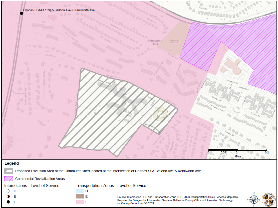
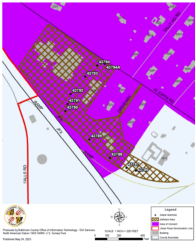
The area shown on the map attached as Exhibit "A" shall be designated as a deficient area;
2.
2025 Basic Services Water Supply Map; and
3.
2025 Basic Services Transportation Map with the following amendment:
A.
The commuter shed that includes the intersection of Charles street and Bellona Avenue/Kenilworth Drive shall be redrawn to exclude the area of land within the boundary of West Joppa Road, Greenwood Road, and Chestnut Road, as shown on the map attached as Exhibit "B" and more fully described herein as follows:
Lot One and Lot Two as shown on a plat entitled, 'amended Subdivision Plat of Blakehurst Life Care Community' dated March 18, 1992 and recorded among the Land Records of Baltimore County in Plat Book SM No. 64, Folio 34.
B.
The three Basic Services Maps shall be prepared annually in accordance with the schedule set forth below, which maps shall incorporate a delineation of adequacy and availability of water supply, sewerage, transportation services and facilities according to the standards and requirements set forth in this section.
C.
The individual Sewer, Water Supply and Transportation Basic Services Maps shall be adopted by the County Council in accordance with the procedures and requirements of this article, contrary provisions of Article 32 of the Baltimore County Code notwithstanding.
[Bill No. 137-2004]
D.
Boundaries as shown on the Basic Services Maps shall be interpreted in accordance with Section 100.4 of these Zoning Regulations.
E.
Amendments.
1.
On or before February 28 of each year, the Planning Board shall recommend to the County Council any proposed annual revisions to the Basic Services Maps. The Planning Board need not adopt a preliminary report or hold a public hearing with respect to its recommendations, although it shall allow the public a reasonable opportunity to comment before adopting the recommendations.
[Bill Nos. 117-2001; 99-2008]
2.
On or before May 31 of each year, the County Council shall take action on said maps after consideration of the recommendations of the Planning Board. The County Council shall hold one public hearing prior to adoption of said maps, which hearing shall be advertised and held in accordance with § 32-3-221 of the Baltimore County Code.
[Bill Nos. 117-2001; 137-2004; 99-2008]
3.
The Basic Services Maps may be amended only under the annual revision procedures set forth above, except in the following circumstances, after the Planning Board has been given an opportunity, at a regular meeting of the Board, to review and issue a report concerning the proposed amendment:
a.
Error. In the case of error, the maps may be corrected at any time by resolution of the County Council, provided that the Council finds that an error has, in fact, been made.
b.
Correction of deficiency. In the case of a deficiency which has been corrected by actual construction of adequate facilities, the maps may be amended, at any time, to reflect the correction, by resolution of the County Council after certification by the Department of Public Works and Transportation, in the case of a water or sewer deficiency, or the Department of Traffic Engineering, in the case of a traffic deficiency, that the needed facility has been constructed and is performing so that the area no longer suffers a service deficiency. Where correction of the deficiency has been accomplished by means of private funding, the developer or developers paying the cost of correction shall have a preferred claim to any increase in the reserve capacity resulting from the correction irrespective of the requirements of Section 4A02.3.G.2.b. Absent a contrary agreement between the developers contributing to the cost of correction, the developers shall share in any increase in reserve capacity on a prorated basis in accordance with their percentage of contribution to the entire cost of correction. [3]
[33-2021]
4.
When amending the Basic Services Maps pursuant to the provisions of Section 4A02.3.E.3.a or b, the Planning Board and the County Council shall consider the purposes of the Zoning Regulations and Map and the factors set forth in § 32-3-510(a)(2) of the Baltimore County Code. Contrary provisions of § 32-3-221 of the Baltimore County Code notwithstanding, no hearing under the procedures of § 32-3-221 need be held before the County Council adopts an amendment pursuant to Subsection 4A02.3.E.3.a or b of these regulations.
[Bill No. 137-2004]
F.
Basic Services Maps are not intended to permanently establish either areas of service deficiencies or areas of service availability and adequacy. Such maps will be reviewed annually, as it is the intent of the County Council that existing service deficiencies will be corrected in accordance with the Master Plan and capital improvements program. It is also recognized by the County Council that continuing development in certain areas may create service deficiencies in areas that presently have adequate levels of service. In some cases, changes in underlying zoning classifications may have to be made to better correlate development potential.
G.
Reserve capacity use certificate.
1.
Except as otherwise provided in this article, no building permit, pursuant to Subsection 500.1 of Article 5 of these Zoning Regulations and no final subdivision approval shall be issued or granted after the effective date of this Article within a Basic Services Mapped area, unless the Director of the Department of Planning has issued, upon appropriate application on forms prepared by the Director, a reserve capacity use certificate for that development in accordance with the following:
[Bill No. 55-2011]
a.
With respect to all subdivisions recorded prior to the effective date of this article, no reserve capacity use certificate shall be issued which allows an extent of development exceeding that allowed in accordance with Paragraph 4 hereof.
b.
With respect to all subdivisions finally approved subsequent to the effective date of this article, the Department of Planning shall notify the applicant as part of any such final subdivision approval, the extent of development allowed pursuant to such reserve capacity use certificates applicable thereto as of the date of final subdivision approval issued in accordance with Paragraph 4 hereof.
c.
With respect to an application for a building permit for development which does not require subdivision approval, no reserve capacity use certificate shall be issued which allows an extent of development exceeding that allowed in accordance with Paragraph 4 hereof.
2.
Application for certificate.
[Bill No. 55-2011]
a.
Except as otherwise provided in Paragraph 3, an application for a reserve capacity use certificate shall be filed with the Director of the Department of Planning after the applicant has applied for a building permit (for development which does not otherwise require subdivision approval) or final subdivision approval for which the application for a reserve capacity use certificate is sought, and shall be acted upon by the Director within three working days after said filing.
b.
Applications may be acted upon only according to the order in which they are properly filed with the Department of Planning.
3.
Prior to January 1, 1980, no applications for a reserve capacity use certificate shall be accepted by the Department of Planning [4], unless the applicant has a final subdivision plat covering the subject property recorded prior to the effective date of this article or the applicant has applied for a building permit for development for which subdivision approval is not otherwise required.
[Bill No. 55-2011]
4.
Formula.
a.
A reserve capacity use certificate shall authorize development only to the extent that it will meet the water supply standards of Section 4A02.4 and will not utilize more than the reserve capacity of the sewerage or the transportation network, as the case may be, of the Basic Services Mapped area within which the property is located. Before issuance of such a certificate, the sewerage or transportation capacity shall be determined under the formula:
R = (N - A) + E
in which:
b.
In the event that any reserve capacity use certificate determination results in R equaling zero, such determination shall not prohibit the granting of final subdivision approval.
5.
Except as otherwise provided in Paragraph 6, any reserve capacity use certificate for development of a subdivision tract shall expire nine months after that date it is issued, except to the extent that it applies to a tract or part of a tract on which substantial construction of the utilities or roads has taken place on that date or with respect to which a public works agreement has been both executed and funded in that there has been deposited with Baltimore County money or irrevocable security in an amount sufficient to secure the construction of the public improvements covered by that agreement.
6.
A reserve capacity use certificate pertaining to development that has been authorized by a building permit does not expire unless and until the building permit expires.
7.
For a development or section thereof, reserve capacity use certificates allowing an extent of development beyond that authorized by Paragraph 4 above shall be issued by the Director of the Department of Planning upon application, if there is prior to the effective date of the map or maps which would otherwise prohibit the proposed development, any of the following:
[Bill No. 55-2011]
a.
A public works agreement, covering that section of the proposed development, that has been both executed and funded by the deposit of money or irrevocable security in an amount sufficient to secure construction of the public improvements covered by the public works agreement and which had been both executed and funded at a time when the area had no service deficiency; or
b.
Substantial construction of the utilities or roads has taken place in the proposed development or section thereof at a time when the area had no service deficiency.
c.
A reserve capacity use certificate issued under this paragraph is limited to the part of the proposed development that meets the requirements of subparagraphs a and b above.
Editor's note— Refer to Article 4A—Appendices for Basic Services Maps.
--- (3) ---
1. Editor's Note—Under Bill No. 36-1987, the Department of Traffic Engineering was abolished and its duties and responsibilities were transferred to the Bureau of Traffic Engineering of the Department of Public Works and Transportation. See Section 1 of the Laws of Baltimore County, 1999 (Bill No. 31-1999)
--- (4) ---
2. Editor's Note—Formerly the "Office of Planning," this Department was renamed by Bill No. 55-2011, effective 10-16-2011.
§ 4A02.4. - Basic services mapping standards.
A.
Generally. The standards contained herein are intended to form the basis for the delineation of areas on the Basic Services Maps as well as for the evaluation of development applications in accordance with the requirements of this article.
B.
Water supply standards.
1.
Intent. The water supply standards and maps are intended to regulate nonindustrial development where there are serious deficiencies in the public water supply system, as evidenced by county tests of water flows from a substantial sample of fire hydrants.
2.
Standard. Residual water pressure at the public fire hydrant nearest the site of the proposed nonindustrial development must meet the standards established by the National Board of Fire Underwriters fire flow test.
3.
Exception. This subsection does not apply to any development that will not be served by a public water supply system.
C.
Sewerage standards.
1.
Intent. The sewerage standards and maps are intended to regulate nonindustrial development where it has been determined that the county's share of public sewerage capacity is substantially less than the capacity necessary both to serve already established uses and to serve new uses likely to be established pursuant to this legislation.
2.
Determination of reserve capacity. The county's share of public sewerage capacity must be capable of serving already established uses and new uses likely to be established under the provisions of this legislation.
3.
Maximum level of nonindustrial development. The maximum level of nonindustrial development per sewerage area shall not be greater than that capable of being provided with available sewerage capacity based on the following:
a.
The county's share of the maximum reserve capacity of the sewerage in the area on the effective date of mapping of the area minus the daily quantity of sewerage from any industrial buildings for which construction permits are expected to be issued between that date and the time the "basic services" map is next revised, in millions of gallons of sewerage per day; and
b.
The maximum level of nonindustrial development allowable in the district as determined based on the following assumptions:
(1)
Each dwelling unit with three bedrooms or more shall be considered to result in a yield of 225 gallons of sewage per day.
(2)
Each dwelling unit with less than three bedrooms shall be considered to result in a yield of 200 gallons of sewage per day.
(3)
Each square foot of gross floor area of a building or a part of a building devoted principally to retail use shall be considered to result in a yield of 0.05 gallon of sewage per day.
(4)
Each square foot of gross floor area of a building or a part of a building devoted principally to office use shall be considered to result in a yield of 0.09 gallon of sewage per day.
c.
The quantity of sewage yielded by a building or a part of a building to be devoted principally to uses other than dwelling or retail or office uses shall be determined by the Department of Public Works and Transportation.
[33-2021]
4.
Exception. This subsection does not apply to any development that will not be served by a public sewerage system.
D.
Transportation.
1.
Intent. The transportation standards and maps are intended to regulate nonindustrial development where it has been determined that the capacity of arterial and arterial collector intersections is less than the capacity necessary to accommodate traffic both from established uses and from uses likely to be built pursuant to this article. Such development is not intended to be restricted unless there is a substantial probability that an arterial and arterial collector intersection situated within the mapped area will, on the date the map becomes effective, be rated at level-of-service E or F under standards established by the Highway Capacity Manual, 1965, published by the Highway Research Board of the Division of Engineering and Industrial Research, National Academy of Sciences National Research Council.
2.
Determination of critical vehicle-trip number.
a.
For the purpose of this paragraph, the "critical vehicle-trip number" of an intersection is determined by the formula:
C = F - E/2 + E
in which each letter represents a number of daily vehicle trips through a given intersection at peak hour and
b.
Determination of reserve capacity. It is intended that the reserve capacity be determined for each district by the formula:
N = C - (T + I)
in which
3.
Maximum level of nonindustrial development.
a.
The level of additional nonindustrial development in a mapped area, as provided above, may not exceed that which would generate the number of daily peak-hour vehicle trips equal to the reserve capacity of that mapped area, based on the following assumptions:
(1)
Every 100 dwelling units, other than for the elderly, shall be considered to result in the generation of 85-peak-hour vehicle trips daily.
(2)
Every 100 dwelling units in housing for the elderly shall be considered to result in the generation of 25-peak-hour vehicle trips daily.
(3)
Every 1,000 square feet of gross floor area of a building or a part of a building devoted principally to retail use shall be considered to result in the generation of 14.70 peak-hour vehicle trips daily.
(4)
Every 1,000 square feet of gross floor area of a building or a part of a building devoted principally to office use shall be considered to result in the generation of 2.34 peak-hour vehicle trips daily.
b.
The number of daily peak-hour vehicle trips generated by a building or a part of a building to be devoted principally to uses other than dwellings or retail or office uses shall be determined by the Department of Traffic Engineering. [6]
E.
General exceptions to basic services mapping standards.
1.
The provisions of Section 4A02.4.A, B, C and D do not apply to any of the following:
a.
Any development of three or fewer single-family detached dwellings, or establishment of their accessory uses, on a lot of record as of November 19, 1979 (see Section 101).
b.
To any development in a C.C.C. District for which, prior to January 21, 1980, a subdivision plan was finally approved or for which, prior to January 21, 1980, an application for a building permit had been made.
c.
To any development in a C.S.A. District for which, prior to January 21, 1980, a subdivision plan was finally approved or for which, prior to January 21, 1980, an application for a building permit has been made. [7]
d.
To any development in an R.A.E. Zone for which, prior to January 21, 1980, a subdivision plan was finally approved or for which, prior to January 21, 1980, an application for a building permit had been made.
e.
To any development in a town center or community center for which an official detailed plan was approved by the Planning Board as of the effective date of Bill No. 178-1979. For purposes of this exception, an "official detailed plan" includes an official "revitalization" plan or similar plan prepared by the Department of Planning or a consultant to the county, but does not include a subdivision plan or other developer's plan.
[Bill No. 55-2011]
f.
On-site expansions of existing hospitals; any development of a "continuing care facility" as defined in Title 10, Subtitle 4 of the Human Services Article of the Annotated Code of Maryland.
[Bill No. 79-2015]
g.
Any development in an area for which an official detailed plan has been prepared that contains a recommendation that the area be exempted from basic services restrictions. For purposes of this exception, an "official detailed plan" includes an official "revitalization" plan or similar plan prepared by the Department of Planning or a consultant to the county and approved, subsequent to July 1, 1982, by the Planning Board and the County Council, but does not include a subdivision plan or other developer's plan.
[Bill No. 55-2011]
h.
Health-care and surgery center.
[Bill No. 37-2015]
i.
To any development located in a Commercial Revitalization District.
[Bill No. 79-2015 [8]]
j.
To any development located in the Downtown Towson District.
[Bill No. 49-2016]
F.
South Perry Hall — White Marsh Area. No grading permit or other building permit shall be issued for development pursuant to a development plan approved after February 1, 2001, for any development project that will be accessed from Bucks School House Road or White Marsh Road, until all of the following road projects have been contracted for construction:
[Bill No. 35-2001 [9]]
1.
Replace the box culvert under White Marsh Road that crosses the tributary of White Marsh Run located between Perry Ridge Court and Selwin Court.
2.
Widen the paved section of White Marsh Road between Bucks School House Road and Selwin Court to 20 feet.
3.
Widen the paved section of Bucks School House Road between Ridge Road and Perry Hall Boulevard to 20 feet.
4.
Realign horizontal curves along Bucks School House Road so that the minimum radius of the center line for any horizontal curve is not less than 380 feet.
G.
Petitions for special variance from provisions of this subsection.
1.
The Zoning Commissioner may, after a public hearing, grant a petition for a special variance from a provision of this subsection, only to an extent that will not violate that provision's purpose, pursuant to a finding:
a.
That the demand or impact of the development proposed will be less than that assumed by the district standard that would otherwise restrict or prohibit the development, or that the standard is not relevant to the development proposal; and
b.
That the granting of the petition will not adversely affect a person whose application was filed prior to the petitioner's application in accordance with Section 4A02.3.G.2.b.
2.
The Department of Planning shall give a report on the petition to the Zoning Commissioner prior to his consideration of the petition.
[Bill No. 55-2011]
3.
The Zoning Commissioner may grant or deny the petition, or grant it subject to any conditions or limitations consistent with the criteria set forth in Paragraph 1 above.
4.
An appeal may be filed with the County Board of Appeals within 30 days of the decision of the Zoning Commissioner.
3. Editor's Note—Under Bill No. 36-1987, the Department of Traffic Engineering was abolished and its duties and responsibilities were transferred to the Bureau of Traffic Engineering of the Department of Public Works and Transportation. See Section 1 of the Laws of Baltimore County, 1999 (Bill No. 31-1999).
--- (6) ---
4. Editor's Note—Under Bill No. 36-1987, the Department of Traffic Engineering was abolished and its duties and responsibilities were transferred to the Bureau of Traffic Engineering of the Department of Public Works and Transportation. See Section 1 of the Laws of Baltimore County, 1999 (Bill No. 31-1999).
--- (7) ---
5. Editor's Note—The former C.N.S., C.S.A., C.S.-1 and C.S.-2 Districts were consolidated into the A.S. District by Bill No. 172-1993, effective 1-27-1994. See Section 259.2.B.
--- (8) ---
6. Editor's Note—This bill also provided that it would apply to Commercial Revitalization Districts established by County Council resolution prior to the effective date of this Act.
--- (9) ---
7. Editor's Note—This bill provided for the renumbering of former Subsection F as Subsection G. It also stated that the provisions of this subsection shall expire and be of no further effect when all of the road projects listed have been contracted for construction, or May 25, 2004, whichever shall first occur.
§ 4A03.1. - Definitions.
In this section the following words have the meanings indicated.
SUBDIVISION — The division of property into two or more lots.
UNDERSIZED LOT — An unimproved platted lot or a lot of record on or before August 6, 1999, that does not meet the area, height or setback requirements in these Zoning Regulations to allow the construction of a dwelling.
§ 4A03.2. - Application.
[Bill Nos. 60-2003; 15-2004]
Except as provided in Sections 4A03.13 and 4A03.14, this section applies to property zoned D.R. or R.C.5 and located in the Bowleys Quarters and Back River Neck areas defined in the map attached as Exhibit A and incorporated by reference in this section. [11]
2. Editor's Note—Said map is on file in the County offices.
§ 4A03.3. - Connection to public sewer or water.
[Bill No. 5-2006]
A property owner with a dwelling in existence on or before February 19, 2006, or with a nonexpired building permit that was issued on or before February 19, 2006, shall be required to connect to a public sewer, public water or both if the property is:
A.
Zoned D.R. or R.C. 5; and
B.
Served by public sewer, public water or both with adequate capacity.
§ 4A03.4. - Building permits.
[Bill No. 5-2006]
A.
Except as provided in Paragraph B of this subsection, a building permit may be issued for the construction of a dwelling on an unimproved lot or lot of record that meets all of the zoning requirements subject to the following conditions:
[Bill No. 67-2008]
1.
Variances are not required for the construction of the dwelling;
2.
The property owner connects to a public sewer, public water or both where available and with adequate capacity;
3.
The dwelling meets the design requirements provided for in this section; and
4.
No further subdivision of the lot is allowed, except in the case of a minor subdivision, or a single-tract parcel that is zoned D.R.3.5 and located in the Back River Neck Area.
B.
A building permit may be issued for the construction of a dwelling on an undersized lot subject to the following conditions:
1.
The owner of the lot does not own sufficient adjoining land that if combined with the adjoining land would allow the property owner to conform to the current zoning requirements;
2.
No further subdivision of the lot is allowed;
3.
The property owner obtains a variance as provided for in Section 307 of these Zoning Regulations if in the D.R. Zone or the property owner obtains special hearing relief in accordance with Section 1A04.3.B.1.b of these Zoning Regulations if in the R.C.5 Zone; and
4.
The property owner connects to a public sewer, public water, or both where available and with adequate capacity.
§ 4A03.5. - Building permit application.
[Bill No. 122-2010]
A.
1.
Any person desiring to erect a dwelling in accordance with the provisions of this section shall file with the Department of Permits, Approvals and Inspections, at the time of application for a building permit, plans sufficient to allow the Department of Planning to prepare the guidelines provided in Paragraph B of this subsection.
[Bill No. 55-2011]
2.
Elevation drawings may be required in addition to plans and drawings otherwise required to be submitted as part of the application for a building permit.
3.
Photographs representative of the neighborhood where the lot or tract is situated may be required by the Department of Planning in order to determine the appropriateness of the proposed new building in relation to existing structures in the neighborhood.
[Bill No. 55-2011]
B.
1.
At the time of application for the building permit, as provided above, the Director of Permits, Approvals and Inspections shall request comments from the Directors of the Department of Planning and the Departments of Environmental Protection and Sustainability and Public Works and Transportation.
[Bill Nos. 55-2011; 33-2021]
2.
Within 15 days after receipt of a request from the Director of Permits, Approvals and Inspections, the Directors shall provide to the Department of Permits, Approvals and Inspections written recommendations concerning the application with regard to the following:
A.
Site design. New buildings shall be appropriate in the context of the neighborhood in which they are proposed to be located. Appropriateness shall be evaluated on the basis of new building size, lot coverage, building orientation and location on the lot or tract.
B.
Architectural design. Appropriateness shall be evaluated based on one or more of these architectural design elements or aspects:
[1]
Height;
[2]
Bulk or massing;
[3]
Major divisions, or architectural rhythm, of facades;
[4]
Proportions of openings such as windows and doors in relation to walls;
[5]
Roof design and treatment; and
[6]
Materials and colors, and other aspects of facade texture or appearance.
C.
Design amendments. The Director of Permits, Approvals and Inspections may recommend approval, disapproval or modification of the building permit after consideration of the recommendations proposed by the Directors.
§ 4A03.6. - Public notice.
[Bill No. 122-2010]
For undersized lots, on application for a building permit in accordance with this section, the subject property shall be posted conspicuously under the direction of the Department of Permits, Approvals and Inspections with notice of the application for a period of at least 15 days.
§ 4A03.7. - Public hearing.
A.
This subsection applies to undersized lots.
B.
Within the 15-day posting period:
[Bill No. 122-2010]
1.
Any owner or occupant within 1,000 feet of the lot may file a written request for a public hearing with the Department of Permits, Approvals and Inspections; or
2.
The Director of Permits, Approvals and Inspections may require a public hearing.
C.
The Department of Permits, Approvals and Inspections shall notify the applicant within 20 days after the receipt of a request for a public hearing.
[Bill No. 122-2010]
D.
The Zoning Commissioner shall hold the public hearing within 30 days after receiving the request for a public hearing.
E.
At the public hearing, the Zoning Commissioner shall determine whether the proposed dwelling is appropriate.
§ 4A03.8. - Final approval.
[Bill No. 122-2010]
A.
The Director of Permits, Approvals and Inspections may:
1.
Issue the building permit; or
2.
For undersized lots, notwithstanding any provision to the contrary, require a public hearing before the Zoning Commissioner in accordance with this section.
B.
If the Department of Permits, Approvals and Inspections has not notified the applicant of a determination in accordance with the provisions of this section, or has not notified the applicant in accordance with Subsection 4A03.7 of the intention to require a public hearing, the dwelling shall be deemed appropriate for purposes of this section.
§ 4A03.9. - Appeals.
[Bill No. 122-2010]
The decision of the Zoning Commissioner or the Director of Permits, Approvals and Inspections may be appealed, in which case the Board of Appeals shall hold the hearing within 45 days after receipt of the request.
§ 4A03.10. - Fees.
[Bill No. 122-2010]
The Director of Permits, Approvals and Inspections shall establish appropriate fee schedules.
§ 4A03.11. - Growth allocation not applicable.
[Bill No. 5-2006]
A property owner who is required to connect to public sewer, public water or both as provided for in this section may not apply for growth allocation under Article 32, Title 9 of the Baltimore County Code.
§ 4A03.12. - Regulations.
[Bill Nos. 5-2006; 122-2010; 55-2011]
The Department of Public Works and Transportation, in consultation with the Department of Planning, the Department of Environmental Protection and Sustainability and the Department of Permits, Approvals and Inspections, may adopt regulations in accordance with Article 3, Title 7 of the Baltimore County Code, to carry out the provisions of this section.
[33-2021]
§ 4A03.13. - Growth allocation: Back River Neck District.
[Bill No. 60-2003]
A.
This subsection applies to property that:
1.
Is zoned R.C. 5;
2.
Is located in the Back River Neck District defined in the map attached as Exhibit A and incorporated by reference in this section; [12]
3.
Receives growth allocation in accordance with the Baltimore County Code and the State Critical Area Law.
B.
1.
In this subsection "villa" means a group of five or less attached dwelling units that have been constructed together in a lateral row surrounded by yard space and in which each dwelling unit is separated from another by a party wall.
2.
A "single-family villa" refers to any one dwelling within the attached group.
C.
Villas are permitted as of right only on property that is included in this subsection as provided for in Paragraph A of this subsection.
D.
Except as specifically exempted by this subsection, a property subject to this subsection is required to comply with all of the other provisions of this section.
E.
Notwithstanding Subsection 4A03.11 of this section, a property owner who is required to connect to public sewer, public water or both as provided for in this section may apply for growth allocation under Article 32, Title 9 of the Baltimore County Code.
[Bill No. 137-2004; 5-2006]
F.
A development plan and amendments to a development plan:
1.
Are not required to comply with:
a.
Subsections 4A03.4.A.1, 3, and 4 and B.1, 2, and 3 and 4A03.5 of this section;
b.
Section 102.4 of the Zoning Regulations;
c.
Section 104 of the Zoning Regulations, except that nonconforming uses may continue and be relocated on the property outside of the original footprints;
d.
Section 1A04.3 of the Zoning Regulations, except that a structure on property that is included in this subsection is subject to the height regulation;
e.
The open space requirements in § 32-6-108 of the Baltimore County Code and the Local Open Space Manual; and
[Bill No. 137-2004]
f.
The panhandle driveway requirements in § 32-4-409 of the Baltimore County Code;
[Bill No. 137-2004]
2.
May include the following provisions:
a.
Panhandles shall be permitted without being subject to the comprehensive Manual of Development Policies;
b.
Existing road paving is not required to be widened;
c.
Curbs, gutters, or sidewalks are not required; and
d.
Any provision regarding full cul-de-sacs do not apply if modified turnaround areas are constructed or otherwise available on any affected roads.
G.
A development plan:
1.
Shall comply with the development review and approval process as provided for in Article 32 of the Baltimore County Code;
[Bill No. 137-2004]
2.
Is not eligible for a limited exemption from the development review and approval process under § 32-4-106 of the Baltimore County Code; and
[Bill No. 137-2004]
3.
Shall include a pattern book assuring that the development achieves a high quality of design.
3. Editor's Note—Said map is on file in the County offices; and
§ 4A03.14. - R.C. 20 properties.
[Bill No. 15-2004; 5-2006]
A.
This subsection applies to property zoned R.C. 20 and located in the Bowleys Quarters and Back River Neck areas as provided in Subsection 4A03.2 of this section.
B.
A property owner may connect to the public sewer, public water or both subject to the following conditions:
1.
Variances are not required for the construction of the dwelling;
2.
Public sewer, public water or both are available and have adequate capacity;
3.
It is technically feasible to connect to the public sewer or public water;
4.
The lot for which the connection is sought has received all required permits, including a building permit and federal, state and county environmental approvals;
5.
The lot existed on or before January 1, 2003, or the portion of the lot lying within the R.C.20 Zone was not occupied by a dwelling as of January 1, 2003;
6.
Except for bona fide intrafamily transfers as provided for in Section 1A05.5 of the Baltimore County Zoning Regulations, and subdivisions predominantly involving portions of the lot not zoned R.C.20, no further subdivision of the lot is allowed;
7.
Except for bona fide intrafamily transfers as provided for in Section 1A05.5 of the Baltimore County Zoning Regulations, only one connection for public sewer, public water or both per lot is allowed for one single-family dwelling in an R.C.20 Zone;
8.
The dwelling meets all of the design requirements as provided for in this section; and
9.
If the lot is undersized, then the property owner must meet the conditions in Section 4A03.4.B.1 and 3.
C.
The determination of whether it is technically feasible to connect to public sewer, public water or both shall be in the sole discretion of the Director of the Department of Public Works and Transportation. The Director shall develop a policy for allocating the cost of public sewer or public water service or both authorized under this section.
[33-2021]
D.
Public [sewer] [13] and public water service or both shall be provided to properties that have been transferred in accordance with Section 1A05.5 of the Baltimore County Zoning Regulations subject to the conditions in Paragraph B of this subsection.
4. Editor's Note—The word "sewer" was inadvertently omitted from Bill No. 5-2006, although it was the legislative intent of the County that it be included herein.