
Barronett Town City Zoning Code
ARTICLE II
- ZONING REGULATIONS
Sec. 38-70.- Purpose and intent.
The purpose of this article is to promote and to protect the public health, morals, safety, and general welfare of the county. It is intended to encourage the use of lands and natural resources in the county in accordance with their character and adaptability; to promote orderly development; to secure safety to health, life and property; to prevent highways from economic suffocation by encroaching uses; to preserve land values and ensure a quality environment for future generations. This article is intended to accomplish this purpose by providing for the proper locations, construction and use of buildings, structures, and the use of land, shorelands, air, and water within the unincorporated areas of the county.
(Code 2000, § 38-311; Ord. of 3-19-2002, Art. I, § 11)
Sec. 38-71. - Applicability.
Pursuant to Wis. Stats. §§ 59.692 and 87.30, all of the unincorporated areas of the county are subject to county shoreland and floodplain zoning within the shoreland and floodplain areas described in divisions 2 and 27 of this article and section 38-921.
(Code 2000, § 38-312; Ord. of 3-19-2002, Art. I, § 11.5; Res. No. 47-17, 6-20-2017)
Sec. 38-72. - Interpretation.
(a)
The provisions of this article shall be held to be minimum requirements, adopted for the promotion and protection of the public health, morals, safety, and general welfare of the county. Whenever the requirements of this article are at variance with the requirements of any other lawfully adopted regulations, ordinances, or private covenants, the most restrictive, or that imposing the higher standards shall govern.
(b)
In their interpretation and application, the provisions of this article shall be held to be minimum requirements and shall be liberally construed in favor of the county and shall not be deemed a limitation or repeat of any other powers granted by state statutes. Where a provision of this article is required by a standard in Wis. Admin. Code ch. NR 115, and where the ordinance provision is unclear, the provision shall be interpreted in light of the Wis. Admin. Code ch. NR 115 standards in effect on the date of adoption of this article, or in effect on the date of the most recent text amendment to this article.
(Code 2000, § 38-313; Ord. of 3-19-2002, Art. I, § 12)
Sec. 38-103.- District establishment.
For the purposes of this article, the unincorporated areas of the county are hereby divided into the following use districts and shall be placed into such districts in accordance with their best use, efficiency and in general continuity with existing land use:
(1)
Residential (R) District—Dark Blue.
(2)
Residential Mobile (RM) District—Orange.
(3)
Residential-Recreational 1 (RR-1) District—Light Blue.
(4)
Residential-Recreational 2 (RR-2) District—Brown.
(5)
Residential-Agricultural (RA) District—Pink.
(6)
Agricultural (A) District—Yellow.
(7)
Forestry (F) District—Green.
(8)
Commercial (C) District—Purple Lined.
(9)
Commercial Highway (CH) District—Black Lined.
(10)
Industrial (I) District—Black.
(11)
Planned Unit Development (PUD) District. 1
(12)
Shoreland-Wetland District—Designated by state wetland map.
(13)
Planned Residential Development (PRD) District. 1
1 No color assignment; district added to ordinance from which this article is derived after creation of the original maps.
(Code 2000, § 38-320; Ord. of 3-19-2002, Art. II, § 20; Res. No. 47-17, 6-20-2017)
Sec. 38-104. - Zoning district map and district boundaries.
(a)
The locations and boundaries of the aforesaid districts, except shoreland-wetland districts, are shown on separate maps of each township and these maps collectively with the county wetlands map, shall make up the official zoning map of the county, and shall be made part of this article. United States Geological Survey quadrangle maps, and flood hazard boundary maps, and general floodplain maps for the county are also adopted as aids in determination of navigability, shoreland boundaries, and for topographical information necessary to properly administer the provisions of this article.
(b)
District boundaries, except shoreland-wetlands, are generally located in conjunction with the centerlines of roadways, railways, section lines, quarter section lines and lot lines. Questions regarding the exact location of district boundaries shall be determined by the zoning administrator in accordance with the following interpretive rules:
(1)
Unless otherwise indicated on the map, district boundaries are the centerlines of highways, streets and other roadways or railroads; section lines, quarter section lines, lot lines, or such lines extended. Where different dimensions of depth or length of a boundary are indicated, either by figures shown on the zoning map or by an attached legend or by attached maps such as enlargements U.S.G.S. Maps (R.C. District) or other maps for clarification, such dimensions and material shall be controlling.
(2)
Districts located at the intersections of roadways or roadways and railroads, shall be measured from the center point of such intersections.
(3)
Where a district boundary is indicated as paralleling a roadway or railroad and a definite depth is not given, the district boundary line shall be measured at right angles to the roadway or railroad and shall be 300 feet in depth, or the depth necessary to meet the district area requirement when multiplied by the minimum width, whichever is greater. The length of each such district shall be taken as what is shown on the map.
(4)
Where a district boundary is indicated as paralleling the edge of a watercourse and a definite depth is not given, the district boundary line shall be measured at right angles to the watercourse and shall be 300 feet in depth, or the depth necessary to satisfy the minimum area required when multiplied by the minimum district width requirement, whichever is greater. The length of each district shall be taken as what is shown on the map.
(5)
Where a district boundary line divides a lot or parcel of less than the required area, which is in single ownership at the time of enactment of this article, the requirements of the district in which the greatest proportion of the lot or parcel lies, shall apply to the entire lot or parcel.
(6)
The boundary of a shoreland-wetland district is presumed to be the edge of a wetlands as defined in the ordinance, or the landward edge to which shoreland regulations apply. The zoning administrator shall determine shoreland-wetland district boundaries by visual inspection and may request any necessary assistance from the department of natural resources.
(7)
All other cases of interpretation of district boundaries and appeals from the determination of the zoning administrator shall be determined by the board of adjustments.
(Code 2000, § 38-321; Ord. of 3-19-2002, Art. II, § 21; Res. No. 47-17, 6-20-2017)
Sec. 38-105. - Dimensional standards.
The following dimensional standards shall apply to zoning districts:
Notes:
a Plus any area required by Wis. Admin. Code ch. NR 115.
b Airport approach protection-required by Wis. Stats. § 114.136(2)(b).
c The shoreland ordinance dimensional requirements may be more restrictive.
d Silos: 100-foot limitation.
e Forestry and agricultural districts: The minimum lot or parcel area shall be 20 acres, except where the initial parcel is a government lot, or quarter, quarter section which is less than 40 acres. In such cases, the divided parcels shall be a minimum of 17 acres, or one-half of the initial parcel size, whichever is greater.
(Code 2000, § 38-322; Res. No. 2006-111, § 2, 1-23-2007; Res. No. 47-17, 6-20-2017)
Sec. 38-124.- General use regulations governing districts.
(a)
No land, shorelands, water, or premises shall be used unless in accordance with the provisions of this article and such use shall conform to the regulations prescribed herein for the use district in which such land, shorelands, water or premises is located.
(b)
No building, structure or part thereof, shall be erected, constructed, reconstructed, moved, enlarged or structurally altered unless in accordance with the provisions of this article and such building, structure or part thereof, shall conform to the regulations prescribed herein for the use district in which such building, structure or part thereof, is located.
(Code 2000, § 38-330; Ord. of 3-19-2002, Art. III)
Sec. 38-147.- Purpose.
The purpose of the Residential (R) District is to protect areas having suitable characteristics for prime yearround residential development from uses which would prove detrimental to residential values. It is intended to encourage such development around existing residential areas where soil conditions are suitable for such development and in those which can be economically and readily served with the required facilities and services.
(Code 2000, § 38-340; Ord. of 3-19-2002, Art. IV, § 40)
Sec. 38-148. - Permitted uses.
The following permitted uses shall apply to the Residential (R) District:
(1)
One- or two-family dwelling (not to exceed two dwelling units).
(2)
Accessory buildings and uses incidental to customary residential use.
(3)
Customary home occupation. Home occupations which involve automobile or other motor vehicle or engine repair are not permitted.
(4)
Gardening for home use.
(5)
Essential services and utilities intended to serve the residential and accessory uses.
(6)
Signs, subject to the provisions of division 18 of this article.
(7)
Single guest cabin, subject to the provisions of division 28 of this article.
(8)
Single bunkhouse, subject to the provisions of division 28 of this article.
(Code 2000, § 38-341; Ord. of 3-19-2002, Art. IV, § 41; Res. No. 64-10, 7-27-2010; Res. No. 25-15, 3-24-2015; Res. No. 47-17, 6-20-2017)
Sec. 38-149. - Conditional uses.
The following conditional uses shall apply to the Residential (R) District:
(1)
Expanded home occupation. Expanded home occupations which involve automobile or other motor vehicle or engine repair are not permitted.
(2)
Multiple-family dwellings.
(3)
Boardinghouse and lodginghouse.
(4)
Public and semipublic uses including, but not limited to, museums, churches, public and private schools, clinics, hospitals, rest homes, funeral homes; recreation areas such as playgrounds, tennis courts, pools, and public and private parks.
(5)
Telephone exchanges, telephone, telegraph, and power transmission lines, poles, towers, and substations with accessory buildings and equipment.
(Code 2000, § 38-342; Ord. of 3-19-2002, Art. IV, § 42; Res. No. 64-10, 7-27-2010; Res. No. 25-15, 3-24-2015; Res. No. 1-19, 2-19-2019)
Sec. 38-177.- Purpose.
The purpose of the Residential-Mobile Home (RM) District is to provide for an area for the accommodation of both conventional residential dwellings and single mobile homes. It is intended to encourage such development around existing areas of mobile home development where soil conditions are suitable for such development and in those areas which can be economically and readily served with the required facilities and services.
(Code 2000, § 38-350; Ord. of 3-19-2002, Art. V, § 50)
Sec. 38-178. - Permitted uses.
The following permitted uses shall apply to the Residential-Mobile Home (RM) District:
(1)
One- or two-family dwelling (not to exceed two dwelling units).
(2)
Single mobile home per lot or parcel.
(3)
Accessory buildings and uses incidental to the principle residential use.
(4)
Customary home occupation. Home occupations which involve automobile, motor vehicle or other engine repair are not permitted.
(5)
Gardening for home use.
(6)
Essential services and utilities intended to serve the residential and the accessory uses.
(7)
Signs, subject to the provisions of division 18 of this article.
(8)
Single guest cabin, subject to the provisions of division 28 of this article.
(9)
Single bunkhouse, subject to the provisions of division 28 of this article.
(Code 2000, § 38-351; Ord. of 3-19-2002, Art. V, § 51; Res. No. 64-10, 7-27-2010; Res. No. 25-15, 3-24-2015; Res. No. 47-17, 6-20-2017)
Sec. 38-179. - Conditional uses.
The following conditional uses shall apply to the Residential-Mobile Home (RM) District:
(1)
Expanded home occupation. Expanded home occupations which involve automobile or other motor vehicle or engine repair are not permitted.
(2)
Mobile home parks.
(3)
Multiple-family dwellings.
(4)
Boardinghouses and lodginghouses.
(5)
Public and semipublic uses including, but not limited to, the following: museums, churches, public and private schools, clinics, hospitals, rest homes, funeral homes; recreational areas such as: playgrounds, tennis courts, pools, and public and private parks.
(6)
Telephone exchanges, telephone, telegraph, and power transmission lines, poles, towers, and substations with accessory buildings and equipment.
(Code 2000, § 38-352; Ord. of 3-19-2002, Art. V, § 52; Res. No. 64-10, 7-27-2010; Res. No. 25-15, 3-24-2015; Res. No. 1-19, 2-19-2019)
Sec. 38-202.- Purpose.
The purpose of the Residential-Recreational 1 (RR-1) District is to provide for both seasonal and yearround residential development and to encourage the orderly development of the recreation industry in areas having a high recreational value, where the soil conditions and other physical features will economically support such development without depleting or destroying natural resources.
(Code 2000, § 38-360; Ord. of 3-19-2002, Art. VI, § 60)
Sec. 38-203. - Permitted uses.
The following permitted uses shall apply to the Residential-Recreational 1 (RR-1) District:
(1)
One- or two-family dwelling (not to exceed two dwelling units).
(2)
Accessory buildings and uses incidental to the principal residential use.
(3)
Customary home occupation. Home occupations which involve automobile, motor vehicle or other engine repair are not permitted.
(4)
Gardening for home use or sale.
(5)
Essential services and utilities intended to serve the residential and accessory uses.
(6)
Historical, geological and religious markers and monuments.
(7)
Signs, subject to the provisions of division 18 of this article.
(8)
Single guest cabin, subject to the provisions of division 28 of this article.
(9)
Single bunkhouse, subject to the provisions of division 28 of this article.
(Code 2000, § 38-361; Ord. of 3-19-2002, Art. VI, § 61; Res. No. 64-10, 7-27-2010; Res. No. 25-15, 3-24-2015; Res. No. 47-17, 6-20-2017)
Sec. 38-204. - Conditional uses.
The following conditional uses shall apply to the Residential-Recreational 1 (RR-1) District:
(1)
Public and semipublic uses, including, but not limited to, the following: museums, churches, public and private schools, clinics, hospitals, rest homes, funeral homes; recreational areas such as playgrounds, tennis courts, pools, and public and private parks.
(2)
Multiple-family dwellings.
(3)
Boardinghouses and lodginghouses.
(4)
Resorts, hotels, motels, and small apartments.
(5)
Restaurants, dinner clubs, taverns, dance halls, and other private clubs.
(6)
Gift and specialty shops.
(7)
Bait stores, sporting goods stores, and small general merchandise stores.
(8)
Expanded home occupation. Expanded home occupations which involve automobile, motor vehicle or other engine repair are not permitted.
(9)
Single mobile home.
(10)
Telephone exchanges, telephone, telegraph, and power transmission lines, poles, towers, and substations with accessory buildings and equipment.
(11)
Mini-storage units.
(Code 2000, § 38-362; Ord. of 3-19-2002, Art. VI, § 62; Res. No. 82-05, 12-21-2004; Res. No. 64-10, 7-27-2010; Res. No. 25-15, 3-24-2015; Res. No. 1-19, 2-19-2019)
Sec. 38-222.- Purpose.
The purpose of the Residential-Recreational 2 (RR-2) District is to provide for both seasonal and yearround residential development, yet ensure a rural atmosphere and the preservation of open space by requiring larger lot development. The soil conditions and other physical features must be suitable for such use and these areas shall be located in such a way as to be economically feasible to provide such development with the necessary facilities and services.
(Code 2000, § 38-370; Ord. of 3-19-2002, Art. VII, § 70)
Sec. 38-223. - Permitted uses.
The following permitted uses shall apply to the Residential-Recreational 2 (RR-2) District:
(1)
Two seasonal or yearround dwellings (not to exceed four dwelling units).
(2)
Accessory buildings and uses incidental to the principle residential use.
(3)
Customary home occupation. Home occupations which involve automobile, motor vehicle or other engine repair are not permitted.
(4)
Essential services and utilities intended to serve the residential and accessory uses.
(5)
Gardening for home use or sale.
(6)
Conservation trails and natural resources management programs.
(7)
Historical, geological, and religious markers and monuments.
(8)
Fire control and detection structures.
(9)
Signs, subject to the provisions of division 18 of this article.
(10)
Horses. Not to exceed two animals, with an exception for a mare with a colt for up to two years. Fencing is the liability of the horse owner.
(11)
Single guest cabin, subject to the provisions of division 28 of this article.
(12)
Single bunkhouse, subject to the provisions of division 28 of this article.
(Code 2000, § 38-371; Ord. of 3-19-2002, Art. VII, § 71; Res. No. 64-10, 7-27-2010; Res. No. 25-15, 3-24-2015; Res. No. 47-17, 6-20-2017)
Sec. 38-224. - Conditional uses.
The following conditional uses shall apply to the Residential-Recreational 2 (RR-2) District:
(1)
Campgrounds, public and private parks and other recreational camps and parks.
(2)
Resorts, motels, small apartments, dinner clubs, taverns, dance halls, and other private clubs.
(3)
Gift shops, bait and sporting goods stores, and small general merchandise stores.
(4)
Marinas and boat storage.
(5)
Sportsman's clubs and shooting ranges.
(6)
Game and fish farms and fish hatcheries.
(7)
Riding stables, golf courses, and similar recreational facilities.
(8)
Institutions of a philanthropic or educational nature.
(9)
Single mobile home.
(10)
Expanded home occupation. Expanded home occupations which involve automobile, motor vehicle or other engine repair are not permitted.
(11)
Nurseries and greenhouses when used for other than a home use.
(12)
Telephone, telegraph, and power transmission lines, poles, towers, and substations with accessory buildings and equipment.
(13)
Mini-storage units.
(Code 2000, § 38-372; Ord. of 3-19-2002, Art. VII, § 72; Res. No. 82-05, 12-21-2004; Res. No. 64-10, 7-27-2010; Res. No. 25-15, 3-24-2015)
Sec. 38-247.- Purpose.
The purpose of the Residential-Agricultural (RA) District is to provide for some residential development in those areas which have been or are partially being used for agriculture and associated uses and that are not included within the agricultural district due to their marginal production capabilities. Such area's primary use may be a residential use with a subsidiary agricultural use.
(Code 2000, § 38-380; Ord. of 3-19-2002, Art. VIII, § 80)
Sec. 38-248. - Permitted uses.
The following permitted uses shall apply to the Residential-Agricultural (RA) District:
(1)
Two seasonal or yearround dwellings (not to exceed four dwelling units).
(2)
General farming, provided that buildings in which farm animals are kept shall be at least 100 feet away from any adjoining property line or building designated for human habitation other than the residence of the owner of the property, owner's agent or lessee.
(3)
Accessory buildings and uses incidental to the principal permitted use.
(4)
Essential services and uses incidental to the principal permitted and accessory uses.
(5)
Customary home occupation. Home occupations which involve automobile, motor vehicle, or other engine repair are permitted only by conditional use.
(6)
Roadside stands provided sufficient parking is available.
(7)
Greenhouses and nurseries.
(8)
Trails and wildlife refuges.
(9)
Wood lots and tree farms.
(10)
Production and harvesting of wild crops.
(11)
Fire control detection structures.
(12)
Historical, geological, and religious markers and monuments.
(13)
Signs, subject to the provisions of division 18 of this article.
(14)
Single guest cabin, subject to the provisions of division 28 of this article.
(15)
Single bunkhouse, subject to the provisions of division 28 of this article.
(Code 2000, § 38-381; Ord. of 3-19-2002, Art. VIII, § 81; Res. No. 64-10, 7-27-2010; Res. No. 25-15, 3-24-2015; Res. No. 47-17, 6-20-2017)
Sec. 38-249. - Conditional uses.
The following conditional uses shall apply to the Residential-Agricultural (RA) District:
(1)
Single mobile home.
(2)
Expanded home occupation, or any home occupation involving automobile, motor vehicle, or other engine repair.
(3)
Public and private schools and churches.
(4)
Cemeteries.
(5)
Airports and landing strips.
(6)
Drive-in theaters.
(7)
Storage of junked automobiles, salvage yards, and scrap storage and processing. Also subject to provisions of the state administrative code.
(8)
Stockyards.
(9)
Portable sawmills and appurtenant equipment, and that such length of stay shall not exceed 30 days in any one one-year period.
(10)
Telephone, telegraph, and power transmission lines, poles, towers, and substations with accessory buildings and equipment.
(11)
Campgrounds.
(12)
Game and fish farms.
(13)
Kennels, when located no less than 100 feet from any adjoining property line, and no less than 500 feet from any existing residence.
(14)
Riding stables and similar recreational facilities.
(15)
Mini-storage units.
(Code 2000, § 38-382; Ord. of 3-19-2002, Art. VIII, § 82; Res. No. 82-05, 12-21-2004)
Sec. 38-277.- Purpose.
The purpose of the Agricultural (A) District is to provide for the continuation of general farming and related activities and to preserve in agriculture, those lands suited for such uses. It is intended to avoid the problems of the mixing of farm and nonfarm uses. Due to the excessive costs of providing urban-type services in rural areas, a low density population should be maintained.
(Code 2000, § 38-390; Ord. of 3-19-2002, Art. IX, § 90)
Sec. 38-278. - Permitted uses.
The following permitted uses shall apply to the Agricultural (A) District:
(1)
General farming provided that buildings in which farms animals are kept shall be at least 100 feet from any adjoining property line or building designated for human habitation other than the residence of the owner of the property, his/her agent, or lessee.
(2)
Two seasonal or yearround dwellings (not to exceed four dwelling units).
(3)
Accessory buildings and uses incidental to the farming and residential use.
(4)
Essential services and utilities intended to serve the farming, residential, and accessory uses.
(5)
Customary home occupation. Home occupations which involve automobile, motor vehicle, or other engine repair are permitted only by conditional use.
(6)
Roadside stands, provided sufficient parking is available.
(7)
Greenhouses and nurseries.
(8)
Riding stables and other similar recreational uses.
(9)
Production and harvesting of wild crops.
(10)
Game and fish farms, trails, and wildlife refuges.
(11)
Soil and water conservation programs.
(12)
Wood lots and tree farms.
(13)
Portable sawmills for personal use.
(14)
Fire control and detection structures.
(15)
Signs, subject to the provisions of division 18 of this article.
(16)
Kennels, when located not less than 100 feet from any adjoining property line, and no less than 500 feet from existing residence.
(17)
Single guest cabin, subject to the provisions of division 28 of this article.
(18)
Single bunkhouse, subject to the provisions of division 28 of this article.
(Code 2000, § 38-391; Ord. of 3-19-2002, Art. IX, § 91; Res. No. 2006-111, § 8, 1-23-2007; Res. No. 64-10, 7-27-2010; Res. No. 25-15, 3-24-2015; Res. No. 47-17, 6-20-2017)
Sec. 38-279. - Conditional uses.
The following conditional uses shall apply to the Agricultural (A) District:
(1)
Mobile homes, no more than two. A conditional use permit is required for each.
(2)
Public and private schools and churches.
(3)
Cemeteries.
(4)
Airports and landing strips.
(5)
Drive-in theaters.
(6)
Stockyards and slaughterhouses.
(7)
Sawmills, planing mills, and other primary forest products processing plants.
(8)
Telephone, telegraph, and power transmission lines, poles, towers, and substations with accessory buildings and equipment.
(9)
Communications. Radio and TV towers, microwave relay stations, and other similar structures.
(10)
Expanded home occupation, or any home occupation involving automobile, motor vehicle, or other engine repair.
(11)
Nonmetallic mining, including the stripping of topsoil.
(12)
Storage of junking automobiles, salvage yards, and scrap storage and processing. Also subject to the provisions of the state administrative code.
(13)
On land disposal operations for garbage, refuse, and other solid waste materials. Also subject to provisions of the state administrative code.
(14)
Agricultural machinery dealership and repairs.
(Code 2000, § 38-392; Ord. of 3-19-2002, Art. IX, § 92; Res. No. 47-17, 6-20-2017)
Sec. 38-302.- Purpose.
The purpose of the Forestry (F) District is to protect and foster the development and multiple use of the forest lands and associated resources. It is intended to encourage forest management practices and to recognize the recreational value of the forest when such uses are compatible. Isolated settlement with its cost to government and hardship to the individual is regulated by providing for yearround residences only within reasonable access of necessary residential services.
(Code 2000, § 38-400; Ord. of 3-19-2002, Art. X, § 100)
Sec. 38-303. - Permitted uses.
The following permitted uses shall apply to the Forestry (F) District:
(1)
Production and harvesting of forest crops.
(2)
Forest, soil, and water management programs.
(3)
Conservation reserves, trails, and wildlife refuges.
(4)
Fire control and detection structures.
(5)
Historical, geological, and religious markers and monuments.
(6)
Seasonal cabins with no more than one unit per lot or parcel.
(7)
Accessory buildings and uses incidental to the principle permitted use.
(8)
Portable sawmills, planing mills, debarking operations, and similar equipment such that length of stay shall not exceed 90 days within any one-year period.
(9)
Signs, subject to the provisions of division 18 of this article.
(10)
One- or two-family dwelling when located within reasonable access of school and mail routes, and other necessary residential services (not to exceed two dwelling units).
(11)
Customary home occupation. Home occupations which involve automobile, motor vehicle, or other engine repair are permitted only by conditional use.
(12)
Single guest cabin, subject to the provisions of division 28 of this article.
(13)
Single bunkhouse, subject to the provisions of division 28 of this article.
(Code 2000, § 38-401; Ord. of 3-19-2002, Art. X, § 101; Res. No. 64-10, 7-27-2010; Res. No. 25-15, 3-24-2015; Res. No. 47-17, 6-20-2017)
Sec. 38-304. - Conditional uses.
The following conditional uses shall apply to the Forestry (F) District:
(1)
Permanent forest industries such as sawmills, planing mills, and other primary forest products processing plants.
(2)
Hunting and fishing clubs and shooting ranges.
(3)
Licensed game, fur, and fish farms and fish hatcheries.
(4)
Public and private parks and campgrounds.
(5)
Single mobile home when located within reasonable access of school and mail routes and other residential services.
(6)
Expanded home occupation, automobile, motor vehicle, or other engine repair or other such business which may involve yearround employment, except the harvesting of forest crops.
(7)
Nonmetallic mining, including the stripping of topsoil.
(8)
Pipelines.
(9)
Power dams, power plants, and flowages.
(10)
Telephone, telegraph, and power transmission lines, poles, towers, and substations with accessory buildings and equipment.
(11)
Communications. Radio and TV towers, microwave relay stations, and other similar structures.
(12)
Storage of junked automobiles, salvage yards, and scrap storage and processing. Also subject to the provisions of the state administrative code.
(Code 2000, § 38-402; Ord. of 3-19-2002, Art. X, § 102)
Sec. 38-322.- Purpose.
The purpose of the Commercial (C) District is to provide for the orderly grouping at appropriate locations of retail business and service establishments and other similar commercial operations in order to avoid the problems and costs of mixed and scattered land use. It is also intended to provide a measure of control for those commercial uses which may possibly present a problem due to excessive traffic, parking, noise, smoke, dust, or other such detrimental effects of operation.
(Code 2000, § 38-420; Ord. of 3-19-2002, Art. XII, § 120)
Sec. 38-323. - Permitted uses.
The following permitted uses shall apply to the Commercial (C) District:
(1)
A residential dwelling (one dwelling unit) or a mobile home in conjunction with and accessory to the uses permitted, provided that occupancy is restricted to owner, or one employee.
(2)
Bank, savings and loan, or other financial institutions.
(3)
Barbershops and beauty parlors.
(4)
Book and stationery stores, and newsstands.
(5)
Business and professional offices, and studios.
(6)
Clothing stores, department stores, shoe stores, and shoe repair shops.
(7)
Drug stores and soda fountains.
(8)
Florist shops and greenhouses.
(9)
Food products (retail), fruit and vegetable store, grocery store, meat and fish market, supermarket, and bakeries.
(10)
Furniture store, household furnishings, office equipment, and upholstery.
(11)
Hardware, appliances, plumbing, heating, and electrical supplies, and sporting goods.
(12)
Jewelry stores and antique shops.
(13)
Restaurants and cafes.
(14)
Music, radio, and television stores.
(15)
Paint store and interior decorating.
(16)
Taverns.
(17)
Clubs and lodges.
(18)
Hotels and motels.
(19)
Drive-in establishments offering in-car service to customers.
(20)
Farm implement sales.
(21)
Laundry establishments.
(22)
Funeral homes.
(23)
Telephone exchanges, telephone, telegraph, and power transmission lines, poles, towers, and substations with accessory buildings and equipment.
(24)
Filling stations, new and used car sales establishments, and auto repair shops.
(25)
Accessory buildings and uses when clearly incidental to the conduct of a retail business on the premises.
(26)
Print shops and publishing houses.
(27)
Signs, subject to the provisions of division 18 of this article.
(Code 2000, § 38-421; Ord. of 3-19-2002, Art. XII, § 121; Res. No. 64-10, 7-27-2010)
Sec. 38-324. - Conditional uses.
The following conditional uses shall apply to the Commercial (C) District:
(1)
Warehousing, storage, and trucking terminal.
(2)
Dance halls, skating rinks, and bowling alleys.
(3)
Miniature golf, go-karts, amusement parks, and outdoor theaters.
(4)
Racetracks of various types.
(5)
Dyeing and cleaning establishments.
(6)
Animal hospital, pet shop, and veterinary clinic.
(7)
Sawmills and planning mills, and other forest products processing plants.
(8)
Bulk fertilizer and feed mill storage.
(9)
Storage of recreational equipment and vehicles, and shall meet the requirements as provided in division 25 of this article.
(10)
Mini-storage units.
Any other commercial use not enumerated in the above sections shall require a conditional use permit.
(Code 2000, § 38-422; Ord. of 3-19-2002, Art. XII, § 122; Res. No. 82-05, 12-21-2004)
Sec. 38-347.- Purpose.
The purpose of the Commercial Highway (CH) District is to provide an area for commercial development to serve the traveling public along major arterial and collector highways in such a manner as to minimize interruption of traffic flow, safeguard pedestrian movement, and optimize the aesthetic appearance to passing motorists.
(Code 2000, § 38-430; Ord. of 3-19-2002, Art. XII-A, § 120-A)
Sec. 38-348. - Permitted uses.
The following permitted uses shall apply to the Commercial Highway (CH) District:
(1)
Police station.
(2)
Underground utility lines.
(3)
Parks.
(4)
Nonintensive agriculture.
(5)
Accessory uses (not involving open storage).
(Code 2000, § 38-431; Ord. of 3-19-2002, Art. XII-A, § 121-A)
Sec. 38-349. - Conditional uses.
The following conditional uses shall apply to the Commercial Highway (CH) District:
(1)
A site plan showing the lot size, building size and setbacks, setback access points, signing, easements, landscaping, fencing, and drainage will be required as part of all conditional use applications.
(2)
Businesses of a retail or service nature, unless specifically listed elsewhere in this section.
(3)
Clubs (nonprofit).
(4)
Community centers.
(5)
Recreational uses.
(6)
Community service agencies.
(7)
Wholesaling of products.
(8)
Fabrication or assembling incidental to retail sales.
(9)
Governmental, business, professional, and semiprofessional offices.
(10)
Electrical substations and gas regulator stations.
(11)
Water reservoirs, water storage tanks, water pumping stations, and sewer lift stations.
(12)
Overhead utility lines.
(13)
Hotels, motels, and lodges.
(14)
Automobile filling stations.
(15)
Automobile service stations.
(16)
Parking lots.
(17)
Mini-storage units.
(18)
Enterprises or businesses of the same nature or class as those listed this district which in the opinion of the zoning committee, are not more disruptive or detrimental to the welfare of the area than those listed.
(Code 2000, § 38-432; Ord. of 3-19-2002, Art. XII-A, § 122-A; Res. No. 82-05, 12-21-2004)
Sec. 38-350. - Area regulations.
(a)
Minimum lot size required for rezoning. The minimum lot size for classification into the commercial highway district shall be five acres. No tracts shall be rezoned without a minimum of five acres and without an overall access plan.
(b)
Maximum floor area. The maximum lot area for classification into the commercial highway district shall be as follows:
(1)
Other uses by right, 30 percent of the total lot area.
(2)
Conditional uses, 30 percent of the total lot area.
(c)
Minimum lot area. The minimum lot are for classification into the commercial highway district shall be as follows:
(1)
Uses by right, one acre.
(2)
Automotive filling stations, 10,000 square feet.
(3)
Automotive service stations, 13,000 square feet plus an additional 2,000 square feet for each service bay over two.
(4)
Other conditional uses. No minimum requirements unless otherwise specified by the zoning committee.
(d)
Minimum setback from property lines. The minimum setback from property lines for classification into the commercial highway district shall be 20 feet, except that buildings shall be set back as per sections of this article.
(e)
Maximum building height. The maximum building height for classification into the commercial highway district shall be three stories.
(f)
Landscaping. At least ten percent of the total land area shall be landscaped in accordance with a landscaping plan approved by the zoning committee.
(g)
Access. There shall be no more than two access points from any tract that has been rezoned to this zone. All internal lot accesses shall be by either internal access road or frontage roads. The access plans shall be approved by the zoning committee before conditional use approval and permit issuance.
(h)
Outside storage areas. Outside storage of goods and supplies shall only be allowed in screened and fenced areas that have been designated on the conditional use site plan.
(i)
Signs. All uses by right and conditional uses shall be subject to all provisions of this article with regard to signs, parking and loading access, vision clearance, floodplains and wetlands.
(Code 2000, § 38-433; Ord. of 3-19-2002, Art. XII-A, § 123-A)
Sec. 38-379.- Purpose.
The purpose of the Industrial (I) District is to provide for manufacturing and industrial operations which, on the basis of actual physical and operational characteristics would not be detrimental to surrounding areas or public, by reason of smoke, noise, dust, odor, traffic, physical appearance, air, water, or thermal pollution, or any other environmental degradation. Industries requiring outdoor storage of raw materials and/or finished products, may be required to provide fencing or screening in accordance with division 25 of this article.
(Code 2000, § 38-440; Ord. of 3-19-2002, Art. XIII, § 130)
Sec. 38-380. - Permitted uses.
The following permitted uses shall apply to the Industrial (I) District:
(1)
A residential dwelling (one dwelling unit) or a mobile home in conjunction with and accessory to the uses permitted, provided that occupancy is restricted to the owner or one employee.
(2)
General warehousing and storage connected with the following permitted use under this section.
(3)
Metal and wood assembly, fabrication, and manufacturing.
(4)
Electronics assembly, fabrication, and manufacturing.
(5)
Clothing manufacturing.
(6)
Signs, subject to the provisions of division 18 of this article.
(Code 2000, § 38-441; Ord. of 3-19-2002, Art. XIII, § 131; Res. No. 64-10, 7-27-2010)
Sec. 38-381. - Conditional uses.
The following conditional uses shall apply to the Industrial (I) District:
(1)
Storage and/or disposal of toxic and hazardous materials.
(2)
Bulk storage of gasoline, propane, chemicals, and other materials of an explosive nature.
(3)
Chemical manufacturing.
(4)
Foundaries.
(5)
Food processing.
(6)
Meat processing and the processing and disposal of the wastes from such.
(7)
Fertilizer processing.
(8)
Tool and die manufacturing.
(9)
Mining and quarry operation.
(10)
Ready-mix concrete and gravel production.
Any other industrial use not enumerated in the above sections or any industrial use which is determined to be objectionable by the zoning committee on the basis of its potential of detrimental harmful effects to the surrounding area or public, may be permitted only upon the issuance of a conditional use whereby the zoning committee may set performance standards, pollution standards, aesthetic controls, and dimensional and site requirements in order to ensure the public health, safety, and general welfare of this county.
(Code 2000, § 38-442; Ord. of 3-19-2002, Art. XIII, § 132)
Sec. 38-406.- Purpose.
(a)
The purpose of the Planned Unit Development (PUD) District is to provide for a larger scale project type development which, when viewed in entirety, may involve multiple districts and have an interrelationship of uses within those districts. This development may be of a recreational, residential, or commercial nature or a combination of such. This district is intended to provide for such development in an orderly manner and avoid the confusion of potentially numerous zoning changes.
(b)
This district shall have no definite boundaries until such are approved by the county board by order of zoning change to the PUD district. Plans for the proposed development shall be submitted in triplicate and shall show the location, size, and proposed use of all structures and land included in the areas involved.
(Code 2000, § 38-450; Ord. of 3-19-2002, Art. XIV, § 140)
Sec. 38-407. - Uses.
The uses within the Planned Unit Development (PUD) District shall be determined by the plan as approved by the county board and shall conform to the requirements of the related district involved insofar as practicable. The specific uses within any particular PUD district shall be formulated by the zoning committee and the respective developer prior to the county board action.
(Code 2000, § 38-451; Ord. of 3-19-2002, Art. XIV, § 141)
Sec. 38-408. - Consideration.
In considering an application for a change to the PUD district, the zoning committee shall consider the following factors in evaluating the effect of such a change and development:
(1)
The location, nature, and size of the proposed area.
(2)
The size of the site in relation to the proposed use.
(3)
Existing topographic and drainage features, and vegetative cover.
(4)
The maintenance of safe and healthful conditions and control of pollution.
(5)
The location of the site with respect to the existing roads and other facilities and the impact upon such.
(6)
Its compatibility with the existing uses on land adjacent thereto.
(7)
Its compatibility with the immediate and surrounding environment and the possibility for reclamation, if needed.
(8)
Its impact upon and harmony with the future environment and the future development of the area.
(9)
Its relationship to the public interest, the purpose and intent of this article, and substantial justice to all parties concerned.
(Code 2000, § 38-452; Ord. of 3-19-2002, Art. XIV, § 142)
Sec. 38-430.- Highway setbacks.
For the purpose of determining the distance buildings and other structures shall be set back from streets and highways, the highways of the county are divided into the following classes:
(1)
Class A highways.
a.
All arterial highways classified as expressways are hereby designated as Class A highways.
b.
The setback from expressways shall be 190 feet from the centerline of a two-lane facility, or 190 feet from the center of the median of a divided facility, or 50 feet from the right-of-way line, whichever is greater.
(2)
Class B highways.
a.
All state highways not designated as Class A highways.
b.
The setback from Class B highways shall be 150 feet from the centerline of such highway or 100 feet from the right-of-way line, whichever is greater.
(3)
Class C highways.
a.
All lettered county highways are hereby designated as Class C highways.
b.
The setback from Class C highways shall be 133 feet from the centerline of such highway or 100 feet from the right-of-way line, whichever is greater.
(4)
Class D highways.
a.
Town roads may be designated as Class D highways by concurrent action of the town board and the county zoning committee.
b.
The setback from Class D highways shall be 133 feet from the centerline of such highways or 100 feet from the right-of-way line, whichever is greater.
(5)
Class E highways.
a.
All town roads, unless otherwise designated, are designated Class E highways.
b.
The setback from Class E highways shall be 75 feet from the centerline of the road or 50 feet from the right-of-way line, whichever is greater.
c.
In the event a Class A, B, C, or D highway traverses or passes on the edge of a major subdivision, the setback standard for that class highway shall apply.
(Code 2000, § 38-480; Ord. of 3-19-2002, Art. XVI, § 160)
Sec. 38-431. - Vision triangles.
(a)
Street intersection quadrant. In each quadrant of every public street intersection, there shall be a visual clearance triangle bounded by the street centerlines and a line connection point on them 300 feet from a Class A or Class B highway intersection 200 feet from a Class C, D, or E highway intersection.
(b)
Blocking of vision triangle. Nothing shall block the vision triangle from 2½ feet above the ground to ten feet above the ground. Open fences, telephone, telegraph, and power transmission poles, field and forest crops excepted.
(1)
At highway intersections with transitional widening. At all intersections of highways with other highways provided with transitional widening of pavement or surfacing, such transitional widening shall be considered as additional width and the setback lines on the side which is widened shall be increased by an amount equal to the width of the additional pavement.
(2)
Access driveways and road spacing.
a.
Access driveways to highways from abutting properties shall comply with the following requirements:
1.
Class A highway: No access driveways are allowed.
2.
Class B highway: A recommended minimum distance of 500 feet spacing of highway frontage between access driveways for separate land uses. A minimum distance of 500 feet spacing access driveways may be located to the right-of-way line of an intersecting highway. Discretion shall be granted to the D.O.T. to permit driveway at a lesser setback for safety reasons. Also subject to Wis. Admin. Code ch. Trans. 233.
3.
Class C highway: A recommended minimum of 300 feet spacing between access driveways; adjoining driveways permitted to accomplish same. A minimum distance of 300 feet spacing between access driveways and the right-of-way line of an intersecting highway. Discretion shall be granted to the county highway department to permit driveway at a lesser setback if justified by safety reasons.
4.
Class D and E highways: A recommended minimum of 200 feet spacing between access driveways; adjoining driveways permitted. To accomplish same, minimum distance of 200 feet spacing between access driveways and the right-of-way line of an intersecting Class A, B, or C highway, otherwise the spacing is the same as between two driveways. Discretion is granted to the towns to permit driveways at a lesser setback for safety reasons.
b.
Where there are two of more lots in less than 500 feet of frontage on a Class B highway, a service road of not less than 66 feet of right-of-way shall be provided across the entire frontage of each lot.
c.
The maximum number and width of access driveways to highways and service roads shall be as follows:
1.
Commercial and industrial land use driveways. A maximum of two access driveways with a maximum of 35 feet of width.
2.
Other land use driveways. One access driveway with a maximum of 24 feet of width. Discretion shall be granted to the county highway and dam committee to permit two driveways on a single property with 600 feet minimum frontage on a Class C highway.
3.
Driveways shall be at least a minimum of 20 feet wide, unobstructed into the driveway to a height of 15 feet.
4.
Driveways shall have a turnaround 20 feet wide and 40 feet long or equivalent, within 100 feet of the building.
5.
Driveways are described as serving no more than two residential or commercial buildings. All driveways which serve new residential or commercial buildings that are greater than 100 feet from a public or private road shall meet the following within 60 days of zoning permit issuance:
(i)
Driveways shall have a clearance of no less than 20 feet in width. Any curves in driveways must not be less than 100-foot radius.
(ii)
Overhead clearance shall be established at a minimum height of 15 feet.
(iii)
Driveways exceeding 150 feet in length must provide an adequate turnaround area that will accommodate, a 30-foot-long fire truck.
(iv)
Existing driveways shall be brought into compliance with this section as a condition of approval of issuance of a zoning permit when an addition or improvements to an existing dwelling exceeding a 25 percent increase in enclosed living space is constructed, or an attached or detached garage is constructed.
(v)
The turnaround space can be provided by one of the following methods and shall be within 100 feet of the principal building:
A.
If a circle drive is constructed, it must have a radius of no less than 35 feet to the centerline;
B.
A turnaround space free of trees and other obstructions may be provided if it has the dimensions of not less than 60 feet by 50 feet; or
C.
A turnout may be provided with the following dimensions: The length shall be a minimum of 30 feet. The width at the entrance shall also be a minimum of 30 feet. The turnout may be trapezoidal in shape, thereby tapering down to a minimum of 20 feet at the rear. In addition, a minimum of 40 feet of driveway must be provided between the building and the turnout to allow enough room to back a 30-foot fire truck into the turnout. Exemptions from the provisions of this article would include:
(I)
New buildings that are 100 feet or less from a public road or a private road.
(II)
Those portions of both private roads and driveways which are restricted by an existing easement of less than 20 feet in width.
d.
Where crossovers in median strips have been provided, access driveways shall be directly opposite these crossovers.
e.
In addition to the standards of this subsection, a permit E-M-04-68 or its subsequent revision must be filed with the state department of transportation for access to all state highways. Approval must be given by the state department of transportation agency before the county will consider and give approval to the applicant's request. Access to county highways must be approved by the county highway department prior to construction of a driveway connecting to a county highway.
f.
Private roads are described as those serving more than two residential or commercial buildings. All private roads serving multiple buildings, constructed after the enactment of this article, shall be a minimum width of two rods, four-rod easements are recommended.
g.
Where crossovers in median strips have been provided, access driveways shall be directly opposite these crossovers.
h.
In addition to the above standards, a permit E-M-04-68 or its subsequent revision must be filed with the state department of transportation for access to all state highways. Approval must be given by the above agency before the county will consider and give approval to the applicant's request.
(Code 2000, § 38-481; Ord. of 3-19-2002, Art. XVI, § 161; Res. No. 2006-111, § 7, 1-23-2007; Res. No. 2021-29, 4-27-2021)
Sec. 38-432. - Roadway setback averaging.
A roadway setback may be reduced to the average of roadway setbacks for existing structures on adjacent properties where such structures are within 100 feet of the building site provided the resulting roadway setback is not less than two-thirds the required roadway setback.
(Code 2000, § 38-482; Ord. of 3-19-2002, Art. XVI, § 162; Res. No. 47-17, 6-20-2017; Res. No. 1-19, 2-19-2019)
Sec. 38-463.- Loading space.
All commercial and industrial uses shall provide sufficient maneuvering and loading space on the premises for pickup, delivery, and service vehicles necessary for normal operations.
(Code 2000, § 38-490; Ord. of 3-19-2002, Art. XVII, § 170)
Sec. 38-464. - Off-street parking.
(a)
Minimum parking spaces. Each use shall provide the following minimum off-street parking spaces. Each parking space shall be at least 200 square feet in area.
(1)
Dwellings. One space for each dwelling unit.
(2)
Restaurants, taverns, and similar establishments. One space for each 50 square feet of floor space devoted to patrons.
(3)
Drive-in eating stands offering in-car service. Five spaces for each person employed to serve customers.
(4)
Motels, mobile home parks, and camping grounds. One space for each unit.
(5)
Retail business and service establishments. One space for each 200 square feet of floor area.
(6)
Industrial uses and warehouses. One space for each two employees on the premises at a maximum employment on the main shift.
(7)
Service stations. Parking for all vehicles used directly in the conduct of the business, plus two spaces for each gas pump, plus three spaces for each grease rack.
(b)
Classification of use subject to appeal. Any use not specifically named shall be assigned to the most appropriate classification by the zoning administrator subject to appeal to the board of adjustments.
(Code 2000, § 38-491; Ord. of 3-19-2002, Art. XVII, § 171)
Sec. 38-482.- General provisions.
(a)
Permit required. Except as otherwise specifically authorized, no sign shall be located, erected, moved, reconstructed, extended, enlarged, or structurally altered in the county until a permit has been issued by the county zoning administrator. A permit shall only be issued for a sign in conformity with the size, type, number, location, and use regulations affecting each zoning district.
(b)
Exceptions. A permit shall not be required for the following classes of signs:
(1)
Class A signs. Official traffic control signs and informational or directional notices erected by federal, state, or local units of government.
(2)
Class B signs.
a.
Type 1. Type 1 on-premises real estate signs, residential identification, warning, and similar signs not greater than four square feet in area.
b.
Type 2. Type 2 on-premises signs or bulletin boards for public, charitable, or religious institutions. Such signs shall not exceed 32 square feet in area, and no more than one sign for each such highway upon which the property faces shall be located outside of the right-of-way of the property.
c.
Type 3. Type 3 on-premises signs advertising the sale of farm products. Such signs shall not be in use for more than six months or exceed 32 square feet in area. No more than one sign in the approaching direction along any one highway shall be permitted.
(c)
Prohibited characteristics of signs.
(1)
No sign shall resemble, imitate, or approximate the shape, size, form, or color of railroad or traffic signs, signals, or devices, except required signs on multiple use trails.
(2)
No sign shall be so located as to interfere with the visibility or effectiveness of any official traffic sign or signal or with driver vision at any access point or intersection.
(3)
No sign shall be erected, relocated, or maintained so as to prevent free ingress or egress from any door, window, or fire escape, and no sign shall be attached to a standpipe or fire escape.
(4)
No sign shall contain any rotating or moving parts, or be illuminated by flashing lights.
(5)
No sign shall exceed the maximum height limitations of the district in which it is located.
(6)
No sign shall be located on a lot so as to reduce the required dimensional setback and side yard requirements of the district in which it is located.
(7)
No sign shall be erected upon trees, or painted or drawn upon rocks or other natural features, or trucks vans or trailers.
(8)
No sign shall be located, erected, moved, reconstructed, extended, enlarged, or structurally altered except in conformity with Wis. Stats. § 84.30 and Wis. Admin. Code ch. Trans 200.
(9)
No sign shall be allowed to remain up for more than three months after the business has ceased to operate; the business owner or landowner shall be responsible for its removal.
(10)
All signs must be maintained in good repair. This includes that the message must be current and all signs must be painted. If a sign is found to be not in good repair, the zoning administrator may order the sign either repaired or removed within 90 days. After this time, such unrepaired signs shall constitute a violation of the zoning ordinance.
(11)
Signs are not subject to normal building setbacks; however, all signs along public roadways must be located outside of the official road right-of-way. Permitted and exempt signs that are improperly placed within the right-of-way of a county highway will be removed by the county highway department and stored at their department headquarters. Sign owners may reclaim removed signs at a cost of $25.00 per sign, payable to the highway department. The highway department reserves the right to impose a forfeiture up to $500.00 for habitual repeat offenders.
(Code 2000, § 38-500; Ord. of 3-19-2002, Art. XVIII, § 180; Res. No. 55-17, 7-18-2017)
Sec. 38-483. - Classification of signs requiring permit.
(a)
Class C signs. On-premises signs which advertise a business activity or service performed on the property.
(1)
Type 1. Signs advertising a permitted home occupation or professional office. Such signs shall not exceed 12 square feet in area, and no more than one such sign for each highway upon which the property faces shall be permitted.
(2)
Type 2. Signs advertising a business activity or service available in a commercial or industrial area. Such signs shall not exceed 80 square feet in area where non-lighted, and if illuminated, shall not exceed 40 square feet in area. Not more than one such sign for each story may be attached to a building facade, and no sign may project more than six feet beyond a building when attached thereto or be higher than four feet above the top roofline. Freestanding signs shall not exceed 20 feet in height from the ground.
(3)
Type 3. Signs advertising a resort or recreational business activity or product available. Such signs shall not exceed 32 square feet in area and no more than one such sign for each highway upon which the property faces shall be permitted.
(b)
Class D signs. Signs or billboards which advertise a general brand of product, an area of interest, a business activity, or a service available which is not in direct relation to the use of the premises on which it is located. Such signs shall not exceed 300 square feet in area. Free standing signs shall be erected outside a line parallel to and 50 feet from the right-of-way of the highway and shall not exceed 20 feet in height above the ground or be located within 300 feet of an existing residence.
(c)
Class E signs. Off-premises directory signs in the specific interest of the traveling public which advertise a business activity, an area of interest, or service available at a specific location shall be within 25 air-miles of the premises on which it is located.
(1)
Type 1. Directory signs indicating the direction to a resort or recreational business activity. No more than two such signs relating to any one use shall be permitted in the approaching directions along any one highway.
a.
Signs located on Class A and B highways shall not exceed 50 square feet in area or be located within 300 feet of an existing residence. Such signs shall be placed outside of the right-of-way line of the highway subject to Wis. Admin. Code ch. Trans 233.
b.
Signs located on Class C, D, and E highways shall not exceed four square feet in area. When common posting is provided, all such signs shall be attached thereto.
(2)
Type 2. Directory signs indicating the direction to a business activity, area of interest, or logo. No more than two such signs relating to any one use shall be permitted in the approaching direction along any one highway.
a.
Signs located on a Class A highway shall not exceed 50 square feet in area or be placed within 300 feet of an existing residence. Such signs shall be placed outside of the right-of-way of the highway subject to Wis. Admin. Code ch. Trans 233.
b.
Signs located on Class B and C highways shall not exceed 12 square feet. Class B Highways are subject to Wis. Admin. Code ch. Trans 233.
(3)
Type 3. Directory signs to a cottage or residence. Such signs shall not exceed four square feet in area, and when common posting is provided, all such signs shall be attached thereto.
(Code 2000, § 38-501; Ord. of 3-19-2002, Art. XVIII, § 181)
Sec. 38-484. - Class and type of signs permitted in various zone districts.
The following are permitted classes and types of signs in zone districts of the county:
(Code 2000, § 38-502; Ord. of 3-19-2002, Art. XVIII, § 182; Res. No. 47-17, 6-20-2017)
Sec. 38-507.- Cases where zoning permit is required.
(a)
Land use permits are required when a building is erected, placed, moved, or structurally altered so as to change its use or increase its footprint or outer dimensions.
(b)
Land use permits are also required for other structures such as signs, decks, patios, retaining walls, walkways, stairs, fire pits, mobile homes (conditional use permit also needed), recreational vehicles outside of a licensed campground and for most agricultural structures such as silos, outbuildings, manure storage facilities, grain storage bins, etc. Note: recreational vehicles are allowed in shoreland areas for a limited number of months with no permit. See section 38-659.
(c)
Land use permits are required for structures even if the structure is movable.
(Code 2000, § 38-510; Ord. of 3-19-2002, Art. XIX, § 190; Res. No. 47-17, 6-20-2017)
Sec. 38-508. - Cases where zoning permit is not required.
A zoning permit is not required:
(1)
For any accessory building which has a floor area of less than 65 square feet provided such structures conform to all setbacks, yard, and open space requirements of this article.
(2)
For any improvements, alterations, or repairs to an existing building which shall not affect a structural change or increase floor area.
(Code 2000, § 38-511; Ord. of 3-19-2002, Art. XIX, § 191)
Sec. 38-509. - Application for a zoning permit.
(a)
An application for a zoning permit shall be made to the zoning office upon forms furnished and includes, for the purpose of proper enforcement of these regulations, the following data:
(1)
A diagram of the property sufficient to assure compliance with the dimensional requirements set forth within this article. Such a diagram shall clearly show the following:
a.
The exterior boundaries of the property involved.
b.
The location on the lot or parcel of existing structures.
c.
The location of private on-site wastewater treatment system on the lot or parcel.
d.
The distance from the centerline of any road (or the right-of-way, whichever is greater) and the distance from the ordinary highwater mark of any water body.
(2)
Name and address of owner, legal description, lot or parcel area, zoning district classification, use intended, structure or building details, and other data listed upon the application form.
(b)
No zoning permit will be issued for a structure designed or intended for human occupancy before a sanitary permit is issued, except it the structure will be connected to a municipal sewer system.
(c)
Privies require a sanitary permit and are permitted subject to chapter 74. Setbacks of 100 feet from adjoining property residence, or 75 feet from side yard lot boundary, whichever is greater. A one-boring soil test must be filed to obtain a pit privy permit.
(d)
Other nonplumbing systems are subject to the requirements of Wis. Admin. Code ch. SPS 91.
(Code 2000, § 38-512; Ord. of 3-19-2002, Art. XIX, § 192; Res. No. 47-17, 6-20-2017)
Sec. 38-510. - Display of zoning permit.
It shall be the responsibility of the owner, his/her agent, or other persons engaged in construction upon the property to display and maintain a zoning permit upon the property and in a place which is readily visible for inspection from the time work is started until such work is completed.
(Code 2000, § 38-513; Ord. of 3-19-2002, Art. XIX, § 193)
Sec. 38-511. - Refusal to work.
It shall be the responsibility of all workers, builders, and contractors to refuse to work upon a property until a zoning permit has been properly displayed if a permit is required for such construction.
(Code 2000, § 38-514; Ord. of 3-19-2002, Art. XIX, § 194)
Sec. 38-512. - Public services.
It shall be the responsibility of a municipality, governmental agency contractor worker, or public utility to refuse to connect any electric, water, gas sewer or other service to property or a structure or to provide an entrance to the same unless a zoning permit has been properly displayed if a permit is required for such construction or activity.
(Code 2000, § 38-515; Ord. of 3-19-2002, Art. XIX, § 195)
Sec. 38-513. - Expiration.
A zoning permit shall expire one year from the date of issuance if no activity or construction has commenced, with regard to such permit for such premises. If such activity or construction has not proceeded to a point of exterior completion within a period of one year, a new permit will be required.
(Code 2000, § 38-516; Ord. of 3-19-2002, Art. XIX, § 196; Res. No. 47-17, 6-20-2017)
Sec. 38-535.- General provisions.
Any use listed as a conditional use in this article shall be permitted only upon application to the zoning administrator and issuance of a conditional use permit by the zoning committee. A conditional use permit shall be issued only upon satisfaction of the requirements listed herein, in addition to all other requirements of this article. All such uses are hereby declared to possess such unique and special characteristics that each specific use shall be considered as an individual case.
(Code 2000, § 38-520; Ord. of 3-19-2002, Art. XX, § 200)
Sec. 38-536. - Required information.
In order to secure evidence upon which to base its determination, the zoning committee may require, in addition to the information required for a zoning permit, the submission of plans of buildings, arrangement of operations, plat of grounds showing location of buildings, stockpiles, equipment storage, fences or screens, specification of operations, parking areas, traffic access, open spaces, landscaping, and pertinent information that may be necessary to determine if the proposed use meets the requirements of this article.
(Code 2000, § 38-521; Ord. of 3-19-2002, Art. XX, § 201)
Sec. 38-537. - Standards applicable to all conditional uses.
In passing upon a conditional use permit application, the zoning committee shall consider the following factors:
(1)
The location, nature, and size of the proposed use.
(2)
The size of the site in relation to the proposed use.
(3)
The location of the site with respect to existing or future roads giving access to it.
(4)
Its compatibility with existing uses on land adjacent thereto.
(5)
Its compatibility with the immediate and surrounding environment and the possibility for reclamation, if needed.
(6)
Its impact upon and harmony with the future environment and the future development of the district.
(7)
Existing topographic and drainage features and vegetative cover.
(8)
Its relationship to the public interest and the purpose and intent of this division.
(Code 2000, § 38-522; Ord. of 3-19-2002, Art. XX, § 202; Res. No. 47-17, 6-20-2017)
Sec. 38-538. - Conditions attached to conditional use permit.
(a)
Upon consideration of the factors listed in section 38-537, the zoning committee may attach such conditions, in addition to those otherwise specifically listed, that it deems necessary in furthering the purposes of this division. Such conditions may include landscaping, type of construction, sureties, lighting, fencing, planting screens, operational control, period of operation, improved traffic circulation, deed restrictions, or parking requirements necessary to fulfill the purpose and content of this division. Violation of any of these conditions shall be deemed a violation of this division.
(b)
If an applicant for a conditional use permit meets or agrees to meet all of the requirements and conditions specified in the county ordinance or those imposed by the county zoning committee, the county shall grant the conditional use permit. Any condition imposed must be related to the purpose of the ordinance and be based on substantial evidence.
(c)
The requirements and conditions described under subsection (a) of this section must be reasonable and, to the extent practicable, measurable and may include conditions such as the permit's duration, transfer, or renewal. The applicant must demonstrate that the application and all requirements and conditions established by the county relating to the conditional use are or shall be satisfied, both of which must be supported by substantial evidence. The county's decision to approve or deny the permit must be supported by substantial evidence.
(Code 2000, § 38-523; Ord. of 3-19-2002, Art. XX, § 203; Res. No. 1-19, 2-19-2019)
Sec. 38-539. - Notice and public hearing.
Before issuing a conditional use permit, the zoning committee shall hold a public hearing. Notice of such public hearing specifying the time, place, and matters to come before the committee, and shall be given in the manner that is specified in this article.
(Code 2000, § 38-524; Ord. of 3-19-2002, Art. XX, § 204)
Sec. 38-540. - Termination.
Where a conditional use is granted by the zoning committee and such conditional use does not continue in conformity with the requirement of this division, or with any conditions that were attached to such conditional use at the time of approval, the conditional use permit shall be terminated by action of the zoning committee. If such conditional use continues in conformity with this division and does not violate any of the conditions established at the time of approval or produce a hazard to the surrounding public, then such conditional use shall be allowed to continue. Conditional use approvals which have not been initiated shall expire two years from the date of approval, unless extended by action of the zoning committee.
(Code 2000, § 38-525; Ord. of 3-19-2002, Art. XX, § 205)
Sec. 38-569.- Nonconforming uses.
(a)
Property uses that are not in compliance with applicable provisions of this division may continue, subject to the following conditions:
(1)
The property owner can prove that the use was legally established and in place prior to the adoption of this division.
(2)
The use predated the sections of this division which render the use nonconforming.
(3)
The nonconforming use is not discontinued or interrupted for a period of more than one year.
(4)
The nonconforming use has not had a documented history of being classified as a nuisance.
(5)
The expansion of a building containing a nonconforming use may be altered or expanded, subject to the provisions of section 38-571. Ordinary maintenance and repair of the building is allowable.
(6)
When a structure or a building containing a nonconforming use is damaged by fire, explosion, act of God, or public enemy to the extent that more than 50 percent of its building footprint is permanently destroyed, it shall not be restored except in compliance with division 22 of this article, or upon the issuance of a conditional use permit. In addition to the standards generally required for a conditional use permit, the zoning committee shall also consider the hardship to the applicant and feasibility of requiring that restoration conform to this division.
(7)
Any expansion of a nonconforming use activity shall require a conditional use permit.
(8)
A nonconforming use which is changed to a conforming use shall not revert to nonconforming.
(b)
Classification of a nonconforming use under this section does not eliminate the necessity for issuance of a zoning permit or other permits as required in section 38-745 for activities specific in that section, as requiring permits.
(Code 2000, § 38-530; Res. No. 47-17, 6-20-2017)
Sec. 38-570. - Nonconforming structures (not nonconforming to shoreland setbacks).
(a)
Purpose. It is the intent of these provisions to balance the public objectives of this division with the interests of owners of nonconforming structures by:
(1)
Treating structures which are most nonconforming and therefore most contrary to the objectives of this division more restrictively than structures which are more nearly in compliance with provisions of this division; and
(2)
Allowing for the improvement or expansion of principal structures essential to the reasonable use of a property provided the adverse effects of such improvement or expansion are adequately mitigated.
(b)
General repair, maintenance, expansion or enlargement of structure.
(1)
Any repair, maintenance, renovation, rebuilding or remodeling of a nonconforming structure or any part of nonconforming structure is allowed within the same structure envelope as long as a permit is obtained (if required) prior to the activity taking place.
(2)
Nonconforming structures may be expanded, provided that the lifetime total of all expansions is limited to 50 percent of the structure's area which existed at the time the structure became nonconforming.
(3)
A structure that is nonconforming as to structural or dimensional standards may not be expanded or enlarged so as to increase its dimensional nonconformity. Where practicable, additions to nonconforming structures shall conform to all applicable provisions of this division.
(Code 2000, § 38-531; Res. No. 47-17, 6-20-2017; Res. No. 1-19, 2-19-2019)
Sec. 38-571. - Temporary uses.
The following temporary uses may be established in an area from which they otherwise excluded by the regulations of this division:
(1)
A house trailer or mobile home to be occupied by an owner or builder while residential construction is in progress, except in residential districts. Permits for such uses shall be required. The permit shall allow the temporary use for a period of one year. Extensions of the use beyond one year shall require a conditional use permit.
(2)
For the placement of temporary living quarters or other necessary structures involved in logging operations or utility and construction operations, placement not to exceed one year, except by the granting of a conditional use permit.
(Code 2000, § 38-532; Res. No. 47-17, 6-20-2017)
Sec. 38-596.- Use of substandard and nonconforming properties for a dwelling.
A lot or parcel which does not contain sufficient area to conform to the dimensional requirements of this division but which meets the requirements set forth in sections 38-597 and 38-598 may be used as a building site for a single-family dwelling and garage upon issuance of a zoning permit subject to the conditions listed in division 19 of this article.
(Code 2000, § 38-540; Ord. of 3-19-2002, Art. XXII, § 220)
Sec. 38-597. - Conditions attached to use of substandard property.
The following uses shall apply to substandard lots or parcels:
(1)
Such use is permitted in the zoning district.
(2)
The lot or parcel is of record in the county register of deeds office prior to effective date of the ordinance from which this article is derived.
(3)
The lot is in separate ownership from abutting lands. If abutting lands and the substandard lot or parcel have the same ownership, they shall be considered as one parcel and shall conform to the requirements of this division.
(4)
To comply with all other district and dimensional requirements.
(5)
No lot or parcel shall be reduced to be substandard or such lot shall not be usable.
(6)
Such lot or parcel shall be able to satisfy the minimum area requirement for the installation of a private on-site wastewater treatment system.
(Code 2000, § 38-541; Ord. of 3-19-2002, Art. XXII, § 221; Res. No. 47-17, 6-20-2017)
Sec. 38-598. - Minimum lot or parcel requirements.
The following requirements shall apply to substandard lots or parcels:
(Code 2000, § 38-542; Ord. of 3-19-2002, Art. XXII, § 222; Res. No. 47-17, 6-20-2017)
Sec. 38-599. - Use of substandard lots for other purposes.
All other uses of substandard lots shall require a variance from the board of adjustments, subject to the conditions listed in section 38-597.
(Code 2000, § 38-543; Ord. of 3-19-2002, Art. XXII, § 223)
Sec. 38-622.- Minimum standards of mobile home placement.
Minimum standards for placement of mobile homes shall be as follows:
(1)
Manufactured under 24 CFR 3280, 3282 and 3283, and 42 USCA 5401 et seq., as administered by the U.S. Department of Housing and Urban Development, effective June 15, 1976.
(2)
The mobile home shall be substantially affixed to the property by means of piers with skirting, a foundation, or a basement. The mobile home shall be served with sewer and water facilities.
(3)
Placement of any mobile home manufactured prior to June 15, 1976, is prohibited.
(4)
The placement of a mobile home requires a conditional use permit unless the parcel is zoned residential mobile or the mobile home is being placed in an authorized mobile home park.
(Code 2000, § 38-550; Ord. of 3-19-2002, Art. XXIII, § 230; Res. No. 47-17, 6-20-2017)
Sec. 38-623. - Minimum standards of mobile home parks.
Mobile home parks are allowed in the county only under a conditional use and provided the following minimum standards are met:
(1)
The minimum size of a mobile home park shall be ten acres.
(2)
The maximum number of mobile homes shall be six per acre.
(3)
Minimum dimension of a mobile home site shall be 50 feet wide by 100 feet long.
(4)
There shall be a minimum distance of 20 feet between units.
(5)
There shall be a minimum distance of 15 feet between units and service roads.
(6)
All drives, parking areas, and walkways shall be hard surfaced before occupancy; stage development being allowed.
(7)
Two off-street parking spaces for each mobile home unit.
(8)
There shall be a minimum yard setback of 40 feet at all lot lines of the mobile home park.
(9)
Sanitary facilities subject to Wis. Admin. Code ch. SPS 383.
(10)
Open space. Minimum of ten percent of the total lot area of development of park, exclusive of required yard and access drives.
(11)
Provide: Temporary planting of fast growing vegetation capable of reaching a height of 15 feet or more. Permanent evergreen planting; the trees to be such a number and so arranged that within ten years, they will have formed a screen equivalent in opacity to a solid fence or wall. Such permanent planting shall be grown or maintained to a height of not less than 15 feet.
(12)
Mobile homes in mobile home parks shall be authorized by a land use permit and shall be subject to the provisions in section 38-622(1).
(13)
No unit classified as a recreational vehicle shall be used in place of a mobile home in a mobile home park.
(Code 2000, § 38-551; Ord. of 3-19-2002, Art. XXIII, § 231; Res. No. 47-17, 6-20-2017)
Sec. 38-655.- Purpose.
The purpose of this division is to regulate campgrounds and resorts in order to protect the health, safety, and welfare of the citizens, and the natural, historical and cultural resources of the county. These land uses are encouraged by the county because of their importance in providing the general public access to recreational opportunities and the public waters in accordance with the state public trust doctrine. It is also recognized that such land uses promote tourism and contribute to the general economic welfare of the county.
(Code 2000, § 38-560; Res. No. 61-08, 6-17-2008; Ord. of 08-15-2023)
Sec. 38-656. - Applicability.
(a)
The provisions of this division shall apply to all campgrounds and resorts within the unincorporated areas of the county that are created, require a new conditional use permit, or require an amendment to an existing conditional use permit after the effective date of this Code.
(b)
When a campground or resort existing before the effective date of this Code wishes to expand the number of camping sites beyond its current conditional use permit approval, or beyond the campground's or resort's number of camping sites existing at the effective date of this Code if the number of camping sites is not stated in its current conditional use permit approval, the campground or resort shall not exceed the maximum number of sites as listed in sec. 38-658 general provisions, paragraph (14) of this Code in the zoning district the campground or resort is located in.
(c)
All previous requirements contained in this division are hereby repealed after the effective date of this Code.
(Code 2000, § 38-561; Res. No. 61-08, 6-17-2008; Ord. of 08-15-2023)
Sec. 38-657. - Definitions.
The following words, terms and phrases, when used in this division, shall have the meanings ascribed to them in this section, except where the context clearly indicates a different meaning:
Campground means a publicly or privately owned parcel of land that has a valid permit issued under Wis. Stats. § 97.67 and Wis. Admin. Code Ch. ATCP 79, and an approved conditional use application by the county zoning committee if applicable, open to the general public, with or without a daily fee that is used primarily for the purpose of providing camping sites for use by camping units. A campground may also provide one permanent dwelling unit for the use of the owner or operator of the campground.
Camping site means a portion of land within a campground or resort for placing a camping unit.
Camping Type—Seasonal means camping where the unit is allowed to be stored on the campsite/parcel during periods when the unit is not occupied or when the campground is not in operation.
Camping Type—Temporary means camping where the unit is removed when the unit is not occupied.
Camping Type—Rustic/primitive means camping as defined in ATCP 79.27.
Camping Unit—Cabin means a building or other structure as defined in ATCP 79.03(4). These are used for temporary living quarters or shelter during periods of recreation, vacation or leisure time.
Camping Unit—Mobile means tents, tent trailer, travel trailer, camping trailer (ATCP 79.03(5), pickup camper, motor home (ATCP 79.03(20), or any other portable device or vehicular type structure as may be developed, marketed, or used for temporary living quarters or shelter during periods of recreation, vacation, leisure time or travel.
Camping Unit—Park model means a camping unit that is built on a single chassis mounted on wheels that has a gross trailer area of not more than 400 square feet in setup mode, and bears a label, symbol or other identifying mark indicating construction to nationally recognized standards ANSI 119.5 (ATCP 79.03(23). If the tongue and wheels are removed after set up and/or is skirted the tongue, wheels and axle must remain on the campground or resort property. A park model camping unit is not considered a mobile camping unit due to the fact of its limited mobility. These are used for temporary living quarters or shelter during periods of recreation, vacation or leisure time. These type of camping units are required to be connected to a POWTS; unless it is located at a facility licensed to sell this type of camping unit and only located there for the purpose of sale.
Camping Unit—Yurt means a building or other structure as defined in ATCP 79.03(42). These are used for seasonal living quarters or shelter during periods of recreations, vacation or leisure time.
Contiguous parcels or Tracts of land means - adjoining, touching or unbroken.
Density point means a measure of land that is used, in conjunction with developable building area to determine the density of units in campgrounds and resorts.
Developable building area means - an area suitable for construction which does not include floodways, wetlands, slopes greater than or equal to 20 percent, easement areas which prohibit construction, or the area required for setbacks.
Dwelling unit means a permanent structure or part thereof having one or more rooms and providing bathroom and kitchen facilities designed and constructed as a permanent residential occupancy for the owner or manager.
Entity means a person or organization possessing separate and distinct legal rights, such as an individual, partnership or corporation. An entity can, among other things, own property, engage in business, enter into contracts, pay taxes, sue and be sued. An entity is capable of operating legally, suing and making decisions through agents, e.g., a corporation, a state or an association.
Resort means a publicly or privately owned parcel of land that has a valid permit issued under Wis. Stats. § 97.67 and Wis. Admin. Code Ch. ATCP 79, and an approved conditional use application by the county zoning committee if applicable, open to the general public, with or without a daily fee that is used primarily for the purpose of providing resort units. A resort may have one permanent dwelling unit for the use of the owner or manager of the resort.
Resort unit means a permanently placed cabin in a resort or campground used for seasonal or temporary use only, for 365 days to rent, year not to exceed more than 180 cumulative calendar days per occupancy.
(Code 2000, § 38-562; Res. No. 61-08, 6-17-2008; Res. No. 47-17, 6-20-2017; Ord. of 08-15-2023)
Sec. 38-658. - General provisions.
Campgrounds and resorts shall be subject to the following provisions:
(1)
Nothing in this division shall apply to the placement of mobile homes, which are regulated by federal and state authorities and division 23 of this article.
(2)
A campground or resort shall be allowed only in residential-recreation 1, residential-recreation 2, residential-agriculture, agriculture, and forestry zoning districts by an approved conditional use application by the county zoning committee. An application for a conditional use permit for a campground or resort must include a description with a map including the boundaries of neighboring properties and roads abutting to the campground or resort, and a plot plan with the estimated location of the proposed campground or resort including camping sites and resort units density points, and all accessory structures and facilities (e.g., pavilions, shelters, sanitary facilities, wash houses.) of the campground or resort.
(3)
A campground or resort shall have a valid permit issued under Wis. Stats. § 97.67 and Wis. Admin. Code Ch. ATCP 79, and an approved conditional use application by the county zoning committee if applicable.
(4)
A campground or resort may be any combination of camping sites, and resort units.
(5)
Camping sites shall be restricted to permitted campgrounds or resorts.
(6)
All roads in a campground or resort shall be no less than 20 feet wide and have an unobstructed overhead clearance of no less than 15 feet.
(7)
Camping units, resort units, and accessory structures (e.g., pavilions, shelters, sanitary facilities, wash houses,.) of the campground or resort shall conform to all dimensional requirements of the zoning district in which they are located, and the setback requirements as indicated in the parameters of the campgrounds and resorts table located under sub paragraph 13 below.
(8)
Land-use permits shall not be required for individual camping units.
(9)
Land-use permits shall be required for;
a.
All resort units and all accessory structures (e.g., pavilions, shelters, wash houses, of the campground or resort.
b.
Each individual camping unit, camping site, or resort unit is allowed;
1.
One storage shed with 100 square feet maximum, maximum of 12 feet high, and not for human habitation.
2.
One deck or patio with 150 square feet maximum and to be open sided without a roof. No shed or deck may be attached to camping unit or resort unit.
(10)
A campground or resort abutting navigable waters shall be subject to the additional provisions:
a.
The minimum standards specified in Wis. Admin. Code Ch. NR 115 and 116 shall be satisfied.
b.
Shoreland setbacks for all structures including camping units, resort units, and accessory structures and facilities (e.g., sheds, decks, patios, sanitary facilities, wash houses) associated with a campground or resort shall conform to the provisions of division 27 of this article.
c.
The shoreline viewing corridor, the access pathway, and the vegetative protection buffer shall conform to the provisions of division 27 of this article. Pathways and viewing corridors, depending on the total parcel area and shoreland frontage, may be allowed.
d.
New impervious surfaces that are located within 300 feet of navigable lakes, rivers, creeks or streams shall comply with the impervious surface provisions of division 27 of this article.
e.
Temporary items such as benches, chairs, picnic tables, fire rings, etc. in the shoreline setback area, access corridor, are allowed.
All docks and piers shall conform to the State department of natural resources (DNR) regulations and guidelines for docks and piers.
(11)
No camping unit or resort unit may be used as a primary residence.
(12)
All camping units located at camping sites for three or more consecutive weeks shall be served with suitable sanitary facilities in accordance with the county private sewage systems ordinance (chapter 74) and Wis. Admin. Code Ch. SPS 383. All proposals for expansion of existing campgrounds and/or resorts includes an inspection and evaluation of the private sewage system. Modifications to existing sanitary systems may be required by the zoning committee as a condition of the conditional use permit.
(13)
The setback for the side yard lot lines from a camping unit or resort unit shall be 35 feet.
(14)
A campground or resort shall have a minimum area, and if abutting navigable waters, a minimum shoreline measured at the ordinary high water mark, according to the following table:
Parameters for Campgrounds and Resorts
(15)
The number of camping sites and resort units permitted in a campground or resort shall not exceed, and may be less than by condition of the conditional use permit, the least of that established by the following procedure, Wis. Admin. Code Ch. ATCP 79 and NR 115 or 116, if applicable:
a.
Density of camping sites and resort units shall be determined by density points. Listed in the table under subsection 14 above.
b.
The allowable number of density points for a campground or resort shall be determined by multiplying the developable acreage by the density factor in table of parameters for campgrounds and resorts. Fractional numbers shall be rounded down.
c.
The density point value for camping sites is one and the density point value for resort unit is one.
d.
The allowable density points thusly obtained shall be allocated as follows until the number of density points has been exhausted.
1.
Example: A proposed campground or resort contains 20 acres of which 16 acres are developable in forestry district. The total density points are six multiplied by 16 equaling 96 sites.
2.
Example: A proposed campground or resort contains 30 acres of which 30 acres are developable in forest district. The total density points are six multiplied by 30 equaling 180 sites. However, only a maximum of 150 sites are allowable.
e.
For a campground or resort abutting a navigable waterway, the campground or resort, shall conform to the shore land class development standards of division 27 of this article.
f.
The proposed number of camping sites and resort units in a new campground or resort, or in the expansion area of an existing campground or resort, established by this procedure shall be verified by the zoning office prior to applying for a conditional use permit or applying to amend an existing conditional use permit.
(16)
Provisions applicable to condominium ownership:
a.
A new campground or resort created in condominium ownership shall conform to the density standards of this division of this Code and shall be operated with valid state and county permits if the campground or resort contains any camping sites.
b.
Any campground or resort with camping sites regardless of ownership must be operated with valid state and county permits. Any campground or resort that ceases to operate with valid state and county permits shall not be allowed any camping sites or resort units.
(17)
Any contiguous parcels or tracts of land, which are owned, controlled, or managed as a single entity shall be treated as a single parcel or tract for the purpose of this chapter.
(Code 2000, § 38-563; Res. No. 61-08, 6-17-2008; Res. No. 25-15, 3-24-2015; Res. No. 47-17, 6-20-2017; Res. No. 1-19, 2-19-2019; Ord. of 08-15-2023)
Sec. 38-659. - Camping units outside of permitted campgrounds and resorts.
Camping units including mobile recreational vehicles located outside of a state-licensed and permitted campground or resort shall be subject to the following provisions:
(1)
A camping unit outside of a permitted campground or resort shall be allowed only in residential, residential mobile, residential-recreational 1, residential-recreational 2, residential-agricultural, agricultural, and forestry zoning districts.
(2)
No more than two camping units shall be allowed on any parcel at the same time.
(3)
A camping unit shall not be used as a primary residence.
(4)
A camping unit shall conform to all dimensional and setback requirements of the zoning district in which it is located.
(5)
A camping unit located on a parcel abutting navigable waters shall conform to shoreland setbacks as specified in division 27 of this article.
(6)
A camping unit occupied for a period of nine days or more shall be served with suitable sanitary facilities in accordance with the county private sewage systems ordinance (chapter 74) and Wis. Admin. Code Ch. SPS 383.
(Code 2000, § 38-564; Res. No. 61-08, 6-17-2008; Res. No. 64-10, 7-27-2010; Res. No. 25-15, 3-24-2015; Res. No. 47-17, 6-20-2017; Ord. of 08-15-2023)
Sec. 38-682.- General provisions.
Screening or fencing which may be required by this division or by the zoning committee shall be subject to the following provisions:
(1)
Any use or conditional use listed in this division requiring screening or fencing shall be permitted only when authorized by the county zoning committee and subject to its approval of a screening or fencing plan for that particular use.
(2)
Planting or other suitable screening, including fences or freestanding walls, shall be required when deemed necessary for the screening or enclosure purposes by the county zoning committee; such as around outdoor storage yards, industrial property lines, salvage yards, refuse disposal sites, quarries, mines, mobile home parks, trailer camps, and campgrounds. Such provisions shall be required to the extent needed to provide for:
a.
Screening of objectionable views.
b.
Enclosure of storage materials.
c.
Public health and safety.
d.
A suitable setting for the particular use or other facilities.
(3)
Screen planting.
a.
Adequate to screen objectionable views effectively within a reasonable time; in some cases, temporary screening devices may be required until suitable screen planting can be achieved.
b.
Other planting: For mobile home parks and campgrounds, other planting should be adequate in size, quantity, and character to other improvements, to provide adequate privacy and pleasant outlook for living units to minimize reflected glare.
c.
Existing planting: Acceptable as required planting to the extent that it is equivalent, suitable, and preserved in good condition.
d.
Fences and walls: Appropriately designed for the function intended and shall be substantially constructed to withstand conditions of soil, weather, and use.
e.
All screening, fences, and walls required by this division shall be maintained so as not to provide an objectionable view by themselves.
(Code 2000, § 38-570; Ord. of 3-19-2002, Art. XXV, § 250)
Sec. 38-713.- Application information.
In addition to the information required in an application for a conditional use permit, and the considerations involved, an application for a quarry or mine operation must have the following:
(1)
A description of all phases of the contemplated operation including types of machinery and equipment which will or might be necessary to carry on the operation.
(2)
Topographic maps or aerial photos of the proposed site, and the area beyond the site to a minimum distance of 300 feet on all sides, and information as to the soils and other geographic features that are located within the area.
(3)
An estimation of the quantity and type of material to be removed and its effect on the surrounding area.
(4)
Where the operation is to include sand and gravel washing, the estimated daily quantity of water required, its source, and its disposal shall be identified.
(5)
Where the operation is to include a hot or cold blacktop mix plant, a description of the type of equipment to be used and an estimate of use frequency.
(6)
An approved reclamation plan pursuant to Wis. Admin. Code ch. NR 135.
(Code 2000, § 38-580; Ord. of 3-19-2002, Art. XXVI, § 260; Res. No. 25-15, 3-24-2015)
Sec. 38-714. - Restoration plan and/or financial guarantee.
The county zoning committee shall not grant a conditional use for a quarry or nonmetallic mining operation without the reclamation permit and financial assurance required under Wis. Admin. Code ch. NR 135 and this division.
(Code 2000, § 38-581; Ord. of 3-19-2002, Art. XXVI, § 261; Res. No. 25-15, 3-24-2015)
Sec. 38-715. - Conditions for approval.
The county zoning committee may set forth special conditions prior to granting such use to ensure the health, safety, and general welfare of the user, neighbor, community or general public. Such conditions shall be considered dependent upon the type and size of such operations.
(Code 2000, § 38-582; Ord. of 3-19-2002, Art. XXVI, § 262)
Sec. 38-716. - Duration of conditional grant.
The zoning committee may set limits on the duration of the nonmetallic mining operation as a condition of approval. The operation of all nonmetallic mines in the county is subject to Wis. Admin. Code ch. NR 135 and this division.
(Code 2000, § 38-583; Ord. of 3-19-2002, Art. XXVI, § 263; Res. No. 25-15, 3-24-2015)
Sec. 38-717. - Existing quarry operations.
The operation of all nonmetallic mines in the county is subject to Wis. Admin. Code ch. NR 135 and this division.
(Code 2000, § 38-584; Ord. of 3-19-2002, Art. XXVI, § 264; Res. No. 25-15, 3-24-2015)
Sec. 38-738.- Statutory authorization; findings of fact; statement of purpose.
(a)
Statutory authorization. This division is adopted pursuant to the authorization in Wis. Stats. § 59.692, to implement Wis. Stats. §§ 59.692 and 281.31.
(b)
Findings of fact. Uncontrolled use of the shorelands and pollution of the navigable waters of the county will adversely affect the public health, safety, convenience, and general welfare and impair the tax base. The legislature of the state has delegated responsibility to the counties to further the maintenance of safe and healthful conditions; prevent and control water pollution; protect spawning grounds, fish and aquatic life; control building sites, placement of structures and land uses; and preserve shore cover and natural beauty. This responsibility is hereby recognized by the county.
(c)
Purpose and intent. (NR 115.01) For the purpose of promoting the public health, safety, convenience and welfare, and promote and protect the public trust in navigable waters, this division has been established to:
(1)
Further the maintenance of safe and healthful conditions and prevent and control water pollution through:
a.
Limiting structures to those areas where soil and geological conditions will provide a safe foundation.
b.
Establishing minimum lot sizes to provide adequate area for private on-site waste treatment systems.
c.
Controlling filling and grading to prevent soil erosion problems.
d.
Limiting impervious surfaces to control runoff which carries pollutants.
(2)
Protect spawning grounds, fish and aquatic life through:
a.
Preserving wetlands and other fish and aquatic habitat.
b.
Regulating pollution sources.
c.
Controlling shoreline alterations, dredging and lagooning.
(3)
Control building sites, placement of structures and land uses through:
a.
Prohibiting certain uses detrimental to the shoreland-wetlands.
b.
Setting minimum lot sizes and widths.
c.
Setting minimum building setbacks from waterways.
d.
Setting the maximum height of near shore structures.
(4)
Preserve and restore shoreland vegetation and natural scenic beauty through:
a.
Restricting the removal of natural shoreland cover.
b.
Preventing shoreline encroachment by structures.
c.
Controlling shoreland excavation and other earth moving activities.
d.
Regulating the use and placement of boathouses and other structures.
(Code 2000, § 38-590; Res. No. 72-16, 9-20-2016)
Sec. 38-739. - General provisions.
(a)
Areas to be regulated. Areas regulated by this division include all the lands (referred to herein as shorelands) in the unincorporated areas of the county which are:
(1)
Within 1,000 feet of the ordinary highwater mark of navigable lakes, ponds or flowages (Wis. Admin. Code § NR 115.03(8)). Lakes, ponds or flowages in the county shall be presumed to be navigable if they are listed in the state department of natural resources publication FH-800 2009 "Wisconsin Lakes" book available electronically at the following website: http://dnr.wi.gov/lakes/lakebook/wilakes2009bma.pdf or are shown on United States Geological Survey quadrangle maps (1:24,000 scale), or other zoning base maps.
(2)
Within 300 feet of the ordinary highwater mark of navigable rivers or streams, or to the landward side of the floodplain, whichever distance is greater (Wis. Admin. Code § NR 115.03(8)). Rivers and streams in the county shall be presumed to be navigable if they are designated as perennial waterways or intermittent waterways on United States Geological Survey quadrangle maps (1:24,000). Flood hazard boundary maps, flood insurance rate maps, flood boundary-floodway maps, county soil survey maps or other existing county floodplain zoning maps shall be used to delineate floodplain areas.
(3)
The provisions of this article apply to regulation of the use and development of unincorporated shoreland areas. Unless specifically exempted by law, all cities, villages, towns, counties and, when Wis. Stats. § 13.48(13) applies, state agencies are required to comply with, and obtain all necessary permits under, local shoreland ordinances. The construction, reconstruction, maintenance or repair of state highways and bridges carried out under the direction and supervision of the state department of transportation is not subject to local shoreland zoning ordinances if Wis. Stats. § 30.2022(1) applies (Wis. Admin. Code § NR 115.02). Shoreland zoning requirements in annexed or incorporated areas are provided in Wis. Stats. §§ 61.353 and 62.233.
(4)
Determinations of navigability and ordinary highwater mark location shall initially be made by the zoning administrator. When questions arise, the zoning administrator shall contact the appropriate office of the department for a final determination of navigability or ordinary highwater mark. The county may work with surveyors with regard to Wis. Stats. § 59.692(1h).
(5)
Under Wis. Stats. § 281.31(2m), notwithstanding any other provision of law or administrative rule promulgated thereunder, this shoreland zoning ordinance does not apply to:
a.
Lands adjacent to farm drainage ditches if:
1.
Such lands are not adjacent to a natural navigable stream or river;
2.
Those parts of such drainage ditches adjacent to such lands were not navigable streams before ditching; and
b.
Lands adjacent to artificially constructed drainage ditches, ponds or stormwater retention basins that are not hydrologically connected to a natural navigable water body.
(b)
Shoreland-wetland maps. The most recent version of the state wetland inventory as depicted on the department of natural resources surface water data viewer is made part of this division. The maps can be viewed at http://dnrmaps.wi.gov/SL/Viewer.html Viewer=SWDV&runWorkflow=Wetland.
(c)
Compliance. The use of any land; the size, shape and placement of lots; the use, size, type and location of structures on lots; the installation and maintenance of water supply and waste disposal facilities; the filling, grading, lagooning, and dredging of any lands; the cutting of shoreland vegetation; and the subdivision of lots shall be in full compliance with the terms of this division and other applicable local, state or federal regulations. Buildings and other structures shall require a permit unless otherwise expressly excluded by a provision of this division. Property owners, builders and contractors are responsible for compliance with the terms of this division.
(d)
Municipalities and state agencies regulated. Unless specifically exempted by law, all cities, villages, towns, and counties are required to comply with this division and obtain all necessary permits. State agencies are required to comply when Wis. Stats. § 13.48(13) applies. The construction, reconstruction, maintenance and repair of state highways and bridges by the state department of transportation are exempt when Wis. Stats. § 30.2022 applies.
(e)
Abrogation and greater restrictions. (Wis. Stats. § 59.692(5).) The provisions of this division supersede provisions in other articles of this chapter that solely relate to shorelands. In other words, if a zoning standard only applies to lands that lie within the shoreland and applies because the lands are in shoreland, then this division supersedes those provisions. However, where an ordinance adopted under a statute other than Wis. Stats. § 59.692 does not solely relate to shorelands and is more restrictive than this division (e.g., a floodplain ordinance), that ordinance shall continue in full force and effect to the extent of the greater restrictions.
(1)
This division shall not require approval or be subject to disapproval by any town or town board (Wis. Stats. § 59.692(2)(a)).
(2)
If an existing town ordinance relating to shorelands is more restrictive than this division or any amendments thereto, the town ordinance continues in all respects to the extent of the greater restrictions but not otherwise (Wis. Stats. § 59.692(2)(b)).
(3)
This division is not intended to repeal, abrogate or impair any existing deed restrictions, covenants or easements. However, where this division imposes greater restrictions, the provisions of this division shall prevail.
(4)
These provisions shall only apply to the shoreland area when they impose greater restrictions than this division otherwise imposes.
(5)
This division may establish standards to regulate matters that are not regulated in Wis. Admin. Code ch. NR 115, but that further the purposes of shoreland zoning as described in section 38-738(c) (Wis. Stats. § 59.692(1d)(b)).
(6)
Counties may not establish shoreland zoning standards in a shoreland zoning ordinance that requires any of the following:
a.
Approval to install or maintain outdoor lighting in shorelands, impose any fee or mitigation requirement to install or maintain outdoor lighting in shorelands, or otherwise prohibits or regulates outdoor lighting in shorelands if the lighting is designed or intended for residential use.
b.
Requires any inspection or upgrade of a structure before the sale or other transfer of the structure may be made.
(See Wis. Stats. § 59.692(1k)(a)1.)
(7)
The construction and maintenance of a facility is considered to satisfy the requirements of a shoreland zoning ordinance if the department has issued all required permits or approvals authorizing the construction or maintenance under Wis. Stats. chs. 30, 31, 281, or 283. The term "facility" means any property or equipment of a public utility, as defined in Wis. Stats. § 196.01(5), or a cooperative association organized under Wis. Stats. ch. 185 for the purpose of producing or furnishing heat, light, or power to its members only, that is used for the transmission, delivery, or furnishing of natural gas, heat, light, or power. (Wis. Stats. § 59.692(7).)
(f)
Interpretation. In their interpretation and application, the provisions of this division shall be liberally construed in favor of the county and shall not be deemed a limitation or repeal of any other powers granted by state statutes. Where a provision of this division is required by statute and a standard in Wis. Admin. Code ch. NR 115, and where the ordinance provision is unclear, the provision shall be interpreted in light of the statute and Wis. Admin. Code ch. NR 115 standards in effect on the date of the adoption of this division or in effect on the date of the most recent text amendment to this division (Wis. Stats. § 59.69(13)).
(Code 2000, § 38-591; Res. No. 72-16, 9-20-2016)
Sec. 38-740. - Shoreland-wetland district.
(a)
Designation. This district includes all shorelands within the jurisdiction of this division which are designated as wetlands on the most recent version of the state wetland inventory as depicted on the department of natural resources surface water data viewer. Where an apparent discrepancy exists between the shoreland-wetland district boundary shown on the state wetland inventory and actual field conditions, the county shall contact the department to determine if the map is in error. If the department determines that a particular area was incorrectly mapped as wetland or meets the wetland definition but was not shown as wetland on the map, the county shall have the authority to immediately grant or deny a shoreland zoning permit in accordance with the applicable regulations based on the department determination as to whether the area is wetland. In order to correct wetland mapping errors on the official zoning map, an official zoning map amendment must be initiated within a reasonable period of time.
(b)
Purpose. This district is created to maintain safe and healthful conditions, to prevent water pollution, to protect fish spawning grounds and wildlife habitat, to preserve shore cover and natural beauty, and to control building and development in wetlands whenever possible. When development is permitted in a wetland, the development should occur in a manner that minimizes adverse impacts upon the wetland.
(c)
Permitted uses. The following uses shall be allowed, subject to general shoreland zoning regulations contained in this division, the provisions of Wis. Stats. chs. 30 and 31, and Wis. Stats. § 281.36, and the provisions of other applicable local, state and federal laws:
(1)
Activities and uses which do not require the issuance of a zoning permit, but which must be carried out without any filling, flooding, draining, dredging, ditching, tiling or excavating:
a.
Hiking, fishing, trapping, hunting, swimming, and boating;
b.
The harvesting of wild crops, such as marsh hay, ferns, moss, wild rice, berries, tree fruits, and tree seeds, in a manner that is not injurious to the natural reproduction of such crops;
c.
The pasturing of livestock;
d.
The cultivation of agricultural crops;
e.
The practice of silviculture, including the planting, thinning, and harvesting of timber; and
f.
The construction or maintenance of duck blinds.
(2)
Uses which do not require the issuance of a zoning permit and which may include limited filling, flooding, draining, dredging, ditching, tiling, or excavating but only to the extent specifically provided in the following:
a.
Temporary water level stabilization measures necessary to alleviate abnormally wet or dry conditions that would have an adverse impact on silvicultural activities if not corrected;
b.
The cultivation of cranberries including flooding, dike and dam construction or ditching necessary for the growing and harvesting of cranberries;
c.
The maintenance and repair of existing agricultural drainage systems including ditching, tiling, dredging, excavating and filling necessary to maintain the level of drainage required to continue the existing agricultural use. This includes the minimum filling necessary for disposal of dredged spoil adjacent to the drainage system provided that dredged spoil is placed on existing spoil banks where possible;
d.
The construction or maintenance of fences for the pasturing of livestock, including limited excavating and filling necessary for such construction or maintenance;
e.
The construction or maintenance of piers, docks or walkways built on pilings, including limited excavating and filling necessary for such construction and maintenance; and
f.
The maintenance, repair, replacement or reconstruction of existing town and county highways and bridges, including limited excavating and filling necessary for such maintenance, repair, replacement or reconstruction.
(3)
Uses which require the issuance of a zoning permit and which may include limited filling, flooding, draining, dredging, ditching, tiling or excavating, but only to the extent specifically provided in the following:
a.
The construction and maintenance of roads which are necessary to conduct silvicultural activities or agricultural cultivation, provided that:
1.
The road cannot as a practical matter be located outside the wetland;
2.
The road is designed and constructed to minimize adverse impact upon the natural functions of the wetland enumerated in subsection (e) of this section;
3.
The road is designed and constructed with the minimum cross sectional area practical to serve the intended use; and
4.
Road construction activities are carried out in the immediate area of the roadbed only.
b.
The construction or maintenance of nonresidential buildings, provided that:
1.
The building is essential for and used solely in conjunction with the raising of waterfowl, minnows or other wetland or aquatic animals; or some other use permitted in the shoreland-wetland district;
2.
The building cannot, as a practical matter, be located outside the wetland;
3.
Such building is not designed for human habitation and does not exceed 500 square feet in floor area; and
4.
Only limited filling or excavating necessary to provide structural support for the building is authorized.
c.
The establishment of public and private parks and recreation areas, natural and outdoor education areas, historic and scientific areas, wildlife refuges, game bird and animal farms, fur animal farms, fish hatcheries, and public boat launching ramps and attendant access roads, provided that:
1.
Any private development is used exclusively for the permitted use and the applicant has received a permit or license under Wis. Stats. ch. 29, where applicable;
2.
Filling or excavating necessary for the construction or maintenance of public boat launching ramps or attendant access roads is allowed only where such construction or maintenance meets the criteria in subsection (c)(3)a of this section; and
3.
Ditching, excavating, dredging, or dike and dam construction in public and private parks and recreation areas, natural and outdoor education areas, historic and scientific areas, wildlife refuges, game bird and animal farms, fur animal farms, and fish hatcheries is allowed only for the purpose of improving wildlife habitat and to otherwise enhance wetland values.
d.
The construction or maintenance of electric, gas, telephone, water and sewer transmission and distribution facilities, by public utilities and cooperative associations organized for the purpose of producing or furnishing heat, light, power or water to their members and the construction or maintenance of railroad lines, provided that:
1.
The transmission and distribution facilities and railroad lines cannot, as a practical matter, be located outside the wetland;
2.
Such construction or maintenance is done in a manner designed to minimize adverse impact upon the natural functions of the wetland enumerated in subsection (e)(2) of this section.
(d)
Prohibited uses. Any use not listed in subsection (c)(1), (2) or (3) of this section is prohibited, unless the wetland or portion of the wetland has been rezoned by amendment of this division in accordance with subsection (e) of this section and Wis. Stats. § 59.69(5)(e).
(e)
Rezoning of lands in the shoreland-wetland district.
(1)
For all proposed text and map amendments to the shoreland-wetland provisions of this division, the appropriate office with the department shall be provided with the following:
a.
A copy of every petition for a text or map amendment to the shoreland-wetland provisions of this division, within five days of the filing of such petition with the county clerk. Such petition includes a copy of the state wetland inventory map adopted as part of this division describing any proposed rezoning of a shoreland-wetland;
b.
Written notice of the public hearing to be held on a proposed amendment at least ten days prior to such hearing;
c.
A copy of the county zoning agency's findings and recommendations on each proposed amendment within ten days after the submission of those findings and recommendations to the county board; and
d.
Written notice of the county board's decision on the proposed amendment within ten days after it is issued.
(2)
A wetland, or a portion thereof, in the shoreland-wetland district shall not be rezoned if the proposed rezoning may result in a significant adverse impact upon any of the following:
a.
Storm and floodwater storage capacity;
b.
Maintenance of dry season stream flow, the discharge of groundwater to a wetland, the recharge of groundwater from a wetland to another area, or the flow of groundwater through a wetland;
c.
Filtering or storage of sediments, nutrients, heavy metals or organic compounds that would otherwise drain into navigable waters;
d.
Shoreline protection against soil erosion;
e.
Fish spawning, breeding, nursery or feeding grounds;
f.
Wildlife habitat; or
g.
Wetlands both within the boundary of designated areas of special natural resource interest and those wetlands which are in proximity to or have a direct hydrologic connection to such designated areas as defined in Wis. Admin. Code § NR 103.04, which can be accessed at the following website: http://www.legis.state.wi.us/rsb/code/nr/nr103.pdf.
(3)
If the department notifies the county zoning agency that a proposed text or map amendment to the shoreland-wetland provisions of this division may have a significant adverse impact upon any of the criteria listed in subsection (e)(2) of this section, that amendment, if approved by the county board, shall contain the following provision:
"This amendment shall not take effect until more than 30 days have elapsed after written notice of the county board's approval of this amendment is mailed to the department of natural resources. During that 30-day period, the department of natural resources may notify the county board that it will adopt a superseding shoreland ordinance for the county under Wis. Stats. § 59.692(6). If the department does so notify the county board, the effect of this amendment shall be stayed until the Wis. Stats. § 59.692(6), adoption procedure is completed or otherwise terminated."
(Code 2000, § 38-592; Res. No. 72-16, 9-20-2016)
Sec. 38-741. - Land division review and sanitary regulations.
(a)
Land division review. The county shall review, pursuant to Wis. Stats. § 236.45, all land divisions in shoreland areas which create three or more parcels or building sites of five acres each or less within a five-year period. In such review all of the following factors shall be considered:
(1)
Hazards to the health, safety or welfare of future residents.
(2)
Proper relationship to adjoining areas.
(3)
Public access to navigable waters, as required by law.
(4)
Adequate stormwater drainage facilities.
(5)
Conformity to state law and administrative code provisions.
(b)
Sanitary regulations. The county shall adopt sanitary regulations for the protection of health and the preservation and enhancement of water quality.
(1)
Where public water supply systems are not available, private well construction shall be required to conform to Wis. Admin. Code ch. NR 812.
(2)
Where a public sewage collection and treatment system is not available, design and construction of private on-site waste treatment system shall, prior to July 1, 1980, be required to comply with Wis. Admin. Code ch. SPS 383 and, after June 30, 1980, be governed by a private sewage system ordinance adopted by the county under Wis. Stats. § 59.70(5).
(c)
Development of islands. Standards for the development of these natural features are hereby established to preserve and protect the characteristics of the island and the adjacent body of water.
(1)
Islands with sufficient area to meet setbacks in section 38-743(1) may be developed, subject to the following standards:
a.
The proposed use shall be a permitted or conditional use for the underlying zoning district.
b.
A developed island shall be provided with at least one mainland access lot, on that same waterbody, for ingress, egress, and parking areas and sanitary maintenance on the island. The construction or placement of any structure on an access lot is prohibited with the exception of piers, docks, wharfs, boat hoists and boat shelters in conformance with Wis. Admin. Code chs. NR 115 and 326, and Wis. Stats. ch. 30.
c.
The total number of principal structures on an island shall be based on the surface area, minimum average lot width and setbacks as prescribed by the applicable zoning district and/or minimum requirements in sections 38-742 and 38-743 for one principal structure.
d.
A structure with plumbing shall only be allowed on an island with an approved sanitary permit including a viable maintenance agreement and contingency plan, including a suitable maintenance contract signed by a licensed service provider. A holding tank septic system shall not be allowed as an acceptable waste disposal system due to the frequent service interval requirements. If a road access to the island is authorized by permit and constructed, a holding tank may be considered for waste treatment at that time.
e.
Cutting of vegetation within the required shoreland buffer shall be consistent with section 38-744.
(2)
Islands shall not be developed if any of the following exist:
a.
Insufficient upland area.
b.
Insufficient areas that meet setbacks.
c.
The island is subject to flooding.
d.
There is no viable access lot.
e.
Other significant environmental limitations exist, including steep slopes or inadequate soil.
f.
There is documented cultural, historic or ecological value on the island.
(d)
Back lot access to waters. The use of waterfront lots to provide deeded access to back lots is specifically prohibited in all districts that allow single-family residential use. No land division shall be recorded and no zoning permit shall be issued for a waterfront parcel unless the minimum lot area, width and water frontage are provided for each dwelling unit which is or proposed to be located on the waterfront property or located on a back lot where the owner has a deeded interest in the waterfront property.
(Code 2000, § 38-593; Res. No. 72-16, 9-20-2016)
Sec. 38-742. - Minimum lot size.
(a)
Purpose. Minimum lot sizes in the shoreland area shall be established to afford protection against danger to health, safety and welfare, and protection against pollution of the adjacent body of water. In calculating the minimum area or width of a lot, the beds of navigable waters shall not be included.
(b)
Sewered lots.
(1)
The minimum lot area shall be 10,000 square feet and the minimum average lot width shall be 65 feet.
(2)
The width shall be calculated by averaging the measurements at the following locations:
a.
The ordinary highwater mark.
b.
The building setback line.
c.
The rear lot line.
(c)
Unsewered lots.
(1)
The minimum lot area shall be 20,000 square feet and the minimum average lot width shall be 100 feet with at least 100 feet of frontage at the ordinary highwater mark.
(2)
The width shall be calculated by averaging the measurements at the following locations:
a.
The ordinary highwater mark.
b.
The building setback line.
c.
The rear lot line.
(d)
Substandard lots. A legally created lot or parcel that met minimum area and minimum average width requirements when created, but does not meet current lot size requirements, may be used as a building site if all of the following apply:
(1)
The substandard lot or parcel was never reconfigured or combined with another lot or parcel by plat, survey, or consolidation by the owner into one property tax parcel.
(2)
The substandard lot or parcel has never been developed with one or more of its structures placed partly upon an adjacent lot or parcel.
(3)
The substandard lot or parcel is developed to comply with all other ordinance requirements.
(e)
Other substandard lots. Except for lots which meet the requirements of subsection (d) of this section, a building permit for the improvement of a lot having lesser dimensions than those stated in subsections (b) and (c) of this section shall be issued only if a variance is granted by the board of adjustments.
(Code 2000, § 38-594; Res. No. 72-16, 9-20-2016)
Sec. 38-743. - Shoreland setbacks.
Permitted building setbacks shall be established to conform to health, safety and welfare requirements, preserve natural beauty, reduce flood hazards and avoid water pollution.
(1)
Shoreland setbacks. Unless exempt under subsection (1)a of this section, reduced under subsection (2) of this section, or increased under subsection (3) of this section, a setback of 75 feet from the ordinary highwater mark of any navigable water to the nearest part of a building or structure shall be required for all buildings and structures.
a.
Exempt structures. All of the following structures are exempt from the shoreland setback standards in this subsection (1):
1.
Boathouses may be constructed according to the following provisions:
(i)
The entire boathouse must be located above the ordinary highwater mark and entirely within the viewing and access corridor.
(ii)
Boathouses shall be designed and constructed solely for the storage of boats and related equipment.
(iii)
Boathouses shall not contain plumbing components or be used for human habitation.
(iv)
One boathouse is permitted per lot. Lots in contiguous ownership shall be considered one lot for purposes of this exemption.
(v)
Boathouses shall be constructed in conformity with local floodplain zoning standards.
(vi)
Boathouses shall not exceed one story and 300 square feet in size (outside dimensions).
(vii)
The roof of a boathouse may be used as a deck provided that:
A.
The boathouse has a flat roof.
B.
The roof has no side walls or screens.
C.
The roof may have a railing that meets the department of safety and professional services standards.
(viii)
Boathouses constructed after the effective date of the ordinance from which this article is derived shall have a pitched roof that is no flatter than 4/12 pitch, and shall not be designed or used as deck, observation platform or for other similar uses.
(ix)
Earth toned non-reflective color shall be required for all exterior surfaces of a boathouse.
(x)
The main door shall face the water.
(xi)
Patios, patio doors, decks, fireplaces and other features inconsistent with the use of the structure exclusively as a boathouse are not permitted.
(xii)
The boathouse shall be of wood construction. Concrete footings are allowed provided that they do not extend more than six inches above grade.
2.
(i)
Open sided and screened structures, such as gazebos, decks, patios and screen houses in the shoreland setback area, that satisfy the requirements in Wis. Stats. § 59.692(1v).
(ii)
Exempt open sided and screened structures may be constructed with an approved permit at less than minimum setback required in subsection (1) above, pursuant to Wis. Stats. § 59.692(1v), subject to the following standards:
A.
The part of the structure that is nearest to the water is located at least 35 feet landward from the ordinary-highwater mark.
B.
The floor area of all the structures in the shoreland setback area will not exceed 200 square feet, excluding those exempt under subsections (1)a.1(iii), (iv), and (vi) of this section.
C.
The structure that is the subject of the request for special zoning permission has no sides or has open or screened sides.
D.
The county must approve a plan, consistent with section 38-744(c) that will be implemented by the owner of the property to preserve or establish a vegetative buffer zone that covers at least 70 percent of the half of the shoreland setback area that is nearest to the water.
E.
The structure, if freestanding, may not have a wall height exceeding ten feet.
F.
An affidavit shall be signed by the owner requesting the section 59.692 permit which acknowledges the shoreland buffer requirements. Said affidavit will also be recorded in the county register of deeds and serve as official notice of this requirement to future property owners.
3.
Broadcast signal receivers, including satellite dishes or antennas that are one meter or less in diameter and satellite earth station antennas that are two meters or less in diameter.
4.
Utility transmission and distribution lines, poles, towers, water towers, pumping stations, well pump house covers, private on-site wastewater treatment systems that comply with Wis. Admin. Code ch. SPS 383, and other utility structures that have no feasible alternative location outside of the minimum setback and that employ best management practices to infiltrate or otherwise control stormwater runoff from the structure.
5.
Walkways, stairways or rail systems that are necessary to provide pedestrian access to the shoreline and are a maximum of 60 inches in width.
(i)
Pedestrian access to the shoreline. A stairway, walkway or lift is allowed in the shoreland setback area only when it is necessary to provide pedestrian access to the shoreline because of steep slopes or unstable soils. The construction is subject to the following standards:
A.
Canopies, roofs, and sides are prohibited. Open railings may be provided.
B.
A maximum width of five feet (outside dimensions) is allowed for a stairway, walkway, or lift.
C.
Landings are allowed where required for safety purposes and shall not exceed a cumulative total of 40 square feet. The stairway shall not terminate with a landing unless it is necessary for access or connection to a dock.
D.
A stairway, walkway, or lift shall be constructed and surfaced to effectively control erosion and minimize stormwater runoff directly into a waterway.
E.
Walkways, stairways or lifts shall be located within the allowable viewing and access corridor to the extent practicable.
F.
Any filling, grading or excavation that is proposed must meet the requirements of section 38-745.
(ii)
Accommodations for disabled or elderly persons. Where access to the water would not otherwise be possible, a power lift may be installed in addition to a walkway and/or a stairway provided that both structures are located in the viewing and access corridor to the extent practicable.
6.
Devices or systems used to treat runoff from impervious surfaces.
b.
Existing exempt structures. Existing exempt structures may be maintained, repaired, replaced, restored, rebuilt and remodeled provided the activity does not expand the footprint and does not go beyond the three-dimensional building envelope of the existing structure. Expansion of a structure beyond the existing footprint is allowable if the expansion is necessary to comply with applicable state or federal requirements (Wis. Stats. § 59.692(1k)(a)2m).
(2)
Reduced principal structure setback. A setback less than the 75-foot required setback from the ordinary highwater mark shall be permitted for a proposed principal structure and shall be determined as follows (Wis. Stats. § 59.692(1n)): Where there are existing principal structures in both directions, the setback shall equal the average of the distances the two existing principal structures are set back from the ordinary highwater mark provided all of the following are met:
a.
Both of the existing principal structures are located on adjacent lot to the proposed principal structure.
b.
Both of the existing principal structures are located within 250 feet of the proposed principal structure and are the closest structure.
c.
Both of the existing principal structures are located less than 75 feet from the ordinary highwater mark.
d.
The average setback shall not be reduced to less than 35 feet from the ordinary highwater mark of any navigable water.
(3)
Increased principal structure setback. A setback greater than the required 75 feet from the ordinary highwater mark may be required for a proposed principal structure and determined as follows (Wis. Stats. § 59.692(1n)(c)): Where there are existing principal structures in both directions, the setback shall equal the average of the distances the two existing principal structures are set back from the ordinary highwater mark provided all of the following are met:
a.
Both of the existing principal structures are located on adjacent lot to the proposed principal structure.
b.
Both of the existing principal structures are located within 200 feet of the proposed principal structure.
c.
Both of the existing principal structures are located greater than 75 feet from the ordinary highwater mark.
d.
Both of the existing principal structures were required to be located at a setback greater than 75 feet from the ordinary highwater mark.
e.
The increased setback does not apply if the resulting setback limits the placement to an area on which the structure cannot be built.
(4)
Other setbacks.
a.
In areas classified as shoreland, the side property-line setback (both sides) on riparian lots shall be a minimum of ten feet for all structures.
b.
All buildings and structures shall be set back at least ten feet from the highwater mark of non-navigable streams and drainageways. The highwater mark is that point up to which the presence and action of surface water is so continuous as to leave a distinctive mark by erosion, destruction or prevention of terrestrial vegetation, predominance of aquatic vegetation, or other easily recognized characteristics. Roadways, recreational trails and pedestrian walkways shall be permitted to cross non-navigable streams and drainageways provided such construction allows for the free passage of waters and that runoff is controlled so as to prevent erosion and transport of sediment and pollutants to nearby waters.
c.
All buildings and structures except for those permitted to be located within shoreland wetlands (see section 38-740) regarding wetland protection standards shall be set back at least 25 feet landward from the boundary of wetlands. This setback area is subject to the provisions of section 38-740.
(5)
Floodplain structures. Buildings and structures to be constructed or placed in a floodplain shall be required to comply with any applicable floodplain zoning ordinance.
(Code 2000, § 38-595; Res. No. 72-16, 9-20-2016; Res. No. 1-19, 2-19-2019)
Sec. 38-744. - Vegetation.
(a)
Purpose. To protect natural scenic beauty, fish and wildlife habitat, and water quality, the county shall regulate removal of vegetation in shoreland areas with standards that consider sound forestry and soil conservation practices, the effect of vegetation removal on water quality including soil erosion and the flow of effluents, sediments and nutrients.
(b)
Shoreland buffer standards. To protect water quality, fish and wildlife habitat and natural scenic beauty, and to promote preservation and restoration of native vegetation, this division shall designate all land that extends from the ordinary highwater mark to a minimum of 35 feet inland as a shoreland buffer and prohibit removal of vegetation in the shoreland buffer. A compliant shoreland buffer shall contain three distinct layers including a native tree canopy, shrub layer, and groundcover layer, except for closed canopy forest types such as pine and hemlock. The following activities are allowed within the shoreland buffer, subject to the following standards:
(1)
The removal of trees and shrubs in the shoreland buffer to create a viewing and access corridor per Wis. Stats. § 59.692(1f)(b).
a.
The viewing and access corridor may be up to 35 feet wide for every 100 feet of shoreline frontage.
b.
The viewing and access corridor may run contiguously for the entire maximum allowed width per shoreline frontage owned.
c.
The allowable viewing and access corridor shall be determined by the amount of shoreline frontage listed on a certified survey map, the county GIS parcel map, or other reasonably accurate assessment tool in use in the zoning, surveying or land records departments.
d.
The viewing and access corridor must be maintained with some form of vegetation that prevents bank erosion and sedimentation of the waterway. Sand, gravel, rock or other similar materials shall be prohibited as an alternative to vegetation unless otherwise allowed by this division.
(2)
The removal of damaged, dead, diseased or dying trees and tree branches provided they present a safety hazard to structures or persons, and provided they are replaced with native vegetation or approved cultivars of native stock that is equally effective in fulfilling the purposes of the shoreland buffer.
(3)
The removal of trees and shrubs in the shoreland buffer on a parcel with ten or more acres of forested land consistent with "generally accepted forestry management practices" as defined in Wis. Admin. Code § NR 1.25(2)(b), and described in the state department of natural resources publication "Wisconsin Forest Management Guidelines," provided that vegetation removal be consistent with these practices.
(4)
The removal of vegetation within the shoreland buffer to manage exotic or invasive species, provided that any vegetation removed be replaced with native vegetation or approved cultivars of native stock that is equally effective in fulfilling the purposes of the shoreland buffer.
(5)
Any path, road or passage within the required shoreland buffer, including the allowable viewing and access corridor, shall be constructed and surfaced so as to effectively control erosion and minimize stormwater runoff directly into a waterway.
(6)
Protection of shoreland buffer vegetation during times of construction. Except where construction within the shoreland buffer is authorized, all vegetation within the required shoreland buffer shall be protected by fencing to exclude construction activities. Such vegetation shall be maintained so as to maximize the soil stabilization and filtering functions of the shoreland buffer.
(c)
Shoreland buffer restoration standards. Where shoreland buffer restoration is required in section 38-743(1)a.2 or proposed under section 38-749, the restoration shall meet the following criteria:
(1)
Passive restoration (natural recovery). When all mowing, pruning, and vegetation cutting ceases within the shoreland buffer, with the exception of activities allowed by subsection (b) of this of this section, and existing vegetation is then allowed to grow naturally, this shall be known as a passive shoreland buffer restoration. A passive shoreland buffer may only serve as the restoration if tree, shrub and ground cover layers are already present in acceptable densities, as outlined in subsections (b)(2) and (3) of this section, and the site is suited for natural regeneration.
(2)
Active restoration (accelerated recovery). When all mowing, pruning, and vegetation cutting ceases, with exception of activities allowed by subsection (b) of this section, and native species or approved cultivars of native stock are planted at required densities within the shoreland buffer this shall be known as an active shoreland buffer restoration. All active shoreland buffer restorations shall meet the following standards:
a.
Planting shall be species native to the state and approved by the county land and water conservation department (LWCD). Cultivars of these native species may be used if approved by the LWCD.
b.
Trees shall be planted to restore a density of at least one stem per 100 square feet of shoreland buffer area.
c.
Shrubs shall be planted to restore a density of at least two stems per 100 square feet of shoreland buffer area, except for closed canopy forest types.
d.
Ground cover shall be restored to the extent practicable.
(3)
Shoreland buffer restoration plan requirements. A plan for the restoration of an active shoreland buffer includes:
a.
An inventory of plant species currently present and an indication of their density within the required shoreland buffer.
b.
A list of desired native, site-adapted species (or approved cultivars of native species), size or age of species and a schedule for their planting. A minimum size or age of species may be required depending on site conditions.
c.
A sketch showing no mow areas and/or the placement and densities of each species planned for the restored shoreland buffer.
d.
A description of how the applicant intends to carry out the project including a watering plan and the erosion control measures that will be used during restoration.
e.
A description of the proposed method for removal of existing turf grass or other non-native species. Landscape cloth, plastic, mill felt or other barriers similar in nature may only be used on a temporary basis to facilitate the removal of non-native species.
f.
A replacement schedule for restoration plantings. Any vegetation required as mitigation but subsequently dies due to neglect, lack of watering, planting errors, deer browse, etc., shall be replaced and maintained.
g.
All buffer restoration plans shall be approved by the LWCD.
(Code 2000, § 38-596; Res. No. 72-16, 9-20-2016)
Sec. 38-745. - Filling, grading, lagooning, dredging, ditching and excavating.
(a)
General standards. Filling, grading, lagooning, dredging, ditching or excavating which does not require a permit under subsection (b) of this section may be permitted in the shoreland area, provided that:
(1)
It is not done within the vegetative buffer zone unless necessary for establishing or expanding the vegetative buffer.
(2)
It is done in a manner designed to minimize erosion, sedimentation and impairment of fish and wildlife habitat.
(3)
Filling, grading, lagooning, dredging, ditching or excavating in a shoreland wetland district meets the requirements of section 38-740(c).
(4)
All applicable federal, state and local authority is obtained in addition to a permit under this division.
(5)
Any fill placed in the shoreland area is protected against erosion by the use of riprap, vegetative cover or a bulkhead.
(b)
Permit required. Except as provided in subsection (a) of this section, a permit is required:
(1)
For any filling or grading of any area which is within 300 feet landward of the ordinary highwater mark of navigable water and which has surface drainage toward the water and on which there is either:
a.
Any filling or grading on slopes of more than 20 percent.
b.
Filling or grading of more than 1,000 square feet on slopes of 12 percent, 20 percent.
c.
Filling or grading of more than 2,000 square feet but less than one acre on slopes less than 12.
(2)
For any construction or dredging commenced on any artificial waterway, canal, ditch, lagoon, pond, lake or similar waterway which is within 300 feet landward of the ordinary highwater mark of a navigable body of water or where the purpose is the ultimate connection with a navigable body of water.
(c)
Permit conditions. In granting a permit under subsection (b) of this section, the county shall attach the following conditions, where appropriate.
(1)
The smallest amount of bare ground shall be exposed for as short a time as feasible.
(2)
Temporary ground cover (such as mulch or jute netting) shall be used and permanent vegetative cover shall be established.
(3)
Diversion berms or bales, silting basins, terraces, filter fabric fencing, and other methods shall be used to prevent erosion.
(4)
Lagoons shall be constructed to avoid fish trap conditions.
(5)
Fill shall be stabilized according to accepted engineering standards.
(6)
Filling shall comply with any local floodplain zoning ordinance and shall not restrict a floodway or destroy the flood storage capacity of a floodplain.
(7)
Channels or artificial watercourses shall be constructed with side slopes of two units horizontal distance to one unit vertical or flatter which shall be promptly vegetated, unless bulkheads or riprap are provided.
(Code 2000, § 38-597; Res. No. 72-16, 9-20-2016)
Sec. 38-746. - Impervious surface standards.
(a)
Purpose. To establish impervious surface standards to protect water quality, fish and wildlife habitat and to protect against pollution of navigable waters. The county impervious surface standards shall apply to the construction, reconstruction, expansion, replacement or relocation of any impervious surface on a riparian lot or parcel and any non-riparian lot or parcel that is located entirely within 300 feet of the ordinary highwater mark of any navigable waterway.
(b)
Calculation of percentage of impervious surface. Percentage of impervious surface shall be calculated by dividing the surface area of the existing and proposed impervious surfaces on the portion of a lot or parcel that is within 300 feet of the ordinary highwater mark by the total surface area of that lot or parcel, and multiplied by 100. Impervious surfaces described in subsection (e) of this section shall be excluded from the calculation of impervious surface on the lot or parcel.
(1)
If an outlot lies between the ordinary highwater mark and the developable lot or parcel and both are in common ownership, the lot or parcel and the outlot shall be considered one lot or parcel for the purposes of calculating the percentage of impervious surface.
(2)
For properties under alternative forms of ownership such as condominiums, cooperatives and associations, the limits to expansion on structures and caps on impervious surfaces shall be attributable to the total number of units within the development. For example, if owners within a three-unit condominium development have 1,500 square feet of expansion opportunity available to the units under the impervious surface limitations and they want to expand their structures, then the expansion opportunity for principal or accessory structures shall be split equally amongst the three units so that no more than 500 feet of expansion to impervious surfaces is afforded to each unit.
(c)
General impervious surface standard. Except as authorized in subsections (d) and (e) of this section, up to 15 percent impervious surfaces are allowed on the portion of a lot or parcel that is within 300 feet of the ordinary highwater mark.
(d)
Maximum impervious surface. A property may exceed the impervious surface standard under subsection (c) of this section, provided the following standards are met:
(1)
A property owner may have more than 15 percent impervious surface but not more than 30 percent impervious surface on the portion of a lot or parcel that is within 300 feet of the ordinary highwater mark.
(2)
For properties that exceed the standard under subsection (c) of this section, but do not exceed the maximum standard under subsection (d)(1) of this section, a permit can be issued for development with a mitigation plan that meets the standards found in section 38-749.
(e)
Treated impervious surfaces. Impervious surfaces that can be documented to show they meet either of the standards in subsection (d) of this section shall be excluded from the impervious surface calculations under subsection (b) of this section.
(1)
The impervious surface is treated by devices such as stormwater ponds, constructed wetlands, infiltration basins, rain gardens, bio-swales or other engineered systems.
(2)
The runoff from the impervious surface discharges to an internally drained pervious area that retains the runoff on or off the parcel and allows infiltration into the soil.
(3)
To qualify for the statutory exemption, property owners shall submit a complete permit application that is reviewed and approved by the county. The application includes the following:
a.
Calculations showing how much runoff is coming from the impervious surface area.
b.
Documentation that the runoff from the impervious surface is being treated by a proposed treatment system, treatment device or internally drained area.
c.
An implementation schedule and enforceable obligation on the property owner to establish and maintain the treatment system, treatment devices or internally drained area. The enforceable obligations shall be evidenced by an instrument recorded in the office of the register of deeds prior to the issuance of the permit.
(f)
Existing impervious surfaces. For existing impervious surfaces that were lawfully placed when constructed but that do not comply with the impervious surface standard in subsection (c) of this section, or the maximum impervious surface standard in subsection (d) of this section, the property owner may do any of the following:
(1)
Maintain and repair the existing impervious surfaces;
(2)
Replace existing impervious surfaces with similar surfaces within the existing building envelope;
(3)
Relocate or modify an existing impervious surface with similar or different impervious surface, provided that the relocation or modification does not result in an increase in the percentage of impervious surface that existed on the effective date of the county shoreland ordinance, and the impervious surface meets the applicable setback requirements in section 38-743(1) and (2).
(Code 2000, § 38-598; Res. No. 72-16, 9-20-2016)
Sec. 38-747. - Height.
In order to protect and preserve wildlife habitat and natural scenic beauty, on or after February 1, 2010, the county shall not permit any construction that result in a structure taller than 35 feet within 75 feet of the ordinary highwater mark of any navigable waters. The structure height is the measurement of the vertical line segment starting at the lowest point of any exposed wall and its intersect with the ground (Point A in the following diagram) to a line horizontal to the highest point of a structure (Point B in the following diagram), unless specified under other sections of this Code.
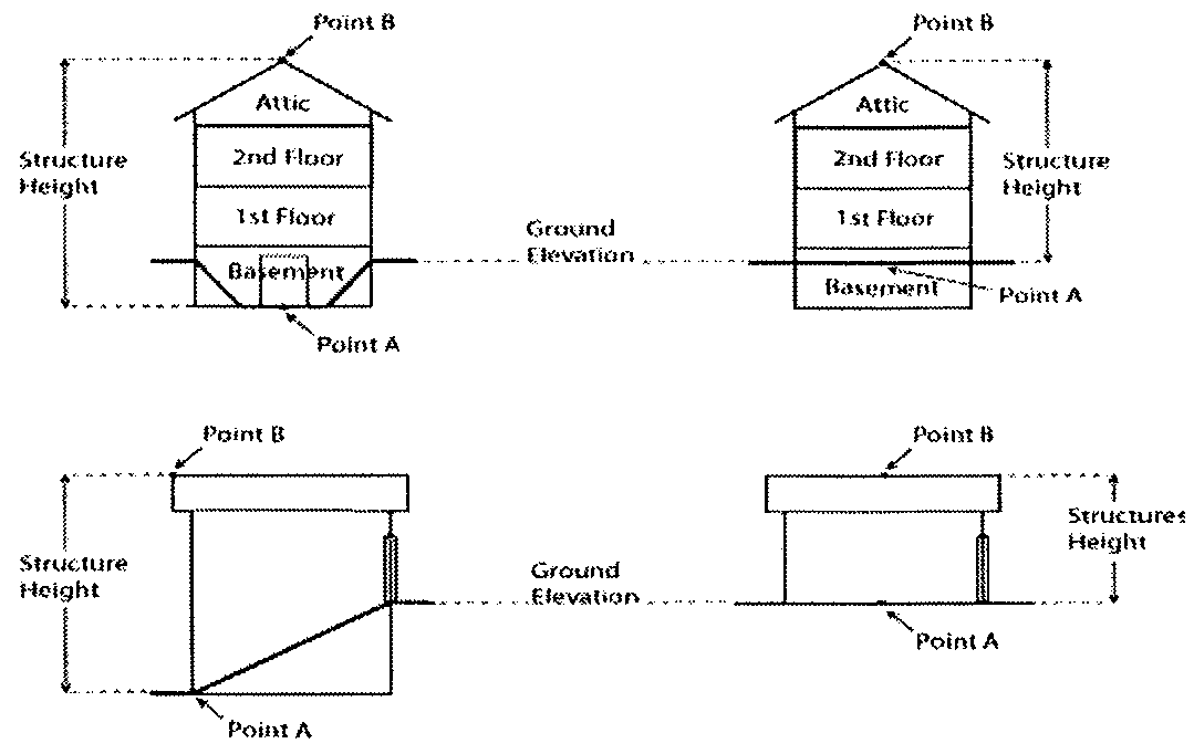
(Code 2000, § 38-599; Res. No. 72-16, 9-20-2016)
Sec. 38-748. - Nonconforming uses and structures.
(a)
Discontinued nonconforming use. If a nonconforming use is discontinued for a period of 12 months, any future use of the building, structure or property shall conform to the ordinance.
(b)
Maintenance, repair, replacement or vertical expansion of nonconforming structures. An existing structure that was lawfully placed when constructed but that does not comply with the required shoreland setback, or that is otherwise in violation of this chapter, that under Wis. Stats. § 59.692(1t), may not be enforced, may be maintained, repaired, replaced, restored, rebuilt or remodeled if the activity does not expand the footprint of the nonconforming structure. Further, an existing structure that was lawfully placed when constructed but that does not comply with the required shoreland setback may be vertically expanded unless the vertical expansion would extend more than 35 feet above grade level. Counties may allow expansion of a structure beyond the existing footprint if the expansion is necessary to comply with applicable state or federal requirements (Wis. Stats. § 59.692(1k)(a)2, 4 and (b)).
(c)
Lateral expansion of nonconforming principal structures within the setback. An existing principal structure that was lawfully placed when constructed but that does not comply with the required building setback per section 38-743(1) may be expanded laterally, provided that all of the following requirements are met:
(1)
The use of the structure has not been discontinued for a period of 12 months or more if a nonconforming use.
(2)
The existing principal structure is at least 35 feet from the ordinary highwater mark.
(3)
Lateral expansions are limited to a maximum of 200 square feet over the life of the structure. No portion of the expansion may be any closer to the ordinary highwater mark than the closest point of the existing principal structure.
(4)
The county shall issue a permit that requires a mitigation plan that shall be approved by the county and implemented by the property owner by the date specified in the permit. The mitigation plan shall meet the standards found in section 38-750.
(5)
All other provisions of the shoreland ordinance shall be met.
(d)
Expansion of a nonconforming principal structures beyond setback. An existing principal structure that was lawfully placed when constructed but that does not comply with the required building setback under section 38-743(1) may be expanded horizontally, landward, or vertically, provided that the expanded area meets the building setback requirements per section 38-743(1), and that all other provisions of the shoreland ordinance are met. A mitigation plan is not required solely for expansion under this subsection, but may be required per section 38-746.
(e)
Relocation of nonconforming principal structures. An existing principal structure that was lawfully placed when constructed but that does not comply with the required building setback per section 38-743(1) may be relocated on the property provided all of the following requirements are met:
(1)
The use of the structure has not been discontinued for a period of 12 months or more if a nonconforming use.
(2)
The existing principal structure is at least 35 feet from the ordinary highwater mark.
(3)
No portion of the relocated structure is located any closer to the ordinary highwater mark than the closest point of the existing principal structure.
(4)
The county determines that no other location is available on the property to build a principal structure of a comparable size to the structure proposed for relocation that will result in compliance with the shoreland setback requirement per section 38-743(1).
(5)
The county shall issue a permit that requires a mitigation plan that shall be approved by the county and implemented by the property owner by the date specified in the permit. The mitigation plan shall meet the standards found in section 38-746, and include enforceable obligations of the property owner to establish or maintain measures that the county determines are adequate to offset the impacts of the permitted expansion on water quality, near-shore aquatic habitat, upland wildlife habitat and natural scenic beauty. The mitigation measures shall be proportional to the amount and impacts of the replaced or relocated structure being permitted. The obligations of the property owner under the mitigation plan shall be evidenced by an instrument recorded in the office of the county register of deeds.
(6)
All other provisions of the shoreland ordinance shall be met.
(Code 2000, § 38-600; Res. No. 72-16, 9-20-2016; Res. No. 1-19, 2-19-2019)
Sec. 38-749. - Authorized maintenance, repair, replacement or vertical expansion of structures.
A structure of which any part has been authorized to be located within the shoreland setback area by a variance granted before July 13, 2015, may be maintained, repaired, replaced, restored, rebuilt or remodeled. Additionally, the structure may be vertically expanded unless the vertical expansion would extend more than 35 feet above grade level. Counties may allow expansion of a structure beyond the existing footprint if the expansion is necessary to comply with applicable state or federal requirements.
(Code 2000, § 38-601; Res. No. 72-16, 9-20-2016; Res. No. 1-19, 2-19-2019)
Sec. 38-750. - Mitigation.
(a)
For purposes of this division, mitigation means balancing measures that are designed, implemented and function to restore natural functions and values that are otherwise lost through development and human activities. When the county issues a permit requiring mitigation under sections 38-746(d)(2) or 38-748(c) and (e), the property owner must submit a complete plan that is reviewed and approved by the county. The plan includes the following:
(1)
A description of the measures that will be implemented to restore natural functions lost through development of the permitted project. The mitigation measures must be selected from the choices in subsection (b) of this section, and shall be proportional in scope to the projected impacts on water quality, near-shore aquatic habitat, upland wildlife habitat and natural scenic beauty.
(2)
An affidavit to be recorded with the register of deeds which will serve as an enforceable obligation on the property owner to establish and maintain the mitigation measures. The affidavit must be recorded prior to issuance of the permit authorizing construction. This form may be provided by the zoning department.
(3)
An implementation schedule outlining the phases of installation or implementation. Mitigation projects involving actual construction of a device (e.g., rain garden) shall be completed within two years of permit issuance.
(b)
Mitigation requirements and measures.
(1)
Mitigation points are required for developing property under the following conditions:
a.
Impervious surface coverage is greater than 15 percent but less than 20 percent, two points.
b.
Impervious surface coverage is from 20 percent to 30 percent, three points.
c.
Lateral expansion of nonconforming principal structure within the shoreland setback section 38-748(c), three points.
d.
Relocation of nonconforming principal structure within the shoreland setback section 38-748(e), one point.
(2)
The following mitigation measures are available to satisfy the point requirements noted above. Point requirements are cumulative (a project may require mitigation due to more than one circumstance in subsection (b)(1) of this section), in which case the points should be combined.
a.
Removal of a structure within the shoreland setback, up to three points.
b.
Installation of a rain garden sized to properly treat runoff created by the project (see notes below), up to three points.
c.
Installation of a stormwater infiltration system sized to properly treat runoff created by the project (see notes below), three points.
d.
Recording an affidavit that ensures the preservation of an existing compliant shoreland buffer, two points.
e.
Active restoration (accelerated recovery) of a compliant shoreland buffer, four points, section 38-744(c)(2).
f.
Passive restoration (natural recovery) of a compliant shoreland buffer, one point, section 38-744(c)(1).
g.
Increasing depth of an existing compliant shoreland buffer, two points for every 15 feet of depth.
h.
Reducing width of allowable viewing and access corridors, one point for every 15-foot reduction.
i.
Sea wall removal and natural bank stabilization, three points.
j.
Increasing shoreland setback, one point for every 15-foot increase beyond required (maximum of three points).
k.
Installation of a new private onside wastewater treatment system, three points, bringing an existing operating system to code, two points.
Notes: Plans that involve the active restoration/creation of a shoreland buffer must be approved by the LWCD. The LWCD is also available to create or design buffer restoration plans. There will be a fee charged by LWCD for these services. The fees are set and periodically adjusted by the zoning and agriculture and land conservation committees. Subsections (b)(2)b and c of this section may also require plans to be prepared and certified by a professional engineer.
(Code 2000, § 38-602; Res. No. 72-16, 9-20-2016)
Sec. 38-751. - Administrative provisions.
This division shall require all of the following:
(1)
The appointment of an administrator and such additional staff as the workload may require.
(2)
The creation of a zoning agency as authorized by Wis. Stats. § 59.69, a board of adjustments as authorized by Wis. Stats. § 59.694, and a county planning agency as defined in Wis. Stats. § 236.02(3), and required by Wis. Stats. § 59.692(3).
(3)
A system of permits in accordance with a fee schedule approved by the zoning committee, for all new construction, development, reconstruction, structural alteration or moving of buildings and structures. A copy of applications shall be required to be filed in the office of the county zoning administrator, unless prohibited by Wis. Stats. § 59.692(1k).
(4)
Regular inspection of permitted work in progress to ensure conformity of the finished structures with the terms of the county shoreland regulations.
(5)
A variance procedure which authorizes the board of adjustments to grant such variance from the terms of the ordinance as will not be contrary to the public interest where, owing to special conditions and the adoption of the shoreland zoning ordinance, a literal enforcement of the provisions of the ordinance will result in unnecessary hardship as long as the granting of a variance does not have the effect of granting or increasing any use of property which is prohibited in that zoning district by the county shoreland regulations.
(6)
A special exception (conditional use) procedure for uses presenting special problems.
(7)
The county shall keep a complete record of all proceedings before the board of adjustments, zoning agency and planning agency.
(8)
Written notice to the appropriate office of the department at least ten days prior to any hearing on a proposed variance, special exception or conditional use permit, appeal for a map or text interpretation, map or text amendment, and copies of all proposed land divisions submitted to the county for review under section 38-1005(c).
(9)
Submission to the appropriate office of the department, within ten days after grant or denial, copies of any decision on a variance, special exception or conditional use permit, or appeal for a map or text interpretation, and any decision to amend a map or text of an ordinance.
(10)
Development and maintenance of an official map of all mapped zoning district boundaries, amendments, and recordings.
(11)
The establishment of appropriate penalties for violations of various provisions of the ordinance, including forfeitures. Compliance with the ordinance shall be enforceable by the use of injunctions to prevent or abate a violation, as provided in Wis. Stats. § 59.69(11).
(12)
Pursuing the prosecution of violations of the county shoreland regulations.
(13)
Shoreland wetland map amendments according to Wis. Admin. Code § NR 115.04. Every petition for a shoreland-wetland map amendment filed with the county clerk shall be referred to the county zoning agency. A copy of each petition shall be provided to the appropriate office of the department within five days of the filing of the petition with the county clerk. Written notice of the public hearing to be held on a proposed amendment shall be provided to the appropriate office of the department at least ten days prior to the hearing. A copy of the county board's decision on each proposed amendment shall be forwarded to the appropriate office of the department within ten days after the decision is issued.
(Code 2000, § 38-603; Res. No. 72-16, 9-20-2016; Res. No. 1-19, 2-19-2019)
Sec. 38-752. - Definitions.
(a)
Several of the terms of subsection (c) of this section are also defined in section 38-6. Where terms are duplicated, the definitions in subsection (c) of this section are more applicable to this division and shall prevail.
(b)
For the purpose of administering and enforcing this division, all distances unless otherwise specified shall be measured horizontally.
(c)
The following words, terms and phrases, when used in this division, shall have the meanings ascribed to them in this subsection, except where the context clearly indicates a different meaning:
Access and viewing corridor means a strip of vegetated land that allows safe pedestrian access to the shore through the vegetative buffer zone.
Accessory structure means a subordinate structure on the same property as the principal structure which is devoted to a use incidental to the principal use of the property. Accessory structures include, but are not limited to, detached garages, sheds, barns, gazebos, patios, decks, swimming pools, hot tubs, fences, retaining walls, driveways, parking lots, sidewalks, detached stairways and lifts.
Boathouse means a permanent structure used for the storage of watercraft and associated materials and includes all structures which are totally enclosed, have roofs or walls or any combination of these structural parts.
Building envelope means the three-dimensional space within which a structure is built (still used in section 38-746).
County zoning agency means that committee or commission created or designated by the county board under Wis. Stats. § 59.69(2)(a), to act in all matters pertaining to county planning and zoning.
Department means the department of natural resources.
Drainage system means one or more artificial ditches, tile drains or similar devices which collect surface runoff or groundwater and convey it to a point of discharge.
Existing development pattern means that principal structures exist within 250 feet of a proposed principal structure in both directions along the shoreline.
Fire pit means a structure that is constructed of metal, brick and/or stone, held together with mortar, and is considered to be permanently placed and not portable. Such structures may have fire boxes and ovens. For purposes of this division, fire pits must meet setbacks as described in section 38-743(1).
Fire ring means a temporary portable structure made of metal, bricks or rocks that are not held together with mortar, or by any other method to cause it to be unmovable. Fire rings are generally recognized as a "circle of rocks" or may be a decorative metal ring that is purchased for the purpose of containing a campfire.
Floodplain (Wis. Admin. Code § NR 115.03(4)) means the land which has been or may be hereafter covered by floodwater during the regional flood. The floodplain includes the floodway and the flood fringe as those terms are defined in Wis. Admin. Code ch. NR 116.
Footprint means the land area covered by a structure at ground level measured on a horizontal plane. The footprint of a residence or building includes the horizontal plane bounded by the furthest exterior wall and eave if present, projected to natural grade. For structures without walls (decks, stairways, patios, carports), a single horizontal plane bounded by the furthest portion of the structure projected to natural grade. Note: For the purposes of replacing or reconstructing a nonconforming building with walls, the footprint shall not be expanded by enclosing the area that is located within the horizontal plane from the exterior wall to the eaves projected to natural grade. This constitutes a lateral expansion under Wis. Admin. Code ch. NR 115 and would need to follow Wis. Admin. Code § NR 115.05(1)(g)5.
Generally accepted forestry management practices means forestry management practices that promote sound management of a forest. Generally accepted forestry management practices include those practices contained in the most recent version of the department publication known as the state forest management guidelines and identified as PUB FR-226.
Impervious surface means an area that releases as runoff all or a majority of the precipitation that falls on it. The term "impervious surface" excludes frozen soil but includes rooftops, sidewalks, driveways, parking lots, and streets unless specifically designed, constructed, and maintained to be pervious. Roadways as defined in Wis. Stats. § 340.01(54) or sidewalks as defined in Wis. Stats. § 340.01(58) are not considered impervious surfaces.
Lot means a continuous parcel of land, not divided by a public right-of-way, and sufficient in size to meet the lot width and lot area provisions of this division.
Lot area means the area of a horizontal plane bounded by the front, side, and rear lot lines of a lot, but not including the area of any land below the ordinary highwater mark of navigable waters.
Lot of record means any lot, the description of which is properly recorded with the register of deeds, which at the time of its recordation complied with all applicable laws, ordinances, and regulations.
Mitigation means balancing measures that are designed, implemented and function to restore natural functions and values that are otherwise lost through development and human activities.
Navigable waters means Lake Superior, Lake Michigan, all natural inland lakes within the state and all streams, ponds, sloughs, flowages and other waters within the territorial limits of this state, including the state portion of boundary waters, which are navigable under the laws of this state. Under Wis. Stats. § 281.31(2)(d), notwithstanding any other provision of law or administrative rule promulgated thereunder, shoreland ordinances required under Wis. Stats. § 59.692, and Wis. Admin. Code ch. NR 115 do not apply to lands adjacent to:
(1)
Farm drainage ditches where such lands are not adjacent to a natural navigable stream or river and such lands were not navigable streams before ditching; and
(2)
Artificially constructed drainage ditches, ponds or stormwater retention basins that are not hydrologically connected to a natural navigable water body.
Ordinary highwater mark means the point on the bank or shore up to which the presence and action of surface water is so continuous as to leave a distinctive mark such as by erosion, destruction or prevention of terrestrial vegetation, predominance of aquatic vegetation, or other easily recognized characteristics.
Previously developed means a lot or parcel that was developed with a structure legally placed upon it.
Regional flood means a flood determined to be representative of large floods known to have generally occurred in the state and which may be expected to occur on a particular stream because of like physical characteristics, once in every 100 years.
Routine maintenance of vegetation means normally accepted horticultural practices that do not result in the loss of any layer of existing vegetation and do not require earth disturbance.
Shoreland means lands within the following distances from the ordinary highwater mark of navigable waters: 1,000 feet from a lake, pond or flowage; and 300 feet from a river or stream or to the landward side of the floodplain, whichever distance is greater.
Shoreland setback, also known as the "shoreland setback area" in Wis. Stats. § 59.692(1)(bn), means an area in a shoreland that is within a certain distance of the ordinary highwater mark in which the construction or placement of structures has been limited or prohibited under an ordinance enacted under Wis. Stats. § 59.692.
Shoreland-wetland district means a zoning district, created as a part of the county zoning regulations, comprised of shorelands that are designated as wetlands on the state wetland inventory maps prepared by the department.
Special exception (conditional use) means a use which is permitted by this division provided that certain conditions specified in this article are met and that a permit is granted by the board of adjustments or, where appropriate, the planning and zoning committee or county board.
Structure means a principal structure or any accessory structure including a garage, shed, boathouse, sidewalk, walkway, patio, deck, retaining wall, porch or fire pit.
Substandard lots means a legally created lot or parcel that met minimum area and minimum average width requirements when created, but does not meet current requirements for a new lot.
Unnecessary hardship means that circumstance where special conditions, which were not self-created, affect a particular property and make strict conformity with restrictions governing area, setbacks, frontage, height or density unnecessarily burdensome or unreasonable in light of the purposes of this division.
Wetlands means those areas where water is at, near or above the land surface long enough to be capable of supporting aquatic or hydrophytic vegetation and which have soils indicative of wet condition.
(Code 2000, § 38-604; Res. No. 72-16, 9-20-2016)
Sec. 38-778.- Guest cabins.
(a)
Guest cabins are authorized as a permitted use in residential, residential mobile, residential recreational one and two, residential agriculture, agriculture and forestry zoning districts.
(b)
Guest cabins are intended to be used for overflow guest accommodations, etc., and are accessory to the principal structure. A parcel must contain a principal dwelling before a guest cabin can be authorized.
(c)
Guest cabins shall be subject to all provisions of the state uniform dwelling code, as appropriate.
(d)
One guest cabin shall be allowed per lot (lots in contiguous ownership shall be considered one lot for purposes of this use). A lot containing a guest cabin may not also contain a bunkhouse.
(e)
All applicable setbacks shall be maintained.
(f)
Guest cabins shall not exceed the following size limitations:
(1)
Freestanding guest cabins shall be one story and shall not exceed 400 square feet in floor area.
(2)
Guest cabins that are within an accessory structure (e.g., pole shed) shall be limited to 50 percent of the structure floor area, or 400 square feet, whichever is lesser.
(3)
Guest cabins utilizing the loft space (attic truss type construction) above a garage may be the full floor area size of the garage building footprint; however, a garage may not contain two full stories to create living space. No external knee walls shall be allowed above the first story. Dormer windows, if installed, shall not exceed 30 percent (fractional numbers shall be rounded down to the nearest whole number) of the lineal distance of the roof.
(g)
Guest cabins containing plumbing shall be subject to the requirements of Wis. Stats. ch. 145, Wis. Admin. Code ch. SPS 383, and chapter 74.
(h)
When a previously permitted accessory structure is converted to a guest cabin, the size limitations noted in subsection (g) of this section do apply and a change of use permit must be obtained from the zoning office.
(i)
Guest cabins are subject to internal inspection by the zoning department.
(Code 2000, § 38-610; Res. No. 25-15, 3-24-2015; Res. No. 47-17, 6-20-2017; Res. No. 1-19, 2-19-2019)
Sec. 38-779. - Bunkhouses.
(a)
Bunkhouses are authorized as a permitted use in residential, residential mobile, residential recreational one and two, residential agriculture, agriculture and forestry zoning districts.
(b)
Bunkhouses are intended to be used for overflow sleeping only and are accessory to the principal structure. A parcel must contain a principal dwelling before a bunkhouse can be authorized.
(c)
Bunkhouses shall be subject to all provisions of the state uniform dwelling code, as appropriate.
(d)
One bunkhouse shall be allowed per lot (lots in contiguous ownership shall be considered one lot for purposes of this use). A lot containing a bunkhouse may not also contain a guest cabin.
(e)
All applicable setbacks shall be maintained.
(f)
A bunkhouse shall not contain any plumbing.
(g)
Bunkhouses shall not exceed 400 square feet in floor area and must be free standing. Bunkhouses shall be limited to one story.
(h)
A bunkhouse shall not be located within an existing structure (i.e., pole shed, garage).
(i)
Bunkhouses are subject to internal inspection by the zoning department.
(Code 2000, § 38-611; Res. No. 25-15, 3-24-2015; Res. No. 47-17, 6-20-2017; Res. No. 1-19, 2-19-2019)
Sec. 38-802.- County zoning administrator to enforce article; assistant designated.
The county zoning administrator shall administer and enforce the provisions of this article. The county zoning committee may also authorize designation of an assistant zoning administrator to assist in the enforcement and administration of this article.
(Code 2000, § 38-620; Ord. of 3-19-2002, Art. XXIX, § 290)
Sec. 38-803. - Duties of zoning administrator.
In administering and enforcing this article, the county zoning administrator, and any of his or her assistants, shall perform the following duties:
(1)
Provide necessary forms and applications for permits.
(2)
Issue zoning permits where the provisions of this article have been complied with.
(3)
Issue conditional use permits when authorized by the county zoning committee.
(4)
Survey the county upon adoption of the ordinance from which this article is derived, and, when necessary upon passage of amendments, identify and record information relative to nonconforming uses and structures.
(5)
Maintain files and applicants, permits, and other relevant information.
(6)
Make an annual report of his or her activities to the county zoning committee and to the county board.
(Code 2000, § 38-621; Ord. of 3-19-2002, Art. XXIX, § 291)
Sec. 38-804. - Powers of zoning administrator.
The county zoning administrator, and his or her assistants, shall have powers and authority, including, but not limited to, the following:
(1)
Access to any structure or premises for the purpose of performing his or her duties between 8:00 a.m. and 6:00 p.m. by the permission of the owner or upon issuance of a special inspection warrant. Additionally, by signing a land use permit application, the property owner or representative grants permission to the zoning administrator (and/or staff) to access the property for purposes of inspection.
(2)
Upon reasonable cause or question as to proper compliance, to revoke any land use permit and issue cease and desist orders requiring the cessation of any building, moving, alterations, or use which is in violation of the provisions of this article.
(Code 2000, § 38-622; Ord. of 3-19-2002, Art. XXIX, § 292; Res. No. 47-17, 6-20-2017)
Sec. 38-805. - Fee schedule.
The county zoning committee shall establish a fee schedule in connection with the filing of applications and permits and a current copy of such fee schedule shall be available and posted in the office of the zoning administrator. The fee schedule may be periodically adjusted by the zoning committee independent of the code amendment process.
(Code 2000, § 38-623; Ord. of 3-19-2002, Art. XXIX, § 293; Res. No. 47-17, 6-20-2017)
Sec. 38-824.- Powers of the board.
The county board of adjustments is hereby created. Such board shall be appointed in accordance with the provisions of Wis. Stats. § 59.694, consisting of five members and two alternate members, which shall have the following duties and powers:
(1)
To hear and decide appeals where it is alleged there is error in any order, requirement, decision, or determination made by an administrative official in the enforcement or administration of this chapter, including, without limitation, appeals brought pursuant to section 38-1005.
(2)
To authorize upon appeal in specific cases variances from the terms of this chapter that will not be contrary to the public interest, where, owing to special conditions, a literal enforcement of the provisions of the ordinance will result in unnecessary hardship, and so that the spirit of the ordinance shall be observed and substantial justice done.
a.
A property owner bears the burden of proving "unnecessary hardship," as that term is used in this subsection, for an area variance, by demonstrating that strict compliance with a zoning ordinance would unreasonably prevent the property owner from using the property owner's property for a permitted purpose or would render conformity with the zoning ordinance unnecessarily burdensome or, for a use variance, by demonstrating that strict compliance with the zoning ordinance would leave the property owner with no reasonable use of the property in the absence of a variance. In all circumstances, a property owner bears the burden of proving that the unnecessary hardship is based on conditions unique to the property, rather than considerations personal to the property owner, and that the unnecessary hardship was not created by the property owner.
b.
A variance granted under this subsection runs with the land.
c.
A variance granted under this article, and after April 5, 2012, shall be deemed expired if not authorized by a land use permit within two years of the date on which the variance was granted.
(3)
To be responsible for the interpretation of any of the provisions of this article which may have to be clarified in regard to a specific situation or peculiarity.
(4)
To hear and decide matters brought to the board pursuant to section 38-1005.
(Code 2000, § 38-630; Ord. of 3-19-2002, Art. XXX, § 300; Res. No. 1-19, 2-19-2019)
Sec. 38-825. - Appeals procedure.
(a)
Generally. Appeals to the board of adjustments may be taken by any person aggrieved or by an officer, department, board, or bureau of the municipality affected by any decision of any other administrative officer, including, without limitation, appeals brought pursuant to section 38-1005.
(b)
Time for filing notice; submission of records. Appeal shall be taken within 30 days unless otherwise provided by the rules of the board, by filing with the official whose decision is in question, and with the boards, a notice of appeal specifying the reasons for the appeal. The official whose decision is in question shall transmit to the board all records regarding the matter appealed.
(c)
Hearing. The board shall fix a reasonable time for the hearing and publish adequate notice pursuant to state law, specifying the date, time, place and subject of the hearing. The board shall ensure that notice shall be mailed to the parties in interest and the department regional office at least ten days in advance of the hearing. At the hearing, any party may appear in person or by agent.
(d)
Decision. The final decision regarding the appeal or variance application shall:
(1)
Be made within a reasonable time;
(2)
Be sent to the department regional office within ten days of the decision;
(3)
State the specific facts which are the basis for the board's decision;
(4)
Either affirm, reverse, vary or modify the order, requirement, decision or determination appealed; in whole or in part, dismiss the appeal for lack of jurisdiction; or grant or deny the variance application; and
(5)
Include the reasons for granting an appeal, describing the hardship demonstrated by the applicant in the case of a variance, clearly stated in the recorded minutes of the board proceedings.
(Code 2000, § 38-631; Ord. of 3-19-2002, Art. XXX, § 301)
Sec. 38-826. - Open meeting; rules and procedures.
(a)
All meetings of the board of adjustments shall be open to the public and, upon a hearing, any party may appear in person, by agent, or attorney. Meetings of the board shall be at the call of the chairman and at such other times as the board may determine. Such meetings shall be noticed as to date, time, place, and the matters to come before the board.
(b)
The board of adjustments shall adopt such rules as it deems necessary for the conduct of business, and may exercise all the powers, and is vested with all of the duties conferred on such boards by Wis. Stats. § 59.694 and under this chapter.
(Code 2000, § 38-632; Ord. of 3-19-2002, Art. XXX, § 302)
Sec. 38-827. - Minutes.
The board of adjustments shall keep minutes of its proceedings showing the vote of each member upon each question, or if absent or failing to vote, indicating such fact, and shall keep records of its examinations and other official actions, all of which shall be public record.
(Code 2000, § 38-633; Ord. of 3-19-2002, Art. XXX, § 303)
Sec. 38-853.- Purpose.
The purpose of this division is to regulate by zoning permit:
(1)
The siting and construction of any new mobile service support structure and facilities;
(2)
With regard to a Class 1 collocation, the substantial modification of an existing support structure and mobile service facilities; and
(3)
With regard to a Class 2 collocation, collocation on an existing support structure which does not require the substantial modification of an existing support structure and mobile service facilities.
(Code 2000, § 38-701; Res. No. 10-14, § II, 3-18-2014)
Sec. 38-854. - Exemptions.
(a)
Exempt from review under this division will be television antennas, satellite dishes one meter (or 39 inches) in diameter or less, satellite dishes used commercially three meters in diameter or less, receive only antennas, amateur radio facilities, and mobile services providing public information coverage of news events or of a temporary or emergency nature.
(b)
Exempt from the permitting requirements of this division will be satellite dishes more than one meter in diameter, ground-mounted antennas not exceeding 100 feet in height, building-mounted antennas not exceeding 25 feet above the highest part of the building to which they are attached, and utility pole-mounted antennas not exceeding 25 feet above the highest part of the utility pole to which they are attached.
(c)
Exempt structures under this division are subject to all other applicable provisions of the zoning provisions of this article.
(Code 2000, § 38-702; Res. No. 10-14, § III, 3-18-2014)
Sec. 38-855. - Definitions.
(a)
Definitions. The following definitions shall apply to this division, unless the context dictates otherwise. All definitions in section 38-6 shall apply, unless specifically defined in this section:
Alternative support structure means structures including, but not limited to, clock towers, steeples, silos, light poles, water towers, freestanding chimneys, utility poles and towers, towers, buildings or similar structures that may support telecommunications facilities.
Antenna means any system of wires, poles, rods, reflecting discs, or similar devices used for the transmission or reception of electromagnetic waves when such system is either external to or attached to the exterior of a structure. Antennas includes devices having active elements extending in any direction, and directional beam type arrays having elements carried by and disposed from a generally horizontal boom that may be mounted upon and rotated through a vertical mast or tower interconnecting the boom and antenna support, all of which elements are deemed to be a part of the antenna.
Antenna, building-mounted, means any antenna, other than an antenna with its supports resting on the ground, directly attached or affixed to a building.
Antenna, ground-mounted, means any antenna with its base placed directly on the ground.
Camouflaged tower means any telecommunications tower that due to design or appearance hides, obscures, or conceals the presence of the tower and antennas. Camouflaging may be accomplished by a suitable combination of the following examples lack of lighting, low tower height, noncontrasting colors, screening and landscaping, and others.
Carrier means companies licensed by the Federal Communications Commission (FCC) to build personal wireless telecommunications facilities and operate personal wireless telecommunications services. Also called a provider.
Class 1 collocation means the placement of a new mobile service facility on an existing support structure, such that the owner of the facility does not need to construct a freestanding support structure for the facility, but does need to engage in substantial modification.
Class 2 collocation means the placement of a new mobile service facility on an existing support structure such that the owner of the facility does not need to construct a freestanding support structure for the facility or engage in substantial modification.
Collocation means a telecommunications facility comprised of a single telecommunications tower or building supporting multiple antennas, dishes, or similar devices owned or used by more than one public or private entity.
Guyed structure means a telecommunications tower that is supported in whole or in part by guy wires and ground anchors or other means of support besides the superstructure of the tower itself.
Height, telecommunications tower, means the distance measured from the original grade at the base of the tower to the highest point of the tower. This measurement excludes any attached antennas, and lighting.
Lattice structure means a telecommunications tower that consists of vertical and horizontal supports and crossed metal braces.
Monopole structure means a telecommunications tower of a single pole design.
Operation means other than nominal use; when a facility is used regularly as an integral part of an active system of telecommunications, it shall be deemed in operation.
Provider. See Carrier.
Satellite dish means a device incorporating a reflective surface that is solid, open mesh, or bar configured that is shallow dish, cone, horn, or cornucopia shaped and is used to transmit or receive electromagnetic signals. This definition is meant to include, but is not limited to, what are commonly referred to as satellite earth stations, TYROs and satellite microwave antennas.
Substantial modification means the modification of a mobile service support structure, including the mounting of an antenna on the structure, that does any of the following:
(1)
For structures with an overall height of 200 feet or less, increases the overall height of the structure by more than 20 feet.
(2)
For structures with an overall height of more than 200 feet, increases the overall height of the structure by ten percent or more.
(3)
Measured at the level of the appurtenance added to the structure as a result of the modification, increases the width of the support structure by 20 feet or more, unless a larger area is needed for collocation.
(4)
Increases the square footage of an existing equipment compound to a total area of more than 2,500 square feet.
Telecommunications facility means a facility, site, or location that contains one or more antennas, telecommunications towers, alternative support structures, satellite dish antennas, other similar communication devices, and support equipment which is used for transmitting, receiving, or relaying telecommunications signals, excluding facilities exempted under this division.
Telecommunications facility structure means a telecommunications tower or alternative support structure on which telecommunications antennas may be mounted.
Telecommunications tower means any structure that is designed and constructed primarily for the purpose of supporting one or more antennas, including camouflaged towers, lattice towers, guy towers, or monopole towers. This includes radio and television transmission towers, microwave towers, and common-carrier towers. It shall exclude alternative support structures and those facilities exempted under this division.
Utility pole-mounted antenna means an antenna attached to or upon an existing or replacement electric transmission or distribution pole, streetlight, traffic signal, athletic field light, or other approved similar structure.
(b)
Additional definitions contained in Wis. Stats. § 66.0404(1) are hereby incorporated by reference.
(Code 2000, § 38-703; Res. No. 10-14, § IV, 3-18-2014)
Sec. 38-856. - Siting and construction of any new mobile service support structure and facilities and Class 1 collocation.
(a)
Application process.
(1)
A land use permit is required for the siting and construction of any new mobile service support structure and facilities.
(2)
A written permit application must be completed by any applicant and submitted to the county zoning department. The application must contain the following information:
a.
The name and business address of, and the contact individual for, the applicant.
b.
The location of the proposed or affected support structure.
c.
The location of the proposed mobile service facility.
d.
If the application is to substantially modify an existing support structure, a construction plan which describes the proposed modifications to the support structure and the equipment and network components, including antennas, transmitters, receivers, base stations, power supplies, cabling, and related equipment associated with the proposed modifications.
e.
If the application is to construct a new mobile service support structure, a construction plan which describes the proposed mobile service support structure and the equipment and network components, including antennas, transmitters, receivers, base stations, power supplies, cabling, and related equipment to be placed on or around the new mobile service support structure.
f.
If an application is to construct a new mobile service support structure, an explanation as to why the applicant chose the proposed location and why the applicant did not choose collocation, including a sworn statement from an individual who has responsibility over the placement of the mobile service support structure attesting that collocation within the applicant's search ring would not result in the same mobile service functionality, coverage, and capacity; is technically infeasible; or is economically burdensome to the mobile service provider.
(3)
A permit application will be provided by the county upon request to any applicant.
(4)
If an applicant submits to the county an application for a permit to engage in an activity described in this division, which contains all of the information required under this division, the county shall consider the application complete. If the county does not believe that the application is complete, the county shall notify the applicant in writing, within ten days of receiving the application, that the application is not complete. The written notification shall specify in detail the required information that was incomplete. An applicant may resubmit an application as often as necessary until it is complete.
(5)
Within 90 days of its receipt of a complete application, the county shall complete all of the following or the applicant may consider the application approved, except that the applicant and the county may agree in writing to an extension of the 90-day period:
a.
Review the application to determine whether it complies with all applicable aspects of the political subdivision's building code and, subject to the limitations in this section, zoning ordinances.
b.
Make a final decision whether to approve or disapprove the application.
c.
Notify the applicant, in writing, of its final decision.
d.
If the decision is to disapprove the application, include with the written notification substantial evidence which supports the decision.
(6)
The county may disapprove an application if an applicant refuses to evaluate the feasibility of collocation within the applicant's search ring and provide the sworn statement described under subsection (a)(2)f of this section.
(7)
If an applicant provides the county with an engineering certification showing that a mobile service support structure, or an existing structure, is designed to collapse within a smaller area than the setback or fall zone area required in a zoning ordinance, that zoning ordinance does not apply to such a structure unless the town provides the applicant with substantial evidence that the engineering certification is flawed.
(b)
The fee for the permit is $3,000.00.
(Code 2000, § 38-704; Res. No. 10-14, § V, 3-18-2014)
Sec. 38-857. - Class 2 collocation.
(a)
Application process.
(1)
A land use permit is required for a Class 2 collocation.
(2)
A written permit application must be completed by any applicant and submitted to the county. The application must contain the following information:
a.
The name and business address of, and the contact individual for, the applicant.
b.
The location of the proposed or affected support structure.
c.
The location of the proposed mobile service facility.
(3)
A permit application will be provided by the county upon request to any applicant.
(4)
A Class 2 collocation is subject to the same requirements for the issuance of a building permit to which any other type of commercial development or land use development is subject.
(5)
If an applicant submits to the county an application for a permit to engage in an activity described in this division, which contains all of the information required under this division, the county shall consider the application complete. If any of the required information is not in the application, the county shall notify the applicant in writing, within five days of receiving the application, that the application is not complete. The written notification shall specify in detail the required information that was incomplete. An applicant may resubmit an application as often as necessary until it is complete.
(6)
Within 45 days of its receipt of a complete application, the county shall complete all of the following or the applicant may consider the application approved, except that the applicant and the county may agree in writing to an extension of the 45-day period:
a.
Make a final decision whether to approve or disapprove the application.
b.
Notify the applicant, in writing, of its final decision.
c.
If the application is approved, issue the applicant the relevant permit.
d.
If the decision is to disapprove the application, include with the written notification substantial evidence which supports the decision.
(7)
The fee for the permit is $500.00.
(b)
Collocation related exclusively to installation of broadband equipment shall be a $100.00 fee.
(Code 2000, § 38-705; Res. No. 10-14, § VI, 3-18-2014; Res. No. 1-19, 2-19-2019)
Sec. 38-858. - Removal of abandoned telecommunications facilities.
It is the express policy of the county that telecommunications facilities be removed and their sites restored to their pre-construction state once they are no longer in use and not a functional part of providing telecommunications service.
(1)
Removal and restoration of such facilities is the responsibility of the owner of the facility.
(2)
The telecommunications facility shall be removed when use of the facility has been discontinued or the facility not been used for its permitted purpose for 12 consecutive months. Mere intent to continue use of the facility shall not constitute use. The applicant/owner shall demonstrate through facility lease or other similar instrument that the use will be continued without a lapse of more than 12 consecutive months to constitute actual use. If the applicant cannot demonstrate actual use, the facility shall be considered abandoned and shall be removed.
(3)
This restoration includes removal of any subsurface structure or foundation, including concrete, used to support the telecommunications facility, to a level of three feet below grade.
(4)
Nothing in this section prevents the removal of the facility prior to expiration of the 12-month period.
(Code 2000, § 38-706; Res. No. 10-14, § VII, 3-18-2014)
Sec. 38-859. - Reporting requirements.
Notification shall be provided to the zoning department if any of the information changes in section 38-856(a)(2) or 38-857(a)(2).
(Code 2000, § 38-707; Res. No. 10-14, § VIII, 3-18-2014)

