
Belhaven City Zoning Code
CHAPTER 153
SUBDIVISION REGULATIONS
Sec. 153.01. - Title; effective date.
This chapter shall be known as the subdivision regulations of the Town of Belhaven, North Carolina, and may be referred to as the "Subdivision Regulations." These regulations were first adopted by the Town on January 16, 1967 and subsequently amended on May 2, 1994.
(Code 1979, § 153.01; Ord. of 5-2-1994)
Sec. 153.02. - Purpose.
(a)
This chapter is adopted as a part of the implementation of the Town's Land Use Plan.
(b)
The regulation of land subdivision is widely accepted as a function of municipal government undertaken as a method of ensuring sound community growth and the safeguarding of the interest of the homeowner, the subdivider, and the local government. subdivision regulations prevent excessive governmental operating costs by setting minimum standards for public improvements installed prior to development. At the same time, they ensure to the maximum degree possible the means whereby land can be developed for the highest possible use with all of the necessary protection against deterioration and obsolescence.
(c)
The subdivision of land is a technical and business venture which not only affects the immediate return to the investor in land and the value of the land on which he/she may wish to build, but it also involves, for the local government, specific items of cost and income for the years to come which must be weighted at the time that a subdivision is under consideration.
(d)
This chapter is to provide for the orderly development of the Town and its environs through the control and regulation of the subdivision of land. According to G.S. 160A-372, a subdivision control ordinance may provide for the orderly growth and development of the Town; for the coordination of streets and highways within proposed subdivisions with existing or planned streets and highways and with other public facilities; for the dedication or reservation of recreation areas serving residents of the immediate neighborhood within the subdivision, and rights-of-way or easements for street and utility purposes; and for the distribution of population and traffic in a manner that will avoid congestion and overcrowding and will create conditions essential to public health, safety and general welfare.
(Code 1979, § 153.02; Ord. of 5-2-1994)
Sec. 153.03. - Application of regulations.
These regulations shall apply to lands within the corporate limits of the Town and its extraterritorial limits for one mile beyond the corporate limits. All subdivision plans, all streets or rights-of-way created for the purpose of partitioning land and changes in property boundary lines shall be approved by the Planning Commission in accordance with these regulations. A person desiring to subdivide land by creating a street or way or to sell any portion of a parcel of land, shall submit preliminary plans and final documents for approval as provided in this chapter and state law.
(Code 1979, § 153.03; Ord. of 5-2-1994)
Sec. 153.04. - Authority.
The provisions of this chapter are adopted under authority granted by the General Assembly of the State of North Carolina, in G.S. 160A-19.
(Code 1979, § 153.04; Ord. of 5-2-1994)
Sec. 153.05. - Jurisdiction.
All subdivision of land within the subdivision jurisdiction of the Town shall, after the effective date of these regulations, be governed by the procedures and standards contained within these regulations.
(Code 1979, § 153.05; Ord. of 5-2-1994)
Sec. 153.06. - Scope.
All subdivisions shall be subject to the provisions of this chapter except those situations listed as "not included" in the statutory definition of a subdivision (G.S. 160A-376(1) through (4)) and as reiterated in the definition of a subdivision in section 153.07.
(Code 1979, § 153.06; Ord. of 5-2-1994)
Sec. 153.07. - Definitions; interpretations.
(a)
The following words, terms and phrases, when used in this chapter, shall have the meanings ascribed to them in this section, except where the context clearly indicates a different meaning:
Alley means a minor right-of-way dedicated to public use, which gives a secondary means of vehicular access to the back or side of properties otherwise abutting a street, and which may be used for public utility purposes.
Areas of environmental concern (AECS) means geographic areas designated by the Coastal Resources Commission as areas of environmental concern, including coastal wetlands, estuarine waters, renewable resource areas, fragile or historic areas, public trust waters, natural hazard areas and areas impacted by key facilities.
Block means a parcel of land which is entirely surrounded by public streets, highways, railroad rights-of-way, public walks, parks or green strips, rural land or drainage channels or a combination thereof.
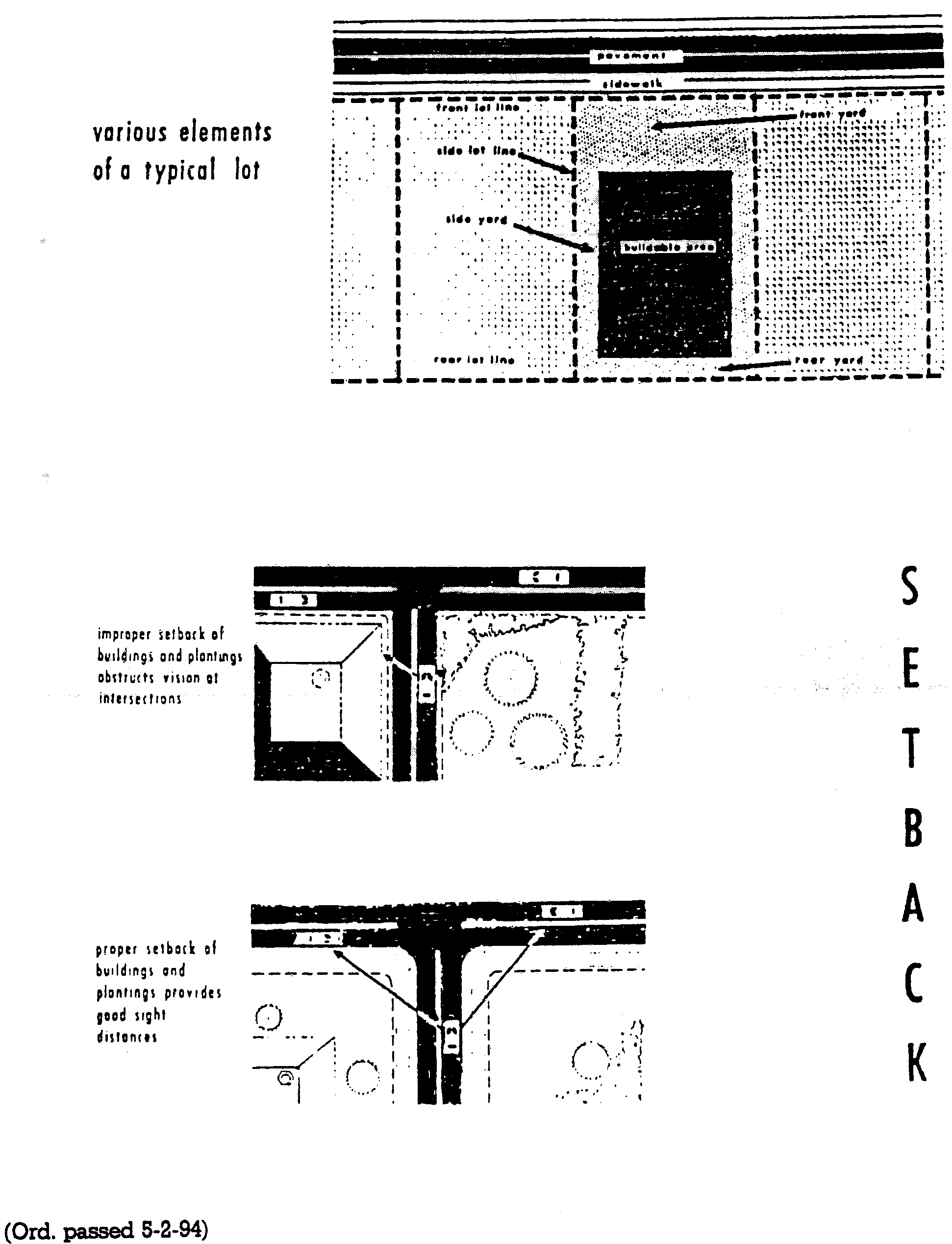
Building setback line means a line parallel to the front property lines in front of which no structure may be built.
Corner lot means a lot abutting two or more streets at the street intersections.
Double frontage lot means a continuous (through) lot of the same depth as the width of a block and which is accessible from both of the streets upon which it fronts.
Easement means permission by the property owner for use by the public, a corporation, or persons of a strip of land for specific purposes.
Extraterritorial jurisdiction means the power of the Town to regulate the use of land lying between the corporate limits and the extraterritorial boundary lines as defined by the Official Zoning Map.
Group development means a development comprising two or more buildings, such as a group of apartments, where the land is not subdivided into the customary streets and lots.
Lot means a portion of a subdivision or any other parcel of land intended as a unit for transfer of ownership or for development, or both. The term "lot" includes the terms "plot" and "parcel."
Official plan means any plan officially adopted by the Planning Board or the Board of Aldermen as a guide for the development of the Town and its surrounding area, consisting of maps, charts and text.
Permanent markers means an iron pipe not less than three-fourths of an inch in diameter and 30 inches long. Permanent markers are described in detail in section 153.57.
Plat includes the terms "map," "plan," "plat," "replat," or "replot," and means a map or plan of a tract or parcel of land which is to be, or which has been subdivided.
Plat, final, means a map of a land subdivision prepared in a form suitable for filing of record with necessary affidavits, dedications and acceptances, and with complete bearings and dimensions of all lines defining lots and blocks, streets and alleys, public areas and other dimensions of land.
Plat, preliminary, means a map of proposed land subdivision showing the character and proposed layout of the tract in sufficient detail to indicate the suitability of the proposed subdivision of land.
Street means a dedicated and accepted public right-of-way for vehicular and pedestrian traffic.
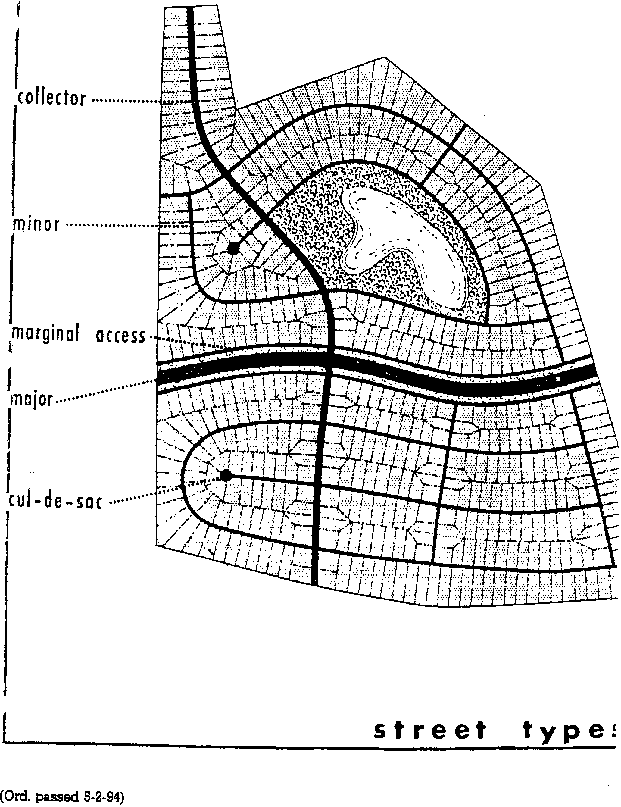
Collector street means a street which collects and distributes traffic from and to minor streets and serves as the most direct route to a major street or a community facility.
Cul-de-sac means a minor street having one end open to vehicular traffic and the other end permanently terminated by a vehicular turnaround.
Major street means a street or highway which is used for moving heavy traffic volumes or high speed traffic, or both, or which has been designated as a major street on the thoroughfare plan.
Marginal access street means a minor street located beside a limited access street or highway or a railroad, which provides access to abutting properties, provides protection from through traffic, and controls access.
Minor street means a street whose primary purpose is to provide access to adjacent properties and which is designated in a manner that will discourage use by through traffic.
Subdivider means any person, firm, or corporation which subdivides any land deemed to be a subdivision as defined below.
Subdivision means and includes all divisions of a tract or parcel of land into two or more lots, building sites, or other divisions for the purpose, whether immediate or future, of sale or building development, and includes all divisions of land involving the dedication of a new street or a change in existing streets; provided, however, that the following shall not be included within this definition nor be subject to the regulations set forth in this chapter:
(1)
The combination or recombination of portions of previously platted lots where the total number of lots is not increased and the resultant lots are equal to or exceed the standards of the Town set forth in this chapter and other ordinances of the Town;
(2)
The division of land into parcels greater than ten acres where no street right-of-way dedication is involved;
(3)
The division of a tract in single ownership whose entire area is no greater than two acres into not more than three lots, where no street right-of-way dedication is involved and where the resultant lots are equal to or exceed the standards of the Town, as set forth in this chapter and other ordinances of the Town;
(4)
The public acquisition of land for the widening or opening of streets or for infrastructure improvements necessary for public works or utilities projects, including, but not limited to, plant sites, pumping stations, substations, wells, drainage or similar needs;
(5)
In addition to the exceptions provided in the North Carolina General Statutes, a subdivision shall not include the division of land to be sold only as burial plots within cemeteries.
(b)
For the purpose of this chapter, certain words shall be interpreted as follows:
(1)
The term "may" is permissive.
(2)
The term "shall" is mandatory.
(3)
The term "building" includes the term "structure."
(4)
The term "Town" means the Town of Belhaven, a municipal corporation of the State of North Carolina.
(5)
The terms "chapter" and "regulation" means the Subdivision Regulations of the Town of Belhaven, North Carolina.
(6)
The term "Planning Board" means the Town of Belhaven Planning and Zoning Board.
(7)
The term "Board of Aldermen" means the Board of Aldermen of Belhaven, North Carolina.
(8)
The term "Register of Deeds" means the Recorder of Deeds for Beaufort County, North Carolina.
(Code 1979, § 153.07; Ord. of 5-2-1994; Ord. of 12-7-1998)
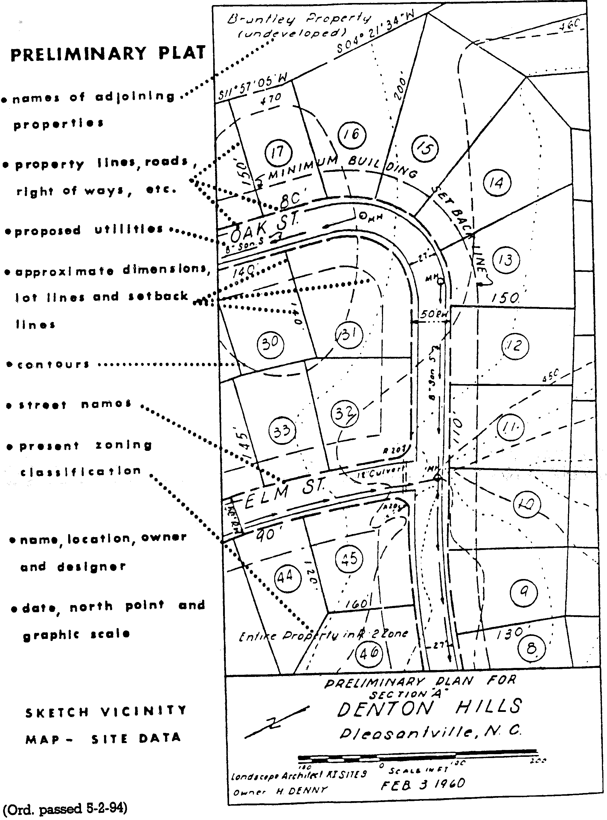
Sec. 153.15. - Sketch plan.
(a)
General. Before the subdivider makes application for approval of the preliminary subdivision plat, a sketch plan of the proposed subdivision shall be prepared and two copies submitted to the Code Enforcement Officer for review. The sketch plan shall be drawn at a scale of not less than 200 feet to one inch.
(b)
Contents of the sketch plan. The sketch plan shall contain or be accompanied by the following information:
(1)
The proposed name and location of the subdivision.
(2)
The names and addresses of the owners and the subdividers.
(3)
The total acreage to be subdivided.
(4)
The tentative street and lot arrangement.
(5)
The approximate rights-of-way, easements, and lot lines.
(6)
The average lot area and approximate number of lots.
(7)
The existing and proposed uses of land throughout the subdivision.
(8)
The zoning classification of the land to be subdivided.
(9)
Vicinity map, showing proposed subdivision in relation to existing, readily identifiable landmarks.
(c)
Administrative staff review. At the time the sketch plan is submitted, it shall be reviewed by the Code Enforcement Officer for general compliance with the requirements of this chapter; the subdivider or his/her representative shall discuss plans for development of the proposed subdivision; and the Code Enforcement Officer shall advise the subdivider as to the regulations which pertain to the proposed development and the procedure the subdivider shall follow in preparing and submitting the subdivision plats. Submitting a sketch plan for review and discussion does not require a formal application or fee. This procedure shall not be construed as an official application, or approval of such a sketch plan by the Code Enforcement Officer or Planning Board.
(Code 1979, § 153.15; Ord. of 5-2-1994)
Cross reference— Penalty, see § 153.99.
Sec. 153.16. - Preliminary plat.
(a)
Sketch plan. Prior to submission of a preliminary plat, the subdivider shall submit to the Code Enforcement Officer two copies of a sketch plan of the proposed subdivision as per section 153.15.
(b)
Submission of preliminary plat. The subdivider shall prepare a preliminary plat and such improvement plans and other supplementary material as may be required to indicate the general objectives of the development. The subdivider shall submit six copies of the preliminary plat to the Code Enforcement Officer at least 20 days prior to the third Wednesday of the month. The preliminary plat shall be prepared by a registered surveyor or engineer.
(c)
Fee. At the time of submission of the preliminary plat, the subdivider shall pay to the Town Clerk a filing fee as follows:
(1)
If one to ten lots: $100.00.
(2)
If 11 to 50 lots: add $7.00 per lot over ten.
(3)
If 51 or more lots: add $6.00 per lot over 50.
(d)
Scale. The preliminary plat shall be drawn on a sheet 18 by 24 inches or a multiple thereof at a scale of one inch equals 100 feet or, for areas over 100 acres, one inch equals 200 feet.
(e)
General information. The following general information shall be shown on the preliminary plat:
(1)
Proposed name of the subdivision. The name shall not duplicate nor resemble the name of another subdivision in the county and shall be approved by the Planning Board.
(2)
Date, north point, and scale of drawing.
(3)
Appropriate identification clearly stating the map is a preliminary plat.
(4)
A vicinity map showing the location of the proposed subdivision.
(5)
Names and addresses of the owner, subdivider, and engineer or surveyor.
(6)
Date the property was surveyed, if available. (A survey is not required for preliminary plat.)
(f)
Existing conditions. The following existing conditions shall be shown on the preliminary plat:
(1)
The location, width, and names of all existing or platted streets within or adjacent to the tract, together with easements, railroad rights-of-way and other important features, such as section lines and corners, city boundary lines, and monuments.
(2)
Contour lines related to an established bench mark or other datum approved by the Code Enforcement Officer, with intervals at a minimum of two feet for slopes up to ten percent and five feet for slopes over ten percent.
(3)
The existing zoning classifications of the tract.
(4)
The location of existing buildings, railroads and bridges.
(5)
The location of all 100-year floodplains, marshes, water, watercourses, ditches, drainage channels and subsurface drainage structures, and the proposed method of disposing of all runoff from the proposed subdivision, and the location and size of all drainage easements relating thereto, whether they are located within or outside of the proposed plat.
(6)
The plans for sanitary sewers, storm sewers, water mains, culverts, electric and gas lines, and other surface and subsurface structures and pipe lines existing and proposed within or immediately adjacent to the proposed subdivision, showing connections to existing systems or proposals for developing new water supply, storm drainage, and sewage disposal systems. If applicable, the developer's sedimentation and pollution control plan shall be submitted.
(7)
Pavement widths and grades and names of all proposed streets. Names shall not duplicate or resemble the names of existing streets within the Town or the county, if within the extraterritorial jurisdiction.
(8)
The lot lines, lot dimensions, lot and block numbers, and minimum building setback lines.
(9)
Proposed parks, school site, or other public open spaces, if any.
(10)
The total acreage in the tract, acreage in public or other land usage, and average lot size, total number of lots, and linear feet in streets.
(11)
Any other supplemental material or information considered by either the subdivider or the Planning Board to be pertinent to the review of the preliminary plat.
(12)
Results of percolation tests for each proposed lot and assessment of Beaufort County detailed soils information to determine soil suitability for installation and successful operation of septic tanks, where public service is not available.
(g)
Certification of compliance with area of environmental concern standards. A certificate of compliance with AEC standards shall be signed by the AEC permit officer and accompany the preliminary plat (see certification form in Appendix A, section 153.1000).
(h)
Approval of preliminary plats.
(1)
The Planning Board shall review and take final action on each preliminary plat within 60 days after first consideration by the Planning Board. First consideration by the Planning Board shall be at the next monthly meeting after the preliminary plat has been submitted to the Code Enforcement Officer, if the submission occurs more than 20 days before such monthly meeting. If the submission takes place less than 21 days before the next Planning Board meeting, first consideration shall be at the second next meeting. Failure of the Planning Board to take action within 60 days shall be grounds for the subdivider to submit the preliminary plat to the Board of Aldermen for review.
(2)
Prior to the Planning Board meeting, the Code Enforcement Officer shall notify in writing those public officials and agencies which are concerned with the new development, including the Town Manager, the County Health Department, the district engineer of the state department of transportation and the County Superintendent of Schools that a plat is available for review and recommendations.
(3)
Upon completion of the preliminary plat review, the Planning Board shall approve, approve conditionally, or disapprove the plat.
a.
If the preliminary plat is approved, approval shall be noted on two copies of the plat by the Planning Board secretary. One of these copies shall be transmitted to the subdivider and the other to the Board of Aldermen.
b.
In the case of conditional approval, the reasons for conditional approval and the conditions to be met shall be specified in writing. One copy of such reasons and conditions shall be filed with a copy of the plat retained by the Planning Board, one shall be transmitted to the Board of Aldermen with a copy of the plat, and one shall be transmitted to the subdivider.
c.
When a preliminary plat is disapproved, the Planning Board shall specify the reasons for such action in writing. One copy of such reasons shall be retained by the Planning Board, one copy shall be transmitted to the Board of Aldermen, and one copy shall be transmitted to the subdivider. If the preliminary plat is disapproved, the subdivider may make the recommended changes and submit a revised preliminary plat.
(4)
The Board of Aldermen shall approve, conditionally approve, or disapprove the preliminary plat. Upon approval of the preliminary plat by the Board of Aldermen, the subdivider may proceed with the preparation of the final plat, and the installation or arrangement for required improvements in accordance with the preliminary plat as approved and the requirements of this chapter. Disapproval of the plat shall be accompanied by the stated reasons for such action and recommendations made on the basis of which the proposed plat could be approved.
(Code 1979, § 153.16; Ord. of 5-2-1994)
Cross reference— Penalty, see § 153.99; preliminary plat checklist, see Appendix B, § 153.2000.
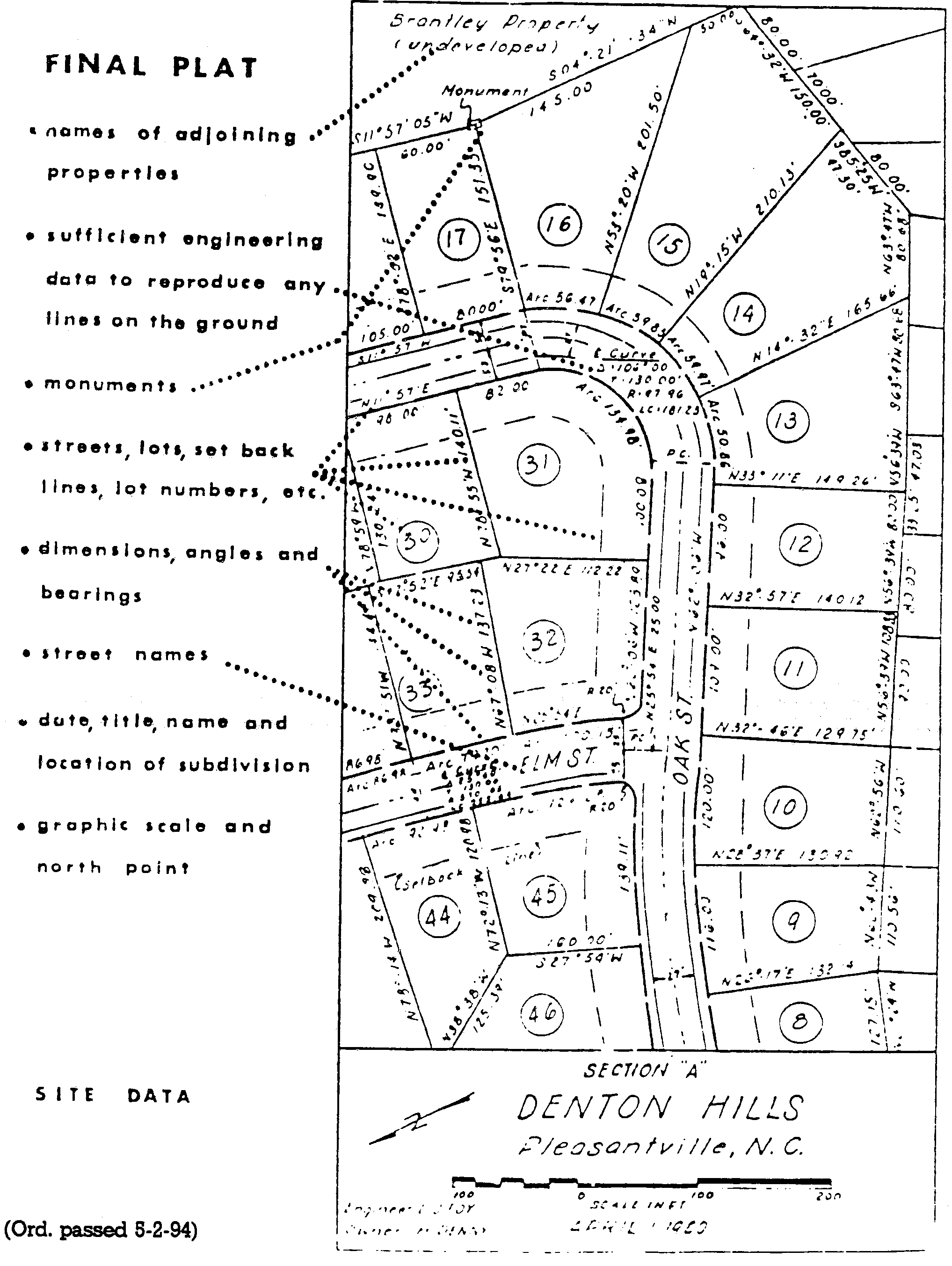
Sec. 153.17. - Final plat.
(a)
General.
(1)
Final plats for all subdivisions shall not be approved until all required improvements have been installed or the subdivider has guaranteed to the satisfaction of the Board of Aldermen that such improvements will be installed as provided in section 153.56.
(2)
The subdivider shall submit four copies of the final plat; one drawn in ink on Mylar or such other material as acceptable for recording in the register of deeds office and three additional paper copies to the Code Enforcement Officer by 2:00 p.m. on the first Friday of the month preceding the next regularly scheduled meeting of the Planning Board at which the plat is to be considered for final approval. The subdivider shall pay the current filing fee required by the county register of deeds for recording the plat.
(b)
Time of submission. The final plat of the proposed subdivision shall be submitted to the Code Enforcement Officer for final approval within one year of the date on which the preliminary plat was approved. If final plats are not submitted for final approval within such time, the approval of preliminary plats shall be considered as having lapsed unless the Planning Board agrees to an extension of time.
(c)
Drafting. The final plat shall conform substantially to the approved preliminary plat. The final plat shall be prepared by a registered surveyor or engineer, and shall be drawn at a scale of 100 feet to one inch.
(d)
Contents of the final plat. The final plat shall constitute that portion of the approved preliminary plat which the subdivider proposes to record and develop at the time; such portion shall conform to all requirements of this chapter and shall show the following information:
(1)
The exact boundary lines based upon field survey of the tract to be subdivided fully dimensioned by lengths and bearings, and the location of boundary lines of adjoining lands, with adjacent subdivisions identified by official names.
(2)
The accurate locations and descriptions of all monuments, markers, and control points as described in section 153.57.
(3)
Sufficient engineering data to determine readily and reproduce on the ground every straight or curved boundary line, street line, lot line, right-of-way line, easement line, and setback line, including dimensions, bearings, or deflection angles, radii, arcs, chords, central angles, and tangent distances for the center line of curved streets and curved property lines that are not the boundary of curved streets. All dimensions shall be measured to the nearest one-tenth of a foot and all angles to the nearest minutes.
(4)
The location of all rights-of-way, easements, and areas to be dedicated to public use with the purpose of each stated.
(5)
The location, purpose, and dimensions of areas to be used for the purposes other than residential and public.
(6)
The blocks numbered consecutively throughout the entire subdivision and the lots numbered consecutively throughout each block.
(7)
The widths, and names where appropriate, of all proposed streets and alleys, and of all adjacent streets and alleys.
(8)
The plans for the location and size of water mains, sanitary sewers, storm sewers, gas lines and any electric, telephone, and cable lines.
(9)
The name of the subdivision, the owners and the surveyor or engineer.
(10)
The date of the survey and plat preparation, a north arrow, and graphic scale.
(11)
The deed restrictions proposed for the subdivision, if any.
(12)
Sketch vicinity map showing relationship between subdivision and surrounding area.
(13)
Any other information considered by either the subdivider or the Planning Board to be pertinent to the review of the final plat or any other information not specified here but required in G.S. 47-30, as amended (1991), to meet the state's plat requirements.
(14)
The following certificates shall appear with the final plat submitted to the Planning Board by the surveyor. (An example of each certificate listed below appears in Appendix A, section 153.1000).
a.
Certificate of ownership and dedication, signed.
b.
Certification of approval of water supply and sewage disposal systems, signed.
c.
Certificate of accuracy and mapping, signed.
d.
Reference to any separate instruments, including restrictive covenants, filed in the register of deeds office which directly affect the land being subdivided.
(e)
Administrative review.
(1)
On behalf of the Planning Board, the Code Enforcement Officer shall review the final plat for conformance to the Town's Land Use Plan, the requirements of this chapter, and any other specifications which were agreed upon at the time of the review of the preliminary plat, particularly that of compliance with AEC standards (see Appendix C, section 153.3000). The Code Enforcement Officer shall have up to 60 days to complete his/her review.
(2)
During review of the final plat, the Code Enforcement Officer may request that an engineer or surveyor be appointed to check the accuracy of the subdivision layout and the final plat. If substantial errors are found, the surveying costs shall be charged to the subdivider. The final plat shall be checked for conformity with the preliminary plat.
(3)
A report on the final plat review results shall be prepared for the Board of Aldermen, and the plat shall be transmitted to the Board of Aldermen for final action. A copy of the final plat review report shall also be forwarded to the Planning Board.
(4)
The Board of Aldermen shall approve the final plat in whole or in part, subject to modification, or may disapprove said plat. If the final plat is approved, a statement of such fact shall be transcribed to a copy of the plat. The final plat shall then be recorded. If the final plat is disapproved, the reasons for such action shall be noted in the minutes and recommendations made on the basis of which the proposed subdivision could be approved.
(f)
Record of plat. After approval of the final plat and the affixing of all required signatures, one print of the final plat shall be returned to the subdivider. The Town Clerk shall file the approved final plat at the subdivider's expense with the register of deeds of the county within 30 days of the date of its approval by the Planning Board or such approval shall be void.
(Code 1979, § 153.17; Ord. of 5-2-1994)
Cross reference— Penalty, see § 153.99; final plat checklist, see Appendix C, § 153.3000.
Sec. 153.18. - Replatting procedures.
In an approved subdivision, the land can be re-subdivided by following the same procedure, rules and regulations as prescribed herein for an original subdivision.
(Code 1979, § 153.18; Ord. of 5-2-1994)
Sec. 153.30. - General provisions.
(a)
The principles and requirements within this article shall be followed in the development of all subdivisions and shall be considered minimum standards.
(b)
Conformity to existing plans, maps, codes, and ordinances is required. The alignment and other specifications of all proposed streets shall be in conformity with the officially adopted thoroughfare plan of the Town. The proposed street layout shall, whenever feasible, be tied in with and provide continuation for the existing street systems. The proposed streets, as extensions of existing streets, shall bear the same street names. In no case shall a proposed street bear a similar name to any existing street, irrespective to the suffix of the street name.
(c)
Land subject to flooding and land deemed by the Planning Board or other authorities to be uninhabitable for other reasons shall not be platted for residential occupancy.
(Code 1979, § 153.30; Ord. of 5-2-1994)
Cross reference— Penalty, see § 153.99.
Sec. 153.31. - Specific requirements.
The following standards for urban design shall be minimum requirements. Where other official engineering and public works standards and specifications are more stringent, such higher standards shall be used.
(Code 1979, § 153.31; Ord. of 5-2-1994)
Sec. 153.32. - Alleys.
(a)
Alleys shall be provided in commercial and industrial districts, except that the Planning Board may waive this requirement when other definite and assured provision is made for service access, such as off-street loading, unloading, and parking consistent with and adequate for the uses proposed. No alley shall have access from a major street but shall have its access point confined to minor streets.
(b)
The width of an alley serving commercial and industrial areas shall not be less than 20 feet. Dead-end alleys shall be avoided if possible, but if unavoidable, shall be provided with adequate turnaround facilities at the closed end as determined by the Planning Board.
(c)
Alleys are not permitted in residential districts except when the Planning Board determines special conditions warrant a secondary means of access.
(d)
Sharp changes in alignment and grade shall be avoided.
(Code 1979, § 153.32; Ord. of 5-2-1994)
Cross reference— Penalty, see § 153.99.
Sec. 153.33. - Blocks.
Blocks shall be laid out with special attention given to the type of use contemplated.
(1)
Block lengths shall not exceed 1,500 feet or be less than 300 feet. Blocks shall not be more than 1,000 feet unless there is an approved pedestrian walkway through the block.
(2)
Blocks shall have a sufficient width to allow two tiers of lots of minimum depth. Blocks may consist of single-tier lots where such are required to separate residential development from through vehicular traffic or nonresidential uses.
(Code 1979, § 153.33; Ord. of 5-2-1994)
Cross reference— Penalty, see § 153.99.
Sec. 153.34. - Buffer strips.
It is recommended that, in residential districts, a buffer strip of at least 50 feet in depth, in addition to the normal lot depth required, be provided adjacent to all railroads, limited access highways, and commercial developments. This strip shall be part of the platted lots, but shall have the following restriction lettered on the face of the plat: "This strip reserved for the planting of trees or shrubs by the owner; the building of structures hereon is prohibited."
(Code 1979, § 153.34; Ord. of 5-2-1994)
Cross reference— Penalty, see § 153.99.
Sec. 153.35. - Building setback lines.
The minimum building setback shall not be less than that prescribed in chapter 152 for the appropriate zone or zones in which the subdivision exists.
Cross reference— Penalty, see § 153.99.
(Code 1979, § 153.35; Ord. of 5-2-1994)
Sec. 153.36. - Cul-de-sacs.
A cul-de-sac shall not exceed 500 feet in length measured from the entrance to the center of the turnaround and shall be designed to be permanently closed and be provided at the closed end with a turnaround. The distance from the edge of pavement on the vehicular turnaround to the right-of-way line should not be less than the distance from the edge of pavement to right-of-way line on the street approaching the turnaround. Cul-de-sacs should not be used to avoid connection with an existing street or to avoid the extension of an important street. Adequate sewer and water line right-of-way should be reserved to eliminate water line deadends and to provide sewerage outfalls.
(Code 1979, § 153.36; Ord. of 5-2-1994)
Cross reference— Penalty, see § 153.99.
Sec. 153.37. - Easements.
Utility and other easements shall be provided as follows:
(1)
Where a subdivision is traversed by a watercourse, drainageway, channel, canal, or stream, there shall be provided a storm easement or drainage right-of-way conforming substantially with the lines of such watercourse, and such further width or construction, or both, as will be adequate for the purpose. Adequacy shall be subject to the judgment of the Planning Board.
(2)
Where alleys are not provided, easements not less than ten feet wide, centered on lot lines for both underground and aboveground facilities, for use by both public and private utilities shall be provided along each rear lot line. A five-foot easement alongside lot lines of individual lots may be required when necessary for use by public and private utilities.
(Code 1979, § 153.37; Ord. of 5-2-1994)
Cross reference— Penalty, see § 153.99.
Sec. 153.38. - Grades.
Street grades shall conform in general to the topography and shall comply with the approved thoroughfare plan for the Town. The minimum slope on any street shall not be less than 0.5 percent unless specifically reduced to 0.35 percent where there is a high-type pavement accurately crowned or in areas where special drainage conditions may control. Grades shall not exceed five percent.
(1)
Grades approaching intersections shall not exceed five percent for a distance of not less than 100 feet from the center line of said intersection.
(2)
Vertical curves shall have such length as necessary to provide safe sight distances as described in the Town's approved thoroughfare plan and shall be approved by the Planning Board.
(Code 1979, § 153.38; Ord. of 5-2-1994)
Cross reference— Penalty, see § 153.99.
Sec. 153.39. - Horizontal curves.
Where a center line deflection angle of more than ten degrees occurs, a circular curve shall be introduced, with a radius on said centerline of not less than the following:
Circular Curve Radius
A tangent of not less than 100 feet in length shall be provided between curves.
(Code 1979, § 153.39; Ord. of 5-2-1994)
Cross reference— Penalty, see § 153.99.
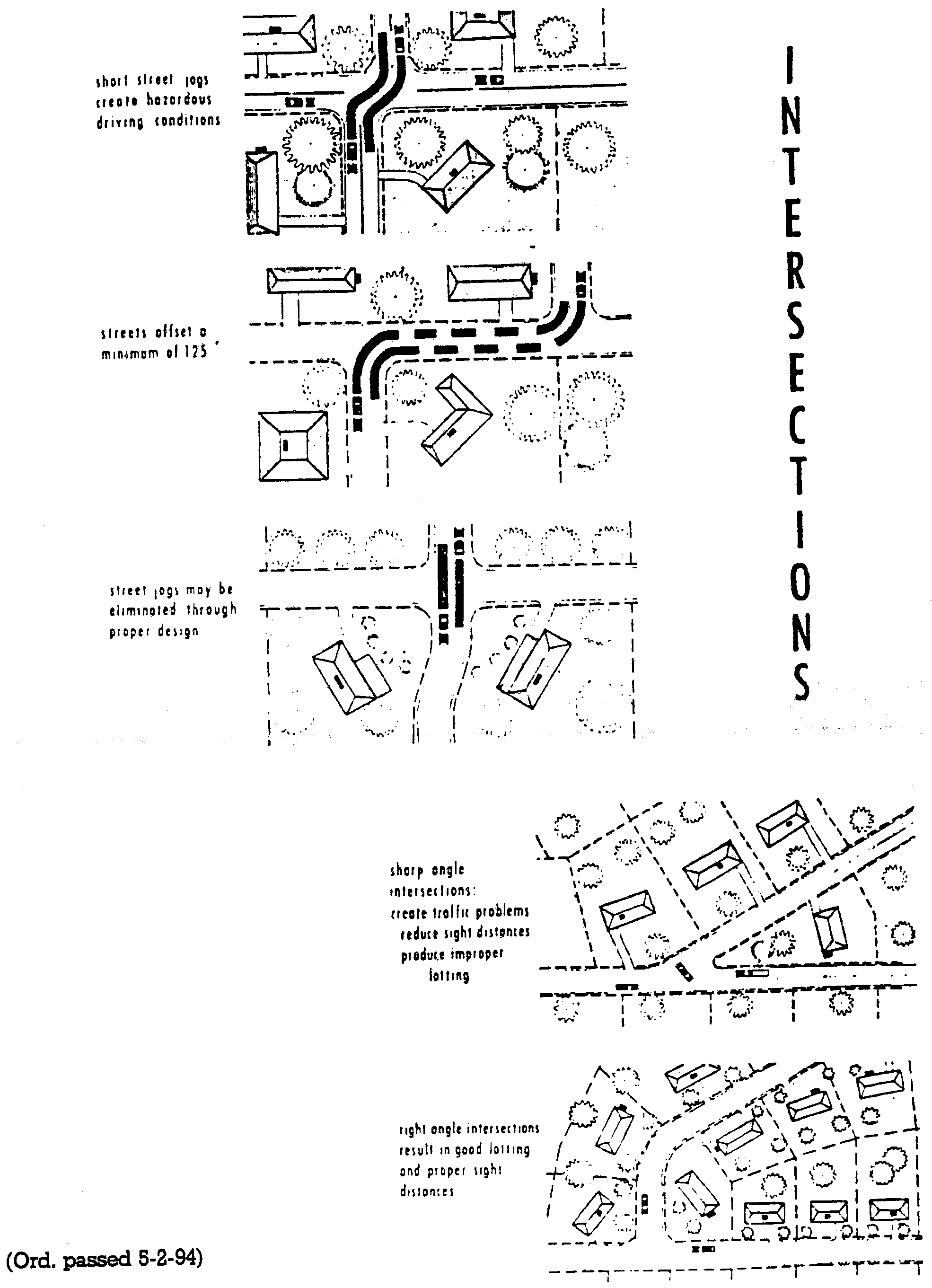
Sec. 153.40. - Intersections.
Street intersections shall be laid out as follows:
(1)
Streets shall intersect as nearly as possible at right angles, and no street shall intersect at less than 60 degrees.
(2)
Intersections of minor streets with a collector street shall be at least 450 feet apart measured from centerline to centerline.
(3)
Property lines at street intersections shall be curbed with a minimum radius of 20 feet and where the angle of street intersections is less than 90 degrees, the Planning Board may require a greater curb radius. Where a street intersects a highway, the design standards of the state department of transportation shall apply.
(4)
Street jogs are to be avoided unless exception is granted by the department of highways. If offset is necessary, centerline offsets of less than 200 feet shall be avoided.
(Code 1979, § 153.40; Ord. of 5-2-1994)
Cross reference— Penalty, see § 153.99.
Sec. 153.41. - Lots.
Lots shall be laid out as follows:
(1)
Lot sizes, shapes, and locations shall be made with due regard to topographic conditions, contemplated use, and the surrounding area. Every lot shall front or abut, for a distance of at least 50 feet, on a public street which has a minimum right-of-way width of 50 feet.
(2)
Where public water and sewer facilities are available every lot shall contain not less than the area prescribed in chapter 152 for the appropriate zone in which the subdivision exists.
(3)
Residential lots not served by municipal or community water and sewer shall have the minimum area required by the County Health Department to accommodate septic tanks and water wells, but may not have less than the minimum dimensional requirements specified for the zoning district in which it is located. Residential lots served by municipal or community water, but not sewer, shall be not less than the minimum area required by the County Health Department to accommodate septic tanks, but may not have less than the minimum dimensional requirements specified for the zoning district in which it is located. In no instance shall the area of a residential lot be less than the size determined to be adequate by the county health officer after investigation of soil conditions, proposed individual disposal system, and depth of ground water. All lots shall conform with the provisions of chapter 152.
(4)
Corner lots for residential use shall have an extra width of ten feet to permit adequate building setback from side streets.
(5)
Double frontage and reverse frontage lots shall be avoided except where necessary to separate residential development from through traffic or nonresidential uses.
(6)
Side lot lines shall be substantially at right angles or radial to street lines.
(7)
When lots are required for commercial or industrial uses they shall be adequate to provide for the off-street service and parking facilities required by the type of use and development contemplated. Adequacy shall be subject to the judgment of the Planning Board.
(Code 1979, § 153.41; Ord. of 5-2-1994)
Cross reference— Penalty, see § 153.99.
Sec. 153.42. - Right-of-way and pavement widths.
(a)
Within corporate limits. Minimum street rights-of-way and pavement widths which include curb and gutter shall be in accordance with the Thoroughfare Plan and shall not be less than the following:
Minimum Street Rights-of-Way
(b)
Outside corporate limits. All rights-of-way and pavement widths in subdivisions outside corporate limits but within the Town's one-mile extraterritorial boundary shall adhere to the minimum standards required by the department of transportation for acceptance.
(Code 1979, § 153.42; Ord. of 5-2-1994)
Cross reference— Penalty, see § 153.99.
Sec. 153.43. - Streets.
(a)
The arrangement, character, extent, width, grade, and location of all streets shall conform to all of the elements of official plans for the community and shall be designed in accordance with the provisions of this chapter.
(b)
Minor streets shall be laid out so that their use by through traffic will be discouraged.
(c)
There shall be no private streets platted in any subdivision. Every lot shall be served from a publicly dedicated street.
(d)
When a subdivision is adjacent to a major highway, the Planning Board may require a marginal access street to provide access for lots fronting on the arterial street or highway.
(e)
Proposed streets which are obviously in alignment with other existing and named streets shall bear the assigned name of the existing streets. In no case shall the name for proposed streets duplicate or be phonetically similar to existing street names.
(f)
The street pattern shall be such as to cause no hardship in the subdividing of adjacent properties. The Planning Board may require the dedication of a street right-of-way to facilitate the development of adjoining properties.
(Code 1979, § 153.43; Ord. of 5-2-1994)
Cross reference— Penalty, see § 153.99.
Sec. 153.55. - General provisions.
(a)
Final plats for all subdivisions shall not be approved until all the required improvements listed in this article have been installed or the subdivider has guaranteed to the satisfaction of the Board of Aldermen that such improvements will be installed according to section 153.56. The subdivider shall assume the entire cost of all improvements listed herein. Professional services required by this chapter shall be paid for by the subdivider.
(b)
All improvements shall be made in conformity with the requirements and standards set forth in this chapter and other specifications and policies of the Town. All improvements shall be inspected and approved by the Town Manager as conforming to this article. Specifications are determined by the Town Engineer.
(c)
Municipal services or facilities shall not be extended or furnished by the Town to any subdivision established hereafter, either inside or outside the corporate limits, until the subdivider has entered into an agreement with the Town covering the required improvements.
(Code 1979, § 153.55; Ord. of 5-2-1994)
Cross reference— Penalty, see § 153.99.
Sec. 153.56. - Guarantees.
(a)
Guarantees in lieu of completed improvements.
(1)
No final subdivision plat shall be approved by the Planning Board or the Board of Aldermen or accepted for record by the county register of deeds until the required improvements have been constructed in a satisfactory manner and approved by the Town Manager; or in lieu of such prior construction, the Board of Aldermen shall have accepted a bond with surety and conditions satisfactory to the Town in an amount equal to 1.5 times the estimated cost of the subdivider's responsibility. The Town may also accept in lieu of bond a certified check or a cash deposit with the Town equal to 1.5 times the estimated cost of the installation. An additional alternative is to accept a letter of credit or line of credit from a lending institution (banks, savings and loan) that specifies a line of credit which will be extended to the Town upon request. This amount may not be used for the purposes other than the improvements specified for the subdivision being approved. The lending institution shall provide assurance to the Board of Aldermen in writing that a notice on the specified line of credit will be forwarded by the lending institution to the office of Mayor of the Town.
(2)
With any of these guarantees, improvements shall be made and utilities installed without additional cost to the Town above the original agreement in the event of default by the subdivider. The cost estimate shall be verified as accurate by the Town Manager.
(b)
Defects guarantee. The owner of the subdivision shall require the contractor constructing streets or any other facility to give bond guaranteeing the work against defects for a period of one year after completion and acceptance.
(Code 1979, § 153.56; Ord. of 5-2-1994)
Cross reference— Penalty, see § 153.99.
Sec. 153.57. - Required improvements.
(a)
Permanent concrete monuments. Permanent concrete monuments four inches in diameter or square, three feet long, shall be placed at not less than two corners of the subdivision, provided that additional monuments shall be placed where necessary so that no point within the subdivision lies more than 500 feet from a monument. Two or more of the required monuments shall be designated as control corners. The top of each monument shall have an indented cross metal pin or metal plate to identify properly the location of the point. All monuments, markers, and control points shall be shown on the final plat.
(b)
Steel or iron markers. Steel or iron markers shall be set at all lot and property corners and at all other survey points not marked by monuments as determined suitable by the Town Manager. Survey markers shall be at least three-fourths-inch in diameter and shall be sunk vertically into the ground until the top is flush with the finished grade, except in sidewalks, streets, and other similar surfaces where the markers shall be flush with such surface.
(c)
Electrical, telephone and gas services. All electrical, telephone/telegraph and gas services shall be installed underground at the subdivider's expense.
(d)
Streets.
(1)
Grading. The subdivider of any subdivision designed to be used for residential, commercial, industrial or other purposes shall clear and grade proposed streets according to the provisions of these regulations.
(2)
Paving. The subdivider shall be responsible for the cost and installation of road foundation materials as specified by the Town. The subdivider shall be responsible for the cost and installation of paving all streets on the final plat in accordance with specifications of the Town. All streets shall comply with the applicable design requirements for rights-of-way and paving as specified under section 153.42.
(3)
Curbs and gutters. Curbs and gutters shall be constructed on both sides of all streets within the corporate limits of the Town. Curbs and gutters shall be a combination curb and gutter or such other construction that the Town Manager may approve. The subdivider shall be responsible for all materials and installation necessary to install curbs and gutters. All curbs and gutters shall comply with the applicable design requirements as specified under section 153.42.
(4)
Surface water.
a.
Where, in the opinion of the Planning Board, a public stormwater sewer system is reasonably accessible, the subdivider shall connect with the system. The subdivider shall provide all grading and install all structures necessary to carry the water to the storm drainage system. Drainage and construction of structures shall conform to town specifications and standards. Surface water drainage shall not empty into a sanitary sewer or onto a street.
b.
Where a storm drainage system is not accessible, the subdivider shall provide all grading and install all structures necessary to properly carry the water to a suitable outlet and locations which are acceptable to the Town.
(e)
Sewage disposal.
(1)
In Town.
a.
Where a subdivision is within the Town limits, the subdivider shall connect every lot within the subdivision to the sewer system of the Town. Sewer connections shall be constructed under the supervision and approval of the engineering authority of the municipality. The Town Manager shall specify the materials necessary to install the sewer line.
b.
The cost of materials and installation necessary to extend the sewer line shall be paid by the subdivider. The cost of materials necessary to serve any area outside of the subdivision shall be paid by the Town.
(2)
Outside of Town.
a.
Where a subdivision is outside the Town limits and lots cannot be economically connected with a sewerage system, they must contain adequate area for the installation of approved septic tanks and disposal fields. Whenever individual sewage disposal systems are planned a representative of the County Health Department shall investigate the site to determine whether or not such individual facilities are feasible. Approval of the county health officer must be in writing. When individual sewage disposal systems are planned, the minimum lot size shall be 20,000 square feet.
b.
When any part of a subdivision outside the Town limits is located within 200 feet of an existing town sewer line, the subdivider shall be required to install, at no cost to the Town, sewer mains and appropriate lift stations to serve every lot within the subdivision. However, if the subdivider shall petition the Town to annex the subdivision, then the Board of Aldermen may participate in the cost of sewer line extension to the subdivision.
(f)
Sidewalks. Sidewalks shall be required along both sides of officially designated collector streets where the Planning Commission determines considerable pedestrian traffic is expected. The cost of materials and installation for sidewalks shall be paid by the subdivider.
(g)
Street lighting. Before final approval of a subdivision plat, the subdivider shall present to the Planning Board a street lighting plan developed in accordance with town policy. Public street lighting fixture installation fees, if any, shall be paid by the subdivider. Rental fees on the fixtures, if within the Town limits, shall be paid by the Town.
(h)
Street name markers (signs). Street name markers shall be provided at all subdivision street intersections and at any other point within the subdivision deemed necessary by the Planning Board. The cost of purchasing the street name markers and poles shall be paid for by the subdivider. The Town shall be responsible for the placement cost of the street name markers.
(i)
Water supply. Every lot in each subdivision shall be provided with a water supply which is ample for the needs of the development proposed.
(1)
In Town.
a.
Subdivisions within the Town limits shall be supplied with water from the Town. The water system shall be arranged between the subdivider and the Town according to the water service policies of the Town.
b.
Every lot in each subdivision within the Town limits shall be located within 500 feet of a six-inch water line and fire hydrant. All fire hydrants shall be installed in accordance with town policy.
c.
The cost of all materials and installation used in the extension of the water line shall be paid by the subdivider.
(2)
Outside of Town.
a.
In subdivisions outside the Town limits, individual water supplies (wells) shall be located, constructed and operated in accordance with standards and specifications of the county district health department. Approval of the county health officer for the location, construction and operation of the individual water sources must be in writing.
b.
Where any part of a subdivision outside the Town limits is located within 200 feet of an existing water line of the Town, the subdivider shall be required to tie into the municipal system and install water mains to serve every lot within the subdivision. The cost of materials and installation shall be paid by the subdivider. However, if the subdivider petitions the Town to annex the subdivision, the Town may participate in the cost of water line extension to the subdivision.
Note:
(i)
Water supplies serving ten or more connections are classified as public water supplies by state law, and plans and specifications must be approved by the sanitary engineering division of the state Board of health.
(ii)
Water supplies serving from two to nine connections inclusively may be regulated by the county Board of health, and plans must be approved by that agency.
(iii)
Plans for public and community sewer systems must be approved by the division of stream sanitation and hydrology of the state department of water resources.
(iv)
Individual water supplies should be located, constructed and operated in accordance with state Board of health Bulletin No. 476, Protection of Private Water Supplies.
(v)
Individual sewerage systems must be installed and maintained in accordance with the state Board of health rules and regulations governing the disposal of sewage from any residence, place of business, or place of public assembly in North Carolina and the regulations of the county Board of health. The state Board of health Bulletin No. 519, Residential Sewage Disposal Plants, contains helpful information.
(Code 1979, § 153.57; Ord. of 5-2-1994)
Cross reference— Penalty, see § 153.99.
Sec. 153.70. - Variances.
(a)
The Board of Aldermen may approve subdivision plats which vary from the requirements of design, but not of procedure or improvements, contained in these regulations.
(b)
Where topography or other existing physical conditions are such that compliance with the requirements of this chapter would cause an unusual and unnecessary hardship on the subdivider above and beyond what other subdividers would meet, the minimum requirements as set forth in this chapter may be varied by the Planning Board or the Board of Aldermen, provided that such variations will not have the effect of nullifying the interest and purpose of these regulations.
(Code 1979, § 153.70; Ord. of 5-2-1994)
Sec. 153.71. - Exceptions.
The standards and requirements of this article may be modified by the Planning Board and the Board of Aldermen in the case of a plan and program for a group, cluster or Planned Unit Development, which, in the judgment of the Planning Board, provides adequate public spaces and improvements for the circulation, recreation, light, air, and service needs of the tract when fully developed and populated, and which also provides such covenants or other legal provisions as will ensure conformity to and achievement of the land development plan.
(Code 1979, § 153.71; Ord. of 5-2-1994)
Sec. 153.72. - Procedure exceptions.
(a)
The subdivider must submit a written request stating the reasons for each modification. The Planning Board may require such conditions as will, in its judgment, preserve the spirit and intent of these regulations. These conditions may include, but shall not be limited to, surety, performance, or maintenance bonds; affidavits, covenants, or other legal instruments, as will ensure conformity to and achievement of the plan.
(b)
Any modifications thus authorized are required to be entered in writing in the minutes of the Planning Board and the reasoning on which the departure was justifiably set forth.
(Code 1979, § 153.72; Ord. of 5-2-1994)
Sec. 153.73. - Amendment.
The Board of Aldermen may from time to time amend these regulations, according to G.S. 160A-364, but no amendment shall become effective unless it shall have been proposed by or shall have been submitted to the Planning Board for review and recommendations. The Planning Board shall have 45 days within which to submit a recommendation. If the Planning Board fails to submit a recommendation within the specified time, it shall be deemed to have approved the amendment.
(Code 1979, § 153.73; Ord. of 5-2-1994)
Sec. 153.74. - Separability.
Should any section or provision of this chapter be declared by the courts to be invalid for any reason, such declaration shall not affect the chapter as a whole, or any part thereof other than the part so declared to be unconstitutional or invalid.
(Code 1979, § 153.74; Ord. of 5-2-1994)
Sec. 153.75. - Conflict.
When the requirements of this chapter conflict with the requirements of other lawfully adopted rules, regulations, or ordinances of the Town, the more stringent or higher requirements shall govern.
(Code 1979, § 153.75; Ord. of 5-2-1994)
Sec. 153.76. - No service or permit until final plat approval.
No street shall be accepted and maintained by the Town, nor shall any street lighting, water, or sewer be extended to or connected with any subdivision of land nor shall any permit be issued by any administrative agency or department of the Town, for the construction of any building or building improvements requiring a permit unless and until the requirements set forth in this chapter have been complied with and the same approved by the Town. In no instance shall the requirements of this section prohibit the administrative agency from issuing improvement permits described in sections 153.55 through 153.57, after preliminary plat approval when minimum standards of those improvements in sections 153.55 through 153.57 are to be met.
(Code 1979, § 153.76; Ord. of 5-2-1994)
Sec. 153.77. - Compliance with official plans.
To ensure orderly development of the community in accordance with the general principles set forth in the Land Use Plan, the Planning Board may require that the subdivider reserve or dedicate open spaces for such purposes as parks, playgrounds, schools and fire stations in accordance with section 153.30.
(Code 1979, § 153.77; Ord. of 5-2-1994)
Sec. 153.78. - Town costs when oversize facilities are required.
Whenever the Planning Board requires that the developer install improvements or facilities that are either larger, more costly or not normally required by this chapter, the municipality shall be responsible for all of the costs of oversizing. The subdivider shall be required to pay only the portion of the cost of construction that would equal the cost of an improvement required to serve only the subdivision, as determined by the Board of Aldermen. The purpose of this section is to guarantee compliance with official town plans and to preserve equal protection to all the developers in the Town.
(Code 1979, § 153.78; Ord. of 5-2-1994)
Sec. 153.79. - Duty of register of deeds.
The Town shall file a copy of this chapter with the register of deeds of the county. The register of deeds shall not thereafter file or record a plat of subdivision or other evidence of land subdivision located within the territorial jurisdiction of the Town without the approval of the legislative body as required in this chapter. The landowner shown on a subdivision plat submitted for recording, or his/her authorized agent, shall sign a statement stating whether or not any land shown thereon or described herein is within the corporate limits or extraterritorial jurisdiction of the Town. The filing or recording of a plat of a subdivision without the approval of the Planning Board or Board of Aldermen, as required by this chapter, shall be null and void. The Clerk of Superior Court of Beaufort County shall not order or direct the recording of a plat where such recording would be in conflict with this section.
(Code 1979, § 153.79; Ord. of 5-2-1994)
Sec. 153.99. - Penalty.
(a)
The following penalties, as proposed in G.S. 160A-375, shall prevail. Any person who, being the owner or agent of the owner of any land located within the platting jurisdiction granted to the municipality thereafter transfers or sells such land by reference to a plat showing a subdivision of such land before such plat has been approved by said legislative body and recorded in the office of the register of deeds, shall be guilty of a misdemeanor and the description by metes and bounds in the instrument of transfer or other document used in the process of selling or transferring shall not exempt the transaction from such penalties. Said municipality, through its town attorney or other official designated by its local legislative body, may enjoin such transfer or sale by action for injunction.
(b)
Any persons violating any provisions of any section of this chapter, or who shall violate or fail to comply with any order made thereunder shall be punishable for a fine not to exceed $500.00. Each day such violation shall be permitted to exist shall constitute a separate offense.
(Code 1979, § 153.99; Ord. of 5-2-1994)
Sec. 153.1000. - Appendix A. Suggested Form of Certificates.
Certificate of Ownership and Dedication
I (we) hereby certify that I am (we are) the owner(s) of the property shown and described hereon and that I (we) hereby adopt this plan of subdivision with my (our) free consent, establish the minimum building lines, and dedicate (or provide cash in lieu of dedication for) all streets, alleys, walks, parks and private use as noted.
________, 20___
Date
___________
Owner
___________
Owner
Certificate of Accuracy and Mapping
I, ___________, certify that this plat was drawn under my supervision from an actual survey made under my supervision (deed description recorded in Book _____, page _____, etc.) (other); that the boundaries not surveyed are clearly indicated as drawn from information found in Book _____, page _____; that the ratio precision as calculated is 1:_____; that this plat was prepared in accordance with G.S. 47-30 as amended. Witness my original signature, registration number and seal this _____ day of _______, A.D., 20___.
Seal or Stamp
___________
Surveyor
___________
Registration Number
Certificate of Approval of Water Supply and Sewage Disposal Systems
I hereby certify that the water supply and sewage disposal systems installed, or proposed for installation in ___________ subdivision fully meets the requirements of the North Carolina State Health Department and are hereby approved as shown.
________, 20___
Date
___________
County Health Officer
Performance Bond
I hereby certify:
(1)
That streets, utilities, and other improvements have been installed in an acceptable manner and according to town specifications in the subdivision entitled ___________; or
(2)
That a surety bond in the amount of $ _____ or cash in the amount of $ _____ has been posted with the Town of Belhaven, North Carolina to assure completion of all required improvements in case of default.
________, 20___
Date
(1)
___________
Town Manager
(2)
___________
Town Clerk
Certification of Compliance with Area of Environmental Concern Standards
Any preliminary or final plat shall contain a statement that the subdivision is either located within or not within a North Carolina Coastal Area Management Act Area of Environmental Concern and be signed by the local permit officer and local subdivision enforcement officer. The statement shall be similar to the following:
"This subdivision is/is not located in an Area of Environmental Concern, based on an on-site investigation by the local CAMA Permit Officer and the local subdivision enforcement officer in consultation with the State AEC Field Consultant."
This further certifies:
"This if the subdivision is, in part or totally, in an AEC, all proposed development in the AEC will conform to develop standards of the State Guidelines for AEC's."
___________
AEC Local Permit Officer
___________
Belhaven Subdivision Enforcement Officer
Certificate of Approval by the Planning Board.
The Belhaven Planning Board hereby approves the final plat for the ___________ subdivision.
________, 20___
Date
___________
Chairperson, Belhaven Planning Board
(Code 1979, ch. 153, app. A; Ord. of 5-2-1994)
Sec. 153.2000. - Appendix B. Preliminary Plat Checklist.
Subdivision Record
Preliminary Plat
Name of subdivision: ____________
Location: ____________
Owner: ____________
Address: ____________
Telephone: ____________
Designer: ____________
Address: ____________
Telephone: ____________
Checklist:
___ Sketch vicinity map showing location of subdivision and surrounding area.
___ Six copies of preliminary plat at proper scale.
___ Name of subdivision and owner.
___ North point, graphic scale, date.
___ Words "Preliminary Plat" indicated on map.
___ Boundaries of tract with bearings and distances.
___ Name of adjoining property owners.
___ The location of existing sewers, water and gas mains and other utilities.
___ Statement from County Health Department for any septic tank use.
___ Location of all existing natural features.
___ Names, locations and approximate dimensions of proposed streets, easements, parks, and reservations, lot lines, sanitary sewers, storm sewers, water mains, culverts, electric and gas lines, and other surface and subsurface structures and pipe lines.
___ Results of Perc Tests for each proposed lot.
___ Contour maps at required interval.
___ Proposed lot lines, building lines and approximate dimensions.
___ Lot and block numbers.
___ Zoning classification on land to be subdivided and on adjoining land.
___ Conforms to general requirements and minimum design standards.
___ Areas to be used for the purpose other than residential.
___ Total acreage in the tract.
Approved ___ Date ________ : To proceed to final plat subject to the following modifications:
____________
Disapproved ___ Date ________ : For the following reasons:
____________
(Code 1979, ch. 153, app. B; Ord. of 5-2-1994)
Sec. 153.3000. - Appendix C. Final Plat Checklist.
NAME OF SUBDIVISION ____________
LOCATION ____________
OWNER ___________ADDRESS ____________
TELEPHONE ___________
SURVEYOR ___________ADDRESS ____________
TELEPHONE ___________
Checklist:
___ Submitted within 12 months of preliminary approval.
___ Four copies of final plat.
___ Proper scale of map.
___ Conforms substantially to preliminary plat.
___ Names and right-of-way lines of streets and roads.
___ Lot lines and building lines.
___ Lot and block numbers.
___ Reservations, easements, public areas, or sites for other residential use with explanation or purpose.
___ Legal description of boundary lines, street lines, lot lines, building lines, etc.
___ Contour map.
___ North point, graphic scale, date.
___ Location and description of monuments.
___ Names and location of adjoining subdivisions and streets and the location and ownership of adjoining unsubdivided property.
___ Conforms to general requirements and minimum design standards.
___ Required improvements have been made or $ _____ bond posted.
___ Required certificates.
Approved ___ Date ________ : By planning Board.
Disapproved ___ Date ________ : For the following reasons:
____________
(Code 1979, ch. 153, app. C; Ord. of 5-2-1994)