
Bellaire City Zoning Code
ARTICLE V
- ZONING REGULATIONS5
Editor's note—Ord. No. 25-036, § 2(Exh. A), adopted May 19, 2025, amended Art. V in its entirety to read as herein set out. Former Art. V, Divs. 1, 2, §§ 24-501—24-548, pertained to similar subject matter and derived from Ord. No. 81-006, §§ 3—6, adopted February 23, 1981; Ord. No. 81-065, §§ 1—3, adopted Nov. 2, 1981; Ord. No. 81-067, §§ 1—5, adopted in 1981; Ord. No. 82-020, §§ 13—22, adopted March 29, 1982; Ord. No. 82-028, § 1, adopted April 19, 1982; Ord. No. 83-076, § 3, adopted Oct. 17, 1983; Ord. No. 83-088, § 1, adopted Nov. 21, 1983; Ord. No. 83-095, §§ 11—14, 18, adopted Dec. 5, 1983; Ord. No. 84-041, § 1, adopted May 24, 1984; Ord. No. 85-010, § 2, adopted Jan. 28, 1985; Ord. No. 85-011, § 4, adopted Jan. 28, 1985; Ord. No. 85-036, § 1, adopted June 3, 1985; Ord. No. 85-050, §§ 1, 2, adopted Aug. 19, 1985; Ord. No. 85-051, § 2, adopted Aug. 19, 1985; Ord. No. 86-009, § 1, adopted Feb. 3, 1986; Ord. No. 87-001, § 1, adopted Jan. 5, 1987; Ord. No. 87-025, § 1, adopted June 15, 1987; Ord. No. 89-009, § 1, adopted March 6, 1989; Ord. No. 89-022, § 2, adopted June 5, 1989; Ord. No. 91-012, §§ 7, 8, 10—15, 17, 18, 20—23, 25, adopted March 4, 1991; Ord. No. 91-057, § 7, adopted July 1, 1991; Ord. No. 92-011, adopted March 2, 1992; Ord. No. 01-006, §§ 2—5, adopted Jan. 15, 2001; Ord. No. 01-037, §§ 4—7, adopted April 16, 2001; Ord. No. 02-048, § 3(24-546), adopted Aug. 19, 2002; Ord. No. 04-034, § 2, adopted June 7, 2004; Ord. No. 06-070, § 2, adopted Aug. 7, 2006; Ord. No. 07-074, § 2(Exh. A), adopted Dec. 3, 2007; Ord. No. 08-058, § 1(App. A), adopted Sept. 8, 2008; Ord. No. 10-025, §§ 2, 3(App. B), adopted April 5, 2010; Ord. No. 10-057, § 1(App. A), adopted Aug. 2, 2010; Ord. No. 11-086, § 1(App. A), adopted Dec. 12, 2011; Ord. No. 12-006, § 1(App. A), adopted February 20, 2012; Ord. No. 14-013, § 1, adopted March 3, 2014; Ord. No. 14-041, § 1, adopted August 18, 2014; Ord. No. 16-062, § 1, adopted Oct. 17, 2016; Ord. No. 17-008, § 1, adopted Jan. 23, 2017; Ord. No. 17-028, § 1, adopted May 15, 2017; Ord. No. 19-059, § 1(App. A), adopted Nov. 4, 2019; Ord. No. 20-054, § 1(App. A), adopted Dec. 21, 2020; Ord. No. 21-031, § 2(App. A), adopted May 24, 2021; Ord. No. 21-052, § 1(Att. A), adopted Sept. 20, 2021; Ord. No. 23-068, § 2(App. A), adopted Oct. 2, 2023; and Ord. No. 24-097, § 2(Exh. A), adopted Nov. 18, 2024.
State Law reference— Districts, V.T.C.A., Local Government Code § 211.005.
Sec. 24-501. - Districts Established.
In order to carry out the goals and objectives of the comprehensive plan and the purposes of this chapter, the following districts are hereby created:
(1)
Residential Districts.
a)
R-1 Residential District (R-1)
b)
R-3 Residential District (R-3)
c)
R-4 Residential District (R-4)
d)
R-5 Residential District (R-5)
e)
R-MF Residential Multi-Family District (R-MF)
f)
R-6 Small-Lot Residential Attached District (R-6)
(2)
Mixed-Use Districts.
a)
R-M.2-O Residential-Office Mixed-Use District (R-M.2-O)
b)
Corridor Mixed-Use District (CMU)
c)
Urban Village — Downtown District (UV-D)
d)
Urban Village — Transit Oriented Development District (UV-T)
(3)
Other Districts.
a)
Loop 610 District (L610)
b)
Light Industrial District (LI)
c)
North Bellaire Special Development District (NBSDD)
(Ord. No. 25-036, § 2(Exh. A), 5-19-2025)
Sec. 24-502. - Permitted Uses.
No structure or land in the City of Bellaire shall hereafter be constructed, built, moved, remodeled by expanding the size thereof, reconstructed, used or occupied except in accordance with the requirements of the zoning district in which the structure is located. However, a structure, use or lot lawfully existing at the date of adoption of this chapter may be occupied as a nonconforming use under the procedures and requirements of this chapter.
It is further specifically provided that there shall be a right of continued occupancy for any nonconforming residential structure located in the City of Bellaire which is used as a place of residence and that such right shall not be terminated by reason of sale or other transfer of title or vacancy of the structure.
Any such structure may be reoccupied as a residence at any time, subject only to the requirements of this Code for the issuance of an occupancy permit; and whenever requested to do so by a title company, a mortgage company, a potential buyer or another interested party, the Building Official is hereby authorized to issue a certificate of right to occupy such legally existing nonconforming residential structure.
(Ord. No. 25-036, § 2(Exh. A), 5-19-2025)
Sec. 24-503. - Specific Uses.
Certain uses, which because of their nature and existing location are not appropriate for categorizing into specific zoning districts, are allowed in various zoning districts by specific use permit. The procedure for approval of a specific use permit includes notice, public hearings and recommendation of the Planning and Zoning Commission, the same basic procedure prescribed for amendments to this Code. Any use not permitted by this chapter or approved as a specific use permit under the procedures hereinafter set out is prohibited.
(Ord. No. 25-036, § 2(Exh. A), 5-19-2025)
Sec. 24-504. - Planned Development.
A.
Planned Development in Residential Districts. A planned development mechanism is provided for selected residential districts in order to provide greater flexibility and opportunity in the planning and development of residential projects that serve to upgrade and enhance existing residential neighborhoods while responding to current market trends in housing.
B.
Planned Development in Residential-Commercial Mixed-Use Districts. A planned development mechanism is provided in order to provide greater flexibility and opportunity in the planning and development of residential or commercial projects or a combination thereof within a mixed land use environment.
C.
Planned Development in City Center Districts. A planned development mechanism is provided in order to provide greater flexibility and opportunity in the planning and development of City center projects, such as shopping centers, office plazas, permitted retail, service and commercial type uses, or a combination of such uses.
D.
Planned Development in Loop 610 District. A planned development mechanism is provided for the area immediately adjacent to Interstate Highway Loop 610 in order to provide greater flexibility and opportunity in the planning and development of projects of good design, such as office plazas, residential projects, medical centers, or a combination of such uses.
E.
Planned Development in the North Bellaire Special Development District. A planned development mechanism is provided in order to provide greater flexibility and opportunity in the planning and development of large-scale mixed-use developments, while considering community protections.
(Ord. No. 25-036, § 2(Exh. A), 5-19-2025)
Sec. 24-505. - Temporary Uses.
A.
Authorization. Temporary uses may be authorized by the City Council in any zoning district subject to the standards hereinafter established, provided that all temporary uses shall meet the minimum requirements of this Code for any type of development within the zoning district in which the use is located and shall, in addition, meet the minimum requirements of this Code for the building and maintenance of any structure erected as a temporary use.
B.
Time limitation. All temporary uses shall be for a period of time not exceeding thirty (30) days from the date of commencement of construction of the temporary use structure or the actual inhabitation or use of the structure for temporary use purposes, whichever is shorter.
The time limitation herein imposed may be extended or shortened by action of the City Council, for good cause shown, when it shall appear that extension thereof is in the best interest of the applicant and neither contrary to the purposes and objectives of the comprehensive plan nor injurious to the health, safety and well-being of the residents, citizens and inhabitants of the City of Bellaire.
C.
Permit required. A permit must be obtained for all temporary uses; such permit shall be issued by the Building Official of the City of Bellaire. The permit issued shall be entitled "Temporary Use Permit" and shall be for a period of time not exceeding thirty (30) days. Such permit shall clearly specify the use intended and any conditions and safeguards imposed by the Building Official for the protection of the health, safety and well being of the residents, citizens and inhabitants of the City of Bellaire. The Building Official shall be authorized to charge a fee for the issuance of a temporary use permit in an amount as shall from time to time be established by the City Council or the City Manager. Nothing herein provided shall prevent the City Council from extending the expiration date of any temporary use permit issued hereunder under such terms and conditions as may be prescribed.
D.
Exception for construction. The Building Official may, for a period not in excess of thirty (30) days, issue a temporary permit for construction offices (shacks) and the open storage of building materials upon a construction site so long as such offices (shacks) and open storage meet all other requirements of this Code.
E.
Construction upon public rights-of-way. The Building Official may, for a period to terminate simultaneously with the completion of construction, issue a temporary permit for the open storage of construction equipment, construction materials and the location of construction offices (shacks) on private property, except private property that is zoned residential, in residential use or immediately adjacent to a residential use, which has been duly leased by, which is owned by or which has been provided, by written consent of the owner, to a contractor performing work on public property or public rights-of-way, so long as such equipment and materials are stored behind the required front building line as specified for the zoning district in which the property is located and in a manner which shall not adversely impact adjacent property, and further so long as such equipment and materials are adequately fenced and/or other appropriate safeguards are provided to prevent injury to third parties. The open storage of construction equipment and materials and construction offices (shacks) shall meet all other requirements of this Code.
(Ord. No. 25-036, § 2(Exh. A), 5-19-2025)
Sec. 24-506. - Subdivision Regulations.
In addition to the requirements as set forth in this chapter, all property proposed for planned development approval or any property requiring subdividing or resubdividing for any purpose within the City, shall be laid out in accordance with Chapter 23.5 of this Code, "Land Subdivision Regulations," including, but not limited to, regulations contained therein for streets, alleys, sidewalks, utilities and drainage.
(Ord. No. 25-036, § 2(Exh. A), 5-19-2025)
Sec. 24-507. - Use of Nonconforming Residential Lots.
Notwithstanding the minimum requirements for residential lot size, structures may be constructed, built, moved, remodeled by expanding the size thereof, reconstructed, occupied or used on a nonconforming lot of record platted prior to the enactment of this chapter, or any amendment hereto, provided that all such structures shall meet all other applicable development and use regulations for the zoning district in which the structure is located.
(Ord. No. 25-036, § 2(Exh. A), 5-19-2025)
Sec. 24-508. - Structure and Area Regulations.
No structure or part thereof shall be constructed, built, moved, remodeled by expanding the size thereof, reconstructed, occupied or used in such manner that the maximum height, lot coverage, floor area or floor area ratio exceeds that specified for the zoning district in which the structure or use is located; nor shall a structure or part thereof be constructed, built, remodeled by expanding the size thereof, reconstructed, occupied or used in such manner that yards are provided which are smaller than the required yards in the zoning district in which the structure or use is located.
Provisions of this section may be modified only to the extent that is permissible under the terms and provisions of this Code.
(Ord. No. 25-036, § 2(Exh. A), 5-19-2025)
Sec. 24-509. - Use and Land Regulations.
No structure or land shall be used for any purpose except as specified herein except as a nonconforming use lawfully existing at the date of enactment of this chapter.
(Ord. No. 25-036, § 2(Exh. A), 5-19-2025)
Sec. 24-510. - Accessory Uses and Structures.
A.
Authorization. Accessory structures and uses are permitted in any zoning district in connection with any principal use lawfully existing within such district provided that all accessory structures or uses shall meet the development regulations for the zoning district in which the structure or use is located, in addition to the further requirements of this section.
B.
Particular prohibited accessory structures and uses. Prohibited accessory structures and uses are:
(1)
Commercial garages, commercial parking lots and commercial parking areas, except when incorporated within an approved planned development; and
(2)
Kitchen facilities in any structure other than a principal residential structure or one (1) accessory residential structure of a single-family home which contributes to the comfort, convenience or necessity of the occupants of a single-family residence which is the principal structure, provided that the accessory residential structure is constructed in accordance with all minimum requirements prescribed by the Building Code for the construction of a residential structure and the provisions of subsection (C) of this section. For purposes of this section, the term "comfort, convenience or necessity" shall not include a right of the owner or occupant of the principal structure to derive income from use of the accessory structure as a rental property; rental of any residential accessory structure is specifically prohibited. However, the comfort, convenience or necessity of the occupant of the principal structure may be served by using such residential accessory structure for the purpose of housing guests on a temporary basis, as a place of residence for family members or as a place of residence for any full-time or part-time domestic employees who work within the main residential structure or upon the grounds surrounding the same. Whenever occupied as quarters for the employee, it shall be unlawful for any adult person to occupy such residential accessory structure unless he or she is a domestic employee of the occupant of the main structure.
C.
Accessory structures, location and regulation.
(1)
All detached accessory structures and uses in any residential district shall be located in the rear or side yard of the residential unit.
(2)
No accessory structure or use shall exceed the height of the principal structure to which it is accessory.
(3)
All accessory structures and uses shall be subordinate to and supportive of the primary use and structure.
(Ord. No. 25-036, § 2(Exh. A), 5-19-2025)
Sec. 24-511. - Performance Standards.
All uses in any district of the City shall conform in operation, location and construction to the performance standards herein specified for noise, air pollution and particulate matter and other air contaminants, odorous matter, fire and explosive hazard material, toxic and noxious matter, vibration, open storage and glare.
A.
Noise.
(1)
Environmental sound levels. It shall be a violation of this chapter for any person to operate or permit to be operated any stationary source of sound which creates a unit percentile sound level (L1) greater than fifteen (15) dB(A) above the ambient sound pressure level (L90) as set forth in Table 1 in any residential use zone, or creates a tenth percentile sound level (L10) or a ninetieth percentile sound level (L90) which exceeds the limits set forth in Table 1 for the receiving land use districts when measured at the property boundary. For the purpose of enforcing these provisions, a measurement period shall not be less than ten (10) minutes or more than thirty (30) minutes.
Table 1. Limiting Sound
Levels for Land Use Districts
L90
L10
When a noise source can be identified and its noise measured in more than one (1) land use category, the limits of the most restrictive use shall apply at the boundary and within the most restrictive land use category.
(2)
Public and private project review. All public and private projects shall be subject to a review process by the Building Official in order to determine if such projects are likely to cause noise or vibration in violation of this subsection. The Building Official shall be authorized to make or require any investigations or studies which in his opinion are necessary to determine if compliance with this subsection can be achieved. The Building Official shall also have the authority to require noise attenuation measures in accordance with the findings of said investigations or studies for the purpose of determining compliance with this subsection.
(3)
Exemptions. The following uses and activities shall be exempt from the noise level regulations herein specified:
a)
Noises not directly under control of the property user;
b)
Noises emanating from construction and maintenance activities between the hours of 7:00 a.m. and 7:00 p.m. (daylight hours);
c)
Noises of safety signals, warning devices and emergency pressure relief valves;
d)
Transient noise of moving sources such as automobiles, trucks, airplanes and trains.
B.
Control of air pollution from visible emission and particulate matter. No person may cause, suffer, allow or permit any outdoor burning, incineration, visible emissions or particulate matter from any source to exceed allowable rates specified in the 30 Tex. Admin. Code § 111.111, incorporated herein by reference.
C.
Odorous matter. No person shall discharge from any source whatsoever one (1) or more air contaminants that produce an odor, in such concentration and of such duration as may tend to be injurious to or to adversely affect human health or welfare. No discharge shall be permitted which exceeds applicable standards set by the Texas Commission on Environmental Quality.
D.
Fire and explosive hazardous material.
(1)
No use involving the manufacture or storage of compounds or products which decompose by detonation shall be permitted in any district except that chlorates, nitrates, perchlorates, phosphorus and similar substances and compounds in small quantities for use by industry, school laboratories, druggists or wholesalers may be permitted when approved by the Fire Marshall of the City of Bellaire as not presenting a fire or explosion hazard.
(2)
The storage and use of all flammable liquids and materials such as pyroxylin plastics, nitrocellulose film, solvents and petroleum products shall be permitted only when such storage or use conforms to the standards and regulations of the City.
(3)
Volatile organic compound loading facilities and gasoline terminals must be in compliance with 30 Tex. Admin. Code § 115.219 (as applicable to Harris County), incorporated herein by reference and filed in the office of the City Clerk of the City of Bellaire.
E.
Toxic and noxious matter. No operation or use in any district shall emit toxic and noxious matter that is in violation of 30 Tex. Admin. Code § 101.1 et seq. (as applicable to Harris County), incorporated herein by reference and filed in the office of the City Clerk of the City of Bellaire.
F.
Vibration. No operation or use in any district shall at any time create earthborn vibration which, when measured at the bounding property line of the source of operation, exceeds the limit of displacement set forth in the following table in the frequency ranges specified.
G.
Open storage. No open storage of materials or commodities shall be permitted in any district except as an accessory use to a main use in an LI, Light Industrial or PD, Planned Development Industrial District which is located in a building. No open storage operation shall be located in front of a main building. No wrecking, junk or salvage yard shall be permitted as a storage use in any district.
H.
Glare. No use or operation in any district shall be located or conducted so as to produce intense glare or direct illumination across the bounding property line from a visible source of illumination or glare nor shall such light be of such intensity as to create a nuisance or detract from the use and enjoyment of adjacent property.
Sec. 24-512. - Fence Regulations.
A.
In residential zoning districts, no fences or walls that are not screening fences or walls, as required in Section 24-513, shall be constructed to a height in excess of eight (8) feet. Fences or walls eight (8) feet in height or less may be constructed anywhere inside the property lines of a lot zoned residential, except within the front yard as that term is defined in this chapter and according to the table below.
Maximum Height of Fence or Wall Based on Location
* In the case of the Interstate Highway 610 (West Loop) Frontage Road and Union Pacific Railroad rights-of-way, this section shall not be construed to mean that a fence or wall of any height is permitted in the front yard. It applies to fences in the side or rear yard only.
In all cases fences or walls shall have setbacks that are sufficient to provide clear vision of the street to the driver of a vehicle entering or backing into the street.
B.
In non-residential zoning districts, fences may be located anywhere on a lot, subject to such conditions and limitations as shall be provided in this Code.
(Ord. No. 25-036, § 2(Exh. A), 5-19-2025)
Sec. 24-513. - Landscaping, Screening and Buffering.
A.
Purpose. The standards set out in this section are intended to:
(1)
Protect and improve the appearance and character of the community, including its developed and open space areas, in accordance with the Comprehensive Plan;
(2)
Increase the compatibility of adjacent land uses;
(3)
Mitigate the effects of noise, dust, debris, artificial light intrusions and other externalities created by the use of land, and the "heat island" effect of paved surfaces in urban settings; and
(4)
Conserve water and promote the long-term viability of development landscaping by promoting the planting and maintenance of native and drought-resistant vegetation types.
B.
Applicability. Standards described herein are minimum standards applicable to all new planned developments, mixed-use developments, multifamily and, non-residential structures and related parking that have, as a condition of approval, requirements for landscaping, screening or buffering and to all non-residential uses and related parking permitted.
(1)
The requirements of this section shall also apply when:
a)
There is an enlargement exceeding one thousand (1,000) square feet in area of the exterior dimensions of an existing non-residential, multifamily residential, mixed-use building, or of any existing building within a planned development, or more than one thousand (1,000) square feet cumulative among multiple buildings in all such cases; or
b)
There is either a new parking lot for a non-residential or multifamily residential or mixed-use building, or for a planned development, or expansion of an existing parking lot in such cases to provide one (1) or more additional parking spaces.
(2)
The requirements of this section shall apply to the entirety of the development site if it is completely developed by the new construction of a building or buildings and associated off-street parking. If the entirety of the building site is only partially developed by new construction or enlargement (with the enlargement exceeding at least one thousand (1,000) square feet in area of the previous exterior dimensions of a building, or cumulative among multiple buildings, per subsection (1)b)), the requirements of this section shall be applied only in proportion to the area of the new or enlarged building and/or off-street parking area.
(3)
The requirements of this section shall not apply when:
a)
Reconstruction work on an existing building that was partially damaged or destroyed involves less than fifty (50) percent of the pre-existing area of the exterior dimensions of the building. This exemption shall apply only when the reconstruction will not result in an increase in the number of parking spaces.
(4)
Nothing in this section shall be construed to require compliance with the requirements of this section for finish or remodeling work to the interior or exterior of an existing building if such work does not result in an increase in the number of parking spaces or in an enlargement of the exterior dimensions of the building.
C.
General requirements.
(1)
Quantity of landscaping. The minimum amount of landscaping required for a development site shall be based on the applicable factors in Table 24-513.A, Quantity of Landscaping.
Table 24-513.A
Quantity of Landscaping
a)
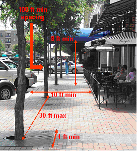
Street trees in the UV-D and UV-T districts. Street trees shall be planted at regular intervals along all street frontages in accordance with Section 9-355.1 in Chapter 9, Buildings, of the City Code, except that the minimum tree spacing in the UV-D and UV-T districts shall be thirty (30) feet rather than forty (40) feet. Applicants may select any tree variety specified for the UV-D and UV-T districts, if any, in Section 9-355.1, and shall not plant specified undesirable trees. Such trees may be planted within the public street right-of-way as provided in Section 9-355.1, subject to the approval of the Administrative Official. As illustrated in Figure 24-513.A, the following specific provisions also apply in the UV-D and UV-T districts:
1)
Minor variations from the regular 30-foot spacing are permitted to avoid conflicts with driveway locations and accommodate other design considerations.
2)
Trees shall be planted in at-grade tree wells with tree grates, a minimum of four (4) feet square, within the sidewalk. Such street trees shall be maintained to provide a clear zone free of limbs, from ground level up to eight (8) feet above ground level, for visibility and to avoid potential hazards to pedestrians and vehicles. Each tree well shall have an irrigation system for the delivery of water to the wells.
FIGURE 24-513.A
Street Tree Planting
in UV-D and UV-T Districts
(2)
General site landscaping. Any portions of development sites not used for buildings, sidewalks, parking areas or other impervious surfaces that count toward site coverage shall be planted or covered, and so maintained by the owners. This treatment shall consist of any combination of such material as trees, hedges, shrubs, garden plants, vines, ground covers, grasses, and mulch. The use of planter boxes of any size shall not constitute compliance with this section.
a)
Use of sod. In non-residential and multifamily residential development and planned developments, not more than fifty (50) percent of the area devoted to general site landscaping as defined in this subsection may be planted with sod. Athletic fields shall not be counted in this calculation.
b)
Use of mulch. In non-residential and multifamily residential development and planned developments, not more than ten (10) percent of the area devoted to general site landscaping as defined in this subsection may involve the placement of mulch. Mulch used in landscaping areas may be organic, such as pine bark or shredded hardwoods, or inorganic, such as stone, gravel or commercially available recycled materials intended for such use. Materials that float shall be contained by edging.
c)
Use of palm trees. Palm trees may be used in site landscaping but shall not count toward compliance with the minimum tree requirements in Table 24-513.A.
d)
Mitigation of building mass in the UV-D and UV-T districts. Where a building is more than sixty (60) feet in length, tree plantings other than required street trees shall be clustered to break up the appearance of building mass so that the building is perceived to be divided into lengths of no greater than fifty (50) feet when viewed from street-level vantage points.
(3)
Credits against required landscaping. For development sites in the UV-D district, landscaping, as herein required of a surface parking area adjacent to a street, may be counted toward meeting the general site landscaping requirements. The administrative official may, upon application of the property owner and/or developer, allow the use of the adjacent public street right-of-way for the perimeter landscaping and screening of the surface parking.
a)
The administrative official shall permit the use of the public street right-of-way for landscaping and screening only when it is determined, in consultation with the Department of Public Works, that such use does not constitute an actual or potential hazard to the health, safety and well-being of the residents, citizens and inhabitants of the City of Bellaire.
(4)
Planting standards. All plantings in satisfaction of this section shall comply with the standards of this subsection.
a)
Quality and viability of plantings. All landscape material shall be in compliance with the standards of the American Nursery and Landscape Association. All plant material shall have a habit of growth that is normal for the species.
b)
Locally appropriate species. At least seventy-five (75) percent of the proposed plantings shall be species native to Southeast Texas to promote reduced water use and increased drought resistance.
c)
Undesirable species. No proposed landscape material shall appear on the Invasive and Noxious Weeds list for the State of Texas promulgated by the United States Department of Agriculture, nor on the Texas Noxious Weed List promulgated by the Texas Department of Agriculture.
1)
Undesirable tree species. No proposed new or replacement trees shall be among the undesirable tree species identified in Section 9-350 M.
d)
Species diversity. To avoid large monocultures of trees and shrubs, and the risk of large-scale losses in the event of disease or blight, species used to meet the requirements of this section shall be diversified as follows, with calculations rounded up to the nearest whole number:
1)
When ten (10) or more trees are required on a parcel proposed for development, no more than fifty (50) percent of each category of required trees (street trees, parking lot trees, site trees) on a site shall be of any one (1) species.
(5)
Installation. All landscaping shall be installed in a sound workmanlike manner according to accepted commercial planting procedures, with the quality of plant materials as described in this section and with a readily available water supply. All plant material shall be insect and disease-resistant and shall be of sound health and vigorous growth, clean and reasonably free of injuries, weeds, noxious pests and diseases when installed.
a)
Sod shall be solid, and seeding of turf grasses is not permitted.
b)
Ground cover shall be planted in such a manner as to present a finished appearance and reasonably complete coverage within three (3) months after planting.
c)
Shrubs used for screening shall be three (3) feet or taller in height, as measured from the surrounding soil line, immediately upon planting. Such shrubs shall be maintained at this minimum height, and shall at no time exceed forty-two (42) inches in height.
d)
Phased development. The administrative official may allow installation of landscaping with each phase of a multi-phase development, provided that all landscaping required for each phase is installed concurrently with each phase. The City Attorney may require execution of a development agreement with the City to clarify phasing plans and timing, and to provide surety.
e)
Tree planting within City right-of-way. Planting of trees and other vegetation within City rights-of-way shall meet any applicable Department of Public Works standards, to protect underground and overhead utilities, streets and sidewalks, drainage improvements; street lighting, and sight distances, and the visibility of traffic control devices.
(6)
Maintenance. The owner and tenant of the landscaped premises and their agents, if any, shall be jointly and severally responsible for the continuing care and maintenance of all landscaping and preserved vegetation in a good condition so as to present a healthy, neat and orderly appearance, free from refuse and debris. This shall include any portions of abutting public right-of-way that the owner was permitted to landscape as part of complying with this section.
a)
All landscape areas shall be watered as needed to ensure continuous healthy growth and development.
b)
Trees shall be pruned as needed to ensure healthy growth and development, and when planted near streets or sidewalks, to not interfere with vehicular or pedestrian traffic or parked vehicles.
1)
Topping, tipping, bark ripping, flush cutting, and stub cutting are prohibited for trees that are installed and maintained within a public street right-of-way or were planted or preserved on private property as part of complying with this section.
c)
Maintenance shall include the removal and replacement of dead, dying or diseased plant material.
1)
Replacement of required landscaping that is dead or otherwise no longer meets the standards of this section shall occur within sixty (60) days of notification by the City. Replacement material shall be of similar character and quality as the dead or removed landscaping, and in the case of trees, shall meet and be completed in accordance with applicable provisions of Article XI, Trees, in Chapter 9, Buildings, of the City Code of Ordinances. Failure to replace in a timely manner in accordance with this subsection shall constitute a violation of these regulations.
D.
Screening and buffering.
(1)
Between non-residential or multifamily and residential uses. Where the rear or side of a non-residential or multifamily building is exposed to a residence or to a residential district boundary line, and where such building is closer than fifty (50) feet to the residence or to the boundary line, a screening wall of at least eight (8) feet in height and at most twelve (12) feet in height shall be erected separating the rear or side from the adjacent residence or residential district, unless a planned development has been approved specifically authorizing an alternate solution for screening and/or buffering, which is not in conflict with the purposes of this section and which is justified based upon architectural, aesthetic and landscaping considerations peculiar to the specific development, in which case the requirements of the planned development approval shall prevail.
a)
City Council waiver of non-residential screening requirement. The provisions of this subsection as to screening and buffering between non-residential or multifamily and residential uses may be waived by the City Council upon recommendation by the Planning and Zoning Commission in the following cases:
1)
When a property line abuts a dedicated alley, except where the property line is at a boundary of the UV-D district and an abutting residential property is in an R-1, R-3, R-4, R-5 or R-6 district; or
2)
When a rear or service side abuts an existing wall or other durable landscaping or screening barrier on an abutting property if said existing barrier satisfies the requirements of this subsection.
b)
Automatic waiver in UV-D and UV-T districts. The provisions of this subsection as to screening and buffering between non-residential or multifamily and residential uses are waived in the UV-D and UV-T districts, except that the provisions still apply in the UV-D district when the non-residential property is at a boundary of the district and the abutting residential property is in an R-1, R-3, R-4, R-5 or R-6 district.
1)
Parking area distance in UV-T district. Off-street parking areas in the UV-T district shall not be located within fifty (50) feet of a residential zoned neighborhood.
c)
The Administrative Official may allow or require a screening wall greater than twelve (12) feet in height if he determines that the additional height is necessary to mitigate negative impacts from the non-residential or multifamily property.
(2)
Between residential planned developments and other residential property. Where a residential use requires a planned development amendment to proceed, there shall be at least a six-foot screening wall or fence and at most a ten-foot screening wall or fence between the property that is the subject of the planned development and any abutting residential property that conforms to regulations for permitted uses within the district in which it is located. A planned development may be approved specifically authorizing an alternate solution for screening and/or buffering, which is not in conflict with the purposes of this section and which is justified based upon architectural, aesthetic and landscaping considerations peculiar to the specific development, in which case the requirements of the planned development approval shall prevail.
a)
Automatic waiver in UV-D and UV-T districts. The provisions of this subsection as to screening and buffering between residential planned developments and other residential uses are waived in the UV-D and UV-T districts, except that the provisions still apply in the UV-D district when the residential planned development is at a boundary of the district and the abutting residential property is in an R-1, R-3, R-4, R-5 or R-6 district.
1)
Parking area distance in UV-T district. Off-street parking areas in the UV-T district shall not be located within fifty (50) feet of a residential zoned neighborhood.
b)
The Administrative Official may allow or require a screening wall or fence greater than ten (10) feet in height if he determines that the additional height is necessary to mitigate negative impacts from the residential planned development property.
(3)
Standards for screening walls and fences. A screening wall or fence shall be of wood or masonry construction as provided herein. However, only masonry construction is permitted for required screening walls between non-residential and residential uses, in which case the masonry material and construction shall be consistent for the entire length of the wall erected to screen a particular use.
a)
A screening wall or fence of wooden construction shall be a permanent wooden fence constructed of cedar or redwood and with capped galvanized iron posts set in concrete. The wall or fence must not be less than the height specified for each of the types of screening addressed in subsections D.(1) and D.(2). The wall or fence shall not contain openings of more than forty (40) square inches in each one-square-foot of surface of such wall or fence, and such wall or fence surface shall constitute a visual barrier.
b)
A screening wall or fence may be constructed, which shall be of masonry construction on a concrete beam or foundation or a metal frame or base, which supports a permanent type wall material, the surface of which does not contain openings of more than forty (40) square inches in each one-square-foot of surface of such wall or fence, and which fence or wall surface shall constitute a visual barrier.
c)
In either permanent wooden or masonry constructed walls or fences, no opening shall be permitted for access unless a solid gate, equaling the height of the wall or fence, is provided. Such gate shall remain closed at all times except when in actual use.
(4)
Screening of trash receptacles. All trash receptacles upon property adjacent to single-family residential use shall be located at least ten (10) feet from any and all points upon any lot in single-family residential use. Further, all such trash receptacles shall be visually screened by means of a fence or a wall.
a)
Limited application in UV-T district. The screening requirement for trash receptacles applies in the UV-T district only with regard to visual screening from an abutting public street right-of-way and not from adjacent residential property.
b)
Additional provisions in UV-D and UV-T districts.
1)
Dumpsters and garbage bins shall be located behind principal buildings relative to public street frontage whenever practical, and such trash receptacles shall also be accessible from alleys or vehicular access easements where available and practical.
2)
Such solid waste facilities shall be fully enclosed as specified by this subsection, except that an opaque wall shall be provided in all cases in the UV-D and UV-T districts rather than a wood fence alternative.
(5)
Screening of outside storage. All outside storage areas, including waste material storage facilities, in planned development, non-residential, and multifamily districts shall be screened from adjacent residential uses and public street rights-of-way. No other outside storage besides trash receptacles is permitted in the UV-D and UV-T districts. Screening may be as follows:
a)
A screening wall or fence which shall be of wood or masonry construction of sufficient height to screen that which is being stored; or
b)
A hedge which shall be of sufficient height and density to screen that which is being stored.
E.
Screening of off-street parking. Landscaping shall be provided along the edge of any off-street parking area for five (5) vehicles or more that is not visually screened by an intervening building or structure from an abutting public right-of-way or adjacent residential property.
(1)
The perimeter landscaping shall involve shrubs of five-gallon container size, spaced a maximum of four (4) feet on center, to form a continuous and solid visual screen, within one (1) year of planting, exclusive of driveways, pedestrian walkways and visibility triangles. The shrubs shall be three (3) feet or taller in height, as measured from the surrounding soil line, immediately upon planting. Such shrubs shall be maintained at this minimum height, and shall at no time exceed forty-two (42) inches in height.
(2)
Special provisions for UV-D and UV-T districts. Requirements in this subsection for screening of off-street parking areas apply in the UV-D and UV-T districts only with regard to visual screening from an abutting public street right-of-way and not from adjacent residential property, and are illustrated in Figure 24-513.B. In the UV-D district, the screening requirement applies when the adjacent residential property is outside the UV-D district and in an R-1, R-3, R-4, R-5 or R-6 district.
a)
Openings for circulation. Openings through the perimeter landscaping, for pedestrian and bicycle circulation to and from public sidewalks or other circulation routes, shall be provided approximately every fifty (50) linear feet, with each opening no more than five (5) feet wide.
b)
Utility company screening policies in UV-T. Screening of parking areas which utility companies allow on their properties within the UV-T district shall be subject to the policies of such companies with regard to allowable screening methods and the location and height of screening.
FIGURE 24-513.B
Screening of Off-Street Parking
in UV-D and UV-T Districts

Parking Area Perimeters. The screening and access standards illustrated above apply to surface parking areas that abut a public street right-of-way.
F.
Landscaping of off-street parking.
(1)
Parking lot trees shall be provided for any off-street parking area for ten (10) vehicles or more for a commercial, multifamily residential or mixed-use development, with a minimum of one 45-gallon tree for every ten (10) parking spaces, in accordance with Section 9-355.2.
a)
Parking lot trees shall be planted so that each parking space is within fifty (50) feet of at least one such tree as measured from the center of the tree trunk to some point on the marked parking space. Depending on the size and shape of smaller parking areas, this may mean that the required tree(s) may be planted adjacent to rather than within the interior of the parking area. The required tree(s) also may be planted within an abutting public street right-of-way subject to the approval requirements of this section.
b)
When trees must be planted within the interior of a parking area to comply with the requirements of this subsection, or are otherwise incorporated within the interior, the following standards shall apply:
1)
The planting area for each tree, whether located at an edge of the parking area or designed as an interior island or median between parking modules, shall be no less than six (6) feet across in any horizontal direction.
2)
All planting areas shall have permeable surfaces and be planted with locally appropriate species as defined in this section, which may include shrubs, groundcovers or grasses. If a planting area is used as part of a biological stormwater treatment system, pursuant to an approved drainage plan, groundcovers shall be selected that are appropriate to that function.
3)
Where required or otherwise incorporated, planting areas and landscaping islands shall be integrated into the overall design of the surface parking area in accordance with this chapter in such a manner that they may assist in defining parking slots, pedestrian paths, driveways, and internal collector lanes, in limiting points of ingress and egress, and in separating parking pavement from street alignments.
(2)
Where applicable, landscaped areas and walkways abutting parking spaces shall be protected by a wheel stop or six (6) inch curb that is at least three (3) feet from any landscaping except grass or ground cover. Curb lines may be interrupted to allow for stormwater flows into biological treatment areas pursuant to an approved drainage plan, provided that the curb openings do not interfere with the curb's protective function.
(3)
All parking lot landscaping shall be located and maintained so as not to interfere with the act of parking or with parking area maintenance and so as not to create a traffic hazard by obscuring driver or pedestrian vision within the parking lot interior or at the intersections of walkways, driveways, collector lanes and streets, or any combination thereof.
(4)
Interior landscaping of parking areas may be included as a condition of planned development approval for the purpose of providing trees and massed plantings.
(5)
Waiver of interior landscaping in UV-D and UV-T districts. Off-street surface parking areas in the UV-D and UV-T districts shall be exempt from any required planting of trees within the interior of such parking areas given the limited developable area within these districts. Instead, the requirement in Section 9-355.1 of one (1) tree for every ten (10) parking spaces shall be satisfied by planting such trees within or near the perimeter screening area required by this section for off-street surface parking areas.
a)
Any such trees planted within or near a perimeter screening area shall be maintained to provide a clear zone free of limbs, from ground level up to eight (8) feet above ground level, for visibility and to avoid potential hazards to pedestrians and vehicles.
G.
Screening of parking structures and drive-under parking. The ground level of a parking structure or ground-level parking located under an elevated building shall be screened from public street rights-of-way and/or any abutting residential use or zoning district through the installation of vegetative screening, except at points of ingress and egress. Such screening shall involve shrubs of five-gallon container size, spaced a maximum of four (4) feet on center, to form a continuous and solid visual screen, within one (1) year of planting, exclusive of driveways, pedestrian walkways and visibility triangles. The shrubs shall be three (3) feet or taller in height, as measured from the surrounding soil line, immediately upon planting. Such shrubs shall be maintained at this minimum height, and shall at no time exceed forty-two (42) inches in height. Such screening shall not be required where a parking structure is wrapped with liner buildings that accommodate active uses other than parking, or where buildings are otherwise situated that obstruct views of the garage or of the drive-under parking.
(1)
Screening of upper levels of parking structures. Each level of a parking structure above the ground level shall be designed to include screening along any façade that is not visually screened by an intervening building or structure from public view or abutting residential use or zoning district. Such screening shall consist of architectural and/or landscape elements that are at least three (3) feet and six (6) inches in height, as measured from the floor of the level, to provide a continuous and solid visual screen that blocks headlight glare from vehicles parked within the structure.
H.
Special provisions.
(1)
Parking lot tree planting waiver in CMU/R-MF districts. The requirements of this section and of Section 9-355.2 related to parking lot tree planting shall not apply to off-street parking areas in the CMU and R-MF districts when the parking area is located behind a building on a development site or is otherwise not visible from abutting public street rights-of-way.
(2)
Relief on constrained sites in the UV-D and UV-T districts. Upon the recommendation of the Administrative Official, the Planning and Zoning Commission may modify or reduce landscaping requirements, to the minimum extent necessary, to provide relief for constrained and/or redeveloping sites in the UV-D and UV-T districts where full compliance would be impractical and adjacent properties would not be unreasonably impacted.
(Ord. No. 25-036, § 2(Exh. A), 5-19-2025)
Sec. 24-513a. - Design standards in commercial and mixed-use districts.
A.
Purpose. The purpose of this section is to establish reasonable design standards and related guidance to address community desire for visually appealing non-residential, multi-family, and mixed-use development that enhances the overall quality and character of the City, while balancing the legitimate development and commercial needs of property owners.
(1)
Urban Village districts. For the Urban Village-Downtown (UV-D) and Urban Village-Transit-Oriented Development (UV-T) districts, certain standards within this section, together with the use regulations and physical development standards for each district, are especially intended to promote and maintain an urban development character as described in the respective district purpose statements.
(2)
Security emphasis. All design processes within the CMU, R-MF, UV-D and UV-T districts shall also consider Crime Prevention Through Environmental Design (CPTED) principles to enhance the security of residents, workers and visitors.
B.
Applicability. The design standards established in this section apply to any new non-residential, multifamily, or mixed-use development in the Corridor Mixed Use (CMU), Residential - Multifamily (R-MF), Urban Village-Downtown (UV-D), and Urban Village-Transit-Oriented Development (UV-T) districts, and to any non-residential, multifamily, or mixed-use redevelopment in these districts that follows the removal of all pre-existing buildings on the site.
(1)
The requirements of this section regarding canopies and awnings, colors, and visual interest and anti-monotony shall also apply to the enlarged portion of an existing non-residential, multifamily residential or mixed-use building when the enlargement exceeds one thousand (1,000) square feet or twenty-five (25) percent in area, whichever is less, of the exterior dimensions of the building.
(2)
The requirements of this section shall not apply to the reconstructed portion of an existing building that was partially damaged or destroyed if the reconstruction involves less than fifty (50) percent of the pre-existing area of the exterior dimensions of the building.
(3)
Nothing in this section shall be construed to require compliance with the requirements of this section for finish or remodeling work to the interior of an existing building if such work does not result in an enlargement of the exterior dimensions of the building.
C.
Standards. The specific standards are provided in Table 24-513a.A. The table is arranged in alphabetical order by the type of standard.
Table 24-513a.A
Design Standards for CMU, R-MF, UV-D and UV-T Districts
| Applicable District(s) | Standards | Illustrations |
|---|---|---|
|
CMU
R-MF (only for Unified Design) UV-D UV-T | Arrangement and Design for Multiple Buildings Unified Design Developments with multiple structures on a single property shall reflect a coordinated design and include unifying elements such as common building forms, materials, textures, architectural detailing and colors. Massing Through Grouping (Not for CMU/R-MF) Individual buildings on a development site or on adjacent sites, if not attached, shall be arranged and designed to appear as a group of attached buildings to the extent practical. Clustering for Pedestrian Focus (Not for CMU/R-MF) Individual buildings on a development site or on adjacent sites shall be clustered, whenever possible, to create pedestrian-oriented precincts and walkable connections. |  |
|
CMU
R-MF UV-D UV-T | Canopies and Awnings Use of canopies and awnings on building and parking structure façades adjacent to and above public sidewalks and other public spaces is encouraged to provide shade and weather protection and to add visual interest to structures, provided the placement and design of such canopies and awnings is consistent with the building architecture, and they are maintained in sound condition at all times. Projection Canopies and awnings shall project no more than six feet from the façade of a building or parking structure. Lighting Canopies and awnings shall not be backlit or internally lit. |  |
|
UV-D
UV-T | Clear Building Entries The primary building entry shall be easily identifiable for visitors. The building architecture should reinforce the visual importance of the entry, and the entry design should be pedestrian-scale and transparent. |  Credit: Chipotle
|
|
CMU
R-MF UV-D UV-T | Colors Use of overly iridescent or fluorescent colors on any building façade or roof is prohibited, as determined by the Administrative Official, taking into consideration the existing range and use of color in architecture, signs and other physical improvements within the district and its vicinity. |  |
|
UV-D
UV-T | Curb Cut Limits for Vehicular Access Such limits are intended to minimize vehicle-pedestrian conflict points at mid-block locations along public sidewalks, enhance the pedestrian environment within the district, and preserve the extent of curb space for on-street parking. • A maximum of one curb cut shall be permitted for every 100 feet of public street frontage. • All driveways shall be limited to two lanes, and in no case shall a driveway or associated curb cut exceed 30 feet in width. • Upon recommendation of the Administrative Official, the Planning and Zoning Commission may increase the maximum number or decrease the minimum spacing of curb cuts per segment of street frontage, as specified above, where warranted based on site-specific or emergency access considerations. Pedestrian Safety Wherever an access driveway, alley, vehicular access easement or other vehicular circulation path crosses a public sidewalk or other pedestrian path, a crosswalk treatment shall be installed consisting of a material that contrasts with the adjacent pavement in both texture and color (e.g., brick pavers, patterned concrete, etc.). • Access points for off-street parking areas and parking structures, where vehicles cross a public sidewalk or other pedestrian path, shall be well lit to ensure visibility of pedestrians and bicyclists. |   |
|
UV-D
UV-T | Framing of and Relationship to Public Spaces Individual buildings or groups of buildings on a development site or adjacent sites shall be arranged and designed, whenever possible, to form pedestrian-friendly outdoor plaza areas, courtyards and open spaces that are focal points for surrounding and nearby development and which encourage street activity, public gathering, outdoor dining, recreation, etc. Landscaping, street furniture, water features, public art, active play areas for children and/or other amenities should be incorporated to enhance the appeal of such spaces for pedestrians and users of the space. Such spaces should be adjacent to and easily accessible from a public street whenever possible. Private-Public Design Compatibility Where a development fronts on a public plaza, pocket park or other public space, the building architecture and other on-site elements shall be designed for compatibility with the existing or planned adjacent public space. Lighting Where a development fronts on public street rights-of-way and/or public plazas/spaces, exterior lighting shall be located and directed to provide adequate pedestrian-level illumination of public sidewalks and other immediately adjacent public ways and/or seating areas. |  Credit: Sugar Land Town Square
|
|
CMU
R-MF | Freestanding Canopies The design of freestanding or semi-freestanding canopies, such as those used as shelters for pump islands at auto service stations, and for port-cocheres, shall be consistent with the architectural style, predominant and accent materials, color, and lighting of the principal building on the development site. | 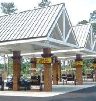 |
|
UV-D
UV-T | Grid Street Pattern Where applicable, depending on the district size and shape and the nature and extent of proposed development or redevelopment, blocks shall be arranged in an approximate grid-like fashion to ensure connectivity and alternate circulation routes within the district. Variation from the grid pattern should occur only to avoid constraints or accommodate other desirable design elements. |  |
|
UV-D
UV-T | Ground-Level Uses Development projects shall locate off-street parking and/or garage parking within the interior of blocks and away from public street frontages whenever practical so that such ground-level parking does not directly abut a public sidewalk. Instead, the ground level of structures that front on public sidewalks should be occupied by active retail, service, office, residential or other uses permitted in the district. "Wrap-around" design of active uses around parking garages is strongly encouraged. Parking Structures Where active uses along the ground-level street frontages of a parking structure are not practical, the parking structure and its vehicle entrances shall be designed to minimize views into the garage interior from adjacent streets through installation of decorative grilles or screens, additional landscaping, or other effective screening method. |
Credit: Sugar Land Town Square
  |
|
UV-D
UV-T | Lighting of Buildings and Sites Lighting of building exteriors and parking areas shall be designed to match the architectural character of the site and its vicinity in terms of fixtures and illumination. |  Credit: Sugar Land Town Square
|
|
UV-D
UV-T | Maximum Block Length Where applicable, depending on the district size and shape and the nature and extent of proposed development or redevelopment, the length of a block, on any side, generally shall not exceed 400 feet. This distance is measured between streets that frame and define a block; however, a public access way or easement shall also be considered to define a block when, in the same manner as a vehicular through street, such access way or easement creates a break between private development sites that provides continuous non-vehicular circulation between streets on either side of the development sites. |   |
|
CMU
R-MF UV-D UV-T | Multi-Family Development Internalized Design Ingress to and egress from all dwelling units shall be made through the interior of the building rather than from direct outside entrances to each unit. Balconies At least 50% of the units shall be provided with a functional or faux balcony. All such balconies shall be located on side or rear building elevations to avoid projection of balconies over the front building line and into public right-of-way, when the front setback is less than five feet. Mechanical Equipment No window or wall-mounted air conditioning units are permitted. |  |
| UV-T | Off-Street Parking Limits* Off-Street Parking Dispersion Off-street surface parking is permitted in the district, but concentrations of such parking shall be avoided to promote the desired Urban character and prevent disruption of non-vehicular circulation within the area. Maximum Parking Area Dimension No edge of an off-street surface parking area shall exceed 150 feet in length, and the entire parking area shall not exceed 21,780 square feet (½ acre). * Drive-under parking is excluded from these provisions. |  |
|
UV-D
UV-T | Orientation of Residential Garages All garage doors associated with any residential development in the district shall be oriented away from, and not be visible from, any public street right-of-way inside or outside the zoning district. | 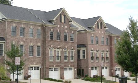 NOT DESIRABLE (garages oriented to street)
 DESIRABLE (garages not visible from street)
|
|
UV-D
UV-T | Parking Structures Such structures shall be designed for architectural consistency with the primary building served or other nearby buildings in terms of façade design, articulation, finish materials and/or shielding of unfinished structural elements and mechanical equipment. Special Design Elements Parking structures shall include architectural and/or landscape elements which enhance the garage appearance and help to screen parked vehicles and interior lighting from external view (e.g., decorative screens, trellises with or without associated vegetation, façade and roofline variation). |  |
|
CMU
R-MF UV-D UV-T | Screening of Mechanical/Service Equipment Rooftop Mechanical Equipment Such equipment shall be completely screened from ground-level public view through design and materials consistent with the overall building design and colors, including potential use of sloped roofs or other architectural elements (e.g., parapet walls) that conceal flat roof areas where mechanical equipment is mounted. • Where a green roof system is installed and maintained on a rooftop, dense vegetative screening may be used to satisfy the screening requirement for mechanical equipment. (Only for UV-T) Ground-Level or Building-Mounted Service Equipment Such exterior equipment (e.g., mechanical components, electrical drops, utility meter banks, heating/cooling controls) shall be completely screened from ground-level public view through design, materials and/or painting consistent with the overall building design and colors. The required screening may also be accomplished through installation of dense, year-round vegetation as shown on the site landscape plan. |   |
| CMU | Service Bays Uses with overhead doors providing access to service bays (e.g., auto service/repair) shall, wherever the site size, shape and orientation allows, place any building wall with overhead doors perpendicular to public street frontage. Where such building orientation is not practical, the overhead doors shall be of similar color to the building façade or roof material. | 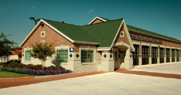 |
|
UV-D
UV-T | Sidewalks Sidewalks with a minimum width of 10 feet shall be provided along each side of a site that abuts a public street. Such sidewalks shall be designed and constructed according to City standards. Applicants may use any alternative design treatments for public sidewalks which are specified for the district, if any, in Section 23.5-21(d) in Chapter 23.5, Land Subdivision Regulations, of the City Code. Relief on constrained sites in UV-D. Upon the recommendation of the Administrative Official, the Planning and Zoning Commission may reduce the sidewalk width standard to the minimum extent necessary, and in no case to less than 6 feet of sidewalk width, to provide relief for constrained and/or redeveloping sites where full compliance would be impractical. Public Access Easement Where a sidewalk or portion of the sidewalk required by this section is situated outside the City street right-of-way, the property owner shall establish a public access easement so that such sidewalk area is continuously available for public use. Arcade Treatment Arcades may be constructed along building façades to provide shelter and shade, but shall be located entirely outside the public right-of-way. The arcade design shall also incorporate adequate pedestrian-level lighting under the arcade for visibility and security. |  |
|
UV-D
UV-T | Transparency of Non-Residential Uses at Street Level Building façades associated with non-residential uses that face public street rights-of-way, public plazas/spaces shall have windows at the ground level, for product display or other active building uses, which, together with door openings, comprise at least 60 percent of the ground-level façade. • Such ground-level windows and doors shall be non-mirrored, allowing views into and out of the interior of the building, to the extent practical given code requirements governing the selection of window glass. Frosted glass or other treatment is permitted for doors and windows where privacy is needed (e.g., bathrooms). |  Credit: Whole Foods
|
|
UV-D
UV-T | Overhead Utility Lines All local utility wires, not including high-capacity power transmission lines, shall be installed underground. |  |
|
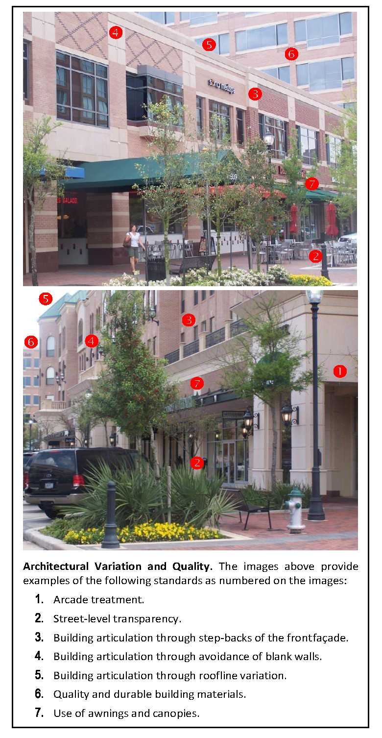
CMU
R-MF UV-D UV-T | Visual Interest and Anti-Monotony The standards below shall apply to all exterior elevations of structures that are not visually screened by an intervening building or structure from public view. Building Articulation Building façades to which these standards apply shall be articulated to reduce the apparent mass of the structure and to add visual appeal. This may be accomplished by stepping back a portion of the façade periodically relative to the building line, along with other design variations in the façade as illustrated in Figure 24-513a.A, below. Roofline Articulation For flat roofs or façades with a horizontal eave, fascia or parapet, the roofline shall be varied vertically so that no unmodulated segment of roof exceeds 50 feet in horizontal dimension. This standard can also be satisfied by incorporating design elements such as functional or faux dormers, gables, towers, or chimneys. Avoidance of Blank Walls Any exterior building elevation that faces a public street right-of-way, public plaza/space, public parking area or area of residential use shall have no more than 16 feet of uninterrupted blank wall space in a horizontal or vertical direction. This standard can be satisfied by incorporating window openings, porches or balconies, articulation of the building façade, decorative cornices, material and color variations, or score lines. Landscape Treatment for Large Walls Where buildings are more than 60 feet in length or 35 feet in height, site trees required by the landscaping standards of this chapter (and not required street trees) shall be arranged to break up the appearance of building mass so that the building is perceived to be divided into lengths of no greater than 50 feet when viewed from ground-level public vantage points. | See Figure 24-513a.A, below, for graphics illustrating building articulation and other techniques for adding architectural interest. |
Figure 24-513a.A
Examples of Building Designs and Articulation Standards
(Ord. No. 25-036, § 2(Exh. A), 5-19-2025)
Sec. 24-514. - Off-Street Parking and Loading.
A.
Purpose. The requirements of this section are intended to reduce congestion of the public streets and to promote the safety and welfare of the public by ensuring the availability of adequate off-street parking and loading facilities in the City of Bellaire.
B.
Required parking.
(1)
Off-street parking spaces shall be provided for each use in accordance with the requirements of each district.
(2)
The number of required off-street parking spaces that are designed and designated for disabled persons shall comply with the requirements of the Texas Accessibility Standards.
(3)
When calculating the number of required off-street parking spaces, fractions of less than one-half (½) shall be disregarded, and fractions of one-half (½) or more shall be counted as one (1) space.
C.
Location of required parking spaces.
(1)
For single-family detached and single-family attached dwelling units, required parking shall be located on the same lot.
(2)
Spaces needed to meet parking requirements for all uses other than single-family detached and attached dwellings may be located off-site on a separate property provided that the most distant parking space that is located off-site is no more than three hundred (300) feet from the principal building associated with the use, and the off-site parking is not separated from the use by an arterial street, a limited-access highway or other impediment to pedestrian circulation.
a)
No more than fifty (50) percent of the total required off-street parking spaces shall be located off site. None of the required parking spaces for disabled persons shall be located off site. None of the off-site parking shall involve or displace the off-street parking required of another use except through a shared parking arrangement under this chapter.
b)
An identifiable and publicly available pedestrian connection shall exist between the off-site parking area and the use.
c)
Any proposed off-site parking arrangement, and the continued availability of the dedicated parking, shall be documented through a written legal agreement executed by the involved property owners. An agreement shall be reviewed by and be satisfactory to the City Attorney as to form, sufficiency and manner of execution, and shall bind all heirs, successors and assigns. Off-site parking privileges shall continue in effect only as long as the agreement, binding on all parties, remains in force.
1)
If there is a change in circumstances regarding the off-site parking area, which displaces, reduces or terminates the required parking, the owner of the use served by the off-site parking shall promptly notify the Administrative Official of the changed circumstances and his plans for maintaining full compliance with this chapter.
2)
Failure to notify the Administrative Official of changed circumstances, or to provide the required parking within ninety (90) days of any loss of required parking, shall be cause for initiating revocation of the certificate of occupancy for the use.
D.
Use of required parking spaces. No portion of any required off-street parking space shall be used for the storage, sale or display of merchandise, or the storage, sale or display of complete or dismantled vehicles, except as authorized in this Code.
(1)
Blocking access to required off-street parking and loading spaces is prohibited, and dumpsters, trash enclosures, utility equipment or other site improvements or activities shall not be located in off-street parking and loading spaces.
E.
Design of required parking spaces.
(1)
Except as provided in subsection (2) or as otherwise specified in a planned development approval, each required parking space shall have the dimensions as hereinafter provided.
(2)
Required parking spaces shall be dimensioned as specified in Table 24-514.A.
a)
Vertical clearance of not less than eight (8) feet from all structures and trees/vegetation shall be provided over all parking space types. Additional clearance shall be provided, as appropriate, over spaces designated for vans, light trucks and other larger vehicles that require greater clearance. All parking garage entrances shall include an overhead bar to alert drivers of oversized vehicles regarding clearance.
Table 24-514.A
Parking Space Dimensions
F.
Change of use. Whenever a use which is in existence on the date of enactment of this chapter is changed or modified so that additional parking spaces are required under this chapter, the new required parking spaces shall comply with the requirements of this section. A nonconformity with the terms and provisions of this section as to insufficient parking spaces may be continued, but the nonconformity shall not be increased as provided for in Article VII of this chapter.
G.
Required off-street loading spaces.
(1)
Location of required loading spaces. Loading spaces shall be located on the same lot as the building or structure to which they are accessory. No loading space shall be located in a required front yard.
(2)
Designation and use. Each required loading space shall be designated as such and shall only be used for loading purposes.
(3)
Design and maintenance.
a)
Dimensions. Each space shall be a minimum of twelve (12) feet wide, forty-five (45) feet long, with an unobstructed vertical clearance of not less than fourteen (14) feet.
b)
Screening. All loading spaces or maneuvering areas shall be fully screened from view of any residential use by a uniformly colored, solid, visual and auditory barrier of not less than five (5) feet nor greater than seven (7) feet in height or a densely planted landscape screen consisting of evergreen shrubs or trees which shall be at least four (4) feet in height when planted and which can be expected to reach at least six (6) feet in height within three (3) years thereafter. The screening shall extend the full length of any loading facility with openings as required for ingress and egress, with not greater than twenty percent open space within the screen. The screen shall not be located closer than five (5) feet to any lot line.
1)
Screening waiver in UV-T district. Requirements in this subsection for screening of loading spaces and maneuvering areas from the view of any residential use do not apply in the UV-T district, but such areas shall be fully screened where visible from an abutting public street right-of-way. Additionally, loading and truck access areas shall be located behind principal buildings relative to public street frontage whenever practical, and such areas shall also be accessible from alleys or vehicular access easements where available and practical.
c)
Surfacing and drainage. All loading spaces shall be surfaced with an all-weather, durable and dust-free surface and shall be graded and drained to dispose of surface water accumulation by means of a storm water drainage system.
(4)
Number required. One (1) loading space shall be required for the first fifty thousand (50,000) to one hundred thousand (100,000) square feet of commercial floor area, and one (1) space shall be required for each additional twenty thousand (200,000) square feet of commercial floor area.
(5)
On-street loading in UV-D and UV-T districts. On-street, over-the-curb loading is permitted in the UV-D and UV-T districts between the hours of 7:00 a.m. and 10:00 p.m.
(Ord. No. 25-036, § 2(Exh. A), 5-19-2025)
State Law reference— Municipality may regulate parking on private property, V.T.C.A., Local Government Code § 431.001.
Sec. 24-514a. - Parking requirements, non-single family.
(a)
General Requirements. The following requirements as provided in Table 24-514a.A are hereby established as parking regulations for all structures and developments other than single-family dwellings (attached or detached), including planned developments, which may be found in all zoning districts as permitted.
TABLE 24-514a.A
Required Off-Street Parking
(1)
GFA — Gross Floor Area (excludes space used for distinct lobbies, hallways, elevators, mechanical equipment, etc.).
(b)
Mixed use. Mixed-use development in the CMU, UV-D and UV-T districts may be granted reductions in required parking as provided in this subsection.
(1)
Shared parking table. Shared parking allows a reduction in the total number of required parking spaces when a parcel is occupied by two (2) or more uses which typically do not experience peak parking demands at the same time. When any land or building is used for two (2) or more uses that are listed below, the minimum total number of required parking spaces may be determined by the following procedures:
a)
Multiply the minimum required parking for each individual use, excluding spaces reserved for use by specified individuals or classes of individuals, such as (e.g., handicapped parking), by the appropriate percentage listed in Table 24-514a.B, for each of the designated time periods.
b)
Calculate a sum for all uses for each of the five (5) columns. The minimum parking requirement is the highest of these sums.
c)
In general, the maximum reduction pursuant to Table 24-514a.B shall be twenty-five (25) percent. However, a greater reduction is permitted, provided that:
1)
Sufficient land is set aside for each parking space in excess of the twenty-five (25) percent reduction that is not constructed, so that the spaces may be constructed at a later date should the Administrative Official determine that they are necessary; and
2)
The property owner executes and records a document that guarantees that the spaces will be constructed upon written order of the Administrative Official.
Table 24-514a.B
Shared Parking Table
(2)
Special shared parking study. As an alternative to the methodology in Table 24-514a.B, an applicant may propose a special study to document the parking required for mixed uses by reviewing peak loading times for uses during a twenty-four-hour day and designing for the peak hour demand.
a)
The study shall provide data on the following:
1)
The recommended parking needs of the project.
2)
The sensitivity of the proposed uses to change. For example, a center with no restaurant could have significant changes in parking if a restaurant was added.
3)
Similar mixes of uses in other areas of the community or surrounding region.
4)
Degree of variability of parking for individual uses (average, range and standard deviation).
b)
The shared parking study must be conducted by a professional engineer with experience in parking analysis and planning.
1)
The City may retain a qualified engineer, at the applicant's expense, to prepare the special study and provide recommendations to the City; or
2)
The City may rely on the applicant's selected engineer to conduct the study, with review provided by City technical staff and/or consultant.
c)
Upon the recommendation of the Administrative Official, the Planning and Zoning Commission may require a reserved open area on the site to offset the risk of parking needs increasing over time. Once the project is occupied and well established, if there is a surplus of parking, the applicant may petition for additional development capacity and parking using the reserved area.
(3)
Design of shared parking. Where shared parking is implemented:
a)
A pedestrian circulation system shall be provided that connects uses and parking areas, making it easy and convenient to move between uses.
b)
All shared parking shall be located within one hundred fifty (150) feet of any building which it serves, as measured along an established pedestrian route from the nearest point of the parking facility to the nearest point of the use served.
(c)
Shared parking among sites under different ownership. Adjoining developments with separate property ownership in the CMU, UV-D and UV-T districts may propose shared parking arrangements in accordance with the purposes and procedure of Section 24-514a(b)(1), above, with the following conditions:
(1)
Cooperating property owners shall use Table 24-514a.B to calculate the reduction in required parking to be achieved through a shared parking arrangement.
(2)
The Administrative Official is authorized to approve joint parking arrangements in accordance with this subsection.
(3)
In addition to the conditions specified in this section, above, for shared parking among mixed uses on a single site, a shared parking arrangement among multiple sites shall require:
a)
Provision for interconnected parking areas between the sites to accommodate vehicular circulation; and
b)
Recorded easements that provide for, at a minimum:
1)
Cross-access among the parking areas and connections to permit parking by the different uses anywhere in the connected properties;
2)
A pedestrian circulation system that connects uses and parking areas, making it easy and convenient to move between uses; and
3)
Allocation of maintenance responsibilities.
(d)
Stacking spaces. Uses with drive-through facilities in the CMU and UV-D districts shall provide vehicle stacking spaces as set out in this section and in Table 24-514a.C. Stacking spaces include the spaces at menu boards, service windows, and drive-through lanes for Automated Teller Machines (ATMs).
(1)
Size of stacking spaces: Eight (8) feet wide x eighteen (18) feet long, exclusive of access drives and parking aisles.
Table 24-514a.C
Required Stacking Spaces
(Ord. No. 25-036, § 2(Exh. A), 5-19-2025)
Sec. 24-515. - Special Off-Street Parking Regulations.
In all residential districts, no truck exceeding three-fourths (¾) ton capacity, no bus, no recreational vehicle, trailer, boat, motor home or mobile home shall be parked or stored on any abutting street or within the front yard, as such terms are defined in this chapter, and shall not, anywhere within any of such districts, be used as a dwelling or for business, commercial or storage purposes.
A truck, bus, recreational vehicle, trailer, boat, motor home or mobile home may only be parked behind the rear plane of the primary structure.
(Ord. No. 25-036, § 2(Exh. A), 5-19-2025)
Sec. 24-516. - Parking on Unsurfaced Area Prohibited.
A.
It shall be prohibited to park unattended vehicles on the unsurfaced area within the distance between the edge of the curb or edge of the paved surface of a public street abutting a front or side yard and the outermost surface of any structures located on any property. For the purpose of this section unsurfaced area includes, but is not limited to, those areas covered with grass and/or other vegetation, whether natural, planted or landscaped.
B.
It shall be an affirmative defense to prosecution under this section that the vehicle was parked on an uncurbed street with two (2) wheels on the same lateral side of the vehicle resting on and parallel to the paved portion of the street and two (2) wheels on the same lateral side of the vehicle resting on and parallel to the unsurfaced area defined in (a) above; provided, however, that such parking in no way impedes the orderly flow of traffic on said street.
(Ord. No. 25-036, § 2(Exh. A), 5-19-2025)
Sec. 24-517. - Home Occupations.
A.
Authorization. A home occupation shall be permitted in any residential dwelling unit or accessory structure provided that the home or structure complies with the terms and provisions of this chapter.
B.
Purpose. The regulations of this section are designed to protect and maintain the residential character of established neighborhoods while recognizing that particular professional and limited business activities are traditionally and inoffensively carried on in the home. All home occupations are subordinate to the primary use of the home as a place of residence and shall not interfere with the enjoyment of surrounding homes as places of residence.
C.
Limitation on home occupations. Any home occupation is prohibited when:
(1)
The home occupation causes, by reason of its existence, a noticeable increase in the number of motor vehicles traveling to and from the home or on the public streets surrounding or abutting the home; or when
(2)
The home occupation in any way destroys or interferes with the primary use of the home as a place of residence.
D.
Particular home occupations permitted. Permitted home occupations are (list is not all inclusive).
(1)
Homebound employment of a physically, mentally or emotionally handicapped person;
(2)
Office facilities for salesmen, sales representatives and manufacturers' representatives, when no retail or wholesale sales are made or transacted on premises;
(3)
Studio or laboratory of an artist, musician, photographer, craftsman, writer, tailor or similar person;
(4)
Office facilities for accountants, architects, brokers, engineers, lawyers, insurance agents, realtors and members of similar professions.
E.
Use limitations. In addition to the requirements of the zoning district in which it is located and those requirements herein previously set out, all home occupations shall comply with the following restrictions:
(1)
No stock in trade shall be displayed or sold on the premises;
(2)
The home occupation shall be conducted entirely within the principal dwelling unit or accessory structure, or off premises in accordance with all applicable provisions of this chapter, and in no event shall such use be visible from any other residential structure or public way;
(3)
There shall be no outdoor storage of equipment or material used in the home occupation;
(4)
No more than one (1) vehicle shall be used in the conduct of the home occupation;
(5)
No mechanical, explosive, electrical or other equipment which produces noise, electrical or magnetic interference, vibration, heat, glare or other nuisance outside the residential or accessory structure shall be used;
(6)
No home occupation shall be permitted which is noxious or offensive to a person of ordinary sensitivity or hazardous by reason of vehicular traffic, generation or emission of noise, vibration, smoke, dust or other particulate matter, odorous matter, heat, humidity, glare, refuse, radiation or other objectionable emissions;
(7)
Advertising.
a)
Forms of advertising of home occupations that are permitted:
1)
Word of mouth by telephone or face to face;
2)
Free listing in telephone directories and business journals and directories; and/or
3)
Business cards and stationery.
b)
Forms of advertising home occupations that are prohibited:
1)
Any sign, display or written advertisement of the occupation or the telephone number of the occupation except as specifically listed in (7)a; and
2)
Any radio or television advertisement of the occupation or the telephone number of the occupation or any other means of advertisement by word of mouth except as specifically listed in (7)a.
(Ord. No. 25-036, § 2(Exh. A), 5-19-2025)
Sec. 24-518. - Expansion of Nonconforming Residential Structures.
Notwithstanding the minimum requirements for side yards and rear yards as herein set out, any existing residential structure, lawfully existing prior to the enactment of this chapter or any amendment hereto, located within the City of Bellaire may be expanded or enlarged as long as such expansion or enlargement does not extend into the required side yard or rear yard beyond the outermost surface of the existing building line, and as long as such expansion does not violate the City's fire code or any other code, ordinance, rule or regulation of the City of Bellaire.
(Ord. No. 25-036, § 2(Exh. A), 5-19-2025)
Sec. 24-519. - Residential Planned Development.
Residential planned developments may be proposed for lands immediately adjacent to Interstate Highway Loop 610, provided that the subject property abuts the right-of-way of either Interstate Highway Loop 610 East Service Road or West Service Road and that the project will not isolate or surround any parcel of land abutting it. The intent of allowing such development is to acknowledge the adverse impact of the freeway and encourage development of projects of high quality which will mitigate these effects with sound barriers such as walls and landscaping that will act as buffers both for the development and for adjacent residential areas. Such lands in any zoning district, except the Light Industrial District, may be approved as residential planned developments, subject to the following restrictions and limitations.
(1)
Size and area.
a)
Project area. The minimum project area shall be two (2) acres with a gross density not to exceed ten (10) dwelling units per acre, which is equivalent to an average minimum lot size of four thousand three hundred (4,300) square feet. The depth of the site from the service road shall not exceed four hundred (400) feet. In the event that a line four hundred (400) feet from the service road bisects a lot, the nearest platted lot line legally existing at the time of adoption of this section shall be the outermost boundary of the Planned Development District.
b)
Maximum building height. 2½ stories, except that cooling towers, roof gables, chimneys, radio and television antennas and vent stacks may extend for an additional height, the total not to exceed forty (40) feet above the average level of the base of the foundation of the building. Radio communications antennas for non-commercial service may not exceed sixty (60) feet above the average level of the base of the foundation of the building.
c)
Minimum floor area per dwelling unit. One thousand two hundred fifty (1,250) square feet.
d)
Building lines.
1)
The front building line shall be setback a minimum of ten (10) feet from any new street right-of-way dedicated as a part of the planned development district, except that in no case shall required parking obstruct pedestrian flow in the required sidewalk.
The front building line facing an existing public street other than the East and West Service Road of Loop 610 shall be set back from the public street right-of-way a minimum distance, which shall be determined by computing the average distance between the outermost surface of the existing main buildings on the two (2) abutting lots and the edge of the public street right-of-way. However, in the event that there are no existing buildings on the two (2) abutting lots, the required setback distance shall be twenty-five (25) feet.
In the event that the front building line is facing a court, as that term is defined herein, there shall be a minimum separation between front building lines of forty (40) feet with at least ten (10) feet of yard space from the front of the building to the property line and twenty (20) feet for a public utility easement, for pedestrian access as well as utilities between the property lines.
2)
No building line of any structure within the planned development district shall be located any closer than eight (8) feet to the side lot line of any residential lot adjacent to the planned development district. In the event that any portion of the planned development site includes a corner lot, no such building line shall be located closer than ten (10) feet to the right-of-way of the adjacent side street, designated as such on the approved plat of the planned development. This provision does not apply to the corner lots in the event that the right-of-way of the adjacent side street is the East or West Service Road of Loop 610.
Within the interior of the planned development district, zero lot lines are permitted for adjacent residential units; but in the event that the main residential units are separated, a minimum of six (6) feet must be maintained between units.
3)
No building line of any main residential structure shall be located within a distance of seventy-five (75) feet of the East or West Service Roads of Loop 610. A berm and/or plantings shall be located within this strip that are not less than five (5) feet in width and six (6) feet in height at the time of occupancy of the site. The individual trees or shrubs shall be planted and maintained by the owner or occupant so as to provide a dense screen year-round. At least fifty (50) percent of the plantings shall consist of evergreens. A solid wall or fence, not to exceed eight (8) feet in height, complemented by suitable plantings, may be substituted for the landscaped screening, if specifically authorized as a condition to the approval of the planned development. The strip may be part of the yard or common area of residential uses within a planned development or have required parking and/or recreational amenities located within it.
4)
No building line of any structure within the planned development district shall be located any closer than ten (10) feet to the rear lot line of any adjacent residential lot.
5)
No contiguous building lines of structures having zero lot lines shall exceed two hundred (200) linear feet.
e)
Maximum site coverage: Sixty (60) percent of site area.
(2)
Parking and driveways. Each home within the planned development district shall have as a minimum one (1) car garage; driveways shall be of such design as to accommodate two (2) vehicles per unit totally on site. Within the planned development district, two (2) garages of neighboring dwelling units may share a common wall on a common lot line so long as the required six-foot minimum distance is maintained between separated main residential structures.
(3)
Screening and landscaping. Generally, screening and landscaping shall be required for the planned development district according to the specifications set forth in Section 24-513, Division 1, of this article.
(4)
Soundproofing. All dwelling units shall be soundproofed such that residents will not be subject to sustained noise from Interstate Highway 610 in excess of fifty (50) db(A).
(Ord. No. 25-036, § 2(Exh. A), 5-19-2025)
Sec. 24-520. - Minimum Setback Along Bellaire Boulevard.
The front building line for all residential development along Bellaire Boulevard shall be set back a minimum of thirty (30) feet from the property line.
(Ord. No. 25-036, § 2(Exh. A), 5-19-2025)
Sec. 24-521. - Communication Towers and Antennas.
The following general conditions for communication towers and antennas shall apply regardless of whether the communications tower or antenna is to be construed as a permitted use or a specific use.
A.
Permit Required. Before construction of a communication tower or antenna, a permit must be obtained from the Building Official. Issuance of the permit shall be conditioned upon submission of plans and specifications, payment of established fees and continued compliance with all requirements relating to communication towers or antennas set forth in the City Code.
B.
Availability of suitable existing communication towers or other support structures.
1.
All new communication towers shall be designed to structurally accommodate the maximum number of additional users as economically, as well as, technically practicable.
2.
No new communication tower shall be permitted unless the applicant demonstrates to the reasonable satisfaction of the Building Official that no existing communication tower or antenna support structure can accommodate the applicant's proposed antenna. Evidence submitted to demonstrate that no existing communication tower or antenna support structure can accommodate the applicant's proposed antenna may consist of any of the following:
(a)
No existing communication towers or antenna support structures are located within the geographic area required to meet applicant's engineering requirements; or
(b)
Existing communication towers or antenna support structures are not of sufficient height to meet applicant's engineering requirements; or
(c)
Existing communication towers or antenna support structures do not have sufficient structural strength to support applicant's proposed antenna and related equipment and cannot be reinforced to provide sufficient structural strength; or
(d)
The applicant's proposed antenna would cause electromagnetic interference with the antenna on the existing communication towers or antenna support structures, or the support structures would cause interference with the applicant's proposed antenna; or
(e)
The fees or costs required to share an existing communication tower or antenna support structure or to adapt an existing tower or antenna structure for sharing are unreasonable; or
(f)
Property owners or owners of existing communication towers or antenna support structures are unwilling to accommodate the applicant's needs; or
(g)
The applicant demonstrates that there are other limiting factors that render existing communication towers and antenna support structures unsuitable.
3.
The permit granted for the construction and continued operation of a new communication tower is specifically subject to the condition that the communication tower owner abides by the following provisions relating to shared use:
(a)
The communication tower owner shall respond in a timely, comprehensive manner to a request for information from a potential shared use applicant;
(b)
The communication tower owner shall negotiate in good faith for shared use by third parties; and
(c)
The communication tower owner shall allow shared use where the third party seeking the use agrees in writing to pay reasonable, pro rata charges for sharing, including payment of all charges necessary to modify the communication tower and transmitters to accommodate shared use, but not total communication tower reconstruction, and to observe whatever technical requirements are necessary to allow shared use without creating interference.
C.
Distance from adjacent property. Communication towers shall be spaced from all adjacent property at a minimum of one hundred twenty-five (125) percent of the height of the communication tower measured from the base of the communication tower to the nearest adjacent property line.
D.
Height restriction. The maximum height for communication towers shall be one hundred twenty feet as measured from the base of the communication tower to its highest point.
E.
Structural integrity. To ensure the structural integrity of communication towers or antennas, the owner of a communication tower or antenna shall, before building such structure, submit a structural integrity report to the Building Official prepared by a registered professional engineer prior to placing such communication tower or antenna into service. In addition, the owner shall ensure that the communication tower or antenna is maintained in compliance with all standards contained in applicable local building codes and the applicable standard for communication towers and antenna that are published by the Electronic Industries Association, as amended from time to time. The owner of a communication tower or antenna shall submit on an annual basis, to the Building Official, a certification of structural integrity prepared by a registered professional engineer. If the Building official determines that the communication tower or antenna fails to comply with such codes and standards and constitutes a danger to persons and property, then upon notice being provided to the owner, the owner shall have thirty (30) days to bring such communication tower or antenna into compliance with such codes and standards. If the owner fails to bring such communication tower or antenna into compliance within the said thirty (30) days, the City may remove such communication tower or antenna or cause it to be removed at the owner's expense.
F.
Security fencing. Communication towers, other than monopole antenna support structures, shall be enclosed by fencing not less than eight (8) feet in height and shall be equipped with an appropriate anti-climbing device. Access to the communication tower shall only be through a locked gate.
G.
No hazardous materials on site. The storage, distribution or sale of volatile, flammable, explosive or hazardous materials such as propane, natural gas, and dangerous chemicals shall be prohibited on any site used for the location of a communication tower or antenna except for that fuel needed for a backup generator.
H.
Radiation Standards. Communication towers and antennas shall comply with current Federal Communication Commission Standards for non-ionizing electromagnetic radiation (NIER). The owner shall submit verification that the proposed site plan ensures compliance with these standards prior to placing any communication tower or antennas into service.
I.
Visual impacts.
(i)
Communication towers shall, subject to any applicable standards of the FAA or other applicable federal or state agency, have a neutral finish, or otherwise be constructed so as to reduce visual obtrusiveness, and blend the tower facilities to the natural setting and built environment.
(ii)
Communication towers and antennas shall not be illuminated except as required by FAA regulation or other federal or state agencies.
J.
Abandonment. Any antenna or communication tower that for a continuous period of twelve (12) months is not operated, shall be considered abandoned, and the owner of such antenna or communication tower shall remove same within ninety (90) days of receipt of notice from the Building Official notifying the owner of such abandonment. If such antenna or communication tower is not removed within said ninety (90) days, the Building Official may cause such antenna or communication tower to be removed at the owner's expense. If there are two (2) or more users of a single communication tower, then this provision shall not become effective until all users cease using the communication tower.
(Ord. No. 25-036, § 2(Exh. A), 5-19-2025)
Federal law reference—Preservation of local zoning authority regarding wireless telecommunications facilities, 47 USC § 322(c)(7).
Sec. 24-522. - Setback Requirements for Combined Lots.
When two (2) or more lots are combined, whether by plat, replat, or amended plat, after August 7, 2006, the new lot will retain the setback from each street that existed prior to the combination.
(Ord. No. 25-036, § 2(Exh. A), 5-19-2025)
Sec. 24-523. - Through Lots Prohibited.
No plat, replat or amending plat shall be approved if such approval results in the creation of a through lot. Through lots in existence as of December 3, 2007, may continue.
(Ord. No. 25-036, § 2(Exh. A), 5-19-2025)
Sec. 24-524. - Site Plan Review.
A.
Required information. Development applications which require administrative and/or Planning and Zoning Commission review of a site plan under this chapter, as well as all applications for a planned development amendment to this chapter, shall include the following information in a format specified by the Administrative Official:
(1)
North arrow and scale.
(2)
Vicinity map indicating the general location of the site and its relationship with adjacent and nearby streets in all directions from the site to a distance of two hundred (200) feet.
(3)
Surrounding uses, activities and influences of the site and adjacent properties within two hundred (200) feet, including:
a)
Public streets, and the location of any existing traffic control devices.
b)
Bicycle and/or pedestrian facilities, routes, paths or other existing improvements.
c)
Driveways that exist or which are proposed to the degree that they appear on plans on file with the City.
d)
Any buildings that exist or are proposed to the degree that their location and size are shown on plans on file with the City.
e)
Residences, which may be shown in approximate location and general size and shape.
(4)
The boundary lines of the area included in the site plan, including bearings, dimensions and reference to a point on a recorded plat.
(5)
Existing and finished grades or contours, as applicable.
(6)
Identification of any areas on the site or within two hundred (200) feet that are within the 100-year floodplain.
(7)
The size of the subject property, and sufficient dimensions to indicate the relationship between buildings, property lines, zoning district boundaries, parking areas and other elements of the plan.
(8)
Existing structures and other improvements on the site.
(9)
The general location of new public streets, any proposed improvements or adjustments to existing public streets, and points of ingress to and egress from the development.
(10)
Proposed location of buildings and other structures, parking areas, driveways, on-site circulation, screening and buffering, drainage patterns, public streets and any existing or proposed easements.
(11)
A schedule indicating total site area, total floor area, lot coverage relative to landscape surface area, allocation and specific location of all proposed principal and accessory land uses, number of dwelling units, nonresidential square footage, number of standard and ADA accessible parking spaces, any loading spaces, height of all buildings and structures, residential density, nonresidential floor area ratio(s), and other pertinent quantities relative to the submitted plan, including the above quantities by individual structure for plans with multiple buildings.
(12)
Focal points and site amenities.
(13)
The proposed location of any and all green space, public parks or other areas reserved for public use in the proposed development.
(14)
Building elevations and other site and architectural detail depicting conformance with design standards established for particular zoning districts, including:
a)
For the UV-T district, site and building design standards outlined in Section 24-547 D.
(15)
Landscape plan as set forth in Section 24-513 D.(2), illustrating the planned approach for providing required landscaping, screening and buffering, as applicable, as well as required tree planting for commercial property as set forth in Section 9-355 in Chapter 9, Buildings, of the City Code.
(16)
Tree disposition plan for the preservation and replacement of trees on the property as set forth in Section 9-352 D. in Chapter 9, Buildings, of the City Code:
a)
For planned development applications, the tree disposition plan shall be submitted at the time of application rather than with an application for building permit after planned development approval.
(17)
Name and address of the land owner, applicant, architect, landscape architect, planner, engineer, surveyor or other person involved in the preparation of the site plan.
(18)
A written description, and any available documentation, of known environmental hazards or conditions existing on the property from historical use or off-site activities which impacted the site.
a)
Specifically, applicants shall provide any existing, known Phase I Environmental Site Assessment Reports or other environmental due diligence reports in their possession associated with the property.
b)
Applicants shall provide all reports submitted to the Texas Commission on Environmental Quality (TCEQ) and associated correspondence on the status of any environmental assessment, remediation, and/or closure activities related to the property.
c)
Should the TCEQ issue a "No Further Action" determination or "Certificate of Completion," documentation of such shall be provided to the City and no further action shall be required under this subsection.
d)
For planned development applications, specific use permit applications, or zoning changes, environmental documentation required by this subsection shall be submitted at the time of the planned development, specific use permit, or zoning change application, rather than with an application for building permit after planned development, specific use permit, or zoning change approval.
(19)
A written description and analysis of additional demand on City utilities and storm drainage facilities, and impact on their available capacity, from the proposed development.
(20)
A traffic impact analysis, if deemed necessary by the Administrative Official, the Planning and Zoning Commission or the City Council.
(21)
Such other information or documentation as the Administrative Official, the Planning and Zoning Commission or the City Council may from time to time designate or which may be deemed necessary and appropriate to a full and proper consideration and disposition of the particular application, including, but not limited to, dumpster locations.
B.
Procedures.
(1)
Complete application. The applicant shall submit a complete application to the Administrative Official along with the content requirements specified in this section, above. Processing of the application and review of the site plan shall not commence until all submittal requirements are satisfied.
(2)
Review. Except as otherwise required for a planned development and in the NBSDD and the UV-T district, the Administrative Official shall review the site plan for conformance with all applicable standards and guidelines of the City Code, with the exception of any proposed variations from City standards as part of a planned development application, which must be clearly specified.
(3)
Zoning amendment process for Planned Development Amendments. When the Planning and Zoning Commission is ready to proceed with the zoning amendment aspect of a planned development application, including a report and recommendation to City Council, the Commission and the Administrative Official shall proceed to complete all public notice, hearing and other processing requirements as set forth in Chapter 24, Article VI, Amendatory Procedure, of the City Code.
(Ord. No. 25-036, § 2(Exh. A), 5-19-2025)
Sec. 24-524a. - Developments with Known Affected Soil or Groundwater.
For development applications which require administrative and/or Planning and Zoning Commission review of a site plan under this chapter, as well as all applications for a planned development amendment to this chapter, the following provisions shall apply to all proposed developments with known affected soil or groundwater per the Texas Commission on Environmental Quality (TCEQ):
A.
Prior to issuance of any building permit which involves soil disturbance, a Soil and Groundwater Management Plan prepared by a licensed professional engineer shall be submitted to and reviewed and approved by the Building Official or his or her designee. The plan will address, at a minimum, environmental monitoring during construction, spill contingency plans, plans for management of affected media, profiling and disposal of wastes, and communications with the City and regulatory agencies. The recommendations of the approved Soil and Groundwater Management Plan shall be followed without exception. Any violation of the approved Soil and Groundwater Management Plan can result in immediate construction stoppage and revocation of the development's building permit.
B.
As part of the fees associated with the building permit, the applicant shall pay all costs associated with 3rd-party construction monitoring and soil testing contracted by the City of Bellaire which is necessary to confirm that the Soil and Groundwater Management Plan is strictly adhered to.
C.
Prior to initiation of any soil disturbance activities, the applicant shall provide documentation that its earthwork contractors are Hazardous Waste Operations and Emergency Response (HAZWOPER) trained to perform excavation in areas with the potential for encountering impacted soils.
(Ord. No. 25-036, § 2(Exh. A), 5-19-2025)
Sec. 24-525. - Schools, private clubs, and places of worship in residential districts.
A.
Purpose. The purpose of this section is to set specific and consistent regulations for the development of schools, private clubs, and places of worship in residentially zoned districts to ensure compatibility with existing neighborhoods and to minimize possible negative impacts of such uses.
B.
Standard Regulations.
(1)
Size and area.
a.
Minimum lot area. Twenty-two thousand (22,000) square feet;
b.
Minimum lot width. One hundred twenty-five (125) feet;
c.
Minimum lot depth. One hundred twenty-five (125) feet;
d.
Maximum building height. Forty-five (45) feet, including steeples, domes, spires, bell towers, cooling towers, roof gables, chimneys, antennas, and vent stacks;
e.
Minimum floor area. Two thousand five hundred (2,500);
f.
Minimum required yards.
i.
Front yard: Thirty (30) feet;
ii.
Side yard: Twenty (20) feet, provided that on a corner lot, the minimum side yard adjacent to the side street shall be ten (10) feet;
iii.
Rear yard: Twenty (20) feet, for both the main structure and any accessory structures;
g.
Maximum lot coverage. Fifty (50) percent of lot area. Up to seventy-five (75) percent of lot area if approved with a specific use permit, except for places of worship and schools in the Bellaire Boulevard Estate Overlay District.
(2)
Parking. See Subsection 24-514a.
(Ord. No. 25-036, § 2(Exh. A), 5-19-2025)
Editor's note— Ord. No. 25-036, § 2(Exh. A), adopted May 19, 2025, amended the title of § 24-525 to read as herein set out. The former § 24-525 title pertained to schools and churches in residential districts.
Sec. 24-526. - Pawnshop regulations.
The following general conditions for pawnshops shall apply regardless of whether the pawnshop is to be construed as a permitted or specific use. A pawnshop shall not be located within one hundred (100) feet of any residential property to the closest point of any property in use as a pawnshop or containing such use.
(Ord. No. 25-036, § 2(Exh. A), 5-19-2025)
Sec. 24-531. - R-1 Residential District.
A.
Purpose. The R-1 Residential District is a low density residential area characterized by the zoning requirements set forth in this section.
B.
Unzoned property. All property not included in a zoning district or for any reason removed from an established zoning classification, shall be deemed included in the R-1 Residential District although not so delineated on the Official Zoning District Map.
C.
Uses.
(1)
Permitted uses.
a)
Single-family dwellings.
b)
Public parks.
c)
Utilities:
1)
Telephone lines and related cross connecting points.
2)
Local utility distribution lines.
d)
Accessory uses, subject to the requirements of Section 24-510.
e)
Home occupations, subject to the requirements of Section 24-517.
f)
Facilities owned and maintained by the City.
g)
Deleted.
(2)
Specific uses.
a)
Schools.
b)
Places of worship.
D.
Standard regulations.
(1)
Residential structures. Table 24-531-1 identifies all dimensional regulations for single-family dwellings.
Table 24-531-1
Dimensional Regulations for Single-Family Detached Dwellings
a)
Parking. Two (2) on-site spaces per dwelling unit, subject to the requirements of Section 24-514.
(2)
Nonresidential structures.
a)
Reserved.
b)
Reserved.
(Ord. No. 25-036, § 2(Exh. A), 5-19-2025)
Sec. 24-532. - R-3 Residential District.
A.
Purpose. The R-3 Residential District is a lower medium density residential area characterized by the zoning requirements set forth in this section.
B.
Uses.
(1)
Permitted uses.
a)
Single-family dwellings;
b)
Public parks;
c)
Utilities:
1)
Local utility distribution lines; and
2)
Telephone lines and related cross connecting points.
d)
Accessory uses, subject to the requirements of Section 24-510;
e)
Home occupations, subject to the requirements of Section 24-517;
f)
Facilities owned and maintained by the City;
g)
Deleted;
h)
Planned Development: Loop 610 Residential.
(2)
Specific uses.
a)
Schools; and
b)
Places of worship.
C.
Standard regulations.
(1)
Residential structures. See Table 24-531-1 for all dimensional regulations for single-family dwellings.
a)
Parking. Two (2) on-site spaces per dwelling unit, subject to the requirements of Section 24-514.
(2)
Nonresidential structures.
a)
Reserved.
b)
Reserved.
(Ord. No. 25-036, § 2(Exh. A), 5-19-2025)
Sec. 24-533. - R-4 Residential District.
A.
Purpose. The R-4 Residential District is a medium density residential area characterized by the zoning requirements set forth in this section.
B.
Uses.
(1)
Permitted uses.
a)
Single-family dwellings;
b)
Public parks; and
c)
Utilities:
1)
Local utility distribution lines;
2)
Telephone lines and related cross connecting points;
3)
Accessory uses, subject to the requirements of Section 24-510;
d)
Home occupations, subject to the requirements of Section 24-517;
e)
Facilities owned and maintained by the City; and
f)
Deleted.
(2)
Specific uses.
a)
Schools; and
b)
Places of worship.
C.
Standard regulations.
(1)
Residential structures. Table 24-531-1 identifies all dimensional regulations for single-family dwellings.
a)
Parking. Two (2) on-site spaces per dwelling unit, subject to the requirements of Section 24-514.
(2)
Nonresidential structures.
a)
Reserved.
b)
Reserved.
(Ord. No. 25-036, § 2(Exh. A), 5-19-2025)
Sec. 24-534. - R-5 Residential District.
A.
Purpose. The R-5 Residential District is a medium to upper medium density residential area characterized by the zoning requirements set forth in this section.
B.
Uses.
(1)
Permitted uses.
a)
Single-family dwellings;
b)
Public parks;
c)
Utilities:
1)
Local utility distribution lines;
2)
Telephone lines and related cross connecting points;
d)
Accessory uses, subject to the requirements of Section 24-510;
e)
Home occupations, subject to the requirements of Section 24-517;
f)
Facilities owned and maintained by the City; and
g)
Planned Development: Residential.
(2)
Specific uses.
a)
Schools; and
b)
Places of worship.
C.
Standard regulations.
(1)
Residential structures. Table 24-531-1 identifies all dimensional regulations for single-family dwellings.
a)
Parking. Two (2) on-site spaces per dwelling unit, subject to the requirements of Section 24-514.
(2)
Nonresidential structures.
a)
Reserved.
b)
Reserved.
D.
Planned Development: Residential. Planned developments may be approved in this District under the amendatory procedures of this chapter, subject to the following restrictions and limitations.
(1)
Size and area.
a)
Project area. A planned development in an R-5 Residential District shall have a minimum site of two (2) acres except in the event that a site of less than two (2) acres is bounded on two (2) or more sides by town homes. In the latter instance the minimum size and area shall be that which is designated on the approved plat of the planned development. In either event the project area shall have a minimum average equivalent lot size of five thousand (5,000) square feet;
b)
Maximum building height. Two and one half (2½) stories, except that cooling towers, roof gables, chimneys, radio and television antennas and vent stacks may extend for an additional height, the total not to exceed forty (40) feet above the average level of the base of the foundation of the building. Radio communications antennas for non-commercial service may not exceed sixty (60) feet above the average level of the base of the foundation of the building;
To determine height restrictions related to the maximum height of the top plate of the second story, height measurements shall be from the top of the lowest level of the top of the foundation of the heated or air conditioned building enclosed within the outer walls of the structure.
To determine height restrictions related to the maximum height of any ridge pole, height measurements shall be from a reference elevation established as three (3) feet above the average natural ground at the structure. However, in the event the 500-year flood elevation at the structure, as determined by the effective FEMA Flood Insurance Study (FIS) and Flood Insurance Rate Map, plus one (1) foot is higher than the reference elevation defined above, then a revised reference elevation defined as the 500-year flood elevation at the structure plus one (1) foot shall be utilized. Under no circumstances shall the height from the lowest level of the top of the foundation of the heated or air-conditioned building enclosed within the outer walls of the structure to any ridge pole exceed thirty-five (35) feet six (6) inches.
c)
Minimum floor area per dwelling unit. One thousand five hundred fifty (1,550) square feet;
d)
Building lines.
1)
The front building line shall be set back a minimum of ten (10) feet from any new street right-of-way dedicated as part of the planned development district, except that in no case shall required parking obstruct pedestrian flow on the required sidewalk;
The front building line facing an existing public street shall be set back from the public street right-of-way a minimum distance, which shall be determined by computing the average distance between the outermost surface of the existing main buildings on the two (2) abutting lots and the edge of the public street right-of-way.
In the event that the front building line faces a court, as that term is defined herein, there shall be a minimum separation between front building lines of forty (40) feet with at least ten (10) feet of yard space from the front of the building to the property line and twenty (20) feet for a public utility easement, for pedestrian access as well as utilities between the property lines;
2)
No building line of any structure within the planned development district shall be located any closer than six (6) feet from the side lot line of any residential lot adjacent to the planned development district. In the event that any portion of the planned development site includes a corner lot, no such building line shall be located any closer than ten (10) feet to the right-of-way of the adjacent side street, designated as such on the approved plat of the planned development. Within the interior of the planned development district, zero lot lines are permitted for adjacent residential units; but in the event that the main residential units are separated, a minimum of eight (8) feet must be maintained between units;
3)
No building line of any structure within the planned development district shall be located any closer than ten (10) feet to the rear lot line of any adjacent residential lot;
4)
No contiguous building lines of structures having zero lot lines shall exceed two hundred (200) linear feet; and
5)
In no case shall any building line of any structure within the planned development district be located nearer than ten (10) feet to the street right-of-way of Bellaire Boulevard.
f)
Maximum site coverage. Sixty (60) percent of site area.
(2)
Parking and driveways. Each home within the planned development district shall have a two-car garage; driveways shall be of such design as to accommodate two (2) vehicles totally on site. Within the planned development district, two (2) garages of neighboring dwelling units may share a common wall on a common lot line so long as the required eight (8) foot minimum distance is maintained between separated main residential structures;
(3)
Screening. Screening shall be required between the planned development district and abutting property in commercial use, according to the specifications set forth in Section 24-513 of Division 1 of this article;
(4)
Landscaping. In addition to that landscaping which may be an integral part of the screening herein required, landscaping shall also be required for the purpose of providing an acceptable transition between the planned development district and surrounding lower density residential development.
(Ord. No. 25-036, § 2(Exh. A), 5-19-2025)
Sec. 24-535. - R-MF Residential Multi-Family District.
A.
Purpose. The R-MF Residential Multi-Family District is a high density residential area including the potential for independent senior living, characterized by the zoning requirements set forth in this section.
B.
Uses.
(1)
Permitted uses.
a)
Multi-family dwellings with access from the interior of the building;
b)
Public parks;
c)
Utilities:
1)
Local utility distribution lines;
2)
Telephone lines and related cross connecting points;
3)
Accessory uses, subject to the requirements of Section 24-510; and
4)
Home occupations, subject to the requirements of Section 24-517;
d)
Facilities owned and maintained by the City; and
e)
Planned Development: Applicants may propose planned developments in this district under the amendatory procedures in Section 24-604. This procedure will enable consideration of development proposals involving uses or designs that might not strictly adhere to the standards within this section but would meet the spirit and intent of the district.
C.
Standard regulations.
(1)
Residential structures.
a)
Size and area.
1)
Minimum lot area. Forty-three thousand five hundred sixty (43,560) square feet (one (1) acre);
2)
Minimum lot width. One hundred fifty (150) feet;
3)
Minimum lot depth. One hundred (100) feet;
4)
Maximum building height. Fifty-three (53) feet, including drive under parking, except that cooling towers, roof gables, chimneys, radio and television antennas and vent stacks may extend for an additional height, the total not to exceed sixty-three (63) feet above the average level of the base of the foundation of the building.;
5)
Minimum required yards.
a.
Front yard: Ten (10) feet;
b.
Side yard: No side yard is specified except that when a side yard abuts a lot which is in residential use, the minimum side yard shall be ten (10) feet, and on a corner lot, both street exposures shall be treated as front yards.
c.
Architectural features: the outermost point of architectural features (roof eaves, fireplaces and/or chimneys or bay windows, excluding fireplaces which are attached to the ground) projecting from the side building line shall be a minimum of seven (7) feet from the side property line when a side yard is required.
No other projection from the side building line shall be permitted.
d.
Rear yard: Fifteen (15) feet
6)
Maximum lot coverage. Seventy-five (75) percent of lot area.
b)
Height-Setback plane for side and rear yards. Where a property is at a boundary of the R-MF district and a residential property in a R-1, R-3, R-4, R-5 or R-6 district either abuts or is directly across an alley from the subject property in the R-MF district, any portion of the principal building(s) that exceeds twenty-seven (27) feet in height, shall be set back an additional amount, computed as two (2) feet from the rear set back line for each one foot of additional building height above twenty-seven (27) feet. This ratio establishes a height-setback plane as illustrated in Figure 24-536.A.
1)
Additionally, in situations as described above, the screening and buffering required between certain uses in Section 24-513 D. shall be supplemented by planting a row of trees along the side or rear property line toward the abutting residential property or alley. This shall involve trees of forty-five-gallon size spaced a maximum of ten (10) feet on center along the property line. The supplemental tree planting shall not count toward any other minimum site landscaping requirements in this chapter.
2)
Planting of trees within any utility easements along the property line shall meet any applicable City standards to protect underground and overhead utilities, and any utility company policies with regard to allowable screening methods and the location and height of screening. Where compliance with the supplemental tree planting requirement is not possible due to utility conflicts, the administrative official shall work with the applicant during the site plan review process to seek an alternate solution which is not in conflict with the purposes of this subsection.
3)
On properties subject to the height-setback plane, no accessory structure shall be located within the rear yard area toward the abutting residential property or alley. Any accessory structure on the subject property shall comply with the height-setback requirements as applied to the principal structure(s), in addition to the requirements of Section 24-510.
c)
Minimum site area per dwelling unit. One thousand two hundred (1,200) square feet.
1)
The minimum site area per dwelling unit may be reduced through an approved planned development.
d)
Site plan review required. All development applications in this district require site plan review and approval to ensure conformance with the substantive standards for this district and other applicable provisions of the City Code.
1)
Required approvals.
a.
Administrative final action. The Administrative Official is authorized to take final action on site plans for all development applications, except planned developments, in accordance with Section 24-524, provided that the site plan complies with the standards for this district and other applicable provisions of the City Code, or will comply if conditions specified by the official are met. The Administrative Official, at his sole discretion, may also refer any such site plan to the Planning and Zoning Commission for review and decision.
2)
Application requirements. Applicants shall satisfy all application and submittal requirements for the site plan review itemized in Section 24-524.
a.
Waiver authority. The administrative official is authorized to waive elements of the site plan submittal requirements in Section 24-524 if he finds that the specified information relates to a site development standard that does not apply to a proposed project. This waiver authority does not apply to planned developments.
(Ord. No. 25-036, § 2(Exh. A), 5-19-2025)
Sec. 24-536. - Corridor mixed use district (CMU).
A.
Purpose.
(1)
Generally. This district provides for residential, non-residential and mixed uses, at higher development intensities than many other areas of the community, to accommodate local shopping, services, employment and housing options that benefit Bellaire residents and the City's tax base. This district is also intended to elevate the quality of site development and redevelopment along and in the vicinity of roadway corridors under this zoning given their high visibility to Bellaire residents and many others who travel through the community daily. Screening measures and reduced development intensities are required where district edges abut primarily residential properties to ensure protection of neighborhoods just outside the district.
(2)
Character. Much of the property along roadway corridors within Bellaire is oriented to automobile circulation and access versus a pedestrian focus. However, this district provides site and building design standards to mitigate the Auto Urban development character that typically predominates along busy, principal roadway corridors (e.g., extensive site area devoted to surface parking, limited landscaping, greater setback of buildings from street frontages). The CMU district also encompasses downtown edges that are likely to continue exhibiting an Auto Urban development pattern relative to the core Urban Village-Downtown area.
(3)
Uses. This district provides for a range of residential and non-residential development options—and encourages mixing of such uses. Especially along roadway corridors where relatively small and shallow frontage properties are common, CMU provides for small-scale businesses and other uses that are convenient to nearby residents. Residential development opportunities within the district, especially for small-lot and attached housing types, address housing needs of Bellaire residents at different stages of life. Downtown edges included within CMU provide for a similar use mix as along corridor frontages, but with the opportunity for larger sites and scale of uses near some of the busiest intersections in the City.
B.
Uses.
(1)
Permitted uses.
a)
Utilities.
1)
Local utility distribution lines; and
2)
Telephone lines and related cross-connecting points.
b)
Facilities owned and maintained by the City or other governmental entities, including public transit facilities and public parks.
c)
Commercial uses as follows, not to include any drive-in or drive-through facilities without Specific Use Permit Approval, or head shops:
1)
Banks, credit unions and similar institutions;
2)
Business and professional offices and services;
3)
General retail sales and services; and
4)
Restaurants and cafeterias.
d)
Mixed-use developments consisting of a combination of two (2) or more of the permitted commercial uses listed in subsection c), above, or a combination of one (1) or more of such uses and at least one (1) of the following residential uses:
1)
Single-family dwellings, attached; and
2)
Multi-family dwellings.
e)
Planned Development: Applicants may propose planned developments in this district under the amendatory procedures in Section 24-604. This procedure will enable consideration of development proposals involving uses or designs that might not strictly adhere to the standards within this section but would meet the spirit and intent of the district. All such applications must still meet the following district standards:
1)
Minimum site area;
2)
Minimum site width and depth;
3)
Maximum building height; and
4)
Height-setback plane where a property is at a boundary of the CMU district and an abutting residential property is in an R-1, R-3, R-4, R-5 or R-6 district.
f)
Accessory uses as follows, subject to the requirements of Section 24-510, except that, for the purposes of the CMU district, an accessory use may occur within a portion of a principal structure:
1)
Home occupations, subject to the requirements of Section 24-517.
(2)
Specific uses.
a)
Recreational and amusement uses as follows:
1)
Amusement, commercial indoor;
2)
Art gallery or museum;
3)
Athletic, swimming or tennis club and/or facilities;
4)
Movie theater, indoor; and
5)
Private club.
b)
Educational, institutional and special uses as follows:
1)
Antenna;
2)
Hospital, acute and/or chronic care;
3)
Kindergarten, nursery and/or day care center;
4)
Nursing home;
5)
Radio, television or microwave antenna or tower; and
6)
School, business or trade.
c)
Commercial uses with drive-in or drive-through facilities, not to include head shops. Such drive-ins and drive-throughs shall comply with the provisions of Section 24-54 a(d), and the following:
1)
Plans for onsite circulation and driveway locations shall accommodate a logical and safe vehicle and pedestrian circulation pattern.
2)
Bicycle and pedestrian use of drive-through windows shall not be prohibited.
3)
Walk-up windows do not count as drive-ins or drive-throughs and shall not require a specific use permit.
d)
Transportation, automobile and related uses as follows:
1)
Auto parts sales; and
2)
Automobile service stations.
e)
Places of worship.
f)
Schools.
(3)
Temporary uses. Temporary uses in the CMU district shall be authorized, permitted, limited in duration and subject to potential time extensions as provided in Section 24-505. Examples of such uses include:
a)
Construction offices.
b)
Public interest or special events.
c)
Sidewalk sales and other outdoor sales events (e.g., farmers' market).
(4)
Relative quantity of multi-family residential use. At no time shall more than ten (10) percent of the total gross developed floor area within the CMU district, excluding the floor area of any parking structures, be in multi-family residential uses.
C.
Development Standards.
(1)
Site plan review required. All development applications in the CMU district require site plan review and approval to ensure conformance with the substantive standards for this district and other applicable provisions of the City Code.
a)
Required approvals.
1)
Administrative final action. The Administrative Official is authorized to take final action on site plans for all development applications other than planned developments, in accordance with Section 24-524, provided the site plan complies with the standards for this district and other applicable provisions of the City Code, or will comply if conditions specified by the official are met. The Administrative Official, at his sole discretion, may also refer any such site plan to the Planning and Zoning Commission for review and decision.
b)
Application requirements. Applicants shall satisfy all application and submittal requirements for site plan review itemized in Section 24-524.
1)
Waiver authority. For projects in the CMU district other than planned development applications, the administrative official is authorized to waive elements of the site plan submittal requirements in Section 24-524 if he finds that the specified information relates to a site development standard that does not apply to a proposed project.
(2)
Size and area.
c)
Places of worship.
1)
Minimum lot area. Five thousand (5,000) square feet.
2)
Minimum lot width. Fifty (50) feet.
3)
Minimum lot depth. One hundred (100) feet.
4)
Maximum building height. Forty (40) feet including drive-under parking, except that:
(a)
Up to ten (10) feet of additional height is allowed to accommodate roof gables, chimneys, vent stacks and mechanical equipment, with the total not to exceed fifty (50) feet above the average level of the base of the foundation of the building;
(b)
Up to twenty (20) feet of additional height is allowed to accommodate church steeples, domes, spires and bell towers; cooling towers; and radio and television antennae, with the total not to exceed sixty (60) feet above the average level of the base of the foundation of the building; and
(c)
Requests for additional height beyond the allowances provided in items (a) and (b), above, shall require approval of a specific use permit.
5)
Minimum required yards.
(a)
Front yard. Fifteen (15) feet.
(b)
Side yard. Five (5) feet, provided that on a corner lot, both street exposures shall be treated as front yards on all lots platted after the date of enactment of this chapter, except that where one street exposure is designated as a side yard by a building line shown on a plat approved by the Planning and Zoning Commission, containing a side yard of ten (10) feet or more, the building line provisions on the plat shall be observed. On lots which were official corner lots of record prior to the date of enactment of this chapter, the minimum side yard adjacent to the side street shall be ten (10) feet.
(c)
Rear yard.
i.
For the main structure, ten (10) feet from any alley or easement, with not more than fifty (50) percent lot coverage on the back half of the lot.
ii.
For any accessory structure, three (3) feet from any alley or easement or five (5) feet where there is no alley or easement.
(d)
Height-setback plane for side and rear yards. Where a property is at a boundary of the CMU district and a residential property in an R-1, R-3, R-4, R-5 or R-6 district either abuts or is directly across an alley from the subject property in the CMU district, the minimum yard toward the abutting property or alley shall be fifteen (15) feet. Additionally, any portion of the principal building that exceeds twenty-seven (27) feet in height, including any "additional height" extensions, shall be set back an additional amount, computed as two (2) feet from the fifteen-foot building line at ground level for each one (1) foot of additional building height above twenty-seven (27) feet. This ratio establishes a height-setback plane as illustrated in Figure 24-536.A.
Additionally, in situations as described above, the screening and buffering required between certain uses in Section 24-513 D. shall be supplemented by planting of a row of trees along the side or rear property line toward the abutting residential property or alley. This shall involve trees of forty-five-gallon size spaced a maximum of ten (10) feet on center along the property line. The supplemental tree planting shall not count toward any other minimum site landscaping requirements in this chapter.
Planting of trees within any utility easements along the property line shall meet any applicable Department of Public Works standards to protect underground and overhead utilities, and any utility company policies with regard to allowable screening methods and the location and height of screening. Where compliance with the supplemental tree planting requirement is not possible due to utility conflicts, the administrative official shall work with the applicant during the site plan review process, or with the applicant and the Planning and Zoning Commission for planned development applications, to seek an alternate solution which is not in conflict with the purposes of this subsection.
i.
On properties subject to the height-setback plane, no accessory structure shall be located within the fifteen-foot yard area toward the abutting residential property or alley. Any accessory structure on the subject property shall comply with the height-setback plane requirements as applied to the principal structure, in addition to the requirements of Section 24-510.
6)
Maximum site coverage. Seventy-five (75) percent of lot area.
Figure 24-536.A
Height-Setback Plane
d)
Schools.
1)
Minimum lot area. Five thousnad (5,000) square feet.
2)
Minimum lot width. Fifty (50) feet.
3)
Minimum lot depth. One hundred (100) feet.
4)
Maximum building height. Forty (40) feet including drive-under parking, except that:
(a)
Up to ten (10) feet of additional height is allowed to accommodate roof gables, chimneys, vent stacks and mechanical equipment, with the total not to exceed fifty (50) feet above the average level of the base of the foundation of the building; and
(b)
Up to twenty (20) feet of additional height is allowed to accommodate church steeples, domes, spires and bell towers; cooling towers; and radio and television antennae, with the total not to exceed sixty (60) feet above the average level of the base of the foundation of the building; and
(c)
Requests for additional height beyond the allowances provided in items (a) and (b), above, shall require approval of a specific use permit.
5)
Minimum required yards.
(a)
Front yard. Fifteen (15) feet.
(b)
Side yard. Five (5) feet, provided that on a corner lot, both street exposures shall be treated as front yards on all lots platted after the date of enactment of this chapter, except that where one (1) street exposure is designated as a side yard by a building line shown on a plat approved by the Planning and Zoning Commission, containing a side yard of ten (10) feet or more, the building line provisions on the plat shall be observed. On lots which were official corner lots of record prior to the date of enactment of this chapter, the minimum side yard adjacent to the side street shall be ten (10) feet.
(c)
Rear yard.
i.
For the main structure, ten (10) feet from any alley or easement, with not more than fifty (50) percent lot coverage on the back half of the lot.
ii.
For any accessory structure, three (3) feet from any alley or easement or five (5) feet where there is no alley or easement.
(d)
Height-setback plane for side and rear yards. Where a property is at a boundary of the CMU district and a residential property in an R-1, R-3, R-4, R-5 or R-6 district either abuts or is directly across an alley from the subject property in the CMU district, the minimum yard toward the abutting property or alley shall be fifteen (15) feet. Additionally, any portion of the principal building that exceeds twenty-seven (27) feet in height, including any "additional height" extensions, shall be set back an additional amount, computed as two (2) feet from the fifteen-foot building line at ground level for each one (1) foot of additional building height above twenty-seven (27) feet. This ratio establishes a height-setback plane as illustrated in Figure 24-536.A.
Additionally, in situations as described above, the screening and buffering required between certain uses in Section 24-513 D. shall be supplemented by planting of a row of trees along the side or rear property line toward the abutting residential property or alley. This shall involve trees of forty-five-gallon size spaced a maximum of ten (10) feet on center along the property line. The supplemental tree planting shall not count toward any other minimum site landscaping requirements in this chapter.
Planting of trees within any utility easements along the property line shall meet any applicable Department of Public Works standards to protect underground and overhead utilities, and any utility company policies with regard to allowable screening methods and the location and height of screening. Where compliance with the supplemental tree planting requirement is not possible due to utility conflicts, the administrative official shall work with the applicant during the site plan review process, or with the applicant and the Planning and Zoning Commission for planned development applications, to seek an alternate solution which is not in conflict with the purposes of this subsection.
i.
On properties subject to the height-setback plane, no accessory structure shall be located within the fifteen-foot yard area toward the abutting residential property or alley. Any accessory structure on the subject property shall comply with the height-setback plane requirements as applied to the principal structure, in addition to the requirements of Section 24-510.
6)
Maximum site coverage. Seventy-five (75) percent of lot area.
e)
Commercial and small-scale (under one-half (½) acre) mixed-use development.
1)
Minimum lot area. Five thousand (5,000) square feet.
2)
Minimum lot width. Fifty (50) feet.
3)
Minimum lot depth. One hundred (100) feet.
4)
Maximum building height. Forty (40) feet including drive-under parking, except that:
(a)
Up to ten (10) feet of additional height is allowed to accommodate roof gables, chimneys, vent stacks and mechanical equipment, with the total not to exceed fifty (50) feet above the average level of the base of the foundation of the building; and
(b)
Up to twenty (20) feet of additional height is allowed to accommodate church steeples, domes, spires and bell towers; cooling towers; and radio and television antennae, with the total not to exceed sixty (60) feet above the average level of the base of the foundation of the building; and
(c)
Requests for additional height beyond the allowances provided in items (a) and (b), above, shall require approval of a specific use permit.
5)
Minimum required yards.
(a)
Front yard. Fifteen (15) feet.
(b)
Side yard. No side yard is specified except that:
i.
Where a side yard abuts a lot which is in residential use, the minimum side yard shall be ten (10) feet; or
ii.
On a corner lot which is in residential use, both street exposures shall be treated as front yards on all lots platted after the date of enactment of this chapter, except that where one (1) street exposure is designated as a side yard by a building line shown on a plat approved by the Planning and Zoning Commission, containing a side yard of ten (10) feet or more, the building line provisions on the plat shall be observed. On lots which were official corner lots of record prior to the date of enactment of this chapter, the minimum side yard adjacent to the side street shall be ten (10) feet.
(c)
Rear yard. Ten (10) feet.
(d)
Height-setback plane for side and rear yards. Where a property is at a boundary of the CMU district and a residential property in an R-1, R-3, R-4, R-5 or R-6 district either abuts or is directly across an alley from the subject property in the CMU district, the minimum yard toward the abutting property or alley shall be fifteen (15) feet. Additionally, any portion of the principal building that exceeds twenty-seven (27) feet in height, including any "additional height" extensions, shall be set back an additional amount, computed as two (2) feet from the fifteen-foot building line at ground level for each one (1) foot of additional building height above twenty-seven (27) feet. This ratio establishes a height-setback plane as illustrated in Figure 24-536.A.
Additionally, in situations as described above, the screening and buffering required between certain uses in Section 24-513 D. shall be supplemented by planting of a row of trees along the side or rear property line toward the abutting residential property or alley. This shall involve trees of forty-five-gallon size spaced a maximum of ten (10) feet on center along the property line. The supplemental tree planting shall not count toward any other minimum site landscaping requirements in this chapter.
Planting of trees within any utility easements along the property line shall meet any applicable Department of Public Works standards to protect underground and overhead utilities, and any utility company policies with regard to allowable screening methods and the location and height of screening. Where compliance with the supplemental tree planting requirement is not possible due to utility conflicts, the administrative official shall work with the applicant during the site plan review process, or with the applicant and the Planning and Zoning Commission for planned development applications, to seek an alternate solution which is not in conflict with the purposes of this subsection.
i.
On properties subject to the height-setback plane, no accessory structure shall be located within the fifteen-foot yard area toward the abutting residential property or alley. Any accessory structure on the subject property shall comply with the height-setback plane requirements as applied to the principal structure, in addition to the requirements of Section 24-510.
(e)
Limitation on outdoor activity adjacent to residential districts. Where a property is at a boundary of the CMU district and an abutting residential property is in an R-1, R-3, R-4, R-5 or R-6 district, any outdoor seating, assembly or other area that is partially or entirely outside the principal structure and intended for patronage by or service to customers of the use shall be located only in front of a line connecting the two (2) midpoints of the two (2) opposite side lot lines. Any such outdoor activity shall also comply with the performance standards for noise in Section 24-511.
6)
Maximum density for multi-family residential use. Any mixed-use development with a multi-family residential component shall not exceed a gross residential density of thirty (30) units per acre for the total project site.
7)
Maximum site coverage. Seventy-five (75) percent of lot area.
f)
Mixed-Use Development.
1)
Minimum site area. Twenty-one thousand seven hundred eighty (21,780) square feet (one-half (½) acre).
(a)
Minimum mix of uses. For a development on a site of one-half acre or larger to be considered a "mixed-use" project, each different use must occupy at least five thousand (5,000) square feet or ten (10) percent of the total floor area of the development, whichever is greater.
i.
Where a mixed-use development involves multi-family dwellings, such dwellings shall not be the sole principal use in a freestanding building. The principal multi-family residential use shall only be constructed as part of a building which includes one (1) or more principal non-residential uses that are permitted in the district as provided in Section 24-536 B.(1)b) or c), and that occupy at least twenty-five (25) percent of the total gross floor area of the building. Any floor area used for parking shall not count as part of the floor area of any principal use.
2)
Minimum site width. One hundred (100) feet.
3)
Minimum site depth. One hundred (100) feet.
4)
Maximum building height. Fifty-three (53) feet including drive-under parking, except that:
(a)
Up to ten (10) feet of additional height is allowed to accommodate roof gables, chimneys, vent stacks and mechanical equipment, with the total not to exceed sixty-three (63) feet above the average level of the base of the foundation of the building; and
(b)
Up to twenty (20) feet of additional height is allowed to accommodate church steeples, domes, spires and bell towers; cooling towers; and radio and television antennae, with the total not to exceed seventy-three (73) feet above the average level of the base of the foundation of the building; and
(c)
Requests for additional height beyond the allowances provided in items (a) and (b), above, shall require approval of a specific use permit.
5)
Minimum required yards.
(a)
Front yard. Fifteen (15) feet.
(b)
Side yard. No side yard is specified except that:
i.
Where a side yard abuts a lot which is in residential use, the minimum side yard shall be ten (10) feet; or
ii.
On a corner lot which is in residential use, both street exposures shall be treated as front yards on all lots platted after the date of enactment of this chapter, except that where one (1) street exposure is designated as a side yard by a building line shown on a plat approved by the Planning and Zoning Commission, containing a side yard of ten (10) feet or more, the building line provisions on the plat shall be observed. On lots which were official corner lots of record prior to the date of enactment of this chapter, the minimum side yard adjacent to the side street shall be ten (10) feet.
(c)
Rear yard. Ten (10) feet.
(d)
Height-setback plane for side and rear yards. Where a property is at a boundary of the CMU district and a residential property in an R-1, R-3, R-4, R-5 or R-6 district either abuts or is directly across an alley from the subject property in the CMU district, the minimum yard toward the abutting property or alley shall be fifteen (15) feet. Additionally, any portion of the principal building that exceeds twenty-seven (27) feet in height, including any "additional height" extensions, shall be set back an additional amount, computed as two (2) feet from the fifteen-foot building line at ground level for each one (1) foot of additional building height above twenty-seven (27) feet. This ratio establishes a height-setback plane as illustrated in Figure 24-536.A.
Additionally, in situations as described above, the screening and buffering required between certain uses in Section 24-513 D. shall be supplemented by planting of a row of trees along the side or rear property line toward the abutting residential property or alley. This shall involve trees of forty-five-gallon size spaced a maximum of ten (10) feet on center along the property line. The supplemental tree planting shall not count toward any other minimum site landscaping requirements in this chapter.
Planting of trees within any utility easements along the property line shall meet any applicable Department of Public Works standards to protect underground and overhead utilities, and any utility company policies with regard to allowable screening methods and the location and height of screening. Where compliance with the supplemental tree planting requirement is not possible due to utility conflicts, the administrative official shall work with the applicant during the site plan review process, or with the applicant and the Planning and Zoning Commission for planned development applications, to seek an alternate solution which is not in conflict with the purposes of this subsection.
i.
On properties subject to the height-setback plane, no accessory structure shall be located within the fifteen-foot yard area toward the abutting residential property or alley. Any accessory structure on the subject property shall comply with the height-setback plane requirements as applied to the principal structure, in addition to the requirements of Section 24-510.
(e)
Limitation on outdoor activity adjacent to residential districts. Where a property is at a boundary of the CMU district and an abutting residential property is in an R-1, R-3, R-4, R-5 or R-6 district, any outdoor seating, assembly or other area that is partially or entirely outside the principal structure and intended for patronage by or service to customers of the use shall be located only in front of a line connecting the two (2) midpoints of the two (2) opposite side lot lines. Any such outdoor activity shall also comply with the performance standards for noise in Section 24-511.
6)
Maximum density for multi-family residential use. Any mixed-use development with a multi-family residential component shall not exceed a gross residential density of thirty (30) units per acre for the total project site.
7)
Maximum site coverage. Eighty-five (85) percent of lot area.
g)
Planned Development:
1)
Minimum site area. Thirty-two thousand six hundred seventy (32,670) square feet (three-fourths (¾) acre).
2)
Minimum site width. One hundred fifty (150) feet.
3)
Minimum site depth. One hundred (100) feet.
4)
Maximum building height. Fifty-three (53) feet including drive-under parking, except that requests for additional height beyond the allowances provided shall be incorporated into the planned development application.
(a)
Up to ten (10) feet of additional height is allowed to accommodate roof gables, chimneys, vent stacks and mechanical equipment, with the total not to exceed sixty-three (63) feet above the average level of the base of the foundation of the building; and
(b)
Up to twenty (20) feet of additional height is allowed to accommodate church steeples, domes, spires and bell towers; cooling towers; and radio and television antennae, with the total not to exceed seventy-three (73) feet above the average level of the base of the foundation of the building; and
5)
Minimum required yards. As established by the approved site plan for the planned development amendment, except that for side and rear yards:
(a)
Where a property is at a boundary of the CMU district and a residential property in an R-1, R-3, R-4, R-5 or R-6 district either abuts or is directly across an alley from the subject property in the CMU district, the minimum yard toward the abutting property or alley shall be fifteen (15) feet. Additionally, any portion of the principal building that exceeds twenty-seven (27) feet in height, including any "additional height" extensions, shall be set back an additional amount, computed as two (2) feet from the fifteen-foot building line at ground level for each one (1) foot of additional building height above twenty-seven (27) feet. This ratio establishes a height-setback plane as illustrated in Figure 24-536.A.
Additionally, in situations as described above, the screening and buffering required between certain uses in Section 24-513 D. shall be supplemented by planting of a row of trees along the side or rear property line toward the abutting residential property or alley. This shall involve trees of forty-five-gallon size spaced a maximum of ten (10) feet on center along the property line. The supplemental tree planting shall not count toward any other minimum site landscaping requirements in this chapter.
Planting of trees within any utility easements along the property line shall meet any applicable Department of Public Works standards to protect underground and overhead utilities, and any utility company policies with regard to allowable screening methods and the location and height of screening. Where compliance with the supplemental tree planting requirement is not possible due to utility conflicts, the administrative official shall work with the applicant during the site plan review process, or with the applicant and the Planning and Zoning Commission for planned development applications, to seek an alternate solution which is not in conflict with the purposes of this subsection.
i.
On properties subject to the height-setback plane, no accessory structure shall be located within the fifteen-foot yard area toward the abutting residential property or alley. Any accessory structure on the subject property shall comply with the height-setback plane requirements as applied to the principal structure, in addition to the requirements of Section 24-510.
(b)
Limitation on outdoor activity adjacent to residential districts. Where a property is at a boundary of the CMU district and an abutting residential property is in an R-1, R-3, R-4, R-5 or R-6 district, any outdoor seating, assembly or other area that is partially or entirely outside the principal structure and intended for patronage by or service to customers of the use shall be located only in front of a line connecting the two (2) midpoints of the two (2) opposite side lot lines. Any such outdoor activity shall also comply with the performance standards for noise in Section 24-511.
6)
Maximum site coverage. As established by the approved site plan for the planned development amendment.
(2)
Parking. A minimum number of off-street parking spaces shall be required as follows:
a)
Residential structures:
1)
Two (2) on-site spaces per single-family dwelling unit, subject to the requirements of Section 24-514.
2)
For multi-family dwellings, a minimum number of off-street parking spaces as provided in Section 24-514a.
b)
Places of worship:
1)
One (1) on-site space for every three (3) individual seats provided in the main sanctuary. Whenever pews are provided in lieu of individual seats, twenty-four (24) inches shall be the equivalent of one (1) seat.
c)
Schools:
1)
One (1) on-site space for each classroom plus one (1) on-site space for each four (4) seats in any auditorium, gymnasium or other place of assembly.
d)
Other non-residential uses:
1)
A minimum number of off-street parking spaces as provided in Section 24-514a.
(3)
Outdoor lighting. All outdoor lighting shall be located, screened or shielded so that adjacent residential lots or structures are not directly illuminated.
(Ord. No. 25-036, § 2(Exh. A), 5-19-2025)
Sec. 24-537. - Urban village-downtown district (UV-D).
A.
Purpose.
(1)
Generally. This district provides for a mix of uses and style of development intended to reinforce the "small town" downtown feel desired by Bellaire residents, including opportunities for shopping, services, dining and entertainment. While Bellaire residents and visitors frequent the area for convenience shopping and multi-purpose trips, it has not offered the typical experience of a destination downtown given how this primary commercial area in Bellaire developed over time without a traditional Main Street or other focal point for typical downtown amenities. The district is also a high-profile area of the community given its proximity to busy Bellaire Boulevard and its bifurcation by the Bissonnet diagonal. District standards require that more visible landscaping and green elements be incorporated on all sites, including within off-street parking areas and any higher-intensity residential or mixed-use developments that emerge within the district.
(2)
Character. This district is intended to support a transition to a more urban development character through redevelopment in the core downtown area. This could provide the critical mass the area has always lacked to spur greater foot traffic and extended visits that are essential to a vibrant mix of retail, service and hospitality businesses. Encouraging housing options adds another important element by putting full-time residents in the area with expectations for a safe and hospitable environment in which to live, recreate, and host guests and visitors. Keys to an urban character are relatively small block sizes (or pedestrian routes through larger blocks), more intensive site development and coverage, reduced reliance on off-street surface parking, and greater architectural enclosure of public streets and spaces to support a pedestrian orientation.
(3)
Uses. This district provides for a mix of commercial, office, civic and entertainment uses appropriate for an urban character setting, and especially for new residential presence to add built-in demand for local shopping and services. Land assembly and master-planned development is encouraged, as is vertical mixing of uses in buildings that accommodate upper-floor residential, office or other uses above street-level retail and services. This pattern is most appropriate in pedestrian-oriented areas, but also along busy arterial streets through the district where frontage properties are less conducive for stand-alone residential use. Unusually shaped and undersized building sites, caused by the diagonal orientation of Bissonnet through the community, pose a particular challenge in some parts of the district, which is also good reason to encourage more vertical development where appropriate.
B.
Uses.
(1)
Permitted uses.
a)
Utilities:
1)
Local utility distribution lines; and
2)
Telephone lines and related cross-connecting points.
b)
Facilities owned and maintained by the City or other governmental entities, including public transit facilities and public parks.
c)
Townhouse dwellings, involving at least three (3) contiguous lots, with at least one-half (½) of each lot located within three hundred and fifty (350) feet of a boundary of the UV-D district that abuts residential property in an R-1, R-3, R-4, R-5 or R-6 district, so as to provide a transition between the UV-D district and nearby lower density residential development.
d)
Commercial uses as follows, not to include any drive-in or drive-through facilities except as provided in (2)d) below or head shops:
1)
Banks, credit unions and similar institutions;
2)
Business and professional offices and services;
3)
General retail sales and services, but not including mini-storage businesses, mortuaries or funeral parlors, pawnshops, or tattoo shops; and
4)
Restaurants and cafeterias.
e)
Recreational and amusement uses as follows:
1)
Amusement, commercial indoor;
2)
Art gallery or museum;
3)
Athletic, swimming or tennis club and/or facilities; and
4)
Theater, for live performances.
f)
Private club or place of worship.
g)
Conference center facilities.
h)
Mixed-use developments consisting of a combination of two (2) or more of the permitted uses listed in subsections d), e), f) or g), above, or a combination of one (1) or more of such uses with townhouse dwellings.
i)
Planned development: Applicants may propose planned developments in this district under the amendatory procedures in Section 24-604. This procedure will enable consideration of development proposals involving uses or designs that might not strictly adhere to the standards within this Section but would meet the spirit and intent of the district. Any proposed mixed-use development that includes multi-family dwellings must be approved as a planned development, which is the only option for approval of multi-family residential use in this district. All planned development applications must still meet the following district standards:
1)
Minimum site area;
2)
Maximum building height;
3)
All provisions that apply to multi-family dwellings where such use is proposed; and
4)
Height-setback plane where a property is at a boundary of the UV-D district and an abutting residential property is in an R-1, R-3, R-4, R-5 or R-6 district.
j)
Accessory uses as follows, subject to the requirements of Section 24-510, except that, for the purposes of the UV-D district, an accessory use may occur within a portion of a principal structure:
1)
Home occupations, subject to the requirements of Section 24-517;
2)
Bars, when accessory to a principal restaurant, hotel, commercial indoor amusement, movie theater, theater or private club use, and subject to the requirements of Chapter 3, Alcoholic Beverages; and
3)
Vehicle washing, included as an accessory service use within a parking structure, provided that all associated activity is carried out inside the structure, screened from view from any public street right-of-way, and that no vehicle repairs are made on the premises.
(2)
Specific uses.
a)
Commercial uses without drive-in or drive-through facilities not listed in B(1)d), above, not to include head shops:
1)
Hotels, but not motels as defined in Section 24-202(111).
b)
Recreational and amusement uses as follows:
1)
Movie theater, indoor.
c)
Educational, institutional and special uses as follows:
1)
Antenna;
2)
Hospital, acute and/or chronic care;
3)
Kindergarten, nursery and/or day care center;
4)
Nursing home;
5)
Radio, television or microwave antenna or tower; and
6)
School, business or trade.
d)
Transportation, automobile and related uses as follows:
1)
Commercial parking garage operations, within multi-level and/or underground garage space as defined in Section 24-202(78), but not commercial surface parking lots (areas) as defined in Section 24-202(42); and
2)
Passenger terminals and bus passenger stations, but not heliports.
e)
Drive-ins and drive-throughs for properties with lot lines that are within one-hundred (100) feet or less of the nearest right-of-way line of Bissonnet Street, Bellaire Boulevard, or South Rice Avenue. Such drive-ins and drive-throughs shall comply with the provisions of Section 24-514a(d), and the following:
1)
Drive-through windows shall be located to the side of or rear of buildings and shall not be located between the principal structure and Bissonnet, Bellaire, and South Rice.
2)
Plans for onsite circulation and driveway locations shall accommodate a logical and safe vehicle and pedestrian circulation pattern.
3)
Bicycle and pedestrian use of drive-through windows shall not be prohibited.
4)
Walk-up windows do not count as drive-ins or drive-throughs and shall not require a specific use permit.
(3)
Temporary uses. Temporary uses in the UV-D district shall be authorized, permitted, limited in duration and subject to potential time extensions as provided in Section 24-505. Examples of such uses include:
a)
Construction offices.
b)
Public interest or special events.
c)
Sidewalk sales and other outdoor sales events (e.g., farmers' market).
C.
Development standards.
(1)
Site plan review required. All development applications in the UV-D district require site plan review and approval to ensure conformance with the substantive standards for this district and other applicable provisions of this Code.
a)
Required approvals.
1)
Administrative approval. The Administrative Official is authorized to take final action on site plans for all development applications other than planned developments, in accordance with Section 24-524, provided the site plan complies with the standards for this district and other applicable provisions of the City Code, or will comply if conditions specified by the official are met. The Administrative Official, at his sole discretion, may also refer any such site plan to the Planning and Zoning Commission for review and decision.
b)
Application requirements. Applicants shall satisfy all application and submittal requirements for site plan review itemized in Section 24-524.
1)
Waiver authority. For projects in the UV-D district other than planned development applications, the Administrative Official is authorized to waive elements of the site plan submittal requirements in Section 24-524 if he finds that the specified information relates to a site development standard that does not apply to a proposed project.
(2)
Size and area.
a)
Townhouse dwellings.
1)
Minimum lot area: One thousand six hundred twenty-five (1,625) square feet as in the R-6 district.
2)
Minimum lot width: Twenty-five (25) feet as in the R-6 district.
3)
Minimum lot depth: Sixty-five (65) feet as in the R-6 district.
4)
Maximum building height: Either three (3) stories not to exceed thirty-five (35) feet six (6) inches, or four (4) stories not to exceed forty-five (45) feet six (6) inches, subject to the provisions of Section 24-548 C.(2)a)4) and 5) regarding maximum townhouse height in the R-6 district.
5)
Minimum floor area per dwelling unit: One thousand one hundred (1,100) square feet as in the R-6 district.
6)
Required yards:
(a)
Street-facing yards: Ten (10) feet minimum.
(b)
Side and rear yards: No side or rear yard is specified except that:
i.
Residential use in the UV-D district is subject to design standards for the district in Section 24-513 a, which require that all garage doors associated with residential development be oriented away from, and not be visible from, any public street right-of-way inside or outside the district.
ii.
Where a property is at a boundary of the UV-D district and a residential property in an R-1, R-3, R-4, R-5 or R-6 district either abuts or is directly across an alley from the subject property in the UV-D district, the minimum yard toward the abutting property or alley shall be fifteen (15) feet. Additionally, any portion of the principal building that exceeds seventeen (17) feet in height, including any "additional height" extensions, shall be set back an additional amount, computed as two (2) feet from the fifteen-foot building line at ground level for each one (1) foot of additional building height above seventeen (17) feet. This ratio establishes a height-setback plane as illustrated in Figure 24-536 A.
Additionally, in situations as described above, the screening and buffering required between certain uses in Section 24-513 D. shall be supplemented by planting of a row of trees along the side or rear property line toward the abutting residential property or alley. This shall involve trees of forty-five-gallon size spaced a maximum of ten (10) feet on center along the property line. The supplemental tree planting shall not count toward any other minimum site landscaping requirements in this Chapter.
Planting of trees within any utility easements along the property line shall meet any applicable Department of Public Works standards to protect underground and overhead utilities, and any utility company policies with regard to allowable screening methods and the location and height of screening. Where compliance with the supplemental tree planting requirement is not possible due to utility conflicts, the Administrative Official shall work with the applicant during the site plan review process, or with the applicant and the Planning and Zoning Commission for planned development applications, to seek an alternate solution which is not in conflict with the purposes of this subsection.
iii.
On properties subject to the height-setback plane, no accessory structure shall be located within the fifteen-foot yard area toward the abutting residential property or alley. Any accessory structure on the subject property shall comply with the height-setback plane requirements as applied to the principal structure, in addition to the requirements of Section 24-510.
7)
Maximum lot coverage: Eighty (80) percent of lot area as in the R-6 district, with ninety (90) percent available as part of a planned development.
b)
Commercial and small-scale (under one (1) acre) mixed-use development.
1)
Minimum site area: Five thousand (5,000) square feet.
2)
Minimum site width: Fifty (50) feet.
3)
Minimum site depth: One hundred (100) feet.
4)
Maximum building height: Forty (40) feet including drive-under parking and any above-surface portion of partial subsurface parking, except that:
(a)
Up to ten (10) feet of additional height is allowed to accommodate roof gables, chimneys, vent stacks and mechanical equipment, with the total not to exceed fifty (50) feet above the average level of the base of the foundation of the building; and
(b)
Up to twenty (20) feet of additional height is allowed to accommodate steeples, domes, spires and bell towers; cooling towers; and radio and television antennae, with the total not to exceed sixty (60) feet above the average level of the base of the foundation of the building; and
(c)
Requests for additional height beyond the allowances provided in items (a) and (b), above, shall require approval of a specific use permit.
5)
Required yards:
(a)
Street-facing yards: ten (10) feet minimum, or at least five (5) percent of the site depth for sites with less than one hundred (100) feet of depth from the street frontage.
i.
Exception along major roadways in UV-D. The minimum street-facing yard shall be fifteen (15) feet for properties with frontage along Bissonnet Street, Bellaire Boulevard, or South Rice Avenue, except for sites with less than one hundred (100) feet of depth from the street frontage, for which the street-facing yard shall be at least five (5) percent of the site depth.
(b)
Side and rear yards: No side or rear yard is specified except that:
i.
Where a property is at a boundary of the UV-D district and an abutting residential property is in an R-1, R-3, R-4, R-5 or R-6 district, the minimum yard toward the abutting property shall be fifteen (15) feet. Additionally, any portion of the principal building that exceeds seventeen (17) feet in height, including any "additional height" extensions, shall be set back an additional amount, computed as two (2) feet from the fifteen-foot building line at ground level for each one (1) foot of additional building height above seventeen (17) feet. This ratio establishes a height-setback plane as illustrated in Figure 24-536.A.
Additionally, in situations as described above, the screening and buffering required between certain uses in Section 24-513 D. shall be supplemented by planting of a row of trees along the side or rear property line toward the abutting residential property. This shall involve trees of forty-five-gallon size spaced a maximum of ten (10) feet on center along the property line. The supplemental tree planting shall not count toward any other minimum site landscaping requirements in this Chapter.
Planting of trees within any utility easements along the property line shall meet any applicable Department of Public Works standards to protect underground and overhead utilities, and any utility company policies with regard to allowable screening methods and the location and height of screening. Where compliance with the supplemental tree planting requirement is not possible due to utility conflicts, the Administrative Official shall work with the applicant during the site plan review process, or with the applicant and the Planning and Zoning Commission for planned development applications, to seek an alternate solution which is not in conflict with the purposes of this subsection.
ii.
On properties subject to the height-setback plane, no accessory structure shall be located within the fifteen-foot yard area toward the abutting residential property. Any accessory structure on the subject property shall comply with the height-setback plane requirements as applied to the principal structure, in addition to the requirements of Section 24-510.
6)
Maximum site coverage: Eighty (80) percent of lot area, with ninety (90) percent available as part of a planned development.
7)
Standards applicable to residential use.
(a)
Townhouse dwellings: Any townhouse dwellings that are part of a mixed-use development shall meet all the standards for lot area and dimensions, building height, floor area per dwelling unit, yards, and lot coverage that apply to such dwellings when they are developed as an independent use in the UV-D district.
c)
Mixed-use development.
1)
Minimum site area: One (1) acre.
(a)
Minimum mix of uses. For a development on a site of one (1) acre or larger to be considered a "mixed-use" project, each different use must occupy at least five thousand (5,000) square feet or ten (10) percent of the total floor area of the development, whichever is greater.
(b)
Site area credit. If a site abuts an alley or vehicular access easement, one-half (½) of the width of the alley or easement which is directly adjacent to the site shall be counted toward the calculation of site area.
2)
Maximum building height: Fifty-three (53) feet including drive-under parking and any above-surface portion of partial subsurface parking, except that:
(a)
Up to ten (10) feet of additional height is allowed to accommodate roof gables, chimneys, vent stacks and mechanical equipment, with the total not to exceed sixty-three (63) feet above the average level of the base of the foundation of the building; and
(b)
Up to twenty (20) feet of additional height is allowed to accommodate steeples, domes, spires and bell towers; cooling towers; and radio and television antennae, with the total not to exceed seventy-three (73) feet above the average level of the base of the foundation of the building; and
(c)
Requests for additional height beyond the allowances provided in items (a) and (b), above, shall require approval of a specific use permit.
3)
Required yards:
(a)
Street-facing yards: Ten (10) feet minimum, or at least five (5) percent of the site depth for sites with less than one hundred (100) feet of depth from the street frontage.
i.
Exception along major roadways in UV-D. The minimum street-facing yard shall be fifteen (15) feet for properties with frontage along Bissonnet Street, Bellaire Boulevard, or South Rice Avenue, except for sites with less than one hundred (100) feet of depth from the street frontage, for which the street-facing yard shall be at least five (5) percent of the site depth.
(b)
Side and rear yards: No side or rear yard is specified except that:
i.
Where a property is at a boundary of the UV-D district and a residential property in an R-1, R-3, R-4, R-5 or R-6 district either abuts or is directly across an alley from the subject property in the CMU district, the minimum yard toward the abutting property or alley shall be fifteen (15) feet. Additionally, any portion of the principal building that exceeds seventeen (17) feet in height, including any "additional height" extensions, shall be set back an additional amount, computed as two (2) feet from the fifteen-foot building line at ground level for each one (1) foot of additional building height above seventeen (17) feet. This ratio establishes a height-setback plane as illustrated in Figure 24-536.A.
Additionally, in situations as described above, the screening and buffering required between certain uses in Section 24-513 D. shall be supplemented by planting of a row of trees along the side or rear property line toward the abutting residential property or alley. This shall involve trees of forty-five-gallon size spaced a maximum of ten (10) feet on center along the property line. The supplemental tree planting shall not count toward any other minimum site landscaping requirements in this Chapter.
Planting of trees within any utility easements along the property line shall meet any applicable Department of Public Works standards to protect underground and overhead utilities, and any utility company policies with regard to allowable screening methods and the location and height of screening. Where compliance with the supplemental tree planting requirement is not possible due to utility conflicts, the Administrative Official shall work with the applicant during the site plan review process, or with the applicant and the Planning and Zoning Commission for planned development applications, to seek an alternate solution which is not in conflict with the purposes of this subsection.
ii.
On properties subject to the height-setback plane, no accessory structure shall be located within the fifteen-foot yard area toward the abutting residential property or alley. Any accessory structure on the subject property shall comply with the height-setback plane requirements as applied to the principal structure, in addition to the requirements of Section 24-510.
4)
Maximum site coverage: Eighty (80) percent of lot area, with ninety (90) percent available as part of a planned development.
5)
Standards applicable to residential use.
(a)
Townhouse dwellings: Any townhouse dwellings that are part of a mixed-use development shall meet all the standards for lot area and dimensions, building height, floor area per dwelling unit, yards, and lot coverage that apply to such dwellings when they are developed as an independent use in the UV-D district.
d)
Planned development.
1)
Minimum site area: One (1) acre.
(a)
Site area credit. If a site abuts an alley or vehicular access easement, one-half of the width of the alley or easement which is directly adjacent to the site shall be counted toward the calculation of site area.
2)
Maximum building height: Fifty-three (53) feet including drive-under parking and any above-surface portion of partial subsurface parking, except that:
(a)
Up to ten (10) feet of additional height is allowed to accommodate roof gables, chimneys, vent stacks and mechanical equipment, with the total not to exceed sixty-three (63) feet above the average level of the base of the foundation of the building; and
(b)
Up to twenty (20) feet of additional height is allowed to accommodate steeples, domes, spires and bell towers; cooling towers; and radio and television antennae, with the total not to exceed seventy-three (73) feet above the average level of the base of the foundation of the building; and
(c)
Requests for additional height beyond the allowances provided in items (a) and (b), above, shall be incorporated into the planned development application.
3)
Minimum required yards:
(a)
Front yard: As established by the approved site plan for the planned development amendment.
(b)
Side and rear yards: No side or rear yard is specified except that:
i.
Where a property is at a boundary of the UV-D district and a residential property in an R-1, R-3, R-4, R-5 or R-6 district either abuts or is directly across an alley from the subject property in the UV-D district, the minimum yard toward the abutting property or alley shall be fifteen (15) feet. Additionally, any portion of the principal building that exceeds seventeen (17) feet in height, including any "additional height" extensions, shall be set back an additional amount, computed as two (2) feet from the fifteen-foot building line at ground level for each one (1) foot of additional building height above seventeen (17) feet. This ratio establishes a height-setback plane as illustrated in Figure 24-536.A.
Additionally, in situations as described above, the screening and buffering required between certain uses in Section 24-513 D. shall be supplemented by planting of a row of trees along the side or rear property line toward the abutting residential property or alley. This shall involve trees of forty-five-gallon size spaced a maximum of ten (10) feet on center along the property line. The supplemental tree planting shall not count toward any other minimum site landscaping requirements in this Chapter.
Planting of trees within any utility easements along the property line shall meet any applicable Department of Public Works standards to protect underground and overhead utilities, and any utility company policies with regard to allowable screening methods and the location and height of screening. Where compliance with the supplemental tree planting requirement is not possible due to utility conflicts, the Administrative Official shall work with the applicant during the site plan review process, or with the applicant and the Planning and Zoning Commission for planned development applications, to seek an alternate solution which is not in conflict with the purposes of this subsection.
ii.
On properties subject to the height-setback plane, no accessory structure shall be located within the fifteen-foot yard area toward the abutting residential property or alley. Any accessory structure on the subject property shall comply with the height-setback plane requirements as applied to the principal structure, in addition to the requirements of Section 24-510.
4)
Maximum site coverage: Ninety (90) percent.
5)
Standards applicable to planned developments proposing mixed-use development with a multi-family residential component.
(a)
Maximum residential density: shall not exceed a gross density of twenty (20) units per acre for the total project site.
(b)
Multiple uses in buildings: multi-family dwellings shall not be the sole principal use in a freestanding building.
i.
The principal multi-family residential use shall only be constructed as part of a building which includes one (1) or more principal non-residential uses that are permitted in the district as provided in Section 24-537 B.(1)b), d), e), f), or g) and that occupy at least twenty-five (25) percent of the total gross floor area of the building. Any floor area used for parking shall not count as part of the floor area of any principal use.
(c)
Design standards for multi-family residential use. Multi-family residential use in the UV-D district is subject to design standards for such use in Section 24-513 a.
(3)
Outdoor seating and activity areas.
a)
Outdoor seating within required yards. Outdoor seating associated with a restaurant or other dining or drinking establishment may project into the full depth of the required street-facing yard, provided the seating area:
1)
is at grade and does not obstruct a visibility triangle at street or driveway intersections as defined in this Chapter;
2)
does not obstruct a public sidewalk or other accessible pedestrian passage; and
3)
is separated from the right-of-way by landscaping or a vertical barrier.
b)
Limitation on outdoor activity adjacent to residential districts. Where a property is at a boundary of the UV-D district and an abutting residential property is in an R-1, R-3, R-4, R-5 or R-6 district, any outdoor seating, assembly or other area that is partially or entirely outside the principal structure and intended for patronage by or service to customers of the use shall be located only in front of a line connecting the two (2) midpoints of the two (2) opposite side lot lines. Any such outdoor activity shall also comply with the performance standards for noise in Section 24-511 and with Section 22-4 of the City Code regarding noise.
(4)
Parking. A minimum number of off-street parking spaces shall be required as follows:
a)
Residential structures:
1)
Two (2) on-site spaces per townhouse dwelling, subject to the requirements of Section 24-514.
2)
For multi-family dwellings, a minimum number of off-street parking spaces as provided in Section 24-514a.
b)
Other non-residential uses:
1)
A minimum number of off-street parking spaces as provided in Section 24-514a.
c)
Rooftop parking is prohibited on any building located on a property at a boundary of the UV-D district that is subject to the height-setback plane provisions within the district.
(5)
Outdoor lighting. All outdoor lighting shall be located, screened or shielded so that adjacent residential lots or structures are not directly illuminated.
(Ord. No. 25-036, § 2(Exh. A), 5-19-2025; Ord. No. 25-082, § 2(Exh. A), 9-8-2025)
Sec. 24-537a. - R-M.2-O Residential-Office Mixed-Use District.
A.
Purpose. The R-M.2-O Residential-Office Mixed-Use District is a medium density mixed residential and small-scale commercial area that serves as a buffer zone between retail/office and residential uses, characterized by the zoning requirements set forth in this section.
B.
Uses.
(1)
Permitted uses.
a)
Single family dwellings;
b)
Public parks;
c)
Utilities:
1)
Local utility distribution lines;
2)
Telephone lines and related cross connecting points.
d)
Accessory uses, subject to the requirements of Section 24-510.
e)
Home occupations, subject to the requirements of Section 24-517.
f), g)
[Deleted.]
h)
Facilities owned and maintained by the City.
i)
Business and professional offices and services.
(2)
Specific uses.
a)
Kindergarten, nursery and/or day care center;
b)
Places of worship;
c)
Schools.
(3)
Additional use requirements. It shall be unlawful for any person to make use of any property located within the R-M.2-O Residential-Office Mixed Use District except in accordance with the uses permitted in this District, with the performance standards set forth in Division 1 of this article and with the additional regulations listed below.
Trash and laundry. No collection, storage for refuse, debris or garbage generated by any use shall be allowed in this District when such storage is visible from publicly owned streets. No hanging of laundry, cleaning rags, mops or similar items shall be allowed within view of publicly owned streets. Screening structures erected to obscure such items from view from publicly owned streets shall meet applicable City specifications for materials and construction as set forth in Section 24-513.
C.
Standard regulations.
(1)
Residential structures. Table 24-531-1 identifies all dimensional regulations for single-family dwellings.
a)
Parking. Two (2) on-site spaces per dwelling unit, subject to the requirements of Section 24-514.
(2)
Non-residential structures.
a)
Places of worship.
1)
Size and area.
a.
Minimum lot area. Five thousand (5,000) square feet.
b.
Minimum lot width. Fifty (50) feet.
c.
Minimum lot depth. One hundred (100) feet.
d.
Maximum building height. Two and one-half (2½) stories, except that:
1.
Church steeples, domes, spires and bell towers may extend for an additional height, the total not to exceed forty (40) feet above the average level of the base of the foundation of the building; and
2.
Cooling towers, roof gables, chimneys, radio and television antennas and vent stacks may extend for an additional height, the total not to exceed forty (40) feet above the average level of the base of the foundation of the building. Radio communications antennas for non-commercial service may not exceed sixty (60) feet above the average level of the base of the foundation of the building.
e.
Maximum floor area to lot area. Fifty (50) percent of lot area.
f.
Minimum required yards.
1.
Front yard. Twenty-five (25) feet;
2.
Side yard. Five (5) feet, provided that on a corner lot, both street exposures shall be treated as front yards on all lots platted after the date of enactment of this chapter, except that where one (1) street exposure is designated as a side yard by a building line shown on a plat approved by the Planning and Zoning Commission, containing a side yard of ten (10) feet or more, the building line provisions on the plat shall be observed. On lots which were official corner lots of record prior to the date of enactment of this chapter, the minimum side yard adjacent to the side street shall be ten (10) feet;
3.
Rear yard.
aa.
For the main structure, ten (10) feet from any alley or easement, with not more than fifty (50) percent lot coverage on the back half of the lot;
bb.
For any accessory structure, three (3) feet from any alley or easement or five (5) feet where there is no alley or easement.
g.
Maximum lot coverage. Sixty (60) percent of lot area.
2)
Parking. One (1) on-site space for every three (3) individual seats provided in the main sanctuary. Whenever pews are provided in lieu of individual seats, twenty-four (24) inches shall be the equivalent of one (1) seat.
b)
Schools.
1)
Size and area.
a.
Minimum lot area. Five thousand (5,000) square feet.
b.
Minimum lot width. Fifty (50) feet.
c.
Minimum lot depth. One hundred (100) feet.
d.
Maximum building height. Two and one-half (2½) stories, except that cooling towers, roof gables, chimneys, radio and television antennas and vent stacks may extend for an additional height, the total not to exceed forty (40) feet above the average level of the base of the foundation of the building. Radio communications antennas for non-commercial service may not exceed sixty (60) feet above the average level of the base of the foundation of the building.
e.
Maximum floor area to lot area. 100 percent of lot area.
f.
Minimum required yards.
1.
Front yard. Twenty-five (25) feet;
2.
Side yard. Five (5) feet, provided that on a corner lot, both street exposures shall be treated as front yards on all lots platted after the date of enactment of this chapter, except that where one (1) street exposure is designated as a side yard by a building line shown on a plat approved by the Planning and Zoning Commission, containing a side yard of ten (10) feet or more, the building line provisions on the plat shall be observed. On lots which were official corner lots of record prior to the date of enactment of this chapter, the minimum side yard adjacent to the side street shall be ten (10) feet.
3.
Rear yard.
aa.
For the main structure, ten (10) feet from any alley or easement, with not more than fifty (50) percent lot coverage on the back half of the lot;
bb.
For any accessory structure, three (3) feet from any alley or easement or five (5) feet where there is no alley or easement.
g.
Maximum lot coverage. Sixty (60) percent of lot area.
2)
Parking. One (1) on-site space for each classroom plus one (1) on-site space for each four (4) seats in any auditorium, gymnasium or other place of assembly.
c)
Commercial-Office.
1)
Size and area.
a.
Minimum lot area. Five thousand (5,000) square feet.
b.
Minimum lot width. Fifty (50) feet.
c.
Minimum lot depth. One hundred (100) feet.
d.
Maximum building height. One story, and drive-under parking is prohibited, except that cooling towers, roof gables, chimneys, radio and television antennas and vent stacks and similar extensions may extend for an additional height, the total not to exceed forty (40) feet above the average level of the base of the foundation of the building. A greater height may be permitted in the granting of a specific use amendment for radio, television and microwave antenna or tower.
e.
Maximum floor area to lot area. Twenty-five (25) percent of lot area.
f.
Minimum required yards.
1.
Front yard. Fifteen (15) feet;
2.
Side yard. Five (5) feet, except that on a corner lot, the side yard shall be ten (10) feet.
3.
Rear yard. Fifteen (15) feet.
g.
Maximum lot coverage. Seventy-five (75) percent of lot area.
2)
[Deleted.]
3)
Landscaping and screening. Landscaping and screening shall be required between property in office use and abutting property in residential use or zoned residential, according to the specifications set forth in Section 24-513 of Division 1 of this article.
(Ord. No. 25-036, § 2(Exh. A), 5-19-2025)
Sec. 24-541. - Loop 610 District.
A.
Purpose. The Loop 610 District is an area of high quality office plaza and mixed use, including residential, which is in close proximity to and compatible with existing and future residential use on land which is adjacent to or in close proximity to Interstate Highway Loop 610, characterized by the zoning requirements set forth in this section.
B.
Permitted uses.
a)
Single family dwellings.
b)
Public parks.
c)
Utilities:
1)
Local utility distribution lines;
2)
Telephone lines and related cross connecting points; and
d)
Accessory uses, subject to the requirements of Section 24-510.
e)
Home occupations, subject to the requirements of Section 24-517.
f)
Facilities owned and maintained by the City.
g)
Planned Development. Office Plaza.
h)
Planned Development. Residential-Office Plaza Mixed Use.
C.
Specific Uses.
(1)
Places of worship;
(2)
Schools.
D.
Standard regulations. Table 24-531-1 identifies all dimensional regulations for single-family dwellings.
(1)
Residential structures.
a)
Parking. Two (2) on-site spaces per dwelling unit, subject to the requirements of Section 24-514.
(2)
Non-residential structures.
a)
Places of worship.
1)
Size and area.
a.
Minimum lot area. Seven thousand four hundred (7,400) square feet.
b.
Minimum lot width. Sixty (60) feet.
c.
Minimum lot depth. One hundred (100) feet.
d.
Maximum building height. Two and one-half (2½) stories, except that:
1.
Church steeples, domes, spires and bell towers may extend for an additional height, the total not to exceed forty (40) feet above the average level of the base of the foundation of the building; and
2.
Cooling towers, roof gables, chimneys, radio and television antennas and vent stacks may extend for an additional height, the total not to exceed forty (40) feet above the average level of the base of the foundation of the building. Radio communications antennas for non-commercial service may not exceed sixty (60) feet above the average level of the base of the foundation of the building.
e.
Maximum floor area to lot area. Fifty (50) percent of lot area.
f.
Minimum required yards.
1.
Front yard. Thirty (30) feet;
2.
Side yard. Six (6) feet, provided that on a corner lot, both street exposures shall be treated as front yards on all lots platted after the date of enactment of this chapter, except that where one (1) street exposure is designated as a side yard by a building line shown on a plat approved by the Planning and Zoning Commission, containing a side yard of ten (10) feet or more, the building line provisions on the plat shall be observed. On lots which were official corner lots of record prior to the date of enactment of this chapter, the minimum side yard adjacent to the side street shall be ten (10) feet;
3.
Rear yard.
aa.
For the main structure, ten (10) feet from any alley or easement, with not more than fifty (50) percent lot coverage on the back half of the lot;
bb.
For any accessory structure, three (3) feet from any alley or easement or five (5) feet where there is no alley or easement.
g.
Maximum lot coverage. Sixty (60) percent of lot area.
2)
Parking. One (1) on-site space for every three (3) individual seats provided in the main sanctuary. Whenever pews are provided in lieu of individual seats, twenty-four (24) inches shall be the equivalent of one (1) seat.
b)
Schools.
1)
Size and area.
a.
Minimum lot area. Seven thousand four hundred (7,400) square feet.
b.
Minimum lot width. Sixty (60) feet.
c.
Minimum lot depth. One hundred (100) feet.
d.
Maximum building height. Two and one-half (2½) stories, except that one (1) additional story is allowed for every one hundred (100) feet a structure is located from the nearest lot line of a residential lot located in an existing abutting residential district, provided that any residential district or portion of any residential district which is separated from the structure by Loop 610 shall not be considered an abutting residential district, provided, however, that, regardless of where it is located, no structure shall exceed six (6) stories. Cooling towers, roof gables, theatrical fly spaces, chimneys, radio and television antennas and vent stacks may extend for an additional height, the total height not to exceed eighty-four (84) feet above the average level of the base of the foundation of the building, excluding basements. Radio communications antennas for non-commercial service may not exceed sixty (60) feet above the average level of the base of the foundation of the building.
e.
Maximum floor area to lot area. One hundred (100) percent of lot area.
f.
Minimum required yards.
1.
Front yard. Thirty (30) feet;
2.
Side yard. Six (6) feet, provided that on a corner lot, both street exposures shall be treated as front yards on all lots platted after the date of enactment of this chapter, except that where one (1) street exposure is designated as a side yard by a building line shown on a plat approved by the Planning and Zoning Commission, containing a side yard of ten (10) feet or more, the building line provisions on the plat shall be observed.
On lots which were official corner lots of record prior to the date of enactment of this chapter, the minimum side yard adjacent to the side street shall be ten (10) feet.
3.
Rear yard.
aa.
For the main structure, ten (10) feet from any alley or easement, with not more than fifty (50) percent lot coverage on the back half of the lot;
bb.
For any accessory structure, three (3) feet from any alley or easement or five (5) feet where there is no alley or easement.
g.
Maximum lot coverage. Sixty (60) percent of lot area.
2)
Parking. One (1) on-site space for each classroom plus one (1) on-site space for each four (4) seats in any auditorium, gymnasium or other place of assembly.
D.
Planned Development: Office Plaza. Office plaza planned developments may be approved in this District under the amendatory procedures of this chapter, subject to the following restrictions and limitations:
(1)
Size and area.
a)
Site area. The minimum site area shall be four (4) acres.
See provisions of Sections 24-604 and 24-605 for procedure to be followed in initiating planned development amendments and specific use amendments.
b)
Maximum building height. No building shall have a height in excess of six (6) stories (excluding cooling towers, roof gables, chimneys, radio and television antennas, vent stacks and similar extensions which may extend for an additional height, the total not to exceed eighty-four (84) feet). A greater height may be permitted in the granting of a specific use amendment for radio, television and microwave antenna or tower.
c)
Maximum floor area to site area. One hundred (100) percent of site area.
d)
Building lines.
1)
No building shall be constructed less than fifty (50) feet from the right-of-way line of the abutting Interstate Highway Loop 610 Service Road;
2)
All other building lines shall be computed on the basis of a ratio of 0.84 foot of building height per one (1) foot of distance between said building lines and the nearest point on a lot zoned residential or in residential use that is outside of the proposed planned development district and existing on the date said planned development district is established by ordinance.
3)
Interior building lines within the planned development shall be established by the approved site plan.
e)
Maximum site coverage. Sixty (60) percent of site area.
(2)
[Deleted.]
(3)
Screening. None is prescribed except as may be established by the planned development amendment.
(4)
Landscaping. None is prescribed except as may be established by the planned development amendment.
(5)
Outdoor lighting. All outdoor lighting shall be located, screened or shielded so that adjacent residential lots or structures are not directly illuminated.
(6)
Development intensity bonuses. Notwithstanding any other provisions of this section, a planned development amendment may be granted which permits floor area ratio increases over and above that permitted by other provisions of this section not to exceed the amounts set out herein, except that the cumulative amount of any bonus granted may not cause the total floor area to exceed two hundred (200) percent of the site area.
a)
Public open space. One (1) percent floor area to site area for every one (1) percent of the development site over and above the forth percent base requirement, that is preserved in landscaped open space, plazas with public art, fountains and/or pedestrian walkways.
b)
Parking. One (1) percent floor area to site area for every three (3) percent of a parking structure located below ground level or for every three (3) percent of a parking structure integrated into the base structure of the main building that it serves.
c)
Land assembly. The allowable maximum floor area to site area (floor area ratio) for any site assembled that is in excess of one (1) acre may be increased by an amount computed as follows:
0.05 (total site minus one (1) acre) divided by one (1) acre
d)
Street orientation, siting and design. Increase in floor area to site area of up to thirty-three (33) percent for special street orientation, siting or design features that achieve a standard of excellence in relation to the specific environment in which the project is located and that exceed other requirements of this Code.
E.
Planned Development: Residential-Office Plaza. Residential-office plaza planned developments may be approved in this District under the amendatory procedures of this chapter, subject to the following restrictions and limitations.
(1)
Size and area.
a)
Site area. The minimum site area shall be four (4) acres, with not less than thirty-four (34) percent of such site allocated to residential development, with not more than thirty-three (33) percent allocated to office plaza development and with at least thirty-three (33) percent committed to open space, including public and private rights-of-way, all impervious surfaces, exclusive of buildings, and pervious (green) area.
b)
Maximum building height.
1)
Residential. Three (3) stories, except that cooling towers, roof gables, chimneys, radio and television antennas and vent stacks may extend for an additional height, the total not to exceed forty (40) feet above the average level of the base of the foundation of the building. Radio communications antennas for non-commercial service may not exceed sixty (60) feet above the average level of the base of the foundation of the building.
2)
Office Plaza. No building shall have a height in excess of six (6) stories (excluding cooling towers, roof gables, chimneys, radio and television antennas, vent stacks and similar extensions which may extend for an additional height, the total not to exceed eighty-four (84) feet). A greater height may be permitted in the granting of a specific use amendment for radio, television and microwave antenna or tower.
c)
Floor area to site area.
1)
Residential. A minimum of one thousand two hundred fifty (1,250) square feet of living area per dwelling unit of site committed to residential development;
EXCEPTION: For any planned development approved under the terms and provisions of this section for the development of an assisted living facility or nursing home, a minimum of three hundred twenty-five (325) square feet of building area per resident;
2)
Office plaza. A maximum of one hundred (100) percent of site area committed to commercial development.
d)
Building lines.
1)
Residential.
a.
The front building line shall be set back a minimum of ten (10) feet from any new street right-of-way dedicated as a part of the planned development district, except that in no case shall required parking obstruct pedestrian flow on the required sidewalk. The front building line facing an existing public street shall be set back from the public street right-of-way a minimum distance, which shall be determined by computing the average distance between the outermost surface of the existing main buildings on the two (2) abutting lots and the edge of the public street right-of-way. However, in the event that there are no existing buildings on the two (2) abutting lots, the required setback distance shall be twenty-five (25) feet.
In the event that the front building line is facing a court, as that term is defined herein, there shall be a minimum separation between front building lines of forty (40) feet with at least ten (10) feet of yard space from the front of the building to the property line and twenty (20) feet for a public utility easement, for pedestrian access as well as utilities between the property lines.
b.
No building line of any structure within the planned development district shall be located any closer than eight (8) feet to the side lot line of any residential lot adjacent to the planned development district nor shall any such building line be located any closer than fifteen (15) feet to the side lot line of any commercial lot adjacent to the planned development district. In the event that any portion of the planned development site includes a corner lot, no such building line shall be located any closer than ten (10) feet from the right-of-way of the adjacent side street, designated as such on the approved plat of the planned development.
Within the interior of the planned development district, zero lot lines are permitted for adjacent residential units; but in the event that the main residential units are separated, a minimum of six (6) feet must be maintained between units.
c.
No building line of any structure within the planned development district shall be located any closer than ten (10) feet to the rear lot line of any adjacent residential lot.
d.
No contiguous building lines of structures having zero lot lines shall exceed two hundred (200) linear feet.
e.
In order to mitigate possible adverse impacts of office uses upon residential uses within the residential-office plaza planned development district, the special relationship between such office and residential uses shall be governed by the performance standards set forth in this Code and by building line standards in the site plan.
2)
Office plaza.
a.
No building shall be constructed less than fifty (50) feet from the right-of-way of the abutting Interstate Highway Loop 610 Service Road;
b.
All office plaza building lines shall be computed on the basis of a ratio of 0.84 foot of building height per one (1) foot of distance between said building lines and the nearest point on a lot zoned residential or in residential use that is outside of the proposed planned development district and existing on the date said planned development district is established by ordinance.
3)
Interior building lines between buildings within the planned development shall be established by the approved site plan.
e)
Maximum site coverage under permitted total site allocations.
1)
Residential. Seventy-five (75) percent of that portion of the site area allocated to residential development;
2)
Office plaza. Sixty (60) percent of that portion of the site area allocated to commercial development.
Open space requirements in residential and office plaza areas may be derived from the thirty-three (33) percent site requirement for open space, which includes private and public rights-of-way, all impervious surfaces, exclusive of buildings, and pervious (green) areas.
(2)
Parking.
a)
Residential parking and driveways. Each home within the planned development district shall have a two-car garage; driveways shall be of such design as to accommodate two (2) vehicles per unit totally on site. Within the planned development district, two (2) garages of neighboring dwelling units may share a common wall on a common lot line so long as the required six-foot minimum distance is maintained between separated main residential structures.
b)
[Deleted.]
c)
Notwithstanding anything in this subsection to the contrary, no nursing home or assisted living facility shall be required to have a garage or driveway, unless otherwise provided in the planned development district in which it is located.
(3)
Screening. None is prescribed except as may be established by the planned development amendment.
(4)
Landscaping. None is prescribed except as may be established by the planned development amendment.
(5)
Outdoor lighting. All outdoor lighting shall be located, screened or shielded so that adjacent residential lots or structures, whether located within or outside of the planned development district, are not directly illuminated.
(6)
Development intensity bonuses. Notwithstanding any other provisions of this section, a planned development amendment may be granted which permits floor area ratio increases over and above that permitted by other provisions of this section not to exceed the amounts set out herein, except that the cumulative amount of any bonus granted may not cause the total floor area to exceed two hundred (200) percent of the site area.
a)
Public open space. One (1) percent floor area to site area for every one (1) percent of the development site over and above the forth percent base requirement, that is preserved in landscaped open space, plazas with public art, fountains and/or pedestrian walkways.
b)
Parking. One (1) percent floor area to site area for every three (3) percent of a parking structure located below ground level or for every three (3) percent of a parking structure integrated into the base structure of the main building that it serves.
c)
Land assembly. The allowable maximum floor area to site area (floor area ratio) for any site assembled that is in excess of one (1) acre may be increased by an amount computed as follows:
0.05 (total site minus one (1) acre) divided by one (1) acre.
d)
Street orientation, siting and design. Increase in floor area to site area of up to thirty-three (33) percent for special street orientation, siting or design features that achieve a standard of excellence in relation to the specific environment in which the project is located and that exceed other requirements of this Code.
(Ord. No. 25-036, § 2(Exh. A), 5-19-2025)
Sec. 24-542. - LI Light Industrial District (LI).
A.
Purpose. The LI Light Industrial District includes light and industrial non-polluting uses such as manufacturing, storage, warehousing, distribution and related office use.
B.
Uses.
(1)
Permitted uses.
a)
Utilities:
1)
Local utility distribution lines;
2)
Telephone lines and related cross connecting points.
b)
Facilities owned and maintained by the City.
c)
Planned Development. Light Industrial.
d)
Accessory offices to light industrial uses.
e)
Automobile or motorcycles sales.
f)
Automobile parts sales.
g)
Bottling plant.
h)
Building material storage and wholesaling.
i)
Cabinet or upholstery shop.
j)
Contractor's yard or shop.
k)
Engine or motor repair shop.
l)
Garden shop, including greenhouse or nursery stock storage area.
m)
Laundry and dry cleaning plants.
n)
Light compounding or fabrication.
o)
Light manufacturing uses.
p)
Printing plants and shops.
q)
Public utility plants and offices.
r)
Radio or television broadcasting stations, studios or offices.
s)
Tire retreading or recapping.
t)
Trailer rental or sales.
u)
Truck and construction equipment sales and service.
v)
Veterinary clinic.
w)
Warehouse.
x)
Welding or machine shop.
y)
Wholesale bakery.
z)
Business and professional offices.
(2)
Specific uses.
a)
Electrical generating plant (private).
b)
Automobile service station.
c)
Passenger terminal, bus passenger station or heliport.
d)
Radio, television and microwave antenna or tower.
C.
Standard regulations.
(1)
Size and area.
a)
Minimum lot area. Seven thousand five hundred (7,500) square feet.
b)
Minimum lot width. Sixty (60) feet.
c)
Minimum lot depth. One hundred (100) feet.
d)
Maximum building height. Three (3) stories, except that cooling towers, roof gables, chimneys, radio and television antennas, vent stacks and similar extensions may extend for an additional height, the total not to exceed forty-two (42) feet above the average level of the base of the foundation of the building. A greater height may be permitted in the granting of a specific use amendment for radio, television and microwave antenna or tower.
e)
Maximum floor area to lot area. One hundred (100) percent of lot area.
f)
Minimum required yards.
1)
All yards shall extend at least ten (10) feet from any public right-of-way;
2)
All yards shall extend at least five (5) feet from any property line not adjacent to a public right-of-way;
3)
All yards shall extend at least fifty (50) feet from the nearest point on any lot zoned residential or in residential use on the date of enactment of this chapter.
g)
Maximum lot coverage. Eighty (80) percent of lot area.
(2)
[Deleted.]
D.
Planned Development: Light Industrial. Light Industrial planned developments may be approved in this District under the amendatory procedures of this chapter, subject to the following restrictions and limitations.
(1)
Size and area.
Please see provisions of § 24-604 and § 24-605 for procedure to be followed in initiating planned development amendments and specific use amendments.
a)
Site area. The minimum site area shall be twenty-two thousand five hundred (22,500) square feet.
b)
Maximum building height. No building shall have a height in excess of five (5) stories, excluding cooling towers, roof gables, chimneys, radio and television antennas, vent stacks and similar extensions which may extend for an additional height, the total not to exceed eighty (80) feet unless the building has a height which does not exceed 0.84 feet in height per foot of distance between the building and the nearest point on a lot zoned residential or in residential use that is outside of the proposed planned development district and existing on the date said planned development district is established by ordinance. A greater height may be permitted in the granting of a specific use amendment for radio, television and microwave antenna or tower.
c)
Maximum floor area to site area. One hundred fifty (150) percent of site area.
d)
Building lines. None are prescribed except as may be established by the planned development amendment.
Maximum site coverage. Eighty-five (85) percent of site area.
(2)
[Deleted.]
(3)
Screening. None is prescribed except as may be established by the planned development amendment.
(4)
Landscaping. None is prescribed except as may be established by the planned development amendment.
(5)
Outdoor lighting. All outdoor lighting shall be located, screened or shielded so that adjacent residential lots or structures are not directly illuminated.
(Ord. No. 25-036, § 2(Exh. A), 5-19-2025)
Sec. 24-543. - Mulberry Residential Estate District (MRED).
A.
Purpose. The Mulberry Residential Estate District is a district created to allow maximum flexibility in accordance with the specific requirements of this Code for the purposes of providing for development and/or redevelopment of the properties within this District.
B.
Platting. Special platting provisions as set out in Section 23.5-15 may be used for all subdivision platting in this District.
C.
Uses.
(1)
Permitted uses.
a)
Single family dwellings.
b)
Public parks.
c)
Utilities:
1)
Local utility distribution lines;
2)
Telephone lines and related cross connecting points.
d)
Accessory uses, subject to the requirements of Section 24-510.
e)
Home occupations, subject to the requirements of Section 24-517.
f)
Facilities owned and maintained by the City.
(2)
Specific uses.
a)
Places of worship.
b)
Schools.
Average level of the base of the foundation of the building. Radio communications antennas for non-commercial service may not exceed sixty (60) feet above the average level of the base of the foundation of the building.
a)
Minimum floor area per dwelling unit. One thousand six hundred (1,600) square feet.
b)
Minimum required yards. The front most building lines for all buildings located adjacent to Mulberry Lane shall be set back a minimum of fifty (50) feet from the property line contiguous with the Mulberry Lane right-of-way. For all estate housing development, the area between the required minimum setback of the front most building line and the property line shall be common open space, perpetually retained and maintained by the homeowners' association. Where, through platting procedures, the tract of land to be developed is subdivided into individual lots for detached single-family dwelling units, in addition to the required common area, one (1) side yard shall be eliminated and no side yard required. The other side yard must equal a minimum of fifteen (15) feet.
The wall of the dwelling unit located on the zero lot line shall have no windows, doors, air conditioning units or any other type of openings, provided, however, that atriums or courts shall be permitted on the zero lot line side, when the court or atrium is enclosed by three (3) walls of the dwelling unit, and a solid wall of at least eight (8) feet in height is provided on the zero lot line.
Any building to be constructed on the property line may be permitted only after a perpetual easement in the adjacent side yard of the adjoining property has been dedicated for the following purposes:
1)
A roof overhang from the adjoining lot (limited by Building Code requirements for such overhang into the side yards);
2)
Maintenance, improvement or replacement of any of the original construction of the improvements on the adjacent property, including but not limited to overhangs, eaves, portions of roofs, outcroppings of structures or minor encroachments due to natural settlement of structures;
3)
For any other purpose as shall reasonably be necessary to service and/or maintain such structures.
The wall of any dwelling unit which is located on a zero lot line shall be constructed of the same material as the exterior walls of the unit.
4)
Additional setback requirements. Where detached units are designed to face upon an open space or common area, rather than a street, cul-de-sac or public service drive, the open space or common area shall be a minimum of fifty (50) feet in width, and the area of fifty (50) feet in width upon which the dwelling units face shall not include vehicular drives or parking areas.
Where lots face upon a new street or cul-de-sac, the setback from the front property line shall be a minimum of twenty-five (25) feet, and the setback from the rear property line shall be a minimum of twenty (20) feet.
Where the lot abuts a public service drive, the setback from the rear property line shall be a minimum of ten (10) feet.
A distance of three (3) feet shall be required between a public service drive and the required screening wall or fence that separates the new development from adjacent properties.
5)
Maximum lot coverage. The total lot coverage permitted for all buildings, cul-de-sacs, alleys and other impervious surfaces on the site shall not exceed fifty-five (55) percent of the site area.
(2)
Variety in housing development.
a)
Where there are no more than four (4) units and no less than two (2) housing units, there shall be at least two (2) different floor plans providing varied setbacks, heights or rooflines. The variation herein required shall be of such a nature as to be readily apparent from observation from the street or other areas, and shall be significant in nature.
b)
Where there are five (5) to twelve (12) units within a housing development, there shall be at least three (3) floor plans providing varied setbacks, heights or rooflines.
c)
Where there are more than twelve (12) units within a housing development, there shall be at least five (5) floor plans providing varied setbacks, heights or rooflines.
In the event of a dispute as to the meaning or interpretation of this provision, the Building Official is hereby vested with authority to determine a significant variation, based upon established standards in the housing industry.
(3)
Parking. A minimum of two (2) off-street parking spaces shall be provided for each dwelling unit, in addition to a two-car garage for each dwelling unit. In the event that the garage openings within the housing development have a direct access to public service drives, said garages shall not face onto said public service drives that adjoin side yards of existing lots in residential use.
(4)
Access. Each dwelling unit within a housing development shall have a clear, direct access on a public service drive, street or cul-de-sac, complying with applicable subdivision regulations in Chapter 23.5 of the Code of Ordinances of the City of Bellaire. Public service drives shall provide automobile access to individual units, service access for trash collection and emergency service access. Public service drives shall not be used as storage and shall provide for signage restricting parking.
(5)
Cul-de-sacs. Cul-de-sacs in housing developments, notwithstanding what may be provided in other sections of this Code, may have a minimum right-of-way diameter of eighty-five (85) feet and a minimum turning radius of thirty-five (35) feet.
(6)
Screening and landscaping. A screening wall or fence no less than six (6) feet and no greater than eight (8) feet in height shall be constructed on the north, south and east property lines of estate housing developments that are adjacent to property in residential use. A screening wall or fence shall not extend into the common front area resulting from the required minimum setback from Mulberry Lane.
Along the east property line of an estate housing development site, landscaping may be substituted for a screening wall or fence where the east property line abuts an easement that is at least one hundred (100) feet in width.
Landscaping of a guest parking area, of sufficient height, density and location, is required to screen automobiles from Mulberry Lane, if said parking area is not visually screened from Mulberry Lane by an intervening building.
In addition to landscaping and screening as required above, landscaping shall be provided on the basis of at least three (3) trees per dwelling unit within the estate development. Existing trees shall be preserved to the maximum extent practicable, and in the event any such existing tree shall have a trunk of at least ten (10) inches in diameter, the same shall count towards meeting the total tree requirement.
(Ord. No. 25-036, § 2(Exh. A), 5-19-2025)
Sec. 24-544. - North Bellaire Special Development District (NBSDD).
A.
Purpose.
(1)
Generally. The North Bellaire Special Development District is bordered not only by busy arterial streets, but also a major freeway. Long-established neighborhoods of single-family detached homes are immediately north of the district and also to the south across Fournace Place. This district provides for non-residential mixed-use development as part of an overall master-planned contiguous special development district. The district is intended for commercial uses such as retail centers, restaurants, office, entertainment, hospitality, and service businesses that cater to the Bellaire community and provide a pedestrian oriented destination which promotes community and boosts quality of life in Bellaire. Recognizing the district's location within a primarily residential area, development must be properly located and scaled and shall minimize impacts to surrounding areas, considering traffic, noise, light, and shadows. Highly visible landscaping, green and open space areas, and pedestrian features shall be incorporated on all sites. Access to and from the district shall be prioritized for the West Loop 610 Frontage Road. Additionally, development shall consider and mitigate drainage and flooding impacts in accordance with City requirements, or as determined by the City to be necessary and appropriate to mitigate risks from flooding to health and safety and property value in the surrounding residential areas.
(2)
Character. Recognizing the unique aspects of a large contiguous commercial district, this section provides for higher development intensities than in other areas of the City but requires careful and creative site planning to ensure consistency in architectural standards, to provide for a mix of parking options, to conceal parking structures to the maximum degree practicable, and to promote pedestrian connectivity among uses. The highest allowable development intensities shall be limited to properties that front on and have their primary access from the West Loop 610 Frontage Road. Development intensities shall be lower elsewhere in the district. Uses should be designed with sensitivity to the proximity and lower-intensity suburban character of adjacent residential areas. Buffering is emphasized along the northern edge of the district to mitigate impacts on the established residential neighborhood to the north.
(3)
Uses. This district provides for a range of non-residential development options and encourages mixing of such uses. However, this district contains no permitted uses other than municipal and utility functions, and all developments must be proposed and approved as a planned development.
B.
Uses.
(1)
Permitted uses.
a)
Utilities:
1)
Local utility distribution lines; and
2)
Telephone lines and related cross-connecting points.
b)
Facilities owned and maintained by the City.
(2)
Planned development. Applicants intending any use other than those permitted in the district by this subsection must propose a planned development under the amendatory procedures in Section 24-604. All such applications must meet the development standards detailed in this section. Allowable uses inside a planned development may include a single use from the following list or a combination of two (2) or more of the listed uses:
a)
Business and professional offices and services;
b)
Banks, credit unions and similar institutions, but not credit access businesses;
c)
General retail sales and services, excluding pawnshops, tattoo shops, head shops, vehicle sales and services, including service stations, vehicle washing, vehicle repair and vehicle storage;
d)
Restaurants and cafeterias;
e)
Bars, when accessory to a principal restaurant, hotel, commercial indoor amusement or theater use, and subject to the requirements of Chapter 3, Alcoholic Beverages, of the City Code;
f)
Indoor athletic facilities;
g)
Amusement, commercial indoor;
h)
Studios for photography, art, music, dance or fitness activities;
i)
Museums or art galleries;
j)
Theaters, for live performances;
k)
Hotels, as defined in Section 24-202(87), designed to where ingress to and egress from all rooms is made through an inside lobby;
l)
Conference center facilities;
m)
Medical offices and/or urgent care facilities;
n)
Commercial parking garage operations, within multi-level and/or underground garage space as defined in Section 24-202(78), but not commercial surface parking lots (areas) as defined in Section 24-202(41).
(3)
Temporary uses. Temporary uses in the NBSDD shall be authorized, permitted, limited in duration and subject to potential time extensions as provided in Section 24-505. Examples of such uses include:
a)
Construction offices.
b)
Public interest or special events.
c)
Sidewalk sales and other outdoor sales events (e.g. farmer's market).
C.
Development standards.
(1)
Site plan review required. All development applications require site plan review and approval to ensure conformance with the substantive standards for this district and other applicable provisions of the City Code. All development applications, including planned developments and those development applications that are not planned developments, and their associated site plans, require Planning and Zoning Commission review, and a recommendation to City Council, in accordance with Article VI, Amendatory Procedure, of this chapter. Applicants shall satisfy all application and submittal requirements itemized in Section 24-524, including, but not limited to, compliance with established landscape and design standards.
(2)
Traffic impact analysis. All applications relating to a change in use or an increase in development intensity shall include a traffic impact analysis as part of the site plan review. Any and all traffic impacts directly attributable to the development application shall be assessed and all reasonable mitigation actions implemented to maintain existing levels of service on South Rice Avenue and Fournace Place.
(3)
Size and area.
a)
Site area. The minimum site area for all planned developments shall be two (2) acres. There is no minimum site area for permitted uses.
b)
Maximum building height. Height shall be limited to eighty-five (85) feet, including drive-under parking, above the average level of the base of the foundation of the building. This provision should not be interpreted to encourage construction up to the maximum building height throughout the district. In accordance with community protection goals, lesser heights are preferred in areas of the district not directly adjacent to the West Loop 610 Frontage Road.
(4)
Minimum required yards. As established by the approved site plan for each development application, except that:
a)
Where a property is at a boundary of the NBSDD and a residential property in an R-1, R-3, R-4, R-5 or R-6 district either abuts or is directly across an alley from the subject property in the NBSDD, the minimum yard toward the abutting property or alley shall be sixty-five (65) feet. Additionally, any portion of the principal building that exceeds twenty-seven (27) feet in height, including any "additional height" extensions, shall be set back an additional amount, computed as two (2) feet from the sixty-five-foot building line at ground level for each one (1) foot of additional building height above twenty-seven (27) feet. This ratio establishes a height-setback plane.
b)
Additionally, in situations as described above, the screening and buffering required between certain uses in Section 24-513 D. shall be supplemented by planting of a row of trees along the side or rear property line toward the abutting residential property or alley. This shall involve trees of forty-five-gallon size spaced a maximum of ten (10) feet on center along the property line. The supplemental tree planting shall not count toward any other minimum site landscaping requirements in this chapter.
c)
Planting of trees within any utility easements along the property line shall meet any applicable Department of Public Works standards to protect underground and overhead utilities, and any utility company policies with regard to allowable screening methods and the location and height of screening. Where compliance with the supplemental tree planting requirement is not possible due to utility conflicts, the administrative official shall work with the applicant during the site plan review process, or with the applicant and the Planning and Zoning Commission for planned development applications, to seek an alternate solution which is not in conflict with the purposes of this subsection.
d)
On properties subject to the height-setback plane, no accessory structure shall be located within the sixty-five-foot yard area toward the abutting residential property or alley. Any accessory structure on the subject property shall comply with the height-setback plane requirements as applied to the principal structure, in addition to the requirements of Section 24-510. In addition, sixty-five (65) feet adjacent to the property line shall be green space.
e)
No building shall be constructed less than fifty (50) feet from the right-of-way line of the abutting Interstate Highway Loop 610 Service Road.
(5)
Limitation on outdoor activity adjacent to residential districts. Where a property is at a boundary of the NBSDD and an abutting residential property is in an R-1, R-3, R-4, R-5 or R-6 district, any outdoor seating, assembly or other area that is partially or entirely outside the principal structure and intended for patronage by or service to customers of the use shall be located no closer than fifty (50) feet from the property line. Any such outdoor activity shall also comply with the performance standards for noise in Section 24-511.
(6)
Maximum site coverage. As established by the approved site plan for the planned development, but not greater than eighty (80) percent for any given development application. This provision should not be interpreted to encourage construction up to the maximum site coverage throughout the district. In accordance with community protection goals, reduced site coverage is preferred in areas of the district not directly adjacent to the West Loop 610 Frontage Road areas not abutting the West Loop 610 Frontage Road.
(7)
Parking. A minimum number of off-street parking spaces as provided in Section 24-514 a.
(8)
Outdoor lighting. All outdoor lighting shall be located, screened or shielded so that adjacent residential lots or structures are not directly illuminated.
(Ord. No. 25-036, § 2(Exh. A), 5-19-2025)
Sec. 24-545. - Larch Lane Development District (LLDD).
A.
Purpose. The Larch Lane Development District is a district created to allow maximum flexibility in accordance with the specific requirements of this Code for the purposes of providing for residential rehabilitation and/or redevelopment of the properties within this District.
B.
Platting. Special platting provisions as set out in Section 23.5-15 may be used for all subdivision platting in this District.
C.
Uses.
(1)
Permitted uses.
a)
Detached single family dwellings.
b)
Attached single family dwellings.
c)
Duplexes (two (2) dwelling units).
d)
Public parks.
e)
Utilities:
1)
Local utility distribution lines;
2)
Telephone lines and related cross connecting points.
f)
Accessory uses, subject to the requirements of Section 24-510.
g)
Home occupations, subject to the requirements of Section 24-517.
h)
Facilities owned and maintained by the City.
(2)
Specific uses.
a)
Schools.
b)
Places of worship.
D.
Standard regulations. Residential structures (detached, attached and duplex single family dwellings).
(1)
Size and area.
a)
Minimum site area. Six thousand two hundred (6,200) square feet, with a minimum of three thousand one hundred (3,100) square feet of the site area per attached or duplex single family unit.
b)
Maximum building height. Two and one-half (2½) stories, except that cooling towers, roof gables, chimneys, radio and television antennas and vent stacks may extend for an additional height, the total not to exceed forty (40) feet above the average level of the base of the foundation of the building.
Radio communications antennas for non-commercial service may not exceed sixty (60) feet above the average level of the base of the foundation of the building.
c)
Minimum floor area. One thousand five hundred (1,500) square feet.
d)
Minimum required yards.
1)
Front yard. Twenty (20) feet.
2)
Side yard.
a.
Detached. Five (5) feet.
b.
Attached. Zero feet, provided that a ten (10) foot minimum distance is maintained between lines of attached structures and that no line of attached structures shall exceed two hundred (200) linear feet.
3)
[Corner lots.] All corner lots shall maintain a ten (10) foot side yard on the side street frontage.
4)
Rear yard.
a.
For the main residential structure, ten (10) feet from any alley or easement;
e)
[Accessory structure.] For any accessory structure, three (3) feet from any alley or easement or five (5) feet where there is no alley or easement.
f)
Maximum lot coverage. Fifty-five (55) percent of site area.
(2)
Parking and driveways. Each residential structure shall have a two-car garage, and driveways shall be of such design as to accommodate two (2) vehicles totally on site. Two (2) garages of neighboring dwelling units may share a common wall on a common lot line so long as the required five (5) foot side yards are maintained between separated main residential structures.
(3)
Screening. Screening shall be required between the Larch Lane Development District and abutting property in commercial and residential use, according to the specifications set forth in Section 24-513 of Division I of this article.
(4)
Landscaping. Adequate and appropriate landscaping, including trees, shrubs and ground cover, shall be planted in a proper manner and maintained in a healthy and growing condition prior to the issuance of any occupancy permits.
(Ord. No. 25-036, § 2(Exh. A), 5-19-2025)
Sec. 24-546. - Bellaire Boulevard Estate Overlay District (BBEOD).
A.
Purpose. The Bellaire Boulevard Estate Overlay District is a low density residential area and applies to all properties with frontage along Bellaire Boulevard generally from Loop 610 to the eastern City limit as shown on the zoning district map. The overlay district's purpose is to encourage large lot residential development resulting in a "grand boulevard of homes, schools, churches, and houses of worship" with homes facing Bellaire Boulevard and no home with side or rear yard adjacent to Bellaire Boulevard. The overlay district is dormant on each property being invoked only if the property is replatted, resubdivided, or otherwise redeveloped.
B.
Permitted uses.
(1)
Detached single-family dwellings.
(2)
Public parks.
(3)
Home occupations, subject to the requirements of Section 24-517.
(4)
Utilities (including local utility distribution lines and telephones lines and related cross-connecting points).
(5)
Facilities owned and maintained by the City.
C.
Specific uses.
(1)
Places of worship.
(2)
Schools.
D.
Accessory uses. Accessory uses, subject to the requirements of Section 24-510, are considered to be "permitted uses" in this district.
E.
Standard requirements.
(1)
Minimum Lot Area. Twenty-five thousand (25,000) square feet.
(2)
Minimum Lot Width. One hundred (100) feet.
(3)
Minimum Lot Depth. Two hundred fifty (250) feet.
(4)
Maximum Building Height. Two and one-half (2½) stories, except:
a)
Churches and Houses of Worship. Steeples, domes, spires and bell towers may extend to a height not to exceed forty (40) feet.
b)
Other exceptions for residences, places of worship, and schools. cooling towers, chimneys, radio and television antennas, and vent stacks may extend to a height not to exceed forty (40) feet. Radio communications antennas for non-commercial service may not exceed sixty (60) feet.
(5)
Minimum floor area. One thousand six hundred (1,600) square feet per dwelling unit.
a)
Places of Worship: One thousand six hundred (1,600) square feet.
b)
Schools: One thousand six hundred (1,600) square feet.
(6)
Minimum front yard setback for residences, places of worship, or schools. Fifty (50) feet.
(7)
Minimum side yard setback for residences, places of worship, or schools. Ten (10) feet provided that on a corner lot, both street exposures shall be treated as front yards on all lots platted after the date of enactment of this chapter, except that where one (1) street exposure is designated as a side yard by a building line shown on a plat approved by the Planning and Zoning Commission, containing a side yard of ten (10) feet or more, the building line provisions on the plat shall be observed. On lots which were official corner lots of record prior to the date of enactment of this chapter, the minimum side yard adjacent to the side street shall be ten (10) feet except:
a)
Accessory structures. There shall be a side yard of not less than three (3) feet from any interior side lot line when such accessory structure is located in the rear of the lot (which is to the rear of a line connecting the midpoints of the two (2) opposite side lot lines). When any part of an accessory structure is located in front of the line connecting the two (2) midpoints of the two (2) opposite side lot lines, then the same side yard as specified for the main building is required.
b)
Architectural features. The outermost point of architectural features (roof eaves, fireplaces and/or chimneys or bay windows, excluding fireplaces which are attached to the ground) projecting from the side building line shall be a minimum of three (3) feet from the side property line. No other projection from the side building line shall be permitted.
(8)
Rear yard setback. (In computing the rear yard, all measurements shall be made from the rear property line as shown on the plat filed for record in the office of the County Clerk of Harris County, Texas):
a)
Main structure/residential. Ten (10) feet from property line.
b)
Main structure/place of worship, or school. Ten (10) feet from alley or easement, with not more than fifty (50) percent lot coverage on back half of the lot.
c)
Accessory structure/residential. Five (5) feet from the rear property line.
d)
Accessory structure/place of worship or school. Three (3) feet from any alley or easement or five (5) feet where there is no alley or easement.
(9)
Maximum lot coverage.
a)
Residential. Fifty-five (55) percent of lot area.
b)
Place of worship or school. fifty (50) percent of lot area.
(10)
Parking.
a)
Residential. Two (2) on-site spaces per dwelling unit shall be provided subject to the requirements of Section 24-514.
b)
Place of worship. One (1) on-site space for every three (3) individual seats provided in the main sanctuary. Whenever pews are provided in lieu of individual seats, twenty-four (24) inches shall be the equivalent of one (1) seat.
c)
School. One (1) on-site space for each classroom plus one (1) on-site space for each four (4) seats in any auditorium, gymnasium, or other place of assembly.
(Ord. No. 25-036, § 2(Exh. A), 5-19-2025)
Sec. 24-547. - Urban Village (TOD) District (UV-T).
A.
Purpose.
(1)
Generally. This district provides for development styles and intensities in a mix and pattern not found elsewhere in Bellaire. This is due to the district's location at an edge of the community; its proximity to the West Loop 610-U.S. 59 freeway interchange, the Westpark Tollway, and the Uptown Houston area; and the anticipated construction of a METRO light rail hub station along Westpark, which is the northern boundary of the district. The district is intended to yield a mixed-use, pedestrian-oriented, high-quality setting which includes uses and amenities that boost the quality of life of Bellaire residents while also providing a transit-supportive context for passenger rail service that links the community to many other metropolitan destinations. Buffering is emphasized in the southern part of the district to protect the more Suburban character of the established residential neighborhood immediately to the south.
(2)
Character. This district has an urban character, which results from multi-story buildings that create a sense of enclosure along streets and around open spaces through reduced setbacks and greater site coverage. Accommodation of pedestrians is primary while vehicular circulation and access is secondary, especially with the extent of foot traffic a rail transit station can generate. Off-street private surface parking is minimized in favor of on-street parking, scattered common parking areas, and parking structures where feasible, as well as through greater access to the area by transit, walking and bicycling. Any surface parking is generally located behind buildings and/or screened from public view. Landscaping is usually most formal in an urban character area, with regular street trees, sidewalk and streetscape greenery, and within parks and plazas framed by buildings.
(3)
Uses. This district is intended to provide a mix of commercial, office and multi-family residential uses in an urban development form. This may occur through location of varied uses in close proximity, potentially as part of master-planned developments, as well as through vertical mixing of uses within individual buildings, such as residential units or office space above ground-floor retail and personal service uses. Retail, restaurants and service businesses are desired on the street level along highly visible corridors, and especially in close proximity to the anticipated rail transit station. Less visible and quieter streets should accommodate primarily residential buildings, with opportunities to orient dwellings toward potential green spaces (e.g., mews) or other common open space.
B.
Uses.
(1)
Permitted uses.
a)
Utilities:
1)
Local utility distribution lines; and
2)
Telephone lines and related cross-connecting points.
b)
Facilities owned and maintained by the City of Bellaire or other governmental entities, including public transit facilities and public parks.
c)
Mixed-use developments consisting of a combination of two (2) or more of the permitted uses listed in this subsection, including:
1)
Multifamily dwellings, designed to where ingress to and egress from all dwelling units is made through the interior of the building rather than from direct outside entrances to each unit.
2)
Business and professional offices and services.
3)
Banks, credit unions and similar institutions.
4)
Restaurants and cafeterias, without drive-in and/or drive-through service.
5)
General retail sales and services.
6)
Schools, business or trade.
7)
Hotels, as defined in Section 24-202(87), designed to where ingress to and egress from all rooms is made through an inside lobby.
8)
Conference center facilities.
9)
Nurseries and/or day care centers.
10)
Athletic facilities/clubs.
11)
Commercial indoor amusements.
12)
Studios for photography, art, music, dance or fitness activities.
13)
Museums or art galleries.
14)
Movie theaters, indoor.
15)
Theaters, for live performances.
16)
Private club or place of worship.
17)
Commercial parking garage operations, within multi-level and/or underground garage space as defined in Section 24-202(78), but not commercial surface parking lots (areas) as defined in Section 24-202(41).
d)
Planned Development. Applicants may propose planned developments in this district under the amendatory procedures in Section 24-604. This procedure will enable consideration of proposed single-use projects which could be a positive addition to the district, and of other development proposals which might not strictly adhere to the standards within this section but would meet the spirit and intent of the district. All such applications must still meet the following district standards:
1)
Site area. Minimum of one (1) acre.
2)
Height. Minimum building height of two (2) working stories or thirty (30) feet, whichever is greater.
3)
Sidewalk Width. Minimum ten (10) feet wide along any side of a public street.
(2)
Accessory uses. Accessory uses, subject to the requirements of Section 24-510. Except that, for the purposes of the UV-T district, an accessory use may occur within a portion of a principal structure.
a)
Home occupations, subject to the requirements of Section 24-517.
b)
Bars, when accessory to a principal restaurant, hotel, commercial indoor amusement, movie theater, theater or private club use, and subject to the requirements of Chapter 3, Alcoholic Beverages, of the City Code.
c)
Vehicle washing, included as an accessory service use within a parking structure, provided that all associated activity is carried out inside the structure, screened from view from any public street right-of-way, and that no vehicle repairs are made on the premises.
(3)
Temporary uses. Temporary uses in the UV-T district shall be authorized, permitted, limited in duration and subject to potential time extensions as provided in Section 24-505. Examples of such uses include:
a)
Construction offices.
b)
Public interest or special events.
c)
Sidewalk sales and other outdoor sales events (e.g., farmers' market).
(4)
Prohibited uses.
a)
Single-family dwellings (detached or attached).
b)
Any commercial uses (restaurants, banking, etc.) with drive-in, drive-up or drive-through service.
c)
Pawnshops.
d)
Tattoo shops.
e)
Vehicle sales and services, including service stations, vehicle washing, vehicle repair and vehicle storage.
f)
Motels, as defined in Section 24-202(111), where ingress to and egress from each room is through an outside entrance.
g)
Mini-storage businesses.
h)
Commercial parking lots (areas) as defined in Section 24-202(41).
i)
Industrial and/or manufacturing uses.
j)
Warehousing, wholesaling and distribution facilities.
k)
Mortuaries or funeral homes.
l)
Cemeteries.
m)
Heliports.
n)
Sports stadiums or arenas.
o)
Head shops.
C.
Development Standards.
(1)
Site plan review required. All development applications, including planned developments and those development applications that are not planned developments, in the UV-T district are subject to approval by the Planning and Zoning Commission following a site plan review process to determine conformance with the substantive standards for this district and other applicable provisions of the City Code. Applicants shall satisfy all application and submittal requirements itemized in Section 24-524.
(2)
Streets.
a)
East-west connectivity. All new development, redevelopment and public improvements in the district shall be designed so as not to impede potential future improvement of continuous east-west public streets along the existing alignments of Terminal and Lehigh streets, ideally to provide connectivity from the Loop 610 frontage road on the east to South Rice Avenue (through City of Houston territory) on the west.
(3)
Size and area.
a)
Site area. The minimum site area for all developments shall be two (2) acres.
1)
Site area credit. If a site abuts an alley or vehicular access easement, one-half (½) of the width of the alley or easement which is directly adjacent to the site shall be counted toward the calculation of site area.
2)
Blocks and public streets north of Terminal Street. It is the City's intent, consistent with its Comprehensive Plan, to encourage relatively intensive development in close proximity to the planned rail transit station along Westpark Drive. Given that the dead-end termini of several existing public streets are currently in this vicinity (e.g., North 1st Street, North 2nd Street, North 3rd Street), the City will consider development applications on the abutting blocks, north of Terminal Street, which propose to increase development yield through construction of buildings and/or parking structures which span above the public streets, potential abandonment of some or all of the rights-of-way associated with the public streets, or other potential public/private partnership arrangements. This statement of intent in no way obligates the City to pursue or agree to any such proposal.
b)
Front building setback. At least seventy-five (75) percent of the front building facade of all principal buildings shall be at the front property line, with zero feet of setback. Step-backs from the front building line are permitted elsewhere along the front building facade for articulation purposes. The seventy-five (75) percent minimum may only be decreased to accommodate a public plaza, pocket park or other public open space which is situated between the building and along a public street.
c)
Site and landscape coverage. The maximum site coverage for all developments shall be ninety (90) percent of the site area. The corresponding minimum landscape coverage for all developments shall be ten (10) percent of the site area.
d)
Height. The minimum building height for all developments shall be two (2) working stories or thirty (30) feet, whichever is greater. The maximum building height shall be sixteen (16) above-ground working stories or two hundred thirty-five (235) feet, whichever is greater, though this limit shall not foreclose consideration of applications calling for in excess of sixteen (16) stories through the planned development process.
(4)
Development intensity. The standards provided in Table 24-547.A, Development Intensity Standards, indicate the required minimum floor area ratio (FAR) for all developments in the UV-T district, and the maximum FAR permitted under varying conditions. Opportunities for development intensity bonuses, in the form of increased FAR allowances, are also indicated.
Table 24-547.A
Development Intensity Standards
*
For purposes of the UV-T district, for a building or development to be considered a "mixed use" project, each different use must occupy at least 5,000 square feet or 10% of the total floor area of the building or development, whichever is less.
**
A minimum FAR of 0.75 for all developments, together with a minimum building height of two stories, helps to establish an urban character in the district, even for smaller sites and projects.
***
The floor area contained with any portion of a building which the City allows to span above a public street right-of-way shall not be counted when calculating the total floor area of the building.
^^
An additional 10% FAR Bonus shall apply if at least 5,000 square feet of the amenity area is located entirely within a 500-foot radius of the edge of a rail transit station site.
(5)
Outdoor lighting. All outdoor lighting shall be located, screened or shielded so that adjacent residential lots or structure are not directly illuminated.
(Ord. No. 25-036, § 2(Exh. A), 5-19-2025)
Sec. 24-548. - R-6 Small-Lot Residential Attached District.
A.
Purpose. The R-6 Small-Lot Residential Attached District is an upper medium density residential area characterized by the zoning requirements set forth in this section.
B.
Uses.
(1)
Permitted Uses.
a)
Single-family dwellings;
b)
Townhouse dwellings;
c)
Public parks;
d)
Utilities.
1)
Local utility distribution lines;
2)
Telephone lines and related cross connecting points;
e)
Accessory uses, subject to the requirements of Section 24-510;
f)
Home occupations, subject to the requirements of Section 24-517;
g)
Facilities owned and maintained by the City; and
h)
Planned development. Single-family and/or townhouse residential.
(2)
Specific Uses.
a)
Schools; and
b)
Places of worship.
C.
Standard Regulations.
(1)
Single-family dwellings. Table 24-531-1 identifies all dimensional regulations for single-family dwellings.
b)
Parking. Two (2) on-site spaces per dwelling unit, subject to the requirements of Section 24-514.
(2)
Townhouse dwellings.
a)
Size and area.
1)
Minimum lot area. One thousand six hundred twenty-five (1,625) square feet;
2)
Minimum lot width. Twenty-five (25) feet;
3)
Minimum lot depth. Sixty-five (65) feet;
4)
Maximum building height for structures within seventy-five (75) feet of R-1, R-3, R-4, or R-5 district or within seventy-five (75) feet of a public right-of-way abutting R-1, R-3, R-4, or R-5 district. Three (3) stories not to exceed thirty-five (35) feet six (6) inches. To determine height restrictions related to the maximum height of the top plate of the third (3rd) story, height measurements shall be from the top of the lowest level of the top of the foundation of the heated or air conditioned building enclosed within the outer walls of the structure. Cooling towers, chimneys, radio and television antennas, and vent stacks may extend to a height not to exceed forty (40) feet above the average level of the base of the foundation of the building. Radio communication antennas for non-commercial service may not exceed sixty (60) feet above the average level of the base of the foundation of the building. Rooftop decks are prohibited.
To determine the maximum height, measurements shall be from a reference elevation established as three (3) feet above the average natural ground at the structure. However, in the event the 500-year flood elevation at the structure, as determined by the effective FEMA Flood Insurance Study (FIS) and Flood Insurance Rate Map, plus one (1) foot is higher than the reference elevation defined above, then a revised reference elevation defined as the 500-year flood elevation at the structure plus one (1) foot shall be utilized. Under no circumstances shall the height from the lowest level of the top of the foundation of the heated or air-conditioned building enclosed within the outer walls of the structure exceed thirty-five (35) feet six (6) inches.
5)
Maximum building height for structures not within seventy-five (75) feet of R-1, R-3, R-4, or R-5 district or within seventy-five (75) feet of a public right-of-way abutting R-1, R-3, R-4, or R-5 district. Four (4) stories not to exceed forty-five (45) feet six (6) inches. To determine height restrictions related to the maximum height of the top plate of the third story, height measurements shall be from the top of the lowest level of the top of the foundation of the heated or air conditioned building enclosed within the outer walls of the structure. Cooling towers, chimneys, radio and television antennas, and vent stacks may extend to a height not to exceed fifty (50) feet above the average level of the base of the foundation of the building. Radio communication antennas for non-commercial service may not exceed sixty (60) feet above the average level of the base of the foundation of the building. Rooftop decks are prohibited.
To determine the maximum height, measurements shall be from a reference elevation established as three (3) feet above the average natural ground at the structure. However, in the event the 500-year flood elevation at the structure, as determined by the effective FEMA Flood Insurance Study (FIS) and Flood Insurance Rate Map, plus one (1) foot is higher than the reference elevation defined above, then a revised reference elevation defined as the 500-year flood elevation at the structure plus one (1) foot shall be utilized. Under no circumstances shall the height from the lowest level of the top of the foundation of the heated or air-conditioned building enclosed within the outer walls of the structure exceed forty-five (45) feet six (6) inches.
6)
Minimum floor area per dwelling unit. One thousand one hundred (1,100) square feet;
7)
Minimum required yards.
a.
Front yard from existing public street right-of-way. Twenty-five (25) feet;
b.
Front yard from internal private street right-of-way. Ten (10) feet;
c.
Side yard. Zero (0) feet from interior side lot lines where there is separation from any other unit by one (1) or more common fire-resistant walls. On corner lots, the minimum side yard adjacent to the side street shall be ten (10) feet;
d.
Minimum yard between structures. Five (5) feet;
e.
Architectural features. The outermost point of architectural features (roof eaves, fireplaces and/or chimneys or bay windows, excluding fireplaces which are attached to the ground) projecting from the side building line shall be a minimum of three (3) feet from the side property line. No other projection from the side building line shall be permitted;
f.
Rear yard abutting R-6 district. Five (5) feet;
g.
Minimum yard abutting all other districts. Ten (10) feet.
8)
Maximum lot coverage. Eighty (80) percent of lot area.
b)
Parking. Two (2) on-site spaces per dwelling unit, subject to the requirements of Section 24-514.
c)
Drainage shall comply with the Code of Ordinances, Section 9-72—Drainage requirements for non-residential construction.
D.
Planned Development: Single-Family and/or Townhouse Residential. Planned developments may be approved in this District under the amendatory procedures of this chapter, but shall be limited to Single-Family and/or Townhouse Residential uses and subject to the following restrictions and limitations.
(1)
Size and area.
a)
Project area. A planned development in an R-6 Residential District shall have a minimum site of one (1) acre.
b)
Maximum building height for structures within seventy-five (75) feet of R-1, R-3, R-4, or R-5 district or within seventy-five (75) feet of a public right-of-way abutting R-1, R-3, R-4, or R-5 district. Three (3) stories not to exceed thirty-five (35) feet six (6) inches. To determine height restrictions related to the maximum height of the top plate of the third (3rd) story, height measurements shall be from the top of the lowest level of the top of the foundation of the heated or air conditioned building enclosed within the outer walls of the structure. Cooling towers, chimneys, radio and television antennas, and vent stacks may extend to a height not to exceed forty (40) feet above the average level of the base of the foundation of the building. Radio communication antennas for non-commercial service may not exceed sixty (60) feet above the average level of the base of the foundation of the building. Rooftop decks are prohibited.
To determine the maximum height, measurements shall be from a reference elevation established as three (3) feet above the average natural ground at the structure. However, in the event the 500-year flood elevation at the structure, as determined by the effective FEMA Flood Insurance Study (FIS) and Flood Insurance Rate Map, plus one (1) foot is higher than the reference elevation defined above, then a revised reference elevation defined as the 500-year flood elevation at the structure plus one (1) foot shall be utilized. Under no circumstances shall the height from the lowest level of the top of the foundation of the heated or air-conditioned building enclosed within the outer walls of the structure exceed thirty-five (35) feet six (6) inches.
c)
Maximum building height for structures not within seventy-five (75) feet of R-1, R-3, R-4, or R-5 district or within seventy-five (75) feet of a public right-of-way abutting R-1, R-3, R-4, or R-5 district. Four (4) stories not to exceed forty-five (45) feet six (6) inches. To determine height restrictions related to the maximum height of the top plate of the third (3rd) story, height measurements shall be from the top of the lowest level of the top of the foundation of the heated or air conditioned building enclosed within the outer walls of the structure. Cooling towers, chimneys, radio and television antennas, and vent stacks may extend to a height not to exceed fifty (50) feet above the average level of the base of the foundation of the building. Radio communication antennas for non-commercial service may not exceed sixty (60) feet above the average level of the base of the foundation of the building. Rooftop decks are prohibited.
To determine the maximum height, measurements shall be from a reference elevation established as three (3) feet above the average natural ground at the structure. However, in the event the 500-year flood elevation at the structure, as determined by the effective FEMA Flood Insurance Study (FIS) and Flood Insurance Rate Map, plus one (1) foot is higher than the reference elevation defined above, then a revised reference elevation defined as the 500-year flood elevation at the structure plus one (1) foot shall be utilized. Under no circumstances shall the height from the lowest level of the top of the foundation of the heated or air-conditioned building enclosed within the outer walls of the structure exceed forty-five (45) feet six (6) inches.
d)
Minimum floor area per dwelling unit. One thousand one hundred (1,100) square feet;
e)
Building lines shall be established in the ordinance approving the Planned Development.
f)
Maximum site coverage. Eighty (80) percent of site area.
(2)
Parking and driveways. Each home within the planned development district shall have a two-car garage; driveways shall be of such design as to accommodate two (2) vehicles totally on site;
(3)
Screening. Screening shall be required between the planned development district and abutting property according to the specifications set forth in Section 24-513 of Division 1 of this article;
(4)
Landscaping. In addition to that landscaping which may be an integral part of the screening herein required, landscaping shall also be required for the purpose of providing an acceptable transition between the planned development district and surrounding lower density residential development.
(5)
Drainage shall comply with the Code of Ordinances, Section 9-72—Drainage requirements for non-residential construction.
(Ord. No. 25-036, § 2(Exh. A), 5-19-2025)