
Belle Glade City Zoning Code
ARTICLE III
SUPPLEMENTARY REGULATIONS
Sec. 31-276.- Filling stations and automobile service stations.
Filling stations and automobile service stations shall not be constructed in any district within the city except where specifically permitted in this section and shall comply with the following rules:
(1)
No building permit shall be issued for the construction of any filling station or service station if any part of the lot or parcel of land on which same is to be constructed is within three hundred (300) feet of any other lot or parcel of land on which a filling station or service station exists or for which a permit has been issued that is in the same block and on the same side of the respective street. This provision shall not prohibit the issuance of a permit if the respective filling station or service station sites are across the street from each other or in separate blocks from each other.
(2)
No building permit shall be issued for the construction of any filling or service station if any part of the lot or parcel of land on which same is to be constructed is within three hundred (300) feet of any church, school, hospital, auditorium or other similar institution or public building where a large number of persons congregate.
(3)
The measurement of three hundred (300) feet shall be by the direct or air line measurement made or taken from the nearest boundary of the lots or premises in question.
(4)
No gasoline or motor fuel pump, pump island or device by or from which motor vehicles are served shall be located closer than twelve (12) feet from the property line where the service drive is parallel with the front property line, and sixteen (16) feet from the property line where the service drive is entered from a side street, as on a corner lot. No vehicle shall be permitted to park so that any part protrudes into any public right-of-way.
(Code 1967, § 29-215)
Sec. 31-277. - Storage lanes in drive-in facilities.
Each permitted use having a facility intended to service the customer directly from the customer's vehicle shall be considered a drive-in facility and have a minimum storage lane of four (4) motor vehicles for each "drive-in" window. (A motor vehicle space is nine (9) feet in width by nineteen (19) feet in depth). This requirement includes, but is not limited to, drive-in liquor stores, drive-in restaurants and drive-in banks.
(Code 1967, § 29-216)
Sec. 31-278. - Churches and schools.
Whenever a proposed church or school has a property line in common with a residential use or zone, the city commission, after receiving recommendations of the planning and zoning board and considering the best interests of the respective property owners and the public, may require the owner and occupant of the property upon which such school or church is located, to erect and maintain a fence, visual screen or any combination of either or both, upon such property as nearly adjacent to the adjoining property lines as is practical and permissible under this chapter. It is not the intent of this provision to require the installation of a fence or visual screen adjacent to any property which is not residentially used or zoned at the time of the issuance of the building permit for the church or school.
(Code 1967, § 29-217)
Sec. 31-279. - Zoning of newly annexed lands.
Where any real property is annexed to the city, such property shall be zoned for a specific use as outlined in this chapter.
(Code 1967, § 29-218)
Sec. 31-280. - Uses not covered in zoning code.
Any land use not specifically defined or covered by this chapter shall be determined by ordinance.
(Code 1967, § 29-219)
Sec. 31-281. - Uses prohibited.
(a)
To the extent it is subject to this chapter, any use of property not specifically permitted by this chapter with respect to such property, is hereby prohibited.
(b)
Whenever commercially or industrially used or zoned property which is to be developed after November 24, 1980 has a property line in common with any residentially zoned property, the city commission, after receiving recommendations of the planning and zoning board, and considering the best interest of the respective property owners and the public, may require, as a prerequisite to the issuance of a building permit for the development of such commercially or industrially used property, that a fence, visual screen, or any combination of either of them, shall be installed and maintained upon such commercially or industrially used or zoned property.
(Code 1967, § 29-220)
Sec. 31-282. - Clear vision areas.
(a)
A clear vision area shall be maintained on the corner of all property at the intersection of two (2) streets, or a street and a railroad. A clear vision area shall contain no planting, fence, wall, structure or obstruction exceeding two and one-half (2½) feet in height, measured from the top of the curb, or where no curb exists, from the established street centerline grade, except that trees exceeding this height may be located in this area, provided all branches and foliage below a height of eight (8) feet are removed.
(b)
A clear vision area shall consist of a triangular area two (2) sides of which are lot lines each measured for a distance of ten (10) feet along the respective lot line from the corner of the intersecting street or railroad right-of-way, and the third side of which is a straight line across the corner of the lot joining the nonintersection ends of the other two (2) sides.
(Code 1967, § 29-222)
Sec. 31-283. - Mixed uses.
Whenever residential uses are intended within the same structure as a business use permitted in B-1 or B-2, Business Districts, the structure itself shall comply with all setbacks and density guidelines set out in R-3, Residential Districts; except that if only one (1) dwelling unit is within the business structure, the structure must follow the appropriate business setback requirements.
(Code 1967, § 29-223)
Sec. 31-284. - Height.
In all zoning districts height regulations as to engineering requirements shall comply with the building code.
(Code 1967, § 29-224)
Sec. 31-285. - Right of owner to reside on premises.
The use restrictions as stated in this chapter shall not prohibit any owner from residing on his property regardless of the permitted uses.
(Code 1967, § 29-225)
Sec. 31-286. - Structures to have access.
Every building hereafter erected or situated on property shall be on a lot adjacent to a public street, or have a public access easement sufficient to provide access for servicing, fire protection and required off-street parking.
(Code 1967, § 29-226)
Sec. 31-287. - Dumpster-type receptacle.
(a)
Whenever a dumpster-type receptacle is deemed necessary for a permitted use, the area for each receptacle shall have the following minimum dimensions:
Length—Eight (8) feet;
Width—Eight (8) feet.
(b)
Receptacle areas shall be located so that service vehicles do not interfere with the use of any street, sidewalk or alley.
(Code 1967, § 29-227)
Sec. 31-288. - Barracks prohibited; exception.
It is unlawful to use any structure or building in the city as a barracks for occupancy by humans for living or sleeping except when an extreme emergency exists as a result of local or national disaster necessitating such use on a temporary basis.
(Code 1967, § 29-228)
Sec. 31-289. - Requirement concerning junkyards (salvage yards).
All junkyards shall be enclosed by a fence or other screening devices, designed and placed in a manner rendering such screening at least eighty (80) percent opaque from ground level to not less than eight (8) feet in height.
(Code 1967, § 29-229)
Sec. 31-290. - Fees for comprehensive plan amendments, development permit applications and annexation petitions.
(a)
Definition. As used in this section, the phrase "Land Use Application" shall include any application for a comprehensive plan amendment, petition for annexation, rezoning request, variance request or a special exception use approval request.
(b)
Application fees. At the time of submitting a Land Use Application, the applicant must pay a nonrefundable application review and processing fee as set forth on a resolution adopted by the city commission . Also, at the time of submitting a Land Use Application, the applicant must pay an additional fee for estimated costs, including, but not limited to, legal ads and certified mail. If the costs incurred by the city are greater than the estimated payment amount, the applicant shall reimburse the city the balance of the outstanding costs prior to any further processing of the application. If the applicant fails to reimburse the city such outstanding costs, the city may suspend its review and processing of the application and such application may be deemed as withdrawn. Should the costs be less than the estimated payment amount and there are no other outstanding costs owed to the city, the surplus amount is to be returned to the applicant at the completion of the review and public hearing process.
(c)
Cost recovery for use of outside consultants.
(1)
Generally. There is hereby imposed an administrative fee for the various costs incurred by the city for the use of the city's outside consultants for the processing and review of a Land Use Application. Such fees shall be equal in amount to the city's actual costs incurred, as billed by each consultant in accordance with the terms and conditions of the consultant's contract with the city. Outside consultant services may include engineering, planning, legal, technical, environmental and any other consultant services determined by the city to be reasonably required for the review and/or processing of such application. All fees shall be deemed nonrefundable unless a written refund request has been received by the city prior to the city's incurring of any such costs.
(2)
Payment. Any person who files a Land Use Application, which necessitates, in the city's sole discretion, the services of an outside consultant, shall pay at the time the application is made, an estimated consultant fee. The consultant fee shall be based upon the anticipated costs that will be incurred to review and process the application and shall be determined by the city manager and/or the director of finance. If the costs incurred by the city are greater than the estimated consultant fee, the applicant shall reimburse the city the balance of the outstanding costs prior to any further processing of the application. If the applicant fails to reimburse the city such outstanding costs, the city may suspend its review and processing of the application and the application may be deemed as withdrawn. Upon the final approval or denial of an application and the payment of all consultant charges, administrative fees, and mailing and publication costs, any remaining funds that are not otherwise owed to the city shall be refunded to the applicant no later than sixty (60) days after such approval or denial.
(3)
Review of charges. In the event an applicant believes the city has overcharged the applicant for the work performed by any outside consultant, the applicant may make a written request to the director of finance for a review of such charges. The written request shall be received by the city within ten (10) calendar days after the date of the invoice or the applicant shall waive his or her right to such review. After consulting with the director of finance, if the city manager determines that there has been a mistake concerning a consultant's fees, the city manager is authorized to issue a revised invoice or if paid, refund the appropriate amount to the applicant. The decision of the city manager shall be final.
(d)
Payment in full required. No new Land Use Application may be accepted and no building permit or certificate of occupancy may be issued for any property until all application fees, outside consultant fees incurred, costs of publication and outstanding postage related to the property (including fees or costs related to any previous applications on the property) have been paid in full. The city may collect past due costs and fees in any manner that is allowed by law, and the city shall be authorized to recover its reasonable attorney's fees incurred in such collection.
(e)
Exemptions.
(1)
City-initiated applications. This section shall not apply to applications which are originally initiated by or on behalf of the city.
(2)
Other government-initiated applications. The application review and processing fees set forth in this section shall not apply to applications of another governmental entity acting in its governmental capacity; provided, however, that the initiating governmental entity does not charge the city for its review, process and/or comments upon the city's review requests of a similar type or nature.
(Ord. No. 04-12, § 1, 11-15-04; Ord. No. 16-04, § 2, 3-21-16)
Editor's note— Ord. No. 04-12, § 1, adopted Nov. 15, 2004, repealed the former § 31-290, and enacted a new § 31-290 as set out herein. The former § 31-290 pertained to schedule of charges and derived from Code 1967, § 29-230 and Ord. No. 00-7, § 1, adopted August 7, 2000.
Sec. 31-291. - Amendments.
(a)
Amendments to the zoning code may be initiated by:
(1)
City commission;
(2)
Planning board;
(3)
City manager;
(4)
An application completed by an owner or owners of the property, the use of which is to be changed by such amendment.
(b)
All proposed amendments to provisions of this chapter shall be submitted to the planning and building department on forms provided by the city. The planning and building department shall place the proposed amendment on the agenda of the planning and zoning board and shall take all steps necessary to hold a public hearing on the proposed amendment within sixty (60) days of receipt of applications.
(c)
No recommendation for an amendment to the zoning text or for rezonings shall be considered by the planning and zoning board sitting as the LPA until due notice has been given pursuant to section 20-21 of the Code.
(d)
After the public hearing, the planning and zoning board shall transmit a written report of its findings and its recommendation to the city commission for action.
(Code 1967, § 29-231; Ord. No. 04-12, § 2, 11-15-04)
Sec. 31-292. - Administration and enforcement.
The planning and building department shall have primary responsibility for the administration and enforcement of this chapter.
(Code 1967, § 29-232)
Sec. 31-293. - Penalties for violation.
(a)
Any person or corporation who shall violate any of the provisions of this chapter, fail to comply herewith, or who shall build or alter any building in violation of any detailed statement or plan filed with and approved by the planning and building department, upon conviction thereof shall be punished by a fine not exceeding five hundred dollars ($500.00) or imprisonment at hard labor for a term not exceeding sixty (60) days, or both such fine and imprisonment. Each day any such violation shall continue shall constitute a separate offense.
(b)
The owner of any building or premises or part thereof, where anything in violation of this chapter shall be placed, or shall exist, and any architect, builder, contractor, agent, person or corporation employed in connection therewith and who may have assisted in the commission of any such violation shall each be guilty of a separate offense and, upon conviction thereof, shall be punished as provided in this chapter.
(c)
In addition to the penalties herein provided, the city shall have all civil remedies available including, but not limited to, injunctive relief.
(Code 1967, § 29-233)
Sec. 31-294. - Concurrency review and approvals.
General concurrency required. It shall be unlawful for any person to carry out any development or use of real property in the city which is inconsistent with the requirements of this chapter and the comprehensive plan. The city shall coordinate the timing, provision and funding of potable water, sanitary sewer, solid waste, drainage, park and recreation, road mass transit, public school facilities and fire-rescue public facilities to maintain the LOS for such public facilities as adopted in the city's comprehensive plan and shall ensure that no development orders are issued unless the following conditions are met: either there are adequate public facilities available to serve the proposed development concurrent with the impacts of such development on the public facilities; or the development orders issued are conditioned upon the availability of public services concurrent with the impacts of such development on public facilities. The following types of development orders shall be reviewed for concurrency as follows:
(Ord. No. 06-22, § 1, 11-20-06)
Sec. 31-295. - Proportionate fair-share program.
(a)
Purpose and intent. The purpose of this section is to establish a method whereby the impacts of development on transportation facilities can be mitigated by the cooperative efforts of the public and private sectors, to be known as the proportionate fair-share program, as required by and in a manner consistent with F.S. § 163.3180(16).
(b)
Applicability. The proportionate fair-share program shall apply to all developments that fail to meet the standards of this chapter and the city's Comprehensive Plan on a roadway within the city that is not the responsibility of Palm Beach County, the Florida Department of Transportation (FDOT) or another agency. The proportionate fair-share program does not apply to the following:
(1)
Collector and arterial roads which are not the responsibility of the city pursuant to Section 1.3(4) of the Charter of Palm Beach County, Florida. However, a traffic concurrency letter from the county is required to be submitted by the applicant certifying compliance with the county-wide traffic performance standards ordinance adopted pursuant to the county Charter prior to the issuance of a development order by the city.
(2)
Developments of Regional Impact (DRIs) using proportionate fair-share under F.S. § 163.3180(12).
(3)
Projects exempted from this chapter by state law.
(4)
Projects that received traffic concurrency approval prior to December 1, 2006.
(5)
Individual single-family homes.
(6)
Vested projects.
(c)
General requirements. An applicant may choose to satisfy the LOS for transportation by making a proportionate fair-share contribution, so long as each of the following requirements are met:
(1)
The proposed development is consistent with the comprehensive plan and applicable land development regulations.
(2)
The road improvement necessary to maintain the LOS for transportation is identified in the five-year schedule of capital improvements in the CIE.
(3)
Any improvement project proposed to meet the developer's fair-share obligation shall meet the city's design standards for locally maintained roadways.
(d)
Intergovernmental coordination. Pursuant to policies in the Intergovernmental Coordination Element of the Comprehensive Plan, the city shall coordinate with Palm Beach County and other affected jurisdictions such as FDOT, regarding mitigation to impacted facilities not under the jurisdiction of the local government receiving the application for proportionate fair-share mitigation.
(e)
Application process.
(1)
In the event of a lack of capacity to maintain the LOS for transportation, the applicant shall have the opportunity to satisfy LOS for transportation requirements through the proportionate fair-share program subject to the requirements of subsection (c).
(2)
Prior to the submittal of an application, eligible applicants shall schedule a pre-application meeting with city staff. Subsequent to the pre-application meeting, eligible applicants shall submit a completed development application and all documentation requested by the city. The applicant shall be required to pay a reasonable fee for the cost of reviewing the application, said fee to be set by resolution of the city commission. If the impacted facility is on the Strategic Intermodal System (SIS), then FDOT will be notified and invited to participate in the pre-application meeting. The city shall also have the option of notifying and inviting Palm Beach County.
(3)
City staff shall review the application and certify that the application is sufficient and complete within fourteen (14) working days. If an application is determined to be insufficient, incomplete or inconsistent with the general requirements of the proportionate fair-share program as indicated in subsection (c), then the applicant will be notified in writing of the reasons for such deficiencies. If such deficiencies are not remedied by the applicant within thirty (30) days of receipt of the written notification, then the application will be deemed withdrawn and all fees forfeited to the city, unless the city determines that the applicant is working toward a remedy of the stated deficiencies in good faith, in which case the city may extend the deadline as deemed appropriate by the city.
(4)
Pursuant to F.S. § 163.3180(16)(e), proposed proportionate fair-share mitigation for development impacts to facilities on the SIS requires the concurrency of the FDOT. The applicant shall submit evidence of an agreement between the applicant and the FDOT for inclusion in the proportionate fair-share agreement.
(5)
When an application is deemed sufficient and complete in accordance with subparagraph (3), above, the applicant shall be advised in writing and a proposed proportionate fair-share obligation and binding agreement prepared by the city shall be executed by the applicant and delivered to the appropriate parties for review, including a copy to the FDOT for any proposed proportionate fair-share mitigation on a SIS facility, no later than sixty (60) days from the date at which the applicant received the notification of a sufficient and complete application. If the agreement is not received by the city within these sixty (60) days, then the application will be deemed withdrawn and all fees forfeited to the city, unless the city determines that the applicant is working toward a remedy of the stated deficiencies in good faith, in which case the city may extend the deadline as deemed appropriate by the city.
(6)
No proportionate fair-share agreement will be effective until approved by the city through an administrative approval.
(f)
Determining proportionate fair-share obligation.
(1)
Proportionate fair-share mitigation for transportation LOS impacts may include, without limitation, separately or collectively, private funds, contributions of land, and construction and contribution of facilities.
(2)
A development eligible for participation under the proportionate fair-share program shall not be required to pay more than its proportionate fair-share. The fair market value of the proportionate fair-share mitigation for the impacted facilities shall not differ regardless of the method of mitigation.
(3)
The methodology used to calculate a development's proportionate fair-share obligation shall be as provided for in F.S. § 163.3180(12), as follows:
The cumulative number of trips from the proposed development expected to reach roadways during peak hours from the complete build out of a stage or phase being approved, divided by the change in the peak hour maximum service volume (MSV) of roadways resulting from construction of an improvement necessary to maintain the adopted LOS, multiplied by the construction cost, at the time of developer payment, of the improvement necessary to maintain the adopted LOS.
OR, as such is expressed by the following mathematical formula:
Proportionate Fair-Share=Σ[[(Development Trips i )/(SV Increase i )] × Cost i ]
Where:
Development Trips i = Those trips from the stage or phase of development under review that are assigned to roadway segment "i" and have triggered a deficiency per the city's concurrency management system;
SV Increase i = Service volume increase provided by the eligible improvement to roadway segment "i" per subsection (c);
Cost i = Adjusted cost of the improvement to segment "i". Cost shall include all improvements and associated costs, such as design, right-of-way acquisition, planning, engineering review, inspection, administration, and physical development costs directly associated with construction at the anticipated cost, including contingencies, in the year it will be incurred.
(4)
For the purposes of determining proportionate fair-share obligations, the city's Engineer shall determine improvement costs based upon the actual and/or anticipated cost of the improvement in the year that construction will occur.
(5)
If an improvement is proposed by the applicant, then the value of the improvement shall be based on an engineer's certified cost estimate provided by the applicant and approved by the city's engineer or by some other method approved by the city's engineer.
(g)
Impact fee credit for proportionate fair-share mitigation.
(1)
Proportionate fair-share contributions shall be applied as a credit against road impact fees to the extent that all or a portion of the proportionate fair-share mitigation is used to address the same capital infrastructure improvements contemplated by road impact fees which have been established or amended by the city.
(2)
The proportionate fair-share obligation is intended to mitigate the transportation impacts of a proposed project. As a result, any road impact fee credit based upon proportionate fair-share contributions for a proposed project cannot be transferred to any other project.
(h)
Proportionate fair-share agreements.
(1)
Upon execution of a proportionate fair-share agreement ("agreement"), the applicant shall receive a certification of concurrency reservation for capital road facilities. Should the applicant fail to apply for a development permit within twelve (12) months, then the agreement shall be considered null and void, and the applicant shall be required to reapply, unless the city and the applicant mutually agree to an extension.
(2)
Payment of the proportionate fair-share contribution is due in full no later than issuance of the first building permit, and shall be non-refundable. If the payment is submitted more than ninety (90) days from the date of execution of the Agreement, then the proportionate fair-share cost shall be recalculated at the time of payment, pursuant to subsection (f) and adjusted accordingly.
(3)
In the event an Agreement requires the applicant to pay or build one hundred (100) percent of one or more road improvements, all such improvements shall be commenced prior to issuance of a building permit and assured by a binding agreement that is accompanied by a performance security, as determined by the city, which is sufficient to ensure the completion of all required improvements.
(4)
Dedication of necessary rights-of-way for facility improvements pursuant to a proportionate fair-share agreement shall be completed prior to issuance of the first building permit.
(5)
Any requested change to a development subsequent to the issuance of a development order may be subject to additional proportionate fair-share contributions to the extent the change would generate additional traffic that would require additional mitigation.
(6)
Applicants may submit a letter to withdraw from the proportionate fair-share agreement at any time prior to the execution of the agreement. The application fee and any associated advertising costs paid to the city will be nonrefundable.
(i)
Appropriation of fair-share revenues.
(1)
Proportionate fair-share revenues shall be placed in the appropriate project account for funding of scheduled improvements in the CIE, or as otherwise established in the terms of the proportionate fair-share agreement. Proportionate fair-share revenues may be used as the fifty (50) percent local match for funding under the FDOT TRIP, or any other matching requirement for state and federal grant programs as may be allowed by law.
(2)
In the event a scheduled facility improvement is removed from the CIE, then the revenues collected for its construction may be applied toward the construction of another improvement within the city that would mitigate the impacts of development pursuant to the requirements of subsection (c).
(Ord. No. 06-22, § 1, 11-20-06)
Sec. 31-296. - Prohibited signs.
The following signs or types of signs shall be prohibited within the city:
Off-premises signs including outdoor advertising signs and billboards other than those lawfully existing on the effective date of the ordinance from which this section derives, and protected by F.S. § 479.15.
(Ord. No. 08-06, § 2, 7-21-08)
Sec. 31-297. - Uniform exterior architectural treatment.
(a)
General. Any structure abutting, facing or visible from any right-of-way shall have the exterior walls facing, abutting or visible from the right-of-way covered with or made of stucco, wood, brick, stone, architectural concrete block, or similar materials. Metal paneling shall not represent more than twenty-five (25) percent of the total square footage of the façade of any exterior wall facing, abutting or visible from a right-of-way.
(b)
Non-conforming structures in existence at the time of adoption of this ordinance may be repaired and maintained, so long as the total cost of repairs do not exceed fifty (50) percent of the fair market value of the building and the non-conformity is not increased.
(c)
Applicability. This section shall not apply to permitted accessory structures to single family residences, structures located in agricultural districts, schools or any other structure exempted by an applicable local, state, or federal law, rule or regulation.
(Ord. No. 15-06, § 2, 3-2-15)
Sec. 31-298. - Landscape requirements.
(a)
Purpose and intent. The purpose and intent of this section is to establish regulations for the installation and maintenance of landscapes, to utilize landscaping as an effective means to preserve, protect, and enhance aesthetic resources, thereby contributing to the quality of life by promoting the public health, safety and general welfare. In addition, it is the policy of the city commission that every effort shall be made to preserve and maintain natural vegetation. It is the further intent of this section to provide flexible guidelines for the development, installation and maintenance of landscaped areas without inhibiting creative landscape design, construction and management, to encourage landscaping beyond the minimum standards.
(b)
Definitions. The following words, terms and phrases, when used in this section, shall have the meanings ascribed to them in this subsection, except where the context clearly indicates a different meaning:
Buffer means a landscape area which may include walls, fences, berms, trees, shrubs, hedges, ground cover and other plant materials.
Buffer screen means that portion of a buffer which includes a six-foot high, opaque vegetative landscape screen designed and maintained to visually screen a development or portion thereof from adjacent property within one year of construction and planting.
Canopy tree means a hardwood tree that locally reaches a minimum height of forty (40) feet at maturity, provides relief from direct sunlight for at least six (6) months of the year. Examples may be found in the suggested tree list attached to this landscape section.
Certificate of occupancy means the document issued by the city building official upon completion of construction of a building indicating that the building complies with all building codes and that it may be occupied.
Diameter at breast height or DBH means the trunk diameter of a tree measured at four and one-half (4½) feet above ground level at the base of the tree, provided however, if the tree trunk forks below four and one-half (4½) feet above ground level, each trunk shall be considered a tree.
Director means the director of planning and community redevelopment services.
Ground cover means plants of species which normally reach an average height of 12—18 inches upon maturity, installed in such a manner as to form a continuous cover over the ground. Sod shall not be considered ground cover.
Hedge means a row of closely planted shrubs or other vegetative screening forming a boundary or restrictive barrier which shall be eighty (80) percent opaque within one year thereafter. At planting, hedge shrubs shall be not less than eighteen (18) inches in height with an 18-inch spread and shall be "full" specimens which are fully rooted in at minimum three-gallon containers. Hedges shall be of nondeciduous species and planted and maintained so as to form a continuous unbroken solid, visual screen.
Impervious surface means land area covered by a surface treatment that hinders the ability of the underlying soils to percolate water.
Interior landscaping means landscaping that is located around the periphery of structures and interspersed throughout the parking areas.
Irrigation system means a permanent, supplemental watering system designed to transport and distribute water to plants.
Land clearing means any development or other activity which alters the land upon which it is located, except for normal sodding and placement of signs.
Landscape plan means plans and drawings showing the location of buildings structures, pedestrian, transportation or environmental systems and the detail for placement of site amenities, accessibility, components, plantings, and other tangible objects. Plans shall be numbered, dated, North Arrow indicated and scaled. Where required by Florida Statutes Chapter 481, Part II plans will be sealed by an appropriately licensed professional.
Landscaping means any combination of living plants such as grass, ground cover, shrubs, vines, hedges, or trees and non-living landscape material such as rocks, pebbles, sand, mulch, walls, fences, or decorative paving materials.
Mulch means non-living, organic materials used in landscape design to retard erosion and retain moisture. This can include cypress bark, pine needle, pine nugget, red mulch and other natural mulches. No recycled, salvaged or inorganic mulches of any kind are acceptable.
Native vegetation means any plant species with a geographic distribution indigenous to the Palm Beach/Okeechobee County region.
New development means the construction of a building or structure on unimproved real property.
Parking area means all property used for off-street parking, vehicular aisles and accessways, loading zones, interior and perimeter landscaping, and other outdoor vehicular use areas.
Prohibited species means species of flora whose noxious characteristics or presence in sufficient number, biomass, or a real extent may reasonably be expected to compromise the viability of desirable native species and which are considered invasive species.
Rain sensor device means a low voltage electrical or mechanical component placed in the circuitry of an automatic lawn irrigation system which is designed to turn off a sprinkler controller when precipitation has reached a pre-set quantity.
Renovation development means a development which includes additions to existing buildings or structures totaling thirty (30) percent or more of the total gross floor area of all existing buildings or structures on the site inclusive of any additions made during the previous three (3) years.
Retention area means area used for retaining on site runoff. For calculation purposes this area starts at the top of bank where grade transition into the retention area begins.
Shrub means any woody perennial plant of low height, characterized by multiple stems and branches continuous from the base. Shrubs shall be of the minimum heights set forth in this section.
Specimen means a tree that exhibits unusual characteristics or is especially well grown for its species.
Tree means any self-supporting woody plant which locally grows to an overall height of fifteen (15) feet or greater with a minimum mature crown spread of fifteen (15) feet or greater and which has a trunk which can be maintained with over five (5) feet of clear wood. No provision relating to trees in this ordinance shall include prohibited trees.
Vacant development means a building or buildings which comprise a single development and have remained unoccupied for not less than one hundred eighty (180) days.
Vine means any ornamental plant requiring physical support to grow upwards.
Visibility triangle means the area of land described as either of the following in which nothing may obstruct view between two (2) and six (6) feet:
(1)
The triangular area of property on each side of a driveway formed by the intersection of the driveway and the public right-of-way line with two (2) sides of each triangle being ten (10) feet in length from the point of intersection and the third side being a line connecting the ends of the two (2) other sides; or
(2)
The triangular area of property located at a corner formed by the intersection of two (2) or more public rights-of-way with two (2) sides of the triangular area being thirty (30) feet in length along the abutting public right-of-way lines, measured from their point of intersection, and the third side being a line connecting the ends of the two (2) other sides.
(c)
Applicability. The provisions of this section shall be interpreted and applied as the minimum requirements for landscaping in the City of Belle Glade.
(1)
It shall be unlawful for any person, firm or corporation to conduct the development, redevelopment, rehabilitation of any real property, public or private, lying within the city unless in compliance with the terms of this section.
(2)
When the construction upon or the development of a new site or the redevelopment reconstruction, upgrading, expansion or change in the use of a previously developed site is such that the site plan review by city commission is required prior to the issuance of a building permit, the provisions of this section shall be applied to newly approved areas of such a site.
(3)
No permit shall be issued for building, paving or tree removal unless the landscape construction documents comply with the provisions hereof; and no certificate of occupancy shall be issued until the requirements herein are met.
(4)
If the provisions of this section conflict with other ordinances or regulations, the more stringent limitation or requirement shall govern or prevail to the extent of the conflict.
(5)
Exemptions and exceptions.
a.
This section shall not apply to the following:
1.
Golf courses and specialized athletic fields;
2.
Properties used for agricultural purposes;
3.
Rights-of-way for public utilities; and
4.
Single-family, duplex and manufactured home dwellings on individual lots.
b.
Properties within the CRA shall comply with the tree requirements in section 31-345 as provided for in each CRA redevelopment sector. Exceptions to the section 31-345 requirements may be made by the CRA on any properties within the CRA District during the CRA site plan review subject to the approval of the city commission.
(6)
Unless otherwise provided in the Code of Ordinances, final certificates of occupancy shall not be issued until landscape requirements of this ordinance are complied with.
(d)
Planting standards and requirements.
(1)
Preservation. Preservation of existing landscape materials and land forms is encouraged. Natural existing vegetation may be substituted for the applicable landscape buffer provided canopy trees are at least two (2) inches in caliper and understory/hedge/shrubbery provides a continuous visual screen from the adjacent property.
(2)
Quality. Plant materials used to conform with the provisions of this section shall equal or exceed the Florida No. 1, as given in "Grades and Standards for Nursery Plants," Part I, 1963, and Part III, State of Florida, Department of Agriculture, and amendments thereto.
(3)
Canopy trees. Canopy trees shall have a minimum height of ten (10) feet, be fully rooted in a minimum 25-gallon container and have a caliper requirement of two (2) inches measured six (6) inches above the ground immediately upon planting or where required as replacement planting. Wherever trees are installed, they shall be anchored in order to provide sufficient time for the roots to become established. Trees of species providing roots known to cause damage to public roadways or other public works shall not be planted closer than twelve (12) feet to such public works or public roadways.
(4)
Understory trees. Understory trees shall have a minimum height of six (6) feet and a caliber requirement of one and one-half (1½) inches measured six (6) inches above the ground with a minimum four (4) feet crown spread at the time of planting. Multi-trunk understory trees shall have no more trunks than typical for their species with combined caliber of two and one-half (2½) inches.
(5)
Power line setbacks. Trees of species whose canopy could be damaged by or could cause damage to overhead power lines shall not be planted closer than a horizontal distance from overhead power lines of thirty (30) feet for large-sized trees and twenty (20) feet for medium-sized trees. Large- and medium-sized trees shall be determined by power company guidelines. Small trees can be planted adjacent to power lines. Palms should be planted at a distance equal to or greater than the average frond length plus two (2) feet from the power lines. Plantings near pad-mounted transformers shall not restrict access to or maintenance of the transformer, and a five-foot clearance is recommended. For additional information, contact your local power company for recommended tree lists and setbacks.
(6)
Shrubs and hedges. Shrubs shall be at a minimum, a three-gallon container size. Shrubs classified as "spreading type" shall have a minimum height of fourteen (14) inches with a minimum spread of eighteen (18) inches. Shrubs classified as "upright type" shall have a minimum height of eighteen (18) inches with a minimum spread of eighteen (18) inches when measured immediately after planting and shall reach an average height of thirty-six (36) inches within one year after planting. Hedges shall be of nondeciduous species and planted and maintained so as to form a continuous unbroken solid, visual screen.
(7)
Ground cover. Ground cover such as ivy, juniper and lily turf used in lieu of grass shall be planted in such manner as to present a finished appearance and reasonably complete coverage within three (3) months after planting.
(8)
Vines. Vines shall be a minimum of thirty (30) inches in height at the time of planting and may be used in conjunction with fences, screens or walls. No vines shall be planted within utility easements or within five (5) feet of any existing or proposed utility pole, guy wire or pad mounted transformer.
(9)
Lawn grass. Grass shall be species normally grown as permanent lawns in the city. Sod shall be clean and reasonably free of weeds and noxious pests or diseases. Grass shall comprise no more than fifty (50) percent of the required landscaping. Areas, such as retention areas and rights-of-way, which are required to be sodded shall not be included in calculating total allowed lawn area.
(10)
Berm. When a berm is used to form a visual screen in lieu of or in conjunction with a hedge or wall, such berm shall not exceed a slope of thirty (30) degrees and shall be completely covered with shrubs, grass or other living ground cover.
(11)
Suggested species. The landscaping requirements of this ordinance may be achieved by using any of the suggested species listed in the following table. Other species may also be used if the city finds that such species are appropriate and equivalent in function and quality.
(12)
Designation on-site plan. The specific species designated on the approved site plan shall be the species planted in the locations and quantities indicated.
(13)
Native plants. Whenever possible, plantings shall be native and drought resistant.
(e)
Suggested tree and plant species list. The following species are suggested for installed planting:
(1)
Canopy trees. Trees which normally grow to mature height of forty (40) feet or more:
(2)
Understory trees. Trees which normally grow to a mature height of fifteen (15) to thirty-five (35) feet:
(3)
Palms: (Three (3) palms equals one (1) canopy tree) Palms not to exceed thirty-three (33) percent of total tree requirements.
(4)
Shrubs:
(f)
Installation.
(1)
All required landscaping installed pursuant to this ordinance, shall be installed according to accepted good planting practices and to Florida Nurserymen and Growers Association standards.
(2)
Landscaped areas shall be protected from vehicular encroachment by car stops, curbs, or other appropriate means.
(g)
Existing vegetation.
(1)
All native vegetation, that is not located in areas requiring their removal, as part of the development plan, shall be retained in an undisturbed state.
(2)
All prohibited species shall be removed upon development.
(3)
Existing healthy trees which have a caliper of two (2) inches DBH, or larger, and which are not prohibited trees may be credited toward meeting the minimum number of required trees.
(h)
Protecting existing vegetation.
(1)
Erection of protective barriers. During construction, builders shall be required to erect protective barriers around existing trees that might be injured. These barriers shall be constructed of wood and extend to the drip line of the tree to be protected.
(2)
Other protection. It shall be unlawful for any person to allow machinery, soil deposits, harmful liquids or any substance that would cause disease or destruction of any trees protected by this section to encroach into or be stored within the drip line of the tree.
(i)
Landscape design.
(1)
A landscape plan shall be submitted and approved as part of the site plan approval process and prior to the issuance of a building permit. All landscape plans must show the location of existing or proposed utility lines that could be impacted by the vegetation being planted. After installation the landscaper must certify that the landscaping has been installed pursuant to the plan, or as amended.
(2)
Landscape design standards.
a.
Not less than twenty (20) percent of the total gross area of a development site shall be landscaped. The landscaped areas shall be located on the site in such manner as to maximize preservation of existing trees with priority given to specimen trees.
b.
Not less than fifty (50) percent of the required landscaping for a development shall be interior landscaping.
c.
Impervious surfaces shall not be placed within five (5) feet of the base of an existing tree.
d.
Mulch shall be designed and installed in all planting areas to a depth of two (2) to three (3) inches. The type of mulch shall be specified on the landscape plan.
e.
The location of all dumpsters and other trash receptacles, lift stations and back flow preventers shall be totally screened with an opaque, masonry wall, decorative or wood fence of appropriate height to conceal it from view from any public right-of-way. Dumpsters shall have a minimum six-foot high enclosure. A hedge shall be installed around the perimeter of this screen and may itself constitute the opaque screen subject to written approval of the chief building official. Where possible, dumpsters, lift stations and back flow preventers shall be sited so as to not be visible from public right-of-way. Gates of similar material shall be used to screen trash receptacles from view from public right-of-way.
f.
In order to allow for flexibility and creativity in design standards, hedges may be replaced or interrupted in areas that provide for a decorative wall and berms and other creative landscape features and landscape materials may be clustered so long as the parking area remains screened from public right-of-way and adjacent private property. Such modification must be approved by the director or designee, in accordance with site plan review procedures and must be consistent with the intent of this section.
g.
A landscaped area not less than five (5) feet wide, consisting primarily of shrubbery, shall be provided along all sides of a building that abut a parking area. A landscaped area not less than two (2) feet in minimum width shall be provided along the sides and rear of a building. The landscaping shall include a hedge, one tree for every thirty (30) linear feet, and ground cover. This landscaping may be clustered to allow for creativity and flexibility in design with the approval of the chief building official.
(j)
Parking.
(1)
Parking area landscaping adjacent to streets. On the site of a multi-family or a non-residential development which includes a parking area not entirely screened visually by an intervening building from abutting streets, landscaping shall be installed as follows:
a.
A landscaped strip of land not less than ten (10) feet in width shall be located between the parking area and the abutting street right-of-way.
b.
The landscaping provided within the landscaped strip shall include:
1.
One tree for every thirty (30) linear feet of required landscape strip planted singly or in clusters, not be more than fifty (50) feet apart, located between the property line and the parking area; and
2.
A hedge, wall, berm or other durable landscape barrier placed along the perimeter of the strip; and
3.
Other landscaping, such as shrubs or vines, planted five (5) feet on-center along the street side of a wall; and
4.
Grass, ground cover, or other landscape treatment.
c.
Shrubs comprising a hedge shall be planted in the landscaped strip at twenty-four (24) to thirty (30) inches on-center.
d.
Property located between the strip and parking area shall also be landscaped with grass or other ground cover at a minimum.
(2)
Adjacent to private property. On the site of a multi-family or a non-residential development that includes a parking area not entirely screened visually by an intervening building from abutting private property, landscaping shall be installed as follows:
a.
A landscaped strip of land not less than five (5) feet in width shall be located between the parking area and the abutting property.
b.
The landscaping provided within the landscaped strip shall include:
1.
One tree for every thirty (30) linear feet of required landscape strip planted singly or in clusters, not be more than fifty (50) feet apart, located between the property line and the abutting private property; and
2.
Other landscaping, such as shrubs, planted five (5) feet on-center; and
3.
Grass, ground cover, or other landscape treatment.
c.
Shrubs comprising a hedge shall be planted in the landscaped strip at twenty-four (24) to thirty (30) inches on-center.
d.
Property located between the strip and parking area shall also be landscaped with grass or other ground cover at a minimum.
(3)
Parking area interior landscaping.
a.
Not less than fifty (50) percent of the required landscaping shall be interior landscaping exclusive of required buffer. Interior landscaping shall be located around the periphery of structures and interspersed throughout parking areas.
b.
A landscaped area not less than five (5) feet wide, consisting primarily of shrubbery, shall be provided along the sides of the building which abut a parking area. A landscaped area not less than two (2) feet in minimum width shall be provided along the sides and rear of a building where abutting an on-site service or access driveway. The landscaping located along the sides and rear of buildings that abut a parking area or driveways shall include a hedge, one tree for every thirty (30) linear feet, and ground cover. This landscaping may be clustered to allow for creativity and flexibility in design with the approval of the chief building official.
c.
Interior landscaping shall include not less than one tree for every five hundred (500) square feet or fraction thereof of interior landscaped area. Interior landscaped areas shall be located in such a manner as to divide and break up the expanse of paving.
d.
Vehicles may not encroach more than two (2) feet into any interior landscaped area. Two (2) feet of said landscaped area may be part of the required depth of each abutting parking space.
e.
Interior landscaped islands shall be provided between every ten (10) parking spaces. Each interior island shall be not less than six (6) feet in width. Each interior island shall contain not less than one shade tree and a combination of shrubs, ground cover, grass, and mulch. Any hedge materials located within an interior landscaped island shall be maintained at a height of not more than twenty-four (24) inches.
f.
Terminal landscaped islands shall be provided at the end of each parking row. Full terminal landscaped islands shall be not less than ten (10) feet in width and two (2) parking spaces in length. Other terminal landscaped islands shall be not less than ten (10) feet in width and one parking space in length. The length of the islands may be five (5) feet less than the required parking space length. Each terminal island shall contain not less than one shade tree per eighteen (18) feet in length and a combination of shrubs, ground cover, grass and mulch.
g.
Interior landscaped medians shall be provided between every interior row of parking spaces and not less than six (6) feet in width. Interior medians shall be landscaped with not less than one shade tree every thirty (30) linear feet thereof planted singly or in clusters provided that no trees shall be located more than fifty (50) feet apart and a combination of shrubs, ground cover, grass and mulch. Any hedge materials located within an interior landscaped median shall be maintained at a height of not more than twenty-four (24) inches. Up to ten (10) percent of the required parking spaces may be exempt from this requirement.
h.
Not less than fifty (50) percent of trees used in parking area interior landscaping shall be canopy trees.
(k)
Buffers. Landscaping areas and buffers are required between certain land uses, along certain corridors, in certain areas, and in paved parking areas to preserve the value of land and buildings on surrounding properties and neighborhoods; to eliminate or minimize potential nuisances such as noise, lights, signs, dirt, litter, unsightly buildings, or parking areas; and to encourage the proliferation of trees and vegetation. Buffers provide spacing to reduce potentially adverse impacts. Landscaping provides beautification and aesthetic enhancement of improved and vacant land.
(1)
Location and design. Buffers shall be provided on the outer perimeter of a lot or parcel, in accordance with the requirements and standards contained herein. Buffers shall not be located on any portion of any existing, dedicated, or reserved public or private street or right-of-way. The buffer width is normally calculated parallel to the property line.
(2)
Use of buffers. A buffer may be used for some forms of passive recreation. It may contain pedestrian, bike or equestrian trails, provided that:
a.
No plant material is eliminated.
b.
The total width of the buffer is maintained.
c.
All other requirements of this code are met.
The buffer may include a storm water retention area and/or septic tank.
(3)
Required buffer widths. Requirements for buffers are based on the intensity of the proposed development or use, and the use that is developed or designated on all adjacent properties. In order to determine the type of buffer required for a proposed use, the following procedure shall apply:
a.
Identify the zoning classification of the site and all adjacent properties.
b.
Refer to buffer table for the buffer type required on each boundary.
c.
Refer to buffer type description.
d.
The total required buffer width may be reduced by up to ten (10) feet and the number of required planting materials may be reduced by twenty (20) percent if a six-foot-high wall is installed as a part of the buffer. In all cases a minimum five-foot buffer must be maintained.
Buffer Table by Land Use Category
(4)
Buffer type description: Each buffer type shall contain the materials described as follows, with the remainder of each buffer area landscaped with grass, ground cover or other landscape treatment:
a.
Buffer type A.
1.
Minimum average width: Thirty (30) feet.
2.
Required materials:
(A)
Landscaping—For each one hundred (100) linear feet or fraction thereof of boundary, the following plants shall be provided in accordance with the planting standards and requirements of this section. Fractional amounts of trees calculated hereunder shall be rounded to the nearest whole tree.
(B)
Seven (7) canopy trees.
(C)
Nine (9) understory trees.
(D)
Shrubbery or hedge to provide a continuous visual screen within thirty-six (36) months of planting, or immediately upon planting for buffers contiguous to onsite parking lots.
b.
Buffer type B.
1.
Minimum average width: Twenty (20) feet.
2.
Required materials:
(A)
Landscaping—For each one hundred (100) linear feet or fraction thereof of boundary, the following plants shall be provided in accordance with the planting standards and requirements of this section. Fractional amounts of trees calculated hereunder shall be rounded to the nearest whole tree.
(B)
Six (6) canopy trees.
(C)
Seven (7) understory trees.
(D)
Shrubbery or hedge to provide a continuous visual screen within thirty-six (36) months of planting, or immediately upon planting for buffers contiguous to onsite parking lots.
c.
Buffer type C.
1.
Minimum average width: Fifteen (15) feet.
2.
Required materials:
(A)
Landscaping—For each one hundred (100) linear feet or fraction thereof of boundary, the following plants shall be provided in accordance with the planting standards and requirements of this section. Fractional amounts of trees calculated hereunder shall be rounded to the nearest whole tree.
(B)
Five (5) canopy trees.
(C)
Five (5) understory trees.
(D)
Shrubbery or hedge to provide a continuous visual screen within thirty-six (36) months of planting, or immediately upon planting for buffers contiguous to onsite parking lots.
d.
Buffer type D.
1.
Minimum average width: Ten (10) feet.
2.
Required materials:
(A)
Landscaping—For each one hundred (100) linear feet or fraction thereof of boundary, the following plants shall be provided in accordance with the planting standards and requirements of this section. Fractional amounts of trees calculated hereunder shall be rounded to the nearest whole tree.
(B)
Four (4) canopy trees.
(C)
Three (3) understory trees.
(D)
Shrubbery or hedge to provide a continuous visual screen within thirty-six (36) months of planting, or immediately upon planting for buffers contiguous to onsite parking lots.
For purposes of this section, "continuous visual screen upon planting" shall mean overlapping foliage from one plant to another.
(l)
Development landscaping requirements.
(1)
Multi-family residential development. Multi-family development shall provide a landscaped strip of land of not less than ten (10) feet in width between the building walls and parking areas. Landscape materials shall be provided as follows:
a.
The greater of one tree for every twenty (20) linear feet of required landscape perimeter area, or one tree for every two hundred (200) square feet of planting area or a major portion thereof, with no less than fifty (50) percent being shade trees, located between the building walls and parking areas; and
b.
A hedge or other durable landscape barrier not less than three (3) feet in height at installation placed in a continuous manner along the building walls.
c.
A landscaped strip of land not less than ten (10) feet in depth shall be located between the abutting right-of-way and parking areas. Landscape materials shall be provided as follows:
1.
The greater of one tree for every twenty-five (25) linear feet of required landscape perimeter area, or one tree for every two hundred fifty (250) square feet of planting area or major portion thereof, with no less than seventy-five (75) percent being shade trees, located between the abutting right-of-way and parking area; and
2.
A hedge, wall, berm or other durable landscape barrier not less than three (3) feet in height at installation placed in a continuous manner along the building walls; and
3.
A combination of grass, ground cover, or other landscape treatment excluding paving which covers the remainder of the landscaped strip.
d.
All property excluding the required landscape strip lying between the building and parking area and between the right-of-way and parking area shall be landscaped with grass or other ground cover.
e.
Multi-family residential development shall provide not less than one tree for each one thousand five hundred (1,500) square feet, or fraction thereof, of development site.
f.
Not less than twenty (20) percent of the development site shall be landscaped inclusive of all other requirements of this section.
(2)
Commercial and other non-residential development.
a.
A commercial or other non-residential development being either new development, renovation development, or vacant development shall include one existing or planted tree for every two thousand five hundred (2,500) square feet, or fraction thereof, of the development site.
b.
Not less than twenty (20) percent of the developed site shall be landscaped.
(m)
Irrigation design.
(1)
An irrigation plan shall be submitted and approved as part of the site plan approval process and prior to the issuance of a building permit.
(2)
Irrigation design standards.
a.
Landscaped areas shall be provided with an automatic irrigation system of sufficient capacity to maintain the landscaping in a healthy growing condition. All irrigation systems shall be designed, installed and maintained in such a manner as not to be a nuisance to adjacent properties and uses and to the general public.
b.
All irrigation systems shall provide one hundred (100) percent head to head coverage.
c.
All irrigation systems must be equipped with a rain sensor that will override the irrigation cycle when adequate rainfall has occurred. This sensor must be mounted outside the range of the irrigation system and left in the "on" position.
(n)
Maintenance.
(1)
The owner of real property landscaped as new development, renovation development or vacant development pursuant to the provisions of this ordinance is responsible for the maintenance of all such required landscaping in a healthy, growing condition.
(2)
The owner of real property landscaped prior to the effective date of this ordinance is responsible for the maintenance of all installed landscaping in a healthy, growing condition. The city may periodically inspect all areas of required landscaping for proper maintenance. Regular maintenance includes irrigation, fertilization, and routine pruning of all trees and shrubs. The owner of the real property shall be responsible to correct any deficiency reported by inspection thirty (30) days after notification. Failure to comply will result in a hearing before the code enforcement special magistrate.
(3)
Landscaped areas shall be maintained in a neat and orderly appearance and kept free from refuse and debris. All walls and fences shall be maintained in good condition so as to present a neat and orderly appearance and shall be kept free from graffiti.
(4)
Trees shall be pruned only as necessary to promote healthy growth or to avoid power lines. Trees shall not be severely pruned or "hat racked" in order to permanently maintain growth at a reduced height. Pruning shall be accomplished in accordance with current applicable National Arborists' Standards and the American National Standards Institute (ANSI) Standard A300 Pruning/Trimming Standards.
(o)
Landscape plan submittal, review, and approval. A landscape layout plan must be submitted to the building official or his/her designee with the application for a permit for new construction. The chief building official or his/her designee must approve the plan before a building permit is issued for the work. A landscape plan shall consist of two (2) sets of prints drawn to scale with sufficient clarity to indicate the location, nature and extent of the work proposed, and shall show in detail that it conforms to the requirements of this section.
(p)
General requirements.
(1)
Issuance of building permit. A building permit covered under the scope of this ordinance shall not be issued for new construction of a building within the city unless the chief building official has received and approved a landscape plan complying with the provisions of this section.
No final certificate of occupancy shall be issued by the building official for the occupancy of a new building unless the landscape plan has been implemented and certified by the landscape architect. Prior to the issuance of a certificate of occupancy, the chief building official or his/her designee, shall inspect the certificate and building site to verify compliance with the approved landscape plan.
(2)
Enforcement. Enforcement of these regulations shall be in accordance with the code enforcement procedures set forth in chapter 2, article 5, division 3 of this Code of Ordinances, as amended from time to time.
(3)
Review fees and permit fees. Prior to the review of a landscape plan or the issuance of a permit, the applicant shall pay fees established from time to time by resolution of the city commission. Such fees shall be used to defray the cost of monitoring the compliance of this section.
(Ord. No. 15-07, § 2, 3-2-15)
Sec. 31-299. - Hedges.
(a)
Residential districts. In residential districts, hedges shall not exceed six (6) feet in height in the front yard (between the street and the principal structure) and shall not exceed ten (10) feet in height in the side and rear yards. Corner lots shall have two (2) front yards.
(b)
Non-residential districts. In non-residential districts, hedges shall not exceed ten (10) feet in height.
(c)
[Requirements.] All hedges are subject to the clear vision area requirements of section 31-282 of this article.
(Ord. No. 16-02, § 2, 2-1-16)
Sec. 31-300. - Airport Overlay Zoning District regulations.
(a)
Purpose and intent. The purpose of this overlay district is to facilitate proper land use planning and zoning compatibility with airport operations in the City of Belle Glade. Airports may produce noise levels that are not compatible with residential and educational uses and certain commercial and industrial uses. Hazards reduce the size of the area available for the landing, take off and maneuvering of aircraft, which impairs the viability of the airport. In the interest of the public health, safety, and welfare it is appropriate to establish regulations to prevent or minimize the creation of hazards and the placement of inappropriate land uses in the vicinity of existing airports, and to ensure that future airports are not incompatible with existing land uses and structures.
The Airport Overlay Zoning District (AO) is comprised of two (2) primary components based on the category of airport and adopted standards for noise compatibility. Additional standards may be required for those lands and uses located in proximity to the Belle Glade State Municipal Airport (X10) within the surfaces as defined below. Subsection (c) of these regulations generally applies to land use and noise considerations ("noise") including the airport surfaces as defined herein. Additional standards and provisions in and around Belle Glade's Airport may be found in Federal Aviation Regulation (FAR) 14 C.F.R. part 77 and Chapter 333, Florida Statutes.
(b)
Definitions.
Airport. Belle Glade State Municipal Airport (X10).
Airport elevation. The highest point of the airport usable landing area measured in feet above mean sea level.
Airport hazard. An obstruction to air navigation that affects the safe and efficient use of navigable airspace or the operation of planned or existing air navigation and communication facilities.
Airport hazard area. Any area of land or water upon which an airport hazard might be established.
Airport layout plan. A set of scaled drawings that provides a graphic representation of the existing and future development plan for the airport and demonstrates the preservation and continuity of safety, utility, and efficiency of the airport.
Airport protection zoning regulations. Airport zoning regulations governing airport hazards.
Airspace drawings. Federal Aviation Administration (FAA) approved airport layout plan set drawings depicting the airport imaginary surfaces and the application of the Federal obstruction standards contained in 14 C.F.R. §§ 77.13, 77.17, 77.19, 77.21, and 77.23, to the conditions at the airport.
Approach surface. A surface longitudinally centered on the extended runway centerline, extending outward and upward from the end of the primary surface and at the same slope as the approach zone height limitation slope set forth in subsection (c), below. In plain view, the perimeter of the approach surface coincides with the perimeter of the approach zone.
Approach, transitional, horizontal, and conical zones. These zones are set forth in subsection (c) of these regulations.
Board of adjustment. The City of Belle Glade Board of Adjustment as identified in Chapter, 31, Article IV of the City's Zoning Code. The board of adjustment shall have and exercise the powers to hear and decide appeals from any order, requirement, decision, or determination made by the local government in the enforcement of these airport zoning regulations, as provided in F.S. § 333.09(3).
Conical surface. A surface extending outward and upward from the periphery of the horizontal surface at a slope of twenty (20) to one (1) for a horizontal distance of four thousand (4,000) feet.
Department or FDOT. The Florida Department of Transportation.
Development permit (or permit). Any building permit, zoning permit, subdivision approval, rezoning, certification, special exception, variance, or any other official action of local government issued in accordance with its land development regulations adopted pursuant to F.S. § 163.3202, and having the effect of permitting the development of land.
Educational facility. Any structure, land, or use thereof that includes a public or private K—12 school, charter school, magnet school, college campus, or university campus. The term does not include space used for educational purposes within a multi-tenant building.
Hazard to navigation. An obstruction determined to have a substantial adverse effect on the safe and efficient utilization of the navigable airspace.
Height. For the purpose of determining the height limits in all zones set forth in this regulation and shown on the zoning map, and as defined in the City's Zoning Code section 31-4 "Building height".
Horizontal surface. A horizontal plane one hundred fifty (150) feet above the established airport elevation, the perimeter of which in plan coincides with the perimeter of the horizontal zone.
Landfill. Has the same meaning as provided in F.S. § 403.703.
Local government. The county or municipality exercising land use jurisdiction under F.S. § 163.3171, as to the use and development of lands within its territorial limits. For purposes of these airport zoning regulations the local government shall be the City of Belle Glade.
Maps. A graphic or series of graphics illustrating the respective airport surfaces and/or zones surrounding the airport. Maps, as they may be amended from time to time, are maintained within the City of Belle Glade's Department of Planning and Community Redevelopment Services.
Non-precision instrument runway. A runway having an instrument approach procedure utilizing air navigational facilities with only horizontal guidance, or area type navigation equipment, for which a straight-in non-precision instrument approach procedure has been approved or planned.
Nonconforming use. Any pre-existing structure, object of natural growth, or use of land which lawfully exists at a specific height at the time these regulations were adopted, but which existence or height is inconsistent these regulations in their present form.
Obstruction (may also be referred to as airport obstruction). Any object of natural growth or terrain, or permanent or temporary construction or alteration, including equipment or materials used and any permanent or temporary apparatus, or alteration of any permanent or temporary existing structure by a change in its height, including appurtenances, or lateral dimensions, including equipment or material used therein, existing or proposed which exceeds the federal obstruction standards contained in 14 C.F.R. part 77, subpart C.
Person. Any individual, firm, co-partnership, corporation, company, association, joint-stock association, or body politic, and includes any trustee, receiver, assignee, or other similar representative thereof.
Precision instrument runway. A runway having an existing instrument approach procedure utilizing an Instrument Landing System (ILS) or a Precision Approach Radar (PAR). It also means a runway for which a precision approach system is planned and is so indicated on an approved airport layout plan or any other planning document.
Primary surface. A surface longitudinally centered on a runway, extending two hundred (200) feet beyond each end of that runway. The width of the primary surface is set forth in subsection (c) of this section. The elevation of any point on the primary surface is the same as the elevation of the nearest point on the runway centerline.
Public-use airport. An airport, publicly or privately owned, licensed by the state, which is open for use by the public. Belle Glade State Municipal Airport (X10) is a public-use airport.
Runway. A defined area on an airport prepared for landing and takeoff of aircraft along its length.
Runway protection zone. An area at ground level beyond the runway end to enhance the safety and protection of people and property on the ground (formerly the clear zone). The runway protection zone ("RPZ") is trapezoidal in shape and centered about the extended runway center lines of each of the runways, and begins two hundred (200) feet beyond the end of the area suitable for takeoff and landing.
Structure. Any object constructed, erected, altered, or installed including, without limitation, buildings, towers, smoke stacks, utility poles, power generation equipment, and overhead transmission lines.
Substantial modification. Any repair, reconstruction, rehabilitation, or improvement of a structure the actual cost of which equals or exceeds fifty (50) percent of the market value of the structure.
Transitional surface. These surfaces extend outward at ninety (90) degree angles to the runway centerline and the runway centerline extended at a slope of seven (7) feet horizontally for each foot vertically from the sides of the primary and approach surfaces to where they intersect the horizontal and conical surfaces. Transitional surfaces for those portions of the precision approach surfaces, which project through and beyond the limits of the conical surface, extend a distance of five thousand (5,000) feet measured horizontally from the edge of the approach surface and at ninety (90) degree angles to the extended runway centerline.
(c)
Belle Glade State Municipal Airport (X10). Lands adjacent to and surrounding the airport as identified below and referenced in maps within the municipal boundaries of the City of Belle Glade are subject to subsection (c)(1) below; lands located within the surfaces and zones below but not within the city (i.e., unincorporated Palm Beach County) are regulated by Palm Beach County.
(1)
Airport surfaces.
Airspace height limitations. Buildings, structures or similar shall not be permitted within the surfaces identified below except as may be permitted in subsection (2), below.
a.
Airport surfaces. Airspace height limitations shall apply to all sites lying beneath the primary, approach, transitional, horizontal and conical surfaces. An area located in more than one of the described surfaces is considered to be only in the surface with the more restrictive height limitation. The various surfaces and height restrictions are as follows, and are generally depicted on the drawing designated as Figure 31-300.1, "Civil Airport Imaginary Surface."
b.
Primary surface (PS). An area located at each end of a runway which is longitudinally centered on each runway, extending two hundred (200) feet beyond each end of that specially prepared hard surface runway with the width specified for the most precise approach existing or planned for either end of that runway. The primary surface ends at each runway end for all runways without a specially prepared hard surface. The width of each primary surface is as follows:
i.
Public utility visual runways: 250 feet.
ii.
Private utility visual runways: 100 feet.
c.
Horizontal surface (HS). An area around each airport, at a fixed elevation of one-hundred fifty (150) feet above ground level (AGL) with an outer boundary the perimeter of which is constructed by swinging arcs or specified radii from the center of each end of the primary surface of the airport's runways and connecting the adjacent arcs by lines tangent to those arcs. The radius of each arc is: (1) five thousand (5,000) feet for all runways designated as utility or visual; and (2) ten thousand (10,000) feet for all other runways. The radius of the arc specified for each end of a runway will have the same arithmetical value. That value will be the highest determined for either end of the runway. When a 5,000-foot arc is encompassed by tangents connecting two adjacent 10,000-foot arcs, the 5,000-foot arc shall be disregarded on the construction of the perimeter of the horizontal surface. The airport elevation is based on information obtained from the Florida Aviation Database (FAD) which is subject to periodic adjustment.
d.
Conical surface (CS). An area extending outward from the periphery of the airport's horizontal surface for a distance of four thousand (4,000) feet.
e.
Approach surface (AS). An area longitudinally centered on the extended runway centerline and extending outward from the end of the primary surface. The approach surface area and height restrictions are designated for each runway based upon the type of approach available or planned for that runway end, as follows:
i.
Approach surface width. The inner edge of the approach surface is the same width as the primary surface. The outer width of the approach surface is prescribed for the most precise approach existing or planned for that runway end expanding uniformly outward to a width of:
(a)
For a non-precision instrument runway other than a utility runway, a maximum width of three thousand five hundred (3,500) feet.
(b)
For a utility visual runway, a maximum width of one thousand two hundred fifty (1,250) feet.
(c)
For a utility non-precision instrument runway, a maximum width of two thousand (2,000) feet.
ii.
Approach surface length. The approach surface extends from the end of the runway primary surface for a horizontal distance of:
(a)
For a visual or non-precision instrument utility runway, a distance of five thousand (5,000) feet.
f.
Transitional surface (TR). These surfaces extend outward and upward at right angles to the runway centerline and the runway centerline extended at a slope of seven (7) to one (1) from the sides of the primary surface and from the sides of the approach surfaces. Transitional surfaces for those portions of the precision approach surface which project through and beyond the limits of the conical surface, extend a distance of five thousand (5,000) feet measured horizontally from the edge of the approach surface and at right angles to the runway centerline.
g.
Height limitations. No structure or obstruction, including, without being limited to, wireless communications tower or antenna, shall be erected to a height which would cause such structure to exceed any of the above defined surfaces.
Figure 31-300.1: Civil Airport Imaginary Surface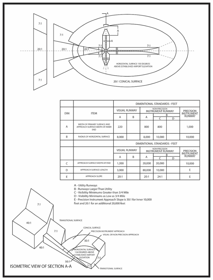
(2)
Land use. Land Use and Noise are understood to include regulations based on the potential impacts from noise and land use compatibility on lands within the surfaces defined herein.
a.
Notwithstanding any other provisions of the overlay, no use may be made of land or water within any zone established by this Code in such a manner as to create electrical interference with navigational signals or radio communication between the airport and aircraft, make it difficult for pilots to distinguish between airport lights and others, result in glare in the eyes of pilots using the airport, impair visibility in the vicinity of the airport, create bird strike hazards, or otherwise in any way endanger or interfere with the landing, takeoff, or maneuvering of aircraft intending to use the airport.
Except as otherwise provided herein, the following land uses, structures or activities shall be prohibited:
i.
Any sanitary landfill:
(a)
located within ten thousand (10,000) feet from the nearest point of any runway used or planned to be used by turbine aircraft at the airport;
(b)
within five thousand (5,000) feet from the nearest point of any runway used only by nonturbine aircraft;
(c)
outside the perimeters defined in subparagraphs i.(a) and i.(b) above but still within the lateral limits of the civil airport imaginary surfaces defined in 14 C.F.R. s. 77.79;
(d)
located more than ten thousand (10,000) feet from the nearest point of any runway at the airport, but still within the lateral limits of the civil airport imaginary surfaces depicted in the airspace drawings; or
(e)
where any landfill is located and constructed so that it attracts or sustains hazardous bird movements from feeding, water, or roosting areas into, or across, the runways or approach and departure patterns of aircraft. The operator of such landfill must be required to incorporate bird management techniques or other practices to minimize bird hazards to airborne aircraft.
ii.
Restricting new incompatible uses, activities, or substantial modifications to existing incompatible uses within the airport's runway protection zones.
iii.
Non-compatible land uses, except where such land use is specifically contemplated therein, with appropriate mitigation or similar techniques described therein.
iv.
Residential construction and any educational facility, with the exception of aviation school facilities, within an area contiguous to the airport measuring one-half (1;frax;2) the length of the longest runway on either side of and at the end of each runway centerline.
v.
New incompatible uses, activities, or substantial modifications to existing incompatible uses within runway protection zones. This standard shall not be construed to require the removal, alteration, sound conditioning, or other change, or to interfere with the continued use or adjacent expansion of any educational facility or site in existence on July 1, 1993.
(3)
Permits required.
a.
Permits shall be required from the FAA, FDOT-Central Aviation Division, City of Belle Glade, and Palm Beach County, as may be applicable, for the following activities. Applications for development or redevelopment shall be provided to FDOT-Central Aviation Office within fifteen (15) days of receipt by the city and may be submitted via the following: DOTAirportZoning@dot.state.fl.us.
i.
A person proposing to construct, alter, or allow an airport obstruction in an airport hazard area in violation of the airport protection zoning regulations adopted under this subsection must apply for a permit. A permit may not be issued if it would allow the establishment or creation of an airport hazard or if it would permit a nonconforming obstruction to become a greater hazard to air navigation than it was when the applicable airport protection zoning regulation was adopted which allowed the establishment or creation of the obstruction, or than it is when the application for a permit is made.
ii.
Each application for a permit shall indicate the purpose for which the permit is desired, with sufficient particularity to permit it to be determined whether the resulting use, structure, or tree would conform to the regulations herein prescribed. If such determination is in the affirmative, the permit shall be granted. Vertical height shall be measured from the highest point on the ground along the periphery of the structure or tree to the highest point on the structure or tree.
iii.
If it is determined that a nonconforming obstruction has been abandoned or is more than eighty (80) percent torn down, destroyed, deteriorated, or decayed, a permit may not be granted if it would allow the obstruction to exceed the applicable height limit or otherwise deviate from the airport protection zoning regulations. Whether or not an application is made for a permit under this subsection, the owner of the nonconforming obstruction may be required, at his or her own expense, to lower, remove, reconstruct, alter, or equip such obstruction as may be necessary to conform to the current airport protection zoning regulations. If the owner of the nonconforming obstruction neglects or refuses to comply with such requirement for ten (10) days after notice, the administrative agency, including but not limited to FAA and/or FDOT, may report the violation to the City of Belle Glade and/or Palm Beach County, as applicable.
iv.
Owner(s) of the obstruction shall be required to install, operate, and maintain thereon, at the owner's expense, marking and lighting in conformance with the specific standards established by the Federal Aviation Administration.
b.
Consideration of issuing permits. The following items shall be taken into consideration by the planning board and the city commission during the review, including subsequent approval and or denial, of any permits within the AO Airport Overlay Zoning District. The city commission may defer review and approval or deny an application pending information from the applicant and from FDOT and/or FAA, as may be applicable, and may consider the following in its review:
i.
The safety of persons on the ground and in the air.
ii.
The safe and efficient use of navigable airspace.
iii.
The nature of the terrain and height of existing structures.
iv.
The effect of the construction or alteration on the state licensing standards for a public-use airport contained in Chapter 330, Florida Statutes, and regulations adopted thereunder.
v.
The character of existing and planned flight operations and developments at public-use airports.
vi.
Federal airways, visual flight rules, flyways and corridors, and instrument approaches as designated by the Federal Aviation Administration.
vii.
The effect of the construction or alteration of the proposed structure on the minimum descent altitude or the decision height at the affected airport.
viii.
The cumulative effects on navigable airspace of all existing structures and all other known proposed structures in the area.
ix.
Additional requirements as may be adopted within these regulations pertinent to evaluation and protection of airspace and airport operations.
c.
Appeals of permits shall be heard by the board of adjustment. An appeal shall be filed and subsequently heard consistent with the provisions in F.S. § 333.09, and consistent with Chapter 31, Article IV of the City of Belle Glade Zoning Code.
(Ord. No. 18-01, § 2, 3-19-18)
Sec. 31-301. - Buffer between districts.
(a)
Applicability. Where a P, B-1, B-2, B-3. I-1, I-2, PUD or PIP district adjoins a R-1, R-2, R-3, or MH district, a buffer that creates a visual barrier shall be required.
(b)
Buffer criteria. The buffer shall meet the following minimum criteria:
(1)
The buffer shall consist of a solid masonry wall, wood or vinyl fence. The buffer shall be opaque and shall obstruct views of the non-residential use. Buffers that contain lattice or are otherwise transparent are prohibited;
(2)
The buffer shall be installed finished side out (toward the residential use) and shall be a minimum of six (6) feet in height, measured from ground level; and
(3)
The wall or fence shall be installed along all side and rear property lines so adjoining the residential property, except that the buffer shall not project into any adjacent residential property.
(c)
Timeline.
(1)
New commercial/industrial uses. For new commercial/industrial uses on properties that meet the criteria set forth in subsection (a) above, the property owner shall be required to erect the required buffer prior to the exercise of any use permitted on the property.
(2)
Existing commercial/industrial properties. For those commercial/industrial properties in existence on the date this ordinance is adopted and that meet the criteria set forth in subsection (a) above, property owners shall have a period of one year, after the adoption of this ordinance, to come into compliance with this section. However, if within the one year timeline, the owner of an existing business applies to the city for a permit that involves the performance of substantial improvements to the subject property, the property owner shall be required to comply with this section immediately. Substantial improvements shall be defined as improvements that exceed fifty (50) percent of the market value of the existing structure on the property. In no case shall a permit be used to extend the time for compliance beyond the one year timeline, unless otherwise approved in writing by the city.
(Ord. No. 18-03, § 2, 6-4-18)
Editor's note— Ord. No. 18-03, § 2, adopted June 4, 2018, set out provisions intended for use as § 31-300. At the editor's discretion, to prevent duplication of section numbers, these provisions have been included as § 31-301.
Sec. 31-302. - Shipping containers.
(a)
Definitions. Shipping container means a reusable steel vessel that is originally, specifically or formerly designed for or used in the packing, shipping, movement, or transportation of freight, articles, goods, or commodities and is also designed for or capable of being mounted or moved on a rail car, truck trailer or loaded on a ship.
(b)
Prohibitions on shipping containers.
(1)
Shipping containers, including shipping containers that have been modified or retrofitted, shall not be used for habitation.
(2)
Shipping containers, including shipping containers that have been modified or retrofitted, shall not be used as office space.
(3)
Shipping containers shall not be used as a shed or storage on any property within the City of Belle Glade.
(Ord. No. 25-09, § 2, 7-21-25)