
Birmingham City Zoning Code
TITLE 2
ZONE DISTRICTS
Section 1. - E-1 Estate District.
Subsection 1.
Generally. The regulations set forth in this section or set forth elsewhere in this ordinance, when referred to in this section, are the regulations in the E-1 Estate District.
Subsection 2.
Use regulations. A building or premises shall be used only for the following purposes:
1.
Single-family dwelling.
2.
Nurseries or truck gardens; except, that no retail sales shall be made on the premises.
3.
Noncommercial greenhouse; provided that no greenhouse heating plant shall be operated within 25 feet of any lot line.
4.
Publicly owned or operated park, playground or community building, museum, library or art gallery; provided that any building shall be located not less than 25 feet from any side lot line.
5.
Church or other place of worship; provided that any building shall be located not less than 25 feet from any side lot line.
6.
Public school, elementary or high, or a parochial or private school having a curriculum including the same courses ordinarily given in a public school, but not providing residential accommodations for students; provided that any such building shall be located not less than 25 feet from any side lot line.
7.
Golf club or golf course, except a par three golf course, miniature course or practice golf driving range operated for commercial purposes.
8.
Home occupations.
9.
Accessory structures and uses, not including accessory use child care centers.
10.
A church or public building may have one bulletin board or one sign, located on the same lot as the main structure, said bulletin board or sign not to exceed 27 square feet in area nor to be animated or illuminated with intermittent light.
11.
Temporary signs not exceeding a total of eight square feet in area located on the same lot pertaining to the lease, hire or sale of a building or premises.
12.
A temporary sign not exceeding a total of eight square feet in area relating to the development, sale or lease of lots or houses in a subdivision containing not less than five lots, which sign shall not remain more than two years or after the sale of the last lot, whichever occurs first.
13.
Family day/night care home.
14.
Wireless communications facility, in accordance with article VI, section 18.
15.
Community garden* provided that no residential structure is on the same property as the community garden, garden use excluding all accessory structures is allowed in any yard, market stands are allowed by special exception, on-site sales of produce grown at community garden are prohibited except when granted by special exception for a market stand, accessory structures limited to storage sheds, water cisterns, cold frames, hoophouses and greenhouses built of standard uniform materials that are either new or in sound condition not showing signs of decay, all compost and organic matter stored on site shall not cover more than ten percent of the total lot area and shall be screened from view of adjacent property and public right-of-way with fencing built of standard uniform materials that are either new or in sound condition not showing signs of decay or evergreen landscape buffer, shall be managed to prevent rodents and pests, shall be maintained to prevent odors and drainage from compost onto adjacent sites, all gardening equipment shall be limited to household gardening/lawn equipment, and a community garden permit is obtained from PEP that provides the following information:
a.
Name of all persons or entities that govern the garden.
b.
Name, signature and contact information of garden manager.
c.
Description of garden use and purpose.
d.
Detailed explanation of location of garden including address.
e.
Site plan that depicts all structures, compost piles, proposed screening and garden installations of the proposed garden.
f.
Results of soil testing for soil condition and contamination.
If a garden is fallow or no longer useful or productive and is not maintained free from injurious, noxious or unsightly weeds, the lot will be deemed to be a nuisance and will be subject to code enforcement. If any accessory structure is not maintained in sound condition free from evidence of decay and can be seen from public right-of-way or an adjacent property, they will be considered a nuisance and will be subject to code enforcement.
It is a requirement that soil testing be conducted prior to gardening activities. Test for both soil condition and possible soil contamination, to determine at minimum constraints to food production, shall be conducted. Information on acquiring soil testing kits and analysis can be found in the appendix to the [this] City of Birmingham Zoning Ordinance.
16.
Farmers market provided that [it] occurs only on lots where the primary use is a school, place of worship, a public park (provided that the City of Birmingham School Board or Park and Recreation Board has given written permission allowing the market to occur on their property) or on an abutting lot that is owned by one of the aforementioned primary uses, sales only occur on a temporary basis no more than 78 days per year and between the hours of 7:00 a.m. and 7:00 p.m., market can not operate for more than two consecutive days, market manager demonstrates that adequate parking is available on the lot being used by the market or a parking arrangement has been made for a nonresidential lot that is within 500 feet and is not in use during market hours, items made from kits, used or mass-produced items are prohibited, every vendor in any market shall, within one hour after the closing of the market, cause his or her provisions and vehicle to be removed from the vendor stall, and his or her stall thoroughly cleansed, and all rubbish to be removed from the vendor stall, an affidavit verifying landowners permission and identifying market manager is submitted to PEP, acknowledgement of applicable Jefferson County Health Department regulations, a farmers market permit, valid for one year, is obtained from PEP and a permit fee is paid to PEP that provides the following information:
a.
Name of all persons or entities that govern the market.
b.
Name, signature and contact information of market manager.
c.
List of all vendors and a list of items to be sold by vendor.
d.
Copy of State of Alabama Farmers Market Authority Certificate.
e.
List of market cleanup procedures.
f.
Detailed explanation of location of market and days/hours of operation.
g.
Address of the market location.
h.
Parking plan.
17.
Apiary provided that it is accessory to a residential structure or community garden, located in a rear yard, hives are set back from property lines by 20 feet, a continuous water source is available, a flyway barrier (fence or dense evergreen shrub) is provided that is six feet high and extends three feet either side of the hive opening, hive opening faces the flyway barrier, two hives are allowed on lots less than 10,000 square feet and one additional hive per 4,000 square feet is allowed on lots larger than 10,000 square feet with a maximum of ten hives per lot.
(Ord. No. 94-66, § I, 4-5-1994; Ord. No. 97-77, § 1(art. 1, § 1(2)), 6-24-1997; Ord. No. 02-159, 11-5-2002; Ord. No. 13-71, 5-7-2013)
Subsection 3.
Area and dimensional regulations. Except as provided in articles VI and VIII, the area and dimensional regulations set forth in the following table shall be observed:
Subsection 4.
Parking regulations. Off-street parking spaces shall be provided in accordance with the requirements for specific uses set forth in article V.
Section 2. - R-1 Single-Family District.
Subsection 1.
Generally. The regulations set forth in this section or set forth elsewhere in this ordinance, when referred to in this section, are the regulations in the R-1 Single-Family District.
Subsection 2.
Use regulations. A building or premises shall be used only for the following purposes:
1.
Any use permitted in the E-1 Estate District.
Subsection 3.
Area and dimensional regulations. Except as provided in articles VI and VIII, the area and dimensional regulations set forth in the following table shall be observed:
Subsection 4.
Parking regulations. Off-street parking spaces shall be provided in accordance with the requirements for specific uses set forth in Article V.
Section 3. - R-2 Single-Family District.
Subsection 1.
Generally. The regulations set forth in this section or set forth elsewhere in this ordinance, when referred to in this section, are the regulations in the R-2 Single-Family District.
Subsection 2.
Use regulations. A building or premises shall be used only for the following purposes:
1.
Any use permitted in the E-1 Estate District.
Subsection 3.
Area and dimensional regulations. Except as provided in articles VI and VIII, the area and dimensional regulations set forth in the following table shall be observed:
Subsection 4.
Parking regulations. Off-street parking spaces shall be provided in accordance with the requirements for specific uses set forth in article V.
Section 4. - R-3 Single-Family District.
Subsection 1.
Generally. The regulations set forth in this section or set forth elsewhere in this ordinance, when referred to in this section, are the regulations in the R-3 Single-Family District.
Subsection 2.
Use regulations. A building or premises shall be used only for the following purposes:
1.
Any use permitted in the E-1 Estate District.
Subsection 3.
Area and dimensional regulations. Except as provided in articles VI and VIII, the area and dimensional regulations set forth in the following table shall be observed:
Subsection 4.
Parking regulations. Off-street parking spaces shall be provided in accordance with the requirements for specific uses set forth in article V.
Section 5. - R-4 Two-Family and Semi-Attached Dwelling District.
Subsection 1.
Generally. The regulations set forth in this section or set forth elsewhere in this ordinance, when referred to in this section, are the regulations in the R-4 Two-Family and Semi-Attached Dwelling District.
Subsection 2.
Use regulations. A building or premises shall be used only for the following purposes:
1.
Any use permitted in the E-1 Estate District.
2.
Two-family dwellings.
3.
Semi-attached dwellings.
Subsection 3.
Area and dimensional regulations. Except as provided in articles VI and VIII, the area and dimensional regulations set forth in the following table shall be observed:
Subsection 4.
Site plan.
1.
The site plan, when required, must show:
a.
The direction of north, appropriate scale and topography in not greater than two-foot contour intervals.
b.
The proposed location and heights of all structures.
c.
The use of all structures and premises.
d.
The areas and proportionate amount of parking to be developed.
e.
The location of streets, driveways and walks.
f.
All service and loading spaces.
g.
Location and areas of illumination of all exterior lighting.
h.
The location, size, number and character of all exterior signs.
i.
The location, character and extent of landscaping, retaining and screen walls and other treatment for the protection of the adjoining property.
j.
The facilities for surface drainage of the premises.
k.
The proposed resubdivision of the subject property.
2.
The deed restrictions and covenants must show the treatment of all land held in undivided common interest.
Subsection 5.
Parking regulations. Off-street parking spaces shall be provided in accordance with the requirements for specific uses set forth in article V.
Subsection 6.
Other regulations. Semi-attached dwellings must comply with the requirements set forth in article VI, section 15.
Section 6. - R-4A Medium Density Residential District.
Subsection 1.
Generally. The regulations set forth in this section or set forth elsewhere in this ordinance, when referred to in this section, are the regulations in the R-4A Medium Density Residential District.
Subsection 2.
Use regulations. A building or premises shall be used only for the following purposes:
1.
Any use permitted in the E-1 Estate District.
2.
Two-family dwellings.
3.
Semi-attached dwellings.
4.
Attached single-family dwellings.
5.
Multiple-family dwellings (limited to a maximum of four dwelling units per structure).
Subsection 3.
Area and dimensional regulations. Except as provided in articles VI and VIII, the area and dimensional regulations set forth in the following table shall be observed:
Subsection 4.
Site plan.
1.
The site plan must show:
a.
The direction of north, appropriate scale and topography in not greater than two-foot contour intervals.
b.
The proposed location and heights of all structures.
c.
The use of all structures and premises.
d.
The areas and proportionate amount of parking to be developed.
e.
The location of streets, driveways and walks.
f.
All service and loading spaces.
g.
Location and areas of illumination of all exterior lighting.
h.
The location, size, number and character of all exterior signs.
i.
The location, character and extent of landscaping, retaining and screen walls and other treatment for the protection of adjoining property.
j.
The facilities for surface drainage of the premises.
k.
The proposed resubdivision of the subject property.
2.
The deed restrictions and covenants must show the treatment of all land held in undivided common interest.
Subsection 5.
Parking regulations. Off-street parking spaces shall be provided in accordance with the requirements for specific uses set forth in article V.
Subsection 6.
Other regulations. Attached and semi-attached dwellings must comply with the requirements set forth in article VI, section 15.
Note— When any lot having a width of less than 100 feet is used for a multiple-family dwelling, such multiple-family dwelling shall be constructed in a manner that the front of the structure and all front doors shall face and open toward a dedicated street and all rear doors shall face and open toward the rear yard, as defined in Article II, Section 56, Chapter 57, General Code, 1944, as amended.
Section 7. - R-5 Multiple Dwelling District.
Subsection 1.
Generally. The regulations set forth in this section or set forth elsewhere in this ordinance, when referred to in this section are the regulations in the R-5 Multiple Dwelling District.
Subsection 2.
Use regulations. A building or premises shall be used only for the following purposes:
1.
Any use permitted in the E-1 Estate District.
2.
Two-family dwelling.
3.
Multiple dwelling.
4.
Attached and semi-attached single-family dwellings.
5.
Condominiums (residential).
6.
Religious, educational, charitable or public institution or building, except a penal or mental institution or a communal living facility. Permitted uses are schools, churches, and residential accessory uses limited to rectories, parsonages and dwellings for resident administrators, watchmen, custodians or caretakers. Other similar institutional uses not within 1,000 feet of such uses are permitted on appeal, subject to approval of the zoning board of adjustment.
7.
Private club or lodge, excepting one, the chief activity of which is a service customarily carried on as a business.
8.
Family group day/night care facility.
9.
Accessory structures and uses, not including accessory use child care centers.
10.
One name plate, to be lighted with only indirect nonintermittent light, not exceeding six square feet in area attached to the wall at an entrance.
(Ord. No. 94-66, § I, 4-5-1994)
Subsection 3.
Area and dimensional regulations. Except as provided in articles VI and VIII, the area and dimensional regulations set forth in the following table shall be observed:
Subsection 4.
Site plan.
1.
The site plan, when required, must show:
a.
The direction of north, appropriate scale and topography in not greater than two-foot contour intervals.
b.
The proposed location and heights of all structures.
c.
The use of all structures and premises.
d.
The areas and proportionate amount of parking to be developed.
e.
The location of streets, driveways and walks.
f.
All service and loading spaces.
g.
Location and areas of illumination of all exterior lighting.
h.
The location, size, number and character of all exterior signs.
i.
The location, character and extent of landscaping, retaining and screen walls and other treatment for the protection of adjoining property.
j.
The facilities for surface drainage of the premises.
k.
The proposed resubdivision of the subject property.
2.
The deed restrictions and covenants must show the treatment of all land held in undivided common interest.
Subsection 5.
Parking regulations. Off-street parking spaces shall be provided in accordance with the requirements for specific uses set forth in article V.
Subsection 6.
Other regulations. Attached and semi-attached dwellings must comply with the requirements set forth in article VI, section 15.
Note— When any lot having a width of less than 100 feet is used for a multiple-family dwelling, such multiple-family dwelling shall be constructed in a manner that the front of the structure and all front doors shall face and open toward a dedicated street and all rear doors shall face and open toward the rear yard, as defined in Article II, Section 56, Chapter 57, General City Code 1944, as amended.
Section 8. - R-6 Multiple Dwelling District.
Subsection 1.
Generally. The regulations set forth in this section or set forth elsewhere in this ordinance, when referred to in this section, are the regulations in the R-6 Multiple Dwelling District.
Subsection 2.
Use regulations. A building or premises shall be used only for the following purposes:
1.
Any use permitted in the R-5 Multiple Dwelling District.
Subsection 3.
Area and dimensional regulations. Except as provided in articles VI and VIII, the area and dimensional regulations set forth in the following table shall be observed:
Subsection 4.
Site plan.
1.
The site plan, when required, must show:
a.
The direction of north, appropriate scale and topography in not greater than two-foot contour intervals.
b.
The proposed location and heights of all structures.
c.
The use of all structures and premises.
d.
The areas and proportionate amount of parking to be developed.
e.
The location of streets, driveways and walks.
f.
All service and loading spaces.
g.
Location and areas of illumination of all exterior lighting.
h.
The location, size, number and character of all exterior signs.
i.
The location, character and extent of landscaping, retaining and screen walls and other treatment for the protection of adjoining property.
j.
The facilities for surface drainage of the premises.
k.
The proposed resubdivision of the subject property.
2.
The deed restrictions and covenants must show the treatment of all land held in undivided common interest.
Subsection 5.
Parking regulations. Off-street parking spaces shall be provided in accordance with the requirements for specific uses set forth in article V.
Subsection 6.
Other regulations. Attached and semi-attached dwellings must comply with the requirements set forth in article VI, section 15.
Note— When any lot having a width of less than 100 feet is used for a multiple-family dwelling, such multiple-family dwelling shall be constructed in a manner that the front of the structure and all front doors shall face and open toward a dedicated street and all rear doors shall face and open toward the rear yard, as defined in Article II, Section 56, Chapter 57, General Code, 1944, as amended.
Section 9. - R-7 Multiple Dwelling District.
Subsection 1.
Generally. The regulations set forth in this section or set forth elsewhere in this ordinance, when referred to in this section, are the regulations in the R-7 Multiple Dwelling District.
Subsection 2.
Use regulations. A building or premises shall be used only for the following purposes:
1.
Any use permitted in the R-5 Multiple Dwelling District.
Subsection 3.
Area and dimensional regulations. Except as provided in articles VI and VIII, the area and dimensional regulations set forth in the following table shall be observed:
Subsection 4.
Site plan.
1.
The site plan, when required, must show:
a.
The direction or north, appropriate scale and topography in not greater than two-foot contour intervals.
b.
The proposed location and heights of all structures.
c.
The use of all structures and premises.
d.
The areas and proportionate amount of parking to be developed.
e.
The location of streets, driveways and walks.
f.
All service and loading spaces.
g.
Location and areas of illumination of all exterior lighting.
h.
The location, size, number and character of all exterior signs.
i.
The location, character and extent of landscaping, retaining and screen walls and other treatment for the protection of adjoining property.
j.
The facilities for surface drainage of the premises.
k.
The proposed resubdivision of the subject property.
2.
The deed restrictions and covenants must show the treatment of all land held in undivided common interest.
Subsection 5.
Parking regulations. Off-street parking spaces shall be provided in accordance with the requirements for specific uses set forth in article V.
Subsection 6.
Other regulations. Attached and semi-attached dwellings must comply with the requirements set forth in article VI, section 15.
Note— When a lot having a width of less than 100 feet is used for a multiple-family dwelling, such multiple-family dwelling shall be constructed in a manner that the front of the structure and all front doors shall face and open toward a dedicated street and all rear doors shall face and open toward the rear yard, as defined in Article II, Section 56, Chapter 57, General Code, 1944, as amended.
Section 10. - R-8 Planned Residential District.
Subsection 1.
Generally. The regulations set forth in this section or set forth elsewhere in this ordinance, when referred to in this section, are the regulations in the R-8 Planned Residential Dwelling District. The R-8 Planned Residential District allows the flexible and orderly arrangement of large planned residential areas designed as a single unit in a manner consistent with the provisions of this section. The owner or owners or a tract of land may submit a petition for the establishment of such a district provided the tract of land is five or more acres in area or less than five acres and is located within an urban renewal project area. The petitioner shall submit a plan for the development of the tract to the zoning advisory committee for review and approval in accordance with the provisions of this section.
Subsection 2.
Use regulations. The use of each building and/or premises shall be in accordance with the development plan referred to in subsection 1, and shall be limited to the following:
1.
Any use allowed in the E-1 Estate District.
2.
Two-family dwelling.
3.
Multiple dwelling; provided, however, that no building or accessory structure shall be located closer than 25 feet to any R-8 district boundary.
4.
Attached and semi-attached single-family dwellings.
5.
Condominiums (residential).
Subsection 3.
Area and dimensional regulations. The area and dimensional regulations set forth in this section shall be observed:
1.
Maximum height of structures. Except as provided in article VI, the maximum height of structures shall be 45 feet.
2.
Structure setback. No building shall be closer to any abutting street than 25 feet.
3.
Open space between buildings. Open space between buildings, measured at the closest point, shall not be less than 20 feet for one-story buildings, 30 feet when one or both are two-story buildings, or 40 feet when one or both are three-story buildings.
4.
Area per family. The required average land area per family shall not be less than 3,750 square feet; except, that in attached and semi-attached single-family dwellings, the average land area per family shall not be less than 2,500 square feet.
Subsection 4.
Parking regulations. Off-street parking shall be provided in accordance with the requirements for specific uses set forth in article V.
Subsection 5.
Development plan requirements. In order to prevent adverse environmental impacts and to achieve a compatible relation among uses covered in subsection 2 above and with the land use suitability of surrounding properties and nearby zone districts, as well as the surrounding transportation network, and owners of lands included in this district shall concur in an overall site development plan to be reviewed and considered for approval by the planning commission or zoning advisory committee prior to any grading, clearing, site improvements or issuance of related permits. All owners of property petitioning for establishment of a new R-8 district shall submit an acceptable development plan for zoning advisory committee approval prior to adoption by the city council. Any district may be phased over a reasonable period of time. Final site development plans may be postponed for portions of the parcel scheduled for completion after the first five acres. However when phased, the whole district must be covered by a more generalized conceptual design for ultimate development which may be tentative, but must include a viable timetable for completion of each sector, with sufficient information to judge internal and external impacts. The site development plan shall include:
1.
Maps indicating:
a.
The direction of north, appropriate scale and topography in not greater than two-foot contour intervals.
b.
The proposed location and height of all structures and site improvements.
c.
The use of all structures and premises.
d.
The areas and proportionate amount of parking to be developed.
e.
The location of streets, driveways and walks, including all points of ingress and egress and access streets.
f.
All service areas and loading spaces.
g.
Location and areas of illumination of all exterior lighting.
h.
The location, size, number and character of all exterior signs.
i.
The location, character and extent of all recreation, open spaces, beautification features and landscaping, fences, retaining and screen walls and other treatment for the protection of adjoining property.
j.
The facilities planned for sanitary sewers or treatment and surface drainage of the premises.
k.
A grading plan showing original and finished slopes, means of stabilization and relation to floodplains, drainage ways, wetlands, subsurface conditions and soil suitability.
2.
A traffic analysis indicating that the proposed development will be so related to streets and arteries that the traffic generated can be accommodated without causing excessive congestion or hazards or objectionable volumes of traffic on residential streets.
3.
A comprehensive independent market analysis, if requested by the planning commission or zoning advisory committee, on the needs to be served and the general economic justification.
4.
A copy of any proposed subdivision plats, new streets, other easements, and deed restrictions including any third party covenants to be recorded, and the legal treatment and responsibility for maintenance of any public or common grounds or spaces.
Subsection 6.
Review and approval of plans. The zoning advisory committee shall review, approve in part or whole, or disapprove, setting forth its reasons therefor, all conceptual designs and any site development plans for R-8 districts initiated or recommended for adoption by the planning commission without an original plan, in the case of initial zoning of annexed territory. The zoning advisory committee shall also review, and approve or disapprove all other site development plans involved in rezoning requests or subsequent plan amendments. After due notice and hearing of all interested parties, and consideration of analyses or recommendations by its staff, the zoning advisory committee shall judge the acceptability of varied elements of the plan in close conformity with the following criteria to:
1.
Minimize traffic congestion, conflicting movements, hazards, clutter or glare interfering with drivers' visibility of streets, drives and protecting pedestrian ways and avoiding the attraction of customer or truck traffic through local residential frontage streets;
2.
Ensure long-term adequacy of grading, storm drainage, sanitary sewers, other utilities and improvements, particularly preventing landslides, erosion, sedimentation, flooding and similar problems on subject property and nearby parcels of land in accordance with the City of Birmingham Soil Erosion and Sediment Control Code;
3.
Minimize activity conflicts, and environmental degradation, while maximizing a compatible interrelation of uses and economical development through shared access, parking utility easements, service areas, clustering, etc.;
4.
Preserve historic or significant places, scenic features, steep slopes, or drainage ways, and create effective natural, planted and manmade buffers of sufficient height, density and width to screen objectionable on-site noise, vibration, smoke, dust, fumes, odor, heat, glare or visibility from adjacent less intensive uses and particularly residential development and zones.
Once a site development plan has been approved, no work shall be done and no permits shall be issued except in accordance with said plan. No certificate of occupancy shall be issued until all site improvements as required by an approved site development plan are completed.
Subsection 7.
Delay in construction. In the event that construction in accordance with the originally approved development plan has not begun within two years from the date of its approval, the development plan shall expire and become null and void. If less than 25 percent of the site improvements have been installed within 18 months after issuance of a permit to begin construction, the site development plan shall expire and become null and void.
Section 1. - B-1 Neighborhood Business District.
Subsection 1.
Generally. The regulations set forth in this section or set forth elsewhere in this ordinance, when referred to in this section, are the regulations in the B-1 Neighborhood Business District.
(Ord. No. 07-33, § 1(1), 2-13-2007)
Subsection 2.
Use regulations. A building or premises shall be used only for the following purposes:
1.
Any use permitted in the R-5 Multiple Dwelling District.
2.
Greenhouse having a retail outlet on the premises.
3.
Bakery with sales of all bakery products at retail on the premises only; except, that catering services direct to consumer shall be permitted.
4.
Barbershop, beauty shop, massage or similar personal service shops.
5.
Catering shop, business, music, dancing, or similar school.
6.
Dressmaking and tailoring; provided that all work is done for individuals, at retail only, and on the premises.
7.
Drugstore limited to size to that which is of service to the immediately surrounding neighborhood only.
8.
Dwelling, jointly with other uses or as a principal use.
9.
Laundromat or shop for the delivery or picking up of laundry or dry cleaning.
10.
Medical or dental office or clinic and other professional or business office.
11.
Parking lot or parking garage.
12.
Restaurant or coffee shop; provided that the serving of food or beverages to patrons waiting in parked automobiles shall not be permitted.
13.
Retail store, limited in character and size to that which is of service to the immediately surrounding neighborhood only, except for any such use listed for the first time in the B-2 or B-3 districts.
14.
Service station, except, no up shall be located within 50 feet of a dwelling district, nor any portion of a structure within 15 feet of a dwelling district.
15.
Shoe repairing, repairing of household appliances and bicycles on an individual service call basis, and other uses of a similar character limited in size and nature to those which serve the immediately surrounding neighborhood.
16.
Telephone exchange or outdoor public telephone booth.
17.
Tourist home.
18.
Utility installations.
19.
Adult care facility or child care center.
20.
Accessory structures and uses, including signs subject to the following conditions:
a.
Signs shall pertain to goods, products or services sold or offered on the premises.
b.
Signs shall be attached to a vertical surface of the building or extend not more than 18 inches therefrom.
c.
Such signs shall not exceed in the aggregate 40 square feet of gross surface area for any lot having 40 feet or less of street frontage. On lots having a frontage greater than 40 feet, such sign or signs shall not exceed in the aggregate one square foot in area for each linear foot of principal street frontage, but in no case shall the aggregate area of such sign or signs exceed 60 square feet, provided, however, in developments consisting of two or more establishments each use shall be allowed signs not to exceed the frontage occupied by such establishment, but in no case to exceed 60 square feet.
21.
Farmers market provided that sales only occur on a temporary basis no more than 78 days per year and between the hours of 7:00 a.m. and 7:00 p.m., market can not operate for more than two consecutive days, market manager demonstrates that adequate parking is available on the lot being used by the market or a parking arrangement has been made for a nonresidential lot that is within 500 feet and is not in use during market hours, items made from kits, used or mass-produced items are prohibited, every vendor in any market shall, within one hour after the closing of the market, cause his or her provisions and vehicle to be removed from the vendor stall, and his or her stall thoroughly cleansed, and all rubbish to be removed from the vendor stall, an affidavit verifying landowners permission and identifying market manager is submitted to PEP, acknowledgement of applicable Jefferson County Health Department regulations, a farmers market permit, valid for one year, is obtained from PEP and a permit fee is paid to PEP that provides the following information:
a.
Name of all persons or entities that govern the market.
b.
Name, signature and contact information of market manager.
c.
List of all vendors and a list of items to be sold by vendor.
d.
Copy of State of Alabama Farmers Market Authority Certificate.
e.
List of market cleanup procedures.
f.
Detailed explanation of location of market and days/hours of operation.
g.
Address of the market location.
h.
Parking plan.
22.
Public market provided that 25 percent of vendors sell produce or value-added agricultural products, sales only occur on a temporary basis no more than 78 days per year and between the hours of 7:00 a.m. and 7:00 p.m., market can not operate for more than two consecutive days, market manager demonstrates that adequate parking is available on the lot being used by the market or a parking arrangement has been made for a non-residential lot that is within 500 feet and is not in use during market hours, used clothing, mass produced items and appliances are prohibited, every vendor in any market shall, within one hour after the closing of the market, cause his or her provisions and vehicle to be removed from the vendor stall, and his or her stall thoroughly cleansed, all rubbish to be removed from the vendor stall, an affidavit verifying landowners permission and identifying market manager is submitted to PEP, acknowledgement of applicable Jefferson County Health Department regulations, and a public market permit, valid for one year, is obtained from PEP and a permit fee is paid to PEP that provides the following information:
a.
Name of all persons or entities that govern the market.
b.
Name, signature and contact information of market manager.
c.
List of all vendors, the products they will sell and their grower's permits or City of Birmingham business licenses number.
d.
List of market cleanup procedures.
e.
Detailed explanation of location of market and days/hours of operation.
f.
Parking plan.
23.
Pay day (deferred presentment) and title loan operations.
(Ord. No. 94-66, § I, 4-5-1994; Ord. No. 07-33, § 1(2), 2-13-2007; Ord. No. 13-71, 5-7-2013; Ord. No. 13-178, § 1, 12-26-2013)
Subsection 3.
Area and dimensional regulations. Except as provided in articles VI and VIII, the area and dimensional regulations set forth in the following table shall be observed:
(Ord. No. 07-33, § 1(3), 2-13-2007)
Subsection 4.
Site development plan.
1.
Except for single-family and two-family dwellings, a site development plan is required in conjunction with all building permits for new construction and when a building or part thereof is enlarged or extended to at least 50 percent of its current floor area. At a minimum, the site development plan must show:
a.
The direction of north, appropriate scale and existing and finished topography in not greater than two-foot contour intervals.
b.
The proposed location including any easements that may exist on site and elevation drawings of all sides of each building prototype.
c.
The use of all structures and premises.
d.
The location of proposed driveways and marked off-street parking spaces.
e.
The edge of pavement for existing and proposed streets, driveways and walkways.
f.
All service and loading spaces as well as the location of solid waste containers. Also, provide enclosure details for large solid waste containers, including their access in compliance with article VI, section 5.
g.
Location and areas of illumination of all exterior lighting.
h.
The location, size, number and character of all exterior signs.
i.
The location, character and extent of landscaping, retaining and screen walls and other treatment for the protection of adjoining property or fences, and other measures for screening or buffering views from incompatible land uses. This includes detailed landscaping plans for structures and parking areas. The landscaping plan shall include plant location, corresponding plant schedule and planting instructions. In addition to landscape requirements for off-street parking as specified in article V, landscaping of the remainder of the lot, exclusive of areas occupied by structures and parking, shall not be less than five percent. Said landscaping shall include a combination of shrubs, trees and ground cover.
j.
Plans and facilities for stormwater drainage of the premises.
k.
Any proposed re-subdivision of the subject property; when applicable.
2.
Any proposed condominium must also conform to article VIII of the Birmingham Subdivision Regulations. The deed restrictions and covenants must show the treatment of all land held in common interest.
(Ord. No. 07-33, § 1(4), 2-13-2007)
Subsection 5.
Parking and loading regulations. Off-street parking and loading spaces shall be provided in accordance with the requirements for specific uses set forth in article V.
(Ord. No. 07-33, § 1(5), 2-13-2007)
Subsection 6.
Other regulations. Attached and semi-attached dwellings must comply with the requirements set forth in article VI, section 15.
(Ord. No. 07-33, § 1(6), 2-13-2007)
Editor's note— The subdivision regulations referenced in subsection 4 of this section can be found in Appendix C to this Code.
Section 2. - B-2 General Business District.
Subsection 1.
Generally. The regulations set forth in this section or set forth elsewhere in this ordinance, when referred to in this section, are the regulations in the B-2 General Business District.
(Ord. No. 07-33, § 2(1), 2-13-2007)
Subsection 2.
Use regulations. A building or premises shall be used only for the following purposes:
1.
Any use permitted in the B-1 Neighborhood Business District; except that the limitations upon extent of service area shall not apply.
2.
Signs or billboards.
3.
Automobile or trailer display and sales room.
4.
Public garage.
5.
Amusement or recreation service except drive-in theater or practice golf driving range.
6.
Business, dancing or music school.
7.
Display room for merchandise to be sold at wholesale.
8.
Dwellings, jointly with other uses or as a principal use.
9.
Frozen food lockers.
10.
Farm implement display and sales room.
11.
Hotel, motel or motor court.
12.
Hospital or clinic for animals, but not including open kennels.
13.
Radio or television broadcasting station, studio or office.
14.
Retail store or shop.
15.
Self-storage structure.
16.
Tavern or drive-in restaurant.
17.
Undertaking establishment or mortuary.
18.
Used car lot.
19.
Bank or lending institution.
20.
Utility service buildings.
21.
Medical or dental laboratory.
22.
The following uses provided all materials stored and all work done on the premises is done within a building:
a.
Dyeing and cleaning establishment or laundry; provided pickup or delivery of clothing is not made to other pickup points.
b.
Painting decorators.
c.
Radio or television repair shop.
d.
Dressmaking, millinery, or tailoring establishment.
e.
Upholstering shop, not involving furniture manufacturing.
f.
Plumbing and electrical shops.
g.
Any other general service or repair establishment of similar character.
23.
A shopping center or facility composed of any one or more of the foregoing uses or any combination thereof.
24.
Accessory structures and uses.
25.
Indoor urban farm.
26.
Amusement (indoor and outdoor). Except when the property abuts residential zoned property located within the city, amusement (outdoor) is only allowed by special exception granted by the zoning board of adjustment.
(Ord. No. 07-33, § 2(2), 2-13-2007; Ord. No. 13-71, 5-7-2013; Ord. No. 13-141, § 2, 11-5-2013)
Subsection 3.
Area and dimensional regulations. Except as provided in articles VI and VIII, the area and dimensional regulations set forth in the following table shall be observed:
(Ord. No. 07-33, § 2(3), 2-13-2007)
Subsection 4.
Site development plan.
1.
Except for single-family and two-family dwellings, a site development plan is required in conjunction with all building permits for new construction and when a building or part thereof is enlarged or extended to at least 50 percent of its current floor area. At a minimum, the site development plan must show:
a.
The direction of north, appropriate scale and existing and finished topography in not greater than two-foot contour intervals.
b.
The proposed location including any easements that may exist on site and elevation drawings of all sides of each building prototype.
c.
The use of all structures and premises.
d.
The location of proposed driveways and marked off-street parking spaces.
e.
The edge of pavement for existing and proposed streets, driveways and walkways.
f.
All service and loading spaces as well as the location of solid waste containers. Also, provide enclosure details for large solid waste containers, including their access in compliance with article VI, section 5.
g.
Location and areas of illumination of all exterior lighting.
h.
The location, size, number and character of all exterior signs.
i.
The location, character and extent of landscaping, retaining and screen walls and other treatment for the protection of adjoining property or fences, and other measures for screening or buffering views from incompatible land uses. This includes detailed landscaping plans for structures and parking areas. The landscaping plan shall include plant location, corresponding plant schedule and planting instructions. In addition to landscape requirements for off-street parking as specified in article V, landscaping of the remainder of the lot, exclusive of areas occupied by structures and parking, shall not be less than five percent. Said landscaping shall include a combination of shrubs, trees and ground cover.
j.
Plans and facilities for stormwater drainage of the premises.
k.
Any proposed re-subdivision of the subject property; when applicable.
2.
Any proposed condominium must also conform to article VIII of the Birmingham Subdivision Regulations. The deed restrictions and covenants must show the treatment of all land held in common interest.
(Ord. No. 07-33, § 2(4), 2-13-2007)
Subsection 4 [5].
Parking and loading regulations. Off-street parking and loading spaces shall be provided in accordance with the requirements for specific uses set forth in article V.
(Ord. No. 07-33, § 2(4), 2-13-2007)
Subsection 5 [6].
Other regulations. Attached and semi-attached dwellings must comply with the requirements set forth in article VI, section 15.
(Ord. No. 07-33, § 2(5), 2-13-2007)
Section 3. - B-3 Community Business District.
Subsection 1.
Generally. The regulations set forth in this section or set forth elsewhere in the ordinance, when referred to in this section, are the regulations in the B-3 Community Business District.
Subsection 2.
Use regulations. A building or premises shall be used only for the following purposes:
1.
Retail store.
2.
Restaurant (including drive-in restaurant) or tavern.
3.
Automotive, farm implement or trailer display or sales.
4.
Service station; except [that] no pump shall be located within 50 feet of a dwelling district or any portion of a structure within 15 feet of a dwelling district.
5.
Hardware or building material sales.
6.
Hotel or motel.
7.
Amusement or recreation service, such as theater, dance hall or bowling alley.
8.
Laundry, dry cleaning or dyeing plant.
9.
Personal service shop, such as barbershop or beauty shop, photographic studio or massage establishment.
10.
Business service shop, such as blueprinting, accounting, duplicating or employment agency.
11.
Business, music or dancing school.
12.
Office.
13.
Repair service for such items as radios, televisions, shoes, watches or jewelry.
14.
Bank or lending institution.
15.
Parking lot or garage.
16.
Automotive, farm implement or trailer repair or servicing.
17.
Radio or television broadcasting station, studio or office.
18.
Undertaking establishment or mortuary.
19.
Wholesale establishment, including storage and display.
20.
Carpentry, painting, plumbing, tinsmithing, and electrical shops; provided that all work on the premises is done within a building, and all materials are stored in a building.
21.
Testing or research laboratory.
22.
Millinery, dressmaking or tailoring.
23.
On-premises signs.
24.
Printing or engraving.
25.
Light manufacturing limited to the following:
a.
Furniture.
b.
Jewelry.
c.
Cosmetics.
d.
Candy.
e.
Fur goods, except tanning or dyeing.
f.
Medical, dental, or drafting instruments.
g.
Optical equipment, clocks, watches and similar precision instruments.
26.
Other manufacturing, processing, fabricating or assembling operations which do not create any objectionable noise, vibrations, smoke, dust, odor, heat or glare, but only when the manufacturing, processing, fabricating or assembling is incidental to a retail business conducted on the premises.
27.
Mini-warehouse.
28.
Dwelling, jointly with other uses or as a principal use, including family day/night care or family group day/night care facilities.
29.
Church, hospitals or other institutions, but not including mental hospitals or penal institutions.
30.
Private club or lodge.
31.
Public buildings.
32.
Parks.
33.
Telephone exchange or service buildings.
34.
Utility installation or service building.
35.
Adult care facility or child care center.
36.
Wireless communications facility, in accordance with article VI, section 18.
37.
Accessory structures and uses, including accessory use child care centers.
38.
Community garden* provided that no residential structure is on the same property as the community garden, garden use excluding all accessory structures is allowed in any yard, market stands are allowed, on-site sales of produce grown at community garden are not prohibited, accessory structures limited to storage sheds, water cisterns, cold frames, hoophouses and greenhouses built of standard uniform materials that are either new or in sound condition not showing signs of decay, all compost and organic matter stored on site shall not cover more than ten percent of the total lot area and shall be screened from view of adjacent property and public right-of-way with fencing built of standard uniform materials that are either new or in sound condition not showing signs of decay or evergreen landscape buffer, shall be managed to prevent rodents and pests, shall be maintained to prevent odors and drainage from compost onto adjacent sites, all gardening equipment shall be limited to household gardening/lawn equipment, and a community garden permit is obtained from PEP that provides the following information:
a.
Name of all persons or entities that govern the garden.
b.
Name, signature and contact information of garden manager.
c.
Description of garden use and purpose.
d.
Detailed explanation of location of garden including address.
e.
Site plan that depicts all structures, compost piles, proposed screening and garden installations of the proposed garden.
f.
Results of soil testing for soil condition and contamination.
If a garden is fallow or no longer useful or productive and is not maintained free from injurious, noxious or unsightly weeds, the lot will be deemed to be a nuisance and will be subject to code enforcement. If any accessory structure is not maintained in sound condition free from evidence of decay and can be seen from public right-of-way or an adjacent property, they will be considered a nuisance and will be subject to code enforcement.
It is a requirement that soil testing be conducted prior to gardening activities. Test for both soil condition and possible soil contamination, to determine at minimum constraints to food production, shall be conducted. Information on acquiring soil testing kits and analysis can be found in the appendix to the [this] City of Birmingham Zoning Ordinance.
39.
Farmers market provided that sales only occur on a temporary basis no more than 78 days per year and between the hours of 7:00 a.m. and 7:00 p.m., market can not operate for more than two consecutive days, market manager demonstrates that adequate parking is available on the lot being used by the market or a parking arrangement has been made for a nonresidential lot that is within 500 feet and is not in use during market hours, items made from kits, used or mass-produced items are prohibited, every vendor in any market shall, within one hour after the closing of the market, cause his or her provisions and vehicle to be removed from the vendor stall, and his or her stall thoroughly cleansed, and all rubbish to be removed from the vendor stall, an affidavit verifying landowners permission and identifying market manager is submitted to PEP, acknowledgement of applicable Jefferson County Health Department regulations, a farmers market permit, valid for one year, is obtained from PEP and a permit fee is paid to PEP that provides the following information:
a.
Name of all persons or entities that govern the market.
b.
Name, signature and contact information of market manager.
c.
List of all vendors and a list of items to be sold by vendor.
d.
Copy of State of Alabama Farmers Market Authority Certificate.
e.
List of market cleanup procedures.
f.
Detailed explanation of location of market and days/hours of operation.
g.
Address of the market location.
h.
Parking plan.
40.
Public market provided that 25 percent of vendors sell produce or value-added agricultural products, sales only occur on a temporary basis no more than 78 days per year and between the hours of 7:00 a.m. and 7:00 p.m., market can not operate for more than two consecutive days, market manager demonstrates that adequate parking is available on the lot being used by the market or a parking arrangement has been made for a nonresidential lot that is within 500 feet and is not in use during market hours, used clothing, mass-produced items and appliances are prohibited, every vendor in any market shall, within one hour after the closing of the market, cause his or her provisions and vehicle to be removed from the vendor stall, and his or her stall thoroughly cleansed, all rubbish to be removed from the vendor stall, an affidavit verifying landowners permission and identifying market manager is submitted to PEP, acknowledgement of applicable Jefferson County Health Department regulations, and a public market permit, valid for one year, is obtained from PEP and a permit fee is paid to PEP that provides the following information:
a.
Name of all persons or entities that govern the market.
b.
Name, signature and contact information of market manager.
c.
List of all vendors, the products they will sell and their grower's permits or City of Birmingham business licenses number.
d.
List of market cleanup procedures.
e.
Detailed explanation of location of market and days/hours of operation.
f.
Parking plan.
41.
Indoor urban farm.
42.
Apiary provided that it is accessory to a residential structure or community garden, located in a rear yard, hives are set back from property lines by 20 feet, a continuous water source is available, a flyway barrier (fence or dense evergreen shrub) is provided that is six feet high and extends three feet either side of the hive opening, hive opening faces the flyway barrier, two hives are allowed on lots less than 10,000 square feet and one additional hive per 4,000 square feet is allowed on lots larger than 10,000 square feet with a maximum of ten hives per lot.
43.
Pay day (deferred presentment) and title loan operations.
44.
Amusement (indoor and outdoor). Except when the property abuts residential zoned property located within the city, amusement (outdoor) is only allowed by special exception granted by the zoning board of adjustment.
(Ord. No. 94-66, § I, 4-5-1994; Ord. No. 97-77, § 1(title 2, art. II, § 3, subsec. 2), 6-24-1997; Ord. No. 07-33, § 3(2), 2-13-2007; Ord. No. 13-71, 5-7-2013; Ord. No. 13-141, § 3, 11-5-2013; Ord. No. 13-178, § 2, 12-26-2013)
Subsection 3.
Area and dimensional regulations. Except as provided in articles VI and VIII, the area and dimensional regulations set forth in the following table shall be observed:
(Ord. No. 07-33, § 3(3), 2-13-2007)
Subsection 4.
Site development plan.
1.
Except for single-family and two-family dwellings, a site development plan is required in conjunction with all building permits for new construction and when a building or part thereof is enlarged or extended to at least 50 percent of its current floor area. At a minimum, the site development plan must show:
a.
The direction of north, appropriate scale and existing and finished topography in not greater than two-foot contour intervals.
b.
The proposed location including any easements that may exist on site and elevation drawings of all sides of each building prototype.
c.
The use of all structures and premises.
d.
The location of proposed driveways and marked off-street parking spaces.
e.
The edge of pavement for existing and proposed streets, driveways and walkways.
f.
All service and loading spaces as well as the location of solid waste containers. Also, provide enclosure details for large solid waste containers, including their access in compliance with article VI, section 5.
g.
Location and areas of illumination of all exterior lighting.
h.
The location, size, number and character of all exterior signs.
i.
The location, character and extent of landscaping, retaining and screen walls and other treatment for the protection of adjoining property or fences, and other measures for screening or buffering views from incompatible land uses. This includes detailed landscaping plans for structures and parking areas. The landscaping plan shall include plant location, corresponding plant schedule and planting instructions. In addition to landscape requirements for off-street parking as specified in article V, landscaping of the remainder of the lot, exclusive of areas occupied by structures and parking, shall not be less than five percent. Said landscaping shall include a combination of shrubs, trees and ground cover.
j.
Plans and facilities for stormwater drainage of the premises.
k.
Any proposed re-subdivision of the subject property; when applicable.
2.
Any proposed condominium must also conform to article VIII of the Birmingham Subdivision Regulations. The deed restrictions and covenants must show the treatment of all land held in common interest.
(Ord. No. 07-33, § 3(4), 2-13-2007)
Subsection 4 [5].
Parking and loading regulations. Off-street parking and loading spaces shall be provided in an amount equal to one-half the requirements of article V. Off-street loading shall be in accordance with the requirements of article V.
(Ord. No. 07-33, § 3(4), 2-13-2007)
Section 4. - B-4 Central Business District.
Subsection 1.
Generally. The regulations set forth in this section or set forth elsewhere in this ordinance, when referred to in this section, are the regulations in the B-4 Central Business District.
(Ord. No. 07-33, § 4(1), 2-13-2007)
Subsection 2.
Use regulations. The use regulations are the same as those in the B-3 Community Business District.
(Ord. No. 07-33, § 4(2), 2-13-2007)
Subsection 3.
Area and dimensional regulations. Except as provided in articles VI and VIII, the area and dimensional regulations set forth in the following table shall be observed:
(Ord. No. 07-33, § 4(3), 2-13-2007)
Subsection 4.
Parking and loading regulations. Off-street parking is not required in the B-4 Central Business District. Off-street loading shall be provided in accordance with the requirements of article V.
(Ord. No. 07-33, § 4(4), 2-13-2007)
Section 5. - B-5 Mixed Business District.
Subsection 1.
Generally. The regulations set forth in this section or set forth elsewhere in this ordinance, when referred to in this section, are the regulations in the B-5 Mixed Business District. The B-5 Mixed Business District is provided in order to encourage orderly and convenient concentrations of office, retail, business and higher density residential complexes in highly accessible locations appropriate to the character of surrounding property and its future development. This district shall not be created on less than two acres or at least a half block containing all lot frontage on the same side of a street situated between two intersecting streets.
Subsection 2.
Use regulations. A building or premises shall be used only for the following purposes:
1.
Business office, professional office or medical clinic or laboratory.
2.
Religious, educational, charitable, or public institution or civic club, including kindergartens but excluding a penal or mental institution, or communal living facility.
3.
Family day/night care or family group day/night care facility, adult care facility, or child care center.
4.
Wireless communications facility, in accordance with article VI, section 18.
5.
Accessory structures and uses, including accessory use child care centers.
6.
In addition, the following uses may also be permitted only in accordance with a site development plan approved as specified in subsections 5 and 6 of this section:
a.
Retail sales.
b.
Business or personal services.
c.
Restaurants, cafeterias.
d.
Service station, and automotive repair, but excluding truck stops, vehicle sales, outside repairs or storage of inoperable vehicles or other equipment.
e.
Hospital or nursing home.
f.
General shops and businesses similar to those above or ordinarily conducted in a shopping center or mall.
g.
Hotels, motels.
h.
Recreation, amusement or entertainment, but excluding adult establishments.
i.
Multiple dwellings, attached and semi-attached dwellings and condominiums.
j.
Other uses which are similar to those above or whose effects on surrounding areas are consistent with them.
k.
Recreation, amusement (indoor and outdoor). Except when the property abuts residential zoned property located within the city, amusement (outdoor) is only allowed by special exception granted by the zoning board of adjustment or entertainment, but excluding adult establishments.
(Ord. No. 94-66, § I, 4-5-1994; Ord. No. 97-77, § 1(title 2, art. II, § 5, subsec. 2), 6-24-1997; Ord. No. 13-141, § 4, 11-5-2013)
Subsection 3.
Area and dimensional regulations.
1.
Except as provided in articles VI and VIII, the following area and dimensional regulations shall govern the location of all structures in this district.
2.
No building shall be constructed closer than 50 feet to the boundary of an A, E, or R district or any residential district zoning.
3.
No building shall be located closer than 20 feet to another building; and no nonresidential building shall be located closer than 75 feet to a residential building, whether on the same or an adjoining lot.
4.
Average density of all residential development shall not be less than 2,500 square feet per dwelling unit.
5.
All structures and any impervious manmade surfaces shall cover no more than 75 percent of nonresidential development, nor more than 60 percent of a residential site; and the remaining areas shall be maintained in natural vegetation or landscaping.
Subsection 4.
Parking and loading regulations. Off-street parking and loading spaces shall be provided in accordance with the requirements for specific uses as set forth in article V.
Subsection 5.
Development plan requirements. In order to prevent adverse environmental impacts and to achieve a compatible relation among uses covered in subsection 2.6 above and with the land use suitability of surrounding properties and nearby zone districts, as well as the surrounding transportation network, any owners of lands included in this district shall concur in an overall site development plan to be reviewed and considered for approval by the planning commission or zoning advisory committee prior to any grading, clearing, site improvements or issuance of related permits. All owners of property petitioning for establishment of a new B-5 district shall submit an acceptable development plan for zoning advisory committee approval prior to adoption by the city council. Any district may be phased over a reasonable period of time. Final site development plans may be postponed for portions of the parcel scheduled for completion after the first two acres. However, when phased, the whole district must be covered by a more generalized conceptual design timetable for development which may be tentative, but must include a viable timetable for completion of each sector, with sufficient information to judge internal and external impacts. The site development plan shall include:
1.
Maps indicating:
a.
The direction of north, appropriate scale and topography in not greater than two-foot contour intervals.
b.
The proposed location and height of all structures and site improvements.
c.
The use of all structures and premises.
d.
The areas and proportionate amount of parking to be developed.
e.
The location of streets, driveways and walks including all points of ingress and egress and access streets.
f.
All service areas and loading spaces.
g.
Location and areas of illumination of all exterior lighting.
h.
The location, size, number and character of all exterior signs.
i.
The location, character and extent of all recreation, open space, beautification features, and landscaping, fences, retaining and screen walls and other treatment for the protection of adjoining property.
j.
The facilities planned for sanitary sewers or treatment, and surface drainage of the premises.
k.
A grading plan showing original and finished slopes, means of stabilization and relation to floodplains, drainage ways, wetlands, subsurface condition and soil suitability.
2.
A traffic analysis indicating that the proposed development will be so related to streets and arteries that the traffic generated can be accommodated without causing excessive congestion or hazards or objectionable volumes of traffic on residential streets.
3.
A comprehensive independent market analysis, if requested by the planning commission or zoning advisory committee, on the needs to be served and the general economic justification.
4.
A copy of any proposed subdivision plats, new streets, other easements, and deed restrictions including any third party covenants to be recorded, and the legal treatment and responsibility for maintenance or any public or common grounds or spaces.
Subsection 6.
Review and approval of plans. The zoning advisory committee shall review, approve in part or whole, or disapprove, setting forth its reasons therefore, all conceptual designs any site development plans for B-5 districts initiated or recommended for adoption by the planning commission without an original plan, in the case of initial zoning of annexed territory. The zoning advisory committee shall also review, and approve or disapprove all other site development plans involved in rezoning requests or subsequent plan amendments. After due notice and hearing of all interested parties, and consideration of analyses or recommendations by its staff, the zoning advisory committee shall judge the acceptability of varied elements of the plan in close conformity with the following criteria to:
1.
Minimize traffic congestion, conflicting movements, hazards, clutter or glare interfering with drivers' visibility of streets, drives and sight lines around corners, also accommodating emergency vehicles, and protecting pedestrian ways and avoiding the attraction of customer or truck traffic through local residential frontage streets;
2.
Assure long-term adequacy of grading, storm drainage, sanitary sewers, other utilities and improvements, particularly preventing landslides, erosion, sedimentation, flooding and similar problems on subject property and nearby parcels of land in accordance with the City of Birmingham Soil Erosion and Sediment Control Code;
3.
Minimize activity conflicts, and environmental degradation, while maximizing a compatible interrelation of uses and economical development through shared access, parking, utility easements, service areas, clustering, etc.;
4.
Preserve historic or significant places, scenic features, steep slopes, or drainage ways, and create effective natural, planted and manmade buffers of sufficient height, density and width to screen objectionable on-site noise, vibration, smoke, dust, fumes, odor, heat, glare of visibility from adjacent less intensive uses and particularly residential development and zones.
Once a site development plan has been approved, no work shall be done and no permits shall be issued except in accord with said plan. No certificate of occupancy shall be issued until all site improvements as required by an approved site development plan are completed.
Subsection 7.
Delay in construction. In the event that construction in accordance with the originally approved development plan has not begun within two years from the date of its approval, the development plan shall expire and become null and void. If less than 25 percent of the site improvements have been installed within 18 months after issuance of a permit to begin construction, the site development plan shall expire and become null and void.
Section 6. - B-6 Health and Institutional District.
Subsection 1.
Purpose. The regulations set forth in this section, or elsewhere in this ordinance, when referred to in this section, are the regulations in the B-6 Health and Institutional District. The B-6 Health and Institutional District is provided for the orderly arrangement of buildings and uses on the campus of professional health care providers, hospitals, institutions of higher learning, including residential dwellings that are associated with such uses and are located on the same campus of the associated institution, as well as other uses that may from time to time be associated with, or accessory to, the aforementioned uses.
Subsection 2.
Use regulations. A building or premises shall be used only for the following purposes:
1.
All uses permitted under the O&I Office and Institutional District, except as provided herein.
2.
Dwellings (as defined), dormitories, student residence halls, family day/night care, or family group day/night care facilities, provided that such dwellings and residential facilities are associated with or accessory to the primary institution, and wholly contained within the boundaries of the master plan of the designated campus.
3.
All uses permitted under the B-1 Neighborhood Business District, provided such uses are associated with and/or located on the campus of the primary institution and these uses are designated on the approved master plan. When no approved master plan exists or if the B-1 uses are not so designated on an approved master plan, then the B-1 uses shall be located no closer than 500 feet to any residential zone district.
4.
Fraternities, sororities, and other group dwellings that are recognized by, and/or associated with a college or university campus and so designated on an approved master plan. Provided, however, that no such fraternities, sororities, or other group dwellings may be located within 1,000 feet of a single-family residential zone district.
5.
Other service uses, such as shipping and receiving, maintenance operations, and similar support functions, which are accessory to and in exclusive support of the operations of the primary institution and wholly contained within the boundaries of the institution's campus. These uses must be designated and identified on the approved master plan of the campus. These uses however, shall not be located in areas of the designated campus where they may create land use conflicts with off-campus uses.
Subsection 3.
Area and dimensional regulations. Except as provided in articles VI and VIII, the area and dimensional regulations set forth in this subsection will be observed; or the area and dimensional requirements set forth pursuant to an approved master plan will be observed. Without an approved master plan, no building or structure shall have a height that exceeds 120 feet. Additionally no building or structure shall have a height that exceeds 45 feet when it is within 500 feet of a residential district (as measured from the building line). Without an approved master plan, the area and dimensional requirements are listed in the following table:
Subsection 4.
Parking and loading regulations. Off-street parking and loading spaces shall be provided in accordance with the requirements for specific uses set forth in article V of the Zoning Ordinance of the City of Birmingham, or pursuant to an approved master plan. A parking plan must be an element of the approved master plan. When a master plan is submitted for review and approval, all parking spaces required herein may be provided on an aggregate basis. All required parking spaces must be located within the approved boundaries of the campus of the permitted institution and such parking must be approved as a part of the adopted master plan for the permitted institution. Required parking spaces shall be located on the same lot of the building/use or adjacent to the building/use that it serves except as provided below:
(a)
100 percent of the parking spaces must be located within 800 feet of the building line of the proposed building/use that the parking serves if it is not served by an approved bus/shuttle or other transport system.
(b)
If serviced by an approved bus/shuttle or other transport system, at least 70 percent of the required parking shall be located within 1,200 feet of the building line of the proposed building/use that the parking serves. The remaining 30 percent or less of the required parking may be located in remote parking lots, according to the approved parking plan, at a distance greater than 1,200 feet from the building line of the proposed building/use that the parking serves. When parking spaces are so provided, the approved master plan for the permitted institution must document that an adequate bus/shuttle or other transport system exists or will be established to support the parking during all work shifts and scheduled class times.
(c)
Up to 50 percent of the parking spaces required for (a) arenas, sports venues, or auditoriums, that are primarily used during off peak hours, may be provided and jointly used by (b) uses. The (b) uses include: outpatient hospitals or clinics, banks, offices, retail stores, repair shops, service establishments, and other institutional or higher education facilities and similar uses that, in the opinion of the director are not normally open, used, or operated during the same hours as those uses listed in (a). In no event shall the parking spaces that are being jointly used be located further than 800 feet from the building line of the uses that they serve. To be eligible for jointly used parking, however, a written agreement assuring the parking spaces retention shall be properly drawn and executed by the parties concerned. This agreement must be approved as to form by the city attorney, recorded at the applicant's expense in the office of the judge of probate, and shall be in full force and effect until released by resolution of the zoning board of adjustment. Upon completion of the aforementioned, the agreement shall be filed with the application for a building permit.
Subsection 5.
Master plan information required. A master plan will be required by the planning commission or zoning advisory committee as an aid in determining the merits of a re-zoning petition to establish a B-6 zone district. If a B-6 zone district is established as a result of initial zoning or a city-initiated comprehensive plan, the master plan will be required if the affected institution wishes to: avoid the required area, dimensional, height and setback regulations; take advantage of relaxed retail use restrictions; and provide required parking on an aggregate basis. A master plan shall include the following, subject to refinement on site development plans:
a.
The direction of north and scale.
b.
The proposed general location, approximate setbacks, and approximate height of all structures. These location and massing issues may be specified in the master plan by designated "geographic density zones" where similar development restrictions will uniformly apply.
c.
The proposed uses of all buildings or premises shall be designated or, similar proposed uses of structures and premises may be grouped together in "geographic use zones."
d.
The locations and proportionate amount of parking and loading spaces to be developed on site, and if applicable an aggregate campus parking plan, by "geographic use zones" or campus wide.
e.
The location of lot lines, public street ROW, pavement edge.
f.
An overall campus parking and traffic circulation plan. This must include a bus/shuttle or other transport system plan and pedestrian plan when parking spaces are proposed in locations more than 800 feet distant from the building, structures, or uses that they support.
g.
Preliminary points of ingress and egress for vehicles to access parking for buildings or site.
h.
Reasonable additional requirements may be recommended by the planning commission or zoning advisory committee as they relate to the protection of adjoining property.
Subsection 6.
Master plan approval and amendments. A master plan together with any supplementary information, will be referred to the planning commission or zoning advisory committee for:
[a.]
Study and recommendation to the city council on a petition for the establishment of a B-6 zone district, according to the procedure specified in article VII; or
[b.]
Study and approval or disapproval when a B-6 zone district is established as a result of initial zoning or a city-initiated comprehensive plan.
Amendments to the approved master plan will be reviewed by the planning commission or the zoning advisory committee in accordance with the procedures outlined in this subsection and subsection 5.
Subsection 7.
Site development plan requirements. Unless otherwise required by state law or other city ordinance, a site development plan will be required for review and approval by the staff of the department of planning, engineering, and permits, prior to the issuance of any permits for grading, clearing, site improvements or any other construction or building permits. Site plans not approved by staff may be appealed to the zoning board of adjustment in accordance with the regulations set forth in this zoning ordinance. In the review and approval of the development plans, consideration will be given to plans that have a goal of preventing adverse environmental impacts, to ameliorating land use conflicts, and to achieving a compatible relationship between surrounding land uses and zoning districts, and to improving parking, pedestrian, and transportation access.
A.
With an approved master plan. A site development plan will be required for review as an aid in determining the consistency of the site development with the campus master plan, completeness of the application, and adherence to the site development plan goals. Site development plans not in conformance with the master plan will not be considered by the planning commission or zoning advisory committee without an amendment to the approved master plan.
B.
Without an approved master plan. A site development plan will be required for review as an aid in determining the consistency of the site development with the area and dimensional regulations, height and setback regulations, land use allowances, completeness of the application, and adherence to the site development plan goals.
C.
Site development plans shall consist of the following:
a.
All service, loading, and parking spaces.
b.
Location and areas of illumination of all exterior lighting.
c.
The location, size, number and character of all exterior signs.
d.
The location, character and extent of, fences, retaining and screen walls, lighting and other treatment.
e.
The facilities for surface drainage of the premises.
f.
Location and screening of garbage disposal areas; and exterior mechanical and utility equipment.
g.
The direction north, scale, and topography in no greater than two-foot contour intervals.
h.
The proposed location, setback and height of all structures and site improvements.
i.
The uses of all structures and premises.
j.
The locations and proportionate amount of parking to be developed on site or adjacent to the site, or an explanation of how aggregate parking will serve the project.
k.
The location of lot lines, street rights-of-way, street and sidewalk edge of pavement, proposed driveways and walks including all points of ingress and egress for vehicles and pedestrians.
l.
Site landscaping plan including plant material schedule listing plant names, size, spacing and quantity, also including specific plant installation illustrations and instructions.
Section 7. - O&I Office and Institutional District.
Subsection 1.
Purpose. The regulations set forth in this section or elsewhere in this ordinance, when referred to in this section, are the regulations in the O&I Office and Institutional District. The O&I Office and Institutional District is provided for the orderly arrangement of institutional, clerical and administrative space.
Subsection 2.
Use regulations. A building or premises shall be used only for the following purposes:
1.
A public, semi-public, or private office:
a.
Sales office; provided that merchandise shall not be stored on the premises.
b.
Research or testing laboratories.
c.
Radio or television broadcasting studio or station.
d.
Cemetery, mortuary or funeral home.
2.
A public or semi-public, religious, educational or charitable institution. Such use may include:
a.
A club, lodge, fraternity or sorority; provided that such establishments are not conducted primarily for financial gain.
b.
A clinic, sanitarium, convalescent home or hospital, except one principally used for the treatment of animals.
c.
Public and semi-public recreation, including but not limited to parks, golf, swimming, tennis, country and community clubs or associations; provided that such establishments are not conducted primarily for financial gain.
d.
Church, school or orphanage.
e.
Adult care facility or child care center.
3.
Other uses not specifically listed above, but which are similar to those listed above or uses whose effects on surrounding areas are consistent with those listed above, are permitted on appeal, subject to the approval of the zoning board of adjustment. Such areas shall not include repair garages or storage yards for materials, vehicles or equipment, warehouses, buildings and other facilities having commercial or industrial characteristics and buildings used or intended to be used as communal living facilities, detention, correctional, or penal institutions.
4.
Wireless communications facilities, in accordance with article VI, section 18.
5.
Accessory structures and uses including accessory use child care center and commercial uses which are clearly incidental to the permitted use of the premises and which are carried on wholly within a main building or accessory building. Such uses may include:
a.
Drugstore limited in size to that which is of service to the principal use of the premises.
b.
Restaurant or coffee shop; provided that the serving of food or beverages to patrons waiting in parked automobiles shall not be permitted.
c.
Retail sales and service shops limited in character and size to that which is of service to the principal use of the premises.
d.
On-premises signs shall be in accordance with the regulations set forth in the B-1 Neighborhood Business District.
(Ord. No. 94-66, § I, 4-5-1994; Ord. No. 97-77, § 1(title 2, art. II, § 6), 6-24-1997)
Subsection 3.
Area and dimensional regulations.
1.
Except as provided in articles VI and VIII, the area and dimensional regulations set forth in this subsection shall be observed:
2.
Open space between buildings. Open spaces between buildings, measured at the closest point between buildings, shall not be less than 20 feet for buildings 35 feet or less in height and 45 feet when one or both buildings are 35 feet or higher in height.
Subsection 4.
Parking and loading regulations. Off-street parking and loading spaces shall be provided in accordance with the requirements for specific uses set forth in article V.
Subsection 5.
Plan and other information may be required. A development plan may be required by the planning commission at its discretion as an aid in determining the merits of a petition to establish an O&I zone district. If such a zone district is established partially on the basis of an approved development plan, building permits will be issued only for structures which are in general conformity with said plan. Said plan shall include the following:
a.
The direction of north, scale and topography in not greater than two-foot contour intervals.
b.
The proposed location and height of all structures and site improvements.
c.
The use of structures and premises.
d.
The areas and proportionate amount of parking to be developed.
e.
The location of streets, driveways and walks, including all points of ingress and egress.
f.
All service and loading spaces.
g.
Location and areas of illumination of all exterior lighting.
h.
The location, size, number and character of all exterior signs.
i.
The location, character and extent of landscaping, fences, retaining and screen walls, and other treatment for the protection of adjoining property.
j.
The facilities for surface drainage of the premises.
k.
Location of garbage disposal areas.
Subsection 6.
Review and approval of plan. A development plan, together with any supplementary information, shall be referred to the planning commission for study and recommendation before any action is taken on petition for establishment of an O&I zone district. Reasonable additional requirements may be recommended by the planning commission for the protection of adjoining property. The planning commission shall report its recommendations and reasons therefor to the city council for action according to the procedure specified in article VII. Any subsequent amendments in the required plan shall be reviewed by the planning commission in accordance with the procedure outlined in subsections 5 and 6 of this section.
Subsection 7.
Delay in construction. If construction, in accordance with a required development plan, has not begun within two years from the date of approval of zone district amendment by the city council, the development plan shall expire and become null and void.
Section 8. - PRD Planned Recreational District.
Subsection 1.
Generally. The regulations set forth in this section or elsewhere in this ordinance, when referred to in this section, are the regulations in the PRD Planned Recreational District. The PRD Planned Recreational District is provided for the orderly arrangement of recreational facilities and associated commercial uses.
Subsection 2.
Application—Review and approval. A petition for the establishment of a PRD Planned Recreational District on a tract of land containing a minimum of 20 acres may be submitted by:
1.
The owner(s) of the subject land; or
2.
The zoning advisory committee of the Birmingham Planning Commission, the Birmingham Planning Commission or the council of the City of Birmingham to assure the compatibility of uses within a PRD Planned Recreational District.
The petitioner shall submit a plan for the development of the property for review and approval in accordance with the provisions of subsection 7 of this section before any action is taken upon the petition. The zoning advisory committee or the Birmingham Planning Commission shall determine that each approved use is compatible with other uses within, adjacent to, and in the vicinity of the PRD Planned Recreational District. The development plan and application shall be submitted to the zoning advisory committee of the Birmingham Planning Commission for rezoning considerations or to the Birmingham Planning Commission for initial zoning considerations.
Subsection 3.
Compliance with article. The PRD Planned Recreational district shall be laid out, developed and used only in accord with a plan prepared and approved in compliance with the provisions of this section.
Subsection 4.
Use regulations. The use of each building and/or premises shall be in accordance with the plan referred to in subsection 7 of this section. The zoning advisory committee and the Birmingham Planning Commission shall determine that each approved use is compatible with other uses within, adjacent to and in the vicinity of the PRD Planned Recreational District. The uses listed below are permitted in this district only when approved, which uses shall be limited to:
1.
Archeries.
2.
Amusement parks.
3.
Athletic fields and stadiums (baseball, football, tennis, etc.).
4.
Carnivals.
5.
Circuses.
6.
Drive-in or enclosed theaters (excluding adult entertainment).
7.
Fairgrounds.
8.
Golf courses (full size, miniature and putting greens).
9.
Merry-go-rounds.
10.
Miniature railroads.
11.
Picnic or camp grounds including mobile home parks. All sanitary facilities must be in conformity with the provision of chapter 12.5 [of title 12], General Code of the City of Birmingham, as amended, with the density and location subject to the approval of the zoning board of adjustment.
12.
Pony riding tracks.
13.
Practice golf driving range.
14.
Race tracks (automobile, stock cars, motorcycles, horses and dogs).
15.
Riding stables and trails.
16.
Roller and ice-skating rinks.
17.
Skeet, rifle or trap shooting ranges, provided that such use is not located nearer than 1,000 feet to any residence other than owner or lessor of the site or such facility is totally enclosed with materials to contain any munitions discharged therein.
18.
Sport arenas.
19.
Swimming pools, boating or water parks.
20.
Theme parks.
21.
Zoos.
22.
Other similar recreational or tourist facilities.
23.
Wireless communications facilities, in accordance with article VI, section 18.
24.
Accessory structures and uses, including but not limited to apartments and/or dormitories, but not including family day/night care or family group day/night care facility.
25.
Associated commercial activities excluding adult establishments, and including but not limited to, the following:
a.
Ambulance or helistops for emergency service only.
b.
Banks.
c.
Hotels-motels.
d.
Office buildings.
e.
Restaurants with or without tavern combinations.
f.
Service stations.
g.
Veterinary establishments.
h.
Adult care facilities, child care center and accessory use child care centers.
(Ord. No. 94-66, § I, 4-5-1994; Ord. No. 97-77, § 1(title 2, art. II, § 8, subsec. 4), 6-24-1997)
Subsection 5.
Area and dimensional regulations. The area and dimensional regulations set forth in this subsection shall be observed:
1.
Maximum height of structures. Except as provided in articles VI and VIII, the maximum height of buildings shall be 100 feet, and no structure shall exceed 200 feet in height.
2.
Minimum structure setbacks.
a.
Front yard. No building or structure shall be closer than 50 feet to any abutting street.
b.
Side yards. No building or structure shall be closer than 25 feet to any adjoining side property line, except as provided in item "d" below.
c.
Rear yard. No building or structure shall be closer than 50 feet to any rear property line, except as provided in item "d" below.
d.
District setback. No building or structure shall be closer than 100 feet to a PRD Planned Recreational District boundary line.
3.
Open space between buildings. Open space between buildings, measured at the closest point, shall not be less than 25 feet for one-story buildings, 35 feet when one or both are two-story buildings, and 50 feet when one or both are three-story or taller buildings.
4.
Residential structures. The area and dimensional requirements for residential uses shall comply with article I, section 7, R-5 Multiple Dwelling District, but shall be permitted as accessory to the principal use of the site. This shall not prohibit a dwelling for a resident watchman, custodian or caretaker employed full-time on the premises.
5.
Buffers. Additional setbacks, buffers or restraints may be required where determined necessary.
Subsection 6.
Off-street parking and loading regulations. Off-street parking and loading shall be provided as required in article V.
Subsection 7.
Development plan and other information—Contents. The development plan and application shall be submitted to the zoning advisory committee of the Birmingham Planning Commission for rezoning considerations or to the Birmingham Planning Commission for initial zoning considerations, for review and approval in accordance with the provisions of this section before any action is taken upon the petition. Building permits will be issued only for structures which are in strict conformity with the development plan. Said plan shall comply with all requirements of this section and shall be accompanied by evidence concerning the feasibility of the project, the relationship of the proposed development on surrounding property and other physical conditions. When required by the planning commission, said plan and supporting evidence may include each of the following:
1.
A site plan defining the areas wherein buildings may be constructed; the locations and extent of parking and the proportionate amount thereof; the location of all roads, driveways and walks and the points of ingress and egress, including access streets where required; the location, height and character of walls, fencing or other forms of screening; the location, size, character and number of signs excluding trailer or portable signs of any type; the location and character of exterior lighting; and the character and extent of landscaping, planting and other treatment for protection of adjoining properties.
2.
A drainage and grading plan including an environmental analysis of the site and its environs.
3.
A copy of any acceptable deed restrictions intended to be recorded.
4.
A professional economic analysis on the needs and extent of the market to be served, and general economic justification and impact.
5.
A professional traffic analysis indicating the effect of the proposed development on existing adjacent streets specifying the direction and amount of traffic flow to and from the development. Said analysis of any project shall include:
a.
Traffic congestion or causes;
b.
Projected volumes of traffic in adjacent residential areas; and
c.
Adequate improvements to accommodate the projected volumes, determined necessary by the Birmingham Planning Commission or the zoning advisory committee as a part of the development plan required herein.
6.
A professional land use study of the existing and proposed land uses in the area surrounding the subject property and projection of the relationship of proposed development to existing and future uses.
7.
Schematic drawings of buildings and other improvements that illustrate the character of development shall be submitted for review and approval. The commission or committee may request that said plans be reviewed by and receive recommendation from the design review committee or any such body empowered by statute to consider or advise the city on architectural design.
In addition to the above, the design and land development controls should be addressed by the plan in areas surrounding the proposed facility and particularly its major access ways to assure a high level of quality not just for the proposed facility but for the journey to and from the facility and for spin-off or associated development that the major facility spawns.
Subsection 8.
Recommendation to city council. The Birmingham Planning Commission or zoning advisory committee may approve the development plan and recommend to the city council the rezoning based on conditions requiring the applicant to submit sufficient information addressing problems relative to requirement of subsection 7, subject to final approval by the Birmingham Planning Commission or zoning advisory committee following the establishment of the district.
Subsection 9.
Delay in construction. In the event that construction has not begun within two years from the date of approval by the city council, said development plan shall become null and void; in accordance with the required development plan; provided, however, that such expiration shall not be applicable to land acquired by the City of Birmingham for the purpose of public development.
Subsection 10.
Amendments to plan. After the adoption of a PRD Planned Recreational District, amendments or changes to the development plan shall be submitted to the zoning advisory committee of the Birmingham Planning Commission for approval or disapproval. Such submission shall include the same plans or studies required for the initial application. Any change in the development plan that includes changes in the approved uses of the district shall also be approved to assure the compatibility of the changed use with other uses within, adjacent to and in the vicinity of the PRD Planned Recreational District.
Section 1. - M-1 Light Industrial District.
Subsection 1.
Generally. The regulations set forth in this section or set forth elsewhere in this ordinance, when referred to in this section, are the regulations in the M-1 Light Industrial District.
(Ord. No. 07-33, § 1(1), 2-13-2007)
Subsection 2.
Use regulations. A building or premises shall be used only for the following purposes:
1.
Any use permitted in the R-7 Multiple Dwelling District or the B-3 Community Business District.
2.
Contractor's or construction equipment dealer's yard.
3.
Grain and feed storage.
4.
Heating fuel or building material storage or wholesaling; provided that the materials shall not be extracted or processed on the premises.
5.
Lumber yard.
6.
Truck terminal.
7.
Railroad installation.
8.
Warehouse.
9.
Dairy, veterinary clinics, kennels, dog training and boarding facilities.
10.
Assembly of parts for production of finished equipment.
11.
Manufacturing, fabricating, processing, or assembling uses which do not create any objectionable noise, vibration, smoke, dust, odor, heat or glare, such as the following:
a.
Boats (less than five tons.)
b.
Bolts, nuts, screws, washers, rivets, nails, brads, tacks, spikes, staples and similar items.
c.
Clothing.
d.
Food.
e.
Pharmaceuticals.
f.
Furniture and wood products.
g.
Glass products, but not including glass manufacture.
h.
Hand tool and hardware products.
i.
Ice.
j.
Musical instruments, games or toys.
k.
Office machines.
l.
Plastic products, not including processing of raw materials.
m.
Plating of silverware or utensils.
n.
Signs.
o.
Sporting goods.
p.
Other similar uses.
12.
Accessory structures and uses:
a.
Except that no outside storage of materials shall be permitted, when adjacent to a residential or agricultural zone district, except through grant of a special exception by the zoning board of adjustment. Said board may limit the type, area and height, and require enclosure by walls, fences, berms, shrubs, or trees, pre-existing or newly planted, sufficient to substantially screen its effects or visibility from nearby streets and any residential or agricultural zone districts;
b.
Including outside kennels or dog runs subject to submission of an overall site development plan to be reviewed and approved by the zoning advisory committee prior to any grading, clearing, site improvements or issuance of related permits; provided, however, that no outside kennels or dog runs shall be permitted when within 1,000 feet of a residential zone district. The zoning advisory committee will require enclosure by walls, fences, berms, shrubs or trees, pre-existing or newly planted, and may limit the type, area and height to sufficiently screen its effects or visibility from nearby streets and any adjacent uses.
13.
Outdoor urban farm* provided all compost and organic matter stored on site is screened from adjacent lots and is more than 1,000 feet from any adjacent residential dwelling, which shall not cover more than ten percent of the total area, shall be managed to prevent rodents and pests, prevent odors and drainage from compost onto adjacent sites, all farming equipment shall be screened from view with fencing or landscaping of adjacent lots, accessory structures are limited to storage sheds, greenhouses, hoophouses, cold frames and cisterns built of standard uniform materials that are either new or in sound condition not showing signs of decay, apiaries are set back from property lines by 25 feet and 50 feet from any adjacent residential lots, a continuous water source is available, one hive allowed per 2,500 square feet with maximum of 40 hives.
If any accessory structure is not maintained in sound condition free from evidence of decay and can be seen from the public right-of-way or an adjacent property, they will be considered a nuisance and will be subject to code enforcement.
It is a requirement that soil testing be conducted prior to gardening activities. Test for both soil condition and possible soil contamination, to determine at minimum constraints to food production, shall be conducted. Information on acquiring soil testing kits and analysis can be found in the appendix to the [this] City of Birmingham Zoning Ordinance.
14.
Flea market.
(Ord. No. 07-33, § 1(2), 2-13-2007; Ord. No. 13-71, 5-7-2013)
Subsection 3.
Area and dimensional regulations. Except as provided in articles VI and VIII, the area and dimensional regulations set forth in the following table shall be observed.
(Ord. No. 07-33, § 1(3), 2-13-2007)
Subsection 4.
Site development plan.
1.
Except for single-family and two-family dwellings, a site development plan is required in conjunction with all building permits for new construction and when a building or part thereof is enlarged or extended to at least 50 percent of its current floor area. At a minimum, the site development plan must show:
a.
The direction of north, appropriate scale and existing and finished topography in not greater than two-foot contour intervals.
b.
The proposed location including any easements that may exist on site and elevation drawings of all sides of each building prototype.
c.
The use of all structures and premises.
d.
The location of proposed driveways and marked off-street parking spaces.
e.
The edge of pavement for existing and proposed streets, driveways and walkways.
f.
All service and loading spaces as well as the location of solid waste containers. Also, provide enclosure details for large solid waste containers, including their access in compliance with article VI, section 5.
g.
Location and areas of illumination of all exterior lighting.
h.
The location, size, number and character of all exterior signs.
i.
The location, character and extent of landscaping, retaining and screen walls and other treatment for the protection of adjoining property or fences, and other measures for screening or buffering views from incompatible land uses. This includes detailed landscaping plans for structures and parking areas. The landscaping plan shall include plant location, corresponding plant schedule and planting instructions. In addition to landscape requirements for off-street parking as specified in article V, landscaping of the remainder of the lot, exclusive of areas occupied by structures and parking, shall not be less than five percent. Said landscaping shall include a combination of shrubs, trees and ground cover.
j.
Plans and facilities for stormwater drainage of the premises.
k.
Any proposed re-subdivision of the subject property; when applicable.
2.
Any proposed condominium must also conform to article VIII of the Birmingham Subdivision Regulations. The deed restrictions and covenants must show the treatment of all land held in common interest.
(Ord. No. 07-33, § 1(4), 2-13-2007)
Subsection 5.
Parking and loading regulations. Off-street parking and loading spaces shall be provided in accordance with the requirements for specific uses set forth in article V.
(Ord. No. 07-33, § 1(5), 2-13-2007)
Subsection 6.
Attached and semi-attached dwellings. Attached and semi-attached dwellings must comply with the requirements set forth in article VI, section 15.
(Ord. No. 07-33, § 1(6), 2-13-2007)
Section 2. - M-1A General Industrial District.
Subsection 1.
Generally. The regulations set forth in this section or set forth in this ordinance, when refereed to in this section, are the regulations of the M-1A General Industrial District. This district aims to accommodate wholesaling and manufacturing uses.
Subsection 2.
Use regulations. A building or premises shall be used only for the following purposes:
1.
Business and professional offices.
2.
Religious, educational or charitable institutions.
3.
Retail sales or business services.
4.
Recreation, amusement or entertainment.
5.
Automotive, farm implements, trailer, or heavy equipment sales, services and repair, including truck stops and terminals.
6.
Repair or modification services for major appliances and electrical machinery.
7.
Wholesale, distribution or warehousing operation.
8.
Testing or research laboratory.
9.
Contractor's or construction equipment dealer's yard or utilities' yards.
10.
Lumber yard, temporary storage of nontoxic natural resources or nonhazardous materials.
11.
Bottling plant, canning and preserving of fruits or vegetables.
12.
Furniture, wood and paper products.
13.
Printing, book binding.
14.
Veterinary clinics, kennels, dog training and boarding facilities.
15.
Assembly of parts for production of finished goods.
16.
Other manufacturing, fabricating, processing or assembling uses and activities which do not create any danger to health or safety, air or water pollution either on or off site, nor any objectionable noise, vibration, smoke, dust, fumes, odor, heat or glare in any abutting zone (excepting an M-2 or similar heavy industrial district), such as the following:
a.
Textile mills, fabrics, clothing, leather or fur goods.
b.
Grain mill products, bakery, pharmaceuticals.
c.
Electrical appliances, equipment, instruments.
d.
Motor vehicles, aircraft and boats less than five tons.
e.
Professional, scientific instruments, office machines.
f.
Jewelry, glass, optical goods, plastic ware.
g.
Musical instruments, toys, sporting goods, hardware, utensils.
h.
General industrial equipment.
i.
Stone, clay and cement products.
17.
Adult care facility or child care center.
18.
Wireless communications facilities, in accordance with article VI, section 18.
19.
Accessory structures and uses:
a.
Except that no outside storage of materials shall be permitted, when adjacent to a residential or agricultural zone district, except through grant of a special exception by the zoning board of adjustment. Said board may require enclosure by walls, fences, berms, shrubs, or trees, pre-existing or newly planted, and limit the type, area and height, to substantially screen its effects or visibility from nearby streets and any residential or agricultural zone districts;
b.
Including outside kennels or dog runs subject to submission of an overall site development plan to be reviewed and approved by the zoning advisory committee prior to any grading, clearing, site improvements or issuance of related permits; provided, however, that no outside kennels or dog runs shall be permitted when within 1,000 feet of a residential zone district. The zoning advisory committee will require enclosure by walls, fences, berms, shrubs or trees, pre-existing or newly planted, and may limit the type, area and height to sufficiently screen its effects or visibility from nearby streets and any adjacent uses.
20.
None of the above activities shall involve resource production, foundries, processing or refining of raw materials such as ore, metals, rubber, plastic, fuel, petroleum, nor storage or disposal of hazardous chemicals or wastes.
21.
Outdoor urban farm* provided all compost and organic matter stored on site is screened from adjacent lots and is more than 1,000 feet from any adjacent residential dwelling, which shall not cover more than ten percent of the total area, shall be managed to prevent rodents and pests, prevent odors and drainage from compost onto adjacent sites, all farming equipment shall be screened from view with fencing or landscaping of adjacent lots, accessory structures are limited to storage sheds, greenhouses, hoophouses, cold frames and cisterns built of standard uniform materials that are either new or in sound condition not showing signs of decay, apiaries are set back from property lines by 25 feet and 50 feet from any adjacent residential lots, a continuous water source is available, one hive allowed per 2,500 square feet with maximum of 40 hives.
If any accessory structure is not maintained in sound condition free from evidence of decay and can be seen from public right-of-way or an adjacent property, they will be considered a nuisance and will be subject to code enforcement.
It is a requirement that soil testing be conducted prior to gardening activities. Test for both soil condition and possible soil contamination, to determine at minimum constraints to food production, shall be conducted. Information on acquiring soil testing kits and analysis can be found in the appendix to the [this] City of Birmingham Zoning Ordinance.
22.
Flea market.
23.
Farmers market provided that; sales only occur on a temporary basis no more than 78 days per year and between the hours of 7:00 a.m. and 7:00 p.m., market can not operate for more than two consecutive days, market manager demonstrates that adequate parking is available on the lot being used by the market or a parking arrangement has been made for a nonresidential lot that is within 500 feet and is not in use during market hours, items made from kits, used or mass-produced items are prohibited, every vendor in any market shall, within one hour after the closing of the market, cause his or her provisions and vehicle to be removed from the vendor stall, and his or her stall thoroughly cleansed, and all rubbish to be removed from the vendor stall, an affidavit verifying landowners permission and identifying market manager is submitted to PEP, acknowledgement of applicable Jefferson County Health Department regulations, a farmers market permit, valid for one year, is obtained from PEP and a permit fee is paid to PEP that provides the following information:
a.
Name of all persons or entities that govern the market.
b.
Name, signature and contact information of market manager.
c.
List of all vendors and a list of items to be sold by vendor.
d.
Copy of State of Alabama Farmers Market Authority Certificate.
e.
List of market cleanup procedures.
f.
Detailed explanation of location of market and days/hours of operation.
g.
Address of the market location.
h.
Parking plan.
24.
Public market provided that; 25 percent of vendors sell produce or value-added agricultural products, sales only occur on a temporary basis no more than 78 days per year and between the hours of 7:00 a.m. and 7:00 p.m., market can not operate for more than two consecutive days, market manager demonstrates that adequate parking is available on the lot being used by the market or a parking arrangement has been made for a nonresidential lot that is within 500 feet and is not in use during market hours, used clothing, mass-produced items and appliances are prohibited, every vendor in any market shall, within one hour after the closing of the market, cause his or her provisions and vehicle to be removed from the vendor stall, and his or her stall thoroughly cleansed, all rubbish to be removed from the vendor stall, an affidavit verifying landowners permission and identifying market manager is submitted to PEP, acknowledgement of applicable Jefferson County Health Department regulations, and a public market permit, valid for one year, is obtained from PEP and a permit fee is paid to PEP that provides the following information:
a.
Name of all persons or entities that govern the market.
b.
Name, signature and contact information of market manager.
c.
List of all vendors, the products they will sell and their grower's permits or City of Birmingham business licenses number.
d.
List of market cleanup procedures.
e.
Detailed explanation of location of market and days/hours of operation.
f.
Parking plan.
25.
Pay day (deferred presentment) and title loan operations.
26.
Amusement (indoor and outdoor). Except when the property abuts residential zoned property located within the city, amusement (outdoor) is only allowed by special exception granted by the zoning board of adjustment.
(Ord. No. 94-66, § I, 4-5-1994; Ord. No. 97-77, § 1(title 2, art. III, § 2, subsec. 2), 6-24-1997; Ord. No. 13-71, 5-7-2013; Ord. No. 13-141, § 5, 11-5-2013; Ord. No. 13-178, § 3, 12-26-2013)
Subsection 3.
Area and dimensional regulations.
1.
Except as provided in articles VI and VIII, the area and dimensional regulations set forth in the following table shall be observed:
2.
In addition no building shall be located closer than 75 feet to any agricultural or residential zoning district.
3.
All structures and any impervious manmade surfaces shall cover no more than 80 percent of the land on any lot, and the remaining area shall be maintained in natural vegetation or landscaping.
Subsection 4.
Parking and loading regulations. Off-street parking and loading spaces shall be provided in accordance with the requirements for specific uses set forth in article V.
Section 3. - M-2 Heavy Industrial District.
Subsection 1.
Generally. The regulations set forth in this section or set forth in this ordinance, when referred to in this section, are the regulations of the M-2 Heavy Industrial District.
Subsection 2.
Use regulations. A building or premises shall be used only for the following purposes:
1.
Any use permitted in the M-1 Light Industrial District; except that no dwelling other than that for a resident watchman, custodian or caretaker employed on the premises shall be permitted, nor may any dwelling be used for any family day/night care or family group day/night care facility.
2.
A junkyard, or junkyard use, is permitted provided that this use is granted the appropriate license for operation by the city council and a nontransparent fence, as described herein, is erected along the entire perimeter of the site. The wall or fence (including gates) shall be of sound construction and approved by the director (or designee) of the department of planning, engineering, and permits. Walls shall be solidly constructed of block, brick, stone, concrete, or similar materials as approved by the director. Fences shall be constructed of manufactured metal sheeting material, reasonably smooth and uniform wood materials, or similar materials upon approval of the director. All materials used for wall or fence construction (including gates) shall be of sound and good condition, shall be protected against decay by the use of paint or other preservatives, and shall be uniform in height throughout. The wall or fence (including gates) may be required to be erected higher than eight feet if the adjacent property is zoned residential or if the topography of the surrounding and nearby properties enable the junk and/or scrap materials to be readily viewed. The fence requirement may be further modified by the director if the property's location, or location of the use on the property, is such that the site will not be viewable by the public or structures and/or dense vegetation is adequate to prevent viewing of the site by the public. All properly permitted and licensed junkyards existing at the enactment of this section shall conform to the requirements of this section within two years of the adoption of this section by the city council.
3.
Any other use not in conflict with any other ordinances of the City of Birmingham regulating nuisances and approved by the director of planning, engineering, and permits; provided, further, that the uses listed below may not be operated, placed, or established on a property until and unless the use shall be approved by the city council after report from the planning division of the department of planning, engineering, and permits:
a.
Abattoir.
b.
Acid manufacture.
c.
Atomic power plant or reactor.
d.
Explosives manufacture or inside storage.
e.
Fat, grease, lard or tallow rendering or refining.
f.
Glue or size manufacture.
g.
Garbage, offal or dead animal reduction or dumping.
h.
Petroleum refining.
i.
Stockyard or slaughter of animals.
j.
Hazardous waste or toxic disposal.
k.
Medical and infectious materials disposal.
(Ord. No. 94-66, § I, 4-5-1994)
Subsection 3.
Area and dimensional regulations. Except as provided in articles VI and VIII, the area and dimensional regulations set forth in the following table shall be observed:
Subsection 4.
Parking and loading regulations. Off-street parking and loading spaces shall be provided in accordance with the requirements for specific uses set forth in article V.
Section 4. - M-3 Planned Industrial District.
Subsection 1.
Generally. The regulations set forth in this section or set forth elsewhere in this ordinance, when referred to in this section, are the regulations in the M-3 Planned Industrial District. The M-3 Planned Industrial District is provided to encourage the orderly arrangement of high quality industrial development designed for maximum compatibility internally and with surrounding environs. This district shall not be established on less than six acres; however, this may be reduced to one acre, or a half block consisting of all lot frontage between two intervening streets, if such property is situated within or adjacent to a B or M zoning district or else abuts on a street having at least four moving lanes.
Subsection 2.
Use regulations.
1.
Any use permitted in the O&I Office and Institutional District.
2.
No other grading, construction, site improvement or use, temporary or otherwise, shall be permitted except in accord with an approved site development plan as specified in subsections 5 and 6. Where such plan has been approved it may also designate the following additional uses as being permitted:
a.
Business offices or services.
b.
Wholesale or distribution operations.
c.
Printing or engraving plant.
d.
Radio or television broadcasting station or studio, including towers.
e.
Office-warehouse combinations and related facilities, but no separate truck stops or terminals.
f.
Manufacturing, fabricating, assembling, or processing of the following:
(1)
Electrical or electronic equipment.
(2)
Jewelry, cosmetics.
(3)
Bakery.
(4)
Pharmaceuticals.
(5)
Medical, dental or drafting instruments.
(6)
Musical instruments, games or toys.
(7)
Optical equipment, clocks, watches or similar precision instruments, office machines, photographic equipment.
(8)
Clay, leather, fabric, metal, wood, or glass product of a handcraft nature.
(9)
Clothing and other fabrics.
(10)
Fur goods, except tanning or dyeing.
(11)
Sporting goods, hand tools, hardware, home appliances and utensils.
(12)
Furniture, wood and paper products.
(13)
Plastic products, not including processing of raw materials.
g.
Other uses which are similar in type to those listed above or the environmental impacts of which in surrounding areas are consistent with those listed above and which would not create any danger to health and safety, and which do not create any objectionable noise, vibration, smoke, dust, odor, heat, or glare in a surrounding area and that are specified on an approved development plan and are consistent with the "conceptual design" for the particular district.
h.
Accessory structures and uses, except that all outside storage shall consist of finished or packaged goods and must be enclosed by walls, fences, berms, shrubs or trees, pre-existing or newly planted, sufficient to substantially screen it from nearby streets and residential zone districts.
i.
None of the above uses or activities shall involve resource production, foundries, processing or refining of raw materials, such as ore, metals, rubber, plastic, fuel, petroleum, nor storage or disposal of hazardous chemicals or wastes.
Subsection 3.
Area and dimensional regulations.
1.
Except as provided in articles VI and VIII, the following area and dimensional regulations shall govern the location of all structures in this district.
2.
No building shall be constructed closer than 75 feet to the boundary of an A, E or R district or any residential zoning district. No building shall be located closer than 20 feet to another building.
3.
All structures and any impervious manmade surfaces shall cover no more than 70 percent of the land on any lot, and the remaining area shall be maintained in natural vegetation or landscaping.
Subsection 4.
Parking and loading regulations. Off-street parking and loading spaces shall be provided in accordance with the requirements for specific uses as set forth in article V.
Subsection 5.
Development plan requirements. In order to prevent adverse environmental impacts and to achieve a compatible relation among uses covered in subsection 2.2 above and with the land use suitability of surrounding properties and nearby zone districts, as well as the surrounding transportation network, any owners of lands included in this district shall concur in an overall site development plan to be reviewed and considered for approval by the planning commission or zoning advisory committee prior to any grading, clearing, site improvements or issuance of related permits. All owners of property petitioning for establishment of a new M-3 district shall submit an acceptable development plan for zoning advisory committee approval prior to adoption by the city council. Any district may be phased over a reasonable period of time. Final site development plans may be postponed for portions of the parcel scheduled for completion after the first six acres. However, when phased, the whole district must be covered by a more generalized conceptual design for ultimate development which may be tentative, but must include a viable timetable for completion of each sector, with sufficient information to judge internal and external impacts. The site development plan shall include:
1.
Maps indicating:
a.
The direction of north, appropriate scale and topography in not greater than two-foot contour intervals.
b.
The proposed location and height of all structures and site improvements.
c.
The use of all structures and premises.
d.
The areas and proportionate amount of parking to be developed.
e.
The location of streets, driveways and walks including all points of ingress and egress and access streets.
f.
All service areas and loading spaces.
g.
Location and areas of illumination of all exterior lighting.
h.
The location, size, number and character of all exterior signs.
i.
The location, character and extent of all recreation, open space, beautification features, and landscaping, fences, retaining and screen walls, and other treatment for the protection of adjoining property.
j.
The facilities planned for sanitary sewers or treatment, and surface drainage of the premises.
k.
A grading plan showing original and finished slopes, means of stabilization and relation to floodplains, drainage ways, wetlands, subsurface conditions and soil suitability.
2.
A traffic analysis indicating that the proposed development will be so related to streets and arteries that the traffic generated can be accommodated without causing excessive congestion or hazards, or objectionable volumes of traffic on residential streets.
3.
A comprehensive independent market analysis, if requested by the planning commission or zoning advisory committee, on the needs to be served and the general economic justification.
4.
A copy of any proposed subdivision plats, new streets, other easements, and deed restrictions including any third party covenants to be recorded, and the legal treatment and responsibility for maintenance of any public or common grounds or spaces.
Subsection 6.
Review and approval of plans. The zoning advisory committee shall review, approve in part or whole, or disapprove, setting forth its reasons therefore, all conceptual designs and any site development plans for M-3 districts initiated or recommended for adoption by the planning commission without an original plan in the case of initial zoning of annexed territory or zoning in accordance with a comprehensive plan. The zoning advisory committee shall also review, and approve or deny all other site development plans involved in rezoning requests or subsequent plan amendments. After due notice and hearing of all interested parties, and consideration of analyses or recommendations by its staff, the zoning advisory committee shall judge the acceptability of varied elements of the plan in close conformity with the following criteria to:
1.
Minimize traffic congestion, conflicting movements, hazards, clutter or glare interfering with drivers' visibility of streets, drives and sight lines around corners, also accommodating emergency vehicles, and protecting pedestrian ways and avoiding the attraction of customer or truck traffic through local residential frontage streets.
2.
Ensure long-term adequacy of grading, storm drainage, sanitary sewers, other utilities and improvements, particularly preventing landslides, erosion, sedimentation, flooding and similar problems on subject property and nearby parcels of land in accordance with the City of Birmingham Soil Erosion and Sediment Control Code.
3.
Minimize activity conflicts, and environmental degradation, while maximizing a compatible interrelation of uses and economical development through shared access, parking, utility easements, service areas, clustering, etc.
4.
Preserve historical or significant places, scenic features, steep slopes or drainage ways, and create effective natural, planted and manmade buffers of sufficient height, density and width to screen objectionable on-site noise, vibration, smoke, dust, fumes, odor, glare or visibility from adjacent less intensive uses and particularly residential development and zones.
Once a site development plan has been approved, no work shall be done and no permits shall be issued except in accord with said plan. No certificate of occupancy shall be issued until all site improvement as required by an approved site development plan are completed.
Subsection 7.
Delay in construction. In the event that construction in accordance with the originally approved development plan has not begun within the two years from the date of its approval, the development plan shall expire and become null and void. If less than 25 percent of the site improvements have been installed within 18 months after issuance of a permit to begin construction, the site development plan shall expire and become null and void.
Section 5. - M-4 Special Mining and Lumbering District.
Subsection 1.
Generally. The regulations set forth in this section or set forth elsewhere in this ordinance, when referred to in this section, are the regulations in the M-4 Special Mining and Lumbering District.
Subsection 2.
Use regulations. A building or premises shall be used only for the following purposes:
1.
Any use permitted in the A-1 Agricultural District.
2.
Mining, quarrying, extracting, or other removal by open pit, strip, shaft, slope, drift or any other method of removal of all mineral or other earth products of every kind, as hereinbelow restricted.
3.
Timbering, logging, saw milling, extraction of timber products; and processing, distilling, manufacturing and treating of all such products. Reforestation shall require no permit.
4.
The right to erect, maintain, alter, enlarge, use and operate structures, building, machinery, housing, roads, railroads, transmission lines, right-of-way, and all other facilities of every kind accessory or appropriate to the conduct of such above permitted uses.
5.
The right to dump soil, tailings and other waste and to use so much of said district as may be required for such purposes, and such other rights as may be incidental or accessory to such permitted uses, provided such spoil, tailings and other waste is disposed of in a manner that pollution of streams or lakes are controlled in conformance of the Environmental Protection Agency and the Alabama Department of Environmental Management.
Subsection 3.
Area and dimensional regulations. Except as provided in articles VI and VIII, the area and dimensional regulations set forth in the following table shall be observed:
Areas and dimensional regulations for residential uses shall conform to the area and dimensional regulations of the A-1 Agricultural District.
Subsection 4.
Parking and loading regulations. Off-street parking and loading spaces shall be provided in accordance with the requirements for specific uses set forth in article V.
Subsection 5.
Permit, operation and reclamation regulations.
1.
Before any permits may be used or work begins for strip or surface mining, the owner or operator must have applied for and received a clearing and earthwork permit and/or a permit from the city engineer of the City of Birmingham as herein provided. Any person lawfully engaged in strip or surface mining shall immediately secure such permit or cease operation of such strip mine. Applicants for a permit shall file an application with the city engineer which shall contain the following information and comply with the Soil Erosion and Sediment Control Code of the City of Birmingham:
a.
The name of applicant and whether individual, partnership, corporation or other legal entity.
b.
Legal address of the applicant for process of legal service or notice and the address of each mining operation.
c.
The name and address of the agent, subsidiaries or independent contractors who may be engaged in strip surface mining on behalf of the applicant on the land or premises to be affected. Any agent, subsidiary or independent contractor engaged by the applicant subsequent to issuance of a permit shall be identified by written notice to the city engineer within 30 days of such engagement; however such engagement shall not relieve the permittee of responsibility hereunder.
d.
A statement of whether the applicant, any subsidiary, affiliate or persons controlled by or under common control with the applicant, has ever had a strip or surface mining permit suspended or revoked by the City of Birmingham, Jefferson County, the State of Alabama, or any other state, or has ever had a surface mining bond, or security deposited in lieu of bond, forfeited.
e.
All names under which the applicant previously operated or is now engaging in surface mining within the City of Birmingham.
f.
A legal description of the land or premises upon which the applicant proposes to engage in strip or surface mining including a map at a suitable scale noting the date prepared and showing:
(1)
The areas of proposed operation under the said permit, if issued.
(2)
The names of owners of surface and mineral rights.
(3)
The location of all existing and proposed structures.
(4)
A 200-foot setback line or buffer from all adjacent property, public road rights-of-way, rivers, streams, or public lakes. The 200-foot setback from an adjacent property may be excepted provided the adjacent property has a legally existing strip or surface mine in operation thereon or provided the owner(s) of the surface rights to such adjacent property has provided the applicant with written consent for such mining.
(5)
The total acreage of land or premises proposed for strip or surface mining.
(6)
The existing and proposed surface drainage plans for the area of land or premises proposed for strip or surface mining noting approvals or requirements by the Alabama Department of Environmental Management, the Environmental Protection Agency or other governmental agencies. If said plans have been approved by said agencies, they shall be sufficient.
(7)
A land surveyor registered in the State of Alabama certification which shall read as follows: ("I (land surveyor's name and State of Alabama registration number), hereby certify that this is a true and accurate map and shows to the best of my knowledge and according to my survey all information required by Appendix D, General Code of the City of Birmingham, Alabama (Zoning Ordinance)." The certification shall be signed and notarized. The failure to include the required certificate shall void said application for permit.
(8)
A statement by the applicant that he has obtained, or before commencing mining will obtain, from the surface and mineral owners, the legal right to mine by strip or surface mining methods, the land to be affected by each permittee and if not already obtained, a statement of intent, from the legal surface and mineral owner, to deliver said rights upon issuance of said permit.
(9)
Evidence of permits under the current Alabama Surface Mining Act.
(10)
Evidence of liability insurance in the amount required herein.
(11)
Evidence of reclamation bond in the amount required herein.
(12)
Evidence that the affected lands or premises are zoned M-4 Special Mining and Lumbering District in the form of a zoning certificate issued by the appropriate agency of the City of Birmingham.
g.
The fee for a permit shall be in accordance with the Erosion Control Code and shall be submitted with the application. All sums received through payment of application fees shall be paid through the city engineer.
h.
If a permittee succeeds another at any uncompleted operation by sale, assignment, lease, or otherwise, the city engineer may release the first permittee from all liability requirements of this regulation after the successor has filed a completed application, and the successor permittee assumes full liability for mining, conservation, and reclamation procedures established therein. Any agent, subsidiary or independent contractor engaged by the applicant or permittee subsequent to issuance of a permit shall be identified to the city engineer within 30 days of its engagement. The utilization of an agent, subsidiary or subcontractor shall not relieve the permittee of its responsibility hereunder except as hereinabove provided.
i.
Each permit shall remain in effect for 12 months unless previously revoked or otherwise terminated as provided herein. Request for additional permits or extensions of permits shall be submitted in the same manner as the first application.
2.
Operational regulations. The regulations set forth in this subsection or set forth elsewhere in this section, when referred to in this section, are the operational regulations of subsection 2, Sections 2 and 5 of this article.
a.
No pit, spoil, tailings, waste or material incidental or accessory to surface mining shall be located closer to adjacent property lines, public road rights-of-way, lakes or rivers than 200 feet, and not closer than 500 feet to a private residence or public building. This setback may be excepted provided the adjacent property has a legally existing strip or surface mine in operation thereon and further provided the owner(s) or the surface mineral rights has provided the operator or permittee with a consent for same in writing.
b.
The operator or permittee shall divert water from the active pit areas in a manner designed to reduce siltation, erosion or other damage to streams and natural watercourses. As mining begins, all drainage ways which flow from the active pit areas must be protected.
c.
All roads must be maintained in a manner approved by the city engineer to reduce dust.
d.
The general operation of the dumping of pit, soil, tailings, waste or other materials, shall be in a manner that pollution of streams or lakes are controlled in conformance with regulations of the Environmental Protection Agency and the Alabama Department of Environmental Management.
e.
The use of explosives for the purpose of blasting in connection with surface mining shall be done in accordance with the rules, regulations, and standards as set forth by the U.S. Bureau of Mines, the coal mining laws of the State of Alabama and the open pit and quarry safety rules of the State of Alabama. No blasting shall be performed after sunset or before sunrise, except as required, to comply with the above regulations.
f.
The city engineer or any member of his staff, or a person designated by the City of Birmingham, may enter upon the affected lands at any reasonable time for the purpose of inspection to determine whether the provisions of this section are being complied with.
3.
Insurance and bonds.
a.
The application for permit shall be accompanied by a certificate of insurance certifying that the applicant has in force a public liability insurance policy issued by an insurance company authorized or licensed to do business in the State of Alabama covering all strip or surface mining operation of the applicant on lands or premises affected by such application and affording personal injury and property damage protection. The insurance shall cover the operator, all of its agents and employees, and shall not be less than $1,000,000.00 for personal injury and $1,000,000.00 for property damage. The city engineer may waive the provisions of this subsection upon the operator posting securities, in the amount of $1,000,000.00, of the same type and in the same manner as specified in this section.
b.
Each application for a permit shall be accompanied by a bond in accordance with the Soil Erosion and Sediment Control Code per acre of affected land. State bonding requirements shall be credited toward the bond per acre required herein. No bond however, shall be for less than $5,000.00. Any bond herein required to be filed with the city engineer by the applicant shall be payable to the City of Birmingham for the surface mining and reclamation fund and conditioned that the operator shall faithfully perform all applicable requirements of the permit. Such bonds shall be signed by the operator, as principal, and by a good and sufficient corporate surety authorized or licensed to do business in the State of Alabama, as surety.
c.
In lieu of the hereinabove required bond, the operator may elect to submit to the city engineer cash or negotiable bonds of the United States government, or the State of Alabama, or any municipality within the state. The amount of cash or market value of such securities shall be equal at least to the amount of the bond. The city engineer shall, upon receipt of any such cash or securities, immediately deposit the same with the finance director of the City of Birmingham, whose duty it shall be to receive and hold the same in the name of the City of Birmingham, in trust, for the purposes for which such a deposit is made. The finance director shall at all times be responsible for the custody and safekeeping of such deposits. The operator making the deposit of securities shall be entitled from time to time to demand and receive from the finance director, on the written order of release of the city engineer, the whole or any portion of any securities so deposited, upon depositing with the city engineer in lieu thereof cash or other negotiable securities of the classes herein specified having a market value at least equal to the sum of said securities; provided, however, that where securities, deposited as aforesaid, mature or are called, the finance director, at the request of the operator, shall convert such securities into such other negotiable securities of the classes herein specified as may be designated by the operator. The total coverage of the bond or amount of cash and securities shall be increased or reduced from time to time as land is added or withdrawn from the area covered by the permit as provided in this section.
d.
Whenever an operator shall have completed all applicable requirements under the permit for part or all of the affected land, he shall notify the city engineer thereof. The bond may be released as specified in the Soil Erosion and Sediment Control Code.
e.
A bond filed as above prescribed shall be conditioned so that it cannot be canceled by the surety with less than 90 days' written notice to the city engineer. If a bond is canceled after such notice, the operator shall on or before the effective date of such cancellation, substitute another bond or cash or securities as provided herein.
f.
If the authorization or license to do business with the State of Alabama of any surety upon a bond filed with the city engineer pursuant to this ordinance shall be suspended or revoked, the operator, shall substitute for such surety a good and sufficient corporate surety licensed to do business in the State of Alabama, or another bond, or cash or securities in lieu thereof as provided hereinabove.
g.
The failure of the operator to make substitution of surety bond, cash or securities, as provided above, shall result in the suspension of the permit of the operator to conduct any operation on the affected land in such permit in accordance with this section. If such permit is revoked, the operator shall not conduct further mining of the affected land or premises until substitution as provided hereinabove has been made.
h.
All sums received through the forfeiture of bonds, the recovery of civil penalties, or otherwise for the reclamation of disturbed lands shall be placed in the general fund of the City of Birmingham and credited to an account designated as the surface mining and reclamation fund. This fund, which is hereby established, shall be available to the council of the City of Birmingham for expenditures only for the purpose of reclamation and revegetation of the land affected, subsequent to the enactment of this section. Defaulted bond funds shall be first applied to reclaiming the lands covered by the surface mining and reclamation fund of the City of Birmingham.
4.
Reclamation. The permittee shall notify the city engineer within 30 days after termination of the operation, or prior to the termination at any time, and shall reclaim the affected lands in accordance with the following provisions:
a.
The operator or permittee shall backfill the final pit by sloping the last spoil pile toward the high wall to a minimum depth of seven feet above the bottom mineral seam.
b.
If any of the affected lands are toxic, deficient in plant nutrients, composed of sand, gravel, shale or stone to such extent as to prohibit plant growth, the applicant shall be required to cover such area with overburden material or fertilizers to promote revegetation. To establish the condition of soil or affected lands, the city engineer may require the permittee or operator to submit test results or documentation.
c.
A permittee with legal title or right may construct dams of earth or other materials in cuts of all operations when lakes may be formed, and cause lakes to be formed, provided that the formation of said lakes will not interfere with underground or other mining operations or cause damage to adjoining property, or establish a stagnant lake or pond. If permittee elects to form lakes or ponds as part of his reclamation efforts, he shall cover any toxic seam on the bottom of the open pit to a depth of two feet. The permittee is encouraged to make such lake or pond accessible to wildlife.
d.
The permittee may elect to reclaim the affected land for range, agricultural or horticultural, homesite, recreational, industrial or commercial uses but no such election shall result in grading to a lesser extent than set forth in this subsection or establish a vested interest to a rezoning for such uses.
e.
The permittee shall complete the contouring of all spoil piles within 12 months from the date of expiration of the surface mining operations.
f.
The permittee shall perform planting and revegetation during the first planting season after regrading is complete; however, the outer slope shall be revegetated as soon as possible to provide quick growth cover and reduce erosion.
g.
The operator or permittee shall cover the face of any toxic material left exposed in the bottom of the pit by surface mining with overburden material to a depth of two feet.
h.
The operator or permittee shall eliminate all high walls except the final high wall of each pit and construct two access ways to the area above the high wall for each horizontal mile of said final high wall.
i.
When final reclamation is assumed, if affected lands are being developed for forestry, the operator will, in addition to trees, establish a protective covering of some other type plant, such as grass, to assist in preventing excessive erosion pending the development of forest tree seedlings into trees.
5.
Revocation of permits.
a.
The city engineer may revoke any permit upon:
(1)
Revocation of state permit.
(2)
Expiration or cancellation of liability insurance.
(3)
Expiration or cancellation of reclamation bond.
(4)
Violation of any regulation herein provided; however, no permit shall be revoked until the city engineer shall, in writing, advise the permittee of the reason for such revocation, and allow such permittee or operator a reasonable period of time not exceeding 60 days to correct such violation or other defect. If after this period, the permittee or operator so notified remains in violation, the city engineer may cause to have issued and served upon the permittee or operator alleged to be committing such violation, a written notice which shall require the permittee or operator so complained against to answer the charges of such formal complaint at a hearing before the city engineer at a time not less than ten days nor more than 30 days after the service of such notice. The charged permittee or operator may appear in person or by representative or counsel at such hearing. After such hearing the city engineer shall enter such order as deemed appropriate on the basis of the facts presented and forthwith mail a copy thereof to the charged permittee or operator or its attorney of record and to the council of the City of Birmingham. If such order of the city engineer is not complied with and is then not the subject of an appeal to the council of the City of Birmingham or appropriate court as herein provided, the city engineer may cause to have instituted a civil action in any court of a competent jurisdiction to forfeit the bond of the permittee or operator as to land affected by the permittee or operator's violation of this regulation, or for injunctive or other appropriate relief to prevent any further or continued violation of such final order.
b.
Any permittee or operator may appeal any order of the city engineer to the council of the City of Birmingham and hence, to the Circuit Court of Jefferson County as prescribed by law. During the period of appeal by such permittee or operator, the city engineer shall not commence separate legal proceedings as herein authorized nor shall any permit be revoked until final adjudication of the appeal.
c.
Nothing in this regulation shall prevent the city engineer from making efforts to obtain voluntary compliance through warning, conference or any other appropriate means. This regulation specifically directs and encourages the city engineer to exhaust conciliatory efforts before taking formal action against permittee or operator as provided herein.
Subsection 6.
Exceptions. The provisions of this section shall not apply to any surface mining activities of the State of Alabama incidental to their activities in construction, repairing, and maintaining the public road system in the City of Birmingham. The provisions of this section shall also extend to any person, firm, or corporation contracting with the State of Alabama, to construct, repair and maintain public roads, provided such contracts contain standards for the reclamation of all affected surface mining areas in accordance with the surface mining laws of the State of Alabama.
Section 1. - A-1 Agricultural District.
Subsection 1.
Generally. The regulations set forth in this section or set forth elsewhere in this ordinance, when referred to in this section, are the regulations in the A-1 Agricultural District.
Subsection. 2.
Use regulations. A building or premises shall be used only for the following purposes:
1.
Any use permitted in the E-1 Estate District.
2.
Poultry farm.
3.
Rabbit and other animal farms except as prohibited by [section 6-1-4 of this Code].
4.
Apiary (bee hives)
5.
Greenhouse and nursery.
6.
Dog kennel.
7.
General farming.
8.
Truck farming.
9.
Dairy.
10.
Ranching.
11.
Removal of chert (temporary use only) maximum six months.
12.
Recreational camp, river camps, etc.
13.
Family group day/night care facility, adult care facility, or child care center.
14.
All surface support facilities shall be permitted for subsurface or underground mining; provided that these support facilities are located no closer than 200 feet to property lines, which constitute the boundaries of this use, right-of-way, roads or public easements. The underground mining operation must conform in every respect with the state and federal law governing such operation.
15.
Accessory structures and uses including but not limited to the following:
a.
Chicken (fowl) houses or pens; provided that the minimum setback from adjoining property lines shall be 100 feet and from street right-of-way lines shall be 300 feet. No chicken (fowl) house shall be built closer than 300 feet to the nearest adjacent residence.
b.
Livestock barns; provided that the minimum setback from adjoining property lines shall be 100 feet and from street right-of-way lines shall be 300 feet. No livestock barns shall be built closer than 300 feet to the nearest adjacent residence.
c.
Accessory use child care center.
16.
Any of the above uses may be combined with a single-family dwelling if separate structures and/or facilities are provided for each use.
(Ord. No. 94-66, § I, 4-5-1994)
Subsection 3.
Area and dimensional regulations. Except as provided in articles VI and VIII, the area and dimensional regulations set forth in the following table shall be observed:
Subsection 4.
Parking regulations. Off-street parking spaces shall be provided in accordance with the requirements for specific uses set forth in article V.
Section 2. - A-2 Agricultural District.
Subsection 1.
Generally. The regulations set forth in this section or set forth elsewhere in this ordinance, when referred to in this section, are the regulations in the A-2 Agricultural District.
Subsection 2.
Use regulations.
A.
A building or premises shall be used only for the following purposes:
1.
Any use permitted in the E-1 Estate District.
2.
Accessory structures and uses including but not limited to the following:
a.
One horse shall be permitted on any parcel, tract or lot containing a minimum area of 43,560 square feet (one acre). For each additional one acre of land contained in such parcel, tract or lot, one additional horse shall be allowed. No horse shall be allowed on any parcel, tract or lot except in accordance with the following provisions:
(1)
All barns, stables, etc. shall be located at least 70 feet from side lot lines and 35 feet from rear property line.
(2)
All animals are to be housed, fed, watered and pastured at least 150 feet from any adjacent residential structure.
(3)
All animals shall be housed and fed in the rear of the owner's residence.
b.
Rabbits and other small animals (maximum of 20) shall be housed not less than 150 feet from any adjacent residential structure with a minimum of 35 feet from any property line.
c.
Poultry or fowl raising where poultry is used only for personal family consumption; the total flock shall not exceed 25 grown chickens, with not more than two roosters permitted. Poultry, or fowl houses shall not be closer than 15 feet to a property line or 100 feet to the nearest adjacent residential structure.
d.
Accessory use child care center.
B.
No building or premises shall be used for the storage or housing of the following:
1.
Commercial poultry or fowl raising.
2.
Cows.
3.
Goats.
4.
Swine.
C.
Family group day/night care facility, adult care facility or child care center.
(Ord. No. 94-66, § I, 4-5-1994)
Subsection 3.
Area and dimensional regulations. Except as provided in articles VI and VIII, the area and dimensional regulations set forth in the following table shall be observed:
Subsection 4.
Parking regulations. Off-street parking spaces shall be provided in accordance with the requirements for specific uses set forth in article V.
Section 3. - MXD Mixed Use District.
Subsection 1.
Generally. The regulations set forth in this section are the regulations for the MXD Mixed Use District. This district is established to provide for a compatible and complementary mixture of residential, office, commercial, cultural, institutional, governmental, and industrial uses. The purpose of this section is:
(1)
To encourage flexible, creative and imaginative approaches to a range of urban development opportunities;
(2)
To provide flexible and creative solutions to transportation and parking problems, public or private, motorized and pedestrian;
(3)
To promote citizen interaction and a sense of community;
(4)
To provide opportunities for affordable housing;
(5)
To provide economic, convenient and efficient provision of sufficient public services;
(6)
To ensure the provision of public spaces and activities;
(7)
To preserve significant natural features of the land; and
(8)
To develop in a manner complementary with other land in the vicinity.
Subsection 2.
Mixed use district definitions. For the purposes of this section the following words, terms and phrases shall have the meaning ascribed to them as specified herein.
A.
Civic use areas. Land areas intended to contain public/quasi-public buildings and uses (such as churches, schools, libraries, fire stations, and other similar uses) for the use, enjoyment and benefit of the public.
B.
Common open space. The land area which is accessible and available to all occupants of specific dwellings or subdivisions for whose use the space is intended and reserved. This space is owned and managed by a property owners' association.
C.
Conceptual plan. A plan consisting of several maps and narratives laying out existing conditions and proposing MXD subareas and a general land use group plan for an MXD or phase thereof.
D.
Development guidelines. Regulations for development within an MXD which are established by the developer and approved by the director of the department of planning, engineering and permits that govern location, character, and extent of proposed site plans and design features.
E.
Development plans. Detailed maps and narratives, based on approved conceptual plans and development guidelines, delineating a proposed development or phase of development and providing the basis for a preliminary subdivision.
F.
Golf courses, private. Golf courses privately owned and not open to the general public.
G.
Golf courses, public. Golf courses owned by a government agency or privately owned but open to the general public on a daily fee basis.
H.
Gross land area. Total land area of a site or district inclusive of dedicated street rights-of-way, civic use area and open space area.
I.
Land use groups. Uses permitted in varying proportions under the MXD subarea plans.
J.
Mixed Use District (MXD). A mixed use district is a zone district wherein a compatible mixture of office, commercial, residential, industrial and civic uses and open space may be combined.
K.
MXD subareas. Areas enumerated below which may be developed under an MXD zoning classification. The boundaries of these areas are required to be delineated on conceptual plans.
1.
Mixed Use District/Residential (MXD/R). A mixed use development subarea comprehensively planned for residential community development.
2.
Mixed Use District/Employment (MXD/E). A mixed use development subarea comprehensively planned for employment based development.
3.
Mixed Use District/Village Center (MXD/VC). A mixed use development subarea comprehensively planned to concentrate civic, cultural, commercial, residential and employment activities into a cohesive center.
L.
Net acres. The total land area of a site less proposed public rights-of-way, easements, required civic use area and required open space.
M.
Performance bonus. A method for allowing additional land use options and/or densities when the development plan's net acres establish additional open space beyond that required.
N.
Property owners' association. A private corporation or other legal entity established by the developer to provide for the ownership, maintenance, and management of the common open space areas, and other community area improvements of a development, as well as enforcement of its covenants.
O.
Public open space. Land dedicated for leisure and/or recreation, including but not limited to: pedestrian paths, parks, athletic fields and courts assigned to a public agency which is responsible for its operation and maintenance.
P.
Required open space. Percentage of a proposed development that must be restricted to common and/or public open space as specified in the area, dimensional, and design requirements.
Q.
Steering committee. A committee which may include private sector and governmental representatives which may be formed to provide oversight to a development.
R.
Required civic use space. Percentage of a proposed development that must be dedicated to publicly owned civic use activities as specified in the area, dimensional and design requirements.
Subsection 3.
Submittal requirements for MXD zoning and conceptual plan approval.
A.
Process for rezoning to MXD (owner/developer initiated).
1.
The minimum gross land area required for an application for rezoning to MXD is 40 acres. Smaller areas may be considered for rezoning to MXD when contiguous to a larger tract of land that is already zoned MXD and is under the same ownership as the larger tract and using the same development guidelines.
2.
The applicant shall submit six copies of a "draft" conceptual plan, with payment of the rezoning fee. The department of planning, engineering and permits shall schedule a pre-application conference within 15 days to review the draft proposal. This informal conference may include the applicant, department of planning, engineering and permits, traffic engineering department, and other private and public entities which may have interests in the vicinity of the project.
3.
The applicant should incorporate staff recommended changes to the "draft" conceptual plan. Upon the applicant submitting six copies of a completed conceptual plan, the department of planning, engineering and permits shall process a rezoning case and request the zoning advisory committee to hold a public hearing at their next meeting.
4.
After the zoning advisory committee public hearing, the department of planning, engineering and permits will set a public hearing for rezoning with the city council.
B.
Process for conceptual plan approval in an existing MXD zone (where zoning has been established by the city in accordance with a comprehensive plan).
1.
Six copies of a "draft" conceptual plan shall be submitted to the urban planning department which will convene a pre-application conference within 15 days. This conference will be lead by the chairman of the steering committee, should one exist, for the area in which the MXD zone is being implemented, or by the director of the department of planning, engineering and permits where such a steering committee is not in place.
2.
After the pre-application conference, the applicant should incorporate staff recommended changes to the "draft" conceptual plan. Upon applicant submitting six copies of a completed conceptual plan, the department of planning, engineering and permits shall process public hearings before the zoning advisory committee and city council.
C.
Requirements for a conceptual plan submittal. The conceptual plan submittal shall consist of maps and written material as detailed below. Maps should include title block and include date, north arrow, legend, and scale. Scale should be compatible between comparable maps and large enough to fully understand the proposed development concept.
1.
Existing environmental features map.
a.
Geologic features.
b.
Soils map.
c.
Topographic features (with contour intervals not greater than five feet).
d.
Flood maps (showing Federal Emergency Management Act floodways and 100-year floodplains).
e.
Wetlands identification where U.S. Army Corps of Engineers approvals are required.
f.
Large tree stands, water features, significant scenic areas or identified endangered species habitat.
2.
Existing manmade features map.
a.
Location of existing land uses on site and within 500 feet of the site boundaries.
b.
Location of existing roads and rights-of-way and the volume/capacity ratios of existing contiguous freeways, arterial, and major collector roadways.
c.
Location and size of existing accessible water lines and sanitary sewer lines, their rights-of-way or easements and their capacities and current demand.
d.
Location of other utilities and their rights-of-way or easements such as natural gas, electrical, telephone, and cable television.
e.
Historical sites listed or eligible for National Register listing.
3.
Existing legal features map.
a.
Existing zoning on site and within 500 feet of site boundaries.
b.
Property lines and dimensions of site.
c.
Municipal and county jurisdictional boundaries, where applicable.
4.
Conceptual plan map.
a.
Boundaries of the proposed MXD zone and proposed boundaries of MXD subareas (for example, residential, employment, village center).
b.
Proposed on-site arterial and collector street system showing approximate locations and access to off-site roadways.
c.
General location and size of projected water lines and sanitary sewer lines, their rights-of-way or easements and their capacities and point of connection.
d.
Generalized location of proposed land use groups including required open space and required civic use areas.
5.
Conceptual plan written submittal.
a.
A narrative discussing how the proposed project addresses the eight purposes of an MXD zone outlined in subsection 1 of this section (pages 4—5).
b.
Projected built-out resident population and employment population.
c.
Quantitative geographic data in acres:
(1)
Gross land area;
(2)
Net land area;
(3)
Approximate acreage of areas dedicated to various land use groups within each proposed MXD subarea including approximate percentages of each;
(4)
Approximate acreage of open space area, (including acres for public or private golf courses, public open space, common open space), including approximate percentages of each;
(5)
Approximate acreage of civic use areas, including approximate percentages.
d.
Estimates of demands and provisions for supplying adequate drinking water and sanitary sewage disposal to meet the needs of a projected built-out population per phase.
e.
A traffic impact analysis indicating that the traffic generated when each phase of the proposed project is built out can be accommodated without causing excessive congestion or safety hazards on existing or proposed roads.
D.
Minor amendments to conceptual plans. Any minor or nonsubstantive change in the approved conceptual plan may be made after approval of such change by the director of the department of planning, engineering and permits. Any proposed change in an approved conceptual plan shall be clearly portrayed on all copies of the approved plan and submitted to the director of the department of planning, engineering and permits for review and determination. At his or her discretion, the proposed change may be referred to a steering committee for review or to the zoning advisory committee and city council for a public hearing and action. No amendment shall be made without public hearings which would cause any of the following to occur:
1.
Proposed changes in MXD subarea boundaries which increase the acreage of more intense subareas by more than five percent of the council approved conceptual plan.
2.
Proposed land use group changes which could increase the overall densities or intensity of uses by more than ten percent of the council approved conceptual plan.
3.
Proposed land use group changes which could alter the MXD's relationships to adjacent developed property or relationships to planned uses.
4.
Any reduction in the total acreage of required open space or required civic use space or any reduction of ten percent or more of the total acreage of open space or civic use areas in the city council approved conceptual plan.
5.
Major realignment of arterial or collector streets.
Subsection 4.
Development requirements.
A.
Development guidelines. The applicant shall submit six draft copies of development guidelines to the department of planning, engineering and permits for review. Within 30 days after receiving said documents, the director of the department of planning, engineering and permits shall call a meeting with the applicant and a steering committee, where applicable, to discuss staff comments. If agreement cannot be reached on the sufficiency of this submittal, appeals may be filed with the zoning board of adjustment. Proposed development guidelines shall include minimum standards for site and project development and amendment procedures, subject to the approval of the director of the department of planning, engineering and permits and a steering committee, where applicable. These guidelines shall include but are not limited to, the following:
1.
Area, dimensional, and design requirements of this ordinance as baseline standards.
2.
Building materials and colors and architectural features.
3.
Buffers and screening requirements between different land use groups and between different land use groups and existing residentially zoned districts.
4.
Landscaping for off-street parking lots, solid waste and recycling containers, utility equipment, and for the development as a whole.
5.
Pedestrian amenities and pedestrian circulation plans and requirements, such as for bikelanes, equestrian trails, sidewalks or pedestrian paths as appropriate.
6.
Building and parking lot setback lines.
7.
Methods to limit the number of parking lot access points to public streets and to link parking areas with adjacent properties.
8.
Fences and walls including size, material and placement.
9.
Public right-of-way amenity plans, including street trees, street furniture, lighting and landscaping.
10.
Overhead utility location and height.
11.
Site clearing and preservation procedures for trees and other natural vegetation.
12.
Signs.
13.
Exterior lighting.
14.
Zero lot line housing layout and design features.
15.
Design guidelines for MXD/VC subareas, in addition to the above, shall address the following design features:
a.
Vehicular and pedestrian circulation systems that promote a comfortable and pleasant walkway environment, including materials, landscaping, lighting, street furniture, and permitted parking lot layouts and location;
b.
Village center open space plan, showing how required village square and other open space amenities relate to other activities to promote a village atmosphere;
c.
Building placement, facade design, entrance and window location and placement, provisions for any visible utilities or accessory structures, heights, materials, colors, signage and lighting.
16.
Right-of-way improvement standards where not in compliance with city subdivision regulations and where modification of these regulations are expected to be requested of the subdivision committee.
B.
Development plans. Development plans in an approved MXD subarea must be: (1) submitted to the department of planning, engineering and permits and (2) conform to the approved conceptual plan and development guidelines and (3) consist of mapped or plotted information and written information. The department of planning, engineering and permits and other city staff as well as a project steering committee, where applicable, shall review these plans and respond to the applicant within 15 days with comments. The applicant, after consideration of staff comments, will make appropriate revisions, if necessary, and submit the development plans for the approval of the director of the department of planning, engineering and permits. Appeals of any provisions on the development plan approval may be filed with the zoning board of adjustment.
1.
Development plan maps. Detailed development plans shall be prepared at a scale sufficient for detailed review and delineate: (1) MXD subareas for the development; (2) land use groups for all parcels; (3) required open space and civic use area; (4) additional open space which is proposed, if applicable; (5) phasing of development. In addition, data should be submitted delineating conformance with the development guidelines as well as the following:
a.
Topographic contours not greater than two-foot intervals.
b.
Approximate height of all buildings.
c.
Use(s) of all buildings.
d.
Approximate location of all utilities.
e.
Approximate total site acreage.
f.
Approximate total site impervious (manmade) surfaces.
g.
Lot lines within 100 feet of development site boundaries.
h.
Location of all structures within 100 feet of site, their use and heights.
i.
Location of all private roads, drives, and parking lots within 100 feet.
j.
Buffer and screening provisions.
k.
Parking lot design specifying layout and landscaping in detail.
l.
All walls and fences.
m.
Lighting plan.
2.
Development plan written submittal.
a.
Legal description of project property.
b.
Quantitative geographic data in acres:
(1)
Gross land area;
(2)
Net land area;
(3)
Areas dedicated to various land use groups within each proposed MXD subarea including percentages of each;
(4)
Open space area, (including acres for public or private golf courses, public open space, common open space, and required open space including percentages of each);
(5)
Civic use areas, including percentages.
c.
Documentation from developer committing provision of adequate drinking water and sanitary sewage disposal to meet the need of the projected built-out population.
d.
A traffic impact analysis indicating how each phase of the proposed development will relate to streets and roadways and that the traffic generated when built out can be accommodated without causing excessive congestion, hazards, or objectionable volumes of traffic on existing or proposed roads.
C.
Preliminary subdivisions and draft covenants. Preliminary subdivisions in an approved MXD subarea must be submitted to the department of planning, engineering and permits, conform to the approved conceptual plan, development guidelines and development plans and consist of mapped or plotted information and written information, including draft covenants, where applicable, governing relationships between the developer and property owners. The department of planning, engineering and permits and other city staff as well as a project steering committee, where applicable, shall review these plans and respond to the applicant within 15 days with comments. The applicant, after consideration of staff comments, will make appropriate revisions, if necessary, and submit the following:
1.
Preliminary subdivision plats. Preliminary subdivision plats shall be submitted as provided for in the city's subdivision regulations for subdivision committee review and action. (See subdivision regulations, available from the department of planning, engineering and permits.)
2.
Covenants. Covenants shall be between applicant and deed holders of all property in the area covered by this application. Covenants shall include articles which include, but are not limited to the following:
a.
Articles of incorporation and bylaws for a property owners' association.
b.
Provision for the establishing of a procedure for turning over management of open space and other amenities from applicant to the property owners' association.
c.
Provision for an account to fund maintenance and operational expenses of common or open public space.
D.
Covenants and final subdivision plat. After receiving approval of the development guidelines, the development plan and preliminary subdivision plat, the applicant shall submit final covenants and file an application with subdivision committee for approval of a final plat. Upon approval of the final covenants by the director of the department of planning, engineering and permits, the final plat will be submitted as provided for in the city's subdivision regulations for subdivision committee review and action. After the final plat has been recorded, building permits may be applied for at the department of buildings and inspection. A condition of building permit issuance is review and approval by the director of the department of planning, engineering and permits for compliance with the approved plans. Appeals of the decision on compliance by the director of the department of planning, engineering and permits are to the zoning board of adjustment.
Subsection 5.
Permitted uses, use groups, and use percentages.
A.
Permitted uses. Any use not specifically listed in these land use groups, including accessory structures and uses, but excluding, except as herein provided, accessory use child care centers, may be allowed in groups with similar uses as determined by the director of the department of planning, engineering and permits. Uses specifically listed for the first time in a less restrictive land use group cannot be interpreted to be allowed in a more restrictive land use group.
B.
Use groups.
1.
Open space uses. Except as noted these uses are allowed in all subareas:
a.
Parks.
b.
Athletic fields and courts.
c.
Pedestrian paths (See subsection 6.A.3).
d.
Golf courses, boat clubs, marinas, and swimming pools.
e.
Natural undisturbed areas.
f.
Public recreation centers.
g.
Village greens and town squares.
h.
Natatorium, gymnasium, velodrome.
i.
Stadiums and athletic coliseums (permitted in MXD/E subareas only).
j.
Other like uses.
2.
Civic uses. Except as noted these uses are allowed in all subareas:
a.
Library.
b.
School, grades K—9.
c.
Municipal services and buildings.
d.
Police and fire stations.
e.
Post offices.
f.
Child care centers or adult care facilities.
g.
Nonprofit civic or cultural societies (no office buildings).
h.
Churches, synagogues, and other places of worship.
i.
High schools, grades 9—12, colleges, and universities (not allowed in MXD/R).
j.
Museums and art galleries (not allowed in MXD/R).
k.
Music center, symphony halls, and amphitheater (not allowed in MXD/R).
l.
Performing arts theater (not allowed in MXD/R).
m.
Hospitals (not allowed in MXD/R).
n.
Public conference center (not allowed in MXD/R).
o.
Other like uses.
3.
Residential use groups.
4.
Commercial use groups.
Commercial Use Group 1. Neighborhood business uses.
a.
All uses allowed in Residential Use Group 2.
b.
Residential uses in mixed use building.
c.
Artist studio.
d.
Greenhouse.
e.
Restaurants without drive through or drive-in capabilities.
f.
Offices not exceeding 5,000 square feet per building.
g.
Neighborhood retail, sales and services not exceeding 5,000 square feet per building.
h.
Auto service station limited to one facility per intersection.
i.
Private club or lodge.
j.
Commercial health club, spa or recreation facility.
k.
Tourist home.
l.
Other like uses.
Commercial Use Group 2. General commercial uses.
a.
All uses allowed in Residential Use Group 3.
b.
All uses allowed in Neighborhood Business, Commercial Use Group 1.
c.
General office.
d.
Retail sales and services.
e.
Restaurants.
f.
Hotels or motels.
g.
Conference centers.
h.
Nonindustrial research and development.
i.
Parking garages.
j.
Cinemas.
k.
Taverns.
l.
Funeral homes.
m.
Other like uses.
Commercial Use Group 3. Commercial/limited industrial use.
a.
All uses allowed in Commercial Use Group 2, except residential uses.
b.
Building contractors.
c.
Light industrial use; provided uses do not create any danger to health or safety in surrounding areas and which do not create any objectionable noise, vibration, smoke, dust, odor, heat or glare, or release any pollutant which would require a permit from a state or federal agency.
d.
Wholesale sales.
e.
Shipping/receiving, warehousing and self storage.
f.
Auto repair.
g.
Auto sales, new or used.
h.
Animal hospitals and veterinarians.
i.
Broadcasting stations.
j.
Other like uses.
5.
Special exception uses (with zoning board of adjustment approval).
a.
Public utilities (with adequate screening provision).
b.
Outdoor storage (in MXD/E only, finished or packaged goods only and with adequate screening provisions).
c.
Horse stables, barns and corrals (only when contiguous to equestrian trails, on ten-acre sites or larger and adequately buffered from neighboring uses).
d.
Cemeteries.
e.
Family day/night care facility, or accessory use child center.
f.
Appeals for more intensive uses than are allowed under proposed land use groups.
6.
Wireless communications facilities. In accordance with article VI, section 18.
C.
Use percentages. The following sets forth the proportions of permitted uses for arranging acreages of MXD subareas. Unless otherwise noted, all MXD zones have provisions for required open space and civic use areas. (See area, dimensional and design regulations).
1.
MXD/R residential uses with complementing commercial uses.
a.
Sites less than 20 net acres.
i.
Allowed uses and proportions:
Residential Use Group 1 - maximum 100 percent.
Residential Use Group 2 - maximum 10 percent.
ii.
Performance bonus. Allowed uses and proportions:
Residential Use Group 1 - maximum 100 percent.
Residential Use Group 2 - an additional 1.5 percent for every one percent of additional open space up to a maximum of 25 percent.
b.
Sites between 20 to 40 net acres.
i.
Allowed uses and proportions:
Residential Use Group 1 - maximum 90 percent.
Residential Use Group 2 - maximum 15 percent.
Commercial Group 1 - maximum 5 percent.
ii.
Performance bonus: Allowed uses and proportions:
Residential Use Group 1 - maximum 90 percent.
Residential Use Group 2 - an additional 1.5 percent for every one percent of additional open space up to a maximum of 30 percent.
Commercial Use Group 1 - maximum 5 percent.
c.
Sites over 40 net acres.
i.
Allowed uses and proportions:
Residential Use Group 1 - maximum 80 percent.
Residential Use Group 2 - maximum 25 percent.
Residential Use Group 3 - maximum five percent.
Commercial Use Group 1 - maximum five percent.
Commercial Use Group 2 - maximum two percent.
ii.
Performance bonus. Allowed uses and proportions:
Residential Use Group 1 - maximum 80 percent.
Residential Use Group 2 - an additional one percent for every one percent of additional open space up to a maximum of 35 percent.
Residential Use Group 3 - an additional one-half percent for every one percent up to a maximum of ten percent.
Commercial Use Group 1 - maximum five percent.
Commercial Use Group 2 - maximum three percent.
2.
MXD/E with complementary commercial and residential uses. Applications may be made for sites of over ten net acres.
a.
Allowed uses and proportions:
Commercial Use Group 2 - maximum 90 percent.
Commercial Use Group 3 - maximum 40 percent.
b.
Performance bonus. Allowed uses and proportions:
Commercial Use Group 2 - maximum 90 percent.
Commercial Use Group 3 - two percent for every one percent of additional open space up to a maximum of 60 percent.
3.
MXD/VC village center uses with complementing residential and commercial uses arranged and located in a manner to provide a defined and pedestrian oriented business and service center for a larger MXD area. Application may be made for the MXD/VC subarea designation, where part of a larger MXD zoned property, for sites between ten and 80 net acres. Allowed uses and proportions:
Residential Use Group 1 - maximum 30 percent.
Residential Use Group 2 - maximum 30 percent.
Residential Use Group 3 - maximum 25 percent.
Commercial Use Group 1 - combined maximum 50 percent.
Commercial Use Group 2 - combined maximum 50 percent.
(Ord. No. 94-66, § I, 4-5-1994; Ord. No. 97-77, § 1(title 2, art. IV, § 3, subsec. 5), 6-24-1997)
Subsection 6.
Area, dimensional and design requirements.
A.
MXD overall minimum standards.
1.
Required open space. The minimum requirement for open space in the conceptual plan shall be 15 percent of the gross land area. Each development plan submittal shall include a minimum of five percent of the gross area as open space or the amount of open space approved in the corresponding conceptual plan, whichever is greater. Not more than 75 percent of the required open space may be satisfied by the provision of public golf courses and not more than 50 percent of the required open space may be satisfied by the provision of private golf courses. All other listed public or common open space uses may count 100 percent toward satisfying this requirement.
2.
Required civic uses. A minimum percentage depending on subarea designation of the proposed development uses shall be dedicated to listed publicly owned civic uses. This minimum requirement shall be three percent for MXD/R and MXD/E and five percent for MXD/VC.
3.
Pedestrian paths. A pedestrian pathway system generally continuous throughout the district, is required and shall consist of dedicated public rights-of-way or easements, which may include bike lanes or equestrian trails. The path system specifications must be included as a part of the development guidelines submittal.
B.
Within MXD/R and MXD/E subareas the following requirements shall apply:
1.
Height.
a.
Residential Use Groups 1 and 2 shall have a maximum height of 35 feet.
b.
Residential Use Group 3 shall have a maximum height of 75 feet.
c.
Commercial Use Group 1 shall have a maximum height of 35 feet in MXD/R and 75 feet in MXD/E.
d.
Commercial Use Group 2 shall have a maximum height of 35 feet in MXD/R and 75 feet in MXD/E.
e.
Commercial Use Group 3 shall have a maximum height of 75 feet.
2.
Separation of residential buildings. Unless provided for in approved development guidelines, the minimum separation for residential buildings (except accessory structures) shall be:
40 feet front of one building to back of another building.
25 feet front of one building to side of another building.
35 feet front of one building to front of another building.
30 feet back of one building to back of another building.
20 feet side of one building to back of another building.
15 feet side of one building to side of another building.
For all buildings exceeding 35 feet in height, the minimum separation between buildings shall increase one additional foot for each additional foot the building exceeds 35 feet in height.
3.
Impervious surfaces. The maximum manmade impervious surfaces (roof top, paved parking, and like surfaces) for parcels of property shall depend on its use as specified below. Interpretation of a use as it applies to impervious surface ratios shall be made by the director of the department of planning, engineering and permits with appeals of this decision to zoning board of adjustment.
Retail sales or services and light industrial or warehousing, maximum 80 percent.
Office or research, maximum 65 percent.
All other uses, maximum 50 percent. (For attached single-family dwellings this ratio shall apply to the composite site, not each individual parcel.)
C.
Within MXD/VC subarea the following requirements apply:
1.
Height - the maximum height for all structures is 45 feet.
2.
Open space - a minimum of one village green or town square between one and five acres shall be provided.
3.
All utilities shall be underground.
4.
Off-street parking shall be prohibited at street intersections.
5.
Off-street parking shall be in the rear or side of buildings unless special Development Guidelines are established.
Subsection 7.
Parking requirements.
A.
Off-street parking requirements. Off-street parking spaces shall be provided in accordance with the requirements for specific uses set forth in article V.
B.
On-street parking. Generally continuous parallel or angle parking shall be provided along streets where commercial uses are predominant. Except where narrower streets are provided through Subdivision Variance, parallel parking is permitted along all other neighborhood streets.
Section 1. - Parking requirements—Specified uses.
The following are the off-street parking standards for the City of Birmingham, except as modified in the B-3 Community Business District and the B-4 Central Business District.
1.
Appliance store, hardware store, clothing or shoe repair or service shop. Two parking spaces plus one additional parking space for each 300 square feet of floor area over 1,000.
2.
Bowling alley. Four parking spaces for each alley.
3.
Business, professional or public office building, studio, bank, medical or dental clinic. Three parking spaces plus one additional parking space for each 400 square feet of floor area over 1,000.
4.
Church or place of worship. One parking space for each eight seats in the main auditorium.
5.
College or high schools. One parking space for each eight seats in the main auditorium or five spaces for each classroom, whichever is greater.
6.
Commercial outdoor, recreational and amusement facilities. The number of parking spaces shall be determined by the zoning board of adjustment, but no fee is to be required or provided as in article VIII.
7.
Community center, library, museum or art gallery. Ten parking spaces plus one additional space for each 400 square feet of floor area in excess of 2,000 square feet.
8.
Dance hall, assembly or exhibition hall without fixed seats. One parking space for each 100 square feet of floor area used therefor.
9.
Dwelling.
a.
Single-family detached. One parking space per dwelling unit.
b.
Two-family dwelling. One parking space per dwelling unit.
c.
Multifamily dwellings. 1½ parking spaces for each unit with one bedroom, two spaces for each unit with two bedrooms or more.
d.
Townhouse dwellings. When all parking is within each unit's recorded lot, one space per dwelling; and, when parking is within a common parking lot, 1½ parking spaces per dwelling unit.
10.
Fraternity or sorority associated with a college. One parking space for each resident member.
11.
Furniture, machinery or equipment sales or services. Two spaces plus one parking space for every 1,000 square feet of floor area.
12.
Golf club. One parking space for each five members.
13.
Hospital. One parking space for each four beds.
14.
Hotel. One parking space for each three sleeping rooms, suites or dwelling units, plus one space for each 4,000 square feet of commercial or office floor area contained therein.
15.
Manufacturing or industrial establishment, public utility service building, research or testing laboratory, creamery, bottling plant, wholesale warehouse, urban farm, indoor urban farm or similar establishment. One parking space for every three employees on the maximum working shift, plus space to accommodate all trucks and other vehicles used in connection therewith.
16.
Mortuary or funeral home. One parking space for each 50 square feet of floor space in slumber rooms, parlors or individual funeral service rooms.
17.
Printing or plumbing shop or similar service establishment. One parking space for each three persons employed therein; plus space to accommodate all trucks and other vehicles used in connection therewith.
18.
Private club or lodge. One parking space for each 100 square feet of nonstorage and nonservice floor area.
19.
Restaurant, nightclub, cafe or similar recreation or amusement establishment. One parking space for each 100 square feet of floor area.
20.
Retail store or personal service establishment, except as otherwise specified herein. One parking space for each 250 square feet of floor area.
21.
Roominghouse or boardinghouse. One parking space for each two sleeping rooms.
22.
Sanitarium, convalescent home, home for the aged or similar institution. One parking space for each six beds.
23.
School, middle or elementary. One parking space for each ten seats in the auditorium or main assembly room, or one space for each classroom, whichever is greater.
24.
Sports arena, stadium or gymnasium, except school. One parking space for each five sets or seating spaces.
25.
Theater or auditorium, except school. One parking space for each five seats or seating spaces.
26.
Tourist home, motel or motor court. One parking space for each sleeping room or suite.
27.
Adult care center. One parking space for each employee and one space for every six adult patrons.
28.
Child care center. One parking space for each employee and one space for every six children of Department of Human Resources, Jefferson County licensed capacity.
29.
Family group day/night care. Three parking spaces, inclusive of required spaces for the dwelling.
(Ord. No. 94-66, § I, 4-5-1994; Ord. No. 13-71, 5-7-2013)
Section 2. - Rules in applying standards.
In applying the standards of section 1 of this article, the following rules shall apply:
1.
[The term] "floor area" shall mean the gross floor area of the specified use.
2.
Where fractional spaces result, the parking spaces required shall be construed to be the next highest whole number.
3.
The parking space requirement for a use not specifically mentioned herein shall be the same as required for a use of similar nature.
4.
In the case of mixed or joint uses, the parking spaces required shall equal the sum of the requirements of the various uses computed separately.
5.
These standards shall apply fully to uses and buildings established after the effective date of this ordinance.
6.
These standards shall apply fully to all additions, expansions, enlargements or reconstructions on the basis of the addition, expansion, enlargement or reconstruction only.
7.
Whenever any use or building established prior to the effective date of this ordinance is enlarged or expanded to the extent of twice the size of said use or building existing at the time of enactment of this ordinance, then these standards shall apply fully.
Section 3. - Location of required spaces.
All parking spaces required herein shall be located on the same lot with the building or use served. However, when an increase in the number of spaces is required by a change of use or enlargement of the building, or where such spaces are provided collectively or used jointly by two or more buildings or establishments, the required spaces may be located and maintained not to exceed 300 feet from an institutional building served, and not to exceed 500 feet from any other nonresidential building served.
1.
Up to 50 percent of the parking spaces required for (a) theaters, public auditoriums, bowling alleys, dance halls, nightclubs or cafes, and up to 100 percent of the parking space required for a church auditorium may be provided and jointly used by (b) banks, offices, retail stores, repair shops, service establishments and similar uses not normally open, used or operated during the same hours as those listed in (a); provided, however, that written agreement hereto is properly executed and filed as specified below.
2.
In any case where the required parking spaces are not located on the same lot with the building or use served, or where such spaces are collectively or jointly provided and used, a written agreement thereby assuring their retention for such purposes shall be properly drawn and executed by the parties concerned, approved as to form by the city attorney and shall be filed with the application for a building permit, recorded at the applicant's expense in the office of the judge of probate, and shall be in full force and effect until released by resolution of the zoning board of adjustment.
3.
No off-street parking shall be permitted in the required front yard of any E or R districts except upon a driveway providing access to a garage, carport, or parking area for a dwelling.
4.
All parking spaces required herein, except for urban farms and farmers markets, including adequate driveways and maneuvering areas shall be improved with a suitable hard surface permanent type of pavement.
5.
All parking spaces required herein for urban farms including adequate driveways and maneuvering areas shall be improved with a suitable permanent porous surface or suitable hard surface.
(Ord. No. 13-71, 5-7-2013)
Section 4. - Loading requirements—Specified uses.
The following are the off-street loading regulations of the City of Birmingham:
1.
A building whose dominant use in handling and selling goods at retail shall provide spaces in relation to the total floor area used for retail purposes as follows:
2.
Manufacturing, repair, wholesale or warehouse uses shall provide spaces in relation to the GFA as follows:
3.
Other buildings not listed above shall provide spaces in relation to the GFA as follows:
4.
Urban farm uses shall provide loading spaces in relation to the production area as follows:
(Ord. No. 13-71, 5-7-2013)
Section 5. - Rules in applying standards.
In applying the requirements of section 4 of this article, the following rules shall apply:
1.
These requirements shall apply fully to all buildings erected after the effective date of this ordinance and all enlargements, expansions, or reconstructions thereof.
2.
No building or part thereof in the O&I, B-1 and B-2 districts, heretofore erected, shall hereafter be enlarged or extended to the extent of 50 percent or more in floor area or ground area used unless off-street loading space is provided in accordance with the provisions of this article.
3.
No building or part thereof in the B-3, B-4, B-6, PRD, M-1, M-1A, M-2, M-3 and M-4 districts heretofore erected shall hereafter be enlarged or extended to provide an additional floor area of 25,000 square feet or more, or to provide a total gross floor area of 40,000 square feet or more, unless off-street loading space is provided in accordance with the provisions of this article.
Section 6. - Commercial parking lots and off-street parking areas.
Before any parking lot or area can be constructed, established or set aside, a permit must be obtained from the department of planning, engineering and permits, which permit shall only be issued provided the following requirements shall have been complied with by the applicant:
1.
Off-street parking spaces, lots and areas where vehicles will be parked, displayed, sold, serviced, stored, loaded or unloaded, containing more than 4,000 square feet in area shall have not less than five percent of the gross land area, exclusive of area occupied by structures, developed as landscaped areas.
2.
A detailed plan, sketch, or layout or layout of any area mentioned in subsection 1 containing more than 4,000 square feet must first be submitted to and approved by the department of planning, engineering and permits. Such plan, sketch, or layout shall show the location and dimensions of all entrances and exits and shall also show the manner in which the landscaped area is to be developed, including the approximate number, size and type of trees, shrubs or other plants to be planted and maintained in such areas. Off-street parking areas and lots shall also show the manner in which vehicles shall be parked.
3.
Areas of less than 4,000 square feet that are enlarged at a later time to more than 4,000 square feet shall comply with the requirements of this section for both the old and new areas.
4.
Areas that exceed 10,000 square feet shall contain landscaped islands within the interior of the area, which shall not be less than one-half the required landscaped area.
5.
The required planting shall be completed prior to final inspection by the department of buildings and inspections.
6.
No driveway or building permit shall be issued until after compliance with subsection 2 of this section.
Section 1. - Purpose.
The regulations set forth in the article supplement or modify the district regulations appearing elsewhere in this ordinance. These regulations shall not be construed to modify the regulations set forth in article VI, section 13.
Section 2. - Use modifications.
[Subsection] 1.
Temporary structures for use incidental to construction work may be permitted in any district during the period that construction work is in progress, but such temporary buildings shall be removed upon completion or abandonment of the construction work.
[Subsection] 2.
Utility structures, including, but not limited to poles, wires, cross arms, transformers attached to poles, guy wires, insulators, conduits and other facilities necessary for the transmission or distribution of electric power or to provide telephone or telegraph service and pipe lines, vents, valves, hydrants, regulator, meters and other facilities necessary for the transmission or distribution of gas, oil, water or other fluids, may be constructed, erected, repaired, maintained or replaced within any district within the City of Birmingham. This is not to be construed to include the erection or construction of buildings or electric substations.
[Subsection] 3.
Railroad facilities, including main line tracts, switching spurs, control signals, poles, and wires or similar facilities (but not yards or service facilities) needed for operating railroad trains, may be constructed, repaired, maintained or replaced in any E, R or B-1 district, and these as well as terminal facilities, including passenger or freight stations, team tracts and storage yards are permitted in the B-2, B-3 and B-4 districts.
[Subsection] 4.
Use of lots and structures in all residential districts for garage sales or rummage sales as herein defined, subject to the limitations and conditions set out herein:
a.
A garage sale is the sale of surplus or unwanted personal property accumulated in the maintenance or operation of a home or dwelling;
b.
A rummage sale is the sale of personal property belonging to a religious, charitable, civic or service organization;
c.
No such sale shall be conducted without a permit first being issued by the director of the department of planning, engineering and permits, an application for which shall be made in writing to said director accompanied by a fee of $5.00 and by a list of all owners of property participating in the sale;
d.
No person or organization shall conduct such a sale more than once during any six consecutive months;
e.
No garage or rummage sale shall continue for more than three consecutive days;
f.
All such sales shall be conducted by the permittee who shall be one of the owners of property offered for sale;
g.
All garage sales shall be conducted at the residence of the permittee; all rummage sales shall be conducted at the site of a religious, charitable, civic or service organization, or such other place as shall be designated in the permit;
h.
No advertisement of any garage or rummage sale shall be permitted on public property;
i.
No yard sign having an area of more than six square feet shall be permitted, nor shall any illuminated or animated sign be displayed. No sign shall be displayed prior to the date of sale, and all such signs shall be removed no later than the day following the last day of such sale.
(Ord. No. 10-31, § 1(2), 3-2-2010)
Section 3. - Height modifications.
[Subsection] 1.
Chimneys, cooling towers, elevator bulkheads, head houses, fire towers, gas tanks, lighthouses, steeples, penthouses, stacks, stage towers or scenery lofts, tanks, water towers, ornamental towers and spires, where permitted, may be erected to any height not in conflict with existing or hereafter adopted ordinances of the City of Birmingham; except that were permitted in connection with residential uses, such structures shall be limited to a height of 25 feet above the maximum height of structures permitted in that district. Said exception relative to residential uses shall become effective immediately for new structures, and within one year after its adoption in relation to structures existing at the time of the adoption of this ordinance. The provisions of section 18 of this article shall govern the heights of wireless communications facilities.
[Subsection] 2.
The limitation on number of stories shall not apply to buildings used exclusively for storage purposes, provided such buildings do not exceed the height in feet permitted in the district in which located.
[Subsection] 3.
Public, semipublic or public service buildings, including but not limited to hospitals, schools and churches, when permitted in a district with height limitations of less than 60 feet, may be erected to a maximum height of 60 feet, provided side yards are increased by one foot for each foot of additional building height above the height limitation for the district in which the building is located.
(Ord. No. 97-77, § 1(title 2, art. VI, § 3), 6-24-1997)
Section 4. - Area modification for lots of record.
Where a lot of record at the time of the effective date of this ordinance had less area or less width than herein required for the district in which it is located, said lot may nonetheless be used for a single-family dwelling.
Section 5. - General yard modifications.
[Subsection] 1.
Every part of a required yard shall be open to the sky unobstructed by any structure or part hereof, and unoccupied for storage, servicing or similar use except as provided herein.
[Subsection] 2.
Sills, belt courses or ornamental features may project into any yard not to exceed six inches.
[Subsection] 3.
Cornices or eaves may project into any required yard not to exceed 18 inches.
[Subsection] 4.
Terraces, uncovered porches, underground fallout shelters or ornamental features which do not extend more than five feet above grade may project into a required yard, provided such projections shall not be closer than two feet to any lot line.
[Subsection] 5.
More than one multiple dwelling, institutional, commercial or industrial building may be located upon a lot or tract, but such buildings shall not encroach upon the front, side and rear yards required by the district regulations. For multiple dwellings the open space between buildings measured at the closest point shall not be less than 20 feet for one-story buildings, 30 feet when one or both are two-story buildings, and 40 feet when one or both are three or more story buildings.
[Subsection] 6.
Where an open space is more than 50 percent surrounded by residential or institutional buildings, the minimum width of the open space shall be at least 20 feet for one-story buildings, 30 feet when one or both are two-story buildings, and 40 feet when one or both are three or more story buildings.
[Subsection] 7.
In residential districts, no required yard except the rear yard shall be used for the location of a private swimming pool, and if constructed, said pool shall be enclosed by a fence of not less than four feet in height. No mechanical appurtenance or pool shall be within ten feet of any lot line.
[Subsection] 8.
The minimum dimension of a yard upon which any entrance or exit of a multiple dwelling faces shall be 20 feet.
[Subsection] 9.
Wherever yards are provided between commercial or industrial structures, they shall have a minimum width of not less than six feet.
[Subsection] 10.
As an additional limitation of an accessory use, the following shall apply:
a.
For the purposes of this subsection 10, the term "disabled motor vehicle" shall refer to any motor vehicle regardless of size which is incapable or being self-propelled upon the public streets of the City of Birmingham, or when such motor vehicle cannot safely be moved on any public street under its own power, or which does not meet the requirement for operation upon the public streets.
b.
Disabled motor vehicles shall not be permitted in a front or side yard in a residential district; provided, however, that on a driveway crossing the front or side yard of a lot in a residential zone district, one disabled motor vehicle may be parked for a reasonable time to allow for the servicing or removal of said disabled vehicle, but in no case shall a disabled vehicle be allowed to remain on a driveway crossing a front or side yard for a period exceeding five days from the time the vehicle became disabled.
c.
One disabled motor vehicle may be permitted in a rear yard in a residential district as an accessory use to the main use of the lot; provided that such vehicle is not located in any open space required by this article. Service and repair work may be performed on such vehicle, and parts, tools, and equipment incidental to such service and repair thereto may be stored and used; provided, however, that a disabled vehicle shall not be permitted to remain outside of a building for a period in excess of 30 days on any lot regardless of how zoned, except a lot upon which is operating a junk dealer or scrap metal processor in compliance with the requirements of the General City Code, or on that portion of any lot within 20 feet of an abutting lot used or zoned for residential purposes.
d.
Storage, service and repair in a residential district of a disabled motor vehicle which is conducted entirely within the confines of a completely enclosed garage (not to include open carports) shall be permitted, provided that such vehicle is the property of the owner or occupier of the lot and that such use is not a commercial use of the property.
e.
It shall be the responsibility of the owner of a disabled vehicle, the person in possession of property or the property owner on whose property a disabled vehicle is located to meet the requirements of this subsection 10.
[Subsection] 11.
New and expanded structures shall provide an area for solid waste containers adequate to house garbage and any other type of waste on site; not in the public right-of-way. The container must be located on the same lot as the principle building and no closer than 25 feet to dwellings off-site. Except for uses within M-2 and M-4 zoned districts and uses having small containers serviced by the City of Birmingham's Public Works Department, solid waste containers also must be:
(1)
In rear or side yards or within the principal building; and
(2)
Exterior sites must be below grade or have a solid opaque screening walls or gate on all sides made of concrete, masonry material and/or wood at a height taller than the container (when residential the enclosure must have a veneer similar to the dwelling's veneer); and
(3)
When a proposed use includes a food service establishment enclosure must be compliant with county health department regulations.
(Ord. No. 07-33, § 1(art. VI, § 5), 2-13-2007)
Section 6. - Front yard modifications.
The required front yards heretofore established shall be modified in the following cases:
1.
Where 40 percent or more of the frontage on the same side of a street between two intersecting streets is presently developed or may hereafter be developed with buildings that have (with a variation of five feet or less) a front yard greater or lesser in depth than herein required, new buildings shall not be erected closer to the street than the average front yard so established by the existing buildings.
2.
Where 40 percent or more of the frontage on one side of a street between two intersecting streets is presently developed or may hereafter be developed with buildings that do not have a front yard as described above, then:
a.
Where a building is to be erected on a parcel of land that is within 100 feet of existing buildings on both sides, the minimum front yard shall be a line drawn between the two closest front corners of the adjacent building; or
b.
Where a building is to be erected on a parcel of land that is within 100 feet of an existing building on one side only, such building may be erected as close to the street as the existing adjacent building.
3.
Through lots shall provide the required front yard on both streets.
4.
Corner lots shall provide a front yard on each street side. However, the buildable width of a lot of record need not be reduced to less than 28 feet; provided that the side yards shall in no case be reduced to less than that otherwise required for the zone district. No accessory building shall project into the front yard on either side.
5.
Permitted signs attached to buildings may extend into a front yard of the required yard abutting a side street not to exceed 18 inches.
6.
Service station pumps and pump islands may be located with a required front yard, but in no case shall they be closer than 15 feet to any street line.
Section 7. - Rear and side yard modifications.
The rear or side yards heretofore established shall be modified in the following cases:
1.
Where a lot abuts upon an alley, one-half of the alley width may be considered as part of the required rear or side yard for building purposes; however, the minimum yard abutting an alley shall be three feet.
2.
An unenclosed balcony, porch steps or fire escape may project into a rear yard for a distance not exceeding ten feet.
3.
Accessory buildings and structures may be built in a rear yard, but such accessory buildings and structures shall not occupy more than 30 percent of the required rear yard and shall not be nearer than three feet to any side or rear lot line, except that when a garage is entered from an alley it shall not be located closer than five feet to the alley line.
4.
Satellite antennas shall be permitted in the rear yard only. The zoning board of adjustment may grant variances to this provision only for rear yards whose topography or dimensions will not permit the physical placement of these structures. Such limitations shall not include placement of satellite dishes because of problems associated with reception of satellite signals.
Section 8. - Walls and fences.
Subsection 1
Definitions. The definitions listed within this section are intended for this section only and do not apply to any other section of the zoning ordinance.
1.
Abuts. Lying contiguous with another property line. For the purpose of this section, property is considered to be abutting only when property lines are contiguous.
2.
Feature. In regard to a fence or wall, a feature is any item, such as an accessory or ornamental item, which is added or incorporated into the top portion of the fence or wall. Fencing materials, such as lattice or similar items, or any material that could normally be used as a fence, is not considered to be a feature. A feature item would be included in the overall height of a fence or wall.
3.
Fence or wall. A structure, solid or otherwise, erected, placed, or constructed on a property, which is intended to be a barrier, boundary, enclosure, privacy feature, or decorative item. It is characteristic of such an item that it is normally a separate "stand-alone" structure, erected along the perimeter (or close to the perimeter) of a property.
4.
Height. A measurement made from the ground directly adjacent to the fence or wall (or supports, gates, and other features) perpendicular upward to the utmost part of the fence, wall, supports, gates, and other features of a fence or wall.
5.
Height of fence erected atop a retaining wall. The average least dimension of a retainer wall, measured from the top of the retainer wall to the nearest ground level, will be included in the height limits of a fence or wall, provided that the least dimension does not vary more than six inches for its entire length. If a retaining wall's least dimension varies more than six inches, the permitted height of a fence erected atop a retainer wall will be determined by the staff of the department of planning, engineering, and permits based on a review and/or interpretation by the director of the department of planning, engineering, and permits.
6.
Retaining wall. A structure, normally constructed of block, brick or stone that is erected to retain soil upon a specific property, or to prevent soil from encroaching upon a specific property.
7.
Supports. Posts or similar items that are erected vertically and perpendicular to the ground for the purpose of supporting the main sections or portions of a fence structure. The portion of a support that extends above the height of the fence material must be of a decorative and/or finished type material.
8.
Yards. For irregular and/or unusually shaped lots, the exact location of a particular yard will be determined by the staff of the department of planning, engineering, and permits based on a review and/or interpretation by the director of the department of planning, engineering, and permits. For a standard type of lot, the following will be used.
a.
Complete front yard. The area extending from the exterior wall of a structure to the front property line, and located between the side lot lines. On a corner lot, the front yard also includes the area extending from the side exterior wall of a structure to the property line that adjoins a dedicated street, then continuing to a rear or side lot line. This area is to be included as a front yard whether the adjoining street is open or not. [On a vacant lot, the front yard area shall be as defined in the definitions section of this ordinance and in article VI, section 6. The dimensions of this yard (setbacks) shall be determined by the zoning classification.]
b.
Side yard. The area extending from the exterior sidewall of a structure to a side property line. [On a vacant lot, the side yard shall be as defined in the definitions section of this ordinance and in article VI, section 7. The dimensions of this yard (setbacks) shall be determined by the zoning classification.]
c.
Rear yard. The area extending from the exterior rear wall of a structure to the rear property line, including the area between the side lot lines. On a corner lot, the rear yard shall be as described except that the boundary on the side adjacent to the street shall be a straight line parallel to the street extending from the exterior rear corner of the structure (nearest to the street) to the rear property line. [On a vacant lot, the rear yard shall be as defined in the definitions section of this ordinance and in article VI, section 7. The dimensions of this yard (setbacks) shall be determined by the zoning classification.]
Subsection 2.
Permits. A zoning permit is required before any fence or wall can be erected or placed upon any property within the City of Birmingham.
Subsection 3.
Residential[ly] zoned property. Upon any E or R zoned property, a wall or fence may be erected or placed in accordance with the following:
1.
Complete front yard. No wall or fence within a front yard area shall exceed a height of four feet and supports and other features shall not exceed a height of five feet, except as required for wireless communication installations as listed in section 18 of this article.
2.
Side and rear yard.
a.
Within a side or rear yard, a wall or fence may be erected or placed to a height of eight feet, and the supports and other features may be erected or placed at a height of nine feet, provided that any structure that allows residential occupancy on an adjacent property is setback a minimum of five feet from the side and/or rear lot line.
b.
If an existing dwelling unit on an adjacent property is setback less that five feet from a side or rear lot line, a portion (or all) of the wall or fence erected adjacent to that structure may be required to be of a "see through" type of material, such as chainlink, so that adequate light and ventilation may be provided. This determination will be made by staff as a result of an on site field inspection. The overall height of the fence or wall will be as detailed in the previous item (A).
Subsection 4.
Nonresidentially zoned property.
A.
On nonresidentially zoned property, the fence and/or wall height restrictions listed within this section will apply, except as required for wireless communication installations as listed in section 18 of this article, provided that property:
(1)
Lies within the same block face, between two intersecting streets, with residentially zoned property; or
(2)
Abuts residentially zoned property as defined in this section. In that case, the height restrictions listed in the previous section will be the same.
B.
On other nonresidentially zoned property, the height of a fence or wall will be determined by administrative review of staff of the department of planning, engineering, and permits.
Subsection 5.
Visibility. No fence, wall, or planting, shall be erected, placed, or constructed so that it obstructs visibility of traffic and thereby creates a "line of sight" problem as determined by a review by the traffic engineering department. The reconfiguration and/or repositioning of such a fence or wall shall be completed in compliance with the recommendation of the traffic engineering department.
(Ord. No. 97-77, § 1(title 2, art. VI, § 8), 6-24-1997)
Section 9. - Sign regulations.
Subsection 1.
Purpose and scope. The purpose of this section is to establish regulations for the erection and maintenance of signs. It is determined that, while signs are a proper commercial use of private property in certain areas of the city and under certain zoning classifications and are entitled to the protection of the law, such signs should be reasonably regulated in the interest of the public safety and welfare and to safeguard and promote the aesthetic quality of the city by the establishment of standards for the number, size, height, spacing and illumination of such signs. The regulations herein contained shall govern all signs presently existing or hereafter erected or displayed, but shall neither waive nor repeal additional requirements of other applicable ordinances not inconsistent herewith. However, these requirements shall not apply to signs necessary to the discharge of governmental functions, such as traffic control signals and devices, street signs, public notices and various court or postal requirements.
Subsection 2.
Definitions. For the purpose of this section the following words, terms and phases shall have the meaning ascribed to them as specified herein. When not inconsistent with the context, words used in the present tense shall include the future tense, words in the plural number shall include the singular number, and words in the singular number shall include the plural number.
1.
Areas of special aesthetic concern. Any area of the city established by resolution of the city council as a community renewal project area, a commercial revitalization project area, a neighborhood revitalization and improvement project area, an urban renewal and urban redevelopment project area and the downtown master plan project area; and, also, historic districts, scenic corridors, and B-3 Community Business Districts, wherein city policy is seeking to upgrade both the quality and amount of private investment through public support and wherein the improvement of aesthetic quality is a principle factor for the general welfare.
2.
Back-to-back signs. Signs erected with faces oriented in opposite directions and separated by no more than four feet.
3.
Illuminated sign. A sign illuminated by the following types of lighting:
a.
Indirect. A sign reflecting light from a separate outside source aimed toward it.
b.
Direct. A sign emitting light from a source within or affixed to the sign face, and beaming outward from it.
c.
Intermittent. A sign containing any flashing light, including arrangements that spell messages, simulate motion or form various symbols or images.
4.
Maintenance. Any cleaning, painting, copy changes, poster panel replacement, or bulb replacement, which does not alter the basic design, structure, size or electrical service to the sign.
5.
Monument sign. A permanent sign mounted on the ground in such a manner that the sign face is attached to the ground either directly or in a landscaped setting wherein the bottom edge of the sign face shall be less than four feet above the ground level.
6.
Off-premises sign. Any permanent sign which directs the attention of the general public to a business, service, product or activity not conducted, offered or sold as a major portion of business upon the premises where such sign is located. None of the following shall be deemed an off-premises sign:
a.
Directional and other official signs authorized by law.
b.
Signs advertising the sale or lease of property upon which they are located.
c.
On-premises signs.
7.
On-premises sign. A permanent sign erected upon, and maintained in conjunction with the use of a specific parcel of property identifying the name of the place, persons or organizations occupying the premises or designating the principal use or activity or the principal product or service available on the premises.
8.
Pole sign. A permanent sign mounted on a pole or poles wherein the bottom edge of the sign shall be at least four feet above the ground level.
9.
Portable sign. Any sign, whether on its own trailer, wheels or otherwise, which is designed to be transported from one place to another. It is characteristic of a portable sign that the space provided for advertising messages may be changed at will by the replacement of lettering or symbols.
10.
Product advertising sign. A permanent sign erected and maintained in conjunction with the use of a specific parcel of property identifying the name of the place, persons or organization occupying the premises and designating a product or service available on the premises, which is not a principal use, activity, or product sold on the premises.
11.
Projecting sign. A sign located off the ground, affixed to an exterior building wall, and extending beyond it more than one foot.
12.
Roof sign. A sign attached or affixed in any manner to the top of any building roof.
13.
Scenic corridor. A travelway corridor which is determined by the city to be important for the general welfare by promoting investment and reinvestment in businesses and tourism through creating a favorable impression on the traveling public by reducing visual clutter and enhancing the visual clarity and aesthetic quality along such travelways; which corridor shall consist of the paved roadway and right-of-way and an area 300 feet from either side of and parallel to the street right-of-way.
14.
Sign. Any solid or flexible material, structure, or combination thereof, including supporting apparatus, containing lettered, symbolic or graphic matter, or similar eye-attracting devices or light systems, attached to, resting on or painted upon a building or structure or erected or placed on premises, and designed to be visible from off the premises, provided, however, that this shall not include hand-painted window signs of less than 70 square feet.
15.
Sign area. Display spaces on a unified structure excluding supporting members and decorative base or border provided that:
a.
Where two sign faces are placed side by side on a structure, the sign area shall be the total of the areas of the faces.
b.
Where sign faces are erected back to back or in a "V" type, the sign area shall be one-half of the total of the areas of the faces.
16.
Sign face. The surface area of a sign devoted to a message or advertising display.
17.
Signs, height of. The vertical distance from the average grade at the base of the sign to the highest point on the top of the sign.
18.
Signs, spacing of. The distance between signs shall be measured along the centerline of the street or highway adjacent to the signs between the lines intersecting with the centerline which are drawn as perpendicular lines from the center points of the sign faces to the centerline of the street.
19.
Temporary sign. A sign or advertising display constructed of cloth, canvas, fabric, paper, plywood, or other light material and intended to be displayed for a short period of time. Included in this category are retailers' signs temporarily displayed for the purpose of informing the public of a sale or special offer, and banner signs, beacons, balloons, and mascot signs.
20.
Three-sided signs. Signs erected with three or more faces oriented in different directions.
21.
"V-type" signs. Signs erected with faces oriented in different directions which shall be separated by no more than four feet at their nearest point, and with a horizontal angle no greater than 30 degrees.
22.
Wall sign. A sign located off the ground, directly upon, but no higher than, the building wall, projecting beyond said wall not more than one foot. Wall signs shall include messages carved, inscribed or designed into a face of the building and any sign painted or drawn on a face of the building.
Subsection 3.
Permit required; exemptions; prohibited signs.
1.
Permits required.
a.
Unless exempted or prohibited as provided hereinbelow, all signs shall require permits as provided in this section.
b.
Application for a permit shall be made to the department of planning, engineering and permits and shall be accompanied by such drawings, plans, specifications, and engineering designs as may be necessary to fully advise and acquaint the department personnel with the proposed sign and sign location and be accompanied with the deed, lease or other agreement by which the applicant has the right to erect, use or maintain the proposed sign at that location.
c.
Except as may be further restricted hereinafter, no permit for an off-premises sign shall be issued without the applicant first having presented documentation of the removal of an existing sign of equal or greater size due to voluntary sign removal by the permit holder, an accident or act of God. All replacement signs shall be equal to or of a lesser size than the previously existing sign.
d.
For the purposes of voluntary sign removal by the permit holder under this subsection:
(1)
Signs in areas of special aesthetic concern shall be removed before signs in any other location;
(2)
If no signs of applicant are located in areas of special aesthetic concern, signs shall be removed from scenic corridors prior to signs in any other location;
(3)
Nonconforming signs shall be removed prior to conforming signs; provided, however, that a permit for a sign shall be issued upon request if a permitted sign is caused to be removed due to an accident, voluntary removal, or act of God. The relocated sign shall be:
(1)
No more nonconforming than the site of the sign being replaced;
(2)
In close proximity to the same sign location, not to exceed 200 feet from the original sign location; and
(3)
The relocation site must be properly zoned for such use.
e.
All such documentation will be subject to stringent enforcement. If any misrepresentation is made pertaining to any such documentation, the applicant will be subject to revocation of any permit issued in reliance on such misrepresentation and shall be required to remove any structure built under such permit.
2.
Exempt signs. Except as otherwise provided in this ordinance, the following signs are exempt from the provisions of this section, subject however, to meeting all other applicable codes and regulations:
a.
Bulletin boards and identification signs for public, charitable, educational or religious institutions located on the premises of said institutions and not exceeding 24 square feet in total area.
b.
One construction sign per street frontage located on property where building is actually in progress under a valid building permit, which may include the names of persons and firms performing services, labor, or supplying materials to the premises and not exceeding 24 square feet. Such sign must be removed before a certificate of occupancy is issued.
c.
Flags or insignias of a governmental, religious, charitable, or fraternal organization, except when displayed in connection with a commercial promotion.
d.
Decorative flags and bunting for celebrations, conventions, and commemorations for a prescribed period of time when authorized by the city council.
e.
One occupational sign or one professional name plate for each premises, denoting only the name, street, number and business of an occupant in a commercial building or public institutional building. Each occupational sign or professional name plate shall not exceed six square feet in area.
f.
Political signs.
g.
Window signs which identify or advertise activities, services, goods, or products available within the building, and which collectively cover 20 percent or less of the window glass surface area.
h.
Fuel price informational signs advertising the price of motor vehicle fuel provided that only one fuel price informational sign shall be permitted per fuel pump which sign shall be limited in size to an area of 216 square inches, shall be affixed directly and firmly to the fuel pump and shall be stationary. Nothing herein shall be construed to prohibit the advertisement of fuel prices on any other sign meeting the requirements of this section.
3.
Prohibited signs. The following signs are prohibited:
a.
Lights and signs that resemble any traffic control device, official traffic control signs, or emergency vehicle markings.
b.
Signs that produce noise or sounds capable of being heard including nondistinguishable sounds.
c.
Signs which emit odor, visible smoke, vapor, or particles.
d.
Signs attached to or painted onto a vehicle for a primary purpose of advertising.
e.
Abandoned signs.
f.
Signs attached to trees, utility poles, streetlight, or placed on any public property except as authorized by ordinance of the city council.
g.
Stacked signs that are separate sign displays mounted one above the other whether on unified or separate structures.
h.
Signs painted or drawn upon rocks, trees, or other natural features.
4.
Decal. A permanent decal, bearing the permit number, will be issued by the department of planning, engineering and permits with the permit. It shall be the responsibility of the applicant to ensure that the decal is affixed to the permitted sign and in a manner that the decal is clearly and easily visible and readable.
(Ord. No. 97-21, § 1, 2-18-1997)
Subsection 4.
Sign fees. Prior to the issuance of a permit, fees for on-premises and off-premises signs shall be payable as specified below. These fees are in addition to, and not in lieu of any other fees or licenses required.
Note— All sign fees are now listed in the City of Birmingham Technical Code (except annual fee for off-premises signs). See excerpt of sign fees from Technical Code at end of Index for current fee amounts.
Annual fees must be paid by January 31 of each year beginning January 31, 1990. No additional permits will be issued until such annual fee has been paid, including permits that are pending.
Subsection 5.
General requirements for all signs.
1.
Signs shall not be erected or maintained which imitate, resemble, obscure or otherwise physically interfere with any official traffic sign, signal or device, nor obstruct or physically interfere with the driver's view of approaching, merging or intersecting traffic.
2.
Signs shall not be erected or maintained which are structurally unsafe or in substantial disrepair.
3.
It shall be unlawful to use a vehicle or trailer as a sign in circumvention of this section.
4.
Maintenance. Any sign not meeting the following provisions shall be repaired or removed within 60 days after receipt of notification by the department of planning, engineering and permits unless the director of the department of planning, engineering and permits determines that the sign owner is delayed for legitimate reasons and is making a good faith effort to correct any deficiency.
a.
The area around any freestanding sign shall be kept clear of trash and litter and shall present a neat and healthy appearance.
b.
All signs shall be maintained at the level of appearance originally held at the time of sign erection.
c.
Exposed backs of signs must be painted a single, neural color, presenting an attractive and finished appearance.
d.
It shall be the responsibility of the off-premises sign owner and the on-premises sign business owner to maintain and ensure conformance to the provisions of this section.
5.
No illuminated or highly reflective signs, including their structures, shall be erected or maintained which are not effectively shielded so as to prevent beams or rays of light from being directed at any portion of the street or roadways, or from shining on or into residential buildings or otherwise adversely affecting surrounding or facing premises; or which adversely affect the safe operation of motor vehicles by reason of light intensity or brilliance which cause glare or otherwise impair the vision of the driver of the motor vehicle.
Subsection 6.
Off-premises sign regulations. In addition to the other requirements of this section and other ordinances of the City of Birmingham, off-premises signs must comply with the following regulations:
1.
Maximum size.
a.
The maximum sign area shall be 800 square feet, with a maximum height of 20 feet and a maximum length of 50 feet inclusive of any embellishments, border or trim, but excluding the base or apron, supports and other structural members.
b.
An off-premises sign structure may contain two sign faces oriented in the same direction; signs may be placed back-to-back or V-type, provided that the total area of the sign faces oriented in any one direction shall not exceed maximum size provisions.
2.
Lighting. Off-premises signs shall not be erected or maintained which contain, include or are illuminated by intermittent lighting except those giving public service information such as, but not limited to time, date, temperature, weather or news.
3.
Minimum spacing and setback requirements. Off-premises signs shall not be erected closer to other off-premises signs than the following prescribed distances except as hereinafter restricted:
a.
The minimum spacing for all off-premises signs, on the same side of the street, shall be 1,000 linear feet measured on the centerline of the street. (See Diagram A.)
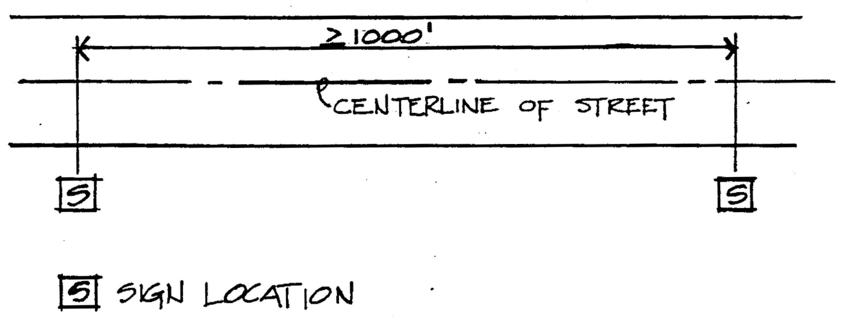
b.
The minimum spacing for all off-premises signs which are on opposite sides of the street shall be 500 linear feet measured on the centerline of such street. (See Diagram B.)
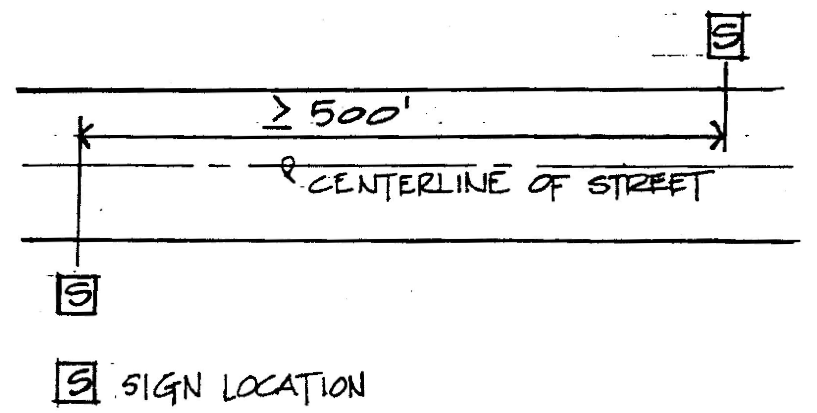
c.
When an existing off-premises sign is located within 300 feet of the right-of-way of any street or highway intersection, including the intersection of streets or highways not at grade, no additional sign shall be spaced less than 1,000 feet apart as measured along the center lines of the streets regardless of the street from which the signs are intended to be viewed. (See Diagram C.)
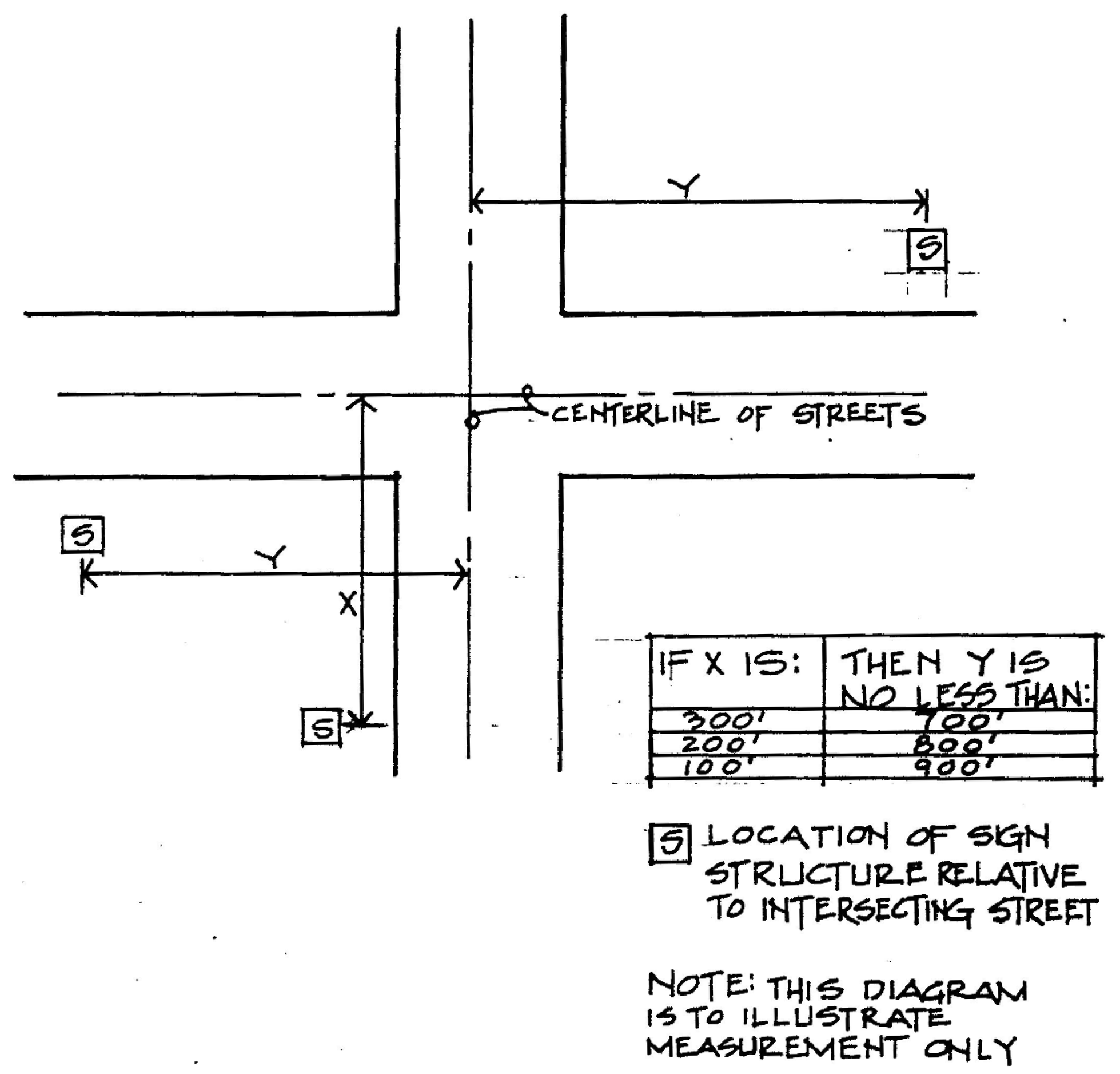
d.
Off-premises erected with 800 feet of and directed toward any Interstate Highway, The Elton B. Stephens Expressway or U.S. Highway 280 shall be located no closer than 300 feet to the paved portion of main-traveled ways and interchange ramps.
e.
An off-premises sign erected within ten feet of the right-of-way of intersecting or merging streets, alleys, private drives, bridges, or railroad crossings shall be a minimum of eight feet above the level of the pavement of said streets.
f.
Off-premises signs larger than 300 square feet shall be set back at least 400 feet; signs between 85 and 300 square feet shall be set back at least 250 feet; and signs 85 square feet or less shall be set back at least 125 feet from any residentially zoned property, public park or school measured from the nearest edge of the sign.
4.
Maximum height. The maximum height for any off-premises sign shall be 40 feet above ground level at its base. Where the ground level is lower than the main-traveled way of the street or highway along which the sign is too constructed, the maximum height as measured to the top of the sign face shall be extended to a point 25 feet above the plane of said main-traveled way.
5.
General off-premises sign requirements.
a.
No off-premises sign structures shall be located on, or project over, any public property or right-of-way except as provided by ordinance of the city council.
b.
No off-premises sign shall be permitted on top of any building or rooftop.
c.
No three-sided signs shall be permitted.
d.
It shall be unlawful to construct an off-premises sign where such constructions require the removal of any tree 12 inches in diameter or greater.
6.
Scenic corridors. The scenic corridors herein established consist of the following:
a.
Elton B. Stephens Expressway.
b.
Interstate 65.
c.
Interstate 59.
d.
Interstate 20.
e.
Interstate 459.
f.
U.S. Highway 280.
g.
Montgomery Highway from the city line as it splits into 20th Street South and 21st Street South along the line both of these streets to 12th Avenue North.
h.
Messer-Airport Highway from the air terminal to Interstate 59/20.
i.
Clairmont Avenue/University Boulevard from 38th Street to Elton B. Stephens Expressway.
j.
7th Avenue South from 32nd Street to the Elton B. Stephens Expressway.
k.
1st Avenue North/Parkway East from the Elton B. Stephens Expressway to city limits.
l.
8th Avenue North from Interstate 65 to Avenue Y Ensley.
m.
John Rogers Drive from U.S. 11 to U.S. 78.
n.
State Highway 119.
o.
Grants Mill Road.
p.
Lakeshore Parkway.
q.
Finley Boulevard from Highway 78 to 26th Street North.
r.
Lomb Avenue/Martin Luther King Drive from Bessemer Road to West Oxmoor Road.
s.
Spaulding-Ishkooda Road from Ishkooda Road to Martin Luther King Drive.
t.
Arkadelphia Road from Lomb Avenue to I-59.
7.
Areas of special aesthetic concern.
a.
No additional off-premises signs shall be permitted in ares of special aesthetic concern as herein defined.
b.
All off-premises signs shall be removed from all of the named areas of special aesthetic concern as set out herein below within 90 days after written notice to the permittee of such signs:
(1)
Community renewal project area;
(2)
Commercial revitalization project area;
(3)
Neighborhood revitalization and improvement project area;
(4)
The downtown master plan project area;
(5)
An urban renewal and urban redevelopment project area;
(6)
Historic districts; and
(7)
B-3 Community Business Districts.
(Ord. No. 97-21, 2-18-1997)
Subsection 7.
On-premises sign regulations. Unless otherwise provided in this ordinance, on-premises signs must comply with the following regulations:
1.
Maximum size.
a.
Except as provided below, each business establishment shall be limited to a square footage of 672 square feet for on-premises signage.
b.
The total square footage of on-premises signs for retail car dealerships may be increased to an amount no greater than 35 percent of the maximum size specified herein which shall be calculated by measuring the actual square footage of the sign face as defined herein.
2.
Maximum number. No maximum number of on-premises signs is specified in the ordinance. For each business establishment, the maximum number of permitted signs shall be determined based on the maximum square footage allowance as specified herein.
3.
Maximum height. Except for on-premises signs where the roof is higher than 50 feet, the maximum height of on-premises signs shall be 50 feet above ground level as its base; provided, however, that in areas within 750 feet of the right-of-way or interstate highways, the maximum height shall be extended to a point of 25 feet above the plane of the main traveled way of the interstate when the ground level of the sign base is lower than said main traveled way.
4.
Placement requirements.
a.
No on-premises sign shall be placed in such a manner as to block effective visibility of adjacent signs, whether on or off-premises signs in any district.
b.
No on-premises sign shall be placed within 15 feet of any residential zone boundary.
c.
No projecting sign shall project into any public right-of-way by more than five feet.
d.
Wall signs shall not extend more than ten feet across the roof line or across any corner of the wall on which the sign is mounted.
e.
No sign face shall be placed in such a manner that a motorist's visibility is obscured wither at driveways or entrance points to any business or at intersecting streets or alleys.
5.
Illumination. It shall be unlawful to erect any attraction or sign which contains a beacon of any type and/or contains a spotlight providing direct illumination to the public.
6.
Portable signs. Only one portable sign shall be permitted for each business establishment; however, such sign shall not be considered a part of the total allowable square footage for signage as provided herein.
7.
Product advertising signs. Product advertising signs shall not exceed 12 square feet in area for any one premises which area shall be included in the total permitted sign area for that premises.
Subsection 8.
Penalties. Both the owners or other persons in charge or control of signs, and owners or other persons in charge or control of property on which signs are located shall be responsible for assuring compliance with this section. Any failure or refusal to comply with this section shall be a violation and punished as provided in article VII, section 4 of this ordinance.
Section 10. - Floodplain zone districts.
All of the zone districts heretofore established shall be modified and supplemented in the following instances and according to the following rationale:
1.
Rationale; purpose. Certain lands and flood hazard areas of the City of Birmingham are subject to periodic inundation which results in loss of life, property, health and safety hazards, disruption of commerce and governmental services, extraordinary public expenditures for flood protection and relief, and impairment of the tax base, all of which adversely affect the public health, safety and general welfare. These flood losses are caused by the cumulative effect of obstructions in the floodplains causing increases in flood heights and velocities, and by the occupancy in flood hazard areas by uses vulnerable to floods or hazards to other lands which are inadequately elevated, floodproofed, or otherwise protected from flood damages. It is the purpose of this section to promote the public health, safety and general welfare and to minimize public and private losses due to flood conditions in specific areas by the following provisions designed to:
a.
Restrict or prohibit uses which are dangerous to health, safety and property due to water or erosion hazards, or which result in damaging increases in erosion or in flood heights or velocities;
b.
Require that uses vulnerable to floods, including facilities which serve such uses, be protected against flood damage at the time of initial construction;
c.
Control the alteration of natural floodplains, stream channels, and natural protective barriers which are involved in the accommodation of floodwaters;
d.
Control filling, grading, dredging and other development which may increase erosion or flood damage; and
e.
Prevent or regulate the construction of flood barriers which will unnaturally divert floodwaters or which may increase flood hazards to other lands.
The basic underlying objectives that guided the preparation of this section are: the protection of human life and health; the minimizing of public expenditures for costly flood control projects, and rescue and relief efforts associated with flooding, as well as interruption and damage to individual residents, businesses, industry and public facilities and utilities such as water and gas mains, electric, telephone and sewer lines, streets and bridges; and in general the development and maintenance of a stable tax base by providing for the sound use and development of floodprone areas in such a manner to minimize future flood blight and insure that all purchasers of private property subject to flooding are notified that such property is in a flood area.
2.
Definitions. Any other provision in this section to the contrary notwithstanding for the purposes of this subsection 2, the following words, terms and phrases shall have the meanings ascribed to them in this subsection 2. Unless specifically defined herein, words or phrases used in this section shall be interpreted so as to give them the meaning they have in common usage and give this section its most reasonable application. When not inconsistent with the context, words used in the present tense shall include the future tense, words in the plural number shall include the singular number, and words in the singular number shall include the plural number.
a.
Addition (to an existing building) means any walled and roofed expansion to the perimeter of a building in which the addition is connected by a common load-bearing wall other than a fire wall. Any walled and roofed addition which is connected by a fire wall or is separated by independent perimeter load-bearing walls is new construction.
b.
Administrative officer means the person(s) appointed to administer, interpret and implement the provisions of this section in accordance with the provisions of subsection 4.a and b.
c.
Appeal means a request for a review of the administrative officers' interpretation of any provision of this section or a request for a variance.
d.
Area of shallow flooding means a designated AO Zone on a community's flood insurance rate map (FIRM) with a one percent or greater annual chance of flooding to an average depth of one to three feet where a clearly defined channel does not exist, where the path of flooding is unpredictable and where velocity flow may be evident. Such flooding is characterized by ponding or sheet flow.
e.
Area of special flood hazard means the land in the floodplain within a community subject to a one percent or greater chance of flooding in any given year.
f.
Base flood means the flood having a one percent chance of being equaled or exceeded in any given year.
g.
Basement means any area of a building having its floor subgrade (below ground level) on all sides.
h.
Breakaway wall means a wall that is not part of the structural support of the building and is intended through its design and construction to collapse under specific lateral loading forces without causing damage to the elevated portion of the building or the supporting foundation system.
i.
Building. See Structure.
j.
Development means any manmade change to improved or unimproved real estate, including, but not limited to, buildings or other structures, mining, dredging, filling, grading, paving, excavating or drilling operations, or storage of materials or equipment.
k.
Elevated building means a nonbasement building (1) built to have the top of the elevated floor elevated above the ground level by means of pilings, columns (posts and piers), or shear walls parallel to the flow of the water and (2) adequately anchored so as not to impair the structural integrity of the building during a flood of up to the magnitude of the base flood. [The term] "elevated building" also includes a building elevated by means of fill or solid foundation perimeter walls with openings sufficient to facilitate the unimpeded movement of floodwaters.
l.
Existing construction means structures for which the "start of construction" commenced before May 5, 1981, the effective date of the initial floodplain management ordinance adopted by the city. [The term] "existing construction" may also be referred to as "existing structures."
m
Existing manufactured home park or subdivision means a manufactured home park or subdivision for which the construction of facilities for servicing the lots on which the manufactured homes are to be affixed (including, at a minimum, the installation of utilities, the construction of streets, and either final site grading or the pouring of concrete pads) is completed before May 5, 1981, the effective date of the initial floodplain management ordinance adopted by the city.
n.
Expansion to an existing manufactured home park or subdivision means the preparation of additional sites by the construction of facilities for servicing the lots on which the manufactured homes are to be affixed (including the installation of utilities, the construction of streets, and either final site grading or the pouring of concrete pads).
o.
Flood or flooding means a general and temporary condition of partial or complete inundation of normally dry land areas from the overflow of inland or tidal waters or the unusual and rapid accumulation of runoff of surface waters from any source.
p.
Flood insurance rate map (FIRM) means an official map of a community, on which the Federal Emergency Management Agency has delineated both the areas of special flood hazard and the risk premium zones applicable to the community.
q.
Flood insurance study means the official report provided by Federal Emergency Management Agency. The report contains profiles along distances of each studied stream with stream bed elevations and corresponding flood elevations, as well as flood maps and the water surface elevation of the base flood.
r.
Floodplain means the area of special flood hazard covered by a flood having a one percent chance of being equaled or exceeded in any given year and delineated as a Zone A, AO, A1-30, AE, A99 or AH on the community's flood insurance rate map (FIRM).
s.
Floodproofing means any combination of structural and nonstructural additions, changes, or adjustments to structures which reduce or eliminate flood damage to real estate or improved real property, water and sanitary facilities, structures and their contents.
t.
Floodway means the channel of a river or other watercourse and the adjacent land areas that must be reserved in order to discharge the base flood without cumulatively increasing the water surface elevation more than one foot.
u.
Functionally dependent facility means a facility which cannot be used for its intended purpose unless it is located or carried out in close proximity to water, such as a docking or port facility necessary for the loading and unloading of cargo or passengers, shipbuilding, ship repair, or seafood processing facilities. The term does not include long-term storage, manufacture, sales or service facilities.
v.
Highest adjacent grade means the highest natural elevation of the ground surface, prior to construction, next to the proposed walls of a structure.
w.
Historic structure means any structure that meets one or more of the following criteria:
(1)
Listed individually in the National Register of Historic Places (a listing maintained by the Department of the Interior) or preliminarily determined by the Secretary of the Interior as meeting the requirements for individual listing on the National Register;
(2)
Certified or preliminarily determined by the Secretary of the Interior as contributing to the historical significance of a registered historic district or a district preliminarily determined by the Secretary to qualify as a registered historic district;
(3)
Individually listed on a state inventory of historic places in states with historic preservation programs which have been approved by the Secretary of the Interior; or
(4)
Individually listed on a local inventory of historic places in communities with historic preservation programs that have been certified either:
(i)
By an approved state program as determined by the Secretary of the Interior; or
(ii)
Directly by the Secretary of the Interior in states without approved programs.
x.
Improvement cost, for determining "substantial improvement," means the value of all costs for improvements and/or repairs to a structure. Cost shall include all structural costs for labor and materials, as well as all finish materials, built-in appliances, hardware, profit and overhead but excluding plans, surveys, permit fees, debris removal and clean-up, items not considered real property, and accessory structures. The improvement cost shall be determined by the latest edition of "Building Valuation Data" of current average construction value per square foot published by the Southern Building Code Congress International or a written estimate of labor and materials prepared and certified by the contractor.
y.
Lowest floor means the lowest floor of the lowest enclosed area (including basement). An unfinished or flood-resistant enclosure, usable solely for parking of vehicles, building access or storage in an area other than a basement area is not considered a building's lowest floor; provided that such enclosure is not built so as to render the structure in violation of the applicable nonelevation design requirement of subsection 5.
z.
Manufactured home means a structure, transportable in one or more sections, which is built on a permanent chassis and designed to be used with or without a permanent foundation when connected to the required utilities. The term also includes park trailers, travel trailers and similar transportable structures placed on a site for 180 consecutive days or longer and intended to be improved property.
aa.
Manufactured home park or subdivision means a parcel (or contiguous parcels) of land divided into two or more manufactured home lots for rent or sale.
bb.
Market value of the building, for determining "substantial improvement," means the market value of the building only, excluding land. Market value shall be determined by the most recent appraisal by the county tax assessor or by a certified appraisal report using the comparable sales method, whichever is the greater value.
cc.
Mean sea level means the average height of the sea for all stages of the tide. It is used as a reference for establishing various elevations within the floodplain. For purposes of this section, the term is synonymous with National Geodetic Vertical Datum (NGVD).
dd.
National Geodetic Vertical Datum (NGVD), as corrected in 1929, is a vertical control used as a reference for establishing various elevations within the floodplain.
ee.
New construction means structures for which the start of construction commenced on or after May 5, 1981, the effective date of the initial floodplain management ordinance adopted by the city. The term also includes any subsequent improvements to such structures.
ff.
New manufactured home park or subdivision means a manufactured home park or subdivision for which the construction of facilities for servicing the lots on which the manufactured homes are to be affixed (including at a minimum, the installation of utilities, the construction of streets, and either final site grading or the pouring of concrete pads) is completed on or after May 5, 1981, the effective date of the initial floodplain management ordinance adopted by the city.
gg.
Recreational vehicle means a vehicle which is:
(1)
Built on a single chassis;
(2)
400 square feet or less when measured at the largest horizontal projection;
(3)
Designed to be self-propelled or permanently towable by a light-duty truck; and
(4)
Designed primarily not for use as a permanent dwelling but as temporary living quarters for recreational, camping, travel, or seasonal use.
hh.
Start of construction, for other than new construction of substantial improvements under the Coastal Barrier Resources Act (P.L. 97-348), includes substantial improvement, and means the date the building permit was issued, provided the actual start of construction, repair, reconstruction, rehabilitation, addition placement, or improvement was within 180 days of the permit date. The actual "start" means either the first placement of permanent construction of a structure (including a manufactured home) on a site, such as the pouring of slabs or footings, installation of piles, construction of columns, or any work beyond the stage of excavation or the placement of a manufactured home on a foundation. Permanent construction does not include land preparation, such as clearing, grading and filling; nor does it include the installation of streets and/or walkways; nor does it include excavation for a basement, footings, piers or foundations or the erection of temporary forms; nor does it include the installation on the property of accessory buildings, such as garages or sheds not occupied as dwelling units or not part of the main structure. For a substantial improvement, the actual start of construction means the first alteration of any wall, ceiling, floor, or other structural part of a structure, whether or not that alteration affects the external dimensions of the structure.
ii.
Structure means a walled and roofed building that is principally above ground, a manufactured home, a gas or liquid storage tank, and other manmade facilities or infrastructures.
jj.
Substantial damage means damage of any origin sustained by a structure whereby the cost of restoring the structure to its before-damaged condition would equal or exceed 50 percent of the market value of the structure before the damage occurred.
kk.
Substantial improvement means any combination of repairs, reconstruction, alteration, addition or improvement to a building, taking place during the life of a building, in which the cumulative "improvement cost" (as defined by this section) equals or exceeds 50 percent of the "market value of the building" (as defined by this section). The market value of the building should be (1) the present appraised value of the building prior to the start of the repair or improvement, or (2) in the case of damage, the value of the building prior to the damage occurring. This term includes structures which have incurred substantial damage, regardless of the actual repair work performed. For the purposes of this definition substantial improvement is considered to occur when the first alteration of any wall, ceiling, floor, or other structural part of the building commences, whether or not that alteration affects the external dimensions of the structure. The term does not, however, include any project for improvement of a structure to comply with existing state or local health, sanitary, or safety code specifications which have been identified by the code enforcement official and which are solely necessary to ensure safe living conditions.
Example. A substantial improvement occurs when the cumulative improvement costs to a building over a period of time exceed 50 percent of the current market value of the building, as shown in the following example:
In 1988, a $30,000.00 improvement is made to a $100,000.00 building:
$30,000.00 improvement cost divided by $100,000.00 market value of building = 30 percent.
50 percent improvement, which is not a substantial improvement.
In 1994, a $45,000.00 improvement is proposed for the same building with a current market value of $143,000.00:
$143,000.00 = 1994 building value before proposed $45,000.00 improvement.
$30,000.00 improvement in 1988 + $45,000.00 proposed 1994 improvement = $75,000.00 cumulative improvement costs.
$75,000.00 cumulative improvement costs divided by $143,000.00 current market value = 52 percent.
> 50 percent improvement, which is a substantial improvement.
ll.
Substantially improved existing manufactured home parks or subdivisions means where the repair, reconstruction, rehabilitation or improvement of the streets, utilities and pads equals or exceeds 50 percent of the value of the streets, utilities and pads before the repair, reconstruction or improvement commenced.
mm.
Variance means a grant of relief by the zoning board of adjustment to a person from the requirements of this section which permits construction in a manner otherwise prohibited by this section where specific enforcement would result in practical difficulty.
nn.
Zone A, AO, A1-30, AE, A99 or AH means an area of special flood hazard delineated on the community's flood insurance rate map (FIRM).
3.
General provisions.
a.
Lands to which this section applies. In addition to the other requirements of this section and other ordinances of the City of Birmingham, this section shall apply to all areas of special flood hazard within the corporate limits of the City of Birmingham.
b.
Basis for establishing the areas of special flood hazard. The areas of special flood hazard identified by the Federal Emergency Management Agency, Federal Insurance Administration through the scientific engineering report entitled "Flood Insurance Study, City of Birmingham, Alabama, Jefferson County," dated September 16, 1980, with accompanying flood insurance rate maps and flood boundary and floodway maps and any revision thereto are adopted by reference and declared to be a part of this section.
c.
Establishment of development permit. A permit to develop in a flood hazard area, a floodplain development permit, shall be required in conformance with the provision of this section prior to the commencement of any development activities.
d.
Compliance. No structure or land shall hereafter be located, extended, converted or structurally altered without full compliance with the terms of this section and other applicable regulations.
e.
Abrogation and greater restrictions. This section is not intended to repeal, abrogate, or impair any existing easements, covenants, or deed restrictions. However, where this section and another conflict or overlap, whichever imposes the more stringent restrictions shall prevail.
f.
Interpretation. In the interpretation and application of this section, all provisions shall be:
(1)
Considered as minimum requirements;
(2)
Liberally construed in favor of the governing body; and
(3)
Deemed neither to limit nor repeal any other powers granted under state statutes.
g.
Warning and disclaimer of liability. The degree of flood protection required by this section is considered reasonable for regulatory purposes and is based on scientific and engineering considerations. Larger floods can and will occur on rare occasions. Flood heights may be increased by manmade or natural causes. This section does not imply that land outside the areas of special flood hazard or uses permitted within such areas will be free from flooding or flood damages. This section shall not create liability on the part of the City of Birmingham or by any officer or employee thereof for any flood damages that results from reliance on this section or any administrative decision lawfully made thereunder.
h.
Penalties for violation. Violation of the provisions of this section or failure to comply with any of its requirements, including violation of conditions and safeguards established in connection with grants of variance or special exceptions, shall constitute a misdemeanor. Any person who violates this section or fails to comply with any of its requirements shall, upon conviction thereof, be fined not more than $500.00 or imprisoned for not more than 180 days, or both, and in addition shall pay all costs and expenses involved in the case. Each day such violation continues shall be considered a separate offense. Nothing herein contained shall prevent the City of Birmingham from taking such other lawful action as is necessary to prevent or remedy any violation.
4.
Administration.
a.
Designation of administrative officers. The director of the planning, engineering and permits department is hereby appointed to administer, interpret and implement the provisions of this section jointly with the director of the planning, engineering and permits department (for general application to the zoning ordinance, see article VII, sections 1 and 2).
b.
Duties and responsibilities of the administrative officers shall include, but not be limited to the following:
(1)
The administrative officers shall review all development permits to assure that the permit requirements of this section have been satisfied.
(2)
The director of the department of planning, engineering and permits shall advise permittee that additional federal and state permits may be required, and if specific federal or state permits are known, require that copies of such permits be provided and maintained on file with the development permit.
(3)
The director of the department of planning, engineering and permits shall notify adjacent communities and the appropriate authority of the State of Alabama prior to any alteration or relocation of a watercourse, and submit evidence of such notification to the Federal Emergency Management Agency.
(4)
The director of the department of planning, engineering and permits shall assure that maintenance is provided within the altered or relocated portion of said watercourse so that the measured capacity of the stream channel to carry floodwaters is not diminished.
(5)
The director of the department of planning, engineering and permits shall verify and record the actual elevation (in relation to mean sea level) of the lowest floor (including basement) of all new or substantially improved structures, in accordance with subsection 4, part c(2)(a).
(6)
The director of the department of planning, engineering and permits shall verify and record the actual elevation (in relation to mean sea level) to which the new or substantially improved structures have been floodproofed, in accordance with subsection 4, part c(2)(a).
(7)
When floodproofing is utilized for a particular structure, the director of the department of planning, engineering and permits shall obtain certification from a registered professional engineer or architect.
(8)
Where interpretation is needed as to the exact location of the boundaries of the areas of special flood hazard (for example, where there appears to be a conflict between a mapped boundary and actual field conditions) the director of the department of planning, engineering and permits shall make the necessary interpretation. The person contesting the location of the boundary shall be given a reasonable opportunity to appeal the interpretation as provided in this section.
(9)
When base flood elevation data has not been provided in accordance with subsection 3, part b, then the director of the department of planning, engineering and permits shall obtain, review, and reasonably utilize any base flood elevation data available from a federal, state or other source, in order to administer the provisions of subsection 5.
(10)
All records pertaining to the provisions of this section shall be maintained in the offices of the administrative officer and shall be open for public inspection.
c.
Permit and certification procedures.
(1)
Application stage. Application for a floodplain development permit shall supplement an application for a building permit, subdivision plat or other development approval and shall be made to the director of the department of planning, engineering and permits on forms furnished by him, prior to any development activities, and may include, but not be limited to plans in duplicate drawn to scale showing the nature, location, dimensions, and elevations of the area in question; existing and/or proposed structures, fill, storage of materials; drainage facilities, and the location of the foregoing. Specifically, the following information is required:
(a)
Elevation in relation to mean sea level of the proposed lowest floor (including basement) of all buildings;
(b)
Elevation in relation to mean sea level to which any nonresidential structure will be floodproofed;
(c)
Provide a certificate from a registered professional engineer or architect that the nonresidential floodproofed building meets the floodproofing criteria in subsection 5, part b(2);
(d)
Description of the extent to which any watercourse will be altered or relocated as a result of proposed development.
(2)
Construction stage.
(a)
Provide a floor elevation or floodproofing certification after the lowest floor is completed, after placement of the horizontal structural members of the lowest floor. Upon placement of the horizontal structural members of the lowest floor or floodproofing by whatever means, whichever is applicable, it shall be the duty of the permit holder to submit to the director of the department of planning, engineering and permits a certification for the elevation of the lowest floor, floodproofed elevation, or the elevation of the lowest portion of the horizontal structural members of the lowest floor, whichever is applicable, as built, in relation to mean sea level. Said certification shall be prepared by or under the direct supervision of a registered land surveyor or professional engineer and certified by same. When floodproofing is utilized for a particular building, said certification shall be prepared by or under the direct supervision of a professional engineer or architect and certified by same.
(b)
Any work done prior to submission of the certification shall be at the permit holder's risk. The director of the department of planning, engineering and permits shall review the flood elevation survey data submitted. Deficiencies detected by such review shall be corrected by the permit holder immediately and prior to further progressive work being permitted to proceed. Failure to submit the survey or failure to make said corrections required hereby, shall be cause to issue a stop work order for the project.
d.
Variance or modifications.
(1)
The zoning board of adjustment of the City of Birmingham as established in article VIII of this ordinance shall hear and decide on appeals and request for variances from the requirements of this section.
(2)
The zoning board of adjustment shall hear and decide appeals when it is alleged there is an error in any requirement, decision or determination made by the administrative officer in the enforcement or administration of this section.
(3)
Any person aggrieved by the decision of the zoning board of adjustment may appeal such decision in accordance with article VIII, section 6 of this ordinance.
(4)
Variances may be issued for the repair or rehabilitation of historic structures (see definition) upon a determination that the proposed repair or rehabilitation will not preclude the structure's continued designation as a historic structure and the variance is the minimum to preserve the historic character and design of the structure.
(5)
In passing upon such applications, the zoning board of adjustment shall consider all technical evaluations, all relevant factors, all standards specified in other parts of this section and the:
(i)
Danger that materials may be swept into other lands to the injury of others;
(ii)
Danger to life and property due to flooding or erosion damage;
(iii)
Susceptibility of the proposed facility and its contents to flood damage and the effect of such damage on the individual owner;
(iv)
Importance of the services provided by the proposed facility to the community;
(v)
Necessity to the facility of a waterfront location, where applicable;
(vi)
Availability of alternative locations, not subject to flooding or erosion damage for the proposed use;
(vii)
Compatibility of the proposed use with existing and anticipated development;
(viii)
Relationship of the proposed use to the comprehensive plan and floodplain management program for that area;
(ix)
Safety of access to the property in times of flood for ordinary and emergency vehicles;
(x)
Expected heights, velocity, duration, rate of rise and sediment transport of the floodwaters and the effects of wave action, if applicable, expected at the site; and
(xi)
Costs of providing governmental services during and after flood conditions including maintenance and repair of public utilities and facilities such as sewer, gas, electrical, and water systems, and streets and bridges.
(6)
Upon consideration of the factors listed above and the purposes of this section, the zoning board of adjustment may attach such conditions to the granting of variances as it deems necessary to further the purposes of this section.
(7)
Variances shall not be issued within any designated floodway if any increase in flood level during the base flood discharge would result.
(8)
Variances shall only be issued upon a determination that the variance is the minimum necessary considering the flood hazard to afford relief and in the instance of a historical building, a determination that the variance is the minimum necessary so as not to destroy the historic character and design of the building.
(9)
Variances shall only be issued upon:
(i)
A showing of good and sufficient cause;
(ii)
A determination that failure to grant the variance would result in exceptional hardship; and
(iii)
A determination that the granting of the variance will not result in increased flood heights, additional threats to public safety, extraordinary public expense, create nuisance, cause fraud on or victimization of the public or conflict with existing laws or ordinances of the city.
(10)
Any applicant to whom a variance or modification is granted shall be given written notice specifying the difference between the base flood elevation and the elevation to which the structure is to be built and stating the cost of flood insurance will be commensurable with the increased risk resulting from the reduced lowest floor elevation.
(11)
The director of the department of planning, engineering and permits shall maintain the records of all appeal actions and report any variances to the Federal Emergency Management Agency upon request.
5.
Provisions for flood hazard reduction.
a.
General standards. In all areas of special flood hazard the following provisions are required:
(1)
All new construction and substantial improvements shall be anchored to prevent flotation, collapse, or lateral movement of the structure.
(2)
All manufactured homes shall be anchored to prevent flotation, collapse, or lateral movement attributable to water loads associated with the base flood. Methods of anchoring may include, but are not limited to, use of over-the-top or frame ties to ground anchors. This standard shall be in addition to and consistent with applicable state requirements for resisting wind forces.
(3)
All new construction and substantial improvements shall be constructed with materials and utility equipment resistant to damage attributable to water loads associated with the base flood.
(4)
All new construction or substantial improvements shall be constructed by methods and practices that minimize flood damage.
(5)
All electrical, heating, ventilation, plumbing, air conditioning equipment, and other service facilities shall be designed and/or located so as to prevent water from entering or accumulating within the components during conditions of flooding.
(6)
All new and replacement water supply systems shall be designed to minimize or eliminate infiltration of floodwaters into the system.
(7)
New and replacement sanitary sewage systems shall be designed to minimize or eliminate infiltration of floodwaters into the systems and discharges from the systems into floodwaters.
(8)
On-site waste disposal systems shall be located to avoid impairment to them or contamination from them during flooding.
(9)
Any alteration, repair, reconstruction, or improvements to a structure which is in compliance with the provisions of this section, shall meet the requirements of "new construction" as contained in this section.
(10)
Any alteration, repair, reconstruction or improvement to a building which is not in compliance with the provisions of this section, shall be undertaken only if said nonconformity is not furthered, extended or replaced.
(11)
No development in a floodplain shall include locating or storing toxic chemicals, explosives, buoyant materials, pollutants, or other hazardous or toxic materials that could be injurious to human, animal or plant life, unless elevated one foot above the base flood elevation. Underground storage of fuel, toxic or flammable substances is expressly prohibited in the floodplain.
b.
Specific standards. In all areas of special flood hazard where base flood elevation data has been provided, as set forth in subsection 3, part b. or subsection 4, part b(9), the following provisions are required:
(1)
Residential construction. New construction or substantial improvement of any residential structure (or manufactured home) shall have the lowest floor, including basement, elevated no lower than one foot above the base flood elevation. Should solid foundation perimeter walls be used to elevate a structure, openings sufficient to facilitate the unimpeded movement of floodwaters shall be provided in accordance with standards of subsection 5, part b(2).
(2)
Nonresidential construction. New construction or substantial improvement of any commercial, industrial or other nonresidential structure shall either have the lowest floor, including basement, elevated no lower than one foot above the base flood elevation or, together with attendant utility and sanitary facilities, be floodproofed so that below the required elevation the structure is watertight with walls substantially impermeable to the passage of water and use structural components having the capability of resisting hydrostatic and hydrodynamic loads and effects of buoyancy. A registered professional engineer or architect shall certify that the standards of this subsection are satisfied. Such certification shall be provided to the official as set forth in subsection 4, part c(2).
(3)
Elevated buildings. New construction or substantial improvements of elevated buildings that include fully enclosed areas formed by foundation and other exterior walls below the base flood elevation shall be designed to preclude finished living space and designed to allow for the entry and exit of floodwaters to automatically equalize hydrostatic flood forces on exterior walls.
(a)
Designs for complying with this requirement must either be certified by a professional engineer or architect and meet the following minimum criteria:
(i)
Provide a minimum of two openings having a total net area of not less than one square inch for every square foot of enclosed area subject to flooding;
(ii)
The bottom of all openings shall be no higher than one foot above grade; and
(iii)
Openings may be equipped with screens, louvers, valves or other coverings or devices provided they permit the automatic flow of floodwaters in both directions.
(b)
Electrical, plumbing, and other utility connections are prohibited below the base flood elevation;
(c)
Access to the enclosed area shall be the minimum necessary to allow for parking of vehicles (garage door) or limited storage of maintenance equipment used in connection with the premises (standard exterior door) or entry to the living area (stairways or elevator); and
(d)
The interior portion of such enclosed area shall not be partitioned or finished into separate rooms.
(4)
Standards for manufactured homes and recreational vehicles.
(a)
All manufactured homes placed, or substantially improved, on individual lots or parcels, in expansions to existing manufactured home parks or subdivisions, or in substantially improved manufactured home parks or subdivisions, must meet all the requirements for new construction, including elevation and anchoring.
(b)
All manufactured homes placed or substantially improved in an existing manufactured home park or subdivision must be elevated so that:
(i)
The lowest floor of the manufactured home is elevated no lower than one foot above the base flood elevation;
(ii)
The manufactured home chassis is supported by reinforced piers or other foundation elements of at least an equivalent strength, of no less than 36 inches in height above grade;
(iii)
The manufactured home must be securely anchored to the adequately anchored foundation system to resist flotation, collapse and lateral movement; or
(iv)
In an existing manufactured home park or subdivision on which a manufactured home has incurred "substantial damage" as the result of a flood, any manufactured home placed or substantially improved must meet the standards of subsection 5, parts b(1) and (3) above.
(c)
All recreational vehicles placed on sites must either:
(i)
Be on the site for fewer than 180 consecutive days and be fully licensed and ready for highway use; or
(ii)
The recreational vehicle must meet all the requirements for new construction, including anchoring and elevation requirements of subsection 5, part a(2) and part b(1) above. A recreational vehicle is ready for highway use if it is on its wheels or jacking system, is attached to the site only by quick disconnect type utilities and security devices and has no permanently attached structures.
c.
Standards for floodways. Located within areas of special flood hazard established in subsection 3, part b, are areas designated as floodways. Since the floodway is an extremely hazardous area due to the velocity of floodwaters which carry debris, potential projectiles and has erosion potential, the following provisions shall apply:
(1)
Prohibit encroachments, including fill, new construction, substantial improvements and other developments unless certification by a registered professional engineer is provided demonstrating that encroachments shall not result in any increase in flood levels during occurrence of the base flood discharge.
(2)
If subsection 5, part c(1) is satisfied, all new construction and substantial improvements shall comply with all applicable flood hazard reduction provisions of subsection 5.
(3)
Prohibit the placement of manufactured homes except in an existing manufactured home park or subdivision. A replacement manufactured home may be placed on a lot in an existing manufactured home park or subdivision provided the anchoring standards of subsection 5, part a(2), and the elevation standards of subsection 5, part b(1) and the encroachment standards of subsection 5, part c(1), are met.
d.
Standards for streams without established base flood elevation and/or floodways. Located within the areas of special flood hazard established in subsection 3, part b, where streams exist but where no base flood data has been provided or where base flood data has been provided without floodways, the following provisions apply:
(1)
No encroachments, including fill material or structures shall be located within areas of special flood hazard, unless certification by a registered professional engineer is provided demonstrating that the cumulative effect of the proposed development, when combined with all other existing and anticipated development will not increase the water surface elevation of the base flood more than one foot at any point within the community. The engineering certification should be supported by technical data that conforms to standard hydraulic engineering principles.
(2)
New construction or substantial improvements of buildings shall be elevated or floodproofed to elevations established in accordance with subsection 4, part b(9).
e.
Standards for subdivision proposals and other new developments.
(1)
All subdivision proposals and other proposed new developments, including manufactured home parks or subdivisions, shall be reviewed by the administrative officer to determine whether such proposals will be reasonably safe from flooding. If a subdivision proposal or other proposed new development is in a floodprone area, any such proposals shall be prepared by a professional engineer and be reviewed for conformance with the following standards:
(a)
All such proposals shall be consistent with the need to minimize flood damage within the floodprone area;
(b)
All public utilities and facilities, such as sewer, gas, electrical and water systems shall be located and constructed to minimize flood damage;
(c)
Adequate drainage shall be provided to reduce exposure to flood hazards; and
(2)
All subdivision plat proposals and other proposed site plans for new development in a floodprone area, including manufactured home parks or subdivisions, shall have floodplain zones delineated and base flood elevation data provided by a registered land surveyor or professional engineer.
(Ord. No. 95-56, 3-21-1995)
Section 11. - Adult establishments.
1.
General applicability. The regulations set forth in this section supplement or modify the district regulations appearing elsewhere in this ordinance and shall apply to all property within business districts as established by the council of the City of Birmingham.
2.
Purpose. The purpose of this section is to amend the zoning ordinance of the City of Birmingham, Alabama, in a manner which:
a.
Protects the constitutional rights of those persons and corporations who desire to deal in, purchase or rent "adult" or sex-oriented materials; and
b.
Minimizes the public safety problems which the experience with past and current adult establishments in the city has demonstrated are substantial; and
c.
Provides for zoning protection of existing residential and commercial real estate values from substantial impairment; and
d.
In general to provide for the protection of the health, safety, comfort and general welfare of the citizens of the City of Birmingham.
3.
Findings of fact. Based upon the evidence and information submitted to the council, the governing body of the City of Birmingham, Alabama, upon statements of citizens submitted to the council, upon receipts submitted by the police department of the city to this council, upon expert opinions submitted to and considered by this council, and upon the knowledge and experience gained by council members, both while serving as members of this council and prior thereof, this council hereby makes the following findings of fact:
a.
Adult entertainment or sex-oriented businesses which have existed within the City of Birmingham and which currently exist, have experienced substantial numbers of arrests for sex-related offenses.
b.
The number of such arrests are proportionally greater at adult entertainment or sex-oriented businesses than at other businesses in the city.
c.
Adult entertainment or sex-oriented businesses have established a "community reputation" of attracting persons who do engage in various sexual practices on the premises of the business.
d.
This "community reputation" tends to diminish nearby real estate values.
e.
This "community reputation" reduces the perceived quality of life for neighboring residents.
4.
Definitions. As used in this subsection, the following words and phrases will have the following meanings:
a.
Adult book store. An establishment having, as a substantial or significant portion of its stock in trade available for purchase or rental, books, magazines, and other periodicals, cassette tapes, videotapes or films which are distinguished or characterized by their emphasis on matter depicting, describing or relating to specified sexual activities or specified anatomical areas, as defined in this subsection, or an establishment with a segment or section devoted to the sale, rental or display of such material.
b.
Adult cabaret or dancing establishment. A cabaret or dancing establishment which features topless or bottomless dancers, go-go dancers, exotic dancers, strippers, male or female impersonators, or similar entertainers.
c.
Adult establishment. Any adult book store, adult mini-motion picture theater, adult motion picture theater, adult cabaret or dancing establishment or any combination thereof.
d.
Adult mini-motion picture theater. An enclosed building with a capacity of less than 50 persons used for presenting material distinguished or characterized by an emphasis on matter depicting, describing or relating to specified sexual activities or specified anatomical areas, as defined in this section, for observation by patrons therein.
e.
Adult motion picture theater. An enclosed building with a capacity of 50 or more persons used for presenting material distinguished or characterized by an emphasis on matter depicting, describing or relating to specified sexual activities or specified anatomical areas, as defined in this section, for observation by patrons therein.
f.
Specified anatomical areas:
(1)
Less than completely and opaquely covered human genitals, pubic region, buttock, and female breast below a point immediately above the top of the areola; and
(2)
Human male genitals in a discernible turgid state, even if completely and opaquely covered.
g.
Specified sexual activities:
(1)
Human genitals in a state of sexual stimulation or arousal;
(2)
Acts of human masturbation, sexual intercourse or sodomy; and
(3)
Fondling or other erotic touching of human genitals, pubic region, buttocks or female breast.
5.
Permit required. No adult establishment, as defined by this subsection, shall be constructed, established, or operated by any person without first obtaining a permit from the director of the department of planning, engineering and permits, which permit shall certify that such adult establishment complies with the requirements of subsection (6) of this section.
6.
Locational requirements. All distance limitations shown below are measured from the closest lot line between items listed. No adult establishment shall be constructed, established, or operated within:
a.
750 feet of any E, R, A or MXD zoning district, or any property, regardless of its zoning classification, that contains a single-family or two-family detached dwelling, or multiple-family dwelling;
b.
750 feet of a child care facility, kindergarten, elementary, middle, or high school, college, university, or similar type of school, whether public or private;
c.
750 feet of a public park;
d.
750 feet of a church or place of worship;
e.
1,500 feet of another adult establishment;
f.
Those areas that are considered registered and listed on the National Register of Historic Places as historic districts, or areas within 750 feet of those districts. The boundaries of said historic districts are on file in the department of planning, engineering and permits;
g.
A commercial revitalization district, urban renewal and redevelopment project area, or within 750 feet of those districts, as established by the council of the City of Birmingham. The boundaries of such districts are on file in the department of planning, engineering and permits.
7.
Signs. Signs for adult establishments shall conform to the following:
a.
Signs shall pertain to goods, products or services sold or offered on the premises.
b.
Signs shall be attached to a vertical surface of the building or extend not more than 18 inches therefrom.
c.
Signs shall not exceed in the aggregate 40 square feet of gross surface area for any lot having 40 feet or less of street frontage. On lots having a frontage greater than 40 feet, such sign or signs shall not exceed in the aggregate one square foot in area for each linear foot of principal street frontage, but in no case shall the aggregate area of such sign or signs exceed 100 square feet.
d.
Signs or exterior displays of any kind shall be limited to words, phrases and numbers and shall not include live, animated or pictorial displays or any material depicting, describing or relating to specified sexual activities or specified anatomical areas that may permit the observation of such display of materials from any public way. This provision shall apply to any display, decoration, sign, show window or other openings.
(Ord. No. 10-111, 8-24-2010)
Section 12. - "Q" Qualified Zone District.
Subsection 1.
Purpose. The purpose of the "Q" (Qualified District) is to provide for the regulation of commercial, manufacturing or residential uses of land and structures in order that uses and development of said land, buildings and structures will be harmonious and compatible with and not have an undesirable or detrimental impact on surrounding development. The purpose of this section is also to protect the public welfare and the property value of surrounding property by securing an appropriate development that is in harmony with the objectives of the City of Birmingham Master Plan as adopted by the Birmingham Planning Commission. In order to achieve the above stated purposes provision is hereby made that in consideration of a change of zone the subject property shall be limited in such manner that it may not be utilized for all the uses ordinarily permitted in a particular zone classification and/or that development of said subject property shall conform to specific standards. In such cases, the ordinance changing the zoning classification of the property in question shall place it in a "Q" (Qualified) zoning classification. The "Q" (Qualified) District shall be indicated in the rezoning ordinance passed by the city council and on the official zoning map by the symbol "Q" immediately before the combination of symbols designation, e.g., "Q" B-2 in addition to the case number assigned to the individual rezoning case.
Subsection 2.
Zone districts that may be combined with a "Q" (Qualified) District. Rezonings for a "Q" (Qualified) District must be combined with another zone district as set forth below. A "Q" (Qualified) District may not be requested which is not so combined with these applicable districts. A "Q" (Qualified) District zoning classification shall only be used in combination with zones R-1, R-2, R-3, R-4, R4A, R-5, R-6, R-7, O&I, B-1, B-2, B-3, B-6, M-1, M-1A, M-2 and M-4 as defined elsewhere in the zoning ordinance of the City of Birmingham.
Subsection 3.
Uses permitted in a "Q" (Qualified) District. The uses permitted in a "Q" (Qualified) District shall be limited to those set out in the rezoning ordinance passed by the city council.
Subsection 4.
Standards that may be required in a "Q" (Qualified) District. In addition to permitted uses as set forth in subsection 3 above, the "Q" (Qualified) rezoning ordinance passed by council may impose standards on the subject property with respect to buffers, ingress and egress, development plans, drainage, and environmental plans as well as other considerations that may be necessary to make the proposed development compatible with surrounding development. All applicable limitations and/or standards within the "Q" (Qualified) District shall be considered to apply permanently to the specific uses permitted in said zone.
Subsection 5.
Expiration of development plan (time limit on development). In the event that construction, in accordance with a development plan (when required) is not begun within two years from the date of approval by the city council of the "Q" (Qualified) District, said development plan shall become null and void.
Subsection 6.
Amendments to "Q" (Qualified) District.
1.
In the event that more permitted uses than those set forth in the "Q" (Qualified) District rezoning ordinance passed by council are desired for the subject property, the city council will, after proper notification, hold a public hearing on the matter to determine its validity.
2.
Applicants for amendments pertaining only to standards, which may be required as set forth in subdivision 4 above, need only be presented to and approved by the zoning advisory committee of the Birmingham Planning Commission.
Section 13. - Additional height regulations in vicinity of municipal airport.
Subsection 1.
Applicability of sections; approval of certain structures. The regulations set forth in this section qualify or modify the district regulations appearing elsewhere in this ordinance and shall apply to all property included within the airport height control zones shown on the zoning district maps. No structure or building shall be erected which will be higher than 150 feet above the site ground level or which will be higher than 1,143 feet (500 feet above the established airport elevation) above sea level unless the location of such structure or building shall have been approved by the Federal Aviation Administration or other appropriate federal agency.
Subsection 2.
Height limitations. No structure or portion thereof shall be erected within the airport approach zones, transitional zones, horizontal zone or conical surface in excess of the elevations described below:
1.
Approach zones.
a.
Southwest approach zone. Runway 5-23, an elevation above the elevation at the end of the runway a distance equal to 1/50 of the horizontal distance beginning 200 feet from the end of the runway measured along the centerline of the runway extended.
b.
Northeast approach zone. Runway 5-23, north approach zone; Runway 18-36 and South Approach Zone Runway 18-36, an elevation above the elevation at the end of the runway, a distance equal to 1/40 of the horizontal distance beginning 200 feet from the end of the runway measured along the centerline of the runway extended.
2.
Transitional zones. An elevation 1/70 of the horizontal distance measured outward at right angles to the centerline of the runway or the centerline of the centerline if extended, beginning at the interior edges of the transitional zone.
3.
Horizontal zones. An elevation 150 feet above the established airport elevation.
4.
Conical surface. The maximum height permitted in the horizontal zone plus an elevation 1/40 of the horizontal distance measured outward at right angles to the periphery of the horizontal zone.
Subsection 3.
Overlap of control zones. Where airport height control zones overlap, the most restrictive height limitation shall prevail. In no case shall the requirement of this section prevent the construction of a structure not exceeding 20 feet in height.
Section 14. - Holding Zone District (HZD).
Subsection 1.
Generally. The regulations set forth in this section or set forth elsewhere in this ordinance, when referred to in this section are the regulations in the Holding Zone District (HZD). The purpose of the Holding Zone District (HZD) is to provide for the regulation of all uses and structures within areas which have been recently annexed and are yet to be developed in order to encourage the orderly timing and phasing of growth in these areas. The Holding Zone District may be applied to any areas which have been recently annexed for which the city finds should be held in a primarily undeveloped state for an interim period of time pending development and/or completion of a comprehensive land use plan for the subject area.
Subsection 2.
Use regulations. A building or premises shall be used only for the following purposes:
1.
Any use existing at the time of rezoning the subject property Holding Zone District.
2.
Raising and grazing of animals, except no commercial feed lots.
3.
Nurseries, green houses or the growing of crops, except that no wholesale or retail sales shall be conducted on the premises.
4.
Forestry.
5.
Single-family structures on one acre or more (permitted only by conditional approval of the planning commission).
6.
Wireless communications facility, in accordance with article VI, section 18.
7.
Accessory structures and uses which are incidental to the main use of the premises (permitted only by conditional approval of the planning commission).
(Ord. No. 97-77, § 1(title 2, art. VI, § 14, subsec. 2), 6-24-1997)
Subsection 3.
Area and dimensional regulations. Except as provided in articles VI and VIII, the area and dimensional regulations set forth in the following table shall be observed:
Maximum height does not apply to barns or silos provided that additional setbacks are provided in accordance with the requirements set forth in article VI, section 13; no structures for keeping of animals shall be located closer than 150 feet from any lot line.
Subsection 4.
Parking regulations. Off-street parking spaces shall be provided in accordance with the requirements for specific uses set forth in article V.
Section 15. - Additional regulations for attached and semi-attached dwellings.
Subsection 1.
Purpose. The purpose of these additional regulations is to provide for design flexibility in the construction of attached and semi-attached dwellings; encourage open space; promote infill housing; and encourage ownership. In the event that multiple family units are converted to attached and semi-attached single ownership, the regulations set forth in this section shall apply.
Subsection 2.
Administration. For the purposes of this section, all new construction shall be constructed on a lot of record, showing separate ownership for each lot.
Subsection 3.
Additional permitted uses. Recreational facilities and parking facilities shall be permitted when constructed as an accessory use to the entire development.
Subsection 4.
Open space. Undeveloped open space, and/or outdoor recreation shall account for 35 percent of the total development in R-5, R-6 and R-7 Multiple Dwelling Districts, and 50 percent of the total development in R-4 Two-Family and Semi-Attached Dwelling Districts and R-4A Medium Density Residential Districts. In any case, not less than 25 percent of these total area percentages shall remain as undeveloped and/or landscaped open space.
Subsection 5.
Design regulations.
[1.]
Front building lines. Front building lines shall vary a minimum of three feet or more for every two dwelling units.
[2.]
Access and entrances. The front doors of all dwelling units must be a minimum of ten feet from any paved surface, except walkways. Private walkways, having a destination of a public walkway or street or private drive, or parking lot shall be provided.
[3.]
Utility services. All dwellings shall be serviced by utilities and other wiring from the rear or side of the dwelling unless underground.
[4.]
Limitations on dwelling units. No structure shall contain any more than eight attached dwelling units.
Section 16. - "C" Contingency Zone District.
Subsection 1.
Purpose. The purpose of the "C" (Contingency) District is to provide for an orderly arrangement of uses, and to provide residential property that is adjacent to potential commercial or industrial development; and single-family residential property that is adjacent to potential multifamily development, with enough land use protection so as not to adversely affect the health, safety, morals or convenience of the general public. In order to achieve the above stated purpose, provision is hereby made that in consideration of a change in zone district boundaries that is the result of initial zoning, or zoning in accordance with a comprehensive plan, the department of planning, engineering and permits staff, shall limit the use of the subject property to development plan approval. The "C" (Contingency) District shall be indicated in the rezoning ordinance passed by the city council and on the official zoning map by the symbol "C" immediately before the combination of symbols designation, e.g. "C" R-6.
Subsection 2.
Other zone districts that may be combined with a "C" (Contingency) District. Rezonings for a "C" (Contingency) District must be combined with another zoned district as set forth below. A "C" (Contingency) District may not be created which is not so combined with these applicable districts. Further a "C" (Contingency) District can only be imposed by the city council or the Birmingham Planning Commission during initial zoning, or zoning in accordance with a comprehensive plan; additionally a "C" (Contingency) District cannot be requested by the property owner. A "C" (Contingency) District classification shall only be used in combination with zones R-4A, R-5, R-6, R-7, O&I, B-1, B-2, B-3, B-6, M-1, M-1A, M-2 and M-4 as defined elsewhere in this zoning ordinance of the City of Birmingham.
Subsection 3.
Uses permitted in a "C" (Contingency) District. The uses permitted under any zone classification coupled with a "C" (Contingency) District are not affected by such "C" designation. Only the potential development of the subject property is affected.
Subsection 4.
Standards that may be required in a "C" (Contingency) District. The "C" (Contingency) rezoning ordinance passed by council shall permit the department of planning, engineering and permits staff to impose standards on the subject property in accordance with a development plan. Said development plan shall be submitted by the developer and reviewed in a timely manner, and if necessary, revised by staff. Staff review and possible revisions of the submitted development plan shall include, but shall not be limited to the following criteria:
1.
Proposed location and height of all structures and site improvements.
2.
Use of all structures and premises.
3.
Parking lot location, volume, ingress and egress, and landscaping.
4.
Location of streets, driveways and walkways, including points of ingress and egress and access streets.
5.
Service and loading spaces.
6.
Solid waste container locations, access and screening.
7.
Location of all overhead utilities.
8.
The amount of manmade impervious surfaces in relation to the total square footage of the parcel.
9.
Finished site topographic contours (at not greater than two-foot intervals).
10.
Stormwater drainage plan.
11.
Buffering and screening of adjacent incompatible or less intensive land uses.
12.
Location, size, and number of all exterior signs.
13.
Location of all exterior areas to be illuminated; all exterior lighting.
14.
Location of all exterior doors.
15.
Other factors which may ameliorate incompatible land uses.
16.
Compliance with City's Soil Erosion and Sediment Control Code.
All applicable limitations and/or standards within the "C" (Contingency) District shall be considered to apply permanently to the specific uses permitted in said zone.
Subsection 5.
Appeal procedure. In the event that the developer is aggrieved by the decision of the department of planning, engineering and permits, with regard to the development plan submitted, a timely appeal shall be taken by the developer to the zoning board of adjustment in accordance with the regulations set forth in this zoning ordinance, viz., article VIII, section 3.
Section 17. - Child and adult care facilities.
Subsection 1.
Purpose and intent. The regulations set forth in this section provide for the provision of child and adult care situated in normal residential and nonresidential surroundings so as to provide for an environment that is healthy and safe. It is found that affordable, good-quality, and licensed child and adult care within the city is critical to the well being of the children and adults in the community. At the same time, these standards are intended to preserve the character of the zoning districts in which they may locate.
(Ord. No. 94-66, § I, 4-5-1994)
Subsection 2.
Definitions. For the purposes of this ordinance the following words, terms, and phrases shall have the meaning ascribed to them as specified herein. When not inconsistent with the context, words used in the present tense shall include the future tense, words in the plural number shall include the singular number and words in the singular number shall include the plural number.
1.
Adult. A person 19 years of age or older.
2.
Adult care. The provision of supplemental care and supervision for nonresident adults who, by reason of aging or disability, require services furnished by a facility that provides shelter and protective oversight on a regular basis for less than 24 hours a day. As used in this section, the term is not intended to include sitting services of a casual nonrecurring nature or in the adult's own home, communal living facilities, clinics or rehabilitation facilities, sanitariums or convalescent homes.
3.
Adult care facility. A building or structure wherein an agency, association, organization, person or group of persons, whether established for financial gain or otherwise, regularly provides adult care for three or more adults.
4.
Child. A person under 19 years of age.
5.
Child care. The provision of supplemental parental care and supervision for a related or nonrelated child or children, on a regular basis for less than 24 hours a day. As used in this section, this term is not intended to include baby sitting services of a casual, nonrecurring nature or in a child's own home.
6.
Child care center. A facility or licensed agency that provides for the care of 13 or more children for periods of less than 24 hours a day.
7.
Child care facility. A building or structure wherein an agency, association, organization, person, or group of persons, whether established for financial gain or otherwise, regularly provides care for one or more nonresident children, whether related or unrelated to the operator of the facility, for periods of less than 24 hours a day. Child care facilities include family day/night care homes, group family day/night care homes, and child care centers, including centers operating as an accessory use to hospitals, churches or other institutional uses.
8.
Department of human resources (Department of Human Resources, Jefferson County). State of Alabama or Jefferson County Department of Human Resources.
9.
Family day/night care home. A child care facility which is the family home in which the operator resides and which receives not more than six children, which number shall be determined by counting all but two of the operator's own children six years of age or younger, for care at any one time during the day or night and is licensed as a family day/night care home by Department of Human Resources, Jefferson County. All family day/night care homes currently licensed by Department of Human Resources, Jefferson County must come into compliance with this provision (definition) no later than the anniversary date of their department of human resources license or December 31, 1994, whichever is later.
10.
Family group day/night care home. A child care facility which is the family home in which the operator resides and which receives not more than 12 children, which number shall be determined by counting all but two of the operator's own children six years of age or younger, for care at any one time during the day or night and is licensed as a family group day/night care home by Department of Human Resources, Jefferson County. All family group day/night care homes currently licensed by Department of Human Resources, Jefferson County must come into compliance with this provision (definition) no later than the anniversary date of their department of human resources license or December 31, 1994, whichever is later.
11.
Substitute/alternate. A person employed by an adult or child care provider on a part-time temporary basis who is available to act as a care giver in the absence of the operator.
12
Zoning certificate of operation. A certificate of operation, issued by the City of Birmingham, Department of Planning, Engineering and Permits, authorizing the operation of a child or adult care facility within the corporate limits of the City of Birmingham.
(Ord. No. 94-66, § I, 4-5-1994; Ord. of 4-26-1994)
Subsection 3.
Zoning certificate required.
1.
Each child or adult care operator shall apply for a zoning certificate of operation on a form provided by the department of planning, engineering and permits. A copy of such application shall be forwarded to the appropriate neighborhood association for their information at least four weeks prior to the final determination as to approval of a certificate of operation. Applicant shall comply with all current provisions of this ordinance and receive said zoning certificate of operation from the department of planning, engineering and permits prior to beginning operation. Any child or adult care facility which is currently registered or licensed by Department of Human Resources, Jefferson County as of the effective date of this ordinance, shall apply for said zoning certificate of operation within 45 days as of the effective date of this ordinance.
2.
The zoning certificate of operation shall be conspicuously posted inside the entrance or reception area of the facility.
3.
The zoning certificate of operation of any child or adult care facility operator whose Department of Human Resources, Jefferson County license becomes inactive or which facility becomes inactive and ceases to operate, will be revoked immediately, and must apply as a new applicant and facility to resume operation. In this case all then current regulations must be met.
4.
No changes in operation beyond the scope outlined in the zoning certificate of operation of any child or adult care facility may be made prior to application for a new zoning certificate of operation. Any child or adult care facility found to be operating beyond the terms of their zoning certificate of operation must come into compliance immediately or their zoning certificate of operation will be revoked.
5.
All child and adult care facilities must submit to inspection by the department of planning, engineering and permits zoning enforcement personnel during normal hours of operation.
(Ord. No. 94-66, § I, 4-5-1994)
Subsection 4.
General requirements for all child and adult care facilities.
1.
Lot size, setbacks, and all other aspects of the premises must conform to those applicable to the zoning district in which the facility is located.
2.
All state, county and city licensing requirements shall be met including business licenses and those pertaining to building, fire safety and health codes.
3.
When located in a residential district, no child or adult care facility shall be permitted to be located within 1,000 feet of another child care or adult care facility also located in a residential district. Any child or adult care facility which is currently registered or licensed by Department of Human Resources, Jefferson County as of the effective date of this ordinance is exempt from this spacing requirement.
(Ord. No. 94-66, § I, 4-5-1994)
Subsection 5.
Family day/night care homes and family group day/night care homes.
1.
Family day/night care homes shall be located in a dwelling. Family group day/night care homes shall be located in a single-family detached dwelling. Its use as a family care home or family group care home shall be clearly incidental to the use of the premises for dwelling purposes by the care giver and shall be carried on wholly within the main building, except for the outside play area.
2.
Family day/night care home and family group day/night care home operators shall provide the department of planning, engineering and permits with the names, dates of birth and sex of their own children for the purpose of determining the number of children which may be received for care. The zoning certificate of operation obtained from the department of planning, engineering and permits shall specify the number of children which may be cared for.
3.
When located in a residential district, employment shall be limited to:
a.
Family day/night care homes: The child care provider who resides at the dwelling, and the substitute/alternate, who is on record at the department of human resources.
b.
Family group day/night care homes: The child care provider who resides at the residence, and no more than one full-time and one part-time employee, and the substitute/alternate, who is on record at the department of human resources.
4.
When located in a residential district, no structural or decorative alterations shall be made or permitted that will alter the single-family character of an existing residential structure.
5.
When located in a residential district, no identification signs shall be permitted.
6.
Off-street drop-off/pick-up area may be determined necessary by the department of traffic engineering. If determined necessary, a site plan must be submitted for approval by the department of traffic engineering and the department of planning, engineering and permits. No pick-up/drop-off or parking shall be permitted in the required front yard except upon a paved surface providing access to a carport or garage.
7.
When located in a residential district, hours of operation shall be restricted to 13 hours daily. The zoning certificate of operation obtained from the department of planning, engineering and permits shall specify the approved hours of operation.
8.
Playground equipment is restricted to the rear yard only. No equipment may be located closer than ten feet to any lot line when located in a residential district. Outside activities shall be restricted to daylight hours.
9.
For all family group day/night care homes off-street parking as required by article V of this ordinance must be met, unless otherwise specified in this ordinance. Spaces must not be located in the required front yard and must be improved with a suitable hard surface permanent type of pavement. A site plan indicating the required parking shall be submitted for approval by the department of planning, engineering and permits.
(Ord. No. 94-66, § I, 4-5-1994)
Subsection 6.
Child care centers.
1.
Off-street parking as required by article V of this ordinance must be met, unless otherwise specified in this ordinance. A site plan indicating the required parking shall be submitted for approval by the department of planning, engineering and permits.
2.
When located in a residential district signage shall not exceed 18 square feet in area and no ground sign shall exceed four feet in height. All signage shall be lighted with only indirect, nonintermittent light. All signage shall be subject to approval by the department of planning, engineering and permits.
3.
Required off-street pick-up/drop off site plan must be submitted for approval by the department of traffic engineering and the department of planning, engineering and permits.
4.
When located in a residential district, playground equipment shall:
(a)
Be restricted to the rear yard;
(b)
Occupy no more than 30 percent of the required rear yard; and
(c)
Not be nearer than ten feet to any lot line.
5.
When located in a nonresidential district, playground equipment shall:
(a)
Be in a rear or side yard;
(b)
Occupy no more than 30 percent of the required yard; and
(c)
Be no closer than three feet to any side or rear lot line, except when adjacent to a residential zone district, in which case playground equipment shall be no closer than ten feet to any lot line.
6.
No child care center shall be permitted to be located in a multiple-family dwelling unit.
7.
When located in or abutting residential districts or where considered by zoning board of adjustment, hours of operation may be limited by zoning board of adjustment.
(Ord. No. 94-66, § I, 4-5-1994)
Subsection 7.
Child care centers as an accessory use.
1.
No additional off-street parking is required, however primary use parking requirements must be met.
2.
No additional signs shall be permitted for the accessory use.
3.
Required off-street pick-up/drop-off site plan must be approved by department of traffic engineering and department of planning, engineering and permits.
4.
When located in a residential district, the accessory use child care center must be contained within the primary structure or within another structure on the same lot as the primary structure, except as provided herein.
5.
An accessory use child care center shall not be permitted in a residential structure.
6.
No accessory use child care center shall be used as a residential dwelling.
7.
When located in a residential district, playground equipment shall:
(a)
Be restricted to the rear yard;
(b)
Occupy no more than 30 percent of the required rear yard; and
(c)
Not be nearer than ten feet to any lot line.
8.
When located in a nonresidential district, playground equipment shall:
(a)
Be in a rear or side yard;
(b)
Occupy no more than 30 percent of the required yard; and
(c)
Be no closer than three feet to any side or rear lot line, except, when adjacent to a residential zone district, in which case playground equipment shall be no closer than ten feet to any lot line.
9.
When located in or abutting residential districts or where considered by zoning board of adjustment, hours of operation may be limited by zoning board of adjustment.
(Ord. No. 94-66, § I, 4-5-1994)
Subsection 8.
Adult care center.
1.
Off-street parking as required by article V of this ordinance must be met, unless otherwise specified in this ordinance. A site plan indicating the required parking shall be submitted for approval by the department of planning, engineering and permits.
2.
When located in a residential district, no identification signs shall be permitted.
3.
Required off-street pick-up/drop-off site plan must be approved by department of traffic engineering and department of planning, engineering and permits.
4.
When located in or abutting residential districts or where considered by zoning board of adjustment, hours of operation may be limited by zoning board of adjustment.
5.
Each adult care facility shall have 50 square feet of usable space for each adult being kept and cared for in the facility. Areas in the facility not considered in the calculation of usable space are kitchens, bathrooms, isolation rooms, halls or passageways, stairs and stairways, offices, and storage areas.
6.
There shall be not less than one caregiver for each six adults under care in each adult care facility.
7.
No adult care facility shall be permitted to be located in a multiple-family dwelling unit.
(Ord. No. 94-66, § I, 4-5-1994)
Subsection 9.
Penalties. Any agency, association, organization, person, or group of persons, whether established for financial gain or otherwise regularly providing care for children or adults within the City of Birmingham shall be responsible for compliance with this section. Any failure or refusal to comply with this section shall be a violation and punished as provided in article VII, section 4 of this ordinance.
(Ord. No. 94-66, § I, 4-5-1994)
Section 18. - Wireless communications facilities.
Subsection 1.
Purpose. The purpose of the regulations contained within this section is to protect the public health, safety, and welfare by establishing minimum locational requirements, siting criteria and development standards for wireless communications facilities, in accordance with section 704(a) of the Federal Telecommunications Act of 1996, as amended. The impact of these regulations is consistent with the objectives of the Federal Telecommunications Act of 1996 (the Act) to accommodate quality telecommunications services for consumers at competitive pricing, encourage the rapid deployment of new technologies, and promote competition within a framework of minimum necessary regulation. As authorized by the Act, the city finds it necessary to enact and enforce these minimum standards. These standards are designed to: assure safety; ensure compatibility with adjacent land uses; preserve the character of community design; protect revitalization and redevelopment areas, historic districts, and other like areas of considerable city investment; avoid adverse visual impacts to the city landscape; and discourage unnecessary proliferation of wireless facilities. It is the express intent of this section that the construction of new communication towers be an option of last resort. To the extent feasible, collocation of antennas on existing towers and their attachment to building rooftops and other suitable structures should first be sought. However, where new tower construction is found absolutely necessary, compatible design measures, such as monopole towers at reduced heights, camouflaging techniques, and screening should be instituted to minimize detrimental effects to the community aesthetic standards.
(Ord. No. 97-77, § 1(art. VI, § 18, subsec. 1), 6-24-1997)
Subsection 2.
Definitions. Certain terms used in this ordinance shall have the meanings defined by this subsection. In the event a term is not listed in this subsection or is not defined elsewhere in this zoning ordinance, the conventional meaning of the term shall apply. The director is authorized to make a final determination of the meaning of any term used in this section, and, in case of any dispute, an appeal of the director's determination may be filed with the zoning board of adjustment in accordance with article VIII.
1.
Act. The Federal Telecommunications Act of 1996, as amended.
2.
Collocation. The placement of more than one communications antenna by more than one wireless communications service provider on a single communications tower.
3.
Communications antenna. A device used to transmit and/or receive wireless communications services as authorized by the Federal Communications Commission (FCC), including all mounts and supporting structures other than supporting communications towers. For the purpose of this section, a communications antennae shall be classified by the director into one of the following types:
a.
Microwave dish antenna. Parabolic antennas that emit microwave signals.
b.
Panel antenna. Vertical and horizontal plane antennas that aim radio signals in specific directions. Also referred to as a sector antenna.
c.
Whip antenna. Cylindrical antennas which emit radio signals in a 360-degree horizontal plane and a compressed vertical plane. Also referred to as a stick, omni directional, or pipe antenna.
4.
Communications engineer. Such registered professional engineer(s) qualified in the design and installation of wireless communications facilities and appointed from time-to-time by the mayor to advise and assist in the technical engineering aspects of the administration and enforcement of this section.
5.
Communications tower. Any ground-mounted structure that is designed and constructed primarily for the purpose of supporting one or more antennas. For the purpose of this section, a communications tower shall be classified by the director into one of the following structural types:
a.
Guyed tower. A communications tower anchored with guy wires.
b.
Lattice tower. A self-supporting communications tower with three or more sides of open-framed supports.
c.
Monopole tower. A cylindrical self-supporting communications tower constructed as a single spire.
d.
Camouflaged tower. A self-supporting communications tower concealed to resemble an object that blends with its surroundings, such as, by way of example but not limitation, a communications tower concealed to resemble a pine tree within a wooded setting, a street lamp, a lookout tower, a clock tower, or a light post on an athletic field.
6.
Communications tower, temporary. A transportable communications tower operating temporarily to accommodate special circumstances or in conjunction with a special event. Also referred to as a COW, cellular on wheels or communications on wheels.
7.
Compound. A land parcel or that area of a land parcel set aside by lease agreement or easement and developed for a communications tower or commercial satellite facility and accessory buildings, structures, and equipment. Typically, the compound is demarcated by a fence and may include a landscape screen or wooded preserve surrounding the enclosure, all within the compound.
8.
Design review committee. A committee established by [section 7-1-385 of this Code], as amended, and charged, among other duties, with the review of the urban design elements of all proposed wireless communications facilities within designated commercial revitalization and redevelopment districts, local historic districts, and other areas and sites where design review committee approval is required by this section.
9.
Director. The director of the department of planning, engineering and permits or that person(s) charged by the director to administer and enforce the provisions of this section.
10.
Dispatch communications. Internal private communication services between a fixed base radio station and mobile units not intended for transmission to the general public and not conducted for a profit.
11.
Engineer. A registered professional engineer qualified in the design and installation of wireless communications facilities.
12.
FAA. The Federal Aviation Administration.
13.
FCC. The Federal Communications Commission.
14.
Height. When referring to a communications tower or ground-mounted commercial satellite facility, the distance measured from the structure's lowest elevation at grade to the highest point of the structure and any projections from the structure; except a lightning rod of six or less feet shall not be included in determining the height of the structure. When referring to a communications antenna or commercial satellite facility mounted to the roof of a building, the distance measured from the top roof line to the top of the antenna.
15.
Multifamily complex. For the purpose of this section, a tract of five or more acres planned and developed as an integral unit under single ownership or control, consisting of three or more buildings of multiple-family dwellings for individual lease or sale.
16.
Protected residential lot. A subdivided lot used, planned, or clearly intended for residential use other than a multifamily complex, as defined by this section, regardless of zoning classification, or a vacant lot zoned residential.
17.
Public utilities. Essential services to the public at-large, including water, sewer, telephone (except wireless), electricity, natural gas, and other services regulated by the Alabama Public Service Commission as a public utility, but excluding cable TV, radio, television, and any public utility operation of a wireless communications facility for a profit.
18.
Roof line, bottom. A line which joins the vertical plane of a building face with the lowest horizontal member of the roof of a building.
19.
Roof line, top. A horizontal line above which no roof surface on a building projects, excluding equipment, service penthouses and other structures mounted to a roof.
20.
Stealth concealment. The creative application of construction techniques designed to minimize the visual impact of communications towers, antennas, commercial satellite facilities, and accessory buildings and structures. Stealth concealment may include, but not be limited to such measures as, architecturally compatible screening shields around a roof top antenna facility, specially finished antenna panels affixed to a building wall, the design of an equipment shelter to resemble a garage or household storage building, or a church steeple, spire, or clock tower enclosing antennas mounted to a building.
21.
Wireless communications facilities. For the purpose of this section, wireless communications facilities shall be classified by the director into one of the following functional use classifications:
a.
Broadcast facilities. Transmission towers, relay towers, and accessory facilities used to transmit AM and FM radio signals, VHF and UHF television (TVBS) signals, wireless cable (MMDS) signals, and similar broadcast services.
b.
Cellular communications facilities. Low-powered transmitters used to transmit signals in a cell for cellular radiotelephone services (cellular phones), personal communications services (PCS), enhanced specialized mobile radio (ESMR), trunk mobile cellular radio, paging services, and similar cellular-based communications services to the general public.
c.
Commercial satellite facilities. Satellite earth stations which are greater than two meters in diameter and used to send and/or receive satellite signals and similar communications services.
d.
Microwave relay facilities. Facilities used to transmit radio signals between two or more fixed points by microwave antennas and similar transmission services.
e.
Two-way radio facilities. Fixed base stations used to communicate with mobile units or multiple points and similar radio transmission services.
(Ord. No. 97-77, § 1(art. VI, § 18, subsec. 2), 6-24-1997)
Subsection 3.
Exemptions.
1.
Federally mandated exemptions. The following wireless communications facilities shall be exempt from the requirements of this section, in accordance with the Federal Telecommunications Act of 1996; provided, however, such facilities may be subject to other provisions of this zoning ordinance, building and technical codes, and related parts of the city Code:
a.
Amateur radio service antennas (HAMS), provided such antennas where accessory to a residential use shall not exceed 25 feet above the established height of the zoning district.
b.
Satellite earth station antennas that are one meter or less in diameter and designed to receive direct broadcast satellite services (DBS), including direct-to-home satellite services.
c.
Antennas which receive signals from television broadcast stations (TVBS) or antennas that are one meter or less in diameter or diagonal measurement and are designed to receive wireless cable services via multi-channel multipoint distribution service providers (MMDS), provided such antennas shall not exceed 25 feet above the established height of the zoning district.
d.
Satellite earth station antennas which are two meters or less in diameter and located in any area zoned to generally permit commercial or industrial uses.
2.
Additional exemptions. The following wireless communications facilities shall be exempt from the requirements of this section, except as noted. Such facilities shall not be exempt from the requirements of subsection 4, Prohibitions; the height limitations in subsection 6, District Use and Height Regulations; subsection 8, Required Permits and Approvals; and other applicable provisions of this zoning ordinance, the building and technical codes, and related parts of the city Code. These facilities shall only be permitted by administrative review and approval as an accessory structure that is subordinate and incidental to an approved nonresidential use on the same parcel. An application to develop a wireless communications facility, as provided for in this section, may be required.
a.
Accessory facilities used exclusively for dispatch communications by public emergency agencies.
b.
Accessory facilities used exclusively for dispatch communications by government agencies.
c.
Accessory facilities used exclusively for dispatch communications by private providers, provided such facilities do not exceed 15 feet in height where mounted to a building roof top or 20 feet in height where ground mounted. Further, such facilities shall not bear advertising or be lighted.
d.
Facilities, such as supervisory control and data acquisition (SCADA) or distribution automation (DA) facilities, exclusively used by public utilities (as defined by this section) for monitoring and controlling the operation of public utility systems, where accessory to a permitted public utility installation, provided such facilities do not exceed 20 feet in height where mounted to a building roof top or other structure or 60 feet in height where ground mounted.
(Ord. No. 97-77, § 1(art. VI, § 18, subsec. 3), 6-24-1997)
Subsection 4.
Prohibitions. Except as provided for in subsection 3-1, federally mandated exemptions, all wireless communications facilities shall be subject to the following prohibitions:
1.
Lattice tower prohibition. Ground-mounted lattice towers exceeding 40 feet in height shall be prohibited throughout the city.
2.
Protected residential lot prohibition. No communications tower, commercial satellite facility, broadcasting facility, or two-way radio facility shall be permitted on a protected residential lot, as defined by this section.
3.
Dwelling prohibition. No communications antenna shall be attached to a one- or two-family dwelling or any other dwelling of less than 50 feet in height.
4.
Antenna height prohibition. No communications antenna exceeding 20 feet in height shall be mounted to the roof of a building.
(Ord. No. 97-77, § 1(art. VI, § 18, subsec. 4), 6-24-1997)
Subsection 5.
Requirements applicable to all wireless communications facilities.
1.
FCC and FAA approvals. No permit shall be approved for a wireless communications facility without first obtaining written approvals from the FCC and FAA, if required by federal law. Copies of notices to and responses from the FCC and FAA shall be submitted with the permit application. Should the FCC or FAA not require approval, the permit applicant shall submit an engineer's certification that no such approval is required.
2.
Birmingham Airport Authority approval. All wireless communications facilities located within an airport height control zone or all facilities higher than 200 feet above grade (regardless of location within or outside an airport height control zone) shall obtain written approval from the Birmingham Airport Authority stating that the proposed facility is in compliance with article VI, section 13, additional height regulations in vicinity of municipal airport of this zoning ordinance, and does not interfere with the orderly implementation of the long-range airport master plan. All other facilities of less than 200 [feet] above grade shall require an engineer's certification that the proposed facility lies outside of the airport height control zones.
3.
Radio frequency (RF) emissions. Wireless communications facilities subject to FCC standards governing radio frequency emissions shall require an engineer's certification of compliance with current FCC emission standards, before a permit may be approved.
4.
Environmental effects. The development of any wireless communications facility shall fully comply with the most current provisions of the National Environmental Policy Act of 1969 (NEPA), as currently implemented by the FCC. The applicant for a permit to develop a facility shall evaluate a proposed site to determine possible significant impact on environmentally-sensitive areas. Should a development have an environmental impact, an environmental assessment (EA) shall be prepared and filed with the FCC for approval. A copy of the EA shall also be submitted to the director for comment to the FCC. No permit to construct a facility shall be approved unless the applicant submits an FCC-approved EA with the permit application. Should an EA not be required, the permit application shall include an engineer's certification that a thorough investigation has determined no possible significant environmental impact.
5.
Historic preservation. No communications tower or ground-mounted commercial satellite facility shall be located within 200 feet of a locally or nationally-designated historic district or any individual property listed on the National Register of Historic Districts and Places. Permitted communications antennas and commercial satellite facilities mounted to an individually-listed historic building or any building (contributing and noncontributing) within a locally or nationally-designated historic district shall be subject to approval of the proposed design by the design review committee (DRC), in addition to other approvals required by the district use regulations. The DRC may approve, deny, or modify the proposed design to best achieve the historic preservation objectives for the particular location. Stealth concealment of antennas may be required by the design review committee. This provision extends the authority of the design review committee to apply design review to wireless communications facilities proposed for historic districts and individual property listings on the National Register of Historic Districts and Places.
6.
Construction and safety standards. All towers and antennas shall comply with wind loading and other structural standards contained in applicable building and technical codes, industry codes, and manufacturer standards so as not to endanger the health and safety of residents, employees or travelers in the event of structural failure due to extreme weather conditions or other acts of God.
7.
Required yards and setbacks. All ground-mounted facilities shall meet the following yard and setback requirements:
a.
District yard requirements. No compound, guy anchor, tower, or commercial satellite facility shall be permitted, except in accordance with the yards required by the zoning district. The following rules shall be followed for measuring setbacks to comply with district yard requirements:
(1)
Setbacks for communications towers shall be measured from the compound fence line to the property line or, in the absence of a compound, from the perimeter of the area dedicated to the tower and equipment to the property line.
(2)
Setbacks for guy anchors shall be measured from the guy anchor to the property line.
(3)
Setbacks for commercial satellite facilities shall be measured from the edge of the satellite dish facility or the compound fence, whichever is greater, to the property line.
b.
Additional setback requirements. In addition to the district yard requirements, all ground-mounted facilities shall meet the following additional setback requirements, whichever result in a greater setback:
(1)
Communications towers shall be set back from all property lines to a distance equal to at least one foot of setback for each four feet of tower height, as measured from the center of the tower base to the property line.
(2)
Communications towers shall be set back at least 200 feet from a protected residential lot, as measured from the center of the tower base to the property line.
(3)
No compound, communications tower, or commercial satellite facility shall be permitted between a front building line and a street line.
c.
Leased lot provisions. If a facility is proposed to be placed on a leased portion of a larger lot owned by someone other than the facility owner, setbacks shall be measured from the boundaries of the larger lot. A leased lot shall not be subdivided except in accordance with the yard and setback requirements of this section.
8.
Finish. Painted communications towers shall be limited to gray-toned colors. For unpainted towers, the finish shall be a hot-dipped, noncorrosive, galvanized steel finish or a gray-toned, weather-resistant, treated concrete finish, except where other markings are required by the FAA for safety purposes. Likewise, communications antennas shall be gray-toned, unless otherwise required. Written evidence of required markings shall be submitted with the permit application. Satellite dishes may be painted white, black, gray, beige, or similar neutral color that most effectively blends the facility within its environs.
9.
Lighting. Communications towers, antennas, and commercial satellite facilities shall not be artificially lighted unless required by the FAA for safety purposes. Where required, dual lighting (red at night/strobe during day) shall be installed unless restricted by the FAA. Written evidence of required lighting shall be submitted with the permit application.
10.
Security. Each facility compound shall be fully secured. A minimum six feet high, galvanized steel or vinyl-covered, chain link fence shall be installed to secure the compound. The fence may be topped with barbed or razor wire, provided the overall height does not exceed eight feet total. Other security measures may include locks, alarms, postings, and low-intensity security lighting (maximum equivalent to a 150 watt bulb).
11.
Access. A driveway of ten feet minimum width shall provide vehicular access to a facility compound for maintenance or emergency services. One parking space shall be provided. Where available, parking and access may be from an adjoining alley, public street, or off-street parking lot. Driveway and parking surfaces shall be stabilized and dust-free but need not be hard-surfaced.
12.
Signs. No advertising signs shall be permitted on any facility; however, warning signs, emergency contact information signs, and signs announcing space available for collocation may be posted on all compounds. Such permitted signs shall not be illuminated and not exceed six square feet in area per sign and eight feet in height above grade.
13.
Equipment and service structures.
a.
Ground-mounted facilities.
(1)
All ground-mounted utility buildings and structures shall, to the extent possible, maximize use of building materials, colors, and textures that effectively blend within the surrounding natural setting and built environment, as determined by the director.
(2)
All equipment and service buildings within the compound shall be unmanned. Location of occupied buildings outside of a compound shall be regulated by the zoning district location. Broadcasting facilities shall be allowed to have studios.
(3)
In the case of a camouflaged tower compound, stealth concealment shall be maximized to achieve visual compatibility.
b.
Roof-mounted facilities.
(1)
Where deemed necessary by the director to protect public views, equipment and service structures mounted to a building roof top shall be screened from ground-level views or enclosed within the building.
(2)
Where feasible, alternative stealth concealment that achieves architectural compatibility and protects public views may be approved by the director.
14.
Screening.
a.
Communications antennas. All communications antennas and commercial satellite facilities attached to a building or structure (other than a communications tower) shall be situated so as to minimize visibility and, to the extent feasible, architecturally blend with the building design, through the use of screening, colors, material finishes, and, as the case may require, stealth concealment, as determined by the director.
b.
Facility compound. In general, the design of a compound shall, to the extent possible, maximize use of building materials, colors, textures, screening, and landscaping that effectively blend the facility within the surrounding natural setting and built environment. To achieve visual compatibility, all compounds shall be fully screened at ground-level views from adjacent properties and public street rights-of-way, as determined by the director according to the following standards:
(1)
Standard screening method. Screening shall be installed and maintained within a minimum six feet wide landscaped buffer strip along the perimeter of the compound, except access areas. Security fencing shall be screened to its full height, eight feet or less, by a decay-resistant, solid wood fence; earth berms and brick or masonry walls may be substitute screens. The buffer strip shall be planted with an attractive combination of trees, shrubs, vines, and/or ground covers that enhance the outward appearance of the screening fence. At minimum, the landscaped buffer shall be planted with a row of evergreen:
(a)
Trees, eight feet or greater height at planting, spaced 20 feet on center or less;
(b)
Shrubs, 24 inches or greater height at planting, spaced three feet on center or less.
Remaining areas of the buffer shall be planted with any combination of ground covers, vines, and mulched beds.
(2)
Preservation of natural screening. Existing mature tree growth and natural land forms on the site shall be preserved to the maximum extent possible. Towers sited on large, wooded lots, shall preserve substantial natural growth around the property perimeter to form a sufficient screen from surrounding off-site views.
(3)
Reduced or modified screening method.
(a)
In isolated areas of intensive development of heavy commercial and industrial uses, reduced or modified screening methods shall include the use of earth-toned colored, vinyl-coated steel security fencing in combination with evergreen shrubs, trees, vines, and/or other plantings necessary to achieve visual protection from surrounding off-site views, as determined by the director.
(b)
In certain remote locations where the facility cannot be seen beyond the property lines, such as remote, agricultural or rural locations, standard screening may be waived by the director, provided a natural screen is preserved, as described above in (2), preservation of natural screening.
(c)
Screening may be waived or modified by the director to allow the creative application of stealth concealment that most effectively blends the facility within the surrounding natural setting and built environment and best achieves visual compatibility.
(4)
Installation, maintenance and bonding.
(a)
A required screening fence shall be installed before communications operations begin. Required plantings shall be installed within 30 days of the beginning of the next seasonal planting opportunity or within six months of permit approval, whichever comes first. All required plants shall be xeriscape tolerant. Screening shall be continuously maintained. Any dead, missing, or unhealthy plants shall be replanted at the next seasonal planting opportunity, and broken or decaying fencing shall be replaced.
(b)
The director shall require surety bonds in an amount equal to 115 percent of the estimated cost of completion of the required plantings as assurance for installation and maintenance. It shall be the responsibility of the owner to obtain and maintain the bond continuously until released by the director. The bond shall remain in effect for a period of two years from the date of permit approval and shall then be released by the director to the owner, provided all plantings have been installed and maintained as required. In the case of single ownership of multiple facilities, the owner may obtain a blanket bond to guarantee the installation and maintenance of all facilities under the same ownership and subject to bonding. The bond shall be provided by a bonding company licensed and registered in the State of Alabama. In lieu of a surety bond, the owner may file a cash bond or instrument of credit with the director in an amount equal to that which would be required in the surety bond.
(Ord. No. 97-77, § 1(art. VI, § 18, subsec. 5), 6-24-1997)
Subsection 6.
District use and height regulations. Unless otherwise provided by other applicable provisions of this section, the regulations of this subsection shall govern the location and height of wireless communications facilities within the various zoning districts.
1.
Cellular communications, microwave relay and two-way radio facilities.
A.
Districts use regulations.
(1)
Permitted communications towers.
(a)
Permitted by administrative review and approval in the following districts: B-2, B-3, B-5, PRD, M-1, M-1A, M-2, M-3, M-4, MXD/E, and A-1 districts.
(b)
Permitted by special exception granted by the zoning board of adjustment in the following districts: E-1, R-1, R-2, R-3, R-4, R-4A, R-5, R-6, R-7, R-8, O&I, B-1, B-6, A-2, HZD, and MXD/R districts.
(c)
Cellular communications facilities shall be restricted to monopole and camouflaged towers where communications towers are approved for the district location.
(d)
Microwave relay towers under 120 feet in height shall be restricted to monopole and camouflaged towers where communications towers are approved for the district location. Such towers greater than 120 feet in height may include guyed towers upon an engineer's certification of the structural necessity of a guyed tower (cost shall not be a consideration).
(e)
Two-way radio facilities 40 feet or greater in height shall be restricted to guyed, monopole and camouflaged towers where communications towers are approved for the district location. Towers under 40 feet in height may be lattice towers.
(f)
Communications towers located in the area designated "service commercial" by the city center master plan shall be permitted by administrative review and approval and shall be prohibited in all other downtown master plan designations, regardless of zoning designation.
(g)
The director may, in consultation with the director of communications, approve under special circumstances a permit for a temporary communications tower or COW (cellular on wheels) for a cellular communications facility where permitted in a zoning district by administrative review and approval. When operating during a publicly-recognized special event approved by the director, such tower may be installed up to 72 hours before the event begins and shall be removed within 72 hours after the event ends. If the COW installation is not associated with a special event, the maximum period that may be approved for a location shall be not more than 30 days in any given calendar year. The COW shall be fully transportable, not permanently affixed to the ground or a structure. The temporary tower shall, at minimum, comply with the district use and height regulations and setback and lighting requirements of this section, in addition to applicable building and technical codes and FCC, FAA, and Birmingham Airport Authority approvals.
(2)
Permitted communications antennas.
(a)
Permitted by administrative review and approval in all districts, under the following conditions:
i.
Attached to an existing communications tower.
ii.
Attached to a building.
iii.
Attached to a water tower.
iv.
Attached to a permitted billboard.
(b)
Permitted by special exception granted by the zoning board of adjustment where attached to a structure other than an existing communications tower, building, water tower, or permitted billboard.
B.
Height limitations.
(1)
Communications towers. Communications towers shall be limited in height according to zoning district location, as follows:
(a)
60 feet in height when located in the E-1, R-1, R-2, R-3, R-4, R-4A, R-5, R-6, R-7, R-8, O&I, B-1, B-6, A-2, HZD and MXD/R districts, except camouflaged towers may be granted up to a 20 feet height bonus (80 feet maximum height) upon approval of visual compatibility by the director;
(b)
120 feet in height when located in the B-2, B-3, B-5, PRD, M-1, M-3 and MXD/E districts;
(c)
200 feet in height when located in the M-1A, M-2, M-4 and A-1 districts;
(d)
Communications towers located in the area designated "service commercial" by the city center master plan shall be restricted to a 120 feet maximum height, regardless of zoning designation.
(2)
Communications antennas. The maximum height of all communications antennas shall be determined by the building or structure on which the antennas are attached, as follows:
(a)
20 feet above the top roof line where mounted to the roof top of a building;
(b)
The bottom roof line where a panel antenna is attached to a building face;
(c)
Ten feet above the top of a sign face where attached to a billboard;
(d)
Except as provided in (a), (b) and (c) above, the highest point of any other structure to which an antenna is attached.
2.
Commercial satellite facilities.
A.
Districts use regulations.
(1)
Permitted by administrative review and approval in the following districts: B-2, B-3, B-4, B-5, B-6, O&I, PRD, M-1, M-1A, M-2, M-3, M-4, MXD/E and A-1 districts.
(2)
Permitted by special exception granted by the zoning board of adjustment in the following districts: E-1, R-1, R-2, R-3, R-4, R-4A, R-5, R-6, R-7, R-8, B-1, A-2, HZD and MXD/R districts.
B.
Height limitations. The maximum height of all commercial satellite facilities within all zoning districts shall be 15 feet if mounted to the roof top of a building and 20 feet if ground mounted.
3.
Requirements for broadcast facilities.
A.
Districts use regulations.
(1)
Permitted communications towers.
(a)
Permitted by special exception granted by the zoning board of adjustment in the following districts: B-5, PRD, M-1, M-1A, M-2, M-3, M-4, MXD/E and A-1 districts.
(b)
To the furthest possible extent, broadcast facilities shall be restricted to remote, isolated locations not visible at ground view from surrounding properties and rights-of-way, as determined by the zoning board of adjustment.
(c)
Communications towers for broadcast facilities shall be restricted to monopole and guyed towers.
(2)
Permitted communications antennas. Permitted by right granted by administrative review and approval in all districts where attached to an existing communications tower.
(3)
Broadcasting studios permitted. Broadcasting facilities shall also be permitted to have studios where a broadcasting facility has been approved by the zoning board of adjustment.
B.
Height limitations. The maximum height of communications towers for broadcast facilities shall be determined on a case-by-case basis by an engineer's certification of necessary height required to achieve the proposed broadcast coverage.
(Ord. No. 97-77, § 1(art. VI, § 18, subsec. 6), 6-24-1997)
Subsection 7.
Collocation requirements. All communications towers of 60 or more feet in height shall comply with the requirements of this subsection which are intended to encourage collocation.
1.
Shared use design. Communication towers shall be designed to maximize shared use to the extent possible, given the structural and technical limitations of the type of tower proposed. Each tower of 60 or more feet in height shall, at a minimum, be designed for double its initially-intended use for all transmitting and receiving antennas other than microwave dish antennas. Towers 120 feet or greater in height shall be designed for triple use. Towers must be designed to allow for future rearrangement of antennas upon the tower and to accept antennas mounted at varying heights. The tower compound shall be planned for future expansion to accommodate the maximum number of shared users. An engineer shall certify compliance with these shared use design standards.
2.
Justification for new tower installation.
a.
No new communications tower shall be installed if space is structurally and technically available for the proposed communication antennas and equipment on an existing tower or alternative site of a building or other structure, and the alternative location would cover the required area without undue signal interference.
b.
A proposal for a new tower shall be accompanied by a study prepared by an engineer that includes, at a minimum, a coverage analysis depicted on a map along with an inventory and evaluation of existing towers and alternative sites considered. The coverage analysis and inventory shall extend to a radius which varies according to the proposed tower height, as shown below:
c.
An engineer shall certify that study results (required by b above) conclude that the system design and engineering requirements of the proposed antennas and equipment cannot be accommodated on any existing tower or alternative site (building or structure) inventoried within the study radius due to one or more of the following justifications:
(1)
No existing tower or alternative site would be of sufficient height to meet the proposed coverage requirements, and the placement of multiple antennas at lower heights could not achieve the same level of service.
(2)
No existing tower or alternative site is of sufficient structural strength to support the proposed antennas and equipment, and reinforcing or replacing an existing facility is not feasible.
(3)
Alternative locations would cause undue radio frequency or other signal interference problems.
(4)
An affidavit by the applicant assures that the owner of the alternative tower or site has been contacted but is unwilling to make space available for the proposed antennas and equipment, or such owner has offered available space but the terms of availability are not reasonable due to either of the following reasons, as confirmed by the director:
(i)
The available space is not offered at a reasonable market lease rate, as substantiated by analysis of current market data; or
(ii)
The terms of availability to build and operate the proposed facility are not commercially reasonable.
3.
Affidavit of collocation availability. The permit application for a new communications tower installation shall include an affidavit of the provider's good faith intent to allow the collocation of communications antennas and equipment at a reasonable market lease rate and under commercially reasonable terms, provided the costs of modifying the facility for collocation are borne by the collocating provider, and the collocation would not cause undue signal interference with the initial installation.
(Ord. No. 97-77, § 1(art. VI, § 18, subsec. 7), 6-24-1997)
Subsection 8.
Required permits and approvals.
1.
Special exception approval.
a.
Approval authority and conditions. Approval of a special exception by the zoning board of adjustment shall be made in accordance with article VIII. The board may attach such conditions for approval as it may deem necessary in the particular case to protect the public interest and the purpose of this section.
b.
Board review criteria. In acting upon an application for special exception approval, the board shall duly consider the purpose of this section and the following applicable review criteria, considering the unique construction and transmission requirements of each facility:
(1)
View protection. The proposed facility design would not create materially adverse visual impacts to surrounding properties, the public right-of-way and distant vistas.
(2)
Land use compatibility. The proposed facility would not interfere with the use and enjoyment of surrounding lands, both existing and future, and would fit the character of land use and development at the proposed location.
(3)
Design harmony. The proposed facility design would not disturb the harmony of natural settings and surrounding development patterns.
(4)
Technical justification. Sufficient technical evidence justifies the proposed facility location and design as a preferred alternative to achieve the necessary service coverage. If the facility is proposed for a residential zoning location, technical necessity prevents location in a nonresidential zone.
c.
Application requirements. The following submittals, as the board deems applicable to its review of the proposal, shall supplement a zoning board of adjustment application for special exception approval:
(1)
Statement of consistency. A statement explaining consistency of the proposal with the purpose of this section and the board review criteria.
(2)
Conceptual site plan. A conceptual site plan showing the facility layout and location on the proposed site, including location and dimensions of all improvements, setbacks, access, security installations, screening, and such other information necessary to assess general compliance with the development standards required by this section and consistency with the board review criteria.
(3)
Topographic vicinity map. A current USGS quadrangle sheet (1:24,000), or equivalent, showing the proposed site location and a two-mile radius with areas that the facility is visible and residential areas within the visibility areas highlighted.
(4)
Elevation. An elevation of the facility, showing type, height, finish, lighting, site improvements, and such other details necessary to convey an image of the facility at the proposed location.
(5)
Visual impact analysis. Photo simulations or drawings showing the visual impact from distant viewpoints.
(6)
Justification for new tower installation. Coverage analysis and study by an engineer, as described in this section, certifying that the system design and engineering requirements of the facility cannot be accommodated on any existing tower or alternative site within the required study radius.
(7)
Engineer's certification. An engineer shall certify that the proposed facility will be designed in full compliance with the structural, environmental, safety, dimensional, design, and all other applicable technical standards required by this section and other applicable local, state, and federal laws. A communications tower for a broadcast facility shall require an engineer's certification of height requirements.
d.
Board action and record. The zoning board of adjustment may act to approve, modify, or deny an application within a reasonable time period, in accordance with the adopted rules of procedure of the zoning board of adjustment, as amended. In the case of modification or denial, the board shall prepare a written record of its denial or modifications, including reasons for the action. A copy of such record shall be sent by the director to the applicant within a reasonable time period following the board action to modify or deny the application.
e.
Reimbursement of technical review costs incurred by city. Any reasonable costs incurred not to exceed $1,500.00 for the communications engineer's review and recommendation on an application shall be reimbursed by the applicant to the city. Any special exception application for a new communications tower of 60 or more feet in height may, at the director's discretion, be referred to the communications engineer for review and report of recommendations. All such applications shall include an escrow fee in the amount of $500.00. Within 30 days after the board acts on a special exception, the city shall reimburse the applicant for any excess escrow amount or, where the escrow does not cover the full costs of the communications engineer's review and report, the applicant shall reimburse the city for the shortage before the board conducts a hearing. In no event shall an applicant be obligated to reimburse the city more than $1,500.00 per application despite multiple approvals (i.e., special exception, variance and administrative approvals) that may be required by a single application for the same proposal.
2.
Administrative review and approval. All building permit applications for new facilities and modifications to existing facilities shall be subject to administrative review and approval in compliance with the requirements of this section. The following submittals, as the director deems applicable to administrative review, shall be required:
a.
Application to develop a wireless communications facility. The applicant shall complete an application form prepared and made available by the director and submit two copies of such application and required attachments as a supplement to an application for a building permit.
b.
Required attachments. The applicant shall submit the following attachments to the permit application, as the director deems applicable:
(1)
Site plan, prepared by an engineer, fully dimensioned and drawn to scale, showing complete facility installation details, including but not limited to, property lines, lease lot lines, adjoining rights-of-way, easements, layout and location of all existing and proposed improvements, buildings, structures, mechanical and electrical equipment, setbacks, access, parking, security installations, signs, screening, landscape details, and such other detailed information necessary to assess full compliance with the development standards required by this section.
(2)
Construction plans, specifications, and details, prepared by an engineer, as required by the building permit, including such additional information necessary to assess full compliance with the design and construction standards of this section, such as but not limited to, details on facility height, finish, and lighting.
(3)
Engineer certifications, as required by this section:
(a)
FCC and FAA approvals (include copy of notices and responses) or, should FCC or FAA not require approval, certification that no approval is required (see subsection 5-1).
(b)
Birmingham Airport Authority approval for facilities located within an airport height control zone or exceeding 200 feet above grade (include copy of approval letter) or, for facilities under 200 feet above grade, an engineer's certification that the facility is not located within an airport height zone (see subsection 5-2).
(c)
Compliance with current FCC radio frequency emission standards (see subsection 5-3).
(d)
Compliance with FCC environmental assessment requirements (include copy of FCC-approved EA), or if not required, certification that a thorough investigation has determined no possible significant environmental impact (see subsection 5-4).
(e)
Compliance with wind loading and other construction and safety standards contained in applicable building codes, technical codes, industry codes, and manufacturer standards (see subsection 5-6).
(f)
Compliance with required lighting or markings by the FAA (see subsections 5-9 and 5-10).
(g)
Structural necessity of a guyed tower for a microwave relay facility (see subsection 6-1-a(1)(d)).
(h)
Shared use design (see subsection 7-1).
(i)
Coverage analysis study and certification that the proposed facility cannot be accommodated on any existing tower or alternative site evaluated in the study radius (see subsection 7-2).
(4)
Affidavits and other submittals, as required by this section:
(a)
Applicant's affidavit that the owner of a feasible tower or site is unwilling to make space available for collocation or attachment (see subsection 7-2c(4)).
(b)
Provider's affidavit of good faith intent to allow collocation (see subsection 7-3).
(c)
Evidence of liability insurance required by city Code.
c.
Administrative action and record. The director shall act to approve or deny a permit application within a reasonable time period following submission of a completed application. In the case of denial, the director shall prepare a written record of denial, including reasons for the action. A copy of such record shall be sent by the director to the applicant within a reasonable time period following the administrative action to deny the application.
d.
Reimbursement of technical review costs incurred by city. Any reasonable costs not to exceed $1,500.00 incurred for the communications engineer's review and recommendation on an application shall be reimbursed by the applicant to the city. Any permit application for a new communications tower of 60 or more feet in height may, at the director's discretion, be referred to the communications engineer for review and report of recommendations. All such applications shall include an escrow fee in the amount of $500.00. Within 30 days after a permit is issued, the city shall reimburse the applicant for any excess escrow amount or, where the escrow does not cover the full costs of the communications engineer's review and report, the applicant shall reimburse the city for the shortage before the director acts on a permit application. In no event shall an applicant be obligated to reimburse the city more than $1,500.00 per application despite multiple approvals (i.e., special exception, variance, and administrative approvals) that may be required by a single application for the same proposal.
3.
Variance justification and procedures.
a.
Approval authority and conditions. Approval of a variance by the zoning board of adjustment shall be made in accordance with article VIII and the additional requirements of this section. The board may attach such conditions for approval as it may deem necessary in the particular case to protect the public interest and the purpose of this section.
b.
Variance justification. No variance shall be approved that conflicts with the purpose of this section, considering the unique requirements of each facility, and shall only be justified in extraordinary cases where the applicant has demonstrated that owing to exceptional topographic or other unique physical conditions of a particular property, the strict application of the requirement for which a variance is sought would result in exceptional hardship or practical difficulty in the construction of the proposed facility or the transmission of communications services.
c.
Application requirements. The following submittals, as the board deems necessary to its review of the proposal, shall supplement a zoning board of adjustment application for a variance:
(1)
Variance justification. The applicant shall fully explain the justification for the variance in accordance with b above. The variance justification statement shall also include the following certifications by an engineer:
(a)
Certification of exceptional topographic or other unique physical conditions of a particular property or coverage area.
(b)
Certification of exceptional hardship or practical difficulty in the construction of the proposed facility or the transmission of communications services.
(2)
Required attachments. The applicant shall submit the same attachments required for a special exception application by subsections 8-1.c and 8-2.b, as the board deems applicable to a thorough evaluation of the variance justification, and such other information as the zoning board of adjustment may find necessary to reach a determination on the justification for the variance.
d.
Board action and record. The zoning board of adjustment may act to approve, modify, or deny an application within a reasonable time period, in accordance with the adopted rules of procedure of the zoning board of adjustment, as amended. In the case of modification or denial, the board shall prepare a written record of its denial or modifications, including reasons for the action. A copy of such record shall be sent by the director to the applicant within a reasonable time period following the board action to modify or deny the application.
e.
Reimbursement of technical review costs incurred by city. Any reasonable costs not to exceed $1,500.00 incurred for the communications engineer's review and recommendation on an application shall be reimbursed by the applicant to the city. Any variance application for a new communications tower of 60 or more feet in height may, at the director's discretion, be referred to the communications engineer for review and report of recommendations. All such applications shall include an escrow fee in the amount of $500.00. Within 30 days after the board acts on a variance, the city shall reimburse the applicant for any excess escrow amount or, where the escrow does not cover the full costs of the communications engineer's review and report, the applicant shall reimburse the city for the shortage before the board conducts a hearing. In no event shall an applicant be obligated to reimburse the city more than $1,500.00 per application despite multiple approvals (i.e., special exception, variance, and administrative approvals) that may be required by a single application for the same proposal.
4.
Required approvals; coordination of review procedures.
a.
Required approvals. In addition to the approvals required that may be required by subsections 8-1 through 8-3 above, the following additional approvals may be required:
(1)
Design review committee. All proposed facilities located in a design review district or subject to the historic preservation standards of this section shall be subject to review and approval of design by the design review committee.
(2)
MXD steering committee. All proposed facilities located in an MXD-Mixed Use District shall be subject to review and approval of a development plan in accordance with article IV.
(3)
Zoning advisory committee development plan exemption. All facilities subject to approval of a development plan, as required in the R-8, B-5, B-6, O&I, PRD and M-3 zoning districts shall be exempt from approval of a required development plan by the zoning advisory committee. Development plan approval shall be conducted by administrative review and approval in accordance with this section.
(4)
Special conditions for review and approval. Facilities may be subject to special conditions for review and approval set forth by conditional approval actions of the zoning board of adjustment, zoning advisory committee, subdivision committee, or city council.
b.
Coordination of review procedures. No permit application for administrative review and approval shall be considered unless all other approvals required by this section have been obtained. Zoning board of adjustment action shall first be obtained prior to consideration by the design review committee or MXD steering committee.
5.
Permit to operate on city-owned property. A request to operate a wireless communications facility on city-owned property, including city-owned rights-of-way, shall be submitted to the director on an application form approved by the city attorney. Following review and reporting of recommendations by the director, the head of the agency or department responsible for such property, and the director of communications, the city attorney shall prepare a revocable lease or contract. Such lease or contract shall specify the standards and conditions for constructing and operating the facility using the requirements of this section as a guide. If the lease or contract is approved and executed by the city, thereafter, an application to develop a wireless communications facility may be submitted with a building permit application. The wireless facility shall be exempt from the requirements of this section, other than the prohibitions listed in subsection 4 which shall still apply. Instead, the wireless facility shall be subject to standards and conditions contained in the approved lease or contract. It shall be a violation of this section for the owner or operator of any such facility to refuse or fail to comply with the terms of the approved lease or contract. Any such failure shall subject the permit holder to revocation of any such permit issued, and the owner may be required to remove any structure built under such permit.
6.
Misrepresentation of documentation. Any affidavit, certification, studies, plans or any other documentation submitted as part of an application for approval of a wireless communications facility shall be subject to strict enforcement. If any misrepresentation is made pertaining to any such documentation, the applicant will be subject to revocation of any permit issued in reliance on such misrepresentation and may be required to remove any structure built under such permit.
(Ord. No. 97-77, § 1(art. VI, § 18, subsec. 8), 6-24-1997)
Subsection 9.
Abandoned and nonconforming facilities.
1.
Abandoned facilities. Any wireless communications facility that is no longer in use for its original communications purpose shall be removed at the owner's expense. The owner shall provide the director with a copy of the notice to the FCC of intent to cease operations and shall be given 90 days from the date of ceasing operations to remove the obsolete tower and accessory structures and restore the site to its natural condition. In the case of multiple operators sharing use of a single tower, this provision shall not become effective until all users cease operations. In the event FCC notification of intent to cease operations is not required, notice shall still be given to the director within the 90-day period after ceasing operations.
2.
Nonconforming facilities. The lawful use, on the effective date of the ordinance enacting this section, of a wireless communications facility that does not conform to the provisions of this section may be lawfully continued as provided for in title 1, nonconforming uses, of this zoning ordinance.
(Ord. No. 97-77, § 1(art. VI, § 18, subsec. 9), 6-24-1997)
Section 19. - U.S. Highway 280 Overlay District regulations.
Subsection 1.
Administration.
1.
Intent and purpose. Recognizing the special nature of the Highway 280 Corridor and the impact of the appearance of this corridor and its importance to the local economy, the intent of this section is to establish minimum standards and regulations for all building development, including access management, building design and orientation, site development, signage and landscaping, that will help insure that development is aesthetically pleasing and economically viable. To this end, the regulations set forth in this section, or set forth elsewhere in this ordinance, when referred to in this section, are regulations of the U.S. Highway 280 Overlay District. These regulations shall apply to all lands within the U.S. Highway 280 Corridor as identified on the herein attached map entitled "U.S. Highway 280 Overlay District Boundary Map," which is also incorporated into and depicted on the Zone Map of the City of Birmingham. The purposes of these regulations are to ensure creativity and compatibility of the planning and design among land uses in the corridor as well as to encourage a responsible land ethic. Additionally, these regulations have been developed with consideration of the character of the corridor in an attempt to ensure quality development and redevelopment as it occurs, to conserve the valve of property as well as to enhance the investment of all those locating within the corridor. The U.S. Highway 280 Overlay District is designed to work in conjunction with the underlying zoning district(s), present and future, in order to exercise reasonable control over the land and to accomplish the stated purposes. In addition to the development regulations set forth herein, the city has determined that access management is integral to development within the corridor. To this end, all development projects will be encouraged to be designed to minimize congestion on Highway 280, by incorporating one or more of the following principles into the site design as applicable:
a.
Limit the number of conflict points by limiting left turning movements and cross highway through movements.
b.
Separate conflict areas by adequate spacing between driveway and street intersections.
c.
Reduce interference with through traffic by providing turning lanes, designing driveways with large turning radii and restricting turning movements in and out of driveways.
d.
Provide sufficient spacing for at-grade signalized intersections.
e.
Provide adequate on-site and intra-site circulation and parking areas in order to minimize the number of driveways to the highway.
This section is not intended to repeal, abrogate, or impair any existing easements, covenants, or deed restrictions. However, where this section and another section of this ordinance conflict or overlap, whichever imposes the more stringent restrictions shall prevail.
2.
Compliance. In consideration of an application for a building permit for property located in the Highway 280 Overlay District, the property owner or his or her agent shall submit a site plan and accompanying information to the department of planning, engineering and permits for review and approval. The site plan shall be drawn to a scale no smaller than one inch equals 50 feet and shall show the following information:
a.
All dimensions and distances, property lines, easements, landscaping, buffers and public and private rights-of-way.
b.
Existing and proposed buildings and structures, including signs, trash containers, fences, walls, light poles, power poles, outdoor utility equipment and structures, and roof and ground mounted mechanical appurtenance units.
c.
Location, height, size, materials, color and lighting of all signs.
d.
Bodies of water, water detention areas, drainage structures and sanitary sewer lines and facilities and water distribution lines.
e.
Driveways, accommodations for bicycles and pedestrians, parking areas, existing and proposed parking spaces, access aisles and other vehicle maneuvering areas; along with all required landscaping.
f.
All existing and proposed built improvements, natural features such as rock outcroppings, streams, and other landscape elements; plant materials keyed to a planting schedule with botanical names, common names, cultivar (if any), quantity of materials, size of materials at time of planting and plantscaping.
g.
Sufficient information and detail to clearly demonstrate that all applicable requirements and standards of this section are fully satisfied.
h.
The site plan shall be accompanied by:
i.
A grading plan which shows all areas of cut and fill and the grade of all finished floor elevations in relation to the elevation of the Highway 280 pavement which adjoins the property.
ii.
An access management plan which shows compliance with subsection 2.0. Proposed median access cuts must be approved by the Alabama DOT prior to submission of the site plan and access management plan.
iii.
Certification that building orientation, materials and design comply with the requirements of subsection 3.0.
iv.
An exterior lighting plan which shows compliance with subsection 5.0, including the proposed foot candles of artificial light on and off premises.
v.
A sign plan which shows compliance with subsection 7.
vi.
A landscape plan and an irrigation plan which shows compliance with subsection 8.
vii.
An erosion and sedimentation plan which meets or exceeds the requirements of the City of Birmingham Soil and Erosion Control Ordinance.
viii.
Other plans or specifications necessary to show compliance with this section.
No structure or land shall hereafter be located, extended, converted, or structurally altered without full compliance with the terms of this section and other applicable regulations.
3.
Uses permitted in the U.S. Highway 280 Overlay District. The uses permitted under any zone district classification coupled with the U.S. Highway 280 Overlay District are not affected by such overlay district designation. Only the potential development of the subject property is affected.
4.
Interpretation. In the interpretation and application of this section, all provisions shall be:
(1)
Considered as minimum requirements; and
(2)
Liberally construed in favor of the governing body.
Subsection 2.
Highway 280 access. All parcels which front onto Highway 280 and which adjoin private property are encouraged to either share access with adjoining properties or have access to a frontage road.
a.
The number and location of access points to Highway 280 shall be determined as part of the site plan review process.
b.
The development of each parcel in areas where a frontage road is either available or planned shall incorporate the frontage road into the site design.
c.
In areas where a frontage road is not available or planned, each parcel shall be encouraged to share paved highway access drives with adjoining properties.
d.
Access to Highway 280 may be prohibited from any tract having access to a street intersecting Highway 280 or any tract with frontage on Highway 280 which has access through an existing joint-use access easement or driveway. Otherwise, access to Highway 280 shall be limited to one driveway unless otherwise permitted.
e.
Maximum practical spacing between driveways shall be required. Unless otherwise approved, no driveway accessing Highway 280 shall be located:
1.
Closer than 300 feet from the nearest adjacent driveway, unless no other access is available to a parcel of land;
2.
Where the number of feet of sight distance is less than ten times the posted speed limit;
3.
On the inside radius of a curve; or
4.
Where the roadway grade of Highway 280 exceeds 7.5 percent.
f.
Minimum spacing between local streets intersecting Highway 280 shall be 600 feet and between collector streets shall be 1,320 feet; and improvements to intersections will be based upon a review of a professional traffic analysis.
g.
The number of median breaks on Highway 280 should be minimized. All future connecting streets should align with median breaks to the greatest extent practicable.
Subsection 3.
Building design and orientation. The following standards shall apply to all development in the corridor, except single-family detached dwellings:
a.
Minimum building setback from the Highway 280 right-of-way shall be 50 feet. Minimum front building setback from other public street rights-of-way shall be 40 feet. Minimum side and rear building setbacks from other public street rights-of-way shall be 25 feet.
b.
Service and loading areas, outdoor storage areas, trash receptacles, utility equipment, mechanical units, satellite dishes and similar appurtenances shall be located so as to minimize visibility from public property and shall be visually screened from view from off the premises. Trash receptacles shall be located within a four-sided structure which completely conceals the trash receptacle. The color and architecture of the structure shall be compatible with that of the building which it serves.
c.
The outdoor display of sales merchandise and outdoor storage when permitted, shall not be visible from public property, except automobiles, live plants, and vending machines.
d.
Mechanical units shall be ground mounted whenever possible. However, in all cases, roof-mounted units and ground-mounted units shall be screened from view from public property.
e.
Building orientation shall be such that loading and service areas do not face Highway 280, except in the case of double frontage lots, where such areas must be located in a rear or side yard which faces the highway. All loading and service areas shall be screened from view from off the premises.
f.
In order to prolong the life of buildings, reduce the need for periodic maintenance and maintain a character which is commensurate with the public interest, the following materials shall be used as primary exterior building wall finishes on portions of the building which are visible from the Highway 280 right-of-way: brick, stone, glass, wood, stucco, imitation stucco, precast concrete, poured concrete, and/or split-face concrete block.
g.
Nonstructural awnings, covered with cloth, plastic or other fabric, shall not project more than seven feet from the building wall shall not be lower than eight feet nor higher than 14 feet above grade and shall not be internally illuminated.
Subsection 4.
Fences and walls.
a.
Screening walls and fences shall be compatible in color and materials of the building on the premises.
b.
Fences designed to create privacy or separation shall be made of masonry, ornamental metal, durable wood, vinyl that is designed and fabricated to appear as wood, or a combination of these materials. Chain link, plastic or wire fencing is not permitted for fences visible from public property.
c.
When visible from public property, solid fences shall have an evergreen- landscaped strip on the Highway 280 side of the fence.
d.
Fences and walls shall not restrict traffic intersection sight lines.
Subsection 5.
Exterior lighting.
a.
Lighting shall have underground electric service, except where the lights, service poles and wires are not visible from public property.
b.
The intensity, location and design of lighting shall be such that not more than one footcandle of light is cast upon adjacent property or the public right-of-way. Light fixtures shall be designed to cast light downward. Where necessary, cut off devices shall be used to minimize glare off premises.
c.
Exterior lights shall not exceed 20 feet in height.
d.
Wooden light poles are prohibited on private property.
e.
Light poles and fixtures shall be compatible with the architecture of the buildings on the premises.
f.
Flashing, blinking or intermittent lights or bare neon tubing, are prohibited.
Subsection 6.
Grading and drainage.
a.
Except for retaining walls, smooth topographic transition shall be provided throughout the site and between properties. Slopes steeper than 1:3 rise to run are prohibited.
b.
The exterior surface of retaining walls shall be compatible with the architecture and site design of the property.
c.
Retaining walls which exceed eight feet in height and are visible from public property, shall be visually screened with vegetation.
d.
In areas which are visible from public property, subsurface drainage structures and grass swales shall be used to manage stormwater. Open ditches are prohibited.
e.
The use of crushed granite or limestone for slope stabilization and storm drainage is prohibited in the public right-of-way and areas which are visible from the through and auxiliary lanes of Highway 280.
f.
Prior to the issuance of a certificate of occupancy for the premises, all slopes shall be stabilized with grass or other evergreen groundcover or other vegetation.
Subsection 7.
Signs.
1.
Permits required. A sign permit shall be obtained from the department of planning, engineering and permits prior to the erection or placement of a sign which is regulated by this section.
2.
Exempt signs. The following signs are exempt from the requirements of this section, provided they do not create a safety hazard as determined by the appropriate governmental authority.
a.
Directional signs which do not exceed four square feet of copy area nor three feet in height, located in parking or vehicle maneuvering areas, which are intended to direct traffic through the area and do not contain any advertising.
b.
Regulatory, statutory and traffic control signs necessary to promote the public health, safety and welfare; as required by the municipal, county, state or federal government.
c.
Legal notices, memorial and historical markers and other official government signs.
d.
Holiday lights and decorations.
e.
Signs incorporated into vending machines by a manufacturer or distributor, which identify or advertise only the product or service dispensed by the machine, including gasoline pumps, and telephone booths.
f.
Merchandise displayed behind storefront windows so long as no part of the display moves or contains flashing lights.
g.
Advertising and identifying signs located on taxicabs, buses, trailers, trucks or vehicle bumpers.
h.
Public warning signs to indicate the dangers of trespassing, swimming, animals or similar hazards.
i.
Reserved.
j.
Reserved.
k.
Works of art that do not constitute advertising.
l.
Signs carried by a person.
m.
One temporary, construction sign not to exceed 16 square feet in area, nor six feet in height.
n.
Projecting (or blade) signs subject to administrative review provided that said sign(s) shall not extend more than four feet from the vertical surface of the building to which it is mounted, shall be a minimum of eight feet above the exterior grade, and the total sign face area (excluding bracket or mounting device) shall not exceed 16 square feet for one sign (total for both faces), 24 square feet for two signs (total four faces), or 30 square feet for three signs (total six faces). The maximum number of projecting signs per building or tenant space shall be based on actual linear feet of frontage. Only one sign is exempted for frontage of less than 50 feet, two signs for frontage of greater than 50 feet but less than 100 feet, and three signs for frontage of greater than 100 feet with a maximum of three signs per building or tenant space.
3.
Prohibited signs. The following signs are prohibited, unless otherwise exempted or permitted by this article:
a.
Signs which do not comply with the adopted building, electrical or fire codes.
b.
Any sign which constitutes a safety hazard, as determined by the appropriate governmental authority, including signs which obstruct visibility at intersections.
c.
Signs which are not permanently attached to the ground or a building, including, portable signs, inflatable signs, banners and similar devices.
d.
Off-premises signs.
e.
Signs located in the public right-of-way and signs attached to trees or poles, including signs attached to private property located in the public right-of-way.
f.
Animated signs, including signs which move, revolve, rotate, or appear to be animated by mechanical, electronic or other means.
g.
Signs with flashing, blinking, moving or intermittent light or with light which varies in intensity or color, except time and temperature signs.
h.
Strings of light bulbs, inflatable signs, and signs which emit noise, odor or visible matter such as smoke or steam.
i.
Wind driven signs including banners, flags, pennants, ribbons, spinners, streamers, captive balloons and similar devices.
j.
Roof signs.
k.
Signs that incorporate projected images, emit any sound that is intended to attract attention or involve the use of live animals.
l.
Signs or sign structures that interfere, in any way, with the free use of any fire escape, emergency exit or standpipe, or that obstructs any window to such an extent that light or ventilation is reduced to a point below that required by any provision of these regulations.
m.
Signs that resemble any official sign or marker erected by any governmental agency, or that by reason of position, shape or color, would conflict with the proper functioning of any traffic sign or signal, or be of a size, location, movement, content, color or illumination that may be reasonably confused with or construed as, or conceal, a traffic-control device; or, nongovernmental signs that use the words "STOP," "LOOK," "DANGER," or any similar word, phrase or symbol.
n.
Signs that contain any writing or control mechanism that causes unreasonable interference with radio, television or other communication signals.
4.
General regulations for all signs throughout the corridor. The following regulations are applicable for signs on private property throughout the corridor:
a.
Not more than one flag of governmental, religious, charitable, or fraternal organizations may be displayed on any one parcel of land. The flag shall not exceed 15 square feet in area and shall be flown from a pole, the top of which shall be less than 35 feet in height.
b.
No sign shall have more than two faces.
5.
Temporary signs.
a.
Each business, institution or public building may have one temporary banner affixed to the building wall, which advertises a sale or special event. However, each business, institution or public building shall be limited to not more than a total of 30 days each calendar year, during which such a temporary sign may be displayed, except that no such sign may be erected for a period of ten days or more. A temporary sign permit shall be obtained prior to erection of the sign.
b.
Each new business may have one illuminated, temporary sign, which may be a banner, which shall not to exceed 32 square feet in sign face area and shall be attached to the building wall of the premises for a period not to exceed 30 days, or until a permanent sign is installed, whichever time period is shorter. A temporary sign permit shall be obtained prior to erection of the sign.
c.
Commercial property may have one, nonilluminated, freestanding, temporary identification sign per facing street, while the property is being developed, which shall not exceed 48 square feet of sign face area nor ten feet in height. For a single tenant project, the sign shall be removed when the project is complete, or the permanent sign has been erected, whichever occurs first. For multi-tenant projects, the sign shall be removed when 75 percent of the tenant spaces have been leased, or the permanent sign has been erected, whichever occurs first.
d.
Residential subdivisions with five or more lots may have one freestanding, on-premises, temporary identification sign while the subdivision is being developed, which shall not exceed 32 square feet of sign face area nor ten feet in height. The sign shall not be illuminated and shall be removed within 120 days after construction begins on the first dwelling in the subdivision, or the permanent subdivision identification sign has been erected, whichever occurs first.
e.
Each premises may have one on-premises sign, which advertises the sale or lease of the property, which does not exceed six square feet of sign face area when located in a single-family residential zoning district, and 24 square feet in all other zoning districts. The signs shall be removed upon the sale or lease of the premises.
6.
Signs permitted for retail and service establishments which are not located in a shopping center. Each building may have one freestanding sign and one building wall sign or one canopy sign per facing street. However, in no case can a building have more than two building wall signs. Reader boards with moveable copy may be incorporated into the sign face area of a freestanding sign. Sign face area of a reader board shall be included as part of the maximum freestanding sign face area permitted by this subsection.
a.
Freestanding sign, more than eight feet in height.
i.
Maximum height of the sign shall be 20 feet above the average elevation of the ground at the base of the sign, or ten feet above the center line elevation of the public street or highway which is closest to the sign. Said elevation shall be measured at the point on the centerline which is closest to the sign. Berms shall not be used to increase the height of a freestanding sign.
ii.
The maximum sign face area of an internally illuminated sign shall be 55 square feet.
iii.
The maximum sign face area of a nonilluminated or indirectly illuminated sign shall be 66 square feet.
iv.
Signs shall be set back at least ten feet from any property line.
b.
Freestanding sign, eight feet or less in height.
i.
Maximum height of the sign shall be eight feet above the average elevation of the ground at the base of the sign. Berms shall not be used to increase the height of a freestanding sign.
ii.
The maximum sign face area of an internally illuminated sign shall be 66 square feet. Sign face area of the sign may be increased 0.5 square feet for each additional foot of building setback from the property line in excess of 50 feet, up to a maximum sign face area of 100 square feet.
iii.
The maximum sign face area of a nonilluminated or indirectly illuminated sign shall be 80 square feet. Sign face area of the sign may be increased 0.5 square feet for each additional foot of building setback from the property line in excess of 50 feet, up to a maximum sign face area of 100 square feet.
iv.
Signs shall be set back at least ten feet from any property line.
c.
Building wall and canopy signs. The maximum sign face area shall be 15 percent of the building wall area to which the sign or canopy is attached, up to a maximum sign face area of 150 square feet. The maximum sign face area may be increased one square foot for every five feet of building setback in excess of 50 feet, up to a maximum of 210 square feet.
7.
Signs permitted for retail and service establishments located in a shopping center. Each tenant space may have one building wall sign or one canopy sign. A tenant space with more than 50,000 square feet of gross floor area may have one building wall sign or one canopy sign per facing street, if the tenant space is located at the end of the shopping center building which faces a public street intersection.
a.
The building wall sign or canopy sign for each business shall be attached to a front or side building wall which encloses that business premises.
b.
The maximum sign face area shall be 15 percent of the building wall area to which the sign or canopy is attached, up to a maximum sign face area of 150 square feet. The maximum sign face area may be increased one square foot for every five feet of building setback in excess of 50 feet, up to a maximum sign face area of 210 square feet.
8.
Shopping center identification signs. Each shopping center may have one freestanding sign which identifies the name of the shopping center. Tenant signs are permitted, provided that the combined total sign face area for both tenant signs and the shopping center identification sign does not exceed the maximum allowable sign face area shown in subsection 7.08.a.ii and iii.
a.
Freestanding sign.
i.
Maximum height of the sign shall be 20 feet above the average elevation of the ground at the base of the sign, if the average grade is at or lower in elevation than the centerline of the nearest public street; or ten feet above the average elevation of the ground at the base of the sign, if the average grade is higher in elevation than the center line elevation of the nearest public street. Said elevation shall be measured at the point on the centerline which is closest to the sign. Berms shall not be used to increase the height of a freestanding sign. For shopping centers with more than 300 continuous feet of public road frontage, maximum height of the sign shall be 30 feet above the average elevation of the ground at the base of the sign, if the average grade is at or lower in elevation than the centerline of the nearest public street; or 18 feet above the average elevation of the ground at the base of the sign, if the average grade is higher in elevation than the center line of the nearest public street. Said elevation shall be measured at the point on the centerline which is closest to the sign. Berms shall not be used to increase the height of a freestanding sign.
ii.
The maximum sign face area of an internally illuminated sign shall be 55 square feet. Sign face area may be increased one square foot for every eight feet of continuous public street frontage in excess of 300 feet, up to a maximum sign face area of 96 square feet.
iii.
The maximum sign face area of a nonilluminated or indirectly illuminated sign shall be 66 square feet. Sign face area may be increased one square foot for every five feet of continuous public street frontage in excess of 300 feet, up to a maximum sign face area of 120 square feet.
iv.
Signs shall be set back at least ten feet from any property line.
9.
Signs permitted for office, industrial and institutional buildings. Each office, industrial or institutional building may have one freestanding sign; and one building wall sign per facing street, but in no case more than two wall signs.
a.
Freestanding signs.
i.
Maximum height shall be eight feet above the average elevation of the ground at the base of the sign. Berms shall not be used to increase the height of a freestanding sign.
ii.
The maximum sign face area of an internally illuminated sign shall be 32 square feet; 80 square feet for office buildings with gross floor area greater than 100,000 square feet which are not located in an office park.
iii.
The maximum sign face area of a nonilluminated or indirectly illuminated sign shall be 48 square feet; 120 square feet for office buildings with gross floor area greater than 100,000 square feet which are not located in an office park.
iv.
Signs shall be set back at least ten feet from any property line.
b.
Building wall signs. The maximum sign face area shall be 15 percent of the building wall area to which the sign is attached, up to a maximum sign face area of 60 square feet. In addition, each retail establishment located in an office or institution building may have one building wall sign which shall not exceed 30 square feet of sign face area and shall be attached to the building wall of the retail tenant space.
10.
Office parks, industrial parks, institutional campuses and mixed use developments. Each office park, industrial park, institutional campus and mixed use development which contains more than two buildings, other than accessory buildings, may have one freestanding sign per public street entrance, which identifies the name of the park or campus.
a.
Maximum height of the sign shall be eight feet above the average elevation of the ground at the base of the sign. Berms shall not be used to increase the height of a freestanding sign.
b.
The maximum sign face area of an internally illuminated sign shall be 48 square feet; 100 square feet for developments with buildings which contain a total of more than 500,000 square feet of gross floor area.
c.
The maximum sign face area of a nonilluminated or indirectly illuminated sign shall be 60 square feet; 120 square feet for developments with buildings which contain a total of more than 500,000 square feet of gross floor area.
d.
Signs shall be set back at least ten feet from any property line. Signs with sign face area of 100 square feet or more shall be set back at least 50 feet from any property line.
11.
Signs permitted for multiple dwellings. Each complex or community of multiple dwellings is permitted one freestanding sign per public street entrance.
a.
Maximum height of the sign shall be six feet above the average elevation of the ground at the base of the sign. Berms shall not be used to increase the height of a freestanding sign.
b.
All signs shall be nonilluminated or indirectly illuminated and the maximum sign face area shall not exceed 32 square feet. Signs may not be located in the public right-of-way.
c.
Signs shall be set back at least ten feet from any property line.
d.
All such signs shall be maintained perpetually by the developer, the owner of the sign, a pertinent homeowner's association or some other person who is legally accountable. Such accountability is required before a permit shall be issued. If, following the issuance of a permit and subsequent erection of such signs, no accountable person accepts legal responsibility to maintain the signs and no other provision has been made for maintenance, the signs shall be removed by the developer or owner.
12.
Signs permitted for single-family dwellings.
a.
Each approved home occupation may have one nonilluminated building wall sign which does not exceed one square foot of sign face area and which identifies the name of the business.
b.
Each residential subdivision is permitted a maximum of one nonilluminated or indirectly illuminated freestanding sign per public street entrance to the subdivision. The sign shall only identify the name of the subdivision and shall be incorporated into landscaping which compliments the design of the signs and creates an entrance feature for the subdivision. The sign shall not be located in the public street right-of-way. Maximum height of the sign shall be six feet above the average elevation of the ground at the base of the sign. Berms shall not be used to increase the height of a freestanding sign. The maximum sign face area of the nonilluminated or indirectly illuminated ground sign shall be 32 square feet. Signs shall be set back at least five feet from any property line.
13.
Sign definitions.
Awning or canopy sign. A sign that is mounted, painted on or attached to an awning or canopy.
Banner. A sign, not otherwise classified as a temporary sign, made of cloth, canvas, plastic sheeting or any other flexible material, not rigidly attached to a building or the ground through a permanent support structure.
Building. A structure having a roof supported by columns or walls.
Building wall sign. A sign attached parallel to, supported by and not more than 14 inches from, the exterior wall of a building. The sign may be painted on the surface of the wall or erected and confined within the limits of said wall.
Construction sign. A sign pertaining only to the construction, alteration, rehabilitation or remodeling of buildings, identifying only those parties involved in construction on the premises and future activity for which the construction is intended.
Freestanding sign. A permanent sign which is not attached to a building.
Indirectly illuminated sign. A sign which is illuminated by a light source which is external to the sign cabinet or structure.
Internally illuminated sign. A sign which is illuminated by a light source which is behind the sign face.
Institution. A nonprofit or quasi-public use such as a church, library, public or private school, hospital or publicly owned or operated building, structure or property used for a public purpose.
Mixed use development. A development which contains any combination of retail, office, institution or multifamily residential uses.
Off-premises sign. A sign which directs attention to a business, commodity, service or entertainment conducted, sold or offered at a location other than the premises on which the sign is located.
Portable sign. Any sign not permanently attached to the ground or another permanent structure; including but not limited to: signs designed to be transported by means of wheels, "A" frame signs, menu and sandwich board signs, balloons used as signs, umbrellas used for advertising and signs attached to or painted on vehicles, parked and visible from the public right-of-way, unless said vehicles are used in the normal day to day operations of the business.
Premises. A lot, parcel or tract of land together with the buildings and structures thereon, having a separate street address.
Projecting (or blade) sign. A sign that is attached to the exterior wall of a building and extends perpendicular more than 14 inches from the wall of the building.
Public property. Property owned by a municipality, a county, the State of Alabama or the United States government, except property used for public utility purposes. All public street rights-of-way are public property.
Real estate sign. A sign indicating that the property on which the sign is located is for sale, lease or development, to announce an open-house event in connection with the sale or lease of a building, or to identity a model home.
Roof sign. A sign which is attached to and supported by a building and extends above the exterior wall of the building to which it is attached.
Shopping center. A building which contains two or more retail establishments.
Sign. A name, identification, image, description, display or illustration which is affixed to, printed or represented directly or indirectly upon a building, structure or piece of land, and which directs attention to an object, product, place, activity, facility, service, event, attraction, person, institution, organization or business.
Sign face area. The sign face area of any sign with only one sign face shall be computed by means of the smallest geometric figure that encompasses the extreme limits of the writing, representation, emblem, or other display, together with any material or color forming an integral part of the background of the display or used to differentiate the sign from the backdrop or structure against which it is placed. The sign face area for a sign with more than one face shall be computed by adding together the area of all sign faces visible from any one point. When two sign faces are placed back to back, so that both faces cannot be viewed from any point at the same time, and when such sign faces are not more than 42 inches apart, with a horizontal angle no greater than 30 degrees, the sign area shall be computed by the measurement of one of the sign faces.
Sign height. The vertical distance measured from the lowest finished grade elevation directly beneath the center of the sign to the highest elevation of the sign.
Temporary sign. A sign not permanently and rigidly affixed to the ground or a building.
Subsection 8.
Buffers and landscaping.
1.
Purpose. The buffers and landscaping standards are provided to enhance the physical appearance of buildings, their designated parking areas, and the positive impact of parking areas on adjacent land uses.
2.
Impervious surfaces. Except for single-family dwellings, impervious surfaces such as rooftops and pavement areas for each development shall not cover more than 80 percent of a lot or parcel.
3.
Buffers.
a.
Applicability. The following table shows required buffers in the corridor. When the use in Row A is developed adjacent to the use in Column B, the use in Row A shall provide the required buffer. Required buffers shall be located along all property lines that separate property which is currently used for the uses stipulated in the following table.
b.
Buffers. Required buffers may be natural areas, planted areas or a combination of both. All required buffers shall meet or exceed the standards of this subsection.
c.
Maintenance. The property owner shall be responsible for maintenance, repair and replacement of all landscaping materials and irrigation systems required by this section. All plant material shall be tended and maintained in a healthy growing condition, replaced when dead and kept free of weeds, refuse and debris.
d.
Irrigation. All required buffers shall be irrigated with a fully automated irrigation system; except for those buffers which are approved as natural buffers. Automatic controllers shall be screened from view, locked and not easily accessible to pedestrian traffic. Required backflow prevention devices connected to the water system shall be screened from view and shall not be set in lawn areas. Shrub and lawn sprinkler heads adjacent to pedestrian walks, parking spaces, driveways and structures shall be high pop-ups installed one-half inch from the edge of curbs and walks and six feet from architectural structures. The owner shall keep the irrigation system in proper working condition as a part of a regular maintenance program.
4.
Landscaping for parking areas.
a.
General requirements. The following requirements shall be met concerning improvements to parking lots:
i.
Landscape plans for developments that require 100 or more off- street parking spaces shall be prepared by a registered landscape architect or a licensed landscape designer. All submitted plans shall bear the architect's/designer's seal, signature and State of Alabama registration number.
ii.
All cuts and fills and/or terraces shall have sufficient vegetative cover installed so as to prevent erosion.
b.
Landscape plan requirements. The following plan requirements shall be fulfilled:
i.
All landscaping plans shall be drawn at an appropriate scale so as to convey the design intent, to the appropriate planning and zoning authority.
ii.
All submitted plans shall include: the title of development, name and address of owner/developer/agent; name and address of person/firm preparing the plans; date of preparation, scale, north arrow and dates of all revisions; a location map of site to nearest public street intersection; boundaries of property in concern; location and description of all adjacent properties, streets and easements; parcel identification and zoning classification; number of parking spaces; total square footage of impervious areas and landscaping; and the location and dimensions of entrance/exit points.
c.
Applicability. These regulations apply to all areas, (hereinafter referred to as parking areas), which are open to the general public or visible from public property, and used for off-street parking and loading, vehicle maneuvering and the retail sale of motor fuels. These regulations shall apply to new parking areas and to any enlargement of parking areas by 25 percent or more. The enlargement of any existing parking area by 25 percent or more shall require that the existing and new parking areas conform the requirements of this section. Multilevel parking structures are exempt from the interior planting requirements.
d.
Design standards. Only large trees may be planted to comply with the requirements of this subsection, except when site visibility at intersections or when overhead utilities prevent the use of large trees, in which case medium or small trees may be used. Interior landscaped islands and perimeter planting areas shall be planted with trees equal to or greater than one tree for each 900 square feet of impervious parking area. Only trees listed in the tree selection list and noted with (*) may be planted within or on the perimeter of a parking area. Large parking areas shall be designed as a series of smaller lots that provide space for not more than 100 cars. The smaller lots shall be separated by internal planting areas that form a perimeter which is at least nine feet wide, planted with large trees and shrubs. These planted areas shall be counted as part of the ten percent internal planting requirement for parking areas.
e.
Perimeter planting. The width of required perimeter planting areas, which are located within required buffer areas, may be included as part of the minimum buffer width, provided that the plant materials meet the minimum standards for a buffer. Parking areas shall be separated from the Highway 280 right-of-way by a 15-foot-wide perimeter planting area. The perimeter planting area shall contain a double staggered row of evergreen shrubs which are at least 18 inches in height at the time of planting and which shall be maintained at a height of 36 inches at maturity. Shrubs should be spaced to allow growth of species type. Deciduous trees shall be equal in number to one tree per 25 feet of Highway 280 frontage. Large trees shall be planted on 35 foot centers and small and medium size trees shall be planted on 25 foot centers. Parking areas shall be separated from other public road rights-of-way by a ten-foot-wide perimeter planting area. The perimeter planting area shall contain a double staggered row of evergreen shrubs which are at least 18 inches in height at the time of planting and which shall be maintained at a height of 36 inches at maturity. Shrubs should be spaced to allow growth of species type. Deciduous trees shall be equal in number to one tree per 25 feet of public street frontage. Large trees shall be planted on 35-foot centers and small and medium size trees shall be planted on 25-foot centers. Parking areas shall be separated from other private property by an eight-foot-wide perimeter planting area. The perimeter planting area shall contain a double staggered row of evergreen shrubs which are at least 18 inches in height at the time of planting and which shall be maintained at a height of 36 inches at maturity. Shrubs should be spaced to allow growth of species type. Deciduous trees shall be equal in number to one tree per 50 feet of abutting property line. Large trees shall be planted 35 feet on center and small and medium size trees shall be planted 25 feet on center.
f.
Interior planting. Notwithstanding the requirements of any other provisions in this section, whenever the impervious surface of a parking area exceeds 8,000 square feet, an area equal to ten percent of the impervious surface area shall be provided for landscaping islands in the interior of the parking area. Plant material located within six feet of a building shall not be included as part of the minimum interior planting requirement. The interior parking area planting requirement is in addition to the required perimeter planting. Gasoline service stations and automobile sales lots are exempt from the interior planting requirements. The interior islands shall be at least nine feet by 20 feet, planted with a combination of large trees and evergreen shrubs. One landscaped island shall be required for each row of 12 contiguous parking spaces. Each landscaped island shall contain at least one large tree which meets the minimum requirements of this section.
g.
Maintenance. The property owner shall be responsible for the maintenance, repair and replacement of all landscaping materials, barriers and irrigation systems required by this section. All plant material shall be maintained in perpetuity in a healthy growing condition, replaced when dead and kept free of weeds, refuse and debris.
h.
Irrigation. All required landscaping shall be irrigated by an automatic irrigation system; except required interior landscaping within an existing parking area which is being landscaped to comply with the requirements of this ordinance. Pop-up heads or drip emitters shall be installed for shrub and lawn irrigation of areas next to buildings/structures, driveways, parking spaces and pedestrian walks.
i.
[Conformance.] All installation, spacing and maintenance of plant materials shall conform to the American Standard for Nursery Stock, latest edition, published by The American Association of Nurserymen and Standardized Plant Names latest edition, by The American Joint Committee on Horticultural Nomenclature.
j.
Trees. Only trees in the tree selection list may be planted in required landscaping and buffer areas.
i.
Shade trees shall be a minimum of 2½-inch caliper in size at planting.
ii.
Flowering trees shall be at least six feet in height at planting.
iii.
Pines shall be at least five gallon, or five feet in height at planting. Spacing of pine trees in containers shall be a maximum of eight feet on centers.
k.
Tree selection list. Trees permitted in landscaped buffers are noted with the (#) sign. Trees permitted in parking areas are noted with the (*) sign. All tree heights listed are heights at maturity.
5[l.]
Shrubs. Shrubs used for screening shall be evergreen and shall obscure the view of the screened item upon installation. Only the following shrubs may be planted in required landscaping and buffer areas, in compliance with the following size/spacing relationships:
m.
Ground covers. Ground covers shall be of a single species and planted in large masses. Only the following ground covers may be planted in required landscaping areas in compliance with the following size/spacing relationships:
Section 20. - Highland Park Neighborhood Form-Based Overlay District regulations.
Subsection 1.
Intent and purpose.
A.
Intent. The intent of this section is to establish minimum standards and regulations for building development, building and frontage category and orientation, site development, signage and landscaping for the Highland Park Neighborhood. Such standards and regulations will help ensure that development is aesthetically pleasing and compatible with surrounding streetscape and land uses. This overlay district is designed to encourage new development that will complement the existing historic character of the neighborhood as well as help to create and sustain a pedestrian friendly environment. It is intended that this overlay district will only apply to properties that are bordered by a sidewalk. As its principle focus is on new development, it will not be applied retroactively to existing projects. A unique feature that distinguishes this overlay district from the existing zoning ordinance is that setback requirements are correlated to the buildings frontage category. The frontage category determines the minimum and maximum setback.
B.
Purpose. This overlay district is a regulatory tool that can be used to guide the future growth and character of Highland Park by means of a specific regulating plan. The regulating plan's purpose is to implement a community's vision as a traditional neighborhood that emphasizes the street and pedestrian travel and access. The result of the plan is the placement of the overlay district "over" the underlying zoning, thereby modifying the underlying zoning's area dimensional and parking regulations. The standards of the overlay district address the buildings in relation to their placement on a lot, the size and height of buildings, and, perhaps most importantly, how they relate to the street and adjacent buildings. The form-based overlay also addresses parking, pedestrian and vehicular access, landscaping and signage. The Highland Park Neighborhood Form-Based Overlay includes the following key components:
[1.]
Regulating plan. The maps and text delineating the regulated area where the overlay standards apply.
[2.]
Building category standards. Regulations that specify the placement, size and massing of buildings and frontages.
[3.]
Landscape standards. Regulations governing landscape design and planting on private property, most commonly parking areas, and the way in which they affect the public realm.
[4.]
Sign standards. Regulations describing allowable sign sizes, materials, placement, and type of illumination.
Subsection 2.
Definitions. The following terms shall have the meaning provided herein. Terms not defined herein shall have the meaning provided in the City of Birmingham Zoning Ordinance and/or city subdivision regulations.
Base. The lowest of the three divisions of a building's facade. In multistory buildings the base is generally the ground floor, articulated by entries, porches or stoops.
Building form. The placement, shape, size and massing (height, width and depth) of frontage categories.
Building height. The [building height] is the measurement of the vertical distance in feet from the grade to the highest point of the coping of a flat roof or to the deck line of a mansard roof, or to the average height between eaves and ridge for gable, hip and gambrel roofs.
Cap. The uppermost division of a building's facade. For nonresidential buildings, a cornice is often the cap, or is suggested by some other articulation at the top of the wall.
Expression line. A horizontal architectural or decorative feature of the facade that differentiates the building's base from middle and cap elements above.
Facade. The face or exterior wall of a building that is also the primary frontage, almost always containing one or more entrances and characterized by an elaboration of stylistic details. Facades have three divisions that include the base, middle, and cap.
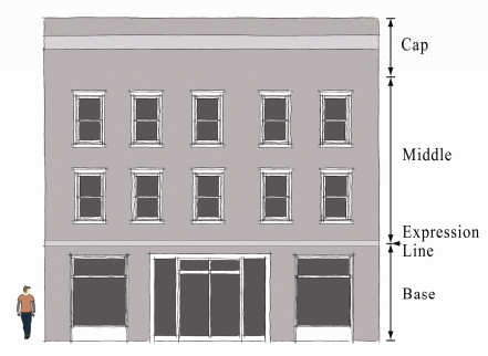
Frontage categories. The collection of building typologies listed in the Highland Park Neighborhood Form-Based Overlay District. These categories include the configurations of building elements within the primary frontage. There are eight frontage categories listed for the Neighborhood Form-Based Overlay District: Civic, Common Yard, Forecourt, Gallery, Porch with Short Lawn, Shopfront, Stoop, Terrace or Lightwell.
Frontage enclosure. The percentage of the lot width that has buildings and/or street walls within the required (minimum and maximum) setback area. If a property has an established front yard setback (as detailed in subsection 4.B) the frontage enclosure area begins at the established front yard setback.
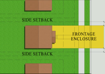
Glazing. Clear or translucent material through which light is transmitted into a building, usually glass, but also including acrylic and other materials.
Landing. The horizontal platform at the end of a stair flight or between two flights of stairs or at an entrance to a building. An entry landing may be covered.
Middle. The division of the facade that is between the base and the cap. This division is generally the largest.
Mixed use developments. Sites developed within the Highland Park Neighborhood Form-Based Overlay District having multiple land uses all on the same legal lot.
Overlay district. A set of regulations that imposes additional area, dimensional and other development standards onto an underlying zoning district.
Porch. An entrance area to a building, covered by a roof and having structural supports that goes to the ground.
Primary frontage. The street or public frontage providing the primary or most important approach to the main entrance of the building.
Public realm. Publicly owned and accessible property such as public rights-of- way, parks and plazas.
Regulating plan. Maps and supporting documentation that delineate the area where the Highland Park Neighborhood Form-Based Overlay development standards apply.
Secondary frontage. The street frontage of a lot other than the primary frontage. Secondary frontages may or may not include an entrance to a building.
Street frontage. All of the property on one side of a street between two intersecting streets; or, if the street is dead-ended, the property abutting on one side between the street's intersection and its dead-end.
Street wall. A masonry wall that extends from the building's side or rear; possibly part of the frontage enclosure requirement. Street walls are often used as a visual screen and help establish an edge that defines the streets. Street walls may not extend forward from the face of the building.
Subsection 3.
Administration.
A.
Uses permitted in the Highland Park Neighborhood Form-Based Overlay District. The overlay district does not determine or govern the use of the property. Use is governed by the underlying base zoning.
B.
Procedures for amending the Highland Park Neighborhood Form-Based Overlay District. A proposed change or amendment to the regulating plan of the overlay district may be initiated by the city council, the full Birmingham Planning Commission or the commission's zoning advisory committee, or by petition of one or more property owners or authorized agents of such owners of property within the overlay district. The petition for change of the overlay district by a property owner shall only apply to that individual owner's property. Any petition for change shall be in accordance with the procedures set up in article VII, section 3, of this ordinance. Procedure for preparation of documentation to amend the overlay district:
1.
Review and provide maps and text describing the existing land use plan, zoning and development regulations that apply to the affected properties.
2.
Review and provide maps reflecting existing lot lines and building footprints.
3.
Provide text describing the change in conditions since the overlay district was established that justifies a change or amendment to the district.
4.
Provide maps of the base zoning and zoning overlays.
C.
Compliance. All building and grading permits will be reviewed to ensure consistency with these regulations. The City of Birmingham's Department of Planning, Engineering and Permits (PEP) will review all proposed projects in the overlay district that require building, grading, sign and other permits that make modifications to existing landscaping and parking.
D.
Construction permit review. The applicant has the discretion to submit construction documents directly for permits without first getting PEP planning division review comments. The permit's documentation must include the information listed below in subsection F; development plans submittal requirements. An incomplete permit application will be returned for the additional required information. An application not compliant with these regulations will be denied. It is recommended that applicants first contact the City of Birmingham's Department of Planning, Engineering and Permits (PEP). The planning division staff of PEP will provide the published regulations for projects within the various sub-districts (see subsection 4 of this section) of the overlay district. It is recommended that the applicant become familiar with the pertinent regulations prior to planning the project and before the development of any working drawings. In consideration of an application for a permit for property located in the overlay district, the property owner or his or her agent may submit documents addressing the submittal information listed in the development plan submittal requirements below (in subsection F) to the planning division of PEP for review. These documents will be reviewed for compliance with this section and all sections of the zoning ordinance. After the review, comments pertaining to zoning compliance will be shared with the applicant.
E.
Development plans submittal requirements. This requirement of the Highland Park Neighborhood Form-Based Overlay District only applies to construction of new buildings, the expansion of an existing building that is within the minimum and maximum front yard setback area, new parking lots or alterations of parking lots over 4,000 square feet. Additionally, the overlay district requirements will only apply to properties that are bordered by a sidewalk. The following requirements replace the existing site or development plan requirements of the underlying (base) zoning. Submitted plans shall be drawn to a scale no smaller than 1" = 30' and shall include (1) the title of the development, (2) name and address of the owner or developer or agent of either, (3) name and address of the person or firm preparing each of the plans, (4) a North arrow, (5) date of preparation, and (6), if applicable, dates of any submitted revisions. Plans shall also include the following applicable information:
1.
All dimensions and distances, property lines, easements, and public and private rights-of-way;
2.
Existing and proposed building or structure footprints, including location of any trash containers and the method of screening them;
3.
Building or structure elevation drawings;
4.
Fences, walls, light poles, overhead utility lines, outdoor utility equipment and structures. This includes the location of all roof- and ground-mounted HVAC units or other mechanical appurtenances;
5.
Bodies of water, water detention areas and drainage structures;
6.
Location and dimensions of driveways and the number, location, and dimensions of parking spaces; dimensions of access aisles, curbs, vehicle maneuvering areas and pedestrian walkways. Bicycle racks or storage facilities must be provided other than for houses, duplexes and townhouses;
7.
With the exception of houses and duplexes, a landscape plan showing compliance with the landscape standards (subsection 8) of this section;
8.
When signage is proposed, a plan showing compliance with the signage standards (subsection 7) of this section;
9.
Any other plans or specifications necessary to show compliance with this section.
F.
If the property is within a hazard area.
1.
FEMA flood hazard. All development must comply with requirements of the floodplain zone districts.
2.
Slide zone. Development is regulated by the engineering division of PEP; projects require affidavits from geotechnical engineers to ensure stability.
G.
Interpretation. The interpretation and application of this section shall be consistent with article VII, section 2, subsection 1.
Subsection 4.
Highland Park Neighborhood Form-Based Districts. The regulating plan may consist of five sub-districts (FSD), which are as follows:
[A.]
(FSD-1) Reserved Urban Residential. This is the most restrictive of the sub-districts a sub-district with common yard and civic frontage categories.
[B.]
(FSD-2) Limited Urban Residential. A sub-district with common yard, porch with short lawn, terrace or lightwell, stoop forecourt and civic frontage categories.
[C.]
(FSD-3) General Urban Residential. A sub-district with common yard, porch with short lawn, terrace or lightwell, stoop, forecourt shopfront and civic frontage categories.
[D.]
(FSD-4) Limited Urban. A sub-district with common yard, porch with short lawn, terrace or lightwell, stoop, forecourt, shopfront and civic frontage categories.
[E.]
(FSD-5) General Urban. A sub-district with common yard, porch with short lawn, terrace or lightwell, stoop, forecourt, shopfront, gallery and civic frontage categories.
Subsection 5.
Frontage categories. All proposed projects are routed into one of the eight categories based on criteria set forth in each frontage category. A frontage category is not intended to regulate style but does dictate where on the site a structure may be placed. The frontage categories are:
[A.]
Civic. This frontage category is developed typically for government, public or semi-public agencies. The frontage's design follows the building's function. Public parks are exempt from this overlay.
[B.]
Common yard. This frontage category will have a planted deep front yard with the building facade set back substantially from the front lot line. The front yard is visually continuous with adjacent yards. This frontage category will normally be for a single- or two-family dwelling and have a landing attached to the front of the house at the entrance.
[C.]
Forecourt. A frontage category, usually a larger building, with the central portion or block of the building set back between two flanking sections that are closer to the front property line, creating an open recessed court. This space can be either landscaped or used for vehicle drop-offs.
[D.]
Gallery. A frontage category wherein the facade is aligned close to the front property line with an attached cantilevered shed or colonnade overlapping the sidewalk. This category conventionally has ground retail and mixed uses above.
[E.]
Porch with short lawn. This frontage category has a facade that is set back a short distance from the front property line and has a large attached porch across a majority of the front elevation and small planted front yard. This frontage category will normally be used for single and two-family dwellings.
[F.]
Shopfront. A frontage category wherein the facade is aligned close to the front property line with the building entrance at sidewalk grade. The frontage has substantial glazing on the sidewalk level; typically with an awning extend over the sidewalk. This frontage will normally be associated with a commercial use, such as a restaurant or retail store. Upper floors are frequently in office or residential uses.
[G.]
Stoop. This frontage category will normally be used for dwellings with a short setback from the front property line. A stoop is a small uncovered landing located at or near surrounding grade.
[H.]
Terrace or lightwell. This frontage category will normally be used for multifamily dwellings, with frontage close to the street and with a small landing; either terrace elevated above the street level or a lightwell sunk below the street level, or a combination of both.
Subsection 6.
Building form standards.
A.
Site development standards. The intent of the sub-district building form standards are to establish development parameters that reinforce the neighborhood's character. Most significant are the standards addressing minimum and maximum setbacks, frontage enclosures, building heights, parking access and parking location. Together, these standards reflect both the neighborhood's traditional urban form and its expressions for future improvements (see Table 1).
B.
Setback modifications. The required front yards heretofore established shall be modified in the following cases:
1.
Where an underlying zoning district on a block face has a minimum required setback and where 40 percent or more of the street frontage on the same side of a street between two intersecting streets is presently developed with buildings that have (with a variation of five feet or less) a front yard greater or lesser in depth than herein required, new buildings shall not be erected closer to the street than the average front yard so established by the existing buildings.
2.
Where an underlying zoning district on a block face has a minimum required setback and where 40 percent or more of the street frontage on one side of a street between two intersecting streets is presently developed with buildings that do not have a front yard as described above, then:
a.
Where a building is to be erected on a parcel of land that is within 100 feet of existing buildings on both sides, the minimum front yard shall be a line drawn between the two closest to the street corners of the adjacent building; or
b.
Where a building is to be erected on a parcel of land that is within 100 feet of an existing building on one side only, such building may be erected as close to the street as the existing adjacent building.
3.
When none of the aforementioned modifications are applicable the form based setback standards apply.
4.
For lots with established front yard setbacks the minimum front setback will begin at the established front yard and the maximum front yard setback will be the difference between the minimum and maximum setback as listed on Table 1 as measured from the established front yard.
Footnotes:
1.
Minimum front setback. Includes porches and other design features.
2.
Minimum front setback. For corner lots in all sub-districts, the minimum front setback on secondary frontage is five feet and the maximum front setback is 20 feet.
3.
See Subsection 6B. For required front setback modifications.
4.
Minimum frontage enclosure. For corner lots, minimum frontage enclosure requirements only apply to primary frontage.
5.
Maximum building height. For buildings greater than 45 feet, an additional ten feet stepback from the building's front wall is required.
6.
Parking access. Street access is permitted for mid-block properties that do not have alley access.
7.
Parking location. See article V, section 3 in the City's Zoning Ordinance regarding joint parking arrangements.
Subsection 7.
Building form requirements. The following building standards apply to all sub-districts and frontage categories in Highland Park Neighborhood Form-Based Overlay Districts. Requirements in the overlay district only apply to the construction of new buildings, the expansion of an existing building that is within the minimum and maximum front yard setback area, new parking lots or alteration of parking lots over 4,000 square feet. Additionally, the overlay district requirements will only apply to properties that are bordered by a sidewalk. No building existing on the date which these regulations come into effect shall be modified so that it is less in conformance with this ordinance.
A.
Entries. A principal building shall have its main entrance oriented to a public street and accessible from a public sidewalk or plaza. Secondary entrances are exempt from this requirement. The main entrance shall not be closed while a secondary entrance remains opened. In some frontage categories, building entrances (excluding emergency egress) facing a public street shall be determined by the following thresholds:
1.
Galleries must have covered walkways at least ten feet in depth;
2.
Terrace must have an elevated entry over three feet above grade and lightwells must have a sunken entry over three feet below grade;
3.
Stoops must have landings no more than three feet from grade;
4.
The porch with short lawn frontage category has porch size thresholds of a minimum of eight feet in depth across a majority of the front elevation and maintaining at least 40 percent openness of the exterior elevation (as measured in square feet);
5.
Forecourt has a qualifying threshold that measures its openness. This threshold includes the width of the courtyard when calculating the enclosure area. The width of the courtyard shall be no less than the width of the largest building wing.
B.
Facades.
1.
Window and door openings should have a vertical orientation and vertical alignment between floors.
2.
All forecourt, gallery and shopfront frontage categories may be designed with a discernible base, middle and cap defined by horizontal elements. An expression line should accentuate the base from elements above. Variations in materials and colors can help achieve this standard.
3.
For mixed use and nonresidential buildings, ground floor front facades shall be not less than 40 percent or more than 90 percent clear glazing; measured between three and eight feet from finished grade. Additional floors beyond the ground floor shall be not less than 25 percent or more than 75 percent clear glazing.
C.
Off-street parking.
1.
Off-street parking shall not be closer to the public street than the principal buildings on the same lot.
2.
Dwelling parking garage doors that face public streets shall be set back three feet from the front of the building facade.
D.
Parking structures.
1.
When adjacent to public streets the ground floor of any above ground parking structure should have built-out space suitable for retail, residential, office space. Design shall include said space or provide a facade mimicking said space for a minimum of 75 percent of the public street frontage.
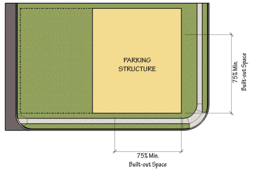
2.
Parking structure walls must utilize materials, colors and a pattern of openings consistent with surrounding buildings.
3.
Parking structure walls facing public streets or residential areas shall minimize openings to avoid noise and light impacts. This shall be accomplished with a minimum 42-inch high solid wall (measured from the finished floor elevation) on the exterior sides of each level.
4.
Pole mounted light fixtures on upper decks of parking structures shall use full cut-off fixtures, have a maximum height of 16 feet, include shields for keeping light onsite and prevent the source of the light from being seen off site. Poles shall be located between internal parking rows rather than at the structure's perimeter.
5.
When adjacent to public streets pedestrian circulation elements (stair towers, elevators) shall be located toward and accessible from streets.
6.
When on corner lots parking access shall be from secondary streets.
7.
Underground parking may be built out to the property lot lines.
E.
Street walls. Unless otherwise restricted in this ordinance. Street walls from six to eight feet in height and up to 18 feet in length may be built as part of the frontage enclosure requirement and assist in screening. Street walls must have the same external veneer as the principal building's street frontage(s).
F.
Right-of-way. Any structure or portion thereof which encroaches into the public right-of-way or its airspace will require an approved right-of-way agreement from the city council.
Subsection 8.
Shared parking. Different uses have different peak parking demand times. These parking peaks may vary for daytime and evening; as well as weekday and weekends. To accommodate those varying peak parking demands, mixed use developments on one lot may use the shared parking table that follows. Parking spaces reserved for any use cannot be used in the shared parking table.
Subsection 9.
Sign standards. The purpose of the sign standards and guidelines is to encourage uniform and aesthetically pleasing neighborhood signage and provide signage that is complementary and well-integrated for pedestrians while also legible to vehicular traffic. All signs will adhere, at minimum, to the standards laid out in the underlying zoning district and/or article VI, section 9, sign regulations, of the City of Birmingham Zoning Ordinance, but are also subject to the following additional guidelines and restrictions.
A.
Prohibited signs.
1.
Animated, flashing, chasing, pulsating, rotating, video display, running or sequential signs are not permitted accept for signs depicting time, temperature and gasoline prices.
2.
All portable signs, as defined in the City of Birmingham Zoning Ordinance, are not permitted.
3.
Banners and streamers; except decorative flags, banners and bunting for celebrations, conventions and commemorations authorized by the city ordinances, are not permitted.
B.
Construction and materials.
1.
Signs shall be professionally engineered and constructed using high-quality materials.
2.
A dull or matte finish is encouraged to reduce glare and enhance legibility.
3.
Signs should not obscure key design features, doors or windows.
4.
Wall signs for multiple businesses in the same building shall be of similar material and design.
C.
When lit.
1.
Signs may be spotlighted or externally lit with a diffused light source and should be shielded in accordance with article VI, section 9, subsection 5 of the zoning ordinance.
2.
Signs may have backlighting to illuminate the background of letters, characters or graphics on the sign.
3.
Neon signs are allowed.
4.
Signs may be internally lit box signs when they have routed or push-through copy and designed so that only the copy is illuminated at night.
Subsection 10.
Landscape standards. The purpose of the landscape standards is to enhance the physical appearance of buildings, and their designated parking areas, and the positive impact of parking areas on adjacent land uses. Projects involving single-family detached homes and duplexes are exempt from these requirements. Other projects with less than 4,000 square feet of parking area are not subject to item C, landscaping requirements for surface parking, of this subsection. Requirements in this subsection only apply to the construction of new buildings, the expansion of an existing building that is within the minimum and maximum front yard setback area, new parking lots or alteration of parking lots over 4,000 square feet. Additionally, the overlay district requirements will only apply to properties that are bordered by a sidewalk.
A.
Landscape plan requirements.
1.
Landscape plans shall include:
The site's square footage;
Building footprint's square footage;
The parking area's square footage;
The title of development; name and address of owner/developer/agent; name and address of person/firm preparing the plan;
Date of preparation; scale; north arrow; revision dates;
Streets and easements; number of parking spaces;
The location and dimensions of entrance, exits, doors, drives, walkways, paved areas, curbs, fences, drainage; and
Other improvements affecting the landscaping.
2.
The plan shall also illustrate where each plant is to be installed, details for installing plant material and a composite plant material schedule which totals quantities and lists all plants by common name, botanical name, size or specification and spacing.
3.
Landscape plans shall be prepared by a registered landscape architect or architect. All submitted plans shall bear the architect's seal, signature and State of Alabama registration number.
B.
Design standards. The zoning ordinance has landscape requirements for surface parking areas as well as requirements for the overall site. In addition to citywide requirements, the following requirements also apply. In case of conflicts with the citywide regulations and those of the Highland Park Neighborhood Form-Based Overlay District, the more restrictive shall apply. All landscape plans shall be drawn at no greater than 1"=30' in scale so as to convey the design intent.
1.
Only trees with a mature height of greater than 40 feet may be planted to comply with the requirements of this subsection, except when site visibility at intersections or when overhead utilities prevent the use of large trees, in which case medium or small trees may be used. Large trees shall be no less than 2½-inch caliper at time of installation. Small trees shall have a minimum eight feet in height at time of installation.
2.
One tree per every 2,000 square feet of required landscape area shall be installed.
3.
A combination of trees, shrubs, grass and groundcovers shall be used.
4.
Plant material shall conform to the American Standard for Nursery Stock, latest edition, published by The American Association of Nurserymen.
5.
All cuts and fills and/or terraces shall have sufficient vegetative cover installed so as to prevent erosion.
C.
Landscape requirements for surface parking. These requirements apply to all areas used for off-street parking, loading, vehicle maneuvering and are 4,000 square feet or larger. A minimum of five percent of the parking area must be landscaped. The following planting layout must be followed which may exceed the five percent minimum.
1.
Perimeter surface parking planting.
a.
A perimeter planting strip shall be adjacent to any public street. These planting strips shall be a minimum of five feet wide.
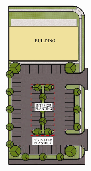
b.
A perimeter planting strips shall be planted with a combination of trees, shrubs and groundcovers. Shrubs shall be used to screen the right-of-way from views of parked cars and shall be maintained at no less than 36 inches in height.
c.
The planting strip shall be covered with groundcover or organic or mineral mulch so as no soil is left exposed. The use of concrete, asphalt or other impervious surfaces is prohibited.
2.
Interior surface parking plantings. These plantings are required for parking areas over 10,000 square feet: Properties used for the retail sale of automobiles are exempt from this requirement.
a.
In addition to the perimeter surface parking planting requirements, 2.5 percent, one-half of the minimum required five percent of the total square footage of the surface parking area shall be planted with trees, shrubs, grass and ground covers.
b.
Interior parking plantings must be located so that vehicles may maneuver on all sides or project into the parking area at least 18 feet with parking or maneuvering areas on three sides. Interior landscape islands or swales shall have a minimum dimension of five feet at the site where trees are located. The minimum square footage of interior parking islands or swales is 60 square feet.
c.
One landscaped island or swale shall be required for each row of 12 contiguous parking spaces. This island shall be planted with at least one tree each that meets the minimum requirements of this subsection.
D.
Overall site landscape requirements.
1.
Five percent of the site (minus parking area and structures) shall be landscaped.
2.
Plantings shall conform to item B, design standards, of this subsection.
E.
Special screening requirements. Dumpsters and other trash receptacles for all uses other than single-family or two-family residences shall be screened from public streets or properties which are zoned for residential use. Receptacles shall be below grade or shall be placed on a concrete pad and enclosed on three sides by wall at a height taller than the container. Enclosures' fourth side shall have an opaque gate unless the service opening is oriented away from public streets or adjacent residential properties. The enclosure shall be built of permanent materials with a veneer similar to the principal structure's veneer.
F.
Maintenance. The property owner shall be responsible for the maintenance, repair and replacement of all landscape materials, barriers and irrigation systems required by this subsection. All plant material shall be maintained in perpetuity in a healthy growing condition, replaced when dead and kept free of weeds, refuse and debris.
G.
Irrigation. Plant material irrigation is encouraged. It is preferable that nonpotable water be used for irrigation.
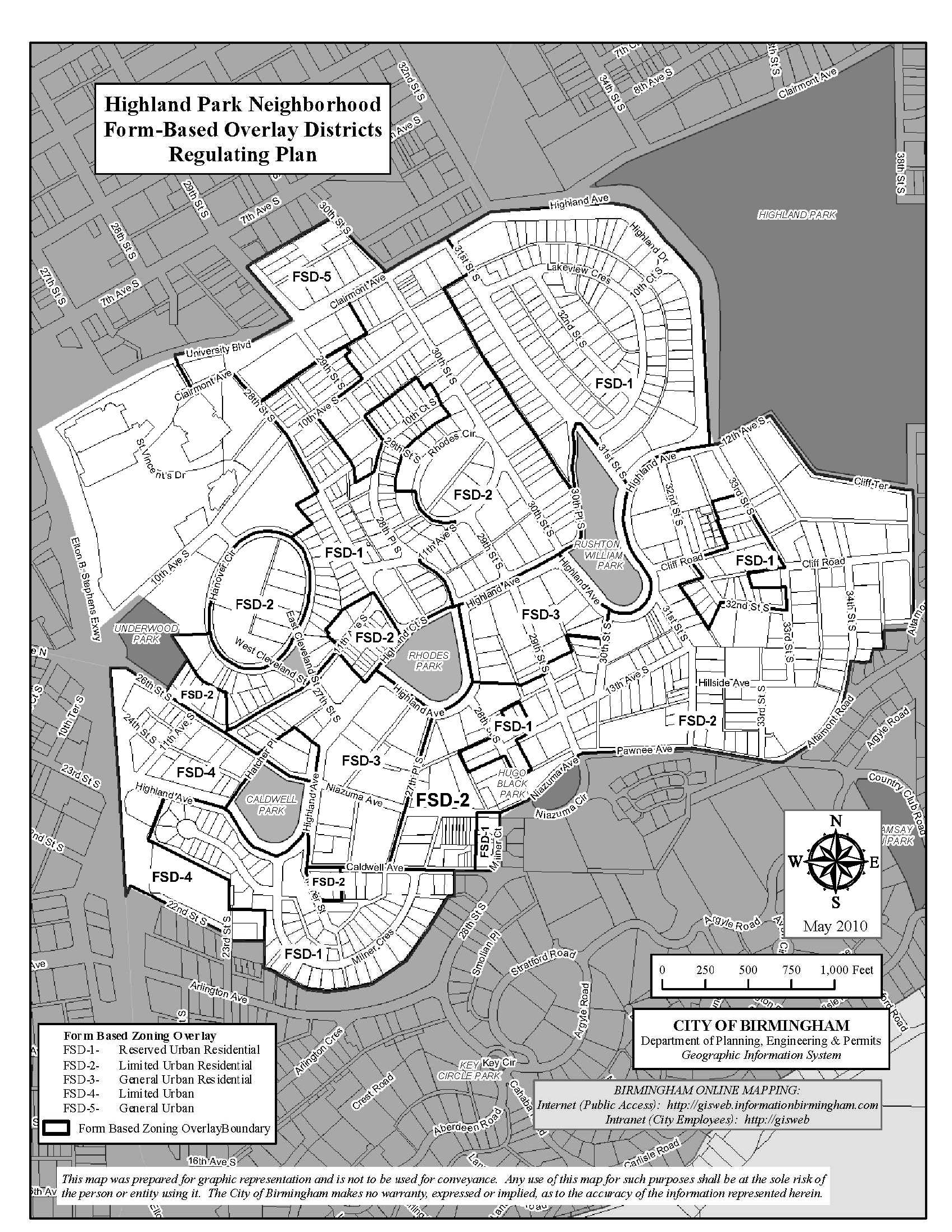
(Ord. No. 10-68, § 1, 5-11-2010)
Section 21. - Payday (deferred presentment) and title loans.
1.
General applicability. The regulations set forth in this section supplement or modify the district regulations appearing elsewhere in this [appendix]. The regulations shall apply to any business that has been designated by the Council of the City of Birmingham and by the required license schedule as a payday loan (deferred presentment) and title loan operation.
2.
Purpose. The purpose of this section is to amend the Zoning Ordinance of the City of Birmingham, Alabama, in order to:
a.
Reduce traffic congestion that is reported to be associated with these types of businesses;
b.
Reduce the concentration of these types of businesses in certain areas in an effort to encourage and enhance economic development within that area by promoting business diversity in the offering of other goods and/or services in the area;
c.
Provide for zoning protection of existing residential and commercial real estate values from possible economic impairment by these types of businesses; and
d.
In general to provide for the protection of the health, safety, comfort and general welfare of the citizens of the City of Birmingham.
3.
Finding of fact. Based upon the evidence and information submitted to the Council, the governing body of the city of Birmingham, Alabama, including statements of citizens submitted to the Council, expert opinions submitted to and considered by this Council, and the knowledge and experience gained by Council members both prior to and while serving as members of this Council, this Council hereby makes the following findings of fact:
a.
There [is] a disproportionate number of these types of businesses within the corporate limits of the City of Birmingham based upon the number per resident compared to the other cities within Jefferson County and within unincorporated Jefferson County.
b.
According to public statements made by real estate developers, real estate agents, community leaders, clergy, and members of the general public, a "negative community reputation" has been created by these businesses because of the extraordinarily high interest rates for these loans. Consumers of the services offered by these businesses have also made statements that terms and conditions associated with these types of loans are confusing and very difficult to understand.
c.
Real estate developers and agents have stated that this "negative community reputation" has a detrimental effect on the location of other commercial developments within the area and that these businesses tend to diminish nearby real estate values.
4.
Definitions. As used in this section, the following words and phrases will have the following meanings:
a.
Payday loan (deferred presentment) business. A business that, in accordance to [with] the requirements and restrictions listed in Chapter 18A of Title 5 of the Code of Alabama (Alabama Deferred Presentment Services Act), involves a transaction pursuant to a written agreement involving the following combination of activities in exchange for a fee: (1) accepting a check or authorization to debit a checking account and, in connection with that acceptance, advancing funds to the checking account holder; and (2) holding the check or authorization to debit the checking account for a specified period of time.
b.
Title loan business. Any business that offers a short-term loan that is collateralized by the title of a vehicle in accordance with the requirements and restrictions described and detailed in Chapter 19A of Title 5 of the Code of Alabama (Alabama Pawn Shop Act).
5.
Locational requirements. In order to provide for more economic opportunities within certain areas of the City of Birmingham, the following spacing requirements are required:
a.
No payday loans (deferred presentment) and/or title loan business (as described and detailed within this section) established after the enactment of this ordinance [section] shall be located within 2,000 linear feet of another such business. The method of measurement that shall be used is a straight line measured from the closest portion of a lot or property that is occupied by these businesses.
b.
Any properly licensed payday loan (deferred presentment) and/or title loan business (as described and detailed within this section) existing at the time of the enactment of this section that is within 2,000 feet of another such business (as measured as described above) shall be considered to be a legal nonconforming use.
(Ord. No. 13-178, § 4, 12-26-2013)
Appendix A
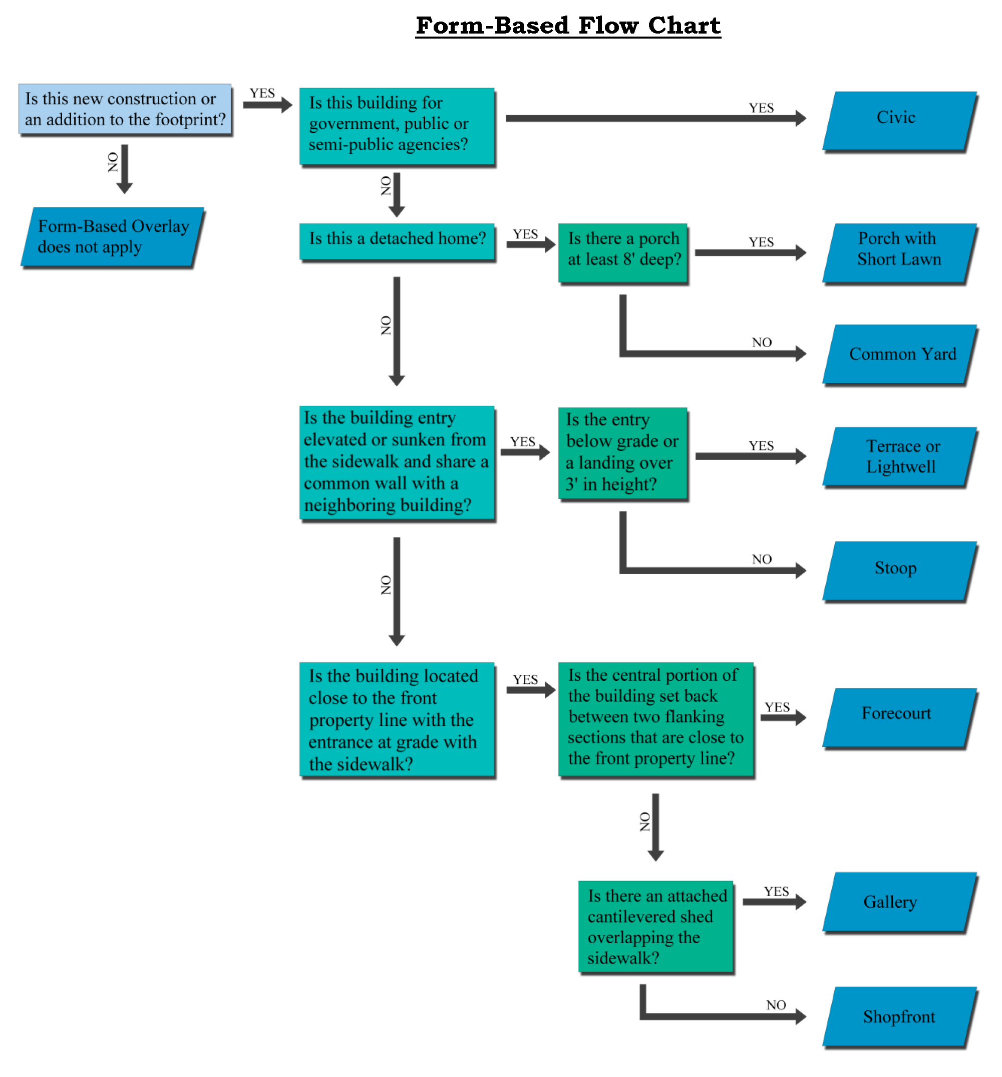
(Ord. No. 10-68, app. A, 5-11-2010)
Appendix B
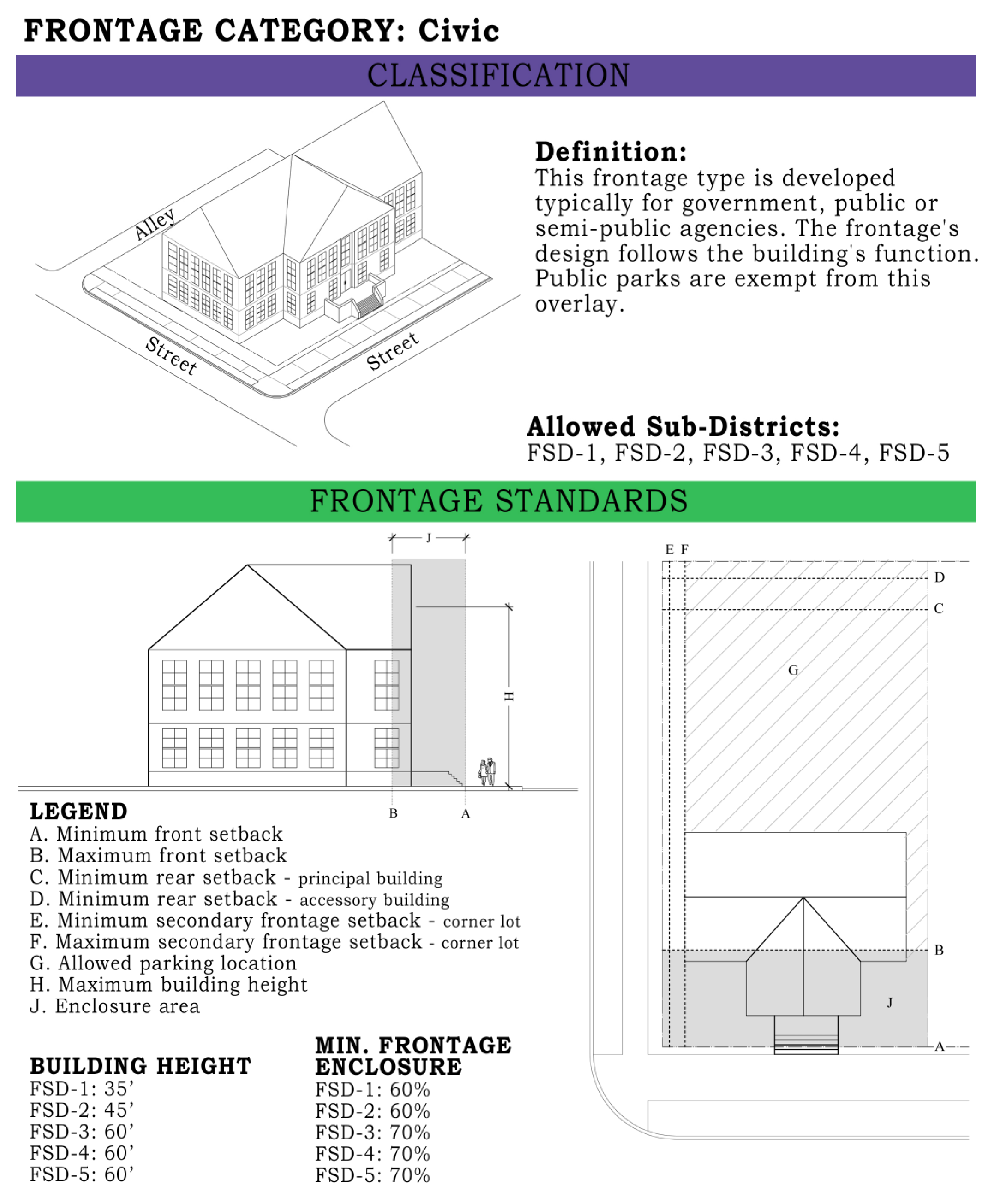
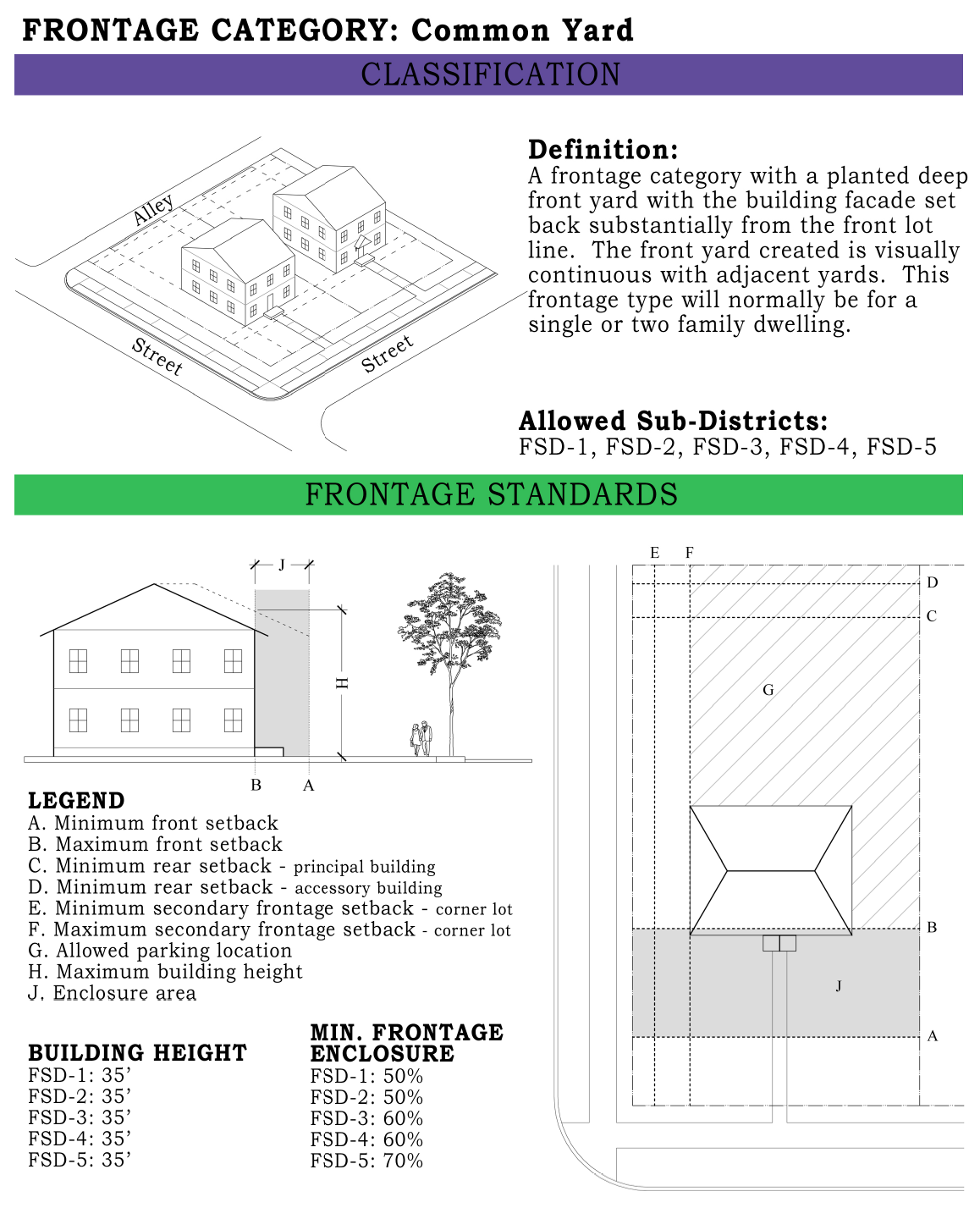
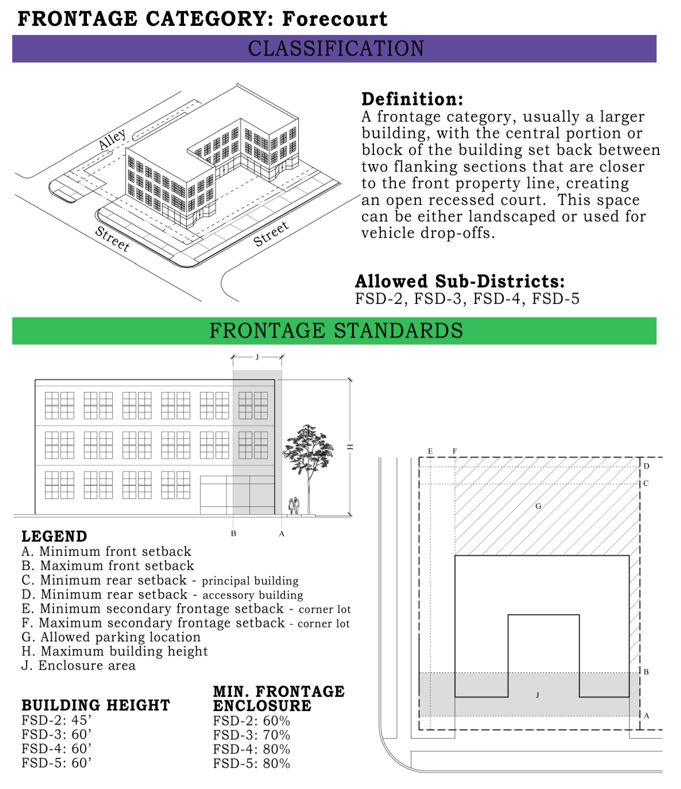
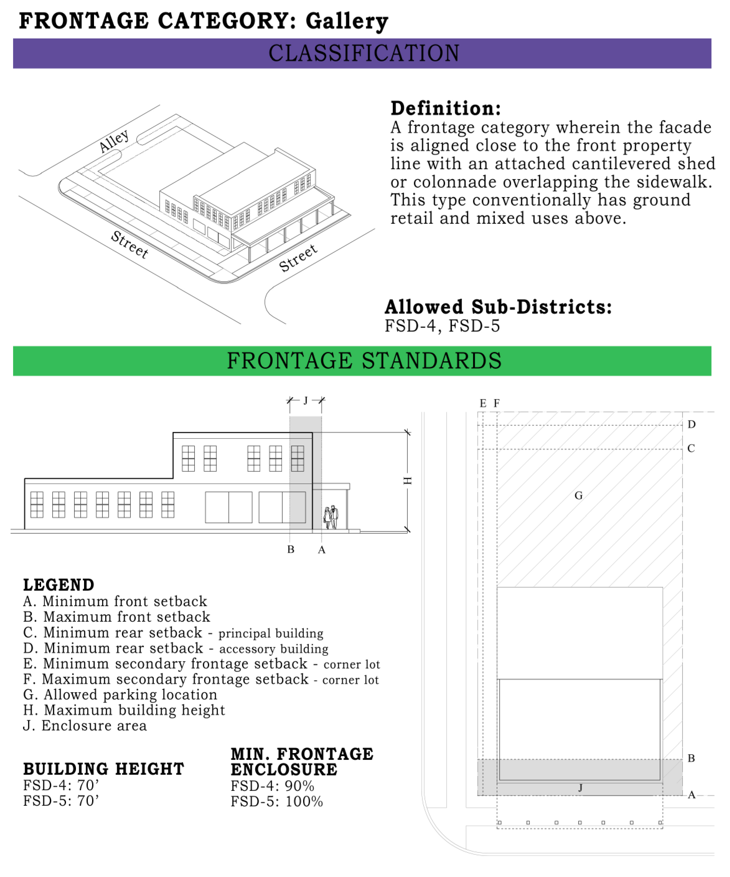
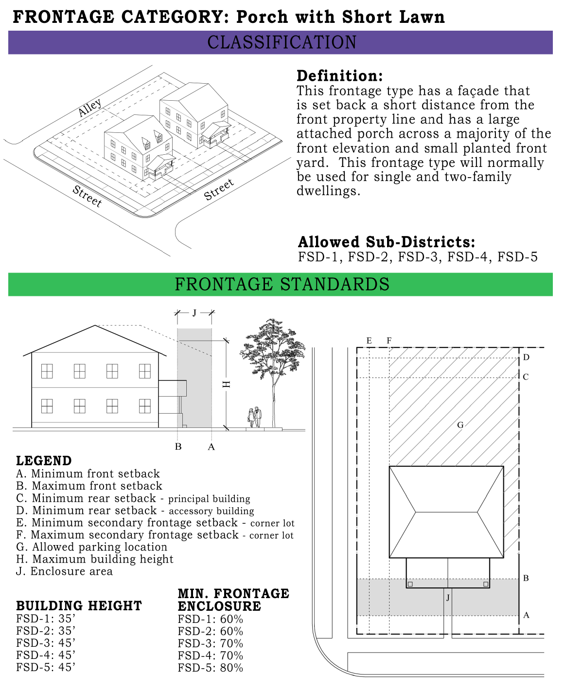
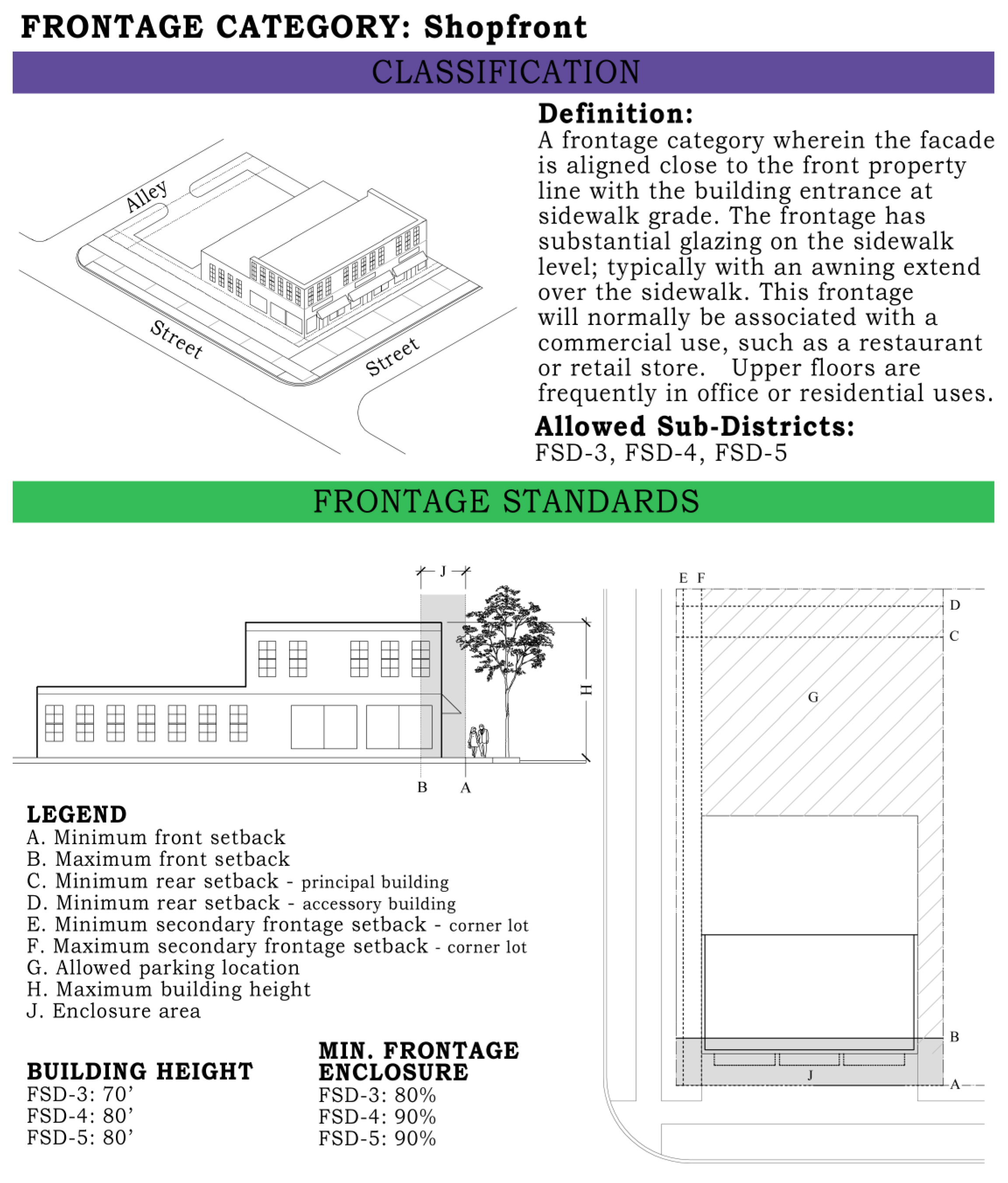
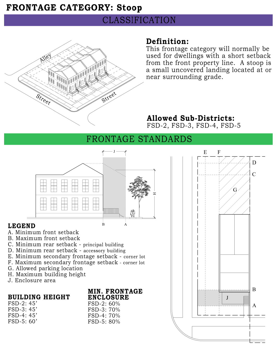
(Ord. No. 10-68, app. B, 5-11-2010)
Appendix C. - Calculating Birmingham's Minimum Landscaping Requirements
The zoning ordinance requires landscaping for parking areas as well as site landscaping for lots located in certain zoned districts. Except for special design areas such as Oxmoor, Highway 280, Form Based Zoning Districts and Commercial Revitalization Districts, the following are the minimum landscaping requirements. Develop plans must show all building doors, drives, walkways, paved areas, curbs, fences, drainage and other improvements affecting landscaping. Grass and other ground cover alone will not satisfy these landscaping requirements; the plan must include trees and/or shrubs. The plan should designate where each plant is to be installed, include details for installing plant materials and a composite schedule which totals quantities and list all plants by common name, botanical name, size or specification, and spacing.
For parking lot landscaping.
1.
To determine if this requirement is applicable for parking areas, first calculate the square feet of the paved parking and maneuvering areas. If this area is 4,000 square feet or larger the parking lot landscape requirements apply. If it is under that size, go to number seven.
2.
If the parking area is 4,000 square feet or larger, calculate the gross square footage of the lot; or for large acreage parcels, calculate all of the disturbed, cleared and graded areas. For purposes of a formula calculation, the lot or site's gross area may be called A.
3.
Next calculate the total square footage of the footprints of all structures. For purposes of a formula calculation, the sum total structural footprint may be called B.
4.
For parking areas a minimum of five percent of the gross area (minus structures) must be landscaped. The formula for the minimum landscaped requirement is A minus B time five percent (A-B times 0.05). The purpose of this landscaping requirement is to screen the parking lot from passers-by on adjacent streets or from incompatible or less intensive adjacent land uses. Therefore the location of the landscaping on the site must accomplish that objective.
5.
If a parking area is 10,000 square feet or larger, then half the minimum requirement 2.5 percent must be in interior landscaped islands within the parking lot. Gasoline service stations and automobile sales lots are exempt from the interior planting requirements.
6.
Qualifying interior islands must be islands within or peninsulas protrude at least 18 feet into the parking or maneuvering areas and must not in any way infringe on the minimum parking space size of 9 x 18 feet.
For site landscaping. There is also an overall general site landscaping requirement of five percent of the site, in addition to the parking lot landscape requirement. To accomplish this requirement's objective the selected plant locations should be around the building or as landscaped buffers between the site and incompatible, less intensive adjacent land uses.
7.
In addition to parking lot landscaping there are also overall general landscaping requirements of five percent for sites. To calculate the required site landscaping, determine the lot square footage or for large acreage parcels all disturbed, cleared and graded areas. For purposes of a formula calculation, the lot or site's gross area may be called X.
8.
Calculate the total square footage of the footprints of all structures. For purposes of a formula calculation, the sum total structural footprint may be called Y.
9.
Calculate the square feet of the paved parking and maneuvering areas and if applicable the minimum parking lot landscaping required in number 4 above. For purposes of a formula calculation, the sum total parking lot areas may be called Z.
10.
The general five percent site landscaping requirement shall be determined by using the following formula: X minus the sum of Y plus Z times five percent [X-(Y+Z)] times 0.05.
(Ord. No. 10-68, app C, 5-11-2010)
Section 1. - Administration.
Subsection 1.
Enforcement. The duty of administering and enforcing the provisions of this ordinance is hereby conferred upon the director of the department of planning, engineering and permits. It shall also be the duty of all officers and employees of the city and especially of all members of the police and fire departments to assist the director of the department of planning, engineering and permits by reporting to him new construction, reconstruction or new land uses and apparent violations of this ordinance.
Subsection 2.
Building permits. All applications for building permits for the construction of any building or for the alteration of any building where such alterations will cause an increase in the land coverage of such building, shall be accompanied by an acceptable drawing or plat in duplicate drawn to scale showing the lot plan, the location of the building on the lot as constructed or altered, accurate dimensions of the building and lot, and such other information as may be necessary to enable the director of planning, engineering and permits to determine that the proposed structure and use of land will conform to the provisions of this ordinance. All dimensions shown on these drawings or plats relating to the location and size of the lot to be built upon shall be based on an actual survey and it shall be in a form acceptable to the director of planning, engineering and permits. The original copy of such applications and plats shall be kept in the office of the director of planning, engineering and permits and the duplicate copy shall be kept with the building permit at the building at all times during construction.
Subsection 3.
Certificates of occupancy. Certificates of occupancy shall be required for any of the following and shall be obtained from the director of planning, engineering and permits:
1.
Occupancy and use of a building hereafter erected, except for a single-family dwelling.
2.
Change in use of land or an existing building, including an increase in the number of dwelling units.
3.
Any change in the use of a nonconforming use.
4.
No fee shall be charged for an original and two copies of a certificate of occupancy as required herein, but for each additional copy there shall be a charge of $1.00, which shall be remitted to the director of finance of the City of Birmingham.
Section 2. - Interpretation of ordinance.
Subsection 1.
Minimum requirements. In interpreting and applying the provisions of this ordinance, they shall be held to be the minimum requirements for the promotion of public health, safety, convenience, comfort, morals and the general welfare. Where this ordinance imposes greater restrictions upon the use of a building or land or upon the height, bulk or size of a building or structure, or requires larger open spaces, yard area or lot area, than are imposed or required by other ordinances, rules, regulations or permits, or by easements, covenants or agreements, the provisions of this ordinance shall govern. Where any other ordinances, rules, regulations, or permits or restrictive conditions of the city or city agencies charged with zoning responsibilities impose greater restrictions upon the use of a building or upon the height, bulk or size of a building or structure, or require larger open spaces, yard area or lot area than are required under the regulations of this ordinance, such provisions shall govern.
Subsection 2.
City not subject to ordinance. Any provision of this ordinance to the contrary notwithstanding, the city, in exercising any governmental function, power or authority, shall not be subject to the provisions of this ordinance or in anyway limited thereby in the exercise of such governmental function, power or authority.
Section 3. - Amendments and changes.
Subsection 1.
Requirements for change. Whenever the public necessity, convenience, general welfare or good zoning practice warrants such action, the city council, by the favorable vote of a majority of the members, may amend, supplement, modify or repeal the regulations of zoning district boundaries herein established.
Subsection 2.
Petition for or initiation of change. A proposed change of the zone district boundaries or of the regulations may be initiated by the city council, the planning commission, the zoning advisory committee of the Birmingham Planning Commission, or by petition of one or more owners or authorized agents of such owners of property within the area proposed to be changed.
Subsection 3.
Action on petition. Any proposed amendment, supplement, modification, or repeal shall first be submitted to the zoning advisory committee of the Birmingham Planning Commission for its recommendations and report. After the city council shall have received the recommendation of the zoning advisory committee of the Birmingham Planning Commission on the proposed change, or if no recommendation is received from the zoning advisory committee of the Birmingham Planning Commission within 60 days of the date of application, the city council may proceed to hold a public hearing in relation thereto, giving not less than 15 days notice of the time, place and object thereof by publication in a newspaper of general circulation in the City of Birmingham. The proposed change may be deemed by the applicant to have been denied if the city council takes no final action upon the same within 150 days after the filing of the application, or within 90 days after receipt of the recommendation by the zoning advisory committee of the Birmingham Planning Commission, provided that this sentence shall not be construed to divest the city council of jurisdiction to take final action on such proposed change at any time prior to any litigation instituted thereon against this council or the city by the applicant.
Subsection 4.
Fees. Before any action shall be taken as provided in this section, the applicant petitioning for a change shall deposit with the City of Birmingham the sum of $500.00 to cover the approximate cost of this procedure, which also includes the placement of two separate notifications in a newspaper of general publication within Jefferson and/or Shelby County. Under no condition shall any part thereof be refunded for failure of such amendment to be enacted into law.
(Ord. No. 10-31, 3-5-2010)
Subsection 5.
Reinitiating or rehearing petitions. Whenever the city council, following upon a duly scheduled public hearing as hereinabove provided in subsection 3, votes on the merits of an applicant's petition for a zoning change or amendment, and as a result of such vote the council fails to approve such zoning change or amendment, no action shall be initiated for a zoning change or amendment affecting that same parcel of land before the passage of one year following the date of the council vote; provided, however, the city council itself may, by resolution duly adopted, vote to either (a) reinitiate the proposed zoning amendment before the zoning advisory committee or (b) schedule a rehearing of the petition for the proposed zoning amendment before the council. Any such resolution to rehear a petition as provided for in (b) above must be on a council agenda for the council's consideration at a time no later than 30 days following the meeting of council at which the proposed zoning amendment failed to obtain such council approval. In the event the resolution is one to rehear the petition for a proposed zoning change or amendment before the council, the resolution shall state the date of the council meeting whereat such rehearing will be held, which date shall be sufficiently advanced so as to permit not less than 15 days' notice of the meeting as hereinabove provided in subsection 3 of this section.
(Ord. 09-157, 3-2-2010; Ord. No. 10-31, § 1(3), 3-2-2010)
Section 4. - Violation and penalty.
Subsection 1.
Penalty. In addition to all other means provided by law for the enforcement of the provisions of this ordinance, any person violating any of the provisions hereof shall, upon conviction, be punished within the limits of and as provided by section 1-1-6 of the General Code of the City of Birmingham. (Not more than $500.00 fine or imprisonment not more than six months or by both). Each day that a violation exists shall constitute a separate offense.
Section 5. - Validity.
Subsection 1.
Severability of ordinance. If any section or provision of this ordinance be declared by a court of competent jurisdiction to be invalid, such decision shall not affect the validity of the ordinance as a whole or any part thereof other than the part so declared to be invalid.
Section 6. - Annual review.
[Subsection] 1.
At the beginning of each calendar year, the zoning administrator shall compile a listing of each rezoning case from the previous year. These cases, along with a written report, shall be submitted to the Birmingham Planning Commission for approval.
[Subsection] 2.
The written report shall contain, at a minimum, the following:
a.
Case information and comments.
(1)
Prior year case list including case number, location, and basic request information.
(2)
"Q" conditions with criteria for each case.
(3)
Possible adverse or unusual effects of previous cases on surrounding property.
(4)
Recommendations to cure adverse effects or to pursue desirable effects.
b.
Text changes.
(1)
Prior year text change list including case number and nature of change.
(2)
Suggestions and purposes for further text changes.
[Subsection] 3.
The written report shall also be submitted to the city council along with any verbal presentation that the appropriate council committee deems necessary.
[Subsection] 4.
In the event that any text changes are recommended, the zoning administrator shall forward each, jointly or severally, to the zoning advisory committee for a recommendation, and then to the city council for approval. All notification requirements must be adhered to.
[Subsection] 5.
The written report shall be entitled "An Annual Review of Rezonings and Suggested Text Changes," and shall be submitted to the planning commission at its February meeting.
Section 1. - Creation and membership.
The zoning board of adjustment is hereby established. The word "board," when used in this ordinance, shall be construed to mean the zoning board of adjustment. The board created in accordance with and as authorized by Act No. 326 of the 1969 regular session of the Legislature of Alabama shall consist of seven members, appointed by the city council for overlapping terms of seven years, one of which shall be a person licensed by the State of Alabama to engage in the real estate profession either as a broker or sales person; one of which shall be a person licensed by the State of Alabama as a registered architect; one of which shall be a person licensed by the State of Alabama to engage in building construction; the remaining four members shall represent other diverse segments of the population not principally affiliated with the above professions.
No member of the zoning board of adjustment of the City of Birmingham shall cast any vote or debate on any matter pending before the board which would benefit directly or indirectly any such member or persons in said member's immediate family, or any business with which said member is associated.
All members of the zoning board of adjustment of the City of Birmingham shall be citizens and residents of the City of Birmingham. Any member who ceases to be a citizen and resident of the City of Birmingham shall vacate said position on the zoning board of adjustment immediately.
Section 2. - Meetings, procedure and records.
Meetings of the board shall be held at such times as the board may determine, or upon call of the chairman. Such chairman or, in his absence, the vice-chairman, may administer oaths and compel the attendance of witnesses. All meetings of the board shall be open to the public.
The board shall adopt and publish its own rules of procedure and keep minutes of its proceedings, showing the vote of each member upon each question, or if absent or failing to vote, indicating such fact, and shall keep records of its examinations and other official actions, all of which shall be immediately filed in the office of the board and shall be a public record.
Section 3. - Appeals to the board.
An appeal from the decision of the director of the department of planning, engineering and permits may be taken to the board by any person aggrieved, or by any officer, department, board or agency of the City of Birmingham affected by such decision.
Such appeal shall be taken within a reasonable time, as provided by the rules of the board, by filing with the director of the department of planning, engineering and permits and with the board a notice of appeal specifying the grounds thereof.
The director of the department of planning, engineering and permits shall forthwith transmit to the board all the papers constituting the record upon which the action appealed was taken. An appeal stays all proceedings in furtherance of the action appealed from, unless the director of the department of planning, engineering and permits certifies to the board, after the notice of appeal shall have been filed with him, that by reason of facts stated in the certificate a stay would, in his opinion, cause imminent peril to life or property. In such case, proceedings shall not be stayed otherwise than by a restraining order which may be granted by the board or by a court of record on application or notice to the director of the department of planning, engineering and permits and on due cause shown.
Section 4. - Hearing of appeals.
The board shall fix a reasonable time for the hearing of an appeal taken within the time specified by its rules, given public notice thereof, as well as due notice to all adjacent property owners, and decide the same within a reasonable time. Upon the hearing of such appeal, any party may appear in person, or by agent or attorney.
Section 5. - Powers and duties.
The board in appropriate cases and subject to appropriate conditions and safeguards, shall have the following powers:
1.
To hear and decide appeals where it is alleged there is error in any order, requirement, decision or determination made by the director of the department of planning, engineering and permits in the enforcement or application of this ordinance.
2.
To authorize in specific cases a variance from the terms of this ordinance such as will not be contrary to the public interest, where owing to special conditions a literal enforcement of the provisions of this ordinance will result in unnecessary hardship, but where the spirit of the ordinance shall be observed and substantial justice done. Such special conditions shall be limited to exceptional narrowness, shallowness or shape of a specific piece of property existing at the time of the enactment of this ordinance, or exceptional topographic conditions or other extraordinary and exceptional situations or conditions of such piece of property as would result in peculiar, extraordinary and practical difficulties. However, the granting of the variance shall not allow a structure or use in a district restricted against such structure or use, except as specifically provided for in this article. No variance shall be authorized unless the board finds all of the following conditions exist:
a.
That the special circumstances or conditions applying to the building or land in question are peculiar to such premises and do not apply generally to other land or buildings in the vicinity.
b.
That the granting of the application is necessary for the preservation and enjoyment of a property right and not merely to serve as a convenience to the applicant.
c.
That the condition from which relief for a variance is sought did not result from action by the applicant.
d.
That the authorizing of the variance will not impair an adequate supply of light and air to adjacent property or unreasonably increase the congestion in public streets, or increase the danger of fire, or imperil the public safety, or unreasonably diminish or impair established property values within the surrounding areas, or in any other respect impair the health, safety, comfort, morals, or general welfare of the inhabitants of the City of Birmingham.
3.
The board may modify the strict application of the provisions of this ordinance and cause a permit to be issued upon such reasonable condition as it may prescribe in the following cases:
a.
The extension of a district for a distance of not more than 50 feet where the boundary line of a district divides a lot or tract held in single ownership at the time of the passage of this ordinance.
b.
The determination of the proper district applicable to particular land in cases of ambiguity or doubt arising from a difference between the street layout actually on the ground and the street layout as shown on the zone map.
c.
The reconstruction of a building, the use of which is nonconforming, which has been destroyed, or partially destroyed by explosion, fire, act of God or the public enemy, except for the reconstruction of a nonconforming building located in a floodplain zone district, where 50 percent or more of the building has been damaged by any means, in which case the provisions of article VI, section 10 shall apply.
d.
The erection, extension and use of a structure, or the use of premises not otherwise authorized or permitted by this ordinance in any location for a public service corporation for public utility purposes which is deemed reasonably necessary for the public convenience or welfare.
e.
Reduction in the parking and loading requirements of this ordinance whenever the character or use of a building or premises is such as to make unnecessary the full provision of parking or loading facilities, or where such regulations would impose an unnecessary hardship, such as extreme financial difficulty, structural difficulty or similar condition upon the use of the property.
f.
The erection of a temporary building for commerce or industry in the E or R districts which is incidental to the residential development, such permit to be issued for a period of not more than one year.
g.
The location, construction, extension, structural alteration of a permitted use in a floodplain district, provided such variance or modification shall not be issued within any designated floodway if any increase in flood level during the base flood discharge would result and the board determines that:
(1)
The variances for modification is the minimum necessary, considering the flood hazard to afford relief;
(2)
The applicant has shown good and sufficient cause for the granting of such request;
(3)
The failure to grant the requested variance or modification would result in exceptional hardship; and
(4)
The granting of the variance or modification will not result in increased flood height, additional threats to public safety, extraordinary public expense, create nuisance, cause fraud on or victimization of the public or conflict with existing laws or ordinances of the city;
and shall through its action show that consideration has been given to all technical evaluations, all relevant factors and all standards specified in article VI, section 10 of this ordinance and the following:
(i)
The danger that materials may be swept into other lands to the injury of others;
(ii)
The danger to life and property due to flooding or erosion damage;
(iii)
The susceptibility of the proposed facility and its contents to flood damage and the effect of such damage on the individual owner;
(iv)
The importance of the services provided by the proposed facility to the community;
(v)
The necessity to the facility of a waterfront location, where applicable;
(vi)
The availability of alternative locations, not subject to flooding or erosion damage, or the proposed use;
(vii)
The compatibility of the proposed use with existing and anticipated development;
(viii)
The relationship of the proposed use to the comprehensive plan and flood and floodplain management program for that area;
(ix)
The safety of access to the property in times of flood for ordinary and emergency vehicles;
(x)
The expected heights, velocity, duration, rate of rise and sediment transport of the floodwaters and the effects of wave action, if applicable, expected at the site; and,
(xi)
The costs of providing governmental services during and after flood conditioning including maintenance and repair of public utilities and facilities such as sewer, gas, electrical and water systems, and streets and bridges.
4.
When any modification or special exception hereinafter in this section authorized will not tend to impair the health, safety, convenience or comfort of the public, including that portion of the public occupying the property immediately contiguous to the parcel of land which the modification concerns, to be determined by the board upon the adduction of competent evidence, including a view of the premises and its surroundings at the discretion of the board, the board may modify the strict application of the provisions of this ordinance and cause a permit to be issued upon such reasonable conditions as it may prescribe for the location, construction, extension, structural alteration and operation of any of the following uses, in any district from which these uses are prohibited or limited by this ordinance:
a.
Airport or landing field.
b.
Cemetery or mausoleum, including a mortuary or funeral home when located within the boundaries of an established cemetery.
c.
Hospital or institution provided that any hospital or institution authorized in any "E" or "R" district shall be located on a site of not less than five acres, and shall be set back from all required yard lines at least two feet for each foot of building height.
d.
Commercial, recreational or amusement development for temporary or seasonal periods.
e.
Drive-in theater.
f.
Practice golf driving range, par three golf course or miniature golf course.
g.
Trailer camp, provided such trailer camp shall comply with the provisions of applicable ordinances of the city.
h.
Private club.
i.
Wireless communications facilities where a special exception is specified in article VI, section 18.
j.
Extraction of natural resources.
k.
Sanitary landfill operation.
l.
Public building owned or operated by governmental agency.
m.
Privately operated community buildings, recreation field or amphitheater.
n.
Off-street parking area provided the parking area adjoins a commercial or industrial district.
o.
Community, common, joint or private fallout shelters.
p.
Family day/night care facility in any MXD or HZD Zone District; family group day/night care facility in any R-4A, R-8 or HZD Zone District; child care center in any R-5, R-6, R-7 or R-8 Zone District or any child care center in any district abutting a residential zone district; child care center as an accessory use to a public or private institutional uses permitted in any E-1, R-1, R-2, R-3, R-4, R-4A, R-5, R-6, R-7, R-8, MXD or HZD Zone District or any child care center as an accessory use in any district abutting a residential zone district; adult care facility in any R-5, R-6, R-7, or R-8 Zone District or any adult care facility in any district abutting a residential zone district, provided that the applicant:
(1)
Complies with the requirements of article VI, section 17 of this ordinance; and
(2)
Provides a certification from the owner and operator that approval under this section shall not be transferable without prior approval by the zoning board of adjustment of the City of Birmingham.
q.
Communal living facility in any R-4, R-5, R-6, R-7, B-1, B-2, B-3, B-4 or M-1 Zoning District provided the applicant submits:
(1)
A statement from the state department of health or the state department of mental health and/or the Jefferson County Department of Health that the proposed facility meets all requirements for the appropriate license, if applicable.
(2)
A statement from the City of Birmingham Housing Code Enforcement Division that the proposed facility meets all provisions of the City of Birmingham Housing Code.
(3)
A certification from the owner and operator that approval under this section shall not be transferable without prior approval by the zoning board of adjustment of the City of Birmingham.
r.
Wrecker service or insurance company holding yard in a M-1 Light Industrial District.
s.
Personal services such as a beauty shop or barbershop when located in an approved communal living facility primarily designated for elderly residents having more than 100 residents, or in a multifamily building or condominium building having more than 100 units, provided that:
(1)
No exterior signage is permitted, and
(2)
The use of the facility shall be limited to only those persons who reside at the facility.
t.
Medical clinic, when located in a public housing community operated by the housing authority, as defined in Title 24-1-22 of the Code of Alabama 1975, provided:
(1)
The use of the clinic is limited to residents of the housing community in which the clinic is located; no other persons may receive services at such clinic.
(2)
No exterior signage is permitted.
u.
Opioid replacement therapy treatment facility only in a B-2, B-3, B-4, O&I, or M-1, M1-A, M-2 zoning district. In order to operate, the following information must be provided:
(1)
A letter from the state department of health, state health planning and development agency, or the state department of mental health and/or the Jefferson County Department of Health that the proposed facility meets all requirements for operation and that all applicable and/or appropriate license (or licenses) or certifications have been obtained. If no license (or licenses) or certifications are needed or required for operation from the above listed agencies, a letter stating that fact from these agencies must be provided.
(2)
The applicant submits a certification from the owner and operator that approval under this section shall not be transferable without prior approval by the zoning board of adjustment of the City of Birmingham.
v.
Amusement (outdoor), when the property abuts a residential zoned property located with the city in a B-2, B-3, B-4, B-5, M-1, and M-5 district.
w.
Uses on appeal when specified elsewhere in this article.
x.
Chicken coop in only an M-l, M-1A, M-2 or M-3 zoning district provided that roosters are prohibited, it is accessory to an urban farm, no more than 100 hens per property, an enclosed predator-proof coop/run shall be provided that is no more than 2,000 square feet, the minimum setback from adjoining property lines shall be 100 feet and from street right-of-way lines shall be 300 feet. No chicken coop shall be built closer than 500 feet to the nearest adjacent residential zoned lot.
y.
Outdoor urban farm in only a B-2 zoning district* provided all compost and organic matter stored on site is screened from adjacent lots and is more than 1,000 feet from any adjacent residential dwelling, which shall not cover more than ten percent of the total area, shall be managed to prevent rodents and pests, prevent odors and drainage from compost onto adjacent sites, all farming equipment shall be screened from view with fencing or landscaping of adjacent lots, accessory structures are limited to storage sheds, greenhouses, hoophouses, cold frames and cisterns built of standard uniform materials that are either new or in sound condition not showing signs of decay, apiaries are set back from property lines by 25 feet and 50 feet from any adjacent residential lots, a continuous water source is available, one hive allowed per 2,500 square feet with maximum of 40 hives.
If any accessory structure is not maintained in sound condition free from evidence of decay and can be seen from public right-of-way or an adjacent property, they will be considered a nuisance and will be subject to code enforcement.
It is a requirement that soil testing be conducted prior to gardening activities. Test for both soil condition and possible soil contamination, to determine at minimum constraints to food production, shall be conducted. Information on acquiring soil testing kits and analysis can be found in either the appendix to the [this] City of Birmingham Zoning Ordinance or the Technical Code for the City of Birmingham.
z.
Market stand in only E-l, R-l, R-2, R-3, R-4, R-4A, R-5, R-6 or R-7 zoning districts, provided that accessory to a community garden, sales only occur on a temporary basis no more than 78 days per year and between the hours of 7:00 a.m. and 7:00 p.m., market can not operate for more than two consecutive days, market manager demonstrates that adequate parking is available on the lot being used by the market or a parking arrangement has been made for a nonresidential lot that is within 500 feet and is not in use during market hours, items made from kits, used or mass-produced items are prohibited, only agriculture products grown on the community garden property can be sold, within one hour after the closing of the market stand the market stand must be moved to its permanent storage area in a rear yard and the market area be cleaned of any debris or trash, an affidavit verifying landowners permission and identifying community garden manager is submitted to PEP.
When the zoning board of adjustments considers a special exception to allow a market stand, they must consider the distance of a market stand from allowed market areas. If the proposed market stand is outside of walking distance (one-half mile) of an allowed market area (place of worship, school or park) or the applicant can demonstrate in writing that the owner of an allowed market area will not allow a market to occur on their property, then the board may, after considering other factors such as parking, approve the special exception.
5.
The board may modify the strict application of the area and dimensional provisions of this ordinance as they apply to lots 50 feet in width in the R-5 Multiple Dwelling District, R-6 Multiple Dwelling District and R-7 Multiple Dwelling District, if in the discretion of the board, the design of the apartments as shown upon the site plan before the said board will add to the safety, convenience, comfort and general welfare of the public, by allowing the construction of one more dwelling unit than is allowable under the minimum lot area per family regulations in the said R-5, R-6, and R-7 multiple dwelling districts.
6.
In the event that a structure or premises occupied by a legal nonconforming use becomes abandoned, discontinued or remains vacant, for a continuous period of two or more years, the board may grant a special exception to reestablish the legal nonconforming use provided that documentation is submitted to the staff of the planning, engineering, and permits department that the previous use was a legal nonconforming use; and there was no intent to abandon the legal nonconforming use since the use was discontinued or stopped, thereby losing its legal nonconforming status. Documentation must also be provided confirming that the use of the subject property has not converted or conformed to its current zoning classification requirements. Said documentation may be in the form of a letter, or similar instrument, from the owner or applicant which is substantiated and/or supplemented by information provided by the City of Birmingham. The applicant must also provide, in writing, documentation stating reasons why the legal nonconforming use will not tend to impair the health, safety, convenience or comfort of the public, including that portion of the public occupying the property immediately contiguous to the parcel of land which the resumption of the legal nonconforming status concerns.
7.
In exercising the above mentioned powers the board may, in conformity with the provisions of this ordinance, reverse or affirm, wholly or partly, or may modify the order, requirement, decision or determination appealed from and may make such order, requirement, decision or determination as ought to be made and to that end shall have all powers of the director of the department of planning, engineering and permits. The concurring vote of two-thirds of the members present shall be necessary to reverse or modify any order, requirement, decision or determination of the director of the department of planning, engineering and permits, or to decide in favor of the appellant or applicant on any matter upon which is required to pass, or to effect any variation from the strict application of the provisions of this ordinance.
8.
To defray a portion of the costs occasioned thereby, no appeal from the decision of the director of the department of planning, engineering and permits, and no application for an exception, variance or other matter, shall be entered on the docket of, or heard by, or ruled on by the board until there has been paid to the offices of the board by the appellant or applicant the following fees:
Said fees shall be remitted to the director of finance of the City of Birmingham. If, on appeal from the decision of the director of the department of planning, engineering and permits pertaining to an interpretation of the provisions of this ordinance, the applicant is successful in reversing the decision of the director of the department of planning, engineering and permits, the fee shall be returned to the applicant. No fee shall be required for an interpretation of this ordinance where there is a variance between the street layout on the ground and the street layout as shown on the district zoning map. Neither the City of Birmingham, nor any officer, agent, or employee of the city acting in his official capacity, nor any agency of the city, shall be required to pay a fee under this article.
(Ord. No. 08-237, 12-1-2008; Ord. No. 10-31, § 1(5), 3-2-2010; Ord. No. 11-137, § 2, 11-8-2011; Ord. No. 13-71, 5-7-2013; Ord. No. 13-141, § 6, 11-5-2013)
Section 6. - Appeals from action of the board.
Any party aggrieved by any final judgment or decision of the board may, within 15 days thereafter, appeal therefrom to the circuit court or court of like jurisdiction by filing with the board a written notice of appeal, specifying the judgment or decision from which appeal is taken. In case of such appeal, the board shall cause a transcript of the proceedings in the case to be certified to the court to which the appeal is taken and the case shall in such court be tried de novo.