
Blythe City Zoning Code
DIVISION III
DEVELOPMENT AND PERFORMANCE STANDARDS
Chapter 17.10 - LOT AND BUILDING DIMENSIONS
Sections:
Chapter 17.12 - SETBACKS*
Sections:
Chapter 17.14 - FENCES, HEDGES AND WALLS
Sections:
Chapter 17.16 - OFF-STREET PARKING
Sections:
Chapter 17.18 - LOADING
Sections:
Chapter 17.20 - TRASH, STORAGE AND UTILITY AREAS
Sections:
Chapter 17.22 - LANDSCAPING*
Sections:
Chapter 17.23 - STREET NAMING SYSTEM
Sections:
Chapter 17.24 - STREET IMPROVEMENTS—MECHANICAL EQUIPMENT—ACCESS*
Sections:
Chapter 17.26 - SIGNS[5]
Sections:
Editor's note—Ord. No. 923, § 2, adopted Jan. 9, 2024, repealed the former Ch. 17.26, §§ 17.26.010—17.26.230, and enacted a new Ch. 17.26 as set out herein. The former Ch. 17.26 pertained to similar subject matter and derived from Ord. 792 § 1 Exh. A (part), adopted in 2004.
Chapter 17.27 - ARTS IN PUBLIC PLACES PROGRAM
Sections:
Chapter 17.28 - HAZARDS—NOISE—LIGHT AND GLARE—AIR POLLUTION
Sections:
Chapter 17.29 - FLOODPLAIN MANAGEMENT
Sections:
17.10.010 - Lot area, width and depth.
The minimum lot areas and dimensions in the various land use zones shall be as shown in the following table:
(Ord. 789 § 1 (part), 2004: Ord. 636 (part), 1988: Ord. 595 § 4.00 (part), 1982)
17.10.015 - Residential lot coverage.
The ground floor area of all roofed structures, both main and accessory, on residential lots shall be limited to forty percent of the total lot area.
(Ord. 789 § 1 (part), 2004)
17.10.020 - Lot size exemptions.
Where a lot is recognized as a legal lot as defined in this title, and the area and dimensions of the lot are less than required for its zone, the following shall apply:
A.
Such lot in the residential, commercial and industrial service zones may be occupied by the uses permitted in the zone.
B.
Such lot in residential zones may be occupied by the number of dwelling units permitted under the density provision (minimum square footage of lot area required per dwelling unit) of the zone in which it is located. If the lot area is less than the minimum required dwelling unit, one dwelling unit may occupy the lot provided the development standards are met or acceptably modified in accordance with procedures of this title.
C.
Development regulations for a nonconforming legal lot in residential zones may be varied in accordance with the requirements and procedures of Section 17.70.070, Minor variances—Granting, if strict application of these regulations would deprive such property of privileges enjoyed for lots of the required minimum size. The planning director shall also, when granting minor variances, make the remaining findings required under Chapter 17.70.
D.
The planning director may vary side yard setbacks for a nonconforming lot in the C-M-O zone to zero subject to the following conditions if he is also able to make the findings required by Chapter 17.70:
1.
The lot is a legal lot having access from a street or alley both to the front and rear and the side yard is not the yard of a corner lot adjacent to a street;
2.
The wall of the residence located on the side yard lot line has no windows or other openings and no extensions of the foundation, wall or roof protruding over the lot line;
3.
The wall of the residence located on the side yard lot line does not extend more than twenty-five feet to the rear of the front yard setback line and is separated by twenty feet from any accessory building located on the same lot line.
E.
Such lot in the I-G zone may be occupied by the uses permitted in the zone only if a conditional use permit is granted.
(Ord. 630 § 3 (part), 1987; Ord. 595 § 4.00 (part), 1982)
17.10.030 - Dwelling unit floor area.
The minimum gross floor area of a dwelling unit in the various land use zones shall be as shown in subsections A or B of this section.
A.
Minimum Gross Floor Area in Square Feet.
Two-family or Multiple-family Dwelling
* Single-family and two-family dwellings in separate buildings are not permitted uses in the R-H zone.
B.
Manufactured housing units permitted under Section 17.38.060(E) shall have a minimum square footage of six hundred seventy-two square feet. Those manufactured units which have less than eight hundred square feet of floor space shall be required to construct or install sixty cubic feet of enclosed storage that shall match the exterior of the unit.
(Ord. 679 § 2, 1992: Ord. 595 § 4.01, 1982)
17.10.031 - Residential accessory structure size.
The square footage of any accessory structure shall not exceed the ground floor area of the primary dwelling unit, unless approved through the variance process.
(Ord. 789 § 1 (part), 2004)
17.10.035 - Residential building width.
All single-family residential units shall be a minimum of twenty feet in width, except those manufactured housing units on twenty-five foot lots allowed under Section 17.38.060 of this title. Width shall be exclusive of eves, overhangs, porches or awnings.
(Ord. 679 § 1, 1992: Ord. 659 § 1, 1989)
17.10.040 - Building height.
A.
The height of any single-family residential structure shall not exceed two stories from finished grade; and the height of any accessory structures shall not exceed eighteen feet from finished grade.
B.
All other buildings shall not exceed three stories in height or a maximum of thirty-four feet in height.
C.
The height of telecommunications facilities shall be as set forth in Chapter 17.47.
D.
All other unmanned structures in the I-S and I-G zone shall not exceed seventy-five feet in height without the issuance of a variance by the city council as set forth in Chapter 17.70.
(Ord. 789 § 1 (part), 2004: Ord. 721 § 3, 1995; Ord. 638 § 4, 1988; Ord. 617 § 1, 1985: Ord. 595 § 4.02, 1982)
17.10.050 - Lot area per dwelling unit.
A.
The minimum lot area required for each dwelling unit in the residential zones shall be as shown in the following table:
B.
The table set out in subsection A of this section is designed so that a development meeting the requirements of the R-E and R-L zones will be consistent with the "Low Density Residential" category defined in the Land Use Element of the Blythe General Plan; the R-M-L and R-M zones' requirements will be consistent with the "Medium Density Residential" category and the R-H zone requirements will be consistent with the "High Density Residential" category.
(Ord. 789 § 1 (part), 2004: Ord. 638 § 5, 1988; Ord. 636 (part), 1988; Ord. 595 § 4.03, 1982)
17.10.060 - Recreation space.
A.
All developments in residential zones must provide a minimum of one square foot of recreation space for every five square feet of gross dwelling unit floor area. At least half of this shall be in the form of private recreation space, with each unit having one square foot of private recreation space for every ten square feet of its gross floor area. This requirement may be waived by the planning director if the proposed development contains exceptional design features or amenities (such as spas, a pool, tennis courts, etc.). No recreation area shall have a dimension of less than eight feet.
B.
Private and common recreation space may be located in a required rear or side setback, but not in a required front setback. Area in a required side setback cannot be counted as common recreation space unless it has a minimum dimension of twenty feet.
(Ord. 630 § 3 (part), 1987; Ord. 601 § 3 (part), 1984; Ord. 595 § 4.04, 1982)
17.10.070 - Perimeter foundation.
All perimeter foundations must be at least eight inches above the highest adjacent curb height.
(Ord. 601 § 2 (part), 1984)
17.12.010 - Measurement.
Setbacks along streets shall be measured from the "lot line" established for the planned right-of-way for collector, secondary, major and arterial streets specified in the Circulation Element of the Blythe General Plan. The "lot line" of either an existing or planned street is measured from a centerline established by the planning director or is the planned right-of-way line for the street as established by the planning director based upon policies and actions taken under city laws. In no event shall the "lot line" be considered closer than thirty feet on an existing or planned city street from the centerline as established by the planning director.
(Ord. 630 § 3 (part), 1987; Ord. 595 § 4.05(A) (part), 1982)
17.12.020 - Compliance—Factors affecting requirements.
Structures shall be set back from the front, side and rear property lines of the lot on which they are located in accordance with the requirements set forth in this chapter. The setback requirements will vary depending on what bounds the property (streets, alleys or other lots), the function of the structure (main or accessory building) and the zone in which it is located (residential, commercial or industrial).
(Ord. 595 § 4.05(A) (part), 1982)
17.12.030 - Residential-zone setbacks.
Setback requirements in the residential zones shall be as follows:
Notes:
1.
Fire escapes and unenclosed, uncovered stairways, unenclosed patios, porches, platforms and landing places not extending above the level of the first floor, as well as cornices, eaves, sills and similar architectural features may project up to five feet into the required setback. Balconies and fireplaces having a maximum linear dimension of eight feet may project up to thirty inches into the required setback.
2.
A main building shall be located no closer to a side property line than five feet, except for fireplaces having a maximum linear dimension of eight feet, and eaves which may project two feet into the required setback. Three-or-more-storied buildings in the R-H zone shall be located no closer than ten feet to a side property line.
3.
The building shall be located at least three feet from the lot line if it has openings along the lot line or is of frame construction. If the eaves of the building are constructed of one-hour fire-resistant material, they may project one foot into the three-foot setback. If the entire building is constructed of one-hour fire-resistant material and all water drainage from the roof is onto the lot on which the building is located, no setback is required.
4.
This applies only to accessory structures (except swimming pools) located at least eighty feet from the front lot line. Accessory structures located less than eighty feet from the front lot line must be set back the same distance as main buildings. Swimming pools must be set back at least five feet from a lot line.
5.
Except garages opening onto the street, which must be set back at least twenty feet.
6.
Lot not having access to an alley shall provide one side yard of a minimum of ten feet for vehicular access to the rear yard.
7.
Attached unenclosed patios with no freestanding walls may extend up to ten feet into the required setback from the rear lot line only.
8.
Two-story accessory structures shall maintain the same setback as main buildings.
9.
Handicapped ramps are permitted in the front, side, and rear yard setbacks of any residential structure provided that they do not extend closer than three feet to any side yard property line and five feet to any rear or front yard property line.
(Ord. 789 § 1 (part), 2004; Ord. 636 (part), 1988: Ord. 595 § 4.05(B), 1982)
(Ord. No. 862, § 7, 10-8-13)
17.12.040 - C-N, C-C, C-G, I-S, I-G, and P/Q-P setback requirements.
Setback requirements in the C-N, C-C, C-G, I-S, I-G, and P/Q-P zones shall be as follows:
Notes:
1.
No setback is required for buildings in the C-C, C-G, and I-S zones, except as noted in Section 17.12.050, where the lot width is sixty feet or less.
2.
Cornices, eaves, sills, and similar architectural features may project up to five feet into the required setback.
3.
Where a building is provided with a vehicle or pedestrian access door, the building shall be set back twenty-five feet from the opposite side of the alley.
4.
Where a building abuts a residential zone, the average of the combined building setback standards for the residential and abutting zones shall apply.
5.
When a building is surrounded by developed properties, then the setback may be determined by the planning director by taking an average of the setbacks on the existing buildings in the block.
(Ord. 630 § 3 (part), 1987; Ord. 601 § 3 (part), 1984: Ord. 595 § 4.05(C), 1982)
17.12.050 - Intersection visibility.
In all zones, no buildings, walls, fences, hedges, shrubs, ground signs or other physical obstruction higher than three feet above grade shall be located in the triangular areas defined by the intersections diagramed below (the diagrams are not to scale):
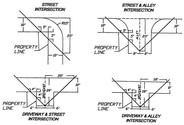
(Ord. 789 § 1 (part), 2004; Ord. 595 § 4.05(D), 1982)
17.12.060 - Distance between buildings.
Facing walls of separate buildings on the same lot in the residential zones (buildings linked by a common roof are considered separate buildings) shall be set apart according to the following table:
Notes:
1.
The total separation required between two facing walls is the sum of that required for each.
2.
No part of the structure may encroach into the three feet separating.
3.
Separation requirements are based on V-N Type Construction and R-3 Occupancy.
(Ord. 789 § 1 (part), 2004: Ord. 595 § 4.06, 1982)
17.14.010 - Residential zones—Height.
Screening up to six feet in height shall be permitted on all rear and side property lines with the following exceptions:
A.
No fence, wall or hedge over four feet in height will be permitted within the required front yard setback.
B.
Fences over six feet in height, to enclose swimming pools, tennis courts or other game areas located within the rear half of the lot, may be permitted upon the finding of the planning director that such an enclosure will not constitute a nuisance to abutting property.
C.
No fence, wall or hedge or other physical obstruction higher than three feet above grade shall be located in the triangular areas defined by the intersections diagramed in Section 17.12.050.
D.
Where a single story, single-family residential structure is located on a parcel of land immediately adjacent to a multi-story, multi-family residential structure with windows overlooking the single-story structure and no public rights-of-way or public property will be impacted, a hedge, higher than six feet may be grown to provide screening for the single-story structure. The property owner on which the hedge is located shall be wholly responsible for the upkeep and maintenance of the hedge. The hedge shall be regularly watered, trimmed and maintained in order to avoid the creation of a fire hazard and for aesthetic purposes. Failure to maintain the hedge shall be a violation of this chapter, a fire hazard and a nuisance that the city may abate as set forth in the Blythe Municipal Code.
(Ord. 806 § 1, 2006; Ord. 789 § 1 (part), 2004: Ord. 630 § 3 (part), 1987; Ord. 603 § 1, 1984: Ord. 595 § 4.07(A)(1), 1982)
17.14.020 - Residential zones—Materials.
All screening under this section shall be composed of one or more of the following:
A.
Masonry walls;
B.
Evergreen shrubs closely spaced and maintained;
C.
Wooden fencing, if of adequate aesthetic and structural quality and durability;
D.
Other materials approved by the planning director, after giving consideration to appearance, structural quality and durability.
(Ord. 630 § 3 (part), 1987; Ord. 595 § 4.07(A)(2), 1982)
17.14.030 - Commercial and industrial zones—Location.
Screening shall be required in all commercial and industrial zones as follows:
A.
Along any side or rear lot line when adjacent to a residential use, or along the front yard setback line, as defined by Section 17.12.040, when adjacent to or across the street from a residential use;
B.
Along the front yard setback line, as defined by Section 17.12.040, for any outdoor storage operation;
C.
Around any trash enclosure or storage area; except as provided for in Sections 17.20.010(A) and (B).
(Ord. 789 § 1 (part), 2004: Ord. 603 § 2, 1984: Ord. 595 § 4.07(B)(1), 1982)
17.14.040 - Commercial and industrial zones—Materials.
All screening in commercial and industrial zones shall be composed of one or more of the following:
A.
Masonry walls;
B.
Wooden fencing, if of adequate aesthetic and structural quality and durability;
C.
Other materials approved by the planning director after giving consideration to appearance, structural quality and durability.
(Ord. 630 § 3 (part), 1987; Ord. 595 § 4.07(B)(2), 1982)
17.14.050 - Commercial and industrial zones—Height.
Screening may be permitted within the height ranges shown in the following table with the following exceptions:
A.
No fence, wall or hedge or other physical obstruction higher than three feet above grade shall be located in the triangular areas defined by the intersections diagramed in Section 17.12.050.
Note:
In no instance shall the materials stored exceed the height of the screening.
(Ord. 789 § 1 (part), 2004: Ord. 603 § 3, 1984: Ord. 595 § 4.07(B)(3), 1982)
17.14.060 - Measurement of screening height.
For the purposes of this chapter, the height of any screening shall be measured as follows:
A.
For street-abutting property lines, at sidewalk grade;
B.
For interior property lines, at the highest elevation of adjacent finished grade or as determined by the planning director.
(Ord. 630 § 3 (part), 1987; Ord. 595 § 4.07(C), 1982)
17.14.070 - Other security-fencing requirements unaffected.
Nothing in this chapter shall be deemed to set aside or reduce the requirements established for security fencing by local, state or federal law.
(Ord. 595 § 4.07(D), 1982)
17.14.080 - Security fencing allowances.
Security fencing, consisting of chain link and barbed wire, may be permitted up to eight feet in height along any rear or side lot line not adjacent to residential uses or zones. Such fencing may also be permitted along the front yard setback line, as defined by Section 17.12.040, when it is not adjacent to, or across the street from any residential use or zone.
(Ord. 603 § 4, 1984)
17.14.090 - Maintenance and upkeep of fencing and screening.
It shall be the responsibility of the property owner and/or tenant to maintain site fencing and/or screening in a state of good repair. If a fence or screen, or any part thereof, due to deterioration and/or lack of maintenance is unable to serve its intended purpose as a fence or screen, it shall be declared a public nuisance.
(Ord. 789 § 1 (part), 2004)
17.16.010 - Compliance required when.
A.
The standards for providing off-street parking set out in this chapter shall apply at the time of the erection of any main building.
B.
These standards shall also be complied with when an existing building is altered or enlarged by the addition of dwelling units or guestrooms or where the use is intensified or floor area added.
(Ord. 601 § 3 (part), 1984; Ord. 595 § 4.08 (part), 1982)
17.16.020 - Enlargement, extension, intensification or addition requires conformity.
Where automobile parking space is provided and maintained on a lot in connection with a structure and where such parking spaces at the time the ordinance codified in this chapter became effective were insufficient to meet the requirements for the use with which it is associated, or where no such parking has been provided, said structure may be altered or enlarged, or such use may be extended, only if additional automobile parking spaces are provided to meet the standards for the use in conformity with the requirements set forth in this title, for the enlargement, extension or addition proposed. Where a structure located in a commercial zone and having a commercial use at the time of the enactment of the ordinance codified in this section does not have any area on its lot for parking it is exempt from providing parking except when an intensification of use takes place.
(Ord. 638 § 6 (part), 1988: Ord. 595 § 4.08 (A) (part), 1982)
17.16.030 - Fractional number in calculations.
Where calculation of the number of spaces required results in a fractional number, the next higher whole number shall be used.
(Ord. 595 § 4.08(A) (part), 1982)
17.16.040 - Enclosure required for nonlocomotive vehicle.
No motor vehicle shall be parked or stored in a residential or commercial zone, other than in an entirely enclosed space, unless the vehicle is capable of movement under its own power.
(Ord. 595 § 4.08(A) (part), 1982)
17.16.050 - Commercial vehicles in residential zones.
Unless excepted pursuant to subsection A of this section, no commercial or construction vehicle, or towed or commercial equipment, or agricultural equipment, shall be parked on private property or on public right-of-way in residential zones unless the vehicle or equipment is screened from public view and adjacent properties. The term "commercial or construction vehicle, or towed, or commercial equipment, or agricultural equipment" includes, but is not limited to, utility body trucks, construction or agriculture tractors, construction vehicles and towed equipment, semitruck tractors, semitruck trailers, dump trucks, step van delivery trucks or any parts or apparatus of any of the above.
A.
Commercial Vehicles Exempted. The following commercial vehicles are exempted from the above paragraph:
1.
Pickup trucks, utility vans and similar utility vehicles, each of which does not exceed eight feet in height or twenty feet in combined total length;
2.
All vehicles while being used in actual construction work on a permit-approved construction site;
3.
All vehicles in the process of making a pickup or delivery;
4.
All vehicles used to load or unload agriculture products or supplies, and all vehicles used in cultivation or harvesting of crops, pertaining to that specific property;
5.
Government, utility and emergency service vehicles; and
6.
All vehicles used in gardening or landscaping businesses, each of which does not exceed eight feet in height or twenty feet in length.
(Ord. 695 § 1, 1993: Ord. 595 § 4.08 (A) (part), 1982)
17.16.055 - Vehicles in front yard setbacks.
No motor vehicle, trailer, boat or recreational vehicle shall be parked in the front yard setback as defined by this title, except on paved driveways.
(Ord. 695 § 2, 1993)
17.16.060 - Number of spaces required—Residential.
The number of spaces required for residential uses shall be as follows:
A.
There shall be at least two parking spaces for every dwelling unit in zones R-R, R-E, R-L and R-M-L. One and one-half parking spaces shall be provided for every dwelling unit in the R-M and R-H zones.
B.
Tandem parking shall not be permitted to meet the requirements of subsection A of this section.
(Ord. 789 § 1 (part), 2004: Ord. 595 § 4.08(B)(1), 1982)
17.16.070 - Number of spaces required—Nonresidential.
A.
The number of spaces required for nonresidential uses shall be as follows for the various types and buildings and uses. The requirement for a use not specifically mentioned shall be the same as for a use specified which has similar traffic-generating characteristics:
1.
For churches, theaters, auditoriums and similar places of assembly: at least one space for each five seats in the principal assembly room counting twenty inches of seating space on a bench as one seat. In cases where temporary or movable seats are provided, there shall be one space for every forty square feet of area within the assembly room. In cases of a use without a building, there shall be one space for each five persons normally attending or using the facilities;
2.
For hospitals: one per three beds;
3.
For clinics, medical and dental offices: one per two hundred square feet of gross floor area;
4.
For convalescent, nursing or rest homes, sanitaria or homes for the care of children or the aged: one space for each four beds;
5.
For hotels and motels: one per room;
6.
For boardinghouses, clubhouses, fraternity or sorority houses: one space for each guestroom, plus one space for each two beds in a dormitory in any of the above;
7.
For child care services: one space for each staff member, plus one space for each twenty children;
8.
For mobile home parks: See Chapter 17.40;
9.
For retail stores, administrative and professional offices: one space for each two hundred fifty square feet of gross floor area;
10.
For manufacturing, industrial, warehouse and storage buildings: one space for each five hundred square feet of gross floor area;
11.
For storage yards, nursery sales, contractor yards and lumberyards, and public utilities services: one space for each five hundred square feet of gross floor area, plus one space for each two thousand square feet of open land on the premises;
12.
For bowling alleys: six spaces for each alley;
13.
For restaurants, cafes, bars or other eating or drinking establishments including fast-food establishments: one space for each fifty square feet of gross floor area with a minimum of five spaces;
14.
For retail stores: one space for every three hundred seventy-five square feet of gross floor area;
15.
For mini-warehousing or storage: one space for every twenty cubicles or storage spaces plus two enclosed spaces for the manager's quarters.
B.
"Gross floor area" need not include duct and elevator shafts; stairs; telephone, electrical and mechanical rooms; restrooms; janitor rooms and corridors.
(Ord. 595 § 4.08(B)(2), 1982)
17.16.080 - Joint use of parking areas.
Where an attested copy of a contract between the parties concerned and the city as a third party beneficiary is filed with the application for a building permit, which contract sets forth an agreement for joint use of parking spaces irrevocable for the life of the uses or buildings concerned, the number of spaces jointly required for a place of assembly, the use of which is principally exercised during nonbusiness hours, and a business use or uses regularly closed at such time may be reduced so that the total number equals whichever is greater of:
A.
All spaces required for the business use or uses, plus one-half of the spaces required for the place of assembly; or
B.
All the spaces required for the place of assembly, plus one-half of the spaces required for the business use or uses.
(Ord. 595 § 4.08(C), 1982)
17.16.090 - Location—Residential.
Required parking spaces for residential buildings and uses shall be provided as follows:
A.
On the same lot as the main building;
B.
Located at least twenty feet from a public street;
C.
Not located in any required yard. For exceptions for garages or carports, see Section 17.12.030.
(Ord. 595 § 4.08(D)(1), 1982)
17.16.100 - Location—Nonresidential.
Required parking spaces for other than residential buildings and uses shall be provided in one or more of the following locations:
A.
On the lot with the building served;
B.
On a contiguous lot, or a lot within five hundred feet of the building or use served, if a legally acceptable covenant is executed and recorded to guarantee the maintenance of the required spaces and an attested copy is filed with the department;
C.
By inclusion in a municipal parking district.
(Ord. 595 § 4.08(D)(2), 1982)
17.16.110 - Design—Residential.
Every required parking area and garage for residential uses shall be designed and maintained in accordance with the following regulations:
A.
Each parking space shall be not less than nine feet in width and twenty feet in depth, and shall be independently accessible with a minimum of twenty-five feet of unobstructed space provided for the maneuvering of vehicles.
B.
Every parking stall adjoined on one or both sides of its lengths by a curb, fence, wall, partition, column, post or similar obstruction, that is located less than four feet from an access aisle measured along the length of the stall or continues to form the end of an access aisle, shall have a minimum width of eleven feet six inches.
C.
In the R-R, R-E and R-L zones, at least two spaces per dwelling unit shall be provided in a garage or carport, except that for a single-family dwelling having less than eight hundred seventy-five square feet of gross floor area a minimum of one covered space shall be required.
D.
In the R-M-L, R-M and R-H zones, at least one space per dwelling unit shall be provided in a garage or carport.
E.
Carports or unenclosed spaces shall be screened from all property lines except those abutting an alley by a combination of landscaping and a minimum five-foot-high permanent decorative barrier.
F.
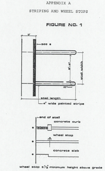
Striping and car stops or bumpers shall be as shown in Figure No. 1 in Appendix A to this chapter.
(Ord. 789 § 1 (part), 2004: Ord. 595 § 4.08(E)(1), 1982)
17.16.120 - Design—Nonresidential.
Every required nonresidential parking area and garage shall be designed and maintained in accordance with the following regulations:
A.
Parking stall dimensions shall be in accordance with the following table:
Exception: Every parking stall adjoined on one or both sides of its length by a curb, fence, wall, partition, column, post or similar obstruction, that is located less than four feet from an access aisle measured along the length of the stall or continues to form the end of an access aisle, shall have a minimum width of eleven feet six inches.
B.
Each stall shall be located so that no automobile is required to back onto a public street.
C.
In every parking area and garage containing ten or more stalls, twenty percent of the stalls may be designed to accommodate compact cars, and shall be clearly marked as compact stalls.
D.
Handicapped stalls shall be provided as recommended by the state code (two percent of total required spaces).
E.
Striping and car stops or bumpers shall be as shown in Figure No. 1 in Appendix A to this chapter.
F.
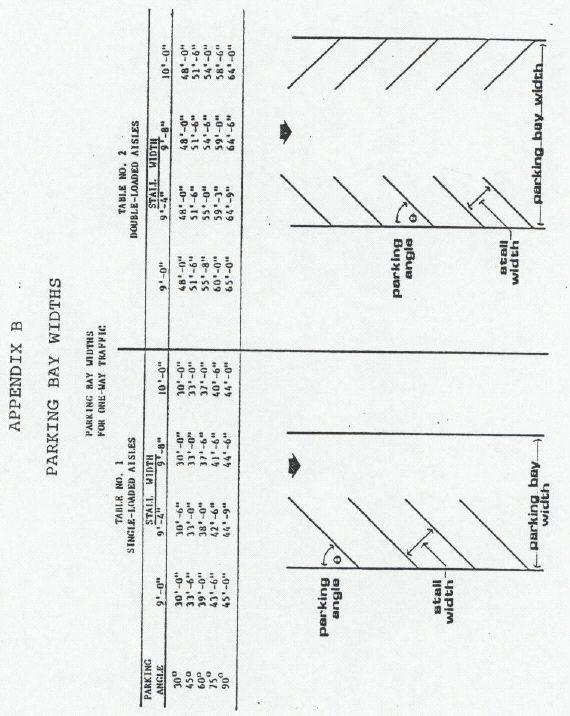
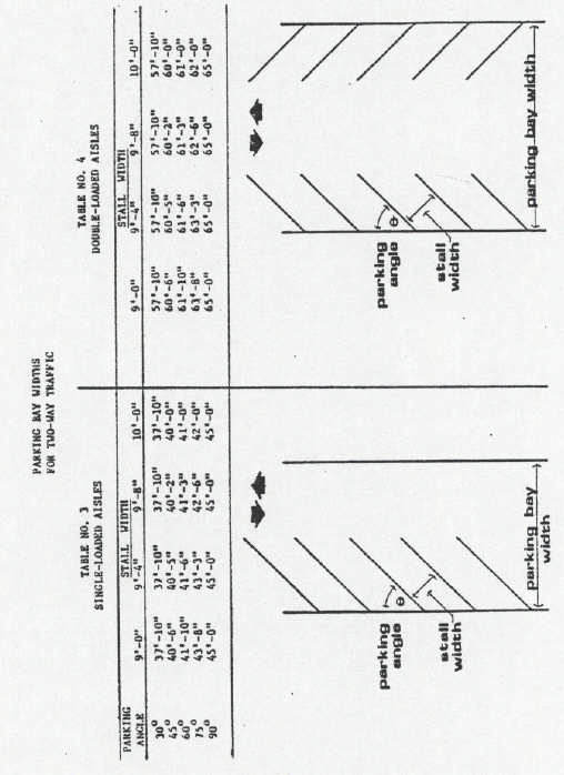
The minimum width of each parking bay shall be determined by the stall width and parking angle in accordance with Tables 1, 2, 3 and 4 in Appendix B to this chapter. Where parking stalls of two bays interlock the bays may overlap. The minimum bay widths required may be reduced for bays or portions of bays containing compact stalls, provided that the net aisle width is not reduced.
G.
Unless otherwise excepted in this section, all parking areas, including those for outdoor automotive display, sales and storage, shall be surfaced or paved with asphalt concrete of at least two and one-half inches thickness over a suitable base material, and shall thereafter be maintained in good condition. However, should use or soil condition necessitate, the planning director may require additional paving or lot improvement.
H.
Where such areas adjoin residential uses they shall be separated therefrom by screening as specified in Chapter 17.14. These areas shall also be provided with adequate wheel stops: a concrete curb not less than six inches high, installed and maintained as a safeguard to abutting property. The barrier shall be at least three feet from any property line, but in no case shall it be less than necessary to meet the intent of this chapter.
(Ord. 630 § 3 (part), 1987; Ord. 601 § 3 (part), 1984; Ord. 595 § 4.08(E)(2), 1982)
17.16.130 - Driveway requirements.
There shall be paved vehicular access from a dedicated and improved street or alley to off-street parking facilities on the property requiring the off-street parking as follows:
A.
Single-family residences: Each driveway shall be at least ten feet wide and shall not be encumbered by a projection to a height under eight feet above grade.
B.
Multiple-family residences: Each driveway shall be at least twelve feet wide and shall not be encumbered by any projection to a height under twelve feet above grade. If any driveway serves as access to more than ten parking spaces such driveway shall be not less than eighteen feet wide. Where there is more than one means of access, two twelve-foot-wide driveways may be provided in lieu of one eighteen-foot-wide driveway.
C.
Commercial or industrial uses: One-way driveways shall be twelve feet wide; two-way, twenty feet wide; and shall not be encumbered by any projection to a height under fourteen feet above grade. Where there is more than one means of access, two twelve-foot-wide driveways may be provided in lieu of one twenty-foot-wide driveway. Exception: Where access is provided for drive-through service offered by a banking institution, fast-food restaurant or similar use, and access is a one-way driveway, the driveway may be ten feet wide.
D.
Child care services: A circular driveway at least twenty feet in width shall be provided for the safe off-street loading and unloading of children.
E.
All zones: Where two driveways are provided each shall be clearly marked as to the direction of ingress and egress.
(Ord. 595 § 4.08(F), 1982)
17.16.140 - Fee in lieu of required parking.
Where parking requirements cannot be met on the same site or adjacent site to the development requiring parking, parking requirements may be satisfied at the option of the city by payment to the city of an amount of money for each square foot of parking space required under this title. A parking space shall consist of two hundred fifty square feet for the calculation required. The amount of money per square foot shall be set by resolution of the city council in the same manner as required for permits and fees under council in the same manner as required for permits and fees under this title. Alternately parking requirements may be met by participating in the construction and/or purchase of a cooperative parking facility within one hundred fifty feet of the development requiring parking.
(Ord. 638 § 6 (part), 1988: Ord. 595 § 4.08(G), 1982)
17.18.010 - Adequate loading space required.
All commercial and industrial buildings, hotels, hospitals and institutions erected, constructed, converted, established or enlarged to increase their floor space after the adoption of the ordinance codified in this title shall be provided with adequate loading spaces of at least twenty-five by fourteen feet with a fourteen-foot overhead clearance. The number of spaces needed will be determined by the planning director; however, in no case shall there be less than one space.
(Ord. 630 § 3 (part), 1987; Ord. 601 § 3 (part), 1984: Ord. 595 § 4.09 (part), 1982)
17.18.020 - Ingress and egress for trucks.
Any loading space provided shall afford adequate ingress and egress for trucks from a public street or alley.
(Ord. 595 § 4.09 (part), 1982)
17.18.030 - Use of public street or alley.
In no case shall any part of a public street or alley be used for loading.
(Ord. 595 § 4.09 (part), 1982)
17.20.010 - Trash and garbage collection areas.
All outside trash and garbage collection areas shall be constructed as approved by the planning director as set forth in the following guidelines:
A.
Residential, commercial and industrial areas that are served by alleys shall locate collection areas in or on the alley. Where collection is on the alley with an insert onto private property, a concrete pad shall be required. Where collection is in the alley, commercial, multifamily residential and industrial users shall provide a concrete pad. The area shall be screened from the owner's property.
B.
Commercial and industrial users not served by alleys shall locate collection areas as close as possible to public right-of-way. The area shall be paved and shall be enclosed on three sides, with one side providing screening from the public right-of-way. Location shall be approved by the planning director and the public works director.
C.
Commercial, industrial and residential property tenants shall be responsible for keeping garbage collection and storage areas clean and picked up. Those failing to do so shall be subject to penalties of this title.
(Ord. 789 § 1 (part), 2004: Ord. 664 § 1, 1990: Ord. 638 § 7, 1988: Ord. 630 § 3 (part), 1987; Ord. 595 § 4.10(A)(2), 1982)
17.20.015 - Recyclable materials storage and collection areas.
Commercial, industrial and residential property tenants shall be responsible for keeping recyclable materials storage and collection areas clean and picked up. Those failing to do so shall be subject to penalties of this title.
(Ord. 789 § 1 (part), 2004)
17.20.020 - Trash containers.
All trash containers shall be as provided or specified by the director of public works.
(Ord. 595 § 4.10(A)(2), 1982)
17.20.030 - Storage areas.
At least sixty cubic feet of enclosed accessory storage space shall be provided for each dwelling unit. The space may be located in a garage or carport provided that it does not interfere with the parking of a vehicle.
(Ord. 595 § 4.10(B), 1982)
17.22.010 - Purpose.
The purpose of this section is to establish general guidelines for the planting and care of landscaping and irrigation in residential, commercial, industrial and public/quasi-public zones. The goals of this section are to:
A.
Enhance the community's environmental and visual character for its citizens' use and enjoyment;
B.
Establish a more healthy environment by using plants to mitigate pollution's ill effects;
C.
Safeguard property values;
D.
Protect public and private investments; and
E.
To promote high-quality development.
(Ord. 789 § 1 (part), 2004)
17.22.020 - Applicability.
This section applies to all existing and proposed landscaped areas in residential, commercial, industrial and public/quasi-public use.
(Ord. 789 § 1 (part), 2004)
17.22.030 - Where required.
Landscaping is required in the following locations for all residential, commercial, industrial, and public/quasi-public uses:
A.
Throughout required front yard setbacks and other areas visible from a public street where not used for parking, access or loading;
B.
Five percent of the parking lot area which is visible from a public street; and
C.
Refer to Section 17.34.055 of this title for nonconforming areas.
(Ord. 789 § 1 (part), 2004)
17.22.040 - Approval of elements.
1.
Required landscaping shall consist of an effective combination of trees, lawn and/or ground cover, shrubs and desert vegetation, as approved by the planning director.
2.
All unplanted landscape areas in commercial, industrial and public/quasi-public shall be mulched with a minimum of two inches of material as approved by the planning director to promote weed control and water conservation.
(Ord. 789 § 1 (part), 2004)
17.22.050 - Trees in front yard of dwellings.
A minimum of two deciduous or evergreen shade trees conforming to the measurements specified in this section shall be planted in the front yard of any lot on which a dwelling unit or units are to be built or placed.
A.
Minimum branching height for all shade trees shall be six feet;
B.
Minimum size for shade trees shall be two and one-half to three inches in diameter measured six inches above grade, and twelve to fourteen feet in height.
(Ord. 789 § 1 (part), 2004)
17.22.060 - Commercial, industrial or public/quasi-public.
For every two hundred square feet of landscaping, a minimum of one deciduous or evergreen tree conforming to the measurements specified in this section shall be planted in a tree, well-sized to properly accommodate the intended tree. Suitable protection shall be provided to trees and public works from traffic.
A.
Minimum branching height for all shade trees shall be six feet.
B.
Minimum size for shade trees shall be three and one-half to four inches in diameter measured six inches above grade, and twelve to fourteen feet in height.
(Ord. 789 § 1 (part), 2004)
17.22.070 - Irrigation systems.
All landscaped areas in commercial and industrial uses, and multi-family residences in R-M, R-M-L and R-H zones shall have a properly maintained permanent, automated, underground, full-coverage irrigation system meeting the approval of the planning director. In residential R-R, R-E and R-L zones irrigation systems in the front yard setbacks of residences are encouraged.
(Ord. 789 § 1 (part), 2004)
17.22.080 - Maintenance.
It shall be the responsibility of the property owner and/or tenant to:
A.
Maintain all landscaping and landscape areas in a neat, clean and healthful condition;
B.
Replace dead trees and/or plants within sixty days;
C.
Mow grass on a regular basis (maximum grass height shall be eight inches);
D.
Maintain tree canopies at a minimum of six feet in height;
E.
Maintain irrigation systems in proper working order.
Those failing to do so shall be subject to penalties of this chapter.
(Ord. 789 § 1 (part), 2004)
17.23.010 - System established.
A uniform system is necessary to provide control and coordination for the selection of street names to prevent situations that may affect emergency response by emergency services providers, as well as to minimize confusion to postal workers and the public at large. It is determined that a system be adopted that will eliminate future street naming duplication, spelling or pronunciation similarities, difficult pronunciations, inappropriate usages (both English and Spanish), and which encourages pleasant sounding and geographically relevant street names.
(Ord. 766 § 1 (part), 2000)
17.23.020 - Street naming committee.
A committee formed of one member each from the development services department, fire department, and police department shall sit as a body to review proposed names for new streets in order to eliminate duplications of street names, spelling or pronunciation similarities, difficult pronunciations, and inappropriate usages (both English and Spanish). The development services department committee member shall be designated as "street naming coordinator."
(Ord. 766 § 1 (part), 2000)
17.23.030 - Street naming coordinator—Duties.
The duties of the street naming coordinator shall be to facilitate and advise applicants on the selection of new street names through the use of:
A.
Three lists of street names which will be kept current:
1.
Existing Street Name List. A list of street names currently in use, thus not available for use as new street names;
2.
Available Street Name List. A list of approved street names which are not in use and may be used for streets in new developments;
3.
Tentative Street Name List. A list of street names which have been assigned to new streets but have not yet been recorded or constructed.
B.
The street naming coordinator shall supply a copy of the "available street name list" to applicants, and shall verify that all street names selected by an applicant are in conformance with the "procedure for street naming" before recordation of a final tract map or final approval of site plans.
(Ord. 766 § 1 (part), 2000)
17.23.040 - Procedure for street naming.
A written "Procedure for Street Naming" shall be made available to applicants in order to fulfill the necessary requirements of new street naming. The procedure for street naming shall be an extension of this code.
(Ord. 766 § 1 (part), 2000)
17.23.050 - Usage of surnames.
A street may be named for a living or deceased citizen who has made a significant contribution to the community with the approval of the city council as recommended by the street naming coordinator at the request of an applicant, general public or a city official.
(Ord. 766 § 1 (part), 2000)
17.23.060 - Official street names.
All names presently assigned to streets prior to January 1, 2000, are accepted as the official names of such streets.
(Ord. 766 § 1 (part), 2000)
17.23.070 - Change of street names.
In the event that street names are changed in the future, such name changes shall be undertaken upon the recommendation of the planning commission to the city council. Public hearings shall be held by the planning commission and city council in considering the proposed name changes. Written notice shall be given to all parties to be affected by such name change, i.e., the residents of the subject street, or, in the event that a large number of residents are affected, by posting of notices along the street and by subject publication of such notice at least ten days prior to the date of the hearing.
(Ord. 766 § 1 (part), 2000)
17.23.080 - Severability.
If any section, subsection, or clause of the ordinance codified in this chapter shall be deemed to be unconstitutional or otherwise invalid, the validity of the remaining sections, subsections, and clauses shall not be affected.
(Ord. 766 § 1 (part), 2000)
17.24.010 - Street improvements.
The installation of curbs, gutters and sidewalks, or the repair of such existing street improvements to city standards, is required along the street frontage of any building site as a condition precedent to issuing any building permit. Refer to Section 17.34.055 of this title concerning nonconforming areas.
(Ord. 638 § 9 (part), 1988: Ord. 595 § 4.12, 1982)
17.24.020 - Mechanical equipment.
Mechanical equipment including, but not limited to, hearing and air-conditioning devices shall be located within the building or, if mounted elsewhere, shall be screened from public view. Residences up to and including four units on a single lot may screen the equipment by placing it below the ridge line of a gabled roof on the side away from the street at the front of the house. Flat-roof residences shall screen equipment from public view from the street at the front of the residence.
(Ord. 638 § 9 (part), 1988: Ord. 630 § 3 (part), 1987; Ord. 595 § 4.13, 1982)
17.24.030 - Access across prohibited zone.
Access to a use shall not be taken across property subject to a zone in which such use is prohibited.
(Ord. 595 § 4.15, 1982)
17.26.010 - Findings.
The city council finds all of the following:
A.
Police Power. The city, pursuant to its police power, has the authority to take appropriate action to address concerns regarding traffic safety and aesthetics, as they relate to signs (Metromedia Inc. v. City of San Diego, 453 U.S. 490 (1981)); and
B.
First Amendment. Signs constitute speech protected by the First Amendment of the United States Constitution and by Article 1, Section 2 of the Constitution of the State of California and that its regulation of signs must be consistent with these protections; and
C.
Harms of Non-Regulation. An uncontrolled proliferation of signs within the city is harmful to the public's health, safety and welfare, in that such signs are:
1.
Aesthetically displeasing, distracting, discordant with their surroundings and detract from the natural beauty of the city, and
2.
They create a safety hazard as drivers, pedestrians, and others venturing into the public area will be distracted by attempting to read an excessive number of signs that are placed in a haphazard, dangerous, or dangerously attention-seeking manner; and
D.
Substantial Interest. The city has a substantial interest in regulating signs and the regulations within this chapter further the city's substantial interests in traffic safety and aesthetics, consistent with National Advertising Co. v. City of Orange, 861 F.2d 246, 248 (9th Cir. 1988) and Foti v. City of Menlo Park, 146 F.3d 629 (9th Cir. 1998); and
E.
Commercial Interests. Businesses have an interest in having signage that effectively advertises their goods or services, and is visible to potential customers; and
F.
Aesthetic Interests. City residents and visitors have a substantial interest in visiting, living, and working in an aesthetically pleasing city; and
G.
Traffic Safety Interest. City residents and visitors have a substantial interest in traffic safety within the city; and
H.
Limited Regulation is Necessary. The city has properly balanced its interests in aesthetics and traffic safety with the interests of businesses and consumers by limiting off-site commercial signs, and by limiting the time, place, and manner of placement of commercial signs on commercial lots; and
I.
Signs Can Cause Problems. Signs take up space and may obstruct views, distract motorists, displace alternative uses for land, and pose other problems that legitimately call for regulation; and
J.
Commercial Speech Versus Non-Commercial Speech. Commercial speech can be regulated more stringently than non-commercial speech; however, the city council recognizes the need of businesses in the city to communicate to the public about the goods and services they provide; and
K.
Content Neutrality. The city council intends this chapter to ensure its regulations are content-neutral and are the least restrictive means to achieve the goals set forth herein (See e.g., Reed v. Town of Gilbert, 76 U.S. 155 (2015); and
L.
On-Site Signage. These regulations allow on-site commercial signage while limiting off-site advertising signs, the city council having found that onsite commercial speech is more valuable than off-site commercial speech, as permitted in Outdoor Systems, Inc. v. City of Mesa, 997 F.2d 604, 611 (9th Cir. 1993) and Metromedia Inc. v. City of San Diego, 453 U.S. 490 (1981); and
M.
Procedures are Beneficial. Because signs are speech protected by the United States and the California Constitutions, detailed procedures are necessary to ensure that permits are expeditiously issued or denied based on objective criteria and consistent with due process of law; and
N.
Message Substitution. A message substitution provision has been added to the city's sign regulations, allowing any sign regulated by the new provisions of this ordinance to display a non-commercial message, so that the city's regulations satisfy the constitutional mandate that it not restrict non-commercial signage to a greater degree than commercial signage. (See Clear Channel Outdoor, Inc. v. City of Los Angeles, 340 F.3d 810 (9th Cir. 2003); Outdoor Systems. Inc. v. City of Mesa, 997 F.2d 604 (9th Cir. 1993); and
O.
Temporary Signs. The unregulated proliferation of temporary signs in the public right-of-way can be detrimental to the aesthetic quality of the streets and sidewalks, can interfere with traffic safety, pedestrian access to public sidewalks and streets, and can obstruct the entrance to businesses and residences; and
P.
Limits on Interfering with Traffic. Prohibiting commercial conduct that is intended to, or that does in fact, attract the attention of drivers, furthers the city's substantial interest in traffic safety (See, e.g., Sanctity of Life Network v. California Highway Patrol, 105 Cal. App. 4th 858, 862 (2003) (holding that protected First Amendment speech can be restricted if it interferes with traffic)).
(Ord. No. 923, § 2, 1-9-24)
17.26.020 - Purpose.
The purpose of this chapter is to promote the public health, safety and welfare and preserve community aesthetics through implementation of a uniform set of rules and regulations. This chapter is intended to:
A.
Preserve and improve the appearance of the city as a place to live, work, and visit;
B.
Reduce visual clutter while providing reasonable opportunities for adequate identification of businesses and the goods and services they offer;
C.
Promote signs and graphics that are attractive, pleasing, and harmonized with the physical character of the environment and surrounding properties;
D.
Ensure that signs effectively identify businesses and other establishments;
E.
Prevent an inadvertent favoring of commercial speech over non-commercial speech; and
F.
Reduce traffic hazards.
(Ord. No. 923, § 2, 1-9-24)
17.26.030 - Definitions.
For the purposes of this chapter, the following definitions shall apply. These definitions shall be adapted to the context for appropriate grammatical tenses, number, case, and gender.
"A-frame sign" means a freestanding sign usually hinged at the top, or attached in a similar manner, and widening at the bottom to form a shape similar to the letter "A." Such signs are usually designed to be portable and are not considered permanent signs.
"Abandoned sign" means a sign which is one of the following: (a) located on property which becomes vacant or unoccupied for one year or more; (b) previously pertained to an on-site occupant or business, but is now unrelated to the premises' present occupant or business; or (c) a sign which pertains to a time, event, or purpose which no longer applies.
"Accessory sign" means a sign whose copy refers to the products, facilities, or services available on the premises.
"Advertising statuary" means an imitation or representation of a person or thing which is sculptured, molded, modeled, or cast in any solid or plastic substance, material or fabric and used to identify or advertise a product or service.
"Advertising vehicle" means any vehicle or trailer on a public right-of-way or public property or on private property visible from a public right-of-way which has attached thereto, or located thereon, any advertising device or detachable sign, which device or sign has the basic purpose of advertisement. One example of an "advertising vehicle" is a vehicle towing a trailer with an arrow directing traffic to a commercial establishment.
"Aggregate sign area" means the total area of all signs combined.
"Animated sign" means any sign which includes action or motion or the optical illusion of action or motion, or color changes of all or any part of the sign facing, requiring electrical energy, or set in motion by movement of the atmosphere. Excluded from the definition are flags.
"Art mural" means a non-commercial, original, one-of-a-kind, hand-painted, or hand-tiled work of visual art on the exterior wall, façade, or surface of a building. "Art mural" does not include murals containing any electrical or mechanical components or changing image murals.
"Attraction board" means a sign capable of supporting copy which is readily changeable without the use of tools. An example of an attraction board is a theater marquee.
"Banner" means a sign hung without frames, possessing written communication applied to nonrigid paper, plastic, fabric, or similar material.
"Billboard" means a sign with a commercial message, other than a directional sign, which directs attention to a business, commodity, service, or entertainment conducted, sold, or offered elsewhere than upon the premises where the sign is located, or to which it is affixed. Also known as an outdoor advertising sign.
"Building-mounted sign" means a sign affixed to a building, painted directly on a wall, or erected against the wall of a building. All parts of the sign are affixed flush to the wall. Building-mounted signs may include murals, signs affixed to awnings (excluding under canopy signs), signs attached to fascia, mansard roof signs, wall signs, and window signs.
"Business" means a commercial, office, institutional or industrial establishment.
"Canopy" means a fixed structure of any material and any length, projecting from and connected to a building and/or columns and posts from the ground or supported by a frame extending from the building and/or posts from the ground.
"Copy" or "sign copy" means any words, letters, numbers, figures, designs, or other symbolic representations incorporated onto the face of a sign.
"Commercial sign" means a sign which is "commercial" as defined by applicable case law interpreting the First Amendment to the United States Constitution. Typical examples of "commercial" signs include advertisements of a particular product or service.
"Development" means, on land or in or under water: the placement or erection of any solid material or structure; discharge or disposal of any dredged material or of any gaseous, liquid, solid or thermal waste; grading, removing, dredging, mining or extraction of any materials; change in the density or intensity of use of land, including, but not limited to, subdivision pursuant to the Subdivision Map Act, and any other division of land, including lot splits, except where the land division is brought about in connection with the purchase of such land by a public agency for public recreational use; change in the intensity of use of water, or of access thereto; construction, reconstruction, demolition or alteration of the size of any structure, including any facility of any private, public or municipal utility; and the removal or harvesting of major vegetation other than for agricultural purposes.
"Directional sign" means any sign which is designed and erected solely for the purpose of traffic or pedestrian direction and which is placed on the property to which or on which the public is directed. Such a sign contains no advertising copy. Typical examples of such signs are: "one-way," "entrance," "exit," "parking in rear," "fifteen miles per hour," "no left turn."
"Director" or "planning director" means the director of the City of Blythe development services department or the director's authorized agent or representative.
"Downtown area" means that area on Hobsonway extending from the east side of Ash Avenue to the west side of Third Street; and the area between the alley west of Main Street to the alley east of First Street extending north from Hobsonway to Murphy Street and south from Hobsonway to Rice Street.
"Face of building wall" means the outer surface of any main exterior wall or foundation of a building, including windows and store fronts.
"Fascia" means a parapet-type wall used as part of the fascia of a flat-roofed building and projecting not more than six feet from the building face immediately adjacent thereto. Such a wall shall enclose at least three sides of the projecting flat roof and return to a parapet wall or the building.
"Flag" means a visual display device without copy, made of flexible material, usually cloth, paper, or plastic.
"Flashing sign" means any sign which contains an intermittent or flashing light source or which includes the illusion of intermittent or flashing light by means of animation or an externally mounted intermittent light source.
"Freestanding sign" means a sign supported upon the ground and not attached to any building. This definition includes monument signs and ground signs.
"Identification sign" or "ID sign" means a sign whose copy is limited to the name and address of a building, business, office, establishment, person, or activity.
"Illumination" or "illuminated" means the method by which a sign is lighted to be readable at night. The following types of illumination are provided for in this chapter:
1.
"Direct illumination" means the lighting of the sign face from behind so that the light shines through translucent sign copy or lighting via neon or other gases within translucent tubing incorporated onto or into the sign face.
2.
"Indirect illumination" means the lighting of an opaque sign face from a light source mounted in front of the face, or the lighting of opaque sign copy (on an opaque sign face) via lights mounted into the copy and shining rearward onto the face to form a lighted "halo" around the copy (e.g., "reverse channel" letters).
"Improvement plan(s)" means on- and off-site construction drawings.
"Landscaping" means any material used as a decorative feature, such as shrubbery or planting materials within planter boxes or concrete bases, used in conjunction with a sign which expresses the theme of the sign and related structure but does not contain advertising copy.
"Lot" means a parcel of real property which is shown as a single lot in a lawfully recorded subdivision, approved pursuant to the provisions of the Subdivision Map Act; or, a parcel of real property, the dimensions and boundaries of which are defined as a single lot by a lawfully recorded record of survey map. See "site."
"Mansard roof sign" means any sign attached to or supported by a mansard roof. A "mansard roof" is a roof having two slopes, the lower steeper than the upper, and having a slope of sixty degrees or greater with the horizontal plane.
"Modification" or "modify" means the addition of structures or equipment to a previously approved installation. The term does not include replacement of existing equipment or structures, provided the replacement equipment or structure is substantially similar to the pre-existing equipment or structure, and creates no new impacts not addressed in connection with the previous approval. Solely repainting a sign in original colors is not a "modification."
"Monument sign" means a freestanding sign mounted on a low-profile solid base or a fence, or a freestanding wall, as distinguished from support by poles.
"Multi-building complex" means more than one structure on a parcel of land housing commercial uses in which there are appurtenant shared facilities (such as parking or pedestrian mall), and which is designed to provide an area in which the public can obtain varied products and services. Distinguishing characteristics of a multi-building complex may, but need not, include common ownership of the real property upon which the center is located, common-wall construction, and multiple-tenant commercial use of a single structure or structures in multiple buildings.
"Multi-tenant commercial building" means a commercial development in which there exist multiple separate commercial activities, in which there are appurtenant shared facilities (such as parking or pedestrian mall), and which is designed to provide a single area in which the public can obtain varied products and services. Distinguishing characteristics of a multi-tenant commercial building may, but need not, include common ownership of the real property upon which the center is located, common-wall construction and multiple-occupant commercial use of a single structure.
"Neon sign" means a sign which utilizes neon or other gases within translucent tubing in or on any part of the sign structure.
"Non-commercial sign" means any sign which is not a commercial sign. Examples include, but are not limited to, political signs and ideological signs.
"Off-premises sign" or "off-site sign" means a structure which bears a sign which is not appurtenant to the use of the property where the sign is located or a product sold or a service offered upon the property where the sign is located, and which does not identify the place of business where the sign is located as a purveyor of the merchandise or services advertised upon the sign. Some temporary signs are not defined as off-premises signs as used within this chapter.
"On-premises sign" or "on-site sign" means a sign referring to a person, establishment, merchandise, service, event, or entertainment which is located, sold, produced, manufactured, provided, or furnished on the premises where the sign is located.
"Parapet wall" means a wall extending above the roof plane of the building.
"Permanent sign" means any sign which is intended to be and is so constructed as to be a lasting and enduring condition, remaining unchanged in character, condition (beyond normal wear) and position and in a permanent manner affixed to the ground, wall, or building. A sign may be a "permanent sign" even if the sign itself has changeable copy.
"Political sign" means a sign indicating the name and/or picture of an individual seeking election to a public office, or relating to a forthcoming public election, referendum, initiative, or to the advocating by persons, groups or parties of political views or policies.
"Portable commercial sign" means a commercial sign made of any material, which, by its design, is readily movable, whether or not equipped with wheels, casters or rollers or other similar design, which sign is not permanently affixed to the ground, structure or building, or a sign upon a vehicle or trailer used as a stationary advertising display, the primary purpose of which is to serve as a base or platform for the sign. This definition generally includes A-frame signs.
"Projecting sign" means any sign with two parallel faces no more than eighteen inches apart projecting twelve inches or more from the wall or eaves of a building. No guy wires, braces or secondary supports are visible.
"Private property" means any property other than public property.
"Roof sign" means any sign erected upon or above a roof or parapet wall of a building or placed above the apparent flat roof or eaves of a building.
"Semipermanent sign" means a non-illuminated sign intended to be erected or posted for a minimum of sixty-one days and a maximum of one year. Typical examples include a sign advertising the future construction of one or more buildings or a model home complex.
"Sign" means any medium for visual communication, including, but not limited to, words, symbols and/or illustrations, together with all parts, materials, frame, and background, which is used or intended to be used to attract attention to, identify or advertise an establishment, product, service, cause, activity or location, or to provide information or opinion, or to convey a message. "Sign" includes, but is not limited to, posters, reader boards, placards, fliers, handbills, paintings, murals, statues, wall designs, balloons, flags, and inflatable tube men.
"Sign face" means the exterior surface of a sign exclusive of structural supports, on which is placed the sign copy.
"Sign permit" means an entitlement from the city to place or erect a sign.
"Sign structure" means the structural supports, uprights and bracing for a sign.
"Site" means the area of the lot to be developed.
"Temporary sign" means any sign constructed of wood, paper, cloth, canvas, or other similar lightweight material, with or without frames, and all others including painted windows intended to be displayed for a limited period of time. A typical example of a temporary sign is a yard sale sign.
"Temporary window sign" means a sign printed on paper, cardboard, wood, or other temporary material, affixed to, or displayed flush against a window or located within a distance equal to the greatest dimension of the window (either width or height) and designed to be viewed from the outside of the building in which the window is located; it also includes paint applied directly to the window. A typical example is a paper poster that is taped to the inside of a store window.
"Under-canopy sign" means a sign suspended beneath a projecting canopy, walkway cover, awning, ceiling, or marquee.
"Wall sign" means a sign, which is attached to, erected on, painted on, or otherwise affixed to the exterior wall of a building or structure so that the face of the sign is approximately parallel to the building's exterior wall and exposed to the building's exterior side. Signs or advertising displays in or on windows are not wall signs.
"Window sign" means a graphic or opaque surface etched or permanently applied onto a window. A typical example is a thin plastic film applied to a window such that it almost appears to be part of the window itself.
(Ord. No. 923, § 2, 1-9-24)
17.26.040 - Applicability/general rules.
A.
Applicability. This chapter applies to all existing and proposed signs to be located within the city.
B.
Types of Signs. There are three main types of signs: permanent, semipermanent, and temporary.
C.
General Rule. No person shall erect, place, modify, or maintain any sign except as authorized by this chapter. To ensure compliance with this chapter, a sign permit shall be required for any sign, except as provided herein.
D.
Other Permits Required. Even if a given sign is exempted from the sign permit requirements of this chapter, the sign is still subject to all other applicable requirements of this code, including, but not limited to, grading, plumbing, electrical, building, fire, encroachment, and similar safety requirements.
(Ord. No. 923, § 2, 1-9-24)
17.26.050 - General policies.
The following policies, principles, rules, and regulations apply to all signs within the regulatory scope of this chapter, and to all provisions of this chapter, notwithstanding any more specific provisions to the contrary:
A.
Message Neutrality. It is the city's policy to regulate signs in a viewpoint-neutral and/or content-neutral manner. The message of the sign shall not be reviewed except to the minimum extent necessary to identify the type of sign.
B.
Administrative Interpretations. All administrative and quasi-adjudicative interpretations of this chapter are to be exercised in light of the city's message neutrality policy. Where a particular type of sign is proposed in a permit application, and the type is neither expressly allowed nor prohibited by this chapter, or whenever a sign does not qualify as a "structure" as defined in the building code, then the director and/or the city council, as applicable, shall approve, conditionally approve, or disapprove the application based on the most similar sign type that is expressly regulated by this chapter.
C.
Message Substitution. Subject to the owner's consent, a non-commercial message of any type or content may be substituted for any allowed commercial message or any allowed non-commercial message, provided that the sign structure or mounting device is legal without consideration of message content. Such substitution of message may be made without any additional approval or permitting. This provision prevails over any more specific provision to the contrary within this chapter. The purpose of this provision is to prevent any inadvertent favoring of commercial speech over non-commercial speech or favoring of any particular non-commercial message over any other non-commercial message. This provision does not create a right to increase the total amount of signage on a parcel or lot; it does not create a right of substitution of one commercial message in place of another; it does not create a right to display an off-site commercial message sign, and it does not affect the requirement that a sign structure or mounting device be properly permitted.
D.
More Rigorous Standards Prevail. Where a matter of interpretation arises regarding the provisions of this chapter, the more specific definition or more rigorous standard shall prevail. Whenever the planning director determines that the application of any provision of this chapter is uncertain, the issue shall be referred to the city council for determination.
(Ord. No. 923, § 2, 1-9-24)
17.26.060 - Signs prohibited in all zones.
Except as otherwise permitted by this chapter, the following signs are prohibited in all zones:
A.
Any sign not in accordance with the provisions of this chapter;
B.
Abandoned signs;
C.
Advertising vehicles;
D.
Signs affixed to vehicles parked on private property which collectively exceed two square feet, or two linear feet in any dimension;
E.
Commercial flags;
F.
Animated or flashing signs within twenty-five feet of or projecting into any public right-of-way;
G.
Portable commercial signs;
H.
Off-premises signs;
I.
Signs which identify or advertise activities which are illegal under federal, state, or local laws in effect at the location of such signs or activities;
J.
Building-mounted signs placed on or above the roof or above the eave line of any structure;
K.
Signs which purport to be, are an imitation of, or resemble an official traffic sign or signal;
L.
Signs which, by reason of their size, location, movement, content, coloring, or manner of illumination may be confused with or construed as a traffic-control sign, signal or device, or the light of an emergency vehicle, or which obstruct the visibility of any traffic or street sign or signal device;
M.
Signs that create a potential safety hazard by obstructing a clear view between any combination of vehicles and/or pedestrians;
N.
Balloon signs, inflatable animal or other figures, or other inflatable displays, whether tethered or not, except as otherwise permitted by a sign permit;
O.
Neon signs, except those specifically approved as an activity's major identification sign;
P.
Signs drawn or painted onto or otherwise affixed to trees or rocks unless specifically permitted in this chapter;
Q.
Advertising statuaries;
R.
Translucent or transparent signs on internally illuminated awnings so that they allow light to shine through the letters of the copy;
S.
Any signs not specifically allowed in this chapter.
(Ord. No. 923, § 2, 1-9-24)
17.26.070 - Exempt signs.
Notwithstanding Section 17.26.060 (Signs prohibited in all zones), the following signs are not subject to this chapter.
A.
Unseen Signs. Signs which are designed and located such that they can be viewed exclusively from within a building or an enclosed outdoor area.
B.
Official Notices. Official notices issued by any court or public body or officer and notices posted by any public officer in the performance of a public duty or by any person giving legal notice.
C.
Public Safety Signs. Directional, warning, or informational signs required by or authorized by law or by a governmental authority, including signs necessary for the operation and safety of public utility uses.
D.
City Signs. Signs installed, owned, controlled, or maintained by the city and signs displaying information to the public on behalf of the city.
E.
Directional Pavement Markings. Markings on pavement which are solely directional.
(Ord. No. 923, § 2, 1-9-24)
17.26.080 - No sign permit required.
Notwithstanding Section 17.26.040 (Applicability/general rules), the following signs do not require a sign permit. However, such signs must still comply with all other requirements of this chapter and all other legal requirements.
Neither their sign area nor the number of signs shall be included in the calculation of the aggregate sign area or number of signs permitted for any premises or use.
A.
Signs in any Zone Except Residential. Newspaper stand identification. Maximum three square feet. No illumination.
B.
Residential Zones.
1.
One Permanent Sign. One permanent sign, or a collection of permanent signs which work together, which collectively do not exceed two square feet. Such sign(s) shall be affixed to the primary structure. A typical example is a sign showing the numerical street address.
2.
Flags. One building-mounted non-commercial flag no larger than five feet in length or three feet in width.
3.
Vehicular Directional Signs. Vehicular directional signs solely used to identify street entrances and exits. Such signs may be building-mounted or free standing. Each sign may not exceed three square feet. Each sign may be illuminated.
4.
For Sale Signs. Consistent with California Civil Code section 713, one freestanding sign per street frontage installed in plain view of the public which advertises the following: (a) that the property is for sale, lease, or exchange by the owner or his or her agent; (b) directions to the property; (c) the owner's or agent's name; (d) the owner's or agent's address and telephone number. Each sign may not exceed eight square feet and may not exceed four feet in height. Such signs shall not be illuminated.
5.
Temporary Non-Commercial Signs. The owner or occupant, or other party with the permission of the owner and/or occupant, may display temporarily signage displaying any non-commercial message subject to the following rules:
a.
The height of an individual sign shall not exceed six feet.
b.
The total square footage of signs displayed under this section shall not exceed eight square feet.
c.
If temporary signs posted under this section pertain to a specific event, they shall be taken down within seven days after the event occurs.
d.
The sign shall not be displayed for a period of more than ninety days.
6.
Temporary Signs Displayed During One-Time Event. The owner or occupant of a residential parcel may also display an additional temporary sign containing any commercial or non-commercial message for up to seventy-two hours during the occurrence of a one-time event held at the property. In no event may the sign be displayed within twenty-four hours after the one-time event has concluded.
C.
Commercial and Industrial Zones.
1.
Temporary Window Signs. Temporary window signs fronting on a street, parking lot or common on-site area, not covering more than fifty percent of the area of the window(s) within which they are placed for a period not to exceed fourteen days not more than four times per calendar year, with a minimum of thirty days between each placement. If a temporary window sign is painted directly onto the window, then instead of fourteen days, the temporary window sign may be placed for a period not to exceed forty-five days. No more than three signs per elevation with windows may be installed at any one time.
2.
One Building-Mounted Sign. One building mounted sign within thirty feet of the main entrance. Such sign shall not exceed four square feet, and shall not exceed three feet in any dimension, and shall not be installed at any location in excess of six feet from the ground. Such signs shall not be directly illuminated.
3.
Up to Six Permanent Signs. Up to six additional signs per premises. Such signs collectively cannot exceed three square feet and must be either building-mounted or window-mounted. Such signs shall not be illuminated.
4.
Up to Two Temporary Non-Commercial Signs. Up to two non-commercial temporary signs per property. The sign area for such signs may not exceed four square feet each. A typical example is a sign regarding an upcoming election.
5.
One for Sale Sign. Consistent with California Civil Code section 713, one freestanding sign per street frontage to a maximum of one sign per parcel installed in plain view of the public which advertises the following: (a) that the property is for sale, lease, or exchange by the owner or his or her agent; (b) directions to the property; (c) the owner's or agent's name; (d) the owner's or agent's address and telephone number. Such sign may not exceed thirty-two square feet or have any side exceed eight feet. Such sign shall not be illuminated.
(Ord. No. 923, § 2, 1-9-24)
17.26.090 - How area and height are measured.
A.
How Sign Area is Measured. Sign area is measured as follows:
1.
Basic Rule. Sign size or area is the entire area of the sign face, including nonstructural perimeter trim but excluding structures or uprights on which the sign is supported.
2.
Window Signs. Temporary window sign area is the entire area of any sign placed on or inside a window and not painted directly on the glass. For signs applied directly on the glass (e.g., plastic film onto the glass), area measurements are the same as for wall signs.
3.
Wall Signs. The area of signs composed of individual letters affixed to a building or freestanding wall is the area which encloses all copy, logos, and graphics with four, six, or eight perpendicular lines.
4.
Double-Faced Signs. If a sign is double-faced with only one face visible from any ground position at one time, its sign area is the area of either face taken separately. Thus, if the maximum permitted sign area is twenty square feet, a double-faced sign may have an area of twenty square feet per face.
5.
Three-Dimensional Signs. If a sign has three or more faces, its sign area is the sum of the areas of each individual face. Thus, if a sign has four faces and the maximum permitted sign area is twenty square feet, the maximum allowable area for each face is five square feet.
6.
Separated-Panel Signs. The sign area of open or separated panel signs (i.e., those signs having empty spaces between copy panels) is the entire area encompassed by the sign face, including the empty spaces between panels.
B.
How Sign Height is Measured. Sign height is measured as follows:
1.
Building-Mounted Signs. The height of building-mounted signs is measured from the average finished grade directly beneath the sign.
2.
Freestanding Signs. The height of a freestanding sign is measured from the top of the curb of the nearest street (or the edge of pavement of such street where there is no curb) to the highest point of the surface of the sign or any vertical projection thereof, including supporting columns and/or design elements. However, if the director reasonably determines that a freestanding sign is not oriented to any particular street or is too far from such a street to reasonably apply the foregoing standard, sign height is measured from the average finished grade at the base of the sign.
(Ord. No. 923, § 2, 1-9-24)
17.26.100 - Sign regulations applicable in all zones.
A.
Prohibited Sign Locations.
1.
Setback from Street and Intersections. No freestanding sign may be within five feet of a street right-of-way nor within a corner cutoff area identified in Section 17.12.050 (Intersection Visibility).
2.
No Off-Premises Signs. All signs shall be located on the same premises as the land use or activity identified by the sign, unless specifically permitted to be off premises in this chapter.
3.
Distance from Utility Lines. No sign shall be closer to overhead utility lines than the distance prescribed by California law or by the rules duly promulgated by agencies of the state or by the applicable public utility.
4.
Public Right-of-Way. No sign shall be located on or within or project over or across a public right-of-way, including public streets, sidewalks, parkways, medians, and rights-of-way, unless specifically permitted in this chapter and a sign permit has been obtained. Any sign located on, within, or over a public-right-of-way in violation of this section may be summarily removed by the city.
5.
Public Safety. No sign shall obstruct the use of sidewalks, walkways and bike lanes and no sign shall obstruct free and clear vision of pedestrian and vehicular traffic.
6.
On Public Property. Except as authorized by law, signs may not be placed on or attached to any public property including city landscaping, stop signs, traffic signals, poles in the right-of-way, or fixtures in public parks. Any sign located on public property in violation of this section may be summarily removed by the city.
7.
On Utility Property. Except as authorized by law, signs may not be placed on or attached to any utility owned property, including any utility poles.
B.
Illumination. Illumination from or upon any sign shall not be directed upward, or towards any motorist or pedestrian. In addition, illumination from or upon any sign shall be shaded or shielded, such that it does not create glare, undue brightness or otherwise constitute a safety hazard. "Undue brightness" is illumination in excess of that which is reasonably necessary to make the sign reasonably visible to the average person on an adjacent street.
C.
Maintenance. Any sign displayed within the city, together with supports, braces, guys, anchors, and electrical components, shall be maintained in good physical condition, including the replacement of defective parts. Exposed surfaces shall be kept clean, in good repair and painted where paint is required.
D.
Landscaping of Freestanding Signs. All permanent freestanding signs shall include, as part of their design, landscaping and/or landscaping about their base to prevent vehicles from hitting the sign, to improve the overall appearance of the installation, and to screen light fixtures and other appurtenances. Minimum landscape area at the base of freestanding signs shall be a minimum of twice the aggregate area of the freestanding sign or combination of signs. The property owner shall maintain all landscape areas in a healthy and viable condition.
E.
Engineering. Sign poles and/or sign canisters shall be subject to engineering requirements. Prior to the reuse of an existing pole sign or sign canister, the structural integrity must be confirmed by a properly licensed California Engineer.
(Ord. No. 923, § 2, 1-9-24)
17.26.110 - Permanent signs in multiple-family residential zones.
If a lot has a multiple-family dwelling structure on the lot, and the lot is zoned to allow multiple-family dwellings, the following permanent non-commercial signs are allowed with a sign permit. Each of the signs, if illuminated, may be only indirectly illuminated. No dimension of any such sign may exceed six feet. No portion of any such sign may be further than six feet from the ground. If the sign is attached to a wall, no portion of the sign may exceed the height of the wall.
A.
One Building-Mounted or Freestanding Sign (e.g., Complex ID). Either one building-mounted or one freestanding sign. Up to two signs per entry are allowed (but only one per entry if the sign is double faced). The sign area for each sign may not exceed twenty-four square feet. A typical example is a sign which names the residential complex.
B.
One Entrance Sign for Pedestrian Traffic (e.g., Directional). Either one building-mounted or one freestanding sign per entrance to the residential complex. Such sign must be within thirty feet of the entrance and must be oriented to pedestrian traffic. The sign area may not exceed nine square feet. A typical example is a sign which gives directions to unit numbers.
C.
One Freestanding Vehicular Entrance Sign (e.g., Directional). One freestanding sign per vehicular entrance to the residential complex. Such sign must be within thirty feet of the entrance and oriented to vehicular traffic. The sign area may not exceed nine square feet. A typical example is a sign which gives directions to unit numbers.
D.
One Permanent Sign (e.g., Rental Information). For lots containing fifteen or more dwelling units, one permanent sign per street frontage. Such sign area may not exceed six square feet. A typical example is a sign which provides rental information.
E.
Three Additional Permanent Signs. Up to one free-standing and two building-mounted permanent signs which collectively do not have a sign area exceeding twenty-four square feet.
(Ord. No. 923, § 2, 1-9-24)
17.26.120 - Permanent signs in agricultural, commercial, and industrial zones.
A.
The following permanent signs are allowed in agricultural, commercial, and industrial zones, with a sign permit.
1.
Freestanding Signs (e.g., Complex ID). One freestanding sign per street frontage. A typical example names the shopping center or complex. The maximum sign area is twenty-five hundredths square feet per linear foot of street frontage up to a maximum of ninety-six square feet. The sign height shall not exceed fifty feet, except that if the lot fronts on the Interstate-10 freeway, the maximum height is seventy-five feet. Illumination, if any, may be direct or indirect. Letters shall be a minimum of ten inches in height. Aggregate sign area may not be combined among street frontage.
2.
Building-Mounted Signs for Tenants (e.g., Tenant ID). For each separate business on the lot, one permanent building-mounted sign which is mounted flush with the building. Maximum height is eight feet. The maximum sign area is one square foot per linear foot of tenant frontage. Illumination, if any, may be direct or indirect. For purposes of this subsection, "tenant frontage" means the width of tenant space, measured in linear feet, facing a parking lot, public street, or private street.
3.
Building-Mounted Signs. Up to two building-mounted signs per building (maximum one per side of building). The maximum sign area is one square foot per linear foot of street frontage. Each sign shall be installed within two feet of the top of the face of a building, and if that is not possible, the place closest to the top of the face. Illumination, if any, may be direct or indirect.
4.
Under-Canopy Signs. For each separate business on the lot, up to one under-canopy sign. Such sign is allowed only if the business fronts a parking lot or a street. The sign area shall not exceed three square feet. Sign illumination is prohibited.
5.
Pedestrian Entrance Signs (e.g., Directional). Either one building-mounted or one freestanding sign per entrance to a multi-tenant commercial building or multi-building complex. Such sign must be within thirty feet of the entrance and be oriented to pedestrian traffic. The sign height may not exceed the height of the wall on which it is mounted or six feet if the sign is freestanding and the sign area may not exceed eighteen square feet. A typical example is a sign which gives directions to unit numbers. Illumination, if any, may be direct or indirect.
6.
Window Signs. One window sign per window. Must be permanently applied or affixed to the inside of the glass.
B.
Maximum Number of Signs. The maximum number of signs permitted is four per business, with no more than two signs per building side.
C.
Aggregate Sign Area. Maximum permissible aggregate sign area shall be based on lot size, as follows:
1.
If the lot size is up to six thousand square feet, the aggregate sign area shall not exceed fifty square feet.
2.
If the lot size is between six thousand one and twelve thousand square feet, the aggregate sign area shall not exceed one hundred square feet.
3.
If the lot size is between twelve thousand one and twenty-four thousand square feet, the aggregate sign area shall not exceed one hundred fifty square feet.
4.
If the lot size is between twenty-four thousand one and thirty-six thousand square feet, the aggregate sign area shall not exceed two hundred square feet.
5.
If the lot size is thirty-six thousand one square feet or greater in size, the aggregate sign area shall not exceed two hundred fifty square feet.
(Ord. No. 923, § 2, 1-9-24)
17.26.130 - Signs in downtown area.
The following additional requirements apply in the downtown area.
A.
Design Guidelines. Signs within the downtown area shall meet the requirements set forth in this chapter and the downtown design guidelines adopted by the city.
B.
Prohibited Signs. Rotating, revolving, or moving signs are prohibited in the downtown area.
(Ord. No. 923, § 2, 1-9-24)
17.26.140 - Billboards along interstate-10 freeway.
A.
Billboards Allowed with Caltrans and Sign Permit. Billboards are allowed adjacent to the Interstate-10 freeway in the locations specified by this section with a sign permit, provided that the California Department of Transportation has first issued a permit pursuant to the Outdoor Advertising Act. All billboards shall comply with all requirements of the Outdoor Advertising Act and regulations.
B.
Location Restrictions. Billboards may only be placed in the commercial and industrial zones. Billboards are prohibited in the area extending from Lovekin Boulevard to Intake Boulevard, between Chanslor Way and 14th Avenue.
(Ord. No. 923, § 2, 1-9-24)
17.26.150 - Specific uses.
A.
Religious Assembly, Institutional Uses, Theaters, Cinemas, and Cabarets. Notwithstanding any other provisions of this code to the contrary, if a religious assembly, institutional use, theater, cinema, or cabaret is allowed in the zone, then, at minimum, the following signs are allowed for such uses with a sign permit. To the extent that a zone may allow additional signage, then such additional signage is also allowed. Sign illumination, if any, may be direct or indirect.
1.
One Freestanding Sign. One freestanding sign not to exceed the allowable height for such signs in the zone in which it is located.
2.
Two Building-Mounted Signs. Up to two building-mounted signs which do not exceed the allowed height and size for such signs in the zone in which it is located. One of the allowed signs may include an attraction board.
3.
Additional Building-Mounted Signs. One building-mounted sign per screen or stage. Maximum sign area is eight square feet per sign. Illumination, if any, must be indirect.
B.
Gas Stations. The signs referenced in subsections A and C of section 17.50.080 ("Signs") of Chapter 17.50 (Automobile Service Stations) require a sign permit, but the posterboard signs authorized in subsection B do not require a sign permit. No sign permit will be issued in violation of Chapter 17.50.
(Ord. No. 923, § 2, 1-9-24)
17.26.160 - Art murals on private property.
A.
Purposes.
1.
These regulations relating to original art murals further the following purposes:
a.
Encouraging artistic expression;
b.
Fostering a sense of pride;
c.
Preventing vandalism at mural sites through the installation of murals that vandals are reluctant to disturb; and
d.
Preserving existing murals that are a valued part of the history of the city of Blythe.
2.
The city wishes to encourage the installation of murals and, at the same time, prevent the proliferation of off-site commercial signs. Therefore, the city's mural regulations exclude commercial advertising on murals to prevent the installation of the equivalent of an off-site commercial sign on a mural. This restriction on commercial advertising is intended to work in tandem with the limitations of off-site commercial signs to designated areas in the city. Both the limitation on zones and the exclusion of commercial advertising on murals are supported by the United States Supreme Court's ruling in Metromedia, Inc. v. City of San Diego, 453 U.S. 490 (1981). In Metromedia, the Supreme Court ruled that cities may ban off-site commercial signs. The Supreme Court also ruled that cities can carve out exemptions to such a ban for non-commercial signs and on-site commercial signs.
3.
These mural regulations also promote public safety and welfare by regulating such displays in keeping with the following objectives:
a.
That the design, construction, installation, repair, and maintenance of such displays will not interfere with traffic safety or otherwise endanger public safety.
b.
That the regulations will provide reasonable protection to the visual environment by controlling the size, height, spacing, and location of such displays.
c.
That the public will enjoy the aesthetic benefits of being able to view such displays in numbers and sizes that are reasonably and appropriately regulated without having to endure visual blight and traffic safety impacts that would be caused by such displays that are not reasonably and appropriately regulated.
d.
That consideration will be given to equalizing the opportunity for messages to be displayed.
e.
That adequacy of message opportunity will be available to sign users without dominating the visual appearance of the area.
f.
That the regulations will conform to judicial decisions, thereby limiting further costly litigation and facilitating enforcement of these regulations.
B.
Permit Required. It shall be unlawful for any person, firm, or corporation to authorize, erect, construct, maintain, move, alter, change, place, suspend, or attach any art mural within the city without first obtaining an art mural permit.
C.
Application and Review Procedures.
1.
Authority to Adopt Administrative Rules. The city manager is authorized to adopt art mural administrative rules implementing this section. The city manager is further authorized to specify art mural permit application requirements and art mural review procedures consistent with the requirements of this section.
2.
Application Requirements. An application for an art mural permit shall be submitted to the development services department to be assessed for compliance with the requirements of this section. An application for an art mural permit shall be submitted with applicable application fees, as established by resolution of the city council. The planning director shall have the authority to determine whether or not an application for an art mural permit meets all of the applicable permit application requirements.
3.
Planning and Art in Public Places Committee Review. Upon a determination by the planning director that an application for an art mural permit is complete and meets all applicable art mural requirements under this section, then the art mural permit application shall be forwarded to the art in public places committee for review and recommendations. The art in public places committee shall recommend that the city council approve any art mural satisfying the requirements of this section.
4.
City Council Review. The city council shall have final approval authority on an art mural permit application.
D.
Mural Regulations. Art murals shall meet the requirements of this section. An art mural satisfying these requirements and complying with applicable city permit application and review procedures will be issued an art mural permit following review by the city council.
1.
No part of a mural shall exceed the height of the structure to which it is tiled, painted, or affixed.
2.
No part of a mural shall extend more than six inches from the plane of the wall upon which it is tiled, painted, or affixed.
3.
No part of a mural shall exceed a height of twenty-five feet above grade.
4.
No mural may depict obscene or defamatory content.
5.
No mural may contain commercial messages. This prohibition includes, but is not limited to, advertising for goods or services, corporate logos, sponsorship logos, the name and/or logo of a recognizable entity, copyright, or trademark information related to a business or commercial enterprise of any kind.
6.
No mural may consist of, or contain, electrical or mechanical components, or changing images, which are defined as moving structural elements, flashing or sequential lights, lighting elements, or other automated methods that result in movement, the appearance of movement, or change of mural image or message, not including static illumination turned off and back on not more than once every twenty-four hours.
7.
No mural, except for murals consisting completely of paint, shall be placed over the exterior surface of any building opening, including, but not limited to, windows, doors, and vents. Notwithstanding the foregoing, a mural consisting of paint or any other material permitted under this section may be placed on roll down security doors on a commercial or industrial building.
8.
No mural shall be placed on residential building containing fewer than five residential dwelling units.
9.
No mural shall be placed on a lot located other than in the agriculture, medium-density residential, high-density residential, public/quasi-public, commercial, and industrial zones.
10.
If illuminated, lighting shall be so arranged as to reflect away from adjoining property or any public way and so as not to cause a nuisance either to street or highway traffic or to the living environment.
11.
Digitally printed image murals shall receive approval from the building department.
12.
Any murals not authorized by this section are prohibited.
E.
Maintenance. Murals shall be maintained through repair, paint, or any necessary treatment so as to prevent decay. Defective or insufficient weather protection for exterior treatments and facades, including faded paint or materials and graffiti, shall be promptly addressed, and repaired or stabilized to prevent further deterioration.
F.
Grandfathering of Art Murals. Any art mural installed prior to the effective date of this section shall have legal nonconforming status and shall not be required to obtain an art mural permit under this section but shall be maintained as required by this section.
(Ord. No. 923, § 2, 1-9-24)
17.26.170 - Semipermanent signs.
A.
Maximum Time Periods. No semipermanent sign shall be posted for more than one year. In addition, all semipermanent signs shall be removed within ten days after the occurrence of the event, if any, which is the subject of the semipermanent sign. For example, a semipermanent sign advertising the future construction of a facility on the lot or site shall be removed within ten days after the facility has received a certificate of occupancy, and a model home complex identification sign shall be removed within ten days after the model homes are completed and sold. The date of posting and permit number shall be permanently and legibly marked on the lower right-hand corner of the face of the sign.
B.
Maximum Sign Area. Semipermanent signs may not exceed thirty-two square feet in area with no dimension exceeding eight feet. The aggregate area of all semipermanent signs on a lot shall not exceed sixty-four square feet.
C.
Maximum Height. Freestanding semipermanent signs shall not exceed eight feet in height. Semipermanent signs which are posted, attached, or affixed to multiple-floor buildings shall not be placed higher than the finished floor line of the second floor of such buildings and such signs posted, attached, or affixed to single-floor buildings shall not be higher than the eave line or top of wall of the building.
D.
Maximum Number. In no case shall the number of semipermanent signs on any lot or site exceed ten.
E.
Placement Restrictions. Semipermanent signs may not be posted in violation of any provision of this chapter or this code.
F.
Temporary Commercial Signs Prohibited. Temporary commercial signs may not be posted on sites approved for semipermanent signs unless specifically authorized by the semipermanent sign permit.
G.
Time Extensions. Prior to the expiration of the permit, the permittee may apply for a time extension of up to one year. The planning director shall approve the application for an extension of time upon determining that the semipermanent sign is otherwise in compliance with the requirements of this section and that the time extension is necessary to accomplish the purposes for which the semipermanent sign has been posted.
H.
Maintenance Semipermanent Signs. All semipermanent signs shall be maintained in a state of security, safety, and good repair.
(Ord. No. 923, § 2, 1-9-24)
17.26.180 - Temporary signs.
All temporary signs must comply with the provisions of this chapter, including the standards set forth in this section.
A.
Sign Permit Required. Except as set forth in this chapter, a sign permit is required for any temporary sign.
B.
Maximum Time Periods. Except as set forth in this section, no temporary sign shall be posted for more than sixty consecutive days nor shall such temporary sign or sign displaying similar messages regarding the same event, if any, which is the subject of such temporary sign be re-posted upon the same site, or any site which is visible from the original site, within ninety days of the removal of the original temporary sign.
C.
Maximum Sign Area. Temporary signs placed on private commercial and industrial property may not exceed thirty-two square feet in area with no dimension exceeding eight feet. The aggregate area of all temporary signs maintained on any lot may not exceed thirty-two square feet.
D.
Maximum Height. Temporary signs which are posted, attached or affixed to private multiple-floor buildings shall not be placed higher than eight feet or the finished floor line of the second floor of such buildings, whichever is less, and temporary signs which are posted, attached or affixed to private single-floor buildings shall not be higher than the eave line or top of wall of the building. All heights shall be measured to the highest point of the surface of the sign.
E.
Maximum Number. In no case shall the total number of temporary signs for any permit exceed fifty.
F.
Placement Restrictions. Temporary signs shall be placed no less than two hundred feet apart from identical or substantially similar temporary signs and shall not be visible simultaneously with the boundaries of the city.
G.
Maintenance of Temporary Signs. All temporary signs shall be maintained in a state of security, safety, and good repair.
H.
Banners. A banner is allowed upon temporary sign permit approval on each building street frontage within six months of the business opening. The banner shall consist of lightweight fabric or similar material attached to the building wall below the eave line for a period not to exceed sixty days. The banner shall not be illuminated and its size shall not exceed thirty-two square feet. Under no circumstances shall banners be utilized as permanent business signage.
(Ord. No. 923, § 2, 1-9-24)
17.26.190 - Portable signs.
One A-frame sign is allowed per business in commercial zones upon portable sign permit approval, subject to the following requirements:
A.
Maximum Sign Area and Height. A-frame signs shall not exceed three feet in width or four feet in height.
B.
Location Restrictions. A-frames must be placed directly adjacent to the individual business to which the portable sign permit is issued. A-frame signs shall not be placed within five feet of any public street or within five feet of the corner cutoff area identified in Section 17.12.050 (Intersection visibility).
C.
Clearance. There must be a minimum six-foot clearance path of travel between the edge of any A-frame sign and any obstruction in the sidewalk such as street signs, light poles, fire hydrants and news racks.
D.
Daily Placement and Removal. A-frame signs may only be placed in the public right-of-way when the establishment is actually open to the public for business. A-frame signs shall be removed from the sidewalk at the end of every business day.
E.
Indemnification. A permittee for a portable sign permit for an A-frame sign shall be required to indemnify, defend, with attorneys of the city's choosing, and hold harmless the city, its city council, officers, and employees from and against any and all claims, demands, obligations, damages, actions, causes of action, suits, losses, judgments, liabilities, costs, and expenses, including without limitation, attorneys' fees and court costs, of every kind and nature whatsoever which may arise in connection with the permittee's sign.
(Ord. No. 923, § 2, 1-9-24)
17.26.200 - Sign permit review procedures.
A.
Permanent Signs—Sign Permit.
1.
Applicability. A permanent sign permit is required for all permanent signs prior to erection or placement, unless otherwise exempted by this chapter.
2.
Approval Authority. The designated approving authority for sign permits is the director.
3.
Approval Determination. A sign permit shall be granted when the director determines the proposal to be in conformance with all applicable provisions of this chapter and with all other applicable laws, rules, and regulations.
B.
Semipermanent—Sign Permit.
1.
Applicability. A semipermanent sign permit is required for all semipermanent signs prior to erection or placement, unless otherwise exempted by this chapter.
2.
Approval Authority. The designated approval authority for all semipermanent signs shall be the director.
3.
Approval Determination. A semipermanent sign permit shall be granted if the director determines the proposal complies with this chapter and all other applicable laws, rules, and regulations.
C.
Temporary Sign—Sign Permit.
1.
Applicability. A temporary sign permit is required for all temporary signs prior to erection or placement, unless otherwise exempted by this chapter.
2.
Approval Authority. The designated approval authority for all temporary signs shall be the director.
3.
Approval Determination. A temporary sign permit shall be granted if the director determines the proposal complies with this chapter and all other applicable laws, rules, and regulations.
D.
Portable Sign—Sign Permit.
1.
Applicability. A portable sign permit is required for all portable signs prior to erection or placement, unless otherwise exempted by this chapter.
2.
Approval Authority. The designated approval authority for all portable signs shall be the director.
3.
Approval Determination. A portable sign permit shall be granted if the director determines the proposal complies with this chapter and all other applicable laws, rules, and regulations.
E.
Submission Materials. The following shall be submitted by the applicant to the development services department at the time of permit application unless otherwise modified by the director:
1.
Application. Completed sign application obtained from the city;
2.
Fees. Appropriate fees as established by city council resolution;
3.
Consent. Written authorization from the property owner, or lessor, or authorized agent of the building or premises upon which the sign is to be erected;
4.
Semipermanent, Temporary, and Portable Signs—Statement of Responsibility. Each application for a semipermanent, temporary, or portable sign permit shall include a statement of responsibility certifying a natural person who will be responsible for removing each sign for which a permit is issued by the date removal is required, and who will reimburse the city for any costs incurred by the city in removing each such sign which violates the provisions of this chapter;
5.
Plans. Sign plans with number of copies and exhibits as required in the application. Such plans must include the following information:
a.
Sign Elevation. Sign elevation drawing indicating overall and letter/figure/design dimensions, colors, materials, proposed copy, and illumination method.
b.
Location Depiction. Site plan indicating the location of all main and accessory signs existing or proposed for the site with dimensions, color, material, copy and method of illumination indicated for each, and
c.
Building Elevations. Building elevations with signs depicted (for building-mounted signs).
F.
Sign Application Procedures.
1.
Application. An application for a permanent sign permit, semipermanent sign permit, temporary sign permit, or portable sign permit shall be made on the form(s) prescribed by the development services department.
2.
Review and Approval. The planning director or other authorized staff member shall review standard sign applications and shall either approve, approve with modification(s), or deny the application. The application for a sign permit shall be approved if the proposed sign is consistent with the requirements of this chapter.
G.
Planned Sign Programs.
1.
Planned Sign Program. Planned sign program review per the provisions of this subsection is required for submissions which:
a.
Include three or more permanent signs,
b.
Are in conjunction with review of a site development project by the planning director, or
c.
Include a request for a sign adjustment to a sign previously approved under a planned sign program.
2.
Determination. The planning director shall either approve, approve with modifications, or deny planned sign program applications.
3.
Conditions. The planning director, upon completion of his or her review, may attach appropriate conditions to any sign program approval. To approve a planned sign program, the planning director must determine that:
a.
The sign program is consistent with the purpose and intent of this chapter; and
b.
The sign program is in harmony with and visually related to:
i.
All signs within the planned sign program, via the incorporation of several common design elements such as materials, letter style, colors, illumination, sign type or sign shape.
ii.
The Buildings they Identify. This may be accomplished by utilizing materials, colors, or design motif included in the building being identified.
iii.
Surrounding Development. Implementation of the planned sign program will not adversely affect surrounding land uses or obscure adjacent conforming signs.
4.
Modifications to Sign Program. Modification of signs within a previously approved sign program shall be reviewed and approved by the planning director under the same procedures as review of a new planned sign program.
H.
Sign Adjustments. Adjustments to planned sign programs to permit additional sign area, additional numbers of signs, an alternative sign location, an alternative type of signage, new illumination or additional height may be granted by the planning director if such adjustments are consistent with this chapter. Applications for sign adjustments shall be submitted in writing to the planning director. The planning director may approve a sign adjustment if the planning director determines the adjustment is necessary based on one or more of the following reasons:
1.
Additional Area.
a.
To overcome a disadvantage as a result of an exceptional setback between the street and the sign or orientation of the sign location;
b.
To achieve an effect which is essentially architectural, sculptural, or graphic art;
c.
To permit more sign area in a single sign than is allowed, where a more orderly and concise pattern of signing will result;
d.
To allow a sign to be in proper scale with its building or use;
e.
To allow a sign compatible with other conforming signs in the vicinity;
f.
To establish the allowable amount and location of signing when no street frontage exists or when, due to an unusual lot shape (e.g., flag lot), the street frontage is excessively narrow in proportion to the average width of the lot.
2.
Additional Number. To compensate for inadequate visibility, or to facilitate good design balance.
3.
Alternative Locations.
a.
To transfer area from one wall to another wall or to a freestanding sign upon determining that such alternative location is necessary to overcome a disadvantage caused by an unfavorable orientation of the front wall to the street or parking lot or an exceptional setback;
b.
To permit the placement of a sign on an access easement to a lot not having street frontage, at a point where viewable from the adjoining public street. In addition to any other requirements, the applicant shall submit evidence of the legal right to establish and maintain a sign within the access easement;
c.
Additionally, alternative on-site locations may be granted in order to further the intent and purposes of this chapter or where normal placement would conflict with the architectural design of a structure.
4.
Alternative Type of Sign. To facilitate compatibility with the architecture of structure(s) on the site and improve the overall appearance on the site.
5.
Additional Height. To permit additional height to overcome a visibility disadvantage.
I.
Disposition of Plans.
1.
When revisions to sign plans are required as a condition of approval, the applicant shall submit the required number of copies of the revised plans to the development services department to be stamped "Approved." The department will retain copies and a set will be returned to the applicant.
2.
After approval is granted, it shall be the responsibility of the applicant to submit all required applications, plans, bonds, and fees to the building department for issuance of the building permit.
J.
Sign Permit Expiration and Time Extensions.
1.
Approval of a sign permit application or planned program application shall expire one year from its effective date unless the sign has been erected or a different expiration date is stipulated at the time of approval. Prior to the expiration of the approval, the applicant may apply to the director for an extension of up to one year from the date of expiration. The director may make minor modifications or may deny further extensions of the approved sign or signs at the time of extension if the director determines that there has been a substantial change in circumstances.
2.
The expiration date of the sign approval(s) shall automatically be extended to concur with the expiration date of building permits or other permits relating to the installation of the sign.
3.
A sign approval shall expire and become void if the circumstances or facts upon which the approval was granted changes through some subsequent action by the owner or lessees such that the sign would not be permitted per this chapter under the new circumstances.
(Ord. No. 923, § 2, 1-9-24)
17.26.210 - Nonconforming signs.
A.
Every legal sign in existence on the effective date of the ordinance codified in this chapter which does not conform to the provisions of this chapter, but which was in conformance with city sign regulations in effect prior to said effective date, shall be deemed a nonconforming sign and may be continued and maintained provided:
1.
The sign is properly maintained and does not in any way endanger the public; and
2.
The sign was covered by a valid permit or variance or complied with all applicable laws on the date of adoption of the ordinance codified in this chapter; or
3.
If the existing business(es) closes after adoption of the ordinance codified in this chapter, the new occupant or business will be required to comply with the requirements of this chapter.
B.
No nonconforming sign shall be changed to another nonconforming sign, changed in any manner that increases the sign's noncompliance with the provisions of this chapter, nor expanded or structurally altered so as to extend its useful life. This restriction does not preclude change of sign copy or normal maintenance.
C.
Any nonconforming sign which is damaged or destroyed beyond fifty percent of its value shall be removed or brought into conformity with the provisions of this chapter. The determination whether a sign is damaged or destroyed beyond fifty percent of value shall rest with the planning director and shall be based upon the actual cost of replacing said sign.
D.
The burden of establishing a sign as legally nonconforming under this section rests upon the person or persons, firm or corporation claiming legal status for a sign.
(Ord. No. 923, § 2, 1-9-24)
17.26.220 - Enforcement, sign removal and abatement.
A.
Enforcement Responsibility. The director shall enforce the provisions of this chapter.
B.
Illegal Signs. Any sign which does not have a required permit, which remains posted beyond the time limits set forth in this chapter or the applicable sign permit, which is a danger to the public, or which otherwise violates applicable provisions of this chapter is illegal. If the director determines a sign to be illegal, the director may order the property owner and/or sign owner to remove the sign or may require other actions to ensure compliance with this chapter.
C.
Abatement of Illegal and Abandoned Signs. Any illegal or abandoned sign is hereby declared to be a public nuisance, which may be abated in accordance with the nuisance abatement procedures set forth in Chapter 8.28 (Abatement of Public Nuisances) of this code or any other remedy available at law or in equity, including the alternative remedies set forth in Chapter 8.28 of this code.
D.
Violations. Any person who violates the provisions of this chapter shall be deemed guilty of a misdemeanor and upon conviction shall be punishable as provided in Chapter 1.24 of this code.
E.
No City Liability. Neither the city nor any of its agents shall be liable for any damage to a sign which is removed under this section.
F.
Confiscated Signs. If the city confiscates any signs for violation of this chapter, the city shall keep such signs in its possession to the extent required by California Civil Code section 2080 et seq. If the city still has such sign in its possession, the owner of such sign(s) may obtain such signs from the city after paying the city for its reasonable costs to impound such sign(s), which amount may be set by resolution of the city council.
(Ord. No. 923, § 2, 1-9-24)
17.26.230 - Appeals.
Any decision of the planning director made pursuant to this chapter may be appealed to the city council. The appeal shall be conducted in accordance with the following requirements:
A.
Written Request. Within ten calendar days after the date of a decision of the planning director, an aggrieved party may appeal such action by filing a written appeal with the city clerk setting forth the reasons why the decision was not proper.
B.
Appeal Fee. At the time of filing, the appellant shall pay the designated appeal fee, as established by resolution of the city council.
C.
Appeal Hearing. Upon receipt of the written appeal, the city clerk shall set the matter for a hearing before the city council. The city council shall hear the matter de novo and shall conduct the hearing pursuant to the procedures set forth by the city. The appeal shall be held within a reasonable time after the filing of the appeal at the discretion of the city manager. At the hearing, the appellant may present any information they deem relevant to the decision appealed. The formal rules of evidence and procedure applicable in a court of law shall not apply to the hearing. At the conclusion of the hearing, the city council may affirm, reverse, remand or modify the decision appealed. The decision of the city council shall be final and judicial review thereof shall be subject to the provisions of Sections 1094.5 and 1094.6 of the California Code of Civil Procedure.
(Ord. No. 923, § 2, 1-9-24)
17.27.010 - Purpose.
The purpose of this section is to establish an arts in public places program.
(Ord. 800 § 1 (part), 2006)
17.27.020 - Applicability.
A.
Newly constructed and reconstructed commercial and industrial buildings and structures and additions to commercial and industrial buildings and structures shall include public arts amenities.
B.
New single- and multi-family developments of five units or more shall include public arts amenities.
(Ord. 800 § 1 (part), 2006)
17.27.030 - Fee in-lieu.
A.
Payment may be made to the city of a fee in-lieu of the inclusion of public arts amenities.
B.
Said fee shall be one percent of commercial and industrial project costs as stated on building permits. Project costs shall not include improvements in/to the public right-of-way.
C.
Said fee shall be one-half of one percent of project costs as stated on building permit. Said fee shall apply to single- and multi-family developments of five units or more. Project costs shall not include improvements in/to the public right-of-way.
D.
Proceeds of such fee shall be expended by the city only for the acquisition, installation, improvement, maintenance, and insurance of public arts amenities located in the city of Blythe.
(Ord. 800 § 1 (part), 2006)
17.27.040 - Review of art in public places.
The Blythe city council shall review and at its discretion approve all art proposed for construction and/or installation in public places.
(Ord. 800 § 1 (part), 2006)
17.28.010 - Uses with detrimental emissions.
No use shall be established which causes or emits any dust, gas, smoke, fumes, odors, noise or vibrations which are or may be detrimental to other properties in the neighborhood or to the occupants thereof.
(Ord. 595 § 5.00, 1982)
17.28.020 - Flammable and explosive materials.
All activities involving, and all storage of, flammable and explosive materials shall be provided with adequate safety devices against hazards of fire and explosion by adequate firefighting and fire-suppression equipment and devices standard in industry.
(Ord. 595 § 5.01, 1982)
17.28.030 - Lighting of private property.
Lighting, where provided to illuminate private property, shall be so arranged as to reflect away from adjoining property or any public way and to be arranged so as not to cause a nuisance either to highway traffic or to the living environment.
(Ord. 595 § 5.02, 1982)
17.28.040 - Airborne emissions.
No airborne emission shall be permitted which causes any damage to health, animals, vegetation or other forms of property, or which causes soiling at or beyond the property line of the property where the emission is produced.
(Ord. 595 § 5.03, 1982)
17.28.050 - Vacant buildings.
Vacant buildings are determined to be a potential hazard to the safety and welfare of the citizens. All vacant buildings shall be secured as follows:
A.
Trash and Debris Removal. All buildings shall be cleared of trash and debris that would create a fire hazard or a place for vermin.
B.
Security. It is the owner's responsibility to see that the building is secured at all times.
1.
Glass windows and doors shall be kept in good repair. Any broken glass shall be replaced with glass.
2.
If it is decided to secure the building by boarding it up, the following standards shall apply:
a.
The covering shall be one-half inch CCX plywood or equivalent;
b.
The covering shall be inset in window and door opening so as to present a smooth surface with the exterior of the building;
c.
The covering shall be secured with screws;
d.
The covering shall be painted a color to match the rest of the building.
(Ord. 695 § 4, 1993)
17.29.010 - Statutory authorization, findings of fact, purpose and methods.
A.
Statutory Authorization. The Legislature of the State of California has in Government Code Sections 65302, 65560 and 65800 conferred upon local governments the authority to adopt regulations designed to promote the public health, safety and general welfare of its citizenry. Therefore, the city council of the city of Blythe does adopt the following floodplain management regulations.
B.
Findings of Fact.
1.
The flood hazard areas of the city of Blythe are subject to periodic inundation which results in loss of life and property, health and safety hazards, disruption of commerce and governmental services, extraordinary public expenditures for flood protection and relief, and impairment of the tax base, all of which adversely affect the public health, safety, and general welfare.
2.
These flood losses are caused by uses that are inadequately elevated, floodproofed, or protected from flood damage. The cumulative effect of obstructions in areas of special flood hazards which increase flood heights and velocities also contributes to flood losses.
C.
Statement of Purpose. It is the purpose of this chapter to promote the public health, safety, and general welfare, and to minimize public and private losses due to flood conditions in specific areas by legally enforceable regulations applied uniformly throughout the community to all publicly and privately owned land within flood prone, mudslide (i.e., mudflow) or flood-related erosion areas. These regulations are designed to:
1.
Protect human life and health;
2.
Minimize expenditure of public money for costly flood-control projects;
3.
Minimize the need for rescue and relief efforts associated with flooding and generally undertaken at the expense of the general public;
4.
Minimize prolonged business interruptions;
5.
Minimize damage to public facilities and utilities such as water and gas mains; electric, telephone and sewer lines; and streets and bridges located in areas of special flood hazard;
6.
Help maintain a stable tax base by providing for the sound use and development of areas of special flood hazard so as to minimize future blighted areas caused by flood damage;
7.
Ensure that potential buyers are notified that property is in an area of special flood hazard; and
8.
Ensure that those who occupy the areas of special flood hazard assume responsibility for their actions.
D.
Methods of Reducing Flood Losses. In order to accomplish its purposes, this chapter includes regulations to:
1.
Restrict or prohibit uses which are dangerous to health, safety, and property due to water or erosion hazards, or which result in damaging increases in erosion or flood heights or velocities;
2.
Require that uses vulnerable to floods, including facilities which serve such uses, be protected against flood damage at the time of initial construction;
3.
Control the alteration of natural floodplains, stream channels, and natural protective barriers, which help accommodate or channel floodwaters;
4.
Control filling, grading, dredging, and other development which may increase flood damage; and
5.
Prevent or regulate the construction of flood barriers which will unnaturally divert floodwaters or which may increase flood hazards in other areas.
(Ord. 827 § 1 (part), 2008)
17.29.020 - Definitions.
Unless specifically defined below, words or phrases used in this chapter shall be interpreted so as to give them the meaning they have in common usage and to give this chapter its most reasonable application.
A Zone. See "Special flood hazard area."
"Accessory structure" means a structure that is either:
1.
Solely for the parking of no more than two cars; or
2.
A small, low cost shed for limited storage, less than one hundred fifty square feet and one thousand five hundred dollars in value.
"Accessory use" means a use which is incidental and subordinate to the principal use of the parcel of land on which it is located.
"Alluvial fan" means a geomorphologic feature characterized by a cone or fan shaped deposit of boulders, gravel, and fine sediments that have been eroded from mountain slopes, transported by floodflows, and then deposited on the valley floors, and which is subject to flashflooding, high velocity flows, debris flows, erosion, sediment movement and deposition, and channel migration.
"Apex" means a point on an alluvial fan or similar landform below which the flow path of the major stream that formed the fan becomes unpredictable and alluvial fan flooding can occur.
"Appeal" means a request for a review of the floodplain administrator's interpretation of any provision of this chapter.
"Area of shallow flooding" means a designated AO or AH zone on the flood insurance rate map (FIRM). The base flood depths range from one to three feet; a clearly defined channel does not exist; the path of flooding is unpredictable and indeterminate; and velocity flow may be evident. Such flooding is characterized by ponding or sheet flow.
Area of Special Flood Hazard. See "Special flood hazard area."
"Base flood" means a flood which has a one percent chance of being equaled or exceeded in any given year (also called the "one hundred year flood"). Base flood is the term used throughout this chapter.
"Base flood elevation (BFE)" means the elevation shown on the flood insurance rate map for Zones AE, AH, A1-30, VE and V1-V30 that indicates the water surface elevation resulting from a flood that has a one percent or greater chance of being equaled or exceeded in any given year.
"Basement" means any area of the building having its floor subgrade—i.e., below ground level—on all sides.
Building. See "Structure."
"Development" means any man-made change to improved or unimproved real estate, including, but not limited to, buildings or other structures, mining, dredging, filling, grading, paving, excavation or drilling operations or storage of equipment or materials.
"Encroachment" means the advance or infringement of uses, plant growth, fill, excavation, buildings, permanent structures or development into a floodplain which may impede or alter the flow capacity of a floodplain.
"Existing manufactured home park or subdivision" means a manufactured home park or subdivision for which the construction of facilities for servicing the lots on which the manufactured homes are to be affixed (including, at a minimum, the installation of utilities, the construction of streets, and either final site grading or the pouring of concrete pads) is completed before the adoption date of the ordinance codified in this chapter.
"Expansion to an existing manufactured home park or subdivision" means the preparation of additional sites by the construction of facilities for servicing the lots on which the manufactured homes are to be affixed (including the installation of utilities, the construction of streets, and either final site grading or the pouring of concrete pads).
"Flood, flooding or floodwater" means:
1.
A general and temporary condition of partial or complete inundation of normally dry land areas from the overflow of inland or tidal waters; the unusual and rapid accumulation or runoff of surface waters from any source; and/or mudslides (i.e., mudflows); and
2.
The condition resulting from flood-related erosion.
"Flood boundary and floodway map (FBFM)" means the official map on which the Federal Emergency Management Agency or Federal Insurance Administration has delineated both the areas of special flood hazards and the floodway.
"Flood insurance rate map (FIRM)" means the official map on which the Federal Emergency Management Agency or Federal Insurance Administration has delineated both the areas of special flood hazards and the risk premium zones applicable to the community.
"Flood insurance study" means the official report provided by the Federal Insurance Administration that includes flood profiles, the flood insurance rate map, the flood boundary and floodway map, and the water surface elevation of the base flood.
"Floodplain administrator" means the community official designated by title to administer and enforce the floodplain management regulations.
"Floodplain management" means the operation of an overall program of corrective and preventive measures for reducing flood damage and preserving and enhancing, where possible, natural resources in the floodplain, including, but not limited to, emergency preparedness plans, flood control works, floodplain management regulations and open space plans.
"Floodplain management regulations" means this chapter and other zoning ordinances, subdivision regulations, building codes, health regulations, special purpose ordinances (such as grading and erosion control) and other application of police power which control development in floodprone areas. This term describes federal, state or local regulations in any combination thereof which provide standards for preventing and reducing flood loss and damage.
"Floodplain or flood prone area" means any land area susceptible to being inundated by water from any source—see "Flooding."
"Floodproofing" means any combination of structural and nonstructural additions, changes, or adjustments to structures which reduce or eliminate flood damage to real estate or improved real property, water and sanitary facilities, structures, and their contents. For guidelines on dry and wet floodproofing, see FEMA Technical Bulletins TB 1-93, TB 3-93 and TB 7-93.
"Floodway" means the channel of a river or other watercourse and the adjacent land areas that must be reserved in order to discharge the base flood without cumulatively increasing the water surface elevation more than one foot. Also referred to as "Regulatory Floodway."
"Floodway fringe" means that area of the floodplain on either side of the "Regulatory Floodway" where encroachment may be permitted.
"Fraud and victimization" as related to Section 17.29.060 of this chapter, means that the variance granted must not cause fraud on or victimization of the public. In examining this requirement, the city of Blythe will consider the fact that every newly constructed building adds to government responsibilities and remains a part of the community for fifty to one hundred years. Buildings that are permitted to be constructed below the base flood elevation are subject during all those years to increased risk of damage from floods, while future owners of the property and the community as a whole are subject to all the costs, inconvenience, danger, and suffering that those increased flood damages bring. In addition, future owners may purchase the property, unaware that it is subject to potential flood damage, and can be insured only at very high flood insurance rates.
"Functionally dependent use" means a use which cannot perform its intended purpose unless it is located or carried out in close proximity to water. The term includes only docking facilities, port facilities that are necessary for the loading and unloading of cargo or passengers, and ship building and ship repair facilities, and does not include long-term storage or related manufacturing facilities.
"Governing body" means the local governing unit, i.e., county or municipality, that is empowered to adopt and implement regulations to provide for the public health, safety and general welfare of its citizenry.
"Hardship" as related to Section 17.29.060 of this chapter means the exceptional hardship that would result from a failure to grant the requested variance. The Blythe city council requires that the variance be exceptional, unusual, and peculiar to the property involved. Mere economic or financial hardship alone is not exceptional. Inconvenience, aesthetic considerations, physical handicaps, personal preferences, or the disapproval of one's neighbors likewise cannot, as a rule, qualify as an exceptional hardship. All of these problems can be resolved through other means without granting a variance, even if the alternative is more expensive, or requires the property owner to build elsewhere or put the parcel to a different use than originally intended.
"Highest adjacent grade" means the highest natural elevation of the ground surface prior to construction next to the proposed walls of a structure.
"Historic structure" means any structure that is:
1.
Listed individually in the National Register of Historic Places (a listing maintained by the department of interior) or preliminarily determined by the Secretary of the Interior as meeting the requirements for individual listing on the National Register;
2.
Certified or preliminarily determined by the Secretary of the Interior as contributing to the historical significance of a registered historic district or a district preliminarily determined by the secretary to qualify as a registered historic district;
3.
Individually listed on a state inventory of historic places in states with historic preservation programs which have been approved by the Secretary of Interior; or
4.
Individually listed on a local inventory of historic places in communities with historic preservation programs that have been certified either by an approved state program as determined by the Secretary of the Interior or directly by the Secretary of the Interior in states without approved programs.
"Levee" means a man-made structure, usually an earthen embankment, designed and constructed in accordance with sound engineering practices to contain, control or divert the flow of water so as to provide protection from temporary flooding.
"Levee system" means a flood protection system which consists of a levee, or levees, and associated structures, such as closure and drainage devices, which are constructed and operated in accord with sound engineering practices.
"Lowest floor" means the lowest floor of the lowest enclosed area, including basement (see "Basement" definition).
1.
An unfinished or flood-resistant enclosure below the lowest floor that is usable solely for parking of vehicles, building access or storage in an area other than a basement area, is not considered a building's lowest floor provided it conforms to applicable non-elevation design requirements, including, but not limited to:
a.
The flood openings standard in Section 17.29.050(A)(3)(c);
b.
The anchoring standards in Section 17.29.050(A)(1);
c.
The construction materials and methods standards in Section 17.29.050(A)(2); and
d.
The standards for utilities in Section 17.29.050(B).
2.
For residential structures, all subgrade enclosed areas are prohibited as they are considered to be basements (see "Basement" definition). This prohibition includes below-grade garages and storage areas.
"Manufactured home" means a structure, transportable in one or more sections, which is built on a permanent chassis and is designed for use with or without a permanent foundation when attached to the required utilities. The term "manufactured home" does not include a "recreational vehicle."
"Manufactured home park or subdivision" means a parcel (or contiguous parcels) of land divided into two or more manufactured home lots for rent or sale.
"Market value" is defined in the city of Blythe substantial damage/improvement procedures. See Section 17.29.040(B)(2)(a).
"Mean sea level" means, for purposes of the National Flood Insurance Program, the National Geodetic Vertical Datum (NGVD) of 1929, North American Vertical Datum (NAVD) of 1988, or other datum, to which base flood elevations shown on a community's flood insurance rate map are referenced.
"New construction" for floodplain management purposes, means structures for which the "start of construction" commenced on or after the adoption date of the ordinance codified in this chapter, and includes any subsequent improvements to such structures.
"New manufactured home park or subdivision" means a manufactured home park or subdivision for which the construction of facilities for servicing the lots on which the manufactured homes are to be affixed (including at a minimum, the installation of utilities, the construction of streets, and either final site grading or the pouring of concrete pads) is completed on or after the adoption date of the ordinance codified in this chapter.
"Obstruction" means and includes, but is not limited to, any dam, wall, wharf, embankment, levee, dike, pile, abutment, protection, excavation, channelization, bridge, conduit, culvert, building, wire, fence, rock, gravel, refuse, fill, structure, vegetation or other material in, along, across or projecting into any watercourse which may alter, impede, retard or change the direction and/or velocity of the flow of water, or due to its location, its propensity to snare or collect debris carried by the flow of water, or its likelihood of being carried downstream.
One Hundred Year Flood or 100 Year Flood. See "Base flood."
"Program deficiency" means a defect in a community's floodplain management regulations or administrative procedures that impairs effective implementation of those floodplain management regulations.
"Public safety and nuisance" as related to Section 17.29.060 of this chapter, means that the granting of a variance must not result in anything which is injurious to safety or health of an entire community or neighborhood, or any considerable number of persons, or unlawfully obstructs the free passage or use, in the customary manner, of any navigable lake, or river, bay, stream, canal, or basin.
"Recreational vehicle" means a vehicle which is:
1.
Built on a single chassis;
2.
Four hundred square feet or less when measured at the largest horizontal projection;
3.
Designed to be self-propelled or permanently towable by a light-duty truck; and
4.
Designed primarily not for use as a permanent dwelling but as temporary living quarters for recreational, camping, travel or seasonal use.
"Regulatory floodway" means the channel of a river or other watercourse and the adjacent land areas that must be reserved in order to discharge the base flood without cumulatively increasing the water surface elevation more than one foot.
"Remedy a violation" means to bring the structure or other development into compliance with state or local floodplain management regulations, or if this is not possible, to reduce the impacts of its noncompliance. Ways that impacts may be reduced include protecting the structure or other affected development from flood damages, implementing the enforcement provisions of the ordinance or otherwise deterring future similar violations, or reducing state or federal financial exposure with regard to the structure or other development.
"Riverine" means relating to, formed by, or resembling a river (including tributaries), stream, brook, etc.
Sheet Flow Area. See "Area of shallow flooding."
"Special flood hazard area (SFHA)" means an area in the floodplain subject to a one percent or greater chance of flooding in any given year. It is shown on an FHBM or FIRM as Zone A, AO, A1, A30, AE, A99 or AH.
"Start of construction" means and includes substantial improvement and other proposed new development and means the date the building permit was issued, provided the actual start of construction, repair, reconstruction, rehabilitation, addition, placement, or other improvement was within one hundred eighty days from the date of the permit. The actual start means either the first placement of permanent construction of a structure on a site, such as the pouring of slab or footings, the installation of piles, the construction of columns, or any work beyond the stage of excavation; or the placement of a manufactured home on a foundation. Permanent construction does not include land preparation, such as clearing, grading, and filling; nor does it include the installation of streets and/or walkways; nor does it include excavation for a basement, footings, piers, or foundations or the erection of temporary forms; nor does it include the installation on the property of accessory buildings, such as garages or sheds not occupied as dwelling units or not part of the main structure. For a substantial improvement, the actual start of construction means the first alteration of any wall, ceiling, floor, or other structural part of a building, whether or not that alteration affects the external dimensions of the building.
"Structure" means a walled and roofed building that is principally above ground; this includes a gas or liquid storage tank or a manufactured home.
"Substantial damage" means damage of any origin sustained by a structure whereby the cost of restoring the structure to its before-damaged condition would equal or exceed fifty percent of the market value of the structure before the damage occurred.
"Substantial improvement" means any reconstruction, rehabilitation, addition, or other improvement of a structure, the cost of which equals or exceeds fifty percent of the market value of the structure before the "start of construction" of the improvement. This term includes structures which have incurred "substantial damage," regardless of the actual repair work performed. The term does not, however, include either:
1.
Any project for improvement of a structure to correct existing violations or state or local health, sanitary, or safety code specifications which have been identified by the local code enforcement official and which are the minimum necessary to assure safe living conditions; or
2.
Any alteration of a "historic structure," provided that the alteration will not preclude the structure's continued designation as a "historic structure."
"Variance" means a grant of relief from the requirements of this chapter which permits construction in a manner that would otherwise be prohibited by this chapter.
"Violation" means the failure of a structure or other development to be fully compliant with this chapter. A structure or other development without the elevation certificate, other certifications, or other evidence of compliance required in this chapter is presumed to be in violation until such time as that documentation is provided.
"Water surface elevation" means the height, in relation to the National Geodetic Vertical Datum (NGVD) of 1929, North American Vertical Datum (NAVD) of 1988, or other datum, of floods of various magnitudes and frequencies in the floodplains of coastal or riverine areas.
"Watercourse" means a lake, river, creek, stream, wash, arroyo, channel or other topographic feature on or over which waters flow at least periodically. Watercourse includes specifically designated areas in which substantial flood damage may occur.
(Ord. 827 § 1 (part), 2008)
17.29.030 - General provisions.
A.
Lands to Which this Chapter Applies. This chapter shall apply to all areas of special flood hazards within the jurisdiction of the city of Blythe.
B.
Basis for Establishing the Areas of Special Flood Hazard. The areas of special flood hazard identified by the Federal Emergency Management Agency (FEMA) in the "Flood Insurance Study (FIS) for Riverside County, California and Incorporated Areas" dated August 28, 2008, with accompanying flood insurance rate maps (FIRM's) and flood boundary and floodway maps (FBFM's), dated August 28, 2008, and all subsequent amendments and/or revisions, are adopted by reference and declared to be a part of this chapter. This FIS and attendant mapping is the minimum area of applicability of this chapter and may be supplemented by studies for other areas which allow implementation of this chapter and which are recommended to the Blythe city council by the floodplain administrator. The study, FIRM'S and FBFM's are on file at the city of Blythe planning department, 235 North Broadway, Blythe.
C.
Compliance. No structure or land shall hereafter be constructed, located, extended, converted, or altered without full compliance with the terms of this chapter and other applicable regulations. Violation of the requirements (including violations of conditions and safeguards) shall constitute a misdemeanor. Nothing herein shall prevent the Blythe city council from taking such lawful action as is necessary to prevent or remedy any violation.
D.
Abrogation and Greater Restrictions. This chapter is not intended to repeal, abrogate, or impair any existing easements, covenants or deed restrictions. However, where this chapter and another ordinance, easement, covenant or deed restriction conflict or overlap, whichever imposes the more stringent restrictions shall prevail.
E.
Interpretation. In the interpretation and application of this chapter, all provisions shall be:
1.
Considered as minimum requirements;
2.
Liberally construed in favor of the governing body; and
3.
Deemed neither to limit nor repeal any other powers granted under state statutes.
F.
Warning and Disclaimer of Liability. The degree of flood protection required by this chapter is considered reasonable for regulatory purposes and is based on scientific and engineering considerations. Larger floods can and will occur on rare occasions. Flood heights may be increased by man-made or natural causes. This chapter does not imply that land outside the areas of special flood hazards or uses permitted within such areas will be free from flooding or flood damages. This chapter shall not create liability on the part of the Blythe city council, any officer or employee thereof, the state of California, or the Federal Emergency Management Agency, for any flood damages that result from reliance on this chapter or any administrative decision lawfully made hereunder.
G.
Severability. This chapter and the various parts thereof are declared to be severable. Should any section of this chapter be declared by the courts to be unconstitutional or invalid, such decision shall not affect the validity of the ordinance as a whole, or any portion thereof other than the section so declared to be unconstitutional or invalid.
(Ord. 827 § 1 (part), 2008)
17.29.040 - Administration.
A.
Designation of the Floodplain Administrator. The planning director is appointed to administer, implement, and enforce this chapter by granting or denying development permits in accord with its provisions.
B.
Duties and Responsibilities of the Floodplain Administrator. The duties and responsibilities of the floodplain administrator shall include, but not be limited to, the following:
1.
Permit Review. Review all development permits to determine:
a.
Permit requirements of this chapter have been satisfied, including determination of substantial improvement and substantial damage of existing structures,
b.
All other required state and federal permits have been obtained,
c.
The site is reasonably safe from flooding,
d.
The proposed development does not adversely affect the carrying capacity of areas where base flood elevations have been determined but a floodway has not been designated. This means that the cumulative effect of the proposed development when combined with all other existing and anticipated development will not increase the water surface elevation of the base flood more than one foot at any point within the city of Blythe, and
e.
All letters of map revision (LOMR's) for flood-control projects are approved prior to the issuance of building permits. Building permits must not be issued based on conditional letters of map revision (CLOMR's). Approved CLOMR's allow construction of the proposed flood-control project and land preparation as specified in the "start of construction" definition;
2.
Development of Substantial Improvement and Substantial Damage Procedures.
a.
Using FEMA publication FEMA 213, "Answers to Questions About Substantially Damaged Buildings," develop detailed procedures for identifying and administering requirements for substantial improvement and substantial damage, to include defining "Market Value."
b.
Assure procedures are coordinated with other departments/divisions and implemented by community staff.
3.
Review and Use and Development of Other Base Flood Data. When base flood elevation data has not been provided in accordance with Section 17.29.030(B), the floodplain administrator shall obtain, review, and reasonably utilize any base flood elevation and floodway data available from a federal or state agency, or other source, in order to administer Section 17.29.050.
Note: a base flood elevation may be obtained using one of two methods from the FEMA publication, FEMA 265, "Managing Floodplain Development in Approximate Zone A Areas—A Guide for Obtaining and Developing Base (100-year) Flood Elevations" dated July 1995.
4.
Notification of Other Agencies.
a.
Alteration or Relocation of a Watercourse.
i.
Notify adjacent communities and the California Department of Water Resources prior to alteration or relocation;
ii.
Submit evidence of such notification to the Federal Emergency Management Agency; and
iii.
Assure that the flood-carrying capacity within the altered or relocated portion of said watercourse is maintained.
b.
Base Flood Elevation Changes Due to Physical Alterations.
i.
Within six months of information becoming available or project completion, whichever comes first, the floodplain administrator shall submit or assure that the permit applicant submits technical or scientific data to FEMA for a letter of map revision (LOMR).
ii.
All LOMR's for flood-control projects are approved prior to the issuance of building permits. Building permits must not be issued based on conditional letters of map revision (CLOMR's). Approved CLOMR's allow construction of the proposed flood-control project and land preparation as specified in the "start of construction" definition.
Such submissions are necessary so that upon confirmation of those physical changes affecting flooding conditions, risk premium rates and floodplain management requirements are based on current data.
c.
Changes in Corporate Boundaries. Notify FEMA in writing whenever the corporate boundaries have been modified by annexation or other means and include a copy of a map of the community clearly delineating the new corporate limits.
5.
Documentation of Floodplain Development. Obtain and maintain for public inspection and make available as needed the following:
a.
Certification required by Section 17.29.050(A)(3)(a) and Section 17.29.050(D) (lowest floor elevations);
b.
Certification required by Section 17.29.050(A)(3)(b) (elevation or floodproofing of nonresidential structures);
c.
Certification required by Section 17.29.050(A)(3)(c) (wet floodproofing standard);
d.
Certification of elevation required by Section 17.29.050(C)(l)(c) (subdivisions and other proposed development standards);
e.
Certification required by Section 17.29.050(F)(2) (floodway encroachments); and
f.
Maintain a record of all variance actions, including justification for their issuance, and report such variances issued in its biennial report submitted to the Federal Emergency Management Agency.
6.
Map Determination. Make interpretations where needed, as to the exact location of the boundaries of the areas of special flood hazard, where there appears to be a conflict between a mapped boundary and actual field conditions. The person contesting the location of the boundary shall be given a reasonable opportunity to appeal the interpretation as provided in Section 17.29.040(D).
7.
Remedial Action. Take action to remedy violations of this chapter as specified in Section 17.29.030(C).
8.
Biennial Report. Complete and submit biennial report to FEMA.
9.
Planning. Assure community's general plan is consistent with floodplain management objectives herein.
C.
Development Permit. A development permit shall be obtained before any construction or other development, including manufactured homes, within any area of special flood hazard established in Section 17.29.030(B). Application for a development permit shall be made on forms furnished by the city of Blythe. The applicant shall provide the following minimum information:
1.
Plans in duplicate, drawn to scale, showing:
a.
Location, dimensions, and elevation of the area in question, existing or proposed structures, storage of materials and equipment and their location;
b.
Proposed locations of water supply, sanitary sewer and other utilities;
c.
Grading information showing existing and proposed contours, any proposed fill and drainage facilities;
d.
Location of the regulatory floodway when applicable;
e.
Base flood elevation information as specified in Section 17.29.030(B) or 17.29.040(B)(3);
f.
Proposed elevation in relation to mean sea level, of the lowest floor (including basement) of all structures; and
g.
Proposed elevation in relation to mean sea level to which any nonresidential structure will be floodproofed, as required in Section 17.29.050(A)(3)(b) of this chapter and detailed in FEMA Technical Bulletin TB 3-93.
2.
Certification from a registered civil engineer or architect that the nonresidential floodproofed building meets the floodproofing criteria in Section 17.29.050(A)(3)(b).
3.
For a crawl-space foundation, location and total net area of foundation openings as required in Section 17.29.050(A)(3)(c) of this chapter and detailed in FEMA Technical Bulletins 1-93 and 7-93.
4.
Description of the extent to which any watercourse will be altered or relocated as a result of proposed development.
5.
All appropriate certifications listed in subsection (B)(5) of this section.
D.
Appeals. The city council of the city of Blythe shall hear and decide appeals when it is alleged there is an error in any requirement, decision, or determination made by the floodplain administrator in the enforcement or administration of this chapter.
(Ord. 827 § 1 (part), 2008)
17.29.050 - Provisions for flood hazard reduction.
A.
Standards of Construction. In all areas of special flood hazards the following standards are required:
1.
Anchoring. All new construction and substantial improvements of structures, including manufactured homes, shall be adequately anchored to prevent flotation, collapse or lateral movement of the structure resulting from hydrodynamic and hydrostatic loads, including the effects of buoyancy;
2.
Construction Materials and Methods. All new construction and substantial improvements of structures, including manufactured homes, shall be constructed:
a.
With flood-resistant materials, and utility equipment resistant to flood damage for areas below the base flood elevation,
b.
Using methods and practices that minimize flood damage,
c.
With electrical, heating, ventilation, plumbing and airconditioning equipment and other service facilities that are designed and/or located so as to prevent water from entering or accumulating within the components during conditions of flooding, and
d.
Within Zone AH or AO, so that there are adequate drainage paths around structures on slopes to guide floodwaters around and away from proposed structures;
3.
Elevation and Floodproofing.
a.
Residential Construction. All new construction or substantial improvements of residential structures shall have the lowest floor, including basement:
i.
In AE, AH, A1-30 zones, elevated to or above the base flood elevation;
ii.
In an AO zone, elevated above the highest adjacent grade to a height equal to or exceeding the depth number specified in feet on the FIRM, or elevated at least two feet above the highest adjacent grade if no depth number is specified;
iii.
In an A zone, without BFE's specified on the FIRM [unnumbered A zone], elevated to or above the base flood elevation; as determined under Section 17.29.040(B)(3).
Upon the completion of the structure, the elevation of the lowest floor, including basement, shall be certified by a registered civil engineer or licensed land surveyor, and verified by the community building inspector to be properly elevated. Such certification and verification shall be provided to the floodplain administrator.
b.
Nonresidential Construction. All new construction or substantial improvements of nonresidential structures shall either be elevated to conform with subsection (A)(3)(a) of this section or:
i.
Be floodproofed, together with attendant utility and sanitary facilities, below the elevation recommended under subsection (A)(3)(a), so that the structure is watertight with walls substantially impermeable to the passage of water;
ii.
Have structural components capable of resisting hydrostatic and hydrodynamic loads and effects of buoyancy; and
iii.
Be certified by a registered civil engineer or architect that the standards of subsections (A)(3)(b)(i) and (ii) are satisfied. Such certification shall be provided to the floodplain administrator.
c.
Flood Openings. All new construction and substantial improvements of structures with fully enclosed areas below the lowest floor (excluding basements) that are usable solely for parking of vehicles, building access or storage, and which are subject to flooding, shall be designed to automatically equalize hydrostatic flood forces on exterior walls by allowing for the entry and exit of floodwater. Designs for meeting this requirement must meet the following minimum criteria:
i.
For Non-Engineered Openings.
(A)
Have a minimum of two openings on different sides having a total net area of not less than one square inch for every square foot of enclosed area subject to flooding;
(B)
The bottom of all openings shall be no higher than one foot above grade;
(C)
Openings may be equipped with screens, louvers, valves or other coverings or devices provided that they permit the automatic entry and exit of floodwater; and
(D)
Buildings with more than one enclosed area must have openings on exterior walls for each area to allow floodwater to directly enter; or
ii.
Be Certified by a Registered Civil Engineer or Architect.
d.
Manufactured Homes.
i.
See subsection D of this section.
e.
Garages and Low Cost Accessory Structures.
i.
Attached Garages.
(A)
A garage attached to a residential structure, constructed with the garage floor slab below the BFE, must be designed to allow for the automatic entry of floodwaters. See subsection (A)(3)(c). Areas of the garage below the BFE must be constructed with flood-resistant materials. See subsection (A)(2).
(B)
A garage attached to a nonresidential structure must meet the above requirements or be dry floodproofed. For guidance on below grade parking areas, see FEMA Technical Bulletin TB-6.
ii.
Detached Garages and Accessory Structures.
(A)
"Accessory structures" used solely for parking (two car detached garages or smaller) or limited storage (small, low-cost sheds), as defined in Section 17.29.020, may be constructed such that its floor is below the base flood elevation (BFE), provided the structure is designed and constructed in accordance with the following requirements:
(1)
Use of the accessory structure must be limited to parking or limited storage;
(2)
The portions of the accessory structure located below the BFE must be built using flood-resistant materials;
(3)
The accessory structure must be adequately anchored to prevent flotation, collapse and lateral movement;
(4)
Any mechanical and utility equipment in the accessory structure must be elevated or floodproofed to or above the BFE;
(5)
The accessory structure must comply with floodplain encroachment provisions in subsection F of this section; and
(6)
The accessory structure must be designed to allow for the automatic entry of floodwaters in accordance with subsection (A)(3)(c) of this section.
(B)
Detached garages and accessory structures not meeting the above standards must be constructed in accordance with all applicable standards in subsection A of this section.
B.
Standards for Utilities.
1.
All new and replacement water supply and sanitary sewage systems shall be designed to minimize or eliminate:
a.
Infiltration of floodwaters into the systems; and
b.
Discharge from the systems into floodwaters.
2.
On-site waste disposal systems shall be located to avoid impairment to them, or contamination from them during flooding.
C.
Standards for Subdivisions and Other Proposed Development.
1.
All new subdivision proposals and other proposed development, including proposals for manufactured home parks and subdivisions, greater than fifty lots or five acres, whichever is the lesser, shall:
a.
Identify the special flood hazard areas (SFHA) and base flood elevations (BFE);
b.
Identify the elevations of lowest floors of all proposed structures and pads on the final plans;
c.
If the site is filled above the base flood elevation, the following as-built information for each structure shall be certified by a registered civil engineer or licensed land surveyor and provided as part of an application for a letter of map revision based on fill (LOMR-F) to the floodplain administrator:
i.
Lowest floor elevation,
ii.
Pad elevation,
iii.
Lowest adjacent grade.
2.
All subdivision proposals and other proposed development shall be consistent with the need to minimize flood damage.
3.
All subdivision proposals and other proposed development shall have public utilities and facilities such as sewer, gas, electrical and water systems located and constructed to minimize flood damage.
4.
All subdivisions and other proposed development shall provide adequate drainage to reduce exposure to flood hazards.
D.
Standards for Manufactured Homes.
1.
All manufactured homes that are placed or substantially improved, on sites located:
a.
Outside of a manufactured home park or subdivision;
b.
In a new manufactured home park or subdivision;
c.
In an expansion to an existing manufactured home park or subdivision; or
d.
In an existing manufactured home park or subdivision upon which a manufactured home has incurred "substantial damage" as the result of a flood, shall:
i.
Within Zones A1-30, AH and AE on the community's flood insurance rate map, be elevated on a permanent foundation such that the lowest floor of the manufactured home is elevated to or above the base flood elevation and be securely fastened to an adequately anchored foundation system to resist flotation, collapse and lateral movement.
2.
All manufactured homes to be placed or substantially improved on sites in an existing manufactured home park or subdivision within Zones A1-30, AH and AE on the community's flood insurance rate map that are not subject to the provisions of subsection (D)(1) will be securely fastened to an adequately anchored foundation system to resist flotation, collapse, and lateral movement, and be elevated so that either the:
a.
Lowest floor of the manufactured home is at or above the base flood elevation; or
b.
Manufactured home chassis is supported by reinforced piers or other foundation elements of at least equivalent strength that are no less than thirty-six inches in height above grade.
Upon the completion of the structure, the elevation of the lowest floor including basement shall be certified by a registered civil engineer or licensed land surveyor, and verified by the community building inspector to be properly elevated. Such certification and verification shall be provided to the floodplain administrator.
E.
Standards for Recreational Vehicles.
1.
All recreational vehicles placed in Zones A1-30, AH and AE will either:
a.
Be on the site for fewer than one hundred eighty consecutive days;
b.
Be fully licensed and ready for highway use. A recreational vehicle is ready for highway use if it is on its wheels or jacking system, is attached to the site only by quick disconnect type utilities and security devices, and has no permanently attached additions; or
c.
Meet the permit requirements of Section 17.29.040(C) of this chapter and the elevation and anchoring requirements for manufactured homes in subsection (D)(1).
F.
Floodways. Since floodways are an extremely hazardous area due to the velocity of floodwaters which carry debris, potential projectiles, and erosion potential, the following provisions apply:
1.
Until a regulatory floodway is adopted, no new construction, substantial development, or other development (including fill) shall be permitted within Zones A1-30 and AE, unless it is demonstrated that the cumulative effect of the proposed development, when combined with all other development, will not increase the water surface elevation of the base flood more than one foot at any point within the city of Blythe.
2.
Within an adopted regulatory floodway, the city of Blythe shall prohibit encroachments, including fill, new construction, substantial improvements, and other development, unless certification by a registered civil engineer is provided demonstrating that the proposed encroachment shall not result in any increase in flood levels during the occurrence of the base flood discharge.
3.
If subsections (F)(1) and (2) are satisfied, all new construction, substantial improvement, and other proposed new development shall comply with all other applicable flood hazard reduction provisions of this section.
(Ord. 827 § 1 (part), 2008)
17.29.060 - Variance procedure.
A.
Nature of Variances. The issuance of a variance is for floodplain management purposes only. Insurance premium rates are determined by statute according to actuarial risk and will not be modified by the granting of a variance.
The variance criteria set forth in this section of the ordinance are based on the general principle of zoning law that variances pertain to a piece of property and are not personal in nature. A variance may be granted for a parcel of property with physical characteristics so unusual that complying with the requirements of this chapter would create an exceptional hardship to the applicant or the surrounding property owners. The characteristics must be unique to the property and not be shared by adjacent parcels. The unique characteristic must pertain to the land itself, not to the structure, its inhabitants, or the property owners.
It is the duty of the Blythe city council to help protect its citizens from flooding. This need is so compelling and the implications of the cost of insuring a structure built below flood level are so serious that variances from the flood elevation or from other requirements in the flood ordinance are quite rare. The long-term goal of preventing and reducing flood loss and damage can only be met if variances are strictly limited. Therefore, the variance guidelines provided in this chapter are more detailed and contain multiple provisions that must be met before a variance can be properly granted. The criteria are designed to screen out those situations in which alternatives other than a variance are more appropriate.
B.
Conditions for Variances.
1.
Generally, variances may be issued for new construction, substantial improvement, and other proposed new development to be erected on a lot of one-half acre or less in size contiguous to and surrounded by lots with existing structures constructed below the base flood level, providing that the procedures of Sections 17.29.040 and 17.29.050 of this chapter have been fully considered. As the lot size increases beyond one-half acre, the technical justification required for issuing the variance increases.
2.
Variances may be issued for the repair or rehabilitation of "historic structures" (as defined in Section 17.29.020 of this chapter) upon a determination that the proposed repair or rehabilitation will not preclude the structure's continued designation as an historic structure and the variance is the minimum necessary to preserve the historic character and design of the structure.
3.
Variances shall not be issued within any mapped regulatory floodway if any increase in flood levels during the base flood discharge would result.
4.
Variances shall only be issued upon a determination that the variance is the "minimum necessary" considering the flood hazard, to afford relief. "Minimum necessary" means to afford relief with a minimum of deviation from the requirements of this chapter. For example, in the case of variances to an elevation requirement, this means the Blythe city council need not grant permission for the applicant to build at grade, or even to whatever elevation the applicant proposes, but only to that elevation which the Blythe city council believes will both provide relief and preserve the integrity of the local ordinance.
5.
Any applicant to whom a variance is granted shall be given written notice over the signature of a community official that:
a.
The issuance of a variance to construct a structure below the base flood level will result in increased premium rates for flood insurance up to amounts as high as twenty-five dollars for one hundred dollars of insurance coverage; and
b.
Such construction below the base flood level increases risks to life and property. It is recommended that a copy of the notice shall be recorded by the floodplain administrator in the office of the Riverside recorder and shall be recorded in a manner so that it appears in the chain of title of the affected parcel of land.
6.
The floodplain administrator will maintain a record of all variance actions, including justification for their issuance, and report such variances issued in its biennial report submitted to the Federal Emergency Management Agency.
C.
Appeal Board.
1.
In passing upon requests for variances, the Blythe city council shall consider all technical evaluations, all relevant factors, standards specified in other sections of this chapter, and the:
a.
Danger that materials may be swept onto other lands to the injury of others;
b.
Danger of life and property due to flooding or erosion damage;
c.
Susceptibility of the proposed facility and its contents to flood damage and the effect of such damage on the existing individual owner and future owners of the property;
d.
Importance of the services provided by the proposed facility to the community;
e.
Necessity to the facility of a waterfront location, where applicable;
f.
Availability of alternative locations for the proposed use which are not subject to flooding or erosion damage;
g.
Compatibility of the proposed use with existing and anticipated development;
h.
Relationship of the proposed use to the comprehensive plan and floodplain management program for that area;
i.
Safety of access to the property in time of flood for ordinary and emergency vehicles;
j.
Expected heights, velocity, duration, rate of rise, and sediment transport of the floodwaters expected at the site; and
k.
Costs of providing governmental services during and after flood conditions, including maintenance and repair of public utilities and facilities such as sewer, gas, electrical, and water system and streets and bridges.
2.
Variances shall only be issued upon a:
a.
Showing of good and sufficient cause;
b.
Determination that failure to grant the variance would result in exceptional "hardship" to the applicant; and
c.
Determination that the granting of a variance will not result in increased flood heights, additional threats to public safety, or extraordinary public expense, create a nuisance (see "Public safety and nuisance"), cause "fraud and victimization" of the public, or conflict with existing local laws or ordinances.
3.
Variances may be issued for new construction, substantial improvement, and other proposed new development necessary for the conduct of a functionally dependent use provided that the provisions of subsections (C)(1) through (C)(4) of this section are satisfied and that the structure or other development is protected by methods that minimize flood damages during the base flood and does not result in additional threats to public safety and does not create a public nuisance.
4.
Upon consideration of the factors of subsection (B)(1) of this section and the purposes of this chapter, the Blythe city council may attach such conditions to the granting of variances as it deems necessary to further the purposes of this chapter.
(Ord. 827 § 1 (part), 2008)