
Brady City Zoning Code
ESTABLISHMENT AND
DESIGNATION OF DISTRICTS
§ 154.025 PLANNING COMMISSION RECOMMENDATIONS.
It shall be a purpose of the Planning Commission to recommend the boundaries of the various original districts and appropriate regulations to be enforced therein. The Planning Commission shall make a preliminary report and hold public hearings thereon before submitting its final report, and the governing body shall not hold its public hearings or take action until it has received the final report of the Planning Commission.
(Ord. 2009-04, passed 4-23-2009)
§ 154.026 DISTRICTS CREATED.
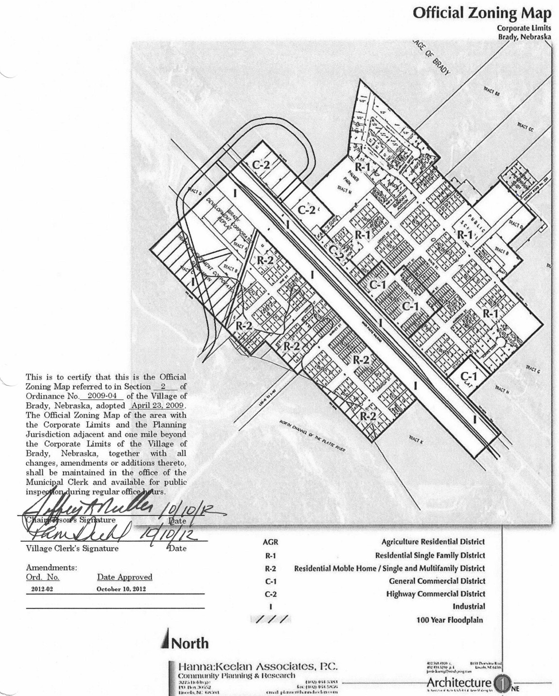
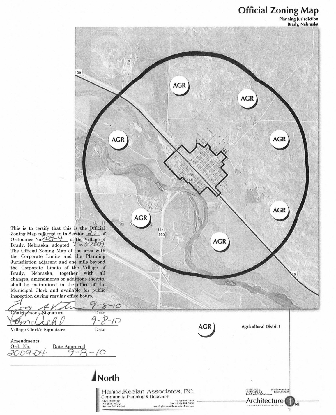
(A) AGR Agriculture Residential District;
(B) R-1 Residential Single-Family District;
(C) R-2 Residential Mobile Home/Single- and Multi-Family District;
(D) C-1 General Commercial District;
(E) C-2 Highway Commercial District; and
(F) I Industrial.
(Ord. 2009-04, passed 4-23-2009)
§ 154.027 OFFICIAL ZONING MAP.
(A) The boundaries of the district are shown upon maps, which are made a part hereof, which map(s) are designated as the village zoning district map, dated 9-8-2010 and signed by the Mayor and attested by the Village Clerk and hereinafter referred to as the “official zoning maps.”
(B) The signed copy of the zoning map(s) containing the zoning districts designated at the time of adoption of this chapter shall be maintained in the office of the Village Clerk for the use and benefit of the public.
(C) (1) If in accordance with the provisions of this chapter, changes are made in the district boundaries or other matter portrayed on the official zoning map(s), such changes shall be entered on the appropriate part of the official zoning map(s) promptly after the amendment has been approved by the governing body, with an entry on the official zoning map(s) as follows:
“On (date), by official action of the Village Board, the following change was made in the official zoning map(s) (brief description of the nature of the change), which entry shall be signed by the Mayor and attested by the Village Clerk.”
(2) No amendment to this chapter, which involves matter portrayed on the official zoning map(s) shall become effective until after such change and entry have been made on said map(s).
(D) No changes of any nature shall be made in the official zoning map(s) or matter show thereon except in conformity with the procedures set forth in this chapter.
(E) (1) In the event that the official zoning map(s) become damaged, destroyed, lost or difficult to interpret, the Village Board, may, by ordinance, adopt a new official zoning map(s) which shall supersede the prior official zoning map(s).
(2) The new official zoning map(s) may correct drafting or other errors or omissions in the prior official zoning map(s), but no such correction shall have the effect of amending the original official zoning map(s) or any subsequent amendment thereof.
(Ord. 2009-04, passed 4-23-2009; Ord. passed 9-8-2010)
§ 154.028 RULES FOR INTERPRETATION OF DISTRICT BOUNDARIES.
Where uncertainty exists as to the boundaries of districts as shown on the official zoning map(s), the following rules shall apply:
(A) Boundaries indicated as approximately following the center lines of streets, highways or alleys shall be construed to follow such center lines;
(B) Boundaries indicated as approximately following platted lot lines shall be construed as following such lot lines;
(C) Boundaries indicated as approximately following village limits shall be construed as following such village limits;
(D) Boundaries indicated as following railroad lines shall be construed to be midway between the main tracks;
(E) Boundaries indicated as parallel to or extension of features indicated in divisions (A) through (D) of this section shall be so construed. Distances not specifically indicated on the official zoning map(s) shall be determined by the scale of the map;
(F) Where physical or cultural features existing on the ground are at variance with those shown on the official zoning map(s), or in other circumstances not covered by divisions (A) through (E) of this section, the Board of Zoning Adjustment shall interpret the district boundaries; and
(G) Where a district boundary line divides a lot which was in single ownership at the time of passage of this chapter, the Board of Zoning Adjustment may permit, as an exception, the extension of the regulations for either portion of the lot not to exceed 150 feet beyond the district line into the remaining portion of the lot.
(Ord. 2009-04, passed 4-23-2009)