
Bulloch County Unincorporated
City Zoning Code
City Zoning Code
ARTICLE 19
- IGO, INTERSTATE GATEWAY OVERLAY DISTRICT
Section 1901.- IGO district boundaries.
The boundaries of the interstate gateway overlay district correspond to the boundaries of the tax allocation district #1 — I-16/U.S. 301 interstate gateway redevelopment area, as adopted by the board of commissioners and shown on the Official Zoning Map of Bulloch County, and as may be amended from time to time in accordance with the procedures of this zoning ordinance. The tax allocation district #1 — I-16/U.S. 301 interstate gateway redevelopment area is referred to herein as the "interstate gateway redevelopment area," and the redevelopment plan adopted for the interstate gateway redevelopment area is referred to as the "interstate gateway redevelopment plan."
(Amd. of 9-2-14; Amd. of 4-4-23(2), § 1901)
Section 1902. - IGO district design standards; intent.
(a)
The intent of the IGO district is to maintain high quality, long-lasting and sustainable development within the interstate gateway redevelopment area and such other areas as may be designated by the Bulloch County Board of Commissioners from time to time. The standards established by the IGO district are intended to enhance the visual aspect, livability and economic vitality of the areas included within the overlay district; foster common design themes and architectural diversity and interest; and achieve and maintain a consistent, durable and pleasing aesthetic/visual quality.
(b)
It is further the intent of the IGO district to implement the interstate gateway redevelopment plan through consistency with or as guided by the design standard concepts and the future land use, infrastructure and transportation plans adopted as part of the interstate gateway redevelopment plan, and such plans as may be amended by the board of commissioners from time to time.
(c)
The IGO district does not change the underlying zoning district of a property, but rather adds provisions that enhance, change or replace certain requirements as specified in this article that otherwise apply to the underlying zoning district.
(Amd. of 9-2-14; Amd. of 4-4-23(2), § 1902)
Section 1903. - IGO district design standards; applicability.
(a)
Construction activities subject to the IGO design standards.
(1)
The design standards contained in this article apply to all new nonresidential, multifamily and mixed-use buildings and projects to be issued building or development permits within the IGO overlay district, regardless of the underlying zoning of the property, and to any construction activity that results in the change of the principal use of a building or property.
(2)
The design standards contained in this article do not apply to additions, renovations or maintenance of buildings or land uses that existed prior to the adoption of the IGO district, provided that such activities do not involve or result in a change of the principal use of the building or property.
(b)
Uses allowed in the IGO district. All principal and accessory uses allowed by right or by conditional use approval in the underlying zoning district on a property are similarly allowed within the IGO district, except signs that are regulated under section 1907, below.
(c)
All other standards, requirements and provisions of this zoning ordinance shall apply in accordance with the underlying zoning on a property except as modified, added to or superseded by the provisions of this article 19 for a building or development project within the IGO district.
(d)
Additional and individual standards may be established through conditional zoning approval for any property within the IGO district by the board of commissioners.
(Amd. of 9-2-14; Amd. of 4-4-23(2), § 1903)
Section 1904. - Development enhancements.
Development in the underlying zoning districts within an IGO district shall be developed under the following enhanced provisions in lieu of regulations established in other articles and sections of this zoning ordinance:
(a)
Condominium or multi-family projects.
(1)
A condominium or multi-family project, where otherwise allowed by the zoning of the property, may be developed at a maximum density of no more than eight dwelling units per acre; except as allowed under the following subsection 1904(a)(2).
(2)
A condominium or multi-family project otherwise allowed under the property's zoning may be developed at a maximum density of no more than 12 dwelling units per acre provided that community recreation amenities are provided that meet or exceed the following guidelines:
a.
A community recreation amenity area or areas must be provided to serve the development. The minimum recreational facilities shall be based on the number of dwelling units served in accordance with Table 19.1, which may be met through the provision of one or more amenity areas.
b.
All amenities must be completed and available for use prior to issuance of a certificate of occupancy on more than 50 percent of the dwellings served by the recreational amenity in the development.
c.
The recreation amenity may be designed to serve the entire development or separate amenity areas may be provided for specific residential development areas. If multiple recreation amenity areas are provided, the total of all amenities shall be no less than the total required by Table 19.1 based on the entire development as a whole, distributed proportionally to each development area based on the number of dwelling units each amenity area serves.
(b)
A hotel, motel or resort hotel located within the IGO district, where otherwise allowed by the zoning of the property, shall meet or exceed the following provisions:
(1)
Each guest unit must contain a minimum square footage per unit of 300 square feet.
(2)
At least 15 square feet of gross floor area per guest unit must be provided for one or more of the following:
a.
A restaurant, deli or other sit-down food service area for breakfast service or dining;
b.
A health spa operated in accordance with state law (O.C.G.A § 10-1-392 et seq.) staffed with massage therapists that are available on site full-time or by appointment and licensed in accordance with O.C.G.A § 43-24A-a et seq.;
c.
A retail store such as a convenience, travel accessory, tourist or sports shop;
d.
A business or concierge center for guests; and/or
e.
Meeting rooms or convention facilities.
(3)
Common areas for recreational use by guests collectively containing a minimum of 15 square feet of area per guest unit must be provided. In computing the total square footage provided, swimming pools, fitness or work-out centers and other recreational or leisure facilities available to all guests may be used in determining the square footage; check-in, lobby and waiting areas shall not be included.
(4)
Management must be on the property 24 hours a day, seven days a week.
(5)
Daily maid service must be included in the standard room rate.
(c)
In the LI and HI zoning districts, the minimum front yard setback may be reduced by the zoning official to no less than 35 feet if the entire area between the building and the adjoining street is landscaped to the standards for frontage landscape strips under section 1911.
Table 19.1: Recreation Amenities
1 Children's play area including active play equipment. Multiple play areas are allowed, but none less than ½ acre in size. This area may also be occupied by athletic courts and swimming pools as required herein, and by other recreational amenities.
2 Any combination of tennis, basketball or volleyball courts.
3 For instance, 100—149 dwellings = 1 court; 150—249 dwellings = 2 courts; 250—299 dwellings = 3 courts; 300—399 dwellings = 4 courts.
4 Pools shall meet or exceed ANSI/NSPI-1 standards for class B public pools and maintain compliance with construction and operating permits issued by the health department.
Note: "sf" stands for "square feet."
(Amd. of 9-2-14; Amd. of 4-4-23(2), § 1904)
Section 1905. - Streets and roads.
(a)
Public streets and roads within a development must meet the design and construction requirements for all such public roads established by Bulloch County.
(b)
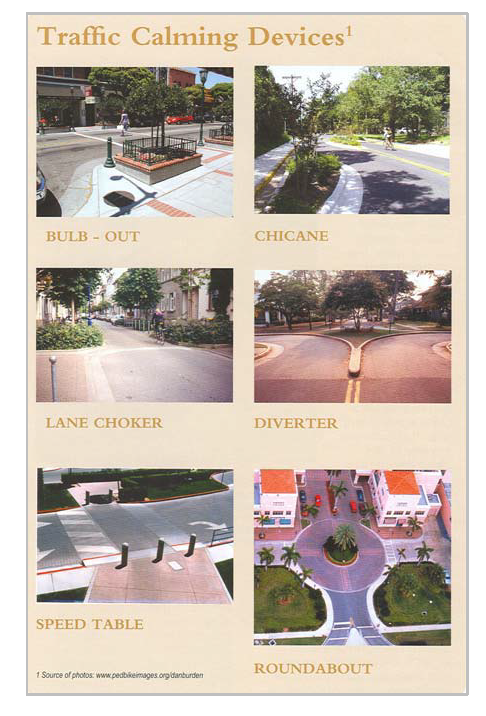
Private streets and roads may be approved with alternate design and construction standards intended to foster "smart growth" concepts and accepted principles of "new urbanism." Such an alternate design must be approved by the development services staff, and may require curb and gutter to justify reductions from the right-of-way width required for a public street. Alternate designs may include, but are not limited to:
(1)
Roundabouts and traffic circles.
(2)
On-street parking refuges with landscaped "bulb-outs."
(3)
Traffic calming strategies such as central landscaped islands, speed tables and undulating lanage created by variations in curb lines.
(4)
Alternate decorative paving materials at entrances and for pedestrian crossings.
(c)
While traffic signs and other traffic control devices must conform to the Federal Highway Administration's Manual on Uniform Traffic Control Devices, street name signs may be decorative in nature when used throughout a development, subject to approval by the development services staff for readability and ease of identification for emergency vehicles.
(d)
U.S. 301 corridor access. Any new construction or change in the principal use on a property within the IGO district having frontage on U.S. 301 must comply with the following design standards:
(1)
Along those portions of U.S. 301 where a highway median is installed or planned:
a.
Full-service vehicular driveway access directly from U.S. 301 shall be located only at median breaks where left-turning movements are allowed or planned and a left-turning lane in the median is or will be installed.
b.
Between installed or planned median break locations, vehicular driveway access directly from U.S. 301 shall be limited to right-in/right-out movements and shall be located no closer to any other vehicular driveway access on the same side of the highway than 350 feet (measured centerline-to-centerline of each driveway).
(2)
Along those portions of U.S. 301 where a highway median is not installed or planned, vehicular driveway access directly from U.S. 301 shall be located no closer to any other vehicular driveway access on the same side of the highway than 350 feet (measured centerline-to-centerline of each driveway).
(3)
Properties having frontage on U.S. 301 shall provide service road access to all abutting properties in accordance with Section 1906 as a condition of issuance of a building permit or development approval, whether or not such properties have independent access to U.S. 301.
(4)
All driveway connections to U.S. 301 must be approved by and issued permits by the Georgia Department of Transportation prior to construction. County driveway requirements that are more restrictive than those of the Georgia DOT shall prevail.
(Amd. of 9-2-14; Amd. of 4-4-23(2), § 1905)
Section 1906. - U.S. 301 corridor road and utility access.
(a)
Intent and purpose of this section.
(1)
The intent of this section is to:
a.
Create a continuous service road serving all properties that are adjacent to (or otherwise would obtain their access from) U.S. 301 in order to provide vehicular access for all such properties adjacent to or served by this limited access state highway;
b.
Provide vehicular access to properties that are to the rear of properties adjacent to U.S. 301 and that have no alternate access from a public street;
c.
Provide for the placement of utilities serving properties that provide or are provided access to U.S. 301; and
d.
Provide signage and landscaping enhancements that encourage economic development of the area.
(2)
The purpose of this section is to protect the public health, safety and welfare by:
a.
Providing for equal economic development opportunities for all properties within the U.S. 301 corridor;
b.
Providing for safe vehicular movements between U.S. 301 and adjacent properties;
c.
Protecting the operational efficiency and safety of U.S. 301 traffic, in compliance with access restrictions imposed by the Georgia Department of Transportation;
d.
Providing for uniformity and equal access to public and private utilities serving the area and each property;
e.
Allowing special signage to be placed on each property abutting U.S. 301 for enhanced visibility of businesses and development from the highway; and
f.
Providing for the aesthetic quality of the U.S. 301 corridor through the provision of landscaping to a higher standard than that required of other properties in the IGO district.
(b)
Service road and easements required.
(1)
For any property that has frontage on U.S. 301, as a condition of issuance of a development or building permit, property owners shall provide a publicly dedicated service road and grant utility easements and frontage landscape strips across their property, as described in this section, to each abutting property that also has frontage on U.S. 301 and to any other abutting property that has no access from a public street.
(2)
The service road shall permit vehicular access between abutting properties and to driveway connections with U.S. 301 located in accordance with the provisions of this article, planned road improvements contained in the I-16/U.S. 301 redevelopment plan, and the standards imposed by the Georgia Department of Transportation.
(3)
Each required utility easement shall be granted as a permanent, fully-assignable easement to Bulloch County, which may be assigned by Bulloch County for the placement of public and private utilities such as, but not limited to, water, sewer, telephone, cable, natural gas and electrical service.
(c)
Design and improvement standards.
(1)
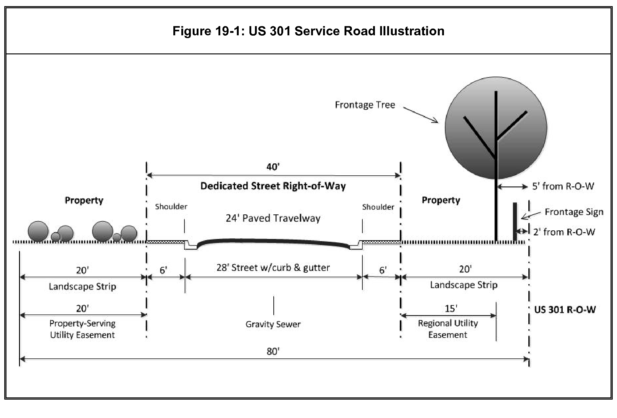
Any service road and its associated utility easements and landscaping strips, as required by subsection 1906(b)(1), collectively shall be no less than 80 feet in width.
(2)
The service road shall occupy a publicly dedicated right-of-way of no less than 40 feet in width, and shall be improved with a roadway no less than 28 feet in width (including raised curbs and a 24-foot wide travelway) in order to accommodate two-way vehicular traffic to and from the adjoining properties. The paved travelway and curbs shall be centered within the right-of-way. (See figure 19-1, below.)
(3)
A service road and utility easements running through a property that has frontage on U.S. 301 to a property located to the rear that has no public street access, shall be located by the county in consultation with the property owners involved.
(4)
The service road travelway shall be paved and constructed to the public road cross-sectional standards contained in the Bulloch County Subdivision Regulations under section 7.1, paragraphs (a) through (j) or as most recently amended. Curbing shall be raised concrete curb and gutters and provided in accordance with section 6.2.5 of the Bulloch County Subdivision Regulations. The roadway shall be provided with a six-foot wide shoulder behind each curb. After the service road has been inspected and accepted by Bulloch County, the owner(s) shall convey fee simple title to the service road right-of-way to Bulloch County.
(5)
A 20-foot wide frontage landscape strip shall be provided along each side of the service road. See section 1911 for landscaping requirements in frontage landscape strips in general, and specifically subsection 1911(c)(5) relating to the placement of frontage trees along the U.S. 301 right-of-way.
(6)
Utility easements shall be granted as follows:
a.
A 15-foot wide utility easement shall be located within the required 20-foot wide frontage landscape strip between the service road right-of-way and the right-of-way of U.S. 301, parallel and adjacent to the service road right-of-way. (See Figure 19-1, below).
b.
In all other cases, a 20-foot wide utility easement shall be located within the required 20-foot wide frontage landscape strip parallel and adjacent to the service road right-of-way, extending into the property to be developed.
(7)
A frontage sign may be placed within the landscape strip adjacent to the U.S. 301 right-of-way in accordance with subsection 1907(b)(2).
(8)
Driveways connecting development on a property to the service road shall be no more than 24 feet wide for two-way traffic and shall be no less than 100 feet from any other two-way or one-way driveway (measured centerline-to-centerline). One-way paired driveways shall be no more than 12 feet wide and shall be separated by at least 50 feet (measured centerline-to-centerline).
(9)
Construction of the service road, extension of utilities and placement of landscaping material shall be done in conjunction with the development or construction approved on the property, and their completion shall be required prior to issuance of a certificate of occupancy for such development or construction.
(d)
Modifications and relief.
(1)
Prior to its construction, the county manager or their designee shall have the power and authority to determine or modify the location, layout, design or improvement of a service road or utility easement on a property, in order to preserve or enhance the integrity, character or safety of traffic operations; its aesthetic characteristics; or the installation of public or private utilities within or crossing the property.
(2)
For service roads that terminate at the right-of-way of I-16, improvements shall be modified to provide vehicular access only as needed to serve development on the property and to serve abutting properties that otherwise have no public street access.
(Amd. of 9-2-14; Amd. of 4-4-23(2), § 1906)
Section 1907. - Signage.
All provisions of article 22 of this zoning ordinance pertaining to signs and sign permit requirements apply to properties within the IGO district, with the following exceptions:
(a)
Interstate signs. In addition to the freestanding signs allowed under article 22, one interstate sign is allowed on each property that adjoins or lies within 660 feet of the right-of-way of I-16, and is occupied by a commercial, office or industrial use, under the following provisions:
(1)
Such a sign shall be a minimum of 120 feet and a maximum of 180 feet in height;
(2)
Such a sign may include a total of 150 square feet of sign area for all signage on the sign structure;
(3)
Such a sign shall be no closer than 200 feet from any other interstate sign (measured in all directions); and
(4)
Such a sign shall be no closer to the I-16 right-of-way than 50 feet.
(b)
Frontage signs along U.S. 301. On any property that has frontage on U.S. 301:
(1)
Signs that are otherwise allowed under article 22 of this zoning ordinance, including billboards, shall not be located within any utility easement or within a landscape strip that lies between a service road right-of-way and the right-of-way of U.S. 301; and
(2)
One sign (in addition to the signs that are allowed under article 22) may be located on the property within a landscape strip (but not within a utility easement) that lies between a service road right-of-way and the right-of-way of U.S. 301. Such frontage sign must be a monument sign of no more than 120 square feet in area, must be six feet in height, and its nearest edge must be parallel to and located two feet from the U.S. 301 right-of-way.
(c)
Interstate signs (allowed under subsection (a), above) and billboards shall not be located within any minimum required front, side or rear yard.
(Amd. of 9-2-14; Amd. of 12-4-18(1); Amd. of 4-4-23(2), § 1907)
Section 1908. - Architectural design guidelines.
(a)
The use of a common palate of building materials for a specific nonresidential or multi-family project shall be maintained for all building façades to create a consistent and themed architectural identity. For large commercial/retail buildings, variations in façade, roofline and depth must be provided to lend the appearance of multi-tenant occupancy.
(b)
Terms used in this section:
Arcade: A covered walkway or structural canopy extending along the entire length of the front façade of a commercial building.
Building types:
(1)
Multi-family residential: A residential building containing three or more dwelling units.
(2)
Commercial or office: A building occupied by one or more business establishments that are primarily engaged in the sale of goods; the provision of personal, professional, business, entertainment or other commercial services; the management of a business enterprise; or the provision of temporary housing to the traveling public (such as a motel).
(3)
Mixed-use: A building occupied by both commercial stores or offices and residential dwelling units.
(4)
Industrial: A building occupied by one or more business establishment that are primarily engaged in the fabrication, manufacture or production of durable or non-durable goods.
(5)
Institutional: A building occupied by a nonprofit religious, recreational or philanthropic organization, club or private school.
Façade: A vertical exterior face or elevation of a building.
(1)
Front façade: Any façade with a public entry that faces a public right-of-way. "Facing" a right-of-way shall include being angled 60 degrees or less toward a right-of-way.
(2)
Rear façade: Any façade without a public entry that does not face a public right-of-way. Such façades may form the "sides" of a building if not facing a right-of-way.
(3)
Side façade: Any façade without a public entry but facing a public right-of-way or any façade with a public entry but not facing a public right-of-way. A side façade typically connects a front façade with a rear façade.
Net square footage of wall area: The total area in square feet of a single building façade, less the total area of windows and doors contained within the façade.
Nonresidential use or development: A property that contains or is intended to contain a commercial, office, industrial or institutional building as its principal use (as defined in this zoning ordinance), or a mixed-use building that exclusively contains commercial, office, industrial or institutional uses on its first or ground floor.
Obscured from view: The imposition of structural or natural materials between an observer and an object such that the features of the object become visually indistinguishable.
(c)
Building plans.
(1)
All building plans submitted as an application for a building permit within the IGO district must clearly indicate all of the proposed building materials and colors for each façade as described herein. The plans must clearly show the location and calculate the amount/percentages of all building materials per façade.
(2)
Groups of buildings on the same parcel of land may be reviewed and permitted as a single project rather than individual buildings. Grouping of similar buildings is encouraged to minimize the number of reviews required and to allow for originality and design flexibility.
(d)
General architectural requirements.
(1)
All ground mounted mechanical, HVAC and like systems shall be obscured from view on all sides by an adequately opaque wall, fence or lattice made of materials compatible with the building's materials, or with dense evergreen landscaping.
(2)
For all commercial or office buildings, roof mounted mechanical, HVAC and like systems shall be obscured from view from any public street.
(3)
Permanent mounted exterior neon lights shall not be allowed. Under-canopy lighting shall be recessed and not directly visible from any public street.
(4)
In a nonresidential development with out-parcels, buildings located on the out-parcels shall be constructed of the same primary building material as the principal building with which they are associated.
(5)
Back-lit awnings, roof mounted lights, and/or roof mounted flag poles are not allowed. Satellite dishes shall be located and painted to blend with the background as much as practical.
(6)
Overhead doors for nonresidential uses are not allowed to face a public street or highway.
(e)
Building materials. The following building materials may be used and combined to create a consistent, attractive, interesting and long-lasting building design. The quantity and type of building materials are described below.
(1)
Allowed building materials.
a.
Brick or brick veneers.
b.
Stone or stone veneers of natural stone such as, but not limited to, granite, limestone and marble are allowed building materials. Terra cotta and/or cast stone, which simulate natural stone, are also acceptable. Painted stone is not allowed.
c.
Tilt/architectural pre-cast concrete.
d.
High grade stucco. Simulated or artificial stucco products are not acceptable.
e.
Painted concrete block.
f.
Split-face block/concrete masonry unit (CMU).
g.
Natural wood and cement-based artificial wood siding.
h.
Structural glass or glass curtain wall.
i.
Pre-engineered metal buildings.
(2)
Ratios and amounts of allowed building materials. The following Table 19.2 outlines the allowed building materials for specific types of uses that apply to each façade:
Table 19.2: Allowed Building Materials
(3)
Accent/trim exterior building material. Small amounts of building materials such as wood, tile, etc., may be used to enhance the elevation of the building or for decorative elements but must not exceed ten percent of total wall area per façade.
(4)
Façade calculations.
a.
With the exception of accent/trim materials, there shall be no more than two primary building materials used on any one façade. When a material is restricted as a percentage in Table 19.2, such as stucco, siding, etc., the building material may not be combined with another restricted building material. The allowed façade materials shall not apply to windows, glass-front windows, entry doors and/or roll-up doors.
b.
The amount of permitted material shall be calculated using the net square footage of wall area per façade. A building material that is allowed (such as brick) may be used in any percentage throughout the structure. A material that is restricted (such as stucco) is allowed as a maximum percentage.
For example, a commercial building has a front façade with a gross façade area of 1,200 square feet with 400 square feet consisting of windows and doors. Begin with the net square footage of wall area of 800 square feet (1,200 minus 400) for required building material calculations. In this case, the front façade of a commercial building with a net wall area of 800 square feet shall have no more than 200 square feet of stucco on the front façade (800 x 25% = 200). The balance must be brick or another allowed material without a percentage restriction.
(f)
Roof requirements.
(1)
Sloped roofs. Sloped roofs must be covered with shingles, tiles, standing seam metal, or other material with similar appropriate texture and appearance. Tar paper and corrugated metal roofs are not allowed on sloped roofs.
(2)
Mansard roofs. Mansard roofs shall have a minimum pitch of 2:1 (60°) and a maximum pitch of 90° (vertical), with a minimum four-foot vertical surface rise. The top story of a building may simulate a mansard roof but the minimum and maximum pitches will apply.
(3)
Canopies. Drive under canopies for gasoline pumps may have a flat roof with vertical or factory formed facing of finished sheet metal.
(4)
Arcade for multi-tenant commercial building. For any multi-tenant commercial shopping center or strip retail/service center, a covered arcade shall be provided along the front façade of the building. Arcades are covered walkways connected to or separate from the principal building. They should be designed in a manner that provides architectural depth to the building and includes covered areas for relief from the weather. The arcade must be a minimum of five feet in width.
(g)
Alternate standards.
(1)
The architectural design standards of this section are intended to be followed as outlined above. In the event the intent of these standards can be achieved with minor deviations that do not substantially affect the purpose and intent of this section, the county manager or their designee has the authority to modify the specific provisions on a case-by-case basis.
(2)
If substantial modifications or changes to the architectural design standards of this section are desired for a particular property or building, the property owner may apply for a variance to modify these standards. Any application for an alternate architectural design standard shall be accompanied with proposed elevations, building material descriptions and renderings necessary for the planning and zoning commission to make a determination whether the alternate proposal meets the intent of these requirements. A variance approval may be granted with conditions, modifications or requirements deemed necessary to maintain the high level of development quality intended by the IGO district.
(Amd. of 9-2-14; Amd. of 4-4-23(2), § 1908)
Section 1909: - Exterior lighting.
(a)
Definitions of terms used.
Direct light: Light emitted directly from the lamp, off of the reflector or reflector diffuser, or through the refractor or diffuser lens, of a luminary.
Luminary: A complete lighting system, including a lamp or lamps and a fixture. This term shall be interpreted broadly as applying to all outdoor electrically powered illuminating devices, outdoor lighting or reflective surfaces, lamps and similar devices (permanently installed or portable), used for illumination or advertisement.
Luminary, full cut-off: Outdoor light fixtures shielded or constructed so that no direct light rays are emitted by the installed fixture at angles above the horizontal plane of the lowest part of the luminary.
(b)
Purpose and intent. This section is intended to reduce the problems created by improperly designed and installed outdoor light fixtures, eliminate problems of glare, and minimize light trespass, with regulations that avoid unnecessary direct light from shining onto abutting properties or streets.
(c)
Direction of luminaries.
(1)
Light must be directed away from residential buildings and motor vehicles on public roadways.
(2)
Any luminary that is aimed, directed, or focused such as to cause direct light from the luminary to be directed toward residential buildings on adjacent or nearby land, or to create glare perceptible to persons operating motor vehicles on public roadways, shall be redirected or its light output controlled or shielded as necessary to eliminate such conditions.
(d)
Luminaries adjacent to residential districts. For any commercial use adjacent to an area zoned AG-5, R-80, R-40, R-25, R-15, R-2, R-3 or MHP, or residential portions of a PUD, all luminaries, hereafter installed for outdoor lighting shall be full cut-off luminaries, as defined by this section, or another luminary that does not emit any direct light above the horizontal plane of the lowest part of the luminary.
(e)
Prohibited lighting. The following types of outdoor lighting are prohibited:
(1)
Searchlights for advertising purposes;
(2)
Laser source light, or any similar high intensity light, used for any purpose.
(Amd. of 9-2-14; Amd. of 4-4-23(2), § 1909)
Section 1910. - Landscaping.
The landscaping requirements of the IGO district are in addition to the buffer and screening requirements of article 4 of this zoning ordinance.
(a)
Purpose. The purpose of the landscaping requirements of the IGO district is to improve the aesthetic qualities of the district and to protect and preserve the appearance, character and value of its neighborhoods and business areas by:
(1)
Providing for quality and consistency in the design and location of landscaping;
(2)
Providing for a "signature look" for the area to establish a unique sense of place; and
(3)
Providing for increased economic development opportunities through an enhanced aesthetic setting attractive to customers and employees alike.
(b)
Definitions related to landscaping.
Caliper: The diameter of a tree (usually nursery stock) measured at a point six inches above the ground or top of root ball for up to and including four-inch caliper trees, and at a point 12 inches above the ground or top of root ball for larger sizes.
Deciduous: A plant with foliage that is shed annually.
Evergreen: A plant with foliage that persists and remains green year-round.
Ground cover: Low growing, spreading plants, other than turf grass, such as but not limited to ivy, liriope, juniper, mondo grass or sedge.
Landscape materials: Any combination of living plant materials and nonliving materials such as rocks, pebbles, wood chips, mulch and pavers, and decorative features, including sculpture, patterned walks, fountains, and pools. Synthetic landscaping materials acceptable to the zoning official may also be used.
Mulch: Pine straw, pine or cypress bark, pebbles, lava rock or synthetic landscaping materials acceptable to the zoning official.
Shrub: A self-supporting woody plant that normally reaches a height of less than 15 feet, such as but not limited to azalea, boxwood, yew, hydrangea, holly, nandina or camellia.
Tree: A large, woody plant that has one or several self-supporting stems or trunks and numerous branches, and that normally reaches a height of 15 feet or more. May be classified as deciduous or evergreen.
Tree, shade: A broadleaf tree that has a single trunk and which will reach at least 35 feet in height and 35 feet in spread at maturity. In defining such trees, reference may be made to the latest editions of Landscape Plant Materials for Georgia (Cooperative Extension Service, The University of Georgia College of Agriculture, Bulletin No. 625) and the Manual of Woody Landscape Plants (Michael Dirr, 1983, Castle Books).
(Amd. of 9-2-14; Amd. of 4-4-23(2), § 1910)
Section 1911. - Frontage landscape strips.
(a)
Frontage landscape strips; where required.
(1)
Single-family residential subdivisions and lots are exempt from the requirements of this section.
(2)
All properties having frontage on U.S. 301 shall provide landscape strips along U.S. 301 and along their respective service roads, located as described in subsection 1906(c)(5).
(3)
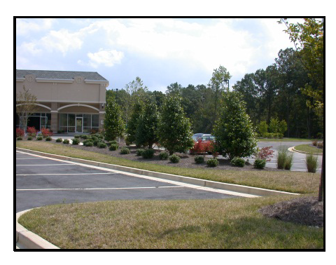
For all other properties having frontage on a public street other than U.S. 301, multi-family, office, institutional, commercial and industrial projects located in the R-3, PUD, MHP, GC, NC, LI or HI zoning districts shall provide and maintain a continuous 20-foot wide frontage landscape strip (exclusive of driveways) adjacent to all public street rights-of-way.
(4)
All minimum required landscape strips shall be landscaped in accordance with the requirements of this section and shall be provided with an installed irrigation system. The location and detail of all required landscaping shall be depicted on the site landscaping plan required under section 1913.
(b)
Location of structures in frontage landscape strips. If a frontage landscape strip is required, it shall contain no structures, parking areas, patios, non-landscaped or wet pond storm water detention facilities, or any other accessory uses except for the following:
(1)
Retaining walls or earthen berms constructed as part of an overall landscape design.
(2)
Pedestrian-oriented facilities such as sidewalks.
(3)
Underground utilities and fire hydrants.
(4)
Driveways required to access the property.
(5)
Signs otherwise permitted by the IGO district and this zoning ordinance.
(c)
Landscaping required in frontage landscape strips.
(1)
All portions of a required frontage landscape strip shall be covered by landscape materials, as defined in this article, except for those ground areas that are covered by permitted structures. A minimum of 50 percent of the required landscape area shall be covered with living plant materials.
(2)
Shrubs are to be provided within the frontage landscape strip at the rate of three shrubs for every ten linear feet of street frontage, or portion thereof (excluding driveways). Shrubs must be at least 18 inches tall at the time of planting, and be of a species that will normally exceed two feet in height at maturity.
(3)
Trees may be planted in a frontage landscape strip in lieu of shrubs in a ratio of one tree = six shrubs. Such trees must be of a type that is suitable to local growing conditions. Upon planting, new deciduous trees shall have a caliper of no less than two inches and new evergreen trees shall be at least six feet tall.
(4)
Plant materials may be clustered for decorative effect following professional landscaping standards for spacing, location and design, except for trees required for tree-line planting along U.S. 301.
(5)
Along U.S. 301, within the frontage landscape strip adjacent to the highway, trees shall be planted in a line five feet from the right-of-way line of U.S. 301. Trees shall be spaced 40 feet on center and located in multiples of 40 feet from the nearest intersection of the rights-of-way of U.S. 301 and I-16 on the same side of the highway as the frontage landscape strip.
a.
Such trees along U.S. 301 must be one or any combination of the following species.
1.
Japanese Cryptomeria;
2.
Leyland Cypress; or
3.
Bald Cypress.
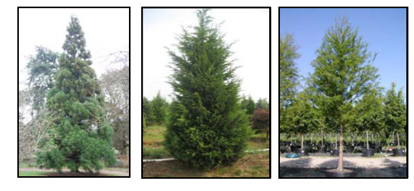
b.
An alternate but equivalent tree species approved by a Georgia Registered Landscape Architect for growing conditions on a particular property may be considered for approval by the zoning official under the provisions of subsection 1913(c)(2).
(Amd. of 9-2-14; Amd. of 4-4-23(2), § 1911)
Section 1912. - Parking lot plantings.
(a)
Parking lot internal planting areas. The following requirements of this section apply to any parking lot designed or intended to accommodate five motor vehicles or more for residents, employees, customers or visitors in the R-3, PUD, MHP, GC, NC, LI or HI zoning districts within the IGO district. Parking lots designed and intended for the storage of vehicles owned by the business on site overnight (such as a company fleet), or maintains a stock of vehicles as part of its business activities (such as a car sales lot, a salvage and wrecking yard, car rental agency, etc.), are not subject to the requirements of this section.
(b)
Trees required in parking lots. At least one shade tree or evergreen tree (as defined in this article), occupying a planting space of at least 150 square feet each, shall be furnished for each ten parking spaces in the parking lot.
(1)
Trees must be placed in or around the parking lot such that every parking space is within 50 feet of a tree. The 50-foot distance is measured from the center of the tree to any point within the parking space.
(2)
New shade trees shall have a caliper of no less than two inches upon planting, or a height of no more than six feet for evergreens, and shall be maintained in good condition. Trees that must be removed as a result of disease, damage or death, must be replaced.
(c)
Standards for parking lot planting areas.
(1)
Landscape islands, strips or other planting areas shall be located within the parking lot and shall constitute at least ten percent of the entire area devoted to parking spaces, aisles and connecting driveways.
(2)
Landscape islands, strips or other planting areas shall be landscaped with any combination of such plant materials as trees, shrubs, grass or ground cover, except for those areas that are mulched. Such planting areas shall be well drained and contain suitable soil; and shall be provided with an installed irrigation system.
(3)
As a minimum, a landscaping island shall be located at the end of every parking bay between the last parking space and an adjacent travel aisle or driveway. The island shall extend the length of the parking bay and shall be no less than eight feet wide for at least one-half the length of the adjacent parking space.

(4)
Landscape islands between side-by-side parking spaces shall be no less than eight feet in width and extend for at least one-half the length of the adjacent parking space. Landscaping strips between head-to-head parking spaces shall be no less than eight feet in width without wheel stops, or five feet in width when provided with wheel stops in the parking spaces such that no vehicular overhang is permitted.
(Amd. of 9-2-14; Amd. of 4-4-23(2), § 1912)
Section 1913. - Landscaping plans; plant materials.
(a)
Landscaping plans; when required.
(1)
The provisions of this section do not apply to landscaping of any kind that exceeds or is otherwise not required by the landscaping requirements of this article.
(2)
Site landscaping plans are required upon application for a development permit or for a building permit for new construction of buildings or any development to which landscaping requirements of this article apply.
(3)
Site landscaping plans shall be required for only that phase of development for which the development permit or building permit is being requested.
(4)
In cases where approval of the required landscaping plans would cause harmful delay to the start of construction, the zoning official may issue footing and foundation permits for the project so that construction may proceed, pending approval of the landscaping plans.
(5)
Authorization for construction beyond the footing and foundation shall not be issued until the required site landscaping plans have been submitted and approved.
(b)
Landscaping plans; specifications. All site landscaping as required by this article for frontage landscape strips and parking lot plantings shall be illustrated on plans as described in this subsection.
(1)
Scale at one inch = 20 feet to 50 feet, as needed to clearly illustrate the proposed plantings. Multiple sheets keyed to an index sheet may be used.
(2)
Caption:
a.
The name of the development and its total acreage (or square footage if less than an acre).
b.
Name, address, telephone and fax numbers of the property owner and developer.
c.
Name, address, telephone and fax numbers of the applicant.
d.
Name, address, telephone and fax numbers of the individual or company responsible for the design. The name, registration number and seal of the professional under whom the plan was prepared, if any, shall be stamped on the plan and signed.
e.
Date of survey, north point and graphic scale, source of datum, date of plan drawing, and revision dates, as appropriate.
(3)
The location and size of all underground or aboveground utilities within the landscaping area, including the limits of any public or private utility easements and storm water detention areas.
(4)
The outline of all existing (to remain) and proposed buildings and structures.
(5)
The boundaries of all areas required to remain undisturbed.
(6)
The location and details of any buffer or other screening required under article 4 of this zoning ordinance.
(7)
The boundaries of each required landscape frontage strip and parking lot planting area.
(8)
A planting plan showing the location, size, and the botanical and common names of proposed plant materials.
(9)
The location, size and common name of all existing plant materials to be retained that contribute to meeting the minimum requirements of this article for landscape strips or parking lot landscaping.
(c)
Acceptable plant materials. The following are the minimum plant sizes and conditions to be used in satisfying the requirements of this article. Acceptable plant materials for landscaping shall be as approved by a Georgia registered landscape architect if deviations from these standards are desired by the developer.
(1)
New plant materials.
a.
Medium shrubs (those having a mature height of four feet or less), 18 x 24-inch balled and burlapped meeting the American Standard for Nursery Stock ANSI Z60.1 (2004 or latest adopted edition).
b.
Large shrubs (those having a mature height greater than four feet), 24 x 30-inch balled and burlapped meeting the American Standard for Nursery Stock ANSI Z60.1 (2004 or latest adopted edition).
c.
Ground cover, two and one-half-inch pot.
d.
Deciduous trees, minimum two-inch caliper.
e.
Evergreen trees, minimum six feet high at the time of planting.
The American Standard for Nursery Stock, published by the American Association for Nurserymen, may be referred to for the determination of plant standards.
(2)
Approval of plant materials. Approval of a proposal to use a specific landscaping material shall be subject to a determination by the zoning official that the proposed material is approved by a Georgia registered landscape architect as the most appropriate for:
a.
The specific location, given surrounding land uses on nearby properties; and
b.
The specific topography, soil, existing vegetation, and other factors that may influence the effectiveness of a landscaping material.
(d)
Installation and maintenance of plant materials.
(1)
Installation of plant materials. Plant materials, as required by the provisions of this article, shall be installed prior to issuance of a certificate of occupancy. The zoning official may allow up to one planting season in a 12-month period in which the installation of plant materials shall be completed, subject to the performance surety requirements, below.
(2)
Performance surety.
a.
In such cases as when planting stock availability is low or weather conditions are not appropriate for planting, the project owner may postpone planting until the next planting season; provided that performance surety is posted with Bulloch County in accordance with the following criteria:
1.
Surety shall be in cash held in escrow or an irrevocable letter of credit submitted to the zoning official, with the appropriate documentation.
2.
Surety shall be provided in an amount equal to 110 percent of the cost of plant materials, installation and two-year guarantee as demonstrated by a signed contract between the owner and their landscape contractor, and as approved by the zoning official.
b.
An inspection shall be made by the zoning official of all landscape plantings to assure compliance with plan requirements prior to release of the performance surety. The performance surety will be drawn upon by Bulloch County at the time of expiration if the planting requirements have not been fulfilled, or if the owner has not requested an extension. One three-month extension may be permitted with documented justification acceptable to the zoning official. Any inspections performed after the final inspection (for project release) are subject to re-inspection fee schedules.
(3)
Maintenance surety.
a.
Prior to issuance of a certificate of occupancy, or prior to release of a performance surety provided under this section (whichever last occurs), a maintenance surety in the form of a letter of credit or cash escrow account in a form acceptable to the zoning official is required for all plant materials installed as a result of the requirements of this article. The developer shall be responsible for maintenance of all such plant materials for two years from the date of acceptance of the maintenance bond.
b.
The value of the maintenance surety shall be equal to 25 percent of the actual cost of installation of the plant materials. The cost of installation shall be evidenced by copies of contractor agreements or actual invoices paid, or as otherwise determined by the zoning official in accordance with generally established costs for the industry.
(4)
Maintenance of required plant materials.
a.
The owner, tenant and their agent, if any, and their successors and assigns shall be jointly and severally responsible for the maintenance in good condition of the plant materials used to meet the minimum landscaping requirements of this article. This responsibility is in addition to and survives the release of any maintenance surety provided for the property by the developer.
b.
Plants that are diseased, unsurvivably damaged or are dead, shall be removed and replaced with a plant of the same species, variety or cultivar, as acceptable to the zoning official.
c.
Other landscape materials shall be maintained in proper repair and shall be kept clear of refuse and debris.
(Amd. of 9-2-14; Amd. of 4-4-23(2), § 1913)
Section 1914. - Water and sewer.
(a)
For purposes of this section, the following terms shall have the following meanings:
Planned development: Refers to new private or public land developments within or partially within the IGO district approved by the county according to a development plan and consisting of residential subdivisions of five or more lots, commercial subdivisions of two or more lots, two-family or multi-family developments with a net density of two units per acre or greater, planned unit developments as provided for in article 12 of appendix C—zoning, sections 1201 et seq. of the Code of Ordinances of Bulloch County, Georgia, or a single unit commercial or industrial development with an estimated usage of 1,000 gallons per day or more of wastewater calculated pursuant to the City of Statesboro's Aid-to-Construction Fee Ordinance in accordance with City of Statesboro Code Section 82-176.
New development: Refers to new private or public land developments within or partially within the IGO district that are not a planned development, a farm, or a single-family residential property.
(b)
Planned developments or new developments located on property within or partially within the IGO district shall be required to connect to the City of Statesboro's water and sewer infrastructure pursuant to Water/Sewer Agreement "A" for Tax Allocation District #1, included herein as appendix 19.1, if any portion of the planned development's property or new development's property is located within 1,000 linear feet of any component of the City of Statesboro's water and sewer infrastructure capable of providing the planned development or new development water and sewer service, or if due to expansion of the City of Statesboro's water and sewer infrastructure the planned development's property or new development's property becomes located within 1,000 linear feet of any component of the City of Statesboro's water and sewer infrastructure capable of providing the planned development or new development water and sewer service.
(c)
If a planned development or new development located on property that is within or partially within the IGO district is not located within 1,000 linear feet of any component of the City of Statesboro's water and sewer infrastructure capable of providing the planned development or new development water and sewer service, then the planned development or new development may install a private water system and sewer disposal system in anticipation of future connection to the City of Statesboro's water and sewer infrastructure pursuant to the terms and conditions in Water/Sewer Agreement "B" for Tax Allocation District #1, included herein as appendix 19.2.
(d)
The City of Statesboro and the county reserve the right to grant a joint waiver of a planned development's or new development's obligation imposed by the county on planned developments or new developments within the IGO district to connect to the City of Statesboro's water and sewer infrastructure. The county and the City of Statesboro shall act in good faith in considering a request for waiver, and the grant of a waiver shall not be unreasonably withheld by either the county or the City of Statesboro.
(Amd. of 9-2-14; Amd. of 4-4-23(2), § 1914)
APPENDIX 19.1. - WATER/SEWER AGREEMENT "A" FOR TAX ALLOCATION DISTRICT #1
GEORGIA, BULLOCH COUNTY
THIS AGREEMENT entered into this ___ day of ________, 20___ by and between the MAYOR AND CITY COUNCIL OF STATESBORO, a municipal corporation, its assigns and successors, hereinafter referred to as "City" and ___________, their heirs, assigns and successors, hereinafter referred to as "Developer", the developer of the project known as ___________.
WHEREAS, in regard to extending and making additions to the City's water and/or sanitary sewer systems and also to the construction of water distribution and/or sanitary sewer collection and disposal systems to serve the property known as ___________; located at ___________ and
WHEREAS, the engineering design for said water and sanitary sewer systems will be accomplished by competent, professional engineers registered in the State of Georgia;
NOW THEREFORE, the City and ___________ covenant and agree as follows:
1. City shall approve the designation of the engineer who shall be responsible for the engineering design and inspection in connection with the installation of said water and sanitary sewer systems. The Developer shall be responsible for providing resident inspection during construction and for insuring the engineer's conformance to area planning, adequacy of design, and conformance to City requirements regarding location, size and depth of lines, capacity and arrangements of lift stations and quality of construction. The Developer shall provide to the City a statement from the project engineer certifying that the materials and workmanship including pipes, bedding, thrust blocks, valves, fire hydrants, manholes, lift station equipment and other related materials and work meet the approved specifications and plans. Upon request of the City, the certification shall be substantiated by material affidavits from suppliers and by applicable test results for inflow/infiltration, exfiltration, deflection, pressure, leaks, bacteria, compaction and other tests required by the City. All construction, engineering and inspection costs in connection with these systems shall be borne by the Developer. The City will provide only the sewage treatment facility and the water supply facility.
2. The Developer will pay a five hundred ($500.00) dollar non-refundable fee to the City of Statesboro to cover the costs for the City's Consulting Engineers to review plans for compliance with the City's Long Range Water and Sewer Master Plan as well as the Long Range Water and Sewer Master Plan adopted for Tax Allocation District One by BULLOCH COUNTY BOARD OF COMMISSIONERS and the MAYOR AND CITY COUNCIL OF STATESBORO. This fee will also cover the costs for said Engineer to update the Water and Sewer Master Plan as per the development and to update the City's water/sewer location maps to include this extension of mains. The Developer covenants and agrees to reimburse the City for additional inspection time on unfamiliar contractors until such time as the contractor is approved by the City.
3. Both parties covenant and agree that if the project is located outside the City Limits, but is not contiguous to the City Limits, in order to receive utilities from the City, the Developer will comply with the City's Water and Sewer access, design and construction standards. Except for the City's water and sewer access, design and construction standards, the County's developmental regulations, e.g. the County's comprehensive plan, the district redevelopment plan, land development standards, zoning, permitting, regulations and review processes not in conflict with the City's water and sewer access, design and construction standards shall apply.
4. The Developer shall hold the City harmless and indemnify City against any damages due to work associated with the tie on of existing water or sanitary sewer lines.
5. Both parties covenant and agree that upon completion of the systems and all related facilities, including all associated water and sewage fees being fully paid for by the Developer (except the sewage treatment facility and the water supply facility) and after the submission of "as built" drawings (one electronic copy in a format acceptable to the City and two blueprint plans), the City will, subject to approval of the City Engineer, accept title thereto and assume responsibility for maintenance and operation of those portions located within public easements or rights-of-way. The acceptance shall include all rights, title and interest that the Developer has in the water and sanitary sewer systems servicing the said project and also all easements and/or rights-of-way required for the purpose of maintenance thereof. Developer agrees to execute any further documentation, such as a Bill of Sale and/or Easement, upon request of the City as may be necessary to transfer title to the systems. The Developer shall bear the costs for the proper recording of all water and sewer easements. Those portions of the facilities not so conveyed by the Developer such as single use lines, shall remain the responsibility of the Developer or its assigns as to the ownership and maintenance.
6. The Developer warrants the water and sanitary sewer systems to include all parts, piping and pumping devices that make up the water or sewer system against defects and improper installation for a period of one (1) year from the date the City accepts the system. During the one (1) year warranty any repairs to the system will be made at the expense of the Developer and any street repairs necessitated for the maintenance and repair of the water system and/or sanitary sewer systems will also be at the expense of the Developer.
7. The Developer agrees to, whenever possible, acquire and dedicate rights-of-way and/or easements necessary to connect the project to the City's water and sewer infrastructure. In the event the developer cannot acquire and dedicate rights-of-way and/or easements necessary to connect to the City's water and sewer infrastructure, and the City's subsequently acquires the needed rights-of-way and/or easements necessary to connect to the City's water and sewer infrastructure, then the owner or developer shall reimburse that Party for all costs associated with acquiring the needed rights-of-way and/or easements.
8. Upon approval engineering and design plans by the City, and if no rights-of-way, easements or other property rights must be obtained to connect to the City's water and sewer infrastructure the Developer must connect the project to the City's water and sewer infrastructure within the District within ONE HUNDRED AND EIGHTY (180) days.
9. Upon approval of the engineering and design plans by the City, and if rights-of-way, easements or other property rights must be obtained to connect to the City's water and sewer infrastructure the Developer must connect the project to the City's water and sewer infrastructure within the District within THREE HUNDRED AND SIXTY-FIVE (365) days.
10. In the event the Developer sells any or all of the property containing the project prior to connecting to the City's water and sewer infrastructure, the developer shall upon sale include appropriate deed restrictions requiring all subsequent owners of the property to connect to the City's water and sewer infrastructure.
11. Both parties covenant and agree that all costs, including construction, land, legal and engineering, in connection with the addition and/or installation of the system shall be borne by the Developer. It shall be the Developer's responsibility to obtain all the necessary regulatory permits and approvals. It is understood and agreed by and between the parties that the City's sole responsibility will be to provide the sewage treatment facility, the water supply facility and any water and sewer mains that may already be in place.
12. Developer acknowledges that there is an Aid to Construction fee (ATC) for each gallon of sewage accepted by the City from Developer for treatment. This fee shall be imposed in accordance with the current City rates in effect and shall be paid by Developer to the City upon execution of this Agreement. The current rate is $_____ per gallon per day of sewage accepted by the City for treatment. The City calculates that _____ gallons per day of sewage from the Project will be treated by the City. The Developer, therefore, tenders the amount of $_____ to the City in payment of this fee. If it becomes apparent that the amount of sewage to be treated by the City will exceed the amount set forth above, Developer shall immediately tender such payment of the ATC fees to the City as is required. It shall be the responsibility of the City to correctly calculate the gallons of sewage from the Project to be treated by the City. The City's calculations shall be consistent with the City's schedule of contributory load factors. The ATC fee is payable upon execution of the agreement.
13. It is understood and agreed by and between the parties that there shall be a sanitary sewer connection fee and a separate water connection fee in accordance with the current City rates in effect. The connection fees shall be paid upon issuance of a building permit.
14. Developer acknowledges that the City shall be the sole provider of water for consumption or irrigation and covenants and agrees not to obtain a private well or obtain water from any source other than the City.
15. This agreement may not be transferred or assigned in whole or of any part by Developer without prior written consent of the City and any violation of this agreement shall terminate the City's obligation hereunder.
16. This agreement is to be governed by Georgia Law and it is understood and agreed by and between the parties that all provisions of both state and federal law now or hereafter in effect relating to water and sewage service shall be applicable to this Agreement.
IN WITNESS WHEREOF all parties have set their hands and seals on this day of ________, 20___.
MAYOR AND CITY COUNCIL OF STATESBORO
BY: ___________
ATTEST:___________
Signed, sealed and delivered
in the presence of:
___________
Witness
___________
Notary Public
DEVELOPER
BY: ___________
ATTEST:___________
Signed, sealed and delivered
in the presence of:
___________
Witness
___________
Notary Public
(Amd. of 9-2-14; Amd. of 4-4-2023(2))
APPENDIX 19.2. - WATER/SEWER AGREEMENT "B" FOR TAX ALLOCATION DISTRICT #1
GEORGIA, BULLOCH COUNTY
THIS AGREEMENT entered into this ___ day of ________, 20___ by and between the MAYOR AND CITY COUNCIL OF STATESBORO, a municipal corporation, its assigns and successors, hereinafter referred to as "City" and ___________, their heirs, assigns and successors, hereinafter referred to as "Developer", the developer of the project known as ___________.
WHEREAS, this project is located within or partially within Tax Allocation District One, but is not currently located within one thousand (1,000) linear feet of any component of the City's water and sewer infrastructure capable of providing the project water and sewer service;
WHEREAS, the Developer needs to install a private water system and sewer disposal system to serve the project the property known as ___________; located at ___________ in anticipation of future connection to the City's water and sewer infrastructure;
WHEREAS, the engineering design for said private water system and sewer disposal system will be accomplished by competent, professional engineers registered in the State of Georgia;
NOW THEREFORE, the City and ___________ covenant and agree as follows:
1. City shall approve the designation of the engineer who shall be responsible for the engineering design and inspection in connection with the installation of said water system and sewer disposal system. The Developer shall be responsible for providing resident inspection during construction and for insuring the engineer's conformance to the applicable City's Water and Sewer access, design and construction standards. The Developer shall provide to the City a statement from the project engineer certifying that the materials and workmanship other related materials and work meet the approved specifications and plans. Upon request of the City, the certification shall be substantiated by material affidavits from suppliers and by applicable test results for inflow/infiltration, exfiltration, deflection, pressure, leaks, bacteria, compaction and other tests required by the City. All construction, engineering and inspection costs in connection with the private water system and sewer disposal system shall be borne by the Developer.
2. The Developer will pay a five hundred ($500.00) dollar non-refundable fee to the City of Statesboro to cover the costs for the City's Consulting Engineers to review plans for compliance with the City's Water and Sewer access, design and construction standards. The Developer covenants and agrees to reimburse the City for additional inspection time on unfamiliar contractors until such time as the contractor is approved by the City.
3. The Developer warrants that the private water system and sewer disposal system shall comply with City's Water and Sewer access, design and construction standards as well as all other applicable State and Federal laws and regulations.
4. The Developer covenants and agrees that when any part of the property containing the project becomes located within one thousand (1,000) linear feet of any component of the City's water and sewer infrastructure capable of providing the project water and sewer service, the Developer shall cause the project to connect to the City's water and sewer infrastructure pursuant to the conditions set forth in the "Water/Sewer Agreement "A" for Tax Allocation District #1" a copy of which is attached as Exhibit A to this agreement.
5. In the event any or all of the property containing the project is sold prior to connecting to the City's water and sewer infrastructure, the developer shall upon sale include appropriate deed restrictions requiring all subsequent owners of the property to connect to the City's water and sewer infrastructure pursuant to the conditions set forth in the "Water/Sewer Agreement "A" for Tax Allocation District #1", a copy of which is attached as Exhibit A to this agreement, when any part of the property containing the project becomes located within one thousand (1,000) linear feet of any component of the City's water and sewer infrastructure capable of providing the project water and sewer service.
6. Both parties covenant and agree that all costs, including construction, land, legal and engineering, in connection with the addition and/or installation of the private water system and sewer disposal system shall be borne by the Developer. It shall be the Developer's responsibility to obtain all the necessary regulatory permits and approvals.
7. This agreement may not be transferred or assigned in whole or of any part by Developer without prior written consent of the City and any violation of this agreement shall terminate the City's obligation hereunder.
8. This agreement is to be governed by Georgia Law and it is understood and agreed by and between the parties that all provisions of both state and federal law now or hereafter in effect relating to water and sewage service shall be applicable to this Agreement.
IN WITNESS WHEREOF all parties have set their hands and seals on this ___ day of _______, 20___.
MAYOR AND CITY COUNCIL OF STATESBORO
BY: ___________
ATTEST:___________
Signed, sealed and delivered
in the presence of:
___________
Witness
___________
Notary Public
DEVELOPER
BY: ___________
ATTEST: ___________
(Amd. of 9-2-14)