
Catawba County Unincorporated
City Zoning Code
City Zoning Code
DIVISION 1
GENERALLY
Sec. 44-400.- Establishment of districts.
Purpose: This article divides the county into various districts for purposes of zoning. Within each district, this article describes the permitted uses or building types, densities, intensities, and dimensional standards such as setbacks, permitted height, and floor area ratio. The purpose of this article is to implement the county's small area plans, protect neighborhoods, and provide for economic development.
(a)
Zoning districts. The following zoning districts are established by the county:
Table 44-400-1. Zoning Districts Established
(b)
Conditional zoning districts. This chapter establishes conditional zoning districts that correspond to the general zoning districts. The conditional zoning districts have the same name as the general and zoning district designation along with the designation -CD. For example, a conditional zoning district that corresponds to residential (R-20) has the designation R-20-CD.
(c)
Overlay districts. The overlay districts designated in subsection (1) may impose greater restrictions, require higher development standards, prohibit certain uses, and require additional approvals, as stated in the overlay district regulations.
(d)
Special districts. Special districts are general use districts that are established to address unique situations or special public benefits, such as large employment generators. However, unlike overlay districts, special districts include their own use, dimensional and other standards, and serve as general use districts in the locations where they are mapped.
(Ord. No. 2021-05, 6-21-2021)
Sec. 44-401. - Zoning map.
The official zoning map is maintained by the county geographic information system (GIS) department.
(1)
Adoption of official zoning map. The official zoning map is adopted by reference and declared to be part of this chapter. Where boundaries and designations are not shown directly on the basic map sheets, they are indicated by overlays to such sheets or as separate maps. Overlays or separate maps have the same force and effect as the basic map sheets.
(2)
Inset maps. Where the scale of the basic map sheets or supplemental maps are inadequate for presentation of details in particular areas, such areas may be cross referenced on the basic map sheets or included on supplemental maps or separate inset maps at an appropriate scale.
(3)
Zoning map replacement. The board of commissioners may direct the preparation of a new official zoning map. The new official zoning map replaces the previous official zoning map upon approval by the board pursuant to G.S. 160D-105.
(4)
Authentication. The signature of the chairperson of the board of commissioners shall authenticate the official zoning map. The signature shall be attested by the signature of the clerk to the board, and shall bear the seal of the county under the following words: "This is to certify that the Official Zoning Map referred to was approved on ________."
(5)
Official zoning map amendment, updating and authentication. The official zoning map shall be amended, updated and authenticated as follows:
a.
Amendment. The official zoning map is subject to amendment by this chapter as set out in section 44-324 above. Any proposed amendment shall be identified by reference to the map sheet and/or supplement, and a legal description or other property identification or such other information as is required to make specific the application of the amendment.
b.
Updating. Amendments to the official zoning map shall be updated on the official zoning map by the planning director. Prior to such updating, a certified copy of the amendment shall be physically attached to each map sheet, supplement, or schedule sheet to be changed and prominently marked: "Amendment effective ________: GIS mapping incomplete."
c.
Authentication of amendments. Amendments shall be authenticated by entries made by the planning director on map sheets, supplements, schedule sheets affected, and a record of the nature and date maintained. The entries shall indicate the date the amendment was made, the date the change became effective, if other than the date of the actual approval, the number of the amending chapter, and an indication of the nature of the change sufficient to facilitate specific identification.
(6)
Unauthorized changes prohibited. No changes of any nature shall be made in the official zoning map, except as set forth in this chapter. Any unauthorized changes by any person is a violation of this chapter and punishable as provided by law. This subsection does not preclude action under other applicable criminal state statutes against any person alleged to have made unauthorized changes in this chapter.
(7)
Final authority for official zoning map. Regardless of the existence of purported copies of all or part of the official zoning map which may from time to time be made, published, or reproduced, the official zoning map is the final authority as to the current zoning status of all lands and waters within the zoning jurisdiction of the county.
(8)
The official zoning map shall be available for public inspection and copying. The map may be in paper or a digital format approved by the county. Copies of the zoning district map may be reproduced by any method of reproduction that gives legible and permanent copies.
(Ord. No. 2021-05, 6-21-2021)
Sec. 44-402. - Boundaries of districts.
(a)
District symbol on official zoning map. A district symbol or name shown within district boundaries on the official zoning map indicates that district regulations pertaining to the district extend throughout the whole area surrounded by the boundary line, except as otherwise specifically provided.
(b)
Uncertainty as to boundaries. Where uncertainty exists as to boundaries of districts or other areas delineated for regulatory purposes in the official zoning map, the following rules shall apply:
(1)
Boundaries indicated as approximately following the centerlines of streets, alleys, rights-of-way or easements shall be construed as following such centerlines as they exist on the ground. If a right-of-way is abandoned, the boundary remains in its location.
(2)
Boundaries indicated as approximately following boundaries of streets, alleys, other public or private property lines, rights-of-way, or easements shall follow such boundaries.
(3)
Boundaries indicated as approximately following mean high-water lines or centerlines of rivers, lakes, coves or other bodies of water shall be construed as following such mean high-water lines or centerlines. If the mean high-water line or centerline changes, the boundary shall be construed as moving with the change.
(4)
Boundaries indicated as approximately parallel to or extensions of features described in subsections (1), (2), and (3) above shall be construed as being parallel to or extensions of such features.
(5)
Where distances are not specifically indicated on any map in the official zoning map, they shall be determined by reference to the scale of the map.
(6)
Boundaries indicated as entering any body of water, but not continuing to intersect with other zoning boundaries or with the limits of the jurisdiction of the county, shall be construed as extending, in the direction in which they enter the body of water, to intersect with other zoning boundaries or with the limits of county jurisdiction.
(7)
Where parcels of land and water areas have been inadvertently excluded from a zoning district classification in any manner, the parcel shall be classified to conform to the district which surrounds it or which is most restrictive adjacent to it, until changed after a public hearing.
(8)
Where remaining uncertainty or conflict occurs:
a.
In other circumstances not covered in this section where existing natural or manmade features are at variance with those shown in the official zoning map, where the official zoning map is illegible or unclear, where interpretation based on such rules would produce contradiction or conflict with the intent of this chapter, or upon request from the planning director or an affected property owner, the board of adjustment shall make a finding and interpretation concerning the boundaries involved in accordance with the intent and purpose of this chapter.
b.
When such finding and interpretation involve only correction to the official zoning map or any official supplement and do not change the zoning of any lot, the board of commissioners may direct corrections without proposing an amendment to the map involved. When the zoning of any lot would be changed by such correction, the board of commissioners shall initiate a proposed corrective amendment.
(9)
Where the rules of interpretation set forth in subsections (1), (2), and (3) above would produce a variation of the actual location from the mapped location and this would change the zoning status of a lot or parcel, the boundary shall be interpreted to avoid such change.
(c)
Action where a zoning lot contains two or more zoning district designations. Where a zoning lot contains two or more district designations, the regulations of the underlying general district fronting the public street shall govern, except where the lot fronts on Lakes Hickory, Lookout or Norman or the main stem Catawba River. In these cases, the underlying general district fronting the lake or main stem river shall govern.
(Ord. No. 2021-05, 6-21-2021)
Sec. 44-403. - Use regulations.
(a)
The permitted use and structures within each zoning district are shown in table 44-403-1, use matrix.
(b)
Uses or structures that are not expressly listed in the use matrix or throughout this chapter are permitted in districts where similar uses are permitted. The planning director may determine that a use is materially similar if:
(1)
The use is listed within the same structure or function classification as the use specifically listed in the use matrix, as determined by the land-based classification standards (LBCS) of the American Planning Association; or
(2)
If the use cannot be located within one of the LBCS classifications pursuant to subsection (1) above, the planning director shall refer to the most recent version of the North American Industry Classification System (NAICS), published by the Executive Office of the President, Office of Management and Budget.
(c)
The letter symbols in Table 44-403-1 have the following meanings.
(d)
The reference column in table 44-403-1 indicates the article, division or section of this chapter where additional regulations are required for the specific use. Sections are referenced as "44-xxx." The letter "S" references the section for special use standards and the letter "P" references the section for supplemental regulations.
Table 44-403-1. Use Matrix
(Ord. No. 2021-05, 6-21-2021)
Sec. 44-404. - Dimensional regulations.
(a)
Calculation and rounding of requirements.
(1)
When making calculations as directed in this chapter, for example, off-street parking requirements, round to the next highest whole number.
(2)
No portion of a lot used in connection with an existing or proposed building, structure or use and which is necessary for compliance with the area, height and/or placement regulations of this chapter shall, through sale or otherwise, be used again as part of the lot required in connection with any other building, structure, or use.
(b)
Dimensional standards. Except as specifically provided in this chapter, regulations governing the density, maximum permitted floor area ratio, minimum lot size and width, required front, side and rear setbacks, maximum permitted height of structure, and gross leasable area are shown in table 44-404-1, dimensional standards.
Table 44-404-1. Dimensional Standards
Notes:
(1)
Churches/synagogues and places of worship, that apply for and qualify for tax exempt status with the county, may have a maximum height of 70 feet. In addition, steeples and belfries, which project above the total height of the structure, are allowed to have additional height, equal to that of the worship structure.
(2)
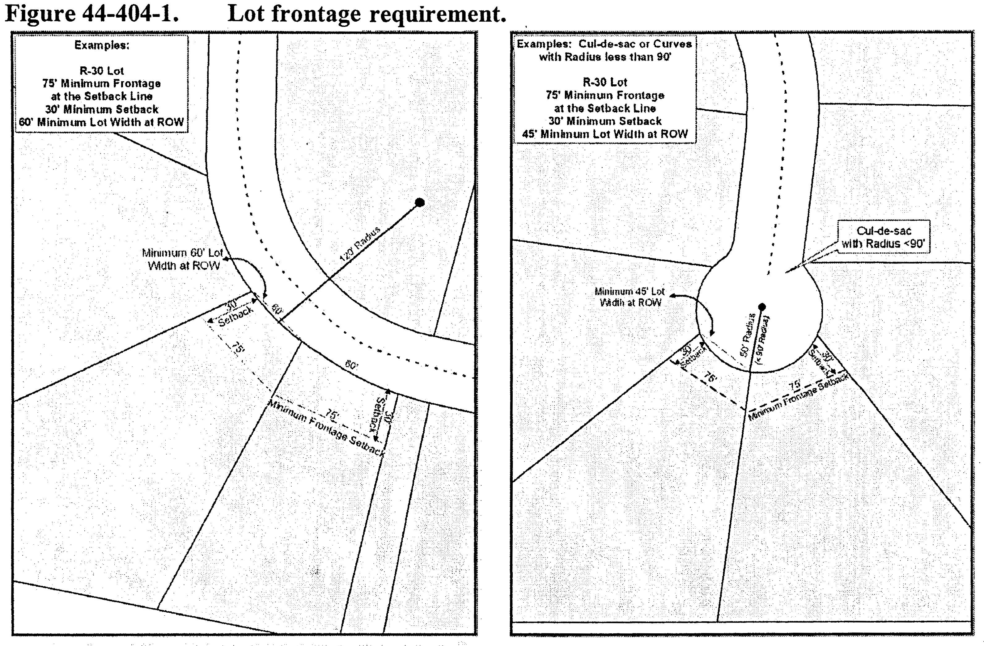
Lots on the turning circles of culs-de-sac may have a minimum 75 feet of lot width.
(3)
A setback of 20 feet is allowed along one internal street front for corner lots within residential subdivisions.
(c)
Density. Density refers to dwelling units per gross acre, and applies only to cluster subdivisions as defined in section 44-544 and multifamily or mixed-use buildings, if permitted in the zoning district.
(d)
Floor area ratio. Floor area ratio is the gross floor area of all nonresidential buildings or structures on a lot, divided by the total lot area. See definitions for calculation example.
(e)
Lot area. The area of a lot means the total area within its boundaries, excluding all rights-of-way. Minimum lot area is the minimum square footage required for a lot by this chapter. The minimum area does not include submerged lands nor street rights-of-way. The minimum lot size for a duplex is 1.5 times the lot size of a single-family dwelling, as indicated in table 44-404-1.
(f)
Frontage and lot width.
(1)
Generally. Lot width shall be measured across the required front setback line, except as provided in subsection (f)(2) below. The front setback line is construed to be parallel to the front lot line. In determining the front lot line for different lot types, as defined in subsection (i) below and depicted in figure 44-404-1, lot types, the following rules shall be used:
a.
On interior lots, the front lot line is the lot line that abuts a street.
b.
On corner lots, the lot lines parallel to each of the streets are both considered to be front lot lines for regulatory purposes.
c.
On multiple frontage lots, all portions adjacent to streets are considered to be front lot lines for regulatory purposes.
(2)
Lot frontage. Lot frontage shall not be less than 80 percent of the required minimum lot width except for lots on the turning circles of culs-de-sac or at similar points of street curvature where the radius of the right-of-way line is less than 90 feet. In the case of a cul-de-sac or where a right-of-way radius is less than 90 feet, the minimum frontage shall be 45 feet. Figure 44-404-1 indicates the relationships involved.
(3)
Diminishing lot width. Lot width shall not be less than 45 feet for any part of its width. The planning director may waive this requirement based on topography, original lot configuration, utility easements or rights-of-way and other natural features.
(4)
Lot width-to-depth ratio.
a.
Depth of residential major and minor development lots cannot exceed five times the width, except for lots with attached dwellings or when portions in excess of that depth are for the purpose of providing separation from major streets or railroads, rights-of-ways, easements, wetlands, water areas, protective strips, original lot configuration or severe topography.
b.
The width-depth ratio does not apply when:
1.
The width of a lot exceeds 300 feet;
2.
The lot is for nonresidential purposes;
3.
Creating a family subdivision.
(g)
Setbacks.
(1)
Generally. A setback is an imaginary line that governs the siting of buildings and structures on a lot. Figure 44-404-2 indicates the nomenclature and location of setbacks. Setbacks are measured from the property lot lines, not considering private easement boundaries.
(2)
Front setbacks. The front setback is an imaginary line extending the entire width of the lot and parallel to the front lot line. The setback requirement in table 44-404-1 is measured perpendicular to the front lot line at the closest point to the front lot line.
(3)
Side setbacks. The side setback is an imaginary line extending the entire length of the lot and parallel to the side lot line. The setback requirement in table 44-404-1 is measured perpendicular to the side lot line at the closest point to the side lot line.
(4)
Rear setbacks. The rear setback is an imaginary line extending the entire width of the lot and parallel to the rear lot line. The setback requirement in table 44-404-1 is measured perpendicular to the rear lot line at the closest point to the rear lot line.
(5)
Corner and multiple frontage lot setbacks. A corner or multiple frontage lot must observe the front yard setbacks for all frontages facing the streets. The rear lot line is the lot line that is opposite to the front with the shortest boundary. If the lot has equal frontage on two streets, frontage will be determined in accordance with the prevailing area lot patterns. See table 44-404-1 as well as figure 44-404-2 above.
(6)
Projections into setbacks.
a.
Cornices, eaves, stoops, gutters, and similar architectural features as determined by the planning director which are attached to a zoning regulated structure may project no more than three feet into the required front setback, five feet into the required rear setback and two feet into the required side setback.
b.
Mechanical equipment, such as air conditioning units, heat pumps, heating equipment, solar panels attached to principal dwellings, and similar installations, may not project into the required front setback, but may project five feet into the required rear setback and two feet into the required side setback.
c.
Features, such as stairs, not attached to a zoning regulated structure, are not subject to the setback requirements.
(h)
Height.
(1)
Excluded portions of structures. Except where specifically provided otherwise, the height limitations of this chapter do not apply to:
a.
Any roof structures for housing elevators, stairways, tanks, ventilating fans, solar energy collectors, or similar equipment required to operate and maintain a building, provided that such structures shall not cover more than 20 percent of the roof area or extend over ten feet in height;
b.
Spires, cupolas, domes, monuments, water towers, skylights, flagpoles, vents, construction or mining cranes or draglines, or similar structures, which may be erected above the height limit;
c.
Firewalls or parapet walls provided that such walls shall not extend more than five feet above the roof.
(2)
Aviation hazard. It is the responsibility of the property owner locating a structure within 5,280 feet of a documented public/private airstrip to obtain a certification from FAA and/or NCDOT verifying that the height of the proposed structure will not be an aviation hazard.
(i)
Lot types. Figure 44-404-3 illustrates the terminology used with reference to corner, interior and double frontage lots.
(1)
In figure 44-404-3, lot "A" is a corner lot, defined as a lot located at the intersection of two or more streets. A lot abutting a curved street is considered a corner lot if straight lines drawn from the foremost points of the side lot lines to the foremost point of the lot (projected if rounded) meet at an interior angle of less than 135 degrees.
(2)
In figure 44-404-3, lot "B" is an interior lot. An interior lot is a lot other than corner lot and abutting one street. Alleys are not considered streets for purposes of this definition.
(3)
In figure 44-404-3, lot "C" is a double frontage lot. A double frontage lot is a lot other than a corner lot, and has frontage on more than one street. Alleys are not considered streets for purposes of this definition.
Figure 44-404-3. Lot Types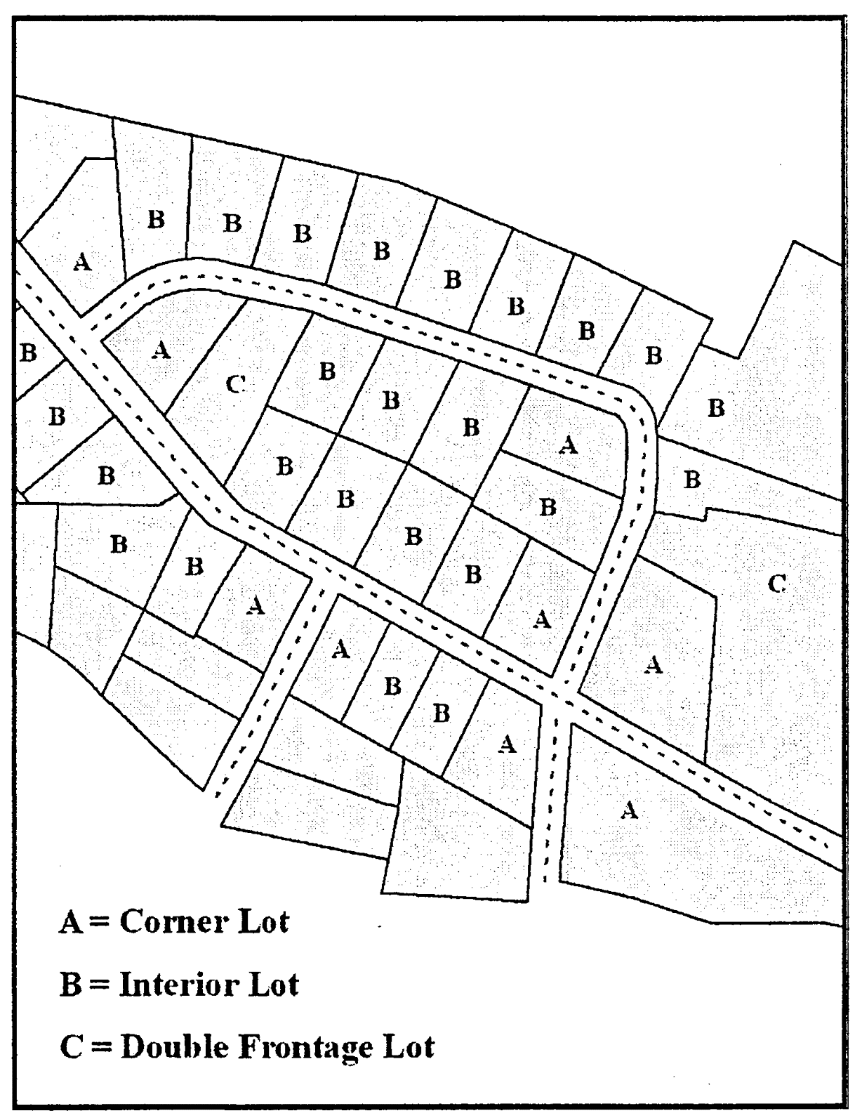
(Ord. No. 2021-05, 6-21-2021)
Sec. 44-405. - Placement of dwelling units on a lot.
(a)
Only one residential dwelling or duplex, and its customary accessory structures, is allowed per zoning lot as a matter of right.
(b)
Dwelling units shall be sited with the front of the structure running parallel to a street in order to achieve consistency and harmony with surrounding structures. The planning director shall have the authority to grant a waiver in the site placement of homes on a case by case basis. This waiver will be based in the topography of the site and any other specific conditions of the site.
(c)
On corner lots the property owner may choose which frontage to face the home.
(Ord. No. 2021-05, 6-21-2021)
Sec. 44-406. - Access.
(a)
A legal lot created and recorded on or before March 18, 1996, must have access to an access easement which has been recorded in the office of the register of deeds. The easement must be a minimum of 15 feet in width and connect to a state-maintained road.
(b)
A legal lot created and recorded after March 18, 1996 must have a minimum 45-foot right-of-way to a state-maintained road. A legal lot created and recorded after March 20, 2017 must have an NCDOT approved right-of-way connecting to a state-maintained road. In non-family subdivision situations, the road must be constructed to NCDOT standards.
An exception to this requirement is lots created for an estate settlement or lots exempt from subdivision regulations as defined in subsection 44-341(a)(1), which must have a minimum 15-foot easement as required in subsection (a) above. No construction standards are required.
(c)
In addition to minimum setback and building spacing requirements specified in this chapter, all buildings and other structures, land preparation, and landscaping must be so located and arranged on lots as to provide safe and convenient access for emergency purposes, fire protection, servicing, and off-street parking and loading located on the premises.
(d)
No residentially zoned land may be used for vehicular or pedestrian access to land or structures in other zoning districts, except as provided in this chapter or other lawful regulations.
(Ord. No. 2021-05, 6-21-2021)
Sec. 44-407. - Visibility of intersections.
No structure or portion of any structure may be placed or erected; no motor vehicle, trailer or equipment may be allowed to park, stand, stop or be stored; and no vegetation may be maintained, planted or allowed to grow in a manner which impedes the visibility from a street, alley or driveway of oncoming traffic from any direction in the intersecting public street. The visibility shall be unobstructed between the heights of two and one-half feet and eight feet, as measured from the pavement edge of the adjacent roadway, across triangles described as follows:
(1)
Start at the intersection of the rights-of-way of the two intersecting roadways or at the intersection of the pavement edges, if no right-of-way exists;
(2)
Measure from the intersection 70 feet along the major right-of-way or pavement edge and 10 feet along the minor; and
(3)
Connect the ends of the measurements to form a triangle.
(Ord. No. 2021-05, 6-21-2021)