
Champlin City Zoning Code
ARTICLE III
ZONING DISTRICTS ESTABLISHED; ZONING MAP; ZONING DISTRICT REGULATIONS
Sec. 126-156. - District classification.
In order to provide orderly, economic and safe development and to classify and regulate the location of various land uses, and the location of buildings designated for specific uses; to regulate and limit the intensity of the use of lot areas and to regulate and determine the areas of yards, recreation and open space within and surrounding such buildings, the city is hereby divided into 14 districts. The use, height and area regulations shall be uniform in each district. Districts shall be known as:
(1)
Residential districts.
(2)
Nonresidential districts.
(3)
Special districts.
(Code 1977, § 13-109.1; Ord. No. 630, § 13-109.1, 1-8-2007; Ord. No. 663, 9-22-2008)
Sec. 126-157. - Zoning map.
The location and boundaries of the districts established by this chapter are hereby set forth on the zoning map and said map is hereby made a part of this chapter; said map shall be known as the "City of Champlin Zoning Map." Said map and all notations, references, and data shown thereon are hereby incorporated by reference into this chapter and shall be as much a part of it as if all were fully described herein. It shall be the responsibility of the zoning administrator to maintain said map, and amendments thereto shall be recorded on said zoning map within 30 days after official publication of amendments. The official zoning map shall be kept on file in the city hall. The county flood insurance study for the city prepared by the Federal Emergency Management Agency (FEMA), dated September 2, 2004, and the water surface profiles and flood boundary and floodway maps therein are attached to and made a part of the zoning map and this chapter.
(Code 1977, § 13-109.2; Ord. No. 600, 8-23-2004)
Sec. 126-158. - New subdivisions.
Nothing in this chapter shall be interpreted so as to allow the creation of newly subdivided lots, with a minimum area less than provided in any zoning district except where allowed in special regulation for each district as specified in this chapter.
(Code 1977, § 13-109.3)
Sec. 126-159. - Boundary lines.
Wherever any uncertainty exists as to the boundary of any use district as shown on the zoning map incorporated herein, the following rules shall apply:
(1)
Where district boundary lines are indicated as following streets, alleys, or similar rights-of-way, they shall be construed as following the centerlines thereof;
(2)
Where district boundary lines are indicated as approximately following lot lines or section lines, such lines shall be construed to be such boundaries;
(3)
Where a lot held in one ownership, and of record at the effective date of the ordinance from which this section is derived, is divided by a district boundary line, the entire lot shall be construed to be within the less restricted district; provided that this construction shall not apply if it increases the area of the less restricted portion of the lot by more than 20 percent;
(4)
Where figures are shown on the zoning map between a street or property line and a district boundary line, they indicate that the district boundary lines run parallel to the street line or property line at a distance therefrom equivalent to the number of feet so indicated, unless otherwise indicated; and
(5)
The floodplain district boundaries have been based on the available flood data for the city. The boundaries of the floodplain district shall be determined by scaling distances on the zoning map (where there appears to be a conflict between a mapped boundary and actual field conditions) and if an inspection is needed as to the exact location of the boundaries of the district as shown on the official zoning map, the board of adjustment and city council shall make the necessary interpretation. The person contesting the location of the district boundary shall be given a reasonable opportunity to present his case to the board and to submit his own technical evidence if he so desires. Where such a conflict is found to exist, flood elevations shall be the governing factor in locating regulatory floodplain limits. In the event floodplain district boundaries are changed through the above procedures, the commissioner of natural resources must be notified of the change and his approval obtained.
(Code 1977, § 13-109.4)
Sec. 126-160. - Uses not provided for within zoning districts.
Whenever in any zoning district a use is not specifically allowed as a permitted, accessory, or conditional use, the use shall be considered prohibited.
(Ord. No. 605, 1-24-2005)
Sec. 126-161. - Architecture.
(a)
Purpose. The purpose of establishing criteria for architectural design and exterior facing materials is to ensure a high standard of development that is compatible with neighboring development and contributes to a community image of permanence, stability, and visual aesthetics, while preventing impermanent construction and use of materials that are unsightly, rapidly deteriorate, contribute to depreciation of neighborhood property values, or cause urban blight.
(b)
Definitions. For the purpose of this section, the following definitions shall apply:
Arcade means a series of arches supported by columns or other vertical elements.
Architectural symmetry means a characteristic by which the two sides of a facade or architectural floor plan of a building present mirror images of one another.
Balcony means a platform that projects from the wall of a building, and which is enclosed on its outer three sides by a balustrade, railing, or parapet.
Baluster means a vertical supporting element, similar to a small column.
Balustrade means a railing consisting of a row of balusters supporting a rail.
Bay means a section of a building distinguished by vertical elements such as columns or pillars. Often, a bay will protrude from the surface of the wall in which it is situated, thus creating a small, nook-like interior space, often of a rectangular or semi-hexagonal outline. See bay window.
Bay window means a projecting bay that is lit on all of its projecting sides by windows. See bay.
Board-and-batten means a wooden siding treatment in which wide, vertically oriented boards are separated by narrower strips of wood called "battens," which form the joints between the boards.
Column means a supporting pillar consisting of a base, a cylindrical shaft, and a capital on top of the shaft. Columns may be plain or ornamental.
Cornice means a crowning projection at a roof line, often with molding or other classical detail.
Cornice molding means a decorative strip of wood running just below the eaves of a building. A cornice molding is a cross between a cornice and a molding; a cornice is a crowning projection at a roof line, while a molding is a decorative strip of wood.
Cupola means a small dome, or hexagonal or octagonal tower, located at the top of a building. A cupola is sometimes topped with a lantern. A belvedere is a square-shaped cupola.
Eaves means the projecting edge of a roof that overhangs an exterior wall to protect it from the rain.
Facade means an exterior wall, or face, of a building.
Flared roof means a roof with a bell-shaped profile. It is sloped with concave curves at the top, and with convex curves at the bottom.
Front facade means any face of a building or facade that is visible from public right(s)-of-way, or parks, or that contains the building's primary entrance.
Gable roof means a roof with two slopes—front and rear—joining at a single ridge line parallel to the entrance facade. When the ridge line of a gable-roofed house is perpendicular to the street, the roof is said to be a "gable-end roof."
Gambrel roof means a ridged roof with two slopes at each side, the lower slopes being steeper than the upper slopes.
Hipped roof means a roof with four sloped sides. The sides meet at a ridge at the center of the roof. Two of the sides are trapezoidal in shape, while the remaining two sides are triangular, and thus meet the ridge at its end-points.
Jettied story means an upper story of a building that projects out over the story beneath it, common in Colonial American architecture.
Mansard roof means a four-sided hipped roof featuring two slopes on each side, the lower slopes being very steep, almost vertical, and the upper slopes sometimes being so horizontal that they are not visible from the ground. The Mansard roof was named after the French 17th-century architect Francois Mansart (1598—1666), who popularized the form.
Masonry means being of stone, brick, or concrete.
Molding means a decorative strip of wood.
Mullions means the structural units that divide adjacent windows.
Parapet means a low wall, located at the top of any sudden drop, such as at the top of the facade of a building.
Pavilion means a small but prominent portion of a building that juts out from a main building, either above its roof line, or to the side, and which is identified by a unique height and individual roof type. A pavilion may also stand alone, separate from a larger building, or may be connected to a main building by a terrace or path.
Pergola means a garden structure built up over a path or narrow terrace, lined with evenly spaced columns or posts that support a wooden-framed roof without sheathing. Often, vines are trained around the wooden framework of a pergola, and the pergola may lead from one building to another.
Pilaster means a shallow, non-structural rectangular column, attached to, and projecting only slightly from, a wall surface.
Pillar means a structural support, similar to a column, but larger and more massive, and often without ornamentation.
Portico means an entrance porch with columns or pilasters and a roof, and often crowned by a triangular pediment.
Primary entrance means an entrance facing a public street or sidewalk that is intended as the main entrance to a building.
Projection means a side wing, tower, or window bay that protrudes from a building.
Roofline means the part of a building that rises above the building's eaves. Rooflines can be highly decorative, with balustrades, pediments, statuary, dormer windows, cross gables, etc.
Wall fenestration means the arrangement of windows and doors on the elevations of a building.
(c)
General standards. Apply to all commercial, industrial and multifamily uses and districts within the city with the exception of city public facilities necessarily designed to protect the health, safety and welfare of the city:
(1)
Unified design on all sides. Building construction and design shall be used to create a structure with equally attractive sides. Using the same materials on all four sides of a structure so that, no matter what vantage point it is viewed from, the design is not interrupted, and all the parts are perceived as part of a unified whole.
(2)
Defined entrances. Primary building entrances must be clearly defined to promote visual interest and architectural presence. One primary entrance is required per building and multi-tenant buildings require one primary entrance for each tenant space.
(3)
Wall fenestration and plane. Building walls or facades shall be articulated to reduce the mass of the building. Large blank exterior walls shall be prohibited. Elevations shall divide large facades and walls into human scaled proportions.
a.
All facades must have three of the following four features and no facade shall have an uninterrupted length exceeding 100 feet without including three of the following four features:
1.
Change in plane through wall projections or recesses utilizing the following examples or an equivalent element that subdivides the wall into human scale proportions:
a)
Columns, arcade, bay.
b)
Jettied story.
c)
Pavilion, pergola, portico, covered doorways.
d)
Balconies for each floor above the first.
e)
Covered box or bay windows or other windows.
2.
Change in texture or masonry pattern.
3.
Wall fenestration or openings through doors or windows placed in a manner that is impactful to the design and with architectural symmetry.
4.
Change in color.
b.
Large, uninterrupted expanses of a single material are prohibited, unless the design is obviously superior to the purpose of this chapter as determined by the city.
(4)
Building materials.
a.
Industry standards. All building and roofing materials shall meet current accepted industry standards, and tolerances, and shall be subject to review and approval by the city for quality, durability, and aesthetic appeal. All exterior surfaces must be finished with the appropriate sealant, stain, paint, or other process (to manufacturer's specifications) to withstand the elements and prevent fading, chipping, chalking, cracking, peeling, warping, rot, rust, water damage, or other natural degrading process, with the exception of those materials, like copper, where the degrading process is architecturally desirable and must not be allowed to become or remain in an unsafe condition as defined by the Uniform Building and Fire Codes.
b.
Material color and product samples. Exterior materials of buildings shall be consistent or complementary in color, texture and quality. The applicant shall submit to the city product samples, color building elevations, and associated drawings which illustrate the construction techniques to be used in the installation of such materials.
c.
Signs. Development signage areas shall be drawn on elevations and incorporated in the building design.
d.
Required facade material combination and class. Acceptable facade exterior materials are organized by type of building use and then divided into Class 1, Class 2 and prohibited categories as shown in the following table:
(5)
Multiple building arrangement and style.
a.
Any other building, such as the case with multiple buildings on a single parcel, accessory buildings, or parking structures, should be of compatible design and materials with emphasis on the position(s) of the building(s) to give visual interest.
b.
If complementary building styles, materials, and color schemes are proposed for a development, the developer shall submit to the city a plan showing the distribution of the styles, materials, and colors throughout the development.
(6)
LEED (Leadership in Energy and Environmental Design). LEED is encouraged in the design of buildings. The LEED certification system provides third-party verification that a building was designed and built using strategies aimed at improving performance across all the metrics that matter most: Energy savings, water efficiency, CO 2 emissions reduction, improved indoor environmental quality, and stewardship of resources and sensitivity to their impacts.
(d)
Existing buildings. Nonconforming buildings constructed before the effective date of this section must bring the building into conformity with any proposed expansion or addition to the existing building footprint as follows:
(1)
All exterior facades of the new addition or expansion of the footprint must comply with this section with careful design consideration and incorporation of the existing building features.
(2)
With the new addition or expansion, sufficient improvements shall be proposed to the existing exterior facades that bring the existing structure into conformity with this section.
(Code 1977, § 13-111.16; Ord. No. 839, (Att.), 3-8-2021)
Sec. 126-191. - Purpose.
The residential districts are established to accomplish the general purposes of this chapter and for the following specific purposes:
(1)
To preserve existing living qualities of residential neighborhoods;
(2)
To ensure future high quality amenities including, but not limited to, the provision of adequate light, air, privacy and convenience of access to property;
(3)
To increase convenience and comfort by providing usable open space and recreation space on the same lot as the housing units they serve;
(4)
To prevent additions or alterations of structures which would damage the character or desirability of existing residential areas;
(5)
To protect residential areas, to the extent possible and appropriate in each area, against unduly heavy motor vehicle traffic; and
(6)
To encourage a variety and range of dwelling types and a wide range of population densities with emphasis on home ownership.
(Code 1977, § 13-110.1)
Sec. 126-192. - Intent.
The specific intent of each residential district is as follows:
(1)
R-A agriculture-residential district.
a.
This district is intended to preserve lands for agriculture uses, maintain lands in their natural state pending the proper timing of development and provide areas for single-family dwellings on large tracts of land and where public facilities are not available.
b.
Minimum lot area shall be ten acres.
(2)
R-1L large lot single-family residential district. This district is intended to provide large lot single-family residences in areas with public sanitary sewer, storm sewer and municipal water. Exception: Areas that have been assessed for public sanitary sewer and/or municipal water and/or storm sewer may be subdivided into lots containing not less than 13,500 square feet with the following limitations:
a.
Subdivisions utilizing on-site sewage disposal systems and private water wells cannot exceed one single-family residence per gross acre. Streets and other improvements may be temporary in nature as approved by the city council;
b.
The subdivider and the city shall enter into an agreement acknowledging the restriction in subsection (2)a of this section. The city shall record the agreement with the county recorder and/or the registrar of titles;
c.
Minimum lot area shall be 13,500 square feet;
d.
Riparian lots shall be 15,000 square feet in size;
e.
No one-family residence hereafter constructed in an R-1L district shall contain less than 1,440 square feet in floor area, nor be less than 28 feet in width; and
f.
To protect the intent and integrity of the large lot single-family district, each R-1L residential lot shall be landscaped in accordance with the following:
1.
The following landscape planting requirements:
(i)
The entire yard shall be sodded;
(ii)
Ten foundation planting (shrubs) minimum five gallon (all placed in the front yard);
(iii)
Two coniferous trees minimum eight feet (a minimum of one placed in the front yard); and
(iv)
Three deciduous trees minimum 2 1/2-inch diameter (a minimum of two placed in the front yard).
2.
The total number of required new trees may be reduced by the retention of existing trees; provided that the following conditions are satisfied:
(i)
Such trees fulfill the minimum requirements of subsection (2)f.1 of this section as to size and species. The community development department shall recommend to the planning commission the amount of the credit for such existing trees based upon their location and distribution in the lot; and
(ii)
Proper precautions to protect trees during development shall be indicated on grading plans submitted for plan review.
3.
The developer of an R-1L subdivision shall submit a letter of credit to guarantee the cost of sodding based on estimates provided by the developer and approved by the city; and
4.
Variations from these landscaping standards may be approved by the city council. The following information shall be provided to the city staff a minimum of seven working days prior to the proposal being presented to the city council:
(i)
A landscape plan prepared by a registered landscape architect in the state;
(ii)
The plan shall be approved by the city council prior to actual construction of the landscape improvements; and
(iii)
Proposed variations shall be comparable in materials and quantities to the above stated standards.
(3)
R-1 single-family residential district. This district is intended to provide single-family residences in areas with public sanitary sewer, stormsewer and municipal water. Exception: Areas that have been assessed for public sanitary sewer and/or municipal water and/or storm sewer may be subdivided into lots containing not less than 10,000 square feet with the following limitations:
a.
Subdivisions utilizing on-site sewage disposal systems and private water wells cannot exceed one single-family residence per gross acre. Construction shall not be permitted on adjoining lots. Streets and other improvements may be temporary in nature as approved by the city council;
b.
The subdivider and the city shall enter into an agreement acknowledging the restriction in subsection (3)a of this section. The city shall record the agreement with the county recorder and/or the registrar of titles.
c.
Minimum lot area shall be 10,000 square feet;
d.
Riparian lots shall be 15,000 square feet in size;
e.
No one- or two-family residence hereafter constructed in a R-1 district shall contain less than the following floor area: two bedrooms, 864 square feet and three bedrooms, 1,008 square feet. Residences containing more than three bedrooms shall have an additional 150 net square feet of floor area for each bedroom in excess of three bedrooms; and
f.
No one- or two-family residence shall be less than 20 feet in width.
(4)
R-2 two-family residential district.
a.
This district is intended to provide an area, which will allow two-family residences.
b.
Public sanitary sewer, storm sewer and municipal water are required.
c.
Minimum lot area shall be 15,000 square feet per two-family residence.
d.
No two-family residence hereafter constructed shall contain less than the following floor area: two bedrooms, 864 square feet and three bedrooms, 1,008 square feet. Residences containing more than three bedrooms shall have an additional 150 net square feet of floor area for each bedroom in excess of three bedrooms.
e.
No two-family residence shall be less than 20 feet in width.
(5)
R-3 low density multiple-family residential district.
a.
This district is intended:
1.
To create low density multiple areas with a broad range of housing types;
2.
To preserve and enhance transitional residential areas between lower and higher densities in areas served by public utilities; and
3.
To enhance transitional areas between low density housing and other nonresidential land uses. The district must be served by public sanitary sewer, storm sewer and municipal water.
b.
Maximum density allowed shall be six dwelling units per gross acre. PUD recommended.
(6)
R-4 medium density multiple-family residential district.
a.
This district is intended to provide a residential area that allows a broad range of housing types (townhouses, apartments, etc.) of medium density multifamily units in areas served by public sanitary sewer, storm sewer and municipal water.
b.
Maximum density allowed shall be 12 dwelling units per gross acre. PUD recommended.
(7)
R-5 high density multiple-family residential district.
a.
This district is intended to create, preserve and enhance areas for multifamily use of higher densities for both permanent and transient families, in areas served by public sanitary sewer, storm sewer and municipal water, with good accessibility to thoroughfares, public community centers, libraries, shopping centers and employment centers, and where such development fits the comprehensive plan.
b.
Maximum density allowed shall be 18 units per gross acre. PUD recommended.
(Code 1977, § 13-110.2)
Sec. 126-193. - Allowable uses in residential districts.
The following uses shall be permitted in residential districts:
P = Permitted uses
C = Conditional uses
A = Accessory uses
Similar uses not mentioned above shall be interpreted to be permitted, conditional, or accessory within a district as determined by the city.
(Code 1977, §§ 8-413, 13-110.3; Ord. No. 651, 11-26-2007)
Sec. 126-194. - Schedule of residential district requirements for lot area, depth, width, coverage, setbacks, height.
(a)
The schedule of residential district requirements shall be as follows:
(b)
Setbacks along county roads and state highways shall be as follows:
(1)
Principal structures in all residential districts shall be:
a.
Ninety feet from the ultimate centerline of County Road 103 and County Road 121; and
b.
One hundred feet from the ultimate centerline of County Road 12 and County Road 14.
(2)
Accessory buildings and/or structures, including decks in all residential districts shall be:
a.
Seventy feet from the ultimate centerline of County Road 103 and County Road 121; and
b.
Eighty feet from ultimate centerline of County Road 12 and County Road 14.
* Notes—Detached accessory structure: 18 feet or the height of the principle structure, whichever is less.
Attached accessory structure: The structure may have a height larger than 18 feet if needed to make it architecturally compatible (to match rooflines) with the principle structure. However, in no case shall the attached accessory structure be higher than the principle structure, nor shall the maximum height of a garage door exceed 16 feet.
General notes:
1. Minimum lot width of R-1 and R-2 corner lots shall be 90 feet.
2. Lots within the Mississippi River corridor critical area shall reference section 126-348 of the Code for requirements for lot area, depth, width, setbacks, and height.
(Code 1977, § 13-110.4; Ord. No. 650, 11-26-2007; Ord. No. 732, 10-28-2013; Ord. No. 850, 5-23-2022)
Sec. 126-195. - Special regulations for all residential districts.
(a)
Two-family dwellings may be divided into single parcels of record with the party wall acting as the dividing lot line subject to the following conditions:
(1)
Each of the lots created in subdividing lands on which a two-family structure is located shall be equal in area or as near equal as is reasonably possible;
(2)
A survey of the premises showing acreage computations and dimensions shall be prepared by a surveyor registered in the state and shall be filed with the city clerk;
(3)
If a lot containing an existing two-family dwelling is subdivided into two lots, the minimum lot area, lot width and setback requirements may be waived;
(4)
Separate services shall be provided to each residential unit for sanitary sewer, municipal water, electricity, natural gas, telephone and other utilities;
(5)
The party wall that divides the two properties must be a vertical wall and not a horizontal wall;
(6)
To protect the safety and property of the owners and occupants, no existing property containing a party wall shall be divided into two separate parcels until the dividing party wall has a fire rating that meets new construction standards contained in the Uniform Building Code and no openings shall be allowed in the party walls. Party walls must meet sound transmission control ratings as set forth in the appendix of the Uniform Building Code;
(7)
The owner of the property to be subdivided by a party wall shall execute and record with the county recorder or registrar of titles a declaration of covenants, conditions and restrictions, which shall be approved by the city attorney. The declarations shall generally preserve the rights of the several owners sharing a single structure and also the rights of the public. These declarations shall contain the following:
a.
Building and property use restrictions;
b.
General rules of law relating to party walls;
c.
Rules relating to repair of the party wall if damaged by fire or other casualty and relating to maintenance of the party wall;
d.
Easements, if the party wall encroaches on the abutting property;
e.
A method of resolving disputes concerning the wall; and
f.
Hazard insurance.
(8)
The authority to divide a single structure containing two dwelling units shall be subject to the provisions of this Code relating to park dedication and other subdivision requirements and the city council may impose other reasonable conditions; and
(9)
When full compliance with the provision of this section has been met, the requirements of this chapter as to setback along the party wall line shall be waived.
(b)
Home occupations (as defined in section 126-2) are permitted uses in all residential districts; provided that:
(1)
The use of a dwelling unit or garage for any home occupation shall be clearly incidental and subordinate to its residential use. Not more than 25 percent of the floor area of one floor of a dwelling unit shall be used in the conduct of the home occupation;
(2)
The home occupation shall be conducted entirely within a fully enclosed building. No exterior or interior alterations of the building or land, or other visible evidence of the conduct of the home occupation shall be permitted which are not customarily found in a dwelling, except that one sign, not exceeding one square foot in area, nonilluminated, and mounted flat against the wall of the principal building shall be permitted;
(3)
No person other than members of the family residing on the premises shall be engaged in such occupation (requires a certificate of occupancy);
(4)
There shall be no exterior storage of equipment or materials used in the home occupation;
(5)
There shall be no use of utilities or community facilities beyond that normal to the use of property for residential purposes;
(6)
A home occupation shall serve no more than two customers or clients at one time;
(7)
The hours of operation for any home occupation shall be limited to between 8:00 a.m. and 8:00 p.m.;
(8)
A home occupation shall not create pedestrian, automobile, or truck traffic significantly in excess of the normal amount in the district. No truck or similar vehicle used in conjunction with a home occupation shall be parked unattached to a trailer upon a residential lot. Such home occupations shall not involve the need for more than three parking spaces for the occupant and visitors. Adequate off-street parking facilities required to serve the home occupation shall be provided on the premises, but no such parking facility shall be established within any required front or side yard, except upon an established driveway;
(9)
No equipment or process shall be used in such home occupation, which creates noise, vibration, glare, fumes, odors, or electrical interference detectable to the normal senses off the lot. In the case of electrical interference, no equipment or process shall be used which creates visual or audible interference in any radio or television receiver off the premises, or causes fluctuations in line voltage off the premises;
(10)
No retail business other than that conducted by mail shall be permitted, except for those products that are not marketed or sold in a wholesale or retail outlet; examples of such products include, but are not limited to, the following: Avon, Fuller products, and Shakely products;
(11)
No home occupation shall include operations relating to ammunition or firearm manufacturing requiring an ATF license. This does not apply to ammunition reloading for personal use, as defined under the Minnesota State Fire Code;
(12)
Such occupations as, but not limited to, architects, artists, manufacturer's representatives, writers, clergymen, lawyers, teachers, insurance agents, dressmakers, and millinery and similar domestic crafts shall be permitted; and
(13)
A citizen operating a home occupation grants to the city the right to inspect the premises in which the occupation is being conducted to ensure compliance with the provisions of this section or any conditions additionally imposed including the general health, safety, and welfare of the citizens of the city. The city reserves the right to prohibit any home occupation if it deems necessary.
(c)
In-home day care.
(1)
Purpose and intent. The regulation of in-home day cares in this section is to establish standards by which they can be conducted within the city without jeopardizing the health, safety and general welfare of the day care participants and/or the surrounding neighborhood.
(2)
General standards for in-home day cares.
a.
In-home day cares operated within a single-family or two-family dwelling shall be a permitted use in an R-1, R-2 and R-3 residential district.
b.
In-home day cares operated within a multifamily dwelling shall be a conditional use in any residential district.
c.
In-home day cares shall be permitted one permanent sign no larger than three square feet. Such sign shall not be illuminated and shall be located on the dwelling unit or in the front yard with a minimum setback of 20 feet.
d.
A temporary sign permit may be issued for up to 30 days in a calendar year for a second sign no larger than three square feet. Such sign shall be allowed in the rear or side yard with no minimum setback.
(Code 1977, § 13-110.5; Ord. No. 642, § 13-110.5, 6-25-2007; Ord. No. 770, 9-12-2016; Ord. No. 880, 4-10-2023)
Sec. 126-196. - Special regulations for the R-3, R-4, and R-5 residential districts and PUD residential developments.
As the population and demographics of the city continue to grow and change, there becomes a need to establish more defined standards for multiple-family developments to protect the public health, safety, morals and general welfare of the future residents of these multiple family developments as well as the existing property owners in the city.
(1)
General regulations.
a.
Lot densities. Lot densities applicable to all apartments, townhouses and condominiums development shall be as follows:
1.
For R-3 zoned property, the maximum shall be six units per acre;
2.
For R-4 zoned property, the maximum shall be 12 units per acre;
3.
For R-5 zoned property, the maximum shall be 18 units per acre.
4.
For PUD zoned property (designated medium density), the maximum shall be 12 units per acre; and
5.
For PUD zoned property (designated high density), the maximum shall be 18 units per acre.
b.
Apartments.
1.
Minimum floor area.
(i)
The minimum floor area of any efficiency dwelling unit shall be not less than 400 net square feet, that of a one bedroom dwelling unit shall be not less than 600 net square feet, and that of a two bedroom dwelling unit shall be not less than 750 net square feet. Units containing three or more bedrooms shall have an additional 150 net square feet of floor area for each bedroom in excess of two bedrooms.
(ii)
For purposes of measurement, the net floor area of a dwelling unit shall mean that area within a building used as a single dwelling unit, and shall be measured from the inside walls to the center of partitions bounding the dwelling unit being measured, but shall not include public stairways, public entries, public foyers, public balconies, or unenclosed public porches, separate utility rooms, furnace area or rooms, storage areas not within the apartment, or garages.
2.
Efficiency dwelling units. No more than 20 percent of the dwelling units in any one building shall be efficiency dwelling units.
3.
Closets and bulk storage. The following minimum amounts of closet and bulk storage shall be provided for each dwelling unit:
(i)
For a one-bedroom unit, ten lineal feet of closet space and 80 cubic feet of bulk storage;
(ii)
For a two-bedroom unit, 24 lineal feet of closet space and 100 cubic feet of bulk storage; and
(iii)
For each bedroom in excess of two in any one dwelling unit, an additional ten lineal feet of closet space and 50 cubic feet of bulk storage volume shall be required.
4.
Projecting air conditioning and heating units. Air conditioning or heating units projecting through exterior walls or windows shall be so located and designed that they neither unnecessarily generate nor transmit sound nor disrupt the architectural amenities of the building. All mechanical units shall be screened.
c.
Townhouses.
1.
Access. A townhouse development shall be platted into lots and common open spaces. Each townhouse unit shall have access to a public street directly or by means of a platted interior drive leading to the public street, which interior drive shall be conveyed by nonexclusive easement to each townhouse owner.
2.
Lots. Each townhouse dwelling unit shall be located on a separate platted lot.
3.
Maximum height and roofline regulations. No more than two townhouse units in a group shall have the same roofline. Accessory buildings in this district shall not exceed 15 feet in height.
4.
Density. A minimum gross land area of 6,000 square feet shall be required for each townhouse dwelling unit. The gross land area may include the platted townhouse dwelling lot and contiguous common open space.
5.
Character of construction. Townhouses shall be single structures consisting of not less than three nor more than eight dwelling units with no other dwelling or portion of other dwelling directly above or below, and each dwelling unit shall be connected to the other by a party wall that has no opening.
6.
Minimum development area. The minimum area upon which a townhouse development may be erected shall be one-half acre.
7.
Common open space, covenants, and homeowners' associations. Common open space shall surround the development and this open space shall be accessible to the owners of the townhouses. The right to use and enjoy the common area shall be reserved to townhouse owners by declaration of covenants, conditions and restrictions that shall be approved by the city attorney and filed with the county recorder. Said declaration shall also provide for a homeowner's association that must be properly formed. Easements for the homeowners must be designated as appurtenant to the benefited property and should be designated as exclusive or nonexclusive as the case may be. These easements shall cover at least the following: accessory party walls, parking, overhangs and encroachments (if any), and utility, water and sewer easements. The said declaration shall provide the manner of imposing assessment for upkeep of the common area and priority of assessments must be described. All persons having an interest in the premises must join in the declaration. A copy of the declaration of covenants shall be filed with the zoning administrator.
8.
Group setback. No townhouse structure shall be closer than 30 feet to any other townhouse structure.
d.
Condominiums.
1.
Access. A condominium development shall be platted into building pads and common open spaces. Each condominium unit shall have access to a public street directly or by means of a platted interior drive leading to the public street, which interior drive shall be conveyed by nonexclusive easement to each condominium owner.
2.
Maximum height and roofline regulations. No more than two condominium buildings in a group shall have the same roofline. Accessory buildings in this district shall not exceed 15 feet in height.
3.
Minimum development area. The minimum area upon which a condominium development may be erected shall be one-half acre.
4.
Maximum lot coverage. The maximum lot coverage of all structures in condominium developments shall be 20 percent.
5.
Common open space, covenants, and homeowners' associations. Common open space shall surround the development and this open space shall be accessible to the owners of the condominiums. The right to use and enjoy the common area shall be reserved to condominium owners by declaration of covenants, conditions and restriction, which shall be approved by the city attorney and filed with the county recorder. Said declaration shall also provide for a homeowner's association that must be properly formed. Easements for the homeowners must be designated as appurtenant to the benefited property and should be designated as exclusive or nonexclusive as the case may be. These easements shall cover at least the following: accessory party walls, parking, overhangs and encroachments (if any), and utility, water and sewer easements. The said declaration shall provide the manner of imposing assessments for upkeep of the common area and priority of assessments must be described. All persons having an interest in the premises must join in the declaration. A copy of the declaration of covenants shall be filed with the city.
6.
Group setback. No condominium structure shall be closer than 30 feet to any other condominium structure.
(2)
Plan approval. A building permit for a R-3, R-4, R-5 and PUD multiple-dwelling building containing more than four dwelling units shall not be issued unless the applicants have received site plan approval from the city planning commission and city council, as stipulated in article II, division 3 of this chapter.
(3)
Performance standards.
a.
General.
1.
Exterior lighting. All sources of artificial light situated in multiple-family sites shall be so fixed, directed, designed or sized that the sum total of their illumination will not increase the level of illumination on any nearby residential property by more than 0.1 footcandle in or within 25 feet of a dwelling nor more than 0.5 footcandle on any other part of the property.
2.
Glare. Glare, whether direct or reflected, such as from floodlights, spotlights or high temperature processes, and as differentiated from general illumination, shall not be visible beyond the site or origin at any property line.
3.
Storage of waste material, debris, etc. All waste material, debris, refuse, garbage, fuel, or materials not currently in use for construction shall be stored indoors or totally screened from the eye-level view from public streets and adjacent properties.
4.
Screening of ground level view. The ground level view of all mechanical equipment, utilities, storage, and similar features, including roof top equipment shall be completely screened from contiguous properties and adjacent streets, or designed to be compatible with the architectural treatment of the principle structures.
5.
Trash and garbage bin storage. Except for townhouse and multiple residential sites of four or less units, exterior trash or garbage storage bins or units shall be enclosed. In the case of townhouses and multiple residences with four or less units, storage shall be completely enclosed by walls and a roof.
6.
Accessory structures to be of similar type. Garages, accessory structures, screen walls and exposed areas of retaining walls shall be of a similar type, quality, and appearance as the principal structure unless such a structure is not visible or is fully screened from any public street or adjacent property.
7.
Irrigation. Underground irrigation shall be required in all multiple-family developments that consist of three or more units per building.
b.
Setbacks.
1.
Principal structures.
2.
Accessory structures.
3.
Parking lots.
Setbacks in parentheses apply adjacent or across the street from R-1 and R-2 districts.
(i)
From minor and intermediate arterial, setbacks shall be increased to 50 feet or one and one-half times the building height whichever is greater (maximum setback 100 feet)
(ii)
Parking setbacks shall be increased to 30 feet from minor and intermediate arterial.
c.
Schedule of residential district requirements for lot area, depth, width, coverage, and height.
d.
Architecture.
1.
It is not the intent of the city to unreasonably restrict design freedom when reviewing project architecture in connection with a site or building plan. However, it is in the best interest of the city to promote high standards of architectural design.
2.
This standard applies to all multifamily developments within the Highway 169 Corridor:
(i)
Major exterior surfaces on walls shall be face brick or stone. Glass, stucco, architecturally treated concrete, cast-in-place or precast panels or decorative blocks will be acceptable as the major exterior wall surface when they are incorporated into an overall design which is compatible with the standards for the district in which it is located. Wood and metal may be used as accent materials; provided that they are appropriately integrated into the overall building design and not suited in areas, which will be subject to damage associated with heavy use.
(ii)
Under no circumstances shall sheet metal aluminum, corrugated aluminum, asbestos, iron plain or painted, or plain concrete block be acceptable as major exterior wall material on buildings within the city, rear and side exterior surfaces that are not visible from any public street or adjoining property may be constructed of a lesser material than the front of the building.
e.
Minimum landscaping requirements.
1.
Exposed ground areas to be landscaped. For R-3, R-4, and R-5 districts and PUD multifamily developments, all exposed ground area surrounding the principal building and accessory buildings which are not driveways, sidewalks, or patios shall be landscaped with grass, shrubs, trees, or other ornamental landscape material.
2.
Tree height and width standards. The following minimum standards shall be required:
(i)
Overstory deciduous trees: 1.5-inches in diameter;
(ii)
Ornamental trees: 1.5-inches diameter;
(iii)
Coniferous trees: eight feet tall; and
(iv)
Major shrub planting: five gallon.
3.
Application. In order to achieve landscaping which is appropriate in scale with the size of a building and site, the following minimum standards shall apply to all multiple-family districts:
(i)
One tree for every 1,000 square feet of total building floor area or one tree for every 50 feet of site perimeter, whichever is greater. A minimum of 30 percent of the trees required shall be coniferous;
(ii)
One ornamental tree can be substituted for every 0.6 overstory deciduous shade tree. In no case shall ornamental trees exceed 50 percent of the required number of trees; and
(iii)
One understory shrub for every 300 square feet of building or one shrub for every 30 feet of site perimeter, whichever is greater.
4.
Additional landscape requirements for properties fronting Highway 169. In addition to minimum site planting, screening, and parking lot requirements, the following will be required for every 100 feet of frontage along Highway 169:
(i)
One three-inch minimum, overstory deciduous tree;
(ii)
Two ten-foot minimum, coniferous trees; and
(iii)
Two two-inch minimum, ornamental trees may be substituted for every one deciduous overstory tree.
5.
Credit for large trees. The total number of required overstory trees may be reduced by one-half tree for each new deciduous tree measuring 4 1/2 inches or more in diameter, or each new coniferous tree measuring 18 feet or more in height. In no event, however, shall the reduction be greater than 25 percent of the total number of trees required.
6.
Landscape yard credit. A landscape yard credit shall be given to a site plan which contains exterior sculptures, fountains, decorative walks, additional ponds beyond those required for storm drainage purposes, courtyards, and decorative accent lighting for the building. The community development department will recommend credits be given on a case-by-case basis, depending upon the nature and scope of such a facility proposed for credit.
7.
Grass and ground cover. All open areas of a site not occupied by building, parking, walkways, or storage shall be grass or approved ground cover. Ground cover shall be planted in such a manner as to present a finished appearance and reasonably completed coverage within 12 months after planting, with proper erosion control during the plant establishment period. Exception to this is undisturbed areas containing natural vegetation that can be maintained free of foreign and noxious materials.
8.
Slopes and berms.
(i)
Final slope grades steeper than 3:1 will not be permitted without special approval of treatment such as terracing or retaining walls.
(ii)
Earth berm screening parking lots and other open areas shall not have slopes exceeding 3:1. A minimum two-foot berm is required.
9.
Placement of plant materials and utilities.
(i)
All required screening or buffering shall be located on the lot occupied by the use, building, facility, or structures to be screened. No screening or buffering shall be located on any public right-of-way or within eight feet of the traveled portion of any street or highway.
(ii)
All utilities are required to be underground. Plant materials shall be located to provide reasonable access to all utilities.
10.
Maintenance. The property owner shall be responsible for replacement of any dead trees, shrubs, ground covers, and sodding. If any plant materials are not maintained or replaced, the city shall maintain or replace said plant materials and assess the property for the costs thereof after due notice has been given to the property owner.
11.
Sizing of plant material and methods of installation. All deciduous and coniferous trees shall be sized and planted in accordance with national nurseryman standards.
12.
Performance surety. The owner shall provide the city with cash, corporate surety bond, approved letter of credit or other surety satisfactory to the city to guarantee the proper installation and vigorous growth of all landscape elements and screening required herein. Said surety shall remain in effect for two full growing seasons. The first year, the amount of surety will be equal to 110 percent of the estimated costs of plant material, installation, and tree preservation. The second year, said surety shall be equal to 25 percent of the estimated costs of plant material, installation, and tree preservation.
(i)
A growing season shall include the period May 1 through October 31.
(ii)
The two-year guarantee period for plant material installed after June 1 shall commence the following year.
(iii)
Lots provided with an irrigation system covering 100 percent of the area improved with landscaping need only provide a surety for one growing season.
f.
Screening and buffering. Screening and buffering shall be satisfied through the use of screening fences, walls, earth berms, and/or planting screens. If the topography, existing vegetation, permanent structures, or other features create a barrier, which meets the screening requirements, they may be substituted.
1.
Site screening.
(i)
Screening fence wall.
A.
A fence or wall may be used for screening when plant materials are provided along the outside of the fence or wall for aesthetic appeal.
B.
A screening fence or wall shall be constructed of attractive, permanent finished materials, compatible with those used in the construction of the principal structure. Such screens shall provide a minimum year round opaqueness of 80 percent and be of sufficient height to achieve screening but not to exceed six feet in height.
C.
Screen fences and walls that are in disrepair shall be repaired.
(ii)
Earth berms.
A.
An earth berm shall be allowed for screening when used in combination with plant material. A minimum of 25 percent of the required screen must be provided with plant material.
B.
Earth berms shall be of sufficient height to achieve screening but shall not exceed a 3:1 slope.
(iii)
Planting screens.
A.
A planting screen shall consist of healthy, fully hardy plant materials and shall be designed to provide a minimum year round opaqueness of 80 percent at the time of maturity. The plant material shall be of sufficient height to achieve the required screening.
B.
Composition of plant material for screening shall be composed of the following minimum standards: not less than 33 percent coniferous; not less than 25 percent deciduous; not more than 33 percent shrubs; and not more than 45 percent of one species.
C.
Planting screens shall be maintained in a neat and healthful condition. Plants that have died shall be promptly replaced.
2.
Parking area screening. Any off-street parking area containing more than six parking spaces, any part of which is within 30 feet of an adjoining residential zone or across the street from any residential zone, and any driveway to a parking area containing at least six spaces within 15 feet of an adjoining residential zone shall be completely screened to a height of at least three and one-half feet above the parking grade. Such screening shall be accomplished through the use of earth berming and/or plant materials.
3.
Additional screening.
(i)
Double fronted residential buildings and lots adjacent to collector or arterial streets shall be screened. A 15-foot easement area for landscaping will be provided. Screening shall be provided to a height of three and one-half feet above the adjacent roadway. Screening shall be accomplished by a combination of earth berming and planting. A minimum of 25 percent of required screening must be provided with plant material.
(ii)
The light from automobile headlights and other sources shall be screened whenever it may be directed onto adjacent single- and two-family residential windows.
g.
Recreation and open space. Multiple-family residential projects shall contain an adequate amount of land for park, recreation or local open space use, exclusive of drainage areas, parking areas which shall not be less than 20 percent of the gross area of the property and shall consist of land within the building setback lines.
h.
Compliance.
1.
Existing uses shall comply with the screening requirements listed in this section at the time alterations are made on the building or premises. Compliance by existing uses shall not be required if the city determines that because of the unique character of the existing use, compliance is not needed to promote the welfare of the city or that compliance is not reasonably possible because of the existing development.
2.
A nonconforming building or structure shall not be altered or enlarged in any manner unless such alterations or enlargements are made to bring the building or structure into conformity with the regulations of this section.
(Code 1977, § 13-110.6; Ord. No. 851, 5-23-2022)
Sec. 126-287. - Old town conversion overlay district.
(a)
Purpose.
(1)
The old town area currently contains many single-family structures that lie within commercial zoning districts. These single-family structures are on small single-family lots that, alone, could not support a new commercial building and/or parking area that meets current city standards. Further, it is reasonable to expect that these single-family structures will be converted to commercial establishments.
(2)
Because the city strives for a well-planned community that protects the health, safety, morals, and general welfare of the citizens of the city, there is a need for an ordinance that regulates the conversion of existing single-family structures to commercial establishments.
(3)
Because the conversion of existing single-family structures is unique to the old town area, there is a need to establish an overlay district which stipulates site performance guidelines to regulate setbacks, lot coverage, parking, landscaping, allowable uses, building exteriors, maintenance, screening, and lighting. These standards will ensure against detrimental impacts on the environment, neighboring properties, and public interest, by providing for a pleasant, attractive, and aesthetically pleasing environment.
(b)
General requirements.
(1)
Allowable uses. Each potential commercial land use has unique characteristics that would affect its location in an existing single-family structure. Because of this, the underlying commercial zoning classification shall govern the allowable uses and a conditional use permit shall be required for every allowable use.
(2)
Lot coverage.
a.
Maximum building coverage shall be 20 percent of the lot.
b.
Maximum impervious surface coverage shall be 50 percent of the lot.
(3)
Building setbacks.
a.
Principal structure.
1.
Front yard. New construction shall not encroach into the front yard setbacks any further than currently exists.
2.
Side yard (street). New construction shall not encroach into the street side yard setbacks any further than currently exists.
3.
Side yard. New construction shall not encroach the side yard setback any further than currently exists or ten feet, whichever is greater.
4.
Rear yard. New construction shall not encroach into the rear yard setback any further than currently exists or 30 feet, whichever is less.
b.
Accessory structure.
1.
Front yard. No accessory structure shall be located in the front yard setback area.
2.
Side yard (street). No accessory structure shall be located in the street side yard setback area.
3.
Side yard. No accessory structure shall be located within ten feet of the side yard setback area (if adjacent to R-1 or R-2 residential this setback shall be 30 feet).
4.
Rear yard. No accessory structure shall be located within 30 feet of the rear yard setback area.
(4)
Parking.
a.
Require number of stalls. The required number of stalls shall be as regulated by section 126-419.
b.
Setbacks. Parking setbacks shall be as follows:
1.
Front yard: ten feet.
2.
Side yard (street): 15 feet.
3.
Side yard: five feet.
4.
Rear yard: not permitted.
c.
Curb and gutter. Concrete box (B 6—12) curbing is required along the perimeter of all paved areas.
(5)
Landscaping. Landscaping shall be as regulated in section 126-216.
(6)
Screening.
a.
Screening and buffering shall be satisfied through the use of screening fences, walls, earth berms, and/or planting screens. If the topography, existing vegetation, permanent structures, or other features create a barrier that meets the screening requirements, they may be substituted.
b.
In addition to the foregoing, additional screening regulations are contained in section 126-217.
(7)
Building exteriors.
a.
The conversion of existing single-family structures into a commercial use is a unique situation that requires specific architectural control measures to ensure compatibility with surrounding structures.
b.
It is not the intent of the city to unreasonably restrict design freedom when reviewing project architecture in connection with a site or building plan. However, it is in the best interest of the city to promote high standards of architectural design.
c.
This standard applies to all commercial and industrial underlying districts within the old town overlay district. Further:
1.
The existing character of the principal structure shall be kept. Alterations to the existing structure are permitted when the character of the existing structure is not adversely affected.
2.
Upgrades to the existing structure shall be done with materials that are consistent with the age and quality of the building or structure being altered.
3.
Garages, accessory structures, screen walls and exposed areas of retaining walls shall be of similar type, quality, and appearance as the principal structure.
4.
A nonconforming building or structure shall not be altered or enlarged in any manner unless such alterations or enlargements are made to bring the building or structure into conformity with the regulations of this section.
(8)
Lighting.
a.
All sources of artificial light situated in nonresidential sites shall be so fixed, directed, designed or sized that the sum total of their illumination will not increase the level of illumination on any nearby residential property by more than one-tenth footcandle in or within 25 feet of a dwelling nor more than five-tenths footcandle on any other part of the property.
b.
All commercial lighting shall be located in the front and street side yard areas. No commercial lighting shall be located in the rear and side yard areas.
(9)
Site maintenance.
a.
The property owner shall be responsible for replacement of any dead trees, shrubs, ground covers, and sodding. If any plant materials are not maintained or replaced, the city shall maintain or replace said materials and assess the property for the costs thereof after due notice to the property owner.
b.
The building exteriors shall be kept in reasonable repair and maintained in such a manner as not to create an adverse appearance.
(10)
Destruction. No building or structure which has been damaged by fire, explosion, act of God, or any other cause, to the extent of more than 50 percent of its value shall be restored except in conformity with the regulations of this section which govern the underlying land use.
(11)
Signage. Signage shall be as regulated by chapter 118, except as follows:
a.
The sum total of all business signs shall not exceed 24 square feet;
b.
Pylon signs shall be prohibited;
c.
Wall-mounted signs shall not be internally lit;
d.
The character of all signs shall be compatible with the architecture of the structure for which the sign will be attached; and
e.
If a monument sign is constructed, the monument sign shall be designed with similar type, quality, and appearance as the principal structure.
(Code 1977, § 13-111.18)
Sec. 126-308. - Purpose and intent.
(a)
The PUD is supplementary to all other zoning districts contained in this chapter, the purpose of which is to encourage, under appropriate circumstances, a more creative, varied and efficient use of land in the city. Where such supplementary zoning is approved, it shall be deemed supplementary and superimposed over the basic zoning of the property under consideration. Where a conflict may arise between the requirements of the supplementary and basic zoning, those requirements related to the supplementary zoning shall prevail.
(b)
The provisions of this section are intended to provide residential and commercial areas that can be developed with some modification of the strict application of the normal zoning district regulations in accordance with the provisions and regulations contained herein.
(c)
The PUD can be developed within any zoning district and is intended to encourage:
(1)
Flexibility in land development to benefit from new technology in building design and construction and land development;
(2)
Variety in the organization of site elements and building design through the use of trained and experienced land planners, registered architects and/or landscape architects to prepare plans for all planned unit developments;
(3)
Preservation and enhancement of desirable site characteristics and open space; and
(4)
More efficient and effective use of land, open space and public facilities.
(Code 1977, § 13-112.1)
Sec. 126-309. - Permitted uses.
Land and/or buildings shall be permitted or allowed as conditional uses in the districts.
(Code 1977, § 13-112.2)
Sec. 126-310. - Lot area, setback, height and coverage regulations.
(a)
Minimum lot area requirement. The minimum total lot area shall be not less than ten acres. Lots of less than ten acres may qualify only if the applicant can show that the minimum lot area requirement should be waived because a PUD is in the public interest and that one or both of the following conditions exist:
(1)
Unusual physical features of the property itself or of the surrounding neighborhood are such that development under the standard provisions of the normal district would not be appropriate in order to conserve a physical or terrain feature of importance to the neighborhood or community; or
(2)
The property is adjacent to or across the street from property that has been developed under the provisions of this section and will contribute to the neighborhood.
(b)
Number of dwelling units.
(1)
A PUD may provide for a variety of housing and building types in any one of the basic zoning districts. The total number of dwelling units allowed in a development shall be determined by either:
a.
The area standards of the zoning district in which the proposed development is to be located; or
b.
The density specified by the planning commission or city council consistent with the intent of the city's land use plan.
(2)
A plan may provide for a greater number of dwelling units per acre than would otherwise be permitted by the regulations applicable to the site, but the density or intensity of land use exceeds by more than ten percent that permitted by the regulations otherwise applicable to the site, the applicant has the burden to show that such excess will not have an undue and adverse impact on existing public facilities and on the reasonable enjoyment of neighboring property. The planning commission and city council, in determining the reasonableness of the increase in the authorized dwelling units per acre, shall recognize that increased density may be compensated for by additional private amenities and by increased efficiency in public facilities and services to be achieved by:
a.
The location, amount and proposed use of common open space;
b.
The location design and type of dwelling units; and
c.
The physical characteristics of the site.
(c)
Front, rear and side yard building setback regulations.
(1)
Single- and two-family residential developments. Building setbacks from all property lines which form the perimeter of the total property in the PUD or from all interior and exterior dedicated street rights-of-way lines or from the paving of any private interior circulation streets shall be as follows or as established during the final PUD process:
(2)
Multifamily, commercial, and industrial developments. Building setbacks from all property lines which form the perimeter of the total property in the PUD or from all interior and exterior dedicated street rights-of-way lines or from the paving of any private interior circulation street shall be 20 feet or the height of the building, whichever is greater.
(d)
Building height regulations. No building shall exceed the height limitation of the district in which it is located.
(e)
Lot coverage.
(1)
In residential districts, the total ground area occupied by buildings in a PUD shall not exceed 20 percent of the total site area. If the total project is to be phased regulated below, open space shall be provided so that the ground coverage of each phase shall not exceed the maximum allowable coverage.
(2)
In nonresidential districts, the total ground area occupied by buildings in a PUD shall not exceed 50 percent of the total site area.
(3)
The maximum floor area ratio (FAR) shall be determined by dividing the sum total of the gross area of all floors of the principal structures on a site by the gross area of the total site.
(Code 1977, § 13-112.3)
Sec. 126-311. - Building and site design, construction and maintenance regulations.
(a)
More than one building may be placed on one platted or recorded lot in any PUD. Areas for single-family detached dwellings must comply with chapter 122, pertaining to subdivisions, in all respects not specifically noted in this section as appropriate variances or waivers.
(b)
A PUD which only involves one building or housing type, such as all detached or all attached units, shall not be considered as inconsistent with the stated purposes and objectives of this section and shall not be the sole basis for denial or approval.
(c)
The overall appearance and compatibility of individual buildings to other site elements or to surrounding development will be the primary consideration in the review stages of the planning commission and city council.
(d)
No building permit shall be granted for any building on land for which a plan for a PUD is in the process of review or which does not conform to the approved final plan or for one phase of the final plan.
(e)
The staging of the development shall include the following:
(1)
Any PUD plan proposed to be constructed in stages shall include full details relative thereto and the city council may approve or modify where necessary, any such proposals;
(2)
The staging shall include the time for beginning and completion of each stage. Such timing may be modified by the city council on the showing of good cause by the developer; and
(3)
The land owner or developer shall make such easements, covenants and other arrangements and shall furnish such performance bond or bonds as may be determined by the city council to be reasonably required to ensure performance and completion of private streets and utilities, landscaping and privately owned and maintained recreational facilities in accordance with the plan and to protect the public interest in the event of abandonment of the plan before completion.
(f)
Open space requirements for PUDs shall be as follows:
(1)
Primary function. A primary function of the PUD provision is to encourage development which will preserve and enhance the worthwhile, natural terrain characteristics and not force intense development to utilize all portions of a given site in order to arrive at the maximum intensity or density allowed. In evaluating each individual proposal, the recognition of this objective will be a basic consideration in granting approval or denial including, but is not limited to, the following:
a.
The amount and location of common open space shall be consistent with the stated purpose and intent of this section and in no case shall be less than 15 percent of the total project area. The planning commission and city council may determine that portions of this open space will be dedicated to the city for general public recreation or open space purposes as prescribed in chapter 122, subdivisions; and
b.
All common open space shall be labeled as such and as to its intent or designed functions.
(2)
Operating and maintenance requirements for planned unit developments common facilities. In the event certain land areas or structures are provided within the PUD for private recreational use or as service facilities, the owner of such land and buildings shall enter into an agreement with the city to ensure the continued operation and maintenance to a predetermined reasonable standard. These common areas may be placed under the ownership of one of the following, depending which is more appropriate:
a.
Dedicated to the public where a community-wide use would be anticipated;
b.
Owner or lessor control; or
c.
The homeowner's association; provided all of the following conditions are met:
1.
The homeowner's association must be incorporated pursuant to Minn. Stats. ch. 317, and prior to any sale;
2.
Membership must be mandatory for each owner and any successive buyer;
3.
The open space restrictions must be permanent, not for a given period of years;
4.
The association must be responsible for liability insurance, local taxes, and the maintenance of residential and other facilities;
5.
Landowners must pay their pro rata share of the cost. The assessment levied by the association can become a lien on the property in accordance with the state statutes; and
6.
The association must be able to adjust the assessment to meet changed needs.
(3)
Covenants, easements and restrictions. The final plan shall contain such proposed covenants, easements and other provisions relating to the bulk, location and density of such residential units, nonresidential uses and public facilities as are necessary for the welfare of the planned unit development and are consistent with the best interests of the entire city. All or any of the covenants, easements, and other provisions, if part of the final plan, may be modified, enforced, removed, or released as deemed necessary by the city council for the preservation of the public health, safety, morals and general welfare of all city residents.
(4)
Streets, utilities, services and public facilities. The uniqueness of each proposal for a PUD requires that specifications and standards for streets, utilities and services may be subject to minor modifications from the specifications and standards established in this and other city ordinances governing their construction. The city council may, therefore, waive or modify the specifications or standards where it is found that they are not required in the interest of the residents of the entire city. The plans and profiles of all streets, utilities and services shall be reviewed, modified, if necessary, and approved by the city engineer, fire marshal and building official prior to the final approval of the PUD plan by the city council. All PUD projects shall be served by public sanitary sewer, storm sewer and municipal water. All utilities including electrical shall be placed underground.
(Code 1977, § 13-112.4)
Sec. 126-312. - Application, review and administration procedures.
(a)
The general sequence for application, review and action on a PUD shall be according to the following outline, with more detailed requirements found in the remainder of this section:
(1)
At least three weeks before consideration by the planning commission, the applicant shall submit a statement of concept and a concept sketch plan to the city for approval in principle prior to submission of a formal application for a PUD and any required zoning change. The purpose of the concept stage is to inform the city of the applicant's intentions and to inform the applicant as to the general acceptability of the proposal before extensive costs are expended by the applicant. The concept application shall contain, as a minimum, the following exhibits:
a.
Location maps showing the location within the city and more detailed locations on half-section plat maps showing all perimeter property lines;
b.
Ownership of all the property of parcels under consideration and of all lands within 350 feet;
c.
A written statement of consent of all property owners within the proposed PUD; and
d.
A general statement of concept explaining the land uses proposed, population density, land use intensity and circulation pattern relationships to existing uses and the city comprehensive plan; public lands, parks and open space and their intended ownership; availability and timing of public utilities; tentative staging and sequence schedule; financial capabilities of proposed developer; other exhibits relating to land characteristics that will affect the concept of development.
(2)
The zoning administrator and planner and engineer shall prepare a brief written review and submit the review and sketch plan to the planning and zoning commissioners;
(3)
The planning commission shall hold an informal neighborhood meeting (not the required public hearing) of all interested parties. Property owners within 350 feet of the proposal shall be notified in writing, although failure of any such owner to receive notice shall not invalidate the proceedings. The applicant shall be present to discuss the proposal and answer questions concerning the proposal. The planning commission shall make a written recommendation to the city council;
(4)
The city council, upon receiving the written recommendation of the planning commission, may vote upon the recommendations of the planning commission, hold such additional public meetings as it deems advisable or refer the matter back to the planning commission for further considerations;
(5)
The application, filing fee and copies of the preliminary plan are to be submitted to the zoning administrator at least 14 days prior to the presentation at the regular planning commission meeting;
(6)
The planning commission staff shall review the preliminary plans and transmit copies for review to the planning commission members, building official, city clerk, city engineer, planner and applicant at least five days before the presentation to the planning commission;
(7)
The applicant shall make presentation of the preliminary plan to the planning commission;
(8)
The planning commission shall hold a public hearing and act on the preliminary plan;
(9)
The planning commission shall send written recommendations for action on the preliminary plan to the city council;
(10)
If the city council approves the preliminary plan, the zoning administrator shall change the zoning classification on the official zoning map if a zoning change was made and further designate the district or portion of a district as a PUD;
(11)
The applicant shall submit the final plan within 90 days of the preliminary plan approval and 14 days prior to the final plan review at the city council meeting;
(12)
The zoning administrator shall transmit copies of the final plan to the planning commission, planning staff, city engineer, building official and fire marshal;
(13)
The city staff shall review the final plans and make written recommendation to the city council at least five days before the meeting; and
(14)
The city council shall review the final plan and take action.
(b)
Application procedures for a PUD generally follow the procedure for amendment, section 126-37, with more specific application requirements in the following subsections of this section.
(c)
Application for a PUD shall be made by the owner of the property, except that an option holder may apply for a PUD; provided his application is accompanied by a signed statement indicating no objections from the owner or owners of all properties involved in the application.
(d)
PUD preliminary plan requirements shall be as follows:
(1)
Application for a PUD preliminary plan shall be filed with the zoning administrator together with the required number of copies of the following plans and information:
a.
Location maps as required in the concept stage;
b.
All information required in chapter 122, subdivisions, for a preliminary plat, including requests for variances of standard regulations;
c.
General development plan including, but not limited to, the following information:
1.
Proposed site development including location of buildings, parking areas, circulation (pedestrian and vehicular) pattern, dimensions;
2.
Landscaping plan, species and size;
3.
Preliminary utility plan;
4.
Preliminary architectural concept plans (may be perspective character sketches or a model); and
5.
Tabulation of total area, area and percentage in each category, densities of residential areas, intensity (FAR, etc.) of use, parking provisions, etc.
d.
PUD projects under ten acres (as allowed only through waiver provisions) need only include the above preliminary plan requirements. Projects of ten acres and over must also comply with the following provisions:
1.
Existing site analysis, including, but not limited to: soils, slopes, vegetation, climate (micro-climate);
2.
Circulation, including vehicular and pedestrian movement throughout the site, relationship to the city thoroughfare plan and the adjoining land, a descriptive statement of objectives and standards for the various circulation elements and the proposed jurisdiction of each component;
3.
Population, including densities and distribution for the various residential categories, projected occupant characteristics, living area related to the population, etc. These tabulations will be used to evaluate the adequacy of living space, open space, educational facilities, utility systems, traffic generations and other services both public and private;
4.
Utilities and services, showing existing and generalized proposed systems for water, sewer, electricity, gas, and rights-of-way, easements and structures for utility distribution. Such plan shall also contain a statement as to the construction, ownership and maintenance of these systems;
5.
Grading, indicating which areas must be adapted to allow the development proposed and how it will visually and physically affect adjoining lands;
6.
Impact on low lands and natural conservation areas; and
7.
Phasing plan indicating geographic staging and approximate timing of the plan or portion thereof.
(2)
The fee for filing a PUD preliminary plan which includes the fees for subdivision, newspaper publication of the public hearing notice and mailing in the U.S. mail system a notice of the public hearing to all property owners within 350 feet of the subject property as determined by the county auditor's records shall be as set forth in chapter 22. Any additional fees incurred for engineering, legal and planning services will be paid by the applicant;
(3)
The planning commission's study and review of the preliminary plan shall include the following:
a.
The planning commission will hold a public hearing on the preliminary plan in the manner described in section 126-37;
b.
The planning commission shall make its written recommendations to the city council for project approval; approval with condition; or denial. Such recommendations shall be made within 60 days of the closing of the initial hearing unless the applicant files a written request to the planning commission for delay. If the planning commission does not make its written recommendations within the specified time period and a delay has not been requested by the applicant, the city council may take action on request of the applicant; and
c.
The planning commission shall forward to the city council its written recommendations based on and including, but not limited to, the following:
1.
Compatibility with the stated purposes and intent of the planned unit development;
2.
Relationship of the proposed plan to the neighborhood in which it is proposed to be located, to the city's land use plan and to other provisions of this chapter; and
3.
Internal organization and adequacy of various uses or densities; circulation and parking facilities, recreation areas and open space.
(4)
The city council shall take action on the preliminary plan. If the zoning change or the preliminary plan is approved by the city council as a PUD, the plan is attached to and is a part of the ordinance establishing the zoning change. The zoning administrator shall then change the zoning classification on the official zoning map if a zoning change was made and further designate the district or portion of a district as a PUD whether or not a zoning change was made. A number shall be assigned to each PUD district in sequence through each year.
(e)
PUD final plan requirements shall be as follows:
(1)
A final plan shall be submitted with an application for final plan approval within six months after city council approval of the preliminary plan unless a written request for an extension is submitted by the applicant. If an application for final approval or a request for an extension is not received within six months, the preliminary plan will be considered abandoned and a new application for a preliminary plan must be submitted following the preliminary plan procedure. Extensions of not more than one year may be granted;
(2)
The planning commission shall make its written recommendation to the city council within 60 days;
(3)
The final plan shall be in substantial compliance with the approved preliminary plan. Substantial compliance shall mean:
a.
The number of residential living units has not been increased;
b.
The floor area of nonresidential uses has not been increased;
c.
Open space has not been decreased or altered to change its original intended design or use; and
d.
All special conditions prescribed on the preliminary plan by the applicant or any of the reviewing bodies have been incorporated into the final plan.
(4)
The application for final plan approval (or for any stages of the final plan) shall be accompanied by a legal description of the total property together with copies of the following plans and data:
a.
A plan with locations of all structures including placement, size and type with topography showing two-foot contour intervals;
b.
Preliminary architectural drawings including, but not limited to, building plans, elevations, and sections together with preliminary specifications;
c.
Elevations or sections throughout the site that will best indicate the relationship of the buildings with the various terrain features and site elements;
d.
A grading and drainage plan at one-foot contour intervals;
e.
A utility plan for all public utilities;
f.
A landscape plan prepared by a professional landscape architect;
g.
The proposed zoning changes with legal descriptions of all district boundary changes, if any;
h.
Deed restriction, covenants, agreements, articles of incorporation, by-laws of proposed homeowner's association and other documents controlling the use of property, type of construction or development, or the activities of future residents;
i.
The procedures for approving and recording of final plats shall be followed if the final plan involves platting or division of land or the platting of public streets; and
j.
Any other information that is necessary to fully represent the intentions of the preliminary plan.
(5)
When the final plan is approved by the city council, the final plan and all supporting documents will be filed with the preliminary plan and together they will form the ordinance establishing the PUD district; and
(6)
Building permits shall not be issued for any of the structures or land alterations shall not be made until the following conditions are met:
a.
Public open space has been deeded to the city and officially recorded or a cash payment in lieu of land donation has been made to coincide with construction of each building pursuant to the subdivision regulations;
b.
The design and construction specifications for all utilities, street improvements and mass grading have been approved by the city engineer;
c.
The homeowner's association's article of incorporation and by-laws, covenants and deed restrictions have been approved by the city attorney;
d.
The construction plans for proposed structures have been approved by the building official;
e.
The final plat (if necessary) has been approved by the city and recorded with the appropriate governmental agency as required by law. Such recorded plats shall contain a statement indicating that such plat is part of a planned unit development in the city; and
f.
The detailed site development plans have been approved by all appropriate city staff members and the city council and such signatures appear on the plans.
(Code 1977, § 13-112.5)
Sec. 126-313. - General regulations.
(a)
Rules and regulations. The planning commission and city council may from time to time amend or vary the application and review procedures and the quantity and type of documents to be presented.
(b)
Minor changes. The zoning administrator may authorize minor changes in the location, placement and height of structures after the final plan has been adopted, however, any change in use, provisions of open space and any other major change shall be made only after a public hearing and adoption by the city council. Any such changes shall be recorded as amendments to the final plan.
(c)
Certification of plans. All architectural and engineering plans shall be designed and certified by a professional registered architect or engineer. The site plans may be prepared by a professional site planner, but must be certified by a registered engineer or architect.
(d)
Annual review and termination. The council, or by direction, the planning commission, shall review annually, after approval of a preliminary plan, the progress of each planned development to determine whether or not the applicant has substantially complied with the planned development agreement, and shall make note thereof in the minutes at a regular meeting. If the applicant has failed to comply with the planned development agreement, the council may, in its sole discretion, remove the superimposed planned development zoning by resolution, after a duly advertised public hearing, and the land area within the planned development shall automatically revert to its prior basic zoning classification.
(e)
Ownership. Application for a PUD may be made only by the owner of the land involved in the application, or by his duly authorized representative, except that a longterm option or contract holder may apply; provided this application is accompanied by fully executed agreements or documents from the owner stating that he has no objections and is joining in the same as his interest may appear. The applicant must furnish one copy of an up-to-date certified abstract of title, registered property report, or other evidence as the city attorney may require showing title or control by the applicant or other consenting owners.
(f)
Withdrawal. Any application for a PUD may be withdrawn by the applicant at any time prior to filing the required final plat thereof as required in chapter 122, subdivisions, or at any time prior to physical implementation of the permit.
(g)
Miscellaneous. Signs, parking facilities and any other provisions not specifically discussed in this PUD section shall be regulated by regulations contained elsewhere within this chapter or other applicable ordinances, laws or regulations.
(Code 1977, § 13-112.6)
Sec. 126-345. - Findings and purpose.
(a)
It is the purpose and intent of this division to prevent damage to natural and cultural resources and to preserve and enhance their value to the public. The preservation of trees and woodlands, marshes, swamps, wetlands, drainage ways, watercourses and steep slopes within the city serves important ecological, recreational and aesthetic functions to the benefit of existing and future residences.
(b)
The control of damage to natural resources and the preservation and enhancement of their natural, aesthetic, cultural, and historic value promote the health, safety, and general welfare of the city.
(Code 1977, § 13-114.1; Ord. No. 592, 4-26-2004)
Sec. 126-346. - Establishment of boundaries.
(a)
This division shall apply to all public and private lands within the following described areas:
(1)
All areas within the Mississippi River Corridor as established in the city's comprehensive plan;
(2)
Woodlands and significant trees (trees greater than six inches in diameter at breast height (DBH) as measured five feet above grade);
(3)
Areas comprising slopes of 12 percent or greater;
(4)
Natural drainage routes as determined by the city engineer; and
(5)
Sites of archaeological or historical significance as determined by criteria set out in the National Environmental Policy Act (NEPA) or the state historic preservation office.
(b)
The conservancy district and the regulations herein shall apply to all lands in addition to the regulations of any other zoning districts which now or in the future may lie within the boundaries of these districts and shall not be a separate zoning district, but it shall apply to and govern uses within areas of the various zoning district.
(Code 1977, § 13-114.2; Ord. No. 592, 4-26-2004)
Sec. 126-347. - Permit; improvements.
To ensure that regulations in this division are properly implemented, any persons undertaking improvements to or on any land within a conservancy district shall, prior to commencing the work, obtain a permit from the city. All such improvements shall be subject to standards adopted by the city and any other state or federal regulations.
(Code 1977, § 13-114.3; Ord. No. 592, 4-26-2004)
Sec. 126-348. - Mississippi River Corridor Critical Area (MRCCA).
(a)
Purpose and authority. The city finds that the Mississippi River corridor within the city is a unique and valuable resource. The purpose of this section is to control irreversible damage to the Mississippi River corridor critical areas and the preservation and enhancement of the Mississippi River's natural, aesthetic, cultural and historic values that promote the health, safety and general welfare of the city. This section is adopted pursuant to the authorization and policies contained in Minn. Stats. ch. 116G, Minnesota Rules Parts 6106.0010—6106.0180, and the planning and zoning enabling legislation in Minn. Stats. chs. 462 and 473. The Legislature of Minnesota has delegated responsibility to the city to regulate the subdivision, use and development of designated Mississippi River corridor critical areas and thus preserve and enhance the quality of important historic, cultural, aesthetic values, and natural systems and provide for the wise use of these areas.
(1)
Designated goals of the MRCCA rules and plan.
a.
Protect and preserve the Mississippi River and adjacent lands that the legislature finds to be unique and valuable state and regional resources for the benefit of the health, safety, and welfare of the citizens of the state, region, and nation;
b.
Prevent and mitigate irreversible damages to these state, regional, and natural resources;
c.
Preserve and enhance the natural, aesthetic, cultural, and historical values of the Mississippi River and adjacent lands for public use and benefit;
d.
Protect and preserve the Mississippi River as an essential element in the national, state, and regional transportation, sewer and water, and recreational systems; and
e.
Protect and preserve the biological and ecological functions of the Mississippi River corridor.
(b)
Definitions. Unless specifically defined below, words or phrases used in this section shall be interpreted to give them the same meaning they have in common usage and to give this section its most reasonable application. For the purpose of this section, the words "must" and "shall" are mandatory and not permissive. All distances, unless otherwise specified, are measured horizontally. Unless specifically defined, the use of the words "this section" shall refer to section 126-348.
Access path means an area designated to provide ingress and egress to public waters.
Adjacent means having a boundary that physically touches or adjoins.
Agricultural use means a use having the meaning given under Minn. Stats. § 40A.02.
Alternative design means subdivision design methods such as conservation design, transfer of development density, or similar zoning and site design techniques that protect open space and natural areas.
Biological and ecological functions means the functions of vegetation in stabilizing soils and slopes, retaining and filtering runoff, providing habitat, and recharging groundwater.
Bluff means a natural topographic feature having:
(1)
A slope that rises at least 25 feet where the grade of the slope averages 18 percent or greater, measured over any horizontal distance of 25 feet, as follows:
a.
Where the slope begins above the ordinary high water level, from the toe of the slope to the top of the slope; or
b.
Where the slope begins below the ordinary high water level, from the ordinary high water level to the top of the slope. See Figure 1;
Figure 1. Bluff
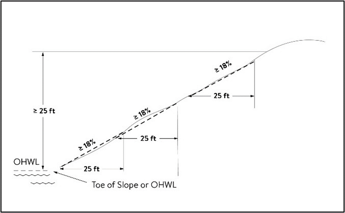
(2)
A natural escarpment or cliff with a slope that rises at least ten feet above the ordinary high water level or toe of the slope, whichever is applicable, to the top of the slope, with a slope of 75 degrees or greater. See Figure 2.
Figure 2. Natural Escarpment Bluff and Bluff Impact Zone
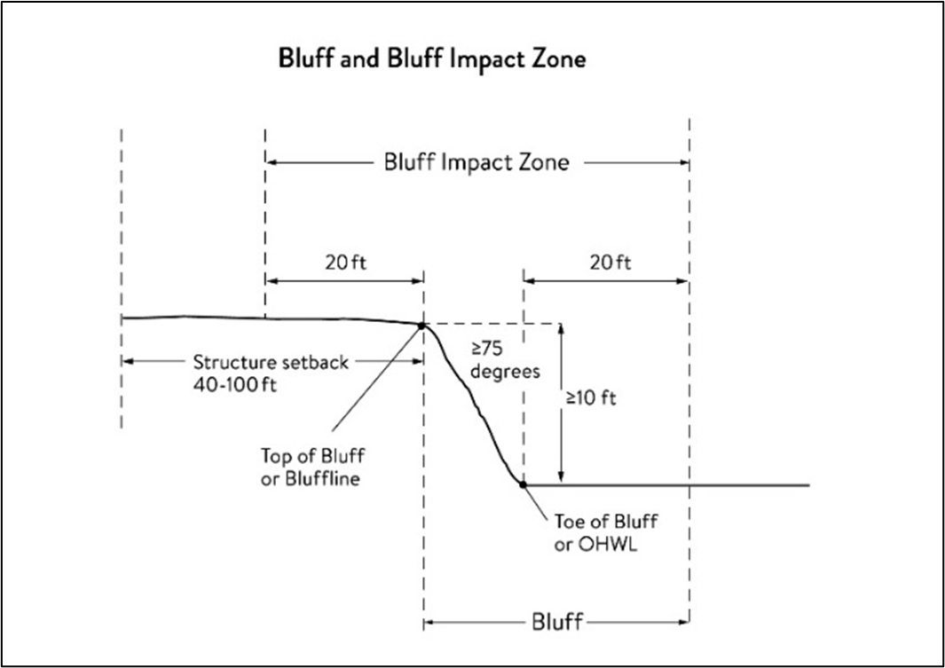
Bluff impact zone (BIZ) means a bluff and land located within 20 feet of the bluff. See Figures 1, 2 and 3 for a bluff example.
Figure 3. Bluff Impact Zone, Bluffline, Toe of Bluff, and Top of Bluff
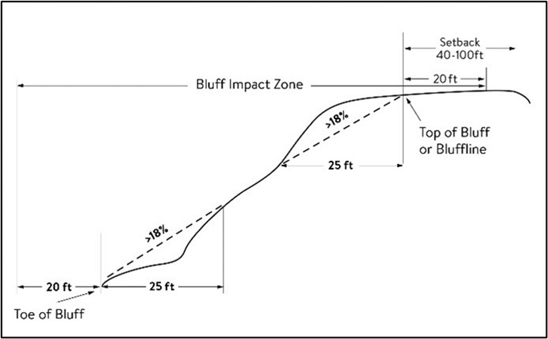
Bluffline means a line delineating the top of the bluff. More than one bluffline may be encountered proceeding landward from the river. See Figures 2 and 3.
Bluff, toe of means a line along the bottom of a bluff, requiring field verification, such that the slope above the line exceeds 18 percent and the slope below the line is 18 percent or less, measured over a horizontal distance of 25 feet. See Figures 2 and 3.
Bluff, top of means a line along the top of a bluff, requiring field verification, such that the slope below the line exceeds 18 percent and the slope above the line is 18 percent or less, measured over a horizontal distance of 25 feet. See Figures 2 and 3.
Buildable area means the area upon which structures may be placed on a lot or parcel of land and excludes areas needed to meet requirements for setback, rights-of-way, bluff impact zones, historic properties, wetlands, designated floodways, land below the ordinary high water level of public waters, and other unbuildable areas.
Building means a structure with two or more outside rigid walls and a fully secured roof and affixed to a permanent site.
Certificate of compliance means a document written after a compliance inspection, certifying that the development complies with applicable requirements at the time of the inspection.
Commissioner means the commissioner of the Minnesota Department of Natural Resources.
Conditional use means a use having the meaning given under Minn. Stats. chs. 394 and 462. Reference city Code section 126-65.
Conservation design means a pattern of subdivision that is characterized by grouping lots within a portion of a parcel, where the remaining portion of the parcel is permanently protected as open space.
Conventional subdivision means a pattern of subdivision that is characterized by lots that are spread regularly throughout a parcel in a lot and block design.
Deck means a horizontal, unenclosed, aboveground level structure open to the sky, with or without attached railings, seats, trellises, or other features, attached or functionally related to a principal use or site.
Developer has the meaning given under Minn. Stats. § 116G.03.
Development has the meaning given under Minn. Stats. § 116G.03.
Discretionary action means an action under this chapter related to land use that requires a public hearing by local ordinance or statute, such as preliminary plats, final subdivision plats, planned unit developments, conditional use permits, interim use permits, variances, appeals, and rezonings.
Dock has the meaning given under Minnesota Rules Chapter 6115.
Electric power facilities means equipment and associated facilities for generating electric power or devices for converting wind energy to electrical energy as identified and defined under Minn. Stats. ch. 216E.
Essential services means underground or overhead gas, electrical, communications, steam, or water distribution, collection, supply, or disposal systems, including storm water. Essential services include poles, wires, mains, drains, pipes, conduits, cables, fire alarm boxes, traffic signals, hydrants, navigational structures, aviation safety facilities or other similar equipment and accessories in conjunction with the systems. Essential services does not include buildings, treatment works as defined in Minn. Stats. § 115.01, electric power facilities or transmission services.
Feedlot has the meaning given for animal feedlots under Minnesota Rules chapter 7020.
Floodplain. Having the meaning given the meaning given under Minnesota Rules Chapter 6120.
Fully reconstructs means the reconstruction of an existing impervious surface that involves site grading and subsurface excavation so that soil is exposed. Mill and overlay and other resurfacing activities are not considered fully reconstructed.
Hard-surface trail means a trail surfaced in asphalt, crushed aggregate, or other hard surface, for multi-purpose use, as determined by local, regional, or state agency plans.
Historic property means an archaeological site, standing structure, site, district, or other property that is:
(1)
Listed in the National Register of Historic Places or the State Register of Historic Places or locally designated as a historic site under Minn. Stats. ch. 471;
(2)
Determined to meet the criteria for eligibility to the National Register of Historic Places or the State Register of Historic Places as determined by the director of the Minnesota Historical Society; or
(3)
An unplatted cemetery that falls under the provisions of Minn. Stats. ch. 307, in consultation with the Office of the State Archaeologist.
Impervious surface means a constructed hard surface that either prevents or retards the entry of water into the soil and causes water to run off the surface in greater quantities and at an increased rate of flow than prior to development. Examples include rooftops, decks, sidewalks, patios, parking lots, storage areas, and driveways, including those with concrete, asphalt, or gravel surfaces.
Intensive vegetation clearing means the removal of all or a majority of the trees or shrubs in a contiguous patch, strip, row, or block.
Interim use means a use having the meaning given under Minn. Stats. chs. 394 and 462.
Land alteration means an activity that exposes the soil or changes the topography, drainage, or cross section of the land, excluding gardening or similar minor soil disturbances.
Local government means counties, cities, and townships.
Lot has the meaning given under Minnesota Rules Chapter 6120.
Lot width means the shortest distance between lot lines measured at both the ordinary high water level and at the required structure setback from the ordinary high water level. See Figure 4.
Figure 4. Lot Width
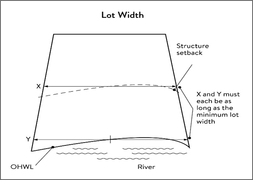
Marina has the meaning given under Minnesota Rules Chapter 6115.
Mississippi River corridor critical area (MRCCA) means the area within the river corridor boundary.
Mississippi River corridor critical area (MRCCA) plan means a chapter or other element in the City of Champlin comprehensive plan.
Mooring facility has the meaning given under Minnesota Rules Chapter 6115.0170.
Native plant community means a plant community identified by the Minnesota Biological Survey or biological survey issued or adopted by a local, state, or federal agency.
Natural-surface trail means a trail composed of native soil and rock or compacted granular stone, primarily intended for hiking, equestrian, or mountain bike use, as determined by local, regional, or state agency plans.
Natural vegetation means any combination of ground cover, understory, and tree canopy that, while it may have been altered by human activity, continues to stabilize soils, retain and filter runoff, provide habitat, and recharge groundwater.
Nonconformity has the meaning given under Minn. Stats. § 394.22.
Nonmetallic mining means construction, reconstruction, repair, relocation, expansion, or removal of any facility for the extraction, stockpiling, storage, disposal, or reclamation of nonmetallic minerals such a stone, sand, and gravel. Nonmetallic mining does not include ancillary facilities such as access roads, bridges, culverts, and water level control structures. For purposes of this subpart, "facility" includes all mine pits, quarries, stockpiles, basins, processing structures and equipment, and any structures that drain or divert public waters to allow mining.
Off-premise advertising signs means those signs that direct attention to a product, service, business, or entertainment venue that is not exclusively related to the premises where the sign is located.
Ordinary high water level (OHWL) has the meaning given under Minn. Stats. § 103G.005.
Overlay district means a zoning district applied over one or more previously established zoning districts, establishing additional or stricter standards and criteria for covered properties in addition to those of the underlying zoning district. Overlay districts are often used to protect historic features and natural resources such as shoreland or floodplain.
Parcel has the meaning given under Minn. Stats. § 116G.03.
Patio means a constructed hard surface located at ground level with no railings and open to the sky.
Picnic shelter means a roofed structure open on all sides, accessory to a recreational use.
Planned unit development means a method of land development that merges zoning and subdivision controls, allowing developers to plan and develop a large area as a single entity, characterized by a unified site design, a mix of structure types and land uses, and phasing of development over a number of years. Planned unit development includes any conversion of existing structures and land uses that utilize this method of development.
Plat has the meaning given under Minn. Stats. chs. 505 and 515B.
Port means a water transportation complex established and operated under the jurisdiction of a port authority according to Minn. Stats. ch. 458.
Primary conservation areas means key resources and features, including shore impact zones, bluff impact zones, floodplains, wetlands, gorges, areas of confluence with tributaries, natural drainage routes, unstable soils and bedrock, native plant communities, cultural and historic properties, and significant existing vegetative stands, tree canopies, and other resources identified in local government plans.
Private facilities means private roads, driveways, and parking areas, private water access and viewing facilities, decks and patios in setback areas, and private signs.
Professional engineer means an engineer licensed to practice in Minnesota.
Public facilities means public utilities, public transportation facilities, and public recreational facilities.
Public recreation facilities means recreational facilities provided by the state or a local government and dedicated to public use, including parks, scenic overlooks, observation platforms, trails, docks, fishing piers, picnic shelters, water access ramps, and other similar water-oriented public facilities used for recreation.
Public river corridor views means views toward the river from public parkland, historic properties, and public overlooks, as well as views toward bluffs from the ordinary high water level of the opposite shore, as seen during the summer months and documented in the MRCCA plan/chapter of the comprehensive plan.
Public transportation facilities means all transportation facilities provided by federal, state, or local government and dedicated to public use, such as roadways, transit facilities, railroads, and bikeways.
Public utilities means electric power facilities, essential services, and transmission services.
Public waters has the meaning given under Minn. Stats. § 103G.005.
Readily visible means land and development that are easily seen from the ordinary high water level of the opposite shore during summer months.
Resource agency means a federal, state, regional, or local agency that engages in environmental, natural, or cultural resource protection or restoration activities, including planning, implementation, and monitoring.
Retaining wall means a vertical or nearly vertical structures constructed of mortar and rubble masonry, rock, or stone regardless of size, vertical timber pilings, horizontal timber planks with piling supports, sheet pilings, poured concrete, concrete blocks, or other durable materials.
Rock riprap means natural coarse rock placed or constructed to armor shorelines, streambeds, bridge abutments, pilings and other shoreline structures against scour, or water or ice erosion.
River corridor boundary means the boundary approved and adopted by the Metropolitan Council under Minn. Stats. § 116G.06, as approved and adopted by the legislature in Minn. Stats. § 116G.15, and as legally described in the Sate Register, volume 43, pages 508 to 518.
River-dependent use means the use of land for commercial, industrial, or utility purposes, where access to and use of a public water feature is an integral part of the normal conduct of business and where the use is dependent on shoreline facilities.
Selective vegetation removal means the removal of isolated individual trees or shrubs that are not in a contiguous patch, strip, row, or block and that does not substantially reduce the tree canopy or understory cover.
Setback means a separation distance measured horizontally.
Shore impact zone (SIZ) means land located between the ordinary high water level of public waters and a line parallel to it at a setback of 50 percent of the required structure setback or, for agricultural use, 50 feet landward of the ordinary high water level. See Figure 5.
Figure 5. Shore Impact Zone
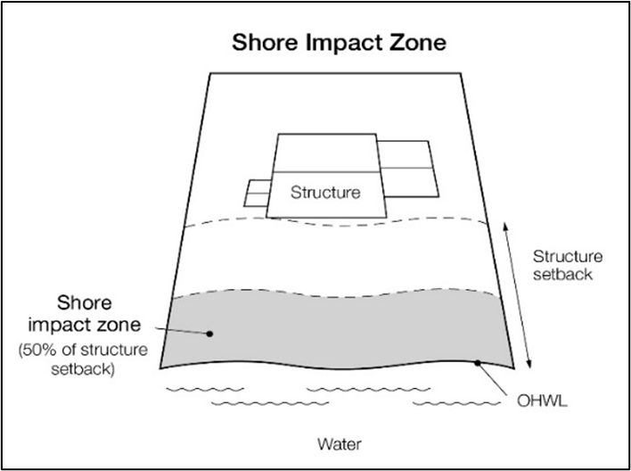
Shoreline facilities means facilities that require a location adjoining public waters for ingress and egress, loading and unloading, and public water intake and outflow, such as barge facilities, port facilities, commodity loading and unloading equipment, watercraft lifts, marinas, short-term watercraft mooring facilities for patrons, and water access ramps. Structures that would be enhanced by a shoreline location, but do not require a location adjoining public waters as part of their function, are not shoreline facilities, such as restaurants, bait shops, and boat dealerships.
Steep slope means a natural topographic feature with an average slope of 12 to 18 percent, measured over a horizontal distance equal to or greater than 50 feet, and any slopes greater than 18 percent that are not bluffs.
Storm water management facilities means facilities for the collection, conveyance, treatment, or disposal of storm water.
Structure means a building, sign, or appurtenance thereto, except for aerial or underground utility lines, such as sewer, electric, telephone, or gas lines, and utility line towers, poles, and other supporting appurtenances.
Subdivision has the meaning given under Minn. Stats. § 462.352.
Subsurface sewage treatment system has the meaning given under Minnesota Rules Part 7080.1100.
Transmission services means:
(1)
Electric power lines, cables, pipelines, or conduits that are:
a.
Used to transport power between two points, as identified and defined under Minn. Stats. § 216E.01, Subd. 4; or
b.
For mains or pipelines for gas, liquids, or solids in suspension, used to transport gas, liquids, or solids in suspension between two points; and
(2)
Telecommunication lines, cables, pipelines, or conduits.
Treeline means the more or less continuous line formed by the tops of trees in a wooded area when viewed from a particular point. The treeline is determined during all seasons as if under full foliage.
Variance has the meaning given under Minn. Stats. § 394.22.
Water access ramp means a boat ramp, carry-down site, boarding dock, and approach road, or other access that allows launching and removal of a boat, canoe, or other watercraft with or without a vehicle and trailer.
Water-oriented accessory structure means a small building or other improvement, except stairways, fences, docks, and retaining walls, that, because of the relationship of its use to public waters, needs to be located closer to public waters than the normal structure setback. Examples include gazebos, screen houses, fish houses, pump houses, and detached decks and patios.
Water quality impact zone means land within the shore impact zone or within 50 feet of the OHWL of the river, whichever is greater, and land within 50 feet of a public water, wetland, or natural drainage route.
Wetland has the meaning given under Minn. Stats. § 103G.005.
Wharf has the meaning given under Minnesota Rules Part 6115.0170.
(c)
Administration. This administration subsection contains general provisions, permit required, evaluation criteria, mitigation conditions, written findings, permit application standards, variances, conditional use permit, nonconformities, notifications, exemptions, and appeals.
(1)
General administration.
a.
Jurisdiction. The provisions of this section apply to land within the river corridor boundary as described in the State Register, volume 43, pages 508 to 519 and shown on the official zoning map.
b.
Enforcement. The city is responsible for the administration and enforcement of this section. Any violation of its provisions or failure to comply with any of its requirements including violations of conditions and safeguards established in connection with grants of variances or conditional uses constitutes a misdemeanor and is punishable as defined by law. Violations of this section can occur regardless of whether or not a permit is required for a regulated activity.
c.
Severability. If any section, clause, provision, or portion of this section is judged unconstitutional or invalid by a court of competent jurisdiction, the remainder of this section shall not be affected thereby.
d.
Abrogation and greater restrictions. It is not intended by this section to repeal, abrogate, or impair any existing easements, covenants, or deed restrictions. However, where this section imposes greater restrictions, the provisions of this section shall prevail. All other sections inconsistent with this section are hereby repealed to the extent of the inconsistency only.
e.
Underlying zoning. Uses and standards of underlying zoning districts apply except where standards of this overlay district are more restrictive.
(2)
Permit required. Administrative review permit or conditional use permit are required as follows:
a.
Administrative review permit. The following shall require an administrative review permit by the city:
1.
Construction of buildings or structures, or building additions, or decks within the primary conservation areas including, but not limited to, the shore impact zone and bluff impact zone, or water quality impact zone, priorities for restoration areas identified in the MRCCA plan, or within 50 feet of a wetland or natural drainage.
2.
Construction or replacement of rock riprap, retaining walls, and other erosion control structures within the bluff impact zone and water quality impact zone.
3.
Land alterations that involve more than ten cubic yards of material or affects an area greater than 1,000 square feet within the water quality impact zone.
4.
Installation and/or alteration of sewage treatment systems within the MRCCA boundary.
5.
Vegetation removal and vegetation restoration within the primary conservation areas (DNR mapping) including, but not limited to, the shore impact zone and bluff impact zone, or water quality impact zone, priorities for restoration areas identified in the MRCCA plan, or within 50 feet of a wetland or natural drainage.
6.
Interim or temporary uses within the primary conservation areas (DNR mapping) including, but not limited to, the shore impact zone and bluff impact zone, or water quality impact zone, priorities for restoration areas identified in the MRCCA plan, or within 50 feet of a wetland or natural drainage.
7.
Ramps and private water access and viewing facilities within the primary conservation areas (DNR mapping) including, but not limited to, the shore impact zone and bluff impact zone, or water quality impact zone, priorities for restoration areas identified in the MRCCA plan, or within 50 feet of a wetland or natural drainage.
8.
Ramps, lifts, mobility paths, or other facilities for persons with physical disabilities, if subsection (g) cannot be complied with.
9.
Stormwater management facilities in the bluff impact zone and water quality impact zone.
10.
Water-oriented accessory structures.
b.
Conditional use permit. The following within the MRCCA boundary shall require a conditional use permit from the city:
1.
In the CA-RTC river towns and cities district, structures over 48 feet.
2.
Wireless communication towers.
3.
Nonmetallic mining.
4.
Land alterations in excess of 150 cubic yards in compliance with section 126-70, land alterations.
c.
Concurrent permit review. Any administrative review permit that is concurrent with another application requiring a discretionary action, public notification or public hearing process shall be reviewed concurrently within the discretionary action, public hearing process.
d.
All conditional use permits, required under this section, must comply with division 2, conditional use permits.
(3)
Permit application. The applications for conditional use permits, variances and administrative reviews required under this section must submit the following information unless the city determines that the information is not needed.
a.
Application form.
b.
A detailed project narrative description including for administrative reviews, variances and conditional use permits, how the proposed alteration, variance or conditional use is consistent with the purposes of this section including subsections of purpose, evaluation criteria, mitigation conditions, vegetation restoration plan and criteria as described in subsection (c)(3)b., written findings for variances and conditional use permits.
c.
Application fee in accordance with chapter 22, fees;
d.
Scaled maps and plans, dimensional renderings, maintenance agreements, and other materials that identify and describe:
1.
Primary conservation areas;
2.
Public river corridor views;
3.
Buildable area;
4.
Existing and proposed topography and drainage patterns;
5.
Proposed storm water and erosion and sediment control practices;
6.
Vegetation to be removed and restored with a vegetation restoration plan consistent with the vegetation management standards;
7.
Ordinary high water level, blufflines, and all required setbacks;
8.
Existing and proposed structures;
9.
Existing and proposed impervious surfaces; and
10.
Existing and proposed subsurface sewage treatment systems.
(4)
Evaluation criteria, mitigation conditions and written findings. Any activity, improvement or use required to obtain an administrative review permit, conditional use permit, or variances shall be evaluated by the criteria herein and with the conditions as stated below. Each permit will be evaluated for consistency with the standards of this section and for the impacts to primary conservation areas, public river corridor views, and other resources identified in the MRCCA plan.
a.
Mitigation conditions. If negative impacts are found in the evaluation of the activity, improvement, variance, or use, the city will require conditions to mitigate the impacts that are related to and proportional to the impacts. Mitigation conditions may include the following:
1.
Restoration of vegetation identified as "vegetation restoration priorities" identified in the MRCCA plan.
2.
Preservation of existing vegetation;
3.
Stormwater runoff management;
4.
Reducing impervious surface;
5.
Increasing structure setbacks;
6.
Wetland and drainage route restoration and/or preservation;
7.
Limiting the height of structures;
8.
Modifying structure design to limit visual impacts on public river corridor views (PRCVs);
9.
Buffers, filter strips;
10.
Increasing, enhancing, and/or connecting habitat for pollinators, birds, and other wildlife;
11.
Increasing open space dedication; and
12.
Other conservation measures.
b.
Written findings for variances and conditional use permits. To approve variances and conditional use permits, the planning commission shall make its findings of fact and recommendations in writing to the city council, consistent with the purpose of this section as follows:
1.
The extent, location and intensity of the conditional use or variance will be in substantial compliance with the MRCCA plan goals.
2.
The conditional use or variance is consistent with the character and management purpose of the MRCCA overlay district in which it is located;
3.
The conditional use or variance is in compliance with the city's comprehensive plan, conservancy district ordinance, floodplain ordinance and surface water management plan;
4.
The conditional use or variance will not be detrimental to primary conservation areas (PCAs), including shore impacts zones (SIZ), bluff impact zones (BIZ), floodplains, wetlands, natural drainage routes and watercourses, unstable soils and bedrock, native plant communities, cultural and historic properties, significant vegetative stands, publicly owned parks, trails and open spaces nor will it contribute to negative incremental impacts when considered in the context of past, present and future actions; and
5.
The conditional use or variance will not be detrimental to public river corridor views (PRCVs), or other scenic views nor will it contribute to negative incremental impacts to PRCVs when considered in the context of past, present and reasonable future actions; and
6.
The conditional use or variance will not negatively impact priorities for restoration as shown in the MRCCA plan.
7.
For structures exceeding the height limits, the following criteria shall be considered and written findings shall be submitted for determining whether to grant a conditional use permit, or variance:
i.
Assessment of the visual impact of the proposed structure on public river corridor views, including views from other communities;
ii.
Determination that the proposed structure meets the required bluff and OHWL setbacks;
iii.
Identification and application of techniques to minimize the perceived bulk of the proposed structure, such as: Placing the long axis of the building perpendicular to the river; stepping back of portions of the facade; lowering the roof pitch or use of a flat roof; using building materials or mitigation techniques that will blend in with the natural surroundings such as green roofs, green walls, or other green and brown building materials; narrowing the profile of upper floors of the building; or increasing the setbacks of the building from the Mississippi River or blufflines;
iv.
Identification of a preservation of those view corridors identified in the MRCCA plan; and
v.
Opportunities for creation or enhancement of public river corridor views.
(5)
Variances. Variances to the requirements under this section may only be granted in accordance with division 4, variances and appeals.
(6)
Nonconformities. All legally established nonconformities as of the date of the ordinance from which this section is derived may continue consistent with Minn. Stats. § 462.357, Subd. 1e and city Code section 126-40. Nonconforming uses, signs, lots, buildings and structures, and the following:
a.
Site alterations and expansion of site alterations that were legally made prior to the effective date of the ordinance from which this section is derived are conforming. Site alterations include vegetation, erosion control, storm water control measures, and other nonstructural site improvements.
b.
New structures erected in conformance with the setback averaging provisions are conforming structures.
c.
Legally nonconforming principal structures that do not meet the setback requirements may be expanded laterally provided that:
1.
The expansion does not extend into the shore or bluff impact zone or further into the required setback than the building line of the existing principal structure (see Figure 6); and
2.
The expanded structure's scale and bulk is consistent with that of the original structure and existing surrounding development.
Figure 6. Expansion of Nonconforming Structure
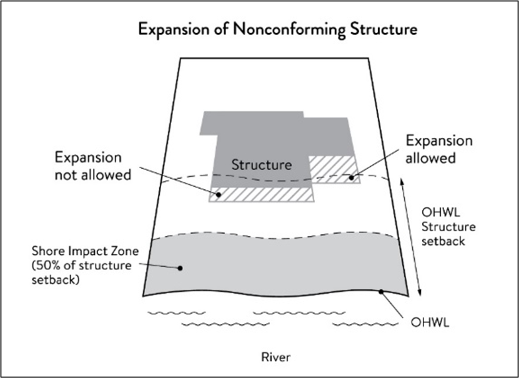
(7)
Notifications.
a.
Amendments to this section and to the MRCCA plan must be submitted to the commissioner as provided in Minnesota Rules Part 6106.0070, Subp. 3, Items B—I.
b.
Notice of public hearings for discretionary actions, including conditional and interim use permits, variances, appeals, rezonings, preliminary plats, final subdivision plats, comprehensive plan amendments and PUDs, must be sent to the following entities at least ten days prior to the hearing:
1.
The commissioner in a format prescribed by the DNR;
2.
National Park Service; and
3.
Where building heights exceed the height limits as part of the conditional use or variance process, adjoining local governments within the MRCCA, including those with overlapping jurisdiction and those across the river.
e.
Notice of final decisions for actions in nonconformities, including findings of fact, must be sent to the commissioner, the National Park Service, and adjoining local governments within the MRCCA within ten days of the final decision.
f.
Requests to amend district boundaries must follow the provisions in Minnesota Rules Part 6106.0100, Subp. 9, Item C.
(8)
Appeals. Property owners may appeal the administrative review permit to the city council. A written notice of intent to appeal shall be filed with the city within 30 calendar days of receipt of notice of the decision. Upon receipt of the written notice of intent to appeal, the council shall, within a reasonable time but no later than 30 days after receipt of notice of appeal, hear the appeal, and shall promptly thereafter render its decision, which decision shall be final.
(d)
River corridor overlay districts. This section applies to the Mississippi River corridor critical areas (MRCCA) identified on the official zoning map including the following corridor area (CA) overlay districts. The city has approximately 588 acres of land in the MRCCA designated as four different overlay districts: Rural and open space (CA-ROS), river neighborhoods (CA-RN), river towns and crossings (CA-RTC), and separated from river (CA-SR). The district boundary lines are intended to follow the centerlines of rivers and streams, highways, streets, lot lines, and municipal boundaries, unless a boundary line is otherwise indicated on the map. Where district boundaries cross unsubdivided property, the district boundary line is determined by use of dimensions or the scale appearing on the map.
(1)
Rural and open space (CA-ROS).
a.
Description. The ROS district is characterized by rural and low-density development patterns and land uses, and includes land that is riparian or visible from the river, as well as large, undeveloped tracts of high ecological and scenic value, floodplain, and undeveloped islands. Many primary conservation areas exist in the district.
b.
Management purpose. The ROS district must be managed to sustain and restore the rural and natural character of the corridor and to protect and enhance habitat, parks and open space, public river corridor views, and scenic, natural, and historic areas.
(2)
River neighborhood (CA-RN).
a.
Description. The RN district is characterized by primarily residential neighborhoods that are riparian or readily visible from the river or that abut riparian parkland. The district includes parks and open space, limited commercial development, marinas, and related land uses.
b.
Management purpose. The RN district must be managed to maintain the character of the river corridor within the context of existing residential and related neighborhood development, and to protect and enhance habitat, parks and open space, public river corridor views, and scenic, natural, and historic areas. Minimizing erosion and the flow of untreated storm water into the river and enhancing habitat and shoreline vegetation are priorities in the district.
(3)
River towns and crossings (CA-RTC).
a.
Description. The RTC district is characterized by historic downtown areas and limited nodes of intense development at specific river crossings, as well as institutional campuses that predate designation of the MRCCA, and that include taller buildings.
b.
Management purpose. The RTC district must be managed in a manner that allows continued growth and redevelopment in historic downtowns and more intensive redevelopment in limited areas at river crossings to accommodate compact walkable development patterns and connections to the river. Minimizing erosion and the flow of untreated storm water into the river, providing public access to and public views of the river, and restoring natural vegetation in riparian areas and tree canopy are priorities in the district.
(4)
Separated from river (CA-SR).
a.
Description. The SR district is characterized by its physical and visual distance from the Mississippi River. The district includes land separated from the river by distance, topography, development, or a transportation corridor. The land in this district is not readily visible from the Mississippi River.
b.
Management purpose. The SR district provides flexibility in managing development without negatively affecting the key resources and features of the river corridor. Minimizing negative impacts to primary conservation areas and minimizing erosion and flow of untreated storm water into the Mississippi River are priorities in the district.
(e)
Special land use provisions. The additional special use provisions in this section apply to the following land uses and are meant to identify development standards and considerations for land uses that have potential to negatively impact primary conservation areas and public river corridor views.
(1)
Underlying zoning. Uses within the MRCCA are generally determined by underlying zoning, with additional provisions for the following land uses:
a.
Agricultural use. Perennial ground cover is required within 50 feet of the ordinary high water level and within the bluff impact zone.
b.
Feedlots. New animal feedlots and manure storage areas are prohibited. Existing animal feedlots and manure storage areas must conform with Minnesota Rules Chapter 7020.
c.
Forestry. Tree harvesting and biomass harvesting within woodlands, and associated reforestation, must be consistent with recommended practices in Conserving Wooded Areas in Developing Communities: Best Management Practices in Minnesota.
d.
Nonmetallic mining. Nonmetallic mining requires a conditional use permit or interim use permit issued by the local government, subject to the following:
1.
New nonmetallic mining is prohibited within the shore impact zone and bluff impact zone and within the required structure setback from the bluffline and OHWL;
2.
Processing machinery must be located consistent with setback standards for structures;
3.
Only one barge loading area, which must be limited to the minimum size practicable, is permitted for each mining operation;
4.
New and, where practicable, existing nonmetallic mining operations must not be readily visible and must be screened by establishing and maintaining natural vegetation. The unscreened boundaries of nonmetallic mining areas are limited to only the barge loading area;
5.
A site management plan must be developed by the operator and approved by the local government before new nonmetallic mining commences. Operations must be consistent with the site plan throughout the duration of operations at the site. The site management plan must:
i.
Describe how the site will be developed over time with an emphasis on minimizing environmental risk to public waters;
ii.
Explain where staged reclamation may occur at certain points during the life of the site;
iii.
Address dust, noise, storm water management, possible pollutant discharges, days and hours of operation, and duration of operations; and
iv.
Describe any anticipated vegetation and topographic alterations outside the pit, and reclamation plans consistent with the stated end use for the land; and
e.
Existing and new nonmetallic mining operations must submit land reclamation plans to the local government compatible with the purposes of this chapter.
(2)
River-dependent uses. River-dependent uses must comply with the following design standards:
a.
Structures and parking areas, except shoreline facilities and private roads and conveyances serving river-dependent uses as provided in exemption tables, must meet the dimensional and performance standards in this section, must be designed so that they are not readily visible, and must be screened by establishing and maintaining natural vegetation;
b.
Shoreline facilities must comply with Minnesota Rules Chapter 6115 and must:
1.
Be designed in a compact fashion so as to minimize the shoreline area affected; and
2.
Minimize the surface area of land occupied in relation to the number of watercraft or barges to be served; and
c.
Dredging and placement of dredged material are subject to existing federal and state permit requirements and agreements.
(3)
Wireless communication towers. Wireless communication towers require a conditional or interim use permit and are subject to the following design standards:
a.
The applicant must demonstrate that functional coverage cannot be provided through co-location, a tower at a lower height, or a tower at a location outside of the MRCCA;
b.
The tower must not be located in a bluff or shore impact zone;
c.
Placement of the tower must minimize impacts on public river corridor views; and
d.
Comply with the general design standards for public facilities.
(f)
Standards.
(1)
Structure height and setback. The structure setbacks from the ordinary high water level (OHWL) and bluffs, as well as structure height limits measured on the side of the structure facing the Mississippi River, for each of the MRCCA districts, are shown in Table 126-348(e).1.a and described below in compliance with Minnesota Rules 6106.0120:
Table 126-348(e).1.a Height and Setback Standards
a.
Height descriptions. Structures, including alterations as defined by this section, must be no taller than the heights specified for each district below. Structures and facilities must comply with the following specific height standards unless identified as exempt in this section.
1.
CA-ROS rural open space district: Maximum 35 feet.
2.
CA-RN river neighborhood district: Maximum 35 feet.
3.
CA-RTC river towns and cities district: Maximum 48 feet, provided tiering of structures away from the Mississippi River and from blufflines is given priority, with lower structure heights closer to the river and blufflines, and that structure design and placement minimizes interference with public river corridor views. Structures over 48 feet are allowed as a conditional use according to section 128-348(c), administration.
4.
CA-SR separated from river district: Maximum height is determined by underlying zoning, provided the allowed height is consistent with that of the mature treeline, where present, and existing surrounding development, as viewed from the OHWL of the opposite shore.
b.
In addition to the conditional use permit requirements, criteria for considering whether to grant a conditional use permit for structures exceeding the height limits must include:
1.
Assessment of the visual impact of the proposed structure on public river corridor views, including views from other communities;
2.
Determination that the proposed structure meets the required bluff and OHWL setbacks;
3.
Identification and application of techniques to minimize the perceived bulk of the proposed structure, such as:
i.
Placing the long axis of the building perpendicular to the river;
ii.
Stepping back of portions of the facade;
iii.
Narrowing the profile of upper floors of the building; or
iv.
Increasing the setbacks of the building from the Mississippi River or blufflines;
c.
Identification of techniques for preservation of those view corridors identified in the MRCCA plan; and
d.
Opportunities for the creation or enhancement of public river corridor views.
(2)
Structure and impervious surface setback descriptions.
a.
Structures, including alterations as defined by this section, and impervious surfaces must not be located in the shore impact zone nor in the bluff impact zone and must meet the following setback requirement from the ordinary high water level of the Mississippi River as specified for each district below unless identified as exempt in this section.
1.
CA-ROS rural open space district: 200 feet from the Mississippi River and 100 feet from the bluffline.
2.
CA-RN river neighborhood district: 100 feet from the Mississippi River and 40 feet from the bluffline.
3.
CA-RTC river towns and cities district: 75 feet from the Mississippi River and 40 feet from the bluffline.
4.
CA-SR separated from river district: As specified in underlying zoning district and 40 feet from the bluffline.
(3)
Setback averaging. Where principal structures exist on the adjoining lots on both sides of a proposed building site, the minimum setback may be altered to conform to the average of the adjoining setbacks, if the new structure's scale and bulk riverward or bluffward of the setbacks required under this subsection are consistent with adjoining development. See Figure 7.
Figure 7. Structure Setback Averaging
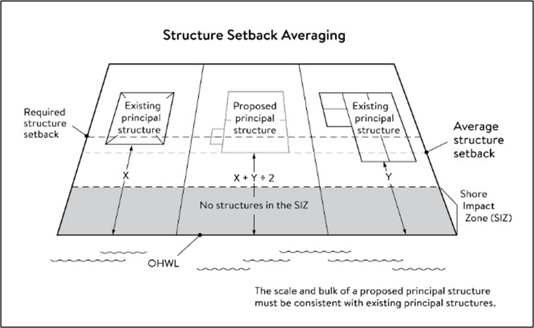
(4)
Subsurface sewage treatment systems, including the septic tank and absorption area, must be located at least 75 feet from the ordinary high water level of the Mississippi River and all other public waters.
(5)
Lot size and buildable area.
a.
The width of lots abutting the Mississippi River in the ROS district must be at least 200 feet, unless alternative design methods are used that provide greater protection of the riparian area.
b.
Minimum lot depth for lots within the Mississippi River corridor critical area shall be 200 feet.
c.
All new lots must have adequate buildable area to comply with the setback requirements of this section so as to not require variances to use the lots for their intended purpose.
(g)
Performance standards for private facilities. All private facilities must be developed in accordance with the vegetation management and land alteration requirements of this section.
(1)
Private roads, driveways, and parking areas. Private roads, driveways, parking areas must comply with the following:
a.
Must be designed and constructed to take advantage of natural vegetation and topography so that they are not readily visible;
b.
Comply with structure setback requirements according to this section; and
c.
Not be placed within the bluff impact zone or shore impact zone, unless exempt by this section and designed consistent with this section.
(2)
Private water access and viewing facilities. Private water access and viewing facilities including trails, paths, ramps, recreational boating and fishing facilities, stairways, lifts, and landings, must comply with the following:
a.
Private access paths must be no more than:
1.
Eight feet wide, if placed within the shore impact zone; and
2.
Four feet wide, if placed within the bluff impact zone.
b.
Private water access ramps must:
1.
Comply with Minnesota Rules Parts 6115.0210 and 6280.0250; and
2.
Be designed and constructed consistent with the applicable standards in Design Handbook for Recreational Boating and Fishing Facilities, incorporated by reference under [Minnesota Rules] Part 6106.0090.
c.
Private stairways, lifts, and landings are subject to the following standards:
1.
Stairways and lifts must not exceed four feet in width on residential lots. Wider stairways are allowed for commercial properties and residential facilities held in common, if approved by the city;
2.
Landings for stairways and lifts on residential lots must not exceed 32 square feet in area. Landings larger than 32 square feet are allowed for commercial properties and residential facilities held in common, if approved by the city;
3.
Canopies or roofs are prohibited on stairways, lifts, or landings;
4.
Stairways, lifts, and landings must be located in the least visible portion of the lot whenever practical; and
5.
Ramps, lifts, mobility paths, or other facilities for persons with physical disabilities are allowed for achieving access to shore areas according to Minnesota Rules [Part] 6106.0080, subpart 7. Ramps or other facilities to provide persons with disabilities access to the persons' property, as required by the federal Americans with Disabilities Act and the federal Fair Housing Act and as provided by Minnesota Rules Chapter 1341, in compliance with this section or if ramps or other facilities cannot comply, may be allowed with an administrative permit provided:
i.
The permit terminates on either a specific date or upon occurrence of a particular event related to the person requiring accommodation; and
ii.
Upon expiration of the permit, the ramp or other facilities must be removed.
(3)
One water-oriented accessory structure is allowed for each riparian lot or parcel less than 300 feet in width at the ordinary high water level, with one additional water-oriented accessory structure allowed for each additional 300 feet of shoreline on the same lot or parcel. Water-oriented accessory structures are prohibited in the bluff impact zone and must:
a.
Not exceed 12 feet in height;
b.
Not exceed 120 square feet in area; and
c.
Be placed a minimum of ten feet from the ordinary high water level.
(4)
Private decks and patios in setback areas. Private decks and at-grade patios may encroach into the required setbacks from the ordinary high water level and blufflines without a variance, in compliance with vegetation management, land alteration, and storm water management standards, provided that:
a.
The encroachment of the deck or patio into the required setback area does not exceed 15 percent of the required structure setback.
b.
The area of the deck or patio that extends into the required setback area occupies no more than 25 percent of the total area between the required setback and the 15 percent allowance, using the following formula:
[required setback depth (feet) x 0.15 x lot width (feet) x 0.25 = maximum total area]; and
c.
The deck or patio does not extend into the bluff impact zone. See Figure 8.
Figure 8. Deck and Patio Encroachment
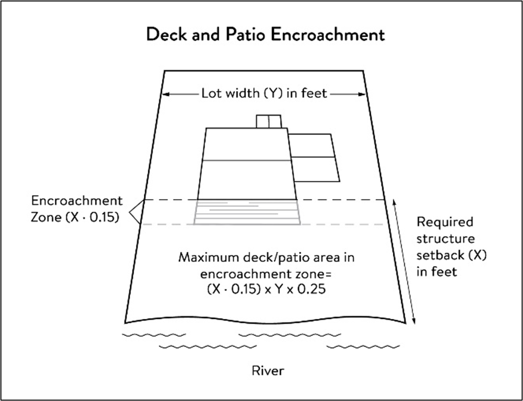
(5)
Signs.
a.
All signs within the MRCCA districts shall comply with the underlying zoning and chapter 118, signs.
b.
Off-premise advertising signs must:
1.
Meet required structure placement and height standards and;
2.
Not be readily visible.
c.
All signs shall be consistent with Minn. Stats. § 86B.115. A person may not use a fixed or anchored structure on the waters of this state, not a part of a pier or dock extending from shore, for advertising purposes.
d.
Private signs are prohibited within primary conservation areas, including the shore impact zone (SIZ), except for signs that meet the following:
1.
One sign no greater than three feet in height and four square feet in surface area; and
2.
Sign lighting is prohibited.
(6)
Fences. Fences between principal structures and the river are allowed if fences meet the following:
a.
Not higher than six feet outside the shore impacts zones (SIZ), bluff impact zones (BIZ), and regulatory floodplain.
b.
Not higher than four feet and maximum 50 percent opaque within the shore impacts zones (SIZ), bluff impact zones (BIZ), and regulatory floodplain above the OHWL as long as the fence is out of the floodway.
(h)
Performance standards for public facilities.
(1)
Public facilities general design standards. All public facilities must be designed and constructed to:
a.
Minimize visibility of the facility from the river to the extent consistent with the purpose of the facility;
b.
Comply with the structure placement and height standards in this section;
c.
Be consistent with the vegetation management standards, and the land alteration and storm water management standards in this section, including use of practices identified in Best Practices for Meeting DNR General Public Waters Work Permit GP 2004-0001, where applicable;
d.
Avoid primary conservation areas, unless no alternative exists. If no alternative exists, then disturbance to primary conservation areas must be avoided to the greatest extent practicable, and design and construction must minimize impacts;
e.
Minimize disturbance of spawning and nesting times by scheduling construction at times when local fish and wildlife are not spawning or nesting; and
f.
Minimize disturbance during bird migration and nesting times by scheduling construction at times when birds are not migrating or nesting.
(2)
Public right-of-way maintenance standards. Right-of-way maintenance must comply with the following standards:
a.
Vegetation currently in a natural state must be maintained to the extent feasible;
b.
Where vegetation in a natural state has been removed, native plants must be planted and maintained on the right-of-way; and
c.
Chemical control of vegetation must be avoided when practicable, but when chemical control is necessary, chemicals used must be in accordance with the regulations and other requirements of all state and federal agencies with authority over the chemical's use.
(3)
Public crossings of public water or public land. Crossings of public waters or land controlled by the commissioner are subject to approval by the commissioner according to Minn. Stats. §§ 84.415 and 103G.245.
(4)
Public utilities. Public utilities must comply with the following standards:
a.
High-voltage transmission lines, wind energy conversion systems greater than five megawatts, and pipelines are regulated according to Minn. Stats. chs. 216E, 216F, and 216G respectively; and
b.
If overhead placement is necessary, utility facility crossings must minimize visibility of the facility from the river, be hidden from view and follow other existing rights-of-way as much as practicable.
c.
The appearance of structures must be as compatible as practicable with the surrounding area in a natural state with regard to height and width, materials used, and color.
d.
Wireless communication facilities, according to special land use provisions.
(5)
Public transportation facilities. Public transportation facilities shall comply with structure placement and height standards in this section. Where such facilities intersect or abut two or more MRCCA districts, the least restrictive standards apply. Public transportation facilities must be designed and constructed to give priority to:
a.
Providing scenic overlooks for motorists, bicyclists, and pedestrians;
b.
Providing safe pedestrian crossings and facilities along the river corridor;
c.
Providing access to the riverfront in public ownership; and
d.
Allowing for use of the land between the river and the transportation facility.
(6)
Public recreational facilities. Public recreational facilities must comply with the following standards:
a.
Buildings and parking associated with public recreational facilities must comply with the structure placement and height standards in this section.
b.
Roads and driveways associated with public recreational facilities must not be placed in the bluff or shore impact zones unless no other placement alternative exists. If no alternative exists, then design and construction must minimize impacts to shoreline vegetation, erodible soils and slopes, and other sensitive resources.
c.
Trails, access paths, and viewing areas associated with public recreational facilities and providing access to or views of the Mississippi River are allowed within the bluff and shore impact zones if design, construction, and maintenance methods are consistent with the best management practice guidelines in Trail Planning, Design, and Development Guidelines.
1.
Hard-surface trails are not allowed on the face of bluffs with a slope exceeding 30 percent. Natural surface trails are allowed, provided they do not exceed eight feet in width.
2.
Trails, paths, and viewing areas must be designed and constructed to minimize:
i.
Visibility from the river;
ii.
Visual impacts on public river corridor views; and
iii.
Disturbance to and fragmentation of primary conservation areas.
d.
Public water access facilities must comply with the following requirements:
1.
Watercraft access ramps must comply with Minnesota Rules Chapters 6115.0210 and 6280.0250; and
2.
Facilities must be designed and constructed consistent with the standards in Design Handbook for Recreational Boating and Fishing Facilities.
e.
Public stairways, lifts, and landings must be designed as provided in private water access and viewing facilities section.
f.
Public signs and kiosks for public recreational facilities, for interpretive or directional purposes are allowed in the bluff or shore impact zones, provided they are placed and constructed to minimize disturbance to these areas and avoid visual impacts on public river corridor views. If illuminated, the lighting must be fully shielded and be directed downward.
(i)
Vegetation management. The purpose of vegetation management is to establish standards that sustain and enhance the biological and ecological functions of vegetation; preserve the natural character and topography of the MRCCA; and maintain stability of bluffs and steep slopes and ensure stability of other erosion-prone areas.
(1)
Applicability. This subsection applies to:
a.
Shore impact zones;
b.
Areas within 50 feet of a wetland or natural drainage route;
c.
Bluff impact zones;
d.
Areas of native plant communities; and
e.
Significant existing vegetative stands identified in the MRCCA plan.
(2)
Only the following intensive vegetation clearing activities are allowed with a permit:
a.
Clearing of vegetation that is dead, diseased, dying, or hazardous;
b.
Clearing to prevent the spread of diseases or insect pests;
c.
Clearing to remove invasive non-native species.
d.
Clearing to prepare for restoration and erosion control management activities consistent with a plan approved by the city.
e.
The minimum necessary for development that is allowed with a building permit or as an exemption under this section.
(3)
Only the following intensive vegetation clearing activities allowed without a permit:
a.
Maintenance of existing lawns, landscaping and gardens;
b.
Removal of vegetation in emergency situations as determined by the city;
c.
Right-of-way maintenance for public facilities meeting the standards of this section;
d.
Agricultural and forestry activities meeting the standards of this section;
e.
Selective vegetation removal, provided that vegetative cover remains consistent with the management purpose of the MRCCA district, including removal of:
1.
Vegetation that is dead, diseased, dying, or hazardous;
2.
Vegetation to prevent the spread of diseases or insect pests;
3.
Individual trees and shrubs; and
4.
Invasive non-native species.
(4)
General performance standards. The following standards must be met, in addition to a restoration plan in order to approve a permit:
a.
Development is sited to minimize removal of or disturbance to natural vegetation;
b.
Soil, slope stability, and hydrologic conditions are suitable for the proposed work as determined by a professional engineer or resource agency;
c.
Clearing is the minimum necessary and designed to blend with the natural terrain and minimize visual impacts to public river corridor views;
d.
Vegetation removal activities are conducted so as to expose the smallest practical area of soil to erosion for the least possible time;
e.
Any other condition determined necessary to achieve the purpose of this section.
(5)
Vegetation restoration plan. Development of a restoration plan and reestablishment of natural vegetation is required for any vegetation removed with a permit, failure to comply with any vegetation clearing and restoration standards and criteria, or as part of subdivision and land development. The vegetation restoration plan must meet the restoration plan performance standards.
(6)
Restoration plan performance standards. The vegetation restoration plan must satisfy the permit application submittal requirements, and:
a.
Vegetation must be restored in one or more of the following restoration priority areas:
1.
Areas with soils showing signs of erosion, especially on or near the top and bottom of steep slopes and bluffs;
2.
Shoreline areas within 25 feet of the water with no natural vegetation, degraded vegetation, or planted with turf grass;
3.
Areas on steep slopes and bluffs that are visible from the river with no natural vegetation, degraded vegetation, or planted with turf grass;
4.
Other approved priority opportunity area, including priorities identified in the MRCCA plan, if none of the above exist.
b.
Include vegetation that provides suitable habitat and effective soil stability, runoff retention, and infiltration capability. Vegetation species, composition, density, and diversity must be guided by nearby patches of native plant communities and by native vegetation establishment and enhancement guidelines;
c.
Any highly erodible soils disturbed during removal and/or restoration must be stabilized with deep-rooted vegetation with a high stem density;
d.
Vegetation removed must be restored with natural or native vegetation to the greatest extent practicable. The area (square feet) of the restored vegetation should be similar to that removed to the greatest extent practicable;
e.
For restoration of removed native plant communities, restored vegetation must also provide biological and ecological function equivalent to the removed native plant communities. The area (square feet) of the restored vegetation should be equivalent to that removed;
f.
Be prepared by a qualified individual; and
g.
Include a maintenance plan that includes management provisions for controlling invasive species and replacement of plant loss for three years.
h.
Other conditions as determined necessary by the city to achieve the purpose of this section.
i.
A certificate of compliance will be issued after the vegetation restoration plan requirements have been satisfied.
(j)
Land alteration. The purpose of this section is to establish standards that protect water quality from pollutant loadings of sediment, nutrients, bacteria, and other contaminants; and maintain stability of bluffs, shorelines, and other areas prone to erosion.
(1)
Any land alteration over 150 cubic yards shall be in compliance with section 126-70, land alterations.
a.
Within the bluff impact zone, land alteration is prohibited, except for the following which are allowed by permit:
1.
Erosion control consistent with a plan approved by the city or resource agency;
2.
The minimum necessary for development that is allowed as an exception under exemptions section; and
3.
Repair and maintenance of existing buildings and facilities.
b.
Within the water quality impact zone, land alteration that involves more than ten cubic yards of material or affects an area greater than 1,000 square feet requires a permit, shall be in compliance with the administrative section.
(2)
Conditions of land alteration permit approval:
a.
Temporary and permanent erosion and sediment control measures retain sediment onsite consistent with best management practices in the Minnesota Stormwater Manual, incorporated by reference under [Minnesota Rules] Part 6106.0090;
b.
Natural site topography, soil, and vegetation conditions are used to control runoff and reduce erosion and sedimentation;
c.
Construction activity is phased when possible;
d.
All erosion and sediment controls are installed before starting any land disturbance activity;
e.
Erosion and sediment controls are maintained to ensure effective operation;
f.
The proposed work is consistent with the vegetation standards in [Minnesota Rules] Part 6106.0150; and
g.
Best management practices for protecting and enhancing ecological and water resources identified in Best Practices for Meeting DNR General Public Waters Work Permit GP 2004-001, incorporated by reference under [Minnesota Rules] Part 6106.0090, are implemented where applicable, regardless of project type.
(3)
Rock riprap, retaining walls, and other erosion control structures.
a.
Construction or replacement of rock riprap, retaining walls, and other erosion control structures within the bluff impact zone and the water quality impact zone are allowed with a permit consistent with land alteration standards provided that:
1.
If the project includes work at or below the OHWL, the commissioner has already approved or permitted the project.
2.
The structures are used only to correct an established erosion problem as determined by the city.
3.
The size and extent of the structures are the minimum necessary to correct the erosion problem and are not larger than the following, unless a professional engineer determines that a larger structure is needed to correct the erosion problem:
i.
Retaining walls must not exceed five feet in height and must be placed a minimum horizontal distance of ten feet apart; and
ii.
Riprap must not exceed the height of the regulatory flood protection elevation. See Figure 9 below.
iii.
Modular block or similar material retaining walls are prohibited within 20 feet of the ordinary high water level, with exceptions as determined by the city engineer with design considerations such as wall function, soil type, erosion control, and shoreline stabilization.
4.
Repair of existing rock riprap, retaining walls, and other erosion control structures above the OHWL does not require a permit provided it does not involve any land alteration.
b.
Construction at or below the OHWL. Construction, repair, or replacement of rock riprap, retaining walls, and other erosion control structures located at or below the OHWL must comply with Minnesota Rules Part 6115.0215, Subp. 4, item E, and 6115.0216, Subp. 2. Work must not proceed until approved by the commissioner, permitted by the U.S. Army Corps of Engineers, and any other permits are obtained. See Figure 9.
Figure 9. Riprap Guidelines
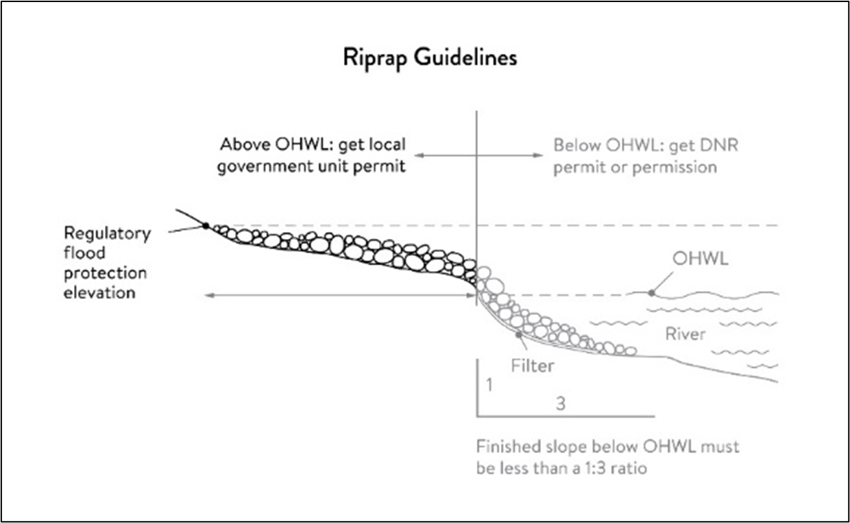
(4)
Stormwater management.
a.
In the bluff impact zone, storm water management facilities are prohibited, except by permit if:
1.
There are no alternatives for storm water treatment outside the bluff impact zone on the subject site;
2.
The site generating runoff is designed so that the amount of runoff reaching the bluff impact zone is reduced to the greatest extent practicable;
3.
The construction and operation of the facility does not affect slope stability on the subject property or adjacent properties; and
4.
Mitigation based on the best available engineering and geological practices is required and applied to eliminate or minimize the risk of slope failure.
b.
In the water quality impact zone, development that creates new impervious surface, as allowed by Exemptions section, or fully reconstructs existing impervious surface of more than 10,000 square feet requires a storm water permit. Multipurpose trails and sidewalks are exempt if there is down gradient vegetation or a filter strip that is at least five feet wide.
c.
In all other areas, storm water runoff must be directed away from the bluff impact zones or unstable areas.
(5)
Development on steep slopes. Construction of structures, impervious surfaces, land alteration, vegetation removal, or other construction activities are allowed on steep slopes if:
a.
The development can be accomplished without increasing erosion or storm water runoff;
b.
The soil types and geology are suitable for the proposed development; and
c.
Vegetation is managed according to the requirements of the vegetation management section.
(6)
Compliance with other plans and programs. All development must:
a.
Be consistent with Minn. Stats. ch. 103B, and local water management plans completed under [Minn. Stats.] ch. 8410;
b.
Meet or exceed the wetland protection standards under Minnesota Rules Chapter 8420; and
c.
Meet or exceed the floodplain management standards under Minnesota Rules Chapters 6120.5000—6120.6200.
(k)
Subdivision and land development standards.
(1)
The purposes the subdivision and land development standards are to:
a.
Protect and enhance the natural and scenic values of the Mississippi River critical corridor area during development or redevelopment of the remaining large sites within the corridor;
b.
Establish standards for protecting and restoring biological and ecological functions of primary conservation areas on large sites; and
c.
Encourage restoration of natural vegetation during development or redevelopment of large sites, where restoration opportunities have been identified in local plans.
(2)
Applicability. The design standards in this subsection apply to subdivisions, planned unit developments and master-planned development and redevelopment of land involving ten or more acres for contiguous parcels that abut the Mississippi River and 20 or more acres for all other parcels, including smaller individual sites within the following developments that are part of a common plan of development that may be constructed at different times: Subdivisions; planned unit developments; and master-planned development and redevelopment of land.
(3)
Exemptions. The following activities are exempt from this part:
a.
Minor subdivisions consisting of three or fewer lots;
b.
Minor boundary line corrections;
c.
Resolutions of encroachments;
d.
Additions to existing lots of record;
e.
Placement of essential services; and
f.
Activities involving river-dependent commercial and industrial uses.
(4)
Design standards.
a.
Primary conservation areas, where they exist, must be set aside and designated as protected open space in quantities meeting the following as a percentage of total parcel area:
1.
CA-ROS: 50 percent;
2.
CA-RN: 20 percent;
3.
CA-RTC: Ten percent; and
4.
CA-SR: Ten percent, if the parcel includes native plant communities or provides feasible connections to a regional park or trail system, otherwise no requirement.
b.
If the primary conservation areas exceed the maximum percentage established above, then protection of native plant communities and natural vegetation in riparian areas shall be prioritized.
c.
If primary conservation areas exist but do not have natural vegetation (identified as restoration priorities in the MRCCA plan), then a vegetation assessment must be completed to evaluate the unvegetated primary conservation areas and determine whether vegetation restoration is needed. If restoration is needed, vegetation must be restored according to the vegetation restoration plan standards in the vegetation management section.
d.
If primary conservation areas do not exist on the parcel and portions of the parcel have been identified in the MRCCA plan as a restoration area, vegetation must be restored in the identified areas according to vegetation restoration plan section and the area must be set aside and designated as protected open space.
e.
Storm water treatment areas or other green infrastructure may be used to meet the protected open space requirements if the vegetation provides biological and ecological functions.
f.
Land dedicated under section 122-5, park dedication, for public river access, parks, or other open space or public facilities may be counted toward the protected open space requirement.
g.
Protected open space areas must connect open space, natural areas, and recreational areas, where present on adjacent parcels, as much as possible to form an interconnected network.
(5)
Permanent protection of designated open space. Permanent protection methods must ensure the long-term management of vegetation to meet its biological and ecological functions, prohibit structures, and prohibit land alteration, except as needed to provide public recreational facilities and access to the river. Designated open space areas must be protected through one or more of the following methods:
a.
Public acquisition by a government entity for conservation purposes;
b.
A permanent conservation easement, as provided in Minn. Stats. ch. 84C;
c.
A deed restriction; and
d.
Other arrangements that achieve an equivalent degree of protection.
(6)
Alternative design standards. Applicants are encouraged to propose alternative design methods that achieve better protection or restoration of primary conservation areas. Methods may include protection and restoration of continuous vegetation, preventing the fragmentation of vegetation, and habitat conservation for known protected species such as the blanding turtle.
(l)
Exemptions. The purpose is to provide exemptions to structure placement, height and other standards for specific river or water access dependent facilities as provided in Minn. Stats. § 116G.15, Subd. 4.
(1)
Applicability. Uses and activities not specifically exempted must comply with this section. Uses and activities exempted under shore impact zone and bluff impact zone must comply with the vegetation management and land alteration standards in this section.
(2)
Exemption category definitions.
a.
Exempt—E. This means that the use or activity is allowed;
b.
Exempt if no alternative—(E). This means that the use or activity is allowed only if no alternatives exist; and
c.
Not exempt—N. This means that a use or activity is not exempt and must meet the standards of this chapter.
(3)
General uses and activities exemption table.
(4)
Public utilities exemption table.
(5)
Public recreational facilities exemption table.
(6)
River-dependent uses exemption table.
(7)
Private residential and commercial water access and use facilities exemption table.
(Code 1977, § 13-114.4; Ord. No. 592, 4-26-2004; Ord. No. 845, 10-12-2021; Ord. No. 852, Att., 5-23-2022)
Editor's note— Ord. No. 845, adopted Oct. 12, 2021, amended the title of § 126-348 to read as herein set out. The former § 126-348 title pertained to the Mississippi River Corridor.
Sec. 126-349. - Woodland and significant tree protection.
(a)
Findings and purpose. The city recognizes that preservation and replanting of trees is important on new development sites in order to maintain a healthy and desirable community. The purposes of tree preservation regulations are:
(1)
Prevention of soil erosion;
(2)
Improvement of air quality;
(3)
Energy conservation through natural insulation and shading;
(4)
Increased property values;
(5)
Protection of privacy by maintaining and establishing buffers between conflicting uses; and
(6)
Providing habitat for wildlife.
(b)
Scope. The regulations contained in this section shall apply to all properties involving a site plan application or preliminary plat/lot division application resulting in the creation of one or more new development parcels and to property during construction after subdivision or when not connected with subdivision.
(c)
Heritage trees.
(1)
Upon nomination by any person and with the written consent of the property owner, the city council, after public hearing, may designate a tree as a heritage tree. A tree may be designated as a heritage tree upon a finding that it is unique and of importance to the community due to any of the following factors:
a.
It is an outstanding specimen of a desirable species;
b.
It is one of the largest or oldest trees in the city; or
c.
It possesses distinctive form, size, age, location, and/or historical significance.
(2)
After city council approval of a heritage tree designation, the property owner shall execute and record with the county recorder or, if appropriate, the county registrar of titles, a conservation easement of unlimited duration pursuant to Minn. Stats. ch. 84C over said tree. A listing of trees so designated, including the specific locations thereof, shall be kept by the community development department. Once designated, a heritage tree shall be subject to the provisions of this section unless removed from the list of heritage trees by action of the city council. The city council may remove a tree from the list upon its own motion or upon written request by the property owner.
(d)
Intent.
(1)
Developments, structures, utilities, and all other site activities must be designed, installed and constructed so that the maximum number of trees are preserved on all lots or parcels with special emphasis on the following:
a.
Specimen trees (trees larger than 24 inches DBH);
b.
Heritage trees; and
c.
Trees and/or woodlands that serve as a buffer between existing and proposed subdivisions.
(2)
Flexibility of city standards shall be considered when possible to ensure the preservation of the maximum number of trees.
(e)
Tree preservation plan required. To minimize tree loss and to mitigate tree removal on wooded lots or parcels containing trees, a tree preservation plan shall be submitted with all site plan, preliminary plat and lot division applications. The plan shall be approved by the city.
(f)
Tree preservation plan content. The content of all tree preservation plans submitted shall, for purposes of city staff review, include the following:
(1)
A tree inventory indicating size, species, location, and condition of all significant trees (six-inch DBH or greater) and clumps of nonsignificant trees within the site limits;
(2)
Identification of trees to be protected, preserved, or undisturbed and to be removed;
(3)
Areas proposed to be designated as natural preserves where all natural vegetation will be protected and preserved;
(4)
Proposed disturbance zones;
(5)
Location and dimensions of building pads, construction zone for each lot and grading contours of the site;
(6)
Locations and details of tree protection fencing to be installed for all trees to be preserved; and
(7)
Calculation of significant tree inches removed on the site.
(g)
Tree preservation barriers.
(1)
There shall be no movement, clearing, or storage of equipment within a designated tree protection area. No person shall permit the placement of construction materials, debris, soil deposits, or fill within the canopy of any protected tree areas.
(2)
Before any construction or grading takes place, snow fencing or erosion control fencing shall be installed around the borders of wooded areas at the drip-line of outer trees. If less protection is necessary due to the proximity of building structures or infrastructure, such reduced protection shall require approval by the city prior to any construction activity taking place.
(3)
No construction work shall begin until the protective fencing is installed and inspected by the city.
(4)
Silt barriers or similar effective erosion control barriers shall be required in any area where erosion or siltation may cause damage to protected trees.
(5)
All protective fencing and erosion control barriers must be maintained throughout the land disturbance and construction process.
(6)
The mowing, clearing, and grubbing of brush or debris located within or under the drip-line of existing trees may be allowed; provided such mowing, clearing, or grubbing is accomplished by hand or by mowers. The use of heavy equipment for this purpose is not allowed.
(h)
Standards of preservation during subdivision.
(1)
Developments in residential districts may remove or disturb up to 50 percent of the total inches of significant trees. Any removal or disturbance beyond this threshold shall require reforestation or restitution.
(2)
Developments in nonresidential districts may remove or disturb up to 60 percent of the total inches of significant trees. Any removal or disturbance beyond this threshold shall require reforestation or restitution.
(3)
Tree inches of significant trees to be removed for water quality treatment ponds and rights-of-way for arterial and major collector roadways shall be exempt from the calculation of total significant tree inches on a development site.
(i)
Standards of preservation during construction after subdivision or when not connected with subdivision.
(1)
In residential subdivisions, the builder shall be responsible for working with the community development department for the protection of the trees to be preserved on a particular lot.
(2)
Prior to the issuance of a building permit by the city, the applicant for such building permit shall provide a certified survey identifying the location, size and species of trees six inches DBH or larger in size. Such survey shall indicate trees to be removed and those to be saved.
(3)
The builder shall be required to replace significant trees removed from within the building pad on a basis of one-half-inch tree replacement for each one inch of tree removed.
(j)
Reforestation/restitution requirement. If a development tree preservation plan exceeds the allowable removal or disturbance threshold, the subdivider shall either reforest within the site or pay restitution, or provide a combination thereof, as determined by the city. For each one inch of significant tree that is removed beyond the threshold, the subdivider shall replant one inch of new tree or provide the city with $100.00 in restitution.
(k)
Reforestation/restitution plan.
(1)
If the amount of significant tree inches to be removed or disturbed exceeds the specified threshold, the subdivider shall provide a reforestation plan, or a calculation of restitution, or a combination thereof, as determined by the city.
(2)
A reforestation plan shall be prepared by a registered landscape architect or forester and shall comply with the following criteria:
a.
The plan shall indicate the location and diameter or height of all trees to be planted;
b.
Plantings shall be of similar vegetation found on the site, with a preference for plantings designated as native to the site;
c.
The minimum planting size for deciduous trees shall be 2.5 inches DBH and the minimum planting size for coniferous trees shall be six feet in height;
d.
Replacement trees on a reforestation plan may count toward the trees required by the city's landscaping regulations;
e.
Reforestation plantings shall be guaranteed for one full growing season; and
f.
Restitution shall be paid to the city prior to the city's release of the signed final plat mylars, or prior to the approval of a minor subdivision. Any restitution shall be placed in a fund to be used for reforestation projects in the city.
(l)
Restrictions for properties not undergoing development. The number of trees removed from privately owned land shall be limited to two significant trees per year, unless an approved tree replacement plan has been obtained. The following trees are exempt from this provision:
(1)
Trees removed because they are dead or diseased;
(2)
Trees that are an obstruction to traffic or power lines;
(3)
Trees that pose a hazard to structures; and
(4)
If the removal of the tree is consistent with good forestry practices.
(m)
Penalties. Any person who shall violate any of the provisions of this section or any tree preservation plan approved thereunder shall be guilty of an offense punishable as a misdemeanor. In addition, any and all permits and approvals extended by the city in connection with the property on which the violation occurs may be suspended or revoked after notice and an opportunity to be heard, and the city may also deny a certificate of occupancy or pursue injunctive relief and/or damages.
(Code 1977, § 13-114.5; Ord. No. 592, 4-26-2004)
Sec. 126-350. - Areas comprising slopes of 12 percent or greater.
No development shall be permitted on land having a slope, before alteration, in excess of 12 percent unless the applicant shall prove that the following conditions are met:
(1)
The foundation and underlying material of any structure, including roads, shall be adequate for slope condition and soil type;
(2)
The applicant can demonstrate that development during and after construction can be accomplished without increasing erosion, and that there is proper utilization of controls to reduce runoff to nondestructive levels;
(3)
The proposed development presents no danger of falling rock, mud, uprooted trees, or other material to structures, recreational facilities, public lands, and public water, at lower elevations; and
(4)
All retaining walls, shall meet the following design requirements:
a.
Retaining walls or terrace contours shall not exceed five feet in height; and
b.
The minimum horizontal distance between terraces and retaining walls shall be ten feet.
(Code 1977, § 13-114.6; Ord. No. 592, 4-26-2004)
Sec. 126-351. - Applications.
(a)
Recommendation. Conditional use permits, except hereinafter noted, shall be issued by the city council after recommendation from the planning commission.
(b)
Submission; site plan specifications. A written application for a conditional use permit must be submitted to the zoning administrator. Such application shall include a site plan with adequate evidence to show that the proposed use will conform to the standards set forth in this section. The site plan shall be prepared to a scale appropriate to the size of the project and suitable for the review to be performed, which shall not be less than one inch equals 200 feet or more than one inch equals ten feet. The following information shall be provided in the site plan:
(1)
The name and address of the owner and developer, the legal description and address of the property, north point, date and scale of drawing, and number of sheets;
(2)
The location of the property, including such information as the name and numbers of roads, existing subdivisions, buildings, and other landmarks;
(3)
The existing topography, as indicated on a contour map having contour intervals of one foot on a zero percent to three percent slope, two feet on a three percent to ten percent slope, and five feet on a ten percent or greater slope. The topography map shall also clearly delineate:
a.
Any bluff line; and
b
All streams, including intermittent streams and swales, rivers, water bodies, and wetlands located on the site, including:
1
The depth of water;
2
The bottom slope;
3
A description of body materials and all vegetation, which may be found in the water body;
4
A statement of water turbidity;
5
A statement of water quality; and
6
A classification given to the water body by the state department of natural resources and the state pollution control agency, if any.
The topography map shall also indicate the floodway and/or flood fringe lines and indicate the normal high-water mark of the river;
(4)
A plan delineating the existing drainage of the water setting forth in which direction the volume and at what rate stormwater is conveyed from the site and setting forth those areas of the site where stormwater collects and is gradually percolated into the ground or slowly released into a stream or pond;
(5)
A description of the soils of the site, including a map indicating soil types by areas to be disturbed as well as a soil report prepared by a soil scientist containing information on the suitability of the soils for the type of development proposed and for the type of sewage disposal proposed and describing any remedial steps to be taken by the developer to render the soils suitable. All areas proposed for grading shall be identified by soil type, both as to soil type of existing topsoil and soil type of the new contour. The location and extent of any erosion areas shall be indicated;
(6)
A description of the flora and fauna of the site set forth with details of those areas where unique plant or animal species may be found on the site;
(7)
A description of any features, buildings, or areas that are of historic significance;
(8)
A map indicating the proposed finished grade shown at contours at the same intervals as provided in this section or as required to clearly indicate the relationship of proposed changes to existing topography and remaining features;
(9)
A landscape plan drawn to an appropriate scale, including dimensions and distances and the location, type, size, and description of all existing vegetation, clearly locating and describing any vegetation proposed for removal and all proposed landscape materials which will be added to the site as part of the development;
(10)
A proposed drainage plan of the developed site delineating in which direction, the volume, and at what rate stormwater will be conveyed from the site and setting forth the areas of the site where stormwater will be allowed to collect and gradually percolate into the ground, or be slowly released into a stream or lake. The plan shall also set forth the hydraulic capacity of all structures to be constructed or existing structures to be utilized, including volume of holding ponds and design storm;
(11)
An erosion and sedimentation control plan indicating the type, location, and necessary technical information on control measures to be taken both during and after construction, including a statement expressing the calculated anticipated gross soil loss expressed in ton/acre/year, both during and after construction;
(12)
The proposed size, alignment, height, and intended use of any structures to be erected or located on the site;
(13)
A clear delineation of all areas that shall be paved or surfaced, including a description of the surface material to be used;
(14)
A description of the method to be provided for vehicular and pedestrian access to the proposed development and public access to the river and/or public river view opportunities both before and after development's impact on existing views of and along the river;
(15)
A description of all parking facilities to be provided as part of the development of the site including an analysis of parking needs generated by the proposed development;
(16)
A delineation of the area or areas to be dedicated for public use;
(17)
A delineation of the location and amounts of excavated soils to be stored on the site during construction; and
(18)
Any other information pertinent to the particular project which in the opinion of the zoning administrator or applicant is necessary or helpful for the review of the project.
(c)
Six sets of clearly legible blue or black lined copies or drawings and required information shall be submitted to the zoning administrator and shall be accompanied by a receipt from the zoning administrator evidencing the payment of all required site plan fees.
(d)
No permit shall be issued unless the applicant, in support of his application, shall submit engineering data, surveys, site plans, and other information as the city may require in order to determine the effects of such development on the affected lands and water areas. Such data, surveys, etc., shall be prepared by hydrologists, biologists, botanists, or other technical persons as required by the zoning administrator at the applicant's expense.
(Code 1977, § 13-114.7; Ord. No. 592, 4-26-2004)
Sec. 126-352. - Expiration, extension and revisions.
(a)
Work authorized by the conditional use permit shall begin within 60 days from the date of issuance of the permit unless a different date for the commencement of work is set forth in the permit. The work authorized by the permit shall be completed within the time limit specified in the permit that in no event shall exceed more than 12 months from the date of issuance. The permittee shall notify the zoning administrator at least 24 hours prior to commencement of work.
(b)
Should the work not be commenced as specified herein, then the permit shall become void. However, if prior to the date established for commencement of work, the permittee makes written request to the zoning administrator for an extension of time to commence the work, setting forth the reasons for the required extension, the zoning administrator may grant one extension of not more than 60 days.
(c)
Any revision of the originally approved site plan must be approved by the city.
(d)
A conditional use permit may be approved subject to compliance with conditions that are specifically set forth in the permit and are necessary to ensure compliance with the requirements contained in this division. Such conditions may, among other matters:
(1)
Limit the size, kind or character of the proposed development;
(2)
Require the construction of other structures, including special foundations and soil stabilization structures;
(3)
Establish required monitoring procedures;
(4)
Require such alterations of the site as may be necessary;
(5)
Require execution of an agreement between the city and the developer; and
(6)
Require surety in the form of a performance bond.
Accompanying such agreement and performance bond shall be a statement from the owner indicating the city's right of entry to the property if it becomes necessary to complete the agreed upon work.
(Code 1977, § 13-114.8; Ord. No. 592, 4-26-2004)
Sec. 126-353. - Effect of permit.
The granting of a conditional use permit under the provisions of this division shall in no way affect the property owner's or the permittee's responsibility to obtain the approval required by any other statute, ordinance, or regulation of any federal or state agency or subdivision thereof.
(Code 1977, § 13-114.9; Ord. No. 592, 4-26-2004)
Sec. 126-354. - Purpose.
The purpose of the open space district is to:
(1)
Provide for nature oriented recreation and open space lands for the needs of the population, present and future.
(2)
Preserve and protect open space lands as a limited and valuable resource.
(3)
Provide contrasts to the built environment.
(4)
Ensure the retention of certain lands in their natural or near natural state, so as to protect the public health, safety, and welfare of the community.
(Ord. No. 679, 2-9-2009)
Sec. 126-355. - Allowable uses.
(a)
The following uses shall be permitted in open space districts:
(1)
Undeveloped natural land.
(2)
Unpaved and paved trails or pathways.
(3)
Archaeological or historic sites.
(4)
Educational, research or philanthropic uses, which conform to the purpose of the open space district.
(5)
Parkland including but not limited to picnic grounds and playgrounds.
(6)
Public and private natural wildlife reserves, sanctuaries, and arboretums.
(7)
Utility services.
(b)
The following uses shall be conditional uses in open space districts:
(1)
Access driveways and parking areas.
(c)
The following uses shall be accessory uses in open space districts:
(1)
Shelters or pavilions without walls.
(2)
Restroom facilities.
(3)
Directional or informational signs not exceeding four square feet in area.
(Ord. No. 679, 2-9-2009)
Sec. 126-356. - Area requirements.
There shall be no minimum lot area.
(Ord. No. 679, 2-9-2009)
Sec. 126-357. - Building coverage.
No buildings shall be constructed in open space designated lands.
(Ord. No. 679, 2-9-2009)
Sec. 126-216. - Landscaping.
(a)
Minimum requirements.
(1)
For commercial districts, at least 25 percent of the land area shall be landscaped with grass, approved ground cover, shrubbery, and trees.
(2)
For industrial districts, at least 25 percent of the land area within industrial lots that are located around the perimeter of industrial areas and viewable from major arterial roadway corridors shall be landscaped with grass, approved ground cover, shrubbery, and trees. At least 15 percent of the land area within industrial lots located in the interior of industrial areas shall be landscaped.
(3)
For commercial and industrial districts, the boulevard area shall be maintained on all city and county roadways by the property owner. The boulevard ground cover shall be similar to that stated in subsections (a)(1) and (a)(2) of this section.
(4)
The following minimum standards shall be required:
a.
Overstory deciduous trees: 2 1/2-inch diameter;
b.
Ornamental trees: 1 1/2-inch diameter;
c.
Coniferous trees: eight feet tall; and
d.
Major shrub planting: five gallon.
(5)
In order to achieve landscaping which is appropriate in scale with the size of a building and site, the following minimum standards shall apply to all commercial and industrial developments:
a.
One tree for every 1,000 square feet of total building floor area or one tree for every 50 feet of site perimeter, whichever is greater. A minimum of 30 percent of the trees required will be coniferous;
b.
One ornamental tree can be substituted for every 0.6 overstory deciduous shade tree. In no case, shall ornamental trees exceed 50 percent of the required number of trees; and
c.
One understory shrub for every 300 square feet of building or one shrub for every 30 feet of site perimeter, whichever is greater.
(b)
Additional landscape requirements for properties fronting Highway 169. In addition to minimum site planting, screening, and parking lot requirements, the following will be required for every 100 feet of frontage along Highway 169:
(1)
One three-inch minimum, overstory deciduous tree;
(2)
Two ten-foot minimum, coniferous trees; and
(3)
Two two-inch minimum, ornamental trees may be substituted for every one deciduous overstory tree.
(c)
Interior parking area landscaping.
(1)
All parking areas containing over 150 stalls shall include unpaved, landscaped islands that are reasonably distributed throughout the parking area to break up the expanses of paved areas.
(2)
All parking areas less than 150 stalls shall include unpaved, landscaped islands along driving aisles that serve as primary circulation to the site. In addition, landscaped islands shall be provided every 225 feet or less of uninterrupted parking stalls.
(3)
All landscaped islands shall contain a minimum of 180 square feet and shall be provided with deciduous shade trees, ornamental or evergreen trees, plus ground cover, mulch, and/or shrubbery, in addition to the minimum landscape requirements of this ordinance. Interior parking landscaped area trees shall be provided at the rate of one tree for each 15 surface parking spaces provided or a fraction thereof. Parking area landscaping shall be contained in planting beds bordered by a raised concrete curb or equivalent approved by the planning commission.
(d)
Credit for large trees. The total number of required overstory trees may be reduced by one-half tree for each new deciduous tree measuring 4 1/2 inches or more in diameter, or each new coniferous tree measuring 18 feet or more in height. In no event, however, shall the reduction be greater than 25 percent of the total number of trees required.
(e)
Credit for existing trees. The total number of required new overstory trees may be reduced by the retention of existing overstory trees; provided that the following conditions are satisfied:
(1)
Such trees fulfill the minimum requirement of this section as to size and species. The community development director shall recommend to the planning commission the amount of the credit for such existing trees based upon their location and distribution in the lot; and
(2)
Proper precautions to protect trees during development shall be indicated on grading plans submitted for plan review. These precautions shall be included in the landscape survey.
(f)
Landscape yard credit. A landscape yard credit shall be given to a site plan which contains exterior sculptures, fountains, decorative walks, additional ponds beyond those required for storm drainage purposes, courtyards, and decorative accent lighting for the building. The community development director will recommend a credit be given on a case-by-case basis, depending upon the nature and scope of such a facility proposed for credit.
(g)
Grass and ground cover. All open areas of a site not occupied by building, parking, walkways, or storage shall be grass or approved ground cover. Ground cover shall be planted in such a manner as to present a finished appearance and reasonably complete coverage within 12 months after planting, with proper erosion control during plant establishment period. Exception to this is undisturbed areas containing natural vegetation that can be maintained free of foreign and noxious materials.
(h)
Slopes and berms.
(1)
Final slope grades steeper than 3:1 will not be permitted without special approval of treatment such as terracing or retaining walls.
(2)
Earth berm screening parking lots and other open areas shall not have slopes exceeding 3:1. A minimum two-foot berm is required.
(i)
Placement of plant materials and utilities.
(1)
All required screening or buffering shall be located on the lot occupied by the use, building, facility, or structures to be screened. No screening or buffering shall be located on any public right-of-way or within eight feet of the traveled portion of any street or highway.
(2)
All utilities are required to be underground. Plant materials shall be located to provide reasonable access to all utilities.
(j)
Maintenance. The property owner shall be responsible for replacement of any dead trees, shrubs, ground covers, and sodding. If any plant materials are not maintained or replaced, the city shall maintain or replace said plant materials and assess the property for the costs thereof.
(k)
Irrigation. Underground irrigation shall be required in all industrial and commercial districts.
(l)
Performance surety. The owner shall provide the city with cash, corporate surety bond, approved letter of credit or other surety satisfactory to the city to guarantee the proper installation and vigorous growth of all landscape elements and screening required herein. Said surety shall remain in effect for two full growing seasons. The first year, the amount of surety will be equal to 110 percent of the estimated costs of plant material, installation, and tree preservation. The second year, said surety will be equal to 25 percent of the estimated costs of plant material, installation, and tree preservation. Further:
(1)
A growing season shall include the period May 1 through October 31;
(2)
The two-year guarantee period for plant material installed after June 1 shall commence the following year; and
(3)
Lots provided with an irrigation system covering 100 percent of the area improved with landscaping need only provide a surety for one growing season.
(Code 1977, § 13-111.7)
Sec. 126-217. - Screening and buffering.
Screening and buffering shall be satisfied through the use of screening fences, walls, earth berms, and/or planting screens. If the topography, existing vegetation, permanent structures, or other features create a barrier that meets the screening requirements, they may be substituted.
(1)
Screening fence or wall.
a.
A fence or wall may be used for screening when plant materials are provided along the outside of the fence or wall for aesthetic appeal.
b.
A screening fence or wall shall be constructed of attractive, permanent finished materials, compatible with those used in the construction of the principal structure. Such screens shall provide a minimum year round opaqueness of 80 percent and be of sufficient height to achieve screening but not to exceed six feet in height.
c.
Screen fences and walls in disrepair shall be repaired.
(2)
Earth berms.
a.
An earth berm shall be allowed for screening when used in combination with plant material. A minimum of 25 percent of the required screen must be provided with plant material.
b.
Earth berm shall be of sufficient height to achieve screening but shall not exceed a 3:1 slope.
(3)
Planting screens.
a.
A planting screen shall consist of healthy, fully hardy plant materials and shall be designed to provide a minimum year round opaqueness of 80 percent at the time of maturity. The plant material shall be of sufficient height to achieve the required screening.
b.
Composition of plant material for screening shall be composed of the minimum standards:
1.
Not less than 33 percent coniferous;
2.
Not less than 25 percent deciduous;
3.
Not more than 33 percent shrubs; and
4.
Not more than 45 percent of one species
c.
Planting screens shall be maintained in a neat and healthful condition. Plants that have died shall be promptly replaced.
(Code 1977, § 13-111.8)
Sec. 126-218. - Parking area screening.
Any off-street parking area containing more than six parking spaces, any part of which is within 30 feet of an adjoining residential zone or across the street from any residential zone, and any driveway to a parking area containing at least six spaces within 15 feet of an adjoining residential zone shall be completely screened to a height of at least three and one-half feet above the parking grade. Such screening shall be accomplished through the use of earth berming and/or plant materials, as outlined in section 126-217.
(Code 1977, § 13-111.9)
Sec. 126-219. - Additional screening.
(a)
Double fronted residential buildings and lots adjacent to collector or arterial streets shall be screened. A 15-foot easement area for landscaping will be provided. Screening shall be provided to a height of three and one-half feet above the adjacent roadway. Screening shall be accomplished by a combination of earth berming and planting. A minimum of 25 percent of required screening must be provided with plant material.
(b)
The light from automobile headlights and other sources shall be screened whenever it may be directed onto adjacent residential windows.
(c)
In R-3, R-4, and R-5 districts, all waste material, debris, refuse, garbage, fuel, or materials not currently in use for construction shall be stored indoors or totally screened from the eye level view from public streets and adjacent properties.
(d)
In all districts, all mechanical equipment, utility meters, storage, and service areas and similar features shall be completely screened from the eye level view from adjacent properties and public streets, or designed to be compatible with the architectural treatment of the principal structure.
(e)
In commercial and light industrial districts, all trash and trash handling equipment shall be stored within the principal structure, within an attached structure accessible from within the principal structure, or totally screened from eye level view from public streets and adjacent residential or commercial properties. If accessory structures are proposed, they shall be constructed of the same building material as the principal structure and be readily served through swinging doors. Design shall be approved by the fire marshall.
(f)
The ground level view of all mechanical utilities including roof top equipment shall be completely screened from contiguous properties and adjacent streets, or designed to be compatible with the architectural treatment of the principal structures.
(g)
All external loading and service areas accessory to buildings shall be completely screened from the ground level view from contiguous residential or commercial properties and adjacent streets, except at access points.
(Code 1977, § 13-111.10)
Sec. 126-220. - Compliance.
(a)
Existing uses shall comply with the screening requirements listed in this division at the time alterations are made on the building or premises. Compliance by existing uses shall not be required if the city determines either that because of the unique character of the existing use compliance is not needed to promote the welfare of the city or that compliance is not reasonably possible because of the existing development.
(b)
The obligation to establish new screening uses shall be joint when businesses abut multifamily uses and districts.
(Code 1977, § 13-111.11)
Sec. 126-221. - Setbacks.
(a)
Setbacks for commercial and industrial districts shall be as follows:
Setbacks in parenthesis apply adjacent or across the street from R-1 and R-2 districts. See section 126-224 for a reduction in setbacks.
(b)
From minor and intermediate arterial, setbacks shall be increased to 50 feet or one and one-half times the building height whichever is greater (maximum setback 100 feet).
(c)
Parking setbacks shall be increased to 30 feet from minor and intermediate arterial.
(Code 1977, § 13-111.12; Ord. No. 630, § 13-111.12, 1-8-2007; Ord. No. 663, 9-22-2008)
Sec. 126-222. - Riparian lots.
Riparian lots within the critical area shall maintain a setback of 40 feet from the bluff line and 100 feet from the normal high-water mark.
(Code 1977, § 13-111.13)
Sec. 126-223. - Height regulations.
Height regulations for commercial and industrial districts shall be as follows:
(Code 1977, § 13-111.14; Ord. No. 630, § 13-111.14, 1-8-2007; Ord. No. 663, 9-22-2008)
Sec. 126-224. - Setback flexibility.
(a)
Application. Setback flexibility applies to all districts that are not adjacent or across the street from single-family residential areas.
(b)
Reduction to building setback requirement. A reduction to the building setback requirement may be requested if the applicant agrees to provide additional plant materials beyond the minimum landscape requirement, interior parking lot landscaping or screening requirements. The community development director may recommend a 25 percent reduction in setbacks; provided that the following plant materials are added within the setback areas; (required plant units per 100 feet of the setback perimeter):
(1)
One overstory deciduous tree;
(2)
One-half ornamental tree; and
(3)
One evergreen tree.
(c)
Reduction to parking area setback requirement. A reduction to the parking area setback requirement may be requested if the applicant agrees to provide additional berming and plant material for parking lot screening purposes. The community development director may recommend a 25 percent reduction in parking area setback; provided that the following berming and plant materials are added within the setback areas; (berms with slopes no greater than 3:1 and required plant units per 100 feet of the setback perimeter):
(1)
One overstory deciduous tree;
(2)
One-half ornamental tree;
(3)
Ten shrubs; and
(4)
Two evergreen trees.
(Code 1977, § 13-111.15)
Sec. 126-242. - Purpose.
The commercial districts are established to accomplish the general purpose of this chapter and the comprehensive plan and for the following specific purposes:
(1)
To group compatible business uses that will tend to draw trade that is naturally interchangeable and so promotes the business prosperity and public convenience;
(2)
To provide an adequate supply of business and professional services to meet the needs of the residents; and
(3)
To promote a high quality of total commercial development and design that produces a positive visual image.
(Code 1977, § 13-111.1)
Sec. 126-243. - Intent.
(a)
C-1 (commercial-office business district). The C-1 commercial-office business district is intended for the location and development of office buildings, hotels, hospitals, clinics and public buildings. These uses shall be considered principal uses and must occupy at least 40 percent of the building square footage of the zoning district area. Related uses which are subject to more restrictive controls and for uses providing goods and services which are primarily for the use of persons employed in the district shall be considered accessory uses and shall not be permitted unless 40 percent of district area square footage is occupied by a principal use. The uses allowed in this district are those in which there is no exterior display or selling of merchandise to the general public. The district must be provided with public sanitary sewer, storm sewer, and municipal water.
(b)
C-2 (commercial-general business district). The C-2 commercial-general business district is intended to contain basic retail areas that are compact and convenient to the residents of the community. The districts must be provided with public sanitary sewer, storm sewer, and municipal water.
(c)
C-3 (commercial-mini-storage district). The C-3 commercial-mini-storage district is intended to furnish commercial/retail business areas in the community with a wide range of services and goods. It is intended that this district shall include those related to commercial mini-storage. The districts must be provided with public sanitary sewer, storm sewer, and municipal water.
(d)
CN (neighborhood commercial district). The neighborhood commercial district is intended to provide appropriately located areas for retail stores, offices, and personal service establishments patronized by residents of the immediate area.
(e)
CH (highway commercial district). The highway commercial district is intended for uses, which are limited to sales and service operations directly related to highway uses, tourist, and travelers.
(Code 1977, § 13-111.2; Ord. No. 647, 11-13-2007; Ord. No. 663, 9-22-2008)
Sec. 126-244. - Allowable uses.
(a)
No business shall be allowed to locate in a commercial building if the primary entrance to such business is through the rear of the building, if such commercial building has a rear yard which is adjacent to residentially zoned property and unseparated by a public street or highway right-of-way unless all of the following conditions are met:
(1)
The property is zoned C-2 (general business);
(2)
The proposed business is a permitted use in a C-2 district under this section, if the business has its primary entrance in the front of the building; and
(3)
A conditional use permit is granted by the city council. With such conditional use permit approval, the city may place conditions that protect the health, safety, morals and general welfare of the citizens of the city.
(b)
The following uses shall be permitted in commercial districts:
Districts:
P = Permitted uses
C = Conditional uses
A = Accessory use
(Code 1977, § 13-111.3; Ord. No. 630, § 13-111.3, 1-8-2007; Ord. No. 632, § 13-111.3, 1-8-2007; Ord. No. 647, 11-13-2007; Ord. No. 663, 9-22-2008; Ord. No. 687, 3-9-2009; Ord. No. 742, 10-14-2014; Ord. No. 825, § 1, 5-26-2020; Ord. No. 894, 1-22-2024; Ord. No. 903, 12-9-2024)
Sec. 126-267. - Intent.
(a)
The I-1 industrial district is established to accomplish the general purpose of this chapter and the comprehensive plan and the following specific purposes:
(1)
To provide employment opportunities; and
(2)
To group industrial uses in locations accessible to highways so that the movement of raw materials, finished products and employees can be carried on efficiently in an unobtrusive manner.
(b)
It is recognized that, while the city is predominantly residential in character, industrial uses are an important part of the city land pattern. The regulations for this district are intended to encourage industrial development that is compatible with surrounding or abutting land uses. To accomplish this compatibility, development in the planned industrial district:
(1)
Is limited to administrative, wholesaling, manufacturing, and related uses that can be carried on in an unobtrusive manner;
(2)
Must provide suitable open spaces, landscaping, and parking areas;
(3)
Must establish a high standard of appearance and controls for external effects (such as noise, smoke, etc.); and
(4)
The district must be provided with public sanitary sewer, storm sewer and municipal water.
(Code 1977, § 13-111.4)
Sec. 126-268. - Allowable uses.
Within an I-1 industrial district, no building or land shall be used except for one or more of the following uses, providing they comply with the standards set forth in section 126-269:
(1)
The following are permitted uses in the I-1 industrial district:
a.
Manufacturing, compounding, processing, packaging, storage, treatment, or assembly of products and materials within a structure, except for rendering/slaughtering/refining facilities;
b.
Business and professional offices;
c.
Machine shops;
d.
Printing and publishing;
e.
Services uses of blueprinting, duplicating, mailing and graphic arts;
f.
Research and design laboratories;
g.
Public buildings and facilities;
h.
Uses not explicitly enumerated in this section as permitted uses, but closely similar thereto as determined by the zoning administrator; provided these uses are not explicitly mentioned elsewhere in this chapter;
i.
Cannabis microbusiness with or without retail endorsement (subject to the buffer zones set forth in section 126-270);
j.
Cannabis mezzobusiness with or without retail endorsement (subject to the buffer zones set forth in section 126-270);
k.
Cannabis cultivator, cannabis manufacturer, cannabis wholesaler, cannabis transporter, cannabis testing facility, cannabis event organizer, cannabis delivery service, and medical cannabis combination business (subject to the buffer zones set forth in section 126-270); and
l.
Lower-potency hemp edible manufacturer.
(2)
The following are conditional uses in the I-1 industrial district:
a.
Antennas that comply with the performance standards outlined in article V of this chapter.
b.
Retail and service establishments essential to the operation of an industrial district and providing goods and services which are primarily for the use of persons employed in the district; and
c.
Day care facilities.
(3)
The following are accessory uses in the I-1 industrial district:
a.
All uses customarily incidental to the permitted or conditional uses above;
b.
Off-street parking and loading as regulated by article IV, division 2 of this chapter;
c.
Signs as regulated by chapter 118; and
d.
Warehousing.
(4)
Industrial uses within 300 feet of the old town redevelopment district shall meet the following additional conditions:
a.
A conditional use permit shall be required;
b.
Uses such as the following may be considered:
1.
Office;
2.
Laboratories (medical and dental);
3.
Light manufacturing that will not cause any adverse health, safety or general welfare effects; and
4.
Plumbing, heating and electrical contractors.
c.
Performance standards as set forth in section 126-269 shall be complied with and shall include the following additional requirements:
1.
Additional landscaping shall include:
(i)
One eight-foot coniferous tree for every 50 feet of total site boundary adjacent to R-1 of R-2 residential; and
(ii)
One four-foot undulating berm adjacent to R-1 or R-2 development extending the length of the property.
2.
No exterior storage shall be allowed; and
3.
No large interior or exterior vehicle storage in excess of 4.5 tons per axle shall be permitted.
(Code 1977, § 13-111.5; Ord. No. 903, 12-9-2024)
Sec. 126-269. - Performance standards.
(a)
Primary purpose.
(1)
A primary purpose of this section is to eliminate such problems as excessive uniformity, dissimilarity, inappropriateness or poor quality of design in the exterior appearance of structures and the lack of proper attention to site development and landscaping in the city.
(2)
Standards set forth in this section will:
a.
Promote harmonious development in the city;
b.
Increase the desirability of residences;
c.
Encourage investment or occupation in the city;
d.
Optimize the use and value of land and improvements;
e.
Increase the stability and value of property;
f.
Add to the conditions effecting the peace, health, and welfare of the city; and
g.
Establish a proper relationship between the taxable value of property and the cost of municipal services.
(3)
The maintenance of certain standards is essential to ensure compatible relationships between land uses within a community. All uses allowed as either permitted or conditional uses within the city's various zoning districts shall conform to the following general provisions and performance standards.
(b)
Specific regulations.
(1)
All required yards shall either be open, landscaped or green areas except where off-street parking is required as specified in article IV, division 2 of this chapter.
(2)
All public rights-of-way within nonresidential districts shall be considered collector streets or arterial as defined in the comprehensive plan.
(3)
Outside sales and display:
a.
Outside display of products and merchandise is permitted in commercial districts under the following criteria:
1.
Outside display areas shall be located immediately adjacent to the building frontage and is limited to 50 percent of the width of the building frontage or 100 lineal feet, whichever is less. Building frontage is defined as the dimension or width of a store front occupied by the retailer establishing the outside display. For the purposes of this ordinance a frontage must contain a public or customer entrance or exit and no space is allowed more than two frontages.
2.
For gas convenience uses, outside display shall be permitted adjacent to gas pumps.
3.
Outside display shall not exceed a height of 60 inches.
4.
Outside display shall not be located so as to block pedestrian walkways, doorways, parking stalls, drive aisles. Thirty-six inches is the minimum width required to maintain pedestrian access.
b.
In commercial zoning districts, temporary outdoor sales of seasonal products such as, but not limited to, Christmas trees or plants, may be conducted in the parking lot or other open areas for periods up to eight weeks per calendar year by the occupant so long as adequate paved off-street parking is provided. Temporary outdoor sales of seasonal products require administrative approval by the city.
c.
Donation drop boxes located outside the confines of a building are prohibited on any commercial or industrial zoned property or property guided for commercial or industrial land use.
d.
Outdoor vending machines shall be permitted as an accessory use in commercial zoning districts for single occupant buildings with more than 5,000 square feet of gross floor area and individual tenants in multitenant buildings having at least 50 linear feet of store frontage and 5,000 square feet of gross floor area. Outdoor vending machines shall meet the following conditions:
1.
Outdoor vending machines shall be adjacent to the facade of the principal structure.
2.
Outdoor vending machines shall be placed on a concrete surface.
3.
No more than two outdoor vending machines are permitted for a single occupant building or tenant within a multitenant building.
4.
No outdoor vending machine shall be placed in a location so as to impede pedestrian access, block parking areas, or create an unsafe condition.
5.
Outdoor vending machines shall not face residentially zoned property unless separated by a public street.
6.
The property on which the vending machine is located shall remain in compliance with Americans with Disabilities Act (ADA) standards at all times.
(4)
The occupant of a property zoned for commercial or industrial uses may store passenger motor vehicles on the property, provided the vehicle is (1) owned or leased by the occupant; (2) the vehicle is regularly used in connection with and as an integral part of the operation of the principle use of the property; and (3) is not larger than the footprint of a standard passenger vehicle parking stall. This does not permit the outdoor storage of equipment, trailers, recreational vehicles, motorcycles, or other similar vehicles, semi-tractors, or vehicles for sale.
(5)
All outside located mechanical devices for heating, cooling, etc., shall be screened. Screening shall be consistent with section 126-217.
(6)
The purpose of this subsection is to establish lighting requirements for personal safety and crime prevention while regulating the spill over of light and glare on operators of motor vehicles, pedestrians, and land uses near a light source to promote personal and traffic safety and to prevent the creation of public nuisances.
a.
The terms defined herein shall have the meanings given them:
Cut-off angle means the angle formed by a line drawn from the direction of the light rays at the light source on a line perpendicular to the ground from the light source, beyond which no light is emitted.
Footcandle means the international unit of illumination produced on a surface.
Glare means the effect produced by the intensity and direction of any artificial illumination sufficient to cause annoyance, discomfort or impairment of vision.
b.
Exterior lighting shall be designed and arranged to limit direct illumination and glare in any contiguous parcel of land. Reflected glare or spill light shall not exceed five-tenths footcandle when the source of light abuts any residential parcel, or one footcandle when the source of lights abuts any commercial or industrial parcel or any public right-of-way measured at one foot above the ground at the property line.
c.
Any lighting shall be arranged so as not to shine directly on adjoining property. A person shall not conduct a use that has a source of illumination that produces glare clearly visible beyond a property line or creates a sensation within a visual field to cause annoyance, discomfort or impaired vision. The use of lenses, deflectors and shields shall be used to eliminate nuisance and hazardous lighting.
d.
The city may limit the hours of operation of outdoor lighting equipment if the city deems it necessary to reduce the impact of light on the surrounding neighborhood.
e.
Light poles or standards for exterior lighting shall not exceed 35 feet in height, except when a luminaire is located within 200 feet of a residential property, in which case the maximum height shall be 25 feet.
f.
All luminaires, including wall mounted units, shall contain fully shielded fixtures with a flat lens and a cutoff angle of 90 degrees or less.
g.
The uniformity ratio shall be no greater than 6:1, maximum to minimum footcandles over the entire lot.
h.
Wall-mounted luminaires should not be used to illuminate parking lots. The height of wall-mounted luminaires shall not exceed 18 feet above the ground level at the building line.
i.
Any new lighting installed after the effective date of the ordinance from which this section is derived shall be in compliance with the requirements of this section. Any lighting in existence before the effective date of the ordinance from which this section is derived that does not comply with its requirements shall be considered legally noncomplying and may remain, subject to the following: When poles or wall-mounted fixtures are removed and replaced for reasons other than accidents, they must be replaced with luminaires and poles that comply; and when a new parking lot or an addition to an existing parking lot is constructed, the new lot or lot addition must be provided with complying lighting.
j.
Temporary lighting for festivals, parades or civic events is exempt from the provisions of this subsection (7).
(7)
The following shall be controlled:
a.
Noise. Noises emanating from any use shall be in compliance with and regulated by chapter 7030, Minnesota Administrative Rules for the state pollution control agency, air quality division, as amended.
b.
Odor. No activity or operation shall cause, at any time, the discharge of toxic, noxious or odorous matter beyond the limits of the immediate site where it is located in such concentrations as to be obnoxious or otherwise detrimental to or endanger the public health, welfare, comfort or safety or cause injury to property or business.
c.
Vibration. Vibration shall not be discernible at any property line to the human sense of feeling for three minutes or more duration in any one hour. Vibration of any kind shall not produce at any time an acceleration of more than one-tenth gravities or shall not result in any combination of amplitudes and frequencies beyond the "safe" range of Table VII, United States Bureau of Mines Bulletin No. 442, "Seismic Effects of Quarry Blasting," on any structure. The methods and equations of said Bulletin No. 442 shall be used to compute all values for the enforcement of this subsection.
d.
Smoke. As regulated by the state pollution control agency.
e.
Dust. As regulated by the state pollution control agency.
f.
Fumes and gases. Fumes or gases shall not be emitted at any point in concentrations or amounts that are noxious, toxic, or corrosive. The values given in Table I (Industrial Hygiene Standards - Maximum Allowable Concentration for 8-Hour Day, Five Days Per Week), Table III (Odor Thresholds), and Table IV (Concentrations of Substances Causing Pain in the Eyes), and Table V (Exposure to Substances Causing Damage to Vegetation) in the latest revision of Chapter 5, "Physiological Effects," that contains such tables, in the "Air Pollution Abatement Manual," by Manufacturing Chemists' Association, Inc., Washington, D.C., are hereby established as guides for the determination of permissible concentration or amounts. Detailed plans for the elimination of fumes or gases may be required before the issuance of a building permit.
g.
Hazard. Every operation shall be carried on with reasonable precautions against fire and explosion hazards.
h.
Investigations and tests. In order to ensure compliance with the performance standards set forth above, the city may require the owner or operator of any permitted use to have made such investigations and tests as may be required to show adherence to the performance standards. Such investigation and tests as are required to be made shall be carried out by an independent testing organization as may be agreed upon by all parties concerned, or if there is failure to agree, by such independent testing organization as may be selected by the city after 30 days notice. The costs incurred in having such investigations or tests conducted shall be paid by the owner or operator if a violation is established, otherwise by the city.
(8)
The procedure stated above shall not preclude the city from making any tests and investigations it finds appropriate to determine compliance with these performance standards.
(Code 1977, § 13-111.6; Ord. No. 717, 11-14-2011; Ord. No. 771, 10-24-2016)
Sec. 126-270. - Regulations of cannabis businesses.
(a)
Purpose and intent. It is the purpose of this section to regulate the location of cannabis businesses, to create a buffer zone around various other nearby property uses. It is the intention of the city to promote the health, safety, morals, and general welfare of the citizens of the city and establish reasonable and uniform regulations to:
(1)
Prevent additional criminal activity within the city;
(2)
Prevent deterioration of neighborhoods and its consequent adverse effect on the real estate values of properties within the neighborhood; and
(3)
To locate cannabis businesses away from minors.
(b)
Minimum buffer zones for cannabis businesses.
(1)
The city shall prohibit the operation of a cannabis business within 1,000 feet of a school, as measured from the nearest property line of the school to the closest point of the property line of the building upon which the cannabis business is located.
(2)
The city shall prohibit the operation of a cannabis business within 500 feet of a daycare, including facility and in-home, as measured from the nearest property line of the daycare to the closest point of the property line of the building upon which the cannabis business is located.
(3)
The city shall prohibit the operation of a cannabis business within 500 feet of a residential treatment center, as measured from the nearest property line of the residential treatment center to the closest point of the property line of the building upon which the cannabis business is located.
(4)
The city shall prohibit the operation of a cannabis business within 500 feet of an attraction within a public park that is regularly used by minors, including, but not limited to, a playground or athletic field, as measured from the closest point of the attraction to the closest point of the property line of the building upon which the cannabis business is located.
(5)
Pursuant to Minn. Stats. § 462.367, subd. 14, nothing in section 126-270 shall prohibit an active cannabis business or a cannabis business seeking registration from continuing operation at the same site if a (school, daycare, residential treatment facility, or attraction within a public park that is regularly used by minors) moves within the minimum buffer zone.
(c)
Additional regulations for cannabis businesses.
(1)
Odor: Cannabis businesses that involve cultivation, manufacturing, wholesaling, transporting, testing facility, or a combination business shall submit an odor mitigation plan that outlines all odor emitting aspects of the business and mitigations to be implemented to ensure odor is not readily detectable beyond the boundaries of the immediate site upon the establishment of the business and for the full duration of the business.
(2)
Outdoor cannabis cultivation is prohibited for cannabis cultivators, microbusiness, mezzobusiness, and medical cannabis combination businesses.
(Ord. No. 903, 12-9-2024)