
Charleston City Zoning Code
ARTICLE 3
SITE REGULATIONS
PART 7 - PARKING LOT, VEHICULAR USE, AND REFUSE COLLECTION AREA LANDSCAPING AND SCREENING REQUIREMENTS[1]
Editor's note— Ord. No. 2008-05, § 1, adopted Jan. 22, 2008, repealed former Part 7, §§ 54-340—54-343, in its entirety which pertained to parking lot landscaping requirements and derived from the initial publication of the Zoning Ordinance.
Sec. 54-301. - Height, area and setback regulations.
In any zone district, except the Neighborhood District or the Agricultural Districts or on land developed pursuant to Neighborhood District or Agricultural District regulations, the maximum heights of buildings or structures, the minimum dimensions of yards, courts and other open spaces, the area of lot required per family housed thereon and the percent of lot to be occupied by buildings shall be as shown on Table 3.1: Height, Area and Setback Regulations, as modified by special provisions, exceptions, conditions and general regulations contained elsewhere herein; provided, however, that the requirements set forth in Article 3: Part 2, for the Old City Height District shall prevail over the accompanying schedule to the extent that they conflict with said Table, but in all other respects, the Table 3.1 shall apply in all other zone districts.
TABLE 3.1: HEIGHT, AREA AND SETBACK REGULATIONS5/9/22
_____
FOOTNOTES to Table 3.1: Height, Area and Setback Regulations
1.
Attached single-family dwellings permitted. Refer to Article 3: Part 11, for special provision of standards and regulations for one family attached dwellings, town or row houses where permitted.
2.
See definitions in Section 54-120 for "Building" and "Lot Occupancy."
3.
Under no conditions shall the minimum distance between residences not joined by a common wall be less than three (3) feet.
4.
In any district, it shall be unlawful to construct a porch, piazza or balcony so that the same extends in whole or in part over a public street, lane, court, or other public right-of-way without specific permission from the city executive body and compliance with all applicable city ordinances.
5.
See Article 5: Exceptions and Modifications, Part 2 Exceptions to Height and Setback Requirements.
6.
Reserved.
7.
Reserved.
8.
No structure, including appurtenant parts thereto, shall, except for the conditions as specified in Article 5: Exceptions and Modifications, exceed a height equal to three (3) times the least dimension, as measured from the center of the right-of-way to the face of the building.
9.
Notwithstanding the figures set forth in this table, the height, set back and other area requirements established by Article 3: Part 2, shall apply in the Old City Height Districts.
10.
The front and rear yard minimum depths shall not preclude Table 3.2: Driveway and Building Setback Regulations for Business and Industrial Lots. This Table will take priority over the front and rear yard minimum requirements if there is a conflict.
11.
The staff will review the site plans for the proposed developments within this district to determine such elements, but not be limited to, the appropriate location of structures, parking, common open space and preservation of environmentally sensitive features.
12.
The average overall density for DR-6 will be six dwelling units per acre, DR-3 (non-mobile home) and DR-9 will be nine dwelling units per acre, and DR-12 will be twelve dwelling units per acre.
13.
The calculation of the minimum lot area per family in square feet shall be based only on such part of the lot or tract of land that is deemed to be high ground and, for single and two-family lots zoned SR-6, STR, DR-1, DR-1F, DR-2, DR-2F, DR-3 (non-mobile home), DR-6, DR-9 and DR-12 that front on a street right-of-way and have vehicular access at the rear of the lot from an alley right-of-way that satisfies the requirements of this chapter, the calculation of the minimum lot area per family in square feet may be reduced by the area of the alley right-of-way directly behind the lot.
14.
Notwithstanding anything herein to the contrary, buildings and structures existing as of January 1, 1993, in which a portion of the ground level thereof is used, dedicated or reserved for a non-residential use permitted in the zoning district, may include dwellings of the following size, within the existing structure, to wit:
(a)
one bedroom - 550 square feet;
(b)
two bedroom - 750 square feet;
(c)
three bedroom - 1,000 square feet;
(d)
four bedroom - 1,250 square feet.
15.
Reserved.
16.
Fences and freestanding walls on residentially zoned properties, not under the jurisdiction of the Board of Architectural Review, shall not exceed a height of six (6) feet; within residential zoning districts under the jurisdiction of the Board of Architectural Review, fences and freestanding walls shall not exceed a height of seven (7) feet and a pier height of eight (8) feet; provided however, nothing herein shall be construed to prevent or prohibit the restoration or an addition in length to any fence or freestanding wall that is in existence as of the effective date of this ordinance, to the height as is in existence as of the date of this ordinance.
17.
Within the Johns Island Overlay Zone, all buildings shall be required to maintain a minimum building setback of thirty (30′) feet from the Office of Ocean and Coastal Resource Management critical line adjacent to waterways and saltwater wetlands.
18.
In the SR-8 district, no building shall be built with a front setback closer to, or further back from the front property line, than the average front setback of the buildings on the lots on either side of the lot upon which the building is to be built, plus or minus 5 feet. In the event there are no buildings on both sides of the lot on which the building is to be built, the front setback shall be the same as the building on the lot on the same side of the street adjacent to the lot upon which the building is to be built.
In determining the front setback of adjacent buildings, it shall be presumed that the setbacks shown on that certain map of The Crescent prepared by the City of Charleston Department of Planning and Urban Development, printed in August, 2000, and on file at that office, are correct. An applicant may establish a different setback by providing a sealed copy of a survey or surveys by a qualified surveyor demonstrating that the front setback(s) on the adjacent lot(s) are not as shown on the said map.
19.
For rear setbacks on marshfront lots within the SR-8 district, no building shall be built closer than 60 feet from the critical line established by the South Carolina Office of Ocean and Coastal Resource Management. On all other lots, the minimum rear setback shall be 25 feet.
20.
In the SR-8 district, accessory buildings shall have a minimum front setback from the front street of 100 feet, or the front setback of the principal building, whichever is less. The minimum setback for accessory buildings from the side street shall be 35 feet or the side setback of the principal building, whichever is larger.
21.
Minimum lot area, setbacks, frontage and maximum lot occupancy for Affordable Housing are set forth in Sec. 54-207, p. or 54-207, z.
22.
Within Neighborhood Districts building setbacks from street rights-of way, height and frontage ratio requirements are based on the type of street a lot abuts. There shall be no minimum requirements for side or rear setbacks and no maximum lot occupancy requirement. See Section 54-294.
23.
The C and RR-1 zoning districts permit up to four (4) one-family detached dwellings on a lot as a conditional use pursuant to Section 54-207, t.
23.
The C and RR-1 zoning districts permit up to four (4) one-family detached dwellings on a lot as a conditional use pursuant to Section 54-207, t.
24.
For density and height information, see Section 54-300.
(Ord. No. 1996-227, § 19, 11-26-96; Ord. No. 1997-145, § 1, 4-22-97; Ord. No. 1999-22, § 4, 3-10-99; Ord. No. 1999-137, § 5, 9-28-99; Ord. No. 2001-30, § 1, 3-14-01; Ord. No. 2001-44, §§ 4, 5, 5-8-01; Ord. No. 2002-84, §§ 4, 5, 8-13-02; Ord. No. 2002-92, §§ 5, 6, 8-13-01; Ord. No. 2003-69, §§ 8, 14, 8-19-03; Ord. No. 2004-77, § 4, 8-17-04; Ord. No. 2006-167, §§ 1—3, 5-2-06; Ord. No. 2006-427, §§ 1—6, 9-26-06; Ord. No. 2006-463, § 3, 10-17-06; Ord. No. 2007-58, §§ 1—4, 3-6-07; Ord. No. 2007-99, §§ 1—4, 5-1-07;Ord. No. 2011-09, § 1, 2-8-11; Ord. No. 2011-10, §§ 1—3, 2-8-11; Ord. No. 2011-157, § 2, 10-11-11; Ord. No. 2012-55, § 3, 2-14-12; Ord. No. 2013-106, § 1, 10-8-13; Ord. No. 2014-67, §§ 6, 7, 5-13-14; Ord. No. 2015-142, §§ 14—16, 10-13-2015; Ord. No. 2016-102, § 5, 9-13-16; Ord. No. 2018-031, § 6, 4-10-18; Ord. No. 2020-097, §§ 3, 4, 8-18-20)
Sec. 54-305. - Applicability of requirements for Old City Height District.
a.
Defined. The Old City Height District includes all of peninsular Charleston lying south of Mt. Pleasant Street, and the extension thereof across the entire peninsula, as described on the map adopted as part of ordinance #1978-80 establishing the Old City Height District.
b.
In any zone district, the maximum heights of buildings or structures, the minimum setbacks, courts and other open spaces, the area of lot required per family housed thereon and the percent of lot to be occupied by buildings shall be as shown on Table 3.1: Height, Area and Setback Regulations, as modified by special provisions, exceptions, conditions and general regulations contained elsewhere herein; provided, however, that the requirements set forth in Article 3: Part 2, for the Old City Height District shall prevail over Table 3.1 to the extent that they conflict with said Table, but in all other respects, the accompanying Table shall apply in all zone districts. Notwithstanding anything herein to the contrary, heights of buildings and structures on properties located in the Tech Corridor (TC) overlay zone and the Old City Height District shall be governed by the provisions of Section 54-229.1.d. Notwithstanding anything herein to the contrary, heights of buildings and structures on properties located in the Upper Peninsula (UP) District and the Old City Height District shall be governed by the provisions of Section 54-300.
(Ord. No. 2014-125, § 2, 9-23-2014; Ord. No. 2015-142, § 12, 10-13-2015)
Sec. 54-306. - Old City Height Districts.
The requirements of this section have resulted from a contextual study of building height and architectural patterns in the Old City Height District. The requirements of this section reflect the predominant building height trends of the areas to which they are applied, and reinforce the principles cited in the Downtown Plan, adopted in 1999, that higher structures be located along spine streets of the Peninsula, with heights of structures tapering down towards the waters' edges. The requirements of this Section are intended to clarify acceptable heights of buildings in areas of the Old City Height District, subject to the right of the Board of Architectural Review to adjust heights in limited circumstances when based on architectural merit and context.
General requirements:
1.
Heights shall be measured in stories or feet, as specified. Notwithstanding the foregoing, height shall be measured in feet in the following districts: 3X, 85/200, 85/125, 85/30, 100/30, 80/30, 55/30S, 55/30, 56/30V, 120/30, 50W, W and WP.
2.
For maximum height specified in feet, the measurement shall be taken from the highest curb elevation adjacent to the site to the highest point of the structure. Where heights are specified in stories, the measurement shall be taken from finished floor to finished floor.
3.
Notwithstanding Sec. 54-306 (5), new principal buildings within a VE or AE zone on the Flood Insurance Rate Map may have 2 stories over a first-floor structure that exceeds 6' in height, provided the first floor elevation does not exceed the elevation required to meet FEMA and City freeboard requirements.
4.
If a building is required to be raised per FEMA requirements, that same height shall be added to the maximum height allowed, up to a maximum of six (6) feet. This measurement shall be taken from the highest curb elevation.
5.
Existing structures shall be allowed to be elevated to meet FEMA and City freeboard requirements and exceed height limitations of this Chapter.
6.
Any area under a structure in excess of six feet shall be counted as a story.
7.
The BAR is empowered to require a downward adjustment of one-half story in the number of stories from the permitted number of stories in the applicable height district based on the predominate number of stories in the structure's immediate surroundings, as defined in Section 54-231.
8.
Floors shall be measured in the following manner:
Residential:
a.
The maximum height of any residential floor shall be 12 feet The BAR may grant a waiver up to 14 feet on the first or second floor, based on architectural merit and context. Any dimension above this shall constitute two stories.
b.
The minimum height of any residential floor shall not be less than 10 feet; however, there is no minimum height for floors in a one family dwelling , two family dwelling or one family attached dwelling .
c.
The BAR is empowered to require adjustments to floor heights, based on context of the structure with its immediate surroundings, as defined in Section 54-231.
Non-Residential:
d.
The maximum height of any nonresidential story shall be 20 feet. The BAR may grant a waiver up to 25 feet on the main floor based on architectural merit and context. Any dimension above this height shall constitute two stories.
e.
The minimum height of any nonresidential floor shall not be less than 12 feet, unless otherwise specified in Sec. 54.306.X.
f.
The BAR is empowered to require adjustments to floor heights, based on context of the structure with its immediate surroundings, as defined in Section 54-231 H.
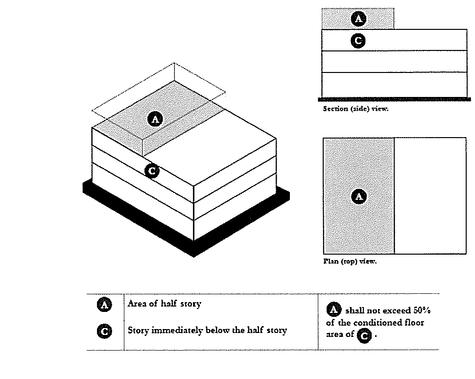
9.
Half stories, as the top story of a building, shall be permitted as specified by height district, subject to the following restrictions.
For the purposes of this section, half stories on one-family dwellings, two-family dwellings, one-family attached dwellings, and accessory buildings to these building types within the Old City Height Districts shall be limited the space under a gable or hipped roof where the wall plates, or knee walls, on at least two opposite exterior walls shall not exceed two feet in height. The aggregate width of dormers on a half story shall not exceed 30% of the width of the exterior wall below the dormer(s).
Notwithstanding the definition for half story in Sec. 54-120, for purposes of this section, half stories on all other types of buildings may be either:
a.
A full story with a total floor area, including any covered exterior floor area under a roof, that does not exceed 50% of the conditioned floor area of the story immediately below the half story as illustrated in Figure 1 below, or
b.
A half story under a gable or hipped roof that complies with the restrictions for a half story on a one or two family dwelling described in the previous paragraph
Figure 1
10.
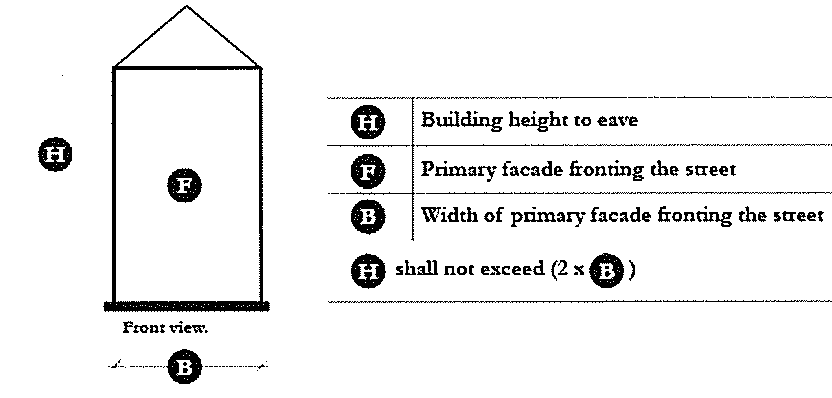
Building height to roof eave shall not exceed twice the building width of the primary façade of habitable space fronting the street as illustrated in Figure 2 below; provided the Board of Architectural Review may waive this provision based on architectural merit and context.
Figure 2
11.
There shall be no minimum building height requirement, unless required by the applicable height district as specified in Sectiohn 54-306.X.
12.
If any portion of a structure subject to the jurisdiction of the BAR is within fifty (50) feet of an existing structure rated "exceptional" (Group 1) or "excellent" (Group 2) on the Historic Architecture Inventory, adopted by Section 54-235, or a structure in the Landmark Overlay district, such portion of that structure shall not exceed the height of such existing structures unless approved by the Board of Architectural Review based on architectural merit and context.
13.
Additional buildings and additions to buildings that are subject to the jurisdiction of the BAR shall be subordinate in height, scale and mass to the primary building; provided this provision may be waived by the Board of Architectural Review when it deems such appropriate based on architectural merit and context or existing lot conditions. This provision does not apply to vertical additions to existing buildings. When appropriate, vertical additions must strive to be minimally visible with minimal impact on the character of the historic building and its context.
14.
Parking garages shall not exceed the height of the principal building on the site. Parking garages shall not be constrained by floor to floor height requirements, but stand-alone parking garages shall appear from the street to conform to the number of stories permitted in the height district in which it is located.
15.
In the height districts where additional height may be awarded on the basis of architectural merit and context, if the property is not subject to the jurisdiction of the Board of Architectural Review, the owner requesting the additional height must submit the plans to the Board of Architectural Review for review and approval. The property will not remain subject to the Board of Architectural Review purview after the request for additional height is reviewed. Any further request for additional height will trigger review by the Board of Architectural Review.
16.
An applicant seeking a height rezoning shall only be able to request a rezoning to the next higher height district, except for applicants seeking a rezoning to the Upper Peninsula Zoning district. Requests to rezone to a higher height district shall be evaluated, in part, on the context of the property, the character of the immediate area, street widths around the property, and whether the requested rezoning will be compatible with surrounding properties.
17.
Standalone Communication towers shall not exceed the maximum building height limits of districts that include a maximum height limit in feet, or a height limit equal to 14 feet per story for districts that are specified in stories.
18.
"Architectural merit" means a project that reflects exemplary architectural and urban design, utilizes the highest level of materials and finishes and contributes to the public realm, as outlined in the Board of Architectural Review Principles.
19.
Additional height for ornamental appurtenances and utilitarian appurtenances related to mechanical equipment or structural systems (such as elevator and stair towers, exhaust fans, HVAC and communication equipment) that exceed the maximum allowable height may be permitted by the Board of Architectural Review, based on architectural merit and context.
20.
Appurtenances shall not exceed nine (9) feet and shall be placed to the rear of side of a building where possible in order to minimize visibility from the public right of way.
21.
Mechanical equipment on a roof shall be visually screened from the street with parapets or other types of visual screens of the minimum height necessary to conceal the same. Density of screening should be adequate to sufficiently screen mechanical equipment.
(Ord. No. 2001-62, § 1, 6-19-02; Ord. No. 2003-07, §§ 1, 2, 1-14-03; Ord. No. 2004-25, § 2, 3-9-04; Ord. No. 2004-89, § 1, 9-14-04; Ord. No. 2004-94, § 1, 9-14-04; Ord. No. 2007-172, §§ 3, 4, 9-11-07; Ord. No. 2008-139, §§ 1—3, 10-28-08; Ord. No. 2014-32, § 1, 3-18-14; Ord. No. 2014-153, § 2, 12-2-14; Ord. No. 2015-140, § 1, 10-13-2015; Ord. No. 2017-085, § 1, 8-15-17; Ord. No. 2020-014, § 1, 1-28-20; Ord. No. 2021-014; Ord. No. 2021-014, § 1, 2-9-21; Ord. No. 2022-181, § 1, 12-6-22)
Sec. 54-306.A. - Height District 2.5.
In this district:
1.
Maximum building height shall be 2.5 stories as specified in 54-306.X.
2.
The Board of Architectural Review or Design Review Board may permit an additional half story on buildings subject to its jurisdiction based on architectural merit and context.
3.
Within residential zone districts, accessory buildings that satisfy setback requirements of this Chapter, shall not exceed one and one-half (1½) stories and an eave height of eleven (11) feet unless the principal building on the lot is two (2) or more stories in height, in which case the accessory building shall not exceed two (2) stories and a total height of twenty-four (24) feet measured from the ground to the peak of a gable, hip, or shed roof. The Board of Architectural Review may approve an increase to the twenty-four (24) foot height limitation.
(Ord. No. 2017-085, § 1, 8-15-17; Ord. No. 2020-014, § 1, 1-28-20; Ord. No. 2022-192, § 1, 12-20-22)
Sec. 54-306.B. - Height District 3.
In this district:
1.
Maximum building height shall be 3 stories as specified in 54.306.X.
2.
The attic shall not be habitable.
3.
The nonresidential ground floor shall not exceed 14 feet as specified in 54.306.X.
4.
The Board of Architectural Review may waive the limitation on habitable attic space based on architectural merit and context.
5.
Within residential zone districts, accessory buildings that satisfy setback requirements of this Chapter, shall not exceed one and one-half (1½) stories and an eave height of eleven (11) feet unless the principal building on the lot is two (2) or more stories in height, in which case the accessory building shall not exceed two (2) stories and a total height of twenty-four (24) feet measured from the ground to the peak of a gable, hip, or shed roof. The Board of Architectural Review may approve an increase to the twenty-four (24) foot height limitation.
(Ord. No. 2017-085, § 1, 8-15-17; Ord. No. 2020-014, § 1, 1-28-20; Ord. No. 2022-192, § 1, 12-20-22)
Sec. 54-306.C. - Height District 2.5 - 3.
In this district:
1.
On rights-of way greater than 50 feet, the building height shall be limited to a maximum 3 stories as specified in 54.306.X.
2.
On rights-of-way between 35 feet and 50 feet, the building height shall be limited to a maximum of 3 stories as specified in 54.306.X, and shall also be limited by the right-of-way width of the street at a maximum 1:1 ratio (i.e.: if a ROW is 40ft, the building shall not be taller than 40ft). Right-of-Way measurements will be determined by the Zoning Administrator.
3.
On rights-of-way less than 35ft the building height shall be limited to a maximum 2.5 stories as specified in 54.306.X.
4.
The nonresidential main floor shall not be less than 12 feet in height and no more than 14 feet in height, unless a waiver is granted for additional height of the floor per the requirements of Section 54-306(7) hereof.
5.
Within residential zone districts, accessory buildings that satisfy setback requirements of this Chapter, shall not exceed one and one-half (1½) stories and an eave height of eleven (11) feet unless the principal building on the lot is two (2) or more stories in height, in which case the accessory building shall not exceed two (2) stories and a total height of twenty-four (24) feet measured from the ground to the peak of a gable, hip, or shed roof. The Board of Architectural Review may approve an increase to the twenty-four (24) foot height limitation.
(Ord. No. 2017-085, § 1, 8-15-17; Ord. No. 2020-014, § 1, 1-28-20; Ord. No. 2022-192, § 1, 12-20-22)
Sec. 54-306.D. - Height District 3.5.
In this district:
1.
Maximum building height shall be 3.5 stories as specified in 54.306.X.
2.
The Board of Architectural Review or Design Review Board may permit an additional half story, based on architectural merit and context.
(Ord. No. 2017-085, § 1, 8-15-17; Ord. No. 2020-014, § 1, 1-28-20)
Sec. 54-306.E. - Height District 4.
In this district:
1.
Maximum building height shall not exceed 4 stories as specified in 54.306.X.
2.
The Board of Architectural Review or Design Review Board may permit an additional one-half story, based on architectural merit and context.
(Ord. No. 2017-085, § 1, 8-15-17; Ord. No. 2020-014, § 1, 1-28-20)
Sec. 54-306.F. - Height District 5.
In this district:
1.
Maximum building height shall not exceed 5 stories as specified in 54.306.X.
2.
The Board of Architectural Review or Design Review Board may permit an additional story based on architectural merit and context.
3.
Structures that are 5 stories or more shall be abutted by sidewalks no less than 10 feet in width.
(Ord. No. 2017-085, § 1, 8-15-17; Ord. No. 2020-014, § 1, 1-28-20)
Sec. 54-306.G. - Height District 6.
In this district:
1.
Maximum building height shall not exceed 6 stories as specified in 54.306.X.
2.
The Board of Architectural Review or Design Review Board may permit an additional story based on architectural merit and context.
3.
Structures that are more than 6 stories shall be abutted by sidewalks no less than 10 feet in width.
(Ord. No. 2017-085, § 1, 8-15-17; Ord. No. 2020-014, § 1, 1-28-20)
Sec 54-306.H. - Height District 7.
In this district:
1.
Maximum building height shall not exceed 7 stories as specified in 54.306.X.
2.
The Board of Architectural Review or Design Review Board may permit an additional story based on architectural merit and context.
3.
Structures that are more than 7 stories shall be abutted by sidewalks no less than 10 feet in width.
(Ord. No. 2017-085, § 1, 8-15-17; Ord. No. 2020-014, § 1, 1-28-20)
Sec. 54-306.I. - Height District 8.
In this district:
1.
Maximum building height shall not exceed 8 stories as specified in 54.306.X.
2.
The Board of Architectural Review or Design Review Board may permit an additional story based on architectural merit and context.
3.
Structures that are 8 stories or more shall be abutted by sidewalks no less than 10 feet in width.
4.
The provisions of Section 54-306(12) do not apply in this height district.
(Ord. No. 2017-085, § 1, 8-15-17; Ord. No. 2020-014, § 1, 1-28-20)
Sec. 54-306.J. - Height District 4-12.
In this district:
1.
Maximum building height shall not exceed 4 stories subject to height bonuses acquired through the use of incentive options as defined beginning is Section. 54-299.21.
2.
Structures more than 4 stories shall be abutted by sidewalks no less than 10 feet in width.
(Ord. No. 2017-085, § 1, 8-15-17; Ord. No. 2020-014, § 1, 1-28-20)
Sec. 54-306.K. - Height District 3X.
In this district, no structure, including appurtenant parts of a structure, except for elevator penthouses, or mechanical penthouses, shall exceed a height equal to three (3) times the least dimension as measured from the center of the right-of-way to the face of the building. No structure fronting on any street shall be lower than the height of thirty (30) feet.
(Ord. No. 2017-085, § 1, 8-15-17; Ord. No. 2020-014, § 1, 1-28-20)
Sec. 54-306.L. - Height District 85/200.
In this district:
1.
For structures located in Mixed-Use Workforce Housing (MU-1/WH and MU-2/WH) base zoning districts and for structures having principal uses of Health Services, as listed on the Table of Permitted Uses in Section 54, Article 2, Part 3. at 801, 805, 806, and 807, no part of a structure, including elevator penthouses and mechanical penthouses, shall exceed the height of two hundred (200) feet, nor shall the principal structure be lower than thirty (30) feet. For all other principal uses and accessory uses within this height district, the maximum building height shall not exceed 5 stories as specified in 54.306.F.
2.
All portions of a structure, except cornices, canopies, balconies, arcades and other non-habitable architectural elements, shall be set back at least forty (40) feet from the center of the street right-of-way, and a minimum of fifty (50) percent of the building's street frontage shall occur at this set back line, subject to provisions of Article 3: Part 10.
3.
All portions of a structure above eighty-five (85) feet including elevator penthouses and mechanical penthouses, except cornices, canopies, balconies, arcades and other non-habitable architectural elements, shall be set back at least fifty-five (55) feet from the center of the street right-of-way. All such portions of a structure, except cornices, canopies, balconies, arcades and other non-habitable architectural elements, shall occupy no more than fifty (50) percent of the building site coverage area.
(Ord. No. 2017-085, § 1, 8-15-17; Ord. No. 2020-014, § 1, 1-28-20; Ord. No. 2022-078, § 1, 6-21-22)
Sec. 54-306.M. - Height District 85/125.
In this district:
1.
For structures located in Mixed-Use Workforce Housing (MU-1/WH and MU-2/WH) base zoning districts and for structures having principal uses of Health Services, as listed on the Table of Permitted Uses in Section 54, Article 2, Part 3. at 801, 805, 806, and 807, no part of a structure, including elevator penthouses and mechanical penthouses, shall exceed the height of one hundred and twenty-five (125) feet, nor shall the principal structure be lower than thirty (30) feet. For all other principal uses and accessory uses within this height district, the maximum building height shall not exceed 5 stories as specified in 54.306.F.
2.
All portions of a structure, except cornices, canopies, balconies, arcades and other non-habitable architectural elements, shall be set back at least forty (40) feet from the center of the street right-of-way, and a minimum of fifty (50) percent of the building's street frontage shall occur at this set back line, subject to provisions of Article 3: Part 10.
3.
All portions of a structure above eighty-five (85) feet including elevator penthouses and mechanical penthouses, except cornices, canopies, balconies, arcades and other non-habitable architectural elements, shall be set back at least fifty-five (55) feet from the center of the street right-of-way. All such portions of a structure, except cornices, canopies, balconies, arcades and other non-habitable architectural elements, shall occupy no more than seventy-five (75) percent of the building site coverage area.
(Ord. No. 2017-085, § 1, 8-15-17; Ord. No. 2020-014, § 1, 1-28-20; Ord. No. 2022-078, § 2, 6-21-22)
Sec. 54-306.N. - Height District 85/30.
In this district:
1.
For structures located in Mixed-Use Workforce Housing (MU-1/WH and MU-2/WH) base zoning districts and for structures having principal uses of Health Services, as listed on the Table of Permitted Uses in Section 54, Article 2, Part 3. at 801, 805, 806, and 807, no part of a structure, including elevator penthouses and mechanical penthouses, shall exceed the height of one eighty-five (85) feet, nor shall the principal structure be lower than thirty (30) feet. For all other principal uses and accessory uses within this height district, the maximum building height shall not exceed 5 stories as specified in 54.306.F.
2.
All portions of a structure, except cornices, canopies, balconies, arcades and other non-habitable architectural elements, shall be set back at least forty (40) feet from the center of the street right-of-way, and a minimum of fifty (50) percent of the building's street frontage shall occur at this set back line, subject to provisions of Article 3: Part 10.
(Ord. No. 2017-085, § 1, 8-15-17; Ord. No. 2020-014, § 1, 1-28-20; Ord. No. 2022-078, § 3, 6-21-22)
Sec. 54-306.O. - Height District 100/30.
In this district:
1.
The minimum height for a structure fronting on a street is thirty (30) feet, and the minimum height on the ground floor of a structure fifteen (15) feet.
2.
The maximum height of a structure along north-south oriented streets is four (4) stories. The height along north-south oriented streets shall be maintained from the edge of the right-of-way into the interior of the lot for a distance of one hundred (100) feet, except as provided in part 5 hereof.
3.
The maximum height of a structure along east-west oriented streets is five (5) stories. The height along east-west oriented streets shall be maintained from the edge of the right-of-way into the interior of the lot a distance of twenty-five (25) feet, except as provided in part 5 hereof.
4.
Within the interior of lots (one hundred (100) feet from the edge of north-south oriented streets and twenty-five (25) from the edge of east-west oriented streets), the maximum height for a structure is one hundred (100) feet.
5.
To enable the incorporation of distinct architectural features and improve pedestrian activity at the street level, the height limits of parts 2 and 3 may be exceed by an additional occupied story within the step-back areas set out in parts 2 and 3 and occupied or unoccupied architectural features along the right-of-way may exceed the height limits of parts 2 and 3 upon findings by the Board of Architectural Review that:
a.
The sidewalks widths along all streets abutting the project are widened by at least three (3) feet; and
b.
At least seventy-five (75) percent of the ground floor street frontages is devoted to non-residential use; and
c.
If applicable, the additional story and its proposed location in the step-back areas prescribed by parts 2 and 3 enhance the architectural approach of the project; and
d.
If applicable, proposed architectural features along the right-of-way that exceed the height limits of parts 2 and 3 enhance the architectural approach of the project and do not constitute, in the aggregate, more than twenty (20) percent of the square footage of the footprint of the structure at the street level.
(Ord. No. 2017-085, § 1, 8-15-17; Ord. No. 2020-014, § 1, 1-28-20)
Sec. 54-306.P. - Height District 80/30.
In this district:
1.
No structure, including appurtenant parts of a structure except for elevator penthouses, or mechanical penthouses, shall exceed a height of eighty (80) feet nor shall any structure fronting on any street be lower than the height of thirty (30) feet.
2.
All portions of a structure above the fifty-five (55) foot level shall be set back at least twenty-five (25) feet from all street right-of-way lines.
(Ord. No. 2017-085, § 1, 8-15-17; Ord. No. 2020-014, § 1, 1-28-20)
Sec. 54-306.Q. - Height District 50W.
In this district:
1.
No structure shall exceed a height of fifty feet (50′).
2.
All structures shall be set back from the high water mark a minimum of twenty-five feet (25′), except that water-dependent structures shall be allowed to encroach on the twenty-five foot (25′) setback.
3.
All structures shall be set back from the high water mark of manmade canals a minimum of ten feet (10′), except that water-dependent structures shall be allowed to encroach on the ten foot (10′) setback.
(Ord. No. 2017-085, § 1, 8-15-17; Ord. No. 2020-014, § 1, 1-28-20 $)
Sec. 54-306.R. - Height District W.
In this district:
1.
No structure shall be nearer to the nearest right-of-way lines of the street on which it fronts than a distance equal to the height of the building.
2.
The ground coverage of all structures on a lot shall not exceed twenty-five (25) percent of the lot area; "ground coverage" being defined as the sum of the areas of the largest floors in each building.
3.
No structure shall be nearer to an interior property line or side street right-of-way line than a distance equal to one-half-the height of the building.
(Ord. No. 2017-085, § 1, 8-15-17; Ord. No. 2020-014, § 1, 1-28-20)
Sec. 54-306.S. - Height District WP.
In this district:
1.
No structure shall exceed the height of sixty (60) feet.
2.
The ground coverage of all structures on a lot shall not exceed twenty-five (25) percent of the lot area; "ground coverage" being defined as the sum of the areas of the largest floor in each building. Ground coverage shall not include paved parking areas or staging areas.
(Ord. No. 2017-085, § 1, 8-15-17; Ord. No. 2020-014, § 1, 1-28-20)
Sec. 54-306.T. - Height District 56/30 V.
In this district:
1.
FEMA Velocity Zone regulations impose significant restrictions on the developable volume of properties that fall within its influence, and are particularly restrictive regarding street-level development. The success of the traditional urban fabric of Charleston is highly dependent upon the activation of the public realm, and street-level uses are a key element of this activity. The 56/30V Height District is intended to encourage a continuation of Charleston's urban traditions by providing incentive for development of street-level activity within FEMA Velocity Zones.
2.
No part of a structure shall exceed the height of fifty-six (56) feet unless permitted as a result of the following clauses, nor shall any principal structure be lower than thirty (30) feet.
3.
Allowances for additional enclosed habitable space above fifty-six (56) feet but not to exceed a height of seventy (70) feet shall be permitted when the development in question provides for contributory occupation of the ground floor at the street frontage(s) of the property. Such contributory occupation must be designed to abide by FEMA requirements for development in Velocity Zones as approved by the city's Floodplain Administrator. For every square foot of approved contributory occupation of the ground floor, the development will be permitted an equivalent square foot of habitable space above fifty-six (56) feet, up to a limit of 25 percent of the total rooftop area. Contributory occupation is defined as any activity that is deemed by the Zoning Administrator to be consistent with and supportive of the goal of street-level activation within the FEMA V-Zone. Such activity might include, but is not limited to: outdoor dining (covered or open-air), temporary shops or merchant stands; manned vending carts; green spaces (physically open to the sky); building access stairs or lobbies, storefront displays, etc. In addition, the areas dedicated to contributory occupation must be located with a majority of its frontage on the street or public sidewalk, and must be specifically designed to support contributory occupation. Under no circumstances will parking, mechanical or storage areas be considered contributory occupation.
4.
Allowances for additional height above fifty-six (56) feet but not to exceed seventy (70) feet may be permitted for architectural features such as parapets, towers, pergolas, or other roof elements, and mechanical rooms, elevator penthouses and stair towers. Mechanical rooms, elevator penthouses and stair towers must be designed as integrated architectural elements. The design of such features is further limited as follows: they shall not contain enclosed habitable spaces (unless such habitable spaces are permitted as a result of the previous clause); the total rooftop occupation (including allowed enclosed habitable spaces and uninhabitable architectural features) shall not exceed 50 percent of the total rooftop area; the existence and design of any such features is subject to review and approval of the Board of Architectural Review.
(Ord. No. 2017-085, § 1, 8-15-17; Ord. No. 2020-014, § 1, 1-28-20$)
Sec. 54-306.U. - Height District 120/30.
In this district:
1.
No structure, including appurtenant parts of a structure, except for elevator penthouses, or mechanical penthouses, shall exceed a height of one hundred twenty (120) feet nor shall any structure fronting on any street be lower than the height of thirty (30) feet.
2.
All portions of a structure above the seventy (70) foot height level shall set back at least thirty (30) feet from all street right-of-way lines.
3.
All principal structures fifty (50) feet or less in height shall have no set back from street right-of-way lines, subject to provisions of Article 3: Part 10; except such structures may be set back from street right-of-way a distance no greater than the least such set back of the two adjoining buildings on either side.
(Ord. No. 2017-085, § 1, 8-15-17; Ord. No. 2020-014, § 1, 1-28-20)
Sec. 54-306.V. - Height District 55/30 S.
In this district:
1.
No part of a structure shall exceed the height of fifty-five (55) feet, nor shall the principal structure be lower than thirty (30) feet.
2.
All structures shall have no minimum set back from street right-of-way lines, subject to provisions of Article 3: Part 10.
(Ord. No. 2017-085, § 1, 8-15-17; Ord. No. 2020-014, § 1, 1-28-20)
Sec. 54-306.W. - Height District 55/30.
In this district:
1.
No part of a structure shall exceed the height of fifty-five (55) feet, nor shall the principal structure be lower than thirty (30) feet.
2.
All structures shall have no set back from street right-of-way lines, subject to provisions of Article 3: Part 10.
(Ord. No. 2020-014, § 1, 1-28-20)
Sec. 54-306.X. - Height district chart.
1 Building heights in this district may be restricted by street right-of-way.
2 The 4/12 district is not eligible for height rezonings unless the base zoning of the property is rezoned from the Upper Peninsula zoning district to another base zoning district concurrently with the height rezoning.
(Ord. No. 2020-014, § 1, 1-28-20; Ord. No. 2021-014, § 1, 2-9-21)
Sec. 54-306.Y. - Height District 8-12(A), (B), and (C).
In this district:
1.
Maximum building height shall not exceed eight (8) stories subject to height bonuses acquired through the satisfaction of public benefit requirements as set forth below.
2.
Only properties that (i) are already zoned Height District 8, (ii) are more than 3.5 acres of contiguous highland in size, and (iii) are concurrently applying to be rezoned Planned Unit Development (PUD) subject to PUD guidelines and master plan that require on-site workforce housing, a minimum twenty (20) percent of the property as publicly accessible open space or dedicated to public realm improvements, and other public benefits satisfactory to City Council, shall be permitted to apply for rezoning to Height District 8-12(A), (B), or (C). Requests to rezone to Height District 8-12(A), (B), or (C) shall be evaluated, in part, on the context of the property, the character of the immediate area, street widths around the property, and whether the requested rezoning will be compatible with surrounding properties.
3.
Subject in each case to satisfaction of all publicly accessible open space, workforce housing, and other requirements set forth in the applicable PUD guidelines and master plan, maximum building height may exceed eight (8) stories, but in any event shall not exceed nine (9) stories in Height District 8-12(A), ten (10) stories in Height District 8-12(B), and twelve (12) stories in Height District 8-12(C). Not more than forty (40) percent of the total land area subject to the applicable PUD guidelines and master plan shall be included in Height District 8-12(A), (B), and (C) in aggregate, and the remainder shall remain in Height District 8 or a lower Height District. Subject to the foregoing aggregate limitation, the maximum percentage of the total land area subject to the applicable PUD guidelines and master plan that may be included in any one of Height District 8-12(A), (B), or (C) shall be as follows:
a.
Height District 8-12(A) 20%.
b.
Height District 8-12(B) 20%.
c.
Height District 8-12(C) 15%.
In addition, the application of this height district shall result in a net reduction in developable square footage for the overall property, determined as follows: (x) the total combined increase in amount of developable square footage that may be constructed on the property subject to the applicable PUD guidelines and master plan as a result of including portions of the property in Height District 8-12(A), (B), or (C) (calculated for any area as the number of additional stories multiplied by the square footage of land area included in the applicable Height District 8-12(A), (B), or (C)), must be no more than seventy-five (75) percent of (y) the total combined reduction in amount of developable square footage that may be constructed on the property subject to the applicable PUD guidelines and master plan as a result of including portions of the property in the required open space or dedicated public improvements or lower height districts (calculated for any area as the number of reduced stories multiplied by the square footage of land area included in the open space, or dedicated public improvements or lower height district (for which calculation open space or dedicated public improvements areas shall be deemed to be reduced to zero (0) stories).
4.
No additional story may be awarded by the Board of Architectural Review or Design Review Board based on architectural merit and context.
5.
The Board of Architectural Review or Design Review Board shall require that the composite roofline of buildings within the land area subject to the applicable PUD guidelines and master plan be varied through the use of volumetric forms and roof shapes of varying heights.
6.
In the event that the base zoning district of a property that is currently within Height District 8-12(A), (B), or (C) is rezoned to another base zoning district other than PUD, the property shall automatically be rezoned to Height District 8, unless rezoned to another Height District.
7.
Structures that are eight (8) stories or more shall be abutted by sidewalks no less than ten (10) feet in width along public street frontages.
8.
On public street frontages, immediately adjacent to any building with a street front façade that is taller than nine (9) stories, there will be a twenty (20) foot setback from the street front façade for any adjacent building mass for a minimum width of twenty (20) feet along that frontage to ensure that the massing integrity of the taller volume can be expressed fully down to the street without being combined with other immediate adjacent massing.
9.
The provisions of Section 54-306(10) (Building height to roof eave shall not exceed twice the building width of the primary façade of habitable space fronting the street) and (13) (Additional buildings and additions to buildings that are subject to the jurisdiction of the BAR shall be subordinate in height, scale and mass to the primary building) do not apply in this height district.
(Ord. No. 2024-017, § 1, 2-13-24)
Sec. 54-307. - View corridor protection.
In all the Old City Height Districts, structures shall be spaced so that no street prolonged toward the Ashley or Cooper River would be blocked by a building, thereby preserving the vista from East Bay Street, East Battery, Lockwood Drive or Halsey Blvd.
Sec. 54-308. - Exceptions.
The height limitations of 54-306 shall not apply to church spires, belfries, cupolas, domes, port cranes and movable passenger cruise boarding ramps not intended or used for human occupancy, monuments, masts and aerials.
Sec. 54-310. - Driveway spacing and design for business, office and industrial lots.
The maximum width of driveways, and the minimum curb radius shall be based upon the speed limit of the street to which the driveway is to be connected, and shall be as shown on Table 3.2. Driveways shall be a minimum distance of 50 feet from the intersection of the right-of-way lines to the edge of driveways. The distance between the proposed driveway and an existing adjacent driveway shall be the greatest distance feasible. For parcels with a right-of-way frontage equal to or less than 130-feet in length the development is limited to one driveway and for parcels with a frontage greater than130-feet in length the development may have multiple driveways, but no more than three driveways. For parcels with a right-of-way frontage equal to less than 130-feet in length, two single lane driveways may be allowed if the inbound drive is upstream from the outbound drive. In cases of new development and/or redevelopment, the driveways shall be located in a manner where they can be shared between parcels, if feasible. See Figures 3.1 and 3.2 for an illustration of how to measure these dimensions.
(Ord. No. 2008-05, § 1, 11-20-07)
Sec. 54-311. - Building setbacks for business, office or industrial lots.
The minimum building setbacks from street rights-of-way for business, office or industrial lots shall be based upon the speed limit of the adjoining street(s) and shall be as shown on Table 3.2.
TABLE 3.2: DRIVEWAY AND BUILDING SETBACK REGULATIONS
FOR BUSINESS, OFFICE AND INDUSTRIAL LOTS
Notes:
1.
Not applicable to the peninsular section of Charleston below Mount Pleasant Street, to any property located within the Old City District west of the Ashley River, to any property included within the Commercial Corridor Design Review District as defined in Section 54-268, or to any property within the GP zoning district. Minimum setbacks for Residential Office per Table 3:1 Section 54-301.
(Ord. No. 2000-244, § 1, 10-10-00; Ord. No. 2003-69, § 9, 8-19-03; Ord. No. 2005-336, § 1, 8-16-05; Ord. No. 2007-212, § 1, 11-20-07)
Sec. 54-315. - Intent.
The purpose of this section is to establish minimum requirements for off-street parking based on the typical needs of various types of land uses, the pattern of development in the city, and the physical characteristics of the land and environment in the Charleston area.
Sec. 54-316. - Applicability of requirements.
At the time any building, structure, or outdoor commercial space (a use not utilizing a structure) is constructed, reused, enlarged, or increased in capacity by the addition of dwelling units, guest rooms, floor area, or seats, the required number of off-street automobile parking spaces with adequate provisions for ingress and egress by an automobile of standard size shall be provided for the new or enlarged use(s) pursuant to Table 3.3. Properties within the GP zoning district shall be exempt from all provisions of Part 4: Off-Street Parking Requirements, with the exception of Section 54-317, subsection b. relating to the maximum area of paved parking spaces and aisles.
Applications for determining compliance with parking requirements shall include a scaled site plan, showing the existing and proposed location of structures, trees, monuments, signs, and other improvements, and the location of existing and proposed parking. Applications may be subject to the requirements under Article 6: Site Plan Review (Technical Review Committee), where applicable.
Land uses existing on the effective date of this ordinance which do not comply with the off-street parking requirements of Article 3: Part 4, shall be subject to Article 1: Part 2: Non-conforming Uses.
(Ord. No. 2003-69, § 10, 8-19-03)
Sec. 54-317. - Required number of off-street parking spaces by land use.
a.
Minimum number of parking spaces required. Table 3.3 indicates off-street parking requirements for land uses. All calculations shall be rounded up to the next whole number. The total parking requirement for mixed uses shall be the sum of the requirement for each use, except that "shopping center" developments, as defined in Table 3.3, shall be exempt from this requirement. Parking spaces required for one use shall not be used to satisfy the parking requirement for another use with the exception of churches, synagogues or other places of worship. Additional parking for bicycles shall be required for certain land uses pursuant to Section 54-320. For the purposes of this Section, "peninsula" shall mean the area of the City of Charleston bounded by the Cooper River to the east, the Ashley River to the west and south, and the Charleston City Limits to the north.
b.
Maximum area of paved parking spaces and aisles allowed for surface parking lots. The maximum number of hard surfaced parking spaces allowed for a shopping center development, as defined in Table 3.3, shall not exceed the total number of spaces required pursuant to this section, increased by 20 percent. All spaces and appurtenant aisles in excess of this 20 percent cap, or areas within the parking lot equivalent in size to the number of excess parking spaces multiplied by 450 square feet, shall be non-hard surfaced utilizing slag, gravel, ROC, grasscrete, or similar porous material or simply a grass field.
TABLE 3.3: OFF-STREET PARKING REQUIREMENTS
(Ord. No. 1998-76, § 3, 4-28-98; Ord. No. 2002-92, § 7, 8-13-02; Ord. No. 2004-70, § 1, 7-20-04; Ord. No. 2006-428, § 9, 9-26-06; Ord. No. 2007-214, § 1, 11-20-07; Ord. No. 2014-130, §§ 2-4, 10-14-14; Ord. No. 2016-011, § 2, 1-12-16; Ord. No. 2017-144, §§ 2, 3, 12-11-17; Ord. No. 2018-043, § 14, 4-10-18; Ord. No. 2022-065, § 3, 4-26-22)
Sec. 54-318. - Design requirements for new parking areas.
a.
Surface lots:
1.
Standard Parking Space Size shall be 9′ × 18′6″ or 9′ × 17′ if vehicle overhang is provided.
2.
Handicapped Parking Space Size and quantity shall be determined by Building Code and Federal regulations.
3.
Parallel Parking Space size is required to be 7′ wide by 22′ long.
4.
Aisle Width Aisles shall be of a sufficient width to provide safe access for the type and number of vehicles using the parking lot. The following dimensions shall be used as a guide for typical situations:
(a)
24 feet for 90° parking;
(b)
22 feet for two-way angled parking; 15 feet for 60° parking with one-way flow;
(c)
13′6″ for 45° parking with one-way flow.
5.
Public parking lots not associated with a specific development and monitored during periods of use may have up to 20 percent of the total parking spaces designated with signs and pavement markings for compact cars only. Minimum size is 7′6″ wide and 16′ long.
b.
Parking garages:
1.
Parking garages may provide compact car spaces at a rate of up to forty percent (40%) of the total parking spaces provided.
2.
Minimum width for standard parking spaces is 8′6″; for compact spaces 7′6″.
3.
Minimum parking bay depth (two standard parking spaces and an aisle) is 60′ for 90° parking; for 60° parking with one-way traffic, the minimum depth is 54′, for 45° parking with one-way traffic, the minimum depth is 49′.
4.
Handicapped parking space size and quantity shall be determined by Building Code and Federal regulations.
c.
Maneuverability. Parking areas must allow adequate room for vehicles to access parking lots and maneuver into and out of spaces safely. Parking lots requiring vehicles to back onto a public right-of-way shall not be permitted, except that properties with exclusively residential uses, with up to 10 dwellings on a lot and parking access on a local or collector street carrying less than 650 vehicles per day, may have driveways which require a vehicle to back onto and maneuver in the public right-of-way.
d.
Surface material requirements. But for the exceptions listed below, all surface parking lots shall be paved with a durable, hard surfaced material which is appropriate for the intended land use. All handicapped parking spaces, and the paths connecting spaces to buildings, shall be hard-surfaced regardless of the land use.
1.
Exceptions. The following types of land uses shall be permitted to have surface parking lots which are paved with non-hard surfaced materials such as slag, gravel, ROC, or grasscrete, or not paved at all, provided that site drainage can be accommodated pursuant to city requirements; that a hard surfaced paved apron, of a length noted below, is constructed at each driveway entrance from a public street; and that the type of material and design of the paving material(s) used are found by the city to be suitable for the intended land use and the character of the property, historic or otherwise, and surrounding neighborhood:
(a)
Exclusively residential uses with ten (10) or fewer residential units on one lot; all parking provided may be non-hard surfaced. Paved apron not required.
(b)
Church, synagogue, or other place of worship; three-quarters (.75) of the parking provided may be non-hard surfaced; requires a twenty foot (20′) paved apron.
(c)
Day care centers, preschools, elementary through junior high schools (8th grade); three-quarters (.75) of the parking provided may be non-hard surfaced; requires a twenty foot (20′) paved apron.
(d)
Private clubs, fraternal lodges, country clubs; three-quarters (.75) of the parking provided may be non-hard surfaced; requires a twenty foot (20′) paved apron.
(e)
Recreational facilities, marinas, driving ranges, golf courses; all parking provided may be non-hard surfaced; requires a twenty-five foot (25′) paved apron.
(f)
Office uses allowed within the Residential Office (RO) zone district; all parking provided may be non-hard surfaced; requires a twenty foot (20′) paved apron.
(g)
Retail uses; ten (10) percent of parking provided may be non-hard surfaced; requires a twenty foot (20′) paved apron.
(h)
Agricultural uses associated with the production, harvesting, packaging and shipping of agricultural products; all parking provided may be non-hard surfaced; requires a thirty foot (30′) paved apron.
(i)
Manufacturing establishments within the Light Industrial (Ll) or Heavy Industrial (Hl) zone district not catering to retail trade; all parking provided may be non-hard surfaced; requires a forty-five foot (45′) paved apron.
2.
In making a determination of the suitability of a paving material and design, the types of vehicles which will typically use the parking lot, the anticipated amount of daily or weekly traffic, the drainage conditions of the site and surrounding area, and the character of the surrounding neighborhood, historic or otherwise, shall be considered.
e.
Lighting. Lighting used to illuminate any parking area shall be shielded or otherwise designed to direct light away from adjacent residential districts.
Sec. 54-318.1. - Storage or display of merchandise in parking areas prohibited.
a.
Storage or display of merchandise in outdoor parking spaces and driveways shall be prohibited, except that temporary display of shrubs, plants, flowers, Christmas trees, seasonal greenery, and seasonal agricultural produce, not to exceed thirty (30) days within a three month period, shall be permitted if required number of parking spaces for land uses are provided.
b.
Display of passenger vehicles, trucks, boats and boat trailers by authorized businesses licensed by the City for commercial sales of passenger vehicles, trucks and boats shall be exempt from this section.
c.
Existing storage or display of merchandise in outdoor parking areas that does not comply with the restrictions in this section shall be amortized and made to conform to these restrictions 90 days after the effective date of this ordinance.
(Ord. No. 2003-116, § 1, 12-16-03)
Sec. 54-319. - Location of parking.
Off-street parking spaces provided pursuant to this section shall be located upon the same lot of record as the use to which they are associated. However, if the property does not provide sufficient off-street parking, parking may be provided on a properly zoned lot within 400 feet of the building or use, provided, however, that a satisfactory long-term lease with a term of at least 10 years is provided to and approved by the zoning administrator (such distance shall be measured from the nearest point of the parking lot to the nearest boundary of the lot on which the building or use is located that the parking is said to serve), and further provided that for eating and drinking places or catering uses, the lot used for off site parking shall not adjoin a lot with a residential zoning designation or be separated from a lot with a residential zoning designation by a right-of-way of 55 or less feet.
Sec. 54-319.1. - Shared parking.
1.
The Technical Review Committee (TRC) may authorize a parking reduction for a new development site or redevelopment site zoned General Business (GB) with multiple uses upon the review of a shared parking analysis that demonstrates that the uses are in close proximity to one another and have different peak parking demands and operating hours. For the purposes of this section, development site shall mean a lot or parcel of land or combination of lots or parcels of land proposed for development. If a development site has more than one (1) parcel or lot with different owners, all property owners will be required to sign the application for shared parking, and shall be required to execute and record in the public records a declaration on a form provided by the Department of Planning and Preservation, hereinafter department, stating that the parcels have been developed as a single unit for purposes of meeting the zoning ordinance requirements. The declaration shall include a legal description of each parcel and shall state that no parcel may be developed separate from the other parcel unless each parcel standing alone meets the requirements of the shared parking approval.
a.
Shared parking study. The shared parking analysis shall clearly identify the uses that will use the shared spaces at different times of the day, week, month or year subject to the following:
i.
The shared parking analysis shall be based on the Urban Land Institute's (ULI) Shared Parking Model (latest edition). The analysis must be prepared and sealed by a registered engineer in the State of South Carolina with transportation expertise;
ii.
The shared parking analysis shall address the size and type of activities, the composition of tenants or, uses, the rate of turnover for proposed shared spaces, and the anticipated peak parking and traffic demands;
iii.
The shared parking analysis shall provide for no reduction in the number of handicapped spaces;
iv.
The shared parking analysis shall provide a plan to convert reserved space to required spaces;
v.
The shared parking analysis shall be approved by TRC prior to submittal, based on the feasibility and observations of the uses to share the parking due to their particular peak parking and trip generation characteristics;
vi.
Shared use parking approval shall only be valid for those uses as indicated in the study; and
vii.
If a parking reduction is approved under the provisions of this section, such approval shall be evidenced by the issuance of an order in the manner prescribed in Section 54-319.1., 54-319.2.
b.
Change in use. Should any of the approved uses as indicated in the approved shared parking analysis change, or should the Zoning Director or Department of Traffic and Transportation, or its successor, find that any of the conditions described in the approved shared parking analysis or parking reduction order no longer exist, the owner of record shall have the option of submitting a revised shared parking analysis in accordance with the standards of this section or of providing the number of spaces required for each use as if computed separately.
2.
Parking reduction order. If an application for shared parking is approved, such approval shall be evidenced in an order executed by the department and a consent to order executed by the applicant. The order shall state the number of parking spaces required to be provided, a legal description of the property where the parking is to be provided and the property served by the parking area and the conditions upon which the shared parking is approved. The parking reduction order shall only take effect upon the recordation of the order in the County Register of Deeds office at the expense of the applicant and filed with the department by applicant.
a.
The parking reduction order shall act as a restrictive covenant running with the land and be binding on any successors in interest or assigns of the property owner.
3.
If there is a failure of any condition contained in the parking reduction order, the owner of the property or agent shall:
a.
Apply for an amended parking reduction order. The application shall show that although the condition has failed, it does not adversely impact the character and integrity of surrounding properties or that additional conditions will be substituted for any failed condition. The department may require a new parking study as provided in subsection 1.a. to support the application.
b.
In the event the department agrees with the application, the department may approve the amendment to shared parking.
c.
When final, the amended order shall be prepared for execution and recording in the County Register of Deeds office at applicant's expense by the applicant.
d.
If the department determines that failure of the condition adversely impacts the character and integrity of surrounding properties, the owner will be required to comply with the condition or obtain a new parking reduction order in accordance with this section. Failure of a condition of a parking reduction order without approval of an amended or new parking reduction order as provided herein shall be a violation of the Zoning Ordinance.
4.
If a shared parking application includes the use of an off-site parcel owned by other than the applicant for parking or purposes related to parking, an off-site parking agreement in accordance with Section 54-319.2 will be required.
5.
A parking reduction order may be terminated by application of the owner of the property affected by the order to the department if it is shown that parking has been provided which meets the requirements of Article 3, Part 4 Off-street parking requirements, and the use no longer needs a parking reduction. A termination of the parking reduction order shall be executed by the department and recorded in the public records of the county at the applicant's expense. A copy of the recorded order shall be filed with the department by the applicant.
(Ord. No. 2022-025, § 1, 2-22-22; Ord. No. 2025-086, § 1, 6-17-25)
Sec. 54-319.2. - Off-site parking agreement.
1.
When the required off-street parking for a shared use parking approval is to be provided on a site at a location different from the site which will be served by the parking as provided in Section 54-319.1, the owner of the off-site parcel of land and the owner of the land intended to be served by such shared use parking approval (if different than the owner of the parcel to be used for parking) shall enter into an agreement with the City. The off-site parking area shall never be sold or transferred except in conjunction with the sale of the parcel served by the off-site parking facilities unless:
a.
The parcel to be sold will continue to be used as provided in the off-site parking agreement and the new owner executes a consent to assume and be bound by the obligations of the owner of the parcel used for parking as provided in the agreement. The consent shall be in a form approved and executed by the department and recorded in the County Register of Deeds Office at the expense of the owner. A copy of the recorded document shall be provided by owner to the department; or
b.
A different parcel complying with the provisions of the Article 3, Part 4 Off-street parking requirements, and subject to a recorded off-site parking agreement as specified herein may be substituted for the parcel of land subject to the off-site parking agreement; or
c.
The parcel being served by the off-site parking no longer requires the parking as evidenced by a written statement executed by the parties executing the off-site parking agreement and as approved by the department and a termination of the off-site parking agreement is executed by the department and recorded in the County Register of Deeds office at owner's expense.
(Ord. No. 2022-025, § 1, 2-22-22)
Sec. 54-320. - Additional parking requirements.
a.
Bicycle parking shall be provided for land uses pursuant to Table 3.4.
b.
Required bicycle parking facilities shall be designed and constructed to allow bicycles to be securely fastened to the ground or buildings and shall be located at or near main entrances to buildings in well lighted areas.
TABLE 3.4: BICYCLE PARKING REQUIREMENTS
Sec. 54-321. - Off-street loading space requirements for business, wholesale, industrial, or terminal uses.
a.
Every building or structure, except existing buildings within the Old and Historic District and the Old City District in peninsula Charleston, hereafter established or used for business, wholesale, industry or terminals shall provide space as indicated herein for the loading and unloading of vehicles. Such space shall have access to a public alley or, if there is no alley, to a public street. Required loading spaces are:
1.
Retail business building: one (1) space 10 by 25 feet for each 10,000 square feet of floor area or fraction thereof.
2.
Wholesale and industry: one (1) space 10 by 50 feet for each 10,000 square feet of floor area or fraction thereof.
3.
Bus and truck terminal: sufficient space to accommodate the maximum number of loading vehicles and stored vehicles at the terminal at one time.
4.
Accommodation Uses: one (1) space, 10 by 25 feet, for each facility with 100 or more rooms, and an additional space for each additional 100 rooms.
(Ord. No. 1998-76, § 4, 4-28-98)
Sec. 54-325. - Intent.
This Ordinance is intended to protect trees by regulating the cutting down, damaging, planting and replacement of trees. This Ordinance is not intended to prohibit agriculture, silviculture, horticulture or nursery operations within the city.
Sec. 54-326. - Exemptions.
The regulations set forth herein shall apply to all real property within the city limits of Charleston, subject to the following exemptions:
a.
Residential Exemption. Lots equal to or less than one (1) acre that are zoned RR-1, SR-1, SR-2, SR-3, SR-4, SR-5, SR-6 (Single-Family Residential), SR-7, SR-8 (Single-Family Residential) or STR (Single and Two Family Residential) or used exclusively for single-family detached or duplex dwellings, shall be exempt from the provisions of this Ordinance, except those relating to grand trees, provided, however, in the initial development of a lot greater than one (1) acre, subdivided or developed after the effective date of this Ordinance for use as RR-1, SR-1, SR-2, SR-3, SR-4, SR-5, SR-6 (Single-Family Residential), SR-7, SR-8 (Single-Family Residential) or STR (Single and Two Family Residential) such development shall be subject to the provisions of this Ordinance. Individual lots equal to or less than one (1) acre sold thereafter shall be exempt from the provisions of this Ordinance, except those relating to grand trees. For lots zoned RR-1, SR-1, SR-2, SR-3, SR-4, SR-5, SR-6 (Single-Family Residential), SR-7, SR-8 (Single-Family Residential) or STR (Single and Two Family Residential) if a change of zoning has been requested to a zoning classification other than RR-1, SR-1, SR-2, SR-3, SR-4, SR-5, SR-6 (Single-Family Residential), SR-7, SR-8 (Single-Family Residential) or STR (Single and Two Family Residential) said lot cannot be cleared prior to the decision on the rezoning by the Planning Commission.
b.
Commercial Timber Operations. Commercial timber operations shall be exempt from the provisions of this Ordinance, except that a fifty foot (50′) buffer of existing trees shall be maintained adjacent to all public rights-of-way.
c.
Wetlands Mitigation. The mitigation of wetlands pursuant to a development order or approved plan from, and the requirements of, the South Carolina DHEC-OCRM or the Army Corps of Engineers shall be exempt from the provisions of this Ordinance.
d.
Commercial Tree Operation Exemption. Trees grown specifically for sale by commercial nurseries are exempt from the provisions of this Ordinance.
e.
Agricultural Exemption. Any bona fide agricultural use shall be exempt from the provisions of this Ordinance.
f.
Airports. Removal of trees for the purposes of maintaining safe clearance for aircraft as required by federal law or the establishment of facilities exclusively dedicated to aviation operations by the Charleston County Aviation Authority will be exempt from the provisions of this Ordinance.
g.
Utility Companies, Electric Suppliers and Governmental Agencies. Utility companies, electric suppliers and governmental agencies constructing or maintaining easements for water, sewer, electricity, gas, drainage, telephone or television transmission or rights-of-way shall be exempt from the provisions of this Ordinance if the applicable company, supplier or agency has executed an Agreement with the City which, at a minimum: 1) recognizes the need to minimize the cutting or trimming of grand trees which do not frustrate or substantially interfere with the intended purpose of construction or maintenance; 2) establishes, to the extent feasible, design guidelines for construction and maintenance which identifies the saving of grand trees as a factor to be considered in the design process; 3) allows for a consultation process with the City prior to the commencement of major construction or maintenance or the removal of grand trees; and 4) provides that a breach of such Agreement constitutes a violation of this ordinance and a loss of exemption from the requirements of this Ordinance.
h.
Nothing in this article shall be construed to prevent the ordinary cutting, trimming and maintenance of a tree; nor shall anything in this article be construed to prevent the cutting or removal of any tree which the authorized municipal officers shall certify as required for public safety.
(Ord. No. 1999-22, § 5, 3-10-99; Ord. No. 1999-54, § 4, 4-27-99; Ord. No. 2001-44, § 6, 5-8-01; Ord. No. 2002-19, § 3, 2-12-02)
Sec. 54-327. - Tree removal restrictions.
a.
Protection of Grand Trees. The removal, relocation, destruction or abuse in any manner of any grand tree (24″ or greater D.B.H., excluding pine trees and sweetgum trees) is prohibited on any parcel of non-exempt land unless a variance, special exception, or staff approval has been obtained pursuant to Section 54-329. For subdivisions, the siting of a lot so as to place a grand tree at or near the center of a lot in a location that will require the removal of the grand tree for construction of a dwelling unit, shall be prohibited.
b.
Protected Trees Prior to Development. Where a building permit or subdivision approval has not been issued, the removal, relocation, destruction or abuse in any manner of more than twenty-five percent (25%) of the protected trees (8″ or greater D.B.H.) on any one (1) parcel of non-exempt land within any five (5) year period shall be prohibited. The total number of protected trees existing on any one parcel shall not be reduced below a total number equal to fifteen (15) protected trees per acre.
c.
Protected trees during or after development. The removal, relocation, destruction or abuse in any manner of protected trees required to be saved by this Chapter is prohibited. For parcels of land proposed for development, a minimum number of protected trees on the entire parcel equal to fifteen (15) protected trees per acre shall be saved. For parcels containing less than fifteen (15) protected trees per acre, the total number of protected trees required to be saved shall equal the total number of protected trees existing on the parcel. Grand trees to be saved may be used to calculate the total number of protected trees to be saved.
d.
Protection of Tree Colonnades and Allees. The removal, relocation, destruction or abuse in any manner of any protected tree within a colonnade or allee is prohibited on any parcel of non-exempt land. For the purpose of this ordinance, a colonnade or allee is defined as any two (2) or more parallel rows of trees of the same species with a minimum of four (4) trees total and a minimum of two (2) trees measuring twenty inches (20″) or greater D.B.H., except for pine trees and parallel rows of trees with a public right-of-way in the center which are exempt from this definition.
e.
This Ordinance shall not restrict the ability of the City of Charleston, public utilities, and electric suppliers from maintaining safe clearance around utility lines.
f.
The area of existing utility and drainage easements may be subtracted from the total site area for the purpose of calculating the number of protected trees required to be saved.
g.
The following standards shall apply regarding the removal and disposal of trees and vegetation associated with land development approved by the Subdivision Review Committee and/or the Technical Review Committee:
Definitions. For the purpose of this subsection, the following items shall be defined as follows:
1.
"Burning" means the setting on fire, igniting of or combustion of any trees, understory trees, brush or other vegetation.
2.
"Incineration" means the process of lighting and burning trees, understory trees, brush or other vegetation.
3.
"Incinerator" means any instrument or devise used or intended for the purpose of incineration.
No person, firm or corporation shall incinerate and/or burn any trees, understory trees, brush or other vegetation or cause the process of incineration to take place and/or use an incinerator when clearing trees, understory trees, brush or other vegetation for an approved residential subdivision and/or any other approved development land in the City of Charleston.
(Ord. No. 2000-10, § 1, 1-25-00; Ord. No. 2002-19, § 4, 2-12-02; Ord. No. 2007-118, § 1, 6-19-07; Ord. No. 2009-209, § 1, 10-13-09; Ord. No. 2012-375, § 1, 9-25-12)
Sec. 54-328. - Tree survey requirements.
a.
Application for a building permit. Application for a building permit where protected trees are proposed to be removed shall require the submission of a site plan or plat which includes the following:
1.
A tree survey overlay at the same scale as the site plan or plat, which locates all protected trees identified by D.B.H. and species. Dead or diseased trees shall be identified. Groups of trees in close proximity, (i.e. those within five feet of each other) may be designated as a clump of trees, with the predominant species, estimated number and average diameter indicated. All tree surveys shall be prepared by a licensed landscape architect, surveyor or engineer registered in South Carolina and shall have an accuracy of plus or minus three feet ( 3′). For developments including but not limited to golf courses, parks, playgrounds or other outdoor public recreational developments and cemeteries, which exceed ten (10) acres, an aerial photograph or a print of equal quality may be substituted for a tree survey with the approval of the Zoning Administrator in instances where the Zoning Administrator determines that they would provide the same information as the tree survey;
2.
Location of all existing and proposed structures, improvements, rights-of-way, and easements on the property and designation of all public rights-of-way and other public lands adjacent to the property;
3.
Designation of protected trees to be saved and those to be relocated or removed;
4.
An illustration of how trees are to be protected during development in accordance with the standards set forth in Section 54-330;
5.
If existing protected trees are to be relocated, a designation of the location where they are proposed to be replanted. If protected trees are to be replaced, the size and species of recommended trees that are proposed and the location where they are proposed to be replanted;
6.
Any proposed changes in grade or drainage on the property with an illustration of how protected trees are to be maintained;
7.
The name, signature, seal and address of the site surveyor, who shall be responsible for the accuracy of the information provided.
b.
Application for subdivision approval. Application for subdivision approval where protected trees are proposed to be impacted shall require the following information in addition to plat information required by Section 54-810 and 54-811:
1.
A tree survey overlay on the plat which locates all grand trees identified by D.B.H. and species. Dead or diseased trees shall be identified. All tree surveys for subdivisions involving the construction of roads or drainage easements shall be performed by a licensed, registered surveyor and shall have an accuracy of plus or minus three feet ( 3′). All other tree surveys shall be prepared by a landscape architect, surveyor or engineer registered in South Carolina and shall have an accuracy of plus or minus three feet ( 3′);
2.
Limits of areas proposed to be clearcut for proposed structures, improvements, rights-of-way, and easements. Clearcutting beyond the limits as shown on the plat or site plan shall not be permitted.
3.
A tree protection plan showing how grand trees located in development areas are to be protected during development in accordance with the standards set forth in Section 54-330.
Sec. 54-329. - Standards for approval to remove trees.
a.
The removal of a protected tree, that is not a grand tree, in violation of the standards set forth in Section 54-327 shall be approved if the Zoning Administrator finds that one or more of the following conditions exist. Trees removed under the following conditions shall require replacement with two (2), two and one-half inch (2½″) caliper recommended trees (see Appendix A). This section shall not apply to grand trees.
1.
The protected tree is located at least twenty-five feet (25′) away from the property line and where a proposed building or accessory structure is to be placed in accordance with other City standards; or
2.
The protected tree creates unsafe vision on a public street or right-of-way as defined by Section 54-351.
3.
The protected tree has a D.B.H. of eight inches (8″) to fifteen inches (15″), is located at least twenty-five feet (25′) from the property line within a parking lot providing no more than the maximum number of hard surfaced parking spaces allowed by this chapter, and the Zoning Administrator determines that no other design alternative exists to save the tree.
b.
Removal of a grand tree shall require approval of a variance, except for grand trees listed under category III or category IV in Section 54-331 which shall require approval of a special exception where the Board finds that the grand tree is in poor health, that removal of the grand tree will allow protection of a specimen tree, as defined herein, which would otherwise be removed if the grand tree is saved, or that the grand tree is located within a proposed building footprint, street, road, driveway, drainage way, or parking area and no other reasonable design or economically reasonable alternative exists to save the tree.
c.
Each protected or grand tree that is determined by the Zoning Administrator to be hazardous, diseased or injured to the extent it is irreparably damaged shall be approved for removal. The burden of providing proof of the extent of the hazard, disease or injury shall rest with the applicant, who must provide documentation from a qualified arborist. When there is a question of tree hazard, the Zoning Administrator may require documentation, including strength loss calculations for the portion of the tree creating the hazard, from an arborist who has been certified by the International Society of Arboriculture or who is otherwise qualified. Each live tree which is approved for removal shall require replacement with one (1) recommended tree of an equivalent species.
d.
Each protected or grand tree that is determined by the Zoning Administrator to be causing structural damage to a habitable building where said damage cannot be remedied without removing the tree shall be approved for removal. When there is a question of whether tree removal is necessary, the Zoning Administrator may require documentation from an arborist who is certified by the International Society of Arboriculture or, who is otherwise qualified, that said damage cannot be successfully halted through root pruning and installation of a root barrier while maintaining the structural integrity of the tree. Each tree removed shall require replacement with one (1) recommended tree of an equivalent species.
(Ord. No. 2002-19, § 5, 2-12-02)
Sec. 54-330. - Tree protection requirements.
a.
Protective Barricades Required. Protective barricades shall be placed around all protected trees and grand trees located in development areas, and designated to be saved, prior to the start of development activities, and shall remain in place until development activities are complete or construction in accordance with standards set forth in this Section commences. The area within the protective barricade shall remain free of all building materials, dirt or other construction debris, vehicles and development activities. Barricades shall be erected at a minimum distance from the base of protected trees and grand trees according to the following standards:
1.
For Protected Trees Twenty-Three Inches (23″) or Less D.B.H. Protective barricades shall be placed a minimum distance of ten feet (10′) from the base of each protected tree; and
2.
For Protected Trees Greater Than Twenty-Three Inches ( 23″) D.B.H. and Grand Trees. Protective barricades shall provide a diameter of protection around the tree equal in feet to the diameter breast height of the tree (i.e., a 24″ diameter tree would require a 24-foot diameter protective barricade).
b.
Construction within the protective barricade. Changes in grade or construction of impervious surface or utilities within the required protected barricade shall be permitted subject to the following guidelines:
1.
Changes in grade or construction within protected zones must be approved by the Zoning Administrator prior to beginning construction. Plans must be submitted which illustrate in detail protective measures necessary as described in Section 2.10 of Erosion and Sediment Control Practices for Developing Areas by the South Carolina Land Resources Conservation Commission, Erosion and Sediment Control Division; and
2.
A minimum setback, to be determined using the following guidelines, shall be maintained between impervious surfaces and the bases of all protected and grand trees, except where the zoning administrator finds that a proposed encroachment of an impervious surface will not adversely affect a tree, or that special construction methods and tree care, including but not limited to mulching, root pruning, soil aeration, and fertilization/bio-stimulant treatment, will reduce the potential for adversely affecting a tree:
(a)
Trees of eight inches (8″) to sixteen inches (16″) D.B.H.: a minimum clearance of eight feet ( 8') is required.
(b)
Trees of seventeen inches (17″) to twenty-three inches (23″) D.B.H.: a minimum clearance of ten feet (10′) is required.
(c)
Grand Trees: a minimum clearance of twelve feet is required, plus an additional one foot (1′) of clearance for every three D.B.H. inches (3″) in excess of twenty-four (24) (i.e., a tree having a D.B.H. of thirty-six inches [36″] must have a minimum clearance of sixteen feet [16′] between its base and any impervious surface).
c.
All roots outside the protective barricade to be removed during development shall be severed clean and a two inch (2″) layer of mulch shall be applied over the surface of exposed roots during development.
d.
All pruning of protected trees and grand trees shall be done by a qualified tree service during development according to the National Arborists Association, Pruning Standards for Shade Trees.
(Ord. No. 2002-19, §§ 6, 7, 2-12-02)
Sec. 54-331. - Tree replacement, relocation, planting and maintenance requirements.
a.
Tree Replacement Required.
1.
For existing trees, the Board of Zoning Appeals-Site Design is authorized to grant variances or special exceptions to allow their removal as specified in Section 54-327 and 54-329, and to require the planting of replacement trees of at least two and one-half inches (2½″) caliper measured at six inches (6″) above grade with the total caliper inches per removed tree not to exceed the amount specified in Section 54-331.b.
2.
For trees removed unlawfully, without approval, the Board of Zoning Appeals-Site Design is authorized to grant after-the-fact approval, and require mitigation for trees removed with replacement trees of at least two and one-half inches (2½″) caliper measured at six inches (6″) above grade. The total caliper inches, type and size of replacement trees required by the Board shall be based on the health and specimen quality of the tree(s) removed, the site specific conditions, and the factual circumstances under which the tree was removed. For trees removed unlawfully from a single-family zoned lot or a lot used exclusively for a single-family home, the Board is authorized to require up to three (3) times the total D.B.H. of the tree(s) removed in caliper inches of replacement trees and the minimum size of the replacement trees to be planted on-site shall be four inches (4″) caliper. For trees removed unlawfully from all other properties, the Board is authorized to require up to ten (10) times the total D.B.H. of the tree(s) removed in caliper inches of replacement trees and the minimum size of the replacement trees to be planted on-site shall be four inches (4″) caliper.
3.
In all cases, the Board is authorized to require up to fifty (50) percent of the total caliper inches of replacement trees to be planted off-site at a location in the general area of where the tree removal(s) occurred, and to allow off-site replacement to be accomplished through a contribution to the City of Charleston Street Tree Planting Program in an amount equivalent to the City's cost for the type, size and number of trees to be planted off-site.
4.
In certain circumstances, the Board may require mitigation for trees removed in the form of specific arboricultural services to be rendered to remaining trees on the site.
b.
Mitigation Requirements. The Board is authorized, upon the granting of a variance or special exception for removal of a grand tree, to require mitigation with replacement trees. The total caliper inches per removed tree shall not exceed the amount specified below for the tree species being removed. Tree species are categorized by ratings taken from the Tree Species Rating Guide (March 2001), developed by the Southern Chapter of the International Society of Arboriculture. The categories below list tree species by their lowest rating in the range for hardiness zone 8. The category for species not listed below will be determined by using the Tree Species Rating Guide.
c.
Relocation of a Protected Tree. Relocation is accomplished by relocating the protected tree on land under the same ownership which is to be developed pursuant to the same development order.
d.
Replacement. Replacement is accomplished by planting the number, size and species of a recommended tree in accordance with the conditions at the Board of Zoning Appeals—Site Design, on land under the same ownership which is to be developed pursuant to the same development permit, within the right-of-way adjacent to the property subject to the approval of the appropriate government agency, or off-site within the general area of the trees being replaced.
e.
Tree Planting Requirements. In the relocation of a protected tree, or the replacement of a protected tree or grand tree with a recommended tree, the following planting criteria shall be met:
1.
Each tree must be a minimum of two and one-half inches (2½″) caliper measured six inches (6″) above grade.
2.
All trees used shall be vigorous, well shaped, branched and foliated;
3.
All trees shall be planted in accordance with the specifications described in Section 1.94 of Erosion and Sediment Control Practices for Developing Areas by the South Carolina Land Resources Conservation Commission, Erosion and Sediment Control Division; and
4.
Seventy-five percent (75%) of the recommended trees shall be of those species which will provide similar or better wildlife habitat, shade, erosion control or water purification as the existing species.
f.
Inspection of Protected, Relocated or Replaced Trees. All relocated or replaced trees shall be inspected by the Zoning Administrator one (1) year after their planting to insure they are surviving in a healthy condition. Trees planted pursuant to this section that are found to be in declining condition shall be replaced by the owner of the parcel within thirty (30) days of notification from the Zoning Administrator. If replacement is necessary, there shall be a re-inspection six (6) months after the replacement planting.
g.
Maintenance of Protected, Relocated or Replaced Trees. The owner of the parcel shall be responsible for the maintenance of all protected, grand, relocated or replaced trees.
(Ord. No. 1999-54, § 4, 4-27-99; Ord. No. 2000-10, § 2, 1-25-00; Ord. No. 2002-19, § 8, 2-12-02; Ord. No. 2012-375, § 2, 9-25-12)
Sec. 54-340. - Intent.
All new surface parking lots, vehicular use areas, and refuse collection areas shall require the installation of landscaping, screen walls or fences pursuant to this chapter. Existing landscaping on developed or undeveloped property which satisfies requirements of this chapter, either partially or completely shall be maintained. Proposed improvements to properties developed prior to the effective date of this ordinance shall require parking lot landscaping improvements pursuant to this chapter for the entire property when there is a building addition or renovation that requires the approval of the Technical Review Committee.
(Ord. No. 2008-05, § 1, 1-22-08)
Sec. 54-341. - Applicability of requirements.
a.
Properties zoned RR-1, SR-1, SR-2, SR-3, SR-4, SR-5, SR-6, SR-7, SR-8 (Single-Family Residential), STR (Single and Two Family Residential), or used exclusively for Single-Family or Duplex dwellings shall be exempt from these requirements.
(Ord. No. 2008-05, § 1, 1-22-08)
Sec. 54-342. - Plan review and approval requirements.
a.
Submittal of plan required. When installation of landscaping is required a plan shall be submitted to the Zoning Division. The Zoning Administrator shall follow the requirements listed herein in approving or disapproving any required plan.
b.
The contents of the plan shall include the following:
1.
Dimensions and acreage of each lot or plot or portion thereof to be built upon or otherwise used;
2.
Layout of the entire project, including the proposed uses of all buildings and their relationship to surrounding properties;
3.
Layout of all parking lots, vehicular use areas, and refuse collection areas, including the location of vehicular entry and exit points, the internal vehicular circulation pattern and the location and dimension of required parking and loading spaces;
4.
Location and dimensions of existing and proposed streets and highways;
5.
Location, name (botanical and common), size and spacing of all existing plant materials to be retained and proposed plantings and screenings. The plan shall clearly distinguish between existing plant materials to be retained and proposed plantings;
6.
Location of walls, fences and railings and an indication of their height and construction materials;
7.
Details illustrating landscaping installation; and
8.
Title; north arrow; scale, names of owner, developer and person responsible for plan preparation; and the date that the plan was drawn, including subsequent revision dates.
c.
No building permit shall be issued until the required landscaping plan has been submitted and approved, and no certificate of occupancy shall be issued until the landscaping is completed as certified by an on-site inspection by the Zoning Administrator.
(Ord. No. 2008-05, § 1, 1-22-08)
Sec. 54-343. - Perimeter landscaping requirements for surface parking lots, service areas or other vehicular use areas.
Surface parking lots, service areas or other vehicular use areas shall include landscaping where such areas abut a public right-of-way or neighboring parcel, except where permitted driveway connections and pedestrian connections are to be provided. Such landscaping shall be provided as follows:
a.
A landscaping area at least five (5) feet in depth shall be located adjacent to the abutting right-of-way or neighboring parcel; except that where a drainage or other utility easement exists along a property line and the property line is not adjacent to a residentially zoned property, the landscape area can be reduced to three (3) feet and be located between the parking lot, service area or other vehicular use area and the drainage or utility easement.
b.
The landscaping area shall be planted with either one (1) recommended tree for each twenty five (25) linear feet of landscaping area and an evergreen hedge or other durable landscape material of at least three (3) feet in height to provide a continuous landscape element; or one (1) recommended tree for each twenty-five (25) linear feet of landscaping area in combination with a screen wall and/or fence of at least three (3) feet in height to provide a continuous landscape element. Screen walls and fences shall not exceed height limitations set forth in Table 3.1 (Section 54-301) and are subject to the BAR or CCDRB approval where applicable. (See Figure 343:1 and 343:2).
Figure 343:1 and Figure 343:2
c.
All portions of the landscaping area not planted with shrubs or trees, or covered by a screen wall or fence shall be planted with appropriate vegetation approved by the Zoning Administrator (See Figure 343:3).
d.
Where the landscaping area abuts a surface parking lot or other vehicular use area, the landscaping area shall be protected by curbing or an alternate durable and contextually appropriate material approved by the Zoning Administrator (See Figure 343:4).
e.
Exemptions:
1.
Surface parking lots, service areas or other vehicular use areas located south of Mount Pleasant Street, and the extension thereof across the peninsula, shall only be required to include a landscaping area adjacent to public rights-of-way and not adjacent to neighboring parcels, unless required pursuant to the Article 3, Part 8 Landscape Buffer Requirements.
2.
Surface parking lots, service areas or other vehicular use areas for properties used exclusively for residential uses and zoned to allow ten (10) or fewer dwelling units shall only be required to include a landscaping area adjacent to public rights-of-way and not adjacent to neighboring parcels.
3.
When a surface parking lot, service area or other vehicular use area will be entirely screened from all adjacent public rights-of-way by an intervening building or structure, the parking, service or other vehicular use area shall be exempt from providing street frontage and perimeter landscaping.
4.
Recommended trees shall comprise one-hundred (100) percent of the perimeter landscaping trees except in cases where a parking lot, service area, or other vehicular use area is located within an existing utility easement, in which case the landscape area(s) may be planted with an understory trees in place of each required recommended tree.
(Ord. No. 2008-05, § 1, 1-22-08; Ord. No. 2016-145, § 1, 11-10-16)
Sec. 54-343.1. - Interior landscaping requirements for surface parking lots and other vehicular use areas.
Surface parking lots and vehicular use areas shall include interior landscaping in accordance with the following requirements. For the purposes of this section, a landscape island shall have a minimum area equivalent to nine (9) feet wide by eighteen (18) feet long, or the length of the abutting parking space, whichever is less, be protected from the parking or service area by a curb, and be planted with one (1) recommended tree.
a.
Properties zoned BP (Business Park), LI (Light Industrial), or HI (Heavy Industrial) shall provide one (1) landscape island for every two thousand (2,000) square feet of parking, loading or other vehicular use area. Landscape islands shall be placed at the ends of automobile parking rows with the remainder of required landscape islands placed throughout the vehicular use area or combined into larger landscape islands.
b.
All other properties shall provide a minimum total number of landscape islands equivalent to one (1) landscape island for every five (5) parking spaces. Each parking row shall terminate with landscape islands and no more than twelve (12) parking spaces shall be permitted in a continuous row without being interrupted by a landscape island.
c.
Recommended trees shall comprise one-hundred (100) percent of interior parking lot trees except in cases where a parking lot is located within an existing utility easement in which case landscape islands may be planted with one (1) understory tree in place of each required recommended tree.
d.
Landscape islands having no curbing shall be protected by an alternative, durable and contextually appropriate material approved by the Zoning Administrator.
e.
Exemptions. Properties used exclusively for residential uses and zoned to allow ten (10) or fewer dwelling units, and all properties within the Old City District or Old and Historic District and limited to fifteen (15) or fewer off-street parking spaces shall not be required to provide interior landscaping.
(Ord. No. 2008-05, § 1, 1-22-08)
Sec. 54-343.2. - Screening requirements for refuse collection areas.
All dumpster, trash compactor, trash can (roll out) or other refuse collection areas shall be screened from streets and adjacent properties with an enclosure constructed of durable materials; except that a refuse collection area completely screened from all adjacent public rights-of-way and neighboring properties by intervening buildings or other structures shall not be required to have an additional enclosure. Enclosures shall be closed on three sides with an operable gate on the fourth side and shall be designed to completely screen the refuse and containers inside. The enclosure detail shall be approved by the BAR or CCDRB when located on a property within their jurisdiction.
(Ord. No. 2008-05, § 1, 1-22-08)
Sec. 54-344. - Intent.
All subdivisions, residential or otherwise, and site improvements shall require the installation of landscape buffers pursuant to this Article. Existing buffers which satisfy the requirements of this Article, either partially or completely, shall be maintained. Proposed improvements to properties developed prior to this Article shall only require buffer improvements for the section(s) of the lot being improved, unless the cost of the proposed building additions and site improvements exceeds fifty percent (50%) of the current value of the existing land and improvements thereon, in which case the entire lot shall be brought into compliance with landscape buffer requirements of this Article.
Sec. 54-345. - Applicability of requirements.
Landscape buffer requirements listed herein shall apply to all real property within the City limits of Charleston.
Sec. 54-346. - Plan review and approval requirements.
Whenever any property is affected by these landscape buffer requirements, the property owner or developer shall submit a plan for review and approval by the Zoning Administrator. The Zoning Administrator shall follow the requirements of this Article in approving or disapproving any plan required herein.
a.
The contents of the plan shall include the following:
1.
Dimensions and acreage of each lot or plot or portion thereof to be built upon or otherwise used;
2.
Layout of the entire project, including the proposed uses of all buildings and their relationship to surrounding properties;
3.
Layout of all off-street parking and loading areas, including the location of entry and exit points, the internal vehicular circulation pattern and the location and dimension of required parking and loading spaces;
4.
Location and dimensions of existing and proposed streets and highways;
5.
Location, name (botanical and common), size and spacing of all existing plant materials to be retained and proposed plantings and screenings. The plan shall clearly distinguish between existing plant materials to be retained and proposed plantings;
6.
Location of walls, fences and railings and an indication of their height and construction materials;
7.
Details illustrating landscaping installation; and
8.
Title; north arrow; scale, names of owner, developer and person responsible for plan preparation; and the date that the plan was drawn, including subsequent revision dates.
b.
No building permit shall be issued until the required landscaping plan has been submitted and approved, and no certificate of occupancy shall be issued until the landscaping is completed as certified by an on-site inspection by the Zoning Administrator.
Sec. 54-347. - Landscape buffer requirements.
Buffers are landscaped areas of varying depths intended to separate and screen incompatible land uses from one another or provide green areas along major roadways and rivers, and in some instances, screen development entirely from roadways or rivers.
a.
Generally
1.
Buffers shall vary in depth and in landscaping requirements according to the zone district of the adjoining property or the classification of the adjacent road or river. (See attached road and river classification chart).
2.
Buffers shall be located along the perimeter of a lot or parcel and shall extend to the boundary line of the lot or parcel. Buffers shall not be located on any portion of an existing public or private street right-of-way. Where utility or drainage easements exist along property lines, the buffer shall be located adjacent to the easement and may be reduced by the width of the easement on the property where the buffer is required or twenty-five percent (25%) of the required buffer width, whichever is smaller.
3.
Buffers which are required pursuant to this Article shall be indicated as such on all plats of new and expanded developments.
4.
With the exception of the improvements as listed below in subsection 5., no new structures, impervious surfaces, unpaved vehicular use areas or other improvements shall hereafter be constructed within designated buffer areas.
5.
Sidewalks pursuant to Section 54-361, fences, gates, mailboxes, community boat ramps, necessary driveways, and permitted signs may be installed in designated buffer areas, subject to applicable permits.
b.
Non-conforming buffers. All developed lots and all undeveloped but recorded single-family house lots on (effective date) which do not comply with the buffer requirement of this section shall be grandfathered as legal non-conforming lots, except that existing landscaping on these legal non-conforming lots which satisfies, either partially or wholly, the buffer requirements of this Article, shall be required to be maintained.
c.
Schedule of required buffers. Table 3.5 shows the required buffers. Compliance of planted buffers will be evaluated on the basis of "Required Plantings per one Hundred Feet" as specified on buffer diagram text.
Existing vegetation may be combined with or substituted for new plant material in order to satisfy "Required Plantings per One Hundred Feet."
Where deemed appropriate by the Zoning Administrator, non-vegetative screening devices, including fences, walls and earthen berms may be substituted for a portion of the "Required Plantings per one Hundred Feet" in buffer types B, D, F, J and K.
d.
Exceptions.
1.
All properties located within the City limits on the peninsula of Charleston shall not require installation of landscape buffers along street frontages; and landscape buffers required pursuant to Table 3.5: Schedule of Required Buffers, to separate and screen incompatible uses, shall only be required to consist of a landscaping area with a minimum width of five (5) feet in which a wall of at least six (6) feet in height is placed and one (1) recommended non-deciduous tree is planted for each twenty-five (25) feet linear feet of landscaping area. For the purposes of this Section, "peninsula" shall mean the area of the City of Charleston bounded by the Cooper River to the east, the Ashley River to the west and south, and the Charleston City Limits to the north.
2.
Design Review District. In order to allow for new buildings to relate harmoniously with the streetscape and to other structures in the vicinity, when deemed appropriate by the Design Review Board, buildings may encroach into Class I Road Buffers (Buffer Type A), Class II Road Buffers (Buffer Type C), and Class VI Road Buffers (Buffer Type H). In Gathering Place Districts, the Design Review Board may allow buildings to encroach into any street frontage buffer, except for properties along I-26, I-526, the James Island Connector, and the Glenn McConnell Parkway. These exemptions shall not apply to parking lots or any other vehicular use areas.
3.
Board of Architectural Review. In order to allow for new buildings to relate harmoniously with the streetscape and to other structures in the vicinity, when deemed appropriate by the Board of Architectural Review, buildings may encroach into Class I Road Buffers (Buffer Type A) and Class II Road Buffers (Buffer Type C). This exemption shall not apply to parking lots or any other vehicular use areas.
(Ord. No. 2002-17, § 1, 2-12-02; Ord. No. 2005-336, § 2, 8-16-05; Ord. No. 2005-604, § 1, 10-18-05; Ord. No. 2008-05, § 2, 1-22-08; ; Ord. No. 2011-57, § 2, 8-16-11; Ord. No. 2011-135, § 1, 9-13-11; Ord. No. 2016-083, § 1, 7-19-16)
TABLE 3.5: SCHEDULE OF REQUIRED BUFFERS
ADJACENT EXISTING ZONING, ROAD OR RIVER CLASSIFICATION
1,2,3
1 ;sz=8q;Where more than one use occurs on a property, the most intensive use determines the standard.
2 See Road and River Classification Chart.
3 Within the Johns Island Overlay District, a two hundred (200) foot Type K buffer is required along any road frontage of a parcel used for warehouse, distribution or industrial purposes.
;sz=8q;* No buffer required
**Within the Johns Island Overlay District, a one hundred (100) foot Type J buffer is required.
;sz=8q;Buffer Widths
A. 15 feet
F. 50
B. 15
G. 75
C. 25
H. 75
D. 25
J. 100
E. 50
K. 200
Sec. 54-347.1. - Critical line buffer requirements.
Critical line buffers are naturally vegetated areas of specific widths, adjacent to all SCDHEC-OCRM critical lines. The primary purpose for critical line buffers is to protect water quality.
a.
Generally:
1.
Buffers which satisfy the requirements for a Type L Buffer as listed in Section 54-348, shall be located on all property within the zoning districts listed below in subsection 2.
2.
Buffers shall vary in width according to the zoning of the lot as listed below:
(a)
Within the C, RR-1, SR-1 through SR-7, STR, DR-3, DR-6, and DR-9 zoning districts, each buffer shall maintain a minimum width of 25 feet.
(b)
Within the AG-8, AG-S, DR-4, DR-12, DR-1, DR-1F, DR-2, DR-2F, RO, GO, CT, LB, GB, UC, MU-1, MU-2, GP, JC, BP, LI, and HI, zoning districts and all properties zoned or developed under the Neighborhood District regulations, each buffer shall maintain a minimum width of 40 feet.
(c)
Within the CY zoning district, the provisions of subsection 2 (a) and (b) shall apply based on designated uses in the development plan.
3.
All buildings shall be setback a minimum of ten feet from the required Critical Line buffer.
4.
Buffers shall be located adjacent to the Critical Line and extend the entire length of the Critical Line.
5.
The boundaries of the SCDHEC-OCRM certified Critical Line and Critical Line Buffer shall be clearly delineated and identified on all development plans and plats submitted for approval and notes shall be placed on all development plans and plats which read as follows: "The Critical Line Buffer shown hereon is under the jurisdiction and permitting authority of the City of Charleston."
b.
Exemptions. In addition to the exemptions provided in Section 54-344, the following exemptions shall apply.
1.
Platted single family lots of record as of September 12, 2000.
2.
Approved valid, preliminary subdivision plats as of September 12, 2000, and any project submitted to the Technical Review Committee as of September 12, 2000, shall be exempt from this ordinance.
3.
Properties located within the Old City District or Old and Historic District and located on the peninsula south of Line Street extended from the Ashley River to the Cooper River or West of the Ashley River in an area bounded by the Ashley River on the east, the Highway 61 Connector and Merritt Road on the south, Albemarle Road on the west, and Folly Road/Highway 17 on the north.
4.
Existing developed portions of The Citadel campus, and water-dependent maritime shipping and cargo handling facilities or terminals.
5.
Golf courses shall only be exempt from tree removal restrictions of Section 54-348 in areas of the required Critical Line Buffer that fall within golf corridors when a tree or trees would obstruct play as shown on plans approved by the Technical Review Committee. Tree protection requirements of Article 3, Part 6, including requirements to protect grand trees, shall still apply.
c.
Violations. The Board of Zoning Appeals—Site Design is authorized, upon a violation of the buffer regulations set forth herein, to require restoration of the buffer area using Best Management Practices to a condition deemed by the Board to be comparable to that which existed prior to the damage and/or destruction of the protected vegetation within the buffer.
(Ord. No. 2001-14, § 1, 2-27-01; Ord. No. 2002-84, § 6, 8-13-02; Ord. No. 2003-69, §§ 11, 15, 8-19-03; Ord. No. 2016-102, § 10, 9-13-16; Ord. No. 2018-031, § 10, 4-10-18)
Sec. 54-348. - Buffer types.
Buffer Type A
Required for properties which abut Class I roads. Buffer must maintain an average
depth of fifteen feet, not to go below ten feet, and contain specified vegetation
selected from Appendix A. The intent of this buffer type is to provide street frontage
landscaping along Class I roads.
Required minimum plantings per one hundred feet:
2 recommended trees
3 understory trees
40 ornamental shrubs
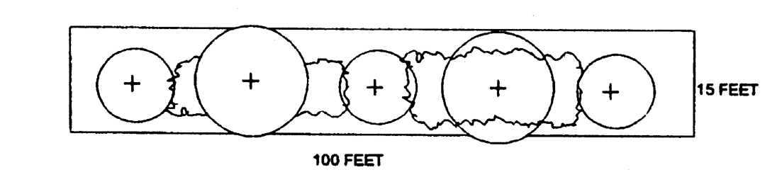
Buffer Type A
Buffer Type B
Required for properties which abut an incompatible zoning. Buffer must maintain a
minimum depth of fifteen feet and contain specified vegetation selected from Appendix
A. The intent of this buffer type is to provide a dense visual screen which mitigates
adverse impacts of incompatible developments.
Required minimum plantings per one hundred feet:
3 recommended trees
4 understory trees
20 buffer shrubs
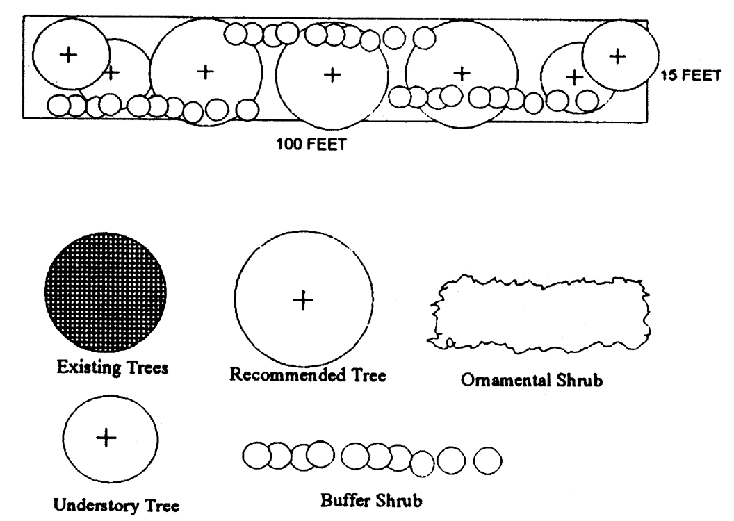
Buffer Type B
Buffer Type C
Required for properties which abut Class II roads. Buffer must maintain a mean depth
of twenty-five feet, not to go below fifteen feet and contain specified vegetation
selected from Appendix A. The intent of this buffer is to provide street frontage
landscaping along Class II roads.
Required minimum plantings per one hundred feet:
2 recommended trees
5 understory trees
60 ornamental shrubs
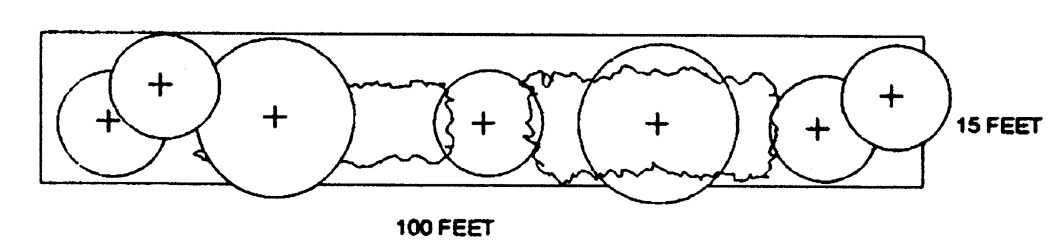
Buffer Type C
Buffer Type D
Required for properties which abut an incompatible zoning. Buffer must maintain a
minimum depth of twenty-five feet and contain specified vegetation selected from Appendix
A. The intent of this buffer type is to provide a dense visual screen which mitigates
adverse impacts of incompatible developments.
Required minimum plantings per one hundred feet:
3 recommended trees
4 understory trees
30 buffer shrubs
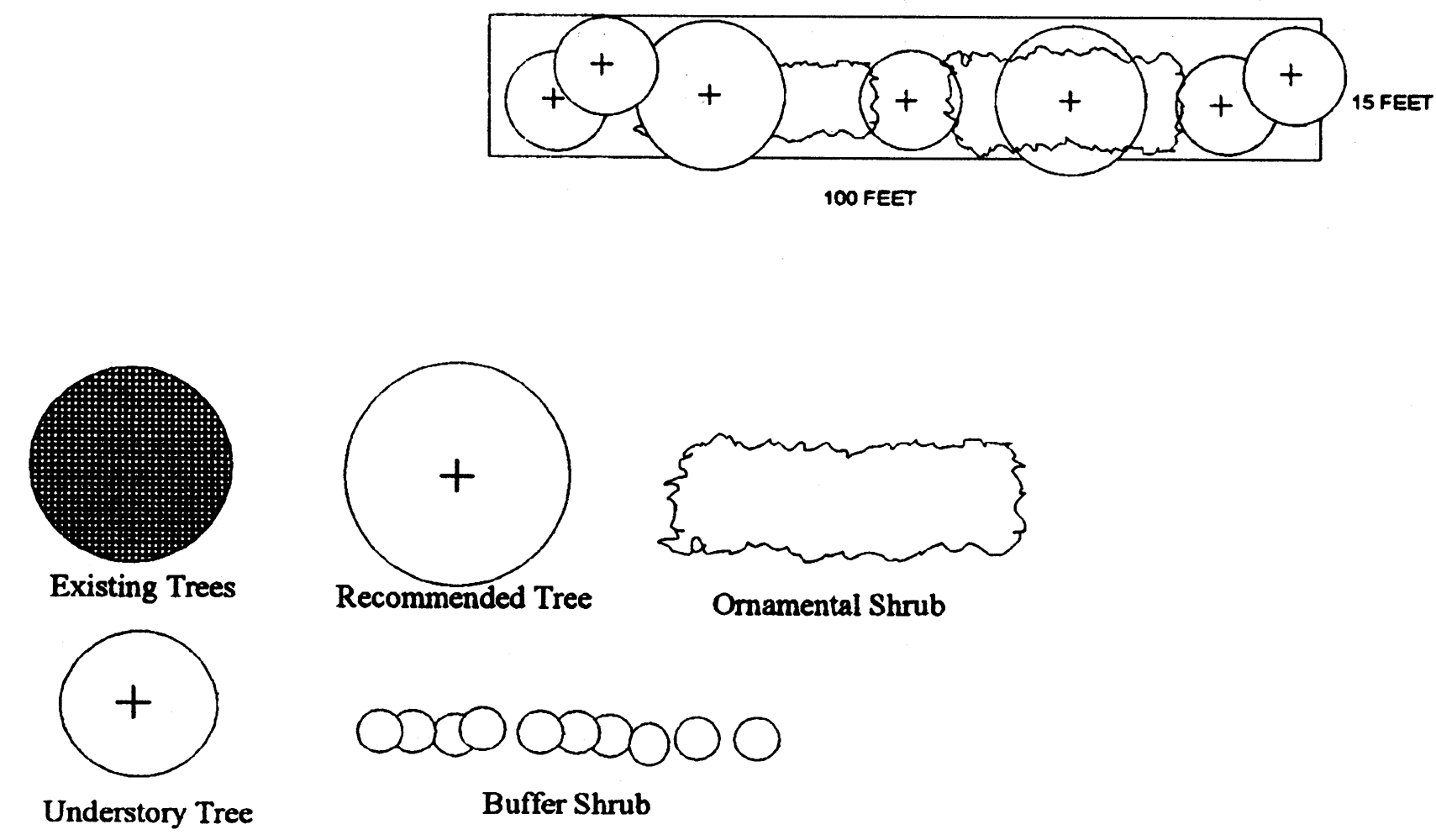
Buffer Type D
Buffer Type E
Required for properties which abut Class III roads. Buffer must maintain an average
depth of fifty feet, not to go below forty feet, and contain specified vegetation
selected from Appendix B. At least fifty percent (50%) of supplemental understory
vegetation must be evergreen. The intent of this buffer type is to provide dense street
frontage landscaping along Class III roads while allowing for corridors of visibility.
Required minimum plantings per one hundred feet:
Existing trees with six inches and greater D.B.H. must remain
6 recommended trees
5 understory trees
20 buffer shrubs
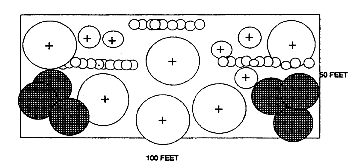
Buffer Type E
Buffer Type F
Required for properties which abut Class IV roads or properties which abut incompatible
zones. Buffer must maintain a minimum depth of fifty feet and contain specified vegetation.
Plant materials used to supplement Class IV road buffers shall be selected from Appendix
B. At least fifty percent (50%) of understory vegetation selected from Appendix B
must be evergreen. Plant materials used to supplement other Type F buffers shall be
selected from Appendix A. The intent of this buffer type is to ensure a very dense
street frontage buffer along Class IV roads and between incompatible developments.
Required minimum plantings per one hundred feet:
Existing trees with six inches and greater D.B.H. must remain
6 recommended trees
9 understory trees
30 buffer shrubs
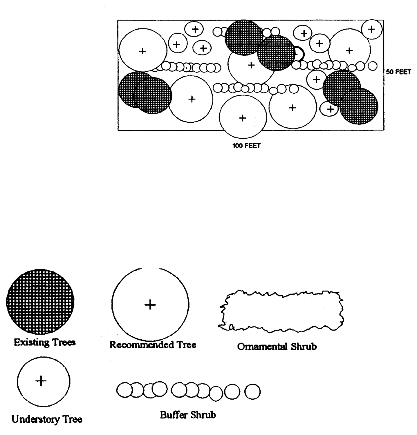
Buffer Type F
Buffer Type G
Required for properties which abut Class V Roads. Buffer must maintain a minimum depth
of seventy-five feet and contain specified vegetation selected from Appendix B. At
least fifty percent of supplemental understory vegetation must be evergreen. The intent
of this buffer type is to provide dense street frontage landscaping along Class V
roads while allowing for corridors of visibility. Such corridors, which may be absent
of vegetation, shall not exceed thirty-three percent of total buffer length.
Required minimum plantings per one hundred feet:
Existing trees 6 inches D.B.H. and greater must remain
9 recommended trees
12 understory trees
35 buffer shrubs
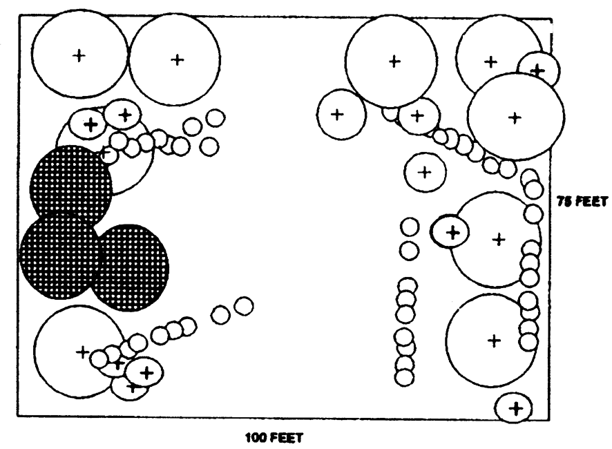
Buffer Type G
Buffer Type H
Required for properties which abut Class VI Roads and scenic rivers. Buffer must maintain
a minimum depth of seventy-five feet and contain specified vegetation selected from
Appendix B. At least fifty percent of understory vegetation must be evergreen. The
intent of this buffer type is to provide dense street frontage landscaping along Class
VI Roads, while allowing for corridors of visibility. Such corridors, which may be
absent of vegetation, shall not exceed thirty-three percent of total buffer length.
Required plantings per one-hundred feet:
Existing trees six inches and greater D.B.H. must remain
9 recommended trees
7 understory trees
30 buffer shrubs
One street tree (selected from recommended tree list) every fifty feet, to be setback
twenty-five feet from front property line. (These trees may be counted to satisfy
"Required plantings per one-hundred feet").
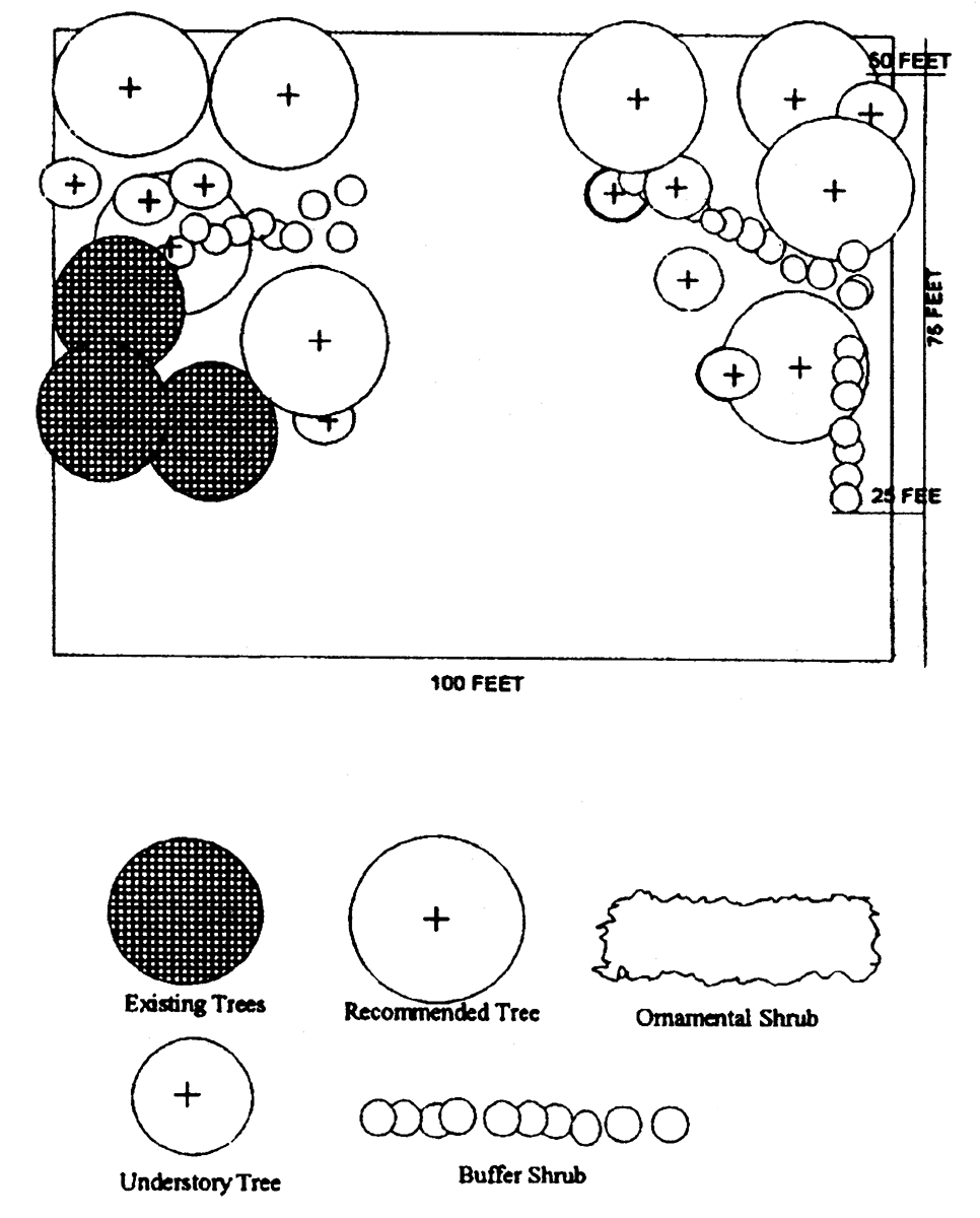
Buffer Type H
Buffer Type J
Required for properties which abut Class VII Roads and scenic rivers. Buffer must
maintain a minimum depth of one hundred feet and contain specified vegetation selected
from Appendix B. At least 50 percent of understory vegetation selected from Appendix
B must be evergreen. River frontage buffers may provide a vision corridor or corridors
not to exceed thirty three percent of total buffer length. Such corridor or corridors
may be absent of vegetation. Remainder of river frontage buffer shall contain required
vegetation. Road frontage buffers shall not contain vision corridors. The intent of
this buffer type is to preserve the scenic character of property abutting Class VII
Roads and rivers by maintaining a dense natural buffer.
Required minimum plantings per one hundred feet:
Existing trees with 6 inches and greater D.B.H. must remain
Existing understory vegetation listed on Table 2 must remain
24 recommended trees
20 understory trees
50 buffer shrubs
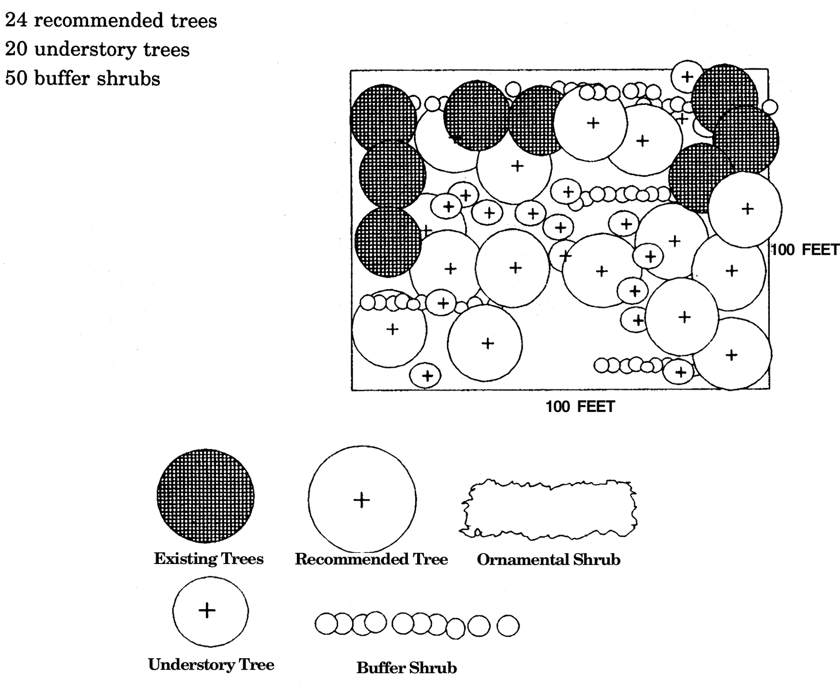
Buffer Type J
Buffer Type K
Required for properties which abut Class VIII Roads. Buffer must maintain a minimum
depth of 200 feet and contain specified vegetation selected from Appendix B. At least
fifty percent (50%) of the understory vegetation selected from Appendix B must be
evergreen. The intent of this buffer type is to preserve the scenic character of the
property abutting Class VIII Roads by maintaining a dense natural buffer.
Required minimum plantings per one hundred feet:
Existing trees with six inches and greater D.B.H. must remain
Existing understory vegetation listed on Table 2 must remain
24 recommended trees
20 understory trees
50 buffer shrubs
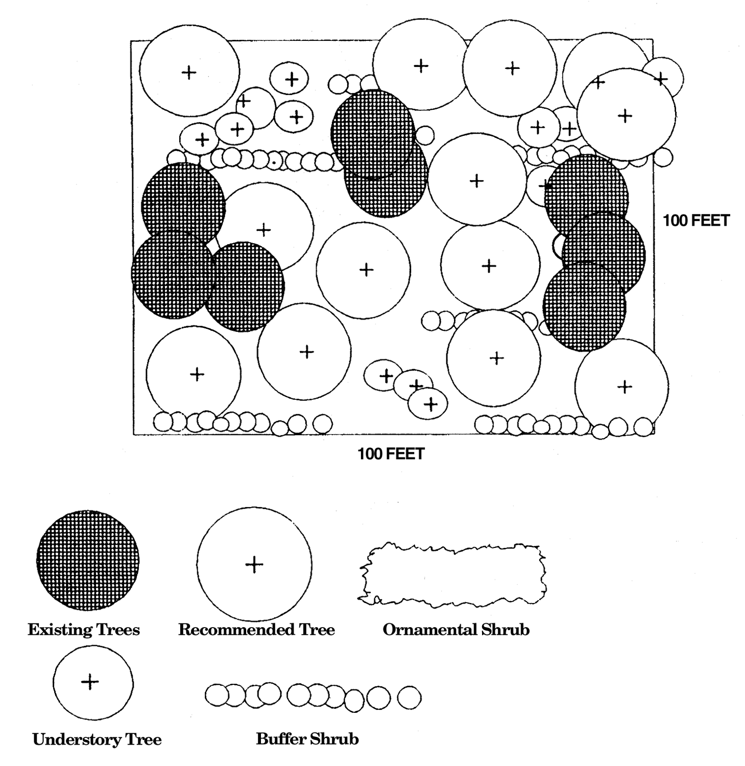
Buffer Type K
Buffer Type L
Required on all non-exempt properties within the zoning districts listed in Section 54-347.1 that abut SCDHEC-OCRM critical lines. The minimum width of the required buffer shall
be as indicated in Section 54-347.1.a.2. Within the required buffer areas, as shown
on approved plats or site plans pursuant to Section 54-347.1.a.4., existing vegetation
shall remain pursuant to the following guidelines. The following activities or improvements
shall be prohibited when establishing or maintaining buffers:
1.
Manicured, grassed lawns; only native grasses shall be allowed;
2.
Removal, damage or abuse in any manner of protected trees (trees with a diameter breast height of eight (8) inches or greater); and
3.
Pruning shrubs below three (3) feet in height.
Only the following activities or improvements shall be allowed within the required buffer:
1
Supplemental planting with native trees, shrubs and native grasses listed in Appendix B;
2.
Removal of trees with a diameter breast height less than eight (8) inches;
3.
Water-dependent structures and pedestrian or vehicular accessways leading to water-dependent structures as defined in Section 54-120. Such accessways shall be designed to avoid channelization of stormwater runoff and be the minimum necessary to provide safe access;
4.
Pedestrian or vehicular accessways specifically certified and approved for construction by OCRM or the U.S. Army Corps of Engineers;
5.
Minimum utility line penetrations as specifically approved by applicable public utility service providers;
6.
Use of vegetated surface swales or other approved means of surface runoff transport; and
7.
Stormwater drainage outfalls if certified and approved for construction by OCRM or the U.S. Army Corps of Engineers.
(Ord. No. 2001-14, § 2, 2-27-01)
Sec. 54-349. - Road and river classification chart.
The following roads and rivers are classified as follows. See Table 3.5: Schedule of Required Buffers, for buffer requirements.
CLASS I (15 feet)
Ashley Hall Road
Ashley River Road (Saint Andrews Boulevard to Sam Rittenburg Boulevard)
Fordham Road
Harborview Road
Old Towne Road
Orange Grove Road
Orleans Road
Saint Andrews Boulevard
Wappoo Road
CLASS II (25 feet)
Albemarle Road
Ashley River Road (Sam Rittenburg Boulevard to Mark Clark Expressway)
Central Park Road
Drayton Hall connector
Folly Road
Highway 41
Grimball Road (Folly Road to Riverland Drive)
James Island Bridge/Highway 61 Connector
Magwood Road
Maybank Highway (James Island)
Reflectance Drive
Sam Rittenburg Boulevard
Savage Road
Savannah Highway
Wesley Drive
CLASS III (50 feet)
Abbapoola Road
Ashley River Road (Mark Clark Expressway to Church Creek)
Bees Ferry Road
Belvedere Road
Brownswood Road
Cane Slash Road
Chisolm Road
Clements Ferry Road (Road 33) (except for along that portion of Clements Ferry Road southeast of Reflectance Drive intersection to city limits where a Class II (25 ft) shall apply)
Edenvale Road
Humbert Road
Murraywood Road
Old Pond Road
Patton Avenue/Fickling Hill Road
Plow Ground Road
CLASS IV (50 feet)
Ashley River Road (Church Creek to railroad viaduct)
Highway 61 Expressway (south of Bees Ferry Road)
James Island Expressway
Mark Clark Expressway
Riverland Drive
CLASS V (75 feet)
Bohicket Road (except within 1,400 feet of the intersection with Maybank Highway where a Class VI buffer shall apply)
Main Road (Johns Island) (except within 1,400 feet of the intersection with Maybank Highway where a Class VI buffer shall apply)
Maybank Highway (Johns Island) (excluding the sections listed under Class VI)
River Road (except within 1,400 feet of the intersection with Maybank Highway where a Class VI buffer shall apply)
CLASS VI (75 feet)
Bohicket Road (within 1,400 feet of the intersection with Maybank Highway)
Main Road (within 1,400 feet of the intersection with Maybank Highway)
Maybank Highway (on Johns Island within 1,400 feet of River Road, within 1,400 feet of Hollydale Court, and within 1,400 feet of Main Road)
River Road (within 1,400 feet of the intersection with Maybank Highway)
CLASS VII (100 feet)
Ashley River Road (a railroad viaduct to Muirfield Parkway/MacLaura Hall Avenue intersection)
Cainhoy Road
Ashley River Shoreline Frontage (Church Creek to city limits)
CLASS VIII (200 feet)
Ashley River Road (Muirfield Parkway/MacLaura Hall Avenue intersection to city limits)
(Ord. No. 2005-432, § 9-13-05; Ord. No. 2005-596, 10-4-05; Ord. No. 2009-75, 5-26-09; 2011-135, § 2, 9-13-2011; Ord. No. 2015-142, § 13, 10-13-2015)
Sec. 54-350. - Relocation and moving of structures.
a.
No structure may be moved to or relocated upon a lot within the City of Charleston unless the Board of Zoning Appeals, or the Board of Architectural Review, if the location of the lot where the building or structure is to be relocated is within the Old and Historic District or Old City District, after review, finds that the structure, as relocated, will be in general harmony with the prevailing character of the neighborhood to which it is being located in terms of height, mass, volume, scale and the location of the structure on the lot.
b.
Structure, for the purposes of this Section, shall mean any house, building or other structure which has been previously used in whole or in part for residential, commercial or other purposes at another location. Accessory structures of 350 square feet or less will be exempt from the provisions of this Section.
c.
As part of the application, the applicant shall submit to the Board of Zoning Appeals: (a) detailed exterior elevations and any proposed elements that will be attached to the structures; and (b) photographs of all sides of the structure to be relocated, photographs of the lot to which the structure is to be relocated, and photographs of the block where the structure is to be relocated.
d.
Prior to acting upon any application for the removal or relocation of a structure within the corporate limits, the Board of Zoning Appeals shall cause the Chief Building Official of the City of Charleston to submit a written statement to it concerning the feasibility of renovating the structure and of the owner's ability to bring the structure up to standards of all City codes.
e.
As a condition of approval, the Board of Zoning Appeals may require that the applicant give satisfactory evidence of his ability to complete the relocation and renovation of the structure, including construction contracts and financial ability; and further, upon a finding that the health and welfare of the neighborhood may be adversely affected by allowing the structure to remain in an incomplete condition after removal, the Board of Zoning Appeals may require that the owner file with the City a performance bond or other satisfactory means to insure that the structure will be renovated in a timely fashion.
(Ord. No. 1999-54, § 4, 4-27-99)
Sec. 54-351. - Vision clearance requirements.
Except as hereinafter provided, no fence, wall, shrubbery, sign, marquee, or other obstruction to vision between the heights of three (3) feet and fifteen (15) feet shall be permitted within the vision clearance triangle which shall be determined by measuring back fifteen (15) feet from the intersection of the rights-of-way of two streets or railroads or of a street intersection with a railroad right-of-way line and connecting the two points. Necessary traffic and directional signs shall not be included in this requirement.
Sec. 54-352. - Intent and applicability.
In order to promote the general welfare of the city through the appropriate use of lots and areas within the city in zone districts designated SR-3, SR-4, SR-5, STR, DR-1F, DR-1, DR-2F, DR-2, DR-3, DR-6, DR-9, DR-12, LB, GB, GP, MU-1, MU-2, LI and UP by the construction therein of one-family attached dwellings, known as town, row, or patio houses, it is provided that such structures may be erected within such boundaries, subject to the standards and regulations in Section 54-353.
(Ord. No. 2003-63, § 3, 7-15-03; Ord. No. 2003-69, § 13, 8-19-03; Ord. No. 2014-67, § 8, 5-13-14; Ord. No. 2015-142, § 10, 10-13-2015)
Sec. 54-353. - Standards and regulations.
For one-family attached dwellings, town, or row houses, the following standards and regulations shall apply in all districts where permitted.
a.
Height limitations: Maximum fifty (50) feet and three (3) stories.
b.
Lot width: Minimum sixteen (16) feet, except where side setbacks are hereinafter required, the minimum lot width shall be increased accordingly.
c.
Front setback for the principal building: Must conform to area regulations of district where located, with the following exceptions:
1.
In an STR, DR-1F, DR-2F, DR-3, DR-6, DR-9 or DR-12 district, no front setback shall be required for interior units of a single grouping of one family attached dwellings, provided that the minimum front setback of the end units of such grouping shall be either (1) ten feet, or (2) not less than the front setback of any structure located on the next built-upon lot fronting on the same street which is not part of the same town house, whichever is less.
2.
In any district, if motor vehicles are parked or stored within a unit with vehicular entrance directly from the street, a minimum front setback of eight (8) feet shall be provided, except in the GB district, where the minimum front setback shall be five (5) feet and the maximum setback shall be ten (10) feet.
3.
In any district, if motor vehicles are parked or stored in the front yard of a unit the front setback shall be at least twenty-five (25) feet.
d.
Side setback for the principal building: A minimum side setback of six (6) feet shall be provided between the end units of a row and a side lot line; provided, however that:
1.
In the GB district, the minimum side setback between the end units in a row and an interior side lot line may be five (5) feet; and
2.
When the side lot line is a street line, the side setback adjacent to such street shall be at least ten (10) feet; and
3.
When the side lot line borders a driveway, the title to which or the easement to which runs with or is appurtenant to such lot, the side setback may be reduced to three (3) feet; and
4.
When no building on the next adjacent lot fronting on the same street is within three (3) feet of the side lot line, the side setback adjacent to such next lot may be reduced to four (4) feet if its wall on that side shall be of masonry construction, without openings, except ventilator grills; and
5.
When the next adjacent lot is a platted open space or common area with a minimum width of ten (10) feet, there shall be no required side setback.
e.
Rear setback for the principal building: A minimum rear setback of sixteen (16) feet shall be provided, except that within the GB district the rear setback may be reduced to ten (10) feet; but
1.
When required vehicular parking space is provided in rear yard, minimum rear setback shall be twenty-five (25) feet; and
2.
When a carport, garage, or other accessory building exceeding fifty (50) square feet is located in rear yard, the minimum rear setback shall be twenty-five (25) feet; and
3.
When the property is zoned GB, the rear setback from an alley right-of-way shall be a minimum of five (5) feet and maximum of ten (10) feet if motor vehicles are parked in a unit, or a minimum of twenty-five (25) feet if a vehicle is to be parked in a driveway.
f.
Minimum lot area per family: One thousand five hundred (1,500) square feet, except 1,200 square feet in the GB district.
g.
Percent of lot occupancy: Except in the GB district, not more than fifty (50) percent of lot shall be occupied by principal and accessory buildings, except this may be increased by one hundred (100) square feet when required vehicular parking is provided in principal building, or in a parking lot or community garage the title to which or the easement for the use of which runs with or is appurtenant to the title to such building. In the GB district, not more than eighty (80) percent of lot shall be occupied by the principal and accessory buildings.
h.
Accessory buildings: Shall be permitted and the following standards shall apply:
1.
Front setback for accessory buildings: No front setback shall be required, provided that any accessory building must be located to the rear of the principal building a minimum of ten (10) feet.
2.
Side setback for accessory buildings: There shall be no minimum side setback required, provided, however that when the side lot line is a street line, the side setback adjacent to such street shall be at least ten (10) feet.
3.
Rear setback for accessory buildings: Minimum rear setback of five (5) feet shall be provided.
4.
In addition to a carport or garage, another accessory building shall be permitted in the rear yard provided it does not exceed one hundred (100) square feet in floor area and twelve feet in height, and any such accessory buildings shall be constructed of materials similar to or in keeping with the principal building.
i.
Additional dwellings: Not allowed.
j.
Special requirements:
1.
The partition wall and walls between such structures shall comply with building code requirements.
2.
Not more than six (6) such dwellings shall be constructed or attached together in a continuous row, and no such row shall exceed two hundred (200) feet in length, except in SR-3, SR-4, SR-5 and STR Districts, where not more than two such units shall be constructed or attached together in a continuous row.
3.
Off-street parking shall be provided for each such dwelling, pursuant to the zoning regulations, either on the premises or in a community parking lot or garage the title to which and/or the easement for the use of which runs with and/or is appurtenant to the title to such dwelling. No such parking lot or garage shall be located more than two hundred (200) feet from the dwelling which it serves. One driveway with a maximum width of eleven (11) feet shall be permitted in the front yard, except that dwellings within a development may be exempt from these driveway restrictions if sidewalks or paved multi-use paths with a minimum width of five (5) feet are installed along both sides of all street rights-of-way within the development, except streets in the GB district approved pursuant to Subsection. 54-353.j.4., and along all street rights-of-way located adjacent to the development and classified as subcollector or access streets.
4.
In the GB district, street design standards in Section 54-821 shall be modified to permit the minimum right-of-way width and pavement width for a one-way, undivided access street with mountable curb to be reduced to twenty (20) feet, or two-way, undivided access street with mountable curb to be reduced to twenty-two (22) feet, if:
(a)
Block length does not exceed five hundred (500) feet in length; and
(b)
Right-of-way width and pavement width for streets that provide parallel parking is increased by seven (7) feet in the area where on-street parking is provided on one side, and fourteen (14) feet in the area where on-street parking is provided on two (2) sides; and
(c)
Such streets and associated pavement markings and signage are permanently maintained by a home owners association and not maintained by the City of Charleston; and
(d)
Through-block, concrete pedestrian paths with a minimum width of five (5) feet are provided in open space parcels or easements with a minimum width of ten (10) feet in each block that exceeds 200 feet in length; and
(e)
the Technical Review Committee members find that the pavement widths, right-of-way widths, and layout of all streets within a development using this exception are sufficient to meet engineering, accessibility, pedestrian safety, traffic safety, and emergency vehicle access requirements; and
(f)
One useable open space area is set aside as community gathering space and constructed as part of the development with a minimum total area, excluding easements, all stormwater facilities and required buffers, of fourteen thousand (14,000) square feet, and a minimum dimension of one hundred (100) feet. One such community gathering space shall be included for every fifty (50) dwelling units, and each space shall be increased in size by two hundred eighty (280) square feet for each additional dwelling unit until the next multiplier of fifty (50) units is reached.
(Ord. No. 2003-63, § 4, 7-15-03; Ord. No. 2014-67, § 9, 5-13-14; Ord. No. 2016-061, § 1, 5-10-16; Ord. No. 2021-155, § 1, 11-9-21)
Sec. 54-354. - Intent.
The intent of the DR-3 district is to promote acceptable living environments for occupants of mobile home parks with mobile home spaces offered for rental or lease, as well as for mobile homes placed on single lots. The mobile home is recognized as a specific form of housing for which standards should be provided for appropriate development, spacing and use. No use other than the use as shown on the approved site plan shall be allowed within a mobile home park.
Sec. 54-355. - Rules and regulations for mobile home parks.
Mobile home parks shall be permitted, provided that a site plan is submitted according to the requirements of Article 6, of this Chapter and that the design of the park complies with the following conditions:
a.
Access and frontage. A mobile home park shall have direct access onto a road classified as an arterial or collector street and no mobile home park shall have direct access onto a road classified as a local street.
b.
Mobile home access: Each mobile home space within a mobile home park shall have direct access to a roadway located within the park site.
c.
Off-street parking: A minimum of two (2) paved off-street parking spaces shall be provided for, and be located upon, each mobile home space included in a mobile home park.
d.
On-street parking: On-street parking spaces shall be incorporated in the design of a mobile home park only on roadways located within the park having a paved width of 30 feet or more.
e.
Drainage: Mobile home parks shall incorporate drainage facilities to comply with the City of Charleston's storm water management system criteria.
f.
Natural features: The site plan shall specify the landscaping features as slopes, drainage ways, vegetation and trees, which features shall be incorporated into the design and layout of the mobile home park, and to the extent practicable, shall be utilized as buffers between the park site and adjacent land uses as well as between individual mobile home spaces within the mobile home park. A tree survey shall be submitted to the zoning administrator identifying trees of eight (8) inches or larger in diameter measured at breast height (4½ feet above the ground) which trees, if at all possible, shall be preserved.
g.
Mobile home park screening: Each mobile home park shall incorporate screening around its perimeter in the form of a six (6) foot view reducing fence or natural vegetation or such other means in order to mitigate against noise and glare.
h.
Mobile home pad setbacks: Mobile home pads on mobile home spaces within a mobile home park shall be set back at least twenty-five (25) feet from the perimeter boundary lines of a mobile home park, and, when a mobile home space abuts an arterial or major collector street, the setback along the arterial or major collector street shall be at least fifty (50) feet.
i.
Roadways: Access to, and circulation within, mobile home parks shall be designed to promote the public safety and all rights-of-way within mobile home parks shall comply with the standards set forth in Section 54-821 of this Chapter, and shall be constructed with such materials as are utilized in the construction of standard public rights-of-way within the City of Charleston.
j.
Lighting: The site plan shall identify the location of the street lights within the mobile home park and intensity of lighting to be provided thereby.
k.
Facilities: Each mobile home space shall be equipped with access to public water and sewerage, as well as electricity.
l.
Open space: Each mobile home park containing twenty (20) or more mobile home spaces shall provide at least two hundred (200) square feet of common open space for each mobile home space. Calculation for the common open space shall not include the set back requirements for mobile home parks as set forth in subsection h, above.
m.
Storage space: Each mobile home park shall provide a screened area for the storage of boats and trailers, which area shall, in the aggregate, be comprised of at least one hundred (100) square feet for every mobile home space within the park.
n.
Accessory buildings: All accessory structures to be located on a mobile home space shall be situated so as not to be visible from a right-of-way within a mobile home park, and shall be situated so as not to encroach on the setback requirements as set forth in subsection h, above.
o.
Foundation. All mobile homes situated within a mobile home park shall be supported by a foundation system which meets the building code requirements of the City of Charleston and for which a building permit has been obtained.
p.
Identification sign. All mobile home park signage shall be governed by the residential subdivision sign standards as provided in Article 4.
q.
Roof over structure. No roof shall be constructed over a mobile home independent of a mobile home structure.
r.
Refuse areas: All refuse areas located within a mobile home park shall be screened and enclosed so as to prevent odor and windblown debris.
s.
Lot area. All mobile home parks shall contain two (2) or more contiguous acres under single ownership.
t.
Mobile home skirting. All mobile homes situated within a mobile home park shall be skirted by manufactured skirting or other materials suitable for exterior use and approved by the Zoning Administrator and the Chief Building Inspector, including corrosion-resistant metal, fiberglass/plastic, wood/wood siding (both must be protected from the elements by water resistant solution/substance), decay-resistant wood/pressure treated lumber, and masonry/concrete/rock. The enclosed crawl space under the mobile home must be ventilated and include access panels in compliance with the building code of the City of Charleston.
Sec. 54-356. - Rules and regulations for mobile home lots.
A single mobile home may be located on its own lot in a DR-3 district provided that the following conditions are met:
a.
The parcel or lot of land upon which the mobile home is to be placed shall contain at least one (1) contiguous acre and be under single ownership;
b.
No other occupied structure or building shall be located on the lot or parcel of land upon which such mobile home is situated;
c.
The mobile home shall be located at least twenty-five (25) feet from any property lines, or rights-of-way; and
d.
All mobile homes placed on an individual lot shall be skirted in a manner as provided for in Section 54-355, t.
Sec. 54-357. - Temporary mobile homes permitted.
A single mobile home may be placed on a lot in any DR-3 district on a temporary basis not to exceed six (6) months for the purpose of serving as a temporary residence during the construction of a permanent residence provided the following conditions are met:
a.
A building permit shall be obtained for the permanent structure to be built on the lot where the temporary mobile home is to be situated; and
b.
The temporary mobile home is located on the lot in conformity with all applicable City codes.
Sec. 54-358. - Standards and regulations.
The City Council of Charleston finds as a fact that dwellings, consisting primarily of units designed for occupancy by not more than two elderly persons, do not have the dimensional requirements of other residential structures or common open space, service areas and facilities are coordinated, and that it is desirable to promote the general welfare by providing districts wherein such structures may be erected if certain standards and regulations are met. It, therefore, is provided that in any DR-4 diverse residential district, multi-family dwellings containing not less than twenty (20) units in a single structure or complex of structures and designed for the elderly and conforming to the requirements of federal programs for housing the elderly may be erected if all of the following standards and regulations are met:
a.
At least 90 percent of the units in such dwellings shall be one-bedroom units, or efficiency units with no separate bedrooms. All units shall meet the standards of the public safety and housing ordinance and all other applicable city ordinances.
b.
Setbacks - The dwelling shall be so constructed that no portion thereof shall be closer to an adverse residential property line than one half the height of the structure, but in no event shall the minimum depths or widths be less than:
1.
Front yard - 25 feet.
2.
Each side yard - 15 feet.
3.
Rear yard - 30 feet.
c.
Lot area per living unit, minimum requirements 300 square feet per unit.
d.
Minimum total lot area - 9,000 square feet.
e.
Maximum percent of lot occupancy by all buildings - 50 percent.
f.
Height limits - 50 feet and four stories except where Old City Height Districts, as set forth in Article 3, Part 2, apply.
g.
Accessory Buildings essential to service of principal building shall be set back at least sixty (60) feet from front street, fifteen (15) feet from side street, and fifteen (15) feet from any adjacent residential property line except that no structure for handling of garbage or waste shall be closer than thirty (30) feet to an adjacent residential property line.
h.
Off-street parking - The provisions of Article 3: Part 4, shall apply to all activities on the site, except that the minimum requirements for dwelling units shall be:
1.
First 20 units - one parking space per unit.
2.
All units in excess of 20, ⅓ space per unit.
i.
Off-street loading - One space, 10 by 25 feet, for each 20,000 feet of total building floor area, or fraction thereof. No loading space within fifty feet of an adversely-owned residential property shall be used between 8 p.m. and 8 a.m. of the following day.
j.
Landscaped areas - Landscaped area, at least six (6) feet wide, shall be provided on all perimeters of property. This may be included in computing minimum setbacks.
k.
It shall be the policy of the management to lease living units herein permitted only for occupancy by adults, not in excess of three per unit, including servants or nursing attendants, although children or overnight guests may be occasionally permitted.
l.
Accessory retail and personal uses, e.g., barber shop/beauty parlor, banking facilities, postal services, gift shop, etc., which serve the residents of the elderly housing facility may be permitted, but shall not exceed 10% of the total residential floor area. Such uses shall be internally oriented within the complex.
(Ord. No. 2012-379, § 1, 10-9-12)
Sec. 54-360. - Requirement for multi-family and non-residential development.
Proposed improvements to multi-family residential and non-residential properties where there is a building addition or renovation that requires the approval of the Technical Review Committee under Article 6 shall provide sidewalks in or adjacent to public rights-of-way.
(Ord. No. 2011-57, § 1, 8-16-11)
Sec. 54-361. - General standards.
a.
Location. Generally, sidewalks shall be provided in the public right-of-way, and extend across the length of the right-of-way adjacent to the development. Sidewalks may abut the curb. Where there is no curb, sidewalks shall be offset at least three feet from the edge of the pavement.
b.
Materials. Required sidewalks shall be constructed according to the specifications of the City Engineer.
c.
Construction and Inspections.
1.
Sidewalks shall be constructed by the TRC applicant prior to the issuance of a Certificate of Occupancy for the development requiring the sidewalk improvements.
2.
Sidewalks constructed in the public right-of-way shall be inspected by the City Engineer for compliance with City standards.
3.
For sidewalks to be constructed within a right-of-way that is not under the jurisdiction of the City of Charleston, the applicant shall provide a copy of the permit authorizing such work. For the South Carolina Department of Trasnportation (D.O.T.), a copy of the D.O.T. encroachment approval shall be submitted with a request for Final TRC approval.
i.
When the appropriate authority denies a request to construct a sidewalk in the public right of way:
1.
Sidewalks may be placed outside of a public right-of-way if the applicant voluntarily agrees to record an easement for the safe movement of pedestrians and the maintenance of the sidewalk.
4.
Sidewalks may also be placed outside of a public right-of-way when deemed appropriate for the preservation of a grand tree or for the accommodation of utilities or other necessary infrastructure provided that the applicant voluntarily agrees to record an easement for the safe movement of pedestrians and the maintenance of the sidewalk.
(Ord. No. 2011-57, § 1, 8-16-11)
Sec. 54-363. - Purpose.
To promote and support quality bus and transit services, to provide and enhance mobility options, reduce individual vehicle miles traveled, and to meet the transportation needs of the City of Charleston's residents, workers, and visitors.
(Ord. No. 2019-057, § 1, 7-16-19)
Sec. 54-364. - Defined terms.
For the purposes of this article the following terms are defined and the term "transit" shall also mean "bus".
Transit Accommodations. Includes transit stops, transit shelters and associated infrastructure.
Transit Shelter. A permanently installed structure located at a transit stop that provides seating and protection from the weather for people waiting for a transit vehicle.
Transit Stop. A designated place where transit vehicles pause to allow for passenger boarding and disembarking. A transit stop is marked with a transit stop sign and shall include the appropriate infrastructure such as a stop pad and sidewalk connectivity, and may also include, but not limited to, amenities such a shelters, benches and trash receptacles.
Transit Vehicle. A mode of transportation providing a schedule transportation service to the public.
(Ord. No. 2019-057, § 1, 7-16-19)
Sec. 54-365. - Applicability and requirement thresholds.
a.
Proposed improvements to multi-family residential properties, non-residential properties, and subdivisions with fifty (50) or more single-family or two-family dwelling units where there is new development, redevelopment, or changes to a building that require the approval of the Technical Review Committee (TRC) under Article 6 shall provide transit accommodations along existing or planned bus and transit routes as identified by the Berkeley-Charleston-Dorchester Council of Governments (BCD COG) in the Regional Transit Framework Plan as part of the Long Range Transportation Plan including transit stops, shelters, or other amenities when any of the following thresholds are met:
1.
The site development will generate vehicular trips that will impact the traffic operations of the adjacent streets or intersections so that the Level of Service (LOS) drops below LOS C or the adjacent streets or intersections are already operating below LOS C, as determined by a traffic impact analysis; or
2.
The site development will generate a minimum of 500 vehicular trips per day per the current edition of the Institute of Transportation Engineers' (ITE) Trip Generation Handbook; or
3.
If the site development will generate a minimum of 2,500 daily vehicular trips per the ITE Trip Generation Handbook, has frontage on more than one public street, and is served by more than one public transit, then two transit accommodations will be required.
b.
Transit accommodations will be reviewed during the TRC approval process; therefore, coordination with the Charleston Area Regional Transportation Authority (CARTA) is strongly recommended early in the development review process.
(Ord. No. 2019-057, § 1, 7-16-19)
Sec. 54-366. - Type of transit accommodations, location, design, and installation.
a.
The type of Transit Accommodation required shall be determined by the City of Charleston Department of Traffic and Transportation. Size and capacity of transit accommodations should reflect the size of corresponding development, adjacent land uses, and planned future development. The TRC applicant shall provide documentation with associated exhibits regarding the proposed Transit Accommodations including location and design, prior to final TRC approval.
b.
Location and design of Transit Accommodations shall be coordinated with the Department of Traffic and Transportation.
1.
Transit Accommodations shall be provided in the public right-of-way; however these accommodations may be located outside of the public right-of-way and on the development site subject to all of the following:
i.
Transit Accommodations may be placed outside of a public right-of-way when deemed appropriate for the preservation of a grand tree, for the accommodation of utilities, for other necessary infrastructure, or for other purposes approved by TRC.
ii.
The developer shall provide a location on the development site within an acceptable proximity to the public right-of-way for the Transit Accommodations.
iii.
The developer shall provide a recorded public easement dedicated for the Transit Accommodations, maintenance, and the safe movement of pedestrians.
2.
For Transit Accommodations to be constructed within a right-of-way that is not under the jurisdiction of the City of Charleston, the applicant shall provide a copy of the permit authorizing such work within the right-of-way. For SCDOT right-of-way, a copy of the SCDOT encroachment approval shall be submitted with a request for Final TRC approval.
3.
Transit Accommodations shall comply with all other applicable City codes, ordinances, and design review requirements.
c.
Prior to the issuance of the Certificate of Construction Completion Occupancy (Certificate of Occupancy) for multi-family and non-residential development sites or recordation of a final subdivision plat for subdivisions with single-family or two-family dwelling units, Transit Accommodations shall be provided by and installed by the developer and shall be inspected by the Department of Traffic and Transportation or its designee.
(Ord. No. 2019-057, § 1, 7-16-19)