
Craig City Zoning Code
CHAPTER 16
02 - Community Design Standards
Sections:
16.02.010 - General provisions.
A.
Applicability. All development applications shall comply with the applicable standards contained in this chapter.
B.
Relation to zone district standards. In the event of a conflict between a standard or requirement contained in the Density and Dimensional Chart in Article 3, and text in this chapter, the standard in the chart in Chapter 16.03 of this title shall prevail.
(Ord. 962 §§1, 2, 2007)
16.02.020 - Vision and intent.
The intention of the city in enacting this chapter is to clearly describe the city's vision for its physical development and to create a cohesive and well-designed community that furthers the goals identified in the Master Plan.
(Ord. 962 §§1, 2, 2007)
16.02.030 - Application of community design standards.
The planning commission and the city council will evaluate each proposal based on these standards and the context within which each project is located. Applicants must conform to the design standards in this chapter unless it can be demonstrated that an acceptable alternative meets the following condition: Strict application of the standard or unique site features makes the particular standard impractical.
(Ord. 962 §§1, 2, 2007)
16.02.040 - Lots and blocks.
A.
Intent. The intent of the block and lot standards is to continue the city's existing block pattern in a manner that is compatible with site-specific conditions. The design and development of subdivisions shall preserve, insofar as it is possible, the natural terrain, natural drainage, existing topsoil and trees.
B.
General provisions.
1.
Blocks. Streets shall be designed to create blocks that consider interconnectedness, topography, solar orientation, views and other design features.
2.
Lot dimension and configuration.
a.
Lot size, width, depth, shape and orientation and minimum building setback lines shall conform to this chapter and shall facilitate the placement of buildings with sufficient access, outdoor space, privacy and view.
b.
Depth and width of properties shall be adequate to provide for off-street parking, landscaping and loading areas required by the type of use and development contemplated.
c.
Lot frontage. All lots shall have frontage that is either adjacent to or directly accessible to a street. Street frontage shall typically not be less than twenty-five percent (25%) of the lot depth.
d.
Corner lots. Corner lots for residential use shall have extra width to accommodate the required building setback and utility easements on both street frontages. For a corner lot, the front of the lot is defined as the side having the shortest street frontage. In the case of a reverse corner lot, both sides abutting a street shall maintain a front yard setback.
e.
Double frontage. Residential lots that front on two (2) streets (double frontage) shall not be permitted.
f.
Side lot lines. Side lot lines shall be substantially at right angles or radial to road right-of-way lines or centerlines.
g.
Residential lot access to adjacent street.
1)
Driveway access to a local or collector street from a single-family detached residential lot shall be limited to one (1) driveway curbcut or driveway access of no greater than twenty (20) feet in width. A circular drive in which each access to the local or collector street is less than ten (10) feet in width, separated by at least thirty (30) feet, and which is constructed as an integral part of the overall architectural design of the single-family residence may be considered as a single driveway access.
2)
Driveway access to a local street from a single-family detached residential lot shall be greater than thirty (30) feet from the intersection of the local street and a collector street or one hundred fifty (150) feet from the intersection of the local street, and an arterial street as measured from the intersecting right-of-way lines.
3)
Driveway access to a collector street from a single-family detached residential lot shall be greater than seventy-five (75) feet from the intersection of the collector street and a local street, another collector street or an arterial street, as measured from the intersecting right-of-way lines.
h.
Commercial, business and industrial lot access to adjacent street.
1)
Driveway access to a local or collector street from a multi-family residential, commercial, business or industrial lot shall be greater than one hundred twenty-five (125) feet from any street intersection, as measured from the intersecting right-of-way lines.
2)
Driveway access to an arterial street from a commercial, business or industrial lot shall be not less than one hundred (100) feet from any intersection on the arterial street or from another commercial, business or industrial lot's access, as measured from the intersecting right-of-way lines or driveways.
3)
Driveway access to a local street, collector street or arterial street from a multi-family residential, commercial, business or industrial lot may be allowed by the city at its sole discretion.
(Ord. 962 §§1, 2, 2007)
16.02.050 - Streets.
A.
Intent. The intent of the street standards is to establish a safe, efficient, attractive transportation system that promotes all modes of transportation and is sensitive to the environment.
B.
General provisions. The local street system of any proposed development shall be designed to be safe, efficient, convenient and attractive, and consider all modes of transportation that will use the system. Streets should be an inviting public space and an integral part of community design. Local streets shall provide for both intra- and inter-neighborhood connections to knit developments together. All streets should interconnect to help create a network of public areas to allow free movement of cars, bicycles and pedestrians.
1.
Street connections. All streets shall be aligned to join with planned or existing streets consistent with the Master Plan, Comprehensive Street and Highway Plan, or as approved by the city council. All streets shall be designed to bear a logical relationship to the topography of the land. Intersections of streets shall be at right angles unless otherwise approved by the city.
2.
Street layout. The street layout shall form an interconnected system of streets, where feasible, primarily in a grid or modified pattern adapted to the topography, unique natural features, environmental constraints and open space areas.
3.
Controlling street access. A strip of land between a dedicated street and adjacent property shall only be reserved for the purpose of controlling access to such street from such property when control of such land is given to the city.
4.
Visibility at intersections. No shrubs, ground cover, berms, fences, structures or other materials or items greater than thirty-six (36) inches in height shall be planted, created or maintained at street intersections within the site distance triangle. Trees shall not be planted in the site distance triangle.
5.
Pedestrian crossings at street intersections and mid-block. Pedestrian crossings shall be accessible to handicapped individuals, and mid-block crossings may be required at the direction of the city council.
6.
Street right-of-way dedication. The full width of right-of-way for all streets being platted must be conveyed to the city after final acceptance unless otherwise approved by the city.
7.
Perimeter streets. When a street is dedicated which ends on the plat, the street right-of-way must be dedicated to the boundary of the plat.
8.
Street names. Names of new streets shall not duplicate names of existing streets in the city. However, new streets which are extensions of, or which are in alignment with, existing streets within the city shall bear the names of such streets. Street naming and property address numbering will be coordinated between the applicant, the city and county where applicable.
9.
Street standards. Streets shall conform to the adopted city specifications and all other applicable laws, rules and regulations.
10.
General design standards.
a.
Design of streets, curbs and gutters shall be in accordance with the Americans with Disabilities Act (ADA) standards.
b.
Concrete curb and gutter is required on all city streets. The standard curb and gutter for city streets will be six (6) inches straight back with a twenty-two-inch gutter.
c.
Streets shall be designed in accordance with the American Association of State Highway and Transportation Officials Policy on Geometric Design of Highways and Streets, 1990, and shall conform to the adopted city specifications, as amended.
d.
The layout of arterial and collector streets shall be per the city Transportation Plan unless otherwise approved by the city council.
e.
Culs-de-sac shall be permitted, provided that they are not more than five hundred (500) feet in length and have a turnaround diameter of at least eighty (80) feet. Surface drainage shall be toward the intersecting street or, if this is not possible, a drainage easement shall be required through the cul-de-sac.
f.
Dead-end streets, with the exception of culs-de-sac, shall be prohibited unless they are designed to connect with future streets in adjacent land that has not been platted, in which case a temporary turnaround easement of sixty (60) feet shall be required.
g.
Restrictions of access shall be required when a subdivision or portion thereof adjoins an arterial highway. Marginal access streets, reverse frontage with screen planting contained in a nonaccess reservation, deep lots or similar treatment shall be required to reduce the impact of traffic on residential properties and to avoid interference with the movement of traffic on thoroughfares.
h.
Half-streets shall be prohibited. When a proposed half-street in one (1) subdivision is adjacent to another property, the approval of the adjacent owner shall be obtained and the entire street shall be dedicated. The responsibility for acquiring the additional right-of-way shall be the subdivider's. In the event the adjacent land is not obtainable, the subdivider shall dedicate the full width of the street.
i.
Right-of-way widths shall be specified in the city Transportation Plan.
11.
Arterial streets and major streets design.
a.
Arterial streets shall be designed to accommodate present and future transportation requirements.
b.
Arterial streets shall align and connect across intersecting arterials to distribute traffic and provide continuity of travel throughout the city.
c.
Design standards
12.
Collector streets.
a.
Intersections of collector streets and arterial streets shall be aligned to distribute traffic and provide continuity across the city.
b.
Design standards
13.
Local streets.
a.
These streets shall generally parallel the arterial and collector street system, provide a variety of route options, interconnect to allow traffic to disperse in an equitable manner and be as narrow as possible without sacrificing the ability to accommodate expected traffic and services. Local street cross-sections will generally include a four-foot landscaped area adjacent to the roadway.
b.
Design standards.
14.
Alleys.
a.
Alleys shall be treated as public ways, and any lot having access from an alley shall also front upon a public street. Alleys shall be provided in commercial and industrial areas, except that this requirement may be waived where other provisions are made and approved for service access.
b.
Garages, accessory dwellings above garages and rear yards may access the collector and local street system via an alley.
c.
Design standard.
(Ord. 962 §§1, 2, 2007)
16.02.060 - Parking.
A.
Intent. The intent of this section is to provide adequate parking for motor vehicles while minimizing the visual impact of parking lots and structures.
B.
General provisions. In all zone districts, off-street parking facilities for the storage of motor vehicles for the use of occupants, employees and patrons of the buildings or structures hereafter erected, altered or extended shall be provided and maintained as herein prescribed.
1.
Surface. All parking and driveway areas and primary access to parking facilities shall be surfaced with asphalt or concrete.
2.
Integrate parking lots with surrounding developments. Parking lots shall not dominate the street frontage of pedestrian-oriented streets (downtown area), interfere with pedestrian or bicycle routes or negatively impact surrounding neighborhoods.
3.
Landscaping. Parking lots shall be landscaped and shall also be screened from adjacent (especially residential) uses with landscaping, berms, walls or fencing as provided in this chapter. Parking lot landscape designs located adjacent to residential uses shall minimize any negative impact on residential properties from the parking lot.
4.
Shared access. Where feasible, and in order to reduce traffic and vehicle turning movements on major streets, parking lots shall share access drives and cross-access easements with adjacent property with similar land uses.
5.
Off-street parking design. Any off-street parking area (except for individual residential lots) shall be designed so that vehicles may exit without backing onto a public street unless no other practical alternative is available. Off-street parking areas shall be designed so that parked vehicles do not encroach upon or extend onto public rights-of-way or sidewalks or strike against or damage any wall, vegetation, utility or other structure.
6.
Circulation area design. Circulation areas shall be designed to facilitate the safe movement of vehicles without posing a danger to pedestrians or impeding the function of the parking area.
7.
Striping. All parking areas shall be striped to identify individual parking spaces.
8.
Lighting. All parking area lighting shall be full cut-off-type fixtures. Any light used to illuminate parking areas or for any other purpose shall be so arranged as to reflect the light away from nearby residential properties and away from the vision of passing motorists.
9.
Shared off-street parking. When there are opportunities to support parking demand through shared off-street parking for compatible uses (such as a movie theater and an office building), a parking study and shared-parking agreements shall be used to demonstrate the adequacy of the parking supply as a substitute for standard parking requirements.
10.
Adjacent on-street parking in CD and MU districts. In order to promote a pedestrian scale and encourage a perception of safety in the CD - Commercial Downtown and MU - Mixed Use districts, parking may be satisfied using adjacent on-street parking or shared rear-lot parking areas. A parking study and shared-parking agreements shall be used to demonstrate the adequacy of the parking supply as a substitute for standard parking requirements.
C.
Paved off-street parking requirements. Paved off-street parking shall be provided according to the minimum requirements as specified below:
_____________________________________
_____________________________________
Off-street parking for commercial uses shall be sufficient to provide parking for employees of all proposed uses. Spaces reserved for employees shall be designated as such by means of striping and signage.
D.
Location of spaces for residential uses. Off-street parking facilities for residential uses shall be provided and located on the same lot as the building they are intended to serve.
E.
Handicap parking spaces.
1.
Handicap parking spaces shall be required for all retail, office, business, multi-family, industrial and institutional uses.
2.
Handicap parking spaces shall be designated as being for the handicapped with painted symbols and standard identification signs.
3.
Handicap parking spaces shall be located as close as possible to the nearest accessible building entrance.
4.
Number of handicap parking spaces:
For every eight (8) handicap parking spaces, there must be at least one (1) van-accessible space. If there is only one (1) handicap parking space, that space must be van-accessible.
F.
Minimum handicap parking space dimensions are as shown below:
1.
Parking spaces must be eight (8) feet by eighteen (18) feet with a five-foot-wide access aisle.
2.
Van-accessible spaces must be eight (8) feet by eighteen (18) feet, with an eight-foot-wide access aisle.
3.
Parking spaces for the physically handicapped that are parallel to a pedestrian walk which is handicap-accessible may have the same dimensions as those for standard vehicles.
G.
Parking stall dimensions. Parking stalls for automobiles shall meet the following standards. All dimensions represent the minimum requirement for any required parking space.
____________________________________________
PARKING STALL DIMENSIONS
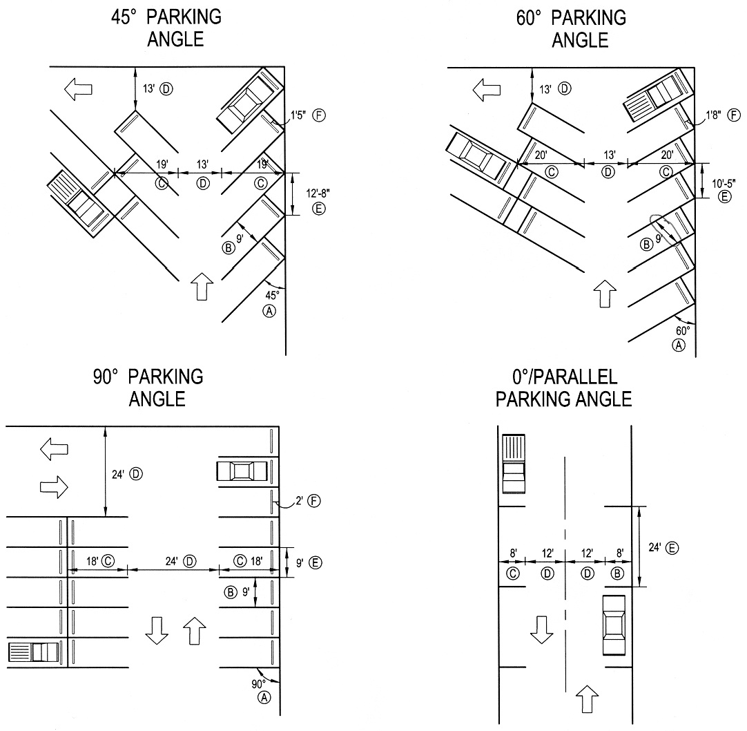
______________________________________
H.
Bicycle parking spaces. Commercial, industrial, civic, employment, multi-family and recreational uses shall provide bicycle facilities to meet the following standards:
1.
A minimum number of bicycle parking spaces shall be provided, equal in number to two percent (2%) of the total number of automobile parking spaces provided by the development, but not less than one (1) space.
2.
For convenience and security, bicycle parking facilities shall be located near building entrances. Within downtown commercial areas, however, a grouping of spaces shall be provided as directed by the city.
3.
Bicycle parking facilities shall be designed to allow the bicycle frame and one (1) wheel to be securely locked to a structure which is permanently attached to the pavement.
4.
Bicycle parking facilities shall be located so as not to interfere with pedestrian traffic or access to buildings.
(Ord. 962 §§1, 2, 2007)
16.02.070 - Sidewalks and trails.
A.
Intent. The intent of the standards for sidewalks and trails is to assure a safe, convenient and attractive pedestrian/bicycle system that minimizes conflicts between vehicles, bicycles and pedestrians.
B.
General provisions.
1.
Interconnected network. A sidewalk network that interconnects all dwelling units with other dwelling units, nonresidential uses and common open space shall be provided throughout each development. Sidewalks shall be separate and distinct from motor vehicle circulation routes to the greatest extent possible. The pedestrian circulation system shall include gathering/sitting areas and provide benches, landscaping and other street furniture where appropriate.
2.
Sidewalks required. In all zone districts except the A and RR districts, sidewalks are required along both sides of a street. Within the RR district, sidewalks are required along one (1) side of the street unless the development is served by rural streets.
3.
Sidewalk width. Sidewalks shall be a minimum of four (4) feet wide when adjacent to local streets. A four-foot-wide detached sidewalk is the preferred sidewalk alternative within local street rights-of-way. Sidewalks adjacent to storefronts in commercial areas shall be ten (10) to fifteen (15) feet in width, or consistent with the average sidewalk width on a block if building in an area with existing sidewalks. Sidewalk width in industrial and mixed-use areas may be wider than four (4) feet, depending upon location and existing conditions.
4.
Sidewalk location. Sidewalks shall be located within the right-of-way unless otherwise authorized by the city council.
5.
Sidewalk materials. Sidewalks shall be constructed of concrete and of sufficient strength to support light maintenance vehicles. If used as a secondary emergency access, sidewalks must also be able to support a fire truck (sixty thousand [60,000] pounds).
6.
Sidewalk installation. Sidewalks and related improvements shall be installed or constructed by the subdivider in accordance with plans and specifications approved by the city and, after installation or construction, they shall be subject to inspection and approval by the city.
7.
Accessibility. Sidewalks and plazas shall be accessible to disabled individuals as required by this code and the Americans with Disabilities Act.
8.
Walkways. Walkways through a subdivision block shall be not less than eight (8) feet in width, shall be within a dedicated right-of-way not less than twenty (20) feet in width and shall be flanked with appropriate landscaping. Walkways along buildings and within parking lots shall be raised and curbed where suitable. A direct pedestrian connection to building entries, public space and parking areas shall be provided from public sidewalks. Walkways shall be constructed of the same materials as sidewalks, except that walkways internal to asphalt surfaced parking lots may be of asphalt construction. Walkways crossing driveways in parking lots shall be clearly delineated by a change in pavement color, texture or paint striping.
9.
Lighting. All sidewalks and other pedestrian walkways shall work with Yampa Valley Electric Association to install appropriate lighting using poles and fixtures consistent with the overall design theme for the development.
10.
Trails. Trails shall be provided within open space areas and be designed to connect to other open space areas. Trails shall be a minimum of eight (8) feet in width. A trail may be flanked on one (1) side by a soft-surface path a minimum of four (4) feet in width. The soft-surface path shall be constructed with a minimum depth of eight (8) inches of com-pressed gravel and crowned and compacted with edging to contain the trail material.
(Ord. 962 §§1, 2, 2007)
16.02.080 - Easement and utility standards.
A.
Utility easement width. Utility easements shall measure five (5) feet on each side of abutting rear lot lines. On subdivision perimeter rear lot lines adjacent to unsubdivided property, utility easements shall measure ten (10) feet in width. In the event that the location of utility easements adjacent to rear property lines is unsuitable for use by utility companies due to drainage, irrigation ditches or other obstructions, the subdivider shall provide like width easements adjacent to said areas of obstruction. Side lot line easements, where necessary, shall measure ten (10) feet in full width; five (5) feet either side of a lot line is acceptable. Front lot line easements shall measure ten (10) feet in width. Easements may be more or less than widths stated if the specific utility indicates in writing a width other than those required by this code. Utility easements shall be subject to the approval of the city.
B.
Multiple installations within easements. Easements shall be designed so as to provide efficient installation of utilities. Public utility installations shall be located as to permit multiple installations within the easements. The developer will establish final utility grades prior to utility installations.
C.
Underground utilities. Telephone lines, electric lines, cable television lines and other like utility services shall be placed underground. The subdivider shall be responsible for complying with the requirements of this section and shall make the necessary arrangements, including any construction or installation charges with each utility provider for the installation of such underground facilities. Transformers, switching boxes, meter cabinets, pedestals, ducts and other facilities necessarily appurtenant to such underground utilities shall be placed underground or on the surface but not on utility poles. Screening or fencing is required to the satisfaction of the city council. Electric transmission and distribution feeder lines and necessary appurtenances thereto may not be placed above ground unless they are carrying greater than fifteen (15) kV. Upon approval of the city, such facilities shall be placed within easements or rights-of-way provided for particular facilities.
D.
Easements of not less than ten (10) feet in width shall be provided for utilities on each side of all rear lot lines where alleys are not provided, and along each side of certain side lot lines.
E.
Street lighting. Street lighting is required on all city streets. Streetlights will be required at all intersections, at ends of culs-de-sac and at three-hundred-foot spacing along streets. All street lighting will meet Yampa Valley Electric Association standards for installation and equipment. Street lighting on city streets will be operated and maintained by Yampa Valley Electric Association. Associated underground lighting supply circuits shall be installed.
(Ord. 962 §§1, 2, 2007)
16.02.090 - Architectural standards.
A.
Intent. The city establishes the following minimum architectural standards in order to support and develop commercial, retail and industrial districts that enhance the appearance of the city.
B.
General provisions.
1.
Blank walls and wall articulation.
a.
Blank, windowless walls are discouraged, and walls shall not have an uninterrupted length exceeding fifty (50) feet. Pilasters, texture transitions, windows and stepping of the wall plane are required.
b.
Blank wall or service area treatment of side and/or rear elevations visible to the general public is not allowed unless the city determines that there are adequate building or landscape features to conceal the view of the blank wall.
c.
Continuous cornice lines or eaves are encouraged between adjacent buildings.
d.
Buildings with flat roofs shall provide a parapet with an articulated cornice.
2.
Facade treatment. The architectural treatment of the front facade shall be continued, in its major features, around all visibly exposed sides of a building.
3.
Windows. Windows shall be vertically proportioned wherever possible.
4.
Awnings. Fixed or retractable awnings are permitted. Canvas is the preferred material, although other waterproofed fabrics may be used; metal or aluminum awnings shall not be used unless otherwise approved by the city council.
5.
Screening. All air-conditioning units, HVAC systems, exhaust pipes or stacks, elevator housing and satellite dishes, other telecommunications receiving devices and any other apparatus placed on the roof of a building shall be thoroughly screened from view from the public right-of-way and from adjacent properties by using walls, fencing, roof elements and landscaping. In addition, all trash facilities and loading and parking areas shall be screened from public view by landscaping, building elements or approved fencing.
6.
Roof materials. If galvanized, metal roofs shall be colored.
C.
CD - Commercial Downtown District architectural standards.
1.
Setbacks. Buildings shall abut the front property line. Building facades may be recessed if an arcade or similar structure abuts the front setback. Architectural projections, including cornices, balconies, canopies and entry features, may encroach into public rights-of-way, subject to permits as required by the city code.
2.
Multi-story, mixed-use structures. Commercial uses shall be contained in multi-story mixed-use structures with commercial/ retail uses on the ground level and above and/or apartment dwellings or offices on the upper levels.
3.
Pedestrian scale. The establishment of buildings on isolated "pad sites" surrounded by parking lots and driveways, and that offer mainly auto-oriented signage to define entrances, is not allowed.
4.
Entries. Transparent entries and large storefront windows are strongly encouraged. Recessed and other styles of window openings are desired.
5.
Windows. Street-level storefront windows are strongly encouraged.
6.
Awnings and canopies. Awnings or canopies, which provide a generally consistent cover along the pedestrian walk, are encouraged. Translucent awnings made of plastic, Teflon or similar materials are not permitted in the CD Zone District.
7.
Historic buildings. Where feasible, historic structures shall be preserved and restored to allow for reuse as businesses. Restoration of any structure, if on the National Register of Historic Places, shall comply with the Secretary of Interior Standards for Restoration.
D.
C-2 - Community Commercial District architectural standards.
1.
Design of developments with internal orientation. In multiple-building developments, where setbacks are increased to accommodate independent development with internal orientation, all primary building entrances should face walkways, plazas or courtyards that have direct, continuous linkage to the street without making people walk through parking lots. However, it may be necessary for such direct pedestrian access ways to cross drive aisles. Driveway crossings must place priority on the pedestrian access.
2.
Requirement for four-sided design. A building's special architectural features and treatments shall not be restricted to a single facade. All sides of a building open to view by the public, whether viewed from public or private property, shall display a similar level of quality and architectural interest.
3.
Building form. The design of all buildings shall employ textured surfaces, projections, recesses, shadow lines, color, window patterns, overhangs, reveals, changes in parapet heights and similar architectural features to avoid monolithic shapes and surfaces and to emphasize building entries. Buildings shall not contain unbroken, flat walls of fifty (50) feet or greater in length. Buildings having single walls exceeding fifty (50) feet in length shall incorporate one (1) or more of the following for every fifty (50) feet:
a.
Changes in color, graphic patterning, changes in texture or changes in material.
b.
Pilasters.
c.
Projections, recesses and reveals.
d.
Windows and fenestration.
e.
Arcades and pergolas.
f.
Towers.
g.
Gable projections.
h.
Horizontal/vertical breaks.
i.
Other similar techniques.
4.
Exterior building materials and colors. Intense, bright or fluorescent colors shall not be used as the predominant color on any wall or roof of any primary or accessory structure. These colors, however, may be used as building accent colors.
E.
I-L - Light Industrial and I-H - Heavy Industrial District architectural standards.
1.
Intent. These districts provide the opportunity to develop quality light industrial, business park, service and commercial projects. The following standards shall apply:
a.
The C-2 - Community Commercial District architectural standards shall apply.
b.
Building massing and form:
1)
Office and entry spaces shall be distinguished from the building mass.
2)
Large, square, "box-like" structures are prohibited. Architectural elements with smaller forms stepping outward and downward are permissible.
3)
Loading areas shall not front any street or public right-of way.
4)
Parking requirements shall be provided to the extent possible at the rear or sides of the building.
c.
Wall articulation. Walls shall not have an uninterrupted length exceeding fifty (50) feet. Pilasters, texture transitions, windows and stepping of the wall plane are required.
d.
Siting structures.
1)
Structures shall be sited to avoid a "wall" effect along public rights-of-way and along adjacent property lines. This can be achieved by varying the building setbacks and clustering buildings.
2)
Where multiple buildings are proposed on a development parcel, buildings shall be oriented to allow views into the project and shall preserve high-quality views through the project (e.g., views of the mountains).
(Ord. 962 §§1, 2, 2007)
16.02.100 - Parks and open space.
A.
Intent. It is the intent of this section to ensure that an integrated network of parks and open space is developed and preserved as the city grows.
B.
Types of parks and open space.
1.
Plazas. A plaza is typically located in a commercial or industrial area to serve as a gathering place. A plaza is usually bordered by buildings and may feature seating, formal landscape plantings and amenities such as fountains or public art. Developers are responsible for developing and providing the appropriate amenities for each plaza.
2.
Neighborhood parks. Every residential development shall provide land (or cash in lieu of land) for a neighborhood park and develop such park that will serve the neighborhood in accordance with the requirements set forth in this chapter. Land dedicated for park purposes may be credited toward the open space land dedication required at the time of subdivision. A homeowners' association, the landowner or the city, at its discretion, shall be responsible for the maintenance of the park. A neighborhood park shall be at least five (5) acres and include active play areas and sprinklered landscaping
3.
Community park. Community parks serve the residents of several neighborhoods. Community parks are to be located on or near arterial streets, at the edge of residential areas or in nonresidential areas. The developer shall dedicate land (or make a cash-in-lieu contribution) for land and improvements in accordance with the requirements of this chapter. A community park shall be at least twenty (20) acres and include an active play area, ball fields and sprinklered landscaping in the majority of the park.
4.
Trails. The trail system shall link neighborhoods, parks, schools, open spaces, employment centers, community facilities and neighboring communities and will provide important transportation connections, as well as recreational opportunities. Developers must provide trail connections to both the city's trail system and destinations within the neighborhood.
5.
Regional open space. The city's regional open space system includes: drainage ways, floodplains, natural areas, natural area buffer zones, wetlands, subsidence areas, agriculture preservation areas and lands of archeological or historic significance. Public access to these areas will generally be limited to trails and similar improvements.
6.
Storm drainage facilities. Storm drainage facilities, including stormwater detention and stormwater retention ponds, may function as open space for active recreation, trail corridors or habitat enhancement areas if they are designed appropriately. Credit toward the open space dedication requirements will be considered on a case-by-case basis by the city council at the time of platting.
C.
General provisions.
1.
Open space should serve as the neighborhood focus. Open space, such as drainage ways and developed parks and plazas, shall be used to organize lot, block and street patterns and to enhance surrounding developments.
2.
Public access. Areas designated as public open space shall be both visibly and physically accessible to the community. Adequate public access shall be provided to all public open space, natural and developed, directly from the public street and trail system. Pocket parks and plazas shall be integrated into the neighborhood design and be accessible to pedestrians and bicyclists.
3.
Ownership and maintenance of open space. Ownership and maintenance of public open space shall be determined by the city on a case-by-case basis through the review process.
a.
Generally, the city shall own and maintain neighborhood parks, community parks and public trails.
b.
Landscaped outlots and private recreational facilities shall be owned and maintained by a homeowners' association or the landowner.
c.
Environmentally sensitive, archaeological and historic resources may be dedicated to and maintained by the city, if approved by the city council.
d.
Stormwater detention and retention areas that function as open space shall be owned and maintained by a homeowners' association or the landowner unless otherwise approved by the city.
e.
Areas designated as open space shall be maintained according to the designated function of the area. Applicants shall develop a management plan which addresses: irrigation, revegetation, erosion control and weed management. If the area is to remain in private ownership, a mechanism which will assure maintenance will be funded in perpetuity must be in place at the time of final plat.
4.
Open space protection. Areas designated as open space shall be protected by conveyance to the city, as provided on the plat and by this chapter, deed restriction or other appropriate method to ensure that they remain open in perpetuity and cannot be subdivided or developed in the future without approval of the city.
D.
Open space requirements.
1.
Functional open space includes:
a.
Areas within the community designated for the common use of the residents of an individual development and/or the community at large.
b.
Areas designated for preservation and protection of environmental resources, including floodplains, natural drainage ways and wetland areas.
c.
Areas designated for agricultural preservation.
d.
Areas of archeological and historic significance.
e.
Areas of critical or important habitat as defined by the Colorado Division of Wildlife.
2.
Required open space shall not include the following:
a.
Required setback areas around oil and gas production facilities.
b.
Disconnected remnants of land created by division of sites into lots or parcels that do not qualify as functional open space or that preserve environmental resources, unless approved by the city council.
c.
Private yards.
d.
Stormwater conveyance and detention facilities unless approved by the city.
e.
Required parking lot landscaping associated with all uses, except parking specifically designated for access to open space areas and within commercial/ industrial projects.
3.
Amount of open space required. In addition to streets, the overall open space dedication for all residential subdivisions is six percent (6%) of the gross land area. Developers shall dedicate to the city a minimum of six percent (6%) of the gross land area for open space that includes public parks, trails, natural open lands or other civic purposes at the time of subdivision.
a.
Residential developments. For residential developments, the developer shall provide:
1)
The land for one (1) neighborhood park for every two hundred (200) dwelling units or portion thereof, which shall be constructed in the subdivision within a one-quarter-mile radius of the proposed homes; or a fair-share, cash-in-lieu contribution for the cost of the neighborhood park that will serve the development; and
2)
The land for one (1) community park for every four hundred (400) dwelling units or portion thereof, which shall be constructed in the subdivision, or a fair-share, cash-in-lieu contribution for the cost of the community park that will serve the development.
b.
Commercial and industrial developments. In addition to streets, the developer shall provide a minimum of six percent (6%) of the gross land being subdivided or cash-in-lieu of land as functional open space, which may include: plazas, trails, landscaped areas (including parking lot landscaping), natural areas and other civic purposes.
c.
Planned Unit Development Overlay District (PUD). In addition to streets, the developer shall provide a minimum of thirty percent (30%) of the gross land area being developed as open space, which may include parks, trails, homeowners' association- or landowner-owned landscaped areas (excluding parking lots), natural areas and amenities for residents and other civic purposes.
(Ord. 962 §§1, 2, 2007)
16.02.110 - Public sites and dedication requirements.
The developer of residential projects shall dedicate public sites for open space, parks, schools or other civic purposes in accordance with the requirements of this section, to serve the proposed subdivision and future residents thereof.
1.
Land dedication. Payments and dedications made under the requirements of this section shall be made payable or dedicated to the city. Dedication of such sites and land areas to the city shall be free and clear of all liens and encumbrances. The applicant shall provide for the installation of the streets adjacent to the park and school sites, the installation of water, sewer and other public utilities to the park and school sites and overlot grading of the park and school sites.
2.
Fee in lieu of dedication. If there is not sufficient property on the plat to provide land for the entire school or park facility required, with the approval of the city council, the subdivider may, in lieu of dedication of all or part of the land requirements, pay fees in lieu of the equivalent land areas which would have been dedicated to public facilities. Fees are to be calculated in the following manner:
a.
Fees shall be calculated based on the full market value of the land assuming the plat has been approved and proper zoning exists.
b.
Full market value shall be determined by mutual agreement between the subdivider and the city council. In the event of inability of any of the above parties to agree on the value of the subject land, the subdivider shall submit to the city a written appraisal from a qualified appraiser meeting the value requirements set forth herein. Said appraisal shall be made by an individual or entity that does not have a financial interest in the subdivision and is a member of the Appraisal Institute (MAI), a member of the Society of Real Estate Appraisers (SRA), or such other qualified person mutually agreeable to the manager and the applicant. The applicant shall pay the cost of said appraisal.
c.
Such appraisal may be submitted during the review period of the final plat. If the city council believes that the appraised value is not accurate, it may obtain its own appraisal from a qualified appraiser, or determine the fair market value by such procedure as the city council deems appropriate.
d.
All fees in lieu of dedications are to be paid prior to the approval of the final plat unless otherwise agreed by the city council.
e.
For subdivisions that are platted in phases, the above calculations can be made on a phase-by-phase basis through methods to be devised by the city council, realizing that by virtue of developing one (1) phase, the value of the undeveloped adjacent phase will increase. The subdivider has the option of paying the fees for all phases upon the due date of fees for the first phase.
3.
Unacceptable land for dedication. Unless otherwise determined by the city council in its sole discretion, land areas that are not acceptable in determining the fulfillment of the requirements for the provision of land areas for public purpose facility sites shall include the following:
a.
Natural drainageways, streams, gullies and rivers, including all lands within the one-hundred-year floodplain.
b.
Rights-of-way and/or easements for irrigation ditches and aqueducts.
c.
Steep, rugged and hazardous geological land areas and such other areas as are not conducive for use as the intended park or school site.
(Ord. 962 §§1, 2, 2007)
16.02.120 - Landscape design.
Intent. The intent of this section is to preserve the city's character and integrate new development into the city by promoting quality landscape design.
1.
Site design. Landscape improvements shall be an integral part of the overall site design for each property. Landscape improvements shall be designed to complement and enhance the character of multi-family, commercial and industrial properties and shall follow these guidelines:
a.
Configured to maximize connections within the site to landscaped areas in adjacent developments. Small, isolated islands of landscaping should be avoided except as required in parking lots and for screening along roadways.
b.
Consistent with the character of the proposed development and the surrounding area to reinforce neighborhood identity.
c.
Enhance natural features, drainage ways and environmental resources.
d.
Designed for mature landscapes and shall provide appropriate visibility for cars and pedestrians.
e.
No more than thirty-six (36) inches high when located in a sight distance triangle.
2.
Environmental considerations.
a.
Landscapes shall use the following Xeriscape design principles to facilitate water conservation:
1)
Use of mulch to maintain soil moisture and reduce evaporation.
2)
Appropriate turf selection to minimize the use of bluegrass.
3)
Zoning of plant materials according to their microclimatic needs and water requirements.
4)
Improve soil with organic matter if needed.
5)
Efficient irrigation systems.
6)
Proper maintenance and irrigation schedules.
b.
All landscapes shall strive to maximize the use of native species. Where native material is not appropriate for the intended use or appearance, species that are regionally adapted and noninvasive may be used.
c.
Landscapes shall consist of a variety of species. No one (1) species may make up more than twenty-five percent (25%) of the total nongrass plant materials on the site.
d.
Where possible, trees shall be located to provide summer shade and limit winter shade on walks and streets.
e.
Weed control will be practiced on all areas disturbed by construction, and those areas shall be reseeded to prevent erosion. Native, noninvasive grasses shall be used for revegetation where practical. Weed control is the responsibility of the landowner on all reseeded areas and all preservation areas. Weed control shall be a continual responsibility of the owner during all phases of land clearing and construction. Every effort shall be made to prevent the spread of noxious weeds.
3.
Plant materials.
a.
The minimum planting sizes on all required landscaping shall be two-inch-caliper deciduous trees, one-and-one-half-inch caliper ornamental trees, six-foot-tall evergreen trees and five-gallon shrubs. Caliper sizes will be measured one (1) foot above the ground.
b.
Ground cover and vines shall be a minimum one-gallon size, except when a higher quality landscaping can be produced by utilizing smaller container sizes planted on closer centers.
c.
Wood chips and wood shavings have no minimum size, but shall have a minimum of three (3) inches in depth, installed over a geotextile fabric.
d.
When used as ground cover, rock or stone shall be one (1) to four (4) inches in size and to a minimum depth of three (3) inches installed over a geotextile fabric.
e.
Plants shall be healthy, well-branched, vigorous stock with a growth habit normal to the species and variety and free of diseases, insects and injuries. A variety of plant species should be installed to prevent the spread of disease.
f.
All plants shall conform to standards for measurements, grading, branching, quality and ball and burlapping as stated in the current edition of the American Standard for Nursery Stock, American Association of Nurserymen, Inc., (AAN-ASNS) and the Colorado Nursery Act of 1965 (CNA).
4.
Irrigation. All required landscaping shall be irrigated as required for plant establishment and maintenance. Irrigation shall be appropriate to the type and scope of the improvements.
a.
Required landscaping in urban developments shall be irrigated with a permanent irrigation system.
b.
Landscaped areas in commercial parking lots are limited to drip irrigation for trees and shrubs, with no impact or spray heads permitted. For grass areas, only drought-tolerant grasses shall be permitted.
c.
Irrigation systems shall be drip irrigation where possible. All irrigation systems shall be designed to minimize overspray and runoff onto paved or other nonlandscaped areas.
d.
Temporary irrigation may be used to establish native grasses and vegetation.
5.
Guarantee of installation. Required landscape improvements shall be installed prior to issuance of a certificate of occupancy (C.O.) for all structures. If weather conditions prevent installation, the developer shall post a financial guarantee for the improvements. This guarantee shall be released upon completion of the installation of the landscaping.
6.
Maintenance.
a.
All plantings shall be maintained in a healthy and attractive manner by the property owner of record, the property owner's agent or tenant or a homeowners' association which has assumed landscaping maintenance responsibility. Maintenance shall include, but not be limited to: watering, fertilizing, weeding, cleaning, pruning, trimming, spraying and cultivating.
b.
Dead plant materials shall be removed and replaced within one (1) month of their death with planting materials that meet the original intent of the approved landscaping design.
c.
Natural landscaping materials, such as rock, stone, bark chips and shavings which no longer cover the area in which they were originally deposited, shall be replenished so that they again achieve full coverage to a minimum depth of three (3) inches.
d.
Landscaping structural features, such as fencing, planter boxes, etc., shall be maintained in a sound structural and attractive condition.
7.
Landscaping standards.
a.
Landscape improvements within the RHD, MU, CD, C-2, LI and HI zone districts shall be designed to enhance the overall appearance of the development and to integrate the project with adjacent land uses and into the surrounding neighborhood. For each district, the following minimum percentage of the gross lot size shall be landscaped per these standards:
b.
The developer or assigns shall provide:
1)
Site trees - plant a minimum of two (2) trees per one thousand (1,000) square feet of landscaped area or fraction thereof, distributed on the site.
2)
Shrubs - plant a minimum of three (3) shrubs per one thousand (1,000) square feet of landscaped area or fraction thereof. Group shrubs and distribute throughout the site. Trees may be substituted for up to one-half (½) of the required shrubs at the rate of one (1) tree for six (6) shrubs.
3)
Ground cover - establish irrigated grass turf maintained to appropriate standards for active recreation in areas that will function for active recreation. Where appropriate, use native grass for areas that will not function as active recreation areas. Native grass must be weed-free and maintained at a maximum height of twelve (12) inches. There shall be a minimum of seventy-five percent (75%) live materials between the building and the street unless otherwise approved by the city. For active recreation areas, a turf-type tall fescue or a brome/fescue mix will be used.
4)
For all lots, a minimum of twenty-five percent (25%) of the linear frontage of the developed site abutting public rights-of-way shall be landscaped to a depth of fifteen (15) feet. Such frontage landscape areas shall be utilized in calculating the minimum area requirements.
5)
Screen loading areas - loading areas (including vehicles being loaded) and service and storage areas visible from the public right-of-way or adjacent property must be screened from view with an opaque screen that is an integral part of the building architecture, or by landscaping. Chain-link fencing with slats, tires or used building materials are not acceptable screening materials.
c.
The building owner or occupant shall maintain the yard and landscaping within the adjacent road right-of-way in accordance with city regulations.
8.
Parking lot landscaping standards. Parking lot landscaping is intended break up large expanses of pavement, create shade, buffer views of parking lots from adjacent streets and development and enhance the overall appearance of each project. All parking lots with forty (40) spaces or more shall be subject to these requirements. The developer or assigns shall provide:
a.
Site trees - a minimum of one (1) tree per five (5) parking spaces. Group trees together in islands which are a minimum of ten (10) feet wide. Use the landscaping to break up large expanses of pavement and to create a tree canopy for summer shade.
b.
Shrubs - a minimum of one (1) shrub per one hundred fifty (150) square feet of landscaped area. Group plantings in landscape islands.
c.
Ground cover - limit areas of irrigated turf. Grass is discouraged in areas less than ten (10) feet wide. Install a grass buffer (native grass where possible) around the perimeter to filter runoff and improve water quality.
d.
Landscape setback to parking lots - not less than five (5) feet from streets or any property line. The purpose of the setback is to provide a buffer between the adjacent street and parking or loading areas and to screen the parking from the street.
e.
When the provision of off-street parking for forty (40) or more vehicles is required, there shall be landscaped areas within the perimeter of the parking area in the minimum amount of twelve (12) square feet for each parking space. The required landscaped areas need not be contiguous, but there shall be at least one (1) tree in each separate area.
f.
Provide a plan for long-term maintenance of landscaping - all landscaping within and adjacent to parking lots shall be owned and maintained by the landowner or occupant.
B.
Submittal standards for landscape plans. All land development applications will be accompanied by the appropriate landscape plan:
1.
Preliminary landscape plan (submit with preliminary plat). Intent: to illustrate the master landscape plan for the development.
a.
Describe the design intention and how the proposal is consistent with the purpose and intent of these regulations.
b.
Landscaping should be included on the preliminary open space and ecological characterization plan if it can be clearly illustrated and the scale is not greater than 1" = 100'.
c.
Information required on the plan is listed in the table below.
2.
Final landscape plan (submit with final plat). Intent: to ensure that each phase of the final landscape plan is consistent with the master landscape plan for the development and to illustrate the specific landscaping details for each phase.
a.
Describe the design intention and how the proposal is consistent with the preliminary landscape plan.
b.
The final landscape plan must be on a separate page from the final plat map and should be included with the final open space plan. The scale shall not be greater than 1" = 50'.
c.
Information required on the plan is listed in the table below:
______________________________________
C.
Prohibited plant materials list. The following trees are prohibited in the city: Russian olive, Lombardy poplar, Siberian elm, Boxelder maple, cotton-bearing cottonwood, salt cedar or tamarisk.
(Ord. 969 §2, 2007; Ord. 962 §§1, 2, 2007)
16.02.130 - Buffering and screening.
A.
Intent. The intent of this section is to integrate adjacent land uses and provide seamless transitions from one (1) use to another through the use of building orientation and access, landscaping, appropriate architectural elements and nonbuildable buffer areas.
B.
Location and screening of required loading and service areas.
1.
Loading docks, solid waste facilities, recycling facilities and other service areas shall be placed to the rear or side of buildings in visually unobtrusive locations.
2.
Screening, buffering and landscaping shall be incorporated to prevent direct views of the loading areas and their driveways from adjacent properties or from the public right-of-way. Screening and landscaping shall also prevent spill-over glare and noise. Screening and buffering shall be achieved through walls, architectural features and landscaping. Recesses in the building or depressed access ramps may be used.
C.
Dumpsters.
1.
Every development that is required to provide one (1) or more Dumpsters for solid waste collection shall provide sites for such Dumpsters that are:
a.
Located to facilitate collection and minimize any negative impact on persons occupying the development site, neighboring properties or public rights-of-way; and
b.
Constructed to allow for collection without damage to the development site or the collection vehicle and constructed of a reinforced concrete block wall with a concrete pad.
Such developments shall provide an area for recycling as well as disposal of solid waste.
2.
All such Dumpsters shall be screened to prevent them from being visible to:
a.
Persons located within any dwelling unit on residential property other than that where the Dumpster is located;
b.
Occupants, customers or other invitees located within any building on nonresidential property other than that where the Dumpster is located; and
c.
Persons traveling on any public street, sidewalk or other public way.
(Ord. 962 §§1, 2, 2007)
16.02.140 - Fences, hedges and walls.
A.
Intent. The intent of this section is to ensure that walls, hedges and fences are attractive and in character with the neighborhood. The creation of fence "canyons" along streets, parks or other public areas is prohibited.
B.
General provisions.
1.
Compatibility. Walls and fences shall be architecturally compatible with the style, materials and colors of the principal buildings on the same lot. If used along collector or arterial streets, such features shall be made visually interesting by integrating architectural elements, such as brick or stone columns, varying the alignment or setback of the fence, softening the appearance of fence lines with plantings or through similar techniques.
2.
Prohibited materials (except in Agriculture or Open Space Districts). Contemporary security fencing, such as concertina or razor wire, barbed wire or electrically charged fences is prohibited unless specifically allowed by the city council. Chain-link fencing with or without slats shall not be used as a fencing material for screening purposes, except as permitted in Industrial zone districts.
3.
Retaining walls. Retaining walls shall be designed to resist loads due to the lateral pressure of retained material in accordance with accepted engineering practice and shall not be unsightly or detrimental to abutting property.
4.
Residential and Mixed Use District fence standards. Fences, hedges or walls shall follow the provisions below:
a.
Fences, hedges and walls not greater that six (6) feet in height shall be permitted on or within all rear and side property lines and on or to the rear of all front yard setback lines.
b.
Fences, hedges and walls not greater than three (3) feet in height shall be permitted on or within all front and side property lines in any required front yard setback. Such fences may be increased to four (4) feet maximum height if the fencing material is at a ratio of 2:3 open space per square foot for that part of the fence extending above three (3) feet in height.
c.
No person shall erect a fence without first obtaining a permit from the building department. The property owner shall provide the building department with a survey by a state-licensed land surveyor to determine lot line locations. If a survey is not provided, an agreement must be submitted with the signatures of all abutting property owners that includes the exact location of the proposed fence.
d.
Fences and hedges on corner lots (no more than six [6] feet in height) are permitted in a front yard setback up to the property line under the following conditions:
1)
The front yard to be fenced is that yard readily recognizable as it orients toward the street;
2)
No fence or related landscape element obstructs vision between the heights of three (3) feet and ten (10) feet above street level within a triangular area formed by connecting two (2) points, each fifty (50) feet away from the intersection of the curb lines (visibility triangle); and
3)
In no case shall a fence, wall or hedge greater than six (6) feet in height encroach upon the predominant setback except as stated above.
5.
Business and Industrial District fence standards.
a.
Fences, hedges and walls shall be permitted on or within all rear, side and front property lines, provided that a clear field of view is not obstructed for vehicles traveling on public roads or entering from private access roads.
b.
In the Industrial (LI and HI) zone districts, a chain-link fence may be permitted so long as it is not higher than eight (8) feet anywhere on the premises and the visibility at the intersection and from public ways meet the requirements of this chapter.
6.
Maintenance. Dilapidated, unsightly or dangerous fences shall be removed or repaired when so ordered by the city. Hedges shall be maintained in a healthy condition, trimmed and pruned as appropriate for the plant type. Dead plant material in hedges shall be removed or replaced as appropriate when so ordered by the city. Hedges shall not encroach upon sidewalks or street rights-of-way.
(Ord. 962 §§1, 2, 2007)
16.02.150 - Lighting.
A.
Intent: Street lighting is required on all city streets. Streetlights will be required at all intersections, at ends of culs-de-sac and at three-hundred-foot spacing along streets. All street lighting will meet Yampa Valley Electric Association standards for installation and equipment. Street lighting on city streets will be operated and maintained by the Yampa Valley Electric Association.
1.
To create an attractive lighting system to enhance visibility and safety, while minimizing glare and contrast.
2.
To encourage exterior lighting that is functional, aesthetically pleasing and complimentary to the architectural style of buildings.
B.
General provisions.
1.
Evaluation of exterior lighting. Exterior lighting shall be evaluated in the development review process to ensure that the functional and security needs of the project are met in a way that does not adversely affect the adjacent properties or neighborhood. The degree to which exterior night lighting affects a property owner or neighborhood will be examined, considering the light source, level of illumination, hours of illumination and need for illumination in relation to the effects of the lighting on the adjacent property owners and the neighborhood.
2.
Light style. The style of lights shall be consistent with the style and character of architecture proposed on the site. Light fixtures that illuminate signage shall be compatible with the architecture of the building on which they are placed.
3.
Concealed light source. Light sources shall be concealed or shielded to the maximum extent feasible to minimize the potential for glare and unnecessary diffusion on adjacent property and away from the vision of passing motorists. All lights shall be directed downward, and the light source shall be equipped with "cut-off" devices so that it will not be visible from any adjacent property and to ensure that ambient skyward light is eliminated. Accent and flagpole lighting shall be permitted to be directed upward as long as the light source is shielded and not visible from any adjacent property. Light fixtures installed under canopies, awnings, overhangs and the like shall be fully recessed.
4.
Hours of lighting operation. All parking lot lighting fixtures and exterior building lights, except those required for security purposes, shall be extinguished within one (1) hour after the end of business hours and remain extinguished until one (1) hour prior to the beginning of business hours. If a portion of a parking lot is used after dark, only that portion shall be lighted.
5.
Light standards. All light fixtures shall be mounted on concrete, fiberglass or painted metal poles per electric service provider.
6.
Excessive illumination. Lighting within any lot that unnecessarily illuminates any other lot and substantially interferes with the use or enjoyment of such other lot is prohibited. Lighting unnecessarily illuminates another lot if it clearly exceeds the standards set forth in this section, if the light shines directly into a residence or if the standards set forth in this section could reasonably be achieved in a manner that would not substantially interfere with the use or enjoyment of neighboring properties.
7.
Exemption for outdoor recreational uses. Because of their limited hours of operation and their unique requirements for nighttime visibility, ball diamonds, playing fields, tennis courts and other similar outdoor recreational uses (both public and private, unless otherwise restricted by the city council) shall be exempt from the general provisions of this section. However, exterior lighting for such uses shall be extinguished no later than 12:00 a.m. (midnight).
The city manager shall have the authority to grant an exemption from these requirements for special events.
(Ord. 962 §§1, 2, 2007)
16.02.160 - Sanitary sewer.
A.
Intent. All residential, commercial and industrial uses which have human occupancy shall have sanitary sewer. The sanitary sewer system shall be connected to an existing public sanitary sewer system and shall consist of a closed system of sanitary sewer mains and lateral branch connections to each structure or lot upon which a structure is to be built. Sanitary sewer lines are to be of sufficient size and designed to collect all sewage from all proposed or portable structures within the subdivision or development. Wastewater collection systems will be designed to flow as projected in the city Master Plan.
B.
Wastewater pump stations are not allowed unless all other alternatives have been exhausted, and sewer service will not be allowed unless the collection system abuts the property to be served.
C.
Sewer lines smaller than a fifteen-inch diameter shall be designed for a maximum flow depth of one-half (½) of the diameter, or half-full flow, during periods of peak flow. Sewer lines fifteen (15) inches in diameter or larger shall be designed for a maximum flow depth of eight-tenths (0.8) diameter or eighty percent (80%) full flow during periods of peak flow.
D.
Sewer lines shall have a sufficient slope to maintain a minimum flow velocity of two (2) feet per second. These minimum slopes are outlined on the attached chart. The maximum velocity of the sewer flow will not exceed fifteen (15) feet per second.
________________________________________________________
Table 16.1
General assumptions used in evaluating the sanitary sewer system capacity
Manning's Roughness Factor (n) assumed to be 0.013
Minimum slopes are based on a mean velocity, when flowing full, of not less than 2.0 ft/s according to the "Recommended Standards for Sewage Works," 1978
(Ord. 962 §§1, 2, 2007)
16.02.170 - Stormwater drainage.
Intent. Streets and alleys will be designed to carry stormwater run-off away from houses and property. When the capacity of the street is reached, the developer will be required to install storm drains to keep the stormwater flow within the right-of-way and prevent damage to adjacent property. The stormwater system will be designed using generally accepted methods (Denver Urban Drainage and Flood Control Criteria Manual) with modifications for local storm conditions. The retention of stormwater in temporary ponding areas to hold back the storm peak flow is an acceptable method of addressing increased flows due to development. Again, stormwater retention must be designed using generally accepted methods. All new developments will provide storm routing for a one-hundred-year event and provide adequate storm drains or retention areas to contain within the street or drainage right-of-way the stormwater runoff from all precipitation events of a ten-year interval.
1.
General provisions.
a.
Landscaping associated with storm drainage facilities shall be integrated into the overall design of the project.
b.
It shall enhance the overall appearance of the project, prevent erosion and improve water quality of stormwater runoff whenever possible.
c.
Storm drainage facilities may function as open space for active recreation, trail corridors or habitat enhancement areas if they are designed appropriately and approved by the city council.
d.
The use of planting strips and shallow landscaped depressions (bioswales) in parking lots and along roads is encouraged to help trap and remove pollutants from stormwater runoff.
2.
Applicability. All storm drainage facilities shall be appropriately landscaped.
3.
Minimum requirements.
a.
All facilities shall be seeded to grass appropriate to the function of the area. Areas to be used for active recreation shall be seeded to a turf-type grass and irrigated with a permanent irrigation system. Areas to be maintained for habitat enhancement shall be seeded to native grasses and wildflowers. The developer is responsible for establishment of a complete, weed-free stand of grass. Trail corridors may be seeded to native grasses if appropriately integrated with adjacent improvements. Areas to be used for active recreation shall be seeded to a turf-type tall fescue or brome/fescue mix or other drought-tolerant grass acceptable to the city and irrigated with a permanent irrigation system.
b.
Maximum side slope on drainage facilities shall be 4:1; minimum slope of the bottom of a drainage facility shall be one-half percent (0.5%).
c.
Landscape improvements shall be designed to enhance the function of the facility. Areas designed for recreation shall include clusters of trees to provide shade, located so they do not impair the function of the facility.
d.
Habitat and water quality enhancement, including wetland plantings in low wet areas, is encouraged.
4.
Ownership and maintenance. All drainage facilities shall be owned and maintained by the landowner or occupant unless otherwise approved by the city.
(Ord. 962 §§1, 2, 2007)
16.02.180 - Potable water.
A.
All residential, commercial and industrial uses which have human occupancy shall have potable water served by the city or appropriate water district. The water system shall be of sufficient size and design to supply potable water to each structure or lot upon which a structure is to be built.
B.
The extensions of the city water system outside of the city limits will be approved by the city council. Water system extensions outside the city limits will meet the same criteria as required inside the city limits.
C.
Extension of the water system shall be designed to meet fire flow conditions. Water lines and water storage will be sized to meet all requirements of the adopted fire code. At a minimum, the water lines will be sized to provide one thousand (1,000) gallons per minute, with a residual pressure of twenty (20) pounds per square inch. Storage must be sized to provide fire flows of a duration specified in the fire code and to sustain flows during periods of peak usage. Oversizing of water lines and water storage may be required to meet the needs of the water system. Off-site improvements may be necessary to provide adequate flows.
D.
The minimum normal operating pressure for system extensions shall be thirty-five (35) pounds per square inch. The maximum normal operating pressure for system extensions shall be one hundred (100) pounds per square inch.
E.
Overall, the water system will be designed with a grid of twelve-inch mains on a one-mile spacing or less. The internal piping within this grid will be a minimum of eight (8) inches. Larger pipe sizes within the one-mile spacing may be required, depending upon fire flow requirements and elevation changes.
F.
All water piping, valves, hydrants and other materials will meet the city minimum specifications. All water lines shall be PVC Pipe C900 Class 200. Installation of the piping and water system materials shall be in conformance with city minimum specifications. Prior to acceptance of the water line into the system, the water line shall be disinfected and leak-tested as per AWWA requirements. Once accepted, the installer or developer shall provide a guarantee for the improvements for a one-year period.
G.
Water service will not be allowed unless a water main abuts the property to be served.
(Ord. 962 §§1, 2, 2007)
16.02.190 - Fire hydrants.
The subdivider shall install fire hydrants at street intersections and at other points as per the requirements of the Craig Fire Protection District and the city. Fire hydrants will be spaced at a maximum distance of six hundred (600) feet or less.
(Ord. 962 §§1, 2, 2007)