
Desoto County Unincorporated
City Zoning Code
City Zoning Code
ARTICLE VI
DEVELOPMENT DESIGN AND IMPROVEMENT STANDARDS
Sec. 20-442. - Purpose.
The purpose of this article is to provide development design and improvement standards applicable to all development activity within the County.
(LDR, § 7001; Ord. No. 2012-01, § 7001, 5-22-2012)
Sec. 20-443. - Responsibility for improvements.
All improvements required by this article shall be designed, installed, and paid for by the developer.
(LDR, § 7002; Ord. No. 2012-01, § 7002, 5-22-2012)
Sec. 20-444. - Principles of development design.
The provisions of this article are intended to ensure functional and attractive development. Development design shall first take into account the protection of natural resources as prescribed in Article V of this chapter. All development shall be designed to avoid unnecessary impervious surface cover; to provide adequate access to lots and sites; and to avoid adverse effects of shadow, glare, noise, odor, traffic, drainage, and utilities on surrounding properties.
(LDR, § 7003; Ord. No. 2012-01, § 7003, 5-22-2012)
Sec. 20-445. - Design exceptions to DeSoto County Engineering Standards.
(a)
Purpose.
(1)
In cases when the design criteria provided in the DeSoto County Engineering Standards are unable to be met due to site specific conditions or constraints, the County Engineer (or designee), may recommend a value or standard less than the stated minimum established by the Standards. This is referred to as a Design Exception and applies only to the specific project in which the exception is requested. Design Exception requests shall not be made solely on the basis of reducing costs, or construction time, and Design Exceptions shall only be granted when the Board finds that the public's health, safety, and welfare is maintained with approval of the exception.
(2)
Submittal. Design Exceptions can be requested when application of the adopted Engineering Standards cannot be reasonably achieved and shall be applied for with a Development Plan.
a.
All Design Exception requests must include the following documentation or information:
1.
Project Information: Project description, location map, project limits, design parameters, all existing constraints, temporary or permanent exception(s), any future work or plans programmed to address the constraint(s), future limitations, and other applicable information as determined by the Engineer of Record.
2.
Exception Details: A narrative explaining why the standards cannot be met and why the alternative design is appropriate, and shall include plans/exhibits/cross-sections showing where the specific deviation will occur and details for the Design Exception.
3.
Alternatives Considered: Provide design alternatives for the requested Design Exception meeting or partially complying with County standards, Florida Department of Transportation (FDOT) or the American Association of State Highway and Transportation Offices (AASHTO) criteria.
4.
Impact Analysis: Evaluate the impacts to safety, operations, right-of-way, community, environmental, and multimodal accommodation.
5.
Cost: The anticipated cost associated with the deviation including a cost-benefit ratio analysis.
6.
Mitigation Measures: List strategies incorporated into the design to mitigate any negative effects of the Design Exception requested.
(3)
The request will be reviewed by County staff. The decision to approve or deny Design Exceptions shall be at the discretion of the Board of County Commissioners. Generally, an exception may be approved if the County agrees with the Engineer of Record that the required criteria is impractical due to site specific constraints and the proposed design wisely balance all design impacts.
(Ord. No. 2025-007, § 3, 5-27-2025)
Sec. 20-472. - Setbacks.
(a)
Minimum distance between buildings.
(1)
The minimum distance between adjacent buildings shall be ten feet.
(2)
Distance shall be measured at the narrowest space between structures, whether a main living unit, principal structure, an allowable attachment, or an accessory use, and shall not include roof overhang (eave).
(b)
Minimum setbacks for buildings exceeding 25 feet in height. Except for nonresidential uses, when a building exceeds 25 feet in height, the minimum distance from an adjacent building or property line shall be increased by two feet for each story above two.
(c)
Exception to required front yard setbacks. In all zoning districts, corner lots of record which do not meet minimum area requirements shall be required to meet only one full depth front yard and all other front yards may be reduced by 50 percent.
(LDR, § 7101; Ord. No. 2012-01, § 7101, 5-22-2012)
Sec. 20-473. - Height limit exclusions.
Height limits imposed by zoning district regulations shall not apply to customary building appurtenances (spires, ventilators, chimneys, rooftop equipment and like) or to antennas, water tanks, silos, windmills and similar structures not intended for human occupancy, provided such heights shall not violate standards prescribed by the Federal Aviation Authority.
(LDR, § 7102; Ord. No. 2012-01, § 7102, 5-22-2012)
Sec. 20-500. - Purpose; compliance with construction standards.
(a)
Purpose. This division establishes minimum requirements applicable to the development of transportation systems, including public and private streets, and access control to and from public streets. These standards are intended to minimize the traffic impacts of development and to assure that all developments adequately and safely provide for the storage and movement of vehicles consistent with good engineering and development design practices.
(b)
Compliance with construction standards. The transportation system, work in the public rights-of-way and all required subdivision improvements shall be constructed in accordance with applicable provisions of the LDRs and the County Engineering Standard Details.
(LDR, § 7201; Ord. No. 2012-01, § 7201, 5-22-2012)
Sec. 20-501. - Street classification system established.
Streets in the County are classified and mapped according to function served in order to allow for regulation of access, road and right-of-way widths, circulation patterns, design speed, and construction standards.
(LDR, § 7202; Ord. No. 2012-01, § 7202, 5-22-2012)
Sec. 20-502. - Rights-of-way.
(a)
Right-of-way widths. Right-of-way requirements for road construction shall be as specified in Section 20-503 unless otherwise required by the County Comprehensive Plan. The right-of-way shall be measured from property line to property line.
(b)
Future rights-of-way. Future right-of-way requirements are identified in the Transportation Element of the County Comprehensive Plan.
(c)
Protection and use of rights-of-way.
(1)
No encroachment shall be permitted into existing rights-of-way, except for temporary use authorized by the County.
(2)
Use of the right-of-way for public or private utilities including, but not limited to, sanitary sewer, potable water, telephone wires, cable television wires, gas lines, or electricity transmission, shall be allowed subject to the placement specifications in Article XIII, Division 3, of this chapter, and other applicable County regulations.
(3)
Sidewalks and bicycle ways may be placed within the right-of-way.
(LDR, § 7203; Ord. No. 2012-01, § 7203, 5-22-2012)
Sec. 20-503. - Right-of-way standards.
Right-of-way standards shall be as follows:
(LDR, § 7204; Ord. No. 2012-01, § 7204, 5-22-2012)
Sec. 20-504. - Street design standards.
(a)
General design standards.
(1)
All streets in a new development shall be designed and constructed pursuant to the standards in Article XIII, Division 3, of this chapter.
(2)
The street system of the proposed development shall to the extent practicable, conform to the natural topography of the site, preserving existing hydrological and vegetative patterns, and minimizing erosion potential, runoff, and the need for site alteration. Particular effort should be directed toward securing the flattest possible grade near intersections.
(3)
Streets shall be laid out to avoid wetlands and environmentally sensitive areas.
(4)
Private streets may be allowed within developments that will remain under common ownership, provided they are designed and constructed pursuant to the standards in Article XIII, Divisions 3 and 4, of this chapter and the County Engineering Standard Details Manual.
(5)
The street layout in all new development may be coordinated with and interconnected to the street system of the surrounding area.
(6)
Streets in proposed subdivisions may be connected to rights-of-way in adjacent areas to allow for proper inter-neighborhood traffic flow. If adjacent lands are unplatted, stub-outs in the new development may be provided for future connection to the adjacent unplatted land.
(7)
Residential streets shall be arranged to discourage through traffic.
(8)
Streets shall intersect as nearly as possible at right angles and in no case shall be less than 60 degrees.
(9)
New intersections along one side on an existing street shall, where possible, coincide with existing intersections. Where an offset (jog) is necessary at an intersection, the distance between centerline of the intersecting streets shall be no less than 150 feet.
(10)
No two streets may intersect with any other street on the same side at a distance of less than 400 feet measured from centerline to centerline of the intersecting street. When the intersected street is an arterial, the distance between intersecting streets shall be no less than 1,000 feet.
(11)
Block corners shall have a right-of-way radius of not less than 25 feet. Edge of pavement radius at intersection shall not be less than 35 feet.
(b)
Paving widths. Paving widths for each street classification shall be as shown in the County Engineering Standard Details Manual.
(c)
Shoulders. Shoulders, where required, shall measure at least four feet in width and shall be required on each side of streets and shall be located within the right-of-way. Shoulders shall consist of stabilized turf or other material permitted by the County Engineering Standard Details Manual. Shoulders and/or drainage swales shall be designed and constructed as follows:
(1)
All residential streets shall provide two shoulders. Shoulders shall be grass surfaced except in circumstances where grass cannot be expected to survive.
(2)
If required by the Florida Department of Transportation (FDOT), shoulders and/or drainage swales shall be provided.
(3)
Collector streets where curbing is not required shall provide shoulders and/or drainage swales.
(4)
Arterial streets where curbing is not required shall provide shoulders and/or drainage swales.
(5)
Grassing shall be required in the following areas:
a.
Areas of rights-of-way not paved;
b.
Storm drainage swales and rights-of-way;
c.
Berms of drainage basins and slopes of drainage basins to bottom of slope or to water level.
(d)
Acceleration, deceleration, and turning lanes.
(1)
Deceleration or turning lanes may be required by the County along existing and proposed streets as determined by a traffic impact study that may be required by the County Engineer.
(2)
Acceleration, deceleration and turning lanes shall be designed according to the following standards: State of Florida Manual of Uniform Minimum Standards for Design, Construction and Maintenance for Streets and Highways, prepared by FDOT.
(3)
Acceleration lanes are only required when indicated as needed by a traffic impact study. The design shall be as per the recommendation of the County Engineer. Where needed, a paved taper shall be provided for right hand turns.
(e)
Dead-end streets. Only dead end rights-of-way, one lot depth in length, which will provide future access to adjacent unplatted land, will be permitted.
(f)
Culs-de-sac. Right-of-way diameter to the cul-de-sac shall not be less than 100 feet.
(g)
Stub streets.
(1)
Residential access and subcollector stub streets may be permitted only within subsections of a phased development for which the proposed street in its entirety has received final site plan approval.
(2)
Residential collector and higher order stub streets may be permitted or required by the County provided that the future extension of the street is deemed desirable by the County or conforms to an adopted County Transportation Plan.
(3)
Temporary culs-de-sac shall be provided for all stub streets providing access to five or more lots or housing units.
(h)
Driveways.
(1)
Driveways to be created or altered within the right-of-way of any County road system shall be constructed in accordance with the requirements set forth in the LDRs.
(2)
Permit required. Applications for driveway permits are available at the Department of Development. The requirements and procedures for driveway construction are contained in Article XIII of this chapter and the County Engineering Standard Details Manual.
(i)
Clear visibility triangle. In order to provide a clear view of intersecting streets to the motorist, there shall be a triangular area of clear visibility formed by two intersecting streets or the intersection of a driveway and a street. The following standards shall be met:
(1)
Nothing shall be erected, placed, parked, planted, or allowed to grow within the clear visibility triangle, in such a manner as to materially impede vision between a height of two feet and ten feet above the grade, measured at the centerline of the intersection.
(2)
The clear visibility triangle shall be formed by connecting a point on each street centerline, to be located at the distance from the intersection of the street centerlines indicated below, and a third line connecting the two points (see below).
(3)
Intersections of driveways with streets (see below) shall be provided beginning at the intersection of the driveway edge with rounded corner, thence along the street straight line across the property to a point on the edge of the driveway 25 feet from the point of beginning. Where driveways are curved or intersect with the street at other than right angles, a visibility triangle shall be provided giving equivalent visibility to drivers of cars on and entering the street. The visibility triangle shall be provided on each side of a driveway.
DRIVEWAY CLEAR VISIBILITY TRIANGLE STREET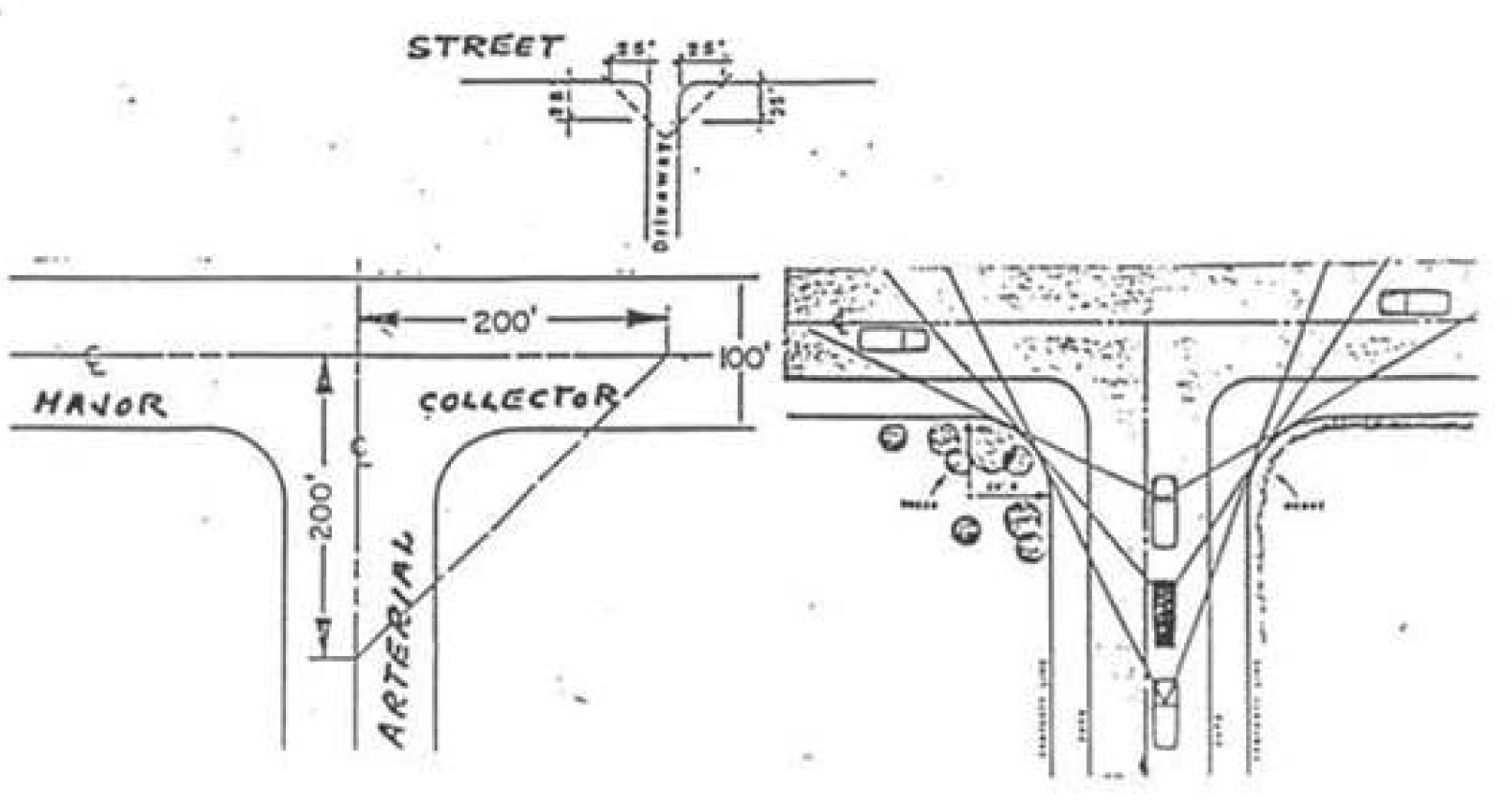
(j)
Signage and signalization. The developer shall erect all necessary roadway signs and traffic signalization as may be required by the County, based upon County or State traffic standards. At least two street name signs shall be placed at each four-way street intersection, and one at each "T" intersection. Signs shall be installed under light standards and free of visual obstruction. The design of street name signs shall be consistent, of a style appropriate to the community, and of a uniform size and color. Dead-end signs shall be erected at the beginning intersection of all discontinuous streets.
(k)
Blocks.
(1)
Where a tract of land is bounded by streets forming a block, the block shall have sufficient width to provide for two tiers of lots of appropriate depths.
(2)
The lengths, widths, and shapes of blocks shall be consistent with adjacent areas. Block length may be exceeded when adjacent to restored or artificial features such as lakes, rivers, and golf courses.
(LDR, § 7205; Ord. No. 2012-01, § 7205, 5-22-2012)
Sec. 20-505. - Access.
All proposed development shall meet the following standards for vehicular access and circulation:
(1)
Number of access points.
a.
All projects shall have access to a public right-of-way. The number of access points shall be as follows:
* Through the special exception use, development plan, or development plan modification process, the Board of County Commissioners may grant additional access points based on: the roadway's conformance to the right-of-way width standard in LDR Section 20-503, the extent of roadway frontage, the number of trips generated, and the traffic impact on the surrounding roadway network.
b.
Notwithstanding the provisions above:
1.
A nonresidential development or a multifamily residential development on a corner lot may be allowed two points of access. However, no more than one access shall be onto each arterial.
2.
Schools may have one additional access, provided that the additional access drive is limited to school bus use only.
(2)
Separation between access points and between access points and intersections.
a.
The minimum separation between access points onto arterial and collector roadways, or between an access point and an intersection of an arterial or collector with another road, shall be as shown in the following table:
b.
The distance between access points or between an access point and an intersection of an arterial or collector with another road shall be measured from the centerline of the proposed driveway or roadway to the centerline of the nearest adjacent roadway or driveway.
(3)
Frontage on parallel access roads and driveways.
a.
Parallel access shall be provided to all lots platted with frontage on State highways or County highways. The access may be provided by an approved dedicated right-of-way or by an access easement across the lots served by the easement. The plat shall restrict direct access to the lots from the State highway or County highway. The access right-of-way or easement may be immediately adjacent to or one tier of lots removed from the right-of-way of the State highway or County highway. The acceptability of dedicated right-of-way for access shall be determined in each instance as based upon consideration of resulting public safety and convenience. Driveway connections between the parallel access and the State highway or County highway will be limited in number and location. Parallel access is required in order to minimize direct access to State highways and County highways for the safety and convenience of the public. This access requirement may be met through the use of interconnecting parking lots which abut the arterial or major collector facility. The maximum number of parking lots that may be so interconnected, however, is three. County highways are C-660, C-661, C-760, C-760A, C-761, C-763, C-769 (Kings Highway), Turner Avenue, Airport Avenue, and Hillsborough Avenue (South Arcadia Avenue).
b.
Adjacent uses may share a common driveway, provided that appropriate access easements are granted between or among the property owners.
(4)
Alternative designs. Where natural features or spacing of existing driveways and roadways cause the forgoing access requirements to be physically infeasible, alternate designs may be approved.
(5)
Access to residential lots.
a.
Access to nonresidential uses shall not be through an area designed, approved, or developed for residential use.
b.
All lots in a proposed residential subdivision shall have frontage on and access from an existing street meeting the requirements of the LDRs.
c.
Access to all lots in a proposed residential subdivision shall be by way of a residential access or residential sub-collector street.
(LDR, § 7206; Ord. No. 2012-01, § 7206, 5-22-2012; Ord. No. 2014-06, § 24, 10-28-2014; Ord. No. 2019-10, § 1, 7-23-2019)
Sec. 20-506. - Standards for drive-up facilities.
(a)
Generally. All facilities providing drive-up or drive-through service shall provide on-site stacking lanes in accordance with the following standards.
(b)
Standards.
(1)
The facilities and stacking lanes shall be located and designed to minimize turning movements in relation to the driveway access to streets and intersection.
(2)
The facilities and stacking lanes shall be located and designed to minimize or avoid conflicts between vehicular traffic and pedestrian areas such as sidewalks, crosswalks, or other pedestrian access ways.
(3)
A bypass lane shall be provided.
(4)
Stacking lane distance shall be measured from the service window to the property line bordering the furthest street providing access to the facility.
(5)
Proposed development with a drive-up facility may have to be substantiated by an engineering report.
(6)
Minimum stacking lane distance shall be as follows:
a.
Financial institutions shall have a minimum distance of 200 feet. Two or more stacking lanes may be provided which together total 200 feet.
b.
All other uses shall have a minimum distance of 120 feet.
(7)
Alleys or driveways in or abutting areas designed, approved, or developed for residential use shall not be used for circulation of traffic for drive-up facilities.
(8)
Where turns are required in the exit lane, the minimum distance from any drive-up station to the beginning point of the curve shall be 34 feet. The minimum inside turning radius shall be 25 feet.
(9)
Construction of stacking lanes shall conform to the specifications as set forth in the LDRs.
(LDR, § 7207; Ord. No. 2012-01, § 7207, 5-22-2012)
Sec. 20-536. - Intent; general requirements.
(a)
The intent of this division is to provide the minimum off-street parking and loading standards to avoid undue congestion and/or overflow to adjacent properties or roads, as well as to provide good traffic movement and avoid conflicts between vehicles and pedestrians.
(b)
In all districts every structure or land use that is constructed, enlarged, increased in density or intensity shall provide the minimum off-street parking spaces in accordance with the requirements in this division. Uses existing on the effective date of the LDRs that do not conform may be continued, but shall not enlarge their structure and/or increase their density or intensify their use until they comply with these requirements.
(1)
General requirements.
a.
Parking spaces shall not be designed to back into or use the road right-of-way.
b.
No part of an off-street parking area required for any building or use by this division shall be included as a part of an off-street parking area similarly required for another building or use, unless the type of use indicates that the periods of usage will not overlap or be concurrent with each other. Joint use or shared parking shall not be permitted between land uses to meet the minimum parking requirements, unless a written agreement among the owners is executed, is reviewed by the County Attorney and approved by the Development Director, and recorded in the public records at the expense of the property owners, and said agreement may not be canceled without the prior consent of the County Attorney and Development Director and recording in the public record at the expense of the owners.
c.
All landscaped areas shall be protected from encroachment by a barrier such as curbs, wheel stops, or similar devices.
d.
All off-street parking areas shall be designed to provide safe and convenient circulation, in accordance with commonly accepted traffic engineering practices and subject to review of the County Engineer.
(2)
Parking and loading spaces required. The off-street parking and loading space standards shall be as shown on Table 20-536, Parking and Loading Standards.
Table 20-536. Parking and Loading Space Standards
(LDR, § 7300; Ord. No. 2012-01, § 7300, 5-22-2012; Ord. No. 2016-12, § 4, 5-24-2016; Ord. No. 2024-005, § 3, 6-25-2024)
Sec. 20-537. - Parking area design and development standards.
(a)
Location and design standards.
(1)
The off-street parking area required by this division shall be located on the same plot or parcel of land they are intended to serve or on a remote parcel as provided for in Section 20-538.
(2)
Off-street parking areas required by this division shall be arranged or designed in the same manner as depicted in Detail D-18, DeSoto County Engineering Standard Details, Typical On-Site Parking Space Layout.
(3)
All driveways, parking and loading areas, and access thereto within residential multifamily and commercial zoning districts and commercial uses regardless of zoning district shall be paved at a minimum consistent with Detail D-17B, DeSoto County Engineering Standard Details, Typical Pavement Section No. 2. Notwithstanding, for places of worship and other public assembly uses, and commercial uses with a size less than 5,000 square feet, up to 50 percent of the required parking spaces (but not driveways and loading spaces) may be grass, gravel or similar material parking spaces but such spaces shall be marked with a wheel stop consistent with Detail D-19A, DeSoto County Engineering Standard Details, Typical Concrete Wheel Stop Detail. In addition, this standard does not apply to single-family dwellings, duplexes, sports arenas, agricultural uses, or within any agricultural zoning district.
The Department Director may approve the utilization of grassed parking areas for the required number of vehicular parking spaces for churches or other places of worship, for places of public assembly for meetings or other events, and for temporary uses; where it is clear that such grassed surface can be adequately maintained due to the infrequency of use, and that adequate permanent traffic control means will be provided to direct vehicular flow and parking, Paved parking will be provided for ADA spaces and meet related standards.
(4)
All driveways, truck parking and loading areas, and access thereto within industrial zoning districts and industrial uses regardless of zoning district shall be paved at a minimum consistent with Detail D-17C, DeSoto County Engineering Standard Details, Typical Pavement Section No. 3. This standard shall not apply to agricultural uses and places of worship. Notwithstanding, personal and commercial vehicle access and parking areas may be paved consistent with Detail D-17B, DeSoto County Engineering Standard Details, Typical Pavement Section No. 2 and up to 50 percent of the required parking area (but not driveways and loading spaces) may be grass, gravel, or similar materials parking spaces but such parking spaces shall be marked with a wheel stop consistent with Detail D-19A, DeSoto County Engineering Standard Details, Typical Concrete Wheel Stop Detail. This standard shall not apply to places of worship.
(5)
Each regular parking space required and provided pursuant to the provisions of this division shall not be less than ten feet in width, and 20 feet in length as is provided for in Detail D-19, DeSoto County Engineering Standard Details, Typical Parking Space.
(6)
Each parallel parking space shall not be less than ten feet in width and 24 feet in length as depicted in Detail D-18, DeSoto County Engineering Standard Details, Typical On-Site Parking Space Layout.
(7)
The required off-street parking space shall be clearly delineated by six-inch, visible, marked with striping, except for single-family dwellings. Parking and vehicle service areas which abut landscaped areas, shall be designed with bumper guards, wheel stops, or contiguous curbing. The required bumper guards or wheel stops shall be located as displayed in Detail D-19A, DeSoto County Engineering Standard Details, Typical Concrete Wheel Stop Detail.
(8)
All required off-street parking areas shall be directly accessible from a public or private street, alley or easement. All off-street parking areas shall be designed to permit convenient maneuvering of vehicles and each space shall be accessible without driving over or through any other parking space. Back-out parking shall not be allowed on any street or highway except for parking spaces required for single-family dwellings and duplexes.
(9)
All off-street parking areas shall be drained consistent with Division 5 of this article.
(10)
Any lighting shall be so arranged and designed as to prevent any glare or excessive light on adjacent property or public streets.
(11)
A parking area plan shall be submitted with every application for a development plan, improvement plan or building permit for any use or structure required to provide off-street parking under these regulations, which plan shall clearly and accurately designate the required parking spaces, access aisles and driveways, landscaping, and relation to the uses or structures these off-street parking area are intended to serve.
(b)
Handicapped accessibility.
(1)
Accessible parking spaces for disabled persons must conform to:
a.
American with Disabilities Act and Accessibilities Guidelines;
b.
Fair Housing Act and Accessibility Guidelines;
c.
Florida Accessibility Code; and
d.
Florida Fair Housing Act.
(2)
Accessible parking space locations.
a.
Accessible parking spaces must be conveniently located near a main accessible building entrance via the shortest accessible route. For buildings with multiple accessible entrances with adjacent parking, accessible parking spaces should be dispersed and located closest to the accessible entrances.
b.
Accessible parking spaces may be clustered in one or more parking areas if equivalent or greater accessibility is provided in terms of distance from the accessible entrance, impact of parking fees, and convenience.
(3)
Accessible route.
a.
Location. An accessible route shall be provided from the accessible parking space to the accessible building entrance and shall be located so that pedestrians are not required to wheel or walk behind parked vehicles (except the one they operate in or in which they are a passenger) or in traffic lanes.
b.
Width. The minimum clear width of an accessible route shall be 60 inches (five feet).
c.
Surface texture. Ground surfaces along accessible routes, including walks, ramps, and curb ramps, shall be stable, firm, and slip-resistant. Sidewalks and walkways should be constructed of concrete or similar materials. Soft or loose materials such as sand, gravel, bark, mulch, or wood chips are not suitable.
d.
If a sidewalk is available in the public right-of-way, an accessible route shall be provided from the sidewalk to an accessible building entrance as displayed in Detail D-22, DeSoto County Engineering Standard Details, Accessible Route and Bicycle and Pedestrian Circulation Conceptual Layout.
e.
If a public transit stop is located in the public right-of-way in front of the site or adjacent to the site, an accessible route shall be provided from the public transit stop to an accessible building entrance.
(4)
Handicapped parking space layout and marking.
a.
Each handicapped parking space required and provided pursuant to the provisions of this division shall not be less than 12 feet in width, 20 feet in length, with a five feet wide adjacent access aisle, and marked as is provided for in Detail D-20, DeSoto County Engineering Standard Details, Typical Handicapped Parking Space.
b.
Two accessible parking spaces may share a common access aisle.
c.
Parked vehicle overhangs shall not reduce the clear width of an accessible route.
d.
When an existing parking area is re-striped, the re-striping must provide accessible parking as required by the ADA and the Florida Accessibility Code.
(5)
Signage. Handicapped parking signage shall be provided for as is displayed in Detail D-21, DeSoto County Engineering Standard Details, Typical Handicapped Parking Sign Detail.
(6)
Number of spaces. Parking spaces for disable persons shall be provided in accordance with Table 20-537, Disabled Parking Spaces Required.
Table 20-537. Disabled Parking Spaces Required
(c)
Nonconforming vehicle use areas. For nonconforming vehicle use areas, see Section 20-761.
(d)
Parking of commercial and other vehicles. For parking of commercial and other vehicles, see Sections 20-96 through 20-98.
(e)
Parking area landscaping. All landscaping material shall be installed in a sound workmanlike manner and according to accepted good planting procedures with quality of plant materials as described in Division 6 of this article and be properly fertilized at the time of installation. A qualified representative of the County shall inspect all landscaping following installation within five business days of proper notification of such completion. No permanent certificate of occupancy will be issued unless the landscaping meets the requirements herein provided. Once a certificate of occupancy is issued, the landscaping and irrigation shall be continuously maintained and protected by the property owner.
(1)
Parking area perimeter landscaping.
a.
An off-street parking area that abuts a public right-of-way shall include a landscaped strip on the perimeter of the parking area adjacent to the right-of-way. This landscaped strip shall be the same as Buffer "A" as provided for in Figure 7-4, which is set forth in Section 20-604(a); provided, however, that except for property zoned IH or IL, such buffer may be reduced in height to avoid obstructing the view from the right-of-way of commercial, professional, retail or other similar uses, or of equipment, produce or other commercial or retail products displayed outside of such businesses or offices.
b.
An off-street parking area that abuts an area designated, approved, or developed for residential use shall provide a landscaped strip along the perimeter of the parking area adjacent to the residential area. This landscaped strip shall be the same as Buffer "B" provided for in Figure 7-5, which is set forth in Section 20-604(b).
(2)
Parking area interior landscaping.
a.
A minimum ten percent of the gross parking area, excluding perimeter landscaping, is to be devoted to living landscape, which includes grass, ground cover, plants, shrubs and trees. The gross parking area is to be measured from the edge of the parking and/or driveway paving and sidewalks extended five feet in all directions, but is not to include any area enclosed by the building or covered by a building overhead.
b.
Every 11th consecutive parking space, and at the end of every parking strip or row, shall have a landscaped island five feet in width and 20 feet in depth. Each island shall contain one tree, and grass or ground cover, said island to be protected from vehicular encroachment by means of a six-inch vertical curbing or other barrier acceptable to the County Engineer.
c.
Installation. Landscaped areas, walls, structures and walks, shall require protection from the encroachment or overhang of parked vehicles where such protection is necessary, reinforced concrete wheel stops or a staff approved continuous curbing arrangement of not less than six inches in height, shall be installed to prevent said encroachment. Concrete wheel stops, when used, shall be permanently anchored to the ground, and located not less than 24 inches from the landscaped area. If the 24-inch vehicular overhang area is left unpaved, it shall be landscaped according to the provisions of this section.
(3)
Planned unit development landscaping requirements.
a.
Parking area perimeter landscaping shall be as required in Subsection (e)(1) of this section.
b.
Parking area interior landscaping shall be as required in Subsection (e)(2) of this section. The following other requirements shall apply.
1.
Parking lot medians required. Parking lot medians dividing two adjoining rows of parking are required for all new development and redevelopment for any nonresidential component of a PUD. Each median shall be landscaped with hedge, shrubs, or ground cover. The parking median shall be a minimum five feet wide without vehicular encroachment. There shall also be one tree for every 40 lineal feet of area. Plant material referred to herein shall be in accordance with Section 20-598(7). The remainder of the required landscaped area shall be landscaped with grass, ground cover or other approved landscape treatment, excluding impervious paving.
2.
Lighting required. The parking lot and the accessible route from the parking lot to the main building entrance shall be provided with a minimum illumination level of one footcandle.
(4)
Parking area landscape flexibility. The Planning and Zoning Director is hereby authorized to grant the following permitted modifications:
a.
The living landscape requirements of any parking area may be consolidated or clustered.
b.
The requirement of five by 20 feet living landscaped islands for each 11 parking spaces may be consolidated, clustered or replaced.
c.
Perimeter landscaping requirements relating to buffers between property may be transferred, or utilized on other areas of the site.
(f)
Off-street loading requirements. Off-street loading areas shall be provided in the following manner:
(1)
Dimensions. Loading spaces shall be not less than ten feet wide and 25 feet long with 14 feet of vertical clearance but for tractor trailer parking, a minimum 12 feet wide by 50 foot long with 16 feet clearance is recommended.
(2)
Plans. Plans for loading ramps or truck wells shall be accompanied by a profile drawing showing the ramp, ramp transitions and overhead clearances.
(3)
Location. Loading spaces shall be located and designed as follows:
a.
As near as possible to the main structure and limited to the rear two-thirds of the parcel, if feasible;
b.
Situated to ensure that the loading facility is screened from adjacent streets as much as possible;
c.
Situated to ensure that loading and unloading takes place on the premises and in no case within adjacent public rights-of-way or other traffic circulation areas on the premises;
d.
Situated to ensure that vehicular maneuvers occur on the premises; and
e.
Situated to avoid adverse impacts upon neighboring residential properties.
(4)
Screening. Loading areas abutting residentially zoned parcels shall provide a landscaped strip along the perimeter of the parking area adjacent to the residential area. This landscaped strip shall be the same as Buffer "B" provided for in Figure 7-5, which is set forth in Section 20-604(b).
(5)
Striping. Loading areas shall be striped indicating the loading spaces and identifying the spaces for "loading only." The striping shall be permanently maintained by the property owner/tenant in a clear and visible manner at all times.
(g)
Parking credits. The required amount of off-street parking may be reduced in exchange for certain enhancements that reduce the need for required off-street parking.
(1)
Bicycle parking. Three bicycle parking rack spaces shall be the equivalent of one paved parking space up to a maximum of three paved parking spaces. A bicycle rack example is displayed in Detail D-26, DeSoto County Engineering Standard Details, Typical Bicycle Rack Detail. Bicycle rack spaces shall be:
a.
Clearly marked and designated for bicycle parking.
b.
Separated from motor vehicle parking areas and driveways by a barrier, such as a curb, rail, or bollard, or be located in a manner which minimizes the possibility of motor vehicles striking parked bicycles.
(2)
Public transit shelter. A 15 percent paved parking credit shall be provided for construction of a public transit shelter on a designated bus route on or adjacent to the site, subject to County Engineer approval of the location. Alternatively, a bond may be posted for future construction once the transit route is extended to the site. Credit is given when the transit shelter is constructed in conformance with County transit designs guidelines, and other regulations.
(Ord. No. 2016-12, § 5(7301), 5-24-2016; Ord. No. 2024-003, § 1, 5-28-2024)
Sec. 20-538. - Remote parking lot.
(a)
The requirements of Section 20-536 shall apply to remote parking lots.
(b)
The requirements of Section 20-537 shall apply to remote parking lots, except that all vehicular surface areas, including parking spaces, shall be paved.
(c)
A remote parking lot shall be located within 660 linear feet of the property being served as measured by the shortest airline distance between or among the nearest point on the respective property lines. The owner of said parking area and the owner of the property to be served shall enter execute an agreement or a unity of title or similar document if under same ownership, reviewed by the County Attorney and approved by the Development Director, that the parking area shall not be sold or disposed of except in conjunction with the sale of the building the parking area serves so long as these parking facilities are required. Said agreement, unity of title or similar instrument shall be recorded at the expense of the owner of the property on which the facilities will be located and shall run with the land to bind the heirs, successors and assigns of said owner. Said agreement shall not be cancelled without the prior consent of the County Attorney and Development Director and recording in the public record at the expense of the owners.
(Ord. No. 2016-12, § 6(7302), 5-24-2016)
Sec. 20-570. - Relationship to other stormwater management requirements.
In addition to meeting the requirements of the LDRs, the design and performance of all stormwater management systems shall comply with applicable State or Federal regulations, or rules of the Florida Department of Environmental Protection (FDEP) or the Southwest Florida Water Management District. In all cases the strictest of the applicable standards shall apply.
(LDR, § 7401; Ord. No. 2012-01, § 7401, 5-22-2012)
Sec. 20-571. - Exemptions.
The following development activities are exempt from the stormwater management requirements of this division, except that steps to control erosion and sedimentation must be taken for all development.
(1)
The construction of a single-family or duplex residential dwelling unit and accessory structures.
(2)
Any development within a subdivision if each of the following conditions have been met:
a.
Stormwater management provisions for the subdivision were previously approved and remain valid as part of a final plat or improvement plan; and
b.
The development is conducted in accordance with the stormwater management provisions submitted with the final plat or improvement plan.
(3)
Bona fide agricultural activity which has a permit or is exempt from permitting from SWFWMD or FDEP.
(4)
Maintenance activity that does not change or affect the quality, rate, volume or location of stormwater flows on the site or of stormwater runoff.
(5)
Action taken under emergency conditions to prevent imminent harm or danger to persons, or to protect property from imminent fire, violent storms, hurricanes or other hazards. A report of the emergency action shall be made to the Department of Development as soon as practical.
(6)
Any development for which stormwater management permits are required by Federal, State, or Southwest Florida Water Management District regulations to the extent that such permits include review and consideration of impacts on adjacent property and/or County drainage and provided that the development activities has the necessary permit prior to commencement.
(LDR, § 7402; Ord. No. 2012-01, § 7402, 5-22-2012; Ord. No. 2014-06, § 17(7402), 10-28-2014)
Sec. 20-572. - Stormwater protection requirements.
All development plans shall provide that any additional stormwater generated by improvements will not run off on adjacent properties. The first floor elevation of principal structures located in subdivisions shall be located at least 18 inches above the average height of the street crown.
(LDR, § 7403; Ord. No. 2012-01, § 7403, 5-22-2012; Ord. No. 2014-06, § 17(7403), 10-28-2014)
Sec. 20-573. - Stormwater management requirements.
(a)
Performance standards. All development must be designed, constructed and maintained to meet the following performance standards:
(1)
While development activity is underway and after it is completed, the characteristics of stormwater runoff shall approximate the rate, volume, quality, and timing of stormwater runoff that occurred under the site's natural unimproved or existing state, except that the first one inch of stormwater runoff shall be treated in an off line retention system or according to other best management practices as required by the County Engineer.
(2)
The proposed development and development activity shall not violate the water quality standards as set forth in the applicable provisions of the Florida Administrative Code.
(b)
Design standards. To comply with the foregoing performance standards, the proposed stormwater management system shall conform to the following design standards:
(1)
The design and construction of the proposed stormwater management system shall be certified as meeting the requirements of the LDR by a professional engineer registered in the State.
(2)
The hydrograph for the developed or redeveloped site shall not exceed the peak rate of flow and volume of runoff produced by conditions existing before development or redevelopment.
(3)
Channeling runoff directly into natural water bodies shall be prohibited, unless permitted by appropriate regulatory agencies. Runoff shall be routed through swales and other systems designed to increase time of concentration, decrease velocity, increase infiltration, allow suspended solids to settle, and otherwise remove pollutants.
(4)
The area of land disturbed by development shall be as small as practicable. Those areas which are not to be disturbed shall be protected by an adequate barrier from construction activity. Whenever possible, natural vegetation shall be retained and protected.
(5)
No grading, cutting, or filling shall be commenced until erosion and sedimentation control devices have been installed between the disturbed area and water bodies, watercourses, and wetlands.
(6)
Land which has been cleared for development and upon which construction has not been commenced shall be protected from erosion by appropriate techniques designed to revegetate the area.
(7)
The system shall be designed so that sediment shall be retained on the site of the development.
(8)
Wetlands and other water bodies shall not be used as sediment traps.
(9)
Erosion and sedimentation facilities shall receive regular maintenance to ensure that they continue to function properly.
(10)
Artificial watercourses shall be designed, considering soil type and side bank stabilization, so that the velocity flow is low enough to prevent erosion.
(11)
Vegetated buffer strips shall be provided or, where practicable, retained in their natural state along the banks of all watercourses, water bodies, or wetlands.
(12)
Intermittent watercourses, such as swales, should be vegetated except where flows exceed five feet per second, then they shall be concreted, or otherwise sufficiently stabilized.
(13)
The runoff shall be retained or detained on site in accordance with the applicable SWFWMD rules.
(14)
Runoff from streets and parking lots shall be treated to reduce the quantity of oil and sediment entering receiving waters.
(15)
The banks of detention and retention areas shall slope at a gentle grade into the waters in accordance with the applicable SWFWMD rules as a safeguard against drowning, personal injury or other accidents, to encourage the growth of vegetation and to allow the alternate flooding and exposure of areas along the shore as water levels periodically rise and fall.
(16)
The use of drainage detention and retention facilities and vegetated buffer zones as open space, recreation, and conservation areas shall be encouraged.
(17)
The developer shall be responsible for obtaining any necessary permits for the stormwater management system required by local, State, of Federal agencies.
(LDR, § 7404; Ord. No. 2012-01, § 7404, 5-22-2012)
Sec. 20-574. - Dedication or maintenance of stormwater management systems.
The County may maintain the stormwater system only in subdivisions where there are single ownerships of lots and where the roads are dedicated to and accepted by the County. In all other developments, the developers or owners shall maintain the stormwater system.
(LDR, § 7405; Ord. No. 2012-01, § 7405, 5-22-2012)
Sec. 20-597. - Intent.
(a)
The intent of this division is to provide for required landscaping in certain developments for the purpose of enhancing the appearance of developed areas of the County. Buffers provide spacing and vegetative barriers that reduce potentially adverse impacts such as noise, odor, light or appearance. Landscaping is required in off-street parking areas in order to promote safe and efficient use of the facilities.
(b)
This division contains standards for required buffers between adjacent uses, landscape requirements for off-street parking areas, and general maintenance requirements that apply to all landscaped areas.
(LDR, § 7501; Ord. No. 2012-01, § 7501, 5-22-2012)
Sec. 20-598. - General landscape requirements.
All proposed landscaping shall meet the following minimum requirements:
(1)
Preservation and protection of existing native species of plant material is strongly encouraged. Existing native species and natural cover should be retained wherever possible. The use of drought-resistant plants and horticultural methods are encouraged.
(2)
Where it is not possible to retain existing natural ground cover, landscaping areas shall be seeded and/or sodded, or provided with other acceptable ground cover.
(3)
Installation of all plant materials shall conform to standard acceptable horticultural practice.
(4)
Where berms or mounds are used within a landscaped area, slopes shall not exceed 30 degrees and shall be completely covered with vegetation.
(5)
Maintenance of all landscaped areas shall be the responsibility of the property owner.
(6)
Landscaping materials shall meet the requirements of the clear visibility triangle provided for in the LDRs.
(7)
The following trees and shrubs are recommended for use in all landscaped areas:
* - Indigenous
S - Small mature size: up to 20 feet in height.
M - Medium mature size: 20 feet to 60 feet in height.
L - Large mature size: 60 feet to 100 feet in height.
(8)
The following harmful nuisance trees shall be excluded from any landscaping plan:
(LDR, § 7502; Ord. No. 2012-01, § 7502, 5-22-2012)
Sec. 20-599. - Required buffers.
A buffer is a specified land area together with its planting and landscaping requirements. A buffer may also contain a barrier such as a fence, wall, hedge, or berm where such additional screening is necessary to achieve the desired degree of buffering between adjacent uses.
(LDR, § 7503; Ord. No. 2012-01, § 7503, 5-22-2012)
Sec. 20-600. - Determination of buffer requirements.
Buffers shall be required for all new development and redevelopment on lands in the County. The buffer matrix describes the type of buffer required as determined by the type of proposed use and the type of use which is designated, approved, or existing on lands adjacent to the proposed project. In order to determine the type of buffer required, the following procedures shall be followed:
(1)
Identify the type of use for the proposed project.
(2)
Identify the type of use for all properties abutting the proposed project and based upon designated, approved, or developed use of the property.
(3)
Where an abutting property has a lawful nonconforming use of less intensity than the allowable use of the property, buffering shall be based upon the allowable use.
(4)
Refer to the Buffer Matrix for buffer requirements on each property boundary or portion thereof and select the desired buffer option for the specified type of buffer from those shown in Figures 7-4 through 7-7, which are set forth in Section 20-604.
*Multifamily developments, mobile home developments, subdivisions, but not undivided single-family or duplex.
(LDR, § 7504; Ord. No. 2012-01, § 7504, 5-22-2012)
Sec. 20-601. - Types of buffers.
Unless specified elsewhere in the LDRs, any buffer yard shown for a type of buffer (A, B, C, or D; Figures 7-4 through 7-7, which are set forth in Section 20-604) shall satisfy the buffer requirement. Trees in buffers of more than ten feet may be small, medium, or large (as described above), provided, however, at least one-half of the required trees shall be large.
(LDR, § 7505; Ord. No. 2012-01, § 7505, 5-22-2012)
Sec. 20-602. - Use and location of buffers.
(a)
Areas set aside as required buffers may also be used as follows:
(1)
Satisfaction of minimum setback requirements, if any.
(2)
Satisfaction of minimum open space requirements, if any.
(3)
May contain stormwater retention or detention areas, so long as the required buffer plantings are provided and the design and landscaping of the buffer does not interfere with proper functioning of the drainage system and the design water depth does not harm the viability of the plantings.
(4)
Passive recreation such as pedestrian, bicycle, or equestrian trails subject to the following limitations:
a.
The total width of the buffer is maintained.
b.
All other requirements of the LDR are met.
(5)
Installation of underground utilities, so long as the location and use of the utility lines does not interfere with required buffer plantings.
(b)
The following uses shall not be allowed in a required buffer: play fields, stables, swimming pools, tennis courts, or similar active recreational uses; storage facilities, or parking facilities.
(c)
General location and design requirements:
(1)
Buffers shall be located on the outer perimeter of a lot or parcel, extending to the lot or parcel boundary line.
(2)
Buffers shall not be located on any portion of an existing, dedicated, proposed right-of-way, road easement, or private street.
(3)
Where an existing utility easement is partially or wholly within a required buffer, the developer should design the buffer to eliminate or minimize plantings within the easement. Such design may necessitate choosing a buffer with more land area and fewer required plantings.
(4)
Where a proposed development is a mixed use project, buffers shall not be required between various constituent parts except that any nonresidential use shall be separated from residential use by the minimum required buffer. It is the intent to allow flexibility of design within the confines of a mixed use development, but to nevertheless require buffering of a proposed residential portion of the project from potential negative impact of a proposed nonresidential portion of the project.
(5)
Except for property zoned IH or IL, buffers may be reduced in height or density in order to avoid obstructing the view from the right-of-way of commercial, professional, retail or other similar uses, or of equipment, produce or other commercial or retail products displayed outside of such businesses or offices.
(LDR, § 7506; Ord. No. 2012-01, § 7506, 5-22-2012; Ord. No. 2014-06, § 12, 10-28-2014)
Sec. 20-603. - Alternative buffer proposals.
(a)
An applicant may submit a detailed alternative plan and specifications for landscaping and screening to the Board of County Commissioners for review and approval.
(b)
The Board of County Commissioners may approve the alternative buffering and screening proposal, in writing, upon finding the proposal will afford a degree of buffering and screening, in terms of height, opacity and separation, that is suitable to the property and its surroundings, or equivalent to or exceeding that provided by the requirements of this division.
(LDR, § 7507; Ord. No. 2012-01, § 7507, 5-22-2012)
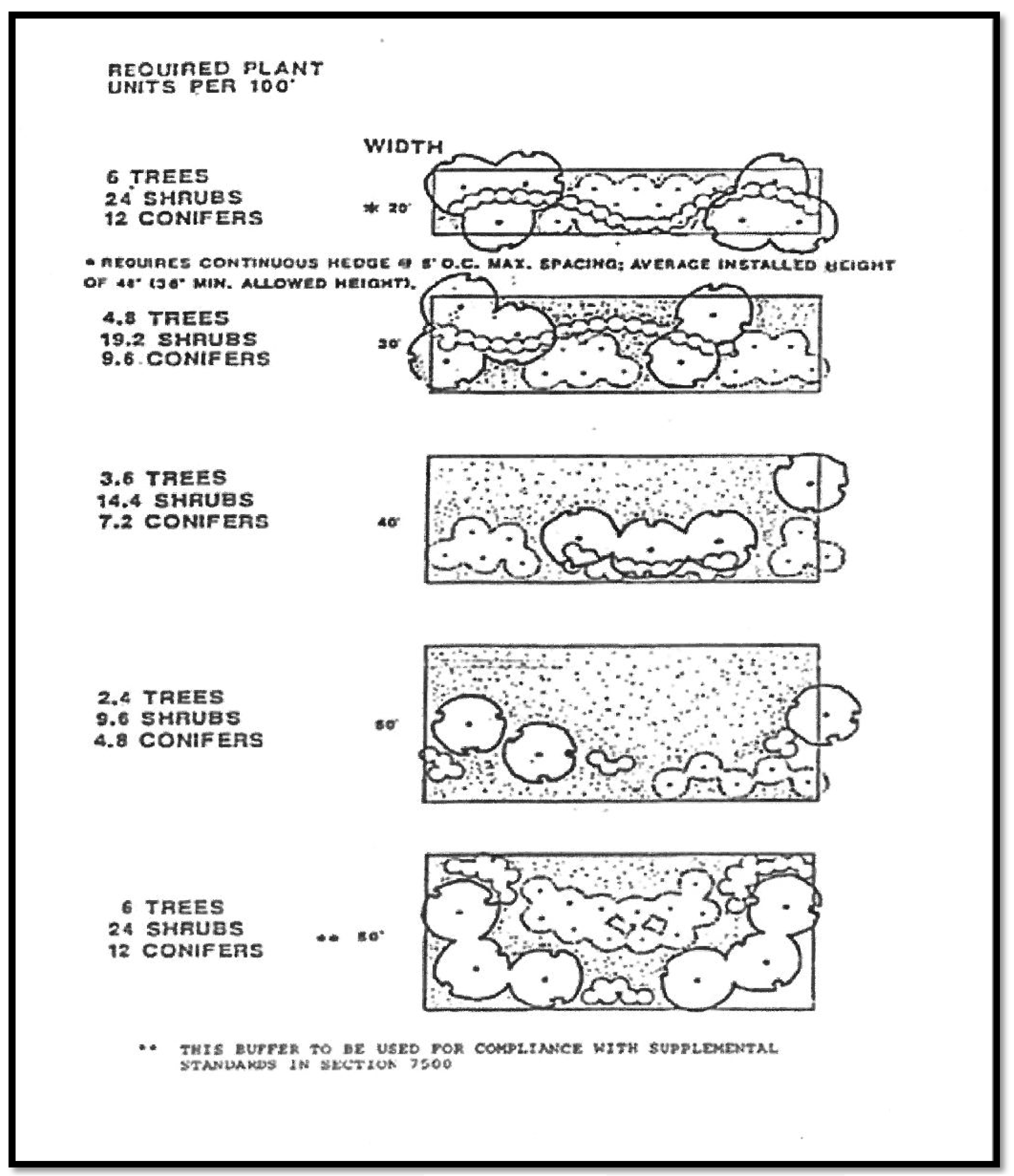
Sec. 20-604. - Buffer diagrams.
(a)
Buffer A (Figure 7-4).
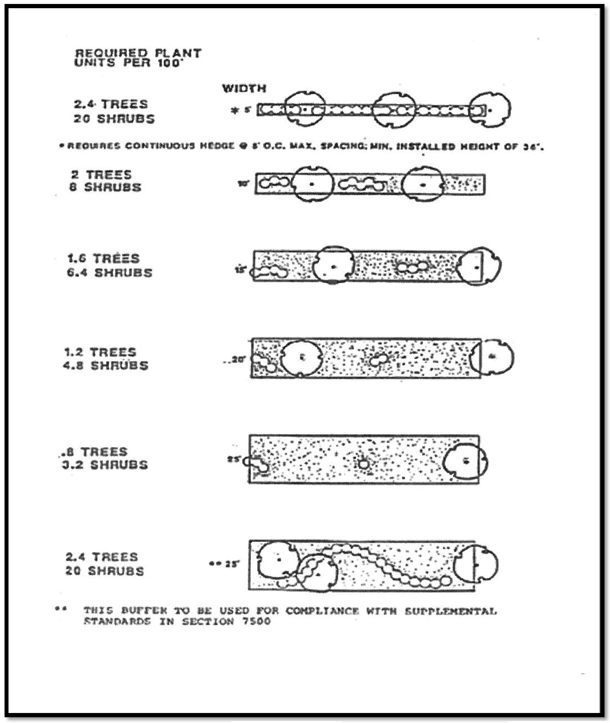
BUFFER A
(b)
Buffer B (Figure 7-5).
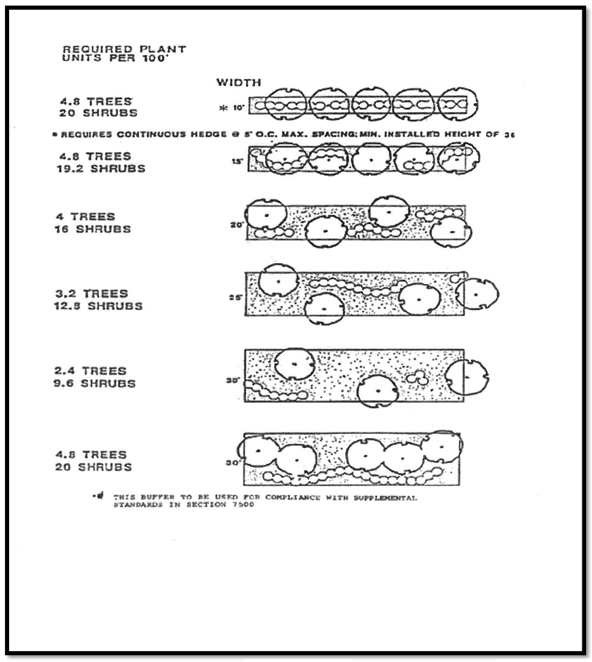
BUFFER B
(c)
Buffer C (Figure 7-6).
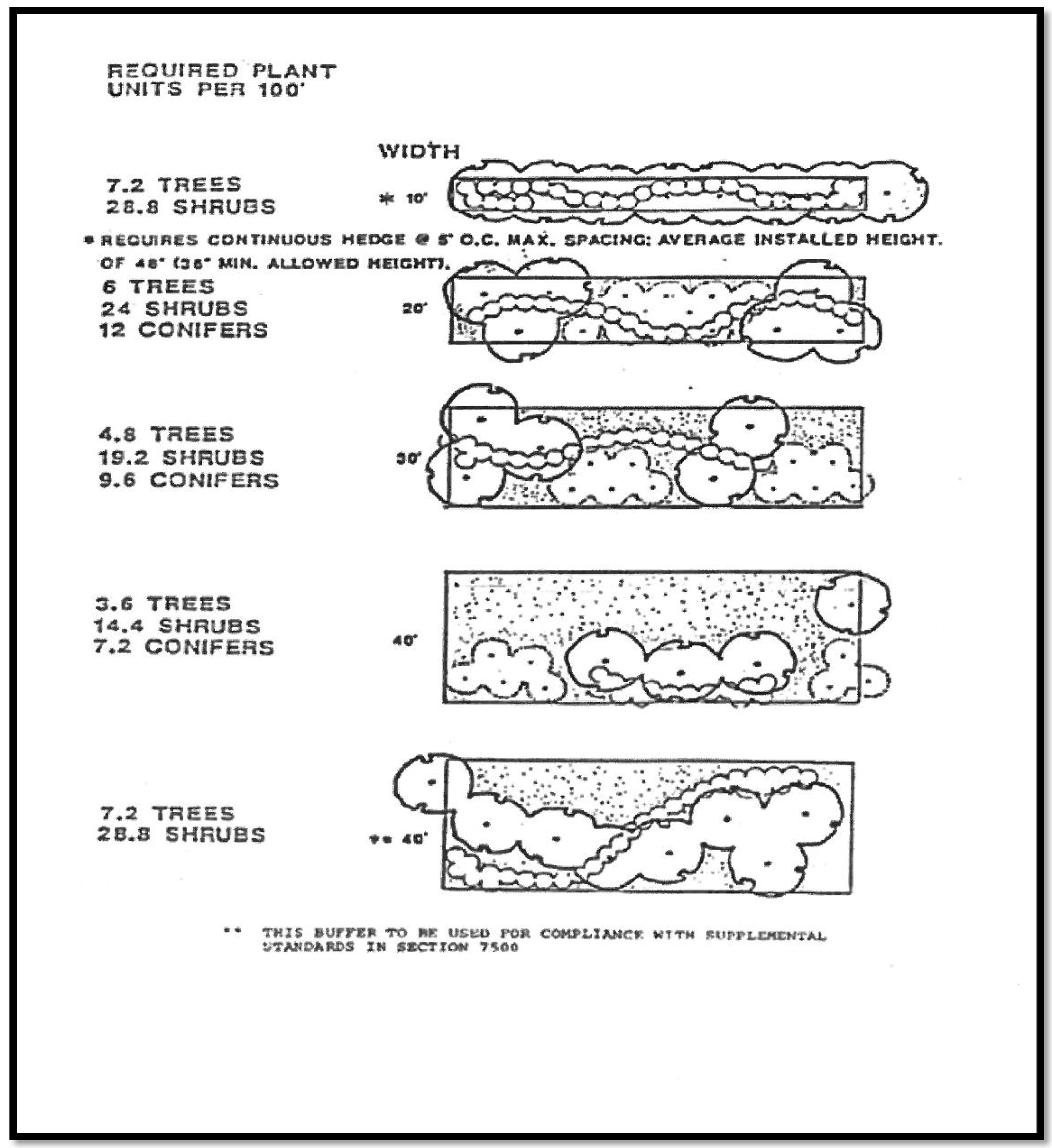
BUFFER C
(d)
Buffer D (Figure 7-7).
BUFFER D
(LDR, art. 7)