
Dumfries City Zoning Code
ARTICLE III
- DISTRICTS
DIVISION 9. - FLOODPLAIN DISTRICTS FP-1[3]
Editor's note— Ord. No. O-2014-009, adopted Oct. 8, 2014, amended former Div. 9, §§ 70-346—70-355, in its entirety which pertained to similar subject matter and derived from the Code of 1990, §§ 15-251—15-254, 15-256—15-261; Ord. of 8-1-1989(2), §§ 9.1—9.3, 9.5—9.9; Ord. of 1-3-1995.
Sec. 70-86.- Town divided into districts; districts enumerated.
For the purpose of this chapter in regulating use of land, water and buildings, the height, bulk, population density and open space, the town is hereby divided into the following districts:
Residential, limited R-1
Residential, general R-2
Residential, condominium R-3
Residential, multifamily R-4
Business, general B-1
Business, neighborhood B-2
Industrial, limited M-1
Floodplain FP-1
Historic overlay H-1
Special purpose SP-1
Chesapeake Bay Preservation Area Overlay CBPA-OD
Flex Business/Office FB/O-1.
Planned mixed use district PMUD.
(Code 1990, § 15-15-36; Ord. of 1-18-1979, § 2-1; Ord. of 6-2-1987(1), (2); Ord. No. O-2016-003, 4-5-2016)
Sec. 70-87. - Annexed territory.
All territory which may be annexed to the town shall be considered as being in the R-1 residential, limited district until otherwise changed by amendment to this chapter.
(Code 1990, § 15-37; Ord. of 1-18-1979, § 2-2)
State Law reference— Temporary application of zoning ordinance to property annexed, Code of Virginia, § 15.2-2286(A)(2).
Sec. 70-111.- Intent.
Residential, limited district R-1 encompasses low-density, single-family residential areas. This division is designed to stabilize, protect and promote this type of development. This district should provide a suitable environment for families who desire quiet, spacious homesites with the amenities of suburban living, without fear of encroachment of dissimilar uses.
(Code 1990, § 15-56; Ord. of 1-18-1979, Art. 3)
Sec. 70-112. - Use regulations.
Any one main building and its accessory buildings may be erected on any lot or parcel of land in residential district R-1. Structures to be erected or land to be used shall be for the following uses:
(1)
Single-family dwellings.
(2)
Churches and other places of worship.
(3)
Accessory uses as defined in this chapter. However, no accessory use may be closer than ten feet to any side yard property line, nor closer than five feet to any rear yard property line.
(4)
Public utilities such as poles, lines, distribution transformers, pipes, meters and other facilities necessary for the provision of utilities, including water and sewage facilities. New electric and communication utilities shall be installed underground, except:
a.
New construction in areas where overhead utilities are used on the existing structures on either side;
b.
Additions to existing structures;
c.
The replacement of a structure which has been destroyed as specified in subsection 70-580(a); and
d.
Where, because of topographic or other such conditions of the land, underground utilities cannot be installed.
(5)
Signs in accordance with section 70-14.
(6)
Off-street parking in accordance with section 70-13.
(7)
Private residential swimming pool.
(8)
Home occupation, including any occupation, profession, enterprise or activity conducted on-premises used principally for dwelling purposes in connection with which:
a.
No person other than a member of the family residing on the premises is employed on the premises.
b.
Not more than 25 percent of the floor area of the dwelling unit is used.
c.
There is no group instruction or assembly and no product is sold on the premises.
d.
There is no sign, display or change in the exterior appearance of the building, other than a nameplate not exceeding one square foot in area attached to the building.
e.
No mechanical equipment is used or maintained other than that normally used for domestic or household purposes.
f.
There is no outside storage of supplies, equipment, etc.
g.
There are no trucks weighting over 6,000 pounds GVW parked on the property.
(Code 1990, § 15-57; Ord. of 1-18-1979, § 3-1; Ord. of 11-21-1983(1); Ord. of 9-1-1987(1); Ord. of 6-6-2006(2), § 15-57; Ord. of 12-2-2008, § 1)
Sec. 70-113. - Area regulations.
The minimum lot area for any one main structure in this district shall be 15,000 square feet.
(Code 1990, § 15-58; Ord. of 1-18-1979, § 3-2)
Sec. 70-114. - Setback regulations.
Structures shall be located 40 feet or more from any street or highway right-of-way. This shall be known as the setback line.
(Code 1990, § 15-59; Ord. of 1-18-1979, § 3-3)
Sec. 70-115. - Frontage regulations.
The minimum width of any lot at the setback line shall be 100 feet.
(Code 1990, § 15-60; Ord. of 1-18-1979, § 3-4)
Sec. 70-116. - Yard regulations.
Yard regulations for residential, limited district R-1 shall be as follows:
(1)
The minimum width of each side yard shall be 15 feet.
(2)
The minimum rear yard for each main structure shall be 35 feet.
(Code 1990, § 15-61; Ord. of 1-18-1979, § 3-5)
Sec. 70-117. - Height regulations.
(a)
Buildings may be erected up to 35 feet in height from grade, except church spires, belfries, cupolas, monuments, water towers, churches, flues, flagpoles, television antennas and radio aerials, which are exempt.
(b)
No accessory building which is within ten feet of any party lot line shall be more than one story in height, and in no case shall any accessory building be more in height than the main structure.
(Code 1990, § 15-62; Ord. of 1-18-1979, § 3-6)
Sec. 70-118. - Corner lots.
(a)
Of the two sides of a corner lot, the front shall be deemed to be the shortest of the two sides fronting on streets.
(b)
The side yard on the side facing the side street shall be 40 feet or more for both main and accessory buildings.
(c)
For subdivisions platted after January 18, 1979, each corner lot shall have a minimum width at the setback line of 125 feet.
(Code 1990, § 15-63; Ord. of 1-18-1979, § 3-7)
Sec. 70-141.- Intent.
Residential general district R-2 encompasses medium-density residential areas, both existing and planned. This division is designed to stabilize, protect, and promote this type of development. This district should provide a suitable environment for families who desire quiet homesites without fear of encroachment of dissimilar uses.
(Code 1990, § 15-81; Ord. of 1-18-1979, Art. 4)
Sec. 70-142. - Use regulations.
Only one main structure and its accessory buildings may be erected on any lot or parcel of land in residential district R-2. Structures to be erected or land to be used shall be for the following uses:
(1)
Single-family dwellings.
(2)
Churches and other places of worship.
(3)
Libraries.
(4)
Accessory uses as defined in this chapter. However, no accessory use may be closer than five feet to any party lot line.
(5)
Off-street parking in accordance with section 70-13.
(6)
Signs in accordance with section 70-14.
(7)
Public utilities including poles, lines, distribution transformers, pipes, meters, and other facilities necessary for the provision and maintenance of public utilities, including water and sewerage facilities. New electric and communication utilities shall be installed underground, except:
a.
New construction in areas where overhead utilities are used in the existing structures on either side;
b.
Additions to existing structures;
c.
The replacement of a structure which has been destroyed as specified in section 70-580(a); and
d.
Where, because of topographic or other such conditions of the land, underground utilities cannot be installed.
(8)
Parks and playgrounds, with a conditional use permit.
(9)
Schools, with a conditional use permit.
(10)
Philanthropic uses, with a conditional use permit.
(11)
No duplex shall contain less than 800 square feet of habitable floor space per dwelling unit. The dwelling units of a duplex shall share a common party wall that is continuous through the structure. Each unit shall have its own property boundary defined and meet the minimum lot size of the R-2 district. The common property line shall run the entire length from the front to the rear property line. All yard and setback requirements for the R-2 district shall be followed, except, where a common party wall is shared, the side yard setback requirements may be waived. Each unit shall be required to have its own metered utility service. Each unit shall have its own outside entrance and not be occupied by more than one family.
(12)
Private residential swimming pool.
(13)
Home occupation, including any occupation, profession, enterprise or activity conducted on premises used principally for dwelling purposes in connection with which:
a.
No person other than a member of the family residing on the premises is employed on the premises.
b.
Not more than 25 percent of the floor area of the dwelling unit is used.
c.
There is no group instruction or assembly and no product is sold on the premises.
d.
There is no sign, display or change in the exterior appearance of the building, other than a nameplate not exceeding one square foot in area attached to the building.
e.
No mechanical equipment is used or maintained other than that normally used for domestic or household purposes.
f.
There is no outside storage of supplies, equipment, etc.
g.
There are no trucks weighing over 6,000 pounds GVW parked on the property.
(Code 1990, § 15-82; Ord. of 1-18-1979, § 4-1; Ord. of 11-21-1983(2); Ord. of 9-1-1987(2); Ord. No. O-2011-008, § 2, 5-17-2011)
Sec. 70-143. - Area regulations.
The minimum lot area for any dwelling unit or principal building or structure in this district shall be 10,000 square feet.
(Code 1990, § 15-83; Ord. of 1-18-1979, § 4-2; Ord. No. O-2011-008, § 2, 5-17-2011)
Sec. 70-144. - Setback regulations.
Structures shall be located 30 feet or more from any street or highway right-of-way. This shall be known as the setback line.
(Code 1990, § 15-84; Ord. of 1-18-1979, § 4-3)
Sec. 70-145. - Frontage regulations.
The minimum width of any lot at the setback line shall be 75 feet.
(Code 1990, § 15-85; Ord. of 1-18-1979, § 4-4)
Sec. 70-146. - Yard regulations.
Yard regulations for residential general district R-2 shall be as follows:
(1)
The minimum width of the side yard shall be 25 feet, with the minimum of any one side yard being ten feet.
(2)
The minimum rear yard for each main structure shall be 25 feet.
(Code 1990, § 15-86; Ord. of 1-18-1979, § 4-5)
Sec. 70-147. - Height regulations.
Structures may be erected up to 35 feet in height from grade, except:
(1)
The height limit for dwellings may be increased up to 45 feet, provided each side yard is ten feet plus one foot of additional side yard for each additional foot of building height over 35 feet.
(2)
Church spires, belfries, cupolas, monuments, water towers, churches, flues and flagpoles are exempt.
(3)
No accessory building which is within five feet of any party lot line shall be more than one story in height, and in no case shall any accessory building be more in height than the main structure.
(Code 1990, § 15-87; Ord. of 1-18-1979, § 4-6)
Sec. 70-148. - Corner lots.
(a)
Of the two sides of a corner lot, the front shall be deemed to be the shortest of the two sides fronting on streets.
(b)
The side yard facing the side street shall be 25 feet or more for both the main and accessory buildings.
(c)
For subdivisions platted after January 18, 1979, each corner lot shall have a minimum width at the setback line of 100 feet.
(Code 1990, § 15-88; Ord. of 1-18-1979, § 4-7)
Sec. 70-171.- Intent.
It is the purpose of this district to encourage a variety of housing types and arrangements, to insure a suitable environment for family life and recreation, and to provide for higher residential densities as might be appropriate for areas served by public water and sewer systems.
(Code 1990, § 15-106; Ord. of 1-18-1979, Art. 5)
Sec. 70-172. - Use regulations.
Structures erected shall be for the following uses:
(1)
Townhouses/patio houses type condominiums.
(2)
Accessory uses as defined in this chapter.
(3)
Swimming pools, recreational and athletic facilities, community buildings, and other similar related improvements for the common use of occupants of the development and their guests.
(4)
Off-street parking in accordance with section 70-12.
(5)
Signs in accordance with section 70-13.
(6)
Public utilities in accordance with section 70-180.
(7)
Home occupation, including any occupation, profession, enterprise or activity conducted on premises used principally for dwelling purposes in connection with which:
a.
No person other than a member of the family residing on the premises is employed on the premises.
b.
Not more than 25 percent of the floor area of the dwelling unit is used.
c.
There is no group instruction or assembly and no product is sold on the premises.
d.
There is no sign, display or change in the exterior appearance of the building, other than a nameplate not exceeding one square foot in area attached to the building.
e.
No mechanical equipment is used or maintained other than that normally used for domestic or household purposes.
f.
There is no outside storage of supplies, equipment, etc.
g.
There are no trucks weighing over 6,000 pounds GVW parked on the property.
(Code 1990, § 15-107; Ord. of 1-18-1979, § 5-1; Ord. of 9-1-1987(3))
Sec. 70-173. - Density.
The permitted density of any townhouse/patio houses development shall not be more than eight units per gross acre.
(Code 1990, § 15-108; Ord. of 1-18-1979, § 5-2)
Sec. 70-174. - Area regulations.
The minimum lot area for any use in this district shall be five acres.
(Code 1990, § 15-109; Ord. of 1-18-1979, § 5-3)
Sec. 70-175. - Yard regulations.
(a)
Each dwelling unit shall have a rear yard of 20 feet.
(b)
Each group of dwelling units shall have a side yard of 15 feet; however, in no case shall any two groupings of units be closer than 30 feet.
(c)
Notwithstanding subsections (a) and (b) of this section, the finished floor of unenclosed porches, terraces or decks shall be not less than two feet from each side line of the lot, and shall be not less than five feet from the rear line of the lot, provided that said finished floor, excluding railings and roof structures, shall not exceed 12 feet in height from grade, measured at the dwelling.
(Code 1990, § 15-110; Ord. of 1-18-1979, § 5-4; Ord. of 1-11-2000, § 1)
Sec. 70-176. - Height regulations.
Structures may be erected up to 35 feet in height from grade, except:
(1)
Belfries, cupolas, monuments, water towers, flues and flagpoles are exempt.
(2)
No accessory building which is within 15 feet of any structure or party lot line shall be more than one story in height, and in no case shall any accessory building be more in height than the main structure.
(Code 1990, § 15-111; Ord. of 1-18-1979, § 5-5)
Sec. 70-177. - Required common area.
(a)
Open space shall comprise at least 35 percent of the total gross area of the development.
(b)
The term "open space" shall be defined for the purpose of this section as any area not covered by buildings, parking structures, or accessory structures (except recreational structures), and as land which is accessible and available to all occupants of dwelling units for whose use the space is intended. Such open space shall not include proposed street rights-of-way, open parking areas, and driveways for dwellings, side yards between buildings, and yards located between buildings, and parking lots.
(c)
All open space, including public recreational facilities, shall be specifically included in the development schedule and be constructed and fully improved by the developer at a rate equivalent to or greater than the construction of residential structures.
(Code 1990, § 15-112; Ord. of 1-18-1979, § 5-6)
Sec. 70-178. - Facades; party walls.
(a)
The facades of dwelling units in a townhouse development shall be varied so that not more than three abutting units will have the same or essentially the same architectural treatment of facades and rooflines.
(b)
Attached dwellings shall be separated by an acceptable fire-rated party wall to or through the roofline, and the property line shall be in the center of the party wall.
(Code 1990, § 15-113; Ord. of 1-18-1979, § 5-7)
Sec. 70-179. - Streets.
(a)
Generally. Interior streets within the townhouse complex shall have an unrestricted right-of-way of not less than 50 feet and construction of such rights-of-way shall conform to the town's ordinances and policies.
(b)
Adjacent streets.
(1)
Sidewalks, curb and gutter, or swell ditches shall be constructed by the developer in accordance with the specifications of the town.
(2)
The developer may be required to construct and open unimproved public roads that adjoin his property.
(3)
The developer shall construct and open such other public roads as are necessary for safe vehicular and pedestrian traffic.
(4)
The development schedule shall ensure grading, drainage, and substantial subbase construction and maintenance of roadways prior to beginning construction of residential structures.
(Code 1990, § 15-114; Ord. of 1-18-1979, § 5-8)
Sec. 70-180. - Utilities.
(a)
Uses in this district may be constructed only on properties served by public sewer and water systems.
(b)
All utility systems including power and telephone shall be installed underground.
(Code 1990, § 15-115; Ord. of 1-18-1979, § 5-9)
Sec. 70-181. - Management of common areas.
Common areas shall be maintained by and be the sole responsibility of the developer-owner of the development until such time as the developer-owner conveys such common areas to a nonprofit corporate owner whose members shall be all of the individual owners in the development. Such land shall be conveyed to and be held by the nonprofit corporate owner solely for recreational and parking purposes of the owners in the development. In the event of such conveyance by the developer-owner to a nonprofit corporate owner, deed restrictions and covenants shall provide, among other things, that any assessments and charges for cost of maintenance of such common areas shall constitute a pro rata lien upon the individual townhouse lots. Maintenance of exteriors, lawns, refuse handling, lighting, and drainage shall be provided in a similar manner so as to discharge any responsibility from the town.
(Code 1990, § 15-116; Ord. of 1-18-1979, § 5-10)
Sec. 70-182. - Site plan.
Before a building permit shall be issued or construction commenced on any permitted use in this district or a permit issued for a new use, all requirements of article IV of this chapter shall be met.
(Code 1990, § 15-117; Ord. of 1-18-1979, § 5-11; Ord. No. O-2019-001, 2-5-2019)
Sec. 70-183. - Recreation areas.
Recreation areas shall be provided in all developments in proportion to the scale of development at the rate of 500 square feet of developed recreation area per dwelling unit.
(Code 1990, § 15-118; Ord. of 1-18-1979, § 5-12)
Sec. 70-206.- Intent.
Residential district R-4 encompasses high-density residential areas. This division is designed to stabilize and protect this type of development. This district should provide a suitable environment for persons desiring the amenities of apartment living.
(Code 1990, § 15-136; Ord. of 1-18-1979, Art. 6)
Sec. 70-207. - Use regulations.
Structures to be erected or land to be used shall be for the following purposes:
(1)
Multiple family dwellings.
(2)
Accessory uses.
(3)
Off-street parking in accordance with section 70-13.
(4)
Signs in accordance with section 70-14.
(5)
Recreational facilities.
(6)
Public utilities in accordance with section 70-218.
(Code 1990, § 15-137; Ord. of 1-18-1979, § 6-1)
Sec. 70-208. - Area and density regulations.
The minimum lot area for any use in this district shall be 2½ acres, and the density shall not be more than 15 dwelling units per gross acre.
(Code 1990, § 15-138; Ord. of 1-18-1979, § 6-2)
Sec. 70-209. - Setback regulations.
Setback regulations for this district shall be as follows:
(1)
The setback line for buildings shall not be less than 15 feet from all property or right-of-way lines. This setback must be reserved for walks, shrubbery, and trees; screen tree planting in this setback shall be required. Parking requirements shall be in addition to the 15 feet reserved.
(2)
The average separation between adjacent apartment buildings shall be 30 feet.
(Code 1990, § 15-139; Ord. of 1-18-1979, § 6-3)
Sec. 70-210. - Required open space.
(a)
Open space shall comprise at least 25 percent of the total gross area of the apartment development.
(b)
Open space shall be defined for the purpose of this division as any area not covered by buildings, parking structures, or accessory structures (except recreational structures), and as land which is accessible and available to all occupants of dwelling units for whose use the space is intended. Such open space shall not include proposed street rights-of-way, open parking areas, driveways for dwellings, side yards between buildings, and yards located between buildings, except for areas that are developed at a density less than the maximum of 15 units per acre; then the required open space per acre may be reduced by one percent for each unit under the required maximum density not to exceed a total of five percent.
(c)
All open space, including public recreational facilities, shall be specifically included in the development schedule and be constructed and fully improved by the developer at a rate equivalent to or greater than the construction of residential structures.
(Code 1990, § 15-140; Ord. of 1-18-1979, § 6-4)
Sec. 70-211. - Height regulations.
The maximum height of any structure in this district shall be three stories.
(Code 1990, § 15-141; Ord. of 1-18-1979, § 6-5)
Sec. 70-212. - Walks.
(a)
There shall be individual walks to each apartment connecting to a common walk.
(b)
Common walks shall be provided for pedestrian conveniences and safety to cars, other apartments, streets, and recreation areas.
(c)
Width, alignment, and gradient of walks shall be appropriate for safety, convenience, and appearance and shall be suitable for use both by pedestrians and for the circulation of small wheeled vehicles such as baby carriages. Width shall generally be at least three feet for walks on individual lots and at least four feet for common walks.
(Code 1990, § 15-142; Ord. of 1-18-1979, § 6-6)
Sec. 70-213. - Patio.
Each family unit shall be provided an appropriate and private outdoor unencumbered living space of not less than 150 square feet located convenient to an entrance and constructed of weather-resistant material with good drainage. Garden apartments with nonstreet entrances shall have balconies to provide outdoor living space which shall have a minimum of 72 square feet.
(Code 1990, § 15-143; Ord. of 1-18-1979, § 6-7)
Sec. 70-214. - Lighting.
All entrances, exits, and driveways shall be lighted.
(Code 1990, § 15-144; Ord. of 1-18-1979, § 6-8)
Sec. 70-215. - Garbage and trash disposal.
Garbage collection, trash receptacles, and screening shall be in accordance with article I, section 70-25.
(Code 1990, § 15-145; Ord. of 1-18-1979, § 6-9; Ord. of 5-14-1996(1); Ord. No. O-2017-010, 9-5-2017)
Sec. 70-216. - Common recreational areas.
(a)
There shall be provided areas and facilities for developed recreational purposes appropriate to the needs of the occupants. The needs of different age groups shall be considered and the space provided must be large enough to accommodate normal recreational and leisure activities. This common area is to be in addition to the private area specified in section 70-212. Five hundred square feet per dwelling unit shall be the minimum allowed for common recreation areas.
(b)
All open space and common areas as well as developed recreation facilities shall be specifically included in the development schedule and be constructed and fully improved by the developer.
(Code 1990, § 15-146; Ord. of 1-18-1979, § 6-10)
Sec. 70-217. - Architectural treatment.
Buildings shall be architecturally pleasing with aesthetic considerations considered in planning.
(Code 1990, § 15-147; Ord. of 1-18-1979, § 6-11)
Sec. 70-218. - Utilities.
(a)
Apartments shall be constructed only on properties served by public sewer and water systems.
(b)
All utility systems including power and telephone lines shall be installed underground.
(Code 1990, § 15-148; Ord. of 1-18-1979, § 6-12)
Sec. 70-219. - Streets.
(a)
Generally. Interior streets within the apartment complex shall have an unrestricted right-of-way of not less than 50 feet and construction of such rights-of-way shall conform to the town's ordinances and policies.
(b)
Adjacent streets.
(1)
Sidewalks, curbs and gutters, or swell ditches shall be constructed by the developer in accordance with specifications of the town.
(2)
The developer may be required to construct and open unimproved public roads that adjoin his property.
(3)
The developer shall construct and open such other public roads as are necessary for safe vehicular and pedestrian traffic.
(4)
The development schedule shall ensure grading, drainage, and substantial subbase construction and maintenance of roadways prior to beginning construction of residential structures.
(Code 1990, § 15-149; Ord. of 1-18-1979, § 6-13)
Sec. 70-220. - Site plan.
Before a building permit shall be issued or construction commenced on any permitted use in this district or a permit issued for a new use, all requirements of article IV of this chapter shall be met.
(Code 1990, § 15-150; Ord. of 1-18-1979, § 6-14; Ord. No. O-2019-001, 2-5-2019)
Sec. 70-246.- Intent.
This district is intended to provide sufficient space in appropriate locations for a wide variety of commercial and miscellaneous service activities, generally serving a wide area and located particularly along certain existing major thoroughfares where a general mixture of commercial and service activity now exists, but which uses are not characterized by extensive warehousing, frequent heavy trucking activity, open storage of material, or the nuisance factors of dust, odor, or noise associated with manufacturing.
(Code 1990, § 15-166; Ord. of 1-18-1979, Art. 7; Ord. No. 25-ORD-1, Exh. A, 2-4-2025)
Sec. 70-247(A). - Allowable uses.
Structures to be erected or land to be used shall be for one of the following uses. Only one main structure and its accessory building shall be erected on any lot or parcel of land in this district.
(1)
Antique shop.
(2)
Apparel, clothing store.
(3)
Art gallery.
(4)
Art supply store.
(5)
Bakery, provided all products produced on the premises shall be sold at retail on the premises.
(6)
Banks and financial institutions without drive-through windows.
(7)
Barber, beauty shop, beauty supply and accessories.
(8)
Bicycle sales, new, and repairs when incidental to such sales.
(9)
Bookstore, newsstand.
(10)
Bowling alley.
(11)
Craft beverage production establishments.
(12)
Candy store.
(13)
Clock shop sales and repair.
(14)
Computer store or personal electronic sales and service.
(15)
Data or computer services.
(16)
Dog grooming, with indoor kennel facilities.
(17)
Drug store without a drive-through window.
(18)
Fast food restaurants without a drive-through window.
(19)
Fire station.
(20)
Florist, gift shop.
(21)
Food store: Grocery store, supermarket (excluding convenience or quick service food stores).
(22)
Furniture store.
(23)
Government offices.
(24)
Hardware, paint and wallpaper store.
(25)
Health club (also fitness center, gym, private recreational facility/club).
(26)
Hobby, craft shop.
(27)
Hospitals.
(28)
Hotels and motels.
(29)
Jewelry, engraving store.
(30)
Library.
(31)
Locksmith.
(32)
Medical and/or dental office and clinic.
(33)
Museums.
(34)
Musical instruments, sheet music, and recorded music sales.
(35)
Office, general business or professional.
(36)
Photographic equipment sales and service and photographic studio.
(37)
Printing, photocopying, photographic processing or blueprinting.
(38)
Repair services or businesses, including repair of lamps, microwave ovens, radios, shoes, television sets, toasters, toys, watches, and similar items.
(39)
Rescue squads.
(40)
Research and development (non-hazmat).
(41)
Restaurant, full-service, cafe, catering business, delicatessens or ice cream parlors, for service of food for consumption primarily on the premises, including outdoor eating area, but not drive-in or fast food restaurants.
(42)
Restaurant, food prepared for carry-out or home delivery; not for consumption on premises.
(43)
Retail stores and businesses.
(44)
Roller rinks.
(45)
School or studio for the arts.
(46)
Shoe sales and repair store.
(47)
Sporting goods store.
(48)
Stamp and coin stores.
(49)
Stationery store.
(50)
Tailor, seamstress shop.
(51)
Tanning salon.
(52)
Tobacco store.
(53)
Tourist information and orientation facilities.
(54)
Toy store.
(55)
Universities, colleges, and seminaries.
(56)
Veterinary hospital, state licensed, with indoor boarding kennels and outdoor exercise.
(Code 1990, § 15-167; Ord. of 1-18-1979, § 7-1; Ord. of 6-16-1982; Ord. of 1-7-1986; Ord. of 6-7-1988, § 1; Ord. of 6-27-1989; Ord. of 8-1-1989(1); Ord. of 1-2-1990; Ord. of 6-11-1991; Ord. of 1-3-1995(2), § 1; Ord. of 4-22-1997, § 1; Ord. of 2-4-2003(3), § 1; Ord. of 12-7-2004, § 2; Ord. No. O-2011-013, § 1, 9-20-2011; Ord. No. O-2013-009, § 1, 7-9-2013; Ord. No. O-2014-011, § 1, 11-5-2014; Ord. No. O-2018-002, 1-3-2018; Ord. No. 24-O-3, 1-23-2024; Ord. No. 25-ORD-1, Exh. A, 2-4-2025)
Sec. 70-247(B). - Uses allowable pursuant to a conditional use permit.
Structures to be erected or land to be used for one of the following uses may be allowed subject to a conditional use permit in accordance with section 70-10 of the zoning ordinance. Only one main structure and its accessory building shall be erected on any lot or parcel of land in this district.
(1)
Amusement parlors.
(2)
Child care or adult day care center.
(3)
Convenience stores and service establishments such as, but not limited to, automatic self-service laundries.
(4)
Cultural arts, entertainment and events. An establishment that produces or provides space for banquets, events, performances, exhibits or receptions for the purpose of leisure and entertainment with the following conditions:
a.
Events must end by 10:00 p.m. Sunday through Thursday, and 1:00 a.m. Saturday and Sunday.
b.
Must meet all relevant Code requirements in the town, including those related to buildings, fire and noise.
(5)
Gaming facility.
(6)
Garages and public parking.
(7)
Household appliance sales and service store.
(8)
Live theaters, live entertainment centers, clinic.
(9)
Miniature golf courses and golf driving ranges.
(10)
Movie theaters and assembly halls.
(11)
Off-premises sales of beer and wine.
(12)
Pet shops.
(13)
Residential, limited to multifamily dwellings, located above a commercial, retail or office use on the ground floor or located on the ground floor only if the residences do not face on Main Street, Fraley Boulevard, Route 234, Graham Park Road, or, if the building fronts on multiple streets, the residences must not face on the public street with the highest functional class as determined by the public works department.
(14)
School, K-12.
(15)
Uses otherwise permitted under section 70-247(A) above with a drive-through window.
(16)
Wholesale businesses, with parking to the rear of the building.
(Ord. No. O-2011-013, § 1, 9-20-2011; Ord. No. O-2013-009, § 1, 7-9-2013; Ord. No. O-2014-011, § 1, 11-5-2014; Ord. No. O-2017-004, 6-6-2017; Ord. No. O-2018-002, 1-3-2018; Ord. No. O-2020-001, 1-7-2020; Ord. No. 25-ORD-1, Exh. A, 2-4-2025)
Sec. 70-247(C). - Accessory uses.
Accessory uses, buildings, and structures permitted in accordance with section 70-16.
(1)
Public utilities such as poles, lines, distribution transformers, pipes, meters, water and sewer lines. New and/or upgraded/improved electric and communications utilities shall be installed underground.
(2)
Parking lots, parking spaces, parking areas and parking structures.
(Ord. No. O-2011-013, § 1, 9-20-2011; Ord. No. O-2013-009, § 1, 7-9-2013; Ord. No. O-2018-002, 1-3-2018; Ord. No. 25-ORD-1, Exh. A, 2-4-2025)
Sec. 70-248. - Area regulations.
For each building containing or intended to contain one or more permitted uses, the minimum lot area shall be as follows:
(1)
For lots with less than 100 feet frontage, the area shall be as contained in the lot as of January 18, 1979.
(2)
For lots subdivided after January 18, 1979, the minimum lot area shall be 10,000 square feet.
(Code 1990, § 15-168; Ord. of 1-18-1979, § 7-2; Ord. of 12-4-1984; Ord. No. 25-ORD-1, Exh. A, 2-4-2025)
Sec. 70-249. - Frontage regulations.
(a)
For permitted uses in this district, all lots with less than 100-foot frontage that were in existence prior to January 18, 1979, shall be permitted to be used for business purposes.
(b)
For permitted uses in this district, all lots subdivided after January 18, 1979, shall have not less than 100-foot frontage.
(Code 1990, § 15-169; Ord. of 1-18-1979, § 7-3; Ord. of 12-4-1984; Ord. No. 25-ORD-1, Exh. A, 2-4-2025)
Sec. 70-250. - Setback regulations.
Structures shall be located 50 feet from any street or highway or from any street or highway right-of-way; except that no building need be set back more than the average of the two adjacent structures on either side unless so required by the administrator. This shall be known as the setback line.
(Code 1990, § 15-170; Ord. of 1-18-1979, § 7-4; Ord. No. 25-ORD-1, Exh. A, 2-4-2025)
Sec. 70-251. - Yard regulations.
The yard regulations for this district shall be as follows:
(1)
No side yard is required, except when a use is abutting a residential district, there shall be a side yard of 25 feet.
(2)
No rear yard is required, except when a use is abutting a residential district, there shall be a rear yard of 25 feet.
(Code 1990, § 15-171; Ord. of 1-18-1979, § 7-5; Ord. No. 25-ORD-1, Exh. A, 2-4-2025)
Sec. 70-252. - Height regulations; maximum structure limitation.
No structure shall exceed 50 feet in height from grade of the ground, excluding mechanical equipment, which shall be adequately screened. No other architectural features such as false facades and towers, antennas, aerials, satellite dishes, spires, belfries, cupolas, chimneys, flues, flagpoles and steeples and similar devices shall exceed 55 feet in height from grade of the ground.
(Code 1990, § 15-172; Ord. of 1-18-1979, § 7-6; Ord. No. 0-2005-02, § 1(15-172), 10-3-2004; Ord. No. 25-ORD-1, Exh. A, 2-4-2025)
Sec. 70-253. - Corner lots.
(a)
Of the two sides of a corner lot, the front shall be deemed to be the shortest of the two sides fronting on streets.
(b)
The side yard facing on the side street shall be 50 feet for both main and accessory buildings.
(Code 1990, § 15-173; Ord. of 1-18-1979, § 7-7; Ord. No. 25-ORD-1, Exh. A, 2-4-2025)
Sec. 70-254. - Site plan.
Before a building permit shall be issued or construction commenced on any permitted use in this district or a permit issued for a new use, all requirements of article IV of this chapter shall be met.
(Code 1990, § 15-174; Ord. of 1-18-1979, § 7-8; Ord. No. O-2019-001, 2-5-2019; Ord. No. 25-ORD-1, Exh. A, 2-4-2025)
Sec. 70-255. - Performance standards for buildings located in District B-1 with multiple family dwellings.
Buildings located in District B-1 with multiple family dwellings shall meet the following performance standards:
(1)
The ground floor of the building shall have a minimum of 40 percent of its floor area on the first floor devoted to nonresidential uses. This minimum floor area shall not include space devoted to a parking garage or residential amenities intended for exclusive use of the building's residents, such as a business center or gymnasium. This minimum floor area shall occupy the full first floor frontage of a building's façade along Main Street, Fraley Boulevard, Route 234 or Graham Park Road. If the building does not have frontage along Main Street, Fraley Boulevard, Route 234 or Graham Park Road this minimum floor area shall occupy the full first floor frontage of a building's façade along the public street with the highest functional class as determined by the public works department.
(2)
If more than one building with multiple family dwellings are proposed for a mixed use development, the minimum 40 percent of floor area on the first floor devoted to nonresidential uses may be distributed among the first floors of the buildings at the discretion of the applicant, so long as the minimum 40 percent floor area is achieved across the entire mixed use development and is indicated in the building tabulations shown on the development's site plan.
(3)
No parking spaces within a parking garage shall be visible along the first floor frontage of the building's façade along Main Street, Fraley Boulevard, Route 234, Graham Park Road, or the first floor frontage of the building's façade along the public street with the highest functional class as determined by the public works department. Parking spaces within a parking garage shall be located behind the floor area on the first floor devoted to nonresidential uses.
(4)
The building's first floor shall have a minimum height of 14 feet, measured from the floor to the ceiling.
(5)
Notwithstanding subsection (1) above, the building may have a first floor entrance along Main Street, Fraley Boulevard, Route 234, Graham Park Road or the public street with the highest functional class for access to the building's dwellings. The floor area devoted to this entrance, and any associated lobby for the multiple family dwellings, shall not be included in the minimum 40 percent floor area for nonresidential uses.
(6)
No individual access shall be provided for residential dwellings located on the first floor of any building in District B-1.
(Ord. No. O-2017-004, 6-6-2017; Ord. No. 25-ORD-1, Exh. A, 2-4-2025)
Sec. 70-256. - Provision for screened trash receptacles.
Garbage collection, trash receptacles, and screening shall be in accordance with article I, section 70-25.
(Ord. of 5-14-1996(5), § 1; Ord. No. O-2017-010, 9-5-2017; Ord. No. 25-ORD-1, Exh. A, 2-4-2025)
Sec. 70-281.- Intent.
This district is intended to provide a limited range of retail, commercial and convenience business uses to serve public need at the neighborhood level. This district is intended to create an environment to encourage a mix of living and working areas that is comfortable for pedestrians and bicyclists as well as automobiles, that contains uses that might not always require a trip by automobile, and to create a sense of community character as the heart of the historic Town of Dumfries.
(Code 1990, § 15-196; Ord. of 6-2-1987(1); Ord. No. O-2011-014, § 1, 9-20-2011; Ord. No. O-2013-010, § 1, 7-9-2013; Ord. No. O-2015-01, 1-6-2015; Ord. No. 25-ORD-1, Exh. A, 2-4-2025)
Sec. 70-282(A). - Allowable uses.
(a)
Structures to be erected or land to be used shall be for one of the following uses. Only one main structure and its accessory building shall be erected on any lot or parcel of land in this district.
(1)
Antique shop.
(2)
Apparel, clothing store.
(3)
Art gallery.
(4)
Art supply store.
(5)
Bakery, provided all products produced on the premises shall be sold at retail on the premises.
(6)
Banks and financial institutions without drive-through windows.
(7)
Barber, beauty shop, beauty supply and accessories.
(8)
Bicycle, motorcycle sales, new.
(9)
Bookstore, newsstand.
(10)
Candy store.
(11)
Clock shop sales and repair.
(12)
Computer store or personal electronic sales and service.
(13)
Craft beverage production establishments.
(14)
Drug store without a drive-through window.
(15)
Florist, gift shop.
(16)
Food store: grocery store, supermarket (excluding convenience or quick service food stores).
(17)
Government offices.
(18)
Hardware, paint and wallpaper store.
(19)
Health club (also fitness center, gym, private recreational facility/club).
(20)
Hobby, craft shop.
(21)
Jewelry, engraving store.
(22)
Library.
(23)
Locksmith.
(24)
Medical and/or dental office and clinic.
(25)
Museum.
(26)
Musical instruments, sheet music, and recorded music sales.
(27)
Office, general business or professional.
(28)
Park, public.
(29)
Photographic equipment sales and service and photographic studio.
(30)
Recreation facility, public.
(31)
Repair services or businesses, including repair of lamps, microwave ovens, radios, shoes, television sets, toasters, toys, watches, and similar items.
(32)
Restaurant, full-service, cafe, catering business, delicatessens or ice cream parlors, for service of food for consumption primarily on the premises, including outdoor eating area, but not drive-in or fast food restaurants.
(33)
Restaurant, food prepared for carry-out or home delivery; not for consumption on premises.
(34)
School or studio for the arts.
(35)
Shoe sales and repair store.
(36)
Stamp and coin stores.
(37)
Stationery store.
(38)
Tailor, seamstress shop.
(39)
Tanning salon.
(40)
Tobacco store.
(41)
Tourist information and orientation facilities.
(42)
Toy store.
(43)
Universities, colleges, and seminaries.
(b)
Off-street parking shall be located to the rear or side of the principal structure.
(c)
For permitted uses in this district, the primary entrance of the principal structure shall face the street.
(d)
Direct access to a public right-of-way shall not be permitted through the rear or side yard of double-frontage lots.
(Code 1990, § 15-197; Ord. of 6-2-1987(1); Ord. of 9-27-1994, § 1; Ord. of 3-5-1996, § 1; Ord. of 3-3-1998(2), § 1; Ord. of 8-4-1998(2), § 1; Ord. of 2-3-1998, § 1; Ord. of 6-6-2006(3), § 15-197; Ord. of 10-6-2006; Ord. of 8-7-2007(2), § 1; Ord. of 7-1-2008(4), § 1; Ord. No. O-2011-014, § 1, 9-20-2011; Ord. No. O-2013-010, § 1, 7-9-2013; Ord. No. O-2015-01, 1-6-2015; Ord. No. O-2018-002, 1-3-2018; Ord. No. 24-O-3, 1-23-2024; Ord. No. 25-ORD-1, Exh. A, 2-4-2025)
Sec. 70-282(B). - Uses allowable pursuant to a conditional use permit.
Structures to be erected or land to be used for one of the following uses shall be allowed subject to a conditional use permit in accordance with section 70-10 of the zoning ordinance. Only one main structure and its accessory building shall be erected on any lot or parcel of land in this district.
(1)
Bed and breakfast inn.
(2)
Child care or adult day care center.
(3)
Convenience stores with gasoline sales.
(4)
Cultural arts, entertainment and events. An establishment that produces or provides space for banquets, events, performances, exhibits or receptions for the purpose of leisure and entertainment with the following conditions:
a.
Events must end by 10:00 p.m. Sunday through Friday, and 1:00 a.m. Saturday and Sunday.
b.
Must meet all relevant Code requirements in the town, including those related to buildings, fire and noise.
(5)
Dog grooming, without indoor or outdoor kennel facilities.
(6)
Off-premises sales of beer and wine.
(7)
Residential, limited to multifamily dwellings, located above a commercial, retail, or office use on the ground floor or located on the ground floor only if the building in which the residences are located does not face on Main Street, Fraley Boulevard, Route 234 or Graham Park Road.
(8)
School, K-12.
(9)
Uses otherwise permitted under section 70-282(A) above with a drive-through window.
(Ord. No. O-2011-014, § 1, 9-20-2011; Ord. No. O-2012-010, 11-13-12; Ord. No. O-2013-010, § 1, 7-9-2013; Ord. No. O-2015-01, 1-6-2015; Ord. No. O-2017-004, 6-6-2017; Ord. No. O-2018-002, 1-3-2018; Ord. of 9-15-2020(1); Ord. No. 25-ORD-1, Exh. A, 2-4-2025)
Sec. 70-282(C). - Accessory uses.
Accessory uses, buildings, and structures permitted in accordance with section 70-16.
(1)
Parking lots, parking spaces, parking areas and parking structures.
(2)
Public utilities such as poles, lines, distribution transformers, pipes, meters, water and sewer lines. New and/or upgraded/improved electric and communications utilities shall be installed underground.
(Ord. No. O-2011-014, § 1, 9-20-2011; Ord. No. O-2013-010, § 1, 7-9-2013; Ord. No. O-2015-01, 1-6-2015; Ord. No. O-2018-002, 1-3-2018; Ord. No. 25-ORD-1, Exh. A, 2-4-2025)
Sec. 70-283. - Area regulations.
For each building containing or intended to contain one or more permitted uses, the minimum lot area shall be as follows:
(1)
For lots with less than 100 feet frontage, the area shall be as contained in the lot as of January 18, 1979.
(2)
For lots subdivided after January 18, 1979, the minimum lot area shall be 10,000 square feet.
(Code 1990, § 15-198; Ord. of 6-2-1987(1); Ord. No. 25-ORD-1, Exh. A, 2-4-2025)
Sec. 70-284. - Frontage regulations.
(a)
For permitted uses in this district, all lots with less than 100 feet frontage, that were in existence prior to January 18, 1979, shall be permitted to be used for business purposes.
(b)
For permitted uses in this district, all lots subdivided after January 18, 1979, shall have not less than 100 feet frontage. Maximum lot coverage shall not exceed 80 percent with a required minimum green area of 20 percent.
(Code 1990, § 15-199; Ord. of 6-2-1987(1); Ord. No. 25-ORD-1, Exh. A, 2-4-2025)
Sec. 70-285. - Setback regulations.
Structures shall be located a minimum of five feet and a maximum of 25 feet from any street or highway right-of-way.
(Code 1990, § 15-200; Ord. of 6-2-1987(1); Ord. of 6-6-2006(3), § 15-200; Ord. No. 25-ORD-1, Exh. A, 2-4-2025)
Sec. 70-286. - Yard regulations.
The yard regulations for this district shall be as follows:
(1)
No side yard is required, except when a use is abutting a residential district, there shall be a side yard of 25 feet.
(2)
No rear yard is required, except when a use is abutting a residential district, there shall be a rear yard of 25 feet.
(Code 1990, § 15-201; Ord. of 6-2-1987(1); Ord. No. 25-ORD-1, Exh. A, 2-4-2025)
Sec. 70-287. - Height regulations; maximum structure limitation.
The maximum height of structures in the B-2 zone is 50 feet from grade of the ground, excluding mechanical equipment, which shall be adequately screened. No other architectural features such as false facades and towers, antennas, aerials, satellite dishes, spires, belfries, cupolas, chimneys, flues, flagpoles and steeples and similar devices shall exceed 55 feet in height from grade of the ground. However, additional height may be approved through approval of a conditional use permit. In no case shall building height exceed the lesser of six stories or 75 feet. Mechanical equipment, architectural features, as listed above, shall not extend higher than 80 feet.
Additional height is not guaranteed, and may only be approved upon finding that the additional height will not adversely affect surrounding land uses. Minimum building setbacks for building sides adjacent to residential property or property zoned residentially shall be increased by one foot for every additional one foot of height that a building extends above 55 feet.
(Code 1990, § 15-202; Ord. of 6-2-1987(1); Ord. No. 0-2005-02, § 1(15-202), 10-3-2004; Ord. No. O-2012-011, 11-13-12; Ord. No. 25-ORD-1, Exh. A, 2-4-2025)
Sec. 70-288. - Corner lots.
(a)
Of the two sides of a corner lot, the front shall be deemed to be the shortest of the two sides fronting on streets.
(b)
The side yard facing on the side street shall be ten feet for both main and accessory buildings.
(c)
Removable membrane covered structures may be placed within five feet of the property line in the side or rear yard of corner lots bounded by two or more streets upon issuance of a conditional use permit. When the use of the property changes, these structures shall be removed.
(Code 1990, § 15-203; Ord. of 6-2-1987(1); Ord. No. 0-2004-05, § 1, 6-4-2004; Ord. No. 25-ORD-1, Exh. A, 2-4-2025)
Sec. 70-289. - Site plan.
Before a building permit shall be issued or construction commenced on any permitted use in this district or a permit issued for a new use, all requirements of article IV of this chapter shall be met.
(Code 1990, § 15-204; Ord. of 6-2-1987(1); Ord. No. O-2019-001, 2-5-2019; Ord. No. 25-ORD-1, Exh. A, 2-4-2025)
Sec. 70-290. - Provision for screened trash receptacles.
Garbage collection, trash receptacles, and screening shall be in accordance with article I, section 70-25.
(Ord. of 5-14-1996(1), § 10; Ord. No. O-2017-010, 9-5-2017; Ord. No. 25-ORD-1, Exh. A, 2-4-2025)
Sec. 70-291. - Performance standards for buildings located in district B-2 with multiple family dwellings.
Buildings located in District B-2 with multiple family dwellings shall meet the following performance standards:
(1)
The ground floor of the building shall have a minimum of 40 percent of its floor area on the first floor devoted to nonresidential uses. This minimum floor area shall not include space devoted to a parking garage or residential amenities intended for exclusive use of the building's residents, such as a business center or gymnasium. This minimum floor area shall occupy the full first floor frontage of a building's fa!;ade along Main Street, Fraley Boulevard, Route 234 or Graham Park Road. If the building does not have frontage along Main Street, Fraley Boulevard, Route 234 or Graham Park Road, this minimum floor area shall occupy the full first floor frontage of a building's fa!;ade along the public street with the highest functional class as determined by the public works department.
(2)
If more than one building with multiple family dwellings are proposed for a mixed use development, the minimum 40 percent of floor area on the first floor devoted to nonresidential uses may be distributed among the first floors of the buildings at the discretion of the applicant, so long as the minimum 40 percent floor area is achieved across the entire mixed use development and is indicated in the building tabulations shown on the development's site plan.
(3)
No parking spaces within a parking garage shall be visible along the first floor frontage of the building's fa!;ade along Main Street, Fraley Boulevard, Route 234, Graham Park Road, or the first floor frontage of the building's fa!;ade along the public street with the highest functional class as determined by the public works department. Parking spaces within a parking garage shall be located behind the floor area on the first floor devoted to nonresidential uses.
(4)
The building's first floor shall have a minimum height of 14 feet, measured from the floor to the ceiling.
(5)
Notwithstanding subsection (1) above, the building may have a first floor entrance along Main Street, Fraley Boulevard, Route 234, Graham Park Road or the public street with the highest functional class for access to the building's dwellings. The floor area devoted to this entrance, and any associated lobby for the multiple family dwellings, shall not be included in the minimum 40 percent floor area for nonresidential uses.
(6)
No individual access shall be provided for residential dwellings located on the first floor of any building in District B-2.
(Ord. No. O-2017-004, 6-6-2017; Ord. No. 25-ORD-1, Exh. A, 2-4-2025)
Sec. 70-316.- Intent.
The intent of this district is to provide sufficient space in appropriate locations for certain types of manufacturing uses, relatively free from offense, in modern landscaped buildings, to make available more attractive locations for these industries, and to provide opportunities for employment closer to places of residence with corresponding reduction of travel time from home to work. Typical development in the district would be that which is commonly known as an industrial park. In order to preserve the land for industry and to avoid future conflicts between industry and residence, future residential and commercial uses are prohibited.
(Code 1990, § 15-226; Ord. of 1-18-1979, Art. 8)
Sec. 70-317. - Permitted uses.
Structures to be erected or land to be used shall be for the following uses:
(1)
The manufacture, compounding, processing, packing or treatment of such products as bakery goods, candy, cosmetics, dairy products, drugs, perfumes, pharmaceuticals, perfumed toilet soap, toiletries, and food products, except fish and meat products, yeast, and the rendering or refining of fats and oils.
(2)
The manufacture, compounding, assembling, or treatment of articles or merchandise from the following material which has been prepared beforehand: bone, cellophane, canvas, cloth, cork, feathers, felt, fiber, fur, glass, gravel, hair, horn, leather, paper, plastics, Portland cement, precious or semiprecious metals or stones, sand, shell, textiles, tobacco, wood, yarns, and paint not employing a boiling process.
(3)
The manufacture of pottery and figurines or other similar ceramic products using only previously pulverized clay and kilns fired only by electricity or gas.
(4)
The manufacture and maintenance of electric and neon signs, billboards, commercial advertising structures, light sheet metal products, including heating and ventilating ducts and equipment, cornices, eaves, and the like.
(5)
The manufacture of musical instruments, toys, novelties, and rubber and metal stamps.
(6)
Assembly of electrical appliances, electronic instruments and devices, radios, television sets, and phonographs; electroplating and the manufacture of small parts and components such as coils, condensers, transformers and crystal holders.
(7)
Automobile assembling, painting, upholstering, rebuilding, reconditioning, body and fender work, truck repairing or overhauling, tire retreading or recapping, battery manufacturing and the like.
(8)
Contractors' equipment and storage yards.
(9)
Machine shop, excluding punch presses over 20 tons rated capacity, drop hammers, and automatic screw machines.
(10)
Distribution plant, parcel delivery, ice and cold storage plant, bottling plant, and food commissary or catering establishment.
(11)
Foundry casting lightweight, nonferrous metal not causing noxious fumes, noise, or odors.
(12)
Laboratories: pharmaceutical, medical, experimental, photo, or motion picture film or testing.
(13)
Laundry, cleaning, or dyeing works and carpet and rug cleaning.
(14)
Veterinary offices or hospitals and boarding kennels.
(15)
Wholesale business, storage buildings, and warehousing.
(16)
Fire stations.
(17)
Rescue squad stations.
(18)
Carpenter or cabinet shops.
(19)
Feed and fuel distributors.
(20)
Plumbing or storage yards.
(21)
Public utilities such as poles, lines, distribution transformers, pipes, meters, water and sewer lines, and public utility generating booster or relay stations, transformer substations, transmission lines, and towers. New electric and communication utilities shall be installed underground.
(22)
Public utility service yards.
(23)
Retail lumber yards, including only incidental mill work.
(24)
Sheet metal shops.
(25)
Totally fireproof high-rise office building.
(26)
Accessory uses as defined in this chapter.
(27)
Off-street parking and loading areas in accordance with section 70-13.
(28)
Signs in accordance with section 70-14.
(29)
Intermediate material recovery facility, for materials specified in the definition. Other materials may be considered under a conditional use permit.
(30)
Automobile recycling, on parcels of 25 acres or larger where all vehicle storage is not located in a floodplain, with a conditional use permit.
(Code 1990, § 15-227; Ord. of 1-18-1979, § 8-1; Ord. of 4-2-1991, § 1; Ord. of 7-16-2000, § 2)
Sec. 70-318. - Requirements for permitted uses.
(a)
Before a building permit shall be issued or construction commenced on one permitted use in this district or a permit issued for a new use, all requirements of article III, division 11 of this chapter shall be met.
(b)
Permitted uses shall be conducted wholly within a completely enclosed building or within an area enclosed on all sides by a solid masonry wall, a uniformly painted solid board fence or evergreen hedge not less than six feet in height. Public utilities and signs requiring natural air circulation, unobstructed view, or other technical consideration necessary for proper operation may be exempt from this provision. This exception does not include storing of any materials.
(c)
Landscaping shall be required within any established or required front setback area. The plans and execution must take into consideration traffic hazards. Landscaping may be permitted to within 50 feet from the corner of any intersecting street.
(d)
Sufficient area shall be provided to screen adequately permitted uses from adjacent businesses and residential districts.
(Code 1990, § 15-228; Ord. of 1-18-1979, § 8-2)
Sec. 70-319. - Area regulations.
There are no area regulations, except where a permitted use in this district uses an individual sewerage or industrial waste system. In such case, the local official charged with inspecting and approving such system shall approve the area needed.
(Code 1990, § 15-229; Ord. of 1-18-1979, § 8-3)
Sec. 70-320. - Setback regulations.
Structures shall be located 50 feet or more from any street or highway or from any street or highway right-of-way. This shall be known as the setback line.
(Code 1990, § 15-230; Ord. of 1-18-1979, § 8-4)
Sec. 70-321. - Yard regulations.
The yard regulations for this district shall be as follows:
(1)
No side yard is required, except that when a use is abutting a residential district, there shall be a side yard of 50 feet.
(2)
No rear yard is required, except that when a use is abutting a residential district, there shall be a rear yard of 50 feet.
(Code 1990, § 15-231; Ord. of 1-18-1979, § 8-5)
Sec. 70-322. - Height regulations.
Buildings may be erected up to 35 feet from grade. For buildings over 35 feet in height, approval shall be obtained from the administrator. Chimneys, flues, cooling towers, flagpoles, radio or communication towers, or their accessory facilities not normally occupied by workers are excluded from this limitation. Parapet walls are permitted up to four feet above the limited height of the building on which the walls rest.
(Code 1990, § 15-232; Ord. of 1-18-1979, § 8-6)
Sec. 70-323. - Air pollution control.
All uses in this district shall meet the standards of the state air pollution control board.
(Code 1990, § 15-233; Ord. of 1-18-1979, § 8-7)
Sec. 70-324. - Provision for screened trash receptacles.
Garbage collection, trash receptacles, and screening shall be in accordance with article I, section 70-25.
(Ord. of 5-14-1996(2), § 1; Ord. No. O-2017-010, 9-5-2017)
Sec. 70-346.- Statutory authorization and purpose.
This ordinance is adopted pursuant to the authority granted to localities by Va. Code § 15.2-2280.
The purpose of these districts is to prevent the loss of life and property, the creation of health and safety hazards, the disruption of commerce and governmental services, the extraordinary and unnecessary expenditure of public funds for flood protection and relief, and the impairment of the tax base by:
(a)
Regulating uses, activities, and development which, alone or in combination with other existing or future uses, activities, and development, will cause unacceptable increases in flood heights, velocities, and frequencies.
(b)
Restricting or prohibiting certain uses, activities, and development from locating within areas subject to flooding.
(c)
Requiring all those uses, activities, and developments that do occur in flood-prone areas to be protected and/or flood-proofed against flooding and flood damage and,
(d)
Protecting individuals from buying land and structures which are unsuited for intended purposes because of flood hazards.
(Ord. No. O-2014-009, 10-8-2014)
Sec. 70-347. - Applicability.
These provisions shall apply to all lands within the jurisdiction of the town and identified as areas of special flood hazard according to the flood insurance rate map (FIRM) that is provided to the town by FEMA.
(Ord. No. O-2014-009, 10-8-2014)
Sec. 70-348. - Compliance and liability.
(a)
No land shall be developed and no structure shall be located, relocated, constructed, reconstructed, enlarged, or structurally altered except in full compliance with the terms and provisions of this ordinance and any other applicable ordinances and regulations which apply to uses within the jurisdiction of this ordinance.
(b)
The degree of flood protection sought by the provisions of this division is considered reasonable for regulatory purposes and is based on acceptable engineering methods of study. Larger floods may occur on rare occasions. Flood heights may be increased by manmade or natural causes, such as ice jams and bridge openings restricted by debris. This ordinance does not imply that districts outside the floodplain district or land uses permitted within such district will be free from flooding or flood damages.
(c)
This ordinance shall not create liability on the part of the town or any officer or employee thereof for any flood damages that result from reliance on this ordinance or any administrative decision lawfully made thereunder.
(Ord. No. O-2014-009, 10-8-2014)
Sec. 70-349. - Records.
Records of actions associated with administering this ordinance shall be kept on file and maintained by the floodplain administrator.
(Ord. No. O-2014-009, 10-8-2014)
Sec. 70-350. - Abrogation and greater restrictions.
This ordinance supersedes any ordinance currently in effect in flood-prone districts. Any ordinance, however, shall remain in full force and effect to the extent that its provisions are more restrictive.
(Ord. No. O-2014-009, 10-8-2014)
Sec. 70-351. - Severability.
If any section, subsection, paragraph, sentence, clause, or phrase of this ordinance shall be declared invalid for any reason whatever, such decision shall not affect the remaining portions of this ordinance. The remaining portions shall remain in full force and effect; and for this purpose, the provisions of this ordinance are hereby declared to be severable.
(Ord. No. O-2014-009, 10-8-2014)
Sec. 70-352. - Penalty for violations.
(a)
Any person who fails to comply with any of the requirements or provisions of this article or directions of the zoning officer or any other authorized employee of the town shall be guilty of a class 1 misdemeanor and subject to the penalties therefore.
(b)
The VA USBC addresses building code violations and the associated penalties in Section 104 and Section 115. Violations and associated penalties of the zoning ordinance of the town are addressed in section 70-2.1 of the zoning ordinance.
(c)
In addition to the above penalties, all other actions are hereby reserved, including an action in equity for the proper enforcement of this article. The imposition of a fine or penalty for any violation of, or noncompliance with, this article shall not excuse the violation or noncompliance or permit it to continue; and all such persons shall be required to correct or remedy such violations within a reasonable time. Any structure constructed, reconstructed, enlarged, altered, or relocated in noncompliance with this article may be declared by the town council to be a public nuisance and abatable as such. Flood insurance may be withheld from structures constructed in violation of this division.
(Ord. No. O-2014-009, 10-8-2014)
Sec. 70-353. - Designation of the floodplain administrator.
The zoning administrator is hereby appointed to administer and implement these regulations and is referred to herein as the floodplain administrator. The floodplain administrator may:
(a)
Do the work themselves. In the absence of a designated floodplain administrator, the duties are conducted by the town chief executive officer.
(b)
Delegate duties and responsibilities set forth in these regulations to qualified technical personnel, plan examiners, inspectors, and other employees.
(c)
Enter into a written agreement or written contract with another community or private sector entity to administer specific provisions of these regulations. Administration of any part of these regulations by another entity shall not relieve the community of its responsibilities pursuant to the participation requirements of the National Flood Insurance Program as set forth in the Code of Federal Regulations at 44 C.F.R. Section 59.22.
(Ord. No. O-2014-009, 10-8-2014)
Sec. 70-354. - Duties and responsibilities of the floodplain administrator.
The duties and responsibilities of the floodplain administrator shall include but are not limited to:
(a)
Review applications for permits to determine whether proposed activities will be located in the special flood hazard area (SFHA).
(b)
Interpret floodplain boundaries and provide available base flood elevation and flood hazard information.
(c)
Review applications to determine whether proposed activities will be reasonably safe from flooding and require new construction and substantial improvements to meet the requirements of these regulations.
(d)
Review applications to determine whether all necessary permits have been obtained from the federal, state or local agencies from which prior or concurrent approval is required; in particular, permits from state agencies for any construction, reconstruction, repair, or alteration of a dam, reservoir, or waterway obstruction (including bridges, culverts, structures), any alteration of a watercourse, or any change of the course, current, or cross section of a stream or body of water, including any change to the 100-year frequency floodplain of free-flowing non-tidal waters of the state.
(e)
Verify that applicants proposing an alteration of a watercourse have notified adjacent communities, the Department of Conservation and Recreation (Division of Dam Safety and Floodplain Management), and other appropriate agencies (VADEQ, USACE) and have submitted copies of such notifications to FEMA.
(f)
Advise applicants for new construction or substantial improvement of structures that are located within an area of the Coastal Barrier Resources System established by the Coastal Barrier Resources Act that Federal flood insurance is not available on such structures; areas subject to this limitation are shown on Flood Insurance Rate Maps as Coastal Barrier Resource System Areas (CBRS) or Otherwise Protected Areas (OPA).
(g)
Approve applications and issue permits to develop in flood hazard areas if the provisions of these regulations have been met, or disapprove applications if the provisions of these regulations have not been met.
(h)
Inspect or cause to be inspected, buildings, structures, and other development for which permits have been issued to determine compliance with these regulations or to determine if non-compliance has occurred or violations have been committed.
(i)
Review elevation certificates and require incomplete or deficient certificates to be corrected.
(j)
Submit to FEMA, or require applicants to submit to FEMA, data and information necessary to maintain FIRMs, including hydrologic and hydraulic engineering analyses prepared by or for the town, within six months after such data and information becomes available if the analyses indicate changes in base flood elevations.
(k)
Maintain and permanently keep records that are necessary for the administration of these regulations, including:
(1)
Flood insurance studies, flood insurance rate maps (including historic studies and maps and current effective studies and maps) and letters of map change; and
(2)
Documentation supporting issuance and denial of permits, elevation certificates, documentation of the elevation (in relation to the datum on the FIRM) to which structures have been flood-proofed, other required design certifications, variances, and records of enforcement actions taken to correct violations of these regulations.
(l)
Enforce the provisions of these regulations, investigate violations, issue notices of violations or stop work orders, and require permit holders to take corrective action.
(m)
Advise the board of zoning appeals regarding the intent of these regulations and, for each application for a variance, prepare a staff report and recommendation.
(n)
Administer the requirements related to proposed work on existing buildings:
(1)
Make determinations as to whether buildings and structures that are located in flood hazard areas and that are damaged by any cause have been substantially damaged.
(2)
Make reasonable efforts to notify owners of substantially damaged structures of the need to obtain a permit to repair, rehabilitate, or reconstruct, and prohibit the non-compliant repair of substantially damaged buildings except for temporary emergency protective measures necessary to secure a property or stabilize a building or structure to prevent additional damage.
(o)
Undertake, as determined appropriate by the floodplain administrator due to the circumstances, other actions which may include but are not limited to: issuing press releases, public service announcements, and other public information materials related to permit requests and repair of damaged structures; coordinating with other federal, state, and local agencies to assist with substantial damage determinations; providing owners of damaged structures information related to the proper repair of damaged structures in special flood hazard areas; and assisting property owners with documentation necessary to file claims for Increased Cost of Compliance coverage under NFIP flood insurance policies.
(p)
Notify the Federal Emergency Management Agency when the corporate boundaries of the town have been modified and:
(1)
Provide a map that clearly delineates the new corporate boundaries or the new area for which the authority to regulate pursuant to these regulations has either been assumed or relinquished through annexation; and
(2)
If the FIRM for any annexed area includes special flood hazard areas that have flood zones that have regulatory requirements that are not set forth in these regulations, prepare amendments to these regulations to adopt the FIRM and appropriate requirements, and submit the amendments to the governing body for adoption; such adoption shall take place at the same time as or prior to the date of annexation and a copy of the amended regulations shall be provided to Department of Conservation and Recreation (Division of Dam Safety and Floodplain Management) and FEMA.
(q)
Upon the request of FEMA, complete and submit a report concerning participation in the NFIP which may request information regarding the number of buildings in the SFHA, number of permits issued for development in the SFHA, and number of variances issued for development in the SFHA.
(r)
It is the duty of the community floodplain administrator to take into account flood, mudslide and flood-related erosion hazards, to the extent that they are known, in all official actions relating to land management and use throughout the entire jurisdictional area of the community, whether or not those hazards have been specifically delineated geographically (e.g. via mapping or surveying).
(Ord. No. O-2014-009, 10-8-2014)
Sec. 70-355. - Use and interpretation of FIRMs.
The floodplain administrator shall make interpretations, where needed, as to the exact location of special flood hazard areas, floodplain boundaries, and floodway boundaries. The following shall apply to the use and interpretation of FIRMs and data:
(a)
Where field surveyed topography indicates that adjacent ground elevations:
(1)
Are below the base flood elevation, even in areas not delineated as a special flood hazard area on a FIRM, the area shall be considered as special flood hazard area and subject to the requirements of these regulations;
(2)
Are above the base flood elevation, the area shall be regulated as special flood hazard area unless the applicant obtains a letter of map change that removes the area from the SFHA.
(b)
In FEMA-identified special flood hazard areas where base flood elevation and floodway data have not been identified and in areas where FEMA has not identified SFHAs, any other flood hazard data available from a federal, state, or other source shall be reviewed and reasonably used.
(c)
Base flood elevations and designated floodway boundaries on FIRMs and in FISs shall take precedence over base flood elevations and floodway boundaries by any other sources if such sources show reduced floodway widths and/or lower base flood elevations.
(d)
Other sources of data shall be reasonably used if such sources show increased base flood elevations and/or larger floodway areas than are shown on FIRMs and in FISs.
(e)
If a preliminary flood insurance rate map and/or a preliminary flood insurance study has been provided by FEMA:
(1)
Upon the issuance of a letter of final determination by FEMA, the preliminary flood hazard data shall be used and shall replace the flood hazard data previously provided from FEMA for the purposes of administering these regulations.
(2)
Prior to the issuance of a letter of final determination by FEMA, the use of preliminary flood hazard data shall be deemed the best available data pursuant to section 70-361(a)(1)c. and used where no base flood elevations and/or floodway areas are provided on the effective FIRM.
(3)
Prior to issuance of a letter of final determination by FEMA, the use of preliminary flood hazard data is permitted where the preliminary base flood elevations or floodway areas exceed the base flood elevations and/or designated floodway widths in existing flood hazard data provided by FEMA. Such preliminary data may be subject to change and/or appeal to FEMA.
(Ord. No. O-2014-009, 10-8-2014)
Sec. 70-356. - Jurisdictional boundary changes.
The county floodplain ordinance in effect on the date of annexation shall remain in effect and shall be enforced by the municipality for all annexed areas until the municipality adopts and enforces an ordinance which meets the requirements for participation in the National Flood Insurance Program. Municipalities with existing floodplain ordinances shall pass a resolution acknowledging and accepting responsibility for enforcing floodplain ordinance standards prior to annexation of any area containing identified flood hazards. If the FIRM for any annexed area includes special flood hazard areas that have flood zones that have regulatory requirements that are not set forth in these regulations, prepare amendments to these regulations to adopt the FIRM and appropriate requirements, and submit the amendments to the governing body for adoption; such adoption shall take place at the same time as or prior to the date of annexation and a copy of the amended regulations shall be provided to Department of Conservation and Recreation (Division of Dam Safety and Floodplain Management) and FEMA.
In accordance with the Code of Federal Regulations, Title 44 Subpart (B) Section 59.22 (a)(9)(v) all NFIP participating communities must notify the Federal Insurance Administration and optionally the state coordinating office in writing whenever the boundaries of the community have been modified by annexation or the community has otherwise assumed or no longer has authority to adopt and enforce floodplain management regulations for a particular area.
In order that all flood insurance rate maps accurately represent the community's boundaries, a copy of a map of the community suitable for reproduction, clearly delineating the new corporate limits or new area for which the community has assumed or relinquished floodplain management regulatory authority must be included with the notification.
(Ord. No. O-2014-009, 10-8-2014)
Sec. 70-357. - District boundary changes.
The delineation of any of the floodplain districts may be revised by the town where natural or man-made changes have occurred and/or where more detailed studies have been conducted or undertaken by the U. S. Army Corps of Engineers or other qualified agency, or an individual documents the need for such change. However, prior to any such change, approval must be obtained from the Federal Emergency Management Agency.
(Ord. No. O-2014-009, 10-8-2014)
Sec. 70-358. - Interpretation of district boundaries.
Initial interpretations of the boundaries of the floodplain districts shall be made by the zoning officer. Should a dispute arise concerning the boundaries of any of the districts, the board of zoning appeals shall make the necessary determination. The person questioning or contesting the location of the district boundary shall be given a reasonable opportunity to present his case to the board and to submit his own technical evidence if he so desires.
(Ord. No. O-2014-009, 10-8-2014)
Sec. 70-359. - Submitting technical data.
A community's base flood elevations may increase or decrease resulting from physical changes affecting flooding conditions. As soon as practicable, but not later than six months after the date such information becomes available, a community shall notify the Federal Emergency Management Agency of the changes by submitting technical or scientific data. Such a submission is necessary so that upon confirmation of those physical changes affecting flooding conditions, risk premium rates and flood plain management requirements will be based upon current data.
(Ord. No. O-2014-009, 10-8-2014)
Sec. 70-360. - Letters of map revision
When development in the floodplain will cause or causes a change in the base flood elevation, the applicant, including state agencies, must notify FEMA by applying for a conditional letter of map revision and then a letter of map revision.
Examples:
(a)
Any development that causes a rise in the base flood elevations within the floodway.
(b)
Any development occurring in Zones A1—30 and AE without a designated floodway, which will cause a rise of more than one foot in the base flood elevation.
(c)
Alteration or relocation of a stream (including but not limited to installing culverts and bridges) 44 Code of Federal Regulations § 65.3 and § 65.6(a)(12)
(Ord. No. O-2014-009, 10-8-2014)
Sec. 70-361. - Establishment of zoning districts.
(a)
Description of special flood hazard districts.
(1)
Basis of districts. The various special flood hazard districts shall include the SFHAs. The basis for the delineation of these districts shall be the FIS and the FIRM for Prince William County, Virginia and Incorporated Areas prepared by the Federal Emergency Management Agency, dated August 3, 2015, and any subsequent revisions or amendments thereto.
The town may identify and regulate local flood hazard or ponding areas that are not delineated on the FIRM. These areas may be delineated on a "local flood hazard map" using best available topographic data and locally derived information such as flood of record, historic high water marks or approximate study methodologies.
The boundaries of the SFHA districts are established as shown on the FIRM which is declared to be a part of this ordinance and which shall be kept on file at the town offices.
a.
The floodway district is in an AE Zone and is delineated, for purposes of this ordinance, using the criterion that certain areas within the floodplain must be capable of carrying the waters of the one percent annual chance flood without increasing the water surface elevation of that flood more than one foot at any point. The areas included in this district are specifically defined in Table 9. of the above-referenced FIS and shown on the accompanying FIRM.
The following provisions shall apply within the floodway district of an AE zone:
i.
Within any floodway area, no encroachments, including fill, new construction, substantial improvements, or other development shall be permitted unless it has been demonstrated through hydrologic and hydraulic analysis performed in accordance with standard engineering practice that the proposed encroachment will not result in any increase in flood levels within the community during the occurrence of the base flood discharge. Hydrologic and hydraulic analyses shall be undertaken only by professional engineers or others of demonstrated qualifications, who shall certify that the technical methods used correctly reflect currently-accepted technical concepts. Studies, analyses, computations, etc., shall be submitted in sufficient detail to allow a thorough review by the floodplain administrator.
Development activities which increase the water surface elevation of the base flood may be allowed, provided that the applicant first applies—with the town's endorsement—for a conditional letter of map revision (CLOMR), and receives the approval of the Federal Emergency Management Agency.
If 70-361(a)(1)a.1 is satisfied, all new construction and substantial improvements shall comply with all applicable flood hazard reduction provisions of section 70-363 et. seq.
ii.
The placement of manufactured homes (mobile homes) is prohibited, except in an existing manufactured home (mobile home) park or subdivision. A replacement manufactured home may be placed on a lot in an existing manufactured home park or subdivision provided the anchoring, elevation, and encroachment standards are met.
b.
The AE, or AH zones on the FIRM accompanying the FIS shall be those areas for which one-percent annual chance flood elevations have been provided and the floodway has not been delineated. The following provisions shall apply within an AE or AH zone:
Until a regulatory floodway is designated, no new construction, substantial improvements, or other development (including fill) shall be permitted within the areas of special flood hazard, designated as zones A1—30 and AE or AH on the FIRM, unless it is demonstrated that the cumulative effect of the proposed development, when combined with all other existing and anticipated development, will not increase the water surface elevation of the base flood more than one foot at any point within the town. This requirement applies along rivers, streams, and other watercourses. The requirement does not apply along bays, estuaries, and the ocean coast.
Development activities in zones Al—30 and AE or AH, on the town FIRM which increase the water surface elevation of the base flood by more than one foot may be allowed, provided that the applicant first applies—with the town's endorsement—for a conditional letter of Map Revision, and receives the approval of the Federal Emergency Management Agency.
c.
The A zone on the FIRM accompanying the FIS shall be those areas for which no detailed flood profiles or elevations are provided, but the one percent annual chance floodplain boundary has been approximated. For these areas, the following provisions shall apply:
The approximated floodplain district shall be that floodplain area for which no detailed flood profiles or elevations are provided, but where a 100-year floodplain boundary has been approximated. Such areas are shown as zone A on the maps accompanying the FIS. For these areas, the base flood elevations and floodway information from federal, state, and other acceptable sources shall be used, when available. Where the specific one percent annual chance flood elevation cannot be determined for this area using other sources of data, such as the U.S. Army Corps of Engineers Floodplain Information Reports, U.S. Geological Survey Flood-Prone Quadrangles, etc., then the applicant for the proposed use, development and/or activity shall determine this base flood elevation. For development proposed in the approximate floodplain the applicant must use technical methods that correctly reflect currently accepted non-detailed technical concepts, such as point on boundary, high water marks, or detailed methodologies such as hydrologic and hydraulic analyses. Studies, analyses, computations, etc., shall be submitted in sufficient detail to allow a thorough review by the floodplain administrator.
The floodplain administrator reserves the right to require a hydrologic and hydraulic analysis for any development. When such base flood elevation data is utilized, the lowest floor shall be elevated one foot or more above the base flood level.
During the permitting process, the floodplain administrator shall obtain information regarding:
i.
The elevation of the lowest floor (including the basement) of all new and substantially improved structures; and,
ii.
Whether the structure has been flood-proofed in accordance with the requirements of this article, the elevation (in relation to mean sea level) to which the structure has been flood-proofed.
Base flood elevation data shall be obtained from other sources or developed using detailed methodologies comparable to those contained in a FIS for subdivision proposals and other proposed development proposals (including manufactured home parks and subdivisions) that exceed fifty lots or five acres, whichever is the lesser.
d.
The AO zone on the FIRM accompanying the FIS shall be those areas of shallow flooding identified as AO on the FIRM. For these areas, the following provisions shall apply:
i.
All new construction and substantial improvements of residential structures shall have the lowest floor, including basement, elevated to or above the flood depth specified on the FIRM, above the highest adjacent grade at least as high as the depth number specified in feet on the FIRM. If no flood depth number is specified, the lowest floor, including basement, shall be elevated no less than two feet above the highest adjacent grade.
ii.
All new construction and substantial improvements of non-residential structures shall:
•
Have the lowest floor, including basement, elevated to or above the flood depth specified on the FIRM, above the highest adjacent grade at least as high as the depth number specified in feet on the FIRM. If no flood depth number is specified, the lowest floor, including basement, shall be elevated at least two feet above the highest adjacent grade; or,
•
Together with attendant utility and sanitary facilities be completely flood-proofed to the specified flood level so that any space below that level is watertight with walls substantially impermeable to the passage of water and with structural components having the capability of resisting hydrostatic and hydrodynamic loads and effects of buoyancy.
iii.
Adequate drainage paths around structures on slopes shall be provided to guide floodwaters around and away from proposed structures.
e.
The Coastal A zone shall be those areas, as defined by the VA USBC, that are subject to wave heights between 1.5 feet and three feet, and identified on the FIRM as areas of Limits of Moderate Wave Action (LiMWA). For these areas, the following provisions shall apply:
Buildings and structures within this zone, including manufactured homes, shall have the lowest floor elevated to or above the base flood elevation plus one foot of freeboard, and must comply with the provisions in section 70-361(a)(1)b., section 70-363, section 70-364 and 70-365 (a) through (c).
f.
The VE or V zones on FIRMs accompanying the FIS shall be those areas that are known as coastal high hazard areas, extending from offshore to the inland limit of a primary frontal dune along an open coast. For these areas, the following provisions shall apply [44 CFR 60.3(e)]:
i.
All new construction and substantial improvements in zones V and VE (V if base flood elevation is available), including manufactured homes, shall be elevated on pilings or columns so that:
•
The bottom of the lowest horizontal structural member of the lowest floor (excluding the pilings or columns) is elevated to at least one foot above the base flood level; and
•
The pile or column foundation and structure attached thereto is anchored to resist flotation, collapse, and lateral movement due to the effects of wind and water loads acting simultaneously on all building components. Wind and water loading values shall each have a one percent chance of being equaled or exceeded in any given year (one-percent annual chance).
ii.
A registered professional engineer or architect shall develop or review the structural design, specifications and plans for the construction, and shall certify that the design and methods of construction to be used are in accordance with accepted standards of practice for meeting the provisions of section 70-361(a)(1)f.1.
iii.
The floodplain administrator shall obtain the elevation (in relation to mean sea level) of the bottom of the lowest horizontal structural member of the lowest floor (excluding pilings and columns) of all new and substantially improved structures in zones V and VE. The floodplain management administrator shall maintain a record of all such information.
iv.
All new construction shall be located landward of the reach of mean high tide.
v.
All new construction and substantial improvements shall have the space below the lowest floor either free of obstruction or constructed with nonsupporting breakaway walls, open wood-lattice work, or insect screening intended to collapse under wind and water loads without causing collapse, displacement, or other structural damage to the elevated portion of the building or supporting foundation system. For the purpose of this section, a breakaway wall shall have a design safe loading resistance of not less than ten and no more than 20 pounds per square foot. Use of breakaway walls which exceed a design safe loading resistance of 20 pounds per square foot (either by design or when so required by local codes) may be permitted only if a registered professional engineer or architect certifies that the designs proposed meet the following conditions:
•
Breakaway wall collapse shall result from water load less than that which would occur during the base flood; and
•
The elevated portion of the building and supporting foundation system shall not be subject to collapse, displacement, or other structural damage due to the effects of wind and water loads acting simultaneously on all building components (structural and nonstructural). Maximum wind and water loading values to be used in this determination shall each have a one percent chance of being equaled or exceeded in any give year.
vi.
The enclosed space below the lowest floor shall be used solely for parking of vehicles, building access, or storage. Such space shall not be partitioned into multiple rooms, temperature-controlled, or used for human habitation.
vii.
The use of fill for structural support of buildings is prohibited. When non-structural fill is proposed in a coastal high hazard area, appropriate engineering analyses shall be conducted to evaluate the impacts of the fill prior to issuance of a development permit.
viii.
The man-made alteration of sand dunes, which would increase potential flood damage, is prohibited.
(Ord. No. O-2014-009, 10-8-2014; Ord. No. O-2015-007, 7-7-2015)
Sec. 70-362. - Overlay concept.
The floodplain districts described above shall be overlays to the existing underlying districts as shown on the official zoning ordinance map, and as such, the provisions for the floodplain districts shall serve as a supplement to the underlying district provisions.
If there is any conflict between the provisions or requirements of the floodplain districts and those of any underlying district, the more restrictive provisions and/or those pertaining to the floodplain districts shall apply.
In the event any provision concerning a Floodplain district is declared inapplicable as a result of any legislative or administrative actions or judicial decision, the basic underlying provisions shall remain applicable.
(Ord. No. O-2014-009, 10-8-2014)
Sec. 70-363. - District provisions.
(a)
Permit and application requirements.
(1)
All uses, activities, and development occurring within any floodplain district, including placement of manufactured homes, shall be undertaken only upon the issuance of a zoning permit. Such development shall be undertaken only in strict compliance with the provisions of this ordinance and with all other applicable codes and ordinances, as amended, such as the Virginia Uniform Statewide Building Code (VA USBC) and the town subdivision regulations. Prior to the issuance of any such permit, the Floodplain Administrator shall require all applications to include compliance with all applicable state and federal laws and shall review all sites to assure they are reasonably safe from flooding. Under no circumstances shall any use, activity, and/or development adversely affect the capacity of the channels or floodways of any watercourse, drainage ditch, or any other drainage facility or system.
(2)
Site plans and permit applications. All applications for development within any floodplain district and all building permits issued for the floodplain shall incorporate the following information:
a.
The elevation of the base flood at the site.
b.
The elevation of the lowest floor (including basement) or, in V zones, the lowest horizontal structural member.
c.
For structures to be flood-proofed (non-residential only), the elevation to which the structure will be flood-proofed.
d.
Topographic information showing existing and proposed ground elevations.
(Ord. No. O-2014-009, 10-8-2014)
Sec. 70-364. - General standards.
The following provisions shall apply to all permits:
(a)
New construction and substantial improvements shall be according to section 70-361(a) of this ordinance and the VA USBC, and anchored to prevent flotation, collapse or lateral movement of the structure.
(b)
Manufactured homes shall be anchored to prevent flotation, collapse, or lateral movement. Methods of anchoring may include, but are not limited to, use of over-the-top or frame ties to ground anchors. This standard shall be in addition to and consistent with applicable state anchoring requirements for resisting wind forces.
(c)
New construction and substantial improvements shall be constructed with materials and utility equipment resistant to flood damage.
(d)
New construction or substantial improvements shall be constructed by methods and practices that minimize flood damage.
(e)
Electrical, heating, ventilation, plumbing, air conditioning equipment and other service facilities, including duct work, shall be designed and/or located so as to prevent water from entering or accumulating within the components during conditions of flooding.
(f)
New and replacement water supply systems shall be designed to minimize or eliminate infiltration of flood waters into the system.
(g)
New and replacement sanitary sewage systems shall be designed to minimize or eliminate infiltration of flood waters into the systems and discharges from the systems into flood waters.
(h)
On-site waste disposal systems shall be located and constructed to avoid impairment to them or contamination from them during flooding.
In addition to provisions (a)—(h) above, in all special flood hazard areas, the additional provisions shall apply:
(i)
Prior to any proposed alteration or relocation of any channels or of any watercourse, stream, etc., within this jurisdiction a permit shall be obtained from the U. S. Corps of Engineers, the Virginia Department of Environmental Quality, and the Virginia Marine Resources Commission (a joint permit application is available from any of these organizations). Furthermore, in riverine areas, notification of the proposal shall be given by the applicant to all affected adjacent jurisdictions, the Department of Conservation and Recreation (Division of Dam Safety and Floodplain Management), other required agencies, and the Federal Emergency Management Agency.
(j)
The flood carrying capacity within an altered or relocated portion of any watercourse shall be maintained.
(Ord. No. O-2014-009, 10-8-2014)
Sec. 70-365. - Elevation and construction standards.
In all identified flood hazard areas where base flood elevations have been provided in the FIS or generated by a certified professional in accordance with 70-361(a)(1)c., the following provisions shall apply:
(a)
Residential construction. New construction or substantial improvement of any residential structure (including manufactured homes) in zones A1—30, AE, AH and A with detailed base flood elevations shall have the lowest floor, including basement, elevated to one foot or more above the base flood level. See section 70-361(a)(1)e. and section 70-361(a)(1)f. for requirements in the coastal A and VE zones.
(b)
Non-residential construction. New construction or substantial improvement of any commercial, industrial, or non-residential building (or manufactured home) shall have the lowest floor, including basement, elevated to one foot or more above the base flood level. See section 70-361(a)(1)e. and section 70-361(a)(1)f. for requirements in the coastal A and VE zones. Buildings located in all A1—30, AE, and AH zones may be flood-proofed in lieu of being elevated provided that all areas of the building components below the elevation corresponding to the BFE plus one foot are water tight with walls substantially impermeable to the passage of water, and use structural components having the capability of resisting hydrostatic and hydrodynamic loads and the effect of buoyancy. A registered professional engineer or architect shall certify that the standards of this subsection are satisfied. Such certification, including the specific elevation (in relation to mean sea level) to which such structures are flood-proofed, shall be maintained by floodplain administrator.
(c)
Space below the lowest floor. In zones A, AE, AH, AO, and A1—A30, fully enclosed areas, of new construction or substantially improved structures, which are below the regulatory flood protection elevation shall:
(1)
Not be designed or used for human habitation, but shall only be used for parking of vehicles, building access, or limited storage of maintenance equipment used in connection with the premises. Access to the enclosed area shall be the minimum necessary to allow for parking of vehicles (garage door) or limited storage of maintenance equipment (standard exterior door), or entry to the living area (stairway or elevator).
(2)
Be constructed entirely of flood resistant materials below the regulatory flood protection elevation;
(3)
Include measures to automatically equalize hydrostatic flood forces on walls by allowing for the entry and exit of floodwaters. To meet this requirement, the openings must either be certified by a professional engineer or architect or meet the following minimum design criteria:
a.
Provide a minimum of two openings on different sides of each enclosed area subject to flooding.
b.
The total net area of all openings must be at least one square inch for each square foot of enclosed area subject to flooding.
c.
If a building has more than one enclosed area, each area must have openings to allow floodwaters to automatically enter and exit.
d.
The bottom of all required openings shall be no higher than one foot above the adjacent grade.
e.
Openings may be equipped with screens, louvers, or other opening coverings or devices, provided they permit the automatic flow of floodwaters in both directions.
f.
Foundation enclosures made of flexible skirting are not considered enclosures for regulatory purposes, and, therefore, do not require openings. Masonry or wood underpinning, regardless of structural status, is considered an enclosure and requires openings as outlined above.
(d)
Standards for manufactured homes and recreational vehicles.
(1)
All manufactured homes placed, or substantially improved, on individual lots or parcels, must meet all the requirements for new construction, including the elevation and anchoring requirements in section 70-363, section 70-364 and section 70-365 (a) through (c). See section 70-361(a)(1) and section 70-361 (a)(1)(f) for requirements in the coastal A and VE zones
(2)
All recreational vehicles placed on sites must either:
a.
Be on the site for fewer than 180 consecutive days, be fully licensed and ready for highway use (a recreational vehicle is ready for highway use if it is on its wheels or jacking system, is attached to the site only by quick disconnect type utilities and security devices and has no permanently attached additions); or
b.
Meet all the requirements for manufactured homes in section 70-365(d)(1).
(Ord. No. O-2014-009, 10-8-2014; Ord. No. O-2015-007, 7-7-2015)
Sec. 70-366. - Standards for subdivision proposals.
(a)
All subdivision proposals shall be consistent with the need to minimize flood damage;
(b)
All subdivision proposals shall have public utilities and facilities such as sewer, gas, electrical and water systems located and constructed to minimize flood damage;
(c)
All subdivision proposals shall have adequate drainage provided to reduce exposure to flood hazards; and
(d)
Base flood elevation data shall be obtained from other sources or developed using detailed methodologies, hydraulic and hydrologic analysis, comparable to those contained in a flood insurance study for subdivision proposals and other proposed development proposals (including manufactured home parks and subdivisions) that exceed 50 lots or five acres, whichever is the lesser.
(Ord. No. O-2014-009, 10-8-2014)
Sec. 70-367. - Existing structures in floodplain areas.
A structure or use of a structure or premises which lawfully existed before the enactment of these provisions, but which is not in conformity with these provisions, may be continued subject to the following conditions:
(a)
Existing structures in the floodway area shall not be expanded or enlarged unless it has been demonstrated through hydrologic and hydraulic analyses performed in accordance with standard engineering practices that the proposed expansion would not result in any increase in the base flood elevation.
(b)
Any modification, alteration, repair, reconstruction, or improvement of any kind to a structure and/or use located in any floodplain areas to an extent or amount of less than 50 percent of its market value shall conform to the VA USBC and the appropriate provisions of this ordinance.
(c)
The modification, alteration, repair, reconstruction, or improvement of any kind to a structure and/or use, regardless of its location in a floodplain area to an extent or amount of 50 percent or more of its market value shall be undertaken only in full compliance with this ordinance and shall require the entire structure to conform to the VA USBC.
(Ord. No. O-2014-009, 10-8-2014)
Sec. 70-368. - Variances: factors to be considered.
Variances shall be issued only upon (i) a showing of good and sufficient cause, (ii) after the board of zoning appeals has determined that failure to grant the variance would result in exceptional hardship to the applicant, and (iii) after the board of zoning appeals has determined that the granting of such variance will not result in (a) unacceptable or prohibited increases in flood heights, (b) additional threats to public safety, (c) extraordinary public expense; and will not (d) create nuisances, (e) cause fraud or victimization of the public, or (f) conflict with local laws or ordinances.
While the granting of variances generally is limited to a lot size less than one-half acre, deviations from that limitation may occur. However, as the lot size increases beyond one-half acre, the technical justification required for issuing a variance increases. Variances may be issued by the board of zoning appeals for new construction and substantial improvements to be erected on a lot of one-half acre or less in size contiguous to and surrounded by lots with existing structures constructed below the base flood level, in conformance with the provisions of this section.
Variances may be issued for new construction and substantial improvements and for other development necessary for the conduct of a functionally dependent use provided that the criteria of this section are met, and the structure or other development is protected by methods that minimize flood damages during the base flood and create no additional threats to public safety.
In passing upon applications for variances, the board of zoning appeals shall satisfy all relevant factors and procedures specified in other sections of the zoning ordinance and consider the following additional factors:
(a)
The danger to life and property due to increased flood heights or velocities caused by encroachments. No variance shall be granted for any proposed use, development, or activity within any floodway district that will cause any increase in the 100-year flood elevation.
(b)
The danger that materials may be swept on to other lands or downstream to the injury of others.
(c)
The proposed water supply and sanitation systems and the ability of these systems to prevent disease, contamination, and unsanitary conditions.
(d)
The susceptibility of the proposed facility and its contents to flood damage and the effect of such damage on the individual owners.
(e)
The importance of the services provided by the proposed facility to the community.
(f)
The requirements of the facility for a waterfront location.
(g)
The availability of alternative locations not subject to flooding for the proposed use.
(h)
The compatibility of the proposed use with existing development and development anticipated in the foreseeable future.
(i)
The relationship of the proposed use to the comprehensive plan and floodplain management program for the area.
(j)
The safety of access by ordinary and emergency vehicles to the property in time of flood.
(k)
The expected heights, velocity, duration, rate of rise, and sediment transport of the flood waters expected at the site.
(l)
The historic nature of a structure. Variances for repair or rehabilitation of historic structures may be granted upon a determination that the proposed repair or rehabilitation will not preclude the structure's continued designation as a historic structure and the variance is the minimum necessary to preserve the historic character and design of the structure.
(m)
Such other factors which are relevant to the purposes of this ordinance.
The board of zoning appeals may refer any application and accompanying documentation pertaining to any request for a variance to any engineer or other qualified person or agency for technical assistance in evaluating the proposed project in relation to flood heights and velocities, and the adequacy of the plans for flood protection and other related matters.
Variances shall be issued only after the board of zoning appeals has determined that the granting of such will not result in (a) unacceptable or prohibited increases in flood heights, (b) additional threats to public safety, (c) extraordinary public expense; and will not (d) create nuisances, (e) cause fraud or victimization of the public, or (f) conflict with local laws or ordinances.
Variances shall be issued only after the board of zoning appeals has determined that the variance will be the minimum required to provide relief.
The board of zoning appeals shall notify the applicant for a variance, in writing that the issuance of a variance to construct a structure below the 100-year flood elevation (a) increases the risks to life and property and (b) will result in increased premium rates for flood insurance.
A record shall be maintained of the above notification as well as all variance actions, including justification for the issuance of the variances. Any variances that are issued shall be noted in the annual or biennial report submitted to the federal insurance administrator.
(Ord. No. O-2014-009, 10-8-2014)
Sec. 70-369. - Glossary.
(a)
Appurtenant or accessory structure means accessory structures not to exceed 200 sq. ft.
(b)
Base flood means the flood having a one percent chance of being equaled or exceeded in any given year.
(c)
Base flood elevation means the Federal Emergency Management Agency designated one percent annual chance water surface elevation. The water surface elevation of the base flood in relation to the datum specified on the town's flood insurance rate map. For the purposes of this ordinance, the base flood is the 100-year flood or one-percent annual chance flood.
(d)
Basement means any area of the building having its floor sub-grade below ground level on all sides.
(e)
Board of zoning appeals means the board appointed to review appeals made by individuals with regard to decisions of the zoning administrator in the interpretation of this ordinance.
(f)
Coastal A zone means flood hazard areas that have been delineated as subject to wave heights between 1.5 feet and three feet.
(g)
Development means any man-made change to improved or unimproved real estate, including, but not limited to, buildings or other structures, mining, dredging, filling, grading, paving, excavation or drilling operations or storage of equipment or materials.
(h)
Elevated building means a non-basement building built to have the lowest floor elevated above the ground level by means of solid foundation perimeter walls, pilings, or columns (posts and piers).
(i)
Encroachment means the advance or infringement of uses, plant growth, fill, excavation, buildings, permanent structures or development into a floodplain, which may impede or alter the flow capacity of a floodplain.
(j)
Existing construction means structures for which the "start of construction" commenced before May 15 1980. "Existing construction" may also be referred to as "existing structures."
(k)
Flood or flooding means:
(1)
A general or temporary condition of partial or complete inundation of normally dry land areas from:
a.
The overflow of inland or tidal waters; or
b.
The unusual and rapid accumulation or runoff of surface waters from any source; or
c.
Mudflows which are proximately caused by flooding as defined in paragraph (1) b. of this definition and are akin to a river of liquid and flowing mud on the surfaces of normally dry land areas, as when earth is carried by a current of water and deposited along the path of the current.
(2)
The collapse or subsidence of land along the shore of a lake or other body of water as a result of erosion or undermining caused by waves or currents of water exceeding anticipated cyclical levels or suddenly caused by an unusually high water level in a natural body of water, accompanied by a severe storm, or by an unanticipated force of nature such as flash flood or an abnormal tidal surge, or by some similarly unusual and unforeseeable event which results in flooding as defined in paragraph (1) a. of this definition.
(l)
Flood insurance rate map (FIRM) means an official map of a community, on which the Federal Emergency Management Agency has delineated both the special hazard areas and the risk premium zones applicable to the community. A FIRM that has been made available digitally is called a digital flood insurance Rate Map (DFIRM).
(m)
Flood insurance study (FIS) means a report by FEMA that examines, evaluates and determines flood hazards and, if appropriate, corresponding water surface elevations, or an examination, evaluation and determination of mudflow and/or flood-related erosion hazards.
(n)
Floodplain or flood-prone area means any land area susceptible to being inundated by water from any source.
(o)
Flood proofing means any combination of structural and non-structural additions, changes, or adjustments to structures which reduce or eliminate flood damage to real estate or improved real property, water and sanitary facilities, structures and their contents.
(p)
Floodway means the channel of a river or other watercourse and the adjacent land areas that must be reserved in order to discharge the base flood without cumulatively increasing the water surface elevation more than one foot.
(q)
Freeboard means a factor of safety usually expressed in feet above a flood level for purposes of floodplain management. "Freeboard" tends to compensate for the many unknown factors that could contribute to flood heights greater than the height calculated for a selected size flood and floodway conditions, such as wave action, bridge openings, and the hydrological effect of urbanization in the watershed. When a freeboard is included in the height of a structure, the flood insurance premiums may be less expensive.
(r)
Highest adjacent grade means the highest natural elevation of the ground surface prior to construction next to the proposed walls of a structure.
(s)
Historic structure means any structure that is:
(1)
Listed individually in the National Register of Historic Places (a listing maintained by the Department of the Interior) or preliminarily determined by the Secretary of the Interior as meeting the requirements for individual listing on the National Register;
(2)
Certified or preliminarily determined by the Secretary of the Interior as contributing to the historical significance of a registered historic district or a district preliminarily determined by the Secretary to qualify as a registered historic district;
(3)
Individually listed on a state inventory of historic places in states with historic preservation programs which have been approved by the Secretary of the Interior; or,
(4)
Individually listed on a local inventory of historic places in communities with historic preservation programs that have been certified either
a.
By an approved state program as determined by the Secretary of the Interior; or
b.
Directly by the Secretary of the Interior in states without approved programs.
(t)
Hydrologic and hydraulic engineering analysis means analyses performed by a licensed professional engineer, in accordance with standard engineering practices that are accepted by the Virginia Department of Conservation and Recreation and FEMA, used to determine the base flood, other frequency floods, flood elevations, floodway information and boundaries, and flood profiles.
(u)
Letters of map change (LOMC) means an official FEMA determination, by letter, that amends or revises an effective flood insurance rate map or flood insurance study. Letters of map change include:
Letter of map amendment (LOMA): An amendment based on technical data showing that a property was incorrectly included in a designated special flood hazard area. A LOMA amends the current effective Flood Insurance Rate Map and establishes that a Land as defined by meets and bounds or structure is not located in a special flood hazard area.
Letter of map revision (LOMR): A revision based on technical data that may show changes to flood zones, flood elevations, floodplain and floodway delineations, and planimetric features. A letter of map revision based on fill (LOMR-F), is a determination that a structure or parcel of land has been elevated by fill above the base flood elevation and is, therefore, no longer exposed to flooding associated with the base flood. In order to qualify for this determination, the fill must have been permitted and placed in accordance with the community's floodplain management regulations.
Conditional letter of map revision (CLOMR): A formal review and comment as to whether a proposed flood protection project or other project complies with the minimum NFIP requirements for such projects with respect to delineation of special flood hazard areas. A CLOMR does not revise the effective flood insurance rate map or flood insurance study.
(v)
Lowest adjacent grade means the lowest natural elevation of the ground surface next to the walls of a structure.
(w)
Lowest floor means the lowest floor of the lowest enclosed area (including basement). An unfinished or flood-resistant enclosure, usable solely for parking of vehicles, building access or storage in an area other than a basement area is not considered a building's lowest floor; provided, that such enclosure is not built so as to render the structure in violation of the applicable non-elevation design requirements of Federal Code 44CFR §60.3.
(x)
Manufactured home means a structure, transportable in one or more sections, which is built on a permanent chassis and is designed for use with or without a permanent foundation when connected to the required utilities. For floodplain management purposes the term "manufactured home" also includes park trailers, travel trailers, and other similar vehicles placed on a site for greater than 180 consecutive days, but does not include a recreational vehicle.
(y)
Manufactured home park or subdivision means a parcel (or contiguous parcels) of land divided into two or more manufactured home lots for rent or sale.
(z)
New construction—For the purposes of determining insurance rates, structures for which the "start of construction" commenced on or after May 15, 1980, and includes any subsequent improvements to such structures. For floodplain management purposes, new construction means structures for which the start of construction commenced on or after the effective date of a floodplain management regulation adopted by a community and includes any subsequent improvements to such structures.
(aa)
Post-FIRM structure means a structure for which construction or substantial improvement occurred after May 15, 1980.
(bb)
Pre-FIRM structure means a structure for which construction or substantial improvement occurred on or before May 15, 1980.
(cc)
Recreational vehicle means vehicle which is:
(1)
Built on a single chassis;
(2)
Four hundred square feet or less when measured at the largest horizontal projection;
(3)
Designed to be self-propelled or permanently towable by a light duty truck; and
(4)
Designed primarily not for use as a permanent dwelling but as temporary living quarters for recreational camping, travel, or seasonal use.
(dd)
Repetitive loss structure means a building covered by a contract for flood insurance that has incurred flood-related damages on two occasions, in which the cost of the repair, on the average, equaled or exceeded 25 percent of the market value of the structure at the time of each flood event; and at the time of the second incidence of flood related damage, the contract for flood insurance contains increased cost of compliance coverage.
(ee)
Severe repetitive loss structure means a structure that:
(1)
Is covered under a contract for flood insurance made available under the NFIP; and
(2)
Has incurred flood related damage:
a.
For which four or more separate claims payments have been made under flood insurance coverage with the amount of each such claim exceeding $5,000.00, and with the cumulative amount of such claims payments exceeding $20,000.00; or
b.
For which at least two separate claims payments have been made under such coverage, with the cumulative amount of such claims exceeding the market value of the insured structure.
(ff)
Shallow flooding area means a special flood hazard area with base flood depths from one to three feet where a clearly defined channel does not exist, where the path of flooding is unpredictable and indeterminate, and where velocity flow may be evident. Such flooding is characterized by ponding or sheet flow.
(gg)
Special flood hazard area means the land in the floodplain subject to a one percent or greater chance of being flooded in any given year as determined in section 70-361 of this ordinance.
(hh)
Start of construction—For other than new construction and substantial improvement, under the Coastal Barriers Resource Act (P.L. - 97-348), means the date the building permit was issued, provided the actual start of construction, repair, reconstruction, rehabilitation, addition, placement, substantial improvement or other improvement was within 180 days of the permit date. The actual start means either the first placement of permanent construction of a structure on a site, such as the pouring of slab or footings, the installation of piles, the construction of columns, or any work beyond the stage of excavation; or the placement of a manufactured home on a foundation. Permanent construction does not include land preparation, such as clearing, grading and filling; nor does it include the installation of streets and/or walkways; nor does it include excavation for a basement, footings, piers, or foundations or the erection of temporary forms; nor does it include the installation on the property of accessory buildings, such as garages or sheds not occupied as dwelling units or not part of the main structure. For a substantial improvement, the actual start of the construction means the first alteration of any wall, ceiling, floor, or other structural part of a building, whether or not that alteration affects the external dimensions of the building.
(ii)
Structure means, for floodplain management purposes, a walled and roofed building, including a gas or liquid storage tank, that is principally above ground, as well as a manufactured home.
(jj)
Substantial damage means damage of any origin sustained by a structure whereby the cost of restoring the structure to its before damaged condition would equal or exceed 50 percent of the market value of the structure before the damage occurred.
(kk)
Substantial improvement means any reconstruction, rehabilitation, addition, or other improvement of a structure, the cost of which equals or exceeds 50 percent of the market value of the structure before the start of construction of the improvement. This term includes structures which have incurred substantial damage regardless of the actual repair work performed. The term does not, however, include either:
(1)
Any project for improvement of a structure to correct existing violations of state or local health, sanitary, or safety code specifications which have been identified by the local code enforcement official and which are the minimum necessary to assure safe living conditions; or
(2)
Any alteration of a historic structure, provided that the alteration will not preclude the structure's continued designation as a historic structure.
(3)
Historic structures undergoing repair or rehabilitation that would constitute a substantial improvement as defined above, must comply with all ordinance requirements that do not preclude the structure's continued designation as a historic structure. Documentation that a specific ordinance requirement will cause removal of the structure from the National Register of Historic Places or the State Inventory of Historic places must be obtained from the Secretary of the Interior or the State Historic Preservation Officer. Any exemption from ordinance requirements will be the minimum necessary to preserve the historic character and design of the structure.
(ll)
Violation means the failure of a structure or other development to be fully compliant with the community's floodplain management regulations. A structure or other development without the elevation certificate, other certifications, or other evidence of compliance required by this ordinance is presumed to be in violation until such time as that documentation is provided.
(mm)
Watercourse means a lake, river, creek, stream, wash, channel or other topographic feature on or over which waters flow at least periodically. Watercourse includes specifically designated areas in which substantial flood damage may occur.
(Ord. No. O-2014-009, 10-8-2014)
Sec. 70-381.- Definitions.
The following words, terms and phrases, when used in this division, shall have the meanings ascribed to them in this section, except where the context clearly indicates a different meaning:
Alteration means any change, modification or addition to part or all of the exterior of any building or structure.
Building means any enclosed or open structure which is a combination of materials to form a construction for occupancy or use.
Building permit means an approval statement signed by the zoning administrator authorizing the construction, alteration, reconstruction, repair, restoration, demolition or razing of all or a part of any building.
Certificate of appropriateness means the approval statement signed by the architectural review board which certifies the appropriateness of a particular request for the construction, alteration, reconstruction, repair, restoration, moving, relocation, demolition, or razing of all or part of any building within a historic district, subject to the issuance of all other permits needed for the matter sought to be accomplished.
Demolition or demolished means the dismantling or tearing down of all or part of any building and all operations incidental thereto.
Historic district means an area containing buildings or places in which historic events occurred or having special public value because of notable architectural or other features relating to the cultural, political, economic, social or artistic heritage of the community, of such significance as to warrant conservation and preservation and as such are designated on an inventory of landmarks meeting the criteria of historic designation, together with any designated area, not to exceed one-quarter mile surrounding a historic landmark.
Historic landmark means any building or place listed on the town inventory of landmarks and meeting the required criteria of historic designation.
Reconstruction means any or all work needed to remake or rebuild all or a part of any building to a sound condition, but not necessarily of original materials.
Repairs means any or all work involving the replacement of existing work with equivalent material for the purpose of maintenance, but not including any addition, change, or modification in construction.
Restoration means any or all work connected with the returning to or restoring of a building, or a part of any building, to its original condition through the use of original or nearly original materials.
Substantial exterior alteration means any and all work done on buildings, structures or sites in a historic district, other than those specifically exempted in this chapter, and other than a nonsubstantial alteration.
(1)
Substantial exterior alterations shall include:
a.
Construction of a new building at any location or a new accessory building on a landmark property or on a site within the historic district;
b.
Any addition to or alteration of a structure which increases the square footage of the structure or otherwise alters substantially its size, height, contour or outline;
c.
Any change or alteration of the exterior architectural style of a landmark structure, including removal or rebuilding of porches, openings, dormers, window sashes, chimneys, columns, structural elements, stairways, terraces and the like;
d.
Addition or removal of one or more stories or alteration of a roofline;
e.
Landscaping which involves major changes of grade or walls and fences more than 3½ feet in height;
f.
Any other major actions not specifically covered by the terms of this section but which would have a substantial effect on the character of the historic district.
(2)
Nonsubstantial alterations shall include:
a.
Work done to prevent deterioration or to replace parts of a structure with similar materials in order to correct any deterioration, decay of or damage to any structure or on any part thereof, or to restore the same as nearly as practical to its condition prior to such deterioration, decay or damage;
b.
Minor work or actions exempted from review.
In any case in which there might be some question as to whether a project may be exempted from review, or may constitute minor work or action, or may constitute substantial alteration, the zoning administrator shall be contacted for an interpretation prior to the commencement of work.
Zoning administrator means the individual appointed by the council who issues the permits for the construction, alteration, reconstruction, repair, restoration, demolition or razing of all or part of any building.
(Code 1990, § 15-281; Ord. of 6-2-1987(2))
Cross reference— Definitions generally, § 1-2.
State Law reference— Historic resources, Code of Virginia, § 10.1-2200 et seq.
Sec. 70-382. - Intent.
A historic district is created to promote the general welfare, health and safety of the public through the perpetuation of those areas or individual structures and premises which have been or may be officially designated by the council as having historic or architectural significance. Regulations within such district are intended to protect against deterioration or destruction of or encroachment upon such areas, structures and premises; to encourage uses which will lead to their continuance, conservation and improvement in an appropriate manner; and to assure that new structures and uses within such district will be in keeping with the character to be preserved and enhanced. It is further the intent of this division that the council along with the planning commission shall seek and obtain the advice and assistance of the architectural review board, created herein, as well as the town historical committee and other organizations or individuals qualified by interest, training and experience in achieving the objectives as set forth.
(Code 1990, § 15-282; Ord. of 6-2-1987(2))
Sec. 70-383. - Boundaries.
The boundaries of the historic district shall be according to the overlay of the 1790 town map, with the exclusion of everything east of Fraley Boulevard, better known as U.S. Route 1: South boundaries, Quantico Street; east boundaries, U.S. Route 1 (north Fraley Boulevard); west boundaries, Old Back Street; north boundaries, Marion Street, which presently does not exist.
(Code 1990, § 15-283; Ord. of 6-2-1987(2))
Sec. 70-406.- Definitions.
The following words, terms and phrases, when used in this division, shall have the meanings ascribed to them in this section, except where the context clearly indicates a different meaning:
Art gallery means a place for display or a retail facility for finished art materials, including paintings, statues, tapestries, ceramics or other art objects.
Bookstore means a retail establishment for the sale and distribution of books and accessory items.
Construction/demolition/debris (CDD) landfill means a land burial facility engineered, constructed and operated in accordance with all applicable federal, state and local regulations, to contain and isolate only construction waste, demolition waste, debris waste, inert waste or combination of the above solid waste as defined by the commonwealth solid waste management regulations and which landfill meets all standards of and is properly licensed by the commonwealth department of environmental quality. Any waste other than CDD is prohibited.
Cultural arts center means an establishment for the presentation of art, scientific, cultural or historic materials, music or live theatrical or musical productions, but not including dinner theaters; this includes, but is not limited to, museums, noncommercial art galleries, arboreta, aquariums, botanical or zoological gardens, auditoriums and music conservatories, to include amphitheaters when accessory to such establishments.
Equestrian facility means a commercial facility for keeping horses, having more than 20 horses for boarding, and three or more for racing and/or riding instruction.
Heliport or helipad means an area designated to accommodate touchdown and lift-off of helicopters, for the purpose of picking up and discharging passengers and/or cargo. Such an area shall contain no operation facilities other than one tie-down space and such additional facilities as are required by law, ordinance or regulation.
Horse racetrack means a facility for racing horses, at which parimutuel wagering and simulcast facilities are permitted pursuant to a license from the state racing commission.
Hotel or motel means a facility offering transient lodging accommodations to the general public which may provide additional services such as restaurants, meeting rooms and recreational facilities.
Indoor shooting range means a place inside a building where shooting is practiced, and includes the following: rifle, pistol, archery (including crossbows) and any other projectile weaponry ranges suitable for an indoor shooting range.
Motor vehicle/equipment storage yard means a facility for the parking or storage of motor vehicles and equipment, to include school buses, maintenance trucks, snow removal supplies, etc.
Parimutuel wagering means the system of wagering on horse races at a facility licensed by the state racing commission in which those who wager on horses that finish in the position for which wagers are taken share in the total amount wagered, and includes parimutuel wagering on simulcast horse racing originating within the commonwealth or from any other jurisdiction.
Public park means an area for public recreation and enjoyment owned and operated by the town or other public entity.
Self-storage center means a building or group of buildings divided into separate compartments used to meet the temporary storage needs of small businesses, apartment residents and other residential uses.
Simulcast horse racing means the simultaneous transmission of the audio or video portion, or both, of horse races from a licensed horse racetrack or satellite facility to another licensed horse racetrack or satellite facility, regardless of state of licensure, whether such races originate within the commonwealth or any other jurisdiction, by satellite communication devices, television cables, telephone lines or any other means for the purposes of conducting parimutuel wagering.
Trade or convention or conference center means a facility used for business or professional conferences and seminars, often with accommodations for sleeping, eating and recreation.
Veterinary hospital means a facility for the prevention, cure or alleviation of disease and injury in animals, including surgery.
Warehousing (non-hazmat) means an operation from a structure for storing goods, wares, commodities and merchandise. No hazardous materials (HAZMAT) may be stored in this warehousing. For the purposes of this chapter, HAZMAT is any material, process, substance or activity involving any substance listed in 40 CFR 355, appendix A, as an extremely hazardous substance (EHS) when that substance is stored, generated, used or released in quantities equal to or greater than the lowest quantity listed for either the threshold planning quantity (TPQ) or reporting quantity (RP) for the substance.
(Ord. of 11-3-1999, § 1(15-284))
Cross reference— Definitions generally, § 1-2.
Sec. 70-407. - Intent.
(a)
This district is created in recognition of the existing construction/demolition/debris (CDD) landfill operation taking place in the town; and in recognition that the residential zoning existing prior to the adoption of this district is not appropriate to assure the health, safety and general welfare of existing and future residents of the town. Standards for the operation and eventual closure of the CDD landfill are established by the commonwealth department of environmental quality (DEQ).
(b)
It is further the intent of this district, in conformance with and in implementation of the town's comprehensive plan, to identify and to encourage alternative uses to that of the existing CDD landfill. The goal is to promote recreational, open space and/or public uses to meet the environmental, social, transportation and economic development needs of the town. The SP-1 district establishes high standards of development to include sound environmental requirements, traffic and parking management, and high quality landscaping standards which meet the needs of the citizens and the landowners alike.
(Ord. of 11-3-1999, § 1(15-285))
Sec. 70-408. - Permitted uses regulations.
Structures to be erected or land to be used shall be for one of the following uses. Only one main structure shall be erected on any lot or parcel in this district. Two or more main structures may be constructed with a conditional use permit.
(1)
Public park.
(2)
Town owned or operated motor vehicle/equipment storage yard.
(Ord. of 11-3-1999, § 1(15-286))
Sec. 70-409. - Accessory uses.
Accessory uses may be permitted in the SP-1 district, but only in conjunction with and accessory to a permitted use.
(1)
Art gallery (accessory to public park).
(2)
Bookstore (accessory to public park).
(3)
Gasoline filling station, nonretail (accessory to motor vehicle/equipment storage yard).
(4)
Restaurant (accessory to public park).
(5)
Warehousing (nonHAZMAT).
(Ord. of 11-3-1999, § 1(15-287))
Sec. 70-410. - Uses permitted by conditional use permit.
The following uses are permitted by conditional use permit:
(1)
Club, private (accessory to public park).
(2)
Commercial parking lot.
(3)
Cultural arts center (accessory to public park).
(4)
Equestrian facility.
(5)
Golf course, golf driving range, miniature golf.
(6)
Heliport or helipad.
(7)
Horse racetrack.
(8)
Self-storage center.
(9)
Indoor shooting range (accessory to public park).
(10)
Stable.
(11)
Veterinary hospital.
(12)
Hotel or motel.
(13)
Trade or convention or conference center.
(Ord. of 11-3-1999, § 1(15-288))
Sec. 70-411. - Area regulations.
The area regulations for this district are as follows:
(1)
Minimum lot size: five acres.
(2)
Maximum lot coverage: 80 percent.
(Ord. of 11-3-1999, § 1(15-289))
Sec. 70-412. - Frontage regulations.
For permitted uses in this district, all lots shall have not less than 100-foot frontage. The council may, by approval of a proffered rezoning (conditional zoning) or a conditional use permit application, approve a reduction or waiver of this frontage requirement; provided that, the amount of reduction or waiver shall be specifically approved and be made a proffer or condition of the final approval.
(Ord. of 11-3-1999, § 1(15-290))
Sec. 70-413. - Setback regulations.
Structures shall be located 50 feet from any street or highway or from any street or highway right-of-way; except, that no building need be set back more than the average of the two adjacent structures on either side unless so required by the administrator. This shall be known as the setback line.
(Ord. of 11-3-1999, § 1(15-291))
Sec. 70-414. - Yard regulations.
The yard regulations for this district are as follows:
(1)
No side yard is required, except when a use is abutting a residential district, there shall be a side yard of 25 feet.
(2)
No rear yard is required, except when a use is abutting a residential district, there shall be a rear yard of 100 feet.
(Ord. of 11-3-1999, § 1(15-292))
Sec. 70-415. - Height regulations.
Buildings may be erected up to 45 feet in height from grade, except that church spires, belfries, cupolas, chimneys, flues, flagpoles, television antennas and radio aerials are exempt. The council may, by approval of a proffered rezoning (conditional zoning) or a conditional use permit application, approve a building with a height greater than 45 feet; provided that, the maximum height shall be specifically approved and be made a proffer or condition of the final approval.
(Ord. of 11-3-1999, § 1(15-293))
Sec. 70-416. - Site plan.
Before a building permit shall be issued or construction commenced on any permitted use in this district or a permit issued for a new use, all requirements of this article shall be met.
(Ord. of 11-3-1999, § 1(15-294))
Sec. 70-417. - Supplementary regulations.
In the event that property upon which the existing construction/demolition/debris (CDD) landfill exists is rezoned to the SP-1 district, such landfill shall be permitted to continue operations as set forth in the Stipulation and Order entered in the matter captioned The Town of Dumfries, Virginia, et al. v. Potomac Landfill, Inc., Chancery No. 24351, Circuit Court of Prince William County, dated December 22, 1987.
(Ord. of 11-3-1999, § 1(15-295))
Sec. 70-418. - Signs.
Notwithstanding any provision of this chapter that might otherwise apply to signs in this district, it is hereby expressly provided that any sign placed on land or on a structure in this district shall require a conditional use permit. If the use is one permitted by conditional use permit under section 70-410, then any sign proposed for such conditional use may be included within the application for said conditional use.
(Ord. of 11-3-1999, § 1(15-296))
Sec. 70-441.- Title.
This division shall be known and referred to as the "Chesapeake Bay Preservation Area Overlay District" of the town.
(Ord. of 5-6-2003, § 1(15-510))
Sec. 70-442. - Definitions.
The following words, terms and phrases, when used in this division, shall have the meanings ascribed to them in this section, except where the context clearly indicates a different meaning:
Best management practice or BMPs means a practice, or a combination of practices, that is determined by a state or designated area-wide planning agency to be the most effective, practical means of preventing or reducing the amount of pollution generated by nonpoint sources to a level compatible with water quality goals.
Buffer area means an area of natural or established vegetation managed to protect other components of a resource protection area and state waters from significant degradation due to land disturbances.
Chesapeake Bay Preservation Area or CBPA means any land designated by the town pursuant to part III of the Chesapeake Bay Preservation Area Designation and Management Regulations, VR 173-02-01, and Code of Virginia, § 10.1-2107. A Chesapeake Bay Preservation Area shall consist of a resource protection area and a resource management area.
Construction footprint means the area of all impervious surfaces including, but not limited to, buildings, roads and drives, parking areas, and sidewalks and the area necessary for construction of such improvements.
Development means the construction, or substantial alteration, of residential, commercial, industrial, institutional, recreation, transportation, or utility facilities or structures.
Diameter at breast height or DBH means the diameter of a tree measured outside the bark at a point 4.5 feet aboveground.
Dripline means a vertical projection to the ground surface from the furthest lateral extent of a tree's leaf canopy.
Impervious cover means a surface composed of any material that significantly impedes or prevents natural infiltration of water into the soil. Impervious surfaces include, but are not limited to, roofs, buildings, streets, parking areas, and any concrete, asphalt, or compacted gravel surface.
Nonpoint source pollution means pollution consisting of constituents such as sediment, nutrients, and organic and toxic substances from diffuse sources, such as runoff from agriculture and urban land development and use.
Nontidal wetlands means those wetlands other than tidal wetlands that are inundated or saturated by surface or ground water at a frequency and duration sufficient to support, and that under normal circumstances do support, a prevalence of vegetation typically adapted for life in saturated soil conditions, as defined by the U.S. Environmental Protection Agency pursuant to section 404 of the Federal Clean Water Act, in 33 CFR 328.3b, dated November 13, 1986.
Noxious weeds means weeds that are difficult to control effectively, such as Johnson grass, kudzu, and multiflora rose.
Plan of development means the process for site plan or subdivision plat review to ensure compliance with Code of Virginia, § 10.1-2109 and this division, prior to any clearing or grading of a site or the issuance of a building permit.
Public road means a publicly owned road designed and constructed in accordance with water quality protection criteria at least as stringent as requirements applicable to the Virginia Department of Transportation, including regulations promulgated pursuant to (i) the Erosion and Sediment Control Law (Code of Virginia, § 10.1-560 et. seq.) and (ii) the Virginia Stormwater Management Act (Code of Virginia, § 10.1-603.1 et seq.). This definition includes those roads where the Virginia Department of Transportation exercises direct supervision over the design or construction activities, or both, and cases where secondary roads are constructed or maintained, or both, by a local government in accordance with the standards of that local government.
Redevelopment means the process of developing land that is or has been previously developed with no increase in the amount of impervious surface.
Resource Management Area or RMA means that component of the Chesapeake Bay Preservation Area that is not classified as the resource protection area.
Resource Protection Area or RPA means that component of the Chesapeake Bay Preservation Area comprised of lands at or near the shoreline that have an intrinsic water quality value due to the ecological and biological processes they perform or are sensitive to impacts which may result in significant degradation to the quality of state waters.
Substantial alteration means expansion or modification of a building or development that would result in a disturbance of land exceeding in area of 2,500 square feet in the resource management area only.
Tidal shore or shore means land contiguous to a tidal body of water between the mean low water level and the mean high water level.
Tidal wetlands means vegetated and nonvegetated wetlands as defined in Code of Virginia, § 62.1-13.2.
Tributary stream means any perennial stream that is so depicted on the most recent U.S. Geological Survey seven and a half minute topographic quadrangle map (scale 1:24,000).
Water-dependent facility means a development of land that cannot exist outside of the resource protection area and must be located on the shoreline by reason of the intrinsic nature of its operation. These facilities include, but are not limited to:
(1)
Ports;
(2)
The intake and outfall structures of power plants, water treatment plants, sewage treatment plants, and storm sewers;
(3)
Marinas and other boat docking structures;
(4)
Beaches and other public water oriented recreation areas; and
(5)
Fisheries or other marine resources facilities.
Wetlands means tidal and nontidal wetlands.
(Ord. of 5-6-2003, § 1(15-511); Ord. of 1-9-2007)
Cross reference— Definitions generally, § 1-2.
Sec. 70-443. - Findings of fact.
(a)
The Chesapeake Bay and its tributaries are one of the most important and productive estuarine systems in the world, providing economic and social benefits to the citizens of the town and the commonwealth. The health of the bay is vital to maintaining the town's economy and the welfare of its citizens.
(b)
The Chesapeake Bay waters have been degraded significantly by many sources of pollution, including nonpoint source pollution, from land uses and development. Existing high quality waters are worthy of protection from degradation to guard against further pollution. Certain lands that are proximate to shorelines have intrinsic water quality value due to the ecological and biological processes they perform. Other lands have severe development constraints from flooding, erosion, and soil limitations. With proper management, they offer significant ecological benefits by providing water quality maintenance and pollution control, as well as flood and shoreline erosion control. These lands together, designated by the town council as Chesapeake Bay Preservation Areas (CBPA), need to be protected from destruction and damage in order to protect the quality of water in the bay and consequently the quality of life in the town and the commonwealth.
(Ord. of 5-6-2003, § 1(15-512))
Sec. 70-444. - Purpose and intent.
(a)
This division is enacted to implement the requirements of Code of Virginia, § 10.1-2100 et seq. (The Chesapeake Bay Preservation Act), and Regulation 9 VAC 10-20 et seq., adopted pursuant thereto by the Chesapeake Bay Local Assistance Board (CBLAB), and amends this chapter.
(b)
The Chesapeake Bay Preservation Act, Code of Virginia, § 10.1-2100 et seq., recognizes that healthy state and local economics are integrally related to each other and environmental health of the Chesapeake Bay. The purpose of this division is to control and regulate runoff at the source to protect against and minimize pollution and deposition of sediment in wetlands, streams, and lakes in the town and are tributaries of the Chesapeake Bay.
(c)
The intent of the town council of the town and the purpose of the overlay district are to assist in protection of the Chesapeake Bay and its uses or appurtenances within the Chesapeake Bay drainage area. Regulations in this division shall encourage and promote:
(1)
Protection of existing high quality state waters;
(2)
Restoration of all other state waters to a condition or quality that will permit all reasonable public uses and will support the propagation and growth of all aquatic life, including game fish, which might reasonably be expected to inhabit them;
(3)
Safeguarding of the clean waters of the commonwealth from pollution;
(4)
Preventing any increase in pollution;
(5)
Reducing existing pollution; and
(6)
Promoting water resource conservation in order to provide for the health, safety, and welfare of the present and future citizens of the town.
(d)
This district shall be in addition to and shall overlay all other zoning districts where they are applied so that any parcel of land lying in the Chesapeake Bay Preservation Area Overlay District shall also lie in one or more of the other zoning districts provided for by this chapter. Unless otherwise stated in chapter 26, article II and chapter 54 of this Code, the design and construction standards manual of the county, and any other applicable local ordinance shall be followed in reviewing and approving development, redevelopment, and uses governed by the division.
(e)
This division is enacted under the authority of Code of Virginia, § 10.1-2100 et seq. (the Chesapeake Bay Preservation Act), and Code of Virginia, § 15.2-2283, which states that zoning ordinances may "also include reasonable provisions, not consistent with applicable state water quality standards, to protect surface water and groundwater as defined in Code of Virginia, § 62.1-255."
(Ord. of 5-6-2003, § 1(15-513); Ord. of 1-6-2004, § 1(5-513))
Sec. 70-445. - Areas of applicability.
(a)
The Chesapeake Bay Preservation Area Overlay District shall apply to all lands identified as CBPAs as designated by the town council and as shown on the overlay CBPA map adopted by the town council on November 12, 1991. The overlay CBPA map, together with all explanatory matter thereon, is hereby adopted by reference and declared to be a part of this division.
(1)
The resource protection area includes:
a.
Tidal wetlands;
b.
Nontidal wetlands connected by surface flow and contiguous to tidal wetlands or water bodies with perennial flow;
c.
Tidal shores;
d.
A 100-foot vegetated buffer area located adjacent to and landward of the component listed in subsections (a)(1)a—(a)(1)c of this section, and along both sides of any water body with perennial flow.
(2)
The resource management area is composed of concentrations of the following land categories: floodplain, highly erodible soils, including steep slopes greater than 25 percent; highly permeable soils; nontidal wetlands not included in the RPA or other sensitive lands necessary to protect the quality of state waters.
(b)
The overlay CBPA map shows the general location of CBPAs and should be consulted by persons contemplating activities within the town prior to engaging in a regulated activity. The specific location of RPAs on a lot or parcel shall be delineated on each site or parcel as required under section 70-450 through the review and approval of the plan of development process as required under section 70-453 or through the review and approval of a water quality impact assessment as required under section 70-542.
(Ord. of 5-6-2003, § 1(15-514))
Sec. 70-446. - Use regulations.
Permitted uses, conditional use permits, accessory uses, any other uses and special requirements shall be as established by the underlying zoning district, unless specifically modified by the requirements set forth herein.
(Ord. of 5-6-2003, § 1(15-515))
Sec. 70-447. - Lot size.
Lot size shall be subject to the requirements of the underlying zoning district, provided that any lot shall have sufficient area outside the RPA to accommodate an intended development, in accordance with the performance standards in section 70-451, when such development is not otherwise allowed in the RPA.
(Ord. of 5-6-2003, § 1(15-516))
Sec. 70-448. - Required conditions.
(a)
All development and redevelopment exceeding 2,500 square feet of land disturbance shall be subject to a plan of development process, including the approval of a site plan, in accordance with the provisions of the zoning ordinance or a subdivision plat, in accordance with the subdivision ordinance, unless otherwise provided for.
(b)
Development in RPAs may be allowed only if it:
(1)
Is water dependent; or
(2)
Constitutes redevelopment.
(c)
A new or expanded water dependent facility may be permitted provided that:
(1)
It does not conflict with the comprehensive plan;
(2)
It complies with the performance criteria set forth in section 70-451;
(3)
Any nonwater dependent component is located outside of resource protection area;
(4)
Access will be provided with the minimum disturbance necessary. Where possible, a single point of access will be provided.
(d)
Roads and driveways not exempt under subdivision B 1 of 9 VAC 10-20-150 and which, therefore, must comply with the provisions of this chapter, may be constructed in or across resource protection areas if each of the following conditions is met:
(1)
The local government makes a finding that there are no reasonable alternatives to aligning the road or driveway in or across the resource protection area;
(2)
The alignment and design of the road or driveway are optimized, consistent with other applicable requirements, to minimize (i) encroachment in the resource protection area and (ii) adverse effects on water quality.
(3)
The design and construction of the road or driveway satisfy all applicable criteria of this division, including submission of a water quality impact assessment; and
(4)
The local government reviews the plan for the road or driveway proposed in or across the resource protection area in coordination with local government site plan, subdivision and plan of development approvals.
(e)
A water quality impact assessment shall be required for any proposed development or redevelopment within RPAs and any development within the RMA that results inland disturbance in excess of 50,000 square feet, or that results in 60 percent or more impervious cover on the lot or parcel being developed.
(f)
Redevelopment shall be permitted only if there is not an increase in the amount of impervious cover and no further encroachment within the RPA and it shall conform to the stormwater management requirements outlined under subsection 70-451(b)(7) and erosion and sediment control requirements outlined under subsection 70-451(b)(4).
(Ord. of 5-6-2003, § 1(15-517); Ord. of 1-9-2007)
Sec. 70-449. - Conflict with other regulations.
In any case where the requirements of this division conflict with any other provision of the town code or existing state or federal regulations, whichever imposes the more stringent restrictions shall apply.
(Ord. of 5-6-2003, § 1(15-518))
Sec. 70-450. - Determining resource protection area boundaries.
(a)
Delineation by the applicant. The site-specific boundaries of the resource protection area shall be determined by the applicant through the performance of an environmental site assessment, subject to approval by the zoning administrator and in accordance with section 70-453, plan of development, or through the submission and approval of a water quality impact assessment as required under section 70-452. The CBPA overlay map shall be used as a guide to the general location of resource protection areas.
(b)
Delineation by the zoning administrator in RPAs. The zoning administrator, when requested by an applicant wishing to construct a single-family residence, or additions to existing homes, or utility buildings, garages, and other structures accessory to single-family residences, may perform the delineation. The zoning administrator shall use hydrology, soils, plant species, and other data, and consult other appropriate resources as needed to perform the delineation.
(c)
Where conflict arises over delineation. Where the applicant has provided a site-specific delineation of the RPA, the zoning administrator will verify the accuracy of the boundary delineation. On determining the site-specific RPA boundary, the zoning administrator may render adjustments to the applicant's boundary delineation, in accordance with section 70-453. In the event the adjusted boundary delineation is contested by the applicant, the applicant may seek relief, in accordance with (denial/appeal of plan).
(Ord. of 5-6-2003, § 1(15-519); Ord. of 1-6-2004, § 1(15-519))
Sec. 70-451. - Performance standards.
(a)
Purpose and intent. The performance standards establish the means to minimize erosion and sedimentation potential, reduce land application of nutrients and toxics, and maximize rainwater infiltration. Natural ground cover, especially woody vegetation, is most effective holding soil in place and preventing site erosion. The uses of indigenous vegetation with its adaptability to local conditions without the use of harmful fertilizers or pesticides, filters stormwater runoff. Minimizing impervious cover enhances rainwater infiltration and effectively reduces stormwater runoff potential.
The purpose and intent of these requirements are also to implement the objectives of preventing a net increase in nonpoint source pollution from new development; achieve a ten percent reduction in nonpoint source pollution from redevelopment; and achieve a 40 percent reduction in nonpoint source pollution from agricultural and silviculture uses.
(b)
General performance standards for development and redevelopment. The following are general performance standards necessary for development and redevelopment:
(1)
Land disturbance shall be limited to the area necessary to provide for the proposed use or development. In accordance with an approved plan of development, the limits of land disturbance, including clearing or grading shall be strictly defined. These limits shall be clearly shown on submitted plans and physically marked on the development site.
(2)
Existing vegetation shall be preserved to the maximum extent practicable consistent with the proposed use or development by an approved plan of development.
a.
Existing trees over four inches in diameter at breast height (DBH) shall be preserved outside the construction footprint. Diseased trees or trees weakened by age, storm, fire, or other injury may be removed.
b.
Prior to clearing or grading, suitable protective barriers, such as safety fencing, shall be erected outside of the dripline of any tree or stand of trees to be preserved, unless otherwise approved on the plan of development. These protective barriers shall remain so erected throughout all phases of construction. The storage of equipment, materials, debris, or fill shall not be allowed within the area protected by the barrier.
(3)
Land development shall minimize impervious cover to promote infiltration of stormwater into the ground consistent with the proposed use or development.
a.
Grid and modular pavements which promote infiltration should be used for any required parking area, alley, or other low traffic driveway.
b.
Parking areas and driveways shall be designed so as to minimize impervious surfaces.
(4)
Notwithstanding any other provisions of this division or exceptions or exemptions thereto, any land disturbing activity exceeding 2,500 square feet, including construction of all single-family houses, septic tanks and drainfields, shall comply with the requirements of the erosion and sediment control chapter.
(5)
All onsite sewage disposal systems not requiring a VPDES permit shall be pumped out at east once every five years.
(6)
A reserve sewerage disposal site with a capacity at least equal to that of the primary sewerage disposal site shall be required. This requirement shall not apply to any lot or parcel recorded prior to October 1, 1989, if such lot or parcel is not sufficient in capacity to accommodate a reserve sewage disposal site, as determined by the health department of the county. Building or construction of any impervious surface shall be prohibited on the area of all sewage disposal sites or on an onsite sewage treatment system which operates under a permit issued by the state water control board, until the structure is served by public sewer.
(7)
For any development or redevelopment, stormwater runoff shall be controlled by the use of the best management practices consistent with the water quality protection provisions of the Virginia Stormwater Management Regulations (4 VAC 3-20-10 et seq.) that achieve the following:
a.
For new development, the post-development nonpoint source pollution runoff load shall not exceed the predevelopment load, based on the CBLAD default average watershed load of 0.45 pound of phosphorus per acre per year. The zoning administrator may waive or modify this requirement for redevelopment sites that originally incorporated best management practices for stormwater runoff quality control, provided the following provisions are satisfied:
1.
In no case may the post-development nonpoint source pollution runoff load exceed the predevelopment land;
2.
Runoff pollution loads must have been calculated and the BMPs selected for the expressed purpose of controlling nonpoint source pollution;
3.
If best management practices are structural, evidence shall be provided that facilities are currently in good working order and performing at the design levels of service. The zoning administrator may require a review of both the original structure design and maintenance plans to verify this provision. A new maintenance agreement may be required to ensure compliance with this section.
b.
For redevelopment sites, the nonpoint source pollution load shall be reduced by at least ten percent. The zoning administrator may waive or modify this requirement for redevelopment sites that originally incorporated best management practices for stormwater runoff quality control provided the following provisions are satisfied:
1.
In no case may the post-development nonpoint source pollution runoff load exceed the predevelopment load;
2.
Runoff pollution loads must have been calculated and the BMPs selected for the expressed purpose of controlling nonpoint source pollution;
3.
If best management practices are structural, evidence shall be provided that facilities are currently in good working order and performing at the design levels of service. The zoning administrator may require a review of both the original structural design and maintenance plans to verify this provision. A new maintenance agreement may be required to ensure compliance with this section.
c.
For redevelopment, both the predevelopment and post-development loadings shall be calculated by the same procedures. However, where the design data is available, the original post-development nonpoint source pollution loadings can be substituted for the existing development loadings.
(8)
Prior to initiating grading or other onsite activities on any portion of a lot or parcel, all wetlands permits or other permits required by federal, state, and local laws and regulations shall be obtained and evidence of such submitted to the zoning administrator, in accordance with section 70-453.
(c)
Buffer area requirements.
(1)
To minimize the adverse effects of human activities on the other components of resource protection area, state waters, and aquatic life, a 100-foot buffer area of vegetation that is effective in retarding runoff, preventing erosion, and filtering nonpoint source pollution from runoff shall be retained if present and established during development where it does not exist.
(2)
The buffer area shall be located adjacent to and landward of other RPA components and along both sides of any water body with perennial flow. The full buffer area shall be designated as the landward component of the RPA, in accordance with sections 70-444 and 70-453.
(3)
The 100-foot buffer area shall be deemed to achieve a 75 percent reduction of sediments and a 40 percent reduction of nutrients.
(4)
The buffer area shall be maintained to meet the following additional performance standards:
a.
In order to maintain the functional value of the buffer area, indigenous vegetation may be removed subject to approval by the zoning administrator, only to provide for reasonable sightlines, access paths, general woodlot management, and best management practices, including those that prevent upland erosion and concentrated flows of stormwater, as follows:
1.
Trees may be pruned or removed as necessary to provide for sight lines and vistas; provided that, where removed, they shall be replaced with other vegetation that is equally effective in retarding runoff, preventing erosion, and filtering nonpoint source pollution from runoff;
2.
Any path shall be constructed and surfaced so as to effectively control erosion;
3.
Dead, diseased, or dying trees or shrubbery and noxious weeds (such as Johnson grass, kudzu and multiflora rose) may be removed and thinning of trees may be allowed pursuant to sound horticultural practice;
4.
For shoreline erosion control projects, trees and woody vegetation may be removed, necessary control techniques employed, and appropriate vegetation established to protect or stabilize the shoreline in accordance with the best available technical advice and applicable permit conditions or requirements.
b.
When the application of the buffer area would result in the loss of a buildable area on a lot or parcel recorded prior to October 1, 1989, the zoning administrator may, through an administrative process, permit encroachments into the buffer area in accordance with section 70-453 and the following criteria:
1.
Encroachments into the buffer areas shall be the minimum necessary to achieve a reasonable buildable area for a principal structure and necessary utilities;
2.
Where practicable, a vegetated area that will maximize water quality protection, mitigate the effects of the buffer encroachment and is equal to the area of encroachment into the buffer area shall be established elsewhere on the lot or parcel; and
3.
The encroachment may not extend into the seaward 50 feet of the buffer area.
(Ord. of 5-6-2003, § 1(15-520); Ord. of 1-6-2004, § 1(15-520); Ord. of 1-9-2007)
Sec. 70-452. - Water quality impact assessment.
(a)
Purpose and intent. The purpose of the water quality impact assessment is to:
(1)
Identify the impacts of proposed development on water quality and lands within RPAs and other environmentally sensitive lands;
(2)
Ensure that, where development does take place within RPAs and other sensitive lands, it will be least disruptive to the natural functions of RPAs and other sensitive lands;
(3)
To protect individuals from investing funds for improvements proposed for location on lands unsuited for such development because of high groundwater, erosion, or vulnerability to flood and storm damage; and
(4)
Specify mitigation which will address water quality protection.
(b)
Water quality impact assessment required. A water quality impact assessment is required for any land disturbance, proposed development or redevelopment, within an RPA, including any buffer area modification or encroachment as provided for in section 70-451(c)(2) and in any development in the RMA if:
(1)
The proposed land disturbance exceeds 50,000 square feet; or
(2)
The proposed development results in more that 60 percent impervious cover on the lot or parcel being developed.
(c)
Levels of assessments. There shall be two levels of water quality impact assessments: a minor assessment and a major assessment.
(1)
Minor water quality impact assessment. A minor water quality impact assessment pertains only to development or redevelopment within CBPAs which causes no more than 5,000 square feet of land disturbance and requires any encroachment into the landward 50 feet of the 100-foot buffer area. A minor assessment must demonstrate that the undisturbed buffer area, enhanced vegetative plantings and any required best management practices will retard runoff, prevent erosion, and filter nonpoint source pollution the equivalent of the full undisturbed 100-foot buffer area. A minor assessment shall include a site drawing to scale which shows the following:
a.
Location of the components of the RPA, including the 100-foot buffer area and any water body with perennial flow;
b.
Location and nature of the proposed encroachment into the buffer area, including: type of paving material; areas of clearing and grading; location of any structures, drives, or other impervious cover; and sewage disposal systems or reserve drainfield sites;
c.
Type and location of proposed best management practices to mitigate the proposed encroachment;
d.
Location of existing vegetation onsite, including the number and type of trees and other vegetation to be removed in the buffer to accommodate the encroachment or modification;
e.
Revegetation plan that supplements the existing buffer vegetation in a manner that provides for pollutant removal, erosion and runoff control.
(2)
Major water quality impact assessment. A major water quality impact assessment shall be required for any development which:
a.
Exceeds 5,000 square feet of land disturbance within CBPAs and requires any encroachment into the landward 50 feet of the 100-foot buffer area;
b.
Disturbs any portion of the buffer area within 50 feet of any other component of an RPA;
c.
The proposed disturbance exceeds 50,000 square feet; or
d.
The proposed development results in more than 60 percent impervious cover on the lot or parcel being developed.
(d)
Required information considered a minimum. The information required in this section shall be considered a minimum, unless the zoning administrator determines that some of the elements are unnecessary due to the scope and nature of the proposed use and development of land.
(e)
Elements to be included in preparation and submission of a major water quality assessment. The following elements shall be included in the preparation and submission of a major water quality assessment:
(1)
All of the information required in a minor water quality impact assessment, as specified in subsection (c) of this section;
(2)
A hydrogeological element that:
a.
Describes the existing topography, soils, hydrology and geology of the site and adjacent lands;
b.
Describes the impacts of the proposed development on topography, soils, hydrology and geology on the site and adjacent lands;
c.
Indicates the following:
1.
Disturbance or destruction of wetlands and justification for such action;
2.
Disruptions or reductions in the supply of water to wetlands, streams, lakes, rivers, or other water bodies;
3.
Disruptions to existing hydrology including wetlands and stream circulation patterns;
4.
Source location and description of proposed fill material;
5.
Location of dredge material and location of dumping area for such material;
6.
Estimation of predevelopment and post-development pollutant loads in runoff;
7.
Estimation of percent increase in impervious surface on-site and type of surfacing materials used;
8.
Percent of site to be cleared for project;
9.
Anticipated duration and phasing schedule of construction project;
10.
Listing of all requisite permits from all applicable agencies necessary to develop project.
d.
Describes the proposed mitigation measures for the potential hydrogeological impacts. Potential mitigation measures include:
1.
Proposed erosion and sediment control concepts; concepts may include minimizing the extent of the cleared area, perimeter controls, reduction of runoff velocities, measures to stabilize disturbed areas, schedule and personnel for site inspection;
2.
Proposed stormwater management system;
3.
Creation of wetlands to replace those lost;
4.
Minimizing cut and fill.
e.
Landscape and clearing elements that:
1.
Identify and delineate the location of all significant plant material, including all trees on-site six inches or greater in diameter at breast height. Where there are groups of trees, stands may be outlined.
2.
Describe the impacts the development or use will have on the existing vegetation. Information should include:
(i)
General limits of clearing, based on all anticipated improvements, including buildings, drives, and utilities;
(ii)
Clear delineation of all trees which will be removed;
(iii)
Description of plant species to be disturbed or removed.
3.
Describe the potential measures for mitigation. Possible mitigation measures include:
(i)
Replanting schedule for trees and other significant vegetation removed for construction, including a list of possible plants and trees to be used.
(ii)
Demonstration that the design of the plan will preserve to the greatest extent possible any significant trees and vegetation on the site and will provide minimum erosion control and vegetation.
(iii)
Demonstration that indigenous plants are to be used to the greatest extent possible.
(f)
Submission and review requirements.
(1)
Five copies of all site drawings and other applicable information as required by subsections (c) and (d) of this section shall be submitted to the zoning administrator for review.
(2)
All information required in this section shall be certified as complete and accurate by a professional engineer or a certified land surveyor.
(3)
A minor water quality impact assessment shall be prepared and submitted to and reviewed by the zoning administrator in conjunction with this section.
(g)
Evaluation procedure.
(1)
Upon the completed review of a minor water quality impact assessment, the zoning administrator will determine if any proposed modification or reduction to the buffer area is consistent with the provisions of this division and make a finding based upon the following criteria in conjunction with this section:
a.
The necessity of the proposed encroachment and the ability to place improvements elsewhere on the site to avoid disturbance of the buffer area;
b.
Impervious surface is minimized;
c.
Proposed best management practices, where required, achieve the requisite reductions in pollutant loadings;
d.
The development, as proposed, meets the purpose and intent of this division;
e.
The cumulative impact of the proposed development, when considered in relation to other development in the vicinity, both existing and proposed, will not result in a significant degradation of water quality.
(2)
Upon the completed review of a major water quality impact assessment, the zoning administrator will determine if the proposed development is consistent with the purpose and intent of this division and make a finding based upon the following criteria in conjunction with section 70-453.
a.
Within any RPA, the proposed development is water-dependent;
b.
The disturbance of wetlands will be minimized;
c.
The development will not result in significant disruption of the hydrology of the site;
d.
The development will not result in significant degradation to aquatic vegetation or life;
e.
The development will not result in unnecessary destruction of plant materials on site;
f.
Proposed erosion and sediment control concepts are adequate to achieve the reductions in runoff and prevent offsite sedimentation;
g.
Proposed stormwater management concepts are adequate to control the stormwater runoff to achieve the required standard for pollutant control;
h.
Proposed revegetation of disturbed areas will provide optimum erosion and sediment control benefits;
i.
The design and location of any proposed drainfield will be in accordance with the requirements of section 70-450;
j.
The development, as proposed, is consistent with the purpose and intent of the overlay district;
k.
The cumulative impact of the proposed development, when considered in relation to other development in the vicinity, both existing and proposed, will not result in a significant degradation of water quality.
(3)
The zoning administrator shall require additional mitigation where potential impacts have not been adequately addressed. Evaluation of mitigation measures will be made by the zoning administrator based on the criteria listed in subsections (g)(1) and (g)(2) of this section.
(4)
The zoning administrator shall find the proposal to be inconsistent with the purpose and intent of this division when the impacts created by the proposal cannot be mitigated. Evaluation of the impacts will be made by the zoning administrator based on the criteria listed in subsections (g)(1) and (g)(2) of this section.
(Ord. of 5-6-2003, § 1(15-521); Ord. of 1-6-2004, § 1(15-521))
Sec. 70-453. - Plan of development.
(a)
Purpose. This section is enacted to assure compliance with this chapter and all applicable ordinances and regulations to protect and enhance the values of the natural environment in the town, to protect the economic value of the natural environment from unwise and disorderly development, to ensure the efficient use of land, and to create standards in the layout, design, landscaping, and construction of development.
(b)
Applicability.
(1)
Any development or redevelopment exceeding 2,500 square feet of land disturbance in the Chesapeake Bay Preservation Area (CBPA) shall be accomplished through a plan of development process prior to any clearing or grading of the site or the issuance of any building permit, to assure compliance with all applicable requirements of this division unless otherwise provided for.
(2)
Preapplication conference. Prior to submitting a plan of development, the applicant should schedule a preapplication conference with the administrator. Sketched plans may be submitted prior to or on the conference date. Due to the existing site conditions, the administrator may waive certain requirements of the plan of development process.
(c)
Required information. In addition to the requirements of the underlying zoning ordinance, or the requirements of chapter 54, subdivisions, and any other related ordinances, regulations, or laws, the plan of development process shall consist of the plans and studies identified below. These required plans and studies may be coordinated or combined, as deemed appropriate by the zoning administrator. The zoning administrator may determine that some of the following information is unnecessary due to the scope and nature of the proposed development. The following plans or studies shall be submitted, unless otherwise provided for:
(1)
A site plan in accordance with the provisions of this division and/or a subdivision plat in accordance with the provisions of chapter 54, subdivisions;
(2)
An environmental site assessment;
(3)
A landscape and clearing plan;
(4)
A stormwater management plan;
(5)
An erosion and sediment control plan in accordance with the provisions chapter 26, article II, erosion and sediment control.
(d)
Site plan information. Two copies of the site plan shall be submitted and shall be clearly drawn to scale and shall show the following, unless otherwise indicated by the administrator:
(1)
Name and address of the applicant, owner of the property, and the preparer of the plan;
(2)
Location of the property including name of the subdivision, tax map number, and name or route number where property is located;
(3)
A boundary survey of the tract, if available, or site plan limit showing north arrow and property line measurements;
(4)
Location of all building restriction lines, setbacks, easements, covenant restrictions, and right-of-ways;
(5)
Existing zoning classification;
(6)
Date, scale, and number of sheets;
(7)
The location of all existing and proposed structures, including marine and temporary structures. In the case of temporary structures, the date when the structure will be removed must be indicated;
(8)
The location and extent of all wooded areas before development; the proposed area of clearing, with indication of post development cover;
(9)
Computations shall include the total site area in acres, the approximate amount and percentage of the site to be covered by open space, and the amount and percentage to be covered by impervious surface after development;
(10)
The location of all existing and proposed septic tanks and drainfield sites including reserve sites; the location of all existing and proposed wells;
(11)
The location of all existing and proposed easements for roads, overhead and underground utilities, drainage, or other easements which may exist or are proposed on the property;
(12)
The location of all curb cuts as approved by the state department of transportation;
(13)
The location and layout of any driveways or parking areas, or any other paved or graveled areas;
(14)
The shortest distances from all property lines to all existing and proposed structures;
(15)
The approximate limit of all resource protection area features and any additional required buffer areas if an environmental assessment is not submitted;
(16)
The approximate limit of the 100-year floodplain;
(17)
Included with the site plan shall be documentation of all existing permits and applications relevant to the parcel, including but not limited to: health department permits for all wells and septic drainfields; all existing zoning permits and zoning applications; applications for rezoning, conditional use permits, and zoning variances and evidence of all wetlands permits required by federal, state, and local laws and regulations applicable to the site, lot, or parcel.
(18)
On all site plans and plats, the Resource Protection Area (RPA) & Resource Management Area (RMA) boundaries shall be depicted, including the requirement to retain an undisturbed and vegetated 100-foot-wide buffer area per the Chesapeake Bay Preservation Area (CBPA) Act requirements.
(19)
Per CBPA Act requirements, the list of required information shall include a notation on site plats indicating that permitted development in RPA (including the 100-foot-wide vegetated buffer) is limited to water dependent facilities or redevelopment.
(e)
Environmental site assessment. An environmental site assessment shall be submitted in conjunction with preliminary site plan or preliminary subdivision plan approval applications. The administrator may waive the requirements of the environmental site assessment provided no part of the lot or parcel being developed is within the RPA boundaries.
(1)
The environmental site assessment shall be drawn to scale and clearly delineate the following environmental features:
a.
Tidal wetlands;
b.
Tidal shores;
c.
Nontidal wetlands connected by surface flow and contiguous to tidal wetlands or water bodies with perennial flow;
d.
A 100-foot buffer area located adjacent to and landward of the components listed in subsections (e)(1)a—(e)(1)c of this section, and along both sides of any water body with perennial flow.
(2)
Wetlands delineations shall be performed consistent with the procedures specified in the Federal Manual for Identifying and Delineating Jurisdictional Wetlands, 1989.
(3)
The environmental site assessment shall delineate the site-specific geographic extent of the RPA.
(4)
The environmental site assessment shall be drawn at the same scale as the preliminary site plan or subdivision plat, and shall be certified as complete and accurate by a professional engineer, a soil scientist, a wetlands scientist, a certified land surveyor, a certified landscape architect, or a person or firm competent to make the assessment.
(f)
Landscape and clearing plan. A landscape and clearing plan shall be submitted in conjunction with a site plan approval or as part of subdivision plat approval. The administrator may waive the requirements of the landscape and clearing plan if the proposed clearing and/or grading is less than 10,000 feet. Landscape and clearing plans shall be prepared and/or certified by a certified professional or person, firm or corporation, competent to design such plans.
(1)
Contents of the plan.
a.
The landscape and clearing plan shall be drawn to scale and clearly delineate the location, size, and description of existing and proposed plant material. All existing trees on the site 12 inches or greater in diameter at breast height (DBH) shall be shown in the landscape and clearing plan. Where there are groups of trees, woodlines of the group may be outlined instead. The specific number of trees 12 inches or greater DBH to the preserved outside of the impervious cover and outside the groups shall be indicated on the plan. Trees to be removed and woodlines to be changed to create a desired impervious cover shall be clearly delineated on the landscape and clearing plan.
b.
Any required buffer area shall be clearly delineated and any plant material to be added to establish or supplement the buffer area, as required by this division, shall be shown on the landscape and clearing plan.
c.
Within the buffer area, trees to be removed for sight lines, vistas, access paths, and best management practices, as provided for in this division, shall be shown on the plan. Vegetation required by this division to replace any existing trees within the buffer area shall also be shown on the landscape and clearing plan.
d.
Trees to be removed for shoreline stabilization projects and any replacement vegetation required by this division shall be shown on the landscape plan.
e.
The landscape and clearing plan will include specifications for the protection of existing trees during clearing, grading, and all phases of construction.
(2)
Plan specifications.
a.
All plant materials necessary supplement the buffer area or vegetated areas outside the impervious cover shall be installed according to standard planting practices and procedures.
b.
All supplementary or replacement plant materials shall be living and in a healthy condition.
c.
Where areas to be preserved, as designated on an approved landscape and clearing plan, are encroached, replacement of existing trees and other vegetation will be achieved at a ratio of two planted trees to one removed. Replacement trees shall be a minimum of 2½ inches DBH at the time of planting.
(3)
Maintenance.
a.
The applicant shall be responsible for the maintenance and replacement of all vegetation as may be required by the provisions of this division.
b.
In buffer areas and areas outside the impervious cover, plant material shall be tended and maintained in a healthy growing condition and free from refuse and debris. Unhealthy, dying, or dead plant materials shall be replaced during the next planting season, as required by the provisions of this division.
(g)
Stormwater management plan. A stormwater management plan shall be submitted as part of the plan of development process required by this division and in conjunction with site plan or subdivision plan approval. The administrator may waiver the requirements of the stormwater management plan when:
(1)
Plan waiver.
a.
Impervious cover is less than 16 percent of the site; and
b.
Development is for a single-family residence, or addition to existing homes, or utility buildings, garages, and other structures accessory to single-family residences, and agriculture structures, on a lot or parcel one acre or larger in size.
(2)
Contents. The stormwater management plan shall contain maps, charts, graphs, tables, photographs, narrative descriptions, explanations, and citations to supporting references as appropriate to communicate the information required by this division. At a minimum, the stormwater management plan must contain the following:
a.
Location and design of all planned stormwater control devices;
b.
Procedures for implementing nonstructural stormwater control practices and techniques;
c.
Predevelopment and post-development nonpoint source pollutant loadings with supporting documentation of all utilized coefficients and calculations;
d.
For facilities, verification of structural soundness, including a professional engineer or class IIIB surveyor certification.
(3)
Site specific facilities. Site specific facilities shall be designed for the ultimate development of the contributing watershed based on zoning, comprehensive plans, local public facility master plans, or other similar planning documents.
(4)
Engineering calculations. All engineering calculations must be performed in accordance with procedures outlined in the current edition of the state stormwater management handbook.
(5)
Inspection and maintenance. The plan shall establish a longterm schedule for inspection and maintenance of stormwater management facilities that includes all maintenance requirements and persons responsible for performing maintenance. If the designated maintenance responsibility is with a party other than the town, then a maintenance agreement shall be executed between the responsible party and the town.
(h)
Erosion and sediment control plan. An erosion and sediment control plan shall be submitted that satisfies the requirements of this division and in accordance with chapter 26, article II, erosion and sediment control, in conjunction with site plan or subdivision plan approval.
(i)
Final plan. Final plans for property within CBPAs shall be final plats for land to be subdivided and/or site plans for land not to be subdivided as required by this division or chapter 54, subdivisions.
(1)
Final plans for all lands within CBPAs shall include the following additional information:
a.
The delineation of the resource protection area boundary; if any lot, parcel, or portion of lot or parcel, lies within the RPA;
b.
The delineation of required buffer areas; if any lot, parcel, or portion of lot or parcel, lies within the RPA;
c.
All wetlands permits required by law;
d.
A maintenance agreement is deemed necessary and appropriate by the zoning administrator to ensure proper maintenance of best management practices in order to continue their functions;
e.
Water quality impact assessment as required by section 70-452.
(2)
Installation and bonding requirements.
a.
Where buffer areas, landscaping, stormwater management facilities or other specifications of an approved plan are required, no certificate of occupancy shall be issued until the installation of required plant materials or facilities is completed, in accordance with the approved site plan.
b.
When the occupancy of a structure is desired prior to the completion of the required landscaping, stormwater management facilities, or other specifications of an approved plan, a certificate of occupancy may be issued only if the applicant provides to the town a form of surety satisfactory to the town attorney in an amount equal to the remaining plant materials, related materials and installation costs of the required landscaping or facilities and/or maintenance costs for any required stormwater management facilities during the construction period.
c.
All required landscaping shall be installed and approved by the first planting season following issuance of a certificate of occupancy or the surety may be forfeited to the town.
d.
All required stormwater management facilities or other specifications shall be installed and approved within 18 months of project commencement. Should the applicant fail, after proper notice, to initiate, complete or maintain appropriate actions required by the approved plan, the surety may be forfeited to the town. The town may collect from the applicant the amount by which the reasonable cost of required actions exceeds the amount of the surety held.
e.
After all required actions of the approved site plan have been competed, the applicant must submit a written request for a final inspection. If the requirements of the approved plan have been completed to the satisfaction of the administrator, such unexpended or portion of the surety held shall be refunded to the applicant or terminated within 60 days following the receipt of the applicant's request for final inspection. The zoning administrator may require a certificate of substantial completion from a professional engineer or class IIIB surveyor before making a final inspection.
(j)
Administrative responsibility. Administration of the plan of development process shall be in accordance with this division and/or chapter 54, subdivisions.
(k)
Denial of plan, appeal of conditions or modifications. In the event the final plan or any component of the plan of development process is disapproved and recommended conditions or modifications are unacceptable to the applicant. The applicant may appeal the decision of the town council to the board of zoning appeals. In granting an appeal, the board must find such plan to be in accordance with all applicable ordinances and include necessary elements to mitigate any detrimental impact on water quality and upon adjacent property and the surrounding area, or such plan meets the purpose and intent of the performance standards in this division. If the board finds that the applicant's plan does not meet the above-stated criteria, they shall deny approval of the plan.
(Ord. of 5-6-2003, § 1(15-522); Ord. No. O-2019-007, 9-17-2019)
Sec. 70-454. - Administrative waivers; nonconforming use and development waivers.
(a)
Nonconforming building and structures. The lawful use of a building or structure which existed on November 12, 1991, or which exists at the time of any amendment to this division, and which is not in conformity with the provisions of the overlay district, may be continued in accordance with this chapter and may be granted a waiver from the following procedures:
(1)
The zoning administrator may grant a nonconforming use and development waiver for structures on legal nonconforming lots or parcels to provide for remodeling and alterations to such nonconforming structures provided that:
a.
There will be no increase in nonpoint source pollution load;
b.
Any development or land disturbance exceeding an area of 2,500 square feet complies with all erosion and sediment control requirements of this division.
(2)
An application for a nonconforming use and development waiver shall be made to upon forms furnished by the zoning administrator and shall include for the purpose of proper enforcement of this division the following information:
a.
Name and address of applicant and property owner;
b.
Legal description of the property and type of proposed used and development;
c.
A sketch of the dimensions of the lot or parcel location of buildings and proposed additions relative to the lot lines, and boundary of the RPA;
d.
Location and description of any existing private water supply or sewage system.
(3)
A nonconforming use and development waiver shall become null and void 12 months from the date issued if no substantial work has commenced.
(4)
An application for the expansion of a nonconforming principal structure may be approved by the zoning administrator through an administrative review process provided that the following findings are made:
a.
The request for the waiver is the minimum necessary to afford relief;
b.
Granting the waiver will not confer upon the applicant any specific privileges that are denied by this division to other property owners in similar situations;
c.
The waiver is in harmony with the purpose and intent of this division and does not result in water quality degradation;
d.
The waiver is not based on conditions or circumstances that are self-created or self-imposed;
e.
Reasonable and appropriate conditions are imposed, as warranted, that will prevent the waiver from causing a degradation of water quality;
f.
Other findings, as appropriate and required by the town are met; and
g.
In no case shall this provision apply to accessory structures.
(b)
Casualty loss. A preexisting structure within any RPAs may be reconstructed, in the event of casualty loss, to its original condition prior to the casualty loss. Any expansion of the structure shall meet the requirements of this division.
(Ord. of 5-6-2003, § 1(15-523))
Sec. 70-455. - Exemptions.
(a)
Exemptions for public utilities, railroads, public roads, and facilities.
(1)
Construction, installation, operation, and maintenance of electric, gas, and telephone transmission and distribution lines, cable television, railroads, and public roads and their appurtenant structures in accordance with the Erosion and Sediment Control Law (Code of Virginia, § 10.1-560, et seq.), or an erosion and sediment control plan approved by the Virginia Soil and Water Conservation Board, will be deemed to constitute compliance with these regulations.
(2)
Construction, installation, and maintenance of water, sewer, and local gas lines, and regional stormwater management facilities shall be exempt from the criteria in this part provided that:
a.
To the degree possible, the location of such utilities and facilities should be outside RPAs;
b.
No more land shall be disturbed than is necessary to provide for the desired utility installation;
c.
All such construction, installation, and maintenance of such utilities and facilities shall be in compliance with all applicable state and federal requirements and permits and designed and conducted in a manner that protects water quality; and
d.
Any land disturbance exceeding an area of 2,500 square feet complies with the requirements of the town erosion and sediment control ordinance.
(b)
Exemptions for silvicultural activities. Silvicultural activities are exempt from the requirements of this division provided that silvicultural operations adhere to water quality protection procedures prescribed by the department of forestry in its Best Management Practices Handbook for Forestry Operations.
(c)
Exemptions in resource protection areas. The following land disturbances in RPA may be exempted from the overlay district: water wells; passive recreation facilities such as boardwalks, bike paths, trails, and hiking pathways; and historic preservation and archaeological activities, provided that it is demonstrated to the satisfaction of the zoning administrator that:
(1)
Any required permits, except those to which this exemption specifically applies, shall have been issued;
(2)
Sufficient and reasonable proof is submitted that the intended use will not deteriorate water quality;
(3)
The intended use does not conflict with nearby planned or approved uses; and
(4)
Any land disturbance exceeding an area of 2,500 square feet shall comply with all town erosion and sediment control requirements.
(Ord. of 5-6-2003, § 1(15-524); Ord. of 1-6-2004, § 1(15-524); Ord. of 1-9-2007)
Sec. 70-456. - Exceptions (variances).
(a)
A request for an exception to the requirements of sections 70-448(b) and 70-451(c) shall be made in writing to the board of zoning appeals. It shall identify the impacts of the proposed exception on water quality and on lands within the resource protection area through the performance of a water quality impact assessment which complies with the provisions of section 70-453.
(b)
The town shall notify the affected public of any such exception requests and shall consider these requests in a public hearing in accordance with Code of Virginia, § 15.2-2204, except that only one hearing shall be required.
(c)
The board of zoning appeals shall review the request for an exception and the water quality impact assessment and may grant the exception with such conditions and safeguards as deemed necessary to further the purpose and intent of this division if the board of zoning appeals finds:
(1)
Granting the exception will not confer upon the applicant any special privileges denied by this division to other property owners in the overlay district;
(2)
The exception request is not based on conditions or circumstances that are self-created or self-imposed, nor does the request arise from conditions or circumstances either permitted or nonconforming that are related to adjacent parcels;
(3)
The exception request is the minimum necessary to afford relief;
(4)
The exception request will be in harmony with the purpose and intent of the overlay district, not injurious to the neighborhood or otherwise detrimental to the public welfare, and is not of substantial detriment to water quality; and
(5)
Reasonable and appropriate conditions are imposed which will prevent the exception request from causing a degradation of water quality.
(d)
If the board of zoning appeals cannot make the required findings or refuses to grant the exception, the town council shall return the request for an exception together with the water quality assessment and the written findings and rationale for the decision to the applicant.
(e)
A request for an exception to the requirements of provisions of this division other than sections 70-448(b) and 70-451(c) shall be made in writing to the zoning administrator. The zoning administrator may grant these exceptions; provided that:
(1)
Exceptions to the requirements are the minimum necessary to afford relief.
(2)
Reasonable and appropriate conditions are placed upon any exception that is granted, as necessary, so that the purpose and intent of this division is preserved.
(3)
Exceptions to section 70-451(b) may be made provided that the findings noted in section 70-456(c) are made.
(Ord. of 5-6-2003, § 1(15-525))
Sec. 70-481.- Purpose and intent.
This district is intended to provide a limited range of flex business, flex office, and commercial uses.
(Ord. of 5-20-2003, § 1(15-530))
Sec. 70-482. - Allowable uses.
Structures to be erected or land to be used shall be for one of the following uses. Only one main structure shall be erected on any lot or parcel in this district. Two or more main buildings may be constructed with a conditional use permit.
(1)
Allowable uses in B-1 and B-2 zoning districts.
(2)
Alarm systems operations office.
(3)
Ambulance service (commercial).
(4)
Bicycle sales, new, and repair when incidental to such sales.
(5)
Building supplies and service with storage under cover.
(6)
Business school.
(7)
Civic club.
(8)
Commercial artist or photographer's studio.
(9)
Contractors, where all services are performed offsite and where there is no storage of supplies or equipment outside the building.
(10)
Convenience stores and service establishments such as, but not limited to automatic self-service laundries.
(11)
Craft beverage production establishments.
(12)
Cultural arts and entertainment centers.
(13)
Electronic component assembly or repair.
(14)
Furniture and upholstery repair.
(15)
Glass and mirror sales and service establishments (excluding automobile glass repair or replacement).
(16)
Medical and/or dental laboratory.
(17)
Package, telecommunications and courier services.
(18)
Photographic processing laboratory.
(19)
Recording studio.
(20)
Repair services or businesses, including repair of guns, bicycles, washers, dryers, stoves, refrigerators, and similar items.
(21)
Self-storage facility without a live-in manager.
(22)
Trade or convention center.
(Ord. of 5-20-2003, § 1(15-531); Ord. No. O-2011-015, § 1, 9-20-2011; Ord. No. O-2013-011, § 1, 7-9-2013; Ord. No. O-2018-002, 1-3-2018)
Sec. 70-483. - Uses allowable pursuant to a conditional use permit.
Structures to be erected or land to be used for one of the following uses shall be allowed subject to a conditional use permit in accordance with section 70-10 of the zoning ordinance. Only one main structure and its accessory building shall be erected on any lot or parcel of land in this district.
(1)
Automobile uses.
a.
Automobile and truck sales and sales and service establishments meeting the following conditions:
i.
Automobile sales, lot size shall be not less than 20,000 square feet.
ii.
Automobile sales and service, lot size shall be not less than one acre.
iii.
Truck sales and truck sales and service, lot size shall be not less than one and two acres respectively.
iv.
All automobiles or trucks whether for sale, lease or waiting for service or repair, when not inside a work bay, shall be placed in a marked parking space conforming to section 70-13.
v.
Site plans for new establishments or tenant layouts for alteration of existing establishments shall contain a certified parking plan, a vehicle delivery statement, a landscaping plan and a lot parking calculation table. Site plans shall conform to article III, division 11 of this chapter and tenant layouts shall be drawn to scale.
vi.
Vehicle lifts and pits, dismantled and wrecked vehicles and all parts and supplies shall be located inside a building enclosed on all sides and all repair and servicing of all vehicles shall be conducted in a building enclosed on all sides. Truck stops are excluded from this zoning district.
vii.
Existing motor vehicle sales and service and rental establishments shall have 90 days after approval of the ordinance from which this section is derived to mark the parking spaces on their lot as required by subsection (2)d of this section.
b.
Automobile rental agencies meeting the following conditions:
i.
Fueling of vehicles will be conducted off the premises.
ii.
Mechanical repairs on the premises is strictly prohibited with the exception of adding fluids, changing a flat tire, and routine interior cleaning.
iii.
Minimum off-street parking must be provided in accordance with section 70-13.
iv.
The storage of wrecked or inoperative vehicles on-site is strictly prohibited.
v.
The size of a rental vehicle parked on-site is limited to a three-quarter-ton vehicle with a GVW (gross vehicle weight. not to exceed 7,500 pounds).
(2)
Banks and financial institutions with or without a drive-through.
(3)
Child care or adult day care center.
(4)
Commercial radio or television broadcasting stations, studios, or offices.
(5)
Electronic equipment and component manufacturing.
(6)
Funeral homes without crematories and live animal slaughter.
(7)
Gasoline filling stations.
(8)
Laundry, cleaning, and dyeing works in which no combustible solvent is used.
(9)
Manufacture of precast concrete decorative and/or structural architectural components, (nonHAZMAT).
(10)
Marina.
(11)
Metal fabrication.
(12)
Mobile home sales.
(13)
Model car racetracks.
(14)
Pawn shops operated by a licensed pawnbroker.
(15)
Private clubs and lodges.
(16)
Processing or manufacturing establishments that are not objectionable because smoke, odor, dust or noise, but only when such processing or manufacturing is incidental to a retail business conducted on premises and more than ten employees employed on the premises engaged in processing or manufacturing activities may be permitted.
(17)
Public maintenance and storage facilities.
(18)
Rental of tools, appliances, machinery, party supplies and similar equipment to the general public, and wherein the items to be rented are stored and/or repaired within a building.
(19)
Shooting range, indoor.
(20)
Stand-alone car wash.
(21)
Wholesale business, with parking to the rear of the building.
(Ord. of 5-20-2003, § 1(15-532); Ord. No. O-2011-015, § 1, 9-20-2011; Ord. No. O-2013-011, § 1, 7-9-2013; Ord. No. O-2018-002, 1-3-2018)
Sec. 70-484. - Accessory uses.
Accessory uses, buildings, and structures permitted in accordance with section 70-16:
(1)
Commercial parking.
(2)
Off-street parking.
(3)
Public utilities such as poles, lines, distribution transformers, pipes, meters, water and sewer lines. New and/or upgraded/improved electric and communications utilities shall be installed underground.
(Ord. of 5-20-2003, § 1(15-532); Ord. No. O-2011-015, § 1, 9-20-2011; Ord. No. O-2013-011, § 1, 7-9-2013; Ord. No. O-2018-002, 1-3-2018)
Sec. 70-485. - Area regulations.
(a)
For each building containing or intended to contain one or more permitted uses, the minimum lot area shall be 10,000 square feet.
(b)
Minimum required green space shall be not less that ten percent.
(Ord. of 5-20-2003, § 1(15-534))
Sec. 70-486. - Frontage regulations.
(a)
For permitted uses in this district all lots with less than 100-foot frontage that were in existence prior to January 18, 1979, shall be permitted to be used for business purposes.
(b)
For permitted uses in this district all lots subdivided after January 18, 1979, shall have not less than 100-foot frontage.
(Ord. of 5-20-2003, § 1(15-535))
Sec. 70-487. - Setback regulations.
Structures shall be located 25 feet from any street or highway right-of-way.
(Ord. of 5-20-2003, § 1(15-536))
Sec. 70-488. - Yard regulations.
(a)
No side yard is required, except when a use is abutting a residential district, there shall be a side yard of 25 feet.
(b)
No rear yard is required, except when a use is abutting a residential district, there shall be a rear yard of 25 feet.
(Ord. of 5-20-2003, § 1(15-537))
Sec. 70-489. - Height regulations.
Buildings may be erected up to 75 feet in height from grade, except that church spires, belfries, cupolas, chimneys, flues, flagpoles, television and radio antennas shall not exceed 20 feet above the roofline.
(Ord. of 5-20-2003, § 1(15-538))
Sec. 70-490. - Site plan.
Before a building permit shall be issued or construction commenced on any permitted use in this district or a permit issued for a new use, all requirements of article IV of this chapter shall be met.
(Ord. of 5-20-2003, § 1(15-539); Ord. No. O-2019-001, 2-5-2019)
Sec. 70-491. - Provision for screened trash receptacles.
Garbage collection, trash receptacles, and screening shall be in accordance with article I, section 70-25.
(Ord. of 5-20-2003, § 1(15-540); Ord. No. O-2017-010, 9-5-2017)
Sec. 70-492. - Corner lots.
(a)
Of the two sides of a corner lot, the front shall be deemed to be the shortest of the two sides fronting on streets.
(b)
The side yard facing on the side street shall be 25 feet for both main and accessory buildings.
(Ord. of 5-20-2003, § 1(15-541))
Sec. 70-493. - Buffer required where adjoining property is residential.
Where a lot or parcel for a commercial or industrial use adjoins a lot in a residential district or is located closer than 100 feet to a residential use, a solid wall or solid board-on-board fence eight feet in height, with its finished side facing the residential lot, shall be erected. However, the wall or fence shall not extend into the front yard required on the lot on which it is located.
(Ord. of 5-20-2003, § 1(15-542))
Sec. 70-535.1.- Purpose and intent.
(a)
The Dumfries Planned Mixed Use District is intended to implement the general purpose, intent, goals, objectives, policies, and action strategies of the comprehensive plan and the purposes of zoning set forth in Code of Virginia, § 15.2-2283, by promoting mixed residential and commercial development according to a detailed plan. The PMUD district is designed to permit and encourage the establishment of communities of varied housing types in developments of two or more contiguous acres, incorporating appropriate public, community, and supportive commercial and employment services. This district is specifically intended to provide flexibility in development layout and the mix of uses, as opposed to the constraints of "Euclidean" zoning (where a jurisdiction is broken into zoning districts with defined uses), and the opportunity for the application of good planning principles. The district is intended to promote efficient use of land, allow a compatible mix of land uses on a single parcel or group of parcels, obtain design flexibility not otherwise possible, ensure efficient traffic circulation, the preservation of sensitive environmental and historic features where present, ensure compatibility of the development with surrounding properties, and the provision of public utilities and services necessary to the development as plans for such a district may be approved by the town council.
(b)
Except as may be otherwise specifically provided, additional land area, which may consist of less acreage than would be required for an initial application, may be added to an existing PMUD if it adjoins an existing district, and forms a logical addition thereto as defined by the zoning administrator. Such addition shall be treated as an amendment of the original master zoning plan.
(c)
The development of a PMUD shall be in substantial conformance with the master zoning plan as provided herein.
(d)
Application for creation of a PMUD district shall be made in accordance with the requirements of this division.
(Ord. No. O-2016-003, 4-5-2016; Ord. No. O-2019-004, 6-4-2019)
Sec. 70-535.2. - Application requirements for a PMUD.
(a)
Every application for a PMUD shall require completion of an application for rezoning on forms prepared by the town.
(b)
Minimum acreage two acres.
(c)
The application fee for a PMUD rezoning shall be listed in the fee schedule.
(d)
A completed copy of the town's checklist for land use applications.
(e)
Each application shall require a master zoning plan as further provided herein.
(f)
Each application shall be accompanied by a narrative statement explaining the applicant's proposed use of each land bay, and such other information as may be reasonably necessary to explain the proposal.
(g)
Such other materials as required by the zoning administrator or as the applicant deems useful or necessary to explain the proposal.
(h)
When rezoning from B-1, B-2, FB/O-1, SP-1, or M-1 districts to the PMUD, the commercial GFA shall be no less than 40 percent (which shall not include residential amenities).
(Ord. No. O-2016-003, 4-5-2016; Ord. No. O-2019-004, 6-4-2019)
Sec. 70-535.3. - PMUD master zoning plan.
(a)
In accordance with the requirements of this division, a PMUD master zoning plan shall consist of drawings and text which show the proposed general layout, transportation network, community open space and parks, general location and extent of proposed housing types, commercial, neighborhood commercial, employment and other uses. The master zoning plan shall depict the general or approximate locations of the principal road network, utility network, location of proposed stormwater management facilities and community and public facilities. The exact locations thereof shall be shown on site or subdivision plans for the development of the property.
(b)
PMUD districts shall be divided into land bays shown on the master zoning plan. Land bays shall be sequentially numbered or lettered. Land bays may contain more than one use designation to achieve a mix of uses, but the designations shall be depicted and a list of proposed uses identified to ensure compatibility with the purposes and objectives of this division.
(c)
An approved master zoning plan shall establish and determine the general layout of the development, the proposed uses permitted in the land bays shown on the master zoning plan, and the general size and capacity of public improvements shown (but not their specific location, unless so proffered).
(Ord. No. O-2016-003, 4-5-2016)
Sec. 70-535.4. - Requirements for a master zoning plan.
(a)
The master zoning plan shall be prepared using a convenient scale so that the entire parcel can be shown on a single sheet of paper no larger than 24 inches by 36 inches. The zoning administrator may approve submission of plans on more than one sheet so long as one sheet depicting the entire project is submitted.
(b)
Any matter submitted with the master zoning plan that is to be considered for illustrative purposes, and is not intended to comprise part of the master zoning plan, shall be clearly labeled as such.
(c)
The elements required to be addressed in the master zoning plan shall be determined, by the zoning administrator, in accordance with the provisions below, following a preapplication conference, and shall be based upon the size, intensity, scope, and impacts of the proposed development.
(d)
The master zoning plan shall, at a minimum, include the following:
(1)
An existing conditions plan that shows the location of property lines, watercourses or lakes, known cemeteries, wooded areas, existing roads, entrances, subdivisions, known easements and major landmarks.
(2)
The general boundaries of each proposed land bay, land use, density or intensity, principal street systems, recreation areas or public use areas to be located within the project.
(3)
The general layout of the street system and its connection to public streets or highways.
(4)
The location of existing or proposed utilities.
(Ord. No. O-2016-003, 4-5-2016)
Sec. 70-535.5. - Residential PMUD permitted uses.
Residential land bays shall designate the uses proposed for each such land bay and shall be established in accordance with the following zoning districts:
(1)
PMUD low: Residential units as permitted in the R-1 district.
(2)
PMUD medium: Residential units as permitted in the R-2 district.
(3)
PMUD high: Residential units permitted in the R-3 (whether townhouses, or in a condominium regime), and the R-4 districts.
(4)
PMUD mixed: Residential units in PMUD high, together with retail or office components on the first floor.
(Ord. No. O-2016-003, 4-5-2016; Ord. No. O-2018-002, 1-2-2018)
Sec. 70-535.6. - Other permitted by right uses in residential landbays.
(a)
Neighborhood commercial and office uses shall be permitted at locations designated on the master zoning plan. For purposes of the PMUD District, neighborhood commercial uses shall include those uses allowable in the B-1 and B-2 districts, with the exception of assembly uses.
(b)
Neighborhood commercial and office uses shall be in accordance with the following standards:
(1)
Such use is complimentary of the surrounding residential uses, as defined by the zoning administrator.
(2)
Such use shall not impede the proposed traffic pattern and possess adequate access for both vehicles and pedestrians, as defined by the zoning administrator.
(3)
In addition, community operated parks, clubhouses, swimming pools, racquet ball and tennis courts, health and fitness facilities, and other recreational or civic facilities, shall be permitted by right in residential areas, in conjunction with a permitted principal use existing or proposed.
(Ord. No. O-2016-003, 4-5-2016; Ord. No. O-2018-002, 1-2-2018)
Sec. 70-535.7. - Nonresidential PMUD permitted uses.
(a)
Nonresidential land bays shall designate the uses proposed for each such land bay, and shall be established in accordance with the uses that are permitted in the following zoning districts:
(1)
B-1, general business.
(2)
B-2, neighborhood business.
(Ord. No. O-2016-003, 4-5-2016; Ord. No. O-2018-002, 1-2-2018)
Sec. 70-535.8. - Conditional uses.
The following uses may be provided in the PMUD, subject to approval of a conditional use permit:
(1)
Automobile rental agencies.
(2)
Bike sales and repair.
(3)
Child care or adult day care center.
(4)
Community center.
(5)
Convenience stores and service establishments such as, but not limited to, automatic self-service laundries.
(6)
Fast food restaurants with a drive-through window.
(7)
Household appliance sales and service store.
(8)
Off-premises sales of beer and wine.
(9)
Pet shops, including boarding kennels on the premises.
(10)
Philanthropic and charitable institutions.
(11)
Private clubs and lodges.
(12)
Veterinary hospitals and boarding kennels.
(13)
All allowable uses in the FB/O-1 flex district, with the exception of uses identified in section 70-482(1).
(Ord. No. O-2016-003, 4-5-2016; Ord. No. O-2018-002, 1-2-2018)
Sec. 70-535.9. - PMUD housing unit types, residential and non-residential performance standards.
(a)
The performance standards applicable to each housing type proposed shall be as those standards are set forth in this division.
(b)
The housing unit types provided in this section shall be permitted by right in all PMUD land bays, except as restricted by provision of any proffer or master zoning plan restriction.
(c)
In addition to the specific housing types provided in this section, the zoning administrator may approve a housing type proposed for construction and shall specify the minimum performance standards after comparison to the performance standards for the most comparable housing unit types provided herein.
(d)
The minimum side yard for any residence shall be five feet.
(e)
No architectural features, such as but not limited to windows, sills, cornices, eaves, and gutter fire escapes, shall encroach into a setback that has been reduced to five feet.
(f)
The zoning administrator may approve modifications in any of the minimum development standards provided in this section, other than relating to required side setbacks. No standard shall be reduced by more than 20 percent of the required minimum and the minimum standards for the housing unit type shall collectively be met or exceeded in the area where the modification is proposed.
(g)
The following housing types shall be permitted in the PMUD in accordance with the standards provided for each:
Notes:
1)
Setbacks for multi-story mixed use buildings shall follow the required setbacks listed above for the ground floor use.
2)
Stoops, porches, and awnings may encroach up to 50 percent of the depth of the setback. Balconies and bay windows may encroach up to 25 percent of the depth of the setback.
3)
Architectural treatment shall vary so that no more than two abutting units are substantially the same, and so that no more than four units in any group are substantially the same.
4)
Residential and non-residential density will be provided as shown on the master zoning plan, and shall not exceed standards as described in the comprehensive plan.
5)
Accessory uses and structures shall be designed in accordance with the regulations in section 70-16 of the Town Code.
(Ord. No. O-2016-003, 4-5-2016)
Sec. 70-535.10. - Setbacks and landscaping standards.
(a)
The PMUD shall be exempt from Euclidean screening and buffer standards.
(b)
Landscaping for PMUD districts shall be shown on the master zoning plan and shall be determined on a case by case basis in consultation with the zoning administrator.
(c)
A transitional buffer of 15 feet along the perimeter of the PMUD boundary is required, landscaped in accordance with section 70-541.6. A retaining wall may be allowed within the perimeter buffer.
(Ord. No. O-2016-003, 4-5-2016)
Sec. 70-535.11. - Parking and street standards.
(a)
With the exception of the uses and associated required spaces listed below, parking will be provided in accordance with section 70-13 of this chapter.
Notes:
1.
Garage spaces and associated driveway spaces shall be counted in the residential parking calculation.
2.
Private streets within the PMUD shall be in accordance with the street details noted below:
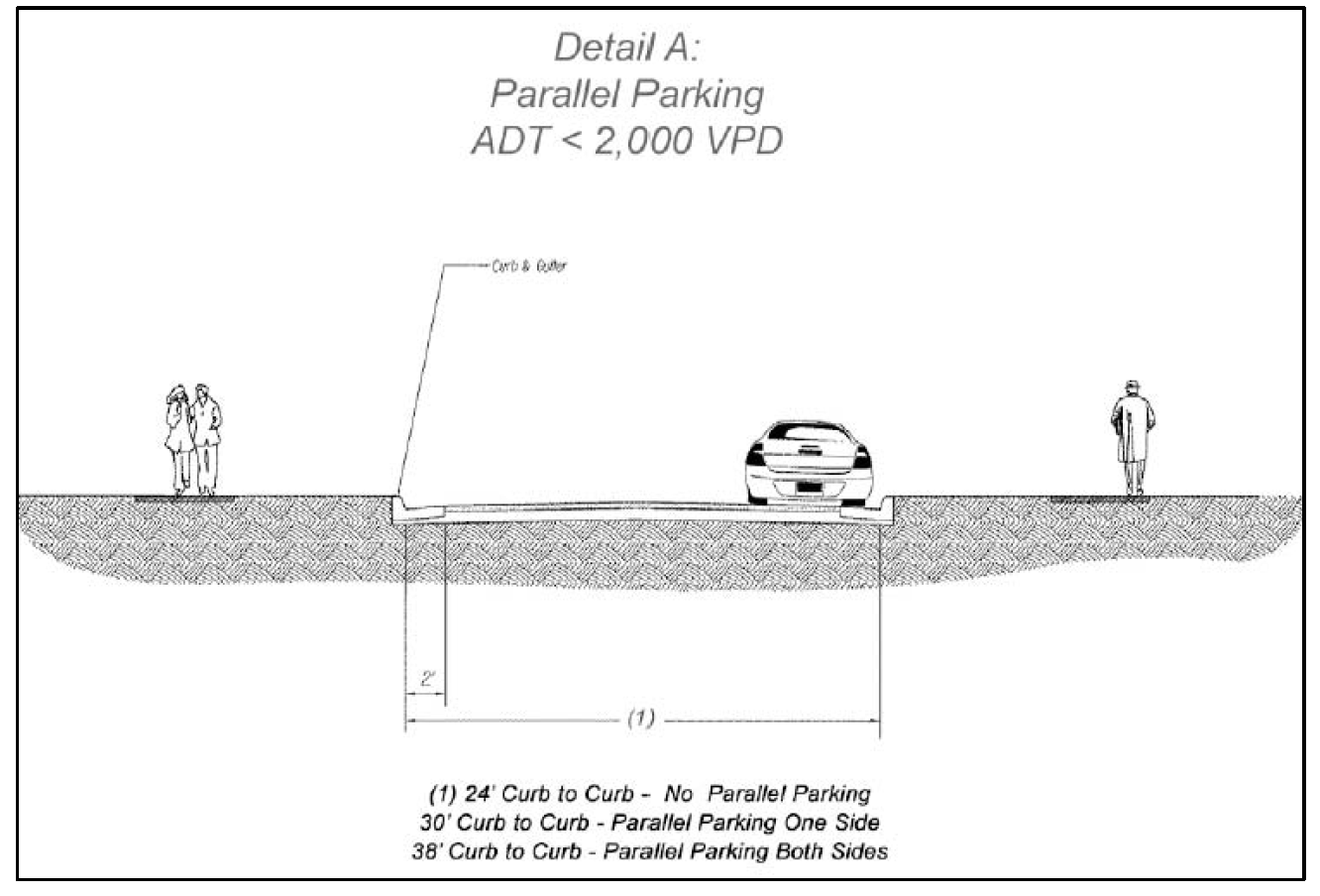
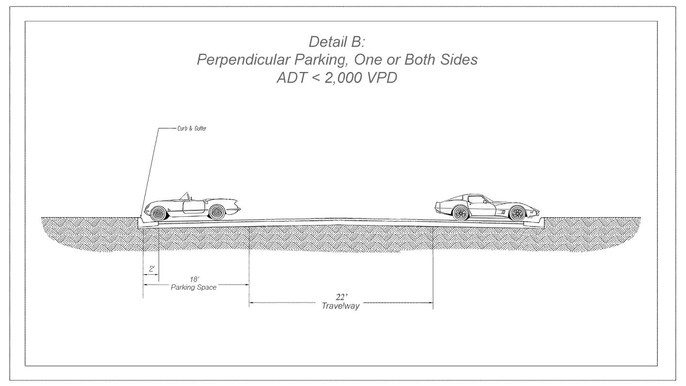
(Ord. No. O-2016-003, 4-5-2016)
Sec. 70-535.12. - Open Space; authority of the zoning administrator to approve modifications to development standards.
(a)
Areas to remain as open space shall be labeled as such, and may be incorporated into any land bay as "OS."
(b)
For purposes of the PMUD, Open space shall mean the area within the boundaries of a development that is intended to provide light, air, view and/or a quality or general appearance of openness, and is designed for scenic, recreational, privacy, or environmental purposes. In general, open space shall be available for entry on and use by the residents of the development within which the open space is located, but may include areas designed to enhance aesthetic amenities, maintain property values and buffer incompatible uses by preserving natural features and providing landscaping or screening for the benefit of such residents or residents of neighboring areas. Open space may include, but shall not be limited to, lawns; decorative plantings; walkways and trails; active and passive recreation areas, such as tot lots, including permitted principal and accessory uses; undisturbed natural areas; wooded areas; easement areas utilized by major utilities such as gas and electric; natural creeks, streams, lakes and similar water features; manmade lakes designed to be an attractive development amenity but which may be used for SWM facilities; wet and dry ponds (including extended detentions) which are landscaped or contain existing trees; and areas where buffering, landscaping or screening are required or provided. Parking areas shall not be considered open space.
(c)
A minimum of 25 percent of the total PMUD area shall be designated for open space but need not be contiguous.
(Ord. No. O-2016-003, 4-5-2016)
Sec. 70-535.13. - Effect of approval of a master zoning plan.
Upon approval of a PMUD, uses permitted in each land bay and the layout of such uses shall be determined by each use designation as shown on the master zoning plan, and any applicable proffers or conditional use permit conditions for those uses requiring such a permit.
(Ord. No. O-2016-003, 4-5-2016)
Sec. 70-535.14. - Waiver/modification provisions for PMUD.
(a)
As part of a PMUD application an applicant may request a waiver of or modification to any standard or requirement set forth in the subdivision ordinance, this division, or other town requirements.
(b)
The applicant shall provide written justification for all proposed waivers or modifications that demonstrates that the request is necessary due to implementing the design goals of the project or due to the unique characteristics of the specific property or the use proposed, provided such waivers or modifications will not conflict with the fulfillment of the purpose of this division, but will promote the purpose hereof.
(c)
All modifications or waivers shall be approved by the zoning administrator upon application. Alternatively, the town council may approve a modification for any such requirement by approval of a conditional zoning proffer statement, or conditional use permit condition.
(d)
The depiction of a modification or waiver on plans required by this section shall not of itself authorize such waiver or modification absent affirmative approval thereof by the town council evidenced by approval of a specific application therefor, or as a proffer or conditional use permit condition, where applicable.
(Ord. No. O-2016-003, 4-5-2016)
Sec. 70-535.15. - Sign regulations in the PMUD zoning district.
Alternative sign regulations in the PMUD zoning district comprehensive sign plan (CSP). Alternative sign regulations for permitted signs may be approved with the submission of a comprehensive sign plan which complies with all regulations set forth in section 70-14 of the zoning ordinance.
Applications for approval of comprehensive sign plans shall be made in accordance with the procedures for a conditional use application as set forth in section 70-10 except that the issues for consideration shall be as set forth in section 70-535.15. Comprehensive sign plans shall be submitted prior to receival of the first occupancy permit for the project. The fee shall be that of a category C conditional use permit application as outlined in the town fee schedule.
(a)
Approval of revisions to approved comprehensive sign plans may be requested and shall be limited to 1) addition of a sign category and/or individual use/user not addressed in the approved CSP, or 2) revision to a sign category that was addressed in the approved CSP. Such revisions shall be reviewed for consistency with the approved comprehensive sign plan. Requests for revisions shall be submitted to the planning director or its designee and shall be evaluated administratively by the standards set forth in section 70-535.15(a).
(1)
In addition, any application for a comprehensive sign plan shall include the following materials: A statement of justification, addressing whether and how each sign proposed by the comprehensive sign plan would:
a.
Assist motorists, bicyclists and/or pedestrians in finding a location without difficulty or confusion;
b.
Clearly identify places of business or communities, while avoiding unnecessary redundancy;
c.
Demonstrate compatibility with, and be subordinate to, the structures and land uses referenced by the sign;
d.
Address light pollution impacts with night-sky friendly equipment and operations;
e.
Incorporate energy efficient measures, where possible; and
f.
Provide a sufficient number of graphic messages or displays without creating competing demands for visual attention.
g.
Minimize impacts on Historic Properties, if applicable to the site.
(Ord. of 10-5-2022(1))
Editor's note— An ord. adopted Oct. 5, 2022, amended § 70-535.15 in its entirety to read as herein set out. Former § 70-535.15 pertained to signage and derived from April 5, 2016.
Sec. 70-535.16. - Miscellaneous development standards.
Outdoor storage shall be prohibited within a PMUD district, unless specifically approved by proffer or special use permit condition.
(Ord. No. O-2016-003, 4-5-2016)
Sec. 70-535.17. - Provision for screened trash receptacles.
Garbage collection, trash receptacles, and screening shall be in accordance with article I, section 70-25.
(Ord. No. O-2017-010, 9-5-2017)