
Ebro City Zoning Code
ARTICLE II
LAND USE, VEGETATION AND BUFFERING1
Code of Ordinances references—Location of alcoholic beverage establishments in proximity to residences, § 6-3; location of alcoholic beverage establishments in proximity to churches, § 6-4.
2.00.01 - Purpose.
The purpose of this Article is to describe the specific uses and restrictions that apply to the broad land use categories established in the Future Land Use Element of the Washington County Comprehensive Plan (including the municipalities of Caryville, Ebro, Vernon, and Wausau). These broad land use categories are:
(1)
Residential;
(2)
Commercial;
(3)
Industrial;
(4)
Mixed use/Sunny Hills;
(5)
Agriculture/Silviculture;
(6)
Conservation;
(7)
Public/Semi-Public; and
(8)
Mixed Use/Planned Unit Developments.
The former land uses of Mineral Extraction, Recreation and Historical are now included as overlay districts on the Future Land Use Map.
These regulations are intended to allow development and use of property only in compliance with the goals, objectives, and policies of the County and municipalities as expressed in the Washington County Comprehensive Plan.
(Ord. No. 2023-16, § 1(Exh. A), 12-14-2023)
2.01.01 - Generally.
Land use districts for Washington County and the municipalities of Caryville, Ebro, Vernon and Wausau are established in the Comprehensive Plan, Future Land Use Element. The land use districts and classifications defined in the Future Land Use Element of the Washington County Comprehensive Plan and delineated on the Future Land Use Map Series shall be compatible with the land use categories in this LDC, which shall determine permissible activities on any parcel in the jurisdiction. Refer to the Future Land Use Element (Section A) of the Comprehensive Plan for the definitions of each use category.
(Ord. No. 2023-16, § 1(Exh. A), 12-14-2023)
2.02.01 - Generally.
This Section defines and prescribes the specific uses allowed within each land use district described in the Washington County Comprehensive Plan and this Code. Within this section, broad categories are introduced first (ex. Residential) with a capital letter, followed by the actual land use categories (ex. Low Density Residential). The broad uses operate under a pyramid-type system, with uses from a lower intensity land use being allowed in a higher intensity land use, although not specifically listed for that district. This does not work in reverse. For example, a single-family home could be built in the Residential High (RH) land use, but a multi-family building could not be built in the Residential Low (RL) classification.
(Ord. No. 2023-16, § 1(Exh. A), 12-14-2023)
2.02.02 - Description of Land Use Districts.
A.
Residential.
1.
Residential Low (RL). This land use district provides for single-family residential settings, along with appropriate accessory structures, such as an accessory dwelling unit, home occupations, schools, parks, and public utility facilities, located as follows: within the municipalities; in the fringe areas surrounding the municipalities; at unincorporated crossroad communities; and at waterfront recreational developments (not RV parks) where adequate setbacks and natural vegetative buffers are maintained. Agricultural uses are allowed in Residential Low.
2.
Residential Medium 1 (RM1). This land use classification provides for single-family residences, duplexes, two-unit townhouses, along with accessory structures, including an accessory dwelling unit, home occupations, schools, parks, and public utility facilities, located as follows: located: within the municipalities; in the developing areas surrounding the municipalities; at unincorporated crossroad communities; and at waterfront recreational (not RV) developments with adequate vegetative buffers and setbacks. All new subdivisions and existing areas in excess of two (2) dwelling units per acre, if available, must have both central sewer and water service. If central water and sewer is not readily available, the County may approve an alternate option through the development review process that complies with the Florida Department of Environmental Protection and other applicable permitting agencies.
3.
Residential Medium 2 (RM2). This land use classification is meant to discourage urban sprawl, provide sites for affordable housing, and provide for single and multi-family residential settings, accessory dwelling units; home occupations, schools, parks, and public utility facilities. However, if central water and sewer is not readily available, the County may approve an alternate option through the development review process that complies with Florida Department of Environmental Protection and other applicable permitting agencies.
4.
Residential High (RH). Land use classification to discourage urban sprawl and to provide sites for affordable housing and multi-family settings, accessory dwelling units, home occupations, schools, parks, and public utility facilities,
B.
Commercial.
1.
Neighborhood Commercial (NC). This land use district provides for areas of low-intensity, neighborhood appropriate commercial/professional services, accessory dwelling units, as well as churches and fraternal organizations, within residential neighborhoods and agricultural crossroads.
2.
General Commercial (C). This land use provides for community and region-serving commercial and professional office uses encouraging compact development of integrated commercial centers and districts; serving the needs of the traveling public with highway commercial areas at interstate interchanges; and to provide areas for redevelopment to support economic development for the County and municipalities.
C.
Industrial.
1.
Industrial (1). The industrial district provides areas for the location of light to high-intensity industrial operations and parks and associated development and to provide sufficient choice of suitable location to encourage economic development of the County and municipalities, while protecting the public health, safety, and welfare, as well as the environment.
D.
Conservation.
1.
Conservation (CON). This land use district provides for the conservation of natural resources for the future of the County and municipalities ecosystems and for the enjoyment of current and future residents.
E.
Public/Semi-Public.
1.
Public/Semi-Public (P). This land use district provides for areas for the location of public and semi-public facilities, including institutional uses.
F.
Agriculture/Silviculture.
1.
Agriculture/Silviculture (AG/SIL). Land use district providing for the establishment. and continuation of properties for agricultural and silvicultural activities, as well as related accessory commercial activities, recreational activities, as described elsewhere in this Code, agritourism, and home sites. Bona fide farm activities and operations, include, but are not limited to, the collection, storage, processing, and distribution of a farm product.
G.
Mixed Use.
1.
Sunny Hills Mixed Use (SHMU). The land use provides for the discouragement of urban sprawl, providing for the provision of affordable/workforce housing and to encourage the development of self-contained residential communities with access to commercial and office/professional uses internal to the development.
2.
Planned Unit Development (PUD). Land use to establish a mixed-use land use served by central water and sewer and using the latest development techniques to meet the following needs: providing a mix of housing types and price ranges; discouraging urban sprawl; creating a self-contained community reducing vehicular trips on nearby highways by providing the community with internal commercial, public facilities, institutional and recreation/open space uses.
3.
Mixed Use Planned Unit Development/Skywatch. Land use to establish a mixed- use land use for the unique circumstances of the Skywatch property, which shall discourage urban sprawl, encourage the development of self-contained residential communities (e.g., residential, recreation, commercial, and associated public facilities are provided within the development), and promote a clustered, innovative design which is sensitive to preserving the rural and environmental character of Washington County. Single-family residential uses, commercial and retail uses, public facilities and grounds, and private and/or public utility providers and services, shall be used to serve the development site, and recreational uses. An on-site private central potable water and sanitary sewer system shall be constructed, operated, and maintained by the Skywatch development. Potable water and sanitary sewer may also be provided by a municipality or other service provider if such service becomes available either before or after construction of the private utilities. Skywatch shall be a phased development over an eight-year period from the date on which the Board of County Commissioners approves a PUD Site Plan for Skywatch.
(Ord. No. 2023-16, § 1(Exh. A), 12-14-2023; Ord. No. 2026-01, § 1(Exh. A), 1-15-2026)
2.02.03 - Allowable uses within each land use district.
Table 2.02.03 lists the allowed uses for each land use district by right or special exception.
Table 2.02.03 - Permitted Uses Within Land Use Districts
Table 2.02.03 - Notes:
* Subject to additional conditions
P: Permitted by Right
P1: Limited to duplexes and two-unit townhomes
P2: Limited to Neighborhood Comm. Office/Professional
P3: See Special Provisions for Uses for information on uses and regulation
P4: Only near agricultural uses
P5: Restaurant as part of farm tours, including tour participants only and secondary to agricultural use
P6: Subject to review of impacts on residential neighborhood
P8: Permitted subject to Special Provisions for Uses
P9: Permitted per F.S. § 125.01055(6). The Board of County Commissioners may approve the development of housing that is affordable, as defined in F.S. § 420.0004, on any parcel designated as commercial, industrial, or mixed use, so long as at least ten (10) percent of the units included in the project are for housing that is affordable.
SE: Special Exception
SEI: Subject to special exception approval and conservation and related regulations
SE2: Special exception, subject to use being subordinate to primary agricultural use
SE3: Special exception, plus approval from government body controlling conservation area
SE4: Special exception, subject to the Special Provisions for Select Land Uses of this LDC and being subordinate to the primary bona-fide agricultural use
SE5: Special exception, subject to conditions under the Special Provision for Select Land Uses
SE6: Special exception for internet broadband towers to be determined by the Planning Commission
D: Depends on underlying land use
TU: Requires Temporary Event Permit
TUI: Temporary events approved by the Planning Commission, limited to sales from church properties, fireworks excluded
(Ord. No. 2023-16, § 1(Exh. A), 12-14-2023; Ord. No. 2024-14, § 2(Exh. A), 12-19-2024; Ord. No. 2026-01, § 1(Exh. A), 1-15-2026)
2.02.04 - Special Provisions for Select Land Uses.
A.
Agriculture/Silviculture. In addition to other land use regulations, the following special provisions shall apply to the following uses with agricultural land:
1.
Immediate Family Exceptions. In accordance with Washington County's Comprehensive Plan and the provisions of Article VI, "Subdivisions," the transfer of property to members of the principal owner's immediate family is allowable without platting, provided that all other applicable requirements including, but not limiting to, approval of a land use certificate and recording of a survey of the split lots with the Washington County Clerk of Court, are met before and during development of the newly created parcel. Single family exceptions implement the optional family homestead concept under F.S. § 163.3179. DHRS minimum standards shall still be met, and residential units constructed on such parcels shall be counted against the maximum land use district density ratio of one (1) unit per one (1) acre. Approval of the land split as to density requirements for the parent tract and split tract shall be approved by the Planning Department. Upon the split, the Planning Department shall cause the legal description of the split property to be recorded with the Washington County Clerk of Court.
2.
Cluster Subdivisions. In accordance with Policy A7-If of the Future Land Use Element of Washington County's Comprehensive Plan clustering of residential development shall be allowed in this district in accordance with the minor subdivision procedures outlined in Article VI of this Code and the following criteria:
a.
Minimum lot sizes shall be one-half (0.5) acre in areas served by central water or sewer service, or one (1.0) acre in areas not served by either central water or sewer service. No minimum lot size if served by both.
b.
All clustered lots must front directly on either a paved roadway (newly constructed or existing) which has uninterrupted direct paved access from a paved minor collector or higher classification paved roadway, or an existing unpaved county- maintained roadway (existing as of the original date of adoption of this plan April 4, 1991).
c.
Tire Access Management Provisions of Article V are adhered to.
d.
The minimum open space ratio shall be as follows:
i.
One (1) to ten (10) lots: Twenty-five (25) percent open space ratio.
ii.
Eleven (11) to twenty-five (25) lots: Thirty-five (35) percent minimum open space ratio.
iii.
Twenty-six (26) to forty (40) lots: Forty-five (45) percent minimum open space ratio.
iv.
Forty (40) to forty-nine (49) lots: Fifty-five (55) percent minimum open space ratio.
e.
The required open space areas shall be arranged such that they provide a buffer between the cluster and surrounding parcels.
f.
The maximum number of residential units or building sites which will be allowed to be clustered on a parcel shall be based upon the gross density of the property, excluding wetlands, and the open space and minimum lot size requirements. When comparing the gross density minus wetlands and the number of lots based on open space and minimum lot size requirements, the lower density shall prevail.
g.
The clustered lots shall be platted in accordance with the subdivision and platting procedures of Article VI of this Code.
3.
Agritourism. Agritourism is limited to being a permitted use bona fide agricultural properties of ten (10) or more acres, and includes, but is not limited to the, following: barn banquets/events, farm tours and food events in barns/buildings and/or vehicles used otherwise for agricultural purposes; fruit and vegetable sale stands; and bed and breakfasts.
4.
Barn Banquet Facility. When a facility for barn banquets is proposed on agricultural parcels of ten (10) or more acres in a barn-like structure built strictly for housing such events, and is not used for any other agricultural purposes, special exception approval is required, along with the following being met:
a.
Apian for the safe and effective movement of traffic to the event venue, as well as safe and convenient parking upon arrival shall be approved.
b.
Access to the barn banquet facility from the off-site roadway shall be via a semi-stabilized driveway constructed with a base of gravel, rock, shell, or other similar material as may be approved by the County.
c.
Tire parking area shall meet the required number of parking spaces for the use. The standards for the width of parking spaces and aisles shall be met within the area designated for parking. The parking area may be constructed of a base of a minimum of one and one-half (1.5) inches of bark chips, sawdust, shavings, gravel, rock, shell, or similar materials as approved by the County. Handicapped parking spaces, however, must be paved and meet the requirements of F.S. § 553.5041. Staff shall be provided to manage the orderly and safe parking of vehicles.
d.
The special exception process shall emphasize the review of off-site impacts of the barn banquet facility and require any conditions of approval necessary to guarantee the health, safety, welfare, and enjoyment of property of adjoining property owners.
5.
Active and Passive Recreational Uses and Activities. Active and Passive Recreational Uses and Activities are permitted under Agriculture/Silviculture, as more particularly described in Section 1.11.00, "Acronyms and Definitions" of this Code.
6.
Mining. Mining and mineral extraction is subject to the Special Exception Process presented in Section 10.05.00 of this Code and the special provisions and requirements in Section 2.03.04A—D, Mineral extraction overlay.
B.
Adult Entertainment Businesses. These businesses are allowed by right in the Industrial land use district subject to the following:
1.
Adult entertainment businesses shall be prohibited from the sale of alcoholic beverages or operating as a bottle club.
2.
Adult entertainment businesses shall be located at least five hundred (500) feet from another adult entertainment business. Said distance shall be measured from the property line of one (1) property containing an adult entertainment business to the property line of the site proposing a new adult entertainment business.
C.
CBD Shops. CBD shops are permitted in designated land use districts subject to the following:
1.
CBD shops shall be located a minimum distance of five hundred (500) feet from the locations of uses children and teens frequent, including daycares, schools, parks, and similar locations. Said distance is to be measured from the property line of the CBD shop to the property line of the other use, taking the route a reasonable person would walk between the uses.
2.
CBD stores shall not be permitted with one thousand (1,000) feet of another CBD store. Said distance is to be measured from the property line of the business to the property line of the other CBD store, taking the route a reasonable person would walk between the uses.
D.
Community Residential Homes. Community residential homes of less than seven (7) residents otherwise meeting the definition of a community residential home shall be permitted by right in a residential land use, provided they are not with one thousand (1,000) feet of another such use of less than seven (7) residents or within two hundred (200) feet of another such use of seven (7) or greater residents. Community residential homes of seven (7) or greater residents shall be allowed as a special exception.
E.
Home Occupations. Home occupations are. permitted by right, subject to the conditions from F.S. § 559.955 listed below:
1.
Home occupations may operate in any Future Land Use Map Designation that allows residential uses.
2.
Employees shall be limited to the occupants of the home, plus two (2) employees or independent contractors from outside the home.
3.
The need for parking generated by the business may not be greater in volume than would normally be expected at a similar home where no business is conducted.
4.
The home occupation shall be subject to all Washington County regulations regarding the use of vehicles or trailers operated or parked at the business.
5.
Vehicles and trailers used in conjunction with the business must be parked in legal parking spaces that are not located within the right-of-way, on or over a sidewalk, or on any unimproved surface in the Right-of-way at the residence.
6.
All heavy equipment, as defined in this LDC, which would be visible from streets or adjoining properties, shall be shielded from view from said streets or properties.
7.
Outdoor storage of merchandise shall be prohibited.
8.
All signage shall comply with the Washington County standards of this LDC.
9.
Any home-based businesses that create noise, vibration, heat, smoke, dust, glare, fumes, or noxious odors shall operate only between the hours of 9:00 a.m. and 6:00 p.m. Home occupations must comply with the required sound level requirements as established in Section 10.05.04.A.5.k, Land Development Code.
10.
Businesses shall comply with all Federal, State, County, and municipality regulations regarding the use, storage, or disposal of any corrosive, combustible, or other hazardous or flammable materials or liquids. County and municipal regulations shall be applied in the same manner as such regulations are applied to single-family residences without a home occupation.
11.
Activities of a home-based business must be secondary to a property's use as a residential dwelling and a home occupation may be conducted in the primary residence or in an accessory building located on the property.
F.
[Indoor Storage Facilities.] Indoor Storage Facilities in the General Commercial land use shall be approved by special exception, subject to the additional restrictions:
1.
Indoor storage facilities shall be reviewed as to architectural appearance. Indoor storage facilities shall be designed in appearance to fit into an office or retail-type environment.
2.
If the renting of moving vehicles/trailers or the storage of RVs, boats, or other large vehicles are part of the indoor storage use, this outdoor storage area shall be blocked from view from adjoining roadways.
G.
Industrial Hemp Cultivating Facilities. Industrial hemp cultivating facilities, as described in F.S. § 581.217, and Rule 5B-57.014 F.AC. shall be permitted, subject to the following:
1.
Industrial hemp cultivation facilities shall be a permitted use in the Agriculture/Silviculture and Industrial land uses if grown under cover only in large facilities that use innovative growing techniques and where processing and distribution activities and operations exceed twenty-five (25) percent of the total square footage of all structures.
2.
Persons wishing to operate an industrial hemp cultivation facility shall supply the County Planning Department with a copy of the permit allowing such cultivation issued by the Florida Department of Agriculture and Consumer Services.
3.
Such facilities must meet the development, design, and performance standards of this Land Development Code, as we ll as the requirements of F.S. § 581.217, Rule 5B-57.014 F.AC., and 7 United State Code (U.S.C.) Section 1639p.
4.
Any other maps and pertinent data requested by the County Planning Department shall be submitted.
H.
Medical Marijuana dispensing, cultivation, and distribution facilities. These shall be permitted, in the districts depicted in Table 2.02.03 subject to the following restrictions:
1.
Medical marijuana dispensing, cultivation, and/or distribution facilities shall be located, at a minimum, five hundred (500) feet from any existing school (public or private). Measurements shall be made from the nearest property line of the school to the nearest property line of the lot containing this facility(s).
2.
Medical marijuana cultivation and/or distribution facilities may be located in Agriculture/Silviculture and Industrial land uses where medical marijuana may be grown only under cover in large facilities that use innovative growing techniques and where processing and/or distribution activities and operations exceed twenty-five (25) percent of the total square footage of the structures.
3.
Medical marijuana dispensing, cultivation, and/or distribution facilities contained within new buildings proposed for this and/or other uses shall be subject to the procedures for review and approval of site and development plans outlined in this chapter (Chapter N). In addition to the usual submittal requirements for a site and development plan review, the applicant shall provide maps and other data showing compliance with the five-hundred-foot separation rule as well as a copy of the authorization by the State Department of Health and/or Department of Business and Professional Regulation to operate a medical marijuana dispensing, cultivating and/or dispensing facility.
4.
For new facilities of this nature proposing to open in an existing building, a land use compliance letter shall be applied for and received. Maps and other data supporting compliance with the five-hundred-foot distance separation from public/private schools, as well as a copy of the authorization issued by the Department of Health and/or Department of Business and Professional Regulation to operate a medical marijuana dispensing, cultivation and/or distribution facility shall be included with said application.
5.
By accepting a development order or land use compliance letter pursuant to this section, the medical marijuana dispensing, cultivation, and/or distribution organization waives any claim concerning, and releases the County, its officers, elected officials, employees, attorneys and agents from any liability for injuries or damages of any kind that result from any arrests or prosecutions of owners, managers, employees, operators, clients, or customers of the dispensing, cultivating, and/or distribution organization for a violation of State or Federal laws, rules, or regulations.
6.
By accepting a development order or land use compliance letter pursuant to this section, the medical marijuana dispensing, cultivation, and/or distribution organization agrees to indemnify, defend, and hold harmless the County, its officers, elected officials, employees, attorneys and agents and insurers against all liability, claims, and demands on account of any injury, loss or damage, including without limitation claims arising from bodily injury, personal injury, sickness, diseases, death, property loss or damage, or any other loss of any kind whatsoever arising out of or in any manner connected with the operation of the dispensing organization that is subject to the development order or land use compliance letter.
7.
The issuance of a development order or land use compliance letter pursuant to this section shall not be deemed to create an exception, defense, or immunity for any person in regard to any potential criminal liability the person may have under State or Federal law for the acquisition, cultivation, possession, processing, transferring, transportation, selling, distribution, dispensing, or administration of marijuana or products containing marijuana.
I.
Mobile Food Vendors. Mobile food vendors, which sell food on private or public property from mobile food dispensing vehicles, as defined within the Definitions section of this LDC, shall be subject to the following regulations:
1.
Upon request, a mobile vendor shall provide to a Code Enforcement Officer or any other duly authorized person, a copy of the license from the State of Florida to operate the mobile vending business from the required by F.S. § 509.251.
2.
Mobile vendors may operate, with proof of owner permission, on any public or private property within Commercial or Industrial land uses, including properties within the Sunny Hills Mixed Use and PUD land uses with either of these underlying uses.
3.
Signage advertising a mobile vending business shall be limited to the property where the business is conducted. No signage shall be located in the public right-of-way. All signage shall meet the requirements for signage within this LDC.
4.
The mobile vending business shall not be located in any parking spaces required for meeting minimum required parking spaces for all businesses within the property.
5.
Mobile vending businesses shall not be located within any required loading zones, fire lanes, in handicapped spaces, or in any location that obstructs the flow of traffic within or on roadways/driveways leading to the property.
6.
Mobile vending businesses shall not be located as to require customers to back onto collector or arterial roadways adjoining the property following the business transaction.
J.
Private School. Private schools are a special exception in the Neighborhood Commercial (NC) zoning district, and shall also meet the following:
1.
A traffic study shall be provided indicating that the site can effectively handle the dropping off and picking up of students, while at the same time maintaining safe and efficient traffic conditions on the adjoining roadway.
2.
The special exception review process shall emphasize the visual, noise, and traffic impacts on adjoining or nearby residential uses and roadways.
K.
Planned Unit Developments. In addition to the land use information on PUDs in Table 2.02.06, the following conditions shall also apply:
1.
All residential subdivisions of one hundred (100) or greater units shall be required to be developed as PUDs.
2.
All PUDs shall have vegetative buffers, preferably natural or mimicking natural conditions, of fifty (50) feet between the PUD and adjacent properties.
3.
Tire density and intensity of PUDs shall be determined based on the underlying land use district standards established in the PUD development review process.
L.
Solar farms. When approved as a special exception, solar farms shall meet the following additional standards:
1.
When abutting a residential land use category, a one-hundred-foot setback shall be provided, including a twenty-five-foot landscape buffer area.
2.
When abutting the Choctawhatchee River, Holmes Creek, and Econfina Creek, a one-hundred-foot buffer from the ordinary high-water line shall be provided.
3.
When trees are required to be removed for solar farm construction, the County's tree removal standards shall be followed.
4.
At the time of issuance of a permit for construction, all Federal, State, and local required permits shall have been approved.
5.
Following the cessation of the use of the property as a solar farm, the owner/lessee of the solar farm site shall be responsible for returning the site to its pre-development state within six (6) months. A surety bond in the amount necessary to return the site to its pre-development condition shall be posted prior to the issuance of a permit allowing construction to ensure against default regarding this obligation.
M.
Silviculture Uses. Silviculture uses shall be subject to the following:
1.
All silviculture activities conducted in the Agriculture/Silviculture district shall utilize tree harvesting methods which are compatible with the maintenance of the natural functions of the area (see Comprehensive Plan for more detail).
2.
The following permanent natural vegetative buffers (above the observed normal waterline) shall be maintained:
a.
One hundred (100) feet from Choctawhatchee River.
b.
One hundred (100) feet from Econfina Creek, Holmes Creek, and Pine Log Creek.
c.
In accordance with regional policy, the County will prohibit all construction, except piers, docks, and landscaping, within one hundred (100) feet of mean high-water mark of Choctawhatchee River, Holmes Creek, and Econfina Creek. The County will continue to monitor development on the Choctawhatchee River, Holmes Creek, and Econfina Creek as provided for in the LDC.
d.
A minimum of fifty (50) percent natural vegetative cover shall be undisturbed in these buffer areas.
3.
No silviculture activities conducted in this land use district will result in the conversion of the existing wetlands to an upland system, or another wetland type.
4.
Silviculture activities in the Pine Log State Forest and the Choctawhatchee Water Management Area shall be allowed in non-wetland areas only.
5.
The County shall take into consideration, in the assessed value of property, increased property values directly related to infrastructure expenditures by government, and shall require that impacts to, and incompatible land uses adjacent to, wetlands should be minimized by first avoidance and then mitigation; and all properties meeting conservation criteria shown as Conservation Element of the Comprehensive Plan, as appropriate.
N.
[Special Treatment Zone.] The Special Treatment Zone (Northwest Florida Beaches International Airport) is an overlay zone on the Future Land Use Map and encompasses more than one (1) underlying land uses and that imposes additional provisions above those that are currently reflected by the land use categories depicted on the Land Use Map. The following special procedures apply:
1.
No development permit shall be granted that would allow the creation of a new hazard or the worsening of an old one. If a regulation would cause "practical difficulty or unnecessary hardship," an individual may appeal first to the Washington County Planning Commission. If a variance is granted, the owner of the nonconforming development may be required to take some measures to lessen any potential risk to airport operations.
O.
Temporary Sales. Temporary sales are permitted in designated future land uses, and shall meet the following requirements:
1.
Parking may be on grass but must be set up so that drivers are not required to back onto adjoining streets.
2.
Temporary sales shall not be located within road right-of-way, but must be on private property, with owner proof of approval of the sales.
3.
Temporary sale uses shall have a signage plan. All signage shall meet County requirements, with signs that would be distracting to drivers being prohibited.
4.
These uses may not occupy parking spaces of a property required to meet the minimum parking requirements for that property nor park in areas designated as zones for emergency response vehicles.
P.
Tobacco Shops. Tobacco shops are permitted in designed land use districts subject to the following:
1.
Tobacco shops shall be located a minimum distance of five hundred (500) feet from the locations of uses children and teens frequent, including day cares, schools, parks, and similar locations. Said distance is to be measured from the nearest property line of the business to the nearest property line of the other use.
2.
Tobacco stores shall not be permitted with one thousand (1,000) feet of another tobacco store. Said distance is to be measured from the closest property line of the property proposed for the tobacco store to the closest property line of the parcel containing the nearby tobacco store taking the route a reasonable person would walk between the uses.
Q.
Wireless Communication Towers. Wireless communication towers shall be subject to the following standards, which are in addition conditions required under a special exception approval:
1.
Renderings of the appearance of the proposed wireless communication tower shall be included.
2.
Wireless communication facilities shall be designed with a fall zone, upon which the tower shall be designed by a certified to any licensed engineer in the State of Florida to land within the property containing the tower in the event of a catastrophic failure or collapse.
3.
A proposed tower shall be designed to allow for future co-location of additional antennas and ground space to accommodate the equipment required for the colocation.
4.
In the event a new wireless communication tower is proposed, the applicant shall provide a detailed report with data demonstrating that the communication need could not be accommodated through either co-location on an existing tower or through small cell deployments. When better communication is desired for an area, small cell deployments shall be the preferred method.
5.
Monopoles or stealth design (communication towers looking like trees, crosses, etc.) are the preferred structure type for wireless communication towers. Where another type of tower is proposed, the applicant shall provide a detailed report including data on why a monopole or stealth design is not feasible for the proposed wireless communications tower.
6.
A tower shall not be artificially lighted except as maybe required by federal or state regulations.
7.
All towers shall be painted or have a non-contrasting finish that minimizes the visibility of the facility from public view, except where contrasting color is required by federal or state regulation. In addition, the exterior of support facilities shall be designed to be compatible with the architectural design prevailing among the structures in the surrounding developed area.
8.
When wireless communications towers are planned in the south County near Ebro, the regulations and restrictions of the Airport Protection Area of Section 2.03.05 of the Land Development Code shall be applicable.
9.
The main access gate in the tower shall have affixed to it a sign not to exceed two (2) feet by three (3) feet in size which displays the owner's or permittee's name and an emergency telephone number.
10.
The maximum height of towers shall be one hundred fifty (150) feet if the tower is designed for one (1) service provider, one hundred seventy (170) feet if the tower is designed to accommodate two (2) service providers, or two hundred (200) feet if the tower is designed to accommodate three (3) or more service providers. Variances to these heights may be approved through the County variance process but must include a detailed report as to why the communications need cannot be met within the prescribed tower heights.
11.
The equipment area at the foot of the tower shall be surrounded by an eight-foot fence, with barbed wire being allowed for security purposes. All support equipment shall be contained within this area. The area containing equipment for the tower at its base shall be screened from view by shrubs maintained at a height of six (6) feet and shade trees of a fast-growth nature which are minimum of eight (8) feet in height upon planting.
12.
Reservation of space for antenna and ground equipment cabinet for emergency services shall be required as a condition of approval for all telecommunication towers.
13.
Any tower that is not occupied by a functioning antenna for a continuous period of twelve (12) months and has no application or lease agreement to place an antenna on the power being actively pursued shall be considered abandoned, and the owner of such tower shall remove same within ninety (90) days of written notice from the Washington County Development Administrator or designee that the tower has been determined to be abandoned. If such tower is not removed within said ninety (90) days, Washington County may have the tower removed at the tower owner's expense. Appeals of the County Development Administrator's determination of abandonment shall be reviewed by the Board of County Commissioners, and the appeal tolls the deadline for removal.
14.
Prior to the issuance of any permit for a new telecommunication tower, the applicant and owner of the tower shall be required to procure and deposit with the County a Surety Bond in the amount of ten thousand dollars ($10,000.00) made payable in favor of "The Board of County Commissioners of Washington County, Florida, for the use and benefit of the residents and citizens of Washington County, Florida," indemnifying the County, the Board of County Commissioners, and any and all affected persons against any and all losses, damages and claims arising out of the placement, maintaining, the removal or deconstruction of any tower found to have been abandoned. The Bond shall be maintained in full force and effect throughout the duration of the existence of the tower. As an alternative to the Surety Bond, the applicant and owner may post and deliver an Irrevocable Letter of Credit which shall be irrevocable for the necessary time period, which Letter shall be in a form acceptable to the Board of County Commissioners and the County Attorney.
15.
The center of transmission towers shall be set back from property lines the distance equal to the height of the tower.
(Ord. No. 2023-16, § 1(Exh. A), 12-14-2023; Ord. No. 2024-14, § 2(Exh. A), 12-19-2024)
2.02.05 - Compatibility of Future Land Use and Land Use Categories.
Due to the similarity and/or compatibility of their uses, Table 2.02.05 below depicts the future land use and land use classifications which are recommended to be located adjacent or in close proximity to each other. These compatibility recommendations are not absolute but aim to guide in future land use or land use amendments.
Table 2.02.05 - Compatibility of Future Land Use and Land Use Districts
(Ord. No. 2023-16, § 1(Exh. A), 12-14-2023)
2.02.06 - Land Use Density and Intensity.
The following Table 2.02.06 summarizes the densities and intensities of the land use districts.
Table 2.02.06 - Land Use Density and Intensity for Washington County and its Municipalities
Notes:
*
Can reduce lot size if equal alternative for water or sewer is approved.
**
35' setback from the front property boundary line to the building or structure if fronting a County road or collector road, and 50' setback from the front property boundary line to the building or structure if fronting arterial road.
***
With Special Exception approval for development, Agriculture/Silviculture Future Land Use Map category design and performance standards will apply in the Conservation Future Land Use Map category.
(Ord. No. 2023-16, § 1(Exh. A), 12-14-2023; Ord. No. 2024-14, § 2(Exh. A), 12-19-2024; Ord. No. 2026-01, § 1(Exh. A), 1-15-2026)
2.02.07 - In General—Setbacks.
In addition to the setbacks outlined in Table 2.02.06, and the natural resources setbacks included in Chapter 4, the following setbacks will apply:
1.
A minimum ten-foot setback shall be required between buildings and structures.
(Ord. No. 2023-16, § 1(Exh. A), 12-14-2023)
2.03.01 - Purpose.
The purpose of this Section is to describe certain overlay districts used to impose special development restrictions on identified areas and/or to allow for development of uses which are by their nature essentially compatible with all other uses (i.e., outdoor recreation). The location of overlay districts is established by Washington County based on the need for special protective measures and/or for development flexibility. The underlying uses in the area, as determined by the applicable land use district remain undisturbed by the creation of the overlay district. The overlay district merely imposes additional development standards and/or protections than those that would otherwise apply.
(Ord. No. 2023-16, § 1(Exh. A), 12-14-2023)
2.03.02 - Recreational land use overlay.
A.
General. This area shall consist of areas indicated on the Future Land Use Map, and shall be utilized in conjunction with the Conservation, Public Facilities, and in any other future land use district (since this use is allowed in all districts) in accordance with the use and density requirements of this Section of the Code, the buffering requirements contained herein, and all provisions of the Washington County Comprehensive Plan.
B.
Permitted and Prohibited Uses. Permitted uses include all outdoor recreational uses (see Section 2.02.02(B)), as well as indoor recreation centers (noncommercial), recreational rentals when approved by the agency controlling the property, and community centers.
C.
Density. The density of a development site shall be that of the underlying land use district. No non-recreational density, excluding approved recreation rentals mentioned above, is allowed in areas designated Recreational Overlay on the Future Land Use Map Series.
D.
Intensity. For all accompanying recreational and other facilities listed above, the maximum Floor Area Ratio (FAR) shall be 0.50.
(Ord. No. 2023-16, § 1(Exh. A), 12-14-2023)
2.03.03 - Historical and Archaeological land use overlay.
A.
General. This area shall consist of all areas with historical or archaeological uses and/or structures shown as Historical and Archaeological Overlay on the Future Land Use Map Series of the Washington County Comprehensive Plan and other areas which may be designated as historical land uses by the governing body through the Comprehensive Plan amendment process.
B.
Permitted and Prohibited Uses. Historical structures may be used for the purpose of their intended original construction, as well as for museums or similar public or private facilities. Passive recreational uses (i.e., picnicking, walking areas, etc. are also allowed on such development sites). Archaeological sites shall have no development covering the site except for interpretive facilities in accordance with State of Florida Standards for Archaeological Sites.
C.
Density. The maximum allowed density in the Historical Land Use District shall be the density at which the area was originally developed (in accordance and compliance with current Florida Department of Environmental Protection rules and regulations for on-site sewage disposal systems (septic tanks)).
D.
Intensity. The maximum allowed intensity of development allowed for rehabilitation and/or replacement of structures shall be in accordance with the originally developed intensity of the historical site in accordance and compliance with current DHRS rules and regulations, as well as State and Federal regulations governing historic structures and/or sites. Newly constructed accessory structures shall have a maximum FAR of 0.75 (including existing structures) and shall not degraded the historical or archeological significance of the area.
(Ord. No. 2023-16, § 1(Exh. A), 12-14-2023)
2.03.04 - Mineral Extraction overlay.
A.
General. This area shall consist of all areas shown as Mineral Extraction Overlay on the Future Land Use Map Series of the Washington County Comprehensive Plan, and other areas which may be designated as mineral extraction uses by the governing body through the Special Exception Process presented in Section 10.05.00 of this Code.
B.
Permitted Uses. All mining activities (does not include landfill activities).
C.
Density and Intensity. In accordance with submitted and approved extraction and reclamation plan.
D.
Special Provisions. All mineral extraction uses shall meet the following requirements:
1.
Burden of Proof. The applicant must document the proposed activity will not cause significant damage to potable water supplies; surface water; threatened and endangered species; species of special concern; or adjacent properties.
2.
Reclamation Plan. The applicant shall provide an acceptable reclamation plan to be implemented in a timely manner at the expense of the applicant.
3.
Wetland Replacement. If wetlands are to be destroyed, they shall be replaced acre for acre, by type, form, and function.
4.
Notification. The Florida Game and Freshwater Fish Commission shall be notified prior to approval to assess any mitigation requirements necessary to protect threatened or endangered species or species of special concern.
5.
Buffering. A one-hundred-foot-buffer shall be required to be established and maintained between the outermost perimeter of mining activities and adjacent existing and future uses to achieve an aesthetically pleasing landscape compatible with those land uses.
6.
Flood Prone Areas. Mining activities shall not be allowed in areas subject to flooding or within designated flood zones.
7.
Phasing of Excavation. Phasing of extraction activities shall be used as a device to assure that only small areas are affected by such activities at one time. Where mining is being accomplished in benches that are more than five (5) years apart, general maintenance to control erosion, provide safety sheer slopes, provide stormwater drainage, and minimize groundwater impacts shall be implemented.
8.
Reclamation Plan. A reclamation plan shall be submitted and approved by the County as part of the development review process before mining activities are permitted. The developer shall be responsible for payment of a surety bond/security in the amount documented to be sufficient in carrying out the reclamation plan in the event the developer defaults on this responsibility.
9.
Before mining operations are approved, the County shall require that a fee and/or bond be posted in amounts sufficient to compensate for any degradation of County maintained roadways with the amount of the fee or bond being determined by the County Engineer and approved by the Board of County Commissioners.
10.
Each geographically distinct mining site shall require a separate permit application.
11.
The County requires that the application for any mining permit from State and/or Federal agency for mining operations and or reclamation be submitted concurrently to the County for consistency with the special exception process as detailed in the Land Development Code and a copy of the approved State/Federal permit be furnished by the permittee to the Washington County Planning Department.
12.
Mining plans shall be issued for a maximum period of twenty-five (25) years. At least every five (5) years the local governing body shall review each individually permitted geographically distinct mining site for a compliance review. If the mining activities are not compliant, then mining will cease until such time as the County can be assured that compliance requirements are being met.
13.
Permissible hours of operation will be between the hours of 7:00 a.m., and 6:00 p.m., from Monday through Saturday, except that the Washington County Planning Commission can recommend that the hourly period can be extended from sunrise to sunset only within remote areas.
14.
The special exception application shall address appropriate modifications in mining operations that will reduce adverse response from the public. These modifications will address the reductions of dust, noise, traffic, stormwater, roadway damage, and security of the site.
15.
It will be the policy of the County to address future undesirable conditions resulting from placement of new mines or expansion of existing mines in close vicinity to existing private potable water wells and/or County/municipal wellheads. A five-hundred-foot setback shall be required from the outer perimeter of the approved planned site of the mine to the any existing identifiable private water wells or public wellhead(s). Placement of any wells by private developers or property owners within the five-hundred-foot setback after approval of the special exception process will require a variance.
16.
To start the process of closing a mine, the developer must file a statement stating the conditions of the pit closure and when the closure is expected to be completed.
17.
Re-vegetation of reclaimed areas shall consist primarily of perennial species native to the area or other species approved by the County. Cost estimates shall be provided by the operator with the reclamation plan and be approved by the County. The cost estimate shall be reviewed every five (5) years, and the security shall be updated as needed. Security shall remain in effect until all of the affected lands have been reclaimed, inspected, and approved by the County Engineer.
18.
The natural functions of wetlands, floodplains and the Choctawhatchee River will be protected by prohibiting mining in one-hundred-year floodplain areas, within thirty (30) feet of wetlands and within one hundred (100) feet of the Choctawhatchee River, Holmes Creek, and Econfina Creek.
19.
To provide for the safety of persons, wildlife, and adjoining property, during final reclamation activities, the site shall be adequately cleared of debris, equipment, materials, and structures. The developer will furnish the Planning Office with a copy the Reclamation Plan, as outlined in F.S. § 378.401, for the requirements to begin reclamation and defines the reclamation standards. Bonding shall be required in an amount equal to or exceeding the total cost of completing all work delineated in the Reclamation Plan.
20.
The County will require evidence that all State and Federal permits necessary to operate any mine have been issued and evidence from a licensed geologist that the operation will not breech the Floridan Aquifer during mining.
21.
Upon approval of a mining operation under the special exception process, a development agreement between the developer and Washington County or the affected municipality will be executed. This development agreement will include all conditions as set forth in the Comprehensive Plan and the Land Development Code as well as those approved during the public hearing and approved by the Board of County Commissioners.
22.
The special exception application shall address appropriate modifications in mining operations that will reduce adverse impact to nearby property and/or the public. Upon approval, these modifications pertaining to the reductions of dust noise, traffic, stormwater, roadway damage, and security of the site will be incorporated into an agreement between the County and/or municipality and the developer.
(Ord. No. 2023-16, § 1(Exh. A), 12-14-2023)
2.03.05 - Airport Protection Zone (AICUZ).
A.
General. The AICUZ area, also known as the Special Treatment Area, for the Northwest Florida Beaches International Airport is the lands and waters described in the Northwest Florida Beaches International Airport 2009 AICUZ User Guide Manual, Development restrictions described in the Guide shall apply within the AICUZ area. There are four (4) specific zones created for the Northwest Florida Beaches International Airport.
B.
Permitted Uses.
1.
Airport Obstruction Height Zone. Map 1: Height limitations and sizes established to conform to the standards for determining obstructions to air navigation.
2.
Wildlife Attractant Hazard Zone (B). Map 2: Ten-thousand-foot Perimeter (B). Separation distance for any wildlife attractants or for new airport development projects meant to accommodate aircraft movement. Page 2, FAA Advisory Circular 150/5200-33B.
3.
5-Mile Perimeter C. Map 3: Five (5) Statute miles Perimeter — Between farthest edge of the airport's air operations area (AOA) and hazardous wildlife attractant if it could cause hazardous wildlife movement into or across the approach or departure airspace. Page 2, FAA Advisory Circular 150/5200-33B.
4.
10-Nautical Mile Perimeter. Map 4: Ten-nautical mile radius of geographical center of publicly center of a publicly owned or operated airport, a military airport, or an airport licensed by the state for public use. Permit required for structures exceeding federal obstruction standards in F.S. § 333.025.
5.
6-Nautical Mile Perimeter. Map 5: Six-nautical mile, limitations on construction or establishments of landfills near public airports. Page 4, FAA Advisory Circular 150/5200-33B.
Any development that would threaten the integrity and mission of the Northwest Florida Beaches International Airport shall be prohibited.
A statute mile is used for surveying and is defined as five thousand two hundred eighty (5,280) feet or one thousand six hundred nine and thirty-four one-hundredths (1,609.34) meters. A nautical mile is six thousand seventy-six (6,076) feet or one thousand eight hundred fifty-two (1,852) meters. The nautical mile is used for aeronautical and maritime navigation.
(Ord. No. 2023-16, § 1(Exh. A), 12-14-2023)
2.03.06 - Tri-County Airport Impact Overlay (AIO) Zone.
The Airport Impact Overlay (AIO) is established to ensure the safe operation of airports and to guide compatible land use in airport-adjacent areas, aligning with F.S. Ch. 333. This ordinance (Ord. No. 2014-14) limits structure and vegetation heights, manages land uses around airports, and restricts developments that could pose hazards or interfere with airport operations.
The Tri-County Airport Authority, representing Holmes, Jackson, and Washington Counties, plays a crucial role in advising the County's Planning and Zoning Commission and Board of County Commissioners on development proposals within the overlay. The AIO and associated regulations apply to all relevant land use and development in the County to ensure compatibility with the Washington County Comprehensive Plan, Land Development Code, and FAA standards.
Key Regulations and Requirements:
1.
Development Standards: Limits are placed on light emissions, smoke, glare, electronic interference, and specific hazardous uses (e.g., schools, hospitals) near airport areas to prevent risks to aviation operations. Landfills are prohibited within certain distances from runways to prevent bird hazards.
2.
Height Restrictions: Specific height restrictions apply within designated zones (e.g., primary, conical, and transitional surfaces), based on airport layout maps and FAA guidelines.
3.
Airspace Obstruction Requirements: Any construction exceeding specified height limits requires an obstruction review process. Submittal documents must include FAA evaluations and detailed project explanations. Approval considers factors like air and ground safety, terrain, existing structures, flight operations, and FAA-designated airways.
4.
Supplemental Standards: Any approved obstruction must have appropriate FAA-compliant lighting and marking at the owner's expense. Structures that exceed obstruction standards posing a navigational hazard will not be approved.
This ordinance ensures safe, compatible development within the County's Airport Impact Overlay, thereby projecting the public and supporting the efficient use of navigable airspace.
(Ord. No. 2024-14, § 2(Exh. A), 12-19-2024)
2.03.06.01 - Purpose and intent.
A.
The Airport Impact Overlay (AIO) is designed to provide for safe airport operations and development of uses in locations near the airport which are compatible with the airport use.
B.
The purpose of this overlay is to regulate heights of structures and vegetation and to regulate the uses of land within the vicinity of general aviation public use airports, in accordance with F.S. Ch. 333, to avoid the creation of airport hazards and inhibit the development of uses which may be adversely affected by airport operations.
C.
The Tri-County Airport Authority, composed of appointed officials from Holmes, Jackson, and Washington Counties, has a critical role in overseeing airport operations and acts as a recommending board to the Planning and Zoning Commission and Board of County Commissioners as it applies to development in the Airport Impact Overlay.
D.
As the County is a member of the Tri-County Airport Authority, which adopts and administers Airport Impact Overlay regulations pursuant to F.S. Ch. 333, the Airport Impact Overlay and its related development criteria are established to ensure aviation-compatible land uses and activities in the County. All development within the County shall comply with the Washington County Comprehensive Plan, the Land Development Code, and the Tri-County Airport Authority Regulations as it applies to development in the Airport Impact Overlay.
(Ord. No. 2024-14, § 2(Exh. A), 12-19-2024)
2.03.06.02 - Definitions.
The definitions of F.S. Ch. 333, Airport Zoning, as amended, shall be applicable to the terms of this section, unless the text and/or context of this section requires otherwise.
(Ord. No. 2024-14, § 2(Exh. A), 12-19-2024)
2.03.06.03 - Standards for Development within the Airport Impact District.
Tri-County Airport.
A.
Description of Area: All lands lying within the transitional, approach, conical, horizontal and primary surfaces as defined and shown on Map 1 "Tri-County Airport Layout Plan," of the Washington County Land Development Code.
B.
Consistent with applicable law, all development within an Airport Impact District shall be subject to the County's development review procedures.
C.
Notwithstanding any other provision of this LDC, no use may be made of land or water within any surfaces established by this LDC in such a manner as to interfere with the operation of an airborne aircraft. The following special requirements shall apply to each permitted use:
1.
All lights or illumination used in conjunction with street, parking, signs, or use of land or structures shall be arranged and operated in such a manner that is not misleading to pilots or dangerous to aircraft operating to and from a public use airport or in the vicinity thereof.
2.
All flood lights, spot lights, or any type of pulsating, flashing, rotating, or oscillating light shall be modified or prohibited if determined by the Tri-County Airport Authority Board, who has authority over that airport, to be a possible risk to safety of aircraft operation.
3.
No operations of any type shall produce smoke, glare, or other visual impairment to pilots within three (3) miles of any usable runway of a public airport.
4.
No operations of any type shall produce electronic interference with navigation signals or radio communication between the airport and aircraft, or other air traffic control facility.
5.
Land within Runway Protection Zones, as defined by the Federal Aviation Administration (FAA), shall be prohibited from use for residential use, schools, hospitals, storage of explosives, or flammable material, assemblage of large groups of people or any other use that could produce a major catastrophe as a result of an aircraft crash.
6.
New landfills shall be prohibited, and existing landfills shall be restricted within the following areas:
a.
Within ten thousand (10,000) feet from the nearest point of any runway used or planned to be used by turbine aircraft.
b.
Within five thousand (5,000) feet from the nearest point of any runway used by only non-turbine aircraft.
c.
Outside the perimeters defined in LDC Section 2.03.06, but still within the lateral limits of the civil airport imaginary surfaces defined in 14 C.F.R. Section 77.19.
7.
Where any landfill is located and constructed in a manner that attracts or sustains hazardous bird movements from feeding, water, or roosting areas into, or across, the runways or approach and departure patterns or aircraft, the landfill operator must incorporate bird management techniques or other practices to minimize bird hazards to airborne aircraft.
8.
Any type of tethered dirigible, balloon, or other type of hovering or floating object the height of which exceeds the criteria outlined in LDC Section 2.03.06 is prohibited.
9.
No structure of any height, type or material shall be constructed or altered so as to cause interference with any radio or electronic navigational aids or systems as determined by the Federal Aviation Administration, or by the Tri-County Airport Authority who has jurisdiction over the airport deemed to be affected.
D.
Height Limitations: No structure shall be erected, and no vegetation shall be permitted to grow, that exceeds any of the following height limitations (point to map):
1.
Primary Surface. No structure or obstruction will be permitted within the primary surface area that is not part of the landing and takeoff area and is greater height than the nearest point on the runway centerline with the exception of FAA approved navigation aids.
2.
Horizontal Surface. One hundred fifty (150) feet above airport elevation.
3.
Conical Surface. One hundred fifty (150) feet above airport elevation at the inner boundary, with permitted height increasing one (1) foot vertically for every twenty (20) feet of horizontal distance measured outward from the inner boundary for a distance of four thousand (4,000) feet.
4.
Approach Surface. The runway centerline end height at the inner edge, with permitted height increasing with horizontal distance outward from the inner edge as follows:
a.
Runway 01/19: One (1) foot vertically for every twenty (20) feet of horizontal distance.
5.
Transitional Surface. The same as for the primary zone or the approach zone where it adjoins, with permitted height increasing one (1) foot vertically for every seven (7) feet horizontally, measured at right angles to the runway centerline or extended centerline.
(Ord. No. 2024-14, § 2(Exh. A), 12-19-2024)
2.03.06.04 - Requirements for airspace obstructions.
The definitions of F.S. Ch. 333, Airport Zoning, as amended, shall be applicable to the terms of this section, unless the text and/or context of this section requires otherwise.
A.
Applicability. An airspace obstruction submittal is required when a proposed airspace obstruction exceeds one (1) or more of the criteria established in LDC Section 2.03.06. Review of airspace obstructions shall occur at the time of the site development plan review, if applicable. If a site development plan is not required, the airspace obstruction shall be reviewed at time of building permit submittal.
B.
Airspace obstruction review materials. The LDC shall establish the submittal requirements for an airspace obstruction review during the Site Development Plan review process. When an airspace obstruction review is required at time of building permit, the following items shall be submitted for review:
1.
A copy of the FAA form 7460-1 "Notice of Proposed Construction or Alteration" and all supporting materials, filed with the FAA;
2.
A copy of the final FAA Obstruction Evaluation/Airport Airspace Analysis (OE/AAA) determination;
3.
A narrative statement with a detailed description/explanation of the proposed airspace obstruction and response to the applicable criteria from LDC Section 2.03.06; and
4.
A letter of recommendation of approval, approval with conditions, or by the Tri-County Airport Authority Board.
C.
Criteria for review. Land use compatibility criteria shall be reviewed for all existing and new development within the County for compliance with the Airport Impact District regulations. The airspace obstruction may not be approved solely on the basis that the FAA determined that the proposed construction or alteration of an obstruction was not an airport hazard. In determining whether to approve or deny an airspace obstruction, the County Administrator or designee, in coordination with the Tri-County Airport Authority Board, must also consider the following, as applicable:
1.
The safety of persons on the ground and in the air.
2.
The safe and efficient use of navigable airspace.
3.
The nature of the surrounding terrain and height of existing structures.
4.
The effect of the construction or alteration on the state licensing standards for a public-use airport contained in F.S. Ch. 333, and LDC regulations adopted thereunder.
5.
The character of existing and planned flight operations and developments at the public-use airport.
6.
Federal airways, visual flight rules, flyways and corridors, and instrument approaches as designated by the FAA.
7.
The effect of the construction or alteration of the proposed structure on the minimum descent altitudes or the decision heights at the affected airport.
8.
The cumulative effects on navigable airspace of all existing structures and other known proposed structures in the area.
9.
Comments and recommendations from FDOT Aviation Office, the affected airport(s), aviation operations and safety experts, where applicable.
D.
Supplemental standards for the development of airspace obstructions:
1.
The owner of the obstruction will be required to install, operate, and maintain thereon and at their own expense, obstruction marking and lighting in conformance with the specific standards established by the FAA, including, but not limited to, FAA Advisory Circular 70/7460-1, as may be amended.
E.
The County Administrator or designee shall not issue an airspace obstruction approval where the FAA has reviewed the proposed and determined its construction or alteration would exceed obstruction standards contained in 14 CFR Part 77 and result in a hazard to air navigation.
Map 1: Tri-County Airport Layout Plan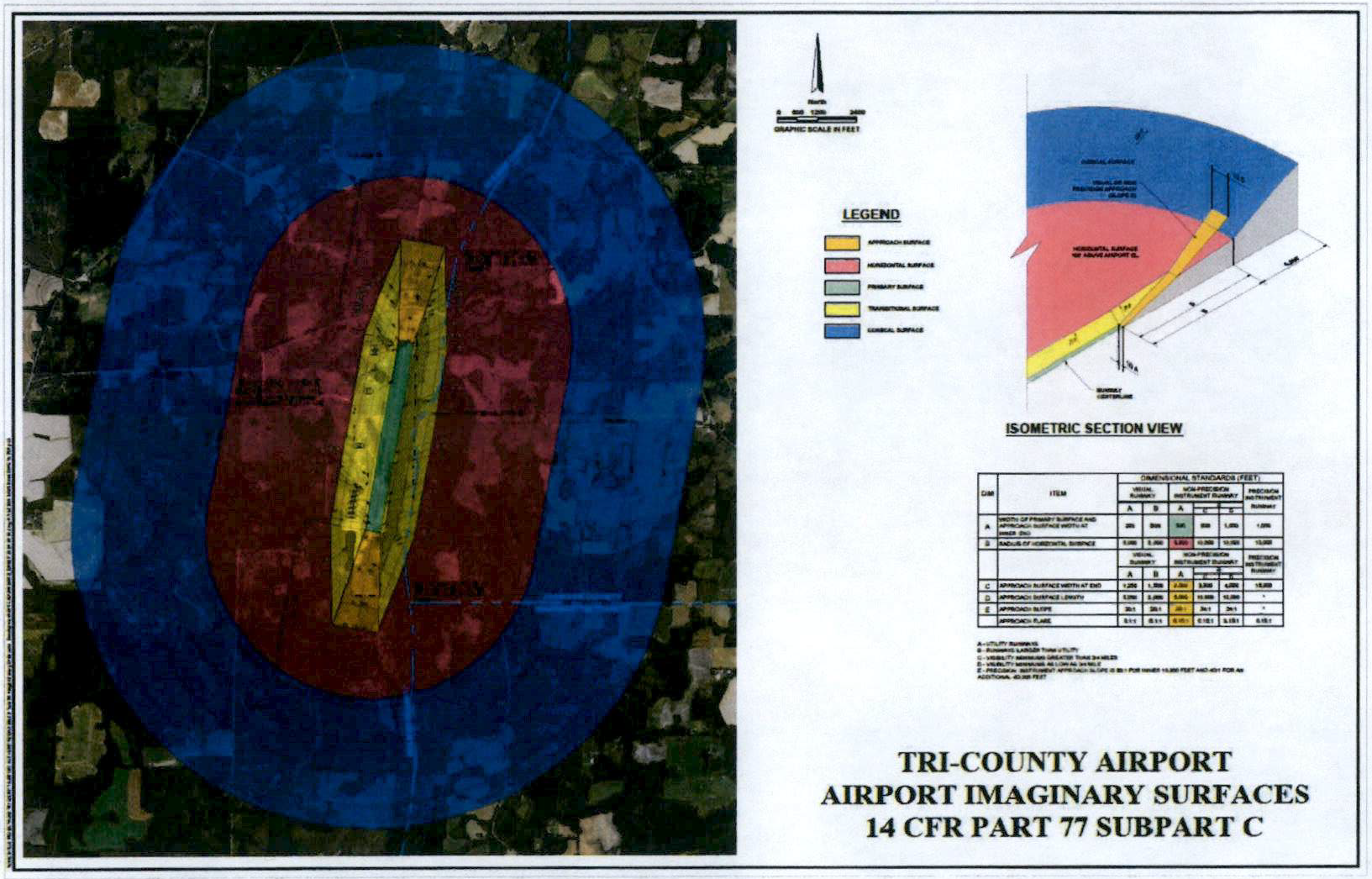
(Ord. No. 2024-14, § 2(Exh. A), 12-19-2024)
2.04.01 - Generally.
Accessory uses which are not for commercial or residential purposes may be approved without a tie to a principal use. The County Administrator or designee during project determination will make the determination of compliance with this section.
(Ord. No. 2023-16, § 1(Exh. A), 12-14-2023)
2.04.02 - Accessory dwelling units.
A.
Purpose. Tire purpose of this subsection is to make housing available to persons who might otherwise have difficulty finding homes while maintaining and protecting the property values and residential character of neighborhoods where accessory dwelling units are located. Applicable regulations governing accessory dwelling units are set out below.
B.
General standards.
1.
Accessory dwelling units shall be allowed in conjunction with the following principal structures:
a.
Detached single-family residential dwelling units;
b.
Retail establishments;
c.
Offices; and
d.
Principal industrial structures.
2.
No more than one (1) accessory dwelling unit shall be allowed on any residential lot or within any principal non-residential structure.
3.
Accessory dwelling units in conjunction with single-family residential structure may be incorporated as within/attached to the principal structure or established as freestanding or detached structures.
4.
All dwelling units accessory to a single-family residential unit shall meet the applicable structure setbacks of Section 2.03.00, of this Code.
5.
Dwelling units accessory to a single-family residential unit shall be no greater in height than the principal residential unit, except that accessory dwelling units may be located attached to and above an accessory structure, such as a freestanding garage, in which case, the height of the combined structure may be twenty-four (24) feet. In no instance shall an accessory dwelling unit be so designed and located as to have windows, which at their base elevation, are higher than the eaves of any residential dwelling unit located on an adjacent property.
6.
Accessory dwelling units shall be constructed utilizing similar architectural standards as utilized for the design and construction of the principal structure.
7.
An accessory apartment shall be located and designed in such a manner so that it will not interfere with the appearance of the principal structure as a single-family dwelling unit, to include limitations on the size of the accessory structure. The accessory dwelling unit cannot exceed fifty (50) percent of the primary structure's square footage in size.
8.
In no instance shall a manufactured home, recreational vehicle (RV), storage shed, or shipping container structure be used as an accessory dwelling unit.
9.
An accessory dwelling unit shall be required to obtain permitting as a habitable structure.
10.
Deviations may not be granted to the requirements set out in this section except in regard to subsections 2.04.02.B.5 and 2.04.02.C.4 of this section. To obtain approval for deviation to the requirements set out in the aforementioned subsections of this section, the applicant shall demonstrate that, in addition to the general criteria for approval, the proposed placement and elevation of the accessory dwelling unit will not adversely impact any adjacent residential property resident; the application may demonstrate satisfaction of this objective by taking advantage of the topographic characteristics or natural vegetation present on-site, or through the use of enhanced landscaping, architectural, or other design responses.
C.
Standards for attached accessory dwelling units.
1.
An accessory dwelling unit may be attached to a principal single-family residential structure if connected by a breezeway, roofed passage, or similar structure. Accessory dwelling units in conjunction with non-residential uses shall be incorporated within or attached to the principal structure.
2.
Any accessory dwelling unit attached to a single-family residential structure, including those connected by breezeway, roofed passage, or similar structure, shall not exceed fifty (50) percent of the primary structure's square footage in size.
3.
An accessory dwelling unit attached to a single-family residential dwelling shall be constructed utilizing similar architectural features as utilized for the design and construction of the principal structure. This provision shall not be construed so as to limit an attached accessory dwelling unit from having its own entryway, porch, or to limit the quantity or location of window space.
4.
An accessory dwelling unit attached to a single-family residential dwelling shall be located entirely within all minimum yard setbacks established by the Land Use category in which it is located.
D.
Standards for detached accessory dwelling units.
1.
Freestanding or detached accessory dwelling units shall be allowed in conjunction with any principal residential use.
2.
A detached dwelling unit accessory to a single-family residential structure shall not exceed fifty (50) percent of the primary structure's square footage in size.
3.
A detached dwelling unit accessory to a single-family residential structure shall be constructed utilizing similar architectural features as utilized for the design and construction of the principal structure. This provision shall not be construed so as to limit a detached accessory dwelling unit from having its own entryway, porch, or to limit the quantity or location of window space.
4.
A detached dwelling unit accessory to a single-family residential structure shall be setback a minimum distance equal to the applicable minimum rear and side yard setbacks established by the Land Use category in which it is located.
E.
Review procedures and conditions for accessory dwelling units. A proposed accessory dwelling unit shall first be reviewed by the Planning Department with the submittal of a Land Use Application, prior to the application for a Building Permit. A complete Land Use Application shall include documentation demonstrating compliance with the applicable accessory dwelling unit requirements noted in this section. A notarized affidavit identifying the proposed structure as an accessory dwelling unit and outlining any conditions of approval shall be signed by the owner as part of the Land Use Application. Affidavits for detached accessory dwelling units shall include, at minimum, a condition that subdivision of the parcel for the benefit of creating a lot exclusively for the accessory dwelling unit shall be subject to all applicable requirements of the County Land Development Code.
(Ord. No. 2023-16, § 1(Exh. A), 12-14-2023)
2.04.03 - Accessory structures.
Barns, pole barns, pool and bath houses, sheds, shops and workshops, and storage buildings, as well as utility buildings, greenhouses, and attached and detached carports and garages.
A.
Storage buildings, shops, utility buildings, greenhouses, garages, carports, and other accessory structures setbacks shall be established in Table 2.02.06 and shall be determined by the Future Land Use Map category of the property. Accessory structures shall not be located closer than ten (10) feet from any structure.
B.
Motor vehicles, manufactured homes, mobile homes, trailers, or recreational vehicles shall not be used as storage buildings, utility buildings, or other like uses.
C.
Building permits are not required for non-residential buildings used for agricultural purposes on bona-fide agricultural properties per F.S. § 604.50(1).
(Ord. No. 2023-16, § 1(Exh. A), 12-14-2023)
2.04.04 - Swimming Pools.
A.
Swimming pool setbacks shall be established in Table 2.02.06 and shall be determined by the Future Land Use Map category of the property.
B.
Setbacks for a swimming pool shall be measured from the water's edge.
C.
Swimming pools shall not be located closer than ten (10) feet from any structure.
(Ord. No. 2023-16, § 1(Exh. A), 12-14-2023)
2.05.01 - General Provisions.
Purpose. Tire purpose of this Section is to protect the quality of water resources from future degradation by maintaining vegetative cover and controlling disturbances to vegetation, to encourage the selection of native plant species for vegetation, to reduce the impact of urban and suburban development on remaining stands of natural vegetation, to provide shade, to reduce heat and glare, to abate noise pollution, to provide, habitat for living things, and to buffer incompatible uses. Included in this Section are provisions for buffers, open space, and landscaping. The County Administrator or designee during project determination will make the determination of compliance with this section.
A.
Exemptions. Lots or parcels of land on which a single-family home is used as a residence shall be exempt from the provisions of these vegetation regulations. This exemption shall not be construed to apply to residential subdivisions or other residential developments that require development plan or subdivision approval.
B.
Landscape Materials. Diversity of plantings should be strived for in all required landscape plantings, and in no case should one (1) species constitute more than fifty (50) percent of a planting.
C.
Prohibited Plants. In accordance with Florida Statutes, the County encourages the use of xeriscape landscaping and Florida Friendly Landscape Program activities that discourage the planting of invasive species. The plants and trees listed in the 2019 List of Invasive Species, or latest list available, listed at the website https://floridaginvasivespecial.org, shall not be installed as landscape materials.
D.
Agricultural Buffers. The County shall require all new developments adjacent to agricultural/silvicultural lands or operations on parcels of twenty (20) acres or more to provide a buffer to reduce the potential conflicts between agricultural/silvicultural and non-agricultural land uses. A fifty-foot agricultural buffer on abutting non-agricultural lands shall be required to ensure that the adjacent farmland retains an Agriculture/Silviculture Land Use Map designation, and that new development is protected from chemicals, noise, glare, odor, dust, and smoke associated with agricultural land uses. Potential buffers could be either a natural barrier or a natural or landscaped buffer supplemented with fencing or other manmade barriers provided that the intent of this policy is fulfilled by the buffer.
(Ord. No. 2023-16, § 1(Exh. A), 12-14-2023)
2.05.02 - Landscaped buffers.
A.
Purpose and Intent. This Section requires landscaped buffers to be provided and maintained when certain land uses are adjacent to or directly across from each other in order to protect uses from the traffic, noise, glare, trash, vibration, odor, and visual impacts likely to be associated with a more intensive land use. Landscaped buffers are also required to conserve the values of land and buildings and to provide adequate light and air. The width of the buffer and the required plantings within the buffer vary depending upon the relative intensities of the abutting or adjacent uses.
B.
How to Determine Landscaped Buffer Requirements. Landscaped buffers shall be located at the perimeter of the building site for any given use and shall not be located in any portion of a public right-of-way, unless approved for this location by the County or the Florida Department of Transportation. The following procedure shall be followed to determine the type of landscaped buffer required:
1.
Identify the land use of the subject property proposed for development.
2.
Identify the land use district of the properties abutting the property proposed for development.
3.
Determine the landscaped buffer required on each building site boundary (or portion thereof) by referring to the Table 2.05.02 in Section 2.05.02.
4.
Design the landscaped buffers based upon the illustrations in Subsection 2.05.02 below for that level of landscape buffer required under the above Table 2.05.02.
C.
Landscaped Buffer Design and Materials.
1.
Existing Native Plant Material. The use of existing native species of plant material is required in landscaped buffers. Existing natural ground cover should be retained where possible, excluding invasive species, which are required to be removed. Where the planting requirements of Section 2.05.02 require additional trees or shrubs to be installed in an existing natural area, it should be done in a manner which minimizes disturbances to native species.
2.
Standards for Additional Material. Where the planting requirements of Section 2.05.02(G) require additional trees to be installed in the landscaped buffer, required landscape materials shall be Florida Department of Agriculture Nursery Grade No. 1 grade or better.
3.
Mixed-Use Development. Where a building site is used for a single mixed-use development, landscaped buffers shall not be required between the various constituent uses. Landscaped buffers required at the perimeter of the development shall be based upon the individual uses on each portion of the property.
4.
Parking Lot Landscaping. Perimeter plantings required for parking lot landscaping may be counted toward satisfying buffer requirements.
5.
Fences. The use offences may be incorporated into an overall development plan. The use of an opaque fence may be used in lieu of landscaping. However, the fence must be at least six (6) feet but not exceeding eight (8) feet in height and the fence must have at least eighty (80) percent opacity. However, when used in lieu of landscaping the buffer yard width remains the same. Posts and other supporting elements must be located on the side of the subject property under development. Fencing materials on a property shall be of the same material and color.
D.
Use of Landscaped Buffers.
1.
Open Space. Landscaped buffers may be counted toward satisfying open space requirements and maybe used for passive recreation. They may contain pedestrian or bike trails, provided that the total width of the buffer area is maintained. In no event, however, shall the following uses be permitted in landscaped buffers: playfields, stables, swimming pools, tennis courts, parking lots and vehicular use areas, dumpsters, equipment storage and other open storage, buildings, or overhangs.
2.
Stormwater Retention/Detention Facilities. The Development Administrator shall be authorized to allow stormwater retention/detention facilities to encroach into landscaped buffers a maximum of thirty (30) percent of buffer width, where it is found that all planting requirements of this Section are met, and the visual screening required by the landscaped buffer will be fully achieved.
E.
Classification of Uses for Determining Buffer Requirements. Table 2.05.02 classifies landscape buffer requirements based on the land use of the developing property and the abutting use along that property line.
Table 2.05.02 - Landscape Buffering Requirements for Abutting Properties
Note 1: When property adjoining developing site has existing landscape buffer, developer required to provided buffer standards and width required to cumulatively meet standards for combined properties (Ex. Adjoining property has 5 1 landscape buffer, developing property requires 10' buffer based on uses, developing parcel provides 5' wide buffer meeting standards).
Note 2: Residential buffering standards do not apply to single-family lots construction, only subdivisions or multi-Family development boundary areas.
Note 3: Landscape Buffering Requirements are the Landscape Standard letter from the Figures following this table.
Note 4: Based on closest use to development site.
Note 5: Abbreviations as follows: RL=Residential Low; RM-1=Residential Medium-2; RM-2=Residential Medium-2; RH=Residential High; NC=Neighborhood Commercial; C=General Commercial; I=Industrial; CON=Conservation; PF=Public Facilities; Ag/Sil=Agriculture/Silviculture; PUD=Planned Unit Development.
F.
Landscaped Buffers.
1.
The following illustrations demonstrate the landscape buffer design standards for the Class A through Class D landscape buffers described above.
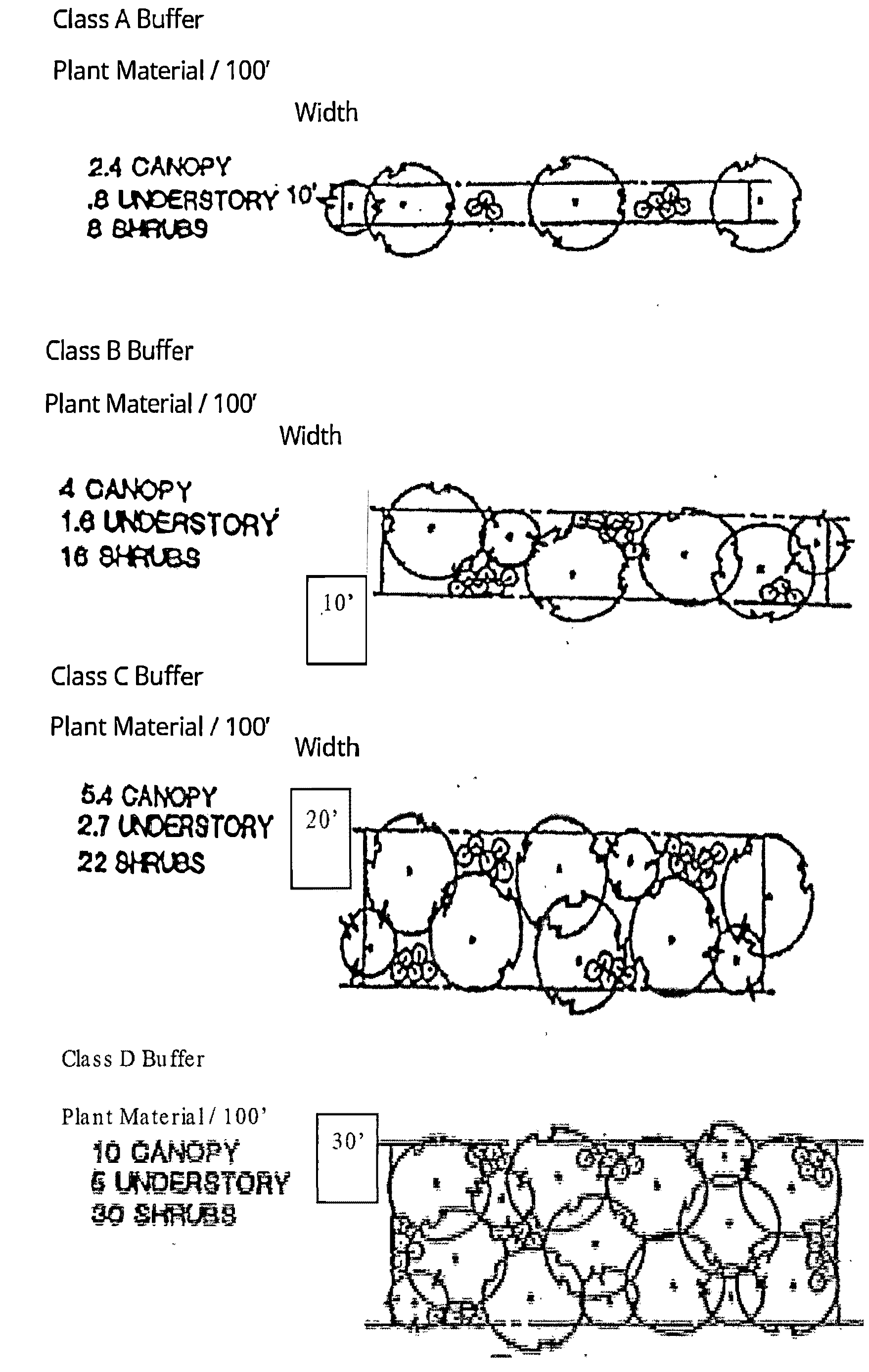
G.
Responsibility for Landscaped Buffers.
1.
The desired width of a landscaped buffer between two (2) parcels is the sum of the required landscaped buffers of the parcels. Where a new use is proposed next to an existing use that has less than the required buffer for that use, unless a waiver is approved by the BOCC, the developer of the new adjoining use will be required to make up the deficiency. For example, if a twenty-foot buffer is required to separate a new development from an existing one, and the existing development has a five-foot buffer, the new development would be required to have a fifteen-foot landscape buffer, unless a waiver is granted due to design constraints for making up the difference.
H.
Maintenance of Landscaped Buffers. The maintenance of all landscaped buffers shall be the responsibility of the property owner. Failure to maintain such landscaped buffers in an attractive and healthy state shall be considered a violation of this Section subject to enforcement in accordance with Article X. The property owner shall be responsible for replacing any planted landscaping that dies. All landscape buffers shall be irrigated by a permanent automatic irrigation system, with sensor to reduce watering during time of sufficient rainfall.
I.
Landscape Plan Requirements. For any development or redevelopment requiring landscape buffers, the landscaping of vehicular use areas, resource protection buffers, similar landscaped areas, or the removal of trees, submittal of a landscape plan is required. Plans for only the removal of trees shall be subject only the portion of the landscape plan governing such activity (tree location survey). The development of a single-family residence or accessory dwelling unit shall not require a landscape plan. For minor development plans, the Development Administrator may at their discretion. Landscaping plans shall include the following:
1.
Plans shall be drawn to scale, with a scale size acceptable for review purposes.
2.
Depict the location of all development, particularly all proposed parking spaces, other vehicular use areas, access aisles, driveways, landscape islands, and areas between rows of parking.
3.
Indicate the location of all irrigation systems and the source of water to be utilized.
4.
Describe by species name and location all plant or other landscaping materials to be installed to meet the requirements of this section.
5.
Include a tabulation of the site area, the calculation of areas to be preserved, number of trees/plants to be planted, number of plants/trees to be preserved, and any other data necessary for the Development Director or his/her designee to determine compliance with the landscaping requirements herein.
6.
Details depicting planting and preservation standards for all new trees and plants.
7.
A tree location survey overlayed on the site development proposed, showing the location of trees to be preserved and removed by species and diameter at breast height (DHB).
8.
A tabulation of the trees to be removed and preserved by species, DHB, and number, which shall be included on the tree location survey.
9.
Details on how trees to be preserved are to be protected during development and depicting any measures needed to provide for their survival.
10.
All landscaping plans are to be signed and sealed by a licensed landscape architect in the State of Florida.
J.
Tree Protection. No property owner or their representative, including, but not limited to builders, contractors, landscapers, business firms, or other legal persons shall remove protected trees, as defined within the definitions section of this LDC without first obtaining a permit from the Planning Department, unless exempted herein. Said request for the removal of trees shall include a tree location survey discussed under Subsection I.7 above.
1.
The following shall be exempted from the tree protection requirements herein:
a.
Trees which pose a danger to persons or property, as determined by an arborist certified by the International Society of Arboriculture or a licensed landscape architect, per F.S. § 163.045.
b.
Single-family dwellings, when protected trees are located within the actual building or structure footprint, on-site sewage system, or well areas.
c.
The pruning or removal of trees by utility companies or workers under contract with said utility company(s) required for the maintenance of existing lines or facilities or the construction of new lines or facilities, following five (5) days' notice to the Washington County Planning Department. Tree work on aerial lines shall be withing the parameters adopted by the National Electrical Codes for clearances, and all pruning shall follow National Arborist Association standards.
d.
Site investigation prior to development, including surveying, soil borings, or geotechnical research where the removal is the minimum necessary to facilitate said activity.
e.
Tire clearing of trees for the path of work on an existing roadway or construction of a new roadways which meet County Road construction and right-of-way standards.
f.
All commercial nurseries, botanical gardens, tree farms grove operations and other bona fide agricultural and/or silvicultural activity, where the trees being removed were planted or managed for agricultural or silvicultural purposes or for sale or intended sale in the course of the business, or those parcels receiving agricultural assessment for ad-valorem taxation per F.S. § 193.461.
g.
Removal of tree listed on the Florida Exotic Pest Plant Council's list of invasive species or under the Florida Department of Agriculture and Consumer Services Noxious Weeds rule under Section 5b-57, F.A.C.
2.
Criteria for Tree Removal. Approval of a tree removal permit shall be based upon the applicant demonstrating reasonable measures in design to place improvements in locations to maximize the opportunities to preserve protected trees, as defined in the LDC. No permit involving the removal of protected trees shall be approved for said removal unless one (1) or more of the following conditions are met:
a.
The intended, permittable use of the site cannot reasonably be undertaken unless specific trees are removed or relocated.
b.
The tree is located is such proximity to an existing or proposed structure that the safety, utility, or structural integrity of the structure is materially impaired.
c.
The tree materially interferes with the location, servicing, or functioning of existing or proposed utility lines or services.
d.
The tree creates a substantial hazard to motor, bicycle, or pedestrian traffic by impairment of vision.
e.
The removal of the tree is necessary to promote the growth of surrounding protected trees, with documentation of such provided by an arborist certified by the International Society of Arboriculture or a landscape architect licensed in the State of Florida.
f.
After trying unsuccessfully to reconfigure the site and find protective measures to maintain the trees viability with development, it is determined by an arborist certified by the International Society of Arboriculture or a landscape architect licensed in the State of Florida that the tree will not survive if preserved.
3.
Protection of Preserved Trees During Development.
a.
Trees to be protected during development shall have barriers as follows:
i.
Posts standing upright shall be placed about the boundary of the critical protection zone as defined within the Definitions Section.
ii.
Posts shall be nominal two-inch by four-inch or larger wood lumber, one and one-half (1.5) inch outer diameter or larger pipe or other suitable material, or drive-in type steel fence posts, which shall extend a minimum of four (4) feet above grade. Posts shall be separated by a maximum of seven and one-half (7.5) feet. Posts shall be strung with at least one-inch by four-inch wooden stringer at least thirty (30) inches off the ground or with minimum four-foot-high convention wire fencing.
iii.
Where groups of protected trees occur within overlapping critical protection areas, the above post and stringer system shall surround the grouping of trees rather than the individual trees. The outer extent of installation shall be determined by the critical protection zone radii of the perimeter trees in the group.
(Ord. No. 2023-16, § 1(Exh. A), 12-14-2023; Ord. No. 2024-14, § 2(Exh. A), 12-19-2024)
2.05.03 - Landscaping of vehicular use areas.
A.
Applicability. The requirements of this Section shall apply to off-street parking facilities and other vehicular use areas that:
1.
Have ten (10) or more parking spaces; or
2.
Are designed to accommodate vehicles that are larger or smaller than automobiles and are over three thousand five hundred (3,500) square feet in area.
B.
Perimeter Requirements. A ten-foot-wide strip of land, located, along property lines adjacent to the street right-of-way(s) shall be landscaped. In no case shall this strip be less than ten (10) feet wide. Width of sidewalks shall not be included within the ten-foot-wide perimeter landscape area.
1.
Landscaped Material Requirements in Perimeter Area.
a.
One (1) shade tree for each fifty (50) feet of linear foot frontage along the right-of-way shall be preserved or planted. Trees planted to meet this requirement shall measure a minimum eight (8) feet in height and three (3) inches in diameter at breast height at planting. Shrubs at a minimum of three (3) feet in height at planting shall be planted three (3) feet on center shall be included in the buffer. The remaining area within the perimeter strip shall be landscaped with other landscape materials.
b.
Trees and other landscaping required in the perimeter strip shall be maintained to assure unobstructed visibility between three (3) and nine (9) feet above the average grade of the adjacent street and the driveway intersections within the visibility triangle as defined in the LDC.
C.
Interior Planting Areas.
1.
At least ten (10) percent of the gross area of the interior vehicular use area shall be landscaped. Interior planting areas are to be located within or adjacent to the parking area as tree islands, at the end of parking bays, inside seven-foot wide or greater medians, or between rows of cars or as part of continuous street or transitional protective yards. Interior planting areas shall be located to most effectively accept and accommodate stormwater runoff and provide shade in large expanses of paving and contribute to orderly circulation of vehicular and pedestrian traffic.
a.
No more than ten (10) parking spaces, shall be permitted in a continuous row without being interrupted by an interior planting area. Each such interior planting area shall include a shade tree and ground cover.
b.
Trees shall be required at the minimum rate of one (1) shade tree for every three thousand five hundred (3,500) square feet of total vehicular use area. All vehicular use areas located within the same parcel single vehicular use area for the purpose of computing the required rate of trees. Outparcel landscaping requirements for parking areas shall be computed individually. Required tress shall be at least eight (8) feet in height and three (3) inches in diameter at breast height.
2.
Minimum size of interior planting areas.
a.
A minimum of one hundred and twenty-five (125) square feet of planting area shall be required for each shade tree.
3.
A minimum planting area of fifty (50) percent of the drip line area of the tree shall be required for all existing trees. If conditions warrant that an area greater than fifty (50) percent is needed to preserve the tree, additional areas may be negotiated between the applicant and the County.
D.
Vehicle Overhang. Vehicles shall not overhang more than two (2) feet into any interior planting area or perimeter strip.
1.
Where landscaping is installed in interior or perimeter strip planting areas, a continuous curb or other acceptable means of protection shall be provided to prevent injury to the vegetation where such vegetation directly abuts vehicular parking. Such curb shall be designed to allow percolation of the water to the root system of the landscape material. Where existing trees are preserved, tree wells, tree islands or a continuous curb shall be utilized to protect the trunk and root system from alterations to surrounding grade elevations and damage from automobiles. A drainage system, sufficient enough to allow percolation into permeable soil, shall be provided in the area defined by the dripline of the tree(s). Notwithstanding, the use of trees and islands for stormwater retention based on sound, Low Impact Development techniques are encouraged, and curbing should have breaks to allow stormwater to enter islands with trees slightly lower than the parking lot elevation.
E.
Maintenance of Landscaping in Vehicular Use Areas. The property owner shall be responsible for maintenance of landscaping within the vehicular parking area. The property owner shall replace all planted landscape materials within the vehicular use areas that have died. All landscaped areas within the vehicular use areas shall be irrigated by a permanent automatic irrigation system, with sensors to reduce watering during time of sufficient rainfall.
(Ord. No. 2023-16, § 1(Exh. A), 12-14-2023)
2.05.04 - Resource protection buffers.
A.
Wetlands and Surface Water Bodies. A minimum thirty-foot permanent natural vegetative buffer, measured landward from the wetlands jurisdiction line or observed normal waterline (whichever is most landward shall be established from all wetlands and natural surface water bodies. Within this buffer, permanent structures will be prohibited except for accessory recreational uses (i.e., docks, piers, boat ramps), and clearing of native vegetation to allow for such structures, as well as maximum ten-foot-wide paths to access such structures, other than in areas designated for silvicultural use (See Section 2.02.03(D) for restrictions on silviculture activities in Conservation Areas), shall be limited to provide only for reasonable access to the shoreline.
A minimum fifty-foot development setback from the ordinary or mean high-water line of all surface water bodies, excluding the Choctawhatchee River, Econfina Creek, Holmes Creek, and Pine Log Creek, is also required. Only water-dependent accessory structures and access paths to such structure of ten (10) feet or less in width are allowed within this area.
B.
Major Managed Areas. A minimum of a one-hundred-foot permanent natural vegetative buffer shall also be maintained from all major managed areas. These are as follows:
1.
Pine Log State Forest;
2.
Falling Waters State Recreational Aiea;
3.
Choctawhatchee Water Management Area;
4.
Holmes Creek State Canoe Trail; and
5.
Econfina State Canoe Trail.
In addition to the minimum one-hundred-foot permanent natural buffer, a minimum one-hundred-foot development setback from the ordinary or mean high-water line is required adjacent to the Choctawhatchee River, Econfina Creek; Holmes Creek, and Pine Log Creek.
C.
Historic. All development (regardless of location) shall maintain a minimum twenty-five-foot buffer from known archaeological or historical sites represented by overlays on the Future Land Use Map.
(Ord. No. 2023-16, § 1(Exh. A), 12-14-2023)
2.05.05 - Open space.
A.
Definition. See Section 1.11.00.
B.
Minimum Provisions. Ure open space of a development site shall be no less than the total site area less the maximum building or floor area, including parking and other impervious coverage areas such as, but limited to sidewalks and patio areas, where water cannot percolate.
C.
The minimum open space requirements by land use shall be as follows:
Table 2.06.05 - % Open Space Requirements by Land Use
(Ord. No. 2023-16, § 1(Exh. A), 12-14-2023)
[2.06.01 - Recreational Vehicles (RVs).]
A.
Recreational vehicles (RVs), as defined in F.S. § 320.01 of the Florida Statutes, and further defined in the Washington County Land Development Code, may not be used for residential purposes other than specifically provide herein.
B.
Recreational vehicles may be used for recreational use within a licensed RV park or campground that has received Federal, State and County development approvals and that meet Florida Building Code standards.
C.
RV Park or campground users shall adhere to the RV park rules and regulations establishing maximum occupancy at an RV park. If no rules are in place at an RV park for maximum occupancy, use of an RV may not exceed a six-month occupancy during one (1) calendar year.
D.
Recreational vehicles (RVs) may be occupied on a private parcel of property while residential construction or development occurs, with the appropriate Land Use Application and Building Permit approvals for a new residential dwelling unit.
1.
Property owners must sign an affidavit of recreational vehicle use with the County Building Department or Planning Department indicating they will be occupying a recreational vehicle temporarily during construction or development on a parcel of property.
2.
Use of an RV during construction is allowed for six (6) months from the date of building permit issuance. Extensions may be granted by the County Building Department but will be limited to two (2) years (maximum), with authorization by the County Manager or his/her designee.
E.
Recreational vehicles (RVs), as defined in Section 320.01 of the Florida Statutes, and further defined in the Washington County Land Development Code, may be used for temporary recreational use within private property. However, recreational use on private property may not exceed four (4) months, or one hundred twenty (120) days, during one (1) calendar year.
F.
Recreational Vehicle (RV) parks and campgrounds shall have access to paved roads. Such uses shall have either a public, or private, central water and sewer system, as required by the Florida Department of Environmental Protection. Such uses may be permitted within the Agriculture/Silviculture Future Land Use Map designation with Special Exception approval, per Section 10.05.00, Land Development Code. As part of the Special Exception process, the distance to major transportation facilities, such as I-10, SRs 77, 79, 90, and 20, and proximity to natural and recreation areas, shall be considered in the review of a proposed RV park or campground.
G.
Residents may place recreational vehicles and other temporary residential shelters and structures on their property for up to thirty-six (36) months following a natural emergency under certain circumstances, per F.S. §§ 125.023 and 166.0335.
(Ord. No. 2023-16, § 1(Exh. A), 12-14-2023)