
Edisto Beach City Zoning Code
ARTICLE IV
DISTRICTS
Sec. 86-111. - Establishment of districts.
For the purpose of this chapter, the town is hereby divided into the following zoning districts:
(Ord. of 6-11-81, § 300; Ord. of 5-14-92, § 1; Ord. of 2-3-97, § 2; Ord. of 12-9-04(2), § 1; Ord. No. 2015-09, § 3(Exh. C), 5-14-15)
Sec. 86-112. - Zoning district boundaries and the official zoning map.
The boundaries of the above zoning districts are shown on a map entitled Official Zoning Map, Edisto Beach, South Carolina, which together with all explanatory matter thereon is hereby adopted by reference and declared to be a part of this chapter. The official zoning map shall be identified by the signature of the mayor attested by the town administrator, together with the date of the adoption of this chapter and any subsequent amendment.
(Ord. of 6-11-81, § 301; Ord. No. 2015-09, § 3(Exh. C), 5-14-15)
Sec. 86-113. - Critical areas and the official zoning map.
Critical areas as defined by section 3, paragraphs (t), (g), (h), and (i) of the South Carolina Coastal Zone Management Act, S.C. Code 1926, § 48-39-270 et seq., are delineated on the official zoning map and, as such, are a part of this chapter.
(Ord. of 6-11-81, § 302; Ord. No. 2015-09, § 3(Exh. C), 5-14-15)
Sec. 86-114. - Flood hazard boundary maps.
Federal Emergency Management Agency flood hazard boundary maps designating flood hazard areas within the town having an effective date as prepared by the Department of Housing and Urban Development, Federal Emergency Management Agency, copies of which are on file in the office of the town administrator, are hereby adopted by reference and are fully a part of this chapter as if set forth in this section.
(Ord. of 6-11-81, § 303; Ord. No. 2015-09, § 3(Exh. C), 5-14-15)
Sec. 86-115. - Rules for interpretation of district boundaries.
Where uncertainty exists as to the boundaries of districts as shown on the official zoning map, or the FEMA flood hazard boundary maps, the following rules shall apply:
(1)
Boundaries indicated as approximately following the centerlines of streets, highways, or alleys shall be construed to follow such centerlines;
(2)
Boundaries indicated as approximately following platted lot lines shall be construed as following such lot lines;
(3)
Boundaries indicated as approximately following town limits shall be construed as following such town limits;
(4)
Boundaries indicated as parallel to or extension of features indicated in subsections (1) through (3) of this section shall be so construed. Distances not specifically indicated on the official zoning map shall be determined by the scale of the map;
(5)
Where physical or cultural features existing on the ground are at variance with those shown on the official zoning map, or in other circumstances not covered by subsections (1) through (4) of this section, the zoning board of appeals shall interpret the district boundaries.
(Ord. of 6-11-81, § 304; Ord. No. 2015-09, § 3(Exh. C), 5-14-15)
Sec. 86-116. - Changes to district boundaries.
(a)
If, in accordance with the provisions of this chapter and S.C. Code 1976, § 6-7-10 et seq., changes are made in district boundaries or other matters portrayed on the official zoning map, such changes shall be entered on the official zoning map promptly after the amendment has been approved by the town council. No amendment to this chapter which involves matter portrayed on the official zoning map shall become effective until after such change has been made on such map.
(b)
No change of any nature shall be made on the official zoning map except in conformity with the procedures set forth by this chapter. Any unauthorized change of whatever kind by any person or persons shall be considered a violation of this chapter and punishable as provided by law.
(Ord. of 6-11-81, § 305; Ord. No. 2015-09, § 3(Exh. C), 5-14-15)
Sec. 86-117. - Custodian of the official zoning map.
Regardless of the existence of purported copies of the official zoning map, referenced in section 86-33(5), which may from time to time be made or published, the official zoning map which shall be located in the town council chambers shall be the final authority as to the current zoning status of land and water areas, building, and other structures in the town.
(Ord. of 6-11-81, § 306; Ord. No. 2015-09, § 3(Exh. C), 5-14-15)
Sec. 86-118. - Zoning of annexed property.
All territory which may hereafter be granted or annexed to the town shall not be classified until such time as the town council may establish such classification through normal procedures. No building permits shall be issued in non-zoned areas.
(Ord. of 6-11-81, § 307; Ord. No. 2015-09, § 3(Exh. C), 5-14-15)
Sec. 86-119. - General standards.
The regulations set by this chapter within each district shall be the minimum regulations and shall apply uniformly to each class or kind of structure or land, except as provided in this chapter. Except where provisions for relief are set forth elsewhere in the chapter, the following general standards for the enforcement of district regulations shall apply.
(1)
Use of land or structures.
a.
No land or structures shall hereafter be used or occupied, and no structure or parts shall hereafter be constructed, erected, altered, or moved, unless in conformity with all of the regulations specified in this chapter for the district in which it is located.
b.
No part of a yard, or other open space or off-street parking or loading required about or in connection with any building for the purpose of complying with this chapter, shall be included as part of a yard open space, or off-street parking or loading space similarly required for any other building.
c.
Right-of-way easements for streets and roads shall not be considered a part of a lot or open space, or front rear or side yard for the purpose of meeting yard requirements.
(2)
Lot reduction prohibited. No yard or lot existing at the time of passage of this chapter shall be reduced in dimensions or area below the minimum requirements set forth in this chapter. Yards or lots created after the effective date of this chapter shall meet at least the minimum requirements established by this chapter.
(3)
Use of substandard lots of record. Where the owner of a lot at the time of the adoption of this chapter does not own sufficient land to enable him to conform to the dimensional requirements of this chapter, such lot may nonetheless be used as a building site and the building code administrator is authorized to issue a permit for the use of the property which conforms to the requirements for the district in which the lot is located as set forth in the chapter provided that the lot requirements are not reduced below the minimum specified in this chapter by more than 20 percent, as determined by the building code administrator.
(4)
Division 2 of this article provides for uses of some districts within certain other districts as permitted uses. In such circumstances, the use, activity or structure allowed within the district must comply with the most stringent regulations governing such use, activity or structure; provided however, lot area should be governed by the underlying or primary district regulations;
(5)
Adoption of this section does not prohibit continuation of an existing, lawful grandfathered use, activity or structure.
(Ord. of 6-11-81, art. IV; Ord. of 10-10-02(1), § 1; Ord. No. 2015-09, § 3(Exh. C), 5-14-15)
Sec. 86-120. - Durational limitation on town council approvals.
Any approval or conditional approval given by town council which is required to be submitted to town council after the recommendation of the planning commission shall be void unless a building permit for the proposed improvements is issued within six months from the date of approval by town council; provided, however, any such approval or conditional approval subject to the vested rights of article VIII of this chapter shall be void unless a building permit for the proposed improvements is issued within six months after a vested right under article VIII expires.
(Ord. of 8-12-04(2), § 1; Ord. of 3-8-07(2), § 1; Ord. No. 2015-09, § 3(Exh. C), 5-14-15)
Sec. 86-135. - R-1 low density residential district.
(a)
Purpose. The purpose of the R-1 low density residential district is to provide for quiet, livable, low-density, single-family neighborhoods. The district requirements are designed to prevent encroachment by incompatible uses and to encourage the discontinuance of existing uses that would not be permitted as new uses under this chapter.
(b)
Permitted uses.
(1)
One-family dwelling. Only one dwelling is permitted per lot.
(2)
Boat docks, private noncommercial.
(3)
Public libraries.
(4)
Noncommercial horticulture or agriculture, but not including the keeping of poultry or livestock.
(5)
Churches, provided structures are not less than 25 feet from any residential property line.
(6)
Public and private schools, provided the structures are placed not less than 50 feet from any residential property line.
(7)
Public utilities, provided that service and storage yards are prohibited.
(8)
Accessory uses and home occupations as described by this chapter. The use of motor vehicles for storage purposes does not conform to the provisions of this chapter as set forth in section 86-3.
(9)
Signs, in accordance with subsection (c) of this section, sign regulations.
(10)
Use of dwelling units otherwise permitted in the R-1 district to provide lodging for short-term occupancy.
(11)
Public parks.
(c)
Sign regulations. See article V of this chapter.
(d)
Area regulations.
(1)
Minimum lot area per dwelling unit:
a.
On septic tank: 11,000 square feet.
b.
On community sewer system: 11,000 square feet.
(2)
Minimum lot width measured at building line for dwelling units: 75 feet.
(3)
Dock sites. Minimum lot width: 50 feet.
(e)
Yard regulations.
(1)
Minimum front yard setbacks for lots on Palmetto Boulevard fronting the Atlantic Ocean from Highway 174 to Portia Street: Ten feet.
(2)
Minimum front yard setback for all other lots: 20 feet.
(3)
Minimum side yard setback: Ten feet.
(4)
Minimum rear yard setback: Ten feet.
(f)
Maximum building height. Forty feet above grade as defined in section 86-182 plus any increase or less any decrease in the base flood elevation (BFE) between that depicted on the National Flood Insurance Program (NFIP) maps adopted as of September 30, 2007, and the base flood elevation depicted on the NFIP maps as of the date of application for a building permit, if any.
(g)
Off-street parking regulations. See section 86-175.
(h)
No permitted use shall create disturbing or offensive noises, traffic hazards or unsightly conditions.
(Ord. of 6-11-81, § 500; Ord. of 3-13-86, § 1; Ord. of 11-10-88, § 1; Ord. of 1-12-89, § 1; Ord. of 3-14-91, § 1; Ord. of 8-8-91, § 1; Ord. of 11-14-96(2), § 1; Ord. of 7-11-02(2), § 1; Ord. of 10-11-07(2), § 3; Ord. No. 2009-04, § 1, 2-12-09; Ord. No. 2012-03, § 2, 4-12-12; Ord. No. 2014-18, §§ 1, 2, 8-14-14; Ord. No. 2015-09, § 3(Exh. C), 5-14-15)
Sec. 86-136. - R-2 two-family residential district.
(a)
Purpose. The purpose of the R-2 two-family residential district is as follows:
(1)
To encourage the formation and continuation of a stable, healthy environment for medium density residential neighborhoods on septic tank systems or following the construction of a public sewerage system.
(2)
To discourage unwarranted encroachment of commercial, industrial or other uses capable of adversely affecting the residential character.
(3)
To discourage any use which would generate traffic on local streets other than that required to serve residents on these streets.
(b)
Permitted uses.
(1)
All uses permitted in the R-1 low density residential district.
(2)
Two-family dwellings.
(3)
Use of dwelling units otherwise permitted in the R-2 district to provide lodging for short-term occupancy.
(4)
Dock sites, 50 feet minimum lot width.
(5)
No permitted use shall create disturbing or offensive noises, traffic hazards or unsightly conditions.
(c)
Sign regulations. See article V of this chapter.
(d)
Area and dimension regulations.
(1)
Minimum lot area (square feet):
(2)
Minimum lot width measured at building line: 70 feet.
(3)
Minimum lot width for dock site only: 50 feet.
(4)
The amendments to this provision do not apply to any lots which are shown on a duly recorded plat and complied with all zoning requirements as of Aug. 7, 1997.
(e)
Yard regulations.
(1)
Minimum front yard setback: 20 feet.
(2)
Minimum side yard setback: Ten feet.
(3)
Minimum rear yard setback: Ten feet.
(4)
No more than 30 percent of the ground of lots in the R-2 district may be covered with impervious surfaces.
(f)
Maximum building height. Forty feet above grade as defined in section 86-182 plus any increase or less any decrease in the base flood elevation (BFE) between that depicted on the National Flood Insurance Program (NFIP) maps adopted as of September 30, 2007, and the base flood elevation depicted on the NFIP maps as of the date of application for a building permit, if any.
(g)
Off-street parking regulations. See section 86-175.
(h)
Processing duplexes. A preliminary development concept plan shall be submitted to the planning commission for recommendation to the town council for all duplexes. This plan shall be in accordance with subsection 86-144(e)(5), pertaining to processing planned developments.
(i)
Certain lots grandfathered. All two-family residential units existing on under construction on lots in the R-2 district, and undeveloped lots in the R-2 district on July 1, 2004 may continue to be used for two-family residential dwellings allowable under this section until the following occurs: (1) a two-family unit is replaced by a single-family unit; or (2) a single-family unit is built on an undeveloped R-2 lot.
(Ord. of 2-3-97, § 4(500A); Ord. of 8-7-97(1), § 4; Ord. of 3-12-98, § 4; Ord. of 8-12-04(1), § 2; Ord. of 9-9-04(3), § 2; Ord. of 10-11-07(2), § 4; Ord. No. 2009-04, § 1, 2-12-09; Ord. No. 2014-18, § 2, 8-14-14; Ord. No. 2015-09, § 3(Exh. C), 5-14-15)
Sec. 86-137. - R-4 low density residential and clubhouse district.
(a)
Purpose. The purpose of the R-4 low density residential and clubhouse district is to provide for quiet, livable, low-density, single-family neighborhoods integrated with appropriate private clubs. The district requirements are designed to prevent encroachment by incompatible uses and to encourage the discontinuance of existing uses that would not be permitted a new user under this chapter.
(b)
Permitted uses.
(1)
All uses permitted in the R-1 low density residential district.
(2)
Clubhouses for private nonprofit yacht clubs, not including the chief activity of which is a service customarily carried on as a business.
(3)
Signs, in accordance with article V of this chapter, sign regulations.
(c)
Area and dimension regulations.
(1)
Minimum lot area:
(2)
Minimum lot width measured at building line: 75 feet.
(3)
Minimum lot width for dock site only: 50 feet.
(d)
Yard regulations.
(1)
Minimum front yard setback: 20 feet.
(2)
Minimum side yard setback: Ten feet.
(3)
Minimum rear yard setback: Ten feet.
(e)
Maximum building height. Forty feet above grade as defined in section 86-182 plus any increase or less any decrease in the base flood elevation (BFE) between that depicted on the National Flood Insurance Program (NFIP) maps adopted as of September 30, 2007, and the base flood elevation depicted on the NFIP maps as of the date of application for a building permit, if any.
(f)
Off-street parking regulations. See section 86-175. For purpose of off-street parking regulations, a clubhouse shall be deemed a place of public assembly.
(g)
Additional requirements for private, nonprofit yacht clubs.
(1)
Dry stacking of boats is prohibited.
(2)
Screening is required as defined in section 86-3 of article I of this chapter.
(h)
Applicant procedure. Each application for a building permit for a clubhouse in an area zoned R-4 shall be reviewed by the planning commission and approved by the town council. The application shall be accompanied by the following:
(1)
A development plan of the proposed development at a scale of not less than one inch equals 100 feet showing:
a.
The location and size of site;
b.
The dimensions of the property;
c.
The location and proposed use of buildings and their general exterior dimensions;
d.
A traffic, parking and circulation plan, showing proposed locations; arrangements, number and dimensions of parking spaces, loading areas, and ingress and egress to and from adjacent street;
e.
The proposed locations and materials to be used for screening as defined in section 86-3 of article I of this chapter.
f.
A title, showing the names of the developer, the date, scale of plan, and the name of the individual or firm preparing the plan.
(2)
A statement, to be filed with the building code administrator, indicating readiness to proceed with construction of the proposed development within one year from the date the proposal is approved.
(i)
Issuance of building permit. No building permit shall be issued for any clubhouse in an area zoned R-4 until a final development plan shall have been reviewed and recommended to the building code administrator by the planning commission. The building code administrator may approve requests based on his review, the planning commission's report, and such other data as he may require.
(Ord. of 6-11-81, § 50.A; Ord. of 5-14-92, § 2; Ord. of 3-12-98, § 5; Ord. of 9-10-98(4), §§ 2, 3; Ord. of 2-13-03(1), § 27; Ord. of 10-11-07(2), § 5; Ord. No. 2009-04, § 1, 2-12-09; Ord. No. 2014-18, § 2, 8-14-14; Ord. No. 2015-09, § 3(Exh. C), 5-14-15)
Sec. 86-138. - R-7 multifamily residential district.
(a)
Purpose. The purpose of the R-7 multifamily residential district is as follows:
(1)
To encourage the formation and continuance of a stable, healthy environment for medium and high density residential neighborhoods on septic tank systems or following the construction of a public sewerage system.
(2)
To discourage unwarranted encroachment of commercial, industrial or other uses capable of adversely affecting the residential character.
(3)
To discourage any use which would generate traffic on local streets other than that required to serve residents on these streets.
(b)
Permitted uses.
(1)
All uses permitted in the R-1 low density residential district.
(2)
Multifamily dwellings, townhouses and condominiums.
(3)
Dock sites: 50 feet minimum lot width.
(4)
Accessory uses to multifamily dwellings, including parking lots, swimming pools, tennis courts, and laundry facilities.
(5)
Two-family dwellings.
(6)
No permitted use shall create disturbing or offensive noises, traffic hazards or unsightly conditions.
(7)
Use of dwelling units otherwise permitted in the R-7 district to provide lodging for short-term occupancy.
(c)
Sign regulations. See article V of this chapter.
(d)
Area and density regulations.
(1)
Minimum lot area:
(2)
Minimum lot width measured at building line: 70 feet.
(3)
The amendments to this provision do not apply to any lots which are shown on a duly recorded plat and complied with all zoning requirements as of August 7, 1997.
(4)
Maximum density is seven dwelling units per acre.
(5)
Notwithstanding the provisions of section 86-168, one-family and two-family residential structures which are constructed on property which has been conveyed in fee simple to a horizontal property regime, as that term is used in the South Carolina Horizontal Property Act, Code of Laws of South Carolina § 27-31-10, et seq., as amended, are not required to be located on an individual lot of record so long as they meet all other density requirements of this section; provided however, none of the premises conveyed to such horizontal property regime may be used for any use except use as permitted dwellings, accessory uses to dwellings and home occupations.
(e)
Yard regulations.
(1)
Minimum front yard setback: 20 feet.
(2)
Minimum side yard setback: Ten feet.
(3)
Minimum rear yard setback: Ten feet.
(4)
No more than 30 percent of the ground of lots in the R-7 district may be covered with impervious surfaces.
(f)
Minimum building height. Forty feet above grade as defined in section 86-182 plus any increase or less any decrease in the base flood elevation (BFE) between that depicted on the National Flood Insurance Program (NFIP) maps adopted as of September 30, 2007, and the base flood elevation depicted on the NFIP maps as of the date of application for a building permit, if any.
(g)
Off-street parking regulations. See section 86-175.
(h)
Processing applications and permits for all dwelling units. Applicants for all dwelling units shall participate in applicant and permit procedures identical to those provided in subsection 86-141(i) and (j).
(Ord. of 6-11-81, § 501; Ord. of 3-13-86, § 2; Ord. of 6-12-86, §§ 1, 2; Ord. of 3-14-91, § 2; Ord. of 4-11-91, § 1; Ord. of 8-8-91, §§ 2, 9; Ord. of 11-14-96(2), §§ 2, 3; Ord. of 8-7-97(1), § 5; Ord. of 3-12-98, § 6; Ord. of 3-11-99(1), § 1; Ord. of 2-8-01, §§ 2—4; Ord. of 8-12-04(1), § 3; Ord. of 10-11-07(2), § 6; Ord. No. 2009-04, § 1, 2-12-09; Ord. No. 2014-18, § 2, 8-14-14; Ord. No. 2015-09, § 3(Exh. C), 5-14-15)
Sec. 86-139. - C-1 office commercial district.
(a)
Purpose. The intent of the C-1 office commercial zoning district is to develop and reserve land for business office, institutional, specified public, semipublic, and residential purposes. The regulations which apply within this district are designed to encourage the formation and continuance of a quiet, compatible and uncongested environment for office type business or professional firms and to discourage any encroachment by uses capable of adversely affecting the specialized character of the district.
(b)
Permitted uses.
(1)
Any uses permitted under section 86-135(b) for the R-1 low density residential district, together with the conditions attached thereto.
(2)
Businesses involving the rendering of personal and general services, including, but not limited to, barber and beauty shops, real estate agencies, attorney offices and shoe repair shops.
(3)
No permitted use shall create disturbing or offensive noises, traffic hazards or unsightly conditions.
(4)
Public libraries.
(c)
Sign regulations. See article V of this chapter.
(d)
Area regulations.
(1)
Minimum lot area per unit:
a.
Single-family dwellings: 11,000 square feet.
b.
Other permitted uses: 11,000 square feet.
c.
Minimum lot width measured at building line: 75 feet.
(e)
Yard regulations.
(1)
Minimum front yard setback: 20 feet.
(2)
Minimum side yard setback: Ten feet.
(3)
Minimum rear yard setback: Ten feet.
(f)
Maximum building height. Forty feet above grade as defined in section 86-182 plus any increase or less any decrease in the base flood elevation (BFE) between that depicted on the National Flood Insurance Program (NFIP) maps adopted as of September 30, 2007, and the base flood elevation depicted on the NFIP maps as of the date of application for a building permit, if any.
(g)
Off-street parking regulations. See section 86-175.
(h)
Screening. Screening is required as defined in section 86-3 of article I of this chapter.
(i)
Applicant procedure. Each application for a building permit for new construction, remodeling, or a change in floor plan or for a change in use permit or a change in the parking requirements in an area zoned C-1 shall be reviewed by the planning commission and approved by town council. Review and approval of new single family structures, a change in floor plan that does not increase parking, general maintenance, repair and upkeep of structural and mechanical elements shall not require review and approval by the planning commission and the town council respectively. The application shall be accompanied by the following:
(1)
A development plan of the proposed development at a scale of not less than one inch equals 100 feet showing:
a.
The location and size of the site;
b.
The dimensions of the property;
c.
The location and proposed use of the buildings and their general exterior dimensions;
d.
A traffic, parking, and circulation plan showing proposed locations, arrangements, number and dimensions of parking spaces, loading areas, and ingress and egress to and from adjacent streets;
e.
The proposed locations and materials to be used for screening;
f.
A title showing the names of the developers, the date, scale of plan, and the name of the individual or firm preparing the plan;
g.
Landscape plan;
h.
Description of construction material, especially roofing and exterior siding;
i.
Elevation drawings (all sides unless identical) and floor plan.
(2)
A statement, to be filed with the building code administrator, indicating readiness to proceed with construction of the proposed development within one year from the date the proposal is approved.
(Ord. of 6-11-81, § 502; Ord. of 3-14-91, § 3; Ord. of 8-8-91, § 3; Ord. of 9-10-98(4), § 4; Ord. of 3-11-99(3), § 1; Ord. of 7-11-02(6), § 1; Ord. of 2-13-03(1), § 28; Ord. of 10-11-07(2), § 7; Ord. No. 2009-04, § 1, 2-12-09; Ord. No. 2014-18, § 2, 8-14-14; Ord. No. 2015-09, § 3(Exh. C), 5-14-15)
Sec. 86-140. - C-2 marine commercial district.
(a)
Purpose. The purpose of the C-2 marine commercial district is to provide areas within the community where, due to their proximity to navigable waters, commercial marine uses may be permitted, and to minimize any adverse effects of such uses from neighboring residential uses.
(b)
Permitted uses.
(1)
Any uses permitted under section 86-135(b) for the R-1 low density residential district, together with the conditions attached thereto.
(2)
Commercial piers, ports, marinas or docking facilities.
(3)
Seafood preparation, limited to at-dock preparation of catch for icing prior to distribution and local sales.
(4)
Marine equipment sales, repairs, and manufacturing.
(5)
Restaurants.
(6)
Bait and tackle shops.
(7)
Accessory uses to the above permitted uses.
(8)
Signs in accord with subsection (c) of this section.
(9)
Reserved.
(10)
No permitted use shall create disturbing or offensive noises, traffic hazards or unsightly conditions.
(c)
Sign regulations. See article V of this chapter.
(d)
Area and dimension regulations.
(1)
Minimum lot area.
All permitted uses with the exception of dock sites used exclusively as such: 8,800 sf.
(2)
Minimum lot width measured at building line: 70 feet.
(3)
Minimum lot width for dock sites only: 50 feet.
(4)
The amendments to this provision do not apply to any lots which are shown on a duly recorded plat complied with all zoning requirements as of August 7, 1997.
(e)
Yard regulations.
(1)
Minimum front yard setback: 20 feet.
(2)
Minimum side yard setback: Ten feet.
(3)
Minimum rear yard setback: Ten feet.
(f)
Maximum building height. Forty feet above grade as defined in section 86-182 plus any increase or less any decrease in the base flood elevation (BFE) between that depicted on the National Flood Insurance Program (NFIP) maps adopted as of September 30, 2007, and the base flood elevation depicted on the NFIP maps as of the date of application for a building permit, if any.
(g)
Off-street parking. See section 86-175.
(h)
Applicant procedure. Each application for a building permit for new construction, remodeling, or a change in floor plan or for a change in use permit or a change in the parking requirements in an area zoned C-2 shall be reviewed by the planning commission and approved by town council. Review and approval of new single family structures, a change in floor plan that does not increase parking, general maintenance, repair and upkeep of structural and mechanical elements shall not require review and approval by the planning commission and the town council respectively. The application shall be accompanied by the following:
(1)
A development plan of the proposed development at a scale of not less than one inch equals 100 feet showing:
a.
The location and size of the site;
b.
The dimensions of the property;
c.
The location and proposed use of the buildings and their general exterior dimensions;
d.
A traffic, parking, and circulation plan showing' proposed locations, arrangements, number and dimensions of parking spaces, loading areas, and ingress and egress to and from adjacent streets;
e.
The proposed locations and materials to be used for screening;
f.
A title showing the names of the developers, the date, scale of plan, and the name of the individual or firm preparing the plan;
g.
Landscape plan;
h.
Description of construction material, especially roofing and exterior siding;
i.
Elevation drawings (all sides unless identical) and floor plan.
j.
The development plan for any proposed use of a commercial pier, pier, marina or docking facility as a point of embarkation either directly, or indirectly using shuttles, tenders, or otherwise, for a commercial vessel capable of transporting more than 25 passengers and crew at any time must include an area dedicated exclusively for passenger processing and waiting, containing a minimum of 15 square feet for each such passenger and located within 150 feet of the planned point of embarkation.
(2)
A statement, to be filed with the building official, indicating readiness to proceed with construction of the proposed development within one year from the date the proposal is approved.
(i)
Issuance of building permit. No building permit shall be issued for any building in area zoned C-2 until a final development plan shall have been reviewed and recommended to the building official by the planning commission. The building official may approve requests based on his review, the planning commission's report, and such other data as he may require.
(Ord. of 6-11-81, § 503; Ord. of 6-12-86, § 3; Ord. of 5-14-87, § 1; Ord. of 7-12-90, § 1; Ord. of 8-8-91, §§ 4, 7; Ord. of 2-11-93, § 1; Ord. of 8-7-97(1), § 2; Ord. of 3-12-98, § 2; Ord. of 9-10-98(4), § 5; Ord. of 3-11-99(3), § 2; Ord. of 10-10-02(2), § 1; Ord. of 2-13-03(1), § 29; Ord. of 12-9-04(3), §§ 1, 2; Ord. of 10-11-07(2), § 8; Ord. No. 2009-04, § 1, 2-12-09; Ord. No. 2014-18, § 2, 8-14-14; Ord. No. 2015-09, § 3(Exh. C), 5-14-15)
Sec. 86-141. - C-3 commercial district.
(a)
Purpose. The purpose of the C-3 commercial district is to provide areas within the community where general retail trade and business activities may be conducted without adversely affecting the residential character of the island.
(b)
Permitted uses.
(1)
Any uses permitted within the C-1 office commercial district and the C-2 marine commercial district, and any use permitted under section 86-135(b) for the R-1 low density residential district together with the conditions attached thereto.
(2)
Any retail business establishment.
(3)
Reserved.
(4)
Commercial piers, ports, marina or docking facilities.
(5)
Planned shopping centers, provided such use is in compliance with subsection (h) of this section.
(6)
Day care facilities, including family day care home, group day care home, day care center and child care center.
(7)
Restaurants, but not drive-in establishments.
(8)
Public utilities, parks and facilities.
(9)
Social, cultural, philanthropic, educational, financial, medical, business and governmental institutions and offices.
(10)
Automobile service station provided:
a.
All pumps are set back at least 25 feet from the right-of-way line of the street;
b.
Parking and/or service areas are separated from adjoining residential properties by screening as defined in section 86-3 of article I of this chapter.
(11)
Garage for the repair and servicing of motor vehicles provided:
a.
All operations are conducted within a fully enclosed building.
b.
There is no open storage of wrecked vehicles, dismantled parts or parts visible beyond the premises.
(12)
Combination of residential structure with any use permitted in this section provided that all dwelling units have direct access to the street.
(13)
Accessory uses and structures customarily incidental to permitted uses;
(14)
Signs, in accordance with subsection (c) of this section, sign regulations.
This list of permitted uses is not illustrative, but is comprehensive and exhaustive.
(c)
Sign regulations. See article V of this chapter.
(d)
Area and dimension regulations.
(1)
Minimum lot area. All permitted uses with the exception of dock sites used exclusively as such: 11,000 square feet.
(2)
Minimum lot width measured at building line: 75 feet.
(3)
Minimum lot width for dock sites only: 50 feet.
(4)
The amendments to this provision do not apply to any lots which are shown on a duly recorded plat and complied with all zoning requirements as of August 7, 1997.
(e)
Yard regulations.
(1)
Minimum front yard setback: 20 feet.
(2)
Minimum side yard setback: None, except where the district abuts any residential zoning district, street or alley, not less than 15 feet shall be provided. Further in such cases, unless separated by a street right-of-way, screening as defined in section 86-3 of article I of this chapter shall be provided.
(3)
Minimum rear yard setback: Ten feet.
(f)
Maximum building height. Forty feet above grade as defined in section 86-182 plus any increase or less any decrease in the base flood elevation (BFE) between that depicted on the National Flood Insurance Program (NFIP) maps adopted as of September 30, 2007, and the base flood elevation depicted on the NFIP maps as of the date of application for a building permit, if any.
(g)
Off-street parking regulations. See section 86-175.
(h)
Requirements for planned shopping centers.
(1)
Lot area. The planned shopping center shall be located on a parcel of land not less than two acres in area.
(2)
Setbacks.
a.
Minimum building setback from all street right-of-way lines shall be 20 feet.
b.
Minimum building setback from side shopping center property lines shall be 15 feet.
c.
Minimum building setback from rear interior property lines shall be 15 feet.
(3)
Screening. Screening is required as defined in section 86-3 of article I of this chapter.
(i)
Applicant procedure. Each application for a building permit for new construction, remodeling, or a change in floor plan or for a change in use permit or in change in parking requirements in an area zoned C-3 shall be reviewed by the planning commission and approved by town council. Review and approval of new single family structures, a change in floor plan that does not increase parking, general maintenance, repair and upkeep of structural and mechanical elements shall not require review and approval by the planning commission and the town council respectively. The application shall be accompanied by the following:
(1)
A development plan of the proposed development at a scale of not less than one inch equals 100 feet showing:
a.
The location and size of the site;
b.
The dimensions of the property;
c.
The location and proposed use of the buildings and their general exterior dimensions;
d.
A traffic, parking, and circulation plan showing proposed locations, arrangements, number and dimensions of parking spaces, loading areas, and ingress and egress to and from adjacent streets;
e.
The proposed locations and materials to be used for screening;
f.
A title showing the names of the developers, the date, scale of plan, and the name of the individual or firm preparing the plan;
g.
Landscape plan;
h.
Description of construction material, especially roofing and exterior siding;
i.
Elevation drawings (all sides unless identical) and floor plan.
j.
The development plan for any proposed use of commercial piers, ports, marinas or docking facilities proposed to be used as a point of embarkation either directly, or indirectly using shuttles, tenders, or otherwise, for a commercial vessel capable of transporting more than 25 passengers and crew at any time must include an area dedicated exclusively for passenger processing and waiting, containing a minimum of 15 square feet for each such passenger and located within 150 feet of the planned point of embarkation.
(2)
A statement, to be filed with the building official, indicating readiness to proceed with construction of the proposed development within one year from the date the proposal is approved.
(j)
Issuance of building permit. No building permit shall be issued for any building in an area zoned C-3 until a final development plan shall have been reviewed and recommended to the building official by the planning commission. The building official may approve requests based on his review, the planning commission's report, and such other data as he may require.
(k)
No permitted use shall create disturbing or offensive noises, traffic hazards or unsightly conditions.
(Ord. of 6-11-81, § 504; Ord. of 2-9-89, § 1; Ord. of 7-12-90, § 2; Ord. of 3-14-91, §§ 4, 5; Ord. of 8-8-91, § 8; Ord. of 11-14-96(3), §§ 2, 3; Ord. of 8-7-97(1), § 3; Ord. of 3-12-98, § 3; Ord. of 9-10-98(4), §§ 6—9; Ord. of 3-11-99(1), § 2; Ord. of 3-11-99(3), § 3; Ord. of 2-8-01, § 5; Ord. of 7-11-02(7), §§ 1, 2; Ord. of 2-13-03(1), § 30; Ord. of 11-11-04(3), § 1; Ord. of 12-9-04(3), §§ 3, 4; Ord. of 10-11-07(2), § 9; Ord. No. 2009-04, § 1, 2-12-09; Ord. No. 2014-11, 5-8-14; Ord. No. 2014-18, § 2, 8-14-14; Ord. No. 2015-09, § 3(Exh. C), 5-14-15)
Sec. 86-142. - PB public and semipublic district.
(a)
Purpose. The purpose of the PB public and semipublic district is to provide for uses which shall be needed in the performance of governmental activity or to furnish areas for community recreation.
(b)
Permitted uses.
(1)
Any office, house, storage shed or other type of buildings which are used exclusively for federal, state, county or town governmental purposes.
(2)
Police, fire, rescue squad or civil defense stations.
(3)
Grounds and facilities for open air games or sports.
(4)
Accessory uses clearly incidental to permitted use and which will not create a nuisance or hazard.
(5)
Public parks.
(c)
Sign regulations. See article V of this chapter.
(d)
Area regulations. Minimum lot area: None except where required by county health department for septic tank usage.
(e)
Yard regulations.
(1)
Setbacks.
a.
Minimum front yard setback: 20 feet.
b.
Minimum side yard setback: Ten feet.
c.
Minimum rear yard setback: Ten feet.
(2)
Screening. Screening is required as defined in section 86-3 of article I of this chapter.
(3)
No more than 30 percent of the ground of lots in the PB district may be covered with impervious surfaces.
(f)
Maximum building height. Forty feet above grade as defined in section 86-182 plus any increase or less any decrease in the base flood elevation (BFE) between that depicted on the National Flood Insurance Program (NFIP) maps adopted as of September 30, 2007, and the base flood elevation depicted on the NFIP maps as of the date of application for a building permit, if any.
(g)
Off-street parking regulations. See section 86-175.
(Ord. of 6-11-81, § 505; Ord. of 3-14-91, § 6; Ord. of 9-10-98(4), § 10; Ord. of 8-12-04(1), § 4; Ord. of 10-11-07(2), § 10; Ord. of 3-20-08(2); Ord. No. 2009-04, § 1, 2-12-09; Ord. No. 2014-18, §§ 1, 2, 8-14-14; Ord. No. 2015-09, § 3(Exh. C), 5-14-15)
Sec. 86-143. - Reserved.
Editor's note— Ord. No. 2015-09, § 3(Exh. C), adopted May 14, 2015, repealed § 86-143 which pertained to the MH mobile home district and derived from § 506 of an ordinance adopted June 11, 1981; § 7 of an ordinance adopted March 14, 1991; § 5 of an ordinance adopted Aug. 8, 1991; §§ 11, 12 of an ordinance adopted Sept. 10, 1998; § 31 of an ordinance adopted Feb. 13, 2003; § 5 of an ordinance adopted Aug. 12, 2004; Ord. No. 2009-04, § 1, adopted Feb. 12, 2009; and Ord. No. 2014-18, § 2, adopted Aug. 14, 2014.
Sec. 86-144. - PUD planned unit development district.
(a)
Purpose.
(1)
The purpose of the PUD planned development district is to permit development for specialized purposes where tracts suitable in location, area, and character are to be planned and developed on a unified basis. Suitability of tracts for the development proposed shall be determined primarily by reference to the currently adopted zoning map, but due consideration shall also be given to the existing and prospective character of surrounding development.
(2)
Within PUD districts, regulations adapted to such unified planning and development are intended to accomplish the purposes of zoning and other applicable regulations to an equivalent or higher degree than where such regulations are designed to control unscheduled developments on individual lots, and to promote economical and efficient land use, an improved level of amenities, appropriate and harmonious variety, creative design, and a better environment.
(b)
Relation of PUD regulations to general zoning or other regulations. The planned unit development regulations that follow shall apply generally to the initiation and regulation of all planned unit development districts. Where there are conflicts between the special PUD regulations in this section and general zoning, or other regulations or requirements, these regulations shall apply in PUD districts unless the planning commission shall find, in a particular case, that provisions in this section do not serve public purposes to a degree at least equivalent to such general zoning or other regulations or requirements.
(c)
Planned unit development; where and how permitted.
(1)
Where the symbol PUD is established on the official zoning district map, planned unit development is permitted as the applicable zoning classification, provided it is planned and developed on a unified basis, in accord with the provisions of this section.
(2)
Where the symbol PUD is not established on the official zoning district map, but where there is a minimum area of at least 20 acres, a planned unit development may nonetheless be established by amendment as provided for in this chapter, where tracts suitable in location and character for the uses and structures proposed are to be planned and developed on a unified basis, in accord with the provisions of this section.
(d)
Permitted PUD uses. Any use permitted in the R-7 district; provided that land use can be further restricted by the PUD adopted development map.
(1)
Subject to restrictions and limitations on land and tract use set forth in the PUD adopted development map, residential uses allowed, in addition to condominiums and other similar buildings for multi-family use, include duplexes and single-family dwellings, so long as such areas meet all other requirements of an R-7 district. Density may be up to, but not exceed, the allowable PUD density in subsection (e)(4) c.
(2)
Subject to restrictions and limitations on land and tract use set forth in the PUD adopted development map, commercial uses limited to the following:
a.
Business and professional offices providing monetary and specialized professional knowledge to the community. Examples include offices of lawyers, accountants, engineers, architects, advertising agencies, real estate, credit and finance, business consultants and banks.
b.
Subject to establishments providing certain convenience items and services to the public. Examples include barber and beauty shops, flower shops, laundromats and dry cleaning pick-up stations, beverage stores, confectioneries, delicatessens, news and magazine stands, bakeries where products are sold exclusively at retail and on premises, gift shops, photographic studios, convenience food and sundry stores, and restaurants, but not drive-ins.
c.
No permitted use shall create disturbing or offensive noises or odors, traffic hazards or unsightly conditions. Dwellings otherwise permitted in the PUD district may be used to provide lodging for short term occupancy.
d.
Any uses comprised of housing of different types and densities and of compatible uses allowed under State Code Section 6-29-720(C)(4) and 6-29-740, provided such is found by town council to be in conformity with the comprehensive plan for the town.
(e)
PUD development standards and specifications. Except as otherwise specified herein, standards and specifications shall be as outlined in the general zoning or other regulations or requirements.
(1)
Site planning: external relationships. Site planning shall provide protection for the PUD from potentially adverse surrounding influences, and protection of surrounding areas from potentially adverse influences from within the PUD development. In particular:
a.
Principal vehicular access points shall be restricted to a minimum number adequate to serve the anticipated maximum population of the PUD, and designed to encourage smooth traffic flow with controlled turning movements and minimize hazards to vehicular or pedestrian traffic.
b.
Access for pedestrians and cyclists entering or leaving the district shall be by safe and convenient routes. Such access need not be adjacent to, or limited to the vicinity of, access points for automotive vehicles. Where there are crossings of pedestrian ways and vehicular routes at edges of planned unit developments, such crossings shall be safely located, marked, and controlled; and where such ways are exposed to substantial automotive traffic at edges of districts, safe-guards including fencing may be required to prevent crossings except at designated points. Bicycle paths shall be so related to the pedestrian system that street crossings are combined.
c.
Where a PUD district adjoins a residential zoning district without any intervening permanent open space of at least 20 feet in width serving as a separation between buildable areas, not counting the width of any street or roadway along such boundary, the portion of the perimeter of the PUD so adjoining shall be planned and developed only for uses permitted in the adjoining residential districts, and in accordance with all other requirements for such districts.
d.
Screening, as defined in section 86-3 of article I of this chapter, shall be provided at edges of PUD districts where needed to protect residents from undesirable views, lighting, noise or other off-site influences, or to protect residential occupants of other districts from similar adverse influences within the PUD. In particular, screening shall be provided for extensive off-street parking areas, areas for storage and collection of refuse and garbage, and other incompatible structures or areas.
e.
Maintenance operations, storage, service operations, and areas for storage and collection of refuse and garbage shall be confined to parcels delineated for that activity. Such parcels shall not be adjacent to residential districts.
(2)
Site planning: internal relationships. The site plan shall provide for safe, efficient, convenient, and harmonious groupings of structures, uses and facilities for appropriate relation of space inside and outside of buildings, to intended uses and structural features, and for preservation of desirable natural features and minimum disturbance of natural topography.
a.
In particular, streets, drives, and parking and service areas, shall provide safe and convenient access to dwelling units and general facilities, and for service and emergency vehicles.
b.
No more than 30 percent of the ground in any planned unit development in the PUD district may be covered with impervious surfaces; provided however, for purposes of the calculations in this subsection, property developed in single family dwellings within the planned unit development shall not be included as part of the PUD, notwithstanding any other provision hereof the requirements of section 86-186 apply to all developments within the PUD.
(3)
Common open space.
a.
General requirements governing common open space.
1.
"Common open space" shall mean a parcel or parcels of land, or an area of water, or a combination of both land and water, within the site designated and intended for the use and enjoyment principally by residents of the proposed PUD. Common open space shall be substantially free of structures, but may contain such improvements as are in the plan as finally approved and are appropriate for the benefit of residents.
2.
A minimum total area of 20 percent of the gross residential area for multi-family dwelling projects shall be set aside as common open space. Of this amount, a maximum of 50 percent may be covered by water. Common open space is not required for single-family detached dwellings, or commercial use buildings.
3.
Up to five percent of the area designated for common open space may be covered by structures clearly auxiliary to the recreational use of the area. Examples include pools and required restrooms, activity centers, playgrounds and equipment, and tennis courts and associated structures. However, buildings for maintenance, storage or service operations shall not be allowed unless they are associated with the related recreational use of such common open space.
4.
The location, shape and character of common open space shall be suitable for the proposed development. Common open space areas need not literally be part of or located within each area of multi-family housing, but shall be reasonably convenient for enjoyment.
5.
Common open space shall be used only for amenity or recreational (active or passive) purposes of a non-profit nature. However, this does not preclude a monetary charge for certain recreational purposes. The uses authorized for the common open space must be appropriate to the scale and character of the development, considering its size, density, expected population, topography, and the number and type of dwellings to be served.
6.
Common open space must be suitably improved for its intended use, but common open space containing natural features clearly worthy of preservation may be left unimproved. The buildings, structures and improvements which are permitted in common open space must be appropriate to the uses which are authorized, and must conserve and enhance the amenities of the area having regard to topography and environmental conditions.
7.
The PUD development schedule shall coordinate the provision and improvement of common open space with the construction of residential dwellings so that at no time will dwellings density per acre exceed pro rata requirements of common open space.
b.
Conveyance and maintenance of common open space. Upon completion of any required improvements of common open space, as shown by the final plan, it shall be conveyed under one of two options.
1.
Dedicated and deeded in fee simple to the town, depending on location, if agreeable to the town; or
2.
Held in corporate ownership by land owners within the PUD and such others as the corporation membership may choose.
(4)
Dimensional requirements.
a.
Minimum area requirements for PUD.
1.
Where PUDs are established on the official zoning map, minimum area requirements are 20 acres.
2.
Where PUDs are not shown on the official zoning map, a minimum area of 20 acres shall be prerequisite to re-zoning.
3.
Where an area is to be added to an existing PUD, there is no minimum area requirement for such addition. Such addition constitutes a zoning change.
b.
Minimum lot width; minimum yard regulations; maximum lot coverage. Minimum lot width, minimum yard regulations, and maximum lot coverage are not otherwise regulated within PUD districts, provided, however, that the planning commission shall ascertain that the characteristics of building sitting shall be appropriate as related to structures within the planned unit development and otherwise fulfill the intent of this chapter. Notwithstanding any other provision of this chapter, the following minimum distance restriction shall apply to improvements within the PUD:
1.
There will be a minimum distance of 20 feet between buildings;
2.
There will be a minimum of 20 feet between any building and a street, road or driveway serving more than one building; and
3.
There will be a minimum distance of ten feet between any building and the tract boundary line of any tract depicted on the current PUD adopted plan development map.
c.
Development densities. No individual parcel as designated in the PUD adopted planned development map shall be developed to a density exceeding ten units per acre when used for multi-family dwellings and seven units per acre if used for duplexes and/or single-family dwellings.
d.
Maximum building height. Forty feet above grade as defined in section 86-182 plus any increase or less any decrease in the base flood elevation (BFE) between that depicted on the National Flood Insurance Program (NFIP) maps adopted as of September 30, 2007, and the base flood elevation depicted on the NFIP maps as of the date of application for a building permit, if any.
e.
Off-street parking requirements. Off-street parking requirements for a PUD shall be in accord with section 86-175.
f.
Sign regulations. See article V of this chapter.
(f)
Processing planned unit developments.
(1)
A preliminary development concept plan for a planned unit development (PUD) project shall be first submitted to the planning commission to determine conformity with the currently adopted zoning map updated zoning, and other regulations applicable in the case.
(2)
A concept plan must also be submitted to the planning commission before a previously undeveloped section of an approved PUD can be approved for development.
(3)
A concept plan for any change to an existing PUD or area within such existing PUD must follow a process significantly in accord with the process required for a new PUD.
a.
Applicant may first present to the planning commission a rough outline of proposed changes to the concept plan, with request for planning commission or it's designee to specify which otherwise required elements or steps may not be required for the specific planned change.
b.
Planning commission may later add back any eliminated element or step if its findings suggest such element or step is important to its consideration.
(4)
The concept plan shall show:
a.
Proposed land uses, the location of various dwelling types, and dwelling unit densities;
b.
Proposed traffic circulation patterns, including all PUD ingresses and egresses;
c.
Proposed parks, playgrounds and other common open space areas;
d.
Delineation of the units or phases to be considered and their progression;
e.
Proposed means of dedication of common open space areas and organizational arrangements for the ownership, maintenance and preservation of common open space;
f.
Relation to zoning districts in surrounding areas and the currently adopted zoning map;
g.
Specifics about any proposed deviations from standards and specifications as outlined in the general zoning, or other regulations or requirements, or from standards and specifications as outlined in subsection (e) of this section; and
h.
Other such information and descriptions as may be deemed reasonably appropriate for planning commission review.
(5)
Unless complete conformity with this section is found by the planning commission in their study of the concept plan, the applicant shall be notified in writing of any discrepancies, and of the willingness of the planning commission and other appropriate officials to confer for the purpose of bringing the material submitted, as nearly as is possible, into conformity with requirements, and/or to define specific modifications of regulations or updates of the currently adopted zoning map that seem justified in view of equivalent service provided for public purposes by the proposal.
(6)
At the conclusion of the preliminary review, the planning commission shall:
a.
For projects located within the designated boundaries of a PUD as shown by the official zoning map, and that are in accordance with the adopted planned development map:
1.
Recommend to the town council approval of the proposal for final plan preparation, if it is determined to be in compliance with the provisions of this section; or
2.
Disapprove the proposal, specifying in writing to the applicant the reasons for disapproval.
b.
For projects requiring rezoning, recommend to the town council:
1.
Approval of the PUD amendment as proposed, approval conditioned with stipulations as to any specific stated modifications or requirements; or
2.
Disapproval, with recorded reasons, therefor.
(7)
Once a PUD is established on the official zoning map, no building permit shall be issued therein unless approved final plans, and reports for the development as a whole or stages or portions thereof, are deemed satisfactory in relation to the total development.
(8)
The final plan shall include the following:
a.
All the information required for the concept plan.
b.
Name, physical address, e-mail address, phone number(s) and fax number of the property owner, applicant, developer and person preparing the plan.
c.
Date of plan preparation and any revision dates.
d.
Graphic scale of a minimum of one inch = 100 feet.
e.
True North arrow.
f.
Auditor's map/book, page and parcel number(s) of land being developed.
g.
Dimensions and total area of the subject parcel(s) (gross and net), and location and dimensions of existing property lines, easements and rights-of-way within or adjacent to the subject parcel(s).
h.
The location and proposed use of buildings and their general exterior dimensions.
i.
The proposed locations and materials used for screening.
j.
Location and dimensions of all proposed streets, pedestrian or bicycle pathways and easements.
k.
Location and dimensions of all wetlands and water areas.
l.
A utilities plan to show all existing and proposed utilities; i.e., water, sewer, electrical, gas, cable TV; and underground storm water drainage lines.
m.
A storm water management plan, including site drainage map.
n.
For nonresidential buildings, floor plans will be required.
o.
Other items requested by the planning commission or the building office, to address site specific questions.
(9)
Approval of final plans and reports shall be based on substantial compliance with the concept plan, compliance with the PUD zoning requirements and the currently adopted zoning and planned development maps, and compliance with any modifications required by council applying at the time the land was zoned to PUD status.
(10)
Upon approval of the final plans and reports, building permits shall be issued in the same manner as for building permits generally, provided that any requirements concerning the order and location in which building permits are to be issued in the particular PUD shall be observed. Except as provided below, final plans and reports approved shall be binding on the applicants and any successors in title so long as PUD zoning is applicable.
(11)
Changes in approved final plans and reports may be approved by the town council on recommendation of the planning commission only upon findings identical to those required for original approval. Other changes shall be approved subject to further amendatory action only.
(12)
Final plan approval is recommended by the planning commission for action by the town council.
a.
No public notice or hearing is required in connection with approval proceedings on final plans or changes in approved plans if there was a public hearing in the preliminary review process, and if the final plan or approved changes are in substantial accord with the plan as was originally presented for public review.
b.
The planning commission or town council may hold such hearings or cause such hearings to be held with such notice as it deems appropriate in connection with such actions.
c.
The adopted "final development plan" becomes the "PUD adopted development Map".
(Ord. No. 2015-21, § 1(Exh. A), 9-10-15)
Editor's note— Prior to the reenactment of § 86-144 by Ord. No. 2015-21, § 1(Exh. A), adopted Sept. 10, 2015, said section was repealed in its entirety by Ord. No. 2015-09, § 3(Exh. C), adopted May 14, 2015. The former § 86-144 pertained to similar subject matter and derived from § 507 of an ordinance adopted June 11, 1981; § 8 of an ordinance adopted March 14, 1991; § 6 of an ordinance adopted Aug. 8, 1991; § 4 of an ordinance adopted Nov. 14, 1996; § 13 of an ordinance adopted Sept. 10, 1998; § 1 of two ordinances adopted July 11, 2001; § 6 of an ordinance adopted Aug. 12, 2004; § 1 of an ordinance adopted March 20, 2005; an ordinance adopted Oct. 12, 2006; § 1 of an ordinance adopted June 14, 2007; § 11 of an ordinance adopted Oct. 11, 2007; Ord. No. 2009-04, § 1, adopted Feb. 12, 2009; Ord. No. 2012-21, adopted Nov. 8, 2012; and Ord. No. 2014-18, § 2, adopted Aug. 14, 2014.
Sec. 86-145. - Beach management overlay zoning district.
(a)
Primary purpose. The purpose of the beach management overlay zoning district is to implement and enforce the preservation strategy and storm hazard mitigation plan adopted by the town so as to protect life and property located within the close proximity to the baseline established by the South Carolina Office of Coastal Resource Management (OCRM).
(b)
Secondary purpose. This beach management overlay district provision will by its being a part of the town's beach management preservation strategy and storm hazard plan provide a means of educating all persons owning property along the beach about the hazards connected with erosion, storms and flooding in areas close to the beach.
(c)
Applicable state law. This beach management overlay zoning district is to be compatible with the South Carolina Beach Management Act, S.C. Code 1976, § 48-39-10 et seq., as amended, with full compliance with this act being required whenever applicable.
(d)
Setback lines.
(1)
New construction and the reconstruction of roofed structures within this overlay district shall have a minimum rear setback measured from the roofline which equals the greatest distance resulting from application of each of the following three methodologies:
a.
Ten feet from the South Carolina Office of Coastal Resource Management baseline;
b.
The average of the distance between the seaward most building roof line of the closest three existing habitable structures to the lot containing the new or reconstructed structure and the South Carolina Office of Coastal Resource Management baseline; and
c.
The average of the distance of the seaward most building roof line of the closest three existing habitable structures to the lot containing the new or reconstructed structure and the edge of the adjacent highway right-of-way. The existing structure can be used when computing average distance.
(2)
Should application of the rear setback provided for in subsection (d)(1) of this section not provide sufficient area to provide for construction or reconstruction, the building code administrator is authorized to allow the 20-foot front setback to be reduced to not less than ten feet; if reduction to ten feet will not enable construction which will not violate subsection (d)(1) of this section, the Building Code Administrator may permit new construction or the reconstruction of roofed structures, as a conditional use, provide the following criteria are satisfied:
a.
All applicable SCDHEC and OCRM permits are obtained including, but not limited to, a Special Permit for Habitable Structures Seaward of the DHEC-OCRM Baseline and Permit to Construct Onsite Wastewater System.
b.
The structure incorporates a four-foot freeboard above the FEMA Base Flood Elevation (BFE) for the property.
c.
The structure is located as far landward as possible while complying with all other applicable zoning and land development regulations.
(e)
Permitting.
(1)
No person or corporation shall initiate any development construction or reconstruction in the area regulated by this chapter, or cause the same to be done without first obtaining permit therefore or forms provided by the town. Compliance with the requirements of this chapter shall be by submittal of a site plan as in the marine commercial district or by submittal of a site plan or plat of the property on which the structure is to be built or rebuilt or expanded. Such site plan or plat will have the structure drawn to scale with the lines shown which earmark the South Carolina Office of Coastal Resource Management's 20-foot critical setback line, the additional rear ten-foot town setback line, the baseline, and the position of the structures in relation to these setback lines.
(2)
Any person or corporation desiring to extend any structure seaward of the South Carolina Office of Coastal Resource Management (OCRM) setback line must be issued authorization from the OCRM. Any person or corporation desiring to extend any structure seaward of OCRM baseline must be issued a special permit from the OCRM.
(3)
No permit shall be issued for construction on any land or accreted land seaward of the most seaward lots currently existing within the town; except that beach walkovers may permitted so long as the entire length of the walkover meets the requirements of the South Carolina Office of Coastal Resource Management, and no such walkover shall be allowed whose width is greater than six feet.
(f)
Setback lines for the seaward most portion or decks and steps of beach front structures.
(1)
New construction and the reconstruction of decks and steps within this overlay district shall have a minimum rear setback which equals the greatest distance resulting from application of each of the following three methodologies:
a.
Ten feet from the South Carolina Office of Coastal Resource Management baseline;
b.
The average of the distance between most seaward portion of the steps and/or decks of the closest three existing habitable structures to the lot containing the new or reconstructed structure and the South Carolina Office of Coastal Resource Management baseline; and
c.
The average of the distance of the seaward most portion of the steps and/or decks of the closest three existing habitable structures to the lot containing the new or reconstructed structure and the edge of the adjacent highway right-of-way. The existing structure can be used when computing average distance.
(2)
Should application of the rear setback provided for in subsection (e)(1) of this section not provide sufficient area to provide for construction or reconstruction, the building code administrator is authorized to allow the 20-foot front setback to be reduced to not less than ten feet; if reduction to ten feet will not enable construction which will not violate subsection (e)(1) of this section, a variance will be necessary to reduce the front setback under ten feet.
(g)
Overlay district boundary lines. The town council will designate the boundary lines in accordance with the procedures and intent set out in the town beachfront preservation and storm hazard mitigation strategy. The lines are to be reviewed and revised, if necessary, every five years in order to account for any movement of the baseline.
(h)
Relationship of overlay district to other zoning district. This overlay zone will encompass all zoning districts that fall within the boundaries established in subsection (f) of this section as shown on an overlay which allows both the overlay zone and the underlying zoning district to be viewed. Since this chapter will include regulations that are in addition to the regulations already established for that zone, any structures, use of activity within an underlying zoning district must comply with both sets of regulations. Any conflict between the regulations with the overlay district and the underlying district will be resolved by application of the more restrictive one.
(i)
Nonconforming buildings or uses. As to this overlay district the nonconforming buildings or land uses declared by this chapter to be incompatible shall be covered by section 86-171 with the additional requirement that nonconforming parts of structures that fall within this established real' setback as provided for in subsection (d)(1) of this section shall not be expanded or enlarged.
(j)
Parking. Parking for this overlay district will be the same as required for new construction or reconstruction of structures provided for in the underlying districts. Due to flood requirements which require elevated structures, parking is encouraged to go under these structures.
(Ord. of 5-14-92, § A; Ord. of 2-11-93, § 1; Ord. of 5-12-94; Ord. of 5-10-01(3), § 1; Ord. of 9-12-02(2), §§ 1, 2; Ord. of 2-13-03(1), § 32; Ord. No. 2009-04, § 1, 2-12-09; Ord. No. 2014-18, § 2, 8-14-14; Ord. No. 2015-09, § 3(Exh. C), 5-14-15; Ord. No. 2023-08, 6-8-23)
Cross reference— Beaches and waterways, ch. 10.
Sec. 86-146. - O-1 open space district.
(a)
Purpose. The purpose of the O-1 open space district is to provide areas of open space where construction of all types of structures is prohibited, unless specified in subsection (b) below. The district requirements are designed to prevent encroachment by all other districts as specified in this chapter.
(b)
Permitted uses.
(1)
Open space.
(2)
Boat docks, private noncommercial, said docks to be as permitted by DHEC.
(3)
Public utilities provided that service and storage yards are prohibited.
(4)
Public parks.
(c)
"Open space district" shall mean a parcel or parcels of land or an area of water and marsh or a combination of land and water and marsh within the site designated.
(d)
This district shall be properties referred to in section 86-113.
(e)
Open space shall be designated on the official zoning map within 90 days after passage of this section.
(Ord. of 5-13-04(2), § 1; Ord. No. 2009-04, § 1, 2-12-09; Ord. No. 2014-18, § 2, 8-14-14; Ord. No. 2015-09, § 3(Exh. C), 5-14-15)
Sec. 86-166. - Street access.
Except as herein provided, no building shall hereafter be erected, constructed, moved or relocated on a lot not located on a publicly dedicated, publicly accepted or publicly maintained street with a right-of-way of at least 50 feet.
(Ord. of 6-11-81, § 701; Ord. No. 2015-09, § 3(Exh. C), 5-14-15)
Sec. 86-167. - Lots facing more than one street.
For lots bounded on more than one street, the owner may choose the street on which he wishes his building to front. Unless the placement of the building must meet requirements of the beach shorefront management plan, the minimum front setback shall be 20 feet with side and rear setback a minimum of ten feet.
(Ord. of 6-11-81, § 703; Ord. of 6-11-81, § 508; Ord. of 12-10-87, § 2; Ord. No. 2015-09, § 3(Exh. C), 5-14-15)
Sec. 86-168. - Location of buildings on lots and residential limitations.
Every building or use hereafter erected or established shall be located on a lot of record; and every one-family, and two-family residential structure, except as herein provided, shall be located on an individual lot of record. In all cases, the principal buildings on a lot shall be located within the area formed by the building lines as outer boundaries and, in no case, shall such buildings infringe beyond the building lines into the respective front, side, rear yards or other setbacks required for the district in which the lot is located.
(Ord. of 6-11-81, § 704; Ord. No. 2015-09, § 3(Exh. C), 5-14-15)
Sec. 86-169. - Double and corner frontage lots.
(a)
On lots having frontage on two streets, but not located on a corner, the minimum front yard shall be provided on each street in accordance with the provisions of this chapter. On lots having frontage on more than two streets, the minimum front yard shall be provided in accordance with the regulations set forth in this chapter on at least two of the street frontages. The minimum front yard on the other frontage or frontages may be reduced along the other streets in accordance with the provisions of section 86-167.
(b)
On corner lots having frontage on two streets, the minimum front yard shall be provided on each street in accordance with the provisions of this chapter. On corner lots having frontage on more than two streets, the minimum front yard on the other frontage or frontages may be reduced along the other streets in accordance with the provisions of section 86-167.
(Ord. of 6-11-81, § 705; Ord. No. 2015-09, § 3(Exh. C), 5-14-15)
Sec. 86-170. - Measurement of front, side, and rear yards; determination of buildable area.
The required front, side and rear yards for individual lots, as set forth for the particular district within which a given lot is located, shall be measured inward toward the center of the lot from all points along the respective front, side and rear property lines of the lot. Once the yard areas of a given lot have been established, the remaining area of the lot which is not included in any required front, side or rear lot shall be known as the buildable area.
(Ord. of 6-11-81, § 707; Ord. No. 2015-09, § 3(Exh. C), 5-14-15)
Sec. 86-171. - Nonconforming buildings or uses.
(a)
Nonconforming buildings or land uses are declared by this chapter to be incompatible with permitted uses in the districts involved. However, to avoid undue hardship, the lawful use of any building or land uses at the time of the enactment of this chapter may be continued even though such use does not conform with the provisions of this chapter except that the nonconforming building or land use or portions thereof shall not be:
(1)
Changed to another nonconforming use;
(2)
Re-established after discontinuance of use or occupancy for a period of 90 days or more;
(3)
Repaired, rebuilt or altered after damage, unless reconstruction or repair has begun within six months after the damage is incurred; however, nonconforming buildings repaired, rebuilt or reconstructed under the provisions of this subsection may only be used for the same business as the building was used prior to the damage and may not be reconstructed to a size larger than the destroyed facility;
(4)
Enlarged or altered in a way which increases its nonconformity;
(b)
Nothing in this section shall be deemed to prevent the strengthening or restoring to a safe condition of any building or part thereof declared to be unsafe by any official charged with protecting the public safety, upon order of such notification.
(Ord. of 6-11-81, § 708; Ord. No. 2015-09, § 3(Exh. C), 5-14-15)
Sec. 86-172. - Nonconforming building or land use discontinuance.
(a)
Notwithstanding other provisions of this chapter, certain nonconforming buildings or land uses, after this chapter is enacted into law, shall be discontinued, and/or shall be torn down, altered or otherwise made to conform with this chapter within the periods of time set forth below. Upon application to the zoning board of appeals, the board, either according to general rule or upon findings in the specific case, may permit not more than one extension for not more than the time indicated below.
(b)
Notice shall be sent by the town administrator or his/her designee, upon learning of, or determining that a building or use is nonconforming to all nonconforming users stating wherein they do not conform to this chapter and stating the date by which they must either comply or cease to exist. The date that a nonconforming use must either comply or cease to exist shall be measured from the date of enactment of this chapter and shall be observed regardless of whether notice of nonconformity is sent by the building code administrator or received by the affected owner.
(c)
Wrecking, junk, scrap, or salvage yards and other open uses of land, signs, automotive and storage and sales lots, outdoor storage yards for lumber, building materials, old appliances, contractors' equipment, and abandoned motor vehicles in a state of disrepair and incapable of moving under their own power are nonconformities to be discontinued within one year, however an extension may be permitted for six months.
(d)
Vehicles used for storage are considered nonconformities and use is to be discontinued within one year; however an extension may be permitted for six months.
(e)
Nonconforming fences and hedges impeding vision at intersections are to be discontinued within 180 days, however an extension may be granted for a period of 30 days.
(f)
Outdoor advertising structures in excess of the total square footage requirements established for the district in which they are located may remain until the present lease expires or three years, whichever comes first, after which they shall be removed.
(Ord. of 6-11-81, § 709; Ord. of 2-13-03(1), § 33; Ord. No. 2015-09, § 3(Exh. C), 5-14-15)
Sec. 86-173. - Accessory uses generally.
In addition to the principal uses, each of the following uses is considered to be a customary accessory use, and as such, shall be situated on the same lot with principal use of uses to which it serves as an accessory.
(1)
Uses customarily accessory to dwellings.
a.
Private garage not to exceed the following storage capacities:
1.
One-family or two-family dwelling: Four automobiles;
2.
Multifamily dwelling: Two automobiles per dwelling unit;
3.
Group dwelling: One and one-half automobiles per sleeping room.
b.
Open storage space or parking area for motor vehicles provided that:
1.
The number of spaces do not exceed the required parking requirements of section 81-175; and
2.
Such storage space or parking area shall not be used for more than one commercial vehicle licensed as one ton or less in capacity per family residing on the premises.
c.
Shed or tool room for the storage of equipment used on grounds or for building maintenance, as described in section 86-3, storage outbuilding.
d.
Children's playhouse and play equipment.
e.
Quarters for the keeping of pets owned by occupants for noncommercial purposes, provided that such use does not generate a nuisance to adjoining properties.
f.
Private swimming pool or cabana.
g.
Private dock.
h.
Noncommercial flower, ornamental shrub or vegetable garden, greenhouse or slat house not over eight feet in height.
(2)
Uses customarily accessory to church buildings.
a.
Religious education buildings.
b.
Kindergartens.
c.
Parsonage, pastorium or parish house, together with any use accessory to a dwelling as listed under subsection (1) of this section.
d.
Off-street parking area for the use, without charge, of members and visitors to the church.
(3)
Uses customarily accessory to retail business, office uses and commercial recreational facilities.
a.
Off-street parking or storage area for customers, clients or employee owned vehicles.
b.
Completely enclosed building for the storage of supplies, stock or merchandise.
c.
Light manufacturing and/or repair facility incidental to the principal use provided that dust, odor, smoke, noise, vibration, heat or glare produced as a result of such manufacturing or repair operation is not perceptible from any boundary line of the lot on which the principal and accessory uses are located and provided such operation is not otherwise specifically prohibited in the district in which the principal use is located.
d.
Sheds or tool rooms for the storage of equipment used in operations or maintenance.
e.
Private swimming pools, bath houses or cabanas.
f.
Bait house.
(4)
Uses customarily accessory to public uses, buildings, or activities. There shall be no limitations regarding accessory use to any use, building, or activity operated within the public domain except that such uses, buildings or activities must be directly related and subordinate to the principal public use.
(Ord. of 6-11-81, § 710; Ord. of 12-9-04(3), § 5; Ord. of 12-9-04(4), § 1; Ord. No. 2015-09, § 3(Exh. C), 5-14-15)
Sec. 86-174. - Setback and other yard requirements for accessory uses.
All accessory uses operated in structures above ground level shall observe all setbacks, yard and other requirements set forth for the district within which they are located, except those water oriented facilities such as docks, marinas, boat houses, etc., which shall be allowed to infringe into required setback areas along shorelines and into rivers, lakes, streams and other waterways.
(Ord. of 6-11-81, § 711; Ord. No. 2015-09, § 3(Exh. C), 5-14-15)
Sec. 86-175. - Off-street parking.
Areas suitable for parking or storing automobiles in off-street locations shall hereafter be required in all districts, except in the commercial core area at the time of the initial construction of any principal building; or when a structural alteration or other changes in a principal building produces an increase in dwelling units, guest rooms floor area, seating or bed capacity, or when a conversion in use occurs. Except for development on lots used for a single family or a two-family residential structures, off-street parking spaces shall have direct access to a street or alley, and shall be provided and maintained in accordance with the following requirements. For purposes of this section, handicap parking spaces shall count towards fulfillment of the requirements set forth in this section.
(Ord. of 6-11-81, § 712; Ord. of 11-14-96(3), § 4; Ord. of 5-8-97; Ord. of 2-12-98, § 1; Ord. of 4-11-02, § 1; Ord. of 11-11-04(4), § 1; Ord. of 12-9-04(3), § 6; Ord. of 7-14-05, §§ 1, 2; Ord. of 11-08-07(4), §§ 1, 2; Ord. No. 2008-09, 11-13-08; Ord. No. 2015-09, § 3(Exh. C), 5-14-15)
Cross reference— Stopping, standing and parking, § 78-31 et seq.
Sec. 86-176. - Parking space area and delineation requirements.
Each required off-street parking space shall be of such a size that it includes a rectangular space measuring no smaller than nine feet by 20 feet. Notwithstanding the provisions of this section, the dimension of handicap parking spaces shall be of such size as is set forth in the building code adopted in section 14-31. All parking spaces in commercial zones must have the parking spaces delineated on the ground in such a way that they can be seen by the motoring public. Such delineation shall be approved by the planning commission and may be made with paint over concrete or asphalt surface, timbers, curbs, raised boards or some other means approved by the planning commission. Additionally, there shall be adequate aisles, entrances and exits provided.
(Ord. of 6-11-81, § 713; Ord. of 6-8-89, § 1; Ord. of 5-8-97; Ord. No. 2015-09, § 3(Exh. C), 5-14-15)
Sec. 86-177. - Location on other property.
If the required automobile parking space cannot reasonably be provided on the same lot on which the principal use is conducted, such spaces may be provided on other off-street property provided such property lies within 300 feet of the main entrance to such principal use. Such automobile parking space shall be associated with the principal use and shall not thereafter be reduced or encroached upon in any manner.
(Ord. of 6-11-81, § 714; Ord. No. 2015-09, § 3(Exh. C), 5-14-15)
Sec. 86-178. - Common off-street parking areas.
A single use encompassing more than one of the activities, as specified in section 86-175, or two or more principal uses whether located on the same or separate lots, may utilize a common area in order to comply with off-street requirements, provided that the total number of individual spaces available in such common areas is not less than the sum of the spaces required for the individual uses as separately computed in accordance with the provisions of section 86-175, and provided that the owner of the lot relinquish his development rights over the portion of the lot that is necessary to provide sufficient individual parking spaces to meet off-street requirements for utilization of the common area for parking until such time as the common utilization for parking ceases.
(Ord. of 6-11-81, § 715; Ord. No. 2008-06, 8-14-08; Ord. No. 2015-09, § 3(Exh. C), 5-14-15)
Cross reference— Stopping, standing and parking, § 78-31 et seq.
Sec. 86-179. - Off-street loading and unloading spaces.
Every lot on which a business, trade or industry is hereafter established shall provide space as indicated for the loading and unloading of vehicles off the street. Such space shall have access to an alley or if there is no alley, to a street. For the purpose of this section, an off-street loading space shall have minimum dimensions of 12 feet by 40 feet and be clear and free of obstructions at all times. These spaces shall be used for transient loading and unloading as temporary parking only. Required space shall be considered as follows:
(1)
Retail business: one space for each retail business.
(2)
Wholesale, industrial, governmental and institutional uses, including public assembly places, hospitals and educational institutions: one space for the first 25,000 square feet of total floor area. Two loading spaces shall be provided for any use in excess of 25,000 square feet.
(3)
Multifamily residences with ten or more dwelling units: one space.
(4)
Adjacent to residential district or a residential property, an off-street loading and unloading area or an off-street parking area for five or more automobiles shall be separated from the adjoining residential district or property by screening as defined in section 86-3 of article I of this chapter. Installation of the screening shall have been completed prior to the issuance of a certificate of occupancy.
(Ord. of 6-11-81, § 716; Ord. of 9-10-98(4), § 14; Ord. No. 2015-09, § 3(Exh. C), 5-14-15)
Sec. 86-180. - Visibility at street intersections.
In all districts established by this chapter, no fence, wall, terrace, sign, shrubbery, planting or other structure or object capable of obstructing driver vision between the heights of three and ten feet above the finished street level shall be permitted on a corner lot within 25 feet of the point formed by the intersection of the street right-of-way lines (or such lines extended in case of a rounded corner) which bound the lot.
(Ord. of 6-11-81, § 717; Ord. No. 2015-09, § 3(Exh. C), 5-14-15)
Cross reference— Streets and sidewalks, ch. 70.
Sec. 86-181. - Visibility at private drives and entrances intersecting with public streets.
At the intersection of any driveway, entrance, or exit with a public street, no fence, wall, hedge or other planting or sign forming a material impediment to visibility over a height of two and one-half feet shall be erected, planted, placed or maintained.
(Ord. of 10-9-03(2), § 5; Ord. No. 2015-09, § 3(Exh. C), 5-14-15)
Sec. 86-182. - Height limitations.
(a)
Wherever the height of structures is limited by the provisions of this chapter, that height shall be measured from the highest of:
(1)
The average grade of the four most distant corners of a structure at the time of stake inspection; or
(2)
One foot above the crown of the road immediately in front of the structure; or
(3)
The average grade of each corner of the lot on which the structure is to be constructed; to the highest portion of such structure.
(b)
The highest portion of a structure shall be deemed to include but shall not be limited to chimneys, widow's walks, air conditioning equipment, observation decks, and dish antennas.
(c)
The height limitations of the chapter shall not apply to church spires, water towers, transmission towers, or radio and television antennas designed for home use other than those described in subsection (b) of this section.
(d)
As used in this section average grade shall not include any increase in elevation attributable to fill.
(e)
A height certificate showing the height of the structure on the lot measured by one of the methods described in subparagraph (a) must be filed with the building code administrator before rough-in inspection. A height certificate must bear the seal of a surveyor authorized to do business as such in South Carolina.
(f)
A structure which is legally nonconforming for height at the time it is destroyed by fire or Act of God may be reconstructed or repaired upon meeting each of the following:
(1)
The height of the reconstructed or repaired structure may not exceed the height of the destroyed structure plus any increase or less any decrease in the base flood elevation (BFE) between that depicted on the National Flood Insurance Program (NFIP) maps adopted as of September 30, 2007, and the base flood elevation depicted on the NFIP maps as of the date of application for a building permit, if any.
(2)
The replacement structure must meet any other requirements of law, including but not limited to the town flood, zoning and building ordinances.
(3)
The application for a building permit must be complete and filed with the town within 12 months of the time the damage is incurred.
(Ord. of 6-11-81, § 719; Ord. of 5-11-00(2), § 1; Ord. of 6-12-03, § 2; Ord. of 10-11-07(2), § 12; Ord. No. 2015-09, § 3(Exh. C), 5-14-15)
Sec. 86-183. - Parking, storage, or use of recreational vehicles.
The following provisions apply to recreational vehicles in all zoning districts.
(1)
Use of a recreational vehicle for overnight sleeping, living, or housekeeping purposes is prohibited.
(2)
No recreational vehicle or similar arrangement shall be allowed to tie into the sewer system or septic system of any property or connect to residential utility hookups when parked or stored on a lot nor shall it be allowed to use a generator, provided, however, a recreational vehicle parked or stored on a lot that is owner-occupied or leased for use as a primary residence may be connected to electricity service for the purposes of maintenance and only while the maintenance is being performed. The use of a recreational vehicle or similar arrangement as a rental accommodation is prohibited.
(3)
No recreational vehicle or similar arrangement may be parked or stored on any lot which does not have affixed to it a building for which a valid certificate of occupancy has been issued and no more than one such recreational vehicle or similar arrangement shall be located on a lot at any one time.
(4)
Recreational vehicles shall not encroach into the street right-of-way or impede sight lines at intersections.
(5)
No recreational vehicle shall park on a lot without the permission of the property owner.
(6)
No recreational vehicle shall be parked or stored with its slides out unless the recreational vehicle is being cleaned or repaired.
(7)
This section does not provide for recreation vehicle parks.
(Ord. of 6-11-81, § 7-20; Ord. of 8-7-97(2), § 1; Ord. No. 2015-09, § 3(Exh. C), 5-14-15; Ord. No. 2021-14, § 2, 9-9-21)
Sec. 86-184. - Parking and storage of certain vehicles.
Automotive vehicles or trailers of any kind or type without current license plates shall not be parked or stored on any residentially zoned property other than in completely enclosed buildings.
(Ord. of 6-11-81, § 721; Ord. No. 2015-09, § 3(Exh. C), 5-14-15)
Cross reference— Traffic and vehicles, ch. 78.
Sec. 86-185. - Setbacks, minimum lot size and dwelling unit density requirements in relation to the critical line.
(a)
Setbacks. Notwithstanding any other provisions of this chapter relating to setbacks, all buildings being constructed on any lot in any zoning district in the town shall observe a setback of five feet from the critical line as determined by DHEC-OCRM. This provision applies to all new construction commenced after August 7, 1997.
(b)
Minimum lot sizes. Notwithstanding any other provisions of this chapter regarding requirements for minimum lot size, all lots in the town in any zoning district shall be such that at least 65 percent of the required minimum square footage be as set forth in this chapter above and beyond the critical line as determined by DHEC-OCRM. This provision does not apply to any lots which are shown on a duly recorded plat as of August 7, 1997.
(c)
Density. Notwithstanding any other provisions of this chapter regarding requirements for maximum density of dwelling units, only the square footage of a parcel which lies above the critical line as determined by DHEC-OCRM and above the elevation of any dam, or outfall pipe or other structure which controls the maximum elevation of any water impoundment on such parcel shall be used to compute density for such parcel; provided, however, no lot meeting other requirements of this chapter shall be restricted to fewer than two dwelling units.
(Ord. of 8-7-97(1), § 1(722); Ord. of 2-8-01, § 6; Ord. of 7-11-02(5), § 1; Ord. of 1-13-05, § 1; Ord. No. 2015-09, § 3(Exh. C), 5-14-15)
Sec. 86-186. - Single-family dwellings; limitations.
(a)
The following limitations on the footprint and size of single-family dwellings and uncovered decks and steps shall apply:
(1)
Footprint.
a.
Single story single-family dwellings shall have a total impervious surface footprint no greater than the larger of:
1.
3,250 square feet, or
2.
The sum of the following: 30 percent of the first 11,000 square feet of the lot plus 15 percent of the remaining square footage of the lot (Example: for a lot of 12,000 square feet the calculation is: (11,000 × 0.30) + (1,000 × 0.15)= 3,450 square feet);
b.
All other single-family dwellings shall have a total impervious surface footprint no greater than the larger of:
1.
2,750 square feet, or
2.
The sum of the following: 30 percent of the first 11,000 square feet of the lot plus 15 percent of the remaining square footage of the lot (Example: for a lot of 12,000 square feet the calculation is: (11,000 × 0.30) + (1,000 × 0.15) = 3,450 square feet);
c.
"Footprint" shall mean the entire area of the lot to be covered by improvements that create impervious surfaces including but not limited to roof overhangs, covered porches, solid surface decks, and accessory structures, but shall not include uncovered decks and exterior uncovered steps that are not solidly sheeted and do not create impervious surfaces; for purposes of this subsection, uncovered porches, decks and external steps are not considered impervious surfaces if they are constructed with boards not exceeding eight inches in width, with gaps of a minimum of one-eighth inch and the surface below the structure is pervious; and
d.
The square footage for accessory structures and appurtenances may be taken from the allowance for impervious surface for the yard.
(2)
Size. Single-family dwellings shall not exceed 3,800 feet of enclosed living area; and
(3)
Uncovered decks and steps.
a.
Single story single-family dwellings shall be limited to 650 square feet of uncovered decks and exterior uncovered steps not solidly sheeted as defined in subsection (a)(1)c above; and
b.
All other single-family dwellings shall be limited to 550 square feet of uncovered decks and exterior uncovered steps not solidly sheeted as defined in subsection (a)(1)c.
c.
Allowed foot print area not utilized for the structure may be used as additional uncovered deck and exterior uncovered steps that are not solidly sheeted and do not create impervious surfaces.
(4)
Impervious surface limitations. No impervious surfaces may be applied to the ground of a lot containing a single-family residence, regardless of district, except as follows:
a.
Impervious surfaces are allowed directly under the footprint of a residential structure; and
b.
Impervious surfaces may be applied to 500 square feet of the yard of such lot.
(b)
Single-family dwellings in existence prior to enactment of this section, which exceed the footprint or the size requirements of this section, shall be deemed to be legally nonconforming structures, as to footprint, size, or both.
(c)
A structure deemed legally nonconforming for footprint or for size under this section, which is destroyed by fire or Act of God, may be reconstructed or repaired only in compliance with each of the following:
(1)
For structures legally nonconforming because of footprint, the footprint of a replacement structure shall be restricted to the footprint of the destroyed structure;
(2)
For structures legally nonconforming because of size, the size of the replacement structure shall not exceed the size of the destroyed structure;
(3)
Reconstruction or repair must begin no later than six months after the damage is incurred; and
(4)
The replacement structure must meet every other requirement of law, including but not limited to the town zoning ordinance, flood ordinance, building ordinance and various business codes governing construction within the town.
(d)
After the effective date of the ordinance from which this subsection derives, no "time sharing unit" or a "vacation time sharing ownership plan" or a "vacation time sharing lease plan" as those terms are used in S.C. Code 1976, § 27-32-10, shall be established within the Town of Edisto Beach except in areas zoned "PUD" on the zoning map of the town. This does not prohibit "vacation multiple ownership interest" as used in S.C. Code 1976, §27-32-250.
(Ord. of 8-8-02, § 2; Ord. of 4-10-03; Ord. of 10-13-05(2), § 1; Ord. of 3-20-08(3), §§ 1, 2; Ord. No. 2010-41, 12-9-10; Ord. No. 2012-03, § 1, 4-12-12; Ord. No. 2015-09, § 3(Exh. C), 5-14-15; Ord. No. 2017-16, 6-8-17)
Sec. 86-187. - Landscape regulations.
(a)
Purpose. The requirement and regulation of landscaping in the Town of Edisto Beach is a critical public concern. Requirements and regulations for landscaping are necessary in order to preserve and enhance the aesthetic beauty of the town, and promote the safety and general welfare of its residents. More specifically, the purpose of these landscape regulations is to:
(1)
Provide buffering between non-compatible land uses.
(2)
Protect, preserve and promote aesthetic appeal and scenic beauty.
(3)
Reduce noise pollution and air pollution.
(4)
Reduce stormwater run-off.
(5)
Filter and reduce glare from artificial light sources.
(6)
Provide shaded areas along streets and in parking areas.
(b)
Application. In their interpretation and application, the provisions of this section shall be held to be the minimum requirements necessary for the promotion and protection of the public health, safety, and aesthetic appeal of the Town of Edisto Beach.
(c)
Existing agreements. This section shall not abrogate any private agreement, provided that where the regulations of this section are more restrictive or impose higher standards than such private agreements, the provisions and requirements of this section shall govern.
(d)
Affected property.
(1)
This section shall apply to all property within the town except lots used for a single-family dwelling.
(2)
New developments: All new development, buildings, structures and parking areas shall comply with minimum landscape requirements set forth herein.
(3)
Existing developments: If the footprint of a building is to be enlarged, or if the total cost of all renovations to an existing building within a five-year period exceed 25 percent of the appraised value as indicated on the Colleton County tax records are to occur, or if the principle use in an existing building is to be changed to a different principle use, then the parking areas for such buildings shall meet one of the following requirements:
a.
If any building footprint is being increased, or a change of the principle use occurs, then all landscape requirements set forth herein shall apply.
b.
If proposed renovations do not include increasing the building footprint and the building code administrator determines that there is sufficient land available to accommodate the addition of required landscaping, then all landscape requirements set forth herein shall apply.
c.
If proposed renovations do not include increasing the building footprint and the building code administrator determines that there is not sufficient land available to accommodate the addition of required landscaping, the building code administrator may exempt the parking area from complying with the requirements set forth herein.
(e)
Percentage of property to be landscaped. Each property shall devote a minimum of 15 percent of its total area to landscaping which may include existing or transplanted trees, shrubs, hedges, and lawns. Paved areas, gravel areas, and retention/detention ponds shall not be calculated as part of the minimum 15 percent.
(f)
Preservation of existing trees and vegetation. Existing trees and vegetation shall be incorporated into the landscape plans for all proposed developments and may be used to satisfy requirements stated herein. Site plans shall be designed to preserve existing vegetation. Random placement of landscape islands and irregular shaped parking lots are encouraged and shall be required in locations where such random placement and irregularities will preserve natural vegetation. The building code administrator shall have the authority to require additional landscape islands of any shape or size that are necessary for the preservation of natural vegetation. Such additional landscaped islands may be exempt from the minimum requirements set forth in subsection (h)(4).
(g)
Landscape requirements for the perimeter of parking areas. Parking areas that extend to within 50 feet of a public right-of-way shall provide a landscape screen between the parking area and the right-of-way.
(1)
If the parking area does not exceed 30,000 square feet in area, then such landscape screen shall be a minimum of ten feet in width and shall contain a minimum of one tree of a species approved by the building code administrator having at least a three inch DBH and ten shrubs per 35 linear feet of street frontage. (See Figure 1)
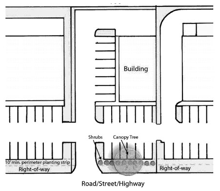
Figure 1
(2)
If the parking area exceeds 30,000 square feet in area, then such landscape screen shall be a minimum of 15 feet in width and shall contain a berm with a minimum height of two and one-half feet above the finished elevation of the parking area. Such berm shall have a maximum slope of one foot of rise to two feet of run and a minimum crown of three feet. In addition to the required berm, one tree of a species approved by the building code administrator having at least a three inch DBH and ten shrubs per 35 linear feet of street frontage shall be required. (See Figure 2)
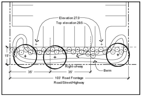
Figure 2
(3)
A 25-foot strip of undisturbed woodlands preserved between the parking area and right-of-way shall be permitted in lieu of the requirements set forth in subsections (g)(1) a. and b. (See Figure 3)
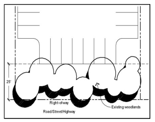
Figure 3
(4)
Perimeters not adjacent to public rights-of-way: In addition to subsection (g)(1), the remaining perimeter of any parking areas shall be surrounded by a continuous five foot landscape border. Such landscape border shall be required between any paved area and any property line, yard, required yard, or structures. The landscape border may be interrupted for ingress and egress to structures and adjoining lots. The landscaped border shall consist of one tree of a species approved by the building code administrator having at least a three inch DBH and ten shrubs for every 35 linear feet of perimeter. (See Figure 4)
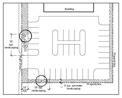
Figure 4
(h)
Landscape requirements for the interior of parking areas.
(1)
The interior of parking areas shall contain landscape islands and peninsulas located in such a manner as to:
a.
Divide and break up large expanses of paving.
b.
Guide traffic flow and direction.
c.
Promote pedestrian and vehicular safety.
d.
Preserve existing trees and vegetation.
(2)
A maximum of 10 consecutive parking spaces in a row shall be permitted without a landscape island or peninsula.
(3)
Each end of each row of parking spaces shall require a landscape island unless the end of such row of parking spaces is adjacent to a perimeter landscape screen or border as required in subsection (g). (See Figure 5)
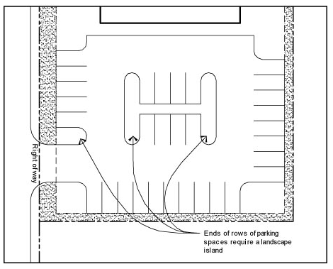
Figure 5
(4)
The minimum width for a landscape island or peninsula that is parallel to a parking space shall be nine feet, and the minimum length for the same shall be 19 feet. Each landscape island or peninsula shall contain a minimum of one tree of a species approved by the building code administrator having at least a three inch DBH and five shrubs. (See Figure 6)
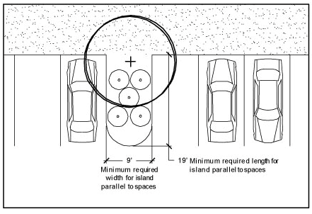
Figure 6
(5)
Every third group of rows of parking spaces shall be separated from one another by a six foot landscape island that extends the entire length of the row of parking spaces. Such landscape island shall contain one tree of a species approved by the building code administrator having at least a three inch DBH and ten shrubs per 35 linear feet. (See Figure 7)
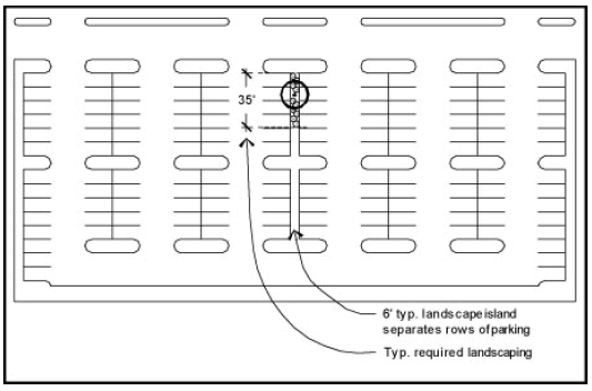
Figure 7
(i)
Retention pond landscape requirements. Developments that provide onsite retention ponds shall be required to plant wetland plant materials in and around such ponds. The plant species selected shall be those, which are commonly known to flourish in wetland areas and improve the quality of surface water run-off. A minimum of one tree of a species approved by the building code administrator having at least a three inch DBH shall be required per 4,000 square feet of retention area. In addition, grasses, shrubs and other herbaceous materials shall be provided in and around the retention areas of an appropriate quantity and placement as to ensure the propagation of such materials to approximately one-half of the retention area within a three-year period.
(Ord. of 8-12-04(1), § 7; Ord. No. 2010-33, 9-9-10; Ord. No. 2015-09, § 3(Exh. C), 5-14-15)
Sec. 86-188. - Limitations on adult bookstores, motion picture theaters and entertainment establishments.
Notwithstanding any other provision of this zoning ordinance, the following limitations are imposed on adult bookstores, adult motion picture theaters and adults only entertainment establishments:
(1)
No such use may be established or operated in the following districts: R-1, R-2, R-4, R-7, C-1, C-2, PE, MH, or PUD zones.
(2)
Such uses shall not be permitted within 300 feet of a:
a.
Church, school, park or playground, or any other such establishment; or
b.
Any residential or PUD district.
(Ord. of 11-11-04(5), § 3; Ord. No. 2015-09, § 3(Exh. C), 5-14-15)
Editor's note— An ordinance adopted Nov. 11, 2004, supplied provisions to be added to the Code as § 86-187. In order to maintain the style of the Code, at the discretion of the editor, these provisions were renumbered as § 86-188 to read as set out herein.
Sec. 86-189. - Limitations on body piercing establishments.
Notwithstanding any other provision of this zoning ordinance, the following limitations are imposed on "body piercing" establishments as that term as used in Code of Laws of South Carolina § 44-32-10:
(1)
No such use may be established or operated in the following districts: R-1, R-2, R-4, R-7, C-1, C-2, PB, MH, or PUD zones.
(2)
Such uses shall not be permitted within 300 feet of a:
a.
Church, school, park or playground, or any other such establishment; or
b.
Any residential or PUD district.
(Ord. of 11-11-04(6), § 2; Ord. No. 2015-09, § 3(Exh. C), 5-14-15)
Editor's note— An ordinance adopted Nov. 11, 2004, supplied provisions to added to the Code as § 86-188. In order to maintain the style of the Code, at the discretion of the editor, these provisions were renumbered as § 86-189 to read as set out herein.
Sec. 86-190. - Maintenance.
Owners of parcels of land within the Town of Edisto Beach shall be responsible for the maintenance of their real property and structures located thereon. In order to determine compliance with this section, the building code administrator shall be permitted to inspect any real property or structure erected thereon.
(Ord. of 12-9-04(5), § 1; Ord. No. 2015-09, § 3(Exh. C), 5-14-15)
Sec. 86-191. - Side-by-side two-family dwelling; division; requirements; nonconformity.
(a)
Division. Notwithstanding the provisions of subsection 86-119(2), where a side-by-side two-family dwelling (duplex) was constructed as a legally permitted use for the district in which it lies, and the plat of the lot on which such dwelling is located is properly recorded, providing the dwelling has met all zoning regulations at the time is was constructed, inspected, and certificate of occupancy issued, the lot may thereafter be divided to permit individual ownership of the two-family dwelling units by the following procedure, provided that lots conveyed to and held in the name of a horizontal property regime pursuant to S.C. Code 1976, §§ 27-31-10 et seq., "Horizontal Property Act," shall be in compliance with the provisions of the Horizontal Property Act to be eligible for division as provided herein:
(1)
A plat showing the as-built location of the two-family dwelling structure on the lot shall be filed with the town.
(2)
The plat of survey shall provide a reference to this section and indicate the purpose for which the plat is prepared.
(3)
The plat shall locate the new ownership division line along the common wall of the structure and provide individual boundaries for each new parcel.
(4)
The structure shall meet or be modified to meet all applicable building code requirements for a side-by-side two-family dwelling of the applicable building code adopted by the town at the time of initial construction.
(5)
Notwithstanding any other provisions of this Code relative to plats, if the proposed division is approved by the planning commission, following review by the building code administrator or his/her designee, a deed may be recorded thereafter effecting the lot division and each lot may be held in separate ownership.
(6)
A copy of the recorded deeds and plat of survey shall be filed with the town.
(b)
Requirements. The following requirements shall be met by each unit of the side-by-side two family dwelling to be eligible to be divided as herein provided.
(1)
Lots shall comply with the area and dimension requirements of this chapter with the following exceptions:
a.
Lot area. The lot area shall not be less than one-half the square feet area of the originating lot for each unit of a side-by-side two-family dwelling. Notwithstanding this requirement, where a side-by-side two-family dwelling was constructed and existing at the time of adoption of this section, the lot area for each unit shall be determined by division along the existing party wall without regard to the minimum lot area requirements established herein.
b.
Lot width. Requirements shall be calculated based on the originating lot, not the resulting divided lots.
c.
Side yard setback. Internal side yard setback: Zero feet.
(2)
Water, sewer, electrical, and gas services shall be entirely separate for each unit of the side-by-side two-family dwelling, and each unit shall be separately metered.
(3)
Notwithstanding any other provisions of this chapter, no more than 30 percent of the ground of each half of lots divided pursuant to this section may be covered with impervious surfaces. All structures built prior to adoption of this section are considered legally nonconforming.
(4)
The owners of each unit of a two-family dwelling shall enter into a written "party wall" agreement on terms agreed to by the owners. The "party wall" agreement shall include the following language, the terms of which must be agreed to by the owners: "The Town of Edisto Beach is not a party to this agreement and shall not be liable to the owners or third parties for any claims that may arise from the terms or creation of this agreement."
(c)
Nonconforming dwelling units. Each unit, or portion thereof, of a side-by-side two-family dwelling existing as of September 9, 2010, which has been divided pursuant to this section and which does not meet one or more of the requirements of the zoning ordinance for individually owned dwellings is declared to be incompatible with permitted uses in the districts involved. However, to avoid undue hardship, the lawful use of any individual unit of a duplex which has been divided may be continued even though such use does not conform with the provisions of this chapter, subject to the provisions of subsection 86-136(i) and section 86-171 as may be amended from time to time.
(d)
No single-family dwellings. Nothing in this section shall be read to permit the construction of a single-family dwelling on a lot established through the division provisions of this section. The construction of a single-family dwelling on a lot established through the division provisions set forth herein is prohibited.
(Ord. No. 2010-38, 9-9-10; Ord. No. 2015-09, § 3(Exh. C), 5-14-15; Ord. No. 2016-23, 11-10-16)