
Emerald Isle City Zoning Code
CHAPTER 6
- DEVELOPMENT STANDARDS
6.1.1 - Subdivisions of Land
All proposed subdivisions shall be in conformity with a plan for the most advantageous development of the entire neighboring area and shall bear a sensible relationship to the existing or amended plans of the Town.
(1)
Use of Public and Private Streets
The use of private streets is specifically authorized in residential subdivisions, group housing developments and other special developments, and planned unit developments that are authorized in accordance with this Ordinance. All other subdivisions authorized in accordance with this Ordinance shall utilize public streets for access to subdivided lots.
(2)
Relations of Proposed Streets to Adjoining Street Systems
The proposed street system shall extend existing and projected streets at not less than the required minimum width. Where in the opinion of the Planning Board or Board of Commissioners it is desirable to provide for street access to adjoining property, proposed streets shall be extended by dedication to the boundary of such property. The Planning Board or Board of Commissioners may require that a subdivision locate proposed streets, public or private, to intersect with other streets or roadways in a place and manner that will minimize traffic congestion and risk to the public safety. The Board of Commissioners may limit the number of and control the traffic from all outlets of subdivisions onto other streets for the purpose of protecting the public safety while providing for reasonably convenient subdivision access to the street system.
(3)
Street Names
Proposed streets that are obviously in alignment with others already existing shall bear the names of existing streets. In no case shall the name of proposed streets duplicate or be phonetically similar to existing street names, irrespective of the addition of a prefix, suffix, or word such as Street, Avenue, Boulevard, Drive, Place, or Court. In no case shall the total number of letters, including the spaces, exceed fifteen (15).
(4)
Street Construction
All dedicated public streets and approved private streets shall be constructed to the specifications of the Town as specified in Chapter 6, Section 6.1.5 of this Development Ordinance.
(5)
Intersections
Street intersections shall be as nearly at right angles as possible, and no intersection shall be at an angle less than seventy-five (75) degrees. No more than two (2) streets shall intersect at any one (1) point.
(6)
Drainage
All watercourses not located within a street right-of-way shall have an adequate easement to allow for maintenance.
(A)
An easement over a drainage pipe shall be a minimum width of fifteen (15) feet.
(B)
An easement for an open ditch shall be a minimum width of twenty (20) feet, plus the width of the ditch.
(7)
Fire Hydrants
Fire hydrants shall be within five hundred (500) feet of each proposed lot as measured along a paved street. All hydrants shall be three-outlet-base-valve type located on a six-inch or larger water main. The fire hydrant plan shall be reviewed by the fire chief.
(8)
Access
Within all proposed subdivisions, group housing and special developments, and all other developments subject to the terms of special plat approvals, a minimum public access width of ten (10) feet shall be provided from each street right-of-way to the high-water mark of both the Atlantic Ocean and Bogue Sound at both the east and west boundaries and center in each of the Town's fifty-four (54) blocks starting at the western limits of the Indian Beach and proceeding in a westerly direction to Bogue Inlet. Provided, the Board of Commissioners may eliminate, vary or change the location or width of any of the public accesses within a block following consideration by the Planning Board based upon topography, good land use planning, or similar consideration.
(9)
Minimum Lot Width
All lots within the proposed subdivision shall meet the required minimum lot width at the front building line. Additionally, every portion of a sawtooth or finger lot shall have a minimum width of at least thirty (30) feet. No portion of any subdivision lot shall have a minimum width of less than thirty (30) feet.
(10)
Installation of Improvements
No local improvements or utilities, including water, sewer, storm drains, paving, curb and gutter, shall be constructed until the preliminary plat and completed detailed plans for such improvements have been examined, analyzed, and approved by the Board of Commissioners. Detailed plans of proposed improvements shall be submitted with the preliminary plat and shall include plan views, profiles, typical sections, cross sections, standard specifications, and construction details. Design of streets and utilities shall be combined into one (1) plan set when possible.
6.1.2 - Business and Mixed Use Districts
(1)
Buffers
A buffer shall be required if commercial, mixed use, or government development abuts a residential or multi-family residential lot. The buffer shall consist of one (1) of the following: (1) a vegetative opaque screen eight (8) feet in height, or (2) an opaque fence six (6) feet in height with a vegetative opaque screen eight (8) feet in height. The buffer must be located along the perimeter of the project where it abuts the residential or multi-family residential lot, and the methods and materials of construction must be approved as part of the commercial development review process. The buffer must be maintained as constructed and replaced or repaired if destroyed or damaged by any means.
(2)
Paved Roads
For all projects containing more than two (2) units, all parking lots, drives, streets and roads within the project shall be paved and constructed in accordance with the construction standards for paved subdivision streets within the Town.
(3)
Lighting
Any lighting provided within the project shall be so located or shielded so that no offensive glare will be visible from an adjoining street or property.
(4)
Swimming Pools
Swimming pools shall conform to the building setback lines. All swimming pools shall be reasonably accessible to emergency equipment and vehicles. Any lighting in the pool area shall be shielded in such a manner that no offensive glare will be visible from an adjoining street or property.
(5)
Garbage Areas
Adequate space shall be provided within the project area for the collection of garbage and other refuse, and all dumpsters and equipment used for garbage collection shall be screened from public view, in accordance with Chapter 15, Section 15-3 of the Town Code.
(6)
Provision for Fire
Each building within a project shall be located within two hundred forty (240) feet of a fire hydrant. All hydrants shall be located adjacent to a paved street, road or parking lot suitable for the transportation of firefighting vehicles and equipment.
6.1.3 - Commercial Structures
(1)
Direct exterior lighting is prohibited
Strip lighting, including neon, LED, or fluorescent lighting, is prohibited on either the exterior of interior of any commercial building or commercial property, unless:
(a)
It is an informational sign (such as "OPEN") that does not exceed two (2) square feet; or
(b)
The interior strip lighting is located no closer than ten (10) feet to any exterior window or door containing glass so that the strip lighting may not be directly seen or viewed from the exterior of the property.
In addition, strip lighting, including neon, LED, or fluorescent lighting, is prohibited as a part of decorative displays, non-signage, or other building features.
The Board of Commissioners is authorized to vary the terms of this subsection (1) or allow lighting otherwise in violation if it finds that the proposed lighting is aesthetically consistent architecturally or for the commercial structure, or is necessary, or desirable for public health or safety reasons.
(2)
Permitted Exterior Colors
The proposed exterior structure colors for facades and walls shall be of low reflectance, subtle, neutral, or earth tone colors. Building trim and accent areas may feature brighter colors as approved by the Planning Director. Colors for new construction will be approved by the Board of Commissioners as part of the commercial review process. For existing buildings, exterior commercial colors must be approved by the Town prior to the painting or repainting of any commercial structure. The colors to be used for the repainting of existing structures may be approved by the Planning Director based on the criteria and intent stated in this Section 6.1.3. The Planning Director may request review of the colors by the Planning Board and approval by the Board of Commissioners if doing so is in the interest of maintaining a family beach image.
(a)
A request can be made for an exterior color that is not of low reflectance, subtle, neutral or earth tone. A request should meet one of the following two criteria: the business in that structure is a national chain or franchise that requires a certain color, or the name, product or service of the business denotes something other than low reflectance, subtle, neutral or earth tone color. Applicant shall have the burden of proving to the reasonable satisfaction of the Town that the exterior color falls under or meets one of the two criteria, and that granting approval is necessary or furthers a legitimate business interest of the applicant. A request for a color other than a one of low reflectance, subtle, neutral or earth tone, without meeting one of the two criteria shall result in denial.
(b)
The applicant may be requested to create a panel of desired color or colors for the Planning Director, Planning Board, and Board of Commissioners to better visualize the ordinance compatibility.
(3)
Decorative Construction Prohibited
The construction, installation, painting, and finishing of the exterior walls, roof lines, awnings and similar architectural features of a commercial building that contain painted or raised designs such as waves, sea creatures, animals, murals, lettering or images other than the business or logo of the commercial establishments in the structure are prohibited.
(4)
Outside Wall Facings
(A)
The total area of glass, windows, and any similar transparent or translucent devices for any side of a commercial structure shall not exceed thirty-five (35) percent of the surface area for that side of the building, and must be positioned uniformly along the face of the structure except that this percentage may be increased by the local fire marshal to bring the structure into conformity with state fire code.
(B)
Each exterior wall of a building that is viewable from any street, road, or the water, including Bogue Sound, its tributaries, the Atlantic Ocean, and the beach strand shall incorporate architectural design features to create a visual break at least every twenty (20) feet along the exterior wall in order to avoid a box-like appearance. A building offset, projecting porch, gable, or other similar structure may be utilized to meet this requirement. This requirement may also be met by the use of the following: variation in rooflines, balconies, building fenestrations, building recesses, variation of building materials and colors and other ornamental building features. All plans for exterior walls will be approved by the Board of Commissioners as part of the commercial review process.
(C)
The placement of towers, spires, and other structurally non-functional additions to any commercial structure must be placed so that no portion extends above any existing or proposed roof line, except that a structure which is intended as a building offset, which is proportional to such structure, may extend no more than four (4) feet above the existing or proposed structure.
(5)
Dry Stack Boat Storage Roofs
(A)
Roofs for dry stack boat storage facilities with a roof pitch of less than four (4) units vertical in twelve (12) units horizontal (4:12) shall incorporate architectural features and building finishes along all sides of the structure in order to make the roof line appear less like a flat roofed structure. This requirement may be met by the use of mansard-style roofs, decorative peaks and gables, a variation in roof lines and pitches, and other similar roof and building fenestrations. All plans for roofs with a pitch of less than 4:12 will be approved by the Board of Commissioners as part of the commercial review process.
6.1.4 - Planned Unit Developments
(1)
Design and Construction Requirements
The design, construction and development of planned developments shall comply with the design and construction requirements of Section 4.2.1, and other applicable ordinances of the Town, except as may be modified in this Section 6.1.4.
(2)
Minimum Area
Subject to the provisions in this Ordinance, all planned unit developments shall contain a minimum of five (5) contiguous acres. Any addition must be at least two (2) acres, contiguous and adjacent to the existing planned unit development, and subject to design standards.
(3)
Project Density
The overall density of each planned development shall be in conformance to the requirements of this Unified Development Ordinance that would limit the number of residential dwellings to no more than eight (8) units per acre regardless of the minimum lot area required per dwelling or unit herein. Specific density requirements for single-family and multifamily dwellings are as follows:
(A)
Single-family dwellings such as cluster homes, patio homes, etc.—Minimum lot area of six thousand two hundred fifty (6,250) square feet for each lot.
(B)
Multifamily dwellings—The minimum lot area for the first two (2) units or the first two-family dwelling shall be fifteen thousand (15,000) square feet. Each additional unit above two (2) shall require a minimum lot area of four thousand seven hundred sixty (4,760) square feet per unit.
(4)
Open Space
(A)
Each planned development shall contain open space in the following percentages of the overall area of the planned residential development that shall be computed based upon the number of dwellings per gross acre of planned development shown in Table 2.4.3.
TABLE 6.1.4: REQUIRED OPEN SPACE IN PLANNED UNIT DEVELOPMENTS
(B)
Open space is defined as that land designated on the plat as being for the use, benefit and enjoyment of the residents of the planned unit development. The open space shall be set aside for the use, benefit and enjoyment of all residents of the planned unit development, and shall either be dedicated to the private use of residents of the planned unit development or conveyed to the owner's association or similar resident's association for ownership, use and management. Land that is restricted in any way so as to be for the use, benefit or enjoyment of a select group within the planned unit development shall not qualify as open space.
(C)
To qualify as open space, land shall have a minimum width of twenty-four (24) feet excluding street rights-of-way, drives, parking areas or structures other than recreational structures. Street rights-of-way, drives, parking areas, and central water and sewer systems may qualify as open space and be counted towards the percentage of open space required for each development. Provided, that street rights-of-way, drives, parking areas, and water and central sewage systems shall not comprise more than thirty-three and one-third (33⅓) percent of the required open spaces for each development unless the percentage is varied or waived by the Board of Commissioners upon recommendation by the Planning Board.
(5)
Required Natural Area
Nothing in this Section 6.1.3 shall change, modify or repeal the requirements of Section 2.4.11 or 6.4 related to Dunes and Vegetation Protection with regard to the percentage of each tract or lot that must be retained in its natural state.
(6)
Dimension Requirements
(A)
Each detached single-family structure shall contain a minimum of seven hundred fifty (750) square feet of heated living space.
(B)
The minimum lot width for detached single-family dwellings at setback shall be sixty (60) feet.
(C)
A 15-foot setback shall be required along all peripheral boundaries of a planned residential development. A building, whether it is a principal or accessory building, shall not encroach upon this required setback distance.
(D)
Side or rear setbacks for single-family detached dwellings. A zero side or rear yard setback, where the side or rear building line is on the side or rear lot line, may be permitted on one (1) side or rear of each lot subject to the following provisions:
(i)
Any wall constructed on the side or rear lot lines shall be a solid, windowless, doorless wall if the wall is located less than three (3) feet from any side or rear lot line with a zero side or rear yard setback.
(ii)
The minimum building separation for the side or rear yard opposite the zero rear lot line shall be either a minimum building separation of fifteen (15) feet from the side of the adjacent dwelling if then constructed, or a minimum 15-foot building setback line from the adjoining side or rear lot line, whichever is greater. This 15-foot area shall be subject to all the requirements and conditions of the Unified Development Ordinance normally applied to side or rear yards for buildings within the zoning district in which the property is located.
(iii)
A five-foot maintenance easement with a maximum eave encroachment easement of two (2) feet within the maintenance easement shall be established in the deed restrictions and covenants of the adjoining lot and shall assure ready access to the lot line wall at reasonable periods of the day for normal maintenance.
(iv)
Preliminary and final site development plans shall indicate the proposed location and configuration of dwellings, driveways and parking arrangements for each lot. In addition, a draft of proposed encroachment and maintenance easement shall be submitted for review and approval.
(v)
All remaining yards shall have a minimum 15-foot building setback.
(7)
Water Supply and Sewage Service
Central water supply and central sewer service connection shall be required for all units, and the same shall be approved, constructed, completed and maintained in accordance with the requirements of the county health department and the state. The use of individual septic systems may be allowed under this section provided the lot served is a minimum of twelve thousand five hundred (12,500) square feet and the county health department has issued the appropriate permits for each lot to be served by an individual septic system.
(8)
Primary Vehicular Access
Primary vehicular access to the planned residential development shall be from a public street.
(9)
Building Height
Maximum height of all buildings shall not exceed the limitations for the district in which the planned residential development is located.
6.1.5 - Streets
(1)
General Standards
All streets within the Town shall be dedicated to public use unless otherwise allowed by applicable provisions of this Unified Development Ordinance. The use of private streets is specifically authorized only in residential subdivisions, group housing developments, other special developments and planned unit developments that are authorized in accordance with this development ordinance. The procedures for dedication are specified in the applicable sections of this development ordinance pertaining to the subdivision of land. All public streets shall be warranted by the developer/owner for a period of one (1) year from the date of acceptance by the Board of Commissioners.
(2)
Erosion and Sedimentation
All streets shall have an acceptable permanent vegetation cover and erosion control measures to prevent erosion of the street right-of-way or private properties.
(3)
Storm Drainage
All streets shall be inspected for proper drainage to the installation of the base course and final grading by the Director of Public Works or their designee. The specific design standards for stormwater control within this development ordinance shall apply to all streets within the Town.
(4)
Public Street Design Standards
Minimum public street design standards are as follows:
(A)
Right-of-way width—Fifty-five (55) feet.
(B)
Pavement width—Twenty (20) feet for streets utilizing ditches; a total of twenty-seven (27) feet of pavement (asphalt and concrete sections) from the back of the curb to the opposite back of the curb for streets utilizing curb and gutter (valley curbs required).
(C)
Base width—Twenty-six (26) feet for streets utilizing ditches and/or curb and gutter.
(D)
Shoulder width—Six (6) feet each side for streets utilizing ditches.
(E)
Ditch width, V-type—3:1 side slopes, for streets utilizing ditches.
(F)
Fill slope—3:1 side slopes minimum.
(G)
Curb and gutter—Two (2) feet valley gutter as specified by the N.C. Department of Transportation.
(H)
Intersection/turning radius—Thirty (30) feet.
(I)
Cul-de-sac right-of-way—Fifty-five (55) feet radius.
(J)
Cul-de-sac pavement width—Thirty-five (35) feet radius, for streets utilizing ditches and/or curb and gutter.
(K)
Side ditches—Minimum depth shall be two (2) feet below center line grade.
(L)
Minimum base course—Minimum base course shall be six (6) inches aggregate stone base course as required by the NCDOT compaction standards with regard to the type of road being constructed.
(M)
Materials—All materials used in street construction within the town shall conform to the material standards of NCDOT.
(5)
Private Street Design Standards
Minimum private street design standards are as follows:
(A)
Right-of-way width—Forty (40) feet, plus a five-foot utility easement on each side of the street.
(B)
Pavement width—Twenty (20) feet for streets utilizing ditches; a total of twenty-seven (27) feet of pavement (asphalt and concrete sections) from the back of the curb to the opposite back of the curb for streets utilizing curb and gutter (valley curbs required).
(C)
Base width—Twenty-three (23) feet for streets utilizing ditches and/or curb and gutter.
(D)
Shoulder width—Three (3) feet each side for streets utilizing ditches.
(E)
Ditch width, V-type—3:1 side slopes, for streets utilizing ditches.
(F)
Fill slope—3:1 side slopes minimum.
(G)
Curb and gutter—Two (2) feet valley gutter as specified by the N.C. Department of Transportation.
(H)
Intersection/turning radius—Thirty (30) feet.
(I)
Cul-de-sac right-of-way—Forty (40) feet radius.
(J)
Cul-de-sac pavement width—Thirty-five (35) feet radius, for streets utilizing ditches and/or curb and gutter.
(K)
Side ditches—Minimum depth shall be two (2) feet below center line grade.
(L)
Minimum base course—Minimum base course shall be six (6) inches aggregate stone base course as required by the NCDOT compaction standards with regard to the type of road being constructed.
(M)
Materials—All materials used in street construction within the Town shall conform to the material standards of NCDOT.
(6)
Utility Cuts
All cuts of existing streets for utility service shall be backfilled in six (6) inches compacted layers. The base course of six (6) inches compacted stone shall be reinstalled and one and one-half (1½) inches of pavement shall be provided. Such utility cuts shall be warranted against failure for a period of one (1) year.
(7)
Other Street Design Standards
Transverse slopes in pavement and shoulders, sight distance, grade, horizontal and vertical curves and superelevation shall be in accordance with the minimum construction standards as established by the North Carolina Department of Transportation.
6.1.6 - Sidewalks and Driveways
(1)
Sidewalk Standard
No sidewalk shall be constructed without a written permit from the Town.
(A)
All connections from the sidewalk to a business front shall be no less than four (4) feet in width and no greater than eight (8) feet in width.
(2)
Driveway Standard
All persons engaging in driveway construction, reconstruction, repair, and alteration must secure a permit and must be done according to the standard specifications of the Town. All driveways shall be constructed to prevent stormwater from running off from the driveway to the pavement of the existing public or private street. All driveways shall have a minimum width of ten (10) feet at the intersection with the public or private street.
The operation will not reasonably interfere with vehicular and pedestrian traffic, the demand and necessity for parking spaces, and the means of egress to and from the property affected and adjacent properties.
(3)
In the R2, RMF, and MH District
In addition to the standards in subsections (1) and (2) above, single-family, duplex and manufactured home structures in the R2, RMF and MH districts shall:
(A)
Be limited to two (2) driveways on the Town or private right-of-way,
(B)
Not exceed a width of sixteen (16) feet each excluding the flares and, if used as part of the parking area, shall be of sufficient length to park two (2) cars off the street right-of-way,
(C)
Not exceed a width of three (3) feet for each flare,
(D)
Not exceed a length of six (6) feet for each flare,
(E)
Flare points shall connect using an inward curved shape,
(F)
Not exceed a width of twenty-two (22) total feet including flares.
6.1.7 - In the VE, VW, MV, VE-C, VW-C and MV-C Districts
(1)
Lots are encouraged to have vehicle access from the rear of the lot, rather than from the front of the lot.
(2)
The required vegetated area shown in Table 5.1 may be utilized to support on-site septic disposal systems. Site specific landscaping plans are required that include the location of any existing natural areas, proposed plans for the preservation of natural areas and the proposed location and extent of all new vegetated and landscaped areas.
(3)
For all projects containing more than two (2) dwelling units, all parking lots, drives, streets and roads within the project shall be paved and constructed in accordance with the construction standards for paved public subdivision streets within the Town unless specifically otherwise authorized by a condition of approval of a Conditional Zoning Overlay District.
(4)
Any lighting provided within the project shall be so located or shielded so that no offensive glare will be visible from an adjoining street or property.
(5)
Adequate space shall be provided within the project area for the collection of garbage and other refuse, and all dumpsters and equipment used for garbage collection shall be screened from public view, in accordance with Chapter 15, Section 15-3 of the Town Code.
(6)
Each building within a project shall be located within two hundred forty (240) feet of a fire hydrant. All hydrants shall be located adjacent to a paved street, road or parking lot suitable for the transportation of firefighting vehicles and equipment. A suitable and readily accessible drive or passage shall be provided so that firefighting vehicles will have the capability of getting adequate access to all structures within the district.
(7)
Public streets, constructed in accordance with Chapter 6, Design Standards of this Unified Development Ordinance, are required for all proposed developments in order to promote and preserve public access.
6.2.1 - Findings, Purpose, and Objectives
(1)
Findings of Fact
The flood prone areas within the jurisdiction of the Town are subject to periodic inundation that results in loss of life, property, health and safety hazards, disruption of commerce and governmental services, extraordinary public expenditures of flood protection and relief, and impairment of the tax base, all of which adversely affect the public health, safety, and general welfare. These flood losses are caused by the cumulative effect of obstructions in floodplains causing increases in flood heights and velocities, and by the occupancy in flood prone areas by uses vulnerable to floods or hazardous to other lands that are inadequately elevated, floodproofed, or otherwise unprotected from flood damages.
(2)
Statement of Purpose
It is the purpose of this Section 6.2 to promote public health, safety, and general welfare and to minimize public and private losses due to flood conditions within flood prone areas by provisions designed to:
(A)
Restrict or prohibit uses that are dangerous to health, safety, and property due to water or erosion hazards, or that result in damaging increases in erosion, flood heights or velocities;
(B)
Require that uses vulnerable to floods, including facilities that serve such uses, be protected against flood damage at the time of initial construction;
(C)
Control the alteration of natural floodplains, stream channels, and natural protective barriers that are involved in the accommodation of flood waters;
(D)
Control filling, grading, dredging, and all other development that may increase erosion or flood damage; and
(E)
Prevent or regulate the construction of flood barriers that will unnaturally divert floodwaters or that may increase flood hazards to other lands.
(3)
Objectives
The objectives of this Section 6.2 are:
(A)
To protect human life and health;
(B)
To minimize expenditure of public money for costly flood control projects;
(C)
To minimize the need for rescue and relief efforts associated with flooding and generally undertaken at the expense of the general public;
(D)
To minimize prolonged business losses and interruptions;
(E)
To minimize damage to public facilities and utilities (i.e. water and gas mains, electric, telephone, cable and sewer lines, streets, and bridges) that are located in flood prone areas;
(F)
To minimize damage to private and public property due to flooding;
(G)
To make flood insurance available to the community through the National Flood Insurance Program;
(H)
To maintain the natural and beneficial functions of floodplains;
(I)
To help maintain a stable tax base by providing for the sound use and development of flood prone areas in such a manner as to minimize flood blight areas; and
(J)
To ensure that potential homebuyers are notified that property is in a special flood hazard area.
6.2.2 - Applicability and Legal Status
(1)
Lands to Which This Article Applies
These regulations shall apply to all special flood hazard areas within the jurisdiction of the Town.
(2)
Effect on Rights and Liabilities Under the Existing Flood Damage Prevention Ordinance
This Section 6.2 and related sections of this Unified Development Ordinance in part comes forward by re-enactment of some of the provisions of the flood damage prevention ordinance enacted July 1, 1977, as amended, and it is not the intention to repeal but rather to re-enact and continue to enforce without interruption of such existing provisions, so that all rights and liabilities that have accrued under the earlier regulations are reserved and may be enforced. The enactment of this Section 6.2 and related sections in Chapters 2 and 9 shall not affect any action, suit or proceeding instituted or pending.
(3)
Effect Upon Outstanding Building Permits
Nothing in this Section 6.2 or related sections of this Unified Development Ordinance shall require any change in the plans, construction, size or designated use of any development or any part thereof for which a floodplain development permit has been granted by the floodplain administrator or their authorized agents before the effective date of this Ordinance; provided, however, that when construction is not begun under such outstanding permit within a period of six (6) months subsequent to passage of this Ordinance or any revision to this Ordinance, construction or use shall be in conformity with the provisions of this Ordinance.
(4)
Severability
If any section, clause, sentence, or phrase of these regulations is held to be invalid or unconstitutional by any court of competent jurisdiction, then said holding shall in no way effect the validity of the remaining portions of these regulations.
(5)
Effective Date
These regulations shall become effective upon adoption.
6.2.3 - General Provisions
(1)
Compliance
No structure or land shall be located, extended, converted, altered, or developed in any way without full compliance with the terms of this Section 6.2 and other applicable regulations.
(2)
Basis for Establishing the Special Flood Hazard Areas
The special flood hazard areas are those identified under the Cooperating Technical State (CTS) agreement between the State of North Carolina and FEMA in its FIS dated June 19, 2020, for Carteret County and associated DFIRM panels, including any digital data developed as part of the FIS, which are adopted by reference and declared a part of these regulations and all revisions thereto after January 1, 2021. Future revisions to the FIS and DFIRM panels that do not change flood hazard data within the jurisdiction authority of the Town of Emerald Isle are also adopted by reference and declared a part of these regulations. Subsequent Letter of Map Revisions (LOMRs) and/or Physical Map Revisions (PMRs) shall be adopted within three (3) months.
(3)
Floodplain Development Permit Required
A floodplain development permit shall be required in conformance with the provisions of Section 2.4.9, Floodplain Development Permit, prior to the commencement of any development activities within special flood hazard areas as determined in Section 6.2.3(2).
(4)
Variance Procedure
The Board of Adjustment may grant a variance from the provisions of this Section 6.2 pursuant to the provisions of Section 2.4.17, Variances.
(5)
Abrogation and Greater Restrictions
This Section 6.2 is not intended to repeal, abrogate, or impair any existing easements, covenants, or deed restrictions. However, where this section and another conflict or overlap, whichever imposes the more stringent restrictions shall prevail.
(6)
Interpretation
In the interpretation and application of this Section 6.2, all provisions shall be considered as minimum requirements, shall be liberally construed in favor of the governing body; and shall be deemed neither to limit nor repeal any other powers granted under state statutes.
(7)
Warning and Disclaimer of Liability
The degree of flood protection required by this Section 6.2 is considered reasonable for regulatory purposes and is based on scientific and engineering consideration. Larger floods can and will occur on rare occasions. Actual flood heights may be increased by manmade or natural causes. This section does not imply that land outside the special flood hazard areas or uses permitted within such areas will be free from flooding or flood damages. This section shall not create liability on the part of the Town or by any officer or employee of the Town for any flood damages that result from reliance on this section or any administrative decision lawfully made under this section.
6.2.4 - Provisions for Flood Hazard Prevention
(1)
General Standards
In all special flood hazard areas the following provisions are required:
(A)
All new construction and substantial improvements shall be designed (or modified) and adequately anchored to prevent flotation, collapse, or lateral movement of the structure.
(B)
All new construction and substantial improvements shall be constructed with materials and utility equipment resistant to flood damage in accordance with FEMA Technical Bulletin 2, Flood Damage-Resistant Materials Requirements.
(C)
All new construction or substantial improvements shall be constructed by methods and practices that minimize flood damages.
(D)
All new electrical, heating, ventilation, plumbing, air conditioning equipment, and other service equipment shall be located at or above the RFPE. These include, but are not limited to, HVAC equipment, water softener units, bath/kitchen fixtures, ductwork, electric/gas meter panels/boxes, utility/cable boxes, water heaters, and electric outlets/switches.
(i)
Replacements part of a substantial improvement, electrical, heating, ventilation, plumbing, air conditioning equipment, and other service equipment shall also meet the above provisions.
(ii)
Replacements that are for maintenance and not part of a substantial improvement, may be installed at the original location provided the addition and/or improvements only comply with the standards for new construction consistent with the code and requirements for the original structure.
(E)
All new and replacement water supply systems shall be designed to minimize or eliminate infiltration of flood waters into the system.
(F)
New and replacement sanitary sewage systems shall be designed to minimize or eliminate infiltration of flood waters into the systems and discharges from the systems into flood waters.
(G)
On-site waste disposal systems shall be located and constructed to avoid impairment to them or contamination from them during flooding.
(H)
Nothing in this Ordinance shall prevent the repair, reconstruction, or replacement of a building or structure existing on the effective date of this Ordinance and located totally or partially within the floodway, non-encroachment area, or stream setback, provided there is no additional encroachment below the Regulatory Flood Protection Elevation in the floodway, non-encroachment area, or stream setback, and provided that such repair, reconstruction, or replacement meets all of the other requirements of this Ordinance. Any alteration, repair, reconstruction, or improvements to a structure that is in compliance with the provisions of this Section 6.2, shall meet the requirements of "new construction" in Chapter 10.
(I)
Non-conforming structures or other development may not be enlarged, replaced, or rebuilt unless such enlargement or reconstruction is accomplished in conformance with the provisions of this Section 6.2. Provided, however, nothing in this Section 6.2 shall prevent the repair, reconstruction, or replacement of a building or structure existing on July 1, 1977 and located totally or partially within the floodway, non-encroachment area, or stream setback, provided that the bulk of the building or structure below the regulatory flood protection elevation in the floodway, non-encroachment area, or stream setback is not increased and provided that such repair, reconstruction, or replacement meets all of the other requirements of the flood damage prevention regulations.
(J)
New solid waste disposal facilities, hazardous waste management facilities, salvage yards, and chemical storage facilities shall not be permitted in special flood hazard areas. A structure or tank for chemical or fuel storage incidental to an allowed use or to the operation of a water treatment plant or wastewater treatment facility may be located in a special flood hazard area only if the structure or tank is either elevated or floodproofed to at least the regulatory flood protection elevation and certified according to subsection 2.4.9(3).
(K)
All subdivision proposals and other development proposals shall be consistent with the need to minimize flood damage.
(L)
All subdivision proposals and other development proposals shall have public utilities and facilities such as sewer, gas, electrical, and water systems located and constructed to minimize flood damage.
(M)
All subdivision proposals and other development proposals shall have adequate drainage provided to reduce exposure to flood hazards.
(N)
All subdivision proposals and other development proposals shall have received all necessary permits from those governmental agencies for which approval is required by federal or state law, including Section 404 of the Federal Water Pollution Control Act Amendments of 1972, 33 U.S.C. 1334.
(O)
When a structure is partially located in a Special Flood Hazard Area, the entire structure shall meet the requirements for new construction and substantial improvements.
(P)
When a structure is located in multiple flood hazard zones or in a flood hazard risk zone with multiple base flood elevations, the provisions for the more restrictive flood hazard risk zone and the highest BFE shall apply.
(2)
Specific Standards
In all special flood hazard areas where base flood elevation (BFE) data has been provided, as set forth in subsection 6.2.3(2) or subsections 2.2.4(5)(B)(xi) and 2.2.4(5)(B)(xii), the following provisions are required:
(A)
Residential Construction
New construction or substantial improvement of any residential structure (including manufactured homes) shall have the reference level, including basement, elevated no lower than the regulatory flood protection elevation, as defined in Section 10.2 of this Ordinance.
(B)
Non-residential Construction
New construction or substantial improvement of any commercial, industrial, or other non-residential structure shall have the reference level, including basement, elevated no lower than the regulatory flood protection elevation, as defined in Section 10.2 of this Ordinance. Structures located in Zones A, AE, AH, AO, A99h may be floodproofed to the regulatory flood protection elevation in lieu of elevation provided that all areas of the structure below the required flood protection elevation are watertight with walls substantially impermeable to the passage of water, using structural components having the capability of resisting hydrostatic and hydrodynamic loads and the effect of buoyancy. A registered professional engineer or architect shall certify that the standards of this subsection are satisfied. Such certification shall be provided to the official as set forth in subsection 2.4.9(3).
(C)
Manufactured Homes
(i)
New or replacement manufactured homes shall be elevated so that the reference level of the manufactured home is no lower than 2 feet above the regulatory flood protection elevation, as defined in Section 10.2 of this Ordinance.
(ii)
Manufactured homes shall be securely anchored to an adequately anchored foundation to resist flotation, collapse, and lateral movement in accordance with the State of North Carolina Regulations for Manufactured/Mobile Homes, 1995 Edition, and any revision thereto adopted by the Commissioner of Insurance pursuant to G.S. 143-143.15 or a certified engineered foundation. When the elevation of the chassis is above thirty-six (36) inches in height, an engineering certification is required.
(iii)
All foundation enclosures or skirting shall be in accordance with subsection 6.2.4(2)(D).
(iv)
An evacuation plan must be developed for evacuation of all residents of all new, substantially improved or substantially damaged manufactured home parks or subdivisions located within flood prone areas. This plan shall be filed with and approved by the floodplain administrator and the local emergency management coordinator.
(D)
Elevated Buildings
Fully enclosed area, of new construction and substantially improved structures, which is below the lowest floor or below the lowest horizontal structural member in VE zones:
(i)
Shall not be designed or used for human habitation, but shall only be used for parking of vehicles, building access, or limited storage of maintenance equipment used in connection with the premises. Access to the enclosed area shall be the minimum necessary to allow for parking of vehicles (garage door) or limited storage of maintenance equipment (standard exterior door), or entry to the living area (stairway or elevator). The interior portion of such enclosed area shall not be finished or partitioned into separate rooms, except to enclose storage areas;
(ii)
Shall not be temperature-controlled or conditioned;
(iii)
Shall be constructed entirely of flood resistant materials at least to the Regulatory Flood Protection Elevation; and
(iv)
Shall include, in Zones A, AE, AH, AO, A99 flood opening to automatically equalize hydrostatic flood forces on walls by allowing for the entry and exit of floodwaters. To meet this requirement the openings must either be certified by a professional engineer or architect or meet or exceed the following minimum design criteria:
(a)
Provide a minimum of two (2) openings on different sides of each enclosed area subject to flooding;
(b)
The total net area of all openings must be at least one (1) square inch for each square foot of each enclosed area subject to flooding;
(c)
If a building has more than one (1) enclosed area, each area must have openings on exterior walls to allow floodwater to directly enter and exit;
(d)
The bottom of all required openings shall be no higher than one (1) foot above the higher of the interior or exterior adjacent grade;
(e)
Openings may be equipped with screens, louvers, or other opening coverings or devices provided they permit the automatic flow of floodwaters in both directions; and
(f)
Enclosures made of flexible skirting are not considered enclosures for regulatory purposes, and, therefore do not require flood openings. Masonry or wood underpinning, regardless of structural status, is considered an enclosure and requires hydrostatic openings as outlined above to comply with this Section 6.2.
(v)
Shall, in Coastal High Hazard Areas (Zone VE) meet the requirements of Section 6.2.4(5) of this Ordinance.
(E)
Additions/Improvements
(i)
Additions and/or improvements to pre-FIRM structures whereas the addition and/or improvements in combination with any interior modifications to the existing structure.
(a)
Are not a substantial improvement, the addition and/or improvements must be designed to minimize flood damages and must not be any more non-conforming than the existing structure.
(b)
Are a substantial improvement, with modifications/rehabilitations/improvements to the existing structure or the common wall is structurally modified more than installing a doorway, both the existing structure and the addition must comply with the standards for new construction.
(ii)
Additions to pre-FIRM or post-FIRM structures that are a substantial improvement with no modifications/rehabilitations/improvements to the existing structure other than a standard door in the common wall, shall require only the addition to comply with the standards for new construction.
(iii)
Additions and/or improvements to post-FIRM structures whereas the addition and/or improvements in combination with any interior modifications to the existing structure.
(a)
Are not a substantial improvement, the addition and/or improvements only must comply with the standards for new construction consistent with the code and requirements for the original structure.
(b)
Are a substantial improvement, both the existing structure and the addition and/or improvements must comply with the standards for new construction.
(iv)
Where a fire wall or independent perimeter load-bearing wall is provided between the addition and the existing building, the addition(s) shall be considered a separate building and only the addition must comply with the standards for new construction.
(v)
Any combination of repair, reconstruction, rehabilitation, addition or improvement of a building or structure taking place during a one-year minimum period, the cumulative cost of which equals or exceeds fifty (50) percent of the market value of the structure before the improvement or repair is started must comply with the standards for new construction. For each building or structure, the one-year period begins on the date of the first improvement or repair of that building or structure subsequent to the effective date of this Ordinance. Substantial damage also means flood-related damage sustained by a structure on two (2) separate occasions during a ten-year period for which the cost of repairs at the time of each such flood event, on the average, equals or exceeds twenty-five (25) percent of the market value of the structure before the damage occurred. If the structure has sustained substantial damage, any repairs are considered substantial improvement regardless of the actual repair work performed. The requirement does not, however, include either:
(a)
Any project for improvement of a building required to correct existing health, sanitary or safety code violations identified by the building official and that are the minimum necessary to assume safe living conditions.
(b)
Any alteration of a historic structure provided that the alteration will not preclude the structure's continued designation as a historic structure.
(F)
Recreational Vehicles
Recreational vehicles placed on sites within a special flood hazard area shall either:
(i)
Be on site for fewer than one hundred eighty (180) consecutive days and be fully licensed and ready for highway use (a recreational vehicle is ready for highway use if it is on its wheels or jacking system, is attached to the site only by quick disconnect type utilities and has no permanently attached additions); or
(ii)
Meet all the requirements for new construction, including anchoring and elevation requirements of Sections 2.4.9, 6.2.4(1), and subsection (2), 6.2.4(C).
(G)
Temporary Structures
Prior to the issuance of a floodplain development permit for a temporary structure, the following requirements must be met:
(i)
Removal Plan
Applicants must submit to the floodplain administrator a plan for the removal of such structure(s) in the event of a hurricane or flash flood warning notification. The plan must include the following information:
(a)
A specified time period for which the temporary use will be permitted;
(b)
The name, address, and phone number of the individual responsible for the removal of the temporary structure;
(c)
The time frame prior to the event at which a structure will be removed (i.e. minimum of seventy-two (72) hours before landfall of a hurricane or immediately upon flood warning notification);
(d)
A copy of the contract or other suitable instrument with a trucking company to insure the availability of removal equipment when needed; and
(e)
Designation, accompanied by documentation, of a location outside the special flood hazard area to which the temporary structure will be moved.
(ii)
Submitted in Writing
The above information shall be submitted in writing to the floodplain administrator for review and written approval.
(H)
Accessory Structures
When accessory structures (sheds, detached garages, etc.) are to be placed within a special flood hazard area, the following criteria shall be met:
(i)
Accessory structures shall not be used for human habitation (including work, sleeping, living, cooking or restroom areas);
(ii)
Accessory structures shall not be temperature-controlled;
(iii)
Accessory structures shall be designed to have low flood damage potential;
(iv)
Accessory structures shall be constructed and placed on the building site so as to offer the minimum resistance to the flow of floodwaters;
(v)
Accessory structures shall be firmly anchored in accordance with subsection 6.2.4(1)(A);
(vi)
Accessory structures, regardless of their size or cost, shall not be placed below elevated buildings in V and VE zones;
(vii)
All service facilities such as electrical and heating equipment shall be installed in accordance with subsection 6.2.4(1)(D); and
(viii)
Openings to relieve hydrostatic pressure during a flood shall be provided below regulatory flood protection elevation in conformance with subsection 6.2.4(2)(D)(i).
(ix)
An accessory structure with a footprint less than one hundred fifty (150) square feet or that is a minimal investment of five thousand dollars ($5,000.00) or less and satisfies the criteria outlined above does not require an elevation or floodproofing certificate. Elevation or floodproofing certifications are required for all other accessory structures in accordance with subsection 2.4.9(3).
(I)
Tanks
When gas and liquid storage tanks are to be placed within a special flood hazard area, the following criteria shall be met:
(i)
Underground tanks. Underground tanks in flood hazard areas shall be anchored to prevent flotation, collapse or lateral movement resulting from hydrodynamic and hydrostatic loads during conditions of the design flood, including the effects of buoyancy assuming the tank is empty;
(ii)
Above-ground tanks, elevated. Above-ground tanks in flood hazard areas shall be elevated to or above the Regulatory Flood Protection Elevation on a supporting structure that is designed to prevent flotation, collapse or lateral movement during conditions of the design flood. Tank-supporting structures shall meet the foundation requirements of the applicable flood hazard area;
(iii)
Above-ground tanks, not elevated. Above-ground tanks that do not meet the elevation requirements of Article 5, Section B (2) of this Ordinance shall not be permitted in V or VE Zones. Tanks may be permitted in other flood hazard areas provided the tanks are designed, constructed, installed, and anchored to resist all flood-related and other loads, including the effects of buoyancy, during conditions of the design flood and without release of contents in the floodwaters or infiltration by floodwaters into the tanks. Tanks shall be designed, constructed, installed, and anchored to resist the potential buoyant and other flood forces acting on an empty tank during design flood conditions.
(iv)
Tank inlets and vents. Tank inlets, fill openings, outlets and vents shall be:
(a)
At or above the Regulatory Flood Protection Elevation or fitted with covers designed to prevent the inflow of floodwater or outflow of the contents of the tanks during conditions of the design flood; and
(b)
Anchored to prevent lateral movement resulting from hydrodynamic and hydrostatic loads, including the effects of buoyancy, during conditions of the design flood.
(3)
Subdivisions, Manufactured Home Parks and Major Developments
All subdivision, manufactured home park and major development proposals located within special flood hazard areas shall:
(A)
Be consistent with the need to minimize flood damage;
(B)
Have public utilities and facilities such as sewer, gas, electrical, and water systems located and constructed to minimize flood damage; and
(C)
Have adequate drainage provided to reduce exposure to flood hazards;
(4)
Standards for Floodplains without Established Base Flood Elevations
Within the special flood hazard areas established in Section 6.2.3(2) where no base flood elevation (BFE) data has been provided, the following provisions shall apply:
(A)
Encroachments
No encroachments, including fill, new construction, substantial improvements or new development shall be permitted within a distance of twenty (20) feet each side from top of bank or five (5) times the width of the stream, whichever is greater, unless certification with supporting technical data by a registered professional engineer is provided demonstrating that such encroachments shall not result in any increase in flood levels during the occurrence of the base flood discharge.
(B)
Elevation and Floodproofing
If subsection 6.2.4(3)(A) is satisfied and base flood elevation (BFE) data is available from other sources, all new construction and substantial improvements within such areas shall also comply with all applicable provisions of this Section 6.2 and shall be elevated or floodproofed in accordance with elevations established in accordance with subsections 2.2.4(5)(B)(xi) and 2.2.4(5)(B)(xii). All subdivision, manufactured home park and other development proposals shall provide BFE data if development is greater than five (5) acres or has more than fifty (50) lots/manufactured home sites. Such base flood data shall be adopted by reference with Section 6.2.3(2) and utilized in implementing this Ordinance. When base flood elevation (BFE) data is not available from a federal, state, or other source, the reference level, including basement, shall be elevated at least two (2) feet above the highest adjacent grade.
(5)
Coastal High Hazard Areas (Zone VE)
Coastal high hazard areas are special flood hazard areas established in Section 6.2.3(2) and designated as Zone VE. These areas have special flood hazards associated with high velocity waters from surges and, therefore, in addition to meeting all provisions in this Section 6.2, the following provisions shall apply to all new construction, substantial improvements and all other development:
(A)
Location
All development shall:
(i)
Be located landward of the reach of mean high tide;
(ii)
Be located landward of the first line of stable natural vegetation; and
(iii)
Comply with all applicable CAMA setback requirements.
(B)
Required Elevation
All development shall be elevated so that the bottom of the lowest supporting horizontal member (excluding pilings or columns) is located no lower than the regulatory flood protection elevation. Floodproofing may not be utilized on any structures in coastal high hazard areas to satisfy the regulatory flood protection elevation requirements.
(C)
Open Construction/Breakaway Walls
All development shall have the space below the bottom of the lowest horizontal structural member of the lowest floor either be free of obstruction or constructed with breakaway walls, open wood latticework or insect screening, provided they are not part of the structural support of the building, are for aesthetic purposes only and are designed so as to breakaway, under abnormally high tides or wave action without causing damage to the elevated portion of the building or supporting foundation system or otherwise jeopardizing the structural integrity of the building. The following design specifications shall be met:
(i)
Material shall consist of open wood or plastic lattice having at least forty (40) percent of its area open,
(ii)
Insect screening, or
(iii)
Breakaway wall shall meet the following design specifications:
(a)
Breakaway walls shall have flood openings that allow for the automatic entry and exit of floodwaters to minimize damage caused by hydrostatic loads, per the North Carolina Residential Building Code;
(b)
Design safe loading resistance shall be not less than ten (10) nor more than twenty (20) pounds per square foot; or
(c)
Breakaway walls that exceed a design safe loading resistance of twenty (20) pounds per square foot (either by design or when so required by state or local codes) shall be certified by a registered professional engineer or architect that the breakaway wall will collapse from a water load less than that which would occur during the base flood event, and the elevated portion of the building and supporting foundation system shall not be subject to collapse, displacement, or other structural damage due to the effects of wind and water loads acting simultaneously on all building components (structural and non-structural). The water loading values used shall be those associated with the base flood. The wind loading values used shall be those required by the North Carolina State Building Code.
(D)
Anchoring
All development shall be securely anchored on pilings or columns.
(E)
Anchoring of Pilings and Columns
All pilings and columns and the attached structures shall be anchored to resist flotation, collapse, and lateral movement due to the effect of wind and water loads acting simultaneously on all building components. Water loading values shall be those associated with base flood. Wind values used shall be those required by the current edition of the North Carolina State Building Code.
(F)
Certification
A registered professional engineer or architect shall certify that the design, specifications and plans for construction are in compliance with the provisions contained in Section 2.4.9 and subsections 6.2.4(2)(2)(D), 6.2.4(2)(2)(F), and 6.2.4(2)(H).
(G)
Other Development
(i)
For concrete pads, including patios, decks, parking pads, walkways, driveways, pool decks, etc. the following is required:
(a)
Shall be structurally independent of the primary structural foundation system of the structure and shall not adversely affect structures through redirection of floodwaters or debris; and
(b)
Shall be constructed to breakaway cleanly during design flood conditions, shall be frangible, and shall not produce debris capable of causing damage to any structure. (The installation of concrete in small segments (approximately 4 feet × 4 feet) that will easily break up during the base flood event, or score concrete in 4 feet × 4 feet maximum segments is acceptable to meet this standard); and
(c)
Reinforcing, including welded wire fabric, shall not be used in order to minimize the potential for concreted pads being a source of debris; and
(d)
Pad thickness shall not exceed four (4) inches; or
(e)
Provide a Design Professional's certification stating the design and method of construction to be used meet the applicable criteria of this section.
(ii)
For swimming pools and spas, the following is required:
(a)
Be designed to withstand all flood-related loads and load combinations;
(b)
Be elevated so that the lowest horizontal structural member is elevated above the RFPE; or
(c)
Be designed and constructed to break away during design flood conditions without producing debris capable of causing damage to any structure; or
(d)
Be sited to remain in the ground during design flood conditions without obstructing flow that results in damage to any structure.
(e)
Registered design professionals must certify to local officials that a pool or spa beneath or near a VE Zone building will not be subject to flotation or displacement that will damage building foundations or elevated portions of the building or any nearby buildings during a coastal flood.
(f)
Pool equipment shall be located above the RFPE whenever practicable. Pool equipment shall not be located beneath an elevated structure.
(iii)
All elevators, vertical platform lifts, chair lifts, etc., the following is required:
(a)
Elevator enclosures must be designed to resist hydrodynamic and hydrostatic forces as well as erosion, scour, and waves.
(b)
Utility equipment in Coastal High Hazard Areas (VE Zones) must not be mounted on, pass through, or be located along breakaway walls.
(c)
The cab, machine/equipment room, hydraulic pump, hydraulic reservoir, counter weight and roller guides, hoist cable, limit switches, electric hoist motor, electrical junction box, circuit panel, and electrical control panel are all required to be above RFPE. When this equipment cannot be located above the RFPE, it must be constructed using flood damage-resistant components.
(d)
Elevator shafts/enclosures that extend below the RFPE shall be constructed of reinforced masonry block or reinforced concrete walls and located on the landward side of the building to provide increased protection from flood damage. Drainage must be provided for the elevator pit.
(e)
Flood damage-resistant materials can also be used inside and outside the elevator cab to reduce flood damage. Use only stainless steel doors and door frames below the BFE. Grouting in of door frames and sills is recommended.
(f)
If an elevator is designed to provide access to areas below the BFE, it shall be equipped with a float switch system that will activate during a flood and send the elevator cab to a floor above the RFPE.
(H)
No Fill for Structural Support
Minor grading and the placement of minor quantities of nonstructural fill may be permitted for landscaping and for drainage purposes under and around buildings and for support of parking slabs, pool decks, patios and walkways. The fill material must be similar and consistent with the natural soils in the area. The placement of site compatible, nonstructural fill under or around an elevated building is limited to two (2) feet. Fill greater than two (2) feet must include an analysis prepared by a qualified registered design professional demonstrating no harmful diversion of floodwaters or wave run-up and wave reflection that would increase damage to adjacent elevated buildings and structures. Nonstructural fill with finished slopes that are steeper than five (5) units horizontal to one (1) unit vertical shall be permitted only if an analysis prepared by a qualified registered design professional demonstrates no harmful diversion of floodwaters or wave run-up and wave reflections that would increase damage to adjacent elevated buildings and structures. There shall be no fill used as structural support.
(I)
No Alternation of Sand Dunes
There shall be no alteration of sand dunes or mangrove stands that would increase potential flood damage.
(J)
No Manufactured Homes
No manufactured homes shall be permitted except in an existing manufactured home park or subdivision. A replacement manufactured home may be placed on a lot in an existing manufactured home park or subdivision provided the anchoring and elevation standards are in compliance with this section of the Ordinance.
(K)
Recreational Vehicles Allowed
Recreational vehicles shall be permitted in coastal high hazard areas provided that they meet the recreational vehicle criteria of subsection 6.2.4(2)(F)(i) and the temporary structure provisions of subsection 6.2.4(2)(2)(G).
(L)
Decks and Patios
(i)
A deck that is structurally attached to a building or structure shall have the bottom of the lowest horizontal structural member at or above the Regulatory Flood Protection Elevation and any supporting members that extend below the Regulatory Flood Protection Elevation shall comply with the foundation requirements that apply to the building or structure, which shall be designed to accommodate any increased loads resulting from the attached deck. The increased loads must be considered in the design of the primary structure and included in the V-Zone Certification required under the flood damage prevention regulations of this Ordinance.
(ii)
A deck or patio that is located below the Regulatory Flood Protection Elevation shall be structurally independent from buildings or structures and their foundation systems, and shall be designed and constructed either to remain intact and in place during design flood conditions or to break apart into small pieces to minimize debris during flooding that is capable of causing structural damage to the building or structure or to adjacent buildings and structures.
(M)
Development Activities other than Buildings and Structures
Shall be permitted only if also authorized by the appropriate state or local authority, if located outside the footprint of, and not structurally attached to, buildings and structures; and if analyses prepared by qualified registered design professionals demonstrate no harmful diversion of floodwaters or wave run-up and wave reflection that would increase damage to adjacent buildings and structures. Such other development activities include but are not limited to:
(i)
Bulkheads, seawalls, retaining walls, revetments, and similar erosion control structures.
(ii)
Solid fences and privacy walls, and fences prone to trapping debris, unless designed and constructed to fail under flood conditions less than the design flood or otherwise function to avoid obstruction of floodwaters.
(iii)
Docks, piers and similar structures.
(N)
Electrical Outlets and Switches
No more than four (4) electrical outlets and no more than four (4) electrical switches may be permitted below RFPE unless required by building code.
(O)
Registered Professional
A registered professional engineer or architect shall certify that the design, specifications and plans for construction are in compliance with the provisions of current flood damage prevention regulations in this Ordinance and on the current version of the North Carolina V-Zone Certification or equivalent local version.
(6)
Standards For Coastal A Zones (Zone CAZ) LiMWA
Structures in CAZs shall be designed and constructed to meet V Zone requirements, including requirements for breakaway walls. However, the NFIP regulations also require flood openings in walls surrounding enclosures below elevated buildings in CAZs (see Technical Bulletin 1, Openings in Foundation Walls and Walls of Enclosures). Breakaway walls used in CAZs must have flood openings that allow for the automatic entry and exit of floodwaters to minimize damage caused by hydrostatic loads. Openings also function during smaller storms or if anticipated wave loading does not occur with the base flood.
(i)
All new construction and substantial improvements shall be elevated so that the bottom of the lowest horizontal structural member of the lowest floor (excluding pilings or columns) is no lower than the regulatory flood protection elevation. Floodproofing shall not be utilized on any structures in Coastal A Zones to satisfy the regulatory flood protection elevation requirements.
(ii)
All new construction and substantial improvements shall have the space below the bottom of the lowest horizontal structural member of the lowest floor either be free of obstruction or constructed with breakaway walls, open wood latticework or insect screening, provided they are not part of the structural support of the building and are designed so as to breakaway, under abnormally high tides or wave action without causing damage to the elevated portion of the building or supporting foundation system or otherwise jeopardizing the structural integrity of the building. The following design specifications shall be met:
(a)
Material shall consist of open wood or plastic lattice having at least forty (40) percent of its area open;
(b)
Insect screening; or
(c)
Breakaway walls shall meet the following design specifications:
(1)
Breakaway walls shall have flood openings to automatically equalize hydrostatic flood forces on walls by allowing for the entry and exit of floodwaters. To meet this requirement, the openings must either be certified by a professional engineer or architect or meet or exceed the design criteria in Section 6.2.4 (2)(D)(iv); and
(2)
Design safe loading resistance shall be not less than ten (10) nor more than twenty (20) pounds per square foot; or
(3)
Breakaway walls that exceed a design safe loading resistance of twenty (20) pounds per square foot (either by design or when so required by state or local codes) shall be certified by a registered professional engineer or architect that the breakaway wall will collapse from a water load less than that which would occur during the base flood event, and the elevated portion of the building and supporting foundation system shall not be subject to collapse, displacement, or other structural damage due to the effects of wind and water loads acting simultaneously on all building components (structural and nonstructural). The water loading values used shall be those associated with the base flood. The wind loading values used shall be those required by the North Carolina State Building Code.
(d)
Concrete pads, including patios, decks, parking pads, walkways, driveways, etc. must meet the provisions of Section 6.2.4 (2)(G);
(e)
All new construction and substantial improvements shall meet the provisions of Section 6.2.4 (5);
(f)
A registered professional engineer or architect shall certify that the design, specifications and plans for construction are in compliance with the provisions of Section 2.4.9 and Section 6.2.4(5)(B)(C), on the current version of the North Carolina V-Zone Certification form or a locally developed V-Zone Certification form;
(g)
Recreational vehicles may be permitted in Coastal A Zones provided that they meet the Recreational Vehicle criteria of Section 6.2.4(5)(K);
(h)
Fill/grading must meet the provisions of Section 6.2.4(5)(H);
(i)
Decks and patios must meet the provisions of Section 6.2.4(5)(L);
(j)
In coastal high hazard areas, development activities other than buildings and structures must meet the provisions of Section 6.2.4(5)(M).
(7)
Standards for Areas of Shallow Flooding (Zone AO)
Located within the Special Flood Hazard Areas established in Article 3, Section B, are areas designated as shallow flooding areas. These areas have special flood hazards associated with base flood depths of one (1) to three (3) feet where a clearly defined channel does not exist and where the path of flooding is unpredictable and indeterminate. In addition to Article 5, Sections A and B, all new construction and substantial improvements shall meet the following requirements:
(i)
The reference level shall be elevated at least as high as the depth number specified on the Flood Insurance Rate Map (FIRM), in feet, plus a freeboard of two (2) feet above the highest adjacent grade; or at least of three (3) feet above the highest adjacent grade if no depth number is specified.
(ii)
Non-residential structures may, in lieu of elevation, be floodproofed to the same level as required in Article 5, Section I (1) so that the structure, together with attendant utility and sanitary facilities, below that level shall be watertight with walls substantially impermeable to the passage of water and with structural components having the capability of resisting hydrostatic and hydrodynamic loads and effects of buoyancy. Certification is required in accordance with Section 2.4.9 and Section 6.2.4(2)(B).
(iii)
Adequate drainage paths shall be provided around structures on slopes, to guide floodwaters around and away from [proposed structures].
(Ord. of 3-12-24(3))
6.3.1 - General
(1)
Findings of Fact
The Board of Commissioners finds that development without control of drainage has a significant adverse impact upon the health, safety and welfare of the community. More specifically:
(A)
Uncontrolled stormwater runoff can carry pollutants into receiving water bodies, degrade water quality and result in closures of shellfishing waters;
(B)
Uncontrolled stormwater runoff can increase nutrients such as phosphorus and nitrogen, thereby accelerating eutrophication of receiving waters, adversely affecting flora and fauna;
(C)
Improperly channeling water increases the velocity of runoff, thereby increasing erosion and sedimentation;
(D)
Construction requiring the alteration of natural topography and removal of vegetation tends to cause a loss of natural recharge areas and increase erosion;
(E)
Siltation of water bodies resulting from increased erosion decreases their capacity to hold and transport water, interferes with navigation, and harms flora and fauna;
(F)
Impervious surfaces increase the volume and rate of stormwater runoff and allow less water to percolate into the soil, thereby decreasing groundwater recharge;
(G)
Improperly managed stormwater runoff can increase the incidence of flooding and the level of floods that occur, endangering property and human life;
(H)
Improperly managed stormwater runoff can interfere with the maintenance of optimum salinity in estuarine areas, thereby disrupting biological productivity;
(I)
The economy of the Town, as well as the health and welfare of its citizens, is dependent upon the preservation of pristine beaches, clean navigable waterways, abundant fishing and shellfishing resources, and a healthy ecosystem that attracts visitors to the Town;
(J)
Many future problems can be avoided or substantially mitigated if land is developed in accordance with sound stormwater runoff management practices.
(2)
Goals and Purposes
The preservation of water quality and protection against flooding are central environmental goals of the Town. In order to meet these important goals, the Town adopts this stormwater management ordinance for the following purposes:
(A)
To regulate new development, redevelopment, and other construction activities within the jurisdiction of the Town, consistent with federal, state and local requirements, and the Town's environmental goals.
(B)
To provide the structure within which the authority of the Town to administer and enforce stormwater quantity and quality regulations will be exercised.
(3)
Objectives
(A)
Promote productive and enjoyable harmony between human activities and nature;
(B)
Protect, restore and maintain the chemical, physical and biological integrity of the waters of Bogue Sound, Archer's Creek and the Atlantic Ocean;
(C)
Prevent individuals and business organizations from causing harm to the community by activities that adversely affect water resources;
(D)
Encourage the construction of drainage systems that aesthetically and functionally approximate natural systems;
(E)
Encourage the protection of natural systems and the use of them in ways that do not impair their beneficial functioning;
(F)
Encourage the use of drainage systems that minimize the consumption of electrical energy or petroleum fuels to move water, remove pollutants, or maintain the systems;
(G)
Minimize the transport of pollutants to area surface waters;
(H)
Protect and maintain natural salinity levels in estuarine areas;
(I)
Minimize erosion and sedimentation;
(J)
Prevent damage to wetlands;
(K)
Prevent damage from flooding, while recognizing that natural fluctuations in water levels are beneficial;
(L)
Protect, restore, and maintain the habitat of fish and wildlife;
(M)
Ensure the attainment of these objectives by requiring the approval and implementation of stormwater management plans for all activities that may have a significant adverse impact upon community waters and nearby properties;
(N)
Prevent or reverse saltwater intrusion.
(4)
Authority
The Town of Emerald Isle is authorized to adopt this Ordinance pursuant to North Carolina law, including but limited to Article 14, Section 5 of the Constitution of North Carolina; G.S. 143-214.7 and rules promulgated by the Environmental Management Commission thereunder; Session Law 2006-246; G.S. 160A-174, 160A-185.
(A)
To regulate new development, redevelopment, and other construction activities within the jurisdiction of the Town, consistent with federal, state and local requirements, and the Town's environmental goals.
(B)
To provide the structure within which the authority of the Town to administer and enforce stormwater quantity and quality regulations will be exercised.
(Ord. of 3-12-24(1))
6.3.2 - Applicability, Permits, and Variances
(1)
Applicability
All development and redevelopment, including, but not limited to, all single-family and duplex residential dwellings, constructed within the Town after the effective date of this Section 6.3 must comply with the minimum stormwater control standards outlined in Sections 6.3.2(2)(C) and 6.3.3.
(2)
Stormwater Management Plan Required
(A)
Unless exempted by subsection (B) below, all development and redevelopment, including, but not limited to, single-family or duplex residential dwellings, constructed within the Town after the effective date of this Ordinance must submit a stormwater management plan to the Stormwater Administrator that complies with the minimum stormwater control standards outlined in this Section 6.3 and related standards of this Unified Development Ordinance, and all other applicable regulations of the Town. The burden of proving compliance with the stormwater management standards and the cost associated with producing such proof shall be borne by the applicant. The stormwater management plan must submitted and approved before:
(i)
A preliminary plat is approved;
(ii)
An existing drainage system is altered, rerouted, or deepened; or
(iii)
A building permit is issued.
(B)
Exemptions
The following development activities are exempt from the stormwater management plan requirement:
(i)
Additions or modifications to existing single-family detached structures, if the development does not increase impervious surface by more than one thousand (1,000) square feet.
(ii)
Any maintenance, alteration, use or improvement to an existing structure not changing or affecting quality, rate, volume or location of surface water discharge.
(iii)
New subdivisions that involve only the preparation of plats that delineate lot boundary lines within the subdivision, and do not involve the construction of infrastructure to serve the subdivision.
(C)
Stormwater Management Plan Standards
Stormwater management plans, when required, shall comply with all applicable provisions of this Ordinance and all other applicable regulations of the Town. It is the responsibility of an applicant to provide sufficient information in the plan so that the Town or its agents may reasonably evaluate the environmental characteristics of the affected areas, the potential and predicted impacts of the proposed activity on area surface waters, and the effectiveness and acceptability of those measures proposed by the applicant for reducing adverse impacts. The applicant shall provide maps, charts, graphs, tables, photographs, narrative descriptions and explanations, as appropriate, to demonstrate compliance with the Town's stormwater management standards.
(i)
Small Residential Projects
Proposed single family and duplex residential projects with less than ten thousand (10,000) square feet of disturbed area shall adhere to the stormwater management plan requirements outlined below:
(a)
Applicant Submittal Requirements
It is the responsibility of an applicant to provide sufficient information in the plan so that the Town or its agents may reasonably evaluate the environmental characteristics of the affected areas, the potential and predicted impacts of the proposed activity on area surface waters, and the effectiveness and acceptability of those measures proposed by the applicant for reducing adverse impacts. The applicant shall provide maps, charts, graphs, tables, photographs, narrative descriptions and explanations, as appropriate, to demonstrate compliance with the Town's stormwater management standards.
(b)
Owner and Developer Information
The applicant shall submit the name, address and telephone number of the owner and the developer.
(c)
Conditions
The conditions of the site shall be described in general, including the following:
1.
The direction of flow of stormwater runoff under existing conditions;
2.
The location of areas on the site where stormwater collects or percolates into the ground; and
3.
A survey of the site, including topography. The survey shall be prepared by a licensed surveyor. Showing contours every two (2) feet. It must also show the cross section, and location, of drainage ditches within the area surveyed, and the location of wetlands, and ponds.
4.
At the discretion of the Town or its agent, the elevation of the seasonal high water table may be required.
(d)
Proposed Alterations
Proposed alterations of the site shall be described, including:
1.
Change(s) in topography. The proposed final elevations shall be shown in a manner that can be distinguished from the existing elevations. If there are abrupt changes in elevations, these should be clearly identified in the plans. These should be plotted on a scale that is easy to read and in a form that conveys the nature of changes that are proposed.
2.
The proposed area to be reserved as natural area on the property as required by the Dunes and Vegetation Protection provisions of this Unified Development Ordinance.
3.
Identification and quantification of the area(s) that will be covered with impervious surface(s) and a description of the surfacing material(s).
4.
The size and location of any buildings or other structures.
(e)
Impacts on Existing Conditions
Predicted impacts of the proposed development on existing conditions shall be described in general, including:
1.
Impacts on wetlands, if any;
2.
Impacts on vegetation.
(f)
Stormwater Runoff Features
All features intended to receive stormwater runoff from the proposed impervious surfaces on site shall be described and their location identified on the survey. The applicant is required to demonstrate that sufficient area is reserved to provide sixteen and sixty-seven hundredths (16.67) cubic feet of storage capacity for every one hundred (100) square feet of impervious surface proposed.
(g)
Erosion and Sediment Control Measures
A description of the measures that will be put in place for the control of erosion and sedimentation shall be provided.
(h)
Other Information
The applicant shall provide other information which the Town or its designated agent deems necessary for an evaluation of the development proposal for compliance with this Chapter.
(ii)
Large Residential Projects
A professionally designed stormwater management plan, designed and sealed by a registered design professional, and meeting all applicable requirements of this Unified Development Ordinance shall be required for all single-family and duplex residential projects which disturb ten thousand (10,000) square feet or more of land and for all multi-family residential, commercial and industrial projects.
(a)
Professionally Drafted Plans
The stormwater management plan for required under this subsection 6.3.2(2)(C)(ii) shall be designed and sealed by a registered design professional as described in Section 6.3.2(2)(C)(v).
(b)
Applicant Submittal Requirements
It is the responsibility of an applicant to include in the stormwater management plan sufficient information for the Town or its agents to evaluate the environmental characteristics of the affected areas, the potential and predicted impacts of the proposed activity on area surface waters, and the effectiveness and acceptability of those measures proposed by the applicant for reducing adverse impacts. The stormwater management plan shall contain maps, charts, graphs, tables, photographs, narrative descriptions and explanations and citations supporting references, as appropriate, to communicate the information required by this section and applicable sections of this Unified Development Ordinance.
(c)
Owner and Development Information
The stormwater management plan shall contain the name, address and telephone number of the owner and the developer.
(d)
Deed Restrictions and Covenants
The approval of the stormwater management plan requires submission of enforceable restrictions on property usage that run with the land, including deed restrictions and protective covenants, for recordation, to ensure that future development and redevelopment maintains the site consistent with the approved project stormwater plans.
(e)
Site Conditions
The existing environmental and hydrologic conditions of the site and of receiving waters and wetlands shall be described in detail, as follows:
1.
The location(s) of runoff leaving the development site along with the direction of the runoff as it exits the site;
2.
The location of areas on the site where stormwater collects or percolates into the ground shall be denoted;
3.
A description of all watercourses, water bodies and wetlands on or adjacent to the site or into which stormwater flows shall be provided. Information regarding their water quality and the current water quality classification, if any, given them by the state Department of Environment and Natural Resources (DENR) shall be included;
4.
The depth(s) to the seasonal high groundwater table shall be provided;
5.
Location of floodplains shall be denoted on the survey plan of the site;
6.
A survey of the site, including topography. The survey shall be prepared by a licensed surveyor showing contours every two (2) feet. It must also show the cross section, and location of drainage ditches within the area surveyed, and the location of wetlands, and ponds. Elevation of the seasonal high water level in the ponds and wetlands shall also be shown. The geographic coordinates of the proposed stormwater treatment system shall also be provided to include within the Town's GIS system; and
7.
Soils, as delineated and described in the Soil Conservation Service Publications, Soil Survey of Carteret County, NC or Soil Survey of the NC Outer Banks. The town or its agent, at their sole discretion, may also require the developer to conduct an evaluation of the soil profile at the development site. If such an investigation is required, it shall be conducted by a registered soil scientist for the developer.
(f)
Proposed Alterations
Proposed alterations of the site shall be described in detail, including:
1.
Changes in Topography. The proposed final elevations shall be shown in a manner that can be distinguished from the existing elevations. If there are abrupt changes in elevations, these should be clearly identified in the plans. These should be plotted on a scale that is easy to read and in a form that conveys the nature of changes that are proposed.
2.
Natural Area Reserve. The proposed area to be reserved as natural area on the property as required by the Dunes and Vegetation Protection provisions of this Unified Development Ordinance.
3.
Impervious Surfaces. Areas that will be covered with an impervious surface and a description of the surfacing material.
4.
Buildings. The size and location of any buildings or other structures.
(g)
Impacts on Existing Conditions
Predicted impacts of the proposed development on existing conditions shall be described in detail, including:
1.
Changes in the incidence and duration of flooding on the site and adjoining property;
2.
Impacts on wetlands, if any;
3.
Impacts on vegetation;
4.
Certification by the owner/developer that all stormwater management construction and maintenance will be done according to plan; and
5.
An as-built certification signature block to be executed after completion, to be signed by the owner and the qualified stormwater design professional.
(h)
Stormwater Runoff Features
All components of the drainage system and any measures for the detention, retention, or infiltration of water or for the protection of water quality shall be described in detail, including:
1.
Stormwater Quantity. The quantity of stormwater, based on a two-inch rainfall design, that will be collected on the site;
2.
Detention and Retention Areas. Detention and retention areas, including plans for the discharge of contained waters;
3.
Percolation Areas. Areas of the site to be used or reserved for percolation;
4.
Erosion and Sediment Control Plan. A plan for the control of erosion and sedimentation which describes in detail the type and location of control measures;
5.
Other Information. Any other information which the developer or the town or its designated agents believes is reasonably necessary for an evaluation of the development proposal for compliance with this Chapter.
(iii)
New Subdivisions
The stormwater management plan for new subdivisions, regardless of proposed land use, shall be designed and sealed by a registered design professional as described in Section 6.3.2(2)(C)(iv) and shall include calculations of, and incorporate design features to control, the total volume of stormwater runoff projected after full build-out of the subdivision.
(a)
Catchment Area
The catchment area shall be the entire development and any adjoining areas that drain into the development site.
(b)
New Subdivision Stormwater Management Plan
Stormwater management plans for new subdivisions shall adhere to the requirements outlined in Section 6.3.2(2)(C)(ii)(a).
(c)
Individual Lot Stormwater Management Plans
The development of a subdivision stormwater management plan in accordance with this subsection may relieve individual lot owners of the requirement to provide the required on-site infiltration required in Section 6.3.3(2)(N). As individual lots within a subdivision are developed, a stormwater management plan shall be required for each lot, in accordance with Section 6.3.2(2)(A) and (B). The stormwater management plan for individual lots may refer to the original subdivision stormwater management plan to meet the requirements of this Chapter, however, the Town or its agent may require additional on-site retention if runoff from the proposed development is not adequately controlled through the original subdivision stormwater management plan.
(iv)
Checklist for Plans
A checklist will be made available by the office of the Stormwater Administrator to facilitate the stormwater management plan approval application. A professionally designed stormwater management plan, designed and sealed by a registered design professional, shall be required for all single-family and duplex residential projects which disturb ten thousand (10,000) square feet or more of land and for all multi-family residential, commercial and industrial projects.
(v)
Registered Design Professional
Where stormwater management plans are required to be prepared by a registered design professional, the plan must be completed by a North Carolina registered professional with qualifications appropriate for the type of system required; these registered professionals are defined as: professional engineers; landscape architects, to the extent that G.S. ch. 89A, allow; and registered land surveyors, to the extent that the design represents incidental drainage within a subdivision, as provided in G.S. 89C-3(7).
(3)
Variance Procedure
The Board of Adjustment may grant a variance from the provisions of this Section 6.3 pursuant to the provisions of Section 2.4.17, Variances.
(Ord. of 3-12-24(1))
6.3.3 - Stormwater Management Standards
(1)
Performance Standards
The proposed development, development activity, or redevelopment shall be planned, designed, constructed, and maintained to:
(A)
Ensure that, after development or redevelopment, runoff leaving the development or redevelopment site approximates the rate of flow and timing of runoff that would have occurred following the two-inch rainfall under existing conditions and to the extent practicable, the predevelopment conditions, unless runoff is discharged into an off-site drainage facility as provided in Section 6.3.3(3);
(B)
Protect the quality of surface waters;
(C)
Ensure that erosion during and after development or redevelopment is minimized;
(D)
Protect the beneficial functioning of wetlands as areas for the natural storage of surface waters and the chemical reduction and assimilation of pollutants;
(E)
Prevent the potential for increased flooding and damage to structures already located in areas known to be subject to potential flooding;
(F)
Protect the natural fluctuating levels of salinity in estuarine areas;
(G)
Minimize injury to flora and fauna and adverse impacts to fish and wildlife habitat that can be directly attributed to transport of sediment or contaminants by stormwater runoff or to recurrent flooding of natural habitats; and
(H)
Otherwise further the objectives of this Section 6.3 and related provisions in this Unified Development Ordinance.
(2)
Design Standards
To ensure attainment of the objectives of this Section 6.3 and related provisions in Chapters 2 and 9, and to ensure that performance standards will be met, the design, construction and maintenance of drainage systems shall be consistent with the following standards:
(A)
Prevent Channeling
Channeling runoff directly into water bodies shall be strictly prohibited. Instead, runoff shall be routed through swales and other systems designed to increase time of concentration, decrease velocity, increase infiltration, allow suspended solids to settle, and remove pollutants.
(B)
Minimize Land-disturbance
The area of land-disturbed by development shall be as small as practicable. Those areas that are not to be disturbed shall be protected by an adequate barrier from construction activity. Whenever possible, indigenous vegetation shall be retained and protected. Where this is not possible, suitable nature species shall be planted.
(C)
Erosion and Sediment Control Devices
(i)
No grading, cutting or filling shall be commenced until erosion and sedimentation control devices have been installed between the disturbed area and water bodies, watercourses and wetlands. Following initial soil disturbance or redisturbance, permanent or temporary stabilization shall be completed on all perimeter dikes, swales, ditches, perimeter slopes, all slopes greater than three (3) horizontal to one (1) vertical (3:1), and embankments of ponds. Requirements for permanent stabilization shall not apply to those areas being used for material storage or for those areas where construction activities are currently being performed.
(ii)
For new residential and commercial construction projects without an existing driveway connection at the street, required erosion and sediment control devices shall include a stone construction entrance at each vehicular entrance to disturbed site to help preserve the road edge and retain sediment on site.
(iii)
Clean sand shall be used for fill. The fines in the sand should be limited so that seepage and migration through it will facilitate normal drainage. The fill shall be placed so as not to cause water to be diverted to adjacent property, including streets and roadways. Pipe culverts shall be installed under driveways to allow passage of water if consistent with good design practices.
(iv)
Incidental filling on previously developed residential lots may be allowed provided the incidental filling does not cause water to be diverted to adjacent property, including streets and roadways.
(D)
Re-vegetation of Cleared Land
Land that has been cleared for development and upon which construction has not commenced shall be protected from erosion by appropriate techniques designed to re-vegetate the area within thirty (30) days (seeding, etc.).
(E)
Retain Sediment
Sediment shall be retained on the site of the development.
(F)
Protection of Wetlands and Waterbodies
Wetlands and other waterbodies shall not be used as sediment traps.
(G)
Maintenance of Erosion and Sedimentation Facilities
Erosion and sedimentation facilities shall be maintained to insure that they continue to function properly.
(H)
Artificial Watercourse Design
Artificial watercourses shall be designed, considering soil type, so that the velocity of flow is low enough to prevent, or minimize to the maximum extent practicable, erosion.
(I)
Vegetation Buffer Strips Design
Vegetated buffer strips shall be created or, where practicable, retained in their natural state along the banks of all watercourses, water bodies or wetlands. The width of the buffer shall be sufficient to prevent erosion, trap the sediment in overland runoff, provide access to the water body and allow for periodic flooding without damage to structures. For projects that disturb more than ten thousand (10,000) square feet of land, no impervious surface shall be constructed within thirty (30) feet of any perennial or intermittent surface waters, except for roads, paths, and water dependent structures. Redevelopment activities which have no net increase in impervious surface and which provides equal or greater stormwater controls than the previous development shall not be subject to the 30-foot setback limitation contained in this paragraph.
(J)
Intermittent and Ephemeral Watercourse Design
Intermittent and ephemeral watercourses will be vegetated.
(K)
Usage of Detention Ponds
Detention ponds may be used to detain increased and accelerated runoff caused by development or redevelopment if the runoff is discharged to a water body, watercourse or wetland. Water shall be released from detention ponds into water bodies, watercourses or wetlands at a rate and in a manner approximating the natural flow that would have occurred before development. The drawdown rate for these ponds shall also be designed so that the water quality volume is drained no faster than forty-eight (48) hours but no slower than one hundred twenty (120) hours.
(L)
Removal of Suspended Solids
For projects that disturb more than ten thousand (10,000) square feet of land, all stormwater management systems shall be designed in accordance with the state standards meeting the eighty-five (85) percent total suspended solids removal rate.
(M)
Usage of Wetlands
Although the use of wetlands for storing and purifying water is encouraged, care must be taken not to overload their capacity, thereby harming the wetlands and transitional vegetation. Wetlands should not be damaged by the construction of detention ponds.
(N)
Infiltration Method Design
All development must provide appropriate infiltration to control runoff of rainfall from all impervious surfaces on site as specified in Section 6.3.2. The design of the infiltration method must take into account the runoff from any pervious surface drainage that is directed to the infiltration site. Flow from gutters and downspouts shall be diverted to the infiltration site, as necessary.
(O)
Underground Storage of Runoff
All underground storage of runoff shall be accomplished so that there is a minimum of two (2) feet vertical separation between the highest seasonal water table and the bottom of the feature(s) used for storage.
(P)
Treatment of Runoff from Parking Lots
Runoff from parking lots shall be treated to remove oil and sediment before it enters receiving waterbodies.
(Q)
Detention and Retention Area Design
Detention and retention areas shall be designed so that shorelines are sinuous rather than straight and so that length of shoreline is maximized, thus offering more space for the growth of littoral vegetation.
(R)
Detention and Retention Area Slopes
With the exception of bulkheaded ponds, the banks of detention and retention areas shall slope at a grade no steeper than 3 to 1 (horizontal run to vertical rise) into an area of water as a safeguard against drowning, personal injury or other accidents, to encourage the growth of vegetation and to allow the alternate flooding and exposure of areas along the shore as water levels periodically rise and fall.
(S)
Usage of Drainage Facilities
The multiple use of drainage facilities and vegetated buffer zones as open space, recreation and conservation areas is encouraged.
(T)
Filling of Wetlands or Ponds
Lot owners or contractors may not fill more than one thousand (1,000) square feet of any part of a pond or wetland unless that pond or wetland is expanded or a new retention area is built as a replacement, provided the following conditions are met:
• The applicant receives approval from the appropriate Federal and/or State regulatory agencies,
• The applicant receives approval from the Town of Emerald Isle, and
• Any expansion or new retention area shall be constructed within the Town limits of Emerald Isle, and be capable of holding a volume of stormwater at least equal to the one lost as a result of the fill.
If this should preclude any reasonable development of the lot, the applicant may apply to the Board of Adjustment for a variance.
(U)
Discharge of Stormwater
New discharges to SA or SB waters and/or expansion of existing conveyance systems which discharge directly to SA or SB waters shall be prohibited.
For projects that disturb more than ten thousand (10,000) square feet of land, diffuse flow of stormwater at a nonerosive velocity to a vegetated buffer or other natural area capable of providing effective infiltration of the runoff from the one-year, 24-hour storm prior to reaching any potential off-site discharge shall no be considered a direct point of stormwater discharge. Consideration shall be given to soil type, slope, vegetation, and existing hydrology when making a qualitative determination of infiltration effectiveness.
(V)
AEC Development
Development within the area of environmental concern (AEC) adjacent to outstanding resource waters (ORW), as defined by the North Carolina Division of Coastal Management, shall not exceed thirty-six (36) percent impervious coverage and shall adhere to the stormwater management standards of the North Carolina Division of Coastal Management, or any successor agency (which may limit coverage to twenty-five (25) percent). The standards of the North Carolina Division of Coastal Management shall take precedence over the standards included in this Section 6.3, provided, however, that the developer shall also be required to adhere to the specific standards included in this Section 6.3 that are not in conflict with the standards of the North Carolina Division of Coastal Management. Redevelopment activities which have no net increase in impervious surface and which provides equal or greater stormwater controls than the previous development shall not be subject to the impervious area limitations contained in this paragraph.
(W)
Prohibited Artificial Recharge
Because this practice reduces stormwater runoff storage capacity, the artificial recharge of natural ponds and/or man-made detention and retention ponds with groundwater or other water supplies is prohibited. This provision shall not apply to groundwater recharge systems installed and in regular use prior to the effective date of this Section 6.3. However, the Town strongly encourages compliance with this prohibition by existing users of groundwater recharge systems.
(X)
Best Stormwater Practices
For projects that disturb more than ten thousand (10,000) square feet of land that are located within one-half-mile of and that drain in whole or part to class SA waters shall design and implement the best stormwater practices that ensure reduction of fecal coliform loading. The best practices are ones that result in the highest degree of fecal die-off and control sources of fecal coliform to the maximum extent practical while still meeting the other requirements of this development ordinance.
(Y)
Engineered Design Criteria
For projects that disturb more than ten thousand (10,000) square feet of land, all stormwater management systems shall meet the General Engineering Design Guidelines set forth in 15A NCAC 02H.1008(c).
(Z)
Universal Stormwater Management Program
15A NCAC 02H.1020 UNIVERSAL STORMWATER MANAGEMENT PROGRAM, including future amendments, provides the foundation for this Ordinance.
(3)
Off-site Drainage Facilities
(A)
Conditions for Allowance of Off-site Drainage Facilities
The Town may allow stormwater runoff that is associated with subdivisions that have an approved subdivision stormwater management plan in accordance with Section 6.3.2(2)(C)(iii), or that is otherwise of unacceptable quality or that would be discharged in volumes or at rates in excess of those otherwise allowed by this Section 6.3, to be discharged into drainage facilities off the site of development if each of the following conditions are met:
(i)
It is not practicable to completely manage runoff on the site in a manner that meets the performance standards and design standards of this Section 6.3, or if the initial subdivision stormwater management plan was designed to accommodate the runoff from the site;
(ii)
The off-site drainage facilities and channels leading to them are designed, constructed and maintained in accordance with the requirements of this Section 6.3;
(iii)
Adverse environmental impacts on the site of development will be minimized.
(B)
Requesting Use of Off-site Drainage Facilities
A request to use off-site drainage facilities and all information related to the proposed off-site facilities should be made a part of the developer's stormwater management plan. Guidance documents to be used when designing or operating off-site drainage systems are listed in Section 6.3.4.
(C)
Approval for Use of Off-site Drainage Facilities
The use of off-site drainage facilities shall be permitted only if easements or deed restrictions to insure continued use of the drainage facility site(s) have been approved by the Town and recorded in the office of the Carteret County Register of Deeds. A copy of such recorded provisions shall be provided to the Town and shall be considered a condition of any approval granted under this Section 6.3.
6.3.4 - Manual of Stormwater Management Practices
(1)
Adopted Manuals of Stormwater Management Practices
The Town adopts by reference the following published manuals of stormwater management practices for the guidance of persons preparing stormwater management plans, and designing or operating drainage systems:
(A)
NCDENR Stormwater Best Management Practices (July 2007, as amended) as published by the NC Department of Environment and Natural Resources, Division of Water Quality, Water Quality Section, 512 N. Salisbury Street, Raleigh, NC 27699.
(2)
Manuals May be Updated
This manual may be updated periodically to reflect the most current and effective practices and shall be made available to the public at the Town hall during normal business hours.
(3)
Stormwater Administrator as Custodian of Practices
The Stormwater Administrator will be the official custodian of these manuals and shall present subsequent revisions of it to the Board of Commissioners and Planning Board for review and approval before same shall be incorporated into the manuals.
6.3.5 - Maintenance
(1)
Dedication of Drainage Facilities
Drainage facilities shall be dedicated to the Town where they are determined by the Board of Commissioners to be appropriately a part of the Town's maintained system.
(2)
Adequate Easements
Any private drainage or stormwater management systems designed to serve projects which disturb more than ten thousand (10,000) square feet of land and all multi-family residential, commercial and industrial projects shall have adequate recorded easements to permit the Town to inspect and, if necessary, to take corrective action should the owner fail to properly maintain the system. A copy of such recorded provisions shall be provided to the Town and shall be considered a condition of any approval granted under this Section 6.3. The Stormwater Administrator or a designated Stormwater Inspector shall inspect all properties and systems annually for any deficiencies. Drainage and stormwater treatment systems must be performing properly to remain in compliance with this Ordinance.
(3)
Operations and Maintenance Plan
Any private drainage or stormwater management systems designed to serve projects which disturb more than ten thousand (10,000) square feet of land and all multi-family residential, commercial and industrial projects shall have an adequate Operations and Maintenance Plan (O&MP). A copy of the recorded O&MP shall be provided to the Town and shall be considered a condition of any approval granted under this Chapter.
(4)
Property Owner Responsibilities
The owner of the property on which work has been done for private stormwater management facilities pursuant to this Section 6.3 or related regulations in this Unified Development Ordinance or any other person or agent in control of such property, shall maintain in good condition and promptly repair and restore all grade surfaces, drains, structures, and other protective devices. This includes regular removal of dead trees, leaves, debris that accumulate in ponds. Such repairs or restoration and maintenance shall be in accordance with approved plans.
6.4.1 - Intent
This Section 6.4 has been created to regulate development and redevelopment within the Town to ensure compatibility with the environmentally sensitive nature of the unique coastal landforms contained within the community. Development and redevelopment of property shall be regulated by the underlying zoning designation already in place as well as the regulations contained herein in order to achieve the following:
(1)
Natural Features and Attractiveness
Preserve the natural features and visual attractiveness of the area. Such features include ocean frontal dunes, naturally vegetated areas, interior dune topography, maritime forest areas, and estuarine buffer areas.
(2)
Soil Stabilization
Preserve vegetation acting as soil stabilizers, and that provide wind or salt mist intrusion protection value, including the dune ridge plants and naturally vegetated forested areas, and that absorb stormwater runoff and reduce flooding concerns.
(3)
Natural Topography
Preserve to the greatest extent possible the existing and natural topography of the Town.
(4)
Rights of Property Owners
Preserve the rights of property owners to develop their property while understanding the impact of development on the natural environment.
6.4.2 - Design Standards
The following design standards shall be adhered to in order to protect the unique natural features and vegetation of the Town:
(1)
New Development and Redevelopment
(A)
Site Selection
In designing the location of a proposed development on a parcel of property, the Town in coordination with the property owner will consider the most suitable building sites on a given parcel of land to be those areas that will require the minimum alterations of the natural vegetation and topography to accommodate the proposed development project.
(B)
Least Disturbance
Where vegetation must be removed for the building site(s), the most suitable site(s) shall be those that disturb the minimum number of healthy trees.
(C)
Residential Area Natural Area Designation
For residential properties, there shall be a minimum of thirty-five (35) percent of the total lot area designated as natural area established in the following manner:
(i)
Designation and Maintenance. The applicant must demonstrate for the DVPI where the mandatory thirty-five (35) percent natural area shall be designated and maintained on the property. This area, marked on the submitted site plan, shall be fenced off on the property.
(ii)
Verification. The DVPI shall verify the placement of stakes before the commencement of land-disturbing activity. During construction this area shall be left in its natural state. Appropriate actions shall be taken by the applicant to protect this area from disturbance.
(iii)
Where practical, the Town encourages property owners/developers to maintain a natural area buffer ten (10) feet in width from the front and rear property lines, excluding the driveway cut allowing vehicular access to the lot, and a five-foot buffer from the side property lines. This area shall count towards the mandatory thirty-five (35) percent natural vegetative area. Pruning or removal of vegetation in this area shall be permitted in accordance with the regulations contained within this Section 6.4. The applicant shall be required to demonstrate to the DVPI where the remaining percentage of natural area shall be designated on the property. If the fringe buffer area, as defined above, satisfies the thirty-five (35) percent requirement then the applicant is not responsible for preserving any additional natural vegetation on the property.
(D)
Commercial Area Natural Area Designation
For commercial properties, the area left in a natural vegetative state shall be designated as follows:
(i)
The percentages of site area shown in Table 5.1 shall be maintained.
(ii)
In cases where a commercial property abuts Emerald Drive (Hwy 58) a minimum of five-foot buffer of green or natural area, consisting of grass, flowers and shrubs not exceeding three (3) feet height, shall either be left bordering the street or planted in order to provide the required buffer. Branches of trees retained or established in the five-foot buffer area may be trimmed or cut up to a maximum of ten (10) feet as authorized by the DVPI. Additionally, the DVPI may require that trees be retained or established every fifteen (15) feet in this area.
(iii)
For all commercial property, natural area can be utilized to support on-site septic systems.
(E)
Topography
The finished topography of any lot altered shall be aligned with and graded with existing neighboring elevation in such a manner as to minimize erosion. In any case where two (2) feet of fill are added to a lot, the lot owner shall be required to obtain an engineered stormwater plan indicating that the use of fill shall in no way create a burden on adjacent property.
(F)
Stable Slopes
Areas where land-disturbing activities have created slopes in excess of three (3) to one (1) shall require a retaining wall to stabilize the slope and preserve vegetation on, above, and below the slope.
(G)
Shared Driveways
The use of shared driveways is encouraged. Driveways shall follow the natural contour lines of the land insofar as possible. Driveway construction and connection with local rights-of-way shall be in accordance with this Ordinance.
(H)
Interior Dunes
Designs that minimize the degree of alteration to interior dunes to the maximum extent practical are encouraged.
(2)
Disturbance of Previously Developed Lots where Additional Development is Planned
(A)
Site Selection
In designing the location of additional development on a previously developed lot, the Town considers the most suitable building sites on a given parcel of land to be those areas that will require the minimum alterations of the existing natural vegetation and topography of the parcel to accommodate the additional development after considering the practical limitations created by the existing development.
(B)
Least Disturbance
Where vegetation must be removed for the building site(s), the most suitable site(s) shall be those that disturb the minimum number of healthy trees after considering the practical limitations created by the existing development.
(C)
Percentage of Natural Area
The minimum percentages of natural areas, as described within this Ordinance for properties within all zoning districts shall conform to the standards set forth in this Unified Development Ordinance.
(D)
Topography
The finished topography of any lot altered shall be aligned with and graded with existing neighboring elevation in such a manner as to minimize erosion. In any case where two (2) feet of fill are added to a previously developed lot, the lot owner shall be required to obtain an engineered stormwater plan indicating that the use of fill shall in no way create a burden on adjacent property.
(E)
Stable Slopes
Areas where land-disturbing activities have created slopes in excess of three (3) to one (1) shall require a retaining wall to stabilize the slope and preserve vegetation on, above, and below the slope.
(F)
Interior Dunes
Designs that minimize the degree of alteration to interior dunes to the maximum extent practical are encouraged.
(Ord. of 9-12-23)
6.4.3 - Natural Area Restrictions
(1)
Topography
The topography of the designated natural area shall not be altered. No land-disturbing activity is permitted in the designated natural area.
(2)
Natural Vegetation
Vegetation shall not be removed, destroyed, altered and/or disturbed without obtaining a Dunes and Vegetation (DV) Permit per Section 2.4.11(1) of this Ordinance.
6.4.4 - Special Restrictions on Oceanfront and Estuary Lots
(1)
Oceanfront Lots
The removal of any and all vegetation within the ocean-erodible setback area, as defined by the North Carolina Division of Coastal Management, is hereby prohibited, except for the construction of walkways and other structures designed to provide ocean access.
(2)
Estuary Lots
The removal of any and all vegetation within the estuarine setback area shall be in accordance the regulations of the North Carolina Division of Coastal Management.
(3)
Special Restrictions
The special restrictions included in this Section 6.4.4 supersede other restrictions contained in this Section 6.4.
6.4.5 - Variances
The Board of Adjustment shall have the authority to vary the percentage of the lot or parcel that shall be left in its natural state where, owing to special conditions, a literal enforcement of the provisions of this Section 6.4 will, in an individual case, result in practical difficulty or unnecessary hardship so that the spirit of this Section 6.4 shall be observed, public safety and welfare secured, and substantial justice done. Variances shall be granted in accordance with the procedures and criteria outlined in Section 2.4.17, Variances.
6.5.1 - Statement of Purpose
It is the intent of the Town to establish regulations to preserve and protect the existing frontal dunes and to promote the growth and recovery of frontal dunes that are damaged during natural disasters. It is desirable to the Town to maintain a continuous frontal dune along the oceanfront of the Town, extending from Bogue Inlet to the Indian Beach Town line, in order to provide a natural structure to mitigate the damaging effects of ocean water storm surge, flooding, and wave action associated with ocean storms; to preserve wildlife habitat in the frontal dunes; and to preserve the aesthetics of the oceanfront area of Emerald Isle.
6.5.2 - Permitted Activities
(1)
Narrow Pathway for Access
Oceanfront property owners may traverse the frontal dune in a narrow pathway only for purposes of accessing the beach strand. Such pathway shall not exceed six (6) feet in width. Oceanfront property owners are encouraged to construct a permanent walkway, ramp, and/or stairs to provide pedestrian access to the beach strand in order to better preserve the frontal dunes.
(2)
Constructed Walkway for Pedestrian Access
Oceanfront property owners may construct a walkway, ramp, and/or stairs to provide pedestrian access to the beach strand. The walkway, ramp, and/or stairs must meet the following specifications:
(A)
The walkway, ramp, and/or stairs shall be constructed to meet standards established in the North Carolina State Building Code.
(B)
The construction of the walkway, ramp, and/or stairs shall be in accordance with the North Carolina Division of Coastal Management's enforcement of the Coastal Area Management Act (CAMA) so that it shall be conclusively presumed to entail negligible alteration of the frontal dune. In no case shall the walkway, ramp, and/or stairs be permitted if it will, in the opinion of the CAMA officer, diminish the dune's capacity as a protective barrier against flooding and erosion.
(3)
Maintenance and Minor Repairs
Oceanfront property owners or their agents may traverse on the specific portion of the frontal dune within the limits of their property to make minor dune repairs, plant vegetation, install sand fencing, and otherwise maintain the frontal dune.
(4)
Vegetation
Oceanfront property owners are encouraged to plant compatible vegetation and install sand fence in a manner that will allow for the nesting of sea turtles on the portion of the frontal dune on their property.
(5)
Narrow Pathway at Public Access Points
The general public may traverse the frontal dune in a narrow pathway established at public access points only for purposes of accessing the beach strand. The public shall not deviate from the established pathway onto adjacent frontal dunes intended to be protected by this Section 6.5.
(6)
Official Regulatory and Research Activities
Federal, state, and local officials engaged in official regulatory activities are authorized to traverse the frontal dunes. Persons engaged in official research and wildlife preservation groups are also authorized to traverse the frontal dunes in support of their research and preservation activities.
(7)
Storage of Small Boats
Oceanfront property owners or their agents may traverse on the specific portion of the frontal dune within the limits of their property in order to store small sailboats (i.e., Hobie Cats, Sunfish, and other similar small sailboats) out of the ocean tidal zone. Such sailboats shall be stored in such a manner that does not compromise the integrity of the frontal dune. If, in the judgment of the Town the sailboat storage does compromise the integrity of the frontal dune, the owner shall be directed to remove the sailboat or be subject to a civil violation as outlined in Chapter 9.
6.5.3 - Prohibited Activities
It shall be unlawful for any person or vehicle to cross any portion of the frontal dune except for official Town business or for emergency access purposes unless such crossing is over a designated pathway, ramp, and/or stairs, or for any other activity permitted in this Section 6.5. Examples of specifically prohibited activities include, but are not limited to playing on frontal dunes, climbing on frontal dunes, removing dune vegetation, allowing pets to traverse frontal dunes, and other activities that reduce the stability of the frontal dune and potentially decrease its storm protection value, wildlife habitat value, and aesthetic value.
6.6.1 - Intent
It is the intent of these regulations to preserve the aesthetic qualities of the unique natural environment that distinguishes the Town. The preservation of such environment from excessive and obtrusive signs is a matter of critical importance to the residents and to the Town, due to its economic reliance on the tourism industry. These regulations are also intended to promote the business community by conveying information to the public using legible and effective signage through the control of their number, location, size, height, appearance, illumination, animation and method or type of construction. Furthermore, the Town seeks to promote the safety of persons and property by providing that signs do not create traffic hazards due to collapse, fire, collision, decay, abandonment or undue distraction of motorists.
6.6.2 - Administration
(1)
Generally
No sign of any type, or any part thereof, shall be erected, painted, posted, placed, replaced or hung in any zoning district except in compliance with this Section 6.6.
(2)
Application
Each application for a sign permit shall be made in writing upon forms furnished by the building inspector, and shall contain or have attached thereto the following information:
(A)
A drawing approximately to scale showing the design of the sign, including dimensions, method of attachment, or support, source of illumination and showing the relationship to any building or structure to which it is, or is proposed to be, installed or affixed.
(B)
A plot plan, approximately to scale, indicating the location of the sign relative to property lines, easements, streets, sidewalks, and other signs.
(3)
Review
Sign plans shall be submitted to and approved by the building inspector prior to a permit being issued. A record of such application, plans, and the actions taken thereon shall be kept in the office of the building inspector.
(4)
Fees
Before being granted a sign permit, each applicant shall pay to the town a fee for each sign permit. The Board of Commissioners shall set the fee. Prior to additional signs being permitted, for a single lot, all existing signs must be brought into compliance (grandfathering will not apply).
(5)
Standards
In addition to the detailed regulations set forth in other provisions of this Section 6.6, all signs displayed within the jurisdiction of this Section 6.6 (including those exempted from the permit process shall comply with the following standards):
(A)
Obstruction to Exits
No sign shall be erected so as to obstruct any fire escape, required exit, window, or door opening intended as a means of egress.
(B)
Obstruction to Ventilation or Light
No signs shall be erected that interfere with any opening required for ventilation and/or light to a structure.
(C)
Clearance from Electrical Power Lines, and Communications Lines
Signs shall maintain all clearance from electrical conductors in accordance with the Town electrical code and shall not interfere with or impede any other utility equipment and/or lines.
(D)
Clearance from Surface and Underground Facilities
Signs and their supporting structures shall maintain clearance and noninterference with all surface and underground facilities and conduits for water, sewage, gas, electricity, or communications equipment or lines. Furthermore, placement shall not interfere with natural or artificial drainage, or surface or underground water.
(E)
Drainage
The roofs of canopies, awnings, or similar sign structures exceeding twenty-five (25) square feet shall be drained to prevent dripping or flowing onto public sidewalks or streets; and shall be connected to an approved disposal source by adequate conductors.
(F)
Obstruction to Corner Visibility
No sign or sign structure shall impair the visibility of intersecting streets and drives. Specifically there shall be no obstruction to vision between a height of three (3) feet and ten (10) feet at the intersection of any connecting streets.
(6)
Exemptions
The following types of signs are exempt from all regulations of this Section 6.6 with the exception of those defined in Section 6.6.2(4):
(A)
Residential signs not exceeding four (4) square feet in area and bearing only property numbers, post box numbers, names of occupants on premises, or other identification of premises not having commercial connotations.
(B)
Non-advertising flags, and single pennants with not less than eight-foot separation; and, insignia of any legal government displayed in a legal manner.
(C)
Legal notices, identification, informational, or directional signs erected or required by governmental bodies or public utilities. Such signs may be placed in a street right-of-way; provided that the sign is placed in such a manner as to not obstruct driver vision of any vehicle entering a roadway from any street, alley, driveway, or parking lot.
(D)
Integral decorative or architectural features of buildings, except letter trademarks, moving parts, or moving lights.
(E)
Signs with a display surface not exceeding four (4) square feet directing and guiding traffic and parking on private property, but bearing no advertising matter.
(F)
Real estate signs advertising the sale, rental, or lease of the premises on which the signs are located, provided such signs:
(i)
"FOR SALE" sign: May not exceed one (1) sign per lot, or two (2) signs if the property for sale is a duplex with each unit offered by separate real estate agencies.
(ii)
"FOR LEASE - ANNUAL" or "FOR RENT - ANNUAL" sign: May not exceed one (1) sign per lot, or two (2) signs if the property for lease or rent is a duplex with each unit offered by separate real estate agencies.
(iii)
"VACATION RENTAL" or "VACATION LEASE" sign: May not exceed one (1) sign per lot, or two (2) signs if the property for rent is a duplex. Such sign must be placed on the principal building it advertises.
(iv)
Are not located on the beach side of any oceanfront property.
(v)
Do not exceed four (4) square feet in area per display surface for property zoned residential or sixteen (16) square feet per display surface for property zoned nonresidential.
(vi)
The signs are removed within thirty (30) days after the sale or lease of the premises.
(vii)
Open house signs for the sale of real estate are permitted under the following restrictions and conditions:
(a)
Open houses may be conducted at any time; however, the use of off-premise directional signs shall be limited to one (1) open house per premise per week and no such signs are permitted unless the owner or real estate agent is present on site during the open house.
(b)
A maximum of four (4) signs may be erected, one (1) on the property at which the open house is being conducted and the remaining three (3) may be placed at appropriate intersections to provide direction to the premises on which the open house is being conducted.
(c)
Do not exceed four (4) square feet in area and must be of similar construction as a typical real estate sign. No banners are permitted
(d)
Signs may be installed no more that one (1) hour before the commencement of the open house and must be removed within one (1) hour following the end of the open house, with a maximum duration of six (6) hours.
(e)
No balloons, streamers, banners or other wind activated devices may be attached to the signs.
(f)
Signs may not be located on the beach side of any oceanfront property.
(viii)
Auction signs for the sale of real estate and/or the contents of real property are permitted under the following restrictions and conditions:
(a)
A maximum of four (4) signs may be erected, one (1) on the property at which the auction is being conducted and the remaining three (3) may be placed at appropriate intersections to provide direction to the premises on which the auction is being conducted.
(b)
Do not exceed four (4) square feet in area and must be of similar construction as a typical real estate sign. No banners are permitted.
(c)
Signs located on the premises in which the auction will be conducted may be installed no more that one (1) week prior to the day of the auction. All directional signs for the auction may be installed no more than one (1) hour before the commencement of the auction. All signs must be removed within one (1) hour following the end of the auction.
(d)
No balloons, streamers, banners or other wind activated devices may be attached to the signs.
(e)
Signs may not be located on the beach side of any oceanfront property.
(G)
Construction site identification signs whose message is limited to identification of architects, engineers, contractors, and other individuals or firms involved with the construction, the name of the building, the intended purpose of the building, and the expected completion date. Such signs shall not exceed one (1) sign per provider and shall be:
(i)
Eight (8) square feet in area per display surface for single-family or duplex construction;
(ii)
Thirty-two (32) square feet in area per display surface for multifamily or nonresidential construction,
(iii)
In any case, not erected prior to issuance of a building permit, and are removed within ten (10) days of issuance of a certificate of occupancy.
(H)
Temporary political signs advertising candidates or issues subject to the following conditions:
1.
Signs may be placed within the NC 58 right-of-way and within the right-of-way of all Town streets, but permission of the adjacent private property owner is required.
2.
Signs must be placed at least three (3) feet from the edge of the street pavement, and shall not be more than forty-two (42) inches higher than the asphalt roadway surface.
3.
Signs shall not be displayed earlier than thirty (30) days prior to the start of "one-stop" voting and shall be removed no more than ten (10) days after the election.
4.
Signs shall not obstruct a driver's sight distance at an intersection or create an unsafe condition for motorists, pedestrians, or bicyclists.
5.
Signs shall not be larger than six (6) square feet.
6.
Signs shall not obscure or replace other signs.
7.
No banners are permitted.
8.
No campaign signs are permitted on or in front of Town-owned property, with the exception of Election Day and only in accordance with the guidelines established by the Town.
9.
There is no limit on the number of campaign signs, provided that all other regulations are followed.
(I)
Gasoline islands and pumps to display only company name and price of product being pumped.
(J)
Temporary sign or banner as defined in Chapter 10.
(K)
On-site temporary signs:
(i)
One (1) menu-board/specials board (e.g. chalkboard) may be utilized per business site and shall be considered as a portion of the allowed temporary signs. These signs shall not exceed seven (7) square feet and must be affixed to the exterior wall of the business.
(ii)
One (1) A-frame sign may be utilized per business site and shall be considered as a portion of the allowed temporary signs. These signs shall be brought in at the close of business daily, and when in use outside of the business they shall be placed not more than five (5) feet from the entrance and shall not exceed four (4) feet in height and thirty (30) inches in width.
(iii)
Movie theaters are limited to fifteen (15) square feet per board for each screening room.
(L)
Permanent subdivision signs, or other structures constructed so as not to interfere with the free flow of traffic, may be located within the Town right-of-way, as approved by the Board of Commissioners.
6.6.3 - Prohibited Signs
The following signs are prohibited in the Town:
(1)
Signs that imitate, or in any way approximate, official highway signs, or that are erected in a way that obscures a sign displayed by a public authority.
(2)
Signs that display flashing, blinking or intermittent lights, or lights of changing intensity. No moving signs or moving parts of signs will be allowed. No sign shall purposefully emit sound, odor, or vapor and every sign must incorporate the latest technology to eliminate the same.
(3)
Except where otherwise allowed by this subsection, all portable signs shall include signs on wheels, affixed to a trailer or vehicle, A-frames or any other devices designed to, or capable of being moved from one (1) location to another. Signs as herein described must be covered, otherwise obscured, or properly situated upon the sign owner's premises, including common areas, in such a way that it may not be seen from any street, road, or other public vehicular right-of-way. A portable sign, vehicle, or trailer may not be parked, placed or otherwise located at any other location within the Town's jurisdiction where it may be seen from any street, road, or other public vehicular right-of-way unless the sign is attached to a vehicle or trailer being actively used by it's owner for non-advertising purposes that are specifically related to the owner's regular business activities and then only for such period of time as is reasonably necessary to perform such service. This Section shall take effect upon adoption.
(4)
Commercial banners, balloons, advertising flags, streamers, spinners, placards, line pennants and other wind activated devices.
(5)
Displays of letters, logos, trademarks, emblems, pictures, etc., on such items as facsimiles of buckets, human or animal figures, tin cans, and other such objects.
(6)
Signs that are erected in a street right-of-way, or placed in a street right-of-way, or placed in such a manner as to obstruct driver vision of any vehicle entering a roadway from any street, alley, driveway, or parking lot.
(7)
Commercial identification or advertising signs on public utility poles, telephone poles, trees, parking meter poles, benches, and refuse containers, except the latter two (2) may display a logotype.
(8)
Street pavement of any kind, other than those placed by the Town or state.
(9)
Signs that contain obscene, suggestive, or offensive words, or words and pictures, which would be inconsistent with a family oriented beach community.
(10)
Any sign located in such a way as to intentionally deny an adjoining property owner visual access to an existing sign.
(11)
Signs that advertise an activity, business, product or service no longer produced or conducted on the premises upon which the sign is located. Where the owner or lessor of the premises is seeking a new tenant, such signs may remain in place for not more than ten (10) days after the business's permanent operations cease.
(12)
No floodlights or signs shall be erected or placed in such a manner as to cause glare that impairs driver vision on a roadway or causes a nuisance to adjacent property.
(13)
Holiday decorations/signs shall be removed within ten (10) days following the recognized holiday.
(14)
The subject matter of all advertising signs shall be limited to advertising businesses or services located in the Town.
(15)
Political signs on state or Town rights-of-way.
(16)
Billboards.
6.6.4 - Signs in General
(1)
All freestanding signs must be at least ten (10) feet from any street and off the right-of-way of Highway 58 (Emerald Drive). The required distance shall be measured from the side of the street or right-of-way to the edge of the sign, whether overhanging or supported.
(2)
Signs shall be placed on the premises of the business being advertised and the sign copy shall be used primarily to identify the on-premises business. Use of the sign copy for the general advertising of products, such as "Coke," "7-Up," etc., shall not be permitted in residential zones.
(3)
The area of a sign shall be measured according to the following rules, as applicable:
(A)
In the case of freestanding, and projecting signs, area consists of the entire surface area on which copy could be placed. The supporting structure or bracing of a sign shall not be counted as part of the sign area, unless such structure or bracing is made part of the sign's message. Where a sign has two (2) display faces back-to-back, the area of only one (1) face shall be considered as the sign area. When a sign has more than one (1) display face, all areas, which can be viewed simultaneously, shall be considered the sign area.
(B)
In the case of a sign (other than freestanding and projecting), whose message is fabricated assembled/printed together with the background that borders or frames that message, the sign area shall be the total area of the entire background.
(C)
In the case of a sign (other than a freestanding, projecting, or marquee), whose message is applied to a background that provides no border or frame, sign area shall be the area of the sign where words, letters, figures, emblems, or other elements of the sign message are or could be placed.
(4)
Strip lighting, including neon, LED, or fluorescent lighting, is prohibited on either the exterior of interior of any commercial building or commercial property, unless:
(A)
It is an informational sign (such as "OPEN") that does not exceed two (2) square feet; or
(B)
The interior strip lighting is located no closer than ten (10) feet to any exterior window or door containing glass so that the strip lighting may not be directly seen or viewed from the exterior of the property.
In addition, strip lighting, including neon, LED, or fluorescent lighting, is prohibited as a part of decorative displays, non-signage, or other building features.
6.6.5 - Signs Permitted in the R2, RMF and MH Districts
(1)
Development identification signs containing only the name of a subdivision, multifamily development, or planned development, provided such signs are indirectly illuminated and are limited to one (1) freestanding sign at each principal point of access to the development, sixty-four (64) square feet in area per display surface, and a maximum height of six (6) feet, or two (2) signs per point of access not to exceed thirty-two (32) square feet each and six (6) feet in height to a subdivision.
(2)
Home occupation signs identifying a home occupation, provided such signs are not illuminated and limited to one (1) sign per zoning lot and a maximum display area of four (4) square feet.
(3)
Churches and other places of worship are limited to one (1) freestanding sign, not to exceed fifty (50) square feet in area, and a maximum height of six (6) feet above the nearest street grade. All signs freestanding signs must be at least ten (10) feet from any street and off the right-of-way of Highway 58 (Emerald Drive).
6.6.6 - Signs in Commercial, Government and Mixed Use Districts
(1)
One (1) permanent, freestanding advertising sign (on-premises) permitted per lot, provided no such sign shall exceed the height of:
(A)
Fifteen (15) feet in B, C, G, VE, VW and MV zoning districts from the grade level of the nearest street.
(2)
In each commercial and mixed use district the sign face for an advertising sign will be limited to:
(A)
Fifty (50) square feet for one (1) business;
(B)
Fifty (50) square feet total for any number of remaining businesses, on a gang sign.
(3)
Business operations fronting on more than one (1) street shall be permitted one (1) freestanding advertising sign each frontage; provided, however, the combined area of all such signs shall not exceed one hundred (100) square feet.
(4)
Business identification signs may be suspended from, or attached to a canopy, wall, or roof, provided that:
(A)
The sum total of the signs does not exceed thirty-two (32) square feet and the bottom of each sign may not extend more than two (2) feet above the lowest point of roof soffit. Business operations that physically front on two (2) or more streets may have two (2) identification signs, but only one (1) per frontage; provided, however, the combined area of all such signs shall not exceed forty-eight (48) square feet and no individual sign may exceed thirty-two (32) square feet; or
(B)
For business operations that have more than one-hundred-fifty (150) linear feet of frontage on a street, a larger business identification sign area may be utilized, subject to the following formula and conditions:
(i)
The maximum business identification sign area, in square feet, shall be equal to the amount of linear feet of frontage on each street times one-half (0.5);
(ii)
The bottom of each sign does not extend more than two (2) feet above the lowest point of the roof soffit;
(iii)
Business operations that physically front on two (2) or more streets may have two (2) business identification signs, but only one (1) per frontage, calculated according to the formula in this subsection as applied to each frontage; or
(iv)
For those business operations that have more than one hundred fifty (150) linear feet of frontage on a street, alternatively, the maximum business identification sign area allowed per each street frontage may be divided into two (2) signs so long as the total sign area for the two (2) signs does not exceed the permitted sign area per frontage.
(5)
Those businesses at Emerald Plantation Shopping Center, in which entry is more than thirty (30) feet from the entrance of the roofed canopy, are permitted to install signage on the interior rear portion of the roof structure.
(6)
Temporary "grand opening" and other such similar banners. Such devices may only be placed after the issuance of temporary zoning permit by the Planning Director. The temporary permit may have a maximum duration of twenty-one (21) days. Signs may be no larger than twenty-four (24) square feet and must be placed on the structure housing the business it is advertising in a manner so as to keep a neat and clean appearance.
6.6.7 - Maintenance; Inspections
(1)
Unsafe Signs
Should any sign become insecure or in danger of falling or otherwise unsafe in the opinion of the building official, the owner thereof, or the person or firm maintaining the same, shall, upon written notice from the building official, forthwith, in the case of immediate danger, and in any case, within ten (10) days, secure the same in a manner to be approved by the building official, in conformity with the provisions of these sign regulations or remove such sign. If such order is not complied with within ten (10) days, the building official shall remove such sign at the expense of the owner or lessee, thereof.
(2)
Maintenance
All signs, together with all their supports, braces, guides, and anchors shall be kept in good repair.
6.6.8 - Design Standards
All signs shall be constructed and designed according to generally accepted engineering practices, to withstand wind pressures and load distribution, as specified in the NC State Building Code.
6.6.9 - Replacing a Freestanding Advertising Sign
A lawfully erected freestanding advertising sign may be relocated or reconstructed within the same parcel so long as the square footage of the total advertising surface area is not increased, and the sign complies with the local development rules in place at the time the sign was erected. The construction work related to the relocation of the lawfully erected freestanding advertising sign shall commence within two years after the date of removal. The Town of Emerald Isle shall have the burden to prove that the freestanding advertising sign was not lawfully erected.
(Ord. of 4-8-25(1))
6.6.10 - Removal and Compensation of a Lawfully Erected Freestanding Sign
The Town of Emerald Isle may require the removal of a lawfully erected freestanding advertising sign as permitted in this Ordinance only if the Town pays the owner of the sign monetary compensation for the removal. Upon payment of monetary compensation, the Town shall own the sign and remove it in a timely manner.
(Ord. of 4-8-25(1))
6.7.1 - Detailed Specifications
(1)
Generally
All off-street parking spaces shall comply with the dimension shown in Table 6.7.1 below.
TABLE 6.7.1: MINIMUM PARKING SPACE DIMENSIONS
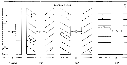 | |||||||
| Minimum Dimensional Areas Indicated on the Drawing Above | |||||||
| A | B | C | D | E | F | ||
|
Parking Angle
0° (parallel) | Stall Width (ft.) | Stall Length (ft.) | Aisle Width (ft.) | Width of Access Drive (ft.) | Bay Width (ft.) | ||
| 1-way | 2-way | 1-way | 2-way | ||||
| 9 ft. | 23 ft. | 12 ft. | 18 ft. | 24 ft. | 30 ft. | 36 ft. | |
| 45° | 9 ft. | 18 ft. | 13 ft. | 20 ft. | 24 ft. | 49 ft. | 56 ft. |
| 60° | 9 ft. | 19 ft. | 20 ft. | 22 ft. | 24 ft. | 58 ft. | 60 ft. |
| 90° | 9 ft. | 19 ft. | 22 ft. | 24 ft. | 24 ft. | 60 ft. | 62 ft. |
(2)
Submission of Plans
Before the construction of any building in any of the various zones, in addition to the building plan to be submitted to the building official for approval, there shall also be submitted a detailed plan of the off-street parking arrangements to be utilized for such structure, including the number of spaces, size, and type of construction of the off-street parking area. Submission of a satisfactory parking plan shall be a condition precedent to the issuance of any building permit.
(3)
Remote Parking Space
If the off-street parking space required by this section cannot be reasonably provided on the same lot on which the principal use is located, such space may be provided on any land within four hundred (400) feet of the main entrance to such principal use, upon review by the Planning Board and approval by the Board of Commissioners. In the Village East, Village West and Marina Village Zoning Districts, if the off street parking space required by this section cannot be reasonably provided on the same lot on which the principal use is located, such spaces may be provided by on-street parking spaces and/or facilities located within two hundred (200) feet of the principal use upon review of the Planning Board and approval by the Board of Commissioners, based upon a determination by the Board of Commissioners upon review of the application showing the location, design, cost, method of construction and payment, and other details, that such placement is in the public interest and/or will assist in economic development or provide access to nearby public facilities or attractions.
(4)
Width of Commercial Driveway
The width of a commercial driveway shall be no less than twelve (12) feet.
(5)
Parking for Residential Uses
Required parking for residential uses may be provided within enclosed garages, but they only count as ½ of a required space. Parking spaces in unenclosed structures, surface parking lots, and driveways provide one (1) parking space. No parking spaces may be established within the public right-of-way or on public land.
(6)
Parking for Non-Residential Uses
Parking areas required by commercial and institutional uses are permitted only in districts that allow commercial and institutional activities.
(7)
Materials for Commercial Parking Lots
No commercial parking lot shall be made of materials other than asphalt, concrete, permeable construction blocks, or structural wood or a wood substitute.
The use of wood or a wood substitute shall be limited to the required standing space for vehicles and may not be used for travel lanes or accessways. Any person desiring to use structural wood or a wood substitute construction shall submit scale drawings and specifications designed and sealed by a North Carolina licensed engineer depicting the parking areas, materials to be used and construction design. Only pressure treated wood or a wood substitute may be used and the parking area shall be at-grade. The design load for the wood or wood substitute parking area shall be based on intended use and shall conform to the requirements of the North Carolina Building Code. All wood and wood substitute parking surfaces shall be kept free of debris and sand in order to insure that they continue to function effectively as a pervious surface.
No types of temporary materials, such as landing mats shall be used for the construction of commercial or residential parking facilities. Seasonal parking facilities (six months or less per year) and vehicular, marine, and trailer storage facilities shall be exempt from the above material requirements. A maintenance plan will be required as part of the site review process.
(8)
Off-street Parking for Special Uses
Off-street parking for special uses shall meet the requirements of this section unless specific requirements for off-street parking for a designated special use is set forth in Section 4.2, in which event the special use shall meet the off-street parking requirements in Section 4.2.
(9)
Access
All required off-street parking facilities shall have adequate ingress and egress from the public right-of-way.
(10)
Handicap Parking Spaces
The number, size, dimension and location for all required handicap parking spaces shall be determined by the applicable sections of the North Carolina Accessibility Code.
(Ord. of 9-12-23)
6.7.2 - Measurement of Requirements
The required number of off-street parking spaces specified for each use shall be considered as the absolute minimum. Accessory buildings shall be included with principal buildings in measurement of gross floor area for determining parking requirements for mixed-use and commercial uses. Gross floor area shall be measured from the outside walls of all structures. Where computation of the required parking based upon gross floor area results in a fraction of a space being required, the next whole number shall be used. In addition, the developer shall evaluate their own needs to determine if parking needs are greater than the required minimum specified by this Ordinance.
6.7.3 - Specific Use Standards
Each development shall provide at least the minimum number of parking spaces shown in Table 6.7.3 below. Planned Unit Developments shall be required to provide the amount of off-street parking stated in the PUD approval.
TABLE 6.7.3: REQUIRED PARKING SPACES
6.7.4 - Off-street Loading
One (1) or more loading berths or other shall be provided for standing, loading and unloading operations either inside or outside a building and on the same or adjoining premises at the frequency of one (1) space per twenty thousand (20,000) square feet of gross floor area. A loading berth shall have minimum plan dimensions of twelve (12) feet by sixty (60) feet and a 14-foot overhead clearance. A loading space need not be necessarily a full berth but shall be sufficient to allow normal loading and unloading operations of a kind and magnitude appropriate to the property served thereby. In no case shall the use of such space hinder the free movement of vehicles and pedestrians over a street, sidewalk, or alley.
6.8.1 - Permit Required
Sidewalk dining will be permitted only in Sidewalk Dining Areas as defined in Section 10.2 of this Ordinance. It is unlawful to operate sidewalk dining on public sidewalks or alleys without a sidewalk dining permit issued by the Town.
(Ord. of 7-9-24(1))
6.8.2 - Minimum Submission Standards
All applications for sidewalk dining permit shall be submitted on a form provided by the Town and contain the following information:
(A)
Five (5) copies of a scaled sketch plan showing the proposed sidewalk dining area boundary and surrounding streetscape details including property lines, sidewalks, lighting, trees, tree grates, planters, benches, street signs, and fire hydrants. The plan shall also include location, number and arrangement of tables, chairs and other appurtenances. The plan will be reviewed for compliance with applicable rules, regulations, ordinances, law, and statutes by the following departments/divisions: Police, Fire/Rescue, and Planning Departments.
(B)
Current permits from both local and state organization for the operation.
(C)
State ABC license to serve alcoholic beverages in the sidewalk dining area (if alcoholic beverages are served).
(D)
Proof of valid insurance policy that provides a minimum liability of $1,000,000 and has the Town of Emerald and the North Carolina Department of Transportation designated as an additional insured under the policy.
(E)
The applicant agrees to maintain no less than four feet (48 inches) minimum pedestrian clearance at all times.
(Ord. of 7-9-24(1))
6.8.3 - Conditions
The following conditions apply to the sidewalk dining permit:
(A)
Sidewalk dining must be associated with an operating restaurant and/or dining establishment that is under the same management and shares the same food preparation facilities, restroom facilities, and other customer conveniences as the restaurant and/or dining and entertainment establishment. No food truck may operate within the right-of-way of NC Department of Transportation.
(B)
Sidewalk dining shall be in accordance with the plan approved by the sidewalk dining permit.
(C)
Sidewalk dining area shall not be enclosed by fixed walls and shall be open to the air.
(D)
Furniture may be of any construction except plastic.
(E)
No tents or cash registers are allowed in the sidewalk dining area.
(F)
All furniture must be removed from the sidewalk dining area each day by 10:00 p.m. or secured firmly against the storefront wall with a chain or similar locking device. Furniture may be returned to its original state in the sidewalk dining area after 6:00 a.m. the following day.
(G)
No additional signage shall be allowed in the sidewalk dining area.
(H)
Umbrellas are not permitted in the sidewalk dining area.
(I)
No electrical/extension cords may be used in the sidewalk dining area.
(J)
Pavers may be installed for flooring within the areas of the sidewalk dining area that is not within the permitted area of the sidewalk. The sidewalk dining permit holder shall be responsible for the maintenance of the pavers and shall be responsible for injuries caused by the pavers.
(K)
No food serving equipment or food service equipment to hold, store, heat, warm, cold, chill or otherwise to keep food to be served may be located in the sidewalk dining area.
(L)
No food or beverage can be served to a patron in the sidewalk dining area unless the patron is seated at a table.
(M)
Accessible routes, as required by the North Carolina State Building Code, shall be maintained.
(N)
Permit holder must comply with all applicable rules, regulations, ordinances, laws or statutes, including the Americans with Disabilities Act (ADA) and those regulations promulgated or enforced by the North Carolina Alcohol Beverage Control Board and the Carteret County Health Department (Environmental Health).
(O)
Sidewalk dining operation must comply with all State and local sanitary and health regulations.
(P)
Addition of sidewalk dining shall not cause the restaurant and/or dining and entertainment establishment to exceed the capacity of patrons as determined by the size of the kitchen as determined by Carteret County Health Department.
(Q)
The permit holder shall maintain general commercial liability insurance, naming the Town and the North Carolina Department of Transportation as additional insured in the amount of not less than $1,000,000 and submit a current certificate of insurance demonstrating continued compliance with this subsection. Such insurance shall not be cancelled without 30 day written notice to the Town.
(R)
The Town maintains the right to enter the sidewalk dining area at any time for inspecting the area, ascertaining compliance with conditions of the permit or making any repairs to public sidewalks and/or alleys.
(S)
Parking for additional seating shall be 1 space for each 4 customer seats. There shall be no parking within any Right-of-Way.
(T)
Remote parking is permissible only under the requirements of Section 6.7.1(3) of this Ordinance.
(U)
There shall be a 70' x 10' site triangle preserved for any sidewalk dining location adjacent to the intersection of two streets.
(Ord. of 7-9-24(1))
6.8.4 - Responsibilities
In addition to the conditions specified in Section 6.8.3, the permit holder of a sidewalk dining permit shall comply with the following:
(A)
Permit holder shall keep the sidewalk dining area free of garbage, trash, refuse, and other waste materials.
(B)
Permit holder shall maintain the sidewalk dining area in a clean and usable state and must protect the right-of-way from damage.
(C)
Permit holder shall properly clean and remove, for the safety of pedestrians and for environmental concerns, any food, drink, and other items spilled in the sidewalk, alley, or adjacent areas located in the right-of-way.
(D)
Permit holder shall use and occupy the sidewalk dining area in a safe and reasonable manner in accordance with applicable laws including the provisions of this article.
(E)
Permit holder shall keep and maintain the sidewalk dining area in good and complete state of repair and condition, except for ordinary wear and tear.
(Ord. of 7-9-24(1))
6.8.5 - Non-Transferability
The sidewalk dining permit is not transferable. A change in ownership of the restaurant or dining and entertainment establishment requires reapplication. The sidewalk dining permit is valid for one year on a calendar year basis (from January 1 through December 31) and will expire on December 31 regardless as to when the outdoor dining permit is issued.
(Ord. of 7-9-24(1))
6.8.6 - Revocation
The sidewalk dining permit may be revoked if it is determined that the permit holder:
(A)
Deliberately misrepresented or provided false information in the permit application;
(B)
Violated any provision of the Town Code or county health department regulations in connection with the operation of the sidewalk dining;
(C)
Violated any law, regulation, or ordinance regarding possession, sale, transportation or consumption of intoxicating beverages or controlled substances in connection with the operation of the sidewalk dining;
(D)
Operated the sidewalk dining in such a manner as to create a public nuisance or to constitute a hazard to public health, safety, and welfare; specifically including failure to keep the sidewalk dining area clean and free of refuse;
(E)
Failed to maintain any health, business, or other permit or license required by law for the operation of the restaurant and/or dining and entertainment establishment.
(Ord. of 7-9-24(1))
6.8.7 - Enforcement and Appeals
Enforcement of this article will be the responsibility of the Planning Director or designee. An appeal of a citation or of a denial or revocation of a permit shall be presented in writing to the Planning Director no later than five calendar days after its issuance.
(Ord. of 7-9-24(1))
6.8.8 - Penalties for Violations
(A)
Any violation of the provisions of this section shall subject the offender to a civil penalty in the amount of $50. Violators shall be issued a written citation, which must be paid within 72 hours. If the person fails to pay the civil penalty within 72 hours, the Town may recover the penalty including all costs and attorneys fees by filing a civil action in the general court of justice in the nature of a suit to collect a debt.
(B)
This article may also be enforced by any appropriate equitable action.
(Ord. of 7-9-24(1))