
Fairburn City Zoning Code
ARTICLE II
ZONING DISTRICTS
DIVISION 2. - DISTRICT REGULATIONS[1]
Editor's note— Ord. No. 2012-04, § 1, adopted June 11, 2012, repealed ch. 80, art. II, divs. 2 and 3, §§ 80-71—80-91 and 80-111, 80-112 added a new ch. 80, art. II, div. 2, §§ 80-71—80-90. Former ch. 80, art. II, div. 2 pertained to similar material and was derived from Ord. of 8-25-2008; Ord. No. 2008-10Z, Exh. A, §§ 4.01—4.21, 8-25-2008; Ord. No. 2009-7Z, § 1, 6-8-2009; Ord. No. 2009-10Z, § 1, 9-14-2009; Ord. No. 2009-11Z, § 1, 11-23-2009. Former ch. 80, art. II, div. 3, pertained to special districts and was derived from Ord. No. 2008-10Z, Exh. A, §§ 4.22, 4.24, adopted August 25, 2008.
Sec. 80-35. - Official zoning map—Adopted.
(a)
The city is divided into zoning districts, as provided herein and as shown on the official zoning map, which, together with all explanatory notes, is adopted by reference and declared to be a part of this chapter.
(b)
The boundaries of the aforementioned districts are hereby established as shown on a map entitled "City of Fairburn Official Zoning Map" and certified by the city clerk. Said map and all explanatory matter depicted thereon is hereby made a part of this chapter and shall be on file in the office of the city clerk.
(Ord. No. 2008-10Z, exh. A, § 3.01, 8-25-2008; Ord. No. 2015-16, § 1(Exh. A), 7-22-2013, 7-27-2015)
Sec. 80-36. - Same—Replacement.
(a)
In the event the official zoning map becomes damaged, lost, or difficult to interpret because of the nature or number of changes and additions, the city council may, by resolution, adopt a new official zoning map, which shall supersede the previous official zoning map.
(b)
The new official zoning map may correct drafting or other errors or omissions in the previous official zoning map, but no such correction shall have the effect of amending the original official zoning map or any subsequent amendment thereof.
(c)
Unless the previous official zoning map has been lost or wholly destroyed, said documents or any remaining significant portions thereof shall be preserved, together with all available records pertaining to its adoption or amendment.
(Ord. No. 2008-10Z, exh. A, § 3.02, 8-25-2008)
Sec. 80-37. - Same—Recording amendments.
On the effective date of amendment of the official zoning map, the change shall be posted in an appropriate manner; and records accompanying the map shall identify the official action by which such amendment was accomplished, the date of such action, and the date of posting. No such amendment shall become effective until such change and entry have been made, it being the intent of these regulations that the public shall be able to rely on the official records of the council as the correct and final authority concerning current zoning status without investigating for possible errors or omissions.
(Ord. No. 2008-10Z, exh. A, § 3.03, 8-25-2008)
Sec. 80-38. - Same—Authentication; location for public inspection.
The official zoning map, properly attested, shall be on file and available for public inspection in the office of the city clerk. The official records of the council shall be the final authority as to the current zoning status of land and water areas, buildings, and other structures in the city.
(Ord. No. 2008-10Z, exh. A, § 3.04, 8-25-2008)
Sec. 80-39. - Changes to map.
No changes of any nature shall be made to the official zoning map except in conformity with the procedures set forth in this chapter.
(Ord. No. 2008-10Z, exh. A, § 3.05, 8-25-2008)
Sec. 80-40. - Rules for interpretation of district boundaries.
Where uncertainty exists with respect to the boundaries shown on the official zoning map, the following rules shall apply:
(1)
Where zoning district boundaries are shown as approximately following the centerline of a street, alley, or public right-of-way, land lot line, corporate limit line, railroad right-of-way, militia district line, or a property boundary, or such lines extended, then such lines shall be construed to be the zoning district boundaries.
(2)
Where a zoning district boundary is shown as being set back from a street or a railroad right-of-way, and approximately parallel thereto, then such zoning district boundary shall be construed as being the noted distance, or, in the absence of such a note, the scaled distance from the centerline of the street or railroad right-of-way and as being parallel thereto.
(3)
Where a zoning district boundary divides a lot, the location of the line shall be the noted distance, or in the absence of such a note, the scaled distance from the lot lines.
(4)
Where a zoning district boundary divides a lot which was in single ownership at the time of passage of the ordinance from which this chapter is derived, the mayor and city council may permit, as an exception, the extension of the regulations for either portion of the lot, not to exceed 50 feet beyond the zoning district boundary into the remaining portion of the lot.
(5)
Where zoning district boundaries are in doubt, the mayor and city council shall determine the location of boundaries.
(Ord. No. 2008-10Z, exh. A, § 3.06, 8-25-2008)
Sec. 80-41. - Districts established.
The city is divided into the following zoning districts.
(Ord. No. 2008-10Z, exh. A, art. 4, 8-25-2008; Ord. No. Z2013-03, exh. A, 4-22-2013; Ord. No. Z2013-04, exh. A, 4-22-2013; Ord. of 10-28-2019(1))
Sec. 80-42. - Donations boxes.
(a)
As used in this section, the term "donation box" shall be defined as follows:
(1)
Donation box shall mean any unattended container, receptacle, or similar device used for soliciting and collecting donations of clothing and/or other salvageable personal property. This term does not include any unattended donation box location within a building which is permitted by-right.
(b)
In addition to accessory uses otherwise permitted in this chapter, donation boxes may only be installed by obtaining a permit under the following conditions and requirements:
(1)
Application. Prior to delivery and/or installation of any donation box, an application shall be filed with the director of planning or his/her designee identifying the size, color, and location of each donation box, as well as any signage proposed on the exterior, of the donation box. A permit shall be required for each donation box installed within the city limits.
(2)
Zoning. Donation boxes shall only be permitted within the non-residential zoning districts, unless otherwise specified herein.
(3)
Approval of property owner. As a part of the application process, a letter must be provided from the owner of the property indicating they are aware and approve the installation of a donation box on their property, including that they are aware of their responsibility to maintain the current operator contact information and, if necessary, maintain or remove the donation box if the operator does not follow the provisions of this section.
(4)
Fees. Fees shall be as adopted by city council in the schedule of fees and kept on file in the city clerk's office.
(5)
Size. Donation boxes shall be limited to no more than 128 cubic feet (four feet wide by four feet deep by eight feet tall). The height of each donation box shall not exceed eight feet in height from finish grade to the highest point of the roof.
(6)
Color. Donation boxes shall be painted or stained with a low reflectance and subtle, neutral or earth-tone color scheme. High-intensity colors, metallic colors, black, or fluorescent colors shall not be used.
(7)
Number of boxes permitted. No more than one donation box shall be permitted on each zoning lot, with a minimum lot size of four acres.
(8)
Location. Donation boxes shall be installed on a paved surface but may not be located within a designated parking space, drive aisle, or loading area. Donation boxes shall not be located within any building setback or established buffer area. Donation boxes shall not be located in such a manner that they block sight lines on the subject tract as determined by the city engineer. To the extent feasible, donation boxes shall be placed so as to be inconspicuous as viewed from the public right-of-way.
(9)
Signage/contact information. The total square footage for all signage on each donation box shall not exceed two square feet. No advertising shall be permitted on the donation box. An additional sign shall contain the following contact information; the name, address, email, and phone number of both the property owner/manager and operator, it too shall not exceed two square feet.
(10)
Cleanliness of premises. Donation boxes shall be maintained in good condition and appearance with no structural damage, holes, or visible rust, and shall be free of graffiti. All boxes shall be free of debris and shall be serviced regularly so as to prevent overflow of donations or the accumulation of junk, debris, or other material.
(11)
Revocation of permit. Any permit granted pursuant to the provisions of this section may be subject to revocation for cause by the director of planning (or his/her designee), including but not limited to, the failure to comply with this section or any other applicable provisions of this Code.
(12)
Renewal of permit. The term of the permit shall expire one year from the date of issuance. An operator may apply for permit renewal by submitting to the director of planning before the expiration of the permit, a renewal application and associated fee.
a.
No person to whom a permit has been issued shall transfer, assign, or convey such permit to another person.
b.
Prior to expiration of the permit, the permittee may voluntarily cancel the permit by notifying the director of planning in writing of the intent to cancel the permit. The permit shall become void upon the director's receipt of a written notice of intent to cancel the permit.
c.
Donation boxes shall be removed when the property becomes vacant or is foreclosed upon.
(13)
Approval/denial of permit. The planning and zoning administrator shall approve a new or renewal permit application if he/she finds that no circumstances exist at the time the application is reviewed or existed at any time during which the previous permit was in effect that are inconsistent with any requirement in this section.
(14)
Display of permit. The operator of the donation box and the property owner shall be responsible for maintaining the permit for each donation box required by this section. The director of planning shall inspect each donation box following its installation to ensure the donation box is installed in accordance with the approved permit. Once it is determined the donation box complies with said permit, a decal shall be affixed to the actual donation box or to the entrance door of the place of business indicating the donation box has been approved. The purpose of this decal shall be to notify city officers and employees that the donation box complies with the provisions of this chapter and the approved donation box permit application.
(Ord. No. 2015-08, § 1(Exh. A), 7-27-2015; Ord. of 10-28-2019(1))
Sec. 80-44. - Uses not listed.
For any use not listed in this chapter, the planning and zoning commission shall determine the proper requirements by classifying the proposed use among the uses which are listed and assigning the use to appropriate zoning district or prohibited uses. After the planning and zoning commission meeting, the director of planning or designee will prepare a zoning ordinance text amendment for review at the next regularly scheduled meeting of the planning and zoning commission, pursuant to sections 80-287 and 80-298 of this Code.
(Ord. No. 2015-12, § 1(Exh. A), 7-27-2015; Ord. of 10-28-2019(1))
Sec. 80-71. - AG—Agricultural Zoning District.
(a)
AG—Intent. The AG Agricultural Zoning District has been established to provide a low-density transitional area in the city between the high-density uses in the downtown area and along the major thoroughfares and the very low-density uses in the rural areas surrounding the city in unincorporated Fulton, Fayette, and Coweta counties.
(b)
AG—Permitted uses. The following uses shall be permitted in any AG Agricultural Zoning District:
(1)
Agricultural, general and specialized farming uses, including: Horticulture, plant nursery, greenhouse, dairy farming, livestock raising, and poultry raising, provided however that buildings used for animals and other agriculture related purposes must be at least 100 feet from all property lines, and outside areas to be used by farm animals are kept at least 100 feet from any adjoining residential property line.
(2)
Building, facility, or land for public utility services.
(3)
Building, facility, or land for non-commercial park, recreation, or open space purposes.
(4)
Cemetery provided all buildings must be at least 100 feet from all property lines; provided the property is at least five acres; and provide no grave is within 50 feet of a property line.
(5)
Civic, social, or fraternal associations, provided any retail sales associated with the operation are for members only, all buildings on the parcel shall be at least 100 feet from all property lines, the parcel is not less than five acres in area, and an undisturbed landscaped buffer at least 35 feet wide shall be maintained along the entire perimeter of the parcel.
(6)
Commercial farm animal uses and commercial agricultural services; provided all buildings are at least 500 feet from any property line and all outside areas to be used by animals other than for horse and cattle grazing, are at least 500 feet from any property line. Commercial horse and cattle grazing areas must be kept at 100 feet from any adjoining residential property line.
(7)
Commercial nursery operation; provided any retail sales associated with the operation constitutes less than ten percent of the business, that all buildings on the parcel are at least 100 feet from all property lines, and that the lot is not less than five acres in area.
(8)
Communication/utilities.
(9)
Events. Special indoor/outdoor events held with less than 75 persons are subject to the review and approval of an administrative permit; events held with 75 or more persons are subject to the review and approval of a use permit.
(10)
Family day care homes.
(11)
Farm stand.
(12)
Forestry and fishing uses.
(13)
Institutional uses.
(14)
Kennel, veterinary hospital or veterinary clinic, provided buildings housing animals are fully enclosed and at least 100 feet from all property lines; and pens, runs, etc. which are not located in a fully enclosed building are at least 200 feet from all property lines.
(15)
Nurseries.
(16)
Places of worship are subject to a use permit.
(17)
Publicly owned building, facility, or land.
(18)
Riding or boarding stables, subject to the following conditions:
a.
All show or exercise rings, trails, pastures or other areas containing animals except structures, must be set back 100 feet from any property boundary adjacent to a residential district;
b.
A minimum area of 15 acres is provided;
c.
One horse or other member of horse (equine) family per fenced acre shall be allowed in association with a single-family dwelling; and
d.
All structures for the shelter of horses shall be at least 100 feet from the lot line of any residentially zoned or used property and located within the rear yard.
(19)
Single-family detached dwelling.
(20)
Single-family dwellings used primarily as guest or second homes.
(21)
Telecommunications and broadband facilities (co-location cellular towers) less than 150 feet in height are subject to an administrative permit.
(22)
Timber cultivation and harvesting.
(23)
U-pick orchards.
(c)
AG—Accessory uses and structures.
(1)
Accessory uses and structures incidental to any permitted use. Temporary storage pods are intended for a limited period of time and not for permanent storage. See section 80-71(b)15.
a.
Accessory structures may be located within the rear, or side yards only but shall not be located within a setback or within the front yard areas.
(2)
Accessory dwelling units. AG zoning district shall conform to the following standards:
a.
Accessory dwelling units, where the total number of dwelling units on any parcel, including the accessory dwelling unit, does not exceed two.
b.
No accessory dwelling unit shall be of a commercial nature.
c.
No accessory dwelling unit shall be constructed until construction of the principal building has actually begun, and no accessory dwelling building shall be used or occupied until the principal building is completed and in use.
d.
All residential development shall provide two spaces per dwelling unit, except accessory dwelling units as described in section 80-337, Off-street parking requirements.
e.
All accessory dwelling units shall be constructed with materials similar as those of the principal building.
f.
All accessory dwelling units shall not exceed the following development standards:
1.
Minimum side setback: 25 feet.
2.
Minimum rear setback: 40 feet.
3.
Maximum building height: 48 feet.
4.
Maximum heated floor area: 800 square feet.
5.
No accessory dwelling unit shall be permitted in the required front setback area.
(3)
Home occupations in accordance with section 80-138.
(4)
Storage and utility buildings.
(5)
Swimming pools, tennis courts and similar facilities.
(d)
AG—Conditional uses.
(e)
AG—Prohibited uses.
(1)
Commercial feed lots.
(2)
Commercial hog farms.
(3)
Commercial poultry houses.
(4)
Landfills.
(5)
Transfer stations.
(f)
AG—Development standards. Unless otherwise provided in this chapter, uses permitted in the AG zoning district shall conform to the following standards:
(g)
AG—Building height and form.
(h)
AG—Design standards. Unless otherwise provided in this chapter, uses permitted in the AG district shall conform to the following design standards:
•
All buildings, structures, kennels, or other means of housing animals must be set back a minimum of 200 feet from any property boundary abutting a zoning district other than AG.
See section 80-197, Agricultural-related activities.
Figure 80-71a. AG: Typical Lot Pattern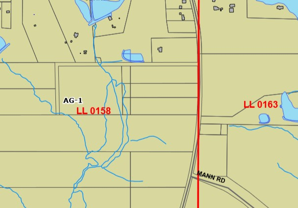
Figure 80-71b. AG: Typical Building Form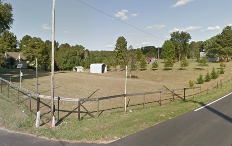
Figure 80-71c. AG: Typical Building/Lot Configuration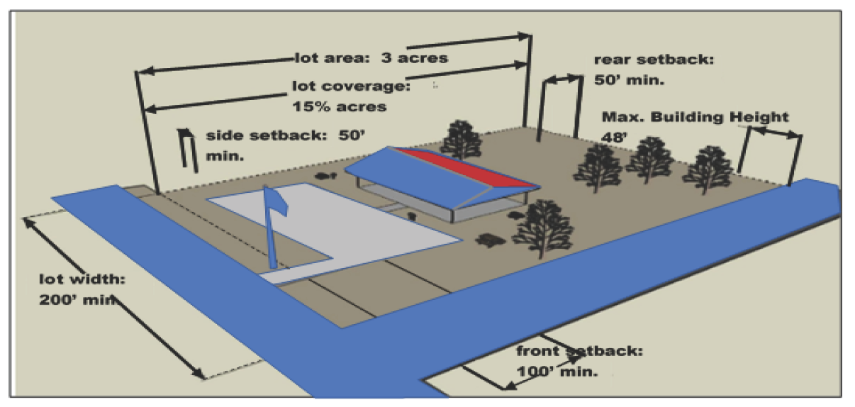
(i)
AG—Other regulations. The headings below contain provisions applicable to uses allowed in the AG Agricultural Zoning District:
Chapter
Number
Building Regulations .....Chapter 62
Environment .....Chapter 65
Soil Erosion and Sedimentation Control .....Chapter 65
Stormwater Management .....Chapter 65
Stream Buffer Protection .....Chapter 65
Floods .....Chapter 68
Land Development .....Chapter 71
Landscaping .....Chapter 74
Subdivisions .....Chapter 77
Zoning .....Chapter 80
Signs .....Chapter 80
(Ord. No. 2012-04, § 1(Exh. A), 6-11-2012; Ord. No. 2014-02, § 1, 2-24-2014; Ord. of 10-28-2019(1); Ord. No. 2023-12, § 1(Exh. A), 7-24-2023)
Editor's note— An ordinance adopted Oct. 28, 2019 changed the title of § 80-71 from AG-1 Agricultural Zoning District to AG Agricultural Zoning District.
_____
Sec. 80-72. - R-1—Single-family Residential Zoning District.
(a)
R-1—Intent. The Single-family Residential Zoning District regulations set forth in this section are the "R-1" district regulations. Article IV should be consulted to determine uses and minimum standards for uses allowed by administrative permit or use permit. The R-1 district encompasses lands devoted to low density residential areas and closely related uses or as a use allowed by administrative permit or use permit.
(b)
R-1—Use regulations. Within the R-1 district, land and structures shall be in accordance with standards herein. Any use not specifically designated as a permitted use in this section or as a use allowed by administrative permit or use permit shall be prohibited.
(c)
R-1—Permitted uses. Structures and land may be used for only the following purposes:
(1)
Communications/utilities.
(2)
Institutional uses: public, private and parochial schools, religious facilities.
(3)
Non-profit recreational uses; public or private playgrounds, parks, golf courses and lakes.
(4)
Single-family detached dwelling.
(d)
R-1—Accessory uses and structures.
(1)
Accessory uses and structures incidental to any permitted use.
(2)
Accessory dwelling units. R-1 zoning district shall conform to the following standards:
a.
Accessory dwelling units, where the total number of dwelling units on any parcel, including the accessory dwelling unit, does not exceed two.
b.
No accessory dwelling unit shall be of a commercial nature.
c.
No accessory dwelling unit shall be constructed until construction of the principal building has actually begun, and no accessory dwelling building shall be used or occupied until the principal building is completed and in use.
d.
All residential development shall provide two spaces per dwelling unit, except accessory dwelling units as described in section 80-337, Off-street parking requirements.
e.
All accessory dwelling units shall be constructed with materials similar as those of the principal building.
f.
All accessory dwelling units shall not exceed the following development standards:
1.
Minimum side setback: 30 feet.
2.
Minimum rear setback: 30 feet.
3.
Maximum building height: 48 feet.
4.
Maximum heated floor area: 800 square feet.
5.
No accessory dwelling unit shall be permitted in the required front setback area.
(3)
Carports/garages.
(4)
For sale, for rent, or for lease signs in accordance with the sign regulations of this section.
(5)
Parking of one unoccupied travel trailer, etc.
(6)
Temporary storage pods are intended for a limited period of time and not for permanent storage.
_____
(e)
R-1—Conditional uses.
(f)
R-1—Development standards. Unless otherwise provided in this chapter, uses permitted in the R-1 zoning district shall conform to the following standards:
(g)
R-1—Building height and form.
(h)
R-1—Design standards. Unless otherwise provided in this chapter, uses permitted in the R-1 district shall conform to the following design standards:
(1)
Accessory structures may be located in the rear or side yards only but not be located within a setback. Habitable accessory structures must be constructed with materials similar as those of the principal structure.
(2)
Off-street parking shall be provided as specified in article IX.
(3)
Buffers shall be provided as specified in article X.
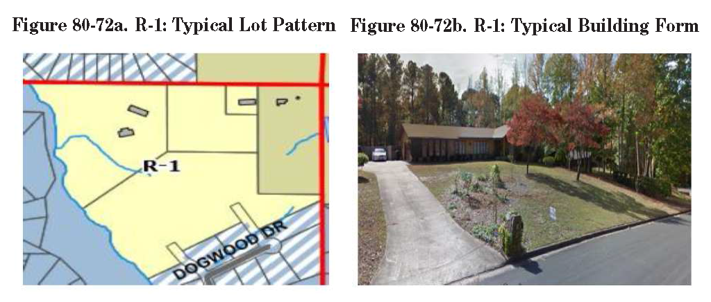
Figure 80-72c. R-1: Typical Building/Lot Configuration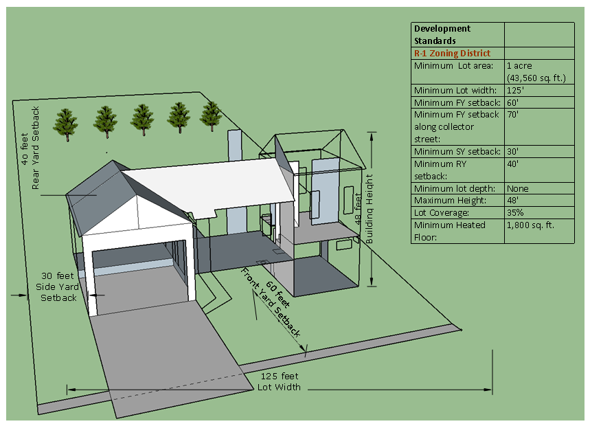
(i)
R-1—Other regulations. The headings below contain provisions applicable to uses allowed in the R-1 Single-family Residential Zoning District:
Chapter
Number
Fire Codes .....Chapter 29
Manufactured and Mobile Homes .....Chapter 38
Solid Waste .....Chapter 47
Traffic and Vehicles .....Chapter 56
Building Regulations .....Chapter 62
Environment .....Chapter 65
Soil Erosion and Sedimentation Control .....Chapter 65
Stormwater Management .....Chapter 65
Stream Buffer Protection .....Chapter 65
Flood Damage Prevention .....Chapter 68
Land Development Regulations .....Chapter 71
Landscaping .....Chapter 74
Subdivisions .....Chapter 77
Zoning .....Chapter 80
Overlay Districts .....Chapter 80
Home Occupation .....Chapter 80
Fencing .....Chapter 80
Off-Street Parking .....Chapter 80
Use Permits .....Chapter 80
Non-Conforming .....Chapter 80
Appeals .....Chapter 80
Signs .....Chapter 80
(Ord. No. 2012-04, § 1(Exh. A), 6-11-2012; Ord. of 10-28-2019(1); Ord. No. 2023-12, § 1(Exh. A), 7-24-2023)
_____
Sec. 80-73. - R-2—Single-family Residential Zoning District.
(a)
R-2—Intent. The R-2 Single-family Residential Zoning District regulations set forth in this section are the "R-2" district regulations. Article IV should be consulted to determine uses and minimum standards for uses allowed by administrative permit or use permit. The R-2 district encompasses land devoted to medium density residential areas and closely related uses or as a use allowed by administrative permit or use permit.
(b)
R-2—Use regulations. Within the R-2 district, land and structures shall be used in accordance with standards herein. Any use not specifically designated as a permitted use in this section or as a use allowed by administrative permit or use permit shall be prohibited.
(c)
R-2—Permitted uses. Structures and land may be used for only the following purposes:
(1)
Accessory dwelling unit.
(2)
Communications/utilities.
(3)
Institutional uses: Public, private and parochial schools, religious facilities.
(4)
Non-profit recreational uses: Public or private playgrounds, parks, golf courses and lakes.
(5)
Single-family detached dwelling.
(d)
R-2—Accessory uses and structures.
(1)
Accessory uses and structures incidental to any permitted use.
(2)
R-2 zoning district shall conform to the following standards:
a.
Accessory dwelling units, where the total number of dwelling units on any parcel, including the accessory dwelling unit, does not exceed two.
b.
No accessory dwelling unit shall be of a commercial nature.
c.
No accessory dwelling unit shall be constructed until construction of the principal building has actually begun, and no accessory dwelling building shall be used or occupied until the principal building is completed and in use.
d.
All residential development shall provide two spaces per dwelling unit, except accessory dwelling units as described in section 80-337, Off-street parking requirements.
e.
All accessory dwelling units shall be constructed with materials similar as those of the principal building.
f.
All accessory dwelling units shall not exceed the following development standards:
1.
Minimum side setback: 30 feet.
2.
Minimum rear setback: 30 feet.
3.
Maximum building height: 48 feet.
4.
Maximum heated floor area: 800 square feet.
5.
No accessory dwelling unit shall be permitted in the required front setback area.
(3)
Carports/garages.
(4)
For sale, for rent, or for lease signs in accordance with the sign regulations of this section.
(5)
Temporary storage pods are intended for a limited period of time and not for permanent storage.
_____
(e)
R-2—Conditional uses.
(f)
R-2—Development standards. Unless otherwise provided in this chapter, uses permitted in the R-2 zoning district shall conform to the following standards:
(g)
R-2—Building height and form.
(h)
R-2—Design standards. Unless otherwise provided in this chapter, uses permitted in the R-2 district shall conform to the following design standards:
(1)
Accessory structures may be located in the rear or side yards only but not be located within a setback. Habitable accessory structures must be constructed with materials similar as those of the principal structure.
(2)
Off-street parking shall be provided as specified in article IX.
(3)
Buffers shall be provided as specified in article X.
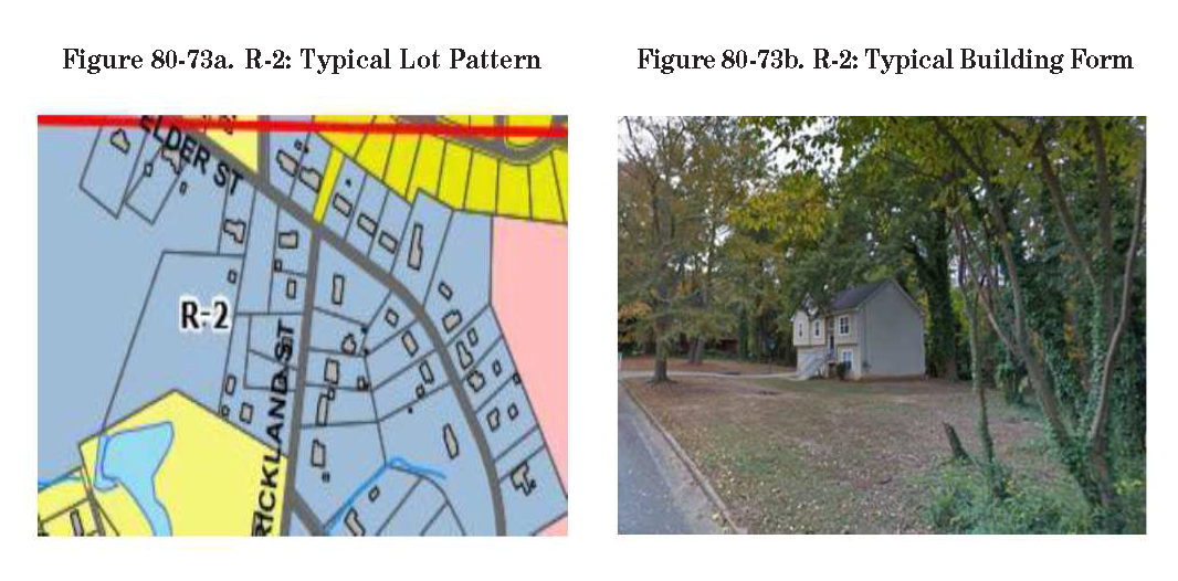
Figure 80-73c. R-2: Typical Building/Lot Configuration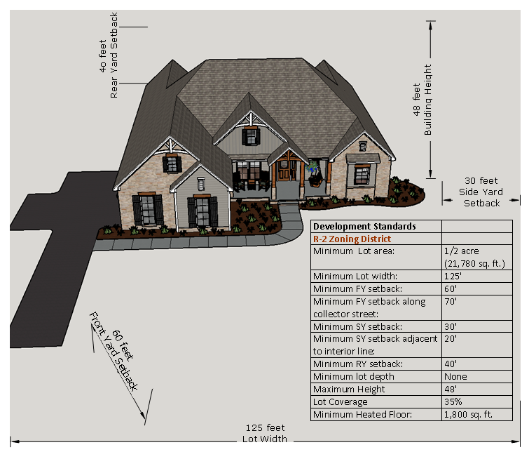
(i)
R-2—Other regulations. The headings below contain provisions applicable to uses allowed in the R-2 Single-family Residential Zoning District:
Chapter
Number
Fire Codes .....Chapter 29
Manufactured and Mobile Homes .....Chapter 38
Solid Waste .....Chapter 47
Traffic and Vehicles .....Chapter 56
Building Regulations .....Chapter 62
Environment .....Chapter 65
Soil Erosion and Sedimentation Control .....Chapter 65
Stormwater Management .....Chapter 65
Stream Buffer Protection .....Chapter 65
Flood Damage Prevention .....Chapter 68
Land Development Regulations .....Chapter 71
Landscaping .....Chapter 74
Subdivisions .....Chapter 77
Zoning .....Chapter 80
Overlay Districts .....Chapter 80
Home Occupation .....Chapter 80
Fencing .....Chapter 80
Off-Street Parking .....Chapter 80
Use Permits .....Chapter 80
Non-Conforming .....Chapter 80
Appeals .....Chapter 80
Signs .....Chapter 80
(Ord. No. 2012-04, § 1(Exh. A), 6-11-2012; Ord. No. 2014-10, § 1, 6-9-2014; Ord. No. 2017-05, § 1(Exh. A), 5-22-2017; Ord. of 10-28-2019(1); Ord. No. 2023-12, § 1(Exh. A), 7-24-2023)
_____
Sec. 80-74. - R-3—Single-family Residential Zoning District.
(a)
R-3—Intent. The R-3 Single-family Residential Zoning District regulations set forth in this section are the "R-3" district regulations. The R-3 Single-family Residential Zoning District is established to provide locations for land areas devoted to development of medium density single-family residential uses on relatively small lots. The district also provides for closely related uses. Article IV should be consulted to determine uses and minimum standards for uses allowed by administrative permit or use permit.
(b)
R-3—Use regulations. Within the R-3 district, land and structures shall be used in accordance with standards herein. Any use not specifically designated as a permitted use in this section or as a use allowed by administrative permit or use permit shall be prohibited.
(c)
R-3—Permitted uses. Structures and land may be used for only the following purposes:
(1)
Accessory dwelling unit.
(2)
Communications/utilities.
(3)
Institutional uses: Public, private and parochial schools, religious facilities.
(4)
Non-profit recreational uses: Public or private playgrounds, parks, golf courses and lakes.
(5)
Single-family detached dwelling.
(d)
R-3—Accessory uses and structures.
1.
Accessory uses and structures incidental to any permitted use.
2.
Accessory dwelling units. R-3 zoning district shall conform to the following standards:
a.
Accessory dwelling units, where the total number of dwelling units on any parcel, including the accessory dwelling unit, does not exceed two.
b.
No accessory dwelling unit shall be of a commercial nature.
c.
No accessory dwelling unit shall be constructed until construction of the principal building has actually begun, and no accessory dwelling building shall be used or occupied until the principal building is completed and in use.
d.
All residential development shall provide two spaces per dwelling unit, except accessory dwelling units as described in section 80-337, Off-street parking requirements.
e.
All accessory dwelling units shall be constructed with materials similar as those of the principal building.
f.
All accessory dwelling units shall not exceed the following development standards:
1.
Minimum side setback: 30 feet.
2.
Minimum rear setback: 30 feet.
3.
Maximum building height: 48 feet.
4.
Maximum heated floor area: 800 square feet.
5.
No accessory dwelling unit shall be permitted in the required front setback area.
(3)
Carports/garages.
(4)
For sale, for rent, or for lease signs in accordance with the sign regulations of this section.
(5)
Temporary storage pods are intended for a limited period of time and not for permanent storage.
_____
(e)
R-3—Conditional uses.
(f)
R-3—Development standards. Unless otherwise provided in this chapter, uses permitted in the R-3 zoning district shall conform to the following standards:
(g)
R-3—Design standards. Unless otherwise provided in this chapter, uses permitted in the R-3 district shall conform to the following design standards:
(1)
Accessory structures may be located in the rear or side yards only but not be located within a setback. Habitable accessory structures must be constructed with materials similar as those of the principal structure.
(2)
Off-street parking shall be provided as specified in article IX.
(3)
Buffers shall be provided as specified in article X.
Figure 80-74a. R-3: Typical Lot Pattern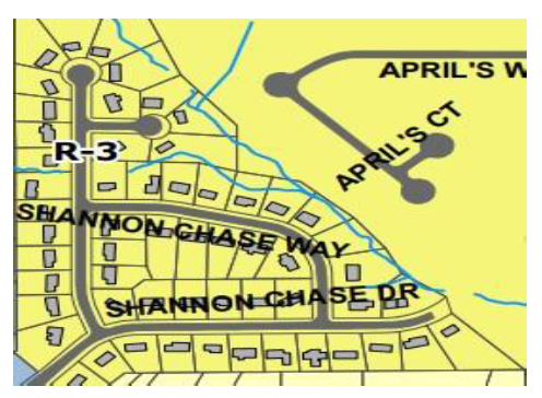
Figure 80-74b. R-3: Typical Building Form
Figure 80-74c. R-3: Typical Building/Lot Configuration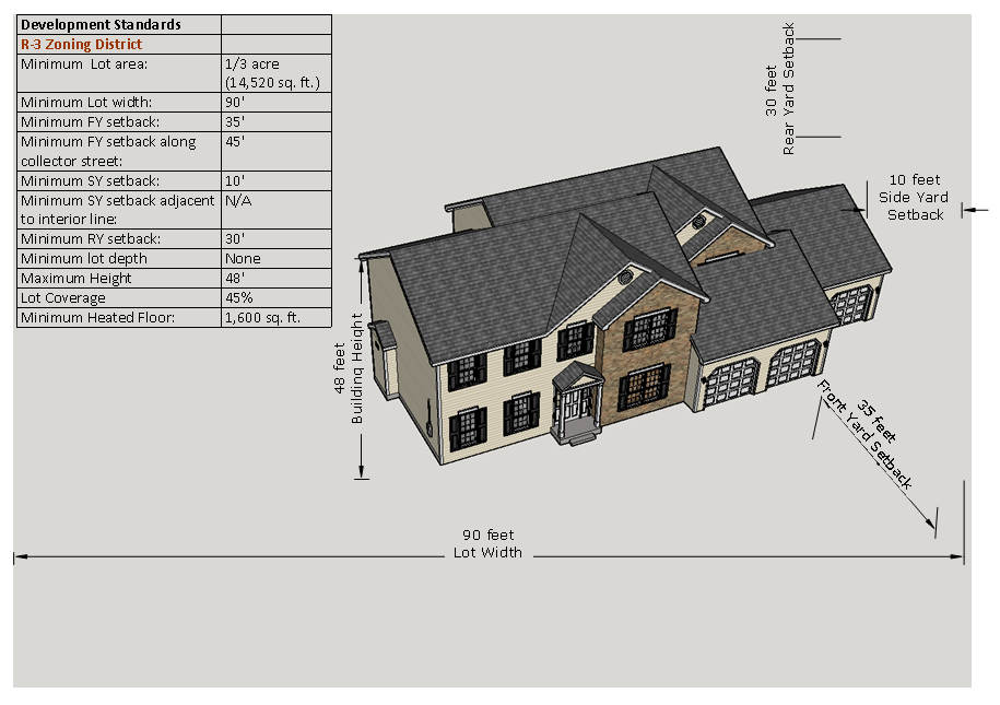
(h)
R-3—Other regulations. The headings below contain provisions applicable to uses allowed in the R-3 Single-family Residential Zoning District:
Chapter
Number
Fire Codes .....Chapter 29
Manufactured and Mobile Homes .....Chapter 38
Solid Waste .....Chapter 47
Traffic and Vehicles .....Chapter 56
Building Regulations .....Chapter 62
Environment .....Chapter 65
Soil Erosion and Sedimentation Control .....Chapter 65
Stormwater Management .....Chapter 65
Stream Buffer Protection .....Chapter 65
Flood Damage Prevention .....Chapter 68
Land Development Regulations .....Chapter 71
Landscaping .....Chapter 74
Subdivisions .....Chapter 77
Zoning .....Chapter 80
Overlay Districts .....Chapter 80
Home Occupation .....Chapter 80
Fencing .....Chapter 80
Off-Street Parking .....Chapter 80
Use Permits .....Chapter 80
Non-Conforming .....Chapter 80
Appeals .....Chapter 80
Signs .....Chapter 80
(Ord. No. 2012-04, § 1(Exh. A), 6-11-2012; Ord. No. 2013-19, § 1(Exh. A), 9-9-2013; Ord. of 10-28-2019(1); Ord. No. 2023-12, § 1(Exh. A), 7-24-2023)
_____
Sec. 80-75. - R-4—Single-family Residential Zoning District.
(a)
R-4—Intent. Regulations set forth in this section are the R-4 Single-family Residential Zoning District regulations. Article IV should be consulted to determine uses and minimum standards for uses allowed by administrative permit or use permit. The R-4 district is intended to provide land areas devoted to high density residential uses on small lots. The district also provides for closely related uses. Land areas zoned R-4 are further intended to provide a transition between low- and high-density dwelling areas or between low density dwelling areas and non-residential areas.
(b)
R-4—Use regulations. Within the R-4 district, land and structures shall be used in accordance with standards herein. Any use not specifically designated as a permitted use in this section or as a use allowed by administrative permit or use permit shall be prohibited.
(c)
R-4—Permitted uses. Structures and land may be used for only the following purposes:
(1)
Accessory dwelling unit.
(2)
Communications/utilities.
(3)
Institutional uses: Public, private and parochial schools, religious facilities.
(4)
Non-profit recreational uses: Public or private playgrounds, parks, golf courses and lakes.
(5)
Single-family detached dwelling.
(d)
R-4—Accessory uses and structures.
(1)
Accessory uses and structures incidental to any permitted use.
(2)
Carports/garages.
(3)
For sale, for rent, or for lease signs in accordance with the sign regulations of this section.
(4)
Temporary storage pods are intended for a limited period of time and not for permanent storage.
_____
(e)
R-4—Conditional uses.
(f)
R-4—Development standards. Unless otherwise provided in this chapter, uses permitted in the R-4 zoning district shall conform to the following standards:
(g)
R-4—Building height and form.
(h)
R-4—Design standards. Unless otherwise provided in this chapter, uses permitted in the R-4 district shall conform to the following design standards:
(1)
Accessory structures may be located in the rear or side yards only but not be located within a setback. Habitable accessory structures must be constructed with materials similar as those of the principal structure.
(2)
Off-street parking shall be provided as specified in article IX.
(3)
Buffers shall be provided as specified in article X.
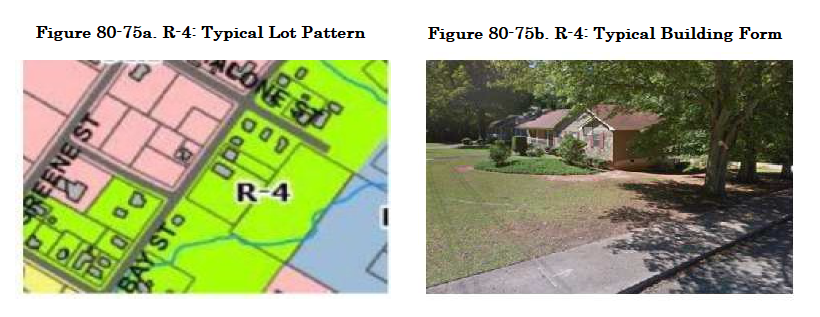
Figure 80-75c. R-4: Typical Building/Lot Configuration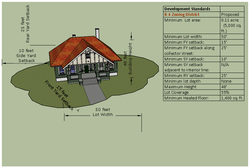
(i)
R-4—Other regulations. The headings below contain provisions applicable to uses allowed in the R-4 Single-family Residential Zoning District:
Chapter
Number
Fire Codes .....Chapter 29
Manufactured and Mobile Homes .....Chapter 38
Solid Waste .....Chapter 47
Traffic and Vehicles .....Chapter 56
Building Regulations .....Chapter 62
Environment .....Chapter 65
Soil Erosion and Sedimentation Control .....Chapter 65
Stormwater Management .....Chapter 65
Stream Buffer Protection .....Chapter 65
Flood Damage Prevention .....Chapter 68
Land Development Regulations .....Chapter 71
Landscaping .....Chapter 74
Subdivisions .....Chapter 77
Zoning .....Chapter 80
Overlay Districts .....Chapter 80
Home Occupation .....Chapter 80
Fencing .....Chapter 80
Off-Street Parking .....Chapter 80
Use Permits .....Chapter 80
Non-Conforming .....Chapter 80
Appeals .....Chapter 80
Signs .....Chapter 80
(Ord. No. 2012-04, § 1(Exh. A), 6-11-2012; Ord. No. 2013-20, § 1(Exh. A), 9-9-2013; Ord. No. 2013-20, § 1(Exh. A), 9-9-2013; Ord. No. 2017-05, § 1(Exh. A), 5-22-2017; Ord. of 10-28-2019(1); Ord. No. 2022-235, § 1, 3-28-2022; Ord. No. 2023-12, § 1(Exh. A), 7-24-2023)
_____
Sec. 80-76. - Reserved.
Editor's note— An ordinance adopted Oct. 28, 2019, repealed § 80-76, which pertained to the DP-6 (two-family) residential district, and derived from Ord. No. 2012-04, § 1(Exh. A), June 11, 2012.
Sec. 80-77. - Reserved.
Editor's note— An ordinance adopted Oct. 28, 2019, repealed § 80-77, which pertained to the RM-4 Multifamily Residential District, and derived from Ord. No. 2012-04, § 1(Exh. A), adopted June 11, 2012.
Sec. 80-78. - Reserved.
Editor's note— An ordinance adopted Oct. 28, 2019, repealed § 80-78, which pertained to the RM-8 Multifamily Residential District, and derived from Ord. No. 2012-04, § 1(Exh. A), adopted June 11, 2012.
Sec. 80-79. - R-CT—Residential Condominium/Townhouse District.
(a)
R-CT—Intent. Regulations set forth in this section are the R-CT Residential Condominium/Townhouse District regulations. Article IV should be consulted to determine uses and minimum standards for uses allowed by administrative permit or use permit. The R-CT district is intended to promote cluster type residential development areas that are consistent with medium density, single-family residential districts. The district also provides for closely related uses.
(b)
R-CT—Use regulations. Within the R-CT district, land and structures shall be used in accordance with standards herein. Any use not specifically designated as a permitted use in this section or as a use allowed by administrative permit or use permit shall be prohibited.
(c)
R-CT—Permitted uses. Structures and land may be used for only the following purposes:
(1)
Condominiums or townhouses.
(2)
Family day care homes.
(3)
Single-family detached dwelling.
(4)
Single-family attached dwelling.
(d)
R-CT—Accessory uses and structures.
(1)
Accessory uses and structures incidental to any permitted use.
(2)
For sale, for rent, or for lease signs in accordance with the sign regulations of this section.
(3)
Temporary storage pods are intended for a limited period of time and not for permanent storage.
(e)
R-CT—Conditional uses.
(f)
R-CT—Development standards. Unless otherwise provided in this chapter, uses permitted in the R-CT zoning district shall conform to the following standards:
(g)
R-CT—Building height and form.
(h)
R-CT—Design standards.
(1)
No building or structure shall contain more than eight dwelling units.
(2)
The façade of each dwelling unit shall be a combination of wood, brick, stone or masonry stucco on concrete (EIFS prohibited). The brick, or stone materials shall comprise not less than 25 percent of the exterior finishes of the façades of buildings. The architectural design shall be subject to approval by the director of planning.
(3)
No fences or walls shall be constructed in the front yard of a townhouse unit. Fences or walls may be constructed in the rear yards only, those fences or walls must all conform to a consistent design throughout the same project, and that design must be approved by the director of planning.
(4)
All such developments shall provide a minimum five-foot sidewalk along both sides of all internal streets, sodded front yards, pedestrian scale street lighting and one canopy tree for each 50 feet of street frontage.
(5)
Site plans must reserve a minimum of 20 percent of the total lot area as improved open space, and at least ten percent of the total open space must be outside of a required stormwater management area.
(6)
Off-street parking shall be provided as specified in article IX.
(7)
Buffers shall be provided as specified in article X.
(8)
Property maintenance shall be accomplished through a condominium of townhouse association in which membership shall be mandatory. Such maintenance shall encompass all individual lots and all common areas that are not contained within the boundaries of individual lots. Such association by-laws shall be subject to approval by the city administrator and shall be recorded with covenants that shall be subject to approval by the city administrator.
Figure 80-79a. R-CT: Typical Lot Pattern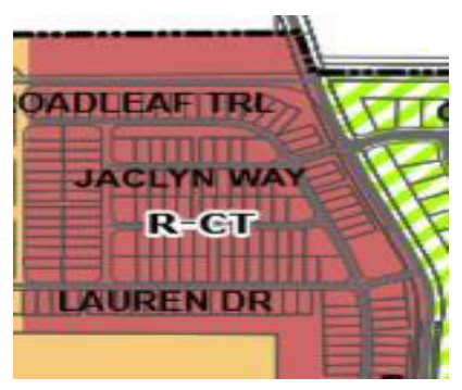
Figure 80-79b. R-CT: Typical Building Form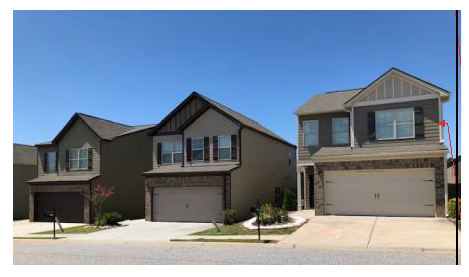
Figure 80-79c. R-CT: Typical Building/Lot Configuration
(i)
R-CT—Other regulations. The headings below may contain provisions applicable to the R-CT Residential Condominium/Townhouse District:
Chapter
Number
Fire Codes .....Chapter 29
Manufactured and Mobile Homes .....Chapter 38
Solid Waste .....Chapter 47
Traffic and Vehicles .....Chapter 56
Building Regulations .....Chapter 62
Environment .....Chapter 65
Soil Erosion and Sedimentation Control .....Chapter 65
Stormwater Management .....Chapter 65
Stream Buffer Protection .....Chapter 65
Flood Damage Prevention .....Chapter 68
Land Development Regulations .....Chapter 71
Landscaping .....Chapter 74
Subdivisions .....Chapter 77
Zoning .....Chapter 80
Overlay Districts .....Chapter 80
Home Occupation .....Chapter 80
Fencing .....Chapter 80
Off-Street Parking .....Chapter 80
Use Permits .....Chapter 80
Non-Conforming .....Chapter 80
Appeals .....Chapter 80
Signs .....Chapter 80
(Ord. No. 2012-04, § 1(Exh. A), 6-11-2012; Ord. No. 2015-10, § 1(Exh. A), 7-27-2015; Ord. of 10-28-2019(1); Ord. No. 2023-12, § 1(Exh. A), 7-24-2023)
_____
Sec. 80-79.1. - RM-12—Multi-family Residential Zoning District.
(a)
RM-12—Intent. Regulations set forth in this section are the RM-12 Multi-family Residential Zoning District regulations. Article IV should be consulted to determine uses and minimum standards for uses allowed by administrative permit or use permit. The RM-12 district is intended to provide land areas devoted to medium density residential uses on small lots. The district also provides for closely related uses. Land areas zoned RM-12 are further intended to provide a transition between low- and high-density dwelling areas or between low density dwelling areas and non-residential areas.
(b)
RM-12—Use regulations. Within the RM-12 district, land and structures shall be used in accordance with standards herein. Any use not specifically designated as a permitted use in this section or as a use allowed by administrative permit or use permit shall be prohibited.
(c)
RM-12—Permitted uses. Structures and land may be used for only the following purposes:
(1)
Two-family dwellings.
(2)
Multi-family dwellings.
(3)
Senior housing.
(d)
RM-12—Accessory uses and structures.
(1)
Accessory uses and structures incidental to any permitted use.
(2)
Garages.
(3)
For sale, for rent, or for lease signs in accordance with the sign regulations of this section.
(4)
Temporary storage pods are intended for a limited period of time and not for permanent storage.
_____
(d)
RM-12—Conditional uses.
(e)
RM-12—Development standards. Unless otherwise provided in this chapter, uses permitted in the RM-12 zoning district shall conform to the following standards:
(f)
RM-12—Building height and form.
(g)
RM-12—Design standards. Unless otherwise provided in this chapter, uses permitted in the RM-12 district shall conform to the following design standards:
(1)
Accessory structures may be located in the rear or side yards only but not be located within a setback. Habitable accessory structures must be constructed with materials similar as those of the principal structure.
(2)
Off-street parking shall be provided as specified in article IX.
(3)
Buffers shall be provided as specified in article X.
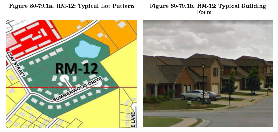
Figure 80-79.1c. RM-12: Typical Building/Lot Configuration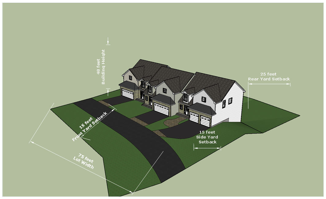
(h)
RM-12—Other regulations. The headings below contain provisions applicable to the RM-12 Multi-family Residential Zoning District:
Chapter
Number
Fire Codes .....Chapter 29
Manufactured and Mobile Homes .....Chapter 38
Solid Waste .....Chapter 47
Traffic and Vehicles .....Chapter 56
Building Regulations .....Chapter 62
Environment .....Chapter 65
Soil Erosion and Sedimentation Control .....Chapter 65
Stormwater Management .....Chapter 65
Stream Buffer Protection .....Chapter 65
Flood Damage Prevention .....Chapter 68
Land Development Regulations .....Chapter 71
Landscaping .....Chapter 74
Subdivisions .....Chapter 77
Zoning .....Chapter 80
Overlay Districts .....Chapter 80
Home Occupation .....Chapter 80
Fencing .....Chapter 80
Off-Street Parking .....Chapter 80
Use Permits .....Chapter 80
Non-Conforming .....Chapter 80
Appeals .....Chapter 80
Signs .....Chapter 80
(Ord. of 10-28-2019(1))
_____
Sec. 80-79.2. - RM-36—Multi-family Residential Zoning District.
(a)
RM-36—Intent. Regulations set forth in this section are the RM-36 Multi-family Residential Zoning District regulations. Article IV should be consulted to determine uses and minimum standards for uses allowed by administrative permit or use permit. The RM-36 district is intended to promote high density residential development areas devoted for rental units in order to provide a wide range of housing options. The district also provides for closely related uses.
(b)
RM-36—Use regulations. Within the RM-36 district, land and structures shall be used in accordance with standards herein. Any use not specifically designated as a permitted use in this section or as a use allowed by administrative permit or use permit shall be prohibited.
(c)
RM-36—Permitted uses. Structures and land may be used for only the following purposes:
(1)
Two-family dwellings.
(2)
Multi-family dwellings.
(3)
Senior housing.
(d)
RM-36—Accessory uses and structures.
(1)
Accessory uses and structures incidental to any permitted use.
(2)
Garages.
(3)
For sale, for rent, or for lease signs in accordance with the sign regulations of this section.
(4)
Temporary storage pods are intended for a limited period of time and not for permanent storage.
_____
(e)
RM-36—Conditional uses.
(f)
RM-36—Development standards. Unless otherwise provided in this chapter, uses permitted in the RM-36 zoning district shall conform to the following standards:
(g)
RM-36—Building height and form.
(h)
RM-36—Design standards. Unless otherwise provided in this chapter, uses permitted in the RM-36 district shall conform to the following design standards:
(1)
Minimum accessory structure requirements. Accessory structures may be located in the rear or side yards only but shall not be located within a minimum yard.
(2)
Site plans must reserve a minimum of 30 percent of the total lot area as improved open space, independent of any stormwater management structures or required yards. This area may be reduced by the provisions of section 80-372, District buffer standards.
(3)
The developer may in lieu of an on-site reservation of open space, contribute to an escrow account earmarked for acquisition of public open space to be located in the vicinity of the site.
(4)
Off-street parking shall be provided as specified in article IX.
(5)
Buffers shall be provided as specified in article X.
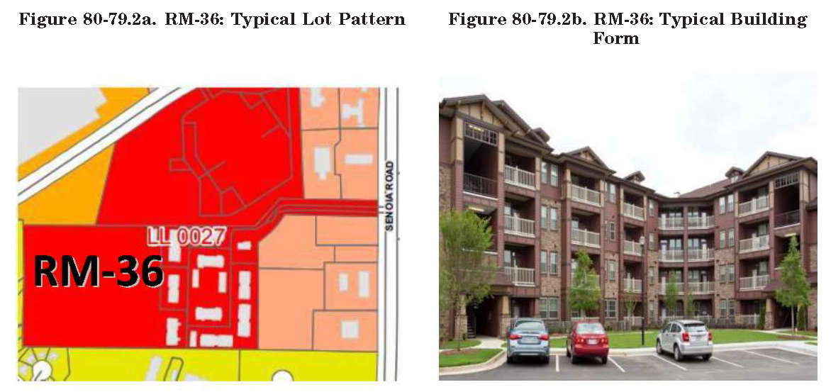
Figure 80-79.2c. RM-36: Typical Building/Lot Configuration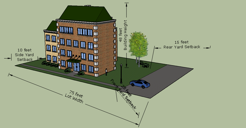
(i)
RM-36—Other regulations. The headings below contain provisions applicable to the RM-36 Multi-family Residential Zoning District:
Chapter
Number
Fire Codes .....Chapter 29
Manufactured and Mobile Homes .....Chapter 38
Solid Waste .....Chapter 47
Traffic and Vehicles .....Chapter 56
Building Regulations .....Chapter 62
Environment .....Chapter 65
Soil Erosion and Sedimentation Control .....Chapter 65
Stormwater Management .....Chapter 65
Stream Buffer Protection .....Chapter 65
Flood Damage Prevention .....Chapter 68
Land Development Regulations .....Chapter 71
Landscaping .....Chapter 74
Subdivisions .....Chapter 77
Zoning .....Chapter 80
Overlay Districts .....Chapter 80
Home Occupation .....Chapter 80
Fencing .....Chapter 80
Off-Street Parking .....Chapter 80
Use Permits .....Chapter 80
Non-Conforming .....Chapter 80
Appeals .....Chapter 80
Signs .....Chapter 80
(Ord. No. Z2013-03, § 1(exh. A), 4-22-2013; Ord. of 10-28-2019(1))
_____
Sec. 80-80. - O&I—Office Institutional Zoning District.
(a)
O&I—Intent. Regulations set forth in this section are the O&I Office Institutional Zoning District regulations. Article IV should be consulted to determine uses and minimum standards for uses allowed by administrative permit or use permit. The O&I district is to provide for the compatible transition from commercial and residential development to limited office and institutional development at selected locations within the city.
(b)
O&I—Use regulations. Within the O&I district, land and structures shall be used in accordance with standards herein. Any use not specifically designated as a permitted use in this section or as a use allowed by administrative permit or use permit shall be prohibited.
(c)
O&I—Permitted uses. Structures and land may be used for only the following purposes:
(1)
Banking and financial institutions.
(2)
Child day care center (small, medium and large), subject to a use permit.
(3)
Churches and other places of worship, subject to a use permit.
(4)
Educational services.
(5)
Funeral services and homes.
(6)
Group residence (small, medium, large), subject to a use permit.
(7)
Group residence/shelter (small, medium, large), subject to a use permit.
(8)
Medical/health services.
(9)
Planned office and institutional parks.
(10)
Professional and business offices.
(11)
Automobile brokerage office.
a.
There will be no automotive maintenance or work done on-site.
b.
All activities shall be conducted entirely within an enclosed building.
c.
There will be no outdoor storage.
d.
There will be no automobiles on-site at any time in reference to the permitted use with the exception of the personal automobiles of staff and clients.
(d)
O&I—Accessory uses and structures.
(1)
Accessory uses and structures incidental to any permitted use.
(2)
Minimum accessory structure requirements: Accessory structures may be located in the rear or side yards only but shall not be located within a minimum yard.
(3)
For sale, for rent, or for lease signs in accordance with the sign regulations of this section.
(4)
Temporary storage pods are intended for a limited period of time and not for permanent storage.
_____
(e)
O&I—Conditional uses.
(f)
O&I—Development standards. Unless otherwise provided in this chapter, uses permitted in the O&I zoning district shall conform to the following standards:
(g)
O&I—Building height and form.
(h)
O&I—Design standards. In order to establish and maintain the O&I (office institutional) district as a quality area, compatible with surrounding uses, which will preserve the investments of all land owners and developers, as well as the tax base of the city, the lot area covered by buildings and parking areas shall not exceed 50 percent of the total lot area and all construction and development within the O&I district must comply with the following site improvement and development standards:
(1)
All operations and activities, except loading and unloading in connection with office building uses, shall be conducted within a completely enclosed building.
(2)
Off-street parking shall be provided as specified in article IX.
(3)
Buffers shall be provided as specified in article X.
(i)
O&I—Other regulations. The headings below contain provisions applicable to the O&I Office Institutional Zoning District:
Chapter
Number
Fire Codes .....Chapter 29
Manufactured and Mobile Homes .....Chapter 38
Solid Waste .....Chapter 47
Traffic and Vehicles .....Chapter 56
Building Regulations .....Chapter 62
Environment .....Chapter 65
Soil Erosion and Sedimentation Control .....Chapter 65
Stormwater Management .....Chapter 65
Stream Buffer Protection .....Chapter 65
Flood Damage Prevention .....Chapter 68
Land Development Regulations .....Chapter 71
Landscaping .....Chapter 74
Subdivisions .....Chapter 77
Zoning .....Chapter 80
Overlay Districts .....Chapter 80
Home Occupation .....Chapter 80
Fencing .....Chapter 80
Off-Street Parking .....Chapter 80
Use Permits .....Chapter 80
Non-Conforming .....Chapter 80
Appeals .....Chapter 80
Signs .....Chapter 80
(Ord. No. 2012-04, § 1(Exh. A), 6-11-2012; Ord. No. 2012-12, § 1, 10-8-2012; Ord. of 10-28-2019(1); Ord. No. 2024-21, § 1, 10-14-2024)
_____
Sec. 80-81. - Reserved.
Editor's note— An ordinance adopted Oct. 28, 2019 repealed § 80-81, which pertained to the DC-1 Historic Downtown Commercial District and derived from Ord. No. 2012-04, § 1(Exh. A), adopted June 11, 2012.
Sec. 80-82. - Reserved.
Editor's note— An ordinance adopted Oct. 28, 2019 repealed § 80-82, which pertained to the DC-2 Downtown Commercial District and derived from Ord. No. 2012-04, § 1(Exh. A), adopted June 11, 2012.
Sec. 80-82.1. - DTMU—Downtown Mixed-Use Zoning District.
(a)
DTMU—Intent. Regulations set forth in this section are the DTMU downtown commercial and historic downtown commercial district regulations. Article IV should be consulted to determine uses and minimum standards for uses allowed by administrative permit or use permit. The purpose of the downtown commercial and historic downtown commercial districts are to:
(1)
Complement retail and office uses in the historic downtown core; and
(2)
To reinforce the historic downtown as the focus of community activity.
The DTMU district is intended to promote a vibrant downtown and opportunities for social interaction consistent with its historic role. To promote and preserve the DTMU district, businesses which increase the number of vehicles in the downtown, and uses which require excessive outside storage, are prohibited.
(b)
DTMU—Use regulations. Within the DTMU district, land and structures shall be used in accordance with the standards herein. Any use not specifically designated as a permitted use in this section, or as a use allowed by use permit shall be prohibited.
(c)
DTMU—Permitted uses. Permitted uses are allowed in the O&I, C-1, C-2, and RM-12 districts.
Structures and land may be used for only the following purposes:
(1)
Office and institutional services and similar uses, including:
a.
Accounting, auditing, and bookkeeping services.
b.
Advertising agencies, outdoor advertising services.
c.
Banking and financial institutions.
d.
Commercial art and graphic design.
e.
Computer repair, programming services and stores.
f.
Dance studios, schools, and halls.
g.
Employment services.
h.
Engineering, architectural, and surveying services.
i.
Insurance agencies, agents, brokers and services.
j.
Labor unions and similar labor organizations.
k.
Land subdivides and developers (except cemeteries).
l.
Legal services.
m.
Libraries.
n.
Management and public relations services.
o.
Medical equipment rental and leasing.
p.
Museums.
q.
Offices and clinics of doctors of medicine, dentists, doctors of osteopathy, chiropractors, optometrists, podiatrists, nurses, and health practitioners.
r.
Pension, health and welfare funds services.
s.
Photographic studios and photography services.
t.
Political organizations.
u.
Real estate operators and lessors, agents and managers.
v.
Research and development services (excluding testing laboratories).
w.
Secretarial and court reporting services.
x.
Security systems services.
y.
Tax return preparation services.
z.
Theatrical producers (except motion picture).
aa.
Title abstract offices.
(2)
Recreational and similar uses, including:
a.
Bowling centers.
b.
Membership sports and recreation clubs.
c.
Sports and recreational camps.
(3)
Retail services and similar uses, including:
a.
Antique stores.
b.
Auto and home supply stores.
c.
Barber shops.
d.
Bicycle shops.
e.
Book stores.
f.
Cable and other pay television services.
g.
Camera and photographic supply stores.
h.
Candy, nut, and confectionery stores.
i.
Computer and computer software stores.
j.
Dance studios, schools, and halls.
k.
Department stores.
l.
Drapery, curtain and upholstery stores.
m.
Drop-off laundry, garment services, and agents for laundries and dry-cleaners.
n.
Drug stores.
o.
Electrical and electronic repair shops.
p.
Floor covering stores.
q.
Florists.
r.
Fruit and vegetable markets.
s
Furniture stores.
t.
Gift, novelty, and souvenir shops.
u.
Grocery stores.
v.
Hardware stores.
w.
Hobby, toy and game shops.
x.
Home furnishings stores.
y.
Hotels, motels, and residential facilities, or other similar accommodations: Provided that no guest room shall have direct access to the exterior of the building except through a main or central lobby; that the main or central lobby must have an area of at least 700 square feet; and that the main or central lobby must have a management employee on duty 24 hours per day and seven days per week.
z.
Household appliance stores.
aa.
Jewelry stores.
bb.
Men's, women's, and children's clothing, specialty shops, shoes, and accessory stores.
cc.
Optical goods stores.
dd.
Paint, glass, and wallpaper stores.
ee.
Photocopying and duplicating stores.
ff.
Radio and television repair shops and stores.
gg.
Bakeries.
hh.
Reupholstery and furniture repair.
ii.
Shoe repair shops and shoeshine parlors.
jj.
Sporting goods stores.
kk.
Telephone communications.
ll.
Tobacco and cigars stores.
mm.
Used merchandise.
nn.
Watch, clock, and jewelry repair.
(4)
Other uses, including:
a.
Art galleries.
b.
Bed and breakfast.
c.
Civic, social, and fraternal associations.
d.
Coin-operated laundries and drycleaning.
e.
Film, music studios and services allied to film and music production.
f.
Motion picture theaters (except drive-in).
g.
Physical fitness facilities.
h.
Restaurants and eating and drinking establishments.
i.
Sewing, needlework, and piece goods stores.
j.
Transportation, tour operators, and travel agencies (excluding trucking).
(d)
DTMU—Accessory uses and structures.
(1)
Accessory uses and structures incidental to any permitted use.
(2)
Minimum accessory structure requirements: Accessory structures may be located in the rear or side yards only but shall not be located within a minimum yard.
(3)
Accessory buildings and uses customarily incidental to the permitted uses, provided that the square footage devoted to storage not to exceed 25 percent of the total building square footage.
(4)
For sale, for rent, or for lease signs in accordance with the sign regulations of this section.
(5)
Temporary storage pods are intended for a limited period of time and not for permanent storage.
_____
(e)
DTMU—Conditional uses.
(f)
DTMU—Development standards. Unless otherwise provided in this chapter, uses permitted in the DTMU zoning district shall conform to the following standards:
(g)
DTMU—Building height and form.
(h)
DTMU—Design standards. Unless otherwise provided in this chapter, uses permitted in the DTMU district shall conform to the following design standards:
(1)
All outside storage of materials and equipment must be completely screened from public view from adjacent properties and streets by opaque fencing or other screening.
(2)
All outside display of merchandise or products must not impede parking or pedestrian walks and must not violate the requirements of the Americans with Disabilities Act of 1990, as amended.
(3)
Off-street parking shall be provided as specified in article IX.
(4)
Buffers shall be provided as specified in article X.
(i)
DTMU—Other regulations. The headings below contain provisions applicable to the DTMU district:
Chapter
Number
Fire Codes .....Chapter 29
Manufactured and Mobile Homes .....Chapter 38
Solid Waste .....Chapter 47
Traffic and Vehicles .....Chapter 56
Building Regulations .....Chapter 62
Environment .....Chapter 65
Soil Erosion and Sedimentation Control .....Chapter 65
Stormwater Management .....Chapter 65
Stream Buffer Protection .....Chapter 65
Flood Damage Prevention .....Chapter 68
Land Development Regulations .....Chapter 71
Landscaping .....Chapter 74
Subdivisions .....Chapter 77
Zoning .....Chapter 80
Overlay Districts .....Chapter 80
Home Occupation .....Chapter 80
Fencing .....Chapter 80
Off-Street Parking .....Chapter 80
Use Permits .....Chapter 80
Non-Conforming .....Chapter 80
Appeals .....Chapter 80
Signs .....Chapter 80
(Ord. of 10-28-2019(1))
_____
Sec. 80-83. - C-1—Neighborhood Commercial Zoning District.
(a)
C-1—Intent. Regulations set forth in this section are the C-1 Neighborhood Commercial Zoning District regulations. Article IV should be consulted to determine uses and minimum standards for uses allowed by administrative permit or use permit. The C-1 neighborhood commercial district is to serve the convenience and pedestrian needs of surrounding residents.
(b)
C-1—Use regulations. Within the C-1 district, land and structures shall be used in accordance with the standards herein. Any use not specifically designated as a permitted use in this section or as a use allowed by use permit shall be prohibited.
(c)
C-1—Permitted uses. Structures and land may be used for only the following purposes:
(1)
Office and institutional services and similar uses, including:
a.
Art studios, galleries, halls and schools.
b.
Banking and financial institutions.
c.
Clubhouse.
d.
Dance studios, halls and schools.
e.
Insurance agencies, agents, brokers, and services.
f.
Legal service offices.
g.
Martial arts facilities.
h.
Music studios, halls and schools.
i.
Photography studios.
j.
Physical fitness facilities.
k.
Real estate agencies, agents, brokers, and services.
l.
Theatrical producers (except motion picture).
(2)
Retail services and similar uses, including:
a.
Bicycle repair shops.
b.
Book stores.
c.
Camera and photographic supply stores.
d.
Candy, nut, and confectionery stores.
e.
Dairy products stores.
f.
Delicatessens.
g.
Drop-off laundry, garment services and agents for laundries and drycleaners.
h.
Drug stores and proprietary stores.
i.
Florists.
j.
Fruit and vegetable markets.
k.
Gift, novelty, and souvenir shops.
l.
Hardware stores.
m.
Hobby, toys, and games shops.
n.
Jewelry stores.
o.
Lock smith.
p.
Men's, women's, and children's apparel, shoes, and accessory stores.
q.
Sporting goods stores.
r.
Stationery stores.
s.
Tobacco and cigar stores.
t.
Used merchandise stores.
(3)
Personal services and similar uses, including:
a.
Barber shops.
b.
Beauty shops.
c.
Shoe repair and shoeshine shops.
(d)
C-1—Accessory uses and structures
(1)
Accessory uses and structures incidental to any permitted use.
(2)
Minimum accessory structure requirements: Accessory structures may be located in the rear or side yards only but shall not be located within a minimum yard.
(3)
Accessory buildings and uses customarily incidental to the permitted uses, provided that the square footage devoted to storage not to exceed 25 percent of the total building square footage.
(4)
For sale, for rent, or for lease signs in accordance with the sign regulations of this section.
(5)
Temporary storage pods are intended for a limited period of time and not for permanent storage.
_____
(e)
C-1—Conditional uses.
(f)
C-1—Development standards. Unless otherwise provided in this chapter, uses permitted in the C-1 zoning district shall conform to the following standards:
(1)
A small box discount retail store must be separated from another small box discount retail store by a minimum distance of 1,500 feet. The required separation distance must be measured in a straight route from the nearest point on the lot line of the property occupied by a small box discount retail store to the nearest point on a lot line of the other property occupied by a small box discount retail store. This subsection (1) shall not apply to the rebuilding and/or enlargement of an existing small box discount retail store. For the purposes of this subsection, rebuilding and/or enlargement shall mean partial or complete demolition of an existing structure and submittal of a building permit application within six months from the demolition of the existing structure. Failure to obtain a building permit shall require a developer and/or landowner to follow the development requirements for a small box discount retail store.
(g)
C-1—Building height and form.
(h)
C-1—Design standards. Unless otherwise provided in this chapter, uses permitted in the C-1 district shall conform to the following design standards:
(1)
No building or structure shall exceed 3,200 square feet per floor.
(2)
No off-street parking area shall contain more than ten parking spaces.
(3)
Site plans must provide facilities for pedestrian and bicycle shoppers.
(4)
No C-1 use shall be located in a neighborhood, which permits parking on both sides of the street unless off-street loading space is provided.
(5)
Off-street parking shall be provided as specified in article IX.
(6)
Buffers shall be provided as specified in article X.
(i)
C-1—Other regulations. The headings below contain provisions applicable to the C-1 Neighborhood Commercial Zoning District:
Chapter
Number
Fire Codes .....Chapter 29
Manufactured and Mobile Homes .....Chapter 38
Solid Waste .....Chapter 47
Traffic and Vehicles .....Chapter 56
Building Regulations .....Chapter 62
Environment .....Chapter 65
Soil Erosion and Sedimentation Control .....Chapter 65
Stormwater Management .....Chapter 65
Stream Buffer Protection .....Chapter 65
Flood Damage Prevention .....Chapter 68
Land Development Regulations .....Chapter 71
Landscaping .....Chapter 74
Subdivisions .....Chapter 77
Zoning .....Chapter 80
Overlay Districts .....Chapter 80
Home Occupation .....Chapter 80
Fencing .....Chapter 80
Off-Street Parking .....Chapter 80
Use Permits .....Chapter 80
Non-Conforming .....Chapter 80
Appeals .....Chapter 80
Signs .....Chapter 80
(Ord. No. 2012-04, § 1(Exh. A), 6-11-2012; Ord. of 10-28-2019(1); Ord. No. 2022-230, § 1, 3-28-2022)
_____
Sec. 80-84. - C-2—General Commercial Zoning District.
(a)
C-2—Intent. Regulations set forth in this section are the C-2 General Commercial Zoning District regulations. Article IV should be consulted to determine uses and minimum standards for uses allowed by administrative permit or use permit. The C-2 general commercial district is to serve the retail and commercial needs of the regional community.
(b)
C-2—Use regulations. Within the C-2 district, land and structures shall be used in accordance with the standards herein. Any use not specifically designated as a permitted use in this section or as a use allowed by use permit shall be prohibited.
(c)
C-2—Permitted uses. Structures and land may be used for only the following purposes:
(1)
Office and institutional services and similar uses, including:
a.
Accident and health insurance carriers.
b.
Adjustment and collection services.
c.
Accounting, auditing, and bookkeeping services.
d.
Advertising agencies.
e.
Ambulance and emergency medical services.
f.
Architectural services.
g.
Bands, orchestras, actors, and other entertainers and entertainment groups.
h.
Banking and financial institutions.
i.
Business associations and consulting services.
j.
Commercial art, photography and graphic design.
k.
Communication services.
l.
Computer repair, programming services and stores.
m.
Employment agencies.
n.
Engineering services.
o.
Health services such as offices and clinics of doctor of medicine, dentists, doctors of osteopathy, chiropractors, optometrists, podiatrists, and other miscellaneous health practitioners.
p.
Individual and family social services.
q.
Job training and vocational rehabilitation services.
r.
Libraries and museums.
s.
Labor unions and similar labor organizations.
t.
Libraries and museums.
u.
offices.
v.
Public relations services.
w.
Surveying services.
x.
Tax return preparation services.
y.
Title abstract offices.
z.
Travel agencies and tour operators.
(2)
Retail services and similar uses, including:
a.
Armature rewinding shops.
b.
Auto and home supply stores.
c.
Automotive glass replacement shops.
d.
Drapery, curtain, and upholstery stores.
e.
Electrical and electronic repair shops.
f.
Furniture stores.
g.
Heating and air-conditioning services.
h.
Home furnishing stores.
i.
Household appliance stores.
j.
Liquor stores.
k.
Musical instrument stores.
l.
Outdoor advertising services.
m.
Optical stores.
n.
Pet shops and pet supply stores; pet grooming (no overnight stay).
o.
Photocopying and duplicating services.
p.
Plumbing services.
q.
Refrigeration and air-conditioning service and repair shops.
r.
Retail stores or shops.
s.
Security systems services.
t.
Tinsmithing shop associated with retail sales.
u.
Truck rental and leasing.
v.
Watch, clock, and jewelry repair.
w.
Welding repair.
(3)
Recreational and similar uses, including:
a.
Amusement and recreation services.
b.
Batting cage.
c.
Bowling centers.
d.
Gymnasiums.
e.
Membership sports and recreation clubs.
f.
Billiards.
g.
Recreational vehicle dealers.
h.
Professional sports clubs and promoters.
i.
Skating rink.
j.
Utility trailer and recreational vehicle rental.
(4)
Other uses, including:
a.
Apartments, above or behind commercial and office uses in the same building.
b.
Assembly halls.
c.
Automatic merchandising machine operators.
d.
Automobile dealers (new and/or used).
e.
Automotive exhaust system repair shops.
f.
Automotive parking lots, automotive specialty shops, garages, and general automobile repair except painting, body repair and overhaul of major components, parking lots, parking garages/decks.
g.
Automotive transmission repair shops.
h.
Automobile, boats, motorcycle dealers (new and/or used).
i.
Building cleaning and maintenance services.
j.
Car wash.
k.
Cleaning services.
l.
Disinfecting and pest control services.
m.
Equipment rental and leasing (except heavy construction equipment).
n.
Film studios and services allied to film production.
o.
Restaurants and eating establishments.
p.
Funeral services and homes.
q.
Garden machinery and equipment.
r.
Gasoline service stations (except truck stops).
s.
Grocery stores.
t.
Health club/spa.
u.
Bus transportation and other transit services.
v.
Local bus charter service; bus charter services.
w.
Lumber and other building materials dealers.
x.
Masonry, stone setting, and other stonework.
y.
Medical equipment rental and leasing.
z.
Recycling centers, collecting.
aa.
Rooming and boarding houses.
bb.
School buses and services.
cc.
Security brokers, dealers, and flotation companies.
dd.
Security and commodity exchanges, investment advice, and services allied with the exchange of securities or commodities.
ee.
Theaters, except drive-in motion picture theatres.
ff.
Hotels, provided that no guest room shall have direct access to the exterior of the building except through a main or central lobby; that the main or central lobby must have an area of at least 700 square feet; and that the main or central lobby must have a management employee on duty 24 hours per day and seven days per week.
gg.
Banking and financial establishments such as federal reserve banks; central reserve depository institutions; national commercial banks; state commercial banks; commercial banks, not elsewhere classified; savings institutions (federally and not federally chartered); credit unions (federally and not federally chartered); branches and agencies of foreign banks; foreign trade and international banking institutions; non-deposit trust facilities; and functions related to depository banking.
(d)
C-2—Accessory uses and structures.
(1)
Accessory uses and structures incidental to any permitted use.
(2)
Minimum accessory structure requirements: Accessory structures may be located in the rear or side yards only but shall not be located within a minimum yard.
(3)
Other use: Accessory structures shall not be located in the minimum front yard.
(4)
For sale, for rent, or for lease signs in accordance with the sign regulations of this section.
(5)
Temporary storage pods are intended for a limited period of time and not for permanent storage.
_____
(e)
C-2—Conditional uses.
(f)
C-2—Development standards. Unless otherwise provided in this chapter, uses permitted in the C-2 zoning district shall conform to the following standards:
(1)
A small box discount retail store must be separated from another small box discount retail store by a minimum distance of 1,500 feet. The required separation distance must be measured in a straight route from the nearest point on the lot line of the property occupied by a small box discount retail store to the nearest point on a lot line of the other property occupied by a small box discount retail store. This subsection (1) shall not apply to the rebuilding and/or enlargement of an existing small box discount retail store. For the purposes of this subsection, rebuilding and/or enlargement shall mean partial or complete demolition of an existing structure and submittal of a building permit application within six months from the demolition of the existing structure. Failure to obtain a building permit shall require a developer and/or landowner to follow the development requirements for a small box discount retail store.
(g)
C-2—Building height and form.
(h)
C-2—Design standards. Unless otherwise provided in this chapter, uses permitted in the C-2 district shall conform to the following design standards:
(1)
All uses must be located on a collector street or larger.
(2)
All outside storage of materials and equipment must be completely screened from public view from adjacent properties and streets by an opaque screening device.
(3)
Site design must permit on-site maneuvering of all vehicles; no backing from the street shall be permitted.
(4)
Off-street parking shall be provided as specified in article IX.
(5)
Buffers shall be provided as specified in article X.
(i)
C-2—Other regulations. The headings below contain provisions applicable to the C-2 General Commercial Zoning District:
Chapter
Number
Fire Codes .....Chapter 29
Manufactured and Mobile Homes .....Chapter 38
Solid Waste .....Chapter 47
Traffic and Vehicles .....Chapter 56
Building Regulations .....Chapter 62
Environment .....Chapter 65
Soil Erosion and Sedimentation Control .....Chapter 65
Stormwater Management .....Chapter 65
Stream Buffer Protection .....Chapter 65
Flood Damage Prevention .....Chapter 68
Land Development Regulations .....Chapter 71
Landscaping .....Chapter 74
Subdivisions .....Chapter 77
Zoning .....Chapter 80
Overlay Districts .....Chapter 80
Home Occupation .....Chapter 80
Fencing .....Chapter 80
Off-Street Parking .....Chapter 80
Use Permits .....Chapter 80
Non-Conforming .....Chapter 80
Appeals .....Chapter 80
Signs .....Chapter 80
(Ord. No. 2012-04, § 1(Exh. A), 6-11-2012; Ord. of 10-28-2019(1); Ord. No. 2022-230, § 1, 3-28-2022)
_____
Sec. 80-85. - M-1—Light Industrial Zoning District.
(a)
M-1—Intent. Regulations set forth in this section are the M-1 Light Industrial Zoning District regulations. Article IV should be consulted to determine uses and minimum standards for uses allowed by administrative permit or use permit. The intent of this section, in establishing the M-1 district, is to provide areas within the city for the manufacture, storage, sale and distribution of goods and the conduct of related commercial and industrial activities.
(b)
M-1—Use regulations. Within the M-1 district, land and structures shall be used in accordance with the standards herein. Any use not specifically designated as a permitted use in this section or as a use allowed by use permit shall be prohibited.
(c)
M-1—Permitted uses. Any permitted use, provided that all manufacturing, processing, assembly and/or disassembly operations and all storage operations associated with such uses not specifically identified below shall be housed entirely within an enclosed building or buildings. All outside storage shall be enclosed by an opaque fence meeting the district height regulations.
Structures and land may be used for only the following purposes:
(1)
Agriculture and forestry.
(2)
Ambulance and emergency radical services.
(3)
Animal hospitals, kennels (boarding and breeding) and veterinary clinics.
a.
All structures shall be located and activities conducted at 100 feet from any property zoned for residential purposes.
b.
All animals shall be housed within an enclosed building and adequate sound and odor control shall be maintained.
(4)
Animal grooming shops.
a.
All structures shall be located and activities conducted at least 100 feet from any property zoned for residential purposes.
(5)
Automobile and truck sales (including retail parts sales and/or tire store).
a.
Such use shall not be permitted within 50 feet of any property used for a school, park, playground or hospital.
b.
All activities shall be carried on entirely within an enclosed building.
c.
Such use shall not be established on a lot which is adjacent to or directly across the street from any single-family residential district.
d.
All outdoor storage must be in the rear of the principal structure and enclosed by an opaque fence no less than eight feet in height.
(6)
Automobile, trailer and boat sales/service.
a.
Minimum one-acre lot size.
b.
All vehicles shall be set back at least ten feet from the street right-of-way line.
c.
Such use shall be located at least 50 feet from any properties zoned for residential purposes.
d.
A solid fence or wall no less than eight feet in height shall be maintained to provide a visual screening between the residential and commercial properties.
(7)
Automobile repair (including paint and body).
a.
Such use shall not be permitted within 50 feet of any property used for a school, park, playground or hospital.
b.
All activities shall be carried on entirely within an enclosed building.
c.
Such use shall not be established on a lot which is adjacent to or directly across the street from any single-family residential district.
d.
All outdoor storage must be in the rear of the principal structure and enclosed by an opaque fence no less than eight feet in height.
(8)
Automobile service station.
a.
All gasoline pumps, tanks and other service facilities shall be set back at least 20 feet from all property lines.
b.
Canopies over fuel islands shall not encroach within 15 feet of any property line.
c.
Minor automobile repair shall be allowed in conjunction with such use provided all such activities shall take place within an enclosed building.
d.
No outside storage or engine/body dismantling is allowed.
e.
All gasoline service stations shall be set back at least 1,000 feet from another gasoline service station on the same side of a street right-of-way as measured from property line to property line.
(9)
Automobile towing.
a.
All outside storage must be in rear of the principal structure and enclosed by opaque fence no less than eight feet in height.
(10)
Carnival, video, horseshow, shooting or athletic event.
(11)
Car maintenance facilities such as brake repair, installation of tires, tune-up shops, oil change services, emission stations and the like.
a.
All activities shall take place within an enclosed building.
b.
No outside storage or engine/body dismantling is allowed.
(12)
Carwashes.
(13)
Commercial greenhouses or plant nursery.
(14)
Commercial recreation and entertainment facilities.
(15)
Cultural facilities. Art galleries, museums, legitimate theaters, libraries, and other uses similar in character to those listed.
(16)
Drive-in movie theater.
a.
The theater screen and all buildings shall be set back at least 50 feet from any property line.
b.
Central loudspeakers are prohibited.
c.
The theater screen shall not be visible from an interstate or arterial roadway.
(17)
Dwellings, residence for watchmen or caretaker employed on premises.
(18)
Eating establishments, including restaurants, drive-in restaurants and cafeterias.
(19)
Electric supply store.
(20)
Electric transformer station, gas regulator station and telephone exchange.
(21)
Farm equipment sales.
(22)
Fuel and ice dealers, manufacturers and wholesalers.
(23)
Food processing plants not to include slaughterhouses.
(24)
Home appliance repair and related service.
(25)
Jewelry repair.
(26)
Laundry and dry-cleaning pickup stations. Linen and diaper services, garment pressing, alteration and repair.
(27)
Light assembly and fabrication. No activity which produces liquid effluent, odor, fumes or dust which can be detected beyond the walls of the building is permitted.
(28)
Liquefied petroleum gas (bottled gas) dealers.
(29)
Lumber, hardware and other building material establishments.
a.
All outdoor storage must be in the rear of the principal structure and enclosed by opaque fence no less than eight feet in height.
(30)
Manufacturing, wholesaling, repairing, compounding, assembly, processing, preparation, packaging of treatment articles, and the transportation of foods (smoking, curing and canning), components, products, clothing, machines and appliances and the like, where character of operations, emissions and by-products do not create adverse effects beyond the boundaries of the property.
(31)
Newspaper publishing facilities.
(32)
Noncommercial club or lodge.
(33)
Office.
(34)
Paint, glass and wallpaper stores.
(35)
Parks and places of amusement, recreation and assembly, including but not limited to golf courses, golf driving ranges, miniature golf courses and tennis courts.
(36)
Photoengraving, typesetting, electrotyping and stereotyping.
(37)
Plumbing and heating equipment dealers.
(38)
Printing, publishing and reproducing establishments. Bookbinding and related work.
(39)
Public buildings and public recreation facilities.
(40)
Radio and television broadcasting stations.
(41)
Railroad car classification yards and train truck yards.
(42)
Railroad stations for freight.
(43)
Research and experimental testing laboratories including medical and dental laboratories.
(44)
Retail/commercial.
a.
A small box discount retail store must be separated from another small box discount retail store by a minimum distance of 1,500 feet. The required separation distance must be measured in a straight route from the nearest point on the lot line of the property occupied by a small box discount retail store to the nearest point on a lot line of the other property occupied by a small box discount retail store. This subsection (1) shall not apply to the rebuilding and/or enlargement of an existing small box discount retail store. For the purposes of this subsection, rebuilding and/or enlargement shall mean partial or complete demolition of an existing structure and submittal of a building permit application within six months from the demolition of the existing structure. Failure to obtain a building permit shall require a developer and/or landowner to follow the development requirements for a small box discount retail store.
(45)
Self-storage mini-warehouse facilities.
(46)
Taxi stands and dispatching agencies.
(47)
Truck terminals/truck stops.
(48)
Warehousing and storage.
(49)
Wholesale sales offices.
(50)
Wholesale trade and distribution establishments and warehousing facilities, including offices.
(d)
M-1—Accessory uses.
(1)
Accessory uses and structures.
a.
Accessory uses and structures incidental to any permitted use.
b.
Minimum accessory structure requirements: Accessory structures may be located in the rear or side yards only but shall not be located within a minimum yard.
c.
Other use: Accessory structures shall not be located in the minimum front yard.
d.
For sale, for rent, or for lease signs in accordance with the sign regulations of this section.
e.
Temporary storage pods are intended for a limited period of time and not for permanent storage.
(2)
Accessory uses and structures incidental to any legal permitted use, provided:
a.
Retail sales and services must be conducted and accessed wholly within the building(s) housing the use to which the activities are accessory.
_____
(e)
M-1—Conditional uses.
(f)
M-1—Development standards. Unless otherwise provided in this chapter, uses permitted in the M-1 zoning district shall conform to the following standards:
(g)
M-1—Building height and form.
(h)
M-1—Design standards. Unless otherwise provided in this chapter, uses permitted in the M-1 district shall conform to the following design standards:
(1)
All uses must be located on a collector street or within an industrial park served by a collector.
(2)
All outside storage of materials and equipment must be completely screened from public view from adjacent properties and streets by an opaque screening device.
(3)
Site design must permit on-site maneuvering of all vehicles; no backing to or from the street shall be permitted.
(4)
No use shall be permitted which produces on objectionable or offensive odor is such concentrations as to be readily perceptible at any point along the lot line of the property on which the use is located.
(5)
The site shall be designed to accommodate adequate queuing and stacking of trucks on-site.
(6)
Off-street parking shall be provided as specified in article IX.
(7)
Buffers shall be provided as specified in article X.
(i)
M-1—Other regulations. The headings below contain provisions applicable to the M-1 Light Industrial Zoning District:
Chapter
Number
Fire Codes .....Chapter 29
Manufactured and Mobile Homes .....Chapter 38
Solid Waste .....Chapter 47
Traffic and Vehicles .....Chapter 56
Building Regulations .....Chapter 62
Environment .....Chapter 65
Soil Erosion and Sedimentation Control .....Chapter 65
Stormwater Management .....Chapter 65
Stream Buffer Protection .....Chapter 65
Flood Damage Prevention .....Chapter 68
Land Development Regulations .....Chapter 71
Landscaping .....Chapter 74
Subdivisions .....Chapter 77
Zoning .....Chapter 80
Overlay Districts .....Chapter 80
Home Occupation .....Chapter 80
Fencing .....Chapter 80
Off-Street Parking .....Chapter 80
Use Permits .....Chapter 80
Non-Conforming .....Chapter 80
Appeals .....Chapter 80
Signs .....Chapter 80
(Ord. No. 2012-04, § 1(Exh. A), 6-11-2012; Ord. No. 2014-12, § 1, 6-9-2014; Ord. No. 2016-08, § 1(Exh. A), 7-25-2016; Ord. of 10-28-2019(1); Ord. No. 2022-230, § 1, 3-28-2022)
_____
Sec. 80-86. - M-2—Heavy Industrial Zoning District.
(a)
M-2—Intent. Regulations set forth in this section are the M-2 Heavy Industrial Zoning District regulations. Article IV should be consulted to determine uses and minimum standards for uses allowed by administrative permit or use permit. The M-2 district is intended to provide suitable areas for major manufacturing and storage and large amounts of land. Typical heavy industrial uses include manufacturing, chemical manufacturing and storage, petrochemical refining and storage, mining and other land uses which may affect the environment. These districts should have access to major streets and utilities and discourage uses which are incompatible.
(b)
M-2—Use regulations. Within the M-2 district, land and structures shall be used in accordance with the standards herein. Any use not specifically designated as a permitted use in this section or as a use allowed by use permit shall be prohibited.
(c)
M-2—Permitted uses. Any permitted use, provided that all manufacturing, processing, assembly and/or disassembly operations and all storage operations associated with such uses not specifically identified below shall be housed entirely within an enclosed building or buildings. All outside storage shall be enclosed by an opaque fence meeting the district height regulations.
Structures and land may be used for only the following purposes:
(1)
Any use permitted in the M-1 light industrial district.
(2)
Basic wood processing including sawmills, planing mills, veneering and laminating of wood.
(3)
Battery manufacture.
(4)
Blast furnace.
(5)
Boiler works.
(6)
Cement products manufacture and production of ready-mix concrete.
(7)
Cooperage and bottling works.
(8)
Dry cleaning plants.
a.
Such use shall be at least 300 feet from any property zoned or used for residential properties.
b.
All applicable state, federal and local codes must be complied with.
(9)
Enameling, galvanizing and electroplating.
(10)
Exterminating facilities.
(11)
Heavy construction contractors.
(12)
Heavy repair services and trade shops.
a.
Such use shall not be permitted within 50 feet of any property used for a school, park, playground or hospital.
b.
All activities shall be carried on entirely within an enclosed building.
c.
Such use shall not be established on a lot which is adjacent to or directly across the street from any single-family residential district.
d.
All outdoor storage must be in the rear of the principal structure and enclosed by an opaque fence no less than eight feet in height.
(13)
Iron or steel foundry or fabrication plant for heavy castings.
(14)
Manufacturing of:
a.
Acetylene gas.
b.
Acid.
c.
Asphalt.
d.
Bleaching powder.
e.
Brick.
f.
Cement.
g.
Chlorine gas.
h.
Coal tar.
i.
Fertilizers.
j.
Glue.
k.
Gypsum board.
l.
Linoleum.
m.
Mineral dye.
n.
Oil.
o.
Oilcloth.
p.
Paint.
q.
Paper.
r.
Paper pulp.
s.
Patent leather.
t.
Petroleum products.
u.
Pottery.
v.
Shellac.
w.
Terra cotta.
x.
Tile.
y.
Turpentine.
z.
Varnish.
aa.
Yeast.
(15)
Laundry and/or dry-cleaning plant distribution center (not including processing, fabrication or manufacturing).
(16)
Outdoor advertising services include: Construction, repair, and maintenance of outdoor advertising signs.
(17)
Removal or extraction of dirt, sand and soil.
(18)
Repair services and trade shops, including sheet metal, upholstering, electrical, plumbing, carpentry, sign painting and other similar activities.
(19)
Storage of fuels, oils, gases and other combustible materials.
(20)
Tar distillation.
(21)
Tire retreading and recapping.
(22)
Truck terminals/truck stops, subject to a use permit.
a.
The lot upon which the truck stop is located, including all structures and parking spaces, must be a minimum of five acres.
b.
No such use is allowed within 5,000 feet in any direction from an existing similar use.
c.
On-site security shall be provided by the owner or operator of the truck stop 24 hours a day, seven days a week.
d.
No long-term storage of trailers or trucks shall be allowed on the lot.
e.
No overnight or sleeping facilities shall be provided on the lot.
(23)
Remediation services. An office-based facility which coordinates the response to environmental emergencies that include remediation and clean-up services for environmentally contaminated buildings or sites, natural disaster relief, fire clean-up and similar services. Trucks owned or long-term leased by the business owner and used for the provision of such services are allowed to be kept on-site, including trucks with more than two axles and employee vehicles; and provided further that all such customer and employee parking shall be paved with asphalt, concrete or similar smooth material or pervious materials approved by the city engineer, gravel surface may be used for commercial vehicle, including trucks with more than two axles, and heavy equipment parking. Additionally, provisions shall not be made to allow the owner's drivers to sleep on premises or to refuel there. If such a facility adjoins any residential use of property, then the boundary it shares with same shall be screened with a permanent opaque fence at least six feet in height. Under no circumstances shall such a facility store or treat any hazardous materials on site. This use is strictly prohibited on properties that are adjacent or that within 500 feet of a landfill.
(d)
M-2—Accessory uses.
(1)
Accessory uses and structures.
a.
Accessory uses and structures incidental to any permitted use.
b.
Minimum accessory structure requirements: Accessory structures may be located in the rear or side yards only but shall not be located within a minimum yard.
c.
Other use: Accessory structures shall not be located in the minimum front yard.
d.
For sale, for rent, or for lease signs in accordance with the sign regulations of this section.
e.
Temporary storage pods are intended for a limited period of time and not for permanent storage.
(2)
Accessory uses and structures incidental to any legal permitted use, provided:
a.
Retail sales and services must be conducted and accessed wholly within the building(s) housing the use to which the activities are accessory.
_____
(e)
M-2—Conditional uses.
(f)
M-2—Development standards. Unless otherwise provided in this chapter, uses permitted in the M-2 zoning district shall conform to the following standards:
(g)
M-2—Building height and form.
(h)
M-2—Design standards. Unless otherwise provided in this chapter, uses permitted in the M-2 district shall conform to the following design standards:
(1)
All uses must be located on a collector street or within an industrial park served by a collector.
(2)
All outside storage of materials and equipment must be completely screened from public view from adjacent properties and streets by an opaque screening device.
(3)
Site design must permit on-site maneuvering of all vehicles; no backing to or from the street shall be permitted.
(4)
Loading docks must be located to the rear of the building unless the loading area is completely screened from the street.
(5)
No use shall be permitted which produces on objectionable or offensive odor is such concentrations as to be readily perceptible at any point along the lot line of the property on which the use is located.
(6)
The site should be designed to accommodate adequate queuing and stacking of trucks on-site.
(7)
Off-street parking shall be provided as specified in article IX.
(8)
Buffers shall be provided as specified in article X.
(i)
M-2—Other regulations. The headings below contain provisions applicable to the M-2 Heavy Industrial Zoning District:
Chapter
Number
Fire Codes .....Chapter 29
Manufactured and Mobile Homes .....Chapter 38
Solid Waste .....Chapter 47
Traffic and Vehicles .....Chapter 56
Building Regulations .....Chapter 62
Environment .....Chapter 65
Soil Erosion and Sedimentation Control .....Chapter 65
Stormwater Management .....Chapter 65
Stream Buffer Protection .....Chapter 65
Flood Damage Prevention .....Chapter 68
Land Development Regulations .....Chapter 71
Landscaping .....Chapter 74
Subdivisions .....Chapter 77
Zoning .....Chapter 80
Overlay Districts .....Chapter 80
Home Occupation .....Chapter 80
Fencing .....Chapter 80
Off-Street Parking .....Chapter 80
Use Permits .....Chapter 80
Non-Conforming .....Chapter 80
Appeals .....Chapter 80
Signs .....Chapter 80
(Ord. No. 2012-04, § 1(Exh. A), 6-11-2012; Ord. of 10-28-2019(1); Ord. No. 2025-03, § 1, 2-24-2025)
_____
Sec. 80-87. - PD—Planned Development Zoning District.
(a)
PD—Intent. The PD Planned Development Zoning District is defined and is mandated as land areas and projects containing a combination of three or more of the following uses: Single-family residential, multi-family residential, commercial, office, institutional, industrial, and conservation. The PD district is intended to:
(1)
Encourage the development of large tracts of land as planned communities.
(2)
Encourage flexible and creative concepts in site planning.
(3)
Preserve the natural amenities of the land by encouraging scenic and functional open areas.
(4)
Provide for an efficient use of land.
(5)
Provide a stable residential environment compatible with surrounding residential areas.
(6)
Protect neighboring properties by requiring larger peripheral lots adjacent to larger lot developments.
(b)
PD—Use regulations. Within the PD district, land and structures shall be used in accordance with the standards herein. Any use not specifically designated as a permitted use in this section or as a use allowed by use permit shall be prohibited.
(c)
PD—Permitted uses. All uses in the R-1, R-2, R-3, R-4, R-CT, RM-12, RM-36, O&I, P&O, C-1, and C-2 are permitted as provided in those respective districts.
(d)
PD—Accessory uses and structures. A structure or land may be used for uses customarily incidental to any permitted use and a dwelling may be used for a home occupation. Retail and service uses, and clubs accessory to recreation facilities are allowed subject to the following conditions:
a.
Accessory retail and service uses shall be located wholly within a building with a majority of the floor area designed for recreation uses. No outdoor advertising is allowed.
b.
Temporary storage pods are intended for a limited period of time and not for permanent storage.
(e)
PD—Development plan. The development plan shall be the zoning control document for features depicted graphically. The site plan requirement applicable to rezoning requests shall be adhered to for PD rezoning requests. A site plan shall become the development plan if the request to rezone is approved without changes or additions. If the approval by the city differs in any way from what is depicted on the site plan submitted for the purpose of seeking rezoning, a revised plan must be certified by the planning and zoning department before development related permits may be issued. A site plan or development plan shall not substitute for plans which are required as a prerequisite for applying for development related permits. The location of all use areas shall be shown on the development plan, and location on the ground shall be as shown on the development plan.
_____
(f)
PD—Development standards. Unless otherwise provided in this chapter, uses permitted in the PD zoning district shall conform to the following standards:
(g)
PD—Minimum accessory structure requirements.
Single-family and two-family uses:
•
Accessory structures may be located within the side or rear yards subject to minimum yard setbacks.
(h)
PD—Building height and form.
(i)
PD—Other minimum standards.
(1)
Common outdoor area consisting of not less than 550 square feet per unit shall be provided for recreation in all developments of 15 or more acres.
(2)
Land area proposed for open space or recreation shall be allocated among the use areas in proportion to the ratio of a neighborhood population to the total PD population so that acreage devoted to open space is reasonably accessible to all residents.
(3)
Multi-family uses shall not be located along the perimeter except adjacent to or across a street from an existing multi-family or more intense use.
(4)
Agreements, covenants, declarations, and other contracts which govern the use, maintenance, and protection of a PD development among its owner's areas shall be part of the official final plat.
(5)
Multi-family units shall not exceed 25 percent of the total number of dwelling units in a PD.
(6)
Minimum common outdoor area. Twenty-five percent of the total site area shall be common outdoor area.
(7)
Pedestrian connectivity. Walkways shall form a logical, safe, and convenient system for pedestrian access to all dwelling units, appropriate facilities within the development, and principle off site pedestrian destinations. All pedestrian facilities shall conform to the provisions of the Americans with Disabilities Act.
(8)
Intermodal transportation. The development plan shall provide for vehicular, bicycle and pedestrian circulation within the PD district. Routes shall be designed to connect to existing or future routes adjoining the PD district.
(j)
PD—Other regulations. The headings below may contain provisions applicable to the PD Planned Development Zoning District:
Chapter
Number
Fire Codes .....Chapter 29
Manufactured and Mobile Homes .....Chapter 38
Solid Waste .....Chapter 47
Traffic and Vehicles .....Chapter 56
Building Regulations .....Chapter 62
Environment .....Chapter 65
Soil Erosion and Sedimentation Control .....Chapter 65
Stormwater Management .....Chapter 65
Stream Buffer Protection .....Chapter 65
Flood Damage Prevention .....Chapter 68
Land Development Regulations .....Chapter 71
Landscaping .....Chapter 74
Subdivisions .....Chapter 77
Zoning .....Chapter 80
Overlay Districts .....Chapter 80
Home Occupation .....Chapter 80
Fencing .....Chapter 80
Off-Street Parking .....Chapter 80
Use Permits .....Chapter 80
Non-Conforming .....Chapter 80
Appeals .....Chapter 80
Signs .....Chapter 80
(Ord. No. 2012-04, § 1(Exh. A), 6-11-2012; Ord. of 10-28-2019(1); Ord. No. 2023-12, § 1(Exh. A), 7-24-2023)
_____
Sec. 80-87.1. - P&O Parks and Open Space Zoning District.
(a)
P&O—Intent. The purpose of the P&O Parks and Open Space Zoning District is to promote the development of public parks and open space service facilities in areas where they will be accessible to the public but not improperly encroach into residential areas or unduly contribute to traffic congestion in surrounding neighborhoods. Examples of parks and open space districts are publicly owned buildings, facilities and lands; and churches and church complexes.
(b)
P&O—Use regulations. Within the P&O district, land and structures shall be used in accordance with the standards herein. Any use not specifically designated as a permitted use in this section or as a use allowed by use permit shall be prohibited.
(c)
P&O—Permitted uses. Structures and land may be used for only the following purposes:
(1)
Agriculture, forestry, or horticulture.
(2)
Building, facility, or land for the distribution of utility service.
(3)
Building, facility, or land for non-commercial park, recreation or open space purposes.
(4)
Building, facility, or land for stormwater management purposes.
(5)
Cemetery.
(6)
Child day care center.
(7)
Church or other legitimate place of worship, including a one-family dwelling for a minister.
(8)
Event, special indoor/outdoor.
(9)
Farmers market.
(10)
Mobile food truck.
(11)
Parks and other recreational and open spaces.
(12)
Publicly owned building, facility, or land.
(13)
Recreational court, public.
(14)
Revival tent.
(15)
Swimming pool, public.
(16)
Wildlife refuge or nature preserve, including a one-family dwelling for a caretaker.
(d)
P&O—Accessory uses.
(1)
Accessory uses and structures.
a.
Accessory uses and structures incidental to any permitted use.
b.
Accessory uses, buildings, and structures incidental to and in support of the above permitted uses, but not including living facilities except as specified above. For example, accessory uses, buildings and structures for a church or other legitimate place of worship would include, but not be limited to, family and domestic counseling services, after school day care, substance abuse group meetings, and use of a building or buildings other than the worship center itself for educational purposes, church administrative functions or indoor athletic activities, so long as the uses, buildings, or structures are actually owned by the church, and that any use is actually conducted by the church.
c.
Minimum accessory structure requirements: Accessory structures may be located in the rear or side yards only but shall not be located within a minimum yard.
d.
Other use: Accessory structures shall not be located in the minimum front yard.
e.
For sale, for rent, or for lease signs in accordance with the sign regulations of this section.
f.
Temporary storage pods are intended for a limited period of time and not for permanent storage.
(2)
Accessory uses and structures incidental to any legal permitted use, provided:
a.
Retail sales and services must be conducted and accessed wholly within the building(s) housing the use to which the activities are accessory.
_____
(e)
P&O—Conditional uses.
(f)
P&O—Development standards. Unless otherwise provided in this chapter, uses permitted in the P&O zoning district shall conform to the following standards:
(g)
P&O—Building height and form.
(h)
P&O—Design standards. Unless otherwise provided in this chapter, uses permitted in the P&O district shall conform to the following design standards:
(1)
All outside storage of materials and equipment must be completely screened from public view from adjacent properties and streets by an opaque screening device.
(2)
Loading docks must be located to the rear of the building unless the loading area is completely screened from the street.
(3)
Site plans for any development must be prepared by a professional site planner, architect, civil engineer, or landscape architect.
(4)
Architectural plans and specifications for any structure must be prepared by a professional architect or civil engineer.
(5)
Landscape plans are required for all developed sites, and they must be prepared by a professional landscape architect.
(6)
Off-street parking shall be provided as specified in article IX.
(7)
Buffers shall be provided as specified in article X.
(i)
P&O—Other regulations. The headings below may contain provisions applicable to the P&O Parks and Open Space Zoning District:
Chapter
Number
Fire Codes .....Chapter 29
Manufactured and Mobile Homes .....Chapter 38
Solid Waste .....Chapter 47
Traffic and Vehicles .....Chapter 56
Building Regulations .....Chapter 62
Environment .....Chapter 65
Soil Erosion and Sedimentation Control .....Chapter 65
Stormwater Management .....Chapter 65
Stream Buffer Protection .....Chapter 65
Flood Damage Prevention .....Chapter 68
Land Development Regulations .....Chapter 71
Landscaping .....Chapter 74
Subdivisions .....Chapter 77
Zoning .....Chapter 80
Overlay Districts .....Chapter 80
Home Occupation .....Chapter 80
Fencing .....Chapter 80
Off-Street Parking .....Chapter 80
Use Permits .....Chapter 80
Non-Conforming .....Chapter 80
Appeals .....Chapter 80
Signs .....Chapter 80
(Ord. No. 2012-04, § 1(Exh. A), 6-11-2012; Ord. of 10-28-2019(1))
_____
Sec. 80-88. - Reserved.
Editor's note— An ordinance adopted Oct. 28, 2019 repealed § 80-88, which pertained to the PS Public Service District and derived from Ord. No. 2012-04, § 1(Exh. A), adopted June 11, 2012.
Sec. 80-89. - Highway 29 Overlay Zoning District.
(a)
Scope. This article establishes standards and procedures that apply to any development, use, alteration, height, density, parking, common space, and building that lies, in whole or in part, within the Fairburn U.S. Highway 29 Overlay Zoning District, hereinafter referred to as the Fairburn overlay district. The Fairburn overlay district is based upon the urban design and development guidelines included in the downtown city livable centers initiative (LCI) study.
The LCI study calls for a community that incorporates higher density development in the downtown city area while providing a mix of commercial, office, recreation, and housing options. Also included in the LCI's goals is the improved mobility on the major corridors.
(b)
Applicability. This article applies to:
(1)
Every application for a building permit where one of the following conditions exist:
a.
Changes resulting in complete demolition of a primary structure.
b.
An increase in building footprint of 20 percent or more.
c.
An increase in building square footage of 50 percent or more. The signage standards within this article apply to:
1.
Every sign permit application for the installation of a new sign.
_____
The procedures, standards, and criteria herein apply only to that portion of the subject property within the boundaries of the Fairburn overlay district. Below are the boundaries of the Highway 29 Overlay Zoning District.
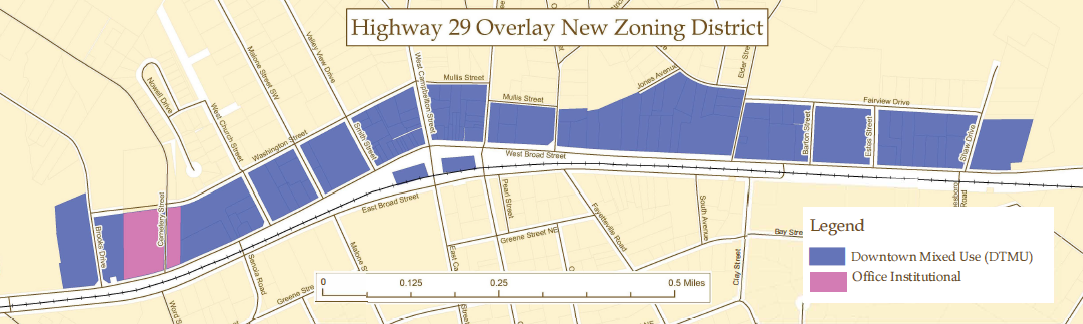
Wherever the underlying zoning regulations are in conflict with the provisions of this overlay district, the regulations of this overlay district shall apply.
Non-conforming uses created by the adoption of the Fairburn overlay district shall be administered as per article V.
Appeals, exceptions and variances shall be administered as per article VI.
(c)
Purpose and intent. The purpose and intent of establishing the Fairburn overlay district is as follows:
(1)
To promote the development of a more dynamic, mixed-use district of appropriate scale and magnitude in the downtown city area.
(2)
To build on the character that is uniquely Fairburn to have a thriving, compact historic downtown.
(3)
To balance the rights of private property owners with the city's desire to guide future development.
(4)
To ensure that new structures and developments are consistent with the vision and recommendations of the downtown city LCI plan (completed in 2009) with significant community involvement and input.
(5)
To design and arrange structures, buildings, and common spaces to create an inviting, walkable, human-scale environment.
(6)
To provide for connectivity of streets and communities and reduce the dependence on automobile use by increasing the ease of movement and opportunities for alternative modes of travel.
(7)
To ensure a proportional relationship of surrounding buildings with respect to the general spacing of structures, building mass and scale, and street frontage by using techniques to achieve compatibility, such as:
a.
Use of consistent setbacks from property lines;
b.
Development of consistent sidewalks and a more active, interesting pedestrian environment;
c.
Use of landscaping and lighting to unify district buildings and define space;
d.
Use of compatible building materials to promote a design and building aesthetic compatible with the desired urban character; and
e.
To implement the policies and objectives of the comprehensive plan and the zoning ordinance of the city within the Fairburn overlay district.
(d)
Definitions.
Boarding and breeding kennels. Establishments where dogs or cats are boarded for compensation or where dogs or cats are bred or raised for sale purposes.
Extended stay motels. Any building containing six or more guest rooms intended or designed to be used, or which are used, rented, or hired out to be occupied, or which are occupied for sleeping purposes for guests and contain kitchen facilities for food preparation including but not limited to such facilities as refrigerators, stoves, and ovens.
Heavy repair shop and trade shop. Shops where lathes, presses, grinders, shapers, and other wood- and metal-working machines are used such as blacksmith, tinsmith, welding, and sheet metal shops; plumbing, heating, and electrical repair shops; and overhaul shops.
Liquor stores. Any business selling general alcoholic beverages, also known as sale of distilled spirits or hard liquor, for off-premises consumption. Liquor store does not include a business selling only beer and/or wine for off-premises consumption.
Live-work units. Buildings or spaces within buildings that are used jointly for commercial and residential purposes where the residential use of the space is secondary or accessory to the primary use as a place of work.
Mixed-use. A building or groups of buildings under one ownership designed to encourage a diversity of compatible land uses, which include a mixture of two or more of the following uses: Retail, office and/or service, and residential.
Multi-family residential. A building or set of buildings containing a group of dwelling units on a common lot containing separate living units for four or more families, having separate or joint entrances, and including apartments and condominiums. These are specifically distinguished from units defined as single-family attached dwellings (townhouses).
Salvage yards/junk yards. A parcel of land on which wastes or used secondhand materials are bought, sold, exchanged, stored, processed, or handled. Materials include but are not limited to: Scrap iron and other ferrous metals, paper; rags, rubber tires, bottles, discarded goods, machinery, or two or more inoperable motor vehicles.
Self-storage. A building or group of buildings divided into separate compartments used to meet the temporary storage needs of small businesses, apartment dwellers, and other residential uses.
Sexually oriented business. See chapter 5, section 5 of part I.
Small box discount retail stores. A retail store with a floor area less than 15,000 square feet that primarily offers for sale an assortment of physical goods, products, or merchandise directly to the consumer, including food or beverages for off-premises consumption, household products, personal grooming and health products, and other consumer goods, with the majority of items being offered for sale at lower than the typical market price. Small box discount retail stores shall not include the following: Pharmacy drug store or a convenience store attached to or collocated with a gas station.
Title and pawn shops. An establishment that engages, in whole or in part, in the business of loaning money on the security of pledges of personal property, or deposits or conditional sales of personal property, or the purchase or sale of personal property.
(e)
District boundaries and map. The boundaries and development categories of the Fairburn overlay district shall be established by a zoning map amendment adopted pursuant to this chapter which amendment shall be incorporated herein and made a part of this article. This map shall be incorporated by reference and shall be known as the official U.S. Highway 29 overlay district map.
The Fairburn overlay district shall be divided into three development categories:
(1)
Educational node. The intent of the educational node is to act as a gateway into the city from the north. Various educational institutions are collocated here to offer opportunities for shared facilities and infrastructure. A flexible mix of land uses is desired to better facilitate service commercial and residential uses in this area catering to the campus community as well as nearby residents.
(2)
Downtown node. The intent of the downtown node is to preserve the historic commercial heart of the city while encouraging a mixture of retail, entertainment, commercial, office and residential uses.
(3)
Civic node. The intent of the civic node is to be gateway into the downtown area from the south. It is expected that several of the civic uses currently spread throughout the city will eventually relocate to this node, creating an area of strong civic presence for the city.
The city director of planning or designee shall have the final authority to determine whether any property is located within the boundaries of the Fairburn overlay district.
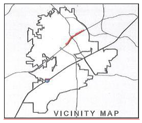
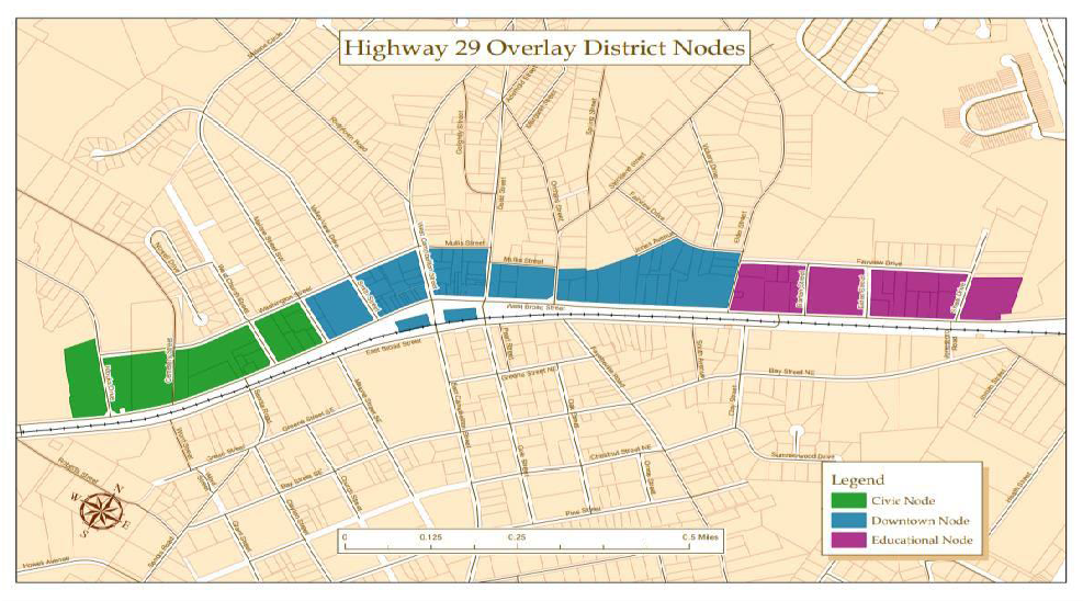
(f)
Principal uses. The following principal uses of land and structures shall be authorized within the Fairburn overlay district:
(1)
The Fairburn overlay district development may consist of any authorized use or combination of principal uses as authorized in the section below.
(2)
Sites may contain a mixture of uses. A single use category (commercial, residential, office/institutional, or civic) should occupy no more than 70 percent of the gross square footage of total building construction approved for the project.
(3)
In buildings with a mixture of residential and non-residential uses, non-residential uses must occupy the ground floor facing the public street.
(4)
For principal uses not to exceed a certain square footage per use, this applies to each use (or business) within a structure, not the structure itself.
Principal uses authorized in each node are:
(1)
Educational node.
a.
Live-work units.
b.
Multi-family residential units.
c.
Institutional uses.
d.
Governmental uses.
e.
Mixed-use with ground floor retail, office and/or service, and residential and/or office located on upper stories.
f.
Office uses—not to exceed 25,000 square feet per use.
g.
Retail uses—not to exceed 45,000 square feet per use.
h.
Food service establishments.
i.
Professional service.
(2)
Downtown node.
a.
Live-work units.
b.
Multi-family residential units.
c.
Mixed-use with ground floor retail, office and/or service, and residential and/or office located on upper stories.
d.
Governmental uses.
e.
Office uses—Not to exceed 25,000 square feet per use.
f.
Retail uses—Not to exceed 45,000 square feet per use.
g.
Food service establishments.
h.
Professional service.
(3)
Civic node.
a.
Live-work units.
b.
Multi-family residential units.
c.
Institutional uses.
d.
Governmental uses.
e.
Mixed-use with ground floor retail, office and/or service, and residential and/or office located on upper stories shall be allowed.
f.
Office uses—not to exceed 25,000 square feet per use.
g.
Retail uses—not to exceed 45,000 square feet per use.
h.
Food service establishments.
i.
Professional service.
Live-work units, which consist of buildings used jointly as dwellings and non-residential (work) purposes that are both permitted in the Fairburn overlay district. Live-work units shall meet all of the following standards:
(1)
Work uses shall be compatible with residential uses and shall not produce or create noise, smoke, vibrations, smells, electrical interferences, or fire hazards that would unreasonably interfere with residential uses. Permitted uses are:
a.
Accounting office;
b.
Planning, engineering, or architectural office;
c.
Financial services office;
d.
Insurance office;
e.
Legal office;
f.
Counseling office;
g.
Real estate office;
h.
Information processing uses;
i.
Tutorial/educational services;
j.
Fine arts studios and/or galleries;
k.
Photography studios;
l.
Consulting services;
m.
Food service establishments; and
n.
Beauty salons.
(2)
The maximum number of employees on the premises shall be five, in addition to the occupants of the residential space.
(3)
The unit shall not accommodate more than seven customers/clients at a time.
(4)
The minimum size of the live-work unit shall be 1,200 square feet with at least one-third of the unit designated for residential space.
The following principal uses of land and structures shall be prohibited within the Fairburn overlay district:
(1)
Boarding and breeding kennels.
(2)
Storage yard for damaged or confiscated automobiles.
(3)
Tire re-treading and recapping.
(4)
Sexually oriented businesses. See chapter 5, section 5 of part I.
(5)
Automotive repair shops.
(6)
Extended stay motels.
(7)
New and used cars sales.
(8)
Title and pawn shops.
(9)
Liquor stores.
(10)
Night clubs.
(11)
Salvage yards/junk yards.
(12)
Self-service car wash and detailing.
(13)
Self-storage.
(14)
Fuel stations.
(15)
Heavy repair and trade shops.
(16)
Small box discount retail stores.
(g)
Development standards. The following requirements shall apply to all structures in the Fairburn overlay district:
(1)
General site design requirements.
a.
For nonresidential uses, the primary ground floor entrance to all buildings shall be clearly visible from the street, shall face the street, and shall be unlocked during operating business hours.
b.
Decorative fencing, where applicable, shall only be made of brick, stone, wood, wrought iron or similar material. Fencing in the front yard of any property shall not be higher than four feet. Fencing to the rear or side of a building shall not be higher than six feet.
c.
No barbed wire, razor wire, chain-link fence or similar elements shall be visible from any public plaza, ground level or sidewalk level outdoor dining area or public right-of-way.
d.
Gates and security arms shall be prohibited from crossing any public street or sidewalk.
e.
All structures shall provide for underground utility access and connections, including pad-mounted transformers, at the rear of the building.
_____
(2)
Building setbacks and height.
a.
The following requirements apply to all developments:
b.
Single story buildings must include building features such as parapet walls or other appropriate architectural elements in order to achieve a minimum height of 16 feet.
c.
Single story buildings must be designed and constructed so as to allow additional stories.
d.
Side setbacks for parcels shall be determined by the underlying zoning.
e.
Parking structures that do not exceed 35 feet in height are allowed by right in this district.
Those exceeding 48 feet in height are subject to a conditional use permit per city zoning ordinance. All parking structures must be designed with materials and architectural features consistent with surrounding buildings.
(3)
Lot coverage and lot size.
a.
Building setbacks and side setbacks standards of this article shall determine lot coverage. No minimum lot coverage or lot size standards from any other article or section shall apply to parcels within the Fairburn overlay district.
(4)
Development standards for live-work units.
a.
All off-street parking shall be hidden behind or within individual units. Garages may not face the public street. Properties that were formerly single-family homes are exempt from this requirement.
b.
The front entrance to each unit shall be at grade opening directly onto the public sidewalk or a public space adjacent to the public sidewalk.
(5)
Development standards for commercial and mixed-use buildings.
a.
Ground-floor commercial and retail uses shall have entrances at grade opening directly onto the public sidewalk or a public space adjacent to the public sidewalk.
b.
Canopies over retail and commercial entrances and/or windows shall be mounted a minimum of eight feet above the sidewalk.
c.
The size of leased commercial space shall vary within each development to allow for diversity of tenants. Individual commercial units shall not exceed the limits established in section 80-92.06.
d.
A minimum of 75 percent of the ground-floor façade of mixed-use and commercial buildings shall be clear and un-tinted, transparent glass. Single use developments and those uses where such window area is impractical or unfeasible are excluded from this minimum requirement.
e.
Pedestrian access shall be provided from all parking areas to the building entrance.
(6)
Development standards for multi-family and townhome buildings.
a.
Ground-floor residential units that face the street shall have entrances with a stoop or porch between the sidewalk and the building façade no less than two feet above grade. A sidewalk shall connect all ground floor entrances to the public sidewalk.
b.
Setbacks for multifamily and townhome buildings shall contain only steps, front porches or stoops, balconies, or landscaping. Mechanical equipment and other building service items may not be located within the setback area between the public sidewalk and building.
(7)
Parking.
a.
Required parking may be provided through a combination of off-street, on-street, or shared parking, provided that all required parking is located with 1,200 feet by travel route of the principal entrance of buildings which it is intended to serve. The minimum number of required parking spaces shall be as provided in section 80-336. These requirements do not apply to district parking areas provided by the city.
b.
All off-street parking, including surface lots and parking decks, shall be located behind or beside buildings. No parking shall be located between the sidewalk and the building face.
c.
Each development which provides automobile parking facilities shall provide bicycle parking facilities in adjacent parking structures, parking lots, the adjoining sidewalk or setback area. Nonresidential developments shall provide bicycle parking at a ratio of one bicycle parking space for every 20 vehicular spaces. Multifamily residential developments shall provide bicycle parking facilities at a minimum ratio of one bicycle parking space for every five multifamily units. No development shall have fewer than three bicycle parking spaces nor be required to exceed a maximum of 50 bicycle parking spaces.
d.
Off-street parking shall be screened from view from any public street by buildings and/or landscaping. Off-street parking may not be located between the sidewalk and the building face.
e.
Any portion of a parking deck that is adjacent to a public street shall be screened with retail on the ground floor. Any upper stories of a parking deck that are visible from a public street shall be clad with materials to reflect the design of the primary structure which it serves.
f.
No parking area may be used for the sale, repair, dismantling, service, or long-term storage of any vehicles or equipment.
g.
Curb cuts:
1.
The consolidation of curb cuts shall be encouraged where possible and new curb cuts shall be discouraged whenever appropriate, considering safe traffic flow, the objectives of this district, and access points needed for the proper functioning of the use.
2.
Location and spacing of curb cuts shall, at a minimum, meet the requirements of the state department of transportation driveway and encroachment control manual.
h.
Shared parking is encouraged in accordance with article VI, Administrative permits and use permits, section 80-181, Parking, off-site and shared.
(h)
Architectural regulations. In order to maintain a consistent character and accent the historic nature of the city's commercial core, the following architectural regulations shall apply to all uses and structures within the Fairburn overlay district:
New construction and renovations shall:
(1)
Maintain the original character of the façade of historic building.
(2)
Conform to the architectural character of the national register structures of the downtown area.
(3)
Reinforce the established horizontal lines of façades on the block. Restore or recreate the historic horizontal alignment of architectural features such as cornices, windowsills and parapets.
Reinforcing established horizontal lines through
windows and cornices helps maintain continuity of storefronts
(4)
Construct 75 percent of the width of the front façade of the building at the ground level as fenestration (windows, doors, etc.).
(5)
Maintain the original size, shape, and design of the storefront opening. Large ground floor windows shall be maintained. Doors shall use painted frames; unfinished aluminum or stainless-steel frames are not permitted. Window and door frames may be metal with anodized or painted finish or varnished or painted wood. Residential type of opaque and paneled doors shall not be permitted.
(6)
Maintain traditional recessed storefront entrances where they exist.
(7)
Provide uninterrupted wall widths of not more than 60 feet.
(8)
Incorporate storefront design widths that change at least every 40 feet.
(9)
Maintain and/or restore kickplate below storefront windows where appropriate. Appropriate kickplate materials include painted wood, glazed tile, painted metal in muted tones or metal matte bronze finish.
(10)
Preserve primary façade elements (see graphic above) and high-quality building materials. If the original façade has been concealed, it shall be uncovered. If portions of the original building material must be replaced, duplicate the material used or use a similar material to the original. Use of "barn" wood or other boarded surfaces which are inconsistent with the original building design shall not be permitted. All building façades visible from the public street shall consist of wood, stone, brick or stucco.
(11)
Preserve and restore original ornamentation and details of the façade using photographic and other evidence.
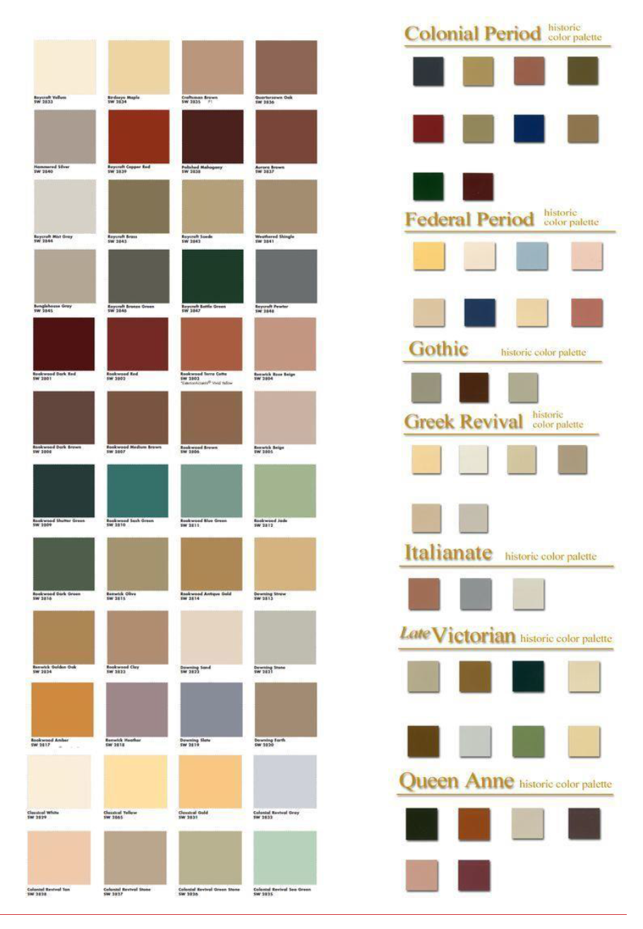
Sample paint color palette for overlay district area
(12)
Preserve the size and shape of upper story windows along street facing façades. Reopen any blocked upper story windows. Maintain the original spacing of windows. Window arrangements not in keeping with the city's historic character, such as gang windows, are not permitted.
(13)
Not make use of aluminum tube-type windows along any street facing façades. Solid vinyl windows are only permitted as long as the window has a minimum frame depth of 4½ inches, is a color other than pure white, and is fabricated to fit the original window opening size. Vinyl clad wood windows may be permitted as long as they are not pure white in color.
(14)
Preserve the original transom, if it exists. The transom shall be clear glass or shall be used for a sign or decorative panel.
(15)
Maintain and repair the original door or replace with a door of similar design and materials. Standard aluminum and glass commercial doors are permitted but the frames shall be painted in dark colors. Replacement doors shall be commercial type doors and shall not be of residential proportions or design.
(16)
Incorporate a building color scheme which visually links the building with others in the area. The colors chosen should relate to the established masonry tones within the downtown area. If brick or masonry is exposed, it shall not be painted. Existing buildings of painted brick shall be repainted and paint removal is not permitted unless approved under the Secretary of the Interior standards for rehabilitation of historic buildings.
(17)
Shall include exterior surfaces, when painted and visible from the public street, are done so in earth tones or colors consistent with the historic character of the city.
a.
The following shall only be recommendations to follow to develop appropriate building color palettes. Three colors are sufficient to highlight any façade:
1.
Base color: Is that on the upper walls and piers flanking the storefront. This shall be natural masonry or painted to look as natural as possible.
2.
Major trim: Is the color that defines the decorative elements of the building, tying together the upper façade trim and the storefront. The trim color should complement the base color. Major trim elements include the building cornice, storefront cornice, window frames, sills and hoods, and storefront frame, columns, and bulkheads (kickplate).
3.
Minor trim: Should enhance the color scheme established by the base and major trim. Often a darker shade of the major trim is used to highlight the window sashes, doors, and selective cornice and bulkhead details.
(18)
Not include roof materials made of reflective surfaces, when visible from the public right-of-way.
(19)
Not make use of security bars and steel roll down doors or curtains which are visible from the public street.
(20)
Incorporate, when necessary, service bays for lanes of drive through restaurants designed so that the openings are not visible from a public street.
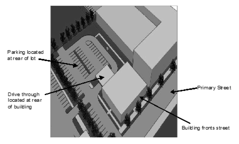
Sample design of drive-through restaurant. Building fronts the street and
drive-through is located at the rear. Graphic is included for illustrative purposes
only.
(21)
Not include temporary awnings.
(22)
Include, where appropriate, fabric, canvas, or metal standing-seam awnings. All other building materials must be of durable quality and shall be compatible with materials used in adjoining buildings.
a.
Landscaping requirements. The following landscaping regulations shall apply to all uses within the Fairburn overlay district. Any development incorporating a mix of uses shall require the submittal of a landscape plan for approval, which shall include the following elements:
1.
A continuous landscape strip of not less than five feet in width shall be constructed along all public streets. The landscape strip in the front yard shall be planted with a row of street trees of at least three and one-half inches in caliper measured from three feet above finished ground level and planted not less than 30 feet on center.
2.
Ground cover shall also be provided in accordance with this section in order to protect tree roots and to prevent erosion. Ground cover shall consist of evergreen shrubs and groundcover plant material mulched with pine bark mulch, or other similar landscaping material to include mulch made from recycled materials.
3.
No tree shall be planted closer than two feet from the street or sidewalk, and no closer than five feet from a fire hydrant, sign post, streetlight standard, utility pole, or similar structure. The property owner shall investigate all conflicts with utilities prior to planting. The landscape plan submitted to city staff must identify all existing and/or proposed underground and overhead utilities.
4.
All parking lots within the Fairburn overlay district shall be bounded by a ten-foot landscape strip along all outside edges. Of the remaining parking lot area, a minimum of ten percent shall be devoted to landscape islands.
5.
The following is a partial list of acceptable trees that can be planted along streets in the city. Trees and all other plantings shall be maintained in accordance with section 80-369.
(i)
October glory red maple.
(ii)
Sunset maple.
(iii)
Nuttal oak (Quercus nattalli).
(iv)
Shumard oak (Quercus shumardii).
(v)
Willow oak.
(vi)
Zelkova serrata.
(vii)
Ginkgo (Ginkgo biloba).
(viii)
Trident maple (Acer buergeranum).
(ix)
Allee lacebark elm (Ulmus parvifolia emer (II).
(x)
Chalkbark Maple (Acer Leucoderme).
(xi)
Georgia Oak (Quercus Falcata).
6.
Street trees shall be installed in a minimum planting area of four feet by eight feet. Tree-planting areas shall provide porous drainage systems that allow for drainage of the planting area.
7.
All street trees and other trees and all ground cover required by this article shall be maintained in a healthy condition, and any trees or ground cover which die shall be replaced within the earliest possible planting season. Maintenance of all trees in this district shall comply with state department of transportation landscape standards (available at http://mydocs.dot.ga.gov/info/gdotpubs/Publications/6755-9.pdf).
(j)
Sidewalks.
(1)
A public sidewalk shall be constructed along all public street frontages contiguous to all properties within the Fairburn overlay district. This sidewalk shall measure a minimum width of ten feet in the downtown node, and six feet in all other areas of the Fairburn overlay district.
(2)
Safe and convenient pedestrian pathways shall be provided from public sidewalks to each structure entrance, including pedestrian access routes to parking decks, through parking lots and between adjacent buildings within the same development. All such pathways shall be concrete and a minimum width of six feet.
(3)
When installed, benches, trash receptacles, and bike racks shall be placed adjacent to the sidewalk zone on all streets.
(k)
Common space requirements.
(1)
A minimum of ten percent of the total lot area shall be designated as common space for each new mixed-use development. Common space areas may be transferred from one parcel to another within overall developments that remain under unified control of a single property owner or group of owners; but, must demonstrate interconnectedness of public areas.
(2)
Common spaces shall be at grade and surrounded by a mix of uses directly accessible from a public sidewalk and building entrances.
(3)
Common space that is provided as part of a new development shall include connectivity to any existing or planned nearby public amenity, including, but not limited to, trail networks, greenspace or park facility.
(4)
Common spaces may include any combination of the following: planted areas, fountains, parks, plazas, trails and paths, hardscape elements related to sidewalks and plazas, and similar features which are located on private property and accessible to the general public. On-street parking shall be permitted to count toward the ten percent common space requirement.
(5)
Private courtyards and other private outdoor amenities may be located at the interior of the block, behind buildings or on rooftops. Private courtyards and outdoor amenities shall not be counted toward the ten percent common space requirement.
(6)
All common space shall be fully implemented prior to issuance of a certificate of occupancy for the primary development.
(7)
Each applicant shall present as a part of the application for a building permit within the Fairburn overlay district a legal mechanism under which all land to be used for public space purposes shall be maintained and protected. Such legal mechanism may include deed restrictions, property owner associations, common areas held in common ownership or control, maintenance easements, or other legal mechanisms, provided that said legal mechanism shall be approved by the city attorney as assuring each of the following mandatory requirements:
a.
That all subsequent property owners within said Fairburn overlay district be placed on notice of this development restriction through the deed records of the city;
b.
That all public space held in common will be properly maintained and insured with no liability or maintenance responsibilities accruing to the city;
c.
That a legal mechanism exists for notice of deficiencies in maintenance of the public space held in common, correction of these deficiencies, and assessment and liens against the properties for the cost of the correction of these deficiencies by a third-party or the city;
d.
When an applicant for a Fairburn overlay district chooses to utilize a property owners association in order to comply with the requirements of the subsection above, the applicant, in addition to meeting all of said requirements, shall provide for all of the following:
1.
Mandatory and automatic membership in the property owner's association as a requirement of property ownership;
2.
A fair and uniform method of assessment for dues, maintenance and related costs;
3.
Where appropriate, party wall maintenance and restoration in the event of damage or destruction; and
4.
Continued maintenance of public space held in common and liability through the use of liens or other means in the case of default.
(l)
Screening.
(1)
All dumpsters shall be enclosed with a wall of equal or greater height on three sides, the material of which shall be similar to the material on the outside of the main building.
(2)
Dumpsters shall not be visible from the public street and shall be fenced or screened so as not to be visible from any adjoining residential district.
(3)
Loading docks shall not be located on the front of any building.
(4)
Loading dock entrances for non-residential uses shall be screened so that loading docks and related activity are not visible from the public right-of-way.
(5)
Loading and dumping activities located within 150 feet of a single-family residential property shall only be permitted to undertake said activities during normal business hours (7:00 a.m.—9:00 p.m.).
(6)
All service areas shall be screened from view from the street with buildings, landscaping, or decorative fencing.
(7)
Accessory mechanical systems and features including air and heating systems, solar collectors, satellite dishes, and telecommunications equipment shall not be visible from the public right-of-way.
(8)
Chain-link fences shall not be visible from the public right-of-way, except those temporary uses specifically permitted by city code.
_____
(m)
Signage. Unless otherwise noted in this subsection, the standards and procedures in article XII shall apply for all signs located within the Fairburn overlay district.
Permitted sign types: Proper placement and relationship to façade elements
_____
Subject to review, approval and permitting, the following sign types shall be permitted in the Fairburn overlay district:
(1)
A-frame sandwich board sign.
(2)
Awning sign.
(3)
Monument sign.
(4)
Projecting sign.
(5)
Wall sign or signboard sign.
(6)
Storefront display window sign.
The following sign types shall be prohibited in the Fairburn overlay district:
(1)
Animated, flashing, rotating or blinking sign—with the exception of traditional barber pole.
(2)
Changeable copy sign (electronic or otherwise), with the exception of signs communicating only the time and/or temperature (see chapter 80, article 12).
(3)
Feather flag sign.
(4)
Pole/pylon sign.
The following materials shall be permitted to be used for signs in the Fairburn overlay district:
(1)
Brick or stone, as foundation for monument sign.
(2)
Canvas, for awning sign.
(3)
Metal, powder coated or painted.
(4)
Wood.
(n)
Outdoor dining.
(1)
Decks or patios located on private property are not regulated or prohibited by this section.
(2)
Restaurants may place tables outside their place of business. These tables must be placed adjacent to the front wall (and side wall, if applicable) of the building.
(3)
Tables must not extend beyond the side property line of the restaurant or encroach upon the side building line of adjacent businesses.
(4)
Dining tables must not be wider than three feet in diameter.
(5)
A minimum of five feet of clear pedestrian access must be maintained on all sidewalks.
(6)
Access to public stairways shall not be blocked. Tables and chairs must not interfere with any utilities or other facilities such as telephone poles, fire hydrants, signs, mailboxes, and benches located on the sidewalk or in the public right-of-way.
(7)
Tables and chairs must not impinge on any required clear distances for maneuvering around entrances or exits. The outdoor dining area shall be accessible to disabled patrons and employees.
(8)
Umbrellas must be of quality construction and must be designed to be secure during windy conditions. No portion of the umbrella may be lower than seven feet above the sidewalk.
(o)
Lighting.
(1)
Street and pedestrian lights shall alternate along all sidewalks every 30 feet.
(2)
All parking areas, walkways, vehicle entrances and service/loading areas shall provide area lighting sufficient to achieve a minimum of 1.5 footcandles of light as measured at grade or ground level and shall have a minimum ratio of the average to the minimum of 4:1 or less, and shall have a minimum vertical illuminance of 0.5 footcandles.
(3)
Lighting fixtures in parking areas shall be located to assure adequate light levels without displacing planned trees. Light fixture placement shall be shown on landscape plans.
(4)
Lighting fixture height, style, design and illumination levels shall be compatible with the building design and height and shall consider safety, function and aesthetics. Lighting fixtures installed along sidewalks shall be of pedestrian scale and shall not exceed 20 feet in height.

Lighting fixtures help make an area safer
and easier to navigate for pedestrians and driver alike.
(5)
Lighting may be used to illuminate buildings, landscaped medians/islands and grounds for safety purposes and to enhance appearance. The visual effects of such lighting shall be subtle.
(6)
Lighting attached to building exteriors to reflect upon building exteriors shall be consistent with the architectural style of the building.
(7)
Security lighting shall be shielded and shall focus on the side or rear entry door.
(8)
Specialty lighting on outdoor patios, terraces, walkways, and trees may be used to encourage nighttime use by pedestrians.
(9)
All outdoor lighting shall use full cut-off fixtures or IDA-approved fixture and be subject to review and approval during the site planning phase of the project.
(p)
Outdoor display.
(1)
Definitions. The following words, terms and phrases, when used in this article, shall have the meanings ascribed to them in this section, except where the context clearly indicates a different meaning:
Access zone means that portion of the public sidewalk reserved for continuous unobstructed pedestrian traffic and ingress/egress to businesses and structures lining the public rights-of-way.
Amenity zone means that portion of public sidewalk for siting of municipal streetscape elements; such as street trees, street lights, benches, trash cans, sign posts, ashtrays, etc.; approved outside dining areas (as permitted by section 80-89, Highway 29 Overlay Zoning District); and designated special events or vending locations (as permitted by article IV, Administrative permits and use permits).
Appearance zone means that portion of the sidewalk as approved for downtown beautification or business enhancement, including planters and benches, product display, ashtrays, signs (as permitted by article XII, Sign regulations), and tables and chairs.
City means the City of Fairburn.
Director of planning means the city zoning administrator.
Obstacle means any object or item whether situated upon or hanging over the right-of-way, including but not limited to noticeable changes in grade or paving materials.
Outdoor display means the outdoor display of products actively available for rent or sale within the principle business facility. This definition does not include products in shipping boxes, crates, on pallets, or other shipping containers, or any construction equipment which shall be considered outdoor storage.
Public property means property owned, leased, or maintained by the city including but not limited to streets, byways or rights-of-way, sidewalks, parking lots, lots of record with or without structures, parks, and easements.
Sidewalk means that portion of the right-of-way improved for use by pedestrians located between the curb line or the edge of an improved roadway and the adjacent property line.
2.
Use of public property.
a.
Purpose of the public sidewalk. Use of the public sidewalk for any purpose other than as a pedestrian right-of-way is a privilege, which the city may grant or deny to insure the primary purpose of the public rights-of-way for travel and to maintain the efficiency of the pedestrian path for both safety and convenience.
1.
To provide for pedestrian clearance, an access zone shall be reserved at all times for continuous, unobstructed pedestrian traffic along the public sidewalk. This reserved zone shall be a minimum of five feet in width as measured from the edge of the sidewalk closest to the street, running parallel to the roadway and as straight as possible, and not encroached upon even if this precludes other uses of the public sidewalk. Where less than five feet exists, all of the right-of-way shall be reserved for pedestrian clearance. A minimum of seven feet height clearance above grade for the access zone shall also remain unobstructed.
2.
To provide for ingress/egress to businesses and structures lining the public rights-of-way, there shall also be reserved clear passages between the access zone and the curb. These passages shall be a minimum of five feet in width and perpendicular to the roadway and as direct as possible. In addition to corner passages at street intersections, each side of a city block shall have a minimum of two said passages spaced at least 50 feet apart as well as passages located at each property line.
b.
Use of the appearance zone. Wherever wide sidewalks exist within the Highway 29 Overlay Zoning District as provided by the current zoning ordinance, the city may designate an appearance zone and grant or deny the privilege of limited use of the zone to abutting businesses for downtown beautification or business enhancement, in accordance with the provisions of this article.
1.
The appearance zone shall only be used for incidental or accessory purposes by an abutting business with a current business license; any use of the area by others shall constitute a type of vending or special event that must obtain proper permits through article IV, Administrative permits and use permits.
2.
The appearance zone for a business shall not exceed the width of the front wall of the abutting business nor extend onto the public sidewalk beyond a depth of 24 inches from the front wall of the business or the maximum depth remaining after observance of the access zone. For corner properties, the sidewalk area adjacent to the side wall of the business may also be considered for the establishment of an appearance zone.
3.
Placement of beautification or enhancement items. Planters, benches, and ashtrays deemed compatible in design and materials may be allowed in the appearance zone provided that these items are kept clean, attractive, sanitary, and in a structurally sound condition at all times. Vegetation must be maintained in a healthy and attractive condition at all times. No hanging baskets or artificial vegetation displays are permitted. All litter must be removed promptly, including cigarette butts.
4.
If the director of planning determines any object to be non-compliant with this section, said object is subject to immediate removal by the business.
c.
Placement of merchandise for display, sale, and advertisement limited. It shall be unlawful to place, for purposes of display, for the sale or advertisement of any property or merchandise whatsoever, upon the public sidewalks or parking spaces/lots of the city except as provided herein.
1.
In accordance with subsections 80-89(p)(2)a. and b. above, wherever wide sidewalks exist within the Highway 29 Overlay Zoning District as provided by the current zoning ordinance, the appearance zone may also be utilized for product display provided:
(i)
Placement of merchandise occurs only during business hours and all merchandise is removed at the close of business each day.
(ii)
To reduce the added risk of product tipping into the access zone, no merchandise shall exceed or be stacked to exceed six feet in height and no shelving units that exceed four feet in height may be used. Tables may be used as long as they fit within the appearance zone.
(iii)
To reduce the added risk of product rolling into the access zone, all wheels shall be locked or chocked.
(iv)
To reduce the added risk of product falling into the access zone, no merchandise shall be hung on the building or suspended from the building's awnings or canopies.
(v)
No signs other than those signs as permitted within the official zoning ordinance, article XII, shall be used on public property; labels less than one-inch square shall not constitute signage.
(vi)
All merchandise must be the merchandise of the business. The appearance zone for a specific business shall be used solely by that business for the display of its merchandise and shall not be leased, sold, or gifted to a third party for their use.
(vii)
The business owner is responsible for ensuring that the merchandise and displays in the appearance zone are clean, well-kept and secure. The business owner is responsible for ensuring that the merchandise and displays will not cause harm to any pedestrians walking in the access zone.
2.
If the director of planning determines any display, or portion thereof, to be non-compliant with this section, said display is subject to immediate removal. After the director of planning has determined that such display is non-compliant, he shall initiate proceedings to cause the removal. The director of planning shall prepare and issue a letter of determination to the owner of record and parties of interest of the building. The letter of determination shall contain, but not be limited to, the following information:
(i)
The street address of the building, structure or premises.
(ii)
A statement indicating the display of merchandise is non-compliant with this section and must be removed or brought into compliance within 24 hours or, that the city has determined, for any reason, that the display must be completely removed within 24 hours, that the owner or occupant may file an appeal to the planning and zoning commission pursuant to section 80-255. Secondary variance/interpretation, and failure to appeal in the time specified will constitute a waiver of all rights to such appeal.
(iii)
A statement advising that if the display is not removed or brought into compliance within the time specified, and an appeal is not filed, the director of planning may cause code enforcement to remove the display and all costs incurred will be charged against the business owner or the owner of record and the total cost to the city for removing the display shall be a special lien against the property and shall be placed upon the tax records of the city.
3.
The letter of determination and all attachments thereto shall be served upon the business owner, owner of record, and any parties of interest designated in the initial application either personally or by certified mail, postage prepaid, return receipt requested. If addresses are not available on any person required to be served the letter of determination, the letter of determination addressed to such person shall be mailed to the address of the building or structure involved in the proceedings. Failure of the director of planning to serve any person herein required to be served other than the owner of record shall not invalidate any proceedings hereunder nor shall it relieve any other person served from any obligation imposed on him. Service by certified mail as herein described shall be effective on the date the letter of determination was received as indicated on the return receipt. Proof of service of the letter of determination shall be by written declaration indicating the date, time and manner in which service was made and signed by the person served on by the return receipt.
4.
In addition, should the owner of record or interested parties give cause to receive a letter of determination for more than two offenses for the same violation during a period of 12 consecutive months, code enforcement may issue a citation to the owner of record or interested parties to appear before the municipal court of the city and there shall be no appeal for the third or subsequent offense occurring during a period of 12 consecutive months. The fines and penalties are as provided in subsection 5. below, however, the minimum fine for such additional citation shall not be less than $150.00 and each subsequent citation within a 12-month period shall be subject to an amount double the previously assessed fine up to $1,000.00.
5.
It shall be unlawful and a violation of this section to place merchandise or property, for purposes of display, sale or advertisement, upon any designated off-street parking associated with each business or upon any public parking space of the city.
d.
Permit approval procedure and requirements.
1.
An application for a permit to have outdoor display with the application fee as established by the city council shall be filed with the director of planning prior to any use or placement of any item upon public property.
2.
The permit will be valid for one year.
3.
Use of the appearance zone shall be in accordance with this section.
4.
The director of planning at his reasonable discretion may require removal for any reason. Failure to remove items and cease use of public property shall result in the removal of such item(s) by the director of planning. The business shall be responsible for all expenses incurred by the city for the removal and storage of such items.
5.
Except for actions arising out of the city's sole negligence, the business agrees to indemnify, defend, and hold harmless the city and all its officers, officials, representatives, agents, and employees, from any and all claims, liability, damages, or causes of action which may arise out of the businesses' or licensee's use of the appearance zone. The business is responsible for repair of any damage to public property or pedestrians caused by their use of the appearance zone.
e.
Compliance with subsection (p), outside display. All businesses will be required to come into compliance with this subsection within 30 days after its adoption by mayor and city council.
(3)
Exceptions. The provisions of this subsection (p), outside display, shall not be applicable to any licensed utility company doing business in the city; nor to the state highway department; nor to the water, sewage, gas and fire departments of the city; nor to any governmental agency.
(4)
Placement of printed advertising matter limited.
a.
It shall be unlawful for any person distributing or causing to be distributed, circulars, handbills, papers or other printed advertising matter through the city, to throw into or place in any yard or mailbox, such items; said items may only be handed to an employee of a place of business. Only one of the items which such person may be distributing shall be placed in each business. It shall be unlawful for any person distributing or causing to be distributed circulars, or receiving such handbills, papers or other printed advertising through the city, to throw or scatter such materials upon any public property in the city.
b.
It shall be unlawful for any person to paste, print, nail, tack or otherwise fasten any card, banner, handbill, sign, poster, advertisement or notice of any kind, or cause such an action to be done, on or upon any public property within the city, or upon any utility facility in a public right-of-way, or upon any private property without the written consent of the owner of such property.
c.
No person other than the owner or driver shall deposit any advertising matter in any motor vehicle or stick or otherwise fasten any advertising matter on any part of any motor vehicle.
5.
Penalty for violation of this subsection (p), outdoor display. Except as otherwise provided, any person violating the provisions of this subsection (p), outdoor display, shall, upon conviction, be punished by a fine not exceeding $1,000.00 or by imprisonment not exceeding six months, or by a combination of such punishments. Each day any violation of any provision of this Code or of any such ordinance, resolution, rule, regulation or order shall continue shall constitute a separate offense. Code enforcement, or its designee, will issue citations for violations of this article to appear before the municipal court in the city. This article does not apply to special events or any type of vendor who obtains proper permits through article IV, Administrative permits and use permits.
(Ord. No. 2012-04, § 1(Exh. A), 6-11-2012; Ord. No. 2013-28, § 1, 10-28-2013; Ord. No. 2014-03, § 1, 2-24-2014; Ord. No. 2014-04, § 1, 2-29-2014; Ord. No. 2015-15, § 1(Exh. A), 7-27-2015; Ord. No. 2015-28, § 1(Exh. A), 12-14-2015; Ord. of 10-28-2019(1); Ord. No. 2022-231, § 1, 3-28-2022; Ord. No. 2023-12, § 1(Exh. A), 7-24-2023)
Sec. 80-90. - Georgia Highway 74 Overlay Zoning District.
(a)
Scope. The regulations set forth in this section or set forth elsewhere in this chapter when referring to this section are the regulations of the Georgia Highway 74 Overlay Zoning District.
(b)
Findings and intent.
(1)
Georgia Highway 74, which serves as the southern gateway to the city is expected to continue experiencing rapid growth in residential, commercial, and industrial construction. Development of well over 1,000 acres of raw land is being driven by proximity to Atlanta and Hartsfield International Airport, as well as access to the interstate system.
(2)
The regulations set forth in this section are intended to ensure attractive developments which are complimentary and will promote a mix of uses rather than the undesirable commercial sprawl which has plagued many communities and threatened the very character that attracted such development interests. These standards will reinforce and implement a land use plan that features residential, office, personal services, hospitality uses, and retail commercial uses along Georgia Highway 74.
(3)
To this end, it is the city's goal to protect the aesthetics of the community, provide for safe travel through, and access to the area and safeguard the welfare of its residents, while encouraging development along the Georgia Highway 74 corridor.
(c)
Boundary. This district is intended as an overlay district regulating and allowing the establishment of uses within the configuration of the allowable Georgia Highway 74 Overlay Zoning District boundaries. Said boundary shall include any properties or portions thereof, located within 1,000 feet of the Georgia Highway 74 right-of-way, as it presently exists or may exist in the future. The underlying district shall continue as permitted uses. Standards set out in this section for site development and architectural design shall control over any underlying district regulations.
(d)
Prohibited uses. The following principal uses of land and structures shall be prohibited within the Georgia Highway 74 Overlay Zoning District:
(1)
Storage yard for damaged or confiscated automobiles.
(2)
Tire re-treading and recapping.
(3)
Sexually oriented businesses. (See chapter 5, section 5 of part I, [of this Code.])
(4)
Heavy repair shop and trade shop.
(5)
Extended stay residential facilities, or other similar accommodations.
(6)
Title and pawn shops.
(7)
Nightclubs.
(8)
Salvage/storage/junk facility.
(9)
Self storage facilities.
(10)
Small box discount retail stores.
(e)
Site development standards. In order to establish and maintain the Georgia Highway 74 Overlay Zoning District as a quality area which will preserve the investments of all landowners and developers, as well as encourage both commercial and residential development within the city, all development within the Georgia Highway 74 Overlay Zoning District must comply with the following standards:
(1)
The following schedule shall control land development as specified:
a.
Retail and commercial services developments shall provide a landscaped buffer with a minimum horizontal dimension of 35 feet adjacent to the Highway 74 right-of-way. A buffer with a minimum horizontal dimension of 75 feet shall be provided where such developments are proposed adjacent to property developed as, or planned as, office use. A 100-foot buffer shall be provided on retail and commercial services developments which adjoin property developed as, or planned as, residential use.
b.
Office development shall provide a landscaped buffer with a minimum horizontal dimension of 45 feet adjacent to the Georgia Highway 74 right-of-way. A buffer with a minimum horizontal dimension of 40 feet shall be provided on office developments which adjoin property developed as, or planned as, residential use.
c.
Residential development shall provide a landscaped buffer with a minimum horizontal dimension of 45 feet adjacent to the Georgia Highway 74 right-of-way. Such buffers shall conform to the standards of section 80-335 and shall provide berms designed to achieve topographic variation.
(2)
The following schedule shall control building setbacks for all commercial construction:
a.
Front yard setback: 50 feet, 50 feet from each street right-of-way for corner lots.
b.
Side yard setback: 20 feet.
c.
Rear yard setback: 30 feet.
(3)
Off-street parking and loading shall be subject to the following:
a.
All retail and commercial uses shall provide a parking ratio of one space for every 200 square feet of enclosed retail floor area available to the public. One parking space shall be provided for every 1,000 square feet of floor area used for storage, assembly, warehousing or other purpose, provided that such areas are not available to the public. Such uses shall provide four percent parking spaces per 1,000 square feet to enclosed retail floor area available to the public, provided the establishments served by the parking spaces comprise a unified shopping center. All such off-street parking areas shall conform to the landscape standards provided in article IX of this chapter unless exceeded herein.
b.
No loading areas shall be permitted between buildings and the Georgia Highway 74.
(4)
Site utilities serving the site shall be placed underground.
(5)
All development shall conform to section 80-372, open space reservation.
(6)
Developers are encouraged to create secondary road networks through a system of density (lot coverage or building height) bonuses. Lot coverage ratios, inclusive of the building footprint and pavement for parking and driveways, shall not exceed 75 percent. Pavement comprising internal street networks shall be exempted provided such street networks channel traffic between developments along Georgia Highway 74 and are not directly linked to Georgia Highway 74.
(7)
Secondary road networks which provide a landscaped boulevard and are linked to adjoining properties shall entitle the property owner to a lot coverage bonus of ten percent.
(8)
Access to Georgia Highway 74 shall be limited to one driveway per existing parcel. A lot coverage bonus of ten percent shall be granted for consolidation of driveways currently permitted by State Department of Transportation.
(9)
Preservation of natural features shall encompass pedestrian amenities linked to adjoining properties. All development shall provide sidewalks linked to such amenities as well as adjoining properties.
(10)
On Georgia Highway 74, no new gasoline service stations shall be permitted within 1,000 feet of any other gasoline service station. All measurement of distances shall be along a straight route from the nearest point on any property line to the nearest point on any property line used as a gasoline service station. New gasoline service stations shall be located at a signalized intersection. This subsection (10) shall not apply to the rebuilding and/or enlargement of an existing gasoline service station. For the purposes of this subsection, rebuilding and/or enlargement shall mean partial or complete demolition of an existing structure and submittal of a building permit application within six months from the demolition of the existing structure. Failure to obtain a building permit shall require a developer and/or landowner to follow the development requirements for a new gasoline service station.
(11)
On Georgia Highway 74, no new drive-through fast food restaurants shall be permitted within 1,500 feet of any other drive-through fast food restaurant, except where the gross floor area of a restaurant exceeds 4,000 square feet and at least 50 percent of the gross floor area is designated for a dining area. Ten percent of the required dining area may include an outdoor dining area. All measurement of distances shall be along a straight route from the nearest point on any property line to the nearest point on any property line used as a drive-through fast food restaurant.
This subsection (11) shall not apply to the rebuilding and/or enlargement of an existing stand-alone drive-through fast food restaurant. For the purposes of this subsection, rebuilding and/or enlargement shall mean partial or complete demolition of an existing structure and submittal of a building permit application within six months from the demolition of the existing structure. Failure to obtain a building permit shall require a developer and/or landowner to follow the development requirements for a new drive-through fast food restaurant. For the purposes of this subsection, rebuilding and/or enlargement shall mean partial or complete demolition of an existing structure and submittal of a building permit application within six months from the demolition of the existing structure. Failure to obtain a building permit shall require a developer and/or landowner to follow the development requirements for a new drive-through fast food restaurant.
(f)
Architectural design standards. In addition to the site development standards set forth in subsection (d) of this section, all construction within the Georgia Highway 74 Overlay Zoning District must comply with the following standards:
(1)
The following specifications shall control the use of building materials:
a.
Exterior wall materials shall consist of one or a combination of the following materials:
1.
Brick or autoclaved concrete substructure.
2.
Stone with either a weathered face or polished, fluted or broken face. No quarry faced stone shall be used.
3.
Masonry stucco on concrete.
4.
Concrete masonry. Units shall be those generally described by the National Concrete Masonry Association as "customized architectural concrete masonry units" or shall be "splitfaced" block with marble aggregate. No exposed concrete block shall be permitted on the exterior of any building within the sight line of a public street. Other exterior walls may be painted concrete block.
5.
Wood.
6.
Glass in combination with metal or similar, durable architectural materials.
7.
Limited use of standing seam metal is permitted in combination with the above materials.
b.
Inappropriate exterior materials and architectural elements. The following materials and elements are considered incompatible and inappropriate for primary and accessory structures and are prohibited:
1.
Plywood, cinderblock, unfinished poured concrete, unfaced concrete block and plastic or metal not closely resembling painted wood clapboard.
2.
Partial (less than three sides) mansard roofs, flat roofs (including a minimum pitch less than four in 12) without a pediment, long unarticulated roofs.
3.
Long, unarticulated or blank facades.
4.
Incongruity of architectural details or color contrasts resulting in a clearly disturbing appearance.
5.
Unscreened chain link or woven metal fences.
6.
Use of reflective materials as the main building material or texture.
7.
Use of highly reflective glass.
8.
The use of exterior insulating finish system (EIFS), also identified by such manufacturer names as "Drivit," synthetic stucco and building materials.
(2)
The following guidelines shall control the architectural character:
a.
All front facades of the principal structure shall face and be parallel to the public right-of-way and consist of all brick construction. All windows, storefront, and fenestrations shall not be secured by way of burglar bars, steel roll-down shutters/curtains or obtrusive security products visible from a public right-of-way.
b.
Side and rear elevations of all office buildings and restaurants shall be majority brick or stone construction and substantially consistent with the front building elevation. Exterior building facades shall provide visual relief every 80 to 120 feet via setbacks, parapet breaks or other architectural element. Canopies installed on the facade shall provide visual relief through a canopy break every 40 feet. All windows, storefront, and fenestrations shall not be secured by way of burglar bars, steel roll-down shutters/curtains or obtrusive security products visible from a public right-of-way.
c.
All new construction on each lot shall be representative of a single architectural style. Combining different elements or styles on a single lot shall not be permitted in the Georgia Highway 74 Overlay Zoning District.
d.
The form and pitch of the roof of new construction shall be substantially proportional to the chosen architectural style.
e.
The height, scale, massing and fenestration of new construction shall be substantially proportional to the chosen architectural style.
(3)
Roof-mounted equipment. Roof-mounted equipment shall be located and/or screened to minimize visibility from public streets and surrounding properties.
(4)
Development shall be subject to architectural and site plan review. Applications for new construction, exterior alterations and expansion of existing structures shall be accompanied by scaled plans prepared by an architect, engineer or other appropriate professional. Such plans shall clearly depict the following:
a.
Building elevations through color rendering.
b.
Proposed colors, materials and textures.
c.
Location of all utility installations, including rooftop units.
d.
Property signs, including location, size, height, color and material.
(5)
The following guidelines shall control outdoor dining areas:
a.
Outdoor seating shall only be permitted where it is determined that the use will not create a hazard, a sight distance obstruction for motor vehicle operators, nor unduly impede pedestrian traffic.
b.
The outdoor seating area shall be contiguous to the current occupied restaurant space and dining area. Outdoor seating may only be located adjacent to the establishment with which they are associated. Outdoor seating areas must remain clear of litter, food scraps, and soiled dishes at all times.
c.
The maintenance of an outdoor seating area shall be the responsibility of the establishment, including, but not limited to, surface treatment and cleaning, litter control, sweeping, drainage, and tree debris removal. The sidewalk and public property shall be kept neat and clean at all times and free from any substance that may cause damage to the sidewalk or public property or cause pedestrian injury.
d.
All the proposed outdoor dining activities will be conducted on private property owned or otherwise controlled by the applicant and that none of the activities will occur on any publicly owned right-of-way.
e.
No barrier may be installed on the sidewalk.
f.
Furnishings for outdoor seating shall consist solely of readily removable railings, posts, tables, chairs, planters, and table umbrellas.
g.
Furnishings may only be attached or secured in a manner approved by the city staff. Such anchoring devices, when removed, shall not create a hazard for pedestrian traffic. Objects which are part of the outdoor seating may be attached or secured to any building or structure on which the outdoor seating area abuts in a manner approved by the city staff.
h.
All furniture material should be durable materials such as wood or metal.
i.
Covered areas or umbrellas must be free of advertisements and contained within the outdoor dining area. Advertisements are allowed only if it is to advertise the name of the restaurant. No fluorescent or strikingly bright or vivid colors. Market style umbrellas, designed specifically for patio or outdoor restaurant use are required. Umbrellas or other covering areas must maintain a minimum height clearance of eight feet.
j.
The tables, chairs, umbrellas, canopies, awnings and any other fixtures shall be of uniform design and shall be made of quality materials and workmanship to ensure the safety and convenience of users and to enhance the visual quality of the urban environment.
k.
No structure or enclosure to accommodate the storage of accumulated garbage, such as a shed, may be erected or placed adjacent to or near the outdoor seating area located on public property. Each establishment shall be responsible for providing appropriate containers for disposing of garbage or waste and employees shall not use municipal trash containers for disposing of garbage or waste.
l.
Outdoor seating shall not interfere with any public service facility, such as a mailbox, fire hydrant, electrical infrastructure, designated pedestrian crossing, or bench located on a sidewalk or public property.
m.
Operation of outdoor seating shall not adversely impact adjacent or nearby residential, religious, educational, or commercial properties and shall be in accordance with all applicable codes and regulations.
n.
Music or speakers in the outdoor dining area is prohibited.
o.
The maintenance of an outdoor seating area shall be the responsibility of the establishment, including, but not limited to, surface treatment and cleaning, litter control, sweeping, drainage, and tree debris removal. The sidewalk and public property shall be kept neat and clean at all times and free from any substance that may cause damage to the sidewalk or public property or cause pedestrian injury.
p.
No fabric inserts, chain link fencing, chicken wire or cyclone fencing. No fabric or advertising on canvas allowed on barriers.
q.
The city reserves the right to review final design for requests that include vertical elements, awnings, canopies and removable side walls covering the outdoor dining space.
r.
Depending on the area of the city where the outdoor dining space is proposed, there are three minimum sidewalk clearances for continuous pedestrian access along the public sidewalk that must be provided.
s.
Outdoor dining space located on corner lots shall not obstruct the sight distance triangle.
t.
The applicant shall apply for a separate outdoor dining permit prior to the construction of the new dining area.
u.
The permit issued shall not be transferable in any manner.
(Ord. No. 2012-04, § 1(Exh. A), 6-11-2012; Ord. No. 2013-01, § 1, 2-11-2013; Ord. No. 2016-08, § 1(Exh. A), 7-25-2016; Ord. No. 18-TA-001(Amend.), § 1, 5-14-2018; Ord. of 10-28-2019(1); Ord. No. 2022-232, § 1, 3-28-2022; Ord. No. 2022-233, § 1, 3-28-2022; Ord. No. 2024-05, § 1(Exh. A), 1-22-2024)
Sec. 80-91. - Reserved.
Editor's note— An ordinance adopted Oct. 28, 2019 amended and renumbered § 80-91 which pertained to the RM-36 Multifamily Residential District. Please see § 80-79.2 for current provisions relating to this district.
Sec. 80-92. - RR Railroad Zoning District.
(a)
RR district scope and intent. Regulations set forth in this section are the RR Railroad Zoning District regulations. Article IV should be consulted to determine uses and minimum standards for uses allowed by administrative permit or use permit. The RR Railroad Zoning District is to provide a zoning designation for all railroad rights-of-way and railroad owned and controlled property in order to facilitate railroad activities while preserving and protecting non-railroad owned and controlled property.
(b)
Use regulations. Within the RR Railroad Zoning District, land and structures shall be used in accordance with the standards herein. Any use not specifically designated as a permitted use in this section or as a use allowed by use permit shall be prohibited.
(c)
Permitted uses. Structures and land may be used for only the following purposes:
(1)
Railroad infrastructure and associated required signage, utility infrastructure and easements and transportation infrastructure;
(2)
Buildings such as depots, intermodals facilities, and transfer stations related to railroad operation;
(3)
Off-street parking; and
(4)
General commercial transport of persons, chattels and other items.
(Ord. No. Z2013-04, § 1(exh. A), 4-22-2013; Ord. of 10-28-2019(1))
Sec. 80-111. - Water resource districts.
(a)
Purpose. The establishment of water resource districts define minimum development standards and criteria, which well afford reasonable protection of environmentally sensitive natural resources found throughout the city. Based on the findings of the city comprehensive plan, it has been determined the wise management of these resources is essential to maintaining the health, safety, general welfare, and economic well-being of the public.
(b)
Definitions. The following words, terms, and phrases, when used in this section, shall have the meanings ascribed to them in this subsection, except where the context clearly indicates a different meaning:
Aquifer means any stratum or zone of rock beneath the surface of the earth capable of containing or producing water from a well.
Buffer means a natural or enhanced vegetated area with no or limited minor land disturbances, such as trails and picnic areas, located adjacent to reservoirs, or perennial streams within a water supply watershed.
Corridor means all land within the buffer areas established adjacent to reservoirs or perennial streams within a water supply watershed and within other setback areas specified in this chapter.
DRASTIC means the standardized system for evaluating groundwater pollution potential using the hydrogeologic settings described in U.S. Environmental Protection Agency document EPA-600/2-87-035. The DRASTIC methodology is the most widely used technique for evaluating pollution susceptibility.
Hazardous waste means any solid waste, by reason of its toxic, caustic, corrosive, abrasive, or otherwise injurious properties, may be detrimental to the health of any person handling or otherwise coming into contract with such material or substance. The U.S. Environmental Protection Agency has developed a list of hazardous wastes based upon corrosivity, reactivity, and toxicity.
Impervious surface means a manmade structure or surface that prevents the infiltration of stormwater into the ground below the structure of surface. Examples are buildings, roads driveways, parking altos, decks, swimming pools, or patios.
Perennial stream means a stream that flows throughout the whole year as indicated on a USGS quad map.
Pollution susceptibility means the relative vulnerability of an aquifer to being polluted from spills, discharges, leaks, impoundments, applications of chemicals, injections and other human activities in the recharge area.
Pollution susceptibility maps means maps of relative vulnerability to pollution prepared by the department of natural resources using the DRASTIC methodology pollution susceptibility maps categorize the land areas of the state into areas having high, medium, and low groundwater pollution potential.
Recharge area means any portion of the earth's surface, where water infiltrates into the ground to replenish an aquifer.
Regulated activity means any activity which will, or which may reasonably be expected to result in the discharge of dredged or fill material into waters of the United States, excepting those activities exempted in section 404 of the Federal Clean Water Act.
River/stream bank means the rising ground, bordering a river or a stream, which serves to confine the water to the natural channel during the normal course of flow.
Significant recharge area means those areas mapped by the department of natural resources in Hydrologic Atlas 18, 1998 edition. Mapping of recharge areas is based on outcrop area, lithology, soil type, thickness, slope density of lithology contracts geologic structure, presence of karts, and potentionmetric surfaces. Significant recharge areas are as follows in the various geologic provinces of the state:
(1)
In the Piedmont and in the Blue Ridge, rocks have little primary porosity, with most groundwater being stored in the overlying soils.
(2)
The significant recharge areas are those with thicker soils.
(3)
Field mapping indicates thick soils in the Piedmont and Blue Ridge are characterized by a density of two or more geologic contracts per four square miles (source: 1976 1.500,000 Geologic Map of Georgia) and slopes lower than eight percent.
Small water supply watershed means a watershed that contains less than 100 square miles of land within the drainage basin upstream of a governmentally owned public drinking water supply intake.
Utility means public or private water or sewer piping systems, water or sewer pumping stations, electric power lines, fuel pipelines, telephone lines, roads, driveways, bridges, river/lake access facilities, stormwater systems and railroads or other utilities identified by a local government.
Water resource district means a map overlay, which imposes a set of requirements in addition to those of the underlying zoning district.
Water supply watershed means the area of land upstream of a governmentally owned public drinking water intake.
Wetlands means those areas inundated or saturated by surface or groundwater at a frequency and duration sufficient to support, and under normal circumstances do support a prevalence of vegetation typically adapted for life in saturated soil conditions. Wetlands generally include swamps, marshes, bogs and similar areas. The ecological parameters for designating wetlands include hydric soils, hydrological vegetation and hydrological conditions involving a temporary or permanent source of water or cause soil saturation.
(c)
Types of water resource districts.
(1)
The water resource districts shall include the following:
a.
Groundwater recharge area district;
b.
Wetlands district; and
c.
Water supply watershed district.
(2)
The boundaries of these water resource districts are shown on a set of maps designated as "overlay district" and are included as part of the official zoning map, which is on file with the city clerk's office.
(d)
Groundwater recharge area district.
(1)
Description. Recharge areas are vulnerable to urban development activities as well as agricultural activities. Pesticides, herbicides spayed on crops, animal waste, and septic tank effluents contribute to a deterioration in the groundwater quality and can threaten the health of residents relying on well water. Development usually means an increase in the amount of land covered with impervious surfaces. Paving land in recharge areas can alter or impair the recharge characteristics thereby decreasing groundwater supplies.
(2)
Purpose. The purpose of the groundwater recharge area district is to establish criteria to protect significant groundwater recharge areas from pollution by spills, discharges, leaks, impoundments, application of chemicals, injections and other development pressures.
(3)
District limits. The groundwater recharge area protection map is delineated according to the state department of natural resources' Significant Recharge Areas, Hydrological Atlas 18, 1989 edition, and the state department of natural resources' Pollution Susceptibility Map, Hydrological Atlas 20, 1992 edition. Standards for this district shall comply with the DNR rule 391-3-16-.02, Criteria for the Protection of Groundwater Recharge Areas.
(e)
Criteria in significant recharge areas.
(1)
Secondary containment for storage tanks. New aboveground chemical or petroleum storage tanks, having a minimum volume of 660 gallons, shall have secondary containment for 110 percent of the volume of such tanks or 110 percent of the volume of the larges tank in a cluster of tanks. Such tanks used for agricultural purposes are exempt, provided they comply with all federal requirements.
(2)
New agricultural waste impoundment sites.
a.
All new agricultural waste impoundment sites shall be lined if they are within:
1.
A high pollution susceptibility area.
2.
A medium pollution susceptibility area and exceed 15-acre feet;
3.
A low pollution susceptibility area and exceed 50 feet.
b.
Construction standards. As a minimum, the liner shall be constructed of compacted clay having a thickness of one-foot and vertical hydraulic conductivity of less than five by ten 7 cm/sec or other criteria established by the Natural Resources Conservation Service. The average size of existing agricultural waste impoundments in the state is about 15-acre feet; sheep-foot rollers or pans with heavy rubber tires, which are normal equipment for most state moving contractors, should be able to compact clay to the recommended vertical hydraulic conductivity.
(3)
Minimum lot sizes for new homes served by septic tank/drain field systems. New homes served by septic tank/drain fields systems shall be on lots having the minimum size limitations as follows, based on application of table MT-1 of the DHR manual (hereinafter DHR table MT-1). The minimums set forth in table MT-1 may be increased further based on consideration of other factors (set forth in sections A-F) of the DHR manual.
a.
One hundred fifty percent of the subdivision minimum lot size calculated based on application of DHR table MT-1 if they are within a high pollution susceptibly area;
b.
One hundred twenty-five percent of the subdivision minimum lot size calculated based on application of DHR table MT-1 if they are within a medium pollution susceptibility area; and
c.
One hundred ten percent of the subdivision minimum lot size calculated based on application of DHR table MT-1 if they are within a low pollution susceptibility area.
(4)
Minimum land requirements for septic tank/drain field systems serving new mobile home parks. New mobile home parks served by septic tank/drain fields systems shall have lots or spaces having the minimum size limitations as follows, based on application of table MT-2 of the DHR manual (hereinafter "DHR table MT-2"). The minimums set forth in table MT-1 may be increased further based on consideration of other factors (set forth in sections A-F) of the DHR manual.
a.
One hundred fifty percent of the subdivision minimum lot or space size calculated based on application of DHR table MT-1 if they are within a high pollution susceptibly area;
b.
One hundred twenty-five percent of the subdivision minimum lot or space size calculated based on application of DHR table MT-1 if they are within a medium pollution susceptibility area; and
c.
One hundred ten percent of the subdivision minimum lot or space size calculated based on application of DHR table MT-1 if they are within a low pollution susceptibility area.
d.
Minimum lot sizes for multifamily development located within a high pollution susceptibility groundwater recharge area.
(5)
Minimum lot sizes for multifamily developments located within a high pollution susceptibility groundwater recharge area. All multifamily development located within a high pollution susceptibility groundwater recharge area shall be required to have the following minimum lot sizes:
a.
For multifamily structures where individual on-site sewerage systems are installed in conjunction with public water systems, 10,890 square feet per unit; and
b.
Where individual on-site sewerage systems are installed in conjunction with individual water system, 21,780 square feet per unit.
The county health department shall approve all multifamily developments. If there are conflicts between provisions of these regulations, the stricter shall apply.
(6)
Minimum lot size for on-site sewerage systems. Notwithstanding any provision of this Code to the contrary, any lot to be serviced by an on-site sewerage system that is not within a high, medium, or low pollution susceptibly area as identified on Hydrological Atlas 20, shall have a minimum lot size of 21,780 square feet. Any lot of record approved prior to the adoption of this chapter shall be exempted from the minimum lot size requirements established in this chapter.
(7)
Approval required for septic tank installation. No construction shall proceed on a building or mobile home to be served by a septic tank unless the county health department first approves the proposed septic tank installation as meeting the minimum lot requirements as set forth in this chapter.
(8)
Spill prevention requirements for new facilities handling hazardous materials. New facilities which handle hazardous materials of the types listed in section 312 of the Resource Conservation and Recovery Act of 1976, excluding underground storage tanks, in amounts of 10,000 pounds or more on any one day, shall perform either operations on impervious surfaces and in conformance with any applicable feral spill prevision requirements and any local fire code requirements.
(9)
Prohibited uses in groundwater recharge areas. In the groundwater recharge areas, the following shall not be permitted:
a.
New sanitary landfills not having synthetic liners and leachate collection systems.
b.
New land disposal of hazardous wastes.
c.
Any new facility permitted or to be permitted to treat, store or dispose of hazardous waste to perform such operations on an impermeable pad having a spill and leak collection system.
(10)
Land disposal of hazardous waste prohibited.
a.
No new wastewater treatment basins without an impermeable liner shall be constructed in areas having high pollution susceptibility; and
b.
No permanent stormwater infiltration basins shall be constructed in areas having high pollution susceptibility.
(f)
Wetland districts.
(1)
Description. The wetlands within the city are indispensable and fragile natural resources with significant development constraints due to flooding, erosion, and soil limitations. In their natural state, wetlands serve man and nature. They provide habitat areas for fish, wildlife and vegetation; water quality maintenance and pollution control, flood control; natural resource education; scientific study, and recreational opportunities.
(2)
Purpose. The purpose of this district is to promote the wise use of wetlands and protect them from alterations which will significantly affect or reduce the primary functions for water quality, floodplain and erosion control, groundwater recharge, aesthetic natural area, and wildlife habitat areas.
(3)
District limits. these regulations shall apply to all lands within wetlands located within the city. The wetland district overlay map, adopted as part of this chapter by reference, shows the general location of wetlands, according to the 1987 National Wetlands Inventory, and should be consulted by persons considering activities in or near wetlands before engaging in a regulated activity. The standards for this district shall comply with Department of Natural Resources Rule 391-3-16-.03, Criteria for Wetlands Protection.
a.
The wetlands district overlay map does not necessarily represent the boundaries of jurisdictional wetlands within the city and cannot serve as a substitute for a delineation of wetland boundaries by the U.S. Army Corps of Engineers, as required by section 404 of the Clean Water Act, as amended.
b.
No local government action under the local ordinance relives the landowner from federal or state permitting requirements.
(4)
Development permit required. No regulated activity will be permitted within the wetlands protection district without written permission or a permit from the city. If the project is of a type that may result in a disturbance of wetlands and is located within 50 feet of a wetlands protection district boundary, as determined by the city using the generalized wetlands map, a U.S. Army Corps of Engineers determination shall be required. If the Corps determine that wetlands are present on the proposed development site, the locate permit or permission will not be granted until a section 404 permit or letter of permission is issued.
(5)
Permitted uses. The following uses are permitted by right within the wetland district to the extent they are not prohibited by any other ordinance or law and provided they do not require structures, grading, fill draining or dredging:
a.
Forestry practices applied in accordance with best management practices approved by the state forestry commission. Section 404 does not require permits for normal, ongoing silvicultrual activities. However, section 404 does list some required road construction best management practice that must be followed in order to quality for such an exemption which includes the following:
1.
Conservation or preservation of soil, water, vegetation, fish or other wildlife, provided the conservation or preservation does not affect waters of the state or of the United States in such a way that would require an individual 404 permit;
2.
Outdoor passive recreational activities, including fishing, bird watching, hiking, boating, horseback riding and canoeing;
3.
Natural water quality treatment or purifications; and
4.
Normal agriculture activities including the planting and harvesting of crops and pasturing of livestock. Such activities shall be subject to best management practices approved by the state department of agriculture.
(6)
Prohibited uses. The following uses are prohibited in a wetland district:
a.
Receiving areas for toxic or hazardous waste or other contaminants.
b.
Hazardous or sanitary landfills.
(g)
Water supply watershed district.
(1)
Description. In order to provide for the health, safety, and welfare of the public and a healthy economic climate within the city and surrounding communities, it is essential that the quality of public drinking water be assured. The ability of natural systems to filter stormwater runoff can be threatened by unrestricted urban and suburban development. Land disturbing activities associated with development can increase erosion and sedimentation that threatens the storage capacity of reservoirs. In addition, stormwater runoff, particularly from impervious surfaces, can introduce toxicants, nutrients, and sediment into drinking water supplies, making water treatment more complicated, expensive and rendering water resources unusable. Industrial land uses that involve the manufacturer, use, transport and storage of hazardous or toxic waste materials result in the potential risk of contamination of nearby drinking water supplies.
(2)
Purpose. The purpose of the water supply watershed protection overlay regulations is to establish measures to protect the quality and quantity of the present and future water supply for the city which will minimize the transport of pollutants and sediment to the water supply, and maintain the yield of the water supply watersheds.
(3)
District limits. The protected water supply watershed districts are hereby designated, and shall comprise the land areas which drain to the water supply intake and the public water supply reservoirs. The boundaries of these districts are defined by the ridgelines of the respective watersheds and the boundary of a radius seven miles upstream of the respective public water supply and water supply reservoirs. These districts shall be further delineated and defined on the water supply watershed district overlay map of the city's official zoning district map, which is hereby incorporated and made a part of this chapter by reference. The standards of this district shall comply with department of natural resources rule 391-3-16-.01, Criteria for the Protection of the Water Supply Watersheds and the Reservoir Management Plan adopted by the city.
a.
Line Creek is a small water supply watershed. An intake for the City of Newnan is located on this creek and does not contain a reservoir.
b.
White Water Creek is a small water supply watershed. An intake for the City of Newnan is located on this creek and does not contain a reservoir.
(4)
Permitted uses. Uses which were lawful on May 9, 2000, shall be allowed to continue as lawful land uses until such time as the use is abandoned. All uses, except those uses set forth in subsection (g)(5) of this section, allowed in the underlying zoning districts as established by this section are permitted in the water supply watershed district, subject to the following standards:
a.
Natural buffer requirements.
1.
Within a seven-mile radius upstream of all public water intakes and water supply reservoirs a natural buffer 100 feet wide shall be maintained on both sides of all perennial stream corridors as measured from the stream banks. Similarly, within the water supply watershed but outside the seven-mile radius, a natural buffer of 50 feet shall be maintained on both sides of all perennial stream corridors as measured from the stream banks.
2.
A natural buffer shall be maintained for a distance of 150 feet from the boundary of any existing or future water supply reservoir.
b.
Impervious surface requirements.
1.
No more than 25 percent of the total land area within a designated water supply watershed district may be covered by impervious surface;
2.
Within a seven-mile radius upstream of all public water intakes, no impervious surface shall be constructed within a 150-foot setback area on both sides of all perennial stream corridors as measured from the stream banks;
3.
Outside a seven-mile radius upstream of all public water intakes and water supply reservoirs, no impervious surface shall be constructed within a 75-foot setback area on both sides of all perennial stream corridors as measured from the stream banks; and
4.
New facilities which handle hazardous materials of the types listed in section 312 of the Resource Conservation and Recovery Act of 1976 (excluding underground storage tanks) and amounts of 10,000 pounds on any one day or more, shall perform their operations on impervious surfaces and in conformance with any applicable federal spill prevention requirements or the requirements of the fire code.
c.
Exemptions. The following uses are exempt from the stream corridor buffer and setback requirements if they meet the stipulated conditions:
1.
Utilities.
(i)
Utilities shall be located as far as reasonably possible from the stream bank and shall not impair the quality of the drinking water system; and
(ii)
Utilities shall be installed and maintained without changing the integrity of the buffer and setback areas as much as possible.
2.
Forestry and agricultural activities.
(i)
Agricultural activities involving the planting and harvesting of crops are exempted, if they conform to the best management practices established by the state department of agriculture and USDA; and
(ii)
Silvicultrual activities must conform to the best management practices established by the state forestry commission.
(5)
Prohibited uses within the water supply watershed district overlay.
a.
All sanitary landfills with or without synthetic liners and leachate collection systems.
b.
All hazardous waste, treatment or disposal facilities.
c.
Septic tanks and septic tank drain fields are prohibited within the 150-foot setback area on both sides of all perennial streams as measured from the stream banks within a seven-mile radius upstream of all public water intakes and water supply reservoirs.
d.
Septic tanks and septic tank drain fields are prohibited within 75-foot setback area on both sides of all perennial streams as measured from the stream banks outside of the seven-mile radius upstream of all public water intakes and water supply reservoirs.
(Ord. No. 2008-10Z, exh. A, § 4.22, 8-25-2008; Ord. of 10-28-2019(1))
Sec. 80-111.1. - Bear Creek water supply watershed ordinance.
(a)
Watershed protection areas. Watershed protection areas are hereby identified, classified, and regulated for the purpose of insuring the preservation and improvement of water quality and for complying with laws of the State of Georgia. The following definitions shall be utilized in the administration of this section, the Bear Creek Water Supply Watershed Ordinance.
(b)
Definitions.
Corridor. All land within the buffer areas and other setback areas.
Impervious surface. A man-made structure or surface which prevents the infiltration of storm water into the ground below the structure or surface. Examples are buildings, paved roads, paved driveways, paved parking lots, swimming pools, or patios.
Large water supply watershed. A watershed area which is greater than 100 square miles as defined by the Georgia Department of Natural Resources Environmental Protection Division.
Buffer. Buffer means a natural or enhanced vegetated area with no or limited minor land disturbances, such as trails and picnic areas.
Natural buffer. A portion of a parcel which shall be set aside to provide a separation between the use(s) on the parcel and adjoining parcels or uses or a stream through the use of natural vegetation, replanting, and supplemental plantings. Vegetation within a natural buffer area shall not be disturbed except for approved access and utility crossings. For lakes and/or reservoirs, the natural buffer shall be measured from the normal pool elevation. For streams and/or creeks, the natural buffer shall be measured from the stream bank.
Natural vegetation. Undisturbed, maintenance-free, self-perpetuating stand of vegetation comprised of indigenous shrubs, flowers, wild grasses and trees.
Nitrification field. A nitrification field shall be defined as any system for the on-site disposal of wastewater.
Perennial stream. A stream that has normal stream flow consisting of base flow (discharge that enters the stream channel mainly from groundwater) or both base flow and direct runoff during any period of the year.
Reservoir boundary. The edge of a water supply reservoir defined by its normal pool elevation level.
Small water supply watershed. A watershed area which is less than 100 square miles as defined by the Georgia Department of Natural Resources Environmental Protection Division.
State water. Any and all rivers, streams, creeks, branches, lakes, reservoirs, ponds, drainage systems, springs, wells, and other bodies of surface or subsurface water, natural or artificial, lying within or forming a part of the boundaries of the state which are not entirely confined and retained completely upon the property of a single individual, partnership, or corporation. For purposes of this section, the city engineer shall make state water determinations. Recorded drainage easements and ditches/swells used for conveying wet weather flows (i.e., no base flow) shall not be considered state waters.
Stream bank. The confining cut of a stream channel usually identified as the point where the normal stream flow has wrested the vegetation. For non-trout waters, the normal stream flow is any stream flow that consists solely of base flow or consists of both base flow and direct runoff during any period of the year. Base flow results from groundwater that enters the stream channel through the soil. This includes spring flows into streams. Direct runoff is the water entering stream channels promptly after rainfalls or snow melts.
Tributaries and streams. Tributaries and streams, whether named or unnamed, that continuously flow to major water supply streams.
Utility. A public or private water or sewer piping system, water or sewer pumping station, electric power line, fuel pipeline, telephone line, road, driveway, bridge, river/lake access facility, storm water system and/or railroad.
Water supply reservoir. A governmentally owned impoundment of water for the primary purpose of providing water to one (1) or more governmentally owned public drinking water systems. This excludes the multipurpose reservoirs owned by the Army Corps of Engineers.
Water supply watershed. The area of land upstream of a governmentally owned public drinking water intake.
(c)
Grandfathered provisions. This section shall not apply to the following activities:
(1)
Work consisting of the repair or maintenance of any lawful use of land that is zoned and approved for such use on or before the effective date of the ordinance from which this section derives.
(2)
Existing development and on-going land disturbance activities including but not limited to existing agriculture, silviculture, landscaping, gardening and lawn maintenance, except that new development or land disturbance activities on such properties will be subject to all applicable buffer requirements.
(3)
Any land development activity that is under construction, fully approved for development, scheduled for permit approval or has been submitted for approval as of the effective date of the ordinance from which this section derives.
(4)
Land development activity that has not been submitted for approval, but that is part of a larger master development plan, such as for an office park or other phased development that has been previously approved within two years of the effective date of the ordinance from which this section derives.
(d)
Exemptions. The following specific activities are exempt from this section. Exemption of these activities does not constitute an exemption for any other activity proposed on a property.
(1)
Utility lines paralleling the creek provided that:
a.
The utilities to be located in the buffer or setback areas cannot feasibly be located outside these areas; and
b.
The utilities are located as far from the stream bank as reasonably possible; and
c.
The installation and maintenance of the utilities are such to protect the integrity of the buffer and setback areas as best as reasonably possible; and
d.
The utilities do not impair the quality of the drinking water stream.
(2)
Within an easement of any utility existing at the time the ordinance from which this section derives takes effect or approved under the terms of this section, land disturbance activities and such impervious cover as is necessary for the operation and maintenance of the utility, including but not limited to manholes, vents and valve structures.
(3)
Emergency work necessary to preserve life or property; provided however, when emergency work is performed under this section, the person performing it shall report such work to the (review and permitting authority) on the next business day after commencement of the work. Within ten days thereafter, the person shall apply for a permit and perform such work within such time period as may be determined by the (review and permitting authority) to be reasonably necessary to correct any impairment such emergency work may have caused to the water conveyance capacity, stability or water quality of the protection area.
(4)
Forestry and silviculture activities on land that is zoned for forestry, silvicultural or agricultural uses and that are not incidental to other land development activity provided that:
a.
The activity is consistent with best management practices established by the Georgia Forestry Commission or the Georgia Department of Agriculture; and
b.
The activity does not impair the quality of the drinking water stream.
(5)
Mining activities are subject to prior approval by the Department of Natural Resources under the Surface Mining Act.
(6)
Conservation easements. Land subject to a perpetual conservation easement at least as restrictive as the provisions of this section.
(e)
Application to watersheds. The following large and small water supply watersheds, designated major water supply streams, named tributaries, minor unnamed streams, and state waters located in and out of the large and small water supply watersheds shall be governed by this article.
(1)
Large water supply watersheds:
a.
Chattahoochee River Basin.
b.
Flint River Basin.
(2)
Small water supply watersheds:
a.
Bear Creek Basin.
b.
Cedar Creek.
c.
Line Creek (Flint).
d.
Whitewater Creek (Flint).
(3)
Designated major water supply streams:
a.
Bear Creek.
b.
Chattahoochee River.
c.
Cedar Creek.
d.
Line Creek (Flint).
e.
Whitewater Creek (Flint).
(4)
Tributaries to water supply streams:
a.
Bear Creek.
b.
Little Bear Creek.
c.
Shoal Creek (Flint).
(5)
Any and all minor unnamed streams which are indicated as perennial on the 1963 (photo revised 1982) U.S.G.S. quad sheets.
(6)
State waters.
(f)
Restrictions.
(1)
Large water supply watersheds.
a.
The corridors of all perennial streams in a large water supply watersheds tributary to a governmentally owned public drinking water supply reservoir within a seven-mile radius of the reservoir boundary are protected by the following criteria:
1.
A natural vegetated buffer shall be maintained for a distance of 100 feet on both sides of the stream as measured from the stream banks. No chemical treatment such as herbicides, pesticides, fertilizers or paint is permitted within the natural vegetated buffer.
2.
Vegetation within a natural buffer area shall not be disturbed except for approved access and utility crossings.
3.
No impervious surface shall be constructed within a 150-foot setback area on both sides of the stream as measured from the stream banks.
4.
Septic tanks and septic tank drainfields are prohibited within a 150-foot setback area on both sides of the stream as measured from the stream banks.
5.
No sewage treatment facility, dumping, discharging, releasing, spraying, distributing of any toxic or other harmful products is allowed onto the land within the natural buffer.
6.
Pervious hiking trails and picnic areas will be allowed within the natural buffer and setback. Any land disturbance activities are subject to the approval of Fairburn.
b.
The following restrictions shall apply specifically to large water supply watersheds as identified in the article:
1.
New facilities located within seven miles of a water supply intake or water supply reservoir, which handle hazardous materials of the types listed in Section 312 of the Resource Conservation and Recovery Act of 1976 (excluding underground storage tanks) in amounts of 10,000 pounds on any one day or more, shall perform their operations on impervious surfaces and in conformance with any applicable federal spill prevention requirements or requirements of the standard fire code.
(2)
Small water supply watershed.
a.
The perennial stream corridors of a small water supply watershed within a seven-mile radius upstream of a governmentally owned public drinking water supply intake or water supply reservoir are protected by the following criteria:
1.
Minimum natural buffer—150 feet as measured from the normal pool elevation or the natural buffer shall be considered the 100-year flood plain elevation, whichever is greater.
2.
Minimum setback for all structures, nitrification fields, and impervious surfaces—150 feet as measured from the normal pool elevation of a reservoir.
3.
A natural buffer shall be maintained of a distance of 100 feet on both sides of the stream as measured from the stream banks. No chemical treatment such as herbicides, pesticides, fertilizers or paint is permitted within the natural vegetated buffer.
4.
Vegetation within a natural buffer area shall not be disturbed except for approved access and utility crossings.
5.
No impervious surface shall be constructed within a 150-foot setback area on both sides of the stream as measured from the stream banks.
6.
Septic tanks and septic tank drainfields are prohibited in the setback area of subsection 80-111.1(f)(2)a.3 above.
7.
No sewage treatment facility, dumping, discharging, releasing, spraying, distributing of any toxic or other harmful products is allowed onto the land within the natural buffer.
8.
Pervious hiking trails and picnic areas will be allowed within the natural buffer and setback. Any land disturbance activities are subject to the approval of the city council.
b.
The perennial stream corridors within a small water supply watersheds and outside a seven-mile radius upstream of a governmentally owned public drinking water supply intake or water supply reservoir are protected by the following criteria:
1.
A natural buffer shall be maintained for a distance of 50 feet on both sides of the stream as measured from the stream banks.
2.
Vegetation within a natural buffer area shall not be disturbed except for approved access and utility crossings.
3.
No impervious surface shall be constructed within a 75-foot setback area on both sides of the stream as measured from the stream banks.
4.
Septic tanks and septic tanks drainfields are prohibited in the 75-foot setback area on both sides of the stream as measured from the stream banks.
5.
No sewage treatment facility, dumping, discharging, releasing, spraying, distributing of any toxic or other harmful products is allowed onto the land within the natural buffer.
6.
Pervious hiking trails and picnic areas will be allowed within the natural buffer and setback. Any land disturbance activities are subject to the approval of the city council.
c.
The following criteria apply at all locations in a small water supply watershed.
1.
New hazardous waste treatment or disposal facilities are prohibited.
2.
The impervious surface area, including all public and private structures, utilities, or facilities, of the entire water supply watershed shall be limited to 25 percent, or existing use, whichever is greater.
3.
Facilities located within seven miles of a water supply intake or water supply reservoir, which handle hazardous materials of the types listed in Section 312 of the Resource Conservation and Recovery Act of 1976 (excluding underground storage tanks) in amounts of 10,000 pounds on any one day or more, shall perform their operations on impervious surfaces and in conformance with any applicable federal spill prevention requirements or requirements of the standard fire code.
(Ord. No. Z2013-05, § 1(exh. A), 4-22-2013; Ord. of 10-28-2019(1))
Sec. 80-112. - Reserved.
Editor's note— An ordinance adopted Oct. 28, 2019 repealed § 80-112 which pertained to the PS Public Service District, and derived from Ord. No. 2008-10Z, exh. A, § 4.24, adopted Aug. 25, 2008.