
Farmington City Zoning Code
CHAPTER 14
04 - ZONING ORDINANCE
Sec. 14.04.01. - Purpose and authority.
(a)
Title. This article shall constitute the zoning regulations of the city of Farmington. It may be cited as the "zoning ordinance" or the "zoning code," and consists of the text, which follows, as well the zoning district boundary map, entitled "Official Zoning Map of the city of Farmington, Arkansas," which is on file in the office of the City Clerk.
(b)
Authority. These regulations are adopted pursuant to authority granted by the Arkansas General Assembly in Title 14, Chapter 56, Subchapter 4 of the Arkansas Code of 1987 annotated, as amended.
(c)
Purpose. The zoning regulations set forth herein area enacted to aid in the implementation of the land use portion of the city of Farmington Comprehensive Land Use Plan, and to promote, in accordance with present and future needs, the safety, order, convenience, prosperity, and general welfare of the citizens of Farmington. The regulations are intended to provide for orderly growth and development; for protection of the character and stability of residential, commercial and industrial properties; for efficiency and economy in the process of development for the appropriate and best use of land; for the use and occupancy of buildings; for healthful and convenient distribution of population; for good civic design and arrangement; and for adequate public utilities and facilities.
(d)
Jurisdiction. The provisions of these regulations shall apply to all land, buildings and structures within the corporate limits of Farmington as they are now or may hereafter exist.
(e)
Nature and application.
(1)
For the purposes stated above, the city has been divided into zoning districts in which the regulations contained herein will govern lot coverage; the height, area, location, and size of buildings; and the uses of land, buildings, and structures. In their interpretation and application, the provisions of these regulations shall be held to be the minimum requirements for the promotion of the public health, safety, order, convenience, prosperity, and general welfare. Whenever these requirements are at variance with the requirements of any other lawfully adopted rules or regulations, the most restrictive, or that imposing the higher standards, shall govern; provided however, that the city of Farmington shall not be responsible for enforcing deed restrictions or restrictive covenants.
(2)
No land shall be used or occupied, no structure shall be erected, moved, converted, altered, enlarged, used or occupied, and no use shall be operated, unless it is in conformity with the regulations herein prescribed for the district in which such structure or land is located. This provision shall not be construed to affect any lawful uses of land or structures that exist, or for which a lawfully issued permit has been issued, at the effective date of these regulations.
(3)
No proposed plat of any new subdivision of land shall hereafter be considered for approval unless the lots within such plat equal or exceed the minimum size and area requirements specified in the applicable zoning district in which the land is located.
(4)
Dedication to public use of land shall not be a condition for any zoning or conditional use approval.
(5)
All structures constructed or occupied in conformance with these regulations shall also conform to all other codes and regulations of the city.
(6)
The provisions of these regulations are severable. If any section, paragraph, sentence, or clause shall be declared invalid, the remainder of the regulations shall not be affected.
(Ord. No. 2011-2, § 1)
Sec. 14.04.02. - Rules of construction and definitions.
(a)
Rules of construction. For the purpose of these regulations, the following rules of construction shall apply:
(1)
Words, phrases, and terms defined herein shall be given the defined meaning.
(2)
Words, phrases, and terms not defined herein but in the Building Code of the city shall be construed as defined in such code.
(3)
Words, phrases, and terms neither defined herein nor in the Building Code, shall be given their usual and customary meanings except where the context clearly indicates a different meaning.
(4)
In case of any difference of meaning or implication between the text and any heading, table or figure, the text shall control.
(5)
The particular shall control the general.
(6)
The word "shall" is always mandatory and not discretionary. The word "may" is permissive and not mandatory.
(7)
Words used in the present tense include the future tense, and words used in the future tense include the present tense.
(8)
Words used in the singular include the plural, and words used in the plural include the singular.
(9)
The words "building" and "structure" are synonymous, and include any part thereof.
(10)
The word "person" includes individuals, firms, corporations, associations and any other similar entities.
(11)
The words "lot," "parcel," "site," "tract," or other unit of ownership are synonymous and may be used interchangeably.
(12)
The word "used" shall include arranged, designed, constructed, altered, converted, rented, leased, or intended to be used.
(13)
All public officials, bodies, and agencies to which reference is made are those of the city of Farmington, unless otherwise indicated.
(14)
Whenever reference is made to a resolution, ordinance, statute, regulation, or document, it shall be construed as a reference to the most recent edition of such resolution, ordinance, statute, regulation, or document, unless otherwise expressly stated.
(15)
Whenever a provision appears requiring the head of a department or another officer or employee to perform an act or duty, that provision shall be construed as authorizing the department head or officer or employee to delegate the responsibility to subordinates, unless the terms of the provision specify otherwise.
(16)
Unless the context clearly suggests the contrary, the conjunction "and" indicates that all connected items, conditions, provisions or events shall apply, and the conjunction "or" indicates that one or more of the connected items, conditions, provision or events shall apply.
(b)
Definitions of terms and uses. This section contains definitions of general terms used through the text. It also contains definitions for the uses identified in the text. The use definitions are intended to be mutually exclusive, which means that uses that are specifically defined shall not also be considered a part of a more general definition of that use. The use "retail/service," for example, does not include the more specific use "convenience store."
Accessory buildings and uses means a subordinate building or a portion of the principal building, the use of which is customarily incidental to that of the dominant use of the principal building or land. An accessory use is one that is customarily incidental, appropriate and subordinate to the principal use of land and buildings. Accessory buildings and uses are located on the same lot and in the same zoning district as the principal use.
Adult entertainment means any adult cabaret, adult theater, adult bookstore, adult massage establishment, model studio, or sexual encounter or meditation center which depicts or describes matters or activities relating to specified sexual activities or specified anatomical areas.
Agriculture, crop means the use of any land for the purpose of growing plants, crops, trees and other agricultural or forestry products.
Agriculture, animal means the use of any land for the purpose of raising livestock.
Agriculture, product sales means the retail sale of agricultural products produced on the same site.
Area means the amount of land surface in a lot or parcel of land.
Basic industry means the first operation or operations that transform a material from its raw state to a form suitable for fabrication.
Building means any structure including a roof supported by walls, designed or intended for the support, enclosure, shelter or protection of persons, animals, chattels, or property and forming a construction that is safe and stable.
Building height means the vertical distance measured from the average elevation of the finished lot grade at the front of the building to the highest point of the structure, exclusive of chimneys, ventilators, or other extension above the roof line.
Building lines means the lines that are parallel to the front, side, or rear lot lines of a lot at a distance equal to the minimum setback requirements, and beyond which the vertical wall of a building or structure shall not be located closer to said lot lines.
Cemetery means land used, or intended to be used, for burial of the dead, whether human or animal, including a mausoleum, columbarium or cinerarium.
Certificate of occupancy means permission to occupy a building and/or property.
Church means a building, together with its accessory buildings and uses, where persons regularly assemble for religious worship, and which building, together with its accessory buildings and uses, including day cares, is maintained and controlled by a religious body organized to sustain public worship.
Club or lodge means an association of persons for the promotion of some non-profit common purpose, such as charity, literature, science, politics, fellowship, etc., meeting periodically, and limited to members.
Construction sales and service means an establishment engaged in the retail or wholesale sale of materials used in the construction of buildings or other structures, as well as the outdoor storage of construction equipment or materials on lots other than construction sites. Typical uses include lumberyards, home improvement centers, lawn and garden supply stores, electrical, plumbing, air conditioning and heating supply stores, swimming pool sales, and construction and trade contractor storage yards.
Convenience store means an establishment, not exceeding 3,500 square feet of gross floor area, serving a limited market area, and engaged in the retail sale of food, beverages, gasoline and other frequently or recurrently needed merchandise for household or automotive use, and which may specifically include a car wash as an accessory use.
Country club means a chartered non-profit membership club catering primarily to its membership, providing one or more of the following social and recreational activities: golf, tennis, swimming, riding, or outdoor recreation. Such clubs typically include dining facilities, clubhouses, locker rooms, and pro shops.
Day care, general (day care center) means a commercial establishment where adult day care services are provided, or where child day care services are provided for more than ten children; with both such services to be provided pursuant to state laws and fire codes, and in accordance with, and licensed by appropriate state agencies.
Day care, limited (child care family home) means a home where day care services are provided to a maximum of ten children, with a maximum of two adults in attendance. It shall be limited to one license per home. The operator shall reside in the structure, and the facility must conform to all codes and regulations, both state and local, applicable thereto, with the most restrictive regulations prevailing. The babysitting of not more than four children shall not be subject to provisions of these regulations.
Detached structure means a structure having no party or common wall with another structure except an accessory structure.
Development means the act of changing the state of a tract of land after its function has been purposefully changed by man; including, but not limited to, structures on the land and alterations to the land.
Development or site plan means a dimensioned presentation of the proposed development of a specified parcel of land that reflects thereon the location of buildings, easements, parking arrangements, public access, and other similar and pertinent features.
District, zoning means any portion or section of the city within which uniform zoning regulations apply.
Drive-in establishments means a facility where services or products are delivered to persons in vehicles by means of a drive-up window or carhop.
Driveway. All driveways shall be a dust free surface
Dwelling means a building or portion thereof which is designed or used as living quarters for one or more families, but not including motels, boardinghouses, tourist homes, convalescent homes, travel trailers, mobile homes, or manufactured housing.
Dwelling, attached means a dwelling that is joined to another dwelling at one or more sides by a wall or walls.
Dwelling, detached means a dwelling that is entirely surrounded by open space on the same lot.
Dwelling, multifamily means a dwelling designed for or occupied by three or more families living independently of each other, exclusive of auto or trailer courts or camps, hotels, or motels.
Dwelling, single-family means a dwelling designed for or occupied by one family only, and being on a permanent foundation.
Dwelling, two-family (duplex) means a dwelling designed for or occupied by not more than two families living independently of each other.
Dwelling unit means a room or group of rooms located within a dwelling and forming a single habitable unit with facilities for living, sanitation, sleeping, and cooking.
Family means one or more persons related by blood, marriage or adoption, or a group of not more than three unrelated persons living together and subsisting in common as a single, non-profit housekeeping unit utilizing only one kitchen. A family may include domestic servants employed by said family.
Farm means a parcel of land used for the growing or raising of agricultural products including related structures thereon.
Floodplain regulations means provisions of the city of Farmington Flood Damage Prevention Code.
Floor area means the sum of the gross horizontal areas of all of the floors of a principal building or buildings, excluding garages and covered parking areas, measured from the exterior faces of exterior walls, or from the centerline of walls separating two building.
Frontage means that edge of a lot bordering a street.
Golf course means a facility providing private or public golf recreation services and support facilities, excluding miniature golf facilities.
Government services means buildings or facilities owned or operated by government entities and providing services for the public, excluding utilities and recreational services. Typical uses include administrative offices of government agencies and utility billing offices.
Greenhouse or nursery means an establishment primarily engaged in the raising and retail sale of horticultural specialties such as flowers, shrubs, and trees, intended for ornamental or landscaping purposes.
Hobby kennel means any kennel where dogs or cats are kept for organized shows, breeding, for exhibition, or for the enjoyment of the household.
Home occupation means any occupation or profession carried on by the inhabitants which is clearly incidental and secondary to the use of the dwelling for dwelling purposes, which does not change the character thereof, which is conducted entirely within the main building, and which meets all other applicable standards and use limitations as described herein. Occupations permitted in residential structures utilized for residential purposes in the R-O, Residential Office and A-I, Agricultural districts may be conducted when the use of the residential structure:
(1)
Does not require the use of more than 15 percent of the living area.
(2)
Does not require the use of an accessory building or yard space or any activity outside the main structure not normally associated with the residential uses.
(3)
Does not have a sign in excess of four square feet in area to denote the business, occupation or profession, and such sign must be attached to the structure.
(4)
Does not involve the outside display of goods and services.
(5)
The person operating the home occupation must be the person residing in the residential structure.
Hotel or motel means an establishment where overnight accommodations are supplied for transient guests. Typical accessory uses include dining, swimming, and meeting facilities.
Kennel means a facility operated commercially and principally for the purpose of boarding, housing, grooming, breeding, or training dogs or cats, or both. A kennel, for the purposes of this chapter, does not include the ownership of dogs that are for the purpose of hunting, exhibiting in field trials or for guarding the homeowner's property. Occasional sale of puppies or kittens, by the owner, lessee or other occupant of such property shall not make the property a kennel for the purposes of this chapter.
Lot means land occupied or intended for occupancy by a use permitted in these regulations, including one main building together with its accessory building, and the open spaces and parking spaces required herein, and having its principal frontage upon a street.
Lot, area means the total horizontal area of a lot typing within the lot lines.
Lot, corner means a lot abutting two of more streets at their intersection.
Lot, double frontage means a lot that is an interior lot extending from one street to another and abutting a street on two ends.
Lot, interior means any lot which is not a corner lot.
Lot lines means the boundary lines of a lot.
Lot line, front means in the case of an interior lot, the line separating said lot from that street which is designed as the front street in the request for a building permit.
Lot line, rear means the lot boundary opposite and most distant from the front lot line. In the case of a pointed or irregular lot, it shall be an imaginary line parallel to and farthest from the front lot line.
Lot line, side means any lot line other than a front or rear lot line as defined herein.
Lot of record means a lot that is a part of a subdivision, the plat of which has been recorded in the office of the Washington County Circuit Clerk.
Lot width means the width of a lot measured at the front building setback line.
Manufactured housing unit means a detached single-family housing unit fabricated in an off-site manufacturing facility for installation or assembly at the building side as a permanent structure with transport features removed, bearing a seal certifying that it is built in compliance with the National Manufactured Housing construction and Safety Standards Act.
Manufactured housing park means a tract of land in one ownership that is used or intended to be used by two or more manufactured housing units, and which has public sanitary sewer facilities or step sewer system, public water, electricity, and other utilities available.
Manufacturing, general means an establishment engaged in the manufacture, predominantly from previously prepared materials, of finished products or parts, including processing, fabrication, assembly, treatment and packaging of such products, and incidental storage, sales, and distribution of such products, but excluding "basic industry."
Manufacturing, limited means an establishment primarily engaged in the on-site production of goods by hand manufacturing which generally involves only the use of hand tools or other equipment not exceeding two horsepower, which may include assembly and packaging, as well as incidental, direct sales to consumers of those good produced on-site.
Medical service means an establishment providing therapeutic, preventative, or corrective personal treatment services on an out-patient basis by physicians, dentists, and other licensed practitioners, as well as the provision of medical testing and analysis services.
Mobile home means a transportable, factory-built housing unit, fabricated prior to June 15, 1976, the effective date for the Federal Mobile Home Construction and Safety Standards Code.
Non-conforming structure means a structure, or portion thereof, lawfully existing at the time these regulations became effective, or as amended, which does not comply with the setback, height, or other development standards applicable in the district in which the structure is located.
Non-conforming use means any structure or land lawfully occupied by a use at the time these regulations, or any amendment thereto, became effective, which does not conform to the use or area regulations of the district within which it is located.
Off Street Parking means any parking area no ton the public right-of-way. Without exception, all off street parking shall be dust free.
Office, general means an establishment providing executive, management, administrative or professional services, but not involving medical or dental services or the sale of merchandise, except as incidental to a permitted use. Typical uses include real estate, insurance, property management, investment, employment, travel, advertising, law, architecture, design, engineering, accounting and similar offices.
Owner means the property owner of record, according to the office of the Washington County Circuit Clerk.
Parks and recreation means a park, playground, open space, or facility, open to the general public and reserved for active or passive recreational activities.
Person means the term shall mean and include any individual, firm, corporation, association, or partnership.
Pet shop means a facility operated commercially and principally for the purpose of selling animals, which in the hands of their immediate owners, will be pets.
Recreation and entertainment, indoor means an establishment offering recreation, entertainment or games of skill to the general public for a fee or charge, and that is wholly enclosed in a building. Typical uses include bowling alleys, indoor theaters, pool halls and video game arcades.
Recreation and entertainment, outdoor means an establishment offering recreation, entertainment or games of skill to the general public for a fee or charge, wherein any portion of the activity takes place in the open. Typical uses include archery ranges, batting cages, golf driving ranges, and miniature golf courses.
Research service means an establishment engaged in conducting basic and applied research, including production of prototype products when limited to the minimum scale necessary for full investigation of the merits of a product, excluding production of products used primarily or customarily for sale or for use in non-prototype production operations.
Restaurant, drive-in means an establishment where the principal business is the sale of food and non-alcoholic beverages in a ready-to-consume stat, and where the design or principal method of operation is that of a fast-food or drive-in-style restaurant offering quick food service, where orders are generally not taken at the customer's table, where food is generally served in disposable wrapping or containers, and where food and beverages may be served directly to the customer in an automobile.
Restaurant, general means an establishment, other than fast-food restaurant, where the principal business is the sale of food and beverages in a ready-to-consume state, where there is no service to a customer in an automobile, and where the design or principal method of operation consists of one or more of the following:
(1)
A sit-down restaurant where customers, normally provided with an individual menu, are generally served food and beverages in non-disposable containers by a restaurant employee at the same table or counter at which the food and beverage items are consumed; or
(2)
A cafeteria or cafeteria-type operation where food and beverages generally are served in non-disposable containers and consumed within the restaurant.
Retail/service means the sale or rental of commonly used goods and merchandise for personal or household use or the provision of services to consumers, excluding those retail and service uses classified more specifically herein. Typical uses include grocery stores, department stores, furniture stores, clothing stores and establishments providing the following products or services: household electronic equipment, sporting goods, bicycles, office supplies, home furnishing, electronics repair, shoe repair, household appliances, wallpaper, carpeting and floor-covering, art supplies, kitchen utensils, jewelry, drugs Laundromats, dry cleaners cosmetics, books, antiques, or automotive parts and accessories.
Running at large means means the term shall mean off the premises of the owner and not under the control of the owner or a member of his or her immediate family.
Service station means an establishment primarily engaged in the retail sale of gasoline or other motor fuels, which may include accessory activities, such as the sale of lubricants, automotive accessories, or supplies, the lubrication or washing of motor vehicles, or the minor adjustment or minor repair of motor vehicles.
Use means any functional, social or technological activity, which is imposed or applied to land or to structures on the land.
Vehicle and equipment sales means an establishment engaged in the retail sale or rental, from the premises, of motorized vehicles, along with incidental service or maintenance. Typical uses include automobile and truck sales, automobile rental, boat sales, and motorcycle sales.
Vehicle repair, general means an establishment primarily engaged in painting of, or bodywork to motor vehicles or heavy equipment. Typical uses include paint and body shops.
Vehicle repair, limited means an establishment primarily engaged in automotive repair other than paint and body shops.
Veterinary care, general means a use providing animal care, veterinary services or boarding.
Veterinary care, limited means a use providing small animal (household pet) boarding or veterinary services, with no outside runs.
Warehouse, residential storage (mini-warehouse) means an enclosed storage facility containing independent, separate units or cubicles that are intended to be leased to persons exclusively for dead storage of their household goods or personal property. The active utilization of any storage space or cubicle within such a storage area for a retail or wholesale business operation is expressly prohibited.
Yard means an open space on the same lot with a building, unobstructed from the ground upward, and measured as the minimum horizontal distance between the lot line and the main building.
Yard, front means a yard extending across the front of a lot between the side yard lines, and being the minimum horizontal distance between the street right-of-way line and the main building or any projections thereof other than the projections of uncovered steps, uncovered balconies, terraces, or uncovered porches. On corner lots the front yard shall be considered as parallel to the street upon which the lot has its least dimension.
Yard, rear means a yard extending across the rear of the lot between the side lot lines, and measured between the rear lot line in the rear of the main building or any projection other than steps, unenclosed porches, or entranceways.
Yard, side means a yard between the main building and the side line of the lot, and extending from the front lot line to the rear yard, and being the minimum horizontal distance between a side lot line and the side of the main building or any projection thereof.
Zero-lot-line single-family residential dwelling. A zero-lot-line single-family residential dwelling is a structure that is built up to or very near the property line on one side, with a setback on the opposite side. The structure may be single-story or multistory.
(Ord. No. 2015-06; Ord. No. 2017-11, § 1, 10-19-17)
Sec. 14.04.03. - Non-conforming structures and uses.
(a)
Continuance of use.
(1)
Any lawfully established use of a structure or land, on the effective date of these regulations or of amendments hereto, that does not conform to the use regulations for the district in which it is located, shall be deemed to be a legal non-conforming use and may be continued, except as otherwise provided herein.
(2)
Any legal non-conforming structure may be continued in use provided there is no physical change other than necessary maintenance and repair, except as otherwise permitted herein.
(3)
Any structure for which a building permit has been lawfully granted prior to the effective date of these regulations, or of amendments hereto, may be completed in accordance with the approved plans. Such building shall thereafter be deemed a lawfully established building.
(b)
Discontinuance of use.
(1)
Whenever any part of a structure or land occupied by a non-conforming use is changed to, or replaced by, a use conforming to the provisions of these regulations, such premises shall not thereafter be used or occupied by a non-conforming use, even though the structure may have been originally designed and constructed for the prior non-conforming use.
(2)
Whenever a non-conforming use of a structure or part thereof, has been discontinued or abandoned for a period of one year or more, such use shall not be re-established, and the use of the premises thereafter shall be in conformity with the regulations of the district.
(c)
Change of use.
(1)
The non-conforming use of any structure or portion thereof, may be occupied by a similar or less intense non-conforming use as may be determined by the zoning official, subject to appeal to the board of the Farmington Planning Commission. No building in which a non-conforming use has been changed to a more restricted use shall again be devoted to a less restricted use.
(2)
A non-conforming use of land without substantial buildings or structures may not be extended or expanded, nor shall it occupy more are than was in use on the effective date of these regulations. If such non-conforming use or portion thereof is discontinued for a period of one year, or changed, any future use of such land or change of use shall be in conformity with the provisions of the district in which such land is located.
(d)
Repairs and alterations.
(1)
Normal maintenance of a non-conforming structure or of a conforming structure containing a non-conforming use is permitted.
(2)
Alterations may be made when required by law, or when such alterations will actually result in eliminating the non-conformity.
(3)
No structure occupied, or partially occupied, by a nonconforming use shall be altered in such a way as to permit the enlargement or expansion of the space occupied by such non-conforming use.
(e)
Damage and destruction. If a non-conforming structure or a structure containing a non-conforming use is damaged or destroyed by natural disaster, fire, or other casualty, the structure may be repaired or reconstructed and used for the same purpose as it was before the occurrence, provided such repair or reconstruction is commenced within 18 months of the date of such damage or destruction and completed. Failure to exercise this option within the time specified, shall be considered a voluntary abandonment and the structure may be rebuilt and used thereafter only for a conforming use, and in compliance with provisions of the district in which it is located.
(f)
District changes. Whenever the boundaries of a zoning district are changed, so as to transfer an area from one district to another, the foregoing provisions shall also apply to any newly created non-conforming uses therein.
(Ord. No. 2015-06)
Sec. 14.04.04. - Establishment of zoning districts and boundaries.
(a)
Zoning districts established. The following zoning districts, which may be referred to by their abbreviations, are hereby established:
(b)
Zoning district boundary map. The location and boundaries of the zoning districts established herein are defined as shown on a map entitled "Official Zoning Map of the city of Farmington, Arkansas," which is on file in the office of the City Clerk. This map, together with all explanatory data thereon, is hereby adopted by reference, and declared to be a part of these regulations. The official zoning map shall be certified as such by signature of the Mayor, attested by the City Clerk.
If in accordance with the provisions of these regulations, changes are made in district boundaries or other data portrayed on the official zoning map, such changes shall be made on said map within 30 days after the amendment has been approved by the City Council.
No changes of any nature shall be made on the official zoning map or information shown thereon, except in conformity with the procedures set forth in these regulations. Any unauthorized change of whatever kind by any person or person shall be considered a violation of these regulations, and punishable pursuant to misdemeanor provisions contained herein.
Regardless of the existence of purported copies of the official zoning map, which may from time to time be made or published, the official zoning map located in the office of the Farmington City Business Manager shall be the final authority as to the current zoning status of property in the city.
(c)
Interpretation of district boundaries. Where uncertainty exists as to the boundaries of districts shown on the official zoning map, the zoning official shall employ the following rules in interpretations thereof. Decisions of the zoning official are subject to appeal to the Farmington Planning Commission.
(1)
Boundaries indicated as approximately following the centerlines of streets or alleys shall be construed to follow such centerlines.
(2)
Boundaries indicated as approximately following city limits shall be construed as following city limits.
(3)
Boundaries indicated as approximately following platted lot lines shall be construed as following such lot lines.
(4)
Boundaries indicated as following water ways shall be construed to be following the center of the stream.
(5)
Boundaries indicated as following railroad lines shall be construed to be midway between the main tracks.
(6)
Boundaries indicated as parallel to, or extensions of features mentioned in the preceding rules, shall be so construed.
(d)
Classification of annexed lands. All lands annexed into the city shall initially be assigned an A-1 zoning district classification. Consideration of a more appropriate classification may subsequently be considered.
(e)
Vacation of public rights-of-ways. Whenever any street, alley, or other public way is vacated or abandoned by action of the City Council pursuant to law, the zoning district classification of the property to which the vacated portions of land accrue, shall become the classification of the vacated land.
(Ord. No. 2015-06; Ord. No. 2017-11, § 1, 10-9-17)
Sec. 14.04.05. - District regulations.
(a)
Agriculture and residential districts. In addition to the agriculture district, which is considered to be a very low density single-family district, and acts to serve as a holding zone for subsequent higher density consideration, there are nine residential districts designed to meet present and future housing needs; to protect the character of, and property values in, residential areas; to encourage an environment conductive to quality family life; and to provide choice in density, as well as in type of housing. Five of the districts are for single-family uses, and are intended to be defined and protected from the encroachment of uses not performing a function necessary to the low and medium density residential environment. One of the districts is intended for single-family mobile home use, two exist for multifamily residential uses, and one combines both residential and office uses. More specific descriptions, permitted uses and conditional uses in the residential districts are as follows: Uses permitted in the residential districts are set forth in the following descriptions of the districts. Only one single family dwelling unit per lot shall be permitted in A-1, RE-1, RE-2, R-1, R-2, R-0, and MF-1. Since it is not possible to list every potential use that may be considered, the Planning Commission may from time to time evaluate uses not listed as permitted or conditional uses as to their suitability in a particular zone. Conditional uses in the residential districts are set forth in the following descriptions of the districts:
(1)
A-1 Agriculture District. The purpose of this district is to provide for a very low density single-family district, while helping to preserve existing agricultural resources, and to guide the conversion of these lands to higher density residential development by application of the zoning standards set forth in this chapter.
Permitted uses include single-family dwellings, churches and cemeteries; field and truck crops, orchards, vineyards, greenhouses, nurseries, landscape gardening; pasture land, livestock and kennels; essential governmental facilities and services, utility facilities such as electric regulating stations or pressure control stations and uses customarily accessory to permitted uses.
(2)
RE-1 Residential Estate District. The purpose of this district is to accommodate single-family residential development on low density, large estate type lots to provide and preserve a rural environment.
Permitted uses include single-family dwelling and accessory building, agriculture, private stable and/or corral, cemetery, golf course (excluding miniature), parks and essential government facilities.
Conditional uses include churches and schools, educational facilities; public or private; private parks, public utility and child care family home.
(3)
RE-2 Residential Estate District. The purpose of this district is to accommodate single-family residential development on low density, large estate type lots. This zone is intended to help preserve rural/estate character and provide for rural amenities with the primary residential nature of the zone.
Permitted uses include single-family dwelling and accessory building; or agriculture, cemetery, golf course (excluding miniature), private stable and/or corral, parks and essential government facilities.
Conditional uses include churches and schools, educational facilities; public or private; private parks, public utility and child care family home.
(4)
R-1 Single-Family Residential. The purpose of this district is to accommodate single-family residential uses on residential lots of at least 10,000 square feet.
Permitted uses include single-family detached dwellings and essential governmental facilities and services.
Conditional uses include utility facilities such as electric regulating stations or pressure control stations and child care family home.
(5)
R-2 Single-Family Residential. This district is intended to principally provide single-family residential use on moderately sized, medium-density lots of at least 7,500 square feet.
Permitted uses include single-family detached dwellings and essential governmental facilities and services.
Conditional uses include utility facilities such as electric regulating stations or pressure control stations and uses customarily accessory to appeal uses or child care family home.
(6)
R-0 Residential Office District. The purpose of the Residential Office District is to provide areas within the city for the placement of offices or offices and residential in combination; to recognize existing offices and in some cases encourage their expansion and to provide a transition use from residential to commercial. Permitted and conditional uses are listed in the attached chart.
(6.5)
R-3 Zero Lot Line Single-Family Residential. The R-3 District is established to provide suitable areas for medium density residential development. Such units would be located in areas where adequate city facilities existed prior to development or would be provided in conjunction with development, and where a suitable environment for medium density residential development would be available. Such districts could be used as buffer or transitional zones between incompatible development districts.
This district is intended to provide single-family residential dwellings on small sized, medium density lots of at least 5,400 square feet and a maximum of eight units per acre. One side setback is abated (zero-lot-line) and the opposite side setback must be a minimum of ten feet.
If the protective or restrictive covenants for the development permit accessory buildings, only one accessory building per zero-lot-line dwelling is permitted.
Permitted uses include single-family detached dwellings and essential governmental facilities and services, and utility facilities. Conditional use for home child care businesses.
No zero-lot-line dwelling unit may be developed adjacent to a non-zero-lot-line property with the side setback abated.
All off-street parking shall be dust free and include concrete curb and gutter.
(7)
MF-1 Single and Multifamily Residential. This district is characterized by single and multifamily residential development on medium-density lots of at least 7,500 square feet. As with other residential zones, this district also serves as a buffer in providing for a graduation in intensity from higher to lower density residential development.
Permitted uses include single-family detached dwelling, multifamily units, and essential governmental facilities and services.
Conditional uses include churches and schools, and utility facilities such as electric regulating stations or pressure control stations.
(8)
MF-2 Multifamily Residential. The purpose of this district is to provide for high density residential development for attached living complexes. A minimum of 6,000 square feet of land is required for each dwelling unit. Municipal utility services must be available to be zoned in this classification.
Permitted uses include multifamily units and essential governmental facilities and services.
Conditional uses include utility facilities such as electric regulating stations.
(9)
MHP Mobile Home Park District. The purpose of the Mobile Home Park District is to provide areas within the city for the placement of mobile homes; to recognize existing mobile home parks and to allow for their expansions or the establishment of new facilities; and to provide a variety of housing types for all income levels.
Permitted uses shall include mobile homes, laundry facilities (for the mobile home park only), special recreation facilities, essential government facilities and services and uses customarily accessory to permitted uses.
ZONING DISTRICTS
MISCELLANEOUS PROVISIONS RESIDENTIAL DISTRICTS.
(1)
Minimum dimension requirements.
a.
When an existing lot is reduced because of conveyance to a federal, state or local government for a public purpose, and the remaining area is at least 75 percentof the required minimum lot size for the district in which it is located, then that remaining lot shall be deemed to comply with minimum lot size requirements.
b.
Minimum lot size requirements shall not be interpreted as prohibiting the construction of a single-family residential dwelling unit on a lot that was legally platted and recorded before the adoption of these regulations. For lots that are rendered non-conforming, the necessity of obtaining a variance from such created non-conformity shall not be required as a condition of issuance of a building permit, provided all setback and other requirements can be met.
c.
When an existing setback is reduced because of conveyance to a federal, state or local government for a public purpose, and the remaining setback is at least 75 percent of the required minimum setback for the district in which it is located, then that remaining setback shall be deemed to satisfy minimum setback requirements.
(2)
Maximum lot coverage.
a.
The maximum lot coverage (all buildings) shall not exceed 40 percent in R-1, R-2, MF-1, and MF-2 zones.
b.
The maximum lot coverage for the R-0 zone is 60 percent of the lot or parcel.
(3)
Height limitations.
a.
The maximum height for all structures is 35 feet in R-1, R-2, MF-1, and MF-2 zones. The maximum height for all structures is 20 feet in MHP zones.
b.
The maximum height for all structures is 40 feet in the R-0 zone.
(4)
Off-street parking.
a.
Parking requirements for R-1 and R-2 zones are as follows:
2 per each single-family dwelling;
1 per each ten seats in a church auditorium or sanctuary;
1 per each 1,000 sq. ft. of school floor area; and
1 per each 500 sq. ft. of floor area in all other areas.
b.
Parking requirements for MF-1 and MF-2 zones are as follows:
2 per each single-family dwelling in MF-1;
4 per each duplex;
6 per each triplex;
8 per each fourplex;
2 per each dwelling unit in any structure larger than a fourplex;
1 per 100 sq. ft. of school floor area; and
1 per each 500 sq. ft. of floor area in all other uses.
c.
Parking requirements of MHP zones are one per each mobile home space.
d.
Parking requirements for R-0 zones are as follows:
2 per each dwelling unit;
2 per each dwelling unit plus one per each 300 sq. ft. of office or business space in combination; and
1 per each 500 sq. ft. of floor area in all other uses.
(b)
Commercial Districts. Commercial districts are principally intended for the provision of services and the conduct of business and retail trade essential to support residents within the city and the surrounding area. Two such districts are established herein to provide for the diversity of uses and appropriate locations required for the range of goods and services needed in Farmington.
Uses permitted and conditional uses in the commercial districts are set forth in the chart that is attached as Exhibit "A." Since it is not possible to list every potential use that may be considered, the Planning Commission may from time to time evaluate uses not listed as permitted or conditional as to their suitability in a particular zone.
(1)
C-1 General Commercial. The purpose of this zoning district is to provide areas within the city for the conduct of commerce and the provision of personal services; to group retail activities for the convenience of the consumer, to reduce energy costs, to take maximum advantages of public facilities and services and to reduce the impact on surrounding property; and to recognize and encourage the continuance of certain existing commercial groupings.
Minimum area requirements.
Lot coverage. No more than 60 percent of the lot or parcel may be covered by structures.
Height requirements. The maximum height shall be 40 feet.
Off-street parking requirements.
1 per each 200 sq. ft. of floor area for eating places and retail establishments.
1 per each room for hotels and motels.
1 per each 500 sq. ft. of floor area for all other uses.
All off street parking shall be a dust free surface.
(2)
C-2 Highway Commercial. The purpose of the Highway Commercial District is to provide areas adjacent to highways within the city for the conduct of commerce and the provision of personal services; to groups retail activities for the convenience of the consumer; to reduce energy costs; to take maximum advantage of public facilities and services; and to reduce the impact on surrounding property; and to recognize and encourage the continuance of certain existing commercial groupings.
Uses permitted and conditional uses in the commercial districts are set forth in the attached chart.
Minimum area requirements.
* The specific properties most affected by the Highway 62 project and described in Exhibit "A." which is attached hereto and incorporated by reference will be allowed a Front Yard Setback of 35 feet.
** Street side setbacks and side setbacks adjacent to residential zones will be 15 feet.
The replacement of buildings and structures in the C-2 Highway Commercial Zone that are substantially destroyed by fire, acts of God or demolished by the property owners shall meet all setback requirements established herein. For purposes of this section, buildings and structures are substantially destroyed if 50 percent of the building or structure would require reconstruction, as determined by the Farmington Building Inspector.
Lot coverage. No more than 60 percent of the lot or parcel may be covered by structures.
Height requirements. The maximum height shall be 40 feet.
Off-street parking requirements.
1 per each room plus one per each employee for hotel and motels;
1 per 200 sq. feet of floor area for offices;
1 per 300 sq. ft. of floor area for commercial;
1 per 4 seating capacity for restaurants;
1 per 400 sq. ft. of floor area for services uses;
1 per each 500 sq. ft. of floor area for all other uses.
All off street parking shall be a dust free surface.
(3)
I Light Industrial District. The Light Industrial zoning district is intended to provide for the development of light to medium intensity industrial uses and their related facilities. Certain commercial and other complementary uses may be permitted. Appropriate standards for the district are designed to assure compatibility with other similar uses and to minimize any conflicts with non-industrial uses located in close proximity to industrial uses. Suitable uses in this district include such limited manufacturing as does not create a nuisance for residential and commercial neighbors. Adequate and suitable transportation facilities are a necessity to this district.
Uses permitted and conditional uses in the industrial district are set forth in the attached chart.
Minimum area requirements.
(c)
PUD—Planned Unit Development District.
(1)
Purpose.
a.
The overall purpose of the Planned Unit Development (PUD) zoning district is to achieve a more functional and aesthetically pleasing plan that assures compatibility with all existing and future surrounding land uses.
b.
In addition, the Planned Unit Development district (PUD) is established to permit the subdivision of land and zoning review into one process. The combination review permits a development proposal to be acted upon simultaneously by the developer and the city. This system is advantageous when the developer that plats the land and provides access and utilities also provides the amenities that make the overall project marketable. An additional advantage is that the approved PUD plan remains intact even if transfer in ownership occurs. The approved PUD plan represents a commitment by both the developer and the city.
The PUD process permits more flexibility in the choice of building types, the arrangement of varied land uses, and the use of generalized rather than specific development regulation. By permitting and encouraging the use of Planned Unit Developments, the Planning Commission and the city council will be able to make more informed land use decisions and thereby guide development more effectively in the best interest of the city.
(2)
Intent. The Planned Unit Development should:
a.
Facilitate and encourage a maximum of social and community interactions and activity among those who live, work, shop, and play there.
b.
Provide open space not only for traditional private use in setbacks and yards surrounding structures, but also conveniently located open space in residential and commercial areas for the benefit of the community and public as places for relaxation, recreation and social interaction.
c.
Achieve a pattern of development which preserves and enhances natural features and native vegetation, prevents soil erosion, and protects water quality.
d.
Allow a creative approach to the use of land and related physical development.
e.
Encourage an efficient use of land resulting in smaller networks of utilities and streets, and thereby lowering costs.
The PUD regulations are designed to provide for small- and large-scale developments incorporating a single type or a variety of residential, commercial, and related uses that are planned and developed as a unit. Such development may consist of individual lots or it may have common building sites.
(3)
General eligibility and phasing requirements.
a.
Ownership control. The land in a PUD shall be owned, leased, or otherwise controlled by a person, firm, group of individuals, partnership, corporation, or trust, provided assurances are given through the procedures contained herein that the project can be successfully completed. A copy of the current deed will be required as a part of the application process. The approved final development plan shall be binding on all subsequent owners of the land until revised or repealed as authorized in this chapter.
b.
Minimum district area. The minimum area for a PUD district shall be four acres. In calculating the minimum area for a PUD district, the measurements shall include the area of all dedicated streets entirely within the boundary of the proposed PUD, and one-half of the area of all boundary or perimeter streets.
c.
Uses permitted. In order to increase creativity and flexibility in the development of areas suitable for a planned unit development, there are no specifically prescribed uses required within the boundaries of a planned unit development. However, proposed zoning uses and locations shall be appropriate to protect, enhance and reasonably conform to surrounding land uses.
The developer shall be responsible for preparation of a specific list of permitted uses within the specific planned unit development requested. The development list shall also include all specific information required by this section.
All commercial uses shall be restricted to closed buildings except parking lots, plant nurseries, temporary farmers markets and craft fairs, promotional events, and normal pump island fuel services.
d.
Screening and Landscaping. In order to enhance the integrity and attractiveness of the development, and when deemed necessary to protect adjacent properties, the planning commission shall require landscaping and screening as part of a PUD. The nature and extent of screening and landscaping shall be determined by the planning commission in relation to the overall character of the development and its specific location. The required screening shall be submitted to the planning commission as part of the preliminary development plan. Landscape plans shall show the general location, type and quality (size/age) of plant material. Screening plans shall include typical details of fences, berms and plant material to be used.
e.
Parking and off-street loading. All uses established with a Planned Unit Development district shall comply with the off-street parking and loading requirements as established in the city's zoning regulations. However, the requirements for individual structures or lots may be met through either provision of adequate parking on the lot on which such structure is so located, or upon adjacent property which is under the control of a property owners' association, to which said lot is an automatic participant. In no case, however, shall the cumulative requirements of all parking and off-street loading requirements be less than if said uses were individually established and located in any other zoning district within the city.
f.
Open Space. Due to the flexibility allowed in development density, well-designed open space is an important factor in providing for innovative design and visual attractiveness. A minimum of ten percent of gross residential areas shall be designated as common usable open space.
g.
Phasing. Submissions of proposals of entire ownerships is encouraged, however, applicants may submit a phased development plan for incorporating incremental final and plats for subareas of the entire ownership. Phased development must indicate the entire ownership on a boundary survey with all proposed streets and drainage. Where this is done, the applicant shall adhere to the approved development schedule for the phased submission of final development plan and plat.
If the applicant cannot adhere to the time period approved, a written request for extension may be submitted to the planning commission for approval of a maximum of two one-year extensions. Additional extensions shall require approval of the city council.
The development of the PUD may be planned in phases; provided, that as part of the general submission, a development schedule is approved which describes:
1.
The parcels that are to be constructed upon in each phase, and the date of each phase submission.
2.
The number of units to be built in each submission.
3.
Each stage within the PUD shall be so planned and related to existing and/or planned services and facilities, including commercial space, such that each phase is self-sufficient and not dependent on later phases and so that failure to proceed to the subsequent stages will not have any adverse impacts on the PUD, its surroundings, or the community in general. Each stage shall also be planned so as to ensure that green space and any other amenities will be provided along with proposed construction at each phase of construction.
(4)
PUD application review procedures. The application procedure shall consist of three phases: Pre-application Conference with City Staff, Preliminary Development Plan Review, and Final Plat.
a.
Pre-application Conference with City Staff. Before submitting an application, the landowner or authorized agent shall confer with city staff in order to become familiar with the development review process. The staff shall inform the applicant of any perceived problems that may arise. A further purpose of the pre-application conference is to make sure that the applicant has, or will be able to, submit the necessary information for filing the application. The intent of this conference is to provide guidance to the applicant prior to incurring substantial expense in the preparation of plans, surveys and other data required in a preliminary plan.
At the time of the conference the developer should provide the following information on a map or aerial photograph:
1.
Street pattern proposed and existing street or right-of-way.
2.
Location of all bordering streets.
3.
General size and shape of lots.
4.
Topography.
5.
Legal description of property.
6.
Proposed land uses and identify of adjacent land owners.
7.
Location of existing utilities.
8.
Existing water courses and flood plains.
9.
Existing and/or proposed tree cover.
10.
Existing adjacent developments.
11.
Any additional information the developer feels is pertinent.
12.
Name and address of owner(s) and developer(s).
b.
Preliminary Development Plan Review. An application seeking a PUD rezoning of a parcel of property shall be submitted to the city of Farmington, including all necessary documents and fees. This will include: site plan, drainage plan and a completed checklist. The following must be included as well as any other information required by the Planning Commission:
1.
Completed application form which includes: name and address of person preparing application, name and address of property owner, including written, notarized documentation to verify that the applicant has permission to locate on property, zoning district, size of property, postal address and tax parcel number.
2.
Payment of non-refundable review fee of $1,000.00 is required at the time the application is accepted. In the event engineering review fees and costs exceed $1,000.00, the owners and/or developers shall reimburse the city of Farmington for all additional expenses incurred prior to review by the Farmington Planning Commission. In the event the Farmington Planning Commission requires modifications to the development and additional engineering fees and costs are incurred, the owners and/or developers shall reimburse the city of Farmington before building permits are sold for the development.
3.
A descriptive statement of the objective(s) for the new facility or material modification and the need for the type of facility and/or capacity requirements.
4.
Fifteen copies of the site plan folded to a size of no greater than 10" X 10½."
5.
List of adjacent property owners and copy of notification letter that will be sent.
6.
White receipts from post office and green cards from registered letters (at least seven days prior to the meeting).
7.
Proof of publication of public hearing notice, should be published a minimum of ten days prior to planning commission meeting (proof must be provided at least seven days prior to the meeting).
• The Following Shall Appear on the Site Plan:
1.
Names, addresses and telephone numbers of the record owners, applicant, surveyor, architect, engineer and person preparing the plat.
2.
Names, addresses and property lines and zoning of all property owners adjacent to the exterior boundaries of the project including across streets and rights of way shall be located at the general location of their property.*
3.
North arrow, graphic scale, acreage, date of preparation, zoning classification and proposed use.
4.
Complete and accurate legend.
5.
Title block located in the lower right hand corner indicating the name and type of project, scale, firm or individual preparing drawings, date and revision.
6.
Note regarding wetlands determination, if any. Note if Army Corps of Engineers determination is in progress.
7.
Written legal description. (If the project is in more than one tract the legal for each individual tract must be provided.)
8.
P.O.B. from a permanent well-defined reference point, P.O.B. must be clearly labeled.
9.
Clear representation of the FEMA Designated 100-year Floodplain and or Floodway and base flood elevations. Reference the FIRM panel number and effective date and the Corps of Engineers Flood Hazard Study.
10.
Status of regulatory permits:
i.
NPDES Storm Water Permit.
ii.
404 Permit.
11.
Provide a benchmark, clearly defined with a precision of 1/100th of a foot. This benchmark must be tied to NAVD 88 datum; Benchmarks include but are not limited to, the following: fire hydrant, manhole rim, drainage structure abutment, etc.
12.
Spot elevations at grade breaks along the flow line of drainage swales.
13.
A general vicinity map of the project at a scale of 1" = 2000'
14.
The location of all existing structures. Dimensions of buildings and setbacks from the building to property lines.
15.
Street right-of-way lines clearly labeled. The drawing shall depict any future ROW needs as determined by the AHTD and/or Master Street Plan. Future ROW as well as existing ROW and center lines should be shown and dimensioned.
16.
Existing topographic information with source of the information noted. Show:
i.
Two foot contour for ground slope between level and ten percent.
ii.
Four foot contour interval for ground slope exceeding ten percent.
17.
Preliminary grading plan.
• Existing Utilities and Drainage Improvements (Copy of the Drainage Criteria Manual can be obtained from the city of Farmington).
1.
Show all known on-site and off-site existing utilities, drainage improvements and easements (dimensioned) and provide the structures, locations, types and condition and note them as "existing" on the plat.
2.
Existing easements shall show the name of the easement holder, purpose of the easement, and book and page number for the easement. If an easement is blanket or indeterminate in nature, a note to this effect should be placed on the plan.
• Proposed Utilities.
1.
Regarding all proposed storm sewer structures and drainage structures:
i.
Provide structure location and types.
ii.
Provide pipe types and sizes.
2.
Regarding all proposed sanitary sewer systems
i.
Provide pipe locations, sizes and types.
ii.
Manhole locations.
3.
Note the occurrence of any previous sanitary sewer overflow problems on-site or in the proximity of the site
4.
If a septic system is to be utilized, note that on the plat. Show the location and test data for all percolation tests.
5.
Regarding all proposed water systems on or near the site:
i.
Provide pipe locations, sizes and types.
ii.
Note the static pressure and flow of the nearest hydrant.
iii.
Show the location of proposed fire hydrants, meters, valves, backflow preventers and related appurtenances.
6.
All proposed underground or surface utility lines if determined: (this category includes but is not limited to telephone, electrical, natural gas and cable.)
i.
Locations of all related structures.
ii.
Locations of all lines above and below ground.
iii.
A note shall be placed where streets will be placed under the existing overhead facilities and the approximate change in the grade for the proposed street.
7.
The width, approximate locations and purposes of all proposed easements or rights-of-way for utilities, drainage, sewers, flood control, ingress/egress or other public purposes within and adjacent to the project.
• Proposed and Existing Streets, Rights-of-way and Easements.
1.
The location, widths and names (avoid using first names of people for new streets) of all existing and proposed streets, allies, paths and other rights-of-way, whether public or private within and adjacent to the project; private easements within and adjacent to the project; and the centerline curve data; and all curb return radii. Private streets shall be clearly identified and named.
2.
A layout of adjoining property sufficient detail to show the effect of proposed and existing streets (including those on the master street plan), adjoining lots and off-site easements. This information can be obtained from the Master Street Plan.
3.
The location of all existing and proposed street lights (at every intersection, cul-de-sac and every 300 feet, and associated easements to serve each light.)
• Site Specific Information.
1.
Provide a note describing any off-site improvements.
2.
The location of known existing or abandoned water wells, sumps, cesspools, springs, water impoundments and underground structures within the project.
3.
The location of known existing or proposed ground leases or access agreements, if known. (e.g. shared parking lots, drives, areas of land that will be leased.)
4.
The location of all known potentially dangerous areas, including areas subject to flooding, slope stability, settlement, excessive noise, previously filled areas and the means of mitigating the hazards (abatement wall, signage, etc.)
5.
The boundaries, acreage and use of existing and proposed public area in and adjacent to the project. If land is to be offered for dedication for park and recreation purposes it shall be designated.
6.
For residential development, indicate the use and list in a table the number of units and bedrooms.
7.
For non-residential use, indicate the gross floor area and if for multiple uses, the floor area devoted to each type of use.
8.
The location and size of existing and proposed signs, if any.
9.
Location and width of curb cuts and driveways. Dimension all driveways and curb cuts from side property line and surrounding intersections.
10.
Location, size, surfacing, landscaping and arrangement of parking and loading areas. Indicate pattern of traffic flow; include a table showing required, provided and handicapped accessible parking spaces.
11.
Location of buffer strips, fences or screen walls, where required (check the zoning ordinance).
12.
Location of existing and purposed sidewalks.
13.
Finished floor elevation of existing and purposed structures.
14.
Indicate location and type of garbage service (Large Scale Developments only.) Dimension turnaround area at dumpster location.
15.
A description of commonly held areas, if applicable.
16.
Draft of covenants, conditions and restrictions, if any.
17.
Draft POA agreements, if any.
18.
A written description of requested variances and waivers from any city requirements.
19.
Show required building setbacks for large scale developments. Provide a note on the plat of the current setback requirements for the PUD. A variance is necessary from the Board of Adjustment for proposed setbacks less than those set forth in the zoning district.
20.
Preliminary drainage plan as required by the consulting engineer.
*All applicants submitting requests for PUD zoning before the Farmington Planning Commission shall provide written notice of the time and place of the regular or special meeting to the owners of all real property adjacent to the project. The notice shall include the name and address of the applicant, location of the project, and the time and place of the scheduled meeting. Notices shall be sent by certified mail, return receipt requested, to the last known address shown on the most recent tax records at the Washington County Tax Collector's Office. Applicants must submit a verified affidavit attesting to the delivery of the notice to all owners of real property adjacent to the project, a copy of the notice to each property owner, and copies of receipts evidencing pre-paid postage for each notice. The affidavit and supporting documents referred to above must be submitted 14 days prior to the regular or special meeting of the planning commission.
The application and plan will be submitted to the Technical Plat review committee. Any requirements of this committee shall be passed on to the planning commission for review and approval. Compliance with these requirements will become a part of the record and must be completed prior to approval.
A public hearing for the preliminary plan shall be set no later than 60 days after filing and shall be legally advertised and adjacent property owners will be notified, as specified in the zoning ordinance.
At the public hearing before the planning commission, the applicant and interested citizens will have the opportunity to discuss the merits of the development proposal. The planning commission will assess the proposal in light of ordinance guidelines and will take action after weighing the recommendations of staff, the developer's presentation and the community response. The commission shall approve, grant approval with conditions on specified modifications, or disapprove the development proposal.
If the planning commission approves the preliminary plan, it will be forwarded to the city council for their review. The city council may grant or deny as submitted or as amended, defer for requested changes or information, or return the application to the planning commission for further study. The council may direct the planning commission to reconsider specific aspects of the preliminary plan. If the preliminary plan is approved, an ordinance shall be prepared which incorporates the plan or conditions. The developer shall provide construction plans to be approved by the City Engineer prior to issuance of a grading permit.
If a preliminary plan is conditionally approved, the applicant shall have 90 days from the date of planning commission action granting approval to submit a revised preliminary plan. If City Staff determines such revisions are in conformance with the planning commission's specific recommendations, it shall be forwarded to the city council for disposition. If the revisions are determined not to be in conformance with the intent of the conditional approval, the revised development plan will be resubmitted to the planning commission for public hearing.
If the development is multifamily and/or commercial in nature, after preliminary plan approval; building permits may be issued at this time. However, all regional infrastructure (including streets and drainage) must be in place prior to a certificate of occupancy for any structure.
Appeals from the action of the planning commission shall be filed with the City Clerk. The content of the of the appeal filing shall consist of (1) a cover letter addressed to the mayor and city council setting forth the request; (2) a copy of the application indicating the planning commission action and property executed by the staff. This filing shall occur within 30 calendar days of the action of the planning commission.
c.
Final Plat. Final Plat approved as a whole or in phases by the planning commission and city council following its review for conformity with the preliminary development plan. In the case of single family residential development; the final plat shall be approved prior to the issuance of any building permits within any portion of the planned unit development where single family lots are proposed. The final plat shall be recorded prior to the issuance of a building permit.
In cases where a phased preliminary development plan is approved, an approved submission schedule for incremental final plat shall be followed. Requests for extensions shall be submitted in writing to the planning commission, which shall not unreasonably withhold approval. A maximum of two one-year extensions may be granted by the planning commission. Additional extensions shall require approval by the city council. Extensions must be applied for before the time elapses on preliminary approvals.
The final plat review shall be conducted by the planning commission and staff. They will review the final plat to determine that no substantial changes were made to those elements of the plan agreed upon in the preliminary development plan. If substantial changes are found to have been made to the agreed elements, then the application must be resubmitted for preliminary development plan review.
The final plat shall be deemed to be in substantial compliance, after review by City staff, with the preliminary development plan provided the plan does not:
1.
Increase proposed floor area for nonresidential use by more than five percent.
2.
Increase total building coverage by more than five percent.
3.
Increase total number of dwelling units by more than five percent within a given phase. Fluctuation shall be permissible, provided overall density is maintained.
A public hearing need not be held to consider modifications on location and design of infrastructure improvements as detailed in the subdivision regulations.
If the planning commission finds only minor differences exist in the final plat, then the commission shall approve final disposition.
Approval or disapproval of a final plat by the planning commission shall occur within 60 days of the filing of the plat. If the plan as submitted contains deviations of substance from the previously approved preliminary development plan the planning commission may, after meeting with the landowner, refuse to grant final approval and shall so advise the landowner of said refusal, giving the reasons such deviations are not in the public interest.
The landowner may either submit a final plat in conformance with the preliminary plan or file a written appeal with the city council within 30 days of the refusal date. The city council shall consider the appeal at its next regularly scheduled meeting.
After the approval of the preliminary plat but before improvements are started, the developer shall submit engineering plans, a final drainage report, and specifications for the streets, grading, and storm drainage improvements including, but not limited to, profiles, specifications, and cross-sections along with grading and storm drainage plans and computations, pursuant to and in compliance with storm water drainage standards to City Staff for review and written approval prior to commencement of improvements. During the same period, the developer shall submit water and sewer plans and specifications to the appropriate water and sewer personnel. No work shall begin without prior approval of City Staff.
All streets which are to be dedicated to the city as public streets within the planned unit development boundaries shall be dedicated and constructed in conformance with the street construction regulations of the city of Farmington and must adhere to the city's master street plan.
Before the final plat has been approved, the applicant shall assure installation of required public improvements as required for final plat approval in the city subdivision regulations. After compliance has been reached with all provisions of the PUD regulation and subdivision regulation, the engineer of record shall present to the staff the original documents, which after application of proper signatures shall be recorded with the county clerk's office.
(5)
Submission requirements. As part of the application process, the applicant shall be required to submit the following documents and information.
a.
Preliminary development plan and plat.
1.
An application and checklist
2.
A copy of the deed for the property
3.
A statement describing the character of the development and including the rationale behind the assumptions and choices made by the application.
4.
A site plan as described in this regulation.
5.
A development schedule indicating the approximate date when construction of the development or stages of the development can be expected to begin and to be completed.
6.
A statement of the applicant's intentions with regard to the future selling or leasing of all or portions of the PUD, including land areas, and dwelling units.
7.
A preliminary plat in accordance with the subdivision regulations for the city.
b.
Final plat. Information required on final plat: The following information, as well as any additional information the Planning Commission may require, shall be clearly shown on the final plat.
1.
The name of the proposed PUD.
2.
The boundary lines of the proposed PUD as determined by accurate field survey by a registered surveyor of the state of Arkansas. Length and bearings of courses shall be shown.
3.
The total acreage of the proposed PUD.
4.
Date of preparation, scale (1"=200', 1"=50') and north arrow.
5.
Dimensions of all streets, alleys, easements, block, lot, parcel lines and buildings line and/or setback lines.
6.
Location of monuments.
7.
Location of railroad right-of-way and any other property owned by utilities.
8.
Name of all streets.
9.
Dedication by owner of all streets, alleys and lands for public use.
10.
All easements and right-of-way granted by the owner.
11.
Street curvature characteristics.
12.
The following supporting data:
i.
Certificate of ownership and dedication.
ii.
Certificate of accuracy - engineer and/or surveyor.
iii.
Certificate of approval of water and sewer system by State Health Department and/or the city of Fayetteville or the Washington Water Authority Water Superintendent.
iv.
Certificate of approval of streets and utilities by City Official.
v.
Certificate of approval of building set-back dimensions by City Building Inspector.
vi.
Certificate of approval for recording by the Planning Commission.
vii.
Certificate of plat acceptance by City Council and any other pertinent information or data.
c.
Additional information to be submitted attached to final plat:
1.
Any restrictive covenants applicable to the lots intended for sale.
2.
Where the land to be developed abuts on the right-or-way of any existing or proposed state highway, the approval of the Arkansas State Highway Department shall be obtained and submitted attached to the final plat.
3.
Where the developer does not provide connections with municipal water and sewer systems, any and all water and sewer improvements must be approved by the Arkansas State Health Department. Such written approval shall be submitted attached to the final plat.
4.
Any plat lying outside the city limits of Farmington but within the planning area boundary shall be accompanied by a letter from the County Judge stating that the county has reviewed the plat and will accept the roads as part of the county system and the developer has agreed to comply with all county requirements.
Discrepancies: If boundary discrepancies are found the Planning Commission may require at the sub divider's expense a re-survey of the proposed PUD.
Approval: The Planning Commission shall approve or disapprove the final plat within 90 days after its submission. If disapproved, the reasons therefore shall be recorded in the minutes of the Planning Commission. Failure of the Planning Commission to act within 90 days from the date of the application shall be deemed approval of the plat. (Ord. No. 80-8.1, Sec. 2.) Building permits may be issued upon request by the owner or developer based on the approved final development plan and plat.
(6)
Modification of plan and plat.
a.
Waivers or variances are not permitted. If, after the development of the PUD has commenced, it becomes either impossible or unconscionable for the applicant to adhere to the approved plan and plat, a modified plan and plat, consistent in intent, can be submitted to the planning commission for public hearing, with notice to adjacent property owners, and the city council for final approval. The modified plan and plat may be substituted for the original plan and plat upon approval by both the planning commission and the city council to the extent it is deemed just and proper so as to relieve the difficulty or hardship in question, provided that such relief may be granted without detriment to the public interest.
If the development of the PUD is abandoned by developer, the PUD zoning shall remain until a new developer brings a zoning request that is approved by city Planning Commission and City Council. This does not mean that the initial PUD developer can ask for rezoning after the PUD is approved.
(Ord. No. 2011-2, § 5; Ord. No. 2017-11, § 1, 10-9-17; Ord. No. 2019-07, § 1, 9-9-19; Ord. No. 2024-03, § 2, 5-13-24)
Sec. 14.04.06. - Animals and livestock.
(a)
Animals and livestock permitted. To preserve the rural environment and character of the A-1 Agriculture, RE-1 Residential Estate, and RE-2 Residential Estate Districts, livestock shall be permitted within the city limits of Farmington, but not in excess and beyond the following limitations and exceptions as follows:
(1)
One large animal, such as a horse, mule, cow, llama, or pig per one acre of land in each lot or parcel.
(2)
One small animal such as a goat, sheep, or emu per one-half acre of land in each lot or parcel.
(3)
Ten fowl or rabbits for each lot or parcel in the A-1 Agriculture District.
(4)
Five fowl or rabbits for each lot or parcel in the RE-1 or RE-2 Districts.
(5)
Hobby kennels are permitted in A-1, RE-1, and RE-2 Districts. Kennels are permitted in A-1 Districts but are prohibited in RE-1 and RE-2 Districts.
(b)
Setback requirements. To help safeguard and prevent animals from becoming nuisances and to protect citizens from potential harm in the newly formed residential estate districts, the following setback requirements must be met in order to own or harbor livestock.
(1)
The primary dwelling for large animals in the A-1, RE-1 and RE-2 Districts must be at least 100 feet from any neighbor's home.
(2)
The primary dwelling for small animals in the A-1, RE-1 and RE-2 Districts must be at least 50 feet from any neighbor's home.
(3)
The primary dwelling for fowl, and rabbits in the A-1, RE-1, and RE-2 Districts must be at least 100 feet from any neighbor's home
(4)
Fencing for any livestock must be constructed in such a manner that animals may not reach legs, necks, wings, or any other body part onto a neighbor's property, or to any shrubs or plants growing onto a neighbor's property.
(5)
Fencing shall be constructed in such a manner as to secure livestock and shall be maintained in good condition at all times.
(6)
Concentrated feed operations for confined livestock shall not be permitted in any zoning district.
(7)
Manure shall not be allowed to accumulate to a point in which it creates an objectionable odor that is disturbing to any person within a reasonable proximity to the premises.
(c)
Nuisance animals. While preserving the rural environment and character of the A-1 Agriculture, RE-1 Residential Estate and RE-2 Residential Estate Districts, it is vitally important for owners to exercise control animals. No owner shall fail to exercise proper care of and control of his or her animals to prevent them from becoming a public nuisance. Any animal doing any of the following shall constitute a public nuisance.
(1)
Running at large in violation of Title 6 of the Farmington city ordinance.
(2)
Permitting, either willfully or through failure to exercise due care and control, any animal to bark, yelp, whine, screech, howl, bray, or make other oral noises in a habitual, unreasonable, continued, or unprovoked manner that can be heard beyond the boundary of the owner's property and disturbs the peace and quiet of any person or persons.
(d)
Prohibited animals.
(1)
No person shall harbor, maintain or control a wild, vicious or undomesticated animal within the city of Farmington as prescribed in Title 6, Farmington city ordinance.
(2)
All persons in all zoning districts shall be required to comply with the Animal Control Regulations prescribed by Title 6 of the Farmington city ordinances.
(e)
Exceptions and exemptions. All persons who have stables or kennels or numbers of animals in excess of what is prescribed herein that are not in compliance at the effective date of this chapter shall be permitted to continue as a legal non-conforming use and may be continued, until and except as provided in Chapter 14, Section 12 of the zoning ordinance.
(Ord. No. 2011-2, § 6)
Sec. 14.04.07. - Special conditions applicable to certain uses.
(a)
General. Uses permitted or those permitted subject to conditional use approval, shall be subject to the requirements of the district provisions as supplemented or modified by this chapter.
(b)
Adult entertainment. All sexually oriented businesses shall be limited to the C-2 Highway Commercial District and shall comply with Title 7, Chapter 7.44 of the Farmington city ordinance.
(c)
Manufactured housing parks. Manufactured housing units, as defined herein and in accordance with state and federal law, are not mobile homes as defined in Section 14.04.02(b). Manufactured housing parks are permitted uses in A-1 and MHP zoning districts. The following minimum standards shall apply to manufactured housing parks:
(1)
Setbacks. Each manufactured housing unit space shall be set back at least 30 feet from all street right-of-ways, and at least 20 feet from all other lot lines.
(2)
Minimum lot size and space size. Manufactured housing parks shall contain at least 4,350 sq. ft. of gross site area for each manufactured housing unit space within the park. Each individual manufactured housing unit space shall be at least 3,000 sq. ft. in area, but shall not occupy more than 50 percent of the lot area.
(3)
Separation of units. Each manufactured housing unit and accessory structure shall be separated by at least 20 feet of horizontal distance from all other manufactured housing units and accessory structures.
(4)
Parking. At least two paved parking space, 180 sq. ft. in area in each space, shall be provided as a part of each manufactured housing unit space. To provide for guests, one additional paved parking space, at least 180 sq. ft. in area, shall be provided for each ten manufactured housing unit spaces. These guest parking spaces shall be centrally located within the park.
(5)
Driveways.
a.
Length and design. Internal driveways or courts designed to have one end permanently closed, shall be no more than 400 feet long unless approved by the Planning Commission. A turn-around having an outside roadway diameter of at least 80 feet shall be provided at the closed end of any driveway.
b.
Paving. All internal driveways shall be paved with asphalt. The minimum requirements are six inches of compacted SB2 gravel with three inches of asphalt surface on firm subgrade. Property owners shall be responsible for maintaining paving on all internal driveways.
c.
Width. Drives shall have a minimum paved width of 26 feet. One-way drives are specifically prohibited.
(6)
Signs. One detached, indirectly illuminated sign, not exceeding 20 sq. ft. in area, may be erected at the main entrance to the manufactured housing park.
(7)
Fire protection. Fire lines and fire hydrants shall be shown on the site plan, and shall be provided in accordance with recommendations of the Fire Chief. No manufactured housing unit space shall be more than 250 feet from a fire hydrant.
(8)
Water and wastewater service. Each manufactured housing unit shall be connected to a public sanitary sewer or a step sewer system and a public water supply system.
(9)
Underground utilities. All light, gas, water, telephone and cable television distribution and service lines to each individual manufactured housing unit shall be placed underground and conform to all state and local codes and regulations.
(10)
Inspections. It shall be the duty of the Building Inspector to make an annual inspection of each approved manufactured housing park, and present to the park owner and unit owner, a written list of existing violations, should there be any.
(11)
Resident managers. In manufactured housing parks containing 30 or more units, a manager must reside within the park area.
(d)
Manufactured housing units. Manufactured housing units shall be considered permitted uses in the A-1 zone, which are single-family districts, and in manufactured housing parks. All manufactured homes shall be installed in accordance with the recommended installation procedures of the manufacturer, and the standards established by the International Building Code, as adopted by the state of Arkansas, as well as those established by the Arkansas Manufactured Home Commission.
(Ord. No. 2011-2, § 7)
Sec. 14.04.08. - Re-zoning and development regulations.
(a)
Re-zoning. The following rules and regulations for re-zoning are as follows:
(1)
Fees. The applicants for change in zoning shall pay (in addition to all required advertising costs) to the City Clerk a filing fee of $25.00 to cover such costs as may be incurred in connection with such application. Such fee is to be deposited in the General Fund of the city of Farmington. The filing fee shall be waived for six months following the effective date of this zoning ordinance.
(2)
Petition process.
a.
The zoning regulations, when amended shall be amended in conformance with the requirements of A.C.A. 14-56-4, as amended, as required for the initial adoption of this chapter.
b.
The Planning Commission shall establish the procedure for processing requests for revision in the zoning regulations.
c.
No application for change of zoning for a given property may be resubmitted within 12 months from the date of action by the Planning Commission or City Council, whichever is later, unless the Planning Commission or City Council finds that a substantial reason exists for waiving this limitation.
d.
1.
All applicant submitting requests for rezoning or amendments to zoning ordinances before the Planning Commission shall provide written notice of the time and place of the public hearing to the owners of all real property adjacent to the subject property. The notice shall include the name and address of the applicant, location of the subject property, and the time and place of the public hearing. Notice shall be sent to the owners of all real property adjacent to the subject property by certified mail, return receipt requested, to the last known address shown on the most recent tax records at the Washington County Tax Collector's office.
2.
Publish a notice of public hearing in a newspaper of general circulation serving the city. The notice must appear in the paper a minimum of 15 days before the public hearing date. Proof of publication of public hearing notice, should be provided a minimum of seven days prior to Planning Commission meeting.
3.
Prior to the public hearing, applicants must submit a verified affidavit attesting to the delivery of the notice to owners of all real property adjacent to the subject property, a copy of the notice that was delivered to each property owner, and copies of receipts evidencing pre-paid postage for each notice. The affidavit and supporting documents referred to herein must be submitted seven days prior to the public hearing.
4.
The Farmington City Business Manager shall post a notice of the public hearing on the subject property adjacent to the nearest city street or state highway. The notice shall be posted a minimum of seven days prior to the public hearing, shall be clearly visible from the public thoroughfare, and shall contain the name and address of the applicant, location of the subject property, and the time and place of the public hearing. If the Planning Commission denies the proposed amendment, the petitioner may appeal such denial to the City Council, provided that the petitioner states specifically in writing to the City Clerk what he considers the Planning Commission's findings and decisions are in error. Such appeal shall be filed with the City Clerk within 15 days from the date of the Planning Commission action.
(b)
Large scale development.
(1)
A large scale development plan shall be required for all industrial and commercial developments, multifamily and residential developments without regard to lot size; all site improvements to real property zoned commercial and industrial; and additions to existing structures on real property zoned commercial and industrial, when the improvements or additions to existing structures exceed 25 percent of the remaining real property.
(2)
A large scale development plan shall be submitted to the Planning Commission for their approval and shall include the following:
a.
A map drawn to scale showing the size and shape of the property on which the development is proposed;
b.
The location, size and arrangement of existing buildings, signs, improvements, water courses or bodies, and any other features that will remain after the development is completed;
c.
The location and size of all proposed buildings, parking and loading areas, the type of surfacing proposed for such areas, streets, driveways, curb cuts, landscaping and any other facilities proposed;
d.
A correct legal description;
e.
The location and names of all abutting or intersecting streets;
f.
The location of all proposed public facilities;
g.
Sufficient right-of-way dedication to comply with the Master Street Plan; and
h.
Sufficient easements to meet utility and drainage requirements.
(3)
The Planning Commission shall approve, approve with conditions or disapprove within 30 days of receipt of all large scale developments submitted. Ground for disapproval may be failure to comply with any of the above requirements.
A large scale development plan approved with conditions or disapproved may be appealed to the City Council. An appeal must be submitted in writing to the City Clerk within 15 days of the Planning Commission's decision and shall state the reasons for appeal.
(4)
a.
All applicants submitting preliminary plats of Large Scale Developments before the Planning Commission shall provide written notice of the time and place of the regular or special meeting to the owners of all real property adjacent to the project. The notice shall include the name and address of the applicant, location of the project, and the time and place of the scheduled meeting. Notices shall be sent by certified mail, return receipt requested, to the last known address shown on the most recent tax records at the Washington County Tax Collector's office.
b.
Prior to the regular or special meeting of the Planning Commission, applicants must submit a verified affidavit attesting to the delivery of the notice to all owners of real property adjacent to the project, a copy of the notice to each property owner, and copies of receipts evidencing pre-paid postage for each notice. The affidavit and supporting documents referred to herein must be submitted seven days prior to the regular or special meeting of the Planning Commission.
c.
Publish a notice of public hearing in a newspaper of general circulation serving the city. The notice must appear in the paper a minimum of 15 days before the public hearing date. Proof of publication of public hearing notice, should be provided a minimum of seven days prior to Planning Commission meeting.
d.
The notice and verification provisions contained herein shall be required for all industrial and commercial developments, multifamily and residential developments without regard to lot size; all site improvements to real property zoned commercial and industrial; and additions to existing structures on real property zoned commercial and industrial, when the improvements or additions to existing structures exceed 25 percent of the remaining real property.
(5)
The owner or developer shall submit sufficient plans and specification for all improvements required by the Planning Commission and shall install at his expense said improvements.
(6)
Fees. Large scale developments shall be subject to the following review fees. Said fees are to be paid when the Plan is submitted for placement on the agenda of the Planning Commission.
a.
Prior to submitting a preliminary plat of a large scale development for single or multifamily subdivisions to the Farmington Planning Commission, owners and/or developers shall complete an application provided by the City Business Manger, provide all documents requested and remit a non-refundable review fee of $2,000.00. In the event engineering review fees and costs incurred by the city of Farmington exceed $2,000.00, owners and/or developers of subdivisions shall reimburse the city of Farmington for all additional expenses before the final plat is submitted to the Farmington Planning Commission. In the event a final plat is submitted but not approved, and additional engineering review is required, owners and/or developers shall remit payment for all additional engineering review fees and costs incurred by the city of Farmington prior to the plat being resubmitted to the Farmington Planning Commission for final plat approval. If additional fees are incurred after final plat approval, signature of Planning Commission officials on the final plat shall be withheld until the city has been reimbursed for all engineering fees related to the project.
b.
For all other large scale developments, owners and/or developers shall complete an application provided by the City Business Manager, provide all documents requested, and remit a non-refundable review fee of $500.00, the owners and/or developers shall reimburse the city of Farmington for all additional expenses incurred prior to review by the Farmington Planning Commission. In the event the Farmington Planning Commission requires modifications to the large scale development and additional engineering fees and costs are incurred, the owners and/or developers shall reimburse the city of Farmington before the large scale development is resubmitted to the Farmington Planning Commission.
(c)
Lot splits.
(1)
Delegation of authority. The Farmington Planning Commission delegates the authority for approving or disapproving lot splits to the City Business Manager or to any City Official designated by the Mayor The City Business Manager, or other City Official, as the case may be, shall either approve or disapprove the proposed lot split within 30 days of application. If approved, and after all conditions have been met, the city Business Manager shall execute a written approval of the lot split and furnish a certified copy to the applicant, which shall be submitted to the Washington County Planning Office. If the lot split is not approved, the City Business Manager shall, in writing, state the reason for the disapproval. The applicant may appeal the decision of the City Business Manager to the Farmington Planning Commission.
(2)
Lot size. The minimum lot size of tracts within the incorporated boundaries of the city of Farmington shall be governed by the lot size specified by the zoning classification of the subject property. Individual lots or parcels within the incorporated boundaries of the city of Farmington and lots or parcels within one mile of the unincorporated boundaries surrounding the city of Farmington that require a septic system shall be constructed and installed in compliance with Arkansas laws, Arkansas State Health Department regulations and Washington County Health Department regulations.
(3)
Metes and bounds. Applicants shall not be permitted to submit metes and bounds descriptions of tracts, parcels or lots on lot split applications.
(4)
Administrative provisions for division of land.
a.
Real property that has not been divided within ten years prior to the application required herein shall be entitled to a division of not more than four lots, subject to the requirements of (2) and (3) above.
b.
The division of land into four parcels all of which must be a minimum of five acres when the tract or parcel being divided was derived from a previous lot split within ten years from the date of application.
c.
The division of land and adjustment of boundary lines for sale or exchange of tracts between adjoining land owners where the sale or exchange of land does not create additional lots.
d.
Division of land into an unspecified number of tracts, with each tract consisting of at least 40 acres, more or less, in size.
e.
Division of land as required by a court order.
f.
Division of land to be used for cemetery purposes and division of and to create burial plots in a cemetery.
g.
Division of land acquired by public acquisition for the widening or opening of streets and/or easements.
h.
Division of land required for the transfer of an interest for mortgages, liens, or deeds of trust provided the division is not the result of a seller-financed transaction.
i.
Division of land and conveyance necessary to correct errors in prior conveyances.
j.
Division of land in the C-2 Highway Commercial Zone that meet the minimum are requirements of all applicable zoning ordinances.
(5)
Additional requirements. Administrative division of land in Subsection (4)a. through j. above is subject to the following requirements:
a.
Completion of application for a lot split and providing all necessary documents required with the application and a survey of the tract and the proposed division of land.
b.
Parcels of land not fronting a public road or directly connected to a public road must have a 60 foot easement for ingress, egress and utilities. The easement can be a shared easement.
c.
Parcels fronting a public road must have at least 75 feet of frontage if they are less than one acre is size and at least 100 feet of frontage if they are less than five acres in size and at least 165 feet of frontage if the parcels are five acres or greater in size.
(d)
Conditions for uses on appeal. The Planning Commission shall hear and decide each request for conditional uses in each zoning district. The Planning Commission shall hold a public meeting on each request and may authorize the conditional use after all of the following requirements have been met.
(1)
A written application has been filed with the city and the $50.00 permit.
(2)
The applicant has provided proof that each adjacent property owner has been notified by return receipt mail or personal contact. If personal contact, a signed affidavit by the owner must be submitted.
(3)
Are public services and utilities available and adequate?
(4)
Is fire protection adequate?
(5)
Is the proposed use compatible with the surrounding area and the planned use for the area?
(6)
Is screening and egress safe and convenient?
(7)
Are off-street parking and loading areas adequate?
(8)
Will refuse and service areas not cause adverse affects on adjacent property?
(9)
Will off-street parking and loading areas not cause adverse effects on adjacent property?
(10)
Will signs be in compliance with the city's sign ordinance?
Renewal of use on appeal permits: Conditional Use Permits issued by the city shall be valid for one year and will expire one year from the date the permit is issued. If no written complaints have been filed with the city business manager within the one year term, the Conditional Use Permit will automatically renew for businesses being issued permits in Zones R-0, C-1, C-2 and Industrial. If one or more written complaints have been filed with the city business manager regarding a business that was issued a Conditional Use Permit in Zones R-0, C-1, C-2 and Industrial within the one year term, the individual or business entity will be notified and the person or business entity shall be required to reapply for a Conditional Use Permit for the next successive one year term.
Conditional Use Permits for home day care businesses in residential zones shall be valid for one year and will expire one year from the date the permit is issued. If no written complaints have been filed with the city business manager within the one year term, permits for home day care businesses in residential zones will be automatically renewed. If one or more written complaints have been filed with the city business manager within the one year term, the individual or business entity will be notified and the person or business entity shall be required to reapply for a Conditional Use Permit for the next successive one year term. Complaints regarding violations of rules and regulations promulgated by the Arkansas Department of Human Services for the operation of home day care businesses are not within the purview and enforcement of the city business manager and the Farmington Planning Commission. All complaints against businesses with Conditional Use Permits in Zones R-0, C-1, CO, Industrial and home day care businesses in residential zones shall be in writing and shall include the name, address and telephone number of the complainant. Verbal complaints shall not constitute sufficient grounds to require a person or business entity to reapply for a Conditional Use Permit.
When presenting the written application for the Conditional Use Permit, a renewal application fee of $50.00 will also be required with each application. Any applications submitted without the requisite fee will not be accepted. All applications and fees should be delivered to Farmington City Hall. All Renewal applications must be submitted no later than 45 days before the expiration date in order to process the paperwork in a timely manner and avoid disruption of business at the location.
(Ord. No. 2011-2, § 8)
Sec. 14.04.09. - Administration and enforcement.
(a)
Administration and enforcement.
(1)
Board of Adjustment.
a.
Designation, organization, meetings of the Board.
1.
The Board of Adjustment, hereinafter referred to as "The Board," shall consist of the members of the Planning Commission.
2.
The Board shall establish regular meeting dates, adopt rules for the conduct of its business, establish a quorum and procedures, and keep a public record of all findings and decisions.
3.
Each session of the Board shall be a public meeting with public notice of said meeting and business to be carried out and published in a newspaper of general circulation in the city at least one time seven days prior to the meeting.
(2)
Appeals from the decision of Enforcement Officer. The Board may hear appeals from the decision of the Enforcement Officer in respect to the enforcement and application of these regulations and may affirm or reverse, in whole or part, such decisions of the Enforcement Officer.
(3)
Variances. The Board may hear request for variances from the literal provisions of the zoning ordinances in instance where strict enforcement of the zoning ordinances would cause undue hardship due to circumstances unique to the individual property under consideration, and grant such variances only when it is demonstrated that such action will be in keeping with the spirit and intent of the provisions of the zoning ordinance. The Board shall not permit, as a variance, any use in a zone that is not permitted under the regulations. The Board may impose conditions in the granting of a variance to insure compliance and to protect adjacent property.
(4)
Fees. The appellant to the Board of Adjustment shall pay (in addition to all required advertising costs) to the City Clerk a filing fee of $25.00 to cover such other costs as may be incurred in connection with such appeal. Such fee is to be deposited in the General Fund of the city of Farmington.
(5)
Appeals from the decision of Board. The decision of the Board in respect to appeals from the decision of the Enforcement Officer and to request for variances shall be subject to appeal only to a court of record having jurisdiction.
(b)
Compliance required.
(1)
Enforcement.
a.
The provisions of this chapter shall be administered by an Enforcement Officer designated by the City Council.
b.
No structure shall be erected, moved, added to or structurally altered, without a building permit. All applications for buildings permits shall provide such information as is necessary to determine conformance with these regulations.
(2)
Penalty for a violation. Violation of the provisions of this chapter or failure to comply with any of its requirements (including violations or conditions and safeguards established in connection with grants or variance or special exceptions) shall constitute a misdemeanor. Any person who violates this chapter or fails to comply with any of its requirements shall upon conviction thereon be subject to a fine not to exceed $500.00 for any one specified offense or violation, or double that sum for each repetition of such offense or violation. If the prohibited action is, in its nature, continuous in respect to time, the fine or penalty for allowing the continuance thereof shall not exceed $250.00 for each day that the same may be unlawfully continued.
The owner or tenant of any building, structure, premises, or part thereof, and any architect, builder, contractor, engineer, agent or other person who commits, participates in, or maintains such violation may be found guilty of a separate offense and suffer the penalties herein provided.
Nothing herein contained shall prevent the city from taking such other lawful action as is necessary to prevent or remedy any violation.
(Ord. No. 2011-2, § 9)
Sec. 14.04.10. - Flood damage prevention.
(a)
Statutory authority. The Legislature of the State of Arkansas has in Ark. Code Ann. § 14-268-101 et seq., delegated the responsibility of local governmental units to adopt regulations to minimize flood losses. Therefore, the City Council of the city of Farmington, Arkansas, does hereby ordain as follows:
(b)
Findings of fact.
(1)
The Federal Emergency Management Agency (FEMA) has identified Special Flood Hazard Areas of Farmington in the current scientific and engineering report entitled "The Flood Insurance Study (FIS) for Washington County, Arkansas and Incorporated Areas," dated January 25, 2024, with an effective Flood Insurance Rate Map (FIRM) dated January 25, 2024.
(2)
These Special Flood Hazard Areas are subject to periodic flooding events that result in loss of life and property, pose health and safety hazards, disrupt commerce and governmental services, and cause extraordinary public expenditures for flood protection and relief, all of which adversely affect the public health, safety, and general welfare.
(3)
These periodic flooding events are exacerbated by the cumulative effect of floodplain developments which cause an increase in flood heights and velocities, and by the placement of inadequately elevated, inadequately floodproofed or otherwise unprotected structures or uses vulnerable to floods into Special Flood Hazard Areas. Such structures or uses are inherently hazardous to other lands because of their adverse impact on flooding events.
(c)
Statement of purpose. The purpose of this section is to promote the public health, safety, and general welfare, to prevent adverse impacts from any floodplain development activities, and to minimize public and private losses due to flooding events in identified Special Flood Hazard Areas. This section advances the stated purpose through provisions designed to:
(1)
Protect human life and health;
(2)
Protect natural floodplains against unwise development;
(3)
Eliminate adverse impacts of necessary floodplain development;
(4)
Minimize expenditure of public monies on flood control projects;
(5)
Minimize the need for rescue and relief efforts associated with flooding and generally undertaken at the expense of the general public;
(6)
Minimize prolonged business interruptions due to flooding events;
(7)
Minimize damage to public facilities and utilities such as water and gas mains, electric, telephone and sewer lines, streets and bridges located in Special Flood Hazard Areas;
(8)
Minimize future flood blight areas to help maintain a stable tax base; and
(9)
Provide for notice to potential buyers when property is in a Special Flood Hazard Area.
(d)
Lands to which this section applies. The section shall apply to all Special Flood Hazard Areas within the jurisdiction of the city of Farmington.
(e)
Methods of reducing flood losses. This section uses the following methods to accomplish the stated purpose:
(1)
This section restricts or prohibits structures or uses in Special Flood Hazard Areas that adversely impact health, safety or property during flooding events;
(2)
This section requires protection against flood damage for structures or uses vulnerable to floods at the time of initial construction, or after substantial improvement of the structure, or after substantial damage has occurred;
(3)
This section controls the alteration of natural floodplains, stream channels and natural protective barriers which are involved in the accommodation and transport of flood waters;
(4)
This section controls floodplain development (structural development, placement of manufactured structures, clearing, grading, mining, drilling, dredging, placement of fill, excavating, watercourse alteration, drainage improvements, roadway or bridge construction, individual water or sewer installations and other activities) which may increase flood damage by increasing flood elevations, flood water velocities, or flood discharge patterns;
(5)
This section regulates the construction of flood barriers which unnaturally divert floodwaters, or which may adversely impact other lands.
(f)
Flood damage prevention code adopted by reference. The city has published notice as required by law to adopt the Flood Damage Prevention Code as a technical code by reference. The city has had and shall continue to have three copies of the Flood Damage Prevention Code on file in the office of the City Clerk for inspection and copying by the public. Therefore, the "Flood Damage Prevention Code for the city of Farmington, Arkansas," dated November 13, 2023, is adopted by reference. The code shall include:
ARTICLE 1 DEFINITIONS
ARTICLE 2 ADMINISTRATION
ARTICLE 3 PROVISIONS FOR FLOOD HAZARD REDUCTION
(g)
Abrogation and greater restrictions. This section does not repeal, abrogate, or impair any existing easements, covenants, or deed restrictions. Whenever there is a conflict or overlap between this section and another ordinance, easement, covenant, or deed restriction, the instrument with the more stringent restrictions applies.
(h)
Interpretation. In the interpretation and application of this section, all provisions must:
(1)
Be considered as minimum requirements;
(2)
Be liberally construed in favor of the governing body; and
(3)
Be deemed to neither limit nor repeal any other powers granted under State statutes.
(i)
Warning and disclaimer of liability. The degree of flood protection required by this section is considered reasonable for regulatory purposes. Documented scientific and engineering data form the basis for these requirements. On rare occasions, flooding events greater than those considered for this section will occur. In addition, flood heights may increase over time due to man-made or natural causes. This section does not imply that land outside Special Flood Hazard Areas will be free from flooding, nor that strict adherence to this section protects uses permitted within Special Flood Hazard Areas from all flood damages. This section specifically does not create liability on the part of the community, nor any official or employee of the community, for any flood damages that result while strictly following this section, or from any lawful administrative decision made under the provisions of this section.
(j)
Compliance. Constructing, locating, substantially altering or changing the use of any structure or land after the effective date of this section requires full compliance with the provisions of this section and all other applicable regulations.
(k)
Penalty for non-compliance. Flood hazards are reduced by compliance with the provisions of this Code. Accordingly, enforcement of this section discourages non-compliance and is a recognized mechanism for flood hazard reduction. The Floodplain Administrator must enforce the provisions of this section and is authorized to:
(1)
Issue cease and desist orders on non-compliant floodplain development projects;
(2)
Issue citations for non-compliance;
(3)
Request that FEMA file a 1316 Action (Denial of Flood Insurance) against non-compliant properties; and
(4)
Take any other lawful action necessary to prevent or remedy any instance of non-compliance with the provisions of this section.
a.
It is a misdemeanor to violate or fail to comply with any provision of this ordinance.
b.
Any person found, in a court of competent jurisdiction, guilty of violating this ordinance is subject to fines of not more than $500.00 per day for each violation; in addition the defendant is subject to payment of all associated court costs and costs involved in the case.
(Ord. No. 2011-2, § 10; Ord. No. 2023-17, §§ 1—11, 11-13-23)
Sec. 14.04.11. - Reserved.
Editor's note— Ord. No. 2016-01, § 1(Exh. A), adopted May 16, 2016, repealed § 14.04.11, which pertained to landscaping and derived from Ord. No. 2016-1, § 1. The user's attention is directed to Art. II of this chapter for similar provisions.
Sec. 14.04.12. - Design standards for multifamily housing.
(a)
The city has published a notice as required by law to adopt updated Design Standards for multifamily housing as a technical code. The city has had and shall continue to have three copies of the Design Standards for Multifamily Housing on file in the office of the City Clerk for inspection and copying by the public.
(b)
The Design Standards for Multifamily Housing, as approved by the Farmington Planning Commission is hereby adopted by reference.
(c)
When reference is made within the Code to the duties of certain officials named therein, the designated official for the city of Farmington, Arkansas, shall be the Building Official or his/her designee.
DESIGN STANDARDS FOR TWO-FAMILY AND MULTIFAMILY DEVELOPMENTS
Purpose and intent.
The design standards in this section are intended to implement the city's vision for two-family residential and multifamily residential developments (multifamily is defined as three-family units and greater). The intent of these standards is to improve the overall quality of two-family and multifamily residential developments with surrounding land uses and enhance pedestrian safety and walkability.
Applicability.
The provisions of this section shall apply to all two-family and multifamily development, when any of the following are met:
A.
New developments that require large scale development review and approval; and/or
B.
All new multifamily construction, including two-family homes, requiring building permits; and/or
C.
Additions or alterations to a building or site, excluding interior-only improvements, which total 50 percent or more of the gross square footage of the existing building(s) or site.
Review process.
These standards shall be applied in the normal review process for large-scale developments and shall be approved by the planning commission.
These standards are also applicable for projects exempt from large-scale development standards but requiring review by this section. Individual two-family or multifamily buildings shall be reviewed by the Building Official for zoning and design standards compliance at the time a building permit is submitted. Adequate drawings shall be submitted by the applicant to facilitate review with the provisions of this section.
Examples of Two-Family Residential Structures.
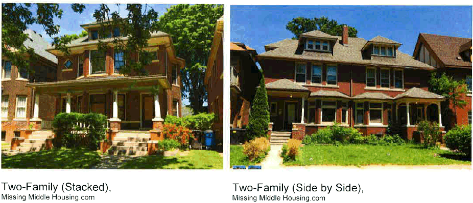
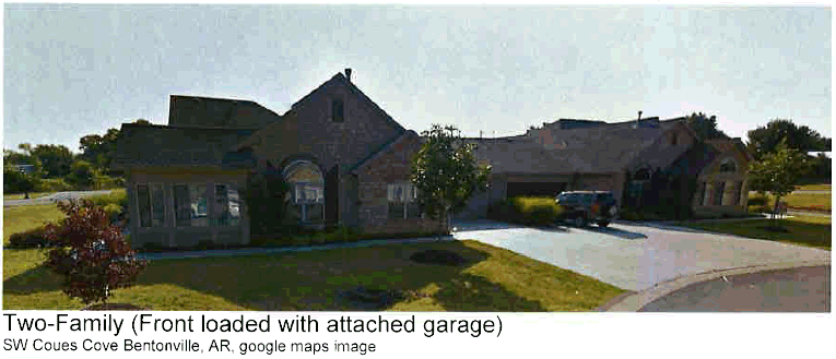
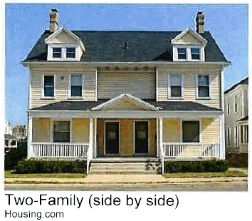
Examples of Three-Family, and Four-Family Residential Structures.
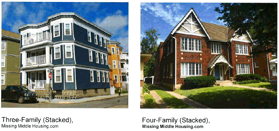
Design Standards for Two-, Three-, and Four-Family Residential Structures.
A.
Building design.
1.
For all units with a garage or carport, the garage or carport shall be placed behind the front building façade. Garages and carports may be attached or detached, and may be entered through an alley or back street.
2.
Each entry, whether combined or individual unit entries, shall be clearly visible from the public realm on each building.
3.
Each building façade shall have articulation; no façades containing only one plane shall be accepted.
4.
Each roofline shall include articulation (such as a gable, hips, dormers, etc.); no roof forms with an unbroken roofline shall be accepted. Exceptions for flat roofs may be allowed if the roof design includes architectural elements and is designed to meet structural and environmental code requirements.
5.
The front façade shall include windows with a minimum 15 percent coverage.
6.
Porches with a minimum six-foot depth and a minimum of 60 square feet in size, shall be required on the front façade of each building. Porches shall be allowed to encroach the front setback as long as they do not interfere with utility easements. The Building Official shall review all requests for encroachment.
a.
Only portions of the structure exclusively including an "open porch" section shall be allowed to encroach the setback. The front building face of the structure shall not be allowed to encroach the required setback. "Porch" shall be defined as a covered shelter, integrated with, or in front of, the entrance of a building. "Open Porch" shall be defined as having no walls on three sides. Railings shall be allowed on open porches.
7.
Internal or external gutter and downspout systems shall be required on all two-family and multifamily buildings.
8.
Exterior building materials:
a.
The primary material shall constitute at least 75 percent of each wall area, excluding glass.
b.
The primary exterior material shall consist of a combination of brick, textured concrete block, stucco, cement-based board or similar masonry product, wood, synthetic stone, or natural stone.
c.
Alternative materials may be proposed for approval by Planning Staff or Building Official unless the material is specifically prohibited in this section.
i.
Material sample board is required to be submitted when proposing any alternative materials.
ii.
The Planning Staff or Building Official have the authority to deny any alternative materials if they are found to be in conflict with the intent of this Code.
d.
No Masonite, asphaltic exterior wall or roof material, aluminum, or steel siding (other than approved architectural metal or composites), non-textured concrete block (ground-faced is allowed), vinyl, EFIS, pre-engineered metal buildings, or other similar materials shall constitute the primary exterior materials.
Building Design Sketch: Two-Family Residential Structures.
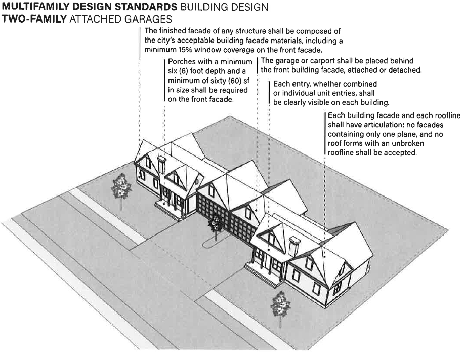
Building Design Sketch: Three- and Four-Family Residential Structures.
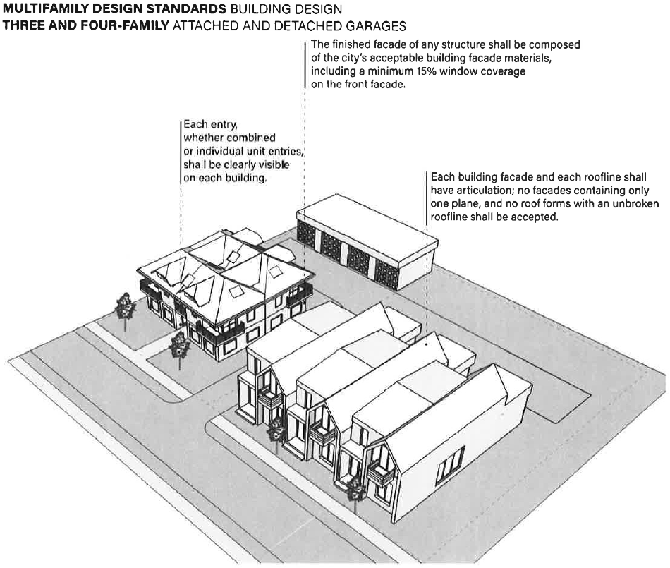
B.
Site planning.
1.
The front of each residential structure shall be oriented towards the street.
2.
All trash receptacle storage areas shall be screened. If the units are served by individual trash service, the two-family, three-family, or four-family units shall be designed in a manner that provides access to residents to store trash receptacles out of sight.
3.
Two-family, three-family, and four-family building façades shall be varied. There shall be a minimum of three alternative building façades or variation of materials before a repeat design may be utilized. In no case shall two identical building façades be placed adjacent to one another. The level of variation in building façade or materials shall be approved by planning staff.
4.
If shared driveways or alleys are proposed with any development, they shall comply with the current fire, building, and planning codes. The width of any shared alley or driveway shall be approved by the City Fire Chief, and additional width may be required at the fire chief's discretion. Any shared private driveways or alley(s) must be maintained by individual owners or a property owners' association.
5.
For rear or alley loaded units.
a.
Where rear or alley loaded, garage or carport may extend beyond rear façade. Setbacks for ancillary structures shall be five feet from the rear and side property lines. Shared garage or carport structures shall be allowed to have a zero-foot setback on the shared side of the structure.
b.
If the development is designed for rear trash pickup, additional width and structural requirements may be placed on the rear-loaded shared alleys or shared driveways.
6.
For two-family buildings with front-loaded driveways, garages, or carports, the driveway shall extend a minimum of 25 feet into the property from the master street plan right-of-way to allow parking to occur without encroaching into the right-of-way or obstructing the pedestrian access. For developments with private streets, there shall be a minimum of 25 feet clear behind the sidewalk. If there is no sidewalk, there shall be a minimum 25 feet clear from the back of curb or ditch.
7.
For three- and four-family buildings: A maximum of two drives per building is allowable. Sharing drives between buildings is encouraged. All parking shall be to the side or rear of the structure. The minimum parking areas required for residential units may not be located within the public street ROW unless specifically approved by the planning commission.
8.
Additional paved parking spaces for planned two-family, three-family, and four-family developments (more than 16 units developed) shall be required. The additional required parking may consist of on-street parking with delineated bump-outs on one side of the street (see special street sections), by adding additional parking within the parking area servicing the development, or may be accomplished with individual off-street parking areas dispersed throughout the development (see special street sections). Additional parking shall be evenly distributed throughout the development and shall be available within 250 feet of each residence. At least one additional parking space for every four units shall be provided in this manner.
a.
When utilizing the individual off-street parking areas or delineated on-street parking areas, the parking areas shall be constructed to the same standard as the street section, and included in the right-of-way (as per the street section).
b.
Ninety-degree parking spaces are preferred for the individual off-street parking areas, alternatives shall require additional engineering review. At least four parking spaces shall be required per parking area.
c.
If utilities are to be placed under the off-street parking areas, boxes and meters shall be set in a manner to be accessible and not within the pavement area.
9.
Clearly defined pedestrian walkways or paths, a minimum of five feet in width, shall be provided from parking areas that connect to the sidewalk system within the development.
Site Planning Sketch: Two-Family Residential Structures.
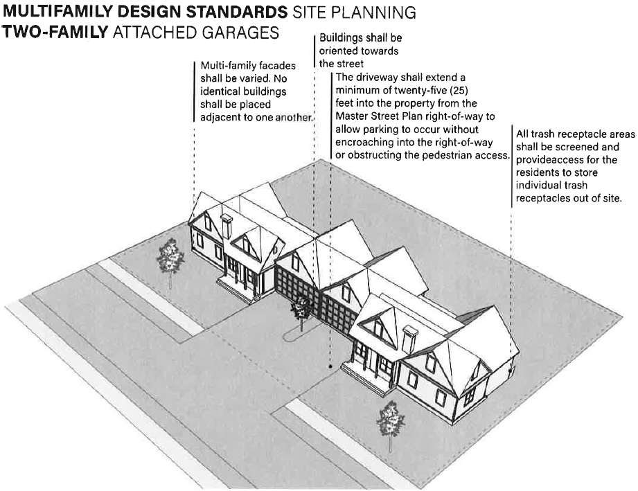
Site Planning Sketch: Three- and Four-Family Residential Structures.
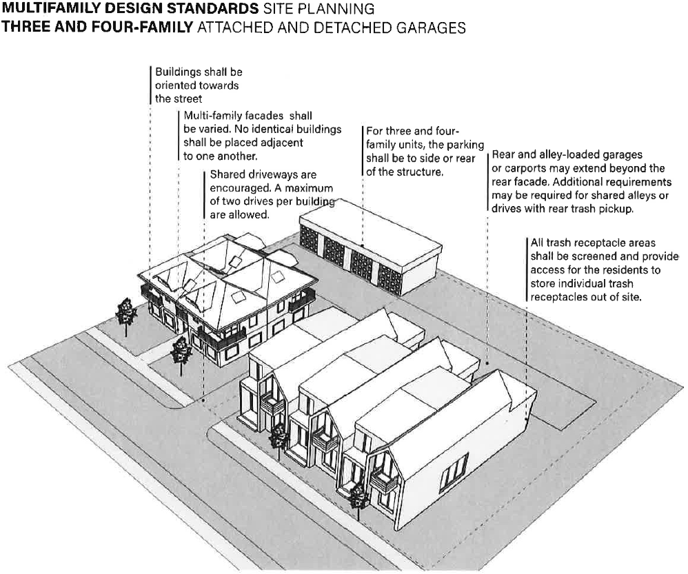
Additional Parking Example Sketch: Two-, Three- and Four-Family Developments.
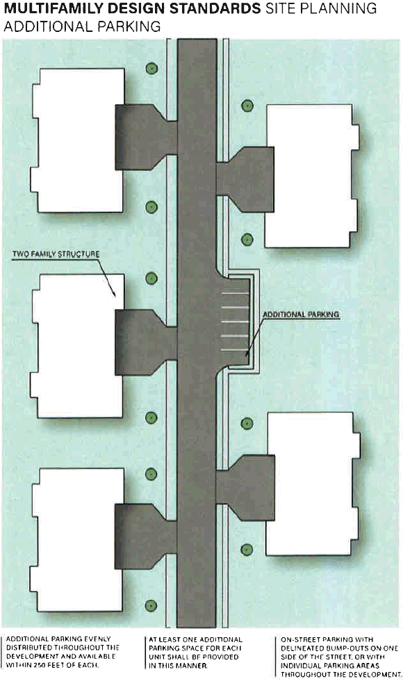
Additional Parking Example Sketch: Bellafont Gardens, Fayetteville, AR.
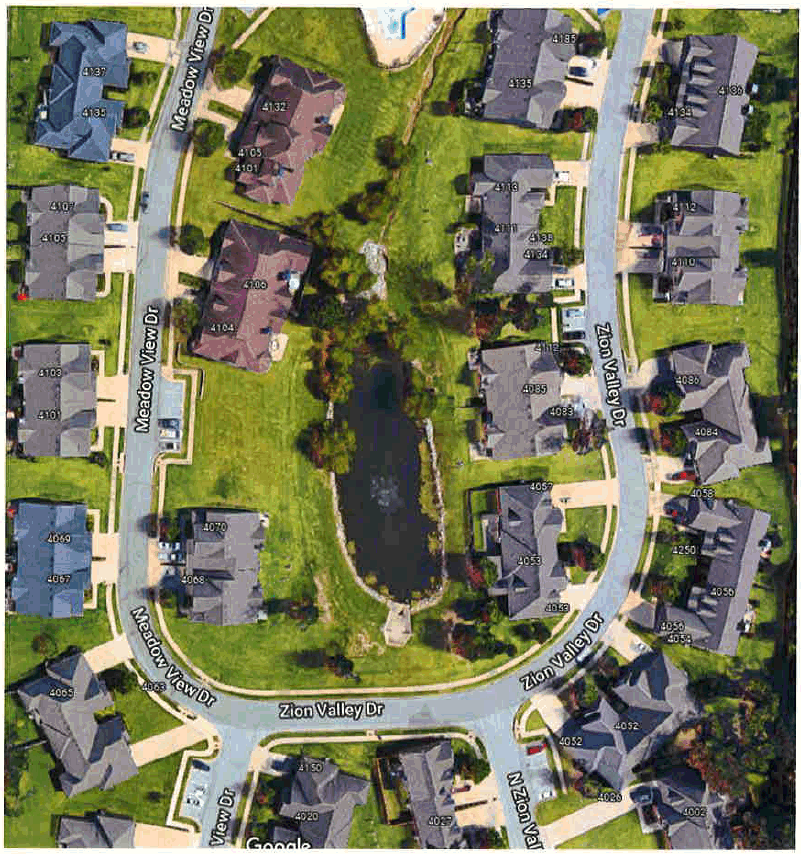
Typical Street Sections for Multifamily Developments to accommodate additional parking requirements:
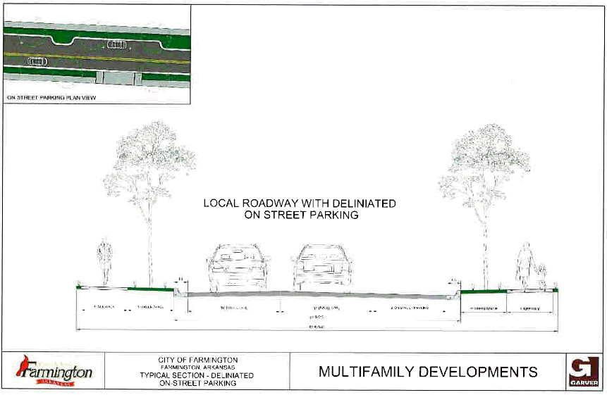
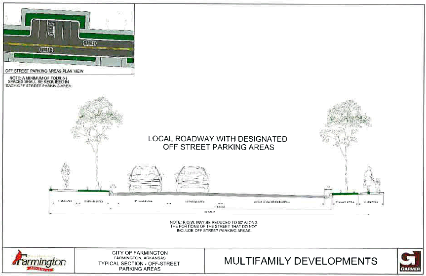
Five-Family and Greater Multifamily Residential Structures
(five or more attached units):
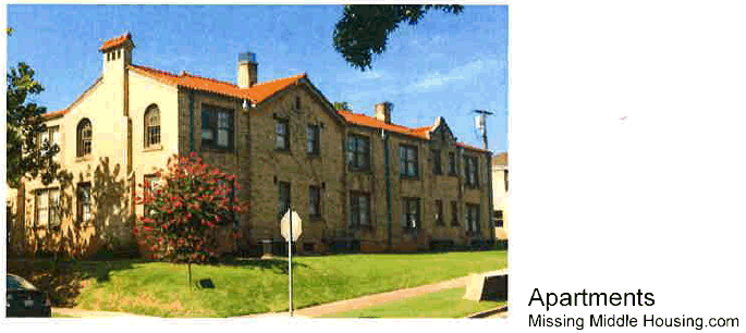
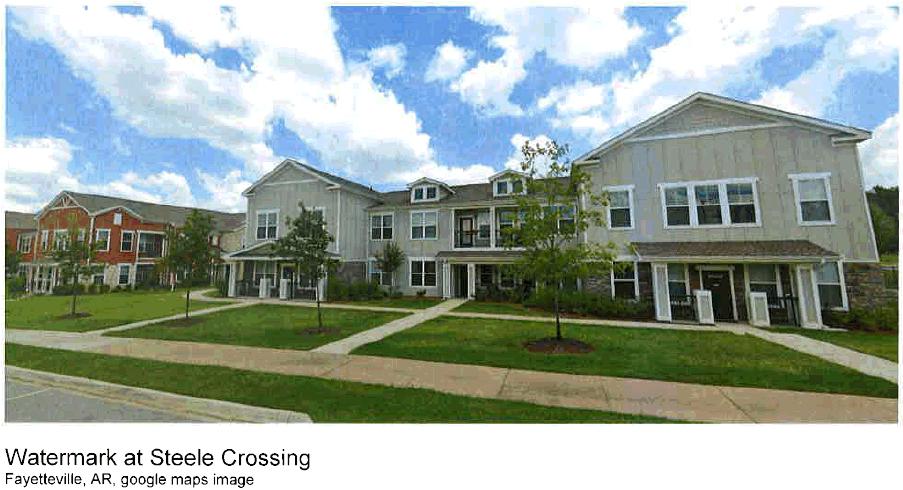
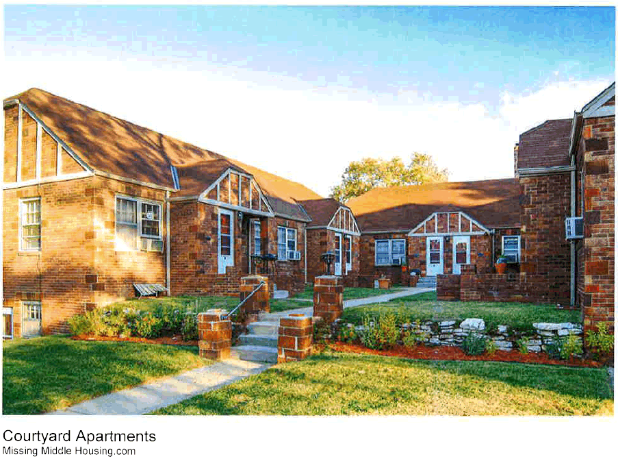
Design Standards for Five-Family and Greater Residential Structures
A.
Building design.
1.
Material.
a.
The primary material shall constitute at least 75 percent of all exterior wall areas, excluding glass.
b.
The primary exterior material shall consist of a combination of brick, textured concrete block, cement-based board, stucco, wood, synthetic stone or natural stone. The remaining exterior material shall be considered building trim.
i.
Trim is defined as an ornamental design feature, that when removed does not significantly alter the appearance of the building. This commonly consists of moldings, cornices, parapet, frieze, sills, lintels, stringcourse, quoining, and ledgment.
c.
No Masonite, asphaltic exterior wall or roof material, aluminum, or steel siding (other than approved architectural metal or composite), non-textured concrete block (ground-faced is allowed), vinyl, EFIS, pre-engineered metal buildings, or other similar materials shall constitute a portion of any building except trim.
2.
Scale and bulk.
a.
The height and scale of new buildings shall be consistent or compatible with the height and scale of adjacent buildings.
b.
Special care, however, shall be taken to achieve the compatibility of larger buildings next to small scale buildings; techniques shall include:
i.
Limiting building size.
ii.
Creating shadow patterns for depth.
iii.
Using building articulation to:
• Create a variety of scale relationships.
• Create the appearance or feeling of a residential scale.
• Constructing buildings that are sympathetic to a structure on an adjoining property.
iv.
Using a design technique or element that:
• Creates a human scale appropriate for a residential use.
• Prevents the construction of a structure in close proximity to a single-family residence zoning district that is significantly more substantial than a structure in a single-family residence zoning district.
• Allowing the construction of a structure, including a multifamily structure, that exhibits a human scale and massing that is appropriate for a residential use.
v.
The scale of the building shall also consider building setback, lot size and relationship to street width.
3.
Wall articulation.
a.
Buildings shall avoid long uninterrupted façade planes and/or blank walls.
b.
All non-single-family buildings with façades greater than 40 feet in length shall incorporate wall plane projections or recesses that are at least two feet in depth.
c.
At least 25 percent of the length of the façade must be cumulatively composed of either projections or recesses. No uninterrupted length of a façade may exceed 40 feet in length.
4.
Façades.
a.
All multifamily structures shall be architecturally finished on all sides with materials of a similar grade.
b.
The front façade shall include windows with a minimum 15 percent coverage.
5.
Roofs.
a.
Roof lines and/or parapets shall be varied with a change in height every 40 linear feet in the building length. Standing seam metal roofing may be permitted. Mansard, mock mansard, or barrel roofs are prohibited.
b.
Parapets, gable roofs, high roofs, or dormers shall be used to conceal flat roofs and rooftop equipment from public view.
c.
Exceptions for flat roofs may be allowed if the roof design includes architectural elements and is designed to meet structural and environmental code requirements.
d.
Alternative lengths and designs may be acceptable and may be approved by the planning commission.
6.
Entrances.
a.
Each primary building on a site, regardless of size, shall have clearly defined, highly visible from the public realm, entrances featuring no less than two of the following:
i.
Canopies or porticos;
ii.
Overhangs;
iii.
Recesses/projections;
iv.
Arcades;
v.
Raised corniced parapets over the door;
vi.
Peaked roof forms;
vii.
Arches;
viii.
Architectural detail such as tile work and moldings integrated into the building structure and design;
ix.
Integral planters or wing walls that incorporate landscaped areas and/or places for sitting; or
x.
Other architectural features approved by planning commission.
7.
Architectural details.
a.
All buildings shall be designed to incorporate no less than three of the architectural elements from the list below, in addition to regulations regarding the design of entrances above. For every additional floor above the ground floor, one additional architectural element shall be provided.
b.
Buildings with a footprint over 5,000 square feet shall include a minimum of five of the referenced architectural elements. Buildings with a footprint over 10,000 square feet shall include a minimum of six of the referenced architectural elements. For every additional floor above the ground floor, one additional architectural element shall be provided.
i.
Canopies, awnings, or porticos;
ii.
Recesses/projections;
iii.
Arcades;
iv.
Peaked roof forms;
v.
Arches;
vi.
Display windows;
vii.
Accent materials (minimum of 15 percent of exterior façade);
viii.
Architectural details (such as tile work and moldings) integrated into the building façade;
ix.
Articulated cornice line;
x.
Articulated ground floor levels or base;
xi.
Varied roof heights; or
xii.
Other architectural features approved by planning commission.
8.
Utility and mechanical equipment screening:
a.
Screening of service yards, banks of utility meters and hardware, mechanical equipment, outdoor storage areas, and/or other potentially unattractive places from public view, shall be accomplished by the use of walls, fencing, planting, or a combination of the measures that follow.
i.
Adjusting the architectural or landscape profile to screen those elements from view.
ii.
Placing those elements on service courts or other locations not generally visible to residents or viewed by the public.
iii.
Integrating those elements into the architecture or landscaping of the site.
b.
Screening shall be equally effective in the winter and the summer seasons.
c.
For rooftop equipment, parapet walls or other screening methods approved by Planning Commission, are required along street frontages and bordering residential areas.
d.
Internal or external gutter and downspout systems shall be required on all multifamily buildings.
9.
The degree of visibility and screening of service yards, utility meters and hardware, mechanical equipment, refuse areas, and/or other potentially unattractive places shall be evaluated using the following criteria:
a.
The degree of visibility from the public realm;
b.
The architectural compatibility of the design and color of the yards, meters and equipment of the building;
c.
Internal overall appearance in relation to the site; and
d.
If adjacent to and visible from single-family residential uses, single-family residential zoning categories, or other marginally compatible uses.
B.
Site planning.
1.
Building placement.
a.
Place as much of the building width at the front of the lot as possible to maximize front façade exposure to the public.
b.
The front façade shall generally be kept parallel with the street.
c.
On corner lots, place as much building mass near the intersection as possible to help anchor the lot and take advantage of high visibility.
d.
Courtyard developments shall be allowed.
i.
Courtyard developments shall comply with the building design standards in section A above, and applicable site planning standards in this section, section B.
ii.
Additional regulations are located within section D for courtyard developments.
2.
Parking placement.
a.
Five-family multifamily units and greater.
i.
Parking areas shall generally be kept to the interior of the site or sides of the buildings with the building façade along the street.
ii.
Parking for courtyard developments shall be to the side or rear of the structure. Access drives shall not go through the courtyard area.
iii.
If a private interior street is required for connectivity, parking may be placed along this street, but must be clearly defined by landscaped curb bump outs between buildings, or every ten parking spaces.
iv.
Parking may be covered or uncovered.
v.
The city's connectivity ordinance will apply to all multifamily developments.
3.
Pedestrian circulation.
a.
Clearly defined pedestrian walkways or paths shall be provided from parking areas to primary building entrances.
b.
Walkways shall be designed so that pedestrians have to cross parking aisles and landscape islands no more than necessary to reach building entries. Walkways shall be a minimum of five-foot-wide sidewalks.
c.
All internal walkways shall be distinguished from driving surfaces through the use of durable, low maintenance surface materials such as colored concrete, pavers, bricks, or scored concrete to enhance pedestrian safety and comfort, as well as the attractiveness of the walkways.
i.
Painted crosswalks shall not be considered sufficient definition of the pedestrian path from the driving surface.
4.
Dumpster Enclosures and Refuse Areas.
a.
Any dumpster or refuse areas shall be screened completely from view and consist of a masonry enclosure and access gate made of opaque material. Textured concrete block may be used, but non-textured concrete block is prohibited.
b.
Any dumpster or refuse area shall be located no closer than 15 feet from the fascia of any adjacent structure. Individual trash cans shall be located at least five feet from adjacent residential structures.
C.
Amenities.
1.
All multifamily developments with over 30 proposed or potential units (within the development) shall provide at least one of the following amenities. All amenities proposed shall be sized appropriately to meet the needs of the projected number of residents within the development, reviewed by Planning Staff, and shall be approved by the Planning Commission. It shall be the responsibility of the applicant to provide evidence that the amenity is sized appropriately:
a.
Swimming pool.
b.
Club house.
c.
Private park with at least one substantial piece of children's playground equipment, park benches, water fountains, and landscaping.
d.
Splash pad park.
e.
Sports facilities. Can included bocce courts, volleyball courts, basketball courts, tennis courts, soccer fields, disk golf course, or other facilities approved by the planning commission.
f.
In some cases, the following may be substituted:
i.
Dog park-sized appropriately with appropriate facilities (fencing, benches, water fountains);
ii.
Substantial hiking or biking trails with appropriate facilities (benches, water fountains); and/or
iii.
An alternative amenity approved by the planning commission.
2.
All multifamily developments with over 100 units shall provide at least two amenities. All multifamily developments with over 200 units shall provide at least three amenities. For every 150 units over 200, one additional amenity shall be required.
3.
These amenities shall be accessible to all residents, centrally located if possible, and accessible by internal walkways.
4.
All amenities shall be maintained by the apartment complex manager and/or owner.
5.
In phased developments, the amenities shall be constructed with the first phase.
D.
Courtyard development.
1.
Courtyard designs shall include a clearly defined courtyard area. The structure may be O, L, or U shaped. A distinct outdoor communal area (or series of areas) shall be provided to serve as a focus for the housing units, with individual entries to the living units provided from the courtyard areas.
2.
All units shall have direct access from the courtyard area or open to the courtyard when there are multiple stories. Additional access points shall be allowed.
3.
The courtyard shall be preserved as a semi-public area which is easily accessed from the street, with a prominent entry. At least a portion of the courtyard should be visible from the street. The courtyard is best located on the level of the street or a few feet above or below the street.
4.
The minimum dimensions of any courtyard area shall be 15 feet by 30 feet. The total courtyard area (or series of areas) shall occupy at least 50 percent of the required open space area for the development. Individual entry areas (a minimum of six feet in depth) into each unit shall be allowed to encroach the courtyard area, as long as the minimum dimensions of the courtyard area are maintained as community area.
5.
A minimum of 25 percent of the courtyard areas shall be landscaped, and shall include a minimum of one shade tree. Refer to the Landscape Ordinance for additional requirements.
Courtyard Development Example Sketch:
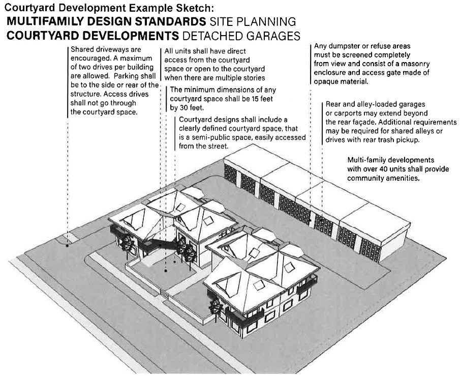
(Ord. No. 2014-10, §§ 1—3; Ord. No. 2023-08, §§ 1—3, 5-8-23)
Sec. 14.04.13. - Amendments.
Ord. No. 2017-1 That the zoning regulations should be and are hereby amended to allow the on-premise consumption of alcoholic beverages in dine-in restaurants, but not fast food and drive-in style restaurants, in C-1 and C-2 Commercial zoning districts and the Residential Office zoning district. The off-premise sale of alcoholic beverages shall be allowed in retail grocery stores, liquor stores and convenience stores in the 2 zoning district and as a conditional use in the C-1 zoning district.
Sec. 14.04.14. - Statement of purpose.
The requirements set forth herein are enacted to: promote the health and safety of the citizens of Farmington; make the City more attractive by establishing standards for landscaping of new developments or additions in certain zones; prevent unnecessary removal and damage of native and specimen trees during construction; prevent unnecessary grading of land during construction; provide for tree, plant, and other natural vegetation material replacement; provide visual screening and sound buffers; screen incompatible land uses; improve air quality; slow or prevent storm water runoff; enhance appearance of parking lots; provide enhanced habitat for wildlife; provide option of establishing parks within developments; and ensure compliance with these standards in new developments and renovations.
(Ord. No. 2016-01, § 1(Exh. A), 5-16-16)
Sec. 14.04.15. - Jurisdiction.
The jurisdiction of this ordinance shall include all land within the city limits of Farmington, Arkansas, and any land added to the city limits after the adoption of this ordinance.
(Ord. No. 2016-01, § 1(Exh. A), 5-16-16; Ord. No. 2023-14, Exh. A, 10-9-23)
Sec. 14.04.16. - Applicability.
The requirements of this ordinance shall apply in full, after the date that this ordinance is adopted, to:
(1)
Zoning Districts for which a building permit is required by the City of Farmington for new construction or addition to an existing structure.
(2)
New parking lots or expansion of existing parking lots in any zone which increases parking spaces to 60 or more spaces, or to parking lots with fewer than 60 spaces, when Planning Commission deems necessary for improved control and safety of pedestrians and motorists.
(3)
Landscaped entryway or other individual lot landscaping for residential developments is OPTIONAL. However, if used, the requirements of this ordinance shall be adhered to.
Exemption from this Ordinance: Any individual who purchases, builds, or remodels a single-family home located in any zoning district is exempted from all requirements of this ordinance.
(Ord. No. 2016-01, § 1(Exh. A), 5-16-16; Ord. No. 2023-14, Exh. A, 10-9-23)
Sec. 14.04.17. - Landscape site plan requirements.
A scaled Landscape Plan prepared by a landscape company or a licensed landscape architect shall include:
(1)
Nine copies of the Landscape Plan in a 24" x 36" format to the City of Farmington Planning Commission for review and plan approval.
(2)
Development project title with names and contact information of project planner, developer, owner, landscape architect or landscaper, scale, date, legend, North Arrow, and general vicinity map indicating existing land uses abutting all boundaries of the proposed development.
(3)
Street Frontage Buffer and Perimeter Side and Back Buffer and any required Parking Lot Buffer, with landscaping area marked with legend symbols for proposed landscaping, right of way, and easements. See section 14.04.19, section 14.04.20, and section 14.04.22 for specific requirements.
(4)
Landscaped areas immediately adjacent to front side of building(s). See section 14.04.21, Landscaping requirements immediately adjacent to building(s).
(5)
Location of existing larger trees with a DBH (diameter at breast height) of eight inches or greater located within required street buffer planting area(s), required side and rear buffers, parking lot, and other open areas. Trees preserved and trees requested to be removed shall be clearly indicated. (Saving one existing tree with DBH 8" or greater, results in three fewer new trees being required.)
(6)
Description of barrier protection that shall be used around preserved vegetation during construction.
(7)
List of proposed vegetation with common name, variety and size of container or tree trunk diameter. See section 14.04.28 for suggested hardy landscape materials suitable for Northwest Arkansas Planting Zone 6b.
(8)
Planting and installation details for shrubs and trees to ensure conformance with required standards of this ordinance.
(9)
Location and description of other proposed or existing landscape improvements such as sidewalks, walls, fences, screens, earth berms; storm water collection facilities (such as rain gardens and detention ponds); sculptures, statues, fountains, street furniture, outdoor lighting, courtyards, or other paved areas.
(10)
Location of existing and proposed physical features such as easements, streets, utilities, buildings, signs, and waterways.
(11)
Location of trash/refuse bin(s), service bays, loading areas or docks, outdoor storage areas, mechanical equipment, walk-in coolers, and description of proposed required screening. See section 14.04.23.
(12)
Type of irrigation system(s). Include details such as spray, drip, or other type of irrigation (such as manual irrigation using a frost-proof hydrant). Irrigation systems shall have a backflow preventer installed per the current Arkansas Plumbing Code and shall be installed by a licensed plumber. (No irrigation shall be required for undisturbed natural areas and existing trees.)
(13)
Developer's performance bond that shall guarantee all plant material shall be planted in accordance with this ordinance and that survival shall be warranted for 24 months from date of installation; and if any plant materials fail to survive during that 24 month period, they shall be replaced within the time period required in this ordinance. See section 14.04.26.
(14)
Parking and/or storage location of any service vehicles, portable machinery and equipment, large tools, construction equipment, food cooking devices, or other business-related equipment, and type of required screening that will shield them from public view.
(Ord. No. 2016-01, § 1(Exh. A), 5-16-16)
Sec. 14.04.18. - General provisions.
(a)
Permits for building, paving, utilities, or construction shall not be issued until a Landscape Site Plan including all required information is approved by the Planning Commission. The Landscape Site Plan must be submitted with the Site Plan.
(b)
Because a very minimal number of trees, shrubs, and other vegetation are required by this ordinance, massing, clustering, or grouping of required number of trees, shrubs, and/or grasses adds visual interest and is encouraged. Groupings shall be integrated into a planting bed or in a curbed area for easier maintenance and neater appearance.
(c)
All landscaping design plans shall be designed with public safety in mind. Landscaping shall not interfere with motorist or pedestrian visibility and safety.
(d)
Landscaping shall not interfere with the general function, safety, or accessibility of any gas, electric, water, sewer, telephone, television cable, or other utility easement; fire hydrant, traffic sign, or traffic signal.
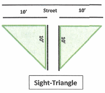
(e)
Sight-Triangle requirements for commercial entryway, (if utilized.) Sight-Triangle shall measure ten feet along the entryway and ten feet along the Public Street or Highway.
Vegetation planted within sight-triangle shall be a maximum 30 inch height at maturity. Trees may be planted if limbs are pruned up to provide clear view of traffic for pedestrians and motorists.
(f)
Street and highway rights-of-way shall be restored and maintained with turf grass or other vegetative ground cover such as low-growing juniper.
(g)
Landscaped areas shall be equipped with an automatic sprinkler system or must be provided with a means to manually irrigate newly planted shrubs and trees using a frost proof yard hydrant. Irrigation systems shall have a backflow preventer installed per the current Arkansas Plumbing Code and shall be installed by a licensed plumber. No irrigation shall be required for undisturbed natural areas and existing trees.
(h)
Required landscape areas shall not include artificial trees, shrubs, plants, synthetic mulch, or any synthetic carpeting designed to mimic grass unless specifically approved by the Planning Commission.
(i)
Preservation of existing vegetation:
(1)
As is practical, do not remove healthy, disease-free vegetation and environmentally sensitive or significant natural areas such as woodlands, prairie, and wetlands located on the development site.
(2)
By preserving healthy existing trees with an eight inch diameter or larger, the number of required new trees and/or shrubs shall be reduced by a ratio of 1:3 after review and approval of developer's tree preservation proposal by Planning Commission.
(3)
Before construction work begins, preserved trees shall be protected by installation of protection barriers at drip-line of tree to prevent tree root compaction and destruction during building construction. The barriers may be removed as necessary for final job completion. Other preserved vegetation shall be clearly marked with colored tape and flags.
(4)
Grading and removal of soil shall not occur within the drip line of preserved tree(s).
(5)
Any type of construction debris or chemicals shall not be placed within 25 feet of preserved trees.
(j)
Trees, Shrubs, and Plants Size Requirements and Planting Requirements. Trees, shrubs, and plants shall be:
(1)
Appropriate for the soil, sunlight, and soil-moisture conditions in which they are planted thus resulting in low maintenance, high-quality design, with limited water requirements. Vegetation native to the area is encouraged.
(2)
High-quality, nursery-grown stock of healthy condition that meets the American Association of Nurserymen standards as specified by the American National Standards Institute in ANSI Z60.1-1986, or as may be amended in the future.
(3)
Planted in sufficient nutrient-rich soil and covered with weed barrier cloth (not plastic sheeting).
(4)
Planted in protected areas where vehicular traffic shall not compact the soil in trees' root-spread area. A minimum of 25 square feet of permeable ground surface area per tree is recommended.
(k)
Minimum size for trees, shrubs and other vegetation at planting.
(l)
Recommended that this hazardous and/or invasive vegetation not be planted.
(m)
Mulch and/or Groundcover Requirements and Prohibitions:
(1)
Planting beds shall be mulched with hardwood mulch to three inch depth in all areas where there is no grass or evergreen groundcover.
(2)
Grass and/or evergreen groundcover may be used and in combination with mulch.
(3)
Owner shall supplement mulch annually to maintain a three inch depth.
(4)
Prohibited Mulch: Rocks, pebbles, white chat, gravel base material, lava rock, shredded rubber, asphalt, concrete, brick pavers, cement pavers. (Exception: brick or cement pavers may be used in a landscape design as stepping stone walkways.)
(5)
Recommended that this hazardous and/or invasive groundcover not be planted.
(Ord. No. 2016-01, § 1(Exh. A), 5-16-16)
Sec. 14.04.19. - Street frontage buffer landscaping in commercial (C-1), commercial (C-2), multifamily-1 (MF-1), multifamily-2 (MF-2), residential office (R-O), mobile home park (MHP), and industrial (I) zoning districts.
(a)
Purpose. Enhance the overall appearance of the City of Farmington; Provide a landscaped transition from the public right-of-way to private property buildings and parking lots; Provide a visual buffer from projecting headlights that might interfere with the vision of passing motorists and pedestrians; Improve the appearance of parking lots located adjacent to a public right-of-way; Encourage preservation of existing trees and other existing vegetation.
(b)
General Provisions.
(1)
Several Street Frontage Buffer options may be combined to meet the particular site constraints of the development.
(2)
Within each 15 feet depth and 30 linear feet of highway or street frontage, the required minimum number of trees and shrubs may be spaced separately, or may be grouped for most attractive appearance. Due to minimal number of trees and shrubs required, grouping them within each 30 foot area is strongly encouraged instead of spacing equally.
(3)
For a corner lot with two street/highway rights-of-way, the main street frontage shall be planted using Street Frontage Buffer - Main Street requirements. (See section 14.04.19(c), (e), and (f))
The lesser, side-street shall use Street Frontage Buffer - Side Street which has fewer requirements. (See section 14.04.19(d))
(4)
Remaining side and rear shall use Landscaped Perimeter Buffer requirements.
(5)
For visual interest developer may plant a variety of shade trees, ornamental trees, and/or conifer trees. (See suggested lists at section 14.04.28).
(6)
Every effort shall be made to preserve existing healthy native trees of eight inch or larger diameter within the street frontage buffer area unless preservation creates traffic hazards.
(7)
Preserved existing trees of eight inch diameter or larger may be substituted for three new trees that may be required anywhere in the landscape plan.
(8)
Developer may choose from any combination/ type/ variety of shrubs. (See lists at section 14.04.28).
(9)
Curbs shall be used around planting beds for easy maintenance and must utilize fabric weed barrier and wood mulch and/ or vegetative groundcover applied according to the standards in 14.04.18(m).
(10)
Commercial entryway(s) vegetation planted within three feet of the right-of-way shall have maximum 30 inch height at maturity. Trees may be included if limbs are pruned up to provide clear view of traffic for pedestrians and motorists. At landscaped entryways all Sight-Triangle Requirements shall apply. See section 14.04.18, General Provisions, (e) Sight-Triangle Requirements.
(11)
Designated parking and loading areas shall be used exclusively for the parking and loading of vehicles and shall not be used for the sale, lease, display, repair, or storage of vehicles, trailers, boats, campers, mobile homes, merchandise, earth-moving equipment, farm equipment, cooking equipment, or other business-related items.
(12)
Chain link fencing and any other type of wire fencing shall not be allowed.
(c)
Street Buffer—Main Street Requirements: Fifteen foot depth by each 30 linear feet:
(1)
One shade tree with two and one-half inch diameter at four and one-half feet above the ground, OR one ornamental tree with one and one-half inch diameter at four and one-half feet above ground, OR one conifer (evergreen) tree a minimum of four feet tall at planting.
(2)
Five shrubs (two gallon size, minimum).
(3)
Perennial ornamental grasses, perennial plants, flowering plants, and other vegetation may be added at landscaper's discretion.
(4)
Mulch and/or groundcover shall be used.
(d)
Street Buffer—Side Street Requirements: (Required if property is a corner lot)
Ten foot depth by each 35 linear feet:
(1)
One shade tree with two and one-half inch diameter at four and one-half feet above the ground, or one ornamental tree with one and one-half inch diameter at four and one-half feet above ground, or one conifer (evergreen) tree a minimum of four feet tall at planting.
(2)
Three shrubs (two gallon size minimum).
(3)
Perennial ornamental grasses, perennial plants, flowering plants, and other vegetation may be added at landscaper's discretion.
(4)
Mulch and/or groundcover shall be used.
(e)
Street Buffer Option 2—Wall Buffer.
(1)
Minimum three foot high reinforced wall composed of brick, stone, stucco, or other finished concrete treatment. Walls taller than three feet shall be designed by a structural engineer to ensure safety. Wrought iron fencing may also be used.
(2)
Minimum wall setback. Setback from city, county, or state right-of-way shall be determined by regulations of City, County or Arkansas State Highway Department to assure clear visibility.
(f)
Street Buffer Option 3—Landscaped Earth Berm.
(1)
May be used if it does not create flooded roadways and walkways, and does not impede view of pedestrian and vehicular traffic.
(2)
Required number of trees, shrubs, perennial ornamental grasses, and other vegetation shall be placed in the landscaping design as best provides attractive street buffer while maintaining a clear view for motorists and pedestrians.
(3)
Maximum vegetation height shall be 30 inch in height at maturity anywhere within berm where pedestrian or motorist view might be blocked.
(4)
If landscaped entryway is used, sight-triangle requirements at entryways shall be followed. See section 14.04.18, General Provisions, (e) Sight-Triangle Requirements.
(5)
To prevent erosion, at least 50 percent of groundcover on berm shall be turf grass and/or evergreen groundcover with any remaining bare ground covered with mulch.
(Ord. No. 2016-01, § 1(Exh. A), 5-16-16)
Sec. 14.04.20. - Landscaped side and back perimeter buffer requirements in commercial (C-1), commercial (C-2), multifamily-1 (MF-1), multifamily-2 (MF-2), residential office (R-O), mobile home park (MHP), and industrial (I) zoning districts.
(a)
Purpose. Perimeter landscaping, a landscaped strip along side and rear lot lines that separates land uses /or properties; prevents two adjacent commercial lots from becoming one large expanse of pavement; provides visually attractive separation between properties in densely developed areas; protects residential zones by providing noise abatement, prevents glare from headlights and property lighting, and provides privacy.
(b)
General Requirements.
(1)
When adjacent to non-residential-zoned property, side buffer shall extend from street frontage to front edge of building, but may be farther back at builder's discretion.
(2)
Landscaped side perimeter buffer is required to extend entire length of side property line(s) when property is adjacent to residential zone. (See ((b)(6)) below)
(3)
If land behind a commercial property is adjacent to another commercial use zone, no fencing or landscaping is required.
(4)
If land behind a commercial property is adjacent to any residential zone, a six foot privacy fence shall be required.
(5)
The Landscaping Plan for all proposed development shall show side and back perimeter landscaping in addition to landscaped street frontage buffer and interior parking lot landscaping.
(6)
Special Side and Rear Perimeter Screening Requirements When Residential Use Is Adjacent To Commercial Use:
a.
Developer shall provide complete screening by means of a privacy barrier (wall or wood privacy fence) a minimum of six feet in height and landscaping in front of fence to provide noise abatement.
b.
Landscaping in front of the barrier shall consist of as many trees and shrubs as necessary, and of suitable size and density to provide 60 percent coverage of the physical barrier within two years of planting.
c.
Tree preservation. Existing shade trees with diameter of eight inches or greater may be included as part of the vegetative screening requirement in a ratio of one preserved tree to three new trees.
(c)
Landscaped Perimeter Buffer Minimum Requirements - per 35 linear feet (grouping of vegetation within each 35 foot increment is strongly suggested)
(1)
One shade tree - two and one-half inch diameter (minimum) at four and one-half feet above the ground OR One ornamental tree - one and one-half inch diameter (minimum) at four and one-half feet above the ground OR one conifer (evergreen) tree a minimum of four feet tall at planting.
(2)
Three shrubs - two gallon size.
(3)
Curbing of landscaped areas is not required in Side or Back Perimeter Buffer areas.
(4)
Mulch/Groundcover. New plantings in perimeter landscaped areas shall be mulched. Preserved existing vegetation does not require mulch. (See section 14.04.18(m), Mulch and/or Groundcover Requirements and Prohibitions)
(5)
Massing/ Grouping/ Clustering of all required vegetation, trees, grasses and/other plantings is encouraged, for most increased visual impact.
(d)
Vehicular access. The perimeter landscaping requirement does not preclude the need for vehicular access to be provided between adjacent lots and allowance may be made as necessary, with approval of Planning Commission.
(Ord. No. 2016-01, § 1(Exh. A), 5-16-16)
Sec. 14.04.21. - Landscaping requirements immediately adjacent to building(s) front.
Plant shrubs, perennial ornamental grasses, perennial plants, or other vegetation in curbed planting beds immediately adjacent to building, spanning a minimum of one-fourth of total building frontage. Plantings may be arranged in any configuration to best suit the building's operation. Additional plantings at sides of building(s) are at discretion of builder or owner.
(Ord. No. 2016-01, § 1(Exh. A), 5-16-16)
Sec. 14.04.22. - Parking lot landscaping in commercial (C-1), commercial (C-2), multifamily-1 (MF-1), multifamily-2 (MF-2), residential office (R-O), mobile home park (MHP), industrial (I) zoning districts, and residential (if applicable).
(a)
Purpose. To improve appearance of parking lot; to create a safe parking area for pedestrians and motorists; where feasible, to preserve existing trees, or plant new trees to provide shade; to provide buffer from headlight glare and noise between adjacent properties, and to ensure privacy of residents living adjacent to parking areas.
(b)
Applicability. Zones include: Commercial (C-1), Commercial (C-2), Multifamily-1 (MF-1), Multifamily-2 (MF-2), Residential Office (R-O), Mobile Home Park (MHP), and Industrial (I). Parking lot islands and landscaping requirements shall apply to any new development or addition for which a parking lot is required with 60 spaces or greater and which requires a building permit from the City of Farmington.
(c)
General Provisions.
(1)
Each island shall be landscaped with a minimum of one hardy shade tree OR ornamental tree, or low-maintenance shrubs unless waived by Planning Commission due to safety purposes.
(2)
Landscaping shall not block motorist or pedestrian view.
(3)
Landscape design of parking island areas may vary based on layout restrictions of the property.
(4)
Preservation of large, healthy existing trees eight inch diameter or larger is encouraged and will be applied toward required tree substitution of one existing tree for three new trees.
(5)
Minimum size of shade trees and ornamental trees at planting shall be:
Shade tree: two and one-half inch diameter at four and one-half feet above ground.
Ornamental tree: one and one-half inch diameter at four and one-half feet above ground.
(6)
Hardwood mulch, turf grass and/or evergreen groundcover shall be used in each island.
(7)
When Planning Commission waives tree/shrub requirement due to safety considerations, parking island shall be landscaped with turf grass, low ornamental grass, groundcover, mulch, or a combination of these.
(d)
Special Screening Standards for Parking Lot Adjacent To Residential Uses. Commercial development adjacent to a residential use, shall meet increased landscaping standards to minimize noise and light glare and to ensure residents' privacy
(1)
Physical barrier to provide full screening shall be a minimum of six feet in height and may consist of wood or masonry fencing, rock or brick walls, berms, or a combination of these methods. Berm construction shall not be used if it will cause flooding.
(2)
Trees and/ or shrubs shall be placed in front of the barrier (on commercial development side) to reduce parking lot noise.
(3)
Trees and/or shrubs planted shall provide 60 percent coverage of the physical barrier within two years.
(4)
At least one-fourth of the trees and shrubs shall be of an evergreen type that maintain leaves year round.
(5)
Tree preservation. Existing healthy shade or specimen trees with diameter of eight inches or greater and existing large shrubs may be included as a portion of the landscape screening, reducing required new trees in ratio of one existing tree for three new trees.
(Ord. No. 2016-01, § 1(Exh. A), 5-16-16)
Sec. 14.04.23. - Auxiliary landscaping/ shielding/ screening requirements.
(a)
Detention Pond and Water Quality Pond Landscaping:
(1)
Several areas around detention pond shall be provided with low shrubs or grass plants for better appearance.
(2)
Pond landscaping plants or shrubs shall be of a type and variety that prevents clogged drains.
(b)
Trash/Refuse/Garbage Storage Areas Screening:
(1)
Shall be located behind the building unless Planning Commission approves another location.
(2)
Shall be located a minimum of 50 feet from any residential or multifamily zoned property.
(3)
Shall be screened a minimum of five feet high on all sides by walls constructed of materials matching the primary building, masonry or by wood fencing, and shall have a secure access gate.
(4)
PROHIBITED: All types of chain-link fence screening and plain, unembellished concrete block walls.
(5)
Shall be located on a reinforced concrete slab a minimum of six inches thick and sloped to drain.
(6)
Shall be landscaped with some type of vegetation planted in front of sides seen from street, highway, or adjacent residential dwellings. Vegetative screening shall be equally effective in all seasons of the year.
(c)
Mechanical Equipment Screening:
(1)
All roof, ground, and wall-mounted mechanical equipment such as air handling equipment, compressors, ductwork, transformers and elevator equipment located within 150 feet of a street or highway right-of-way, residential housing, or public park areas, shall be screened from view or positioned so that they are not highly visible.
(2)
Wall- or ground-mounted equipment shall be screened by any combination of: vegetative screening, brick, stone, reinforced concrete, stucco, or other similar masonry materials; or other materials that match the primary building, and allow proper ventilation and service access.
(d)
Loading dock screening when located adjacent to all Residential, MF-1, MF-2, R-O, or MHP zoning districts, or can be viewed from a street or highway:
(1)
Shall be located at the side (toward the back of structure) or rear of building.
(2)
Shall not be located closer than 50 feet to any residential zone, unless loading dock area is wholly enclosed within a building.
(3)
Shall be screened on all visible sides by a wall with exterior finish similar to primary structure, and with vegetative screening that will be a minimum of seven feet at maturity.
(e)
Walk-in Cooler Screening:
(1)
Shall be structurally integrated into the primary structure by screening walls with exterior finish similar to primary structure.
(2)
Vegetative screening with minimum height at maturity of seven feet shall be planted in front of any screening walls that are visible from residential areas and roadways.
(3)
Alternative, innovative screening combinations shall be considered by Planning Commission.
(f)
Merchandise Displayed for Sale: In C-1 and C-2 zoning districts, merchandise displayed for sale must be located behind the 15 foot depth Street Frontage Buffer. This provision shall apply to new and existing commercial properties.
(g)
Protection of Public Safety and Welfare: Whenever deemed necessary to protect the aesthetic value of property being developed, or adjoining or nearby properties, and to otherwise promote public health, safety or welfare, the Planning Commission shall specify additional conditions.
(Ord. No. 2016-01, § 1(Exh. A), 5-16-16)
Sec. 14.04.24. - Landscaping of residential development entryway(s).[1]
(a)
Purpose. Landscaping is an integral, planned component of residential subdivisions that promotes the development, increases property values, defines major entryways, defines vehicular and pedestrian roadways, and enhances the overall aesthetic qualities. Landscaping in a residential development provides landscaped buffer screening from adjacent, more intensive or incompatible land use areas or vehicular traffic.
(b)
Landscaping Requirements. The Landscaping Plan for a residential development shall show landscaping of entryway(s), neighborhood park(s), Street Frontage Buffer, and/or designated interior public parking lots.
(1)
A landscaped Street Frontage Buffer, if included, shall meet these landscaping guidelines:
a.
Minimum depth of 15 feet from street right-of-way.
b.
Trees minimum of one shade tree with a two-and-one-half inch diameter minimum, OR one ornamental tree with a one-and-one-half inch diameter minimum) OR one conifer of four-foot minimum height, per 30 linear feet.
c.
Shrubs, perennial ornamental grasses, and perennial flowering plants are optional but are encouraged.
d.
Groundcover may be turf grass or other allowed groundcover listed in section 14.04.18(m).
e.
Vegetative materials may be grouped together for optimal aesthetic impact.
(2)
Residential Development landscaped entryway(s) may be provided at some, or all, entryways in a development. The main goal shall be to provide a safe, aesthetically pleasing, low-maintenance, and drought-resistant entryway.
(3)
Sight-Triangle size. Sight-Triangle distances at the intersection of a public street and a residential development entryway shall be of a size distance that ensures safety of pedestrians, bicyclists, and motorists.
(4)
Public interior parking lots, if created, shall meet the requirements set forth in section 14.04.22 - Parking lot landscaping requirements.
(c)
Fences, Walls, and Hedges. Notwithstanding other provisions of this ordinance, fences, walls or hedges may be located at residential development entryways and/or along property lines. Unless otherwise specifically provided for, fences must be constructed and maintained in accordance with the following regulations:
(1)
Fencing may consist of materials such as masonry, brick, rock, stucco, wrought iron, or wood, or any combination of these materials. Fencing shall be utilized or installed in a manner that shall not cause injury to the general public.
(2)
Barbed wire and other wire fencing is absolutely prohibited in residential developments unless the barbed wire or other wire fencing is utilized by adjoining property owner(s) to contain livestock.
(3)
Residential fencing adjacent to street frontage must meet City Building Setback Requirements.
(Ord. No. 2016-01, § 1(Exh. A), 5-16-16)
Note— (These requirements apply only when developer chooses to incorporate an entryway into the residential plan.)
Sec. 14.04.25. - Parkland dedication.
(a)
Title. This title shall constitute the parkland dedication regulations of the city of Farmington. It shall be known and cited as the Parkland Dedication Code. It consists of the text, which follows, as well as the Parks Master Plan for the city of Farmington, Arkansas, on file in the office of the City Clerk.
(b)
Authority. These regulations are adopted pursuant to authority granted by the Arkansas General assembly in Title 14, Chapter 56, Subchapter 4 of the Arkansas Code of 1987 annotated, as amended. All membership in the various boards and commission having authority hereunder, acting prior to the effective date of this article shall remain in office and serve the remainder of their respective terms.
(c)
Purpose.
(1)
Parks provide health and wellness through recreational opportunities, social engagement, neighborhood community building, nature education, nature preservation, increased neighborhood and city property values, and they contribute to overall quality of life.
(2)
The primary purpose of the parkland dedication code is to ensure the need for parks arising from new residential developments is satisfied so those generating the need for park areas and recreation facilities contribute their proportionate share. In some instances, the need for parks and park improvements resulting from new development may be addressed most effectively through the development and acquisition of community or regional parks, or the improvement or expansion of an existing park servicing existing development or the entire city.
(d)
Jurisdiction. Property located within the legal city limits of the city of Farmington, Arkansas.
(e)
Applicability. The requirements of this article apply to:
(1)
Residential subdivisions (single-family, two-family, and multifamily).
(2)
Residential developments (single-family, two-family, and multifamily) where more than one residential structure is being constructed on one lot.
(3)
Exemptions:
a.
Unbuildable lots (lots upon which residential structures cannot be constructed) within residential subdivisions and developments (examples: detention and retention pond lots, a lot created for a lift station, a green buffer strip by a heavily trafficked road).
(f)
Parkland Dedication Determination Process.
(1)
The developer or representative shall meet with the City Business Manager, or designee, as to the preferred location, amount of parkland, or fee-in-lieu required.
(2)
The City Business Manager, or designee, shall make a recommendation based upon Farmington's Parks Master Plan as adopted by the city, and the standards and provisions contained herein, to the Planning Commission and City Council concerning the amount and location of parkland, and/or fee-in-lieu of parkland dedication. In the event the developer and City are unable to agree, each is to make separate recommendations to the above Boards who shall determine the matter.
(3)
At Preliminary Plat or LSD approval, the amount of parkland or fee-in-lieu of shall be approved by the Planning Commission and City Council.
(g)
Types of Dedication.
(1)
Physical Property Conveyance. Defined as when land is conveyed per code requirements. The land dedication ratio shall be as specified per section (h)(1) of herein code.
a.
On-Site Conveyance by Plat. Defined as when land contiguous to a subject property is conveyed.
b.
Off-Site Conveyance by Deed. Defined as when land not contiguous to the subject property is conveyed by a filed deed.
1.
As subject to the following:
i.
The property to be dedicated would serve the subject development per the adopted Parks Master Plan, and the Parkland Dedication code.
ii.
A deed with an exhibit in accordance with the parkland plat requirements is properly filed with the Washington County Assessor's office. The property shall be deeded in whole; granting of easements over property shall not suffice as parkland dedication.
(2)
Fee In-Lieu of Parkland Dedication. Defined as when money is conveyed in lieu of land.
a.
The monetary dedication ratio shall be as specified per section (h)(2) of herein code.
b.
The city may, at its option, require fee-in-lieu under any of the following circumstances to satisfy parkland dedication and park development:
1.
If the city determines it would be better served by expanding or improving an existing park; or
2.
If the density of an existing development is being increased and the city determines that parkland dedication requirements would make development of the subject lot unreasonable; or
3.
If the city determines that proposed parkland will not meet the needs of the city's Park Plan or is not in the best interest of the city.
(h)
Dedication Ratios and Payments.
(1)
Ratios for Land Dedication. Land shall be dedicated at a ratio of 0.023 acre of land for each single-family dwelling unit and 0.020 acre of land for each two-family and multifamily dwelling unit. Land including streets shall not be considered as land for park dedication.
(2)
Fee Payment In Lieu of Land Conveyance. In lieu of land dedication, developer shall contribute to Farmington's Parkland Fund $900.00 for each single-family dwelling unit and $600.00 for each two-family and multifamily dwelling unit.
(3)
Ratio and Payment Review Schedule. The City shall review the above-designated dedication ratios and fee payment at least every four years and make adjustment suggestions to the Planning Commission, and City Council.
(4)
Dedication in Excess. If a developer wishes to dedicate more parkland than required with their proposed development, the developer shall discuss the proposal with the City Business Manager and the Planning Commission; the City Council shall make the final determination of acceptance. If accepted, the dedication in excess will count as credits toward future parkland dedication needs within the same general area of town for the entity making the dedication. Any future development the excess parkland may count toward must be found to be benefited by the excess parkland. Approval of the park credits from the Planning, and the City Council is required.
(5)
Requirement Statement. The City Engineer's Comment Memo for the project's Preliminary Plat or development plan shall list the determined land dedication requirement.
(i)
Parkland Determination Standards.
(1)
Location. The developer may suggest their opinion of the most suitable location for a park but the area shall be approved by the city and must be contiguous to the subject development unless Off-Site Conveyance of Parkland is granted approval by the city.
(2)
Small Land Area. When a proposed park dedication is too small in area to provide an open space of suitable size and character as determined by the City Business Manager, or designee, the Planning Commission, and City Council may allow dedicated land:
a.
Adjacent to existing off-site parkland; or
b.
To provide a continuance for trail development and perhaps a small park, off trail; or
c.
Require Pay-in-Lieu of.
(3)
Land Acceptance Standards.
a.
Parks Master Plan Map. Per the Parks Master Plan Map, when proposed developments are located within ten-minute walk radii, parkland dedication may be strongly considered by the city. However, the city may, at their discretion and per the requirements of this Code, determine that land located outside ten-minute walk radii is appropriate for parkland dedication instead of fee-in-lieu.
b.
Construction Waste. No construction materials shall be disposed of, stored on, or deposited within dedicated parkland by its contractors, subcontractors, employees, or agents at any time while the subdivision is being constructed unless approved in writing by the City Business Manager, or designee(s).
c.
Removal of Undesirable Items. Any trash, dead trees, and any other non-usable material including any health hazards identified by the city, or designee, shall be removed before the city's final acceptance of parkland. Soil Stabilization. Soil shall be stabilized with appropriate sod or other vegetation as determined by City Staff.
d.
Street Frontage. In accordance with the city's Master Street plan, paved public street frontage with required ROW dedication, curbs, gutters, sidewalks, and pedestrian lighting for all required street frontages abutting the parkland are required. Property without public road frontage shall be determined for acceptability with a Variance application.
e.
Access and Visibility. Proposed development adjacent to proposed dedicated parkland shall, wherever practicable, be located and designed to not restrict reasonable access or visibility into the park. Dedicated parkland shall not be located in a space the City Business Manager or designee considers would create a potentially unsafe space for the public.
f.
Existing Plant Material. Shall retain existing native trees or other scenic elements determined by the City Business Manager or designee(s) as being important to the city's park system.
g.
Invasive Plants. Shall not be overrun with invasive plant species unless land is agreed-upon for acceptance by the City Business Manager, or designee.
h.
Buffering. Shall, if and as determined by the City Business Manager, or designee, contain planted buffering or fencing to block undesired views from the park. The cost of such shall be the responsibility of the Owner dedicating the parkland. The proposed site element shall be included on a plan submittal to the City for approval.
i.
Utilities. Municipal drinking water, sewer, electric services, and all other utilities provided in the remainder of the development, as determined as needed for the park, shall be provided to the parkland as part of the subdivision development process, as determined by the City Business Manager or designee. If off-site land is being dedicated, the Planning Commission and City Council shall determine utility requirements.
j.
Hazardous Materials. Prior to the dedication of parkland, the developer shall make full disclosure to the city of the presence of any hazardous materials, substances, and/or underground storage tanks.
k.
Undesirable Properties. Street front landscape buffers, parking lot landscape buffers and islands, irrigation ditches, swales, storm water channels, storm water detention, land with immovable trash, junk, and/or pollutants, or any other land deemed unsuitable by the Planning Commission, or City Council, shall not be accepted as parkland. Appropriateness of potential parkland containing major utility easements over 30 feet wide, land with steep grade, numerous or large drainage channels, that would unduly restrict the development, use, and/or beauty of a site for active and/or passive recreational purposes as identified by the City Business Manager or designee, are generally not acceptable for parkland. However, if requested, suitability of land with these characteristics shall be determined through submittal of a Variance application to the Planning Commission and City Council.
l.
Linkages. Small areas of land and/or non-adjacent lands may be accepted as proposed land dedication if it offers linkages (potential future or current linkages) to parks, trails, natural areas, waterways, or cultural features as determined by the City Business Manager, or designee, on a case-by-case basis.
m.
Floodplain. Floodplain properties, if they can be utilized by the public, will be considered for parkland appropriateness on a case-by-case basis upon a Variance application to the Planning Commission and City Council.
n.
Site Characteristics. Land offered as parkland dedication shall be consistent with the type of park envisioned and determined by the City as needed.
o.
Survey Pins and Monuments. Each corner of parkland to be dedicated shall be marked with a permanent monument and/or lot stakes where applicable and shall be carried out in accordance with Arkansas Standards of Practice for Property Boundary Surveys and Plats Standards of Practice No. 1 and shall be located and identified on a recorded plat completed by a land surveyor registered in the State of Arkansas and provided to the city by the Owner or Developer.
p.
Appropriate landscaping materials. Developer shall preserve existing healthy native trees vegetation located in the proposed park area. Where development must encroach onto the parkland area, a plan showing the proposed development and site work shall be submitted to the city for approval before work shall begin. The city will approve or disapprove any site disturbance.
(4)
Perpetuity. Parkland dedicated to the city is dedicated in perpetuity or until the city determines an alternate best use.
(5)
Park Naming Rights. The City Council shall have park naming rights.
(j)
Plat Requirements.
(1)
The legal boundary of the parkland and its acreage shall be shown on the filed plat.
(2)
Land to be dedicated shall be shown on all applicable sheets in the Plat and/or applicable Plan sheets.
(3)
On the plat or plan, each parkland corner shall be marked with a permanent monument and/or lot stake where applicable and shall be carried out in accordance with Arkansas Standards of Practice for Property Boundary Surveys and Plats Standards of Practice No. 1.
(4)
The parkland shall be labeled as PARKLAND DEDICATED TO THE CITY OF FARMINGTON.
a.
Once the City Council approves the parkland acquisition, the resulting ordinance number shall be added to the plat or plan before signature acquisition may begin.
(5)
Parkland shall be identified on a recorded plat completed by a land surveyor registered in the State of Arkansas and provided to the City by the Owner or Developer.
(k)
Time Frames.
(1)
Land Dedication and Pay-in-Lieu Dedication.
a.
Fee-in-Lieu Payment. The fee-in-lieu shall be paid prior to the city's signature and release of the Final Plat or development plan.
b.
Land Dedication. Land dedication must be properly completed before the city's signature and release of the final Plat or development plan.
c.
Building Permit. In instances where a development plan will not be filed with the Assessor's office, pay-in-lieu or land dedication shall be finalized prior to the city issuing a building permit for construction on the subject property.
(l)
City Use of Fees.
(1)
City Fund. Cash contributions for parks shall be deposited in Farmington's Parkland Fund be used for park or trail acquisition, development, or maintenance, as determined by the city of Farmington. The City shall determine appropriate use of park fees.
(2)
Ownership and Maintenance/Replacement. Dedicated parks shall be maintained by the city of Farmington.
(3)
Reversion or Refund. Parkland dedicated to the City and pay-in-lieu of are not subject to any right of reversion or refund.
(Ord. No. 2016-01, § 1(Exh. A), 5-16-16; Ord. No. 2023-14, Exh. A, 10-9-23)
Sec. 14.04.26. - Performance bond, landscaping installation, maintenance, and replacement of landscaping materials.
Standards have been established for installation of all plant materials within the city. These requirements must be followed in order to receive approval of the site work and final occupancy or approval of the development. The Planning Commission or a representative of the City has the authority to deny the issuance of a final occupancy permit until landscaping is installed according to the requirements of this ordinance and satisfaction of the site inspector.
(1)
Performance Bond Requirement. At the time of presentation of final Landscape Site Plan, developer shall be required to provide the city with a performance bond, certificate of deposit, or letter of credit, to ensure full compliance with landscape installation and the two-year replacement/maintenance requirements.
Should the city have to complete the approved Landscaping Site Plan and/or replace dead landscaping material within two years of planting, developer shall forfeit the performance bond.
The performance bond amount shall be calculated in accordance with the rates set forth below which include purchase of landscaping materials and labor costs that city shall incur to complete the project.
a.
First-time installation: $2,000.00/ 1,000 square feet.
b.
Replacement costs: $500.00/ 1,000 square feet.
(2)
Installation. All landscaping shall be installed in accordance with standards and requirements of this ordinance. Permits for building, paving, utilities or construction shall not be issued until a Landscape Site Plan including all required information is submitted and approved by the Planning Commission. The Landscape Site Plan must be submitted with the Site Plan.
(3)
Delays in planting. When construction has been completed but it would be impractical to plant trees, shrubs, or turf grass or other landscaping material due to weather conditions, upon approval of the city, developer shall be given additional time to complete all required landscaping; further, a temporary occupancy permit may be issued by the building inspector. The developer or builder must make every effort to finish the project within the time frame for completion that both parties have agreed to.
(4)
Enforcement. Final occupancy permits and/or final plats will be held for those who fail to complete landscaping requirements that city and developer have agreed to.
(5)
Guarantee. Once approved, the applicant is required to guarantee the plants for 24 months or they must be replaced by developer in Residential developments, and by owner in C-1, C-2, MF-1, MF-2, R-O, MHP, and I (Industrial) zoned developments. Replacement trees or other vegetation shall comply with same size and quality requirements as set forth in this ordinance.
Should the city have to complete the approved Landscaping Site Plan and/or replace dead landscaping material within two years of planting, developer shall forfeit the performance bond.
(6)
Maintenance of Landscaped Areas by Commercial Property Owners. Commercial property owner shall maintain landscaping as set forth in this ordinance.
a.
Landscaped areas shall be mulched to prevent weed growth and maintain soil moisture.
b.
All roadways, curbs and sidewalks shall be edged on a routine schedule in order to prevent encroachment from the adjacent grassed areas.
c.
The owner of the property shall be responsible for the provision of adequate water and nutrients to the required plant materials.
(7)
Maintenance of Subdivision Entryways by Homeowners Association.
a.
For subdivisions developed within the city of Farmington, the property purchase agreement between subdivision Developer and Buyer shall be required to include a Homeowner's Association Agreement for the purpose of landscaping maintenance in any entryway, street frontage buffer, landscaped parking lot or other landscaped public area within the subdivision. Per-lot homeowner's dues may be set by the Association with dues accrued shall be used for any maintenance and re-planting of landscaping materials.
b.
Definition of Maintenance: Maintenance shall include pruning, trimming, watering, mulch replacement, removal and replacement of dead plant material, debris removal, or other required improvements.
c.
Replacement of Vegetative Materials. Replacement trees or other plant material shall be of similar size and appearance to removed dead vegetation.
d.
Failure to Maintain Entryway, Street Frontage Buffer, Landscaped Parking Lot or Other Landscaped Public Area Landscaping.
1.
Upon notification of a complaint of violation of the landscaping maintenance standards, the city of Farmington shall review the original approved landscape plans for the development, inspect the area, and determine whether a violation exists.
2.
When a violation exists, a notice shall be sent to the Homeowners Association outlining the violation. Notice shall be deemed given when done so in writing and mailed to the Homeowners Association address on file with the Washington County Assessor's Office.
3.
Notice shall require the Association to bring the landscaping into compliance within two months from the date of the notice. The city of Farmington may extend the compliance period for an additional 30 days if it is found that the Homeowners Association is making reasonable efforts to bring the area into compliance within weather and planting constraints.
4.
After the two months due warning from City of Farmington, any needed clean-up and re-planting will be done by the City and full cost of vegetation replacement and/or labor shall be borne by Homeowners Association.
(Ord. No. 2016-01, § 1(Exh. A), 5-16-16)
Sec. 14.04.27. - Definitions.
Berm means earthen mound designed to provide visual interest, screen undesirable views, and decrease noise.
Buffer, perimeter landscape means continuous area of land set aside along the perimeter of a lot in which existing and planted landscaping is used to provide visual and sound screening to reduce the impacts of one type of land use upon another, or street right-of-way from the developed portion of a lot or parcel of land. A combination of harmonious elements, such as plants, trees, shrubs, berms, fences, and walls may be utilized to reduce impact of noise and unsightly visual intrusions.
Conifer tree means Evergreen tree that produces some type of cones and remains green year round.
Critical root zone means minimum ground area under the canopy (leaf spread) of a tree that is considered essential to support the viability of a tree and which should not be compacted during construction.
DBH. (Diameter-at-breast height) In the US, tree diameter is usually measured at four and one-half feet above ground level. For multi-trunk trees, diameter is measured at the narrowest point beneath the point of attachment of the multiple trunks. DBH can be measured with a specially calibrated tape measure called a diameter tape (d-tape) available from arborist or forestry supply dealers.
Damaged Tree means a tree with damage to any of its parts including, roots, root buttress, trunk, or branches.
Deciduous means any tree or shrub that drops leaves or needles at the end of a growing season.
Evergreen means shrub or tree with foliage remaining green year-round. Includes spruce, pine, arborvitae, fir, and cedar trees or some shrubs, but also a variety of shrub or tree that does not drop its leaves seasonally.
Greenspace means any area retained as permeable unpaved ground and dedicated on the site plan to supporting vegetation.
Ground cover means living landscape materials or low-growing plants, other than turf grass, planted to provide continuous cover of ground surface, with average maximum height of 24 inches, or less, at maturity.
Hazardous Tree means a tree where the tree is at risk for failure because it is dead or structurally defective, and where that failure could result in personal injury or property damage.
Invasives means plants species that are detrimental to native plants, native wildlife, ecosystems, or human health, safety and welfare.
Irrigation system means permanent watering system designed to transport and distribute water to plants.
Landscape architect means as defined by the American Society of Landscape Architects, whose primary business is that of designing, overseeing, installing and maintaining landscapes.
Landscape Materials means Living plants such as trees, shrubs, groundcover, perennial and annual flowers, perennial ornamental grasses, and lawn (turf) grass; mulch which is non-living material.
Landscaper means Landscape designer, nurseryman, horticulturist or other landscape professional whose primary business is that of installing and maintaining landscapes.
Mulch means non-living organic material customarily used in landscaping design to retard erosion and retain moisture, insulate soil against temperature extremes, suppress weeds, prevent soil compaction, and provide visual interest.
Native Plant or Tree means a plant or tree that lives or grows naturally without direct or indirect human intervention (USDA and US National Arboretum definition: remaining genetically unaltered by humans.)
Open Space means all areas of natural plant communities or area replanted with vegetation after construction, such as re-vegetated natural areas; tree, shrub, hedge, or ground cover planting areas; and lawns.
Ornamental Tree means a deciduous tree planted primarily for its ornamental value, high visual impact, flowers or buds, or for screening purposes; tends to be smaller at maturity than a canopy (shade) tree.
Park means dedicated land often located in residential developments, but may also be included within other zones, whose main purpose is recreational and/or ecological preservation.
Parking Space means an area set aside for the accommodation of parking a vehicle.
Perimeter Buffer means green space buffer surrounding entire length of sides and/or rear of a property.
Screen means a way to reduce impact of noise and unsightly visual intrusions with more harmonious elements, such as plants, trees, shrubs, berms, fences, walls, or any appropriate combination thereof.
Shade Tree means a deciduous tree planted primarily for its high crown of foliage or overhead canopy.
Shrub means self-supporting, deciduous or evergreen, woody perennial plant of low to medium height with multiple stems and branches continuous from base, usually not more than six feet in height at maturity.
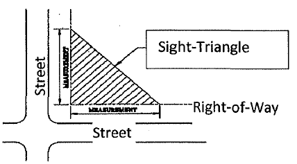
Sight-Triangle means the landscaped area at a street or driveway intersection. The triangle is formed by measuring from the point of intersection of the street front and entryway.
Specimen Tree means large, healthy tree that qualifies for special consideration for preservation due to size, species, or meets other qualifications such as: DBH of 24 inches or greater for large hardwoods such as oaks, hickories, maples; DBH of four inches or greater for small ornamental trees such as dogwoods, redbuds, etc. Very large size for the species; a rare variety; exceptional beauty; specifically used by developer or design professional as a focal point in a landscape project.
Street Frontage Buffer means the length of the property abutting one side of a main street or highway thoroughfare or the main street and side street exposure of a corner lot.
Tree means any self-supporting woody perennial plant which has a DBH* of two inches or more; normally attains overall height of 15+ feet at maturity; usually one main trunk and many branches. It may appear to have several stems or trunks as in several varieties of oak.
*In the US, tree diameter is usually measured at four and one-half feet above ground level (referred to as diameter at breast height or DBH.) DBH can be measured with a specially calibrated tape measure called a diameter tape (d-tape) available from arborist or forestry supply dealers.
Xeriscape means landscape methods conserving water through use of drought-tolerant plants and planting techniques.
(Ord. No. 2016-01, § 1(Exh. A), 5-16-16)
Sec. 14.04.28. - Hardy, drought-tolerant shrubs, grasses, trees, and evergreen.
REMEMBER TO CONSIDER POWER LINE LOCATION WHEN CHOOSING TREES
REMEMBER TO CONSIDER POWER LINE LOCATION WHEN CHOOSING TREES
(Ord. No. 2016-01, § 1(Exh. A), 5-16-16)
Sec. 14.04.29. - [Irrigation required.]
All large-scale developments two acres or more shall now require irrigation to enhance the general appearance of said development.
(Ord. No. 2024-04, § 2, 5-13-24)