
Flagler County Unincorporated
City Zoning Code
City Zoning Code
ARTICLE VI
- RESOURCE PROTECTION STANDARDS
6.00.00.- PURPOSE
The purpose of this regulation is to establish those resources or areas of a development site that must be protected from harmful effects of development. A developer should apply the provisions of this regulation to a proposed development site before any other development design work is done. Application of the provisions of this regulation will divide a proposed development site into areas that may be developed and areas that must generally be left free of development activity. The proposed development should then be designed to fit within the areas that may be developed.
6.01.00 - PROTECTED TREE REMOVAL AND PROTECTION
The purpose of this section is to provide for the protection and replanting of tree canopy native to Flagler County; to provide incentives for developers, permittees, and land owners to preserve protected trees; and to establish procedures, standards and enforcement provisions.
Building footprints, drives, stormwater management facilities, and similar activities on all sites shall be designed to save the maximum practicable number of specimen and historic trees. During the subdivision platting process, lot lines shall be shifted for the same purpose.
(Ord. No. 2024-06, § 2F, 9-16-24)
6.02.00.- WETLANDS[7]
Editor's note— Ord. No. 2007-17, § I, adopted Dec. 17, 2007, repealed the former Sec. 6.02.00, §§ 6.02.01—6.02.13, and enacted a new Sec. 6.02.00, titled "Wetlands," as set out herein. The former Sec. 6.02.00 pertained "Wetlands" and derived from Ord. No. 06-07, § 2, 3-20-06.
6.04.00.- FLOODPLAIN MANAGEMENT[8]
Editor's note— Ord. No. 2018-08, § 2, adopted May 7, 2018, effective June 8, 2018, repealed the former §§ 6.04.01—6.04.06, and enacted new sections as set out herein. The former sections pertained to similar subject matter and derived from Ord. No. 06-18, § 1, July 10, 2006; Ord. No. 2011-03, § 2, June 6, 2011.
6.01.01.- Definitions.
The definitions set forth herein are intended to be read para materia with those in Article III. In the case of a conflict, this section will prevail.
For the purposes of this section, the following words and phrases shall have the meaning set forth herein:
Agricultural: Land having an agricultural classification pursuant to Chap. 193.461, F.S. and used primarily for bona fide agricultural purposes as defined in Chap. 193.461(3)(b), F.S.
A1A Scenic Corridor: As defined by Ordinance 2001-26, as may be amended from time to time.
Building footprint: The portion of the lot, tract or parcel upon which buildings are to be placed.
Caliper: A measurement of a tree's size in inches, as measured: six (6) inches above the ground level for field grown nursery stock and from the soil line for container grown nursery stock, which should be at or near the top of the root flare: six (6) inches above the root flare for bare root nursery stock, up to and including the four (4) inch caliper size interval (i.e., from four (4) inches up to, but not including, four and one-half (4½) inches); twelve (12) inches above the ground level, soil line, or root flare, as appropriate, for nursery stock if the caliper measured at six (6) inches is four and one-half (4½) inches or more. Caliper measurements should be taken with a diameter tape, or as the average of the smallest and largest measurements resulting from the use of manual or electronic "slot" or "pincer" type caliper tools.
Canopy: The overall area of a tree's foliage, the outer edge of which is the drip line.
Developed property: One which has received a certificate of occupancy for the principal building or a majority of the buildings in a multi-structure complex.
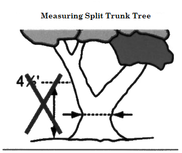
Diameter at breast height (DBH):
A.
Single trunk tree—The measurement of an existing tree's trunk diameter in inches measured roughly four and one-half (4½) feet above ground.
B.
Split-trunk tree—When the trunk branches or splits less than four and one-half (4½) feet from the ground, measure the smallest diameter below the lowest branch.
C.
Multi-trunk trees—Size is determined by measuring the diameter of the individual trunks (max. six (6) trunks) measured at four and one-half (4½) feet, then adding the total diameter of the largest trunk to one-half the diameter of each additional trunk.
Drip line: The outermost edge of the foliage of a tree projected vertically to the ground.
Encroachment: Any activity that has the effect of causing soil compaction, injury to lower limbs, grade change, contamination of soil or damage to the root system. Excluded from this definition are routine maintenance activities such as mowing or walking within the protected tree's drip line.
Firewise communities: A program developed by the National Wildland/Urban Interface Fire Program administered by the Division of Forestry of the Florida Dept. of Agriculture and Consumer Services.
Land clearing: The removal of protected trees, soil or mineral deposits or the placement of fill by any means with the intention of preparing real property for non-agricultural development purposes. This definition does not include removal of other than protected trees; dead or diseased trees of any species; removal of trees in accordance with Firewise Communities standards; underbrushing; or normal mowing or agricultural operations.
Nonresidential: That development, or portion thereof, devoted to commercial, industrial, or institutional land use(s). This does not include agriculture or forestry or essential governmental services.
Nuisance Tree: Brazilian Pepper (Schinus terebinthifolius), Australian Pine (Casuarina spp), punk tree (melaleuca leucadendion) and Chinese tallow (Sapium sebiferum).
Protected tree: A protected tree is free of significant defects in structure or decay of a species listed in section 6.01.04, Protected Tree List, subject to the conditions below for these species:
A.
The trunk is six (6) inches or greater diameter.
B.
Trees with a trunk two (2) inches or greater diameter, if surveyed for credit.
C.
Specimen trees, which are any protected trees with a trunk of eighteen (18) inches or greater diameter except for sand pines.
D.
Historic trees, which are any protected trees with a trunk of thirty-six (36) inches or larger diameter.
Prune: The removal of dead, dying, diseased, weak or objectionable branches in a manner consistent with the standards established in this code.
Replacement tree: A field grown or container grown tree of a species listed in section 6.01.04 and having a minimum caliper as required herein. (see "caliper" definition)
Replacement tree (A1A Corridor only): A field grown or container grown tree of a species listed in the Interim Replacement Tree List for the A1A Scenic Corridor, having a minimum caliper of six (6) inches and having a minimum height of twelve (12) feet when planted.
Specimen or historic tree: A tree meeting the minimum size requirements as defined under "protected trees".
Submerged land: That portion of a parcel lying below the mean high water line of a tidal water body; the seasonal high water line of a fresh water body; or the design elevation of a man-made water body. The latter excludes dry retention areas.
Tree, protected: See protected tree.
Tree relocation: To transplant a protected tree from one location to another.
Tree removal: To permanently remove the trunk and/or root system of a protected tree.
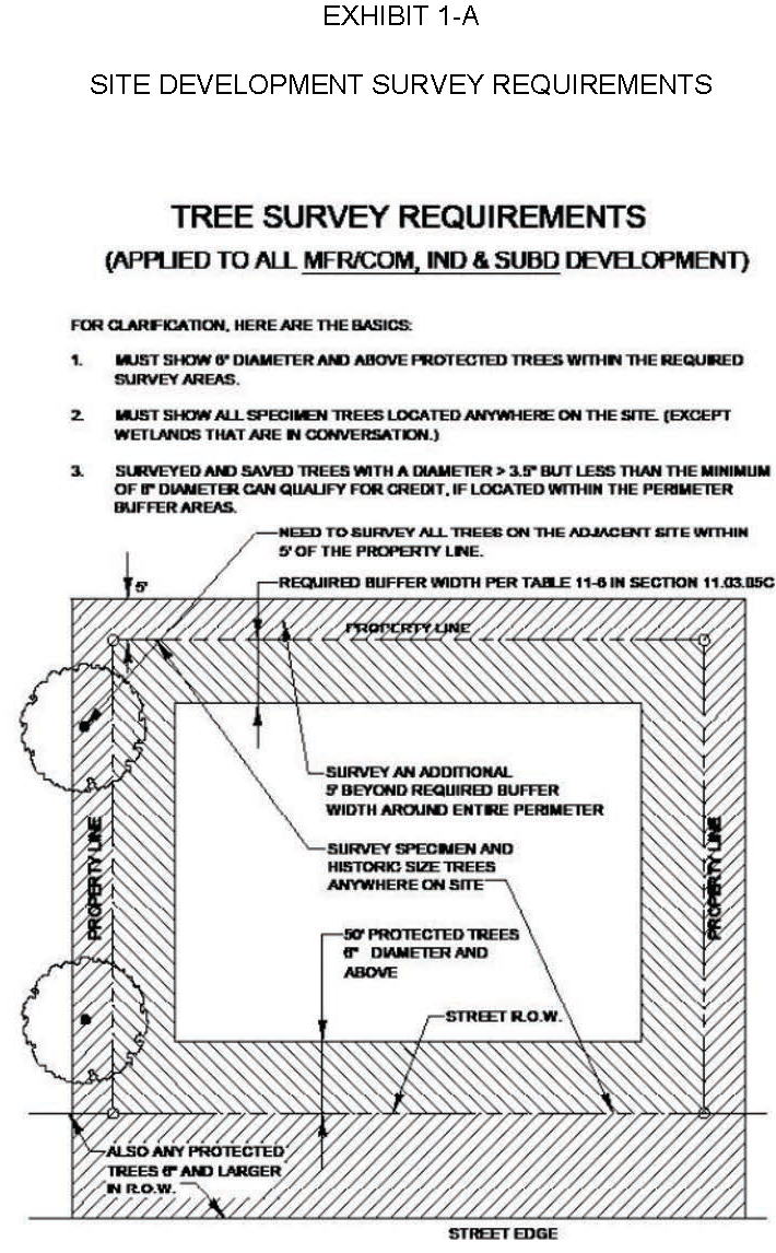
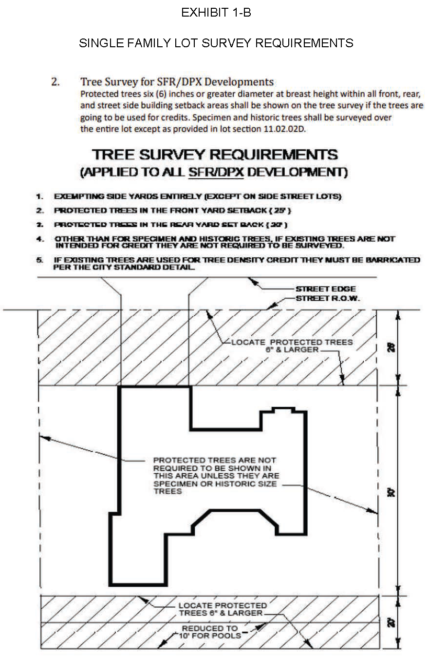
Tree survey: A survey prepared by a Florida licensed land surveyor showing, in addition to all information required by Rule 61G-176, F.A.C. the location, DBH, and common name of all qualifying protected trees within the area proposed for development. Non-protected trees may be designated as "clumps" with the general location and predominant type shown. (See Exhibits 1-A and 1-B)
Underbrushing: The removal of nuisance trees, understory and vegetation by means of bush hogging or hand clearing above grade only.
(Ord. No. 04-04, § 3, 2-16-04; Ord. No. 2024-06, § 2F, 9-16-24)
6.01.02. - Requirements prior to land clearing.
(1)
No person shall proceed with protected tree removal or land clearing on any improved, vacant or unimproved land except in accordance with the procedures and standards of this section.
A.
Contemporaneous with a site plan, subdivision, or planned unit development application, building permit, infrastructure permit or application for special exception approval, the following information must be submitted:
1.
A tree survey, less than twenty-four (24) months old, as defined herein. Jurisdictional wetland areas may be designated by their outer perimeter.
2.
Under the following circumstances, the County Administrator or designee may determine that a survey identifying each individual protected tree is not warranted and a count of all protected trees including species and diameter size is acceptable. In these instances, a sample survey from each unique ecosystem can be provided (minimum sample size shall be one-fourth (¼) acre per sample, or as determined by the County Administrator or designee during conceptual site plan review), and the results of that sample can be extrapolated over the entire area to be disturbed to get an overall estimate of tree density and caliper inches):
a.
When existing vegetated areas are to remain undisturbed; or
b.
When the trees are located in wetland preservation or conservation areas that will not be impacted; or
c.
When a site is comprised of over twenty (20) acres in size or is comprised of less than two (2) community/habitat types.
3.
A legible site development plan drawn to one (1) inch equals twenty (20) feet scale or to the largest practicable scale indicating the following applicable items:
i.
Location of all proposed structures, improvement and site uses, properly dimensioned and referenced to property lines, setback and yard requirements.
ii.
Proposed site elevations, including any proposed fill or excavation.
iii.
Location of proposed or existing utility services, wells or septic systems.
iv.
The common name, size and location of all protected trees on the site specifically designating the protected trees to be retained, removed, relocated or replaced.
a.
All protected trees used to meet the minimum preservation standards shall be located within public R/W's, the landscape buffers, designated preservation areas, and elsewhere on a site where the protected trees will not be impacted by development.
b.
All specimen and historic trees will be located within public R/W's, designated preservation areas, and elsewhere on a site where the specimen and historic trees will not be impacted by development.
v.
Typical location and construction of tree barricades.
vi.
For all applications other than an individual single family building permit, tree information shall be summarized in legend or tabular form.
4.
Landscaping plan.
5.
Applications involving improvements to existing developed properties may be based on drawings showing only that portion of the site directly involved and adjacent structures or portions thereof. In such cases, a tree survey is not required. A sketch showing the approximate location(s) of all existing protected tree(s) with common and botanical name shall be provided instead.
6.
Where protected trees are not, because of past use and/or current conditions, reasonably presumed by the county to exist on a site, an affidavit duly executed by the property owner, engineer, certified arborist, or landscape architect, attesting to such condition may be substituted for a tree survey.
(2)
Authorization to proceed. The development services department shall authorize land clearing through the issuance of the building or development permit. Land clearing is subject to site inspection by the county from application to one (1) year after completion of activity.
A.
Criteria for land clearing. Land clearing will be authorized after the development services director or his/her designee determines that the following conditions, as applicable, exist:
1.
The property has received site plan, special exception or preliminary plat approval pursuant to this Code, has received or applied for a building permit, or is an occupied residential or non-residential property.
2.
A protection and mitigation plan, meeting the requirements of this section and Section 6.01.03 is a condition precedent to land clearing.
3.
The protected tree is in danger of materially impairing the structural integrity of existing or proposed structures, materially interferes with utility service, or adversely affects sight distance triangles.
4.
The protected tree has one or more defects which, in the opinion of a certified arborist, is near death and can not be rehabilitated.
5.
Tree protection barriers have been installed on the property per approved tree protection plan.
B.
The authorization for land clearing shall expire contemporaneously with its associated permit.
(Ord. No. 04-04, § 3, 2-16-04; Ord. No. 2024-06, § 2F, 9-16-24)
6.01.03. - Protected tree protection/replacement requirements.
The individual property owner and/or landscape architect are provided flexibility of design but must preserve a minimum percentage of existing protected tree canopy in a manner to support the long-term health and survival of protected trees. Existing trees are best protected within clusters of open space left undisturbed by grade changes, soil compaction, mechanical or chemical disturbance.
(1)
The minimum number of protected trees to be preserved upon any development site is equal to the percentages set forth below for different land uses. Protected trees lying within designated conservation areas, jurisdictional wetlands and adjacent upland buffers must be preserved in their entirety. By way of example, a building lot contains an aggregate of one hundred (100) caliper inches of protected trees and the minimum preservation equals seventy (70) percent. This seventy (70) inches of required protected trees can be preserved as any combination of qualifying preserved and/or replacement protected trees totaling seventy (70) caliper inches.
A.
Single-family dwelling lots: Each single-family residential lot must preserve or replant at least fifty (50) percent of the total pre-development caliper inches existing on the site. Preserved protected trees may be substituted for tree planting required by the landscaping section of this Code. Trees located within or immediately adjacent to (within ten (10) feet of the foundation, or where the crown or rootball extend within the limits of the foundation, whichever is greater as to its encroachment) the building foundation are exempt.
B.
Multi-family and mobile home park parcels: Each multi-family and mobile home park parcel must preserve or replant at least seventy (70) percent of the total pre-development caliper inches existing on the site. Preserved protected trees may be substituted for tree planting required by the landscaping section of this Code. Replacement trees may be clustered within pervious areas of the site provided that at least five hundred (500) square feet of green space per tree is provided.
C.
Non-residential and mixed use parcels: Each non-residential and mixed use parcel must preserve or replant at least seventy (70) percent of the total pre-development caliper inches existing on the site. Preserved protected trees may be substituted for tree planting required by the landscaping section of this Code. Replacement trees may be clustered within pervious areas of the site provided that at least five hundred (500) square feet of green space per tree is provided.
D.
Where replacement trees are required to be planted in order to maintain the minimum number of caliper inches, and they shall be from a species listed as a protected tree.
1.
Protected tree replacements shall have a minimum caliper of two and one-half (2½) inches measured six (6) inches above grade after planting and be Florida Grade No. 1 or better.
2.
Specimen tree replacements shall have a minimum caliper of three and one-half (32½) inches measured six (6) inches above grade after planting and be Florida Grade No. 1 or better.
3.
Historic tree replacements shall have a minimum caliper of six (6) inches measured six (6) inches above grade after planting and be Florida Grade No. 1 or better.
Tree planting and maintenance procedures for replacement trees shall follow the "Tree, Shrub and Other Woody Plant Maintenance Practices," on pruning, fertilization and support systems called the ANSI (American National Standards Institute) A300 Standard. Transplanting and establishment of trees shall follow those described in Typical Tree Bid Specifications for Florida, part 2 (shipping and handling) part 3 materials, and part 4 (execution) developed by the University of Florida, the Florida Urban Forestry Council and the Florida Chapter of the International Society of Arboriculture.
E.
A1A Scenic Corridor: The pallet of protected trees in the A1A Scenic Corridor is more inclusive than for the county as a whole. This expanded protection is designed to preserve the native ecosystems in the Corridor. A list of protected trees established by Ordinance 2001-26 is available at the Planning and Zoning Dept. and incorporated into the Scenic Corridor Design Guidelines Handbook. The minimum number of protected trees to be preserved upon any development site is calculated as set forth previously within this section however, the list of protected trees is more expansive and the following percentages of aggregate caliper inches shall apply:
1.
Nonresidential, mixed use, and multi-family parcels: Each nonresidential, mixed use, or multi-family parcel owner must preserve or replant at least seventy (70) percent of the total pre-development caliper inches existing on the site. Property owners are encouraged to use preserved protected trees to satisfy perimeter and interior landscaping requirements.
2.
Single-family parcels: Every single-family lot owner must preserve or replant at least fifty (50) percent of the total pre-development caliper inches existing on the site.
3.
Where protected or specimen trees must be replaced or planted to meet minimum preservation or landscape buffer requirements within the Scenic Corridor Overlay district, all plant material will consist of a tree species listed in the Scenic Corridor Index Tree List Plant materials shall conform to the standards for Florida No. 1 or better as given in "Grades and Standards for Nursery Plants," (current version) State of Florida Department of Agricultural and Consumer Services, or equal thereto that has been approved by the county agricultural extension agent. The preservation and use of native vegetation is highly encouraged. Plant materials selected shall be the best suited to withstand the soil and physical conditions of the site. Plant materials that are freeze and drought tolerant are preferred;
4.
Replacement trees shall approximate the distribution of native vegetation;
5.
Whenever a protected tree is removed without legal authorization or in violation of this code, the owner shall replace such removed trees on a one to three (1:3) ratio. For example, if a twenty (20) inch caliper tree is illegally removed, it shall be replaced by a tree or trees equivalent to sixty (60) inches in caliper from the Interim Replacement Tree List or an equivalent tree species;
6.
Proposed trees shall be given sufficient room for optimum growth. If the county administrator or his/her designee reasonably determines that there is insufficient space on the site to plant the required replacement trees for optimum growth, then the owner may be directed to plant the trees in publicly owned areas of the A1A Scenic Corridor, in privately owned strategically visible locations with the permission of the property owner, or donate to the tree fund.
7.
Trees installed or retained within the A1A Scenic Corridor shall not be topped or severely pruned so as to appear stunted or "hat racked". Trees shall be pruned as needed to maintain health and form in such a way that retains or improves the natural form of the particular species; provided, topiary may be practiced upon suitable species if professionally and consistently maintained. The branches of a tree extending over any public sidewalk shall be trimmed to at least the height of eight (8) feet above the sidewalk. The branches of a tree extending over the travel portion of any street used for vehicular traffic shall be trimmed to fifteen (15) feet above the street. All tree pruning shall be conducted according to the standards of the National Arborist Association Standards set forth in ANSI A300 (Part 1) Tree Pruning. All landscaping installed or retained to meet the requirements of this section shall be maintained in a healthy and growing condition.
F.
All replacement or relocated protected trees must be maintained in a healthy and growing condition for a minimum of two (2) years from the date of the last certificate of occupancy in the development. All trees that, in the opinion of the county, will not survive for this minimum time period will be replaced by the property owner.
(Ord. No. 04-04, § 3, 2-16-04; Ord. No. 04-11, § 3, 8-16-04; Ord. No. 2024-06, § 2F, 9-16-24)
6.01.04. - Protected trees.
The following protected trees having a caliper of six (6) inch DBH or greater are protected under the terms of this regulation and also constitute acceptable replacement trees subject to minimum size requirements:
County staff may accept other broadleaf hardwood trees as replacements upon a finding of suitability.
(Ord. No. 04-04, § 3, 2-16-04; Ord. No. 2024-06, § 2F, 9-16-24)
6.01.05. - Tree protection during construction.
(1)
Standards for tree protection during development. The following are minimum standards necessary to protect trees designated for preservation from damage during land clearing and development activities after the permit has been approved.
A.
Protection of existing trees. Prior to any clearing of improved, vacant or unimproved land unless specifically exempted from this section, trees to be preserved shall be identified, staked and clearly marked to prevent physical damage from heavy equipment and other activities incidental to development. Required tree protection barriers shall be subject to inspection for the duration of the activity.
1.
Whenever there is any planned encroachment into the dripline of a protected tree proposed for preservation, the applicant is recommended to secure the services of a licensed certified arborist. The certified arborist should prepare a written report indicating the chances for long term survival of the tree and best practices to be employed during and after construction. As an alternative, the county shall review the protection program for approval.
2.
Root pruning. The roots of all trees to be protected shall be cleanly pruned at the edge of proposed land disturbance activity.
3.
Tree Barriers or barricades. The barriers or barricades shall be installed per the tree protection details included in the approved landscape/tree protection plans. Prior to the clearing of underbrush, barricades shall be installed and required to remain in place throughout the construction period. Absent a tree protection detail in the landscape plan, the minimum size of wood barrier fencing shall be two (2) inches by four (4) inches and the top of the barrier shall be a minimum of four (4) feet high. Another acceptable means of barricading trees is the use of orange plastic construction fence, four (4) feet high, and supported every eight (8) feet by rebar, driven into the ground. Fencing shall be securely attached to rebar by the use of nylon zip ties or twisted wire. Barricades must be taut and perpendicular to ground.
a.
Failure to install tree protection barriers prior to clearing shall result in a fine to the owner. Initial fine for failure to install tree protection barriers prior to clearing shall be up to $1,000.00 for a first violation upon a finding by a special magistrate that the violation is irreparable or irreversible in nature, and fines shall accrue $100.00 per day until installed. In making the findings, the special magistrate shall consider the gravity of the violation, the actions taken by the violator to correct the violation, and any previous violations committed by the violator.
4.
Other required protection of trees: The developer or permittee shall protect the trees designated for preservation in the approved permit from physical damage, chemical poisoning, excavation and grade changes to at least the following minimum standards:
a.
Utility and irrigation line trenches. Trenches shall be routed away from trees to an area outside the drip line to the maximum extent possible or directionally bored.
b.
Grade changes. If approved by the county, retaining walls or dry wells may be utilized to protect root systems from severe grade changes.
c.
Development activities. No vehicle maintenance, storage of construction materials or debris, or cleaning of equipment shall take place within the barricaded area.
5.
Pruning of trees and vegetation. Pruning of branches and roots of trees must be in compliance with the standards established by the American National Standards Institute (ANSI A-300).
6.
Root system protection. The root systems of trees shall be protected as follows:
a.
The protected area shall be mulched and irrigated regularly according to seasonal needs.
b.
The permittee shall protect tree root systems from damage due to noxious materials in solution caused by runoff, or spillage during mixing and placement of construction materials, or drainage from stored materials. Root systems shall also be protected from flooding, erosion or excessive wetting resulting from dewatering operations.
7.
Trees damaged during construction. Trees damaged by construction must be repaired under the direction of a certified arborist consistent with the Code provisions and in a manner acceptable to the county.
a.
Immediate notification of county. Flagler County Development Services must be notified immediately after any damage to any tree by construction operations.
b.
Prompt repair. Such repairs as necessary shall be made promptly after damage occurs to prevent progressive deterioration of damaged trees.
c.
Removal and replacement of damaged trees. The developer or permittee shall remove trees which are determined by the county to be incapable of restoration to normal growth pattern. Such trees shall be subject to replacement under the provisions of this section.
(Ord. No. 04-04, § 3, 2-16-04; Ord. No. 2024-06, § 2F, 9-16-24)
6.01.06. - Exemptions.
The following activities are specifically exempt from the procedures and standards of this section:
(1)
Agricultural activities including harvesting of commercial timber. The latter must comply with the latest addition of "Silviculture Best Management Practices" published by the Florida Department of Agriculture and Consumer Services.
(2)
Tree removal directly within a public or private road right-of-way for the installation of required subdivision improvements.
(3)
Individual service connections and construction, installation of public utility lines provided, however, they comply with Section 6.01.05(4)(a); septic tanks, lines or drain fields; compacted fill within the limits of the approved building footprint.
(4)
Emergency work to protect life, limb or property. This includes clearing that is in conformance with firewise community protection standards set forth by the division of forestry.
(5)
Maintenance activity along road sides, under wires, around fire hydrants and similar instances.
(6)
Damaged trees. Trees suffering major structural damage or destroyed by force majeure are exempt from this section as determined by the county.
(7)
Licensed plant and tree nurseries. Plant and/or tree nurseries licensed pursuant to the Florida State Department of Agriculture and Consumer Services, Division of Plant Industry shall be exempt from the terms and provisions of this article in relation to those trees planted and growing on site for wholesale and/or retail sale purposes in the ordinary course of said licensee's business.
(8)
A tree or trees required or authorized to be cut down, destroyed, removed or relocated or destructively damaged by a county, state or federal law, or by rules promulgated by a county, state or federal agency.
(Ord. No. 04-04, § 3, 2-16-04; Ord. No. 2024-06, § 2F, 9-16-24)
6.01.07. - Enforcement.
(1)
Generally. The development services director or his/her designee shall enforce the provisions of this section.
(2)
Individual enforcement. Each violation of this section or any of its subsections is deemed a separate and distinct infraction of the land development code. Each protected tree to be protected may be the subject of individual enforcement.
(3)
Strict liability of owner. The owner of any property where a tree or trees have been cut down, destroyed, removed, relocated or destructively damaged shall be held strictly liable for a violation of this section unless it can be proven that the damage was caused by:
A.
An act of God;
B.
An act of War;
C.
Development activities on the property in compliance with an approved permit; or
D.
The owner alleges that the damage was caused by vandals or trespassers and the owner of the property has filed a police report for the incident and had taken reasonable security measures to prevent unauthorized access to the property.
(4)
Stop-work order. The enforcement agency shall immediately issue an order to cease and desist any work being carried out in violation of this section or any permit conditions promulgated under this section. Upon notice of such violation, no further work shall take place until appropriate remedial action is instituted, as determined by the enforcement agency.
(5)
Other enforcement. Nothing in this section shall prohibit the county from enforcing this section by other means.
(Ord. No. 04-04, § 3, 2-16-04; Ord. No. 2024-06, § 2F, 9-16-24)
6.01.08. - Penalties.
(1)
Fine and replacement. Each violation of this section shall be punishable in a court of competent jurisdiction by a fine of no more than five hundred dollars ($500.00) plus replacement of the trees removed from the site, unless indicated otherwise. The removal, relocation or destruction, including dripline encroachment, of each tree for which a permit is required in violation of this section shall constitute a separate offense under this section. If the violation is discovered subsequent to stump removal, a presumptive count of one (1) qualifying protected tree per four thousand (4,000) square feet, or major portion thereof, shall be employed in the absence of specific evidence of the actual number of trees destroyed.
(2)
Withholding of permits. Failure of any party to follow the procedures as required by this section shall constitute grounds for withholding site plan approval, building permits, occupancy permits or any other appropriate approvals necessary to continue development until remedial action is completed in accordance with this section.
(3)
In addition to the above, each violation of this Ordinance may be prosecuted as provided by Section 125.69, Florida Statutes 2004, as may be amended, which currently provides as follows:
"Violations of this ordinance shall be prosecuted in the same manner as misdemeanors are prosecuted. Such violations shall be prosecuted in the name of the state in a court having jurisdiction of misdemeanors by the prosecuting attorney thereof and upon conviction shall be punished by a fine not to exceed $500 or by imprisonment in the county jail not to exceed 60 days or by both such fine and imprisonment."
(4)
In the event of a violation, the penalties set forth in this Ordinance shall be applicable to the offending property owner, tenant, any contractor clearing the owner's property or any other person operating on behalf of the owner.
(Ord. No. 04-04, § 3, 2-16-04; Ord. No. 2024-06, § 2F, 9-16-24)
6.01.09. - Tree bank fund established.
(1)
If due to site conditions or configuration, the planning and development board determines that it is impossible or impracticable for the property owner, applicant, or developer to meet the requirements for tree density and/or replacement on-site, then the property owner, applicant, or developer shall pay fees of equivalent value into the tree bank fund or plant the trees off-site upon approval of a suitable site or sites by the County.
The tree bank fund shall be a separate account set up and shown in County financial records in which all receipts are detailed. All monetary contributions paid to the tree bank fund pursuant to this section shall be used exclusively for the design, planting, or replacement of trees on public lands. Funds may also be used for relocating trees onto public lands, and may also be used for the fee and less-than-fee acquisition of private lands which preserve existing tree canopy, especially those sites which include specimen or historic trees. Funds may also be used for the design and installation of irrigation systems, mulching, and staking for these trees.
(2)
Valuation of contributions to the tree bank fund shall be based on the current market rate cost of a 4" Live Oak tree, delivered, installed, staked, and mulched in accordance with County standards. For example, if the market rate for the above mentioned 4" caliper Live Oak is four hundred dollars ($400.00), the cost per caliper inch is one hundred dollars ($100.00). If an applicant is proposing to meet the tree replacement requirement using the tree fund to replace two hundred (200) inches of protected trees, the applicant will pay twenty thousand dollars ($20,000.00) ($100/inch × 200 inches).
(Ord. No. 2024-06, § 2G, 9-16-24)
6.01.10. - Variances.
The planning and development board is hereby designated as the protected tree board of adjustment and is authorized to consider variances in specific cases where such variances will not be contrary to the public interest and where, owing to special conditions a literal enforcement of the provisions of this section would result in unnecessary hardship. All requirements, procedures, findings and appeals of protected tree variances shall follow those provisions for zoning variances as outlined in Article III, Zoning District Regulations.
(Ord. No. 2024-06, § 2H, 9-16-24)
6.02.01.- Purpose and intent.
It is the purpose and intent of this regulation to provide for the protection, maintenance and enhancement of wetlands within Flagler County, recognizing the rights of individual property owners to use their lands in an economically reasonable manner as well as the rights of all citizens to protection of the waters of Flagler County and their associated wetland ecosystems. It is further the purpose and intent of this section of this article to ensure that there be no net loss of wetland function. Prior to evaluating wetland impacts, Flagler County staff shall evaluate the appropriateness of the project as it relates to the Comprehensive Land Use Plan.
(Ord. No. 2007-17, § I, 12-17-07)
6.02.02. - Definitions.
A.
Best management practices (BMP). Management practices as found in "Silviculture Best Management Practices Manual", Florida Department of Agriculture and Consumer Services, Division of Forestry, as amended.
B.
Board. The Flagler County Board of County Commissioners.
C.
Director. Growth management director or his or her designee.
D.
Dredging. Excavation by any means in waters or wetlands. It also means the excavation or creation of a water body which is, or is to be connected to, waters directly or via an excavated water body or a series of excavated water bodies.
E.
Filling. Deposition of materials by any means in waters or wetlands.
F.
Floor area ratio. The gross floor area of all floors permitted on a site divided by the area of the site, usually expressed in decimals of one (1) to two (2) places.
G.
Interested person. Any person who submits written comments during the application review period.
H.
Isolated wetlands. Wetlands that have no hydrological or vegetative connections with "Waters of the State" as defined in section 403.031(3) Florida Statutes, as amended.
I.
Legal advertisement. The notice shall state the title and substance of the requested action, name of the applicant, and the location where the public may inspect the application. The notice shall advise that interested parties may submit comments regarding the application in writing to the planning and zoning department. The required advertisement may be placed in that portion of the newspaper where legal notices and advertisements appear.
J.
Mailed notice shall consist of the first class mailing of a notice of application receipt to each real property owner within three hundred feet (300') of the perimeter of the subject property. Calculation of the distance requirement shall not include water bodies which are contiguous to the subject property.
K.
Mitigation. Actions including, but not limited to, preservation, restoration, enhancement, or creation of wetlands, required to be taken by a person to offset environmental impacts of permitted activities.
L.
Newspaper publication. Publication of public notice in a newspaper shall consist of publication of a legal advertisement in a newspaper of general paid circulation in Flagler County pursuant to Chapter 40, Florida Statutes, being of general interest and readership in the community, not one of limited subject matter. The advertisement shall be placed within thirty (30) days of receipt of a complete application, including application fee. Applicants are responsible for the out-of-pocket costs of such publication(s).
M.
No net loss of wetland function. When used in Section 6.02 of the Flagler County Land Development Code, this term shall mean the quantified value of function consistent with Chapter 62-345, Florida Administrative Code, as amended.
N.
Posted notice. Posting shall consist of a sign to be posted on the parcel of land that is the subject of the application within five (5) business days of a determination of application completeness. The sign shall be posted for a period of ten (10) days. The sign will be visible from the street adjacent to the subject property. Such sign shall measure at least three (3) square feet in area, shall be of a color distinguishable from the surrounding landscape, shall contain notice of receipt of application and shall invite interested parties to contact county staff for further information.
O.
Upland buffer. Upland areas adjacent to wetlands which are necessary to protect the wetlands and wetland-dependent species from the detrimental impacts of development or alteration. The buffer shall include canopy, understory and groundcover which consists of preserved existing vegetation or planted native species where there is no existing vegetation. Native indigenous species listed in the most current edition of "Guide to the Vascular Plants of Central Florida" by Richard P. Wunderline, University Presses of Florida, Gainesville, Florida shall be used. Exotics and naturalized species shall not be planted in upland buffers.
P.
Wetland vegetation. As defined in Chapter 62-340.450, Florida Administrative Code as amended.
Q.
Wetlands. As set forth in Chapter 373.019(25) Florida Statutes, (as amended) wetlands means those areas that are inundated or saturated by surface water or groundwater at a frequency and a duration sufficient to support, and under normal circumstances do support, a prevalence of vegetation typically adapted for life in saturated soils. Soils present in wetlands generally are classified as hydric or alluvial, or possess characteristics that are associated with reducing soil conditions. The prevalent vegetation in wetlands generally consists of facultative or obligate hydrophytic macrophytes that are typically adapted to areas having soil conditions described above. These species, due to morphological, physiological, or reproductive adaptations, have the ability to grow, reproduce, or persist in aquatic environments or anaerobic soil conditions. Florida wetlands generally include swamps, marshes, bayheads, bogs, cypress domes and strands, sloughs, wet prairies, riverine swamps and marshes, hydric seepage slopes, tidalmarshes, mangrove swamps and other similar areas. Florida wetlands generally do not include longleaf or slash pine flatwoods with an understory dominated by saw palmetto.
(Ord. No. 2007-17, § I, 12-17-07)
6.02.03. - Exempted activities.
Activities which are exempted from this section include:
A.
Construction of single-family homes on existing recorded subdivisions where street and drainage improvements have been constructed to the lot, provided that siting of such homes will be reviewed during the building permit process to direct development activity away from wetlands where possible;
B.
Minor maintenance or emergency repair to existing structures of improved areas;
C.
Clearing of walking trails which have no structural components and do not exceed maximum width of ten (10) feet in width;
D.
Construction of timber catwalks and docks five (5) feet wide or less, and observation decks not to exceed two hundred (200) square feet which are related to passive nature walks as expressly provided in an approved site plan;
E.
Bona fide aquaculture activities;
F.
Utility crossings, easements, or rights-of-way that are related to transmission or conveyance of the utility's service to its customers;
G.
Maintenance, together with incidental, approved, dredge and fill activities in ditches, retention and detention areas, public road and other rights-of-way, and other related drainage systems;
H.
Approved mosquito control activities;
I.
Those activities impacting wetlands less than one-half (½) acre in size;
J.
Activities within artificial wetlands which are created as part of approved manmade treatment systems;
K.
Silviculture activities which follow the best management practices outlined in the most current publications entitled, "Silviculture Best Management Practices Manual", Florida Department of Agriculture and Consumer Services, Division of Forestry and "Management Guidelines for Forested Wetlands in Florida," Florida Department of Agriculture and Consumer Services, may be used as a guide for silviculture activities in wetlands. Provided however, failure to follow said practices shall be a violation of this Code;
L.
Existing bona fide agricultural pursuits, including but not limited to, row crops, cattle grazing, sod farming and vegetable farming;
M.
Wetland impacts which are otherwise unavoidable;
N.
Construction of driveways for single-family residences; and
O.
Those exemptions that Flagler County is legally required to recognize.
(Ord. No. 2007-17, § I, 12-17-07)
6.02.04. - Prohibited activities.
A.
All alteration, grading, filling, dredging, or impacts to any wetland, its water supply, or upland buffer are prohibited unless exempted by section 6.02.03 or as authorized pursuant to a wetland alteration permit. Any alteration of wetlands shall be mitigated in accordance with the requirements of section 6.02.05.
B.
All uses and activities that were lawful before January 30, 1991, but which do not conform with the provisions of the section of this article, may be continued but may not be expanded, changed, enlarged, or altered except as provided herein.
(Ord. No. 2007-17, § I, 12-17-07)
6.02.05. - Wetland alteration permit.
A.
Permitting:
1.
Application: Application for a permit shall be on the approved county form, accompanied by the documentation as specified therein. Additional reasonable information shall be submitted as requested by the county to complete a review of the project.
2.
Public notice of application: When a wetland alteration permit application is received, a description of the project and its location will be publicly available and public comment welcomed. Public notice will consist of mailed notice, posted notice, county website notice, newspaper publication, and email notice to interested registrants.
3.
Public comment on permit application: Any person may submit comments regarding an application for wetland alteration permit. Written comments may be submitted to the director throughout the application process for review and consideration.
4.
Application review procedure: Within thirty (30) days of the receipt of an application for a wetland alteration permit, the applicant may be requested to provide such additional information as is reasonably necessary to determine whether the permit should be issued or denied. A decision, which is based upon the criteria contained in this article, shall be in writing and mailed to the applicant's address no later than ninety (90) days after the additional information is received from the applicant, or if a timely request for additional information is not made, no later than ninety (90) days after receipt of the application. If an application is not approved or denied within the applicable ninety (90) days, the applicant may, within thirty (30) days of the last date when a timely decision could have been made, request the county to make a final determination on the license. Then the applicant may seek administrative review as provided by this code.
5.
Application review criteria: When reviewing an application for a Wetland Alteration Permit Flagler County may consider the recommendations of any governmental and/or professional agency. The issuance of a dredge and fill or environmental resource permit, or other similar permit, issued by a federal or state agency or water management district shall not obligate Flagler County to grant a wetland alteration permit, and shall not be deemed to substitute for a wetland alteration permit. A wetland alteration permit shall not be issued unless the following criteria are met:
a.
There shall be no net loss of wetland function (as defined in section 6.02.02 H).
b.
The activity is consistent with the applicable uses and criteria authorized under the Flagler County Land Development Regulations.
c.
Wetland impacts shall be avoided or minimized to the greatest extent practicable, as set forth in section 6.02.06.
d.
The activity is not in contravention with any other federal, state, or local designated preserve or conservation area.
e.
The applicant shall provide proof of financial responsibility, as set forth in sections 6.02.05(A)(5)(j), to conduct the mitigation activities and any necessary management and monitoring of the mitigation site.
f.
With the exception of approved road crossings and other minor activities, the activity will fully comply with the criteria for buffer zones set forth herein.
g.
Wetland impacts which are unavoidable after application of section 6.02.06, will be replaced by compensatory mitigation. Said mitigation shall replace the ecological functional values lost as a result of permitted wetland impacts. Ecological functional values and mitigation acreages shall be determined using Chapter 62-345, F.A.C., and shall be specified in the Wetland Management Plan.
h.
An applicant who carries out mitigation in accordance with a wetland alteration permit shall grant an environmental or conservation easement on the newly created, enhanced, restored, or preserved wetland and buffer to protect it from future development. A legal mechanism other than an environmental or conservation easement may be deemed appropriate by the county on a case by case basis if it carries out the purpose of this subsection.
i.
The use will not threaten public safety or cause nuisances, increase flooding above predevelopment conditions on other lands, result in the unauthorized loss of species listed on the Florida Fish and Wildlife Conservation Commission, National Oceanic and Atmospheric Administration - National Marine Fisheries Service, or U.S. Fish and Wildlife list of plants or animals designated as endangered, threatened, or species of special concern, or violate pollution standards or other federal, state, or local regulations.
j.
The activity will be conducted by an entity with sufficient financial, legal and administrative capability to ensure that the activity will be undertaken in accordance with the terms and conditions of a valid permit. The applicant shall provide proof of financial responsibility in a form acceptable to county staff. Financial responsibility must be sufficient to ensure completion of all mitigation, monitoring and corrective action indicated by the monitoring. These criteria are not applicable to wetland mitigation improvements with a cumulative estimated cost which is less than twenty-five thousand dollars ($25,000.00). Proof of financial responsibility of one hundred twenty-five (125) percent of the cost of the wetland mitigation improvement is required in accordance with the provisions of the Land Development Code. For the purpose of establishing financial responsibility, wetland mitigation improvements which are part of a subdivision development may be included in the subdivision performance bond. Platting does not relieve the applicant from executing a Wetland Management Plan Agreement. The county may recognize approved financial security that is acceptable to state and/or federal agencies.
6.
Permit denial: In the denial of a license, the applicant shall be provided with a written statement setting forth the reasons for denial and the rights of administrative review.
B.
Administrative review: Any applicant and interested person may request review of a final administrative determination made by the director.
(1)
The requirement of certain permit conditions.
(2)
The issuance of a permit.
(3)
The denial of a permit.
An interested person desiring a review of a staff determination shall submit a written request for review to the attention of the appropriate section supervisor. If a resolution cannot be reached, then the decision shall be reviewed by successive supervisory levels until the issue is resolved or reaches the level of the director or his or her designee for the final determination.
An interested person seeking administrative review of a final determination made by the director or the designee shall file an application with the director for review by the board of county commissioners. The application for review shall be filed within ten (10) business days of the director's decision.
C.
Judicial review: Review of any final determination made by the board of county commissioners shall be made by filing a petition for writ of certiorari to the circuit court of the Seventh Judicial Circuit in and for Flagler County within thirty (30) days of the date or rendition of the decision of the board of county commissioners. A petitioner shall not have the remedy of other extraordinary writs or other judicial remedy or process until all administrative remedies have been exhausted.
(Ord. No. 2007-17, § I, 12-17-07)
6.02.06. - Minimization and avoidance.
Applicants must demonstrate that alternatives for avoiding adverse impacts to the functions provided by the wetland system have been evaluated and, as practicable, adverse impacts to these functions have been avoided. The term "avoided" shall not be construed as including the alternative of not implementing the project in some form, nor shall it be construed as requiring a project that is significantly different in type or function. A proposed modification which is not technically capable of being done, is not economically viable, or which adversely affects the public safety through the endangerment of lives or property is not considered "practicable." A proposed modification need not remove all economic value of the property in order to be considered not "practicable." Conversely, a modification need not provide the highest and best use of the property to be "practicable." In determining whether a proposed modification is "practicable", consideration shall also be given to the cost of the modification compared to the environmental benefit it achieves.
(Ord. No. 2007-17, § I, 12-17-07)
6.02.07. - Mitigation monitoring requirements.
A.
As a condition of permit issuance by Flagler County, copies of any monitoring and progress reports, and any violation notices and enforcement documents from other permitting agencies, shall be sent to the county.
B.
A Wetland alteration permit issued by Flagler County that includes mitigation improvements, other than those in a state approved mitigation bank, shall be subject to a recordable and enforceable wetland management plan agreement. The agreement shall attach or incorporate by reference the Flagler County Wetland Alteration Permit and provide for:
1.
Enforcement provisions assuring the mitigation improvements included in the permit are carried out as permitted. In said agreements, county shall reserve the right to issue cease and desist orders and thirty-day notices to cure violations, where applicable. The county shall retain its right to pursue enforcement action, including but not limited to, code enforcement action, court action, including, but not limited to, declaratory or injunctive relief, property liens, withholding of final plat approval or withholding of certificate of occupancy. The agreement shall also specify Flagler County Circuit Court venue and jurisdiction and the ability to recover costs, expenses, expert fees and attorney fees.
2.
Application to successors and assigns.
3.
Recordation of agreement in Public Records of Flagler County.
C.
Agreements shall not include additional mitigation conditions beyond those found in the Flagler County wetland permit. However, agreements shall contain language adopting the conditions of state or federal agency permits for the same project and allow Flagler County the ability to enforce said conditions. Wherever possible, the county shall obtain rights as a co-grantee to enforce conservation easements granted to a state or federal agency, or failing to be named as co-grantee, an assignment of third party enforcement rights under the easements.
D.
The county shall administer a one time monitoring fee for mitigation sites located outside of county jurisdictional boundaries. This fee shall not apply to the use of credits from a state approved mitigation bank. The fee shall be set by resolution and may be modified from time to time.
(Ord. No. 2007-17, § I, 12-17-07)
6.02.08. - Wetland identification.
Wetland boundaries shall be delineated in accordance with the methodology contained in Chapter 62-340, F.A.C., as amended or succeeded.
(Ord. No. 2007-17, § I, 12-17-07)
6.02.09. - Upland Buffer requirements.
A.
Flagler County shall require an upland buffer adjacent to and surrounding all wetlands. The upland buffer may coincide with the setback required by the zoning article in effect in Flagler County or may coincide with wildlife corridors designated in Flagler County's Comprehensive Plan. An acceptable upland buffer will also satisfy the landscaping requirement of the Flagler County Land Development Code. However, said upland buffer shall not impede any existing easement or preclude reasonable access to a body of water (private or public). The upland buffer area along with all wetlands remaining under the permitted design shall be placed in a conservation easement in favor of Flagler County, and/or U.S. Army Corps of Engineers, and/or Florida Department of Environmental Protection, and/or St. Johns River Water Management District. Since avoidance and minimization takes precedence over the upland buffer requirement, under no circumstances will an applicant be authorized to fill jurisdictional wetlands in order to create the required upland buffer.
B.
All activities, including clearing, within the upland buffer shall be consistent with the language of the conservation easement and may conform to the firewise community standards promulgated by the Division of Forestry of the Department of Agriculture and Consumer Services.
C.
Upland buffer widths shall be measured landward of the delineated jurisdictional wetland line. Upland buffer widths shall be determined as follows:
1.
An upland buffer with a minimum width of fifteen (15) feet and an average width of twenty-five (25) feet shall be required around all wetland areas not designated as areas of special concern. The Flagler County Growth Management Director, or his/her designee, shall have the ability to adjust the upland buffer line while maintaining a fifteen-foot minimum and twenty-five foot average.
2.
All wetlands immediately adjacent to designated areas of special concern shall have a minimum upland buffer width of seventy-five (75) feet.
3.
In areas of special concern, an applicant shall have the option to perform a professional qualitative analysis of the subject wetland and have the upland buffer width adjusted. As part of the application to adjust the upland buffer width the applicant shall submit forms 62-345.900(1) and 62-345.900(2) F.A.C for review. Adjustments shall be as follows:
a.
For a "current score" from 0.75 - 1.0: minimum width = 75'.
b.
For a "current score" below 0.75 and greater than or equal to 0.5: minimum width = 50'.
c.
For a "current score" below 0.5 the minimum width of 15' and an average width of 25' shall be required.
D.
Areas of special concern.
The following areas are designated as areas of special concern:
1.
Bulow Creek (as defined in Tomoka Marsh Aquatic Preserve Management Plan)
2.
Bulow Plantation Ruins State Park
3.
Pellicer Creek Conservation Area (as defined in Management Plan)
4.
Haw Creek Preserve State Park
5.
Haw Creek Preserve Conservation Area (as defined in Management Plan)
6.
Little Haw Creek
7.
Blackwater Branch
8.
Sweetwater Branch
9.
Pringle Branch
10.
White Oak Branch
11.
Lake Disston (as defined in FAC 62-302.700(9)(i)(17))
12.
Dead Lake (ordinary high water line)
13.
Crescent Lake (ordinary high water line)
14.
Black Lake (ordinary high water line)
15.
Speckled Perch Lake (ordinary high water line)
16.
Gore Lake (ordinary high water line)
17.
Tank Lake (ordinary high water line)
18.
Mud Lake (ordinary high water line)
19.
Princess Place Preserve (as defined in Management Plan)
20.
Heart Island Conservation Area (as defined in Management Plan)
21.
Washington Oaks State Gardens (as defined in Management Plan)
22.
All jurisdictional wetland areas lying within the Guana Tolomato Matanzas National Estuarine Research Reserve boundary, including those portions of Longs Creek within the Reserve boundary and within unincorporated Flagler County, but excluding the Intracoastal Waterway.
23.
Graham Swamp - to include the area defined in the SJRWMD Management Plan and the wetlands located in the unincorporated area south of SR 100, bounded on the west by Old Kings Road, to the east by John Anderson Highway and to the south by the Section 38 section line (this is the demarcation line used by FDEP as part of State Resolution No. 70-9).
(Ord. No. 2007-17, § I, 12-17-07)
6.02.10. - Wetland preservation incentive; density transfers.
A.
Density may be transferred to upland receiving areas in accordance with the following:
The receiving parcel must be rezoned to a Planned Unit Development (PUD). The transfer of density and any related requirements shall be memorialized in a development agreement. Any increased density must meet concurrency or be mitigated accordingly.
1.
Transfer rate from wetlands, including those wetlands designated as Conservation on the Future Land Use Map, is one (1) dwelling unit per five (5) acres. Gross density of the sending and receiving areas combined cannot exceed the maximum density of the applicable Future Land Use Map category, for the sending or receiving areas. Provided however there shall be no transfer rate for sovereign submerged lands.
2.
To ensure the construction and use of the uplands will not cause adverse secondary impacts to adjacent wetlands from the increased density of the receiving area and on the sending area to the extent applicable, one (1) or more of the following shall be considered:
•Enhancement of the existing wetlands.
•Increasing the width or enhancing the quality of the upland buffer.
•Increased stormwater performance standards.
•Increasing the amount of pervious surface.
•Use of adjacent mitigation.
•Other site design features.
The foregoing measures shall not be considered exhaustive in addressing secondary impacts.
3.
A conservation easement must be placed on all "sending" areas. The conservation easement shall be in standard form. An owner may request the board consider a transfer of less dwelling units than specified in section 6.02.10(5) for continued land uses such as farming. An owner may request the board consider a transfer of greater dwelling units than specified in section 6.02.10(5) in exchange for enhanced or special management of the sending area. Continued land uses or maintenance and/or management of the easement area will require specific conditions for use described in the conservation easement.
4.
The receiving area for the transferred units may be located on another parcel subject to a PUD rezoning for the receiving parcel.
5.
The maximum density of the receiving areas are as follows:
a.
Well and/or septic: two (2) units/acre (approval conditioned on receipt of permits in accordance with FAC 40C-3, 64E-6, and FAC 62-532).
b.
Central water and central sewer: six (6) units/acre.
c.
Multifamily shall be limited to the maximum set by the board of county commissioners via the public hearing process.
6.
The transfer rate limitation found in section 6.02.10(5) shall not apply to a property that is vested, as long as the transfer is from an on site wetland.
7.
The methodology specified above shall provide a standard procedure for an incentive based wetland density transfer program. A property shall be considered vested if a good faith application for a site development activity is received within thirty-six (36) months of the adoption of this methodology.
8.
The transfer of floor area ratio (FAR) from a commercial land use parcel to another commercial land use parcel shall be at fifty (50) percent of the sending FAR. The transfer of FAR must only take place between two (2) commercial parcels.
(Ord. No. 2007-17, § I, 12-17-07)
6.02.11. - Rules, regulations and fees.
By resolution, the board of county commissioners may promulgate and adopt, rules and regulations and set fees to implement the provisions of this regulation. Such rules and regulations shall not be inconsistent with the terms and provisions of this regulation.
(Ord. No. 2007-17, § I, 12-17-07)
6.02.12. - Additional civil remedies.
Any aggrieved person may resort to such relief at law or in equity as may be necessary to ensure compliance with the provisions hereof, including injunctive relief to enjoin and restrain any person violating the provisions of this section of this regulation.
(Ord. No. 2007-17, § I, 12-17-07)
6.02.13. - Penalties.
Any person who violates a provision of this code shall be subject to enforcement action under section 1-6 of the code and chapter 9, articles ii and iii, of this code. each day a violation continues shall constitute a separate offense.
(Ord. No. 2007-17, § I, 12-17-07)
6.03.01.- Purpose and intent.
The intent and purpose of this section is to safeguard the public health, safety and welfare of the people of Flagler County, Florida, by providing protection for areas surrounding public water supply wellfields, through the existing regulatory framework of the United States Environmental Protection Agency (USEPA), the Florida Department of Environmental Protection (DEP), the Florida Department of Health (DOH) and the St. Johns River Water Management District (SJRWMD). This regulation is the minimum standard for wellfield protection. When the Wellhead Protection Area Delineation Study and the wellfield zone of influence map is updated and finalized by the St. Johns Water Management District and fully reviewed by county staff, the county may develop stricter standards for wellfield protection.
(Ord. No. 98-11, § 1, 9-8-98)
6.03.02. - Incorporation of rules and regulations.
A.
Flagler County adopts and incorporates by reference the rules and regulations of the USEPA, the DEP, the DOH, and the SJRWMD pertaining to protection of groundwater.
B.
The county specifically adopts and incorporates by reference Title 40 of the Code of Federal Regulations Part 261 (Identification and listing of hazardous wastes); Title 40 of the Code of Federal Regulations Part 302.4 (Table 302.4) (List of hazardous substances and reportable quantities); Title 40 of the Code of Federal Regulations Part 355, Appendix A and B (List of extremely hazardous substances), as they all may be amended from time to time.
(Ord. No. 98-11, § 1, 9-8-98)
6.03.03. - Permitting.
A.
Any owner or developer shall furnish to the county administrator or designee a copy of any applicable permits issued by the USEPA, DEP, DOH, or the SJRWMD, and including the permit application and any amendments thereto, and any testing or monitoring reports prepared in conjunction with or subsequent to the issuance of the permit.
B.
Upon receipt of applicable state or federal agency permits and compliance with local regulations, Flagler County may issue a "wellfield zone of exclusion permit." The "zone of exclusion" is defined as all land within a two-hundred-foot radius of an existing or designated protected wellhead. Within this "zone of exclusion," no incompatible land uses shall be permitted. Incompatible land uses shall include those industrial and commercial land uses, which handle, store or process hazardous or toxic materials, landfills, borrow pits which penetrate through confining beds and waste storage, transfer, disposal and treatment facilities. The county planning department will provide applicable permit application forms, and permit fees shall be established by resolution.
(Ord. No. 98-11, § 1, 9-8-98)
6.03.04. - Enforcement.
A.
In addition to any enforcement actions initiated by the USEPA, the DEP, DOH, or the SJRWMD, Flagler County shall enforce the provisions of this regulation. Such enforcement mechanisms shall include, but not be limited to, stop work orders, injunctions and recovery of costs, expenses, expert fees, and reasonable attorneys' fees or imposition of penalties, fines and liens as provided by this section and any other remedies provided by law. Flagler County reserves the right to inspect all permitted projects in addition to any regulatory agency inspections that may be conducted.
B.
In the event of any permit violation, Flagler County shall notify the USEPA, DEP, DOH, or SJRWMD, as appropriate, to inform them of the violation and such agency shall have at least fifteen (15) days within which to cure said violation. If after fifteen (15) days the violation is not cured, Flagler County at its option may pursue enforcement in its own name on behalf of its citizens. In the event of a serious violation as solely determined by the county, the fifteen-day notice to other permitting agencies shall not be required, and the county may seek to correct the violation immediately.
C.
Any activity not in conformity with the requirements of this section is declared to be a nuisance. The county administrator or designee shall bring such activities to the attention of the board, which may direct the office of the county attorney to bring appropriate civil action in the court of appropriate jurisdiction for their abatement.
(Ord. No. 98-11, § 1, 9-8-98)
6.03.05. - Civil remedies.
The board, or any aggrieved person, may resort to such relief at law or in equity as may be necessary to ensure compliance with the provisions hereof, including injunctive relief to enjoin and restrain any person violating the provisions of this regulation.
(Ord. No. 98-11, § 1, 9-8-98)
6.03.06. - Civil penalties.
Any violation of this regulation may be enforced by the code enforcement board and the violator may be ordered to pay a civil fine of two hundred fifty dollars ($250.00) for each day the violation continues past the date set for compliance, and up to five hundred dollars ($500.00) per day for repeat violators.
(Ord. No. 98-11, § 1, 9-8-98)
6.03.07. - Criminal penalties.
Violators also may be prosecuted criminally and be subject to a fine of up to five hundred dollars ($500.00) or imprisonment in the county jail for a term of up to sixty (60) days, or both fine and imprisonment. With respect to violations that are continuous with respect to time, each day the violation continues shall constitute a separate offense.
(Ord. No. 98-11, § 1, 9-8-98)
6.03.08. - Effect on county's rights concerning permit application.
This section does not alter any rights of Flagler County to intervene in or otherwise challenge the grant of permit(s) by the USEPA, DEP, DOH, SJRWMD, or any other governmental agency or entity.
(Ord. No. 98-11, § 1, 9-8-98)
6.05.01.- Definitions.
Artificial lighting means any source of temporary, fixed or movable light emanating from a manmade device, including, but not limited to incandescent mercury vapor, metal halide, or sodium lamps, spotlights, streetlights, construction security lights or lights which illuminate signs. This definition shall not include handheld or vehicular lighting.
Beach means lands and waters lying seaward of the seawall or line of permanent vegetation.
Directly illuminating means illuminated as a result of the glowing element(s), lamp(s), globe(s), or reflector(s) of an artificial light source which is visible to a person who is in a standing position on the beach.
Existing development means a building or structure for which a building permit has been issued prior to the adoption of this ordinance.
Fixture means the device that holds, protects, and provides the optical system and power connections for a lamp.
Indirectly illuminating means illuminated as a result of the glowing element(s), lamp(s), globe(s), or reflector(s) of an artificial light source which is not visible to a person who is in a standing position on the beach.
Lamp means the source of light within a luminaire.
Low-profile luminaire means a light fixture set on a base which raises the source of the light no higher than forty-eight (48) inches off the ground, and designed in such a way that light is directed downward from a hooded light source.
Luminaire means a complete unit that artificially produces and distributes light. An artificial light source including fixture, ballast, mounting and lamp(s).
Nest means an area where sea turtle eggs have been naturally deposited or subsequently relocated.
Nesting season means the period of May 1 through October 31 of each year.
Pole lighting means a light fixture set on a base or pole which raises the source of the light higher than forty-eight (48) inches off the ground.
Regulated boundaries means the area between the Atlantic Ocean and the westerly boundary of the lot or parcel that abuts the westerly right-of-way of State Road A1A within unincorporated Flagler County.
Sea turtles means any specimen belong to the species Caretta (loggerhead turtle), Chelonia mydas (green turtle), Dermochelys coracea (leatherback turtle), or any other marine turtle using Flagler County beaches as a nesting habitat.
Sign means any surface, fabric, device or display that is designated to advertise, inform, identify or to attract the attention of persons. For the purpose of this article, the term "sign" shall include all structural parts.
Tinted glass means any glass treated to achieve an industry-approved, inside-to-outside light transmittance value of forty-five (45) percent or less. Such transmittance is limited to the visible spectrum (four hundred (400) to seven (700) nanometers) and is measured as the percentage of light that is transmitted through the glass.
(Ord. No. 01-07, § 2, 4-16-01)
6.05.02. - Violations.
A violation of any of the provisions of this article shall be subject to the penalties and procedures as provided for in chapter 9, Flagler County Code, the enforcement provisions of section 6.02.04, Flagler County Land Development Code, and/or to prosecution for a violation of this article in accordance with section 1-6, Flagler County Code.
(Ord. No. 01-07, § 2, 4-16-01)
6.05.03. - Purpose and intent.
The purpose of this article is to protect the threatened and endangered sea turtles which nest along the beaches of Flagler County, Florida, and to encourage sea turtle nesting on Flagler County beaches by minimizing the artificial light on the beaches.
(Ord. No. 01-07, § 3, 4-16-01)
6.05.04. - Sea turtle nesting areas.
Sea turtles nest or are likely to nest in an area of the beach within unincorporated Flagler County.
The above-described nesting areas are regulated as provided in this article.
(Ord. No. 01-07, § 4, 4-16-01)
6.05.05. - Lighting standards for future development.
(a)
It is the policy of Flagler County to minimize artificial light illuminating the entire coastal beach of the County, and said lighting for new development shall be regulated as provided in this section. To meet this intent, building and electrical plans and the construction of single-story or multi-story buildings or structures, signs, commercial or other structures, including electrical plans associated with parking lots, dune walkovers or other artificial lighting for real property within the unincorporated regulated boundaries shall be in compliance with the following:
(1)
Light fixtures shall be designed, positioned, shielded, or otherwise modified such that the source of light and any reflective surfaces of the fixture shall not be directly visible by a person who is in a standing position on the beach.
(2)
Lights shall not directly or indirectly illuminate the beach during the sea turtle nesting season.
(3)
Tinted glass, or any window film applied to window glass which meet the shading criteria for tinted glass, shall be installed on all windows or single-or multi-story buildings or structures within line of sight of the beach in the regulated boundaries.
(4)
Lights illuminating signs shall be shielded or screened such that they do not illuminate the beach and the source of the light shall not be visible by a person who is in a standing position on the beach.
(b)
The provisions of this section, as amended, shall not apply to any structure for which a building permit has been issued prior to adoption of this ordinance.
(Ord. No. 01-07, § 5, 4-16-01)
6.05.06. - Lighting standards for existing development.
(a)
It is the policy of the board of county commissioners to minimize artificial lighting illuminating the entire coastal beach of the county. To meet this intent, artificial lighting within the regulated boundaries where there are existing buildings, structures or signs within the line of sight of the beach, shall be in compliance with the following by August 1, 2001.
(1)
Light fixtures shall be designed, positioned, shielded, or otherwise modified such that the source of light and any reflective surfaces of the fixture shall not be visible by a person who is in a standing position on the beach.
(2)
Lights shall not directly or indirectly illuminate the beach during the sea turtle nesting season.
(3)
Lights illuminating buildings or associated grounds for decorative or recreational purposes shall be shielded or screened such that they do not illuminate the beach and the source of the light shall not be visible by a person who is in a standing position on the beach, or said lights shall be turned off during the sea turtle nesting season.
(4)
Lights illuminating dune walkovers of any area oceanward of the dune line shall comply with (1) or (2) above during the sea turtle nesting season.
(5)
Lights illuminating signs shall be shielded or screened such that they do not illuminate the beach and the source of the light shall not be visible by a person who is in a standing position on the beach, or said lights shall be turned off during the sea turtle nesting season.
(6)
Any of the following measures, or a combination thereof, shall be taken to reduce or eliminate the negative effect of interior lights illuminating from doors and windows within the line of sight of the beach in the regulated boundaries.
a.
Apply window tint or film that meets the standard for tinted glass;
b.
Rearrange lamps and other moveable fixtures away from windows; or
c.
Use window treatments (e.g., blinds, curtains) to shield interior lights from the beach.
(7)
Flagler County, with the assistance of citizens, shall develop and implement a public education program, primarily directed towards encouraging the management of interior lighting for single-and multi-story buildings or structures.
(Ord. No. 01-07, § 6, 4-16-01)
6.05.07. - Publicly owned lighting.
(a)
Streetlights and lighting at parks and other publicly owned beach access areas located within the regulated boundaries shall be in complete compliance with the following by August 1, 2001:
(1)
Streetlights, lighting at parks or other publicly owned beach access points shall be designed, positioned, shielded, or otherwise modified such that they shall not illuminate the beach and the source of the light shall not be visible by a person who is in a standing position on the beach.
(b)
Specifically exempted from the terms of this section are lights which are aids to navigation, motion sensors and traffic control devices.
(Ord. No. 01-07, § 7, 4-16-01)
6.05.08. - Application review.
(a)
Any permit applied for under this article may be processed concurrently with building development permit review under Flagler County Code.
(Ord. No. 01-07, § 8, 4-16-01)
6.05.09. - Relation to Endangered Species Act.
(a)
This article is adopted for the purposes of implementing the provisions of the Flagler County Comprehensive Plan 2000-2010 to provide protection for sea turtles as a matter of local policy. It is the intent of the county that this article be consistent with, and in furtherance of, the provisions of the Endangered Species Act, 16 U.S.C. 1531—1544, and that it satisfy any obligation the county may have under the Act to prevent harm to sea turtles by its election to adopt this regulation. There are no definitive federal standards regarding artificial lighting. The county has used as a guide the state's model lighting ordinance; followed the nesting season dates established by the state and sought the advice of subject matter experts.
(b)
As an alternative to compliance with the terms of this article, a local government or person may adhere to: (a) a lighting plan approved in writing by the United States Department of the Interior Fish and Wildlife Service as likely to prevent harm to sea turtles; or (b) the conditions of a permit issued under federal law authorizing the taking of sea turtles for an otherwise lawful activity.
(c)
Nothing in this article shall be construed to authorize or license any act prohibited by the Endangered Species Act. Artificial lighting not otherwise regulated by this article which may be in violation of the Endangered Species Act may be reported to the United States Department of Interior, Fish and Wildlife Service, for resolution and enforcement under federal law.
(Ord. No. 01-07, § 9, 4-16-01)
6.05.10. - Appeals.
Any applicant aggrieved by any order, requirement, decision or determination of the enforcement official in the enforcement of this article, shall have the right to appeal said order as provided for by law.
(Ord. No. 01-07, §, 4-16-01)
6.04.01. - Title.
These regulations shall be known as the Floodplain Management Ordinance of Flagler County, hereinafter referred to as "this article" or the "Floodplain Management Regulations."
(Ord. No. 2018-08, § 2, 5-7-18, eff. 6-8-18)
6.04.02. - Scope.
The provisions of this article shall apply to all development that is wholly within or partially within any flood hazard area, including but not limited to the subdivision of land; filling, grading, and other site improvements and utility installations; construction, alteration, remodeling, enlargement, improvement, replacement, repair, relocation or demolition of buildings, structures, and facilities that are exempt from the Florida Building Code; placement, installation, or replacement of manufactured homes and manufactured buildings; installation or replacement of tanks; placement of recreational vehicles; installation of swimming pools; and any other development.
(Ord. No. 2018-08, § 2, 5-7-18, eff. 6-8-18)
6.04.03. - Intent.
The purposes of this article and the flood load and flood resistant construction requirements of the Florida Building Code are to establish minimum requirements to safeguard the public health, safety, and general welfare and to minimize public and private losses due to flooding through regulation of development in flood hazard areas to:
(1)
Minimize unnecessary disruption of commerce, access and public service during times of flooding;
(2)
Require the use of appropriate construction practices in order to prevent or minimize future flood damage;
(3)
Manage filling, grading, dredging, mining, paving, excavation, drilling operations, storage of equipment or materials, and other development which may increase flood damage or erosion potential;
(4)
Manage the alteration of flood hazard areas, watercourses, and shorelines to minimize the impact of development on the natural and beneficial functions of the floodplain;
(5)
Minimize damage to public and private facilities and utilities;
(6)
Help maintain a stable tax base by providing for the sound use and development of flood hazard areas;
(7)
Minimize the need for future expenditure of public funds for flood control projects and response to and recovery from flood events; and
(8)
Meet the requirements of the National Flood Insurance Program for community participation as set forth in the Title 44 Code of Federal Regulations, Section 59.22.
(Ord. No. 2018-08, § 2, 5-7-18, eff. 6-8-18)
6.04.04. - Coordination with the Florida Building Code.
This article is intended to be administered and enforced in conjunction with the Florida Building Code. Where cited, ASCE 24 refers to the edition of the standard that is referenced by the Florida Building Code.
(Ord. No. 2018-08, § 2, 5-7-18, eff. 6-8-18)
6.04.05. - Warning.
The degree of flood protection required by this article and the Florida Building Code, as amended by Flagler County, is considered the minimum reasonable for regulatory purposes and is based on scientific and engineering considerations. Larger floods can and will occur. Flood heights may be increased by man-made or natural causes. This article does not imply that land outside of mapped special flood hazard areas, or that uses permitted within such flood hazard areas, will be free from flooding or flood damage. The flood hazard areas and base flood elevations contained in the Flood Insurance Study and shown on Flood Insurance Rate Maps and the requirements of Title 44 Code of Federal Regulations, Sections 59 and 60 may be revised by the Federal Emergency Management Agency, requiring Flagler County to revise these regulations to remain eligible for participation in the National Flood Insurance Program. No guaranty of vested use, existing use, or future use is implied or expressed by compliance with this article.
6.04.06. - Disclaimer of Liability.
This article shall not create liability on the part of Flagler County or by any officer or employee thereof for any flood damage that results from reliance on this article or any administrative decision lawfully made thereunder.
6.04.12. - General.
Where there is a conflict between a general requirement and a specific requirement, the specific requirement shall be applicable.
(Ord. No. 2018-08, § 2, 5-7-18, eff. 6-8-18)
6.04.13. - Areas to which this article applies.
This article shall apply to all flood hazard areas within unincorporated Flagler County, as established in Section 6.04.14 of this article.
(Ord. No. 2018-08, § 2, 5-7-18, eff. 6-8-18)
6.04.14. - Basis for establishing flood hazard areas.
The Flood Insurance Study for Flagler County, Florida and Incorporated Areas dated June 6, 2018, and all subsequent amendments and revisions, and the accompanying Flood Insurance Rate Maps (FIRM), and all subsequent amendments and revisions to such maps, are adopted by reference as a part of this article and shall serve as the minimum basis for establishing flood hazard areas. Studies and maps that establish flood hazard areas are on file at the Growth Management Department, 1769 E. Moody Blvd. Building 2, Suite 103, Bunnell, FL 32110.
(Ord. No. 2018-08, § 2, 5-7-18, eff. 6-8-18)
6.04.14.01. - Submission of additional data to establish flood hazard areas.
To establish flood hazard areas and base flood elevations, pursuant to Division 1, Subdivision 5, of this article, the Floodplain Administrator may require submission of additional data. Where field surveyed topography prepared by a Florida licensed professional surveyor or digital topography accepted by the county indicates that ground elevations:
(1)
Are below the closest applicable base flood elevation, even in areas not delineated as a special flood hazard area on a FIRM, the area shall be considered as flood hazard area and subject to the requirements of this article and, as applicable, the requirements of the Florida Building Code.
(2)
Are above the closest applicable base flood elevation, the area shall be regulated as special flood hazard area unless the applicant obtains a Letter of Map Change that removes the area from the special flood hazard area.
(Ord. No. 2018-08, § 2, 5-7-18, eff. 6-8-18)
6.04.15. - Other laws.
The provisions of this article shall not be deemed to nullify any provisions of local, state or federal law.
(Ord. No. 2018-08, § 2, 5-7-18, eff. 6-8-18)
6.04.16. - Abrogation and greater restrictions.
This article supersedes any ordinance in effect for management of development in flood hazard areas. However, it is not intended to repeal or abrogate any existing ordinances including but not limited to land development regulations, zoning regulations, stormwater management regulations or the Florida Building Code. In the event of a conflict between this article and any other article, the more restrictive shall govern. This article shall not impair any deed restriction, covenant or easement, but any land that is subject to such interests shall also be governed by this article.
(Ord. No. 2018-08, § 2, 5-7-18, eff. 6-8-18)
6.04.17. - Interpretation.
In the interpretation and application of this article, all provisions shall be:
(1)
Considered as minimum requirements;
(2)
Liberally construed in favor of the governing body; and
(3)
Deemed neither to limit nor repeal any other powers granted under state statutes.
(Ord. No. 2018-08, § 2, 5-7-18, eff. 6-8-18)
6.04.23. - Designation.
The County Administrator is designated as the Floodplain Administrator. The Floodplain Administrator may delegate performance of certain duties to other employees.
(Ord. No. 2018-08, § 2, 5-7-18, eff. 6-8-18)
6.04.24. - General.
The Floodplain Administrator is authorized and directed to administer and enforce the provisions of this article. The Floodplain Administrator shall have the authority to render interpretations of this article consistent with the intent and purpose of this article and may establish policies and procedures in order to clarify the application of its provisions. Such interpretations, policies, and procedures shall not have the effect of waiving requirements specifically provided in this article without the granting of a variance pursuant to Division 1, Subdivision 7 of this article.
(Ord. No. 2018-08, § 2, 5-7-18, eff. 6-8-18)
6.04.25. - Applications and permits.
The Floodplain Administrator, in coordination with other pertinent offices of the county, shall:
(1)
Review applications and plans to determine whether proposed new development will be located in flood hazard areas;
(2)
Review applications for modification of any existing development in flood hazard areas for compliance with the requirements of this article;
(3)
Interpret flood hazard area boundaries where such interpretation is necessary to determine the exact location of boundaries; a person contesting the determination shall have the opportunity to appeal the interpretation;
(4)
Provide available flood elevation and flood hazard information;
(5)
Determine whether additional flood hazard data shall be obtained from other sources or shall be developed by an applicant;
(6)
Review applications to determine whether proposed development will be reasonably safe from flooding;
(7)
Issue floodplain development permits or approvals for development other than buildings and structures that are subject to the Florida Building Code, including buildings, structures and facilities exempt from the Florida Building Code, when compliance with this article is demonstrated, or disapprove the same in the event of noncompliance; and
(8)
Coordinate with and provide comments to the Building Official to assure that applications, plan reviews, and inspections for buildings and structures in flood hazard areas comply with the applicable provisions of this article.
(Ord. No. 2018-08, § 2, 5-7-18, eff. 6-8-18)
6.04.26. - Substantial improvement and substantial damage determinations.
For applications for building permits to improve buildings and structures, including alterations, movement, enlargement, replacement, repair, change of occupancy, additions, rehabilitations, renovations, substantial improvements, repairs of substantial damage, and any other improvement of or work on such buildings and structures, the Floodplain Administrator, in coordination with the Building Official, shall:
(1)
Estimate the market value, or require the applicant to obtain an appraisal of the market value prepared by a qualified independent appraiser, of the building or structure before the start of construction of the proposed work; in the case of repair, the market value of the building or structure shall be the market value before the damage occurred and before any repairs are made;
(2)
Compare the cost to perform the improvement, the cost to repair a damaged building to its pre-damaged condition, or the combined costs of improvements and repairs, if applicable, to the market value of the building or structure;
(3)
Determine and document whether the proposed work constitutes substantial improvement or repair of substantial damage (to include an evaluation of previous improvements and repairs over a 5-year period, as specified in the definition of "substantial improvement"); and
(4)
Notify the applicant if it is determined that the work constitutes substantial improvement or repair of substantial damage and that compliance with the flood resistant construction requirements of the Florida Building Code and this article is required.
(Ord. No. 2018-08, § 2, 5-7-18, eff. 6-8-18)
6.04.27. - Modifications of the strict application of the requirements of the Florida Building Code.
The Floodplain Administrator shall review requests submitted to the Building Official that seek approval to modify the strict application of the flood load and flood resistant construction requirements of the Florida Building Code to determine whether such requests require the granting of a variance pursuant to Division 1, Subdivision 7 of this article.
(Ord. No. 2018-08, § 2, 5-7-18, eff. 6-8-18)
6.04.28. - Notices and orders.
The Floodplain Administrator shall coordinate with appropriate local agencies for the issuance of all necessary notices or orders to ensure compliance with this article.
(Ord. No. 2018-08, § 2, 5-7-18, eff. 6-8-18)
6.04.29. - Inspections.
The Floodplain Administrator shall make the required inspections as specified in Division 1, Subdivision 6 of this article for development that is not subject to the Florida Building Code, including buildings, structures and facilities exempt from the Florida Building Code. The Floodplain Administrator shall inspect flood hazard areas to determine if development is undertaken without issuance of a permit.
(Ord. No. 2018-08, § 2, 5-7-18, eff. 6-8-18)
6.04.30. - Other duties of the Floodplain Administrator.
The Floodplain Administrator shall have other duties, including but not limited to:
(1)
Establish, in coordination with the Building Official, procedures for administering and documenting determinations of substantial improvement and substantial damage made pursuant to Section 6.04.26 of this article;
(2)
Require that applicants proposing alteration of a watercourse notify adjacent communities and the Florida Division of Emergency Management, State Floodplain Management Office, and submit copies of such notifications to the Federal Emergency Management Agency (FEMA);
(3)
Require applicants who submit hydrologic and hydraulic engineering analyses to support permit applications to submit to FEMA the data and information necessary to maintain the Flood Insurance Rate Maps if the analyses propose to change base flood elevations, flood hazard area boundaries, or floodway designations; such submissions shall be made within six (6) months of such data becoming available;
(4)
Review required design certifications and documentation of elevations specified by this article and the Florida Building Code to determine that such certifications and documentations are complete;
(5)
Notify the Federal Emergency Management Agency when the corporate boundaries of Flagler County are modified; and
(6)
Advise applicants for new buildings and structures, including substantial improvements, that are located in any unit of the Coastal Barrier Resources System established by the Coastal Barrier Resources Act (Pub. L. 97-348) and the Coastal Barrier Improvement Act of 1990 (Pub. L. 101-591) that federal flood insurance is not available on such construction; areas subject to this limitation are identified on Flood Insurance Rate Maps as "Coastal Barrier Resource System Areas" and "Otherwise Protected Areas."
(Ord. No. 2018-08, § 2, 5-7-18, eff. 6-8-18)
6.04.31. - Floodplain management records.
Regardless of any limitation on the period required for retention of public records, the Floodplain Administrator shall maintain and permanently keep and make available for public inspection all records that are necessary for the administration of this article and the flood resistant construction requirements of the Florida Building Code, including Flood Insurance Rate Maps; Letters of Map Change; records of issuance of permits and denial of permits; determinations of whether proposed work constitutes substantial improvement or repair of substantial damage; required design certifications and documentation of elevations specified by the Florida Building Code and this article; notifications to adjacent communities, FEMA, and the state related to alterations of watercourses; assurances that the flood carrying capacity of altered watercourses will be maintained; documentation related to appeals and variances, including justification for issuance or denial; and records of enforcement actions taken pursuant to this article and the flood resistant construction requirements of the Florida Building Code. These records shall be available for public inspection at the Growth Management Department, 1769 E. Moody Blvd. Building 2, Suite 103, Bunnell, FL 32110.
(Ord. No. 2018-08, § 2, 5-7-18, eff. 6-8-18)
6.04.38. - Permits required.
Any owner or owner's authorized agent (hereinafter "applicant") who intends to undertake any development activity within the scope of this article, including buildings, structures and facilities exempt from the Florida Building Code, which is wholly within or partially within any flood hazard area shall first make application to the Floodplain Administrator, and the Building Official if applicable, and shall obtain the required permit(s) and approval(s). No such permit or approval shall be issued until compliance with the requirements of this article and all other applicable codes and regulations has been satisfied.
(Ord. No. 2018-08, § 2, 5-7-18, eff. 6-8-18)
6.04.39. - Floodplain development permits or approvals.
Floodplain development permits or approvals shall be issued pursuant to this article for any development activities not subject to the requirements of the Florida Building Code, including buildings, structures and facilities exempt from the Florida Building Code. Depending on the nature and extent of proposed development that includes a building or structure, the Floodplain Administrator may determine that a floodplain development permit or approval is required in addition to a building permit.
(Ord. No. 2018-08, § 2, 5-7-18, eff. 6-8-18)
6.04.39.01. - Buildings, structures and facilities exempt from the Florida Building Code.
Pursuant to the requirements of federal regulation for participation in the National Flood Insurance Program (44 C.F.R. Sections 59 and 60), floodplain development permits or approvals shall be required for the following buildings, structures and facilities that are exempt from the Florida Building Code and any further exemptions provided by law, which are subject to the requirements of this article:
(1)
Railroads and ancillary facilities associated with the railroad.
(2)
Nonresidential farm buildings on farms, as provided in section 604.50, F.S.
(3)
Temporary buildings or sheds used exclusively for construction purposes.
(4)
Mobile or modular structures used as temporary offices.
(5)
Those structures or facilities of electric utilities, as defined in section 366.02, F.S., which are directly involved in the generation, transmission, or distribution of electricity.
(6)
Chickees constructed by the Miccosukee Tribe of Indians of Florida or the Seminole Tribe of Florida. As used in this paragraph, the term "chickee" means an open-sided wooden hut that has a thatched roof of palm or palmetto or other traditional materials, and that does not incorporate any electrical, plumbing, or other non-wood features.
(7)
Family mausoleums not exceeding two hundred fifty (250) square feet in area which are prefabricated and assembled on site or preassembled and delivered on site and have walls, roofs, and a floor constructed of granite, marble, or reinforced concrete.
(8)
Temporary housing provided by the Department of Corrections to any prisoner in the state correctional system.
(9)
Structures identified in section 553.73(10)(k), F.S., are not exempt from the Florida Building Code if such structures are located in flood hazard areas established on Flood Insurance Rate Maps.
(Ord. No. 2018-08, § 2, 5-7-18, eff. 6-8-18)
6.04.40. - Application for a permit or approval.
To obtain a floodplain development permit or approval the applicant shall first file an application in writing on a form furnished by the county. The information provided shall:
(1)
Identify and describe the development to be covered by the permit or approval.
(2)
Describe the land on which the proposed development is to be conducted by legal description, street address or similar description that will readily identify and definitively locate the site.
(3)
Indicate the use and occupancy for which the proposed development is intended.
(4)
Be accompanied by a site plan or construction documents as specified in Division 1, Subdivision 5 of this article.
(5)
State the valuation of the proposed work.
(6)
Be signed by the applicant or the applicant's authorized agent.
(7)
Give such other data and information as required by the Floodplain Administrator.
(Ord. No. 2018-08, § 2, 5-7-18, eff. 6-8-18)
6.04.41. - Validity of permit or approval.
The issuance of a floodplain development permit or approval pursuant to this article shall not be construed to be a permit for, or approval of, any violation of this article, the Florida Building Codes, or any other article of Flagler County. The issuance of permits based on submitted applications, construction documents, and information shall not prevent the Floodplain Administrator from requiring the correction of errors and omissions.
(Ord. No. 2018-08, § 2, 5-7-18, eff. 6-8-18)
6.04.42. - Expiration.
A floodplain development permit or approval shall become invalid unless the work authorized by such permit is commenced within 180 days after its issuance, or if the work authorized is suspended or abandoned for a period of 180 days after the work commences. Extensions for periods of not more than 180 days each shall be requested in writing and justifiable cause shall be demonstrated.
(Ord. No. 2018-08, § 2, 5-7-18, eff. 6-8-18)
6.04.43. - Suspension or revocation.
The Floodplain Administrator is authorized to suspend or revoke a floodplain development permit or approval if the permit was issued in error, on the basis of incorrect, inaccurate or incomplete information, or in violation of this article or any other article, regulation or requirement of Flagler County.
(Ord. No. 2018-08, § 2, 5-7-18, eff. 6-8-18)
6.04.44. - Other permits required.
Floodplain development permits and building permits shall include a condition that all other applicable state or federal permits be obtained before commencement of the permitted development, including but not limited to the following:
(1)
The St. Johns River Water Management District; section 373.036, F.S.
(2)
Florida Department of Health for onsite sewage treatment and disposal systems; section 381.0065, F.S. and Chapter 64E-6, F.A.C.
(3)
Florida Department of Environmental Protection for construction, reconstruction, changes, or physical activities for shore protection or other activities seaward of the coastal construction control line; section 161.141, F.S.
(4)
Florida Department of Environmental Protection for activities subject to the Joint Coastal Permit; section 161.055, F.S.
(5)
Florida Department of Environmental Protection for activities that affect wetlands and alter surface water flows, in conjunction with the U.S. Army Corps of Engineers; Section 404 of the Clean Water Act.
(6)
Federal permits and approvals.
(Ord. No. 2018-08, § 2, 5-7-18, eff. 6-8-18)
6.04.50. - Information for development in flood hazard areas.
The site plan or construction documents for any development subject to the requirements of this article shall be drawn to scale and shall include, as applicable to the proposed development:
(1)
Delineation of flood hazard areas, floodway boundaries and flood zone(s), base flood elevation(s), and ground elevations if necessary for review of the proposed development.
(2)
Where base flood elevations, or floodway data are not included on the FIRM or in the Flood Insurance Study, they shall be established in accordance with Section 6.04.51(2) or (3) of this article.
(3)
Where the parcel on which the proposed development will take place will have more than 50 lots or is larger than 5 acres and the base flood elevations are not included on the FIRM or in the Flood Insurance Study, such elevations shall be established in accordance with Section 6.04.51(1) of this article.
(4)
Location of the proposed activity and proposed structures, and locations of existing buildings and structures; in coastal high hazard areas, new buildings shall be located landward of the reach of mean high tide.
(5)
Location, extent, amount, and proposed final grades of any filling, grading, or excavation.
(6)
Where the placement of fill is proposed, the amount, type, and source of fill material; compaction specifications; a description of the intended purpose of the fill areas; and evidence that the proposed fill areas are the minimum necessary to achieve the intended purpose.
(7)
Delineation of the Coastal Construction Control Line or notation that the site is seaward of the coastal construction control line, if applicable.
(8)
Extent of any proposed alteration of sand dunes or mangrove stands, provided such alteration is approved by the Florida Department of Environmental Protection.
(9)
Existing and proposed alignment of any proposed alteration of a watercourse.
The Floodplain Administrator is authorized to waive the submission of site plans, construction documents, and other data that are required by this article but that are not required to be prepared by a registered design professional if it is found that the nature of the proposed development is such that the review of such submissions is not necessary to ascertain compliance with this article.
(Ord. No. 2018-08, § 2, 5-7-18, eff. 6-8-18)
6.04.51. - Information in flood hazard areas without base flood elevations (approximate Zone A).
Where flood hazard areas are delineated on the FIRM and base flood elevation data have not been provided, the Floodplain Administrator shall:
(1)
Require the applicant to include base flood elevation data prepared in accordance with currently accepted engineering practices.
(2)
Obtain, review, and provide to applicants base flood elevation and floodway data available from a federal or state agency or other source or require the applicant to obtain and use base flood elevation and floodway data available from a federal or state agency or other source.
(3)
Where base flood elevation and floodway data are not available from another source, where the available data are deemed by the Floodplain Administrator to not reasonably reflect flooding conditions, or where the available data are known to be scientifically or technically incorrect or otherwise inadequate:
(a)
Require the applicant to include base flood elevation data prepared in accordance with currently accepted engineering practices; or
(b)
Specify that the base flood elevation is two (2) feet above the highest adjacent grade at the location of the development, provided there is no evidence indicating flood depths have been or may be greater than two (2) feet.
(4)
Where the base flood elevation data are to be used to support a Letter of Map Change from FEMA, advise the applicant that the analyses shall be prepared by a Florida licensed engineer in a format required by FEMA, and that it shall be the responsibility of the applicant to satisfy the submittal requirements and pay the processing fees.
(Ord. No. 2018-08, § 2, 5-7-18, eff. 6-8-18)
6.04.52. - Additional analyses and certifications.
As applicable to the location and nature of the proposed development activity, and in addition to the requirements of this section, the applicant shall have the following analyses signed and sealed by a Florida licensed engineer for submission with the site plan and construction documents:
(1)
For development activities proposed to be located in a regulatory floodway, a floodway encroachment analysis that demonstrates that the encroachment of the proposed development will not cause any increase in base flood elevations; where the applicant proposes to undertake development activities that do increase base flood elevations, the applicant shall submit such analysis to FEMA as specified in Section 6.04.53 of this article and shall submit the Conditional Letter of Map Revision, if issued by FEMA, with the site plan and construction documents.
(2)
For development activities proposed to be located in a riverine flood hazard area for which base flood elevations are included in the Flood Insurance Study or on the FIRM and floodways have not been designated, hydrologic and hydraulic analyses that demonstrate that the cumulative effect of the proposed development, when combined with all other existing and anticipated flood hazard area encroachments, will not increase the base flood elevation more than one (1) foot at any point within the county. This requirement does not apply in isolated flood hazard areas not connected to a riverine flood hazard area or in flood hazard areas identified as Zone AO or Zone AH.
(3)
For alteration of a watercourse, an engineering analysis prepared in accordance with standard engineering practices which demonstrates that the flood-carrying capacity of the altered or relocated portion of the watercourse will not be decreased, and certification that the altered watercourse shall be maintained in a manner which preserves the channel's flood-carrying capacity; the applicant shall submit the analysis to FEMA as specified in Section 6.04.53 of this article.
(4)
For activities that propose to alter sand dunes or mangrove stands in coastal high hazard areas (Zone V), an engineering analysis that demonstrates that the proposed alteration will not increase the potential for flood damage.
(Ord. No. 2018-08, § 2, 5-7-18, eff. 6-8-18)
6.04.53. - Submission of additional data.
When additional hydrologic, hydraulic or other engineering data, studies, and additional analyses are submitted to support an application, the applicant has the right to seek a Letter of Map Change from FEMA to change the base flood elevations, change floodway boundaries, or change boundaries of flood hazard areas shown on FIRMs, and to submit such data to FEMA for such purposes. The analyses shall be prepared by a Florida licensed engineer in a format required by FEMA. Submittal requirements and processing fees shall be the responsibility of the applicant.
(Ord. No. 2018-08, § 2, 5-7-18, eff. 6-8-18)
6.04.59. - General.
Development for which a floodplain development permit or approval is required shall be subject to inspection.
(Ord. No. 2018-08, § 2, 5-7-18, eff. 6-8-18)
6.04.59.01. - Development other than buildings and structures.
The Floodplain Administrator shall inspect all development to determine compliance with the requirements of this article and the conditions of issued floodplain development permits or approvals.
(Ord. No. 2018-08, § 2, 5-7-18, eff. 6-8-18)
6.04.59.02. - Buildings, structures and facilities exempt from the Florida Building Code.
The Floodplain Administrator shall inspect buildings, structures and facilities exempt from the Florida Building Code to determine compliance with the requirements of this article and the conditions of issued floodplain development permits or approvals.
(Ord. No. 2018-08, § 2, 5-7-18, eff. 6-8-18)
6.04.59.02.01. - Buildings, structures and facilities exempt from the Florida Building Code, lowest floor inspection.
Upon placement of the lowest floor, including basement, and prior to further vertical construction, the owner of a building, structure or facility exempt from the Florida Building Code, or the owner's authorized agent, shall submit to the Floodplain Administrator:
(1)
If a design flood elevation was used to determine the required elevation of the lowest floor, the certification of elevation of the lowest floor prepared and sealed by a Florida licensed professional surveyor; or
(2)
If the elevation used to determine the required elevation of the lowest floor was determined in accordance with Section 6.04.51(3)(b) of this article, the documentation of height of the lowest floor above highest adjacent grade, prepared by the owner or the owner's authorized agent.
(Ord. No. 2018-08, § 2, 5-7-18, eff. 6-8-18)
6.04.59.02.02. - Buildings, structures and facilities exempt from the Florida Building Code, final inspection.
As part of the final inspection, the owner or owner's authorized agent shall submit to the Floodplain Administrator a final certification of elevation of the lowest floor or final documentation of the height of the lowest floor above the highest adjacent grade; such certifications and documentations shall be prepared as specified in Section 6.04.59.02.01 of this article.
(Ord. No. 2018-08, § 2, 5-7-18, eff. 6-8-18)
6.04.59.03. - Manufactured homes.
The Floodplain Administrator shall inspect manufactured homes that are installed or replaced in flood hazard areas to determine compliance with the requirements of this article and the conditions of the issued permit. Upon placement of a manufactured home, certification of the elevation of the lowest floor shall be submitted to the Floodplain Administrator.
(Ord. No. 2018-08, § 2, 5-7-18, eff. 6-8-18)
6.04.65. - General.
The Board of County Commissioners of Flagler County (the "Board") shall hear and decide on requests for appeals and requests for variances from the strict application of this article. Pursuant to section 553.73(5), F.S., the Board shall hear and decide on requests for appeals and requests for variances from the strict application of the flood resistant construction requirements of the Florida Building Code. This section does not apply to Section 3109 of the Florida Building Code, Building.
(Ord. No. 2018-08, § 2, 5-7-18, eff. 6-8-18)
6.04.66. - Appeals.
The Board shall hear and decide appeals when it is alleged there is an error in any requirement, decision, or determination made by the Floodplain Administrator in the administration and enforcement of this article. Any person aggrieved by the decision of Board may appeal such decision to the Circuit Court, as provided by Florida Statutes.
(Ord. No. 2018-08, § 2, 5-7-18, eff. 6-8-18)
6.04.67. - Limitations on authority to grant variances.
The Board shall base its decisions on variances on technical justifications submitted by applicants, the considerations for issuance in Section 6.04.71 of this article, the conditions of issuance set forth in Section 6.04.72 of this article, and the comments and recommendations of the Floodplain Administrator and the Building Official. The Board has the right to attach such conditions as it deems necessary to further the purposes and objectives of this article.
(Ord. No. 2018-08, § 2, 5-7-18, eff. 6-8-18)
6.04.68. - Restrictions in floodways.
A variance shall not be issued for any proposed development in a floodway if any increase in base flood elevations would result, as evidenced by the applicable analyses and certifications required in Section 6.04.52 of this article.
(Ord. No. 2018-08, § 2, 5-7-18, eff. 6-8-18)
6.04.69. - Historic buildings.
A variance is authorized to be issued for the repair, improvement, or rehabilitation of a historic building that is determined eligible for the exception to the flood resistant construction requirements of the Florida Building Code, Existing Building, Chapter 12 Historic Buildings, upon a determination that the proposed repair, improvement, or rehabilitation will not preclude the building's continued designation as a historic building and the variance is the minimum necessary to preserve the historic character and design of the building. If the proposed work precludes the building's continued designation as a historic building, a variance shall not be granted and the building and any repair, improvement, and rehabilitation shall be subject to the requirements of the Florida Building Code.
(Ord. No. 2018-08, § 2, 5-7-18, eff. 6-8-18)
6.04.70. - Functionally dependent uses.
A variance is authorized to be issued for the construction or substantial improvement necessary for the conduct of a functionally dependent use, as defined in this article, provided the variance meets the requirements of Section 6.04.68, is the minimum necessary considering the flood hazard, and all due consideration has been given to use of methods and materials that minimize flood damage during occurrence of the base flood.
(Ord. No. 2018-08, § 2, 5-7-18, eff. 6-8-18)
6.04.71. - Considerations for issuance of variances.
In reviewing requests for variances, the Board shall consider all technical evaluations, all relevant factors, all other applicable provisions of the Florida Building Code, this article, and the following:
(1)
The danger that materials and debris may be swept onto other lands resulting in further injury or damage;
(2)
The danger to life and property due to flooding or erosion damage;
(3)
The susceptibility of the proposed development, including contents, to flood damage and the effect of such damage on current and future owners;
(4)
The importance of the services provided by the proposed development to the county;
(5)
The availability of alternate locations for the proposed development that are subject to lower risk of flooding or erosion;
(6)
The compatibility of the proposed development with existing and anticipated development;
(7)
The relationship of the proposed development to the comprehensive plan and floodplain management program for the area;
(8)
The safety of access to the property in times of flooding for ordinary and emergency vehicles;
(9)
The expected heights, velocity, duration, rate of rise and debris and sediment transport of the floodwaters and the effects of wave action, if applicable, expected at the site; and
(10)
The costs of providing governmental services during and after flood conditions including maintenance and repair of public utilities and facilities such as sewer, gas, electrical and water systems, streets and bridges.
(Ord. No. 2018-08, § 2, 5-7-18, eff. 6-8-18)
6.04.72. - Conditions for issuance of variances.
Variances shall be issued only upon:
(1)
Submission by the applicant, of a showing of good and sufficient cause that the unique characteristics of the size, configuration, or topography of the site limit compliance with any provision of this article or the required elevation standards;
(2)
Determination by the Board that:
(a)
Failure to grant the variance would result in exceptional hardship due to the physical characteristics of the land that render the lot undevelopable; increased costs to satisfy the requirements or inconvenience do not constitute hardship;
(b)
The granting of a variance will not result in increased flood heights, additional threats to public safety, extraordinary public expense, nor create nuisances, cause fraud on or victimization of the public or conflict with existing local laws and articles; and
(c)
The variance is the minimum necessary, considering the flood hazard, to afford relief.
(3)
Receipt of a signed statement by the applicant that the variance, if granted, shall be recorded in the Office of the Clerk of the Court in such a manner that it appears in the chain of title of the affected parcel of land; and
(4)
If the request is for a variance to allow construction of the lowest floor of a new building, or substantial improvement of a building, below the required elevation, a copy in the record of a written notice from the Floodplain Administrator to the applicant for the variance, specifying the difference between the base flood elevation and the proposed elevation of the lowest floor, stating that the cost of federal flood insurance will be commensurate with the increased risk resulting from the reduced floor elevation (up to amounts as high as twenty-five dollars ($25.00) for one hundred dollars ($100.00) of insurance coverage), and stating that construction below the base flood elevation increases risks to life and property.
(Ord. No. 2018-08, § 2, 5-7-18, eff. 6-8-18)
6.04.78. - Violations.
Any development that is not within the scope of the Florida Building Code but that is regulated by this article that is performed without an issued permit, that is in conflict with an issued permit, or that does not fully comply with this article, shall be deemed a violation of this article. A building or structure without the documentation of elevation of the lowest floor, other required design certifications, or other evidence of compliance required by this article or the Florida Building Code is presumed to be a violation until such time as that documentation is provided.
(Ord. No. 2018-08, § 2, 5-7-18, eff. 6-8-18)
6.04.79. - Authority.
For development that is not within the scope of the Florida Building Code but that is regulated by this article and that is determined to be a violation, the Floodplain Administrator is authorized to serve notices of violation or stop work orders to owners of the property involved, to the owner's agent, or to the person or persons performing the work.
(Ord. No. 2018-08, § 2, 5-7-18, eff. 6-8-18)
6.04.80. - Unlawful continuance.
Any person who shall continue any work after having been served with a notice of violation or a stop work order, except such work as that person is directed to perform to remove or remedy a violation or unsafe condition, shall be subject to penalties as prescribed by law.
(Ord. No. 2018-08, § 2, 5-7-18, eff. 6-8-18)
6.04.86. - Scope.
Unless otherwise expressly stated, the following words and terms shall, for the purposes of this article, have the meanings shown in this section. The present tense includes the future tense and the future tense includes the present tense. The singular number includes the plural and the plural includes the singular. The word "person" includes a firm, corporation, association, organization, trust or partnership. The word "lot" includes "plot" or "parcel". The word "building" includes "structure". The word "shall" is always mandatory. The word "used" or "occupied" as applied to any land or building shall be construed to include the words "intended, arranged, or designed to be used or occupied".
(Ord. No. 2018-08, § 2, 5-7-18, eff. 6-8-18)
6.04.87. - Terms defined in the Florida Building Code.
Where terms are not defined in this article and are defined in the Florida Building Code, such terms shall have the meanings ascribed to them in that code.
(Ord. No. 2018-08, § 2, 5-7-18, eff. 6-8-18)
6.04.88. - Terms not defined.
Where terms are not defined in this article or the Florida Building Code, such terms shall have ordinarily accepted meanings such as the context implies.
(Ord. No. 2018-08, § 2, 5-7-18, eff. 6-8-18)
6.04.89. - Interpretation, applicability, and conflicts.
(1)
The Floodplain Administrator shall be responsible for interpretation of any term defined herein.
(2)
Any term defined herein which is defined elsewhere within this Code shall have the meaning ascribed within this article to the extent of the applicability of this article. In the event of any conflicts, the Floodplain Administrator shall be responsible for determination of the applicable definition.
(Ord. No. 2018-08, § 2, 5-7-18, eff. 6-8-18)
6.04.97. - Specific definitions of certain terms used in this article.
Alteration of a watercourse. A dam, impoundment, channel relocation, change in channel alignment, channelization, or change in cross-sectional area of the channel or the channel capacity, or any other form of modification which may alter, impede, retard or change the direction and/or velocity of the riverine flow of water during conditions of the base flood.
Appeal. A request for a review of the Floodplain Administrator's interpretation of any provision of this article.
ASCE 24. A standard titled Flood Resistant Design and Construction that is referenced by the Florida Building Code. ASCE 24 is developed and published by the American Society of Civil Engineers, Reston, VA.
Base flood. The flood having a 1-percent chance of being equaled or exceeded in any given year. [Also defined in Florida Building Code, Building, Section 202.] The base flood is commonly referred to as the "100-year flood" or the "1-percent-annual chance flood."
Base flood elevation. The elevation of the base flood, including wave height, relative to the National Geodetic Vertical Datum (NGVD), North American Vertical Datum (NAVD) or other datum specified on the Flood Insurance Rate Map (FIRM). [Also defined in Florida Building Code, Building, Section 202.]
Basement. The portion of a building having its floor subgrade (below ground level) on all sides. [Also defined in Florida Building Code, Building, Section 202.]
Coastal A Zone. Area within a special flood hazard area, landward of a V zone or landward of an open coast without mapped coastal high hazard areas. In a Coastal A zone, the principal source of flooding must be astronomical tides, storm surges, seiches or tsunamis, not riverine flooding. During the base flood conditions, the potential for breaking wave height shall be greater than or equal to 1½ feet (457 mm). The inland limit of the Coastal A zone is (a) the Limit of Moderate Wave Action if delineated on a FIRM, or (b) designated by the authority having jurisdiction. [Also defined in Florida Building Code, Building, Section 202.]
Coastal construction control line. The line established by the State of Florida pursuant to section 161.053, F.S., and recorded in the official records of Flagler County, which defines that portion of the beach-dune system subject to severe fluctuations based on a 100-year storm surge, storm waves or other predictable weather conditions.
Coastal high hazard area. Area within the special flood hazard area extending from offshore to the inland limit of a primary frontal dune along an open coast and any other area that is subject to high-velocity wave action from storms or seismic sources, and shown on a Flood Insurance Rate Map (FIRM) or other flood hazard map as velocity Zone V, VO, VE or V1—V30. [Also defined in Florida Building Code, Building, Section 202.]
Design flood. The flood associated with the greater of the following two areas: [Also defined in Florida Building Code, Building, Section 202.]
1.
Area with a floodplain subject to a 1-percent or greater chance of flooding in any year.
2.
Area designated as a flood hazard area on a community's flood hazard map, or otherwise legally designated.
Design flood elevation. The elevation of the "design flood," including wave height, relative to the datum specified on the community's legally designated flood hazard map. In areas designated as Zone AO, the design flood elevation shall be the elevation of the highest existing grade of the building's perimeter plus the depth number (in feet) specified on the flood hazard map. In areas designated as Zone AO where a depth number is not specified on the map, the depth number shall be taken as being equal to two (2) feet (610 mm). [Also defined in Florida Building Code, Building, Section 202.]
Development. Any man-made change to improved or unimproved real estate, including but not limited to, buildings or other structures, tanks, temporary structures, temporary or permanent storage of equipment or materials, mining, dredging, filling, grading, paving, excavations, drilling operations or any other land disturbing activities.
Encroachment. The placement of fill, excavation, buildings, permanent structures or other development into a flood hazard area which may impede or alter the flow capacity of riverine flood hazard areas.
Existing building and existing structure. Any buildings and structures for which the "start of construction" commenced before February 5, 1986. [Also defined in Florida Building Code, Building, Section 202.]
Existing manufactured home park or subdivision. A manufactured home park or subdivision for which the construction of facilities for servicing the lots on which the manufactured homes are to be affixed (including, at a minimum, the installation of utilities, the construction of streets, and either final site grading or the pouring of concrete pads) was completed before February 5, 1986.
Expansion to an existing manufactured home park or subdivision. The preparation of additional sites by the construction of facilities for servicing the lots on which the manufactured homes are to be affixed (including the installation of utilities, the construction of streets, and either final site grading or the pouring of concrete pads).
Federal Emergency Management Agency (FEMA). The federal agency that, in addition to carrying out other functions, administers the National Flood Insurance Program.
Flood or flooding. A general and temporary condition of partial or complete inundation of normally dry land from: [Also defined in Florida Building Code, Building, Section 202.]
1.
The overflow of inland or tidal waters.
2.
The unusual and rapid accumulation or runoff of surface waters from any source.
Flood damage-resistant materials. Any construction material capable of withstanding direct and prolonged contact with floodwaters without sustaining any damage that requires more than cosmetic repair. [Also defined in Florida Building Code, Building, Section 202.]
Flood hazard area. The greater of the following two areas: [Also defined in Florida Building Code, Building, Section 202.]
1.
The area within a floodplain subject to a 1-percent or greater chance of flooding in any year.
2.
The area designated as a flood hazard area on a community's flood hazard map, or otherwise legally designated.
Flood Insurance Rate Map (FIRM). An official map of a community on which the Federal Emergency Management Agency (FEMA) has delineated both the special flood hazard areas and the risk premium zones applicable to the community. [Also defined in Florida Building Code, Building, Section 202.]
Flood Insurance Study (FIS). The official report provided by the Federal Emergency Management Agency containing the Flood Insurance Rate Map (FIRM), the Flood Boundary and Floodway Map (FBFM), the water surface elevations of the base flood and supporting technical data. [Also defined in Florida Building Code, Building, Section 202.]
Floodplain Administrator. The office or position designated and charged with the administration and enforcement of this article (may be referred to as the Floodplain Manager).
Floodplain development permit or approval. An official document or certificate issued by the county, or other evidence of approval or concurrence, which authorizes performance of specific development activities that are located in flood hazard areas and that are determined to be compliant with this article.
Floodway. The channel of a river or other riverine watercourse and the adjacent land areas that must be reserved in order to discharge the base flood without cumulatively increasing the water surface elevation more than one (1) foot. [Also defined in Florida Building Code, Building, Section 202.]
Floodway encroachment analysis. An engineering analysis of the impact that a proposed encroachment into a floodway is expected to have on the floodway boundaries and base flood elevations; the evaluation shall be prepared by a qualified Florida licensed engineer using standard engineering methods and models.
Florida Building Code. The family of codes adopted by the Florida Building Commission, including: Florida Building Code, Building; Florida Building Code, Residential; Florida Building Code, Existing Building; Florida Building Code, Mechanical; Florida Building Code, Plumbing; Florida Building Code, Fuel Gas.
Functionally dependent use. A use which cannot perform its intended purpose unless it is located or carried out in close proximity to water, including only docking facilities, port facilities that are necessary for the loading and unloading of cargo or passengers, and ship building and ship repair facilities; the term does not include long-term storage or related manufacturing facilities.
Highest adjacent grade. The highest natural elevation of the ground surface prior to construction next to the proposed walls or foundation of a structure.
Historic structure. Any structure that is determined eligible for the exception to the flood hazard area requirements of the Florida Building Code, Existing Building, Chapter 12 Historic Buildings.
Letter of Map Change (LOMC). An official determination issued by FEMA that amends or revises an effective Flood Insurance Rate Map or Flood Insurance Study. Letters of Map Change include:
Letter of Map Amendment (LOMA): An amendment based on technical data showing that a property was incorrectly included in a designated special flood hazard area. A LOMA amends the current effective Flood Insurance Rate Map and establishes that a specific property, portion of a property, or structure is not located in a special flood hazard area.
Letter of Map Revision (LOMR): A revision based on technical data that may show changes to flood zones, flood elevations, special flood hazard area boundaries and floodway delineations, and other planimetric features.
Letter of Map Revision Based on Fill (LOMR-F): A determination that a structure or parcel of land has been elevated by fill above the base flood elevation and is, therefore, no longer located within the special flood hazard area. In order to qualify for this determination, the fill must have been permitted and placed in accordance with the county's floodplain management regulations.
Conditional Letter of Map Revision (CLOMR): A formal review and comment as to whether a proposed flood protection project or other project complies with the minimum NFIP requirements for such projects with respect to delineation of special flood hazard areas. A CLOMR does not revise the effective Flood Insurance Rate Map or Flood Insurance Study; upon submission and approval of certified as-built documentation, a Letter of Map Revision may be issued by FEMA to revise the effective FIRM.
Light-duty truck. As defined in 40 C.F.R. 86.082-2, any motor vehicle rated at 8,500 pounds Gross Vehicular Weight Rating or less which has a vehicular curb weight of 6,000 pounds or less and which has a basic vehicle frontal area of 45 square feet or less, which is:
1.
Designed primarily for purposes of transportation of property or is a derivation of such a vehicle, or
2.
Designed primarily for transportation of persons and has a capacity of more than 12 persons; or
3.
Available with special features enabling off-street or off-highway operation and use.
Lowest floor. The lowest floor of the lowest enclosed area of a building or structure, including basement, but excluding any unfinished or flood-resistant enclosure, other than a basement, usable solely for vehicle parking, building access or limited storage provided that such enclosure is not built so as to render the structure in violation of the non-elevation requirements of the Florida Building Code, Building] Section 1612. [Also defined in Florida Building Code, Building, Section 202.]
Manufactured home. A structure, transportable in one or more sections, which is eight (8) feet or more in width and greater than four hundred (400) square feet, and which is built on a permanent, integral chassis and is designed for use with or without a permanent foundation when attached to the required utilities. The term "manufactured home" does not include a "recreational vehicle" or "park trailer." [Also defined in Rule Chapter 15C-1.0101, F.A.C.]
Manufactured home park or subdivision. A parcel (or contiguous parcels) of land divided into two (2) or more manufactured home lots for rent or sale.
Market value. The price at which a property will change hands between a willing buyer and a willing seller, neither party being under compulsion to buy or sell and both having reasonable knowledge of relevant facts. As used in this article, the term refers to the market value of buildings and structures, excluding the land and other improvements on the parcel. Market value may be established by a qualified independent appraiser, Actual Cash Value (replacement cost depreciated for age and quality of construction), or tax assessment value adjusted to approximate market value by a factor provided by the Property Appraiser.
New construction. For the purposes of administration of this article and the flood resistant construction requirements of the Florida Building Code, structures for which the "start of construction" commenced on or after February 5, 1986 and includes any subsequent improvements to such structures.
New manufactured home park or subdivision. A manufactured home park or subdivision for which the construction of facilities for servicing the lots on which the manufactured homes are to be affixed (including at a minimum, the installation of utilities, the construction of streets, and either final site grading or the pouring of concrete pads) is completed on or after February 5, 1986.
Park trailer. A transportable unit which has a body width not exceeding fourteen (14) feet and which is built on a single chassis and is designed to provide seasonal or temporary living quarters when connected to utilities necessary for operation of installed fixtures and appliances. [Defined in Section 320.01, F.S.]
Recreational vehicle. A vehicle, including a park trailer, which is: [See Section 320.01, F.S.]
1.
Built on a single chassis;
2.
Four hundred (400) square feet or less when measured at the largest horizontal projection;
3.
Designed to be self-propelled or permanently towable by a light-duty truck; and
4.
Designed primarily not for use as a permanent dwelling but as temporary living quarters for recreational, camping, travel, or seasonal use.
Sand dunes. Naturally occurring accumulations of sand in ridges or mounds landward of the beach.
Special flood hazard area. An area in the floodplain subject to a 1 percent or greater chance of flooding in any given year. Special flood hazard areas are shown on FIRMs as Zone A, AE, A1—A30, A99, AR, AO, AH, V, VO, VE or V1—V30. [Also defined in Florida Building Code, Building Section 202.]
Start of construction. The date of issuance of permits for new construction and substantial improvements, provided the actual start of construction, repair, reconstruction, rehabilitation, addition, placement or other improvement is within 180 days after the date of issuance. The actual start of construction means the first placement of permanent construction of a building (including a manufactured home) on a site, such as the pouring of slab or footings, installation of pilings or construction of columns. Permanent construction does not include land preparation (such as clearing, excavation, grading or filling), the installation of streets or walkways, excavation for a basement, footings, piers, or foundations, the erection of temporary forms or the installation of accessory buildings such as garages or sheds not occupied as dwelling units or not part of the main building. For a substantial improvement, the actual "start of construction" means the first alteration of any wall, ceiling, floor or other structural part of a building, whether or not that alteration affects the external dimensions of the building. [Also defined in Florida Building Code, Building Section 202.]
Substantial damage. Damage of any origin sustained by a building or structure whereby the cost of restoring the building or structure to its before-damaged condition would equal or exceed 50 percent of the market value of the building or structure before the damage occurred. [Also defined in Florida Building Code, Building Section 202.]
Substantial improvement. Any combination of repair, reconstruction, rehabilitation, alteration, addition or other improvement of a building or structure taking place during a 5-year period, the cumulative cost of which equals or exceeds 50 percent of the market value of the structure before the improvement or repair is started. For each building or structure, the 5-year period begins on the date of the first improvement or repair of that building or structure subsequent to June 6, 2018. If the structure has sustained substantial damage, any repairs are considered substantial improvement regardless of the actual repair work performed. The term does not, however, include either: [Also defined in Florida Building Code, Building, Section 202.]
1.
Any project for improvement of a building required to correct existing health, sanitary or safety code violations identified by the building official and that is the minimum necessary to assure safe living conditions.
2.
Any alteration of a historic structure provided that the alteration will not preclude the structure's continued designation as a historic structure.
Variance. A grant of relief from the requirements of this article, or the flood resistant construction requirements of the Florida Building Code, which permits construction in a manner that would not otherwise be permitted by this article or the Florida Building Code.
Watercourse. A river, creek, stream, channel or other topographic feature in, on, through, or over which water flows at least periodically.
(Ord. No. 2018-08, § 2, 5-7-18, eff. 6-8-18)
6.04.103. - Design and construction of buildings, structures and facilities exempt from the Florida Building Code.
Pursuant to Section 6.04.39.01 of this article, buildings, structures, and facilities that are exempt from the Florida Building Code, including substantial improvement or repair of substantial damage of such buildings, structures and facilities, shall be designed and constructed in accordance with the flood load and flood resistant construction requirements of ASCE 24. Structures exempt from the Florida Building Code that are not walled and roofed buildings shall comply with the requirements of Division 3, Subdivision 7 of this article.
(Ord. No. 2018-08, § 2, 5-7-18, eff. 6-8-18)
6.04.104. - Buildings and structures seaward of the coastal construction control line.
If extending, in whole or in part, seaward of the coastal construction control line and also located, in whole or in part, in a flood hazard area:
(1)
Buildings and structures shall be designed and constructed to comply with the more restrictive applicable requirements of the Florida Building Code, Building Section 3109 and Section 1612 or Florida Building Code, Residential Section R322.
(2)
Minor structures and non-habitable major structures as defined in section 161.54, F.S., shall be designed and constructed to comply with the intent and applicable provisions of this article and ASCE 24.
(Ord. No. 2018-08, § 2, 5-7-18, eff. 6-8-18)
6.04.110. - Minimum requirements.
Subdivision proposals, including proposals for manufactured home parks and subdivisions, shall be reviewed to determine that:
(1)
Such proposals are consistent with the need to minimize flood damage and will be reasonably safe from flooding;
(2)
All public utilities and facilities such as sewer, gas, electric, communications, and water systems are located and constructed to minimize or eliminate flood damage; and
(3)
Adequate drainage is provided to reduce exposure to flood hazards; in Zones AH and AO, adequate drainage paths shall be provided to guide floodwaters around and away from proposed structures.
(Ord. No. 2018-08, § 2, 5-7-18, eff. 6-8-18)
6.04.111. - Subdivision plats.
Where any portion of proposed subdivisions, including manufactured home parks and subdivisions, lies within a flood hazard area, the following shall be required:
(1)
Delineation of flood hazard areas, floodway boundaries and flood zones, and design flood elevations, as appropriate, shall be shown on preliminary plats;
(2)
Where the subdivision has more than fifty (50) lots or is larger than five (5) acres and base flood elevations are not included on the FIRM, the base flood elevations determined in accordance with Section 6.04.51(1) of this article; and
(3)
Compliance with the site improvement and utilities requirements of Division 3, Subdivision 3 of this article.
(Ord. No. 2018-08, § 2, 5-7-18, eff. 6-8-18)
6.04.117. - Minimum requirements.
All proposed new development shall be reviewed to determine that:
(1)
Such proposals are consistent with the need to minimize flood damage and will be reasonably safe from flooding;
(2)
All public utilities and facilities such as sewer, gas, electric, communications, and water systems are located and constructed to minimize or eliminate flood damage; and
(3)
Adequate drainage is provided to reduce exposure to flood hazards; in Zones AH and AO, adequate drainage paths shall be provided to guide floodwaters around and away from proposed structures.
(Ord. No. 2018-08, § 2, 5-7-18, eff. 6-8-18)
6.04.118. - Sanitary sewage facilities.
(1)
All new and replacement sanitary sewage facilities, private sewage treatment plants (including all pumping stations and collector systems), and on-site waste disposal systems shall be designed in accordance with the standards for onsite sewage treatment and disposal systems in Rule Chapter 64E-6, F.A.C., and ASCE 24 Chapter 7 to minimize or eliminate infiltration of floodwaters into the facilities and discharge from the facilities into floodwaters, and impairment of the facilities and systems.
(2)
On-site sewage treatment and disposal systems shall be located and constructed to avoid impairment to them or contamination from them during flooding; septic tank covers shall be either gasketed watertight locking covers or have the cover set at or above the base flood elevation. For standard on-site sewage treatment and disposal systems, sanitary drain fields shall have their lower limits no less than six (6) inches below the base flood elevation. Alternatively, at the owner's option, the owner may either:
(a)
Install an aerobic treatment system meeting the requirements of Rule Chapter 64E-6, Florida Administrative Code (F.A.C.), with a standard drain field. The standard drain field with this option shall be installed at a minimum base elevation of eighteen (18) inches above Florida Department of Health elevation requirements or a minimum of twelve (12) inches above the centerline of the roadway elevation, whichever is greater; or
(b)
Install an aerobic treatment system with a drip irrigation drain field system at the minimum elevation required by the Florida Department of Health and otherwise meeting the requirements of Rule Chapter 64E-6, Florida Administrative Code (F.A.C.).
(c)
If an aerobic treatment system is selected, then all electronic and mechanical components of the aerobic system shall be flood proofed or elevated to or above one (1) foot above the base flood elevation or the design flood elevation, whichever is greater.
(3)
Onsite Sewage Treatment and Disposal System Repair Permits and Florida Department of Health Approval of Existing Onsite Sewage Treatment and Disposal Systems at the time of permit application exempt the application from the drainfield elevation requirement in Section 6.04.118(2).
(Ord. No. 2018-08, § 2, 5-7-18, eff. 6-8-18)
6.04.119. - Water supply facilities.
All new and replacement water supply facilities shall be designed in accordance with the water well construction standards in Rule Chapter 62-532.500, F.A.C. and ASCE 24 Chapter 7 to minimize or eliminate infiltration of floodwaters into the systems.
(Ord. No. 2018-08, § 2, 5-7-18, eff. 6-8-18)
6.04.120. - Limitations on sites in regulatory floodways.
No development, including but not limited to site improvements, and land disturbing activity involving fill or regrading, shall be authorized in the regulatory floodway unless the floodway encroachment analysis required in Section 6.04.52(1) of this article demonstrates that the proposed development or land disturbing activity will not result in any increase in the base flood elevation.
(Ord. No. 2018-08, § 2, 5-7-18, eff. 6-8-18)
6.04.121. - Limitations on placement of fill.
Subject to the limitations of this article, fill shall be designed to be stable under conditions of flooding including rapid rise and rapid drawdown of floodwaters, prolonged inundation, and protection against flood-related erosion and scour. In addition to these requirements, if intended to support buildings and structures (Zone A only), fill shall comply with the requirements of the Florida Building Code.
(Ord. No. 2018-08, § 2, 5-7-18, eff. 6-8-18)
6.04.122. - Limitations on sites in coastal high hazard areas (Zone V).
In coastal high hazard areas, alteration of sand dunes and mangrove stands shall be permitted only if such alteration is approved by the Florida Department of Environmental Protection and only if the engineering analysis required by Section 6.04.52(4) of this article demonstrates that the proposed alteration will not increase the potential for flood damage. Construction or restoration of dunes under or around elevated buildings and structures shall comply with Section 6.04.163(3) of this article.
(Ord. No. 2018-08, § 2, 5-7-18, eff. 6-8-18)
6.04.128. - General.
All manufactured homes installed in flood hazard areas shall be installed by an installer that is licensed pursuant to Section 320.8249, F.S., and shall comply with the requirements of Rule Chapter 15C-1, F.A.C., and the requirements of this article. If located seaward of the coastal construction control line, all manufactured homes shall comply with the more restrictive of the applicable requirements.
(Ord. No. 2018-08, § 2, 5-7-18, eff. 6-8-18)
6.04.129. - Limitations on installation in floodways and coastal high hazard areas (Zone V).
New installations of manufactured homes shall not be permitted in floodways and coastal high hazard areas (Zone V).
(Ord. No. 2018-08, § 2, 5-7-18, eff. 6-8-18)
6.04.130. - Foundations.
All new manufactured homes and replacement manufactured homes installed in flood hazard areas shall be installed on permanent, reinforced foundations that:
(1)
In flood hazard areas (Zone A) other than coastal high hazard areas and Coastal A Zones, are designed in accordance with the foundation requirements of the Florida Building Code, Residential Section R322.2 and this article. Foundations for manufactured homes subject to Section 6.04.134 of this article are permitted to be reinforced piers or other foundation elements of at least equivalent strength.
(2)
In coastal high hazard areas (Zone V) and Coastal A Zones, are designed in accordance with the foundation requirements of the Florida Building Code, Residential Section R322.3 and this article.
(Ord. No. 2018-08, § 2, 5-7-18, eff. 6-8-18)
6.04.131. - Anchoring.
All new manufactured homes and replacement manufactured homes shall be installed using methods and practices which minimize flood damage and shall be securely anchored to an adequately anchored foundation system to resist flotation, collapse or lateral movement. Methods of anchoring include, but are not limited to, use of over-the-top or frame ties to ground anchors. This anchoring requirement is in addition to applicable state and local anchoring requirements for wind resistance.
(Ord. No. 2018-08, § 2, 5-7-18, eff. 6-8-18)
6.04.132. - Elevation.
Manufactured homes that are placed, replaced, or substantially improved shall comply with Section 6.04.133 or 6.04.134 of this article, as applicable.
(Ord. No. 2018-08, § 2, 5-7-18, eff. 6-8-18)
6.04.133. - General elevation requirement.
Unless subject to the requirements of Section 6.04.134 of this article, all manufactured homes that are placed, replaced, or substantially improved on sites located: (a) outside of a manufactured home park or subdivision; (b) in a new manufactured home park or subdivision; (c) in an expansion to an existing manufactured home park or subdivision; or (d) in an existing manufactured home park or subdivision upon which a manufactured home has incurred "substantial damage" as the result of a flood, shall be elevated such that the bottom of the frame is at or above the elevation required, as applicable to the flood hazard area, in the Florida Building Code, Residential Section R322.2 (Zone A) or Section R322.3 (Zone V and Coastal A Zone).
(Ord. No. 2018-08, § 2, 5-7-18, eff. 6-8-18)
6.04.134. - Elevation requirement for certain existing manufactured home parks and subdivisions.
Manufactured homes that are not subject to Section 6.04.133 of this article, including manufactured homes that are placed, replaced, or substantially improved on sites located in an existing manufactured home park or subdivision, unless on a site where substantial damage as result of flooding has occurred, shall be elevated such that either the:
(1)
Bottom of the frame of the manufactured home is at or above the elevation required, as applicable to the flood hazard area, in the Florida Building Code, Residential Section R322.2 (Zone A) or Section R322.3 (Zone V and Coastal A Zone); or
(2)
Bottom of the frame is supported by reinforced piers or other foundation elements of at least equivalent strength that are not less than 48 inches in height above grade.
(Ord. No. 2018-08, § 2, 5-7-18, eff. 6-8-18)
6.04.135. - Enclosures.
Enclosed areas below elevated manufactured homes shall comply with the requirements of the Florida Building Code, Residential Section R322.2 or R322.3 for such enclosed areas, as applicable to the flood hazard area.
(Ord. No. 2018-08, § 2, 5-7-18, eff. 6-8-18)
6.04.136. - Utility equipment.
Utility equipment that serves manufactured homes, including electric, heating, ventilation, plumbing, and air conditioning equipment and other service facilities, shall comply with the requirements of the Florida Building Code, Residential Section R322, as applicable to the flood hazard area.
(Ord. No. 2018-08, § 2, 5-7-18, eff. 6-8-18)
6.04.140. - Temporary placement.
Recreational vehicles and park trailers placed temporarily in flood hazard areas shall:
(1)
Be on the site for fewer than 180 consecutive days; or
(2)
Be fully licensed and ready for highway use, which means the recreational vehicle or park model is on wheels or jacking system, is attached to the site only by quick-disconnect type utilities and security devices, and has no permanent attachments such as additions, rooms, stairs, decks and porches.
(Ord. No. 2018-08, § 2, 5-7-18, eff. 6-8-18)
6.04.141. - Permanent placement.
Recreational vehicles and park trailers that do not meet the limitations in Section 6.04.140 of this article for temporary placement shall meet the requirements of Division 3, Subdivision 4 of this article for manufactured homes.
(Ord. No. 2018-08, § 2, 5-7-18, eff. 6-8-18)
6.04.149. - Underground tanks.
Underground tanks in flood hazard areas shall be anchored to prevent flotation, collapse or lateral movement resulting from hydrodynamic and hydrostatic loads during conditions of the design flood, including the effects of buoyancy assuming the tank is empty.
(Ord. No. 2018-08, § 2, 5-7-18, eff. 6-8-18)
6.04.150. - Above-ground tanks, not elevated.
Above-ground tanks that do not meet the elevation requirements of Section 6.04.151 of this article shall:
(1)
Be permitted in flood hazard areas (Zone A) other than coastal high hazard areas, provided the tanks are anchored or otherwise designed and constructed to prevent flotation, collapse or lateral movement resulting from hydrodynamic and hydrostatic loads during conditions of the design flood, including the effects of buoyancy assuming the tank is empty and the effects of flood-borne debris.
(2)
Not be permitted in coastal high hazard areas (Zone V and Coastal A Zone).
(Ord. No. 2018-08, § 2, 5-7-18, eff. 6-8-18)
6.04.151. - Above-ground tanks, elevated.
Above-ground tanks in flood hazard areas shall be attached to and elevated to or above the design flood elevation on a supporting structure that is designed to prevent flotation, collapse or lateral movement during conditions of the design flood. Tank-supporting structures shall meet the foundation requirements of the applicable flood hazard area.
(Ord. No. 2018-08, § 2, 5-7-18, eff. 6-8-18)
6.04.152. - Tank inlets and vents.
Tank inlets, fill openings, outlets and vents shall be:
(1)
At or above the design flood elevation or fitted with covers designed to prevent the inflow of floodwater or outflow of the contents of the tanks during conditions of the design flood; and
(2)
Anchored to prevent lateral movement resulting from hydrodynamic and hydrostatic loads, including the effects of buoyancy, during conditions of the design flood.
(Ord. No. 2018-08, § 2, 5-7-18, eff. 6-8-18)
6.04.156. - General requirements for other development.
All development, including man-made changes to improved or unimproved real estate for which specific provisions are not specified in this article or the Florida Building Code, shall:
(1)
Be located and constructed to minimize flood damage;
(2)
Meet the limitations of Section 6.04.120 of this article if located in a regulated floodway;
(3)
Be anchored to prevent flotation, collapse or lateral movement resulting from hydrostatic loads, including the effects of buoyancy, during conditions of the design flood;
(4)
Be constructed of flood damage-resistant materials; and
(5)
Have mechanical, plumbing, and electrical systems above the design flood elevation or meet the requirements of ASCE 24, except that minimum electric service required to address life safety and electric code requirements is permitted below the design flood elevation provided it conforms to the provisions of the electrical part of building code for wet locations.
(Ord. No. 2018-08, § 2, 5-7-18, eff. 6-8-18)
6.04.157. - Fences in regulated floodways.
Fences in regulated floodways that have the potential to block the passage of floodwaters, such as stockade fences and wire mesh fences, shall meet the limitations of Section 6.04.120 of this article.
(Ord. No. 2018-08, § 2, 5-7-18, eff. 6-8-18)
6.04.158. - Retaining walls, sidewalks and driveways in regulated floodways.
Retaining walls and sidewalks and driveways that involve the placement of fill in regulated floodways shall meet the limitations of Section 6.04.120 of this article.
(Ord. No. 2018-08, § 2, 5-7-18, eff. 6-8-18)
6.04.159. - Roads and watercourse crossings in regulated floodways.
Roads and watercourse crossings, including roads, bridges, culverts, low-water crossings and similar means for vehicles or pedestrians to travel from one side of a watercourse to the other side, that encroach into regulated floodways shall meet the limitations of Section 6.04.120 of this article. Alteration of a watercourse that is part of a road or watercourse crossing shall meet the requirements of Section 6.04.52(3) of this article.
(Ord. No. 2018-08, § 2, 5-7-18, eff. 6-8-18)
6.04.160. - Concrete slabs used as parking pads, enclosure floors, landings, decks, walkways, patios and similar nonstructural uses in coastal high hazard areas (Zone V) and Coastal A Zones.
In coastal high hazard areas and Coastal A Zones, concrete slabs used as parking pads, enclosure floors, landings, decks, walkways, patios and similar nonstructural uses are permitted beneath or adjacent to buildings and structures provided the concrete slabs are designed and constructed to be:
(1)
Structurally independent of the foundation system of the building or structure;
(2)
Frangible and not reinforced, so as to minimize debris during flooding that is capable of causing significant damage to any structure; and
(3)
Have a maximum slab thickness of not more than four (4) inches.
(Ord. No. 2018-08, § 2, 5-7-18, eff. 6-8-18)
6.04.161. - Decks and patios in coastal high hazard areas (Zone V) and Coastal A Zones.
In addition to the requirements of the Florida Building Code, in coastal high hazard areas and Coastal A Zones decks and patios shall be located, designed, and constructed in compliance with the following:
(1)
A deck that is structurally attached to a building or structure shall have the bottom of the lowest horizontal structural member at or above the design flood elevation and any supporting members that extend below the design flood elevation shall comply with the foundation requirements that apply to the building or structure, which shall be designed to accommodate any increased loads resulting from the attached deck.
(2)
A deck or patio that is located below the design flood elevation shall be structurally independent from buildings or structures and their foundation systems, and shall be designed and constructed either to remain intact and in place during design flood conditions or to break apart into small pieces to minimize debris during flooding that is capable of causing structural damage to the building or structure or to adjacent buildings and structures.
(3)
A deck or patio that has a vertical thickness of more than twelve (12) inches or that is constructed with more than the minimum amount of fill necessary for site drainage shall not be approved unless an analysis prepared by a qualified registered design professional demonstrates no harmful diversion of floodwaters or wave runup and wave reflection that would increase damage to the building or structure or to adjacent buildings and structures.
(4)
A deck or patio that has a vertical thickness of twelve (12) inches or less and that is at natural grade or on nonstructural fill material that is similar to and compatible with local soils and is the minimum amount necessary for site drainage may be approved without requiring analysis of the impact on diversion of floodwaters or wave runup and wave reflection.
(Ord. No. 2018-08, § 2, 5-7-18, eff. 6-8-18)
6.04.162. - Other development in coastal high hazard areas (Zone V) and Coastal A Zones.
In coastal high hazard areas and Coastal A Zones, development activities other than buildings and structures shall be permitted only if also authorized by the appropriate federal, state or local authority; if located outside the footprint of, and not structurally attached to, buildings and structures; and if analyses prepared by qualified registered design professionals demonstrate no harmful diversion of floodwaters or wave runup and wave reflection that would increase damage to adjacent buildings and structures. Such other development activities include but are not limited to:
(1)
Bulkheads, seawalls, retaining walls, revetments, and similar erosion control structures;
(2)
Solid fences and privacy walls, and fences prone to trapping debris, unless designed and constructed to fail under flood conditions less than the design flood or otherwise function to avoid obstruction of floodwaters; and
(3)
On-site sewage treatment and disposal systems defined in 64E-6.002, F.A.C., as filled systems or mound systems.
(Ord. No. 2018-08, § 2, 5-7-18, eff. 6-8-18)
6.04.163. - Nonstructural fill in coastal high hazard areas (Zone V) and Coastal A Zones.
In coastal high hazard areas and Coastal A Zones:
(1)
Minor grading and the placement of minor quantities of nonstructural fill shall be permitted for landscaping and for drainage purposes under and around buildings.
(2)
Nonstructural fill with finished slopes that are steeper than one (1) unit vertical to five (5) units horizontal shall be permitted only if an analysis prepared by a qualified registered design professional demonstrates no harmful diversion of floodwaters or wave runup and wave reflection that would increase damage to adjacent buildings and structures.
(3)
Where authorized by the Florida Department of Environmental Protection or applicable local approval, sand dune construction and restoration of sand dunes under or around elevated buildings are permitted without additional engineering analysis or certification of the diversion of floodwater or wave runup and wave reflection if the scale and location of the dune work is consistent with local beach-dune morphology and the vertical clearance is maintained between the top of the sand dune and the lowest horizontal structural member of the building.
(Ord. No. 2018-08, § 2, 5-7-18, eff. 6-8-18)