
Grand Rapids City Zoning Code
CHAPTER 61
ZONING ORDINANCE1
Editor's note— Ord. No. 2017-27, adopted March 38, 2017, effective April 27, 2017 repealed Chapter 61 in its entirety and adopted a new Chapter 61 to read as herein set out. Former Chapter 61 pertained to similar subject matter. See Code Comparative Table for complete derivation. Amendments to the ordinance are indicated by parenthetical history notes following amended provisions. The absence of a history note indicates that the provision remains unchanged from the original ordinance.
Cross reference— Department of Community Improvement and Inspection Services, § 1.101; special assessments, Ch. 10; utilities and services, Title II; trees, Ch. 42; streets, Ch. 51; sidewalks, Ch. 52; Planning Commission, Ch. 62; subdivision regulations, Ch. 64; urban renewal areas, Ch. 65; natural and artificial drains, Ch. 66; historic preservation, Ch. 68; amusements, Ch. 103; general building regulations, Ch. 131; Property Maintenance Code, Ch. 140; Building Maintenance Code, Ch. 135; sign location control, Ch. 142; grading and soil erosion control, Ch. 143; flood plain construction, Ch. 144; fences, Ch. 141; dangerous structures, § 9.11 et seq.; noise control, § 9.61 et seq.; property maintenance nuisances, § 9.107 et seq.; unoccupied structure nuisances, § 9.115 et seq.; motor vehicle nuisances, § 9.124 et seq.; waterways, Ch. 154; fire prevention, Ch. 159; parking or storage of motor vehicles in front yard within residential district, Ch. 164.
Sec. 5.1.01. - Title.
This Chapter shall be known as the "Zoning Ordinance" of the City of Grand Rapids, Michigan.
Sec. 5.1.02. - Authority.
This Chapter is enacted pursuant to the authority granted by the Michigan Zoning Enabling Act 110 of the Public Acts of 2006, as amended.
Sec. 5.1.03. - Purpose and Intent.
A.
In addition to promoting the purposes provided in the Zoning Enabling Act, this Chapter is necessary to promote the public health, safety, and general welfare of the City of Grand Rapids as well as to implement the themes, policies and goals contained in officially adopted plans, including the following purposes related to the City of Grand Rapids Master Plan.
B.
Great Neighborhoods.
1.
Protect the character and quality of established residential neighborhoods;
2.
Allow for and advance innovation in new residential development and redevelopment that meets the demand for housing with a greater variety in the type and design of dwellings and to provide for a range of incomes for their residents;
3.
Promote active and vibrant mixed use environments in appropriate locations and intensity; and
4.
Preserve the quality of life for residents and visitors.
C.
Vital Business Districts and a Strong Economy.
1.
Maintain and enhance economically vibrant as well as attractive business and commercial areas;
2.
Provide reasonable accommodation for growth and development;
3.
Promote a balanced supply of commercial, industrial, institutional and transportation land uses that are compatible with adjacent land uses and have sufficient access to public infrastructure;
4.
Promote rehabilitation and reuse of older buildings; and
5.
Provide places for residence, recreation, industry, trade, services, and other uses of land.
D.
Balance with Nature and Enrich Lives.
1.
Ensure uses of land are situated in appropriate locations;
2.
Ensure adequate light, air, privacy, and access to property;
3.
Encourage environmentally responsible development practices;
4.
Facilitate adequate and efficient public infrastructure and systems for transportation, sanitary and storm sewage collection and disposal, potable water, recreation and other public services and amenities; and
5.
Meet the needs of the city's citizens for food, fiber, energy and other natural resources.
E.
Balanced Transportation Systems.
1.
Promote alternate means of transportation to the automobile, such as pedestrian, bicycle and public transit use; and
2.
Limit inappropriate overcrowding of land and congestion of population, transportation systems and networks, and other public facilities.
F.
Provide for partnerships that establish clear, fair and efficient development review and approval procedures for applicants and residents alike.
Sec. 5.1.04. - Effective Date.
This Chapter shall take effect and be in force on and after April 27, 2017.
Sec. 5.1.05. - Applicability.
A.
This Chapter is applicable to all land located within the city. Zoning affects every building, structure and use and extends vertically. All lands, buildings, and uses in a Zone District shall be subject to the applicable provisions of this Chapter.
B.
No building or structure, or part thereof, shall hereafter be erected, constructed, altered, maintained or used, and no new use or change shall be made to any building, structure or land, or part thereof, except in conformity with this Chapter.
Sec. 5.1.06. - Vested Rights.
Nothing in this Chapter shall be interpreted or construed to give rise to permanent vested rights in the continuation of any particular use, density, Zone District, Neighborhood Classification or permissible activity therein. All land, buildings, structures, uses and designations are hereby declared to be subject to any subsequent amendment, change or modification as may be necessary to meet the purposes and intent of this Chapter.
Sec. 5.1.07. - Relationship to Adopted Plans.
The administration, enforcement and amendment of this Chapter shall be consistent with the City Master Plan, Parks and Recreation Plan and any adopted Area Specific Plans, and other plans that may be adopted by the City Commission related to the future development of the city. In the event this Chapter becomes inconsistent with those plans, then this Chapter shall be amended within a reasonable time to become or remain consistent.
Sec. 5.1.08. - Relationship to Other Laws and Agreements.
A.
Other Public Laws, Ordinances, Regulations or Permits. This Chapter is intended to complement other municipal, state and federal regulations that affect land use. Unless otherwise noted in this Chapter, where conditions, standards or requirements imposed by any provision of this Chapter are more restrictive than comparable provisions imposed by other regulations, the provisions of this Chapter shall govern.
B.
Private Agreements. This Chapter is not intended to revoke or repeal any easement, covenant or other private agreement; provided, however, that where this Chapter imposes a greater restriction or requirement, the provisions of this Chapter shall control. Nothing in this Chapter shall modify or repeal any private covenant or deed restriction, but any covenant or restriction shall not be used to justify a lack of compliance with this Chapter. The City shall not be obligated to enforce the provisions of any easements, covenants, or agreements between private parties.
Sec. 5.1.09. - Conflicts Between Requirements.
A.
In cases where two (2) or more requirements in this Chapter conflict with one another, the more restrictive requirement shall not necessarily control (e.g. if an Overlay District conflicts with the base Zone District).
B.
The Planning Director shall determine which requirement controls based on the degree to which one (1) or more requirements results in:
1.
Greater consistency with the goals and objectives contained within the Master Plan;
2.
Better support for the purposes of this Chapter as described in Section 5.1.03. Purpose and Intent, and in the applicable purposes of the conflicting provisions;
3.
Increased compatibility with adjacent development and surrounding community character;
4.
Enhanced environmental quality and protection of natural resources;
5.
Greater protection and preservation of historic and cultural resources; or
6.
Higher quality of building form, design and/or architecture.
Sec. 5.1.10. - Headings and Illustrations.
Headings and illustrations are provided for convenience and reference only and shall not be used to restrict or limit the scope of any provision of this Chapter. Where any difference of meaning or implication between the text of this Chapter and any heading, drawing, table, figure, or illustration, the text shall govern.
Sec. 5.1.11. - Severability.
A.
If any court of competent jurisdiction invalidates any provision of this Chapter, that judgment shall not affect the validity and continued enforcement of any other provision of this Chapter.
B.
If any court of competent jurisdiction invalidates the application of any provision of this Chapter to a particular property, structure, or situation, that judgment shall not affect the application of that provision to any other building, structure, or situation not specifically included in that judgment.
C.
If any court of competent jurisdiction invalidates any condition attached to the approval of a development review application, that judgment shall not affect any other conditions or requirements attached to the same approval that are not specifically included in that judgment.
D.
Whenever a condition or limitation is included in an administrative action authorizing regulatory activity, then it shall be conclusively presumed that the authorizing officer, commission, or board considered that condition or limitation necessary to carry out the requirements, standards, purposes, or spirit and intent of this Chapter, and that the officer, commission, or board would not have granted the authorization to which the condition or limitation pertained except in belief that the condition or limitation was lawful.
Sec. 5.1.12. - Transitional Provisions.
A.
The purpose of transitional provisions is to resolve the status of properties with pending applications or recent approvals and properties with outstanding violations prior to the effective date of this Chapter.
B.
Processing of Applications. Applications, re-applications or requests that were submitted in complete form with all required materials and fees before the effective date of this ordinance shall be governed exclusively by the previous Chapter originally enacted on September 16, 2008 (known as "previous chapter") until and on that date and thereafter exclusively by this Chapter. All development applications, re-applications or requests accepted on or after the effective date of this ordinance shall be subject to and reviewed wholly under the terms of this Chapter.
C.
Approved Project. Any building, development or structure for which a final building permit was issued before the effective date of this Chapter may be completed in conformance with the issued building permit and other applicable permits and conditions, even if the building, development or structure does not fully comply with provisions of this Chapter. If construction is not commenced and diligently pursued within the time allowed under the original permit or any extension granted, then the building, development or structure must be constructed, completed and occupied in full compliance with the standards and requirements of this Chapter.
D.
Violation Continues.
1.
Any violation in existence prior to the effective date of this Chapter shall continue to be a violation under this Chapter and be subject to penalties and enforcement.
2.
If the use, development, construction or other activity that was a violation prior to the effective date of this Chapter complies with the express terms of this Chapter, enforcement action shall cease, except that penalties for violations that occurred before the effective date of this Chapter shall be collected.
3.
The adoption of this Chapter does not affect nor prevent any pending or future prosecution of, or action to abate, violations that occurred before the effective date of this Chapter.
E.
Nonconformity. Any nonconformity in existence prior to the effective date on this Chapter shall also be a nonconformity under this Chapter and shall be regulated by the provisions of Article 3.
F.
Existing Use.
1.
When a use classified as a Special Land Use under this Chapter existed as a Permitted With Approval use or Permitted Use prior to the effective date of this Chapter, that use shall be considered as a legal Special Land Use except as otherwise expressly provided in this Section.
2.
When any amendment to this Chapter changed a Permitted Use to a Special Land Use, any use legally established before that amendment shall be considered a legal Special Land Use on and after the effective date of the amendment unless additional development occurs that was not permitted by the previous Chapter or this Chapter, in which case a new Special Land Use approval shall be required.
3.
A lawfully established, existing use that is not allowed as a Special Land Use or a Permitted Use in the Zone District in which the use is now located shall be considered a nonconforming use and shall be subject to all applicable regulations of Article 3, including Section 5.12.09. B.2. Use Intensity.
G.
Zone District Conversions. The Zone District classifications in the 1969 Zoning Ordinance are converted as follows:
Sec. 5.2.01. - Applicability.
All Zone Districts. The provisions of this Article apply to all Zone Districts unless indicated otherwise. If there is a conflict between this Article and the individual requirements of the Zone District, the Planning Director shall determine which requirements controls, in accordance with Section 5.1.09.
Sec. 5.2.02. - General Requirements.
A.
Standards and Requirements. Standards and requirements for site layout and building placement, building elements, compatible uses, signs, lighting, landscaping and other related measures are considered necessary to promote and strengthen the defined character of city neighborhoods. It has been determined by the Master Plan that neighborhood character contributes to the unique and desirable identity of the city and therefore the measures set forth in this Chapter are necessary and appropriate to promote and strengthen those characteristics.
B.
Main Building and Principal Use. Except as otherwise specifically provided in this Chapter, no lot may contain more than one (1) main building or principal use, except for groups of multiple-family, retail, office, or other groups of buildings erected under a single approved plan, or developed in a coordinated fashion under multiple approved plans, as an integrated complex, as defined by this Chapter.
Sec. 5.2.03. - Alterations, Enlargements and Demolitions.
A.
Alterations and Enlargements. Existing buildings or structures shall not be modified, converted, enlarged, reconstructed, demolished, moved or structurally altered, except as permitted by this Chapter.
B.
Demolition.
1.
To assure a legal replacement use, existing buildings or structures shall not be demolished in any Zone District unless the request satisfies one (1) of the following:
a.
Site Plan and Reuse of a Lot. When a site plan for the redevelopment of a property in any Zone District has been approved pursuant to this Chapter or is permitted by this Chapter, and a Land Use and Development Services (LUDS) or building permit for the redevelopment of the property has been requested.
b.
Building or Housing Code. When the demolition in any Zone District has been authorized by Chapter 131 General Building Regulations or Chapter 140 Housing of the City Code, or required by a court or governmental agency or official of competent jurisdiction. Obtaining a building, demolition or other permit does not ensure compliance with this provision.
2.
Any requested demolition not meeting the requirements of B.1. above shall require Director Review or approval as a Special Land Use, under the following conditions.
a.
Nonconforming Lot. Demolition of structures on a parcel that is nonconforming due to lot width or lot area, and is to be used for an approved accessory use for a Permitted Use on an adjacent property, may be approved by the Director.
b.
Conforming Lots. A Special Land Use approval for demolition is required on lots that meet the lot width or lot area of the District unless the property is to be used for an approved accessory use for an adjacent property or use.
c.
If the property is to be used for an approved accessory use for an adjacent property or use, any additional required zoning approval shall be obtained prior to demolition approval.
Sec. 5.2.04. - Historic Landmark or Historic District.
A designated historic landmark or a property in a historic district as provided in Chapter 68 Historic Preservation Commission of the City Code, shall comply with the requirements for approval of a Certificate of Appropriateness from the Historic Preservation Commission in lieu of the Site Layout and Building Placement requirements and the Building Elements requirements contained in Article 5, Residential Zone Districts and Article 6, Mixed-Use Commercial Zone Districts.
Sec. 5.2.05. - Lot and Yard Requirements.
A.
Measurements. Unless otherwise expressly stated, distances specified in this Chapter are to be measured as the length of an imaginary straight line joining two (2) described points.
B.
Lot Requirements.
1.
Minimum Lot and Street Frontage. Every lot created shall have the minimum lot area, and lot width and lot frontage upon an approved public or private street, as required by this Chapter. Flag lots are prohibited.
2.
Reduction. No lot, or lots of common ownership, yards, parking areas, or other spaces required by this Chapter shall be reduced below the area or dimensional requirements of this Chapter. If already less than the minimum required under this Chapter, that area or dimension shall not be further divided or reduced. Actions by governmental agencies, such as street widening, shall not be considered reductions.
3.
No lot or portion of a lot shall be used to meet the requirements of yard, lot area per unit, residential density, percentage of lot occupancy, or other site requirement for any other existing building or structure of this Chapter, for any other lot.
4.
Two (2) or more lots may be combined into a single lot, provided that all lots are within the same Neighborhood Classification and Zoning District and all requirements of Chapter 64, Subdivision Regulations are met. See also Section 5.3.02.B. Contiguous Nonconforming Lots of Common Ownership.
5.
Established Areas. See Section 5.5.06. for site layout and building placement requirements for lots in established areas.
6.
Administrative Departures.
a.
New Lots. This Departure applies to lots that contain a Single-Family or Two-Family use in an existing principal structure. A reduction to the required lot area and/or lot width may be granted for all newly created lots, provided the application meets the requirements of Section 5.2.05.B.6.c.
b.
Existing vacant lots. This Departure applies to existing lots that do not contain a principal structure. A reduction to the required lot area and/or lot width may be granted to allow for (a) the creation of new lots to be used for Single- or Two-Family use, or (b) the use of an existing vacant lot for Single- or Two-Family use, provided the application meets the requirements of Section 5.2.05.B.6.c.
c.
All Administrative Departures will be reviewed by the standards outlined in Section 5.12.16. in addition to the following standards and requirements below:
i.
The Administrative Departure may not result in the demolition of any principal household building or structure; and
ii.
The lot shall be no less than the minimum lot area and lot width required in Table 5.5.06.A. for a detached Single-Family interior lot, unless accessible from a usable alley, in which case the lot area and lot width may be less than the minimum, but no less than as originally platted; and
iii.
Tandem parking may be permitted for detached Single-Family and Two-Family uses on lots thirty-six (36) feet or less; and
iv.
A property survey shall be provided to ensure that all site layout and building placement standards can be met. If applicable, the survey shall also show the lot lines of the original plat.
d.
An Administrative Departure of not more than three (3) percent of the required lot area of the Zone District may be granted where unusual lot configurations, topography or natural features exist, or where the Departure would be in keeping with the character of the neighborhood.
C.
Building Setbacks and Required Building Lines (RBL).
1.
Building Setbacks.
a.
Except as noted in C.2, below, when this Chapter provides for a building setback, it is considered to be permissive, in that any portion of the main building may be placed anywhere at or behind the setback line. All setbacks extend for the full width of the lot.
b.
Rear Setback. Where any lot line exceeds forty-five (45) degrees from being parallel to the front lot line, a line ten (10) feet in length within the lot, parallel to and at the maximum possible distance from the front lot line shall be deemed the rear lot line for the purpose of measuring rear yard setbacks.
c.
Side Setback. The side setback shall extend from the side lot line between the front setback line and the rear lot line.
2.
Required Building Lines (RBL).
a.
When this Chapter provides for a Required Building Line it is considered as a mandatory placement of the building façade, where the building must be "built to" the required line, except as permitted in Article 5 Residential Zone Districts and Article 6 Mixed-Use Commercial Zone Districts.
b.
RBL Measurement. RBLs shall be measured from the back of the curb along a public street to the building façade, irrespective of the lot line. RBLs are dependent upon the location of the street curb to avoid discrepancies in varying lot lines and to provide sufficient pedestrian circulation, access, and to maintain a consistent streetscape and street wall.
c.
Where a lot line abuts more than two (2) streets, the RBL provisions shall only apply for two (2) streets, as determined by the Director. To designate RBLs, the Director may consider all relevant factors and information, including but not limited to:
i.
The existing or the intended character of existing or proposed streets on which the lot has, or is proposed to have, frontage;
ii.
The locations of front and corner side property lines on adjacent lots or lots on the opposite side of the street; or
iii.
Adjacency to the same or similar land uses.
D.
Lot Widths.
1.
Established Areas. See Section 5.5.06.B. for site placement and building layout requirements for lots in established areas.
2.
Lot widths are measured at the front setback line or RBL, as applicable, and the minimum lot width shall be maintained throughout the depth of the lot. Lot width for a corner lot is measured at the horizontal distance between the shorter of the two (2) dimensions of the front lot line.
3.
There shall be no less than thirty-six (36) feet between the two (2) side lot lines measured at the required front setback line or required building line of the district in which it is located and the requirements of Sections 5.2.05.B.6 and 5.12.16. are satisfied upon approval by the Director.
4.
Minimum Lot Widths for Irregular Lots.
a.
There shall be not less than thirty-six (36) feet between the two (2) side lot lines measured at the public or private rights-of-way, except as permitted in Tables 5.5.06.A. and 5.6.07.A. of this Chapter and the requirements of Sections 5.2.05.B.6. and 5.12.16. are satisfied upon approval by the Director.
b.
For cul-de-sac lots or other irregular lots, if the minimum lot width at the front setback line or RBL cannot be met, the minimum setback line or RBL shall be moved farther into the lot to the point at which the minimum lot width is met.
5.
Administrative Departures.
a.
New Lots. This Departure applies to lots that contain a Single-Family or Two-Family use in an existing principal structure. A reduction to the required lot width may be granted for all newly created lots, provided the application meets the requirements of Section 5.2.05.D.5.c.
b.
Existing vacant lots. This Departure applies to existing lots that do not contain a principal structure. A reduction to the required lot width may be granted to allow for (a) the creation of new lots to be used for Single- or Two-Family use, or (b) the use of an existing vacant lot for Single- or Two-Family use, provided the application meets the requirements of Section 5.2.05.D.5.c.
c.
All Administrative Departures will be reviewed by the standards outlined in Section 5.12.16. in addition to the following standards and requirements below:
i.
The Administrative Departure may not result in the demolition of any principal household building or structure; and
ii.
The proposed lot shall be no less than the minimum lot width required in Table 5.5.06.A. for a detached Single-Family interior lot; and
iii.
If the lot is accessible from a usable alley the lot width may be less than the minimum, but no less than the originally platted lot width, which shall be identified on the survey; and
iv.
Tandem parking may be permitted for detached Single-Family and Two-Family uses on lots thirty-six (36) feet or less; and
v.
A property survey shall be provided to ensure that all site layout and building placement standards can be met.
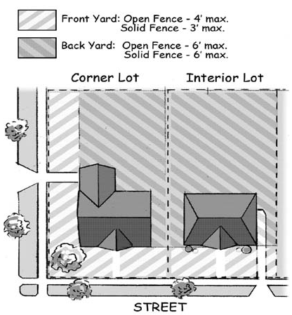
E.
Yards - Corner, Through, and Waterfront Lots.
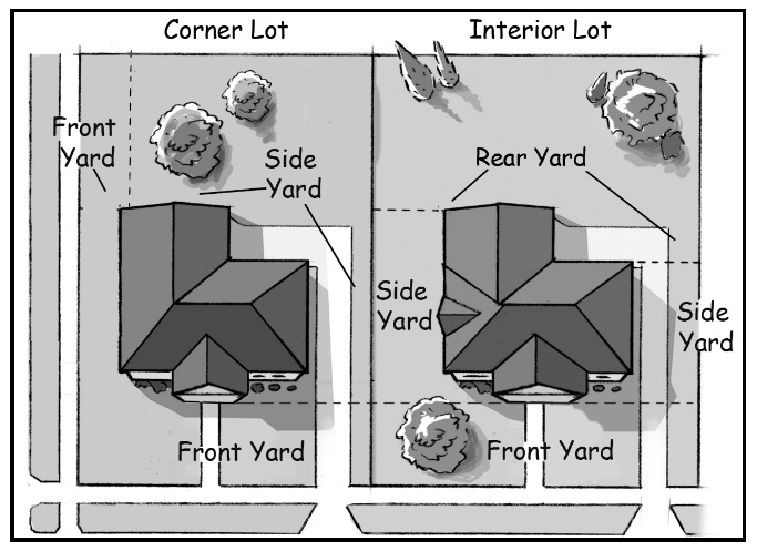
5.2.05.E. Yards.
1.
Corner and Through Lots. Corner and through lots shall have two (2) front lot lines, two (2) front yards, two (2) side yards, and no rear yard. For through lots, the main building or structure shall be oriented toward the predominant frontage based on the established or planned pattern of development, as determined by the Director.
2.
Waterfront lots shall have front yards on both the street and waterfront sides, and two (2) side yards.
F.
Permitted Encroachments into Setbacks and Yards.
1.
General. Encroachments permitted by this Section following may be within setbacks or yards. All permitted encroachments are subject to meeting the minimum greenspace requirements for the lot. Other encroachments are permitted under the applicable Sections of this Chapter as noted below, provided the minimum greenspace requirements for the lot are met.
a.
Garages and other accessory structures - see Section 5.2.08.
b.
Driveways - see Section 5.10.03.F.
c.
Fences and walls - see Section 5.2.11.
d.
Landscaping, except as required for clear vision areas of Section 5.2.15.C.
e.
Private sidewalks.
f.
Swimming pools - see Section 5.2.09.
2.
Architectural Elements, Porches and Stoops.
a.
Front Yard.
i.
Architectural Elements. Architectural elements may project into the front yard by not more than three (3) feet.
ii.
Unenclosed Porches and Stoops. Unenclosed porches and stoops (not including steps) may project into the front yard by no more than ten (10) feet, but shall be no closer than five (5) feet from the front sidewalk. For porches and stoops in Traditional Neighborhoods - See Section 5.5.07.E.3.
iii.
Balconies. Upper level balconies may project into a front yard by no more than six (6) feet.
b.
Side Yard.
i.
Architectural Elements. Architectural elements may project into the side yard by not more than two (2) inches for each one (1) foot of width of the side yard, except that a chimney may be permitted where the Director determines it will not obstruct light or ventilation. In no case shall an architectural element be permitted within five (5) feet of a lot line.
ii.
Unenclosed Porches and Stoops. An unenclosed porch or stoop (including steps) may project into the side yard, provided it is at least five (5) feet from the side lot line.
3.
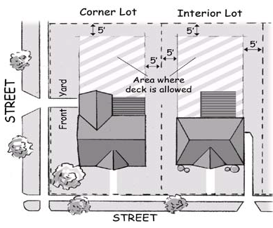
Decks and Patios.
a.
Interior Lot.
i.
A ground-level deck or patio may be in the side yard, provided it meets the minimum side setback for the Zone District, is set back at least ten (10) feet from the front building façade, and is screened from view of the public right-of-way by landscaping or permitted fencing.
ii.
A ground-level deck or patio may be located in the rear yard, provided it is at least five (5) feet from all lot lines.
iii.
A deck with a platform over four (4) feet in height may be in the rear yard, subject to rear and side yard building setbacks.
iv.
A deck or patio is not permitted within the front yard.
b.
Corner Lot.
i.
A ground-level deck or patio may be in the side yard, provided it is at least five (5) feet from the yard lot lines, and is not in a front yard.
ii.
A deck with a platform over four (4) feet high shall meet required side yard setbacks.
c.
Administrative Departure. An Administrative Departure may be approved to reduce the minimum side or rear setback of a ground-level deck or patio to not less than three (3) feet where there are no detrimental effects on adjacent properties, and where applicable fire safety provisions of the City's building codes are met.
5.2.05.F.4 Decks and Patios.
4.
Wheelchair Ramps.
a.
The Director may permit wheelchair ramps used for persons with mobility impairments in a front or rear yard, provided the location does not create a hazard, or impede access for operations related to safety, such as access for fire personnel or equipment. In no case shall a ramp be placed nearer than three (3) feet from any side lot line.
b.
Administrative Departure. An Administrative Departure may be approved to permit a ramp, or any additional modifications needed, nearer than three (3) feet to the side lot line, where it is demonstrated that no other feasible location is practical.
5.
Basement Egress Window Wells. Basement egress window wells are permitted in all yards, provided the following conditions are met:
a.
Setback. A window well shall be set back at least three (3) feet from the side or rear lot line, and at least ten (10) feet from the front lot line.
b.
Front Yard Screening. When in a front yard, a three (3) foot high landscape or building material screen shall be provided in front of the window well. If screened with a building material, the material shall be compatible with the materials and colors used for the main building.
c.
Building Code. The requirements of Chapter 131 of the City Code shall be met.
d.
Administrative Departure. An Administrative Departure may be approved to reduce the minimum setback of a window well from a side or rear lot line where the following conditions are met:
i.
The window well is set back a minimum of one (1) foot from any side or rear lot line.
ii.
A clear path to the public way is provided.
iii.
Adequate fall protection to adjacent walking surfaces is provided.
iv.
Adjacent properties will be protected during excavation.
6.
Athletic Courts - Residential Lots.
a.
Interior Lot. An athletic court shall only be in a rear yard and at least seven (7) feet from the rear and side lot lines.
b.
Corner Lot. An athletic court may be in a side yard, at least seven (7) feet from the side lot line, but not in a front yard.
G.
Below Grade Features. Below-grade or underground features shall not extend into any yard, unless otherwise allowed in this Chapter.
H.
Projections into the Public Right-of-Way. The following projections are permitted, subject to approval of an encroachment permit from the City Engineer.
1.
Balconies. A balcony with a minimum ground clearance of sixteen (16) feet above finished grade may extend up to five (5) feet over a public sidewalk.
2.
Awnings. An awning with a minimum ground clearance of eight (8) feet may extend over a public right-of-way.
3.
Canopies. Canopy support posts shall not be permitted in a public right-of-way unless specifically permitted by Traffic Engineering. See also Section 5.2.18.
4.
Arcades. An arcade shall be permitted only in the TN-TOD, CC, TCC, and TBA Zone Districts.
a.
An arcade shall be open accessible to the public at all times for its entire length to the street line or publicly accessible open area except for building columns, and unobstructed to a height of not less than twelve (12) feet.
b.
Except for corner lots, an arcade shall have a depth not less than ten (10) feet nor more than thirty (30) feet measured perpendicular to the street line or boundary of the publicly accessible open area on which it fronts, and extend for at least fifty (50) feet, or the full length of the street line or boundary of the publicly accessible open area on which it fronts, whichever is the lesser distance.
c.
On a corner lot, an arcade shall have an area of not less than five hundred (500) square feet and a minimum horizontal dimension of ten (10) feet.
d.
No part of the arcade shall be above the traveled portion of the street or publicly accessible open area that it adjoins.
e.
No off-street parking spaces, passenger drop-offs, driveways, or off-street loading berths are permitted anywhere within an arcade.
I.
Roof-Mounted and Ground-Mounted Mechanical Equipment (e.g. air conditioning condensers; swimming pool and spa heaters; pumps and filters; transformers and generators; and similar equipment).
1.
Residential Zone Districts.
a.
All ground mounted mechanical equipment shall be incorporated within the footprint of a main or accessory structure, or placed in a side or rear yard at least three (3) feet from any side or rear lot line, and be fully screened from view from a public street and adjacent properties using one (1) of the following options:
i.
Landscape material which provides a minimum of fifty (50) percent year round opacity;
ii.
A living wall or vertical garden which is covered by vegetation to provide a minimum of fifty (50) percent year round opacity; or
iii.
A decorative wall or fence that incorporates at least one (1) of the primary materials and colors of the nearest wall of the main building and that provides eighty (80) percent year round opacity.
b.
A wall or screen shall be at least one (1) foot taller than the height of the mechanical equipment being screened, provided the screen need not exceed a height of twelve (12) feet.
c.
The screening requirements shall not apply if it is demonstrated that the only feasible location for screening would impede the functioning of solar, wind or geothermal energy equipment or other similar systems.
d.
To the maximum extent practicable utility boxes shall be oriented with access doors facing away from the street right-of-way or adjacent property.
2.
All Other Zone Districts. All mechanical equipment shall be incorporated within the footprint of a principal or accessory structure or mounted on the roof structure.
a.
All roof-mounted mechanical equipment (including, but not limited to, HVAC equipment, exhaust fans, cooling towers, and related guard rails or safety equipment) shall be fully screened from view from a public street at ground level and, to the extent practicable, from adjacent buildings of similar height. Screening shall be provided by one (1) or more of the following options.
i.
A parapet wall or similar feature that is an integral part of the building's architectural design;
ii.
A screening structure erected around the equipment that incorporates at least one (1) of the primary materials and colors on a street-facing façade of the main building and designed to assist in buffering noise;
iii.
A living wall or vertical garden which is covered by vegetation to provide a minimum of fifty (50) percent year round opacity.
b.
The parapet wall or screening structure shall be fully opaque year round and shall be at least as tall as the height of the mechanical equipment being screened provided the screen need not exceed a height of twelve (12) feet.
3.
Administrative Departures.
a.
Mechanical equipment may be placed in an alternate area, including ground mounted equipment, in any Zone District where it is demonstrated that the required location is not feasible, and provided the unit is properly enclosed or screened with vegetation from view of a public street.
b.
Alternate locations for solar, wind or geothermal energy equipment or systems may be permitted if it is demonstrated that the required location or screening would impede their proper functioning.
(Ord. No. 2022-10, 4-12-22; Ord. No. 2022-17, 6-21-22; Ord. No. 2022-30, §§ 1, 2, 8-23-22; Ord. No. 2025-14, § 1, 7-29-25)
Sec. 5.2.06. - Building Height Measurements and Exceptions.
A.
Measurement.
1.
Stories. Where specified in stories, building height shall be measured in the number of stories entirely above the finished grade for any elevation fronting on a public street, including habitable attics, half-stories, and at-grade structured parking.
a.
Unless otherwise specified, story height is measured in feet between the floors of a story to the floor of the story above it.
b.
For the uppermost story, story height shall be measured from the floor of the story to the eave line on pitched roofs and to the tallest point of the roof deck on parapet and flat roofs.
c.
A mezzanine level counts as a story.
d.
For the purposes of this Chapter, the usable floor area of a half story is only that area having at least four (4) feet clear height between floor and ceiling.
e.
Unless otherwise specified, one (1) story shall be measured as not less than nine (9) feet nor more than fifteen (15) feet. The following shall be excluded:
i.
Spaces completely below the finished grade, such as basements, cellars, crawl spaces, sub-basements, and underground parking structures; and
ii.
A story shall not be counted as a story when more than fifty (50) percent of its cubic content is below the finished grade of the adjoining ground.
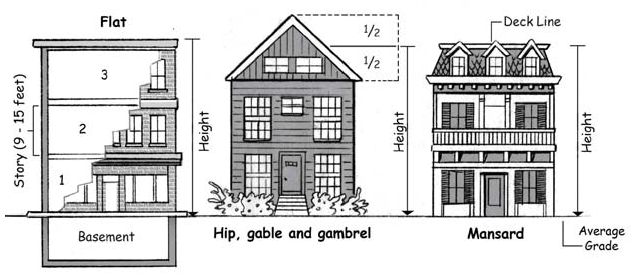
5.2.07. Building Height (Measurement).
2.
Height. When measured in feet, building height shall be measured as the vertical distance from the finished grade adjacent to the structure to the highest point of a flat roof; to the deck line of a mansard roof; and to the average height between the eave and ridge of the highest roof section for a gable, hip or gambrel roof.
3.
Average Grade. See Section 5.16.02.G. for definitions of grade. When the terrain is sloping, the finished grade shall be the average of the elevation of the ground for each side of the structure, as measured six (6) feet from the exterior walls of the structure.
B.
Exceptions. The height requirements of all Zone Districts shall be subject to the following exceptions: parapet walls not exceeding four (4) feet in height, chimneys, cooling towers, elevator bulkheads, fire towers, gas tanks, utility penthouses, stacks, stage towers or scenery lofts, monuments, cupolas, domes and spires and necessary mechanical appurtenances.
C.
Airport Zoning Act. Proposed buildings or structures or modification to existing buildings or structures with a height greater than one hundred (100) feet require a permit from the Kent County Department of Aeronautics, pursuant to the Airport Zoning Act, Public Act No. 23 of 1950.
Sec. 5.2.07. - Single-Family Dwellings, Detached.
A.
A Detached single-family dwelling and any additions or alterations thereto, other than manufactured housing in a licensed manufactured housing community, shall meet the requirements of this Section in addition to all other regulations of this Chapter.
B.
Conversion.
1.
An existing detached single-family dwelling exceeding five thousand (5,000) square feet in gross floor area may be converted to permit additional dwelling units, provided the Director first determines that the size of the structure is substantially out of character with other houses within a three (3) block radius and a Special Land Use application is approved.
2.
In considering the Special Land Use, the Planning Commission shall:
a.
Determine the appropriate number of units to be permitted; and
b.
Ensure that adequate parking as required by Article 10 can be provided in a location that does not create an adverse effect on adjacent properties.
3.
Exception. Notwithstanding Section 5.2.07.B.1. Single-Family dwellings on corner lots may be converted to two-family dwellings as a Permitted Use, subject to applicable Site and Building Placement Standards and Building Element Requirements of Article 5.
C.
Minimum Dimension. Each dwelling shall have a minimum of fourteen (14) feet in any horizontal dimension.
D.
Minimum Floor Area. Each dwelling shall have a minimum gross floor area of seven hundred fifty (750) square feet.
E.
Neighborhood Classification. The dwelling shall comply with the requirements of this Section and shall be generally compatible in character, design and appearance to other residential dwellings within the same Neighborhood Classification.
F.
Primary Entrance.
1.
The primary entrance for the main building shall have a step, stoop, or porch which is attached to the building foundation, or provided with a separate four (4)-inch deep masonry foundation. A stoop or landing shall project at least three (3) feet from the building (not including steps). A porch shall project at least six (6) feet from the building (not including steps).
2.
Section 5.2.05.F.4 provides regulations related to handicap ramps and other modifications to a dwelling's primary entrance for housing intended to accommodate persons with mobility impairments.
G.
Manufactured House. If the dwelling is a manufactured house, it shall:
1.
Be installed pursuant to the manufacturer's setup instructions and shall be secured to the premises by an anchoring system or device complying with the rules and regulations of the Michigan Manufactured Home Commission and shall have a foundation wall as required in this Section.
2.
Be installed with the wheels removed and not have any exposed towing mechanism, undercarriage or chassis.
3.
Have all construction and plumbing, electrical apparatus and insulation within and connected to the manufactured house be of a type and quality conforming to the Manufactured Home Construction and Safety Standards as promulgated by the United States Department of Housing and Urban Development, 24 CFR 3280, as amended, and comply with all applicable building and fire codes.
(Ord. No. 2018-69, § 1, 12-18-18; Ord. No. 2019-09, § 1, 3-26-19)
Sec. 5.2.08. - Accessory Structures.
A.
Permits. All accessory structures shall require a Zoning Permit prior to construction.
B.
Mixed-Use Commercial Zone Districts, Neighborhood Office Service District, and Special Districts.
1.
Accessory structures shall comply with applicable setback and height restrictions specified for the Zone District in which the accessory use or structure is located.
2.
Not more than one (1) detached accessory building is permitted per lot. The area of the permitted accessory building shall not exceed twenty-five (25) percent of the ground level gross floor area of the main building.
C.
Principal Use Required.
1.
Unless otherwise expressly allowed in this Chapter, accessory structures shall be permitted and maintained only in conjunction with a principal use and a main building or structure on the same lot.
2.
Accessory structures may only be constructed at the same time as or after the construction of the main building or structure on the same lot.
3.
If the main building or structure is destroyed, demolished or removed, any accessory buildings or structures on the same lot shall be removed within sixty (60) days, unless a permit for construction of a new main building has been approved.
D.
Public Right-of-Way or Easement. In no instance shall an accessory structure be within a public right-of-way or easement, unless otherwise permitted in an easement agreement.
E.
Architectural Compatibility.
1.
Any accessory structure that is one hundred twenty (120) square feet or larger shall be similar in architecture to the main building in its form and slope of roof. Exterior finish materials shall be those materials customarily used for residential construction, and shall be similar in placement and orientation to the main building.
2.
No accessory structure shall be constructed with a tubular frame construction or with canvas, plastic film, or similar exterior material that does not provide long-term durability.
F.
Carport. A carport shall comply with the location requirements applicable to either an attached or detached accessory structure.
G.
Attached Structures. An accessory structure which is structurally attached to a main building shall be subject to all setback regulations applicable to the main buildings. In addition, attached garages within the Traditional Neighborhood (TN) and Mid-20 th Century Neighborhood (MCN) Zone Districts shall be at least five (5) feet behind the façade of the main building.
H.
Residential Accessory Buildings.
1.
Single-Family and Two-Family Dwellings.
a.
One (1) detached and one (1) attached accessory structure is permitted.
b.
Except as permitted in Section 5.9.03, and as noted below, the height and combined gross floor area for all attached and detached accessory structures shall not exceed the dimensions based on the requirements of Table 5.2.08.G.1.
2.
Multiple-Family Uses.
a.
Accessory structures may exceed the gross floor area of Table 5.2.08.G.1. for total garage or carport space up to the necessary GFA to meet the required number of parking spaces in Article 10. All other requirements of this Chapter shall be met.
b.
Administrative Departures. An Administrative Departure may be approved to permit additional GFA for garage or carport space for multiple-family uses above the minimum requirements of Article 10 for up to two (2) spaces per dwelling unit, provided the applicant can demonstrate a need for the space and all other requirements of this Chapter are met.
I.
Residential Detached Structures.
1.
The structure shall be placed at or behind the front wall of the main building, and at least six (6) feet from the main building, excluding decks and patios. The structure shall be at least three (3) feet from a side lot line or another accessory structure, excluding decks and patios.
2.
Interior lots.
a.
If less than sixty (60) feet from the front lot line, a detached accessory structure shall not encroach into the required front yard and side yard setbacks.
b.
If sixty (60) feet or more from the front lot line and no nearer the front lot line than the main building, the wall(s) of a detached accessory structure shall be a minimum of three (3) feet from the side and rear lot lines.
c.
City building codes require fire safety measures if less than five (5) feet from the lot line.
3.
Corner, Through and Waterfront Lots.
a.
Corner Lots. Detached accessory buildings shall not be within a front yard and shall be set back a minimum of three (3) feet from a side lot line.
b.
Through and Waterfront Lots.
i.
Side yard setback requirements shall be met.
ii.
For through lots, front yard setbacks shall be met on the frontage deemed by the Director to be the less predominant frontage as provided Section 5.2.05.E.2.
iii.
For waterfront lots, all front yard setbacks shall be met.
4.
Alley. An accessory structure shall be at least three (3) feet from an alley right-of-way. See also Section 5.10.03.F. regarding driveways.
5.
The following shall not be counted toward the number or area of permitted detached accessory structures:
a.
Trellises, pergolas arbors or other similar structures;
b.
Gazebos that are two hundred and fifty (250) square feet in area or smaller;
c.
Landscape features, such as small ponds, outdoor kitchens, spas, and fire pits;
d.
Sport courts;
e.
Swimming pools or hot tubs and changing rooms that are two hundred and fifty (250) square feet in area or smaller;
f.
Solar panels;
g.
Decks, patios; and
h.
Other similar structures as determined by the Director.
6.
Administrative Departure. An Administrative Departure may be approved to allow the wall(s) of a detached accessory structure to within one (1) foot of the side or rear lot line, where topography, natural features, or other site constraints exist, where there are no detrimental effects on adjacent properties, and where applicable fire safety provisions of the City's building codes are met. A property survey and scaled site plan shall be submitted.
J.
Additional Accessory Structures.
1.
In addition to the accessory structure(s) provided for in this Section, one (1) accessory structure, such as an enclosed play structure or storage structure, of one hundred twenty (120) square feet or less and up to fourteen (14) feet high may be permitted in the rear yard on a lot with a residential use. A setback of at least three (3) feet from any lot line shall be provided.
2.
For community gardens and other similar uses, one (1) accessory structure of one hundred twenty (120) square feet or less and up to fourteen (14) feet high may be erected for storage of supplies and materials related to the use. An additional structure of the same size and height may be added for properties exceeding three (3) acres. The structure(s) shall meet all setback requirements of the Zone District.
K.
Prohibited Structures.
1.
No mobile home, trailer, vehicle, tank, boat, container, railroad car, dumpster, barrels, crate, furniture, tent, junk object or salvage materials or similar items shall be used as an accessory structure or storage structure.
2.
Living or sleeping quarters, temporary or permanent, in an accessory structure or other building (except as an Accessory Dwelling Unit as provided in Section 5.9.03), travel trailer, motor home or other recreation vehicle, auto chassis, boat or portable building, are prohibited.
L.
Minimum Greenspace. Accessory structures are subject to minimum greenspace calculations as established within each Zone District."
(Ord. No. 2018-32, § 1, 6-5-18)
Sec. 5.2.09. - Swimming Pool Placement.
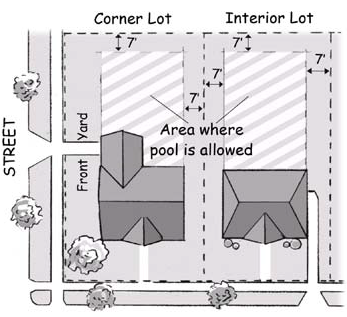
5.2.09.B. Swimming Pool Placement
A.
In addition to the provisions of this Section, all applicable requirements of Chapter 131 General Building Regulations shall apply.
B.
Residential Lots.
1.
Interior Lots. A swimming pool shall only be in the rear yard, and the pool wall/edge set back at least seven (7) feet from the rear and side lot lines.
2.
Corner Lots. A swimming pool may only be in the side yard, with a setback of at least seven (7) feet from the pool wall/edge to a side lot line, and no nearer to a street than the main building.
C.
Patios, decks, concrete surrounds, or the like shall comply with the setback requirements of Section 5.2.05.F.3.
Sec. 5.2.10. - Arbors and Trellises.
A.
Arbors, trellises, pergolas and similar structures may be in any yard provided they comply with clear vision requirements and are at least three (3) feet from front and side lot lines.
B.
Arbors, trellises and pergolas may not be higher than six (6) feet in the front yard or fourteen (14) feet in other yards, and set back at least five (5) feet from the side or rear lot lines.
Sec. 5.2.11. - Fences and Walls.
A.
Permits. All fences and walls higher than thirty (30) inches shall require a Zoning Permit.
B.
Requirements.
1.
Workmanship, Materials, and Maintenance.
a.
Walls and fences shall be constructed using quality workmanship.
b.
Walls shall be made of masonry, decorative block, poured concrete, brick, stone or other high-quality, appropriate material. The material used shall be compatible with material used in construction of the main building.
c.
No fence or wall shall be left in an unfinished state, such as openings on top of walls, uncapped fence posts (unless so designed), or other similar condition.
d.
The finished side of a fence shall face outward toward abutting lots and rights-of-way.
e.
Wrought iron or decorative aluminum fences shall not have exposed pointed ends, but may have finials with flat ends.
f.
Fences shall be made of ornamental metal, rot-resistant wood, chain link or other high-quality, durable materials.
g.
Densely landscaped areas, such as hedges and closely spaced bushes or other plant materials, may be considered a fence when they have the effect or accomplish the purposes normally associated with fences, such as creating privacy or separation. See Section 5.11.12. Landscape Buffers.
h.
Maintenance. Walls and fences shall be maintained in good repair and in safe and attractive condition, including but not limited to replacement of missing, decayed or broken structural and decorative elements with the same materials and removal of graffiti.
i.
Prohibited Material.
i.
Chain link fence material is not permitted in a front yard unless otherwise permitted in this Section.
ii.
Chain link fences with slats are not permitted unless approved by the Planning Director and only where the fence location will not be generally visible from the public right-of-way.
iii.
Unless otherwise required by a public entity or utility to protect power, food or water supplies, barbed, razor, concertina, electrified, or other similar wire is not permitted.
iv.
In the SD-IT District an additional two (2) additional feet of height to accommodate barbed and similar wire fencing is permitted, not to exceed a maximum or overall height of ten (10) feet and only in the side and rear yard.
2.
Front Yard Fences.
a.
Residential Zone Districts. The first five (5) feet of the side yards of a lot shall comply with the fence and wall requirements for a front yard in Table 5.2.11.C. where the front setback is ten (10) feet or less.
b.
Non-Residential Uses. Any fence in a front yard of a non-residential use shall consist of a decorative aluminum or wrought iron picket fence.
c.
Waterfront Lots. The area of a waterfront lot between the main building and the natural body of water is a front yard per Section 5.2.05.E. and shall follow the requirements for front yard fences, except that a solid fence, wall or screening of any kind shall not be permitted in this yard area.
3.
Clear Vision Areas. No fence, wall, screen or planting material shall be erected or maintained in any location that shall obstruct the vision of motorists at street intersections or driveways, per Section 5.2.15. of this Chapter.
4.
Setbacks and Right-of-Way. Fences shall be outside of the public right-of-way and set back at least one (1) foot from the right-of-way line. Fences may otherwise be on the property line.
5.
Vacant Lot. The placement of a fence or wall on a vacant lot shall be permitted. The requirements for walls and open fences shall apply. The requirements of Table 5.2.11.C shall be met when a fence or wall is erected between the lot line and the required setbacks of the District.
6.
Buried Electronic Fences. Electronic fences buried beneath the ground are permitted in all Zone Districts outside of public rights-of-way.
5.2.11.C. Maximum Fence Height.
C.
Maximum Height. Height shall be measured from grade at the lowest point within three (3) feet of the fence or wall, perpendicular from its plane. Height shall be measured from the established grade line to the highest point, including posts and finials. The use of a berm or other feature to artificially increase height is prohibited.
D.
Administrative Departures.
1.
The height, opacity and retaining wall requirements of this Section may be modified where an adequate clear vision area is present, no detriment to neighboring properties would be created and it is clearly demonstrated that due to topography, natural features, lot configuration or other site-related issue that the requirements of this Section cannot be satisfied.
2.
In Mixed-Use Commercial Zone Districts, two (2) feet may be added to the maximum fence height in side or rear yards where it is demonstrated topography, natural features, lot configuration or security makes the additional height necessary and would not be detrimental to neighboring properties.
3.
Vinyl coated chain link fencing may be permitted in the front yard of a property in a SD-IT or other non-residential Zone District where the fence would not be visible from a public right-of-way or materially affect the character of a neighborhood.
(Ord. No. 2018-32, § 2, 6-5-18)
Sec. 5.2.12. - Repair and Storage of Vehicles in Residential Zone Districts.
A.
Repair. In all residential Zone Districts, mechanical work and repair of motor vehicles, boats, travel trailers, snowmobiles, recreational vehicles or any other similar vehicles, licensed to, registered in the name of, and solely for the personal use of the dwelling occupant is permitted with the following conditions:
1.
Not more than one (1) vehicle shall be under repair at any given time.
2.
There shall be no outside storage of vehicle parts or equipment.
3.
Repair activities shall not create excessive noise, vibration, odor or other nuisances to neighboring properties.
B.
Outdoor Recreational Vehicle Storage.
1.
Number Permitted.
a.
Outdoor storage or use of one (1) operable recreational vehicle, not exceeding a length of twenty-five (25) feet (excluding the hitch, bumper and other towing attachments), is permitted within a Residential Zone District in accordance with this Section.
b.
One (1) additional operable vehicle shall be permitted on any lot over twenty-two thousand (22,000) square feet.
2.
Recreational vehicle storage shall only be permitted on a lot on which a principal use is present.
3.
Location.
a.
Except as expressly provided in this Section, vehicle storage shall only be in the rear yard. The vehicle may be stored in the side yard if storage in the rear yard is not possible on an interior lot because of specific conditions related to the lot, such as lot size, topography, or other natural features. Vehicles shall not be closer than four (4) feet from the side lot line and shall be screened from the adjacent property by a six (6) foot high solid fence or hedge.
b.
On corner lots, the recreational vehicle may be parked or stored in a side yard no closer than four (4) feet from the side lot line, provided it is not closer to a street than the main building, is not in a front yard, and is screened from the adjacent property by a solid fence or hedge six (6) feet in height.
4.
One (1) recreational vehicle may be parked on a driveway from May 1 through October 31, provided the vehicle is maintained in good condition, is parked a minimum of six (6) feet from any structure on an adjacent property, is at least fifteen (15) feet from the front lot line and clear vision for pedestrians and vehicles is otherwise maintained, and is not being occupied or repaired.
C.
Commercial Vehicles. No commercial vehicle shall be parked or stored on any property in a Residential Zone District unless within a completely enclosed building, except that one (1) commercial vehicle of three-quarter (¾) ton size or smaller may be parked in a residential driveway. Commercial vehicles are permitted to park temporarily while engaged in the delivery, pickup or service to the subject property.
Sec. 5.2.13. - Commercial Waste Receptacles and Enclosures.
A.
Applicability. The requirements of this Section shall apply to all properties using a receptacle, other than a residential waste container, that is used for the purpose of waste removal, recycling, or reuse of household waste, household goods, clothing, or similar materials.
B.
Enclosure.
1.
All outdoor waste, recycling and compost receptacles, including grease barrels, shall be enclosed on three (3) sides and screened. The fourth side of the enclosure shall consist of a gate, made of wood, vinyl, or other high quality material, as determined by the Director. If the waste receptacle is a dumpster, it shall have an enclosing lid or cover which shall remain closed when not in use.
2.
Residential compost receptacles shall be subject to the provisions of Section 9.108 of the City Code.
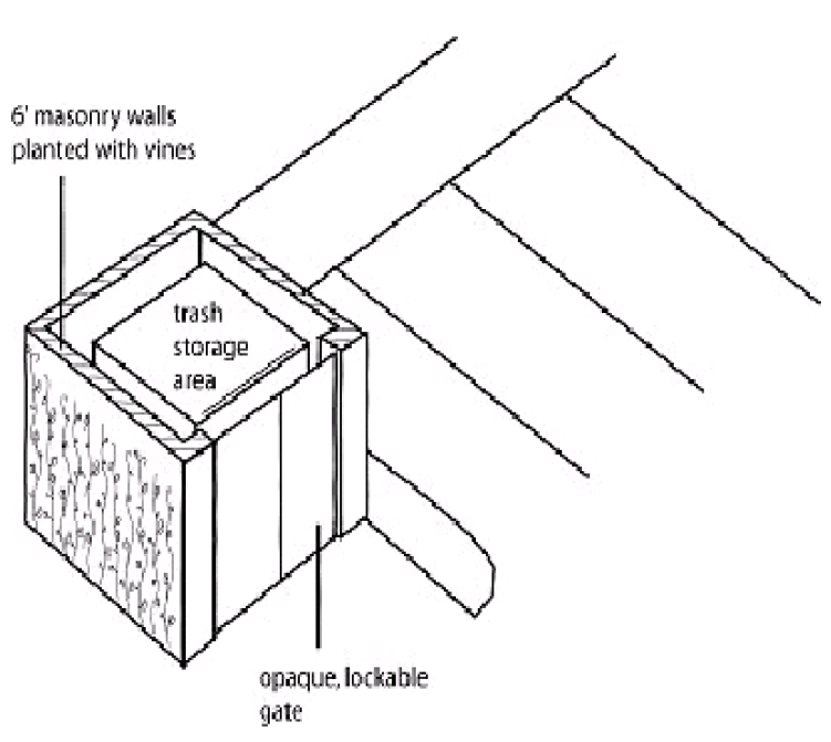
5.2.13. Waste Receptacles & Enclosures
C.
Materials. The enclosure shall be constructed of brick or decorative textured block wall to recognize the permanence of the structure, reduce maintenance requirements and lessen the opportunity for graffiti or vandalism. The enclosure shall be consistent with the building materials of the main building. Steel or concrete bollards shall be installed to assist in the positioning of dumpsters and to protect the enclosure.
D.
Size. The waste receptacle base shall be at least nine (9) feet by six (6) feet in area, constructed on six (6) inches of reinforced concrete pavement. The base shall extend six (6) feet beyond the waste receptacle pad or gate to support the front axle of a refuse vehicle. The enclosure shall have a minimum height of six (6) feet or one (1) foot above the height of the waste receptacle, whichever is greater. The enclosure shall have at least three (3) feet of space on each side of the waste receptacle.
E.
Placement.
1.
Preferred placement. When possible, the back side of the waste receptacle enclosure should be placed against the building, which may act as one (1) side of the enclosure.
2.
Front yard. Waste receptacles and enclosures shall not be placed in the front yard.
3.
Rear and side yards. Waste receptacles and enclosures shall be in the rear or side yard and not closer than three (3) feet from the rear or side lot line, unless otherwise approved by the Director where no other practical location is present.
4.
Residential use adjacent. Waste receptacles and enclosures shall be placed a minimum of twenty (20) feet from an adjacent residential use.
5.
Landscape Buffer. A waste receptacle enclosure shall not be placed within a required landscape buffer area, as described in Section 5.11.12.
F.
Access. Waste receptacles shall be easily accessed by refuse vehicles without the potential to damage vehicles parked in designated parking spaces or interfering with the normal movement of vehicles on or off the site.
G.
Administrative Departure. An Administrative Departure for enclosure materials and the placement of an enclosure may be granted. In granting a waiver from the placement requirements, the Director shall take into consideration the proximity of adjacent residential structures, topography, natural features, existing screening or other barriers, and operational requirements for trash removal that would mitigate potentially adverse effects.
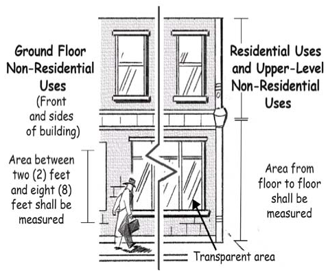
Sec. 5.2.14. - Building Transparency.
A.
Clear Glass. Glass in windows, doors, and display windows shall be transparent to insure a safe, pedestrian-oriented environment. Glass shall be clear or lightly tinted and have a measurement of seventy (70) percent or greater VLT. A glass sample must be provided with the performance values listed on the sample as needed for project review.
B.
Measurement. Transparency requirements shall apply as follows:
1.
For non-residential ground-floor uses, the area of the front and sides of a building between two (2) and eight (8) feet above the sidewalk (or ground level adjacent to the building if a sidewalk is not present) shall be used to measure transparency.
2.
For residential uses and for upper level non-residential uses, the area from floor to floor shall be used to measure transparency. For single-family and two-family dwellings, main entrance doors (not including storm doors) which contain a window shall be counted toward the minimum transparency requirement for the building wall facing the street.
3.
Only those windows and door areas arranged so that active uses within the building are visible from or accessible to the street shall be counted toward meeting transparency requirements. Enclosed product display windows and other similar elements that do not permit clear visibility into the interior of the building shall be omitted from transparency calculations.
5.2.14.B. Transparency Measurement
C.
Reflective Surfaces. The use of highly reflective surfaces, including reflective glass and mirrors, is prohibited on the ground floor.
D.
Security Shutters. Exterior steel barriers, hurricane curtains and other security devices are not permitted on the exterior of the building. If located inside a building, they may not be visible from the sidewalk or public right-of-way during business hours.
E.
Parking Areas. A minimum of six (6) square feet of clear window area for every forty (40) linear feet or portion thereof of the wall(s) of a building that faces a parking area shall be required. The window shall be placed so that the parking area may be readily viewed from inside the building.
F.
Stairwells. Where stairwells are introduced to the outer building wall of a development, the exterior of the stairwell and exit door shall be at least seventy (70) percent transparent.
G.
Cash Register Viewing Window. The cash register for a convenience/package goods store use shall be clearly visible from the street. The viewing window shall be at least twenty (20) square feet in size and consist of clear glass. No signs shall be posted on the viewing window.
H.
Exceptions. Transparency requirements do not apply to portions of structures in assembly area of theaters, auditoriums, religious institutions, and similar uses, provided that the building wall is enhanced by architectural detailing, artwork, landscaping or similar features. Façade variation requirements contained elsewhere in this Chapter shall be met.
I.
Administrative Departures.
1.
Administrative Departures may be granted for any requirement of this Section.
2.
Approved Administrative Departures may be required to provide mitigation measures such as the addition of architectural elements, display windows with a minimum 12-inch depth, a green wall or landscaping.
3.
Administrative Departures may be granted where:
a.
It is demonstrated by the applicant that transparency would be significantly detrimental to the operation or security of the proposed use;
b.
Sloping grades would make the introduction of windows impractical;
c.
All sides of a building are adjacent to the public right-of-way and/or an urban open space;
d.
Any side of a building abuts an outdoor service area, such as loading spaces, trash removal operations, ground level mechanical facilities, or similar use; or
e.
A building that has a side yard setback less than five (5) feet which abuts an interior lot and transparency requirements are in conflict with the City's building codes.
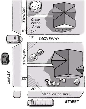
Sec. 5.2.15. - Clear Vision Areas.
A.
Requirement. Clear vision areas are required in locations where an unobstructed view of approaching traffic is necessary for the safety of pedestrians, bicyclists and drivers. A clear vision area is typically, but not exclusively, a triangular area at the intersection of two (2) streets, or a street and a driveway; however, clear vision areas may be required at other locations identified in this Chapter and in Chapter 51 Streets, Article 8 of the City Code.
B.
Measurement. At the intersection of two (2) streets or the intersection of a street and a driveway, the required clear vision area shall be established as follows:
1.
Street Corners. For streets, twenty (20) feet along each lot line starting at the intersection of the lot lines, and connected by a straight line to form a triangular area. In the case of a rounded corner, the measurement shall be taken from the intersection of the front lot lines extended.
2.
Driveways. For driveways, ten (10) feet along the lot line and the driveway starting at the intersection of the lot line and the closest edge of the driveway, and connected by a straight line to form a triangular area.
3.
Other Required Areas. For other required clear vision areas, refer to the standards established in Chapter 51, Article 8 of the City Code.
5.2.15. Clear Vision Areas.
C.
Landscaping or Structures.
1.
No plantings, signs, fences, walls or other structures exceeding thirty (30) inches in height shall be established or maintained in clear vision areas, except as otherwise allowed in this Chapter or in Chapter 51, Article 8 of the City Code.
2.
The Traffic Engineering Department may require a reduction in the height of any screening improvement or a different location of a new building or structure otherwise required in this Chapter to ensure an adequate clear vision area for driveways and streets. These limitations shall be required only for that portion of the building, structure or screening improvement necessary to provide an adequate clear vision area.
D.
Administrative Departure. A new building or structure may be located within a clear vision area, provided the Traffic Engineering Department concurs with the findings of an independent engineering study provided by the applicant that demonstrates that the siting of the new building or structure allows proper stopping sight distance as defined in A Policy on Geometric Design of Highways and Streets, as amended, by the American Association of State Highway and Transportation Officials (AASHTO).
Sec. 5.2.16. - Street and Intersection Widening.
Any project that would widen a street or intersection within a Street Conservation Area shall be submitted to the Planning Commission for review and recommendation prior to final authorization by the City Commission in accordance with Administrative Policy 97-01 Street and Intersection Widening - Planning Commission Review Procedures.
Sec. 5.2.17. - Essential Services.
A.
Applicability. Essential services shall be permitted in all Zone Districts subject to Director Review to determine that the yard, parking, landscaping and screening and other requirements are met, and are designed to be compatible with surrounding uses.
B.
Authority. Accessory facilities, which are determined by the Director, Public Works Director and City Engineer to be necessary in support of essential services, may be permitted in any Zone District.
C.
Concealed Enclosure. The outdoor enclosure of above-ground essential service utilities shall be screened using a permanent brick or decorative textured block wall to recognize the permanence of the new infrastructure, reduce maintenance requirements and lessen the opportunity for graffiti or vandalism.
D.
Administrative Departure. An Administrative Departure may be granted and alternative enclosure or screening materials used in the operation of the utility would be adversely affected by this requirement.
Sec. 5.2.18. - Outdoor Canopies.
A.
Design.
1.
A canopy may be either attached or detached from the main building.
2.
A canopy shall have an architectural and design treatment, including materials and colors, which is substantially similar to the main building. A canopy shall use a similar roof form, pitch, and materials in order to resemble the roof covering of the main building. Any supporting columns shall be coordinated with the design of the main building.
3.
Except as permitted in Section 5.9.24., Outdoor Seating Areas, a canopy shall not cover architectural details, transparency or the expression line of the main building.
4.
Except as otherwise permitted in Section 5.9.24., Outdoor Seating Areas, a canopy structure shall not be enclosed.
5.
If any part of the canopy is illuminated, highly reflective material shall not be installed on the underside of the canopy.
B.
Height. A canopy shall have a minimum ground clearance of eight (8) feet over public sidewalks and a minimum ground clearance of fourteen (14) feet over any vehicular driveway or parking area. A canopy shall not exceed the height of the main building.
C.
Setback/RBL Requirement. A canopy structure shall comply with all minimum building setback requirements or Required Building Line applicable to the main building.
D.
Sides. Each side of a pump canopy shall be considered a separate façade.
E.
Lighting. See also Section 5.2.19. Outdoor Lighting.
1.
All lighting on the underside of a canopy shall be fully recessed.
2.
No portion of any canopy may be externally illuminated.
3.
Fuel station canopy. A maximum of twenty-five (25) percent of a fuel station canopy visible from a public street may be internally illuminated.
F.
Signs. Signs on canopies are subject to the requirements of Article 15.
(Ord. No. 2019-30, § 1, 7-23-19)
Sec. 5.2.19. - Outdoor Lighting.
A.
Purpose. The purpose of this Section is to provide reasonable regulations to direct the location, design, illumination level and use of outdoor lighting to minimize its undesirable effects. Specifically, this Section is intended to promote the public health, safety and general welfare of the City of Grand Rapids by:
1.
Maintaining safe night-time driver performance on public streets by minimizing both brightly lit surfaces and lighting glare;
2.
Promoting lighting that provides security but protects the privacy of adjacent properties;
3.
Allowing lighting that is not unduly intrusive or a nuisance to nearby residents, property occupants, and drivers; and
4.
Eliminating intrusive artificial light and lighting that unnecessarily contributes to sky glow and energy consumption.
B.
Lighting Plan. The following information shall be included for all Director Reviews and Site Plan Reviews. Where neither type of approval is required, any of the following items may be required by the Director prior to lighting installation.
1.
A site plan drawn to a scale of no more than one (1) inch to thirty (30) feet showing the buildings, landscaping, parking and service areas, and location and type of all proposed outdoor lighting, including the building lighting.
2.
A photometric grid overlaid on the proposed site plan. A photometric plan shall indicate lighting levels at ground level based on no greater than a twenty-five (25) foot on-center grid and shall project twenty-five (25) feet onto adjacent properties or to the setback limit line, whichever is greater. Illumination levels shall also be measured for all surrounding streets at the public right-of-way.
3.
An analysis showing that the proposed installation conforms to the lighting level standards in this Chapter. All lighting shall have the intensities and uniformity ratio consistent with the Lighting Handbook of the Illuminations Engineering Society of North America (IESNA).
4.
Specifications for all proposed lighting fixtures including mounting heights, photometric data, designation as sharp cut-off fixtures by IESNA, Color Rendering Index (CRI) of all lamps (bulbs), and other descriptive information on the fixtures.
C.
Outdoor Lighting.
1.
Type. All outdoor lighting, including freestanding, canopy, pole, and building mounted, shall be fully shielded and directed downward to prevent off-site glare and illumination. No portion of the lamp, reflector, lens, or refracting system may extend beyond the housing or shield, with the exception of pedestrian lighting.
2.
Intensity - General. The intensity of light within a site shall not exceed ten (10) footcandles within any part of the site and one (1) footcandle at any lot line, except where it abuts or faces a Residential Zone District or residential use, a maximum of 0.5 footcandles is permitted.
3.
Intensity - Vehicle Fuel or Outdoor Sales Areas.
a.
In areas where lighting levels from existing, similar vehicle fuel stations or outdoor vehicle sales areas or other illuminated areas are on both sides of the lot and across the street, up to eighty (80) percent of the existing light levels may be used.
b.
For vehicle fuel station canopies and outdoor vehicle sales areas that do not meet the location requirement in Subsection C.3.a. above, an Administrative Departure may be granted for a maximum of twenty (20) footcandles within the site, provided the requirements of Subsection C.2. above apply at the lot line.
4.
Uniformity Ratios. To maintain uniformity in light levels across a development and prevent or minimize dark areas, the ratio of maximum to minimum lighting levels on a given lot is measured in footcandles at ground level, and shall not exceed a ratio of fifteen-to-one (15:1). Parking lots shall maintain the same uniformity ratios as the main building or principal use served.
5.
Height. Height shall be measured from the ground to the top of the light fixture. Except as otherwise required, the height of fixtures in a Residential Zone District or within two hundred (200) feet of that district shall not exceed the following light source to ground level height limits, except as may be permitted by the Planning Commission.
a.
Twenty-two and one-half (22½) feet for parking lots.
b.
Twenty (20) feet for sidewalks and pathways.
6.
Fixtures.
a.
All outdoor fixtures, including building mounted fixtures, shall be full cut-off, shielded fixtures as defined by IESNA.
b.
Poles for lighting fixtures shall be of a fixed height. Adjustable poles are prohibited.
c.
High Intensity Discharge (HID) fixtures shall be used in an effort to maintain a unified lighting standard throughout the city and prevent "sky glow." High pressure sodium fixtures shall be prohibited.
d.
The Director may approve decorative light fixtures as an alternative to shielded fixtures when it can be demonstrated that there shall be no off-site glare or illumination and the proposed fixtures will improve the appearance of the site.
7.
Light Poles. The base of light poles in parking areas shall be either flush with grade or mounted on a concrete foundation projecting no more than thirty-six (36) inches above grade. The base of light poles in non-parking areas shall be either flush with grade or mounted on a concrete foundation projecting no more than six (6) inches above grade.
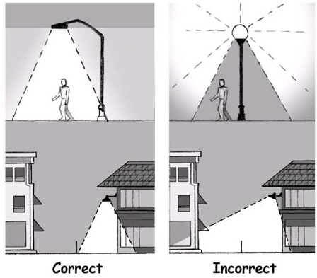
5.2.19.C Outdoor Lighting.
D.
Lighting Reduction.
1.
Hours.
a.
On all non-residentially developed lots which contain a minimum of four (4) parking lot light poles, parking lot lighting levels for ground surface parking lots and the top levels of parking decks or structures must be reduced by at least fifty (50) percent of full operational levels within thirty (30) minutes after the close of business.
b.
Lighting levels may be reduced by turning off fifty (50) percent of the parking lot lights or by dimming parking lot lighting levels to no more than fifty (50) percent of the levels used during business or activity hours within thirty (30) minutes of the close of business, or by some combination thereof.
2.
Security.
a.
Given that a certain minimum lighting level is recommended for safety and security purposes, this provision does not require parking lot lighting levels to be reduced to less than 0.2 footcandles as measured horizontally at the surface on which the light pole is mounted.
b.
The need for security lighting (e.g. the lighting for safety of persons and property) shall be demonstrated. To the extent that an area is illuminated for other purposes, independent security lighting is not allowed.
c.
All security fixtures shall be shielded and aimed so that illumination is directed only to designated areas. In no case shall lighting be directed above a horizontal plane through the top of the lighting fixture, and the fixture shall include full cut-off shields that prevent the light source or lens from being visible on adjacent lots and streets. The use of general floodlighting fixtures is not allowed.
E.
Architectural Lighting. When buildings and structures are to be illuminated, the Director shall approve a design for the illumination using the following requirements.
1.
Direction of Lights. Lighting fixtures shall be carefully sited, aimed and shielded so that light is directed only onto the building façade. Lighting fixtures shall not be directed toward adjacent streets, streets or properties, and light shall not trespass onto surrounding properties.
2.
Façade Lighting. Lighting fixtures mounted on the building and designed to wash the façade with light are permitted. Ground or pole-mounted floodlights are not permitted for façade lighting.
3.
Accent Lighting. Luminous tube (neon), string lighting, LED or fluorescent lighting may be allowed as an architectural detail on the exterior of any structure, provided that such lighting shall not completely outline or define property lines, sales areas, roofs, doors, windows or similar areas in a manner that is not primarily for safety purposes. Accent lighting may be approved by a Director Review upon determining that the accents would not cause off-site glare or light pollution and that lighting is not intended to be used as the equivalent of a sign. Notwithstanding, seasonal lighting displays, including string lighting, may be allowed without Director Review in conjunction with a nationally recognized holiday provided such displays are strung no sooner than sixty (60) days before the holiday and shall be removed within twenty (20) days following the holiday.
4.
Landscape Lighting. The illumination of landscaping shall not generate excessive light levels, cause glare, or direct light beyond the landscaping.
F.
Temporary Light Display in TN-CC Zone District.
1.
Temporary light displays are permitted in connection with planned events at the following uses only.
a.
An arena with a seating capacity of ten thousand (10,000) persons or more; and
b.
A convention center having one hundred thousand (100,000) square feet or more of floor area.
2.
These displays shall only be permitted on the premises in which the event is held.
3.
For each qualifying use, these displays shall be permitted for up to ten (10) events each year and may be displayed for a maximum of eight (8) days for each event. The location, number, size and general character of these displays shall be approved by the Director.
4.
Sign Permit. A sign permit is required for all temporary light displays allowed in this Section.
G.
Other Lighting Requirements.
1.
Indirect illumination of signs, canopies, bollards and buildings is permitted provided a maximum one hundred twenty-five (125) watt bulb is used and placed or shielded to prevent glare.
2.
Electrical feeds to lighting standards shall only run underground.
3.
The use of a laser light source, search lights or any similar high intensity light for outdoor advertisement or entertainment is prohibited, except as permitted in the TN-CC Zone District under Section 5.2.19.F.
4.
Lighting shall not consist of or have the appearance of movement or flashing components, except as otherwise permitted in this Chapter.
H.
Public Street Lighting. The cost of installing and operating approved street lighting on any public street shall be through a financial method approved by the City or by the Michigan Department of Transportation. The costs of all other lighting systems shall be borne by the developer/property owner.
I.
Exemptions. The following outdoor light fixtures are exempt from the provisions of this Section.
1.
Outdoor light fixtures installed prior to the effective date of this Chapter. Fixture replacements shall comply with the requirements of this Section in accordance with the provisions of Section 5.3.06.C. to the extent that the overall appearance of the site is not adversely affected. The Director may require that existing light fixtures be redirected in conditions where excessive glare onto adjacent properties and roadways creates a nuisance or safety concern.
2.
Streetlights within a public right-of-way.
3.
Pedestrian walkway ground lighting.
4.
Outdoor light fixtures which use an incandescent light bulb of one hundred fifty (150) watts or less, except where they create a hazard or nuisance from glare or spillover light.
5.
Lighting necessary for street or utility construction or emergencies.
6.
Lighting necessary for designated recreational fields or similar uses that cannot reasonably comply with the standards and provide sufficient illumination of the recreational field for safe use, following IESNA standards. The fixtures shall be aimed so that their beams are directed and fall within the primary playing or performance area. Lights shall be turned off within one-half (½) hour of the completion of the event.
7.
Government facilities, parks and open areas, public utility facilities, and other uses where sensitive or dangerous materials are located may submit a Site Security Plan to the Director requesting deviations from the requirements of this Section. The Plan may be approved, or approved with conditions, upon finding that:
a.
The lighting is necessary for adequate protection of the public;
b.
The condition, location, or use of the land, or history of activity in the area, indicates the land or any materials stored or used on it are in greater danger of theft or damage, or members of the public are at greater risk for harm than on other property; and
c.
The deviations do not have a significant adverse effect on neighboring areas.
J.
Administrative Departure. An Administrative Departure from the requirements this Section may be granted if it is determined that proposed lighting otherwise meets the purposes of this Section and does not adversely affect the health, safety and welfare of the public.
Sec. 5.2.20. - Infrastructure and Service Needs.
A.
Purpose and Intent.
1.
The purpose of this Section is to permit development projects the ability to proceed at a faster pace than current City resources are capable of constructing, installing, modifying, or improving existing infrastructure and/or service capacities to accommodate the development project. The project may itself be the sole reason for the infrastructure and service needs, or it may contribute to a heightened demand for infrastructure and services which are nearing or already at capacity. Inadequately sized infrastructure or insufficient service to the development project would result in one (1) or more declining levels of traffic safety, roadway capacity, reduced Level of Service (LOS) or water, sewer, energy, communications or other utility service reductions in the system. It is the intent of this Section to allow for development while ensuring that the project site and all customers that use and rely upon sufficient infrastructure and services within the community are properly accommodated.
2.
The inability of the City to provide or enhance the available level of infrastructure or services to accommodate the development project may serve as the basis to deny a project request due to insufficient or increasingly insufficient infrastructure capacity if the project were to be constructed. Project denial due to insufficient infrastructure or services is not a desired outcome as development and redevelopment projects often improve neighborhoods and, over the long-term, improve the economic capacity of the neighborhood and the community by raising property values and employment opportunities. Alternatives to improve infrastructure and/or service insufficiency are preferable to project denial. In these cases, the City may offer an alternative to project denial by accepting the offer of voluntary support by the project's owners to undertake or contribute towards the cost of providing the needed infrastructure or service changes for future conditions created or contributed to as a result of the development project.
3.
In general, infrastructure or service changes are quantifiable in terms of capacity and cost. Needed changes may require study, planning, design, phasing or other efforts before being undertaken. In these situations, the City Commission could, by contract with the project's owners, accept contributions to fund the work. The City would set aside the funds for use only to address the particular infrastructure and/or service changes associated with the development project. For example, in the situation where area streets and intersections are or will be functioning at low levels, undertaking or funding street and intersection improvements may be appropriate. Sometimes, however, street and intersection improvements may not be practical or may be insufficient to address the concerns. Due to topography, the impracticality of acquiring needed additional right-of-way, area-wide traffic patterns, jurisdictional issues or other limitations, different approaches such as additional transit services, remote parking lots, pedestrian overpasses, shared parking structures, reversible traffic flows at peak times, or other, less common, and more cooperative approaches may be the only feasible and reasonable alternatives to ameliorate anticipated infrastructure and service burdens imposed by the development upon customers and citizens within the service area. A particular project may provide the necessary impetus for these alternative approaches, particularly in relation to public health and safety, while itself providing insufficient support or justification. However, together with reasonably foreseeable additional projects, it may form the basis for addressing the need by these approaches.
B.
Existing and Future Conditions Evaluation. The applicant or property owner shall be informed of any inadequately sized infrastructure or insufficient services within the proposed project area that currently exists or that will be created or contributed to by the proposed development project. The Director, Traffic Engineering Director, Planning Commission or City Commission will provide a basis for the determination that a development project, either by itself or in conjunction with other reasonably foreseeable projects, will:
1.
Overload infrastructure or municipal services;
2.
Measurably degrade the level of infrastructure or public services to levels that adversely affect public health, safety or quality of life; or
3.
Place additional strains on infrastructure or public services that already are at levels that adversely affect public health, safety or quality of life.
C.
Alternatives Evaluation. The Director may encourage the applicant to propose particular designs or improvements, cost estimates and other related information to recommend or identify changes on the project site, in the immediate project area or in locations which would assist in supporting the necessary infrastructure or services to sustain the development. Where the Director does not have specific information about needed changes readily available because they are not easily ascertainable given the characteristics of the situation, the Director may identify possible ways and anticipated costs of addressing the conditions.
D.
Determination. Upon review of the alternatives to support the needed infrastructure and/or services to support the development project, the applicant may:
1.
Appeal a determination made by the Director to the Planning Commission.
2.
Discontinue the project.
3.
Redesign the project to address the concerns.
4.
If it is acceptable to all City and other governmental officials of competent jurisdiction, agree to:
a.
Undertake and construct the needed infrastructure improvements according to plans and specifications approved and overseen by the City;
b.
Fund the needed infrastructure or service improvements pursuant to a written agreement approved by the City Commission with the amount of the payment determined based on the actual costs of the improvements;
c.
Contribute to a fund to be used by the City to address the infrastructure or service concerns pursuant to a written agreement approved by the City Commission with the amount of that contribution determined based on what the City Commission reasonably determines to be the applicant's proportionate share of the reasonably anticipated costs of the improvements.
Sec. 5.2.21. - Satellite Dish Antennas.
A.
Roof-Mounted Satellite Dish Antennas. The following roof-mounted satellite dish antennas and similar devices shall not be subject to the requirements of this Article.
1.
In Residential Zone Districts, a device that is two (2) meters (or 6.7 feet) or less in diameter.
2.
In all other Zone Districts, a device that is two (2) meters (or 6.7 feet) or more in diameter, provided the device complies with the height requirements of the Zone District.
B.
Ground-Mounted Satellite Dish Antennas. Ground-mounted satellite dish antennas and similar devices shall be permitted in all Zone Districts, subject to the following conditions:
1.
The maximum height shall be fifteen (15) feet.
2.
The devices shall not be permitted in front and side yards and shall comply with all setback requirements of the Zone District.
3.
All electrical and antenna wiring shall be placed underground.
4.
Evergreen screening shall be provided in sufficient concentration to reasonably conceal the device. Alternative screening that achieves the same effect may be approved by the Director.
5.
The devices shall be sited and designed to withstand a wind force of ninety (90) miles per hour. The device shall be securely mounted and anchored in accordance with manufacturer specifications and the Building Code.
6.
The surface of the device shall be painted or treated so that it does not reflect glare from sunlight, and shall use to the extent practicable, materials and colors that blend with the surroundings.
7.
The surface of the device shall not be used as a sign or message board.
C.
Administrative Departure. An Administrative Departure may be approved to vary any provision of this Section if its application inhibits or prevents the reasonable operation of the satellite dish antenna or similar device. If so approved, the Director may require additional screening or other reasonable conditions to reduce the visibility of the device from adjacent properties.
Sec. 5.2.22. - Backyard Chickens.
A.
The regulations of this Section shall be met, in addition to the regulatory provisions of Article 4, Chapter 155 of the City Code.
B.
One (1) covered enclosure for the keeping of chickens is permitted, not to exceed six (6) square feet in area per chicken, and not higher than eight (8) feet. This square footage shall not count against the allowable square footage or number of accessory structures permitted by Section 5.2.08.
C.
The area of the permitted enclosure may be treated as Greenspace for the purposes of meeting the requirements of Section 5.5.06.H., and is exempt from the vegetation requirements of Section 5.11.07.A. of the General Standards for Landscaping.
D.
Fencing used to enclose chickens is exempt from the approved fence material requirements of Section 5.2.11.B.1.
Sec. 5.2.23. - State Universities.
A.
Purpose.
1.
State universities created pursuant to the constitution and laws of the state of Michigan are unique entities the boards of which are charged with operating the universities to carry out their respective educational missions for the benefit of the people of this state. It is the policy of the City to collaborate with and support state universities in the development of state university owned property.
2.
The City also recognizes development of state university owned property can affect residential or other neighborhoods in its vicinity. Accordingly, this Section is intended to enable a collaborative process that provides appropriate deference to the state university while ensuring neighborhood concerns and effects are appropriately considered in the development of a state university's property.
B.
Applicability and Process.
1.
In addition to, or in lieu of, other ways a state university and the City have collaborated in the development of state university owned property in the City a state university may elect to pursue the approach provided in this Section.
2.
If requested by a state university, the City may, with City Commission approval, enter into a written memorandum of understanding or other written document with a state university that provides for:
a.
Submission of a written plan for the development of one (1) or more parcels of state university owned property in furtherance of the university's mission in any Zone District;
b.
Engagement of the neighborhood association or others in the residential or other neighborhood in the vicinity of the university-owned property for purposes of hearing and considering their comments;
c.
A public meeting conducted by the Director, notice of which is provided in the same manner as a public hearing under this Chapter; and
d.
Director's approval. The Director's approval of the plan(s) pursuant to a memorandum of understanding or other written document, the approval of which shall constitute an approval of the state university's development of the state university owned property addressed by that memorandum of understanding or other written document.
3.
A memorandum of understanding or other written document entered into pursuant to this provision may provide a process for appeal of the Director's denial of a plan proposed by the state university by other City officials as provided by the memorandum of understanding or other written document.
Sec. 5.3.01. - Purpose and Intent.
A.
Nonconformities Permitted. It is recognized that there exists within Zone Districts certain lots, buildings, structures, site improvements, and uses which were lawful before this Chapter was passed or amended, which would be prohibited, regulated, or restricted under the terms of this Chapter. It is the intent of this Chapter to permit these nonconforming lots, buildings, structures, and uses to continue until they are altered, abandoned, removed, or brought into conformance, but not to encourage their continued use or survival.
B.
No Expansion of Nonconformities. Nonconforming lots, buildings, structures, and uses are hereby declared to be incompatible with the Zone Districts in which they are located. It is the intent of this Chapter that these nonconformities shall not be enlarged upon, expanded, or extended, nor be used as grounds for adding other buildings, structures or uses prohibited elsewhere in the Zone District, except as may be provided for in this Chapter.
C.
Construction Prior to Effective Date of this Chapter. Nothing in this Chapter shall be deemed to require a change in the plans, construction, or designated use of any building on which actual construction was lawfully begun prior to the effective date of this Chapter, or an amendment thereto, and upon which actual building construction has been diligently conducted.
D.
Acquisition of Nonconformities. The City may acquire, through purchase or condemnation, private nonconforming lots, buildings, structures, and uses. The City Commission may take actions related to acquisition in the manner provided for by law.
E.
If a nonconformity existing prior to the effective date on this Chapter becomes conforming because of the adoption of this Chapter, or any subsequent amendment, then it shall no longer have a nonconforming status. A condition that was not a nonconformity prior to the effective date of this Chapter does not achieve any nonconforming status under this Chapter by repeal of the previous Chapter.
Sec. 5.3.02. - Nonconforming Lots of Record.
A.
Use Permitted.
1.
A nonconforming lot may be used for any use permitted in the Zone District, subject to any approvals required by this Chapter, provided that all placement, height and other applicable regulations related to the building are met, except as noted in 2. below.
2.
A side yard requirement for a building or structure on a nonconforming lot may be reduced by the same percentage the area of the lot bears to the Zone District requirements. For example, a lot that is twenty (20) percent less than the minimum lot area may reduce the required side yard by twenty (20) percent, provided that no side yard shall be less than five (5) feet.
B.
Contiguous Nonconforming Lots in Common Ownership.
1.
Any two (2) or more nonconforming lots of record or combination of lots and portions of lots of record, existing prior to the effective date of this Chapter, or an amendment thereto, shall be considered to be an undivided parcel for the purposes of this Chapter if they:
a.
Are in common ownership; and
b.
Have continuous frontage; and
c.
Individually do not meet the lot width or lot area requirements of this Chapter.
2.
Parcels meeting these requirements shall be combined into a lot or lots complying as nearly as possible with the lot width and lot size requirements of this Chapter. No portion of that parcel shall be used or divided in a manner that further diminishes compliance with lot width and area requirements of this Chapter.
Sec. 5.3.03. - Nonconforming Buildings or Structures.
A.
Continuation. A nonconforming building or structure may be continued so long as it remains otherwise lawful, subject to the provisions of this Section.
B.
Extensions and Expansion.
1.
No nonconforming building or structure may be enlarged or altered in a way that increases its nonconformity, except as noted in subsection B.2. below.
2.
A nonconforming building or structure may be extended along the portion of the building that is nonconforming provided the following conditions are met:
a.
The existing building or structure must meet at least one-half (½) of the required setback or Required Building Line (RBL) of the Zone District.
b.
The extension of the nonconforming setback or RBL of a building or structure shall not be greater than fifty (50) percent of the total length of the existing building side that is to be extended.
c.
Additions to an existing building which is nonconforming by reason of the building height shall be permitted, provided the addition is no higher than the existing building and has a setback from all property lines that is equal to the height of the new addition.
d.
All parking requirements are met related to the expanded area.
C.
Reconstruction or Movement.
1.
Reconstruction.
a.
Should a nonconforming building or structure be destroyed to an extent of more than seventy-five (75) percent of its replacement cost, exclusive of the foundation, it shall be reconstructed only in conformance with the provisions of this Chapter.
b.
Should a nonconforming building or structure be destroyed to an amount equal to or less than seventy-five (75) percent of its estimated replacement cost, exclusive of the foundation, it may be reconstructed in its previously nonconforming location.
c.
Replacement costs shall be provided by the owner using estimates from at least two (2) contractors in the business of undertaking this work.
2.
Movement.
a.
Should a nonconforming building or structure be moved to a different lot, it shall be moved to a location that complies with the requirements of this Chapter.
b.
If moved on the same lot, the location shall comply with the requirements of this Chapter unless an Administrative Departure is approved for a location that brings it closer to conformity with the Zone District.
Sec. 5.3.04. - Nonconforming Building Elements.
A.
Alterations or Replacements.
1.
Where alterations or replacements to the exterior of a building involve fifty (50) percent or more of the exterior wall area, the entire building shall meet the façade variation, transparency, and building material requirements of the Zone District.
2.
Alterations or replacements that involve less than fifty (50) percent of the exterior wall shall equal those that exist, or shall be as close to conformity as feasible without materially affecting the architectural character of the building.
B.
Exterior Renovations. Exterior renovations shall not destroy or cover original architectural details on a building that are vital to the proper proportion of the façade or the overall architectural character of the building. Brick and stone exteriors shall not be covered with artificial siding or panels.
C.
Building Elements.
1.
Window and Door Openings. Existing window and door openings shall be maintained. New window and door openings should maintain a similar horizontal and vertical relationship as the original.
2.
Vertical and Horizontal Elements. The vertical lines of columns and piers, and the horizontal definition of spandrels and cornices, and other primary structural elements shall be maintained.
D.
Administrative Departure. An Administrative Departure may permit alternative materials or design elements to replace nonconforming elements where the applicant can demonstrate that the original building elements have been removed or substantially damaged, or that the building lacks a significant architectural character as related to its surroundings and the general neighborhood.
Sec. 5.3.05. - Nonconforming Uses.
A.
Enlargement or Increase.
1.
No nonconforming use shall be enlarged or increased, nor extended to occupy a greater area of land than was occupied when the use became nonconforming, except as may be permitted by the Board of Zoning Appeals.
2.
In determining if the proposed enlargement, increase, or greater area shall be permitted, the Board shall find that if approved, the use shall:
a.
Not have a substantial detrimental effect on the use and enjoyment of adjacent uses or lots;
b.
Comply with all parking, sign, or other applicable regulations for accessory uses for the area affected by the proposed enlargement, increase, or greater area;
c.
Not occupy an area larger than twenty-five (25) percent of the original nonconforming area.
3.
The Board of Zoning Appeals may impose reasonable conditions that are necessary to ensure that the proposed enlargement, increase, or greater area shall not prove detrimental to adjacent properties, the neighborhood, or the community.
B.
Extension Within a Building. Any nonconforming use may be extended throughout any parts of a building which were manifestly arranged or designed for that use at the time of adoption or amendment of this Chapter and would have been permitted by right, but the use shall not be extended to occupy any land outside the building.
C.
Reduction in Nonconforming Use. If any part of a nonconforming use is moved or reduced in size by action of the owner, the part of the nonconforming use that is moved or reduced in size shall be considered to be abandoned and any subsequent use shall conform to the requirements of this Chapter.
D.
Abandonment.
1.
If a nonconforming use is abandoned for any reason for a period of more than twelve (12) calendar months, any subsequent use shall conform to the requirements of this Chapter.
2.
A nonconforming use shall be determined to be abandoned if the City is in receipt of a written declaration by the property owner that the use will not be continued, or that two (2) or more of the following conditions exist that demonstrate intent on the part of the property owner to abandon the nonconforming use:
a.
One (1) or more utility meters, such as water, gas and electricity to the property, have been removed;
b.
The property, buildings and/or grounds are unsafe or unsanitary, as described in Chapter 140 Housing Code or Chapter 135 Building Maintenance Code;
c.
Cessation of business operations during the abandonment period;
d.
Removal of signs or other indications of the existence of the nonconforming use;
e.
Removal of equipment or fixtures necessary for the operation of the nonconforming use;
f.
Failure to maintain current licenses, certificates, permits, registrations or other appropriate documentation; or
g.
Other actions, which in the opinion of the Director, constitute an intention by the property owner or lessee to abandon the nonconforming use.
3.
Abandonment Period Extensions.
a.
Upon written request received prior to the end of the abandonment period, the Director may approve an extension of the abandonment period up to an additional six (6) months.
b.
One (1) additional six (6) month extension may be granted if approved by the Board of Zoning Appeals.
c.
Extensions by the Director or Board of Zoning Appeals shall be considered only where a property owner can demonstrate a good faith effort to sell or lease the premises to another, similar use that is at least as conforming as the previous use.
E.
Change to Other Nonconforming Use. Prior to a determination of abandonment, a nonconforming use may be changed to another nonconforming use provided the Board of Zoning Appeals makes all of the following determinations.
1.
The proposed use is equally compatible, or more compatible, with the surrounding neighborhood, and that the use is equal to or more conforming to the uses allowed in the Zone District than the previous nonconforming use.
2.
The proposed nonconforming use is not enlarged or increased, nor extended to occupy a greater area of land than the previous nonconforming use, except as may otherwise be permitted by this the Board of Zoning Appeals.
3.
That buildings and area encompassing the expansion of the nonconforming use complies with all parking, landscaping, or other site development regulations applicable to the area affected by the proposed enlargement, increase or extension of use area as required by this Chapter.
F.
Existing Uses. Certain uses identified with an "E" in Table 5.5.05.B. Uses: Residential Zone Districts, and Table 5.6.06.B. Mixed-use Commercial Zone Districts may continue to exist as permitted uses in their respective Zone Districts, subject to the restrictions contained therein, and shall be exempt from the abandonment criteria of Section 5.3.05.D. above, provided:
1.
There is no increase in size, alteration or change to the building or structure, external or internal, other than general maintenance; and
2.
All equipment or fixtures that are necessary for the operation of the use(s) remain in place; and
3.
Any residential property is registered in conformance with the Chapter 140 Housing of the City Code.
Sec. 5.3.06. - Nonconforming Site Elements.
A.
Purpose. This Section permits reviews of applications for improvements and minor modifications to a nonconforming lot, building, structure or use that does not require a site to meet all of the site improvement regulations of this Chapter. Where appropriate, the intent is to allow gradual compliance with site-related requirements for sites that pre-date requirements for landscaping, paving, and other non-safety site-related items.
B.
Compliance Required. Site elements shall be brought into full compliance with this Chapter for any of the following:
1.
A parking or landscape area is expanded or reconstructed (existing pavement and/or landscape materials and ground cover removed and replaced) by twenty-five (25) percent or more of the original nonconforming area.
2.
The size of the nonconforming site covered by existing lighting is expanded by an area that is fifty (50) percent or more of the original nonconforming area; and/or seventy (70) percent or more of the existing light poles and/or fixtures are replaced by new poles, bases, or fixtures.
C.
Planning Commission Review. Improvements or modifications to nonconforming site elements may be permitted by the Planning Commission during a Special Land Use or Site Plan Review process when required by this Chapter without a complete upgrade of all site elements under the following conditions:
1.
The applicant provides reasonable site improvements to the site in relation to the scale and construction cost of the building improvements or expansion.
2.
The applicant addresses any safety-related site issues for the site.
3.
The improvements or minor expansion do not increase the nonconforming site elements.
4.
The applicant upgrades the site landscaping consistent with Article 11, to the degree deemed appropriate by the Planning Commission.
5.
Driveways that do not conform to the access management requirements of this Chapter are eliminated, provided that minimum reasonable access is maintained.
D.
Administrative Departures.
1.
Improvements or modifications to nonconforming site elements may be permitted as an Administrative Departure for site improvements that require a Director Review without a complete upgrade of all site elements where topography, natural features or other site constraints exist, and where there are no detrimental effects on adjacent properties, and provided that any nonconforming setbacks are not further reduced.
2.
The replacement of a nonconforming off-street parking lot in a front yard may be permitted where the following conditions exist:
a.
The existing parking lot is nonconforming due to its location in the front yard.
b.
A primary structure is located on the lot and is not proposed for demolition or replacement.
c.
There is no other practicable alternative for the location of the required parking spaces.
d.
The parking lot is not expanded and does not result in an increase of any nonconformities.
e.
Landscaping is brought closer to conformance with the requirements of Article 11.
f.
The number of spaces provided does not exceed either twenty (20) spaces or the required number of parking spaces by more than twenty (20) percent, whichever is greater, unless demonstrated by a Parking Demand Study consistent with the requirements of Section 5.10.04.A.
E.
Nothing in this Section shall be construed to require the removal of vegetation preserved as part of the original construction of the landscaped area.
F.
In all instances, required screening walls for waste receptacles, fencing of outdoor storage or screening from adjacent residential uses shall be provided.
G.
The City may require a performance guarantee under the provisions of Section 5.14.04. to insure that all improvements required in this Section are made in accordance with the approved plan.
(Ord. No. 2025-14, § 2, 7-29-25)
Sec. 5.3.07. - Nonconforming Signs.
See Section 5.15.03. for regulations pertaining to nonconforming signs.
Sec. 5.3.08. - Nonconforming Wireless Communication Towers.
See Section 5.9.41. for regulations pertaining to nonconforming wireless communication towers.
Sec. 5.4.01. - Purpose and Intent.
A.
Neighborhood Classifications. This Article establishes three (3) Neighborhood Classifications and a number of Zone Districts within each Neighborhood Classification that represent a broad range of development eras and existing built conditions throughout the city. Through the Master Plan process, residents identified the diversity of existing residential and commercial areas as key to maintaining the attractive and economic vitality of the city.
B.
Development Characters. This Article describes the distinctive characteristics of neighborhoods and other areas, as defined in the City of Grand Rapids Neighborhood Pattern Work Book, and provides the framework for development standards to guide future development. The city is divided into the following Neighborhood Classifications and Zone Districts, as described below.
Sec. 5.4.02. - Neighborhood Classifications.
A.
Neighborhood Classifications. Residential and Mixed-Use Commercial Zone Districts have been assigned a Neighborhood Classification based on similar development characteristics within the City of Grand Rapids, as established by the Master Plan and Pattern Work Book. These Neighborhood Classifications are Traditional Neighborhood; Mid-20 th Century Neighborhood; and Modern Neighborhood. Within each Neighborhood Classification are individual Zone Districts, each with its own uses and development requirements.
5.4.02.B Traditional Neighborhoods (TN).
B.
Traditional Neighborhoods (TN).
1.
Background. Developed prior to society's dependence on the automobile, these neighborhoods were designed to provide residents with a variety of commercial, institutional and residential options within a short walking distance. Residents find housing options such as single-family homes and apartments above storefronts, as well as commercial and institutional uses integrated into a central neighborhood design. Diversity in building size and use enhances the vitality of these neighborhoods.
2.
Characteristics. The valued characteristics of the built environment of a Traditional Neighborhood include:
a.
A pattern of small blocks, alleys and a connected street grid system;
b.
Smaller building footprints on small sites with variable lot sizes;
c.
Human-scaled buildings with high quality exterior materials;
d.
Front façade oriented parallel to the street;
e.
Pedestrian and transit orientation, with widespread provision of on-street parking and off-street surface parking areas that are located to the rear of the lot;
f.
Integrated residential and nonresidential land uses located in the same building or in proximity to one another without extensive buffering;
g.
Well-defined building entries and windows constituting at least fifty (50) percent of the front façade, and
h.
Other building elements and architectural patterns.
5.4.02.C. Mid-20th Century Neighborhoods (MCN).
C.
Mid-20th Century Neighborhoods (MCN).
1.
Background. These neighborhoods reflect American society's change after World War II towards an automobile-dependent development pattern. Residential neighborhoods have a more spacious feel with larger lots and buildings located further from the street. Streets and neighborhoods are less connected; and land uses are segregated from one another, including separation of apartment buildings from single-family housing. More intense commercial and institutional uses are found on highly visible corners and along heavily traveled traffic corridors in strip developments.
2.
Characteristics. The valued characteristics of the built environment of a Mid-20th Century Neighborhood include:
a.
Curvilinear streets with sporadic cul-de-sacs or alleys;
b.
Larger uniform lot sizes with generous building setbacks;
c.
Some mixed uses integrated within a neighborhood, but uses generally segregated;
d.
Pedestrian and automobile-oriented streetscapes that include sidewalks and limited parking in the front of buildings;
e.
Building entries predominately oriented to the street; and
f.
Simplified building articulation and massing.
5.4.02.D. Modern Era Neighborhoods (MON).
D.
Modern Era Neighborhoods (MON).
1.
Background. Land patterns within these neighborhoods have been developed to serve individual uses. Major roadways connect these uses to each other. Street and neighborhood connectivity is less evident and the presence of sidewalks is often limited.
2.
Characteristics. The valued characteristics of the built environment of a Modern Era Neighborhood include:
a.
Larger lots and deeper setbacks in residential areas.
b.
Single-family homes, apartments, office complexes and shopping centers are segregated.
c.
There is a dependence on the automobile or public transit to live, work and/or shop; and
d.
Large greenspace opportunities.
3.
The existing development pattern of segregated land uses, cul-de-sacs and a strong automobile orientation are intended to be minimized over time. Alternative high quality design approaches shall promote multi-family developments within walking distance of transit and the restructuring of existing commercial concentrations as walkable mixed-use centers.
Sec. 5.4.03. - Zone Districts.
A.
Zone Districts. Zone Districts are found under the following Neighborhood Classifications, with the exception of the NOS Neighborhood Office Service District which may be found in Section 5.6.05.
B.
Special Districts. The following Special Districts are in addition to the individual Zone Districts located within each Neighborhood Classification. Special Districts are not required to comply with all design requirements of the Neighborhood Classification. A Special District is intended to accommodate unique land uses and activities that do not readily fall under the intent and purpose of any other Zone District.
C.
Overlay Districts. The following Overlay Districts are in addition to the individual Zone Districts located within each Neighborhood Classification or Special District. Overlay Districts are designed to complement the base Zone District and to achieve a unique set of established goals for a corridor or geographic area.
D.
Neighborhood Office Service District (NOS). The NOS District serves as either a stand-alone district or as a transitional district between areas of high and low intensity development and is not intended to be included in a Neighborhood Classification. It is intended to provide a limited service area within neighborhoods with daily goods and services. See Section 5.6.05.
(Ord. No. 2020-13, § 1, 4-28-20)
Sec. 5.4.04. - Use Determination for Similar Uses or Uses Not Addressed.
A.
Purpose. Since every type of potential use cannot be anticipated in this Chapter, this Section provides a process for addressing uses not specifically listed or those that cannot be reasonably interpreted as substantially the same as those listed. Similarly, there are various uses that include the phrase "and similar uses." These procedures are also intended to interpret the phrase "and similar uses" found in this Chapter.
B.
Decision. The Director may determine that the use is similar to allowed uses in the Zone District, as either a Permitted Use or a Special Land Use. The Director may request that the BZA make this determination. The Director or BZA determination shall be in writing and shall be sent to the applicant.
C.
Review Standards. The Planning Director or BZA shall base the decision on a finding that the proposed use satisfies all of the following.
1.
Is not specifically listed in any other Zone District;
2.
Is generally consistent with the purpose of the Zone District and this Chapter;
3.
Does not materially impair the present or potential use of other properties within the same Zone District or the neighboring area;
4.
Has no greater potential impact on surrounding properties than those listed in the Zone District in terms of aesthetics, traffic generated, noise, potential nuisances, and other impacts related to health, safety and general welfare; and
5.
Is substantially consistent with the Master Plan or other relevant adopted plans of the City.
D.
Text Amendments. Uses determined to be similar to a Permitted Use or a Special Land Use shall be recorded by the Planning Department, and periodically presented to the Planning Commission to consider incorporation into the text of this Chapter.
E.
Should the Director or BZA determine that the use is not similar to a use addressed by this Chapter, an applicant or the City may seek to amend the text of this Chapter to permit the use either as a Permitted Use or Special Land Use in accordance with the text amendment process described in Section 5.12.10. Alternatively, an applicant may seek a use variance from the Board of Zoning Appeals in accordance with the provisions of Section 5.13.04.
Sec. 5.4.05. - Zoning Map.
A.
Zoning Groups. The Zoning Map depicts four (4) levels of zoning groups: Neighborhood Classification, Zone Districts, Special Districts, and Overlay Districts.
B.
Boundaries. The boundaries of these classifications are hereby established as shown on a map entitled "The Zoning Map of the City of Grand Rapids, Michigan," which is incorporated into and made a part of this Chapter and which is maintained by the Planning Department.
C.
Interpretation of Boundaries. Where uncertainty exists regarding the boundaries of a Zone district as shown on the official Zoning Map, the following rules shall apply:
1.
Boundaries.
a.
Boundaries indicated as approximately following the centerlines of streets, highways or alleys shall be construed to follow those centerlines;
b.
Boundaries indicated as approximately following platted lot lines shall be construed as following the lot lines;
c.
Boundaries indicated as approximately following City limits shall be construed as following City limits; and
d.
Boundaries indicated as following shorelines shall be construed as following the shoreline, and in the event of change in shoreline shall be construed as moving with the shoreline.
2.
In circumstances not covered by C.1. above, the Director shall interpret a Zone District boundary after review of the following.
a.
Lot line and Zone District placement;
b.
Existing land uses;
c.
Staff memos, minutes and other information when the designation was made; or
d.
Historical context in the understanding and treatment of district lines.
D.
Where changes are made in a Neighborhood Classification, Zone District, Special District or Overlay District boundaries, other districts or any other matter portrayed on the official Zoning Map, those changes shall be entered on the official Zoning Map promptly after the amendment to this Chapter has been approved by the City Commission.
E.
In any case where a property has not been specifically included within a Zone District, it is hereby declared to be in the Low Density Residential District applicable to the Neighborhood Classification in which it is located. Provided, however, that where property annexed to the City has been restricted by previous zoning regulations of the former municipality, those provisions shall apply pending the adoption of City zoning regulations for the property.
Sec. 5.4.06. - Street Classification Map.
The Street Classification Map and related text within the Street Classification Policy that identifies regional, major, city collector and neighborhood collector streets shall be considered a part of the Zoning Ordinance.
Sec. 5.5.01. - Residential Zone Districts: Purpose and Intent.
A.
Residential Zone Districts are divided into Low-Density Residential (LDR) Districts and Mixed-Density Residential (MDR) Districts within the framework of the three (3) Neighborhood Classifications of Traditional Neighborhoods (TN), Mid-20th Century Neighborhoods (MCN), and Modern Era Neighborhoods (MON).
B.
LDR, Low-Density Residential District. The Low-Density Residential District is intended to create, maintain and promote a variety of housing opportunities for individual households and to maintain the desired physical characteristics of the city's existing neighborhoods.
1.
The density ranges for each Low-Density Residential Zone District varies based upon the Neighborhood Classification in which it is located.
2.
Site and building placement regulations, as well as requirements for building elements, take the built environment into consideration as many of the areas that include this Zone District are in existing developed areas.
C.
MDR, Mixed-Density Residential District. The Mixed-Density Residential District is intended to create, maintain and promote a variety of housing types in areas where development already exists or where it is desired in the future.
1.
The density ranges for each mixed-density Zone District varies based upon the Neighborhood Classification in which it is located, but generally accommodates moderate- to high-density housing, including detached single-family houses, attached single-family dwellings, two-family dwellings, and multiple-family residential buildings.
2.
Site and building placement regulations, as well as requirements for building elements, have taken the built environment into consideration. The Master Plan recommendations in Section 10.0 Development Character and Section 10.9 Higher Quality Medium and High-Density Residential Design shall be used in site design, except where it is impractical or inconsistent with the neighborhood.
Sec. 5.5.02. - Traditional Neighborhood Residential Zone Districts: Purpose and Intent.
A.
TN-LDR, Traditional Neighborhood—Low-Density Residential Zone District. The TN-LDR District is intended to protect established development patterns, consisting predominantly of medium-low density residential development in the form of detached single-family houses and two-family dwellings sited on individual lots. Pockets of medium- to high-density residential development are generally found along transit routes, near to business districts and along major streets. The redevelopment of sites shall remain consistent with this pattern of development.
B.
TN-MDR, Traditional Neighborhood—Mixed-Density Residential Zone District. The TN-MDR District is intended to provide a variety of housing choices in a spatially diverse manner while protecting established development patterns. Mixed-density neighborhoods are generally found along transit routes, near to business districts and along major streets. They often act as a transition between lower density residential development and non-residential uses. Redevelopment shall remain consistent with this pattern of development. The redevelopment of former commercial sites is a significant objective through context sensitive architectural designs and features common to the area.
Sec. 5.5.03. - Mid-20th Century Neighborhood Residential Zone Districts: Purpose and Intent.
A.
MCN-LDR, Mid-20th Century Neighborhood - Low-Density Residential Zone District. The MCN-LDR District is intended to protect the established development pattern, consisting predominantly of low-density residential development characterized by single-family detached houses on individual lots with garages located to the side or rear of the main building. New development and building renovation shall be compatible with the valued characteristics of the existing built environment. To that end, a coordinated variety in design is encouraged. The repeated use of identical façade designs shall be avoided.
B.
MCN-MDR, Mid-20th Century Neighborhood - Mixed-Density Residential District. The MCN-MDR District is intended to provide a variety of housing choices in a spatially diverse manner. The established development pattern, consisting predominantly of low-density residential development characterized by two-family dwellings and small multiple family buildings, shall act as a transition between lower density residential development and non-residential uses. Context-sensitive architectural designs and features common to the area shall be used in the redevelopment of former commercial sites.
Sec. 5.5.04. - Modern Era Neighborhood Residential Zone Districts: Purpose and Intent.
A.
MON-LDR, Modern Era Neighborhood - Low-Density Residential Zone District. The MON-LDR District is intended to reflect the low-density development pattern of single-family detached houses on large lots. The repeated use of identical façade designs shall be avoided. The preservation of natural features such as wetlands, woods and steep slopes are important components and shall be included in development plans for a site.
B.
MON-MDR, Modern Era Neighborhood - Mixed-Density Residential Zone District. The MON-MDR District is intended to permit the moderate- to high-density single-use development pattern that presently exists; however, it strongly encourages the redevelopment of these properties into a mixed-density format where a variety of housing densities and styles are provided. The preservation of natural features such as wetlands, woods and steep slopes are important components and shall be included in development plans for a site.
Sec. 5.5.05. - Uses of Land.
A.
Land Uses. Uses are allowed in residential Zone Districts in accordance with Table 5.5.05.B. Uses: Residential Zone Districts. Article 16 Definitions shall be referred to for clarity on the uses as listed. The following key is to be used in conjunction with the Use Table.
1.
Permitted Uses. Uses permitted by right in the Zone District, subject to compliance with all other applicable requirements of this Chapter. These uses are identified with a "P."
2.
Qualified Review. Uses which may be allowed subject to Director Review unless public hearing before the Planning Commission is requested in accordance with Section 5.12.16., and all other applicable requirements of this Chapter. These uses are identified with a "QR."
3.
Special Land Uses. Uses which may be allowed subject to review and approval by the Planning Commission in accordance with Section 5.12.09., and all other applicable requirements of this Chapter. These uses are identified with an "S."
4.
Existing Uses. Uses that were in existence prior to November 5, 2007 may continue to exist as nonconforming uses. These uses are identified with an "E." See Section 5.3.05.F.
5.
Uses Not Allowed. Uses are prohibited in that Zone District. These uses are identified with an "X".
6.
Use Regulations. Certain allowed uses, whether Permitted Uses or Special Land Uses, are subject to compliance with Article 9 or other provisions of this Chapter or other City Code. These uses are identified under "Use or Other Regulations." A cell marked with "—" under this heading indicates that there are no additional use requirements. However, there may be other applicable regulations in this Chapter or other City Code for the uses listed that are not noted in the Use Table.
7.
Unlisted Uses. Uses not listed in the Table 5.6.06.B. are also prohibited unless the Director determines that the use is similar to other uses listed either as a Permitted Use or Special Land Use in accordance with Section 5.4.04.
8.
Site Development. Vehicle and bicycle parking requirements and pedestrian circulation requirements are in Article 10 Transportation and Mobility. Landscaping requirements are in Article 11 Landscaping and Green Infrastructure. Sign requirements are in Article 15 Signs.
B.
Allowed Uses Table.
C.
Attached Single-Family Residential Use. For development of Attached Single-Family dwellings on a single lot.
1.
Permitted Use within LDR zone districts where the following conditions apply:
a.
Where four (4) or fewer units are constructed in a row on a vacant lot and no demolition is required; and
b.
The parcel is located within five hundred (500) linear feet of a TBA, TOD, TCC or C Zone District, as measured from the closest point of the parcels along the public right-of-way.
2.
Special Land Use within LDR zone districts where the following conditions apply:
a.
Where demolition of an existing structure is required; or
b.
More than five (5) units are constructed in a row.
D.
Two-Family Residential Use. A two-family residential dwelling is a Permitted Use within LDR zone districts when located on a corner lot.
E.
Multiple-Family Residential Use. A multiple-family residential development of six (6) or fewer units is a permitted use on Link Residential and Network Residential Streets in the TN-LDR Zone District.
(Ord. No. 2017-56, §§ 1—3, 10-24-17; Ord. No. 2018-39, §§ 1, 2, 7-10-18; Ord. No. 2018-44, § 1, 7-24-18; Ord. No. 2018-69, § 3, 12-18-18; Ord. No. 2019-09, § 3, 3-26-19; Ord. No. 2019-11, § 1, 3-26-19; Ord. No. 2020-13, § 2, 4-28-20; Ord. No. 2024-20, §§ 1—4, 4-23-24)
Sec. 5.5.06. - Site Layout and Building Placement Requirements.
A.
Site Layout and Building Placement Table. All development in Residential Zone Districts must comply with the requirements in Table 5.5.06.A. unless otherwise expressly stated, or unless a different requirement is contained in an applicable Overlay District. Lot area and lot width requirements listed in Table 5.5.06.A. shall be used where there is not an established lot size.
B.
Lot Area.
1.
The minimum lot area requirement may not permit allowed densities on every lot. Other factors, such as off-street parking, height limits, dwelling unit sizes and lot configuration may limit the built density.
2.
Lot Areas Not Established. On blocks where lot areas are not established, Table 5.5.06.A. Site Layout and Building Placement shall apply.
3.
Established Lot Areas. On blocks where lot areas are established, the following shall apply:
a.
Detached Single Family Dwellings.
i.
For detached single-family dwellings on interior lots, the lot area shall be at least the median lot area of interior single-family lots on the same block and for the purposes of this calculation, the same block is defined as both block faces, in the same Zone District, not to exceed five (5) lots on each side of the subject parcel and five (5) lots directly across the street on which there is at least one (1) conforming main structure.
ii.
For detached single-family dwellings on corner lots, the minimum lot area in Table 5.5.06.A. shall apply.
b.
Two Family Dwellings.
i.
For two-family dwellings on interior lots, the minimum lot area shall be thirty (30) percent larger than the median lot area of single-family lots on the same block. For the purposes of this calculation, the same block is defined as both block faces, in the same Zone District, not to exceed five (5) lots on each side of the subject parcel and five (5) lots directly across the street.
ii.
For two-family dwellings on corner lots, the minimum lot area may be equal to the median lot area of a single-family lot on the same block and is not eligible for any lot area reductions as provided in Section 5.5.06.B.3.b.iii and 5.5.06.B.3.b.iv.
iii.
Reduction (up to one [1]). The minimum lot area may be reduced by an additional ten (10) percent beyond that required in b.i. above where all of the following conditions apply:
1.
Both units are priced at or below thirty (30) percent of the area median household income (as determined by the American Community Survey of the U.S. Census Bureau), as adjusted for family size, for the census tract in which the development is located, with affordability maintained for at least fifteen (15) years.
2.
The units are comparable in size, amenities and location with other similar units in the same block.
3.
The property owner agrees to the submission of annual reports to the City regarding certification of eligible tenants and purchasers, annual certification of rental property and monitoring of affordable rental housing requirements.
iv.
Reduction (up to two [2]). The minimum lot area may be reduced by an additional ten (10) percent for each dwelling unit that is designed and constructed to meet the Type B Unit accessibility requirements of the ANSI A117.1. standard.
v.
Reductions may be combined for a cumulative reduction of up to thirty (30) percent.
4.
Multiple Family Developments and Group Living. The minimum lot area in Table 5.5.06.A. shall apply to multiple-family developments and group living, except for adult foster care family homes, which shall comply with the requirements for detached single family dwellings.
C.
Lot Width.
1.
Lot Widths Not Established. On blocks where lot widths are not established, Table 5.5.06.A. Site Layout and Building Placement shall apply.
2.
Established Areas. On blocks where lot widths are established, the following shall apply.
a.
Detached Single-Family Dwellings.
i.
For detached single-family dwellings on interior lots, the lot width shall be at least the median lot width of interior single-family lots on the same block. For the purposes of this calculation, the same block is defined as both block faces, and in the same Zone District, not to exceed five (5) lots on each side of the subject parcel and five (5) lots directly across the street.
ii.
For detached single-family dwellings on corner lots, the minimum lot width in Table 5.5.06.A. shall apply.
b.
Two-Family Dwellings.
i.
For two-family dwellings on interior lots, the minimum lot width shall be thirty (30) percent larger than the median lot width of single-family lots on the same block. For the purposes of this calculation, the same block is defined as both block faces, in the same Zone District, not to exceed five (5) lots on each side of the subject parcel and five (5) lots directly across the street. In no case shall the lot width be less than the minimum established in Table 5.5.06.A. except as provided in Sections 5.5.06.B.3.b.iii.
ii.
For two-family dwellings on corner lots, the minimum lot width may be equal to the median lot width of a single-family lot on the same block and is not eligible for any lot width reductions as provided in sections 5.5.06.C.2.b.iii and 5.5.06.C.2.b.iv.
iii.
Reduction (up to one [1]). The minimum lot width may be reduced by an additional ten (10) percent beyond that required in b.i. above where all of the following conditions apply:
(a)
Both units are priced at or below thirty (30) percent of the area median household income (as determined by the American Community Survey of the U.S. Census Bureau), as adjusted for family size, for the census tract in which the development is located, with affordability maintained for at least fifteen (15) years.
(b)
The units are comparable in size, amenities and location with other similar units in the same block.
(c)
The property owner agrees to the submission of annual reports to the City regarding certification of eligible tenants and purchasers, annual certification of rental property and monitoring of affordable rental housing requirements.
iv.
Reduction (up to two [2]). The minimum lot width may be reduced by an additional ten (10) percent for each dwelling unit that is designed and constructed to meet the Type B Unit accessibility requirements of the ANSI A117.1. standard.
v.
Reductions may be combined for a cumulative reduction of up to thirty (30) percent.
c.
Multiple Family and Group Living. The minimum lot width in Table 5.5.06.A. shall apply except for adult foster care family homes which shall comply with the regulations applicable to detached single family dwellings.
d.
Administrative Departure. An Administrative Departure of two (2) feet may be approved. In no case shall the lot width be smaller than the minimum established in Table 5.5.06.A.
D.
Front Setbacks and Required Building Line (RBL).
1.
Front Setbacks Not Established - TN Traditional Neighborhood and MCN Mid-20th Century Neighborhoods. On blocks where the front setback or RBL is not established, the RBL in Table 5.5.06.A. Site Layout and Building Placement shall apply.
2.
Established Areas. On blocks where the front setback or building line is established, the following shall apply:
a.
For all residential dwellings on all lots, the Required Building Line (RBL) shall be equal to, or the median of, the front setbacks of existing main buildings on the same block. For the purposes of this calculation, the same block is defined as both block faces, in same Zone District, not to exceed five (5) lots on each side of the subject parcel and five (5) lots directly across the street. In no case shall the RBL be less than the minimum established in Table 5.5.06.A.
b.
Where an established RBL is not present, the minimum setback defined in Table 5.5.06.A. shall apply.
c.
An Administrative Departure up to ten (10) feet of the established RBL may be permitted to accommodate individual site conditions, such as mature trees, topography, or other similar physical condition or where the setbacks of existing buildings on the subject block are inconsistent. The Required Building Line may be determined by referencing the front setbacks of the adjacent properties.
E.
Side Yard Setback.
1.
Side Yard Setbacks. Table 5.5.06.A. Site Layout and Building Placement shall apply to side yard setbacks.
2.
Side Yard Setbacks Between Districts.
a.
Residential. In no case shall side yard setbacks be less than five (5) feet on each lot between two (2) residential Zone Districts or uses, unless specified otherwise.
b.
Residential and Non-Residential. A minimum distance of ten (10) feet shall be maintained on each lot between residential and non-residential Zone Districts or uses.
3.
Exceptions for Attached Single-Family Dwellings. Exceptions to the side yard requirements for attached single-family dwellings are provided in Section 5.9.06.
4.
Corner Lots. Corner lots shall have two (2) front yards, two (2) side yards, and no rear yard.
5.
Administrative Departure. An Administrative Departure up to two (2) feet in a side yard setback may be permitted to accommodate individual site conditions, such as healthy mature trees, topography, or other similar physical condition.
F.
Rear Yard Setback.
1.
Rear Yard Setbacks. Table 5.5.06.A. Site Layout and Building Placement shall apply to rear yard setbacks.
2.
Administrative Departure. An Administrative Departure up to five (5) feet in a rear yard setback may be permitted to accommodate individual site conditions, such as mature trees, topography, or other similar physical condition.
G.
Building Façade Along Required Building Line. The building façade along the RBL shall meet the requirements of Table 5.5.06.A.
H.
Minimum Required Greenspace at Grade.
1.
Purpose. The minimum greenspace requirements are designed to ensure a sufficient amount of area of greenspace for recreation and nature, as well as to provide pervious surface to assist in stormwater management.
2.
Applicability. The minimum required greenspace, as defined by Article 16, shall apply to each lot in its entirety, including driveways.
3.
Stormwater Credit. No more than twenty-five (25) percent of pervious surfaces, such as grass pavers, uncovered decks, brick pavers with a sand base, pervious concrete and asphalt, may be applied toward the greenspace requirements of this Section.
4.
Front Yards. Front yards shall consist of greenspace, and impervious surfaces shall be limited to driveways and private sidewalks.
5.
Multiple-Family Exception. A reduction of not more than twenty-five (25) percent of the required greenspace listed in Table 5.5.06.A. for a multiple-family property is permitted for development projects with the submission of a stormwater mitigation plan that retains one hundred (100) percent of all stormwater on site, as approved by the City's Environmental Protection Services Department (EPSD); and submittal of a LEED checklist and proof of registration that demonstrates the intent to apply for LEED building certification, or other generally recognized sustainable building certification.
6.
Multiple-Family Administrative Departure. An Administrative Departure for a multiple-family property may be approved to permit permanent planters, vegetated walls and green roofs that are readily accessible and safe for residential occupants to be included in greenspace calculations. These items shall be measured in square feet of surface area.
I.
Residential Bonuses.
1.
Purpose. The Master Plan calls for a range of housing types and price points within neighborhoods to accommodate all residents regardless of income, special need or place in life cycle. Developments can receive bonuses as outlined in this Section by providing additional accessibility and housing that is affordable to a wide range of residents.
2.
Housing Bonuses. Bonuses are available for two-family and multiple family developments in accordance with the provisions of Table 5.5.06.I.2.
3.
Accessible Housing. Bonuses are available for two-family and multiple family developments when units are designed and constructed to meet the ANSI A117.1 standards for Type B accessible units when the following conditions are met.
a.
Two-Family Developments. The minimum lot area for two-family residential developments may be reduced where the conditions of Section 5.5.06.B.3.b.iii. are met.
b.
Multiple-Family Developments. The minimum lot area for a multiple family development may be reduced by up to five hundred (500) square feet per dwelling unit when at least twenty-five (25) percent of the units are accessible.
4.
Affordable Housing Bonuses. Density bonuses are available for Multiple-Family developments in accordance with the provisions of Table 5.5.06.I.2.
a.
The minimum lot area per dwelling unit may be reduced by up to five-hundred (500) square feet per dwelling unit where at least twenty (20) percent of the total number of dwelling units are priced between sixty (60) percent and seventy-nine (79) percent of Area Median Income, as adjusted for family size, with rates remaining affordable for at least thirty (30) years.
b.
The minimum lot area per dwelling unit may be reduced by up to one thousand (1,000) square feet per dwelling unit where at least twenty (20) percent of the total number of dwelling units are priced at or below thirty (30) percent of Area Median Income, as adjusted for family size, with rates remaining affordable for at least thirty (30) years.
c.
The Affordable Housing Bonus, as permitted in subsections a and b above, are available only when the following conditions are met:
i.
The affordable units shall be comparable in unit sizes, amenities and location with the market rate units.
ii.
The property owner agrees to the submission of annual reports to the City regarding certification of eligible tenants and purchasers, annual certification of rental property and monitoring of affordable rental housing requirements.
iii.
That the property owner agrees in a writing and recorded with the Kent County Register of Deeds and in a form approved by the City Attorney, that continual compliance with all conditions contained herein are necessary to maintain compliance with this Chapter. A violation of any condition is a violation of the Zoning Ordinance and is a nuisance per se for which the City of Grand Rapids may in addition to other remedies, institute any court or enforcement action provided for by law, including but not limited to, seeking injunctive relief or abatement after a notice and hearing before the Board of Zoning Appeals.
5.
Mixed-Income Housing. Bonuses are available in accordance with the provisions of Table 5.5.06.I.2. when the following conditions are met.
a.
Two-Family Developments. The minimum lot area for two-family residential developments may be reduced where the conditions of Section 5.5.06.B.3.b.iii. and b.iv are met.
b.
Multiple-Family Developments. The minimum lot area for a multiple family development may be reduced by up to five hundred (500) square feet per dwelling unit for a project that satisfies the following criteria:
i.
Project is located within three hundred (300) feet of a transit line;
ii.
At least twenty (20) dwelling units are developed as part of the project;
iii.
If rental units, not less than fifteen (15) percent nor more than thirty (30) percent of the total number of units are priced for households at or below sixty (60) percent of Area Median Income, as adjusted for family size, with rental charges remaining affordable for at least fifteen (15) years.
iv.
If owner units, not less than fifteen (15) percent nor more than thirty (30) percent of the total number of units are priced for households at or below eighty (80) percent of Area Median Income, as adjusted for family size.
v.
The remaining units are priced at market rate.
vi.
The affordable units shall be comparable in unit sizes, amenities and location with the market rate units.
vii.
The property owner agrees to the submission of annual reports to the City regarding certification of eligible tenants and purchasers, annual certification of rental property and monitoring of affordable rental housing requirements.
(Ord. No. 2018-69, §§ 4, 5, 12-18-18; Ord. No. 2019-09, § 4, 3-26-19; Ord. No. 2019-10, § 1, 3-26-19; Ord. No. 2024-20, §§ 5—9, 4-23-24)
Sec. 5.5.07. - Building Element Requirements.
A.
Building Elements Table. All development in the Residential Zone Districts shall comply with the requirements in Table 5.5.07.A. Building Elements unless otherwise expressly stated, or unless a different requirement is contained in an applicable Overlay District.
B.
Building Height.
1.
See Section 5.2.06. Building Height for additional information and exceptions.
In keeping with the character of the TN Neighborhood Classification the entire height of the first floor or ground floor shall be at or above grade.
2.
Residential building heights may be increased from the requirements of Table 5.5.07.A. by Special Land Use approval. The Planning Commission shall take into consideration the neighborhood context, scale, massing and compatibility of the proposed structure in making its decision.
C.
Materials.
1.
Permitted Materials.
a.
Durable building materials, simple configurations and solid craftsmanship are required.
b.
Walls visible from public streets, exclusive of wall areas devoted to meeting transparency requirements, shall be constructed of: high quality, durable materials, including: brick; fiber cement siding, high-quality finished metal; wood lap, aluminum or vinyl siding; and split-faced block, stucco or stone.
c.
EIFS is permitted for accents only.
d.
To provide visual depth and strong shadow lines, clapboard siding must have a minimum butt thickness of a quarter (¼) of an inch.
2.
Where more than one (1) façade material is proposed vertically, the 'heavier' material in appearance shall be incorporated below the 'lighter' material (e.g. masonry below siding).
3.
Roofing Materials.
a.
Roofing materials shall be those used and installed in a manner customary for residential construction, shall be compatible in character and scale with the residential structure on which it is being installed, shall be installed according to the manufacturer's specifications, shall have no visible fasteners, and shall be uniform in type and appearance within each uninterrupted roof plane.
b.
Acceptable roof materials include three hundred (300) pound or better, dimensional asphalt composite shingles, wood shingles and shakes, metal tiles or standing seam, slate, and ceramic tile. The approving authority may permit "engineered" wood or slate with an approved sample and examples of successful, high quality local installations.
c.
Corrugated roofing materials are not permitted.
4.
Repairs and replacements shall be completed with materials similar in color and appearance to the existing materials.
5.
Orientation. Building materials in TN Zone Districts shall have a traditional, horizontal orientation.
6.
Administrative Departure. Other materials of equivalent or better quality, including high quality synthetic materials, may be approved, if determined appropriate for the building, site, and area with an approved sample and examples of successful, high quality local installations.
D.
Façade Variation. The following requirements shall apply to multiple-family dwellings and non-residential buildings in Zone Districts within TN and MCN Neighborhood Classifications.
1.
Uninterrupted Façade. The maximum linear length of an uninterrupted building façade facing a public street and/or park shall be thirty (30) feet. Building wall offsets (projections and recesses), cornices, plinths, quoins, varying building materials or pilasters shall be used to break up the mass of a single building.
2.
Vents, air conditioners and other utility elements shall not be part of any street-facing building façade. Where these elements are part of other façades, particular care must be taken to render these elements less visible to public view through architectural integration or other means of screening.
3.
Administrative Departures. Administrative Departures may be granted for:
a.
A reduction of up to five (5) feet of the thirty (30) foot requirement may be approved, depending on actual building design, entrance placement, and other factors that make the requirement impractical.
b.
Other methods to provide adequate articulation, provided that the visual effect of articulation is maintained. Examples of acceptable variations may include architectural or artistic details or features, a variation in color or materials and enhanced ornamentation around building entranceways.
c.
Locations of vents, air conditioners, and other utility elements where physical conditions of the site dictate a location on the street-facing façade.
E.
Entrances.
1.
Orientation.
a.
Interior Lots. For interior lots, the primary building entrance shall be located in the front façade parallel to the street or urban open space.
b.
Corner Lots. For corner lots, the primary entrance shall face the street from which the structure derives its street address. However, two-family dwellings shall have a separate primary entrance per dwelling unit, with only one primary entrance per street.
c.
Administrative Departure. Alternative orientations may be considered where consistent with existing adjacent development or practical considerations based on existing structure layout.
2.
Primary Entrances. Primary entrances for all residential structures shall be clearly defined by at least one (1) of the following:
a.
A projecting or recessed entrance. A recessed entrance is required if the entrance is within five (5) feet of the lot line; the entrance recess shall not be less than the width of the door(s) when opened outward.
b.
Stoop or enclosed or covered porch, provided that an enclosed porch shall comply with required setbacks, except as provided in E.3. below.
c.
Transom and/or side light window panels framing the door opening.
d.
Architectural trim framing the door opening.
e.
Administrative Departure. Other methods, such as unique color treatments, additional moldings with expression lines, or bays of unique width, may be approved with an Administrative Departure provided the same effect is achieved.
3.
TN Neighborhood Classification - Porches and Stoops. In addition to the above, residential dwellings located in Zone Districts within the TN Neighborhood Classification shall be subject to Section 5.2.07.F. and the following requirements:
a.
The primary entrance facing the street shall include a stoop or a front porch.
b.
Projections into RBLs and Front Yards.
i.
For lots with an RBL, a stoop may be built up to six (6) feet (not including steps) forward of the RBL, and shall be at least three (3) feet wide. An unenclosed front porch may be built up to six (6) feet (not including steps) forward of the RBL.
ii.
For lots with a setback, an unenclosed porch or stoop (not including steps) may project into the front yard by no more than ten (10) feet, but shall be no closer than five (5) feet to the front sidewalk.
c.
Porches, not including steps, shall be at least six (6) feet deep to provide for usable seating and circulation, and be at least one-third (⅓) the width of the front façade of the residential structure (not including the garage), but in no case shall be less than eight (8) feet wide.
d.
Building materials shall be compatible with the main building.
e.
Porch fixtures such as columns, pillars, posts and railings shall be coated with stain or paint if materials made of wood are used.
f.
Administrative Departures may be granted for the following.
i.
A decrease in the required porch projection up to two (2) feet if, due to required building setbacks, the required projection cannot be satisfied.
ii.
Porch or entrance enclosures may be permitted where individual site conditions dictate the need for enclosure or where the enclosure and its placement is consistent with others on the same block face, for the same use and in the same Zone District. In all cases, at least eighty (80) percent transparency shall be maintained.
iii.
Entrances to dwellings to accommodate persons with mobility impairments.
4.
Non-Residential Structures. Non-residential structures in Residential Zone Districts shall comply with the requirements of Section 5.6.08.F. for entrances.
F.
Transparency.
1.
General Requirements. The General Provision requirements of Section 5.2.14. Building Transparency shall apply.
2.
Residential Buildings. Residential buildings shall have windows on all exterior walls of the structure. The size and placement of windows on the façade shall be generally uniform.
a.
TN Residential Dwellings. For all residential dwellings in Zone Districts within the TN Neighborhood Classification, at least twenty (20) percent of the area of the front façade shall consist of windows or primary entrance doors which permit a view from the dwelling to the street.
b.
MCN and MON Residential Dwellings. For all residential dwellings in Zone Districts within MCN and MON Neighborhood Classifications, at least fifteen (15) percent of the area of the front façade shall consist of windows or primary entrance doors which permit a view from the dwelling to the street.
c.
Single-Family Detached and Attached Dwellings (e.g. row houses and townhouses).
i.
At least three (3) windows with a minimum of six (6) square feet each are required on the building's side walls (those adjoining the front façade).
ii.
Administrative Departure. An Administrative Departure may be granted for side wall transparency for single-story dwellings where it is determined that the requirement cannot be met due to the interior design of the dwelling.
d.
Two-Family and Multiple-Family Dwellings. For two-family dwellings and multiple-family dwellings, at least ten (10) percent of the area of the building's side walls (those adjoining the front façade) shall consist of windows.
3.
Non-Residential Buildings.
a.
For non-residential building façades facing public streets, parks and through block walkways, at least forty (40) percent of the façade area shall consist of window and door openings.
b.
In the TN and MCN Neighborhood Classifications, at least twenty (20) percent of the area of a building's side walls (those adjoining the front façade) must consist of windows.
c.
In the MON Neighborhood Classification, at least ten (10) percent of the area of a building's side walls (those adjoining the front façade) must consist of windows.
G.
Transitional Features.
1.
Purpose. Transitional features are architectural elements, site features and alterations to building massing that are used to provide a transition between higher intensity uses and low- or moderate-density residential uses. These features assist in mitigating potential conflicts between those uses in lieu of conventional landscape buffers or large setbacks. It is the intent of these standards to:
a.
Reduce land consumption;
b.
Create a compatible mixed-use environment;
c.
Limit interruptions in vehicular and pedestrian connections created by efforts to segregate densities and uses; and
d.
Establish or maintain vibrant pedestrian- and transit-oriented areas where differing uses and densities can operate in close proximity to one another.
2.
Applicability. Transitional features shall be required in the following circumstances.
a.
Where buildings or structures would be one (1) or more stories higher than adjacent residential buildings or structures.
b.
Where non-residential uses are situated adjacent to residential buildings or structures.
c.
Where higher-intensity land uses that would adversely affect the livability of an area.
d.
As a condition of any zoning approval required by Article 12 when necessary to ensure that the appropriate review standards are satisfied.
3.
Transitional Features. The following transitional features may be required either singly or in combination.
a.
Landscape Buffer. The Director or approving body for a required zoning approval, as applicable, may require the use of a landscape buffer (Section 5.11.12.) in lieu of, or in addition to, a transitional feature where such landscape buffer would be sufficient to reduce potentially adverse impacts between incompatible uses, densities or different building types.
b.
Uses. A continuum of use intensity, where moderate intensity uses are sited between high-intensity uses and low-intensity uses, may be required for multi-building developments on one (1) or more lots. An example would be a duplex between a single-family home and an apartment building.
c.
Height and Massing. Building height and massing shall be reduced in the form of building step-backs, recess lines or other techniques so that large structures are compatible in scale with smaller, adjacent structures.
d.
Architectural Features. Similarly sized and patterned architectural features such as windows, doors, arcades, pilasters, cornices, wall offsets, building materials, and other building articulations included on the lower-intensity use shall be incorporated as transitional features.
4.
Parking and Loading. Where possible, off-street parking, loading, service and utility areas shall be located away from a lower-intensity use.
(Ord. No. 2018-62, § 1, 10-23-18; Ord. No. 2019-09, § 5, 3-26-19)
Sec. 5.6.01. - Purpose and Intent.
A.
Mixed-Use Commercial Districts are intended to accommodate commercial and high-density residential uses that are compatible with the character of existing neighborhoods as defined through the Development Character of the Master Plan. The preservation and reuse of existing buildings, construction of new buildings on underutilized sites and the continuation of a compact development pattern as reflected in the Master Plan are key objectives for these Zone Districts.
B.
There are three types of Mixed-Use Commercial Districts: City Center, Linear and Core.
1.
City Center. City Center acknowledges downtown Grand Rapids as the business and cultural heart of the metropolitan region. A dense development pattern focused on the close proximity of services, a diversity of uses and dynamic building styles characterize this Zone District. The compatibility of more intense development with surrounding neighborhoods is emphasized through the use of a transitional Zone District.
2.
Linear Commercial Areas. Linear commercial areas may pass through multiple Neighborhood Classifications and front on a Major Street, as defined by the City of Grand Rapids Street Classification Policy. The scale of new development and the transportation orientation of these Zone Districts are important factors in establishing the use and building element requirements of this Article.
3.
Core Commercial Areas. Core commercial areas are primarily focused around particular intersections, with defined edges that abut less intense uses. Transit-Oriented Development Zone Districts are focused on creating viable areas for transit and transit stations. The scale and intensity of those core areas, however, varies depending upon the Neighborhood Classification, the available land area, proximity of established residential neighborhoods and street capacity. Rezoning requests to a Transit-Oriented Development require the installation of a qualifying transit station, as described in Section 5.6.08.B.2.c.
C.
Placemaking.
1.
Placemaking is the practice of creating conditions where people can live, socialize, play, and shop in well-designed, comfortable places. Important placemaking elements in each of the Zone Districts are provided to inform zoning requirements and guide development decisions to achieve specific placemaking objectives. These elements are intended to work in concert to ensure the creation of attractive and affordable residential areas, protect existing neighborhood and historic character and resources, allow an appropriate mix of uses that improves economic vitality, and improve the health and well-being of Grand Rapids' residents.
2.
To promote placemaking buildings and places should have a range of high-quality residential, commercial, mixed-use and civic architectural styles to reinforce the unique identities of each part Neighborhood and Zone District. In general, buildings should contribute to placemaking by:
a.
Being easily convertible spaces that allow for uses to change over time;
b.
Having residential uses with a variety of housing types, sizes, and price levels;
c.
Creating the potential for a broad mix of shops, offices, and housing integrated within and among a variety of building types; and
d.
Ensuring that architecture reflects the City's commitment to high quality and enduring character.
(Ord. No. 2024-40, § 1, 9-24-24)
Sec. 5.6.02. - Traditional Neighborhood Mixed-Use Commercial Zone Districts: Purpose and Intent.
A.
TN-CC, Traditional Neighborhood—City Center Zone District (City Center).
1.
The intent of this District is to maintain and enhance the vitality of downtown, reinforce its intense development pattern, provide compatible services near one another, allow diverse uses, and keep older, often historic, buildings in viable use. The compact development pattern of downtown establishes a pedestrian-oriented and transit-friendly environment. The City Center Zone District stresses pedestrian circulation, urban and civic design, protection of natural features, and encourages the reuse of existing buildings.
2.
Placemaking Elements.
a.
Attractive, affordable residential areas that contribute to the achieving a critical mass of commercial services, workplaces within walking distance, and reduced reliance on private vehicle travel.
b.
Interesting and fun places to eat and socialize with a mixture of ages, social peers, co-workers, and families.
c.
Well placed, functional, attractive, and sustainable open spaces, including outdoor cafes, seating areas, and public and private art installations, and other elements to create areas of recreation, rest, and refuge.
d.
Improved mobility options downtown, and to reduce the need for on-site parking by encouraging alternative means of transportation, including use of mass transit, bicycle use and other traffic demand management options through the creation of appropriate density of development.
e.
A comfortable and safe walking environment, with a high degree of transparency along pedestrian pathways that connect areas of interest.
f.
Targeted Commercial Corridors to promote a concentration of retail and entertainment uses that will provide a more consistent shopping experience and enhance the ability of these uses to be financially successful.
g.
Other elements related to the downtown that create healthy, attractive, safe, and fun areas that will attract new visitors, residents, and shoppers to the downtown.
B.
TN-TCC, Traditional Neighborhood—Transitional City Center Zone District (City Center).
1.
The Transitional City Center (TCC) District is the buffer district between the dense City Center Zone District and surrounding near-downtown neighborhoods. This District provides a transition in the intensity of the downtown development pattern for adjacent areas, however, it allows for more development than would ordinarily be allowed in general neighborhood commercial locations.
2.
Placemaking Elements.
a.
Sensitivity in the redevelopment of these structures and in new development is necessary to reinforce the unique physical characteristics of downtown and surrounding neighborhoods, ensure compatibility with adjacent land uses and structures, and maintain neighborhood stability.
b.
The presence of older, often historic, large warehouse buildings in these transition areas requires dense development to ensure proper reuse of these structures.
c.
Development and redevelopment in this Zone District combines these elements to create and maintain a compact, transit-friendly, walkable, mixed-use environment.
d.
Targeted Commercial Corridors promote a concentration of retail and entertainment uses that will provide a more consistent shopping experience and enhance the ability of these uses to be financially successful.
C.
TN-TBA, Traditional Neighborhood—Traditional Business Area Zone District (Linear).
1.
The TN-TBA Zone District is designed to reinforce a pedestrian and transit friendly environment in a compact area characterized by a mix of uses. New development on primary and secondary street frontages shall be compatible in use and scale with surrounding, existing uses and structures.
2.
Placemaking Elements.
a.
A mix of small-scale retail, service, entertainment, civic, office and residential uses in appropriate locations are encouraged to enhance the vitality of the areas.
b.
Retail service uses should be properly located to create a complementary concentration of uses, rather than a series of scattered uses throughout the Linear development character areas. These core areas should be linked by residential, civic, and institutional uses that also complement neighborhood character.
c.
High quality architectural design and materials are important components of all structures to reinforce existing neighborhood character.
d.
Small lot sizes, storefront windows, observable building entrances, structures that abut the sidewalk and on-street or hidden off-street parking all contribute towards the establishment of a pedestrian-oriented environment.
e.
Buildings should have enough developable density to allow for the planned mix of uses, including enough residential and non-retail uses on upper floors to ensure a successful, economically sustainable project.
f.
While some suburban style development, such as auto-oriented uses, may be developed, they should not be so predominant that a suburban, strip development character is allowed.
3.
The recommendations for Traditional Business Area in a Pre-World War II Neighborhood Context, Chapter 10, Section 10.4. of the Master Plan applies to these areas.
D.
TN-TOD, Traditional Neighborhood—Transit-Oriented Development Zone District (Core).
1.
The intent of the TN-TOD District is to preserve and create, compact, walkable, transit-oriented, mixed-use centers in existing commercial areas by encouraging the clustering of ground floor retail uses as a shopping destination and focus of neighborhood activity.
2.
Transit-Oriented Development Zone Districts shall be located on a transit route and may contain public spaces for shared activities. Building height, density and parking incentives are provided to encourage transit ridership.
3.
Placemaking Elements.
a.
Appropriate densities of development are important to ensure sustained, well-used transit service.
b.
Street-level retail and services, with upper-story residential and office use is desired.
c.
Parking shall be provided both on-street and in screened, off-street business district lots.
d.
Uses are compatible and in scale with surrounding, existing uses and structures located at the edge of the Zone District, particularly residential uses.
e.
High quality architectural design and materials are important components of all structures to support a sense of place.
Sec. 5.6.03. - Mid-20th Century Neighborhood Mixed-Use Commercial Zone Districts: Purpose and Intent.
A.
MCN-C, Mid-20th Century Neighborhood—Commercial Zone District (Linear).
1.
The MCN-C Zone District is intended to accommodate vehicles at an appropriate level, while still emphasizing the importance of pedestrians and public transportation in the built environment.
2.
Placemaking Elements.
a.
Small and medium-scale businesses, service and commercial uses that serve the immediate neighborhood and surrounding area are desired.
b.
Mixed-use commercial areas that include a residential component are encouraged, including the redevelopment of older commercial sites for moderate to high-density residential uses.
c.
Moderate lot sizes and setbacks, building orientation to the street, and transparency along pedestrian pathways are important characteristics of this Zone District.
d.
New development on primary and secondary street frontages should be compatible in use and scale with surrounding, existing uses and structures.
B.
MCN-TOD, Mid-20th Century Neighborhood—Transit-Oriented Development Zone District (Core).
1.
The MCN-TOD Zone District is intended to allow uses and densities that are more intense than that permitted in the TN-TOD Zone District. The reconfiguration of existing shopping centers into mixed-use developments that are pedestrian and transit friendly, and which still reasonably accommodate vehicles, is desired.
2.
Placemaking Elements.
a.
Building height, density and parking incentives are provided to encourage transit-oriented development and increased transit ridership.
b.
Larger lot sizes, available parking and parcels generally under single ownership provide for an assortment of redevelopment opportunities for commercial, office and residential uses.
c.
Individual store footprints are limited in size to ensure a diversity of shops and to maintain a pedestrian-scale environment.
d.
New residential development above storefronts and/or provided as a buffer to existing residential uses is desired.
e.
Edge areas in the Zone District shall be sensitive to surrounding neighborhoods to limit adverse effects.
Sec. 5.6.04. - Modern Era Neighborhood Mixed-Use Commercial Zone Districts: Purpose and Intent.
A.
MON-C, Modern Era Neighborhood—Commercial Zone District (Linear).
1.
The purpose of the MON-C Zone District is to accommodate a broad range of business, service and commercial uses. Development in this District is generally more destination-oriented; with a greater dependence upon vehicles.
2.
Placemaking Elements.
a.
High-intensity business, service and commercial uses take place on larger sites that have primary access to major streets.
b.
Medium and high density residential development is encouraged on underutilized commercial sites, and particularly in areas adjacent to a Transit-Oriented Development Zone District.
c.
Pedestrian and public transportation accommodations shall remain important considerations in site design. However, off-street parking, drive-through and auto-oriented uses are more prominent.
B.
MON-TOD, Modern Era Neighborhood—Transit-Oriented Development Zone District (Core).
1.
The MON-TOD Zone District supports compact sub-regional mixed-use centers that consist of intense, multi-level commercial, office and residential uses on major streets.
2.
Placemaking Elements.
a.
Large parcels, generally under single ownership, provide for an assortment of redevelopment opportunities in commercial strip and shopping center locations.
b.
A Transit-Oriented Development Zone District may be located on a transit route and may contain public spaces for shared activities.
c.
Building height, density and parking incentives are provided to encourage transit ridership.
d.
Individual store footprints are limited in size to ensure a diversity of shops and to maintain a pedestrian-scale environment.
e.
Particular emphasis is placed on pedestrian, bike and transit accommodations; the presence of private vehicles is discouraged.
f.
At important intersections buildings shall anchor and define street corners as well as conceal surface parking lots.
g.
The consolidation of driveways, increased pedestrian connections and additional landscaping to buffer parking areas shall promote a safe and attractive environment.
h.
New residential development above storefronts and/or provided as mid-rise structures integrated into a mixed-use environment are desired.
Sec. 5.6.05. - NOS, Neighborhood Office Service Purpose and Intent.
A.
The NOS, Neighborhood Office Service Zone District is provided as a Zone District in addition to the Mixed-Use Commercial District of this Article. The purpose of the NOS Zone District is to allow for small-scale office and service uses that serve the immediate neighborhood and which, by their nature, have minimal effects upon surrounding land uses and public infrastructure. Accordingly, this District may appear in any of the Neighborhoods provided for in this Chapter.
B.
Placemaking Elements.
1.
This District may be used on major streets to accommodate uses that allow a smoother transition from a more intense commercial area to residential uses. In this regard, they may also be used to buffer the effects of heavier traveled streets from residential areas.
2.
Development style is residential in character and complements the features of nearby structures.
3.
Areas in this Zone District may be relatively compact and used to assist in creating additional land use compatibility through the use of smaller scale buildings.
4.
The NOS District is specifically not intended to be applied as a precursor for commercial development or used to systematically eliminate residential properties.
Sec. 5.6.06. - Uses of Land.
A.
Land Uses. Uses are allowed in Mixed-Use Commercial Zone Districts in accordance with Table 5.6.06.B. Uses: Mixed-Use Commercial Zone Districts. Article 16 Definitions shall be referred to for clarity on the uses as listed. The following key is to be used in conjunction with the Uses Table.
1.
Permitted Uses. Uses permitted by right in the Zone District, subject to compliance with all other applicable requirements of this Chapter. These uses are identified with a "P."
2.
Special Land Uses. Uses which may be allowed subject to review and approval by the Planning Commission in accordance with Section 5.12.09., and with all other applicable requirements of this Chapter. These uses are identified with an "S."
3.
Existing Uses. Uses that were in existence prior to November 5, 2007 may continue to exist as nonconforming uses but are not permitted to be established as new uses. These uses are identified with an "E." See Section 5.3.05.F.
4.
Uses Not Allowed. Uses are prohibited in that Zone District. These uses are identified with an "X."
5.
Unlisted Uses. Uses not listed in the Table 5.6.06.B. are also prohibited unless the Director determines that the use is similar to other uses listed either as a Permitted Use or Special Land Use in accordance with Section 5.4.04.
6.
Use Regulations. Certain allowed uses, whether Permitted Use or Special Land Use, are subject to compliance with Article 9 or other provisions of this Chapter or other City Code. These uses are identified in the Table 5.6.06.B. under "Use or other Regulations." A cell marked with "-" under this heading indicates that there are no additional use requirements. However, there may be other applicable regulations in this Chapter or other City Code for the uses listed that are not noted in the Use Table.
7.
Exception. "Exceptions" as noted in Table 5.6.06.B. permit non-retail uses within the ground floor of a commercial building if the building was constructed for purposes or uses other than retail sales. For example, a building constructed for offices may be used for ground floor offices or a dance studio.
8.
Outdoor Activities. All uses and activities shall be conducted wholly within an enclosed building, unless otherwise expressly permitted by this Chapter.
9.
Site Development. Vehicles and bicycle parking requirements and pedestrian circulation requirements are in Article 10 Transportation and Mobility. Landscaping requirements are in Article 11 Landscaping and Green Infrastructure. Sign requirements are in Article 15 Signs.
B.
Uses Table.
C.
Targeted Commercial Corridors.
1.
Purpose. One of the traditional key measures of success of a downtown is its ability to provide continuous mixed-use street frontages with retail uses and eating and drinking facilities occupying the ground floor of buildings on streets that have a well-defined and detailed pedestrian realm. Buildings with frontage on a Targeted Commercial Corridor are intended to accommodate a mix of outdoor activities, such as patios, seating areas, pocket plazas and spacious walkways provide an interesting experiences for the downtown visitor, resident, and worker alike.
2.
Affected Streets. In accordance with the recommendations of the GR Forward Downtown & River Action Plan, a "Targeted Commercial Corridor" is established as shown on the Zone Districts Maps. The Targeted Commercial Corridor includes the following streets. However, the Zone District Maps shall be the principal source for the Corridor locations.
a.
Pearl Street, between Division Avenue and Monroe Avenue.
b.
Monroe Center, between Monroe Avenue and Division Avenue.
c.
Ionia Avenue, between Monroe Center and Cherry Street.
d.
South Division Avenue, between Fulton Street and Wealthy Street.
e.
Bridge Street, between Seward Avenue and Turner Avenue.
3.
Use Requirements. Parcels located on affected streets referenced in Section 5.6.06.C.2 shall be subject to the land use regulations applicable to the TN-TBA Zone District.
4.
A minimum of thirty (30) feet of commercial space depth is required for eligible ground floor uses.
D.
For parcels located within the TBA Zone District, a ground floor office use is permitted, unless the use is located within twenty (20) feet of a front lot line abutting a Neighborhood Business or Urban Center Street. Special Land Use approval is required when ground floor office uses are located within twenty (20) feet of a front lot line abutting a Neighborhood Business or Urban Center Street.
(Ord. No. 2017-56, §§ 4, 5, 10-24-17; Ord. No. 2018-32, §§ 3—5, 6-5-18; Ord. No. 2018-39, § 3, 7-10-18; Ord. No. 2018-45, §§ 1—3, 7-24-18; Ord. No. 2018-62, § 2, 10-23-18; Ord. No. 2018-69, § 6, 12-18-18; Ord. No. 2018-70, § 1, 12-18-18; Ord. No. 2019-10, §§ 2, 3,3-26-19; Ord. No. 2019-16, § 1, 4-23-19; Ord. No. 2020-13, §§ 3, 5, 6, 4-28-20; Ord. No. 2020-21, §§ 1—4, 7-7-20; Ord. No. 2021-03, §§ 1—3, 1-26-21; Ord. No. 2022-30, § 3, 8-23-22; Ord. No. 2024-40, §§ 2, 3, 9-24-24)
Sec. 5.6.07. - Site Layout and Building Placement Requirements.
A.
Site Layout and Building Placement Table. All development in Mixed-Use Commercial Zone Districts shall comply with the requirements in the Table 5.6.07.A. unless otherwise expressly stated, or unless a different requirement is contained in an applicable Overlay District. Lot area and lot width requirements in Table 5.6.07.A. shall be used for any newly created lot. The intent of these requirements is to promote mixed-use development and rehabilitation that:
1.
Encourages the location of new buildings to anchor corners and screen parking at important street intersections;
2.
Meets the intent of the placemaking elements of the Zone District.
3.
Ensures that new buildings relate well to each other, existing buildings and the abutting street;
4.
Maintains or creates a continuous street wall that contributes to the unique character of the Zone District;
5.
Organizes outlot development on larger parcels to improve visual and functional coherence;
6.
Encourages parking to the side and rear of main buildings;
7.
Consolidates driveways on primary streets and encourages vehicular access from secondary streets; and
8.
Provides adequate sidewalk space for pedestrian access and comfort.
B.
Lot Density.
1.
Maximum Density. The minimum lot area requirements may not permit the maximum permitted density. Other factors, such as off-street parking, height limits, and lot configuration may limit the overall density.
2.
Bonus Allowances. Buildings may qualify for a density bonus based upon the Gross Floor Area (GFA) of the development devoted to the features established in Table 5.6.07.B.2. Density Bonus Table.
a.
Mixed-Income Housing Bonus. The minimum lot area per dwelling unit in a multiple family development may be reduced by up to five hundred (500) square feet per unit for development projects that satisfy the criteria below:
i.
The development is located within a half mile of a Bus Rapid Transit (BRT) station or one-quarter of a mile of a transit stop, as measured from the nearest lot line to the right-of-way of the street along which the transit line runs;
ii.
The development includes at least twenty (20) dwelling units;
iii.
Not less than fifteen (15) percent nor more than thirty (30) percent of the total number of rental units are priced for households at or below sixty (60) percent of Area Median Income, as adjusted for family size, with rental charges priced by the same method for at least fifteen (15) years;
iv.
Not less than fifteen (15) percent nor more than thirty (30) percent of the total number of ownership units are priced for households at or below eighty (80) percent of Area Median Income, as adjusted for family size;
v.
The remaining units are priced at market rate;
vi.
The affordable units shall be comparable in unit sizes and amenities to the market rate units and shall be evenly distributed throughout the development;
vii.
Provisions shall be made for the annual certification of eligible tenants and purchasers, certification of rental property and monitoring of affordable housing requirements. A density agreement shall be approved by the City Commission.
b.
Micro-Unit Density Bonus. The minimum lot area per dwelling unit in a multiple family development may be waived when all of the following conditions are met:
i.
The unit has a GFA of no more than four hundred seventy-five (475) square feet;
ii.
The primary entrance of the building containing the unit(s) is located within a half mile of a Bus Rapid Transit (BRT) station or one-quarter of a mile of a transit stop;
iii.
In addition to required vehicle parking per Section 5.10.04.C., two (2) bicycle spaces per unit are provided; and
iv.
The unit shall be subject to the occupancy limitations of the International Property Maintenance Code, as amended.
c.
Affordable Housing Bonus. There are two (2) bonus alternatives available for Multiple-Family developments in accordance with the provisions of Table 5.6.07.B.2.
i.
Alternative 1: The minimum lot area per dwelling unit may be reduced by up to five hundred (500) square feet per dwelling unit where at least twenty (20) percent of the total number of dwelling units are priced between sixty (60) percent and seventy-nine (79) percent of Area Median Income, as adjusted for family size, with rates remaining affordable for at least thirty (30) years.
ii.
Alternative 2: The minimum lot area per dwelling unit may be reduced by up to one thousand (1,000) square feet per dwelling unit where at least twenty (20) percent of the total number of dwelling units are priced at or below thirty (30) percent of Area Median Income, as adjusted for family size, with rates remaining affordable for at least thirty (30) years. Within the TOD and C Zone Districts, this bonus may be used in conjunction with Section 5.6.08.B.2.d. for one (1) additional story.
iii.
The Affordable Housing Bonus, as permitted in subsections i. and ii. above, are available only when the following conditions are met:
(a)
The affordable units shall be comparable in unit sizes, amenities and location with the market rate units.
(b)
The property owner agrees to the submission of annual reports to the City regarding certification of eligible tenants and purchasers, annual certification of rental property and monitoring of affordable rental housing requirements.
(c)
That the property owner agrees in writing and recorded with the Kent County Register of Deeds and in a form approved by the City Attorney, that continual compliance with all conditions contained herein are necessary to maintain compliance with this Chapter. A violation of any condition is a violation of the Zoning Ordinance and is a nuisance per se for which the City of Grand Rapids may in addition to other remedies, institute any court or enforcement action provided for by law, including but not limited to, seeking injunctive relief or abatement after a notice and hearing before the Board of Zoning Appeals.
C.
Required Building Line (RBL). The following RBL requirements shall be used to ensure consistent building placement from public streets, reinforce the purpose of the Neighborhood Classification designations, recognize the appropriate positioning of varying land uses within a Zone District, permit access from the public right-of-way, and provide property owners with the maximum use of a constrained site than would otherwise be possible with a minimum setback requirement. The requirements for RBLs do not apply to the MCN-C, MON-C or NOS Districts.
1.
Established RBL.
a.
The RBL shall be consistent with the established dimension of existing main buildings fronting on the same block and in the same Zone District, except where existing buildings are set back more than twenty (20) feet from the public right-of-way, in which case the provisions of C.3 below shall apply.
b.
As established RBL shall not be used to permit the encroachment into public or private right-of-way.
2.
New Development.
a.
If no uniform RBL has been established, the RBL defined in Table 5.6.07.A. shall be met for all new structures, measured from the back of the street curb without regard to the location of the lot line.
b.
RBL requirements apply only to the first twenty (20) feet of building height. Above twenty (20) feet, buildings may be built out to the front lot line.
c.
Columns shall not be placed in the sidewalk area to support the building above the twenty (20) foot height.
3.
Maximum RBL.
a.
New structures shall be located within three (3) feet of either side of the established minimum uniform RBL.
b.
If no uniform RBL has been established, the building line for all new structures shall be no farther back than ten (10) feet from the RBL.
c.
This provision shall not apply to residential structures, to the residential portion of multi-use structures, nor to any level of the building above the second story.
4.
Exceptions.
a.
Where a lot line abuts three (3) or more streets, the RBL provisions shall apply to only two (2) streets, as determined by the Director. To designate RBLs, the Director may consider all relevant factors and information, including, but not limited to:
i.
The existing or the intended character of existing or proposed streets on which the lot has, or is proposed to have, frontage; and
ii.
The locations of front and corner side property lines on adjacent lots or lots located on the opposite side of the street; and
iii.
Adjacency to the same or similar land uses.
b.
Additions to existing structures and portions of new structures in residential use shall be exempt from the RBL provisions.
5.
Administrative Departures. An Administrative Departure from RBL requirements may be approved to allow:
a.
An adjustment in the established RBL up to ten (10) feet to accommodate individual site conditions, such as healthy mature trees, significant grade change, or other similar physical conditions that make meeting the RBL impractical.
b.
An adjustment in the RBL of up to thirty (30) feet for buildings constructed for the exclusive purpose of ground-floor residential use.
D.
Minimum Front Yard Setback. The minimum front yard setback in Table 5.6.07.A applies in the MCN-C, MON-C and NOS Zone Districts. Buildings and structures in these districts shall be located at or behind the required front setback so long as all other setback requirements are met.
E.
Side Yard Setback.
1.
A landscape buffer, per Section 5.11.12., shall be provided in the side yard when adjacent to a residential use. Landscape buffer requirements may increase the side yard setback.
2.
Side yard setbacks shall be zero or at a setback sufficient to permit building maintenance.
F.
Rear Yard Setback.
1.
Encroachments into the rear yard may be permitted to accommodate parallel parking, waste receptacles, or other similar activities, provided that alleys or other vehicular or pedestrian access ways are not blocked or impeded.
2.
A landscape buffer, per Section 5.11.12., shall be provided in the rear yard when abutting a residential use. Landscape buffer requirements may increase the required rear yard setback. Encroachments are not permitted in the landscape buffer.
G.
Building Façades Along RBLs.
1.
RBL Requirements. Building façades along RBLs shall meet the requirements of Table 5.6.08.A. Building Elements.
2.
RBL Reduction. For buildings with more than seventy-five (75) feet of street frontage, up to thirty (30) percent of the façade along the RBL may be exempt from the RBL requirements contained in Table 5.6.08.A., provided the area is used for a building entrance or urban open space complying with the standards of Section 5.11.14.
3.
Accessory Use. In the Traditional Neighborhood districts at least one (1) of any provided accessory use to hospital and institutional campuses, such as a coffee shop or gift shop, shall be placed on the public right-of-way or sidewalk to contribute to the creation of an active streetscape. Storefront windows, door entrances and façade treatments shall comply with the TN-TBA Zone District requirements of Table 5.6.08.A.
4.
Multiple Main Buildings. Where multiple main buildings are placed on a lot and one (1) or more are not placed at the RBL, the building frontage of any main building located along the RBL shall be at least as long as the building frontage of the largest main building located on the same lot.
H.
Minimum Lot Greenspace.
1.
Purpose. The minimum greenspace requirements are designed to ensure a sufficient amount of area for recreation, nature, and greenspace as well as to provide a pervious surface to assist in stormwater management.
2.
Applicability. The minimum required greenspace provision shall apply to each lot in its entirety. Greenspace includes all natural pervious land surfaces that are covered with soil (and usually with lawns, landscaping, or other plant materials) or water bodies; and does not include permanent structures, sidewalks, patios, decks, or pavement of any type including gravel except as permitted for a stormwater credit.
3.
Stormwater Credit. Up to twenty-five (25) percent of the minimum calculated greenspace requirements may consist of pervious hardscape surfaces, such as grass pavers, uncovered decks, brick pavers with a sand base, pervious concrete and asphalt, if used to account for the stormwater requirements of Chapter 32 of the City Code.
4.
Front Yards. Front yards shall consist of greenspace, and impervious surfaces shall be limited to driveways and private sidewalks, except in the MON-C Zone District where hard surfacing for parking areas is allowed.
5.
Greenspace Credits. Landscape buffers, permanent planters, landscape islands, rain gardens, vegetated walls and green roofs that are readily accessible and usable by building tenants may be included in greenspace calculations.
6.
Exception. A reduction of not more than fifty (50) percent of the required greenspace listed in Table 5.6.07.A. is permitted for development projects that satisfy at least one (1) of the following criteria:
a.
A stormwater mitigation plan that retains one hundred (100) percent of all stormwater on site, as approved by the City's Environmental Protection Services Department (EPSD).
b.
Submittal of a LEED checklist and proof of registration that demonstrates the intent to apply for LEED building certification, or other generally recognized sustainable building certification.
(Ord. No. 2018-62, § 3, 10-23-18; Ord. No. 2024-40, § 4, 9-24-24)
Sec. 5.6.08. - Building Element Requirements.
A.
Building Elements Table.
1.
Purpose. The intent of these requirements is to promote mixed-use development and renovation that:
a.
Establishes a development pattern in which new buildings and building modifications enhance the character of the existing built environment;
b.
Increases transparency (windows) to add visual interest, increase pedestrian traffic and to reduce crime through increased surveillance; and
c.
Enhances a sense of place and contributes to the sustainability of the City; and
d.
Orients building entrances and storefronts to the street; and
e.
Articulates longer building façades into more human-scale increments; and
f.
Distinguishes commercial uses based on scale and auto-orientation; and
g.
Provides for height and other bonuses as incentives to encourage uses and amenities that implement the Master Plan; and
h.
Encourages transportation alternatives (walking, biking and transit) to reduce automobile dependence and fuel consumption.
2.
Applicability. All development in the Mixed-Use Commercial Zone Districts shall comply with the requirements in Table 5.6.08.A. unless otherwise expressly stated, or unless a different requirement is contained in an applicable Overlay District. Residential uses are subject to the building element requirements in Section 5.5.07.A.
3.
All buildings shall comply with all necessary building code requirements to ensure proper fire protection.
B.
Building Height.
1.
Height Limitations.
a.
Height requirements, including bonus height provisions, are subject to the provisions of Section 5.8.02. OD-DH Downtown Height Overlay District and Section 5.8.03. OD-GR Grand River Overlay District, where applicable.
b.
Building heights in all other Mixed-Use Commercial Districts shall not exceed the maximum number of stories as listed in Table 5.6.08.A Building Elements.
2.
Bonus Allowances. Buildings may qualify for a bonus height allowance based upon the Gross Floor Area (GFA) of the development devoted to the features established in Table 5.6.08.B.2 Bonus Table. Bonus height allowances may be used in combination provided that building heights shall not exceed the maximum number of stories in Table 5.6.08.A. Building Elements.
a.
Urban Open Space Bonus. To qualify for this bonus provision, at least the minimum noted urban open space shall be provided on the site, with public access directly from the sidewalk at ground level. The façade along the RBL requirement of Section 5.6.08.D. may be reduced by twenty (20) percent (e.g. a 90% requirement may be reduced to 70%) by the Director if deemed necessary to accommodate the installation of qualifying urban open space. The Director shall grant only that reduction necessary to accommodate the urban open space.
b.
Mixed-Income Housing Bonus. May be used in conjunction with Section 5.6.07.B.2.a. for additional density one (1) additional story may be permitted above the maximum permitted by the Zone District for development projects that satisfy all the criteria below:
i.
The development is located within a half mile of a Bus Rapid Transit (BRT) station or one-quarter of a mile of a transit stop, as measured from the nearest lot line to the right-of-way of the street along which the transit line runs;
ii.
The development includes at least twenty (20) dwelling units;
iii.
Not less than fifteen (15) percent nor more than thirty (30) percent of the total number of rental units are priced for households at or below sixty (60) percent of Area Median Income, as adjusted for family size, with rental charges priced by the same method for at least fifteen (15) years;
iv.
Not less than fifteen (15) percent nor more than thirty (30) percent of the total number of ownership units are priced for households at or below eighty (80) percent of Area Median Income, as adjusted for family size;
v.
The remaining units are priced at market rate;
vi.
The affordable units shall be comparable in unit sizes and amenities to the market rate units and shall be evenly distributed throughout the development;
vii.
Provisions shall be made for the annual certification of eligible tenants and purchasers, certification of rental property and monitoring of affordable housing requirements. A density agreement shall be approved by the City Commission.
c.
Transit Station Bonus. The transit station bonus shall only be approved as part of a submittal for a large development project at a location recognized by The Rapid as a desirable transit station for bus rapid transit (BRT) or trolley. A notarized statement from The Rapid verifying that the proposed transit station location and design is acceptable is required. The minimum dollar amount dedicated for this purpose shall be commensurate with the median cost of land per buildable square foot in the general vicinity. Transit station development shall reflect the intent of urban open space requirements in Section 5.11.14. Development of the station shall be accomplished using one (1) of the following methods:
i.
Construction by the developer shall require the submittal of appropriate drawings, detailed construction commitments, a construction schedule, and a performance guarantee meeting the requirements of Section 5.14.04 for completion of the improvements, to be approved by the City Engineer and the transit authority.
ii.
Cash contribution for transit station improvements that are to be undertaken by agencies such as The Rapid, shall enter into an agreement with the City of Grand Rapids and the agency undertaking the improvement. All agreements shall be in a form approved by the City Attorney.
d.
Affordable Housing Bonus. May be used in conjunction with Section 5.6.07.B.2.c.ii. for additional density. Within the TOD and C Zone Districts, one (1) additional story above the maximum permitted by the Zone District may be permitted, where at least twenty (20) percent of the total number of dwelling units are priced at or below thirty (30) percent of Area Median Income, as adjusted for family size, with rates remaining affordable for at least thirty (30) years, when all of the following conditions are met:
i.
The affordable units shall be comparable in unit sizes, amenities and location with the market rate units.
ii.
The property owner agrees to the submission of annual reports to the City regarding certification of eligible tenants and purchasers, annual certification of rental property and monitoring of affordable rental housing requirements.
iii.
That the property owner agrees in writing and recorded with the Kent County Register of Deeds and in a form approved by the City Attorney, that continual compliance with all conditions contained herein are necessary to maintain compliance with this Chapter. A violation of any condition is a violation of the Zoning Ordinance and is a nuisance per se for which the City of Grand Rapids may in addition to other remedies, institute any court or enforcement action provided for by law, including but not limited to, seeking injunctive relief or abatement after a notice and hearing before the Board of Zoning Appeals.
3.
Administrative Departures. An Administrative Departure from building height requirements may be permitted for:
a.
A reduction in the minimum height requirement for auto-oriented uses and for buildings in those Zone Districts where seventy (70) percent or more of existing buildings and structures located on the same block are single story.
b.
Reconstruction to the former building height (that exceeds the maximum permitted height in Table 5.6.08.A.) where a building is partially destroyed by an act of God. The determination shall consider factors such as the extent of destruction, character of the building and its surroundings and cost of reconstruction.
C.
Materials.
1.
Permitted Materials.
a.
Durable building materials, simple configurations and solid craftsmanship are required.
b.
Primary Materials.
i.
Fifty (50) percent of walls visible from public streets, exclusive of wall areas devoted to meeting transparency requirements shall be constructed of brick, glass, fiber cement siding, wood lap, stucco, split-faced block, or stone. Metal siding or paneling may only be allowed as a primary material upon Director Review, and where combined with a masonry foundation which extends a minimum two feet above adjacent grade.
ii.
To provide visual depth and strong shadow lines, clapboard siding must have a minimum butt thickness of a quarter (¼) inch.
iii.
To ensure durability and visual character, metal siding or paneling shall be minimum 24-gauge with no visible fasteners. Any change in profile shall be non-corrugated and have rib depth of a minimum 1-inch. Departure from these requirements may be approved by the Planning Commission with a Special Land Use approval.
c.
Secondary Materials.
i.
EIFS and vinyl or aluminum siding shall only be used for accents.
ii.
Metal shall be limited to beams, lintels, trim elements and ornamentation only. Architectural metal siding or paneling may be used as a secondary building material by Director Review or Special Land Use approval, subject to the limitations above for primary material.
2.
Where more than one (1) façade material is proposed vertically, the heavier material in appearance shall be incorporated below the lighter material (e.g. masonry below siding).
3.
Roofing Materials.
a.
Roofing materials shall be those used and installed in a manner customary for the materials used in construction of the main building, shall be compatible in character and scale with the structure on which it is being installed, shall be installed according to the manufacturer's specifications, shall have no visible fasteners, and shall be uniform in type and appearance within each uninterrupted roof plane.
b.
Acceptable roof materials include three hundred (300) pounds or better, dimensional asphalt composite shingles, wood shingles and shakes, metal tiles or standing seam, slate, and ceramic tile. The Director may permit "engineered" wood or slate with an approved sample and examples of successful, high quality local installations.
c.
Corrugated roofing materials are not permitted.
4.
Administrative Departure. Other materials of equivalent or better quality, including high quality synthetic material, may be approved, if determined appropriate for the building, site, and area with an approved sample and examples of successful, high quality local installations.
D.
Façade Preservation and Variation.
1.
Exterior Alterations. Exterior changes and façade renovations shall not destroy or cover original details on a building, wherever practicable. Brick and stone façades shall not be covered with artificial siding or panels.
2.
Window and Door Openings. Existing window and door openings shall be maintained wherever practicable. New window and door openings shall maintain a similar horizontal and vertical relationship as the originals.
3.
Vertical and Horizontal Lines. The vertical lines of columns and piers, and the horizontal definition of spandrels and cornices, and other primary structural elements shall be maintained wherever practicable.
4.
Articulation and Variation.
a.
Façade articulation or architectural design variations for building walls facing the street are required to ensure that the building is not monotonous in appearance. Building wall offsets (projections and recesses), cornices, plinths, quoins, varying building materials or pilasters shall be used to break up the mass of a single building.
b.
Façade Interruptions. The maximum linear length of an uninterrupted building façade facing a public street and/or park shall be thirty (30) feet.
c.
Blank or windowless walls shall not make up more than thirty (30) percent of each building façade per story (as measured from floor to floor), and have no horizontal distance greater than fifteen (15) feet per story. Blank, windowless walls facing public streets and/or parks are prohibited.
d.
An Administrative Departure may be approved to allow the following:
i.
An increase of up to five (5) feet to the thirty (30) foot uninterrupted building façade facing public streets requirements may be approved.
ii.
Permitted of other methods to provide adequate articulation, provided that the visual effect of articulation is maintained. Examples of acceptable variations may include architectural or artistic details or features, a variation in color or materials and enhanced ornamentation around building entranceways.
5.
Large Developments. Developments planned for retail or wholesale sales composed of one (1) or more main buildings each of which exceeds thirty thousand (30,000) square feet GFA; or developments with a single large commercial establishment with a main building exceeding thirty thousand (30,000) square feet GFA, shall:
a.
Create a series of smaller "liner buildings" that are positioned along the primary façade of the main building to break up the building mass; or
b.
Design the primary façade of the main building so that it appears to have a series of multiple small storefronts without individual doorways.
E.
Building Orientation.
1.
Primary Entrance. The primary building entrance shall be located in the front façade parallel to the street. Main building entrances and exits shall be located on the primary street.
2.
Administrative Departure. Alternative orientations may be permitted where they are consistent with existing adjacent development.
F.
Entrances.
1.
Primary Entrance. The primary building entrance shall be located in the front façade parallel to the street. At least one (1) main building entrance shall be located on the primary street. A clearly identifiable and usable building entrance is required for every sixty (60) feet of a building's frontage on a primary street.
2.
Recessed Doorways. Where the building entrance is located on or within five (5) feet of a lot line or public sidewalk easement, whichever is closest to the face of the building. Doorways shall be recessed into the face of the building to provide a sense of entrance, to add variety to the streetscape, and provide pedestrian protection from a swinging door.
a.
The entrance recess shall not be less than the width of the door(s) when opened outward;
b.
The entrance recess may not exceed the entrance width;
c.
The entrance may not exceed two (2) stories in height; and
d.
Doors for nonresidential uses along all street frontages shall be consistent with the design of principal entrances and include glass and full operating hardware in the design of the door.
3.
Residential Dwellings. Entrances for all residential dwellings shall be clearly defined by at least two (2) of the following:
a.
Projecting or recessed entrance.
b.
Stoop or enclosed or covered porch.
c.
Transom and/or side light window panels framing the door opening.
d.
Architectural trim framing the door opening.
4.
Administrative Departure.
a.
Non-recessed entrance doors may be permitted where no safety hazard may be created.
b.
Alternative entrance locations shall be permitted where consistent with existing adjacent development.
c.
Other entrance definitions for residential dwellings, such as unique color treatments, sidelight windows, transom window or other adjacent windows, additional moldings with expression lines, or bays of unique width may be permitted provided the same effect is achieved.
d.
A greater spacing for primary entrances may be allowed where the use makes the required entrance spacing impractical, provided that at least one (1) primary entrance is provided on the primary street.
G.
Expression Line.
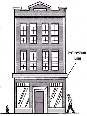
5.6.08.F. Expression Lines (EL).
1.
A horizontal line on the façade known as the Expression Line (EL) shall distinguish the base of the building from the remainder to enhance the pedestrian environment. The EL shall be set so that the bottom of the line is no higher than sixteen (16) feet above grade. The EL shall be created by a change in material, a change in design, or by a continuous setback, recess, or projection above or below the EL. Elements such as cornices, belt courses, corbelling, molding, stringcourses, ornamentation, and changes in material or color or other sculpturing of the base, are appropriate design elements to include with an EL.
2.
If applicable, the height of the EL shall be related to the prevailing scale of development in the area. A change of scale may require a transitional design element between existing and proposed features.
H.
Transparency.
1.
Purpose. The first floors of all buildings shall be designed to encourage and complement pedestrian-scale activity and crime prevention techniques using CPTED (Crime Prevention Through Environmental Design). It is intended that this be accomplished principally by the use of windows and doors arranged so that active uses within the building are visible from or accessible to the street, and parking areas are visible to occupants of the building.
2.
Upper floor transparency is provided to ensure that access to adequate light and air is provided and that excessive areas of blank walls are avoided.
3.
Applicability.
a.
The minimum transparency requirement shall apply to all sides of a building that abut an urban open space or public right-of-way. Transparency requirements shall not apply to sides which abut an alley.
b.
Windows for building sides (non-front) shall be concentrated toward the front edge of the building, in locations most visible from an urban open space or public right-of-way.
4.
General Requirements. The General Provision requirements of Section 5.2.14. Building Transparency shall apply.
5.
Windows and Displays.
a.
Ground level storefront windows shall be horizontal, divided into vertical segments. Heavily tinted or reflective glass, and glass block on street façades shall not be counted toward transparency requirements.
b.
Product display windows shall be internally lit.
c.
Interior displays shall be set back a minimum of one (1) foot from the window and shall not cover more than fifty (50) percent of the window opening. Displays nearer than one (1) foot from the window shall be considered a window sign.
d.
No window covering or screening shall cover more than twenty-five (25) percent of windows or doors that are used to meet transparency requirements.
I.
Building Step-Backs.
1.
Purpose. A step-back is a portion of a building or structure that is recessed from the base of the structure at a defined story. Step-backs are required where necessary to provide a more gradual transition between heights of adjacent buildings and less intensive uses; provide greater access to sunlight for public areas, trees, and lower buildings; provide a comfortable pedestrian experience; and integrate with existing street wall buildings. It is also intended to inform the relationship between the proposed development and the heights of other buildings in the surrounding area. The requirements for building step-backs is to coordinate the proposed development with the location, height, scale, and spacing of existing or approved buildings, and in particular other buildings on the same or adjacent blocks.
2.
Applicability. A step-back is required when one (1) of the following conditions is met:
a.
Any building side in the TN-TCC Zone District that abuts a residential zone district.
b.
Buildings fronting a public street in the TOD Zone Districts.
3.
Requirements.
a.
Where there are existing street wall buildings, the placement of the required step-back shall be no lower than the height of the existing context of the street wall buildings.
b.
Determination of Existing Context.
i.
An existing context of street wall buildings shall be determined by the average number of stories of buildings in the same block and on the block across the street.
ii.
To establish an existing context, the block used in the calculation shall be occupied by existing buildings for a minimum of fifty (50) percent of the linear frontage of the block.
iii.
Existing buildings that do not meet the minimum story requirement of the Zone District shall be excluded from the calculation of the average stories.
c.
Where an existing context is not able to be determined, the fifth story shall be subject to the step-back requirement.
d.
Where required, the step-back shall be at least ten (10) feet.
e.
Building step-backs shall span a minimum horizontal width of at least seventy-five (75) percent of any affected side of a building.
4.
Administrative Departure. The Director may approve a modification to the requirements of subsection 3., above where they are demonstrated to be impractical due to existing building locations, location of adjacent uses, or other physical conditions related to the site or existing buildings.
(Ord. No. 2019-10, § 4, 3-26-19; Ord. No. 2020-13, §§ 4, 7, 4-28-20; Ord. No. 2021-03, §§ 4—8, 1-26-21; Ord. No. 2023-26, §§ 1—3, 7-11-23; Ord. No. 2024-40, § 5, 9-24-24)
Sec. 5.7.01. - Purpose and Intent.
A.
Purpose.
1.
There are certain unique areas within the city that cannot easily be treated in the same manner as other Zone Districts. Accordingly, a "Special District" classification has been created to permit proper regulation of these areas. The Special District combines the major elements of traditional zoning with particular neighborhood elements that can help to preserve the vitality and character of each Special District. The Special Districts are intended to be developed in a manner that shall be sensitive to the Zone Districts they border.
2.
Special Districts have also been created to accommodate particular development concerns, such as accommodating larger institutions.
3.
Special Districts retain many of the characteristics of a traditional, use-based zoning classification system. Uses are regulated by type, size, location, coverage, design, among other particulars, within each Special District.
B.
Special District Designation. Table 5.7.01. lists the Special Districts.
Sec. 5.7.02. - Special District - Airport (SD-AP).
A.
Purpose and Intent.
1.
The Gerald R. Ford International Airport is an important asset to the Grand Rapids metropolitan region and all of western Michigan. The Airport serves as a focal point of development as growth in general aviation, commercial cargo carriers and passenger airlines continues.
2.
The SD-AP District as depicted on Special District-Airport Map E is designed to permit those uses, activities, facilities, and structures necessary for the safe and efficient operation of aircraft and for providing the services and facilities required to accommodate airport patrons and employees.
3.
This district is intended to accommodate and promote aeronautical progress for the public good, while protecting the health and welfare of the public. This Special District permits both aeronautical and non-aeronautical uses and facilities that complement airport operations.
4.
It is recognized that certain aeronautical facilities are exempt from local zoning under the Zoning Act. This District governs only the land surrounding the terminal within the jurisdictional boundaries of the City.
B.
Uses Table. Table 5.7.02.B. lists uses allowed within the SD-AP, subject to compliance with all other applicable requirements of this Chapter.
1.
No use within the SD-AP District shall create electrical or electronic interference with navigational signals or radio or radar communication between the airport and aircraft. No structure or use of land that causes the emission of smoke that may be a pilot navigation hazard or otherwise be detrimental or injurious to the health, safety and welfare of the public using the airport is allowed unless specifically required and authorized by the Federal Aviation Administration (FAA), or other governmental entity with statutory authority.
2.
No use within the SD-AP District shall be designed or operated in a manner that is intended to or has the effect of attracting birds or other wildlife.
3.
Permitted Uses. Uses permitted by right in the Zone District, subject to compliance with all other applicable requirements of this Chapter, are identified with a "P."
4.
Some Permitted Uses are subject to compliance with Article 9. These uses are identified in the Table 5.7.02.B. under "Use or Other Regulations." A cell marked with a dash "—" under this heading indicates that there are no additional use requirements in Article 9.
5.
Unlisted Uses. Uses not listed in the Table 5.7.02.B. are prohibited, unless the Director determines that the use is similar to other uses listed either as a Permitted Use or Special Land Use in accordance with Section 5.4.04.
C.
Site Layout and Building Placement Requirements.
D.
Airport Zoning Act. Proposed buildings or modifications to existing buildings with a height greater than one hundred (100) feet require a permit from the Kent County Department of Aeronautics, pursuant to the Airport Zoning Act, Public Act No. 23 of 1950.
Sec. 5.7.03. - Special District - Open Space (SD-OS).
A.
Purpose and Intent. The Open Space District (SD-OS) is intended to accommodate natural or park-like settings and preserve selected open space land and uses from development pressures. This Special District is intended for public or private purposes, and may include parks, playgrounds, athletic fields, wetlands, floodplains and natural areas.
B.
Allowed Uses Table. Table 5.7.03.B. lists uses allowed within the SD-OS District, subject to compliance with all other applicable requirements of this Chapter.
1.
Permitted Uses. Uses permitted by right in the applicable Zone District, subject to Director Review and compliance with all other applicable requirements of this Chapter, are identified with a "P."
2.
Special Land Uses. Uses which may be allowed subject to review and approval by the Planning Commission in accordance with Section 5.12.09., and with all other applicable requirements of this Chapter. These uses are identified with an "S."
3.
Other Regulations. Many allowed uses, whether a Permitted Use or a Special Land Use, are subject to compliance with other requirements of this Chapter. These uses are identified in the Table 5.7.03.B. under "Use and Other Regulations." A cell marked with "—" under this heading indicates that there are no additional use requirements in Article 9.
4.
Uses Not Allowed. A cell marked with an "X" indicates that the listed use under a Zone District heading is not allowed. Uses not listed in the Table 5.7.03.B. are prohibited unless the Director determines that the use is similar to other uses listed either as a Permitted Use or Special Land Use in accordance with Section 5.4.04.
5.
Unlisted Uses. If an application is submitted for a use not listed, the Director shall make a determination as to the proper Zone District and use classification for the new or unlisted use in accordance with Section 5.4.04.
6.
Site Development. Vehicle and bicycle parking requirements and pedestrian circulation requirements are in Article 10 Transportation and Mobility. Landscaping requirements are in Article 11 Landscaping and Green Infrastructure. Sign requirements are in Article 15 Signs.
C.
Site Layout and Building Placement Requirements.
1.
Lots may contain more than one (1) main building or principal use.
2.
No parking is permitted in the required front yard.
3.
All buildings shall meet the requirements of Table 5.7.03.C.
D.
Building Element Requirements.
1.
Building Materials.
a.
Durable building materials, simple configurations and solid craftsmanship are required.
b.
Walls visible from public streets, exclusive of wall areas devoted to meeting transparency requirements shall be constructed of brick; fiber cement siding, wood lap, aluminum or vinyl siding; and split-faced block, stucco or stone. Metal may only be used for beams, lintels, trim elements and ornamentation.
c.
Building materials in TN-Traditional Neighborhood Zone Districts shall have a traditional, horizontal orientation.
2.
Façade Variation. The maximum linear length of an uninterrupted building façade facing a public street and/or public park shall be between twenty-five (25) and thirty-five (35) feet. Building wall offsets (projections and recesses), cornices, varying building materials or pilasters shall be used to break up the mass of a single building.
3.
Building Orientation. In the TN-Traditional Neighborhood and MCN-Mid-Century Neighborhood Districts, buildings shall be oriented towards a public street.
4.
Transparency. The General Provision requirements of Section 5.2.14. shall apply. The front of a non-residential building shall have forty (40) percent transparency. Transparency on building sides of a non-residential structure shall be twenty (20) percent.
Sec. 5.7.04. - Special District - Industrial-Transportation (SD-IT).
A.
Purpose and Intent. The Industrial-Transportation Districts (IT) are established to reflect the goals and objectives of the Master Plan for a wide range of light industrial and manufacturing uses, heavy manufacturing and processing of raw materials. Regulated adult uses are included within this Zone District to preserve the character and integrity of residential neighborhoods and family-oriented institutions, such as places of worship and recreation. Reasonable protection of adjacent land uses is also an important component of this Special District. Typical light industrial uses are permitted within this Zone District, while typical heavy industrial uses shall be considered as Special Land Uses.
B.
Uses Table. Table 5.7.04.B. lists uses allowed in the Industrial-Transportation Districts (SD-IT), subject to compliance with all other applicable requirements of this Chapter.
1.
Permitted Uses. Uses permitted by right in the applicable Zone District, subject to Director Review where in compliance with all other applicable requirements of this Chapter. Such uses are identified with a "P."
2.
Special Land Uses. Uses which may be allowed subject to review and approval by the Planning Commission in accordance with Section 5.12.09., and with all other applicable requirements of this Chapter. These uses are identified with an "S."
3.
Uses Not Permitted. Uses which are not permitted either by Permitted Use or Special Land Use are identified with an "X."
4.
Other Regulations. Certain allowed uses, whether Permitted Uses or Special Land Uses, are subject to compliance with other requirements of this Chapter. These uses are identified in the Table 5.7.04.B. under "Use or Other Regulations." A cell marked with a dash "—" under this heading indicates that there are no additional use requirements in Article 9.
5.
Unlisted Uses. If an application is submitted for a use not listed, the Director shall make a determination as to the proper Zone District and use classification for the new or unlisted use in accordance with Section 5.4.04.
6.
Site Development. Vehicle and bicycle parking requirements and pedestrian circulation requirements are in Article 10 Transportation and Mobility. Landscaping requirements are in Article 11 Landscaping and Green Infrastructure. Sign requirements are in Article 15 Signs.
7.
Accessory Sales. Accessory retail sales are permitted provided that they:
a.
Are conducted within the same structure housing the principal manufacturing or warehouse use, with no outdoor sales allowed; and
b.
Are limited to hours of operation to between 8 a.m. and 9 p.m., or to the operating hours of the principal use, whichever is shorter; and
c.
Only sell items manufactured by the principal use or are part of the principal use's warehouse stock; and
d.
Provide sufficient parking separate from the principal use of the property.
8.
Enclosed Structure. All uses permitted by right shall be conducted within a completely enclosed structure, except vehicular storage or other uses that require outdoor storage as regulated in Table 5.7.04.B.
9.
Noxious Emissions. No noise, smoke, dust, vibration or any other like nuisance shall adversely affect adjacent residential uses. Those uses which may be noxious or offensive by the reason of emission of odor, dust, smoke, gas, noise, vibration and the like, and not allowed in any other district shall be set back at least three hundred (300) feet from any other Zone District line.
C.
Site Layout and Building Placement Requirements.
1.
All development in the SD-IT Zone District shall comply with the requirements in Table 5.7.04.C. unless otherwise expressly stated, or unless a stricter requirement is in an applicable Overlay District.
2.
Administrative Departure. An Administrative Departure may allow adjustments up to five (5) feet in the established dimensions to accommodate individual site conditions, such as healthy mature trees, topography, or other similar physical conditions.
D.
Building Elements.
E.
Storage and Screening.
1.
Materials and equipment storage areas shall be located in the side or rear yards.
2.
All outdoor storage shall be completely screened from any adjacent parcel or public right-of-way as required by Section 5.9.18.C.
3.
All machinery, equipment and materials shall be at least twenty-five (25) feet from any lot line. No portion of the storage area shall be within seventy-five (75) feet of any Residential Zone District or residential use.
4.
Any hazardous materials proposed to be stored, used or handled on site shall be conducted in accordance with all applicable State and Federal laws. These materials shall be disclosed by the applicant or property owner for Special Land Use requests.
5.
Administrative Departure. Materials and equipment storage may be permitted in the front yard if it is demonstrated that there would be no substantial detriment to surrounding properties, that adequate screening shall be provided; that a minimum setback of fifteen (15) feet from the property line is maintained.
(Ord. No. 2018-45, § 4, 7-24-18; Ord. No. 2018-70, § 2, 12-18-18; Ord. No. 2019-16, § 2, 4-23-19; Ord. No. 2020-21, §§ 5, 6, 7-7-20; Ord. No. 2024-20, § 10, 4-23-24)
Sec. 5.7.05. - Special District - Institutional Campus (SD-IC).
A.
Purpose and Intent.
1.
Large, Campus-Like Settings. The Institutional Campus District is established to account for larger, campus-like settings including colleges and universities, hospital campuses, senior living facilities and similar institutional arrangements. Mixed land uses may occur in the same building (e.g., retail on ground floor, office space above) or in different buildings sited on the same lot or parcel (e.g., freestanding child day care center located on the same parcel as an office building). Active uses such as retail, restaurants, cultural and public spaces are encouraged on the ground floor abutting a public street. In certain circumstances, less intensely developed areas that are characterized by single uses rather than a mix of uses may be developed.
2.
Mixed-Use Environment. The following requirements are intended to deal with the complexities inherent in campus settings and the establishment of a mixed-use environment that services the institutional use as well as the broader community. The Master Plan promotes the restructuring of many of the city's existing institutional areas into compact, walkable, mixed-use centers. The Master Plan advocates incorporating housing, shopping, jobs and services, and providing attractive alternatives to travel by car. It is understood that institutional settings involve density and character of living, education, working, visiting and other arrangements that present unique challenges especially given that in some settings there are special physical, mobility and equipment needs, as well as unique situations in dealing with persons in various life stages, sometimes dealing with particular health and emotional issues.
3.
Design Issues. These regulations guide the physical form of the development project to resolve concerns and address design issues that might occur with the mixture of different uses in the same project. These concerns and design issues may occur within a project or along its boundaries with surrounding residential neighborhoods or commercial areas.
B.
Eligibility Requirements.
1.
Unified Control of Property. The proposed development shall be under single ownership or control to ensure there is a single entity with responsibility for completing and managing the campus.
2.
Minimum Size. The site shall be a minimum of two (2) acres. The Planning Commission may approve submission of an application for a smaller site provided that the proposal substantially achieves the Purpose and Intent of the Special District and meets the other eligibility requirements.
3.
Compatibility. The proposed plan and uses shall not adversely affect adjacent neighborhoods or other development in terms of traffic disruption or congestion or impediments to development or redevelopment of nearby properties.
4.
Master Plan. The proposed use shall be consistent with the Visions, Objectives and Policies, and Development Characters of the Master Plan for the area in which the use is proposed.
C.
Allowed Uses Table. Table 5.7.05.C. lists uses allowed in the Institutional Campus District (SD-IC), subject to compliance with all other applicable requirements of this Chapter.
1.
Permitted Uses. Uses permitted by right in the Zone District, subject to compliance with all other applicable requirements of this Chapter. These uses are identified with a "P."
2.
Special Land Uses. Uses which may be allowed subject to review and approval by the Planning Commission in accordance with Section 5.12.09., and with all other applicable requirements of this Chapter. These uses are identified with an "S."
3.
Use Regulations. Certain allowed uses, whether a Permitted Use or a Special Land Use, are subject to compliance with other requirements of this Chapter. These uses are identified in the Table 5.7.05.C. under "Use or Other Regulations." A cell marked with a dash "—-" under this heading indicates that there are no additional use requirements in Article 9.
4.
Unlisted Uses. Uses not listed in the Table 5.7.05.C. are also prohibited unless the Director determines that the use is similar to other uses listed either as a Permitted Use or Special Land Use in accordance with Section 5.4.04.
5.
Site Development. Vehicle and bicycle parking requirements and pedestrian circulation requirements are located in Article 10 Transportation and Mobility. Landscaping requirements are in Article 11 Landscaping and Green Infrastructure. Sign requirements are in Article 15 Signs.
6.
Accessory Uses. Accessory uses that provide goods or services primarily to employees, students or other immediate stakeholders and operate with low intensity activities such as a coffee shop, pharmacy, gift shop or book store or other similar use shall be permitted as approved by the Director.
7.
Excessive Noise. Activities that may generate a great deal of sound, such as a power house, loading docks or amplified sporting event shall be subject to Special Land Use approval if located within four hundred (400) feet of a residential use.
D.
Site Layout and Building Placement Requirements.
1.
All development in the SD-IC District shall comply with the requirements in Table 5.7.05.D. unless otherwise expressly stated, or unless a different requirement is contained in an applicable Overlay District.
2.
Accessory uses shall be sited to face the public right-of-way or contribute to the creation of a Traditional Neighborhood streetscape. Where located adjacent to a public right-of-way, storefront windows, door entrances and façade treatments shall comply with the TN-TBA Zone District requirements of Table 5.6.08.A.
E.
Building Elements.
1.
All development in the SD-IC shall comply with the requirements in Table 5.7.05.E. unless otherwise expressly stated, or unless a different requirement is contained in an applicable Overlay District.
2.
New window and door openings shall be compatible with existing horizontal and vertical architectural features, such as columns, piers and cornices.
F.
Review and Approval. Except as provided in G., below, the following process shall be used in the SD-IC District.
1.
Perimeter Area. A two hundred fifty (250) foot wide perimeter area shall be established along the outer edge of the SD-IC District as measured from the campus property lines, including any individual lots under common ownership. All improvement to land or structures within the two hundred fifty (250) foot perimeter shall be approved as a Special Land Use by the Planning Commission. The Planning Commission shall review appropriate transitions in landscaping, use, building height and massing, and density related to these improvements.
2.
Interior of Site. Improvements to land or structures outside of the two hundred fifty (250) foot perimeter area shall be subject to Director Review; unless the Director determines that a hearing before the Planning Commission is warranted due to proposed site changes that have the potential to adversely affect neighboring properties.
3.
Facility Master Plan. The institution shall submit a facility master plan to the Director as part of a regular project submittal. The area under development shall be identified.
4.
Optional Plan Review. The Planning Commission may modify any of the design requirements of this Special District under Section 5.12.14. Optional Plan Review at the request of the applicant where one (1) or more of the following conditions exist.
a.
Existing site conditions, including but not limited to: surrounding land uses, topography, soils, and/or other significant natural features, physically preclude or prevent compliance with the requirements of the District without a substantial adverse effect on those features. These features shall be clearly identified and described in the application for any requested modification.
b.
The applicant demonstrates by clear and compelling evidence that site or occupant security requires their modifications.
c.
The justification of any modification shall not be justified solely for financial considerations. However, this does not preclude the Planning Commission from modifying requirements where the applicant demonstrates that the project would be rendered financially unsound or that the requirement is unnecessarily burdensome in relation to the benefit gained.
d.
That no other reasonable design alternatives are available that would comply with the requirements of the District.
e.
That the request for modification was reviewed by the Director, City Engineer, Fire Chief, and Police Chief.
Sec. 5.7.06. - Special District - Planned Redevelopment District (SD-PRD).
A.
Purpose and Intent.
1.
Flexible Development Standards. The Planned Redevelopment District may be appropriate when it may be necessary or desirable to deviate from the standards in another Zone District to ensure that desirable and compatible development occurs. These flexible development standards are necessary to address special conditions with regard to setbacks, yards, building height and special traffic, policing, or landscaping issues. It is not the intent of this District to permit development applications that simply wish to avoid compliance with the other regulations of this Chapter.
2.
Mixed Use Development. The SD-PRD encourages mixed land uses that may occur in the same building (e.g., retail on ground floor, office space above) or in different buildings sited on the same lot (e.g., free-standing child day care center located on the same parcel as an office building). Active uses such as retail, restaurants, cultural and public spaces are encouraged on the ground floor. In certain circumstances, less intensely developed areas characterized by single uses rather than a mix of uses may be developed using the SD-PRD classification.
3.
Project Review Process. The SD-PRD is designed to accomplish the objectives of this Chapter through a land development project review process to achieve integration of the proposed land development project with the characteristics of the area, as authorized by the Zoning Act.
4.
Former PUDs and PRDs. Planned Unit Development (PUD) and Planned Redevelopment Districts (PRD) of a former zoning ordinance have been transferred into this SD-PRD where continued control of new development or redevelopment efforts is desired. All conditions and requirements of the previous project approval, and amendments thereto, shall remain in effect unless otherwise waived by the Planning Commission or City Commission or if the approval has expired pursuant to Section 5.12.12.I., in which case the development shall only be completed in accordance with the provisions of this Chapter.
5.
Master Plan. This Special District permits and controls the development of sites and buildings in a manner that satisfies the Visions, Objectives and Policies, Plan Recommendations, and Development Characters of the Master Plan; particularly as it relates to environmental quality and sustainable design.
B.
Eligibility Requirements.
1.
To apply for SD-PRD approval, the applicant shall demonstrate that each of the eligibility criteria shall be met.
a.
Unified Control of Property. The proposed development shall be under single ownership or control to ensure there is a single entity responsible for completing the project. A responsible party shall be named for the project and included in the application.
b.
Area Specific Plan and Master Plan. An area specific plan shall be prepared as part of the development request, in compliance with the criteria established in Chapter 11 of the Master Plan. The proposed project uses will be consistent with the Master Plan for the area in which the use is proposed.
2.
Exceptions. The Planning Commission may approve submission of an application for a SD-PRD outside of the Eligibility Requirements noted above, provided that the proposed project is generally consistent with the Purpose and Intent of the SD-PRD and is consistent with the Vision, Objectives and Policies, Plan Recommendations, and Development Characters of the Master Plan.
C.
Use Table. Table 5.7.06.C. lists uses allowed within the Planned Redevelopment District (SD-PRD), subject to compliance with all other applicable requirements of this Chapter and any conditions of the City Commission's approval of the SD-PRD.
1.
Permitted Uses. Uses permitted by right in the Zone District, subject to compliance with all other applicable requirements of this Chapter. These uses are identified with a "P."
2.
Special Land Uses. Uses which may be allowed subject to review and approval by the Planning Commission in accordance with Section 5.12.09., and with all other applicable requirements of this Chapter. These uses are identified with an "S."
3.
Use Regulations. Certain allowed uses, whether Permitted Uses or a Special Land Uses, are subject to compliance with Article 9 or other provisions of this Chapter. These uses are identified in the Table 5.7.06.C. under "Use or Other Regulations." A cell marked with a dash "—-" under this heading indicates that there are no additional use requirements. However, there may be other applicable regulations in this Chapter for the uses listed that are not noted in the Use Table.
4.
Unlisted Uses. Uses not listed in the Table 5.7.06.C. are prohibited unless the Director determines that the use is similar to other uses listed either as a Permitted Use or Special Land Use in accordance with Section 5.4.04.
5.
Exception. An Exception, as noted in Table 5.7.06.C. may be given to permit non-retail uses within the ground floor of a commercial building if the building was constructed for purposes or uses other than retail sales. For example, a building constructed for offices may be used for ground floor offices or a dance studio.
6.
Site Development. Vehicle and bicycle parking requirements and pedestrian circulation requirements are located in Article 10 Transportation and Mobility. Landscaping requirements are in Article 11 Landscaping and Green Infrastructure. Sign requirements are in Article 15 Signs.
7.
Dwelling Units.
a.
The total number of dwelling units allowed in a project shall be determined by multiplying the gross acreage of a project area, not including the acreage dedicated to non-residential uses, by the dwelling unit density permitted within the applicable Future Land Use category of the Master Plan, and as shown in Table 5.7.06.C.7., unless an Area Specific Plan has specified a different density.
b.
Additional residential units above those permitted in Table 5.7.06.C.7. may be permitted if determined appropriate by the Planning Commission where the following conditions are present.
i.
Excessive costs incurred in the redevelopment of deteriorating or blighted areas, including costs for land assembly, demolition, and other related costs.
ii.
Costs for the following amenities and activities that would not otherwise be incurred for projects in Zone Districts outside of a PRD.
(a)
Landscaping, such as streetscape, open space and plazas, use of existing landscape, pedestrian ways, or bicycle paths.
(b)
Difficulties related to the property in siting of building or other site improvements, such as topography, view, sun orientation, circulation pattern, physical environment, variation in building setbacks, or building groups (clustering).
(c)
Design features beyond those required by this Chapter, such as street sections, harmonious use of materials, parking areas broken by landscape features, or other enhancements.
c.
City Commission. The City Commission, after receipt of the recommendation of the Planning Commission, shall determine the total number of dwelling units. The City Commission may consider a different number of dwelling units than recommended by the Planning Commission.
D.
Site Layout and Building Placement Requirements. All development in the SD-PRD District shall comply with the requirements in Table 5.7.06.D. unless otherwise expressly stated, or unless a different requirement is contained in an applicable Overlay District.
E.
Building Elements. All development in the SD-PRD shall comply with the requirements in Table 5.7.06.E. unless otherwise expressly stated, or unless a different requirement is contained in an applicable Overlay District.
F.
Additional Requirements.
1.
Any development of a commercial area under these provisions shall be designed in a manner to be pedestrian-friendly, discourage freestanding uses, and eliminate the appearance of a strip commercial development style. The development shall be architecturally pleasing and generally consistent with surrounding development, and shall be consistent with Purpose of a mixed use development in Section 5.7.06.A.
2.
New Buildings. For new main buildings, the main floor of a single retail use shall not be greater than thirty thousand (30,000) square feet of gross floor area.
3.
Commercial areas shall provide a landscape buffer from adjacent uses of a less intense nature, per Section 5.11.12.
4.
Compatibility. The proposed plan and uses shall not adversely affect adjacent neighborhoods or other development in terms of traffic disruption or congestion or impediments to development or redevelopment of nearby properties.
5.
Reflective Surfaces. The use of highly reflective surfaces, including reflective glass and reflective metal roofs, is prohibited. This prohibition shall not apply to solar panels.
6.
Outside Display or Storage. No development or use shall store products outside. Any outside display shall be recommended by the Planning Commission and specifically approved by the City Commission as part of the SD-PRD zone change.
7.
Residential development in a SD-PRD shall be subject to the requirements of Sections 5.9.06 and 5.9.20.
G.
Application, Review and Amendments. See Article 12.
(Ord. No. 2018-32, § 6, 6-5-18)
Sec. 5.8.01. - Purpose and Intent.
A.
Purpose.
1.
It is recognized by this Chapter that there are unique areas within existing Zone Districts of the city that require special consideration to provide certain design, placement, or other regulations in addition to those imposed by the current zoning designation.
2.
Accordingly, this Article provides for certain Overlay Districts that are intended to permit the proper regulation of these areas by adding special considerations in addition to those of the base Zone District. In all cases, applicants for building permits in an Overlay District shall meet both the requirements of the base Zone District and the additional provisions, requirements and restrictions of the Overlay District.
3.
Where there is conflict between other provisions of this Chapter, those specifically applied in the Overlay District shall control. Where there is conflict between other provisions of this Chapter, those specifically applied in the Overlay District shall control, except as may be provided in Section 5.1.09.
4.
The Overlay Districts of this Article allow regulations such as height bonuses in the Downtown area; establishment of particular development characters along the Grand River and East Beltline, protections for the public interest within designated floodplain areas, and provisions for ensuring adequate wayfinding throughout the city.
B.
Overlay District Designation. Table 5.8.01.B denotes the Overlay Districts.
Sec. 5.8.02. - Downtown Height Overlay District (OD-DH).
A.
Purpose.
1.
The purpose of the Downtown Height Overlay District (OD-DH) is to allow a variety of building heights in the areas within and surrounding what is generally recognized as Grand Rapids' Downtown. In addition, certain qualifying development incentives are provided in recognition of the need to provide for a suitable mix of residential, retail, employment centers, and urban open space that is essential for the creation of an attractive, pedestrian-friendly, vibrant, and economically sustainable central business district.
2.
In addition, these incentives promote an environment that enhances property values, contributes to quality of life and sustains the Downtown as a regional asset. To this end, the Downtown Height Overlay District provides for certain incentives that permit building heights above the permitted base building heights to encourage certain development characteristics the City has deemed of value in creating highly livable, walkable, and vibrant environments.
3.
The District is further intended to recognize the need to have varying intensities of development from the densest levels of development in the city core to the edges of commercial area that begin to transition into less intensely developed areas and residential neighborhoods. To this end, the District establishes certain subareas to account for height and incentive differences.
B.
Applicability. Map A of the Zoning Map depicts the boundaries of the area covered by the Downtown Height Overlay District and its subareas. The height requirements of the Height Overlay District are in addition to the requirements of the Zone District in which an individual property is located. All other applicable requirements of each district remain in effect.
C.
Downtown Height Overlay Subareas.
1.
As noted in Table 5.8.02.D., the Height Overlay District establishes two (2) subareas, each of which has height regulations applied. Additional bonus height provisions are available for properties that fall within the Grand River Overlay District of Section 5.08.03.
2.
Purposes. A series of density incentives, provided through variations in building height, are provided to help describe a smooth transition from the most intensively developed core of the downtown to the residential neighborhoods with a transition that steps down building heights from the core to these neighborhoods.
a.
DH-1. The purpose of this subarea is to permit the greatest intensity of land use to create a core of development density for a wide variety of uses that are mutually supportive and serve regional needs, including hotels, restaurants, employment centers, medical centers, entertainment venues, and others. These uses are also intended to create an active, vibrant core.
b.
DH-2. This subarea largely surrounds the core and near-core downtown areas, including areas on the west side of the Grand River, with a number of cultural and institutional uses important to the city and region. It is intended as a transitional area between the more intense development of DH-1 and the edges of downtown and nearby neighborhoods. While still relatively intensively developed, the lower building heights provide transition from the core. The subarea is divided into two zones, DH-2(a) and DH-2(b), to help reinforce the transition of building heights.
D.
Permitted Height. Table 5.8.02.D. describes the minimum and maximum permitted heights for buildings within each Height Overlay Subarea, including potential bonuses as described in Section 5.8.02.G. Heights are measured in stories as provided in Section 5.8.02.E., below.
E.
Story Heights. (See also Section 5.2.06.)
1.
Table 5.8.02.E.1 provides for the height of each story of the main building. Unless otherwise specified, story height is measured in feet from the floor of a story to the floor of the story above it.
2.
For the uppermost story, story height shall be measured from the floor of the story to the eave line on pitched roofs and to the tallest point of the roof deck on parapet and flat roofs.
3.
Story height requirements apply only to street facing façades, however, no portion of a story of the building shall exceed the maximum permitted story height.
4.
A building incorporating both a half story within the roof and a visible basement shall count the height of the two and one-half (2½) stories as one (1) full story.
(Ord. No. 2023-26, §§ 4, 5, 7-11-23)
Sec. 5.8.03. - Grand River Overlay District (OD-GR).
A.
Purpose. As Grand Rapids' most significant natural asset, the Grand River plays an important role in enhancing the quality of life of its residents. The Grand River Overlay District is intended to capitalize on the value of the Grand River as an essential economic, recreational and environmental resource by encouraging land use changes from industrial to open space and mixed-use development. The Grand River Overlay District seeks to introduce new development practices and land use patterns that enhances the extent to which people can view, access and enjoy the riverfront by providing opportunities for viewsheds, easements and recreational opportunities. It is intended that:
1.
Visibility of the Grand River is increased and enhanced by requiring building setbacks that will provide for improved views of the River.
2.
Existing river walk segments be extended along the entire length of the Grand River to allow for a continuous connection alongside the River for recreational and environmental quality purposes through donation, acquisition and easements.
3.
Wildlife corridors along the River's edges be supported through a continuous network of greenspaces.
4.
Water quality be improved with the introduction of less-intense, mixed land uses that are setback from the River's edge as opposed to present, directly abutting industrial uses and paved surfaces.
5.
Building heights generally conform to nearby buildings along the river corridor to provide a sense of visual continuity. Building heights should be configured to provide views to the Grand River and other significant landmarks while allowing an appropriate development intensity.
6.
A variety of people-oriented destinations be created along the river walk to provide visual interest, activity and vibrancy. Mixed-use development and high-density residential construction are essential components for encouraging pedestrian activity and public safety.
B.
Applicability. The requirements of this Overlay District shall apply to any lot or parcel shown on the Grand River Overlay Maps B1-B3, from the ordinary high water mark, floodwall or dock line, whichever is applicable as determined by the Planning Director, on each side of and paralleling the Grand River.
C.
Uses. Any lot or parcel within the OD-GR District shall be subject to the use regulations of the base Zone District.
D.
Site Layout and Building Placement Requirements.
1.
Where a property directly abuts the Grand River, buildings shall be sited to encourage pedestrian activity on both the street side and river side of the property.
2.
All development in the OD-GR District shall comply with the requirements in Table 5.8.03.D. unless otherwise expressly stated. Where specified, these requirements supersede the site layout and building placement requirements of the base Zone District.
E.
Building Elements. All development in the OD-GR District shall comply with the requirements in Table 5.8.03.E. Where specified in this Section, these requirements supersede the building element requirements of the Zone District. Where not specified, the requirements of the underlying Zone District requirements shall prevail.
1.
Step-backs.
a.
Purpose and intent. A step-back is a portion of a building or structure that is recessed from the base of the structure at a defined story. The requirements for building step-backs are intended to ensure compatibility of the proposed development with the location, height, scale, and spacing of existing or approved buildings, and in particular other buildings on the same or adjacent blocks. To encourage public access to the river, some of the step-back requirements may be waived if said access is provided.
b.
Applicability.
i.
A step-back is required per the regulations of Table 5.8.03.E.
ii.
In the Grand River Overlay District, step-backs are required on all building faces (river, street, and two sides).
c.
DH-2(a) requirements.
i.
For buildings 11 stories or taller, one (1) step-back is required somewhere between the 2 nd and 11 th floors.
ii.
For buildings 17 stories or taller, one (1) additional step-back is required somewhere between the 17 th and 19 th floors.
iii.
The step-back can either be 15 feet for 40 percent of the linear building frontage (Option A), or 20 feet for 30 percent of the linear building frontage (Option B).
iv.
Administrative Departure. For buildings 17 stories or taller, an Administrative Departure may be approved to allow one (1) step-back of 30 feet for 40 percent of the linear building frontage or one (1) step-back of 40 feet for 30 percent of the linear building frontage.
d.
TN-TCC requirements.
i.
For buildings six (6) stories or taller, one (1) step-back is required somewhere between the 2nd and 4th floors.
ii.
The step-back can either be 15 feet for 40 percent of the linear building frontage (Option A), or 20 feet for 30 percent of the linear building frontage (Option B).
e.
Public access easement.
i.
If a public access easement of a minimum of 15 feet is provided from the public right-of-way to the river, the step-back requirement of Table 5.8.03.E. shall only apply to the river and street faces of the building.
ii.
Administrative Departure. Where public access to the river already exists within 100 feet, the side façade step-back requirement can be waived without providing public access as described in Section 5.8.03.E.1.
2.
Materials. As required in the base Zone District, except that at least sixty (60) percent of the building wall facing the river, exclusive of wall areas devoted to meeting transparency requirements, shall be constructed of brick, glass, fiber cement siding, wood lap, stucco, split-faced block, or stone.
3.
Façade Variation. As required in the base Zone District, except that the requirements for building walls facing a street shall also apply to the building wall facing the river.
4.
Entrance.
a.
All office buildings, retail sales and service establishments shall have a visible and usable building entrance for customers on both the building wall facing the street and the building wall facing the river.
b.
Primary building entrances, including those entrances facing the river, shall be clearly identified using an awning, paving treatments, change in roofline or other features, such as canopies, porticos, arcades, arches, wing walls, and integral planters.
c.
Primary building entrances and exits shall be located on the primary street. Doorways that open to the sidewalk or multi-use trail shall be recessed.
5.
Expression Line.
a.
An expression line shall be provided to distinguish the base from the remainder of the building to provide a design element that enhances the pedestrian environment. If applicable, the height of the expression line shall meet the prevailing scale of development in the area.
b.
The expression line may be created by a change in material, a change in design, or by a continuous setback, recess, or projection above or below the expression line. Elements such as cornices, belt courses, corbelling, molding, stringcourses, ornamentation, awnings or canopies, and changes in material or color or other sculpturing of the base, are appropriate design elements to include with an expression line.
6.
Transparency. As required in the base Zone District, except that the requirements for building walls facing a street shall also apply to the building wall facing the river.
7.
Streetscape Plan. Standards used by the City Engineer to determine appropriate street tree plantings, walking surfaces and parkway landscaping shall be used where a City-recognized streetscape plan for a defined area has not been adopted (see Section 5.11.13.C.).
8.
Parking. Parking areas and parking structures shall be separated from the river by intervening buildings, except:
a.
Where retail space is provided on the ground floor of the parking structure, and at least fifty (50) percent of its façade facing the river is used as display windows; or
b.
Where a mural or other public art approved by the Planning Commission is provided on the parking structure on the river side of the structure, or in a landscaped area along the river.
c.
Where a. or b. above, apply, the parking area or structure shall have a minimum required front setback of thirty (30) feet from the Grand River.
9.
Landscaping and Access.
a.
Land between the building and the river shall be landscaped and designed as an urban open space for pedestrian use meeting the requirements of Section 5.11.14. Parking areas shall meet the minimum screening requirements of Section 5.11.11.C.
b.
Pedestrian walkways that connect to the river's edge shall be provided between buildings, parking areas or structures, and other built features such as outdoor plazas and courtyards.
c.
Service areas and mechanical equipment shall be visually unobtrusive and shall be integrated with the design of the site and building.
i.
Utility boxes shall be positioned so they cannot be seen from the river or Primary Street by locating them on the sides of buildings and away from pedestrian and vehicular routes.
ii.
Air intake and exhaust systems, or other mechanical equipment that generates noise, smoke or odors shall not be located on the river side of buildings.
F.
Grand River Overlay District Bonus Height Criteria. Development projects in the DH-2(a) Overlay District and TN-TCC Zone District that fall within the Grand River Overlay District may qualify for height bonuses in accordance with Table 5.8.03.F. using the criteria described below.
1.
Public Access Easement.
a.
To qualify for the bonus height, a public access easement at least thirty (30) feet wide, extending across the entirety of the lot on the river side of the main building shall be provided.
b.
Access shall be through permanent easements and shall conform to the provisions of urban open space of Section 5.11.14.B.3. Configuration and Section 5.11.14.B.4. Availability.
c.
A multi-use trail shall also be provided that conforms to the requirements of the City Parks and Recreation Department.
2.
Public Art.
a.
A development that elects this bonus may use any of the following methods:
i.
Allocate one (1) percent of the estimated construction cost for a permanent, on-site public art project(s). The artwork created must be where the public can access the artwork during normal business hours or continually view the artwork from off the site; or
ii.
Contribute one (1) percent of the project's estimated construction cost to the Arts Advisory Committee.
b.
Regardless of the above method selected, the minimum required expenditure shall be ten thousand dollars ($10,000.00).
c.
Public art installations on private property shall be maintained by the property owner.
(Ord. No. 2023-26, §§ 6—8, 7-11-23; Ord. No. 2025-07, §§ 1, 2, 3-25-25)
Sec. 5.8.04. - East Beltline Overlay District (OD-EBL).
A.
Purpose. The purpose of the East Beltline Overlay District is to implement the North East Beltline Joint Development Plan; to provide a consistent development framework; to specify practical development standards; to preserve the natural road edge, scenic views and steep slopes; and to protect the transportation capacity of this important transportation corridor.
B.
Applicability.
1.
The requirements of OD-EBL shall apply to all property abutting or gaining access from the East Beltline, including any lot or parcel shown on the East Beltline Overlay Maps C1 and C2.
2.
This Overlay District shall not be construed to be separate from the base Zone District. In all cases, applicants for building permits in the EBO District shall meet all requirements of the base Zone District and the additional provisions, requirements and restrictions of the OD-EBL. Where there is conflict between other provisions of this Chapter and those specifically applied in the OD-EBL, the latter shall control.
3.
Approvals Prior to 2002. The OD-EBL standards shall not apply to existing developments (including PUDs) approved prior to January 1, 2002.
4.
Town Center Properties. It is recognized that the Town Center is developing as a commercial node at the intersection of the East Beltline and Knapp. Accordingly, certain exceptions are taken in this Article for properties along the East Beltline and located near the intersection of Knapp and the East Beltline as more fully shown on the map entitled the "Town Center Properties."
C.
Modifications and Amendments.
1.
Notwithstanding the provisions, including specific waiver provisions of the Overlay District, the Planning Commission may approve a modification from the requirements of the Overlay District under the procedures and standards of Optional Plan Review.
2.
Project and PUD Amendments. Subsequent amendments or modifications to an approved project or PUD shall be subject to the requirements of this Chapter and shall be brought into compliance with the new requirements, including but not limited to: building and parking lot setbacks, landscaping, parking, lighting, signs, grading, stormwater management, motor vehicle and pedestrian access, and architectural façades and building design.
D.
Setbacks.
1.
Purpose. One of the goals of the North East Beltline Joint Development Plan is to maintain "a natural edge along the East Beltline through gracious development setbacks, preserving natural vegetation and utilizing innovative and low maintenance landscapes along the corridor and the highway right-of-way."
2.
Setbacks of Buildings and Parking Lots from the East Beltline. Buildings and parking lots shall be set back from the East Beltline according to the following schedule.
a.
Parking lot setbacks shall be ninety (90) feet, which is measured from the outside edge of the existing through lane, as of January 1, 2002, to the edge of a parking lot. Within the setback, a minimum twenty-five (25) foot landscape buffer is required, as measured from the right-of-way to the edge of a parking lot.
b.
Setbacks buildings equal to or less than thirty-five (35) feet in height shall be one hundred forty (140) feet, as measured from the outside edge of the through lane existing as of January 1, 2002, with a minimum twenty-five (25) foot setback between buildings and the right-of-way line.
c.
For buildings higher than thirty-five (35) feet, there shall be two (2) additional feet of setback for every additional foot in building height above thirty-five (35) feet.
3.
Setback Modifications. Upon request, the Planning Commission may recommend to the City Commission a reduction in building and parking setbacks to the minimum required setback in the base Zone District. The recommendation shall be based on meeting any of the following circumstances:
a.
The property cannot feasibly be developed if the minimum building setback is applied.
b.
If applied, the minimum building setback creates an adverse effect on environmental features such as steep slopes, wetlands, or vegetation.
c.
Application of the minimum building setback does not further the goals of the North East Beltline Joint Development Plan, Master Plan or this Overlay District.
d.
The property is part of the Town Center Properties.
4.
Exemption South of Lake Drive. Properties south of Lake Drive SE shall be exempt from the Overlay District setback requirements. For these properties the base district setbacks shall be used.
E.
Landscaping.
1.
East Beltline Landscaping. Within the required minimum twenty-five (25) foot landscape buffer that fronts on the East Beltline, landscaping shall be installed according to the following standards for office, institutional, multifamily or mixed-use areas; commercial-use areas; or parking areas. Plants may be clustered into groups or planted in rows. Trees and shrubs should be clustered in locations that are most effective in screening undesirable views.
a.
Office, Institutional, Multi-Family Residential or Mixed-Use Areas. Plantings shall include a minimum of three (3) evergreen trees, two (2) shade trees and eight (8) shrubs for every one hundred (100) linear feet of lot frontage, with fractions rounded up. The Planning Commission may allow a reduction in the number of trees or a variation in the mixture of the tree types to ensure the ability of the landscape materials to grow in a healthy condition and not conflict with one another, and to permit a variety of plant materials.
b.
Commercial-Use Areas. Plantings shall include a mixture of five (5) trees for every one hundred (100) linear feet of lot frontage, with fractions rounded up. A mixture of evergreen, ornamental and shade trees is encouraged. The Planning Commission may allow a reduction in the number of trees or a variation in the mixture of the tree types to ensure the ability of the landscape materials to grow in a healthy condition and not conflict with one another, and to permit a variety of plant materials.
c.
Parking Areas. Continuous plantings, berms or walls shall be a minimum of four (4) feet in height along the East Beltline (plantings measured after three (3) years). The requirement for plantings, berms, or walls for parking areas that abut the East Beltline may be waived if, in the judgment of the Planning Commission, the vehicles in the parking lot will be substantially screened from the road by the finished grade or existing vegetation.
2.
Town Center Properties. A landscape plan that meets the intent of the standards in Subsection E.1. above and Article 11 shall be submitted as part of the Site Plan Review or PRD application. The Planning Commission may reduce or waive front yard landscaping provisions for Town Center properties if deemed impractical or other amenities are provided that achieve the same purposes.
3.
Parking Area Landscaping. For all parking areas that accommodate ten (10) cars or more, the following shall apply.
a.
One (1) landscaped island shall be provided for every ten (10) parking spaces. Landscape islands may be aggregated. Landscape corners count towards the required number of islands.
b.
Landscape islands shall be a minimum of one hundred sixty (160) square feet and a minimum of nine (9) feet wide. Each island should be planted with at least one (1) canopy tree that is at least three (3) feet from the edge of the island.
c.
The Planning Commission may reduce the number of required landscape islands if it finds that adequate relief and shade is provided by other plantings in and around the parking area.
F.
Lighting. The provisions of Section 5.2.19. Outdoor Lighting shall be met, with the following exceptions.
1.
Non "cut-off" light fixtures as defined by IESNA, may be installed, however the maximum initial lumens by each fixture shall not exceed two thousand (2,000) (equivalent to a one hundred fifty-watt incandescent bulb). Mounting heights of alternative fixtures shall not exceed fifteen (15) feet.
2.
Average horizontal illumination levels shall be no greater than two and four tenths (2.4) foot-candles with a maximum to minimum ratio no greater than ten to one (10:1) and an average to minimum uniformity ratio not to exceed four to one (4:1).
3.
Average horizontal illumination levels may be increased near building entrances where pedestrian activity is substantial. In these locations, average horizontal illumination levels shall be no greater than four (4.0) foot-candles with a maximum to minimum ratio no greater than ten to one (10:1) and an average to minimum uniformity ratio not to exceed four to one (4:1).
G.
Access to the East Beltline. The purpose of this subsection is to control and limit motor vehicle access ways and the distance between them on the East Beltline. Access ways or driveways shall be correctly spaced so as to protect the safety of motorists and bicyclists as well as the capacity of this highway to accommodate traffic.
1.
Definition of Access. For the purposes of this Section, an "access" is an entrance and/or exit for motor vehicles to or from the East Beltline or a public street.
2.
Non-Signalized Access Spacing. Accesses shall be spaced as far apart as on-site circulation allows, and on-site circulation shall be designed to limit the number of accesses and to reasonably maximize the distances between them. The distances in Table 5.8.04.G. are based on average acceleration and deceleration considered adequate to maintain safe traffic operations. A greater spacing may be required if sight distances are limited at the proposed access location.
3.
Lack of Sufficient Lot Frontage to Maintain Adjacent Spacing.
a.
In the event that a lot lacks sufficient frontage to maintain adequate spacing, the Planning Commission may require one (1) or more of the following:
i.
An access point to a secondary street.
ii.
Access to service drives where they exist or can be constructed.
iii.
A shared driveway with the adjacent owners. In this case the driveway midpoint should be located at the lot line between the two (2) parcels. All parties shall agree in writing to the joint driveway, including, at a minimum, access rights and maintenance provisions, and submit evidence of the agreement to the Planning Commission.
iv.
If options listed above are not reasonably feasible, the Planning Commission may allow the next lowest spacing from Table 5.8.04.G. For example, on fifty (50) MPH roadway requiring four hundred fifty-five (455) foot spacing, the distance may be reduced to no less than three hundred fifty (350) feet, which is the spacing for forty-five (45) MPH speed.
v.
If all the above options are impossible, an access point may be allowed within the property limits.
b.
In the event that two (2) or more adjacent parcels each do not have sufficient frontage to maintain adequate spacing for access, the Planning Commission may require the dedication of joint access easements or cross access easements for shared access to the public street.
c.
If the property is one of the Town Center Properties, and compliance with the table is not reasonably feasible, then the Planning Commission may reduce or waive the requirements of this subsection.
4.
Access Design. All access points shall be designed to meet Michigan Department of Transportation (MDOT) guidelines and standards in addition to all offsets from intersections and indirect left turn crossovers at signalized and stop-sign intersections. Compliance with clear vision areas in this Chapter and in Chapter 51 Streets, Article 8 of the City Code is required.
Sec. 5.8.05. - Floodplain Overlay District (OD-FP).
A.
Delineation of Floodplain Overlay District.
1.
Purpose. It is the purpose of this Article to protect the general public and all lands in the city subject to flood losses by restricting or prohibiting uses which are dangerous to health, safety, and property in times of flood or which cause excessive increases in flood flow levels or velocities.
2.
Public Hazards. Periodic inundation of certain portions of the city produce flood hazards which result in loss of life and property; health and safety dangers; disruption of commerce and governmental services; extraordinary public expenditures for flood protection and relief; and impairment of the tax base, all of which adversely affect the public health, safety and general welfare of the city. These flood losses are caused by:
a.
The cumulative effect of obstructions in floodplains causing increased flood flow height and velocity; and
b.
The occupancy of flood prone areas by uses vulnerable to floods or hazardous to other uses inadequately elevated or otherwise protected from flood damages.
3.
Applicability. This Article shall apply to all lands within the city shown as a regulatory floodway on the "Flood Insurance Study for Kent County, All Jurisdictions" and dated February 23, 2023 and the Flood Insurance Rate Map (FIRM) panel numbers shown on the index panels: 26081CIND1A and 26081CIND2A, effective February 23, 2023. The provisions and restrictions of this Article shall be considered to apply in addition to, and where applicable instead of, the provisions of Zone Districts.
4.
Flood Areas. Uses and regulations otherwise applicable in existing Zone Districts shall not be allowed unless also permitted in, and developed in accordance with, the provisions of the OD-FP.
B.
Definitions.
1.
Base Flood. The flood having a one percent chance of being equaled or exceeded in any given year.
2.
Flood or Flooding. A general and temporary condition of partial or complete inundation of normally dry land areas from the overflow of water bodies, the unusual and rapid accumulation or runoff of surface waters from any source, or mudslides proximately caused by flooding and akin to a river of liquid and flowing mud on the surfaces of normally dry land areas, as when earth is carried by a current of water and deposited along the path of the current. Flood or flooding may also mean the collapse or subsidence of land along the shore of a lake or other body of water as a result of erosion or undermining caused by waves or currents of water exceeding anticipated cyclical levels or suddenly caused by an unusually high water level in a natural body of water, accompanied by a severe storm, or by an unanticipated force of nature, such as flash flood or an abnormal tidal surge, or by some similarly unusual and unforeseeable event which results in flooding.
3.
Flood Insurance Rate Map (FIRM). An official map of the city on which the Federal Emergency Management Agency (FEMA) has delineated both the special flood hazard areas and the risk premium zones applicable to the city.
4.
Regulatory Floodway. The channel of a river or other watercourse and the adjacent land areas that must be reserved in order to discharge the base flood without cumulatively increasing the water surface elevation more than a designated height.
5.
Special Flood Hazard Area (SFHA). An area having special flood, mudflow, or flood-related erosion hazards and shown on a FIRM as Zone A, AO, A1-A30, AE, A99, AH, AR, AR/A, AR/AE, AR/AH, AR/AO, AR/A1-A30, V1-V30, VE or V. The SFHA is the area where the National Flood Insurance Program's floodplain management regulations must be enforced.
C.
Land Uses. Uses are allowed in the OD-FP in accordance with Table 5.8.05.C. Uses in the Floodplain Overlay District. The following key is to be used in conjunction with the Use Table.
1.
Permitted Uses. Uses permitted by right in the OD-FP, subject to compliance with all other applicable requirements of this Chapter. These uses have a low flood damage potential because of their open space nature and shall be allowed to the extent they are Permitted Uses in the base Zone District, are in compliance with construction requirements of Chapter 32 of the City Code, and have obtained any necessary state and federal permits. These uses are identified with a "P."
2.
Special Land Uses. Uses which may be allowed subject to the review and approval by the Planning Commission in accordance with Section 5.12.09. and all other applicable requirements of this Chapter. The Special Land Use shall be included in Table 5.8.05.C. or Special Land Use in the base Zone District, comply with construction requirements of Chapter 32 of the City Code, and obtain any necessary state and federal permits. These uses are identified with an "S."
3.
Uses Not Allowed. Certain uses are prohibited within the OD-FP. A cell marked with an "X" indicates that the listed use is not allowed in the OD-FP.
4.
Unlisted Uses. Uses not listed in the Table 5.8.05.C. are also prohibited unless the Director determines that the use is similar to other uses listed either as a Permitted Use or Special Land Use in accordance with Section 5.4.04.
5.
Use Regulations. Many allowed uses, whether a Permitted Use or a Special Land Use in the OD-FP, are subject to compliance with Article 9 or other provisions of this Chapter. These uses are identified in the Table 5.8.05.C. under "Use or Other Regulations." A cell marked with a dash "—" under this heading indicates that there are no additional use requirements in Article 9."
D.
General Site Layout and Building Placement Requirements for All Uses.
1.
Structures shall be constructed and arranged on the building site to minimize obstruction to the flow of floodwaters.
a.
Structures shall be constructed with the longest element arranged parallel to the direction of the flood flow.
b.
Structures shall be placed approximately on the same flood flow lines as adjacent structures.
2.
Any excavation, fill extraction, grading, or scraping shall require a soil erosion review and permit requirements under Chapters 32 and 67 of the City Code.
E.
Special Land Use Applications.
1.
Additional Site Plan Requirements. In addition to the requirements of Section 5.12.08, site plans shall include the nature, location, dimensions and elevation of the lot, existing or proposed structures, fill, storage of materials, and the relationship of the above to the location of the regulatory floodway and regulatory flood protection level, and location and elevations of streets; photographs or maps showing existing land uses and vegetation upstream and downstream soil types; and other pertinent information which may be required by the Planning Commission.
2.
Review Standards. The following standards shall apply in addition to the standards for Special Land Uses of Section 5.12.09:
a.
No structure, fill, excavation, or storage shall be permitted which, acting alone or in combination with existing or future uses, significantly and unduly affects the capacity of the regulatory floodway and thereby increases the level of the floodwaters.
b.
Filling in the regulatory floodway may be permitted only after full compliance has been achieved, to the satisfaction of the City Engineer, or designee, with the applicable provisions of Act 451 of the Michigan Public Acts of 1994, as amended, and all other applicable federal, state and local acts, regulations, codes, and ordinances, including but not limited to the flood plain management criteria for flood-prone areas set forth in 44 CFR 60.3, as amended. Fill shall be protected from erosion by rip-rap, vegetative cover, bulkheading or other approved means.
c.
Prior to any alteration or relocation of a water body, notification shall be given to adjacent communities and the Michigan Department of Environment, Great Lakes, and Energy and evidence of that notification submitted to FEMA. The City Engineer or City ESD shall require proper maintenance be provided within the altered or relocated watercourse so that the flood carrying capacity is not diminished.
3.
In reviewing an application, the Planning Commission shall consider the following points before rendering a decision.
a.
Any possible danger to life and property due to increased flood levels or velocities caused by encroachments on the floodplain.
b.
The danger that materials may be swept onto other lands or downstream to the injury of others.
c.
The susceptibility of the proposed development and its contents to flood damage and the effect of such damage on the individual owner.
d.
The importance of the services provided by the development to the city.
e.
The requirement of the proposed development for a waterfront location.
f.
The availability of alternative locations for the proposed use which are not subject to flooding.
g.
The compatibility of the proposed use with existing development and development anticipated in the future.
h.
The relationship of the proposed use to the Master Plan and floodplain management program for the area.
i.
Safe access to the property in times of flood for ordinary and emergency vehicles.
j.
The expected levels, velocity, duration, rate of rise and sediment transport of the floodwaters expected at the site.
k.
The location, elevation and construction of all public facilities for sewer, gas, electrical, and water systems, designed relative to minimize or eliminate flood damage.
l.
The measures taken to ensure adequate drainage to reduce exposure to flood hazards.
m.
Other factors which are, in the opinion of the Planning Commission, relevant to the purposes of this District.
4.
Where, in the opinion of the Planning Commission, topographic data, engineering studies, or other studies are needed to determine the effects of flooding on a proposed use and/or the effects of the use on the regulatory floodway, the Planning Commission may require the applicant to submit this data and/or studies prepared by competent engineers.
5.
Conditions of Approval. Upon reviewing all data and materials, and before granting approval, the Planning Commission may attach conditions to the granting of approvals, which may include but not be limited to the following:
a.
Limitations on period of use, operation, and operational controls.
b.
Submission of performance guarantees, deed restrictions, and covenants.
c.
Requirements for construction of channel modifications, dikes, levees, and other protective measures.
F.
Disclaimer of Liability. The degree of flood protection required by this Article is considered the minimum necessary and reasonable for regulatory purposes. Larger floods may occur at any time, and excessive flood water levels may be experienced due to manmade and natural causes, such as ice jams and accumulated debris in bridge openings. This Article does not imply that areas outside the OD-FP, or uses permitted within such areas, will remain free from flooding or flood damages. This Article shall not create a liability on the part of the City or any officer or employee thereof for any flood damage that results from compliance with or reliance upon this Article or any administrative decision lawfully made under the provisions of this Chapter.
(Ord. No. 2023-06, § 1, 2-21-23)
Sec. 5.8.06. - Wayfinding Signs Overlay District (OD-WS).
A.
Purpose. The purpose of the Wayfinding Signs Overlay District is to provide opportunities to install a comprehensive sign program in appropriate locations where the dense, urban environment of the city can create confusion for visitors who must interpret street signs, traffic control devices, addresses and other information rapidly while attempting to locate a major destination. It is intended that wayfinding signs shall:
1.
Enhance Streetscape. Promote a unified and enhanced visual aesthetic that is consistent with streetscape design elements along a transportation corridor.
2.
Coordinate Information. Convey essential information to pedestrian and vehicular traffic in a clear, consistent, understandable format for multiple destinations.
3.
Reduce Visual Clutter. Minimize the need for multiple signs and provide reasonably sized signs that are in scale with surrounding structures.
4.
Promote Partnerships. Promote partnerships and collaboration to coordinate sign programs, identify multiple users or buildings and convey information in a manner that benefits institutions and attractions within the Overlay District.
B.
Eligibility Requirements. The requirements of this Overlay District shall apply to any land shown on the Wayfinding Signs Overlay Map D, including public rights-of-way. To be eligible for inclusion on the Overlay map all of the following requirements shall be satisfied.
1.
District Plan and Standards. A detailed District Plan developed by stakeholders in a collaborative process that determines sign design, materials, colors, precise placement, destination identification, maintenance and other specifications.
2.
Road Classification. A focus of the District Plan on a primary transportation corridor, being either a Regional Street or City Collector Street as denoted on the Street Classification Map.
3.
Traffic Volumes. Minimum traffic volumes along the primary transportation corridor of not less than eighteen thousand (18,000) vehicles per day.
4.
Travel Lanes. Four (4) or more travel lanes are present.
5.
Zoning. Seventy (70) percent or more of Wayfinding Overlay District is located in the CC City Center or TCC Transitional City Center zone districts.
6.
Property. A minimum of twenty (20) parcels are included.
7.
Public Parking. A minimum of one thousand (1,000) parking spaces intended for visitors, patients or patrons are provided.
8.
Destination. A minimum annual attraction of one (1) or more of the following.
a.
One hundred thousand (100,000) visitors for hospitals, educational facilities, museums and other public attractions;
b.
Three hundred fifty (350) students enrolled (for college and universities);
c.
Twenty-five thousand (25,000) guests/attendees for hotel conference and convention facilities; or
d.
Twenty-five thousand (25,000) attendees for theaters, arenas and other entertainment venues.
C.
General Wayfinding Sign Requirements.
1.
Applicability. Only the sign types listed in Table 5.8.06.C shall be permitted as wayfinding signs in the Overlay District. All other types of signs as permitted by the underlying Zone District shall be permitted, except in no case shall a property have both a private sign and a wayfinding sign of the same sign type.
2.
Base Zoning District. This Overlay District shall not be construed to be separate from the requirements of the base Zone District. The sign requirements in the base Zone District shall apply to electronic signs and non-wayfinding signs on private property. Where there is conflict between other provisions of this Article and those specifically applied in Article 15, Signs, this Article shall control.
3.
Visibility. Signs shall not be placed where they will obstruct traffic or pedestrian visibility, or create a traffic or pedestrian safety hazard.
4.
Sign Width and Parkway. When located within the public right-of-way, the width of a wayfinding sign shall not exceed the width of the streetscape amenity zone or parkway, in which it is to be located.
5.
Utility Lines and Poles. A minimum ten (10) foot horizontal separation between any sign and any overhead utility shall be maintained at all times. Any part of a sign, including cables, guys, etc. shall maintain a minimum clearance of four (4) feet from any electrical conductor, electric light pole, road lamp, traffic light, or other public utility pole or standard.
6.
Pedestrian Kiosks. Pedestrian kiosk signs are required as part of all wayfinding programs. Kiosks shall be located at major transit stops, pedestrian exits from major visitor parking areas or other high-traffic pedestrian locations and crossings.
7.
Sign Hierarchy. The following sign hierarchy shall determine sign size, placement and identified destinations.
a.
District Directional Sign. Sign with general destination information that highlights the most frequented attractions.
b.
Local Directional Sign. Sign which directs visitors to eligible destinations and parking areas.
c.
Local Pedestrian Kiosk. Sign for pedestrians; containing a map, building directory or other information.
d.
Private Building Identification. Sign for identifying an individual building or facility which is designed in the same style as other local wayfinding signs.
8.
Rules that are in place that pertain to the operation or use of signs are identified with an "R." A dash "—"is used to note where sign requirements do not apply. A "P" indicates that the sign type is permitted. An "X" indicates that the sign type is prohibited.
D.
District Plan Requirements.
1.
Identified Destinations.
a.
Approved Destinations. Destinations identified under Eligibility Requirements, Section 5.8.06.B.8. shall be permitted on District or Local Directional Signs.
b.
Additional Destinations. Locations with fewer visitors or attendees may be identified on Local Directional Signs if there is space available on an existing sign. To qualify for placement on a sign, information must be provided that establishes the annual attraction rate of the facility. The rate of attraction should be proportionate to the attraction rate of other eligible facilities within the same District. Sites designating public parking locations shall take priority over other requests.
c.
Ineligible Destinations. Seasonal attractions, commercial activities that do not qualify as a destination, parks and any facility located within an already identified facility shall not qualify as an eligible destination for placement on wayfinding signs.
d.
Identification. Destinations on wayfinding signs shall correspond to the name of the complex or building.
2.
Placement.
a.
Placement. District Welcome Signs and Pedestrian Kiosks may be within the public right-of-way, whether publicly or privately owned. Privately owned Wayfinding District Directional Signs and Local Directional Signs shall be on private property, except as specified in Section 5.8.06.E.4.
b.
Locations. Wayfinding signs shall be permitted along Regional, Major and City Collector streets, as denoted on the Street Classification Map, and within three hundred (300) feet of the primary transportation corridor on intersecting streets.
c.
Survey. A property survey shall be required for each proposed sign site to determine appropriate placement, except for wall-mounted signs and banners.
d.
Administrative Departures.
i.
ROW Locations. Sign placement of privately owned District and Local Directional Signs may be permitted within the public right-of-way if at least (2) of the following circumstances exist.
(a)
Obstructed View. A sign could not be reasonably seen by passing motorists due to the configuration of existing buildings, trees or other obstructions.
(b)
Sight Distance. A sign could not be reasonably seen by passing motorists in sufficient time to allow safe deceleration and destination identification due to traffic volumes, travel speed, travel lanes or vehicle movements.
(c)
Physical Characteristics. The physical shape, topography or placement of buildings on the site prevents the placement of a sign in a visible location.
ii.
Alternate Locations. Private wayfinding signs may be located on large campuses farther than three hundred (300) feet away from the primary transportation corridor where an alternate public entrance into the District is provided.
iii.
Setback. Wayfinding ground signs may be less than five (5) feet from the property line as regulated in 5.8.06.C. if at least two (2) of the following circumstances exist and the Traffic Engineering Department approves the proposed location.
(a)
Obstructed View. A sign could not be reasonably seen by passing motorists due to the configuration of existing buildings, trees or other obstructions.
(b)
Sight Distance. A sign could not be reasonably seen by passing motorists in sufficient time to allow safe deceleration and destination identification due to traffic volumes, travel speed, travel lanes or vehicle movements.
(c)
Physical Characteristics. The physical shape, topography or placement of buildings on the site prevents the placement of a sign in a visible location.
3.
Approval. All sign locations and destinations shall be approved by the funding authority for the wayfinding sign program as well as the Directors of Planning, Traffic Engineering, Public Works, and Engineering, and the Downtown Development Authority (where applicable).
E.
Application Requirements.
1.
Responsible Party. Wayfinding signs within a designated district shall have an assigned "responsible party" or "person" who shall be charged with the installation, maintenance, updating and removal of all signs. The responsible party/person shall be identified on all materials submitted for approval.
2.
District Plan. A detailed District Plan shall be submitted for review, as well as a brief narrative describing the process used to engage stakeholders in the decision-making process.
3.
Destinations. Sign requests shall include the destinations to be identified, as well as written justification for each destination's placement on a District Directional Sign or Local Directional Sign.
4.
Permits. Sign permits shall be obtained for all private wayfinding signs pursuant to Section 5.15.14. An encroachment permit is also required if a sign is located within the public right-of-way.
F.
Fabrication, Installation and Maintenance.
1.
Fabrication and Installation. All signs shall conform to the rules and regulations of the Michigan Manual of Uniform Traffic Control Devices shall be consistent with the approved District Plan and Standards and shall be approved by the Public Works Director. Signs shall not be designed so as to simulate or be confused with traffic signs.
2.
Maintenance. All signs shall be maintained consistent with the requirements of Section 5.15.04.F.
3.
Performance Guarantee. A performance guarantee in accordance with the provisions of Section 5.14.04. may be required for the maintenance, replacement, updating and removal of signs in an amount acceptable to the Director of Public Works.
Sec. 5.8.07. - Special Conditions Overlay District (OD-SC).
A.
Purpose. Within the city there are certain areas that possess unique land uses and physical characteristics that require special attention. These special areas may include treatment of land uses, safety considerations, building and site conditions, and other purposes as described in each area. Since the characteristics that created the need for this District are often in limited areas the regulations applicable to those areas are necessarily unique and specific.
B.
Applicability.
1.
ASP Background. The OD-SC is applied to certain areas, sites, and buildings throughout the City that require individual treatment, primarily as identified through the Area Specific Plan (ASP) process. As such, the underlying zoning will normally remain intact, with only certain aspects of development and use applied.
2.
Locations. Unlike other Overlay Districts, the OD-SC is applied in diverse locations, similar to the OD-WS District (Wayfinding Signs Overlay District). Accordingly, the locations will not be identified separately on the Zoning Map but will be described individually through the Overlay District to ensure adequate identification.
3.
Approvals. Unless otherwise specified, the Application and Review Procedures of Article 12 apply, using the requirements and approvals of the underlying zoning district.
4.
Conflicts. Conflicts between the regulations of the underlying district and the OD-SC shall be resolved in accordance with Section 5.1.09., unless otherwise stated.
C.
Grandville Avenue Area Specific Plan: Viva La Avenida—Long Live the Avenue.
1.
Purpose.
a.
Within the Roosevelt Park neighborhood, Grandville Avenue provides a unique cadence of commercial and residential experiences along the corridor represented by pockets of Traditional Business Areas (primarily at corner properties) and longer stretches of detached single-family residential dwellings. The neighborhood desires to maintain this character.
b.
Along Grandville Avenue, the intent is to maintain the single family detached residential housing, with adjacent Traditional Business Areas at specific nodes as designated on the Future Land Use map.
c.
Commercial buildings and supportive parking in the Traditional Business Areas should be scaled to match the existing development pattern, and encroachments beyond the designated boundaries of the Traditional Business Areas should be prohibited.
2.
Affected Area. This portion of the OD-SC covers the area described in the Grandville Avenue Area Specific Plan (ASP) adopted April 25, 2017.
3.
Residential Development.
a.
Multiple-family dwellings are not permitted in the TN-LDR Zone District.
b.
Ground floor dwellings are permitted on parcels with frontage on Grandville Avenue or Clyde Park Avenue.
4.
Office Use. Ground floor office use is permitted on parcels with frontage on Grandville Avenue or Clyde Park Avenue.
5.
Off-Street Parking. Off-street parking facilities as a principal use of a lot are not permitted within the TN-LDR Zone District.
D.
GR Forward Downtown and River Action Plan Area Specific Plan.
1.
Targeted Commercial Corridors.
a.
Purpose. One of the traditional key measures of success of a downtown is its ability to provide continuous mixed-use street frontages with retail uses and eating and drinking facilities occupying the ground floor of buildings on streets that have a well-defined and detailed pedestrian realm. Buildings with frontage on a Targeted Commercial Corridor are intended to accommodate a mix of outdoor activities, such as patios, seating areas, pocket plazas and spacious walkways provide an interesting experience for the downtown visitor, resident, and worker alike.
b.
Affected Streets. In accordance with the recommendations of the GR Forward Downtown & River Action Plan ASP, a "Targeted Commercial Corridor" is established as part of the OD-SC Zone District. The Targeted Commercial Corridor includes the following streets.
i.
Pearl Street, between Division Avenue and Monroe Avenue.
ii.
Monroe Center Street, between Monroe Avenue and Division Avenue.
iii.
Ionia Avenue, between Monroe Center Street and Cherry Street.
iv.
South Division Avenue, between Fulton Street and Wealthy Street.
v.
Bridge Street, between Seward Avenue and Turner Avenue.
c.
Use and Development Requirements.
i.
Parcels located on affected streets referenced in Section 5.8.06.D.1.b. shall be subject to the land use regulations applicable to the TN-TBA Zone District.
ii.
A minimum of thirty (30) feet of commercial space depth is required for eligible ground floor uses.
iii.
Building Step-Backs. Section 5.6.08.I. shall apply to the following locations:
(a)
Buildings fronting Bridge Street and Monroe Center Street in the TN-CC Zone District.
(b)
Buildings fronting on Ionia Street, between Fulton Street and Cherry Street.
2.
Parking Access. Vehicular access from surface or structured parking areas to or from Monroe Center Street is prohibited.
E.
Southtown Business Area Specific Plan—Industrial Flex Area.
1.
Purpose. The Southtown Industrial Flex Area was created to provide locations where business growth, entrepreneurship, workforce training, and economic activity is desired to flourish. This portion of the OD-SC recognizes that Industrial Flex Areas are changing and need to allow a greater mix of commercial uses.
2.
Affected Area. This portion of the OD-SC includes the areas with the underlying SD-IT Zone District that are within the established boundaries of the Southtown Business Area Specific Plan adopted December 3, 2019.
3.
Use Requirements. Except for residential uses, parcels located in affected area shall be subject to the land use regulations applicable to the TN-TCC Zone District, in addition to the land use regulations applicable to the SD-IT Zone District, with the least restrictive use controlling.
4.
Site Layout and Building Elements.
a.
Uses permitted by the TN-TCC Zone District shall be subject to the Site Layout and Building Placement regulations of Section 5.6.07. applicable to the TN-TCC Zone District.
b.
With the exception of height, uses permitted by the TN-TCC Zone District shall be subject to the Building Elements regulations of Section 5.6.08. applicable to the TN-TCC Zone District.
F.
Residential as Permitted Uses. For parcels located within the MCN-C or MON-C Zone District and that have frontage on Lake Michigan Drive, 28th Street or Plainfield Avenue, any Residential use designated as a Special Land Use in Table 5.6.06.B. may be reviewed as a Permitted Use.
(Ord. No. 2020-13, § 8, 4-28-20)
Sec. 5.9.01. - Purpose and Intent.
A.
It is recognized by this Chapter that certain unique uses cannot easily be evaluated in the same manner as other uses because of their potential to adversely affect public health, safety and welfare; establish a public nuisance; conflict with the character of a neighborhood; impair the social and economic well-being of neighboring properties; impair the general development of an area; or operate in a manner contrary to the purpose and intent of this Chapter.
B.
However, when properly regulated, these uses can make a positive contribution to the economic vitality of the city. Therefore, it is the purpose of this Article to impose reasonable regulations upon certain uses to provide an adequate approval process while moderating their potential adverse effects on surrounding and neighboring properties.
Sec. 5.9.02. - Applicability.
A.
Use Regulations and Approval Process of Table 5.9.02.
1.
Director Review. All uses shall be in accordance with the provisions of Section 5.12.16.
2.
Counter Reviews. All uses listed shall be in accordance with the provisions of Section 5.12.16.
3.
Qualified Review. All uses listed shall be in accordance with the provisions of Section 5.12.16.D.
4.
Special Land Use. All uses listed shall be in accordance with the provisions of Section 5.12.09. The Planning Commission shall have the authority to waive or alter the Use Regulations contained in this Article provided the standards of Section 5.12.09 are substantially met.
B.
Summary of Use Regulations.
1.
Table 5.9.02. shows the principal and accessory uses subject to regulations of this Article in addition to those listed in the Use Tables of the applicable Zone District, and the approval process for those uses within each Zone District.
2.
Districts. The following Zone Districts and abbreviations shall apply for Table 5.9.02.
a.
LDR - Low-Density Residential
b.
MDR - Mixed-Density Residential
c.
NOS - Neighborhood Office Service
d.
CC - City Center
e.
TCC - Transitional City Center
f.
TBA - Traditional Business Area
g.
TOD - Transit-Oriented Development
h.
C - Commercial
i.
OS - Open Space
j.
IT - Industrial Transportation
k.
— Not applicable
(Ord. No. 2018-32, § 7, 6-5-18; Ord. No. 2018-39, §§ 4—6, 7-10-18; Ord. No. 2018-45, § 5, 7-24-18; Ord. No. 2018-70, § 3, 12-18-18; Ord. No. 2019-11, § 3, 3-26-19; Ord. No. 2019-16, § 3, 4-23-19; Ord. No. 2020-21, §§ 7, 8, 7-7-20; Ord. No. 2024-20, §§ 11—13, 4-23-24)
Sec. 5.9.03. - Accessory Dwelling Units (ADU).
A.
Not more than one (1) Accessory Dwelling Unit (ADU) may be permitted per lot.
B.
An ADU may be permitted only in association with a single-family or two-family dwelling.
C.
Minimum Lot Area. An ADU may be developed on a lot meeting the minimum lot size for the applicable zone district.
D.
Residential Density. An ADU shall be excluded from maximum residential density requirements.
E.
Setbacks.
1.
An attached ADU shall be subject to the zone district setback requirements for a primary structure.
2.
A detached ADU shall be subject to the zone district setback requirements for an accessory structure.
F.
Floor Area.
1.
The maximum permitted floor area for an accessory structure that contains a second floor ADU may be increased by one hundred (100) percent solely for the construction of a second-floor unit.
2.
Maximum ADU Size. The ADU shall not exceed forty (40) percent of the gross floor area of the primary structure or four hundred (400) square feet, whichever is larger. In no case shall the ADU exceed eight hundred fifty (850) square feet in gross floor area.
G.
Building Height. The maximum permitted height of a detached ADU is twenty-five (25) feet.
H.
Bedroom Maximum. A maximum of two (2) bedrooms are permitted within an ADU.
I.
Rental. No ADU shall be rented for fewer than thirty (30) days and shall not be used as a short-term rental. If the ADU is not occupied as a residence by the owner, it shall be registered and certified as required in Chapter 140 of the City Code.
J.
Alterations or New Construction. Any alterations to existing buildings or structures or the construction of a new structure to accommodate an ADU shall be designed to maintain the architectural design, style, appearance and character of the main building, including but not limited to entrances, roof pitch, siding and windows.
K.
Deed Restriction. A deed restriction enforceable by the City shall be recorded prior to the issuance of a building permit stipulating that the ADU will not be conveyed separately from the primary dwelling unit(s). An alternative form of security may be substituted if it meets the intent of this provision and is approved by the City Attorney.
(Ord. No. 2018-69, § 7, 12-18-18; Ord. No. 2019-11, § 4, 3-26-19; Ord. No. 2024-20, § 14, 4-23-24)
Sec. 5.9.04. - Adult Foster Care and Adult Day Care.
A.
Adult Foster Care Family Home. The adult foster care home licensee, whether one (1) person or two (2), shall be a member of the household and an occupant of the residence, and is not counted among total adults permitted as part of the care facility.
B.
Adult Foster Care Small and Large Group Homes. The adult foster care group homes shall be registered and licensed as required for adult foster care under the Adult Foster Care Facility Licensing Act, Act 218 of the Public Acts of 1979, MCL 400.701 et seq., as amended.
C.
Adult Day Care Homes. An adult day care home shall be registered and licensed as required for group day care homes under the Child Care Organizations Act, Act 116 of the Public Acts of 1973, MCL 722.11 et seq., as amended.
Sec. 5.9.05. - Alcohol Sales and Consumption.
A.
Purpose. A concentration of alcohol-related uses within a geographic area tend to have particularly detrimental effects on neighborhood character. Accordingly, the use type and type of activities, hours of operation, police resources and the secondary effects resulting from these uses must be taken into consideration during the approval process.
B.
Applicability. Any land use that requires a license from the Michigan Liquor Control Commission (LCC) for the sale or consumption of beer, wine or alcoholic beverages (on- or off-premises, whether packaged, by the bottle, by the glass or otherwise) and any expansion or other changes in that land use, shall require review and approval as specified in Table 5.9.05.B. The Director may submit any Director Review application to the Planning Commission for approval review.
C.
Approval Procedures for the Sales or Service of Alcohol.
D.
Application Requirements. Each application shall be accompanied by a detailed site plan and any information necessary to demonstrate the proposed use or change in use meets the review standards of D. below. The following shall be submitted as part of an application in addition to the requirements of Section 5.12.09.
1.
License Application. A copy of the license application submitted to the LCC; or in the case of a development district license pursuant to City Commission Policy 300-08 Requirements for Approval of Liquor License Requests in City Development Districts, a copy of the license application submitted to the City Clerk.
2.
Site Plan. A site plan illustrating the proposed location where the alcohol sales would occur, as well as all other existing locations of sales within a one thousand (1,000) foot radius measured from the lot lines of the subject site, including, but not limited to restaurants, bars, convenience stores, other alcohol retail outlets, social or service clubs, second hand sales and Regulated Uses.
3.
Operations Management Plan. An Operations Management Plan must be submitted for the review of the Grand Rapids Police Department Vice Unit. The Plan must detail how the operator will manage the facility during events, ensure the security of the patrons both inside and outside the facility, and ensure the appropriate management of the liquor license(s). A Crime Prevention Through Environmental Design (CPTED) analysis may be required by the Police Department part of the Plan.
E.
Review Standards. The following review standards shall be used in the consideration of an alcohol request in addition to those of Section 5.12.09., where applicable. The applicant shall provide a written statement that demonstrates how these standards are satisfied.
1.
Given the character, location, development trends and other aspects of the neighborhood in which the proposed LLC licensed use or change in an LCC licensed use is requested, it is demonstrated that the neighborhood is underserved by the use and that the addition of the LLC licensed use or proposed change in use will be a demonstrable asset to the neighborhood.
2.
In the case of a development area license pursuant to City Commission Policy 300-08, the Planning Commission or Director shall also consider the recommendations of the development area board and may consider how the issuance of a license would promote economic growth in a manner consistent with adopted goals, plans or policies of the area.
3.
The use or change in use as constructed and operated by the applicant is compatible with the neighborhood.
4.
Adjacent or nearby parks (e.g., public parks or recreation centers), playgrounds (e.g., public or private), religious institutions, or schools will not be adversely affected.
5.
That the applicant has considered and has procedures prepared so that the use will be constructed and operated by the applicant in a manner that has the potential to minimize or eliminate negative secondary effects on the neighborhood. Negative secondary effects can include the following factors:
a.
Vehicular and pedestrian traffic, particularly during late night or early morning hours that might disturb area residents.
b.
Noise, odors, or lights that spill over to any property with residential dwellings.
c.
Excessive numbers of persons gathering outside the establishment.
d.
Peak hours of use that materially adds to congestion or other negative traffic related effects in the neighborhood.
e.
Fighting, brawling, public urination or other behavior that can accompany intoxication.
f.
Robberies, shoplifting and other crimes that have a tendency to affect party stores, convenience stores and other retail establishments open late.
6.
Evaluation Considerations. The Planning Commission or Director shall take the following into consideration.
a.
For a use involving sales of beer and wine, or sales of alcoholic beverages by the glass, an application related to a full service restaurant offering full meals for consumption on the premises (and not generally for take-out) at all times it is open for business and that closes prior to midnight shall be presumed to have minimal negative secondary impacts.
b.
For a use involving retail sales of beer, of wine and/or of alcoholic beverages for off-premises consumption, an application related to a full service supermarket or an establishment that features imported or ethnic food items not commonly available in party, convenience or grocery stores, and that closes by 11:00 p.m. shall be presumed to have minimal negative secondary impacts.
c.
The minimal negative secondary impacts, the presumptions in a. and b. above will not apply if the current or proposed location has had instances of negative secondary impacts within a one (1) year period prior to the date of the application; or if the applicant has owned, operated or otherwise been affiliated with an establishment that has had instances of negative secondary impacts such as those described in Subsection D.5.a. The applicant may submit documentation indicating how the previous negative secondary impacts may differ from the current application, or what steps have been taken to minimize future negative secondary impacts.
F.
Terms.
1.
For purposes of this Section, "neighborhood" means a neighborhood served by an organized neighborhood association recognized by the City, or an area within a one thousand (1,000) foot radius of the applicant's site, whichever is greater.
2.
For the purposes of this Section, "restaurant" shall refer to a full service restaurant offering full meals for consumption on the premises during all business hours (and not generally for take-out) with beer and wine, or sales of alcoholic beverages by the glass and where the average daily receipts from the sale of food exceeds fifty (50) percent of the establishment's total average daily receipts, not including sales of novelty items, income from vending machines, cover charges, or other receipts not derived from the sale of food or beverages, and the establishment closes at or before midnight.
G.
Other Requirements.
1.
Cash Register Viewing Window. The cash register for a convenience/package goods store shall be clearly visible from the street. The viewing window shall have a contiguous area of at least twenty (20) square feet of clear glass and have an unobstructed view into the store.
2.
Entertainment. The requirements of Section 5.9.12. Live Entertainment shall also apply if a Dance or Entertainment permit has been requested from the State or City.
3.
Applications for Dance, Entertainment or After Hours permits shall be considered a change in land use and shall be subject to the requirements of this Section.
(Ord. No. 2019-16, § 4, 4-23-19)
Sec. 5.9.06. - Attached Single-Family and Two-Family Dwellings.
A.
Attached dwellings must comply with the dimensional and design standards of Sections 5.5.06. and 5.5.07., except where these standards are expressly modified by this Section.
B.
Minimum Lot Area. The minimum lot area per dwelling unit is as required in the Zone District.
C.
Minimum Setbacks.
1.
Interior Lots. The minimum required interior side setback on the side of the dwelling unit containing the common wall is reduced to zero. The (interior) side and rear setback standards of the Zone District apply around the perimeter of the project.
2.
Corner Lots.
a.
The interior side setback may be reduced to zero. However, the remaining side setback must comply with the standards of the Zone District.
b.
The required building setback from one (1) front lot line may be reduced to fifteen (15) feet. This setback may be further reduced to match the predominant setbacks of adjoining structures on the same side of the street between the nearest intersecting streets or alleys, provided that a minimum setback of three (3) feet is provided in all cases.
D.
Minimum Building Width. Each dwelling shall have a minimum dimension of fourteen (14) feet in any horizontal dimension.
E.
Separation Between Walls.
1.
When the end wall of a row of attached single-family dwellings faces the front wall or rear wall of another row of attached dwellings, there shall be at least twenty (20) feet between the main buildings (excluding minor building projections allowed under Section 5.2.05.).
2.
Driveways, walkways, and open parking areas may be located within this separation area, provided that landscaped planting areas with a minimum separation of four (4) feet from one (1) building wall are provided.
F.
Building Façades on Public Streets.
1.
Building Façades. Building façades that face public streets shall include elements typical of a front façade, including doors and/or windows.
2.
Attached Single-Family Dwelling Façade Treatment. The front of each dwelling must be distinct through either the use of different façade materials; staggered building lines of at least two (2) feet; an identifiable permanent architectural design element such as a chimney; pilaster or column (excluding gutter spouts or siding trim); or a combination of these methods.
G.
Attached Single-Family Roof Line. The roof line of each dwelling must be distinct through either a separation of roof pitches (minimum difference at least five (5) degrees), a difference in roof direction, a difference in roof height (minimum of two [2] vertical feet), or a combination of both methods.
H.
Garage Doors.
1.
Attached Single-Family Garage Door Entrances.
a.
Garage door entrances for individual dwellings shall not face a public street. Alleys or interior driveways shall be used for access. This provision is not intended to prohibit garage doors that serve common parking areas.
b.
Administrative Departure. Garages for individual dwellings may be approved to face a public street where site conditions warrant. If approved, garage doors shall be set back at least twenty (20) feet from the front lot line. Garage doors shall be subject to the same transparency requirements as the building façade.
2.
Maximum Width. Garage doors facing the street may not occupy more than forty (40) percent of the width of the street-facing façade of the main building. The maximum continuous, uninterrupted width of a garage door (or combination of smaller, single-car garage doors) along the street-facing façade may not exceed twenty-five (25) feet. A minimum separation of two (2) feet is required between garage doors.
3.
Recess. All garage doors must be recessed at least five (5) feet from the front building wall nearest the front lot line.
I.
Private Yards.
1.
Minimum Area. Each attached single-family dwelling shall have at least two hundred (200) square feet of private yard with a minimum dimension of five (5) feet.
2.
Location. For attached single-family dwellings, the private yard shall be contiguous to individual units, immediately adjacent to a wall of the dwelling it serves.
3.
At Grade. Required private yards may be at grade, or within four (4) feet of grade if a terrace or patio. An Administrative Departure may be approved for a deck that is more than four (4) feet above grade.
4.
Contiguous to Common Open Space. Required private yards for attached single-family dwellings may be within a common open space area provided that the common area is contiguous and directly accessible to the dwelling and the private yard area exceeds the minimum required common open space.
5.
Driveways and Parking. No driveways or off-street parking spaces (open or enclosed) may be located within required private yards.
J.
Attached Single Family Dwellings - Common Open Space.
1.
Minimum Required Open Space. In addition to required private yards in Section 5.5.08.K., an attached single-family dwelling development of forty (40) or more units must provide a minimum of one hundred fifty (150) square feet of common open space per dwelling unit.
2.
Minimum Dimensions. Required common open space must be located on the same lot as the development and in one (1) or more usable, common areas, each with minimum dimensions of twenty-five (25) feet and a minimum area of two thousand (2,000) square feet.
3.
Accessibility and Landscaping. Common open space areas must be accessible to all attached single-family dwellings and must be improved with landscaping, recreational facilities, and/or walkways.
4.
Trees. Trees must be planted within common open space areas at the rate of one (1) tree for every one thousand (1,000) square feet of required common open space. All trees must have a minimum two and one-half (2½) inch caliper.
5.
Driveways and Parking. No driveways or off-street parking spaces (open or enclosed) may be located within the common open space. Bollards, curbs, wheel stops or other similar features shall be provided to ensure that required open space is not used for off-street parking, loading or vehicle circulation.
(Ord. No. 2018-69, § 8, 12-18-18; Ord. No. 2019-09, § 6, 3-26-19; Ord. No. 2024-20, § 15, 4-23-24)
Sec. 5.9.07. - Auditorium, Theatre and Banquet Hall.
A.
Loading Areas. Loading and unloading areas shall be shown on the site plan and designed to avoid pedestrian/vehicular conflicts or unnecessary vehicle movements in the public right-of-way.
B.
Alcohol Sales or Entertainment Requirements. The requirements of Section 5.9.05. Alcohol Sales and Consumption and/or Section 5.9.12. Live Entertainment shall apply if these activities are planned to occur on the premises.
C.
Remote Broadcasting.
1.
Up to two (2) remote broadcasting sites where radio and/or television broadcasting occurs off-site from the principal location of the broadcasting station may be permitted within three hundred (300) feet of the main entrance of a theater complex, auditorium or arena in which an event is being held.
2.
Remote broadcasting sites are only permitted in the TN-CC Zone District in conjunction with the following:
a.
An arena with a seating capacity of ten thousand (10,000) persons or more; and
b.
A convention center having one hundred thousand (100,000) square feet or more of floor area.
3.
Remote broadcasting sites shall be permitted for up to ten (10) events each year and for a maximum of eight (8) days for each event. Sites and all equipment, signs, and other evidence of the use shall be removed immediately after the termination of the event for which it is associated.
Sec. 5.9.08. - Bed and Breakfast.
A.
Principal Residence of Owner. The dwelling unit in which the bed and breakfast operates shall be the principal residence of the owner-operator who shall reside on the premises at all periods when the use is in operation.
B.
Exterior Appearance. The structure shall maintain an exterior appearance that is in character with surrounding residential uses. The requirements of Article 15 Signs shall apply.
C.
Guest Rooms. The number of guest rooms is limited to one (1) fewer than the total number of bedrooms in the dwelling unit, not to exceed five (5) guest rooms. Maximum occupancy is limited to two (2) adults per guest room. Use of more than five (5) guest rooms shall be considered short-term lodging as provided in Table 5.6.06.B.
D.
Maximum Stay. The owner shall ensure that the length of stay for a lodger not exceed thirty (30) consecutive days.
E.
Cooking. Separate cooking facilities are prohibited.
F.
Accessory Services. Accessory services such as personal service and retail or alcohol sales are permitted within a bed and breakfast use only if individually and expressly approved by the Planning Commission and shall only be for guest services and not as a commercial enterprise available to the general public.
G.
Parking. One (1) additional on-site parking space shall be provided for each guest room in addition to the parking required for the principal residence. On-street parking shall not be used to fulfill this requirement.
H.
Proximity. In order to avoid the concentration of intensive, non-residential land uses in residential neighborhoods, maintain residential character, and compatibility with adjacent residential uses, no bed and breakfast shall be within a five hundred (500) foot radius of another existing bed and breakfast, as measured from the perimeter of the parcel.
I.
Special Events.
1.
A bed and breakfast establishment may hold up to four (4) events within a calendar year where non-guests of the bed and breakfast are allowed to use the premises. Events shall have a maximum duration of two (2) days per occurrence.
2.
Food and drink may be served to non-guests at an approved event.
3.
Sufficient parking shall be provided for each event and occupancy limits shall be determined by the Fire Department and/or Building Official with proper safeguards in force for places of assembly.
4.
A temporary use permit shall be obtained in compliance with Sections 5.9.35.A-B. and H., except that maximum duration of each occurrence as specified in I.1. above shall apply.
Sec. 5.9.09. - Child Care Center.
A.
Outdoor Play Area and Fencing. There shall be on-site outdoor play area sufficient to meet State regulations. All required outdoor play areas shall be enclosed with a minimum of four (4) foot high fence. If placed in the front yard, the fence shall be of an open style, decorative design. All other fence requirements of Section 5.2.11. shall be met.
B.
Ingress and Egress. Vehicle ingress and egress shall be provided as far as possible from street intersections.
C.
Pick Up and Drop Off Area. An on-site drive shall be provided for drop off and pick up of children near the entrance. Stacking area for the drop off/pick up area shall meet the requirements of Section 5.10.03.F.8. and shall be designed to prevent vehicles from stacking into or creating a hazard to traffic flow on the public street or creating obstructions to pedestrian movements on sidewalks or on the site of the child care center.
D.
Accessory to Institutional Use. A child care center may be permitted as an accessory use to an institutional use, such as a religious institution, subject to satisfying all of the applicable necessary requirements of this Article
Sec. 5.9.10. - Drive-In or Drive-Through Facility.
A.
Purpose. The requirements of this Section are intended to minimize the potentially adverse effects of drive-in or drive-through activities on surrounding properties, pedestrians and traffic flow.
B.
Minimum Lot Depth. A minimum lot depth of two hundred (200) feet is required.
C.
Minimum Lot Size. A minimum lot size of one (1) acre is required per drive-through use.
D.
Hours of Operation. Hours of operation shall be restricted to the hours between 6:00 a.m. to 12:00 Midnight if within one hundred fifty (150) feet of a Residential Zone District.
E.
Operations.
1.
The stacking requirements of Section 5.10.03.F.8. shall be met.
2.
The Traffic Engineering Department shall review proposed stacking areas leading up to and from the service window, menu board, or similar service area for a drive-in or drive-through facility, and shall determine the number of stacking spaces required for that use or, alternatively, may require the applicant to provide a queuing analysis for uses generating more than thirty (30) trips per hour at peak times.
3.
Drive-through lanes and stacking areas, menu boards, speakers, or service windows shall not be placed on a street facing side of a building or within twenty-five (25) feet of the lot line of any Residential Zone District or use unless the Planning Commission determines that no other location is feasible.
F.
Pedestrian Walkways. Pedestrian walkways within the site shall be clearly visible, and be emphasized by enhanced paving, a clear change in material, or markings where they intersect drive-in or drive-through aisles.
G.
Screening Requirements.
1.
Any lot line adjacent to a Residential Zone District shall be screened in accordance with the provision of Section 5.11.12.
2.
All service areas and ground-mounted mechanical equipment shall be screened from ground-level view. Trash storage shall comply with the requirements of Section 5.2.13.
H.
Integrated Drive-Through. In the TN-TCC, TOD and SD-PRD Districts a drive-in or drive-through facility located shall be allowed only as part of a larger mixed-use project and integrated into a main building and are not permitted with freestanding, single use buildings. In these Zone Districts, all customer service areas associated with the drive-through use shall be enclosed within a main building, such as a drive-through lane within a parking structure or associated with a multi-use building.
I.
Banks, Credit Unions and Financial Institutions. Drive-through lanes servicing Automated Teller Machines (ATMs), transaction windows and tubes shall be reviewed for placement number, activity level, noise and hours of operation.
Sec. 5.9.11. - Electrical Substations and Private Utilities.
A.
Outdoor Enclosure. Screening is deemed necessary to recognize the permanence of the infrastructure, help increase safety, reduce maintenance requirements, and lessen the opportunity for graffiti or vandalism.
B.
The outdoor enclosure of above-ground essential service utilities shall be screened using a permanent brick or decorative textured block wall at least one (1) foot taller than the equipment being screened, provided that the screen need not be higher than ten (10) feet.
C.
Administrative Departure. An Administrative Departure may be granted and alternative enclosure or screening materials approved if the functioning of the utility would be adversely affected by this requirement or if the location of the infrastructure is not clearly visible from a public street or nearby residential uses.
Sec. 5.9.12. - Live Entertainment.
A.
Live Entertainment shall only be used in conjunction with a banquet hall, restaurant, bar or similar facility.
B.
Review Standards. The following considerations shall be used by the Planning Commission and the Director in the deliberation and approval of a Live Entertainment request in addition to the review standards of Section 5.12.09.
1.
Whether adjacent or nearby parks (e.g., public parks or recreation centers), playgrounds (e.g., public or private), religious institutions, or schools are adversely affected.
2.
Vehicular and pedestrian traffic, particularly during late night or early morning hours that might disturb area residents.
3.
Noise, odors, or lights that spill over to any property with residential dwellings.
4.
Excessive numbers of persons gathering outside the establishment.
5.
Peak hours of use that materially adds to congestion or other negative traffic related effects in the neighborhood.
C.
Sound-Proofing. The building shall be sound-proofed to meet the requirements of the Noise Control Ordinance (Chapter 151, Article 5 of the City Code). The noise analysis and the method of construction being used to meet the standards of the Noise Control Ordinance shall be provided to the Director prior to the issuance of a building permit.
D.
Building Openings. No entrance or exit to the main building in which the activity will occur shall face an adjacent residential use. All other doors and windows, including fire exits, which may direct sound to residential properties shall remain closed during the entertainment.
E.
Hours of Operation. Hours of operation shall not extend beyond 2:00 a.m.
Sec. 5.9.13. - Helistops and Heliports.
A.
Landing and Takeoff Restrictions. No person shall cause or allow a helicopter to land or takeoff in a TN-CC or TN-TCC Zone District between the hours of 11:00 p.m. and 7:00 a.m., nor shall any person cause or allow more than fifteen (15) landings and fifteen (15) takeoffs a month from any one (1) site, nor more than two (2) landings and two (2) takeoffs per day from any one (1) site.
B.
Special Events. The City Manager may grant written permission for additional landings and takeoffs for special events deemed by the Manager to be of community significance.
C.
Noise Limitations.
1.
No person shall operate a helicopter or permit a helicopter to be operated so as to exceed the noise limits established in the Noise Control Ordinance (Chapter 151, Article 5 of the City Code).
2.
Engine Operation. A helicopter engine shall not remain in continuous operation at a landing site for a duration of more than three (3) minutes.
D.
Exemptions. The provisions of this Section shall not apply to hospitals and emergency centers providing helicopter services, or for emergencies, dignitaries, or City-sponsored event landings and takeoffs.
Sec. 5.9.14. - Home Occupations.
A.
Purpose and Conformance.
1.
The regulations of this Section are intended to ensure that home occupations remain subordinate to the residential use, the residential viability of the dwelling is maintained, and that the use not be a detriment to the character and livability of the surrounding neighborhood.
2.
The dwelling shall conform to all requirements of the Zone District.
B.
Business License and Approvals.
1.
All home occupations shall obtain a business license from the City Clerk. Home occupations shall be licensed pursuant to Chapter 116 Home Occupation of the City Code. Chapter 116 describes three occupational classes: Class A, which shall have minimal to no impact on the surrounding neighborhood; Class B and Class C, which have the potential for adverse effects to the neighborhood or community.
2.
All license applications shall include an interior floor plan provided clearly indicated the planned location for the conduct of the home occupation, total living area square footage by the floor, and living area square footage by floor devoted to the home occupation.
3.
Table 5.9.13.B summarizes the Classes and requirements for home occupations and the required approval processes.
C.
Signs shall comply with the requirements of Article 15.
D.
Space Limitations.
1.
No part of an accessory structure, either attached or detached, shall be used in connection with the home occupation.
2.
Class A and Class B.
a.
Not more than one-fourth (¼) of the residential floor area of the dwelling unit and less than one-half (½) of the residential floor area of the main floor shall be devoted to the home occupation.
b.
In no instance shall all home occupations in any single dwelling unit permanently occupy more than three hundred (300) square feet of the dwelling unit.
E.
Alterations.
1.
Exterior Alterations. Home occupations shall not require exterior alterations or involve construction features not customary for dwellings.
2.
No new external entrance to the space devoted to the occupation shall be created.
3.
Interior Alterations. Any permanent structural alterations to the interior of the dwelling unit for purposes of conducting the home occupation which would render it unsuitable for residential use shall be prohibited.
F.
There shall be no outdoor storage of items related to the home occupation.
G.
The activity shall not require the creation of any additional parking spaces to service the home occupation.
H.
Residency. Residency within the dwelling unit in which the home occupation is conducted shall comply with licensing provisions of Chapter 116 Home Occupation of the City Code.
I.
Hazards or Nuisances. No home occupation shall be permitted which would increase traffic, fire and safety hazards, noise, dirt, odor, dust, gas, glare, fumes, vibration or other nuisance elements, or require the use of mechanical or electrical equipment which create a nuisance to the adjacent neighborhood.
J.
Other Codes. All Building, Housing, Fire and other local or State Codes and ordinances, including Chapter 116 Home Occupation of the City Code, shall be met.
K.
Prohibited Occupations. The following shall not be considered as home occupations, including, but are not limited to:
1.
Animal processing.
2.
Any repair of motorized vehicles, including the painting or repair of automobiles, trucks, trailers, boats, and lawn equipment.
3.
Animal hospitals or kennels.
4.
Barber shops or beauty parlors.
5.
Restaurants or catering/food preparation businesses, except catering/food preparation businesses operating in compliance with the Cottage Food Law, PA 113 of 2010.
6.
Medical or dental offices.
7.
Construction businesses or landscaping businesses that provide the storage of goods, equipment and materials to be utilized in the operation of the business or use.
8.
Furniture finishing and refinishing.
9.
Warehousing.
10.
Welding or machine shops.
11.
Any other occupation or service which, in the opinion of the Director, creates unnecessary noise, vibration, glare fumes, odors, or electrical interference detectable to the normal senses, off the premises, or has the potential to adversely affect the character of the neighborhood.
L.
Fine Art/Craft/Music Instruction. Instruction in a fine art, craft or music is a permitted home occupation.
(m)
Reserved.
(Ord. No. 2018-45, §§ 6, 7, 7-24-18)
Sec. 5.9.15. - Mobile Food Vending.
A.
Purpose and Applicability.
1.
Mobile food vending can provide employment and small business growth in the City while providing a broad range of food choices to the public. The provisions of this section are intended to provide a proper balance between these uses that allow brick-and-mortar restaurants to thrive while allowing for new food vending opportunities that can add vitality to vacant parking lots and underutilized sites.
2.
These provisions shall apply to businesses engaged in the cooking, preparation, and distribution of food or beverage on properties outside of the public right-of-way.
3.
This section does not apply to mobile food vendors that move from place to place and are in the same general location for up to thirty (30) minutes at a time, or locations under the control of Chapter 46 Downtown Vending of the City Code.
4.
Mobile food vending shall be permitted subject to the requirements of this Section.
B.
Approval Procedures.
1.
The use and permit review of mobile food vending shall be done in accordance with Table 5.9.15.B.
2.
Any alcohol sales associated with a mobile food vendor shall be reviewed in accordance with Section 5.9.05 of this Chapter.
3.
Other Approvals. In addition to satisfying the requirements of this section, evidence of approval from the Kent County Health Department shall be provided for all mobile food vending. A Transient Merchant License shall be obtained from the Office of the City Clerk, as applicable.
C.
Required Information. The following information shall be submitted with the permit application. The Director and/or Planning Commission may request additional information if deemed necessary. For Special Land Use applications, the site plan identified below may substitute for that required by Section 5.12.09.
1.
A written description of the nature of the proposed use, including the methods of food preparation and cooking, and the frequency, duration and hours of operation;
2.
A trash collection and removal plan;
3.
Source of water and power that will serve the mobile food vending unit;
4.
Dimensioned drawings of any proposed signage;
5.
Details of the mobile food vending unit, including the type, dimensions, elevation drawings or photos, and details of any furniture, tent or other physical features associated with the proposed use;
6.
A dimensioned site plan showing existing and proposed site improvements, including:
i.
Buildings and building setbacks;
ii.
The proposed location of the mobile food vending unit and any other associated activity;
iii.
Existing public improvements adjacent to the site, such as fire hydrants, bus shelters, trees and tree grates and parking meters;
iv.
The nature of the property surfaces (e.g. asphalt, gravel, etc.);
v.
The location of parking;
vi.
Site lighting;
vii.
Signs;
viii.
Trash receptacles;
ix.
The location of on-site water, generator, and/or electric utilities that will serve the mobile food vendor(s);
x.
The location of existing or planned sanitary facilities;
7.
A business district map identifying existing restaurants within buildings and any other known mobile food vending operations within three hundred (300) feet; and
8.
Photographs of the site.
D.
Review Standards. In addition to the review standards of Section 5.12.09., the Planning Commission and the Director shall take the following into consideration in the review and approval of a mobile food vending permit:
1.
Will the use contribute to the vitality and experience of the business district?
2.
Will the use support or detract from existing brick and mortar establishments?
3.
Is there an appropriate separation distance between temporary and permanent uses so as to not impair the long-term viability of nearby businesses?
4.
Will the use add variety to the types of food or beverage offerings in the district or compete with area businesses in close proximity?
5.
Will the proposed stand, trailer, wagon or vehicle contribute to the general aesthetic of the business district and include high quality materials and finishes?
E.
Outdoor Cooking. Outdoor cooking associated with mobile food vending is subject to Special Land Use approval. An Administrative Departure may be granted for outdoor cooking for a mobile food vendor meeting the requirements for temporary use permit approval and provided there are no residential uses located within two hundred (200) feet of the property.
F.
Placement. The mobile food vendor shall meet the setback requirements of the Zone District and the customer window shall be accessed directly from the public sidewalk. The intent of the placement is to contribute to the walkability of the business district and generate pedestrian activity. An Administrative Departure may be granted where an alternate placement would achieve this intent.
G.
Parking Area. The area occupied by accessory concession sales shall not exceed twenty (20) percent of any required parking area. Sufficient on-site or district parking shall be provided for each stand, trailer, wagon, or vehicle on a lot, in addition to any other required parking for retail business buildings on the same parcel.
H.
Pedestrian Space. A minimum pedestrian clear space of five (5) feet is required along all public walkways, unless an Administrative Departure is granted in accordance with Section 5.10.08. Pedestrian Access and Circulation.
I.
Public ROW and Clear Vision. Sales shall not be in the public right-of-way or on public property unless otherwise approved, and shall be outside of clear vision areas.
J.
Sanitary Facilities. Sanitary facilities shall be provided for mobile food vending operated as a principal use on a lot. An Administrative Departure from this requirement may be granted if documentation is provided for alternative arrangements.
K.
Hours of Operation. Operating hours shall be no later than 10:00 p.m. Sunday through Thursday and 11:00 p.m. on Friday and Saturday, unless otherwise approved by the Planning Commission as a Special Land Use.
L.
Co-Location. where mobile food vending has been approved on a lot as a principal use, locating additional vendors on the same lot is encouraged.
M.
Sound. No amplified outdoor music, sound, or noise shall be permitted. Planned locations for outdoor generators that provide power shall be identified. Use of generators may be prohibited if it is anticipated that they may create a nuisance to neighbors due to noise, exhaust or vibration.
N.
Revocation. Any approved stand, trailer, wagon, or vehicle on a property for the purposes of Mobile Food Vending shall remain in continuous operation so long as the premises is occupied. If the business closes, ceases to operate, or fails to keep regular business hours, then the temporary use permit may be revoked by the Director, or by the Planning Commission for Special Land Uses in accordance with the provision of Section 5.12.09.I. If the approval is revised, the stand, trailer, wagon or vehicle shall be immediately removed from the property.
(Ord. No. 2019-16, § 7, 4-23-19)
Sec. 5.9.16. - Live-Work Units.
A.
A dwelling unit may provide live-work opportunities or artists' loft/studio arrangements that includes limited commercial activities on the ground level. Live-work units shall comply with ground floor residential use restrictions of this Chapter.
B.
Permitted Uses. Permitted Uses in the NOS Neighborhood Office Service and TBA Traditional Business Area Zone Districts shall be permitted as live-work uses. Ground floor use requirements for non-residential uses shall not apply.
C.
Location. The live-work unit shall be on a Regional or Major Street as defined in the City's Street Classification Policy.
D.
Space Limitations. The commercial portion shall remain accessory to the primary residential use. A maximum of one-half (½) of the usable area of the dwelling may be devoted to a non-residential use. No part of an accessory structure, either attached or detached shall be used.
E.
Direct Access. There shall be at least one (1) direct access between the working and living spaces within the live-work unit.
F.
Residency. At least one (1) full-time employee who shall also be a resident of the property shall work in the work portion of the live-work unit.
G.
Leases. The owner of the working and living spaces shall be a party to the same lease and shall be the lease holder of the property.
H.
Multiple Live-Work Units. Where there are multiple live-work units within a single structure, each unit shall be physically separated from other units and uses within the structure, and access to individual units shall be from a common open space, corridor, hallway, or other common access areas.
Sec. 5.9.17. - Manufactured Housing Community.
A.
A Manufactured Housing Communities shall comply with Act 96 of the Michigan Public Acts of 1987, as amended.
B.
Access and Circulation. A Manufactured Housing Community shall have two (2) points of ingress and egress, with frontage on a Regional or Major Street as defined in the City's Street Classification Policy. Internal streets shall meet all applicable City requirements for two-way streets.
C.
Pavement and Curbing. All internal streets shall be paved and curbed. Access to individual manufactured house sites shall only be provided via internal streets.
D.
Utilities and Drainage. Public water and sewer shall be connected to all manufactured housing units either separately or as a single unit. The Manufactured Housing Community shall manage all stormwater on site.
E.
Screening and Landscaping. A Manufactured Housing Community which is adjacent to a LDR Zone District shall meet the landscape buffer requirements in Section 5.11.11.
F.
Required Open Space. A Manufactured Housing Community with thirty (30) or more house sites shall contain at least one (1) designated open space area of two (2) percent of the total area of the site of the Manufactured Housing Community, with at least twenty-two thousand (22,000) square feet, and shall otherwise satisfy the urban open space requirements of 5.11.14.
G.
Outdoor Storage. No personal property shall be stored outside or under any manufactured house. The storage of recreational vehicles shall be permitted only in the storage area designated by the owner of the development and shall be limited to the use of the residents. The storage yard shall be completely screened around its perimeter by a six (6) foot high solid decorative wall or fence.
H.
Accessory Structures.
1.
One (1) accessory structure, not to exceed one hundred twenty (120) square feet, shall be permitted for each manufactured housing unit.
2.
Accessory structures shall not be located in the front yard of the housing unit, or on the side of the unit facing a street on a corner lot.
3.
Attached accessory buildings shall be at least ten (10) feet from an adjacent manufactured housing unit and consist of materials similar to the manufactured housing unit.
I.
Submittal. Application for the construction, alteration, or extension of a Manufactured Housing Community shall be submitted for Director Review.
Sec. 5.9.18. - Materials Recovery, Recycling, Equipment Wrecking and Salvage.
A.
Applicability. The provisions of this Section shall apply to all materials recovery and recycling operations, including the processing of junk, waste, discarded or salvaged materials, machinery, or equipment, including vehicle wrecking or dismantling.
B.
The site shall be a minimum of two (2) acres.
C.
Screening.
1.
Outdoor storage and activities shall be completely screened from view, as seen from public rights-of-way and adjacent properties, by a solid wall or fence with a uniform minimum height of at least eight (8) feet and a maximum height of ten (10) feet. The wall or fence shall be constructed of uniform, high-quality, weather-resistant materials. Walls, fences and gates shall be kept in good repair (free of chips, peeling and graffiti) and setback a minimum of six (6) feet from lot lines abutting public rights-of-way.
2.
Landscaping. A vegetative ground cover shall be planted between the required fence and public right-of-way and maintained in good condition. Berms and landscaping shall be installed at all locations around the site that lack natural screening in accordance with the Section 5.11.12., provided that berm height is not restricted.
D.
Machinery, Building, Mining and Stockpile Setbacks. All wrecked vehicles, machinery, equipment, buildings, structures and activities shall meet the following minimum setbacks. Where more than one (1) setback is applicable, the greater setback distance shall apply.
1.
Twenty-five (25) feet from any lot line;
2.
One hundred (100) feet from a residential Zone District;
3.
Five hundred (500) feet from a residence, and;
4.
Three hundred (300) feet from any stream, water body or wetland.
E.
Noise, Odors, Smoke, Fumes, or Dust. Any noise, odors, smoke, fumes, or dust generated on the site by any digging, excavating, loading or processing operation and apt to be borne by the wind, shall be confined to prevent a nuisance or hazard on adjacent properties or public street.
F.
Haul Route Map. An area map delineating the haul route to be used for the proposed operation shall be submitted to the Director. Haul routes shall not pass through residential areas, except on Regional or Major Streets, and shall be approved by the City's Traffic Engineering Department.
G.
Noise Control Plan. The Special Land Use application shall include a study and report prepared by a qualified professional that estimates the noise levels at the lot lines containing the extraction operation and at successive stages of the operation. The plan shall contain mitigation measures to be implemented when noise levels exceed acceptable standards.
H.
Hours and days of operation shall be subject to Planning Commission approval based on the potential effects on surrounding properties, traffic conditions on affected roadways, and other similar factors.
I.
Evidence of applications for Federal and/or State licensing permits for crushing facilities shall be submitted as part of the Special Land Use application.
Sec. 5.9.19. - Marihuana Facilities.
A.
Purpose. The concentration of any one use within a smaller geographic area can be burdensome for reasons of excessive parking needs and/or traffic congestion where there is high demand and can limit the type and variety of businesses that might otherwise exist if there is an oversaturation. The City of Grand Rapids Master Plan describes the desire for Mixed-Use Commercial Zone Districts and encourages a variety of land uses. It the intent of these provisions to ensure that quality of life is not impaired, neighborhood character is preserved, commercial retail viability and variety is enhanced and encouraged, or the stability of industrial areas is maintained.
B.
Applicability. Any land use that requires a license from the Department of Licensing and Regulatory Affairs (LARA) in the administration of Michigan Medical Marihuana Facilities Licensing Act (MMFLA), Michigan Regulation and Taxation of Marihuana Act (MRTMA) or other state law providing for the sale, transport, testing, growing, distribution, and processing of marihuana or any other activity involving a marihuana-related use shall require review and approval as specified in Table 5.9.19.D. Any facility not specifically authorized in Table 5.9.19.D. is prohibited. Provisions of this Section do not apply to the medical use of marihuana in compliance with the Michigan Medical Marihuana Act (MMMA).
C.
The Planning Commission is prohibited from waiving any portion of this Section, except as specifically authorized by Section 5.9.19.E.6. At the Director's discretion, any Director Review application may be forwarded to the Planning Commission for Special Land Use approval if the Director deems that the application could benefit from a review by the Commission.
D.
Approval Procedures for Marihuana Facilities.
1.
License Type. Marihuana facilities are permitted in accordance with the approval procedures described in Table 5.9.19.D. Licensed facilities may be co-located on the same parcel as allowed by Section G.2. and each license type shall be separately subject to the approval procedures described below.
2.
Conversion. Conversion between license types is permitted in accordance with the approval procedures described in Table 5.9.19.D.
3.
Considerations.
i.
During the approval process regulations for these facilities must take into consideration the use type and type of activities, hours of operation, excessive use of police resources which could reasonably be anticipated to be generated by the proposed establishment, both outside and inside, with particular emphasis upon noise, calls for service, trespass enforcement, parking, vehicular use by patrons, and vandalism and the secondary effects resulting from these uses. More specifically, these may include the hours of operation of the proposed establishment will have upon neighboring properties, with attention to the effects of noise, odors, litter, loitering, parking, and glare from exterior lighting or headlights on nearby residential properties.
ii.
A marihuana facility is not eligible for a state operating license until the Planning Director or Planning Commission grants approval using the defined process, as described in Table 5.9.19.D. and in Article 12, Section 5.12.09. The City Clerk will grant final authorization for the facility upon receipt of the signed resolution of approval.
E.
Separation Distances and Waivers.
1.
Purpose.
i.
Marihuana businesses have demonstrated a strong demand for storefront spaces and other business locations. It has been observed that without separation distances between these facilities and certain other land uses marihuana facilities can tend to concentrate in clusters. It is further recognized that these uses which, because of their very nature, have serious objectionable operational characteristics, particularly when concentrated under certain circumstances.
ii.
Special regulations of marihuana facilities have been deemed necessary to limit the intensity and density of this use, and to recognize that separation distances are necessary from certain uses as described in this Section.
2.
Separation Distance Measurements. The distances described in this subsection shall be computed by measuring a straight line from the nearest property line of the parcel used for the purposes stated in this subsection to the nearest property line of the parcel used as a marihuana facility.
3.
Applicability. The location and co-location of authorized facilities shall be determined as follows:
a.
The following minimum-distancing regulations shall apply to marihuana provisioning centers and retailers, except for provisioning centers or retailers co-located in an IT-District, pursuant to 5.9.19.E.4. A provisioning center or retailer shall not be located within:
i.
One thousand (1,000) feet of a child care center, or a school;
ii.
One thousand (1,000) feet of a youth center;
iii.
One thousand (1,000) feet of a publicly owned park or playground;
iv.
One thousand (1,000) feet of a religious institution;
v.
One thousand (1,000) feet of a Substance Use Disorder Program licensed by the State of Michigan;
vi.
One thousand (1,000) feet of a Residential Zone District, as defined in this Chapter, as measured along the primary street frontage on which the use is located;
vii.
Two thousand (2,000) feet of another provisioning center or retailer location that is located within a mixed-use commercial zone district and one thousand (1,000) feet of another provisioning center or retailer location that is located within an industrial zone district; and
viii.
One thousand (1,000) feet of another marihuana facility location, other than a provisioning center or retailer.
b.
The following minimum-distancing regulations shall apply to marihuana processors, marihuana growers, and marihuana provisioning centers or retailers co-located in an IT-District pursuant to 5.9.19.E.4. A facility shall not be located within:
i.
One thousand (1,000) feet of a child care center, or a school;
ii.
One thousand (1,000) feet of a youth center;
iii.
One thousand (1,000) feet of a publicly owned park or playground;
iv.
One thousand (1,000) feet of a religious institution;
v.
One thousand (1,000) feet of a Substance Use Disorder Program licensed by the State of Michigan;
vi.
One thousand (1,000) feet of a Residential Zone District, as defined in this Chapter, as measured along the primary street frontage on which the use is located; and
vii.
One thousand (1,000) feet of another facility location (see 5.9.19.E.4.a.).
c.
The following minimum-distancing regulations shall apply to marihuana microbusinesses. A microbusiness shall not be located within:
i.
One thousand (1,000) feet of a child care center, or a school;
ii.
One thousand (1,000) feet of a youth center;
iii.
One thousand (1,000) feet of a publicly owned park or playground;
iv.
One thousand (1,000) feet of a religious institution;
v.
One thousand (1,000) feet of a Substance Use Disorder Program licensed by the State of Michigan;
vi.
Five hundred (500) feet of a Residential Zone District, as defined in this Chapter, as measured along the primary street frontage on which the use is located;
vii.
When located in a TCC or C Zone District facility must be five hundred (500) feet of another marihuana facility location; and
viii.
When located in a TOD or TBA Zone District facility must one thousand (1,000) feet of another marihuana facility location.
d.
Exception. A marihuana facility or marihuana establishment which has received Special Land Use and/or Director Site Plan approval prior to September 29, 2020 shall not be subject to the minimum distancing regulations for a youth center.
4.
For the purpose of determining a separation distance described in this Section the following definitions shall apply:
a.
A marihuana facility is defined as a location at which the proposed land use has been approved and is effective pursuant to this Section. This does not include Secure Transporters or Safety Compliance Facilities.
b.
School is defined as any building, playing field, or property used for school purposes to impart instruction to children in grades kindergarten through 12, when provided by a public, private, denominational, or parochial school, except those buildings used primarily for adult education or college extension courses.
5.
An application seeking land use approval at a location does not foreclose the filing or consideration of an application for another location located within a minimum distance requirement outlined in this Section. However, once land use approval has been granted to a marihuana facility no other application within the applicable minimum distance requirement shall be considered.
6.
Sensitive Use Waiver. Waivers granted by the Planning Commission for a medical marihuana land use are applicable only to that land use, except that any sensitive use waiver granted before September 29, 2020 for a marijuana provisioning center may be applied to the consideration of a marijuana retail use at the same location as part of the Planning Commission Special Land Use consideration and in accordance with the standards of Section 5.12.09.
F.
Co-Location and Stacked Licenses. There may be only one (1) state operating license per parcel, except co-location and stacked grower licenses are permitted as permitted in subsections 2. and 3. below.
1.
Once the initial license has been approved the application of separation distance requirements is not applicable. A facility with a stacked grower license counts as a single grower for the purposes of facility separation distance requirements.
2.
In Mixed-Use Commercial Zone Districts co-location is allowed if each license is for a separate use (other than stacked grower licenses), subject to Table 5.9.19.D, all applicable state laws, rules and regulations concerning co-location, including but not limited to, LARA requirements for the separation of facilities.
3.
In the IT Industrial-Transportation District, co-location is allowed if each license is for a separate use (other than stacked grower licenses), subject to Table 5.9.19.D, all applicable state laws, rules and regulations concerning co-location, including but not limited to, LARA requirements for the separation of facilities and GFA requirements in this Chapter. Retailers or provisioning centers may be co-located with a grower or processor as long as the retail GFA is not more than twenty-five (25) percent of the combined GFA.
G.
Application Requirements. Each application shall be accompanied by a detailed site plan and any information necessary to describe the proposed use or change of use. Each request shall be considered a new application, including those for class change, stacking, expansion, transfers or other modifications that require Director Review or Special Land Use approval. If more than one (1) use is being requested for a parcel at the same time (e.g. co-location) only one (1) application shall be processed. Only one (1) application shall be processed per parcel at a time; once and application is submitted, any other applications for the same parcel will be rejected until the first application is decided. The following shall be submitted as part of an application in addition to the requirements of Section 5.12.09. All items must be satisfactorily completed for an application to be considered eligible for review.
1.
Verification. A signed statement by the applicant indicating the proposed facility type, including if the proposed facility type involves stacked licenses or co-location and the number of licenses.
2.
Consent. A notarized statement by the property owner that acknowledges use of the property for a marihuana facility and agreement to indemnify, defend and hold harmless the City, its officers, elected officials, employees, and insurers, against all liability, claims or demands arising out of, or in connection to, the operation of a marihuana facility. Written consent shall also include approval of the owner and operator for the City to inspect the facility at any time during normal business hours to ensure compliance with applicable laws and regulations.
3.
LARA. A copy of official paperwork issued by LARA as follows:
a.
For grower, processor, and provisioning center applications: Paperwork indicating that the applicant has successfully completed the prequalification step of the application for the state operating license associated with the proposed land use.
b.
For secure transporter and safety compliance facility applications: Paperwork indicating that the applicant has successfully completed the prequalification step of the application for the state operating license associated with the proposed land use, or proof that the applicant has filed such application for the prequalification step with LARA, including all necessary application fees.
c.
For all marihuana facility applications: Required LARA marihuana facility plans and security plans shall be submitted. Copies of all documents submitted to LARA in connection with the initial license application, subsequent renewal applications, or investigations conducted by LARA shall be made available upon request when such information is necessary and reasonably related to the application review.
4.
Proof of Insurance. Evidence of a valid and effective policy for general liability insurance within minimum limits of one million dollars ($1,000,000.00) per occurrence and a two million dollar ($2,000,000.00) aggregate limit issued from a company licensed to do business in Michigan having an AM Best rating of at least B++ shall be produced that includes the name/s of the insured, effective and expiration dates, and policy number. The City of Grand Rapids and its officials and employees shall be named as additional insureds. The City shall be notified of any cancellation, expiration, reduction in coverage, or other policy changes within five (5) business days of the event.
5.
Building Elevations. Existing and proposed building elevations shall be provided, including building materials, window calculations, descriptions of glass to be used, and other pertinent information that describes building construction or structural alterations.
6.
Site Plan. Existing and proposed site changes must be submitted that demonstrate compliance with this Chapter.
7.
Sign and Lighting Plan. A sign plan for the exterior of the building and any interior signs that will be visible to the public from the public right-of-way shall be submitted with sizes, lighting, and locations. All lighting fixtures visible to the public shall be identified by location, type, and intensity.
8.
Radius. A map, drawn to scale, containing all child care centers, schools, publicly owned parks or playgrounds, religious institutions, Substance Use Disorder Programs, Residential Districts, and any marihuana facilities within one thousand (1,000) feet of the proposed location.
9.
Crime Prevention Through Environmental Design (CPTED) Plan. The plan shall address surveillance methods, access control strategies, territorial reinforcement, maintenance, and target hardening; including the experience of customers, employees, and neighbors (residents, offices, businesses, etc.). The GRPD shall review the CPTED Plan prior to acceptance of the application and shall approve the Plan prior to the Planning Commission public hearing.
10.
Operations and Management Plan. An operations and management plan shall be submitted. The O&M plan should describe security measures in the facility; this may include the movement of the product, methods of storage, cash handling, etc. See also Section 5.9.19.G.
11.
Good Neighbor Plan (GNP). A GNP shall be submitted in accordance with the requirements of Section 5.12.06.D. and Table 5.9.19.D. An updated GNP may be required for expansion requests and applications for Director Review.
12.
Marihuana Industry Voluntary Equitable Development Agreement (MIVEDA). A MIVEDA may be voluntarily offered and submitted as part of the application. If submitted as part of an application, the terms offered in the MIVEDA will be required and implemented into the final approval of the project. The contents of the agreement shall be developed within the framework of City Commission policy.
H.
Operations. Marihuana facilities must be operated in compliance with all applicable state laws, LARA rules, all conditions of the facility's state operating licenses, and all applicable city ordinances. In addition, such facilities shall comply with the following regulations:
1.
Use. Where located in a Mixed-Use Commercial Zone District, the use shall contribute to the vibrancy and walkability of the district. Uses shall be presented as being for retail purposes, unless ground-floor office use is permitted with administrative approval.
2.
Facility Exterior. The exterior appearance of a facility must be compatible with surrounding businesses and any descriptions of desired future character, as described in the Master Plan or an Area-Specific Plan.
a.
No marihuana or equipment used in the growing, production, sale, processing, or transport of marihuana can be placed or stored outside of an enclosed building. This Section does not prohibit the placement or storage of motor vehicles outside of an enclosed building so long as money or marihuana is not left in an unattended vehicle.
b.
Site and building lighting shall be sufficient for safety and security, but not cause excessive glare or be designed so as to be construed as advertising with the intent to attract attention. Outdoor lighting will comply with Section 5.2.19.
c.
Drive-through facilities and mobile facilities are prohibited.
3.
Interior of Facility. A facility will not be designed to attract attention, limit the life of the structure in which the facility is located, or create a nuisance.
a.
Interior construction and design of a facility will not impede the future use of a building for other uses as permitted in the assigned zone district.
b.
Neither marihuana nor marihuana-infused products may be directly visible from the exterior of the facility.
c.
Interior security measures shall not be visible from the public right-of-way (e.g. security shutters, bars, or other methods) during operating business hours.
d.
Interior walls between waiting rooms and display areas shall be forty (40) percent clear glass if the separation wall is thirty (30) feet or less away from the inside of the exterior building wall for the purposes of maintaining an active storefront.
e.
Interior lighting shall not be so bright so as to create a nuisance to neighboring property owners or passersby.
f.
Provisioning centers may not be open to customers between the hours of 9:00 p.m. and 9:00 a.m. The main entry of the business establishment will be wheelchair accessible.
g.
The separation of plant resin by butane extraction or another method that utilizes a substance with a flashpoint below one hundred (100) degrees Fahrenheit shall only be allowed in the IT Industrial-Transportation Zone District.
h.
Ventilation, by-product and waste disposal, and water management (supply and disposal) for the facility will not produce contamination of air, water, or soil; or reduce the expected life of the building due to heat and mold; or create other hazards that may negatively impact the structure and/or surrounding properties.
i.
Air contaminants must be controlled and eliminated by the following methods:
i.
The building must be equipped with an activated air scrubbing and carbon filtration system that eliminates all air contaminants prior to leaving the building. Fan(s) must be sized for cubic feet per minute (CFM) equivalent to the volume of the building (length multiplied by width multiplied by height) divided by three (3). The filter(s) shall be rated for the applicable CFM.
ii.
Air scrubbing and filtration system must be maintained in working order and must be in use at all times. Filters must be changed per manufacturers' recommendation to ensure optimal performance.
iii.
Negative air pressure must be maintained inside the building.
iv.
Doors and windows must remain closed, except for the minimum time length needed to allow people to ingress or egress the building.
v.
An Administrative Departure may be granted for an alternative odor control system, in accordance with the Michigan Mechanical Code, if a mechanical engineer licensed in the State of Michigan submits a report that sufficiently demonstrates the alternative system will be equal to or better than the air scrubbing and carbon filtration system otherwise required.
vi.
For purposes of this section, "air contaminants" means stationary local sources producing air-borne particulates, heat, odors, fumes, spray, vapors, smoke or gases in such quantities as to be irritating or injurious to health.
I.
Annual fee. A licensee must pay a registration fee of five thousand dollars ($5,000.00), for each license used within the City to help defray administrative, compliance monitoring and enforcement costs. The holder of stacked or co-located licenses must pay a separate fee in the amount of five thousand dollars ($5,000.00) for each license. The initial annual registration fee(s) must be paid when the application for City approval is submitted. In each subsequent year, registration fees are due on the date of the City license approval. Fees assessed for marihuana land use approvals or licensing in addition to, not in lieu of, any licensing, land use or other permitting requirements of any law, state regulatory agency, or by City ordinance.
J.
Violations.
1.
A marihuana facility shall not be granted a state operating license until the findings and approvals of this Section are completed.
2.
Civil infraction. It is unlawful to disobey, neglect, or refuse to comply with any provision of this Chapter. A violation is a municipal civil infraction. Each day the violation continues shall be a separate offense. Notwithstanding any other provision of this ordinance to the contrary, violators shall be subject to fines as determined by the City Commission.
3.
Failure to comply with the requirements of this Section shall be considered a violation and may jeopardize the Director or Special Land Use approval and/or license.
4.
Consumption. It shall be a violation of this Chapter for smoking, inhalation, or other consumption of marihuana, or for a person to knowingly allow this behavior to take place on or within the premises of any facility. All of the following will give rise to the rebuttable presumption that a person allowed the consumption of marihuana on or within the premises:
a.
The person had control over the premises or the portion of the premises where the marihuana was consumed;
b.
The person knew or reasonably should have known that the marihuana was consumed; and
c.
The person failed to take corrective action.
K.
Loss of State Operating License. If at any time an authorized facility violates this Chapter or any other applicable City ordinance, the City Commission may request that LARA revoke or refrain from renewing the facility's state operating license.
1.
Revocation of Special Land Use approval. Any approval granted for a facility may be revoked or suspended for any of the following reasons:
a.
Revocation or suspension of the licensee's authorization to operate by LARA.
b.
A finding by LARA that a rule or regulation has been violated by the licensee. After an automatic revocation of a Special Land Use approval, a new Special Land Use application shall be required for a facility to commence operation at the same location.
2.
Failure to obtain state license. In addition to the requirements stated in Section 5.12.09.H.(2) or 5.12.16.B.(6), whichever is applicable, if the applicant fails to obtain the necessary license from LARA within the one (1) year approval period or any extension, the Director or Special Land Use approval shall expire.
3.
Cessation of operations. Cessation of operations for one (1) year, including failure to maintain state licenses necessary to engage in the approved land use is cause for revocation of the Director or Special Land Use approval.
L.
Rights. The operation of a licensed marihuana facility is a revocable privilege and not a right, in conformance with applicable state law. Nothing in this Chapter is to be construed to grant a property right for an individual or business entity to engage in the use, distribution, cultivation, production, possession, transportation or sale of marihuana as a commercial enterprise. Any individual or business entity which purports to have engaged in these activities either prior to or after the enactment of this amendment without obtaining the required authorization is deemed to be an illegally established use and is not entitled to nonconforming use status. Nothing in this Chapter may be held or construed to grant a vested right, license, permit or privilege to continued operations within the City.
M.
State Law. Nothing in this Chapter shall be construed in such a manner as to conflict with the MMMA, MMFLA, MRTMA, or other applicable state marihuana law or rules.
N.
Federal Law.
1.
Nothing in this Chapter, or in any companion regulatory provision adopted in any other provision of this Code, is intended to grant, nor shall they be construed as granting, immunity from criminal prosecution for growing, sale, consumption, use, distribution, or possession of marihuana not in strict compliance with that Act and the General Rules.
2.
Also, since Federal law is not affected by that Act or the General Rules, nothing in this Chapter, or in any companion regulatory provision adopted in any other provision of this Code, is intended to grant, nor shall they be construed as granting, immunity from criminal prosecution under Federal law. The Michigan Acts do not protect users, caregivers or the owners of properties on which the use of marihuana is occurring from Federal prosecution, or from having their property seized by Federal authorities under the Federal Controlled Substances Act.
O.
Receipt of Applications. The Planning Department shall accept complete applications for any recreational marihuana land use that requires a license from LARA in the administration of MRTMA beginning on October 20, 2020. Applications for medical-only marihuana land uses shall be accepted on a continuous basis.
(Ord. No. 2018-45, § 8, 7-24-18; Ord. No. 2018-70, § 4, 12-18-18; Ord. No. 2020-21, § 9, 7-7-20; Ord. No. 2020-43, §§ 1—4, 9-29-20)
Sec. 5.9.20. - Multiple-Family Dwellings.
A.
Applicability. The following requirements apply to multiple-family dwellings, not including attached single-family dwellings, within any Residential Zone District, unless otherwise noted.
B.
Location.
1.
Multiple-family dwellings shall not be located on a Neighborhood Residential Street as defined in the City's Street Classification Policy. The Planning Commission may waive this restriction for redevelopment projects.
2.
In the TN-LDR Zone District, a multiple-family development of six (6) or fewer units is a permitted use when located on a Link Residential or Network Residential Street.
C.
Open Space.
1.
Minimum Required Greenspace or Urban Open Space.
a.
In the MCN and MON district, every residential unit shall have a minimum of sixty-five (65) square feet of greenspace or urban open space and the required open space must be provided on the same lot as the dwelling unit(s) it serves.
b.
The open space area shall be substantially covered with grass, ground cover, shrubs, plants, trees or usable outdoor space open features, such as walkways or patios.
c.
The open space area shall not be less than twelve (12) feet in any dimension.
d.
The open space area must be usable, and cannot be occupied by mechanical equipment, dumpsters or service areas.
2.
Required Rear Yard. In the MCN and MON districts, the required rear yard open space shall be within the rear yard, at ground level or, if on a terrace or patio, within four (4) feet of ground level. Where structures are in the rear yard setback and do not exceed six (6) feet in height, required open space may be provided directly above the structures.
D.
Driveways and Parking. No driveways or off-street parking spaces (open or enclosed) shall be within the required rear yard space. Bollards, curbs, wheel stops or other similar features shall be provided to ensure that required rear yard open space is not used for off-street parking, loading or vehicle circulation.
(Ord. No. 2024-20, § 16, 4-23-24)
Sec. 5.9.21. - Mineral Extraction.
A.
Exemptions. The following shall be exempt from the requirements of this Section:
1.
The usual and customary balancing of land by cutting and filling on a site in preparation for an approved development project provided that the removal does not exceed two hundred (200) cubic yards.
2.
Excavation associated with public streets, sewer or water lines, public utilities, and other similar uses.
3.
Any mineral extraction operation that was in existence and otherwise lawfully operated prior to the effective date of this Chapter.
B.
Site Requirements.
1.
Machinery, Building, Mining and Stockpile Setbacks. All machinery, equipment, buildings, structures and activities shall meet the following minimum setbacks. Where more than one (1) setback requirement in this subsection is applicable, the greater setback distance shall apply.
a.
Fifty (50) feet from any lot line;
b.
One hundred (100) feet from a Residential Zone District; and
c.
Three hundred (300) feet from any stream, water body or wetland.
2.
Nuisance or Hazard. Any noise, odors, smoke, fumes, or dust generated on the site by any digging, excavating, loading or processing operation and borne, or apt to be borne by the wind, shall be confined to prevent a nuisance or hazard on adjacent properties or public streets.
3.
Landscaping. Berms and landscaping shall be installed at all locations around the site that lack natural screening in accordance with the requirements of Section 5.11.12.
4.
The following information shall be provided in addition to information required for a Special Land Use submittal.
a.
A tree inventory on a site map showing the location of all trees eighteen (18) inches in diameter or larger in the area(s) affected by mining shown by numbered dots, with an accompanying database table of corresponding species, caliper size listings, and condition.
b.
A site inventory that contains the identification of all water bodies, wetlands, woodlands, flora, floodplains, floodways, hydric soils, groundwater recharge areas, water table levels and flows, in addition to a written description of the quality, character, and health of the natural features.
c.
Division of the site into a series of cells that illustrate the sequence of the proposed extraction activities and estimated dates for activities.
d.
Reclamation Plan as described in C, below.
e.
Supporting Documentation as described in D, below.
C.
Required Reclamation Plan. A plan shall be submitted showing how the entire property shall be returned to a developable site for uses that are permitted in the Zone District. The reclamation plan shall include the following:
1.
Grading information showing proposed topography at contour intervals of not less than two (2) feet.
2.
Schedule of progressive rehabilitation and the proposed date for completing all extraction operations and handling of all spoils and extraneous materials.
3.
Concept plan(s) for the proposed end use of the site when restored, drawn to scale, and prepared by a professional engineer, licensed architect, or licensed landscape architect. The concept plan shall include:
a.
The proposed circulation system, including the location of internal roads and connection to the external road network;
b.
Delineation of drainage patterns, identification of lakes, floodplains, water bodies, wetlands; and
c.
Lot layout and other development information.
D.
Supporting Documentation.
1.
Haul Route Map. An area map delineating the haul route to be used for the proposed operation shall be submitted. Haul routes shall not pass through residential areas, except on Regional or Major Streets, and shall be approved by the City's Traffic Engineering Department.
2.
Noise Control Plan. A study and report prepared by a qualified professional which estimates the noise levels at the lot lines containing the extraction operation and at successive stages of the operation shall be submitted. This plan shall contain mitigation measures to be implemented when noise levels exceed acceptable standards.
3.
Soil Erosion Plan. A dust and mud control plan shall be included as part of the submittal to the City's Environmental Protection Services Department.
4.
Impact Mitigation Plan. A plan to mitigate effects resulting from mineral extraction, and the method by which complaints about any aspect of the facility operation or off-site transportation are to be received and resolved shall be submitted. This plan shall set forth the procedures to address complaints regarding adverse effects, such as noise, fugitive dust, ground water changes, wetland loss or other potential effects.
E.
Operation Requirements.
1.
Hours of Operation. The Planning Commission shall set the appropriate days and times for extraction and transportation operations based on the potential effects on surrounding properties, traffic conditions on affected roadways, and other similar factors.
2.
Hazardous Materials. All fuels, chemicals and other hazardous materials to be located on-site shall be noted in the application, including material, quantity, use, and method of primary and secondary containment.
3.
Equipment Storage. Only equipment or vehicles owned or leased by the operator shall be stored on the site overnight.
4.
Ingress and Egress Roads. Entrance roads used from any adjacent street shall be hard surfaced with a concrete or bituminous substance for at least one hundred fifty (150) feet from the entrance to the site.
5.
Outside Materials. No material from outside the site shall be brought in for processing or storage.
6.
Reclamation.
a.
After mining is completed on one specified area, quadrant, or cell, reclamation shall follow progressively in reasonable stages set forth in the plan before mining continues on other areas of the site. Extraction areas which are inactive or expected to be inactive for over one (1) year shall be stabilized and slopes reduced to one (1) vertical foot to four (4) horizontal feet.
b.
All rehabilitation activity shall be in compliance with soil erosion and sedimentation requirements of the City, as well as state and federal governments. Ground cover and other plantings to stabilize the soil surface and to beautify the restored area, as well as to protect from erosion and siltation, shall be provided. All seeding and planting materials shall be of native stock or plantings approved by the Director.
c.
Reclamation of the entire site shall be completed within nine (9) months of cessation of all mining operations. All plant structures, buildings, stockpiles and equipment shall be removed within the time limit; provided, however, that structures that have a function under the reclamation plan and can be lawfully used under the requirements of the Zone District may be retained.
Sec. 5.9.22. - Outdoor Activities (Excluding Vehicle Sale/Lease or Rental).
A.
Principal Use Required. Outdoor activities shall be accessory to the principal use in the Mixed-Use Commercial Zone Districts.
B.
Parking Lot. The area used by outdoor activities shall not occupy required vehicle or bicycle parking spaces.
C.
Pedestrian Space. A minimum pedestrian clear space of five (5) feet is required along all public walkways in accordance with Section 5.10.08. Pedestrian Access and Circulation.
D.
Clear Vision. Outdoor activities areas shall be outside of clear vision areas.
E.
Encroachment Permit. An encroachment permit shall be obtained from the City if an outdoor activity area is in the public right-of-way or on public property.
F.
Required Materials. A site plan and related materials shall be submitted that includes:
1.
The location and dimensions of the outdoor activities;
2.
Site dimensions and setback distances of all buildings or other planned structures or display areas;
3.
Existing public improvements, such as fire hydrants, bus shelters, trees and tree grates and parking meters; and
4.
Photographs of the area.
G.
Outdoor Displays.
1.
Items or products shall be displayed no farther than fifteen (15) feet from the commercial building or structure.
2.
Items or products shall not be displayed during non-business hours, except in a designated display case.
3.
Display areas that abut a Residential Zone District along a side or rear lot line shall be effectively screened from view of the Residential Zone District by a six (6) feet high solid wall or fence, or dense vegetative screen.
H.
Food Preparation and Cooking. Special Land Use approval is required for outdoor food preparation and cooking, subject to the following requirements.
1.
Food preparation shall be directly related to the principal use on the same lot.
2.
All equipment shall be on private property.
3.
Cooking apparatus must be separated from areas of pedestrian movement.
4.
Smoke emissions shall not impair pedestrian or vehicular sight distances or serve as a distraction at street intersections.
5.
An Administrative Departure may be granted provided that there are no residential uses located within two hundred (200) feet of the property.
Sec. 5.9.23. - Outdoor Recreation Fields.
A.
Loading Areas. Loading areas shall be shown on the site plan and designed to avoid pedestrian/vehicular conflicts or unnecessary vehicle movements in the public right-of-way.
B.
Alcohol Sales and Entertainment. The requirements of Section 5.9.05. Alcohol Sales and Consumption and Section 5.9.12. Live Entertainment shall also apply if planned on the premises.
C.
Outdoor Lighting. Outdoor lighting shall be designed specifically for playfields. Pole height shall be no taller than sixty (60) feet unless evidence is provided by the applicant that a greater height is necessary to manage spillover light from occurring on abutting properties.
D.
Noise Control. Any use of loud speakers or other sound amplification, including hours of operation, frequency, duration and level shall receive specific approval by the Planning Commission during its review of the project request.
Sec. 5.9.24. - Outdoor Seating Areas.
A.
Accessory Use. Outdoor seating areas shall be permitted as an accessory use to a principal use such as a restaurant, café or similar establishment.
B.
Application Materials. A site plan shall be submitted that includes the location and dimensions of the outdoor seating area; proposed type and location of fencing or other separation barriers; proposed dimensioned layout of tables and seating; dimensions of the building; and existing public improvements, such as fire hydrants, bus shelters, trees and tree grates and parking meters. Photographs of the area and specification for proposed outdoor barriers and furniture shall be included.
C.
Pedestrian Space. A minimum pedestrian clear width of six (6) feet is required along all public walkways at all times, unless waived in accordance with Section 5.10.08.C.2.
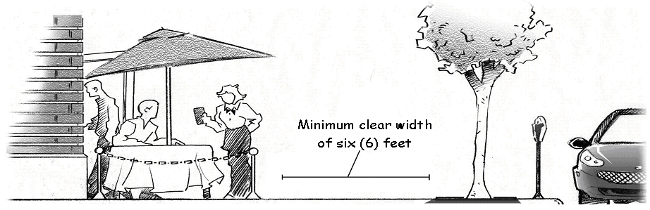
5.9.24.C. Pedestrian Space.
D.
Trash Receptacles. Trash receptacles related to outdoor seating areas shall be provided outside of the public right-of-way during non-business hours.
E.
Dining Areas. Outdoor dining areas shall be designed so as to be architecturally compatible with existing structures on the subject property.
F.
Canopy Enclosures. To extend the seasonal use of outdoor dining areas, side walls may be affixed to a canopy extending over the dining area when all of the following requirements are met:
1.
The outdoor dining area is located completely on private property and shall not encroach into the City's right-of-way.
2.
The use of canopy side walls shall be permitted between September 15 and May 15.
3.
Canopy side walls shall be constructed using a base fabric that is 100% acrylic and at least 9.25 ounces per square yard or heavier.
4.
Where existing building windows face an outdoor dining area, the canopy side wall shall have an area of clear vinyl located on the same elevation that is equal to the building window being covered by the side wall. In no case shall a canopy side wall facing a public street have less than fifty (50) percent clear vinyl.
5.
Side wall window openings shall be made of clear plexiglass or isinglass material of thirty (30) pounds and fabric-welded to the side wall.
6.
All side wall frames shall have a powder coated finish and be constructed of a minimum 1"×1" tubular aluminum with a gauge of 8 (0.125 inches) or thicker.
7.
Except as required by the building code, signage is not permitted on the exterior canopy side wall.
8.
All Building and Fire codes and other local or State Codes and ordinances shall be met.
G.
Hours of Operation. Outdoor seating shall cease operation by 10:00 p.m. Sunday through Thursday and 11:00 p.m. on Friday and Saturday, unless otherwise approved by the Planning Commission as a Special Land Use.
H.
Approval Process for Outdoor Seating Areas.
I.
Administrative Departure. An Administrative Departure may be granted in lieu of a Special Land Use for outdoor seating areas dedicated for office or residential uses not available to the general public where in the opinion of the Director, the location would not adversely affect adjacent properties or substantially alter the character of the neighborhood.
(Ord. No. 2019-30, § 2, 7-23-19)
Sec. 5.9.25. - Overhead Walkways or Other Connections.
A.
Connections between structures that pass over a public street shall be approved by the City Commission, after a recommendation from the Planning Commission.
B.
In evaluating a request for a connection, the Planning Commission and City Commission shall evaluate the relationship of the proposed connection to the street, its effect on street level activities and views, and the following requirements.
1.
Clear Glass. The use of clear glass on the sides of an overhead connection is required and the use of darkened glass is prohibited. The requirements of Section 5.2.14. Building Transparency shall apply.
2.
Exterior Requirements. The exterior of all overhead connections shall be level. Any sloping or ramped surface between levels shall be accommodated within the bridge structure itself. The exterior height of an overhead connection is limited to that which is height reasonably necessary to provide one (1) level plus any needed slope. No multi-level connections are permitted.
3.
Clear Span. Overhead connections shall be designed and constructed to provide a clear span across streets, sidewalks and other public rights-of-way.
4.
Minimum Clearance. There shall be a minimum clearance of sixteen (16) feet below any overhead walkway or connection above a public street or fire lane.
Sec. 5.9.26. - Parking Structures.
A.
Design Requirements. All design requirements of Table 5.6.08.A. Building Elements shall apply.
B.
Ground Level Active Use.
1.
An active use is required at the ground level of the parking facility where the lot abuts a public street. Space for the active use shall occupy a minimum width of seventy-five (75) percent of the structure frontage on at least one (1) primary public street. The Director shall determine the street to which this provision shall apply.
2.
For parking structures occupying a corner lot, the required active space on the primary public street shall occupy at least one (1) corner. Active uses shall also turn the corner and occupy at least an additional twenty-five (25) percent of the structure façade along the additional public street frontage.
3.
Space for the active uses shall have a minimum depth of thirty (30) feet. Active use areas shall not be used for storage or utility/service space.
Sec. 5.9.27. - Recycling Collection Stations.
A.
Materials. Materials collected at recycling collection points shall be limited to aluminum, copper, plastic, glass, paper materials, and batteries.
B.
Maintenance. Recycling collection points shall be well maintained and orderly in appearance, such as bins with uniform color, size and shape. The areas immediately surrounding recycling sites shall be kept clean, in good repair and free of materials, rubbish or debris. The exterior of outside collection containers shall remain free of graffiti, chipped or peeling paint, or other signs of abandonment or neglect.
C.
Containers. Collection containers shall be at least twenty (20) feet from any lot line adjacent to a residential use or Residential Zone District.
D.
Outside Storage. If stored outside, recyclable materials shall be within weather-tight containers no higher than eight (8) feet.
E.
Screening. Collection containers and recycling locations shall be screened from external view and may include solid fencing, a vegetative screen or combination thereof, as approved by the Director.
F.
Processing Equipment. Processing equipment, including crushers and sorting equipment shall not be part of an outside collection operation.
G.
Parking. A minimum of five (5) parking spaces per recycling collection point or one (1) parking space for each receptacle, whichever is greater, shall be required.
Sec. 5.9.28. - Regulated Uses.
A.
Purpose.
1.
In the development and execution of this Section, it is recognized that there are some uses which, because of their very nature, have serious objectionable operational characteristics, particularly when several uses are concentrated under certain circumstances or when one (1) or more are near a Residential Zone District, thereby having a deleterious effect upon the adjacent areas. Special regulation of these uses as itemized in this Article is necessary to ensure that these adverse effects shall not contribute to the blighting or downgrading of the surrounding neighborhood. These controls are for the purpose of preventing a concentration of these uses within any one (1) area, or to prevent deterioration or blighting of a nearby residential neighborhood. These controls do not legitimatize activities, which are prohibited in other Chapters of the City Code.
2.
In regulating sexually oriented businesses, it is the purpose of this Section to promote the health, safety, and general welfare of the citizens of the City, and to establish reasonable and uniform regulations to prevent the deleterious secondary effects of sexually oriented businesses. The provisions of this Chapter have neither the purpose nor effect of imposing a limitation or restriction on the content or reasonable access to any communicative materials, including sexually oriented materials. Similarly, it is neither the intent nor effect of this Chapter to restrict or deny access by adults to sexually oriented materials protected by the First Amendment of the U.S. Constitution, or to deny access by the distributors and exhibitors of sexually oriented entertainment to their intended market. Neither is it the intent nor effect of this Chapter to condone or legitimize the distribution of obscene material.
3.
Based on evidence of the adverse secondary effects of adult uses presented in hearings and in reports, and on findings incorporated in the following documents made available to the City Commission, the City Commission finds that sexually oriented businesses as a category of establishments are correlated with harmful secondary effects, and that the reports documented below are reasonably believed to be relevant to the problems that Grand Rapids is seeking to abate and prevent in the future.
a.
Case Law: Pap's A.M. v. City of Erie, 529 U.S. 277 (2000); Thomas v. Chicago Park District, 122 S. Ct. 775 (2002), City of Renton v. Playtime Theatres, Inc., 475 U.S. 41 (1986), Young v. American Mini Theatres, 426 U.S. 50 (1976), Barnes v. Glen Theatre, Inc., 501 U.S. 560 (1991); California v. LaRue, 409 U.S. 109 (1972); DLS, Inc. v. City of Chattanooga, 107 F.3d 403 (6th Cir. 1997); East Brooks Books, Inc. v. City of Memphis, 48 F.3d 220 (6th Cir. 1995); Broadway Books v. Roberts, 642 F.Supp. 486 (E.D. Tenn. 1986); Bright Lights, Inc. v. City of Newport, 830 F.Supp. 378 (E.D. Ky. 1993); Richland Bookmart v. Nichols, 137 F.3d 435 (6th Cir. 1998); Dèjá vu v. Metro Government, 1999 U.S. App. LEXIS 535 (6th Cir. 1999); Bamon Corp. v. City of Dayton, 7923 F.2d 470 (6th Cir. 1991); Threesome Entertainment v. Strittmather, 4 F.Supp.2d 710 (N.D. Ohio 1998); J.L. Spoons, Inc. v. City of Brunswick, 49 F.Supp.2d 1032 (N.D. Ohio 1999); Triplett Grille, Inc. v. City of Akron, 40 F.3d 129 (6th Cir. 1994); Nightclubs, Inc. v. City of Paducah, 202 F.3d 884 (6th Cir. 2000); O'Connor v. City and County of Denver, 894 F.2d 1210 (10th Cir. 1990); Dèjá vu of Nashville, Inc., et al. v. Metropolitan Government of Nashville and Davidson County, 2001 U.S. App. LEXIS 26007 (6th Cir. Dec. 6, 2001); Z.J. Gifts D-2, L.L.C. v. City of Aurora, 136 F.3d 683 (10th Cir. 1998); Connection Distrib. Co. v. Reno, 154 F.3d 281 (6th Cir. 1998); Sundance Assocs. v. Reno, 139 F.3d 804 (10th Cir. 1998); American Library Association v. Reno, 33 F.3d 78 (D.C. Cir. 1994); American Target Advertising, Inc. v. Giani, 199 F.3d 1241 (10th Cir. 2000); Z.J. Gifts D-2, L.L.C. v. City of Aurora, 136 F.3d 683 (10th Cir. 1998); ILQ Investments, Inc. v. City of Rochester, 25 F.3d 1413 (8th Cir. 1994); Bigg Wolf Discount Video Movie Sales, Inc. v. Montgomery County, 2002 U.S. Dist. LEXIS 1896 (D. Md., Feb. 6, 2002); Currence v. Cincinnati, 2002 U.S. App. LEXIS 1258 (6th Cir., Jan. 24, 2002); and other cases;
b.
Testimony and Reports. Testimony to Congress in 136 Cong. Rec. S 8987; 135 Cong. Rec. S. 14519; 135 Cong. Rec. S 5636; 134 Cong. Rec. E 3750; and reports of secondary effects occurring in and around sexually oriented businesses, including, but not limited to, Phoenix, Arizona - 1979; Minneapolis, Minnesota-1980; Houston, Texas - 1997; Amarillo, Texas; Garden Grove, California - 1991; Los Angeles, California - 1977; Whittier, California - 1978; Austin, Texas - 1986; Seattle, Washington - 1989; Oklahoma City, Oklahoma - 1986; Cleveland, Ohio - and Dallas, Texas - 1997; St. Croix County, Wisconsin - 1993; Bellevue, Washington, - 1998; Newport News, Virginia - 1996; New York Times Square study - 1994; Phoenix, Arizona - 1995-98; and also on findings from the paper entitled "Stripclubs According to Strippers: Exposing Workplace Sexual Violence," by Kelly Holsopple, Program Director, Freedom and Justice Center for Prostitution Resources, Minneapolis, Minnesota, and from "Sexually Oriented Businesses: An Insider's View," by David Sherman, presented to the Michigan House Committee on Ethics and Constitutional Law, Jan. 12, 2000, and the Report of the Attorney General's Working Group On The Regulation Of Sexually Oriented Businesses, (June 6, 1989, State of Minnesota), the City Commission finds that sexually oriented businesses as a category of establishments are correlated with harmful secondary effects, and that the foregoing reports are reasonably believed to be relevant to the problems that Grand Rapids is seeking to abate and prevent in the future.
B.
Uses Subject to Control. Uses subject to these controls are as follows:
1.
Adult book stores, adult novelty stores, or adult video stores;
2.
Adult cabarets;
3.
Adult motion picture theaters;
4.
Nude or semi-nude model studios; and
5.
Sexually oriented businesses.
C.
Definitions. Certain terms as used in this Section are defined under Regulated Uses in Section 5.16.02, R.
D.
Permitted Uses. The Regulated Uses listed in Section 5.9.28.B. are permitted if:
1.
The use is within a Zone District where the use is specifically permitted;
2.
The use is more than five hundred (500) feet from any Residential Zone District, measured to the nearest lot line of the proposed use; and
3.
The use is not within one thousand (1,000) feet of one (1) other Regulated Use, measured from the nearest lot line to the nearest lot line on a straight-line basis.
E.
Variance for Proximity to Residential or Other Regulated Use.
1.
If the proposed use is within five hundred (500) feet of a Residential Zone District, or within one thousand (1,000) feet of any other Regulated Use, the Board of Zoning Appeals may grant a variance for the distance restricts pursuant to the standards provided in Section 5.13.04.B. and pursuant to the procedures in 2., below.
2.
A public hearing held in accordance with the requirements of the Zoning Act, except that notice shall be served on all owners and occupants of all property within five hundred (500) feet of the proposed use at least thirty (30) days prior to the Board of Zoning Appeals hearing on the matter.
3.
Limit on Reapplication. No application which has been denied wholly or in part shall be resubmitted for a period of one (1) year from the date of said denial, except on the grounds of new evidence found valid by the Board of Zoning Appeals.
F.
Expansion and Discontinuance of Use.
1.
Establishments where uses are subject to the distance requirements of this Section shall not be expanded in any manner without first applying for and receiving a variance from the Board of Zoning Appeals as provided in E., above. Further, if a use subject to the distance requirements of this Section is discontinued for more than thirty (30) days, the use may not be reestablished without applying for and receiving the approval of the Board of Zoning Appeals as provided in E., above.
2.
Nothing in this Section shall prevent the reconstruction, repairing, or rebuilding and continued use of any building or structure the uses of which make it subject to the controls of this Section which is damaged by fire, collapse, explosion or act of God.
Sec. 5.9.29. - Residential Rehabilitation Facilities.
Any residential rehabilitation facility having thirteen (13) to twenty (20) adults shall be at least one thousand five hundred (1,500) feet from any other residential rehabilitation facility, transitional or emergency shelter, single room occupancy dwelling, or small or large adult foster care facility. The facility shall comply with all State of Michigan requirements, as applicable.
Sec. 5.9.30. - Rooming and Boarding Houses.
A.
There shall be not more than four (4) rooms occupied by tenants, provided that the Planning Commission may permit additional rooms on lots exceeding ten thousand (10,000) square feet as determined by the Planning Commission considering the following conditions.
1.
Parking meeting the requirements of Article 10 and parking lot landscaping meeting the requirements of Sections 5.11.11 and 5.11.12 shall be provided.
2.
The Planning Commission shall consider the presence of other similar uses in the immediate vicinity to determine if permitting additional rooms would have the effect of adversely affecting the character of the area.
B.
Occupancy by tenants shall generally be for expected durations longer than one (1) week.
C.
Independent Cooking. Individual rooms shall not contain independent cooking facilities. This requirement shall not prohibit the serving of meals to tenants or the use of a single kitchen by tenants.
D.
No more than one (1) individual shall occupy a room.
E.
Owner Occupied. Rooming and boarding houses shall be owner occupied and serve as the principal residence of the owner.
Sec. 5.9.31. - Self-Storage Facilities.
A.
Minimum site area shall be a minimum of three (3) acres.
B.
The facility shall front on and have direct ingress and egress from a Regional or Major Street, or through a shared access drive off that street.
C.
All buildings shall be set back at least twenty-five (25) feet from any lot line.
D.
Landscape Requirements. The front yard shall be covered with grass or other ground cover or plant material, and with hedges and trees planted in a manner that effectively screens the facility from public view. In addition, any yard which is adjacent to a Residential Zone District shall have a landscape buffer per Section 5.11.12., provided the buffer is at least twenty (20) feet wide.
E.
The perimeter of the entire site shall be secured by a six (6) foot ornamental fence or solid wall.
F.
No storage of combustible or flammable liquids or fibers, or explosive or toxic materials shall be permitted.
G.
Outdoor Storage of Vehicles. Outdoor storage of motor vehicles, recreational vehicles, trailers, campers, boats, and other items of value shall be separately approved as a Special Land Use.
H.
One (1) dwelling unit for on-site manager may be provided.
I.
There shall be no commercial enterprise or activity on the premises, other than the self-storage units and a related rental office.
J.
TN-CC and TN-TCC Zone Districts.
1.
All self-storage activities shall be contained within a single building and conducted exclusively indoors. Individual storage units may be accessed from inside the building only.
2.
The lot area and setback regulations of Article 6 and landscaping regulation of Article 11 shall apply.
3.
The requirement for a location on a Regional or Major Street may be waived by the Planning Commission if the facility will occupy an existing building and is otherwise found to be an appropriate location meeting the Special Land Use review standards.
Sec. 5.9.32. - Single Room Occupancy (SRO).
A.
Separation Requirement. Any SRO having thirteen (13) or more units shall be at least one thousand five hundred (1,500) feet from any other SRO, residential rehabilitation facility, transitional or emergency shelter, or small or large adult foster care facility.
B.
Continuous Tenancy. At least ninety (90) percent of the SRO units shall be occupied by the same tenants for a continuous period of at least ninety (90) days.
C.
Size Limitation. An SRO unit shall be limited to one (1) habitable room of three hundred (300) square feet or less, exclusive of up to seventy (70) square feet of floor area devoted to kitchen use.
D.
Good Neighbor Plan. When a Special Land Use is required, a Good Neighbor Plan shall be submitted in accordance with the requirements of Section 5.12.06.D.
(Ord. No. 2024-20, § 17, 4-23-24)
Sec. 5.9.33. - Social or Service Clubs; Motorcycle Clubs.
A.
Office Space. Up to twenty-five (25) percent the gross floor area of the building or two-thousand (2,000) square feet, whichever is greater, may be used for office space.
B.
Management of Club. The affairs and management of such social or service club shall be conducted by a board of directors, executive committee, or similar body chosen by the members at their annual meeting.
C.
Alcoholic Beverages. The sale or consumption of beer, wine or other alcoholic beverages to members and their guests must comply with Section 5.9.05. This activity shall be secondary and incidental to the promotion of some other objective of the organization, and further provided that the sale of alcoholic beverages shall comply with all applicable federal, state and municipal laws, rules, regulations, orders, permits and licenses.
D.
Motorcycle Club Review Standards. These review standards shall be used by the Planning Commission in its consideration of request for a motorcycle club, which by its nature, may adversely affect surrounding property owners if improperly located. The applicant shall also provide a written statement that responds to the following:
1.
Given the character, location, development trends and other aspects of the neighborhood in which the proposed club is requested, it is demonstrated that the neighborhood is underserved by such a use and that the addition or change in use will demonstrably be an asset to the neighborhood.
2.
The use or change in use as constructed and operated by the applicant is compatible with the neighborhood in which it will be located.
3.
Adjacent or nearby parks (e.g., public parks or recreation centers), playgrounds (e.g., public or private), religious institutions, or schools will not be adversely affected.
4.
The use or change in use will not have any, or minimal, negative secondary effects on the neighborhood. Negative secondary effects can include the following impacts:
a.
Vehicular and pedestrian traffic, particularly during late night or early morning hours that might disturb area residents.
b.
Noise, odors, or lights that emanate beyond the site's boundaries onto property in the area on which there are residential dwellings.
c.
Excessive numbers of persons gathering outside the establishment.
d.
Peak hours of use that add to congestion or other negative effects in the neighborhood.
e.
Fighting, brawling, outside urination or other behavior that can accompany intoxication.
Sec. 5.9.34. - Social Service Facilities.
Office Uses. In Residential Zone Districts, up to twenty-five (25) percent of the gross floor area of the building or two thousand (2,000) square feet, whichever is greater, may be used for office space.
Sec. 5.9.35. - Temporary Structures and Uses.
A.
Purpose, Applicability, Applications, Permits.
1.
This Section allows for the establishment of certain temporary uses or special events of limited duration, provided that the uses comply with the requirements of this Section and are discontinued upon the expiration of an approved time period. Any extension of the time period shall only be granted upon a finding that the need for the extension is due to circumstances beyond the immediate control of the applicant and applied for in writing prior to the expiration of the temporary use permit.
2.
Application. The Director may issue a permit for temporary structures and uses based upon receipt of a permit fee as applicable and a complete application, including:
a.
A site plan, showing building locations, use areas, assigned parking areas and other relevant information;
b.
A written statement demonstrating compliance with the requirements of this Section;
c.
Written permission of the owner(s) for the activity on that property; and
d.
Any materials required by this Section for specific uses, structures, activities, and events.
3.
Permits.
a.
Encroachment Permit. Any structures or activities planning to use public rights-of-way shall require an encroachment permit from the City's Engineering Department.
b.
The temporary structures and uses permit shall be in addition to other licenses, permits or approvals otherwise required by any governmental entity.
c.
A building permit shall be required where the temporary use includes a tent exceeding two hundred (200) square feet.
d.
Permit and inspection fees shall be set by resolution of the City Commission.
4.
Conditions of Approval. The Director may attach conditions to the permit that would minimize disturbance to and compatibility with the area and surrounding land uses, and/or protect the public health, safety and welfare.
5.
Performance Guarantee. The Director may require a performance guarantee meeting the requirements of Section 5.14.04 to insure compliance with this Chapter and all other applicable City ordinances, standards, rules and regulations.
6.
Table 5.9.35.A shall also be used to govern the requirements for temporary structures and uses.
B.
General Requirements.
1.
Public Rights-of-Way or Property. Temporary uses, structures or special events that occur in the public right-of-way or other public land shall be governed by applicable City policies.
2.
Private Property. Temporary uses, structures or special events on private property shall:
a.
Not conflict with the activities related to the principal uses taking place on the site;
b.
Not be detrimental to property or improvements in the surrounding area;
c.
Not have substantial adverse effects or noise effects on nearby residential neighborhoods or to the public health, safety, or general welfare;
d.
Not include permanent alterations to a structure or the site;
e.
Comply with any applicable conditions of any prior zoning approvals that apply to a site or use on the site;
f.
Not interfere with the normal operations of any permanent use on the property;
g.
Contain sufficient land area to allow the temporary use, structure, or special event to occur, as well as adequate land to accommodate the parking and traffic movement associated with the temporary use; and
h.
Except as provided in Section 5.9.35.J., not permit transient merchant activities or temporary seasonal retail sales on a vacant lot.
3.
Temporary structures, uses and special events shall not involve the construction or alteration of any permanent building or structure.
4.
Temporary Structures. All temporary structures including, but not limited to, greenhouses, trailers, mobile homes, etc., shall conform to the Zone District setback requirements, unless otherwise specified in the approval.
5.
Permitted signs are regulated by Article 15 Signs.
6.
Sanitary Facilities. Sanitary facilities, either portable or permanent, shall be made available to all employees, attendants and participants during hours of operation. If portable, they shall be maintained to minimize odors and to remain fully functional.
7.
Parking. The number of parking spaces required for the temporary use or building shall be determined by the Director. Required parking spaces for a permanent use or building on the proposed site shall be considered in the parking calculation. No required parking spaces may be occupied by any activity related to the temporary use.
8.
Clean Up and Restoration. All sites shall be completely cleaned of debris and temporary structures or equipment within five (5) days of the termination of the temporary use, including, but not limited to: trash receptacles, signs, stands, poles, electrical wiring or any other fixtures and appurtenances or equipment connected therewith. The applicant shall restore the site to its original condition or better, unless the area is intended for new construction within a reasonable time following the temporary event.
C.
Construction-Related Temporary Structures.
1.
The following temporary construction-related buildings and uses are permitted, subject to the following requirements.
a.
Construction Trailer or Construction Yard. The construction trailer or construction yard shall be incidental and necessary to construction at the site. Any structures or area shall be removed within thirty (30) days after a Final Occupancy permit has been issued, regardless of any time remaining on the building permit.
b.
Temporary Sale Office or Model Home. The temporary sales office or model home shall be incidental to and necessary for, and directly related to, the sale or rental of real property in a new subdivision or housing project. The temporary office or model home shall be removed when fifty (50) percent of the lots or units have been sold or leased, regardless of any time remaining on the permit or extension of the permit.
2.
Permits for the same location and for the same purpose may be renewed by the Director for one (1) successive period of up to twelve (12) calendar months beyond what is permitted in Table 5.9.35.A.
D.
Temporary Housing.
1.
Temporary housing, in the form of a manufactured house, may be placed upon a site previously occupied by a detached single-family or two-family dwelling for the purposes of housing the intended occupants of a new dwelling, subject to the following requirements:
2.
Construction. The former dwelling has been destroyed or otherwise rendered uninhabitable for a minimum of thirty (30) days, and a dwelling has been approved by the City for either reconstruction or replacement.
3.
Building and Housing Codes. The type and condition of the temporary housing is permitted under applicable building or housing code requirements.
4.
Location. The temporary housing is located in the rear yard. An Administrative Departure may be permitted for other locations where there is no feasible location in the rear yard provided that adjacent properties are not adversely affected.
5.
Extension Request. One (1) time extension for an additional three (3) months may be permitted if requested at least thirty (30) days prior to the expiration of the temporary use permit.
E.
Temporary Storage. Temporary storage containers shall be permitted to serve an approved existing use, subject to the following requirements.
1.
Portable Shipping Containers - Commercial.
a.
Location. The container shall not be in the front yard, or within ten (10) feet of any lot line or structure on the lot or on an adjacent lot.
b.
Access. The container shall not impede ingress, egress, or emergency access.
2.
Temporary Portable Storage Container - Residential.
a.
Size. The maximum allowable size is one hundred fifty (150) square feet with an overall length not to exceed sixteen (16) feet.
b.
Clear Vision. Clear vision areas shall be maintained at all times, and portable storage containers shall not obstruct the flow of pedestrian or vehicular traffic.
c.
Location. Containers shall be placed on a concrete or asphalt surface no closer than ten (10) feet from the front lot line.
d.
Condition. All containers in use on a lot shall be free from rust, peeling paint, and other visible forms of deterioration.
e.
Number. Up to two (2) containers may be on the same lot at the same time, provided the total maximum allowable sized is not exceeded.
F.
Temporary Structures - Institutional Use. The following requirements shall apply to temporary institutional structures, such as portable classrooms.
1.
Principal Use. The City shall have approved the principal use.
2.
Location. The temporary structure shall:
a.
Not be in the front yard;
b.
Comply with side and rear yard requirements of the Zone District, but in no case be less than twenty-five (25) feet from the rear lot line abutting a residential use;
c.
Be at least six (6) feet from any structure; and
d.
Not be within any required off-street parking area or required landscaped area.
3.
Screening. Under-skirting for the structure shall be used and landscaping provided around the perimeter of the base where visible from other developed lots or public rights-of-way.
4.
Extensions. Extensions may be granted for up to two (2) additional one (1) year periods, upon approval of a written request submitted at least thirty (30) days prior to the expiration of the temporary use permit.
G.
Temporary Outdoor Sales and Services. Grand openings, parking lot sales, sidewalk sales, clearance sales, special events and holiday celebrations including the temporary outdoor sale of merchandise, goods, materials or services may occur in a Mixed-Use Commercial Zone District, subject to the following requirements.
1.
Accessory Use. Outdoor temporary sales or services shall be an accessory to an allowed use on the same lot.
2.
Parking and Access. A designated off-street parking area adequate to serve the activity shall be provided where it does not interrupt or hamper the flow of traffic on public streets, impede access to the principal use, pedestrian movements, or emergency vehicle access.
3.
Area of Operation. The area of operation for all activities associated with outdoor temporary sales or service shall:
a.
Not exceed eight hundred (800) square feet and no single dimension shall exceed forty (40) linear feet; and
b.
Be located on an asphalt, concrete or equivalent surface.
4.
Prohibited Sales. Sales of merchandise or the provision of services unrelated to the principal use unless operated by, or in support of, or as a fundraiser for a nonprofit organization.
H.
Assembly and Fundraising Activities. Assembly activities (e.g., carnivals, fairs, rodeos, sport events, concerts, and shows) or fundraising activities that benefit a community service group or non-profit organization (e.g. car washes, bake sales, auctions) are permitted in Residential Zone Districts on properties approved for educational, governmental, or institutional uses and in Mixed-Use Commercial Zone Districts, subject to the following requirements:
1.
Parking and Access. A designated off-street parking area shall be provided adequate to serve the activity where it does not interrupt the flow of traffic on public streets; or impede access to the principal use, adjacent uses, pedestrian movements, or emergency vehicle access.
2.
Hours of Operation. In all Residential Zone Districts, hours of operation shall start no earlier than 8:00 a.m. and end no later than 8:00 p.m., except on Fridays and Saturdays the hours may extend to 10:00 p.m. Hours of operation in all other districts shall operate within the hours of 8:00 a.m. to 11:00 p.m. unless otherwise approved by the Director.
3.
Setup/Takedown. The duration of use provided in Table 5.9.35.A. shall include setup and takedown activities.
4.
Fundraising Agreement. Goods or services being sold by a commercial entity for a fundraising event shall submit evidence of an event agreement with the community service group or non-profit organization with the permit application.
I.
Outdoor Seasonal Sales and Farmers' Markets. The outdoor sale of agricultural products is permitted, subject to the following definitions and requirements:
1.
Seasonal Sales.
a.
Seasonal sales are permitted in mixed-use commercial Zone Districts, and in all other Zone Districts on lots approved for educational, government or institutional uses.
b.
A minimum pedestrian walkway of at least five (5) feet in width along the front of the display/sales areas shall be maintained clear of obstructions.
2.
Farmers' Markets.
a.
Farmers' markets are permitted in mixed-use commercial Zone Districts, and in all other Zone Districts on properties approved for educational, government or institutional uses.
b.
Duration.
i.
In Mixed-Use Commercial Zone Districts, the maximum duration of a farmers' market shall be nine (9) consecutive months.
ii.
In all other Zone Districts, the maximum duration of the farmers' market shall be nine (9) total months in any twelve (12) month period.
iii.
Activity is limited to three (3) days per week between 7:00 a.m. and 7:00 p.m. Expansion of the number of days or hours of operation may be approved as a Special Land Use.
c.
Multiple vendors are permitted with items available for sale limited to products obtained primarily through farming or agricultural activities such as:
i.
Farm produce (e.g. fruits, vegetables, grains, nuts, fresh flowers and bedding plants, trees and forest products, Christmas trees).
ii.
Fresh meat, eggs honey and dairy products.
iii.
Foodstuffs produced by the vendor or a family member (e.g. cheese, baked goods, etc.)
iv.
Hand-made craft items (e.g. jewelry, pottery, wearing apparel, fine arts, etc.) provided that the sales area not to exceed twenty (20) percent of the farmers' market total sales area.
d.
A minimum pedestrian walkway of at least five (5) feet in width along the front of the display/sales areas shall be maintained clear of obstructions.
3.
Food Preparation or Cooking. With the exception of the TN-CC Zone District, outdoor food preparation or cooking is prohibited within two hundred (200) feet of a residential use. Cooking apparatus shall be separated from areas of pedestrian movement, and smoke emissions shall not impair pedestrian or vehicular sight distances or serve as a distraction at street intersections.
4.
Temporary Use Permit. Prior to the opening of a seasonal sales operation or a farmers' market, an application for a Temporary Use Permit shall be submitted for review. In addition to a completed application and application fee, the following materials are required:
a.
A site plan that includes the location and dimensions of the sales and parking areas; site dimensions and floor areas of any buildings or tents; and existing public improvements, such as fire hydrants, bus shelters, trees and tree grates and parking meters.
b.
Photographs of the planned sales and parking areas.
c.
Written rules of operation or management plan, including days and hours of operation, period of time to be in operation, and a list of products to be sold.
J.
Temporary Surface Parking Lots. Temporary surface parking lots are permitted in any Mixed-Use Commercial District pending the construction of a development project, subject to the following requirements and conditions.
1.
Zoning Approval. Evidence of a zoning approval under the provisions of this Chapter for a new development shall be submitted with the temporary use permit.
2.
Site Plan. A site plan shall be submitted that includes site dimensions, existing public improvements, and proposed site layout of the temporary parking lot. Except as noted in 3., below, interior parking lot landscape, pedestrian and bicycle parking requirements shall not be applicable to temporary surface parking lots.
3.
Screening. Minimum parking lot screening requirements of Section 5.11.11 shall apply if the parking lot will be used for longer than six (6) months, including any approved extension.
4.
Phasing Description. A description of the various phases of the development project with anticipated dates of completion shall be submitted as part of the request.
5.
Extension. The permitted duration of this use may be renewed for up to one (1) additional year, upon approval of a written request submitted to the Director at least thirty (30) days prior to the expiration of the temporary use permit.
6.
Removal. If the project for which the temporary parking lot fails to be initiated and substantially completed, the Director may require the immediate removal of the parking area. A performance guarantee shall be submitted following approval of the temporary parking lot in an amount sufficient to remove the parking area and restore the site.
K.
Garage Sales.
1.
Garage sales are exempt from the permit requirements in this Section, provided that they meet the duration requirements of Table 5.9.35.A.
2.
Garages/basement/yard sales operating beyond the duration requirements of Table 5.9.35.A. are considered commercial uses.
3.
Items offered for sale shall be limited to personal property not acquired for resale by the residents of the lot where the sale occurs.
(Ord. No. 2019-16, §§ 5, 6, 4-23-19; Ord. No. 2024-20, § 18, 4-23-24)
Sec. 5.9.36. - Transitional or Emergency Shelters.
A.
In a residential zone district, any transitional or emergency shelter having seven (7) or more adults shall:
1.
Be located on a Network Residential or Crosstown Connector Street as identified by the Vital Streets Plan, unless located on a lot of one (1) acre or more in area.
2.
Be located within two thousand five hundred (2,500) feet of a transit stop.
B.
Any transitional or emergency shelter having thirteen (13) or more adults shall be at least one thousand five hundred (1,500) feet from any other transitional or emergency shelter, residential rehabilitation facility, single room occupancy dwelling, or small or large adult foster care facility.
C.
Good Neighbor Plan. A Good Neighbor Plan shall be submitted in accordance with the requirements of Section 5.12.06.D.
(Ord. No. 2024-20, § 17, 4-23-24)
Sec. 5.9.38. - Vehicle Fuel Stations (without vehicle service or repair, may include a convenience store or other retail use).
A.
Location of Equipment and Structures. Fuel pumps, pump islands, detached canopies, compressed air connections, and similar equipment shall be set back at least fifteen (15) feet from a street right-of-way and twenty (20) feet from all lot lines adjacent to a residential use or Zone District.
B.
Landscape Buffer. When gasoline or fuel sales are adjacent to a residential use or Zone District, a landscape buffer between uses shall be provided as required in Section 5.11.12.
C.
Outdoor Displays. Outdoor displays of merchandise shall be directly adjacent to the front of the building and shall be limited to typical service station merchandise (e.g. road salt, vehicle fluids, beverages, and ice).
D.
Cash Register Viewing Window. The cash register shall be clearly visible from the street. The viewing window shall have a contiguous area of at least fifteen (15) square feet of clear glass and maintain an unobstructed view into the building.
E.
Single-Bay Car Wash. A single-bay car wash may be permitted as an accessory use, subject to the following development and design standards:
1.
The entrance to the car wash bay shall be sited so as not to be readily visible from an adjacent primary street, as determined by the Director.
2.
The car wash bay shall accommodate only one (1) vehicle at a time.
3.
The car wash bay shall be outside of all required setback and landscape areas.
4.
In addition to any other off-street parking requirements or stacking requirements of Section 5.10.03.F.8., the lot shall contain adequate space to allow a minimum of three (3) stacking spaces for car wash services and shall be located to prevent vehicles from stacking into or creating a hazard to traffic flow on the public street or create obstructions to pedestrian movements on sidewalks.
5.
Where a car wash is adjacent to a residential use or Zone District, the hours of operation shall be limited to 8:00 a.m. through 10:00 p.m.
F.
Fuel Pump Canopy. A canopy over the fuel pumps may be erected subject to the requirements of Section 5.2.18.
G.
See also Section 5.9.37. where vehicle repair or service is provided.
H.
Principal Building Placement. It is recognized that the traditional development pattern of vehicle fuel stations commonly places the primary building behind the fueling pumps and set back off street, which is contrary to the Site Layout and Building placement standards of TN and MCN zone districts. Therefore, in evaluating a site plan for a vehicle fuel station, the Planning Commission may modify the Required Building Line (RBL) of Table 5.6.07.A for the principal building provided that the Planning Commission determines that the following conditions have been met:
1.
The Plan meets the intent of the placemaking elements of the Zone District; and
2.
That new buildings relate well to each other, existing buildings and the abutting street; and
3.
The plan maintains or creates a continuous street wall that contributes to the unique character of the Zone District; and
4.
The plan consolidates driveways on primary streets and encourages vehicular access from secondary streets; and
5.
Provides adequate sidewalk space for pedestrian access and comfort.
(Ord. No. 2019-30, § 3, 7-23-19)
Sec. 5.9.39. - Vehicle Sales/Leasing and Automobile Rental.
A.
The requirements of Section 5.9.40. Vehicle Service or Repair shall apply when these services are provided.
B.
Minimum Lot Size. The site shall be a minimum of one (1) acre when vehicles are displayed outdoors.
C.
Open Drive Aisles. Outdoor display and storage areas of vehicles shall maintain open drive aisles to allow free movement of vehicles.
D.
Parking. All vehicles waiting to be picked up by the vehicle driver shall be kept in approved parking spaces on site.
E.
Licensing. Vehicle licensing requirements of the State of Michigan shall be followed in the review and approval of vehicle sales requests.
F.
Flag or Pennant. One (1) flag or pennant may be displayed on each vehicle for sale or lease. The maximum size of each flag or pennant shall not exceed twelve (12) inches × eighteen (18) inches.
G.
State Licenses. Table 5.9.36 further clarifies the Use Tables 5.6.06.B. and 5.7.04.B. A "P" indicates a Permitted Use; an "S" indicates a Special Land Use; an "X" indicates the use is not allowed in that District.
Sec. 5.9.40. - Vehicle Service or Repair.
A.
This Section applies to uses in the Mixed-Use Commercial Zone Districts. Repair and storage of vehicles in Residential Zone Districts shall be in accordance with the requirements of Section 5.2.12.
B.
This Section shall be used in conjunction with Section 5.9.38. Vehicle Fuel Stations where vehicle repair or service is provided.
C.
The site shall be a minimum of one (1) acre.
D.
Screening.
1.
Vehicle service bay openings shall be oriented away from any public street or Residential Zone District to minimize the view of the vehicle service area and to limit noise effects.
2.
An Administrative Departure from this requirement may be granted to permit berms, evergreen shrubs, evergreen trees, masonry walls, solid wooden fencing, or any combination of these to minimize the bay openings from view.
E.
Enclosed Activities.
1.
All repair and maintenance activities shall be performed entirely within an enclosed building or structure.
2.
Enclosed Equipment. Hydraulic hoists, pits, and all lubrications, greasing, automobile washing, or repairing equipment shall be enclosed within a building. When any building or portion of a building housing this equipment shares a lot line with a residential use or Zone District, the closest adjacent building wall shall consist of a solid wall with no openings other than those required by applicable building codes.
3.
Enclosed Storage. All vehicle parts, dismantled vehicles (non-salvage or wrecking), and similar materials, and all discarded materials such as tires, cans and drums shall be stored within an enclosed building during all hours.
F.
Storage of Vehicles.
1.
Approved Parking Spaces. All vehicles awaiting repair or pick up by the vehicle owner shall be kept in approved parking spaces on site.
2.
Only those damaged or wrecked vehicles awaiting repair shall be stored on site, provided that a maximum of two (2) used vehicles displayed for sale shall be permitted as an accessory use, subject to Director Review.
G.
A Vehicle Service or Repair Facility shall be registered and licensed as required under the Motor Vehicle Service and Repair Act, Act 300 of 1974, MCL 257.1302a, as amended.
Sec. 5.9.41. - Wireless Communication Facilities.
A.
Purpose and Intent. The purpose of this Section is to establish guidelines for the siting of towers and antennas for wireless communication uses. The intent of this Section is to:
1.
Encourage the location of towers in non-residential areas and minimize the total number of towers throughout the city; and
2.
Promote the joint use of new and existing tower sites to minimize adverse visual impact of towers and antennas through careful design, siting, landscaping, and camouflaging techniques; and
3.
Enhance the ability of the providers of wireless communications services to provide their services to the community quickly, effectively, and efficiently.
B.
Definitions. Definitions used in this Section are under Wireless Communication Facilities in Section 5.16.02.W.
C.
Applicability.
1.
This Section applies to all construction and expansion of Wireless Communication Facilities.
2.
Amateur Radio and Receive-Only Antennas. This Section shall not govern any tower, or the installation of any antenna, that is less than seventy (70) feet high, including building height, and is owned and operated by a federally-licensed amateur radio station operator or is used exclusively for receive-only antennas.
D.
Principal or Accessory Use. Towers shall be installed on a conforming lot either as a principal use, or as an accessory use related to the principal use.
E.
Inventory of Existing Sites.
1.
An applicant for a tower and/or an antenna shall provide an inventory of its existing towers, antennas, or sites approved for towers and antennas that are within the city, or outside of the city serving areas within the city. The inventory shall include latitudinal and longitudinal location coordinates and the coverage area of the proposed tower or antenna, whether within or near the City's jurisdiction, including specific information about the design and height of each tower.
2.
The City may share this information, provided that the City is not, by sharing that information, in any way representing or warranting that these sites are available or suitable for tower or antenna construction.
F.
Availability of Suitable Existing Towers or Other Structures. No new tower shall be permitted unless the applicant demonstrates to the reasonable satisfaction of the Planning Commission that no existing tower or structure can accommodate the applicant's proposed antenna. Evidence may consist of any of the following.
1.
No existing towers or structures are within the geographic area required to meet the applicant's engineering and coverage requirements.
2.
Existing towers or structures are not of sufficient height to meet the applicant's engineering requirements.
3.
Existing towers or structures do not have sufficient structural strength to support the applicant's proposed antenna and related equipment.
4.
The applicant's proposed antenna would cause electromagnetic interference with the antenna(s) on the existing towers or structures, or the antenna(s) on the existing towers or structures would cause interference with the applicant's proposed antenna.
5.
The fees, costs, or contractual provisions required by the owner in order to share an existing tower or structure or to adapt an existing tower or structure for sharing are unreasonable, meaning when the costs exceed new tower development.
6.
The applicant demonstrates that there are other limiting factors that render existing towers and structures unsuitable.
G.
Measurement. For purposes of measurement, tower and antenna setbacks and separation distances shall be applied to all facilities whether inside or outside the city's boundaries.
H.
Setbacks.
1.
Towers shall be located so that there is a sufficient radius of land around the tower so that its collapse shall be contained on the property where located. Accessory buildings shall follow the minimum setback requirements of the Zone District.
2.
Antennas installed on building rooftops shall be setback from the edge of the roof at least one (1) foot for each foot of antenna height as measured from the top of the roof (or parapet, if one exists) to the highest point of the antenna.
I.
Separation.
1.
Towers shall be set back at least three hundred (300) feet from any off-site residential structure.
2.
In Zone Districts other than SD-IT, towers over ninety (90) feet in height shall not be within one-quarter (¼) of a mile of any existing tower that is over ninety (90) feet high. Tower separation shall be measured by following a straight line from the portion of the base of the proposed tower that is closest to the base of the pre-existing tower.
J.
Height. Where permitted, monopoles shall not be higher than one hundred ninety-five (195) feet in SD-IT and C Zone Districts; and one hundred fifty (150) feet in all other Zone Districts. Any tower and/or antenna placement adjacent to a Residential Zone District that requires lighting shall use a continuous red beacon at night.
K.
Location and Design.
1.
Co-Location.
a.
Towers shall be constructed to accommodate at least four (4) antenna platform levels. A statement by the applicant and/or a structural analysis sealed by an engineer affirming that the construction of the wireless communications facility will accommodate co-location of additional antennas for future users shall be provided.
b.
Co-location terms, including rates for compatible providers shall be included in the application. Terms shall be consistent with the market for metropolitan Grand Rapids and applicants shall submit a signed statement agreeing to permit co-location consistent with those rates.
c.
Two (2) equipment shelters shall be allowed per site. Multiple shelters integrated into one (1) shall be considered a single shelter. No single provider shall occupy more than two hundred fifty (250) square feet of interior floor space.
2.
Design.
a.
Where visible from a public street, the design of equipment shelters and related structures including shall use colors, landscaping, materials screening, and textures that have the finish and appearance to blend into the character of the neighborhood and surrounding buildings so as to make the antenna and related equipment as visually unobtrusive as possible.
b.
Visible cabling and wiring, antenna and supporting electrical and mechanical equipment, must be a neutral color that is identical to, or closely compatible with, the color of the supporting structure so as to make the antenna and related equipment as visually unobtrusive as practicable.
c.
Stealth equipment is permitted to be used as a wireless communication tower for areas where special sensitivity to neighboring properties is necessary.
3.
No advertising or business signs shall be allowed.
4.
Wireless communications facilities shall be located and designed to not obstruct or significantly diminish views of the Grand River from public streets and public property.
5.
Fencing and Landscaping.
a.
Security fencing or a wall not less than six (6) feet nor more than eight (8) feet high shall enclose towers and related appurtenances.
b.
Wireless communication facilities and equipment shall be placed on a site where existing vegetation is preserved to the maximum extent possible.
c.
Landscaping consisting of evergreen vegetation with a minimum planted height of six (6) feet placed densely so as to form a screen, shall be placed completely around the wireless communications facility at ground level, except as required to access the facility. Where appropriate, existing landscaping can be used to satisfy this requirement. Landscaping shall be installed on the outside of any fencing.
6.
Administrative Departure. An Administrative Departure may be permitted for landscape requirements and/or require a different type of screen or wall depending upon the location.
L.
Approvals. Wireless communications facilities are permitted under varying conditions dependent upon their form and the Zone District in which they are to be located. The following approval procedures apply.
1.
Director Review.
a.
Installing an antenna on an existing structure other than a tower that already has existing antennas (such as a building, sign, light pole, water tower, or other free standing non-residential structure), provided the addition does not extend above the highest point of the building or structure by more than thirty (30) feet or fifty (50) percent of the height of the existing structure, whichever is less, (except single family detached dwellings and their accessory structures) in all Zone Districts.
b.
Installing an antenna on an existing structure other than a tower that does not have existing antennas (such as a building, sign, light pole, water tower, or other free standing non-residential structure), provided the addition does not extend above the highest point of the existing structure by more than thirty (30) feet or fifty (50) percent of the height of the existing building or structure, whichever is less, (not including single family detached dwellings and their accessory structures) in all Zone Districts except SD-OS, LDR and MDR.
c.
Installing an antenna on an existing tower of any height, including the placement of additional buildings or other supporting equipment used in connection with that antenna, provided the additional height of the antenna adds no more than twenty (20) feet to the height of the existing tower.
2.
Special Land Use.
a.
Any wireless communication facility not listed under Director Review and otherwise prohibited shall require a Special Land Use approval in accordance with the requirements of Section 5.12.09.
b.
In addition to the review consideration of Section 5.12.09., the Planning Commission shall consider the following factors in approving applications for towers and antennas and may attach conditions consistent with these factors.
i.
Tower or antenna height;
ii.
Proximity of the tower or antenna to residential structures and Residential Zone District boundaries;
iii.
Nature of uses on adjacent and nearby properties;
iv.
Surrounding topography;
v.
Surrounding tree coverage and foliage;
vi.
Tower or antenna design, with particular reference to design characteristics that have the effect of reducing or eliminating visual obtrusiveness;
vii.
Proposed ingress and egress; and
viii.
Availability of suitable existing towers, other structures, or alternative technologies not requiring the use of towers or structures.
M.
Building Permits.
1.
Structures covered under this Section shall require a building permit prior to the erection, expansion, including an increase in height, or relocation. The application for a permit shall include construction drawings showing the proposed method of installation, including details of structural support, footing, foundation, guys, braces, anchors, and other information as required by the City's Building Official to ensure proper engineering practice.
2.
A site plan and other illustration drawn to scale shall be provided showing the lot or parcel on which the structure is to be erected, all structures on site, all structures within two hundred (200) feet of the site, all structural elements, and all other relevant information.
3.
The permit shall include twenty-four (24) hour emergency contact information and contact information for the entities with responsibility for the wireless communications facilities described in the application. Contact information for the tower owner, operator, and emergency contact shall be kept current and on file with the City at all times.
N.
Federal and State Requirements. Towers and antennas shall meet or exceed current standards and regulations of the Federal Aviation Administration (FAA), the Federal Communications Commission (FCC) and any other federal or state agency with the authority to regulate towers and antennas. If those standards and regulations are changed, then the owners of the towers and antennas shall bring them into compliance within the time mandated by the controlling federal and state agency. Failure to bring towers and antennas into compliance shall constitute grounds for removal of the structure at the owner's expense.
O.
Fees. Notwithstanding any other provision of this Chapter, the Director may require, as part of fees for building permit or Special Land Use application for telecommunication facilities, an amount sufficient to recover all of the City's costs in retaining consultants to verify statements made in conjunction with the permit application, to the extent that verification requires specific expertise. The amount of this fee shall be equal to the cost charged by the consultant.
P.
Removal of Facilities.
1.
Any tower or antenna that is not operated for a continuous period of one (1) year or more shall be considered to be abandoned, and the owner shall remove the same within ninety (90) days of receipt of notice of the determination. Failure to remove an abandoned tower or antenna after this time period shall be grounds to remove the tower or antenna at the owner's expense.
2.
The owner of a facility shall provide a performance guarantee meeting the requirements of Section 5.14.04. adequate to secure the cost of removing an antenna, antenna array, or tower that has been abandoned. In the event of a transfer of ownership, the seller shall be responsible for notifying the buyer of this requirement and for notifying the City of the transfer.
3.
Damaged or Destroyed Nonconforming Facilities.
a.
Notwithstanding this Section, nonconforming wireless communications facilities that are damaged or destroyed by an Act of God may be rebuilt without having to first obtain approvals otherwise required by this Section, provided that any other permits applicable to construction or reconstruction must be obtained.
b.
The type, height, and location of the wireless communications facility shall be the same as the original approved facility and constructed in accordance with currently applicable building codes.
c.
Permits for construction shall be obtained within one hundred and eighty (180) days from the date the facility is damaged or destroyed, and reconstruction shall be started within six (6) months from the time of damage and shall be continued until completed.
d.
If no permit for construction is obtained, or if an issued permit expires, the facility shall be deemed abandoned as specified in Section 5.9.38.P.
Q.
Prohibited Facilities.
1.
Lattice and guy wire towers in all Zone Districts.
2.
Towers in the TN-CC, TN-TCC, TN-TBA, TOD, LDR, MDR, SD-OS, and SD-NOS Zone Districts.
Sec. 5.9.42. - Zoo.
Review Standards. A zoo use in any Zone District shall be subject to the Special District - Institutional Campus Section 5.7.05.F. Review and Approval.
Sec. 5.10.01. - Purpose and Intent.
A.
The purpose of this Section is to support the development of a balanced transportation system that promotes the efficient use of transportation resources and supports the Themes of the Master Plan, Sustainability Plan, Vital Streets Plan and Manual, and other adopted plans of the City that include vehicle, transit, bicycles, and pedestrian circulation.
B.
It is the intent of this Article that:
1.
Measures will materially advance city streets as beautiful, functional places that provide mobility and equitable access for all people by marrying active sidewalks, safe bicycle facilities, a robust tree canopy, extensively used transit, and vehicular accommodations within an appropriate context.
2.
These provisions improve bicycle and pedestrian movement to reduce reliance on personal vehicle use, provide for improved circulation between and within development sites, and promote transportation options to reduce Vehicle Miles Traveled (VMT) and related vehicle emissions.
3.
Traffic-related serious injuries and fatalities will be eliminated in keeping with Vision Zero to create a safer, more comfortable atmosphere for pedestrians and bicyclists.
4.
Transportation options will be available, affordable, and reliable for all people to meet their daily travel needs regardless of age, ability, race, ethnicity, or economic status.
5.
Public health outcomes and recreational opportunities will be improved by promoting and enabling walking, bicycling, and other forms of active transportation to contribute reductions in childhood and adult obesity.
C.
Further, off-street parking and loading spaces for each use shall be provided in accordance with the requirements established in this Section to:
1.
Relieve traffic congestion in the streets;
2.
To minimize any detrimental effects of off-street parking areas on adjacent lands;
3.
Improve the visual aesthetics of parking areas;
4.
Ensure the proper and appropriately located parking areas;
5.
Prevent the establishment of excessive amounts of off-street parking;
6.
Encourage appropriate redevelopment and reinvestment;
7.
Advance the compatibility of parking lanes and drive entries with pedestrian safety; and
8.
Reduce the need for parking by promoting the use of mass transit, bicycles, and other Transportation Demand Management measures as an alternative to traditional reliance on personal vehicle use.
D.
General. The requirements of this Article shall apply to all new development and redevelopment in the City.
Sec. 5.10.02. - Off-Street Parking: General Requirements.
A.
Change in Use or Intensity.
1.
Whenever the use of a building or lot changes to a use with different off-street parking requirements as identified in Table 5.10.04.C. parking facilities shall be provided as required by this Chapter for the new use.
2.
If any building, structure, or intensity of use is increased through the addition of dwelling units, floor area, seating capacity, or through other means that affect parking requirements, additional off-street parking shall be provided to bring the use into compliance.
3.
Any area once designated as required off-street parking shall not be changed to any other use unless and until equal facilities meeting the requirements of this Chapter are provided elsewhere, or the change in use alters the parking requirements of the site.
4.
If a change in use or intensity results in a parking requirement that reduces required spaces by fifty (50) spaces or more in excess of the parking requirement at the time the parking lot was constructed, the Director, after notice to the property owner, may require the removal of all or part of the additional parking spaces, unless the owner applies for and is granted a parking adjustment as provided in Section 5.10.04.D. The parking area removed shall be landscaped in accordance with the provisions of this Chapter.
B.
Use. Off-street parking areas as a principal use of a lot shall be regulated as listed in the Use Tables of the applicable Zone District.
Sec. 5.10.03. - Off-Street Parking: Design Requirements.
A.
The following requirements apply to surface parking areas. Additional requirements for parking structures are in Section 5.9.26.; for driveways in Section 5.10.03.F.
B.
Use of Off-Street Parking, Stacking, and Loading Areas. All vehicular parking areas, stacking areas and loading areas required by this Article shall only be used for those designated purposes.
C.
Location.
1.
Except as otherwise permitted, all off-street parking areas shall be provided on the same lot as the use it serves, or no farther than three hundred (300) feet from the nearest point of the building to the nearest point of the parking facility along public rights-of-way or publicly available sidewalk.
2.
Use of parking facilities in a Residential Zone District by a non-residential use shall be treated as a Special Land Use. Access to an off-street parking area that serves a nonresidential use shall not be permitted across lots that are residential in use or located in a Residential Zone District.
3.
Parking may be owned, leased or shared by the owner of the building with another building owner upon providing evidence of agreements or easements to the Director. In the event that the agreement is no longer in effect, parking requirements shall be satisfied by each building that was a party to the shared agreement.
4.
The use of parking in the public right-of-way shall only be permitted as allowed in Section 5.10.04.F.
D.
Design Requirements.
1.
Defined Areas. Off-street parking areas of three (3) or more spaces and off-street loading areas shall be striped and maintained in good condition to be clearly visible with lines to indicate parking space limits and loading areas. All striping shall comply with the Manual of Uniform Traffic Control Devices.
2.
Accessible Parking. Parking lots shall provide parking spaces for vehicles for the disabled in compliance with the State Building Code and the Americans with Disabilities Act (ADA), as applicable.
3.
Outdoor Lighting. New or redeveloped off-street parking, stacking and loading areas shall comply with the outdoor lighting requirements of Section 5.2.19.
4.
Landscaping Elements. All parking areas shall be landscaped in accordance with Section 5.11.11. Parking and Loading Area Landscape Requirements.
5.
Streetscape Elements. Streetscape elements (e.g. benches, trash receptacles, light fixtures, bollards, fountains, bicycle racks, etc.) placed within or immediately adjacent to an off-street parking area shall be compatible with the architectural features of buildings or structures in the Neighborhood Classification to help establish a unifying theme for the neighborhood. Any adopted Streetscape Plan under the provisions of Section 5.11.13. Streetscape Design Standards shall be followed.
6.
Minimum Greenspace. Lot areas used for off-street parking, stacking and loading areas are subject to minimum greenspace calculations for each Zone District.
7.
Parking Lot Width. Parking lots shall not cover more than fifty (50) percent of the width of the lot as measured at the front lot line. This requirement shall not apply to parking in rear yards.
8.
Curbs and Vehicle Stops. All off-street parking lots, access drives and aisles, and other vehicle maneuvering areas shall provide curbs or similar devices at least five (5) inches high to prevent vehicles from overhanging on or into public right-of-way, sidewalks, walkways, adjacent property, or landscape areas.
9.
Stormwater.
a.
All stormwater runoff created from parking areas shall be completely retained on the site for any rainfall that is less than or equal to the 25-year, 24-hour rainfall. Stormwater facilities shall be reviewed and approved by the Environmental Services Department.
b.
All off-street parking, stacking and loading areas shall comply with the stormwater management standards of Chapter 32 of the City Code, City policies, and other applicable state and federal laws.
c.
When used for stormwater management purposes, planted areas may be installed at a lower grade than the parking lot pavement, include curbing at the edge of a landscaped area and have openings or gaps allowing drainage from the pavement to enter and percolate through the landscaped areas.
10.
Large Parking Lots (two hundred (200) or more spaces).
a.
Large off-street parking lots shall be designed to simulate a grid pattern through the placement of landscape islands, buildings, and drive aisles.
b.
Large off-street parking lots shall include primary drive aisles that are designed to appear as an extension of the public street network, extending the full length of the main building façades.
c.
Utility placement on sites with large parking lots shall be configured to allow for future new buildings on the site.
11.
Electric Car Charging Points. Large parking lots and structures shall provide at least one (1) electric plug-in service point for every two hundred (200) parking spaces. Plug-in points shall be associated with individual parking spaces and shall be installed according to appropriate design standards, as approved by the Director.
E.
Setbacks. Except for parking areas on the same lot as a detached single-family or two-family dwelling, off-street parking and loading areas shall meet the following requirements:
1.
Front Yard Setbacks.
a.
For accessory parking areas, no part of the parking area shall be permitted in the front yard.
b.
For parking areas that are principal uses and for parking lots in the MON-C Zone District, the parking area shall conform to the front yard setback or RBL requirements as appropriate, provided that a five (5) foot setback shall be met where there is no established RBL.
c.
Parking areas that are accessory to a Vehicle Fueling Station may be permitted in the front yard subject to the requirements of Section 5.9.38.H.
d.
Parking areas that support office or retail uses accessory to the primary use may be permitted in front yard in the SD-IT Zone District.
2.
Side and Rear Yard Setbacks.
a.
Residential. Parking areas within or abutting a Residential Zone District shall maintain the minimum side and rear yard setbacks as required in the Zone District; except where an alley abuts the property, the required rear yard setback may be reduced to five (5) feet. Parking areas shall not be in landscape buffer areas.
b.
Non-Residential. For parking areas within or abutting a commercial or industrial use or Zone District without an abutting residential property, the parking lot side and rear setbacks must be at least five (5) feet, provided required landscape buffer requirements of Section 5.11.11. and greenspace requirements for the applicable Zone District are satisfied.
c.
Administrative Departure. Parking areas may be permitted to extend across contiguous lots in developments with coordinated site design, shared access points and/or shared parking arrangements.
F.
Access and Driveways.
1.
All off-street parking, stacking and loading areas shall be arranged for convenient access and safety of pedestrians, bicyclists, and vehicles, and designed so that they do not interfere with other on-site circulation, parking facilities, or pedestrian movements.
2.
All off-street parking, stacking and loading areas shall be provided with adequate, paved, access drives and aisles, or other vehicle maneuvering areas meeting the requirements of Section 5.10.04.
3.
Except for detached single-family dwellings, attached single-family dwellings or where tandem parking is approved, or through a valet parking plan approved in accordance with Chapter 113 of the City Code, off-street parking areas with three (3) or more spaces shall be configured so that a vehicle may enter and leave a parking space without moving another vehicle.
4.
Access.
a.
Where a parking area abuts an alley, access to parking areas shall be obtained from the alley. Additional curb cuts on the public street shall be prohibited.
b.
Where a parking area does not abut an alley, and abuts two (2) or more streets, access to the parking area shall be from the street with the lower traffic volumes.
c.
An Administrative Departure may be granted if, due to the location or configuration of the parcel, these requirements cannot be satisfied.
5.
See Section 5.10.08. for pedestrian access provisions in off-street parking lots.
6.
Driveways.
a.
Adequate ingress and egress to the parking area shall be provided by clearly defined driveways so that vehicles entering or leaving the parking lot will be traveling in a forward motion and in accordance with accepted access management principles.
b.
Distance from Lot Line. Unless otherwise permitted by this Chapter or by the Traffic Engineering Department, all driveways, including the entry radius of the drive approach that serve a single main building or principal use, shall be at least one (1) foot from an abutting lot line.
c.
Sidewalks shall extend through driveway approaches.
d.
Surface. There shall be a hard-surfaced driveway from the public or private right-of-way to the required parking space. The drive surface must be permanent, and completely covered with concrete, bituminous surface, brick or other similar surface. A pervious surface may be used, subject to applicable City ordinances and policies.
e.
Residential Driveways.
i.
Number. For single- and two-family residential dwellings only one (1) driveway shall be permitted.
ii.
Width. Residential driveways shall be a minimum of ten (10) feet wide. The minimum width of driveways for other uses shall be determined by the City's Traffic Engineering Department who may impose a maximum width based on access and safety considerations.
iii.
Ribbon Driveways. Ribbon driveways are permitted for residential driveways, subject to the same dimensions for standard driveways. Individual ribbons shall only be permitted within the boundary of the lot and shall not be less than eighteen (18) inches or more than thirty (30) inches wide.
iv.
Driveway with Garage. Where a garage or accessory structure is accessed directly from a public street and has a vehicle door eight (8) feet or wider, the driveway shall extend to the vehicle door.
(a)
Garage doors and all required off-street parking spaces shall be set back at least twenty (20) feet from the front line to prevent obstruction of the sidewalk by parked cars.
(b)
Driveway pavement shall not extend behind the front façade of the garage.
v.
Residential Driveway without Garage. The driveway of a residential property that does not have an attached or detached garage shall extend twenty (20) feet past the rear of the dwelling to allow for sufficient car storage. In the case of corner lots with insufficient depth, the driveway shall extend at least twenty (2) feet past the front of the dwelling.
vi.
Residential Turn-Around Space. Residential properties with front yards abutting a Major, Regional or City Collector Street, as defined in the Street Classification Policy, are permitted a turn-around space in the front yard under the following conditions:
(a)
The space is set back a minimum of twenty (20) feet from the front lot line;
(b)
The space is no larger than twelve (12) feet by twenty (20) feet;
(c)
The space is screened from the street and abutting property with plant materials approved by the Director;
(d)
The minimum greenspace requirement for the property is met; and
(e)
The space is not used for regular parking or storage of vehicles.
7.
Stacking Areas.
a.
The Traffic Engineering Department shall review any proposed stacking areas to determine an adequate number of spaces if a number is not otherwise specified by this Chapter. A queuing analysis may be required from the applicant for uses generating more than thirty (30) trips per hour.
b.
A minimum of twenty (20) feet per vehicle is required for each stacking space.
c.
The stacking area shall not interfere with other on-site traffic circulation, parking spaces, or bicycle or pedestrian movements, or cause vehicles to queue within a private street or public right-of-way.
d.
Unless otherwise permitted, stacking areas shall not be placed on a street facing side of a building or within twenty-five (25) feet of the lot line of any Residential Zone District or use unless the approving authority determines that no other location is feasible.
e.
Where five (5) or more stacking spaces are provided, the individual stacking lanes shall be clearly delineated. Protective bollards, when used, shall be painted to match the dominant color used on the nearest structure with which the bollards are associated.
G.
Front Yard Parking. Parking or storage of motor vehicles in the unpaved portion of the front yard of a residential use or residentially-zoned property is prohibited. A legal driveway in the front yard may be used for parking, provided the public sidewalk is not blocked.
H.
Administrative Departures.
1.
The distance from the lot line requirements for shared driveways of abutting properties may be eliminated, provided both property owners grant written permission for joint use and access.
2.
For single and two-family dwellings, additional driveways may be permitted provided that sufficient lot frontage is available and that the lot configuration or other physical constraint requires an additional driveway for safe and adequate circulation.
3.
Direct access to a public street may be permitted for lots where special conditions prevent access from the alley.
I.
Construction.
1.
A parking site plan shall be submitted prior to construction of any development or use that has more than three (3) required off-street parking spaces. The plan shall accurately depict the location and dimensions of required parking spaces, access aisles, and driveways, and the relation of the off-street parking areas to the uses or structures the areas are designed to serve.
2.
A required parking lot shall be fully constructed within six (6) months of receipt of a building permit and prior to the issuance of a Building Certificate of Occupancy for the use or uses it serves. The Director may grant one (1) extension for up to an additional six (6) months in the event of adverse weather conditions or unusual delays beyond the control of the property owner or responsible person. The Director may require a performance guarantee as permitted in Section 5.14.04.
3.
In the case of phased development, off-street parking, stacking and loading areas shall only be provided for the portions of the development for approved phases, or a temporary use permit has been approved for a surface parking lot.
4.
Surfacing.
a.
All off-street parking, stacking, loading areas and drive approaches from the alley or street shall be surfaced with asphalt, concrete, brick, stone, pavers, or an equivalent material in accordance with 1993 City of Grand Rapids Standard Construction Specifications as amended.
b.
Surfaces such as pervious asphalt, pervious concrete or turf blocks are permitted; subject to Chapter 32 of the City Code and other City policies pertaining to stormwater management. A maintenance plan, outlining responsible parties, procedures, and schedules for permeable pavement areas must be submitted and approved by the City Engineer.
c.
Surfacing materials for outdoor parking areas associated with vehicle or container storage may be gravel in accordance with 1993 City of Grand Rapids Standard Construction Specifications as amended, provided the subject area is at least one hundred (100) feet in driving distance from the nearest public street, no gravel is tracked off-site, and the paving surface is permitted under Chapter 32 of the City Code and other policies pertaining to stormwater management.
d.
Parking and circulation areas must meet pavement strength specifications as determined by the Fire Department.
5.
Parking areas shall be striped and maintained in good condition to be clearly visible with lines to indicate parking space limits. All striping shall comply with the Michigan Manual of Uniform Traffic Control Devices unless an alternative is approved by the Traffic Engineering Department.
J.
Maintenance.
1.
All parking areas shall be maintained free of dust, trash, weeds and debris. Surfacing, curbing, lighting fixtures, signs, and related appurtenances shall be maintained in a smooth, well-graded condition, and in good repair and safe condition at all times.
2.
The visibility of pavement markings delineating parking spaces and directional control shall be maintained.
3.
All off-street parking, stacking and loading areas required by this Chapter shall be maintained free of accumulated snow or standing water that prevents full use and occupancy of the areas, except for temporary periods of heavy rainfall or snowfall, not to exceed five (5) days.
(Ord. No. 2019-30, § 4, 7-23-19; Ord. No. 2020-13, § 9, 4-28-20; Ord. No. 2024-20, § 20, 4-23-24)
Sec. 5.10.04. - Off-Street Parking: Space Requirements.
A.
Parking Plan/Demand Study.
1.
Prior to construction, a LUDS permit application shall be submitted for any development or use that is required to provide more than three (3) off-street parking spaces. The application shall accurately designate the required parking spaces, access aisles, and driveways, and the relation of the off-street parking areas to the uses or structures the areas are designed to serve.
2.
Parking Demand Study. The Director may require an independent Parking Demand Study, completed by a qualified person or firm, that analyzes parking demand based on the recommendations of the Institute of Traffic Engineers (ITE), and includes relevant data collected from uses or mix of uses that are the same or comparable to the proposed use in terms of density, scale, bulk, area, type of activity and location. The study shall include the following information, unless waived by the Director.
a.
Required parking computation in accordance with Table 5.10.04.C. and the number of parking spaces to be provided.
b.
Information regarding any requested parking reductions in accordance with Section 5.10.05.
c.
Demonstration of parking need based on factors such as land use and development character of the area to be served by the parking facility, including the relative intensity of uses requiring parking, availability of transit, proximity of nearby employment centers and residential uses, and other relevant factors.
d.
Signed and executed easements, agreements, or other documentation required to ensure that spaces counted toward the parking requirements are properly secured.
e.
Site plan(s) for planned parking areas covered by the parking plan indicating the locations of planned parking, names of property owners for properties not under the direct control of the applicant, and any other site details relevant to the parking plan application.
f.
Any other information required by the Director to ensure an adequate review of the parking plan application.
B.
Dimensional Requirements. Each off-street parking space shall have an area that meets the Dimensional Requirements in Table 5.10.04.B., except as may be allowed by the Traffic Engineering Department.
C.
Required Parking Spaces. The amount of required off-street parking spaces for individual uses shall be determined in accordance with Table 5.10.04.C. Off-Street Parking Requirements. The following factors shall be used in determining the required number of parking spaces.
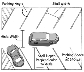
5.10.04.C. Dimensional Standards for Parking Spaces and Aisles (Measurement).
1.
Measurements.
a.
Floor Area. Where floor area is the unit of measurement to determine the required number of off-street parking and loading spaces, gross floor area (GFA) shall be used.
b.
Bench Seating. In calculating bench seating for places of assembly, each continuous four (4) foot segment of benches, pews or other similar seating shall be counted as one (1) seat.
c.
Employees. Where the number of spaces required is based on the number of employees, calculations shall be based upon the maximum number of employees likely to be on the premises at any one time. Where multiple shifts of employees are involved, calculations shall be based on the largest shift.
d.
Occupancy. Where occupants are used as a measurement, all calculations shall be based on the maximum capacity permitted under fire safety and building codes.
e.
Stalls. Where vehicle stalls are used as a measurement, all calculations shall be based on the number of service bays, garage door openings or similar area.
2.
Fractions. Where units of measurements determining the number of required parking or loading spaces result in a fraction, the fraction shall be counted as one (1) additional parking space.
3.
Uses.
a.
Parking shall be calculated separately for each use in a building, structure or on a lot, except that the Planning Director may determine that a lower standard would be adequate for shared parking, as described in Section 5.10.05.E.
b.
Accessory uses shall be calculated separately.
4.
Unlisted Requirements. The Director shall make a determination as to the proper classification of a parking requirement not listed for a particular use based on the requirement of the closest comparable use. Where a comparison cannot reasonably be made, the Director may require a Parking Demand Study as provided in Section 5.10.04.A.
5.
Bicycle Parking shall be as required in Section 5.10.10. Bicycle parking shall not occupy any required vehicle parking space.
D.
Maximum Parking. No parking area for an individual use, building, or integrated complex shall exceed the required number of parking spaces by more than twenty (20) percent, unless approved by the Planning Commission as a Special Land Use, and based on a Parking Demand Study submitted by the applicant, as provided in Section 5.10.04.A.
E.
Deferral of Parking Spaces. The Planning Commission may defer the construction of a portion of the parking spaces required in Table 5.10.04.C. as part of a Special Land Use or Site Plan Review application, subject to all of the following requirements.
1.
The owner shall demonstrate that the required number of parking spaces is excessive for the nature of their business or operational characteristics.
2.
An area of sufficient size to meet the deferred number of parking spaces, along with setbacks, landscaping, access drives, aisles and other required parking lot features, shall be retained as open space.
3.
A deferred parking site plan shall identify the area where parking is being deferred, including dimensions and parking lot layout.
4.
Stormwater management requirements shall be based on the full amount of required parking to ensure adequate capacity if additional parking is later deemed necessary.
5.
The owner shall provide a written agreement to construct the deferred parking within six (6) months of a written notice from the Director based on observed need, or to give at least thirty (30) days prior notice to the Director if the deferred parking area is to be constructed.
F.
Traditional Neighborhoods Parking Requirements.
1.
Traditional Neighborhoods - City Center (TN-CC) Zone District Parking Requirements. Off-street parking shall not be required. If provided, the number of spaces shall not exceed one (1) space for each one thousand (1,000) square feet of gross floor area for all non-residential buildings and hotels, and one (1) space per dwelling unit, unless approved by the Planning Commission as a Special Land Use and based on a Parking Demand Study submitted by the applicant, as provided in Section 5.10.04.A.
2.
Traditional Neighborhoods - Low Density Residential (TN-LDR) and Mixed-Density Residential (TN-MDR) Zone District Parking Requirements. Off-street parking shall not be required for developments of six (6) or fewer dwelling units when located on Link Residential and Network Residential Streets.
3.
Administrative Departure.
a.
An Administrative Departure may permit General or Professional Office uses to provide up to three (3) spaces for each one thousand (1,000) square feet of gross floor area if all of the following conditions are met:
i.
The gross floor area of the use is at least 100,000 square feet.
ii.
The off-street parking provided is located within a structure.
iii.
That a Traffic Analysis meeting the requirements of the City's Transportation Engineer be submitted for review and approval by the City's Mobile GR Department.
iv.
A Transportation Demand Management (TDM) plan is submitted that demonstrates compliance with the below requirements.
(a)
Bicycle parking and commuter amenities.
1)
Enclosed, secure bicycle parking facilities, such as bicycle lockers or bicycle rooms are provided on site and given priority location on the ground floor.
2)
The required number of bicycle parking spaces provided shall be provided as indicated in Table 5.10.04.F.3.
3)
A bicycle maintenance station is provided with three (3) feet of unobstructed space on each side. Tools and supplies should include at a minimum: a bicycle pump, wrenches, a chain tool, tire levers, hex keys/Allen wrenches, torx keys, screwdrivers, and spoke wrenches.
4)
Showers and clothing lockers available to all employees are provided on site.
(b)
Carpooling.
1)
A minimum of five (5) percent of total parking spaces on site are reserved for priority carpool parking. Priority spaces must be the closest to building entrances or elevators but not closer than disabled parking.
(c)
Micromobility.
1)
A shared micromobility designated parking zone is provided that has adequate space for several vehicles and is accessible from or within the public right of way, as determined by the Mobile GR Department.
(d)
Transit.
1)
A transit pass agreement with The Rapid is provided and fully funded by the employer that allows all employees to commute via transit on an ongoing basis at no cost to the employees.
2)
Any existing bus stops that abut the subject property shall be improved bus stop amenities (e.g., a shelter) as required and meeting specifications determined by The Rapid and Mobile GR Department.
(e)
Parking cash out.
1)
A parking cash out program meeting the requirements of Section 5.10.04.F.3.b. below is made available to all employees.
b.
A parking cash out program is a program in which the employer offers employees the option to accept taxable cash income instead of a free or subsidized parking space at work. The reimbursement shall be no lower than the monthly rate of the nearest public parking ramp or a commensurate ratio of the rate depending on days required in-office.
G.
Affordable Housing. The number of required off-street parking spaces for developments that utilize the Affordable Housing Bonus as outlined in Articles 5 and 6 may be calculated at one-half space less per unit than what is required in Table 5.10.04.C.
H.
Micro-Units. The number of required off-street parking spaces for developments that contain micro-units as outlined in Article 6 (Section 5.6.07.B.2.b.) may be calculated at one-half (0.5) less space per micro-unit than what is required in Table 5.10.04.C., as long as two (2) bike spaces are also provided per micro-unit. Bicycle spaces provided in association with this calculation shall be in an enclosed, secure facility located on the ground floor with an exterior entrance and paved access to the nearest sidewalk, road, or bicycle path.
(Ord. No. 2019-09, § 7, 3-26-19; Ord. No. 2019-10, § 5, 3-26-19; Ord. No. 2020-18, § 1, 6-16-20; Ord. No. 2020-21, § 10, 7-7-20; Ord. No. 2024-20, §§ 21, 22, 4-23-24; Ord. No. 2024-40, §§ 6, 7, 9-24-24)
Sec. 5.10.05. - Off-Street Parking: Reductions in Parking Requirements.
A.
Parking Reductions - Procedures.
1.
Off-street parking requirements may be reduced by the Director or Planning Commission based on the requirements of this Section.
2.
If the conditions by which any reduction approved under the provisions of this Section are changed or eliminated, the approved reduction shall no longer apply and parking shall be provided in accordance with this Article or the owner applies for another parking reduction.
3.
Administrative Approvals of Parking Reductions.
a.
Off-street parking requirements may be reduced by up to fifty (50) percent upon a finding by the Director that the applicant meets the requirements for at least one (1) of the allowable reductions of this Section. The Planning Director may require that the request for allowable off-street parking reductions be reviewed by the Planning Commission as a Special Land Use based on the potential to affect neighborhood character, the absence of convenient public parking, or the results of a Parking Demand Study as provided in Section 5.10.04.A. demonstrating a potential need for parking.
b.
Administrative Departure. An Administrative Departure up to eight (8) required off-street parking spaces may be granted where the building footprint comprises ninety (90) percent or more of the lot, or the lot cannot otherwise accommodate the required parking by reason of shape, location, natural features or other physical constraint, even if the Departure results in a reduction greater than fifty (50) percent of the required parking.
4.
Special Land Use.
a.
A Special Land Use may be approved to reduce parking requirements above fifty (50) percent or to eliminate any off-street parking requirement upon a finding that the applicant meets the requirements for one (1) or more of the allowable reductions of this Section.
b.
In reviewing a parking reduction, the Planning Commission shall consider the following factors, as applicable.
i.
The land use and development character of the area to be served by the parking facility, including the relative intensity of uses requiring parking, availability of transit, proximity of nearby employment centers and residential uses, and other relevant factors;
ii.
The availability of other publicly available parking in the area, including information such as number of spaces, any applicable restrictions (time limits, dedicated parking areas, etc.), or other uses also counting spaces in the same parking area for meeting parking requirements;
iii.
The timing of parking use relative to other uses in the area including information regarding hours of operation or other operational parking needs that would permit use of the spaces;
iv.
Whether the location of all provided parking meets the requirements of this Article;
v.
Whether compliance with Table 5.10.04.C. is made to the maximum extent practicable taking into account parking lot design and efficiency of the layout;
vi.
Whether other adjustments as described in this Section should apply in conjunction with or in lieu of the requested need-based adjustment; and
vii.
Whether supporting documentation, if provided, adequately demonstrates that sufficient parking is available to meet projected typical demand.
B.
Mixed-Use Parking Coefficient. Where the Director determines that a mix of land uses could reduce the number of required parking spaces, Table 5.10.05.F. below shall be used to calculate mixed-use parking requirements. The required parking for each use shall be totaled, and then divided by the appropriate mixed-use coefficient.
1.
For example, for a mixed-use development containing office and retail uses:
(Parking OFFICE + Parking RETAIL ) (14 + 21) = 35 ÷ 1.2 = 29.17 (30 rounded up)
2.
If there are more than two (2) uses in the development, the required parking for all uses shall be totaled and divided by the lowest applicable coefficient. For example, for a mixed-use development containing office, residential, and retail uses:
(Parking OFFICE + Parking RETAIL ) (14 + 21) = 35 ÷ 1.2 = 29.17 (30 rounded up)
(P OFFICE + P RESIDENTIAL + P RETAIL ) (14 + 12 + 21) = 47 ÷ 1.2 = 39.17 (40 rounded up)
C.
On-Street and Business District Parking.
1.
The use of on-street parking, publicly-owned business district parking lots (district lot), or parking structure spaces to meet a portion of the minimum off-street parking requirements shall be permitted as provided in Subsection A., above, provided the following conditions are met:
a.
Adequate on-street, district lots or parking structures exist within five hundred (500) linear feet of the primary entrance of the main building;
b.
No more than fifty (50) percent of the off-street parking space requirement is met through the use of on-street, district lot or structure parking;
c.
The intensity of the use and its parking requirements shall not substantially adversely affect available parking for surrounding uses; and
d.
There are no adverse effects on existing or planned traffic circulation patterns.
2.
A Parking Demand Study as provided in Section 5.10.04.A. may be required to demonstrate that there are adequate available on-street, district lot, or parking structure spaces.
D.
Payment in Lieu of Parking. A parking program may be instituted to develop publicly owned district parking lots or structures as opposed to individually owned and operated parking areas.
1.
Mixed-Use Commercial Zone Districts. In lieu of providing the required off-street parking spaces for any development, a payment may be made under the provisions of Section 5.10.05.C.2. and 3. below.
2.
Parking Facilities Account.
a.
The purpose of the Parking Facilities Account as set forth in Chapter 31 of the City Code, is to fund the planning, designing, acquiring, building, financing, and developing, but not maintaining, of public off-street parking facilities designated by the City Commission as serving the TN-CC Zone District. The Parking Facilities Account may also be used for other alternatives to the provision of parking facilities in the Zone District, including Transportation Demand Management measures.
b.
Chapter 31 shall establish an amount which, if paid to the Parking Facilities Account, shall constitute provision of one (1) off-street parking space. Chapter 31 also sets forth conditions for partial in-lieu payments and recording of in-lieu payments.
3.
Special Assessment. The City may, as part of any special assessment levied to defray a portion of the cost of a parking facility, determine that the payment, or alternatively, the levy of a special assessment, shall constitute provision of a designated number of parking spaces for the building or structure, and any future building or structure, located on the property specially assessed. The determination of the number of parking spaces deemed to be provided, if any, shall be made at the time that the special assessment is levied.
E.
Alternate Modes of Transportation. One (1) or more of the following methods may be used to reduce off-street parking requirements:
1.
Transit.
a.
Parking requirements may be reduced under the provisions of Section 5.10.05. for up to fifty (50) percent of required parking spaces for buildings, structures, or uses within a half mile of a Bus Rapid Transit (BRT) station or one-quarter of a mile of a transit stop.
b.
A Transportation Demand Management (TDM) study may be required to demonstrate that a sufficient number of vehicle drivers already use or would immediately opt for transit, and therefore would not result in adverse parking impacts on surrounding properties.
c.
The applicant shall provide a written statement from The Rapid verifying that the transit station or transit stop is in a permanent location for the foreseeable future.
2.
Alternative Vehicles.
a.
One (1) alternative vehicle parking space may count as four (4) regular parking spaces.
b.
Alternative parking spaces shall be reserved, signed, and enforced for car-sharing services or for Low-Emitting and Fuel-Efficient Vehicles (vehicles that are either classified as Zero Emission Vehicles (ZEV) by the California Air Resources Board or have achieved a minimum green score of forty (40) on the American Council for an Energy Efficient Economy (ACEEE) annual vehicle rating guide).
c.
Electric car spaces shall include a power outlet for use by the parked car. These spaces should be closest to the main entrance (exclusive of spaces designated for handicapped). Power outlets may count toward those required by Section 5.10.03.D.11.
3.
Each parking spaces reserved, signed, and enforced for carpooling or vanpooling services may count as two (2) regular parking spaces.
4.
Reductions for Bicycle Facilities.
a.
Vehicle parking requirements may be reduced by one (1) space for every four (4) covered, secured bicycle parking spaces, including lockers, one (1) or more floor pumps, and a work stand are provided on site. These amenities must be made easily accessible to cyclists using the bicycle parking spaces.
b.
Parking requirements may also be reduced by four (4) spaces where free showers and locker facilities are available for use within the building.
c.
See Section 5.10.10.B.5. for requirements related to covered bicycle parking spaces.
F.
Shared Parking Agreements.
1.
Mixed-Land Use. Where a mix of land uses creates staggered peak periods of parking demand, shared parking agreements that have the effect of reducing the total amount of required parking spaces are encouraged. Shared parking agreements for off-street parking for two (2) or more buildings or uses is permitted subject to the following:
a.
The total number of required parking spaces for each use on each lot shall not be reduced by more than fifty (50) percent.
b.
Shared parking areas shall be located within three hundred (300) feet of the use.
c.
Adjacent lots shall be connected by drive aisles.
d.
Shared parking leases or agreements shall have a term of not less than five (5) years, including any renewals at the option of the lessee.
2.
Easements. Written easements providing for the continued use and maintenance of shared parking shall be submitted to the Planning for review and approval. Any agreement shall include provisions to address changes in use and ownership. The agreement shall include a provision that, should the agreement be severed or modified, parking for the affected properties will be brought into full compliance with this Chapter.
(Ord. No. 2020-18, § 2, 6-16-20; Ord. No. 2024-20, § 23, 4-23-24; Ord. No. 2024-40, § 8, 9-24-24)
Sec. 5.10.06. - Loading/Unloading Spaces.
A.
Purpose. In all Zone Districts, every building or part thereof which is to be occupied by one (1) or more uses that require the receipt or distribution of materials or merchandise by vehicles shall provide and maintain off-street loading spaces as required by this Section.
B.
Location.
1.
Loading/unloading areas and docks shall be prohibited in the front yard or on any building side facing and directly visible from a street.
2.
Loading/unloading operations shall not interfere with the normal movement of vehicular and pedestrian traffic in public rights-of-way, off-street parking areas, internal drives, or sidewalks.
3.
No loading space that is adjacent to a Residential Zone District shall be nearer than thirty (30) feet to the Zone District line unless it is contained within a completely enclosed building, or enclosed on all sides by a wall or solid fence not less than six (6) feet high.
4.
The vehicular path and turning radii to the loading area must be shown on the site plan to verify truck maneuverability for the largest truck intended to serve the use.
C.
Required. Loading/unloading spaces shall be at least twelve (12) feet wide, thirty (30) feet long, and have fourteen (14) feet of clearance. Each additional required loading space shall be at least ten (10) feet in width, forty-five (45) feet in length, and have fourteen (14) feet of clearance.
D.
The minimum number of loading spaces shall be provided in accordance with Table 5.10.06.D. Loading Space Requirements.
E.
If only one (1) loading space is required, an alley may be used in lieu of the required loading space.
F.
Administrative Departure. An Administrative Departure may be approved to reduce the size of loading spaces, or to modify the number of spaces and location requirements where another measure or location would be more appropriate due to site constraints or the number or type of deliveries experienced by a particular use.
Sec. 5.10.07. - Mobility and Circulation.
A.
Purpose.
1.
The purpose of this Section is to establish mobility and circulation standards that give equal treatment to all modes of travel; allow reasonable access to properties; create a continuous network of non-motorized pathways within and between developments; maintain the capacity of existing public infrastructure as land development occurs; ensure safe access to and from streets by emergency vehicles; and reduce interference with through traffic by other vehicles, bicycles and pedestrians.
2.
Streets should be capable of accommodating multiple modes of transportation and should facilitate the creation of a public realm designed primarily for people, characterized by:
a.
Pedestrian-friendly design that places a high priority on walking, bicycling, and use of public transit;
b.
Streets and blocks arranged to allow for comfortable walking distances, to disperse traffic and to reduce the length of vehicle trips;
c.
A connection to, and enhancement of, the existing street network;
d.
A recognition of the role of buildings and landscaping that contributes to the physical definition of streets as civic places; and
e.
Residential and business uses that have convenient access to existing and future transit stops.
B.
Street and Sidewalk Connections.
1.
Continuation.
a.
Streets and internal circulation drives shall be arranged to provide for the alignment and continuation of existing or proposed streets and drives into adjacent lots, developed or undeveloped.
b.
This provision shall not be construed as prohibiting the termination of streets at public street intersections where appropriate, provided that the overall connectivity of the street network is maintained, and intersections are adequately spaced as determined by the Traffic Engineering Department.
c.
Street continuations may be limited by a highway, waterway, open space, utility line, roadways with limited access restrictions, or development that is expected to remain, as determined by the Traffic Engineering Department.
d.
Where a public street is vacated, pedestrian access shall be preserved for the public where the connection is necessary to prevent circuitous routing.
2.
Street and sidewalk connections shall be made between neighborhood commercial centers and adjacent residential neighborhoods, unless otherwise approved by Traffic Engineering.
3.
At all locations where streets terminate with no street connection, but a future connection is planned or accommodated, a sign shall be installed at the location with the text "STREET TO BE EXTENDED BY THE AUTHORITY OF THE CITY OF GRAND RAPIDS."
4.
The Final Plat or Site Condominium and the deeds for all residential dwellings shall identify all stub streets and include a notation that all street stubs are intended for connection with future streets on adjoining parcels of land.
C.
Cross Access Between Adjacent Uses.
1.
Internal vehicular circulation areas shall be designed to allow for cross access to adjacent lots with residential, nonresidential or mixed-uses.
2.
A stub for future cross access shall be provided from the vehicular use area to all adjacent lots. Where cross access is deemed impractical by the Planning Commission or Director during Site Plan Review or Director Review on the basis of topography, the presence of natural features, or vehicular safety factors, the requirement for cross access may be waived provided that appropriate bicycle and pedestrian connections are made between adjacent developments or uses.
3.
A cross-access easement shall be recorded with the Kent County Register of Deed prior to the issuance of a Building Certificate of Occupancy for the development.
D.
Block Length.
1.
Unless prohibited by environmental or topographic constraints, the average block length in a development shall not exceed six hundred (600) linear feet between the right-of-way lines of intersecting streets, nor exceed a block perimeter of one thousand eight hundred (1,800) feet measured along all sides of a block along the property lines.
2.
When existing barriers limit extension of the street network, blocks shall be created to match the requirements in D.1. above to the maximum extent practicable. Barriers may include features such as a highway, waterway, open space, utility line, roadways with limited access restrictions, or development that is expected to remain.
3.
Mid-Block Paved Pathways.
a.
In cases where the maximum block length and/or block perimeter is exceeded, paved pathways in easements or on open space lots shall be provided mid-block to connect parallel streets on the long side of the block in a location approved by the Director.
b.
The mid-block pathway shall be a minimum of ten (10) feet wide, and designed as a continuation of the streetscape, including materials and furnishings, and lighted using footlights, bollard lights, building lights, and/or adjacent street lights to provide for safety and visibility.
c.
The mid-block pathway requirement may be fulfilled by a permitted alley when a minimum five (5) foot pathway is provided.
4.
In lieu of a mid-block pathway, a mid-building pathway with 24-hour public access may serve as a mid-block pathway.
5.
Administrative Departure. Other options for a mid-block or mid-building pathway may be approved that fulfill the same function.
6.
These requirements shall not apply to residential blocks created under the provisions of Chapter 64, Subdivision Regulations.
Sec. 5.10.08. - Pedestrian Access and Circulation.
A.
Purpose. Pedestrian access shall be required for all sites to improve the health, safety and welfare of the public by providing clear pedestrian pathways at perimeter and internal site locations to reduce pedestrian and vehicular conflicts, improve accessibility for persons with disabilities, and establish a multi-modal environment that is supportive of walking, biking and transit use. These requirements are also intended to promote healthier lifestyles by encouraging walking and bicycling over the use of a private vehicle for many daily activities, and to provide the means by which residents and visitor can be more engaged with their neighbors, coworkers, and fellow visitors.
B.
New Construction. All sites on which any new construction occurs shall provide sidewalks conforming to City standards along all portions of the property which border a public street, excluding alleys.
C.
Minimum Width for Pedestrians.
1.
At least five (5) feet of sidewalk space shall be kept clean and clear for the free passage of pedestrians at all times.
2.
Administrative Departure. Upon consultation with Traffic Engineering, a lesser width of clear area approved. In evaluating a request for an Administrative Departure, the following shall be considered:
a.
Street classification and current or expected volume of use;
b.
Vehicular and pedestrian traffic volumes and related public safety;
c.
Nature of vehicular and pedestrian traffic (e.g. children, etc.);
d.
Availability and practicality (i.e. convenience) of alternative pedestrian routes; and
e.
Time of day, time of week, time of year, and duration of obstructions reducing the minimum required width (e.g. outdoor dining spaces, etc.).
D.
Internal Pedestrian Circulation.
1.
Requirements for mid-block or mid-building pathways of Section 5.10.07.D. shall apply.
2.
All attached single-family and multiple family residential, non-residential and mixed-use developments shall comply with the following requirements.
a.
Continuous internal pedestrian walkways shall be provided to connect off-street surface parking areas with the primary entrances of main buildings.
b.
At least one (1) pedestrian walkway with a minimum width of five (5) feet shall be provided from the internal pedestrian walkway network to the public sidewalk system. In the case of corner lots, connections shall be made to the sidewalks of both streets.
c.
All internal pedestrian walkways shall be distinguished from driving surfaces through the use of durable, low-maintenance surface materials such as pavers, bricks, or scored/stamped concrete or asphalt.
3.
Walkways in Parking Lots.
a.
Paved walkways shall be provided for access to adjacent parks, shopping areas, transit stops, anticipated walkways and institutions. Walkways shall either be dedicated sidewalks raised above the surface of the parking lot, or, if at the same level as the parking lot, clearly marked with striping and tactile alerts, and may use alternative materials, such as pavers.
b.
Each surface parking area that has fifty (50) or more parking spaces, or has any parking spaces more than three hundred fifty (350) feet from the front façade of the main building, shall have at least one (1) pedestrian walkway or sidewalk allowing pedestrians to pass from the row of parking furthest from the main building façade to the primary building entrance.
c.
The required walkway must be at least five (5) feet wide, shall not be within a driving aisle, and, where possible, shall be within a landscaped island running perpendicular to the primary building façade. If parking spaces are adjacent to a sidewalk, the sidewalk must be at least seven (7) feet to allow for vehicular overhang.
E.
Trail Connections. Where trails exist or are planned, paths or sidewalks shall connect building entries to the trail system.
Sec. 5.10.09. - Transit Access and Amenities.
A.
Transit Stops. Where public transit service is available or planned, convenient access to transit stops shall be provided by means of public or private sidewalks or walkways. Any provided seating shall not obstruct a public sidewalk.
B.
Where transit shelters are provided, they shall be placed in highly visible and well lighted locations for purposes of safety, subject to review by The Rapid.
C.
Landscaping. Landscape and/or plaza areas are encouraged at transit stops.
Sec. 5.10.10. - Bicycle Facilities.
A.
Minimum Required Spaces.
1.
Any development or addition to an existing development requiring vehicle parking spaces shall be required to provide bicycle parking. Table 5.10.10.A. indicates the number of required spaces based on the Use Tables of the Zone District. Calculations by area are based on gross floor area of the main building(s). Fractions shall be rounded up.
2.
No bicycle parking is required for single-family detached, two-family, attached single-family dwellings, group living, aeronautical, utilities, and manufactured housing communities.
3.
Mixed use developments shall calculate the total number of required spaces using the appropriate use category for each use in the development. Developments with multiple buildings shall calculate space requirements for each building.
B.
Location.
1.
Bicycle parking shall be within fifty (50) feet of the nearest publicly accessible building entrance, in well-lit areas clearly visible from the street, and on the same lot as the use being served. Facilities may be indoors or outdoors. If indoors, access shall be available to the public during business hours, at a minimum.
2.
A pedestrian-accessible walkway shall be available between the outdoor bicycle parking area and the primary building entrance. Public sidewalks may be used to meet this requirement. An aisle width of at least five (5) feet shall be provided adjacent to any bicycle parking facilities to allow for maneuvering.
3.
Racks shall be installed a minimum of two (2) feet from any entrance door, wall or other obstruction, except for wall-mounted bicycle racks, which may be mounted directly on a wall, and shall not be placed within ten (10) feet of a fire hydrant.
4.
Bicycle lockers shall be inside, or to the side or rear of the main building, but not within any required setback, at a Required Building Line, or within a clear vision area. If indoors, lockers shall be accessible to the public during operating hours of the use(s) within the building.
5.
Covered Bicycle Parking Areas.
a.
Covered bicycle parking is required for any development that requires twenty-five (25) or more bicycle spaces in accordance with Table 5.10.10.A., or to be available for use associated with a parking reduction as described in Section 5.10.05.D.4.
b.
Covered bicycle parking areas shall be sheltered from natural elements by locating them inside or under main or accessory structures, in bicycle lockers, under roof extensions, overhangs, awnings, carports or enclosures, or other similar methods.
c.
If bicycle parking is covered, the cover must be permanently attached to the ground or a structure, and must have at least seven (7) feet of clearance above the surface to which it is attached. Covered parking areas shall maintain at least five (5) feet of clear area for pedestrian use.
d.
Covered bicycle parking areas shall not be place forward of any required setback or Required Building Line and, if attached to a main building, shall meet all applicable setbacks.
6.
Bicycle parking placement shall not conflict with pedestrian travel.
7.
Parking Lots.
a.
Bicycle parking and access facilities may be placed in vehicle parking areas but shall not take the place of a required vehicle parking space or conflict with internal parking aisles.
b.
Each surface parking area with two hundred (200) or more spaces shall have at least one (1) dedicated bicycle lane extending from the primary street to the bicycle parking area. Lanes must be easily accessible for bicycles from the public right-of-way and nearby bicycle paths, and may be either raised above the surface of the parking lot, or, if at the same level as the parking lot, must be clearly marked with striping and tactile alerts, bicycle lane markings, and a contrasting color from the surface of the parking lot, and may also use alternative materials, such as pavers.
C.
Facilities.
1.
Designs of bicycle racks, docks, posts, and lockers are encouraged to be decorative, unique, and appropriate to the surrounding area or related to the use being served, and shall be maintained in good repair. Bicycle parking design should be incorporated whenever possible into building design and coordinated with the design of street furniture when it is provided.
2.
Bicycle parking racks, docks, or posts shall be designed and installed to allow a bicycle to be locked to a structure, attached to the pavement, building, or other permanent structure, with two (2) points of contact to an individual bicycle frame. Racks, docks, and posts shall be designed to allow the bicycle frame and one (1) or both wheels to be locked with a U-lock when used as intended.
3.
The parking surface shall be level and easily accessible from the public right-of-way, and designed and maintained to be mud and dust free, clear of ice and snow, and kept in good repair. The use of rock or gravel areas for bicycle parking is permitted provided that edging materials are used so that the bicycle parking area is clearly demarcated and the ground material is contained.
D.
Administrative Departures.
1.
Required bicycle parking may be reduced by an Administrative Departure when it is demonstrated that the level of bicycle activity at that location warrants a different amount. In no case shall fewer than three (3) spaces be provided.
2.
The Director may permit public bicycle parking provided by the City within the street right-of-way to be counted toward meeting a portion of the minimum bicycle parking requirement for a parcel, as determined by the Director. To count toward the requirements, the spaces shall be on the same block and on the same side of the street. Credit for public bicycle parking spaces shall apply to parking for all uses on the parcel rather than any specific use.
3.
The requirements of this Section not related to the required number of bicycle parking spaces may be modified, reduced, or eliminated if the Director determines that compliance is impractical or unnecessary.
Sec. 5.10.11. - Private Streets.
A.
City Standards. Private streets shall not be constructed, extended or relocated without express written approval by the Engineering, Planning, Traffic Engineering, Fire and Streets and Sanitation Departments and other departments as deemed necessary attesting that the proposed private street complies with all City standards.
B.
Approval. Private streets shall be permitted where there is no opportunity or potential to establish a public street or plat the land.
C.
Application Requirements. The following shall be submitted:
1.
The name(s) and address(es) of the owner(s) and all other parties having any access interest in the private street.
2.
The proposed name of the street as well as the proposed addresses for all new lots or parcels that would have a front or side lot line on the street.
3.
A site plan showing all proposed lots or parcels that would have access by means of the private street, and also showing the location, grade, route, elevation, dimensions and design of the private street and any proposed extensions thereof, together with existing and proposed curb cuts and the location of and distance to any public streets which the private street is to intersect. Adjacent parcels of land and any buildings thereon shall be included in the site plan.
4.
A utility plan showing the location of all public utilities including, but not limited to, water, sewer, telephone, gas, electricity and cable, to be placed within the private street easement or right-of-way or within twenty (20) feet of either side thereof.
5.
A private street maintenance agreement to be approved by the City Commission. The agreement shall run with the land and shall be recorded with the Kent County Register of Deeds. It shall be recorded prior to issuance of a LUDS permit.
D.
Maintenance. The private street shall be continuously maintained in a manner that it does not constitute a danger to public health, safety and welfare. All costs associated with the repair of the private street shall be the responsibility of the individuals and/or the property owners association(s) comprised of land owners served by the street.
E.
Access and Occupancy. The private street shall be readily accessible to and usable by emergency vehicles in all weather. An occupancy permit required under Chapter 131 for a dwelling or other building, the primary access to which is to be provided by a private street, shall not be issued until the private street has been constructed with sufficient width, surface and grade to ensure the safe passage and maneuverability of emergency service vehicles.
F.
Street Frontage. All lots and parcels of land with access to a private street shall have frontage on the approved private street right-of-way equal to the minimum lot width requirement of the Zone District in which the lot is located. A parcel with frontage on both a private and public street shall be considered a corner lot.
G.
Disclosure. The following statement shall be included in any deed or other instrument of conveyance recorded for any lots or other parcels of land served by a private street:
"This property does not abut or front upon a public street. If a public street does not abut or serve the property, the street abutting or serving the property is a private street, and it is therefore not required to be maintained by the City of Grand Rapids."
H.
Performance Guarantee. As a condition of approval of a private street and the issuance of a LUDS permit, the City may require that the applicant provide a performance guarantee in accordance with the provisions of Section 5.14.04., the release of which is conditioned upon the satisfactory performance by the applicant of the terms of this Section and any conditions of approval.
I.
Fee. A fee set by City Commission resolution may be assessed for processing a private street application.
J.
Effect on New and Existing Private Streets.
1.
The provisions of this Section shall apply to all private streets designated or constructed on and after the effective date of this Chapter.
2.
The entire private street, including the portion thereof existing prior to the adoption of this Chapter, shall comply with all requirements of this Section if an existing private street is extended by an increase in its length, or if lots or parcels of land with access to the existing private street are added.
Sec. 5.11.01. - Purpose and Intent.
A.
Purpose. The purpose of this Article is to promote and protect public health, safety and general welfare by preserving and improving environmental conditions affected by the built environment through the effective and functional use of landscaping and green infrastructure, and to accomplish the purposes and intents of this Chapter.
B.
Quality of Life. Protect and enhance community quality of life by using the natural environment to provide shade and visual relief; provide a buffer between potentially incompatible uses; and screen adjacent properties from the effects of noise, light, glare, and other adverse effects.
C.
Design. Required landscaping should be creatively and architecturally designed to add four (4) seasons of visual interest, preserve or complement natural systems, and fit with the character of the surrounding area.
D.
Resiliency. Maximize the benefits of the natural environment to create a more resilient community, including improvement of water quality through stormwater retention, providing a mix of plant materials to mitigate the effects of disease, allow air quality improvements, mitigate the effects of vehicle emissions, and preserve and enhance wildlife habitats.
E.
Economic Benefit. Protect and enhance property values, the character and quality of residential neighborhoods, and the attractiveness and economic vitality of business areas; decrease energy consumption and costs for heating and cooling; and reduce demand on the City's public infrastructure and systems for flood control, stormwater management, potable water, and other public services and amenities.
F.
Stormwater Impact. Reduce stormwater effects and costs associated with site grading, flooding, erosion, expansion of impervious surface areas, and removal of vegetation.
G.
Health Benefits. Decrease the urban-heat island effect on high heat days for vulnerable populations, provide benefits for physical activity by using shade to improve pedestrian comfort, improve air quality for persons with breathing problems, provide opportunities for quiet respites in urban environments, and offer connections to nature to help manage stress.
H.
Tree Preservation and Tree Canopy Coverage.
1.
Sustain and enhance the functions and benefits of vegetation by conserving trees, preserving tree canopy wherever feasible, and increasing canopy coverage through proper protection and planting to better bring trees to maturity.
2.
The requirements relative to tree canopy preservation on each parcel bears an essential relationship to the City's and residents' interest in the preservation of the totality of Grand Rapids' canopy coverage, recognizing that it is the sum of each parcel's gain or loss of trees through land development activities that combine to produce a benefit for all.
3.
Through application of these carefully measured regulations, the City finds that the burden on each parcel for the maintenance of tree canopy when redevelopment occurs will bear a rough proportionality to the important benefits gained from overall tree canopy preservation and replacement.
I.
Community Priorities. Support achievement of the goals and priorities contained in officially adopted plans and policies, such as the Master Plan, Parks and Recreation Master Plan, Green Grand Rapids Plan, Sustainability Plan, Stormwater Master Plan, and Urban Forest Plan, and other adopted plans and policies of the City.
Sec. 5.11.02. - Applicability.
A.
Type of Projects. The requirements of this Article shall apply to all development projects that require a Land Use and Development Services (LUDS) permit and are, at a minimum, subject to the following provisions in addition to this Article.
1.
Nonconformities. Any change to the use of a lot, building or structure is subject to the provisions of Article 3, and Section 5.3.06. Nonconforming Site Elements of this Chapter.
2.
Chapter 42 Trees. Director or Planning Commission approval of landscape plans shall be subject to compliance with Chapter 42 of the City Code and other City regulations and policies pertaining to trees.
B.
Approval Required. No removal of vegetation, ground cover or trees shall be undertaken once an application for an approval required by this Chapter is submitted, or prior to the issuance of a LUDS permit, where required.
C.
If two (2) or more conflicting landscape or open space requirements apply to the same area, that which requires the most landscaping or open space shall apply.
Sec. 5.11.03. - Landscape Plan Submittal Requirements.
A.
A landscape plan shall be submitted as part of Director or Planning Commission approval, subject to the provisions of this Article and Article 12 Application and Review Procedures.
B.
Landscape plans shall include, but are not necessarily be limited to, the following information, unless waived by the Director as being unnecessary. Additional information may be required by the Director or Planning Commission as necessary to evaluate the landscape plan.
1.
Existing and Proposed Features.
a.
Existing and proposed site contours on the project site and one hundred (100) feet beyond the site lot lines, at intervals not to exceed two (2) feet.
b.
Delineation of natural rivers, wetlands, streams and water bodies, or other sensitive environmental areas that may influence water quality and/or stormwater discharge rates shall be delineated on final plats, condominium documents or site plans with a clear notation of use restrictions.
c.
Woodlands, wildlife areas, and steep slopes.
d.
Location, height and type of any berms, fences or walls measuring thirty (30) inches or higher.
e.
Location of all overhead utilities.
2.
Tree Protection and Canopy.
a.
A Tree Inventory displayed as a map or plan with a list and description of the species, condition, and size for all trees six (6) inches in diameter at breast height (DBH) or larger that are within the project site or portion thereof, in those areas affected by development, and within twenty (20) feet of the project boundary.
b.
The percent of tree canopy by tree species shall be provided. The City of Grand Rapids Urban Tree Canopy Analysis Map (2015), as may be updated from time to time, is recognized as determinant of tree canopy coverage for the purposes of this Chapter.
c.
A Tree and Root Protection Plan showing tree protection and root protection zones shall be defined. Methods and details for protecting existing vegetation during construction as required in Section 5.11.10.
3.
Planting Plan Requirements.
a.
Identification (including location, species, condition, and tree size) of existing trees, vegetation, and other landscape elements to be removed or retained. The reasons for removal shall be noted. Unhealthy trees, as defined, shall be exempt from tree replacement requirements.
b.
Location, size, spacing, and species of proposed plant material, including plant lists showing the required and proposed quantities. Where tree replacement is required or proposed, a table that corresponds to the plan shall be provided that lists the quantity and size, by species, of each tree to be planted.
c.
Calculations verifying the minimum landscape area, required greenspace, trees, and plant materials required under this Article shall be provided as part of the Landscape Plan.
d.
Specifications on soil depth, soil type/mix, open soil surface area, and planting methods.
e.
Description of temporary and permanent irrigation methods for trees and landscape areas.
f.
Typical cross section, including slope, height, and width of berms and the type of ground cover to be placed on them.
4.
Maintenance.
a.
Description of landscape maintenance program, including statement that all diseased, damaged or dead materials shall be replaced in accordance with the requirements of Section 5.11.07.H.
b.
Maintenance of rain gardens and other similar features shall comply with the standards and requirements of the City's Environmental Services Department.
Sec. 5.11.04. - Landscape Plan Review Standards and Administrative Departures.
A.
Review Standards. The Planning Director and the Planning Commission shall use the following review standards in reviewing landscape plans.
1.
The applicable Site Plan Review standards of Section 5.12.08 shall be met.
2.
Landscape plans shall generally meet the Intent and Purposes of Section 5.11.01.
3.
Site design and architectural layout activities shall preserve existing trees, other significant vegetation, and natural features to the greatest extent practicable and reduces the risk of damaging these features through changes of grade, soil moisture, and other alterations of the site. This includes, but is not limited to, the layout and design of buildings and associated site improvements including auguring, jacking, or boring to install utilities (as opposed to open cutting).
4.
Provided landscaping and buffering helps block potential negative impacts related to noise, lighting levels, and activity through the use of denser landscape screening and/or a fence or wall visually softened by clustered plantings, creatively and architecturally designed, as appropriate to the character of the surrounding area.
B.
Administrative Departures. In addition to the specific Administrative Departures provided in this Article, Administrative Departures from strict compliance of this Article may be approved, after consultation with the City's Environmental Services Department or City Forester as appropriate, where an applicant can demonstrate that any of the following conditions are applicable to the site.
1.
Space limitations on the site or prevailing development patterns in the surrounding neighborhood justify alternative compliance.
2.
Safety considerations warrant flexibility on the site.
3.
The proposed alternative is equal to or superior in its ability to meet the purpose and intent of this Article and Section 5.12.08.
4.
No other practicable alternative in the placement of a building, structure, street or utility construction, access drive, stormwater management facility, trail or pathway, or other site improvement that inhibits compliance with this Article is available.
Sec. 5.11.05. - Natural Feature Protection: Site Grading and Steep Slopes.
A.
Design. To avoid unnecessary site grading and disturbance of steep slopes, architectural and site designs that respond to a site and its topography shall be used.
B.
Grading.
1.
The general site topography and any natural landforms unique to the property shall be maintained and made part of the development to reinforce the neighborhood character.
2.
Proper grading and elevation relationships to adjacent properties shall be maintained. All necessary grading shall complement natural landforms.
3.
The most significant slopes and ridgelines shall be maintained in their natural state by clustering development.
4.
Stormwater. Stormwater runoff that could result from major changes in topography shall be minimized.
5.
Phased Construction. Large tracts shall be graded in workable units following a scheduled timeline so that construction does not result in large areas left bare and exposed to seasonal runoff.
C.
Slopes.
1.
Cut and fill slopes shall be minimized. Unstable slopes or slopes subject to erosion shall be protected. Slopes shall be re-vegetated using low-maintenance techniques.
2.
Steep Slopes. Grading or removal of vegetative cover shall not be permitted on land with existing steep slopes (grade of twenty (20) percent or greater). Areas containing existing steep slopes shall be included as open space and not be a part of a building site.
D.
Administrative Departure. Where steep slopes or other topographical or natural features make full compliance impractical or impossible, an Administrative Departure may be approved for grading on steep slopes where:
1.
The contiguous surface area of steep slopes is less than ten thousand (10,000) square feet; or
2.
There is insufficient area outside of stream and wetland buffers per Section 5.11.06.D.1. for required sedimentation and erosion control measures.
Sec. 5.11.06. - Natural Feature Protection: Water Resource Protection.
A.
Purpose and Intent. Water resource protection requirements are intended to reduce the effect of the built environment by preventing the chemical, physical, and/or biological degradation of water systems. These systems provide flood control, reduce pollution, maintain and enhance water quality, provide fish and wildlife habitat, and preserve open space. Protection areas shall be assigned to buffer high-value environmental features, while various innovative approaches in stormwater management and mitigation techniques will allow for the development of sites while preserving the functions and values of the environmental features.
B.
Chapter 32. Stormwater Management. In addition to the requirements of this Article, development and land-disturbing activities shall comply with Chapter 32 of the City Code and other City policies pertaining to stormwater management, soil erosion and sedimentation control, and floodplains.
C.
Low Impact Development (LID). Stormwater retention and detention facilities, as well as any contributing conveyance features designed to improve water quality through pretreatment techniques prior to discharge, shall be exempt from the provisions of this Section. The SEMCOG Low Impact Development Manual for Michigan or another comparable document shall be referenced to determine the appropriate Best Management Practices.
D.
Environmental Features.
1.
For the purposes of this Chapter, environmental features shall include rivers, wetlands, streams, water bodies, or other sensitive environmental areas that may influence water quality and/or stormwater discharge rates, but does not include artificial water bodies such as industrial mining pits and concrete-lined canals, areas with existing riparian floodwalls, or decorative landscape ponds.
2.
Boundaries of features shall be determined by a qualified, credentialed consultant using methods accepted by Federal, State or regional permitting agencies, including the Michigan Department of Environmental Quality and the U.S. Army Corps of Engineers.
E.
Protection Areas.
1.
The area within seventy-five (75) feet of an existing environmental feature shall be considered a protection area. Grading, removal of vegetative cover, new structures and paving shall not be permitted within the protection area.
2.
New plantings within the protection area must be native species. Table 5.11.06.E., Permitted Trees Near Water Features, identifies tree species that are permitted within a protection area that contribute to water uptake calculations upon review from the Environmental Services Department.
3.
Administrative Departure. The protection area may be reduced to fifty (50) feet from the environmental feature provided all of the following conditions are met.
a.
Site landscape features, such as vegetation and steep slopes, will be preserved in their natural state insofar as practicable by minimizing tree, vegetative cover and soil removal, alteration of natural drainage courses, and the amount of cutting, filling, and grading.
b.
Natural features and existing site topography have been incorporated into the proposed site design to the maximum extent practicable.
4.
Special Land Use.
a.
The Planning Commission may approve a reduction of less than fifty (50) feet from the protection area to the distances noted in b., below, where:
i.
The conditions for an Administrative Departure of 3. above are satisfied;
ii.
The applicant has demonstrated that there is no practicable alternative; and
iii.
The removal of protection within this area will not result in a loss of habitat, hydrologic function, or erosion control.
b.
The following reductions from the protection area may be approved by the Planning Commission.
i.
To less than twenty-five (25) feet for public recreational facilities and improvements.
ii.
To a minimum of twenty-five (25) feet for all other uses.
5.
Residential Areas. Wetlands in residential plats or site condominiums shall be located in designated open areas, and not in areas designated for development, unless the City's stormwater engineer determines that another suitable location cannot be reasonably achieved.
6.
Serviceable Structures. Water and sewer lines, bridge abutments or approaches, transportation structures, or other infrastructure may be developed and maintained within or near an environmental feature with approval from all applicable local, state, and/or federal agencies.
Sec. 5.11.07. - General Standards for Landscaping and Planting.
A.
Required Vegetation. All areas not covered by buildings, parking areas, driveways, walkways, pedestrian plazas or other pedestrian-oriented impervious surfaces or water surfaces shall be planted with living vegetation, including canopy trees, shrubbery and ground covers.
B.
Berms.
1.
Berm slopes shall not exceed a four to one (4:1) horizontal to vertical ratio, with a top width of at least one-half (½) the berm height, and a maximum height of three (3) feet above the base of the berm.
2.
Berm slopes shall be stabilized with a ground cover or suitable vegetation and properly located outside of clear vision areas.
3.
When constructed, berms shall retain in good condition existing healthy vegetation designated for preservation.
4.
Administrative Departure. Berm heights up to five (5) feet may be permitted provided that stormwater management is not impaired.
C.
Topsoil.
1.
Soil shall be provided at a volume equivalent to plant size to ensure health and longevity.
2.
Topsoil shall be installed with a minimum depth of four (4) inches for lawn areas, and eight (8) to twelve (12) inches within planting beds. Volumes for larger plants are correlated to plant type in Table 5.11.08.B. Minimum Plant Requirements. For the purposes of this calculation, the maximum soil depth is three (3) feet. Structural soil volume may count towards thirty-three (33) percent of total soil volume.
3.
Topsoil for landscaping shall be clean, good quality loam topsoil, dark in color with visible organic content and neutral pH. Topsoil must not contain underlying soils, debris, or stones greater than one-half (½) inch. Topsoil shall be of uniform quality and free from hard clods, stiff clay, sod, or other undesirable materials.
D.
Stabilization. All landscape planting areas shall be stabilized and maintained with seed, sod, ground covers, mulches or other approved materials to prevent soil erosion and allow rainwater infiltration.
E.
Planting Beds. Bark used as mulch shall be maintained at a minimum depth of two (2) inches. Mulch shall be spread in a manner that avoids soil compaction. Planting beds shall be edged with plastic, metal, brick or stone in residential Zone Districts and metal edging in all other Zone Districts.
F.
Timing of Planting. All required plant material shall be planted prior to issuing a Building Certificate of Occupancy. In the event that the project is completed during a time of year when planting is impractical, a performance guarantee meeting the requirements of Section 5.14.04. in the amount of the remaining improvements may be required.
G.
Completion of Improvements. Tree stakes, tree ties and tree wrap shall be removed after completion of the initial growing season.
H.
Maintenance.
1.
Plant materials and landscape areas, including lawn, shall be maintained substantially weed- and debris-free, neat and orderly in appearance, and in healthy growing condition in accordance with the approved site plan.
2.
Plants shall be controlled by reasonable pruning, trimming, or other suitable and acceptable methods so that they do not interfere with public utilities, restrict pedestrian or vehicular access, or constitute a traffic hazard.
3.
Replacement of Plant Material.
a.
Unhealthy, withered, severely pruned, diseased or dead plants shall be replaced within one (1) year or the next appropriate planting period, whichever comes first.
b.
The property shall maintain any required plant material for one (1) year after the initial planting and replace any material which fails to survive or does not exhibit normal growth characteristics of health and vigor, as determined by the City Forester.
c.
The one (1) year periods shall begin after the approval of the planting by the City Forester and shall recommence as material is replaced.
d.
Specific tree replacement requirements are provided in Section 5.11.10.E.
I.
Credit for Existing Vegetation. Existing healthy, well-formed trees and shrubs may be credited towards the requirements of this Article provided the vegetation is identified on the landscape plan, protected from harm during construction, located in an appropriate place, and maintained in a healthy growing condition. All attempts to conserve established, high-quality canopy trees shall be made.
Sec. 5.11.08. - Plant Material Requirements.
A.
Plant Materials. All plant material shall be hardy to the Grand Rapids area (generally Plant Hardiness Zone 6), be free of disease and insects, and conform to the American Standard for Nursery Stock of the American Nurserymen.
B.
Minimum Plant Requirements.
1.
The minimum plant size at planting, spacing, and soil volume necessary for healthy vegetation shall be provided in accordance with Table 5.11.08.B. Minimum Plant Requirements.
2.
Up to three (3) trees may be planted in the required minimum volume of topsoil if the topsoil volume is contiguous.
a.
Each additional small tree (over three (3)) planted in the same contiguous topsoil volume shall require an additional one hundred twenty-five (125) cubic feet of topsoil per tree.
b.
Each additional medium or large tree (over three (3)) planted in the same contiguous topsoil volume shall require an additional three hundred seventy-five (375) cubic feet of topsoil per tree.
3.
The spacing requirements may be reduced to permit closely spaced evergreen plantings when used to form a complete visual barrier, provided the viability of the plant is not compromised.
4.
Caliper measurements required in accordance with this Chapter shall be measured six (6) inches above the ground for trees up to and including four (4) inches in diameter; and twelve (12) inches above the ground for trees greater than four (4) inches in diameter. Diameter at breast height shall be measured at four and one-half (4 ½) feet above existing grade.
C.
Mixture of Non-Tree Species. The landscape plan shall not contain more than thirty-three (33) percent of any single plant species. At least seventy (70) percent of new plantings shall be species native to Michigan.
D.
Mixture of Tree Species. The landscape plan shall not contain any more than thirty-three (33) percent of any single tree genus. At least fifty (50) percent of tree plantings shall be species native to Michigan.
E.
Lawn Grasses. Lawn grasses shall be planted in species normally grown as permanent lawns in the Grand Rapids area as determined by the Director in consultation with the City Forester.
1.
Generally, grasses may be plugged, sprigged, seeded or sodded. When complete sodding or seeding is not used, nursery grass seed shall be sown and mulched for immediate protection until permanent coverage is achieved. Grass sod and seed shall be free of weeds and noxious pests or disease.
2.
In swales and other areas susceptible to erosion, rolled sod, erosion reducing net or suitable mulch shall be used, and shall be staked where necessary for stabilization.
F.
Uncredited Tree Species.
1.
Uncredited Tree Species as listed in Tree Manual and Standards of Practice used by the City's Environmental Services Department and Table 5.11.08.F. are species that are permitted but shall not be credited toward required landscaping because of their brittleness, susceptibility to disease and insects, overly expansive root structure, excessive litter, and or other undesirable characteristics.
2.
Uncredited tree species may be counted as trees for the purpose of counting towards the tree canopy requirement of Section 5.11.09. where appropriate.
3.
Prohibited Tree/Shrub Species. Planting the species as listed in the Tree Manual and Standards of Practice and Table 5.11.08.G. is prohibited in the city due to their invasive nature.
Sec. 5.11.09. - Minimum Tree Canopy.
A.
Purpose. The tree canopy requirements are designed to ensure a sufficient tree coverage to provide an attractive landscape that protects and enhances property values; that provides shade and visual relief, stormwater retention, air and water quality improvements, and buffering and screening from noise, lights and glare; and supports achievements of the City's forty (40) percent canopy goals and other goals contained in the City's Master Plan, Green Grand Rapids Plan, Sustainability Plan and Urban Forest Plan, and other applicable plans as may be adopted by the City.
B.
Applicability. The minimum tree canopy provision shall apply to each lot in its entirety, including driveways and shall include trees located within the public right-of-way. The most current City of Grand Rapids Urban Tree Canopy Analysis Map is recognized as the determinant of tree canopy coverage for the purposes of this Chapter. The following shall comply with minimum tree canopy coverage requirement.
1.
New development that necessitates Site Plan Review or a LUDS permit, including single-family homes as part of a multiple-lot development. Single-family attached, single-family detached, or two-family residential units on an individual, existing lot are not required to meet the provisions of this Section.
2.
Existing development that necessitates site plan review or a LUDS permit, excepting Section 5.11.09.C. below.
3.
Any change to the use of a lot, building or structure per the provisions of Section 5.3.06. Nonconforming Site Elements.
C.
Canopy Distribution. The tree canopy shall be distributed throughout the site or lot, in parking lots, within the adjoining street rights-of-way, and within the side, front, and rear yards of the lot.
D.
Tree Credit. Where tree canopy is insufficient to meet the tree canopy provisions, credit may be given for proposed or recently planted trees. The expected square-foot contribution of each planted tree will be based on Table 5.11.09.D. Trees that have been planted within thirty-six (36) months of the date of the application for zoning approval and are in good, healthy condition shall be credited toward tree canopy coverage at maturity so long as sufficient soil volume has been provided and the tree species is on the approved list for planting.
E.
Protecting Existing Canopy. Existing trees shall be conserved to the greatest extent possible. Where existing trees are to be retained to meet the Tree Canopy Requirements, those trees shall be protected as described in Section 5.11.10.
F.
Administrative Departures.
1.
Tree canopy requirements may be modified subject to meeting one (1) of the following options.
a.
Plant and maintain trees required to satisfy Tree Canopy provisions at another location agreed to by the City Forester; or
b.
Payment in lieu to the Grand Rapids Tree Bank's tree planting program for the purposes of preserving and increasing the community's tree canopy is allowed where tree replacement is not possible on the site. The payment shall be based on an inch by inch basis of the caliper of the lost tree, at a rate per inch as determined by ordinance of the City Commission.
2.
Permanent planters, vegetated walls and green roofs that are accessible and safe for residential occupants may be used towards tree canopy calculations for mixed-income multiple family projects. These items shall be measured in square feet of surface area.
3.
A reduction of not more than thirty-three (33) percent of the required tree canopy listed in each applicable zone district for a parcel may be permitted for development projects.
Sec. 5.11.10. - Tree Preservation and Protection Requirements.
A.
Intent and Application.
1.
This Section establishes requirements for the conservation of trees. Existing vegetation shall be considered a site asset as mature site vegetation offers an established root system and broader urban forest canopy coverage than newly planted trees and shrubs. Therefore, existing vegetation should be protected as much as practicable before, during, and after site development.
2.
Exemptions.
a.
Tree protection requirements do not apply to areas that are necessary for the construction by the City of sidewalks, roadways, public water and sanitary sewer.
b.
Unhealthy trees, as defined, shall be exempt from tree preservation and replacement requirements.
B.
Tree Preservation.
1.
Site Layout and Design.
a.
Landscape planning shall include the preservation of existing healthy trees. All reasonable efforts shall be undertaken in the architectural layout and site engineering design of the proposed development for buildings, driveways, sidewalks, bikepaths, stormwater management facilities, and parking areas to avoid unnecessary removal of protected trees to preserve existing protected trees.
b.
Grading. The required drainage and grading plan, including stormwater management facilities, shall be designed to avoid removal of protected trees in the tree preservation area thereby causing risk of loss through change in grade or moisture.
c.
Utility Lines. Proposed placement of all utility service lines shall be shown on the tree preservation plan. Every effort shall be made to protect existing protected trees during the placement of utility service lines including augering and/or jacking as opposed to open cutting as appropriate
2.
Adjacent Parcels. Every effort shall be made during architectural and site engineering layout and design of the proposed development, including grading and utility placement, to preserve protected trees on adjacent parcels through sensitivity to the critical root zones of protected trees. The critical root zones of protected trees on adjacent parcels shall be carefully reviewed and consideration given during the preparation of the tree preservation plan.
C.
Tree and Root Protection Plan. A Plan illustrating tree protection and root protection zones, methods and details for protecting existing vegetation during construction shall be required as part of any site modifications under the Land Use and Development Services (LUDS) Permit.
1.
Tree Protection Plan. The Plan shall identify trees to be conserved. The Plan shall minimize the loss of soil and roots that will compromise the health and structural stability of trees. Compaction, soil structure damage, and water diversion shall be avoided. Roots and infrastructure conflicts shall be minimized.
2.
Tree Protection Zone (TPZ).
a.
Each tree or group of trees to be retained shall have a designated TPZ around the drip line of the tree(s), the area of which may vary depending on species, factors, age and health of the plant, soil conditions, and proposed construction.
b.
The TPZ shall be established prior to any excavation, grading, trenching or boring, or demolition work, and remain in place until the completion of grading, landscaping, irrigation, or other work that may impact the tree or Critical Root Zone.
3.
Critical Root Zone (CRZ).
a.
The Critical Root Zone shall include any tree roots present on the property to be disturbed, including roots from adjacent properties.
b.
No more than thirty-three (33) percent of a single tree's Critical Root Zone shall be disturbed within a Tree Protection Zone. If more than thirty-three (33) percent of a single tree's Critical Root Zone is disturbed, that tree will not be counted towards meeting minimum tree canopy requirements.
4.
Barriers. Tree protection fencing, notes and details shall be shown on the required landscape plan. The zone may be accomplished by physical barriers or soil protection layers or treatments. Barriers shall be erected before demolition, grading, or construction begins and remain in place until LUDS final inspection.
5.
No impervious material, chemicals, vehicles, or other deleterious material shall be placed under the drip line, and a tree protection fence shall be installed around the Critical Root Zone during construction to limit disturbance.
D.
Tree Damage.
1.
The Director shall require any damage to preserved trees during construction to be mitigated, which may include limb pruning, root pruning, wound cleaning, watering, fertilizing, and any other industry accepted methods as determined by the City Forester. Any damage that is determined to be lethal and not correctable through mitigation shall cause the tree to be removed and replaced.
2.
Removal of more than twenty-five (25) percent of the leaf surface of a tree within an annual growing season shall be considered tree removal and necessitate replacement.
E.
Replacement Trees.
1.
Should any tree designated for preservation and included as part of minimum required landscaping under this Article fail to thrive as a result of pre-construction, construction, or post-construction activities, the owner shall:
a.
Calculate the caliper of the lost tree. The tree shall be replaced on an inch by inch basis.
b.
Develop a replacement plan for an equivalent caliper of new trees to be planted. Replacement trees shall be planted within the Tree Protection Zone or where soils have not been compacted by development activities.
c.
Plant replacement trees of similar species which, at maturity, will obtain the same height, spread and growth characteristics of the lost tree.
2.
At the time of planting, any replacement trees shall be a minimum of two and one-half (2½) inches caliper.
F.
Administrative Departures. The following Administrative Departures may be considered following consultation with the City's Environmental Services Department (ESD) and/or City Forester, as appropriate.
1.
Tree removal may be permitted where at least one (1) of the following conditions exist.
a.
The City Forester or a recognized landscape professional (i.e. Certified Arborist, Landscape Architect, etc.) has determined the tree to be unhealthy; or
b.
A nuisance or threat to an existing structure, underground utility or to public health, safety or welfare exists; or
c.
Removal is required by the City or authorized agent within public rights-of-way, subject to the requirements of Chapter 42 of the City Code; or
d.
In areas where large tree groupings (more than ten thousand [10,000] square feet of contiguous tree canopy) exist, thinning is permissible so long as the overall canopy percentage for the grouping is not reduced.
2.
A change in tree species or reduction in and size, not to exceed one-half (½) inch per tree, may be permitted where new trees will provide a greater tree canopy benefit than the lost tree.
Sec. 5.11.11. - Parking and Loading Area Landscape Requirements.
A.
Purpose. This Section sets minimum design standards and requirements for parking lots and loading areas, including the visual and physical separation of parking lots and structures from sidewalks, streets and other land uses.
B.
General Requirements. All off-street parking and loading areas shall comply with the paving and drainage requirements of Section 5.10.03.
C.
Minimum Screening. Any side of a parking lot or loading area which abuts a public right-of-way, public walkway or park, or the Grand River (see Section 5.8.03.), shall be screened by one (1) of the architectural and/or landscape elements described in this Section. The following screening methods may be used singly or in combination, provided clear vision areas described in Section 5.2.15. are maintained:
1.
Type I - Architectural Screen.
a.
Walls used as a screening device shall be constructed of permanent, low-maintenance materials such as concrete, brick, or architectural block and shall have a minimum eighty (80) percent opacity. The material used shall be compatible with materials used in construction of the main building, but in no case shall include wire or chain link fencing, slatted fencing, painted or stained wood screens or unpatterned or unpainted concrete or concrete block.
b.
Architectural screens should avoid a blank and monotonous appearance by using decorative patterns or architectural elements such as piers, pilasters or breaks in the wall.
c.
Architectural screens shall not be less than thirty-six (36) inches nor greater than forty-eight (48) inches high.
d.
An architectural screen may be placed at the lot line. A two-foot minimum buffer shall be provided between the architectural screen and the parking or loading area to accommodate the overhang of cars and protect the wall wherever cars are likely to park adjacent to the wall.
2.
Type II - Architectural Screen with Landscape Buffer.
a.
A minimum three-foot wide landscape buffer shall be provided in addition to the requirements of a Type I Architectural Screen, as described in C.1. above.
b.
The landscape buffer shall be placed between the wall and the lot line. Groundcover, ornamental grasses, annual or perennial flowers, shrubs, trees or a combination thereof may be used to soften the appearance of the wall.
3.
Type III - Fence with Landscape Buffer.
a.
A decorative fence shall be installed at the lot line if used in combination with a Type IV or Type V landscape buffer described in C.4. and C.5. below.
b.
The fence shall be constructed of painted decorative elements between thirty-six (36) and forty-eight (48) inches high. Wire or chain link fencing shall not be permitted adjacent to public rights-of-way.
4.
Type IV - Landscape Hedge Buffer.
a.
A minimum five-foot wide landscape buffer, consisting of ornamental grasses, hedges, shrubbery, or other planted materials shall be provided.
b.
The buffer shall be at least three (3) feet high when planted, and shall be maintained to form a minimum visual screen of a maximum of four (4) feet high with eighty (80) percent summer opacity within two (2) years after planting.
c.
Planting boxes or raised planters, constructed of materials acceptable under Type I Architectural Screens in C.1. above may be used, provided the height and opacity of such elements meet the criteria established within this Subsection.
5.
Type V - Intermittent Landscape Buffer.
a.
A minimum five (5) foot wide landscape buffer between the right-of-way and the parking area shall be provided.
b.
The buffer shall be planted with a minimum of one (1) canopy tree and ten (10) shrubs per thirty-five (35) linear feet of lot frontage, or fraction thereof.
c.
The landscape buffer shall cover a minimum of sixty-five (65) percent of the total distance of any one (1) lot line.
D.
Changes in Grade.
1.
In situations where the parking area is more than three (3) feet below or above grade at the lot line, a landscape buffer having a minimum width of three (3) feet shall be provided at the grade of the sidewalk.
2.
A landscape buffer or architectural screen shall be provided between the right-of-way and the parking area, as described in this Section.
3.
Banks, berms and terraces shall be covered with landscape elements subject to the approval of the Director. If a retaining wall is used and exposed to view, it shall comply with the Type II Architectural Screen with Landscape Buffer described in C.2. above.
E.
Interior Landscape Standards. Canopy trees shall be located throughout parking lots to reduce the urban heat island effect by providing shade, grant visual relief to expanses of parking, and contribute to the orderly circulation of motor vehicle and pedestrian traffic.
1.
Any parking lot designed for a capacity of fifteen (15) vehicles or more shall provide one (1) canopy tree for every fifteen (15) parking spaces or fraction thereof at regular intervals within the interior of a parking lot.
2.
Any of the following tree planting methods may be used singly or in combination:
a.
Open soil landscape islands with a minimum area of two hundred fifty (250) square feet, and at least seven (7) feet wide.
b.
Covered soil landscape areas specially designed to accommodate tree root growth are permitted with engineered design methods including structural soil, sidewalk support, and soil cells. A minimum tree opening of three (3) feet by three (3) feet is required. Minimum soil volume shall be seven hundred fifty (750) cubic feet per tree.
c.
Open soil and covered soil planting hybrids connected to green space with root paths. Minimum soil volume shall be seven hundred fifty (750) cubic feet per tree. Green space area shall be included in soil volume calculations. Root paths may be used to connect to other covered soil landscape areas.
3.
Tree planting areas may be aggregated. Site corners may count as approved planting areas.
4.
If a pedestrian pathway is included as a component of a landscape island, the island shall be at least eleven (11) feet wide. The pathway shall be five (5) feet wide, with three (3) feet wide landscape areas.
F.
Administrative Departure. An Administrative Departure may be granted for the following requirements.
1.
Parking screening requirements of this Section where alternative screening methods continue to substantially satisfy the standards of this Article. The Administrative Departure may also eliminate or modify the screening requirement in whole or in part for any side of a parking lot adjacent to an alley when that screening would serve no beneficial purpose or alternate screening methods are needed for the purposes of security.
2.
Soil volumes for interior landscape areas may be reduced to five hundred (500) cubic feet per tree where a unique site condition physically prohibits full compliance, it can be demonstrated that the estimated crown spread of parking lot trees will be a minimum diameter of twenty-five (25) feet at full maturity, and/or root paths are connected between tree plantings to equal a larger soil volume.
Sec. 5.11.12. - Landscape Buffers.
A.
Applicability. Landscape buffers shall be used where non-residential activities or intense household or group living situations would affect an existing residential use with glare, noise or exhaust or where the effect of incompatible uses or proportionately different structures cannot be mitigated through building design or transitional features.
B.
Landscape buffers are required in the following circumstances or as may otherwise be required by this Chapter.
1.
Where a parking lot, non-residential driveway or drive-through facility is adjacent to a residential use, public park, recreation facility or open space.
2.
Where a building or structure in a mixed-use Commercial Zone District is two (2) or more stories higher than the buildings or structures in the adjacent residential or SD-OS Zone District, or as otherwise required as a Transitional Feature in Section 5.6.08.I.
3.
Where a twenty-four (24) hour non-residential use of property is adjacent to a residential use, regardless of Zone District.
4.
Screening for perimeter areas of mineral extraction uses.
5.
When required as a condition of approval for a zoning approval required by this Chapter.
C.
Location. The landscape buffer shall be located in the rear and side yards on the subject property extending from the lot line.
D.
Minimum Landscape Buffer Standards.
1.
The following minimum standards shall apply to Zone Districts in the Neighborhood Classifications shown in Table 5.11.12.D. below.
2.
Minimum landscape buffer requirements in Special Districts shall be the same as those of the neighborhood classification that abuts the Special District. Where a Special District abuts more than one (1) neighborhood classification, the Director shall determine which requirements apply.
3.
Species composition of trees shall include at least forty (40) percent large maturing deciduous canopy trees and at least forty (40) percent large maturing evergreen varieties, except where the Director, in consultation with the City Forester, approves other species and tree sizes based on site factors that physically prevent the larger sizes, such as existing overhead utilities.
4.
At least seventy-five (75) percent of all shrubs shall be evergreen or a dense variety of deciduous bush that provides year-round screening.
5.
The Director may determine that additional landscaping is required in the landscape buffer to ensure that any unusual adverse effects of the more intense use require additional mitigation.
E.
Reduction in Buffer Requirements.
1.
The minimum width of a required buffer may be reduced by up to one-third (⅓) with the installation of a six-foot high solid wall or fence along the lot line.
2.
If a required perimeter landscape buffer abuts a public alley, then up to one-half (½) of the alley width may be credited towards the minimum width requirement.
3.
Administrative Departure. If the land use relationships between two (2) abutting lots are such that a lesser buffer would be acceptable, the minimum width of the required buffer may be reduced as an Administrative Departure.
F.
Development within Landscape Buffer.
1.
The following items shall be permitted within the landscape buffer:
a.
Sidewalks, trails and bike paths; and
b.
Stormwater management facilities provided they do not interfere with the performance and maintenance of the buffer area.
2.
The required buffer shall not contain any development, vehicle storage, dumpsters, outdoor storage, impervious surfaces or site features that do not meet the requirements of this Section.
G.
Buffer Review. The Director shall review the buffer during a period of up to two (2) years after a Certificate of Completion has been issued to determine its screening adequacy and effectiveness. Where insufficient plant materials were originally installed, plant materials have died, or the buffer is otherwise deemed to be inadequate, the landowner shall remedy any noncompliant conditions in accordance with the replacement provisions of Section 5.11.07.H.3.
Sec. 5.11.13. - Streetscape Design Standards.
A.
Purpose and Intent. Streetscape improvements are intended to mitigate the effect of the built environment on the natural environment and to support a healthy environment for people. Street trees, in particular, provide shade and visual relief, improve air quality, contribute to noise reduction, calm vehicular traffic, reduce stormwater effects, and improve property values.
B.
Applicability. Streetscape improvements shall be applicable to all development projects requiring a Land Use and Development Services (LUDS) permit and/or where sidewalks or other facilities in the right-of-way are to be installed or replaced.
C.
Streetscape Plan.
1.
Where an area streetscape plan has been approved, including, but not limited to, the Downtown Streetscape Design Guidelines, those design guidelines shall be used for new walking surfaces, street furniture, street trees, landscaping, and lighting fixtures in the public right-of-way.
2.
Where an area streetscape plan does not exist, the following streetscape standards shall be used.
a.
Streetscape Trees. At least one (1) small tree shall be planted for each twenty-five (25) feet of lot frontage or any fraction over twenty-five (25) feet. As an alternative, one (1) medium or large tree may be planted for each forty (40) feet of lot frontage or for any fraction of forty (40) feet. Clustering of ornamental, medium, or large trees is permitted when utility conflicts or required clear vision areas prevent compliance with minimum spacing requirements.
b.
Root Barrier. Root barriers shall be installed within areas where there is less than seven (7) feet between the back of curb and the sidewalk to prevent root penetration and destruction of curbs and sidewalks.
c.
Soil. Topsoil per Article 5.11.07.C. shall be used for tree installation.
D.
Chapter 42 Tree Ordinance. Plans for trees and other vegetation in City rights-of-way shall be reviewed and approved by the City Forester or designee per Chapter 42, and shall include, but not be limited to, tree species, removal, placement, installation and maintenance.
E.
Maintenance and Replacement by Property Owner. The property owner shall be required to maintain street trees for one (1) year after the trees are planted, and replace any tree which fails to survive or does not exhibit normal growth characteristics of health and vigor, as determined by the City Forester. The one (1) year period after the approval of the City Forester shall begin at each planting and shall recommence as trees are replaced.
F.
Administrative Departures. An Administrative Departure that reduces or eliminates streetscape improvements may be granted where one (1) or more of the following conditions apply:
1.
The parkway is too narrow or is otherwise not conducive to the planting of trees or other streetscape improvements.
2.
The right-of-way is under the control of the Michigan Department of Transportation and it does not desire street trees or other streetscape improvements at that location.
3.
No site improvements are being made under the LUDS permit, or are limited in scope or a sufficient distance from the right-of-way.
Sec. 5.11.14. - Urban Open Space.
A.
Applicability and Purposes.
1.
Applicability. The provisions of this Section shall apply to residential, commercial, and mixed-use development sites over one (1) acre and in SD-PRD, TN-CC, TN-TCC, TN-TBA or TOD Zone Districts.
2.
Purposes. Urban open spaces should have a variety of functional, well-designed open spaces that enhance the quality of life for residents, businesses, and visitors. Urban open spaces should:
a.
Include a wide range of characters from small intimate spaces to larger neighborhood and community uses, including small parks and playgrounds to provide gathering spaces for neighborhoods;
b.
Be arranged and designed as part of an urban open space network that defines and connects neighborhoods and the larger community; and
c.
Be located within convenient walking distance of all residents and businesses
B.
Requirements. Any permanent open space created in conjunction with a development project shall accommodate pedestrian activity, rest and recreational opportunities by users of the property. The following minimum requirements shall apply to Urban Open Space.
1.
Size and Type. A minimum of five (5) percent of the gross site area shall consist of urban open space, unless otherwise specified in the bonus provisions, in addition to the green space requirement of the Zone District. Urban open space may include one (1) or more of the following:
a.
Formal plantings, public art or gardens;
b.
Squares, open front courtyards, plazas and parks; and
c.
Active recreation areas such as pools, ball fields, playgrounds, tennis courts and trails.
2.
Location. Urban open space shall be readily accessible to and visible from the street, and connected to a public sidewalk.
a.
A minimum of twenty-five (25) percent of the perimeter of the urban open space shall abut a street.
b.
The open space shall be no more than three (3) feet above or below the adjacent sidewalk level and be designed in accordance with the Americans with Disabilities Act (ADA) accessibility requirements.
3.
Configuration. The urban open space shall be compact, contiguous and serve as a focal point of the development.
a.
In order to avoid long and narrow spaces, the length of a park or plaza may not exceed three (3) times its width, except where specifically used as a connection to additional recreational resources recognized by the City, such as parks or trails.
b.
Buildings shall be oriented toward the urban open space.
c.
The urban open space should be located to receive the maximum amount of year-round natural light.
4.
Availability. If open to the general public, the hours of availability to the public shall be at least 8:00 a.m. to 9:00 p.m. A plaque no more than four (4) square feet in area may be displayed stating the hours for public use. If additional building height is granted through the urban open space bonus provisions of Section 5.6.08, a public easement shall be provided to the City to ensure public access.
5.
Credit. A reduction of not more than fifty (50) percent of the required urban open space may be granted if the Director determines that at least four (4) of the six (6) following pedestrian amenities are provided in a manner that enhances the quality of the urban space and exceeds the specific requirements of this Section:
a.
Seating elements exceeding that required by Section 5.11.14.B.6., including a sidewalk café, moveable seating, fixed individual seats, fixed benches, seat walls, planter ledges, seating steps, and other creatively designed seating areas that invite resting and gathering;
b.
Pedestrian lighting beyond that required to illuminate public rights-of-way at a minimum of two and one-half (2½) foot candles;
c.
Substantial use of pedestrian-oriented awnings, canopies or overhangs that provide sufficient shelter from the elements for pedestrians;
d.
Street furnishings, including, but not limited to, waste receptacles, bicycle racks, drinking fountains or shelters for transit stops, which are placed throughout the planned urban open space;
e.
Landscape planters of sufficient size and coverage area to enhance the overall project site;
f.
Ornamental fountains or waterfalls; or
g.
Sculpture or other public art installation.
6.
Seating Areas.
a.
One (1) linear foot of seating area shall be provided for each thirty (30) square feet of plaza or park space.
b.
Ledges, walls or planters that are flat, between twenty (20) and thirty-six (36) inches above grade, with a minimum depth of eight (8) inches. A combination of seating methods is encouraged.
c.
To ensure that adequate seating is inviting for use by the public, a portion of the required seating must be located within ten (10) feet of a public sidewalk, where present.
7.
Trees. The total footprint of the urban open space shall be at least fifty (50) percent shaded at maturity. One (1) large maturing tree with a minimum caliper of two and one-half (2½) inches shall be planted for each eight hundred (800) square feet of urban space and planted in accordance with Sections 5.11.07. and 5.11.08.
8.
Suitability of Urban Open Space.
a.
The Planning Commission shall review all proposed urban open space during the Site Plan Review process to determine the general suitability and practicality of the urban open space. In reaching a determination, the Commission may consider all relevant factors and information, including, but not limited to:
i.
The goals and objectives of the Master Plan, Parks and Recreation Master Plan, Green Grand Rapids Plan, and any other City adopted plan;
ii.
Suitability of the urban open space for active or passive recreational use or preservation of natural features;
iii.
The need for specific types of open space and recreation in the Zone District and particularly in the general vicinity of the proposed development, taking into account the anticipated users of the open space and nearby land uses; and
iv.
The proximity or potential connectivity to other open space types.
b.
If the Planning Commission determines the open space proposed (or portions thereof) to be unsuitable, a fee-in-lieu of the provision of open space, or a combination of fee and provision of a partial open space requirement may be used to meet the requirement if the Planning Commission finds that all of the following considerations are met, as applicable.
i.
That the amount of urban open space required by the nature and development intensity of the use would yield a lesser benefit than paying the fee.
ii.
That urban open space is available in adjacent or nearby developments within six hundred sixty (660) feet of the principal entrance(s) to each building that is equal to or in excess of the calculated area for all developments individually.
iii.
That physical conditions unique to the site make it impractical to provide the required urban open space.
iv.
That providing the required urban open space would hamper an efficient site layout.
C.
Exclusions. The following areas shall not be counted as urban open space.
1.
Private yards, individual lots or easements less than the minimum size required by this Section;
2.
Driveways, parking areas and required landscape islands;
3.
Stormwater management areas;
4.
Land covered by structures not designated for active recreational uses; and
5.
Designated outdoor storage areas.
D.
Ownership and Maintenance. Open space areas shall be maintained as permanent open space. Examples include, but are not limited to, common ownership by a homeowners association, deed-restricted private ownership, or by dedication to the City or other appropriate public entity. All methods utilizing private ownership shall be in a form approved by the City Attorney, who shall review the documents to ensure perpetual maintenance and preservation of the site. Contact information of the responsible person for the open space shall be provided to the City as part of project application and kept current.
Sec. 5.11.15. - Alternative Energy.
A.
Wind Energy Systems. For the purposes of this Section, an "On Site Use Wind Energy System" is intended to primarily serve the needs of the consumer, but may be connected to the utility grid under certain circumstances. "Utility Grid Wind Energy Systems" are intended to serve the needs of the community and are connected to the utility grid. Applicable screening and buffering requirements shall apply. Wind energy systems are permitted as an accessory use in all districts, subject to the requirements of Table 5.11.15.A.
1.
Setbacks. No part of the wind system structure, including guy wire anchors, shall extend closer than ten (10) feet to the lot lines of the installation site. Where property is located on both sides of a public right-of-way, a wind energy system may be placed no closer than one (1) rotor radius from the closest edge of the right-of-way.
2.
Tower Height.
a.
Tower height shall be defined as the total height from grade to the highest extent of any equipment, including roof-mounted systems. For roof-mounted systems, the height shall be measured from the connection point on the roof.
b.
The height of tower-mounted systems is limited by the size of the property upon which they are constructed. A circular fall zone with a radius of one and two-tenths (1.2) times the total height of the system must be completely contained within the property. For roof-mounted systems, a circular fall zone with a radius of one and one-half (1.5) times the system height must be completely contained within the property.
c.
For the purposes of cooperative wind energy sharing, two (2) or more properties may combine to allow greater system height.
i.
This arrangement shall be subject to Director Review of Section 5.12.16., or may be subject to Special Land Use procedures, at the discretion of the Director.
ii.
Properties entering into a cooperative arrangement must record a permanent cross-access easement with the Kent County Register of Deeds and provided a recorded copy to the Planning Department, describing the terms of the arrangement, and a survey of all properties showing the proposed location of the wind tower(s) and associated fall zones. The easement language must also be included with the title and property survey of all properties entered into the cooperative.
iii.
Any sharing of energy produced by a wind energy system operated under the terms of a cooperative agreement as described in this Section may be subject to state utility regulations.
3.
Historic Districts. Wind energy systems in a designated Historic District or Historic Landmark shall be subject to the review and approval of the Historic Preservation Commission.
4.
SCADA (Supervisory Control and Data Acquisition) or Met (Meteorological) Towers. SCADA and Met towers shall comply with the setback requirements of this Section. An operations and maintenance office building, sub-station, or related equipment or structures shall comply with any applicable requirements of the Zone District.
5.
Construction Codes, Towers, and Interconnection Standards. Utility systems including towers shall comply with all applicable state construction and electrical codes and local building permit requirements, Federal Aviation Administration requirements, the Michigan Airport Zoning Act (Public Act 23 of 1950, MCL 259.431 et seq.), the Michigan Tall Structures Act (Public Act 259 of 1959, MCL 259.481 et seq.), applicable utility, Michigan Public Service Commission, and Federal Energy Regulatory Commission interconnection standards. The minimum FAA lighting standards shall not be exceeded. All tower lighting required by the FAA shall be shielded to the extent possible to reduce glare and visibility from the ground.
6.
Safety.
a.
An On-Site Use Wind Energy System shall have an automatic braking, governing, or feathering system to prevent uncontrolled rotation or over speeding. All wind towers shall have lightning protection. If a tower is supported by guy wires, the wires shall be clearly visible to a height of at least six (6) feet above the guy wire ground anchors.
b.
All Utility Grid Wind Energy Systems shall be designed to prevent unauthorized access to electrical and mechanical components and shall have access doors that are kept securely locked at all times when service personnel are not present. All waste lubricants and cooling fluids shall be properly and safely removed in a timely manner from the site of the wind energy system.
c.
Safety Signs. A sign shall be posted near the tower or operations and maintenance office building that shall contain emergency contact information. Signs shall be placed at the street access to warn visitors about the potential danger of falling ice. These signs shall be in addition to any signs allowed in Article 15.
d.
The minimum vertical blade tip clearance from grade shall be twenty (20) feet for a wind energy system employing a horizontal axis rotor.
7.
Visual Effect. A Utility Grid Wind Energy System project shall use tubular towers and all systems shall be finished in a single, non-reflective matte finish of similar design, size, operation, and appearance and, to the extent possible, shall be integrated into the architectural character of the main building. The applicant shall avoid state or federal scenic areas and significant visual resources listed in the Master Plan or in local, state or federal historic registers.
8.
Environmental Impact.
a.
The applicant shall have a third party, qualified professional conduct an analysis to identify and assess any potential effects on the natural environment including, but not limited to, wetlands and other fragile ecosystems, historical sites and birds and wildlife. The applicant shall take appropriate measures to minimize, eliminate or mitigate adverse effects identified in the analysis.
b.
The applicant shall identify and evaluate the significance of any net effects or concerns that shall remain after mitigation efforts. The applicant shall comply with applicable parts of the Michigan Natural Resources and Environmental Protection Act (Act 451 of 1994, MCL 324.101 et seq.).
9.
Noise. Small wind energy systems shall not exceed sixty (60) decibels, measured at the closest residential dwelling. This level may be exceeded during short-term events such as utility outages or storms.
10.
Electromagnetic Interference.
a.
A Utility Grid Wind Energy System shall not be installed in any location where its proximity to existing fixed broadcast, retransmission, or reception antennas for radio, television, or wireless phone or other personal communication systems would produce electromagnetic interference with signal transmission or reception unless the applicant provides a replacement signal to the affected party that shall restore reception to at least the level present before the operation of the wind energy system.
b.
A Utility Grid Wind Energy System shall not be installed in any location within the line of sight of an existing microwave communications link where operation of the wind energy system is likely to produce electromagnetic interference in the link's operation, unless the interference is insignificant.
11.
Shadow Flicker. The applicant shall conduct an analysis on potential shadow flicker at occupied structures. The analysis shall identify the locations of shadow flicker that may be caused by the project and the expected durations of the flicker at these locations from sunrise to sunset over the course of a year. The analysis shall identify problem areas where shadow flicker may affect the occupants of the structures and describe measures that shall be taken to eliminate or mitigate the effects.
12.
Signs shall meet the requirements of Article 15.
B.
Solar Energy Systems.
1.
Accessory Use. Solar energy systems are permitted as an accessory use in all Zone Districts.
2.
General Requirements.
a.
Solar energy equipment shall be repaired, replaced, or removed within three months of becoming nonfunctional.
b.
All panels shall have tempered, non-reflective surfaces.
c.
Each system shall conform to applicable industry standards including those of the American National Standards Institute (ANSI).
d.
Solar energy collectors shall be installed, maintained, and used only in accordance with the manufacturer's specifications.
3.
Placement.
a.
Solar collection systems shall be placed so as not to adversely affect the pleasure and enjoyment of nearby residential uses.
b.
Ground-mounted equipment. Ground mounted equipment for the collection of solar energy is permitted to the side or rear of the main building, but not within five (5) feet of a side or rear property line, shall be otherwise sited to minimize view from the public right-of-way and adjacent properties, and shall be camouflaged to the extent that the equipment can function normally.
c.
Rooftop equipment. Rooftop equipment for the collection of solar energy may be installed on the roof of a main or accessory structure, including carports or similar structures, when:
i.
The panels do not extend more than two (2) feet above the height of the structure upon which it is placed.
ii.
The panels do not project beyond the eaves of the roof.
iii.
The panels are integrated, to the extent possible, with the architectural character of the building or structure on which the equipment is affixed. No unfinished lumber is permitted.
4.
Administrative Departure. An Administrative Departure may be approved for a location not meeting the requirements of this Section after considering the following:
a.
Potential on-street glare from the solar energy system;
b.
Alternative on-site locations, and;
c.
The extent to which neighborhood character may be compromised.
5.
Connection to the Power Grid. Any and all of the energy generated by solar energy systems may be transferred directly into the utility grid. Any connections shall comply with all other applicable City ordinances and policies and all applicable State or Federal laws.
(Ord. No. 2019-70, § 1, 11-12-19; Ord. No. 2025-07, § 3, 3-25-25)
Sec. 5.12.01. - Purpose and Intent.
A.
Fairness and Equity. Provide a clear and comprehensible development review process that is fair and equitable to all interests including applicants, affected neighbors, and the City;
B.
Orderly Review Process. Establish an orderly review process for all proposed projects involving construction of a building or other structure, any site improvements or alterations or a modification in the use of land within the City that is consistent with this Chapter;
C.
Compliance with Chapter. Ensure that land, parcels, and lots are appropriately developed so that their use and operation comply with all applicable requirements of this Chapter;
D.
Adequate Infrastructure. Provide adequate and efficient facilities and/or infrastructure, land, rights-of-way, and easements so as not to burden the fiscal resources of the City. These provisions include the construction of buildings and utilities, streets and sidewalks, and landscaping;
E.
Open Spaces. Provide functional open spaces, landscape buffers and other elements which contribute to creating an attractive, healthy and sustainable environment within City of Grand Rapids; and
F.
Provide for Health, Safety, and General Welfare. Advance development in compliance with this Article that shall be generally harmonious with surrounding properties and shall not endanger the health, safety, and general welfare of existing, prospective, or future owners, users, surrounding and adjoining properties, and the public.
(Ord. No. 2020-21, § 11, 7-7-20)
Sec. 5.12.02. - Summary of Authorities and Review Procedures, Effect of Decisions.
A.
Table 5.12.02.A. summarizes the review procedures and approval authorities that have roles in the procedures set forth in this Article.
B.
Effect of Decisions.
1.
Any application required to be reviewed under this Chapter shall be approved, approved with conditions, or denied by the approving authority based on the applicable review criteria for each decision. Where applicable, the minutes of a recommending or approving authority shall state the reasons for their decisions in the minutes and provide a written record of the decision to the applicant within a reasonable time following the recommendation or decision.
2.
Prior to reaching a decision, if a required reviewing authority determines that an application does not meet the applicable review criteria as provided in the applicable provisions of this Chapter, but determines that the application could meet those criteria with modifications that otherwise could not be reasonably conditioned, the applicant may request that the decision or recommendation on the application be postponed to provide the opportunity to make those modifications. The Director may require the submission of a new application if the extent of the modifications warrant and shall notify the applicant accordingly.
3.
Conditions of Approval. For those decisions that are approved with conditions, those conditions shall be:
a.
Designed to protect natural resources, the health, safety, welfare, and social and economic well-being, of those who shall use the land use or activity under consideration, residents and landowners immediately adjacent to the proposed land use or activity, and the community as a whole;
b.
Related to the valid exercise of the police power and purposes which are affected by the proposed use or activity; and
c.
Necessary to meet the intent and purpose of the zoning requirements, be related to the standards and requirements established in this Chapter for the land use or activity under consideration, and be necessary to ensure compliance with those standards and requirements.
4.
The breach of any approval condition or requirement shall be considered a violation of this Chapter.
C.
Duration of Approvals.
1.
Period of Duration. Approval of any project shall be valid for a period of one (1) year, unless otherwise stated in this Chapter. Approved projects shall obtain a LUDS and/or building permit and substantial progress achieved or the approval shall lapse and new approval shall be required, unless an extension authorized by this Chapter is granted. (See Section 5.16.02.S. for a definition of substantial progress.)
2.
Extension. Extension of approvals may be granted as provided in this Article if the request for extension is filed in writing prior to the expiration date, and the approving authority finds that the extension is warranted due to circumstances beyond the control of the applicant.
3.
Change of Ownership. Zoning approvals are not affected by any change in ownership.
4.
Expiration. Once a LUDS and/or building permit has been issued, and substantial progress has not occurred, project approval shall expire when the permit(s) expire(s) and new permits must be applied for in accordance with this Article. Abandonment of construction shall be governed by the requirements of Section 5.14.07.I.
D.
Reconsideration of Denial. Unless otherwise specified, any project denied under the procedures of this Article shall not return for reconsideration by the approving authority prior to one (1) year from the date of denial, unless the Director determines that a new request is sufficiently different from the original request so that the new application has the potential to result in a different decision.
(Ord. No. 2019-11, § 5, 3-26-19)
Sec. 5.12.03. - Optional Director Pre-Application Meeting.
A.
Prior to submitting any application required by this Chapter, an optional pre-application meeting with the Director is recommended for the purpose of determining the approval type and process that will be followed to obtain project approval.
B.
The pre-application meeting is a non-binding and informal review of the proposal and is intended to provide information to the applicant on the procedures and policies of the City and the potential for additional materials that may be needed based on the approval sought. Comments or discussion at the pre-application meeting shall not be binding nor confer upon the applicant any development approvals or other rights.
Sec. 5.12.04. - General Application Requirements.
A.
Complete Applications. Applicants shall file an application with the Planning Department for any approval required by this Chapter. An application shall not be accepted until the Director determines that the submitted application is complete, and incomplete applications shall be returned to the applicant. The applicant may request, in writing, the additional materials or changes to the application that are needed to complete the application. At a minimum, the following shall be provided, unless waived by the Director as unnecessary to a particular proposal.
1.
An application form provided by the Planning Department and completed in full and signed by the applicant, including a detailed description of the proposed development project and use.
2.
A site plan, information, and materials, as listed in the project application form or attachments, or in the individual Sections of this Article, specific to the approval requested. The submission shall be in sufficient detail to permit the evaluation of the application to determine whether the request complies with this Chapter.
3.
The applicable fee established by resolution of the City Commission.
4.
A description of any request(s) for Administrative Departures, variances, or other modifications provided for in this Chapter, identified in writing and clearly noted on project plans.
5.
Any additional materials deemed reasonably necessary by the Director or required reviewing authority in making a decision on the application. Additional materials may be requested after the acceptance of the application as complete.
B.
Application Review.
1.
A review of an application shall not be initiated until the submitted application is accepted as complete. Upon acceptance, the Director shall review the application and determine whether any additional information may be required to address any identified issues. This may include materials such as environmental studies, traffic analyses, site analyses, or others as the Director may deem necessary. This determination shall be within ten (10) days from the date of application submission or following the Director's pre-application meeting, if held.
2.
Prior to completing an application review the Director may transmit submitted materials to appropriate departments or agencies for input and recommendations for additional information.
C.
Deferral or Withdrawal of Application. A request for postponement or withdrawal of an application shall be submitted in writing to the Director. This request may be made verbally at a public hearing provided it is made in writing by the applicant not later than seven (7) days following the request.
1.
If the postponement of a public hearing is requested, then the required reviewing authority shall set the date and time or required circumstances (e.g. submission of additional requested material) in which the postponed application shall be re-heard.
2.
If members of the public wish to speak on the postponed application at the original hearing time, public comment shall be taken and considered as part of the record of proceedings for the application.
3.
The application shall be subject to additional fees to defray the costs of processing the application if additional notices are required.
D.
Simultaneous Processing. Where two (2) or more applications are required by this Chapter, they may be processed simultaneously. Certain approvals may not take immediate effect until other applications are reviewed and approved.
Sec. 5.12.05. - Public Notification and Hearings.
A.
Purpose and Applicability. Public notification for submitted applications shall comply with the applicable provisions of this Section, the Zoning Act, and the Rules of Procedure of the applicable required reviewing authority, and other applicable provisions of this Chapter.
B.
Public Notice. Public notice shall be made when required by this Chapter in accordance with the following requirements.
1.
A notice of the request shall be published in a newspaper of general circulation serving the City.
2.
Notice shall be sent by mail or personal delivery to the owners of property for which approval is being considered.
3.
Notice shall also be sent to the owners and occupants of all property within three hundred (300) feet of the subject property, regardless of whether the property is located in the city. If the name of the occupant is not known, the term "occupant" may be used.
4.
In accordance with the Zoning Act, where eleven (11) or more adjacent properties are proposed for a Zone District amendment, the Planning Department shall execute the procedures in Subsections B.1-2. above.
5.
The notice shall be given not less than fifteen (15) days before the date of the public hearing at which the application shall be considered for approval. Content of the notice shall meet the requirements of the Zoning Act.
C.
Validity of Notice.
1.
When the records of the City document the publication, mailing, and posting of notices as required, it shall be presumed that notice of a public hearing was given as required. Failure of a party to receive written notice shall not invalidate the proceedings for which notice was required.
2.
Minor defects in any notice shall not impair the notice or invalidate proceedings pursuant to the notice if a bona fide attempt has been made to comply with applicable notice requirements.
3.
If questions arise regarding the adequacy of the meeting notice, the Planning Department shall be directed to make a finding as to whether substantial notice was provided. This finding shall be made available to the approving authority prior to final action on the request.
D.
Public Hearing. The scheduling of the hearing shall allow for sufficient time for the Planning Department to prepare appropriate materials for the required reviewing authority and for public notification requirements to be satisfied.
E.
Re-Notice. The notification of property owners shall apply only to the initial hearing on the proposed development, unless expressly requested by the reviewing authority or required by this Chapter. Additional notices may be sent if the application is postponed for a significant period of time, as determined by the Director or required reviewing authority.
Sec. 5.12.06. - Neighborhood Meeting.
A.
Purpose. The purpose of a neighborhood meeting is to educate occupants and owners of nearby properties about the proposed development application, receive comments and address concerns about the development proposal; and resolve conflicts and identified issues, where possible, prior to consideration by the required reviewing authorities. The meeting is intended to result in an application that can be made more responsive to neighborhood concerns and thereby allow for the potential to expedite and lessen the expense of the review process by avoiding delays.
B.
Applicability.
1.
At least one (1) development-specific neighborhood meeting using the Recommended Procedure in Subsection C., below, is strongly suggested for any project where a public hearing is required. For minor individual applications (minor variances, etc.), where a neighborhood meeting may not be as useful, individual or small-group discussions with nearby property owners or residents are encouraged. For applications requiring a Good Neighbor Plan per the requirements of Subsection D., below, at least one (1) neighborhood meeting is required prior to submission of the Special Land Use application and draft Good Neighbor Plan. The applicant is responsible for all costs associated with the meetings.
2.
If not previously held, the Director and/or required reviewing authority may direct an applicant to conduct a neighborhood meeting if the proposed project is expected to affect the character of the neighborhood, significant land use issues, appearance concerns, traffic issues, effects on public facilities, or other potential effects on neighboring lands.
3.
Refusal by the applicant to hold a neighborhood meeting shall not unnecessarily delay or discontinue the review process; however, the required reviewing authority may postpone a decision to allow additional time to gather input and information on testimony made during the public hearing.
C.
Recommended Procedure. The following procedures are recommended for all neighborhood engagement efforts.
1.
Notice.
a.
Notice of neighborhood meetings should be given to neighbors and/or neighborhood and/or business association representatives and to the Planning Department as provided below.
b.
Notice shall be provided at least fourteen (14) days prior to the neighborhood meeting by a postcard delivered by mail, for all addresses within a three hundred-foot radius of the subject property. Other means may also be used, including but not limited to hand-delivered fliers or door hangers, phone calls, emails, social media, canvassing, or advertisements or articles in a neighborhood newsletter, if applicable.
c.
Notice Requirements. Any notification shall include the following:
i.
Date, time, and location of the meeting(s).
ii.
Brief description of the proposal and address of the subject property.
iii.
Contact information for the applicant and/or representative(s).
iv.
Statement that requests for interpretation or other reasonable accommodations should be made by contacting the applicant at least seven (7) days prior to this meeting.
v.
If a public hearing for the proposal by the Planning Commission or other reviewing authority has been scheduled at the time the notice is sent, the date, time, and location of that public hearing shall be included in the notice language.
d.
Printed materials shall be legible. The notice may include Braille.
2.
Meeting Details.
a.
The meeting (or last meeting in the case of multiple meetings) shall be held as close to fourteen (14) days prior to the date of application submission and/or the Planning Commission public hearing, as possible. If multiple meetings are held, the meeting times and days should be different for each.
b.
The distance of the meeting location from the subject property should be within one (1) mile, or as close as reasonably possible or where adequate venues may be found. The location should be easily accessible and ADA compliant.
3.
The purpose of the meeting is to permit the applicant to explain the development proposal, answer any questions, respond to concerns, and propose ways to resolve any identified conflicts.
4.
Following the meeting and prior to the public hearing, the applicant shall submit any sign-in sheets and a summary of the issues and discussions from the meeting to the Director for forwarding to the required reviewing authority. Any other correspondence received from the affected neighborhood regarding the meeting shall be forwarded to the Planning Department at least five (5) days prior to the public hearing.
5.
City staff may be invited or elect to attend the neighborhood meeting, but will generally not serve as facilitators or be involved in substantive discussions. Involvement by City staff, if any, may be solely for purposes of advising the attendees regarding the review process and applicable ordinance requirements and review standards.
D.
The Good Neighbor Plan (GNP).
1.
Purpose. The purpose of the GNP is to identify and propose measures to reduce potential negative impacts on nearby residents and businesses by specific uses. The coordination and collaboration of owners or operators with interested parties both before and after the development or licensing process allows for a proactive approach to create a positive working relationship between the community and the applicant by requiring the formulation of a written implementation program. This Section provides a consistent method of addressing issues and likely areas of concern.
2.
Applicability. Any land use specifically required to submit a Good Neighbor Plan (GNP) shall comply with the following provisions.
3.
Additional Special Land Use information. In addition to the Use Regulations of Article 9, a Special Land Use application must include all the following:
a.
Good Neighbor Plan. A written implementation program containing the items listed below.
i.
Measures to ensure proper crime prevention and awareness training.
ii.
Training in the handling of State-regulated substances, where applicable.
iii.
Litter control.
iv.
Loitering control.
v.
Trespass enforcement.
vi.
Landscape maintenance.
vii.
Neighborhood communication.
viii.
Statement attesting to compliance with the City's anti-discrimination policies and ordinances related to hiring, housing, and public accommodation practices, as applicable.
ix.
For marijuana facilities, a Marijuana Industry Voluntary Equitable Development Agreement (MIVEDA), if offered and incorporated into the application in accordance with Article 9 Use Regulations, Section 5.9.19 Marihuana Facilities.
b.
Mitigation. Some uses by the nature of the activities occurring within, on, or around the subject property may create adverse effects on the neighborhood, business, or industrial district, or any area in which the facility is situated. Potential effects associated with operations, and opportunities to mitigate those effects, shall be taken into consideration in the development of a GNP, Special Land Use, and Site Plan Review request. Considerations shall include the following.
i.
The adverse effects, if any, that the hours of operation of the proposed establishment will have upon neighboring properties, with special attention to noise, odors, litter, loitering, parking, and glare from exterior lighting or headlights on nearby residential properties.
ii.
The amount and degree of law enforcement activities which could reasonably be anticipated to be generated by the proposed establishment, both outside and inside, with special emphasis upon noise, calls for service, trespass enforcement, parking, traffic, and vandalism.
iii.
Whether the proposed use makes adequate provisions to eliminate the potential for adverse effects upon the stability of adjacent areas by depreciating the desirability of the property or nearby properties by the placement of the use; or, conversely, escalating rents or property values that could displace residents or businesses and how the requested use might reasonably protect the surrounding area so as not to have an adverse effect on values and existing residents and businesses.
iv.
How the proposed use balances mobility options so as ensure increased access and opportunity for those who might not own or be able to operate a vehicle, and to avoid an excessive parking burden or increased congestion in the general area.
c.
Notification. Notice shall be provided at least fourteen (14) days prior to the neighborhood meeting by a postcard delivered by mail, for all addresses within a three hundred-foot radius of the subject property. This notice shall comply with the requirements of Section 5.12.06.C.1.c.
d.
Record of Good Faith. The GNP must be accompanied by written verification that the owner, operator, manager, or a representative of the parent company met with or attempted in good faith to meet with the local recognized organization(s), adjacent property owners, Corridor Improvement Authority or similar, and Planning Department. The written verification must include all the following:
i.
A copy of the notice and the names and addresses of those notified of the applicant's intent to meet;
ii.
A copy of the time, date, and location of any meetings, and the names, addresses, and phone numbers of those who participated in the meetings;
iii.
A copy of the draft GNP and, if applicable, the site plan sent to the neighborhood association and as presented at the meetings, if different; and
iv.
Identification of those components of the GNP which were agreed upon and those which were unresolved, plus a summary of any additional items discussed during the meeting(s).
v.
The GNP must be completed and submitted to the Director no later than 12:00 p.m., Eastern time, at least eight (8) days prior to the Planning Commission's public hearing for the application.
e.
A statement attesting to the community engagement efforts by the applicant as indicated within the Good Neighbor Plan shall be included from the neighborhood association or organization, and from the Board of the Corridor Improvement Authority, if applicable. If the local recognized organization has a Board of Directors, Land Use Committee, or similar, the applicant shall meet with at least one (1) of those groups prior to the attestation by a representative of that organization. An attestation by a representative should not be construed to be equivalent to support of the applicant's proposal.
(Ord. No. 2018-45, § 9, 7-24-18; Ord. No. 2018-70, § 5, 12-18-18; Ord. No. 2020-21, § 12, 7-7-20)
Sec. 5.12.07. - Planning Commission Pre-Hearing Conference.
A.
An informal pre-hearing conference with the Planning Commission is available for applications for which the Commission will be a required reviewing authority. The purpose of the conference is to provide information to the applicant prior to submission of a formal application on the procedures and policies of the City for projects that the Director deems to be complex or potentially controversial.
B.
An application for a pre-hearing conference shall be filed with the Director, including materials sufficient to determine the general site layout, relationship to adjacent properties, and other information deemed relevant by the Director.
C.
Comments made by the Commission or applicant shall be non-binding and shall not confer upon the applicant any development approvals or other rights.
Sec. 5.12.08. - Site Plan Review.
A.
Purpose. The purpose of the submittal is to ensure compliance with the development and design standards and requirements of this Chapter and to encourage quality development consistent with the goals of the Master Plan. A LUDS permit shall not be issued until the site plan has been approved. All projects requiring review shall submit a Site Plan Review application in accordance with this Article.
B.
Planning Commission Approval. A project requires Site Plan Review by the Planning Commission under any of the following circumstances.
1.
Any proposed development that does not qualify for an Administrative Review under Section 5.12.16. or any project that qualifies for Administrative Review that the Director determines should be submitted for Site Plan Review by the Planning Commission.
2.
Any proposed development on one (1) acre or more located in a TN-TBA, TOD, or C Zone District, where in the opinion of the Director, the site alterations would substantially change the way the site functions or operates, have the potential to adversely affect adjacent properties, decrease the compatibility of the surrounding built environment, or substantially alter the character of the neighborhood.
3.
Special Land Uses in all Zone Districts.
4.
Development Plans (Preliminary and Final), and Minor Deviations of an approved Development Plan, for a PRD Planned Redevelopment District.
5.
Approvals and amendments of Planned Sign Programs.
6.
Recommendation to the City Commission for a Final Site Plan for a Site Condominium.
C.
Other Approvals.
1.
A Site Plan Review is not required for the following, but shall be considered a Counter Review as set forth in Section 5.12.16.
a.
Detached single-family dwellings; and
b.
Projects where interior construction does not increase gross floor area, increase the intensity of use, or effect parking requirements on a site that meets all development requirements and site design standards of this Chapter.
2.
Site Condominiums. A Final Site Plan approval by the City Commission is required for a site condominium, following a recommendation by the Planning Commission.
D.
Application and Review Process.
1.
An application shall be filed with the Planning Department, as provided in Section 5.12.04. for either a Preliminary or Final Site Plan Review.
2.
Preliminary Site Plan Review.
a.
If desired by the applicant, a Preliminary Site Plan Review application may precede the Final Site Plan Review, in accordance with the procedures set forth in this Article. If a Preliminary Site Plan Review is elected, a Preliminary Site Plan shall be submitted for review by the Planning Commission.
b.
The Director may also require submission of a Preliminary Site Plan for projects that raise complex issues, including, but not limited to, the need for major infrastructure improvements and other neighborhood or community-wide effects that would benefit from a Planning Commission review.
c.
The purpose of the Preliminary Site Plan Review is to provide an opportunity for input at the earliest stages of the development process, and to permit the Planning Commission to inform the applicant of the general suitability of the proposed plans prior to incurring extensive engineering and other costs which might be necessary for Final Site Plan approval.
d.
The Director may require additional information specific to the site if deemed necessary to assist in the determination of compliance with the Review Standards of Section 5.12.08.E.
e.
The Planning Commission shall review the Preliminary Site Plan Review application for conformity with the requirements of this Chapter and the review standards of this Article.
f.
Comments from the Planning Commission do not confer upon the applicant any development approvals or other rights.
3.
Final Site Plan Review.
a.
A Final Site Plan Review shall be required for those projects for which a Preliminary Site Plan Review has been approved and for applications meeting the requirements of Section 5.12.08.B.
b.
A Final Site Plan Review application may be submitted for review without first receiving approval of a Preliminary Site Plan Review under the provisions of D.2., above.
c.
The Planning Commission shall review the Final Site Plan Review application for conformity with the requirements of this Chapter and the review standards of this Article.
d.
Following approval of a Final Site Plan Review, and other approvals that may be required by this Chapter, the applicant may submit for further permits as required by this Chapter and other provisions of the City Code.
4.
Optional Public Hearing. In accordance with the Zoning Act, a public hearing for a Site Plan Review is not required. A public hearing shall be held if required by the Planning Commission or Director and notices sent in accordance with Section 5.12.05.B.
E.
Review Standards. The following review standards shall apply for Site Plan Reviews by the Planning Commission and Director Review. Site Plan Review approval shall be granted only if the application meets all the applicable requirements of this Chapter and the following standards.
1.
Master Plan/Zoning Ordinance. The proposed development will meet the purpose and intent of the Master Plan and Zoning Ordinance, including the Zone District.
2.
Site Design.
a.
The site is designed to comply with all provisions of this Chapter.
b.
The site will be developed so as not to impede the normal and orderly development or improvement of surrounding property for uses permitted by this Chapter.
c.
Redevelopment of existing sites are brought into conformance with all site improvement provisions of this Chapter relative to and proportionate to the extent of redevelopment, as determined by the Director or Planning Commission, as applicable.
d.
Every building, structure or dwelling unit is provided with adequate means of ingress and egress by public streets and walkways.
e.
All elements of the site design are harmoniously and efficiently organized in relation to topography, the size and type of lot, character of the neighborhood and adjoining property, and the type, size, and proportions of buildings.
f.
All buildings or groups of buildings are arranged so as to permit access for emergency vehicles by practicable means.
g.
Outdoor lighting is designed so that it is deflected away from adjacent properties and does not impede the vision of drivers on public streets, adversely affect abutting properties, or unnecessarily affect the natural evening sky.
3.
Environment.
a.
Site landscape features, such as notable mature vegetation and steep slopes, will be preserved in their natural state insofar as practicable by minimizing tree and soil removal, alteration to the natural drainage courses, and the amount of cutting, filling and grading.
b.
Natural features and site topography are incorporated into the proposed site design to the maximum extent practicable.
c.
Buildings and structures are placed in a manner that preserves and protects environmentally sensitive areas.
d.
Landscape buffers or greenbelts are provided that ensure that proposed uses are adequately buffered from one another and from surrounding public and private property. Special emphasis is placed on the preservation of notable vegetation that provides an effective landscape screen between properties, where desirable.
e.
Stormwater management measures will be employed to satisfy Chapter 32 and other City ordinances related to water quality.
4.
Vehicular, Bicycle, and Pedestrian Circulation.
a.
Driveways are located to minimize conflict with traffic operations on abutting streets and the number of driveways is the minimum needed to provide reasonable access to the site.
b.
The width of streets and driveways are appropriate for the existing and anticipated volume of traffic.
c.
The arrangement of public or common ways for vehicular and pedestrian circulation respect the pattern of existing or planned streets and pedestrian or bicycle pathways in the area.
d.
Off-street parking and loading areas are provided with particular attention to the effects of noise, glare, and odor on adjacent properties in the proposed development.
e.
Safe, convenient and well-defined vehicular, bicycle, and pedestrian circulation within and to and from the site is provided. Driveways, streets and other elements are designed to promote safe and efficient movement within the site and at its access points.
f.
Pedestrian pathways connect to transit stops or stations where practicable.
g.
Bicycle facilities shall be planned to ensure that conflicts between cyclists, vehicles, and pedestrians are minimized to the greatest possible extent.
5.
Public Facilities. The scale and design of the proposed development does not place an excessive burden on services currently furnished or may be required by the City or other public agency, including, but not limited to, fire and police protection, water supply, stormwater management, sanitary sewage removal and treatment, traffic control, and administrative services.
F.
Decisions.
1.
The Planning Commission shall approve, approve with conditions, postpone or deny the plan, stating the reasons for its decision in the minutes. The decision of the Planning Commission cannot be appealed to the Board of Zoning Appeals.
2.
Conditions imposed by the Planning Commission shall meet the standards of Section 5.12.02.B.3. The Planning Commission may refer to Section 5.2.20 Infrastructure and Service Needs for additional conditions as warranted.
3.
Site Plan Review approval cannot be used to permit a building or site requirement that does not meet the requirements of this Chapter. To this end, the Commission shall not have the authority to change any part of the site plan that meets the allowable uses or Development Requirements of the Zone District, or reverse the approval of an Administrative Departure.
4.
Modifications Permitted.
a.
For applications related to an application for approval of a shopping center or other integrated complex, as defined by this Chapter, the Planning Commission may approve modifications to the parking and sign requirements of Articles 10 and 15 respectively to accommodate design considerations such as shared parking arrangements, sign consolidation, and other similar elements.
b.
Modifications shall only be granted if the Commission finds that they would result in an improved design, rather than simply as a reduction in required parking or a request for larger or additional signs.
5.
Effective Date. Site Plan Review approvals shall have immediate effect. Other required approvals shall have the effective date applicable to that approval.
6.
Duration of Approval.
a.
Preliminary Site Plan. A Preliminary Site Plan approval shall be valid for a period of two (2) years. If a Final Site Plan Review application has not been submitted within the two (2) year period, the approval for the Preliminary Site Plan shall lapse and a new Preliminary or Final Site Plan Review application shall be required.
b.
Final Site Plan. A Final Site Plan Review approval shall be valid for a period of one (1) year, in which time a LUDS and/or building permit shall be obtained and the first phase of construction substantially commenced.
c.
Extension. Upon written request prior to expiration of the approval, two (2) extensions of up to six (6) months may be granted for a Final Site Plan Review approval if the Planning Commission finds that the extension is warranted due to circumstances beyond the control of the applicant.
d.
Expiration. If no action is taken to initiate substantial construction after the expiration of the initial approval period or extension, the Final Site Plan Review approval shall expire when applicable LUDS and/or building permits expire and a new approval shall be required.
G.
Minor Amendments. Any proposed changes by the holder of an approved Final Site Plan shall be submitted to the Director, including documentation detailing the conditions necessitating the changes.
1.
The Director may approve minor amendments that do not alter the basic design nor any specific conditions imposed as part of the original approval, including the following.
a.
Change in the building size, up to ten (10) percent in total floor area.
b.
Movement of buildings or other structures by not more than ten (10) feet.
c.
Replacement of plant material specified in the landscape plan with comparable materials of an equal or greater size and/or number.
d.
Changes in building materials or colors that are similar to and have the same general appearance to, or of a comparable or higher quality than, the previously approved material.
e.
Adjustments to the location and layout of parking lots, provided the perimeter setbacks, yards and buffers, and required parking are maintained.
f.
Sign modifications to location, sign face, landscaping and lighting, provided the general sign design, number of signs, and dimensional requirements are maintained.
g.
Relocating fencing, walls, or screening (not including screening walls), provided that the same level and quality of materials and screening are maintained.
h.
Changes in floor plans that do not alter the character of the use.
i.
Changes required by outside agencies such as the county, state, or federal officials or agencies of competent jurisdiction.
j.
Other minor modifications deemed appropriate by the Director that do not alter the basic design or any specific conditions imposed as part of the original approval.
2.
If the Director determines a proposed amendment is not minor, the proposed amendment shall be submitted as a new application and reviewed in accordance with the requirements of this Article.
H.
Project Phasing.
1.
Phasing Plan. Requests for project phasing shall be approved by the Planning Commission as part of the Site Plan Review. The phasing plan shall include the likely sequence and timeline for construction, as well as the reasoning behind the phased approach.
2.
Contiguous Sequencing. Project phasing shall be sequenced so that development phases are contiguous, and that each phase has the potential to stand on its own in the event future phases are not constructed.
3.
Lapse. The time period for the lapse of a construction phase shall not exceed twelve (12) months from the issuance of a Certificate of Occupancy.
4.
Traditional Neighborhood Zoning Classification.
a.
Where two (2) or more structures are proposed on the same site within a Traditional Neighborhood classification, the first structure to be built shall be located along the primary public street, abutting the public right-of-way (front structure).
b.
The linear building frontage of the structure located along the primary public street shall be at least equal to the linear building frontage of the largest structure(s) to be constructed in subsequent phases.
(Ord. No. 2022-30, § 4, 8-23-22)
Sec. 5.12.09. - Special Land Uses.
A.
Purpose. This Section provides procedures and standards for uses of land or structures that, because of their unique characteristics, require additional consideration in relation to the welfare of adjacent properties, the neighborhood, and the community. The regulations and standards herein are designed to allow practical latitude for the applicant, but maintain adequate provision for the protection of the health, safety, convenience, and general welfare of the community.
B.
Applicability.
1.
The standards and requirements of this Section apply to all Special Land Uses required by this Chapter.
2.
Use Intensity. Once approved, a Special Land Use shall not be increased in intensity unless a new Special Land Use approval is obtained. Increase in intensity shall include the enlargement, extension or expansion of: hours of operation, seating, display, building footprint or use footprint within a building, or other factor that was part of the originally approved application for the Special Land Use and would increase the relative intensity of the use.
C.
Application Procedures.
1.
An application shall be filed with the Planning Department as provided in Section 5.12.04.
2.
Site Plan Review.
a.
Applications for Special Land Uses shall include a Preliminary or Final Site Plan Review application, which shall be submitted and reviewed concurrently in accordance with the provisions of Section 5.12.08. The procedures, standards, and requirements for each approval shall be followed.
b.
If a Preliminary Site Plan Review application is filed with the Special Land Use application, a Final Site Plan approval shall be required prior to the issuance of a LUDS and/or building permit related to the Special Land Use.
D.
Review Procedures.
1.
Following acceptance of a complete application, the Director shall assign the application a public hearing date and time.
2.
Public Hearing. The Planning Commission shall provide public notice and hold a public hearing in accordance with the requirements of Section 5.12.05.
E.
Review Standards. The Planning Commission shall only approve an application for a Special Land Use that meets the following standards.
1.
Master Plan/Zoning Ordinance. The proposed use will be consistent with the purpose and intent of the Master Plan and Zoning Ordinance, including the Zone District.
2.
The Site Plan Review Standards of Section 5.12.08.E.
3.
Neighborhood Effects.
a.
The proposed use would be compatible, harmonious and appropriate with the existing or planned character and uses of the neighborhood, adjacent properties, and the natural environment.
b.
Potentially adverse effects arising from the proposed use on the neighborhood and adjacent properties would be minimized through the provision of adequate parking, the placement of buildings, structures and entrances, as well as the location of screening, fencing, landscaping, buffers or setbacks.
c.
The proposed use would not be detrimental, hazardous, or disturbing to existing or future adjacent uses or to the public welfare by reason of excessive traffic, noise, smoke, odors, glare, visual clutter, and electrical or electromagnetic interference.
d.
The proposed use would not adversely affect the walkability of the neighborhood, impair pedestrian circulation patterns, disrupt the continuity of the urban street wall or otherwise hinder the creation of a pedestrian-oriented environment.
4.
Environment. The building and site area required for the proposed use will retain as many natural features of the landscape as practicable, particularly where the natural features assist in preserving the general character of the neighborhood.
5.
Public Facilities.
a.
Adequate public or private infrastructure and services already exist or would be provided at no additional cost, and will safeguard the health, safety, and general welfare of the public.
b.
The proposed use would not be detrimental to the financial stability and economic welfare of the City.
c.
The proposed use would comply with all other applicable City ordinances and policies and all applicable State laws.
6.
Sale and/or Consumption of Alcohol. Alcohol-related uses tend to have a particularly detrimental effect on neighborhoods where there is a concentration of these uses. Compliance with the standards of review for uses including alcohol sales in Section 5.9.05.D. shall be in addition to the Review Standards of this Section.
F.
Planning Commission Decision and Appeals.
1.
The Planning Commission shall approve, approve with conditions, postpone, or deny the application, stating the reasons for its decision and the review standards used in making its recommendation.
2.
Appeals. Denial of a Special Land Use application may be appealed to the Board of Zoning Appeals. Conditions of approval imposed by the Planning Commission cannot be appealed to the Board of Zoning Appeals.
G.
Conditions of Approval.
1.
Conditions imposed by the Planning Commission shall meet the standards of Section 5.12.02.B.3.
2.
The Planning Commission may modify or eliminate any of the applicable Use Regulations contained within Article 9 for a particular Special Land Use application upon finding that the standards of Section 5.12.09.E. and the intent of the Master Plan are better satisfied with the modification or elimination.
3.
As a condition of approval, the Planning Commission may require a performance guarantee per Section 5.14.04. or other infrastructure and service improvements as needed for project approval, per Section 5.2.20.
H.
Duration of Approval.
1.
Effective Date. Approved Special Land Uses shall take effect sixteen (16) days after the date of Planning Commission approval, except as otherwise noted in the approval resolution.
2.
Period of Validity.
a.
A Special Land Use approval shall be valid for a period of one (1) year, provided the property is used as approved or work has substantially commenced in that period.
b.
Upon written request prior to the expiration of the approval, two (2) extensions of up to six (6) months may be granted if the Planning Commission finds that the extension is warranted due to circumstances beyond the control of the applicant.
c.
If no action is taken to use the property as approved or work is not substantially commenced after the one (1) year approval period or any extension, the Special Land Use approval shall expire when applicable LUDS and/or building permits expire.
3.
Abandonment.
a.
Once established, any Special Land Use shall be considered to be abandoned if the use ceases for a period of one (1) year. Once abandoned, a new Special Land Use application shall be required to continue the previously approved Special Land Use.
b.
A Special Land Use shall be considered abandoned if the Director determines that one (1) or more of the following conditions exist.
i.
One (1) or more utility meters, such as water, gas, and electricity to the property have been removed;
ii.
The property, buildings, and/or grounds are unsafe or unsanitary, as described in Chapter 140 Housing Code or Chapter 135 Building Maintenance Code;
iii.
Signs or other indications of the existence of the use have been removed;
iv.
Equipment or fixtures that are necessary for the operation of the use have been removed; or
v.
Failure to maintain current licenses, certificates, permits, registrations, or other appropriate documentation for the use.
I.
Violation and Revocation.
1.
The breach of any condition or requirement shall be considered a violation of the Special Land Use approval and a violation of this Chapter.
2.
The Planning Commission shall have the authority to revoke any Special Land Use approval where the applicant has failed to comply with applicable requirements in this Article or Chapter, following notice to the property owner and a public hearing held in compliance with Section 5.12.05.
(Ord. No. 2021-22, § 1, 7-27-21)
Sec. 5.12.10. - Zoning Ordinance Text and Map Amendments.
A.
Purpose. This Section is intended to provide the process for amending this Chapter as new circumstances or uses arise, areas change in character, or other conditions warrant a change to the text of this Chapter or a change in the official Zoning Map.
B.
Applicability. An amendment to the text of this Chapter, Zone District boundaries or Neighborhood Classification may be initiated by the City Commission, the Planning Commission, or an owner or person having a legal interest in property in the City.
C.
Application Procedures. An application shall be filed with the Planning Department for any proposed amendment to this Chapter. At a minimum, the following materials shall be provided.
1.
Applications shall be submitted on a form provided by the Planning Department, completed in full and signed by the applicant, and shall include a detailed description of the proposed amendment and certify the accuracy of the information.
2.
For Zoning Ordinance text amendments, a copy of the existing language, the language of the proposed change(s), and the reason(s) for the requested change.
3.
For Zoning Map (Neighborhood and District) amendments:
a.
The current and requested Neighborhood and Zone District.
b.
The following site and related information.
i.
Locations of vehicular access, including public and private roads, and private access easements;
ii.
Distance to road centerlines and right-of-way widths of all abutting streets and alleys;
iii.
Location of natural features such as existing drainage courses, wetlands, flood plains, streams, wood lot, and steep slopes;
iv.
All existing easements or rights-of-way;
v.
Location, size, and/or capacity of all existing utility lines abutting or entering to service the site.
vi.
Where TOD zoning is requested, a written verification from The Rapid that the transit station or stop is in a permanent location.
c.
A detailed statement of how the proposed amendment complies with the applicable review standards in Section 5.12.10.E.
d.
Any additional information required by the Director, Planning Commission or City Commission to assist in its review.
4.
If a request for a new Zone District is for property not already in the Neighborhood Classification, approval of a Neighborhood Classification amendment is required prior to an approval for a change to a new Zone District. Requests for a change in Neighborhood Classification and Zone District may be submitted and reviewed concurrently.
D.
Review Procedures.
1.
Application Completeness. Upon acceptance of a complete application, the Director shall assign the application a public hearing date and time.
2.
Planning Commission Public Hearing. The Planning Commission shall hold a public hearing as provided in Section 5.12.05.
3.
Recommendation to City Commission. Following the public hearing, the Planning Commission shall make its recommendation to the City Commission, including a summary of the comments from the public and findings on the review standards used in making its recommendation.
E.
Review Standards.
1.
Text Amendment. For a change to the text of the Zoning Ordinance, the Planning Commission shall consider, and the City Commission may consider, whether the proposed amendment meets the following standards.
a.
Master Plan/Zoning Ordinance. The proposed amendment:
i.
Is consistent with the purpose and intent of the Master Plan and Zoning Ordinance, including those of the proposed Neighborhood Classification and Zone District.
ii.
Will enhance the functionality or character of the future development in the City.
b.
Environment. The proposed amendment will enhance the natural features and environmental integrity of the City.
c.
Public Facilities. The proposed amendment will protect the health, safety, morals, and general welfare of the public.
d.
Other. Whether the proposed amendment:
i.
Is needed to correct an error or omission in the original text; or
ii.
Will address a community need in physical or economic conditions or development practices; or
iii.
Would not result in the creation of significant nonconformities in the city.
2.
Neighborhood Classification or Zone District (Zoning Map) Amendment. For a change to a new Neighborhood Classification or Zone District, the Planning Commission shall consider, and the City Commission may consider, the following standards.
a.
Master Plan/Zoning Ordinance.
i.
The proposed Neighborhood Classification or Zone District designation is consistent with purpose and intent of the Master Plan, including the Future Land Use Map.
ii.
The proposed Neighborhood Classification or Zone District designation will further the themes and objectives of the Master Plan, as well as any relevant adopted Area Specific Plans or other adopted plans of the City.
iii.
Any property to be rezoned can reasonably accommodate the requirements of the proposed Zone District.
b.
Neighborhood. The proposed new Neighborhood Classification or Zone District is compatible with the Zone District(s) and Neighborhood Classification(s) in the neighborhood.
c.
Environment. The physical, geological, hydrological and other environmental features of the property to be rezoned are compatible with the full range of uses in the proposed Zone District.
d.
Public Facilities District.
i.
Adequate public facilities already exist or will be provided at no additional public cost, and will safeguard the health, safety, and general welfare of the public.
ii.
The proposed Neighborhood Classification or Zone District will not be detrimental to the financial stability and economic welfare of the City.
e.
Other.
i.
The proposed Neighborhood Classification or Zone District is consistent with the trend of development in the neighborhood.
ii.
The property to be rezoned was improperly zoned or classified when this Chapter was adopted or amended.
iii.
The effects on the condition of any nearby parcels currently zoned in a Mixed-Use Commercial Zone District, especially considering existing vacancy rates, current per-square-foot lease or sale rates, and other conditions.
F.
City Commission Decision.
1.
Upon receipt of the recommendation of the Planning Commission, the City Commission may hold a public hearing in accordance with the Zoning Act prior to taking action on the proposed amendment.
2.
Following a public hearing, if held, at a date determined by the City Commission, the Commission shall approve, approve with modifications, or deny the proposed Zoning Ordinance amendment by a majority vote of its members. The City Commission shall state the reason(s) for its decision for the minutes.
G.
Effective Date.
1.
Upon adoption of a Zoning Ordinance amendment, notice of adoption shall be published in accordance with the requirements of the Zoning Act.
2.
The Zoning Ordinance amendment shall take effect thirty-one (31) days after the date the City Commission adopted the amendment, unless otherwise provided by the City Commission.
H.
Duration of Approval. All amendments to the Zoning Ordinance are final.
I.
Resubmission. Following the final action of a denial by the City Commission on a Neighborhood Classification or Zone District amendment, no further applications shall be considered for any part or all of the same property for at least one (1) year from the date of the City Commission's action, with the following exception.
1.
If a Neighborhood Classification or Zone District amendment was denied, the City Commission may reconsider the amendment if a City Commission member on the prevailing side makes a motion for reconsideration and it is passed at the meeting at which the denial decision was made. The vote on the reconsideration of the original action shall not be held later than the next regularly scheduled City Commission meeting.
2.
The time limit on reconsiderations may be waived by a majority vote of the City Commission when it is deemed necessary to facilitate the proper development of the City, and when the City Commission finds that there has been a substantial change in circumstances since the original vote on the Neighborhood Classification or Zone District amendment.
Sec. 5.12.11. - Conditional Rezoning.
A.
Purpose. The City Commission recognizes that there are certain instances where it would be in the best interests of the City, as well as advantageous to property owners seeking a change in a Neighborhood Classification or Zone District, if certain conditions and limitations could be proposed by applicants as part of an application for a zone change. Therefore, it is the intent of this Section to provide a process by which an applicant seeking a change in Neighborhood Classification or Zone District boundaries may propose a Conditional Zoning Offer, with conditions and commitments attached thereto, as part of the application for the requested rezoning. These provisions shall be in accordance with the provisions of the Zoning Act.
B.
Application. An applicant requesting a change in a Neighborhood Classification and/or Zone District may propose a Conditional Zoning Offer, as defined in this Section. The required application and process shall be the same for zone change requests as detailed in Section 5.12.10., except as modified by the requirements of this Section.
C.
Definitions. The following definitions shall apply to this Section.
1.
"Conditional Zoning Offer" shall mean written conditions, proposed by the applicant and approved by the City, processed as part of an approval under this Section. These conditions shall constitute requirements for, and in connection with, the development and/or use of the property approved under a Zoning Agreement.
2.
"Zoning Agreement" shall mean a written agreement offered by the applicant and approved and executed by the applicant and the City and recorded with the Kent County Register of Deeds, incorporating the Conditional Rezoning Offer along with any requirements necessary to implement the Conditional Rezoning Offer.
D.
Eligibility.
1.
An applicant for rezoning may submit a proposed Conditional Rezoning Offer and Zoning Agreement with an application for a zone change. This election shall be made at the time the zone change is filed, or may be made at a later time during the rezoning process, as provided in this Section.
2.
To be eligible, the Conditional Rezoning Offer shall set forth conditions which are equally or more restrictive than the regulations that would otherwise apply under the proposed Neighborhood Classification or Zone District.
E.
Zoning Agreement. The Zoning Agreement shall set forth the Conditional Rezoning Offer and shall include those terms necessary to implement the Agreement. In addition, before acceptance by the City Commission the Zoning Agreement shall include the following:
1.
Acknowledgement that the Zoning Agreement and the Conditional Rezoning Offer included therein were proposed voluntarily by the applicant, and that the City relied upon the Agreement and may not grant the zone change but for the Conditional Rezoning Offer and terms spelled out in the Zoning Agreement.
2.
Acknowledgement that the Zoning Agreement and its terms and conditions are authorized by all applicable state and federal law and constitution, and that the Zoning Agreement is valid.
3.
Agreement and understanding that the property shall only be developed and/or used in a manner that is consistent with the Zoning Agreement.
4.
Agreement and understanding that the approval and the Zoning Agreement shall be binding upon and inure to the benefit of the property owner and the City, and their respective heirs, successors, assigns, receivers or transferees.
5.
Agreement and understanding that if the zone change with a Zoning Agreement becomes void, no development shall take place or permits issued unless and until a new Neighborhood Classification or Zone District for the property has been established or a new zone change with a Zoning Agreement has been approved.
6.
Agreement and understanding that each of the requirements and conditions in the Zoning Agreement represents a necessary and reasonable measure which, when considered with all other conditions and requirements, is roughly proportional to the increased effects or other conditions created by the uses, activities or conditions represented in the approved zone change and Zoning Agreement, taking into consideration the changed Neighborhood Classification and Zone District and the specific use(s), activities, or conditions authorized.
7.
Agreement and understanding that no part of the Zoning Agreement shall permit any activity, use, or condition that would otherwise be prohibited in the Zone District to which the property is to be zoned.
8.
When necessary, the Zoning Agreement shall include and incorporate, by reference, a site plan that illustrates the implementation of the Conditional Rezoning Offer, if appropriate. The site plan and Zoning Agreement shall not replace the requirement for a Site Plan Review or other approvals required by this Chapter.
F.
Conditional Rezoning Offer.
1.
The Zoning Agreement shall specify the Conditional Rezoning Offer and any requirements necessary to implement it. However, the Conditional Rezoning Offer may not authorize uses or developments of greater intensity or density, and/or which are not permitted in the proposed Zone District.
2.
Any uses proposed as part of a Zoning Agreement that would otherwise require approval of a Special Land Use or Site Plan Review shall be approved as required by this Chapter prior to establishment or commencement of the use.
3.
The Conditional Rezoning Offer shall bear a reasonable and rational relationship and/or benefit to the property in question.
4.
The Conditional Rezoning Offer may include limitations on the uses permitted on the property in question, specification of lower density or less intensity of development and use, and/or may impose more restrictive measures on the location, size, height, or other measure of buildings, structures, improvements, setbacks, landscaping, buffers, design, architecture and other features; provided that no variances from height, area, setback or similar dimensional requirements in this Chapter be allowed unless and until approved by the Board of Zoning Appeals as required in Article 13.
5.
The Conditional Rezoning Offer may also include conditions related to the development of the property that are consistent with the intent of this Chapter and applicable state, federal and local regulations. These conditions may include, for example, extension or improvements to infrastructure serving the site, site specific improvements intended to minimize the effects of the development on surrounding properties, or other conditions deemed important to the development by the applicant.
6.
A Conditional Rezoning Offer that includes provisions for preservation of natural features and/or open space, facilities for drainage, facilities for traffic and access, and similar activities that take place on private land shall include a written understanding for permanent maintenance of those features or improvements by entities other than the City, unless a separate agreement for dedication of the property to the City has been executed. The Zoning Agreement shall also contain a provision for authorization and finance of maintenance by or on behalf of the City, after notice, in the event that the property owner(s) fail(s) to perform necessary maintenance in a timely fashion.
G.
Application Procedures.
1.
An application for Conditional Rezoning shall be the same as outlined in this Section. In addition to the required materials listed in Section 5.12.04., a Zoning Agreement in a recordable format acceptable to the City shall be submitted, along with any plans necessary to illustrate the Conditional Rezoning Offer. The Director shall determine the adequacy of any submitted application and may request additional materials deemed necessary to properly demonstrate the extent of the proposed Offer(s).
2.
The application may be amended during the process of consideration, provided that any amended or additional Conditional Rezoning Offers are entered voluntarily and confirmed in writing by the applicant.
H.
Review Procedures.
1.
Application Completeness. Upon acceptance of the application for form and completeness, the Planning Director shall assign the application a public hearing date and time.
2.
City Attorney Review. The Zoning Agreement shall be reviewed by the City Attorney prior to the required Planning Commission public hearing. The City Attorney shall indicate to the Planning Commission and City Commission whether the Zoning Agreement conforms to the requirements of this Section and the Zoning Act, and is in a form acceptable for recording with the Kent County Register of Deeds.
3.
Planning Commission Public Hearing. The Planning Commission shall hold a public hearing in accordance with the requirements of Section 5.12.05.
I.
Review Standards. The Planning Commission shall consider, and the City Commission may consider, whether the proposed Zoning Agreement and Conditional Rezoning offer meet the following standards.
1.
The review standards of Section 5.12.10.E.2. as applicable.
2.
The proposed Zoning Agreement and Conditional Rezoning offer:
a.
Bears a reasonable and rational connection and/or benefit to the property to be rezoned.
b.
Will result in a development that is more compatible with the neighborhood than would have been likely if the property had been rezoned without a Zoning Agreement, or if the property were to be developed under the existing Zone District.
c.
Are necessary to allow the rezoning to be approved, in that the property would likely not be rezoned without the proposed Zoning Agreement and Conditional Rezoning Offer.
d.
Are clearly in the public interest, as compared to the existing Zone District and considering the site specific land use or conditions proposed by the applicant, and that the benefit to the public as a result of approving the Conditional Rezoning and Zoning Agreement clearly outweighs any reasonably foreseeable detriments thereof.
J.
Recommendation to City Commission. The Planning Commission may recommend approval, approval with recommended changes (related to the Zoning Agreement), or denial of the Conditional Rezoning and Zoning Agreement; provided however, that any conditions which add to or amend the Conditional Rezoning Offer are accepted by the applicant in writing prior to consideration by the City Commission.
K.
City Commission Decision.
1.
Upon receipt of the Planning Commission's recommendation, the City Commission shall approve or deny the Conditional Rezoning and Zoning Agreement. The City Commission may amend the application, provided that any conditions that add to or amend the Conditional Rezoning Offer are acceptable to the applicant.
2.
Should a Conditional Rezoning Offer be revised following the Planning Commission public hearing and recommendation, the City Commission may conduct its own public hearing, in accordance with the requirements of the Zoning Act.
3.
If changes are made in the proposed Zoning Agreement, the City Commission may return the application to the Planning Commission to hold a public hearing on the revised Zoning Agreement and submit a revised report and recommendation to the City Commission.
4.
If an applicant proposes a Conditional Zoning Offer after the Planning Commission has held a public hearing on a Neighborhood Classification or Zone District request, the City Commission shall first return the application to the Planning Commission, which shall hold a new public hearing on the Conditional Rezoning and proposed Zoning Agreement and submit a report and recommendation to the City Commission.
L.
Implementation and Effective Date.
1.
Upon adoption of a Conditional Rezoning and Zoning Agreement, notice of adoption shall be published in accordance with the requirements of the Zoning Act.
2.
The Zoning Map shall specify the Neighborhood Classification and/or Zone District to which the property is rezoned, plus the letter "A" to indicate that the property is subject to a Zoning Agreement (i.e., "TN-MDR-A"). The City Clerk shall maintain a listing of all properties subject to Zoning Agreements, and shall provide copies of the Agreements upon request.
3.
The use of any affected property shall conform to all of the requirements regulating use and development within the new Zone District; subject to the provisions of the Zoning Agreement, which shall supersede all provisions otherwise applicable under the Chapter.
4.
The applicant shall record the approved Zoning Agreement with the Kent County Register of Deeds within five (5) days following the effective date of approval by the City Commission. Evidence of recording shall be provided to the City Attorney within seven (7) days following the effective date of approval by the City Commission.
5.
The Conditional Rezoning and Zoning Agreement shall take effect thirty-one (31) calendar days after the date the City Commission adopted the amendment, unless otherwise provided by the City Commission.
6.
Prior to development, any other applicable zoning approval or other approval requirement imposed by this Chapter or other City ordinances shall be met.
M.
Duration of Approval.
1.
Provided that all development and/or use of the property in question is in compliance with the Zoning Agreement, a use or development authorized thereunder may continue indefinitely, provided that all terms of the Conditional Rezoning Offer and the Zoning Agreement continue to be met.
2.
Unless extended by the City Commission for good cause, the Neighborhood Classification or Zone District change and Zoning Agreement shall expire two (2) years after adoption of the Conditional Rezoning and Zoning Agreement, unless substantial progress has occurred.
3.
In the event that approved development has not commenced or has not proceeded diligently to completion within the aforementioned two (2) years, the Zoning Agreement shall be void and of no effect.
4.
Should the Zoning Agreement become void, all development on the subject property shall cease, and no further development shall be permitted. Until action satisfactory to the City is taken to bring the property into compliance with the Zoning Agreement, the City may withhold, or, following notice and an opportunity to be heard, revoke permits and certificates, in addition to, or in lieu of, any other lawful action to achieve compliance.
5.
Notwithstanding the above, if the property owner applies in writing for an extension of the Zoning Agreement at least fifty (50) days prior to the expiration date, the City Commission may, after recommendation by the Planning Commission following a public hearing in accordance with the requirements of this Chapter and the Zoning Act, grant an extension of up to one (1) year. The extension may be granted if the property owner is able to demonstrate that the reasons for the extension were reasonably beyond his or her control and that the project has a reasonable expectation of proceeding. No further extensions may be requested.
6.
If the Zoning Agreement becomes void as outlined above, a rezoning to the property's original Neighborhood Classification or Zone District shall be initiated and processed as required by the Zoning Act and this Chapter.
7.
Nothing in the Zoning Agreement, nor any statement or other provision shall prohibit the City from rezoning all or any portion of the property that is part of the Agreement to another Zone District. Any rezoning shall be conducted in compliance with this Chapter and the Zoning Act.
8.
Failure to comply with the Zoning Agreement at any time after approval may constitute a breach of agreement, and further use of the property may be subject to legal remedies available to the City, including a voiding of the Zoning Agreement.
N.
Amendment.
1.
During the initial two (2) year period following approval of the Zoning Agreement, or during any extension granted by the City as permitted above, the City shall not accept any request or consider any additions or alterations to the Conditional Rezoning Offer or the Zoning Agreement.
2.
Following the initial two (2) year period following approval and any extensions, the Zoning Agreement may be amended or altered, in the same manner as was prescribed for the original Conditional Rezoning Offer and Zoning Agreement.
Sec. 5.12.12. - Planned Redevelopment District (PRD) Review, Approval and Amendment.
A.
Purpose. The PRD process is a review procedure that is intended to encourage innovative land planning and design by:
1.
Recognizing greater flexibility in zoning requirements for larger and multi-lot sites;
2.
Encouraging a mix of land uses;
3.
Encouraging a sensitive design that respects the neighborhood character as well as natural or man-made features of the site and surrounding area; and
4.
Promoting quality design and environmentally sensitive development.
B.
Applicability.
1.
Existing PUD/PRDs. Notwithstanding the requirements of this Chapter, existing conditions of approval for any Planned Unit Development (PUD) and Planned Redevelopment District (PRD) shall remain in full effect as approved prior to the effective date of this Chapter. However, any amendments to these developments shall comply with this Chapter. See also Section 5.7.06.A.4.
2.
Terminology. The term PRD shall be used in this Chapter as the former PUD review and approval process was eliminated with the combination of the two (2) districts.
C.
Application Procedures.
1.
Applications shall be submitted as required in Section 5.12.04.
2.
The application shall include either a Preliminary Site Plan or a Final Site Plan.
a.
A Preliminary Site Plan Review is intended as a conceptual approval. Subsequent Final Site Plans shall be subject to and reasonably consistent with the approved Preliminary Site Plan.
b.
A Final Site Plan approval is intended for an area that is about to undergo construction; showing more detailed site related plans. If not submitted as part of the rezoning application for City Commission approval, Planning Commission approval of a Final Site Plan is required for each phase of development.
3.
The following materials shall be provided in addition to those of Section 5.12.08.
a.
A list of all proposed uses, total acreage, and/or square footage devoted to each use.
b.
All proposed setbacks, lot sizes, and other applicable yard and lot requirements.
c.
Total number of dwelling units, number of rooms per unit and proposed density.
d.
The location and size of parks, open recreation areas, other open space and all public and community uses, including proposed maintenance provisions for private open spaces.
e.
For phased developments, documentation that each phase shall be planned such that if later phases are not implemented, any single phase shall be consistent with the provisions of this Chapter and able to stand alone should subsequent phases no be developed. Any phase shall not detract from the feasibility of developing the remaining portion of the PRD in an appropriate and desirable manner.
f.
Any additional graphics or written materials requested by the Director, Planning Commission or City Commission to assist in the review of the project proposal.
4.
If a Preliminary Site Plan is submitted, the Director may require additional information specific to the site if deemed necessary to ensure compliance with the Review Standards of Section 5.12.12.E.
5.
Special Land Uses. The application shall include all of the information required under Section 5.12.09 for any Special Land Uses proposed with the development.
D.
Review Procedures.
1.
Application Completeness. Upon acceptance of a complete application, the Director shall assign the application a public hearing date and time.
2.
Planning Commission Public Hearing. The Planning Commission shall conduct a public hearing in accordance with the requirements of the Section 5.12.05.
3.
Special Land Uses.
a.
If Special Land Uses are proposed, the application for the use(s) shall be reviewed by the Planning Commission in accordance with the procedures of Section 5.12.09.
b.
A separate public hearing shall be required, but may be conducted concurrently with the PRD hearing.
c.
A decision on the Special Land Use application shall be by separate motion of the Planning Commission.
d.
If approved, the Special Use shall not be valid unless the City Commission approves the PRD and the property is rezoned.
4.
Recommendation to City Commission.
a.
The Planning Commission shall review the PRD application and recommend to the City Commission approval, approval with conditions, or denial based on the Review Standards of Section 5.12.12.E. for the PRD, and Section 5.12.08.E. for the Preliminary or Final Site Plan.
b.
The recommendation shall state the reasons for the recommendation and the review standards used in making the determination.
c.
All setbacks, lot sizes, and other applicable yard and lot requirements shall be recommended by the Planning Commission and set by the City Commission for each PRD application.
d.
The Planning Commission shall recommend and the City Commission shall consider appropriate transitions in landscaping, use, building height and massing, and density at the perimeter of any PRD.
e.
The Planning Commission may recommend, and the City Commission may impose, additional conditions and safeguards deemed necessary, as described in Section 5.12.02.B.3.
f.
The Planning Commission may recommend, and the City Commission may impose a performance guarantee in an amount equivalent to the estimated cost of improvements associated with the PRD, as described in Section 5.14.04., or infrastructure and service improvements as needed for project approval, per Section 5.2.20.
E.
Review Standards. For a zone change to a PRD, the Planning Commission shall consider, and the City Commission may consider, whether the proposed PRD meets the following standards.
1.
The Neighborhood Classification or Zone District change review standards of Section 5.12.10.E.2.
2.
The Site Plan Review standards of Section 5.12.08.E.
3.
Master Plan/Zoning Ordinance.
a.
The mix of uses, density of development, and design of the proposed PRD are consistent with the Master Plan.
b.
The proposed PRD is consistent with the purpose and intent of the Zoning Ordinance.
c.
The proposed PRD meets the eligibility criteria of Section 5.7.06.B. of this Chapter.
d.
The proposed PRD will ensure efficient development on the property and will result in a logical and orderly development pattern in the neighborhood.
4.
Neighborhood.
a.
The proposed development will be compatible, harmonious and appropriate with the existing or planned character and uses of the neighborhood, adjacent properties, and the natural environment.
b.
Potential adverse effects arising from the proposed development on the neighborhood and adjacent properties will be minimized through the provision of adequate parking, the placement of buildings, structures and entrances, as well as the location of screening, fencing, landscaping, buffers or setbacks.
c.
The proposed development will not be detrimental, hazardous, or disturbing to existing or future adjacent uses or to the public welfare by reason of excessive traffic, noise, smoke, odors, visual clutter, and electrical or electromagnetic interference.
d.
Connections for pedestrians and vehicles are provided between buildings, uses and amenities within the property, as well as connections to and from the surrounding properties.
5.
Environment. The proposed development will retain as many natural features of the landscape as practicable, particularly where the natural features assist in preserving the general character of the neighborhood.
6.
Public Facilities.
a.
Adequate public or private infrastructure and services already exist or will be provided at no additional public cost, and will safeguard the health, safety, and general welfare of the public.
b.
The proposed development will not be detrimental to the financial stability and economic welfare of the City.
c.
Wherever practicable, the proposed development will provide amenities, including but not limited to, park and recreational facilities, urban open space, and non-vehicular connections that serve a public purpose.
7.
Other. Where applicable, the Planning Commission shall find that the Review Standards of Section 5.12.09.E. for any proposed Special Land Use are satisfied.
F.
City Commission Decision.
1.
The City Commission shall review the recommendation of the Planning Commission and approve, approve with conditions, or deny the application. If approved, the Preliminary or Final Site Plan submitted with the PRD application shall be considered an integral part of the zone change.
2.
The Zoning Map shall be changed to reflect the location of the PRD after the effective date of the zone change.
G.
Effective Date. Upon adoption of a PRD, notice of adoption shall be published in accordance with the requirements of the Zoning Act. The PRD approval shall take effect thirty-one (31) calendar days after the date of the City Commission approval, unless otherwise provided by the City Commission.
H.
Duration of Approval.
1.
Approval of a Final Site Plan and construction shall be initiated and substantial progress achieved within two (2) years of the effective date of the PRD approval. Upon written request prior to the expiration of the approval, one (1) extension of up to one (1) year may be granted if the Planning Commission finds that the extension is warranted due to circumstances beyond the control of the applicant.
2.
With a multiple-phase PRD, substantial progress on a phase with an approved Final Site Plan shall preserve the approval of the PRD rezoning, provided that consecutive phases are started within two (2) years of completion of the previous phase.
3.
Where development has not occurred or phases have not been completed within two (2) years, a public hearing following the review procedures of Section 5.12.05. shall be held to review the uncompleted portions or phases. This review shall consider the project's compliance with current requirements of this Chapter.
4.
If substantial progress has not occurred within the specified time limits or a new PRD has not been approved, the Planning Commission shall initiate rezoning proceedings to an appropriate Zone District, with a recommendation by the Director.
I.
Amendments to Approved PRDs. Following the City Commission approval of the PRD Preliminary or Final Site Plan Review and the effective date of the Zone Change, a proposed change to the PRD shall be classified in one (1) of the following categories.
1.
Minor Change. The Director is authorized to grant the following proposed Minor Changes under Director Review procedures. The Director may refer any proposed Minor Changes to the Planning Commission for a decision.
a.
Alterations that lessen the intensity of the use without compromising the approved plan.
b.
Changes in the building size, up to five (5) percent in gross floor area of a single building.
c.
Movement of buildings or other structures by not more than five (5) feet.
d.
Replacement of plant material specified in the landscape plan with comparable materials of an equal or greater size.
e.
Changes in building materials to a comparable or higher quality.
f.
Changes in floor plans that do not alter the character of the use or significantly increase traffic generation.
g.
Changes required by outside agencies such as county, State, or federal departments provided the integrity of the project is not compromised, and the Planning Commission is informed of the change.
2.
Minor Deviation. The Planning Commission shall review the following proposed Minor Deviations under Site Plan Review procedures. The Planning Commission may require a public hearing on any deviation from the adopted PRD.
a.
Change in the building size of more than five (5) percent but not more than fifteen (15) percent in gross floor area for a single building.
b.
Movement of buildings or other structures by more than five (5) feet but not more than fifteen (15) feet.
c.
Replacement of plant material specified in the landscape plan with materials of lesser quality or smaller than the approved size.
d.
Changes in building materials to a lesser quality than approved.
e.
Changes required by outside agencies such as county, State, or federal departments where the integrity of the project is compromised.
f.
Deviation from an approved Planned Sign Program, provided that the amendment process of Section 5.15.08.F. shall be followed.
3.
Major Amendment. The Planning Commission shall review proposed Major Amendments under Zone Change procedures. The Planning Commission shall hold a public hearing for any Major Amendment to an adopted PRD. If the major amendment is not approved, the rezoning of the PRD shall not be affected. The following shall be considered a Major Amendment.
a.
Change in the use or character of the development or any increase in residential density.
b.
Increase of fifteen (15) percent or more in gross floor area for a single building.
c.
Significant increase in traffic generation or conflicts in pedestrian, bicycle, or vehicular circulation.
d.
Reduction in greenspace by more than five (5) percent.
e.
Any proposed change that the Director or Planning Commission determines is a Major Amendment.
Sec. 5.12.13. - Site Condominiums.
A.
Purpose. The purpose of this Section is to provide procedures for the division of land on the basis of condominium ownership that is not subject to the platting provisions of the Land Division Act, Public Act 288 of 1967, as amended.
B.
Applicability.
1.
Separate Lot. A site condominium lot shall be treated as a separate lot or parcel and may have buildings and uses as allowed in its Zone District provided the lot meets the development requirements for the Zone District in which it is located.
2.
Exempt Buildings. Existing buildings where rental units are planned for conversion to condominium units shall be exempt from these requirements provided the number of residential units does not increase.
C.
Application Procedures.
1.
An application for a site condominium Site Plan Review shall be filed with the Planning Department pursuant to Section 5.12.04.
2.
The application together with all required information shall be transmitted to the Planning Commission for review.
D.
Review Procedures.
1.
Application Completeness. Upon acceptance of the application for form and completeness, the Director shall assign the application a public hearing date and time.
2.
Public Hearing. The Planning Commission shall hold a public hearing in accordance with the applicable requirements of Section 5.12.05.
E.
Site Plan Review Approval.
1.
Preliminary Site Plan Review.
a.
If submitted, a Preliminary Site Plan shall be reviewed and approved by the Planning Commission in accordance with Section 5.12.08.
b.
Approval of a preliminary Site Plan shall confer upon the proprietor approval of lot sizes, lot orientations, and street layouts for a period of two (2) years.
c.
Three (3) separate one (1) year extensions may be granted by the Planning Commission if applied for in writing prior to the date of expiration of approval of the Preliminary Site Plan.
d.
After a period of two (2) years from approval, unless extensions as provided for in this Chapter have been granted, the preliminary Site Plan approval shall become null and void if a Final Site Plan has not been submitted for City Commission approval.
2.
Final Site Plan Review.
a.
A Final Site Plan meeting the requirements of Section 5.12.08. for the site condominium project shall be submitted for review by the Planning Commission. Following a public hearing noticed in accordance with the applicable provisions of Section 5.12.05., the Planning Commission shall make a recommendation to the City Commission for approval, approval with conditions, or denial, including a summary of the public comment and the findings related to the Site Plan Review Standards of Section 5.12.08.E. used in making its recommendation.
b.
The owner shall submit ten (10) copies of the plan to the City Engineer who shall place the Final Site Plan, containing the information required by Section 5.12.08., on the agenda of the City Commission. Copies of the final plan shall be distributed to the appropriate City departments for their review and comment to the City Commission.
c.
The City Commission may hold a public hearing prior to taking action. Following the public hearing, if held, the City Commission shall approve, approve with conditions, or deny the proposed Final Site Plan for the site condominium application. The City Commission shall state the reason(s) for its decision in the minutes.
d.
The Final Site Plan Review for a site condominium shall be approved by the City Commission prior to the issuance of any building permit for any new structures on the proposed site. The City Commission may consider the issuance of LUDS and/or building permits prior to the approval of the Final Site Plan in exceptional or unusual circumstances beyond the ability of the applicant to control.
F.
Effective Date.
1.
Effective Date. The Final Site Plan for the approved site condominium shall take effect thirty-one (31) days after the date of the City Commission approval, unless otherwise provided by the City Commission.
2.
LUDS and/or Building Permit. Prior to the issuance of a LUDS and/or building permit for any site work or building in an approved site condominium project, the following requirements shall be fulfilled, unless waived by the appropriate City department.
a.
Proposed master deed.
b.
Articles of incorporation for the condominium association.
c.
Improvement plan approval.
d.
Block grading, floodway, soil erosion approval.
e.
Basement elevation and building restriction approval.
f.
Construction of hydrant water, adequate fire access, stormwater detention, floodways, and soil erosion controls.
G.
Boundary Monuments.
1.
Monuments shall be set at all boundary corners and deflection points and at all street right-of-way intersection corner and deflection points. Lot irons shall be set at all condominium site corners and deflection points of condominium site lines.
a.
The City Engineer may grant a delay in the setting of required monuments or irons for a reasonable time, but not to exceed one (1) year from the date of approval by the City Commission, on the condition that the owner or responsible person provide a performance guarantee in an amount determined from time to time by resolution of the City Commission and consistent with Section 5.14.04.
b.
The deposit shall be returned to the owner or responsible person upon receipt of a certificate by a surveyor registered in the State of Michigan that the monuments and irons have been set as required, within the time specified.
c.
If the owner or responsible person defaults, the City Commission shall promptly engage a registered surveyor to set the monuments and irons in the ground as shown on the condominium Final Site Plan, at the owner or responsible person's expense.
2.
All rights-of-way and utility easements shall be described separately from individual condominium sites and shall be accurately delineated by bearings and distances on the condominium subdivision plan and the Final Site Plan.
3.
The rights-of-way and utility easements shall be separately designed for their individual purpose, such as access, roadway, location, installation, maintenance and replacing of public utilities.
4.
The developer shall dedicate to the City all easements for utilities. Water, sewer and electrical easements may be placed within streets, subject to the approval of the City Engineer and the applicable standards of the City.
5.
All streets proposed for any site condominium shall be developed within the minimum design, construction, inspection, approval, and maintenance requirements of this Chapter and Chapter 64 Subdivision Regulations.
Sec. 5.12.14. - Optional Plan Review (OPR) Procedures.
A.
Purpose.
1.
This Section establishes an alternative process by which the Planning Commission may evaluate and approve a development project that cannot otherwise be accommodated using the minimum standards of certain Zone Districts.
2.
It is the intent of this Section to permit a reasonable degree of flexibility in the regulation of development projects to account for unique site conditions or other circumstances, and to encourage innovation in land use and variety in design, layout, and type of structures in a manner that shall achieve the successful integration of the proposed development project with the characteristics of the surrounding neighborhood.
3.
The OPR process establishes a mechanism to review and address new development concepts, innovative design, special issues, public/private ventures, and other unique proposals or circumstances without changing the existing Zone District.
4.
It is not intended that this process be used solely to circumvent the variance process provided in Article 13 for individual buildings or sites.
B.
Applicability.
1.
The following are eligible for approval using the OPR process.
a.
Land development in the TN-CC, TN-TCC, TOD, SD-IC, SD-PRD, OD-EBL, and OD-GR Zone Districts.
b.
Planned Sign Programs and Vintage Signs in any Zone District.
c.
Requests for modifications to Site Layout and Building Placement and Building Element Requirements in the Mixed Use Commercial Zone Districts.
d.
Setbacks from the Grand River in the Grand River Overlay District.
e.
Administrative Departures referred by the Director.
f.
As otherwise required by this Chapter.
2.
The OPR process shall not be used to approve a Permitted Use or a Special Land Use that is not otherwise allowed in the Zone District.
C.
Application Procedures.
1.
An application shall be filed with the Planning Department pursuant to Section 5.12.04.
2.
Applications for Optional Plan Review and Preliminary or Final Site Plan Review shall be submitted for simultaneous review. The procedures, standards, and specifications for each review shall be followed as specified in this Article and other applicable Articles of this Chapter. In all cases, a Final Site Plan Review shall be required prior to the issuance of a LUDS and/or building permit.
D.
Review Procedures.
1.
Application Completeness. Upon acceptance of the application for form, content, and completeness, the Director shall assign the application a public hearing date and time.
2.
Public Hearing. The Planning Commission shall hold a public hearing in accordance with Section 5.12.05.
E.
Review Standards. The Planning Commission shall consider the following standards in consideration of an Optional Plan Review application.
1.
The Site Plan Review Standards of Section 5.12.08.E.
2.
Master Plan/Zoning Ordinance. The project will be consistent with the purpose and intent of the Master Plan and Zoning Ordinance, including the Zone District.
3.
Neighborhood.
a.
The project will be compatible, harmonious and appropriate with the existing or planned character and uses of the neighborhood, adjacent properties, and the natural environment.
b.
Potentially adverse effects arising from the project on the neighborhood and adjacent properties will be minimized through the provision of adequate parking, the placement of buildings, structures and entrances, as well as the location of screening, fencing, landscaping, buffers or setbacks.
c.
The proposed project will not be detrimental, hazardous, or disturbing to existing or future adjacent uses or to the public welfare by reason of excessive traffic, noise, smoke, odors, glare, visual clutter, and electrical or electromagnetic interference.
d.
The proposed project will not adversely affect the walkability of the neighborhood, impair pedestrian circulation patterns, disrupt the continuity of the urban street wall or otherwise hinder the creation of a pedestrian-oriented environment.
e.
The project will not significantly modify the basic standards of the Zone District to the extent that it adversely affects the established or future character of the neighborhood.
4.
Environment. The proposed project will retain as many natural features of the landscape as practicable, particularly where the natural features assist in preserving the general character of the neighborhood.
5.
Public Facilities.
a.
Adequate public or private infrastructure and services already exist or will be provided at no additional cost, and will safeguard the health, safety, and general welfare of the public.
b.
The proposed project will not be detrimental to the financial stability and economic welfare of the City.
c.
The proposed project will comply with all other applicable City ordinances and policies and all applicable State laws.
d.
The project provides urban open space, Grand River edge walkways, or other amenities that serve a public purpose.
6.
The request is necessitated by a condition related to the site or structure, and is not a means to reduce cost or inconvenience.
F.
Planning Commission Decision. The Planning Commission shall approve, approve with conditions, or deny the application, stating the reasons for its decision and the review standards used in making its recommendation.
G.
Conditions of Approval.
1.
Any condition of approval shall meet the standards of Section 5.12.02.B.3. Conditions of approval imposed by the Planning Commission cannot be appealed to the Board of Zoning Appeals.
2.
As a condition of approval, the Planning Commission may require a performance guarantee per Section 5.14.04. or other infrastructure and service improvements as needed for project approval, per Section 5.2.20.
3.
Revocation. The breach of any condition, safeguard, or requirement shall be considered a violation of the project approval and a violation of this Chapter. Following notice to the property owner and a public hearing held in compliance with Section 5.12.05., the Planning Commission shall have the authority to revoke any Optional Plan Review approval where the applicant has failed to comply with applicable requirements in this Article or this Chapter.
H.
Effective Date. Approved Optional Plan Review requests shall take effect sixteen (16) days after the date of Planning Commission approval, except as otherwise noted in the approval resolution.
I.
Duration of Approval.
1.
An Optional Plan Review approval shall be valid for a period of one (1) year, provided the project has demonstrated substantial progress in that period.
2.
Upon written request prior to the expiration of the approval, two (2) extensions of up to six (6) months may be granted if the Planning Commission finds that the extension is warranted due to circumstances beyond the control of the applicant.
3.
If no action is taken to use the property as approved or demonstrated substantial progress has not been made after the one (1) year approval period, or as extended per this subsection, the Optional Plan Review approval shall expire when applicable LUDS and/or building permits expire.
(Ord. No. 2021-22, § 3, 7-27-21; Ord. No. 2022-30, § 5, 8-23-22)
Sec. 5.12.15. - Master Plan Amendment.
A.
Planning Act. An amendment to the Master Plan shall be adopted by the City Commission, following the procedural requirements of the Planning Act.
B.
The following criteria shall be considered in the amendment of the Master Plan:
1.
Whether the proposed amendment corrects an error or is the result of changing conditions, trends, or facts since the Master Plan's adoption;
2.
Plan Elements. Whether the proposed amendment is consistent with the Guiding Principles, Themes, Development Characters, Area Specific Plans, Visions, and Recommendations of the Master Plan;
3.
Community Need. Whether, and the extent to which, the proposed amendment addresses a demonstrated community need that was otherwise not considered in the Plan;
4.
General Welfare. Whether the proposed amendment shall protect the health, safety and general welfare of the public;
5.
Mitigation of Adverse Effects. Whether the proposed amendment avoids adverse impacts on the natural and built environments, including air and water quality, noise, wildlife, vegetation, streets and other infrastructure priorities;
6.
Compatibility. Whether the proposed amendment would result in development that is compatible with existing and proposed uses surrounding the subject property, and the proposed design considerations and land uses are appropriate for the land and neighborhood; and
7.
Efficient and Orderly Development. Whether the proposed land use amendment helps ensure efficient, logical, and orderly development within the city.
Sec. 5.12.16. - Administrative Approvals: Administrative Departures, Director Review, Counter Review, Qualified Review, and State University Plan Approvals.
A.
Administrative Departures.
1.
Purpose.
a.
Administrative Departures are provided to permit development of individual lots or properties that generally fall within the requirements of the Zone District, but, due to site characteristics or other related conditions, a limited degree of flexibility to meet the spirit and purpose of this Chapter is appropriate.
b.
It is not intended to be a general waiver or lessening of regulations. Rather, the procedure permits a site-specific plan that is equal to or better than the strict application of a design standard. It is not intended as a substitute for a variance or as a means for relief from requirements of this Chapter.
2.
Applicability. Only those Administrative Departures that are specifically noted in this Chapter may be requested and approved.
3.
Application Procedure. Requests for Administrative Departures shall be submitted with the applicable application and shall include the following:
a.
Information and materials, as listed in the application form, in sufficient detail to indicate the nature and necessity of the request, and a scaled drawing, if appropriate. Requested Administrative Departures shall be separately listed and clearly noted on the proposed plan.
b.
The applicable fee established by resolution of the City Commission.
4.
Review Standards. The Director shall consider whether the proposed alternative meets the following standards.
a.
Zoning Ordinance. The proposed Departure is consistent with the purpose and intent of the Zone District, and the specific requirements and conditions of the Administrative Departure approval criteria,
b.
Neighborhood. The proposed Departure will be compatible with adjacent properties and the neighborhood,
c.
Environment. The proposed Departure will retain as many natural features of the landscape as possible,
d.
Public Facilities. The proposed Departure will not place a burden on existing infrastructure and services, and
e.
Other. The Departure request is necessitated by a condition of the site or structure, and not as a means to reduce costs or inconvenience.
5.
Decision.
a.
The Director may approve, approve with conditions, or deny the request.
b.
If the Director determines that the extent of the requested Departure(s) requires additional community review and input, the Director may refer the application to the Planning Commission as an Optional Plan Review. The fee for the Administrative Departure shall then be applied to the Optional Plan Review application.
6.
Prior to Other Approval. Decisions on Administrative Departures shall be made prior to consideration of other approval required by this Chapter.
7.
Appeal. A decision regarding an Administrative Departure may be appealed to the Board of Zoning Appeals. Individual conditions imposed as part of an Administrative Departure approval cannot be separately appealed
B.
Director Review Procedures.
1.
Purpose. The Director Review process is intended to provide a streamlined review process for eligible projects to determine compliance with this Chapter.
2.
Applicability. A project requires Director Review under the following circumstances.
a.
Review of a site plan under LUDS and building/construction permits for a project previously reviewed and approved by the Planning Commission, Board of Zoning Appeals, or City Commission.
b.
If desired by an applicant, as an advance review of a site plan or any component thereof, prior to submission for a LUDS permit. This review is only for general compliance and does not confer any approvals by the Director related to the LUDS permit.
c.
Essential services, electrical substations, private utilities and similar uses.
d.
Uses and structures permitted in Article 7 Special Districts for the SD-OS District and SD-IC District.
e.
Uses listed as Director Review in Article 9 Use Regulations, unless referred to the Planning Commission for Site Plan Review.
f.
Uses listed as Qualified Review in Article 5 Residential Zone Districts, Article 6 Mixed-Use Commercial Zone Districts or Article 9 Use Regulations, unless referred to the Planning Commission for public hearing.
g.
Minor change to a PRD Planned Redevelopment District or former PUD Planned Unit Development, as listed in Section 5.12.12.I.1.
h.
Minor modifications to a Planned Sign Program, as provided in Section 5.15.08.F.
i.
Any proposed project that is regulated by this Chapter but does not qualify for a Counter Review and is not subject to other reviews.
j.
Any proposed development on one (1) acre or more in a TN-TBA, TOD, or C Zone District, except as provided in Section 5.12.08.B.2.
k.
As otherwise required by this Chapter.
3.
Application and Review Procedures.
a.
An application package shall be filed with the Planning Department pursuant to Section 5.12.04.A.
b.
Site plans shall be reviewed for conformance with Section 5.12.08.E. Applications for Director Review shall be reviewed by the following officials for compliance with all applicable laws, rules, regulations, permit and license requirements, the Master Plan, other adopted City plans, policies and procedures, including but not limited to the following, as applicable.
i.
Director. Zoning and overall design as the project relates to adjacent properties for compliance with provisions of this Chapter.
ii.
City Engineer. Feasibility for utility service and streets for compliance with City ordinances and infrastructure policies.
iii.
Traffic Engineer. Traffic flow and parking within the project, access to existing public roads and clear vision areas for compliance with City traffic safety policies.
iv.
Stormwater Engineer. Drainage and stormwater management requirements.
v.
Fire Chief. Access for fire vehicles and location of fire hydrants for compliance with the fire and building codes.
vi.
Parks and Recreation Director. Adequacy of public recreation facilities for compliance with City recreational plans.
4.
Director Decision.
a.
The Director shall have the option of requiring any plan to undergo a Site Plan Review under the provisions of Section 5.12.08. even where deemed eligible for a Director Review if the scale or effect of the project is deemed to be significant enough to warrant the review of the Planning Commission.
b.
The Director may impose condition(s) of approval that meet the Review Standards of Section 5.12.02.B.3. The Director may refer to Section 5.2.20. Infrastructure and Service Needs for additional conditions as warranted.
c.
Permits shall not be issued for any building or site activity until the Director Review is completed.
d.
Upon receipt of a complete application, the findings of the Director Review shall be sent to the applicant in writing within fourteen (14) days of the final determination.
e.
Director Review decisions may be appealed to the Board of Zoning Appeals.
5.
Effective Date. Projects approved through Director Review shall have immediate effect.
6.
Duration of Approval.
a.
A Director Review approval shall be valid for a period of one (1) year, in which time a LUDS and/or building permit shall be obtained and the first phase of construction substantially commenced.
b.
Upon written request prior to expiration of the approval, one (1) extension of up to six (6) months may be granted if the Director finds that the extension is warranted due to circumstances beyond the control of the applicant.
c.
If no action is taken to finalize construction after the one (1) year approval period, or as extended, plan approval shall expire when applicable LUDS and/or building permits expire.
7.
Amendments. In the event of any proposed change(s) to an approved Final Site Plan, the applicant shall notify the Director. Documentation detailing the proposed change(s) and the conditions necessitating the changes shall be provided. If significant changes are proposed, the Director may require submission of a new application.
C.
Counter Review Procedures.
1.
Purpose. Certain site or building activities are considered minor improvements that do not warrant Director Review or Site Plan Review. These activities shall be considered Counter Reviews and are reviewed by the Planning Department for compliance with this Chapter. Counter reviews allow a more efficient review process and may also be used to identify projects that require a greater level of review.
2.
Applicability. The following activities shall be subject to Counter Review and permits are required as provided for in this Chapter.
a.
Single-Family and Two-Family Lots and Dwellings:
i.
Construction of a new dwelling.
ii.
Addition to an existing dwelling.
iii.
Interior remodel of an existing dwelling.
iv.
Construction of or alteration to a detached accessory building or structure.
v.
Installation or alteration of a swimming pool, spa, hot tub or similar use.
vi.
Construction or alteration of a deck.
vii.
Installation or alteration of a fence.
b.
Multiple-Family and Non-Residential Lots, Buildings or Structures:
i.
Interior remodel of an existing building.
ii.
Change in use that does not result in substantial site or building alterations.
iii.
Construction of or alteration to a detached accessory building or structure.
iv.
Installation or alteration of a swimming pool, spa, hot tub or similar use.
v.
Construction or alteration of a deck.
vi.
Installation or alteration of a fence.
3.
Review Criteria and Decision. The submitted plans shall comply with the requirements of the Zone District in which the project is located. If all requirements are met the application shall be approved.
4.
Effective Date.
a.
Projects approved through Counter Review shall have immediate effect.
b.
Approvals shall be valid for a period of one (1) year, in which time a LUDS and/or building permit shall be obtained and substantial progress on the first phase of construction is demonstrated.
c.
Upon written request prior to the expiration of the approval, one (1) extension of up to six (6) months may be granted if the Director finds that the extension is warranted due to circumstances beyond the control of the applicant.
d.
If no action is taken to finalize construction after the one (1) year approval period, or as extended, plan approval shall expire when applicable LUDS and/or building permits expire.
D.
Qualified Review Procedures.
1.
Purpose. This Section provides procedures and standards for uses of land or structures that, because of their relationship to surrounding uses and structures, may require additional consideration in relation to the welfare of adjacent properties, the neighborhood, and the community. The regulations and standards herein are designed to allow practical latitude for the applicant, but maintain adequate provision for the protection of the health, safety, convenience, and general welfare of the community.
2.
Applicability. Only those Qualified Review uses that are specifically listed in this Chapter may be requested and approved.
3.
Review Procedures.
a.
Notice of Filing. Upon receipt of a complete application, mailed notice of receipt of a Qualified Review application shall be mailed consistent with the requirements of Section 5.12.05. The notice shall state the nature of the use and provide option for affected persons to request a formal public hearing within fourteen (14) days of the mailing of the request.
b.
No Request for Public Hearing. If no request for public hearing is received, the Qualified Review request shall be processed pursuant to the Director Review procedures under Section 5.12.16.
c.
Request for Public Hearing. If a request for public hearing is received, the Qualified Review request shall be processed consistent with the Special Land Use procedures under Section 5.12.09. Notice of public hearing shall be provided consistent with the requirements of Section 5.12.05.
4.
Review Standards. The Director or Planning Commission shall only approve an application for a Qualified Review use that meets the following standards.
a.
Master Plan/Zoning Ordinance. The proposed use will be consistent with the purpose and intent of the Master Plan and Zoning Ordinance, including the Zone District.
b.
The Site Plan Review Standards of Section 5.12.08.E.
c.
Neighborhood Effects.
i.
The proposed use would be compatible, harmonious and appropriate with the existing or planned character and uses of the neighborhood, adjacent properties, and the natural environment.
ii.
Potentially adverse effects arising from the proposed use on the neighborhood and adjacent properties would be minimized through the provision of adequate parking, the placement of buildings, structures and entrances, as well as the location of screening, fencing, landscaping, buffers or setbacks.
iii.
The proposed use would not be detrimental, hazardous, or disturbing to existing or future adjacent uses or to the public welfare by reason of excessive traffic, noise, smoke, odors, glare, visual clutter, and electrical or electromagnetic interference.
iv.
The proposed use would not adversely affect the walkability of the neighborhood, impair pedestrian circulation patterns, disrupt the continuity of the urban street wall or otherwise hinder the creation of a pedestrian-oriented environment.
d.
Environment. The building and site area required for the proposed use will retain as many natural features of the landscape as practicable, particularly where the natural features assist in preserving the general character of the neighborhood.
e.
Public Facilities.
i.
Adequate public or private infrastructure and services already exist or would be provided at no additional cost, and will safeguard the health, safety, and general welfare of the public.
ii.
The proposed use would not be detrimental to the financial stability and economic welfare of the City.
iii.
The proposed use would comply with all other applicable City ordinances and policies and all applicable State laws.
f.
Sale and/or Consumption of Alcohol. Alcohol-related uses tend to have a particularly detrimental effect on neighborhoods where there is a concentration of these uses. Any use listed as a Qualified Review that includes sale and/or consumption of alcohol shall be referred to Public Hearing.
E.
State University Plan Approvals.
1.
Purpose. State universities created pursuant to the constitution and laws of the State of Michigan are unique entities, the boards of which are charged with operating the universities to carry out their respective educational missions for the benefit of the people of this State. It is the policy of the City to collaborate with and support state universities in the development of state university-owned property. The City also recognizes development of state university-owned property can affect residential neighborhoods in its vicinity. Accordingly, this Section is intended to enable a collaborative process that provides appropriate deference to the state university while ensuring residential neighborhood concerns and effects are appropriately considered in the development of a state university's property.
2.
Written Understanding. In addition to, or in lieu of, other ways a state university and the City have collaborated in the development of state university owned property in the City a state university may elect to pursue the approach provided in 3. below.
3.
If requested by a state university, the City may, with City Commission approval, enter into a written memorandum of understanding or other written document with a state university that provides for the following.
a.
Development and submission of a written plan for the development of one (1) or more parcels of state university owned property in furtherance of the university's mission;
b.
Engagement of the neighborhood association or others in the residential neighborhood in the vicinity of the university-owned property for purposes of hearing and considering their comments;
c.
A public meeting with the Director, with notice provided as required under Section 5.12.05: and
d.
The Director's concurrence with that plan.
4.
The Director's concurrence with the plan(s) pursuant to a memorandum of understanding or other written document shall be all the approval needed under this Chapter for the state university's development of the state university owned property addressed by that memorandum of understanding or other written document.
5.
A memorandum of understanding or other written document entered into pursuant to this provision may provide a process for review by the City Manager or other City officials of a Director's decision not to concur with a plan proposed by the state university pursuant to that memorandum of understanding or other written document.
(Ord. No. 2019-11, §§ 6—8, 3-26-19)
Sec. 5.13.01. - Purpose and Intent.
A.
This Article provides the means for consideration of circumstances that prevent full compliance with this Chapter and procedures for the interpretation of the text of this Chapter.
B.
The intent of these procedures is to ensure:
1.
A process that provides a clear review process that is fair and equitable to all interests including applicants, affected neighbors, and the City; and
2.
That development in compliance with this Chapter is generally harmonious with surrounding properties and does not endanger the health, safety, and general welfare of the public. This includes existing, prospective, or future owners or users of adjacent and nearby properties, and the public.
Sec. 5.13.02. - Summary of Authorities and Review Procedures.
Table 5.13.02. summarizes the variances, appeals, and interpretation procedures and certain other decisions provided for in this Chapter, and clarifies the authorities for those decisions.
Sec. 5.13.03. - Board of Zoning Appeals (BZA).
A.
Membership.
1.
A Board of Zoning Appeals (BZA) is hereby established and shall perform the duties and exercise the powers provided in the Zoning Act and this Chapter.
2.
The BZA shall consist of nine (9) members appointed by the City Commission, each of which shall hold office for a three (3) year term. One (1) member may be a member of the Planning Commission, whose term on the BZA shall coincide with his or her Planning Commission term. One (1) member may be a City Commissioner, who shall not chair the BZA.
3.
Alternate Members.
a.
The City Commission may appoint up to two (2) alternate members for the same term as regular members of the BZA.
b.
An alternate member may be called to sit as a regular member of the BZA in the absence of a regular member or for an individual case where the regular member has abstained for reasons of conflict of interest.
c.
The alternate member shall serve on the BZA until a final decision is made on the application for which the member was called.
d.
When serving as a member, an alternate member shall have the same deliberation and voting rights as a regular member of the BZA.
4.
Conflict of Interest.
a.
A member shall disclose any conflict of interest with respect to any matter before the BZA and shall refrain from participating in any hearing, any discussion or any decision on that matter. Failure of any member to do so shall be deemed a misconduct of office.
b.
If a member is uncertain regarding a potential conflict of interest, the City Attorney shall make a determination prior to the hearing of the case and communicate that determination to the member and the chair.
5.
Misconduct. Members of the BZA may be removed by the City Commission for misfeasance, malfeasance or nonfeasance upon written charges and after a public hearing.
B.
Meetings.
1.
Meetings shall be held as necessary at a fixed time and location and shall be open to the public, and conducted in accordance with the BZA Rules of Procedure.
2.
Five (5) members of the BZA shall constitute a quorum for the conduct of its business, except that hearings for a Use Variance shall require a quorum of six (6) members.
3.
The BZA shall determine the applications that may be reviewed at each meeting under the BZA Rules of Procedure. Additional applications shall be placed on the next available meeting date.
4.
The BZA shall maintain an official record of its proceedings.
C.
Applicability. The BZA is authorized to hear and decide the following types of applications:
1.
Dimensional and Use Variances.
2.
Interpretations of the text and maps of this Chapter.
3.
Appeals of Planning Director decisions regarding Director Review, Administrative Departure, or Use Determination.
4.
Appeals of Planning Commission decisions regarding Special Land Use and Optional Plan Review.
5.
Sign Variances as authorized in Section 5.15.15.
D.
Application Procedures. A complete application for a variance, appeal or interpretation shall be filed with the Planning Department in accordance with the provisions of Section 5.12.04. Where applicable, a scaled drawing that clearly defines the nature and extent of the request shall be included.
E.
Review Procedures. The following application and review procedures shall apply to all applications to the BZA.
1.
Application Completeness. Upon acceptance of the application for form, content, and completeness, the Director shall assign the application a public hearing date and time in accordance with the BZA Rules of Procedure.
2.
Public Hearing. The BZA shall provide public notice and conduct a public hearing in accordance with the requirements of Section 5.12.05.
3.
Testimony. A person may appear and testify at the public hearing, either in person or by a duly authorized agent or attorney. The chairperson may administer oaths and compel the attendance of witnesses. Written comment may also be submitted prior to the public hearing and provided to the BZA.
4.
Other Information Required. The BZA may request other materials deemed necessary to assist in its determination.
F.
Conditions of Approval.
1.
The BZA may attach any conditions to any decision provided for in this Article regarding the location, character and other features of the application as it may deem reasonable.
2.
As a condition of approval, the BZA may require a performance bond, per Section 5.14.04. or infrastructure and service improvements as needed for approval, per Section 5.2.20.
3.
Any conditions attached to an approval shall meet the standards of Section 5.12.02.B.3.
G.
BZA Decision.
1.
The BZA shall render decisions in a timely fashion and in a manner that is consistent with the requirements of this Chapter.
2.
The BZA shall approve, approve with conditions, or deny applications, stating the applicable review standards used and the reasons for its decision.
3.
Voting Requirements.
a.
The following decisions may only be made through the affirmative vote of five (5) members.
i.
Approval of a dimensional variance.
ii.
Decision to reverse an order, requirement, decision, or determination by an approving authority as authorized by this Chapter.
iii.
Approval of an interpretation of the Zoning Ordinance map or text.
iv.
Approval of any other matters upon which the BZA is required by this Chapter to make a decision.
b.
A use variance may only be granted with the affirmative vote of six (6) members.
c.
Approval of minutes and other administrative matters dealing with the operation of the BZA shall be by majority vote of the quorum.
H.
Effective Date.
1.
The decision of the BZA shall not become final until minutes of the meeting at which final action on the request was taken are approved by the BZA, unless the BZA finds that immediate effect is necessary for the preservation of property or personal rights, and the BZA shall so certify on the record.
2.
The City shall provide the applicant with a written notice of its decision within ten (10) days.
3.
The decision of the BZA shall be final. However, any person being an aggrieved party affected by the decision shall have the right of appeal to the Kent County Circuit Court, as provided in the Zoning Act and Circuit Court procedures.
I.
Duration of Approval.
1.
Any approval given by the BZA for a specific property shall be valid for a period of one (1) year, provided the property is used as approved or work has substantially commenced in that period.
2.
Upon written request prior to the expiration of the approval, one (1) extension of up to six (6) months may be granted by the BZA with a finding that the extension is warranted due to circumstances beyond the control of the applicant. If no action is taken to use the property as approved or work is not substantially commenced after the one (1) year approval period, or any extensions granted, the BZA approval shall expire immediately or when the applicable LUDS and/or building permits expire, whichever is later.
3.
Any approval authorized by this Article may be revoked by the BZA and declared invalid following notice to the property owner and a public hearing held in compliance with Section 5.12.05., should any of the requirements of this Chapter, conditions imposed by the BZA, or standards of Sections 5.13.04.B. or 5.13.04.C. are not met or have failed to be maintained. Noncompliance shall also be a violation of this Chapter.
4.
Duration of Approvals.
a.
That portion of any dimensional variance that is granted by the BZA shall not remain in effect if the owner physically moves, dimensionally reduces, or generally alters the approved variance in a way that brings the property closer in conformance with the Zone District.
b.
A use variance granted by the BZA shall be considered not remain in effect if the approved use ceases for a period of twelve (12) calendar months or more, or if the property is used for a use permitted in the Zone District. Any subsequent use shall only be in compliance with the Permitted Uses or Special Land Uses of the Zone District, or another use variance sought.
c.
The owner of property with a previous variance cannot rely on the original dimensional or use variance to support the claim of practical difficulty or unnecessary hardship if it is demonstrated that the property can, in fact, comply or more closely comply with the requirements of this Chapter.
Sec. 5.13.04. - Dimensional and Use Variance Standards.
A.
Purpose.
1.
The variance process is intended to provide limited relief from the requirements of this Chapter in those cases where strict application of a particular requirement shall create a practical difficult (dimensional variance) or an unnecessary hardship (use variance) prohibiting the use of land in a manner otherwise required under this Chapter.
2.
It is not intended that variances be granted merely to remove inconveniences or ease financial burdens. The possibility that compliance with the Chapter may prove to be more costly or time consuming shall not be part of the consideration of the BZA.
B.
Dimensional Variances - Review Standards. A dimensional variance may only be granted by the BZA through a determination that there is evidence of practical difficulty with a finding that all of the following conditions are met.
1.
Exceptional or Extraordinary Circumstances or Conditions. There are exceptional or extraordinary circumstances or conditions applying to the property that do not apply generally to other properties in the same Zone District or in the general vicinity Exceptional or extraordinary circumstances or conditions may include:
a.
Exceptional narrowness, shallowness or shape of a specific property in existence on the effective date of this Chapter or amendment; or
b.
Exceptional topographic or environmental conditions or other extraordinary situations on the land, building or structure; or
c.
The use or development of the property immediately adjacent to the subject property that prohibits the literal enforcement of the requirements of this Chapter.
2.
Substantial Property Right. That the variance is necessary for the preservation and enjoyment of a substantial property right similar to that possessed by other properties in the same Zone District and in the neighboring area.
3.
Not Self-Created. That the immediate practical difficulty causing the need for the variance was not created by an action or inaction by the applicant or the applicant's predecessors in title.
4.
No Substantial Detriment. The variance, if granted, would not cause substantial detriment to adjacent property and the surrounding neighborhood.
5.
Master Plan/Zoning Ordinance. The variance, if granted, is consistent with, and not materially impair, the purpose and intent of the Master Plan and the provisions of the Zoning Ordinance and District under consideration.
C.
Use Variances - Review Standards. A use variance may only be granted by the BZA through a determination that there is evidence of an unnecessary hardship with a finding that all of the following conditions are met.
1.
Uniqueness. That the condition, location, or situation is unique to that property and the Zone District.
2.
Not Self-Created. That the need for the variance was not created by an action or inaction by the applicant or the applicant's predecessors in title.
3.
No Substantial Detriment. That the variance would not alter the essential character of the neighborhood, nor be a detriment to adjacent properties.
4.
Cannot Be Reasonably Used. That the land, building or structure cannot be reasonably used for any of the uses allowed in the Zone District.
5.
Master Plan/Zoning Ordinance. That the variance, if granted, is consistent with, and will not materially impair, the purpose and intent of the Master Plan and the provisions of the Zoning Ordinance and District under consideration.
D.
Planning Commission Opinion. Prior to reaching a decision on a use variance, the BZA may request that the Planning Commission, forward an opinion to the BZA following the presentation of the request by the applicant. The Planning Commission opinion shall be advisory and limited to a discussion of the use variance review standards, with the exception of the self-created standard.
Sec. 5.13.05. - Appeals.
A.
Purpose. The purpose for allowing appeals to administrative decisions is to ensure a review process that is fair and equitable.
B.
Affected Persons. The BZA shall hear an administrative appeal taken from any person or any governmental official aggrieved by any order, requirement, decision or determination as permitted by this Chapter.
C.
Time Limits. An appeal shall be filed with the BZA within thirty (30) days after the date of the decision being appealed, except for Special Land Uses, for which an appeal shall be filed within fifteen (15) days of the decision, and as may be required by Chapter 167. The filing shall specify the grounds of the appeal. The appeal shall be transmitted to the BZA together with all necessary written documentation regarding the action being appealed.
D.
Stay of Proceedings. The filing of an application for an appeal shall stay all proceedings in furtherance of the action appealed, unless the Director certifies to the BZA that a stay would cause imminent peril to life or property. In this case, the proceedings may only be stayed by a restraining order granted by the Kent County Circuit Court.
E.
Review Standards.
1.
In deciding the appeal, the BZA shall be limited to determining whether the decision that was made was done so using the proper requirements and standards in this Chapter.
2.
Unless otherwise permitted by the BZA, the decision of the BZA is limited to the information considered in the decision being appealed. Additional information such as verbal statements, written information, plans, pictures, sound recordings, or other information not available in making the original decision being appealed shall not be considered.
F.
BZA Decision.
1.
For an administrative appeal the BZA may reverse, affirm, or modify, in whole or in part, the order, requirement, decision or determination being appealed, and the BZA may make an order, requirement, decision or determination as ought to be made, and to that end shall have all the powers of the individual or body whose decision was appealed.
2.
For appeals of Special Land Uses, the BZA shall not be permitted to alter a condition of approval attached to the Planning Commission's decision, unless the BZA finds the attached condition to be clearly contrary to the requirements for conditions as provided in Section 5.12.02.B.3.
Sec. 5.13.06. - Interpretations of This Chapter.
A.
Purpose. The purpose for seeking interpretations of this Chapter is to ensure a review process that is fair and equitable. The Director shall first review and recommend text interpretations to the BZA, however, a request from an applicant for an interpretation shall not be considered an appeal under the provisions of Section 5.13.05.
B.
Text. The BZA may hear requests for the interpretation of the text of this Chapter. Text interpretations shall be narrow and address only the situation being interpreted, shall be based on a thorough reading of this Chapter and shall not have the effect of amending this Chapter. Interpretations shall give weight to practical interpretations by City officials when applied consistently over a period of time.
C.
Zoning Map. The BZA may hear requests for the interpretation of the Zoning Map in this Chapter to determine the precise location of boundary lines between Zone Districts. In making its determination of the boundary lines, the BZA shall be governed by the rules of this Article and Section 5.4.05.
D.
Benefit to Property Owner. Where the intent of this Chapter is unclear and the text or maps can be read to support equally more than one (1) interpretation, the benefit shall go to the applicant.
E.
Records. Records shall be kept of all interpretations.
Sec. 5.14.01. - Authority of the Planning Director and City Manager.
A.
Planning Director. The administration of the Chapter, and the interpretation of the provisions of this Chapter, shall be the responsibility of the Planning Director.
B.
City Manager. The enforcement of this Chapter shall be the responsibility of the City Manager.
C.
Lapse in Permitting or Enforcement. No lapse, oversight or dereliction on the part of the City Manager or Director shall legalize, authorize, waive or excuse the violation of any of the provisions of this Chapter.
Sec. 5.14.02. - Development Compliance and LUDS Permits.
A.
Permit Required.
1.
A Development Compliance Permit is necessary to confirm compliance with this Chapter and all conditions or stipulations of approval from the Planning Commission, Board of Zoning Appeals, City Commission, or the Director during the design and construction phases of a project.
2.
Unless otherwise stated in this Chapter, the Development Compliance Permit shall be administered and enforced as a component of the consolidated application and permit titled the Land Use and Development Services (LUDS) Permit of Chapter 67 of the City Code.
3.
No permit nor any license for any use, building or purpose shall be issued by any official or employee of the City if it would be in conflict with the provisions of this Chapter. Any permit or license so issued shall be null and void.
B.
Applicability. A Development Compliance Permit is required for any of the following proposed land uses, development or redevelopment activities, property conditions, or special circumstances that include a physical alteration to a site, building or structure, including special conditions imposed as part of the approval.
1.
Director Review.
2.
Site Plan Review.
3.
Special Land Use.
4.
Optional Plan Review.
5.
Planned Redevelopment District (PRD), or amendment thereto.
6.
Plat, Subdivision (Chapter 64 of the City Code).
7.
Site Condominium.
8.
Dimensional variance, use variance, and sign variance.
9.
Any other approvals of the Director, including Administrative Departures.
10.
A commercial or industrial development or redevelopment project with any type of earth change involving an area of two thousand five hundred (2,500) square feet.
11.
A new or redeveloped off-street parking area of more than three (3) spaces.
Sec. 5.14.03. - Permits and Licenses.
A.
Requirements for Review. Applications for permits and licenses issued by the Planning Department shall be reviewed by the Director to ensure compliance with this Chapter. Incomplete applications shall be returned to the applicant. At a minimum, the following shall be provided.
1.
An application form, including a detailed description of the proposed development project and intended use in sufficient detail to determine whether the request complies with this Chapter or other City requirements.
2.
A site plan drawn to scale, including all buildings and structures and other site improvements.
3.
Any other information required by the Director.
4.
A fee established by resolution of the City Commission.
B.
Permits and Licenses. The following shall require Planning Department review.
1.
Building permits.
2.
Demolition permits.
3.
Encroachment permits.
4.
Outdoor display or seating permits, with or without encroachment.
5.
Temporary use permits.
6.
Property use verification.
7.
City licenses, as determined necessary by this Chapter or as requested by the City Clerk.
8.
State licenses, as determined necessary by this Chapter or as requested by the State of Michigan.
9.
Zoning Permits for temporary uses, special events, outdoor activities, fences and walls higher than thirty (30) inches, accessory structures, and items requiring Counter Review under the provisions of Section 5.12.16.C.
10.
Sign permits, in accordance with the requirements of Article 15 Signs.
Sec. 5.14.04. - Performance Guarantees.
A.
An applicant may be required to provide a performance guarantee as a condition of approval for any project for which a zoning approval is required by this Chapter. The performance guarantee shall be provided by the owner or responsible person. Examples of acceptable guarantees include, but are not limited to, cash deposit, certified check, irrevocable bank letter of credit, or surety bond, in a form acceptable to the City.
B.
The performance guarantee shall be governed by and administered in accordance with the Zoning Act. The guarantee shall be reviewed and approved by the City prior to issuance of a LUDS and/or building permit.
C.
The amount of the guarantee shall be established by the Director, but in no case shall exceed the cost of the project improvements which are the subject of the guarantee. The approval shall also prescribe the period of time within which the improvements for which the performance guarantee has been required are to be completed. The period will begin from the date of the issuance of the building permit.
D.
The Director, upon the written request of the obligated party, shall rebate portions of the performance guarantee upon determination that the improvements for which the rebate has been requested have been satisfactorily completed. The portion of the performance guarantee to be rebated shall be in the same amount as stated in the itemized cost estimate for the applicable improvement.
E.
Forfeiture.
1.
If the conditions under which the guarantee was required are not fulfilled, the City may seek forfeiture of the performance guarantee under the provisions of this Section.
2.
Should the City use the performance guarantee or a portion thereof to complete the required improvements, any amounts remaining after the completion shall be applied first to the City's administrative costs including, without limitation, attorney fees, planning consultants, and engineering consultant fees in completing the improvement with any balance remaining being refunded to the applicant.
3.
If the performance guarantee is not sufficient to allow the City to complete the improvements for which it was posted, the applicant shall be required to pay the City the amounts by which the costs of completing the improvements exceeds the amount of the performance guarantee deposited.
F.
Upon the satisfactory completion of the improvement for which the performance guarantee was required, as determined by the Director, the City shall return to the applicant the balance of the performance guarantee deposited.
Sec. 5.14.05. - Violations.
A.
All land developed or redeveloped, all buildings and structures erected, converted, enlarged, reconstructed, moved or structurally altered, and all land, building and structures uses must comply with all applicable provisions of this Chapter. Failure to comply with applicable provisions constitutes a violation of this Chapter. The violations listed in this Section are intended to be illustrative, and not limited to the specific items.
B.
Development or Redevelopment Violations.
1.
Engaging in the development or redevelopment of land or erecting a building or other structure that fails to meet the requirements of this Chapter.
2.
Failure to comply with any condition or stipulation imposed on a permit or approval, including conditions of approval for any zoning approval authorized by this Chapter for which conditions of approval may be imposed.
C.
Alterations to Existing Land, Buildings or Structures Violations.
1.
Site Features. Modifying, converting, filling, excavating, removing, enlarging, reconstructing, moving or structurally altering land, vegetation, fences, and other site features in any way except as permitted by or pursuant to this Chapter.
2.
Buildings and Structures. Modifying, converting, enlarging, reconstructing, demolishing, moving or structurally altering an existing building or structure except as permitted by Section 5.2.03.
D.
Use Violations.
1.
Using land, buildings or structures in any way except as permitted by or as required by this Chapter.
2.
Engaging in the use of a building or land or any other activity without obtaining all permits or other approvals under this Chapter.
E.
Compliance Violations.
1.
Failure to comply with any lawful order issued by the City Manager or Director.
2.
Failure to arrange for an initial inspection or a re-inspection to determine compliance with notices issued under this Chapter.
3.
Failure to comply with any permit or other approval granted under this Chapter, including any conditions attached.
F.
Separate Violation. Each act of violation and each day upon which a violation occurs or remains shall constitute a separate violation.
Sec. 5.14.06. - Responsibility.
A.
Definitions.
LUDS Enforcement. Enforcement actions taken under Chapter 67 Land Use and Development Services (LUDS) shall use Article 16 of this Chapter for the definitions or meaning of property owner, land owner and responsible party. For the purpose of this Chapter, owner, land owner and property owner; and responsible party and responsible person, are considered interchangeable terms.
B.
Owners are responsible for compliance with the requirements of this Chapter, regardless of any verbal or other unofficial comments made by any City official. Owners are subject to the remedies and penalties of enforcement.
C.
Other Enforcement. All other enforcement actions not authorized under Chapter 67 of the City Code shall use the definitions of owner and responsible person found in this Chapter and Chapter 140 of the City Code. Where definitions conflict, the more inclusive language shall apply.
Sec. 5.14.07. - Enforcement Powers.
A.
The City may use any lawful remedy or enforcement powers against the owner or responsible person for any violation of this Chapter, including, without limitation, one (1) or more of the actions of this Section. Remedies may be pursued simultaneously or sequentially and the pursuit of a single remedy does not foreclose the simultaneous or subsequent pursuit of other remedies. The remedies are cumulative and the City shall have all power granted from time to time under all applicable federal, state and local laws, rules and regulations:
B.
Uncorrected Violations.
1.
Withhold Permit. The City may deny or withhold any and all permits or other forms of authorization from an applicant on any property where there is an uncorrected violation of a provision of this Chapter or a condition or stipulation of approval for a permit or other authorization previously granted by the City. This enforcement provision shall apply regardless of whether the current owner or applicant is responsible for the violation in question.
2.
Permit Approved with Conditions. In addition to denying or withholding a permit or other authorization, the City may grant any permit or other authorization subject to the condition that the violation be corrected.
C.
Revocation. Any permit or other authorization revoked under this procedure shall become null and void. A LUDS Permit or other form of authorization authorized under this Chapter may be revoked when the City Manager determines that:
1.
There is departure from the plans, specifications, or conditions required under the permit;
2.
The LUDS Permit was procured by false representation or was issued in error; or
3.
Any of the provisions of this Chapter or other City Code are being violated.
D.
Cease and Desist Order. With or without revoking a permit, the City Manager may issue a cease and desist order on any land, building or structure for which there is an uncorrected violation of a provision of this Chapter. The cease and desist order must be in writing and must state the work in violation that is to be stopped, the reasons for the stoppage, and the conditions under which the work may be resumed.
E.
Court Order. The City Attorney may bring and prosecute an action in any court of competent jurisdiction to:
1.
Enjoin the owner or responsible person from continuing such use, erection, construction, moving or alteration; or if such is being or has been accomplished, the City Attorney shall enjoin the owner or responsible person from maintaining the same; and/or
2.
Comply with the requirements of this Chapter.
F.
Other Enforcement—Municipal Civil Infraction and Misdemeanor Penalties.
1.
LUDS—Municipal Civil Infractions. Enforcement of LUDS violations and application of Municipal Civil Infraction fees shall follow the procedures and schedule of fines established in Chapters 67 and 170 of the City Code, respectively.
2.
Except as provided in F.1., above, a violation of this Chapter shall, until the fourth offense, constitute a Municipal Civil Infraction, which upon an admission or finding of responsibility shall result in fines established in Chapter 170 Municipal Civil Infractions of the City Code.
3.
A fourth offense shall be a misdemeanor punishable by a fine of up to five hundred dollars ($500.00), or imprisonment for up to ninety (90) days, or both.
4.
Proceedings may be instituted pursuant to Chapter 170 of the City Code. In addition, anyone pleading or found responsible shall pay the costs of enforcement and prosecution.
5.
In addition to civil fines, the District Court shall have equitable jurisdiction to enforce any judgment, writ or order necessary to enforce any provision of this Chapter, including but not limited to order the abatement or correction of the offending action or condition or by granting injunctive relief.
G.
Declaration of Nuisance.
1.
A violation of this Chapter is a nuisance per se and the City may institute appropriate actions or court proceedings to correct, or abate any violation of the provisions of this Chapter. If the owner or responsible person fails to abate a violation, the City may take action to abate the violation.
2.
The abatement may be performed by the City, by a contract vendor, or by other means determined by the City, the actual cost which shall include an administrative fee, shall be a personal debt of the owner, and may be assessed as a lien against the property until paid.
H.
Unless exempted under the provisions of the Zoning Act, no application for any zoning authorization shall be accepted, nor shall any final approval action be undertaken, if the owner of the property and/or the applicant is delinquent in paying any civil fine, costs, or other fee or fine authorized by this Chapter or other City Code.
I.
Abandonment.
1.
Once a final approval is granted by the City and construction begun, if significant construction is not meaningfully continued, or the Building Official determines that work has been abandoned for a continuous period of twelve (12) months, the approval shall lapse and cease to be in effect. No further work shall be permitted without approval of a new LUDS permit.
2.
The Building Official shall make the determination of abandonment of a construction project based on the presence of one (1) or more of the following conditions.
a.
Removal of construction equipment or supplies;
b.
Expiration of an active building permit issued by the City;
c.
Evidence of a failure to maintain the property, such as overgrown weeds, failure to secure buildings, broken windows, or other evidence of lack of maintenance;
d.
Other actions documented by the Building Official as may otherwise be defined by Chapter 153, Article 6 of the City Code evidencing intent to abandon the construction of the project.
3.
Once the Building Official makes a determination of abandonment, if a new LUDS permit application is not submitted within ninety (90) days from the date of the determination, the owner shall restore the site to its previous condition, and/or remove any structures or other evidence of work on the site, within one hundred and eighty (180) days from the date of the determination of abandonment.
4.
If the owner fails to restore the site to its previous condition within one hundred and eighty (180) days, the City may take any and all actions necessary to restore the site to its previous condition, including removing any structures or other evidence of work, and the costs of removal shall be assessed against the property.
Sec. 5.14.08. - Enforcement Process.
A.
Reasonable Entry. If needed, inspections inside a structure, building, dwelling, dwelling unit or accessory building shall be made during reasonable hours. Entry without consent of an owner or an occupant shall require an order of the court as provided by State law.
B.
Basis of Inspections. Inspections shall be made to obtain and maintain compliance with the provision of this Chapter for one (1) or more of the following purposes:
1.
To determine conformity with a permit, zoning approval, or other approval provided in this Chapter, as well as any special conditions imposed.
2.
To determine compliance with a notice or an order issued by the City.
3.
To verify a complaint received by the City, indicating that there is a violation of the provisions of this Chapter.
4.
To verify an observation by the City of a violation of the provisions of this Chapter.
5.
To determine if an emergency is observed or reasonably believed to exist.
6.
To fulfill a request for an inspection made by the owner or responsible person.
7.
To inspect a designated area where all dwellings, accessory building, yards, and/or signs are to be inspected uniformly or intensively or for specific violations.
C.
Content of Written Notices of Violation. Written notices of violation authorized by this Chapter shall include the following information:
1.
A description of the real estate and/or project name sufficient for identification.
2.
A statement of the violation or violations.
3.
A correction order allowing a reasonable time to correct the violation and bring the property into compliance. If the written notice is a Notice to Abate, the notice shall indicate that the City may act to abate the violation if not brought into compliance.
4.
A statement that failure to comply with the Notice may result in further enforcement action.
5.
A statement that a fee shall be charged for the issuance of the Notice. If the written notice is a Notice to Abate, the cost of City action to abate the violation shall be a personal debt of the owner, which may be assessed as a lien against the property until paid.
6.
A description of the right to appeal, as applicable.
D.
Method of Service. The written notice of violation shall be deemed to be properly served in one (1) of the following ways:
1.
Delivered personally;
2.
Sent by first-class mail addressed to the last known address of the responsible person; or
3.
Any other method authorized for the service of process by court rule or State statute.
E.
Posting. After issuing a written notice of violation, the City, at its discretion, may post a copy of the written notice and/or a placard on the property.
F.
Administrative Extension. A request may be submitted by the property owner for an administrative extension to correct violations cited in a written notice of violation. The extension period shall be determined by the designated enforcement officer, but shall not exceed six (6) months. An extension may be considered under the following circumstances.
1.
The extension will not adversely affect adjacent properties nor pose a health or safety hazard to the occupants or others.
2.
The owner or responsible person is making significant progress in correcting the violation(s); or
3.
There are clearly established extenuating circumstances delaying compliance which are beyond the control of the owner or responsible person.
Sec. 5.14.09. - Enforcement Appeals.
A.
LUDS. Except as otherwise stated in this Article, an appeal related to a Land Use and Development Services (LUDS) action shall follow the procedures set forth in Chapter 67 of the City Code.
B.
Written Notice. An appeal of a written notice, order or ruling regarding a violation on a property that is not covered or required to be covered by a LUDS Permit shall be made in writing within twenty (20) days of the date of the notice, order or ruling. However, if a notice, order, or ruling requires the correction of a cited violation within a shorter period of time, the appeal must be made within such shorter period.
C.
Prohibited Appeals. Appeals governed by this Chapter of the following orders, notices or rulings are prohibited:
1.
A determination that an emergency or hazard is present.
2.
A ruling, decision, opinion or action of the City Attorney or imposed by a Court of Law, or a civil infraction ticket.
3.
Conditions attached to an approved permit.
4.
Declaration of Nuisance and/or a Notice to Abate.
Sec. 5.14.10. - Transfer of Ownership.
An owner or responsible person transferring ownership of a property notified as being in violation of a provision of this Chapter shall notify the City in writing within ten (10) days of the transfer with the name, address and telephone number of the new owner and the effective date of the transfer of ownership. The City shall issue a new Notice of Violation to any person assuming the ownership or the status of responsible person for any condition, building or structure which has been cited in a Notice of Violation.
Sec. 5.14.11. - Enforcement Fees.
A.
Fees required for the enforcement of this Chapter shall be established by resolution of the City Commission.
B.
LUDS Fees. Land Use and Development Services fees shall be assessed in accordance with Chapter 67 of the City Code.
C.
Other Fees. The following are other fees related to inspections and enforcement of this Chapter not covered or required to be covered by a LUDS Permit.
1.
Notice of Violation - Basic.
2.
Notice of Violation - Extensive.
3.
Additional Inspections including but not limited to Court requested, Attorney requested, progress inspection, inspection at request of owner or responsible person, or any inspection in addition to the first inspection.
4.
Special Inspection after business hours, on weekends, or holidays.
5.
Failure to keep appointment, arrange for an inspection, or provide entry for a scheduled inspection.
6.
Repeat Notice of Violation where a notice for the same violation was issued within the last six (6) months.
7.
Contact Request.
8.
Administrative Extension.
9.
Administrative Hourly Rate.
10.
Attorney or Civil Infraction Warning Letter.
11.
Preparation of Prosecution or Civil Infraction Case.
12.
Notice to Abate.
13.
Abatement Warning Letter.
14.
Cost of Ordering Abatement.
15.
Vendoring.
16.
Second and Subsequent Vendoring.
17.
Civil Infraction Preparation.
18.
Search Warrant.
19.
Title Search.
20.
Recording Document with Kent County.
21.
Collection Service Fee (City Treasurer).
22.
Collection Service Fee (Small Claims Court).
D.
Sign Permits. See Article 15 Signs for fee requirements related to sign permits.
Sec. 5.15.01. - Purpose and Intent.
A.
Purpose.
1.
This Article promotes safe, well-maintained, vibrant and attractive residential and business neighborhoods while accommodating the need for signs to function for the purposes for which they are intended. The regulations of this Article are written to directly address these purposes and intents and to provide the least restrictive means to accomplish their ends.
2.
The regulations contained in this Article recognize that the individual user's right to convey a message must be balanced against the public's right to be free of signs which unreasonably compete with one another, distract drivers and pedestrians, and create safety concerns and confusion. These regulations are intended to balance the individual user's desire to attract attention with the citizens' right to be free of unreasonable distractions.
3.
This Article specifically recognizes the unique value of residential signs as a means of exercising constitutional freedom of expression, and accordingly provides liberally for the display of noncommercial messages in residential areas.
4.
It is recognized that sign regulations provide business with equal opportunity to attract the public, and that uses that are substantially the same in character deserve similar treatment while recognizing that those with clearly unique circumstances may need to be regulated by other means to ensure that the Purposes and Intents of this Article are met.
5.
The City recognizes constitutional rights to free expression as well as the need to provide directional information, enable travel and navigation, and promote commerce.
6.
The City also recognizes that excessive numbers and locations for signs can impair travel and navigation by overwhelming and confusing travelers. Too many signs can also overwhelm the senses, impair sightlines and vistas, create feelings of anxiety and dismay, affect the tranquility of residential areas, impair aesthetics and degrade the quality of a community.
7.
While these regulations allow for a variety of sign types and sizes, they do not necessarily ensure every property owner or business owner's desired level of visibility.
B.
The intent of this Article are to:
1.
Support the Master Plan's Themes of Great Neighborhoods, Vital Business Districts, Strong Economy, City that Enriches Our Lives, and Partnerships, as well as supporting the purposes and recommendations of the various Area Specific Plans and special plans that are adopted as part of the Master Plan, or other plans adopted in support of the orderly development of the city.
2.
Ensure that signs are located, designed, constructed, installed and maintained in a way that protects life, health, property and the public welfare;
3.
Protect public safety by prohibiting signs that are structurally unsafe or poorly maintained; that cause unsafe traffic conditions through distraction of motorists, confusion with traffic signs, or hindrance of vision; and that impede safe movement of pedestrians or safe ingress and egress from buildings or sites;
4.
Protect aesthetic quality of neighborhoods by preventing visual clutter and protecting views; and to eliminate signs and sign structures on unused properties to prevent confusion and enhance traffic safety;
5.
Ensure that the constitutionally guaranteed right of free speech is protected;
6.
Reduce conflict between private signs and public signs used for purposes of traffic safety, identification of traffic controls, and other governmental purposes;
7.
Reinforce and support the desired character of each Neighborhood Classification and Zone District in a manner that takes into consideration building scale and massing, lot size, building setbacks, transparency, street dimensions, travel speed and pedestrian presence so that signs contribute to the streetscape and aid in creating a "sense of place;"
8.
Allow for adequate and effective signs for identification and appropriate commercial speech and non-commercial speech, and for the dissemination of public information, including but not limited to, public safety information and notification as may be required by law, and
9.
Balance the need and right to communicate with needs to promote orderly communication, promote community aesthetics, prevent a proliferation of signs and sign structures that can be overwhelming, confusing, and distracting and to prevent the placement of signs and sign structures that can inhibit or impede safe travel.
Sec. 5.15.02. - Applicability.
A.
Compliance with this Article. It shall hereafter be unlawful for any person to erect, construct, install, place, locate, re-build, modify or maintain a sign or allow a sign to remain on property in the City except in compliance with this Article.
B.
The effect of this Article is to:
1.
Establish regulations that meet the Purposes and Intents of Section 5.15.01.;
2.
Establish a permit system to allow a variety of sign types in designated Zoning Districts to ensure that the regulations and permit procedures of this Article are met;
3.
Prohibit all signs not expressly permitted by this Article; and
4.
Provide for enforcement of the provisions of this Article.
C.
Other City Codes. All signs shall be designed to comply with all City Codes, as applicable, including but not limited to:
1.
Chapter 51 Streets.
2.
Chapter 68 Historic Preservation Commission.
3.
Chapter 131 General Building Regulations.
4.
Chapter 133 Electrical Code.
5.
Chapter 134 Mechanical Code.
D.
Interaction with Other Regulations. The regulations of this Chapter shall be in addition to any other applicable local, state or federal regulations. If there is any inconsistency between the regulations of this Chapter and another applicable regulation, the more restrictive regulation shall govern to the extent allowable by law.
Sec. 5.15.03. - Nonconforming and Abandoned Signs; Billboard Exchange Program.
A.
Applicability. Every permanently affixed sign which was legally erected, constructed, installed, placed or located, and which lawfully existed on the effective date of this Chapter, but which does not conform to the type, height, size, area, or location requirements of this Article shall be deemed a nonconforming sign, provided that this status shall not be granted to any portable, banner, or other easily removable sign, including signs affixed to the interior or exterior of windows.
B.
Expansion or Extension Prohibited. Nonconforming signs shall not be expanded, enlarged, extended, relocated, repositioned, upgraded, or structurally altered to create an additional nonconformity or to increase the extent of the existing nonconformity, except as permitted by the Billboard Exchange Program. A nonconforming sign may be lessened in size or dimension without jeopardizing its nonconforming status in accordance with Section 5.15.03.G.
C.
Maintenance. Nonconforming signs may be maintained and repaired so as to continue the useful life of the sign.
1.
Maintenance and repair includes re-facing, painting of chipped or faded signs; replacement of faded or damaged surface panels; or repair or replacement of electrical wiring or electrical devices. A sign permit shall be submitted for sign re-facing, but is not required for normal repairs and maintenance.
2.
Excluding maintenance and repair, changes to nonconforming signs shall be prohibited unless the signs are brought closer to conformance with this Chapter, meet the requirements of D., below, or are modified as permitted in Section 5.15.03.G.
D.
Damage or Destruction. If a nonconforming sign is destroyed by an act of god or by means within the control of the owner to an extent that its repair or replacement exceeds fifty (50) percent of its replacement cost, exclusive of the foundation, the sign shall not be restored or replaced to its prior nonconforming status but shall conform in all aspects to the requirements of this Article.
E.
Site Redevelopment. Nonconforming signs may be required to be removed as part of a zoning approval required by the Director, City Commission, Planning Commission or Board of Zoning Appeals involving the redevelopment of a site.
F.
Signs for Nonconforming Uses. A sign on a lot with a nonconforming use shall be erected in accordance with the sign regulations for the District in which the property is located.
G.
Administrative Departure. An Administrative Departure may be granted for the replacement of a nonconforming sign with a new sign frame or structure that is a minimum of twenty-five (25) percent smaller in area or dimensions than the nonconforming sign to be replaced, based on the sign requirements of the Zone District in which the sign is placed.
H.
Abandonment.
1.
Removal Required.
a.
Any nonconforming abandoned sign must be removed within sixty (60) days of written notice.
b.
The sign cabinet for the abandoned sign shall either be removed in its entirety, or the sign face removed, painted a neutral color, substituted with a covering to protect the internal sign elements and prevent breakage of sign panels.
c.
If the sign is not removed or otherwise made to conform to this requirement the City may declare the sign a nuisance per se and institute appropriate actions or court proceedings to correct or abate the violation, per Article 14 of this Chapter.
2.
Re-Use. Once abandoned, if a new sign permit is not approved within one (1) year of the date of abandonment, the nonconforming sign structure shall be removed.
3.
Seasonal Activities. A sign shall not be considered abandoned when used for seasonal activities during regular periods of the year.
4.
Time Extension. The Director may grant a specified time for extension of the requested time to remove the sign structure, provided the owner submits a written statement prior to the expiration of the removal period indicating intent and reasonable timeline for re-use of the sign structure.
I.
Billboard Exchange Programs.
1.
Purpose and Applicability. For the purposes of this Section, two billboard exchange programs are contained herein. The first program pertains to permissible upgrades to non-conforming off-premises signage allowed along I-196, I-96, or US-131 within the Upgrade Eligibility Zone. The second program is intended to allow the repositioning of non-conforming off-premises signage located within specified Mixed-Use Commercial Zone Districts. It is the intent of this Section to promote the health, safety, and general welfare of the citizens of Grand Rapids, and to establish reasonable and uniform regulations that advance the continued growth and development of the city. The provisions of this Section have neither the purpose nor effect of imposing a limitation or restriction on protected speech.
2.
Credits. The premise of both exchange programs is to encourage a reduction or reassignment of billboard signage and/or square footage for the purposes of facilitating redevelopment. Therefore, all nonconforming off-premises signs existing on the effective date of this amendment, except those located in the MON-C or SD-IT Zone Districts, are eligible for voluntary removal credits to be applied toward (1) physical upgrades of eligible off-premises signs as defined in Section 5.15.03.I.3. within the Upgrade Eligibility Zone, or (2) repositioning as defined in Section 5.15.03.I.4. in appropriate Zone Districts. Credits shall be based on sign face size, sign type/locations, number of sign faces, and sign face square footage. Additional credits are available for certain signs, as approved by the Planning Director, to facilitate the redevelopment of land. No removal credits shall be awarded for sign faces to be removed or replaced by an eligible upgrade or for signs that conform to existing zoning requirements.
a.
Table 5.15.03.I.2.a. below describes how voluntary removal credits are calculated. Whole numbers shall only apply to credits to be used. The Planning Department shall document credits used and credits reserved for future use.
b.
Bonus Credits.
i.
Property for Redevelopment may receive a Bonus Credit of the Base Credit × 2.0, subject to Director Approval. For example: The removal of an off-premises poster-size sign with two (2) faces located on property to be used for redevelopment (with Director Approval) would be awarded four (4) credits; 2 faces × 1 credit per face × 2 bonus credits = 4 credits; within the Upgrade Eligibility Zone. If intended for use within an allowed Mixed-Use Commercial District, two poster-sized signs measuring 253 square feet each (506 square feet total) would be awarded double the amount, providing a 988 square feet credit available for repositioning.
ii.
Redevelopment bonus credits shall be awarded as determined by the Director. Bonus credits not used immediately may be reserved for future use. The Director shall determine that removal of a nonconforming off-premises sign is desired to facilitate a development project on a parcel that, due to a lease period or other constraint, the property owner is unable to negotiate the voluntary removal of the sign.
c.
Credit Use in Upgrade Eligibility Zone. Given the size and scale of standard off-premises advertising, credits are encouraged to first be used within the Upgrade Eligibility Zone (i.e., alongside I-96, I-196, and US-131) for permitted upgrades as detailed in Section 5.15.03.l.g. Credits gained from removing billboards in the TBA, CC, TCC, TOD and MCN-C Zone Districts may be used within the Upgrade Eligibility Zone.
d.
Credit Use for Repositioning Exchange. The second preferred location for the use of credits is within the City Center and Transitional City Center districts, where the scale and massing of buildings is substantially larger than those found in Traditional Business Areas and Mid-Century Business Districts. The use of credits for the purposes of repositioning shall be applied accordingly:
i.
Credits gained from billboard removal in the TBA Zone District may be repositioned within the TBA, MCN-C, TOD, TCC, or CC Zone Districts.
ii.
Credits gained from billboard removal in the TCC or CC Zone Districts may be used within those Zone Districts, but not the TBA.
iii.
Credits gained from the TBA, MCN-C, TCC, and CC Zone Districts may be used within the MCN-C and TOD Zone Districts. Credits gained from the TOD Zone District may be used within the TOD Zone District.
iv.
No credits may be used for repositioning from or within the MON-C and SD-IT Zone Districts. These districts are not eligible to be destination Zone Districts or originating Zone Districts.
v.
Credit Conversion. Credits may be converted from a square footage credit into a standard bulletin or poster billboard face sign size to accumulate sign face credits for use in the Upgrade Eligibility Zone. Signs removed within the Upgrade Eligibility Zone may not be converted into a square footage credit for repositioning in the Repositioning Exchange Zone to a designated Mixed-Use Commercial Zone District.
e.
Existing Credits. All sign-face credits reserved for future use as of the effective date of this Amendment may be used within the Upgrade Eligibility Zone but cannot be converted for use within a designated Mixed-Use Commercial Zone District.
3.
Upgrade Eligibility Zone.
a.
Purpose and Intent.
i.
The purpose of the Upgrade Eligibility Zone Billboard Exchange is to reduce the overall number of nonconforming off-premises signs, facilitate redevelopment, reduce visual clutter in residential and neighborhood commercial areas, and allow for the modernization of off-premises signage by providing incentives for the voluntary removal of nonconforming off-premises signs. While it is recognized that off-premises signs serve a valuable purpose in the community by providing an advertising venue for local businesses and institutions, as well as a means to promote non-commercial speech, a proliferation of these signs may contribute to a sense of visual clutter and blight.
ii.
Off-premises signs can deter the redevelopment of a parcel or limit the redevelopment potential of a site due to long lease periods for nonconforming off-premises signs. Accordingly, it is in the best interest of the City to advance the economic welfare of the community by facilitating new investment and land development in accordance with the Master Plan and to remove any potential barriers that may hinder redevelopment opportunities within the city.
iii.
The regulations in this section identify certain high-traffic volume corridors and locations within the city where continuing existing nonconforming off-premises signs is appropriate. In exchange for the voluntary removal of nonconforming off-premises signs, various physical upgrades may be permitted to existing nonconforming off-premises signs and support structures in the designated Upgrade Eligibility Zone. The Upgrade Eligibility Zone consists of existing off-premises signs and support structures in any Zone District that are oriented so that motorists traveling on I-196, I-96, or US-131 are the intended audience. All off-premises signs and support structures included in the Upgrade Eligibility Zone are listed in the current Upgrade Eligibility Zone Table maintained and kept current by the Planning Department.
b.
Upgrade Eligibility. Off-premises signs and support structures located in the Upgrade Eligibility Zone may be upgraded if approved in accordance with the requirements of this Section.
c.
Permitted Upgrades. Eligible off-premises signs may be upgraded, subject to the following requirements:
i.
Nonconforming rights to sign height are transferrable between an old and new structure on the same site within the Upgrade Zone.
ii.
Credits may be combined from more than one (1) off-premises sign location to permit a sign upgrade. Credits are transferable among off-premises sign owners.
iii.
A proposed sign upgrade shall not be permitted in a location that would impede development or redevelopment on the site, as determined by the Director based on the knowledge of approved and proposed projects, building permits, and development trends.
iv.
The non-conforming sign(s) being removed for credit(s) through this program to be used for upgrades must be removed in its entirety (including all sign faces and support structures) before the permitted upgrade may take place.
v.
See Table 5.15.03.I.3.c.v. below for a description of how the credits may be used.
d.
Digital Billboards. Off-premises signs and support structures located in the Upgrade Eligibility Zone may incorporate an Electronic Changeable Copy Sign face as defined in Section 5.15.17.E. and Section 5.15.17.C., subject to the following requirements:
i.
Three (3) sign removal credits will be required for any digital billboard which requires a new support structure as outlined in Table 5.15.03.I.2.d. in order to meet current building code requirements to accommodate a digital billboard face.
ii.
Two (2) sign removal credits will be required to replace a static face with a digital billboard face, except only one (1) sign removal credit will be required if a voluntary public-private partnership agreement is submitted and approved by the City Commission that provides for emergency messaging, public safety initiatives, community outreach opportunities, or other purposes for the benefit of public communications.
iii.
No more than ten (10) sign faces can be converted to a digital billboard face within the Upgrade Eligibility Zone. Up to four (4) digital billboard faces, with two (2) facing each direction (E/W) may be installed along the I-96/I-196 corridor. Up to six (6) digital billboard faces, with three (3) facing each direction (N/S) may be installed along the US-131 corridor.
iv.
Upgrades for digital billboards in accordance with this Section shall not be subject to the requirements of Section 5.15.10.C.3.d, Table 5.15.12.B. Electronic Sign, or Table 5.15.13.A. Electronic Sign.
v.
The sign shall meet the following minimum performance standards:
1)
Spacing. Digital billboards must be spaced a minimum of 1,750 feet from any other digital billboard face facing the same direction of oncoming traffic along the same roadway.
2)
Residential Impact Mitigation.
a)
Digital billboards will include incorporate light impact mitigating design technology if within three hundred (300) feet of residential use.
b)
Digital billboards will not disturb residential uses with shifts in light, message changes, or glare.
c)
A study shall be prepared to demonstrate the digital billboard's viewshed for consideration by the Planning Director or Planning Commission, depending on proximity to residential land uses.
3)
Lighting.
a)
To prevent glare, digital billboards shall not operate at a brightness level greater than 0.3 foot candles of ambient light, as may be further limited by this Section or other City Codes.
b)
Digital billboards shall not display any illumination by flashing, intermittent or moving lights, and will not contain or display animated, moving video or scrolling elements.
c)
Digital billboards shall have installed ambient light monitors and will at all times allow such monitors to automatically adjust the brightness level of the digital billboard based on ambient light conditions.
4)
Message Operations.
a)
The operation of a digital billboard will not be subject to the requirements of Section 5.15.10.
b)
Each message shall be displayed for at least eight (8) seconds and a message change shall be accomplished within one (1) second or less.
c)
A message change must occur simultaneously on the entire digital billboard's face.
d)
A default design mechanism is included that freezes the digital billboard in one (1) position if there is a malfunction; contact information shall be provided for an agent responsible for the digital billboard's operation should a malfunction occur.
4.
Repositioning Exchange.
a.
Grand Rapids' Mixed-Use Commercial Zone Districts, inclusive of the downtown and surrounding neighborhood business districts, comprise a unique built environment that is denser (concentration of businesses and residents), more intense (building scale and pedestrian/bicycle/bus/vehicular movement), and more active (nightlife and events) than other areas of the city. These Zone Districts experience continuous growth and evolution through the development and redevelopment of new and existing buildings, structures, open spaces, and rights-of-way. Billboards have been located where the greatest number of potential customers can view off-premises advertising, which is in these same districts. It is inevitable, then, that in this dynamic context, off-premises signs are oftentimes positioned in the way of development within these districts. Given that in nearly every case billboards are considered to be non-conforming signs within the City Center (CC), Transitional City Center (TCC), Traditional Business Area (TBA), and Mid-Century Neighborhood Commercial (MCN-C) Zone Districts, there is a strong incentive for off-premises advertisers to resist change and remove a revenue-generating asset for unrelated private investment. To facilitate new development and the redevelopment of properties that are impeded by long-term lease agreements with a leaseholder of an off-premises sign, this Section has been designed to allow for the voluntary repositioning of off-premises signs within specified Zone Districts under certain conditions.
b.
In the development and execution of this Section, it is recognized that off-premises signage, because of its very nature, has unique characteristics not common to on-premises signage. Michigan case law, Michigan's Tax Act, and common billboard lease industry language consider all structures, equipment, and materials as "trade fixtures" that are acknowledged as the personal property of an outdoor advertising company. As such, no property rights are bestowed upon a parcel of land for off-premises signage (billboards). Rather, rights to the off-premises signage reside with the owner of the trade fixtures.
i.
Case Law: In Outdoor Systems Advertising, Inc. v. Korth, 238 Mich App. 664 (1999), the Court held that billboards are trade fixtures and, accordingly, remain a lessee's personal property as a matter of law. The trade fixture doctrine permits the lessee, upon the termination of the lease, to remove such a fixture from the lessor's real property. There is no unity of title between the owner of the land and the owner of the personal property. Supporting decisions: Michigan Nat'l Bank, Lansing v. Lansing, 96 Mich. App. 551, 555, 293 N.W. 2d 626 (1980), aff'd. 414 Mich. 851, 322 N.W.2d 173 (1982); Wentworth v. Process Installations, Inc., 122 Mich. App. 452, 465, 333 N.W.2d 78 (1983); Rite Media, Inc. v. Secretary of Massachusetts Hwy. Dep't, 429 Mass. 814, 712 N.E.2d 60 (1999); State ex rel. Comm'r, Dep't of Transportation v. Teasley, 913 S.W.2d 175 (Tenn. App., 1995); and other cases.
ii.
Act 206 of the State of Michigan: "A "trade fixture" is property which was acquired by a tenant as detached personal property but which has been attached to leased or rented real property by the tenant and which is capable of being detached again for use elsewhere. The legislature has provided that "All outdoor advertising signs and billboards" will be classified as assessable personal property. Michigan General Property Tax Act 206 of 1893, Section 211.34c.(3)(ii).
iii.
Standard Industry Lease Language: Typical billboard lease language reads to the effect of: "All structures, equipment, and materials placed upon the said premises by the Lessee are, and shall always, remain trade fixtures belonging to the Lessee that shall be removed by the Lessee at any time prior to or within a reasonable time after the term hereof or any extension thereof."
c.
The regulations in this Section identify specified Mixed-Use Commercial Districts within the City where it is appropriate to consider "repositioning" off-premises advertising assets to make way for additional development within downtown's City Center (CC) and Transitional City Center (TCC) Zone Districts, as well as Traditional Business Areas (TBA) and Mid-Century Neighborhood Commercial (MCN-C); comprising Grand Rapids' neighborhood commercial districts. For the purposes of this Section, non-conforming off-premises signs are allowed to "float" as personal property/trade fixtures not directly bound by the ownership of a parcel of land but are rather associated by the zone district in which the off-premises sign is located, and a valid lease agreement is in effect or whole ownership of the parcel on which the non-conforming off-premises sign is positioned. As such, the location of these assets can move over time within a district to adjust to changing conditions as the city evolves.
d.
The square footage credit obtained through the voluntary removal of non-conforming off-premises signs, as provided for in Section 5.15.03.I.2. may be used towards the relocation of off- premises signage subject to the following requirements:
i.
The Planning Department will verify an inventory of all off-premises signage within each zone district prior to accepting new applications to reposition a non-conforming off-premises sign.
ii.
The total number of off-premises sign faces in each zone district will not be greater than the number in existence as of the effective date of this Amendment. The number of off-premises signs is hereby capped so as to not increase the extent of non-conforming off-premises signs within any designated zone district.
iii.
Repositioned off-premises signage square footage credits will be allowed as described in Section 5.15.03.I.2.
iv.
A signed lease for a repositioned off-premises sign is required prior to the issuance of a sign permit.
v.
Where located on a wall, there is no maximum sign size except in the TBA, MCN-C, and TOD Zone Districts. If an off-premises wall sign is larger than 672 square feet, it shall be considered a Super Sign.
vi.
Off-premises signs shall not cover window openings or points of egress.
vii.
Signs shall not be internally lit or located on or mounted to rooftops, be affixed to balconies or other appurtenances, compromise the historic nature of any building, or be placed in any locations that may present a safety hazard.
e.
Relocation of non-conforming off-premises signage in accordance with this Section shall not be subject to the requirements of Table 5.15.13.A. Billboard or Off-Premises Sign.
f.
Given the unique characteristics of the designated Mixed-Use Commercial Areas, including their pedestrian-orientation, mixed uses, and proximity to institutional and educational uses, neighborhood character areas (See Article 4, Section 5.4.02), and the significance of these places to community identity, the city has a significant governmental interest in protecting an area's aesthetic values and mitigating potential visual blight. The degree of potential impact on these qualities by a repositioned off-premises sign will be dependent upon sign characteristics such as sign dimensions, placement, and type; as well as community context, including historic districts, use mix, proximity to institutional and educational uses, and other factors. The repositioning of off-premises advertising signs will be evaluated by the Planning Director or Planning Commission to evaluate potential negative visual impacts to an area's aesthetics and the appropriateness of a repositioned sign's proposed size and location. The following criteria will apply:
i.
The area, height, placement, and location of the proposed repositioned off-premises sign will not have a negative effect on the pedestrian experience and visual aesthetics of the community greater than the magnitude of other off-premises signs of a similar size, height, placement, and location within the destination zone district.
ii.
The proposed repositioned sign will not compromise public safety, access, or the observability of people within the public right-of-way, parking lots, parks, or other possible gathering areas.
iii.
Potential anticipated negative visual aesthetics can be mitigated in a manner appropriate to the context of the zone district, city block, parcel, and wall in and on which the repositioned off-premises sign is proposed to be located.
g.
To ensure a reasonable nexus between a repositioned off-premises sign that is a Super Sign in the TCC or CC Zone Districts, due to its uncommon nature, mitigation may be necessary to reduce any perceived negative visual effects from more visible signage. As such, an applicant may voluntarily offer to contribute to a fund supporting public art as a method of mitigation. The Downtown Development Authority and the city's various Corridor Improvement Authorities shall be authorized to establish such a fund for contributions made pursuant to this Section for the purposes of the commission, construction, siting, display, and maintenance of art murals and other public art to improve overall visual aesthetics within the zoning district. Supporting resources shall not exceed an amount equal to the greater of:
i.
An amount, equal to $1 if the new off-premises sign is proposed to be a wall sign or painted sign for each square foot of the proposed new sign, for each year of the term of the sign permit; or
ii.
An amount equal to the expected cost, as the Planning Department might reasonably determine, for the commission and installation of an art mural of an area equal to 200% of the area of the proposed off-premises sign, as well as the cost of the mural's maintenance for a period equal to the lease-period of the off-premises sign.
5.
Application and Review Procedures.
a.
Special Land Use. The following are subject to Section 5.12.09. Special Land Use procedures:
i.
Digital billboards located in the CC Zone District.
ii.
Digital billboards in all other zone districts, where the intensity of light from the billboard exceeds 0.3 footcandles at the lot line of any residential use.
iii.
Super Signs.
b.
Director Review. Except as indicated in Section 5.15.03.5.a. above, sign upgrades may be reviewed pursuant to Section 5.12.16.B. Director Review. The Planning Director has the authority to deny any requests for sign upgrades, repositioning, and/or sign face conversion where said requests are located on a parcel or building that is likely to be substantially altered in the next five (5) years or where the parcel or building would be impeding development or redevelopment in the next ten (10) years.
c.
In addition to application materials required by Sections 5.12.04. and 5.12.08.D., the following shall be submitted:
i.
An inventory of billboards to be removed and billboards to be upgraded. The inventory shall include the location, property survey, photos of the structure and all sign faces, the number of sign faces on the structure, height, and any other pertinent information for each billboard to be removed or upgraded.
ii.
An itemized list of requested physical upgrades for each billboard to be upgraded.
iii.
For repositioned signs, a signed lease containing the new address, sign size, sign placement, method of attachment, and other pertinent information to provide a clear understanding of the relocated sign.
d.
Where located within an historic district or on a historic landmark, repositioned off-premises signs shall comply with Chapter 68 Historic Preservation Commission.
(Ord. No. 2023-37, §§ 1—3, 8-8-23)
Sec. 5.15.04. - General Provisions.
A.
Requirements for All Signs. All signs shall be designed, constructed, installed, placed, located and maintained in accordance with all applicable requirements, standards, procedures and regulations in and referred to by this Article.
B.
Placement.
1.
Private Property. All signs and sign structures shall be located on private property, except as provided in 2., below.
2.
Public Right-of-Way. Those signs permitted in a public right-of-way are required to obtain an encroachment permit from the City. Signs illegally placed in the public right-of-way shall be forfeited and immediately confiscated by the City.
3.
Lot and Use Requirements. Other than permitted off-premises signs, a sign containing a commercial message not pertaining to a use on the subject lot is prohibited, and no sign permit shall be approved until a principal use has been established on the property.
4.
Setbacks. Unless otherwise provided, all signs shall maintain a minimum setback of fifteen (15) feet from all lot lines. Sign setbacks shall be measured from the nearest edge of the sign.
5.
Utility Lines and Poles. There shall be at least a ten (10) foot horizontal separation between any sign and any overhead utility. The nearest part of any sign, including cables, guys, etc. shall be at least four (4) feet from any electrical conductor, electric light pole, road lamp, traffic light, or other public utility pole or standard.
6.
Natural Features. No natural features shall be removed or altered, including removal of trees or alteration of the natural topography or other similar action, solely for the purpose of the construction, erection, installation, or modification of a permitted sign
7.
Clear Vision. Signs shall comply with the Clear Vision Area requirements of Section 5.2.15. and Chapter 51, Article 8 of the City Code. Supporting structures shall be designed and placed to provide minimal visual obstruction.
8.
Administrative Departures.
a.
An Administrative Departure of up to five (5) feet from the required setback may be granted for sign placement where unique conditions such as building placement, slope, vegetation or other conditions exist on the site.
b.
An Administrative Departure from the ten (10) foot separation between a sign and a utility line in Section 5.15.04.B.5. may be granted, provided it is recommended by the City's Traffic Engineering Division using the standards of the National Electrical Safety Code (NESC), as amended.
C.
Height and Ground Clearance.
1.
Height. Unless otherwise permitted, no portion of any pylon/pole sign shall exceed a height of twenty-five (25) feet.
2.
Building Roof Line. Signs attached to a building shall not extend above the building roof line.
3.
Minimum Ground Clearance.
a.
Projecting, awning, canopy, marquee and pole/pylon signs shall have a minimum ground clearance of eight (8) feet over public sidewalks and fourteen (14) feet where any sign extends over any vehicular driveway or parking area. No vehicles or structures shall be allowed in the area beneath a pylon sign.
b.
Ground Clearance. Ground clearance is measured from finished grade located directly below the sign to the lowest point on the sign structure enclosing the sign face.
4.
Clear Vision. Any ground sign, permitted within fifteen (15) feet of the front lot line shall not be higher than thirty (30) inches, subject to the requirements of Section 5.2.15.C.
D.
Sign Quality.
1.
It is strongly recommended that all signs be designed by a professional sign designer and be installed by a qualified sign builder or contractor.
2.
Integration.
a.
All permitted sign types shall be designed to fully integrate with the building architecture and overall site design, and to enhance the general character of the Zone District in which it is located. Signs attached to main buildings shall be coordinated and fit appropriately with the architecture of the building.
b.
Signs shall be fabricated, constructed, and installed to conceal fasteners and/or other methods of attachment that are not integral to the sign's design.
3.
Materials.
a.
All permitted sign types shall be designed with the highest quality of materials and fabrication. High quality, durable and low maintenance materials are required. The type of material should be compatible with the associated building's façade and other materials in the surrounding area. Traditional materials, such as wood, are preferred over plastic.
b.
The following primary materials are required for sign faces. Other materials may be used in sign construction provided they are only used in supplementary parts of the sign, such as framing materials or other similar uses.
i.
Metal faces. .125-inch aluminum or 4mm composites for three (3) foot and greater spans to avoid oil canning/rippling of faces. Thinner materials may be used for shorter spans.
ii.
Moldable Synthetic Materials. Solar Grade (SG) acrylics and polycarbonates (or equivalent) to avoid fading, typically no less than .125 inches thick.
iii.
Metal Returns. Etched (sanded) primed and painted aluminum.
iv.
Paints. Paints, when used, shall be acrylic polyurethane paint systems with zinc chromate primers, or equivalent.
v.
Wood Materials. High Density Urethane (HDU), cedar, redwood, and treated lumber. Wooden signs shall be properly sealed to prevent moisture from soaking into the wood.
vi.
Window Materials. Window sign materials shall be of pressure sensitive vinyl or similar. For exterior use, high performance materials that have higher tack values and avoid premature fading shall be used. Printed Pressure Sensitive Vinyl (PSV) decals shall have an exterior laminate added to ensure exterior durability.
c.
Prohibited Materials. Signs shall not be constructed from materials that are remnants or manufactured for a different purpose.
d.
Administrative Departure. An Administrative Departure may be approved for other materials if they provide appropriate high quality, durability, and design features.
E.
Illumination. Where permitted, the illumination of signs is strongly encouraged to help add a sense of liveliness and activity to the area. The following provisions shall apply to illuminated signs that are permitted elsewhere in this Article.
1.
Glare/Distractions. Illuminated signs shall not create glare or unduly illuminate the surrounding area. Sign illumination that could distract motorists or otherwise create a traffic hazard shall be prohibited.
2.
External Illumination. Unless otherwise noted, signs may be externally illuminated, provided that all exterior lighting meets the requirements of this Article.
3.
Light Sources. Signs shall be illuminated only by steady, stationary, shielded light sources using approved electrical devices. Exposed bulbs are prohibited except where neon or LED bulbs are used as signs, historic light fixtures are used for face-lit signs, or for marquee signs used for public theatres.
4.
Direction and Shielding.
a.
Lighting fixtures shall be carefully located, aimed and shielded so that light is directed only onto the sign façade.
b.
To the extent possible, fixtures shall be mounted and directed downward (below the horizontal).
c.
Lighting fixtures shall not be directly visible from or aimed at adjacent streets, roads or properties.
d.
Raceways, conduit, and piping for electrical sources shall not be exposed to view.
5.
Back-Lit and Internally-Illuminated Signs.
a.
Back-lit and internally-illuminated signs shall not cause excessive glare or allow light to encroach onto surrounding properties.
b.
Pan channel or cabinet sign illumination is permitted provided the sign shall be creatively designed with high quality materials and fabrication, as determined by the Director.
6.
Adjacent Residential Use. Except in the TN-CC and TN-TCC Zone Districts, back-lit and internally illuminated signs are prohibited on any side or rear building face where a residential lot is adjacent to, or the sign is viewable from, a residential use.
7.
Vehicle Canopies. All lighting on the underside of a canopy intended to shield vehicles from the elements shall be fully recessed and otherwise not visible from outside the property. A maximum of twenty-five (25) percent of the area of each fuel station canopy visible from a public street may be internally illuminated. No portion of these canopies may be externally illuminated.
8.
Timer Control.
a.
Where illuminated signs are permitted in a residential Zone District, or where a residential Zone District is located across the street from the property on which the sign is places, illuminated signs shall be equipped with a functioning timer control.
b.
The control shall be set so that the sign is not illuminated after 11:00 p.m. or one-half (½) hour following the close of the business, whichever is later, and no sign shall be illuminated before 6:00 a.m., or one-half (½) hour prior to the beginning of the opening of the business, whichever is earlier.
c.
Details of the design and operation of the timer controls shall be submitted with the sign permit application.
9.
Underground Wiring. Underground wiring shall be required for all illuminated signs not attached to a building. A portable generator may be used on a temporary basis in lieu of underground wiring, where approved by the Building Official and a permit has been issued for the installation of permanent wiring.
F.
Sign Safety and Maintenance.
1.
Dangerous and Unsafe Signs.
a.
Immediate Hazard. Any sign that the Director determines is an immediate hazard to health or safety shall be a nuisance per se and a violation of this Chapter, per Section 5.14.07.G.
b.
Unsafe Condition. Any sign that becomes insecure, in danger of falling or otherwise unsafe, but not considered an immediate danger by the Director to the health or safety of the public, shall have the dangerous condition abated upon the receipt of the written notice, and shall be removed or repaired within fourteen (14) days after a notice of violation to the owner or responsible person, per Section 5.14.08.
2.
Maintenance.
a.
Other City Codes. Every sign shall be constructed and maintained in a manner consistent with Chapter 131 General Building Regulations and Chapter 135 Building Maintenance Code of the City Code and maintained at all times in good structural condition.
b.
Safe and Secure Materials. All signs and sign structures shall be erected in a manner and with materials that shall remain safe and secure during the period of use. Signs and sign structures shall be maintained at all times in a state of safe repair, with all braces, bolts, clips, supporting frame, and fastenings free from deterioration, insect infestation, rot, rust or loosening.
c.
Material Finishes. All signs, sign structures, including all metal, wood, or other materials used for parts and supports, shall be kept neatly painted, stained, sealed, or preserved and free from corrosion.
d.
Banners and Flags. Banners and flags shall be attached properly at all times and shall not be allowed to deteriorate to a tattered, torn or faded condition.
3.
Failure to Comply. If the owner fails to remove, alter or repair a sign so as to comply with the standards herein set forth within the time specified in the notice, then the sign may be removed or altered by the City or its designee to comply with this Article.
Sec. 5.15.05. - Sign Measurements.
A.
Area Measurement.
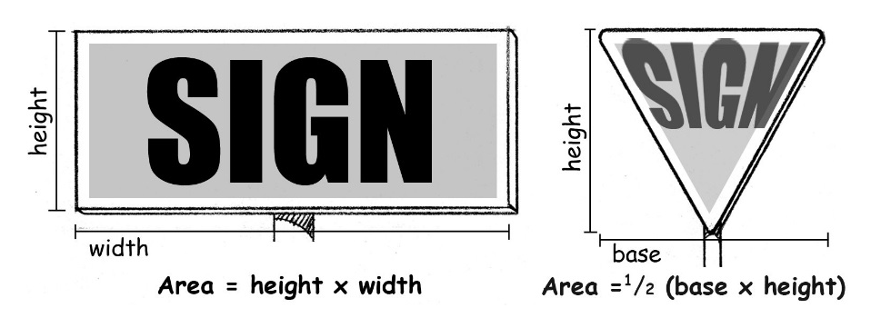
5.15.05.A. Area Measurements.
1.
Except as noted in C., below, the area of a sign shall be measured as the area within a single, continuous perimeter composed of any straight line geometric figure which encloses the extreme limits of writing, representation, emblem, logo, or any other figure of similar character, excluding only the pedestal, poles or other structure necessary to support the sign.
2.
Measurements shall include any frame or other material or color forming an integral part of the display or used to differentiate the sign from the background against which it is placed.
3.
Fractional measurements shall be rounded up to the nearest whole number.
B.
Circle Shapes. The area of a sign that is located entirely within a perfect circle shall use the calculation for the area of a circle.
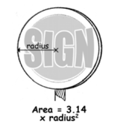
5-15-05.B. Circle Shapes.
C.
Irregular Shapes. In the case of an irregularly shaped sign or a sign with letters and/or symbols directly affixed to or painted on a wall, the area of the sign shall be the area within the perimeter of not more than six (6) straight lines at right angles that enclose the extreme limits of writing, representation, emblem, or any figure or similar character.
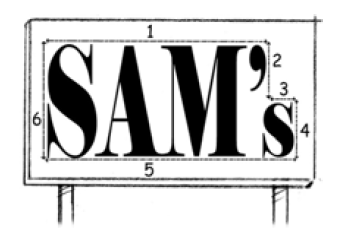
5-15-05.C. Irregular Shapes.
D.
Multiple Faces. The area of a freestanding, ground, or projecting sign that has two (2) or more faces shall be measured by including the area of all sign faces, except if two (2) faces are placed back-to-back, are of equal size, and are no more than twenty-four (24) inches apart at any point, only one (1) face shall be used. If the faces are of unequal size, the larger shall be used.
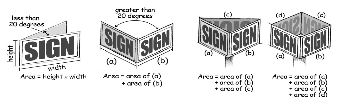
5-15-05.D. Multiple Faces.
E.
Space between Lettering. The sign area shall include vertical and horizontal spacing between letters, characters, emblems, and similar images that convey the sign's message.
F.
Height, Overall. The overall height of a sign or sign structure is measured as the vertical distance from the lowest point of the ground directly below the sign, excluding any artificially constructed earthen berms, to the highest point on the sign or sign structure.
G.
Sign Base. The base or supporting structure of a ground sign shall not count toward the permitted area of the sign, provided it is architecturally distinct from the sign face itself. The base or supporting structure shall be in proportion to the ground sign and may not exceed one hundred (100) percent of the permitted sign area.
H.
Painted Wall Signs. The area of a painted wall sign shall be determined by calculating the area of the smallest square or rectangle that can be drawn around all of the sign elements, including the painted background used to differentiate the sign from the background against which it is placed.
I.
Windows and Doors. Window panes separated by muntins shall not be counted separately as windows but shall be included in the cumulative total square footage of window area of the façade of the building. Measurements shall include and any painted, stenciled, or applied signs on windows, doors or other transparent surfaces regardless of material.
J.
Awning, Canopy or Marquee Signs. The area of a sign that is incorporated into an awning, canopy or marquee shall be determined by calculating the area of the smallest square or rectangle that can be drawn around all of the sign elements. Unless otherwise provided in this Article, if an awning, canopy, or marque has a sign and is back-lit or internal illumination, the entire area of the awning or canopy face shall be counted as the sign area.
K.
Tenant Space Measurements. For those sign types that are measured with respect to tenant spaces, sign area shall be measured by using that portion of the wall associated with that tenant space or storefront, as measured on the front exterior wall of the space.
Sec. 5.15.06. - Sign Restrictions.
A.
Any sign that is not specifically permitted by this Article is prohibited.
B.
Obstructions.
1.
Obstruction of Ingress and Egress. Signs that block ingress or egress from any building, in whole or in part, including those that obstruct any fire escape, required entrance, window, or door opening or that prevent free access to the roof by firefighters.
2.
Obstruct or Impair Vision. Signs that obstruct or impair the vision of motorists, bicyclists or pedestrians at any intersection, driveway, or parking lot or loading area.
3.
A five (5) foot wide clearance area for pedestrians shall be maintained for any sign placed on the ground, as permitted by this Article, such as an A-frame/sandwich board sign.
C.
Movement.
1.
Moving, Spinning, Animated. Signs with any moving, spinning or animated parts, or with the appearance of having any moving, spinning or animated parts, including streamers and pennants.
2.
Flashing, Oscillating, Blinking. Signs employing any flashing, moving, oscillating, blinking, variable intensity of light or color or use intermittent electrical pulsations, except as otherwise allowed by this Article.
3.
Optical Illusion. Signs with optical illusion of movement by means of a design which presents a pattern capable of reversible perspective, giving the illusion of motion or changeable copy, as well as signs that incorporate projected images.
D.
Signs Mimicking Emergency Vehicles, Traffic Signals or Traffic Signs. Signs which would in any way simulate, or could be confused with, the lighting of emergency vehicles, traffic signals, or traffic signs shall be prohibited. There shall be no flashing, oscillating or intermittent, or red, yellow, or green illumination on any sign located in the same line of vision as a traffic control system. Any sign which uses the words "Stop," "Look," or "Danger," or any other shapes, colors, designs, words, phrases, symbols, or characters that interferes with, misleads, or confuses traffic shall be prohibited.
E.
Audible Devices. Signs with audible devices, unless in accordance with Americans with Disabilities Act (ADA) requirements or those required by state or federal safety regulations.
F.
Prohibited Signs. The following signs are prohibited in any Zone District.
1.
Inflatable signs including but not limited to hot or cold air balloons, air-activated devices, or other attention-getting devices.
2.
Human Signs.
3.
Blade Signs.
4.
Snipe Signs. Snipe signs shall not be within, project into, or overhang a public right-of-way, or attached to any telephone pole, light pole, tree, or other objects of a similar nature.
Sec. 5.15.07. - Permitted Signs in All Zone Districts.
A.
Historic Signs.
1.
Historic Painted Signs. A historic business sign that was previously painted on the side(s) of a building prior to November 12, 1969 shall be permitted to remain and to be maintained in its original design, colors, and materials. A historic painted sign shall not be altered without approval of the Director or, if applicable, the Historic Preservation Commission.
2.
Historical Plaques. Historical plaques and signs describing city, state or national designation as an historic site or structure, not exceeding two (2) square feet in area.
B.
Flags.
1.
No more than three (3) such flags shall be permitted on any one (1) lot or lots of common ownership and each flag shall not exceed five (5) feet by eight (8) feet in size.
2.
Flags may either be attached to ground-mounted flag poles anchored in concrete or affixed to a building. The height of the flag pole shall not exceed the height restriction of the Zone District.
3.
Flags, whether ground-mounted or wall-mounted, shall be grouped in a single area of the site or building.
C.
Address Numbers and Street Names. Unless otherwise permitted in this Chapter, address numbers and street names no greater than twelve (12) inches high for residential uses and thirty-six (36) inches high for non-residential uses are permitted.
D.
Holiday Decorations. Holiday decorations for nationally recognized holidays are permitted.
E.
Murals. Murals shall be permitted, provided they:
1.
Do not project more than one (1) foot from the side of a building; and
2.
Do not constitute commercial speech, as determined with reference to the commercial interests of the person or entity that owns the building on which the mural is located.
F.
Official Sign. Official signs shall be permitted in the public right-of-way in all Zone Districts.
G.
Traffic Control Signs. Traffic control signs and signals including regulatory and directional traffic control and street signs erected by a public agency in compliance with Michigan Manual of Uniform Traffic Control Devices, are not subject to the requirements of this Article and shall be permitted in the public right-of-way.
H.
Window and Door Signs.
1.
Any painted, stenciled, or applied signs on windows, doors, or other transparent surfaces, regardless of material, shall not cover more than twenty-five (25) percent of the window, door, or other transparent surface.
2.
Energized window signs, including electronic message boards, changeable message centers, multi-media or computer-controlled variable message signs and similar electronic devices, must comply with Section 5.15.10.C. and the signs permitted in each Zone District.
I.
Vehicle Signs.
1.
Public Transit Vehicles. Public transit vehicles with signs as part of the vehicle shall be stored in a completely enclosed building, unless the storage area is located in an SD-IT District, is otherwise permitted outside of an enclosed building for maintenance or operation, or is completely screened from view.
2.
Vehicle Identification Signs. Vehicles displaying messages shall be parked in assigned loading/unloading areas, and shall not be parked in a location where, in the opinion, of the Director, the purpose is to act as a sign, unless the Director determines that there are no other feasible parking locations on the premises.
J.
Vintage Signs.
1.
Purpose. The purpose of allowing vintage signs is to provide for a contributing resource in historic neighborhoods to be continued either on a contributing site or existing contributing structure. The designation is intended to be limited to locally recognized businesses, institutions, or other significant uses.
2.
The Planning Commission may designate a vintage sign through the Optional Review Process (Section 5.12.14.) either by application or upon the City's initiative. Applicants requesting approval shall have a legal interest in either the sign or the property on which the sign is to be placed/ or located.
3.
The Planning Commission may designate a sign as a vintage sign provided the following criteria are met:
a.
The Review Standards of Section 5.12.14.E.
b.
The Planning Commission shall determine the sign to be of importance within the historic context of the immediate neighborhood whether of local, state, or national significance.
c.
The Planning Commission shall make a determination that the sign does, or will, meet the safety and maintenance requirements of Section 5.15.04.F.2. within six (6) months of designation.
4.
The sign shall be located so as to not confuse drivers, pedestrians, or bicyclist as to the location of any active use whether adjacent or on the site. To this end, the Planning Commission may require relocation of the sign to another location on the same property. Any request for a different location on the property shall require another application.
5.
If the vintage sign is to be relocated, it shall be placed at least ten (10) feet from any property line, not interfere with any required landscape or parking area, or impede visibility of any other permitted sign.
6.
The sign shall not refer to any currently active use or use operating within the previous six months, either on the property on which the sign is placed or any other use within the city to which the sign refers.
7.
Once approved as a vintage sign, no other application for a vintage sign may be approved for the same property. Nor may the sign be altered or in any way except as may be necessary for necessary maintenance in accordance with the provisions of Section 5.15.05.F. If removed, any subsequent sign shall meet the requirements of this Article.
K.
Driveway Signs.
1.
The maximum sign area shall not exceed four (4) square feet, or three (3) feet high. Driveway signs within fifteen (15) feet of the right-of-way shall conform to Clear Vision requirements of Section 5.2.15.
2.
The signs may contain directional information, such as arrows and/or messages such as "Enter," "Exit," or similar.
3.
Driveway signs may be externally- or internally-illuminated in the TN-TOD, MCN-C, SD-IT, SD-IC, and OD-EBL Districts. Illumination is not permitted in any other Zone District.
4.
Illuminated driveway signs require a sign permit.
(Ord. No. 2021-22, § 2, 7-27-21)
Sec. 5.15.08. - Planned Sign Program.
A.
In lieu of the specific sign requirements of a particular Zone District, the Planning Commission may review and approve a Planned Sign Program for signs in all Zone Districts.
B.
Purpose. The purpose of a Planned Sign Program is to allow a greater degree of flexibility in sign design and display in cases where strict compliance with the requirements of this Chapter may not be feasible. Further, a Planned Sign Program is intended to be used for multiple signs for large project development areas and integrated complexes to ensure that the requested signs work in a coordinated fashion to meet the general intent for signs in the District.
C.
Intent.
1.
The Planning Commission shall have the authority to approve alternative requirements for sign design, number, type, size, height, location, and lighting, provided that the applicant fulfills the Standards for Approval in E. below.
2.
This Section shall not be used to circumvent the sign variance process or to simply permit larger, more visible, or additional signs than may otherwise be permitted by this Article, without any consideration for unique sign design and display or other conditions.
D.
Procedures.
1.
Eligibility. A Planned Sign Program may be approved only for integrated complexes and project sites larger than two (2) acres in size.
2.
A Planned Sign Program shall be approved through the Optional Plan Review procedures of Section 5.12.14.
3.
Applications for a Planned Sign Program shall include, at a minimum, the following materials.
a.
A narrative description indicating:
i.
A statement demonstrating that the eligibility requirements are met.
ii.
The general design intent for proposed signs.
iii.
A description of how the signs are coordinated with proposed building architecture and compatibility with the surrounding development context.
iv.
A demonstration of how the requested Planned Sign Program fulfills the Standards for Approval of E., below.
b.
The proposed locations, types, number, heights, and sizes of all signs, indicated on scaled plans and/or building elevation drawings.
c.
Proposed materials, fabrication details, and illumination proposed for sign structures and faces.
4.
The decision of the Planning Commission shall be final and may not be appealed to the Board of Zoning Appeals. However, the applicant may elect to submit a sign variance application to the Board of Zoning Appeals.
E.
Standards for Approval. The application shall have the obligation to demonstrate, and the Planning Commission shall find, that all of the following are met before a Planned Sign Program may be approved.
1.
That the Planned Sign Program would result in a more attractive aesthetic setting, improved safety, provide more convenient identification for planned users, or other similar purposes that would not be achievable without deviations from the specific sign requirements of the Zone District;
2.
That the location and/or physical characteristics of the applicant's property or the needs for identification are unique when compared to other similarly situated parcels in the same Zone District and in the same vicinity;
3.
That the proposed Planned Sign Program substantially furthers the Purposes and Intent of Section 5.15.01.; and
4.
That approval of the Planned Sign Program would not create any adverse effects on one or more properties in the vicinity.
F.
Amendments.
1.
Minor modifications to a previously approved Planned Sign Program may be approved through the Director Review procedures of Section 5.12.16. provided the general sign design, number of signs, and dimensional requirements are maintained. Minor modifications include:
a.
Changes in sign location of not more than five (5) feet;
b.
Changes to sign faces, provided that the face is no larger and materials are consistent with the approved sign; and
c.
Changes to landscaping and lighting.
2.
An amendment to an approved Planned Sign Program not qualifying as a minor modification per Section 5.15.08.F.1. shall be reviewed by the Planning Commission using the Site Plan review process, including the option of a public hearing under the provisions of Section 5.12.08.D.4., and the standards of Section 5.15.08.E.
(Ord. No. 2018-32, §§ 8, 9, 6-5-18)
Sec. 5.15.09. - Community Event Signs.
A.
Purpose and Applicability.
1.
The City finds that in certain circumstances it is in the interest of public safety to permit certain signs to highlight events that may draw attendance from areas outside the immediate neighborhoods and locations where the event is planned.
2.
In these named instances, signs for City-recognized events may be permitted within the City right-of-way on a temporary basis to avoid confusion for citizens and permit adequate directional information for planned events.
3.
The City shall not be responsible for the cost of production, erection, maintenance, or removal of event signs.
B.
Community Events.
1.
The sponsors and participants of community special events operating under a special events permit issued by the City Manager for City-sponsored or supported events may erect additional temporary signs or banners in a manner that is not otherwise consistent with this Article for the duration of the event in accordance with the applicable City policies governing special events. (See City Commission Policy 1100-05 Special Events.)
2.
This requirement recognizes the variety and scale of community events covered by the City Commission's policy. These events may attract large numbers of people who are not familiar with the city and may require additional directional and other related signs to ensure that driver confusion is minimized and traffic is directed to the proper parking and event sites.
3.
Sign locations, types, number, and size shall be approved by the City Manager. Sign permits are not required.
C.
City Sports Events.
1.
The City may permit sponsors and participants of special events operating under a special events permit issued by the City Manager to erect additional signs or banners in accordance with the applicable City policies governing special events (City Commission Policy 1100-05 Special Events).
2.
Sign locations, types, number, and size shall be approved by the City Manager. Sign permits are not required.
Sec. 5.15.10. - Changeable Copy Signs.
A.
General. Changeable copy signs may be manual or electronic, and shall comply with the maximum area and site location requirements of the applicable Zone District.
B.
Changeable Portion of Sign.
1.
The changeable copy portion of a ground, pylon or wall sign shall not exceed fifty (50) percent of the total sign area and shall be integral to the sign cabinet. The remainder of the sign shall be of a permanent character as otherwise required under this Chapter. Temporary portable signs shall be exempt from this requirement.
2.
Window Sign. A changeable copy sign located in a window shall not exceed twenty-five (25) percent of the window area nor be more than three (3) square feet in area and must comply with all other provisions of this Chapter.
C.
Electronic Signs.
1.
Display Regulations.
a.
Scrolling or traveling of a message onto and/or off of the display shall be allowed; provided the message is coming from one (1) direction only and that no message shall take more than five (5) seconds to be displayed in its entirety. Once scrolled, the screen may not change for five (5) minutes.
b.
If non-scrolling, the screen of the sign shall not change more than once every five (5) minutes, and shall remain in a stationary state for at least five (5) minutes.
c.
The display shall not, or shall not appear to, flash, undulate, pulse, or portray explosions, fireworks, flashes of light, or blinking or chasing lights; the display shall not appear to move toward or away from the viewer, expand or contract, bounce, rotate, spin, twist or other similar movements.
d.
All electronic signs in any residential Zone District or within one hundred fifty (150) feet of a residential Zone District that are directly visible from a residential use shall discontinue the display between the hours of 11:00 p.m. and 6:00 a.m.
2.
Light Level Requirements.
a.
To prevent glare, electronic signs shall not operate at a brightness level greater than the manufacturer's recommended levels, except as provided in this or other City Codes.
b.
All signs shall have installed ambient light monitors and shall at all times allow such monitors to automatically adjust the brightness level of the electronic sign based on ambient light conditions.
c.
Maximum brightness levels for electronic signs shall not exceed five thousand (5,000) nits when measured from the sign face at its maximum brightness during daylight hours, and five hundred (500) nits when measured from the sign face at its maximum brightness between dusk and dawn.
3.
Approvals.
a.
Director Review. In Residential Zone Districts the Director may approve, under the provisions of Section 5.12.16., electronic signs that are integral to a ground sign of thirty-two (32) square feet or less, and all of the following requirements are met.
i.
The electronic portion is thirty-five (35) percent or less of the overall sign area;
ii.
The electronic display is thirteen (13) square feet or less; and
iii.
The sign is at least one hundred seventy-five (175) feet from an adjacent residential use.
b.
Permitted Use. Electronic signs are permitted as of right in the TN-TBA, MCN-C, and MON-C Zone Districts, subject to the applicable provisions of this Article.
c.
Special Land Use. A Special Land Use approval under the provisions of Section 5.12.09. shall be required for the following:
i.
Electronic signs not qualifying for Director Review.
ii.
Any electronic sign referred by the Director, regardless of the qualification for a Director Review.
iii.
In Mixed-Use Commercial Zone Districts, electronic signs within three hundred (300) feet of any residentially zoned lot sharing the same street frontage.
iv.
All electronic signs in the MCN-TOD, MON-TOD, and NOS Zone Districts.
d.
Prohibited. Electronic signs are not permitted in the TN-CC, TN-TCC, and TN-TOD Zone Districts.
4.
Additional Requirements.
a.
Permitting.
i.
All electronic signs require a sign permit.
ii.
Electronic sign permit applications shall include a copy of the manufacturer's specifications for luminosity and a certification from the owner or operator of the sign stating that the sign shall be operated in accordance with City Codes and that the owner or operator shall provide proof of conformance upon request of the City.
iii.
An electrical permit shall be obtained prior to the issuance of a sign permit.
b.
If the sign is programmed from the site or from a remote location, the computer interface that programs the sign shall be available to City staff for inspection upon request. The sign shall cease operation if the computer interface is not immediately available.
c.
No lot, including abutting parcels under common ownership, shall be permitted more than one (1) electronic sign.
(Ord. No. 2018-32, § 10, 6-5-18)
Sec. 5.15.11. - Signs in Residential Zone Districts.
A.
Neighborhood Character. As described in Section 5.15.01., it is the intent of this Section to reinforce and enhance the unique character of each of the City's Residential Zone Districts in an appropriate manner, while at the same time permitting sufficient methods to allow a freedom of expression for individuals. Typical lot size, lot width, building placement and building scale elements define the physical form of a neighborhood. An excessive number of signs, excessive sign size and improper placement can create visual clutter that detracts from other important neighborhood design elements that establish an area's sense of place. Signs that are appropriately sized based on the physical attributes of a neighborhood (lot size, building placement, etc.) can strengthen community character and serve as important component in establishing neighborhood identity.
B.
Residential Zone Districts. Table 5.15.11.B. pertains to signs in Residential Zone Districts, as described in Article 5. The table does not contain all sign requirements applicable to the Zone Districts. Signs shall comply with all other applicable requirements of this Chapter. Sign types are defined in Section 5.15.17.
Sec. 5.15.12. - Signs in Mixed-Use Commercial Zone Districts.
A.
Commercial Character. As initially described in Section 5.15.01., it is the intent of this Section to reinforce and enhance the unique character of each of the City's Mixed-Use Commercial Zone Districts in an appropriate manner. Typical lot size, lot width, building placement and building scale elements define the physical form of a neighborhood. An excessive number of signs, excessive sign size and improper placement can create visual clutter that detracts from other important neighborhood design elements that establish an area's sense of place. Signs that are appropriately sized based on the physical attributes of a neighborhood (lot size, building placement, etc.) can strengthen community character and serve as important component in establishing neighborhood identity.
B.
Mixed-Use Commercial Zone Districts. Table 5.15.12.B. pertains to signs in Mixed-Use Commercial Zone Districts, as described in Article 6. The table does not contain all sign requirements applicable to the Zone Districts. Signs shall comply with all other applicable requirements of this Chapter. Sign types are defined in Section 5.15.17.
(Ord. No. 2018-32, § 11, 6-5-18)
Sec. 5.15.13. - Signs in Special and Overlay Districts.
A.
Special Districts and Overlay Districts. Table 5.15.13.A. pertains to signs in Special and Overlay Zone Districts, as described in Articles 7 and 8. The table does not contain all sign requirements applicable to the Zone Districts. Signs shall comply with the requirements listed, as well as all other applicable requirements of this Chapter. Sign types are defined in Section 5.15.17.
B.
Planned Redevelopment District. Planned Redevelopment District Sign Requirements.
1.
Planned Sign Program. Unless otherwise provided in the resolution approving a particular Planned Redevelopment District (PRD), signs hereafter erected in a PRD shall be governed by the rules and requirements of the approved PRD, and of an established Zone District, as assigned by the Planning Commission. The assigned Zone District regulations shall be referred to as the Planned Sign Program. The Planning Commission shall evaluate the adjacent Zone Districts in the same Neighborhood Classification for consistency and compatibility in making its determination.
2.
Owner or Manager Approval. All sign permit requests shall include evidence of approval by the property owner or facility manager to submit the permit application.
3.
Existing Signs. Sign program amendment review shall consider existing signs prior to approval or denial of program change.
4.
Change in Copy. The change of copy on a sign, or the substitution of one (1) sign for another, shall not require an amendment to a Planned Sign Program if the change or substitution is limited in effect to changing the identification of a business activity, and the new or altered sign conforms in all other respects to the approved Planned Sign Program.
5.
Deviations from Planned Sign Program.
a.
Deviations from an approved Planned Sign Program shall be reviewed by the Planning Commission under the Minor Deviation procedures as provided in Section 5.12.12.I.2. No public hearing shall be required. However, the Planning Director or Planning Commission may send such notices of the pending action and receive such comments from surrounding property owners and occupants or other interested persons as either the Planning Director or Planning Commission deems appropriate.
b.
The decision of the Planning Commission may not be appealed to the Board of Zoning Appeals.
Sec. 5.15.14. - Permits, Application Requirements, and Approval.
1.
The purpose of this Section is to set forth procedures and standards for processing sign permit applications.
2.
Sign Permit. Except as provided elsewhere in this Chapter, it shall be unlawful for any person to erect, place, install, display, alter, or relocate a sign without first obtaining a sign permit or permits. A sign permit shall not be issued if the site has existing, unresolved sign violations per the regulations of this Chapter.
3.
Permit Not Required. A sign permit shall not be required under the following conditions.
a.
Maintenance and Repairs. Maintenance and repair includes painting of chipped or faded signs; replacement of faded or damaged surface panels; or repair or replacement of electrical wiring and electrical devices provided the size, structure or cabinet are not changed or removed. An electrical or other City permit may be required.
b.
Exempt Signs. The following signs must comply with all relevant provisions of this Article, but shall not require a sign permit:
i.
Driveway signs without illumination.
ii.
Incidental signs not exceeding two (2) square feet in total area.
iii.
Integral identifiers.
iv.
Murals with no commercial message.
v.
Official signs.
vi.
Residential temporary event signs.
vii.
Commercial temporary event signs twenty (20) square feet or smaller.
viii.
Historical plaques.
c.
Re-faced Signs. A sign permit and fee is required to reface off-premise signs. For other signs, a sign permit and a sign permit fee are not required to be issued if the sign is refaced in a manner that maintains the display on the sign as approved by the original permit. However, a sign permit application is required for the City's records.
4.
Sign Permit Application. To obtain an approved sign permit, a complete application for a sign permit shall be filed by, or with the written consent of, the property owner on a form provided by the City, and shall be accompanied by the following information.
a.
Sign Inventory. Photographs, and descriptions of the type and dimensions, square footage, materials and copy of all other existing signs on the site, keyed to the site plan by a number or letter.
b.
Proposed Signs. A graphic representation of all proposed signs, including dimensions, square footage, dimensions of letters and figures, colors, materials, copy, landscaping, and illumination or movement characteristics, if any, keyed to the site plan by a number or letter.
c.
Site Plan. In addition to the sign information, a site plan shall be provided that identifies the locations of all existing and proposed signs, all existing and proposed buildings, parking areas, vehicular access ways and landscaping.
d.
Sealed Plans. Sealed construction plans, stress sheets and calculations, and other construction information, for freestanding signs fifteen (15) feet or higher or one hundred (100) square feet in area or more and for other installations as required by the City Building Official. A minimum of two (2) sets of such plans and specifications are required, bearing the signature and seal of a registered Michigan architect or engineer who shall assume responsibility for their design.
e.
Performance Guarantee. If required, a performance guarantee shall be submitted in accordance with the provisions of Section 5.14.04.
5.
Application Review.
a.
Determination. The Director shall determine whether the proposed sign or sign program is in compliance with this Article and whether the purposes and objectives of this Article have been met. The determination will be based on a review of site plans, landscaping, clear vision areas, parking locations, drives, setbacks, relationship of proposed location to immediate or surrounding areas for proper sign placement, and other applicable requirements of this Chapter.
b.
Approval. The Director or designee, may approve, conditionally approve subject to modifications, or disapprove any application for a sign permit, subject to the following standards:
i.
Whether the requirements of this Chapter have been satisfied.
ii.
A finding is made that the sign will not adversely affect or be materially detrimental to adjacent uses, buildings or structures, taking into consideration site development, landscaping, construction, and material of exteriors, other signs, exterior lighting, uses, occupancy, density, and the entire development plan.
iii.
The sign placement, scale, shape, illumination, size, letter styles, or other design aspect are architecturally appropriate and compatible in relation to the development on and adjacent to the site of the proposed sign.
6.
Duration of Approval.
a.
A sign permit shall be considered approval to proceed with the work specified in the permit.
b.
The approved permit shall expire and become null and void if the work authorized under such permit is not commenced within one hundred eighty (180) days from the date of issuance. After this period, the City shall consider the application withdrawn and may destroy any application and plans pertaining to the application.
c.
Upon written request prior to the date of expiration, the Director may grant one (1) extension of up to one hundred eighty (180) days if the applicant can demonstrate that the reasons for the extension were beyond their immediate control.
Sec. 5.15.15. - Sign Variances.
A.
Authority.
1.
The Board of Zoning Appeals (BZA) is authorized to hear and decide requests for variances to sign requirements. The BZA shall process the request with the same application and hearing requirements of Section 5.13.03.
2.
In deciding a sign variance application, the BZA shall state the reasons that justify the approval or denial of the variance. The BZA may attach conditions of approval regarding the location, character or other features of the proposed sign as it deems reasonable. The BZA shall evaluate a sign variance application using the review standards of B. below.
3.
The decision of the BZA shall be final. However, any person being an aggrieved party affected by the decision shall have the right of appeal to the Kent County Circuit Court, as provided in the Zoning Act and Circuit Court procedures.
B.
Review Standards for Sign Variances. A sign variance shall only be granted where exceptional practical difficulties prevent the strict application of the requirements of this Chapter. A sign variance may be allowed by the BZA only in cases where all of the following conditions are met.
1.
Exceptional or Extraordinary Circumstances or Conditions. There are exceptional or extraordinary circumstances or conditions applying to the property for which the sign is intended that do not apply generally to other properties in the same Zone District or in the neighboring area. Exceptional or extraordinary circumstances or conditions may include:
a.
Shape of Lot. A sign could not be placed in a required location due to the physical shape, topography or other physical condition of a lot or to the location of an existing structure.
b.
Environmental Conditions. A sign could not be placed in the required location without removing or severely altering natural features, such as trees, topography, drainage courses or encroaching upon stormwater facilities.
c.
View Obstructions. A sign could not be reasonably seen by passing motorists due to the configuration of existing buildings, trees, signs or other obstructions on an abutting property.
d.
Motorist Safety. A sign could not be seen by passing motorists in sufficient time to allow safe deceleration and turning movements. The BZA shall consider the width of the road, driveway locations, number of moving lanes, volume of traffic, and speed limits.
2.
Substantial Property Right. The variance is necessary for the preservation of a substantial property right similar to that possessed by other properties in the same Zone District and in the neighboring area. Increased costs associated with complying with this Chapter shall not be considered as a basis for granting a Variance.
3.
Not Self-Created. The immediate practical difficulty causing the need for the variance was not created by the applicant or any person having an interest in the sign, sign structure, or property.
4.
No Substantial Detriment. Granting the variance will not be detrimental to the public welfare, be injurious to other properties or improvements, endanger public safety, or substantially diminish or impair property values in the area.
5.
Master Plan/Zoning Ordinance. The variance will be consistent with, and not materially impair, the purpose and intent of this Article, the regulation that is the subject of the variance, the Master Plan, and the Zoning Ordinance and Zone District.
Sec. 5.15.16. - Enforcement and Fees.
A.
Enforcement. The City may use any lawful remedy or enforcement powers against the owner or responsible person for any violation of this Article, as described in Article 14 Administration and Enforcement.
B.
Fees. Fees shall be charged for the following services:
1.
Sign Permit Fees. Before issuance of any required sign permit, the City shall collect an application fee in accordance with a fee schedule adopted by resolution of the City Commission.
2.
Second and Additional Inspections. An additional inspection fee shall be charged if more than one (1) inspection is needed or requested to determine compliance with this Article. Second and additional inspections include but are not limited to: Court requested, Attorney requested, progress inspection, inspection at the request of the owner or responsible person, or any inspection in addition to the first inspection. The sign permit fee includes the cost of the first inspection and additional fees as permitted by this Section may be collected for second and additional inspections.
3.
Work without a Permit. Any work started without a permit, or any work beyond the authorized scope of a sign permit constitutes a violation and is grounds for the designated enforcement staff to issue a notice of violation (NOV), a cease and desist order, or other enforcement actions until appropriate permits are obtained. Any permit that would be required based on the work conducted shall subject the owner or responsible person to a doubling of the normal permit fee. However, this action will not exempt any person from compliance with all other provisions of this Section nor from any penalty prescribed by law.
4.
Sign Permit and Inspection Fee Schedule. The following sign permits and inspection services are hereby authorized, and fees established by resolution of the City Commission:
a.
Sign Permit;
b.
Sign Permit - Rework;
c.
Sign Permit - Work Started without a Permit;
d.
Temporary Sign Permit;
e.
Other fees as noted in Section 5.14.11.
5.
Responsible Person. The owner or responsible person shall be responsible for the payment of fees associated with sign permits, inspection services and code enforcement actions related to bringing a sign(s) into compliance with this Article.
C.
Declaration of Nuisance. Any sign installed, altered or maintained in violation of any provision of this Article constitutes a public nuisance per se and is subject to abatement pursuant to Section 5.14.07.
D.
Confiscated Signs.
1.
Any cost incurred by the City for the removal, alteration or relocation of a sign pursuant to the provisions of this Article shall be paid prior to the issuance or renewal of any permit for that property.
2.
Signs removed by City personnel shall be held for ten (10) days. An owner or responsible person may claim the sign within ten (10) days of removal, provided that any costs associated with the sign removal have been paid to the City. After ten (10) days, the City shall be permitted to destroy the sign.
E.
Appeals. The BZA may hear an administrative appeal taken from any person or any governmental official affected or aggrieved by any order, requirement, decision, or determination, as permitted by this Chapter.
Sec. 5.15.17. - Sign Definitions.
The following words, terms and phrases, when used in this Article, shall have the meaning provided below, except where the context clearly indicates a different meaning. The provisions of Section 5.16.01. Rules of Construction and other applicable definitions of Article 16 Definitions shall apply to this Article.
A.
Sign Definitions - A.
ABANDONED SIGN
A sign for which no legal owner can be found, or which contains a message referring to a former use of land on the lot on which the sign is located.
A-FRAME SIGN
A sandwich board or tent sign which is not permanently affixed to a structure or to the ground. Synonymous with Sandwich Board Sign.
AWNING SIGN
A sign affixed flat against the surface of an awning.
B.
Sign Definitions - B.
BANNER/BANNER SIGN
A sign of non-rigid fabric, cloth, or other durable material that is mounted to a pole or a building by a permanent frame at one (1) or more edges without an enclosing structural framework.
BLADE SIGN
A ground mounted, anchored or attached to the ground by a pole. May also be known as feather flags, swoopers, tear drop banners, or other similar names.
BILLBOARD
See Off-Premises Sign.
BILLBOARD EXTENSION
Any temporary attachment or addition to the sign face area that extends beyond the dimensions of the existing sign face area.
BUILDING DIRECTORY SIGN
A directory sign that directs visitors to one (1) or more establishments located above or below the ground floor level of the building, or where the building contains a central arcade that services multiple establishments that do not have street frontage.
BULLETIN
A type of off-premises sign (billboard) that is larger than a poster and typically between 378 sq. ft. (10'6" x 36') and 672 sq. ft. (14' x 48') in area per sign face.
C.
Sign Definitions - C
CANOPY SIGN
Any sign that is part of or attached to a canopy over a door, entrance, window, or outdoor service area. "Canopy" is not included in the meaning of the terms marquee or awning.
CHANGEABLE COPY SIGN
A sign or portion thereof with characters, letters, or illustrations that can be manually or electronically changed or rearranged without physically altering the face of the surface of the sign. See also ELECTRONIC SIGN.
COMMERCIAL MESSAGE
See SPEECH, COMMERCIAL and NONCOMMERCIAL
COMMUNITY EVENT SIGN
Signs approved by the City Manager for City recognized events.
CONTRIBUTING RESOURCE
Any building, structure, object or site, or archaeological value for which a historic property or historic district is significant and is identified as such on the Contributing Resources Map of the Historic Preservation Plan for the historic district or historic property.
CONTRIBUTING SITE
Any site which adds to the historic, architectural, or archaeological value for which a historic property or historic district is significant and is identified as such on the Contributing Resources Map of the Historic Preservation Plan for the historic district or historic property.
CONTRIBUTING STRUCTURE
Any structure which adds to the historic, architectural, or archaeological value for which a historic property or historic district is significant.
D.
Sign Definitions - D
DEVELOPMENT ENTRY SIGN
A freestanding sign on the same property as a residential subdivision, site condominium development, apartment community, group living facility, manufactured housing community, or other similar development, that contains eight (8) or more units or lots.
DIGITAL BILLBOARD
A type of off-premises sign (billboard) that incorporates an electronic changeable copy sign face.
DRIVEWAY SIGN
An on-site sign near driveways, within parking areas, or within development sites to assist with the location and flow of travel for vehicles or pedestrians.
E.
Sign Definitions - E
ELECTRONIC SIGN
Electronic message boards and changeable message centers, multi-media or computer-controlled variable message signs, and similar devices.
EVENT SIGN
A sign necessary to identify or direct individuals to the location of an event or activity. See also COMMUNITY EVENT.
F.
Sign Definitions - F
FREESTANDING SIGN
A sign placed on or affixed to the ground that is independent from any building or other structure, such as pylon/pole or ground signs.
G.
Sign Definitions - G
GOVERNMENTAL SIGN
A sign erected, required, or permitted to be erected by a local government, county, or the state or the federal government.
GROUND SIGN
A freestanding sign resting directly on the ground, or on a base or supported by short poles, and not attached to a building or wall, the bottom of which is no more than twenty-four (24) inches above the finished grade.
H.
Sign Definitions - H
HUMAN SIGN
A sign held or displayed by a person, and unattached to any permanent or temporary structure.
I.
Sign Definitions - I
ILLUMINATED SIGN
Any sign lighted by, or exposed to, artificial lighting either by light on or in the sign, or directed toward the sign.
INCIDENTAL SIGN
A sign that conveys information not intended to be legible from off the site.
INTEGRAL IDENTIFIERS
Typically includes names of buildings, dates of erection, monumental citations, or commemorative tablets carved into stone, concrete or similar material or made of bronze, aluminum or other noncombustible material.
J.
Sign Definitions - J
Reserved for Future Use
K.
Sign Definitions - K
Reserved for Future Use
L.
Sign Definitions - L
LOGO
A non-text graphic representation of a trademark, or symbol, emblem, figure, element, abbreviation, etc., uniquely designed for recognition.
M.
Sign Definitions - M
MARQUEE SIGN
A sign attached to or made a part of a marquee.
MULTI-MEDIA SIGN
A sign with alternating messages accomplished by electronic projection or similar means. See CHANGEABLE COPY SIGN and ELECTRONIC SIGN.
MURAL
A work of art or architectural detail, generally directly painted on a portion of a permanent structure.
N.
Sign Definitions - N
NEON TUBING
Electric discharge tubing manufactured in shapes that form letters, parts of letters, skeleton tubing other decorative elements, and filled with various inert gases. Exposed neon tubing is considered a sign if not used as architectural lighting, as described in Section 5.2.19.E.
NONCOMMERCIAL MESSAGE
See SPEECH, COMMERCIAL and NONCOMMERCIAL
NONCONFORMING SIGN
A sign lawfully erected prior to the effective date of this Chapter, or amendments thereto, and which does not currently conform to the current sign regulations.
O.
Sign Definitions - O
OFFICIAL SIGN
A public notice sign or warning sign required by a valid and applicable federal, state or local law, regulation or by order of a court of competent jurisdiction, including signs for essential services, governmental purposes and utility identification.
OFF-PREMISES SIGN
A sign that may include a commercial message relating to an establishment, organization, product, service, event, entertainment, or activity which is not located, sold, offered, produced, manufactured or furnished on the property (lot) on which the sign is located. Synonymous with BILLBOARD.
ON-PREMISES SIGN
A sign with a commercial message pertaining solely to the use of the property on which it is located such as to an establishment, product, merchandise, good, service or entertainment which is located, sold, offered, produced, manufactured or furnished on that property. It does not include any sign leased, rented or used by or to advertise the products, accommodations or activities not conducted or available on the premises.
P.
Sign Definitions - P
PAINTED WALL SIGN
A sign painted directly on a building or on material which is then attached to a building.
PARKING FACILITY SIGN
A sign located at the entrance to a commercial parking facility as defined in Section 7.201 of the City Code.
PENNANT
Any lightweight plastic fabric, or other material suspended from a rope, wire, or string, usually in a series, often designed to move in the wind.
PERMANENT SIGN
Any sign intended to remain in place by being securely attached or installed upon a building, structure, or the ground.
POLE SIGN
See PYLON SIGN.
PORTABLE SIGN
A sign designed to be easily relocated to a different site. This definition includes trailer mounted signs with interchangeable letters.
PORTAL SIGN
An overhead sign installed parallel to the street at a main entrance or exit to a parking lot or structure.
POSTER
A type of off-premises sign (billboard) that is typically 253 square feet (11' x 23') in area per sign face.
PROJECTING SIGN
A sign attached to a building or wall that extends outward and is perpendicular (generally at or near a ninety (90) degree angle) to the building or wall to which it is attached.
PYLON SIGN
A freestanding sign supported on a pole or poles and not attached to a building or wall. Synonymous with Pole Sign.
Q.
Sign Definitions - Q
Reserved for Future Use
R.
Sign Definitions - R
RACEWAY
An elongated metal enclosure used to mount individual channel lettering and to conceal related transformers and wiring.
RE-FACING
Any alteration to the face of a sign involving the replacement of materials or pans. Re-facing does not refer to replacing the entire sign structure or the removal of the sign.
RESIDENTIAL SIGN
Signs displayed on single and two-family individual lots in residential Zone Districts.
ROOF LINE
For a pitched roof, the roof line is the lower edge of the eave; for a flat roof, the roof line is the uppermost line of the roof of a building; and for an extended façade or parapet, the roof line is uppermost height of the façade or parapet.
ROOF SIGN
A sign erected or extending above the roof line of a building.
S.
Sign Definitions - S
SANDWICH BOARD SIGN
See A-FRAME SIGN.
SIGN
Any name, number, symbol, identification, description, display, illustration, object, graphic, sign structure, or part thereof, whether permanent or temporary, which is affixed to, painted on, represented directly or indirectly upon, or projected onto a building, structure, lot, or other device, whether mobile or affixed to the ground, and which directs attention to any object, product, place, activity, person, institution, organization, or business.
SIGN STRUCTURE
A structure specifically intended for supporting or containing a sign; including but not limited to supports, uprights, bracing, lighting, and framework.
SIGN SURFACE/SIGN FACE
The surface intended for the display of information on the sign.
SNIPE SIGN
A sign of any size, made of any material, and attached to a tree, pole, fence or other object.
SPEECH, COMMERCIAL AND NONCOMMERCIAL
1.
COMMERCIAL SPEECH. Speech by an economically motivated speaker, the purpose of which is to encourage a commercial transaction. Commercial speech may have artistic value or pertain to issues of public importance. Soliciting charitable donations is not commercial speech.
2.
NONCOMMERCIAL SPEECH. All speech that does not qualify as commercial speech.
SPORTS SPONSORSHIP SIGN
An accessory sign that is within the confines of a ball field, golf course, or park owned and operated by the City of Grand Rapids, used by the public for athletic activities.
STREAMER
A ribbon-shaped or cord-like rope which may have pennants and/or banners attached and which is stretched or hung between two (2) or more supports.
SUPER SIGN
A type of off-premises sign (billboard) that exceeds 672 square feet in area per sign face and is not a freestanding sign.
T.
Sign Definitions - T
TEMPORARY SIGN
A sign not permanently attached to the ground, a structure, or a building and is not supported by a permanent frame. Temporary signs include but are not limited to: banners, portable signs and any other non-permanent sign.
TEMPORARY EVENT SIGN
A sign used to direct pedestrian and vehicular traffic and identify event locations for special events.
TRAFFIC CONTROL SIGN
A sign or signal including regulatory and directional traffic control and street signs erected by a public agency in compliance with Michigan Manual of Uniform Traffic Control Devices.
U.
Sign Definitions - U
UPPER LEVEL BUILDING IDENTIFICATION SIGN
A sign located above the ground floor level to identify a building, owner or principal tenant, but not including the building address (see Section 5.15.07.C.).
V.
Sign Definitions - V
VINTAGE SIGN
Any sign which contributes to the historic or architectural character of a property, neighborhood or zone district and that refers to a business, residence, structure or use that is no longer in existence.
W.
Sign Definitions - W
WALL SIGN
A sign painted on, or attached directly to an exterior wall, and parallel to the exterior wall of a building, extending not more than eighteen (18) inches from the wall to which it is attached.
WINDOW SIGN
Any sign affixed to or within twelve (12) inches of the interior or exterior of a window and which is intended to be seen by the public from the outside.
X.
Sign Definitions - X
Reserved for Future Use
Y.
Sign Definitions - Y
Reserved for Future Use
Z.
Sign Definitions- Z
Reserved for Future Use
(Ord. No. 2021-22, §§ 4, 5, 7-27-21; Ord. No. 2023-37, § 4, 8-8-23)
Sec. 5.16.01. - Rules of Construction and Organization.
A.
The following words, terms and phrases, when used in this Article, shall have the meanings ascribed to them in this Chapter, except where the context clearly indicates a different meaning.
B.
Rules of Construction: The following rules of construction apply to this Chapter:
1.
The language of this Chapter shall be read literally. Regulations are no more or less stringent than stated.
2.
The particular shall control the general. For terms used in this Chapter, the use of a general or similar term shall not be taken to be the same as the use of any other specific term.
3.
In case of any difference of meaning or implication between the text of this Chapter and any caption or illustration, the text shall control.
4.
A building or structure includes any part thereof.
5.
The term "used" includes the following meanings when used in context with the following terms: arranged, designed, constructed, altered, rented, leased, sold, occupied, and intended to be occupied.
6.
Unless the context clearly indicates the contrary, where a regulation involves two (2) or more items, conditions, provisions or events connected by the conjunctions "and," "or" or "either . . . or," the conjunction shall be interpreted as follows:
a.
"And" indicates that the connected items, conditions, provisions or events apply.
b.
"Or" indicates that the connected items, conditions, provisions or events may apply singly or in any combination.
c.
"Either … or" indicates that the connected items, conditions, provisions or events apply singly but not in combination.
7.
Unless otherwise specified, a "day" as used in this Chapter shall be a calendar day. If a deadline or required date of action falls on a Saturday, Sunday, or holiday observed by the City, the deadline or required date of action shall be the next day that is not a Saturday, Sunday, or City-observed holiday.
8.
Unless otherwise stated, all calculations that result in a part or fraction of a whole number shall be rounded up to the next highest whole number.
9.
Any reference to Chapter, Article or Section shall mean Chapter, Article or Section of Chapter 61 of the City Code, Zoning Ordinance, unless otherwise specified.
10.
Terms not defined in this Chapter shall be given their ordinary and common meaning. Where not otherwise evident, terms shall have the meaning given in the latest edition of Merriam Webster's Collegiate Dictionary.
Sec. 5.16.02. - Definitions.
A.
Definitions—A.
ABUTTING or ABUTS
The condition of two (2) adjoining parcels having a common property line or boundary but not including lots separated by a street or alley. See ADJACENT.
ACCESSORY STRUCTURE
A building or structure that is subordinate in use and square footage to the principal use of land or buildings, is customarily found in connection with and on the same lot as the principal use or main building. Examples are garages, carports, sheds, gazebos, large play structures and greenhouses.
ACCESSORY USE
A use on the same lot that is customarily incidental, appropriate and subordinate to the principal use of land or buildings.
ACT OF GOD
An event that directly and exclusively results from the occurrence of natural causes that could not reasonably have been prevented by the exercise of foresight or caution.
ADJACENT
The condition of where two (2) or more parcels share common property lines or where two (2) parcels are separated only by an alley, easement or street.
ADMINISTRATIVE DEPARTURE
A minor deviation from the requirements of this Chapter, as provided for in this Chapter and the individual Zone Districts, and as reviewed and approved by the Director in accordance with Section 5.12.16.
ADMINISTRATIVE MANUAL
A document maintained by the Planning Department that serves as a user's guide to this Chapter. The Administrative Manual may contain copies of application forms, fees, schedule and contact information, additional definitions, and interpretations of the intent behind the language and standards in this Chapter, but is not a part of this Chapter.
ADULT FOSTER CARE
See GROUP LIVING.
ADULT USES
See REGULATED USES.
AFFORDABLE HOUSING
Any form of group living or household living intended for low- or moderate-income persons and families with incomes at or below eighty (80) percent of area median income, adjusted for family size; and where monthly shelter costs do not exceed a designated percentage of that person's or family's income, as used by the U.S. Department of Housing and Urban Development (HUD) or the Michigan State Housing Development Authority (MSHDA).
ALLEY
See STREET, ALLEY.
ALTERATION
Any change, addition or modification in construction or type of occupancy or any change in the structural members of a building, such as walls or partitions, columns, beams or girders, the consummated act of which may be referred to in this Chapter as "altered" or "reconstructed."
AMENDMENT
A change in the wording, context or substance of this Chapter, or a change in Zone District boundaries or Neighborhood Classifications on the Official Zoning Map.
ANIMAL, DOMESTIC
A small animal of the type generally accepted as pets including, but not limited to, dogs, cats, and fish, but not including roosters, ducks, geese, pea fowl, goats, sheep, hogs or similar animals.
ANIMAL SALES, SERVICES AND DAY CARE
An establishment that includes sales, grooming or other services, or day time care of dogs, cats and similar small animals. Typical uses include pet stores, dog bathing and clipping salons and pet grooming shops but not including overnight boarding.
APPEAL
A procedure by which a decision or enforcement action from a body or individual authorized to make an administrative decision under the provisions of this Chapter is disputed and submitted to the Board of Zoning Appeals for review.
APPLICANT
The owner of property, or the representative of the owner authorized in writing, applying for development approval.
APPROVAL
A formal action by a designated approving authority approving a plan, use, design, or progress or completion of work as authorized by this Chapter.
APPROVING AUTHORITY
The body or official approving a use, design, or progress or completion of work as authorized by this Chapter. See also REQUIRED REVIEWING AUTHORITY.
ARCADE
A continuous covered space fronting on and open to a street or publicly accessible open area.
ARCHITECTURAL ELEMENTS
That portion of a building containing any architectural projection, relief, cornice, column, change of building material, or window or door opening. Also, ornamentation or decorative features attached to or protruding from an exterior wall that add detail and/or finely-scaled features to a façade. Examples are plinths, cornices, knee braces, columns, belt courses, chimneys, bay windows and other decorative ornaments. Synonymous with Architectural Detail.
ARCHITECTURAL METAL
Metal panel systems, either coated or anodized, metal sheets with expressed seams, metal framing systems, or cut, stamped, or case ornamental metal panels, but not including ribbed or corrugated metal panel systems.
ARTICULATION
Shifts in the plane of walls, setbacks, step-backs, reveals, overhangs, and details in order to create variations in a building's façade. Variations of a building's mass through the use of deep recesses, diminishing upper floor areas, and/or projecting roof overhangs.
ARTISANAL AND CREATIVE INDUSTRY
A use conducted for the production of quality products by skilled craft persons usually involving workers who practice a trade or handicraft and produces products in limited quantities often using traditional methods involving the use of hand tools and small-scale, light mechanical equipment. This may include activities which are concerned with knowledge and information, such as advertising, architecture, art, crafts, design, fashion, film, music, performing arts, publishing, software, toys and games, TV and radio, and video games.
ASSEMBLY BUILDING
A building or structure designed and intended for use as a place of public assembly, with or without fixed seats, for entertainment, business, social, religious, educational or other purposes. Examples of assembly buildings include, but are not limited to auditoriums, cinemas, community centers, convention centers, religious institutions, social or service clubs, sports arenas, and theaters.
ATTACHED
An addition to a main building that is integrated visually, structurally and architecturally with the main building, has an attached roof with similar design to the main building, permits access between the main building and the addition either internally or under the roof, and/or shares a common wall with the main building or is connected to the principal structure by a completely enclosed space. A completely enclosed space is an area under a roof which has solid walls at least eighteen (18) inches high around its entire exterior, or which is completely screened, walled, or provided with glass from floor to ceiling, so that the enclosed interior space is completely separated from the outside space.
AUDITORIUM
An establishment designed or used for the gathering of people seated as an audience; open to the general public, with or without admission charge; and used primarily for public speaking or live entertainment.
AUTOMATED TELLER MACHINE (ATM)
An automated mechanized consumer banking device operated by a financial establishment for the convenience of its customers. ATMs may be provided as a drive-through use, outside of a financial establishment, or a walk-up use in or on a structure unrelated to the financial establishment.
AUTOMOBILE
A motor vehicle designed for passenger or light cargo transportation, and for the purposes of this Chapter include pick-up trucks, vans, motorcycles, sport utility vehicles, and similar vehicles.
AVERAGE
See MEAN AVERAGE (Arithmetic Mean) and MEDIAN AVERAGE.
AWNING
A retractable or fixed shelter projecting from and supported by the exterior wall of a building (i.e. cantilevered) and constructed with non-rigid materials on a supporting framework. See also CANOPY and MARQUEE.
B.
Definitions—B.
BACK OF CURB
That portion of the back side of a street curb, typically six (6) inches from the face of the curb and where the sidewalk or tree lawn begins. The face of the curb is the point where the curb meets the street gutter line.
BALCONY
A platform that projects from the exterior wall of a building above the ground floor, which is exposed to the open air, has direct access to the interior of the building, and is not supported by posts or columns extending to the ground.
BANQUET HALL
An establishment that is used regularly for serving food or beverages to groups that have reserved the facility for banquets or meetings prior to the event; and to which the general public is not admitted; and for which no admission charge is imposed at the door.
BASE ZONE DISTRICT
The Zone District that applies to mapped areas as depicted on the Zoning Map, but not including any Overlay Zone Districts.
BASEMENT
That portion of a structure between the floor and ceiling which has more than one-half (½) its height below grade.
BED AND BREAKFAST
A private home providing accommodations to the traveling public in habitable units for compensation, limited to short-stay facilities. This use includes the provision of approved related accessory and incidental services such as eating and drinking, meeting rooms, and the sale of gifts and convenience goods, not generally available to the public.
BERM
An elongated earthen mound capable of supporting live landscaping materials typically built to separate, screen, or buffer adjacent incompatible uses, parking areas, or buildings, or other similar features.
BIKE-SHARE FACILITIES
Bicycle parking, lockers, and other improvements used in a specific program operated by public or private agencies intended to be used in a program for the common use of bicycles.
BLOCK
Land bounded by streets, not including alleys, or by a combination of streets and public land, railroad rights-of-way, water bodies, or any other barrier.
BLOCK FACE
Land abutting one side of a street and lying between the two nearest intersecting or intercepting streets, railroad rights-of-way, water bodies, or un-subdivided land.
BOARD, BOARD OF ZONING APPEALS, OR BZA
The Board of Zoning Appeals for the City.
BUFFER
Vegetative material, structures (e.g. walls, fences), berms, or any combination of these elements that are used to separate and screen incompatible uses. See also SCREEN or SCREENING.
BUILDABLE AREA
The area of the lot within the limits of the required setbacks for a main building or structure. The buildable area is the total area of a lot that can be built upon.
BUILDING
An independent structure, either temporary or permanent, having a roof supported by columns or any other support used for the enclosure of persons, animals, or property of any kind, or carrying on business activities or other uses.
1.
BUILDING ELEVATION. The front, side, or rear of a structure.
2.
BUILDING FAÇADE. The building elevation facing a street.
3.
BUILDING FRONTAGE. The length of any side of a building which fronts on a public street, a public or private parking area, or a pedestrian walk where customer access to the building is available.
4.
BUILDING HEIGHT. The maximum permitted vertical height of a building, as measured in feet or stories.
5.
BUILDING LINE. The edge of any required setback line in the Zone District, and the corresponding boundaries forming the buildable area of a lot.
6.
BUILDING, MAIN. A building or structure in which the primary permitted use of the lot is conducted, with such use possibly occurring in one or more buildings or structures. Synonymous with principal building or principal structure.
7.
BUILDING MASS. The three-dimensional bulk of a building using: height, width, and depth.
BZA
The Board of Zoning Appeals for the City.
C.
Definitions—C.
CALIPER
See TREE, MEASUREMENTS
CAMPUS
The area encompassing the grounds and buildings of a college, university, hospital or other institutional or educational use.
CANOPY
A rigid multi-sided structure covered with fabric, metal or other material and supported in whole or in part by posts embedded in the ground. Compare to AWNING and MARQUEE.
CARPORT
A roofed structure or shelter or portion of a building open on two (2) or more sides that is provided for the purpose of sheltering one (1) or more vehicles.
CEMETERY
Land used or intended to be used for the burial of human remains or storage of cremated human remains, including columbaria, crematories, mausoleums and mortuaries, when operated in conjunction with, and within the boundary of, that cemetery.
CHARACTER
Those attributes, qualities, and features that make up and distinguish a building or structure, a group of buildings or structures, or a neighborhood or a Zone District, and give it a sense of place, purpose, function, definition, and uniqueness.
CHILD CARE
A private home or facility in which minor children are received for care and supervision for periods of less than twenty-four (24) hours a day, and where the parents are not immediately available to the child.
1.
CHILD CARE CENTER. A facility, other than a private home, receiving one (1) or more preschool or school age children for care and supervision.
2.
CHILD CARE HOME, FAMILY. A private home in which one (1) to six (6) minor children receive care and supervision, not including the children related to an adult member of the family by blood, marriage or adoption. The term includes a home that gives care to an unrelated minor child for more than four (4) weeks during a calendar year.
3.
CHILD CARE HOME, GROUP. A private home in which seven (7) to twelve (12) minor children receive care and supervision, not including the children related to an adult member of the family by blood, marriage or adoption. The term includes a home that gives care to an unrelated minor child for more than four (4) weeks during a calendar year.
CITY
City of Grand Rapids, Michigan. When "City" is capitalized, the reference is to the government of the City of Grand Rapids; when "city" is not capitalized, the reference is to a geographic designation.
CITY CODE
The current City of Grand Rapids Code of Ordinances.
CITY FORESTER
The qualified forestry official or designee, as designated by the City Manager of the City assigned to carry out duties related to trees on public and private property as provided by this Chapter and other applicable City Ordinances.
CITY COMMISSION
The City Commission for the City.
CITY OFFICIALS
City officials who are duly elected or appointed to those offices or positions and includes anyone designated by them or by any of their superiors to act in their place. Examples include City Manager, Planning Director, City Clerk, and City Attorney, but shall not include members of appointed boards or commissions.
CLEAR GLASS
Clear or lightly tinted glass in windows, doors, and display windows with a glass Visible Light Transmittance (VLT) as regulated in Section 5.2.14.A. of this Chapter. See TRANSPARENCY.
CLEAR VISION AREA
The area at the intersection of two (2) streets, whether public or private, or a street and driveway through which an unobstructed view of approaching traffic is necessary for pedestrians and drivers. See Article 8 of Chapter 51 Streets of the City Code.
CLINIC
An establishment providing medical, dental, psychiatric or surgical treatment exclusively on an out-patient basis, with no overnight stays. Clinics may provide examinations, diagnostic services and medical treatment.
COMMERCIAL USE
Any nonresidential use of a lot, building or structure as a principal use for financial gain, including but not limited to entertainment activities, offices, personal services and retail sales.
COMMERCIAL VEHICLE
A vehicle designed, maintained or used primarily for the transportation of property or passengers in furtherance of a commercial enterprise, including tow trucks and semi-trucks.
COMMISSION
See Planning Commission.
COMMON OWNERSHIP
See Ownership, Common.
COMMUNITY CENTER
A government or nonprofit facility used for recreational, social, educational, cultural, or advisory services and activities. Services may be targeted to certain populations (e.g. youth, seniors) but membership is available to the general public. Examples of services include but are not limited to: parenting classes, counseling, tax assistance, health and fitness training, senior meals, and after-school tutoring sessions; but does not include educational uses, religious institutions, , or social or service clubs, operated as a principal use.
COMMUNITY GARDEN
A neighborhood- based development with the primary purpose of providing space for members of the community to grow plants for beautification, education, recreation, community distribution or personal use. Sites are typically managed by public or civic entities, nonprofit organizations or other community-based organizations that are responsible for maintenance and operations.
COMMUNITY EVENT
A temporary outdoor use of land for the purposes of a gathering, including but not limited to a fair, festival, celebration, or fundraiser.
COMPATIBILITY
The characteristics of different uses, activities or design that allow them to be near or adjacent to each other in harmony. Characteristics may include height, scale, mass, and bulk of structures; pedestrian or vehicular traffic, circulation, access, and parking impacts; and landscaping, lighting, noise, odor, and architecture.
CONTIGUOUS
Adjoining or touching at some point.
CONVENIENCE STORE
A retail establishment with a limited sales area which may be a freestanding use or associated with another principal use.
CREMATORY
An establishment that is involved in the purification and reduction of human bodies by fire.
CRIME PREVENTION THROUGH ENVIRONMENTAL DESIGN (CPTED)
Architectural design, site design, and landscape design principles and standards intended to reduce the fear and incidence of crime, and to improve quality of life.
CRITICAL ROOT ZONE (CRZ)
See TREE PROTECTION.
D.
Definitions—D.
DECK
A roofless outdoor structure built as an above-ground platform supported by posts, at least one (1) foot above average grade, which may or may not be attached to the main building or have railings or steps.
DECORATIVE
Any architectural, physical, landscape, or natural feature or other element used to enhance an architectural feature or complement an aesthetic feature of a property.
DENSITY
The gross number of dwelling units per acre of land, calculated by dividing the number of dwelling units on a site by the gross acreage of the site, including dedicated rights-of-way within a site, and that portion of existing dedicated rights-of-way adjoining a site that is between the street or alley centerline and lot lines.
DEVELOPER
Any individual, firm, corporation, association, partnership or trust involved in commencing proceedings to effect development of land.
DEVELOPMENT
The construction, reconstruction, remodeling, conversion, structural alteration, relocation, enlargement, or demolition of any structure, proportion of a structure, or sign; any change in use in land, building, or structure, or material change in the appearance of any structure; any increase in the number of dwelling units, businesses, manufacturing establishments, or offices; any mining, excavation, filling, grading, paving, or land disturbance; and any division of land.
DIRECTOR or PLANNING DIRECTOR
See Planning Director for the City, or designee.
DISPLAY WINDOW
A window integrated into the façade of a building behind which is an area intended for the display of retail goods or promotional materials that is not intended for occupancy or which does not provide direct line of sight into the habitable space beyond.
DRIP LINE
See TREE, MEASUREMENTS.
DRIVE-IN OR DRIVE-THROUGH
An establishment that by design, physical facilities, service or packaging procedures encourages or permits customers to receive services, obtain goods or be entertained while remaining in their vehicles.
DWELLING UNIT
A building or portion thereof which is used exclusively for human habitation, typically consisting of a room or a suite of rooms designed, occupied or intended for occupancy as separate living quarters, with cooking, sleeping and sanitary facilities provided within the unit for use by one (1) household, family or person only. See HOUSEHOLD LIVING.
DWELLING, LIVE-WORK
See LIVE-WORK DWELLING UNIT.
E.
Definitions—E.
EASEMENT
The right to use property owned by another for access to another property or for a specific purpose, including but not limited to utility placement, stormwater drainage, or pedestrian or vehicular access.
EDUCATIONAL USE
A facility offering classes, training courses, or skill development to the public or to members of an organization. This use includes but is not limited to elementary, middle, or high schools; vocational, business, technical schools or training centers; and colleges, and universities. May or may not include residential facilities, such as dormitories, and other accessory facilities, such as cafeterias, restaurants, retail sales, and other uses specifically related to the educational use.
ELEVATION DRAWING
A vertical view drawing of the front, side or rear of a structure that describes the design, floor-to-floor dimensions, building height, window and door dimensions, and signs. See BUILDING ELEVATION.
ENCROACHMENT
The portion of a building, structure, equipment, or sign that intrudes into a required setback, right-of way or easement.
ENTERTAINMENT, LIVE
Any event performed live by one (1) or more persons, whether done for compensation and whether admission is charged, including but not limited to: Musical acts, karaoke, theatrical acts, standup comedy, plays, revues, dance, magic acts, disc jockey functions or other similar activities, but not including Regulated Uses, as defined by this Chapter.
ESSENTIAL SERVICES
1.
The erection, construction, alteration or maintenance by public utilities, municipal departments or commissions, or any governmental agencies, of underground or overhead gas, electrical, steam or water transmission or distribution system, collection, communication, supply or disposal system, including poles, wires, mains, drains, sewers, pipes, conduits, cables, fire alarm boxes, police call boxes, traffic signals, hydrants, towers, electric substations, telephone exchange buildings, gas regulator stations, and other similar equipment and accessories in connection therewith, reasonably necessary for the furnishing of utility service by such public utilities, municipal departments, commissions or any governmental agencies, or for the public health, safety or welfare.
2.
For the purposes of this Chapter, wireless communications towers and antennas are not considered essential services, except where a communications facility that is used for the primary purpose of providing local public safety communication services that directly transmit information for fire protection, police protection, and basic or advanced life support to the City of Grand Rapids Police and Fire Departments, as defined in a written contractual agreement approved by the City Commission and uniquely connected to the Police Department data center.
ESTABLISHED AREA
An area of existing development or lots used to determine lot, area, and building requirements.
ESTABLISHED (BLOCK)
A block that has been legally subdivided into lots of record, when considered relative to lot area and lot width.
EVENT
A non-routine happening or social activity that brings people together for entertainment, business, civil, social, religious, educational or other purposes.
F.
Definitions—F.
FAA
U.S. Federal Aviation Administration
FAMILY
1.
Any number of persons related by blood, marriage, adoption or guardianship, occupying a dwelling unit and living as a single nonprofit housekeeping unit; or not more than six (6) unrelated individuals eighteen (18) years of age or older living together in one (1) dwelling unit, having a relationship which is functionally equivalent to a family. The relationship must be of a permanent and distinct character, cooking as a single housekeeping unit with a demonstrable and recognizable bond characteristic of a cohesive unit.
2.
The following do not qualify as a family: Any society, club, fraternity, sorority, association, lodge, organization, coterie, combine, federation, organization which is not a recognized religious order, or group of students or other individuals where the common living arrangement or basis for the establishment of the housekeeping unit is temporary and/or of resort-seasonal character in nature. The term family does not include any adult foster care facility licensed under Public Act No. 218 of 1979 (MCL 400.701 et seq.) except an adult foster care family home as defined in Section 3 of that Act (MCL 400.703).
FARMERS' MARKET
The temporary outdoor sale, for an extended period, of an array of agricultural products, handmade goods, and similar locally produced items (not including secondhand goods).
FEMA
U.S. Federal Emergency Management Agency, including any successor agency.
FENCE
A structure used to delineate a boundary or act as a barrier or means of protection, confinement or screening.
FLEX-OFFICE
A facility including office, research, laboratory, manufacturing, clean assembly, warehousing, or other related activities whose configurations and construction methods allow for easy conversion of interior and exterior space.
FLOOR AREA
1.
FLOOR AREA, GROSS (GFA). The sum of the gross area of each story of a building measured from the exterior limits of the faces of the structure, or from the centerline of walls separating two (2) buildings, including all areas of a building having a height of more than seven (7) feet, as measured from the floor to the lowest point of the ceiling. Measurement of GFA does not include areas used exclusively for vehicle parking or loading and, in industrial areas, storage sheds with less than one hundred fifty (150) square feet of space, bunkers, electrical substations, smoking shelters, instrument shelters, and similar enclosures.
2.
FLOOR AREA, RESIDENTIAL The area of a residential dwelling unit that is the area within the building measured from the exterior limits of the faces of the structure, but not including areas of basements, unfinished attics, attached or detached accessory structures, breezeways, or enclosed and unenclosed porches.
FOSTER CARE
See GROUP LIVING.
FRONTAGE
See BUILDING FRONTAGE or LOT FRONTAGE.
FUNERAL HOME OR MORTUARY
An establishment in which the human dead are prepared for burial or cremation, including areas used to display funeral equipment, provide gathering spaces for viewing the body, and conduct funeral services.
G.
Definitions—G.
GARAGE (PRIVATE)
An outbuilding or accessory structure used primarily for the parking or storage of vehicles and equipment for the use of the occupants of the main building or structure on the lot, with no facilities for vehicle service or repair.
GARAGE SALE/YARD SALE/BASEMENT SALE
A sale of personal household goods and clothing on the same premises as a principal residential use.
GLARE
See Lighting, Glare.
GRADE
A reference plane representing the ground level adjoining a building or structure used for the purpose of regulating the height of a structure measured at the level of the ground adjacent to the structure if the finished grade is level.
1.
GRADE, AVERAGE. If the ground is not entirely level, the elevation using the ground elevation on each side of the structure, measured at six (6) feet from the exterior walls of the structure.
2.
GRADE, EXISTING. The elevation or surface of the ground or pavement as it exists prior to disturbance.
3.
GRADE, FINISHED. The elevation or surface of the ground after all earthwork has been completed, without a berm, measured at six (6) feet from the exterior walls of the structure.
GREENBELT
A landscape area serving as an obscuring screen, noise abatement or visual enhancement between land uses or between a land use and a public right-of-way.
GREENSPACE
All natural pervious open space at grade, including land covered with soil (and usually with lawns, landscaping, or other plant materials) and water bodies, as required by this Chapter; and does not include permanent structures, sidewalks, patios, decks, or pavement of any type including gravel. Compare to OPEN SPACE and OPEN SPACE, URBAN.
GROUND COVER
Low-growing plants including grass that form a dense, extensive growth after one (1) complete growing season and tend to be used to prevent weeds and soil erosion.
GROUND FLOOR or GROUND LEVEL ESTABLISHMENT
A building or portion thereof under separate ownership, lease, or management, which fronts on and has its floor at the closest level to the street, and has a public entrance from a street.
GROUP LIVING
Residential occupancy of a dwelling unit by other than a household and providing communal facilities.
1.
ADULT DAY CARE. A facility providing group care and supervision in a place other than their usual place of abode on a less than 24-hour basis to adults who may be physically or mentally disabled and open during defined hours of operation to provide various care services, supervision and social interaction for the elderly.
2.
ADULT FOSTER CARE FACILITY. A facility for the care of adults over eighteen (18) years of age, as licensed and regulated by the State of Michigan. It includes facilities and foster care homes for adults who are aged, mentally ill, developmentally disabled, or physically disabled who require supervision on an ongoing basis but who do not require continuous nursing care. It does not include nursing homes, assisted living facilities, hospitals, alcohol or substance abuse rehabilitation centers, or residential centers for persons released from or assigned to a correctional facility.
a.
ADULT FOSTER CARE FAMILY HOME. A private residence with the approved capacity to receive not more than six (6) adults who are provided with foster care for five (5) or more days a week and for two (2) or more consecutive weeks.
b.
ADULT FOSTER CARE LARGE GROUP HOME. An adult foster care facility with the approved capacity to receive thirteen (13) to twenty (20) adults, excluding licensee and staff, to be provided with foster care.
c.
ADULT FOSTER CARE SMALL GROUP HOME. An adult foster care facility with the approved capacity of not more than twelve (12) adults, excluding licensee and staff, who are provided with foster care.
3.
ASSISTED LIVING FACILITY. A combination of housing, supportive services, personalized assistance or health care designed to respond to the individual needs of persons, typically the frail or elderly, who need help with activities of daily living. These facilities may include a central or private kitchen, dining, recreational or other service and support facilities, with separate bedrooms or living quarters.
4.
NURSING OR CONVALESCENT HOME. A State of Michigan licensed long term facility providing accommodation and supervised medical and personal care on a twenty-four-hour basis for aged or infirm persons. A hospital is not included in this definition. A state licensed:
a.
Sub-acute care facility (comprehensive inpatient care designed for a patient who has had an acute illness, injury, or exacerbation of a disease process; usually rendered either immediately after or instead of acute care hospitalization, to treat specific active or complex medical conditions or to administer any necessary technically complex medical treatments in the context of the person's underlying long-term condition);
b.
Home for the aged;
c.
Nursing home; or
d.
Hospice facility providing twenty-four (24) hour care are included.
5.
RESIDENTIAL REHABILITATION FACILITY. An adult residential care facility operated by a government agency or private nonprofit organization that provides care and supervision on a twenty-four-hour basis for the treatment of mental illness, alcohol or substance abuse, or other long term illnesses along with temporary group living accommodations. Also includes "half-way houses" for ex-prisoners making the adjustment from prison/jail to self-sufficiency.
6.
ROOMING OR BOARDING HOUSE. A single-family detached dwelling which is owner-occupied and serves as the principal residence of the owner; where are occupied by individuals who are not related by blood, marriage or adoption to the owner; where two (2) or more rooms are occupied under separate rental agreements or leases; and where communal facilities (such as a kitchen or bathroom) are available to the occupants; and is not a hotel, motel or bed and breakfast.
7.
SINGLE ROOM OCCUPANCY (SRO). A room in a dwelling that contains either a bathroom or kitchen, but not both, and that is designed and intended for a single person's long-term accommodation. An SRO facility is not an owner-occupied rooming/boarding house, hotel, motel or bed and breakfast.
8.
TRANSITIONAL OR EMERGENCY SHELTER. A residential facility operated by a government agency or private nonprofit organization that provides temporary accommodations and on-site management for homeless persons or families, or other persons requiring interim housing arrangements.
H.
Definitions—H.
HEDGE
A row of evergreen or deciduous shrubs planted close enough to form a solid barrier.
HEIGHT, BUILDING
See BUILDING HEIGHT.
HEIGHT, FENCE OR WALL
The vertical distance between finished grade and the highest point of the fence or wall to the top of the fence or wall, including posts, finials, or other supporting structures.
HEIGHT, STRUCTURE
When not a building, the vertical distance between the finished grade and the uppermost part of the structure.
HELIPORT
A landing area regularly used for landing and takeoff of helicopters, including landing pad, support buildings and equipment for refueling, parking, maintenance or repair.
HELISTOP
A landing area regularly used for landing and takeoff of helicopters, without the support services provided by a heliport, such as fueling stations, helicopter storage or other service or maintenance facilities for routine use.
HISTORIC STRUCTURE
A building or structure of historic value as designated in Chapter 68 Historic Preservation Commission of the City Code and/or designated by the county, State or Federal government as historic landmarks or structures.
HOME OCCUPATION
A business, profession, occupation or trade that is conducted within an owner-occupied principal dwelling unit for the economic gain or support of a resident of the dwelling unit and is incidental and secondary to the residential use.
HOSPITAL
A facility providing medical, psychiatric or surgical services for sick or injured persons primarily on an inpatient basis, including accessory facilities for outpatient and emergency treatment, diagnostic and testing services, laboratories, training, research and administration, and services to patients, employees or visitors.
HOUSEHOLD LIVING (DWELLING UNIT)
Residential occupancy of a dwelling unit by one (1) household, family or person. Typical uses include those listed below. Household living does not include the facilities defined under GROUP LIVING.
1.
DWELLING UNIT, ACCESSORY. A secondary and clearly subordinate dwelling unit that is contained within a detached single-family or two-family dwelling, included within an accessory structure, or separate from but located on the same lot as a detached single-family or two-family dwelling. Also known as a "granny flat."
2.
DWELLING UNIT, ATTACHED SINGLE-FAMILY. A single-family dwelling attached by a common vertical wall. This term includes town houses and row houses.
3.
DWELLING UNIT, DETACHED SINGLE-FAMILY. A principal structure intended for occupancy by a single household, on a separate lot or parcel, and not sharing common structural elements with any other structure intended for occupation by another household.
4.
DWELLING UNIT, HOME OCCUPATION. See HOME OCCUPATION.
5.
DWELLING UNIT, LIVE-WORK. See LIVE-WORK UNIT.
6.
DWELLING UNIT, MICRO-UNIT. A dwelling unit, included as part of a multi-unit development and located in a Mixed-Use Commercial zone district, with a total gross floor area of no more than four hundred seventy-five (475) square feet.
7.
DWELLING UNIT, MULTIPLE-FAMILY OR MULTI-FAMILY. A building or lot containing three (3) or more dwelling units, each of which is totally separated from the other units, any two (2) or more of which may be provided with a common entrance or hall. Includes dwelling units on upper stories of a structure with non-residential uses on other stories.
8.
DWELLING, TWO-FAMILY (DUPLEX). A building on a single lot containing two (2) dwelling units, each of which is totally separated from the other.
9.
MANUFACTURED HOUSING COMMUNITY. See MANUFACTURED HOUSING (HOME) COMMUNITY
I.
Definitions—I.
IMPERVIOUS SURFACE
Any hard-surfaced, man-made area that does not readily absorb or retain water, including, but not limited to, building roofs, parking and driveway areas, graveled areas, sidewalks, and paved recreational areas. Synonymous with non-pervious surface.
IMPROVEMENT
Any building, structure, place, work of art, or other object constituting a physical betterment of real property, or any part of the betterment.
INFRASTRUCTURE
Public or private structures that serve the common needs of the population, such as: potable water systems; waste water disposal systems, solid waste disposal sites or retention areas; storm drainage systems; electric, gas, telephone, cable, and other utilities; bridges; roadways; bicycle paths and trails; pedestrian sidewalks, paths and trails; and transit stops.
INSTITUTION
A building or parcel occupied by a non-profit corporation or non-profit organization for public or quasi-public activities.
INTEGRATED COMPLEX
A group of buildings contained within a single or joint development and under one (1) or more approved plans.
INTENSITY
The degree to which land is used, referring to levels of concentration or activity in uses, expressed in lot coverage, dwelling units per acre, parking needs, height, or other measurement used within this Chapter.
J.
Definitions—J.
Reserved for future use.
K.
Definitions—K.
KENNEL
A facility for the boarding, breeding, raising, grooming, selling, training or other animal husbandry activities for domestic animals.
L.
Definitions—L.
LAND DIVISION ACT
The Land Division Act, Public Act 288 of 1967, as amended, or any successor acts.
LAND USE AND DEVELOPMENT SERVICES (LUDS)
A coordinated City program for the review, approval and monitoring of projects that involve the development or redevelopment of land.
LAND USE AND DEVELOPMENT SERVICES (LUDS) PERMIT
A LUDS permit allows for approvals of grading, drainage, landscaping, paving, erosion control, encroachments, permitted land use and similar activities.
LAND USE PLAN
The Future Land Use Map and accompanying text in the Master Plan.
LANDSCAPING
The treatment of the ground surface with live plant materials such as, but not limited to, grass, ground cover, trees, shrubs, vines and other live plant material. In addition, a landscape design may include other decorative natural materials, such as wood chips, boulders or mulch. Structural features such as fountains, pools, statues and benches shall also be considered a part of landscaping if provided in combination with live plant material.
LANDSCAPE SCREEN
A method of visually shielding or obscuring from view a screen comprised of fencing, walls, berms, or plantings of sufficient height, length, and opacity to form a visual barrier.
LEED CERTIFIED
The LEED (Leadership in Energy and Environmental Design) Green Building Rating System is a voluntary, consensus-based national standard for developing high performance, sustainable buildings.
LIGHTING
1.
ACCENT LIGHTING. Back-lighted translucent panels or strip lighting affixed to any wall or roof which serves to provide visual emphasis and attract attention rather than illuminate space for human activity.
2.
ARCHITECTURAL LIGHTING. Exterior lighting which primarily has an aesthetic purpose to illuminate architectural features of a building or site.
3.
AVERAGE ILLUMINATION LEVELS. The overall average of all points on the surface of the illuminated area including the brightest and the dimmest points.
4.
CUT-OFF FIXTURES. Cut-off fixtures control glare by directing light well below the horizon, out of the viewer's line of sight.
5.
DIRECT LIGHT. Light emitted directly by a lamp, off a reflector, or through a refractor of a luminaire.
6.
FIXTURE. The assembly that holds a lamp and may include an assembly housing, a mounting bracket or pole socket, a lamp holder, a ballast, a reflector or mirror, and a refractor or lens.
7.
FLOODLIGHT. A light fixture designed to light a scene or object to a level greater than its surroundings. The beam of floodlights may range from narrow field angles of ten (10) degrees to wide angles of over one hundred (100) degrees.
8.
FOOT-CANDLE. A measure of light falling on a given surface measured both horizontally and vertically. One (1) foot-candle is equal to the amount of light generated by one (1) candle shining on a square foot surface one (1) foot away.
9.
GLARE. The condition that results from insufficiently shielded light sources or areas of excessive light within the field of view.
10.
ILLUMINATING ENGINEERING SOCIETY OF NORTH AMERICA (IESNA). An association of professionals in the field of lighting and related professions.
11.
LAMP. The component of a luminaire that produces the actual light including luminous tube lighting.
12.
LIGHT EMITTING DIODE (LED). A semiconductor device that emits visible light when an electric current passes through it.
13.
LIGHT POLLUTION. Artificial light which causes a detrimental effect on the environment, enjoyment of the night sky or causes undesirable glare or unnecessary illumination of adjacent properties or uses.
14.
LIGHT SHIELD. Any attachment which interrupts and blocks the path of light emitted from a luminaire or fixture.
15.
LUMINAIRE. The complete lighting system, including the lamp and the fixture.
16.
LUMINAIRE, FULL CUTOFF. A luminaire that allows no direct light emissions above a horizontal plane through the luminaire's lowest light-emitting part.
17.
LUMEN. A measure of light energy generated by a light source.
18.
MAXIMUM TO MINIMUM ILLUMINATION RATIO. The ratio of the maximum illumination level to the minimum level.
19.
MOUNTING HEIGHT. The vertical distance between the surface to be illuminated and the bottom of the light source.
20.
LIGHTING, PEDESTRIAN-SCALE. Devices intended to provide outdoor lighting that are lower in height than typical street lighting and located proximate to pedestrian areas such as sidewalks, open space areas or plazas.
21.
RECESSED LIGHTING. Lighting that uses a luminaire mounted above a ceiling (or behind a wall or other surface) with the opening of the luminaire level or behind the surface.
22.
UNIFORMITY RATIO. The ratio of average illumination to minimum illumination.
LINER BUILDINGS
A series of smaller buildings that are part of a façade of a larger structure or as standalone perimeter structures positioned to break up the mass of the structure. Typically used in conjunction with parking structures.
LIVE-WORK DWELLING UNIT
A dwelling unit that contains limited commercial activities on the ground level of a multiple story building.
LOADING AREA
Any entrance/exit into or out of a building that is used for the loading and unloading of materials by trucks or other vehicles.
LOADING SPACE, OFF-STREET
Space provided for bulk pickups and deliveries, scaled to delivery vehicles, and not considered as part of the required off-street parking.
LODGING, EXTENDED STAY
Provision of temporary lodging services of more than thirty (30) consecutive days and less than ninety (90) consecutive days in duration.
LODGING, SHORT TERM
Provision of temporary lodging services of thirty (30) consecutive days or less in duration. The following are considered short-term lodgings:
1.
ONE ROOM RENTAL. An owner-occupied dwelling in which a single room, couch, or other sleeping area is rented to no more than two adult guests overnight. The dwelling shall be the principal residence of the owner-operator and the owner-operator shall be on the premises when the rental activity is occurring. Subject to a Class B Home Occupation License.
2.
BED AND BREAKFAST. An owner-occupied detached dwelling in which the owner/operator rents rooms to overnight guests where incidental food and drink may be offered only to those guests. The dwelling shall be the principal residence of the owner/operator and the owner/operator shall be on the premises when the Bed and Breakfast is active. Subject to a Class C Home Occupation License.
3.
HOTEL AND MOTEL. An establishment where short-term lodging is offered for compensation, typically with a high level of guest services and may include on-site amenities such as pools, restaurants, fitness centers and similar features. Hotels and motels shall be considered five (5) or more bedrooms for the purposes of short-term lodging.
LOT
A parcel of land permitted by law to be used, occupied or intended to be occupied by one or more main buildings or structures and accessory structures, together with yards and open spaces required by this Chapter. A lot may or may not be specifically designated as such on public records. A lot may also include a condominium unit and any limited common element (as defined by Act 59 of Michigan Public Acts of 1978, as amended) under and surrounding the condominium unit, which together meet the minimum yard and area requirements of this Chapter.
1.
LOT AREA. The total horizontal land area within the lot lines of the lot, not to include public or private rights-of-way.
2.
LOT, CORNER
a.
A lot where the interior angle of two (2) adjacent sides at the intersection of two (2) streets is less than one hundred thirty-five (135) degrees.
b.
A lot abutting a curved street if the arc is of a smaller radius than one hundred fifty (150) feet and the tangents to the curve, at the two (2) points where the lot lines meet the curve or the straight street line extended, form an interior angle of less than one hundred thirty-five (135) degrees.
3.
LOT COVERAGE. The part of the lot occupied by buildings or structures, accessory structures and impervious surfaces, expressed as a percentage of the total lot area.
4.
LOT DEPTH. For an interior lot, the horizontal distance between the front and rear lot lines, measured along the midpoint between the side lot lines. For a corner lot, the horizontal distance of the longer of the two (2) dimensions between the front lot line and the side lot line.
5.
LOT FRONTAGE. The horizontal distance between the side lot lines measured at the point where the side lot lines intersect with the street right-of-way. All sides of a lot that abut a street shall be considered frontage. On curvilinear streets, the arc between the side lot lines shall be considered the lot frontage.
6.
LOT, INTERIOR. Any lot not a corner lot.
7.
LOT LINES. The lines bounding a lot. Synonymous with Property Lines.
a.
LOT LINE, COMMON. A lot line separating one (1) lot from another lot.
b.
LOT LINE, FRONT
i.
For an interior lot, that line separating a lot from the street.
ii.
For a corner lot, those lot lines separating the lot from the street.
iii.
For individual through lots, that line separating a lot from the street which corresponds with the primary entrance of the building.
iv.
For a row of double frontage lots, all sides of the lots adjacent to streets shall be considered front yards.
c.
LOT LINE, REAR. That lot line that is parallel or approximately parallel to the front lot line.
d.
LOT LINE, SIDE. Any lot line other than the front lot line or rear lot line. A side lot line separating an interior lot from another lot is an interior side lot line.
8.
LOT OF RECORD. A parcel of land, described by deed and/or subdivision plat, filed with the Kent County Register of Deeds.
9.
LOT, THROUGH; DOUBLE FRONTAGE LOTS. An interior lot having frontage on two (2) more or less parallel streets as distinguished from a corner lot, or a waterfront lot that abuts a street.
10.
LOT, WATERFRONT. Any lot which directly abuts and has lot frontage on a natural water body.
11.
LOT WIDTH. For an interior lot, lot width is the horizontal distance between the side lot lines, measured at the required front setback or Required Building Line for the District in which it is located.
LUDS
See LAND USE AND DEVELOPMENT SERVICES.
M.
Definitions—M.
MAIN BUILDING
A building in which the principal use of the lot is conducted.
MANUFACTURED HOUSE (HOME)
A structure transportable in one (1) or more sections, connected to required utilities which includes the plumbing, heating, air conditioning and electrical systems contained in the structure, built on a chassis and designed to be used as a single dwelling unit with or without permanent foundation.
MANUFACTURED HOUSING (HOME) COMMUNITY
A parcel or tract of land which is under the control of one person, group or firm upon which three (3) or more manufactured homes have been located on a continual non-recreational basis and which is offered to the public for that purpose regardless of whether a change is made therefore, together with any building, structure, enclosure, street, equipment, or facility used or intended for use incident to the occupancy of a manufactured house.
MARIHUANA, also known as MARIJUANA, also known as CANNABIS.
The following words and phrases have the meanings ascribed to them when used in this Chapter:
1.
CO-LOCATION means the siting and operation of a combination of multiple facilities or facility types at a single location.
2.
FACILITY means a location at which a license holder is licensed to operate under the MMFLA, MRTMA, or other applicable state law and administrative rules and regulations. For purposes of this Chapter, a facility does not include a location used by a primary caregiver to assist a qualifying patient connected to the caregiver through LARA's medical marihuana registration process in accordance with the MMMA.
3.
FACILITY PLAN means the plans required to be submitted to LARA in accordance with the applicable state law and administrative rules and regulations that includes among other things diagrams, floor plans, construction details, etc.
4.
GROWER means a person licensed to cultivate marihuana pursuant to MMFLA, MRTMA, or other applicable state marihuana law.
1.
Class A: A grower licensed by LARA to grow not more than one hundred (100) (recreational) or five hundred (500) (medical) marihuana plants.
2.
Class B: A grower licensed by LARA to grow not more than five hundred (500) (recreational) or one thousand (1,000) (medical) marihuana plants.
3.
Class C: A grower licensed by LARA to grow in excess of one thousand five hundred (1,500) (medical) or twelve thousand (12,000) (recreational) marihuana plants.
4.
Excess Grower: A grower licensed by LARA to grow in excess of thirteen thousand (13,000) marihuana plants.
5.
INFUSED PRODUCT means a topical formulation, tincture, beverage, edible substance, or similar product containing marihuana and other ingredients and that is intended for human consumption.
6.
LARA means the Department of Licensing and Regulatory Affairs, and any successor agency to the department.
7.
LICENSEE means a person holding a state operating license.
8.
LICENSING BOARD means the Medical Marihuana Licensing Board created by the MMFLA or other entity managed by LARA for licensing purposes.
9.
MARIHUANA means all parts of the plant Cannabis sativa L., growing or not; the seeds of that plant; the resin extracted from any part of the plant; and every compound, manufacture, salt, derivative, mixture, or preparation of the plant or its seeds or resin. Marihuana does not include the mature stalks of the plant, fiber produced from the stalks, oil or cake made from the seeds of the plant, any other compound, manufacture, salt, derivative, mixture, or preparation of the mature stalks, except the resin extracted from those stalks, fiber, oil, or cake, or any sterilized seed of the plant that is incapable of germination. Marihuana does not include industrial hemp grown or cultivated, or both, for research purposes under the industrial hemp research act.
10.
MICROBUSINESS means a person licensed to cultivate not more than one hundred fifty (150) marihuana plants; process and package marihuana; and sell or otherwise transfer marihuana to individuals who are 21 years of age or older or to a marihuana safety compliance facility, but not to other marihuana establishments.
11.
MMMA means the Michigan Medical Marihuana Act, 2008 IL 1, as amended MCL 333.26424 et seq.
12.
MMFLA means the Michigan Medical Marihuana Facilities Licensing Act, 2016 P.A. 281, as amended, MCL 333.27102 et seq.
13.
MMFLA RULES means rules, including emergency rules, promulgated by LARA to implement the MMFLA.
14.
MEDICAL USE OF MARIHUANA. The acquisition, possession, cultivation, manufacture, extraction, use, internal possession, delivery, transfer, or transportation of marihuana, marihuana-infused products, or paraphernalia relating to the administration of marihuana to treat or alleviate a registered qualifying patient's debilitating medical condition or symptoms associated with the debilitating medical condition, as defined under the MMMA.
15.
MRTMA means the Michigan Regulation and Taxation of Marihuana Act, 2018 IL 1, as amended.
16.
PREQUALIFICATION STEP means the portion of the application for a state operating license pertaining to the applicant's financial background and the criminal history of the applicant and other associated persons.
17.
PROCESSOR means a licensee that is a commercial entity located in this state that purchases marihuana from a grower and that extracts resin from the marihuana or creates a marihuana-infused product for sale and transfer in packaged form to a provisioning center or another processor.
18.
PROVISIONING CENTER means a licensee that is a commercial entity located in this state that purchases marihuana from a grower or processor and sells, supplies, or provides medical marihuana to registered qualifying patients, directly or through the patients' registered primary caregivers. Provisioning center includes a property where marihuana is sold to registered qualifying patients or registered primary caregivers.
19.
RECREATIONAL USE OF MARIHUANA means the acquisition, possession, cultivation, manufacture, extraction, use, internal possession, delivery, transfer, or transportation of marihuana, marihuana-infused products, or paraphernalia relating to the administration of marihuana for recreational purposes, as defined by State law.
20.
REGISTRATION FEE is the same as a license fee.
21.
REHABILITATION FACILITY means a facility as licensed by LARA as a substance abuse disorder program for the purposes of determining separation distances only.
22.
SAFETY COMPLIANCE FACILITY means a licensee authorized to test marihuana, including certification for potency and the presence of contaminants.
23.
SECURE TRANSPORTER means a licensee that is a commercial entity located in this state that stores marihuana and transports marihuana between marihuana facilities for a fee.
24.
STACKED GROWER LICENSE means more than one (1) state operating license issued to a single licensee to operate as a Class C grower as specified in each license at a facility.
25.
STATE OPERATING LICENSE or, unless the context requires a different meaning, "license" means a license that is issued under the MMFLA or other applicable state marihuana law that allows the licensee to operate as a grower, processor, secure transporter, provisioning center, safety compliance facility, or other marihuana-related business. State operating license does not include a patient or caregiver registry identification card issued under MMMA.
MARQUEE
A shelter projecting from and supported by the exterior wall of a building and constructed of rigid materials on a supporting framework. Compare to AWNING and CANOPY.
MASTER PLAN
The Master Plan for the City of Grand Rapids, including appropriate graphic and written materials regarding the physical development of the City. The term "Master Plan" includes any unit or part of the plan and any amendment to the plan or parts thereof, including any adopted Area Specific Plans.
MDEQ or DEQ
Michigan Department of Environmental Quality, including any successor agency.
MDOT
Michigan Department of Transportation, including any successor agency.
MEAN AVERAGE (ARITHMETIC MEAN)
The numerical value derived by dividing the sum of a set of numbers by the total of the numbers. (Example: 50 + 100 + 75 = 225. 225 / 3 = 75. 75 is the mean.)
MEDIAN AVERAGE
The numerical value of an ordered set of values below and above which there is an equal number of values. If there is no middle value, median is the arithmetic average of the two (2) middle values. (Example: 40, 40, 48, 50, 60, 70, 71 = 50 is the median.)
MEZZANINE
An intermediate floor in any story occupying more than one third (⅓) of the floor area of that story.
MICHIGAN PLANNING ENABLING ACT or PLANNING ACT
Act 33 of 2008, as amended, or any successor acts.
MICHIGAN ZONING ENABLING ACT OR ZONING ACT
Public Act 110 of 2006, as amended, or any successor acts.
MID-BLOCK PATHWAY
A paved pathway dedicated to pedestrians and separated from vehicles that extend entirely through a block from a street to a parallel street or alley.
MID-BUILDING PATHWAY
A pathway, dedicated to pedestrians, intended to provide safe, well-lit, and convenient access through buildings from the public sidewalk to the rear or side of a building. Mid-building pathways may coincide with mid-block pathways.
MIXED-USE
The development of a lot, tract or parcel of land, or building(s) with two (2) or more primary land use components, such as residential and commercial uses, that are grouped into a visually compatible and functional land use arrangement. Mixed-uses may be vertically or horizontally integrated within a building or development site.
MLCC or LCC
Michigan Liquor Control Commission, including any successor agency.
MOBILE FOOD VENDING
Serving or offering for sale food and/or beverages from a cart, stand, trailer, wagon, vehicle, or any other similar temporary or moveable unit.
MOTORCYCLE CLUB
A building, room or other facility which is used as a meeting or gathering place for five (5) or more motorcyclists along with their motorcycles.
MUNICIPALITY
The City of Grand Rapids.
N.
Definitions—N.
NATIVE VEGETATION, TREES, OR LANDSCAPE
Plant species that are native to southwestern Michigan and characteristic of a pre-settlement landscape.
NEIGHBORHOOD CLASSIFICATION
One of three (3) areas within the city that share similar development characteristics, as established in the Master Plan and Pattern Workbook, including: Traditional Neighborhood, Mid-20th Century Neighborhood, and Modern Neighborhood, within which are individual Zone Districts, Permitted Uses, Special Land Uses, and development requirements.
NONCONFORMING, NONCONFORMITY
1.
NONCONFORMING BUILDING, NONCONFORMING STRUCTURE. A building or structure, or portion thereof, lawfully existing at the effective date of this Chapter or amendments thereto, which does not conform to the provisions of this Chapter.
2.
NONCONFORMING BUILDING ELEMENT. Portions of the physical parts of buildings or structures lawfully existing at the effective date of this Chapter or amendments thereto, but which no longer conform to the provisions of this Chapter. Building elements may include, but are not limited to, building materials, façades, entrances, expression lines, transparency, and other similar elements as regulated by this Chapter.
3.
NONCONFORMING LOT, NONCONFORMING LOT OF RECORD. A lot with area or dimension lawfully existing at the effective date of this Chapter or amendments thereto with less than the minimum area, dimension or access requirements or other lot requirement of this Chapter.
4.
NONCONFORMING SIGN. A permanently affixed sign which was legally erected, constructed, installed, placed or located on the effective date of this Chapter or amendments thereto, but which no longer conform to the sign type, height, size, area, or location requirements of this Chapter, but not including any temporary event sign, banner, or placard, including those affixed to the interior or exterior of windows.
5.
NONCONFORMING SITE ELEMENT. All or portions of site related features required by this Chapter lawfully existing at the effective date of this Chapter or amendments thereto, but which no longer conform to the provisions of this Chapter. Site elements may include, but are not limited to, parking, landscaping, lighting, access, and other similar elements as regulated by this Chapter.
6.
NONCONFORMING USE. A use that lawfully occupied a building or land on the effective date of this Chapter or amendments thereto, that does not conform to the use regulations of the district in which it is located.
NON-RESIDENTIAL USE
A use of a lot, structure or building by a commercial, governmental or institutional, industrial or transportation, or other use that is not suitable or intended to be used for human habitation.
O.
Definitions—O.
OPEN SPACE
Land devoted to conservation or recreational purposes and/or land designated by the City to remain undeveloped. Open space may include, but is not limited to: lawns, decorative plantings, walkways, active and passive recreation areas, playgrounds, fountains, swimming pools, living plant materials, wetlands and water bodies. Open space shall not include driveways, parking lots or other surfaces designed or intended for vehicular travel.
OPEN SPACE, URBAN
Open space required for certain developments in the SD-PRD, TN-CC, TN-TCC, TN-TBA, or TOD zone districts.
OUTDOOR ACTIVITY
Any enterprise, operation or activity that occurs outside of an enclosed building or structure as part of a permissible use of a lot, including any outdoor display of materials, machinery, vehicles or other items that may or may not be for sale or rent.
OUTDOOR DISPLAY
Merchandise displayed for public viewing in any space which is not enclosed, including, but not limited to, balconies, patios, terraces, walkways, parking areas, lawns, or gardens.
OUTDOOR SEATING
An unenclosed area where seating is provided in association with a commercial use, including, but not limited to seating on balconies, patios, terraces, walkways, lawns, or gardens.
OUTDOOR STORAGE
The keeping of any equipment, goods, junk, materials, merchandise, or vehicles in the same place outside an enclosed building or structure for more than twenty-four (24) hours. This shall not include the permitted display of vehicles or equipment for sale on a sales lot.
OVERHEAD WALKWAY
A pedestrian connection between structures over a public street.
OVERLAY ZONE DISTRICT
A Zone District with regulations that apply in place of, or in addition to, those of the base Zone District.
OWNER
Any person having legal or equitable interest in a property or in real improvements upon a property, solely, jointly, by the entireties, or in common. Owner shall also mean any person who has been empowered to act on behalf of, or as agent of the owner. For the purposes of enforcement, owner shall also mean any person who has or exercises care, custody, dominion or control over any property.
OWNERSHIP, COMMON (as related to abutting nonconforming lots)
A condition in which a single owner possesses two (2) or more nonconforming lots of record or combination of lots and portions of lots of record, in existence at the time of the passage of this Chapter, or an amendment thereto.
OWNERSHIP, SINGLE
Holding record title, possession under a contract to purchase or possession under a lease by a person, firm, corporation or partnership, individually, jointly, in common or in any other manner where the property is or will be under a single or unified control.
P.
Definitions—P.
PACKAGE GOODS STORE
A retail establishment licensed by the State of Michigan for the sale of beer, wine, liquor and other alcoholic beverages (also known as package goods) for consumption off the premises, where the package goods sales area comprises fifty (50) percent or more of the total sales area. Compare to CONVENIENCE STORE.
PARAPET
A low wall or railing raised above the edge of a roof.
PARCEL
See Lot.
PARKING
An area on a street, in a paved lot or in a structure used for the temporary or permanent storage of a vehicle.
1.
PARKING, DEFERRED. A portion of the required off-street parking associated with a use that is not installed at the time of construction, but delayed or deferred until the additional required parking is determined to be needed.
2.
PARKING DEMAND STUDY. An analysis of the total number of parking spaces required in order to accommodate the maximum number of vehicles for parking purposes by a particular use or site at any given time, including the parking requirements for all employees, occupants, clients and visitors, based on the recommendations of the Institute of Traffic Engineers (ITE).
3.
PARKING LOT. A paved area dedicated to vehicular ingress and egress, off-street parking, parking aisles, internal travel ways, fire lanes, and other areas dedicated to vehicular use, but not including vehicular storage or display areas. Synonymous with parking area.
4.
PARKING, OFF-SITE. An off-street parking area intended to serve one or more nonresidential use(s) provided on a different lot than the use(s) it is intended to serve.
5.
PARKING, OFF-STREET. A parking lot in a structure or in the open, which has access to a public or private street and is not within the right-of-way of any public or private street or part of any off-street loading space.
6.
PARKING, SHARED. An off-street parking facility shared by two (2) or more uses that are in proximity to one another, and that have different operational characteristics such that utilization of the parking facilities by one use will not generally overlap with the utilization by the other use(s).
7.
PARKING SPACE. An area of definite length and width, exclusive of drives, aisles or entrances giving access thereto, used for the parking of vehicles.
8.
PARKING SPACE, ACCESSIBLE. A parking space with any additional space necessary for the ingress and egress from the vehicle by a person with disabilities and any equipment needed for that purpose.
9.
PARKING SPACE, ON-STREET. A parking space within the right-of-way of a public or private street.
10.
PARKING STRUCTURE. A structure designed to accommodate off-street parking that is fully or partially enclosed or on the deck surface of a building. Includes the terms parking garage, deck parking, and parking ramp.
11.
PARKING, TANDEM. A parking space within a group of two (2) or more parking spaces or stalls arranged one behind the other.
PARKING LOT ISLAND
A planting area within a parking lot landscaping requirements or assist in the designation of parking aisles that is contained completely within the confines of a parking lot.
PARKING LOT LANDSCAPING
Landscaped areas in and around a parking lot in specified quantities to improve the safety of pedestrian and vehicular traffic, guide traffic movement, improve the environment and improve the appearance of the parking area and site.
1.
PARKING LOT LANDSCAPING, INTERIOR. Vegetative material, structures (walls and fences), berms, and associated ground cover within the interior of a parking lot or other vehicular use area for the purposes of providing visual relief and heat abatement.
2.
PARKING LOT LANDSCAPING, PERIMETER. Vegetative material, structures (walls and fences), berms, and associated ground cover around the perimeter of a parking lot or other vehicular use area for the purposes of screening the parking lot from off-site views when those areas are adjacent to a street right-of-way or other development.
PARTY, RESPONSIBLE
See PERSON, RESPONSIBLE.
PARTY STORE
See CONVENIENCE STORE.
PATIO
A level, surfaced area adjacent to a main building which is not more than twelve (12) inches above average grade, and without walls or a roof.
PEDESTRIAN
A person traveling on foot under their own power. For purposes of this Chapter, the term pedestrian shall also include a wheelchair user.
PEDESTRIAN-ORIENTED DEVELOPMENT or ENVIRONMENT
Development designed with an emphasis primarily on sidewalks and pedestrian access to the site and building rather than on vehicular access and parking. In most cases, the building is built close to the sidewalk, building walls along the sidewalk include large windows, and the main entrance is oriented to the sidewalk. Synonymous with pedestrian-friendly development or environment.
PEDESTRIAN SCALE
The use of human proportioned architectural features and site design elements clearly oriented to pedestrian activity. These elements are typically smaller in scale and more proportional to the human body, rather than monumental or large scale, and include surface texture and patterns, lighting, colors, materials and architectural details.
PERMITTED USE
A use permitted by right in a Zone District, as listed in this Chapter. Compare to SPECIAL LAND USE.
PERSON
Any individual, corporation, government agency, business trust, partnership, two (2) or more persons having a joint interest, or any other legal entity.
PERSON, RESPONSIBLE
Any person related to the use or development of the land, including participating, assisting, directing, creating, causing, or maintaining a condition that results in a violation of this Chapter; The responsible person may include an: architect, engineer, contractor, developer, agency, property owner, land owner, tenant or occupant, or any other person who has control over, or responsibility for, the property. Synonymous with responsible party.
PERVIOUS SURFACE
Area maintained in its natural condition, or covered by a material that permits infiltration or percolation of water into the ground.
PLACEMAKING
The process and features that serve to create and identify specific and memorable qualities of a location, including placemaking elements such as landscape, pedestrian amenities, unique architecture, places of historic significance, and other similar features that together create a unique sense of place for the viewer.
PLANNING ACT
The Michigan Planning Enabling Act, Public Act 33 of 2008, as amended, or any successor acts.
PLANNING COMMISSION or COMMISSION
The Planning Commission for the City.
PLANNING DEPARTMENT
The Planning Department for the City.
PLANNING DIRECTOR or DIRECTOR
The Planning Director for the City, or his or her designee.
PLANTING
A tree, vine or shrub placed on or in the ground.
PLAYGROUND
An any outdoor facility intended for recreation, open to the public, and with any portion thereof containing apparatus intended for the recreation of children.
PLAZA
A publicly- or privately-owned square or similar open area intended as a gathering space that is typically paved and includes pedestrian elements such as benches, seating, fountains, landscaping and public art.
PLINTH
A continuous, usually projecting course of stone or brick forming the base or foundation of a wall.
PORCH
1.
ENCLOSED PORCH. A horizontal surface consisting of a deck, slab or other similar construction attached to a main building and designed for outdoor seating or as a means of entry to the building. A porch covered by a roof and enclosed by walls or windows.
2.
OPEN PORCH. An unenclosed horizontal surface consisting of a deck, slab or other similar construction attached to a main building and designed for outdoor seating or as a means of entry to the building. A porch covered by a roof and open on the sides that does not abut the building, including porches with railings, knee walls and screens.
PORTABLE COMMERCIAL SHIPPING CONTAINER
A container used for the temporary storage and/or transportation of property for any commercial purpose.
PORTABLE RESIDENTIAL STORAGE CONTAINER
A container used for the temporary storage and/or transportation of personal property. Synonymous with temporary storage container.
PRIMARY ENTRANCE
The doorway into a building that faces a public street and is of greatest importance relative to other building entrances. The primary entrance is often the doorway facing the street on which the building is addressed.
PRINCIPAL RESIDENCE
Principal residence shall have the same definition as that phrase is defined in the General Property Tax Act, MCL 211.1 et seq.
PRINCIPAL USE
The primary use or activity taking place on a lot or in a building or structure, but not including any accessory uses occurring on the same lot.
PUBLIC ASSEMBLY FACILITY
A building or other facility where congregations of people regularly attend to participate in or hold meetings, workshops, lectures, civic activities, religious services, and other similar activities.
PUBLIC FACILITY OR USE
A facility including but not limited to a building, lot or infrastructure owned by a governmental entity or is used to provide a governmental function, activity, service, or public benefit.
PUBLIC PARK
Land owned by, or dedicated to, the City for recreational use by the public.
Q.
Definitions—Q.
QUOIN
Corner stones that anchor the edge of the building wall or decorative feature to imitate corner stones, which wrap around the corner of an elevation and join two (2) abutting walls.
R.
Definitions—R.
REAR YARD
See YARD.
RECESSED ENTRANCE
A doorway that is recessed into the face of the building to ensure that the open doors do not encroach onto the sidewalk or other right-of-way, or to provide a sense of entry.
RECREATIONAL VEHICLES AND EQUIPMENT
Portable structures, machines or devices, self-propelled or towable by another vehicle, capable of moving upon the highways without special movement permits; primarily designed, constructed or modified to provide temporary living quarters or for recreational camping, or travel use and the trailers and other devices as shall be primarily intended for the transporting of all the structures, machines, or devices. Recreational vehicles and equipment include the following:
1.
TRAVEL TRAILER. A portable vehicle on a towing chassis, which is designed to be used as a temporary dwelling during travel, recreational, and vacation uses, and which may be identified by the manufacturer as a "travel trailer", which may include self-contained sanitary, water, and electrical facilities, or a "fifth wheel". May otherwise be classified as a non-motorized recreational vehicle.
2.
PICKUP CAMPER. A structure designed to be mounted on a pickup or truck chassis with sufficient equipment to render it suitable for use as a temporary dwelling during the process of travel, recreational, and vacation uses. May otherwise be classified as a non-motorized recreational vehicle.
3.
MOTOR HOME. A vehicle intended for temporary human habitation, sleeping, and/or eating, mounted upon a chassis with wheels and capable of being moved from place to place under its own power. Motor homes generally contain sanitary, water, and electrical facilities. This type of recreational vehicle may be otherwise classified in any of the following classes:
a.
A Class A or bus-type recreational vehicle has the luggage compartment below the living quarter.
b.
A Class B motorized recreational vehicle includes conversion vans and camper vans that may contain refrigerator as well as water and electrical facilities. Otherwise known as a van/camper.
c.
A Class C recreational vehicle is a van with the bed over the cab and is much larger than a passenger van due to the bed over the cab.
4.
FOLDING TENT TRAILER. A folding structure, mounted on wheels for towing and designed for travel and vacation use.
5.
BOATS AND BOAT TRAILERS. Boats, floats, rafts, canoes, plus equipment customarily used to transport them.
6.
OTHER RECREATIONAL EQUIPMENT. Includes snowmobiles, jet skis, all terrain or special terrain vehicles, utility trailers, plus equipment customarily used to transport them.
REDEVELOPMENT
Any expansion, addition, renovation, or major change to an existing building, structure or aspect of development.
REGULATED USES
1.
ADULT MOTION PICTURE THEATER. An establishment regularly used for presenting material distinguished or characterized by an emphasis on matter depicting, describing, or relating to "specified sexual activities" or "specified anatomical areas," as defined herein, for observation by patrons therein.
2.
ADULT BOOKSTORE, ADULT NOVELTY STORE, OR ADULT VIDEO STORE. A commercial establishment which has significant or substantial portion of its inventory, or derives a significant or substantial portion of its revenues, or maintains a significant or substantial section of its sales and display space, to the sale or rental, for any form of consideration, of any one (1) or more of the following:
a.
Books, magazines, periodicals or other printed and/or electronic or digital matter, or photographs, films, motion pictures, video cassettes, compact discs, slides, or other visual representations which are characterized by their emphasis upon the exhibition or description of "specified sexual activities" or "specified anatomical areas."
b.
Instruments, devices, or paraphernalia which are designed for use or marketed primarily for stimulation of human genital organs or for sadomasochistic use or abuse of themselves or others.
c.
For purposes of this definition, the phrase "significant or substantial" means thirty (30) percent or more of any term modified by that phrase.
3.
SPECIFIED SEXUAL ACTIVITIES
a.
Human genitals in a state of sexual stimulation or arousal;
b.
Acts of human masturbation, sexual intercourse or sodomy;
c.
Fondling or other erotic touching of human genitals, pubic region, buttock or female breast.
4.
SPECIFIED ANATOMICAL AREAS
a.
Less than completely and opaquely covered:
i.
Human genitals, pubic region,
ii.
Buttock, and
iii.
The nipple and/or areola of the female breast.
b.
Human male genitals in a discernible turgid state, even if completely and opaquely covered.
5.
ADULT CABARET. A nightclub, bar, juice bar, restaurant bottle club, or similar commercial establishment, with or without alcoholic beverages, which regularly features:
a.
Persons who appear nude or semi-nude,
b.
Live performances which are characterized by the exposure of "specified anatomical areas" or "specified sexual activities," or
c.
Films, motion pictures, videocassettes, slides, electronic, digital or other photographic reproductions which are characterized by their emphasis upon the exhibition or description of "specified sexual activities" or "specified anatomical areas."
6.
NUDE OR SEMI-NUDE MODEL STUDIOS. Any building, structure, premises or part thereof regularly used solely or primarily as a place which offers as its principal activity the providing of models to display any "specified anatomical areas" as defined herein for patrons for a fee or charge.
7.
REGULARLY FEATURES OR REGULARLY SHOWN. A consistent and substantial course of conduct such that the films or performances exhibited on the premises constitute a significant or substantial portion of the films or performances consistently offered as a part of the ongoing business of the adult entertainment business.
8.
SEXUALLY ORIENTED BUSINESS. An adult bookstore, video store, or novelty store, adult cabaret, adult motion picture theater, or a commercial establishment that regularly features the sale, rental, or exhibition for any form of consideration, of books, films, videos, DVDs, magazines, or other visual representation of live performances which are characterized by an emphasis on the exposure of display of specified sexual activities or specified anatomical areas.
RELIGIOUS INSTITUTION
A building owned or maintained by an organized religious organization for the purpose of regular assembly for worship. Examples of religious institutions include but are not limited to: churches, synagogues, mosques, temples, shrines, pagodas, and meetinghouses.
REQUIRED BUILDING LINE (RBL)
A line to which all or part of a building is required to be built. Compare with SETBACK
REQUIRED REVIEWING AUTHORITY
The City Commission, Planning Commission, Board of Zoning Appeals, or Director. A required reviewing authority may be either a recommending body or an approving authority, as provided by this Chapter.
RESIDENTIAL CHARACTER
A building form, neighborhood, or area that is intended primarily for human habitation, and includes human-scaled detailing, pedestrian orientation, and attributes intended to encourage human activity and interaction. This may include neighborhood scale commercial or service uses that do not affect the overall residential character of a building or neighborhood.
RESIDENTIAL REHABILITATION FACILITY
See GROUP LIVING, RESIDENTIAL REHABILITATION FACILITY.
RESTAURANT
A business establishment at which food and drinks are provided to the public, primarily for on-premises consumption by seated patrons.
RESTAURANT, DRIVE-IN/DRIVE-THROUGH
A business establishment with drive-in or drive-through facilities so that patrons may be served ready-to-consume food and drinks in disposable containers, for consumption on or off the premises, and while remaining in their vehicles.
RETAINING WALL
A wall or similar device used at a grade change to hold the soil on the up-hill side of the wall from slumping, sliding, or falling, including but not limited to, segmental walls, masonry walls, poured-in-place concrete walls, boulder walls, stacked railroad ties, and pre-split rock walls.
REZONING
The process described in this Chapter for changing the designation of a parcel to a different Zone District or Neighborhood Classification.
RIGHT-OF-WAY (ROW)
An area owned or maintained by the City, Kent County, State of Michigan, federal government, public utility, railroad, or private concern for the placement of utilities or facilities for the passage of vehicles or pedestrians, including roads, streets, pedestrian walkways, utilities, or railroads.
ROOF LINE
The top edge of a roof or parapet, whichever is higher.
ROOT PROTECTION ZONE (RPZ)
S.
Definitions—S.
SATELLITE DISH ANTENNA
A parabolic or dish-shaped antenna designed for the purpose of receiving radio or television signals.
SCREEN OR SCREENING
A method of visually shielding or obscuring an abutting or nearby structure or use from another by fencing, walls, berms, gates, parapets, penthouse enclosures, features of a building, or plantings of sufficient height, length, and opacity to form a visual barrier.
SEASONAL SALES
The temporary sale of goods or products associated with the season or a cultural event, such as the sale of Christmas trees, pumpkins, or seasonal produce, normally conducted by a single vendor.
SELF-STORAGE FACILITY
A building or group of buildings under single management that contain individual, compartmentalized, and controlled access stalls or lockers for the storage of, and regular access to, residential or commercial customer's goods or wares.
SERVICE AREAS, OUTDOOR
Loading and unloading spaces, trash removal and storage operations, ground level mechanical facilities, or similar site uses.
SETBACK
The minimum distance required by this Chapter, measured from the front, side or rear lot line and/or right-of way line which describes the point at which the nearest part of the applicable building, structure, or sign, measured perpendicularly to the property line and/or right-of-way line shall be places, unless otherwise permitted by this Chapter. Compare to REQUIRED BUILDING LINE.
SIDE YARD
See YARD.
SIGNS
See Sign Definitions of Section 5.15.17.
SITE CONDOMINIUM DEVELOPMENT
A development of one (1) or more condominium units on an unplatted tract of land, in which each individual lot conforms to the requirements of the zone district in which it is located.
SOCIAL OR SERVICE CLUB
A nonprofit association of persons sharing a common interest or specific purpose who gather on a regular basis for fellowship, recreation, promotional activities, charitable causes and other purposes. Examples include civic clubs, fraternal lodges, veterans' organizations, ethnic halls, and private clubs. Bona fide members are characterized by certain membership qualifications, payment of fees or dues, and a constitution and bylaws. For the purposes of this Chapter, this definition shall also include the building, room, or other facility restricted to the use of the social or service club's members and guests.
SOCIAL SERVICE FACILITY
A building used in whole or in part by a government or nonprofit organization for the provision of counseling, social or advisory services to the general public or to targeted population groups (e.g. seniors, youth, persons with mental illness), and where no residential care is provided.
SPECIAL LAND USE
A land use of a lot, building or structure listed in a Zone District in this Chapter that could have additional effects related to the health, safety, convenience, and general welfare of users of nearby properties and the community as a whole, and for which additional scrutiny is needed. Compare to PERMITTED USE.
SQUARE
A formal open space that provides safe and accessible places for the public to meet and gather. It may provide shelters, benches, landscaping, public art, plantings, and greens or other flat, level surfaces.
STACKING AREA
A portion of a development and/or parking area at least twenty (20) feet long and dedicated to the temporary storage or "stacking" of vehicles engaged in a drive-through use of the site.
STEP-BACK
A horizontal portion of a building or structure that is recessed a specified distance from the façade of the story immediately below it. Once a building façade has been stepped back, it may not extend past the step-back line on a higher story.
STOOP
An open platform or landing of stone, masonry, concrete or wood leading to an entrance to a building with minimum dimensions of four (4) feet wide by three (3) feet deep and maximum dimension of six (6) feet wide by five (5) feet deep. If railings are used or required they must be similar to the architectural character of the building. Deck railing is prohibited. If wood is used it must be stained or painted to match the buildings main or accent colors.
STORAGE BUILDING
Structures used for the storage or warehousing of goods, but not including temporary storage containers such as portable on-demand units, self-storage facilities, or tractor trailers used for storage.
STORY
That part of a building, except a mezzanine, included between the surface of one floor and the surface of the next floor, or, if there is no floor above, then the ceiling next above.
STORY, HALF
An uppermost story, lying under a sloping roof, having an area of at least two hundred (200) square feet, with a clear height of seven (7) feet.
STREET
An existing or planned public or private right-of-way that is designed, dedicated, or used principally for vehicular traffic and providing access to abutting properties. The term street includes avenue, boulevard, circle, court, cul-de-sac, drive, place, road, or any other similar term.
1.
STREET, ALLEY. A dedicated public or private way affording a secondary means of access to abutting property, not intended for general traffic circulation.
2.
PRIMARY AND SECONDARY STREET. Where two (2) or more streets are compared for relative rank or importance, the primary street is the street with the higher(est) vehicle traffic counts.
3.
PRIVATE STREET. A street easement which is privately-owned and maintained.
4.
STREET FRONTAGE. The distance that a lot line adjoins a public or private street from one (1) lot line intersecting the street to the furthest lot line intersecting the same street. See LOT FRONTAGE.
5.
STREET FURNISHINGS. Outdoor amenities, including but not limited to tables, chairs, umbrellas, landscape pots, wait stations, valet stations, bicycle racks, planters, benches, bus shelters, kiosks, waste receptacles and other similar items that help to define pedestrian use areas.
STREET CLASSIFICATIONS.
As defined in the Grand Rapids Street Classification Policy, as amended, and incorporated by reference in this Chapter:
1.
CITY COLLECTOR STREET. A street that provides shorter distance movements within the City, collecting traffic form Local streets and higher volume Regional and Major streets, per the Grand Rapids Street Classification Policy.
2.
EXPRESSWAY. A major state and federal highway, connecting cities.
3.
LOCAL/NEIGHBORHOOD STREET. A street that provides access to land uses abutting the street right-of-way, per the Grand Rapids Street Classification Policy.
4.
MAJOR STREET. A street that carries traffic through the City and to adjacent parts of the region.
5.
NEIGHBORHOOD COLLECTOR STREET. A street that collects traffic from Local streets and higher volume City Collector streets, per the Grand Rapids Street Classification Policy.
6.
REGIONAL STREET. A street that carries traffic between Grand Rapids and other communities in the region.
STREET TYPE - VITAL STREETS
As defined in the Grand Rapids Vital Streets Plan, as amended, and incorporated by reference in this Chapter:
1.
CROSSTOWN CONNECTOR STREET. A street that is critically important in the regional travel network and are generally continuous from one end of the city to another.
2.
LINK RESIDENTIAL STREET. A street that serves a larger network function, providing connectivity between nearby neighborhoods or local destinations. They are most typical in areas with traditional neighborhood character and a connected grid of streets but may be in any neighborhood type.
3.
MAKER STREET. A street that serves industrial corridors and are built to accommodate commercial trucks.
4.
NEIGHBORHOOD BUSINESS STREET. A street that is typically located in compact areas that occupy only a segment along a longer street corridor.
5.
NEIGHBORHOOD RESIDENTIAL STREET. A street that serves as an important link for pedestrians and community bicyclists and does not generally feature transit service. Truck traffic may be restricted on these streets. These streets typically have limited connectivity to the larger network
6.
NETWORK RESIDENTIAL STREET. A street that serves residential corridors and are critical to the larger transportation network by efficiently and safely moving regional vehicle and non-motorized users.
7.
URBAN CENTER STREET. A street that represent a wide spectrum—from the highly pedestrianized to the transit-intensive to the high vehicular demands. These streets are Grand Rapids' principal employment and entertainment streets that also support a number of residents, institutions, students, and workers.
STREET WALL
An opaque wall or building façade placed parallel to a public or private street built along the Required Building Line or setback, which aligns with other Required Building Lines, setbacks, or buildings or structures along the same street frontage.
STREETSCAPE
The various components that make up the street, both in the right-of-way and on private lot frontages including pavement, permitted signs, parking spaces, landscaping and street trees, streetlights, sidewalks, etc.
STREETSCAPE PLAN
A plan adopted by the Planning Commission which may include maps, illustrations, and written descriptions which define the minimum standards for the street environment including the space between buildings, streets, paving, signage, landscaping and trees, lights and street furniture. This includes the general standards adopted as the Downtown Streetscape Plan, and as may be amended.
STRUCTURE
Anything constructed or erected, the use of which requires permanent location on the ground or attachment to something having permanent location on the ground, and other construction or erection with special function or form. Includes the term "building."
SUBSTANTIAL PROGRESS
All necessary Land Use and Development Services (LUDS) and building permits for the first phase of the development have been secured, and construction has started.
SURETY
A cash deposit, certified check, irrevocable bank letter of credit, bond, insurance, or other form of financial obligation acceptable to the City.
T.
Definitions—T.
TEMPORARY STRUCTURE
A structure of limited duration, including those for special events that comply with this Chapter and are removed upon the conclusion of the event.
THROUGH TRAFFIC
Vehicular traffic not destined for individual sites or uses within an immediate area.
TOPSOIL
The upper layer of soil, in which plants have most of their roots.
TRAFFIC IMPACT STUDY
An analysis by a qualified person of the effect of traffic generated by a proposed development or redevelopment on street capacity, operations, and public safety, and may include a parking study and access management plan.
TRAFFIC ENGINEERING DIVISION or DEPARTMENT
The Traffic Engineering Division of the City.
TRAIL
An access way, either paved or unpaved, intended to serve multiple modes of travel including walking, jogging, bicycling, or other forms of non-motorized transport.
TRAILER
Any portable structure designed for towing depending solely on wheels for support.
TRANSIT-ORIENTED DEVELOPMENT (TOD)
Mixed-use developments along transit routes normally containing a substantial residential component(s). The location, design, and mix of uses in a TOD emphasize pedestrian-oriented environments and supports public transportation.
TRANSIT
The movement of people by public conveyance in a high occupancy vehicle, including busses, carpools or vanpools, light rail, streetcars and trains.
TRANSITIONAL FEATURES
Uses or structures permitted under this Chapter, which, by their nature or level and scale of activity, act as a transition or buffer between two (2) or more potentially incompatible uses or Zone Districts.
TRANSPARENCY
The ability to see through with clarity. An opening in the building wall allowing light and views between interior and exterior. Measured as clear glass areas for buildings and as open areas for parking structures. Compare to CLEAR GLASS.
TRANSPORTATION DEMAND MANAGEMENT (TDM) MEASURES
An approved and adopted plan of actions that will be implemented to reduce traffic volume with incentives and services promoting ride sharing, transit or other alternative commute options, including flextime and staggered work hour programs that reduce rush hour congestion.
TREE (TYPE)
The leaves, stems, trunk, bark, roots, and any other portion of a woody plant typically growing as a single stem (rarely a multiple stem) in an upright form.
TREE, MEASUREMENTS
1.
DRIP LINE. The soil surface delineated by the outermost branch spread of a single plant or group of plants.
2.
TREE CALIPER. The diameter of a tree trunk.
3.
TREE CANOPY. The layer of leaves, twigs, branches, and stems of trees that cover the ground, buildings, and other surfaces when viewed from above. Tree Canopy Cover is measured as a percent of area covered by tree canopy. The City of Grand Rapids Urban Tree Canopy Analysis Map (2015) is recognized as the determinant of tree canopy coverage for the purposes of this Ordinance.
4.
TREE DIAMETER AT BREAST HEIGHT (DBH). The diameter in inches of a tree measured in inches at four and one-half (4½) feet above the existing grade.
5.
TREE HEIGHT. For a deciduous or evergreen tree, height shall be measured from the top of the tree to the surrounding ground elevation or top of the ball (location where fabric containing root system meets the exposed trunk).
6.
TREE SIZE. Small, medium, and large tree sizes at full maturity relative to species, as determined by Article 11, Landscaping and Green Infrastructure and the City Forester.
TREE PROTECTION
1.
CRITICAL ROOT ZONE (CRZ). The area within the drip line of an existing tree that provides the minimum volume of roots necessary for tree health and stability.
2.
ROOT PROTECTION ZONE (RPZ). The soil area surrounding a tree defined by a perimeter, in which excavation, compaction, and other construction-related activities shall be avoided or mitigated. The RPZ may extend beyond the tree protection zone (TPZ).
3.
TREE INVENTORY PLAN. A map or plan with a list and description of trees containing descriptive and desired information, such as location, species, condition, and tree size, for all or a portion of the project area.
4.
TREE, PROTECTED. Any tree having a diameter of six (6) inches DBH or larger or having an aggregate diameter of fifteen (15) inches DBH or greater.
5.
TREE AND ROOT PROTECTION PLAN. A written document included in construction plans and specifications that defines the protection perimeter and details measures designed to project and prevent damage to existing trees during all phases of the project.
6.
TREE PROTECTION ZONE (TPZ). The area surrounding a tree defined by a perimeter, in which excavation and other construction-related activities should be avoided.
7.
TREE PROTECTION ZONE BARRIERS. Devices such as fencing, berms, or signs installed to define and limit access to tree protection zones, or soil protection layers, as appropriate to accomplish the Tree and Root Protection Plan.
8.
TREE, UNHEALTHY. As determined by the City Forester, a tree demonstrating one (1) or more signs of decline, as indicated by severe insect or disease infestation, or with damage or structural defects that may include, but are not limited to: Severed or damaged roots within the critical root zone; signs of previous topping or other improper pruning practices; evidence of decay or structural defect; cracks, wounds, or cavities within the trunk or limbs; or any other defect that cannot be corrected through standard arboricultural practices.
TRELLIS
An outdoor garden frame used to partition an area and/or as a support for vines or other climbing plants.
TWENTY-FOUR HOUR (24) OPERATIONS
1.
A business operation that has the potential to negatively impact adjacent properties and the surrounding neighborhood due to the following hours of operation:
a.
Open any time between 2:00 a.m. and 5:00 a.m.; or
b.
Open for twenty (20) hours within a consecutive twenty-four (24) hour period.
2.
Twenty-four (24) hour operations shall include, but not be limited to: uses involving alcohol sales or consumption, live entertainment, dance, outdoor seating, outdoor uses of any kind, food-related drive-through facilities, convenience stores, pawnbrokers, or other uses as determined by the Director.
3.
Twenty-four (24) hour uses as regulated by this Chapter shall not include: medical facilities, lodging, indoor athletic facilities, alcohol sales within a twenty-five thousand (25,000) square foot or larger retail use, automated teller machines (ATMs), industrial uses within the SD-IT District, or other like uses as determined by the Director.
U.
Definitions—U.
URBAN FARM
An intentional effort by an individual or a community to grow its capacity for self sufficiency through the cultivation of plants and/or animals for profit or nonprofit, with a single entity serving as the primary operator. May include indoor operations, such as greenhouses, vertical farming, hydroponic systems and aquaponic systems; outdoor operations including growing beds, growing fields, hoophouses and orchards; or operations on the roof of a principal building as a principal use or accessory use.
USE CLASSIFICATION
A designation of the use of land in one (1) of the categories noted below. Regulated Uses are covered in Article 9. See Section 5.4.04 Use Determination for Similar Uses Not Addressed.
1.
RESIDENTIAL
a.
Household Living (residential dwellings). Independent residential occupancy of a dwelling unit by a household, family or person. Typical uses include single-family houses, two-family houses, and multiple family apartment buildings.
b.
Group Living (including residential care). Residential occupancy of a dwelling unit by other than a household and providing communal facilities. Typical uses include adult foster care facilities, assisted living facilities, nursing homes, and transitional shelters.
2.
EDUCATIONAL, GOVERNMENT AND INSTITUTIONAL
a.
Educational Uses. Public and private schools ranging from pre-school through post-graduate study, including technical, vocational and trade schools, as well as residential facilities on or adjacent to the campus and accessory uses such as assembly and athletic facilities, museums, and libraries.
b.
Government and Institutional Uses. Public and private land and facilities that serve established government functions or provide social, religious or cultural services.
3.
COMMERCIAL
a.
Auto-Oriented. Businesses related to the sale or rental of motor vehicles, recreational vehicles, and other forms of personal transportation; fuel stations and repair facilities; car washes; drive-in or drive-through uses; vehicle towing services or wrecking facilities; and other similar businesses.
b.
Entertainment, Hospitality or Recreation. Uses related to arts and entertainment, recreation, food and drink service, lodging, and uses related to tourism. Does not include outdoor recreational fields, home occupations or Regulated Uses.
c.
Office Uses. Uses primarily engaged in providing professional, medical, and financial services; administrative and business support services; and other similar uses.
d.
Personal Services. Services generally involving the care of the person or person's possession, usually on an individual or small group basis and primarily conducted on the premises.
e.
Recreation. A facility or area providing opportunities for physical exercise, physical training or improvement of health for the general public or members of an organization. Includes but is not limited to: theaters, bowling alleys, dance halls, game centers, gymnasiums, health clubs, exercise and fitness facilities, and climbing wall centers.
f.
Retail Sales. Establishments primarily engaged in the sale of goods and materials to the general public.
4.
INDUSTRIAL AND TRANSPORTATION
a.
Industrial. Land and facilities involved in the manufacture or treatment of goods from raw materials, assembly or production of products, warehousing and storage of goods
b.
Transportation Related Facilities. Uses related to the movement of people and goods, including transfer facilities.
c.
Aeronautical. Uses related to airport operations, and customary uses associated with airports.
5.
UTILITY. A use category for public and private services providing essential services such as water, electric power, and heating systems, and wireless communication facilities.
6.
ACCESSORY USES. See ACCESSORY USE.
V.
Definitions—V.
VARIANCE
1.
DIMENSIONAL VARIANCE. An approval by the Board of Zoning Appeals (BZA) after a demonstration that a practical difficulty related to the property is present that prevents a lot, building or structure from being erected or improved in a manner that complies with the strict provisions of this Chapter.
2.
USE VARIANCE. An approval by the Board of Zoning Appeals (BZA) after a demonstration that an unnecessary hardship related to the property is present that prevents a lot, building or structure from being used for any of the Permitted Uses or Special Land Uses of the Zone District.
VEHICLE
Any device by which a person or property may be transported or drawn upon a street, not including devices moved by human power or used exclusively upon stationary rails or tracks.
VEHICLE FUEL STATION
An establishment where motor vehicle fuels and related products are sold to the public and where fuels are dispensed through fuel pumps directly into the vehicles and certain accessory uses; but does not include vehicle service or repair.
VEHICLE SALES AREA, OUTDOOR
An outdoor area used for the storage, display, sale or rental of new or used motor vehicles or recreational vehicles in operable condition.
VEHICLE SALES OR RENTAL
Establishments primarily engaged in the retail sale of new and used vehicles, noncommercial trucks, motor homes, or recreational vehicles in operable condition, including incidental storage, maintenance, and servicing.
VEHICLE WRECKING, SALVAGE OR STORAGE OF INOPERABLE VEHICLES
An establishment involved in vehicle wrecking and towing services; the dismantling or disassembling of used vehicles or trailers; the storage of one (1) or more impounded, damaged, or inoperable vehicles (whether licensed or unlicensed) for a period of more than twenty-four (24) hours; or the sale or dumping of dismantled, partially dismantled, obsolete or wrecked vehicles or their parts.
VEHICLE SERVICE OR REPAIR
An establishment that services or repairs vehicles, including commercial vehicles, engines and trailers, motor homes or recreational vehicles in an entirely enclosed building or structure.
VETERINARY CLINIC
A building, or any portion of a building, used for the treatment of house pets as outpatients only and does not have interior or outdoor kennels and overnight boarding.
VETERINARY HOSPITAL
A building, or any portion of a building, used for the treatment of house pets, and may have interior or outdoor kennels and overnight boarding.
W.
Definitions—W.
WAYFINDING
An organized system of signs and other identifying elements that provide visual cues to visitors to locate specified features in the community.
WRC
Michigan Water Resources Commission, including any successor agency.
WIRELESS COMMUNICATION FACILITIES
1.
ANTENNA. Any outdoor apparatus designed for telephonic, radio, or television communication through the sending and/or receiving of electromagnetic waves.
2.
CO-LOCATION. A communications facility used by more than one wireless communications provider.
3.
HEIGHT (Tower or Related Structure). The distance measured from ground level to the highest point on the tower or other structure, even if the highest point is an antenna.
4.
LATTICE TOWER. A support structure constructed of vertical metal struts and cross braces forming a triangular or square structure which often tapers from the foundation to the top.
5.
MONOPOLE. A support structure constructed of a single, self-supporting hollow metal tube securely anchored to a foundation.
6.
STEALTH EQUIPMENT. A wireless communications facility designed to appear as another natural or artificial object that exists in the surrounding environment or which is architecturally integrated into a building or other structure, and designed to be minimally obtrusive and to camouflage or conceal the presence of antennas or towers.
7.
TELECOMMUNICATION. The technology which enables information to be exchanged through the transmission of voice, video, or data signals by means of electrical or electromagnetic systems.
8.
TOWER. Any structure that is designed and constructed primarily for the purpose of supporting one or more antennas, including self-supporting lattice towers, guy towers, or monopole towers. The term includes radio and television transmission towers, microwave towers, common-carrier towers, cellular telephone towers, alternative tower structures, and the like.
9.
WIRELESS COMMUNICATIONS EQUIPMENT SHELTER. The structure in which the electronic receiving and relay equipment for a wireless communications facility is housed.
10.
WIRELESS COMMUNICATIONS FACILITY. A facility consisting of the equipment and structures involved in receiving communications or radio signals from a mobile radio communications source and transmitting those signals to a central switching computer which connects the mobile unit with the land-based telephone lines.
11.
FACILITY AS ESSENTIAL SERVICE. A communications facility that is used for the primary purpose of providing local public safety communication services that directly transmit information for fire protection, police protection, and basic or advanced life support to the City of Grand Rapids Police and Fire Departments, as defined in a written contractual agreement approved by the City Commission and uniquely connected to the Police Department Data Center.
X.
Definitions—X.—Z.
YARD
An open space that lies between the nearest property line and the principal main building or structure and which is unoccupied and unobstructed from the ground upward except as permitted by this Chapter. The term "yard" shall only be used in relation to a lot on which a main building or structure has been placed.
1.
FRONT YARD. An open space extending the full width of the lot, between the front lot line and the main building.
2.
REAR YARD. An open space extending the full width of the lot, between the rear lot line and the main building.
3.
SIDE YARD. An open space between the main building and the side lot line, extending from the front lot line to the rear lot line.
YOUTH CENTER
A government or nonprofit facility that offers regular, supportive on-site programming or services to persons 18 years of age or younger. Said programs or services shall operate a minimum of three (3) days per week year-round. Programs and services may include, but are not limited to social, training, cultural, artistic, athletic, recreational or advisory services and activities, and may include private youth membership organizations or clubs and facilities that serve children and youth. A youth childcare, religious, schools and parks and playgrounds.
ZONE DISTRICT
An area within a Neighborhood Classification in which certain Permitted Uses and Special Land Uses are allowed and development requirements must be met.
ZONING ACT
The Michigan Zoning Enabling Act, Public Act 110 of 2006, as amended, or any successor acts.
ZONING MAP
The official map upon which the boundaries of various zoning districts are drawn and which is part of this Chapter.
(Ord. No. 2018-32, § 12, 6-5-18; Ord. No. 2018-45, § 10, 7-24-18; Ord. No. 2018-70, § 6, 12-18-18; Ord. No. 2019-16, §§ 8, 9, 4-23-19; Ord. No. 2020-21, §§ 13, 14, 7-7-20; Ord. No. 2020-43, § 5, 9-29-20; Ord. No. 2021-03, § 9, 1-26-21; Ord. No. 2023-26, § 9, 7-11-23; Ord. No. 2024-20, §§ 24—27, 4-23-24)