
Habersham County Unincorporated
City Zoning Code
City Zoning Code
ARTICLE XVII
SUBDIVISION AND COMMERCIAL DEVELOPMENT STANDARDS
Sec. 68-1701. - Short title.
This section shall be known and may be cited as the "Subdivision Regulations of Habersham County, Georgia."
(Ord. of 12-21-2020)
Sec. 68-1702. - Application, platting jurisdiction, and enforcement.
(a)
Plats required: Since subdivisions require land disturbances and infrastructure development that affects the residents of the county financially, aesthetically and generally any subdivider proposing to subdivide land shall submit plats of the proposed subdivision as set forth in section 68-1712 and/or 1718.
(b)
New work: No subdivider shall proceed with any construction work on a proposed subdivision before obtaining preliminary plat approval from the planning commission.
(c)
Platting authority is as follows:
(1)
An exemption plat, as defined by section 68-201, shall be reviewed, approved and marked for recording by the administrative officer.
(2)
A preliminary plat, as defined in section 68-201, shall be reviewed, approved and marked by the planning commission.
(3)
A final plat, as defined in section 68-201, shall be reviewed, approved and marked by the planning commission.
(Ord. of 12-21-2020)
Sec. 68-1703. - Use of plat.
(a)
No final plat of a subdivision as set forth in section 68-1704 and 1718 shall be recorded in the office of the clerk of the superior court of Habersham County unless it shall have the approval of the planning department or the planning commission written on said plat.
(b)
No person shall sell or transfer or agree to sell any land by reference to or exhibition of or other use of a plat of a subdivision before that plat has been approved and marked in accordance with this chapter and recorded in the office of the clerk of the superior court of Habersham County. The description by metes and bounds in the instrument of transfer or other documents shall not exempt the transaction from such penalties.
(c)
The filing or recording of a plat of a subdivision without the approval as required by this chapter shall be a misdemeanor. The planning commission and the governing body are authorized to levy charges for certain actions, inspections and to cover certain direct costs. Such fees are to be used only to defray costs incurred by the planning commission when enforcing the provisions of article XVII.
(Ord. of 12-21-2020)
Sec. 68-1704. - Administrative plat approval.
The following types of land subdivisions, transfers and sales are specifically exempted from the preliminary and final plat approval requirements of these regulations but shall be required to file an exemption plat meeting the requirements of section 68-1718 with the planning department.
(a)
The combination of portions of previously platted lots in an approved subdivision where a previously approved lot is not subdivided to create more than one additional lot and the resultant lots are equal to the standards of the county and no new roads or road location changes are involved.
(b)
The creation and sale of cemetery plots.
(c)
The creation of leaseholds for space within a multiple-occupancy building or the division of property into leaseholds (but not for sale) for commercial, industrial or institutional use.
(d)
Subdivision of land as defined in section 68-201.
(Ord. of 12-21-2020)
Sec. 68-1705. - Subdivision of land.
Subdivision of land, as defined in section 68-201, is allowed and can be approved administratively if the following requirements are met:
(a)
Panhandle or flag lots shall be designed as specified in section 68-1722 of this article unless terrain or geometry makes standard design or frontage impossible or impractical.
(b)
Minimum lot size is equal to that required by the district or minimum required by environmental health for septic tank or in compliance with the slope table of section 68-607, whichever is greater.
(c)
Plats shall meet the applicable specifications for a final plat required in section 68-1718.
(d)
Does not involve the creation of any new streets, public or private, or parcels intended to utilize any community water or sewer system.
(e)
Up to four lots or dwellings may use a shared driveway as defined in section 68-201. When shared driveways are used, the following statement shall be placed on the approved plat(s): "SOME DRIVES IN THIS SUBDIVISION ARE DESIGNATED PRIVATE AND WILL NOT BE ACCEPTED FOR MAINTENANCE BY HABERSHAM COUNTY."
(f)
Five lots or more must comply with the requirements stipulated in section 68-613.
(g)
Panhandles of 600 feet maximum may be allowed where terrain or geometry makes standard design or frontage impossible or impractical.
(h)
Minimum one-acre lot or minimum required by environmental health for septic tank or in compliance with the slope table of section 68-607, whichever is greater.
(i)
A minimum setback of 35 feet from any easement or shared driveway on the front of the lot. Side and rear setbacks are determined by district requirements.
(j)
Plats shall meet the applicable specifications for a final plat required in section 68-1718.
(Ord. of 12-21-2020)
Sec. 68-1706. - Purpose and intent.
This section is intended to allow for the development of conservation subdivisions that cluster development and provide for preservation of open space as an alternative to conventional subdivision development. This section is specifically intended:
(a)
To provide for the preservation of greenspace as a nonstructural storm water runoff and watershed protection measure;
(b)
To provide a residential development option that permits flexibility of design in order to promote environmentally sensitive and efficient uses of the land;
(c)
To preserve in perpetuity unique or sensitive natural resources such as groundwater, floodplains, wetlands, streams, steep slopes, woodlands and wildlife habitat;
(d)
To permit clustering of houses and structures on less environmentally sensitive soils which will reduce the amount of infrastructure including paved surfaces and utility easements necessary for residential development;
(e)
To reduce erosion and sedimentation by minimizing land disturbance and removal of vegetation in residential development;
(f)
To promote interconnected greenways and corridors throughout the community;
(g)
To promote contiguous greenspace with adjacent jurisdiction;
(h)
To encourage interaction in the community by clustering houses and orienting them closer to the street, providing public gathering places, and encouraging use of parks and community facilities as focal points in the neighborhood;
(i)
To encourage street designs that reduce traffic speeds and reliance on main arteries;
(j)
To promote construction of convenient landscaped walking trails and bike paths both within the subdivision and connected to neighboring communities, businesses, and facilities to reduce reliance on automobiles;
(k)
To conserve scenic views and reduce perceived density by maximizing the number of houses with direct access to and views of open space;
(l)
To preserve important historic and archaeological sites.
(Ord. of 12-21-2020)
Sec. 68-1707. - General regulations.
(a)
Applicability of regulations: This design option is available as an alternative for the development of subdivisions that are served by public sewer or an approved private sewer system as permitted by right in the RS and RM districts. The applicant shall comply with all other provisions of the and all other applicable laws.
(b)
Ownership of development site: The tract of land to be subdivided may be held in single and separate ownership or in multiple ownership. If held in multiple ownership, however, the site shall be developed according to a single plan with common authority and common responsibility.
(c)
Housing density determination: The maximum number of lots in the conservation subdivision shall be determined by development of a "Yield Plan." In a "Yield Plan," a conventional subdivision design plan is prepared by the applicant in which the tract of land is subdivided in a manner intended to yield the highest number of lots possible. The plan does not have to meet formal requirements for a site plan but the design must be capable of being constructed given site features and this chapter and all other applicable laws.
(d)
Minimum lot size: Once the maximum number of lots is determined through development of the "Yield Plan," a conservation subdivision layout is developed by meeting the requirements of this section. The minimum lot size in a conservation subdivision shall be 10,000 square feet or the area necessary to accommodate required water and waste disposal systems.
(Ord. of 12-21-2020)
Sec. 68-1708. - Application requirements.
(a)
Site analysis map required: Concurrent with the submission of a preliminary plat, the applicant shall prepare and submit a site analysis map. The purpose of the site analysis map is to ensure that the important site features have been adequately identified prior to the creation of the site design and that the proposed open space will meet the requirements of this section. The site analysis map shall include the following features:
(1)
Property boundaries;
(2)
All streams, rivers, lakes, wetlands and other hydrologic features;
(3)
Topographic contours of no less than five-feet intervals for hilly terrain (slopes greater than ten percent), two-feet intervals for rolling terrain (two percent to ten percent) and one foot for flat terrain (slopes less than two percent) as referenced herein;
(4)
All primary and secondary conservation areas labeled by type as described in this section;
(5)
General vegetation characteristics;
(6)
General soil types;
(7)
The planned location of protected open space;
(8)
Existing roads and structures;
(9)
Potential connections with existing greenspace and trails.
(b)
Open space management plan required: An open space management plan, as described in this section, shall be prepared and submitted prior to the issuance of a land disturbance permit.
(c)
Instrument of permanent protection required: An instrument of permanent protection, such as a conservation easement or permanent restrictive covenant as described in this section, shall be placed on the open space concurrent with the issuance of a land disturbance permit.
(d)
Other requirements: The applicant shall adhere to all other applicable requirements of the underlying zoning, the land development ordinance and all other applicable provisions of the Official Code of Habersham County, Georgia.
(e)
The configuration and location of the subdivision and the proposed open space are subject to approval of the administrative officer and planning commission to ensure that the purposes and intent of this section are met by the application.
(Ord. of 12-21-2020)
Sec. 68-1709. - Open space.
(a)
Definition: Open space is the portion of the conservation subdivision that has been set aside for permanent protection. Activities within the open space are restricted in perpetuity through the use of an approved legal instrument.
(b)
Standards to determine open space:
(1)
The minimum restricted open space shall comprise at least 40 percent of the gross tract area.
(2)
The following are considered primary conservation areas and are required to be included within the open space unless the applicant demonstrates that this provision would constitute an unusual hardship and be counter to the purposes of this section:
a.
The regulatory 100-year floodplain;
b.
Buffer zones of at least 75-foot width along all perennial and intermittent streams;
c.
Slopes above 25 percent of at least 5,000 square feet contiguous area;
d.
Wetlands that meet the definition used by the Army Corps of Engineers pursuant to the Clean Water Act;
e.
Populations of endangered or threatened species or habitat for such species;
f.
Archaeological sites, cemeteries and burial grounds.
(3)
The following are considered secondary conservation areas and should be included within the open space to the maximum extent feasible:
a.
Important historic sites;
b.
Existing healthy, native forests of at least one-acre contiguous area;
c.
Individual existing healthy trees greater than eight inches caliper as measured at DBH;
d.
Other significant natural features and scenic view sheds such as ridge lines, peaks, and rock outcroppings, particularly those that can be seen from public roads;
e.
Prime agricultural lands of at least five acres contiguous area;
f.
Existing trails that connect the tract to neighboring areas.
(4)
Above-ground utility rights-of-way and small areas of impervious surface may be included within the protected open space but cannot be counted towards the 40 percent minimum area requirement (exception: historic structures and existing trails may be counted). Large areas of impervious surface shall be excluded from the open space.
(5)
At least 75 percent of the open space shall be in a contiguous tract. The open space should adjoin any neighboring areas of open space, other protected areas and non-protected natural areas that would be candidates for inclusion as part of a future area of protected open space.
(6)
The open space shall be directly accessible to the largest practicable number of lots within the subdivision. Non-adjoining lots shall be provided with safe, convenient access to the open space.
(c)
Permitted uses of open space: Uses of open space may include the following:
(1)
Conservation of natural, archeological or historical resources;
(2)
Meadows, woodlands, wetlands, wildlife corridors, game preserves or similar conservation-oriented areas;
(3)
Walking or bicycle trails, provided they are constructed of porous paving materials;
(4)
Active recreation areas, provided that they are limited to no more than ten percent of the total open space and are not located within primary conservation areas. Active recreation areas may include impervious surfaces. Active recreation areas in excess of this limit must be located outside of the protected open space;
(5)
Agriculture, horticulture, silviculture or pasture uses, provided that all applicable best management practices are used to minimize environmental impacts and such activities are not conducted within primary conservation areas;
(6)
Nonstructural storm water management practice;
(7)
Easements for drainage, access and underground utility lines;
(8)
Other conservation-oriented uses compatible with the purposes of this chapter.
(d)
Prohibited uses of open space:
(1)
Golf courses;
(2)
Roads, parking lots, and impervious surfaces, except as specifically authorized in this chapter;
(3)
Agricultural and forestry activities not conducted according to accepted best management practices;
(4)
Other activities as determined by the applicant and recorded on the legal instrument provided for permanent protection.
(Ord. of 12-21-2020)
Sec. 68-1710. - Ownership and management of open space.
(a)
Ownership of open space: The applicant must identify the owner of the open space who is responsible for maintaining the open space and facilities located thereon. If a homeowners' association is the owner, membership in the association shall be mandatory and automatic for all homeowners of the subdivision and their successors. If a homeowners' association is the owner, the homeowners' association shall have lien authority to ensure the collection of dues from all members. The responsibility for maintaining the open space and any facilities located thereon shall be borne by the owner.
(b)
Management plan: Applicant shall submit a plan for management of open space and common facilities ("plan") that:
(1)
Allocates responsibility and guidelines for the maintenance and operation of the open space and any facilities located thereon, including provisions for ongoing maintenance and for long-term capital improvements;
(2)
Estimates the costs and staffing requirements needed for maintenance and operation of and insurance for the open space and outlines the means by which such funding will be obtained or provided;
(3)
Provides that any changes to the plan be approved by the planning commissioners;
(4)
Provides for enforcement of the plan.
(c)
In the event the party responsible for maintenance of the open space fails to maintain all or any portion in reasonable order and condition, Habersham County, Georgia may assume responsibility for its maintenance and may enter the premises and take corrective action, including the provision of extended maintenance. The costs of such maintenance may be charged to the owner, homeowners' association or to the individual property owners that make up the homeowners' association and may include administrative costs and penalties. Such costs shall become a lien on all subdivision properties.
(Ord. of 12-21-2020)
Sec. 68-1711. - Legal instrument for permanent protection.
(a)
The open space shall be protected in perpetuity by a binding legal instrument that is recorded with the deed. The instrument shall be one of the following:
(1)
A permanent conservation easement in favor of either:
a.
A land trust or similar conservation-oriented non-profit organization with legal authority to accept such easements. The organization shall be bona fide and in perpetual existence, and the conveyance instruments shall contain an appropriate provision for re-transfer in the event the organization becomes unable to carry out its functions.
b.
A governmental entity with an interest in pursuing goals compatible with the purposes of this section. If the entity accepting the easement is not Habersham County, Georgia then a right of enforcement favoring Habersham County, Georgia, shall be included in the easement.
(2)
A permanent restrictive covenant for conservation purposes in favor of a governmental entity.
(3)
An equivalent legal tool that provides permanent protection if approved by Habersham County, Georgia.
(b)
The instrument for permanent protection shall include clear restrictions on the use of the open space. These restrictions shall include all restrictions contained in this chapter as well as any further restrictions the applicant chooses to place on the use of the open space.
(Ord. of 12-21-2020)
Sec. 68-1712. - Procedures and requirements for approval of subdivision plats.
(a)
Pre-application conference: Whenever a subdivision is proposed within Habersham County, the developer is urged to consult early with the administrative officer, his designee, and/or the review committee. The developer may present sketch plans and data showing existing conditions within the site and in its vicinity and the proposed layout and development of the subdivision and request advice and guidance concerning the project and the administrative procedures involved.
(b)
Sequence of administrative procedures: Listed below in normal sequential order are the generally occurring steps required to successfully complete development of a subdivision:
(1)
Pre-application conference with the administrative officer: For projects of unique design, a conceptual site drawing would aid in the conference.
(2)
Review Chapter 68 of the Habersham County Code for guidance in design.
(3)
Determine the public school district(s) and school(s) that will be necessarily impacted by the proposed subdivision.
(4)
Request the board of education determine the current student load and maximum capacity in each public school to be necessarily impacted by the proposed subdivision.
(5)
Consult with Habersham County Health Department to identify any possible water or sewage problems associated with the land proposed for subdividing.
(6)
Consult FIRM maps, historical flood data, county review staff and design professionals to ensure that land being developed does not propose building sites in flood plains, flood hazard areas and that natural waterways will not be interrupted.
(7)
Have land surveyed to obtain required data for plat submittal and to determine and detail natural features such as topography and geometry, establish lot lines and other specifications required in this chapter. Submit the preliminary plat to the planning department at least 30 days prior to the next regular meeting of the planning commission with the following:
a.
A letter requesting review and approval of a preliminary plat and giving the name and address of a person to whom the notice of the hearing by the planning commission on the preliminary plat shall be sent.
b.
Ten copies of the preliminary plat and other documents as may be specified.
c.
A preliminary plat filing fee shall be assessed as established in the fee schedule approved by the Habersham County Board of Commissioners.
d.
A department of transportation letter is required at the preliminary plat stage if any new road or street is created that abuts/joins a state route.
e.
A traffic study is required at the preliminary plat stage when any new road or street is created that abuts or joins a public street and serves one of the following:
i.
A residential development of 50 lots or more; or
ii.
A commercial/industrial project creating more than 150 trips per day.
Note to staff: Upon review of the preliminary plat by the planning department, all comments that need to be addressed shall be given to the applicant no later than three working days prior to the advertising deadline of the next scheduled planning commission meeting. Each comment is to be referenced to the applicable section of code being commented upon.
(8)
Be prepared to accompany the planning department staff or a planning commission member to the development site prior to the next public hearing of the planning commission meeting.
(9)
Attend planning commission meeting at which preliminary plat approval is sought or send competent representative with written authorization who can answer questions in your name. No action will be taken by the planning commission when no representative is present.
(10)
The planning commission shall review the preliminary plat at its public hearing. After the staff presentation, the applicant shall have ten minutes to make a presentation and any opponents shall have ten minutes to speak. The planning commission may grant more time as necessary.
(11)
Prepare and submit to the planning department all documents required for a land disturbance permit.
(12)
Begin initial subdivision work.
(13)
Request inspection of earthwork and utility work, if any, by planning department prior to applying road surface material such as gravel or pavement and before seeding required by conditions of grading permit.
(14)
Complete survey work as needed.
(15)
Develop final plat for submission to HCPC.
(16)
Complete road, utility and soil erosion work.
(17)
Request final planning department on-site inspection of completed required improvement work.
(18)
Submit final plat to planning department 30 days before meeting at which approval is sought. Plat must bear all required certificates noted in the chapter as well as all notations or changes specified by the planning commission when the preliminary plat was tentatively approved and the following:
a.
A letter requesting review and approval of a final plat and giving the name and address of the person to whom the notice of the hearing by the planning commission on the final plat shall be sent.
b.
The required number of paper copies of the final plat and other documents as may be specified and reproducible(s) which are to be returned to the subdivider for filing.
c.
A final plat fee shall be assessed as established in the fee schedule approved by the Habersham County Board of Commissioners.
d.
A complete disclosure on how all utilities, roads, and amenities are to be maintained, (including department of housing and urban development property report where appropriate) plus information requested as a result of findings during preliminary review.
e.
A copy of all recorded covenants associated with the subdivision.
(19)
Attend planning commission meeting or send a competent representative with written authorization who can answer questions in your name. No action will be taken by the planning commission when no representative is present.
(Ord. of 12-21-2020)
Sec. 68-1713. - Preliminary plat specifications.
The preliminary plat shall conform to the specifications contained in Chapter B.
(Ord. of 12-21-2020)
Sec. 68-1714. - Preliminary plat review.
(a)
The administrative officer or his designee shall check the plat for compliance with these and other relevant county regulations and ordinances and report findings and recommendations to the planning commission in public session.
(b)
No preliminary plat shall be reviewed by planning commission except in public session. The administrative officer is not empowered to act or speak for the planning commission in approving or disapproving preliminary plat requests.
(c)
Planning commission shall not review the preliminary plat or hear public comments unless the applicant or a designated representative with written authorization is present at the hearing. If the applicant or approved representative is not in attendance, the 60-day requirement in subsection (f) below is automatically waived for an additional 61 days.
(d)
After conducting the public hearing as specified in subsection 68-1712(b)(10), the planning commission shall make one of the following decisions which shall be recorded in the minutes:
(1)
Approve the preliminary plat.
(2)
Approve the preliminary plat on condition that necessary modifications be made. Such required modifications must be recorded on the plat and in the minutes.
(3)
Disapprove the preliminary plat.
(e)
If the planning commission approves the preliminary plat, it shall be noted by a certificate of preliminary plat approval (see section 68-1715) inscribed on two copies of the preliminary plat and distributed as follows:
(1)
One annotated copy of the plat shall be returned to the subdivider or agent.
(2)
One copy permanently filed in planning commission records.
(f)
Plats not acted on by planning commission within 60 days of request for approval shall be deemed approved by the planning commission. If, however, planning commission determines that additional time is required to study a preliminary plat, an extension of time shall be requested in writing from the subdivider, who may agree to a specific time extension in lieu of a denial.
(Ord. of 12-21-2020)
Sec. 68-1715. - Parameters of preliminary plat approval.
(a)
All preliminary plat approvals shall be limited by these qualifications:
(1)
The approval is a tentative approval only pending submission of a final plat.
(2)
The approval is valid for only one year from the issuance of a land disturbance permit or two years from the date of preliminary plat approval, whichever is the lesser, and shall be null and void after that date. If final plat approval is not received before the expiration of the preliminary plat, a new preliminary plat application shall be required.
(3)
Exception: One extension of the land disturbance permit for good cause shown and for a maximum time period not to exceed the life of the preliminary plat approval may be granted when requested as follows:
i.
In writing prior to the expiration of the preliminary plat approval.
ii.
Must be filed with the planning and development department.
iii.
The developer shall have the burden of proof and/or justification of a need for the extension.
(b)
Preliminary plat approval does not constitute authorization for subdivider to begin physical improvement to the property being subdivided but rather the authority to:
(1)
Prepare and submit road and infrastructure construction plans;
(2)
Erosion and sedimentation plans for approval;
(3)
To request land disturbance permit(s); and
(4)
All required permits to construct only one model house.
(c)
Plats of developments within municipalities where this chapter has not been adopted shall have the following certificate attached: "This plat of land within the city limits of _______ is not subject to regulation by the Habersham County Planning Commission."
(d)
Major changes to preliminary plats necessitate that the plat be resubmitted to the planning commission for review and approval. No final plat will be approved that does not substantially comply to the approved preliminary plat. Major changes would be changing the street configuration, location of uses, number of lots and similar changes.
(Ord. of 12-21-2020)
Sec. 68-1716. - Land disturbance permit application.
The land disturbance permit application shall conform to and meet the specifications contained in article XII of this chapter.
(Ord. of 12-21-2020)
Sec. 68-1717. - Final plat specifications.
The final plat shall conform to and meet the specifications contained in chapter B and contain the following:
(a)
A surveyor's certification directly on the final plat. See Chapter A, Form 4.
(b)
An owner's certification directly on the final plat. See Chapter A, Form 5.
(c)
Certificate of dedication. See Chapter B.
(d)
A certificate of approval of the final plat by the planning commission directly on the plat. See Chapter A, Form 3.
(Ord. of 12-21-2020)
Sec. 68-1718. - Final plat review and approval.
(a)
The planning department staff shall check the plat for conformance with the approved/conditionally approved preliminary plat and for compliance with this and other relevant county regulations and ordinances and report their findings with their recommendation to the Habersham County Planning Commission in public session. The planning department, upon review of the final plat, shall notify the applicant of any comment that needs to be addressed no later than ten working days prior to the next scheduled planning commission meeting. Each comment shall be referenced to the applicable section of code being commented upon.
(b)
No final plat shall be acted upon by the Habersham County Planning Commission except in public session. The administrative officer is not empowered to act or speak for the Habersham County Planning Commission in approving or disapproving final plat requests.
(c)
The Habersham County Planning Commission shall take no action on a final plat if the applicant or a designated representative is not present at the hearing, in which case the 45-day requirement in subsection (f) below is automatically waived for 46 days.
(d)
At a public hearing conducted under the procedures of subsection 68-1712(b)(10) within 45 days of request for final plat approval, the Habersham County Planning Commission shall take one of the following actions which shall be recorded with reasons for disapproval, where appropriate, in the minutes:
(1)
Approve the final plat.
(2)
Disapprove the final plat and further notify the subdivider in writing of the specific reasons for disapproval within five days.
(e)
In order for the Habersham County Planning Commission to approve a final plat, all requirements of these regulations must have been satisfied and all improvements required must have been completed not less than five workdays prior to the scheduled hearing at which final plat approval is requested. All improvements shall be inspected by the planning department. No final plat will be approved that does not substantially comply with the approved preliminary plat.
(f)
Plats not acted on by the Habersham County Planning Commission within 45 days of a request for approval shall be deemed approved, and a certificate of final plat approval shall be issued on request of the subdivider. If, however, the Habersham County Planning Commission determines that additional time is required to study a final plat, an extension of time shall be requested in writing from the, applicant or their duly authorized agent who may agree to a specific time extension in lieu of a plat disapproval.
(g)
If final plat approval is requested two times and is denied both times because required improvements have not been made, the Habersham County Planning Commission shall not further consider that plat for 90 days following date of the second disapproval.
(h)
When all conditions for approval of the final plat have been met and such approval has been granted, the Habersham County Planning Commission shall endorse and date the certificate of final plat approval on the original copy of the final plat. Such approval and endorsement convey the authority to record the plat and to sell lots shown on the plat.
(i)
Upon approval of a final plat, the subdivision owner shall have the final plat recorded in the office of the clerk of the superior court of Habersham County.
(Ord. of 12-21-2020)
Sec. 68-1720. - General design and other requirements.
(a)
Suitability of the land: Land subject to flooding, improper drainage or erosion or that is for topographical or other reasons unsuitable for residential use that will contribute to danger to health, safety or property destruction unless the hazards can be and are corrected. No land determined to fall in a 25-year floodplain identified by state or federal authority shall be approved for any building site. All land falling into the 100-year flood zone must be so identified on the preliminary and final plats.
(b)
Name of subdivision: The name of the subdivision must have approval of the planning commission. The name shall not duplicate or closely approximate the name of an existing subdivision in the county.
(c)
Conformance to adopted major thoroughfare and other plans: All streets and other features of the major thoroughfare plan of Habersham County, Georgia shall be platted by the subdivider in the location and to the dimension indicated on the major thoroughfare plan. When features of other plans such as schools or public building sites, parks or other land for public uses are located in whole or in part in a land subdivision, such features shall be either dedicated or reserved by the subdivider for acceptance or acquisition within a reasonable time by the appropriate public agency. Whenever a plat proposes the dedication of land to public use that the planning commission finds not required or suitable for such public use, the planning commission shall refuse to approve the plat and shall notify the governing body of the reasons for such action.
(d)
Special easements: Easements having a minimum width of 18 feet and located along the side or rear lot lines shall be provided as required for utility lines, underground mains and cables. Where a watercourse, drainage way, channel, or stream traverses a subdivision, there shall be provided a storm water or drainage right-of-way of adequate width parallel to streets. When suitable road shoulder slopes cannot be obtained within prescribed road right-of-way widths, slope easements shall be required on abutting lots.
(Ord. of 12-21-2020)
Sec. 68-1721. - Reservation of public sites and open spaces.
(a)
Where the features of the comprehensive plan such as school sites, parks, playgrounds and other public spaces are located in whole or in part in a proposed subdivision, such features shall be reserved by the subdivider, provided, however, that no more than ten percent of the total area of the subdivision shall be required for reservation to fulfill the requirements of this section. Whenever the land required for such planned features is not dedicated to and accepted, purchased, acquired, optioned or condemned by the appropriate public agency within a two-year period from the date of recording the subdivision plat or by the time that at least 75 percent of the lots are built on and occupied, whichever is sooner, the subdivider may claim the original reservation and cause it to be subdivided in a manner suitable to the subdivider subject to the provisions of this chapter. Whenever the public body responsible for land acquisition executes a written release stating that the reserved land is not to be acquired, the planning commission shall waive the reservation requirements. When a development is of such size or of a nature which will have a significant impact on community facilities, the dedication of an appropriate amount of land to meet such needs may be required by the planning commission.
(b)
Whenever the planning commission finds that proposed reservation of land or dedication of land for public use is not required or suitable for such public use, it may require the rearrangement of lots to include such land.
(c)
In all subdivisions, due regard shall be shown for all natural features such as large trees and water courses as well as for historical sites and similar community assets. These, when preserved, will add attractiveness and value to the property or community.
(Ord. of 12-21-2020)
Sec. 68-1722. - Design standards for blocks and lots.
(a)
Block lengths and widths: Block lengths and widths shall be as follows:
(1)
Blocks shall be no greater than 1,800 feet nor less than 600 feet in length, except in unusual circumstances.
(2)
Blocks shall be wide enough to allow two tiers of lots, except where fronting on arterial, limited access highways or railroads or prevented by topographical conditions or size of property. In these cases, the planning commission may approve a single tier of lots of minimum depth (see section 68-1719) to include a buffer zone.
(b)
Lot sizes and proportions: Residential lots shall meet the lot width and lot area requirements in section 68-607.
(c)
Commercial and industrial lots shall be adequate to provide service areas and off-street parking suitable to use intended.
(d)
Residential corner lots shall have adequate width to meet building setback requirements from both abutting streets.
(e)
Adequate building sites: Each lot shall contain an adequate building site not subject to flooding and outside the limits of any existing easements, buffers or building setback lines required by this chapter.
(f)
Lot line arrangements: When practical, side lot lines shall be at right angles to straight street lines or radial to curved street lines.
(g)
Panhandle or flag lots: "Panhandle" or "flag" lots of required width and area may be allowed where terrain or geometry makes standard design or frontage impossible or impractical. Where such lots are allowed, the street frontage of each panhandle access shall not be less than 60 feet wide and the panhandle access shall be not more than 200 feet long. The lot shall conform to all other lot standards of this chapter. Not more than two such panhandle access points shall abut each other. All such access points or combinations thereof shall be separated from each other by the frontage of a standard lot required under the other provisions of this chapter.
(h)
Building setback lines:
(1)
Building setback lines shall be indicated on each plat as set forth in section 1108 of this chapter. Corner lot setbacks shall conform to each right-of-way on which the lot fronts.
(2)
In the case of electric transmission lines where easement widths are not definitely established, there shall be a minimum building setback line from the center of the transmission line as follows:
(i)
Double frontage lots: Double frontage lots should be avoided except where essential to provide separation of residential development from major traffic arteries or to overcome specific disadvantages of topography and orientation. A planting screen easement of at least ten feet, and across which there shall be no right of access, shall be provided along the line of lots abutting such a traffic artery or other disadvantageous use.
(Ord. of 12-21-2020)
Sec. 68-1723. - Requirements for streets and other rights-of-way.
(a)
Continuation of existing streets: Existing streets shall be continued at the same or greater width but in no case less than the required width.
(b)
Street names: Proposed streets that are obviously in alignment with others already existing and named shall bear the names of existing streets. In no case shall the name for proposed streets duplicate existing street names regardless of the use of the suffix: street, avenue, boulevard, drive, place, way or court. Through its index list of street names on file, the planning commission can assist the subdivider in avoiding duplication.
(c)
Street jogs: Street jogs with centerline offsets of less than 185 feet shall not be permitted.
(d)
Cul-de-sacs or dead-end streets:
(1)
Minor streets or courts designed to have one end permanently closed shall serve no more than 25 lots per block and have a turn-around or cross street every 1,000 feet unless necessitated by topography. They shall be provided with a turnaround at the closed end.
(2)
Where in the opinion of the platting authorities it is desirable to provide street access to adjoining property, streets shall be extended to the boundary of such property and provided with a temporary turnaround.
(e)
Single entry road restriction: In no case shall more than 100 lots in any subdivision be dependent on a single road or interval of road for entry/exit to/from the subdivision.
(Ord. of 12-21-2020)
Sec. 68-1724. - Development along major thoroughfares, limited access highway or railroad right-of-way.
Conditions and standards for land development within Habersham County shall be assigned in accordance with the type of road or street access provided to the properties. All roadways within the county shall be classified based according to Georgia Department of Transportation and Federal Highway Administration guidelines. The classifications shall be outlined within the county's Comprehensive Plan and updated at a minimum of every five years.
(a)
Lots shall have no access to an arterial road, expressway or other limited access highway but only to rural minor access or residential streets. Where a subdivision abuts or contains an arterial, a limited access highway or a railroad right-of-way, the platting authorities shall require street approximately parallel to and on each side of such right-of-way either as a marginal access street or at a distance suitable for an appropriate use of the intervening land with a ten-foot, non-access reservation suitably planted. Due regard should be given requirements for approach grades and future grade separations in determining distances.
(b)
Alleys: Alleys may be required at the rear of all lots used for multi-family, commercial or industrial developments but shall not be provided in one- and two-family residential developments unless the subdivider provides evidence satisfactory to the platting authorities of the need for alleys.
(c)
Street right-of-way and roadway pavement widths: The right-of-way width shall be the distance across a street from property line to property line. All subdivision streets, public or private, shall be platted as right-of-way streets. Lots shall not include any portion of the right-of-way. All streets shall be evaluated according to performance within specific site requirements or limitations. No street shall be platted on the basis of a private easement.
(d)
Minimum street right-of-way widths shall be as follows:
1.
Rural minor and urban residential.
2.
Within curb and gutter subdivisions.
3.
Collectors and rural major.
4.
Rural arterial system.
5.
Alleys, 16 feet right-of-way.
6.
One-way streets.
(e)
Additional width on existing streets: Subdivisions that adjoin existing streets shall dedicate or reserve right-of-way to meet the above minimum street width requirements.
(1)
The entire right-of-way shall be provided where any part of the subdivision is on both sides of the street.
(2)
When the subdivision is located on one side of an existing street, one-half of the required right-of-way measured from the centerline of the existing roadway, shall be provided.
(f)
Street grades: Maximum and minimum street grades shall be as follows:
(1)
Rural arterial, not in excess of ten percent.
(2)
Rural major and collector streets, not in excess of 18 percent.
(3)
Rural minor routes, residential streets and alleys, not in excess of 16 percent.
(4)
No more than 25 percent of the total square feet of pavement within a subdivision may be applied to a grade of 18 to 16 percent.
(5)
No street grade shall be less than one-half of one percent in cases where streets are curbed and guttered.
(6)
In meeting these grade and slope requirements on steep terrain, the planning commission suggests wherever feasible that the developer utilize a divided roadway in which the lanes for travel in opposite directions are cut at different levels of elevation. Under certain conditions, this method of giving separate treatment to each travel lane would lessen cut and fill requirements. Median cuts would be used at points where both lanes have the same roadway grade. The median cuts would shorten distance of traveling any one direction and facilitate access to lots served by each lane.
(g)
Horizontal curvature: The minimum radii of centerline curvature shall be as follows:
(1)
Arterial streets as indicated on the road classification map, but in no case less than 800 feet.
(2)
Collector and rural major streets, 300 feet.
(3)
Rural minor and residential streets and alleys and other lower classification rural roads (industrial/commercial access, agricultural access, recreation and scenic, resource recovery), 100 feet.
(4)
Exceptions may be granted based on proven performance for special site requirements.
(h)
Tangents: Between reverse curves, there shall be tangent having a length not less than the following:
(1)
Minor arterial streets, not less than 200 feet.
(2)
Collector and rural major streets, 100 feet.
(3)
Rural minor, residential streets and alleys and other lower classification rural roads (industrial/commercial access, agricultural access, recreation and scenic, and resource recovery), 25 feet.
(i)
Vertical alignment: Vertical alignment shall be such that the following requirements are met:
(1)
Rural arterial streets shall have a sight distance of at least 500 feet at four feet above ground level. (10 × the speed limit or 10 × the algebraic distance, per DOT/AASHTO.)
(2)
Rural major and collector streets shall have a sight distance of at least 200 feet at four feet above ground level.
(3)
Rural minor, residential streets and alleys and other lower classification rural roads (industrial/commercial access, agricultural access, recreation and scenic, and resource recovery) shall have a sight distance of at least 100 feet at four feet above ground level.
(4)
Rural arterial streets shall have a sight distance of at least 500 feet at four feet above ground level.
(5)
Local rural routes, 75 feet at four feet above ground level.
(j)
Street intersections: Street intersections shall be as nearly at right angles as possible. No street intersection shall be at an angle of less than 75 degrees, unless required by unusual circumstances.
(k)
Curb-line radii: Property lines at street intersections shall be rounded with a curb radius of 20 feet. Where the angle of intersection is less than 75 degrees, the platting authorities may require a greater radius. The platting authorities also may permit comparable cut-offs or chords in place of rounded corners.
(l)
Steep slope development: Street alignments are subject to performance standards as are appropriate to Habersham County and state construction requirements as may be adjusted to any given site limitations. Driveways and roads coming into a county road shall observe at a minimum a 25-foot deep area with a slope of no more than two percent at the intersection with the county right-of-way. No storm water shall run out onto the county road from a subdivision or individual lot or parcel. Storm water runoff coming from driveways shall be diverted into ditches and away from the county road.
(Ord. of 12-21-2020)
Sec. 68-1725. - Development/project access improvements.
Single-family detached, single-family attached, duplex residential subdivisions, multi-family and nonresidential development: When property that abuts upon an existing or proposed county road is to be developed or redeveloped as a single-family detached or duplex subdivision, multi-family and nonresidential development and the county road will provide access to the property, access improvements to the county road (turn lanes, etc.) shall be provided by the developer as provided herein:
(a)
Design criteria shall be in accordance with the requirements of this document or the latest edition of the Georgia Department of Transportation's "Regulations for Driveway and Encroachment Control."
(b)
A right turn deceleration lane shall be required at each subdivision of 25 lots or more and commercial or private industrial project creating more than 50 trips per day with a road/street intersecting with a public road. Right turn deceleration lanes shall have a minimum length of 150 feet with an additional 50 feet taper length. Pavement width shall be 18 feet (exclusive of curb and gutter) if curb and gutter is required. The design thickness of the base and pavement structure shall include eight-inch compacted graded aggregate base course, four-inch compacted asphalt concrete binder and two-inch compacted asphalt concrete "E" or "F" surface course. Additional right-of-way, if required, to accommodate the right turn deceleration lane and shoulder width to match the existing county road (in no case less than a four-foot wide shoulder) shall be acquired and dedicated by the developer to Habersham County at no cost. Associated drainage improvements as deemed necessary by the construction of the right turn deceleration lane shall be required.
(c)
In the event a developer desires to construct a median break to serve the subdivision, a left turn lane leading to the median break shall be required to be provided by the developer and shall meet the standards contained in the GDOT "Standards Specifications Manual" and "Regulations for Driveway and Encroachment Control," current editions.
(d)
Other access improvements may be required by the county upon the recommendation of either GDOT or the county engineer in order to ensure adequate site access, pedestrian access, convenience and safety to the motoring public.
(e)
The developer shall be responsible for the relocation of public or private utilities and drainage structures as may be occasioned by the required access improvements.
(f)
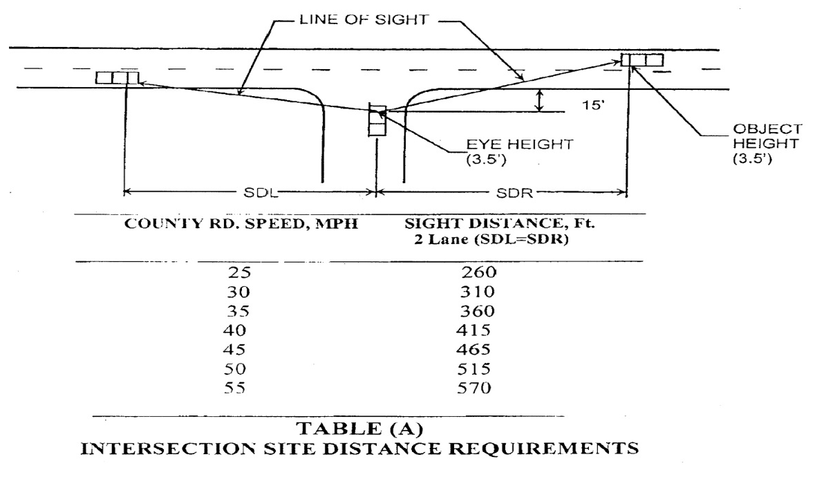
Subdivision street intersections with county maintained roads shall be located to provide adequate sight distance. Minimum intersection sight distances are criteria provided in Table (A) of this subsection. The line of sight establishes the boundary of a sight triangle within which there should be no sight obstruction between the heights of 30 inches and 108 inches. No plants or shrubs shall be planted in this area that grows to a height greater than 30 inches. The sight distance criteria are based on the average time required for a vehicle to make a left or right turn from a stop controlled approach to the public road (AASHTO Case B1 and B2). The time to execute the maneuver is based on recommendations contained in NCHPR Report 383, Intersection Sight Distance. The sight distances for a two-lane road are the distance traveled at the posted speed limit during the average of 6.5 and 7.5 seconds. See ASSHTO Green Book, chapter 9 Intersections, for adjustments due to grades greater than three percent and design vehicle other than passenger cars. The developer's engineer shall certify that sight distance requirements are in accordance with table (A) and so state on the preliminary plans at the time of submittal.
(g)
A traffic impact study by the developer's engineer at the preliminary stage when any new road or street is created that abuts/adjoins a public road/street for all developments creating more than 50 trips per day.
(Ord. of 12-21-2020)
Sec. 68-1726. - Structures on right-of-way.
Right-of-way encroachment—mailboxes and other structures: This section applies to all arterial, collector and minor roads as defined herein.
(a)
Mailboxes, county right-of-way:
(1)
A mailbox that does not conform to the following provisions is an encroachment and shall be removed within 60 days of notification of the violation:
a.
For noncompliance mailbox structures not moved within the 60-day notification period, such removal shall be performed by Habersham County at the expense of the structure owner.
b.
Habersham County will assume no liability for damage that may occur in normal maintenance operations for any mailbox not conforming to the standards stated in subsections (1) through (3).
(2)
No mailbox support shall be allowed to exist on Habersham County's right-of-way that interferes with the safety of the traveling public on the county road system. The mailbox shall be located in accordance with the rules and regulations set forth by the Highway Safety Administration.
a.
The support or post shall not be made of a masonry nature or by any other material that will not readily yield upon impact.
b.
Nor shall any other construction which could be classified as a hazardous fixed object be allowed, either as a support or as an encasement or housing for the box itself.
c.
When using wood, the size shall be a maximum nominal four inch by four inch or, if round, the size will be a maximum of four inches in diameter.
d.
If a metal post is to be used, no larger than three inches in diameter or equivalent shall be allowed and such posts shall be hollow.
e.
When using other materials, the maximum size and configuration shall be determined and approved by the administrative officer prior to installation.
f.
The face of the mailbox shall be no closer than three feet to the edge of the pavement on high-speed (establish threshold speed) routes.
(3)
Multiple mailbox installations shall meet the same criteria as single mailbox installations. Multiple support installations should have their supports separated a minimum distance equal to three-fourths of their heights above ground. This will reduce interaction between adjacent mailboxes and supports.
(b)
Mailboxes—Subdivision roads with low traffic volume and speed: A mailbox that does not conform to the following provisions is an encroachment and shall be removed within 60 days of notification of the violation.
(1)
Subdivision roads with low traffic volume and speed, shall comply with the following standard:
a.
The supporting structure shall be as described in subsection 68-1726(a)(2) above.
b.
The face of the mailbox shall be no closer than two feet to the edge of the pavement or one foot from the back of the curb.
(2)
In the event that a request is made to place a subdivision road in the county maintenance system, all existing structures on right-of-way shall be brought into compliance with section 68-1726 of this chapter.
(c)
Mailboxes—Existing structures on county-maintained roads: Single-entrance subdivision roads with a rural minor road classification that have existing brick or masonry mailbox structures will be allowed so long as they meet the following requirements:
(1)
No portion of the mailbox or its structure shall be closer than two feet to the edge of pavement or one foot from the back of the curb.
(2)
The planning commission reserves the right to review all existing mailbox structures on a case-by-case basis as requested.
(3)
All undeveloped lots within a subdivision on a single entrance, low volume and low speed road shall conform to the specifications for mailbox structures defined in subsection 68-1726(a)(2) above.
(d)
Other structures: Masonry or other type vertical walls that create a hazard will not be allowed on county rights-of-way. Existing masonry or other type walls built on driveways in the right-of-way will comply with the following regulations:
(1)
Single entrance subdivision roads with a rural minor road classification that have existing brick, rubble or masonry driveway headwalls will be allowed so long as they meet the following requirements:
a.
The wall shall not come within four and one-half feet of the edge of pavement.
b.
The wall shall not extend above the existing driveway height without having adequate drain holes through the wall.
c.
The overall height shall not exceed 18 inches above the driveway surface.
d.
All undeveloped lots within a subdivision on a single entrance, low volume, low speed road shall conform to these same specifications.
(2)
Subdivision entrances with elaborate cosmetic structures of brick, masonry, or other materials forming an island shall conform to the following:
a.
No structure shall extend beyond the right-of-way line of the adjoining street.
b.
No structure shall extend vertically to a height that would impair visibility of adjacent vehicle traffic.
c.
Structure walls must not lean or protrude over the adjacent pavement so as to hinder resurfacing or maintenance of the surface.
d.
No structure shall be placed in conflict with utility facilities.
e.
Structures placed in the middle of the cul-de-sac shall conform to all of the above specifications.
f.
All structures must have some type of approved reflective device or be lit.
g.
Any damage to existing structures during routine maintenance of the street will be the liability of the property owner.
(3)
Exemption for new construction: Masonry or other type vertical walls may be built on driveways that are located in a platted subdivision on a "rural minor" road, defined herein and classified as a low volume, low speed, residential road that primarily serves the residents of the subdivision. A subdivision road or street that may be used as a cut through or connector road to a main road may not be considered a "minor" road. These structures must conform to the regulations as stated in this section. Habersham County does not accept maintenance responsibility for these vertical wall structures. The planning commission reserves the right to review all structures on a case-by-case basis as requested.
(e)
Enforcement:
(1)
Existing structures: It shall be the responsibility of the administrative officer to enforce the provisions of this section as it relates to existing structures. The administrative officer shall notify, in writing, property owners found to be in violation of this section. If the property owners fail to remove the structures(s) in violation within the time allowed by this section, the administrative officer is authorized to issue a citation to the property owner stating the nature of the violation, the cost to the property owner for removal and the time and date the matter will be reviewed by the board of commissioners. A copy of the citation shall be sent to the chief building inspector. The administrative officer shall refer the citation to the board of commissioners at its earliest regularly scheduled meeting. The board shall review the facts and if the property owner is found in violation, the administrative officer shall be authorized and directed to remove structures in violation and to bill the property owner the cost of removal.
(2)
Enforcement (new construction): It shall be the responsibility of the administrative officer to enforce the provisions of this section as it relates to all new construction. In addition, the chief building inspector is directed and authorized to deny any and all construction permits for any property or to any property owner with a structure(s) in violation of this section as cited by the administrative officer.
(Ord. of 12-21-2020)
Sec. 68-1727. - Required improvements.
(a)
Performance and specifications: Every subdivider shall be required to make the improvements outlined in this article in accordance with the specifications herein or otherwise adopted by Habersham County. The necessity for storm drainage on each site will be determined by inspection.
(b)
Monuments: Monumentation shall be done as required by Georgia State Rules Section 108-7-05.
(c)
Grading: All streets, roads and alleys shall be graded by the subdivider so that pavements and sidewalks, where required, can be constructed to the required cross section. The minimum width of grading shall be the pavement width as specified in Section 8-1724 plus eight feet on each side. Deviation from the above will be allowed only when due to special topographical conditions.
(1)
Preparation: Before grading is started, that part of the right-of-way consisting of the area to be paved plus the shoulders shall be first cleared of all stumps, roots, brush and other objectionable materials and all trees not intended for preservation.
(2)
Cuts: All boulders and other obstructions shall be removed to a depth of two feet below the subgrade. Rock, when encountered, shall be scarified to a depth of 18 inches below the subgrade. All vegetative debris, to include tree stumps and roots, must be removed from the site or may be burned in its entirety on site if burning complies with state rules and regulations.
(3)
Fill: All suitable material from roadway cuts may be used in the construction of fills, approaches or at other places as needed. Excess materials including organic materials, soft clays, etc. shall be removed from the roadway. The fill shall be spread in layers not to exceed six inches loose and compacted by a sheepsfoot roller. The filling of utility trenches and other places not accessible to the roller shall be mechanically tamped.
(4)
Subgrade: The subgrade shall be properly shaped, rolled and uniformly compacted to conform to the lines, grades and typical cross-sections as shown on drawings approved by the planning commission. Unsuitable materials shall be excavated and replaced with acceptable compacted material.
(d)
Storm water management plan: This section is to formulate a plan to manage storm water runoff so that storm water hazards are not created and existing runoff-related problems are not exacerbated either upstream or downstream from or within the boundaries of the development. The storm water management plan will consist of a storm water report and construction documents (if applicable) to meet the minimum requirements set forth in this section.
(1)
A storm water management plan shall be submitted with the request for land disturbance permit stage and shall contain the following information:
a.
Location of proposed drainage-ways, streams and sediment ponds within the development.
b.
Location, size and invert elevations of proposed drainage structure including culverts, bridges, pipes, drop inlets and top elevations of headwalls, diversion ditches, etc.
c.
Area of land contributing runoff to each drainage feature.
d.
Location of easements and right-of-way for drainage ways and maintenance accesses therefore.
e.
Typical improvement around drainage features and culverts, if any.
f.
Direction of water flow throughout the subdivision and computed velocities at those points deemed necessary by the review agency staff.
g.
Detailed engineering drawings on all impoundment structures, dams, sediment ponds, etc.
(2)
A storm water management plan must be prepared for new development or redevelopment to any site that meets one or more of the following criteria:
a.
A new development in which 5,000 square feet or greater of new impervious area is created or that involves the land disturbing activity of one acre of land or greater;
b.
Land development activity on a redevelopment site that constitutes more than 50 percent of the site area for the entire site or increases the impervious area on site by more than 5,000 square feet.
(3)
The following development activities may be exempt from a storm water management plan:
a.
Developments that do not create the addition of 5,000 square feet of impervious surfaces or disturb more than one acre of land;
b.
Individual single-family residential lots (single-family lots that are part of a subdivision or phased development project are not exempt);
c.
Additions or modifications to existing single-family structures;
d.
Agricultural and silvicultural construction is exempt.
(e)
Storm water report: A storm water hydrology report shall be provided to ensure that the requirements and criteria in these regulations are being complied with and that opportunities are being taken to minimize post-development storm water runoff impacts from the development. The storm water hydrology report shall identify the locations and quantities of storm water runoff entering and exiting the site for both existing and developed conditions. The report at a minimum shall consist of pre- and post-developed topographic drainage maps delineating study points, drainage basins, soil types, runoff coefficients/curve numbers and land cover. In addition, the report shall contain a brief narrative, a vicinity map, a chart summarizing the water runoff associated with the proposed development and supporting design calculations for any proposed storm water management facility (such as and including stage-storage or outlet rating curves and inflow and outflow hydrographs, pre- and post-developed hydrographs). Pond discharge locations shall be in defined drainage ditches or piped systems. If this is not possible, the hydrology report shall address the creation of concentrated flows where none had occurred previously. The design professional shall ensure that the addition of any storm water management facility within its watershed basin does not adversely affect downstream property owners or storm water drainage systems and structures. Storm water hydrology reports shall be conducted in accordance with the criteria established in this section and must be submitted with the stamp and signature of a professional engineer (PE) or a registered land surveyor (RLS) licensed in the State of Georgia.
(f)
Storm water management facilities: Storm water management facilities shall be implemented to control post-developed storm water runoff. The facility shall be designed so that the peak release rates (when combined with all detention bypass areas) are equal to or less than the pre-developed runoff rates at the same location. The facility will be designed to control the two to 50-year storm events. The facility shall also provide the safe passage of the 100-year storm event while providing one foot of free board between the 100-year pond elevation and the top of the dam. A proposed storm water management facility must be accompanied by a set of construction documents signed by a design professional, depicting the location and layout of the proposed facility and provide details for the construction of the facility (ex., outlet structures, dams, positive drainage, other structural controls, etc.). All storm water facilities shall be enclosed by fencing and an access gate where the sides of the facility adjacent to the water are steeper than 3:1 and the depth of the water in the pond is greater than three feet. The owner of the property on which the facility is located shall be responsible for maintaining all storm water management facilities. A clean-out marker showing two-thirds volume level of the pond shall be designated on the outlet structure to facilitate in inspection of the facility. If it is determined that the facility is not hydraulically functioning as designed due to inadequate maintenance, the county may conduct inspections and maintenance on the facility and the owner will be responsible for all expenses involved. A 25-foot easement measured from the elevation of the 100-year storm event within the facility and a 25-foot access easement to the facility shall be provided to the county. The county shall notify the owner 24 hours prior to any inspection or maintenance work which involves accessing the easement. All storm water management facilities shall be designed in accordance with the criteria established in this section, and plans and reports must be submitted with the stamp and signature of a professional engineer (PE) licensed in the State of Georgia.
(1)
The following may be exempt from storm water management facilities but must provide a hydrology report:
a.
A residential subdivision that does not increase the runoff for the two to 50-year storm event by more than 0.1 cubic feet per second per acre. Designated open space areas, flood plains, wetlands, green space and any other areas that are not buildable, with an exemption for stream or creek buffers, may not be included in the hydrological analysis in determining if the subdivision meets this exemption. In addition, the lot sizes must be uniformly sized throughout the subdivision development.
b.
Where development does not increase the storm water runoff by more than one cubic feet per second (cfs) for the two to 50-year storm event.
(2)
Storm water conveyance pipes: All culverts, cross drain, storm sewers or other drainage facilities under the county's jurisdiction shall be designed to accommodate all runoff from its entire upstream drainage area and be based upon the 50-year storm event.
(3)
An adequate drainage system, including necessary open ditches, pipes, culverts, intersectional drains, drop inlets, bridges, etc. shall be provided for the proper drainage of all surface water. Cross-drains shall be provided to accommodate all natural water flow and shall be of sufficient length to permit full width roadway (roadway is defined as the portion of a road or street within the limits of construction) and the required slopes. The culvert pipe size to be provided shall be determined based on an engineering study. In no case shall the pipe diameter for cross drain pipe be less than 18 inches. Side drain pipe (driveway, etc.) shall not be less than 15 inches in diameter.
a.
All pipe used for cross drains shall consist of one of the following:
i.
Reinforced concrete pipe;
ii.
Metal pipe with paved invert and coated with bituminous material;
iii.
Aluminized coated pipe meeting ASSHTO Standard M274 and M36;
iv.
Smooth interior corrugated polyethylene pipe not to exceed 36 inches in diameter meeting ASSHTO Standard M294.
b.
Certificate executed as shown in Chapter A, Form 6.
(g)
Installation of utilities and driveways: After grading is completed and approved and before any base is applied, all of the underground work, water mains, gas mains, etc., and all service crossings shall be installed completely and approved throughout the length of the road and across the flat section. All driveways for houses as they are built shall be cut and drained from the right-of-way.
(h)
Water supply system: Water mains within the subdivision must be provided with connections to each lot from a community water system controlled by EPD or public water system. Minimum diameter of water pipes shall normally be six inches. Fire hydrants must be provided at not more than 1,000 feet intervals whenever community or public water system is used. Required fire hydrants shall be served with adequate water volume and pressure as required by the fire chief and the governing body of Habersham County. If a municipal water supply is not available to the subdivision at the time of development of the subdivision, then the developer should provide an adequate water source and an adequate water storage facility. This shall be accomplished by the use of individual wells for each housing unit or by a community water system. Individual wells are the responsibility of the lot purchaser; however, the community (subdivision) or municipal water system shall provide a minimum flow of 400 gallons per day per lot, shall be sanitary, and shall have a minimum adverse pressure of 30 pounds per square inch at each lot in the subdivision.
(i)
The community water system shall be approved by the Habersham County Health Officer or the Georgia Department of Natural Resources, Water Supply Section and a letter of approval shall accompany the recording permit application.
Water distribution plan: A water distribution plan shall be provided for all developments providing a community water supply system, regardless of the provider/municipality. All designs shall meet the Habersham County Water Main Standards or the state requirements, whichever is more stringent. It shall contain the following information:
(1)
Location and size of water distribution system, including pipes, valves, fittings, hydrants, high pressure pumping equipment, pressure reducing valves, etc., complete to individual lots
(2)
Location and size of all wells, storage tanks and lift stations
(3)
A water supply system letter of approval from environmental health or the Department of Natural Resources, Water Supply Section, shall be attached.
(j)
Sanitary sewers: If the sewage disposal facilities cannot be connected to a trunk line sewer at the time of the development of the subdivision, septic tanks or another approved method of treatment of sanitary sewerage shall be installed by and at the expense of the subdivider or lot purchaser for interim use in conformity with the requirements of the county health department. Plans shall be reviewed by the appropriate municipality or county facility accepting the waste. Further, approved sanitary sewage methods other than septic tanks shall include the maintenance and ownership agreements and requirements explained in detail. In addition, once the proposed plans are approved by a municipality, the building and planning department shall review and approve the plans for installation on county right-of-way. A sanitary sewer plan shall be provided for those developments offering such service. See Chapter A, Form 2.
(k)
Street and alley improvements:
(1)
Required streets shall be either public streets or private streets, all platted with right-of-way specified in section 68-1723. All streets must be paved to meet specifications in sections 68-1724 and 1727 below in order to qualify for final plat approval by the planning commission or acceptance for maintenance by the county governing body as public streets.
(2)
Asphalt paving and curb and gutter required: All streets within subdivisions with any lot 1.5 acre or less in size or slope of five percent shall be paved with asphalt per subsection (m) below and provided with curbs and gutters constructed with either pre-cast concrete curb or integral concrete curb and gutter conforming to the dimensions and standards in the adopted standard drawings. Driveways shall require curb cuts.
(3)
Street signs, signals, markings or other traffic control devices: All street signs, signals, markings or other traffic control devices on public or private streets shall conform to the Manual for Uniform Traffic Control Devices (MUTCD) as adopted by the Georgia Department of Transportation, as required by O.C.G.A. § 32-6-50(a).
(l)
Base: The base course shall consist of compacted and graded aggregated crushed stone or other approved material having a minimum thickness after being thoroughly compacted of six inches on all rural minor and residential streets regardless of the type pavement wearing surface used.
(1)
Base and pavement structure for collectors, rural major, other rural roads, arterial roads, and streets shall be designed based on projected traffic and use. Commercial and/or industrial streets and roads shall be designed by a registered engineer according to the projected loads and weight capacities for the project but in no case shall be no less than eight inches compacted base course and two inches asphaltic concrete surface binder with a one and one-half inch asphalt concrete surface course. Residential streets and roads shall also consist of no less than six inches of compacted base course and two inches of asphaltic concrete surface course.
(2)
All materials shall be secured from an approved source and shall generally conform to minimum acceptable standards of the Georgia Department of Transportation.
(3)
All materials shall be mixed to the extent necessary to produce a thoroughly pulverized and homogeneous mixture.
(4)
As soon as the base material has been spread and mixed, the base shall be brought to approximate line, grade and cross-section and then rolled with a sheepsfoot or other approved roller until full thickness of the base course has been compacted thoroughly. Defects shall be remedied as soon as they are discovered.
(5)
The base course shall be maintained under traffic and kept free from ruts, ridge and dusting, true to grade and cross-section until it is primed.
(6)
No base material shall be deposited or shaped when the subgrade is frozen or thawing or during unfavorable weather conditions.
(m)
Pavement: Wearing surface shall conform to mixes found suitable by the Georgia Department of Transportation, Highway Division, or an independent testing laboratory and shall be applied after prime coat. Unless otherwise approved by the platting authority, pavement shall be constructed as follows:
(1)
Bituminous material used for prime coat shall be in accordance with the current edition of the Georgia Department of Transportation Standard Specifications Manual and shall be applied on clean slightly damp surface in the amounts of from 0.15 to 0.30 gallons/square yard, depending on the nature and condition of the surface.
(2)
Wearing surface shall consist of either an approved plant mix prepared in accordance with the standards in the current edition of the Georgia Department of Transportation Standard Specifications Manual and shall have a completed minimum compacted thickness of two inches or a triple surface treatment constructed in accordance with section 424 of the current edition of the Georgia Department of Transportation Standard Specifications Manual.
(3)
Weather limitations. Comply with the current edition of the Georgia Department of Transportation Standard Specifications Manual.
(4)
Care and precaution shall be taken that all joints between the surface mixture and such structures as manholes and curbs are well sealed.
(5)
Materials and installation of traffic control devices, such as striping or required signal devices and signage, shall be at the developer's expense and comply with Manual for Uniform Traffic Control Devices.
(n)
Guarantee against faulty material and workmanship:
Final approval: Public streets to be accepted by the county will be at the discretion of the governing body. Road acceptance and acceptance of any other dedicated easement to the county shall only be accomplished by written resolution adopted by the governing body at a public meeting; approval of the final plat does not indicate acceptance of roads or easements by the county. Final approval will be considered upon separate written request by the developer, subdivider or any person or persons who own all fee simple interest in the subject road to the governing body and in accordance with one of the following:
(1)
The subdivider shall post with the county a guaranty bond or other surety in an amount equal to 15 percent of the street and utility improvement cost, verified by the county engineer and approved by the governing body for the street for which acceptance is sought. Said bond will guarantee the county that the street has been installed in a workmanlike manner, that it is free from defects caused by faulty materials or workmanship and that the street will remain in acceptable condition for a period of at least 18 months. This bond shall be effective for a period of at least 18 months. At the end of this period, if the street is found to have settled or be otherwise unacceptable because of faulty workmanship or material, the defective street shall be repaired at the expense of the subdivider up to the amount of the bond. Upon his failure or refusal to do so within 90 days after demand is made upon him by the governing body, the county shall make such repairs as are reasonably necessary and recover the cost thereof from the bond issuer.
(2)
Certificate of development conformance required: A certificate of development conformance is required for final approval of road system. The certificate will not be issued until all requirements of these and other applicable regulations have been met. It is also required that the planning department receive a completed request for approval of development conformance, an executed development performance and maintenance agreement and a final inspection report has been done.
(3)
Process of road inspection/acceptance: All roads will be inspected at time of construction pursuant to the published procedures as set forth by the planning department. Published procedures will be included with the development application.
(4)
Warranty deed required: A warranty deed must be provided by the developer, subdivider or any person or persons who own all fee simple interest in the subject road.
(o)
Private roads:
(1)
Private roads may, upon application, be permitted by the planning commission within subdivisions subject to the requirements of this section. The planning commission may impose conditions on the approval of private roads to ensure various public purposes and to mitigate potential problems with private roads. No final plat involving a private road shall be approved unless said final plat conforms to the requirements of this section.
(2)
It shall be unlawful for any person, firm or corporation to construct a new private road or alter an existing private road or to cause the same to be done without complying with this section provided, however, that this shall not be construed to apply to logging roads (trails) and roads (trails) serving agricultural purposes.
(3)
All private roads shall at minimum be constructed to all standards specified in this article except section 68-1722.
(4)
Rights-of-way for private roads shall be designated on final plats as general purpose public access and utility rights-of-way along with the name of said private road. Rights-of-way for private roads shall not be included in any calculation of minimum lot size established by this chapter. Private road rights-of-way shall be shown on the final plat as a discrete parcel to be dedicated to a private homeowners association or other appropriate group (i.e., not shown to be a part of any lot).
(5)
Habersham County shall have no responsibility to maintain, repair, resurface, rebuild, or otherwise improve private roads, signs, drainage improvements or any other appurtenances within general purpose public access and utility rights-of-way established for private roads. A private maintenance covenant recorded with the office of the Clerk of the Superior Court of Habersham County shall be required for any private road and other improvements within general purpose public access and utility rights-of-way established for private roads. The covenants shall set out the distribution of expenses, remedies for noncompliance with the terms of the agreement and other pertinent considerations.
(6)
The covenant shall specifically include the following terms:
a.
The covenant shall establish minimum annual assessments in an amount adequate to defray costs of ordinary maintenance and procedures for approval of additional needed assessments. The covenant shall also specify that the funds from such assessments will be held by a homeowners' or property owners' association or other appropriate group.
b.
The covenant shall include a periodic maintenance schedule.
c.
The covenant for maintenance shall be enforceable by any property owner served by the private road.
d.
The covenant shall establish a formula for assessing maintenance and repair costs equitably to property owners served by private road.
e.
The covenant shall run with the land.
f.
The planning commission may, at its discretion, as a condition of approving private roads require a performance bond and/or maintenance bond be submitted by the subdivider and held by a homeowners' or property owners' association or the planning commission may require that the subdivider pay an amount of money as recommended by the county engineer into an escrow account or other suitable account for the maintenance and repair of private roads and storm water management improvements to be drawn from by the homeowners' or property owners' association as maintenance and repair needs may arise.
(p)
No final plat involving a private road shall be approved by the planning commission for recording unless and until it shall contain the following on the face of the plat:
(1)
Deed book and page reference to the recorded covenant required by this section.
(2)
"Warning, Habersham County has no responsibility to build, improve, maintain or otherwise service the private roads, drainage improvements, and other appurtenances contained within the general public purpose access and utility right-of-way or rights-of-ways for private roads shown on this plat."
(3)
Grant of right-of-way as displayed in Chapter A, Form 7.
(Ord. of 12-21-2020)
Sec. 68-1728. - Opening and improving public streets.
The governing body of Habersham County shall not accept, lay out, open, improve, grade, pave or light any street or lay any utility lines in any street which had not attained the status of a public street prior to the effective date of this chapter, unless such street corresponds to the street location shown on an approved subdivision plat or on an official street map adopted by the planning commission.
(Ord. of 12-21-2020)
Sec. 68-1729. - Access management and connectivity.
(a)
Purpose. The purpose of this section is to set standards for the provision of access to development in a manner that preserves the safety and efficiency of the transportation system. The management of access is a means by which substantial public investment in the transportation system can be protected and the need for remedial measures eliminated or reduced.
(b)
Access management.
(1)
Interparcel access is required between all abutting parking lots and sites based on site conditions and as determined by the Director of Planning and Development to provide a cross-access drive and pedestrian access to allow circulation between sites.
a.
Interparcel access is not required between non-residential uses and single-family residential uses or between single-family residential uses.
b.
This shall be accomplished by stubbing a connection to each adjacent property line. The property owner shall grant an access easement granting public access through the lot. This easement shall be submitted to the Director of Planning and Development and recorded by the applicant or property owner with the Clerk of the Superior Court of Habersham County.
c.
If full access between or among lots is implemented after initial site development, any deficiencies created to formalize the connection are permitted without need for any formal relief through the variance process (e.g.: removing a required parking space to accommodate the connection will render it nonconforming but is permitted to prioritize the connectivity).
d.
Shared driveways between properties shall be established wherever feasible along a major thoroughfare, arterial, or collector street.
(2)
All developments shall have access to a public right-of-way. Developments serving more than four residential units shall have access points built to county road standards to a public right-of-way. All parcels of a development serving more than four residential units shall have interior access, without need for accessing an outside public right-of-way, to each access point or road. The number of access points or roads shall be in accordance with Table 684729(b)(3).
Table 684729(b)(3) - Minimum Number of Access Points
(3)
The separation of access points on a thoroughfare, arterial, or collector road shall be determined by the speed limit of the road with the following minimum spacing requirements in accordance with Table 684729(b)(4).
a.
The distance between access points shall be measured from the centerline of the proposed driveway or road to the centerline of the nearest existing adjacent driveway or road.
b.
Driveway spacing at intersections and corners shall provide adequate sight distance, response time, and permit adequate queuing space.
c.
No driveway, except driveways providing residential access, shall be allowed within 100 feet of the centerline of an intersecting thoroughfare, arterial or collector street.
d.
No nonresidential access except right in/right out channelized access shall be allowed within 100 feet of the centerline of any other thoroughfare or arterial.
e.
The requirements of this section are not intended to eliminate all access to a parcel of land that was legally subdivided prior to the enactment of this section.
Table 684729(b)(4) - Driveway Separation
(4)
All road design and other development activities, including landscaping, shall be arranged on site so as to provide safe and convenient access for emergency vehicles.
(5)
Along thoroughfares, arterials, or collector roads, a deceleration lane, a turn lane, larger or reduced turning radius, traffic islands or other devices or designs, including traffic calming devices and designs, may be required to avoid specific traffic hazards which would otherwise be created by the proposed driveway location. The Director of Planning and Development may require the submission of a traffic analysis based on the scale and scope of the project to determine required improvements.
(6)
Deceleration lanes are required for access to residential uses according to Georgia Department of Transportation (GDOT) guidelines unless deemed necessary by the Director of Planning and Development.
(c)
Driveway connections.
(1)
Quantity.
a.
One driveway connection per lot frontage shall be permitted to streets classified as an arterial or collector, unless otherwise prohibited in this Code.
b.
A shared driveway, if developed at the same time, shall be required to be constructed to serve adjacent properties, where deemed necessary by the Director of Planning and Development. This provision does not apply to residential single-family lots. A recorded access easement shall be required for all shared driveways on separate lots, prior to the issuance of a building permit.
(2)
Type. Because each site is unique, the type of driveway access (e.g., full access movement or right-in, right-out) to be allowed shall be determined by the Director of Planning and Development or the Georgia Department of Transportation (GDOT), where applicable.
(3)
Location.
a.
Driveways shall be located outside the functional limit of an intersection, as determined by the Director of Planning and Development or GDOT, where applicable.
b.
Driveways shall be contained wholly within the lot frontage or as part of a shared access easement with an adjacent property.
c.
An internal access road shall be required for developments with five or more residential units. The internal access road shall be constructed to minor residential county road standards as outlined in Article XVII.
d.
New single-family detached and attached construction shall not be accessed from arterial and collector roadways if access is available from a lower street classification.
e.
Where only access is available from a public road, the driveway shall be designed to allow vehicles to enter "headfirst" instead of reverse in the roadway.
(d)
Development with outparcels. The following standards shall apply only to developments consisting of outparcels.
(1)
Access to the public street shall be made only by an internal access driveway.
(2)
Internal drives shall be located between outparcels and primary developments.
(3)
Internal drives shall connect to all access driveways.
(4)
Driveway connections to internal driveways and access driveways shall be at least 200 feet from all intersections. State roads may require a greater separation.
(5)
Parking areas shall be designed in such a way that will not require the backing of vehicles into or parallel parking along internal drives.
(e)
Controlled access. Access to any development that is controlled through any means such as gates and guardhouses, shall comply with the following standards. Emergency and "exit only" access points are exempt from these requirements.
(1)
Gate width. The clear opening through gates shall be at least two feet wider than the roadway it controls.
(2)
Queuing distance.
a.
Residential uses up to 75 units shall have at least 20 feet of vehicle stacking distance. An additional 20 feet of stacking distance shall be provided for every additional 100 units.
b.
A deceleration lane in accordance with Table 684729(b)(7) shall be required on the exterior road serving the gated community.
c.
Vehicle stacking distance for mixed-use and nonresidential uses shall be no less than 70 feet.
d.
Vehicle stacking distance is measured from the back of the sidewalk, or five feet from the back of curb or edge of street, whichever is closest to the gate.
e.
For any controlled access device that opens on a horizontal plane, such as a gate, a minimum of 20 feet of clear width shall be provided unless additional width is required by the Fire Marshal. Such device shall open away from the street right-of-way.
f.
For residential developments, adequate maneuvering room between the gate and the street shall be provided for a turnaround area for vehicles to exit in a forward motion. The turnaround area shall have a minimum radius of 60 feet to the outside of the turnaround area. The turnaround area is subject to approval by the Fire Marshal.
(f)
Change of driveway location. If the property owner initiates a change of driveway location and receives permission to construct a new driveway, the property owner shall be required to close the existing driveway and install a sidewalk and/or curb to match the existing sidewalk and/or curb, if a sidewalk and/or curb exists. A ditch to maintain drainage shall be required as determined by the Planning and Development Director. The property owner shall landscape the area in accordance with the screening and buffering requirements of this Code.
(g)
Blocking fire lanes, required parking areas. No vehicles, waste receptacles, storage, displays, or other obstacles shall be allowed to block driveways (including cross access easements), fire lanes or required parking, unloading and loading areas unless a valid temporary use permit has been issued.
(h)
Pedestrian circulation. To improve inter-parcel connectivity and pedestrian access, designated pedestrian paths shall be provided to non-residential principal uses from the street right-of-way to adjacent properties.
(Ord. of 11-18-2024, § 1)