
Hanahan City Zoning Code
1
PURPOSE AND APPLICABILITY
1.1. - Title.
This ordinance is officially titled "City of Hanahan Zoning Ordinance" and shall be known as and referred to herein as the Zoning Ordinance. The map accompanying this ordinance, designating and depicting the various zones described herein, is officially titled "City of Hanahan Official Zoning Map" and shall be known as and referred to herein as the Zoning Map.
1.2. - Authority.
This ordinance is hereby adopted under the authority and provisions of the South Carolina Local Government Comprehensive Planning Enabling Act of 1994 — Title 6, Chapter 29 of the South Carolina Code of Laws.
1.3. - Jurisdiction.
The regulations set forth in this ordinance govern the development and use of all land and structures — built and natural environments — within the corporate limits of the City of Hanahan.
1.4. - Purpose.
(A)
Through the adoption of its 2002 Comprehensive Plan, as amended, the City of Hanahan expressed the need to update its Zoning and Land Development ordinances to allow for the protection and promotion of the health, safety, and general welfare — consisting of the following issues — of its present and future citizens and landowners:
(1)
High quality of life and community;
(2)
Property values and privacy;
(3)
Natural as well as built environment;
(4)
Efficient use of public infrastructure and services;
(5)
Stormwater run-off management;
(6)
Calm vehicular traffic and pedestrian accessibility; and
(7)
City identity and character.
(B)
The Zoning Ordinance shall ensure that future development and land uses coalesce with existing conditions in Hanahan to yield the highest and best possible benefits in each and every one (1) of these issues.
1.5. - Severability.
In the event that any portion of this ordinance is found illegal by a court of law of competent jurisdiction, the remainder of the ordinance shall remain in full effect.
1.6. - Applicability.
In the event that this ordinance contains contradictory standards or comes into conflict with the standards imposed by another city code or ordinance or another agency of competent jurisdiction, those higher or stricter standards shall take effect.
2.1. - Responsibility for administration.
2.1.1. City administrator to assign.
Except as otherwise specifically provided, primary responsibility for the city administrator may assign one (1) or more individuals to administer and enforce the Hanahan Zoning Ordinance. This ordinance refers to the person or persons to whom these functions are assigned as the "zoning administrator" or "city planner." the terms "staff," "administrator," and "planner" may be used interchangeably with the positions "zoning administrator" and "city planner" for the purposes of this ordinance. The city administrator shall determine the departmental assignments of these positions.
2.1.2. Duties of the zoning administrator.
The position of "zoning administrator" shall entail the following duties:
(1)
Interpreting and enforcing the Zoning Ordinance;
(2)
Investigating and resolving complaints pertaining to the ordinance;
(3)
Administering permits and certificates, including collecting fees for permits and certificates;
(4)
Processing applications for variances, special exceptions, and appeals to the board of zoning appeals and preparing the record for appeal to circuit court;
(5)
Processing applications for design review and appeals to the design control committee and preparing the record for appeal to circuit court;
(6)
Maintaining a current official zoning map and public records related to zoning; and
(7)
Other duties, as may be assigned.
2.2. - Planning commission.
(A)
Establishment of planning commission. A planning commission has been established for the City of Hanahan (See City of Hanahan Code of Ordinances, ordinance dated 10/8/1973.) as a board that has the powers and duties as provided in the South Carolina Code § 6-29-310 et seq.
(B)
Powers and duties of the planning commission. The planning commission shall be assigned the duty to develop and carry out a continuing planning program for the physical, social, and economic growth, development, and redevelopment of the City of Hanahan. The following steps constitute this duty.
(1)
Comprehensive Plan. Prepare and periodically revise development and/or redevelopment plans and programs.
(2)
Implementation. Prepare and recommend to city council measures for carrying out the plan. Such measures include the following:
(a)
Zoning Ordinance. Text, map, and any necessary revisions.
(b)
Regulations for land subdivision and development. The commission is responsible for overseeing administration of land development standards of the Hanahan Zoning Ordinance upon adoption by council.
(c)
Official map. Map showing the exact location of existing or proposed public streets, highways, utility rights-of-way, and public building sites. The official map and zoning map may be the same document. The commission is responsible for developing regulations and procedures for administering the official map.
(d)
Landscaping ordinance. Provide required standards for planting, tree preservation, and other aesthetic considerations.
(e)
Capital improvements program. List required projects to carry out the adopted plans. The commission submits an annual list of priority projects to council for consideration when annual capital budgets are prepared. The commission should take these priority projects from the adopted Comprehensive Plan.
(f)
Policies and procedures. Implement the adopted comprehensive plan. These could cover such things as expanding the corporate limits, extending the public water and sewer systems, accepting dedicated streets, accepting drainage easements, and offering economic development incentive packages.
2.3. - Board of zoning appeals (BZA).
Establishment of board of zoning appeals. A board of zoning appeals is hereby established for the City of Hanahan as a quasi-judicial board that has the powers and duties as provided in the South Carolina Code § 6-29-780 et seq.
2.3.1. Membership.
(A)
The board shall consist of five (5) members.
(B)
Members shall be citizens of Hanahan.
(C)
Members shall be appointed by city council for overlapping terms of four (4) years.
(D)
Members may continue to serve until a successor is appointed.
(E)
Any vacancy in the membership shall be filled for the unexpired term in the same manner as the initial appointment.
(F)
Members shall serve without pay but may be reimbursed for expenses incurred while part of the board.
(G)
Members cannot hold any other public office or position in the city.
2.3.2. Proceedings of the board of zoning appeals.
(A)
The board of zoning appeals shall elect a chairman and a vice-chairman from its membership, who shall serve for one (1) year or until re-elected or until their successors are elected.
(B)
The board shall appoint a secretary, who may be a city officer, a city employee, a member of the planning commission, or a member of the board of zoning appeals. The secretary shall keep the records and minutes of the board meetings, cause proper notice to be made of cases for board review, and shall conduct correspondence for the board. The secretary shall not participate in the meeting proceedings as a voting member unless he/she is appointed to the board.
(C)
The board shall adopt rules and by-laws in accordance with the provisions of this ordinance and South Carolina Code § 6-29-790.
(D)
Meetings of the board shall be held at the call of the chairman and at such other times as the board may determine.
2.3.3. Powers of the board of zoning appeals.
All questions arising in connection with the enforcement of the Hanahan Zoning Ordinance shall be presented first to the zoning administrator, after which, such questions may be presented to the board of zoning appeals, but only on appeal of the written decision of the zoning administrator.
(A)
Administrative review. The board may hear and decide appeals where it is alleged the zoning administrator erred in an order, requirement, decision, or determination. In such cases, the board may reverse or affirm, wholly or in part, the zoning administrator's actions. The board shall have all the powers of the zoning administrator in such cases and may direct the issuance of a permit.
(B)
Variances. The board shall have the power to hear requests for variances and decide as to their validity when strict application of zoning standards would cause unnecessary hardship.
(1)
The following standards must apply for finding of an unnecessary hardship.
(a)
Extraordinary conditions. There are extraordinary and exceptional conditions pertaining to the particular piece of property, which could exist due to topography, street widening, or other conditions making economically feasible use of the property difficult or impossible.
(b)
Utilization. Because of these extraordinary conditions, the application of the ordinance to a particular piece of property would effectively prohibit or unreasonably restrict the utilization of the property.
(c)
Detriment. The authorization of a variance will not be of substantial detriment to adjacent property or the public good, and the character of the district will not be harmed by granting of the variance.
(d)
Other property. Extraordinary conditions generally do not apply to other property in the vicinity.
(2)
Conditions. In granting a variance, the board may attach to it standards in the ordinance specifically stated and applicable to the variance request that address the location, character, or other features of a proposed building, structure, or use as conditions of approval to protect established property values in the surrounding area and to promote the public health, safety, or general welfare.
(3)
Use variances. The board shall not grant use variances. A use variance involves the establishment of a use not otherwise permitted in a zoning district, extends physically a non-conforming land use, or changes the zoning district boundaries shown on the zoning map.
(4)
Special exceptions. The board may grant special exceptions, as outlined in Section 2.5.3 of this chapter, for land uses specified in the Zoning Ordinance and allowable only by special exception.
2.3.4. Procedure for administrative review, variances, and special exceptions.
(A)
Type of appeal sought.
(1)
Administrative review. Any person believing to have found error in the written decision of the zoning administrator may appeal it to the board of zoning appeals. Such appeals shall be filed with the city within thirty (30) days of the date of written notice of the decision or order of the zoning administrator.
(2)
Variance. Any person seeking relief from the strict application of zoning standards in accordance with subsection 2.3.3(B), above, shall apply for a variance from the board of zoning appeals.
(3)
Special exception. Any person seeking a zoning permit for a land use allowable only by special exception in the zoning district in which the property is located shall apply for a special exception from the board of zoning appeals.
(B)
Application to the City of Hanahan. The applicant appealing to the board of zoning appeals shall undertake the following procedure.
(a)
A completed application, together with the application fee for administrative review or variance, shall be filed with the zoning administrator at least twenty-five (25) days prior to the board of zoning appeals meeting at which the request will be considered.
(b)
Required information. The applicant shall set forth a detailed description of the request on an application form provided by the zoning administrator. The completed application shall include the following information:
(i)
A legal description and street address of the subject property, together with a property boundary map if subject property is not explicitly delineated on the zoning map;
(ii)
Six (6) copies of the site development plan or building plans submitted as part of a zoning permit application reviewed and disapproved by the zoning administrator, where applicable, for the property for which relief is sought.
(iii)
Name, address, and phone number of applicant;
(iv)
Name of property owner(s) and applicant's interest in the property if not the owner in fee simple title;
(v)
Filing date of application;
(vi)
Any other information deemed relevant by the zoning administrator; and
(vii)
Applicant and property owner's signature(s).
(C)
Stay of proceedings. Filing an appeal to the board stays all legal proceedings to enforce the appealed action unless the appealed officer certifies that a stay would cause imminent peril to life and property. In such cases, a board or court restraining order may stay the action.
(D)
Hearings. The board of zoning appeals shall hold a public hearing within sixty (60) days of receiving written application for appeal or variance, giving public notice thereof at least fifteen (15) days prior to the hearing by placing notice in a general circulation newspaper in the community.
(E)
Posting property. In cases involving variances, city staff must post conspicuous notices, (sign with dimensions of at least eighteen (18) inch × twenty-four (24) inch) on or next to the affected property at least fifteen (15) days prior to the hearing. At least one (1) notice must be visible from each street that borders the property.
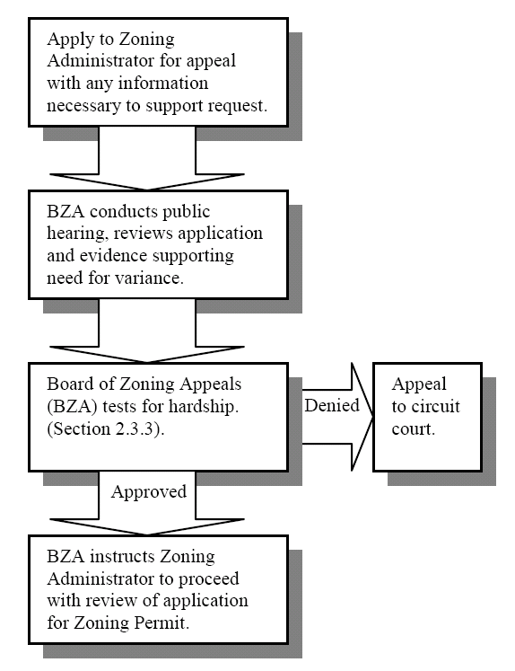
(F)
Record keeping. The board shall keep minutes of its proceedings, showing the vote of each member upon each question or, if absent or failing to vote, indicating such fact, and shall keep records of its examination and other official actions, all of which shall be filed in the office of the zoning administrator and shall be public record. On all appeals, applications, and other matters brought before the board, it shall inform in writing all the parties involved of its decision(s) and the reason(s) heretofore.
(G)
Decisions of the board of zoning appeals. The concurring majority vote of present members of the board shall be necessary to reverse any order, requirement, decision, or determination of the zoning administrator or to decide in favor of the applicant on any matter that it is required to consider under this ordinance or to affect any variation of this ordinance.
(H)
Order on decision. The board of zoning appeals shall, upon decision of approval or denial, submit to the applicant its decision in writing within thirty (30) days and shall notify the zoning administrator of such decision. If the board of zoning appeals finds in favor of the developer, the zoning administrator shall process the application for zoning permit for the reviewed property.
(I)
Appeals of decisions of the board of zoning appeals. Any person who may have a substantial interest in any decision of the board of zoning appeals may appeal that decision to circuit court, filing with the clerk of such court a petition in writing setting forth plainly, fully, and distinctly wherein such decision is contrary to law. Such appeal shall be filed within thirty (30) days of the rendering of the decision of the board.
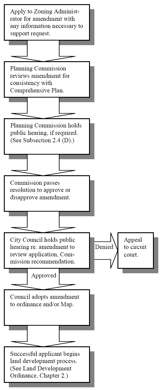
2.4. - Amendments.
(A)
Intent. The regulations, restrictions, and boundaries set forth in this ordinance may, from time to time, be amended, supplemented, changed, or repealed by city council, provided that no such action may be taken until after a public hearing in relation thereto, at which parties of interest and citizens shall have an opportunity to be heard.
(B)
Initiation of amendment. Revision of the text or map of the Zoning Ordinance or the Land Development Ordinance may be initiated within the planning commission or by city council. Additionally, a landowner may request a revision to the Zoning Ordinance or the Land Development Ordinance, provided such affects solely his property, through application to the City of Hanahan submitted to the zoning administrator. The procedure to amend the ordinance is as follows.
(1)
Application to the City of Hanahan. In the event that a landowner requests from the city a rezoning of his/her parcel(s) or other amendment to an ordinance that would solely affect his/her parcel(s), he/she shall undertake the following procedure.
(a)
A completed application, together with the application fee for zoning or land development ordinance amendment shall be filed with the zoning administrator at least twenty-five (25) days prior to the planning commission meeting at which the amendment request will be considered.
(b)
Required information. The applicant shall set forth a detailed description of the amendment on an application provided by the zoning administrator. When the amendment involves a change in the zoning map, the applicant shall submit the following information:
(i)
A legal description and street address of the subject property, together with a property boundary map if subject property is not explicitly delineated on the zoning map;
(ii)
Name, address, and phone number of applicant;
(iii)
Name of property owner(s) and applicant's interest in the property if not the owner in fee simple title;
(iv)
Filing date of application;
(v)
Zoning of adjacent properties;
(vi)
Any other information deemed relevant by the zoning administrator; and
(vii)
Applicant's and property owner's signature.
(c)
Planned Development Districts. The applicant proposing a Planned Development District (Type "B") shall comply with the requirements set forth in Section 4.7, which shall be in addition to these requirements.
(2)
Any amendments, changes (including rezoning), or supplements to the Zoning Map, Zoning Ordinance, or Land Development Ordinance must first be submitted to the zoning administrator for review and recommendation. Upon receipt of a complete amendment application from a landowner, the zoning administrator shall transmit the application and recommendation to the planning commission for consideration.
(C)
Planning commission review. All proposed amendments must be submitted to the Hanahan Planning Commission for its review and recommendation. The planning commission shall have thirty (30) days within which to submit a report to the city council. In reviewing any petition for a Zoning or Land Development Ordinance amendment, the planning commission shall identify and evaluate all factors relevant to the request. These facts shall include but not be limited to the following:
(1)
Whether or not the requested amendment is justified by a change in conditions since the ordinance was adopted or by an error in the ordinance;
(2)
Whether or not the requested amendment is consistent with the Comprehensive Plan;
(3)
The precedents and the possible effects of such precedents that might result from approval or denial of the petition;
(4)
The capability of the city or other government agencies to provide any services, facilities, and/or programs that might be required if the petition is approved;
(5)
Effect of approval of the petition on the condition and/or value of property in city; and
(6)
Effect of approval of the petition on adopted plans and policies of the City of Hanahan.
(D)
Public hearing.
(1)
The planning commission shall hold a public hearing for all Zoning and Land Development Ordinance amendments proposed in which the affected landowner(s) speaks or writes to the planning commission on behalf of the amendment. The purpose is to allow interested parties, including neighbors and adjacent landowners, the opportunity to comment in similar fashion.
(2)
No public hearing or notice (except for inclusion in the publicly posted agenda) shall be required at the planning commission for Zoning and Land Development Ordinance amendments in which an affected landowner does NOT speak or write on behalf of the amendment.
(E)
Notice of public hearing. The zoning administrator shall perform the following duties in the event a public hearing is required.
(1)
Newspaper notice. A notice shall be placed in a newspaper of general circulation in the city at least fifteen (15) days prior to the hearing. The notice shall include the hearing time and place.
(2)
Mail notice. Written notice shall be mailed to all interested groups requesting notice. Written notice shall also be mailed to all adjacent landowners and tenants, where applicable. The mailing shall occur at least fifteen (15) days prior to the hearing. Certified mail shall not be required; the zoning administrator shall use discretion in determining the best type of mailing, which shall be at a minimum, first class U.S. postal mail.
(3)
Posting property. In rezoning cases, conspicuous notices (sign with dimensions of at least eighteen (18) inch × twenty-four (24) inch) shall be posted on or adjacent to the affected property by the zoning administrator. One (1) notice must be visible and readable from each public street that borders the property. Such sign(s) shall be posted at least fifteen (15) days prior to the public hearing.
(F)
Passage by resolution.
(1)
If the planning commission finds by majority vote that the proposed amendment is in accordance with the above considerations, it shall pass a resolution to city council that such amendment be made to the Zoning Ordinance, the Land Development Ordinance, and/or zoning map.
(2)
If the planning commission fails to submit a report within the required thirty (30) day period, it shall be deemed to have recommended approval of the requested amendment.
(G)
Adoption by ordinance. The city council shall conduct a public hearing in accordance with its ordinance amendment requirements. City council shall review the planning commission report and comments made at the public hearing, as available, before taking action to either adopt or reject the amendment to the ordinance. Adoption of the amendment shall be by ordinance by majority vote. After adoption, the zoning administrator shall make the necessary changes to the text of the Zoning Ordinance or Land Development Ordinance and/or to the official zoning map.
(H)
Amendment of the official zoning map. The zoning administrator shall revise the official zoning map to reflect an amendment adopted by ordinance within seven (7) days of the date of adoption.
2.5. - Type of allowable uses.
2.5.1. By-right uses.
Each zoning district includes land uses allowed by right within the district. In order to receive a zoning permit, the proposed land uses shall meet all standards and conditions that apply uniformly throughout the zoning district.
Such uses must meet conditions, restrictions, and/or limitations in order to be permitted, as outlined in this ordinance. These are in addition to standards that apply to all land in the zoning district. This technique is used to allow uses generally compatible with the district but that may generate externalities adversely impacting nearby property or uses unless conditions are imposed to protect those properties or uses. If the zoning administrator deems that these conditions have been met, he shall issue a zoning permit for the use. Otherwise, the zoning permit is denied.
2.5.3. Special exception uses.
Some uses are generally incompatible in some zoning districts but may be allowed by special exception upon review by the board of zoning appeals. The BZA may attach conditions, provided in this ordinance, to the zoning permit to correct or mitigate any non-conformities it foresees, to ensure the compatible development of the proposed site with the zoning district as well as the community as a whole. The procedure for appeals shall apply, per Section 2.3.4.
2.6. - Zoning permit.
2.6.1. Purpose.
(A)
A Zoning permit shall be required for any developer prior to any change in land use, receipt of a new business license or building permit, construction or expansion of any building or other facility for which a building permit is required, erection or any signage for which a permit is required per Section 8.2.1, construction or expansion of a parking area numbering more than six (6) stalls, or any alteration of existing grade by heavy machinery.
(B)
The developer shall demonstrate upon application for a zoning permit the ability and intent to meet all Hanahan Zoning Standards via submittal of a site development plan.
(C)
A zoning permit shall not be required for those activities specifically authorized by a land disturbance permit or a tree removal permit. The following public improvements shall be completed prior to application for a zoning permit in a major land development: potable water and sanitary sewerage unless private on-site systems are proposed and approved, stormwater management, electrical power, and enough of the road system to accommodate construction traffic without significant wear (i.e., the base course typically and minimally). In the event of a phased land development, each of these systems shall be completed within the current phase all previous phases.
(D)
Receipt of a zoning permit authorizes the developer to clear, grade, excavate, and fill in preparation for site development but shall not exempt the developer from the requirement of a tree removal permit.
(A)
The developer shall submit a completed application for a zoning permit to the zoning administrator, who shall date and stamp the application "received."
(B)
A completed application for a zoning permit includes those items specified in the following section, which include, but are not limited to a site development plan and an application form and fee.
(C)
The zoning administrator shall have no more than fifteen (15) days in which to review the completed application and either issue the zoning permit or submit to the developer in writing reasons for disapproval. The zoning administrator shall be authorized to inspect natural resource protection measures proposed as part of the site development, as applicable. The fifteen (15) day time limit may be extended by mutual agreement between the developer and the zoning administrator.
(1)
If the proposed site development is within the jurisdiction of the Hanahan Design Control Committee, then its process for review and approval shall apply, per Chapter 3 of this ordinance.
(D)
The developer shall post an approved zoning permit on the development site at a location easily visible and accessible from the adjacent transportation right-of-way until receipt of a certificate of occupancy.
2.6.3. Application for zoning permit—Site development plan required.
(A)
Application requirements. The following constitute a completed application for a zoning permit.
(1)
An application form available from the zoning administrator. The form shall include the Berkeley County parcel identification number(s) and the address, where available, of the property proposed for development.
(2)
An application fee in the amount set by Hanahan City Council.
(3)
Three (3) copies of the site development plan printed on bond paper or material of equivalent durability. Data sets appearing in the site development plan shall be those below.
(a)
For a single-family detached residential home site or manufactured home site, construction drawings submitted for a building permit may be provided in lieu of a site development plan.
(b)
The site development plan shall include elevation drawings of any structure, sign, or other facility erected vertically to demonstrate compliance of the proposal with height restrictions and appearance standards. The elevation drawings may be attached or illustrated as insets on the plan.
(4)
One (1) copy of the traffic study, where required. Standards and content requirements for the traffic study appear in Section 3.3 of the Hanahan Land Development Ordinance.
(B)
Documentation requirements. The completed application for a zoning permit shall include a site development plan meeting the following standards.
(1)
Scale. The site development plan shall be legibly drawn at a scale that clearly communicates the information required, typically no smaller than one (1) inch equals fifty (50) feet on a sheet twenty-four (24) by thirty-six (36) inches. If the site development plan necessitates more than one (1) sheet, a key diagram drawn at a smaller scale shall show and reference each portion of the plan. The city planner may approve alternate scale and sheet sizes at his sole discretion.
(2)
General information.
(a)
Title block, including the following:
(i)
Proposed name of development, which shall not duplicate or too closely approximate, phonetically or otherwise, the name of any development within the jurisdiction;
(ii)
Names, signatures, and seals of applicant, owner, surveyor, engineer and other professionals involved in plan preparation;
(iii)
North arrow, graphic scale, and written scale;
(iv)
Space for city officials' signatures necessary for approval; and
(v)
The month, day, and year that the original drawing was completed and the month, day, and year for each revision of the original drawing.
(b)
A vicinity map, for the purpose of locating the property being developed, drawn at a scale of one (1) inch equals two thousand (2,000) feet and showing the relation of the property to surrounding properties, differentiated by tone or pattern, to adjoining property and roads, municipal boundaries, and landmarks existing within two thousand (2,000) feet of any part of the property.
(3)
Existing site information.
(a)
The distance and bearing from one (1) corner of the boundary of the development to the nearest intersection of existing streets or roads.
(b)
Total parcel boundaries of the property being developed, showing bearing and distances, and a statement of total acreage of the property.
(c)
Existing parcel identification numbers (tax map numbers).
(d)
Location, ownership, and parcel identification numbers of adjoining properties, including those across rights-of-way.
(e)
Location, ownership, parcel identification numbers, zoning classifications, and land uses of adjoining properties, including those across rights-of-way.
(f)
All existing municipal boundaries, property lines, rights-of-way, easements, railroads, water and sewer lines, fire hydrants, utility transmission lines, culverts, bridges, storm drainage infrastructure, water courses, and buildings and other structures.
(g)
All existing roads, including roads of record but not constructed, and bicycle/pedestrian infrastructure, including sidewalks, on or abutting the tract, labeled with names, right-of-way widths, facility widths, and materials.
(h)
All trees required to be protected, with species and size at diameter at breast height, including graphic indication as to whether Landmark Trees and Protected Trees are proposed to be preserved or removed. Tree survey and protection standards shall be those found in Chapter 7 of this ordinance.
(i)
Type and location of ground cover samples, if required, per Chapter 7 of this ordinance.
(j)
Topography: one- or two-foot contours.
(k)
Flood hazard areas delineated and labeled by type and flood map panel number. Flood hazard information shall be in accordance with the flood hazard ordinance adopted by Hanahan City Council, as amended.
(l)
Critical lines of jurisdictional and isolated wetlands in accordance with state and federal standards as well as any buffers expected to be required by state and federal agencies. The city planner should advise the developer during the pre-application conference about meeting such requirements.
(m)
Endangered species habitat areas, where required by state and federal standards.
(4)
Proposed site development information.
(a)
Proposed land uses.
(b)
Easements, including locations, dimensions, and purposes.
(c)
Plans for utilities (i.e. — sewerage, potable water, electricity, site lighting, cable, telephone, and gas lines, and stormwater drainage).
(d)
Exact footprints of all proposed structures, labeled with function, heated and total floor areas, dimensions, and building setbacks from property boundaries or other features, as may be required in this ordinance.
(e)
Bicycle and pedestrian facilities and widths and materials thereof.
(f)
Extent of all parking areas with indication of stalls, including handicap-accessible and loading stalls.
(g)
Extent of impervious surfaces in square feet and as a ratio of the parcel.
(h)
Any required landscaped areas, vegetative buffers, tree protection areas, and tree planting requirements such as street trees and roadside trees, including labeling of species of plants and groundcover type.
(i)
Location, type, and elevation drawings of signage.
(5)
Platting information. The total tract boundary lines of the area being developed shall be in accordance with the most recent edition of the Minimum Standards Manual for the Practice of Land Surveying in South Carolina, as promulgated by the Code of Laws of South Carolina, Title 40, Chapter 21.
(6)
Supplemental data. Any other information considered pertinent by the applicant, the planning commission, or the city planner to the review of the site development plan shall be submitted with or on the plan
The developer may appeal the decision of the zoning administrator to the board of zoning appeals in accordance with the appeals process specified in Section 2.3.4.
2.7. - Building permit.
The developer in receipt of a zoning permit shall be eligible to apply for a building permit. All standards for review and approval shall be found in the building code adopted by the City of Hanahan, as amended.
2.7.1. Applicability and purpose.
(A)
Proposals of construction and reconstruction shall secure a Building Permit from the City of Hanahan where such is required by the building code adopted by the City of Hanahan, as amended, except that public utilities installing and repairing transmission lines, poles, and substations shall be exempt.
(B)
The purposes of building code administration shall be those found in the building code adopted by the City of Hanahan, as amended.
(A)
The developer shall submit a completed application for a building permit to the building official, who shall date and stamp the application "received."
(B)
If the proposed construction is within the jurisdiction of the Hanahan Design Control Committee, then the building plans shall conform to the design approved by the design control committee. Review and approval by the building official shall not relieve the applicant from meeting the standards for design control, per Section 3 of the Hanahan Zoning Ordinance.
(C)
The building official will be responsible for transmitting any documents needed to determine compliance with zoning standards to the zoning administrator.
(D)
The building official and the zoning administrator shall have no more than fifteen (15) days in which to review the completed application and either issue the building permit or submit to the applicant in writing reasons for disapproval. A valid building permit shall include the signatures of the building official and the zoning administrator.
(E)
The building official and the zoning administrator shall be authorized to inspect the construction project, as needed. The fifteen (15) day time limit may be extended by mutual agreement between the applicant and the building official.
(F)
The developer shall post an approved building permit on the construction site at a location easily visible and accessible from the adjacent transportation right-of-way until receipt of a certificate of occupancy.
2.8. - Certificate of occupancy.
A developer or other applicant in receipt of a building permit and/or zoning permit shall obtain a certificate of occupancy prior to taking residence or commencing business in the structure for which the permit is received.
2.8.1. Purpose.
(A)
All public improvements, including those financially guaranteed, in a major land development shall be completed to the satisfaction of the City of Hanahan prior to application for a certificate of occupancy for any structure within the major land development. In the event of a phased land development, each of these systems shall be completed within the current phase and all previous phases.
(B)
Application for a certificate of occupancy signals to the building official and the zoning administrator that construction and site improvements specified in applications for a building permit and a zoning permit are complete or, where allowed, are financially guaranteed.
(A)
The developer shall submit a completed application for a certificate of occupancy with the required fee to the building official, who shall date and stamp the application "received."
(B)
Those materials required for certificate of occupancy review and approval shall be those submitted in application for a building permit and a zoning permit, plus any documentation of field changes necessitated during development or construction.
(1)
If the developer proposes to install landscaping specified for the approved zoning permit after issuance of a certificate of occupancy, then the developer shall financially guarantee those improvements per Section 6.9 of this ordinance upon application for a certificate of occupancy.
(C)
The building official will be responsible for transmitting any documents needed to determine compliance with zoning standards to the zoning administrator.
(D)
The building official and the zoning administrator shall have no more than fifteen (15) days in which to review the completed application and either issue the certificate of occupancy or submit to the applicant in writing reasons for disapproval. A valid certificate of occupancy shall include the signatures of the building official and the zoning administrator. The fifteen (15) day time limit may be extended by mutual agreement between the applicant and the building official.
(E)
The building official and the zoning administrator shall be authorized to inspect the site, as needed.
The developer may appeal the decision of the building official to the board of examiners in accordance with the appeals process specified in the building code, as adopted by the City of Hanahan. The developer may appeal the decision of the zoning administrator to the board of zoning appeals in accordance with the appeals process specified in Section 2.3.4 of the Hanahan Zoning Ordinance.
2.9. - Enforcement.
2.9.1. Limit on re-application.
Except for requests which are continued with the mutual consent of the applicant and the zoning administrator, an applicant shall not initiate duplicate action for an appeal, variance, special exception, or Zoning Ordinance amendment affecting the same parcel of property or any part thereof more often than once in twelve (12) months.
The city council shall establish a schedule of fees, which shall be posted in the office of the zoning administrator and the city planner and may be altered or amended as needed by city council. Until all applicable fees, charges, and expenses have been paid in full, no action shall be taken on any application or appeal.
(A)
Applicability. Any violation of the Zoning Ordinance and/or the Land Development Ordinance is unlawful and shall be a misdemeanor per SC Code of Laws § 6-29-950(A). Each day in which the violation occurs or exists shall constitute a separate offense where the zoning administrator determines that the situation places the public in imminent danger or creates an emergency situation. In a situation that does not place the public in imminent danger or create an emergency situation, if, in the opinion of the zoning administrator, no substantial progress is made toward correcting the violation by the end of the seventh calendar day, each day the violation continues thereafter shall be constitute a separate offense.
(B)
Enforcement tools. The following steps may be taken by the zoning administrator to ensure compliance with the Zoning Ordinance and/or the land Development Ordinance of the City of Hanahan.
(1)
Permits. The zoning administrator may withhold any or all zoning permits, building permits, other approvals, or certificate of occupancy for any development that does not comply with the provisions of the zoning and land development ordinances. Such approvals will not be granted to the applicant until the development is brought into compliance with these ordinances. Such denial may be appealed to the board of zoning appeals per Section 2.3 of this chapter and shall remain in effect until overturned by the board, if so voted.
(2)
Stop order. If the zoning administrator finds that any of the provisions of the zoning and land development ordinances are being violated or has received reliable information indicating that a violation of these ordinances is occurring or about to occur, he may issue a stop order, per SC Code of Laws § 6-29-950. A stop order requires that all activities in violation of these ordinances cease. Such action may be appealed to the board of zoning appeals per Section 2.3 and shall remain in effect until overturned by the board, if so voted. The stop order shall cite the activities in violation and the provision of local code being violated. The following steps shall be taken by the zoning administrator to serve a stop order.
(a)
Posting. The zoning administrator shall post a copy of the stop order at a conspicuous location on the site of the violation (e.g., the front door of the temporary on-site construction office or on the posted permit being violated).
(b)
Serving. The zoning administrator shall serve the offending party with a copy of the stop order. If available, the construction foreman on-site shall be served. Another copy of the stop order shall be mailed to the address given on the application for permit being violated. The zoning administrator is also encouraged to mail a copy to the property owner.
(c)
Failure to cease activities for which a stop order is served is unlawful and each day during which such activities persist shall be a separate violation of this ordinance. The zoning administrator shall issue a uniform ordinance summons to the violator.
(3)
Selection of remedial action. In order to correct a violation of the Zoning Ordinance and/or the Land Development Ordinance or to mitigate the adverse impacts resulting from a violation of this ordinance, the zoning administrator has the discretion to select among the following courses of action, as appropriate under the circumstances. The intent of these steps is to allow the non-compliance to be eliminated or mitigated without necessitating legal action by the city or citizens with standing against the violator. Such decision by the zoning administrator may be appealed to the board of zoning appeals; however, during such appeal process, the developer may not proceed in any manner in violation of these ordinances.
(a)
Require the developer or owner to take specific actions to bring the construction or activity in question into compliance with the Zoning and Land Development Ordinances.
(b)
Require the developer or owner to take specific actions that will minimize the extent and impacts of the non-compliance or mitigate the adverse impacts caused by or associated with the violation, so long as undue hardship on adjoining or nearby properties or uses is not created.
(4)
Uniform ordinance summons. The zoning administrator, upon witnessing a violation of the Zoning Ordinance or the Land Development Ordinance, may issue a Uniform Ordinance Summons, per Hanahan City Code Section 6-4-1 and enabled by South Carolina Code § 56-7-80. The Uniform Ordinance Summons shall cite the activity in violation and the provision of local code being violated. Each violation shall require a separate Uniform Ordinance Summons. The offender cannot appeal the issuance of an ordinance summons to the board of zoning appeals.
(5)
Affidavit. Any person with knowledge of the facts of a violation of the Zoning Ordinance or Land Development Ordinance may file an affidavit for a uniform ordinance summons for the violator. The zoning administrator shall serve the uniform ordinance summons on the violator, if authorized.
(6)
Injunction. Per SC Code of Laws § 6-29-950(A), the zoning administrator, other local government officer, a local government attorney, or a neighboring property owner specifically damaged by a Zoning or Land Development Ordinance violation can start an action for injunction in circuit court. Such prohibits property uses contrary to zoning standards and can require the removal of unauthorized structures.
(7)
Civil enforcement. Appropriate actions and proceedings may be taken in law or in equity to prevent any violation of these regulations; to prevent unlawful construction, to recover damages, to restrain, correct, or abate a violation; and to prevent illegal occupancy of a building, structure, or premises. These remedies shall be in addition to the penalties described above.
3.1. - Organization and creation.
(A)
Pursuant to Title 6, Chapter 29 of the South Carolina Code of Laws, there is hereby created a design control committee, to be composed of five (5) members appointed by the city council.
(B)
It is the declared policy of the city council that it will consider and approve only those persons who:
(1)
Are residents of the city and have been so for a period of at least one (1) year prior to the appointment; and
(2)
Have demonstrated their general knowledge of the community and concern for the welfare of the total community and its citizens.
(C)
Members shall have a demonstrated interest in, and/or competence and knowledge of, architecture, landscape architecture, and urban design.
(D)
The membership of the committee shall be composed of five (5) members, three (3) of whom shall have special expertise. Those with special expertise shall be registered or licensed to practice their profession in the State of South Carolina.
(1)
Architect;
(2)
Landscape architect or horticulturist;
(3)
Contractor or engineer; and
(4)
Two (2) at-large members of the community.
(5)
The zoning administrator shall serve as an ex-officio, non-voting member.
(E)
Any vacancy in membership shall be filled by city council. The council shall fill each so designated seat with professionals to the extent practical. In the event that a professional seat remains vacant for at least two (2) consecutive regularly scheduled monthly meetings, the council may appoint a layperson to the professional seat, so as to pre-empt prolonged vacancies on the board.
3.2. - Duties and powers.
(A)
It shall be the duty and power of the design control committee to:
(1)
Protect and promote the appearance, character, and economic value of the built environment within specifically designated districts by the city council;
(2)
Review, and approve or deny, all applications for proposed new developments to be located within specifically designated corridors by the city council;
(3)
Review, and approve or deny, all applications for major alterations and/or additions to existing developments to be located within specifically designated corridors by the city council;
(4)
Review, and approve or deny, architectural and landscape plans proposed for public or private property located within specifically designated corridors by the city council;
(5)
Review, and approve or deny, architectural and landscape plans proposed by the city or any other public or state agency to construct facilities to be located within specifically designated corridors by the city council;
(6)
Foster civic beauty; and
(7)
Strengthen the local economy.
(B)
The design control committee shall not have jurisdiction over routine maintenance and repair of property that returns the appearance of the property to its original condition.
3.3. - Design standards and review criteria.
The DCC shall review the plans, drawings, sketches, and other documents required in this chapter for compliance with the following standards. These standards are intended to provide a frame of reference for the applicant in the preparation of site and building plans as well as a method of review for the design control committee. These standards shall neither be regarded as inflexible nor intended to discourage creativity, invention, or innovation.
(A)
Preservation of landscape. The landscape shall be preserved in its natural state, in so far as practicable, by minimizing tree and soil removal, and any grade changes shall be in keeping within the general appearance of neighboring developed areas.
(B)
Relation of proposed buildings to environment. Proposed structures shall be related harmoniously to the terrain and to existing buildings in the vicinity that have a visual relationship with the proposed buildings.
(C)
Drives, parking and circulation. With respect to vehicular and pedestrian circulation, including walkways, interior drives, and parking, special attention shall be given to location and number of access points, general interior circulation, separation of pedestrian and vehicular traffic, and arrangement and placement of parking areas that are safe and convenient and do not dominate or detract from the design of proposed buildings and structures and neighboring properties.
(D)
Utility service. Whenever feasible, onsite electric, telephone and other utility lines shall be located underground; otherwise, lines shall be screened to the extent practical.
(E)
Special features. Outdoor storage areas, expanse of parking, exposed machinery installations, service areas, truck loading areas, utility buildings and structures, and similar accessory areas and structures shall be subject to such setbacks, vegetative buffering, or other screening methods so as to prevent incongruity with the existing or contemplated environment and surrounding properties.
(F)
Maintenance of consistent policy.
(1)
Retention of materials submitted to the DCC. In order to provide guidance and insight into desirable design objectives and for the maintenance of consistent policies in guiding the building public toward better standards of design, the DCC shall have maintained a file containing records of all application brought before the DCC for review, the actions taken by the DCC, drawings submitted and amendments of drawings approved pertaining thereto, and drawings and photographs or reproductions thereof showing structures in the city character which, in its opinion, may serve as general guides to appropriateness or as expression of objectives to a prospective developer or property owner. Such documents shall remain the property of the city and be held in the custody of the zoning administrator.
(2)
Files. The zoning administrator shall seek to maintain files in an orderly manner that will facilitate access by members of the general public seeking guidance and insight into the desirable goals and objectives of the committee under this subchapter. The design control committee should collect for its permanent files copies of guidelines or design criteria developed in other communities and should seek to share copies of its guidelines or design criteria with other communities.
3.4. - Conceptual design review.
A conceptual review shall be strongly encouraged by the zoning administrator, but not required, to discuss conceptual drawings prior to preparing hard-line drawings. The purpose of this review shall be to acquaint the developer with standards and appropriateness of design applicable to the proposed development.
(A)
Consultation with zoning administrator.
(1)
The zoning administrator shall seek to work with prospective applicants to ensure a productive and informative process toward the accomplishment of mutual goals.
(2)
The zoning administrator may advise the applicant to review files on similar applications for information contained therein.
(B)
Submission of documents. Six (6) copies of documentation, preferably eleven (11) inches by seventeen (17) inches in size, shall be submitted.
(1)
Schematic site plan, illustrating:
(a)
Proposed footprint(s) of building(s);
(b)
Parcel boundaries;
(c)
Proposed access and exterior circulation; and
(d)
Approximate basic dimensions
(2)
Basic, sketch elevation(s) of the proposed buildings(s).
(3)
Conceptual drawings will normally be reviewed at the next scheduled meeting after submission provided that submission to the zoning administrator occurs at least five (5) working days prior to the scheduled meeting date.
(C)
Action by DCC. The DCC shall review the conceptual design for achievement of general design guidelines for the City of Hanahan, Section 3.3, and guidelines specific to the zoning district in which the project is proposed. The DCC may approve, disapprove, or conditionally approve the conceptual design. The DCC may request additional information, in which case, the DCC may defer conceptual design discussion to its next meeting.
3.5. - Post-conceptual/pre-application review; conference with zoning administrator.
(A)
Prior to preliminary design review, the zoning administrator shall seek to work with the prospective applicant to ensure that proposed projects would likely achieve approval. Toward this end, the developer shall schedule a conference with the zoning administrator prior to or upon formal application to the DCC for preliminary design review.
(B)
No indication by the zoning administrator that an application is likely to be approved shall be binding, but each application to be heard by the DCC shall be accompanied by a recommendation from the zoning administrator regarding the project's conformity with any conceptual review and compatibility with the regulations of the zoning district in which it is proposed.
(C)
At such a meeting, the zoning administrator will review the application and all submitted materials with the applicant to ensure that all information required by the DCC at conceptual review is included at time of submission for preliminary review. The zoning administrator will also explain the scheduling of subsequent submissions and the requirements for each.
3.6. - Preliminary design review.
The developer seeking a zoning permit for a project subject to design review shall apply for preliminary design review and approval from the design control committee.
(A)
Review by DCC. The developer shall apply to the design control committee for preliminary design review at the office of the zoning administrator at least fifteen (15) days prior to the date of the next scheduled DCC meeting. Incomplete applications shall not be scheduled for review.
(B)
Application requirements. The applicant shall submit a completed application for preliminary design review, together with the fee set by city council, and required documentation to the zoning administrator. Submitted materials shall reflect design development of any conceptual plans approved by the design control committee. Documentation requirements are as follows.
(C)
Submission of documents. Six (6) copies of all documentation shall be submitted to the zoning administrator meeting the following requirements.
(1)
A site plan drawn at a minimum scale of 1/32 -inch = one (1) foot shall show the existing and proposed structure(s) on the lot with the dimensions relative to the property line; existing neighboring building(s) adjacent to the property line; exterior pedestrian and vehicular circulation, including driveways, parking areas, sidewalks, boardwalks, porticos, patios, galleries, and other open-air spaces and routes accessible or integral to exterior circulation; location of circulation lighting fixtures; tree survey, depicting all protected trees on the site, indicated for protection or removal; graded and landscaped areas, including structural elements integral to engineering or designing, such as walls and gates; location, size, and type of signage and inhabitable accessory buildings.
(2)
Building elevations shall be drawn at a minimum scale of 1/16 -inch = one (1) foot; showing the following vertical dimensions: (a) existing grade, (b) proposed grade, (c) finish floor elevations, and (d) building height; and roof slopes; fenestration, entrances, and other voids in the building envelope; indication of cladding materials; and exterior protrusions and spaces, including but not limited to, stoops, stairs, cupolas, awnings and canopies, porches and balconies, railings, and chimneys.
(3)
One (1) or more panoramic photographs shall include a general view of the street showing the building, site and adjacent property (streetscape), and shall supplement individual photographs of the buildings immediately adjacent to and across from the site; and a frontal view of the buildings site from the street.
(4)
Contextual model showing new building in existing environment may be required by the DCC for complex projects.
(D)
The zoning administrator or the DCC may require documentation supplementary to or at a larger scale than that required, or in the event of an unusually large site, the zoning administrator may approve documentation at a smaller scale, provided areas of importance are illustrated at the scale specified in this section.
(E)
Action by DCC. The design control committee shall review the preliminary design for achievement of general design guidelines for the City of Hanahan, Section 3.3, and guidelines specific to the zoning district in which the project is proposed. The DCC may approve, disapprove, or conditionally approve the preliminary design. The DCC may request additional information, in which case, the DCC may table preliminary design review and continue discussion at its next meeting. If the DCC fails to take final action upon any case within forty-five (45) days of the submittal of a completed application for preliminary design review to the zoning administrator, then the application shall be deemed to be approved, and the zoning administrator shall issue a certificate of appropriateness to the developer, except where mutual agreement has been made for an extension of time limit.
(F)
Action by the zoning administrator. The zoning administrator shall submit to the developer a written report of the design control committee's decision, with any attached conditions of approval or reasons for disapproval, within ten (10) days of the decision.
3.7. - Final design review.
After approval of preliminary design, the developer shall apply for final design review and approval from the DCC. Such approval is required prior to the issuance of a certificate of appropriateness, which shall be requisite for receipt of a zoning permit.
(A)
Review by DCC. The developer shall apply to the design control committee for preliminary design review at the office of the zoning administrator at least fifteen (15) days prior to the date of the next scheduled DCC meeting. Incomplete applications shall not be scheduled for review.
(B)
Application requirements. The applicant shall submit a completed application for final review, together with the fee set by city council and published by the zoning administrator for such review, and required documentation to the zoning administrator. Documentation requirements are those specified below. Submitted materials shall, at a minimum, show elements required for preliminary approval, in addition to all elements listed in the requirements below, and reflect refinement of design of the preliminary plans approved by the DCC. Incomplete submittals will be considered for partial and/or informative feedback from the DCC.
(C)
Application requirements. The applicant shall submit a completed application for final design review, together with the fee set by city council, and required documentation to the zoning administrator. Submitted materials shall reflect refinement of the preliminary design approved by the design control committee. Documentation requirements are as follows.
(D)
Submission of documents. Six (6) copies of all documentation shall be submitted to the zoning administrator meeting the following requirements.
(1)
A site plan drawn at a minimum scale of one (1) inch equals twenty (20) feet, shall show the proposed structure(s) on the lot with the dimensions relative to the property line; existing neighboring building(s) adjacent to the property line; demolition of existing site features; and location of all proposed site features such as parking, driveways, walls, gates, location and size of mechanical equipment, landscaped areas, and accessory buildings.
(2)
Floor plans drawn at a minimum scale of ⅛ inch equals one (1) foot depicting the arrangement of the interior spaces of the first floor plan shall show the relationship between the first or ground floor with the site as well as the location of windows and doors, mechanical equipment, electrical meter location, and electrical service access.
(3)
Building elevations and typical building cross section through all elevations drawn at a minimum scale of ⅛ inch equals one (1) foot, shall include vertical dimensions; existing grade; proposed grade; finish floor elevations; roof slopes; mechanical vents and equipment; location and type of outdoor lighting fixtures; design and location of signage; and proposed material selections and textures, indicated by hatching where appropriate, including those for wall cladding, roofs, chimney flues, gutters and downspouts, and porches and railings.
(4)
A landscape plan drawn to a minimum scale of one (1) inch equals twenty (20) feet shall show the location of existing trees to be retained or removed on the site; the locations, varieties, and sizes of trees and plant materials (graphically indicated) to be planted on the site; and other pertinent landscape requirements per Section 6; and indication of the type of irrigation system to be installed, where applicable.
(5)
Typical construction details and typical wall section shall be provided.
(6)
Materials specification outline with samples, brochures, and/or photographs of all exterior materials, colors, finishes, and fixtures shall be provided.
(7)
Drawings of proposed signs illustrating the proposed lettering and graphics, drawn to scale, colors of the proposed sign shall be indicated on the drawing, and actual color samples shall also be furnished. Any proposed illumination techniques shall be indicated on the drawing.
(8)
One (1) or more panoramic photographs shall include a general view of the street showing the building, site and adjacent property (streetscape), and shall supplement individual photographs of the buildings immediately adjacent to and across from the site; and a frontal view of the buildings site from the street.
(9)
A contextual model showing new building in existing environment may be required by the DCC for complex projects.
(E)
Action by DCC. The design control committee shall review the final design for achievement of general design guidelines for the City of Hanahan, Section 3.3, and guidelines specific to the zoning district in which the project is proposed. The DCC may approve, disapprove, or conditionally approve the final design. The DCC may request additional information, in which case, the DCC may table final design review and continue discussion at its next meeting. If the DCC fails to take final action upon any case within forty-five (45) days of the submittal of complete documentation for final design review to the zoning administrator, then the final design shall be deemed to be approved, and the zoning administrator shall issue a certificate of appropriateness to the developer, except where mutual agreement has been made for an extension of time limit.
(F)
Action by the zoning administrator. The zoning administrator shall submit to the developer a written report of the design control committee's decision, with any attached conditions of approval or reasons for disapproval, within ten (10) days of the decision.
3.8. - Certificate of appropriateness; seeking a zoning permit.
(A)
A certificate of appropriateness shall indicate that the developer's design for a proposed project meets or exceeds the general design guidelines for the City of Hanahan, Section 3.3, and guidelines specific to the zoning district in which the project is proposed. The certificate shall be required for receipt of a zoning permit for any project subject to design review.
(B)
Upon approval of the design proposal, the design control committee shall ensure preparation of a report, which may be prepared by the DCC chairperson or the zoning administrator, stating the basis upon which such approval was made and cause a certificate of appropriateness to be issued to the developer.
(1)
If the design control committee approved the final design with no conditions, a certificate of appropriateness shall accompany the written report to the developer regarding the DCC decision.
(2)
In the event of conditions for approval of final design review, the developer shall submit documents revised to reflect the required conditions to the zoning administrator. The zoning administrator shall have ten (10) days from receipt of revised documents to submit to the developer a certificate of appropriateness, provided the revised documents adequately illustrate compliance with the conditions for approval.
(C)
Application for zoning permit. The developer may apply for a zoning permit before or after final design review.
(1)
The developer may apply for a zoning permit upon receipt of a report from the zoning administrator indicating final design approval or conditional approval. Revised documents illustrating compliance with conditions of approval shall be submitted as part of a completed application for a zoning permit.
(2)
Accelerated permitting. The developer may apply for a zoning permit after receiving preliminary design approval or conditional approval; however, the application shall not be considered completed until the final design receives approval from the design control committee and any conditions for approval have been met, as illustrated by revised documents. The site development plan submitted for a zoning permit shall be revised as needed to reflect compliance with any conditions for final approval. Only at this point will the zoning administrator stamp the application for zoning permit "received."
(D)
When a certificate of appropriateness has been issued, a copy will be transmitted to the building official, who should from time to time inspect the alteration or construction approved by such certificate and make a report of such inspection(s) to the design control committee listing all work inspected and reporting any work not in accordance with such certificate.
3.9. - Minor projects; accelerated design review.
In
the case of very minor projects involving alterations resulting from maintenance, repair, or updating of existing property to meet current building codes, as adopted by the City of Hanahan, the design control committee may grant both preliminary and final approval at the same review session if the drawings and other data submitted for preliminary review are sufficiently clear and explicit.
(A)
Application and documentation requirements. The developer (who may be the landowner, business owner, or agent thereof properly empowered) shall indicate to the zoning administrator that he seeks accelerated review upon application for preliminary design review. The procedures shall be identical except as specified herein.
(1)
The developer shall submit illustrative documentation of proposed alterations necessary to convey essential information. The zoning administrator shall be authorized to adjust required preliminary design documentation according to the scope of the proposed project.
(2)
The developer shall be eligible for a reduced fee set by Hanahan City Council for accelerated design review.
(B)
Action by DCC. The design control committee shall review the preliminary design for achievement of general design guidelines for the City of Hanahan, Section 3.3, and guidelines specific to the zoning district in which the project is proposed. The DCC shall determine whether the proposed design is eligible for accelerated review.
(1)
If the design control committee finds that the project is not eligible for accelerated review, then it shall approve, disapprove, or conditionally approve the design proposal as preliminary. Alternatively, the DCC may request additional information, in which case the DCC may table preliminary design review and continue discussion at its next meeting.
(2)
If the design control committee finds that the project is eligible for accelerated review, then it may approve, disapprove, or conditionally approve the proposed design as final and instruct the zoning administrator to proceed with issuance of a certificate of occupancy. Alternatively, the DCC may request additional information, in which case the DCC may table design review and continue discussion at its next meeting.
(C)
Action by the zoning administrator. The zoning administrator shall submit to the developer a written report of the design control committee's findings, with any attached conditions of approval or reasons for disapproval, within ten (10) days of the decision. If the DCC found the project ineligible for accelerated review, then the zoning administrator shall indicate this in the report, which shall instruct the developer to seek final design approval and pay to the city the difference between the accelerated design review fee and the preliminary design review fee upon submittal of documentation for final design approval.
3.10. - Consideration of project design; partial approval.
(A)
The approval of an application for the use, development, or subdivision of land by the zoning administrator, planning commission, or board of zoning appeals shall not deprive the design control committee the power granted to it in this chapter or in any manner diminish such powers.
(B)
At the conclusion of each review, the design control committee shall move to approve, conditionally approve, disapprove, or defer decision on the project in question.
(1)
In case of conditional approval or disapproval, the DCC Chairperson or the zoning administrator shall state the reasons therefor in a written statement within ten (10) days of the action to the developer. The notification may include a summary of recommendations in regard to appropriateness of design, arrangement, texture, material, color and the like or the property involved, as expressed at the review.
(2)
Among other grounds for conditionally approving or disapproving a design are the following considerations:
(a)
Arresting and spectacular effects; appearance;
(b)
Violent contrasts of materials or colors and intense or lurid colors;
(c)
A multiplicity or incongruity of details resulting in a restless and disturbing appearance;
(d)
The absence of unity and coherence in composition not in consonance with the dignity and character of the present structure in case of repair, alteration, or expansion;
(e)
Remodeling or enlargement of an existing building or with the prevailing character of the surrounds in the case of a new building;
(f)
Overbearing massing; and/or
(g)
Excessive repetition of design elements, treatments, or module.
(C)
Partial approval. The design control committee may opt to approve or conditionally approve one (1) or more portions of a project submitted for review. The effect may be to allow the developer to progress with that portion of the project to the next phase of design review or to allow that portion of the project to gain a certificate of appropriateness and authorize the developer to seek zoning or land development approval.
3.11. - Appeals.
(A)
Appeal to design control committee. The developer or any person aggrieved by a decision of the zoning administrator regarding the application of design standards in a zoning district over which the design control district has jurisdiction may appeal the decision to the DCC. The appeal must be filed within thirty (30) days of written notice of the decision.
(B)
Application to the City of Hanahan. The applicant appealing to the design control committee shall undertake the following procedure.
(a)
A completed application, together with the application fee for appeal to the design control committee, shall be filed with the zoning administrator at least twenty-five (25) days prior to the DCC meeting at which the request will be considered.
(b)
Required information. The applicant shall set forth a detailed description of the request on an application form provided by the zoning administrator. The completed application shall include the following information:
(i)
A legal description and street address of the subject property, together with a property boundary map if subject property is not explicitly delineated on the zoning map;
(ii)
Six (6) copies of the site development plan or building plans submitted as part of a zoning permit application reviewed and disapproved by the zoning administrator, where applicable, for the property for which relief is sought, as well as any documentation specified for design review necessary to illustrate conditions pertinent to the appeal.
(iii)
Name, address, and phone number of applicant;
(iv)
Name of property owner(s) and applicant's interest in the property if not the owner in fee simple title;
(v)
Filing date of application;
(vi)
Any other information deemed relevant by the zoning administrator; and
(vii)
Applicant and property owner's signature(s).
(C)
Stay of proceedings. Filing an appeal to the design control committee stays all legal proceedings to enforce the appealed action unless the appealed officer certifies that a stay would cause imminent peril to life and property. In such cases, a court restraining order may stay the action.
(D)
Hearings. The design control committee shall hold a public hearing within sixty (60) days of receiving written application for appeal, giving public notice thereof at least fifteen (15) days prior to the hearing by placing notice in a general circulation newspaper in the community.
(E)
Posting property. City staff must post conspicuous notices on or next to the affected property at least fifteen (15) days prior to the hearing. At least one (1) notice must be visible from each street that borders the property.
(F)
Record keeping. The design control committee shall keep minutes of its proceedings, showing the vote of each member upon each question or, if absent or failing to vote, indicating such fact, and shall keep records of its examination and other official actions, all of which shall be filed in the office of the zoning administrator and shall be public record. On all appeals, applications, and other matters brought before the board, it shall inform in writing all the parties involved of its decision(s) and the reason(s) heretofore.
(G)
Decisions of the design control committee. The concurring majority vote of present members of the DCC shall be necessary to reverse any order, requirement, decision, or determination of the zoning administrator or to decide in favor of the applicant on any matter upon which it is required to consider under this ordinance. The DCC decision shall be based upon for comparison of the completed application to general design guidelines for the City of Hanahan, Section 3.3, and guidelines specific to the zoning district in which the project is proposed.
(H)
Order on decision. The design control committee shall, upon decision of approval or denial, submit to the applicant its decision in writing within thirty (30) days and shall notify the zoning administrator of such decision. If the DCC finds in favor of the developer, the zoning administrator shall process the application for a certificate of appropriateness for the reviewed property.
(I)
Appeals of decisions of the design control committee. Any person who may have a substantial interest in any decision of the DCC may appeal that decision to circuit court, filing with the clerk of such court a petition in writing setting forth plainly, fully, and distinctly wherein such decision is contrary to law. Such appeal shall be filed within thirty (30) days of the rendering of the decision of the DCC.
4.1. - Intent.
This chapter of the Hanahan Zoning Ordinance seeks to implement the future land use element of the Hanahan Comprehensive Plan, as amended. The plan provides for several zones to accommodate varying land uses best suited to the existing natural and built environments and available levels of infrastructure and services. These zones are then mapped as districts within Hanahan, as depicted on the zoning map. The zoning districts that appear on the map are described herein.
4.1.1. Conventional zones.
(A)
Conservation/Preservation (CP). This zone intends to preserve and protect land, marsh, and waters of Hanahan that (1) serve as wildlife refuges, (2) possess great natural or historical significance, (3) serve recreational purposes, and (4) provide needed green space for the health and general welfare of the city's inhabitants. The zone further intends to prevent encroachment of land uses that would adversely impact areas of these four (4) types.
(B)
Single-Family Residential—Low-density (RSL). This zone intends to foster, preserve, and protect existing low-density neighborhoods in which the principal uses of land are detached, single-family dwellings and related accessory and support facilities, so as to protect established communities from overdevelopment. The zone should be mapped to encompass those areas of Hanahan that constitute suburban, bedroom communities within the city.
(C)
Single-Family Residential (RS). This zone intends to foster, preserve, and promote neighborhoods in which the principal uses of land are detached, single-family dwellings and related accessory and support facilities. The zone also provides opportunities for diverse housing choices in planned developments, which shall be held to high standards necessary for compatibility with the surrounding community. The zone should be mapped to encompass those areas of Hanahan that constitute suburban, bedroom communities within the city as well as existing traditional neighborhoods.
(D)
Single-Family Residential—Moderate-density (RSM). This zone intends to foster, preserve, and promote neighborhoods in which the principal uses of land are detached, single-family dwellings and related accessory and support facilities. The zone also provides opportunities for diverse housing choices in planned developments, which shall be held to high standards necessary for compatibility with the surrounding community. This zone should be mapped on a limited basis and is best suited as a transitional area between RS or RSL zoning districts and higher intensity zoning districts, such as CG (General Commercial).
(E)
Multi-Family Residential (RM). This zone intends to accommodate existing medium- to high-density residential development and a variety of housing types on small lots or in planned developments.
(F)
Residential Mobile Home (RT). This zone intends to accommodate manufactured housing development in concert with site-built single-family homes and duplexes in planned developments and cooperative communities.
(G)
Residential/Office (RO). This zone intends to accommodate office, institutional, and residential uses in areas along collector or arterial roads that will not sustain more intense uses or to transition between more intense zoning districts and residential areas.
(H)
General Commercial (CG). This zone intends to foster and advance opportunities for economic development, employment, and sales of goods and services in Hanahan in locations with good access to infrastructure on arterial roads or commercial parks where impacts to lower-intensity uses can be successfully mitigated.
(I)
Industrial (ID). This zone intends to accommodate wholesaling, distribution, storage, processing, and manufacturing in locations with good access to infrastructure on arterial roads or industrial parks where impacts to lower-intensity uses are unlikely.
(A)
Town Residential (TR). This zone intends to provide housing in attached and detached units in a highly interconnected, pedestrian-scale environment near shops, schools, recreation, emergency services, and other public and private services typically provided in a full service community. This district is to provide opportunities for development and redevelopment that contributes to neighborhood and town atmospheres without unduly burdening public infrastructure. To further this intent, very light commerce may also occur in or adjacent to housing units to provide additional services to residents and guests of the Town Residential District.
(B)
Town Center (TC). This zone intends to promote and protect the economic growth and vitality of the Yeamans Hall Road commercial corridor by encouraging the convenient and coordinated land use and development between the Hanahan Municipal Complex and Remount Road, a major gateway to the city. It is the intent that regulations for land use and development within this district will:
(1)
Enhance the viability of local businesses by coordinating land uses and site planning in a harmonious, interconnected environment that reduces the need for vehicular transportation to and between establishments;
(2)
Provide opportunities for medium-density residential development that houses a market for commercial uses in the traditional center of Hanahan and carefully balances the impacts of commerce with the needs of residents—especially those in existing houses—in the district by mitigating negative externalities on site;
(3)
Create a sense of place in Hanahan cultivated by high-quality outdoor public spaces by using buildings to form an appealing, safe environment that functions for pedestrians, cyclists and motorists; and
(4)
Build over time a mixed-use built environment that uses land efficiently and generates significant positive revenue for the City of Hanahan.
4.1.3. Overlay and Floating Zones.
(A)
Planned developments.
(1)
Type "A" PD—Conservation Development. The purpose of this tool is to encourage creative and flexible site design that is sensitive to the land's natural features and adapts to the natural topography; protect environmentally sensitive areas of a development site and preserve on a permanent basis green space, natural features, and prime agricultural lands; decrease or minimize non-point-source pollution impacts by reducing the amount of impervious surfaces in site development; promote cost savings in infrastructure installation by reducing the size, length and impact on infrastructure; provide opportunities for social interaction in park space and pedestrian-friendly areas; and promote higher aesthetic standards in land development similar in use and intensity to the standards of the existing zoning district. The planning commission shall have the authority to modify zoning and land development standards as specified in Section 4.6 to further the intent.
(2)
Type "B" PD—Planned Development District. The purpose of the Planned Development District tool in the City of Hanahan is to encourage variety and flexibility in the use and development of land in order to promote its most appropriate use; to improve design, character and quality of new development; to facilitate the provision of streets and utilities; to preserve natural and scenic features in open space; to allow the developer to meet changes in technology and demand; to provide a maximum choice in types of housing, shopping, and community environment; and to promote higher aesthetic standards for land development in the City of Hanahan. The developer shall own the responsibility to propose alternate zoning and land development standards that further these objectives and, furthermore, to illustrate the envisioned land development that necessitates alternate standards as an official master plan for review by the planning commission and approval of the city council. The proposed text and master plan shall identify all community facilities necessitated by the development to meet the intent of the Hanahan Zoning and Land Development ordinances, including but not limited to roads and parking, parks and open space, natural and cultural resources, and education and public safety facility sites.
(B)
Naval Weapons Station compatibility. This zone intends to ensure that the development of land adjacent to the U.S. Naval Weapons Station (NWS) coexists with its military neighbor, an important employer in the Hanahan area as well as a vital component of national defense. The base commander shall be notified and have the opportunity to comment on rezoning and major land development in this federal military installation overlay zone in accordance with Title 6, Chapter 29, Article 13 of South Carolina Code.
(C)
Design control. The planning commission may recommend and the city council may approve overlay districts within the City of Hanahan in which the developer must propose buildings and land developments to the design control committee for review and approval. A design control overlay district does not modify the zoning standards of the underlying zoning district; rather, it requires the proposal to meet objectives specified by the text of that specific overlay district through qualitative review of the functionality and aesthetic quality of the building or land development design. At a minimum, the proposal shall be reviewed with the considerations specified in Section 3.9 of this ordinance.
4.2. - Official zoning map.
(A)
Designation of zoning districts. All land within the corporate limits of the City of Hanahan is hereby divided into districts as described herein and as depicted on the accompanying document, the City of Hanahan Official Zoning Map. The Zoning Map, together with all explanatory matter thereon, is hereby adopted by reference and declared part of this ordinance.
(B)
Zoning map to be made official. The zoning map shall be identified by the signature of the mayor, attested by the zoning administrator, and shall bear the words, "Official Zoning Map, City of Hanahan, SC," together with the most recent date of amendment. The zoning map shall be located in the city hall and be the final authority as to the current zoning status of land, water areas, and buildings and other structures in the City of Hanahan. No changes of any nature shall be made on the official zoning map except in conformity with the procedures set forth in Section 2.4 of this ordinance. Any unauthorized change shall be considered a violation of this ordinance and shall be punishable as provided by law.
(C)
Interpretation of district boundaries. Where uncertainty exists as to the boundaries of zoning districts as shown on the official zoning map, the following rules shall apply:
(1)
Boundaries indicated as approximately following the centerlines of streets, railroads, utility easements, and alleys shall be construed as following such centerlines;
(2)
Boundaries indicated as approximately following platted lot lines and town limits of incorporation shall be construed as following such lines; and
(3)
Distances not specifically indicated on the official zoning map shall be determined by the scale of the map.
(D)
Change of city boundaries. All territory hereafter annexed to the City of Hanahan shall be zoned conservation/preservation unless the petitioner for annexation and the Hanahan City Council agree that another zone may apply upon annexation by ordinance and that such alternative proposed zoning is in compliance with the Hanahan Comprehensive Plan. The process for zoning amendment, Section 2.4, shall apply.
(E)
City of Hanahan Official Map. The zoning map may be a component of an Official Map, provided for in South Carolina Code § 6-29-340-B-2-c, which the Hanahan Planning Commission may prepare for adoption by city council to illustrate locations of existing and future community facilities.
4.3. - Land use table.
The table beginning on the following page indicates land uses allowed by district. Uses and their function codes (as designated by the American Planning Association) are listed in the two (2) left columns. All unlisted uses that do not fall under a broader category are prohibited. Hanahan zones appear at the table head. One (1) of the following symbols corresponds with each listed use and zone.
(A)
"-" indicates that the corresponding use is not allowed in the zone.
(B)
"P" (permitted) indicates that the corresponding use is allowed as the primary use by right in the zone. Only one (1) primary use shall be allowed per tax map number.
(C)
"C" (conditional) indicates that the corresponding use is allowed with conditions in the zone that are unique to the use. Those conditions are specified in the standards of the zone.
(D)
"A" (accessory) indicates that the corresponding use may occur only in conjunction with a primary use on a parcel.
(E)
"SE" indicates that the corresponding use may be allowed by special exception in the zone. The applicant proposing the use must demonstrate to the satisfaction of the City of Hanahan Board of Zoning Appeals that, in developing the use, potential negative impacts of the use will be mitigated.
Land Uses Allowed by Zone
(Ord. No. 3-2010, § 1, 5-11-2010; Ord. No. 5-2013, § 1, 4-9-2013; Ord. No. 2-2016, § 1, 4-12-2016; Ord. No. 11-2020 , § 1, 8-4-2020)
4.4. - Accessory uses and structures.
4.4.1. In general.
(A)
Accessory uses. Uses customary and incidental to the function of the primary use—that for which a zoning permit is sought or in hand—are allowed by right, except as otherwise provided herein.
(B)
Accessory structures. One (1) or more structures accommodating accessory uses shall be no larger in total floor area than half that of the primary structure (the structure occupied by the primary use), shall occupy no more than one-third (⅓) of the total lot area, and shall not exceed the height of the principal structure on the parcel by more than fifty (50) percent. Structures in excess of these limitations shall be considered primary structures occupied by primary land uses.
(C)
Accessory vehicle parking. All vehicle parking provided for use by patrons, occupants, or other users of structures on the same parcel of land shall be considered incidental. Parking for a structure located on another parcel shall be considered an accessory use to the structure only when a legal agreement or easement exists that specifies the parking area is for the exclusive use of the structure to which the parking is accessory. Vehicle parking as a primary land use is a personal service (Land Use Code 2600) and is allowed according to the land use table.
(Ord. No. 5-2010, § 1, 7-13-2010)
4.4.2. Accessories for single-family detached residences.
(A)
Accessory structures shall be no larger than fifty (50) percent of the house in gross floor area. Any non-residential use of the structure shall comply with Section 9.4.
(B)
Pools and tennis courts and their appurtenant or integral structures—including but not limited to walls, equipment rooms, cabanas, decks, and skirts—shall not encroach required yards, except as provided herein. Pools and tennis courts shall be fenced or otherwise protected from human intrusion; such fencing or other screening need not meet setback requirements provided it is not integral to the pool, tennis court, or appurtenant structure.
(Ord. No. 5-2010, § 1, 7-13-2010)
4.4.3. Accessory dwelling unit.
(A)
A dwelling unit accessory to a single-family detached home shall be a permanent structure no larger than six hundred (600) square feet in heated floor area.
(B)
A dwelling unit accessory to a non-residential use shall be located above the primary use and shall be no larger in heated floor area than the primary use or twenty-five hundred (2,500) square feet, whichever is less.
4.5. - Standards by zone.
4.5.1. Administration of standards.
This section specifies building and lot standards applicable to each zone in the City of Hanahan. All standards found herein are specific to the zone and shall be applied in addition to or, rarely, in place of standards that apply to all property in the city. Each zone includes basic standards, which shall be interpreted and enforced as follows.
(A)
Minimum lot area: Lots proposed in a zoning district shall meet or exceed the minimum land area required. Non-residential lots may be required to be larger than residential lots in a zoning district. A non-residential land use shall not be proposed on an existing lot smaller in area than that required for a non-residential use. Naturally occurring surface water, wetlands, and land within rights-of-way and ingress/egress easements shall not count toward area required to meet minimum lot size.
(B)
Minimum lot width: Lots proposed in a zoning district shall meet or exceed the minimum width required from the front boundary of the lot to the rear of the primary structure. The planning commission may allow a reduction in minimum lot width by one-third (⅓) at the road frontage on the outside of a curved right-of-way boundary, provided the side lot lines are oriented radial to the right-of-way boundary.
(C)
Minimum setbacks: All structures on a lot shall be sited a distance equal to or greater than the minimum required setbacks from property boundaries for the district, except for the following which may protrude a maximum of twenty-four (24) inches into required setback: an unenclosed, unscreened front porch, portico, or gallery; patios, decks, and balconies; roof eaves, overhangs, and gutters; and stoops and stairs. Other structures not attached to the primary structure, including but not limited to garages, sheds, and other accessory structures shall be located a minimum of five (5) feet from a side or rear property line; provided however that this provision shall neither exempt the builder from meeting the fire code administrated by the City of Hanahan nor allow encroachment of easements on the property. All pools shall be setback a minimum of ten (10) feet, with decking no closer than five (5) feet, from side and rear property lines.
(D)
Maximum impervious surface ratio: The high ground of the site or land development shall not be covered by structure, paving, and other surfaces impervious to water at a greater proportion than the maximum specified for the zone. Wetlands within a surveyed critical line shall not count toward the pervious proportion of the parcel.
(E)
Maximum floor/area ratio: The gross floor area of structure shall not exceed the maximum proportion of high ground area specified for the zone in which the site or land development is located. For example, a lot measuring twenty thousand (20,000) square feet in area occupied by structure five thousand (5,000) square feet in gross floor area has a floor/area ratio of twenty-five (25) percent. Wetlands within a surveyed critical line shall not count toward land area for this calculation.
(F)
Maximum height: The maximum height of structure on the lot shall be measured from mean finished grade to the highest point of structure, with the following exceptions.
(1)
So as not to penalize a builder proposing a pitched roof, the maximum height shall be measured to the mean height of the roof (mid-span between the roof ridge and eaves).
(2)
Roof vents, chimneys, cupolas, steeples, belfries, spires, antenna, smokestacks, HVAC equipment, satellite dishes, flagpoles, elevator and stairwell penthouses, an railings required by building code shall be exempt from maximum height limitations.
(3)
Telecommunications towers shall meet the requirements of Section 5.14.
(G)
Maximum residential density: The number of dwelling units on a site or land development shall not exceed the maximum per acre of high ground. Wetlands within a surveyed critical line shall not count toward land area for this calculation, except where a permit has been obtained to fill the wetlands.
(Ord. No. 5-2010, § 1, 7-13-2010; Ord. No. 5-2011, § 1, 6-14-2011)
4.5.2. Conservation/preservation.
(A)
Basic zoning standards.
(B)
Each land use shall include parking in accordance with Section 5.9 of the Hanahan Land Development Ordinance.
4.5.3. Single-Family Residential—Low-density (RSL).
(A)
Basic zoning standards.
(B)
Residential site yards shall occupy at least twenty-five (25) percent of the width of the lot in sum. No side setback shall be less than five (5) feet.
(C)
Each land use shall include parking in accordance with Section 5.9 of the Hanahan Land Development Ordinance.
4.5.4. Single-Family Residential (RS).
(A)
Basic zoning standards.
(B)
Residential site yards shall occupy at least twenty-five (25) percent of the width of the lot in sum. No side setback shall be less than five (5) feet.
(C)
Each land use shall include parking in accordance with Section 5.9 of the Hanahan Land Development Ordinance.
4.5.5. Single-Family Residential—Moderate-density (RSM).
(A)
Basic zoning standards.
(B)
Each land use shall include parking in accordance with Section 5.9 of the Hanahan Land Development Ordinance.
4.5.6. Multi-Family Residential (RM).
(A)
Basic zoning standards.
(B)
On-site parking shall not be located between the transportation right-of-way and the primary structure. No portion of a private garage or carport, where proposed, shall be placed forward of the façade of the primary structure with reference to the road (alleys not included).
(C)
Each land use shall include parking in accordance with Section 5.9 of the Hanahan Land Development Ordinance.
(D)
A fifteen (15) foot landscaped buffer will be required if development abuts single-family housing such as the RS, RSL and RSM districts. If parcel is irregularly-shaped or relatively small, zoning administrator may adjust buffer width.
(E)
A ten (10) foot landscaped buffer will be required if development abuts a utility facility or Industrial use.
(F)
Any development with one hundred (100) units or more will be required to provide a traffic study. Refer to Section 3.3(B) of the Land Development Ordinance to see what is required for the "Study Scope."
( Ord. No. 1-2020 , § 1, 1-7-2020)
4.5.6.1 Multi-Family Residential-Neighborhood (RM-N).
(A)
Basic zoning standards.
(B)
On-site parking shall not be located between the transportation right-of-way and the primary structure. No portion of a private garage or carport, where proposed, shall be placed forward of the façade of the primary structure with reference to the road (alleys not included).
(C)
Each land use shall include parking in accordance with Section 5.9 of the Hanahan Land Development Ordinance.
(D)
A fifteen (15) foot landscaped buffer will be required if development abuts single-family housing such as the RS, RSL and RSM districts. If parcel is irregularly shaped or relatively small, zoning administrator may adjust buffer width.
(E)
A ten (10) foot landscaped buffer will be required if development abuts a utility facility or Industrial use.
(F)
Any development with one hundred (100) units or more will be required to provide a traffic study. Refer to Section 3.3(B) of the Land Development Ordinance to see what is required for the "Study Scope."
( Ord. No. 1-2020 , § 1, 1-7-2020)
4.5.7. Residential—Manufactured Housing (RT).
(A)
Basic zoning standards.
(B)
Each land use shall include parking in accordance with Section 5.9 of the Hanahan Land Development Ordinance.
4.5.8. Residential/Office (RO).
(A)
Basic zoning standards.
(B)
Each land use shall include parking in accordance with Section 5.9 of the Hanahan Land Development Ordinance.
4.5.9. General Commercial (CG).
(A)
Basic zoning standards.
(B)
Each land use shall include parking in accordance with Section 5.9 of the Hanahan Land Development Ordinance.
(A)
Basic Zoning Standards.
(B)
Each land use shall include parking in accordance with Section 5.9 of the Hanahan Land Development Ordinance.
(Ord. No. 5-2013, § 2, 4-9-2013)
4.5.11. Town Residential (TR).
(A)
Expanded Basic Zoning Standards. Due to the array of parcel boundary configurations possible within attached residential housing, conventional lot and bulk requirements are not necessarily based on the lot proposed for construction, but to the structure proposed, neighboring structures, neighboring lots, streets, and rights-of-way.
(B)
Design standards. The applicant who has not met these design standards, in the opinion of the zoning administrator, may appeal the decision to the design control committee, which shall be charged with upholding the intent of the Town Residential Zone.
(1)
All parcels, except those on which educational and religious institutions are located, shall be limited to four thousand (4,000) heated square feet and one thousand (1,000) unheated square feet.
(2)
All non-residential uses, except accommodations functions, park space, and uses in live/work units and home occupations, shall occur on corner lots. The primary public entrance to the use shall occur within forty (40) feet of the parcel corner at the road intersection.
(3)
Live/work units on interior lots shall accommodate one (1) of the following land uses: Finance and insurance; real estate, and rental and leasing; arts, entertainment, and recreation; and social assistance, welfare, and charitable services.
(4)
The façade and primary entrance as well as the more public spaces of a structure, such as retail shopping area or studio, shall be oriented to the transportation right-of-way and not an alley or interior parking area. The façade and primary entrance shall be directly accessible to pedestrian circulation and shall orient as nearly as possible to perpendicular to the transportation right-of-way.
(5)
On-site parking shall not be located between the transportation right-of-way and the primary structure. No portion of a private garage or carport, where proposed, shall be placed forward of the façade of the primary structure with reference to the road (alleys not included).
(6)
Each land use shall include parking in accordance with Section 5.9 of the Hanahan Land Development Ordinance.
(C)
Town Residential District Land Development Standards. The applicant who has not met these design standards, in the opinion of the city planner, may appeal the decision to the planning commission, which shall be charged with upholding the intent of the town residential zone and the land development standards of the City of Hanahan.
(1)
Because townhouses are often located on parcels that align closely with their building footprints, the maximum impervious surface ratio for townhouse and patio home land developments shall be seventy-five (75) percent, measured per block, bound by back of curb.
(2)
Primary vehicular access shall not be provided via single-terminus roads or loop roads, except where approved by the planning commission to further natural resource protection. Two (2) or more routes of access within the development shall exist to each unit inasmuch as practical, as determined by the planning commission.
(3)
Each land use shall provide motor vehicle parking in accordance with Section 5.9 of the Hanahan Land Development Ordinance.
(4)
Bicycle parking, in the form of a rack or similar fixed structure, shall be provided at a ratio of one (1) place per twenty (20) required vehicle stalls. Land uses with fewer than twenty (20) vehicle stalls shall not be required to provide bicycle parking.
(5)
Active park space for community recreation land shall be dedicated, one-quarter (¼) acre per ten (10) units in a major land development plan; such space may include amenity structures, athletic facilities, and formal parks and shall be adjacent to vehicular transportation routes; such space may be allocated throughout the development, including pocket parks and plazas, provided they are defined by structures (gazebo, garden wall, etc.), landscaping (hedges, pavers, etc.), park furniture (bench, fountain, public art, playground equipment, etc.), and circulation infrastructure; stormwater management features are encouraged to be incorporated into active park space; otherwise, the features count toward open space only.
(A)
Lot requirements.
(1)
Area. Nine hundred (900) square feet, minimum.
(2)
Width. Eighteen (18) feet, minimum, for the depth of the lot.
(3)
Depth/width ratio. The width of the parcel shall be at least one-fifth (⅕) the depth throughout the parcel.
(B)
Building requirements.
(1)
Front setbacks. The average front setback of the primary building shall not be greater than the height of the primary building.
(2)
Side setbacks. No side yard shall be required for buildings shorter than three (3) stories and thirty-five (35) feet.
(3)
Rear setbacks. Twenty-five (25) feet, minimum, unless a rear access alley is provided, in which case the minimum depth of the rear yard shall be regulated by vehicular access, as follows:
(a)
The rear yard shall be five (5) feet if parking is located in the alley right-of-way or easement.
(b)
In the event of perpendicular parking stalls on private property, the rear yard shall be thirty (30) feet, minimum, including parking stalls.
(c)
In the event of angled parking on private property, the rear yard shall be twenty-five (25) feet, minimum, including parking stalls.
(C)
Building height limitations.
(1)
All buildings shall be a maximum of four (4) stories in height. The maximum building height shall be forty-five (45) feet. The maximum height of all artificial improvements shall be sixty (60) feet.
(2)
Building step back. All structure equal to or taller than three (3) stories and thirty-five (35) feet shall be set back at least fifteen (15) feet, on average, from all lot lines.
(D)
Design standards.
(1)
Façade. The façade is the exterior wall of the building that incorporates primary and public entrances, behind which is the most publicly accessible space in the building. In the TC District, the façade shall always be the front of the building and shall face the property boundary along the road right-of-way. In the event that the property abuts two (2) road rights-of-way, the façade shall face the road with the higher classification ("A" through "D").
(a)
At least one (1) public entrance shall be provided in the building façade accessible directly from the public right-of-way by means of a walkway vertically separated from adjacent parking surfaces.
(b)
The ratio of solids to voids in the façade shall not exceed three (3) to one (1) (seventy-five (75) percent) in area. For multi-story buildings, this standard shall apply on each story. Windows and doors, including their mullions, muntins, sashes, and glazing, shall be considered void for the purpose of this standard, except that faux windows and glass that is at least ninety (90) percent reflective shall be considered solid.
(c)
The building façade shall be stone, brick, wood, cementitious building materials, or stucco, or any combination thereof. Exposed or painted walls of concrete masonry units and metal shall be prohibited.
(d)
Porches, porticos, piazzas, and the like, together with the wall behind, compose layered façades. The exterior wall within a layered façade, such as that behind a colonnade, shall meet the 3:1 solid-to-void ratio (seventy-five (75) percent). In other words, the archways between the columns of a portico, the posts of a porch, or the piers of a piazza shall not be considered façade voids.
(2)
Corner lots. In the TC District, the front yard shall be that between the primary structure and the road with the higher classification ("A" through "D"). The side yard adjoining the secondary road shall meet the following criteria:
(a)
The wall shall have a solid-to-void ratio no greater than 4 to 1 on the exterior wall of the first storey. The same constraints defining façade solids and voids shall apply.
(b)
The exterior wall of the first storey shall be stone, brick, wood, cementitious building materials, or stucco, or any combination thereof. Painted or exposed walls of concrete masonry units or metal shall be prohibited.
(3)
Color scheme. At least ninety (90) percent of exterior colors, measured in surface area, of artificial elements shall be selected from the following palette. Black, gray, white, and exposed concrete shall not count toward or against calculating compliance with the color scheme requirement. The rear elevation of the building shall be exempt.
(a)
The natural colors of brick, stone, and finished wood;
(b)
All shades and tints of brown (e.g., sand, tan, beige, cream, umber, sienna); and
(c)
Shades of all colors at least one (1) part black to three (3) parts color.
(4)
Requirements for certain building elements.
(a)
Drive-through windows shall face an interior lot line.
(b)
Canopies for automobile service areas, including drive-through services, shall not be located between the primary building and a Type "A" or Type "B" road right-of-way, as described in subsection 4.5.12(E), below.
(c)
All automobiles, trucks, and trailers parked or stored outdoors overnight shall be encircled by a six (6) foot (min.) privacy fence and buffered from adjacent property by a landscaped buffer per Section 6.
(d)
Where provided, on-site commercial truck parking and loading facilities shall be located to the side or rear of the primary building such that the loading door is in the back half of the building and faces an interior lot line or alley.
(e)
Commercial overhead doors shall not face a Type "A" or Type "B" road right-of-way.
(f)
All mechanical equipment shall be installed behind or atop buildings they serve.
(g)
All fences and exterior walls within thirty (30) feet of the public right-of-way shall be constructed so that iron, brick, and/or stucco are the only materials visible from the road right-of-way. Chain-link fencing shall be prohibited.
(5)
Landscaping.
(a)
A front yard, where provided, shall not be covered with asphalt except to provide for on-street parking. The front yard shall include one (1) tree and four (4) shrubs per two hundred (200) square feet. The front yard may be landscaped or treated as a patio or plaza, or any combination thereof. Required vegetation may be planted or potted. Patio and plaza materials shall not consist of asphalt.
(b)
A side yard abutting a public-right-of-way, where provided, shall be landscaped with permeable surfaces with appropriate groundcover, one (1) tree, and four (4) shrubs per one hundred (100) square feet, except for areas constructed and designated for pedestrian access or outdoor sales and dining.
(c)
The planning commission and the design control committee, for projects under the purview of each, may require low-impact development (LID) or green building practices to slow the rate of outflow and filtrate stormwater before it enters road rights-of-way.
(6)
Signage standards.
(a)
Portable signs shall be prohibited, except for sandwich boards with faces no larger than two (2) feet by three (3) feet.
(b)
Freestanding pole-mounted signs and billboards shall be prohibited. All permanent signage shall be attached to buildings, except as allowed by the design control committee. The design control committee may allow monument signs in the TC District in accordance with Section 8.3.3.
(c)
All signage except wall signs and monument signs shall be less than twenty (20) square feet in display area.
(7)
Site lighting. The following standards apply to all illumination of exterior circulation, parking, and service areas, including those covered by an awning or canopy.
(a)
Site lighting sources shall not be more than twenty (20) feet above finished grade, except for security lighting of rear and side yards and illumination of flags required by law.
(b)
Rear-yard security lighting higher than twenty (20) feet above finished grade shall be buffered along parcel boundaries per Section 6.
(c)
Light sources illuminating automobile service areas under awnings and canopies shall be fully recessed so that motorists on the adjoining road right-of-way are shielded from glare.
(8)
Parking and access standards.
(a)
Each land use shall provide motor vehicle parking in accordance with Section 5.9 of the Hanahan Land Development Ordinance.
(b)
Bicycle parking, in the form of a rack or similar fixed structure, shall be provided at a ratio of one (1) place per twenty (20) required vehicle stalls.
(c)
On-site pedestrian circulation shall be clearly differentiated from vehicular circulation and parking areas by material and vertical separation. Asphalt may be used as a material for vehicular parking and circulation only and shall not be used for pedestrian circulation.
(d)
No vehicular circulation or parking shall be permitted between the façade and the road right-of-way, except that designed as angled or parallel on-street parking.
(i)
In the case of site redevelopment utilizing existing structure, the design control committee shall be authorized to modify this standard, provided the developer proposes a suitable alternative, consisting of a garden wall with foundation plantings, at minimum, to screen vehicular parking from the road right-of-way.
(ii)
On-street parking may span between the right-of-way and the front yard so as to avoid right-of-way expansion. Drainage shall be provided between parking stalls and travel lanes to prevent ponding. The planning commission shall be authorized to approve modifications to this standard, provided the developer proposes suitable alternate measures to manage stormwater.
(e)
Vehicular access to off-street parking shall be limited to one (1) two-way or two (2) one-way driveways accessing Type "A" and "B" roads. Additional access may be provided from Type "C" and "D" roads. One-way driveways shall be twelve (12) to sixteen (16) feet wide. Two-way driveways shall be twenty-two (22) to twenty-eight (28) feet wide. Edge-of-pavement or curb radii shall be ten (10) to twenty (20) feet so as to allow slow, safe traffic movements while protecting pedestrians.
(f)
Any outdoor storage or overnight parking of commercial vehicles shall be screened from adjoining properties by a landscaped buffer per Section 6.5.
(E)
Road types. Roads in Town Center zoning districts shall be classified by level and mode of public activity. The purpose is to control the type and frequency of access to the road by motor vehicles and to prioritize the road to be addressed by building façades. Those roads with higher levels of pedestrian activity (existing and planned) must offer greater protection and higher levels of service to pedestrians through restricted access and multi-modal design. Other roads are thus more appropriate for service vehicle access. Roads shall be mapped by type on the official zoning map. New roads proposed in a major land development shall indicate road types in each stage of land development review. Roads shall be classified as follows:
(1)
Type "A" is the most public road, with heavy traffic, both residential and commercial. It is a central artery of the district and serves as a gathering place within the district. Commercial and institutional uses are most appropriate along this road type. Pedestrian access, mobility, and safety shall be prioritized over vehicular mobility.
(2)
Type "B" roads are moderately trafficked, primarily by residents and prospective patrons of the district. Office and residential uses are most appropriate along this road type. Pedestrian access, mobility, and safety shall be prioritized over vehicular mobility.
(3)
Type "C" roads prioritize vehicular access for commercial uses. This road type typically functions in tandem with a Type "A" road to separate needed truck access from the pedestrian environment of the district's gathering place.
(4)
Type "D" roads are alleys, intended for immediate access to and parking "for all uses. Parcels with alley frontage typically have frontage on a Type "A" or Type "B" road as well.
(F)
Town Center—A Design District. The Hanahan Design Control Committee, as provided in Chapter 3 of this ordinance, shall have the authority to issue certificates of appropriateness to projects that successfully meet design criteria. In the Town Center zoning districts, many projects are eligible for administrative review and shall conform to a set of quantitative design standards specified. Design review will apply to projects of or greater than a certain size, scale, or use that necessitates higher scrutiny through qualitative consideration, according to the following table:
(G)
Design control committee objectives for the Town Center Zone.
(1)
Objectives of principle. In addition to those objectives set forth in provisions establishing the design control committee, the committee shall promote the following in Town Center districts:
(a)
A safe, interconnected transportation system in which motorists, cyclists, and pedestrians can freely and leisurely travel to, from, and within a TC district;
(b)
Adequate and safe access for commercial vehicles, which may be accomplished via rear alleys to improve the public realm of Yeamans Hall Road in accordance with objective (a), above;
(c)
An integrated built environment where aesthetics, circulation, and private property frame a cohesive public space, which consists of but is not dominated by Yeamans Hall Road;
(d)
A comprehensive outdoor environment that is complimented, not dominated or diluted by signage, illumination, landscaping, and stormwater management features;
(e)
A unified whole whereby the aesthetics of a TC district combine to create a sense of place, as opposed to a disorderly assortment of individual establishments, through coordinated building and landscaping materials; smooth transitions in building scale; and visually expressed arrival points;
(f)
A quality mixed use environment where land uses are arranged in complimentary fashion so as to reduce conflicts caused by the negative externalities light, noise, odor, and vibration; and
(g)
A district of Hanahan that not only meets the letter of zoning code but the intent as well.
(2)
Objectives of practice. In addition to those objectives set forth in provisions establishing the design control committee, the committee shall promote the following in a Town Center district.
(a)
Pedestrian facilities shall be connected across property boundaries and are not interrupted or rendered uncomfortable or unsafe by design or automobile traffic.
(b)
Automobile parking shall not dominate the landscape and contribute to visual blight in the district. Parking should appear as well as function as ancillary to the primary use of land on a given parcel.
(c)
A Town Center district shall be a place people are traveling to rather than through. Streets, driveways, and parking stalls shall be designed around buildings, walkways, and people.
(d)
Buildings, landscaping, signage, and other improvements shall be in scale with their surroundings and at a scale intended for the pedestrian, not the automobile. Those buildings, which by monolithic or monotonous size or appearance, dominate nearby properties in scale shall be fit into the district with buffers and setbacks that soften the disparity with adjacent conditions.
(e)
Those land uses generating negative externalities shall be buffered and/or enclosed inasmuch as possible to reduce conflicts with neighboring properties. The use and enjoyment of residential and retail property shall be safeguarded against truck traffic, light, noise, and vibration.
(Ord. No. 3-2009, § 1, 5-12-2009; Ord. No. 11-2011, § 1, 12-13-2011)
4.6. - Type "A" Planned Developments (PDs)—Conservation Development.
4.6.1. General Provisions.
(A)
The minimum land area on which a Conservation Development may be proposed shall be two (2) acres, exclusive of wetlands and existing rights-of-way.
(B)
The land proposed for development shall adjoin and have full access to all public infrastructure and services available in the City of Hanahan - roads, water and sewer service, stormwater drainage, etc. The responsibility of providing the improvements necessary to the development shall be applicant's. The proposal shall, where possible, enhance connectivity of infrastructure and minimize dead-end infrastructure lines (roads, water and sewer lines, etc.) by accessing infrastructure networks available along road frontages and adjoining land developments.
(C)
At least fifteen (15) percent of buildable land shall be dedicated as green space for purposes of natural and cultural resource conservation and/or recreation and social interaction in order to meet the intent of the Type "A" PD—Conservation Development. The planning commission shall be authorized to require a greater percentage of land to be conserved to further the purposes of this planned development tool and the Zoning Ordinance as a whole. The greater percentage of green space shall be commensurate with increased deviation from base zoning standards.
(D)
The land for which a Type "A" Planned Development is proposed shall retain the underlying zoning district(s). All principal and accessory uses allowed in the zoning district(s) shall be allowed in proposed planned developments.
(E)
The maximum impervious surface ratio, floor area ratio, and residential density (units per acre), all of which regulate the intensity of development, shall be applied to the entire Land Development rather than to any individual lot. Other standards specific to the zoning district shall remain in effect for each proposed lot.
(F)
The planning commission shall be authorized to modify or waive the following standards insofar as they further the objectives of conservation of natural and cultural resources and provision of meaningful recreational and social gathering spaces:
(1)
Minimum lot size;
(2)
Minimum lot width;
(3)
Minimum setbacks; and
(4)
Required screening and buffering.
(A)
A Type "A" Planned Development shall be submitted to the planning commission as a major land development per Section 2.3 of the Hanahan Land Development Ordinance. No additional steps or materials are required.
(B)
Modification and waiver of standards shall be considered only for the phase of the development submitted for review.
(C)
Any changes to the Type "A" PD during development shall be made in accordance with Chapter 2 of the Hanahan Land Development Ordinance. Re-subdivision of land after completion of the Conservation Development shall comply with the requirements of the zoning district. No modifications and waivers afforded the original planned development shall apply.
(D)
The developer proposing a conservation subdivision shall make adequate provisions for ownership and maintenance of conserved green space to reasonably ensure that it cannot be re-subdivided in the future. At a minimum, a deed restriction preventing further subdivision of green space shall be noted on the final plat. The planning commission may initiate rezoning of the green space to a conservation/preservation district upon final plat approval.
4.6.3. Conservation development architectural design provisions.
(A)
The developer proposing a Type "A" Planned Development shall meet design criteria intended to minimize monotony in development, which is potentially more acute in a development with smaller lots.
(1)
The applicant shall be encouraged to submit a narrative regarding the originality and innovation of the development, including architectural guidelines, subdivision master planning, and natural and recreational amenities. The narrative should include plans and façade elevations or renderings of prospective structures in the development. The narrative should also illustrate or discuss variations in cladding colors and materials of prospective structures. The narrative, where submitted shall not be a regulatory instrument, but provided to the planning commission for information only. The preliminary land development plan, as approved by the planning commission, shall dictate.
(2)
The developer shall be encouraged to submit covenants and restrictions proposed for the property owners association that include the design regulations specified herein; although, these shall also be considered for information only. Building design regulations shall be enforced upon application to the City of Hanahan for zoning and/or building permits.
(B)
Front yards provided in a conservation development shall not be uniform.
(1)
Façades of multi-unit structures, such as townhouses, offices, and retail spaces, shall fluctuate by a minimum of two (2) feet forward or backward from unit to unit so as to articulate each unit as individual and independent.
(2)
Front yards of single-family detached residences and duplexes should vary as well. At a minimum, homebuilders should be encouraged to include front porches or porticos to accomplish variation.
(C)
Garage doors facing the right-of-way shall not be forward of the primary entrance (i.e., "front") door of a residential unit in relation to the right-of-way. This standard shall not apply to alleys.
(D)
Single-family residential lots less than forty (40) feet wide shall be provided with access via alley to the rear or by shared driveways meeting Hanahan Land Development Ordinance standards.
(E)
Front and side elevations of all primary buildings shall be at least ten (10) percent void, except where disallowed by fire code, as adopted and enforced by the City of Hanahan. Hinged doors (i.e., not overhead) and windows, including dormer and gable-end windows, shall be employed to meet this requirement.
(F)
Buildings clad with vinyl, wood, or cementitious siding shall include trim, at least three and one-half (3.5) inches wide, around wall openings, beneath eaves, and along wall corners. Brick-clad buildings shall be encouraged to include arches (typically jack arches) over wall openings and quoins at corners for articulation. Buildings with traditional appearances shall be encouraged to include window shutters where appropriate.
(G)
All buildings with pitched roofs shall include eaves that overhang the exterior wall at least ten (10) inches.
(H)
For multi-unit structures with pitched roofs and eaves, ridges and eaves shall not continue uninterrupted from unit to unit.
4.7. - Type "B" PD—-Planned Development Districts.
4.7.1. General provisions.
(A)
A Planned Development District is a zoning district proposed by the developer in place of existing zoning classifications applied to the land proposed for development. This Type "B" PD differs from a Type "A" PD in that existing zoning standards are replaced rather than modified. The developer may therefore propose alternative land uses and development intensities. Rezoning—legislative action taken by Hanahan City Council—is therefore necessary for final approval of a Type "B" PD, a Planned Development District.
(B)
The applicant proposing a Planned Development District in the City of Hanahan shall achieve all of the standards of this section in good faith and shall demonstrate intent of achieving such standards and document how they will be achieved in writing and through illustration.
(C)
It shall be the responsibility of the applicant to demonstrate why zoning and land development standards of the City of Hanahan otherwise applicable should be modified or replaced by the provisions of the proposed Planned Development District. The applicant shall document exceptions or variations to existing zoning and land development regulations essential to the project in terms of site, design, or dimensional requirements.
(D)
The proposed land uses, development intensities, and associated standards shall be consistent with all policies and goals of the City of Hanahan Comprehensive Land Use Plan.
(E)
The proposal shall efficiently and effectively program the use of land in a manner that preserves natural amenities and environmentally sensitive features to the greatest extent possible.
(F)
The proposal shall not negatively alter the existing prevailing character of an adjacent neighborhood or district by initiating a high concentration of intense uses, a high volume of heavy truck traffic, a scale of the development that dwarfs neighboring properties or disrupts community aesthetics, or degradation and loss of natural resources in and adjacent to the city.
(G)
The proposed development shall not create any externalities—obtrusive, disruptive, intrusive, or excessive light, odor, noise, or vibration—beyond the boundaries of the Planned Development District.
(H)
The proposed Planned Development District with residential and/or retail components shall include pedestrian-friendly circulation, building scale, and aesthetics and for future occupants to allow the opportunity to walk within the City of Hanahan and to preempt the necessity of driving within the built-out Planned Development District.
(I)
The land proposed for development shall adjoin and have full access to all public infrastructure and services available in the City of Hanahan—roads, water and sewer service, stormwater drainage, etc. The responsibility of providing the improvements necessary to serve the development shall be that of the applicant. The proposal shall, where possible, enhance connectivity of infrastructure and minimize dead-end infrastructure lines (roads, water and sewer lines, etc.) by accessing infrastructure networks available along road frontages and adjoining land developments.
4.7.2. Minimum requirements for Planned Development Districts.
(A)
the following shall be required for consideration of a tract of land for a Type "B" Planned Development.
(1)
Minimum district size: Two (2) acres. A Planned Development District may need to be larger than two (2) acres to meet the next standard, "district location."
(2)
District location. So as to avoid illegal spot zoning, a Planned Development District shall be located in an area that can be justified as a distinct district based on the characteristics of the land, access to infrastructure, and juxtaposition of zoning districts in the vicinity.
(3)
Minimum public infrastructure. The area proposed for a Planned Development District shall have direct access to public infrastructure systems—roads, potable water, sewer, stormwater drainage, etc.—in a location where the infrastructure systems can adequately accommodate increases in demand reasonably expected to be generated by development within the PDD. Alternatively, the developer shall propose to upgrade the infrastructure systems accordingly. Proposed improvements need not be limited to infrastructure segments abutting the property; the broader system shall be upgraded to offset negative impacts to surrounding districts.
(B)
The following minimum requirements shall be met by the approved development upon completion.
(1)
The Planned Development District shall include setbacks and/or buffering from adjoining districts of significantly lower development intensity. Specific dimensions of setbacks and buffering shall be proposed by the applicant and reviewed by the planning commission.
(2)
The Planned Development District shall include provisions to protect natural and cultural resources, provide adequate buffering thereof, and designate adequate park space for recreation and social interaction as appropriate for the land uses and development intensities proposed. Specific dimensions, acreages, and locations shall be proposed by the applicant and reviewed by the planning commission.
(C)
Improvements required by the City of Hanahan shall be limited to capital projects necessary to ensure preservation of pre-existing levels of service in Hanahan. In the event that the proposed planned development can be expected to create a proportional need for upgraded capital facilities, Section 5.18 of the Hanahan Land Development Ordinance: "Adequate, Oversized, and Off-site Improvements" shall prevail.
4.7.3. Procedures for review and Approval.
(A)
The developer proposing a Type "B" Planned Development is encouraged to prepare a sketch plan per Section 3.1 of the Hanahan Land Development Ordinance.
(B)
The Developer shall submit a district name (e.g., Crossroads Planned Development District), statement of intent, illustration of existing conditions, Master Development Plan, and set of regulatory provisions for the proposed Planned Development District suitable for adoption by ordinance by the City of Hanahan. These materials shall be submitted to the Hanahan Zoning Administrator as components of the completed application for rezoning per Section 2.4 of this ordinance.
(C)
The Planned Development District (PDD) shall be reviewed and approved or disapproved as rezoning for the affected property according to the process set forth in Section 2.4. If the Hanahan City Council approves the PDD and adopts it by ordinance, the Master Development Plan shall be considered part of the Hanahan Official Zoning Map by reference. The statement of intent and regulatory provisions shall be the zoning standards for the district and a subsection of the Hanahan Zoning Ordinance.
(D)
Failure of the applicant to gain approval from the city council as a Planned Development District shall result in the property under consideration remaining in the zoning district existing at the time of application.
4.7.4. Requirements for illustration of existing conditions.
The applicant shall submit ten (10) copies of an illustration of existing conditions for the proposed development, legibly drawn at a scale that clearly communicates the information required, typically no smaller than one (1) inch equals two hundred (200) feet (one (1″) = two hundred (200 ′)), that includes the following information:
(A)
General information.
(1)
Title block, including the following:
(a)
Proposed name of development;
(b)
Names, signatures, and seals of applicant, owner, surveyor, engineer and other professionals involved in plan preparation;
(c)
North arrow, graphic scale, and written scale; and
(d)
The month, day, and year that the original drawing was completed and the month, day, and year for each revision of the original drawing.
(B)
A vicinity map, for the purpose of locating the property being developed, drawn at a scale of one (1) inch equals two thousand (2,000) feet (one (1″) = two thousand (2,000′)) and showing the relation of the property to surrounding properties, differentiated by tone or pattern, to adjoining property and roads, municipal boundaries, and landmarks existing within two thousand (2,000) feet of any part of the property.
(C)
Existing site information.
(1)
The distance and bearing from one (1) corner of the boundary of the development to the nearest intersection of existing streets or roads.
(2)
Total tract boundaries of the property being developed, showing bearing and distances, and a statement of total acreage of the property.
(3)
Existing parcel identification numbers (tax map numbers).
(4)
Location, ownership, and parcel identification numbers of adjoining properties, including those across rights-of-way.
(5)
Existing zoning classifications and uses of land within the proposed Planned Development District and on adjoining properties, including those across rights-of-way.
(6)
Existing character of the land, such as approximate locations of natural resources including wetlands, floodplains, forests, and any previously known endangered species habitat, which may be illustrated via aerial photography;
(7)
Existing landmarks, especially those related to infrastructure, such as roads, railroads, bridges, culverts, and utility substations in the vicinity of the proposed district; and
(8)
All existing political boundaries, parcel boundaries, rights-of-way, and easements on or adjacent to the proposed Planned Development District.
4.7.5. Master development plan requirements.
The applicant shall submit ten (10) copies of a master development plan for the proposed development, legibly drawn at a scale that clearly communicates the information required, typically no smaller than one (1) inch equals two hundred (200) feet (one (1″) = two hundred (200′)), that includes the following information:
(A)
General information.
(1)
Title block, including the following:
(a)
Proposed name of development—for which the Planned Development District will be named in the Hanahan Zoning Ordinance and on the official zoning map—which shall not duplicate or too closely approximate, phonetically or otherwise, the name of any development within the jurisdiction;
(b)
Names, signatures, and seals of applicant, owner, surveyor, engineer and other professionals involved in plan preparation;
(c)
North arrow, graphic scale, and written scale;
(d)
Space for the zoning administrator's signature and date thereof, which shall indicate adoption as an extension of the official zoning map; and
(e)
The month, day, and year that the original drawing was completed and the month, day, and year for each revision of the original drawing.
(B)
Existing site information.
(1)
The distance and bearing from one (1) corner of the boundary of the development to the nearest intersection of existing streets or roads.
(2)
Total tract boundaries of the property being developed, showing bearing and distances, and a statement of total acreage of the property.
(3)
Existing parcel identification numbers (tax map numbers).
(4)
Approximate locations of significant natural resources expected to be preserved in the Type "B" Planned Development, such as wetlands, any previously known endangered species habitat, and groups of landmark trees.
(C)
Proposed land development information.
(1)
Proposed land uses throughout the development. Land uses may be individual or grouped to provide increased flexibility in anticipation of the maturation of the Planned Development District. Grouped land uses should be similar in intensity so that externalities generated by potentially incompatible neighbors can be avoided or mitigated.
(2)
Tentative road and bicycle/pedestrian infrastructure network layout, with approximate widths or number of lanes.
(3)
Tentative lot arrangement showing approximate average lot size and the number of lots.
(4)
Sites and tentative footprints of structures other than single-family residences with approximate acreages and rough estimates of expected gross floor area.
(5)
Approximate locations for schools, public safety stations, parks, common areas and other facilities intended for public use, as applicable.
(6)
Green space, natural resource protection areas, buffers, tree protection areas, or other green infrastructure necessary to meet the minimum requirements of this section.
(D)
Supplemental data.
(1)
A traffic study meeting the requirements of Section 3.3 of the Hanahan Land Development Ordinance.
(2)
Written statements from all affected public infrastructure and service providers, including SC Department of Transportation, Berkeley County Engineering, Berkeley County Water and Sanitation Authority, Hanahan Fire Department, and other utility and public safety providers. The statements shall indicate the feasibility of the proposed development with regard to availability of infrastructure and services available to the development. The statements should indicate any existing shortcomings or inadequacies and offer recommendations as to how they might be rectified.
(3)
Any other information required by ordinance or considered pertinent by the applicant, the planning commission, or the city planner to the review of the preliminary land development plan shall be submitted with or on the plan.
4.7.6. Requirements of statement of intent and regulatory provisions.
(A)
The statement of intent shall indicate to the planning commission the broader objectives of the Planned Development District, such as the character of the district, the role of the proposal in the economic development of the broader area, the contribution of the development to quality of life and access to or protection of natural resources for current and future Hanahan residents, and an approximate timeline for phasing and build-out of the development. The statement of intent shall indicate to the planning commission why existing zoning districts available to the developer in the Hanahan Zoning Ordinance cannot accommodate the proposed development. The statement of intent shall also be an important guide the city planner and planning commission will consider in their review of proposed amendments to the PDD.
(B)
The regulatory provisions shall be zoning language and shall carry the force of law upon adoption. For conditions in the development for which the regulatory provisions of the district are mute, standards set forth in the Hanahan Zoning and Land Development ordinances shall prevail. The regulatory provisions set forth for the Planned Development District should address the following:
(1)
Land uses programmed or reasonably expected for the development;
(2)
Intensity, lot, and building standards;
(3)
Building design standards;
(4)
Landscaping and signage standards;
(5)
Parking and access standards;
(6)
Road and bicycle/pedestrian infrastructure standards;
(7)
Natural resource protection and green space standards;
(8)
Any other zoning and land development standards deemed desirable or necessary by the developer or the planning commission to the success of the Type "B" Planned Development; and
(9)
Provisions for capital improvements to infrastructure and public services necessary to ensure adequate levels of service to the Planned Development District at build-out. Omission of capital improvements necessary to serve the development in the regulatory provisions shall not relieve the developer of the responsibility to provide them in full or in part as a condition of a future preliminary land development plan approval.
4.7.7. Amendments to Type "B" PDs (Planned Development Districts).
Amendments to Planned Development Districts may be proposed by the original or future developers. Amendments shall be classified as "minor" or "major" at the sole discretion of the zoning administrator, who is charged with interpretation of the Zoning Ordinance, per the criteria stated below.
(A)
A major amendment shall be a zoning amendment per Section 2.4 of this ordinance. The original developer, any future landowner, or the City of Hanahan may initiate an amendment. The following changes to the Planned Development District shall qualify as zoning amendments.
(1)
Any change to the text of the statement of intent or regulatory provisions, except those that clarify the text or correct errors.
(2)
Any change that would result in a ten (10) percent increase in floor area of structures illustrated on the master development plan.
(3)
Any change to the PDD that would result in a ten (10) percent increase in the number of residential units in the development.
(4)
Any change in the PDD that would result in a ten (10) percent increase or decrease in area programmed for one (1) land use or group of similar land uses.
(5)
Any change to the PDD that reduces the number of vehicular access points to the development.
(6)
Any substantial relocation of buildings, parking, roads, or bicycle/pedestrian infrastructure illustrated on the master development plan that would unduly negatively impact circulation, access, and safety of the traveling public.
(7)
Any findings of natural and cultural resources substantially at odds with their illustration on the master development plan.
(8)
Any other change significantly at odds with the PDD's statement of intent.
(B)
The City of Hanahan may initiate an amendment to the PDD that would decrease its number of residential units or non-residential square footage without infringing on vested rights if the city determines and documents that infrastructure has not been upgraded or provided as required or if a significant error in depiction of natural and cultural resources must be corrected to preserve those resources.
(C)
All amendments to the PDD not classified as major amendments shall be minor amendments. The zoning administrator, city planner, or planning commission may approve the minor amendment in conjunction with review and approval of a preliminary land development plan, final plat, or site development plan.
4.8. - Naval Weapons Station Compatibility Overlay Zone.
(A)
This overlay zone shall apply to all property contiguous with the U.S. Naval Weapons Station, which shall include land directly across a right-of-way.
(B)
The NWS-COZ does not alter any zoning standards of the underlying district. The only additional requirement of this overlay zone is that the City of Hanahan shall notify the commander of the Naval Weapons Station, as required by the Federal Defense Facilities Utilization Integrity Protection Act, as amended, prior to any public hearing regarding zoning and land development within the overlay zone. The City shall supply public notice to the commander thirty (30) days prior to the public hearing along with a written report with the findings required in the Act.
5.1. - Purpose.
The purpose of this chapter is to ameliorate the impact and improve the citing of certain land uses, buildings and project whose character could adversely affect surrounding property and environmental conditions. Toward this end, standards criteria over and above those set forth elsewhere by this ordinance are imposed herein. Uses, building, projects and areas affected by this chapter are those allowable as conditional and special exception uses only.
5.2. - General development standards and criteria for conditional and special exception uses.
(A)
The following guidelines and criteria shall be considered by the zoning administrator in his review of any "conditional" uses or uses allowable by special exception identified in the Land Use Table, per Section 4.3. Additionally, certain "conditional uses" identified therein must comply with the more specific requirements of Section 5.3.
(1)
Ingress and egress to the proposed use shall be provided with particular reference to automotive and pedestrian safety and convenience, traffic generated flow and control, and access in case of fire or catastrophe, such as not to be detrimental to existing or anticipated uses, either, adjacent to or in the vicinity of the proposed use.
(2)
The off-street parking and loading areas, where required or proposed by the applicant, shall be designed and provided in harmony with adjacent properties.
(3)
The refuse and service areas shall be adequately screened so as not be visible from adjacent property or public rights-of-way and located in such a way that nuisances to adjacent properties are not created.
(4)
Screening, buffering or separation of any nuisance or hazardous feature shall be provided with reference to type, dimensions and character, and be clearly represented on the submitted plans, to protect adjacent properties.
(5)
The proposed use, building or project shall not hinder development of nearby vacant property for a permitted use in the affected zone or area.
(6)
The affected site shall be suitable in terms of size, shape and topographic conditions to accommodate the proposed use, building or project and to ensure compatibility with adjacent properties.
(B)
If the zoning administrator finds that compliance with these conditions is uncertain or impractical, he may forward the application for zoning permit to the board of zoning appeals for consideration as a special exception, per Section 2.5.3. The board shall impose development restrictions and/or conditions necessary to preserve and protect safety and welfare of persons affected by the proposed use in accordance with the above criteria.
5.3. - Uses affected by this chapter.
The following land uses shall adhere to specific conditions of approval specified in this chapter, in addition to the general standards above. The stricter of conflicting standards shall apply, unless the board of zoning appeals rules otherwise.
(A)
Manufacturing (Section 5.4).
(B)
Certain public service uses in residential zones (5.5).
(C)
Adult uses (5.6)
(D)
Mini-warehouses (5.7).
(E)
Manufactured homes on separate lots (5.8).
(F)
Manufactured home parks, courts, and communities (5.9).
(G)
Veterinary service (5.10).
(H)
Self-service car wash (5.11).
(I)
Townhouse project (5.12).
(J)
Patio and zero lot line housing project (5.13).
(K)
Communications tower and antenna (5.14).
5.4. - Performance standards and criteria for manufacturing and processing plants.
The purpose of this section is to prevent land or building from being used or occupied in any manner so as to create any dangerous, injurious, noxious or otherwise objectionable or hazardous condition. Toward this end, the operational characteristic of all manufacturing and processing uses shall be measured for conformance with the provisions of this section.
5.4.1. Vibration.
No vibration shall be produced which is transmitted through the ground and is discernible without the aid of instruments at any point beyond the lot line; nor shall any vibration produced exceed the following particle velocity levels, measured with a vibration monitor in inches per second at the nearest;
(A)
Residential property line: 0.02
(B)
Non-residential property line: 0.10
(C)
Vibration emanating from construction activities between 7:00 am and 9:00 pm. shall be exempt from these regulations.
All activities and all storage of flammable and explosive material shall be provided with the adequate safety devices against the hazards of fire and explosion including adequate fire fighting and fire suppression equipment, as prescribed by the National Fire Protection Association (which standards are hereby incorporated by reference and made part of this ordinance).
(A)
The emission of visible smoke, dust, dirt, fly ash, particulate matter from any pipes, vents, or other openings, or from any other source into the air, shall comply with the regulation of the South Carolina Pollution Control Authority.
(B)
Air pollution emanating from construction activities between 7:00 a.m. and 9:00 p.m. shall be exempt from these requirements.
There shall be no emission of odorous gases or other odorous matter in such quantities as to be offensive at the property line. Any process, which may involve the creation, or emission of any such odor, shall be provided with both a primary and a secondary safeguard system so that control may be maintained in the event of failure of the primary safeguard system.
There shall be no direct or sky reflected glared, whether from floodlights, high temperature processing, and combustion, welding or otherwise, so as to be visible in any residence.
(A)
All noise shall be muffled so as not to be objectionable due to intermittence, beat frequency or shrillness. In no event shall the sound pressure level of noise radiated continuously from a facility exceed at the lot line the values given in tables below, "Nighttime Schedule" and "Daytime Schedule" in any octave band or frequency. South pressure level shall be measured with a sound level meter and an octave band analyzer that confirms to specifications published by the American Standards Association.
(B)
Noise emanating from construction activities between 7:00 a.m. and 9:00 p.m. shall be exempt from these requirements.
(C)
Nighttime schedule. Maximum permissible sound pressure levels at the lot line for noise radiated continuously from a facility between the hours of 9:00 p.m. and 7:00 a.m.
(D)
Daytime schedule. Maximum permissible sound pressure levels at the lot line for noise radiated from a facility between the hours of 7:00 a.m. and 9:00 a.m. shall not exceed the limits of the preceding table except as specified and corrected below.
There shall be no emission of any fumes or vapors of a noxious, toxic, or corrosive nature, which can cause damage or irritation to health, animals, vegetation, or to any form of property.
5.4.8. Heat, cold, dampness or movement of air.
Activities which could produce any adverse affect on the temperature, motion, or humidity of the atmosphere beyond the lot line shall not be permitted.
The release of any airborne toxic matter shall not exceed the quantities permitted for those materials currently listed in Threshold Limit Values, adopted by the American Conference of Governmental Industrial Hygienists. If a toxic substance is not contained in said listing, the applicant shall satisfy the planning commission that the proposed levels will be safe to the general population. The measurement of toxic matter shall be at ground level or habitable elevation and shall be the average of any twenty-four-hour sampling period.
5.4.10. Exterior illumination.
All operations, activities, and uses shall be conducted so as to comply with the performance standards governing exterior illumination prescribed below. In general, the pattern of light pooling from each light source shall be carefully considered to avoid throwing light onto adjacent properties. Light sources visible in residential or medical areas comply with the light intensities indicated in Column A below.
5.4.11. Maximum intensity of light sources.
Illumination shall be measured from any point outside the property. Illumination levels shall be measured with a photoelectric having a special response similar to that of the human eye, following the standard luminous efficiency curve adopted by the International Commission of Illumination.
5.4.12. Waste matter and storm drainage.
(A)
No use shall accumulate or discharge beyond the lot lines any waste matter, whether liquid or solid, in violation of the applicable standards and regulations of the South Carolina Department of Health and Environmental Control, or in such a manner as to endanger the public health, safety, or general welfare; or cause injury to property.
(B)
Plans and specifications for all proposed industrial waste treatment and disposal facilities shall be submitted to and written approval obtained from the South Carolina Department of Health and Environmental Control prior to the issuance of a zoning permit.
The applicant of a permit for a manufacturing or processing plant which would produce any of the above "objectionable elements" shall acknowledge in writing his understanding of the performance standards applicable to the proposed use and shall submit with the permit application, an agreement to conform with such standards at all times. Any violation of the agreement shall constitute a violation of this ordinance and shall be treated accordingly.
5.5. - Certain public service uses in residential zones.
Due to the potential impact of the following uses in residential areas, their location shall be guided by the additional requirements of this chapter.
(A)
Utility substations.
(B)
Sewage treatment plans.
(C)
Electrical transformers.
(D)
Water towers.
5.6. - Adult use.
It is the purpose of this ordinance to regulate sexually oriented businesses and tattoo parlors to promote the health, safety, morals, and general welfare of the citizens of the City of Hanahan and to establish reasonable uniform regulations to prevent the deleterious location and concentration of sexually oriented businesses and tattoo parlors within the City of Hanahan. The provisions of this ordinance have neither the purpose nor effect of imposing a limitation or restriction on the content of any communicative materials including sexually oriented materials. Similarly, it is not the intent or effect of this ordinance to restrict or deny access by adults to sexually oriented materials protected by the First Amendment, or to deny access by the distributors of sexually oriented entertainment to their intended market. Neither is it the intent or effect of this ordinance to condone or legitimize the distribution of obscene material.
5.6.1. Classification.
Sexually oriented businesses are classified as follows:
(A)
Adult arcades;
(B)
Adult bookstores or adult video stores;
(C)
Adult cabarets;
(D)
Adult motels;
(E)
Adult motion picture theaters;
(F)
Adult theaters;
(G)
Escort agencies;
(H)
Nude model studios; and
(I)
Sexual encounter centers.
5.6.2. Zoning permit and business license required.
(A)
A person commits a misdemeanor if he/she operates a sexually oriented business or tattoo parlor without a valid zoning permit and business license, issued by the City of Hanahan for the particular type of land use and business.
(B)
The applicant must be qualified according to the provisions of this chapter and the premises must be inspected and found to be in compliance with the law by the health department, fire department, zoning administrator, and building official. They shall complete their inspection and certify same to the zoning administrator within twenty-one (21) days of receipt of the application by the zoning administrator.
(C)
If a person who wishes to operate a sexually oriented business or tattoo parlor is an individual, he/she must sign the application for the zoning permit and the business license as the applicant. If a person who wishes to operate a sexually oriented business or tattoo parlor is other than an individual, each individual who has a ten (10) percent or greater interest in the business must sign the application for the permit and license as the applicant. If a corporation is listed as owner of a sexually oriented business or tattoo parlor or as the entity which wishes to operate such a business, each individual having a ten (10) percent or greater interest in the corporation must sign the application for the permit and license as the applicant.
5.6.3. Conditions for issuance of business license.
The City of Hanahan Business License Official shall issue a license to an applicant within thirty (30) days after receipts of an application unless he/she finds one (1) or more of the following to be true:
(A)
An applicant is under eighteen (18) years of age.
(B)
An applicant or applicant(s) spouse is overdue in his/her payment of the city or the county for taxes, fees, fines, or penalties assessed against him/her for imposes upon him/her in relation to a sexually oriented business or tattoo parlor.
(C)
An applicant has failed to provide information reasonably necessary for issuance of the zoning permit and business license or has falsely answered a question or request for information on the applicant form.
(D)
An applicant is residing with a person who has been denied a business license by the City of Hanahan to operate a sexually oriented business or tattoo parlor within the preceding twelve (12) months, or residing with a person whose business license to operate a sexually oriented business or tattoo parlor has been revoked within the preceding twelve (12) months.
(E)
The premises to be used for the sexually oriented business or tattoo parlor have not been approved by the health department, fire department, zoning administrator, and the building official as being in compliance with all applicable laws and ordinances.
(F)
The business license fee required by this ordinance has not been paid.
(G)
An applicant of the proposed establishment is in violation of or is not in compliance with any of the provisions of this ordinance.
(H)
The business license, if granted, shall state on its face the name of the person or persons to whom it is granted, the expiration date, and the address of the sexually oriented business or tattoo parlor.
(I)
An applicant of the proposed establishment is in violation of or is not in compliance with any of the provisions of this ordinance.
(J)
The business license, if granted, shall state on its fact the name of the person or persons to whom it is granted, the expiration date, and the address of the sexually oriented business or tattoo parlor. The license shall be posted in conspicuous place at or near the entrance to the sexually oriented business or tattoo parlor so that it may be easily read at any time.
(A)
An applicant or permittee and/or licensee shall permit representatives of the sheriff's department, health department, fire department, building inspections, zoning, or other city departments or agencies to inspect the premises of a sexually oriented business or tattoo parlor for the purpose of ensuring compliance with the law, at any time it is occupied or open for business.
(B)
A person who operates a sexually oriented business or tattoo parlor or his/her agent or employee commits a misdemeanor if he/she refuses to permit such lawful inspection of the premises at any time it is occupied or open for business.
5.6.5. Expiration of business license.
(A)
Each business license shall expire on April 30th of each year and may be renewed only by making application as provided in Section 6.1.3. Application for renewal should be made no fewer than thirty (30) days before the expiration date, and when made fewer than thirty (30) days before the expiration date, the expiration of the license will not be affected.
(B)
When the City of Hanahan Business License Official denies renewal of a license, the applicant will not be issued a license for one (1) year from the date of denial. If, subsequent to denial, the City of Hanahan Business License Official finds that the basis for denial for the renewal license has been corrected or abated, the applicant may be granted a license if at least ninety (90) days have elapsed since the date denial became final.
5.6.6. Suspension of business license.
The City of Hanahan Business License Official shall suspend a business license for a period not to exceed thirty (30) days if he/she determines that a licensee or an employee of a licensee has:
(A)
Violated or is not in compliance with any section of this ordinance;
(B)
Engaged in excess use of alcoholic beverages while on the sexually oriented business or tattoo parlor premises;
(C)
Refused to allow an inspection of the sexually oriented business or tattoo parlor premises as authorized by this chapter; or
(D)
Knowingly allowed gambling by any person on the sexually oriented business or tattoo parlor premises.
5.6.7. Revocation of business license.
(A)
The City of Hanahan Business License Official shall revoke a business license if a cause of suspension in Section 5.5.6 occurs and the permit and/or license has been suspended within the preceding twelve (12) months.
(B)
The City of Hanahan Business License Official shall revoke a business license if he determines that:
(1)
A licensee gave false or misleading information in the material submitted to the licensing department during the application process;
(2)
A licensee or an employee has knowingly allowed possession, use, or sale of controlled substances on the premises;
(3)
A licensee or an employee has knowingly allowed prostitution on the premises;
(4)
A licensee or an employee knowingly operated the sexually oriented business or tattoo parlor during a period of time when the licensee's license was suspended;
(5)
A licensee or an employee has knowingly allowed any act of sexual intercourse, sodomy, oral copulation, masturbation, or other sexual conduct to occur in or on the licensed premises; or
(6)
A licensee is delinquent in payment to the city, county, or state for any taxes for fees past due.
(C)
When the City of Hanahan Business License Official revokes a business license, the revocation shall continue for one (1) year, and the licensee shall not be issued another license for one (1) year from the date revocation became effective. If, subsequent to revocation, the City of Hanahan Business License Official finds that the basis for the revocation has been corrected or abated, the applicant may be granted a permit and/or licensee if at least ninety (90) days has elapsed since the date the revocation became effective.
5.6.8. Transfer of zoning permit and/or business license.
A permittee or licensee shall not transfer his/her permit and/or license to another, nor shall a permittee or licensee operate a sexually oriented business or tattoo parlor under the authority of a zoning permit and/or business license at any place other than the address designated in the application.
5.6.9. Location of adult uses.
(A)
A person shall be in violation of this ordinance if he/she operates or causes to be operated a sexually oriented business or tattoo parlor outside of an approved location.
(B)
A person shall be in violation of this ordinance if he/she operates or causes to be operated a sexually oriented business or tattoo parlor within one thousand (1,000) feet of:
(1)
A religious institution;
(2)
A public or private elementary or secondary school;
(3)
A boundary of any residential district;
(4)
A public park adjacent to any residential district; or
(5)
The property line of a lot devoted to residential use.
(C)
For the purpose of this ordinance, measurement shall be made in a straight line, without regard to intervening structures or object, from the nearest portion of the building or structure used as a part of the premises where a sexually oriented business or tattoo parlor is conducted, to the nearest property line or the premises of a public or private affected public park, residential district, or residential lot.
(D)
The person shall be in violation of this ordinance if he/she causes or allows the operation, establishment, substantial enlargement, or transfer of ownership or control of an adult use within one thousand (1,000) feet of another adult use.
(E)
A person shall be in violation of this ordinance if he/she causes or allows the operation, establishment, or maintenance of more than one (1) adult use in the same building, structure, or portion thereof or the increase of floor areas of any adult use in any building, structure, or portion thereof containing another adult use.
(F)
For purposes of Subsection 6.1.9(D) of this section, the distance between any two (2) adult uses shall be measured in a straight line, without regard to intervening structures or objects, from the closest exterior wall of the structure in which each business is located.
(G)
Any sexually oriented business or tattoo parlor lawfully operating on June 8, 1993, that is in violation of subsection 6.1.9, (A) through (F) of this section shall be deemed a nonconforming use. The nonconforming use will be allowed to continue for a period not to exceed two (2) years, unless sooner terminated for any reason or voluntarily discontinued for a period of thirty (30) days or more. Such nonconforming uses shall not be increased, enlarged, extended, or altered except that the use may be changed to a conforming use. If two (2) or more adult uses are within one thousand (1,000) feet of one another and otherwise in a permissible location, the sexually oriented business or tattoo parlor which was first established and continually operating at a particular location is the conforming use and the later-established business(s) is nonconforming.
5.6.10. Additional regulations for adult motels.
(A)
Evidence that a sleeping room in a hotel, motel, or a similar commercial establishment has been rented and vacated two (2) or more times in a period of time that is less than ten (10) hours creates a refutable presumption that the establishment is an adult motel as that term is defined in this chapter.
(B)
A person commits a misdemeanor if, as the person in control of a sleeping room in a hotel, motel, or similar commercial establishment that does not have a business license to operate a sexually oriented business, he/she rents or sub-rents a sleeping room to a person and, within ten (10) hours from the time the room is rented, he/she rents or sub-rents the same sleeping room again.
(C)
For purposes of subsection 6.1.10(B) of this section, the terms "rent" or "subrent" mean the act of permitting a room to be occupied for any consideration.
5.6.11. Regulations pertaining to exhibition of sexually explicit films or videos.
A person who operates or causes to be operated a sexually oriented business, other than an adult motel, which exhibits on the premises, in a viewing room of less than one hundred fifty (150) square feet of floor space, a film, video cassette, or other video reproduction which depicts specified sexual activities or specified anatomical areas, shall comply with the following requirements.
(A)
Upon application for a zoning permit and a business license, the application shall be accompanied by a diagram of the premises showing a plan thereof specifying the location of one (1) or more manager's stations and the location of all overhead lighting fixtures and designating any portion of the premises in which patrons will not be allowed. A manager's station may not exceed thirty-two (32) square feet of floor area. The diagram shall also designate the place at which the business license will be conspicuously posted, if granted. A professionally prepared diagram in the nature of an engineer's or architect's blueprint shall not be required; however, each diagram should be oriented to the north or to some designated street or object and should be drawn to a designated scale or with marked dimensions sufficient to show the various internal dimensions of all areas of the interior of the premises to an accuracy of plus or minus six (6) inches. The business license official may waive the foregoing diagram for renewal applications if the applicant adopts a diagram that was previously submitted and certifies that the configuration of the premises has not been altered since it was prepared.
(B)
The application shall be sworn to be true and correct by the applicant.
(C)
No alteration in the configuration of location of a manager's station may be made without the prior approval of the zoning administrator.
(D)
It is the duty of the owners and operator of the premises to ensure that at least one (1) employee is on duty and situated in each manager's station at all times that any patron is present inside the premises.
(E)
The interior of the premises shall be configured in such a manner that there is an unobstructed view from a manager's station of every area of the premises to which any patron is permitted access for any purpose excluding restrooms. Restrooms shall not contain video reproduction equipment. If the premises has two (2) or more manager's stations designated, then the interior of the premises shall be configured in such a manner that there is an unobstructed view of each area of the premises to which any patron is allowed access for any purpose from at least one (1) of the manager's stations. The view required in this subsection must be by direct line of sight from the manager's station.
(F)
It shall be the duty of the owners and operator, and it shall also be the duty of any agents and employees present on the premises, to ensure that the views specified in this subsection remain unobstructed by any doors, walls, merchandise, display racks, or other materials at all times and to ensure that no patron is allowed access to any area of the premises that has be designated as an area in which patrons will not be allowed in the application filed pursuant to this section.
(G)
No viewing room may be occupied by more than one (1) person at a time.
(H)
The premises shall be equipped with overhead lighting fixtures or sufficient intensity to illuminate every place to which patrons are allowed access at an illumination of not less than one (1) foot-candle, as measure at the floor level.
(I)
It shall be the duty of the owners and operator, and it shall also be the duty of any agents and employees present in the premises, to ensure that the illumination described above is maintained at all times that any patron is present on the premises.
It is not a violation of Section 5.6 of the Zoning Ordinance if a person appearing in a state of nudity did so in a modeling class operated:
(A)
By a private college or university, which maintains and operates educational programs in which credits are transferable to a college, junior college, or university supported entirely or partly by taxation; or
(B)
In a structure:
(1)
That has no sign visible from the exterior of the structure and no other advertising that indicates a nude person is available for viewing; and
(2)
Where in order to participate in a class, a student must enroll at least three (3) days in advance of the class; and
(3)
Where no more than one (1) nude model is on the premises at any one (1) time.
5.7. - Mini-warehouses.
Due to the need to better integrate mini-warehouses into the urban fabric of the community, the following standards shall be observed:
(A)
Lot size. Mini-warehousing site shall not exceed two (2) acres.
(B)
Lot coverage. Lot coverage of all structures shall be limited to fifty (50) percent of the total area
(C)
Vehicular ingress-egress shall be limited to one (1) point for each side of property abutting any street lot line.
(D)
Storage only. No business activities other than rentals of storage units shall be conducted on the premises.
5.8. - Manufactured home on a separate lot.
The placement of manufactured homes in subdivisions, and on individual or separate lots, where permitted by this ordinance, shall comply with the following regulations.
(A)
Only one (1) manufactured home shall be located on a lot.
(B)
The manufactured home and accessory uses shall conform to all applicable district requirements.
(C)
The manufactured home shall be attached to a permanent foundation and securely underpinned and anchored. The securing of the unit to a permanent foundation shall be inspected and approved by the building official or his designee.
(D)
Each manufactured home shall have skirting constructed of bricks, concrete blocks, or other appropriate material, which extends from the exterior wall to the ground.
(E)
The tongue shall be removed where so designed.
5.9. - Manufactured home parks, courts, and communities.
Manufactured home parks, courts, and communities shall comply with the following development standards, when application is made to the zoning administrator for a new or renovated community.
(A)
The minimum park or court area shall be two (2) acres.
(B)
The park shall be served by community water and sewer systems, and a system of storm drainage in accordance with the Hanahan Land Development Ordinance.
(C)
Roadways, which are not to be dedicated as public streets, shall have a minimum travel width of twenty (20) feet exclusive of parking.
(D)
Paved roadways shall be required of all parks.
(E)
All on-site roadway intersections shall be provided with adequate lighting, and interior lights shall be provided at not more than four hundred-foot intervals.
(F)
Each manufactured home stand shall be at least twenty-five (25) feet from any other stand and at least twenty-five (25) feet from the right-of-way or ingress-egress easement of any drive which provides common circulation, and fifteen (15) feet from any side or rear property line, and shall meet the front yard setbacks for the district.
(G)
Manufactured homes shall be placed on one (1) of the following types of foundations, which shall be subject to approval by the building official.
(1)
Piers under frame of masonry construction on 16×16×4-inch thick foundation (nominal).
(2)
Masonry curtain-wall foundation of solid continuous construction around the entire perimeter of the mobile home on concrete or masonry footings.
(3)
Concrete slab foundation.
(H)
Foundation shall be so constructed as to prevent settling and accumulation of water under the manufactured home.
(I)
All manufactured homes placed on a concrete slab foundation or on a concrete or masonry footing foundation shall be provided with appropriate skirting of solid durable material around the entire perimeter.
(J)
Each manufactured home shall be securely under-pinned and anchored.
(K)
Space number. Permanent space numbers shall be provided on each mobile home space and shall be located so as to be visible from the internal circulation road. Signs identifying space locations shall be provided at each road intersection.
(L)
License required; revocation. A business license shall be requisite to the opening or operation of a manufactured home community in the City of Hanahan.
(1)
Said license may be revoked by the city business license official for a violation of this ordinance or other applicable ordinance and regulations governing the operations of such uses.
(2)
Recreational vehicle parking. Camper or RV parking is allowed only if on piers, anchored, skirted, and permanently hooked up to utilities.
5.10. - Veterinary services.
Veterinary services and the boarding of animals shall be regulated as follows.
5.10.1. Veterinary clinics.
Veterinary services for small domestic animals must be undertaken within completely enclosed buildings and operated in such a way as to produce no objectionable odors or noise outside its walls. The treatment of large animals such as swine, sheep, goats, horses, cattle, and other livestock shall be prohibited, except in extreme emergency cases. Sheltering and boarding of small domestic animals shall be incidental and secondary to the clinic.
Commercial kennels shall be located no closer to a conventional residential zoning district than five hundred (500) feet and two hundred (200) feet to any residential property line. The applicant shall furnish evidence that adequate measures will be taken to prevent odor, noise, or drainage from becoming a nuisance to uses on adjacent properties.
5.11. - Self-service car wash.
Where allowed, self-service car washes shall be oriented on a lot so that no open vehicular bays will open on or face the street. Where a car wash occupies a corner lot, a fence or dense vegetative buffer shall be provided along the road on the side facing the open bays.
5.12. - Townhouse development.
Due to the unique design features of townhouses, the following design requirements shall be imposed for all such projects in a zoning district where allowable as a conditional use.
(A)
Such projects shall have a minimum of one-and-a-half (1.5) acres.
(B)
Not more than eight (8) townhouses may be joined together.
(C)
The side setback for the end unit shall be as required for the zoning district in which the project is proposed, with not less than fifteen (15) feet between buildings in the project area.
(D)
Rear setbacks shall be ten (10) feet.
(E)
Minimum lot width shall be eighteen (18) feet.
(F)
Buffer areas along the periphery of the project shall be as required by Section 6.4.3.
(G)
Impervious surface area shall not exceed seventy-five (75) percent of a townhouse lot, on average, except where at least twenty-five (25) percent of the land development is devoted to green space, whereby impervious surface may increase to one hundred (100) percent of a townhouse lot.
(H)
Maximum height of buildings shall not exceed thirty-five (35) feet.
(I)
Front setbacks shall be twenty-five (25) feet, but may be waived or modified by the planning commission, due to the unique style of such housing.
(J)
Rear yards shall be enclosed by a six-foot wall or fence unless used for parking, and may include one (1) accessory building no greater than one hundred (100) square feet in gross floor area.
5.13. - Patio and row housing developments.
Due to the unique design features of patio and row housing, the following requirements shall be imposed on all such projects in a zoning district where allowable as a conditional use.
(A)
Such projects shall have a minimum of one and one-half (1.5) acres. Minimum lot area shall be three thousand (3,000) square feet for each residence.
(B)
Minimum lot width shall be thirty-five (35) feet.
(C)
Maximum height of buildings shall not exceed thirty-five (35) feet.
(D)
Where a unit is to be constructed at or on the property line, a five-foot maintenance easement shall be provided on the adjoining lot for access to the structure.
(E)
A minimum patio or yard area of seven hundred (700) square feet shall be provided on each lot, not more than fifteen (15) percent of which shall be impervious.
(F)
Impervious surface area shall not exceed sixty-five (65) percent of a residential lot, on average, except where at least twenty (20) percent of the land development is devoted to green space. In such instances, impervious surface areas may increase to eighty-five (85) percent of a residential lot, on average.
(G)
At least one (1) side yard extending not less than five (5) feet from the property line shall be provided.
(H)
The side yard of the exterior units shall be ten (10) feet from the community tract boundary line.
(I)
Rear yard setbacks shall not be less than ten (10) feet.
(J)
Front setbacks shall be twenty-five (25) feet, but may be waived or modified by the planning commission, due to the unique style of such housing.
(K)
Buffers along the periphery of the project shall be as required per Section 6.4.3.
5.14. - Communications tower and antenna.
The purpose of this ordinance to is to regulate the siting of telecommunications towers and antennae in order to balance the interests of the residents of the City of Hanahan, telecommunications providers, and telecommunications customers. Telecommunications facilities must be sited in a way that protects the health, safety, property, and the general public welfare, but also should not be so restrictive as to prohibit a competitive environment for telecommunications carriers and/or prohibit the provision of quality personal wireless services for residents, workers, and visitors of the City of Hanahan. As cell phone ownership rates increase and landline ownership rates decrease, more households rely on cell phones to make 911 and other emergency calls. Telecommunications facilities should be sited properly in order to provide cellular services, especially during natural disasters and other emergencies.
(Ord. No. 2-2016, § 1, 4-12-2016)
5.14.1. Interpretation.
(A)
Communications tower, as used in this section shall mean a tower, pole, or similar structure which supports a telecommunications antenna operated for commercial purposes above ground in a fixed location, free-standing, guyed, or on existing buildings or other support structures. Common types of telecommunications towers include monopole towers, lattice towers, guyed towers (those held up by guyed wires), or free-standing towers.
(B)
Telecommunications, as defined in the Federal Telecommunications Act of 1996, means the transmission, between or among points specified by the user, of information of the user's choosing, without charge in the form or content of the information as sent and received.
(C)
Antenna as used in this section means any exterior apparatus used to transmit or receive electromagnetic waves for telephonic, radio, television, or personal wireless services.
(D)
Height of a communications tower is the distance from the base of the tower to the top of the structure.
(Ord. No. 2-2016, § 1, 4-12-2016)
5.14.2. Documentation requirements.
In addition to the completed application for zoning permit, which includes a site development plan, the developer shall submit the following information.
(A)
One (1) copy of typical specifications for proposed structures and antenna, including description of design characteristics and materials.
(B)
Depiction of tower location with reference to property boundaries, tower height, guy wires and anchors, existing structures, photographs or elevation drawings depicting typical design of proposed structures, parking, fences, landscape plan, and existing land uses on adjacent property.
(C)
A description of anticipated maintenance needs for the proposed structures and antenna, including frequency of service, personnel, equipment, and traffic, noise, or safety impacts of such maintenance.
(D)
Where applicable, documentation of existing antenna, facilities, and towers, and approved, yet-to-be constructed towers serving any property within the city.
(E)
Identification of the geographic service area for the subject installation, including a map showing the proposed site/service area and the nearest telecommunications facility sites/service areas. Included should be a depiction of distances between proposed facility site and existing telecommunications facilities and how the proposed facility's service area fits into and is necessary to fill a gap in the service network.
(F)
Evidence that co-location of the antenna with an existing facility is not feasible.
(G)
In the event that a tower or antenna is proposed in a Conservation Preservation (CP), Residential Office (RO), or the Town Center (TC) district, a map identifying all nonresidential properties within the same service area and documentation of attempts to identify and/or secure alternative sites within a nonresidential zoning district as a preferred location for siting of the proposed facility.
(H)
A report from a structural engineer registered in South Carolina showing the tower antenna capacity by type and number, and a certification that the tower is designed to withstand winds in accordance with ANSI/EIZ/TIA 22 (latest revision) standards, and structural failure characteristics to determine that site and setbacks are adequate to contain debris within the identified fall zone (property boundaries).
(I)
Identification of the owners of all antennae and equipment to be located on site.
(J)
Evidence that a valid FCC license for the proposed activity has been issued.
(K)
A line of sight analysis showing the potential visual and aesthetic impacts on adjacent residential districts.
(L)
A written agreement to remove the tower and/or antenna within one hundred eighty (180) days after cessation of use.
(M)
Evidence that applicable conditions in this section are met.
(N)
Additional information required by the zoning administrator for determination that all applicable zoning regulations are met.
(Ord. No. 2-2016, § 1, 4-12-2016)
5.14.3. Communications tower and antenna as a conditional use.
(A)
A communications tower and antenna may receive zoning permit from the zoning administrator as a conditional use upon demonstrated conformance with the following table and adherence to all other conditions provided in this chapter.
(B)
Not withstanding the above height limitations, a tower and/or antenna mounted on a building, water tank, or structures other than a freestanding or guyed communications tower shall be allowed up to twenty (20) feet above the highest part of the structure in all zoning districts except Town Center.
(C)
The developer shall demonstrate conformance with the following conditions prior to receiving a zoning permit.
(1)
The proposed communications tower, antenna or accessory structure will be placed in a reasonably available location and/or designed with special aesthetic treatments (e.g., stealth, pine or palm trees) which will minimize the visual impact on the surrounding area and allow the facility to function in accordance with minimum standards imposed by applicable communications regulations and applicant's technical design requirements.
(2)
Applicant must show that a proposed antenna and equipment cannot be accommodated and function as required by applicable regulations and applicant's technical design requirements without unreasonable modifications on any existing structure or tower under the control of applicant.
(3)
Applicants for a permit in a residential office district must show that the area cannot be adequately served by a facility placed in a non-residential district for valid technical reasons.
(4)
Prior to consideration of a permit for location on private property which must be acquired, applicant must show that available publicly owned sites zoned to permit telecommunications facilities, and available privately owned sites occupied by a compatible use, are unsuitable for operation of the facility under applicable communications regulations and applicant's technical design requirements.
(5)
If parcel is within the Accident Potential Zone (APZ) for aircraft, the applicant must show that the height of the tower is less than one hundred twenty (120) feet.
(6)
Applicant must show that a new tower is designed to accommodate additional antennae equal in number to applicant's present and future requirements.
(7)
Applicant must show that all applicable health, nuisance, noise, fire, building, and safety code requirements are met.
(8)
All state and federal requirements must be met: these requirements include, but are not limited to, those set by the Federal Aviation Administration (FAA), State Historic Preservation Office (SHPO), and Department of Natural Resources (DNR).
(9)
A communications tower must not be painted or illuminated unless otherwise provided by state or federal regulations.
(10)
Applicant must show that the proposed site is sufficient to accommodate the fall zone of a tower to ensure there will be no encroachments on adjacent properties in the event of structural failure.
(11)
A permit for a proposed tower site within two thousand (2,000) feet of an existing tower shall not be issued unless the applicant certifies that existing structural specifications and applicant's technical design requirements are not compatible, or that a collocation agreement could not be obtained.
(12)
Applicant must show by certificate from a professional engineer that the proposed facility will contain only equipment meeting FCC rules, and must file with zoning administrator a written indemnification of the municipality and proof of liability insurance or financial ability to respond to claims up to one million dollars ($1,000,000.00) in the aggregate which may arise from the operation of the facility during its life, at no cost to the municipality.
(13)
Land development regulations, visibility fencing, screening, landscaping, parking, access, lot size, exterior illumination, sign, storage, and all other general zoning district regulations except setback and height, shall apply to the use. Setback and height conditions in this section apply, except where specifically modified or waived by the board of zoning appeals with good cause.
(14)
A tower must be a minimum distance equal to one-half (½) the height of the tower from property designated by city council as historic or architecturally significant, and must be set back from all lot lines distances equal to the district setback requirements plus twenty-five (25) percent of the tower height, whichever is greater.
(D)
The zoning administrator may forward the application to the board of zoning appeals to be considered as a special exception, per Section 2.5.3, in any case where he deems that achievement of the conditions is not abundantly clear.
(Ord. No. 2-2016, § 1, 4-12-2016)
5.14.4. Communications tower and antenna as a special exception use.
The board of zoning appeals shall authorize the issuance of a zoning permit for a tower, pole or antenna by special exception based on the following criteria:
(A)
All application requirements and conditions imposed by this Section 5.14 for conditional use are met, except height limitations and setbacks, which may be adjusted as follows.
(1)
If additional tower height is requested, total tower height will not exceed one hundred fifty (150) percent of the maximum height allowed in the table provided in Subsection 5.14.3(A). The applicant shall demonstrate that additional height above that allowed in the table is necessary for service to occupants of an area within the municipality.
(2)
In approving a special exception, the Board of Zoning Appeals may impose such conditions, safeguards, and restrictions upon the premises benefited by the special exception as may be necessary to avoid, minimize, or mitigate any potentially adverse or injurious effect of such special exceptions upon other property in the neighborhood and to carry out the general purpose and intent of this ordinance. Conditions and restrictions may include, but are not limited to, those related to fencing, planting, or other landscaping, additional setbacks from property lines, location, and arrangement of lighting, and other reasonable requirements deemed necessary to safeguard the interest of the general public. The board may require a guarantee or bond to ensure that conditions imposed will be complied with.
(B)
In considering a telecommunication facility for special exception approval, the BZA shall give the following factors reasonable consideration:
(1)
The effect of the proposed telecommunication facility on environmentally sensitive land or natural features, wildlife habitat and vegetation, water quality and air quality.
(2)
Whether the proposed telecommunication facility will adequately provide for safety from fire hazards and have effective measures of fire control.
(3)
The traffic expected to be generated by the proposed facility, the adequacy of access and the vehicular and pedestrian circulation elements (both on and off site), all in relation to the public's interest in pedestrian and vehicular safety and efficient traffic movement.
(4)
The glare or light that may be generated by the proposed facility in relation to uses in the immediate area.
(5)
The location and area footprint with dimensions (all drawn to scale), nature and height of the proposed tower in relationship to other structures in the neighborhood.
(6)
The nature and extent of existing or proposed landscaping screening and buffering on the site and in the neighborhood.
(7)
The location and screening of parking and loading spaces and/or areas.
(C)
In conjunction with the board's action to approve a special exception use, the board shall make written findings certifying compliance with the criteria for a special exception in Subsections (A) and (B) above and any other conditions and regulations applicable to the proposed use. The Telecommunications Act of 1996 requires that denial of a permit be supported by substantial evidence. Therefore, if the board denies approval of the request, it shall specify its reasons for such denial.
(Ord. No. 2-2016, § 1, 4-12-2016)
6.1. - Intent.
The purpose of this chapter is to provide landscape amenities, setbacks, and screening which promote a positive city image reflecting order, harmony and pride. The results will be a strengthening of the economic stability of Hanahan business and residential areas. The goal of this chapter is to contribute to a strong sense of neighborhood and community. The objectives of the ordinance are as follows:
(A)
Improve the appearance of the vehicular use areas and properties abutting public rights-of-way;
(B)
Provide protective buffering between incompatible land uses;
(C)
Protect and preserve the appearance, character, and value of surrounding neighborhoods;
(D)
Promote the aesthetic appeal, scenic beauty, character, and value of the city while preserving and enhancing our natural environment;
(E)
Promote public health, safety, and welfare of our community through the reduction of noise pollution, storm water runoff, air pollution, visual pollution, and artificial light glare;
(F)
Maintain the integrity of trees and plant materials placing them where they will survive and are allowed to grow to their natural size and shape;
(G)
Set criteria for landscaping while allowing for flexibility in design and theme;
(H)
Meet the public demand for orderly growth and aesthetic quality;
(I)
Protect the existing landscape and any future changes in the landscape;
(J)
Create a continuous network of green space and improve the streetscape in the community;
(K)
Define necessary installation and maintenance guidelines for landscaping or community; and
(L)
Define the role of the public and private sectors in creating a community landscape while safeguarding and enhancing property values.
6.2. - Applicability.
All new site and land developments proposed to include commercial, industrial, and multi-family developments, mobile home parks, and other structures shall comply with the minimum landscaping required by the provisions of this chapter. The requirements shall be applicable regardless of zoning district, unless the standards of the zoning district specifically require otherwise or an alternate standard is provided in this chapter.
6.3. - Review and approval of landscaping plans.
(A)
The developer proposing a land use for which landscaping is required shall seek a zoning permit. The site development plan shall document proposed landscaping necessary to meet the requirements of this chapter.
(B)
The developer proposing a residential land development for which landscaping is required shall document proposed landscaping necessary to meet the requirements of this chapter on the preliminary land development plan. The developer shall install or bond landscaping required in common areas prior to application for certificates of occupancy for at least twenty-five (25) percent of the residences proposed in the land development or current phase thereof.
(C)
The developer proposing a non-residential land development for which landscaping is required shall document proposed landscaping necessary to meet the requirements of this chapter on the preliminary land development plan. The developer shall install or bond landscaping required in common areas prior to application for any certificates of occupancy within the land development or current phase thereof.
6.4. - Landscaping provisions for certain land uses.
6.4.1. Manufactured housing community.
A manufactured housing community (a.k.a. mobile home park) shall have a minimum landscaped buffer of at least ten (10) feet in width adjacent to all property boundaries, including rights-of-way. Landscape material will consist of at least five (5) trees and thirty (30) shrubs per one hundred (100) linear feet of buffer.
6.4.2. Commercial and industrial.
(A)
A commercial land use abutting a conventional residential district shall provide one of the following buffers along the district boundary.
(1)
A landscaped buffer ten (10) feet wide that shall consist of at least five (5) canopy trees, seven (7) understory trees, and thirty (30) shrubs per one hundred (100) linear feet of buffer.
(2)
A landscaped buffer eight (8) feet wide with the inclusion of a berm, with a maximum slope of two to one (2:1), that is at least two (2) feet in height. The landscaping shall consist of at least five (5) canopy trees, seven (7) understory trees, and thirty (30) shrubs per one hundred (100) linear feet of buffer.
(3)
A natural, undisturbed vegetative buffer at least eight (8) feet wide, where it is demonstrated that the minimum plantings are retained and provide a year-round opaque buffer.
(B)
An industrial land use abutting a conventional residential district shall provide one of the following buffers along the district boundary.
(1)
A landscaped buffer fifty (50) feet wide that shall consist of at least five (5) canopy trees, seven (7) understory trees, and thirty (30) shrubs per one hundred (100) linear feet of buffer.
(2)
A landscaped buffer thirty-five (35) feet wide with the inclusion of a berm, with a maximum slope of three to one (3:1), that is at least three (3) feet in height. The landscaping shall consist of at least five (5) canopy trees, seven (7) understory trees, and thirty (30) shrubs per one hundred (100) linear feet of buffer and groundcover to inhibit erosion.
(3)
A landscaped buffer twenty-five (25) feet wide with the inclusion of a continuous masonry wall at least six (6) feet in height and eight (8) inches in width (nominal). The landscaped buffer shall be installed outside the masonry wall, along the property lines, and shall consist of at least five (5) canopy trees, seven (7) understory trees, and thirty (30) shrubs per one hundred (100) linear feet of buffer and groundcover to inhibit erosion.
(4)
A natural, undisturbed vegetative buffer at least twenty-five (25) feet wide, where it is demonstrated that the minimum plantings are retained and provide a year-round opaque buffer.
(Ord. No. 7-2012, § 1, 1-8-2013)
6.4.3. Multi-family, townhouse, patio home, and zero-lot-line residential developments.
(A)
Buffering.
(1)
A landscaped buffer of ten (10) feet minimum width shall be provided where a multi-family or townhouse development is proposed on property adjoining a lower density zoning district with no intervening road right-of-way.
(2)
The required buffer shall consist of a combination of two (2) trees and eight (8) smaller plants (understorey trees and/or shrubs) per one hundred (100) linear feet of buffer.
(B)
Canopy provision.
(1)
In addition to the buffer requirements above, one (1) overstorey tree shall be planted for every two (2) dwelling units in common areas of the development.
(2)
Understorey trees may substitute for up to half of the required overstorey trees, at the discretion of the developer, at a two-to-one ratio (2:1). If the chosen understorey tree is Sabal Palmetto, the ratio shall increase to three to one (3:1).
(3)
Preservation of existing trees may count toward these requirements.
6.5. - Landscaping provisions for off-street parking, loading, and vehicular use areas.
(A)
Trees shall be preserved or planted within and/or around the vehicular use and parking area to ensure that all parking stalls are within fifty (50) feet of a tree. Trees on adjacent property shall not contribute to this requirement.
(B)
In the event that the above requirement triggers a tree to be planted within a parking area, the tree shall be planted in a bed of at least two hundred (200) square feet in area. The planting area shall be supplemented by at least six (6) small shrubs or twenty (20) ornamental groundcover plants, such as flowers.
(C)
A landscaped buffer at least eight (8) feet in depth shall be provided along the perimeter of all off-street parking, loading, and vehicular use areas. Minimum required landscaping shall consist of four (4) trees and twenty-five (25) shrubs per one hundred (100) linear feet of buffer.
(1)
The landscaped buffer may be reduced to five (5) feet for parking, loading, and vehicular use areas greater than thirty (30) feet from property boundaries. Minimum required landscaping shall consist of two (2) trees and fifteen (15) shrubs per linear feet of buffer.
(2)
The depth shall increase to ten (10) feet to buffer loading areas and vehicle service areas within thirty (30) feet of property boundaries. Minimum required landscaping shall consist of five (5) trees and thirty (30) shrubs per linear feet of buffer.
(3)
Sabal palmettos may substitute for required trees at a two-to-one (2:1) ratio.
(4)
Land between the buffer and property boundaries shall be left in a natural vegetative state or landscaped with turf grass, at a minimum.
(5)
The buffer may be interrupted by an occupiable structure, walkways accessing the structure, and a driveway providing access to the property.
(D)
For off-street parking areas with more than forty (40) stalls, the buffer between the off-street parking, loading, and vehicular use areas and the adjacent road right-of-way shall be supplemented by one (1) of the following or a combination thereof.
(1)
A masonry garden wall at least thirty-two (32) inches tall.
(2)
A landscaped berm at least two (2) feet tall with a maximum slope of one to two (1:2) with landscaping necessary to inhibit erosion.
6.6. - General landscaping standards.
(A)
The zoning administrator shall be authorized to modify buffer requirements of this ordinance if it [is] determined that:
(1)
Buffers will not serve any useful purpose due to the fact that masonry walls, berms, or landscaping of at least equivalent height, opacity, and maintenance already exist on the adjacent parcel.
(2)
The area of required buffer would exceed twenty-five (25) percent of the site proposed for development.
(B)
A sight triangle shall be maintained at all road intersections or intersections of driveways with roads. Trees shall be allowed as long as, except during early growth stages, only the trunk is visible between the ground and six (6) feet above the ground. Shrubbery or other low growing plants are allowed provided the maximum height at maturity shall not exceed twenty-four (24) inches.
(C)
Landscaping elements, including plants and walls, shall be protected from vehicle collision by barrier curbs, wheel stops, or bollards, which shall be placed at least thirty (30) inches from the landscaping elements to be protected.
(D)
The landscape buffer and material adjacent to any right-of-way shall be provided by the property owner adjoining the right-of-way. When adjacent to other common boundaries, the landscape buffer and materials shall be provided on the parcel being developed.
(E)
If there exists a landscape buffer on the adjoining property, then it is the responsibility of the owner of the property being developed to ensure that the landscaping in the two (2) buffers are compatible.
(F)
When two (2) required buffers would overlap, the stricter, more densely planted buffer shall be implemented.
(G)
Trees planted to meet the requirements of other chapters of the Hanahan Zoning Ordinance and the Hanahan Land Development Ordinance may count toward the planting requirements of this chapter. Trees preserved, either voluntarily or by ordinance requirement, may count one to one toward the planting requirements of this chapter.
(Ord. No. 7-2012, § 1, 1-8-2013)
6.7. - Landscaping materials standards.
All landscape materials shall be of the variety and species that is known to grow and thrive in Hanahan and vicinity. Proposed materials shall be suitable for botanical zone 8-B and shall be tolerant to the conditions in which they are proposed. For instance, plants proposed in paved parking areas shall be tolerant to high heat conditions; shade-tolerant plants shall be installed on the north side of buildings and under tree canopy; and plants installed in tight spaces shall be of a shape and species suited to the limited space. Any material that is proposed which is normally not used in the South Carolina Lowcountry will not be approved unless the owner and designer present documentation regarding the care and survivability of the questioned material to the zoning administrator. Unless specified elsewhere within the Zoning Ordinance, landscape material requirements are as follows:
(A)
Some form of groundcover shall be installed in all portions of landscaped area not occupied by required trees and shrubs. Groundcover may consist of the following: grasses, vines, and other low-growing plants; organic mulch or pine straw; or crushed stone or other natural material. Artificial materials shall be prohibited.
(B)
At least two-thirds (⅔) of required trees and shrubs planted for property boundary buffers shall be evergreen. At least one-third (⅓) of required trees and shrubs planted to buffer off-street parking, loading, and vehicular use areas shall be evergreen.
(C)
All shrubs planted in and around parking areas shall be of a type that naturally attains a mature height of at least twenty-four (24) inches. All shrubs planted along property boundaries shall be of a type that naturally attains a mature height of at least forty-eight (48) inches. Shrubs may be grouped or clustered, provided they maintain the required frequency. Three-gallon shrubs shall be the smallest allowed at installation. The following types are preferred shrubs: Glossy Abelia (Abelia grandiflora), Azalea (Azalea indica), Banana shrub (Michelia figo), Broadleaf Ligustrum (Ligustirum japonica), Cleyera (Cleyera japonica), Sasanqua Camellia (Camellia sasanqua), Camellia (Camellia japonica), Eleagnus (Eleagnus pungens "Fruitland"), Dwarf Burford Holly (Ilex cornuta "Burfordi"), Gordonia (Lisianthus), Variegated Ligustrum (Ligustrum sinensis), Fragrant Tea Olive (Osmanthus fragrans), Pittosporum (Pittosporum tobira), Variegated Pittosporum (Pittosporum variegata), Podocarpus (Podocarpus macrocarpus maki), Indian Hawthorn (Raphiolepis indica), Yeddo Hawthorn (Raphiolepis unbellata), Wax myrtle (Myrica cerifera), and Crape Myrtle (Lagerstromia indica).
(D)
Understorey trees, where required, shall be two-inch caliper trees, minimum, upon installation. Understorey trees typically mature to no greater than forty (40) feet in height. Understorey trees shall be planted at least ten (10) feet from one another and at least twenty (20) feet from overstorey trees.
(E)
Overstorey trees, where required, shall be three (3) inches in caliper, minimum, upon installation. Overstorey trees typically mature to forty (40) feet or more in height and twenty-five (25) feet or more in width. Overstorey trees employed for buffering should typically be columnar or pyramidal in shape; magnolia and red cedar are recommended. Overstorey trees in parking areas should be canopy trees to prevent intrusion of limbs into travel lanes and parking areas; oaks and elms are recommended.
(F)
Palmetto trees shall not count toward tree provision requirements except where specifically allowed.
(G)
The following plants are specifically prohibited from use to meet the landscaping requirements of the City of Hanahan:
(1)
Yucca, Spanish Bayonet, Adams Needle, cactus and any other plant harmful to touch or any plants that are poisonous to touch.
(2)
Kudzu vine, farm crops, or any other plant determined by the zoning administrator to be a nuisance.
6.8. - Landscaping installation and maintenance standards.
The owner, tenant, and any agents thereof shall be jointly and severally responsible for the continued proper maintenance of all landscaping materials. The developer shall document a program for landscape maintenance to the zoning administrator with an application for a zoning permit, which shall include irrigation unless xeriscaping is proposed. The zoning administrator may review landscaping periodically to ensure proper maintenance.
(A)
Trees planted and retained to fulfill the requirements of this ordinance shall be allowed to attain their normal and mature size. Trees shall be pruned only as necessary to promote healthy growth and within the guidelines of Section 7 — Tree Protection. All unhealthy or dead material shall be replaced.
(B)
Shrubs planted and retained to fulfill the requirements of this ordinance shall not be trimmed in unusual shapes and shall be allowed to grow to their normal height or to mature into hedges appropriate for buffering and landscape definition. All unhealthy or dead material shall be replaced.
(C)
All landscaped planting areas shall always contain the groundcover as approved for property development. All required landscaped planting areas shall remain visibly absent of weeds, refuse, or debris at all times, shall be kept with adequate ground cover, and shall have an orderly appearance.
6.9. - Landscaping completion agreement and warranty.
Landscaping shall be bonded or implemented, inspected, and approved by the zoning administrator upon application by the developer for a certificate of occupancy. The developer shall be eligible to bond landscaping only where extenuating circumstances prevented installation of landscaping prior to application for the certificate of occupancy. The developer seeking to bond landscape materials shall adhere to the following procedures.
(A)
The developer shall indicate his desire to guarantee landscaping by submitting a written, signed agreement and financial warranty with or prior to a completed application for a certificate of occupancy to the zoning administrator. The agreement shall document conditions preventing installation of landscaping prior to application for the certificate of occupancy.
(B)
The developer shall sign a written agreement binding him to complete the improvements within four (4) months of receipt of the certificate of occupancy, as indicated by the dated signature of the zoning administrator. The certificate of occupancy shall be referenced in the agreement.
(C)
The developer shall submit one (1) or a combination of the following financial warranties to the city planner with the written, signed agreement with the completed application for a certificate of occupancy:
(1)
A no-contest, irrevocable bank letter of credit;
(2)
A performance and payment bond underwritten by a corporate surety licensed by the State of South Carolina; or
(3)
A cashier's check or cash equivalent.
(D)
The financial warranty shall be in an amount equivalent to two hundred fifty (250) percent of the total labor and materials costs of the landscaping proposed to be ensured. The warranty shall name the City of Hanahan the beneficiary. The zoning administrator shall be authorized to review and approve the costs estimates.
(E)
The zoning administrator will forward the agreement and warranty to the city attorney for review and comment. The developer shall address those comments and resubmit the agreement if deemed necessary by the city attorney.
(F)
An agreement and warranty acceptable to the City of Hanahan shall be required components of a completed application for successful receipt of a certificate of occupancy.
(G)
If guaranteed landscaping is not completed as required, the developer shall be in default. The city shall be authorized to utilize funds of the financial warranty to let or re-let a contract to complete the landscaping. Any funds remaining from the warranty after successful completion of the landscaping shall be returned to the developer.
(H)
As the developer completes the landscaping, it shall be inspected by the zoning administrator. If the zoning administrator determines that the landscaping has been installed in accordance with approved plans, the city shall release the financial warranty to the developer.
7.1. - Intent.
Pursuant to authority conferred by the South Carolina Code of Laws, to promote the public health, safety and general welfare; to reduce noise, heat and glare; to reduce air pollution; to prevent soil erosion; to improve surface drainage and minimize flooding; to prevent excessive and unsightly clearing of wooded tracts of land and to promote tree conservation and preservation; to ensure that noise, glare and other distractions of movement on one (1) area not adversely affect activity within other adjacent areas; to beautify and enhance improved and undeveloped land; to provide a protective physical and psychological barrier between pedestrians and traffic; to create special places that are inviting; to create a civic identity; to counteract the heat stand effect; to encourage energy and water conservation; to protect the wildlife habitat and sensitive ecosystems; to enhance real estate and economic values; to ensure that excessive tree cutting does not reduce property values; to minimize the cost of construction and maintenance of drainage systems necessitated by the increased flow and diversion of surface waters; to encourage the proliferation and replacement of trees on public and private property; and to allow trees to attain their natural shape and size while growing to maturity, the city council does hereby ordain and enact into law this tree protection chapter. The provisions herein shall not be interpreted to prohibit or unduly inhibit development of private property.
7.2. - Business licensing.
It shall be unlawful for any person who is being paid a fee for the business of planting, cutting, trimming, pruning, removing, or otherwise modifying trees within the City of Hanahan to conduct such business without first signing an affidavit stating that he/she has received and read the Tree Protection Ordinance and 1995 ANSI A300 Standards. Such affidavit shall be completed and submitted when making application for or renewing a City of Hanahan business license.
7.3. - Protected Trees.
(A)
The following trees shall be considered "protected" by the City of Hanahan for the purposes of this ordinance:
(1)
Trees planted or retained to meet the requirements of the Hanahan Zoning and Land Development Ordinances.
(2)
All species of trees that are eight (8) inches or more in diameter at breast height (DBH).
(3)
All trees declared to be "landmark" trees per Section 7.4 below.
(B)
On the lot of a single-family detached, single-family attached, or individually sited manufactured home, the following trees shall be exempt from the tree protection requirements of this ordinance:
(1)
All trees in the proposed buildable area or driveway, excluding "landmark" trees.
(2)
Up to twenty-five (25) percent of "protected" trees, excluding landmark trees, outside of the proposed buildable area or driveway.
(3)
Pines (pinus), sweet gums (liquidamber styraciflua), wax myrtles (myrica cerifera), and crepe myrtles (lagerstromia indica).
(4)
Dead trees or trees badly damaged by accident, storm, fire, or infestation.
(C)
On the lot of multi-family residential and nonresidential uses, the following trees shall be exempt from tree protection requirements of this ordinance; provided that in no instance shall there be fewer than twenty (20) trees per acre or less than twenty (20) trees per acre with a combined DBH greater than or equal to one hundred sixty (160) inches per acre retained.
(1)
All trees in the proposed buildable area, driveway, or other required site improvements, excluding "landmark" trees and those protected trees located within required setback or buffer areas whichever is greater, not to exceed sixty-five (65) percent of the entire site.
(2)
Pines (pinus), sweet gums (liquidamber styraciflua), wax myrtles (myrica cerifera), and crepe myrtles (lagerstromia indica).
(3)
Dead trees or trees badly damaged by accident, storm, fire, or infestation.
(Ord. No. 7-2012, § 1, 1-8-2013)
7.4. - Landmark trees.
(A)
The city hereby declares the following trees greater than or equal to the stated diameter at breast height to be "landmark trees" with the preservation standards provided above those for "protected trees."
(B)
All trees not listed above, but greater than thirty-six (36) inches in diameter at breast height and protected under Section 7.3 above, shall be considered "landmark" trees for the purposes of this ordinance.
7.5. - Preservation of protected and landmark trees.
(A)
It shall be unlawful to cut or otherwise destroy a protected tree or landmark tree without first obtaining a tree removal permit or, for property development, a zoning permit.
(B)
Unless specifically authorized by the zoning administrator, no person shall intentionally damage, cut, carve, transplant, or remove any protected or landmark tree; attach any signs with rope, wire, nails, or other contrivance to any protected or landmark tree; allow any substance which is harmful to such trees to come in contact with them or be placed within their drip line over pervious areas; or intentionally set fire or allow any fire to burn when such fire or the heat thereof will injure any portion of any protected tree or landmark tree.
(C)
The developer shall ensure, to the extent practical, that site and land developments are planned, designed, and constructed to maximize retention of existing trees. Protected trees and especially landmark trees shall be located in common areas and in required buffers and yards to the extent practical.
7.6. - Tree survey required for development.
7.6.1. General provisions.
(A)
The developer shall document protected and landmark trees on the property proposed for development. Two (2) survey methods are provided herein. The developer of property ten (10) acres or more in area shall have the option to utilize "standard" or "sampling" survey method for protected trees. Landmark trees shall always be surveyed using the standard method.
(B)
A required tree survey shall appear on all preliminary land development plans, site development plans, and any engineering and building site plans showing the installation and construction of improvements and structures.
(C)
Tree surveying shall not be required on tracts reserved for later phases or future development, on residual tracts of land, or in wetlands proposed to remain undisturbed.
(A)
All protected and landmark trees shall be surveyed and graphically indicated on the appropriate development plan. The graphic indications shall be labeled by species and diameter at breast height.
(B)
Critical root zones and drip lines of protected and landmark trees should be surveyed and illustrated as well. In the absence of specific root zones and drip lines, the plan shall illustrate a graphical representation of the drip line, which shall be a circle centered at the trunk of the tree equal in feet to the diameter at breast height in inches. (e.g., a twenty-four-foot-diameter drip line shall encircle a tree labeled "twenty-four-inch live oak".)
(C)
The survey shall indicate those portions of critical root zones and drip lines of trees on abutting properties that overlap the subject property, to the extent that such drip lines and critical root zones can be determined from the vantage point of the property to be developed. This provision shall not authorize the trespass on other private property abutting the subject site.
(D)
The development plan shall graphically indicate which trees are proposed to be removed, retained, and retained with pruning.
(A)
The intent of the tree sampling survey of protected trees is to relieve the developer of the burden of a complete tree survey for all protected trees, which may be numerous, but to encourage the preservation of clusters of protected trees of greater value in a specific portion or section of a tract or in a natural state. Typically, those trees with greater value on a given site are mature, bottomland, and hardwood, while immature upland pines are of little value to the City of Hanahan. The planning commission will consider an immature upland pine forest a suitable site for development.
(B)
The tree sampling survey of protected trees shall supplement the standard survey of landmark trees. The sampling survey shall indicate the type of groundcover present on each acre of property required to be surveyed. Sampling shall therefore occur once per acre, evenly distributed throughout the property. Groundcover types to be documented on the appropriate development plan include, but are not limited to "cleared," "sandy area," "scrub/shrub," "bottomland hardwood forest," "upland hardwood forest," "bottomland mixed forest," "upland mixed forest," "bottomland pine forest," "upland pine forest," and "marshland."
(C)
Forests shall be surveyed for predominant species types, approximate average age, approximate average tree diameter at breast height, and frequency or density of trees. The sample shall consider all trees, from immature trees to landmark trees. These findings shall be documented per sample and indicated on the development plan.
(D)
Forested areas shall be indicated on the plan via hatching or other graphic method as whether they are proposed to be cleared or retained. The developer shall tabulate the approximate number of trees in proposed cleared forests, which shall be the basis for the tree removal mitigation strategy set forth in Section 7.7.
7.7. - Tree removal mitigation.
(A)
A developer shall propose a tree planting schedule to replace all protected and landmark trees cleared for property development as defined in Sections 7.3 and 7.4. Trees planted shall be proposed in landscaped buffers, common areas, road rights-of-way, and/or other portions of the developed site. To the extent practical, replacement trees shall be the same species and diversity as those removed, and shall be suitable for Botanical Zone 8B (as suggested in Appendix I). The number and size of mitigation trees shall be in accordance with the table below.
(B)
Existing trees, mitigation trees and/or planted buffer trees required in accord with Section 6.4 shall be applied towards the required minimum of twenty (20) trees per acre or less than twenty (20) trees with a combined DBH greater than or equal to one hundred sixty (160) inches per acre requirement.
(C)
If planting trees required for mitigation schedule or to meet the minimum in (B) above is not practical due to site constraints, the developer may opt to pay a fee in lieu of required trees, or, at the discretion of the zoning administrator, plant trees at an off-site location identified on the Community Tree Planting Plan adopted by city council. The amount of the fee shall be equivalent to the value of the required tree. The City of Hanahan Community Tree Planting Plan may provide alternate fees that secure adequate funds to plant required trees elsewhere in the city, as provided for in the plan.
(D)
All newly planted vegetative material shall be guaranteed to meet American Standards for Nursery Stock at time of planting and for one year thereafter. Maintenance and replacement of damaged, destroyed, or dead plant materials shall be the responsibility of the property owner, or in the case of mitigation trees planted off-site, the responsibility of the developer.
(Ord. No. 7-2012, § 1, 1-8-2013)
Editor's note— Appendix I has been set out at the end of this chapter.
7.8. - City of Hanahan Community Tree Planting Plan and Funding.
(A)
The Hanahan Planning Commission shall prepare and the Hanahan City Council shall adopt a community tree planting plan prior to the collection of any fees in lieu of required tree removal mitigation. At a minimum, the plan shall specify locations proposed for reforestation and aesthetic tree plantings, which may include public parks, schools and other community facilities and rights-of-way.
(B)
Fees in lieu of trees required in the mitigation plan, per Section 7.7, shall be recorded and maintained in a special account to be known as the City of Hanahan Tree Preservation Account. Monies maintained in this account may accrue interest at short-term rates prevailing in the market. All such funds and accrued interest shall be used, when appropriated by city council, only for the purpose of funding the installation and maintenance of trees within the City of Hanahan, according to the City of Hanahan Community Tree Planting Plan. Funds may be used to obtain trees, other landscaping associated with tree plantings, sprinklers and other items or materials necessary and proper for the preservation, maintenance, relocation, and restoration of tree ecosystems.
7.9. - Tree protection measures during development.
The developer shall take the following measures to protect retained trees during land disturbance, installation of improvements, construction, and other development activities.
(A)
Clear-cutting shall be prohibited. Clearing of a site for sale or development prior to application for preliminary land development plan approval or a zoning permit shall be prohibited.
(B)
Protected trees scheduled to remain shall be protected against:
(1)
Unnecessary cutting, breaking, or skinning of roots;
(2)
Skinning and bruising of bark;
(3)
Smothering of trees by stockpiling construction or excavation materials within drip line and critical root zone;
(4)
Burning of trash or debris within the drip line or critical root zone;
(5)
Excessive foot or vehicular traffic;
(6)
Parked vehicles within the drip line and critical root zone; and
(7)
Grading, filling, ditching, or trenching, except as specifically provided herein.
(C)
If trees are wounded or stressed during construction, any wounds to the bark should be cleaned to sound wood by removing loose bark and wood, leaving a smooth edge around the wound.
(D)
Topsoil disturbance in the critical root zone and drip line of each tree will be limited to six (6) inches removed or six (6) inches added. Any soil added shall be a loamy soil mix to ensure compaction is minimized.
(E)
The developer shall provide water and fertilizer to trees as required to maintain their health during construction work.
(F)
The developer shall designate one (1) corridor for construction access on the development plan, preferably where the driveway or parking area will be located, and shall limit construction equipment access, material storage, fuel tanks, chemical or cement rinsing, vehicle parking and construction office locations to non-forested areas to the greatest extent practical.
(G)
No more than thirty (30) percent of the area within the drip line and critical root zone of the tree shall be disturbed for access to the construction site, installation of improvements or other construction, except as specifically approved by the planning commission or the design control committee on a development plan under its purview.
(1)
The developer shall submit documentation from a professional landscape architect or arborist that any disturbance beyond thirty (30) percent can be mitigated and that the tree will survive and remain healthy despite the intrusion.
(2)
All segments of roots removed during development shall be severed clean and a two-inch layer of mulch shall be applied over the surface of remaining exposed roots during development.
(H)
The developer shall erect temporary barricades at the drip lines of all trees or groups of trees, except where approved development plans propose installation of improvements or other construction per subsection (G), above.
(1)
The barricade is to be at least three (3) feet high and shall be of adequate structure to prevent removal or failure by natural causes. Two-by-four lumber construction of barricades is recommended. Approval by the zoning administrator shall be required for alternate methods.
(2)
The barricade shall be posted as "tree protection zone" or similarly visibly designated. Orange fencing common to construction sites in the Lowcountry is recommended.
(3)
Nothing shall be stored within the barricades, including but not limited to construction material, machinery, chemical, or temporary soil deposits.
(I)
Any actions that cause the death or removal of trees during development for which approval was not received shall result in a violation of this ordinance AND shall necessitate mitigation for the loss of the tree, per Section 7.7.
7.10. - Issuance of tree removal permits.
7.10.1. General provisions.
A person who seeks to remove a tree outside the context of property development shall apply for a tree removal permit, which shall be required to authorize the removal of the tree. The permit shall be authorized only for the following trees or conditions.
(A)
Trees that may threaten health or property.
(B)
Diseased or infectious trees and trees in decline.
(C)
Trees or their root systems causing visible damage to structures or areas used for pedestrian and vehicular traffic.
(D)
Trees or their root systems causing damage to areas used for pedestrians, vehicular movement, or underground utility lines.
(E)
Trees within road and utility rights-of-way and easements that cannot be properly pruned by the local utility company.
(F)
Trees on land actively managed for forestry and/or harvesting.
(A)
Proper and routine forest management, including thinning and prescribed burns, is encouraged in Hanahan for those properties owned for the prospect of harvesting timber and/or for conservation. The forest manager shall comply with Section 7.2 of this ordinance and shall seek a tree removal permit.
(B)
The applicant in receipt of a tree removal permit for forest management shall not be eligible to apply for preliminary land development plan approval or a zoning permit within two (2) years of the authorization date of the tree removal permit.
(A)
The person seeking to remove a protected tree shall submit a completed application form available from the zoning administrator, together with the fee for review, to the zoning administrator no fewer than five (5) business days prior to removing the tree(s).
(1)
The completed application shall include the name of the applicant, the name of the property owner of the tree, if different from the applicant, the addresses of each, and the reason(s) for proposed removal of the tree. A professional certification may be used to substantiate the reason for removal, and may be submitted as part of the completed application.
(2)
One (1) permit covers all trees proposed for removal in the application.
(B)
The zoning administrator shall review the application and either approve or deny it within five (5) business days. The dated signature of the zoning administrator on the submitted application shall constitute the tree removal permit.
(1)
The zoning administrator shall be authorized by receipt of the application to visit the site as he deems necessary to inspect for compliance with this section of the Zoning Ordinance.
(2)
The zoning administrator shall state in writing the reason(s) for denial. A denied application shall be eligible for appeal to the Hanahan Board of Zoning Appeals, per Section 2.3.
(C)
The authorized permit shall be posted on the site at the road right-of-way during tree removal. The permit shall be valid for six (6) months after the date the zoning administrator signed the application.
(Ord. No. 7-2012, § 1, 1-8-2013)
7.11. - Tree pruning.
(A)
Maintenance pruning allows for the healthy uniform growth of a tree. Tree pruning promotes the health and natural growth of the tree. A tree's habit of growth must be considered ahead of time, and pruning must not interfere with any design intent or landscaping upon the tree's installation.
(B)
The use of unnatural pruning techniques will be considered an unauthorized removal of a tree unless the tree is designated on approved landscape plan to be shaped or formed in an unnatural pattern or to be maintained at a certain height. Examples of unnatural pruning are topping, stubbing, dehorning, or lopping.
(C)
In the situation where a protected tree or its limbs present a potential hazard to real property, minimal pruning shall be allowed in an effort to prevent negative impacts to public and private property and to provide for public safety. In the case of a hazardous tree, removal may be allowed, per Section 7.10.
(D)
No permit is necessary for pruning; however, improper pruning and pruning out of conformance with these provisions shall be a violation of this ordinance and shall necessitate mitigation of the tree's loss, per Section 7.7.
Appendix I. Suggested Mitigation Trees
(Ord. No. 7-2012, § 1, 1-8-2013)
8.1. - Intent.
The purpose of this ordinance is to provide minimum standards to safeguard life, health, property, property values, and general public welfare and promote traffic safety by controlling the design, quality of materials, construction, illumination, size, location and maintenance of sign and sign structures. The City of Hanahan requires signs to have a quality design, to be pleasing in appearance, and to be appropriate in size, materials and illumination to the type of activity to which they pertain. Signs are to be designed and installed in a manner that complements both the building and the general streetscape. Unless located on a major highway, signs are to be designed to be pedestrian in scale. Signs are permitted on (a) workplace, storefront, civic, and live/work buildings, and (b) on attached residential building projects under common ownership with units for rent, and single-family residential developments.
8.2. - Sign review.
8.2.1. Zoning permit required for most signs.
A zoning permit is required for the erection, posting, reposting, placing, replacing or hanging of any sign except where specifically noted below. All signs in Design Control Districts for which a zoning permit is required shall be reviewed by the design control committee, per the requirements of Section 3 of this ordinance, for achievement of the design criteria and standards set forth in this ordinance before a permit for the sign will be issued. The zoning administrator must approve all other signs provided they comply with the requirements of this section before the issuance of a zoning permit. A permit shall not be required for routine maintenance and repair. Minor appearance changes limited to less than twenty (20) percent of the total sign area, including change in text, shall not require a zoning permit.
8.2.2. Sign documentation for zoning permit.
The zoning administrator may review signage for compliance with these standards during site development plan review, per Section 2.6, in which case the zoning permit issued for the development would cover the sign. The applicant shall submit ten (10) copies of a scaled illustration legibly depicting the size and content of the sign and its copy on bond or similar paper. The review process for sign erected independent of a site development for which a zoning permit is required shall nevertheless be that specified for the zoning permit, Section 2.6.
8.3. - Pedestrian-oriented signs.
The following regulations apply to signs proposed on property adjacent to all roads except intercity arterial highways with four (4) or more travel lanes, except where alternate standards for signs for certain purposes and land uses are specified.
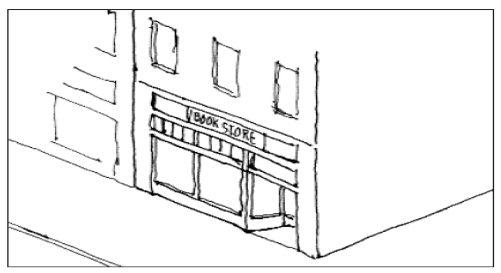
8.3.1. Wall signs.
Any sign directly attached to an exterior wall of a building or dependent upon a building for its support shall be considered a wall sign. Signs directly painted on wall shall be considered wall signs. Wall-mounted signs are subject to the standards below.
(A)
The size of the wall sign shall be no more than five (5) percent of the facade area on which the sign is located, or twenty-four (24) square feet, whichever is less.
(B)
The maximum wall sign area may be divided into two (2) separate signs on the same building facade as long as the total area of the two (2) signs does not exceed the maximum permitted.
(C)
Maximum height shall be eighteen (18) feet above finished grade on that facade.
(D)
Wall signs cannot be located on windows or doors. Standards for window signs appear elsewhere in this chapter.
(E)
Metal applied letter signs may substitute for wall signs. The sign size shall be calculated by drawing one (1) parallelogram around the text and images, adding a two-inch border on all sides, and calculating the area of the resulting box.
Any sign directly attached or painted on to an exterior wall of a building shall be considered a mural. Nothing contained in this section shall circumscribe the display of artwork or a mural in interior locations. Murals are subject to the standards below.
(A)
Murals shall be permitted only in the following districts: Town Center (TC), Town Residential (TR), General Commercial (CG) and Industrial (ID).
(B)
Murals shall be a form or expression of art.
(C)
Murals shall not contain any obscene, explicit, or false or misleading content.
(D)
All murals are required to receive prior approval in writing from the Design Control Committee (DCC). As such, the following documentation will be required in order to considered.
a.
Written consent from the private property owner.
b.
At least two letters of support from the community is encouraged.
c.
A draft of the artwork, including the size, color and material specifications.
d.
A plan for who will be maintaining the mural as well as how long the mural will be displayed.
(E)
A combination of a wall sign and mural on one (1) wall is allowed. Wall signs will be reviewed on staff level according to Section 8.3.1, while murals will still be reviewed and approved by the DCC.
(F)
A person applying for approval of a mural may have an informal preapplication review to allow for a preliminary assessment of the project's compliance as well as suggestions for modifications.
(G)
In reviewing each submittal, the DCC should consider the government's interest in:
a.
Promotion of tourism;
b.
Economic growth;
c.
Aesthetic interests and compatibility with the building architecture surroundings;
d.
Preservation of property values;
e.
Historical preservation; and
f.
Maintaining harmony of design in Town Center (TC), Town Residential (TR), General Commercial (CG) and Industrial (ID) districts.
(H)
The board should consider the size and scale of the mural, the textures, materials and colors in relation to the government interests listed above.
(I)
The DCC may deny an application if the DCC determines that the mural would be detrimental to the government interests enumerated above. Any decision denying a mural submittal must be reduced to writing, with consideration given to at least one (1) of the above enumerated factors.
( Ord. No. 14-2020 , 12-8-2020)
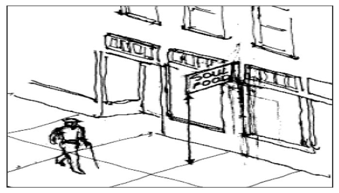
A sign affixed to a building and supported only by the wall on which it is mounted is a projecting sign. These signs shall be subject to the following regulations.
(A)
Maximum sign area is six (6) square feet per side.
(B)
Clearance from the lower edge of the signboard to the ground shall be seven (7) feet or greater.
(C)
Height of the top edge of the signboard shall not exceed the height of the wall from which it projects for single story buildings, or the height of the sill or bottom of any second story window for multi-storey buildings.
(D)
Distance from the building to the signboard shall not exceed two (2) feet.
(E)
Width of signboard shall not exceed three (3) feet.
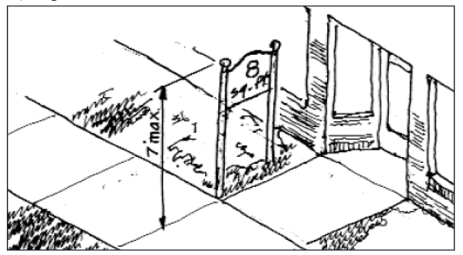
8.3.3. Freestanding (ground-mounted) signs.
A freestanding sign is that supported by a sign structure secured in the ground, wholly independent of any other support. Freestanding signs shall meet the following standards.
(A)
The building served by the freestanding sign shall be set back at least five (5) feet.
(B)
Maximum sign area is eight (8) square feet of copy area per side. If there are no other signs on the facade of the building for which the sign is erected, the copy area of the ground-mounted sign shall be a fifteen (15) square feet per side, maximum. The frame and/or structure of the sign shall not count toward maximum sign area, provided the structure is not more than one (1) foot thick.
(C)
Ground-mounted signs identifying institutions shall be a maximum of twenty (20) square feet of copy area per side. The frame and/or structure of the sign shall not count toward maximum sign area, provided the structure is not more than one (1) foot thick.
(D)
The height of the top of the signboard, or of any posts, brackets, or other supporting elements shall not exceed seven (7) feet.
(E)
In the case of a group of buildings or shops that act as a unit, one (1) freestanding sign may be erected to advertise all of the businesses.
(F)
No neon is allowed on freestanding signs.
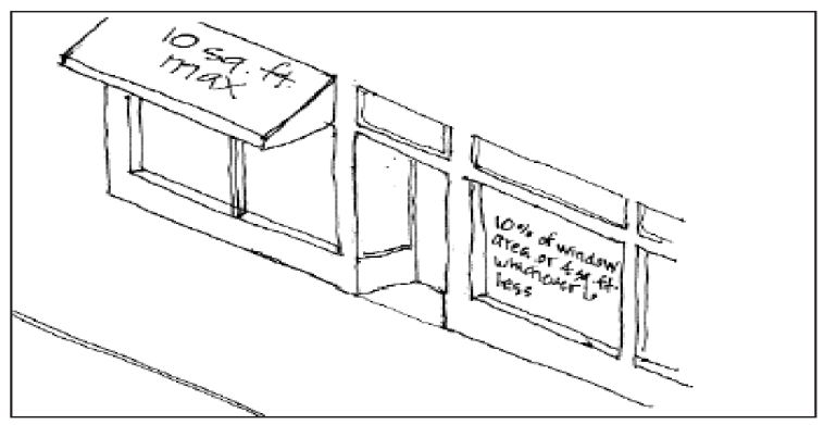
An awning sign is made of flexible fabric or similar material covering a metal frame attached to a building over a window or door. The awning sign may be erected so that it can be raised to a position flat against the building when not in use. Awning signs shall meet the following standards.
(A)
Eight (8) square feet maximum signage area on an awning.
(B)
No backlit awnings shall be allowed.
(C)
No neon shall be allowed on awnings.
8.3.5. Window (and door) signs.
Any sign on a building, either exterior or interior, within two (2) feet of the window, which is intended to be viewed from the exterior of such building, shall be considered a window sign. On-site advisory signs, however, are not considered window signs for the purpose of this ordinance. Window signs shall meet the following standards.
(A)
Maximum size shall be ten (10) percent of the window or door area, or four (4) square feet, whichever is less.
(B)
The sign shall be silk-screened, hand-painted, vinyl, or etched onto the window. Alternatively, a neon sign hung inside the building in the window shall be allowed.
(C)
A window sign in a door shall be no more than two (2) square feet.
A sidewalk sign is an A-frame sign or easel sign, also known as a sandwich board, placed on the sidewalk in front of a business, sometimes posting a menu, or directing patrons to a business at the rear of a building. Sidewalk signs shall meet the following standards.
(A)
The sign location may be located in the right-of-way adjacent to the property served by the sign, but the sign shall not interfere with pedestrian or vehicular circulation or sightlines and shall leave at least four (4) feet of sidewalk clearance.
(B)
All sidewalk signs shall be located in front of a primary building, but may direct patrons to the rear of the building or to a neighboring building along an intersecting right-of-way.
(C)
The sign is constructed of durable materials.
(D)
The signboard does not exceed six (6) square feet per side and one (1) sign per building.
(E)
Letter height shall not exceed four (4) inches.
Any sign with a portion thereof constituting a readerboard with characters, letters, or illustrations that can be changed or rearranged by any means (manual, electronic, atmospheric, mechanical, remote, etc.) without altering the face or surface of the sign. Changeable copy signs, including time and temperature signs, shall meet the following standards to be permitted:
(A)
District limitations. Changeable copy signs shall not be allowed within any residential zoning district with the exception of changeable copy signs used in conjunction with an institutional use; e.g., schools, churches, or public uses.
(B)
Size. Maximum sign area is dictated by that for freestanding/ground mounted signs per subsection 8.3.3(B) and (C), unless the sign location falls under Section 8.4 for highway-oriented signs.
(C)
Integration. The changeable copy readerboard portion of the sign may comprise no more than fifty (50) percent of the total sign face area to which it is a part.
(D)
Illumination. If the message center portion of the sign is being utilized after sunset, the static portion of the sign must also be functioning, illuminated, and readable.
(E)
Electronic changeable copy signs:
(1)
District limitations. Electronic changeable copy signs shall be allowed for use by nonprofit and public agencies; e.g., schools, churches, or public uses.
(2)
Orientation. When located within one hundred fifty (150) feet of one (or more) residentially-used lot(s) in a residential zone, all parts of an electronic changeable copy sign shall be oriented so that no portion of the sign face is visible from existing or permitted principal structures on those lots;
(3)
Limited text. Changeable text of the sign shall be limited to a maximum of ten (10) words to allow passing motorists to read the entire copy with minimal distraction;
(4)
Duration. Any changeable portion of the message shall have a minimum duration of eight (8) seconds and shall be a static display.
(5)
Transitions. During transition from one sign face to another, messages may fade in, dissolve, or scroll or have limited animation provided they do not violate the prohibitions in Section 8.9.
(6)
Color. In residential districts, any portion of the changeable message shall use an amber color or a colored LED projection.
(7)
Brightness. Prior to issuance of a permit for an electronic changeable sign, the applicant shall provide a written certification from the sign manufacturer that the light intensity has been factory pre-set not to exceed a maximum illumination of five thousand (5,000) nits (candelas per square meter) during daylight hours, and five hundred (500) nits (candelas per square meter) between dusk to dawn as measured from the sign's face at maximum brightness in any district.
(8)
Dimmer control. The sign shall be equipped with an automatic dimmer control that will automatically dim the intensity of the light emitted by the sign during ambient low-light conditions and at night so the sign does not exceed the maximum brightness levels allowed in [subsection] (7) above.
(Ord. No. 1-2012, § 1, 3-13-2012; Ord. No. 14-2020 , 12-8-2020)
(A)
Signs may be illuminated by an external or internal source.
(B)
All illumination shall be provided by a steady stationary light source.
(C)
The intensity of light emitted to or from a sign shall not exceed two hundred twenty (220) lux at any point on the sign face.
(D)
Signs illuminated by an internal source must have permanent, nonilluminated framing.
(E)
The light source for any externally illuminated sign shall be shaded, shielded and directed such that the light intensity or brightness is not visible from adjacent properties or rights-of-way.
(F)
No exposed reflective type bulbs and no strobe/intermittent light or incandescent lamps shall be used to illuminate a sign.
(G)
Neither the direct, nor reflected, light from primary light sources - internal or external - shall create a traffic hazard to operators of motor vehicles on public thoroughfares.
(H)
The color of external light sources to illuminate signs shall be white.
(Ord. No. 1-2012, § 1, 3-13-2012)
8.4. - Highway-oriented signs.
The following regulations apply to signs proposed on property adjacent to intercity arterial highways with four (4) or more travel lanes, except where alternate standards for signs for certain purposes and land uses are specified.
8.4.1. On-premises commercial signs.
(A)
On-premises signs shall be permitted in all zones provided that the sign advertises the principal use of the lot.
(B)
Signs shall be located in such a way that they will maintain horizontal and vertical clearance of all overhead electrical conductors. No sign shall be installed closer than ten (10) feet horizontally or vertically from any conductor or public utility guy wire.
(C)
No sign shall be allowed to protrude into the front, side or rear setback. In the absence of required setbacks, no sign shall be located closer than ten (10) feet from the right-of-way or five (5) feet from the side property lines.
(D)
One (1) freestanding on-premises sign shall be allowed per parcel, unless the use is located within a complex, such as a business park or office complex, and shall not exceed three (3) square feet of copy area for each linear foot of road frontage (e.g., one hundred (100) feet of road frontage would justify a seventy-five-square-foot sign), or the maximum sign area permitted in a district, whichever is less.
(E)
Wall signs are allowed but shall not exceed more than thirty-five (35) percent of the wall area on which the sign is affixed.
(F)
The height of a freestanding on-premises sign shall not exceed twenty (20) feet from the surface elevation of the right-of-way, or surface grade beneath the sign, whichever is less.
(G)
The clearance of a freestanding on-premises sign shall comply with the table at right. Clearance shall be measured from finished grade beneath the sign and the surface elevation of the adjacent right-of-way to ensure adequate visual clearance for motorists.
(H)
Signs oriented parallel to the right-of-way shall be exempt from the requirement above and may be located at grade level.
(I)
No sign shall be erected at the intersections of streets, driveways, or alleys in such a manner as to obstruct clear vision.
(J)
On-premises signs may be illuminated by indirect or internal illumination.
(K)
In the event a business is located on a corner lot, two (2) on-premises freestanding signs shall be allowed per parcel. If the intersecting street is not an intercity arterial road with four (4) or more lanes, the second sign shall meet the requirements for pedestrian-oriented signs, Section 8.3.
(L)
No sign shall be placed within fifty (50) feet of conventional residential zoning district purposes unless the sign meets the requirements for pedestrian-oriented signs, per Section 8.3.
(M)
All pedestrian-oriented signs, per Section 8.3, shall be allowed on property adjacent to intercity arterial highways with four (4) or more travel lanes, except that sidewalk signs shall not be permitted in the right-of-way of the same intercity arterial highways.
( Ord. No. 14-2020 , 12-8-2020)
Any sign located, or proposed to be located, at any place other than within the same site or land development in which the specific business or activity being identified on the sign is itself located or conducted is an off-premises sign.
(A)
Off-premises signs shall be allowed only in the Industrial (ID) zoning district.
(B)
One (1) off-premise sign shall be allowed per lot.
(C)
Off-premises signs shall not be greater than twenty (20) feet in height above the surface elevation of the adjacent right-of-way of finished grade beneath the sign.
(D)
Off-premises signs shall not be greater than seventy-five (75) feet in copy area per side.
(E)
Off-premises signs shall be set back at least twenty (20) feet from the pavement edge of the nearest road surface.
(F)
Separation of off-premises signs greater than thirty-five (35) feet in sign area shall be at least one thousand (1,000) feet, measured along the nearest road, from any other off-premises sign.
( Ord. No. 14-2020 , 12-8-2020)
8.5. - Signs for specific purposes and land uses.
Signs for the following specific purposes and land uses shall meet those standards provided herein, regardless of standards more broadly applied.
8.5.1. Neighborhood signs.
A sign that identifies a neighborhood, residential community, or other residential subdivision, name and logo shall not exceed twenty (20) square feet in area. Such signs shall be placed so as not to obstruct the view of traffic and shall be externally illuminated. The sign shall be set back a minimum of ten (10) feet from residential lot lines and road right-of-way.
8.5.2. Project construction signs.
Any sign erected and maintained on the premises temporarily during construction and displaying information, such as the name of the architect, contractor, developer, finance organization, subcontractor or materials vendor on property such individual is furnishing labor, services, or material shall meet these standards for project construction signs.
(A)
One (1) sign shall be allowed per land development or site development.
(B)
The sign shall not exceed thirty (32) square feet (one (1) side).
(C)
The sign is removed within fifteen (15) days of the completion of the project.
(D)
The sign location shall not interfere with pedestrian or vehicular circulation or sightlines.
(A)
Building directory signs, identifying the occupants of a building, shall be wall-mounted, located next to the entrance, a maximum of three (3) square feet, and shall not project more than six (6) inches from the wall.
(B)
Service entrance signs shall not exceed two (2) square feet.
(C)
Parking directional signs may be either wall-mounted or freestanding and are limited to two (2) square feet.
8.6. - Maximum number of signs.
(A)
The following maximums shall apply for individual buildings. Standards for each sign type shall be found in Sections 8.3 and 8.4, above.
(1)
Three (3) total signs of the following types are allowed: wall, awning, freestanding, window, projecting. A sidewalk sign is allowed in addition.
(2)
One (1) additional sign is allowed per secondary entrance (located at the secondary entrance) of the following types: wall, awning, window.
(3)
One (1) service entrance sign is allowed.
(4)
One (1) parking directional sign per parking area is allowed.
(B)
The following maximums shall apply for multi-unit buildings, such as commercial strip malls. Standards for each sign type shall be found in Sections 8.3 and 8.4, above.
(1)
The following maximums apply to the entire property.
(a)
One (1) wall sign allowed on the primary facade.
(b)
One (1) building directory sign per entrance to the property.
(c)
One (1) service entrance sign.
(d)
One (1) parking directional sign per parking area.
(2)
The following maximums apply to each tenant space with a separate entrance.
(a)
Three (3) signs from the following list are allowed: wall, awning, window, projecting, sidewalk sign.
(b)
One (1) sign per unshared secondary entrance is allowed from the following types: wall, awning (on main face or valance), window.
(3)
The following maximums apply to each tenant space with a shared primary entrance.
(a)
One (1) sign is allowed from the following types: wall, awning, window.
(b)
One (1) sign per unshared secondary entrance from the following types: wall, awning, window.
(c)
One (1) sidewalk sign per entrance.
8.7. - Flags and banners.
(A)
Flags on residential property are exempt signs.
(B)
Street banners (those spanning roads) and flags in road rights-of-way shall be limited to noncommercial activities of local government, institutions (e.g., schools), and nonprofits and similar organizations.
(C)
A maximum of one (1) flag per corporation, institution, government, or other entity shall be allowed per building. Duplicate or identical flags shall not be allowed.
(D)
The pole from which said flags are flown shall not exceed the building height limit of the zoning district in which it is located.
8.8. - Exempt signs.
The following signs do not need a zoning permit and may be erected at the discretion of the landowner.
(A)
Signs erected for orderly traffic control and other municipal or governmental purposes will be permitted, including historical monuments, markers, and signs erected by a public authority.
(B)
Signs advertising agricultural products produced on the premises that do not exceed four (4) square feet in area. There shall be a limit of one (1) such sign along each street abutting the parcel. Such signs shall be taken down during the seasons the agricultural products are not being sold.
(C)
Temporary civic, cultural, and public service window posters.
(D)
Temporary promotional or special sales window signs no greater than six (6) feet in sign area, when posted inside commercial establishments, for not more than thirty (30) days.
(E)
Commercial copy signs on ball fields mounted on outfield fences, facing toward the infield.
(F)
Flags on residential property.
(G)
Political signs. Any sign erected for the purpose of advertising a candidate for public office, or stating a position on a public issue on which an election or referendum is pending with respect to a particular campaign, shall be exempt, provided the following standards are met.
(1)
It is unlawful to place, erect, or maintain any political sign so as to pose a visible hazard to pedestrian or vehicular traffic along streets, sidewalks, or at street corners.
(2)
No political signs are allowed to be illuminated or larger than sixteen (16) square feet.
(3)
Signs cannot be placed more than forty-five (45) days prior to official election date for the issue presented on the sign.
(4)
Signs must be removed no later than ten (10) days after the election.
(H)
Real estate signs. Any temporary sign pertaining to the sale, exchange, lease or rental of a building or real property, or other form of exchange shall be exempt, provided the following standards are met.
(1)
Real estate signs in residential zoning districts shall be not exceed eight (8) square feet. One (1) sign shall be allowed per road frontage.
(2)
Real estate signs in non-residential zoning districts shall appear as follows.
(a)
A sign not exceeding sixteen (16) square feet is allowed for the sale, lease, rental, or display of the property on which the sign is located.
(b)
Real estate signs in shopping and/or retail centers must be displayed within the tenant space window and/or in the tenant panel space of the freestanding sign.
(c)
Freestanding real estate signs shall be allowed on property adjacent to intercity arterial highways with four (4) or more travel lanes. Otherwise, the sign shall be posted on the building or in a window.
(d)
One (1) sign shall be allowed per road frontage.
(Ord. No. 3-2009, § 1, 5-12-2009; Ord. No. 13-2020 , § 1, 10-6-2020)
8.9. - Prohibited signs
(A)
Signs that are dilapidated or in disrepair shall be prohibited.
(B)
Signs on roofs, chimneys and balconies shall be prohibited.
(C)
Signs programmed to flash, blink or fluctuate the intensity of lights or to operate intermittently so as to create a strobe effect shall be prohibited.
(D)
Mobile or portable signs shall be prohibited, except sidewalk signs.
(E)
Signs on parked vehicles shall be subject to the following standards.
(1)
Signs placed on, painted on, or affixed to vehicles and/or trailers that are parked on public right-of-way, public property so as to be visible from a public right-of-way, and where the apparent purpose is to advertise a product or business, or direct people to a business or activity located on the same or nearby property shall be prohibited except as temporary signage, meeting the requirements of Section 9.6.4.
(2)
This does not prohibit identification sign painted on or affixed to vehicles and trailers, such as small lettering on motor vehicles, where the sign is incidental to the primary use of the vehicle or trailer.
(F)
Any sign that emits a sound, odor, or visible matter such as smoke or vapor, including any form of pyrotechnics shall be prohibited.
(G)
Any sign or sign structure that obstructs the view of, or is operated in any way that could cause it to be confused with, a traffic/directional safety device or public safety vehicle shall be prohibited.
(H)
Any sign painted on or affixed to trees or other natural features, utility poles, or benches shall be prohibited.
(I)
Any sign exhibiting statements, words, or pictures that are of an obscene or pornographic nature shall be prohibited.
(Ord. No. 11-2011, § 1, 12-13-2011; Ord. No. 1-2012, § 1, 3-13-2012)
9.1. - Applicability.
The following provisions shall apply throughout Hanahan, regardless of the underlying regulating district
9.2. - Externalities.
(A)
Vibration. No inherent and recurring generated vibration shall be created so as to be perceptible without instruments at the property line.
(B)
Noise. No persistent noise shall be detectable beyond the property line in excess of the average level of street and traffic noise generally heard at the point of observation, and no noise above such level shall be caused that is objectionable with respect to intermittence, beat, frequency, or shrillness.
(C)
Odor. No objectionable odor shall be created detectable beyond the property line, and the emission of odors, regardless of type, shall not be such as to be detrimental to the value and use of adjacent property.
(D)
Light. The source of exterior lighting shall not be arranged in such a manner as to be detrimental to adjacent properties or the traveling public. The following standards shall apply.
(1)
Intensity. A light source not provided specifically for the circulation of pedestrians or vehicles between parcels or to and from the public right-of-way shall not emit light exceeding one (1) foot-candle in intensity at the lot line or in the right-of-way. Lighting of parking areas and drive-in, drive-through, and drive-up services shall comply.
(2)
Focused, directed, and undiffused light sources shall not be aimed, directed, or reflected toward a public right of way or another lot.
9.3. - Non-conformities.
9.3.1. Non-conforming lots of record.
Where a lot of record at the time of the effective date of this ordinance or revision thereto has less area or width than required in the zoning district in which it is located, such a lot may nevertheless be used for a permitted use in the district, provided such complies with all other zoning district regulations provided all other applicable regulations are complied with.
9.3.2. Non-conforming land uses.
(A)
Non-conforming land uses are declared by this ordinance to be incompatible with permitted uses in the districts involved. However, to avoid undue hardship, the lawful use of any building or land at the time of the enactment of this ordinance may be continued even though it does not conform with the provisions of this ordinance, provided that the non-conforming building or land use is not:
(1)
Changed to another non-conforming use; or
(2)
Reestablished after discontinuance of one (1) year.
(B)
Property restoration, rehabilitation, retrofit, and replacement shall be allowed, provided, neither gross square footage of structures nor the number of dwelling units is increased.
(C)
Notwithstanding subsection (B), above, a non-conforming manufactured home may be replaced by another manufactured home meeting the standards of Section 5.8: Manufactured Home on a Separate Lot, or Section 5.9: Manufactured Home Parks, Courts, and Communities, as applicable.
(Ord. No. 6-2009, § 1, 9-8-2009)
9.3.3. Non-conforming structures.
(A)
Any improvements to the property worth fifty (50) percent of the appraised value of the structure shall trigger compliance with all standards found herein.
(B)
The structure shall not be expanded, enlarged, or altered in a way that increases the non-conformity (e.g., farther protrusion into required yards).
9.3.4. Non-conforming site conditions.
(A)
Improvements worth ten (10) percent of appraised value or addition of six (6) or more parking spaces shall trigger compliance with standards for parking, access, and landscaping.
(B)
All proposed signage for which a permit is required shall comply with signage standards, except those measures necessary to maintain or repair the non-conforming sign.
9.4. - Working from home.
9.4.1. Home occupations.
A home occupation shall be permitted in any dwelling unit, regardless of zoning district, provided it:
(A)
Is conducted by residents of the dwelling;
(B)
Employs a maximum of two (2) persons in addition to any residents of the dwelling;
(C)
Utilizes not more than thirty (30) percent of the total floor area of principal building for commercial use;
(D)
Collocates with no accessory structure on the property exceeding half the gross floor area of the dwelling;
(E)
Is not visibly evident from the outside of the dwelling and produces no alteration or change in the character or exterior appearance of the principal building from that of a dwelling;
(F)
Shall not display products visible from the street;
(G)
Does not generate traffic in greater volumes than would normally be expected in a residential neighborhood; and
(H)
Provides no more than two (2) off-street parking spaces in the front yard (which shall typically occur unstacked in the driveway) with remaining required spaces to the side or rear of primary structure.
A live/work unit is a joint residential-commercial unit that the proprietor occupies as a residence. Allowable non-residential uses and locations for live/work units are specified by zone, per Chapter 4. The live-work unit shall meet the following standards:
(A)
Residents of the dwelling operate the commercial use.
(B)
The commercial use employs a maximum of four (4) persons in addition to any residents of the dwelling.
(C)
The commercial use utilizes not more than sixty-seven (67) percent of the total floor area of principal building.
(D)
The use may employ a portion or all of an accessory structure on the property, provided the accessory structure does not exceed half the gross floor area of the primary structure.
9.5. - Fence and wall standards.
9.5.1. Applicability.
Jails are exempt from fence and wall standards. Fence standards shall not apply in industrial zoning districts. Unless otherwise noted in this ordinance, fences or walls are permitted in the various districts subject to the following regulations. In the event that a fence is located in a drainage area centered along a property boundary, fence height maximums shall be exclusive of average swale depth, measured from top of bank.
(Ord. No. 1-2015, § 1, 3-10-2015)
9.5.2. Standards for residential uses.
(A)
Maximum height—Front yard: Four (4) feet, except as may be required for screening in the affected district.
(B)
Maximum height—Side and rear yard: Six (6) feet, except as may be required for screening in the affected district. Where the side or rear yard is adjacent to intercity arterial highways with four (4) or more travel lanes, the maximum height is eight (8) feet.
(C)
Materials. The preferred materials are wood, wrought iron, brick, or combinations thereof. Chain link is acceptable only in side and rear yards. Barbed and razor wire shall be prohibited.
(Ord. No. 1-2015, § 1, 3-10-2015)
9.5.3. Standards for non-residential uses.
(A)
Maximum height—Front yard: Six (6) feet.
(B)
Maximum height—Side and rear yard: Eight (8) feet.
(C)
Materials. Brick, stucco, iron, stone, wood, concrete, chain link or combinations thereof are preferred. Chain link is acceptable only in side and rear yards. Barbed wire atop chain link is permitted for fences not visible from a public right-of-way.
(Ord. No. 1-2015, § 1, 3-10-2015)
9.6. - Temporary uses and displays.
9.6.1. Construction trailers.
(A)
Construction trailers may be located at a building site for which a valid building permit has been obtained from the City of Hanahan, or in the case of a residential subdivision, a valid building permit has been obtained for at least one (1) of the residential units being constructed.
(B)
All construction trailers shall be located at least ten (10) feet from any active public right-of-way and from all property boundaries external to the project.
(C)
All construction trailers shall be removed within one (1) month of the completion of the project and before issuance of a certificate of occupancy.
9.6.2. Temporary manufactured homes.
A manufactured home may be allowed on a temporary basis in a zoning district even if it is a prohibited use if a disaster occurs that results in the destruction of an occupied single-family dwelling. The purpose of allowing such manufactured home on said lot is to give the occupants of the destroyed dwelling unit a place to live during the restoration or replacement of the destroyed unit. The zoning administrator will issue a zoning permit for such for a period of up to twelve (12) months, provided the following:
(A)
Construction of a new dwelling unit is proceeding in a diligent manner;
(B)
The granting of such permit will not materially endanger the public health, welfare, or safety; and
(C)
The manufactured home is at least ten (10) feet from all lot lines.
9.6.3. Temporary sales and events.
(A)
Where otherwise prohibited in a particular zoning district, temporary sales and events may be issued a zoning permit as herein provided. Such permits shall be effective for a duration mutually agreed to by the applicant and the zoning administrator not longer than forty-five (45) days, except for fifteen (15) additional days before and after the event allowed for setting up or taking down equipment, tents, and the like. A zoning permit may be renewed up to three (3) months thereafter, totaling four and one-half (4.5) months of operation per year. Upon completion and submittal of an application, the zoning administrator may grant a zoning permit for the following temporary uses:
(1)
Off-site seasonal retail;
(2)
Revivals;
(3)
Shows for civic and youth organizations; and
(4)
Fairs, carnivals, or other similar public activities.
(B)
All temporary uses not otherwise listed will be granted a zoning permit after the zoning administrator has made the following determinations:
(1)
The proposed use shall not materially endanger the public, health, welfare, and safety;
(2)
The proposed use shall not have a substantial negative effect on adjoining properties;
(3)
The proposed use shall be an allowed permanent land use in the zoning district in which it is proposed or, where not specified, similar to the set of allowed uses; and
(4)
A separate permit shall be obtained for each event.
(C)
In approving a zoning permit for a temporary use, the zoning administrator may authorize conditions regarding duration of the use, hours of operation, signage, lighting, etc. to ensure compliance with provisions of Section 9.6. Conditions stated in this section as well as conditions imposed by the zoning administrator to uphold the intent of this ordinance shall be indicated on the zoning permit issued for the temporary use. The applicant in receipt of the zoning permit shall ensure the permit is readily available at the temporary event, preferably posted at a prominent location, such as the entrance, ticket desk, or point of purchase.
For displays of lighting and signage to be shown for a temporary sale or event, such as a grand opening, carnival, or farmers market, the zoning administrator may authorize a zoning permit for the following:
(A)
Temporary signage. A temporary display may contain fluttering devices (e.g., flags, banners, and streamers) for a period of not more than thirty (30) days. Not more than two (2) signs totaling not more than thirty-five (35) feet in sign area shall be allowed per use or purpose.
(B)
Temporary lighting. A temporary display may contain lighting in addition to that generally permitted in the district provided such light source is constant and stationary, for a duration of not more than thirty (30) days.
9.6.5. Portable storage systems.
(A)
A portable storage system shall be allowed as a temporary use for maximum period of thirty (30) days in any twelve-month period. The units shall only be allowed in the rear or side yards of the parcel and shall meet building setback requirements.
(B)
If the rear and side yards are inaccessible, as determined by the zoning administrator, the portable storage unit may be placed in the front yard. The unit shall meet front yard setbacks to the extent practical. Front yard placement shall be limited to a maximum of fifteen (15) days in any twelve-month period.
(Ord. No. 3-2009, § 1, 5-12-2009)
9.7. - Miscellaneous parking and outdoor storage.
9.7.1. Parking, storage, or use of campers or other major recreational equipment.
(A)
For the purpose of this ordinance, major recreational equipment shall include motorized watercraft, aircraft, and off-highway motor vehicles for use other than commercial purposes, as well as on-highway vehicles intended for racing, sleeping, or other non-transportation uses, in addition to any trailer or similar equipment used to transport major recreational equipment.
(B)
All major recreational equipment shall have a current registration and be usable for the purpose for which it was manufactured.
(C)
Storage. No camper or major recreational equipment shall be parked or stored on any empty (vacant house/undeveloped) lot in a residential zoning district. Recreational equipment shall be parked or stored only in the side or rear yard of a developed residential lot; however, in demonstrable cases where recreational equipment cannot be stored in the side or rear yard due to physical constraints on the property, it may be stored in the front yard area under this ordinance. No such equipment shall be used for living or housekeeping purposes when permanently parked or stored on a residential lot in any location not approved for such uses.
(D)
Parking. Campers and other major recreational equipment shall be temporarily parked anywhere on residential premises for a period not to exceed seventy-two (72) hours during loading or unloading. Such equipment may be temporarily parked anywhere on the lot for visiting purposes, in which visitors utilize the equipment for sleeping overnight, for up to two (2) weeks.
(E)
Campers and other major recreational equipment shall not be parked or stored in a manner that obstructs a motorist's view of oncoming traffic on adjacent and intersecting streets.
(Ord. No. 10-2014, § 1, 1-13-2015)
9.7.2. Parking, storage, and use of non-recreational vehicles and equipment and inoperable vehicles.
An "inoperable" vehicle is one that is in such condition at the time of inspection, that it is no longer usable for the purpose for which it was manufactured, regardless of the potential for repair or restoration. If the vehicle is wrecked, dismantled or partially dismantled it is presumed to be "inoperable."
(A)
All inoperable vehicles and non-recreational equipment, including those without a current registration and license plate, shall be stored in enclosed structures or entirely blocked from view from the public roadway behind a fence or natural barrier.
(B)
No construction equipment shall be stored on lot in a residential zoning district other than in completely enclosed buildings.
(C)
Parking of vehicles, implements, and/or equipment used for commercial, industrial, farming, or construction purposes in a residential zoning district shall be limited to one (1) vehicle per residence. Such vehicle, implement, or equipment shall have a curb weight equal to or less than ten thousand five hundred (10,500) pounds and a gross vehicle weight rating (GVWR), where applicable, equal to or less than thirteen thousand (13,000) pounds.
(D)
A vehicle or equipment with a curb weight in excess of ten thousand five hundred (10,500) pounds or a gross vehicle weight rating (GVWR), where applicable, in excess of thirteen thousand (13,000) pounds used for commercial, industrial, farming, or construction purposes shall be prohibited from parking in a residential zoning district, inclusive of any right-of-way, when not actively engaged in commerce.
(E)
Unless subsection 9.7.2(C) applies, a truck/van with an enclosed cargo volume equal to or greater than three hundred fifty (350) cubic feet (e.g., a box truck) shall be parked or stored only in the side or rear yard of a developed residential lot or in a completely enclosed building (e.g., garage) when in a residential zoning district, except when actively engaged in commerce (e.g., loading and unloading).
(Ord. No. 10-2014, § 1, 1-13-2015)
Editor's note— Ord. No. 10-2014, § 1, adopted Jan. 13, 2015, changed the title of § 9.7.2 from "Parking, storage, and use of non-recreational vehicles and equipment" to read as herein set out.
9.7.3. Use of shipping containers prohibited.
Shipping containers shall not be placed or stored in any open area, except where expressly permitted by this ordinance, and shall not be used as an accessory building or structure in any zoning district.
(Ord. No. 3-2009, § 1, 5-12-2009; Ord. No. 5-2009, § 1, 9-8-2009; Ord. No. 10-2014, § 1, 1-13-2015)
A "restoration vehicle" is a vehicle that is retained on the premises for the purpose of repair or upgrade.
(Ord. No. 10-2014, § 1, 1-13-2015)
9.7.5. Restoration permit required.
(A)
Restoration. A person who seeks to restore a vehicle on their premises shall apply for a vehicle restoration permit. The location of the vehicle must be the same as the applicant's place of residence. The City of Hanahan Building and Codes Department may issue one (1) written permit to an owner allowing the unlicensed or unregistered vehicle to be on the owner's premises for the purpose of repair and upgrade for a period not to exceed twelve (12) consecutive months, with a one (1) year extension available upon request and approval (See (D)). Only one (1) vehicle restoration permit is allowed at a time per household or dwelling site.
(B)
Storage. Any unlicensed or unregistered vehicle being repaired or upgraded under the vehicle restoration permit authorization must be stored in a garage or must be parked on a concrete or asphaltic surface, or an approved rock/gravel surface, and covered with an approved fitted cover designed for that vehicle type. The repair or upgrade of the vehicle must be for personal hobby or recreational purposes, and not be for business purposes.
(C)
Application. Restoration permits shall be obtained from the building and codes department after completion of an application and payment of a fee of twenty dollars ($20.00).
(D)
Extension. Permittee may request and the city may authorize one (1) twelve (12) month extension in order to complete the repair, provided permittee is in compliance with the terms of the permit and the property maintenance provisions in this ordinance. At the expiration of the permit or its extension period, if the vehicle is not fully restored to working condition, the owner must either store the vehicle in a fully enclosed building or remove the vehicle from the property.
(Ord. No. 10-2014, § 1, 1-13-2015)
10.1. - Intent.
For the purpose for interpreting this ordinance, certain words, concepts, and ideas are defined. Except as defined herein, all other words used in this ordinance shall have their every-day dictionary definition.
10.2. - Interpretation.
(A)
Words used in the present tense include the future tense.
(B)
Words used in the singular number include the plural, and words used in the plural number include the singular.
(C)
The word "person" includes a firm, association, organization, partnership, corporation, trust, and company as well as an individual. The word "lot" includes the word "plot" or "parcel" or "tract."
(D)
The word "shall" is always mandatory.
(E)
The word "structure" shall include the word "building."
(F)
The word "used" or "occupied" as applied to any land or building shall include the words "intended, arranged, or designed to be used or occupied."
(G)
Any word denoting gender includes the female and the male.
(H)
The word "city" means the City of Hanahan in Berkeley County, South Carolina, unless otherwise noted, while the capitalization of the word — "City" — means the government of the same.
(I)
The word "state" means the State of South Carolina, unless otherwise noted, while the capitalization of the word — "State" — means the government of the same.
10.3. - Definitions.
As used in this ordinance, the following words and terms shall have the meanings specified herein:
ANSI A300. Pruning standards set forth in the Standard Practices for Trees, Shrubs, and Other Woody Plant Maintenance.
Access. A way or means of approach to provide vehicular or pedestrian physical entrance to a property. The location of the intersection of a street or driveway with a road.
Accessory. A use, structure, or part of a structure customarily incidental and subordinate to the principal use of a parcel or a structure is an accessory use or structure, provided the accessory use or structure functions as a complementary to the principal use or structure on the same parcel. e.g., residential accessory uses and structures include but are not limited to a garage, a utility shed, a swimming pool, and a deck. e.g., religious accessory uses and structures include but are not limited to a graveyard, a mausoleum, a columbarium. (Note that these uses and structures may also be accessory to the principal land use, "death care services.")
Acre. A measure of land area containing forty-three thousand five hundred sixty (43,560) square feet.
Adult arcade. Means any place to which the public is permitted or invited wherein coin-operated or slug-operated or electronically, electrically, or mechanically controlled still or motion picture machines, projectors, or other image-producing devices are maintained to show images to five (5) or fewer persons per machine at any one (1) time, and where the images so displayed are distinguished or characterized by the depleting or describing of "specified sexual activities" or "specified anatomical areas."
Adult bookstore or adult video store. Means a commercial establishment which, as one (1) of its principal business purposes, offers for sale or rental for any form or consideration any one (1) or more of the following:
(a)
Books, magazines, periodicals or other printed matter, or photographs, films, motion picture, video cassettes or video reproductions, slides, or other visual representations which depict or describe "specified sexual activities" or "specified anatomical areas"; or,
(b)
Instruments, devices, or paraphernalia designed for use in connection with "specified sexual activities." A commercial establishment may have other principal business purposes that do not involve the offering for sale or rental of material depicting or describing "specified sexual activities" or "specified anatomical areas" and still be categorized as adult bookstore or adult video store. Such other business purposes will not serve to exempt such commercial establishment from being categorized as an adult bookstore or adult video store so long as one (1) of its principal business purposes is the offering for sale or rental for consideration the specified materials which depict or describe "specified sexual activities" or "specified anatomical areas."
Adult cabaret. Means a nightclub, bar, restaurant, or similar commercial establishment which regularly features:
(a)
Person who appear in a state of nudity; or
(b)
Live performances which are characterized by the exposure of "specified anatomical areas" or by "specified sexual activities"; or,
(c)
Films, motion pictures, video cassettes, slides, or other photographic reproductions which are characterized by the depiction or description of "specified sexual activities" or "specified anatomical areas."
Adult motel. Means a hotel, motel, or similar commercial establishment which:
(a)
Offers accommodations to the public for any form of consideration; provides patrons with closed-circuit television transmissions, films, motion pictures, video cassettes, slides, or other photographic reproductions which are characterized by the depiction or description of "specified sexual activities" or "specified anatomical areas; and which has a sign visible from the public right-of-way which advertises the availability of this adult type of photographic reproductions; or
(b)
Offers a sleeping room for rent for a period of time that is less than ten (10) hours; or
(c)
Allows a tenant or occupant of a sleeping room to sub-rent the room for a period of time that is less than ten (10) hours.
Adult motion picture theater. Means a commercial establishment where, for any form of consideration, films, motion pictures, video cassettes, slides, or similar photographic reproductions are regularly shown which are characterized by the depiction or description of "specified sexual activities" or "specified anatomical areas."
Adult theater. Means a theater, concert hall, auditorium, or similar commercial establishment which regularly features persons who appear in a state of nudity or live performances which are characterized by the exposure of "specified sexual activities" or "specified anatomical areas."
Annexation. The incorporation of land into the limits of the existing municipality.
Antenna. A device, dish or array used to transmit or receive telecommunications signals.
Applicant. The owner of land proposed to be subdivided or its representative who shall have express written authority to act on behalf of the owner. Consent shall be required of the legal owner. The terms subdivider and developer can mean the applicant.
Bond. Any form of a surety bond in an amount and form satisfactory to the governing body. All bonds shall be approved by the city council whenever a bond is required by these regulations.
Buildable land. Land free of encumbrances and available to development, including high ground and non-jurisdictional wetlands. Land not buildable includes jurisdictional wetlands, land under water, land under conservation easement, and land committed to infrastructure and community facilities built prior to a land development proposal.
Building. Any structure used or intended for supporting or sheltering any use or occupancy.
Buffer. Land maintained in either a natural or landscaped state and used to screen and/or mitigate the impacts of development on surrounding areas, properties, or rights-of-way.
Caliper. The thickness of trees measured in inches. A caliper measurement for trees shall be measured twelve (12) inches above the soil line, or across the stump if the tree has been severed at less than twelve (12) inches above the soil line.
Common area. Land owned and maintained by a property owners association for the benefit of all owners, whether in conservation, recreation, stormwater management, circulation, parking, or other similar uses and spatial features.
Communications tower. A tower, pole, or similar structure which supports a telecommunications antenna operated for commercial purposes above ground in a fixed location, free-standing, guyed, or on a building.
Critical area. Wetlands below the critical line.
Critical line. The boundary of wetlands recognized by the Office of Ocean and Coastal Resources Management of the South Carolina Department of Health and Environmental Control.
Crown. The above ground parts of the tree that gives the tree its normal shape at maturity. The basic tree shapes are: umbrella, horizontal oval, vase, round, mound, broad triangle, upright oval, narrow triangle, narrow upright, weeping, columnar, and palm.
Day care services.
(a)
Family home day care. A dwelling unit in which care is given by a resident of that unit and no others during the day for one (1) and not more than twelve (12) children, including any child(ren) related to the caregiver.
(b)
Child day care services. Any center, agency, or place, other than a residence, where children not related to the operator are received for custodial care, apart from their parents, whether for compensation, reward, or otherwise, during part or all of the day or night and upon any number of successive days or nights, provided no child is given care for more than twenty-four (24) consecutive hours.
Developer. The owner of land proposed to be improved or subdivided or his/her representative who is responsible for any undertaking that requires review and/or approval under these regulations. Also Subdivider.
Development. The construction, reconstruction, conversion, structural alternation, relocation, or enlargement of any structure; any mine, excavation, landfill or land disturbance; and/or any change in use, or alteration or extension of the use, of land.
Diameter at breast height (DBH). The tree trunk diameter measured in inches at a height four and one-half (4.5) feet above the ground. If a tree forks into multiple trunks below four and one-half (4.5) feet, the trunk is measured at its most narrow point beneath the forks. Measurements shall be made by use of a circumference to diameter conversion tape.
Drip line. The vertical line extending from the outermost edge of the tree canopy to the ground.
Dwelling: Any building or part thereof used or intended to be used for continuous, long-term human inhabitation.
Dwelling, duplex: An independent dwelling unit utilizing structure—roof, floor, or wall—common to one (1) additional dwelling unit where both dwelling units occupy one (1) lot and no other primary land use or residence exists.
Dwelling, manufactured home. An independent dwelling unit composed of one (1) or more occupiable components assembled off-site, to a construction code certified by the U.S. Department of Housing and Urban Development, and transported to the site, but not permanently affixed to a foundation so that it can be subsequently relocated.
Dwelling, multi-family: An independent dwelling unit utilizing structure - roof, floor, and/or walls - common to one (1) or more additional dwelling units functioning as a community that provides access to each residence and a common area for vehicle parking and amenities.
Dwelling, patio house: A freestanding dwelling unit functioning as part of a community that provides access to each house and a common area for vehicle parking and amenities. A patio house lot does not provide parking for automobiles.
Dwelling, row house: A freestanding, independent dwelling unit on an individual parcel with no other primary residence or land use, for which vehicular access and parking are provided, at least in part, in the rear of the lot from an alley.
Dwelling, single-family detached: A freestanding, independent dwelling unit on an individual parcel with no other primary residence or land use.
Dwelling, townhouse or single-family attached: An independent dwelling unit sharing side wall(s) with like units, each with its own roof and foundation, on its own lot, which may be equal to or larger than the footprint of the unit. Direct access to and frontage on a transportation right-of-way is provided to each unit. Vehicle parking is provided on the lot, on street, or in common area.
Easement. Authorization by a property owner for another to use the owner's property for a specified purpose, to be recorded on a plat with the Berkeley County Register of Deeds. That area on private land used, or intended to be used, for the specified purpose.
Escort. Means a person who, for consideration, agrees or offers to act as a companion, guide, or date for another person, or who agrees or offers to privately model lingerie or to privately perform a striptease for another person.
Escort agency. Means a person or business association who furnishes, offers to furnish, or advertises to furnish escorts as one (1) of its primary business purposes for a fee, tip, or other consideration.
Escrow. A deposit of cash with the local government or escrow agent to secure the promise to perform some act.
Establishment. With regard to sexually oriented businesses, means and includes any of the following:
(a)
The opening or commencement of any sexually oriented business as a new business.
(b)
The conversion of an existing business, whether or not a sexually oriented business, to any sexually oriented business;
(c)
The additions of any sexually oriented business to any other existing sexually oriented business
Family. Any number of persons related by blood or marriage and living and cooking together as a single housekeeping unity, plus not more than two (2) unrelated roomers, boarders or domestic servants; or no more than three (3) unrelated persons living and cooking together as a single housekeeping unit.
Flag lot. A mostly landlocked lot, surrounded by lots on all sides, that accesses a public right-of-way by means of a narrow strip of property projecting from the main body of the lot.
Floor/area ratio. Fraction representing gross square footage of structure (floor) divided by the square footage of land on which such structures stand (area).
Frontage. That side of a lot abutting a public right-of-way or the distance over which that lot abuts the public right-of-way. If the term 'frontage' is applied to the Town Residential (TR) district, it shall be defined as both public or private right-of-way, and seen as a special exception with approval from the zoning administrator. Both public and private rights-of-way must meet road criteria set forth in Section 5.6, Land Development Ordinance.
Indigenous trees. Existing or natural growing trees native to the area, i.e. Live Oak (Quercus virginiana), Eastern Red Cedar (Juniperus virginiana), Southern Magnolia (Magnolia grandiflora), and Bald Cypress (Taxodium distichum) trees.
Infrastructure. The facilities and services needed to sustain residential, commercial, industrial, institutional, and other activities.
Land development. Activity, or the result of activity, described in Subsection 1.9(B) of the Hanahan Land Development Ordinance.
Lot. A tract, plot, or portion of a development or other parcel of land intended as a unit for the purpose, whether immediate or future, of transfer of ownership or possession or for development.
Lot, corner. A lot situated at the intersection of two (2) streets, the interior angle of such intersection not exceeding 135 degrees, which frontage on two (2) streets.
Lot frontage. The distance over which the lot abuts the public right-of-way.
Manufactured home space. Means a plot of ground within a manufactured home park designed for the accommodation of one (1) manufactured home.
Mural. Artistic expression painted onto a wall or ceiling. A mural that also qualifies as a sign (see definition below.) shall be regulated as a wall sign.
Non-conforming lot. A lot, the area, dimensions, or location of which were lawful prior to the adoption, revision, or amendment of the Zoning Ordinance, which fails to conform to the present requirements of the zoning district in which it is located.
Non-conforming structure/building. A structure or building, the size, dimensions, or location of which lawfully existed prior to the adoption, revision, or amendment to the Zoning Ordinance but which fails to conform to the current requirements of the zoning district in which it is located.
Non-conforming use. A use or activity that was lawful prior to the adoption, revision, or amendment of the Zoning Ordinance but which fails to conform to the current requirements of the zoning district in which it is located.
Nude model studio. Means any place where a person who appears in a state of nudity or displays "specified anatomical areas" is provided to be observed, sketched, drawn, painted, sculptured, photographed, or similarly depicted by other persons who pay money or any form of consideration.
Nudity or a state of nudity. Means the appearance of a human bare buttock, anus, male genitals, female genitals, or full female breast without a fully opaque cloth covering over the entire nipple and areola.
Office. A use or location primarily used for conducting the affairs of a business, profession, service, industry, government, or like activity where, typically, no material goods are produced or traded.
Parcel. A portion of land for which a single title describing and locating such land exists and is on record with the Berkeley County Register of Deeds.
Pedestrian-oriented development. Development designed with an emphasis on street sidewalk and other pedestrian access to and through the site(s) and building(s) over automobile access and parking areas. Such development will have parking to the side or rear of a building, will mix uses and provide them in proximity to one another, will allow the pedestrian the option or choice of not having to use a car to travel between uses, and will provide a variety of interesting and detailed streetscapes which balance the needs of pedestrian and vehicular traffic.
Pedestrian scale. Relationships between a person and the natural or built environment in which the person conceives of a sense of scale by comprehending depths, distances, and spaces, made possible through existing or manipulated size, texture, permanence, light, acoustics, and accessibility.
Permitted use. Any use specifically allowed in a zoning district, meeting the uniform standards set forth for the district, and subject to the restrictions applicable to that zoning district.
Permittee and/or licensee. Means a person in whose name a permit and/or license to operate a sexually oriented business has been issued, as well as the individual listed as an applicant on the application for a permit and/or license.
Manufactured home. See dwelling, mobile home.
Person. Means an individual, proprietorship, partnership, corporation, association, or other legal entity.
Public hearing. A meeting announced and advertised in advance that is open to the citizens and landowners of Hanahan where the public is given an opportunity to participate and provide input.
Public improvement. Any roadway, sidewalk, parkway, drainage ditch, or other facility for which the local government or other public agency may ultimately assume responsibility for maintenance and operation, or which may effect an improvement for which the responsibility of local government or other public agency is established.
Proper pruning. Pruning as defined by the 1995 ANSI A300 standards.
Right-of-way. Land used, or intended to be used, for transportation, drainage, or other public purpose defined by parcel boundaries and not overlapping privately owned parcels of land.
Scale. Established measure of proportion between actual and represented features and spaces, such as that represented graphically on a hard-line drawing.
Semi-nude. Means a state of dress in which the clothing covers no more than the genitals, pubic region, and areolae of the female breast, as well as portions of the body covered by supporting straps or devices.
Setback. The shortest distance from a structural element to a lot line. See also yard.
Sexual encounter center. Means a business or commercial enterprise that, as one (1) of its primary business purposes, for any form of consideration.
(a)
Physical contact in the form of wrestling or tumbling between persons of the opposite sex; or
(b)
Activities between male and female persons and/or persons of the same sex when one (1) or more of the persons is in a state of nudity or semi-nude.
Sexually oriented business. Means an adult arcade, adult bookstore or adult video store, adult cabaret, adult motel, adult motion picture theater, adult theater, escort agency, nude model studio, or sexual encounter center.
Sign. Any object, device, display, or structure, or part thereof used to advertise, identify, display, direct, or attract attention to an object, person, institution, organization, business, product, service, event, or location by any means, including words, letters, figures, design, symbols, fixtures, colors, illumination, or projected images.
Sign, animated or moving. Any sign or part of a sign that changes physical position or light intensity by any movement or rotation or that gives the visual impression of such movement or rotation.
Sign, changeable copy. A sign or portion thereof which as a readerboard for the display of text information in which each alphanumeric character, graphic, or symbol is defined by objects, not consisting of an illumination device and may be changed or re-arranged manually or mechanically with characters, letters, or illustrations that can be changed or rearranged without altering the face or the surface of the sign.
Sign, electronic changeable copy. A sign or portion thereof that displays electronic, non-pictorial, text information in which each alphanumeric character, graphic, or symbol is defined by a small number of matrix elements using different combinations of light emitting diodes (LED's), fiber optics, light bulbs or other illumination devices within the display area. Electronic changeable copy signs include computer programmable, microprocessor controlled electronic displays. Electronic changeable copy signs include projected images or messages with these characteristics onto buildings or other objects
Sign, flashing. A directly or indirectly illuminated sign or portion thereof that exhibits changing light or color effect by any means, so as to provide intermittent illumination that changes light intensity in sudden transitory bursts and creates the illusion of intermittent flashing light by streaming, graphic bursts showing movement, or any mode of lighting which resembles zooming, twinkling, or sparkling.
Sign, freestanding. Any non-movable sign not affixed to a building, awning, or canopy. For the purposes of this ordinance, monument signs, defined below, shall be considered separately.
Sign, off-site. Any sign identifying, advertising, or directing the public to a business, merchandise, service, institution, entertainment, or activity which is located, sold, rented, based, produced, manufactured, furnished, or taking place at a location other than on the property where the sign is located.
Sign, portable. A sign that is not permanently affixed to a building, separate structure, awning, canopy, or the ground.
Sign, time and temperature. Any sign which displays exclusively current time and temperature information.
Sign, wall. A sign that is permanently affixed or applied to a wall where the face of the sign is parallel to the wall, such as letters, words, or graphics mounted on the wall; furthermore, a plaque hung on the wall or paint or other illustrative material applied to the face of a wall.
Site development. Improvement of and/or construction on a single parcel of land.
Specified anatomical areas. Means the male genitals in a state of sexual arousal and/or the vulva or more intimate parts of the female genitals.
Specified sexual activities. Means and includes any of the following:
(a)
The fondling or other erotic touching of human genitals, pubic region, buttocks, anus, or female breasts;
(b)
Sex acts, normal or perverted, actual or simulated, including intercourse, oral copulation, or sodomy;
(c)
Masturbation, actual or simulated; or
(d)
Excretory functions as part of or in connection with any of the activities set forth in (a) through (c) above.
Subdivider. Any person who, (1) having an interest in land, causes it directly or indirectly to be subdivided, (2) directly or indirectly sells, leases, or develops, or offers to sell, lease, or develop a portion of land, (3) engages directly or through an agent in the business of selling, leasing, developing, or offering for sale, lease, of a subdivision or any interest, lot, parcel site, unit, or plat in a subdivision, or is directly or indirectly controlled by or under direct or indirect common control with any of the foregoing.
Subdivision. Any land, vacant or improved, which is divided or proposed to be divided into two (2) or more lots, parcels, sites, or interests for the purpose of offer, sale, lease, or development, whether immediate or future, or act heretofore. Subdivision includes the movement or abandonment of lot lines and the combination of lots.
Substantial enlargement of a sexually oriented business. Means the increase in floor areas occupied by the business by more than twenty-five (25) percent.
Transfer of ownership or control of a sexually oriented business. Means and includes any of the following:
(a)
The sale, lease, or sublease of the business;
(b)
The transfer of securities which constitute a controlling interest in the business, whether by sale, exchange, or similar means; or
(c)
The establishment of a trust, gift, or other similar legal device which transfers the ownership or control of the business, except for transfer by request or other operation of law upon the death of the person possessing the ownership or control.
Street, public. All public property reserved or dedicated for street traffic.
Street, private. A local roadway serving only abutting lots, not publicly dedicated or maintained by the [local government] but meeting specific municipal improvement standards, and providing access for service and emergency vehicles.
Structure. Anything constructed or erected that requires location on the ground or attached to something having location on the ground.
Telecommunications. The transmission, between or among points specified by the user, of information of the user's choosing, without charge in the form or content of the information as sent and received.
Timber harvest. The removal of trees from a lot for the commercial purpose of converting them into lumber, wood pulp or other wood products.
Topping. Also known as stubbing, dehorning, or lopping refers to cutting back of the leader stem or limbs into stubs larger than three (3) inches in diameter within the tree's crown so as to remove the normal canopy and disfigure the tree.
Transportation right-of-way. For the purposes of this ordinance, a transportation right-of-way shall be the right-of-way providing automobiles, bicycles, and/or pedestrians. Railroad right-of-way shall only be considered a transportation right-of-way where specified as such. In the absence of a transportation right-of-way adjoining the subject property, an ingress/egress easement expressly allowed for certain land developments may be interpreted by city officials and boards to substitute for purposes of lot frontage, building orientation, and parking area configuration.
Tree removal. The cutting or removing of fifty (50) percent or more of the crown, trunk, or root system of a tree, or causing the death of a tree through damaging, poisoning or other direct or indirect action.
Tree. A large, woody perennial plant with one (1) main trunk and many branches.
Utility. Public services, including potable water supply, sanitary sewer service, stormwater drainage infrastructure, telephone line, cable television line, and electricity line.
Vehicular use area. An area other than public or privately dedicated right-of-way, to be utilized for the circulation of automobiles to include alleyways, rear access points and waste removal sites.
Yard. A space created by a required or provided setback on the same lot with a principal building, open, unoccupied, and unobstructed by buildings or structures from ground to the sky except where encroachments and accessory buildings are expressly permitted.
Yard, buffer. A yard containing materials used to provide sight and sound screening from adjoining properties and rights-of-way. The required height and width of the buffer yard and materials used in its constructions may vary according to use and zoning district.
Yard, rear. The yard extending the full width of the lot, situated between the rear lot line and the line projected to the side lot lines from the rear of the building.
Yard, side. The yard situated between the side lot line, the front and rear yards, and the side of the building.
(Ord. No. 3-2009, § 1, 5-12-2009; Ord. No. 1-2012, § 1, 3-13-2012; Ord. No. 4-2014, § 1, 6-10-2014; Ord. No. 2-2020 , § 1, 1-14-2020)