
Harding City Zoning Code
DIVISION 17.5
PERFORMANCE STANDARDS
17.5.01 - PURPOSE.
The purpose of this division is to set forth the requirements for vehicular access, visibility, off-street parking, off-street loading, exterior lighting, screening, landscaping, cultural resource and habitat identification, shoreland protection, erosion control, and stormwater management.
17.5.02 - TRAFFIC ACCESS AND VISIBILITY STANDARDS.
(1)
INTENT. The intent of this section is to alleviate or prevent congestion of public rights-of-way so as to promote the safety and general welfare of the public by establishing minimum requirements for the provision of vehicular access and visibility to public rights-of-way.
(2)
ACCESS STANDARDS.
(a)
Limitation of Access to Federal, State, and County Highways: No new direct vehicular access shall be allowed to Interstate, United States, and State or County trunk highway public rights-of-way unless approved by the authority having jurisdiction over that highway.
(b)
Shared Vehicular Access Points Between Abutting Lots: Vehicular access points planned or required to be located across lot lines shall be shared vehicular access points between abutting lots or parcels. The access point centerline may be the property line between 2 lots or parcels and may be a mutually agreed upon land access easement.
(c)
Distance From Street Intersection: No access point shall be located closer than 100 feet from the intersection of any 2 road rights-of-way or road easement edges, unless there are no other options given the lot dimensions. In all cases, access points shall be located as far from an intersection as the lot size permits.
(d)
Distance Between Access Drives: The minimum distance between access drives serving the same lot shall be 25 feet, measured from the nearest edges of the access drives.
(e)
Angle of Intersection With Public Right-of-Way: All access drives shall intersect with any public road right-of-way or easement at an angle of 90 degrees, wherever possible.
(f)
Distance From Neighboring Property Line: Except in residential zoning districts, the distance from an access drive to the interior side lot line shall not be less than 3 feet, unless it is a shared vehicular access point.
(g)
Driveway Access Width: All openings for access drives onto public roads shall have a maximum width of 30 feet in all residential zoning districts, with a minimum width of 12 feet for single-family and two-family dwellings, and 16 feet for multifamily dwellings. There shall be a maximum width of 40 feet in all nonresidential zoning districts, with a minimum width of 16 feet. All widths shall be measured at the road right-of-way or easement line. New occurrences of continuous access onto public roads wider than these maximums shall not be permitted. (Am. #2006-06-477)
(h)
Depiction on Site Plan: Proposed access driveways on the lot shall be depicted as to their location and configuration on the site plan, if required under Section 17.8.40.
(3)
VISIBILITY STANDARDS.
(a)
Visual Clearance Triangle: In each quadrant of every public road right-of-way intersection or public road easement intersection (including street-railroad intersections), there shall be a visual clearance triangle formed by the 2 intersecting right-of-way or easement centerlines and a chord connecting said centerlines that is 300 feet back from an intersection of any 2 Federal, State, and/or County highways; 200 feet back from an intersection of any such highway and any town or city road; and 100 feet back from an intersection of 2 town or city roads. When a road intersects a railroad line, the chord connection shall be formed by measuring the prescribed measurement above down the center of the rail easement and the type of roadway that it intersects. (Am. #2006-06-477)
(b)
Height Requirements in the Visual Clearance Triangle: Within the visual clearance triangle described and measured in subsection (a) above, no object over 2½ feet in height above the roadbeds shall be allowed, except under subsection (c).
(c)
Permitted Objects and Activities in the Visual Clearance Triangle: The following objects and activities are permitted within the visual clearance triangle: open fences, telephone, telegraph, and power transmission poles, lines, and portable equipment; the planting and harvesting of field crops; deciduous trees with canopies greater than 8 feet from the ground; the growing of other trees provided that vision is not obstructed.
(d)
Depiction on Site Plan: All visual clearance triangles on the lot shall be depicted as to their location and configuration on the site plan, if required under Section 17.8.40.
17.5.03 - OFF-STREET PARKING AND LOADING STANDARDS.
(1)
INTENT. The intent of this section is to alleviate or prevent congestion of public rights-of-way so as to promote the safety and general welfare of the public by establishing minimum off-street parking and loading standards.
(2)
OFF-STREET PARKING STANDARDS.
(a)
Minimum Off-Street Parking Requirements: The minimum number of parking spaces required for each land use is listed within Division 17.3. The Zoning Administrator may reduce the required number of parking spaces by up to 25 percent if the applicant demonstrates that actual parking demand will be less than the standards normally require.
(b)
Handicapped Parking Spaces: Parking for the handicapped shall be provided at the number, size, location, and with signage as specified by State and Federal regulations.
(c)
Location: All required off-street parking areas shall be located on the same lot as the principal use, or not over 1,000 feet from the principal use.
(d)
Installation of Off-Street Parking Areas: All required off-street parking areas shall be completed prior to building occupancy.
(e)
Driveway widths: Adequate access to a public right-of-way shall be provided for all off-street parking areas. Access and internal driveways shall be at least 12 feet wide for a single-family or two-family dwelling, and a minimum of 16 feet wide for other land uses. (Am. #2006-06-477)
(f)
Parking Space Dimensions: Other than for residential uses or parking required to serve the handicapped, all parking stalls shall be at least 9 feet in width and 18 feet in length.
(g)
Use of Off-Street Parking Areas: The use of all required off-street parking areas shall be limited to the parking of licensed, registered, and operable vehicles.
(h)
Depiction on Site Plan: All existing and proposed parking areas on the lot shall be depicted as to their location and configuration on the site plan, if required under Section 17.8.40.
(3)
LOADING STANDARDS.
(a)
Applicability: Any nonresidential use which has a gross floor area of 5,000 square feet or more, and which requires deliveries or makes shipments, shall provide at least one off-street loading area in accordance with this subsection.
(b)
Location: Loading areas shall be provided so that all vehicles loading, maneuvering, or unloading are completely off the public road right-of-way or road easement.
(c)
Depiction on Site Plan: All existing and proposed loading areas on the lot shall be depicted as to their location and configuration on the site plan, if required under Section 17.8.40.
17.5.04 - EXTERIOR LIGHTING STANDARDS.
(1)
INTENT. The intent of this section is to regulate the spill-over of light and glare on operators of motor vehicles, pedestrians, land uses in the vicinity of a light source, and the night sky in order to promote traffic safety, prevent nuisances, and preserve rural community character.
(2)
APPLICABILITY. The requirements of this section apply to all exterior lighting for multiple-family residential uses, nonresidential land uses, and signage including billboards within the jurisdiction of this chapter, except for public lighting within a public road right-of-way or public road easement.
(3)
EXTERIOR LIGHTING STANDARDS.
(a)
Power and Orientation of Light Fixture: No exterior light fixture be placed or oriented so that the lighting element (bulb) or associated convex lens is visible from an adjacent lot line, ordinary high water mark line, or public road right-of-way or easement line. Within a residential zoning district, no light fixture shall exceed 150 watts. All lighting fixtures over 150 watts shall be fully shielded and mounted at a 90 degree angle (or less) to the ground, per the following Figure A. No lighting fixture over 150 watts shall be oriented like either example in Figure B:
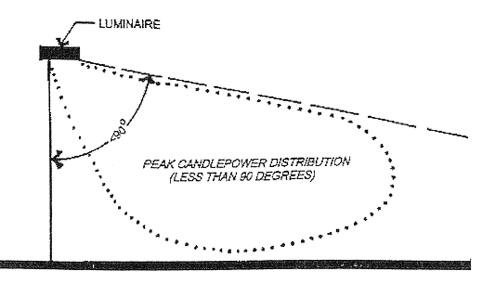
FIGURE A—PERMITTED FIXTURE ORIENTATION FOR LIGHT FIXTURES OVER 150 WATTS
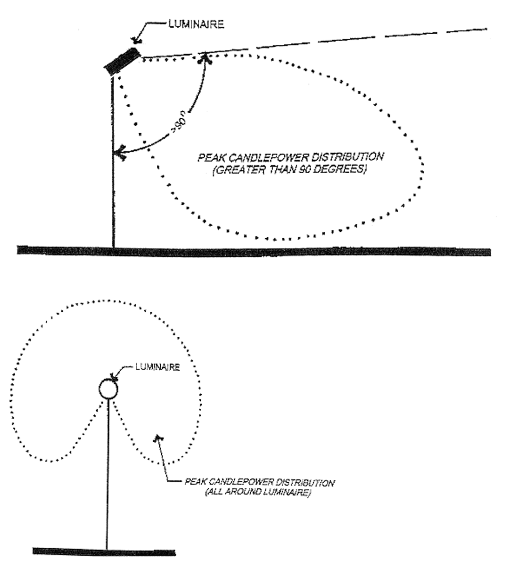
FIGURE B—PROHIBITED FIXTURE ORIENTATIONS FOR LIGHT FIXTURES OVER 150 WATTS
(b)
Maximum Luminaire Height: The maximum permitted luminaire height shall be 20 feet in all residential zoning districts and 40 feet in all other zoning districts. The height of both the pole and base shall be considered in the measurement of the luminaire height.
(c)
Prohibited Light Fixtures: No searchlights or strobe lights shall be permitted.
(d)
Depiction on Site Plan: All existing and proposed exterior light fixtures shall be depicted as to their location, type and wattage on the site plan, if required under Section 17.8.40.
17.5.05 - SCREENING AND LANDSCAPING STANDARDS.
(1)
INTENT. The intent of this section is to indicate the requirements that may be applied for screening and landscaping for certain development projects, zoning districts, and project components.
(2)
SCREENING STANDARDS (LANDSCAPED BUFFERYARDS).
(a)
Applicability: If required as part of a conditional use permit, site plan, or other County approval of a development, the following areas or features may be required to be effectively screened by fencing, landscaping, or berms from view from public roadways, and adjacent residentially zoned properties:
1.
Exterior structures related to heating systems, cooling or air conditioning systems;
2.
Refuse, garbage, dumpsters and recyclable material collection points;
3.
Outdoor storage areas;
4.
Loading docks;
5.
Any other site area or facility as required for the specific land use under Division 17.3 or by the County approval authority, if reasonably related to the protection of neighboring properties or the public from distracting, unappealing, or offensive views of on-site activities.
(b)
Options for Screening The following are options for providing required screening where applicable:
1.
Fencing: The construction of a minimum 6-foot high solid fence shall be deemed adequate screening if required.
2.
Rows of trees: The planting of a minimum of 2 rows of trees staggered with a 10-foot spacing, which are a minimum of 4 feet tall when planted, shall be deemed adequate screening if required. One row shall be either white pine, red pine, or a fast growing hybrid poplar. The other row shall be either white spruce or white cedar. The lot owner shall maintain such planting and any dead trees shall be replaced within one year. Alternate species or planting plan may be substituted if prior approval is received from the Zoning Administrator.
3.
Existing vegetation: The maintenance of existing native vegetation that, from off the property during full foliage conditions, provides the appearance of a solid wall of vegetation, shall be deemed adequate screening if required. The final determination as to acceptability of the existing vegetative screen shall be by the Zoning Administrator.
4.
Earthen berm: The construction of an earthen berm to the minimum height of 6 feet which is to be seeded and/or landscaped with shrubs and maintained by the owner shall be deemed adequate screening if required.
(c)
Depiction on Site Plan: All existing and proposed screening shall be depicted as to their location, type and wattage on the site plan, if required under Section 17.8.40.
(3)
LANDSCAPING STANDARDS (GENERAL YARD LANDSCAPING).
(a)
Applicability: Except for single-family and two-family residential dwellings, the requirements of this subsection shall apply to all new land development projects and all additions, expansions, or site modifications to such uses to the extent practical:
1.
Within the MR, MH, RE, PB, CMU, PI, PD, and H51 zoning districts; and
2.
Where otherwise required for the specific land use in Division 17.3.
(b)
Existing Vegetation: To the greatest extent possible, each development shall retain existing trees outside of proposed building and parking areas.
(c)
Landscaping Coverage: The lot shall be landscaped with an effective combination of living trees, groundcover, and shrubbery. Landscaping shall be emphasized in street yards, adjacent to residentially zoned lots, within and adjacent to parking lots, and near principal building foundations. The following figure provides an example.
(d)
Distance Requirements: No purposely planted tree or shrub as measured from its center shall be located within 5 feet of a driveway or public street right-of-way or easement.
(e)
Visual Clearance Triangle: All new landscaping material located within a visual clearance triangle (as described in Section 17.5.02(3)) shall be 2½ feet or less in height or have a clearance of 8 feet beneath the lowest branch or projection.
(f)
Depiction on Site Plan: All existing and proposed landscaping on the lot shall be depicted on the site plan, if required under Section 17.8.40.
(g)
Installation and Maintenance: All proposed and approved landscaping shall be installed in a sound manner and according to accepted planting procedures with quality plant materials. The lot owner shall maintain such plantings and all dead plantings shall be replaced.
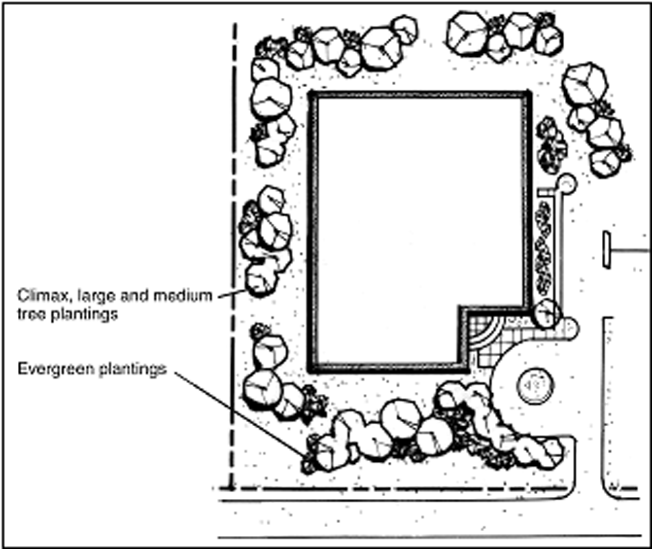
GENERAL YARD LANDSCAPING
17.5.06 - CULTURAL RESOURCE AND HABITAT IDENTIFICATION STANDARDS.
(1)
INTENT. An important goal of the Lincoln County comprehensive plan is protection of critical wildlife habitats and cultural resources sensitive to disruption that may be caused by development and/or other land use activities. These resources include identified historic and archeological resources and rare, threatened, or endangered plant and animal habitat areas. These resources serve important functions which can be lost when land development occurs, in the absence of identification, protection, and/or mitigation approaches.
(2)
IDENTIFICATION. When a land development is proposed on a lot or parcel where a cultural or habitat resource(s) has been identified or mapped in the Lincoln County comprehensive plan, the applicant shall submit more detailed information on the exact location and nature of said resource(s) to the Zoning Administrator before a zoning permit is issued, based on information available from the State Historic Society, the State Department of Natural Resources, or other sources. All State-identified cultural or habitat resources shall be accurately marked and clearly labeled on a site plan, certified survey map, or subdivision plat, if required for the land development.
(3)
PROTECTION. The property owner shall make reasonable efforts to protect such identified cultural resources and habitats, and they shall be subject to State or Federal protection laws.
17.5.07 - SHORELAND DEVELOPMENT STANDARDS.
Refer to Chapter 21 of the Lincoln County Code of Ordinances for development standards applicable in the County's shoreland zoning areas.
17.5.08 - EROSION CONTROL AND STORMWATER MANAGEMENT STANDARDS.
(1)
INTENT. (Am. #2006-06-477) Lincoln County finds that construction site erosion and uncontrolled stormwater runoff from land disturbing and land development activities can have significant adverse impacts upon local water resources and the health, safety and general welfare of the community, and can diminish the public enjoyment and use of natural resources. It is the intent of this section to provide for the control of soil erosion and stormwater runoff.
(2)
AUTHORITY. (Am. #2006-06-477) This section is adopted under the authority granted by §59.693, Wis. Stats. In the administration of this section, the Zoning Administrator may seek technical advice from the Lincoln County Land Information and Conservation Department, the U.S. Department of Agriculture Natural Resources Conservation Service, or the Wisconsin Department of Natural Resources.
(3)
LAND DISTURBANCE ACTIVITIES SUBJECT TO STORMWATER MANAGEMENT AND EROSION CONTROL. All activities directly related to the planting, growing and harvesting of agricultural crops are not considered land disturbance activities under this section and are, therefore, exempt from all of the requirements of this section. Land or soil disturbance and development activities in the shoreland overlay zone shall be subject to the standards in Chapter 21 of the Lincoln County Code of Ordinances, with the most restrictive regulation applying. Other land disturbance and development activities shall be subject to the stormwater management and erosion and sediment control provisions of this section, if any of the following conditions are present:
(a)
An area of one acre or greater will be disturbed by excavation, grading, filling, or other earthmoving activities, resulting in the loss or removal of protective ground cover or vegetation.
(b)
Any land disturbing activity over more than 5,000 square feet is to occur on slopes greater than 15 percent. (See additional criteria in Chapter 21 if property is in the shoreland zone.)
(c)
Any public street, road or highway is to be constructed, enlarged, relocated or reconstructed, unless otherwise specified under TRANS 401, Wis. Adm. Code.
(d)
A proposal that suggests any water course to be changed, enlarged, or materials to be removed from stream bed.
(e)
A proposal is made for any specific land use described under Division 17.3 for which a stormwater management plan, erosion control plan, or both is required.
(f)
An application is filed for approval of a major subdivision under Chapter 18 of the Lincoln County Code of Ordinances.
(g)
Any other land disturbing activity is to occur where the Zoning Administrator determines that high levels of erosion or runoff is likely unless an erosion control plan, stormwater management plan, or both is developed.
(4)
STANDARDS FOR STORMWATER MANAGEMENT AND EROSION CONTROL. (Am. #2006-06-477) Stormwater runoff, soil erosion, siltation, or sedimentation from all land disturbing and development activities described in subsection (3) shall meet standards in NR 151 and 216 and COMM 60 and 20-21, Wis. Adm. Code, and/or shall be controlled in accordance with Technical Guidelines as developed by the U.S. Department of Agriculture, Natural Resources Conservation Service, or the Wisconsin Department of Natural Resources. Stormwater management plans required under this section shall be designed to maintain predevelopment peak runoff rates for the 2-year and 10-year, 24-hour storm event and safely pass the 100-year, 24-hour storm event via an emergency spillway.
(5)
EROSION CONTROL PLAN. (Am. #2007-10-514) Prior to the issuance of a zoning permit or recording of a final plat or certified survey map for all land disturbing activities listed under subsection (3), the applicant shall:
(a)
Reserved.
(b)
Submit an erosion control plan that meets the technical requirements of NR 216, Wis. Adm. Code, and has been stamped by a licensed engineer qualified in erosion control planning.
(6)
STORMWATER MANAGEMENT PLAN. (Am. #2007-10-514) Prior to the issuance of a zoning permit or recording of a final plat or certified survey map for all land disturbing and development activities listed under subsection (3), the applicant shall:
(a)
Reserved.
(b)
Submit a stormwater management plan that meets the technical requirements of NR 216, Wis. Adm. Code, and subsection (4) above, and has been stamped by a licensed engineer qualified in stormwater management planning.
(7)
INSTALLATION AND MAINTENANCE. All construction site erosion control measures shall be installed prior to the land disturbance activity, and maintained by the lot owner throughout the duration of the land disturbance activity. All permanent stormwater management measures shall be installed prior to occupancy of the lot or building, and shall be maintained by the lot owner in perpetuity.
17.5.09 - KEEPING OF FARM ANIMALS.
(1)
INTENT. The intent of this section is to establish standards for the keeping of farm animals in a manner which maintains agriculture as a viable part of Lincoln County's economy and rural communities, allows for farms of multiple sizes and descriptions, including hobby and recreational farming; avoids nuisances, undesirable odors, and other negative impacts on neighboring properties; protects human and animal health; satisfies the needs of farm animals for exercise space; and protects water quality and the environment.
(2)
DEFINITIONS. (Am. #2006-11-491) The following definitions describe terms used to interpret this section:
(a)
Farm Animal: Any animal that is customarily raised for a profit on farms and/or to supplement household food supplies or income, and that has the potential for causing a nuisance or public heath concerns if not properly maintained. Includes but is not limited to cows, beef cattle, hogs, most pigs, chickens, turkeys, alpaca, llama, horses, ponies, sheep, lambs, most goats, ratites (e.g., emu), and rabbits, but not including pigmy goats or pot-bellied pigs. Refer to Wis. Adm. Code ATCP 51 for applicable definition related to certain livestock facilities covered under those rules.
(b)
Animal Unit: An animal unit is a measure that represents a common denominator for the purpose of defining in what quantity farm animals may be kept. The animal unit measure is related to the amount of feed various farm animal species consume and the amount of waste they produce. The table in Wisconsin Administrative Code NR 243.11 indicates the number of common farm animal species that comprise a single animal unit. For animal types not listed in the NR 243.11 table, 1,000 pounds of live animal weight is equal to one animal unit. (Am. #2006-06-477)
(3)
APPLICABILITY. The requirements of this section apply to the following land uses:
(a)
Uses that first establish the keeping of farm animals following the adoption of this chapter.
(b)
Uses that increase the number of farm animals on a lot following adoption of this chapter.
(c)
Any other land use that keeps farm animals where, in the determination of the Zoning Administrator, the intent of this section is being violated.
(d)
Legal nonconforming uses which have been discontinued for a period of 12 or more continuous months.
(e)
Intensive agriculture uses except where in conflict with Wis. Adm. Code ATCP 51. (Cr. #2006-11-491)
(4)
ANIMAL UNIT DENSITY STANDARD. (Am. #2006-06-477) Land uses that keep or maintain farm animals shall provide and continuously maintain a minimum of one acre per animal unit of open land available for animal exercise and nutrient (manure) management. Such acreage may not include land that is heavily wooded, in wetland, within the minimum ordinary high water setback in the shoreland overlay zone as described in Chapter 21, used for buildings or driveways, or otherwise not available for animal exercise and nutrient management. Exceptions to this standard shall be approved by the Zoning Administrator if one of the following conditions is present:
(a)
The land owner submits a nutrient management plan, has such plan approved by the Lincoln County Land Information and Conservation Department, and implements and continuously maintains such plan on the lot.
(5)
OTHER COUNTY PERFORMANCE STANDARDS.
(a)
No farm animals shall be allowed on a lot that is less than 100,000 square feet in area in any Residential Zoning District.
(b)
Outdoor animal containments, such as fenced pastures, pens, coops and similar structures, shall be located:
1.
In accordance with the standards in Ch. 90, Wis. Stats.; and
2.
A distance equal to the required principal building setback from the ordinary high water mark in the shoreland overlay district, where not otherwise preempted by Ch. 90, Wis. Stats.; and
3.
For residentially zoned lots, a minimum of 50 feet from any well, where not otherwise preempted by Ch. 90, Wis. Stats.
(c)
All land uses that keep farm animals are subject to the standards in Chapter 11 of the Lincoln County Code of Ordinances (Animal Waste Management).
(6)
STATE AND FEDERAL STANDARDS. Land uses that keep farm animals may also be subject to State and Federal laws and rules, most of which are not administered by Lincoln County. It is the responsibility of the property owner to adhere to such laws and rules as applicable, which at the time of adoption of this chapter included but were not necessarily limited to the following:
(a)
Agricultural performance standards in ATCP 50 and 51 and NR 115, 151, 243, and 812, Wis. Adm. Code. (Am. #2006-11-491)
(b)
(Rep. #2006-11-491)
(c)
All State manure and nutrient management statutes and rules, including §281.16(3), Wis. Stats.
(d)
Wisconsin Pollutant Discharge Elimination System permits for farm operations over 1,000 animal units, as identified in NR 243.13 through NR 243.16, Wis. Adm. Code.
(e)
Chs. 29 and 169, Wis. Stats., involving the treatment of wild animals.
(f)
Ch. 951, Wis. Stats., involving crimes against animals.
(g)
Ch. 93, Wis. Stats., enabling legislation for the Department of Agriculture Trade and Consumer Protection (ATCP) and which also includes animal regulations.
(h)
Ch. 97, Wis. Stats., involving food regulations. Several ATCP rules also cover various aspects of food processing.
(i)
The U.S. Natural Resources Conservation Service (NRCS) Nutrient Management standard.
(j)
The U.S. Environmental Protection Agency's confined animal feeding operations rule.