
Hayden City Zoning Code
CHAPTER 10
24.- DEVELOPMENT AND DIMENSIONAL STANDARDS
Sec. 10.24.010.- General provisions.
(a)
Applicability. All development applications shall comply with the applicable standards contained in this chapter.
(b)
Relation to zone district standards. In the event of a conflict between a standard or requirement contained in the chapter 10.20, zone districts and official zoning map, and text in this chapter 10.24, the standard in the chart in chapter 10.20 shall prevail.
(c)
Health, safety and welfare. Every use shall be operated so that it does not pose a danger to public health, safety or welfare.
(d)
Local, state and federal regulations and standards. Every use shall be operated in conformance with all applicable federal, state and local regulations and standards. Failure to comply with any and all applicable federal, state and local regulations and standards may be cause for review and/or revocation of any approval granted pursuant to this Development Code.
(Ord. No. 711, § 1, 2-17-2022)
Sec. 10.24.020. - Dimensional and setback standards.
(a)
Land uses in the various zone districts shall comply with the dimensional standards as contained in the Table 10.24-1, Dimensional Standards, found at the end of this chapter.
(b)
The following setback standards are applicable in all zone districts:
(1)
On double frontage lots, both streets shall be considered street frontages for purposes of calculating front yard setbacks.
(2)
On corner lots, one side of the lot (generally that with the shortest length) with street frontage shall meet the applicable front yard setback.
(3)
For purposes of setback calculations, a two-family dwelling shall be constructed as one building occupying one lot.
(4)
On oddly shaped lots with a dwelling sited "square" to the roadway, side setbacks may be less than required in Table 10.24-1, Dimensional Standards, but with no less than a five-foot setback per each side yard.
(5)
On a vacant lot bordered on two sides by previously constructed legal non-conforming buildings that do not meet the required front yard setback for the zoning district, the required front yard setback for the vacant lot shall be calculated as the average front yard setback of the two adjacent buildings. Where a vacant lot is bordered on only one side by such a legal non-conforming building, the required front yard setback shall be calculated as the average of the front yard setback of the adjacent building and the minimum front yard setback for the zoning district.
(6)
Permanent features allowed within setbacks shall include:
a.
Cornices, canopies, eaves or other similar architectural features if they extend no more than two feet into a required setback and if they do not or encroach into or overhand an easement;
b.
Steps or ramps to the principal entrance and necessary landings, provided they do not extend more than six feet into the required setback;
c.
Landscaping;
d.
Fences and walls, subject to height and other restrictions of this chapter;
e.
Utility service lines to a structure and utility lines, wires and associated structures within a utility easement;
f.
Fire escapes, provided they do not extend more than six feet into the required setback;
g.
Uncovered patios, porches and decks not more than 30 inches above grade, provided they do not extend more than 30 percent of the required setback distance into the required setback area; and
h.
Open or covered patios, porches and decks attached to residential dwellings greater than 30 inches in height may extend no more than five feet into a required front or rear setback or five feet into a required side yard setback adjacent to a street, provided they do not encroach into or overhand an easement or property line and do not obstruct any sight distance triangle.
(Ord. No. 711, § 1, 2-17-2022)
Sec. 10.24.030. - Application of community design standards.
The planning commission and the Council will evaluate each proposal based on these principles and the context within which each project is located. The principles are intended to be specific enough to guide development, but not to preclude creative design solutions. Applicants must substantially conform to the design principles in this chapter unless it can be demonstrated that an acceptable alternative meets one or more of the following conditions:
(1)
The alternative better achieves the stated intent;
(2)
The intent cannot be achieved by application of the principle in this circumstance;
(3)
The effect of other principles will be improved by not applying a particular principle;
(4)
Strict application or unique site features make the principle impractical.
(Ord. No. 711, § 1, 2-17-2022)
Sec. 10.24.040. - Design elements.
(a)
Compact urban growth. It is important to maintain a continuity of density, diversity and interconnectedness. Urban development should occur adjacent to the town's core so that the community's prime agricultural land remains usable, natural areas are preserved, and public infrastructure and utilities are used as efficiently as possible.
(b)
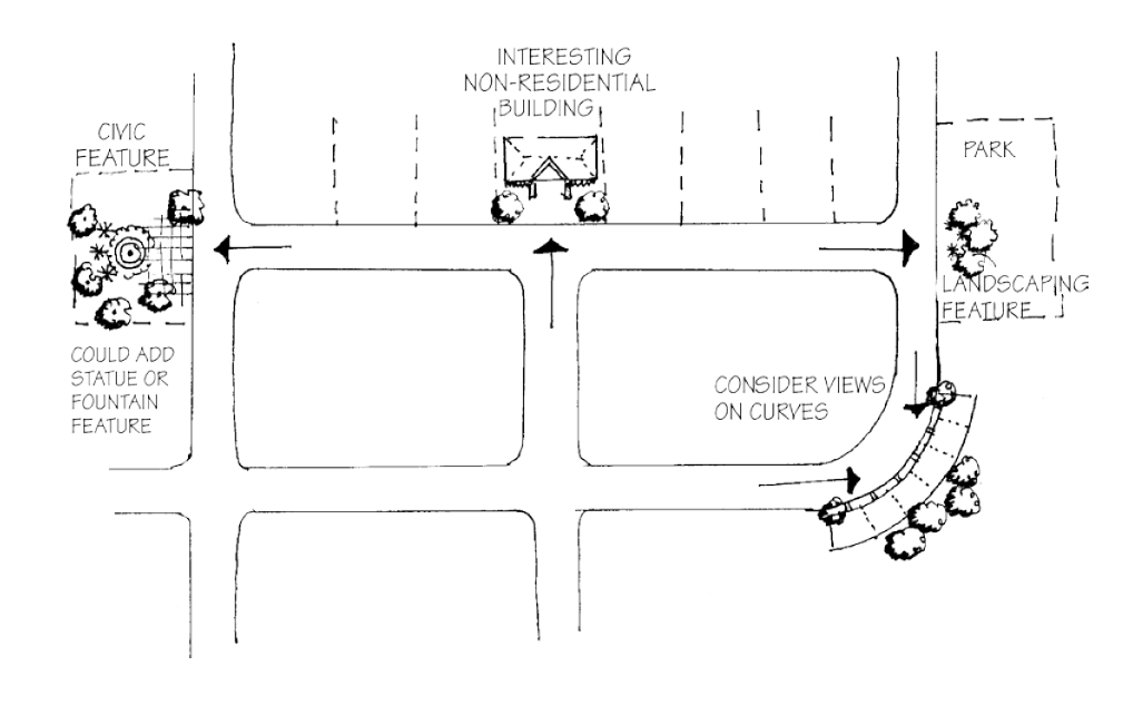
Neighborhood design. Create neighborhoods, rather than residential subdivisions adjacent to one another. Neighborhoods should be organized around a strong center which may include elements such as common open space, civic and commercial or mixed uses. Strong consideration should be given to pedestrian movement, the character of streets and sidewalks as an inviting public space, and the interconnectedness of the streets both within the neighborhood and as they connect to the rest of the community. In addition, new neighborhoods should have a variety of housing sizes and types that help to create a distinct identity rather than a monotonous repetition of one or two styles.
(c)
Streets and sidewalks. The streets should be tree-lined and interconnected in order to create a master transportation network that facilitates the movement of pedestrians, cars and bicycles. Where feasible and appropriate within the downtown area, continue Hayden's existing block pattern to form a grid or modified grid pattern that is adapted to the topography, natural features and environmental considerations.
(d)
Parks and open space. Use natural open spaces and developed public space (such as parks and plazas) to organize and focus lots, blocks and circulation patterns and create an identity for each neighborhood.
(e)
Site design, architecture and landscaping. Encourage innovative, quality site design, architecture, and landscaping in order to create new developments that can be integrated into the existing community and reflect the traditional patterns of the region. Promote the use of native species and xeriscaping in landscaping, revegetation and reclamation.
(f)
Environment. New developments should be designed to fit within the environment. To the greatest extent feasible, sites should be designed to preserve natural areas and the plants and wildlife inhabiting those areas. The town promotes the use of native species in landscaping, revegetation and reclamation.
(g)
Water conservation. Use raw or non-potable water for irrigation and incorporate water saving measures in building design and landscaping. Developments are required to use storm water management techniques that address both water quality and quantity.
(Ord. No. 711, § 1, 2-17-2022)
Sec. 10.24.050. - Compact urban growth.
(a)
Intent. The town encourages a density pattern that tapers from more intense use of the core area to lower densities on the periphery of the town. This policy will accomplish several goals, including:
(1)
Improving air quality by reducing vehicle miles traveled and by promoting alternatives to the private automobile;
(2)
Preserving natural areas and features, particularly at the edges of the town;
(3)
Making possible the efficient use of existing infrastructure and cost-effective extensions of new services; and
(4)
Encouraging in-fill development and reinvestment in built-up areas of town.
(b)
General provisions.
(1)
No development shall be approved unless it is located within the established town municipal boundary and is consistent with the master plan.
(2)
The town shall grow by designing interconnected neighborhoods. The original downtown area needs to be strengthened by the development of commercial, service and mixed-use projects.
(Ord. No. 711, § 1, 2-17-2022)
Sec. 10.24.060. - Neighborhood design principles.
(a)
Intent. To encourage the creation of viable neighborhoods that connect with each other and the integration of new projects into the existing community. New streets, bikeways, sidewalks, paths and trails should connect adjacent neighborhoods.
(b)
Neighborhood structure. Elements to consider integrating into new neighborhoods include:
(1)
Streets, sidewalks and trails within new neighborhoods should connect to adjacent neighborhoods and the existing town.
(2)
Streets that encourage pedestrian activity by creating an inviting atmosphere through attention to the details of landscaping and tree locations, sidewalks, lighting, building architecture, etc.
(3)
A mixed-use neighborhood center where appropriate.
(4)
A variety of housing types, sizes, densities and price ranges.
(5)
A variety of land uses that include a transition of development intensity.
(6)
Pedestrian and bike connections throughout residential neighborhoods that are linked to commercial or civic centers and open space systems.
(7)
Parks, open space and public plazas that are well integrated into the neighborhood.
(c)
General provisions. The following principles contribute to Hayden's small town character. New projects will be evaluated with consideration to these existing neighborhood design principles and the context within which a project is located. Failure to incorporate these design principles into a project may be cause for denial of the project by the town.
(1)
Each neighborhood has a center. It is important that every neighborhood have activity centers that draw people together. Activity centers include natural features, park areas and public buildings.
(2)
Mix of types of dwelling units. A mix of dwelling unit types shall be distributed throughout the development. Housing types and the size of lots shall be varied to enable people to remain in the neighborhood as their needs change.
(3)
Focal points. Focal points, or points of visual termination, shall generally be occupied by more prominent, monumental buildings and structures that employ enhanced height, massing, distinctive architectural treatments, or other distinguishing features, as well as landscape features.
(4)
Public space as development framework. Public space is used to organize blocks and circulation patterns and to enhance surrounding development. Public open space must be functional and easily accessible and shall be designed to organize the placement of buildings to create an identity for each neighborhood. Buildings should face public open space.
(5)
Design streets as public spaces. Buildings shall define streets through the use of relatively uniform setbacks along each block. The streetscape shall also be reinforced by lines of shade trees planted in the tree lawn area and may be further reinforced by walls, hedges, landscaping or fences which define front yards. On a lot with multiple buildings, those located on the interior of the site shall relate to one another both functionally and visually. A building complex may be organized around features such as courtyards, greens, or quadrangles, which encourage pedestrian activity and incidental social interaction. Smaller, individualized groupings of buildings are encouraged. Buildings shall be located to allow for adequate fire and emergency access.
(6)
Access. "Gated" neighborhoods or developments that restrict public access shall not be permitted. Privately maintained streets shall have a public access easement.
(7)
Define the transition between public and private spaces. Buildings shall be located to front towards and relate to public streets or parks, both functionally and visually, to the greatest extent possible. Wherever possible, buildings shall not be oriented to front towards a parking lot.
(8)
Encourage walking and bicycling. Sites shall be designed to minimize conflicts between vehicles, bicycles and pedestrians. Pedestrian and bicycle access and connections shall be designed to make it safe and easy to get around on foot and by bicycle.
(9)
Neighborhoods shall have a mix of activities available rather than a purely residential land use. Neighborhood residents shall have convenient access to parks, schools, open space, trails and services. The optimum size of a neighborhood is one-quarter mile from center to edge.
(10)
Fit within the environment rather than on top of it. New developments shall be designed to respond to the natural environment, fit into the setting and protect scenic view corridors.
(11)
Housing types and styles that reflect the architecture of the region. Familiar architectural styles shall play an important role in developing an architectural identity for neighborhood dwellings.
(Ord. No. 711, § 1, 2-17-2022)
Sec. 10.24.070. - Lots and blocks.
(a)
Intent. The intent of the block and lot standards is to continue the town's existing block pattern in a manner that is compatible with site-specific environmental conditions.
(b)
General provisions.
(1)
Blocks. Streets shall be designed to create blocks that consider interconnectedness, topography, solar orientation, views, and other design features.
(2)
Lot dimension and configuration.
a.
Lot size, width, depth, shape, orientation and minimum building setback lines shall conform to this chapter and shall facilitate the placement of buildings with sufficient access, outdoor space, privacy and view.
b.
Depth and width of properties shall be adequate to provide for off-street parking, landscaping and loading areas required by the type of use and development contemplated.
c.
Lot frontage. All lots shall have frontage that is either adjacent to or directly accessible to a street. Street frontage shall typically not be less than 25 percent of the lot depth. Flag lots are prohibited unless otherwise approved by the Council.
d.
Corner lots. Corner lots for residential use shall have extra width to accommodate the required building setback and utility easements on both street frontages. For a corner lot, the front of the lot is defined as the side having the shortest street frontage. In the case of a reverse corner lot, both sides abutting a street shall maintain a front yard setback.
e.
Double frontage. Residential lots that front on two streets (double frontage) shall not be permitted.
f.
Side lot lines. Side lot lines shall be substantially at right angles or radial to road right-of-way lines or centerlines.
(Ord. No. 711, § 1, 2-17-2022)
Sec. 10.24.080. - Access standards.
(a)
Residential lot access to adjacent street.
(1)
Driveway access to a local or collector street from a single-family detached residential lot shall be limited to one driveway curb-cut or driveway access of no greater than 24 feet in width except as may be approved by a minor variance. A circular drive in which each access to the local or collector street is less than 12 feet in width, separated by at least 30 feet and which is constructed as an integral part of the overall architectural design of the single-family residence may be considered as a single driveway access.
(2)
Driveway access to a local street from a single-family detached residential lot shall be greater than 30 feet from the intersection of the local street and a collector street or 150 feet from the intersection of the local street and an arterial street as measured from the intersecting right-of-way lines.
(3)
Driveway access to a collector street from a single-family detached residential lot shall be greater than 75 feet from the intersection of the collector street and a local street, another collector street, or an arterial street as measured from the intersecting right-of-way lines.
(b)
Commercial, business and industrial lot access to adjacent street.
(1)
Driveway access to a local or collector street from a multi-family residential, commercial, business or industrial lot shall be greater than 125 feet from any street intersection as measured from the intersecting right-of-way lines;
(2)
Driveway access to an arterial street from a commercial, business or industrial lot shall be not less than 100 feet from any intersection on the arterial street, or from another commercial, business or industrial lot's access as measured from the intersecting right-of-way lines, or driveways; or
(3)
Driveway access to a local street, collector street or arterial street from a multi-family residential, commercial, business or industrial lot may be allowed by the town at its sole discretion.
(Ord. No. 711, § 1, 2-17-2022)
Sec. 10.24.090. - Streets.
(a)
Intent. The intent of the street standards is to establish a safe, efficient, attractive transportation system that promotes all modes of transportation and is sensitive to the environment.
(b)
General provisions. The local street system of any proposed development shall be designed to be safe, efficient, convenient, attractive, and consider all modes of transportation that will use the system. Streets should be an inviting public space and an integral part of community design. Local streets shall provide for both intra- and inter-neighborhood connections to knit developments together. All streets should interconnect to help create a comprehensive network of public areas to allow free movement of cars, bicycles and pedestrians.
(1)
Street connections. All streets shall be aligned to join with planned or existing streets consistent with the town master plan. All streets shall be designed to bear a logical relationship to the topography of the land. Intersections of streets shall be at right angles unless otherwise approved by the town.
(2)
Tree-lined streets. All streets shall be lined with trees on both sides with the exception of rural roads and alleys.
(3)
Street layout. The street layout shall form an interconnected system of streets, where feasible primarily in a grid or modified pattern adapted to the topography, unique natural features, environmental constraints, and peripheral open space areas. The street layout shall emphasize the location of neighborhood focus points, other internal open space areas, gateways, and vistas. The use of cul-de-sacs and other roadways with a single point of access shall be minimized. The integration of traffic calming features within and adjacent to residential areas shall be utilized when appropriate.
(4)
Controlling street access. A strip of land between a dedicated street and adjacent property shall not be reserved for the purpose of controlling access to such street from such property.
(5)
Visibility at intersections. No shrubs, ground cover, berms, fences, structures, or other materials or items greater than 24 inches in height shall be planted, created or maintained at street intersections within the site distance triangle. Trees shall not be planted in the site distance triangle.
(6)
Pedestrian crossings at street intersections and mid-block. Pedestrian crossings shall be accessible to handicapped individuals and mid-block crossings may be required at the direction of the Council.
(7)
Access. Access to all subdivisions shall be from a public street system. Driveways shall not be permitted to have direct access to arterial streets or the state highway.
(8)
Street right-of-way dedication. The full width of right-of-way for all streets being platted must be conveyed to the Town after final acceptance unless otherwise approved by the town.
(9)
Perimeter streets. When a street is dedicated which ends on the plat, the street right-of-way must be dedicated to the boundary of the plat.
(10)
Street names. Names of new streets shall not duplicate names of existing streets in Hayden. However, new streets which are extensions of, or which are in alignment with, existing streets within the town shall bear the names of such streets. Street naming and property address numbering will be coordinated between the applicant, Town of Hayden and Routt County.
(c)
Street standards. Streets shall conform to the Routt County Road and Bridge Roadway Standards, other adopted town construction specifications, and all other applicable laws, rules and regulations.
(1)
General design standards.
a.
Where curb and gutter are required, it shall be constructed per the state department of transportation specifications.
b.
Design of streets, curbs and gutters shall be in accordance with the Americans with Disabilities Act (ADA) standards.
c.
Streets shall be designed in accordance with the American Association of State Highway and Transportation Officials Policy on Geometric Design of Highways and Streets, 1990 and shall conform to the adopted Town of Hayden construction standards.
d.
The layout of arterial and collector streets shall conform to the criteria of the town's master plan unless otherwise approved by the Council.
e.
Where future extension of a street is anticipated but not existing, a temporary turnaround having a minimum outside diameter of 110 feet shall be provided.
f.
The maximum allowable length of closed-end streets (cul-de-sacs) in single-family and multi-family residential developments shall be 600 feet unless otherwise approved by the Council.
g.
Right-of-way widths shall be specified in the Routt County Road and Bridge Roadway Standards.
(2)
Arterial streets design.
a.
Arterials shall be at a minimum of one-mile intervals in both north-south and east-west directions.
b.
Arterials shall be designed to accommodate present and future transportation requirements.
c.
Arterial streets shall align and connect across intersecting arterials to distribute traffic and provide continuity.
d.
Typical adjacent land uses to arterial streets include:
1.
Business parks.
2.
Community commercial.
3.
District and community parks.
4.
High density residential.
5.
Industrial developments.
(3)
Collector streets.
a.
Within each one-mile arterial segment, collector streets shall divide the north-south and east-west arterials at approximately the half-mile point.
b.
Intersections of collector streets and arterial streets shall be aligned to distribute traffic and provide continuity for bike routes.
c.
Typical adjacent land uses to collector streets include:
1.
Agriculture.
2.
Business parks.
3.
Community parks.
4.
Industrial.
5.
Low, medium and high density residential.
6.
Middle and high schools.
7.
Neighborhood commercial.
(4)
Local streets.
a.
Where practical, local streets shall generally follow a modified grid pattern adapted to the topography, unique natural features, environmental constraints, and peripheral open space areas. These streets shall generally parallel the arterial and collector street system, provide a variety of route options, interconnect to allow traffic to disperse in an equitable manner and be as narrow as possible without sacrificing the ability to accommodate expected traffic and services. Local street cross-sections will generally include a four-foot tree lawn adjacent to the roadway.
b.
Local streets must provide for both intra- and inter-neighborhood connections.
c.
Typical adjacent land uses to local streets include:
1.
Business parks.
2.
Elementary schools.
3.
Pocket parks.
4.
Neighborhood parks.
5.
Residential.
(5)
Rural local street.
a.
Rural local streets are intended to serve rural locations as may be approved by the Council.
b.
A driveway access crossing the borrow ditch of a rural local street shall contain a culvert of sufficient size to safely pass the designed stormwater drainage flows.
c.
A portion of the borrow ditch may fall outside of the rural local road right-of-way in order to obtain a borrow ditch cross-section sufficient to contain the designed storm water flows and/or to be sufficient in depth for the driveway access culvert.
d.
Typical adjacent land uses to rural local streets include:
1.
Agriculture.
2.
Agri-hood and estate subdivisions.
(6)
Alleys.
a.
Alleys shall be treated as public ways and any lot having access from an alley shall also front upon a public street.
b.
Garages, accessory dwellings above garages and rear yards may access the collector and local street system via an alley.
c.
Typical adjacent land uses to alleys include:
1.
Accessory units above garages.
2.
Garages.
3.
Parking lots with landscaped edges.
4.
Rear yards.
(Ord. No. 711, § 1, 2-17-2022)
Sec. 10.24.100. - Parking.
(a)
Intent. The intent of this section is to provide adequate parking for motor vehicles while minimizing the visual impact of parking lots and structures.
(b)
General provisions. In all zone districts, off-street parking facilities for the storage of motor vehicles for the use of occupants, employees and patrons of the building or structures hereafter erected, altered or extended shall be provided and maintained as herein prescribed.
(1)
Surface. All parking and driveway areas and primary access to parking facilities shall be surfaced with asphalt, concrete or similar materials.
(2)
Integrate parking lots with surroundings. Parking lots shall not dominate the frontage of pedestrian-oriented streets, interfere with designated pedestrian or bicycle routes, or negatively impact surrounding neighborhoods. The pedestrian character of streets and buildings shall be maximized through continuity of buildings and landscape frontage.
(3)
Location. Parking lots shall be located to the rear or side of buildings or in the interior of a block whenever possible.
(4)
Landscaping. Parking lots shall be landscaped, screened and buffered as provided in this chapter.
(5)
Shared access. Where feasible, and in order to reduce traffic and vehicle turning movements on major streets, parking lots shall share access drives and cross-access easements with adjacent property with similar land uses.
(6)
Off-street parking design. Any off-street parking area shall be designed so that vehicles may exit without backing onto a public street unless no other practical alternative is available. Off-street parking areas shall be designed so that parked vehicles do not encroach upon or extend onto public rights-of-way, sidewalks or strike against or damage any wall, vegetation, utility or other structure.
(7)
Circulation area design. Circulation areas shall be designed to facilitate the safe movement of vehicles without posing a danger to pedestrians or impeding the function of the parking area.
(8)
Striping. All parking areas shall be striped to identify individual parking spaces.
(9)
Lighting. All parking area lighting shall be full cutoff type fixtures. Any light used to illuminate parking areas or for any other purpose shall be so arranged as to reflect the light away from nearby residential properties, and away from the vision of passing motorists.
(10)
Shared off-street parking. When there are opportunities to support parking demand through shared off-street parking for compatible uses (such as a movie theater and an office building), a parking study and shared parking agreements shall be used to demonstrate the adequacy of the parking supply as a substitute for standard parking requirements.
(11)
Adjacent on-street parking in the CBD: Central Business district. In order to promote a pedestrian scale and encourage a perception of safety in the CBD: Central Business district, parking for other than residential or overnight uses may be satisfied using adjacent on-street parking or shared rear-lot parking areas. A parking study and shared parking agreements shall be used to demonstrate the adequacy of the parking supply as a substitute for standard parking requirements.
(c)
Paved off-street parking requirements.
(1)
Paved off-street parking shall be provided according to the minimum requirements as specified below:
(2)
Off-street parking for commercial uses shall be sufficient to provide parking for employees of all proposed uses as well as long-term customer parking. Spaces reserved for employees shall be designated as such by means of striping and signage. Parking shall be located at the rear and sides of buildings to the greatest extent possible and screened from the view of streets as provided in this chapter. Required parking in the CBD: Central Business district can be met with on-street and shared parking for other than residential or overnight uses.
(3)
The location of required off-street parking facilities for other than residential uses shall be within 600 60 (660) feet of the building they are intended to serve when measured from the nearest point of the building or structure.
(d)
Location of spaces for residential uses.
(1)
Off-street parking facilities for residential uses shall be provided and located on the same lot as the building they are intended to serve.
(2)
Required off-street parking in residential zones shall not lie within the front yard setback or within any required side yard setback adjacent to a street. (Driveway spaces within these setbacks cannot be counted for required off-street parking.)
a.
Except within a garage or in conjunction with an approved affordable housing project, tandem parking is not allowed to meet required off-street parking requirements.
b.
Front-loading garages shall be set back not less than 22 feet from the back of the sidewalk and required off-street parking spaces shall not encroach upon the sidewalk or road right-of-way.
(e)
Handicap parking spaces.
(1)
Handicap parking spaces shall be required for all retail, office, business, multi-family, industrial and institutional uses.
(2)
Handicap parking spaces shall be designated as being for the handicapped with painted symbols and standard identification signs.
(3)
Handicap parking spaces shall be located as close as possible to the nearest accessible building entrance.
(4)
Number of handicap parking spaces:
(f)
Handicap parking space dimensions.
(1)
Parking spaces must be eight feet by 18 feet with a five-foot-wide access aisle.
(2)
Van-accessible spaces must be eight feet by 18 feet with an eight-foot-wide access aisle.
(3)
Parking spaces for the physically handicapped that are parallel to a pedestrian walk which is handicap accessible may have the same dimensions as those for standard vehicles.
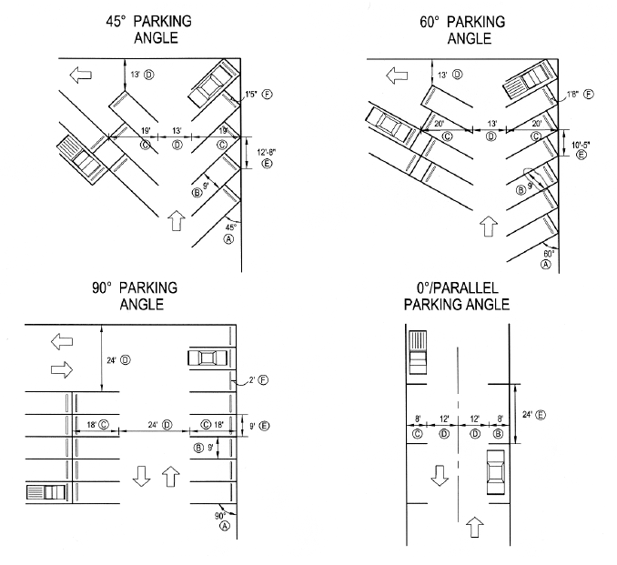
(g)
Parking stall dimensions. Parking stalls for automobiles shall meet the following standards. All dimensions represent the minimum requirement for any required parking space.
(h)
Bicycle parking spaces. Commercial, industrial, civic, employment, multi-family and recreational uses shall provide bicycle facilities to meet the following standards:
(1)
A minimum number of bicycle parking spaces shall be provided, equal in number to two percent of the total number of automobile parking spaces provided by the development, but not less than one space.
(2)
For convenience and security, bicycle parking facilities shall be located near building entrances. Within commercial areas, however, a grouping of spaces shall be provided as directed by the Town.
(3)
Bicycle parking facilities shall be designed to allow the bicycle frame and both wheels to be securely locked to a structure, which is permanently attached to the pavement.
(4)
Bicycle parking facilities shall be located so as not to interfere with pedestrian traffic or access to buildings.
(i)
Lieu of parking. Within the CBD: Central Business District zone, off-street parking requirements for other than residential or overnight uses may be satisfied by payment of an in-lieu parking fee at a rate as established by the town.
(1)
The payment shall be equivalent to the estimated cost to the town of providing the required parking spaces to serve the proposed use and shall be in a total amount as acceptable to the town. Such payment shall be made before issuance of a building permit. Fee revenue shall be deposited in the parking fund designated solely for the purpose of constructing, expanding, repairing, and enhancing municipal parking facilities to provide public parking.
(2)
When an applicant wishes to offer a fee-in-lieu of parking, the applicant must coordinate with the planning director, public works director and town engineer to determine how parking for the proposed use will be made available. A statement of the agreed upon plan for a fee-in-lieu of parking and manner of parking provision must be included with the application.
(3)
Any off-street parking supplied in this manner shall run with the land (not be invalidated by change in ownership), and any subsequent change in use that requires more parking shall require subsequent action by the property owner to satisfy any additional parking requirements. No refund of any fee-in-lieu of parking shall be made when there is a change in use requiring less parking. Final acceptance of any fee-in-lieu is at the complete discretion of the town.
(Ord. No. 711, § 1, 2-17-2022)
Sec. 10.24.110. - Sidewalks/multi-use pathways/trails.
(a)
Intent. The intent of the standards for sidewalks, multi-use pathways and trails is to assure a safe, convenient, and attractive pedestrian/bicycle system that minimizes conflicts between vehicles, bicycles and pedestrians.
(b)
General provisions.
(1)
Interconnected network. A sidewalk network that interconnects all dwelling units with other dwelling units, non-residential uses, and common open space shall be provided throughout each development. Sidewalks shall be separate and distinct from motor vehicle circulation routes to the greatest extent possible. The pedestrian circulation system shall include gathering/sitting areas and provide benches, landscaping and other street furniture where appropriate.
(2)
Sidewalks required. In all zone districts, except for the O district, sidewalks are required along both sides of a street. Within the O district, sidewalks are required along one side of the street unless the development is served by rural local streets.
(3)
Sidewalk width. Sidewalks shall be a minimum of five feet wide when adjacent to local streets; a minimum of five feet wide along one side and eight feet wide along the other side of collector streets; and a minimum of eight feet wide along arterial streets. A four-foot-wide detached sidewalk is the preferred sidewalk alternative within local street rights-of-way. Sidewalks adjacent to storefronts in commercial areas shall be ten to 15 feet in width, or consistent with the average sidewalk width on a block if building in an area with existing sidewalks.
(4)
Sidewalk location. Sidewalks shall be located within the right-of-way unless otherwise authorized by the Council.
(5)
Sidewalk materials. Sidewalks shall be constructed of concrete, brick, slate, colored/textured concrete pavers, concrete containing accents of brick, or some combination thereof that is compatible with the style, materials, colors, and details of the surrounding buildings. Asphalt shall not be used for sidewalks. Sidewalks must be constructed of approved materials of sufficient strength to support light maintenance vehicles. If used as a secondary emergency access, sidewalks must also be able to support a fire truck (60,000 lbs.)
(6)
Sidewalk installation. Sidewalks and related improvements shall be installed or constructed by the subdivider in accordance with plans and specifications approved by the town and, after installation or construction; they shall be subject to inspection and approval by the town.
(7)
Accessibility. Sidewalks and plazas shall be accessible to disabled individuals as required by this Development Code and the Americans with Disabilities Act.
(8)
Walkways. Walkways through a subdivision block shall be not less than eight feet in width, shall be within a dedicated right-of-way not less than 20 feet in width, and shall be flanked with appropriate landscaping. Walkways along buildings and within parking lots shall be raised and curbed where suitable. A direct pedestrian connection to building entries, public space and parking areas shall be provided from public sidewalks. Walkways shall be constructed of the same materials as sidewalks, except that walkways internal to asphalt surfaced parking lots may be of asphalt construction. Walkways crossing driveways in parking lots shall be clearly delineated by a change in pavement color, texture or paint striping.
(9)
Lighting. All sidewalks and other pedestrian walkways shall have appropriate lighting, using poles and fixtures consistent with the overall design theme for the development.
(10)
Multi-use pathways (bikeways). Multi-use pathways shall be provided to link internal open space areas with peripheral open space areas and shall connect to multi-use pathway routes throughout the community. Multi-use pathway routes shall be designated between residential areas and commercial and employment centers and schools. Multi-use pathways on local streets may be delineated by painted "bicycle only" lanes. Sidewalks that may be used as a multi-use pathway are required on arterial and collector streets. All other multi-use pathways shall be a minimum of eight feet wide and shall be of concrete construction or where approved by the Council, compressed gravel (crusher fines) or asphalt paving. Bike racks shall be provided at the entry to open space areas.
(11)
Trails. Trails shall be provided within open space areas and be designed to connect to other open space areas. Trails shall be a minimum of eight feet in width. A trail may be flanked on one side by a soft surface path a minimum of four feet in width. The soft surface path shall be constructed with a minimum depth of eight inches of compressed gravel, and crowned and compacted with edging to contain the trail material.
(Ord. No. 711, § 1, 2-17-2022)
Sec. 10.24.120. - Easement and utility standards.
(a)
Utility easement width. Utility easements shall measure five feet on each side of abutting rear lot lines. On subdivision perimeter rear lot lines adjacent to unsubdivided property, utility easements shall measure ten feet in width. In the event that the location of utility easements adjacent to rear property lines is unsuitable for use by utility companies due to drainage, irrigation ditches or other obstructions, the subdivider shall provide like width easements adjacent to said areas of obstruction. Side lot line easements, where necessary, shall measure ten feet in full width; five feet either side of a lot line is acceptable. Front lot line easements shall measure ten feet in width. Easements may be more or less than widths stated if the specific utility indicates in writing a width other than those required by this Development Code. Utility easements shall be subject to the approval of the town.
(b)
Multiple installations within easements. Easements shall be designed so as to provide efficient installation of utilities. Public utility installations shall be located as to permit multiple installations within the easements. The developer will establish final utility grades prior to utility installations.
(c)
Underground utilities. Telephone lines, electric lines, cable television lines and other like utility services shall be placed underground. The subdivider shall be responsible for complying with the requirements of this section, and shall make the necessary arrangements including any construction or installation charges with each utility provider for the installation of such underground facilities. Transformers, switching boxes, meter cabinets, pedestals, ducts and other facilities necessarily appurtenant to such underground utilities shall be placed underground or on the surface but not on utility poles. Screening or fencing is required to the satisfaction of the Council. Electric transmission and distribution feeder lines and necessary appurtenances thereto may not be placed above ground unless they are carrying greater than 115 kV. Upon approval of the town, such facilities shall be placed within easements or rights-of-way provided for particular facilities.
(d)
Street lighting. Street lighting shall be installed as provided in this Development Code and in accordance with town requirements. Associated underground lighting supply circuits shall be installed.
(Ord. No. 711, § 1, 2-17-2022)
Sec. 10.24.130. - Parks and open space.
(a)
Intent. To ensure that a comprehensive, integrated network of parks and open space is developed and preserved as the community grows.
(b)
Types of parks and open space.
(1)
Plazas. A plaza is typically located in a commercial or industrial area to serve as a gathering place. A plaza is usually bordered by buildings and may feature seating, formal landscape plantings and amenities such as fountains or public art. Developers are responsible for developing and providing the appropriate amenities for each plaza.
(2)
Pocket parks. Every residential development, at town discretion, shall either provide land for a pocket park or provide a fair share, cash-in-lieu contribution for land or improvements in a nearby park that will serve the neighborhood. This can be credited toward the land dedication required at the time of subdivision. A pocket park shall be at least one-half acre and include playground equipment, sprinklered landscaping and be maintained by a homeowner's association or the landowner.
(3)
Neighborhood parks. Every residential development shall, at town discretion, either provide land for a neighborhood park or provide a fair share, cash-in-lieu contribution for land or improvements in a nearby park that will serve the neighborhood. This can be credited toward the land dedication required at the time of subdivision. A homeowner's association, the landowner or the town at its discretion shall be responsible for the development and maintenance of the park. A neighborhood park shall be at least five acres and include active play areas and sprinklered landscaping.
(4)
Community park. Community parks serve the residents of several neighborhoods. Community parks are to be located on or near arterial streets, at the edge of residential areas or in non- residential areas. The developer shall dedicate land for, or make a cash in lieu contribution for land and improvements in accordance with the requirements of this chapter. A community park shall be at least 20 acres and include an active play area, ball fields, and sprinklered landscaping in the majority of the park.
(5)
Trails. The trail system shall link neighborhoods, parks, schools, open spaces, employment centers, community facilities and neighboring communities and thus provide important transportation connections as well as recreational opportunities and access. Developers must provide trail connections to both the town's trail system and destinations within the neighborhood.
(6)
Regional open space. Hayden's regional open space system includes: drainage ways, floodplains, natural areas, natural area buffer zones, wetlands, subsidence areas, agriculture preservation areas and lands of archeological or historic significance. Public access to these areas will generally be limited to trails, educational signs and similar improvements.
(7)
Storm drainage facilities. Storm drainage facilities, including stormwater detention and stormwater retention ponds, may function as open space for active recreation, trail corridors or habitat enhancement areas if they are designed appropriately. Credit toward the open space dedication requirements will be considered on a case-by-case basis by the Council at the time of platting.
(c)
General provisions.
(1)
Open space should serve as the neighborhood focus. Open space, such as the town drainage ways and developed parks and plazas, shall be used to organize lot, block and street patterns and to enhance surrounding developments.
(2)
Public access. Areas designated as public open space shall be both visibly and physically accessible to the community. Adequate public access shall be provided to all public open space, natural and developed, directly from the public street and trail system. Pocket parks and plazas shall be integrated into the neighborhood design and be accessible to pedestrians and bicyclists.
(3)
Buildings shall front public open space. Development adjacent to open spaces shall front onto the area as much as possible, so that the open space areas are not enclosed by back yards. Open space and trail areas shall have a minimum of 300 feet of street frontage unless otherwise authorized by the Council.
(4)
Buffering. Appropriate buffering and setbacks shall be used between environmental resources and proposed development to ensure that the proposed development does not degrade the existing habitat. Developers shall provide an open space buffer zone around all natural areas unless otherwise authorized by the Council. The size of the buffer zone shall be in accordance with studies prepared by the Colorado Parks and Wildlife or a qualified wetland/wildlife ecologist employed by the town and paid for by the developer.
(5)
Ownership and maintenance of open space. Ownership and maintenance of public open space shall be determined by the town on a case-by-case basis through the review process.
a.
Generally, the town shall own and maintain neighborhood parks, community parks and public trails.
b.
Pocket parks, landscaped outlots and private recreational facilities shall be owned and maintained by a homeowners' association or the landowner.
c.
Environmentally sensitive, archaeological and historic resources may be dedicated to and maintained by the town, if approved by the Council.
d.
Stormwater detention and retention areas that function as open space shall be owned and maintained by a homeowners' association or the landowner, unless otherwise approved by the town.
e.
Areas designated as open space shall be maintained according the designated function of the area. Applicants shall work with the Natural Resources Conservation Service or a qualified consultant employed by the town and paid for by the developer to develop a management plan which addresses: irrigation, revegetation, erosion control, and weed management. If the area is to remain in private ownership, a mechanism which will assure maintenance will be funded in perpetuity must be in place at the time of final plat.
f.
Areas designated as open space shall be protected by conveyance to the town as provided on the plat and by this chapter, deed restriction or other appropriate method to ensure that they remain open in perpetuity and cannot be subdivided or developed in the future without approval of the town.
(d)
Open space requirements.
(1)
Open space includes:
a.
Areas within the community designated for the common use of the residents of an individual development and/or the community at large;
b.
Areas designated for preservation and protection of environmental resources including floodplains, natural drainage ways, and wetland areas;
c.
Areas impacted by subsidence;
d.
Areas designated for agricultural preservation;
e.
Areas of archeological and historic significance; and
f.
Areas of critical or important habitat as defined by the Colorado Parks and Wildlife.
(2)
Required open space shall not include the following:
a.
Required setback areas around oil and gas production facilities;
b.
Disconnected remnants of land created by division of sites into lots or parcels that do not qualify as functional open space or preserve environmental resources, unless approved by the Council;
c.
Private yards;
d.
Tree lawns; or
e.
Required parking lot landscaping associated with all uses, except parking specifically designated for access to open space areas or within commercial/industrial projects.
(3)
Amount of open space required. The amount of functional open space required in each development will be based on the density of the development, the recreational requirements of the anticipated users and the anticipated opportunities for public recreation within walking distance of the site (one-quarter mile). In addition to the streets, all residential subdivisions shall dedicate to the town a minimum of 20 percent of the gross land area for public parks, trails and functional open space at the time of subdivision.
a.
All residential developments. For residential developments, the developer shall provide:
1.
A minimum of 20 percent of the gross land being subdivided for use as functional open space including: pocket or neighborhood parks, plazas, trails, recreational amenities, homeowner's association owned landscaped areas (excluding parking lots), natural areas and amenities for residents or other civic purposes;
2.
The land for one pocket park for every 20 dwelling units or portion thereof which shall be constructed in the subdivision or a fair-share, cash-in-lieu contribution for the cost of the pocket park that will serve the development;
3.
The land for one neighborhood park for every 200 dwelling units or portion thereof which shall be constructed in the subdivision within one-quarter mile radius of the proposed homes; or a fair-share, cash-in-lieu contribution for the cost of the neighborhood park that will serve the development;
4.
Land for one community park, or the fair-share, cash-in-lieu contribution for the cost of any regional community park for every dwelling unit which shall be constructed in the subdivision; and
5.
An internal trail system and trails as such may be designated in the town trails map included in the master plan.
(4)
Commercial and industrial developments. In addition to streets the developer of lots one-half acre in size or larger shall provide:
a.
A minimum of 15 percent of the gross land being subdivided as functional open space which may include: plazas, trails, landscaped areas (including parking lots), natural areas and other civic purposes; and
b.
Trails as such may be designated in the town trails map included in the master plan.
(5)
Planned unit developments (PUD). In addition to streets, the developer shall provide:
a.
A minimum of 25 percent of the gross land being developed as open space which may include: pocket parks, trails, homeowner's association or landowner owned landscaped areas (excluding parking lots), natural areas and amenities for residents and other civic purposes;
b.
An internal trail system and trails as such may be designated in the town trails map included in the master plan.
(Ord. No. 711, § 1, 2-17-2022)
Sec. 10.24.140. - Contribution for public school site.
To meet the increased need for schools as a result of increased housing, the developer shall dedicate land areas or sites suitable for school purposes, or provide cash-in-lieu of land in the amount specified for every dwelling unit proposed to be constructed within the development to serve the elementary, middle, and high school public school needs of the residents of such dwelling units. Dedicated land areas may be transferred and conveyed to the town or to the school district, as determined appropriate by the town:
(1)
For single-family dwelling units, the amount of land shall be 1.84 acres per 100 dwelling units;
(2)
For duplex or triplex dwelling units, the amount of land shall be 1.40 acres per 100 dwelling units;
(3)
For multi-family dwelling units, other than duplex or triplex units, the amount of land shall be 0.64 acres per 100 dwelling units;
(4)
For condominium and townhome units, the amount of land shall be 0.82 acres per 100 dwelling units; and
(5)
For mobile homes, the amount of land shall be 1.10 acres per 100 dwelling units.
(Ord. No. 711, § 1, 2-17-2022; Ord. No. 723, § 2, 4-7-2022)
Sec. 10.24.150. - Public sites and dedication requirements.
The developer of residential projects shall dedicate public sites for open space, parks, schools, or other civic purposes in accordance with the requirements of this section to serve the proposed development and future residents thereof.
(1)
Land dedication. Payments and dedications made under the requirements of this section shall be made payable or dedicated to the town. Dedication of such sites and land areas to the town shall be free and clear of all liens and encumbrances. The applicant shall provide for the installation of the streets adjacent to the park and school sites, the installation of water, sewer and other public utilities to the park and school sites, and overlot grading as may be necessary of the park and school sites.
(2)
Fee-in-lieu of dedication. If there is not sufficient property on the plat, or within the development, to provide land for the entire school or park facility required, with the approval of the Council, the developer may, in lieu of dedication of all or part of the land requirements, pay fees in lieu of the equivalent land areas which would have been dedicated to public facilities. Fees are to be calculated in the following manner:
a.
Fees shall be calculated based on the full market value of the land assuming the plat has been approved and proper zoning exists.
b.
Full market value shall be determined by mutual agreement between the developer and the Council. In the event of inability of the parties to agree on the value of the subject land, the developer shall submit to the Town a written appraisal from a licensed Colorado appraiser. The applicant shall pay the cost of said appraisal.
c.
Such appraisal may be submitted during the review period of the final plat or site plan. If the Council believes that the appraised value is not accurate, it may obtain its own appraisal from a licensed Colorado appraiser, or determine the fair market value by such procedure as the Council deems appropriate.
d.
All fees-in-lieu of dedications are to be paid prior to the approval of the recording of the final plat or, in the case of a site plan, prior to the issuance of any town permit related to the site plan, unless otherwise agreed by the Council.
e.
For subdivisions that are platted in phases, the above calculations can be made on a phase-by-phase basis through methods approved by the Council realizing that by virtue of developing one phase, the value of the undeveloped adjacent phase will increase. The subdivider has the option of paying the fees for all phases upon the due date of fees for the first phase.
(3)
Unacceptable land for dedication. Unless otherwise determined by the Council in its sole discretion, land areas that are not acceptable in determining the fulfillment of the requirements for the provision of land areas for public purpose facility sites shall include the following:
a.
Natural drainageways, streams, gullies and rivers including all lands within the 100-year floodplain.
b.
Rights-of-way and/or easements for irrigation ditches and aqueducts.
c.
Steep, rugged and hazardous geological land areas, and such other areas as are not conducive for use as the intended park or school site.
(Ord. No. 711, § 1, 2-17-2022; Ord. No. 723, § 2, 4-7-2022)
Sec. 10.24.160. - Landscape design.
(a)
Intent. To preserve town's special character, and integrate and enhance new development by promoting quality landscape design that:
(1)
Reinforces the identity of the community and each neighborhood;
(2)
Provides tree-lined streets in urban areas;
(3)
Anchors new buildings in the landscape;
(4)
Provides tree canopies within paved areas; and
(5)
Is environmentally sensitive by preserving existing trees, using water conservation techniques, planting native species (when appropriate), and enhances valuable habitat.
(b)
General provisions. All land development applications shall be accompanied by an appropriate landscape plan. Building permit applications for individual single-family residences will not require landscape plans. However, all landscaping within the community shall comply with the intent of these regulations.
(1)
Tree lawns. Landscape improvements in urban settings shall create an orderly, irrigated, managed landscape. All urban neighborhoods shall have tree-lined streets. Trees in tree lawns shall include a mix of species, be aligned in straight rows, and shall be placed within the right-of-way tree lawn. Spacing of trees shall allow for their mature spread. Trees installed along streets that will be widened in the future shall take into account plans for future widening of streets so that established trees will not be disturbed during future construction. Landscape improvements in environmentally sensitive areas and lower density, rural developments shall be native looking and informal. Trees along rural streets shall be planted to create irregular clusters of trees to reinforce the design and character of each project and frame views.
(2)
Site landscape design. Landscape improvements shall be an integral part of the overall site design for each property. Landscape improvements shall be designed to complement and enhance the character of neighborhoods and shall follow these guidelines:
a.
Configured to maximize connections within the site to natural areas and to landscaped areas in adjacent developments. Small, isolated islands of landscaping should be avoided except as required in parking lots and for screening along roadways.
b.
Enhance functional open space through the creation of outdoor rooms appropriate to the location and purpose of the open space within the development. This can be accomplished through a combination of plantings, fencing and berms and by using natural features on the site.
c.
Consistent with the character of the proposed development and the surrounding area to reinforce neighborhood identity.
d.
Enhance natural features, drainage ways and environmental resources.
e.
Designed for mature landscapes and shall provide appropriate visibility for cars and pedestrians.
f.
Preserve and frame views both into and out of the neighborhood.
g.
Incorporate the elements of gateway, path and destination into the design of landscapes. Gateways are entries that provide transitions from one space to another. Pathways are routes that lead to a destination. Destinations are focal points that can include anything from a garden bench at the end of a path to a civic building at the end of a street.
h.
No more than 24 inches high when located in a sight distance triangle.
(3)
Environmental considerations.
a.
Landscapes shall use the following xeriscape design principles to facilitate water conservation:
1.
Well-planned planting schemes;
2.
Appropriate turf selection to minimize the use of bluegrass;
3.
Use of mulch to maintain soil moisture and reduce evaporation;
4.
Zoning of plant materials according to their microclimatic needs and water requirements;
5.
Improve the soil with organic matter if needed;
6.
Efficient irrigation systems; and
7.
Proper maintenance and irrigation schedules.
b.
All landscapes shall strive to maximize the use of native species. Where native material is not appropriate for the intended use or appearance, plant species that are regionally adapted and noninvasive may be used.
c.
Landscapes shall consist of a variety of species to enhance biodiversity. No one species may make up more than 25 percent of the total non-grass plant materials on the site.
d.
Buildings and parking areas shall be located to preserve and promote the health of existing trees, environmental resources and natural drainage ways. No healthy tree shall be removed without good cause. This requirement is not intended to prevent the removal of unhealthy trees in conjunction with site development.
e.
Where possible, trees shall be located to provide summer shade and limit winter shade on walks and streets.
f.
A combination of plantings, berms, walls and fences shall be used as appropriate to buffer sensitive habitat.
g.
Weed control will be practiced on all areas disturbed by construction and those areas shall be reseeded to prevent erosion. Native, noninvasive grasses shall be used for revegetation where practical. Weed control is the responsibility of the landowner on all reseeded areas and all preservation areas. Weed control shall be a continual responsibility of the owner during all phases of land clearing and construction.
h.
All automatic irrigation systems must be installed with moisture sensors
i.
Every effort shall be made to prevent the spread of noxious weeds.
(4)
New buildings and paved areas.
a.
Provide trees, shrubs and groundcover plantings along the sides of new buildings. The size and intensity of plantings shall be appropriate to the building or structure.
b.
Integrate adjacent land uses of different intensities through a combination of berming, plantings and fencing. Use opaque screening only when necessary to mitigate the impact of noise, light, unattractive aesthetics and traffic. A fence shall not be the only screening material used.
c.
Use landscaping to provide a transition from developed, managed landscape to more natural vegetation.
d.
Provide a tree canopy by installing shade trees within and adjacent to paved areas.
e.
Landscaped areas in commercial parking lots are limited to drip irrigation for trees and shrubs with no impact or spray heads permitted. For grass areas, only drought tolerant grasses shall be permitted.
(5)
Plant materials.
a.
The minimum planting sizes on all required landscaping shall be two-inch caliper deciduous trees, one and one-half inch caliper ornamental trees, six-foot-tall evergreen trees and five-gallon shrubs.
b.
Plants shall be healthy, well-branched vigorous stock with a growth habit normal to the species and variety and free of diseases, insects and injuries. A variety of plant species should be installed to prevent the spread of disease.
c.
All plants shall conform to standards for measurements, grading, branching, quality, ball and burlapping as stated in the current edition of the American Standard for Nursery Stock, American Association of Nurserymen, Inc., (AANASNS) and the Colorado Nursery Act of 1965 (CNA).
(6)
Irrigation. All required landscaping shall be irrigated as required for plant establishment and maintenance. Irrigation shall be appropriate to the type and scope of the improvements.
a.
Use of non-treated water for irrigation is encouraged if a permanent, suitable supply is available.
b.
Required landscaping in urban developments shall be irrigated with a permanent irrigation system, which contains moisture sensors.
c.
Irrigation systems shall be drip irrigation where possible. All irrigation systems shall be designed to prevent overspray and runoff onto paved or other non-landscaped areas.
d.
Temporary irrigation may be used to establish native grasses and vegetation.
(7)
Guarantee of installation. Required landscape improvements shall be installed prior to issuance of a certificate of occupancy (CO) for all structures. If weather conditions prevent installation, the developer shall post a financial guarantee for the improvements. This guarantee shall be released upon completion of the installation of the landscaping.
(8)
Maintenance. In order to provide for the ongoing health and appearance of landscape improvements, all landscaping shall be maintained and replaced by the landowner/occupant as necessary. All property owners/occupants shall be responsible for maintenance of landscaping within the portion of the public right-of-way between the back of the curb or street pavement and the adjacent property.
(c)
Landscaping design standards.
(1)
Landscaping within the right-of-way and required common open space. The developer or assigns shall provide:
a.
Tree lawns - an average of at least one deciduous or ornamental tree for every 40 linear feet of block frontage or portion thereof. Trees shall be planted within the tree lawn with adequate spacing to allow for the mature spread of the trees.
b.
Collector and local streets - live groundcover including a combination of grass, trees, flowers, grass or shrubs. In commercial areas this area may be paved if it functions as pedestrian access to storefronts and is integrated into the overall design of the other improvements on the site.
c.
Arterial streets - live groundcover as appropriate to the use and function of the area, including a combination of grass, trees, flowers, paving and one shrub for every 150 square feet of landscape area clustered into planting beds. Developer shall also install an automatic irrigation system for all landscaping within arterial rights-of-way.
d.
Landscaping for required common open space - such as pocket parks and along trails. Landscaping shall be appropriate to the use and function of the area and include trees, shrubs, groundcover, irrigation (where necessary) and paving. Bluegrass is discouraged in these areas.
e.
A mechanism for long-term maintenance of common open space and arterial and collector street right-of-way landscaping such as a homeowners' association and covenants.
(2)
Business/commercial development landscaping standards.
a.
Landscape improvements within the CBD and C zone districts shall be designed to enhance the overall appearance of the development and to integrate the project with adjacent land uses and into the surrounding neighborhood. A minimum of 15 percent of the site (gross) shall be landscaped area.
b.
The developer or assigns shall provide:
1.
Site trees - plant a minimum of one tree per 1,000 square feet of landscaped area, distributed on the site.
2.
Shrubs - plant a minimum of one shrub per 150 square feet of landscaped area. Group shrubs and distribute throughout the site. Trees may be substituted for up to one-half of the required shrubs at the rate of one tree for six shrubs.
3.
Groundcover - establish irrigated grass turf maintained to appropriate standards for active recreation in areas that will function for active recreation. Where appropriate, use native grass for areas that will not function as active recreation areas. Native grass must be weed free and maintained at a maximum height of eight inches. There shall be a minimum of 75 percent live materials between the building and the street unless otherwise approved by the town. For active recreation areas a turf type tall fescue or a brome/fescue mix will be used.
4.
Landscape setback to parking lots - 15 feet from arterials and other streets. The purpose of the setback is to provide a buffer between the street and parking areas.
c.
Screen loading areas - Loading areas (including vehicles being loaded), service and storage areas visible from the public right-of-way or adjacent property must be screened from view with an opaque screen that is an integral part of the building architecture, or by landscaping. Chain link fencing with slats, tires or used building materials are not acceptable screening materials.
d.
The building owner or occupant shall maintain the yard and landscaping within the adjacent road right-of-way in accordance with town regulations.
e.
When an applicant wishes to offer a fee-in-lieu of landscaping, the applicant must coordinate with the town planner and public works director to determine how landscaping for the proposed use will be made available. A statement of the agreed upon plan for a fee-in-lieu of landscaping must be included with the application. Final acceptance of any fee-in-lieu is at the complete discretion of the Council.
(3)
Industrial development landscaping standards.
a.
Landscape improvements within the I-1 and I-2 districts shall be designed to enhance the overall appearance of the development and to integrate the project with adjacent land uses and into the surrounding neighborhood. A minimum of 15 percent of the site (gross) shall be landscaped area. The potential waiver of landscape requirements on the subject property is an option per section 7.24.140.b, fee-in-lieu of dedication, above.
b.
The developer or assigns shall provide:
1.
Site trees - plant a minimum of one tree per 1,500 square feet of landscaped area, distributed on the site.
2.
Shrubs - plant a minimum of one shrub per 300 square feet of landscaped area. Group shrubs and distribute throughout the site. Trees may be substituted at the discretion of the planning commission at site plan review.
(4)
State highway corridor landscaping standards. The developer or assigns shall provide:
a.
Landscape setback to parking lots - provide a 15-foot landscape setback from the highway right-of-way. The purpose of the setback is to provide a buffer between the highway and parking areas. Signage may be included in this setback.
b.
Shrubs - a minimum of one shrub per 150 square feet of landscaped setback. Group shrubs and distribute throughout the landscape setback. Trees may be substituted for up to one-half of the required shrubs at the rate of one tree for six shrubs.
(5)
Central business district (CBD) landscaping standards. Downtown landscaping is intended to provide an attractive environment for people to walk and shop. The developer or assigns shall provide a combination of window boxes, planters, trees, benches, etc. as appropriate to enhance building entries and the streetscape.
(6)
Parking lot landscaping standards. Parking lot landscaping is intended break up large expanses of pavement, create shade, buffer views of parking lots from adjacent streets and development and enhance the overall appearance of each project. All parking lots with ten spaces or more shall be subject to these requirements. The developer or assigns shall provide:
a.
Site trees - a minimum of one tree per five parking spaces. Group trees together in islands which are a minimum of ten feet wide. Use the landscaping to break up large expanses of pavement and to create a tree canopy for summer shade.
b.
Shrubs - a minimum of one shrub per 150 square feet of landscaped area. Group plantings in landscape islands.
c.
Groundcover - limit areas of irrigated turf. Grass is discouraged in areas less than ten feet wide. Install a grass buffer (native grass where possible) around the perimeter to filter runoff and improve water quality.
d.
Landscape setback to parking lots - 15 feet from arterials and other streets. The purpose of the setback is to provide a buffer between the street and parking areas and to screen the parking from the street.
e.
Provide a mechanism for long-term maintenance of landscaping - all landscaping within and adjacent to parking lots shall be owned and maintained by the landowner or occupant.
(d)
Storm drainage facilities.
(1)
Intent. To promote innovative and effective land and water management techniques that protect and enhance water quality.
(2)
General provisions.
a.
Landscaping associated with storm drainage facilities shall be integrated into the overall design of the project.
b.
It shall enhance the overall appearance of the project, prevent erosion and improve water quality of storm water runoff whenever possible.
c.
Storm drainage facilities may function as open space for active recreation, trail corridors or habitat enhancement areas if they are designed appropriately and approved by the Council.
d.
The use of planting strips and shallow landscaped depressions (bio-swales) in parking lots and along roads is encouraged to help trap and remove pollutants from storm water runoff.
(3)
Applicability. All storm drainage facilities shall be appropriately landscaped.
(4)
Minimum requirements.
a.
All facilities shall be seeded to grass appropriate to the function of the area. Areas to be used for active recreation shall be seeded to a turf-type grass and irrigated with a permanent irrigation system. Areas to be maintained for habitat enhancement shall be seeded to native grasses and wildflowers. Developer is responsible for establishment of a complete, weed free stand of grass. Trail corridors may be seeded to native grasses if appropriately integrated with adjacent improvements. Areas to be used for active recreation shall be seeded to a turf type tall fescue or brome/fescue mix or other drought tolerant grass acceptable to the town and irrigated with a permanent irrigation system.
b.
Maximum side slope on drainage facilities shall be 4:1, minimum slope of the bottom of a drainage facility shall be one-half percent.
c.
Landscape improvements shall be designed to enhance the function of the facility. Areas designed for recreation shall include clusters of trees to provide shade, located so they do not impair the function of the facility.
d.
Habitat and water quality enhancement including wetland plantings in low wet areas is encouraged.
(5)
Ownership and maintenance. All drainage facilities shall be owned and maintained by the landowner or occupant unless otherwise approved by the town.
(e)
Submittal standards for landscape plans. All land development applications will be accompanied by the appropriate landscape plan:
(1)
Conceptual landscape plan. (Submit with sketch plan) Intent: to illustrate the overall design concept for landscaping and depict how it relates to the overall development.
a.
Describe the design intention of the proposed landscape improvements.
b.
This information should be included on the sketch plan map or combined with the conceptual open space plan if it can be clearly illustrated and the scale is not greater than 1" = 200'.
c.
Information required on the plan is listed in the table which follows.
(2)
Preliminary landscape plan. (Submit with preliminary plat) Intent: to illustrate the master landscape plan for the development.
a.
Describe the design intention and how the proposal is consistent with the purpose and intent of these regulations.
b.
Landscaping should be included on the preliminary open space and ecological characterization plan if it can be clearly illustrated and the scale is not greater than 1" = 100'.
c.
Information required on the plan is listed in the table which follows.
(3)
Final landscape plan. (Submit with final plat) Intent: to ensure each phase of the final landscape plan is consistent with the master landscape plan for the development and to illustrate the specific landscaping details for each phase.
a.
Describe the design intention and how the proposal is consistent with the preliminary landscape plan.
b.
The final landscape plan must be on a separate page from the final plat map and should be included with the final open space plan. The scale shall not greater than 1" = 50'.
c.
Information required on the plan is listed in the table, which follows.
(f)
Prohibited plant materials list. The following trees are prohibited in the town: Russian Olive, Lombardy Poplar, Siberian Elm, Boxelder Maple, cotton-bearing Cottonwood, Salt Cedar or Tamarisk.
(Ord. No. 711, § 1, 2-17-2022)
Sec. 10.24.170. - Buffering and screening techniques.
(a)
Intent. To integrate adjacent land uses and provide seamless transitions from one use to another through the use of building orientation and access, landscaping, appropriate architectural elements, and non-buildable buffer areas.
(b)
General provisions.
(1)
Special consideration shall be given to adjacent land uses of different intensities. It shall be the responsibility of the developer of the more intensive use to ensure that the transition from one use to another is attractive, functional and minimizes conflicts between the current and planned uses.
(2)
It is the responsibility of the developer of the higher intensity use to demonstrate that the uses will be compatible. This can be accomplished through the effective use of shared access and parking, appropriate building orientation and setbacks, landscaping, architectural treatment, buffer areas, and limited use of fencing and screening walls. Special consideration shall be given to the impact of aesthetics, noise, lighting and traffic.
(3)
Buffering of up to 100 feet of non-buildable area may be required between any development and adjacent natural or environmentally sensitive areas or different uses. The actual amount of any buffer area will be determined on a case-by-case basis.
(4)
Under no circumstances shall a fence be the only screening material used as a buffer between land uses.
(c)
Location and screening of required loading and service areas.
(1)
Loading docks, solid waste facilities, recycling facilities and other service areas shall be placed to the rear or side of buildings in visually unobtrusive locations.
(2)
Screening, buffering and landscaping shall be incorporated to prevent direct views of the loading areas and their driveways from adjacent properties or from the public right-of-way. Screening and landscaping shall also prevent spill-over glare, noise, or exhaust fumes. Screening and buffering shall be achieved through walls, architectural features, and landscaping; and shall be visually impervious. Recesses in the building or depressed access ramps may be used.
(d)
Dumpsters.
(1)
Every development that is required to provide one or more dumpsters for solid waste collection shall provide sites for such dumpsters that are:
a.
Located to facilitate collection and minimize any negative impact on persons occupying the development site, neighboring properties, or public rights-of-way;
b.
Constructed to allow for collection without damage to the development site or the collection vehicle; and,
c.
Provide an area for recycling as well as disposal of solid waste.
(2)
All such dumpsters shall be screened to prevent them from being visible to:
a.
Persons located within any dwelling unit on residential property other than that where the dumpster is located;
b.
Occupants, customers, or other invitees located within any building on nonresidential property other than that where the dumpster is located; and
c.
Persons traveling on any public street, sidewalk or other public way.
(Ord. No. 711, § 1, 2-17-2022)
Sec. 10.24.180. - Fences and walls.
(a)
Intent. To ensure that walls and fences are attractive and in character with the neighborhood. The creation of fence "canyons" along streets, parks or other public areas is prohibited.
(b)
General provisions.
(1)
Compatibility. Walls and fences shall be architecturally compatible with the style, materials, and colors of the principal buildings on the same lot. If used along collector or arterial streets, such features shall be made visually interesting by integrating architectural elements such as brick or stone columns, varying the alignment or setback of the fence, softening the appearance of fence lines with plantings, or through similar techniques. A fence or wall may not consist of a solid, unbroken expanse for more than 50 feet.
(2)
Materials.
a.
Stone walls or brick walls with a stone or cast stone cap, treated wood fences, decorative metal, cast iron fences, stucco walls, and stone piers are encouraged. Solid walls and fences are permitted only in rear and side yards. Retaining walls are permitted where required for landscaping or architectural purposes. Hedges may be used in the same manner and for the same purposes as a fence or wall.
b.
Fences used in front yards shall be at least 50 percent open. Allowable fences are split rail, wrought iron, picket, or other standard residential fences of a similar nature approved by the town.
c.
Solid fences shall be constructed to meet the wind design criteria of the adopted uniform building code, using a basic wind speed of 80 miles per hour.
d.
Other materials may be incorporated in fences and walls as may be approved by the town.
(3)
Prohibited materials. Contemporary security fencing such as concertina or razor wire, barbed wire, or electrically-charged fences (except in agricultural applications) is prohibited unless specifically allowed by the Council. Chain link fencing with or without slats shall not be used as a fencing material for screening purposes.
(4)
Retaining walls. Retaining walls shall be designed to resist loads due to the lateral pressure of retained material in accordance with accepted engineering practice and shall not be unsightly or detrimental to abutting property.
(5)
Height limitations. Fences or walls shall be:
a.
No more than 48 inches high between the front building line and the front property line. Walls shall not be solid except for retaining walls. For corner lots, front yard fence regulations shall apply to both street sides of lot.
b.
No more than 48 inches high if located on a side yard line in the front yard, except if required for demonstrated unique security purposes. Fences and walls shall not be solid, except for retaining walls.
c.
No more than six feet high for an opaque privacy fence located on a rear property line or on a side yard line in the rear yard.
d.
No more than 24 inches high when located within the site distance triangle, and fences or walls within this site distance triangle shall not be solid.
e.
In the industrial (I-1 and I-2) zone districts, a chain link fence may be permitted so long as it is not higher than six feet anywhere on the premises unless a minor variance has been approved by the manager and the visibility at the intersection and from public ways meet the requirements of this chapter.
f.
Fences around a recreation court (e.g. tennis, squash racket, squash tennis or badminton) or around a publicly-owned recreation area may exceed six feet in height if the fence is at least 50 percent open.
g.
Maintenance. Dilapidated, unsightly or dangerous fences shall be removed or repaired when so ordered by the town. Hedges shall be maintained in a healthy condition, trimmed and pruned as appropriate for the plant type. Dead plant material in hedges shall be removed or replaced as appropriate and when so ordered by the town. Hedges shall not encroach upon sidewalks or street rights-of-way.
h.
Permits for fences that encroach onto the public right-of-way shall be revocable at the discretion of the Town.
(Ord. No. 711, § 1, 2-17-2022)
Sec. 10.24.190. - Residential architecture (single-family and multi-family dwelling).
(a)
Intent. Architecture plays an important part in developing an identity for neighborhoods and dwellings. The town wants to build upon the architectural traditions of the region, yet allow for diversity of expression. In addition, the town wants to encourage a variety of housing types, sizes and prices in each neighborhood to allow people to remain in their neighborhoods as their housing needs change.
(b)
Housing diversity/neighborhood identity. Housing diversity is an important goal for new residential development in town. In support of this, the integration of detached and attached single-family dwellings and multifamily dwellings within neighborhoods, even in the same block, is encouraged. Developers shall submit scaled elevation and perspective views of the type of residential units that might be constructed on a typical residential block.
(c)
Multi-family stacked units, including condominiums and apartments. The intent of this section is to build multi-family stacked units that achieve a balance between repetition and variety. Each multi- family dwelling containing more than three dwelling units shall feature a variety of massing proportions, wall plane proportions, roof proportions and other characteristics. The following specific standards shall apply to multi-family stacked units, including condominiums and apartments:
(1)
Individual building identity. For all developments of three or more multi-family stacked buildings, a floor plan may be repeated; however, identical building facades must not be replicated more than twice within the development. Before building may commence on a block and prior to the issuance of a building permit within the block, the applicant shall illustrate how the development will comply with the requirements set forth in this section.
(2)
Articulation. Each multi-family dwelling or condominium shall be articulated with projections, recesses, covered doorways, balconies, box or bay windows and/or other similar features, dividing large facades and walls into human-scaled proportions. Each multi-family building shall feature walls that are articulated by a least two of any of the following elements within every 36-foot length of the facade:
a.
Recesses, projections or significant offsets in the wall plane;
b.
Distinct individualized entrances;
c.
Chimneys that project from the wall plane;
d.
Balconies and/or other outdoor living space; or
e.
Bay or box windows.
(3)
Roofs. Each multi-family building shall feature a combination of primary and secondary roofs. Primary pitched roofs shall be articulated by at least one of the following elements:
a.
Changes in plane and elevations;
b.
Dormers, gables or clerestories; or
c.
Transitions to secondary roofs over entrances, garages, porches, or bay windows.
(4)
Color. For all developments, there shall be no more than two similarly colored structures placed next to each other along a street or major walkway.
(5)
Garages. No street-facing facade shall contain more than four garage fronts. Resident garages or parking that is internal to the block is encouraged. On-street parking should be made available for visitors.
(d)
Finished grade requirements. The intent of this section is to eliminate extreme slopes from the edge of buildings that limit the useable area of the lot after a building is built. All residential buildings shall not have more than a three percent overall slope change from natural to finished grade. Finished grade must not exceed five percent from any exterior wall of the building. If natural grade is greater than five percent, finished grade must not be more than one percent above of natural grade from that wall of the residence.
(Ord. No. 711, § 1, 2-17-2022)
Sec. 10.24.200. - Commercial and industrial architecture.
(a)
Intent. The town has distinctly different downtown, commercial and industrial types of development contemplated within its boundaries. They are different in character, purpose, and the proposed mixture of uses. The design considerations vary for each type, although there are many common design elements. The general provisions section below outlines both common elements and the specific design considerations by type of use. With respect to the CBD: Central Business District, the town's historic buildings have established a pattern of downtown development where buildings are located close to the sidewalk, forming a generally continuous street facade. Pedestrian movement is the primary focus. Building height, architectural details, front setbacks, parking location, wall articulation, and sidewalks establish the architectural edges that define this area as a walkable commercial corridor.
(b)
General provisions.
(1)
Connections. Commercial developments must be linked with surrounding areas by extending city streets, sidewalks, and/or paths directly into and through the development, thereby providing convenient, direct pedestrian, bicycle and vehicle access to and from all sides of the development.
(2)
Accessibility. Developments must be accessible to pedestrians and bicyclists as well as motorists. Site plans shall equally emphasize the following:
a.
Pedestrian access to the site and buildings;
b.
Gathering areas for people; and
c.
Auto access and parking lots.
The emphasis must not be placed solely on parking and drive-through functions.
(3)
Walkways. Walkways must be located and aligned to directly and continuously connect areas or points of pedestrian origin and destination, and not be located and aligned solely based on the outline of a parking lot configuration that does not provide such direct pedestrian access.
(4)
On-street parking. Streets and other elements of the site plan shall be designed so that on-street parking is a functional part of the development (except along arterial streets).
(5)
Building orientation. Where possible, buildings in the CBD: Central Business District shall be located to front on and relate primarily to streets. Building setbacks from local and collector streets should be minimized in order to establish a visually continuous, pedestrian-oriented street front. If a minimized setback is not maintained, the larger setback area shall have landscaping, low walls or fencing, a tree canopy and/or other site improvements along the sidewalk designed for pedestrian interest, scale and comfort.
(6)
Pedestrian scale. The establishment of buildings on isolated "pad sites" surrounded by parking lots and driveways, and that offer mainly auto-oriented signage to define entrances, is not allowed in the CBD Zone District.
(7)
Thematic architectural styles. Standardized "corporate" or strongly thematic architectural styles associated with chain-type restaurants and service stores are not allowed unless they accommodate the desired image for the town and are compatible with adjacent structures and uses.
(8)
Location of parking lots. Parking requirements in the CBD: Central Business District shall be provided to the greatest extent possible by spaces at the rear or sides of the building.
(9)
Blank walls. Blank, windowless walls are discouraged. Where the construction of a blank wall is necessary, the wall shall be articulated.
(10)
Wall articulation.
a.
Walls shall not have an uninterrupted length exceeding 50 feet. Pilasters, texture transitions, windows and stepping of the wall plane are required.
b.
All exterior elevations shall maintain the integrity of the adjacent dwellings architectural character and detailing.
c.
Continuous cornice lines or eaves are encouraged between adjacent buildings.
d.
Buildings with flat roofs shall provide a parapet with an articulated cornice.
(11)
Façade treatment. The architectural treatment of the front facade shall be continued, in its major features, around all visibly exposed sides of a building. Blank walls at side and/or rear elevations visible to the general public are not allowed unless the town determines there are adequate building or landscape features to conceal the view of the blank wall.
(12)
Windows. Windows shall be vertically proportioned wherever possible.
(13)
Awnings. Fixed or retractable awnings are permitted. Canvas is the preferred material, although other waterproofed fabrics may be used; metal, wood or aluminum awnings shall not be used unless otherwise approved by the Council. No portion of any awning, awning support, or awning decoration may be less than seven feet above grade.
(14)
Screening. All air conditioning units, HVAC systems, exhaust pipes or stacks, elevator housing and satellite dishes, other telecommunications receiving devices and any other apparatus placed on the roof of a building shall be thoroughly screened from view from the public right-of-way and from adjacent properties by using walls, fencing, roof elements including pipe chases, and landscaping. In addition, all trash facilities, loading and parking areas shall be screened from public view by landscaping, building elements or approved fencing.
(15)
Architectural details. All materials, colors, and architectural details used on the exterior of a building shall be compatible with the building's style and with each other.
(c)
CBD: Central Business District architectural standards.
(1)
Setbacks. Buildings shall abut the front property line. Building façades may be recessed if an arcade or similar structure abuts the front setback. Architectural projections including cornices, balconies, canopies and entry features may encroach into public rights-of-way, subject to permits as required by town codes.
(2)
Multi-story, mixed-use structures. Commercial uses shall be contained in multi-story (two to three stories) mixed-use structures with commercial/retail uses on the ground level and above and/or apartment dwellings or offices on the upper levels. Such building shall vary in terms of footprint and architectural elevation.
(3)
Entries. Transparent entries and large store-front windows are strongly encouraged. Recessed and other styles of window openings are desired.
(4)
Windows. Street-level storefront windows are strongly encouraged. Office and residential windows organized in a generally regular pattern are encouraged.
(5)
Awnings/canopies. Awnings or canopies, which provide a generally consistent cover along the pedestrian walk, are strongly encouraged. Signage is allowed on awnings. Arcades are desired to maintain a more continuous weather protected walk.
(6)
Historic buildings. Where feasible, historic structures shall be preserved and restored to allow for reuse as businesses.
(7)
Additional architectural standards. Where applicable, it is recommended that projects in the CBD zone district meet the architectural standards identified below in subsection (d), commercial district architectural standards.
(d)
C: Commercial District architectural standards.
(1)
Design of developments with internal orientation. In multiple-building developments, where setbacks are increased to accommodate independent development with internal orientation, primary building entrances are encouraged to face walkways, plazas, or courtyards that have direct, continuous linkage to the street without making people walk through parking lots. However, it may be necessary for such direct pedestrian access ways to cross drive aisles. Driveway crossings must place priority on the pedestrian access.
(2)
Connections. Where it is not possible or appropriate to extend a town street or sidewalk directly into development or bring the building up to a town sidewalk, buildings shall be shaped and designed to form pleasant, direct connections to adjacent land uses.
(3)
Requirement for four-sided design. A building's special architectural features and treatments shall not be restricted to a single facade. All sides of a building open to view by the public, whether viewed from public or private property shall display a similar level of quality and architectural interest.
(4)
Building form. The design of all buildings shall employ textured surfaces, projections, recesses, shadow lines, color, window patterns, overhangs, reveals, changes in parapet heights, and similar architectural features to avoid monolithic shapes and surfaces and to emphasize building entries. Designs shall not contain unbroken flat walls of 50 feet or greater in length.
a.
Buildings having single walls exceeding 50 feet in length shall incorporate one or more of the following for every 50 feet:
1.
Changes in color, graphical patterning, changes in texture, or changes in material;
2.
Projections, recesses and reveals;
3.
Windows and fenestration;
4.
Arcades and pergolas;
5.
Towers;
6.
Gable projections;
7.
Horizontal/vertical breaks; or
8.
Other similar techniques.
(5)
Exterior building materials and colors. Intense, bright or fluorescent colors shall not be used as the predominant color on any wall or roof of any primary or accessory structure. These colors may be used as building accent colors.
(6)
Roof materials. All sloping roof areas with a pitch of three in twelve (3 in 12) or greater, and visible from any public or private right-of-way, shall be surfaced with attractive and durable materials.
(7)
Orientation of pedestrian entries. All office, hotel and motel structures shall be oriented so that pedestrian entries face the nearest adjacent street.
(e)
Industrial (I-1 and I-2) architectural standards.
(1)
Intent. Industrial uses shall provide the opportunity to develop industrial facilities and business parks. In addition, the following standards shall apply:
a.
A building's special architectural features and treatments shall not be restricted to a single facade. All sides of a building open to view by the public, when viewed from public right-of-way shall display a similar level of quality and architectural interest.
b.
Building massing and form:
1.
Office and entry spaces shall be distinguished from the building mass.
2.
Large, square, "box-like" structures are prohibited. Architectural elements with smaller forms stepping outwards and down are permissible.
3.
Loading areas shall not front any street or public right-of way.
4.
Parking requirements shall be provided to the extent possible at the rear or sides of the building.
c.
Wall articulation. Walls shall not have an uninterrupted length exceeding 50 feet. Pilasters, texture transitions, windows and/or stepping of the wall plane are required.
d.
Siting structures.
1.
Structures shall be sited to avoid a "wall" affect along public rights-of-way and along adjacent property lines. This can be achieved by varying the building setbacks and clustering buildings.
2.
Where multiple buildings are proposed on a development parcel, buildings shall be oriented to allow views into the project and shall preserve high quality views through the project (e.g. views of the mountains).
(Ord. No. 711, § 1, 2-17-2022)
Sec. 10.24.210. - Lighting.
(a)
Intent.
(1)
To create an attractive lighting system to enhance visibility and safety, while minimizing glare and contrast.
(2)
To encourage exterior lighting that is functional, aesthetically pleasing, and complimentary to the architectural style of buildings.
(3)
To preserve and enhance the region's dark sky while promoting safety, conserving energy and preserving the environment for astronomy.
(b)
General provisions.
(1)
Evaluation of exterior lighting. Exterior lighting shall be evaluated in the development review process to ensure that the functional and security needs of the project are met in a way that does not adversely affect the adjacent properties or neighborhood. The degree to which exterior night lighting affects a property owner or neighborhood will be examined considering the light source, level of illumination, hours of illumination, and need for illumination in relation to the effects of the lighting on the adjacent property owners and the neighborhood.
(2)
Light style. The style of lights shall be consistent with the style and character of architecture proposed on the site. Light fixtures that illuminate signage shall be compatible with the architecture of the building on which they are placed.
(3)
Concealed light source. Light sources shall be concealed or shielded to the maximum extent feasible to minimize the potential for glare and unnecessary diffusion on adjacent property and away from the vision of passing motorists. All lights shall be directed downward and the light source shall be equipped with "cut-off" devices so that it will not be visible from any adjacent property and to ensure that ambient skyward light is eliminated. Accent and flagpole lighting shall be permitted to be directed upward as long as the light source is shielded and not visible from any adjacent property. Light fixtures installed under canopies, awnings, overhangs and the like shall be fully recessed.
(4)
Hours of lighting operation. All parking lot lighting fixtures and exterior building lights, except those required for security purposes, shall be extinguished within one hour after the end of business hours and remain extinguished until one hour prior to the beginning of business hours. If a portion of a parking lot is used after dark, only that portion shall be lighted.
(5)
Height standards for lighting.
a.
Residential zoning districts. Light fixtures shall be mounted on concrete, fiberglass or painted metal poles no higher than 16 feet from the ground. Lighting mounted on a building or structure shall not exceed the height of the building or structure. Bollard-type lighting fixtures shall be between three and four feet high.
b.
Non-residential zoning districts. Light fixtures shall be mounted on concrete, fiberglass or painted metal poles no higher than 25 feet from the ground, unless a greater height, not to exceed the maximum building height in the applicable zone district, is approved by the planning commission or Council through a development application review process. Lighting mounted on a building or structure shall not exceed the height of the building or structure. Bollard-type lighting fixtures shall be between three and four feet high.
(6)
Excessive illumination. Lighting within any lot that unnecessarily illuminates any other lot and substantially interferes with the use or enjoyment of such other lot is prohibited. Lighting unnecessarily illuminates another lot if it clearly exceeds the standards set forth in this section, if the light shines directly into a residence, or if the standards set forth in this section could reasonably be achieved in a manner that would not substantially interfere with the use or enjoyment of neighboring properties.
(7)
Exemption for outdoor recreational uses. Because of their limited hours of operation and their unique requirements for nighttime visibility, ball diamonds, playing fields, tennis courts, and other similar outdoor recreational uses (both public and private, unless otherwise restricted by the Council) shall be exempt from the general provisions of this section. However, exterior lighting for such uses shall be extinguished no later than 11:00 p.m. The manager shall have the authority to grant an exemption from these requirements for special events.
(Ord. No. 711, § 1, 2-17-2022)
Sec. 10.24.220. - Signs.
(a)
Intent. The intent of this section is to coordinate the use, placement, physical dimensions and design of signs within the town while ensure that signs are compatible with their surroundings, promote wayfinding, provide fair and consistent permitting and enforcement, and prevent placement of signs that are a safety hazard or nuisance to occupants of adjacent and contiguous properties and the traveling public.
(b)
General provisions.
(1)
A sign permit shall be required in order to erect, move, alter, add lighting, reconstruct, or repair any sign except signs that are exempt from permits as identified in subsection (d) below.
(2)
Applications for sign permits shall be made in writing on forms furnished by the town.
(3)
In multiple tenant buildings, a separate permit shall be required for each business entity's sign(s).
(4)
Changing or replacing the copy on an existing lawful sign shall not require a permit, provided the copy change does not change the nature of the sign or render the sign in violation of this section.
(c)
Sign permit review criteria. The following review criteria shall be used by the town to evaluate all permit applications:
(1)
The sign conforms to the definition, size, height, material and location requirements detailed in standards below;
(2)
The sign will not interfere with pedestrian or vehicular safety;
(3)
The sign will be of a professional quality and harmonious in scale and proportion for the building or location where they will be located.
(4)
The sign will not detract from the character of an architecturally significant or historic structure;
(5)
The sign will be located so as to have a negative impact on adjacent properties;
(6)
Any lighting of the sign will be directed in such a manner that it meets the requirements of section 10.24.230(c).
(7)
The sign would not detract from the pedestrian quality of street or area; and
(8)
The sign will not add to an over-proliferation of signs on a particular property or area.
(d)
Exempt signs. The following signs do not require a permit. Unless specifically mentioned below, all signs shall comply with the standards below:
(1)
Address signs. Non-illuminated signs not exceeding two square feet in area which identify the occupants and/or address of the premises, with no more than one sign placed on the frontage, and meeting the town and Routt County addressing standards.
(2)
Banners. Banners applied to paper, plastic or fabric used to decorate or attract attention to a business establishment provided it is displayed for a period not to exceed 30 days in a one-year period and is securely attached to the wall of the establishment, freestanding signs or light poles located on private property. One single-side banner per street frontage per establishment is permitted. Off-premises banners for special events, e.g. religious, charitable, civic, fraternal or similar non-profit/not-for-profit organizations are permitted provided they are erected no sooner than 30 days prior and removed no later than seven days after the event, that they are not illuminated, and off the street right-of-way unless granted such permission by the town or state department of transportation.
(3)
Building identification/memorial signs/historical markers. Non-illuminated signs constructed of wood, metal or masonry which are permanently affixed to buildings or structures for the purpose of identifying the name of the building, date of erection or other historical information not exceeding six square feet.
(4)
Directional signs. Signs indicating entrances, exits and one-way streets and located on the property to which the sign relates. Such signs shall not exceed six square feet in area each.
(5)
Farm products/farmers markets. Temporary farm product/farmers market signs provided:
a.
One on-premises unilluminated sign may be used. Said sign shall be located off the street right-of-way and at least ten feet from any side lot line. Such sign shall have a maximum area of nine square feet.
b.
A maximum of two off-premises unilluminated signs shall be permitted. Said off-premises signs may not exceed six square feet of sign face each. Such signs shall not be located in the street right-of-way or within ten feet of any side lot line. Signs shall only be in place when the business is open to the public.
(6)
Flags. Flags, crests or banners of nations, or organizations of nations, or states and cities, or professional fraternal, religious, or civic organizations, except when displayed in connection with commercial promotion.
(7)
Garage/estate/yard sale/auction signs. Signs that advertise a private garage, estate or yard sale provided such signs are displayed no more than two times per year per location for a period not to exceed five days, or for auctions 30 days.
(8)
Portable signs. Businesses will be allowed one portable sign of six square feet of sign face each per street frontage. Such sign must be located outside of the street right-of-way, not exceed one sign for each 25 feet of publicly accessible building frontage, not create a potentially hazardous situation or impede the flow of pedestrian traffic, and be securely tethered, weighted or restrained to resist strong winds. Signs shall only be in place when the business is open to the public.
(9)
Public signs. Signs required or specifically authorized by any law or by the town for a public purpose.
(10)
Public information signs. Signs that identify restrooms or provide instructions as required by law or necessity, provided the sign does not exceed two square feet in area, is not illuminated. (This category shall be interpreted to include such signs as "no smoking", "restrooms", "no soliciting", "self-service", and similar informational signs.
(11)
Road signs. Signs for the control of traffic or other regulatory purposes including signs for the control of parking on private property and official messages erected by, or on the authority of, a public officer in performance of their duties.
(12)
Scoreboards. Scoreboards for athletic fields.
(13)
Temporary signs. Non-illuminated temporary signs posted on property that is an active construction site or actively being marketed for sale, rent or lease. Signs in conjunction with residential uses shall not exceed 12 square feet; signs in conjunction with all other uses shall not exceed 32 square feet. Such signs shall be removed within seven days after completion of the construction project or sale/lease of the property.
(14)
Time and temperature signs. Signs displaying time and temperature provided they are not related to a commercial promotion. Time and temperature devices shall not be included within the measurement of maximum sign area.
(15)
Vehicular signs. Signs displayed on motor vehicles, semi-trailers, shipping containers or portable storage units that are being operated and/or stored in the normal course of business, such as signs indicating the name of the owner or business, e.g. moving vans, delivery trucks, service vehicles, provided that the primary purpose of such vehicles is not for the display of signs, have current registration and tags, and they are parked or store in areas appropriate to their use as vehicles.
(e)
Prohibited signs. Signs that are not allowed anywhere in the town include:
(1)
Prohibited signs and content:
a.
Off-premises commercial or advertising signs except as specifically permitted in this section or as approved by a conditional use permit;
b.
Signs with lighting technology that create animated features that comprise more than 25 percent of the total allowable sign face;
c.
Mechanical, electrical appurtenances, e.g. revolving beacons, rotating signs, searchlights, inflatable signs or balloons, non-governmental electronic message boards, sound/smoke/odor emitters;
d.
Signs with more than two faces.
e.
Signs with optical illusion of movement by means of a design that presents a pattern capable of reversible perspective giving the illusion of motion or changing of copy.
f.
Roof signs;
g.
Motor vehicles unless the vehicle is functional, used as a motor vehicle, and has current registration and tags;
h.
Signs that are a traffic hazard, e.g. causes visual obstruction/clear vision at an intersection or driveway, interferes with vehicle or bicycle traffic, blocks traffic control devices;
i.
Any sign that interferes with the free passage from a means of ingress or egress or opening providing light or air;
j.
Signs containing text or graphics of an indecent or immoral nature, advertising unlawful activity, or are obscene, fighting words, defaming, inciting to imminent lawless action or true threats;
k.
Signs containing text or graphics that present a clear and present danger due to their potential confusion with traffic control signs or signs that provide public safety information, e.g. signs that use the words "stop", "yield", "caution" or "danger" or comparable words, phrases, symbols or characters, that imply a safety hazard that does not exist; and
l.
Any sign or sign structure that is structurally unsafe, constitutes a hazard to safety or health, is not kept in good repair or is capable of causing electrical shocks to persons coming in contact with it.
(f)
Computation of sign area. The area of all signs shall be computed by determining the sum of the area of each square, rectangle, triangle, portion of a circle, or any combination thereof which creates the smallest continuous single perimeter enclosing the extreme limits of the display surface or faces of the sign excluding reasonable frames or non-structural trim, bracing and support structure. The measured area shall include only one side of the sign, and one additional face is authorized provided it is attached to the approved sign, identical to the approved sign, and separated from the approved sign by an angle of at least 270 degrees on a horizontal plane.
(g)
Types of signs.
(1)
Awning signs. An awning sign is a wall sign which is painted, printed, stitched, sewn or stained onto the exterior of an awning. An awning is a movable or permanent shelter supported entirely from the exterior wall of a building and composed of non-rigid materials except for the supporting framework.
(2)
Canopy signs. A canopy sign is a wall sign that is permanently affixed to a roofed shelter attached to and supported by a building, by columns extending from the ground or by a combination of a building and columns.
(3)
Creative signs. A creative sign is a sign that has a unique design, that exhibits a high degree of thoughtfulness, imagination, inventiveness and spirit, and that makes a positive visual contribution to the overall image of the town.
(4)
Freestanding (pole) signs. A freestanding (pole) sign is a sign which is supported by one or more columns, uprights, poles or braces extended from the ground, but does not include a sign attached to a building.
(5)
Monument signs. A monument sign is a permanent sign where the entire bottom of the sign is affixed to the ground, not to a building.
(6)
Projecting signs. A projecting sign is any sign supported by a building wall and projecting at least 12 inches or more horizontally beyond the surface of a building to which the sign is attached.
(7)
Wall signs. A wall sign is any sign painted on, incorporated in or affixed to the building wall, or any sign consisting of cut-out letters or devices affixed to the building wall with no background defined on the building wall.
(8)
Window signs. A window sign is a sign that is painted on, applied or attached to a window or that can be read through the window from the public right-of-way, placed at or below the second-floor level.
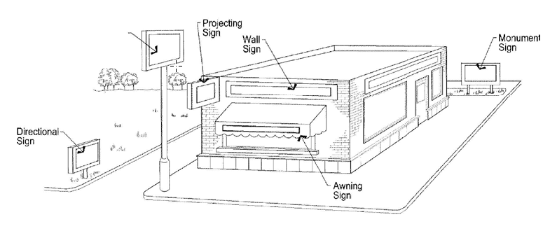
(h)
Standards for specific types of signs.
(Ord. No. 711, § 1, 2-17-2022)
Sec. 10.24.230. - Environmental considerations.
(a)
Intent. The intent of this section is to ensure that new development limits or mitigates its impact to wildlife and wildlife habitat and that it minimizes environmental impacts.
(b)
General provisions.
(1)
Protection of wildlife and natural areas. To the maximum extent practical, development shall be designed to ensure that disturbances which occur to any natural area as a result of development shall be minimized through the use of natural buffer zones. If any development materially disturbs a natural area, the development project shall mitigate such lost natural resource either on- or off-site at a 2:1 rate on a kind-for-kind basis and the mitigation shall be located within the three-mile boundary identified in the master plan unless otherwise approved by Council. Any such mitigation shall be roughly proportional to the loss suffered as a result of the disturbance.
a.
Natural areas shall include: floodplains and floodways, natural drainage and water ways, significant native trees and vegetation, wildlife travel corridors and habitats, special habitat features such as raptor nest sites, key nesting, breeding or feeding areas for birds; fox and coyote dens, remnant native habitat, cottonwood galleries, and any jurisdictional wetland greater than one-quarter acre in size.
b.
The natural area buffer zone shall be used between natural areas and proposed development to ensure that the proposed development does not degrade the natural area. The size of the buffer zone shall be determined in conjunction with the Colorado Parks and Wildlife or a town approved consultant. The town may decrease this buffer when strict application of this subsection will impose an exceptional and undue hardship upon the property owner or developer as determined by Council.
c.
Exceptions. The Council may allow disturbance or construction activity within the natural area or natural area buffer zone for the following limited purposes: mitigation of development activities, restoration of previously degraded areas, emergency public safety activities and utility installations when such activities and installations cannot reasonably be contained within other nearby develop areas, construction of a trail that will provide public access for educational or recreational purposes, or the enhancement of the habitat value and/or other natural resource values of a natural area.
d.
Ecological characterization. If the town determines that the site likely includes areas with wildlife, plant life, and/or other natural characteristics in need of protection, the town may require the developer to provide a report prepared by a professional qualified in the areas of ecology, wildlife biology, or other relevant discipline. The ecological characterization report should be included on the open space plan and describe the following:
1.
The wildlife use of the natural area showing the species of the wildlife using the area, the times or seasons the areas is used by those species and the "value" (meaning feeding, watering, cover, nesting, roosting, perching) that the area provides for such wildlife species;
2.
The boundary of wetlands in the area and a description of the ecological functions and characteristics provided by those wetlands;
3.
Any prominent views from or across the site;
4.
The pattern, species, and location of any significant native trees and other native site vegetation;
5.
The bank, shoreline and high-water mark of any perennial stream or body of water on the site;
6.
Wildlife travel corridors, and
7.
The general ecological functions provided by the site and its features.
e.
Wildlife conflicts. If wildlife that may create conflicts for the future occupants of the development (including, but not limited to, beaver, deer and rattlesnakes) are known to exist in areas adjacent to or on the development site, then the development plan must, to the extent reasonably feasible, include provisions such as barriers, protection mechanisms for landscaping and other site features to minimize conflicts that might otherwise exist between such wildlife and the developed portion of the site. Any impacts to wildlife must be referred to the Colorado Parks and Wildlife and, in the case of locally identified threatened or endangered species, United States Fish and Wildlife Service.
(Ord. No. 711, § 1, 2-17-2022)
Sec. 10.24.240. - Impacts or nuisances.
(a)
Intent. The intent of this section is to ensure that new multi-family, commercial, or industrial developments limit or mitigate their impact on other properties. This section is intended to allow these developments while preventing or substantially minimizing the occurrence of public nuisances that would have a detrimental effect on the property of another person or the community at large.
(b)
General provisions. As part of the site plan review process, any multi-family, commercial, retail, entertainment, or industrial project must provide information related to the impact of that proposal on adjacent properties. This provision is intended to prevent an excessive, offensive, annoying, unpleasant, or obnoxious thing, act, or practice; or a cause or source of annoyance, especially a continual or repeated invasion by a use or activity which invades the property line of another so as to cause harm or discomfort to the owner or resident of that property. All business uses are expected to generate normal and acceptable impacts such as noise, traffic, etc.; this section is intended to address impacts that are excessive given the relationship of the proposed use to the overall nature of the larger residential setting found within commercially zoned lands in the town. Examples of negative impacts or nuisances that may be generated by these types of development include but are not limited to:
(1)
Vehicular traffic,
(2)
Noise from business operations,
(3)
Dust,
(4)
Heat,
(5)
Glare,
(6)
Vibration,
(7)
Smoke,
(8)
Light,
(9)
Odor.
Town staff or subject area experts hired by the town will review all proposals regarding mitigation of any negative impacts or nuisances and provide direction to applicants during the site plan review process. Approval of any site plan including a determination on whether or not impacts and nuisances have been mitigated will be per the standards of this Development Code.
(Ord. No. 711, § 1, 2-17-2022)
Sec. 10.24.250. - Sanitary sewer.
All residential, commercial and industrial uses which have human occupancy shall have sanitary sewer. The sanitary sewer system shall be connected to an existing public sanitary sewer system and shall consist of a closed system of sanitary sewer mains and lateral branch connections to each structure or lot upon which a structure is to be built. Sanitary sewer lines are to be of sufficient size and design to collect all sewage from all proposed or portable structures within the subdivision or development.
(Ord. No. 711, § 1, 2-17-2022)
Sec. 10.24.260. - Potable water.
All residential, commercial and industrial uses, which have human occupancy, shall have potable water served by the town. The water system shall be of sufficient size and design to supply potable water to each structure or lot upon which a structure is to be built.
(Ord. No. 711, § 1, 2-17-2022)
Sec. 10.24.270. - Fire hydrants.
The developer shall install fire hydrants at street intersections and at other points as per the requirements of the West Routt Fire District and the town.
(Ord. No. 711, § 1, 2-17-2022)
Sec. 10.24.280. - Public improvements agreements.
(a)
Agreements and improvements. A public improvement agreement (PIA) stating that the applicant agrees to construct any required public improvements shown in the final plat or site plan (if applicable) documents together with security in a form approved by the town attorney is required. No subdivision plat shall be signed by the town or recorded at the office of the county clerk, and no building permit shall be issued for development until a PIA between the town and the applicant has been executed. Such agreement shall include a list of all agreed-upon public improvements and landscaping, an estimate of the cost of such improvements, the form of guarantee for the improvements, and any other provisions or conditions deemed necessary by the Council to ensure that all improvements will be completed in a timely, quality and cost-effective manner.
(b)
Other agreements or contracts setting forth the plan, method and parties responsible for the construction of any required public improvements shown in the final plat or site plan (if applicable) documents may also be required.
(c)
As required by this Development Code and all applicable laws, rules and regulations, the applicant shall apply to the town for inspection of improvements.
(d)
The following improvements shall be constructed unless waived by the Council.
(1)
Road grading and surfacing.
(2)
Curbs.
(3)
Streetlights.
(4)
Sidewalks.
(5)
Sanitary sewer collection system.
(6)
Storm sewers or storm drainage system, as required.
(7)
Potable water distribution.
(8)
Fire hydrants.
(9)
Utility distribution system for public parks and open space.
(10)
Street signs at all street intersections.
(11)
Permanent reference monuments and monument boxes.
(12)
Underground telephone, electricity and gas lines.
(13)
Berm or fence along major arterial and collector streets.
(14)
Required landscaping, open space and park improvements.
(15)
Tree lawns.
(16)
Underdrains.
(17)
Trails
(18)
Required floodway improvements.
(19)
Required irrigation ditch improvements.
(20)
Required off-site improvements.
(e)
Time for completion. The required time for the completion of all required improvements shall be two years from the recording date of the final map, plan or plat. However, the Council may extend such time for completion upon request from the applicant. Upon completion of such improvements within the required time and approval thereof by the Council, the town shall cause the cash, letter of credit or other accepted security to be released within 30 days of the town's acceptance of such improvements and receipt of the required as-built drawings. When such improvements are not completed within the required time, the town may cause the proceeds of the cash, letter of credit or other accepted security to be used to complete the required improvements in accordance with the terms and provisions of the PIA.
(f)
Partial release of security. During construction of required improvements, the applicant may from time-to-time request the release by the town of a portion of the security for improvements that have been inspected and approved by the town. The required warranty period shall commence upon completion and initial approval of all required improvements in accordance with the terms and provisions of the PIA.
(g)
Warranty. All workmanship and materials for all required improvements shall be warranted by the applicant as specified in the PIA and this Development Code.
(Ord. No. 711, § 1, 2-17-2022)
Sec. 10.24.290. - Conveyance of water rights as part of subdivision and/or annexation.
(a)
Intent and purpose. It is the intent and purpose of this section to further the health, safety and welfare of the citizens of the town by requiring the dedication of water rights prior to the extension of treated or raw water service to new customers and to thereby assure an adequate and stable supply of water to the town service area; to prevent the abandonment of water rights to the detriment of the town; to ensure the financial stability of the town water utility; and to promote the general welfare of the public. This section, in part, provides a supplemental requirement for annexation pursuant to the Municipal Annexation Act of 1965, C.R.S. 1973, 31-8-101 et. seq. and is not to be construed as altering, modifying, eliminating or replacing any requirements set forth therein.
(b)
Definitions. As used in this section, unless the context otherwise requires:
(1)
Equivalent residential unit (EQR) means a number related to the volume of water consumptively used by a single-family residential unit housing a statistical average of 3.5 persons and having not more than 2,500 square feet of irrigated lawn or garden. The water consumption for water uses not associated with use at a single-family residence is considered to be equal to a volume of water, expressed in EQR units, as determined by the town with guidance by the schedule provided in the Table of EQRs. The town shall have sole and exclusive discretion in determining whether the basic dedication requirement should be increased or decreased, on a case-by-case basis, after consideration of the place, method, efficiency and operation of wastewater treatment for use served; provided, however, for residential uses, it is not the intent hereof for the town to reassess the dedication requirement should such limits be exceeded.
The water consumption for each EQR is 1.0 acre-foot per year if wastewater is returned to the Yampa River system by the municipal wastewater treatment facilities serving the town. For deliveries to customers utilizing wastewater treatment facilities which are 100 percent consumptive in nature without material effluent return flows to the Yampa River system, the water consumption for each EQR is 1.0 acre-foot per year. For deliveries to water uses not utilizing the Town's municipal wastewater treatment facilities it is assumed that no return flows are generated to the Yampa River system; this presumption may be rebutted by a licensed professional engineer's analysis of actual return flow efficiency of the wastewater system to be utilized. If wastewater efficiencies are less than those of town sewer facilities but greater than a system which is totally consumptive, the water consumption per EQR shall be modified by the appropriate fraction. The consumptive use as to all other residential, but not commercial, uses is considered to bear the same ratio to the consumptive use of an average single-family residence as the EQR value assigned to that use in the respective tables of EQRs in this section bears to the EQR value assigned to the single-family residence in the table of EQRs for the respective wastewater system utilized.) Consumptive use for commercial uses shall be determined by a licensed professional engineer based upon the circumstances of each particular case.
(2)
Annexation means the act of attaching, adding, joining, or uniting a parcel of land to the legal entity known as the Town of Hayden.
(3)
Subdivide is as a subdivision is defined in this Development Code.
(4)
Appurtenant means belonging to, accessory or incident to, adjunct, appended, or annexed to.
(5)
Dedication means the conveyance of a water right to the town, made by the owner, and the acceptance of such conveyance by the town in accordance with this section, for use by the town through its municipal water system for service to the town, its inhabitants, and water customers.
(6)
Water right means a decreed right to use in accordance with its priority a certain portion of the waters of the state by reason of the appropriation of the same.
(7)
Conveyance of water rights means the legal process by which legal title to the water rights to be dedicated is transferred to the town by appropriate deed.
(8)
Transfer of water rights or change of use to municipal use means all actions required under the laws of the State of Colorado to be brought in the water court and elsewhere to change said water right for use through and within the town's water system. Such actions may include, but not by way of exclusion or limitation, a change in use to municipal uses, a plan for augmentation, a change in the type, place, or time of use, a change in the point of diversion, a change from a fixed point of diversion to alternate or supplemental points of diversion, a change from alternate or supplemental points of diversion to a fixed point of diversion, a change in the means of diversion, a change in the place of storage, a change from direct application to storage and subsequent application, a change from storage and subsequent application to direct application, a change from a fixed place of storage to alternate places of storage, a change from alternate places of storage, or any combination of such changes. Transfer of water rights includes transfer of conditional water rights as well as transfer of absolute water rights.
(9)
Lease means any grant for permissive use which results in the creation of a landlord-tenant relationship on a contractual basis.
(10)
Party means an individual, a partnership, a corporation, a municipality, or any other legal entity, public or private.
(11)
Historical use affidavit means a document which sets forth the following information concerning the water rights proposed for dedication:
a.
The name(s) and address(es) of the owner(s) of the water rights proposed for dedication;
b.
A legal description of the land to be annexed or provided with municipal water service;
c.
The total number of acres to be annexed, subdivided, replatted, or provided with municipal water service and the current use of the property;
d.
The total number of acres presently being irrigated and/or intended to remain in irrigation;
e.
A copy of all decrees concerning all water rights appurtenant to property and/or all water rights proposed for dedication;
f.
A copy of any legal decree or judgment which affects the title of those water rights entered since the owner received title to the water rights appurtenant to the property and/or proposed for dedication;
g.
A copy of the documents by which the owner received title to the water rights appurtenant to the property and/or proposed for dedication;
h.
A copy of all diversion records of the water rights proposed for dedication; and
i.
The owner's statement as to the historic use of water rights appurtenant to the property and/or proposed for dedication.
(12)
Sufficient legal priority means that the water rights proposed for dedication may be reasonably expected to provide a dependable water supply throughout the season of use in the amount for which they are decreed, and that such water rights are reasonably expected to be transferable for use by the town at its existing and proposed points of diversion for municipal use. In making this determination, factors to be considered shall include, but not by way of limitation, the adjudication date and appropriation date of water rights, the decreed use(s), the historic use of the water under the decree, the physical flow available, and the administration practices of the office of the state engineer, and the location and amounts of other water rights which may be injured by any transfer, provided, however, that any water right proposed for dedication shall not be deemed to have sufficient legal priority unless the water right was lawfully adjudicated prior to January 1, 1900.
(c)
Basic dedication requirement.
(1)
Dedication and transfer of direct flow and/or water rights to the town shall be required:
a.
Prior to the approval of the annexation of any land to the town; or
b.
Prior to all extensions of municipally treated water service outside the town limits as they existed on the effective date of this section as originally codified; or
c.
Prior to the subdivision or replatting of any land now located within the town, if such subdivision or replatting requires a change of zone district or if such subdivision or replatting creates an increase in density.
(2)
The dedication requirement shall be calculated in accordance with this section on forms provided by the manager. Such forms shall be accompanied by a historical use affidavit. For those persons whose compliance with this section results in a total EQR of greater than 30 EQR no historical use affidavit shall be required, but an engineering analysis, acceptable to the town, of the historic use of the water rights proposed for dedication shall be required.
(3)
The basic water rights dedication requirement shall be 0.75 acre-foot of historic consumptive use per year, over the course of a full calendar year, for a water right, or water rights, of sufficient legal priority and season of use to service each equivalent residential unit (EQR) of demand as calculated under the table of EQRs below as determined by the town in its sole discretion. The actual annual demand of 0.56 acre-foot of consumptive use water assumes actual diversion, without transit losses throughout the year; it is assumed that the 0.75 acre-foot of historic consumptive use water is necessary to satisfy said demand after reasonable transfer and transit losses. The determination of suitability of a water right for transfer or fee-in-lieu of water right dedication shall be determined in the town's sole discretion. Payment of a fee in lieu of water right dedication will be at the sole discretion of the town and at a rate of payment consistent with the provisions of this section.
(4)
The basic requirement shall be satisfied by the person seeking approval of annexation, subdivision, replatting, or the extension of municipally treated water service, whether or not that person will be the ultimate user(s).
(d)
Table of EQRs nature of facility to be served EQR.
(1)
Residential.
a.
Single-family detached residence not to exceed 3,000 square feet, one full kitchen, two outside hose bibs and up to 2,500 square feet of irrigated lawn and garden watered by sprinkler of drip irrigation = 1.00 EQR.
b.
Residences over 3,000 square feet will be charged an additional .05 EQR for each increment of 100 square feet and over 3,000 square feet of irrigated lawn and garden watered by sprinkler or drip irrigation.
(2)
Other requirements.
a.
An annual average water demand equal to 0.56 acre-foot = 1.00 EQR.
b.
An average monthly peak water demand equal to 22,000 gallons = 1.00 EQR.
c.
A peak daily demand of 1,000 gallons = 1.00 EQR.
(3)
Each additional 100 square feet of irrigated lawn and garden by sprinkler or drip irrigation = 0.02 EQR.
(4)
Each additional 100 square feet of non-residential irrigated landscape by sprinkler or drip irrigation. = 0.02 EQR.
(5)
Multi-family residential units, including duplexes, apartments and condominiums:
a.
Studio apartment or condo with one kitchen up to 1,500 square feet = 0.60 EQR.
b.
Up to and including two bedrooms with up to 1-1.2 baths and one kitchen, up to 1,500 square feet = 0.80 EQR.
c.
Three bedrooms with up to two baths and one kitchen, up to 3,000 square feet = 1.00 EQR.
d.
Each additional 100 square feet or fraction thereof, in excess of the above limits will be assessed 0.03 EQR. There shall not be an adjustment for fractional increments of less than 100 square feet.
e.
Each coin operated washing machine up to 12 pounds capacity = 0.35 EQR.
f.
Common area irrigation and amenities such as swimming pools, clubhouses and laundry facilities to be assessed on a case-by case basis, at the town's sole discretion, in addition to the EQR values expressed above.
(6)
There shall be no partial EQR credit granted for irrigation of less than 2,500 square feet of lawn or landscaping. Any uses described in subparagraph 1, above, which do not utilize municipal water for any irrigation, shall be:
a.
Entitled to a reduction in EQR rating of 0.02 EQR per 100 square feet of lawn or landscaping which is irrigated with non-potable water from a non-municipal system. The maximum credit which can be obtained for residential uses is 25 percent of the total EQR dedication requirement due from the project. However, if credit for any percentage of total EQR is obtained under this code provision, by irrigation from non-potable water from a non-municipal system, then the town shall proportionately reduce the water delivered for the residential use;
b.
Prohibited from having more than one outside hose bib which shall be placed on the front of the residence and shall not be used for any watering of lawns and gardens.
(7)
Each mobile home or mobile home space in a court with not more than 1,000 square feet of irrigated lawn and garden = 0.80 EQR.
(8)
Transient rental units, hotels, motels or rental units within residences;
a.
Manager's units: Uses single family or multi-family classification as applicable.
b.
Each additional room without cooking or kitchen facilities = 0.40 EQR.
c.
Each additional room with cooking or kitchen facilities = 0.50 EQR.
d.
Coin operated washing machine 12 lb. capacity or less = 0.30 EQR.
(9)
Dormitories (per each rental bed space) without laundry or kitchen facilities = 0.10 EQR.
(10)
Recreational vehicle parks:
a.
For each camping or vehicle space without sewer hook-up = 0.35 EQR.
b.
For each camping or vehicle space with sewer hook-up = 0.40 EQR.
c.
For common facilities, managers unit and related facilities, see categories above (spaces which have year-round occupancy are to be evaluated as mobile home parks).
(11)
Bars and restaurants:
a.
For businesses with less than 25 seats = 1.50 EQR.
b.
For each additional seat = 0.04 EQR.
(12)
Service stations and gas stations:
a.
Full service station with two toilets, two lavatories and one hand wash bay = 1.00 EQR.
b.
Demands in excess of the above are determined by projected volume.
(13)
Churches and nonprofit organizations with no residence or regular eating facilities = 1.00 EQR.
(14)
Commercial retail stores with no processed water, no residences and no eating facilities of up to 5,000 square feet including two restrooms which have a total of two lavatories and two toilets (one each per restroom) = 1.00 EQR.
a.
For each additional toilet or urinal with manual flush = 0.30 EQR.
b.
For each additional toilet or urinal with continuous flow = 1.00 EQR.
c.
For each additional lavatory = 0.15 EQR.
d.
For each shower or bath or combination = 0.30 EQR.
e.
For each manual operated drinking fountain = 0.10 EQR.
f.
For each continuous flow drinking fountain = 1.00 EQR.
g.
For each additional 1,000 square feet of floor space above 5,000 feet = 0.02 EQR.
(15)
Commercial offices (such as banks, professional office space and other low traffic occupations) with no processed water, no residences, and no eating facilities of up to 7,000 square feet including two restrooms which have a total of two lavatories and two toilets (one each per restroom) = 1.00 EQR.
a.
For each additional toilet or urinal with manual flush = 0.30 EQR.
b.
For each additional toilet or urinal with continuous flow = 1.00 EQR.
c.
For each additional lavatory = 0.15 EQR.
d.
For each shower or bath or combination = 0.30 EQR.
e.
For each manual operated drinking fountain = 0.10 EQR.
f.
For each continuous flow drinking fountain = 1.00 EQR.
g.
For each additional 1,000 square feet of floor space above 7,000 feet = 0.14 EQR.
(16)
Industrial, including warehouses up to 8,000 square feet which include two toilets (one each per restroom) = 1.00 EQR.
a.
For every 350 gallons/day of processed water with not more than 15 percent consumptive use = 1.00 EQR.
b.
For each additional toilet or urinal with manual flush = 0.30 EQR.
c.
For each additional toilet or urinal with continuous flow = 1.00 EQR.
d.
For each additional lavatory = 0.15 EQR.
e.
For each shower or bath combination = 0.10 EQR.
f.
For each mop sink = 1.00 EQR.
g.
For each manual operated drinking fountain = 0.10 EQR.
h.
For each continuous flow drinking fountain = 1.00 EQR.
i.
For each additional 1,000 square feet or floor space above 8,000 feet = 0.13 EQR.
(17)
Schools including principal's administrative office and school staff but not including cafeteria, gymnasium or athletic field facilities:
a.
Up to 50 students = 1.00 EQR.
b.
For each additional student = 0.02 EQR.
c.
Cafeteria, gymnasium and athletic requirements determined on a case-by-case basis at the town's sole discretion = 0.02 EQR.
d.
The foregoing shall be based on the projected maximum usage of the school facilities and shall be subject to a periodic audit as required by this section.
(18)
Swimming pools up to 25,000-gallon capacity:
a.
Year-round operation = 1.00 EQR.
b.
Summer only (less than six months) = 0.50 EQR.
c.
For each additional 1,000 gallons of capacity = 0.02 EQR.
(19)
Fire protection sprinkler systems = 0.00 EQR.
(20)
Irrigation by sprinkler or drip system:
a.
Residential per 100 square feet = 0.02 EQR.
b.
Commercial per 100 square feet = 0.02 EQR.
c.
Commercial or residential irrigation of more than 5,000 square feet of lawn or landscaping shall be subject to special rates imposed by the town at the town's sole discretion.
(21)
Car washes:
a.
All car washes will be based on water delivery requirements and consumptive use projections with EQRs to be determined by the town at the town's sole discretion.
(22)
Commercial laundromats:
a.
Each washer up to 12 lb. capacity = 0.35 EQR.
b.
For each additional pound of capacity over 12 pounds = 0.015 EQR.
Uses which are not connected to the wastewater facilities of the town will be evaluated by the location of the wastewater return point in setting, modifying or determining dedication requirements, in the town's sole discretion. Additionally, uses which compute to be more than 3.0 EQR per tap connection are subject to review, calculations and assessment on an ad hoc basis by the town after consideration of the anticipated water to be used.
(e)
Dedication of water rights for open space. The owner of any property proposed to be annexed or subdivided who dedicates property to the town pursuant to this section to be used for open space, park, aesthetic, recreation, or irrigation purposes shall also comply with the provisions of this section for the property to be dedicated.
(f)
Procedure.
(1)
In accordance with the basic requirements set forth in this section, the manager shall determine, after consultation with a person or persons skilled in the knowledge of water rights, whether the water rights proposed for dedication pursuant to the provisions of this section will be of sufficient legal priority under the laws of the State of Colorado to ensure the town's ability to meet the service demands of the new user. This determination will be aided by a historic use affidavit or engineering report provided by the new user.
(2)
The town shall have the right, in its sole discretion, to accept or reject any water rights proposed for dedication pursuant to the provisions of this section which the Council has determined do not have sufficient legal priority. If the Council determines that the water rights proposed fail to satisfy the basic determination requirement, the following alternatives, or combination thereof, may be used to otherwise satisfy the basic dedication requirement:
a.
The person required to comply with the basic dedication requirement may pay to the town a cash amount equal to the fair market value of the water rights necessary to satisfy the basic dedication requirement.
b.
The manager may, in his/her discretion, negotiate with the new user to establish other terms or conditions which shall constitute compliance with the basic dedication requirement of this section.
(3)
The new user shall dedicate the water rights determined by the town by filing with the Council an offer thereof. It is the intent of this section that no water service shall be extended to a new user until the agreed to water rights have been dedicated to the town; however, if there are matters pending resolution in the water court concerning the water rights to be dedicated, or if there is other delay beyond the control of the new user, the manager shall have the discretion to approve the extension of such water service prior to the dedication of water rights to the town.
(4)
Subject to negotiations with the Council, all costs and expenses attendant to the conveyance and transfer of water rights dedicated to the town shall be borne by the new user. The manager may, with the approval by the Council, to negotiate a one-time, up-front fee for small users to be paid by the developer and used by the town for the costs of conveyance and transfer. Otherwise, the manager shall establish a deposit requirement to be held by the town and maintained by the new user to pay for such costs.
(5)
Any decision of the manager made hereunder shall be appealable at the next regularly scheduled meeting of the Council, whose determination shall be final.
(6)
If the owner of the property proposed to be annexed or subdivided desires to retain the land or any portion thereof in agricultural production or as open space prior to development, he may be permitted to lease back, on an annual basis, and for irrigation, aesthetic and recreational purposes only, the water rights transferred pursuant to this section. The terms of the lease shall be negotiated with the Council.
(g)
Option to purchase.
(1)
Time. Any person required to comply with the basic dedication requirement shall also grant to the town the option to purchase any and all water rights which are appurtenant to the land to be annexed but which are in excess of the basic dedication requirement. Said option may be exercised by the town at any time for a period of two years following the date of the grant to the town with regard to any or all of the water rights subject to the grant.
(2)
Price. The option price shall be that price agreed upon by the parties. If the parties do not agree upon an option price within 30 days after the notice of the town's intent to exercise its option is received by the owner, an appraisal at the town's expense will establish the price that reflects the fair market value of the water right(s). The appraisal shall be conducted by one licensed Colorado appraiser appointed by the town, one licensed Colorado appraiser appointed by the owner of the water rights, and a third licensed Colorado appraiser who shall be appointed by both parties. The average of the three appraisals shall be the option price.
(3)
Right of first refusal.
a.
Grant of right. In addition to the grant of the option to purchase by the new user(s), there shall be a grant to the town by the user(s) of a right of first refusal regarding the water rights subject to said option to purchase. If the town for any reason should choose not to exercise its option to purchase, it shall retain said first right of refusal, in the event the water rights are sold independently of the land, for a period of ten years following annexation or final approval, or replatting, or extension of water service to a subdivision, whichever last occurs.
b.
Notice period. If the owner of the water rights subject to said right of first refusal wishes to sell the water rights to a third party, he shall give to the town at least 90 days notice of his intention to effect a sale of said water rights by delivering to the town a bona fide written offer to purchase made by a third party. Failure to notify the town in accordance with right of first refusal shall be cause to invalidate any third party sale.
c.
Exercise of right. During the 90-day notice period provided for above, the town shall enjoy its right of first refusal entitling it to purchase the water rights proposed for sale. If within 90 days following notice by the owner of his intention to sell his water rights, the town chooses to exercise its right to purchase, then the town shall pay to the owner the price for the water rights as specified in the bona fide offer in accordance with the terms of such bona fide offer. In the event that the town determines to not exercise its right to purchase the water rights offered for sale, the owner shall be free to sell the water rights to the third party; provided, however, that any such sale to a third party shall be for a price which is at least equal to that price which was tendered to and refused by the town.
(Ord. No. 711, § 1, 2-17-2022)
Sec. 10.24.300 - Community housing standards.
(a)
Purpose. The purpose of this community housing policy is to address the critical lack of housing across nearly all income levels that is imposing a high housing cost burden and limiting the local workforce. This mitigation is an effort to preserve the health, safety, welfare, and quality of life for residents in this community through housing that is attainable. This is accomplished through the establishment of community housing requirements for development, which requires a portion of all new residential development to be set aside for community housing purposes as a condition of approval for such development.
(b)
Applicability. Compliance with the community housing policy shall be required as a condition of approval for all residential development, including: annexations, subdivisions, planned unit developments, or site plan review applications, unless exempted by the section below. In the case where no land use application is made, any building permit application with five or more dwelling units is also subject to these regulations.
(c)
Exemptions.
(1)
Designated employee dwelling units.
(2)
Single-family and two-family dwellings on a single pre-existing lot.
(3)
Three-family dwelling units on a single pre-existing lot.
(4)
Development in which a minimum of 50 percent of units are dedicated to households up to 120 percent AMI.
(5)
Administrative and minor subdivisions resulting in less than two new lots.
(6)
Commercial and industrial developments without a housing component.
(7)
Vested land use approvals pre-dating November 3, 2022.
(d)
Community housing requirements. All new residential subdivisions and all new multi-family residential developments shall set aside housing units for community housing as set forth in this section.
(1)
New development requirements.
a.
Residential developments of greater than four units shall be required to provide ten percent of the total units as community housing AMI category units, which shall include ten percent of the total bedrooms.
b.
Housing cost shall not exceed greater than 30 percent of the gross income of the household in each required community housing AMI category units.
c.
Community housing units shall be encumbered through the use of deed restrictions, an agreement with the Town of Hayden or a combination thereof, as determined in the sole discretion of the town.
d.
Deed restrictions and/or agreements are not eligible for renegotiation for a period of 30 years unless otherwise initiated by the town.
e.
All new development shall require the submittal of a community housing plan that details the restrictions placed on the units for review by town staff along with development application materials unless otherwise exempted from these requirements.
(2)
Fractional remainders. The development's mitigation responsibility will be rounded up to the nearest whole number or pay a fee in lieu based upon the remaining percentage of a unit calculation.
(3)
Sequencing of community housing units. The income categories correspond with current HUD area median income (AMI) limits. The sequence of required community housing units will be as follows:
a.
First community housing unit: Category 2 (100% AMI).
b.
Second community housing unit: Category 1 (80% AMI).
c.
Third community housing unit: Category 3 (120% AMI).
d.
Fourth community housing unit: Category 4 (150% AMI).
e.
Repeat the cycle for additional community housing units.
(4)
Implementation.
a.
Timing of occupancy. The community housing units shall be ready for occupancy no later than the occupancy of market rate units within the project. If the market rate units are to be developed in phases, then the community housing units can be developed in proportion to the phasing of the market rate units.
b.
Community housing unit design. The community housing units shall be of average size, bedroom count, design, and construction quality as market rate units in the same development.
c.
Community housing unit location. The community housing units shall be interspersed with the market rate units and not clustered and/or sequestered.
(e)
Alternative methods to satisfy the requirements of this section.
(1)
A fee-in-lieu is of community housing requirements are calculated at a value of ten percent of the appraised housing unit cost.
a.
Unit value will be determined by appraisal provided by the applicant.
b.
If unit value is in dispute, the town reserves the right to contract their own appraisal.
(2)
Land dedication in lieu of community housing requirements.
a.
Dedicated land must be of approximate equivalent value to the fee in lieu.
b.
Dedicated land must be unencumbered, appropriately entitled, and be served with equivalent infrastructure as the remainder of the development unless otherwise agreed to by the Town Council.
c.
Land dedication shall be conveyed to the Town of Hayden at the time of recordation of the final plat.
(3)
An applicant may propose an alternative significant community benefit to be implemented in lieu of the minimum compliance.
(f)
Significant community benefit procedure.
(1)
Submittal requirements.
a.
Estimated financial impact provided to the community.
b.
Timeline for implementation.
c.
Narrative explaining how the alternative significant community benefit will improve health, wellness, safety, education, or economic outcomes of the community.
d.
Additional documentation, studies, or information is required by staff or Town Council.
(2)
Review process.
a.
An alternative significant community benefit plan may be submitted to the town prior to, or at the time of a site plan application, preliminary plat application, or building permit application in a project that no planning application is required.
b.
The Town Council shall act as the approving body and determine if a specific alternative significate community benefit is acceptable in a public meeting.
c.
If the alternative significant community benefit is deemed satisfactory by the Town Council bonding, commitment guarantee, and/or an improvement agreement may be required to secure the proposal is enacted as part of the overall project.
(g)
Applicability to subdivision of undeveloped land. In the case that land is subdivided and conveyed to individual owners in a vacant or undeveloped status, the subdivider of the land shall meet one of the following options.
(1)
Fee-in-lieu of construction of community housing units based upon ten percent of the market value of a dwelling unit to be constructed on the vacant property. The dwelling unit value will be derived from an appraisal of home sales on similar size and valued lots over the prior two-year period within the Town of Hayden.
(2)
Land dedication in lieu of construction of community housing units proportional with the fee in lieu value.
(3)
Alternative significant community benefit proportional with the fee in lieu value.
(h)
Incentives. Developments that exceed the required community housing standards may qualify for the following incentives. All incentives require approval of the town manager. When an incentive includes a variation from the requirements of this title 10 (Hayden Development Code), such incentive shall require the additional approval of the Town Council.
(1)
Flexibility in dimensional standards (i.e. reduction in minimum lot size, decreased setbacks, increase in maximum structure height).
(2)
Review fee waivers or reductions.
(3)
Property tax incentives.
(4)
Infrastructure support in special circumstances.
(i)
Applicability of other provisions of title 10 The provisions of this section are in addition to all other provisions and requirements of this Code pertaining to development of real property, including those contained in other sections of this chapter, the subdivision regulations, and the zoning regulations.
(Ord. No. 722, § 2, 11-3-2022)
(Ord. No. 711, § 1, 2-17-2022)