
Hilliard City Zoning Code
CHAPTER 62
ZONING AND LAND DEVELOPMENT REGULATIONS
Sec. 62-1.- Definitions.
For the purpose of this chapter, certain words and terms used herein shall be interpreted to have meanings as defined below. The word "used" or "occupied" include the word "intended," "designed," or "arranged" to be used or occupied. The word "lot" includes the word "plot" or "parcel." The word "structure" includes the word "building" as well as other things constructed or erected on the ground, attached to something having location on the ground, or requiring construction or erection on the ground. The word "land" includes the word "marsh," "water," or "swamp." The word "map" shall mean the "Zoning Map of the Town of Hilliard, Florida."
Accessory use or structure means a use or structure of a nature customarily incidental and subordinate to the principal use or structure, and unless otherwise provided, on the same premises.
Accessory dwelling unit (ADU) means living quarters in a building separate from and in addition to the primary residential structure on a lot. The primary structure must be homesteaded. The ADU cannot be sold separately from the primary structure and the lot shall not be subdivided to separate the ADU from the principal structure. The floor area shall be no less than 375 square feet and no greater than 40 percent of the primary structure's gross floor area or 1,000 square feet, whichever is less. Minimum lot size is 10,000 square feet and the maximum lot coverage for all buildings may not exceed 30 percent. The ADU must meet the setbacks for accessory structures.
Alley means a public or private way which affords only a secondary means of access to property abutting thereon.
Alter or alteration means any change in size, shape, occupancy, character or use of a building or structure.
Auditorium means a room, hall, building, or part of a building used for public gatherings.
Buildable area means the portion of a lot remaining after required yards, parking, and landscaping areas have been provided. Buildings may be placed in any part of the buildable area, but limitations on percent of the lot which may be covered by buildings may require open space within the buildable area.
Building means a structure designed for shelter, storage, trade, manufacturing, religion, business, education and the like, having a roof and walls impervious to weather, and shall be subject to this Code.
Building enclosed means a building separated on all sides from adjacent open space, or from other buildings or other structures, by a permanent roof and by exterior walls or party walls which are pierced only by windows and normal entrance or exit doors.
Carport means an accessory structure or portion of a principal structure, consisting of a roof and supporting members such as columns or beams, unenclosed from the ground to the roof on at least two sides, and designed or used for the storage of motor driven vehicles owned and used by the occupants of the building to which it is accessory.
Centerline of street means the line surveyed and monumented by the town or the state department of transportation. If a centerline has not been surveyed and monumented, it shall be that line running midway between the outside curbs or ditches of the street.
Church means a building or structure, the sole design and use of which is for religious worship and the religious program of such church.
Community residential home means a dwelling unit as defined and required by F.S. § 419.001.
Day care/child care centers means facilities that provide care to six or more children and licensed by the State of Florida to provide those services.
Density means the number of residential dwelling units permitted per acre of land, excluding land for street rights-of-way and drainage ditches.
Developable land means all of a parcel of land except:
(1)
Lands lying within proposed public rights-of-way;
(2)
Marshlands, swamps, floodplains or other environmentally sensitive lands where local, state or federal regulations otherwise prohibit development; and
(3)
Bodies of water such as ponds, lakes and reservoirs, either natural or manmade.
Dwelling means any building, or part thereof, occupied in whole or in part as the residence or living quarters of one or more persons.
Dwelling, multiple-family, means a building containing three or more dwelling units.
Dwelling, single-family, means a building containing not more than one dwelling unit designed for residential use
Dwelling, two-family, means a building containing two dwelling units.
Dwelling unit means a room or rooms connected together, constituting a separate, independent housekeeping establishment in the same structure, and containing sleeping facilities and one kitchen.
Easement means a grant from a property owner for the use of land for a specific purpose by the general public, by a corporation, or by a certain person.
Erected means and includes built, constructed, reconstructed, moved upon, or any physical operation on the premises required for building. Excavations, fill, drainage, demolition of an existing structure, and the like shall be considered part of erection.
Floor area means, the sum of the gross horizontal areas of the several floors of a building measured from the exterior faces of the exterior walls or from the centerline of walls separating two buildings.
Garage, means an accessory structure designed or used for inside parking of private passenger vehicles by the occupants of the main building. A private garage attached to or a part of the main structure is to be considered part of the main building. An unattached private garage is to be considered as an accessory building.
Height of a building means the vertical distance from the established grade at the center of the front of a building to the highest point of the roof or parapet.
Hospital means a building or group of buildings licensed as a hospital under the laws of the State of Florida.
Hotel, motel, means a building or a group of buildings in which sleeping accommodations rental is offered to transients with daily or weekly charge.
Loading space, off-street, means an on-the-property space, conveniently located for pickups or deliveries. Such space shall measure not less than 12 feet by 25 feet excluding surfaced area necessary for access and maneuvering.
Lot means a parcel of land. Such lot shall have frontage on a public or private street.
Lot coverage of buildings means that percentage of lot area that is or may be covered or occupied by buildings.
Lot frontage means the portion nearest the street. For the purpose of determining yard requirements on corner lots and through lots, all sides of a lot adjacent to streets shall be considered frontage.
Lot depth means the distance between the front and rear property lines.
Lot width means the distance between the side lot lines.
Lot of record means a lot or parcel which has been so recorded on or before December 29, 1987.
Mobile home or manufactured home means a single-family dwelling unit that is constructed in its own permanent chassis according to the U.S. Department of Housing and Urban Development's Manufactured Home Construction and Safety Standards, with all the following characteristics: (a) designed for long term occupancy and containing sleeping accommodations, a flush toilet, a tub or shower bath, and kitchen facilities, with plumbing and electrical connections provided for attachment to outside systems; (b) designed for transportation after fabrication on streets or highways on its own wheels; and (c) arriving at the site where it is to be occupied as a dwelling complete, including major appliances and furniture, and ready for occupancy except for minor and incidental unpacking and assembly operations, location on jacks or other temporary or permanent foundations, connection to utilities and the like. A travel trailer is not to be considered a mobile home.
Nuisance is an act or omission that infringes or threatens the health, morals, safety, comfort, convenience, general welfare or property values of or within the town.
Nursing home means a facility licensed under the laws of the State of Florida as nursing homes.
Professional or business Office, means an office for such operations as real estate agencies, advertising agencies, insurance agencies, travel agencies, title companies, management consultants, stockbrokers, architects, engineers, attorneys, accountants, doctors, lawyers, dentists, veterinarians, psychiatrists, psychologists, and etc.
Open space means a parcel of land or an area of water, or a combination of land and water, within a site which shall include common recreation areas, woodland areas, parks, playgrounds, golf courses, tennis courts, nature trails, lakes and swimming pools, camping facilities and other similar open space, exclusive of streets, roads and parking areas.
Pet, household, means any domestic animal normally owned or kept as a pet.
Private street or road. A private street or road shall have a minimum width of 60 feet approved by the town council.
Recreational vehicle means a vehicular portable structure built on a chassis with its own wheels, either self-propelled or towed by another vehicle, designed to be used as a temporary dwelling for travel, vacation, camping or recreational purposes, and including travel trailers, camping trailers, pickup campers, converted buses, motor homes, tent trailers, pop-up trailers, boats and boat trailers and similar devices.
Restaurant means an establishment where food is ordered from a menu, prepared, and served for pay primarily for on site or off site consumption.
Service station means an establishment for the dispensing at retail of gasoline and the service of automobile and sale of automobile accessories.
Use of land means the use of land, water surface, and land under water to the extent covered by zoning districts, and over which the town has jurisdiction.
Used car lot means a lot or group of contiguous lots used for the storage, display and sale of used automobiles and where no repair work is done except the necessary reconditioning of the cars to be displayed and sold on the premises.
Yard means a required open space other than a court unoccupied and unobstructed by any structures or portion of a structure from 30 inches above the general ground level of the graded lot upward; provided, however, that fences, walls, poles, posts, and other customary yard accessories, ornaments, and furniture may be permitted in any yard subject to height limitations and requirements limiting obstruction of visibility.
Yard, front, means a yard from the front lot line of a lot adjoining a public or private street to the structure.
Front yards shall be provided on all frontages of through lots. Corner lots must have a front yard of the required depth [and] shall be provided on one frontage and a depth of 15 feet or one-half of the average adjacent front yard, whichever is greater. Corner lots have two side yards.
Yard, side, means a yard extending side property line to the structure. In the case of through lots,
Yard, rear, means a yard extending from the rear lot line to the structure of the lot between inner side yard lines
(Ord. No. 2023-14, § 1(Att. A), 12-7-2023; Ord. No. 2024-02, § 1, 6-6-2024)
Sec. 62-2. - Scope and compliance.
The provisions of this chapter shall apply to all land, buildings, structures and to the uses within the jurisdiction of the town. No land, building or structure shall be moved, added to or enlarged, altered or maintained, except in conformity with the provisions of this chapter. All buildings or structures hereafter erected, reconstructed, altered, enlarged or moved in the town shall be in conformity with the provisions of this chapter.
(Ord. No. 2023-14, § 1(Att. A), 12-7-2023)
Sec. 62-3. - Purpose and policy.
(a)
The purpose of this chapter is to promote, protect, and improve in accordance with the comprehensive plan and with present and future needs, the public health, safety, comfort, good order, appearance, convenience, morals and general welfare of the town; to conserve the value of land, buildings and resources; and to protect the character and maintain the stability of residential, agriculture, business and industrial areas and promote the orderly development of such areas.
(b)
The districts and regulations contained herein are designed to provide orderly growth; to decrease the traffic congestion on public streets and highways; to provide adequate light and air; to promote civic amenities of beauty and visual interest; and to regulate density of population and thus prevent the overcrowding of land in order to facilitate the provision for adequate community service and facilities such as water, sewerage, schools, and parks; and to help accomplish the goals and objectives of the comprehensive plan.
(Ord. No. 2023-14, § 1(Att. A), 12-7-2023)
Sec. 62-4. - Interpretation.
In interpreting and applying the provisions of this chapter, they shall be held to be the minimum requirements for the promotion of the public health, safety, morals and general welfare of the town.
(Ord. No. 2023-14, § 1(Att. A), 12-7-2023)
Sec. 62-5. - Conflict with other legal documents.
It is not intended by this chapter to interfere with or abrogate or annul any easements, covenants or other agreements between parties; provided, however, that where this chapter imposes a greater restriction upon the use of buildings or premises or upon the height of buildings, or requires larger open space than are imposed or required by other ordinances, rules, regulations, or by easements, covenants or agreements, the strictest provisions shall govern.
(Ord. No. 2023-14, § 1(Att. A), 12-7-2023)
Sec. 62-6. - Remedies.
The violation of any of the codes, regulations, restrictions and limitations promulgated under the provisions of this chapter may be restricted by injunction, including a mandatory injunction, and otherwise abated in any manner provided by law, and such suit or action may be instituted and maintained by the town council, or by any person or other group or body affected by the violation of any such regulation, restriction or limitation.
(Ord. No. 2023-14, § 1(Att. A), 12-7-2023)
Sec. 62-7. - Penalties.
Violations of this chapter are punishable as provided in section 1-7.
(Ord. No. 2023-14, § 1(Att. A), 12-7-2023)
Sec. 62-8. - Liability.
The granting of approval of any structure or use shall not constitute representation, guarantee or warranty of any kind or nature by the town or the town planning and zoning board by any officer or employee thereof of the practicality or safety of any structure or use proposed and shall create no liability upon or cause action against such public body, officer, or employee for any damage that may result thereto.
(Ord. No. 2023-14, § 1(Att. A), 12-7-2023)
Sec. 62-281.- Zoning districts exclusive.
The use provisions in the various zoning districts are exclusive and any use not included under permitted or permissible uses shall be prohibited. The following chart includes the permitted uses and the permitted uses by special exception for each district. Permitted uses indicated with a "P" and permitted uses by special exception are indicated with an "E."
USES BY ZONING DISTRICT
(Ord. No. 2023-14, § 1(Att. A), 12-7-2023; Ord. No. 2024-02, § 3, 6-6-2024)
Sec. 62-282. - Agricultural district A-1.
(a)
Intent. district is intended to apply to areas which are sparsely developed.
(b)
Minimum lot requirements.
(1)
Single-family dwelling or mobile homes on individual lot:
a.
Minimum lot width. One hundred fifty feet.
b.
Minimum lot area. One acre.
(2)
Minimum lot size for all other uses: Five acres.
(c)
Maximum lot coverage.
(1)
Maximum lot coverage by all buildings and accessory structures shall not exceed 25 percent of lot area.
(2)
Other permitted or permissible use and accessory buildings shall be five percent.
(d)
Minimum yard requirements.
(1)
Front. Thirty-five feet minimum.
(2)
Side. Twenty feet minimum.
(3)
Rear. Forty feet minimum.
(e)
Maximum height of structures. Thirty feet in height above established grade.
(Ord. No. 2023-14, § 1(Att. A), 12-7-2023)
Sec. 62-283. - Single-family district R-1.
(a)
Intent. This district is intended to apply to areas which are to be developed with large lot single-family homes and ancillary residential uses normally applicable in a residential neighborhood.
(b)
Minimum lot requirements.
(1)
Minimum lot width. One hundred feet.
(2)
Minimum lot area. Twenty thousand square feet.
(c)
Maximum lot coverage. Maximum lot coverage by all buildings and accessory structures shall not exceed 30 percent of lot area.
(d)
Maximum yard requirements.
(1)
Front. Thirty feet.
(2)
Side. Twelve and one-half feet.
(3)
Rear. Thirty-five feet.
(e)
Maximum height of structures. Thirty feet in height above established grade.
(Ord. No. 2023-14, § 1(Att. A), 12-7-2023)
Sec. 62-284. - Single-family district R-2.
(a)
Intent. This district is intended to apply to areas which are to be developed with medium-sized lot single-family homes and accessory residential uses applicable in a single-family residential density that is in keeping with the needs of the community and that can be served adequately by available community services and facilities.
(b)
Minimum lot requirements. The minimum lot requirements per one dwelling are as follows:
(1)
Minimum lot width. Ninety feet.
(2)
Minimum lot area. Ten thousand square feet.
(c)
Maximum lot coverage. Maximum lot coverage by all buildings and accessory structures shall not exceed 30 percent of lot area.
(d)
Minimum yard requirements.
(1)
Front. Thirty feet.
(2)
Side. Twelve and one-half feet.
(3)
Rear. Thirty feet.
(e)
Maximum height of structures. Thirty feet in height above established grade.
(Ord. No. 2023-14, § 1(Att. A), 12-7-2023)
Sec. 62-285. - Multiple-family district R-3.
(a)
Intent. This district is designed to apply to areas which are to be developed with a combination of single-family and multiple-family homes on small lots as is appropriate in a multiple residential area. It is intended to create and maintain a residential district of small homes and rental dwelling units at an intensity that is in keeping with the needs of the community and can be served adequately by available community services and facilities. It is also designed to create and maintain a multiple-family housing stock to serve and protect the character and stability of the district and the town.
(b)
Minimum lot requirements. The minimum lot requirements are as follows:
(1)
Minimum lot width. Seventy feet.
(2)
Minimum lot area. Seven thousand square feet.
(3)
Maximum units per acre. Twelve.
(c)
Maximum lot coverage. Maximum lot coverage by all buildings and accessory structures shall not exceed 35 percent of lot area or 12 units per acre.
(d)
Minimum yard requirements.
(1)
Front. Twenty-five feet.
(2)
Side. Twelve and one-half.
(3)
Rear. Thirty feet.
(g)
Maximum height of structures. Thirty feet in height above established grade.
(Ord. No. 2023-14, § 1(Att. A), 12-7-2023)
Sec. 62-286. - Multifamily-mobile home district RM-4.
(a)
Intent. This section applies to the RM-4 district. This district is designed to apply to areas to be set aside for development with a combination of single-family, multiple-family and mobile homes on small lots that can be adequately served by available community facilities.
(b)
Lot and building requirements.
(1)
Minimum lot width. Seventy-five feet.
(2)
Minimum lot area. Nine thousand square feet.
(3)
Maximum building capacity. Sixteen dwelling units for each building.
(4)
Maximum density. Twelve dwelling units per acre.
(c)
Maximum lot coverage. Maximum lot coverage by all buildings and accessory structures shall not exceed 35 percent of lot area.
(d)
Minimum yard requirements.
(1)
Front yard. Twenty-five feet.
(2)
Side yard. Twelve and one-half feet.
(3)
Rear yard. Thirty feet.
(e)
Maximum height of buildings. Thirty feet in height above established grade.
(Ord. No. 2023-14, § 1(Att. A), 12-7-2023)
Sec. 62-287. - Mobile home district RMH.
(a)
Intent. The provisions of the RMH district provide for the development of areas for individual mobile home parks for residents desiring the unique environments characteristic of mobile home living. It shall be the responsibility of those entities establishing an RMH district to provide for these areas the community services as set forth in this amendment for their orderly development.
(b)
Permitted accessory uses and structures.
(1)
Each mobile home park shall be permitted to contain accessory or support facilities customarily incidental to the operation of the mobile home park as approved on the site plan. Such facilities may include recreational facilities, maintenance facilities and laundry facilities for use by the park residents.
(c)
Minimum lot requirements.
(1)
Mobile home park.
a.
Minimum site width.
1.
One hundred feet of frontage on a public or private road.
b.
Minimum site area.
1.
Ten acres.
2.
Maximum density of eight mobile homes per gross acre.
c.
Minimum lot size for each mobile home.
1.
Five thousand square feet.
d.
Minimum yard requirements for each mobile home.
1.
Front yard. Twenty feet.
2.
Rear yard. Ten feet.
3.
Side yard. Seven and one-half feet.
(d)
Maximum lot coverage by all buildings and structures. Maximum lot coverage by all buildings and structures shall not exceed 35 percent of lot area.
(e)
Minimum yard requirements.
(1)
Mobile home park.
a.
Twenty-five feet from any property line.
(f)
Mobile home parks. All mobile home parks developed in the town shall meet the following minimum standards:
(1)
All mobile homes must be skirted.
(2)
Each mobile home park shall have 150 square feet recreation area per mobile home lot.
(3)
All streets and roads within a mobile home park shall have a minimum width of 50 feet. Cul-de-sac or dead end streets shall have a turning radius of at least 50 feet.
(4)
All streets have a minimum paved surface width of 20 feet and a minimum thickness of six inches.
(5)
A landscaped buffer at least eight feet wide and six feet high or privacy fence six feet high with 85 percent opacity shall be maintained along all property lines of the mobile home park.
(Ord. No. 2023-14, § 1(Att. A), 12-7-2023)
Sec. 62-288. - Main Street commercial MSC.
(a)
Intent. The MSC district is not intended for use by major commercial or service establishments such as service stations, vehicle repair and sales, hotels, etc. However, professional and business offices and similar uses are encouraged.
(b)
Permitted principal uses and structures.
(1)
Limitations. All uses in the MSC are subject to the following limitations:
a.
Sale, display, preparation, and storage to be conducted within a completely enclosed building, and
b.
No more than 20 percent of floor space to be devoted to storage.
c.
No vehicles other than passenger automobiles or trucks of not more than three-quarter-ton capacity shall be used.
d.
On the same premises and in connection with permitted principal uses and structures, one permanent dwelling unit.
(c)
Yard requirements for gasoline filling stations as an accessory use to a convenience store.
(d)
Minimum lot width. Seventy-five feet.
(e)
Minimum size. Seven thousand five hundred square feet.
(f)
Maximum lot coverage. Maximum lot coverage by all buildings and accessory structures shall not exceed 35 percent of lot area.
(g)
Minimum yard requirements.
(1)
Front. Twenty-five feet or the front yard shall be consistent with the adjacent property.
(2)
Side. Ten feet.
(3)
Rear. Thirty-five feet.
(h)
Maximum height of structures. Thirty-five feet in height above established grade or as permitted by a special exception.
(Ord. No. 2023-14, § 1(Att. A), 12-7-2023)
Sec. 62-289. - General commercial district C-1.
(a)
Intent. This district is intended to apply to those areas where general commercial establishments are appropriate and are to be located so as to serve the entire community and its environs. It is not intended to provide for warehousing, production or similar facilities. It is designed to promote the orderly growth and development of the area and to permit adequate service by the street and highway system and the available community services and facilities.
(b)
Minimum lot width. Seventy-five feet
(c)
Minimum size. Seven thousand five hundred square feet.
(d)
Maximum lot coverage. Maximum lot coverage for building and accessory structures shall not exceed 35 percent of lot area.
(e)
Minimum yard requirements.
(1)
Front. Ten feet or the front yard shall meet requirements of the adjacent property.
(2)
Side. Five feet or none, if the adjacent lot is built on the property line, or if the adjacent lot is vacant.
(3)
Rear. Ten feet.
(f)
Maximum height of structures. Thirty-five feet in height above established grade or as permitted by a special exception.
(g)
Site plan required. A site plan shall be submitted by the applicant according to section 62-40.
(Ord. No. 2023-14, § 1(Att. A), 12-7-2023)
Sec. 62-290. - Manufacturing and industrial warehousing district M-1.
(a)
Intent. This district is intended to apply to those areas where manufacturing, warehousing and other industrial uses are appropriate and are to be located where they can be best served by the street and highway system, water, sewer and other community services. Development shall be limited by the adequacy of services and resources available and shall be permitted as necessary to maintain the character, value and stability of the district and the town.
(b)
Minimum lot width. Fifty feet
(c)
Minimum lot size. Ten thousand square feet.
(d)
Minimum yard requirements.
(1)
Front. Twenty-five feet.
(2)
Side. None.
(3)
Rear. Ten feet.
(4)
Wherever property zoned M-1 shall abut or adjoin property zoned primarily for single-family or multifamily residential use: 15 feet.
(e)
Maximum height of structures. Thirty feet in height.
(Ord. No. 2023-14, § 1(Att. A), 12-7-2023)
Sec. 62-311.- Definition.
For the purpose of this chapter, a planned unit development (PUD) shall mean the development of land under unified control which is planned and developed as a whole in a single or programmed series of operations with uses and structures substantially related to the character of the entire development. A PUD must also include a program for the provision, maintenance and operation of all areas, improvements, facilities, and necessary services for the common use of all occupants thereof.
(Ord. No. 2023-14, § 1(Att. A), 12-7-2023)
Sec. 62-312. - Intent.
The application of flexible land use controls to the development of land is often difficult or impossible within traditional zoning district regulations. In order to permit the use of more flexible land use regulations and to facilitate use of the most advantageous techniques of land development, it is often necessary to establish planned unit developments (PUDs) in which development is in harmony with the general purpose and intent of the land development regulations and with the town's general planning program and the adopted comprehensive plan. The objective of a PUD is to encourage ingenuity and imagination to produce developments which are in keeping with overall land use intensity and open space objectives of the town, while departing from the strict application of use, setback, height and minimum lot size requirements of the zoning districts. The intent of the PUD is to permit such flexibility and provide performance criteria which:
(1)
Permit a creative approach to the development of land;
(2)
Accomplish a more desirable environment than would be possible through the strict application of the minimum requirements of the Code;
(3)
Provide for an efficient use of land, resulting in small networks of utilities and streets and thereby lowering development costs;
(4)
Enhance the appearance of the area through preservation of natural features, the provision of underground utilities and the provision of recreation areas; and
(5)
Provide an environment of stable character compatible with surrounding areas.
(Ord. No. 2023-14, § 1(Att. A), 12-7-2023)
Sec. 62-313. - Procedures.
(a)
Application for rezoning to PUD. An application for rezoning to PUD shall include all the information required by the PUD application and shall include at a minimum:
(1)
Legal description.
(2)
Evidence of unified control.
(3)
An agreement by the property owners within the PUD to commit to proceed with the proposed development in accordance with the ordinance creating a PUD and such conditions and safeguards as may be set by the town council
(4)
Provide a written description of the development; and
(5)
To bind their successors to any commitments included in the PUD ordinance.
(b)
Materials to accompany applications. An application for rezoning to PUD shall be accompanied by the following, in sufficient copies as deemed necessary by the planning and zoning board for referrals and recommendations:
(1)
Plans, maps, studies and reports, as may reasonably be required by the town.
(2)
Written description of the intended plan of development.
(3)
A master development plan illustrating:
a.
The location of all uses and facilities.
b.
The number of residential units proposed.
c.
A vehicular and pedestrian circulation plan.
d.
A location of open space and recreational uses, with the acreage to and type of ownership by the open spaces and recreational uses.
e.
A topographic map.
(4)
A statement indicating maintenance and ownership of common facilities.
(5)
Phasing of the development:
(6)
The dedication of land to public use.
(c)
Action by the planning and zoning board and the town council. Following the public hearing the planning and zoning board may recommend to the town council to enact an ordinance establishing a PUD, including any conditions for the development.
(d)
Minor deviations from ordinance creating PUD. In order to facilitate minor adjustments to the plans approved as part of the ordinance creating a PUD, the planning and zoning board may approve minor changes in such plans which comply with the following criteria:
(1)
There are the same or fewer number of dwelling units and/or floor area;
(2)
The open space is in the same general location and in the same general amount, or a greater amount;
(3)
The buildings have the same or less number of stories and/or floor area;
(4)
The roads and drives follow approximately the same course; and have the same public or private rights therein.
(e)
Expiration of time limits provided in ordinance creating a PUD. If development actions required by the ordinance creating a PUD are not taken within any time limits set by the town council in such ordinance, the approval of a PUD as provided in such ordinance shall become invalid and no further action shall be permitted under such ordinance.
(Ord. No. 2023-14, § 1(Att. A), 12-7-2023)
Sec. 62-314. - Implementation of a PUD.
(a)
Development plan. Following the enactment of an ordinance creating a PUD, a site plan application for all or part of the PUD shall be submitted to the planning and zoning board for review in accordance with the schedule of development, as contained in the ordinance, which shall include:
(1)
All materials, drawings, information and other documentation required by the site plan application to certify substantial compliance with the PUD ordinance.
(2)
Agreements, contracts, deed restrictions and sureties acceptable to the town for completion of such development according to plans approved in the ordinance, and for continuing operation and maintenance to such areas, functions and facilities as are not to be provided, operated, or maintained by the town pursuant to written agreement.
(b)
Record plan. If the PUD ordinance requires the recording of record plats, such plats shall accompany the submission of the development plan to the planning and zoning board and shall be included in its approval of such plan, and plats so approved shall be recorded, as provided by law.
(c)
Approval of development plan. The planning and zoning board shall review the final development plan; and, if found in compliance with the PUD ordinance and standards established by the town, shall approve the final development plan.
(d)
Permits required. All construction in the development of a PUD shall proceed only under applicable permits, issued by the town, and no building permit, certificate, or other document authorizing construction or occupancy within a PUD shall be issued, except in accordance with the approved development plan.
(Ord. No. 2023-14, § 1(Att. A), 12-7-2023)
Sec. 62-316. - Standards and criteria.
(a)
Open space. A minimum of 20 percent of the gross site acreage shall be reserved for common recreation and usable open space.
(b)
Project size. A PUD shall consist of a minimum of four acres for all residential future land use map categories. There shall be no minimum size for a PUD in all other future land use map categories.
(c)
Community facilities.
(1)
All PUDs shall provide for underground installation of utilities
(Ord. No. 2023-14, § 1(Att. A), 12-7-2023)
Sec. 62-411.- Definitions.
Sign means any structure or device which is erected, constructed or maintained outside of enclosed buildings, or structures for the purpose of display, information, advertisement, or attraction of the attention of persons, and includes among others, posters, pictures, pictorial or reading matter, and any letter, word, model, device or representation used in the nature of any advertisement, announcement, attraction or direction.
(Ord. No. 2023-14, § 1(Att. A), 12-7-2023)
Sec. 62-412. - Scope and intent.
The provisions of this article shall govern the number, sizes, location, character, and maintenance of signs which may be permitted as a main or accessory use. Increased numbers and sizes of signs as well as certain types of lighting can be distracting to the motoring public and create potential traffic hazards. Haphazard location, construction and maintenance of signs seriously detract from the natural beauty of the town and, in turn, injuriously affect the economic well-being of the citizenry. It is the intent to authorize the size and location of signs which carry out their purpose without unduly interfering with motorists, causing unsafe conditions, and without injuriously affecting the value of property. Flashing signs are prohibited.
(Ord. No. 2023-14, § 1(Att. A), 12-7-2023)
Sec. 62-413. - Measurement of sign area.
The surface area of a sign shall be computed as including the entire area within a regular, geometric form or combinations of regular geometric forms comprising all of the display area of the sign and including all of the elements of the matter displayed. Frames and structural members not being advertising matter shall not be included in computations of surface area.
(Ord. No. 2023-14, § 1(Att. A), 12-7-2023)
Sec. 62-414. - Governmental signs excluded.
For the purpose of these regulations, the term "sign" does not include signs erected and maintained pursuant to and in discharge of any governmental function, or required by any law, ordinance or governmental regulations.
(Ord. No. 2023-14, § 1(Att. A), 12-7-2023)
Sec. 62-415. - Nonconforming signs.
Signs which are nonconforming shall be removed or made to conform by December 31, 2028
(Ord. No. 2023-14, § 1(Att. A), 12-7-2023)
Sec. 62-416. - Removal of signs.
(a)
Grounds for removal. All signs permitted may be removed for reasons of safety of persons or property, faulty construction, lack of maintenance or unsightly appearance.
(b)
Repair/removal of unsafe signs. A citation shall be issued for any unsafe sign or a sign in disrepair. Any sign for which a citation has been issued or is in violation must be repaired or removed within 30 days after receiving due notice. In case the objectionable sign is not removed, the town shall then have the right to enter upon the property, remove the sign and assess such cost against the property.
(c)
Abandoned signs. Any abandoned sign shall be removed within 30 days from the date of its abandonment. Any such sign not removed within the required period shall constitute a nuisance and shall be subject to removal by the town.
(Ord. No. 2023-14, § 1(Att. A), 12-7-2023)
Sec. 62-417. - Construction requirements.
All signs or similar advertising matter shall be governed in their construction or erection and maintenance by the town Code and the Florida Building Code.
(Ord. No. 2023-14, § 1(Att. A), 12-7-2023)
Sec. 62-418. - General requirements for all signs and districts.
The following shall apply to all signs and all use districts:
(1)
Any illuminated sign or lighting device shall employ only a light of constant intensity, and no sign shall be illuminated by or contain flashing, intermittent, rotating or moving light or lights. In no event shall an illuminated sign or lighting device be placed or directed or beamed upon a public thoroughfare, highway, sidewalk or adjacent premises, so as to cause glare or reflection that may constitute a traffic hazard or nuisance.
(2)
No sign shall employ any parts or elements which revolve, rotate, whirl, or spin.
(3)
All wiring, fittings and materials used in the construction, connection and operation of electrically illuminated signs shall be in accordance with the Florida Building Code.
(4)
No sign shall be erected or maintained from the front or face of a building of more than two feet, including those projecting from the face of any theater, hotel or motel marquee.
(5)
No sign shall be placed on the roof of any building.
(6)
No temporary sign shall be placed on the front or face of a building or on any premises.
(7)
No sign erected or maintained in the window of a building, visible from any public or private street or highway, shall occupy more than 20 percent of the window surface.
(8)
No sign of any classification shall be installed, erected or attached in any form, shape or manner against a building, which would prevent ingress and egress through any door or window required or designed for access to any building, nor shall any sign or over street graphic obstruct a fire escape or any door or window giving access to any fire escape.
(9)
Should any sign be or become unsafe or be in danger of falling, the owner thereof or the person maintaining the sign shall, upon receipt of written notice from the town, proceed at once to put such sign in a safe and secure condition or remove the sign.
(10)
No sign shall be placed in any public right-of-way, except publicly-owned signs, such as traffic control signs and directional signs. Signs directing and guiding traffic and parking or indicating private property, but bearing no advertising matter, shall be permitted on any property. No sign shall overhang or infringe upon the right-of-way of any street, road or public way.
(11)
No sign or other street graphic may use the words "stop," "look," "drive-in," "danger" or similar word, phrase, symbol or character, nor simulate a traffic control device, nor may red, amber or green lights be used, within ten feet of a public right-of-way or 200 feet of a traffic control device.
(12)
No sign shall be attached to a tree or any vegetation.
(Ord. No. 2023-14, § 1(Att. A), 12-7-2023)
Sec. 62-419. - Signs permitted in all districts.
The following signs shall be permitted in all districts:
(1)
Not more than one sign advertising the sale, lease or rental of the premises upon which the sign is located, not exceeding 32 square feet in area, except in all residential districts the area of the sign shall not be more than six square feet.
(2)
Professional nameplates not exceeding two square feet in area.
(3)
Signs denoting the name and address of the occupants of the premises, not exceeding two square feet in area.
(4)
Nonadvertising directional signs or symbols (entrance, exit, slow) located and pertaining to a parcel of private property, not to exceed two square feet in area.
(5)
Signs or bulletin boards customarily incidental to places of worship, libraries, museums, social clubs or societies located on the premises of such institution, not to exceed 15 square feet in area.
(6)
Subdivision entrance or identifying signs shall not exceed 40 square feet.
(Ord. No. 2023-14, § 1(Att. A), 12-7-2023)
Sec. 62-420. - Signs permitted in commercial and industrial districts; wall mounted and marquee signs.
In a commercial or industrial district, each business shall be permitted one on-site sign. Permanent on-site signs for any single-business enterprise may have an area equivalent to one and one-half square feet of sign area for each lineal foot of building width or part of a building occupied by such enterprise but shall not exceed a maximum area of 100 square feet. The height of signs shall not exceed 12 feet in height.
(Ord. No. 2023-14, § 1(Att. A), 12-7-2023)
Sec. 62-421. - Temporary signs.
Temporary stationary signs, not exceeding 50 square feet in area, announcing special public or institutional events, the erection of a building, the architect, the builders, or contractors may be erected for a period of 60 days plus the construction period. Such temporary signs shall be nonilluminated and shall conform to the general and setback.
(Ord. No. 2023-14, § 1(Att. A), 12-7-2023)
Sec. 62-422. - Signs on public property.
No sign, other than official signs shall be posted on any public property.
(Ord. No. 2023-14, § 1(Att. A), 12-7-2023)
Sec. 62-423. - Sign setback requirements.
(a)
On-site signs shall be set back from the established right-of-way line at least ten feet. Less than ten feet setback may be allowed where a building is less than ten feet from the right-of-way provided it does not obstruct visibility and cause a traffic safety hazard.
(b)
For every square foot by which any on-site sign exceeds 50 square feet, the setback shall be increased by one-half foot, but need not exceed 100 feet.
(c)
All types of signs and bulletin boards for a church, school or any other public, religious or educational institution may be erected not less than ten feet from the established right-of-way line of any street or highway, provided such sign or bulletin board complies with the clear sight triangle.
(d)
On-site signs shall be erected or placed in conformity with the side and rear yard requirements of the district in which they are located, except that in any residential district, on-site signs shall not be erected or placed within 12 feet of a side or rear lot line. If the requirement for a single side yard in the appropriate zoning district is more than 12 feet, the latter shall apply.
(Ord. No. 2023-14, § 1(Att. A), 12-7-2023)
Sec. 62-521.- Definitions.
The following words, terms and phrases, when used in this article, shall have the meanings ascribed to them in this section, except where the context clearly indicates a different meaning:
Aeronautical study means a Federal Aviation Administration study, conducted in accordance with the standards of 14 C.F.R. part 77, subpart C, and Federal Aviation Administration policy and guidance, on the effect of proposed construction or alteration upon the operation of air navigation facilities and the safe and efficient use of navigable airspace.
Airport means any area of land or water designed and set aside for the landing and taking off of aircraft and used or to be used in the interest of the public for such purpose.
Airport commissioner means a member of the town council appointed as airport commissioner to monitor compliance with the lease agreement, licensing and other internal administrative operations.
Airport elevation means the highest point of an airport's usable landing area measured in feet above mean sea level.
Airport hazard means an obstruction to air navigation which affects the safe and efficient use of navigable airspace or the operation of planned or existing air navigation and communication facilities.
Airport hazard area means any area of land or water upon which an airport hazard might be established.
Airport land use compatibility zoning means airport zoning regulations governing the use of land on, adjacent to, or in the immediate vicinity of airports.
Airport layout plan means a set of scaled drawings that provides a graphic representation of the existing and future development plan for the airport and demonstrates the preservation and continuity of safety, utility, and efficiency of the airport.
Airport master plan means a comprehensive plan of an airport which typically describes current and future plans for airport development designed to support existing and future aviation demand.
Airport obstruction means any existing or proposed object, terrain, or structure construction or alteration that exceeds the federal obstruction standards contained in 14 C.F.R. part 77, subpart C. The term includes:
(1)
Any object of natural growth or terrain;
(2)
Permanent or temporary construction or alteration, including equipment or materials used and any permanent or temporary apparatus; or
(3)
Alteration of any permanent or temporary existing structure by a change in the structure's height, including appurtenances, lateral dimensions, and equipment or materials used in the structure.
Accident potential hazard area means an area within 5,000 feet of the approach or departure end of a runway or in proximity to an airport, where aircraft may maneuver after takeoff or before landing, and is subject to the greatest potential to crash into a structure or the ground.
Airport protection zoning regulations means airport zoning regulations governing airport hazards.
Airspace height means the height limits in all zones set forth in this article. The datum shall be mean sea level elevation (AMSL) unless otherwise specified.
Educational facility means any structure, land, or use that includes a public or private kindergarten through 12th grade school, charter school, magnet school, college campus, or university campus. The term does not include space used for educational purposes within a multitenant building.
Land use administrator means the individual responsible for administering zoning within the town.
Landfill has the same meaning as provided in F.S. § 403.703.
Nonconforming use means any preexisting structure, object of natural growth or use of land which is inconsistent with the provisions of this article, or amendments thereto.
Runway means a defined area on an airport prepared for landing and takeoff of aircraft along its length.
Runway protection zone means an area at ground level beyond the runway end to enhance the safety and protection of people and property on the ground.
Structure means any object, constructed or installed by man, including, but not limited to buildings, towers, smokestacks, utility poles and overhead transmission lines.
Substantial modification means any repair, reconstruction, rehabilitation, or improvement of a structure when the actual cost of the repair, reconstruction, rehabilitation, or improvement of the structure equals or exceeds 50 percent of the market value of the structure.
Utility runway means a runway that is constructed for and intended to be used by propeller-driven aircraft of 15,500 pounds maximum gross weight and less.
Visual runway means a runway intended solely for the operation of aircraft using visual approach procedures with no straight-in instrument approach procedure and no instrument designation indicated on a FAA-approved airport layout plan, a military services-approved military airport layout plan, or by any planning document submitted to the FAA by competent authority.
(Ord. No. 2023-14, § 1(Att. A), 12-7-2023)
Sec. 62-522. - Findings.
(a)
This article is adopted pursuant to the authority conferred by F.S. § 333.03. It is hereby found that an airport obstruction has the potential for being hazardous to aircraft operations as well as the persons and property on the ground in the vicinity of the obstruction. An obstruction may affect land use in the vicinity of the obstruction, and in effect reduces the size of areas available for the landing, takeoff and maneuvering of aircraft, thus tending to destroy or impair the utility of the airport and the public investment therein. Accordingly, it is declared that:
(1)
The creation or establishment of an airport obstruction is a public nuisance and an injury to the region served by the airport;
(2)
It is necessary in the interest of the public health, public safety, and general welfare that the creation of the airport obstructions and structures be prevented;
(3)
It is necessary in the interest of the public health and general welfare that the establishment of incompatible land uses be prevented in the areas defined as the CRN100 contour (ASDS 85 dba) noise area and/or the accident potential hazard area; and
(4)
The prevention of these obstructions, structures and incompatible land uses should be accomplished to the extent legally possible, by the exercise of the police power without compensation.
(b)
It is further declared that both the prevention of and the creation or establishment of airport obstructions, structures and incompatible land uses and the elimination, removal, alteration, mitigation, or marking and lighting of existing airport hazards are public purposes for which the town may raise and expend public funds and acquire land or interests in land.
(Ord. No. 2023-14, § 1(Att. A), 12-7-2023)
Sec. 62-523. - Airport zones and airspace height limitations.
(a)
Created; map. In order to carry out the provisions of this article, there are hereby created and established certain zones which include all of the land lying beneath the approach, transitional, horizontal and conical surfaces as they apply to a particular airport. Such zones are shown on the Hilliard Airport Zoning Map which is attached to the ordinance from which this chapter is derived, made a part of this article by reference and available for inspection in the town offices.
(b)
Public civil airport height zones and limitations. An area located in more than one of the described zones is considered to be only in the zone with the more restrictive height limitation. The various zones are hereby established and defined as follows:
(1)
Primary zone. An area longitudinally centered on the runway extending 200 feet beyond each end of that runway with the width so specified for each runway for the most precise approach existing or planned for either end of the runway. No structure or obstruction will be permitted within the primary zone that is not part of the landing and takeoff area, and is of a greater height than the nearest point on the runway centerline. The width of the primary zone is as follows:
a.
Runways 18 and 36, 250 feet for utility runways having only visual approaches.
b.
The width of the primary zone of a runway will be that width prescribed in this section for the most precise approach, existing or planned, for either end of that runway.
c.
No structure or obstruction will be permitted within the primary zone that is not part of landing and takeoff facilities and is of a greater height than the nearest point on the runway centerline.
(2)
Horizontal zone. The area around each civil airport with an outer boundary the perimeter of which is constructed by swinging arcs of specified radii from the center of each end of the primary zone of each airport's runway and connecting the adjacent arcs by lines tangent to those arcs. The radius of each arc is:
a.
Runways 18 and 36, 5,000 feet for all runways designated as utility or visual. No structure or obstruction will be permitted in the horizontal zone that has a height greater than 150 feet above the airport height.
(3)
Conical zone. The area extending outward from the periphery of the horizontal zone for a distance of 4,000 feet. Height limitations for structures in the conical zone are 150 feet above airport height, increasing one foot vertically for over 20 feet of horizontal distance measured outward from the inner boundary to a height of 350 feet above airport height at the outer boundary.
(4)
Approach zone. An area longitudinally centered on the extended runway centerline and extending outward from each end of the primary surface. An approach zone is designated for each runway based upon the type of approach available or planned for that runway end.
a.
The inner edge of the approach zone is the same width as the primary zone and it expands uniformly to a width of:
1.
Runways 18 and 36, 1,250 feet for that end of a utility runway with only visual approaches.
b.
The approach surface extends for a horizontal distance of:
1.
Runways 18 and 36, 5,000 feet for all utility and visual runways.
c.
The outer width of an approach zone to an end of a runway will be that width prescribed in this subsection for the most precise approach existing or planned for that runway end.
d.
Permitted height limitation within the approach zones is the same as the runway end height at the inner edge and increases with horizontal distance outward from the inner edge as follows:
1.
Runways 18 and 36, permitted height increases one foot vertically for every 20 feet horizontal distance for all utility and visual runways.
(5)
Transitional zone. The area extending outward, from the sides of the primary zones and approach zones connecting them, to the horizontal zone. Height limits within the transitional zone are the same as the primary zone or approach zone at the boundary line where it adjoins and increases at a rate of one foot vertically for every seven feet horizontally, with the horizontal distance measured at right angles to the runway centerline and extended centerline, until the height matches the height of the horizontal zone or conical zone or for a horizontal distance of 5,000 feet from the side of the part of the precision approach zone that extends beyond the conical zone.
(6)
Other areas. In addition to the height limitations imposed in subsections (b)(1) through (5) of this section, no structure or obstruction will be permitted within the town's jurisdiction that would cause a hazard to air navigation.
(c)
Permits. The following procedures are established for the application, consideration, and issuance of permits proposing to construct, alter, or allow an airport obstruction in an airport hazard area.
(1)
Application. A person proposing to construct, alter, or allow an airport obstruction in an airport hazard area in violation of the airport protection zoning regulations adopted under this chapter must apply to the planning and zoning board for a permit. Each application for such permit must be accompanied by (a) documentation showing compliance with the federal requirement for notification of proposed construction or alteration of structures and (b) a valid aeronautical study.
(2)
Permit not to be issued. The planning and zoning board may not issue any permit if it would allow the establishment or creation of an airport hazard or if it would permit a nonconforming obstruction to become a greater hazard to air navigation than it was when the applicable airport protection zoning regulation was adopted which allowed the establishment or creation of the obstruction, or than it is when the application for a permit is made.
(3)
Considerations. In determining whether to issue or deny a permit, the planning and zoning board must consider the following, as applicable:
a.
The safety of persons on the ground and in the air.
b.
The safe and efficient use of navigable airspace.
c.
The nature of the terrain and height of existing structures.
d.
The effect of the construction or alteration on the state licensing standards for a public-use airport contained in chapter 330 and rules adopted thereunder.
e.
The character of existing and planned flight operations and developments at public-use airports.
f.
Federal airways, visual flight rules, flyways and corridors, and instrument approaches as designated by the Federal Aviation Administration.
g.
The effect of the construction or alteration of the proposed structure on the minimum descent altitude or the decision height at the affected airport.
h.
The cumulative effects on navigable airspace of all existing structures and all other known proposed structures in the area.
i.
Any additional requirements elsewhere in this chapter pertinent to evaluation and protection of airspace and airport operations.
(4)
In deciding whether to grant or deny a permit, the planning and zoning board may not rely solely on the determination by the Federal Aviation Administration that the proposed structure is not an airport hazard.
(5)
Obstruction marking and lighting. In issuing a permit under this section, the planning and zoning board shall require the owner of the obstruction to install, operate, and maintain thereon, at his or her own expense, marking and lighting in conformance with the specific standards established by the Federal Aviation Administration.
(6)
Landfills prohibited. The establishment of new landfills is prohibited within the following areas:
a.
Within 10,000 feet from the nearest point of any runway used or planned to be used by turbine aircraft.
b.
Within 5,000 feet from the nearest point of any runway used by only nonturbine aircraft.
c.
Outside the perimeters defined in subparagraphs (1) and (2), but still within the lateral limits of the civil airport imaginary surfaces defined in 14 C.F.R. 77.19.
(Ord. No. 2023-14, § 1(Att. A), 12-7-2023)
Sec. 62-524. - Airport land use restrictions.
(a)
Use restrictions. Notwithstanding any other provision of this chapter, no use may be made of land or water within any zones established by this chapter in such a manner as to interfere with the operation of an airborne aircraft. The following special requirements shall apply to each permitted use:
(1)
All lights or illumination used in conjunction with street, parking, signs or use of land and structures shall be arranged and operated in such a manner that it is not misleading or dangerous to aircraft operating from a public airport or in the vicinity thereof.
(2)
No operations from any type shall produce smoke, glare or other visual hazards within three statute miles of any usable runway of a public airport.
(3)
No operations from any type shall produce electronic interference with navigation signals or radio communication between the airport and aircraft.
(4)
Use of land within the accident potential hazard area shall prohibit high density residential use, schools, hospitals, storage of explosive material, assemblage of large groups of people or any other use that could produce a major catastrophe as a result of an aircraft crash.
(b)
Lighting. Notwithstanding subsection (a) of this section, the owner of any structure over 200 feet above ground level shall install lighting in accordance with Federal Aviation Administration Circular 70-7460-1D and amendments thereto on such structure. Additionally, high intensity white obstruction lights shall be installed on a high structure which exceeds 749 feet above mean sea level. The high intensity white obstruction lights must be in accordance with Federal Aviation Administration Advisory Circular 70-7460-1D and amendments.
(c)
Variances. Any person desiring to erect or increase the height of any structures, or use his property not in accordance with the regulations prescribed in this chapter, may apply to the planning and zoning board for variance from such regulations. The limitations and considerations set forth at section 62-523(c) of this Code shall apply to such applications.
(d)
Hazard marking and lighting. Any permit or variance granted shall require the owner to mark and light the structure in accordance with FAA Advisory Circular 70-7460-1D or subsequent revisions. The permit may be conditioned to permit the county or the town at its own expense to install, operate and maintain such markers and lights as may be necessary to indicate to pilots the presence of an airspace hazard if special conditions so warrant.
(e)
Airport noise zones. No person shall sell, lease or offer to sell or lease any land within the airport noise zone (100CNR 85 dba contour) unless the prospective buyer or lessee has been given the following notice:
"Noise warning—This land lies beneath the aircraft approach and departure routes for Hilliard Airpark and is subject to noise that may be objectionable."
(Ord. No. 2023-14, § 1(Att. A), 12-7-2023)
Sec. 62-525. - Administration and enforcement.
(a)
It shall be the duty of the land use administrator to administer and enforce the regulations prescribed in this article within the territorial limits over which the political subdivision has zoning authority. In the event of any violation of the regulations contained in this article, the person responsible for such violation shall be given notice in writing by the land use administrator. Such notice shall indicate the nature of the violation and the necessary action to correct or abate the violation. A copy of such notice shall be sent to the appropriate planning and zoning board. An administrative official shall order discontinuance of use of land or buildings; removal of trees to conform with height limitations set forth in this article; removal of buildings, additions, alterations, or structures; discontinuance of any work being done; or shall take any or all other action necessary to correct violations and obtain compliance with all the provisions of this article.
(b)
If the land use administrator should determine that a runway has been blocked or obstructed in such a manner that air traffic has been endangered, he may declare the same to be an emergency and use reasonable force to remove the object or obstruction. This authority shall not be construed to include the removal of natural growing trees.
(Ord. No. 2023-14, § 1(Att. A), 12-7-2023)
Sec. 62-526. - Conflicting regulations.
Where there exists a conflict between any of the regulations or limitations prescribed in this article and any other regulations applicable to the same area, whether the conflict be with respect to the height of structures or trees, the use of land or any other matter, the more stringent limitation or requirement shall govern and prevail.
(Ord. No. 2023-14, § 1(Att. A), 12-7-2023)
Sec. 62-551.- Purpose and intent.
The purpose of this article is to establish a method whereby the impacts of development on transportation, drainage, sewer, solid waste and water access and capacity can be mitigated by the cooperative efforts of the public and private sectors, to be known as the "proportionate fair-share program."
(Ord. No. 2023-14, § 1(Att. A), 12-7-2023)
Sec. 62-552. - Applicability.
(a)
The proportionate fair-share program shall apply to all developments for which the applicant has been notified of a lack of capacity to satisfy transportation concurrency on a transportation facility, including transportation facilities maintained by the state department of transportation (FDOT), or another jurisdiction that are relied upon for concurrency determinations. The proportionate fair-share program shall also apply to all developments for which the applicant has been notified of a lack of drainage, sewer, solid waste or water capacity or access to the town water or sewer. The proportionate fair-share program does not apply to developments of regional impact (DRIs) using proportionate fair-share under F.S. § 163.3180(12), or to developments exempted from concurrency, or to lots of record which were purchased by the land owner prior to May 7, 1992.
(b)
The term development shall include any of the following activities:
(1)
Construction, clearing, filling, excavating, grading, paving, dredging, mining, drilling or otherwise significantly disturbing the soil of a site.
(2)
Building, installing, enlarging, replacing or substantially restoring a structure, impervious surface, or water management system, and including the long-term storage of materials.
(Ord. No. 2023-14, § 1(Att. A), 12-7-2023)
Sec. 62-553. - General requirements for transportation concurrency.
(a)
An applicant may choose to satisfy the transportation concurrency requirements by making a proportionate fair-share contribution, pursuant to the following requirements:
(1)
The proposed development is consistent with the comprehensive plan and applicable land development regulations.
(2)
The five-year schedule of capital improvements adopted in the capital improvements element (CIE) includes a transportation improvement or transportation improvements that, upon completion, will provide the needed traffic capacity. The provisions of subsection (b) may apply if a project or projects needed to satisfy concurrency are not presently contained within the local government CIE.
(b)
The town may choose to allow an applicant to satisfy transportation concurrency through the proportionate fair-share program by contributing to an improvement that, upon completion, will provide the needed traffic capacity, but is not contained in the five-year schedule of capital improvements in the CIE, where the following apply:
(1)
The town adopts, by resolution or ordinance, a commitment to add the improvement to the five-year schedule of capital improvements in the CIE, no later than the next regularly scheduled update. To qualify for consideration under this section, the proposed improvement must be determined to be financially feasible pursuant to F.S. § 163.3180(16)(b)1, consistent with the comprehensive plan, and in compliance with the provisions of this article. Financial feasibility for this section means that additional contributions, payments or funding sources are reasonably anticipated during a period not to exceed ten years to fully mitigate impacts on the transportation facilities.
(2)
If the funds allocated for the five-year schedule of capital improvements in the CIE are insufficient to fully fund construction of a transportation improvement required by the CMS, the town may still enter into a binding proportionate fair-share agreement with the applicant authorizing construction of that amount of development on which the proportionate fair-share is calculated if the proportionate fair-share amount in such agreement is sufficient to pay for one or more improvements which will, in the opinion of the governmental entity or entities maintaining the transportation facilities, significantly benefit the impacted transportation system.
The improvement or improvements funded by the proportionate fair-share component must be adopted into the five-year capital improvements schedule of the comprehensive plan at the next annual capital improvements element update.
(c)
Any improvement project proposed to meet the developer's fair-share obligation must meet design standards of the town for locally maintained roadways and those of the state department of transportation for the state highway system.
(Ord. No. 2023-14, § 1(Att. A), 12-7-2023)
Sec. 62-554. - General concurrency requirements for drainage, sewer, solid waste and town water access and capacity.
(a)
An applicant may choose to satisfy concurrency requirements for drainage, sewer, solid waste and town water access and capacity by making a proportionate fair-share contribution, pursuant to the following requirements:
(1)
The proposed development is consistent with the comprehensive plan and applicable land development regulations.
(2)
The five-year schedule of capital improvements adopted in the capital improvements element (CIE) includes drainage, sewer, solid waste and water improvements that, upon completion, will provide the needed drainage, sewer, solid waste and town water access and capacity. The provisions of subsection (b) may apply if a project or projects needed to satisfy concurrency are not presently contained within the local government CIE.
(b)
The town may choose to allow an applicant to satisfy concurrency requirements for drainage, sewer, solid waste and water through the proportionate fair-share program by contributing to an improvement that, upon completion, will provide the needed access and capacity, but is not contained in the five-year schedule of capital improvements in the CIE, where the following apply:
(1)
The town adopts, by resolution or ordinance, a commitment to add the improvement to the five-year schedule of capital improvements in the CIE, no later than the next regularly scheduled update. To qualify for consideration under this section, the proposed improvement must be determined to be financially feasible pursuant to F.S. § 163.3180(16)(b)1, consistent with the comprehensive plan, and in compliance with the provisions of this article. Financial feasibility for this section means that additional contributions, payments or funding sources are reasonably anticipated during a period not to exceed ten years to provide the necessary drainage, sewer, solid waste and town water access and capacity.
(2)
If the funds allocated for the five-year schedule of capital improvements in the CIE are insufficient to fully fund construction of a drainage, sewer, solid waste or water improvement required by the town, the town may still enter into a binding proportionate fair-share agreement with the applicant authorizing construction of that amount of development on which the proportionate fair-share is calculated if the proportionate fair-share amount in such agreement is sufficient to pay for one or more improvements which will, in the opinion of the governmental entity or entities maintaining the facilities, significantly benefit the impacted system or systems.
The improvement or improvements funded by the proportionate fair-share component must be adopted into the five-year capital improvements schedule of the comprehensive plan at the next annual capital improvements element update.
(Ord. No. 2023-14, § 1(Att. A), 12-7-2023)
Sec. 62-555. - Intergovernmental coordination.
Pursuant to policies in the intergovernmental coordination element of the comprehensive plan and applicable policies in the regional policy plan adopted by the Northeast Florida Regional Council, the town shall coordinate with affected jurisdictions, including the state department of transportation, regarding mitigation to impacted facilities not under the jurisdiction of the local government receiving the application for proportionate fair-share mitigation. An interlocal agreement may be established with other affected jurisdictions for this purpose.
(Ord. No. 2023-14, § 1(Att. A), 12-7-2023)
Sec. 62-556. - Application process.
(a)
Upon notification of a lack of capacity to satisfy concurrency, the applicant shall also be notified in writing of the opportunity to satisfy concurrency through the proportionate fair-share program.
(b)
Prior to submitting an application for a proportionate fair-share agreement, a preapplication meeting shall be held to discuss eligibility, application submittal requirements, potential mitigation options, and related issues. If the impacted facility is on the strategic intermodal system (SIS), then the state department of transportation will be notified and invited to participate in the preapplication meeting.
(c)
Eligible applicants shall submit an application to the city that includes an application fee of $250.00 and the following:
(1)
Name, address and phone number of owner, developer and agent;
(2)
Property location, including parcel identification numbers;
(3)
Legal description and survey of property;
(4)
Project description, including type, intensity and amount of development;
(5)
Phasing schedule, if applicable;
(6)
Description of requested proportionate fair-share mitigation method; and
(7)
Copy of concurrency application.
(d)
The town shall review the application and certify that the application is sufficient. If an application is determined to be insufficient, incomplete or inconsistent with the general requirements of the proportionate fair-share program, then the applicant will be notified in writing of the reasons for such deficiencies. The applicant shall have 30 days of receipt of the written notification to correct the deficiencies. The town may, in its discretion, grant an extension of time not to exceed 60 days to cure such deficiencies; provided that the applicant has shown good cause for the extension and has taken reasonable steps to affect a cure. If the applicant does not provide the information within 30 days or does not request an extension, the application shall be closed.
(e)
Pursuant to F.S. § 163.3180(16)(e), proposed proportionate fair-share mitigation for development impacts to facilities on the SIS requires the concurrency of the state department of transportation. The applicant shall submit evidence of an agreement between the applicant and the state department of transportation for inclusion in the proportionate fair-share agreement.
(f)
When an application is deemed sufficient, the applicant shall be advised in writing and a proposed proportionate fair-share obligation and binding agreement will be prepared by the town. The agreement shall be delivered to the appropriate parties for review, including a copy to the state department of transportation for any proposed proportionate fair-share mitigation on a SIS facility.
(g)
The town shall notify the applicant regarding the date of the town council meeting when the agreement will be considered for final approval. No proportionate fair-share agreement will be effective until approved by the town council.
(Ord. No. 2023-14, § 1(Att. A), 12-7-2023)
Sec. 62-557. - Determining proportionate fair-share obligation for transportation concurrency requirement.
(a)
Proportionate fair-share mitigation for concurrency impacts may include, private funds, contributions of land, and construction and contribution of facilities.
(b)
A development shall not be required to pay more than its proportionate fair-share. The fair market value of the proportionate fair-share mitigation for the impacted facilities shall not differ regardless of the method of mitigation.
(c)
The town clerk or his designee shall review the application and render a written decision as to what the fee for transportation concurrency should be based on a fee schedule previously approved by the town council. If the fee payer determines that he would rather have the fee determined by a methodology as provided by the statute, the fee payer shall be responsible for preparation of the individual assessment if the fee payer chooses to conduct the analysis. The person who prepares the individual assessment shall be a qualified professional in the preparation of impact analysis, and shall be approved by the town clerk or his designee on the basis of professional training and experience. The methodology used to calculate an applicant's proportionate fair-share obligation for transportation concurrency shall be as provided for in F.S. § 163.3180(12), as follows:
(1)
The cumulative number of trips from the proposed development expected to reach roadways during peak hours from the complete build out of a project or phase being approved, divided by the change in the peak hour maximum service volume (MSV) of roadways resulting from construction of an improvement necessary to maintain the adopted LOS, multiplied by the construction cost, at the time of developer payment, of the improvement necessary to maintain the adopted LOS; or
(2)
Proportionate fair-share = S[[(Development Trips i ) / (SV Increase i )] × Cost i ]
Where:
a.
Development trips i = Those trips from the development or phase of development under review that are assigned to roadway segment 'i' and have triggered a deficiency;
b.
SV increase i = Service volume increase provided by the eligible improvement to roadway segment "i" per section E;
c.
Cost i = Adjusted cost of the improvement to segment "i." Cost shall include all improvements and associated costs, such as design, right-of-way acquisition, planning, engineering, inspection, and physical development costs directly associated with construction at the anticipated cost in the year it will be incurred.
(d)
For the purposes of determining proportionate fair-share obligations, the town shall determine improvement costs based upon the actual cost of the improvement as obtained from the CIE, the MPO/TIP or the state department of transportation work program. Where such information is not available, improvement cost shall be determined using one of the following methods:
(1)
An analysis by the town of costs by cross section type that incorporates data from recent projects and is updated annually and approved by the town council; or
(2)
The most recent issue of the state department of transportation, transportation costs, as adjusted based upon the type of cross-section (urban or rural); locally available data from recent projects on acquisition, drainage and utility costs; and significant changes in the cost of materials due to unforeseeable events. Cost estimates for state road improvements not included in the adopted the state department of transportation work program shall be determined using this method in coordination with the state department of transportation district.
(e)
If the town has accepted an improvement project proposed by the applicant, then the value of the improvement shall be determined using one of the methods provided in this section.
(f)
If the town has accepted right-of-way dedication for the proportionate fair-share payment, credit for the dedication of the nonsite related right-of-way shall be valued on the date of the dedication at 100 percent of the most recent assessed value by the county property appraiser or, at the option of the applicant, by fair market value established by an independent appraisal conducted by an appraiser that is a member of appraisal institute (MAI), and approved by the town and at no expense to the town. The applicant shall supply a drawing and legal description of the land and a certificate of title or title search of the land to the town at no expense to the town. If the estimated value of the right-of-way dedication proposed by the applicant is less than the town estimated total proportionate fair-share obligation for that development, then the applicant must also pay the difference. Prior to purchase or acquisition of any real estate or acceptance of donations of real estate intended to be used for the proportionate fair-share, public or private partners should contact the state department of transportation for essential information about compliance with federal law and regulations.
(Ord. No. 2023-14, § 1(Att. A), 12-7-2023)
Sec. 62-558. - Determining proportionate fair-share obligation for concurrency requirements relating to drainage, sewer, solid waste and water access and capacity.
(a)
Proportionate fair-share mitigation for concurrency impacts may include, private funds, contributions of land, and construction and contribution of facilities.
(b)
A development shall not be required to pay more than its proportionate fair-share. The fair market value of the proportionate fair-share mitigation for the impacted facilities shall not differ regardless of the method of mitigation.
(c)
The methodology used to calculate an applicant's proportionate fair-share obligation for drainage, sewer, solid waste and water access and capacity shall be determined on the basis of generally recognized principles of impact analysis available to the town recognizing that areas of the town including but not necessarily limited to the northwest quadrant must be addressed as a whole in order to fulfill concurrency requirements relating to growth planning to ensure compliance with state law, including, but not limited to, complying with wetland and stormwater management statutes and regulations. The town clerk or his designee shall review the application and render a written decision as to what the fee should be.
(Ord. No. 2023-14, § 1(Att. A), 12-7-2023)
Sec. 62-559. - Appeal.
A potential fee payer affected by the decision on an individual assessment may appeal the decision to the town council, by filing with the town clerk or his designee within 30 days of the date of the written decision, a written notice stating and specifying briefly the grounds of the appeal. The town clerk shall place the appeal on the town council's agenda for the next regularly scheduled meeting. It is expected that the town council will sustain or reverse the fee determination based on factual findings. The decision of the town council shall be final. The town council may waive the application of the provisions herein upon appeal for good cause shown.
(Ord. No. 2023-14, § 1(Att. A), 12-7-2023)
Sec. 62-560. - Proportionate fair-share agreements.
(a)
Upon execution of a proportionate fair-share agreement, the applicant shall receive a town letter or certificate of concurrency approval. Should the applicant fail to apply for a development permit within 12 months of the execution of the agreement, then the agreement shall be considered null and void, and the applicant shall be required to reapply.
(b)
Payment of the proportionate fair-share contribution is due in full prior to issuance of the final development order or recording of the final plat and shall be nonrefundable. If the payment is submitted more than 12 months from the date of execution of the agreement, then the proportionate fair-share cost shall be recalculated at the time of payment based on the best estimate of the construction cost of the required improvement at the time of payment, and adjusted accordingly.
(c)
All developer improvements authorized under this article must be completed prior to issuance of a development permit, or as otherwise established in a binding agreement that is accompanied by a security instrument that is sufficient to ensure the completion of all required improvements. It is the intent of this section that any required improvements be completed before issuance of building permits or certificates of occupancy.
(d)
Dedication of necessary right-of-way for facility improvements pursuant to a proportionate fair-share agreement must be completed prior to issuance of the final development order or recording of the final plat.
(e)
Any requested change to a development project subsequent to a development order may be subject to additional proportionate fair-share contributions to the extent the change would generate additional traffic that would require mitigation.
(f)
Applicants may submit a letter to withdraw from the proportionate fair-share agreement at any time prior to the execution of the agreement. The application fee and any associated advertising costs to the town will be nonrefundable.
(Ord. No. 2023-14, § 1(Att. A), 12-7-2023)
Sec. 62-561. - Appropriation of fair-share revenues.
(a)
Proportionate fair-share revenues shall be placed in the appropriate project account for funding of scheduled improvements in the town CIE, or as otherwise established in the terms of the proportionate fair-share agreement. At the discretion of the town, proportionate fair-share revenues may be used for operational improvements prior to construction of the capacity project from which the proportionate fair-share revenues were derived. Proportionate fair-share revenues may also be used as the 50 percent local match for funding under the state department of transportation, transportation regional incentive program (TRIP).
(b)
In the event a scheduled facility improvement is removed from the CIE, then the revenues collected for its construction may be applied toward the construction of another improvement within that same corridor or sector that would mitigate the impacts of development.
(c)
Where an impacted regional facility has been designated as a regionally significant transportation facility in an adopted regional transportation plan as provided in F.S. § 339.155, and the town may coordinate with other impacted jurisdictions and agencies to apply proportionate fair-share contributions and public contributions to seek funding for improving the impacted regional facility under the state department of transportation TRIP. Such coordination shall be ratified by the town through an interlocal agreement that establishes a procedure for earmarking of the developer contributions for this purpose.
(Ord. No. 2023-14, § 1(Att. A), 12-7-2023)
Sec. 62-562. - Specific requirements for transportation concurrency to required paved roads for developments.
The Town of Hilliard finds that a specific requirement of transportation concurrency applies to developments that do not abut a paved road. Accordingly, no building permit shall be issued unless the applicant can show that in the case of a common plan of development, as defined below, the lot or lots for which a permit has been sought also abut a paved town street. A common plan of development is defined as a development larger than one single-family dwelling unit, duplex, triplex, or quadruplex. The St. Johns River Water Management District has regulations relating to "common plans of development" but does not appear to have defined this term. Nevertheless, it expects the town and residents to comply with this requirement. The town seeks to comply with the district's regulations even though there apparently has not been any formal rulemaking to define the term common plan of development. In the absence of better guidance from the district and any amendment to these provisions, the town shall consider all property under construction by the same owner within 1,000 feet of the property for which a building permit is sought that does not already abut a paved road to be part of any common plan of development. Property shall be considered "under construction" if a building permit has been applied for until such time the permit is denied, it expires or a certificate of occupancy has been issued for the property. An owner shall be a person with a direct or indirect ownership interest in the property, including without limitation, an ownership interest in an entity that owns an interest in the property. Permit applicants shall, upon written request, provide a notarized statement setting forth to his best knowledge, information and belief, the property owned by the following within 1,000 feet of the property for which a building permit is sought: The applicant and all owners, as defined above, of the property for which the permit is sought. The town council may waive the application of the provisions herein upon appeal for good cause shown and require the developer improve the road same as the connecting roads. The town council may also approve a fair share agreement that allows for the permit to be issued despite the lack of this special requirement of transportation concurrency so long as this specific requirement of transportation concurrency is met at the conclusion of the project and adequate guarantees are provided to the town.
(Ord. No. 2023-14, § 1(Att. A), 12-7-2023)
Sec. 62-563.- Purpose and intent.
(a)
Landscape, landscaped areas, buffers and tree protection shall be provided and/or accomplished for all premises in the manner set forth in this article. Required landscaped areas shall be located at or above grade unless otherwise prescribed in these land development regulations. The minimum provision of required landscape, landscaped areas, buffers and trees may be exceeded. Unless otherwise prescribed, the most stringent provision of this schedule shall prevail.
(b)
Landscape, buffer and tree protection requirements serve many purposes in the built-up environment. Landscape provides visual and climatic relief from buildings, structures and broad expanses of pavement; landscape buffers pedestrian and vehicular traffic; and trees provide shade, scenic beauty and natural habitat.
(c)
In general, landscaping and buffers shall be designed to:
(1)
Enhance the urban development by blending natural and manmade environments.
(2)
Provide shade for paved surfaces.
(3)
Separate vehicular and nonvehicular use areas.
(4)
Define vehicular access ways and access points.
(5)
Screen vehicular movement, noise and glare.
(6)
Provide visual and physical separation of potentially incompatible land uses.
(7)
Incorporate water conservation features such as drought tolerant landscaping and reclaimed water usage as required herein.
(Ord. No. 2023-14, § 1(Att. A), 12-7-2023)
Sec. 62-564. - Definitions.
The following words, terms and phrases, when used in this article, shall have the meanings ascribed to them in this section, except where the context clearly indicates a different meaning:
Berm means manmade earth contoured so as to form a mound above the general elevation of the adjacent ground or surface and designed to provide visual interest, screen undesirable view and/or decrease noise.
Buffer means a combination of physical space and vertical elements such as plants, berms, fences, or walls, whose purpose is to separate and screen incompatible land uses from one another.
Caliper means the diameter of a tree measured at breast height (DBH) which is approximately four and one-half feet above the ground.
Canopy or shade tree means any tree grown specifically for its shade. The term "canopy or shade tree" usually applies to large trees with spreading canopies. Canopy trees normally grow to a minimum overall height of 30 feet and an average mature crown spread of 25 feet. Oaks, maples, ashes, lindens, and elms are examples [of] canopy/shade trees. Canopy trees shall be a minimum of two and one-half inches caliper DBH.
Clear trunk means the distance between the top of the root ball and the point of the trunk where lateral branching begins.
Common area means that area which will be maintained by a homeowners association, or other form of cooperative organization.
Decorative turf means turf used purely for ornamental purposes having no use other than aesthetics.
Drip line means the vertical line running through the outermost portion of the tree crown projected vertically to the ground.
Fully shielded lighting means lighting constructed in such a manner that all light emitted by the fixture, either directly from the lamp or a diffusing element, or indirectly by reflection or refraction from any part of the luminaire, is projected below the horizontal. Such fixtures usually have a flat, horizontally oriented lens and opaque (usually metal) sides. They are often described as shoebox luminaries if the luminaire has a predominantly rectangular form. Fixtures that either have reflecting surfaces or lenses (clear or prismatic) located below the lamp and visible from the side or above and fixtures that can be mounted such that the shielding is ineffective are not considered fully shielded lighting.
Groundcover means a low-growing plant, including turf grass, that, by the nature of its growth characteristics, completely covers the ground and does not usually exceed two feet in height.
Hat racking or topping means pruning a tree in such a way that the majority of limbs are removed and the tree is left with only a trunk and the stumps of a few primary limbs, with little or no foliage or other trimming or pruning that has the effect of preventing a tree from attaining its natural height and/or shape.
Hedge means a row of evenly spaced shrubs planted to form a continuous unbroken visual screen.
Industrial means all uses in M-1 and M-2 zoning districts and all industrial uses in a PUD zoning district.
Landscape means vegetative and inert materials, including, but not limited to, grass, sod, shrubs, vines, hedges, trees, flowers, berms and complementary structural landscape architectural features such as rocks, fountains, sculpture, decorative walls and tree wells or other hardscape features.
Landscaped area means land area to be provided with landscape.
Landscaped strip or landscaped island means required landscaped areas containing ground cover, shrubs, trees and/or other landscape used to divide parking areas into individual bays.
Moisture sensing switch means a device which has the ability to shut off an automatic irrigation controller after receiving a determined amount of rainfall.
Mulch means nonliving organic materials such as wood chips that is customarily placed around the base of trees, shrubs and groundcovers for the purpose of retaining moisture and retarding weed infestation and soil erosion. Also, mulch is used in pathways and play areas.
Native or naturalizing plant species means plant species native to the region or introduced which once established are capable of sustaining growth and reproduction under local climatic conditions, without supplemental watering.
Nonresidential means, pursuant to land use category headings reflected in Schedule B, Permitted Uses, in these land development regulations, all commercial, transient lodging and entertainment, automotive, miscellaneous business and services, industrial and public/semi-public uses.
Parking area means a paved ground surface area used for the temporary parking and maneuvering of vehicles by employees or customers, either for compensation or to provide an accessory service to a commercial, industrial, institutional or residential use.
Paved ground surface area. An area paved with concrete or asphalt
Shrub means a self-supporting woody species of plant characterized by persistent stems and branches springing from the base.
Specimen tree means a particularly fine or unusual example of any tree due to its age, size, rarity, environmental value or exceptional aesthetic quality. A tree may also be designated a specimen due to its association with historic events or persons. A specimen tree cannot be of a species that is unacceptable as referenced in list of exempt trees in this Code.
Tree means a self-supporting woody plant of a species that normally grows to a minimum overall height of 15 feet and has an average mature crown spread greater than 15 feet within the town.
Turf means upper layer of soil bound by grass and plant roots into a thick mat.
Understory, sub-canopy trees means trees which normally grow to a maximum overall height of 15 feet and an average mature crown spread of 15 feet.
Vehicular circulation area means streets, rights-of-way, access ways, parking spaces, parking, loading and unloading and other similar or related functions.
(Ord. No. 2023-14, § 1(Att. A), 12-7-2023)
Sec. 62-565. - Required landscaping.
(a)
Landscape requirements for one-family dwellings and two-family dwellings for development as part of a PUD rezoning shall be as follows:
(1)
At least one canopy tree, two and one-half inches DBH, shall be located in the required front yard of each dwelling unit.
(2)
The lot shall be sodded, seeded, or appropriate ground cover for erosion control.
(b)
Landscape requirements for nonresidential uses, including multifamily structures with three or more dwelling units, shall be as follows:
(1)
Perimeter landscaping. At a minimum, each site developed for multifamily, institutional, commercial, or industrial uses will contain one shade or canopy tree for each 50 linear feet of the perimeter of the site.
(2)
Interior landscaping. There will be one tree per every 1,500 square feet of the first 10,500 square feet of the project site, then one tree for every 4,000 square feet of the remainder of the project site. The trees shall be an equal proportion of shade (canopy) and understory trees. At a minimum, 15 percent of the site shall be landscaped.
(c)
Landscape adjacent to streets and parcels.
(1)
A landscaped strip shall be provided along all parcel lines and abutting street right-of-way lines.
(2)
The depth of the required landscaped strip shall be measured and provided parallel to the parcel line or abutting street right-of-way in question.
(3)
Landscaped strips shall be considered to be required landscaped area.
(4)
A landscaped strip may be included in satisfying buffer requirements.
(d)
Landscaped strips shall be provided in the following manner:
(1)
Ten-foot landscaped strip along all rights-of-way.
(2)
The landscape buffer area shall be planted in the following manner:
a.
Canopy trees.
1.
One row of canopy trees, two and one-half inches DBH at planting. For 50 percent of the canopy trees, two sub-canopy/understory trees may be substituted for each canopy tree.
2.
The trees shall be planted every 50 feet and staggered so as to be midway between each other, and equal distance between each row and right-of-way and/or parcel line. Trees shall be evenly spaced. The tree spacing may be altered with approval of the planning and zoning board provided the total number of trees is provided.
b.
Sub-canopy/understory trees. A minimum of four sub-canopy/understory trees per 100 feet of frontage shall be planted in and about each access point and intersection.
c.
Hedges. When off-street parking, loading, unloading and vehicular circulation areas are to be located adjacent to the street right-of-way, a dense hedge of evergreen-type shrubs shall be provided in the following manner:
1.
At initial planting and installation, shrubs shall be at least 24 inches in height and shall be planted at least 36 inches or less on center.
2.
The hedge shall be planted four feet or more from the tree trunks.
3.
Within two years of initial planting and installation, shrubs shall have attained and be maintained at a minimum height of three feet and shall provide an opaque vegetative screen between the street and the use of the premises.
4.
In lieu of a vegetative hedge, the use of vegetated berms or other appropriate landscape materials in a manner that results in the visual separation of street right-of-way can be approved by the planning and zoning board.
d.
Shrubs.
1.
Buffer areas, not adjacent to a street right-of-way, shall include nine shrubs for every 100 linear feet of the parcel line
2.
Shrubs shall be at least 24 inches in height at the time of planting.
(e)
Groundcover. The buffer area shall be planted with groundcover minimum of 18 inches on center or solid grass sod, unless natural area to remain.
(Ord. No. 2023-14, § 1(Att. A), 12-7-2023)
Sec. 62-566. - Exemptions and exceptions to landscape requirements.
Interior landscaping for parking garages or other vehicle use areas contained entirely with a roofed and walled structure. Landscaping shall be provided around the perimeter of the structures.
(Ord. No. 2023-14, § 1(Att. A), 12-7-2023)
Sec. 62-567. - Parking area landscaping.
The requirements of this section apply to all development, unless exempted:
(1)
Internal landscape area.
a.
Minimum required land area for required landscaped areas not in a parking area. Each required landscaped area shall contain a minimum land area of 200 square feet.
b.
The minimum required internal landscaped area for parking areas shall cover ten percent of the parking area.
c.
Required landscaped area for rows of parking spaces.
1.
A landscaped area shall be provided at each end of all rows of parking.
2.
In addition, at least one landscaped area shall be provided between every ten parking spaces.
3.
Each required landscaped area shall be five feet wide inside the curb or paving line running the entire length of the parking space.
4.
At least one canopy tree shall be provided at each island.
5.
A five-foot turning radius shall be accommodated at the end of parking rows.
d.
Parking space reduction to protect existing trees. The land use administrator shall have the authority to reduce the required number of off-street parking spaces when such reduction would result in the preservation of existing trees.
1.
Trees to be preserved must be a minimum of 12 inches in diameter measured at breast height above the ground.
2.
The reduction in the number of required parking spaces shall result in a reduction in an amount of required parking of less than five percent of the total number of required off-street parking spaces.
(2)
Required trees.
a.
At least one canopy tree shall be provided in each required landscaped area.
b.
One canopy trees or two sub canopy trees shall be provided for each required landscaped area for the rows of parking. A minimum of 50 percent of the trees used shall be canopy trees.
(3)
Location of landscaped areas for interior landscaping.
a.
A landscaped area or buffer shall be provided between all parking areas and principal structures or any sidewalks and street or rights-of-way.
b.
This landscape area or buffer must contain at least one canopy tree per 50 feet linear perimeter of the parcel.
c.
Every effort will be made to retain native vegetation and trees.
d.
Minimum width of the landscape area:
1.
Ten feet when abutting a public right-of-way.
2.
Five feet when abutting alleys or the rear or side property lines.
e.
Each landscaped area shall have five shrubs per each tree required.
f.
All landscaped areas shall be covered in groundcover or turf.
(4)
Maintenance of planted areas.
a.
Irrigation shall be provided for all new planting. Hose bibs maybe installed as an alternative, one hose bib within 75 feet of all landscaped areas.
b.
Maintenance shall be the responsibility of the developer and/or landowner.
c.
Failure to maintain landscaped areas shall be considered a violation of this subpart and subject to code enforcement.
(5)
Buffer zones for incompatible land uses.
a.
A buffer zone is a five-foot landscaped strip along parcel boundaries that serves as a buffer between incompatible uses and land use districts. This shall not be interpreted to mean that parcels within a planned mixed use development must meet these requirements.
b.
A buffer zone shall have a visual screen running the entire length of the property with a minimum opacity of 85 percent and a minimum height of six feet.
c.
The use of existing native vegetation in buffer zones is preferred.
d.
A five-foot buffer of native vegetation between a conservation designated land use and any other development shall be required. This is not in addition to buffers required by any permitting agency.
(6)
Street trees for subdivisions.
a.
The developer shall plant, within ten feet of the right-of-way of each street within a residential development meeting the subdivision requirements of this Code, one canopy tree for every 50 linear feet of right-of-way.
b.
Except where property on one side of the right-of-way is not owned by the developer, the trees shall be planted alternately on either side of the street.
c.
Existing trees and native tree species that need less water and maintenance are preferred.
d.
Coordination with the Town utility departments is required prior to planting the street trees.
e.
Street trees planted shall have a minimum overall height of two and one-half-inch DBH at time of planting.
(7)
Certain functional uses not permitted. No accessory structures, garbage or trash collection points or receptacles, parking, or any other functional use shall be permitted in the minimum required landscape area and/or buffer zone. Combining of compatible functions such as landscaping and drainage facilities are permitted.
(8)
Concealing and location of dumpsters.
a.
Dumpsters must be concealed in opaque concrete, brick or chain-link fence with screening slats of enough height consistent with the size of the container to shield the container from view from all sides.
b.
The front of screen must be accessible for service of the container.
c.
The dumpster must be located on a paved surface of asphalt or concrete.
(9)
Clear line of sight. An unobstructed cross visibility shall be required with in a triangle area formed by the intersection of two rights-of-way or access ways.
(Ord. No. 2023-14, § 1(Att. A), 12-7-2023)
Sec. 62-568. - Landscape design and materials.
(a)
Design principles. All landscaped areas required shall conform to the following general design principles:
(1)
Landscaping should integrate the proposed development into existing site features through consideration of existing topography, hydrology, soils and vegetation.
(2)
The functional elements of the development plan, particularly the drainage systems and internal circulation systems for vehicles and pedestrians, should be integrated into the landscaping plan.
(3)
Landscaping should be used to minimize potential erosion through the use of ground covers or any other type of landscape material that aids in soil stabilization.
(4)
Existing native vegetation should be preserved and used to meet landscaping requirements.
(5)
Landscaping should enhance the visual environment through the use of materials that achieve variety with respect to seasonal changes, species of living material selected, textures, colors and size at maturity.
(6)
Landscaping design should consider the aesthetic and functional aspects of vegetation, both when initially installed and when the vegetation has reached maturity. Newly installed plants should be placed at intervals appropriate to the size of the plant at maturity, and the design should use short-term and long-term elements to satisfy the general design principles of this section over time.
(7)
Landscaping should enhance public safety and minimize nuisances.
(8)
All landscaping and plant material shall be planted in a manner which shall not be intrusive or interfere, at or before maturity, with pavement surfaces, power, cable television, or telephone lines, sewer or water pipes, or any other existing or proposed overhead or underground utility services.
(9)
Landscaping should maximize the shading of streets and vehicle use areas.
(10)
Architectural planters.
a.
Planters can be are used to meet landscaping requirements.
b.
Planters shall be a minimum of ten square feet and shall have minimum depth of 15 inches.
c.
Planters shall be maintained and replanted if necessary.
d.
Planters cannot be located within the town right-of-way without prior consent from the planning and zoning board.
(b)
Installation of required landscape and trees.
(1)
General. All required trees and landscaping shall be installed according to generally accepted commercial planting procedures. Soil, free of limerock, rocks, and other construction debris, shall be provided. All landscaped areas shall be protected from pedestrian and vehicular encroachment by raised planting surfaces, depressed walks, curbs, edges, wheel stops and the like.
(2)
Florida No. 1 quality.
a.
All required plant materials, including, but not limited to, trees and shrubs, shall equal or exceed the standards for Florida No. 1 as established and revised by the state department of agriculture and consumer services.
b.
Grass sod shall be healthy and reasonably free of weeds, pests and disease.
(3)
Proper planting and anchoring.
a.
All plant material shall be mulched to a depth of two inches.
b.
Trees shall be installed with anchoring for a period of at least one year, in order to provide sufficient time for their roots to become established.
1.
Trees with trunks under four inches in diameter should be staked with one to three stakes.
2.
Trees with a diameter of two and one-half inches or more DBH should be guyed with three to four guy wires.
(4)
Irrigation.
a.
All landscaped areas shall be watered with an underground irrigation system or a drip irrigation system or hose bibs designed to allow differential operation schedules for high and low water requirement areas. To avoid operation of the system during periods of increased rainfall, an operational moisture sensor switch shall be required on all irrigation systems equipped with automatic controls that will override the irrigation cycle of the sprinkler system when adequate rainfall has occurred.
b.
If a landscaped area contains primarily species native to the immediate region, or plants acceptable for xeriscape landscaping, the planning and zoning board may waive the requirement for installation of an irrigation system. Consideration of a waiver of the irrigation requirement shall include, in addition to the area covered by native vegetation, such local conditions as sun or shade, use of fill soil, and depth to water table.
c.
The planning and zoning board may require or otherwise approve water supply provisions for unusual landscape conditions provided, however, that a readily available water source shall be located within 100 feet of any required landscaping plant material.
(5)
Berm. When a berm is used to form a required visual screen in lieu of, or in conjunction with, a required hedge or wall, such berm shall not exceed a slope of 30 degrees and shall be completely covered with shrubs, trees, or other living ground cover.
(6)
Grass.
a.
Grass shall be seeded, plugged, or sodded.
b.
On swales, berms or other areas that are subject to erosion, grass shall be completely sodded.
(7)
Ground cover. Ground cover shall be installed and maintained for all improved parcels, in order to prevent erosion and dust. Ground cover used in lieu of grass shall be planted in such a manner so as to present a finished appearance and reasonably complete coverage within three months after planting.
(8)
Nonliving materials. Mulch shall be a minimum depth of two inches.
(c)
Recommended plant list. Below is a list of recommended plants by category:
(d)
Unacceptable plant species. All prohibited species shall be allowed to be removed without a permit and prior to the development of the site.
(e)
Maintenance and replacement of landscape plants. All plant material shall be maintained according to the following standards:
(1)
All required trees, shrubs and landscaped areas shall be maintained in good and healthy condition for as long as the use continues to exist.
(2)
Maintenance shall consist of mowing, removing of litter and dead plant material, necessary pruning, pest control, water and fertilizing.
(3)
Maintenance also includes, but is not limited to, the replacement of plants damaged by insects, disease, vehicular traffic, acts of God and vandalism.
(4)
Necessary replacements shall be made within a time period not to exceed 30 days after notification by the town of the violation.
(5)
In order to increase the tree canopy within the town, give shade to paved surfaces, buffer pedestrian and vehicular traffic and provide scenic beauty and natural habitat, as well as prevent decay, sunburn and hazards to trees, all landscape material shall be pruned to maintain the natural shape of the plant.
(6)
No topping, hat racking, poodle cutting, excess pruning or excess crown reduction shall be performed on trees within the right-of-way.
(7)
The town shall encourage the standards of the International Society of Arboriculture and the Tree Care Industry Association for tree care operations, plant maintenance and proper pruning methods.
(Ord. No. 2023-14, § 1(Att. A), 12-7-2023)
Sec. 62-569. - Tree preservation during development and construction.
(a)
Protective barriers.
(1)
During construction, protective barriers shall be placed, as necessary and/or as directed by the land use administrator, to prevent the destruction or damaging of trees.
(2)
Trees destroyed or receiving major damage must be replaced before occupancy or use unless approval for their removal has been granted during the site plan approval process
(3)
All trees not designated for removal may be required to be protected by barrier zones erected prior to construction of any structures, roads, utility service, or other improvements,
(b)
The protective barrier shall be constructed to the following standards:
(1)
The protective barrier shall be constructed outside the drip line of the tree, when possible (see figure A). The protective barrier shall have a minimum of a six-inch radius, plus one-inch for each one-inch of caliper.
(2)
The protective barrier shall be a minimum of three feet high.
(3)
Protective barrier posts shall be two inches by four inches or larger and shall be no more than six feet apart.
(4)
The barrier shall have two one-by-four-inch horizontal railings affixed securely to the posts.
(5)
The entire protective zone shall be wrapped in orange safety fencing material, a minimum of three feet in height.
(6)
The protective barriers shall be inspected by the department prior to the commencement of construction.
(c)
No grade changes shall be made within the protective barrier zones without prior approval of the land use administrator.
(d)
Where roots greater than one-inch diameter are exposed, they shall be cut cleanly.
(e)
Protective barrier zones shall remain in place and intact until such time as landscape operations begin or construction is complete, whichever occurs first.
(f)
The land use administrator may conduct periodic inspections of the site before work begins and during clearing, construction and post-construction phases of development in order to ensure compliance.
(g)
No building materials, machinery or temporary soil deposits shall be placed within protective barrier zones defined above.
(h)
No attachments or wires other than those of a protective or nondamaging nature shall be attached to any tree.
Figure A
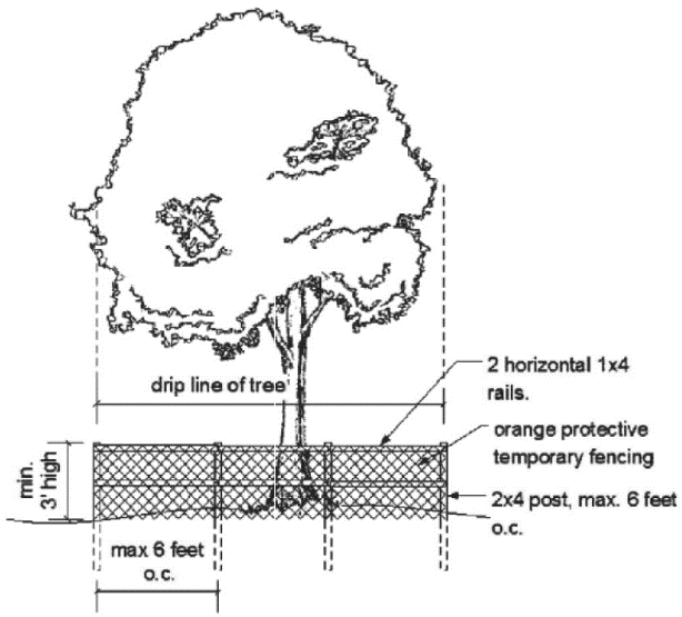
(Ord. No. 2023-14, § 1(Att. A), 12-7-2023)
Sec. 62-570.- Removal of trees.
(a)
Removal of a tree includes any act which will cause a tree to die, such as damage inflicted upon the root system by heavy machinery, changing the natural grade above the root system or round the trunk, damage, including fire damage, inflicted on the tree permitting infection or pest infestation.
(b)
It shall be unlawful for any person, organization, society, association or corporation or any agent or representative thereof, directly or indirectly, to cut down, destroy, remove or move, or effectively destroy through damaging any tree located on any property without obtaining a permit.
(c)
No authorization for the removal of a protected tree shall be granted unless the developer demonstrates the reason for removal of trees.
(Ord. No. 2023-14, § 1(Att. A), 12-7-2023)
Sec. 62-571. - Exceptions and exemptions.
The following are exempt from the landscape requirements of the Code.
(1)
Utility and public works projects undertaken by the town, including in the case of emergencies such as hurricane, windstorm, flood, freeze, or other disasters.
(2)
One- and two-family dwelling units.
(3)
Dangerous trees.
a.
In the event that any tree endangers health or safety and requires immediate removal, verbal authorization may be given by the land use administrator.
b.
The tree may be removed without obtaining a written permit. The verbal authorization shall later be confirmed in writing by the land use administrator.
(4)
Exempt trees. The following types of trees shall be exempt from the provisions of this section and removal allowed without a permit:
(Ord. No. 2023-14, § 1(Att. A), 12-7-2023)
Sec. 62-572. - Drought-tolerant plant standards applicable to required landscaping.
Drought-tolerant plants which shall be used in required landscaping are native, noninvasive plants which will survive and flourish with comparatively little supplemental irrigation. Industrial, commercial, civic, and multifamily residential buildings or structures and common areas of single-family or multifamily residential developments shall incorporate drought tolerant trees, shrubs, and groundcovers in landscape plans as a water conservation measure. A list of plants which require minimal water are included in the St. Johns River Water Management District's publication Water Wise, Florida Landscapes. In addition, mulches and drought tolerant groundcovers shall replace narrow turf areas where irrigation is impractical. Interior remodels or minor modifications to the exterior of a structure are not subject to this requirement.
(Ord. No. 2023-14, § 1(Att. A), 12-7-2023)
Sec. 62-573. - Conditions for tree removal.
The Land Use Administrator shall issue the permit for removal of a tree if one of the following reasons for removal is found to be present:
(1)
The condition of the tree with respect to disease, insect attack, age or other damage creates a danger of falling, or otherwise causes the tree to have an adverse impact on the urban or natural environment;
(2)
Removal of the tree is necessary to construct proposed improvements in order to make use of the property;
(3)
To avoid interference with utility services; or
(Ord. No. 2023-14, § 1(Att. A), 12-7-2023)
Sec. 62-574. - Replacement.
(a)
Generally. In respect to removal of trees to allow construction of improvements on property, and as a condition to the granting of a permit, replacement shall be required.
(1)
Trees removed.
a.
Live oaks.
1.
All efforts shall be made to maintain all live oak trees on the site.
2.
Replacement of live oak trees shall be with live oak trees and the total caliper inches of replacement trees shall equal the total caliper inches of live oak trees removed.
b.
All other trees.
1.
Trees removed over 12 inches DBH on the site shall be replaced.
2.
The replacement for all trees over 12 inches in caliper at DBH on the site shall equal one-third of the total caliper at DBH of the trees removed.
(2)
Tree replacement or payment to town. In lieu of replacement of trees on the site, the land use administrator may approve a plan for replacement of trees offsite or payment to the town's tree mitigation fund. The value will be based on the average cost of other municipalities in northeast Florida.
(b)
Credit for trees. Trees which are preserved shall receive credit against the landscape requirements according to the following schedule:
(1)
Trees 12 to 18 inches. Live oaks, one-inch credit; all others, 50 percent-inch credit.
(2)
Trees 19 to 30 inches. Live oaks, one and one-quarter-inch credit; all others, 75 percent-inch tree credit.
(3)
Trees over 30 inches. Live oaks, one and one-half-inch credit; all others, 100 percent-inch credit.
(Ord. No. 2023-14, § 1(Att. A), 12-7-2023)
Sec. 62-575. - List of plants recommended for the town.
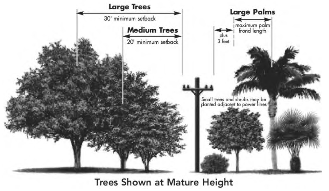
Sec. 62-576.- Definitions.
The following words, terms and phrases, when used in this chapter, shall have the meanings ascribed to them in this section, except where the context clearly indicates a different meaning:
Block means a tier or group of lots existing within well-defined and fixed boundaries within a subdivision, usually being an area surrounded by streets or other physical barriers and having an assigned number, letter or other name by which it may be identified.
Building includes the term "structure" and shall be construed as if followed by the phrase "or part thereof."
Developer means the owners of record executing the dedication required by F.S. § 177.081 and applying for approval of a plat of a subdivision pursuant to F.S. § 177.01 et seq.
Developer's engineer means a professional engineer registered in the state and engaged by the developer to prepare engineering plans and to supervise construction.
Land includes the term "water," "marsh" or "swamp."
Lot includes the term "plot" or "parcel." A lot is also identified as a single unit in a subdivision.
Plat means a map on which the developer's plan for subdivision is presented and which he submits for approval and intends, in final form, to record.
Subdivision means one of the following:
(1)
The division of any parcel of land, of any size whatsoever, into two or more lots of any size.
(2)
The establishment or dedication of a road, street or alley through a tract of land, regardless of area.
(3)
The resubdivision of land heretofore or hereafter divided or platted into lots.
The following shall not be included within this definition nor be subject to this chapter:
(1)
The sale or exchange of lots to or between adjoining property owners, where the sale or exchange does not create additional lots.
(2)
The public acquisition by purchase, acceptance of deed of dedication or exercise of the right of eminent domain of strips of land for the widening or opening of streets or roads.
Surveyor means a land surveyor registered in the state and engaged by the developer to survey and plat the land for subdivision.
Town-approved road or street means a road or street paved in accordance with the specifications prescribed in this chapter, involved in any division of land into a recorded or unrecorded subdivision plat.
(Ord. No. 2023-14, § 1(Att. A), 12-7-2023)
Sec. 62-577. - Intent and purposes.
It is determined and declared:
(1)
The public health, safety, order, convenience, prosperity, morals and welfare require the harmonious, orderly and progressive development of land throughout the town. It is intended that this chapter be liberally construed to accomplish those purposes.
(2)
These subdivision regulations are adopted for the following purposes:
a.
To establish uniform and adequate standards for the design of subdivision plats and for minimum necessary improvements.
b.
To provide regular and orderly procedures for the uniform and expeditious processing of subdivision plats by the proper agencies and officials.
c.
To ensure coordination of subdivision plats with public improvements of the county and the town.
d.
To ensure subdivision, design which will encourage the development of a sound and economically stable community and the creation of a healthful living environment.
e.
To prevent traffic hazards and to provide safe and convenient traffic circulation, both vehicular and pedestrian.
f.
To discourage premature, uneconomical and scattered development
g.
To assure cooperation and greater convenience for developers.
(Ord. No. 2023-14, § 1(Att. A), 12-7-2023)
Sec. 62-578. - Jurisdiction; compliance.
The regulations set out in this chapter apply to all land within the town. No land shall be subdivided or laid out into lots, unless by plat in accordance with this chapter, nor shall any building be constructed in a subdivision unless the subdivision conforms to this chapter.
(Ord. No. 2023-14, § 1(Att. A), 12-7-2023)
Sec. 62-579. - When plat not recorded.
The clerk of the circuit court will not record any instrument showing a subdivision of land that does not bear the approval of the town attorney, the town clerk and the mayor.
(Ord. No. 2023-14, § 1(Att. A), 12-7-2023)
Sec. 62-580. - Town not to approve expenditure of money.
The town will not permit any money to be expended for improvements in any area that has been subdivided or upon any street that has been platted after the effective date of the ordinance from which this chapter is derived unless the subdivision or street has been approved in accordance with this chapter.
(Ord. No. 2023-14, § 1(Att. A), 12-7-2023)
Sec. 62-581. - Right-of-way vacations.
(a)
Definitions. The following words, terms, and phrases, when used in section 62-581, shall have the meanings ascribed to them in this subsection, except where the context clearly indicates a different meaning:
(1)
Vacate. Vacate shall mean the relinquishment of the town's right, title, or interest in a public right-of-way.
(2)
Public right-of-way. A public right-of-way in the Town of Hilliard shall mean public road, street, lane, thoroughfare or travel way that has been platted or dedicated for public purposes such as roads, utilities, or stormwater.
(b)
Review procedures.
(1)
Application. An application to vacate a public right-of-way may be submitted by the town council, land use administrator, or by a property owner abutting or surrounding the public right-of-way.
a.
Applicant must submit an application with a statement outlining the reason for the request, and a sketch of description and legal description of the area to be vacated, including the tax parcel identification number, if applicable. The burden will be on the applicant to show that the request complies with all of the following:
1.
That the request is in conjunction with a new development, redevelopment, or new use of
2.
That the request is in the "public interest" (defined as something that benefits the public as a whole, not just a singular property owner—such as increasing size of property);
3.
That the request will not adversely affect surrounding property owners; and
4.
That the request conforms with utility company regulations by providing a letter from each utility company stating they approve or disapprove the vacate.
(2)
Board review. Applications to vacate a public right-of-way shall be reviewed by the planning and zoning board and the town council according to the criteria provided in this section, with notice of the board hearings provided in accordance with law and this article. The planning and zoning board's review shall be a recommendation to the town council. Prior to the public hearing before the planning and zoning board, the application shall be reviewed by the land use administrator in accordance with the development plan review process as stated in section 62-581.
(3)
Fees. The application shall be accompanied by a fee, which amount shall be determined by a fee schedule passed by a resolution of the town council. Any fees incurred by the town in order to process the application, including advertising, mailing, and legal fees, shall also be charged to the applicant and be payable prior to any vacating of the right-of-way being recorded or final.
(c)
Review criteria. Rights-of-way may only be vacated by the town council upon its finding that the criteria in both (1) and (2) as provided below have been met:
(1)
Public interest. The public right-of-way no longer serves a public purpose and the vacation of the public right-of-way is in the public interest, which shall be based on a consideration of the following:
a.
Whether the public benefits from the use of the subject right-of-way as part of the city street system;
b.
Whether the proposed action is consistent with the comprehensive plan;
c.
Whether the proposed vacation is consistent with the minimum block size requirements and other applicable street connectivity standards;
d.
Whether the proposed action would deny access to private property;
e.
The effect of the proposed action upon public safety;
f.
The effect of the proposed action upon the safety of pedestrians and vehicular traffic;
g.
The effect of the proposed action upon the provision of municipal services including, but not limited to, emergency service and waste removal;
h.
The necessity to relocate utilities both public and private; and the effect of the proposed action on the design and character of the area.
(2)
Streets. If the public right-of-way is a street, the city shall not vacate the right of-way except if the following additional criteria are met:
a.
The loss of the street will not foreclose reasonably foreseeable future bicycle/pedestrian use;
b.
There is no reasonably foreseeable need for any type of transportation corridor for the area.
(d)
Notice requirements.
(1)
Specific notice requirements for vacations. Public hearing notices to vacate a public right-of-way or portion thereof shall be published in a manner consistent with Florida and town law regarding ordinances.
(2)
Neighbors. If the parcel to be vacated includes an alley, all property owners serviced by the alley and all property owners serviced by a connecting alley shall be noticed.
(3)
Petitioner's responsibility. The town, town council, and all officers, employees, and agents thereof shall not assume any responsibility or liability for any matters and things to be done or completed by the petitioner pursuant to the provisions hereof. It is recognized that this procedure may affect substantial interests in real property and other proprietary rights, and the petitioner shall assume full and complete responsibility for compliance with the requirements of law, and these procedures in connection with or arising out of any vacation proceedings instituted by the petitioner, including the payment of all fees required by this section."
(Ord. No. 2023-14, § 1(Att. A), 12-7-2023)
Sec. 62-582.- General procedure for plat approval.
The preliminary and final plat shall be submitted to the town in the format required by the town for recommendation planning and zoning to the council for approval. No plat shall be recorded and no lots shall be sold from the plat unless and until the final plat is approved as provided in this chapter.
(Ord. No. 2023-14, § 1(Att. A), 12-7-2023)
Sec. 62-583. - Preliminary plat.
The developer shall submit the proposed plat accompanied by the following information in a form specified by the town that will show the following:
The preliminary plat shall contain the following information:
(1)
The boundary lines of the area being subdivided with the distance and bearings and the legal description of the property.
(2)
The lines of all proposed streets with their widths and names.
(3)
The outline of any portions of the property intended to be dedicated for public use, such as for schools, parks, etc.
(4)
The lines of adjoining streets with their widths and names.
(5)
All lot lines together with the identification system for all lots and blocks, the square foot area of each lot, and the net usable acreage (less jurisdictional areas). The lot number within a subdivision shall be assigned counterclockwise from the northeast corner and shall follow in a logical numerical order within a particular block.
(6)
The location of all setback lines and easements provided for public use, service, utilities or drainage.
(7)
All dimensions both linear and angular for locating the boundaries of the subdivision, lots, streets, easements, and any other areas for public use or private use.
(8)
The radii, arcs, chords, chord bearings, points of tangencies and central angles for curved streets and rounded block corners, per F.S. § 177.091.
(9)
The location of all survey monuments, permanent points and azimuth marks with their descriptions.
(10)
The name of the subdivision, the scale of the plat, points of the compass and the name of the owner and owners of the subdivision.
(11)
Certification of a currently registered surveyor of the state as to the correct representation of the plat per F.S. § 177.061.
(12)
Private restrictions and trusteeships and their period of existence.
(13)
Acknowledgment of the owner and owners to the plat and restrictions, including dedication to public use of all streets and parks, alleys, easements, rights-of-way and public areas shown on such plat, the dedication of or granting of easements required.
(14)
All flood hazard zones as established by the FEMA flood insurance rate maps.
(15)
The location of permanent benchmarks which shall be provided at convenient points with elevations indicated.
(Ord. No. 2023-14, § 1(Att. A), 12-7-2023)
Sec. 62-584. - Final plat.
The final plat shall show the following in a required by the town and in compliance with F.S. ch. 177:
(1)
The boundary lines of the area platted with distance and bearings and the legal description of the property. The property appraiser's parcel identification number is not acceptable as legal description.
(2)
The lines of all proposed streets with their widths and names.
(3)
The outline of any portions of the property intended to be dedicated for public use, such as for schools, parks and so forth.
(4)
The lines of adjoining streets with their widths and names.
(5)
All lot lines, together with the identification system of all lots and blocks, and the square foot area of each lot. The lot numbers within a subdivision shall be assigned counterclockwise from the northeast corner and shall follow in a logical numerical order within a particular block.
(6)
The location of all setback lines and easements provided for public use, service, utilities or drainage.
(7)
All dimensions, both linear and angular, for locating the boundaries of the subdivision, lots, streets, easements and any other areas for public or private use. Linear dimensions shall be given to the nearest one-one hundredth of a foot. Closure shall be shown on the plat.
(8)
The radii, arcs, chords, chord bearings, points of tangencies and central angles for curved streets and rounded block corners.
(9)
The location of all survey monuments and benchmarks with their descriptions.
(10)
The name of the subdivision, the scale of the plat, points of the compass and the name of the owner of the subdivision.
(11)
The certificate of the surveyor as to the correct representation of the plat and as to F.S. ch. 177, pt. I (F.S. § 177.011 et seq.).
(12)
Private restrictions and trusteeships and their period of existence.
(13)
Acknowledgment of the owner to the plat and restrictions, including dedication to public use of all streets and parks, the dedication of or granting of required easements and a statement that all streets are paved and drained or will be paved and drained before any lots are sold.
(Ord. No. 2023-14, § 1(Att. A), 12-7-2023)
Sec. 62-585. - Signatures; certifications and acknowledgments.
The final plat must contain space and forms for the appropriate certifications and acknowledgments and shall be signed by the following:
(1)
A notary public or other officer authorized by law to take acknowledgments as to the certification of the acknowledgment by the owner or owners.
(2)
A surveyor for the town as for compliance with F.S. ch. 177.
(3)
The town attorney as to legal sufficiency and compliance.
(4)
By the public works director certifying the water supply and sewage system's acceptability
(5)
By the county health officer if the lots will be served by septic tanks for the plat subject to review of each lot for septic tanks by the county environmental health officer according to the Florida Administrative Code.
(6)
By the chairman of the planning and zoning board as to approval by the planning and zoning board.
(7)
By the county tax collector as to the approval that the taxes are current.
(8)
The town clerk as to approval by the council.
(9)
The mayor as to approval for the town.
(10)
The clerk of the circuit court for the county as to the plat having been filed for record. The plat book and page designation shall be obtained from the clerk at the time it is presented to the clerk for recording.
(Ord. No. 2023-14, § 1(Att. A), 12-7-2023)
Sec. 62-586.- Relation to adjoining street system.
The arrangement of streets in a subdivision shall make provision for the continuation of the principal existing streets in adjoining areas or their proper projection where adjoining land is not subdivided insofar as this may be deemed necessary by the council for public requirements. The street arrangement shall be such as not to cause hardships to owners of adjoining property when they plat their own land and seek to provide convenient access to it. Offset streets shall be avoided and the angle of intersection between streets shall not vary by more than ten degrees from a right angle. Streets obviously in alignment with existing streets shall bear the names of the existing streets.
(Ord. No. 2023-14, § 1(Att. A), 12-7-2023)
Sec. 62-587. - Street widths.
(a)
As a minimum requirement for streets, sidewalks and public utilities, the plat shall dedicate a minimum width of 50 feet. Dead-end streets and/or culs-de-sac, streets that terminate within a subdivision other than at boundary line, shall have a minimum width of 50 feet and shall terminate in a turnaround with a minimum radius of 50 feet.
(b)
The council may, after proper study, require a street width in excess of 50 feet, if traffic engineering surveys indicate that present or anticipated future traffic densities justify a street of greater width.
(c)
Where streets parallel and adjoin section and half-section lines adjoining unsubdivided property, a half-street, 50 feet in width, shall be dedicated and, whenever subdivision property adjoins a half-street on a section or half-section line, the remainder of a 100-foot right-of-way shall be dedicated. Water systems shall be placed within 43½ feet of the section and half-section lines.
(d)
The council may, after proper study and due consideration, reduce the right-of-way on certain half-section lines to a width of 80 feet.
(e)
Alleys are not recommended in a residential district.
(Ord. No. 2023-14, § 1(Att. A), 12-7-2023)
Sec. 62-588. - Blocks.
(a)
Where a tract of land is of such size and location as to prevent a lot arrangement related to a normal street design, there may be established courts, dead-end streets or cul-de-sacs, provided that a proper access shall be given to all lots from a dedicated street or court.
(b)
No block shall be longer than 600 feet. Where blocks are made longer than 600 feet in length, a crosswalk, ten feet in width, shall be required near the center of the block.
(Ord. No. 2023-14, § 1(Att. A), 12-7-2023)
Sec. 62-589. - Lots.
(a)
Lots shall comply with the zoning district that the subdivision is located within.
(b)
A corner lot shall have widths sufficient to permit the establishment of front building lines on both the front and side of the lot adjoining the streets.
(c)
The arrangement and design shall be such that all lots will provide satisfactory and desirable building sites, properly related to topography and the character of the surrounding development.
(d)
All side lines of lots shall be at right angles to straight street lines and radial to curved street lines, except where a variation to this rule will provide a better street and lot layout.
(Ord. No. 2023-14, § 1(Att. A), 12-7-2023)
Sec. 62-590.- Preparation of plans and specifications for improvements.
Receipt of the signed copy of the approved preliminary plat is authorization for the developer to proceed with the preparation of plans and specifications for the minimum improvements required by this article and with preparation of the final plat. Prior to the construction of any required improvements, the developer shall furnish the town engineer all plans, information and data necessary to determine the character of the improvements. These plans shall be examined and will be approved if in accordance with this article. Following this approval, construction can be started or the amount of the bond guaranteeing the improvements determined. No final or official plat of a subdivision shall be approved unless either:
(1)
The improvements listed in this article have been installed prior to the approval; or
(2)
The developer files with the town a surety bond to secure the construction of the improvements listed in this article in a satisfactory manner and within a period specified by the council, this period not to exceed 12 months. The bond shall be in an amount at least equal to the cost of constructing the improvements as estimated by the developer's engineer and approved by the town engineer and in a form approved by the town attorney.
(Ord. No. 2023-14, § 1(Att. A), 12-7-2023)
Sec. 62-591. - Inspection.
(a)
The town may have an inspector on the project when deemed necessary during the construction period, and the inspector shall be authorized to enforce the construction of the work in accordance with the approved plans and specifications. The developer shall pay the cost of the inspector. If any changes are required in the approved plans or specifications during the period of construction, the changes must first be approved, in writing, by the town or its authorized representative so that subdivision files can be complete.
(b)
The developer shall have available, when necessary, a qualified engineer for the purpose of setting all line and grade stakes when required by the contractor or inspector.
(c)
The engineer shall furnish the town engineer with a written construction schedule at intervals of at least once each month. The schedule shall show the construction work to be accomplished during the period covered by the schedule.
(Ord. No. 2023-14, § 1(Att. A), 12-7-2023)
Sec. 62-592. - Acceptance for maintenance by town.
(a)
Prior to acceptance by the town, the developer shall furnish a certificate prepared by the developer's engineer to the effect that all improvements have been completed in accordance with the approved plans and specifications. Where the developer elects to post a bond ensuring that the work will be completed in a stated period of time, the certificate required by this section will be required at the time of completion of construction.
(b)
Upon completion of the work covered by the plans and a unilateral agreement, the owner shall notify the town engineer in writing. Upon receipt of notification, the town will make an inspection of the construction work. If all work is found to be satisfactorily completed, then the town, after a period of 90 days from the time of inspection, will make a final inspection. If the work is found satisfactory and if all deficiencies are repaired or corrected, then the town will accept the improvements for maintenance. A performance bond in the amount of 100 percent of the estimated cost of street improvements will be required in all subdivisions.
(Ord. No. 2023-14, § 1(Att. A), 12-7-2023)
Sec. 62-593. - Street improvements.
(a)
All streets and public ways shall be cleared and graded to their full width of right-of-way, including side slopes, and to the appropriate grade and shall be surfaced in accordance with the applicable standard specifications of the state department of transportation and the manual of uniform minimum standards. They shall meet the following minimum specifications:
(1)
Pavement shall be 22 feet in width.
(2)
Shoulders shall be six feet in width.
(3)
Front and back slopes shall not be less than three to one ration (3:1).
(4)
All shoulders and slopes shall be seeded, mulched and fertilized.
(5)
Paving specifications and application shall be according to the current edition of the state department of transportation specifications for road and bridge construction.
(6)
Street cross drains will have headwalls and endwalls.
(b)
If required to prevent erosion or excessive washing of the shoulders, protective measures shall be taken as required by the town or its representative.
(c)
Curbs and gutters shall be constructed along both sides of all streets and in accordance with the standards of the state department of transportation. A modified curb, constructed in accordance with county specifications, may be used on streets with gradients of two percent or less. Where required, turnouts will comply with town specifications and be constructed before the building is completed and before the lot or building is sold.
(d)
The following pavement bases shall be constructed of the following type having a minimum thickness of six inches:
(1)
Sand-bituminous road mix.
(2)
Florida limerock base.
(3)
Limerock stabilized base (300 pounds per square yard).
(4)
Shell cement mix.
(5)
Soil cement mix.
(e)
All pavement bases shall have a surface wearing course of one of the following types, as outlined in the state department of transportation specifications:
(1)
Double surface treatment.
(2)
Asphaltic concrete surface course, one and one-half-inch minimum thickness.
(3)
Hot sand asphalt surface course, one-inch minimum thickness.
(4)
Concrete roads are not acceptable.
(f)
Subgrades, paving bases and surface wearing course shall be constructed in accordance with the specifications of the state department of transportation.
(g)
The owner or developer shall retain a reputable recognition commercial laboratory which shall certify to the town that all materials entering into the completed work are in accordance with these specifications. Where the pavement base is to be sand-bituminous road mix or soil cement mix, the laboratory shall furnish a report covering the blending of soil materials with bituminous materials or cement prior to base construction. A report of the laboratory shall be submitted covering the completed pavement.
(h)
Concrete sidewalks shall be required on one side of the streets in all new residential subdivisions in excess of five lots, unless, in the opinion of the council after proper study, pedestrian traffic or surrounding development will not justify the installation of sidewalks. Construction of sidewalks across individual residential lots, as shown on the approved engineering plans, may be deferred until the house on the individual lot is installed. However, the sidewalk across an individual lot shall be constructed prior to the issuing of a certificate of occupancy for the house on the lot when the engineering plans show a sidewalk is required for that lot. This requirement shall be stated in the declaration of covenants and restrictions of the subdivision, or by other instrument of record which runs with title to the lot or lots. Nothing in the ordinance shall be construed to create an obligation on the part of the town to construct any sidewalk.
(i)
All street markers will be constructed, painted and erected in accordance with town specifications. Street markers will be installed by the developer at the locations shown on the drawings.
(j)
Radii at intersections shall be a minimum of 25 feet.
(k)
A developer shall place appropriate road signs, within the area described by the plat to be recorded. The signs shall be constructed by the town and paid for by the developer.
(l)
All design shall meet requirements of the Manual of Uniform Minimum Standards for Design, Construction, and Maintenance for Streets and Highways prepared by the state department of transportation.
(Ord. No. 2023-14, § 1(Att. A), 12-7-2023)
Sec. 62-594. - Drainage requirements.
(a)
All drainage pipe shall have adequate capacity to carry the runoff resulting from a rainfall intensity which may be exceeded on the average of at least once every year. All drainage facilities shall be designed for a positive outfall to existing storm sewer system, lakes, canals, rivers, streams or previously constructed town, county or state road ditches. If the added runoff from the developed area overtaxes the existing road or outfall ditches, the developer shall include in the plans sufficient work to enlarge the present facilities to care for the added drainage imposed on the system.
(b)
Where storm sewers are provided, the maximum overland flow shall be 400 feet. Minimum grade for curb and gutter shall be three-tenths of one percent; provided that one-half percent grade shall be held insofar as practical.
(c)
Drainage pipe shall be corrugated plastic or metal pipe, plain or reinforced concrete pipe or plain or extra strength vitrified clay pipe, except that corrugated metal pipe shall not be installed under a paved road unless it is asphalt coated. Minimum pipe size shall be 15 inches in diameter.
(d)
All plans shall show, in addition to contours, the outlines and sizes in acres of drainage areas at the various points of concentration.
(e)
Catch basins, drop inlets, curb inlets and manholes shall be of a class A concrete or brick construction and in accordance with state department of transportation standards. All grates shall be cast iron or steel with minimum size of two square feet net open area.
(f)
Where land is subject to periodic flooding by the overflow from creeks, rivers or streams, a floodplain must be established and no building will be permitted within the area of the floodplain, unless the entire area is filled to two feet above the floodplain.
(g)
Permits shall be obtained from St. Johns River Water Management District prior to final approval.
(Ord. No. 2023-14, § 1(Att. A), 12-7-2023)
Sec. 62-595. - Water lines.
(a)
Where an approved public water supply is reasonably accessible or procurable, each lot within the subdivision shall be provided with a connection to the water supply. The water service for each lot will be installed at the time of the application for a building permit. All mains, to the under paving, shall be constructed prior to the paving installation. Fire hydrants will be installed in all subdivisions where a public water supply is available.
(b)
Where no approved public water supply is available, the installation of a private water supply system will be required at the time of the application for a building permit. The private water supply system shall be constructed in such a manner that an adequate supply of potable water will be available to each lot. All applicable state rules and regulations shall govern the installation of the system.
(c)
The developer shall pay all costs required to process the permit.
(Ord. No. 2023-14, § 1(Att. A), 12-7-2023)
Sec. 62-596. - Sanitary sewers.
(a)
Where an adequate sanitary sewer is reasonably accessible, each lot in the subdivision shall be provided with a connection to the sanitary sewer. All connections and the subdivision sewer system shall comply with all applicable state rules.
(b)
Where sewers are not accessible and where septic tanks are not permissible, the owner or developer shall install and operate a sewage collection and treatment system of a capacity sufficient to serve the entire subdivision and all contemplated additions. The system shall be constructed in accordance with the regulations and requirements of and approval of the county health officer and the state department of environmental protection.
(c)
The developer shall pay all costs required to process the permit.
(Ord. No. 2023-14, § 1(Att. A), 12-7-2023)
Sec. 62-32. - Appointed officials and employees.
It shall be within the powers of the town council to contract a land use administrator and appoint such other town employees as the council may deem necessary in order to enforce and administer the provisions of this chapter and any order or resolution made under authority thereof.
(Ord. No. 2023-14, § 1(Att. A), 12-7-2023)
Sec. 62-33. - Powers and duties of the land use administrator's office.
The land use administrator shall administer and enforce the provisions of this chapter. The duties of the land use administrator are to:
(1)
Provide for the processing of all applications for rezoning, comprehensive plan amendments, variances, and special exceptions.
(2)
Keep records of applications, complaints filed, and notices or orders issued related to this chapter.
(3)
Record changes in zoning district and future land use map boundaries.
(4)
Assist applicants in understanding the provisions of this chapter.
(5)
Suggest to the planning and zoning board and the town council modifications to the land development regulations and the comprehensive plan.
(6)
Conduct the necessary inspections required to make rational zoning decisions and to properly advise the town council and the planning and zoning board on zoning matters.
(7)
Review all applications for building permits for compliance with the comprehensive plan and land development regulations.
(Ord. No. 2023-14, § 1(Att. A), 12-7-2023)
Sec. 62-34. - Schedule of fees.
(a)
Fees as set by resolution of the town council shall apply to action under this chapter. A receipt showing payment of the applicable fee shall accompany an application prior to consideration thereof.
(b)
If the applicant does not appear at the advertised public hearing and the planning and zoning board votes to postpone the public hearing as provided for in section 62-37, the applicant shall bear the additional costs of readvertising and renotifying adjacent property owners. Such costs shall be paid prior to the rescheduled hearing.
(Ord. No. 2023-14, § 1(Att. A), 12-7-2023)
Sec. 62-35. - Limitation on exceptions and variances.
Special exception means a use that would not be appropriate generally or without restriction throughout the zoning division or district, but which, if controlled as to number, area, location, or relation to the neighborhood, would promote the public health, safety, welfare, morals, order, comfort, convenience, appearance, prosperity, or general welfare. Such uses may be permitted in such zoning division or district as special exceptions, if specific provision for such special exception is made in this chapter. Special exceptions and variances shall be one year from the effective date of the final order granting same. The planning and zoning board may adopt the following conditions to any special exception or variance:
(1)
The special exception or variance shall be nontransferable and granted to the applicant only and restrict transfer of land to maintain the special exception or variance.
(2)
Place a time period on the special exception or variance different from the one year. Failure to exercise the exception or variance by commencement of the use or action approved thereby within six months within the time period approved shall render the exception or variance invalid and all rights granted thereunder shall terminate.
(3)
Whenever the planning and zoning board has denied an application for a special exception or variance, no further application shall be filed for the same exception or variance on any part or all of the same property for a period of one year from the date of such action.
(4)
The time limits of subsections (2) and (3) of this section may be waived by the affirmative votes of a majority of the planning and zoning board when such action is deemed necessary to prevent injustice or to facilitate the proper development of the town.
(Ord. No. 2023-14, § 1(Att. A), 12-7-2023)
Sec. 62-36. - Notice of public hearings.
(a)
Notice of a time and place of any required public hearings with respect to the comprehensive plan amendment, rezoning of land, special exceptions, variances or appeals shall be given by the land use administrator's office at least 15 days in advance of any such hearings by the town council and at least 15 days in advance of such hearings by the planning and zoning board, via first class mail or hand delivery to all owners or real property within 300 feet of the boundaries of the land upon which comprehensive plan amendment, rezoning, special exception, variance or appeal is requested, together with identical notice to the owner of the land for which comprehensive plan amendment, rezoning, or other action is proposed as provided by F.S. § 166.041. The notification costs shall be paid by the petitioner. Failure of owners of lands adjoining the parcel upon which rezoning or other action is proposed to receive notice of hearings shall in no way affect the validity of the action taken.
(b)
Notice of any public hearing shall be published once in a newspaper of local general circulation with publication at least 15 days prior to the date of hearing by the planning and zoning board, and at least 15 days prior to the date of a hearing by the town council pursuant to F.S. § 166.041. The advertisement costs shall be paid by the petitioner.
(c)
The land use administrator shall cause signs to be posted on any land upon which an application for rezoning is made not less than 15 days in advance of the public hearing by the planning and zoning board. Such signs shall be posted on the property by the town. Such signs shall be in such form as required by the town and shall be erected in full view of the public on each street side of such land. Where such land does not have frontage on a public street, such signs shall be erected on the nearest street right-of-way with an attached notation indicating generally the direction and distance to the land for which comprehensive plan amendment, rezoning, special exception, variance or other action is sought.
(Ord. No. 2023-14, § 1(Att. A), 12-7-2023; Ord. No. 2024-02, § 2, 6-6-2024)
Sec. 62-37. - Postponement of public hearings.
Whenever a public hearing date has been scheduled in accordance with the provisions of this chapter by the planning and zoning board, or town council, it will take the majority vote of the appropriate planning and zoning board or town council to alter such a date.
(Ord. No. 2023-14, § 1(Att. A), 12-7-2023)
Sec. 62-38. - Amendment of application prohibited.
An application for the rezoning of land, a zoning exception, or a zoning variance shall be allowed to be amended by the applicant at any time after until the final action has taken place.
(Ord. No. 2023-14, § 1(Att. A), 12-7-2023)
Sec. 62-39. - Concurrent applications.
An application for the comprehensive plan amendment, rezoning of land special exception and/or variance on all or part of the same land may be made concurrently. In such cases, the application for a special exception and/or variance shall be held in abeyance by the planning and zoning board until action has been taken by the town council on the application for the comprehensive plan amendment or rezoning of such land.
(Ord. No. 2023-14, § 1(Att. A), 12-7-2023)
Sec. 62-40. - Site plan review.
(a)
Site plans, are required for special exceptions and for all multifamily, commercial, industrial, mobile home parks, mobile home subdivisions, and planned unit developments. A building permit for a project requiring a site plan shall not be issued until such site plan is approved.
(b)
In reaching a decision as to whether or not the site plan as submitted should be approved or approved with changes, the planning and zoning board shall be guided in its decision and the exercise of its discretion to approve, to approve with conditions, or to deny by the following criteria. The planning and zoning board shall record its findings in regard to the following criteria, where applicable:
(1)
Sufficiency of statements on ownership and control of the development and permanent maintenance of common open spaces.
(2)
Density and/or use of the proposed development with particular attention to its relationship to adjacent and nearby properties and the effect thereon and in accordance with the town's comprehensive plan.
(3)
Ingress and egress to the site and proposed structures thereon, with particular reference to automotive and pedestrian safety, separation of automotive traffic and pedestrian traffic, traffic flow and control, provision of services and servicing of utilities and refuse collection, and access in case of fire, catastrophe, or emergency.
(4)
Location and relationship of off-street parking and loading facilities to thoroughfares and internal traffic patterns within the proposed development, with particular reference to automotive and pedestrian safety, traffic flow and control, access in case of fire or catastrophe, screening and landscaping.
(5)
Sufficiency of proposed screens and buffers to preserve internal and external harmony and compatibility with uses inside and outside the proposed development.
(6)
A stormwater management and drainage plan for the property in accordance with all town, county and state requirements.
(7)
Utilities, with reference to hook-in locations and availability and capacity for the uses projected.
(8)
Recreation facilities and open spaces, with attention to the size, location, and development of the areas as to adequacy, effect on privacy of adjacent and nearby properties and uses within the proposed development, and relationship to communitywide open spaces and recreation facilities.
(9)
General site arrangement, amenities and convenience, with particular reference to ensuring that appearance and general layout of the proposed development will be compatible and harmonious with properties in the general area and will not be so at variance with other development in the area as to cause a substantial depreciation of property values.
(10)
Such other standards as may be imposed by this chapter for the particular use or activity involved.
(Ord. No. 2023-14, § 1(Att. A), 12-7-2023)
Sec. 62-41. - Comprehensive plan and rezonings
An application for comprehensive plan amendment or rezoning shall be submitted to the town on the application form provided by the town and accompanied by the information requested on the application.
(Ord. No. 2023-14, § 1(Att. A), 12-7-2023)
Sec. 62-61. - Intent.
(a)
There exist lots, structures, uses of land or water and characteristics of use which were lawful prior to December 29, 1987, but which would be prohibited, regulated or restricted under the terms of the current code.
(b)
It is the intent of this chapter to permit these nonconformities to continue until they are removed or otherwise discontinued. It is further the intent that nonconformities shall not be used as grounds for adding other structures or other uses prohibited. It is further the intent that lots, structures, uses of land or water and characteristics of use which were lawful prior to December 29, 1987, may be enlarged upon, or expanded as long as they meet all other requirements of the district established by this chapter.
(Ord. No. 2023-14, § 1(Att. A), 12-7-2023)
Sec. 62-62. - Right of survivorship and conveyance.
Nonconformities in existence prior to December 29, 1987 may be permitted to continue, may be sold, conveyed, or transferred until it becomes a conforming use.
(Ord. No. 2023-14, § 1(Att. A), 12-7-2023)
Sec. 62-63. - Nonconforming use of open land.
Where open land (i.e., land not enclosed by buildings) is being used for nonconforming use, such use shall not be enlarged on the same or adjoining property.
(Ord. No. 2023-14, § 1(Att. A), 12-7-2023)
Sec. 62-64. - Nonconforming use of buildings.
The lawful use of a building existing prior to December 29, 1987, may be continued although such use does not conform to the provisions hereof. The removal of nonconforming use, either due to deterioration or voluntary removal, shall result in the nonconforming use being permanently removed and shall not be replaced except in full compliance with the provisions of the Code.
(Ord. No. 2023-14, § 1(Att. A), 12-7-2023)
Sec. 62-65. - Discontinuance of nonconforming uses.
(a)
Whenever a nonconforming use of a building, or a portion thereof, has been changed to a conforming use, such nonconforming use shall not thereafter be reestablished and the future use shall be in conformity with the provisions of the Code.
(b)
Whenever a nonconforming use of a building has been changed to a conforming use, the new conforming use must meet all provisions of the Code, including the off-street parking requirements.
(c)
Whenever a nonconforming use is being changed to a conforming use, the continuation of an existing nonconforming use may be continued as temporary shelter during construction, providing a permit for construction has been issued and such permit authorizes a temporary use. The temporary shelter shall not be permitted more than 90 days after completion of construction.
(d)
Whenever a nonconforming building or use exists, the nonconformity shall cease and no longer be lawful upon the first of the following circumstances to occur:
(1)
The nonconforming building is vacant for 180 days;
(2)
The nonconforming building ceases having water service or electric power for 180 days. After 90 days of no water service or electric power a notice from a town official, must be mailed by certified mail to the owner of record according to the county property appraiser to notify the nonconforming use will cease in 90 days.
(Ord. No. 2023-14, § 1(Att. A), 12-7-2023)
Sec. 62-66. - Destruction of a nonconforming use building.
No building which has been damaged by any means to an extent of more than 60 percent of the replacement cost of the building immediately prior to damage shall be restored except in conformity with the regulations of this Code, and all rights as a nonconforming use are terminated except as permitted in the Code. If a building is damaged by less than 60 percent of the replacement cost, it may be repaired or reconstructed and used as before the time of change, provided that such repair or reconstruction is substantially completed within 12 months of the date of such damage.
(Ord. No. 2023-14, § 1(Att. A), 12-7-2023)
Sec. 62-67. - Nonconforming lots of record.
(a)
Where a lot or parcel of land has an area or frontage which does not conform with the requirements of the district in which it is located but was a lot of record in single and separate ownership prior to December 29, 1987, such lot or parcel of land may be developed, provided the minimum yard requirements for the zoning districts in which it is located are met.
(b)
A conforming use or structure on a lot of record which was recorded on or before the December 29, 1987 may be expanded or altered, provided other requirements of this Code are met.
(c)
No lot or parcel shall be divided as to create a lot with an area or width below the requirements of this Code.
(d)
No lot or parcel or portion of a lot or parcel shall be altered in a manner which causes the lot to be less compliant with the Code.
(Ord. No. 2023-14, § 1(Att. A), 12-7-2023)
Sec. 62-68. - Nonconforming characteristics of use.
If characteristics of use such as off-street parking or loading or other matters pertaining to the use of land, structures, or premises are made nonconforming by this Code, as amended, no change shall thereafter be made in such characteristics of use which increase nonconformity with the regulations set out in this Code; provided, however, that changes may be made which do not increase, or which decrease, such nonconformities.
(Ord. No. 2023-14, § 1(Att. A), 12-7-2023)
Sec. 62-69. - Repairs and maintenance.
On any nonconforming structure or portion of a structure and on any structure containing a nonconforming use, work may be done in any period of 12 consecutive months on ordinary repairs, or on repair or replacement of 75 percent of the current market value of the structure, or of the nonconforming portion of the structure if a nonconforming portion of the structure is involved.
(Ord. No. 2023-14, § 1(Att. A), 12-7-2023)
Sec. 62-70. - Nonconforming structures unsafe because of maintenance.
If a nonconforming structure or portion of a structure or any structure containing a nonconforming use becomes physically unsafe or unlawful due to lack of repairs or maintenance and is declared by building official of the town to be an unsafe building, it shall not thereafter be restored, repaired or rebuilt except in conformance with the regulations of the Code and the Florida Building Codes.
(Ord. No. 2023-14, § 1(Att. A), 12-7-2023)
Sec. 62-71. - Use, change.
Whenever nonconforming use has been changed to a conforming use or to a use, it shall not thereafter be changed back to a nonconforming use.
(Ord. No. 2023-14, § 1(Att. A), 12-7-2023)
Sec. 62-91. - Established; membership.
(a)
There is established a planning and zoning board consisting of five members, each of whom shall reside in and be qualified voters of the town and shall hold no office of profit under the town government. Members shall be appointed by the town council.
(b)
Members of the planning and zoning board shall serve three-year terms so staggered that the terms expire in accordance with the provisions of the Charter. Any vacancy in the membership shall be filled for the unexpired term within 60 days, in the same manner as the initial appointment. A member of the planning and zoning board may be removed from office by the affirmative vote of 80 percent of the entire town council.
(Ord. No. 2023-14, § 1(Att. A), 12-7-2023)
Sec. 62-92. - Rules of procedure.
The planning and zoning board shall adopt rules of procedure for the governance of its proceedings and the conduct of its business and may adopt such other rules relating to its internal administration as may be necessary. Such rules shall include the following:
(1)
Officers and voting. Annually at the January meeting, the planning and zoning board shall select a new chairperson and a new vice-chairperson from among its members, with all such officers serving a term of one year. All members of the planning and zoning board shall vote in all matters before the planning and zoning board, except where absent or must abstain as required by F.S. § 112.3143. Votes shall be recorded by a roll call vote.
(2)
Minutes, public records. The land use administrator, or a person designated by the land use administrator, shall serve as the planning and zoning board secretary, keep minutes of all its meetings and record its actions and decisions; state if a member is absent; and make a timely report of all planning and zoning board actions to the town council are public records and shall be kept on file in the town hall, as required by state statutes.
(3)
Meetings. Meetings shall be held at the call of the chairperson and at such other times as a majority of the planning and zoning board may determine; provided, however, that the planning and zoning board shall hold at least one regular meeting every month, on a day to be determined by the planning and zoning board. All meetings shall be open to the public and shall be held in governmentally-owned or -leased premises.
(4)
Quorum. A majority of the planning and zoning board shall constitute a quorum for the purpose of meetings and transacting business.
(5)
Removal of members. The planning and zoning board may recommend removal of any member who has three or more consecutive unexcused absences.
(Ord. No. 2023-14, § 1(Att. A), 12-7-2023)
Sec. 62-93. - Powers and duties.
The functions, powers and duties of the planning and zoning board shall be, in general, to serve in an advisory capacity to the town council on all planning and zoning matters. In this capacity, the planning and zoning board shall have the following duties and responsibilities:
(1)
Review and recommend changes in the town's comprehensive plan.
(2)
Review and make recommendations on applications for rezonings, comprehensive plan amendments and amendments to the land development regulations.
(3)
Review and approve requests for special exceptions and variances.
(4)
Review and approve site plans for all multifamily, mobile home parks, mobile home subdivisions, commercial and industrial development and redevelopment and planned unit developments, variances, and special exceptions.
(5)
Hear and decide appeals, on decisions made by the land use administrator.
(Ord. No. 2023-14, § 1(Att. A), 12-7-2023)
Sec. 62-94. - Procedure for hearings for comprehensive plan amendments, rezonings, special exceptions, variances and appeals.
(a)
The planning and zoning board shall make rules for the conduct of hearings related to the granting of comprehensive plan amendments, special exceptions, variances and appeals.
(b)
The planning and zoning board shall keep minutes of its proceedings.
(Ord. No. 2023-14, § 1(Att. A), 12-7-2023)
Sec. 62-95. - Appeals.
(a)
An appeal may be taken to the planning and zoning board by any person aggrieved by any decision of the land use administrator, provided such appeal is filed with the town clerk within 30 days of the date of the action which is the subject of such appeal.
(b)
In exercising its powers, the planning and zoning board may, upon appeal and in conformity with provisions of this chapter, reverse or affirm, wholly or partly, or may modify, decision appealed. An 80 percent vote of the zoning board (minimum of four votes) is required to override a decision of the land use administrator.
(c)
A notice of appeal shall be filed on the forms established and provided by the town and shall include all pertinent information required thereon.
(d)
After receipt of such notice of appeal set a hearing for the next planning and zoning board meeting allowing for time to provide the required public notice for public hearings specified in this section of the Code.
(e)
An appeal shall stay all administrative proceedings in furtherance of the action appealed until such time as a final determination has been made by the planning and zoning board on such appeal.
(Ord. No. 2023-14, § 1(Att. A), 12-7-2023)
Sec. 62-96. - Review of decisions by town.
Decisions of the planning and zoning board in the granting of appeals, exceptions or variances shall be subject to review by the town council on appeal.
(1)
An appeal may be taken by any person who appeared before the planning and zoning board and is adversely affected by the decision of the planning and zoning board provided such appeal is filed with the town clerk within 30 days of the date of the action which is the subject of such appeal.
(2)
A notice of appeal shall be filed on the forms established and provided by the town clerk and shall include all pertinent information required thereon. All appeals are limited to matters raised by appellant before the planning and zoning board and procedural matters which have arisen since the planning and zoning board heard the matter.
(3)
An appeal shall stay all administrative proceedings in furtherance of the action appealed until such time as a final determination has been made by the town council on such appeal.
(4)
The town council shall after receipt of such notice of appeal set a public hearing for the next town council meeting allowing for time to provide the required public notice for public hearings specified in this section of the Code.
(5)
The town council shall find whether in its opinion error was made, and, within the terms of this section, affirm, reverse or modify the action appealed as it deems just and equitable. An 80 percent vote of the town council (minimum of four votes) is required to override a planning and zoning board decision.
(6)
Appeals from the decision of the town council may be appealed to the circuit court within 30 days of the date of the action which is subject to appeal.
(Ord. No. 2023-14, § 1(Att. A), 12-7-2023)
Sec. 62-122. - Initiation of rezoning or comprehensive plan amendment.
An ordinance for the rezoning of land or comprehensive plan amendment may be proposed only by the town council or any member thereof, the planning and zoning board, or the owner of the subject property or duly authorized agent.
(Ord. No. 2023-14, § 1(Att. A), 12-7-2023)
Sec. 62-123. - Public hearing.
A public hearing shall be held by the planning and zoning board to consider a proposal for an amendment to land development regulations, comprehensive plan amendment or for the rezoning of land and make recommendation to the town on the action taken.
(Ord. No. 2023-14, § 1(Att. A), 12-7-2023)
Sec. 62-124. - Limitation of rezoning of land.
(a)
No ordinance to amend the future land use map (FLUM) of the comprehensive plan or to rezone land shall contain conditions, limitations or requirements not applicable to all other land in the zoning district to which the particular land is rezoned, except rezoning to a PUD, planned unit development.
(b)
Whenever the town council has denied an application for a FLUM amendment or the rezoning of land, no further application shall be filed for the same rezoning of any part or all of the same land for a period of one year from the date of such action.
(Ord. No. 2023-14, § 1(Att. A), 12-7-2023)
Sec. 62-125. - Action after denial.
If a petition to amend the future land use map (FLUM) of the comprehensive plan or rezoning is denied, the planning and zoning board and the town council shall not take any further action on an application for basically the same amendment within 12 months after the last application was denied, unless there has been a substantial change of facts or unless waived by the town council.
(Ord. No. 2023-14, § 1(Att. A), 12-7-2023)
Sec. 62-126. - Denial or adoption of amendment; appeal to circuit court.
(a)
At the conclusion of the public hearing, the town council shall either deny the proposed amendment or rezoning, or by ordinance adopt such amendment or rezoning by majority vote of the town council. In order to override a recommendation of the planning and zoning board, an 80 percent vote of the town council is required, minimum of four votes.
(b)
Any amendment to the comprehensive plan or the land development regulations or rezoning of land established by ordinance by the town council shall be subject to appeal to the circuit court within 30 days of the date of the council action which is subject to appeal by any persons aggrieved by such action.
(Ord. No. 2023-14, § 1(Att. A), 12-7-2023)
Sec. 62-151. - Conditions and safeguards.
In the granting of zoning exceptions, the planning and zoning board may provide such conditions and safeguards as may be appropriate and in harmony with the purpose and intent of the land development regulations.
(Ord. No. 2023-14, § 1(Att. A), 12-7-2023)
Sec. 62-152. - Written application.
All applications for a special exception shall be in writing in such form as may be prescribed by the town.
(Ord. No. 2023-14, § 1(Att. A), 12-7-2023)
Sec. 62-153. - Public hearing.
The planning and zoning board shall conduct a public hearing to consider any application for a special exception at a scheduled meeting of the planning and zoning board. Notice of public hearing shall be made as provided in the Code.
(Ord. No. 2023-14, § 1(Att. A), 12-7-2023)
Sec. 62-154. - Power to deny, approve or disapprove with conditions.
The planning and zoning board has the power to deny, approve, or approve with conditions any special exception requested.
(Ord. No. 2023-14, § 1(Att. A), 12-7-2023)
Sec. 62-155. - Limits of uses.
Any special exception permit granted by the planning and zoning board shall allow only that use specifically described in the application and is subject to the terms or conditions expressed in the land development regulations.
(Ord. No. 2023-14, § 1(Att. A), 12-7-2023)
Sec. 62-156. - Resubmittal.
If the planning and zoning board denies an application for a special exception permit, another application for special exception cannot be resubmitted for a period of 12 months after the date the application was denied.
(Ord. No. 2023-14, § 1(Att. A), 12-7-2023)
Sec. 62-157. - Review criteria.
The planning and zoning board, when considering special exception requests, shall use the following criteria as a basis for its findings:
(1)
The establishment, maintenance, or operation of the special exception will not be detrimental to or endanger the public health, safety, or general welfare and is not contrary to established standards, regulations, or ordinances of other governmental agencies.
(2)
Each structure or improvement is so designed and constructed that it is not unsightly, undesirable, or obnoxious in appearance to the extent that it will hinder the orderly and harmonious development of the town and the zoning district in which it is proposed.
(3)
The special exception will not adversely impact the permitted uses in the zoning district nor unduly restrict the enjoyment of other property in the immediate vicinity nor substantially diminish or impair property values within the area.
(4)
The establishment of special exception will not impede the orderly development and improvement of the surrounding property for uses permitted in the zoning district.
(5)
Adequate water supply and sewage disposal facilities will be provided in accordance with state, county and town health requirements. The most stringent of these requirements will apply.
(6)
Adequate access roads, on-site parking, on-site loading and unloading berths, and drainage have been or will be provided where required.
(7)
Adequate measures have been taken to provide ingress and egress to the property which is designed in a manner to minimize traffic congestion on local streets.
(8)
Adequate screening and buffering of the special exception will be provided, where needed.
(9)
The special exception will not require signs or exterior lighting which will cause glare, adversely impact area traffic safety or have a negative economic effect on the area. Any signs or exterior lighting required by the special exception shall be compatible with development in the zoning district.
(Ord. No. 2023-14, § 1(Att. A), 12-7-2023)
Sec. 62-181. - Written application.
All applications for a variance shall be in writing in such form as may be prescribed by town. Variance means a relaxation of the terms of this Code where such variance will not be contrary to the public interest and where, owing to the particular physical surroundings, shape, or topographical condition of the property, and not the result of the actions of the applicant, a literal enforcement of this chapter would result in unnecessary and undue hardship. A variance can be authorized only for height, area and size of structure, size of lot and yards and open spaces; establishment or expansion of a use otherwise prohibited shall not be allowed by variance, nor shall a variance be granted because of the presence of nonconformities in the zoning district or uses in an adjoining zoning district. All variances must be approved by the planning and zoning board.
(Ord. No. 2023-14, § 1(Att. A), 12-7-2023)
Sec. 62-182. - Public hearing.
A public hearing shall be held by the planning and zoning board to consider any application for a zoning variance. Notice of public hearing shall be made as provided in land development regulations.
(Ord. No. 2023-14, § 1(Att. A), 12-7-2023)
Sec. 62-183. - Requirements for grant of variance.
(a)
The planning and zoning board may grant a variance only under circumstances where practical difficulty or unnecessary hardship is so substantial, serious and compelling that [relaxation] of the general restrictions ought to be granted. No variance shall be granted unless the applicant shall show and the planning and zoning board shall find that:
(1)
The particular property, because of size, shape, topography or other physical conditions, suffers singular disadvantage through the operation of the Code, which disadvantage does not apply to other properties in the vicinity;
(2)
Because of this disadvantage, the owner is unable to make reasonable use of the affected property;
(3)
This disadvantage does not exist because of conditions created by the owner or applicant;
(4)
The variance granted is the minimum variance that will make possible the reasonable use of the land, building or structure; and
(5)
The grant of the variance will:
a.
Not be contrary to the public interest;
b.
Not adversely affect other property in the vicinity;
c.
Be in harmony with the spirit, intent and purpose of the Code; and
d.
Not confer on the applicant any special privilege that is denied to other lands, buildings or structures in the same zoning district.
(b)
In the passing upon a request for variance, the planning and zoning board shall not consider prospective financial loss or gain to the owner or applicant, nor shall the planning and zoning board, by variance, permit an activity, business, or operation which is not otherwise allowed in such zoning district.
(Ord. No. 2023-14, § 1(Att. A), 12-7-2023)
Sec. 62-184. - Denial of variance application.
When application for a variance has denied the planning and zoning board, no further application shall be filed for the same variance on the same land, or any part thereof, for a period of 12 months from the date of denial.
(Ord. No. 2023-14, § 1(Att. A), 12-7-2023)
Sec. 62-251. - Use districts generally.
In order to regulate and restrict the location of agriculture, trades, industries, public and semipublic uses, residences, and the location of buildings erected or altered for specific uses, the incorporated area of the town must be developed according the future land use map (FLUM) of the Hilliard Comprehensive Plan and the criteria of the zoning districts described in the land development regulations.
Districts as delineated are as follows, with titles and abbreviations as indicated:
(Ord. No. 2023-14, § 1(Att. A), 12-7-2023)
Sec. 62-252. - Reference to district names.
(a)
Where the phrase "agricultural district" appears in the land development regulations, the phrase shall be construed to include the A-1 district, and no others.
(b)
Where the phrases "all residential districts," "residential districts," and "zoned residentially" are used the land development regulations, the phrases shall be construed to include A-1, R-1, R-2, R-3, RM-4, and RMH districts, and no others.
(c)
Where the phrase "commercial districts" is used the land development regulations, the phrase shall be construed to include the MSC and C-1 districts, and no others.
(d)
Where the phrase "industrial districts" is used in the land development regulations, the phrase shall be construed to include the M-1 district, and no others.
(Ord. No. 2023-14, § 1(Att. A), 12-7-2023)
Sec. 62-253. - Interpretation of district boundaries.
Where uncertainty exists as to the boundaries of districts and the future land use map and zoning map, the following rules shall apply:
(1)
Where such boundaries are indicated as approximately following centerlines of streets and alleys, such centerlines shall be construed to be such boundaries.
(2)
Boundaries indicated as approximately following platted lot lines shall be construed as following such lot lines.
(3)
Boundaries indicated as approximately following town limits shall be construed as following such town limits.
(4)
Boundaries indicated as following railroad lines shall be construed to be midway between the main tracks.
(5)
Where any street or alley is hereafter officially vacated or abandoned, the regulations applicable to each parcel of abutting property shall apply to that portion of such street or alley added thereto by virtue of such vacation or abandonment.
(Ord. No. 2023-14, § 1(Att. A), 12-7-2023)
Sec. 62-342. - Frontage requirements.
Every building hereafter erected or moved shall be located on a lot or parcel of land which provides frontage on a public street or an approved private street.
(Ord. No. 2023-14, § 1(Att. A), 12-7-2023)
Sec. 62-343. - Fences and walls.
Fences and walls may be permitted in any required yard or along the edge of any yard, provided that no fence or wall in excess of six feet shall be permitted in any residential district, and further provided that no fence in excess of four feet in height shall be permitted to encroach into the required front yard of any lot in a residential district. No fence, wall or other visual barrier exceeding 42 inches in height shall be permitted within 30 feet of any intersection as measured from the point of convergence of right-of-way lines.
(Ord. No. 2023-14, § 1(Att. A), 12-7-2023)
Sec. 62-344. - Modification of height regulations.
The height limitations included in the land development regulations do not apply to spires, belfries, cupolas, antennas, water tanks, ventilators, chimneys, elevator shafts or other appurtenances usually required to be placed above the roof level and not intended for human occupancy; provided, however, that the structure (including appurtenances and structures normally erected above roof level) shall be erected to a height above adjacent ground level exceeding the most restrictive of the following:
(1)
Forty feet;
(2)
Elevations as may be prescribed by the Federal Aviation Administration; or
(3)
Elevations as may be prescribed by the state unless applicable permit has been issued.
(Ord. No. 2023-14, § 1(Att. A), 12-7-2023)
Sec. 62-345. - Buildings to have access.
Every building hereafter erected or moved shall be on a lot adjacent to a public street or private street approved by the town council, provided that such private street right-of-way shall be not less than 50 feet in width and further provided that all structures shall be so located on lots as to provide safe and convenient access for servicing, fire protection and required off-street parking. Existing easements or right-of-way of record shall be excluded.
(Ord. No. 2023-14, § 1(Att. A), 12-7-2023)
Sec. 62-346. - Parking of heavy vehicles in residential districts.
(a)
Heavy vehicles listed below shall not be parked in any residential district, unless the personal vehicle of the property owner or as may be required for normal loading or unloading of such vehicles and during the time normally required for service at dwellings, or at structures or activities permitted or permissible in such residential districts:
(1)
Tractors and trucks for commercial use over 18,000 pounds, gross vehicle weight
(2)
Motor vehicles, trailers and semitrailers equipped with machinery and designed for exclusive use in the nature of well drilling, excavation, construction, spraying and like purposes.
(3)
School buses, commercial wreckers, hearses, ambulances.
(4)
Ten persons and over passenger vehicles.
(5)
Trucks used for agricultural purposes over 5,000 pounds, gross vehicle weight.
(b)
In no event shall such vehicles be permitted to be parked along public highways and streets during the hours of darkness.
(Ord. No. 2023-14, § 1(Att. A), 12-7-2023)
Sec. 62-347. - Parking or storage of inoperable vehicles.
Dismantled and/or partially dismantled vehicles which require major repairs to render such vehicles operable and vehicles not legally registered and licensed by the state department of highway safety and motor vehicles shall not be parked or stored in any residential zoning district. In commercial and manufacturing zoning districts vehicles must be visually screened by a solid wall or privacy fence from any abutting public or private right-of-way.
(Ord. No. 2023-14, § 1(Att. A), 12-7-2023)
Sec. 62-348. - Yard and measurement of setbacks.
(a)
Every part of a required yard shall be open from its lowest point to the sky, unobstructed, except for the ordinary projection of sills, belt courses, cornices, buttresses, ornamental features, chimneys, and eaves; provided, however, that none of these projections shall project into a minimum front or side yard more than 36 inches.
(b)
On multiple frontage lots, the required front yard shall be ten feet on the street that is considered the rear yard.
(Ord. No. 2023-14, § 1(Att. A), 12-7-2023)
Sec. 62-349. - Buffer between districts.
Where an MSC, C-1 or M-1 district adjoins an agricultural or residential district without an intervening street or alley, a buffer of planted green space and a solid wall or fence at least six feet in height which creates a visual barrier shall be along all sides and rear property lines.
(Ord. No. 2023-14, § 1(Att. A), 12-7-2023)
Sec. 62-350. - Essential public services.
Essential public services may be permitted in any zoning district. Essential public services are defined as, but not limited to, such uses as water, sewer, gas, telephone or electrical distribution systems, schools, parks, and other governmental uses. Construction with appropriate screening and/or landscaping shall be compatible with the surrounding neighborhood.
(Ord. No. 2023-14, § 1(Att. A), 12-7-2023)
Sec. 62-351. - Waste disposal.
On all commercial property and multiple-family housing sites where commercial type refuse containers (dumpsters) are used, an adequate amount of space shall be provided for the placement of the necessary containers. Junk, scrap and waste collection areas shall be located off-street and to the rear of structures, allowing adequate maneuvering space for the servicing of the sites by the sanitation service. These areas shall have improved surface of concrete or asphalt, and ingress-egress corridors to accommodate the servicing vehicles. All areas used for the waste collection shall be enclosed and visually screened by a solid wall or privacy fence from any abutting public or approved private street or public right-of-way. Waste disposal areas shall be constructed in a manner architecturally compatible with surrounding main use buildings.
(Ord. No. 2023-14, § 1(Att. A), 12-7-2023)
Sec. 62-352. - Mobile homes and trailers.
(a)
Temporary office. A mobile home or trailer may be used in any zoning district as a temporary office or shelter for materials or tools incidental to construction, provided a permit for such construction or development has been issued, and such permit includes authorization for temporary use of a mobile home or trailer. Such use of a mobile home or trailer shall not be permitted for more than one month after the completion of such construction.
(b)
Temporary public use. Any agency of local, municipal, state or federal government may utilize a mobile home or trailer for temporary public purposes in any zoning district. The mobile home or trailer shall not be used for any residential use.
(c)
Sales office. A mobile home or trailer may be used as a sales office in any zoning district.
(d)
Mobile homes on individual lots in certain zoning districts.
(Ord. No. 2023-14, § 1(Att. A), 12-7-2023)
Sec. 62-353. - Excavation and/or filling.
No excavation or filling can occur on a lot unless an active permit has been issued for the property. No runoff or fill can impede on adjoining properties. Permission for excavation for site clearing must be granted by the planning and zoning board and any necessary state permits are secured, except for the following:
(1)
Four loads of fill per year on homesteaded properties.
(Ord. No. 2023-14, § 1(Att. A), 12-7-2023)
Sec. 62-354. - Supplementary regulations for certain uses.
It is the intent that these supplementary regulation standards and criteria be read in addition to, rather than in lieu of, any other requirement in land development regulations. The following uses, whether permitted or permissible by exception, must meet the criteria listed under each use as a prerequisite for further consideration under this zoning code.
(1)
Animals.
a.
Horses and ponies. Allowed for private riding use, shall be limited to one horse or pony per one-half acre, and only if a place of shelter therefore shall be provided which is not closer than 50 feet to any residence. Such horses and ponies shall be kept in a fenced enclosure in the rear yard, not closer than 25 feet to any private property line. If the property is a corner or through lot, the horses and ponies shall be kept in the side yard.
(2)
Day care/childcare centers.
a.
Minimum lot area shall be not less than 7,500 square feet.
b.
Day care/child care centers shall provide a fenced outdoor play area which meets the minimum requirements set forth by the state licensing agency and which shall be located in the rear or side yards of the subject property.
c.
All facilities, operation and maintenance shall meet all applicable county and/or state regulations for such use.
d.
The maximum number of children to be 50 in residential areas.
(3)
Home occupations must meet all of the following conditions:
a.
No person other than members of the family residing on the premises shall be engaged in such occupation.
b.
The use of the premises shall be clearly incidental and subordinate to its use for residential purposes and shall under no circumstances change the residential character of the structure.
c.
There shall be no change in outside appearance of a building or premises, or other visible evidence of the conduct of such home occupation, except that one sign may be permitted, not exceeding one square foot in area, nonilluminated, mounted flat against the wall of the principal building or on a post in the front yard at least five feet back from the street or roadway line.
d.
No traffic shall be generated by such home occupation in greater volumes than would normally be expected in a residential neighborhood.
e.
No equipment or process shall be used in such home occupation which creates noise, vibration, glare, fumes, odors or electrical interference detectable to the normal senses off the lot. In the case of electrical interference, no equipment or process shall be used which creates visual or audible interference in any radio or television receivers off the premises or causes fluctuations in line voltage off the premises.
f.
The giving of art, music or other instructions or lessons shall be limited to not more than four persons at any one time.
g.
Fabrication of articles such as are commonly classified under the terms of arts and handicraft, and providing no retail sales are made at the dwelling unit.
h.
No outside storage of business materials or products.
(4)
Yard sales.
a.
No yard sale shall be permitted Monday through Thursday.
b.
All merchandise shall be removed from site at the end of the last day of sale.
(5)
Chickens.
a.
Chickens, defined as a hen (gallus domesticus), and shall be kept within a coop or enclosure (a fenced or wired-in area, pen or run) at all times. A coop is herein defined as a covered house, structure or room that will provide the chickens with shelter from weather and with a roosting area protected from predators.
b.
Any coop and/or fenced enclosure shall be located in the rear yard of the property, unless the property is deemed to be a corner lot or double frontage lot. No coop, enclosure or chicken shall be allowed in any front or side yard (on corner and through lots the enclosure shall be located in the side yard).
c.
Property owners shall obtain a nonfee permit from the town prior to constructing or erecting any coop or enclosure.
d.
Chickens shall be kept for personal use only. The maximum number of chickens that may be kept shall not exceed 15 chickens. Selling of hens, eggs or manure, or the breeding of chickens for commercial purposes is prohibited.
e.
All coops or enclosures shall be located at least ten feet from the rear property line, side property line and the property's principal residential structure. Coops and enclosures shall be maintained in a clean and sanitary condition at all times. Chickens shall not be permitted to create a nuisance consisting of odor, noise or pests, or contribute to any other nuisance condition.
(Ord. No. 2023-14, § 1(Att. A), 12-7-2023)
Sec. 62-355. - Accessory uses and structures.
(a)
Accessory uses and structures are permitted in all districts provided such uses and structures are of a nature customarily incidental and clearly subordinate to a permitted or permissible principal use or structure and, unless otherwise provided, are located on the same lot (or contiguous lot in the same ownership) as such principal use. Where a building or portion thereof is attached to a building or structure containing such principal use, such building or portion shall be considered as a part of a principal building and not an accessory building. Accessory uses shall not involve operations or structures not in keeping with the character of the district where located and shall be subject to the following:
(1)
Accessory uses and structures shall not be located in required front or side yards in any residential district except as follows:
a.
On double frontage lots, through lots and corner lots, accessory uses and structures may be located in any required side yard.
b.
Accessory structures for the housing of persons such as guesthouses shall not be located in any required yard.
c.
Detached accessory structures, other than as in subsection (a)(1)b of this section, which are separated from the main structure by not less than ten feet may be located in a required side or rear yard but not less than three feet from any lot line.
d.
Air conditioning compressors or other equipment designed to serve the main structure may be located in any required side or rear yard but not less than seven feet from any lot line.
(2)
Accessory uses and structures in any residential district shall include noncommercial greenhouses and plant nurseries, guesthouses, private garages, tool and garden sheds, swimming pools, tennis courts, barbecue pits, and similar uses or structures which:
a.
Do not involve the conduct of business of any kind.
b.
Are of a nature not likely to attract visitors in larger numbers than would normally be expected in a residential neighborhood.
c.
Do not involve operations or structures not in keeping with the character of a residential neighborhood.
(3)
Private swimming pools, shall be a structure of concrete, masonry or other approved material and finish, not located within a completely enclosed building, filled with a controlled water supply, and used or designed to be used for bathing or swimming purposes by humans. A private swimming pool shall be allowed in a residential district as an accessory use only if it fully complies with the following conditions:
a.
That the pool is intended and is to be used solely for the enjoyment of the occupants or bona fide guests.
b.
That the pool cannot be located in the required setback for the district. A swimming pool shall not be permitted in any required front yard.
c.
All fences and gates shall be installed to comply with the Florida Building Code
d.
Any temporary or aboveground pool exceeding two feet in height shall meet these requirements and the requirements of the Florida Building Code.
(4)
The height of all accessory structures in a residential zone shall be limited to 22 feet above the established grade.
(b)
Except for temporary storage of building supplies during the period of construction of the main use building, no accessory building shall be used or occupied until the main use building on the lot is being used.
(Ord. No. 2023-14, § 1(Att. A), 12-7-2023)
Sec. 62-356. - Residences destroyed by acts of god.
Homeowners shall be allowed to place temporary housing on property when their residence is destroyed by an act of God. Temporary housing may consist of a recreational vehicle or travel trailer. Temporary housing will be granted for a period of not to exceed 180 days from the date the residence is destroyed. Mobile home replacement can be granted without special exception when the mobile home has been destroyed by an act of God. Single residences can be re-built in any district if the residence is destroyed by an act of God. All other sections of this land development regulations must be adhered to, including setbacks, lot size, and lot coverage.
(Ord. No. 2023-14, § 1(Att. A), 12-7-2023)
Sec. 62-357. - Ponds and borrow pits.
(a)
Applicability. Any new pond or borrow pit or the expansion or change to an existing pond or borrow pit shall be subject to these standards. Size of the pond or borrow pit refers to the land area at the top of bank at the largest point during the excavation.
(b)
Exemptions. The following activities are exempt from the requirements of this section:
(1)
Maintenance dredging or repair of canals, lakes, rivers, and stormwater management facilities, provided permit requirements from other local, state, and federal agencies are met;
(2)
Work included in a duly approved residential subdivision or nonresidential construction project;
(3)
Swimming pool construction;
(4)
Sites where contamination investigation and remediation are being conducted under the direction of the Department of environmental protection or the United States Environmental Protection Agency, provided that there will be no permanent change in the final grade of the land surface upon completion of the project. Such activities include, but are not necessarily limited to, contaminated soil removal;
(5)
Minor excavations normally and customarily associated with owner-occupied, single-family residences, where no material leaves the property and the excavation is performed without heavy equipment.
(c)
Standards for ponds.
(1)
The owner/applicant shall submit a scaled site plan or sketch to the town illustrating the parcel boundaries, easements, buildings, septic systems, wetlands, and the proposed pond. The planning and zoning board shall review the pond application to assure the pond meets the.
(2)
The planning and zoning board shall review application to assure the pond meets the following standards:
a.
Twenty-five-foot setbacks shall be observed from parcel boundaries, septic systems, and wetlands;
b.
Four feet horizontal to one foot vertical (4:1) slopes shall be observed to a depth of two feet below mean low water line;
c.
Maximum depth shall be 12 feet below the seasonal high groundwater table elevation; and
d.
Lot upon which the proposed pond will be located shall be a minimum of one acre in size (uplands).
(3)
The aggregation requirements of the pond or borrow pit shall apply to the excavation of any pond.
(4)
Application requirements for ponds. An application for a pond shall contain the following documentation:
a.
Any access/haul roads that abut a public or private paved road shall provide for edge of pavement stabilization with, a minimum depth of six inches, which stabilization may consist of compacted crushed crete, limerock, slag rock, or asphalt millings, to protect pavement edge; and
(5)
Hours of operation. Ponds excavation from 7:00 a.m. to 6:00 p.m., Monday through Saturday.
(d)
Standards for borrow pits.
(1)
The owner/applicant shall submit a site plan signed and sealed by a professional engineer registered in the State of Florida to the town illustrating the standards required by the land development regulations.
(2)
The owner/applicant shall obtain permits or an exemption from the SJRWMD for the construction of borrow pits and shall provide the town with the SJRWMD permits necessary to operate the borrow pit or a copy of the exemption letter.
(3)
Where the SJRWMD determines that no permit is required for the construction and operation of the borrow pit, the borrow pit shall be no closer than 100 feet setback from any property boundary.
(4)
Borrow pits shall not be closer than 75 feet to any part of a septic tank system.
(5)
Any two or more excavations, located upon lands under common ownership, within 660 feet of each other shall be aggregated and regulated as if a single excavation.
(6)
Application requirements for borrow pits. An application for a borrow pit shall contain the following documentation:
a.
Erosion and sediment control;
b.
Plans for any dewatering activities;
c.
Access to the project to the appropriate town personnel for the purpose of inspection during normal working hours and at reasonable times when work is in progress;
d.
Fence detail. If side slopes are less than four feet horizontal to one foot vertical (4:1) down to two feet below mean low water level;
e.
Location and setbacks to. Property lines, structures, septic tanks, wetlands, right-of-way, easements, and existing bodies of water;
f.
Documentation of the seasonal high groundwater level (soil bore to determine lithology) if excavation will be deeper than 12 feet below the seasonal high groundwater table elevation;
g.
Any access/haul roads that abut a public or private paved road shall provide for edge of pavement stabilization with, a minimum depth of six inches, which stabilization may consist of compacted crushed crete, limerock, slag rock, or asphalt millings, to protect pavement edge; and
h.
Access points abutting a public or private road shall be at least 12 feet wide.
(7)
Hours of operation. Borrow pits may operate from 7:00 a.m. to 6:00 p.m., Monday through Saturday.
(8)
The planning and zoning board shall approve the operation of a borrow pit. The operation of the borrow pit shall expire on the expiration date of the environmental resource permit (ERP) issued by the SJRWMD. If the operator obtains an extension of the ERP by the SJRWMD, the operator shall provide the town a copy of the ERP extension approval from the SJRWMD. An extension shall be automatically be approved based on the extension of SJRWMD permit.
(e)
Bonding requirements for platted subdivisions. For the duration of the authorized work, a maintenance bond, equal to $0.10 per cubic yard of material removed, shall be required by the public works director for any pond or borrow pit where the excavation is accessed from a public road or street.
(f)
Administration and enforcement.
(1)
Code enforcement shall investigate alleged violations in accordance with town regulations. Code enforcement shall have the authority to temporarily stop work pending adjudication.
(2)
Revocation. Authorization shall be revocable at any stage of the work contemplated herein upon the following grounds:
a.
Approval was granted upon gross misrepresentation by the applicant;
b.
The work violates any ordinance of the town;
c.
The work is not being performed in accordance with the provisions of this section; or
d.
The work is not being performed in accordance with the terms of any permit or development order.
(Ord. No. 2023-14, § 1(Att. A), 12-7-2023)
Sec. 62-381. - Purpose of division; space required.
The purpose of this division is to ensure the reasonable provision for future off-street parking facilities within the town. As previously defined, an "off-street parking space" consists of a minimum area of nine feet by 18 feet.
(Ord. No. 2023-14, § 1(Att. A), 12-7-2023)
Sec. 62-382. - General off-street parking requirements.
(a)
Off-street parking facilities shall be maintained and continued so long as the main use continues. Conforming buildings and uses existing may be modernized, altered, or repaired without providing additional off-street parking, providing there is no increase in area or capacity. Where a conforming building or use exists and such building or structure is enlarged or increased in capacity by adding floor area, volume, or seats, off-street parking shall be provided for the additional floor area, volume, capacity or seats so created or used. Whenever the use of a building or portion thereof changes, the new use shall meet the off-street parking requirements prior to issuance of certificate of occupancy or zoning compliance. Handicapped parking spaces must comply with Florida Statutes.
(b)
At the time of the erection of any building or structure or at the time any structure is enlarged or increased in capacity and/or changed in usage, the following minimum off-street parking spaces are required:
(Ord. No. 2023-14, § 1(Att. A), 12-7-2023)
Sec. 62-383. - Off-street loading definition and requirements.
(a)
An off-street loading space is an on-the-property area preserved for the convenient loading and unloading of materials and merchandise scaled to delivery vehicles. Every off-street loading space shall have the minimum dimensions of 12 feet by 25 feet, excluding the area for direct access and maneuvering. Where a conforming building or use existed at the time of the adoption of the ordinance from which this chapter is derived, and such building or structure is enlarged or increased in capacity by adding floor area or volume, off-street loading as specified in this chapter shall be provided for additional floor area, volume or capacity so created or used. Whenever the use of a building or portion thereof changes, the new use shall meet the off-street loading requirements.
(b)
Off-street loading facilities shall be maintained and continued so long as the main use continues. Conforming buildings and uses existing at the time of adoption of the ordinance from which this chapter is derived may be modernized, altered or repaired without providing additional off-street loading, providing there is no increase in area or capacity.
(Ord. No. 2023-14, § 1(Att. A), 12-7-2023)
Sec. 62-384. - Design standards.
(a)
Drainage. Off-street parking and loading areas shall be drained to prevent damage to abutting property and/or public streets and alleys and obtain the required permits from the SJRWMD and/or FDOT. Parking lots with ten or more parking spaces shall be paved with asphalt or concrete.
(b)
Separation from walkway and streets. Off-street parking and loading facilities shall be separated from walkways, sidewalks, streets or alleys by a wall, fence, or curbing.
(c)
Entrances and exits. Location and design of entrances and exits shall be in accordance FDOT access management and to promote safety in the town. Landscaping, curbing or other barrier shall be provided along lot boundaries to control entrance and exit of vehicles or pedestrians.
(d)
Interior drives. Minimum width of interior drives shall be related to the angle of parking stalls and use of one-way or two-way traffic as follows:
(e)
Marking of parking spaces. Required off-street parking areas shall have individual spaces marked, by painted lines or curbs or other means to indicate individual spaces, and shall be so designed, maintained and regulated that no parking or maneuvering incidental to parking shall be on any public or private street, walk or alley, and so that any automobile may be parked and unparked without moving another. Signs or markers shall be used as necessary to ensure the preservation of the natural features as well as the efficient traffic operation of the lot.
(f)
Lighting. Adequate lighting shall be provided if nonresidential off-street parking or loading facilities are to be used at night. The lighting shall be designed and installed to minimize glare on adjacent property; in any event no source of illumination for such lots shall be directly visible from any window in any residence in an adjacent residential district.
(Ord. No. 2023-14, § 1(Att. A), 12-7-2023)
Sec. 62-385. - Area location/shared parking.
(a)
The required off-street parking or loading facilities shall normally be located on the same lot or parcel of land they are intended to serve. However, the town planning and zoning board may allow the establishment of off-street parking facilities within 600 feet of the premises they are intended to serve in all districts except residential districts when practical difficulties prevent the placing of the facilities on the same lot as the premises they are designed to serve.
(b)
Shared parking provisions.
(1)
The planning and zoning board may consider a shared parking agreement between two nonresidential projects or mixed-use projects provided the project/uses are complimentary (have peak hours of operation at different times of the day)To be considered, a shared parking agreement must address the following:
a.
The agreement is valid only as long as the conditions described in the request for shared parking exist.
b.
The amount of parking in consideration and to whom the parking is designated.
c.
An exhibit depicting the shared parking in relation to the project site.
d.
The town is not bound to honor the shared parking agreement if the conditions described in the request are determined to have changed or result in a health safety.
(2)
The shared parking is subject to an agreement that addresses the following:
a.
The agreement is valid only as long as the conditions described in the application for the shared parking exist, the town must be a party identified in the agreement requiring a signature from the mayor, and the agreement must be in a form acceptable to the town attorney recorded with the Nassau County Clerk of Courts.
b.
A copy of the recorded agreement shall be submitted to the town within ten days of its recording.
(3)
There shall be connections between the shared parking and the structure it serves.
a.
There shall be safe pedestrian connections between the projects.
b.
The parking area must be located within 600 feet walking distance of the structure it serves.
(Ord. No. 2023-14, § 1(Att. A), 12-7-2023)
Sec. 62-386. - Wireless telecommunication facilities.
(a)
Generally. The provisions of this section apply to wireless telecommunications facilities and are intended to promote the health, safety and general welfare of the citizens by regulating the siting of communications towers and to establish the necessary legal framework to encourage the use of towers which are compatible with their surroundings.
(b)
Purpose. The Hilliard Town finds that the promulgation of this section is warranted and necessary to accomplish the following purposes:
(1)
To direct the location of communication towers within the town;
(2)
To protect residential areas and land uses from the potential adverse impacts of communication towers;
(3)
To minimize adverse visual and aesthetic impacts of communication towers through careful design, siting, landscape screening, and innovative aesthetic mitigation;
(4)
To accommodate the growing demand for communication towers;
(5)
To promote and encourage shared use and co-location of existing and new communication towers as the preferred option rather than construction of additional single-use towers;
(6)
To consider the public health and safety of communication towers;
(7)
To avoid or minimize potential damage to adjacent properties from tower failure through engineering and careful siting of tower structures.
(c)
Definitions. The following words, terms and phrases, when used in this section, shall have the meanings ascribed to them in this subsection, except where the context clearly indicates a different meaning:
Alternative support structure means any manmade structure, except towers, including, but not limited to, buildings, power poles, light poles, clock towers, bell towers, steeples, water towers and the like, which allow for the attachment of antennas.
Antenna means a device for radiating or receiving radio waves. As used in this section, the term "antenna" shall include all antennas integrated and used as a single unit, such as an antenna array.
Camouflaged means a structure designed to support one or more antenna but designed to unobtrusively blend into the existing surroundings and disguised so as to not have the appearance of a tower. Such tower shall be consistent in size, scale and appearance with the type of object it is designed to resemble.
Customer premises equipment means telecommunications equipment on the premises of a telecommunications customer for the sole use of the occupants of the premises.
Guyed means a tower anchored with guide wires.
Lattice means a self-supporting tower with three or more side or open-framed supports.
Mobile station means equipment which is not fixed and ordinarily moves. Such a facility is typically the end users' equipment such as a wireless telephone.
Monopole means a single, self-supporting tower of concrete, steel, or similar materials having a solid appearance and no guide wires.
Speculative means a tower which is proposed for erection without evidence of any antenna leases or agreement for use of the tower.
Tower means a structure, greater than 15 feet in height, designed and used primarily to support one or more antenna of any type.
(d)
Special exception required.
(1)
All wireless telecommunication facilities shall be permitted as a special exception. Such facilities may be permitted the A-1, MSC, C-1, M-1 districts under the criteria set forth hereafter and upon the approval of the planning and zoning board.
(2)
No development permit, including building permit, shall be issued until after a public hearing is held on the application and the special exception is approved by planning and zoning board authorizing the construction of the proposed tower or other telecommunication facility.
(e)
Applicability regulations and exemptions to existing structures.
(1)
All new communication towers in the town shall be subject to this chapter and all other applicable building and construction codes. In the event of any conflict between the zoning district regulations and the regulations contained in this section, the provisions of this section shall override and supersede such other regulations unless otherwise specifically set forth herein.
(2)
The provisions of this section, other than the minimum distance requirements from residential districts, shall not apply to communication towers and communication antenna located on property, rights-of-way or easements owned by any governmental entity.
(3)
Communication towers existing on July 1, 2020, shall be allowed to continue to be used as they presently exist. Routine maintenance including replacement with a new tower of like construction and height and modifications to accommodate the co-location of an additional user or users shall be permitted on such existing towers. New construction, other than routine maintenance and modification to accommodate co-location on an existing communication tower, shall comply with the requirements of this section.
(f)
Location on lot. A communication tower may be located on a lot utilized for other principal uses and on a parcel smaller than the minimum lot size required in the zoning district. This parcel shall be considered as the tower site. The tower site, but not the entire lot, shall be subject to all of the requirements of this section, except as specifically provided herein.
(g)
Minimum distance of towers from residential zones.
(1)
Regardless of the zoning district in which the communication tower is located, the minimum distance of the tower shall be not less than 200 feet from the nearest residential lot line of any residential districts or from any parcel containing a residence in an agricultural district except that in the agricultural districts the communication tower may be closer to a parcel boundary provided it remains a minimum of 400 feet from any residence existing at the time of approval.
(2)
Minimum distances shall be measured from the center of the base of the communication tower to the lot line of the applicable residential zoning district or parcel, as the case may be.
(3)
Notwithstanding anything to the contrary in this chapter, no communication tower other than a monopole (freestanding) tower or alternative tower structure shall be located in any residential zoning district.
(h)
Maximum height.
(1)
The maximum height of communication towers shall be:
a.
If constructed for a single user, up to 150 feet in height;
b.
If constructed for two users, up to 250 feet in height;
c.
If constructed for three or more users, up to 330 feet in height.
(2)
A communication tower shall be considered to be constructed for more than one user if:
a.
It is constructed so as to provide sufficient excess capacity over the initial single user loading for one or more additional comparable users; and
b.
The applicant consents in writing with the town to permit one or more additional comparable communication providers to use the proposed tower where feasible and subject to reasonable terms.
(3)
Measurement of communication tower height shall include antenna, base pad, and other appurtenances and shall be measured from the finished grade of the tower site.
(i)
Minimum yard requirements. There are no minimum yard requirements for communication towers.
(j)
Illumination. Communication towers shall not be artificially lighted except as may be required by Federal Aviation Administration. If lighting is required, the applicant must present the town with available lighting alternatives and obtain approval of the town council so that the town is ensured that the design utilized will cause the least possible disturbance to the surroundings.
(k)
Finished color. Communication towers not requiring FAA painting/marking shall have either a galvanized finish or painted a dull blue or gray finish.
(l)
Structural design. Communication towers shall be designed and constructed to ensure that the structural failure or collapse of the tower will not create a safety hazard to adjoining properties. Communication towers shall be constructed to EIA/TIA 222-F Standards or the most current equivalent standards, as published by the Electronic Industries Association, which may be amended from time to time, and all applicable building codes. All plans for the construction of towers shall be sealed by a state-registered professional engineer. Further, any improvements and/or additions (i.e., antenna, satellite dishes, etc.) to existing communication towers shall require submission of site plans sealed and verified by a professional engineer which demonstrates compliance with EIA/TIA 222-F Standards or most current equivalent standards in effect at the time of said improvement or addition. Said plans shall be submitted to, reviewed and approved by the planning and zoning department at the time building permits are requested. A fall zone shall be provided to the extent that is required by EIA/TIA 222-F Standards or the most current equivalent standards.
(m)
Fencing. A six-foot finished masonry wall or fence, with not less than 85 percent opacity shall be required as a minimum around all communication towers located in a residential or commercial zoning district. In all other zoning districts, the fence may be any type of security fence provided that is at least six feet in height. Access to all towers shall be through a locked gate.
(n)
No advertising. Neither the communication tower nor the tower site shall be used for advertising purposes and shall not contain any signs for the purpose of advertising.
(o)
Landscaping. The visual impacts of communication towers shall be mitigated through landscaping or the screening materials at the base of the tower and ancillary structures.
(1)
The following landscaping and buffering of communication towers shall be required around the perimeter of the tower and accessory structures:
a.
A row of shade trees a minimum of ten feet tall and a maximum of 20 feet apart shall be planted around the perimeter of the fence;
b.
A continuous hedge at least 36 inches high at the time of planting, capable of growing to at least 48 inches in height within 18 months, shall be planted in front of the tree line referenced in subsection (o)(1)a of this section;
c.
All required landscaping shall be of the evergreen variety;
d.
All required landscaping shall be native drought tolerant species and/or irrigated and properly maintained to ensure good health and vitality.
(2)
Required landscaping shall be installed outside the fence or wall.
(3)
Existing vegetation shall be preserved to the maximum extent practicable and may be credited as appropriate toward landscaping requirements.
(4)
These standards may be waived by the planning and zoning board for those sides of the proposed tower that are located adjacent to undevelopable lands and lands not in public view or for good cause on any side.
(p)
Abandonment.
(1)
In the event the use of any communication tower has been discontinued for a period of 180 consecutive days, the tower shall be deemed abandoned. Determination of the abandonment shall be made by the land use administrator. Upon the land use administrator's determination of such abandonment, the owner/operator of the tower shall have an additional 180 days within which to:
a.
Reactivate use of the tower or transfer the tower to another owner/operator who makes actual use of the tower; or
b.
Dismantle and remove the tower.
(2)
After that date, the town may dismantle and remove the tower at the owner's expense. The owner/operator shall be responsible for all costs associated therewith. At the earlier of 185 days from the date of abandonment without reactivation or upon completion of dismantling and removal, any special use permit, exception and/or variance approval for the tower shall automatically expire.
(q)
Certification of compliance. Prior to receiving final inspection, adequate proof shall be submitted to the planning and zoning department documenting that the communication tower complies with all current FCC regulations and nonionizing electromagnetic/radiation (NICER) and that the radio frequency levels meet the American National Standards Institute.
(r)
Supplemental information required for applications. The applicant must also submit the following information in addition to the standard information required of all special exception applicants:
(1)
A scaled site plan clearly indicating the tower site, type and height of the proposed tower, the location of the accessory building, on-site land uses and zoning, adjacent land uses and zoning, adjacent roadways, proposed means of access, distances from property lines, elevation drawings of the proposed tower, and any other proposed structures;
(2)
A current zoning or tax map or aerial, showing the location of the proposed tower;
(3)
A legal description of the parent tract and tower site (if applicable);
(4)
Engineering specifications for the proposed tower setting forth the number of users the tower is designed to accommodate and the number of antennas to be located on the tower;
(5)
If the proposed tower site meets the required minimum distance from residential zones, the approximate distance between the proposed tower and the nearest residential dwelling, platted residentially zoned properties, or unplatted residentially zoned properties. If the proposed tower site does not meet the minimum distance requirements, then exact distances, locations and identifications of said properties shall be shown on an updated zoning or tax map;
(6)
A landscape plan showing specific landscape materials;
(7)
The method of fencing, finished color if applicable, the method of aesthetic mitigation and illumination;
(8)
If the applicant is not co-locating (sharing space) on the proposed communication tower of another communication provider, evidence that it has made diligent but unsuccessful efforts to co-locate its antenna and associated equipment on and existing structure. Evidence submitted to demonstrate that no existing tower or structure can accommodate the applicant's proposed antenna may consist of any of the following:
a.
No existing towers or structures are located within the geographic area required to meet the applicant's engineering requirements;
b.
Existing towers or structures are not of sufficient height to meet applicants engineering requirements;
c.
Existing towers or structures do not have sufficient structural strength to support applicants proposed antenna and related equipment;
d.
The applicants proposed antenna would cause impermissible electromagnetic interference, as determined by the FCC, with the antenna on the existing towers or structures, or the antenna on the existing towers or structures would cause impermissible interference, as determined by the FCC, with the applicants proposed antenna;
e.
The fees or costs required to share an existing tower or structure or to adapt an existing tower or structure for sharing are unreasonable. Cost exceeding new tower development are presumed unreasonable;
f.
Property owners or owners of existing towers or structures are unwilling to accommodate the applicant's needs; or
g.
The applicant demonstrates that there are other limiting factors that render existing towers and structures unsuitable; and
h.
If the applicant demonstrates and provides evidence that the proposed facility is designed to accommodate five or more users, the applicant shall be exempt from the provisions of this subsection (r)(8);
(9)
The written consent by the applicant that any special exception shall be conditioned upon requiring the applicant to:
a.
Construct the proposed communication tower so as to provide sufficient excess capacity over the initial single user loading for one or more additional comparable users; and
b.
Permit at least one other comparable communication provider to use the proposed tower where feasible and subject to reasonable terms. The term where feasible, as it applies to co-location, means that utilization of a tower by another tower carrier which would, at the time of such utilization, comply with sound engineering principles, would not materially degrade or impair the communication tower's utilization by existing users, would not unduly burden the tower structurally, and would not otherwise materially and adversely impact existing users. Reasonable terms for use of a communication tower that may be imposed by the owner including a requirement for reasonable rent or fees, taking into consideration the capitalized cost of the communication tower and land, the amount of lease payments by the owner, the incremental cost of designing and constructing the tower so as to accommodate additional users, increases in maintenance expenses relating to the tower and a fair return on investment, provided such amount is also consistent with rates paid by other co-locators at comparable tower sites.
(s)
Criteria for special exception. In addition to meeting the requirements set forth in this chapter, the following findings must be made before the planning and zoning board may grant a special exception for the construction of a communication tower:
(1)
The communication tower shall be compatible with the existing contiguous uses or with the general character and aesthetics of the neighborhood or the area, considering the design and height of the communication tower, the mitigating effect of any existing or proposed landscaping, fencing or other structures, and similar factors;
(2)
The communication tower shall not have any significant detrimental impact on adjacent property values.
(t)
Waiver and variance standards and criteria. Notwithstanding any other variance criteria, with respect to action upon applications for zoning variances from the minimum distances required pursuant to subsection (g) of this section and maximum height requirements of subsection (h) of this section:
(1)
The planning and zoning board shall grant a variance only if it finds from a preponderance of the evidence that the variance meets all of the following standards and criteria:
a.
Certification by a radio frequency engineer, whose credentials are acceptable to the planning and zoning board, that the proposed communication tower is reasonably necessary to serve an adjacent or nearby residential area or other areas.
b.
The variance sought is the minimum necessary to address the need for the variance, subsequent to exploring all reasonable siting alternatives.
c.
The location of the proposed communication tower in relation to the existing structures, trees and other visual buffers shall minimize, to the greatest extent reasonably practicable under the circumstances, any impacts on affected residentially zoned property.
d.
The location of the communication tower will not have a significant detrimental impact on adjacent property values and any property formally designated by the comprehensive plan as protected or environmentally sensitive or judged to possess unique environmental or cultural qualities as determined by current permitting regulations of the town.
(Ord. No. 2024-02, § 4, 6-6-2024)
Sec. 62-451. - Title.
These regulations shall be known as the Flood Damage Prevention Ordinance of the Town of Hilliard, hereinafter referred to as "this article."
(Ord. No. 2023-14, § 1(Att. A), 12-7-2023)
Sec. 62-452. - Scope.
The provisions of this article shall apply to all development that is wholly within or partially within any flood hazard area, including, but not limited to the subdivision of land; filling, grading, and other site improvements and utility installations; construction, alteration, remodeling, enlargement, improvement, replacement, repair, relocation or demolition of buildings, structures, and facilities that are exempt from the Florida Building Code; placement, installation, or replacement of manufactured homes and manufactured buildings; installation or replacement of tanks; placement of recreational vehicles; installation of swimming pools; and any other development.
(Ord. No. 2023-14, § 1(Att. A), 12-7-2023)
Sec. 62-453. - Intent.
The purposes of this article and the flood load and flood resistant construction requirements of the Florida Building Code are to establish minimum requirements to safeguard the public health, safety, and general welfare and to minimize public and private losses due to flooding through regulation of development in flood hazard areas to:
(1)
Minimize unnecessary disruption of commerce, access and public service during times of flooding;
(2)
Require the use of appropriate construction practices in order to prevent or minimize future flood damage;
(3)
Manage filling, grading, dredging, mining, paving, excavation, drilling operations, storage of equipment or materials, and other development which may increase flood damage or erosion potential;
(4)
Manage the alteration of flood hazard areas, watercourses, and shorelines to minimize the impact of development on the natural and beneficial functions of the floodplain;
(5)
Minimize damage to public and private facilities and utilities;
(6)
Help maintain a stable tax base by providing for the sound use and development of flood hazard areas;
(7)
Minimize the need for future expenditure of public funds for flood control projects and response to and recovery from flood events; and
(8)
Meet the requirements of the National Flood Insurance Program for community participation as set forth in Title 44 Code of Federal Regulations, Section 59.22.
(Ord. No. 2023-14, § 1(Att. A), 12-7-2023)
Sec. 62-454. - Coordination with the Florida Building Code.
This article is intended to be administered and enforced in conjunction with the Florida Building Code. Where cited, ASCE 24 refers to the edition of the standard that is referenced by the Florida Building Code.
(Ord. No. 2023-14, § 1(Att. A), 12-7-2023)
Sec. 62-455. - Warning.
The degree of flood protection required by this article and the Florida Building Code, as amended by this community, is considered the minimum reasonable for regulatory purposes and is based on scientific and engineering considerations. Larger floods can and will occur. Flood heights may be increased by man-made or natural causes. This article does not imply that land outside of mapped special flood hazard areas, or that uses permitted within such flood hazard areas, will be free from flooding or flood damage. The flood hazard areas and base flood elevations contained in the flood insurance study and shown on flood insurance rate maps and the requirements of Title 44 Code of Federal Regulations, Sections 59 and 60 may be revised by the Federal Emergency Management Agency, requiring this community to revise these regulations to remain eligible for participation in the National Flood Insurance Program. No guaranty of vested use, existing use, or future use is implied or expressed by compliance with this article.
(Ord. No. 2023-14, § 1(Att. A), 12-7-2023)
Sec. 62-456. - Disclaimer of liability.
This article shall not create liability on the part of the town council of Town of Hilliard or by any officer or employee thereof for any flood damage that results from reliance on this article or any administrative decision lawfully made thereunder.
(Ord. No. 2023-14, § 1(Att. A), 12-7-2023)
Sec. 62-457. - General.
Where there is a conflict between a general requirement and a specific requirement, the specific requirement shall be applicable.
(Ord. No. 2023-14, § 1(Att. A), 12-7-2023)
Sec. 62-458. - Areas to which this article applies.
This article shall apply to all flood hazard areas within the Town of Hilliard, as established in section 62-459 of this article.
(Ord. No. 2023-14, § 1(Att. A), 12-7-2023)
Sec. 62-459. - Basis for establishing flood hazard areas.
The Flood Insurance Study for Nassau County, Florida and Incorporated Areas dated December 17, 2010, and all subsequent amendments and revisions, and the accompanying flood insurance rate maps (FIRM), and all subsequent amendments and revisions to such maps, are adopted by reference as a part of this article and shall serve as the minimum basis for establishing flood hazard areas. Studies and maps that establish flood hazard areas are on file at the town hall.
(Ord. No. 2023-14, § 1(Att. A), 12-7-2023)
Sec. 62-460. - Submission of additional data to establish flood hazard areas.
To establish flood hazard areas and base flood elevations, pursuant to Division 5 of this article the floodplain administrator may require submission of additional data. Where field surveyed topography prepared by a Florida licensed professional surveyor or digital topography accepted by the community indicates that ground elevations:
(1)
Are below the closest applicable base flood elevation, even in areas not delineated as a special flood hazard area on a FIRM, the area shall be considered as flood hazard area and subject to the requirements of this article and, as applicable, the requirements of the Florida Building Code.
(2)
Are above the closest applicable base flood elevation, the area shall be regulated as special flood hazard area unless the applicant obtains a letter of map change that removes the area from the special flood hazard area.
(Ord. No. 2023-14, § 1(Att. A), 12-7-2023)
Sec. 62-461. - Other laws.
The provisions of this article shall not be deemed to nullify any provisions of local, state or federal law.
(Ord. No. 2023-14, § 1(Att. A), 12-7-2023)
Sec. 62-462. - Abrogation and greater restrictions.
This article supersedes any ordinance in effect for management of development in flood hazard areas. However, it is not intended to repeal or abrogate any existing ordinances including, but not limited to land development regulations, zoning ordinances, stormwater management regulations, or the Florida Building Code. In the event of a conflict between this article and any other ordinance, the more restrictive shall govern. This article shall not impair any deed restriction, covenant or easement, but any land that is subject to such interests shall also be governed by this article.
(Ord. No. 2023-14, § 1(Att. A), 12-7-2023)
Sec. 62-463. - Interpretation.
In the interpretation and application of this article, all provisions shall be:
(1)
Considered as minimum requirements;
(2)
Liberally construed in favor of the governing body; and
(3)
Deemed neither to limit nor repeal any other powers granted under state statutes.
(Ord. No. 2023-14, § 1(Att. A), 12-7-2023)
Sec. 62-464. - Designation.
The town clerk is designated as the floodplain administrator. The floodplain administrator may delegate performance of certain duties to other employees.
(Ord. No. 2023-14, § 1(Att. A), 12-7-2023)
Sec. 62-465. - General
The floodplain administrator is authorized and directed to administer and enforce the provisions of this article. The floodplain administrator shall have the authority to render interpretations of this article consistent with the intent and purpose of this article and may establish policies and procedures in order to clarify the application of its provisions. Such interpretations, policies, and procedures shall not have the effect of waiving requirements specifically provided in this article without the granting of a variance pursuant to division 7 of this article.
(Ord. No. 2023-14, § 1(Att. A), 12-7-2023)
Sec. 62-466. - Applications and permits.
The floodplain administrator, in coordination with other pertinent offices of the community, shall:
(1)
Review applications and plans to determine whether proposed new development will be located in flood hazard areas;
(2)
Review applications for modification of any existing development in flood hazard areas for compliance with the requirements of this article;
(3)
Interpret flood hazard area boundaries where such interpretation is necessary to determine the exact location of boundaries; a person contesting the determination shall have the opportunity to appeal the interpretation;
(4)
Provide available flood elevation and flood hazard information;
(5)
Determine whether additional flood hazard data shall be obtained from other sources or shall be developed by an applicant;
(6)
Review applications to determine whether proposed development will be reasonably safe from flooding;
(7)
Issue floodplain development permits or approvals for development other than buildings and structures that are subject to the Florida Building Code, including buildings, structures and facilities exempt from the Florida Building Code, when compliance with this article is demonstrated, or disapprove the same in the event of noncompliance; and
(8)
Coordinate with and provide comments to the building official to assure that applications, plan reviews, and inspections for buildings and structures in flood hazard areas comply with the applicable provisions of this article.
(Ord. No. 2023-14, § 1(Att. A), 12-7-2023)
Sec. 62-467. - Substantial improvement and substantial damage determinations.
For applications for building permits to improve buildings and structures, including alterations, movement, enlargement, replacement, repair, change of occupancy, additions, rehabilitations, renovations, substantial improvements, repairs of substantial damage, and any other improvement of or work on such buildings and structures, the floodplain administrator, in coordination with the building official, shall:
(1)
Estimate the market value, or require the applicant to obtain an appraisal of the market value prepared by a qualified independent appraiser, of the building or structure before the start of construction of the proposed work; in the case of repair, the market value of the building or structure shall be the market value before the damage occurred and before any repairs are made;
(2)
Compare the cost to perform the improvement, the cost to repair a damaged building to its pre-damaged condition, or the combined costs of improvements and repairs, if applicable, to the market value of the building or structure;
(3)
Determine and document whether the proposed work constitutes substantial improvement or repair of substantial damage; and
(4)
Notify the applicant if it is determined that the work constitutes substantial improvement or repair of substantial damage and that compliance with the flood resistant construction requirements of the Florida Building Code and this article is required.
(Ord. No. 2023-14, § 1(Att. A), 12-7-2023)
Sec. 62-468. - Modifications of the strict application of the requirements of the Florida Building Code.
The floodplain administrator shall review requests submitted to the building official that seek approval to modify the strict application of the flood load and flood resistant construction requirements of the Florida Building Code to determine whether such requests require the granting of a variance pursuant to division 7 of this article.
(Ord. No. 2023-14, § 1(Att. A), 12-7-2023)
Sec. 62-469. - Notices and orders.
The floodplain administrator shall coordinate with appropriate local agencies for the issuance of all necessary notices or orders to ensure compliance with this article.
(Ord. No. 2023-14, § 1(Att. A), 12-7-2023)
Sec. 62-470. - Inspections.
The floodplain administrator shall make the required inspections as specified in division 6 of this article for development that is not subject to the Florida Building Code, including buildings, structures and facilities exempt from the Florida Building Code. The floodplain administrator shall inspect flood hazard areas to determine if development is undertaken without issuance of a permit.
(Ord. No. 2023-14, § 1(Att. A), 12-7-2023)
Sec. 62-471. - Other duties of the floodplain administrator.
The floodplain administrator shall have other duties, including, but not limited to:
(1)
Establish, in coordination with the building official, procedures for administering and documenting determinations of substantial improvement and substantial damage made pursuant to section 62-467 of this article;
(2)
Require that applicants proposing alteration of a watercourse notify adjacent communities and the Florida Division of Emergency Management, State Floodplain Management Office, and submit copies of such notifications to the Federal Emergency Management Agency (FEMA);
(3)
Require applicants who submit hydrologic and hydraulic engineering analyses to support permit applications to submit to FEMA the data and information necessary to maintain the flood insurance rate maps if the analyses propose to change base flood elevations, flood hazard area boundaries, or floodway designations; such submissions shall be made within six months of such data becoming available;
(4)
Review required design certifications and documentation of elevations specified by this article and the Florida Building Code to determine that such certifications and documentations are complete; and
(5)
Notify the Federal Emergency Management Agency when the corporate boundaries of the town are modified.
(Ord. No. 2023-14, § 1(Att. A), 12-7-2023)
Sec. 62-472. - Floodplain management records.
Regardless of any limitation on the period required for retention of public records, the floodplain administrator shall maintain and permanently keep and make available for public inspection all records that are necessary for the administration of this article and the flood resistant construction requirements of the Florida Building Code, including flood insurance rate maps; letters of map change; records of issuance of permits and denial of permits; determinations of whether proposed work constitutes substantial improvement or repair of substantial damage; required design certifications and documentation of elevations specified by the Florida Building Code and this article; notifications to adjacent communities, FEMA, and the state related to alterations of watercourses; assurances that the flood carrying capacity of altered watercourses will be maintained; documentation related to appeals and variances, including justification for issuance or denial; and records of enforcement actions taken pursuant to this article and the flood resistant construction requirements of the Florida Building Code. These records shall be available for public inspection at the town hall.
(Ord. No. 2023-14, § 1(Att. A), 12-7-2023)
Sec. 62-473. - Permits required.
Any owner or owner's authorized agent (hereinafter "applicant") who intends to undertake any development activity within the scope of this article, including buildings, structures and facilities exempt from the Florida Building Code, which is wholly within or partially within any flood hazard area shall first make application to the floodplain administrator, and the building official if applicable, and shall obtain the required permit(s) and approval(s). No such permit or approval shall be issued until compliance with the requirements of this article and all other applicable codes and regulations has been satisfied.
(Ord. No. 2023-14, § 1(Att. A), 12-7-2023)
Sec. 62-474. - Floodplain development permits or approvals.
Floodplain development permits or approvals shall be issued pursuant to this article for any development activities not subject to the requirements of the Florida Building Code, including buildings, structures and facilities exempt from the Florida Building Code. Depending on the nature and extent of proposed development that includes a building or structure, the floodplain administrator may determine that a floodplain development permit or approval is required in addition to a building permit.
(Ord. No. 2023-14, § 1(Att. A), 12-7-2023)
Sec. 62-475. - Buildings, structures and facilities exempt from the Florida Building Code.
Pursuant to the requirements of federal regulation for participation in the National Flood Insurance Program (44 C.F.R. Sections 59 and 60), floodplain development permits or approvals shall be required for the following buildings, structures and facilities that are exempt from the Florida Building Code and any further exemptions provided by law, which are subject to the requirements of this article:
(1)
Railroads and ancillary facilities associated with the railroad.
(2)
Nonresidential farm buildings on farms, as provided in F.S. § 604.50.
(3)
Temporary buildings or sheds used exclusively for construction purposes.
(4)
Mobile or modular structures used as temporary offices.
(5)
Those structures or facilities of electric utilities, as defined in F.S. § 366.02, which are directly involved in the generation, transmission, or distribution of electricity.
(6)
Chickees constructed by the Miccosukee Tribe of Indians of Florida or the Seminole Tribe of Florida. As used in this paragraph, the term "chickee" means an open-sided wooden hut that has a thatched roof of palm or palmetto or other traditional materials, and that does not incorporate any electrical, plumbing, or other nonwood features.
(7)
Family mausoleums not exceeding 250 square feet in area which are prefabricated and assembled on site or preassembled and delivered on site and have walls, roofs, and a floor constructed of granite, marble, or reinforced concrete.
(8)
Temporary housing provided by the department of corrections to any prisoner in the state correctional system.
(9)
Structures identified in F.S. § 553.73(10)(k) are not exempt from the Florida Building Code if such structures are located in flood hazard areas established on flood insurance rate maps
(Ord. No. 2023-14, § 1(Att. A), 12-7-2023)
Sec. 62-476. - Application for a permit or approval.
To obtain a floodplain development permit or approval the applicant shall first file an application in writing on a form furnished by the community. The information provided shall:
(1)
Identify and describe the development to be covered by the permit or approval.
(2)
Describe the land on which the proposed development is to be conducted by legal description, street address or similar description that will readily identify and definitively locate the site.
(3)
Indicate the use and occupancy for which the proposed development is intended.
(4)
Be accompanied by a site plan or construction documents as specified in division 5 of this article.
(5)
State the valuation of the proposed work.
(6)
Be signed by the applicant or the applicant's authorized agent.
(7)
Give such other data and information as required by the floodplain administrator.
(Ord. No. 2023-14, § 1(Att. A), 12-7-2023)
Sec. 62-477. - Validity of permit or approval.
The issuance of a floodplain development permit or approval pursuant to this article shall not be construed to be a permit for, or approval of, any violation of this article, the Florida Building Codes, or any other ordinance of this community. The issuance of permits based on submitted applications, construction documents, and information shall not prevent the floodplain administrator from requiring the correction of errors and omissions.
(Ord. No. 2023-14, § 1(Att. A), 12-7-2023)
Sec. 62-478. - Expiration.
A floodplain development permit or approval shall become invalid unless the work authorized by such permit is commenced within 180 days after its issuance, or if the work authorized is suspended or abandoned for a period of 180 days after the work commences. Extensions for periods of not more than 180 days each shall be requested in writing and justifiable cause shall be demonstrated.
(Ord. No. 2023-14, § 1(Att. A), 12-7-2023)
Sec. 62-479. - Suspension or revocation.
The floodplain administrator is authorized to suspend or revoke a floodplain development permit or approval if the permit was issued in error, on the basis of incorrect, inaccurate or incomplete information, or in violation of this article or any other ordinance, regulation or requirement of this community.
(Ord. No. 2023-14, § 1(Att. A), 12-7-2023)
Sec. 62-480. - Other permits required.
Floodplain development permits and building permits shall include a condition that all other applicable state or federal permits be obtained before commencement of the permitted development, including, but not limited to the following:
(1)
The St. Johns River Water Management District; F.S. § 373.036.
(2)
Florida Department of Health for onsite sewage treatment and disposal systems; F.S. § 381.0065 and Chapter 64E-6, F.A.C.
(3)
Florida Department of Environmental Protection for activities subject to the Joint Coastal Permit; F.S. § 161.055.
(4)
Florida Department of Environmental Protection for activities that affect wetlands and alter surface water flows, in conjunction with the U.S. Army Corps of Engineers; Section 404 of the Clean Water Act.
(5)
Federal permits and approvals.
(Ord. No. 2023-14, § 1(Att. A), 12-7-2023)
Sec. 62-481. - Information for development in flood hazard areas.
The site plan or construction documents for any development subject to the requirements of this article shall be drawn to scale and shall include, as applicable to the proposed development:
(1)
Delineation of flood hazard areas, floodway boundaries and flood zone(s), base flood elevation(s), and ground elevations if necessary for review of the proposed development.
(2)
Where base flood elevations or floodway data are not included on the FIRM or in the flood insurance study, they shall be established in accordance with section 62-482(2) or (3) of this article.
(3)
Where the parcel on which the proposed development will take place will have more than 50 lots or is larger than five acres and the base flood elevations are not included on the FIRM or in the flood insurance study, such elevations shall be established in accordance with section 62-482(1) of this article.
(4)
Location of the proposed activity and proposed structures, and locations of existing buildings and structures.
(5)
Location, extent, amount, and proposed final grades of any filling, grading, or excavation.
(6)
Where the placement of fill is proposed, the amount, type, and source of fill material; compaction specifications; a description of the intended purpose of the fill areas; and evidence that the proposed fill areas are the minimum necessary to achieve the intended purpose.
(7)
Existing and proposed alignment of any proposed alteration of a watercourse.
The floodplain administrator is authorized to waive the submission of site plans, construction documents, and other data that are required by this article but that are not required to be prepared by a registered design professional if it is found that the nature of the proposed development is such that the review of such submissions is not necessary to ascertain compliance with this article.
(Ord. No. 2023-14, § 1(Att. A), 12-7-2023)
Sec. 62-482. - Information in flood hazard areas without base flood elevations (approximate zone a).
Where flood hazard areas are delineated on the FIRM and base flood elevation data have not been provided, the floodplain administrator shall:
(1)
Require the applicant to include base flood elevation data prepared in accordance with currently accepted engineering practices.
(2)
Obtain, review, and provide to applicants base flood elevation and floodway data available from a federal or state agency or other source or require the applicant to obtain and use base flood elevation and floodway data available from a federal or state agency or other source.
(3)
Where base flood elevation and floodway data are not available from another source, where the available data are deemed by the Floodplain Administrator to not reasonably reflect flooding conditions, or where the available data are known to be scientifically or technically incorrect or otherwise inadequate:
a.
Require the applicant to include base flood elevation data prepared in accordance with currently accepted engineering practices; or
b.
Specify that the base flood elevation is two feet above the highest adjacent grade at the location of the development, provided there is no evidence indicating flood depths have been or may be greater than two feet.
(4)
Where the base flood elevation data are to be used to support a letter of map change from FEMA, advise the applicant that the analyses shall be prepared by a Florida licensed engineer in a format required by FEMA, and that it shall be the responsibility of the applicant to satisfy the submittal requirements and pay the processing fees.
(Ord. No. 2023-14, § 1(Att. A), 12-7-2023)
Sec. 62-483. - Additional analyses and certifications.
As applicable to the location and nature of the proposed development activity, and in addition to the requirements of this section, the applicant shall have the following analyses signed and sealed by a Florida licensed engineer for submission with the site plan and construction documents:
(1)
For development activities proposed to be located in a regulatory floodway, a floodway encroachment analysis that demonstrates that the encroachment of the proposed development will not cause any increase in base flood elevations; where the applicant proposes to undertake development activities that do increase base flood elevations, the applicant shall submit such analysis to FEMA as specified in section 62-484 of this article and shall submit the conditional letter of map revision, if issued by FEMA, with the site plan and construction documents.
(2)
For development activities proposed to be located in a riverine flood hazard area for which base flood elevations are included in the flood insurance study or on the FIRM and floodways have not been designated, hydrologic and hydraulic analyses that demonstrate that the cumulative effect of the proposed development, when combined with all other existing and anticipated flood hazard area encroachments, will not increase the base flood elevation more than one foot at any point within the community. This requirement does not apply in isolated flood hazard areas not connected to a riverine flood hazard area or in flood hazard areas identified as zone AO or zone AH.
(3)
For alteration of a watercourse, an engineering analysis prepared in accordance with standard engineering practices which demonstrates that the flood-carrying capacity of the altered or relocated portion of the watercourse will not be decreased, and certification that the altered watercourse shall be maintained in a manner which preserves the channel's flood-carrying capacity; the applicant shall submit the analysis to FEMA as specified in section 62-484 of this article.
(Ord. No. 2023-14, § 1(Att. A), 12-7-2023)
Sec. 62-484. - Submission of additional data.
When additional hydrologic, hydraulic or other engineering data, studies, and additional analyses are submitted to support an application, the applicant has the right to seek a letter of map change from FEMA to change the base flood elevations, change floodway boundaries, or change boundaries of flood hazard areas shown on FIRMs, and to submit such data to FEMA for such purposes. The analyses shall be prepared by a Florida licensed engineer in a format required by FEMA. Submittal requirements and processing fees shall be the responsibility of the applicant.
(Ord. No. 2023-14, § 1(Att. A), 12-7-2023)
Sec. 62-485. - General.
Development for which a floodplain development permit or approval is required shall be subject to inspection.
(Ord. No. 2023-14, § 1(Att. A), 12-7-2023)
Sec. 62-486. - Development other than buildings and structures.
The floodplain administrator shall inspect all development to determine compliance with the requirements of this article and the conditions of issued floodplain development permits or approvals.
(Ord. No. 2023-14, § 1(Att. A), 12-7-2023)
Sec. 62-487. - Buildings, structures and facilities exempt from the Florida Building Code.
The floodplain administrator shall inspect buildings, structures and facilities exempt from the Florida Building Code to determine compliance with the requirements of this article and the conditions of issued floodplain development permits or approvals.
(1)
Upon placement of the lowest floor, including basement, and prior to further vertical construction, the owner of a building, structure or facility exempt from the Florida Building Code, or the owner's authorized agent, shall submit to the floodplain administrator:
a.
If a design flood elevation was used to determine the required elevation of the lowest floor, the certification of elevation of the lowest floor prepared and sealed by a Florida licensed professional surveyor; or
b.
If the elevation used to determine the required elevation of the lowest floor was determined in accordance with section 62-482(3)(b) of this article, the documentation of height of the lowest floor above highest adjacent grade, prepared by the owner or the owner's authorized agent.
(2)
As part of the final inspection, the owner or owner's authorized agent shall submit to the floodplain administrator a final certification of elevation of the lowest floor or final documentation of the height of the lowest floor above the highest adjacent grade; such certifications and documentations shall be prepared as specified in section 62-487(1) of this article.
(Ord. No. 2023-14, § 1(Att. A), 12-7-2023)
Sec. 62-488. - Manufactured homes.
The floodplain administrator shall inspect manufactured homes that are installed or replaced in flood hazard areas to determine compliance with the requirements of this article and the conditions of the issued permit. Upon placement of a manufactured home, certification of the elevation of the lowest floor shall be submitted to the floodplain administrator.
(Ord. No. 2023-14, § 1(Att. A), 12-7-2023)
Sec. 62-489. - General.
The planning and zoning board shall hear and decide on requests for appeals and requests for variances from the strict application of this article. Pursuant to F.S. § 553.73(5), the planning and zoning board shall hear and decide on requests for appeals and requests for variances from the strict application of the flood resistant construction requirements of the Florida Building Code.
(Ord. No. 2023-14, § 1(Att. A), 12-7-2023)
Sec. 62-490. - Appeals.
The planning and zoning board shall hear and decide appeals when it is alleged there is an error in any requirement, decision, or determination made by the floodplain administrator in the administration and enforcement of this article. Any person aggrieved by the decision may appeal such decision to the circuit court, as provided by Florida Statutes.
(Ord. No. 2023-14, § 1(Att. A), 12-7-2023)
Sec. 62-491. - Limitations on authority to grant variances.
The planning and zoning board shall base its decisions on variances on technical justifications submitted by applicants, the considerations for issuance in section 62-492 of this article, the conditions of issuance set forth in section 62-493 of this article, and the comments and recommendations of the floodplain administrator and the building official. The planning and zoning board has the right to attach such conditions as it deems necessary to further the purposes and objectives of this article.
(1)
A variance shall not be issued for any proposed development in a floodway if any increase in base flood elevations would result, as evidenced by the applicable analyses and certifications required in section 62-483 of this article.
(2)
A variance is authorized to be issued for the repair, improvement, or rehabilitation of a historic building that is determined eligible for the exception to the flood resistant construction requirements of the Florida Building Code, Existing Building, Chapter 12 Historic Buildings, upon a determination that the proposed repair, improvement, or rehabilitation will not preclude the building's continued designation as a historic building and the variance is the minimum necessary to preserve the historic character and design of the building. If the proposed work precludes the building's continued designation as a historic building, a variance shall not be granted and the building and any repair, improvement, and rehabilitation shall be subject to the requirements of the Florida Building Code.
(3)
A variance is authorized to be issued for the construction or substantial improvement necessary for the conduct of a functionally dependent use, as defined in this article, provided the variance meets the requirements of section 62-491(1), is the minimum necessary considering the flood hazard, and all due consideration has been given to use of methods and materials that minimize flood damage during occurrence of the base flood.
(Ord. No. 2023-14, § 1(Att. A), 12-7-2023)
Sec. 62-492. - Considerations for issuance of variances.
In reviewing requests for variances, the planning and zoning board shall consider all technical evaluations, all relevant factors, all other applicable provisions of the Florida Building Code, this article, and the following:
(1)
The danger that materials and debris may be swept onto other lands resulting in further injury or damage;
(2)
The danger to life and property due to flooding or erosion damage;
(3)
The susceptibility of the proposed development, including contents, to flood damage and the effect of such damage on current and future owners;
(4)
The importance of the services provided by the proposed development to the community;
(5)
The availability of alternate locations for the proposed development that are subject to lower risk of flooding or erosion;
(6)
The compatibility of the proposed development with existing and anticipated development;
(7)
The relationship of the proposed development to the comprehensive plan and floodplain management program for the area;
(8)
The safety of access to the property in times of flooding for ordinary and emergency vehicles;
(9)
The expected heights, velocity, duration, rate of rise and debris and sediment transport of the floodwaters and the effects of wave action, if applicable, expected at the site; and
(10)
The costs of providing governmental services during and after flood conditions including maintenance and repair of public utilities and facilities such as sewer, gas, electrical and water systems, streets and bridges.
(Ord. No. 2023-14, § 1(Att. A), 12-7-2023)
Sec. 62-493. - Conditions for issuance of variances.
Variances shall be issued only upon:
(1)
Submission by the applicant, of a showing of good and sufficient cause that the unique characteristics of the size, configuration, or topography of the site limit compliance with any provision of this article or the required elevation standards;
(2)
Determination by the planning and zoning board that:
a.
Failure to grant the variance would result in exceptional hardship due to the physical characteristics of the land that render the lot undevelopable; increased costs to satisfy the requirements or inconvenience do not constitute hardship;
b.
The granting of a variance will not result in increased flood heights, additional threats to public safety, extraordinary public expense, nor create nuisances, cause fraud on or victimization of the public or conflict with existing local laws and ordinances; and
c.
The variance is the minimum necessary, considering the flood hazard, to afford relief;
(3)
Receipt of a signed statement by the applicant that the variance, if granted, shall be recorded in the office of the clerk of the court in such a manner that it appears in the chain of title of the affected parcel of land; and
(4)
If the request is for a variance to allow construction of the lowest floor of a new building, or substantial improvement of a building, below the required elevation, a copy in the record of a written notice from the floodplain administrator to the applicant for the variance, specifying the difference between the base flood elevation and the proposed elevation of the lowest floor, stating that the cost of federal flood insurance will be commensurate with the increased risk resulting from the reduced floor elevation (up to amounts as high as $25.00 for $100.00 of insurance coverage), and stating that construction below the base flood elevation increases risks to life and property.
(Ord. No. 2023-14, § 1(Att. A), 12-7-2023)
Sec. 62-494. - Violations.
Any development that is not within the scope of the Florida Building Code but that is regulated by this article that is performed without an issued permit, that is in conflict with an issued permit, or that does not fully comply with this article, shall be deemed a violation of this article. A building or structure without the documentation of elevation of the lowest floor, other required design certifications, or other evidence of compliance required by this article or the Florida Building Code is presumed to be a violation until such time as that documentation is provided.
(Ord. No. 2023-14, § 1(Att. A), 12-7-2023)
Sec. 62-495. - Authority.
For development that is not within the scope of the Florida Building Code but that is regulated by this article and that is determined to be a violation, the floodplain administrator is authorized to serve notices of violation or stop work orders to owners of the property involved, to the owner's agent, or to the person or persons performing the work.
(Ord. No. 2023-14, § 1(Att. A), 12-7-2023)
Sec. 62-496. - Unlawful continuance.
Any person who shall continue any work after having been served with a notice of violation or a stop work order, except such work as that person is directed to perform to remove or remedy a violation or unsafe condition, shall be subject to penalties as prescribed by section 1-7 of the Code.
(Ord. No. 2023-14, § 1(Att. A), 12-7-2023)
Sec. 62-496.5. - Definitions of words and terms used in this article.
Unless otherwise expressly stated, the following words and terms shall, for the purposes of this article, have the meanings shown in this division. Where terms are not defined in this article and are defined in the Florida Building Code, such terms shall have the meanings ascribed to them in that code. Where terms are not defined in this article or the Florida Building Code, such terms shall have ordinarily accepted meanings such as the context implies.
Alteration of a watercourse. A dam, impoundment, channel relocation, change in channel alignment, channelization, or change in cross-sectional area of the channel or the channel capacity, or any other form of modification which may alter, impede, retard or change the direction and/or velocity of the riverine flow of water during conditions of the base flood.
Appeal. A request for a review of the floodplain administrator's interpretation of any provision of this article.
ASCE 24. A standard titled Flood Resistant Design and Construction that is referenced by the Florida Building Code. ASCE 24 is developed and published by the American Society of Civil Engineers, Reston, VA.
Base flood. A flood having a one-percent chance of being equaled or exceeded in any given year. [Also defined in FBC, B, Section 202.] The base flood is commonly referred to as the "100-year flood" or the "one-percent-annual chance flood."
Base flood elevation. The elevation of the base flood, including wave height, relative to the National Geodetic Vertical Datum (NGVD), North American Vertical Datum (NAVD) or other datum specified on the Flood Insurance Rate Map (FIRM). [Also defined in FBC, B, Section 202.]
Basement. The portion of a building having its floor subgrade (below ground level) on all sides. [Also defined in FBC, B, Section 202; see "basement (for flood loads)."]
Design flood. The flood associated with the greater of the following two areas: [Also defined in FBC, B, Section 202.]
(1)
Area with a floodplain subject to a one-percent or greater chance of flooding in any year; or
(2)
Area designated as a flood hazard area on the community's flood hazard map, or otherwise legally designated.
Design flood elevation. The elevation of the "design flood," including wave height, relative to the datum specified on the community's legally designated flood hazard map. In areas designated as zone AO, the design flood elevation shall be the elevation of the highest existing grade of the building's perimeter plus the depth number (in feet) specified on the flood hazard map. In areas designated as zone AO where the depth number is not specified on the map, the depth number shall be taken as being equal to two feet. [Also defined in FBC, B, Section 202.]
Development. Any man-made change to improved or unimproved real estate, including, but not limited to, buildings or other structures, tanks, temporary structures, temporary or permanent storage of equipment or materials, mining, dredging, filling, grading, paving, excavations, drilling operations or any other land disturbing activities.
Encroachment. The placement of fill, excavation, buildings, permanent structures or other development into a flood hazard area which may impede or alter the flow capacity of riverine flood hazard areas.
Existing building and existing structure. Any buildings and structures for which the "start of construction" commenced before October 1, 2003. [Also defined in FBC, B, Section 202.]
Existing manufactured home park or subdivision. A manufactured home park or subdivision for which the construction of facilities for servicing the lots on which the manufactured homes are to be affixed (including, at a minimum, the installation of utilities, the construction of streets, and either final site grading or the pouring of concrete pads) is completed before October 1, 2003.
Expansion to an existing manufactured home park or subdivision. The preparation of additional sites by the construction of facilities for servicing the lots on which the manufactured homes are to be affixed (including the installation of utilities, the construction of streets, and either final site grading or the pouring of concrete pads).
Federal Emergency Management Agency (FEMA). The federal agency that, in addition to carrying out other functions, administers the National Flood Insurance Program.
Flood or flooding. A general and temporary condition of partial or complete inundation of normally dry land from: [Also defined in FBC, B, Section 202.]
(1)
The overflow of inland or tidal waters.
(2)
The unusual and rapid accumulation or runoff of surface waters from any source.
Flood damage-resistant materials. Any construction material capable of withstanding direct and prolonged contact with floodwaters without sustaining any damage that requires more than cosmetic repair. [Also defined in FBC, B, Section 202.]
Flood hazard area. The greater of the following two areas: [Also defined in FBC, B, Section 202.]
(1)
The area within a floodplain subject to a one-percent or greater chance of flooding in any year.
(2)
The area designated as a flood hazard area on the community's flood hazard map, or otherwise legally designated.
Flood insurance rate map (FIRM). The official map of the community on which the Federal Emergency Management Agency has delineated both special flood hazard areas and the risk premium zones applicable to the community. [Also defined in FBC, B, Section 202.]
Flood insurance study (FIS). The official report provided by the Federal Emergency Management Agency that contains the flood insurance rate map, the flood boundary and floodway map (if applicable), the water surface elevations of the base flood, and supporting technical data. [Also defined in FBC, B, Section 202.]
Floodplain administrator. The office or position designated and charged with the administration and enforcement of this article (may be referred to as the floodplain manager).
Floodplain development permit or approval. An official document or certificate issued by the community, or other evidence of approval or concurrence, which authorizes performance of specific development activities that are located in flood hazard areas and that are determined to be compliant with this article.
Floodway. The channel of a river or other riverine watercourse and the adjacent land areas that must be reserved in order to discharge the base flood without cumulatively increasing the water surface elevation more than one foot. [Also defined in FBC, B, Section 202.]
Floodway encroachment analysis. An engineering analysis of the impact that a proposed encroachment into a floodway is expected to have on the floodway boundaries and base flood elevations; the evaluation shall be prepared by a qualified Florida licensed engineer using standard engineering methods and models.
Florida Building Code. The family of codes adopted by the Florida Building Commission, including: Florida Building Code, Building; Florida Building Code, Residential; Florida Building Code, Existing Building; Florida Building Code, Mechanical; Florida Building Code, Plumbing; Florida Building Code, Fuel Gas.
Functionally dependent use. A use which cannot perform its intended purpose unless it is located or carried out in close proximity to water, including only docking facilities, port facilities that are necessary for the loading and unloading of cargo or passengers, and ship building and ship repair facilities; the term does not include long-term storage or related manufacturing facilities.
Highest adjacent grade. The highest natural elevation of the ground surface prior to construction next to the proposed walls or foundation of a structure.
Historic structure. Any structure that is determined eligible for the exception to the flood hazard area requirements of the Florida Building Code, Existing Building, Chapter 12 Historic Buildings.
Letter of map change (LOMC). An official determination issued by FEMA that amends or revises an effective flood insurance rate map or flood insurance study. Letters of map change include:
(1)
Letter of map amendment (LOMA). An amendment based on technical data showing that a property was incorrectly included in a designated special flood hazard area. A LOMA amends the current effective flood insurance rate map and establishes that a specific property, portion of a property, or structure is not located in a special flood hazard area.
(2)
Letter of map revision (LOMR). A revision based on technical data that may show changes to flood zones, flood elevations, special flood hazard area boundaries and floodway delineations, and other planimetric features.
(3)
Letter of map revision based on fill (LOMR-F). A determination that a structure or parcel of land has been elevated by fill above the base flood elevation and is, therefore, no longer located within the special flood hazard area. In order to qualify for this determination, the fill must have been permitted and placed in accordance with the community's floodplain management regulations.
(4)
Conditional letter of map revision (CLOMR). A formal review and comment as to whether a proposed flood protection project or other project complies with the minimum NFIP requirements for such projects with respect to delineation of special flood hazard areas. A CLOMR does not revise the effective flood insurance rate map or flood insurance study; upon submission and approval of certified as-built documentation, a letter of map revision may be issued by FEMA to revise the effective FIRM.
Light-duty truck. As defined in 40 C.F.R. 86.082-2, any motor vehicle rated at 8,500 pounds gross vehicular weight rating or less which has a vehicular curb weight of 6,000 pounds or less and which has a basic vehicle frontal area of 45 square feet or less, which is:
(1)
Designed primarily for purposes of transportation of property or is a derivation of such a vehicle; or
(2)
Designed primarily for transportation of persons and has a capacity of more than 12 persons; or
(3)
Available with special features enabling off-street or off-highway operation and use.
Lowest floor. The lowest floor of the lowest enclosed area of a building or structure, including basement, but excluding any unfinished or flood-resistant enclosure, other than a basement, usable solely for vehicle parking, building access or limited storage provided that such enclosure is not built so as to render the structure in violation of the nonelevation requirements of the Florida Building Code or ASCE 24. [Also defined in FBC, B, Section 202.]
Manufactured home. A structure, transportable in one or more sections, which is eight feet or more in width and greater than 400 square feet, and which is built on a permanent, integral chassis and is designed for use with or without a permanent foundation when attached to the required utilities. The term "manufactured home" does not include a "recreational vehicle" or "park trailer." [Also defined in 15C-1.0101, F.A.C.]
Manufactured home park or subdivision. A parcel (or contiguous parcels) of land divided into two or more manufactured home lots for rent or sale.
Market value. The price at which a property will change hands between a willing buyer and a willing seller, neither party being under compulsion to buy or sell and both having reasonable knowledge of relevant facts. As used in this article, the term refers to the market value of buildings and structures, excluding the land and other improvements on the parcel. Market value may be established by a qualified independent appraiser, actual cash value (replacement cost depreciated for age and quality of construction), or tax assessment value adjusted to approximate market value by a factor provided by the property appraiser.
New construction. For the purposes of administration of this article and the flood resistant construction requirements of the Florida Building Code, structures for which the "start of construction" commenced on or after October 1, 2003 and includes any subsequent improvements to such structures.
New manufactured home park or subdivision. A manufactured home park or subdivision for which the construction of facilities for servicing the lots on which the manufactured homes are to be affixed (including at a minimum, the installation of utilities, the construction of streets, and either final site grading or the pouring of concrete pads) is completed on or after October 1, 2003.
Park trailer. A transportable unit which has a body width not exceeding 14 feet and which is built on a single chassis and is designed to provide seasonal or temporary living quarters when connected to utilities necessary for operation of installed fixtures and appliances. [Defined in F.S. § 320.01.]
Recreational vehicle. A vehicle, including a park trailer, which is: [see in F.S. § 320.01.)
(1)
Built on a single chassis;
(2)
Four hundred square feet or less when measured at the largest horizontal projection;
(3)
Designed to be self-propelled or permanently towable by a light-duty truck; and
(4)
Designed primarily not for use as a permanent dwelling but as temporary living quarters for recreational, camping, travel, or seasonal use.
Special flood hazard area. An area in the floodplain subject to a 1 percent or greater chance of flooding in any given year. Special flood hazard areas are shown on FIRMs as zone A, AO, A1—A30, AE, A99, AH, V1—V30, VE or V. [Also defined in FBC, B Section 202.]
Start of construction. The date of issuance of permits for new construction and substantial improvements, provided the actual start of construction, repair, reconstruction, rehabilitation, addition, placement, or other improvement is within 180 days of the date of the issuance. The actual start of construction means either the first placement of permanent construction of a building (including a manufactured home) on a site, such as the pouring of slab or footings, the installation of piles, or the construction of columns.
Permanent construction does not include land preparation (such as clearing, grading, or filling), the installation of streets or walkways, excavation for a basement, footings, piers, or foundations, the erection of temporary forms or the installation of accessory buildings such as garages or sheds not occupied as dwelling units or not part of the main buildings. For a substantial improvement, the actual "start of construction" means the first alteration of any wall, ceiling, floor or other structural part of a building, whether or not that alteration affects the external dimensions of the building. [Also defined in FBC, B Section 202.]
Substantial damage. Damage of any origin sustained by a building or structure whereby the cost of restoring the building or structure to its before-damaged condition would equal or exceed 50 percent of the market value of the building or structure before the damage occurred. [Also defined in FBC, B Section 202.]
Substantial improvement. Any repair, reconstruction, rehabilitation, addition, or other improvement of a building or structure, the cost of which equals or exceeds 50 percent of the market value of the building or structure before the improvement or repair is started. If the structure has incurred "substantial damage," any repairs are considered substantial improvement regardless of the actual repair work performed. The term does not, however, include either: [Also defined in FBC, B, Section 202.]
(1)
Any project for improvement of a building required to correct existing health, sanitary, or safety code violations identified by the building official and that are the minimum necessary to assure safe living conditions.
(2)
Any alteration of a historic structure provided the alteration will not preclude the structure's continued designation as a historic structure.
Variance. A grant of relief from the requirements of this article, or the flood resistant construction requirements of the Florida Building Code, which permits construction in a manner that would not otherwise be permitted by this article or the Florida Building Code.
Watercourse. A river, creek, stream, channel or other topographic feature in, on, through, or over which water flows at least periodically.
(Ord. No. 2023-14, § 1(Att. A), 12-7-2023)
Sec. 62-497. - Design and construction of buildings, structures and facilities exempt from the Florida Building Code.
Pursuant to section 62-475 of this article, buildings, structures, and facilities that are exempt from the Florida Building Code, including substantial improvement or repair of substantial damage of such buildings, structures and facilities, shall be designed and constructed in accordance with the flood load and flood resistant construction requirements of ASCE 24. Structures exempt from the Florida Building Code that are not walled and roofed buildings shall comply with the requirements of division 16 of this article.
(Ord. No. 2023-14, § 1(Att. A), 12-7-2023)
Sec. 62-498. - Minimum requirements.
Subdivision proposals, including proposals for manufactured home parks and subdivisions, shall be reviewed to determine that:
(1)
Such proposals are consistent with the need to minimize flood damage and will be reasonably safe from flooding;
(2)
All public utilities and facilities such as sewer, gas, electric, communications, and water systems are located and constructed to minimize or eliminate flood damage; and
(3)
Adequate drainage is provided to reduce exposure to flood hazards; in zones AH and AO, adequate drainage paths shall be provided to guide floodwaters around and away from proposed structures.
(Ord. No. 2023-14, § 1(Att. A), 12-7-2023)
Sec. 62-499. - Subdivision plats.
Where any portion of proposed subdivisions, including manufactured home parks and subdivisions, lies within a flood hazard area, the following shall be required:
(1)
Delineation of flood hazard areas, floodway boundaries and flood zones, and design flood elevations, as appropriate, shall be shown on preliminary plats;
(2)
Where the subdivision has more than 50 lots or is larger than five acres and base flood elevations are not included on the FIRM, the base flood elevations determined in accordance with section 62-482(1) of this article; and
(3)
Compliance with the site improvement and utilities requirements of division 12 of this article.
(Ord. No. 2023-14, § 1(Att. A), 12-7-2023)
Sec. 62-501. - Minimum requirements.
All proposed new development shall be reviewed to determine that:
(1)
Such proposals are consistent with the need to minimize flood damage and will be reasonably safe from flooding;
(2)
All public utilities and facilities such as sewer, gas, electric, communications, and water systems are located and constructed to minimize or eliminate flood damage; and
(3)
Adequate drainage is provided to reduce exposure to flood hazards; in zones AH and AO, adequate drainage paths shall be provided to guide floodwaters around and away from proposed structures.
(Ord. No. 2023-14, § 1(Att. A), 12-7-2023)
Sec. 62-502. - Sanitary sewage facilities.
All new and replacement sanitary sewage facilities, private sewage treatment plants (including all pumping stations and collector systems), and on-site waste disposal systems shall be designed in accordance with the standards for onsite sewage treatment and disposal systems in Chapter 64E-6, F.A.C. and ASCE 24 Chapter 7 to minimize or eliminate infiltration of floodwaters into the facilities and discharge from the facilities into flood waters, and impairment of the facilities and systems.
(Ord. No. 2023-14, § 1(Att. A), 12-7-2023)
Sec. 62-503. - Water supply facilities.
All new and replacement water supply facilities shall be designed in accordance with the water well construction standards in Chapter 62-532.500, F.A.C. and ASCE 24 Chapter 7 to minimize or eliminate infiltration of floodwaters into the systems.
(Ord. No. 2023-14, § 1(Att. A), 12-7-2023)
Sec. 62-504. - Limitations on sites in regulatory floodways.
No development, including, but not limited to site improvements, and land disturbing activity involving fill or regrading, shall be authorized in the regulatory floodway unless the floodway encroachment analysis required in section 62-483(1) of this article demonstrates that the proposed development or land disturbing activity will not result in any increase in the base flood elevation.
(Ord. No. 2023-14, § 1(Att. A), 12-7-2023)
Sec. 62-505. - Limitations on placement of fill.
Subject to the limitations of this article, fill shall be designed to be stable under conditions of flooding including rapid rise and rapid drawdown of floodwaters, prolonged inundation, and protection against flood-related erosion and scour. In addition to these requirements, if intended to support buildings and structures (zone A only), fill shall comply with the requirements of the Florida Building Code.
(Ord. No. 2023-14, § 1(Att. A), 12-7-2023)
Sec. 62-506. - General.
All manufactured homes installed in flood hazard areas shall be installed by an installer that is licensed pursuant to F.S. § 320.8249, and shall comply with the requirements of Chapter 15C-1, F.A.C. and the requirements of this article.
(Ord. No. 2023-14, § 1(Att. A), 12-7-2023)
Sec. 62-507. - Foundations.
All new manufactured homes and replacement manufactured homes installed in flood hazard areas shall be installed on permanent, reinforced foundations that are designed in accordance with the foundation requirements of the Florida Building Code Residential Section R322.2 and this article. Foundations for manufactured homes subject to section 62-509(2) of this article are permitted to be reinforced piers or other foundation elements of at least equivalent strength.
(Ord. No. 2023-14, § 1(Att. A), 12-7-2023)
Sec. 62-508. - Anchoring.
All new manufactured homes and replacement manufactured homes shall be installed using methods and practices which minimize flood damage and shall be securely anchored to an adequately anchored foundation system to resist flotation, collapse or lateral movement. Methods of anchoring include, but are not limited to, use of over-the-top or frame ties to ground anchors. This anchoring requirement is in addition to applicable state and local anchoring requirements for wind resistance.
(Ord. No. 2023-14, § 1(Att. A), 12-7-2023)
Sec. 62-509. - Elevation.
Manufactured homes that are placed, replaced, or substantially improved shall comply with section 62-509(1) or (2) of this article, as applicable.
(1)
General elevation requirement. Unless subject to the requirements of section 62-509(2) of this article, all manufactured homes that are placed, replaced, or substantially improved on sites located: (a) outside of a manufactured home park or subdivision; (b) in a new manufactured home park or subdivision; (c) in an expansion to an existing manufactured home park or subdivision; or (d) in an existing manufactured home park or subdivision upon which a manufactured home has incurred "substantial damage" as the result of a flood, shall be elevated such that the bottom of the frame is at or above the elevation required, as applicable to the flood hazard area, in the Florida Building Code, Residential Section R322.2 (Zone A).
(2)
Elevation requirement for certain existing manufactured home parks and subdivisions. Manufactured homes that are not subject to section 62-509(1) of this article, including manufactured homes that are placed, replaced, or substantially improved on sites located in an existing manufactured home park or subdivision, unless on a site where substantial damage as result of flooding has occurred, shall be elevated such that either the:
a.
Bottom of the frame of the manufactured home is at or above the elevation required in the Florida Building Code, Residential Section R322.2 (zone A); or
b.
Bottom of the frame is supported by reinforced piers or other foundation elements of at least equivalent strength that are not less than 36 inches in height above grade.
(Ord. No. 2023-14, § 1(Att. A), 12-7-2023)
Sec. 62-510. - Enclosures.
Enclosed areas below elevated manufactured homes shall comply with the requirements of the Florida Building Code, Residential Section R322.2 for such enclosed areas.
(Ord. No. 2023-14, § 1(Att. A), 12-7-2023)
Sec. 62-511. - Utility equipment.
Utility equipment that serves manufactured homes, including electric, heating, ventilation, plumbing, and air conditioning equipment and other service facilities, shall comply with the requirements of the Florida Building Code, Residential Section R322.
(Ord. No. 2023-14, § 1(Att. A), 12-7-2023)
Sec. 62-512. - Temporary placement.
Recreational vehicles and park trailers placed temporarily in flood hazard areas shall:
(1)
Be on the site for fewer than 180 consecutive days; or
(2)
Be fully licensed and ready for highway use, which means the recreational vehicle or park model is on wheels or jacking system, is attached to the site only by quick-disconnect type utilities and security devices, and has no permanent attachments such as additions, rooms, stairs, decks and porches.
(Ord. No. 2023-14, § 1(Att. A), 12-7-2023)
Sec. 62-513. - Permanent placement.
Recreational vehicles and park trailers that do not meet the limitations in section 62-512 of this article for temporary placement shall meet the requirements of division 13 of this article for manufactured homes.
(Ord. No. 2023-14, § 1(Att. A), 12-7-2023)
Sec. 62-514. - Tanks in flood hazard areas.
Tanks in flood hazard areas:
(1)
Underground tanks in flood hazard areas shall be anchored to prevent flotation, collapse or lateral movement resulting from hydrodynamic and hydrostatic loads during conditions of the design flood, including the effects of buoyancy assuming the tank is empty.
(2)
Above-ground tanks in flood hazard areas shall be elevated to or above the design flood elevation and attached to a supporting structure that is designed to prevent flotation, collapse or lateral movement during conditions of the design flood. Tank-supporting structures shall meet the foundation requirements of the applicable flood hazard area.
(3)
Above-ground tanks that do not meet the elevation requirements of section 62-514(2) of this article shall be permitted in flood hazard areas provided the tanks are anchored or otherwise designed and constructed to prevent flotation, collapse or lateral movement resulting from hydrodynamic and hydrostatic loads during conditions of the design flood, including the effects of buoyancy assuming the tank is empty and the effects of flood-borne debris.
(4)
Tank inlets, fill openings, outlets and vents shall be:
a.
At or above the design flood elevation or fitted with covers designed to prevent the inflow of floodwater or outflow of the contents of the tanks during conditions of the design flood; and
b.
Anchored to prevent lateral movement resulting from hydrodynamic and hydrostatic loads, including the effects of buoyancy, during conditions of the design flood.
(Ord. No. 2023-14, § 1(Att. A), 12-7-2023)
Sec. 62-515. - General requirements for other development.
All development, including man-made changes to improved or unimproved real estate for which specific provisions are not specified in this article or the Florida Building Code, shall:
(1)
Be located and constructed to minimize flood damage;
(2)
Meet the limitations of section 62-504 of this article if located in a regulated floodway;
(3)
Be anchored to prevent flotation, collapse or lateral movement resulting from hydrostatic loads, including the effects of buoyancy, during conditions of the design flood;
(4)
Be constructed of flood damage-resistant materials; and
(5)
Have mechanical, plumbing, and electrical systems above the design flood elevation or meet the requirements of ASCE 24, except that minimum electric service required to address life safety and electric code requirements is permitted below the design flood elevation provided it conforms to the provisions of the electrical part of building code for wet locations.
(Ord. No. 2023-14, § 1(Att. A), 12-7-2023)
Sec. 62-516. - Fences, retaining walls, sidewalks, driveways, roads, and watercourses in regulated floodways.
In regulated floodways:
(1)
Fences in regulated floodways that have the potential to block the passage of floodwaters, such as stockade fences and wire mesh fences, shall meet the limitations of section 62-504 of this article.
(2)
Retaining walls and sidewalks and driveways that involve the placement of fill in regulated floodways shall meet the limitations of section 62-504 of this article.
(3)
Roads and watercourse crossings, including roads, bridges, culverts, low-water crossings and similar means for vehicles or pedestrians to travel from one side of a watercourse to the other side, that encroach into regulated floodways shall meet the limitations of section 62-504 of this article. Alteration of a watercourse that is part of a road or watercourse crossing shall meet the requirements of section 62-483(3) of this article.
(Ord. No. 2023-14, § 1(Att. A), 12-7-2023)