
Hollywood City Zoning Code
ARTICLE 4
SCHEDULE OF DISTRICT, USE AND SETBACK REGULATIONS
§ 4.14 PL
Parking Lot (At-Grade) Overlay Regulations.
A. Purpose and uses:
| District Purpose | Main Permitted Uses | Special Exception | Accessory Uses |
These districts are designed to protect the character of the single family neighborhoods. | Single family detached dwelling. | Educational facilities Places of worship, meeting halls and similar nonprofit uses and ham radio antennas (See Section 4.1.G). | Those uses customarily associated with single family homes (See Section 4.1.E). |
B. Development Regulations:
- Alterations and additions to existing structures shall be subject to review for consistency with the criteria listed below regarding the appearance and compatibility of the proposed construction with the site:
- The design of the proposed construction shall be compatible with the original design and scale of the building. The structure may be redesigned, but in a manner which is consistent in design and material throughout. Appeal of a decision shall be to the Planning and Development Board.
- New construction and additions: At least 20% of the required front yard area shall be sodded or landscaped pervious open space.Landscape Requirements: See Article 9.
| Min. Lot Area (sq.ft.) | Min. Lot Width* (ft.) | Min. Unit Size (1 story/2 story) (sq.ft.) | Max. Building Height (ft.) | Required Parking Spaces |
RS-1= 4000 | RS-1= 40 | RS-1= 800 | 30 feet, not to exceed 2 stories | 2 |
| RS-2= 4800 | RS-2= 40 | RS-2= 850/750 | Each parking space shall be 8.5ft. wide; 19 ft. deep & spaces may be tandem. Construction materials as approved by City Engineer. | |
| RS-3= 5000 | RS-3= 50 | RS-3= 1300/1000 | ||
| RS-4= 5800 | RS-4= 50 | RS-4= 1650/1250 | ||
RS-5= 6000 | RS-5= 50 | RS-5= 1100/950 | ||
RS-6= 6000 | RS-6= 60 | RS-6= 1000 | ||
RS-7= 7500 | RS-7= 75 | RS-7= 1000 | ||
RS-8= 10000 | RS-8= 100 | RS-8= 1500 | ||
| RS-9= 15000 | RS-9= 75 | RS-9= 1660/1250 | ||
RS-10= 15000 | RS-10= 100 | RS-10= 2000/1650 | ||
| * Platted lots or lots of record as of April 6, 1994 are considered as legal non-conforming and may be developed consistent with these regulations; provided such lots also comply with Sections 3.8 and 3.9. | ||||
C. Setback Requirements: Main Structure.
Front | Side/Interior | Side/Street | Rear |
25 ft. | The sum of the side yard setbacks shall be at least 25% of the lot width, but not to exceed 50 ft. with no side yard less than 7.5 ft.; except, platted and recorded lots of 50 ft. or less in width may have a 5 ft. setback (only applies to one story additions and new construction of one story buildings). Any construction in excess of one story must meet the 25% rule with a minimum 7.5 ft. setback. | 15 ft. | 15% of the lot depth; 15 ft. min. 50 ft. max.; except Lots in the Lakes Area - For lots with a lot line adjacent to a lake, setback is 25 ft. |
D. Detached and Attached Parking Garages:
- Minimum Size (clear dimension)
- One Car Space Garage: 10.5 ft. wide by 19 ft. long
- Two Car Space Garage: 21.0 ft. wide by 19 ft. long.
- Setbacks: Front - 25 ft.
- Sides - same as main permitted use
- Rear - 20 ft.; except, for lots which are less than or equal to 100 ft., setback is 10 ft.
E. Permitted accessory uses.
Those uses which are customarily associated with single family homes, such as but not limited to: decks, swimming pools, spas, sheds, ornamental features and tennis courts (See § 4.23 for setbacks). The Director may approve other accessory uses if the Director finds that the proposed use is consistent with the following criteria:
- It is located on the same lot as the permitted use.
- It shall be incidental and subordinate to and customarily associated with single family homes.
- That the necessary safeguards are provided for the protection of surrounding property, persons and neighborhood values.
- That the public health, safety, morals and general welfare of the community will not be adversely affected.
- It is consistent with the Comprehensive Plan and Neighborhood Plan if one exists.
- In making the above determinations, the Director shall require the applicant to provide evidence that the proposed use meets the criteria. The Director may also require the applicant to provide planning reports, studies and other evidence to support the applicant's request. Appeal of the Director's decision is to the Planning and and Development Board as an appeal of an Administrative Decision.
F. Cooking or kitchen facilities.
No more than one set of cooking or kitchen facilities is permitted, except, the Director may approve an additional set of facilities if the applicant meets the following criteria:
- The residence shall contain at least 3,600 sq. ft. of floor area, excluding the garage and accessory structures.
- The arrangement of such facilities or conditions on the property shall not result or lend themselves to the creation of an apartment unit.
- No more than one electric or water meter shall be allowed on the property.
- That portion of the residence having a second set of cooking facilities shall not be rented, nor have a doorway to the exterior.
- A covenant, in a form approved by the City Attorney, shall be recorded in the public records of Broward County which sets forth the above conditions and/or any other restrictions that were associated with an approval. The covenant shall be recorded prior to the issuance of a building permit.
G. Special exceptions - setback requirements.
H. Ely Boulevard Residential Overlay District.
- Purpose and use. The purpose of this overlay district is to permit only single family and townhome development for properties located on the west side of North 22nd Avenue (Ely Boulevard) between Farragut and Forrest Streets and between Cody Street and Columbus Place in the Liberia Subdivision pursuant to Plat Book 1, Page 34 and in the New Liberia Subdivsion pursuant to Plat Book 6, Page 43 of the Public Records of Broward County, Florida; specifically defined as follows:
- Lot(s): 2, 29, 30 Block: 4
- Lot(s): 3-5, 45 - 48 Block: 5
- Lot(s): 3-5, 44 - 48 Block: 6
- Lot(s): 29, 30 Block: 9
- Lot(s): 1, 2, 29, 30 Block: 10
- Lot(s): 14, 15, 16, 17 Block: 35
- Lot(s): 7, 8 Block: 32
- Development standards.
Single-Family Homes Facing Ely Boulevard | Townhouses Must Face Ely Boulevard | |
Minimum lot area (sq. ft.) | 3,750 | 7,500 |
Minimum lot width (ft.) | 40 | 100 |
Minimum unit size (sq. ft.) | 1,200 | 1,200 |
Maximum building height | 30 feet, not to exceed 2 stories | 30 feet, not to exceed 2 stories |
Setback requirements | ||
Front | 25 feet (for garage) | 25 feet (for garage) |
15 feet (principal structure) | 15 feet (principal structure) | |
Side | 7.5 feet (adjacent to alley) | 10 feet (adjacent to alley) |
5 feet (interior) | 10 feet (building separation) | |
Side (street) | 15 feet | 15 feet |
Rear | 15 feet | 15 feet |
Density | 1 dwelling unit per platted lot | As permitted by the land use plan. |
* All other requirements of the RS-1 Zoning District continue to apply.
(Ord. O-94-14, passed 4-16-94; Am. Ord. O-2001-16, passed 5-16-01; Am. Ord. O-2003-39, passed 11-19-03; Am. Ord. O-2011-14, passed 5-4-11; Am. Ord. O-2012-05, passed 3-7-12; Am. Ord. O-2019-04, passed 3-20-19; Am. Ord. O-2019-16, passed 8-28-19)
A. Purpose and uses.
District Purpose | Main Permitted Uses | Special Exceptions | Accessory Uses |
These districts are designed to provide standards for the development and maintenance of multiple family residential buildings and hotels, where such uses are permitted (See no. 2 below). | See chart on next page. | Places of worship, meeting halls, social halls, institutional uses, day care facilities, commercial and non- commercial parking lots, and educational facilities. (See chart below) | Those uses which are customarily associated with one of the main permitted uses (See § 4.20). |
| District (Multiple Family MF) | Maximum Density, units per acre* | Main Permitted Uses | |||||
| Single Family | Duplex | Townhouse | Apt. Bldg. | Hotel | Commercial | ||
| (1) RM-9 (Low -Med MF) | 9 | Yes | Yes | Yes | Yes | No | No |
| (2) RM-12 (Med MF) | 12 | Yes | Yes | Yes | Yes | No | No |
| (3) RM-18 (Med-High MF) | 18 | Yes | Yes | Yes | Yes | No, except east of I-95 permitted. | No |
| (4) RM-25 (High MF) | 25 for Apt. Bldg.; 50 for Hotel, except if Comprehensive Plan land Use designation is Commercial** | Yes | Yes | Yes | Yes | Yes | No |
| (5) BRT-25 (Beach Resort MF) | 25 for Apt. Bldg. 50 for Hotel, except if Comprehensive Plan land Use designation is Commercial ** | Yes | Yes | Yes | Yes | Yes | Special Exception for eating and drinking uses if east of AIA, otherwise they are a Permitted Use; pawn, thrift, consignment shops, psychic help uses, tattoo shops and office are prohibited; all other commercial uses are permitted. |
| (6) See § 4.2.D for RM-WET Multiple Family Wetlands District Regulations. | |||||||
| (7) See § 4.2.E for NBDD North Beach Development District Regulations. | |||||||
* When residential uses are permitted, at least two units per platted lot are permitted regardless of the maximum permitted density. **Maximum density for parcels with Comprehensive Plan designation of General Business is outlined under “Permitted Uses in Areas Designated General Business” in Future Land Use Element of the Comprehensive Plan. MF = Multiple Family | |||||||
B. Development regulations.
| District | Min. Lot Area (sq. ft.)* | Min. Lot Width* (ft.) | Max. Height (ft.) | Landscape, open space** | Single Family (SF) | Duplex (Dup) | Townhouse | Apt. | Hotel |
| Minimum Unit Size (Sq. Ft.) | |||||||||
| (1) RM-9 | 6000 | 60 | 2 stories not to exceed 30 ft. | 40% | 1000 | 500 | 800 | 500 Min 750 Avg | Not Allowed |
| (2) RM-12 | 6000 | 60 | 3 stories not to exceed 35 ft. | 40% | 1000 | 500 | 800 | 500 Min 750 Avg | Not Allowed |
| (3) RM-18 | 6000 | 60 | 4 stories not to exceed 45 ft., except if adjacent to sing. fam. district, then height 30 ft for first 100 ft of lot. | 40% | 1000 | 500 | 800 | 500 Min 750 Avg | Not Allowed |
| (4) RM-25 | 6000 | 60 | Oceanfront - 80% of the distance from Erosion Control Line. Non- Oceanfront 65 ft or 6 stories. Development east of A-1-A, south of Harrison Street: no greater than 50 feet where there is already an existing high density multi-family residential project developed east of A-1-A and whose oceanfront views would otherwise be severely restricted and/or blocked by any such proposed development to be located east of the existing building and on the same block. | 40% | 1000 | 500 | 800 | 500 Min 750 Avg | 15% of units 300-335; 85% of units 335+ |
| (5) BRT-25 | 6000 | 60 | North of Tyler to Sherman Street - 50 feet. South of Harrison St. - 65 ft. and North of Balboa Street - 150 ft. | 40% | 1000 | 500 | 800 | 500 Min 750 Avg | 15% of units 300-335; 85% of units 335+ |
| (6) See Section 4.2.D for RM-WET Wetlands District Regulations. | |||||||||
| (7) See Section 4.2.E for NBDD North Beach Development District Regulations. | |||||||||
* Platted lots or lots of record which contain less than the minimums are considered as legal non-conforming and may be developed consistent with these regulations; provided such lots also comply with Sections 3.8 and 3.9. ** Includes landscaped open space located at-grade or at higher elevations such as on pool decks, parking decks, roof decks and similar uses. | |||||||||
A. C-1 Low Intensity Commercial District.
1. Purpose and uses:
| District Purposes | Main Permitted Uses | Special Exception | Accessory Uses | Prohibited Uses |
|---|---|---|---|---|
This district is intended to provide standards for the sale of goods and services near residential neighborhoods. | Amusement, outdoor (east of the Intracoastal Waterway only). | Day Care Facilities. | Any Use that is customarily associated with the Main Permitted Use or Special Exception. (See § 4.21) | Any use not listed as a Main Permitted Use or Special Exception. |
Apts. on the second floor and above.* | Plant Nursery & Garden Center. | |||
Assembly of pre-manufactured parts for sale on the premises (See § 4.21). | School,** public or private. | |||
Commercial Uses. Except for Self-Storage Facilities. | Service Station (east of the Intracoastal Waterway only) | |||
Hotel (if located east of the intracoastal). | ||||
Offices. | ||||
Personal Services. | ||||
Places of worship, meeting halls and fraternal lodges. | ||||
Retail sales (indoor).** | ||||
Schools, recreational or cultural. | ||||
* Can not exceed 50% of the total floor area of the building. | ||||
** See Performance Standards § 4.3.J |
2. Development Regulations:
Setbacks | Maximum Height | Minimum Apt. Unit Size (Sq.Ft.) and Maximum Density |
0 ft. adjacent to commercial property. | 2 stories or 30 ft. | 500 Min. |
15 ft. from any property line adjacent to or across an alley from residentially zoned property. (A 5 ft. landscaped buffer must be included within the setback area with one tree for every 20 linear ft. of required buffer area) | 750 Avg | |
See Performance Standards § 4.3.J | Density: 9 units per acre. |
Setbacks are measured from the Base Building Line pursuant to Article 3.
B. C-2 Low/Medium Intensity Commercial District.
1. Purpose and uses:
District Purposes | Main Permitted Uses | Accessory Uses | Prohibited Uses | |
|---|---|---|---|---|
This district is intended to provide standards for the sale of goods and services to the entire city while remaining compatible with the surrounding residential neighborhood. | Apt. on the second floor and above.* | Day Care Facilities | Any Use that is customarily associated with the Main Permitted Uses or Special Exceptions. (See § 4.21). | Any use not listed as a Main Permitted Use or Special Exception. |
Assembly of pre-manufactured parts for sale on the premises (See § 4.21). | School,** public or private | |||
Automotive sales (new). | Service Stations. | |||
Commercial uses. Except for Self-Storage Facilities. | ||||
Consignment shops. | ||||
Hotels & Motels. | ||||
Offices. | ||||
Pain Management Clinic* (See § 4.22.R for regulations). | ||||
Personal Services. | ||||
Places of worship, meeting halls and fraternal lodges. | ||||
Retail (indoor/outdoor).** | ||||
Substance Abuse and Rehabilitation Centers (See § 4.22.R for regulations). | ||||
Adult Educational Facilities (See Article 2 “Definitions”). | ||||
*Can not exceed 50% of the total floor area of the building. | ||||
**See performance Standards § 4.3.J |
2. Development regulations:
Setbacks | Maximum Height | Minimum Unit Size (Sq. Ft.) and Maximum Density |
0 ft. adjacent to commercial property. | 5 stories or 60 ft. | Apt.: 500 Min. |
If adjacent to residential zoning district. | 750 Avg. | |
# of Stories Setback front, rear, sides | Hotel or motel: | |
1 15 ft. | 300-335 sq. ft 15 % of units | |
2-5 15 ft. + 10 ft. per floor | 335+ sq. ft 85% of units | |
A 5 ft. landscaped buffer must be included within the setback area with one tree for every 20 linear ft. of required buffer area. See Performance Standards in § 4.3.J. | Density: Apts.=18 units per acre Hotel or motel=36 units per acre. |
Setbacks are measured from the Base Building Line pursuant to Article 3.
C. C-3 Medium Intensity Commercial District.
1. Purpose and uses:
| District Purposes | Main Permitted Uses | Special Exception | Accessory Uses | Prohibited Uses |
|---|---|---|---|---|
This district is intended to provide standards for the sale of goods and services to the entire city while remaining compatible with the surrounding residential neighborhood. | Apt. on the second floor and above.* | Day Care Facilities. | Any Use that is customarily associated with the Main Permitted Use or Special Exception. (See § 4.21). | Any use not listed as a Main Permitted Use or Special Exception. |
Assembly of premanufactured parts for sale on the premises (See § 4.21). | School,** public or private. | |||
Commercial uses. Except for Self-Storage Facilities. | Service Stations. | |||
Consignment shops. | ||||
Hotels & Motels. | ||||
Offices. | ||||
Pain Management Clinics. (See § 4.22.R for regulations). | ||||
Personal Services. | ||||
Places of worship, meeting halls and fraternal lodges. | ||||
Psychic Help Uses. | ||||
Retail (indoor/outdoor).** | ||||
Substance Abuse and Rehabilitation Centers. (See § 4.22.R for regulations). | ||||
Thrift Shops.** | ||||
Adult Educational Facilities (See Article 2 “Definitions”). | ||||
*Can not exceed 50% of the total floor area of the building. | ||||
** See Performance Standards in § 4.3.J. |
2. Development regulations:
Setbacks | Maximum Height | Minimum Unit Size (Sq. Ft.) and Maximum Density |
|---|---|---|
0 ft. adjacent to commercial property. | 5 stories or 60 ft. | Apt.: 500 Min. |
If adjacent to residential zoning district. | Hotel or motel: | |
# of Stories Setback front, rear, sides | Density | |
A 5 ft. landscaped buffer must be included within the setback area with one tree for every 20 linear ft. of required buffer area. | ||
See Performance Standards in § 4.3.J. |
Setbacks are measured from the Base Building Line pursuant to Article 3.
D. C-4 Medium/High Intensity Commercial District.
1. Purpose and uses:
| District Purposes | Main Permitted Uses | Special Exception | Accessory Uses | Prohibitied Uses |
|---|---|---|---|---|
This district is intended to provide standards for businesses located along major arterials which serve the entire city and surrounding communities. | Amusement uses (indoor/outdoor) | Car wash. | Any Use that is customarily associated with the Main Permitted Use. (See § 4.21.) | Any use not listed as a permitted use. |
Assembly of pre-manufactured parts for sale on the premises (See § 4.21). | School,** public or private | |||
Automotive sales(new or used) or repair.** | Service Station | |||
Commercial uses. Except for Self-Storage Facilities. | ||||
Consignment shops. | ||||
Hotels & Motels. | ||||
Offices. | ||||
Pain Management Clinics * (See § 4.22.R for regulations). | ||||
Pawnshops. | ||||
Personal Services. | ||||
Places of worship, meeting halls and fraternal lodges. | ||||
Psychic Help Uses. | ||||
Retail (indoor/outdoor).** | ||||
Schools, commercial/Bus., recreational, cultural. | ||||
Substance Abuse and Rehabilitation Centers. See § 4.22.R for regulations). | ||||
Thrift shops. | ||||
Wholesale & warehousing. | ||||
**See Performance Standards in § 4.3.J. |
2. Development regulations:
Setbacks | Max Height | Min. Unit Size and Maximum Density |
|---|---|---|
0 ft. adjacent to commercial property. | 175 ft. | Hotel or motel: |
If adjacent to residential zoning district. | 300-335 sq. ft 15 % of units | |
# of Stories Setback front, rear, sides | 335+ sq. ft 85% of units | |
1 15 ft. | Density: 36 units per acre | |
2+ 15 ft. + 10 ft. per floor, not to exceed 55 ft. | ||
A 5 ft. landscaped buffer must be included within the setback area with one tree for every 20 linear ft. of required buffer area. See Performance Standards in § 4.3.J. |
Setbacks are measured from the Base Building Line pursuant to Article 3.
E. C-5 High Intensity Commercial District.
1. Purpose and uses:
| District Purposes | Main Permitted Uses | Special Exception | Accessory Uses | Prohibited Uses |
|---|---|---|---|---|
This district is intended to provide suitable standards for business of a high intensity nature. | Amusement uses (indoor/outdoor). | School,** public or private | Any Use that is customarily associated with the Main Permitted Use or Special Exception. Can not exceed 50% of the total floor area of the building. See § 4.21. | Any use not listed as a Main Permitted Use. |
Assembly of pre-manufactured parts for sale on the premises (See § 4.21). | Service Station | |||
Automotive sales (new or used) or repair.* | ||||
Car wash. | ||||
Commercial Uses. Except for Self-Storage Facilities. | ||||
Consignment shops. | ||||
Hotels & Motels. | ||||
Offices. | ||||
Pain Management Clinics (See § 4.22.R for regulations). | ||||
Pawnshops. | ||||
Personal Services. | ||||
Places of worship, meeting halls and fraternal lodges. | ||||
Psychic Help Uses. | ||||
Retail (indoor/outdoor**). | ||||
Schools, commercial/bus., recreational, cultural. | ||||
Service Stations. | ||||
Storage, outdoor. | ||||
Substance Abuse and Rehabilitation Centers. See § 4.22.R for regulations). | ||||
Thrift shops. | ||||
Wholesale & warehousing. | ||||
*Paint or body permitted as an accessory use only. | ||||
**See Performance Standards in § 4.3.J. |
2. Development regulations:
Setbacks | Maximum Height |
|---|---|
0 ft. adjacent to commercial property. | 35 ft. height if within 100 ft. from property zoned single family, RM-9 or RM-12. |
# of Stories Setback front, rear, sides | 175 ft. within 100 ft. from property zoned RM-18, Rm-25, BR-25 or BW-25. |
1 15 ft. | |
2+ 15 ft. + 10 ft. per floor, not to exceed 55 ft. | |
A 5 ft. landscaped buffer must be included within the setback area with one tree for every 20 linear ft. of required buffer area. | 175 ft. if above not applicable. |
Minimum Unit Size and Maximum Density |
|---|
Hotel or motel: 300 - 335 sq. ft 15 % of units |
335+ sq. ft 85% of units |
Density: Hotel or motel=18 units per acre |
See Performance Standards in § 4.3.J |
Setbacks are measured from the Base Building Line pursuant to Article 3.
F. O-1 Light Intensity Office District.
1. Purpose and uses:
District Purposes | Main Permitted Uses | Accessory Uses | Prohibited Uses | |
|---|---|---|---|---|
This district is intended to provide standards for: | Offices. * | Day Care Facilities.* | Any Use that is customarily associated with the Main Permitted Use or Special Exception. See § 4.21. | Any use not listed as a Main Permitted Use or Special Exception. |
(a) The placement of low intensity professional office uses which are located near residential neighborhoods and which are designed in such a manner as to be compatible with the residential character of adjacent areas. | Single Family. | Personal Service Uses. | ||
The intent is to provide an opportunity for small offices to exist on properties which were originally designed as single family homes but, due to traffic patterns and noise, do not lend themselves to be retained as single family homes. | (For properties less than 0.25 acres): Administrative Offices which do not involve the on-site handling, processing, distribution, display, storage, or sale of goods and merchandise, such as, but not limited to, real estate brokers, insurance agencies, marketing and investment counseling, stockbrokers, secretarial and stenographic services, or other similar uses. Professional Offices not to exceed 2 doctors, dentists, lawyers, accountants, architects, engineers, or other similar field.* Single Family - Residential and Regional Activity Center Land Uses only * See Performance Standards § 4.3.J. | Hospital Hospitality House. | ||
(b) The placement and use of low rise office buildings, on sites exceeding 1.5 acres which are near residential neighborhoods, that are designed in such a manner as to be compatible with residential neighborhoods even though office buildings are significantly larger in size. The intent is to achieve a compatible (scale) architectural relationship between low density residential development and larger sized office buildings. | * See Performance Standards § 4.3.J. | |||
(c) To insure that rehabilitation work and new construction occurs in a manner that maintains the residential character of adjacent single family districts. |
2. Development regulations:
Min. lot size and width | Maximum lot size | Setbacks | Max. height |
|---|---|---|---|
New construction: 1 Platted lot Rehabilitation or additions to buildings*: 2 platted lots; except 1 lot is permitted when: a. the entire block contains only one lot which faces the main street; b. when the abutting lots are developed with one of the main permitted uses or special exceptions; or c. corner lots which can be developed without any variances. * Additions that exceed 50% of the floor area of the existing building or additions and rehabilitation work that exceed 50% of the assessed value of the property (building only). | 2 platted lots; however, sites may exceed this limitation if all of the following criteria is met: a. The site exceeds 1.5 acres as of or prior to the effective date of this ordinance (Oct. 23, 1996). b. The site is under common ownership as recorded in the public records of Broward County as of or prior to the effective date of this ordinance (Oct. 23, 1996). c. Sites shall not be expanded beyond the area (size) that is under common ownership as of or prior to the effective date of this ordinance (Oct. 23, 1996). Those sites that exceed the maximum 2 platted lots but which do not meet the above criteria, shall only be developed with no more than 1 building per 2 platted lots. | Front 25 ft., Rear 20 ft., Interior side 10 ft., Street side 20 ft. See § 4.3.J.5 for property lines abutting a residential district. | 2 stories or 30 ft. |
Setbacks are measured from the Base Building Line pursuant to Article 3.
G. O-2 Medium Intensity Office District.
1. Purpose and uses:
District Purposes | Main Permitted Uses | Accessory Uses | Prohibited Uses | |
|---|---|---|---|---|
This district is intended to provide standards for the development and maintenance of medium intensity administrative, professional and/or financial office uses. | Offices. Single Family. | Day care facilities. Funeral Home. Places of worship, meeting halls & fraternal lodges. Schools, bus. & commercial. Adult Educational Facilities (See Article 2 “Definitions”). | Any Use that is customarily associated with the Main Permitted Use or Special Exception. (See § 4.21). | Any use not listed as a permitted use or Special Exception. |
2. Development regulations:
Min. lot size (sq. ft.) | Max. lot coverage | Setbacks | Max. height |
|---|---|---|---|
1 Platted lot | 60% | 20 ft. from any lot line for 1-2 floors + 5 ft. for each additional floor. When abutting a residential district, A 5 ft. landscaped buffer must be included within the setback area with one tree for every 40 linear ft. of required buffer area. See Performance Standards in § 4.3.J. | 4 stories or 50 ft. |
Setbacks are measured from the Base Building Line pursuant to Article 3.
H. O-3 High Intensity Office District.
1. Purpose and uses:
District Purposes | Main Permitted Uses | Accessory Uses | Prohibited Uses | |
|---|---|---|---|---|
This district is intended to provide standards for the development and maintenance of office type uses in high rise structures while retaining a reasonable amount of open space. | Offices. Single Family. Pain Management Clinics (See § 4.22.R for regulations). Substance Abuse and Rehabilitation Centers. (See § 4.22.R for regulations). | Day care facilities Funeral Home. Places of worship, meeting halls & fraternal lodges. Schools, bus. & commercial Adult Educational Facilities (See Article 2 “Definitions”). | Any Use that is customarily associated with the Main Permitted Use or Special Exception. | Any use not listed as a permitted use or a Special Exception. |
2. Development regulations:
Min. Lot Size (sq. ft.) | Max. Lot Coverage | Setbacks | Max. Height |
|---|---|---|---|
1 Platted lot | 75% | 20 ft. from any lot line for 1 - 2 floors + 5 ft. for each additional floor. When abutting a residential district, a 5 ft. landscaped buffer must be included within the setback area with one tree for every 20 linear ft. of required buffer area. See Performance Standards in § 4.3.J. for property lines abutting a residential district. | 6 stories or 75 ft. |
Setbacks are measured from the Base Building Line pursuant to Article 3.
I. OM Mixed Use Office District.
1. Purpose and uses:
District Purposes | Main Permitted Uses | Accessory Uses | Prohibited Uses | |
|---|---|---|---|---|
This district is intended to provide standards for the development and maintenance of low intensity administrative and/or professional office uses which are located in close relationship to established or planned residential neighborhoods and which are designed in such a manner as to be compatible with the residential character of adjacent areas. | Offices. Multiple family residential on the second floor and above.* *Can not exceed 50% of the total floor area of the building. | Day care facilities Funeral Home Places of worship, meeting halls & fraternal lodges. Schools,bus. & commercial | Any Use that is customarily associated with the Main Permitted Use. See § 4-21. | Any use not listed as a permitted use or Special Exception. |
2. Development regulations:
Min. & Max. lot size (sq. ft.) | Max. lot coverage | Setbacks | Max. Height | Min. residential unit size (sq. ft.) |
|---|---|---|---|---|
1 Platted lot | 60% | 20 ft. from any lot line. When abutting a residential district, a 5 ft. landscaped buffer must be included within the setback area with one tree for every 20 linear ft. of required buffer area. See § 4.3.J.5 for property lines abutting a residential district. | 4 stories or 50 ft. | 500 Min. 750 Avg. |
Setbacks are measured from the Base Building Line pursuant to Article 3.
J. Performance standards (All districts except as noted):
- Automotive uses including sales, repair, detailing and washing: All vehicle repair shall take place within a fully enclosed building. No windows or garage doors shall be placed within 100 ft. of residentially zoned property.
Vehicles left on site overnight for repair shall be placed in storage at a location which meets the outdoor storage standards listed below.
Detailing/car washing shall only be permitted in a structure or under a permitted canopy. Canopies shall not be placed where they will interfere with parking or traffic circulation.
When automotive repair services are offered in conjunction with the retail sale of parts, said repair area shall not be permitted if it faces residentially zoned property. The service drive for the repair area shall be surrounded by 6 ft. high concrete opaque wall. The paved area shall be surrounded by a 5 ft. landscaped area. Any air compressor shall be within a wholly enclosed building that prevents the transmission of noise. - Burglar alarm: Shall not face residentially zoned property.
- Crematorium: Shall be approved by the appropriate state agencies.
- Day Care Facilities: When located in single family districts are regulated by Broward County Ordinance No. 90-33, as amended. Commercial Day Care Facilities shall provide a minimum of 45 sq. ft. per child of outdoor play area. Day Care Facilities for adults are exempt from the outdoor play area requirement.
- Design and landscaping requirements:
- All pervious areas shall be landscaped with grass, ground cover and/or shrubbery.
- All office or commercial development adjacent to residentially zoned properties on the sides and rear shall be separated from the residential property by an opaque 6 ft. high concrete wall and tree screen.
- Any development which has parking in any yard that faces a street shall provide an opaque 4 ft. high concrete wall set back three feet from and parallel to the street right-of-way line or a screening hedge with a 100% irrigation system. If the wall is selected, it shall also include a screening hedge in the setback area.
- Design, landscaping, and performance standards in the O-1 Light Intensity Office District:
- Any property in the O-1 District which involves conversion of a nonoffice use to another Permitted Use or Special Exception use or is the subject of a building permit application shall be reviewed pursuant to the Planning and Development Review procedures. Any such property subject to Planning and Development Review may be required to modify either the site and/or any buildings on the site as part of the Planning and Development Review process. The Director may require improvements to the building and site in order to insure that the conversion meets the objectives of this article.
- The design, scale and appearance of all structures in the O-1 district:
- Sites containing 2 lots or less: Elevations facing the main street shall be designed as an office or as a single family home; however, the area of the window openings may not be reduced. The remaining elevations shall maintain the single family residential character of the building. The facades and roof lines of buildings shall be designed to break up their linear appearance and form. This standard applies to new construction, additions and rehabilitation work.
- Sites exceeding 1.5 acres: shall be designed in such a manner as to be compatible with single family residential structures even though the office buildings may be significantly larger in size. The intent is to achieve a compatible architectural relationship between nearby single family residential development and larger sized office buildings. The facades and roof lines of the office building(s) shall be designed to break up their linear appearance and form.
- New buildings shall be sited in a manner that results in the maximum distance from adjacent residential structures.
- Gabled roofs on new buildings shall use concrete flat tile or barrel tile. Existing buildings which currently have shingle, flat tile, or barrel tile are required to maintain the same roofing material or better. Gravel roofs are not permitted. If they presently exist, they must be upgraded according to aforementioned standard; however, flat gravel roofs may remain if they cannot be seen from the street. The Department shall determine if the proposed roofing material is of a higher aesthetic quality than the present roof. Additions shall have shingle, flat tile, or barrel tile and match the existing roof.
- Parking Requirement: 1 space per 250 sq. ft. for sites greater than 0.25 acres in size, 1 space per 500 sq. ft., to a maximum of 5 spaces for sites less than or equal to 0.25 acres in size (requirement applies to Permitted Uses for O-1 as listed above).
- The design of the parking lot shall be approved by the Director based upon the following regulations:
- Two way drive minimum width: 12 ft.
- Parking lot setback: 5 ft. setback from any lot line
- Driveway setback: 3 ft. setback from any lot line.
- Head-in/back-out parking: not permitted.
- Required parking spaces (tandem) may be designed on a circular drive with an interior landscaped island.
- Cross-access agreements between properties shall be recorded in the public records prior to the issuance of a building permit.
- Wall/Fencing. Landscaping shall be placed between the wall and any lot line when adjacent to a right-of-way.
- Sites exceeding 0.5 acres shall have a decorative CBS wall. Long walls should be designed to break-up their linear form through alternating the location of the footings. The placement of pilasters, stucco banding, decorative caps and similar types of treatments on the wall is encouraged.
- Sites 0.5 acres or less, a decorative opaque non-wood wall/fence, 6 feet in height shall be installed where adjacent to residential.
- With the exception of one or two car garages on sites less than 1.5 acres, parking spaces shall not be located below the lowest occupied finished floor elevation of a structure.
- An appeal of the Director's decision regarding compliance with any of the above criteria is to the Planning and Development Board.
- Hospital Hospitality House.
- Shall be located within 150 ft. of a hospital.
- Shall be limited to one per hospital.
- Shall be owned by the hospital or an affiliated entity.
- Outdoor uses - storage:
- Shall be in conjunction with a principal use in the district and located within 700 ft. of that use;
- Shall be surrounded by (the storage area) a 6 ft. opaque fence; and
- Shall contain a 5 ft. landscaped buffer on all street frontages.
- Outdoor uses-retail sales:
- Shall be part of a licensed use that occurs within a wholly enclosed building.
- The retail area shall be surrounded by a 6 ft. vinyl coated chain link fence, wood fence, CBS wall, aluminum picket fence or wrought iron fence.
- A 5 ft. landscape buffer shall be provided adjacent to the required fence or wall.
- Temporary retail sales associated with holidays, seasonal promotions or special events may occur on vacant lots and are exempt from a - c above with the approval of the Director. An application for a permit shall be filed with the Department; and, once approved, be valid for 45 days and shall be granted no more than 3 times in one calendar year. A fee of $50 per each promotion or event is required along with proof of a current Business Tax Receipt.
- Temporary outdoor retail sales (special promotions and grand openings in conjunction with an existing retail establishment shall be permitted based on the following (exempt from a - c above):
- Grand Openings: one time in one calendar year, for 10 consecutive days.
- Special Promotions: two times each calendar year, 5 consecutive days each.
- A application processing fee of $50 per each promotion or event is required.
- Pet care and veterinary offices: May include on-site animal boarding, provided that all animals shall be treated or kept inside fully-enclosed air conditioned buildings. The area in which the animals are boarded shall be designed to prevent the transmission of noise. No openings shall be permitted in walls which face residentially zoned property.
- Thrift shops located within the C-3 Medium Intensity District:
- Shall have a minimum floor area of 10,000 square feet;
- All goods donated for sale at the thrift shop must be accepted through the rear of the store;
- No more than 30% of the floor area shall be utilized for receiving, sorting and storage of donated goods;
- The sale of furniture is prohibited; and
- Only the sale of small tabletop electronics is permitted
- Shall post signs advising patrons that the merchandise/goods within the store are primarily pre- owned.
K. Summary of permitted uses:
| Uses/Districts | C-1 | C-2 | C-3 | C-4 | C-5 | O-1 | O-2 | O-3 | OM |
|---|---|---|---|---|---|---|---|---|---|
Assembly of pre-manufactured parts for sale on the premises. | Yes | Yes | Yes | Yes | Yes | No* | No* | No* | No* |
Automotive Paint/Body | No | No | No | No* | Yes | No | No | No | No |
Automotive sales, new. | No | Yes | No | Yes | Yes | No | No | No | No |
Automotive sales, old. | No | No | No | Yes | Yes | No | No | No | No |
Automotive repair and storage. | No | No* | No | Yes | Yes | No | No | No | No |
Boarding/Rooming houses. | No | No | No | No | No | No | No | No | No |
Car wash or detailing | No* | No* | No* | Yes | Yes | No | No | No | No |
Consignment shops. | No | Yes | Yes | Yes | Yes | No | No | No | No |
Day care facilities. | SE | SE | SE | No | No | SE | SE | No | SE |
Funeral Homes. | Yes | Yes | Yes | Yes | Yes | No | SE | SE | SE |
Hotels and motels. | No | Yes | Yes | Yes | Yes | No | No | No | No |
Manufacturing. | No | No | No | No | No | No | No | No | No |
Multiple Family Residential (on the second floor and above). | Yes | Yes | Yes | No | No | No | No | No | Yes |
Offices. | Yes | Yes | Yes | Yes | Yes | Yes | Yes | Yes | Yes |
Outdoor storage. | No | No | No | No | Yes | No | No | No | No |
Outdoor retail.* | No | SE | SE | SE | SE | No | No | No | No |
Outdoor amusement. | No** | No | No | Yes | Yes | No | No | No | No |
Pawnshops. | No | No | No | Yes | Yes | No | No | No | No |
Plant Nursery and Garden Center. | SE | Yes | Yes | Yes | Yes | No | No | No | No |
Psychic Help Uses. | No | No | Yes | Yes | Yes | No | No | No | No |
Retail (indoor) and Personal Service. | Yes | Yes | Yes | Yes | Yes | SE | No* | No* | No* |
School, adult educational. | No | No | No | Yes | Yes | No | No | No | No |
School, Grades K-12 | Yes | Yes | Yes | Yes | Yes | No | No | No | No |
School, recreational and cultural | Yes | Yes | Yes | Yes | Yes | No | No | No | No |
Service Stations.+ | No** | SE | SE | SE | SE | No | No | No | No |
Thrift shops. | No | No | Yes*** | Yes | Yes | No | No | No | No |
Wholesaling and Warehousing. | No | No | No | Yes | Yes | No | No | No | No |
SE = Special Exception - See Article 5 Administrative Regulations | |||||||||
(Ord. O-94-14, passed 4-16-94; Am. Ord. O-94-73, passed 11-23-94; Am. Ord. O-96-18, passed 5-22-96; Am. Ord. O-96-42, passed 9-25-96; Am. Ord. O-99-14, passed 5-12-99; Am. Ord. O-2001-16, passed 5-16-2001; Am. Ord. O-2002-27, passed 9-4-2002; Am. Ord. O-2002-35, passed 10-2-2002; Am. Ord. O-2006-12, passed 5-3-2006; Am. Ord. O-2008-28, passed 11-19-2008; Am. Ord. O-2010-12, passed 4-7-10; Am. Ord. O-2011-14, passed 5-4-11; Am. Ord. O-2012-05, passed 3-7-12)
A. IM-1 Low Intensity Industrial and Manufacturing District.
1. Purpose and uses:
District Purpose | Main Permitted Uses | Prohibited Uses | |
|---|---|---|---|
This district is intended to provide suitable standards for development and maintenance of office; heavy commercial; and light manufacturing uses. | Commercial; Consignment Shop; Hotels and motels; Light Industrial and Manufacturing; Offices; Pawn Shop; Self-Storage Facility; Thrifty Shop; Warehouse. | Oil and/or gasoline storage tanks; Outdoor commercial amusement facilities; Service Station | Residential; Institutional; Heavy industrial and manufacturing; Hazardous Industries; Motor freight terminals; Paint or varnish manufacture; Uses which produce effects upon contiguous property in the form of noise, odor, vibration, smoke, particulate matter, glare, heat, fire or explosive hazard; All uses which are incompatible with the approved land use designation of the property pursuant to the City of Hollywood's future land use map. |
2. Development regulations:
Setbacks | Maximum Height | Maximum Lot Coverage |
|---|---|---|
Front or street side - Pursuant to the performance standards of the industrial street landscape buffers (§ 4.4.E). Side interior and Rear - 0 feet. Whenever the IM-1 District abuts a residential district, 20 ft setback +1 additional ft per 1 ft increase over 15 ft of height. A 5 ft. wide approved landscaped buffer must be included and maintained pursuant to the industrial landscape buffers (§ 4.4.E). | 35 feet | 90% |
Setbacks are measured from the Base Building Line pursuant to Article 3.
B. IM-2 Low/Medium Intensity Industrial and Manufacturing District.
1. Purpose and uses:
District Purpose | Main Permitted Uses | Prohibited Uses | |
|---|---|---|---|
This district is intended to provide suitable standards for development and maintenance of office; heavy commercial; light manufacturing; and industrial uses of a non-objectionable nature. | Commercial; Consignment Shop; Hotels and motels; Light Industrial and Manufacturing; Offices; Pawn Shop; Self-Storage Facility; Thrifty Shop; Warehouse. | Hazardous Industries; Oil and/or gasoline storage tanks; Service Station | Residential, except that provisions may be made for living quarters for owners and agents within structures used exclusively for businesses; Institutional; Heavy manufacturing and industrial. Motor freight terminals; Paint or varnish manufacture; Uses which produce effects upon contiguous property in the form of noise, odor, vibration, smoke, particulate matter, glare, heat, fire or explosive hazard; All uses which are incompatible with the approved land use designation of the property pursuant to the Comprehensive Plan Future Land Use Map. |
2. Development regulations:
Setbacks | Maximum Height | Maximum Lot Coverage |
|---|---|---|
Front or street side - Pursuant to the performance standards of the industrial street landscape buffers (§ 4.4.E). Side interior and Rear - 0 feet. Whenever the IM-2 District abuts a residential district, 20 ft setback +1 additional ft per 1 ft increase over 15 ft of height. A 5 ft. wide approved landscaped buffer must be included and maintained pursuant to the industrial landscape buffers (§ 4.4.E). | 35 feet | 90% |
Setbacks are measured from the Base Building Line pursuant to Article 3.
C. IM-3 Medium Intensity Industrial and Manufacturing.
1. Purpose and Uses:
District Purpose | Main Permitted Uses | Prohibited Uses | |
|---|---|---|---|
This district is intended to provide sites for manufacturing and industrial uses which may be objectionable to or incompatible with residential areas. | Commercial; | Hazardous Industries; Service Station | Residential, except that provisions may be made for living quarters for owners and agents within structures used exclusively for businesses; Institutional; Heavy manufacturing and industrial; Paint or varnish manufacture. Uses which produce effects upon contiguous property in the form of noise, odor, vibration, smoke, particulate matter, glare, heat, fire or explosive hazard; All uses which are incompatible with the approved land use designation of the property pursuant to the Comprehensive Plan Future Land Use Map. |
2. Development regulations:
Setbacks | Maximum Height | Maximum Lot Coverage |
|---|---|---|
Front or street side - Pursuant to the performance standards of the industrial street landscape buffers (§ 4.4.E). Side interior and Rear - 0 feet. Whenever the IM-3 District abuts a residential district, 20 ft setback +1 additional ft per 1 ft increase over 15 ft of height. A 5 ft. wide approved landscaped buffer must be included and maintained pursuant to the industrial landscape buffers (§ 4.4.E). | 100 feet, except for radio antenna towers which may extend to a height of 200 feet. | 90% |
Setbacks are measured from the Base Building Line pursuant to Article 3.
D. IM-4 High Intensity Industrial and Manufacturing District.
1. Purpose and uses:
District Purpose | Main Permitted Uses | Prohibited Uses | |
|---|---|---|---|
This district is intended to preserve, enhance, and create areas containing larger and heavier types of manufacturing and industrial uses which normally have no serious effects upon contiguous nonresidential areas. | Industrial; | Service Station | Residential, except as accessory to a permitted use; Institutional; Hotels and motels. Uses which produce effects upon contiguous property in the form of noise, odor, vibration, smoke, particulate matter, glare, heat, fire or explosive hazard; All uses which are incompatible with the approved land use designation of the property pursuant to the City of Hollywood's future land use map. |
2. Development regulations:
Setbacks | Maximum Height | Maximum Lot Coverage |
|---|---|---|
Front or street side - Pursuant to the performance standards of the industrial street landscape buffers (§ 4.4.E). Side interior and Rear - 0 feet. Whenever the IM-4 District abuts a residential district, 20 ft setback +1 additional ft per 1 ft increase over 15 ft of height. A 5 ft. wide approved landscaped buffer must be included and maintained pursuant to the industrial landscape buffers (§ 4.4.E). | 35 feet | 90% |
E. Performance standards:
- Industrial Landscape Buffers: New construction, alterations or additions to existing structures which increase the gross floor area of a building by more than 50 percent, shall be required to provide:
- Landscaped buffers along street frontages equal to 5 percent of lot depth, with a minimum depth of 5 feet from the base building line, and a maximum required depth of 15 feet. Depth of landscape buffers shall be measured from the base building line and any corner chord as required by these regulations (See § 4.22).
- A decorative metal picket fence or CBS wall six to eight feet high along the inside of the landscaped buffer except where broken by a building or a driveway.
- Landscaping as required in Vehicular Use Areas (See Article 9).
- Required landscaping and screening must be installed prior to issuance of a certificate of occupancy. An occupancy certificate may be issued if an approved bond is posted in the amount of the cost of the landscaping to ensure that the landscaping and screening will be provided within a 30 day period.
- Parking shall not be placed within the landscaped buffer.
- Outdoor storage: Permitted, subject to the Industrial Street Landscape Buffer requirements.
- Recycling Operations:
- Must take place within enclosed buildings;
- Shall be limited to disassembling, sorting, baling for transport, storage, buying and selling; and
- May not utilize chemicals or heat in the recycling process.
- If the IM District is adjacent to a residential district, then a 6 ft. CBS wall and 10 ft. setback is required.
(Ord. O-94-14, passed 4-16-94; Am. Ord. O-2002-35, passed 10-2-2002; Am. Ord. O-2012-05, passed 3-7-12)
A. Purpose and uses:
District Purpose | Main Permitted Uses | Special Exceptions | Accessory Uses |
|---|---|---|---|
This district is applied to areas which are used for farming purposes, and to other areas where it is premature to apply a more restrictive zoning district designation. | Single family dwelling; place of worship; agricultural uses; horticulture; livestock; aquaculture; stables; railroad right of way; but not yards, shops or round house. | None | Any Use that is customarily associated with the Main Permitted Use. See § 4.21. |
B. Development regulations:
Minimum Lot Area | Minimum Lot Width | Maximum Height | Max. Lot Coverage |
|---|---|---|---|
35,000 sq. ft. | 125 ft. | 60 ft. | 20% Structures |
C. Setback regulations:
1. The following regulations apply to structures that are less than 20 ft. in height:
Front | Side | Side facing a street | Rear |
|---|---|---|---|
25 ft. | Single Family - 10 ft. Other - 25 ft. | 25% of lot width not to exceed 25 ft. | 25 ft. |
2. Buildings which exceed 20 ft. in height: the setback listed in C.1. above plus one ft. for each two ft in height above 20 ft.
3. Buildings which exceed 30 ft. in height: the setback required by C.1. above plus the setback for C.2. above plus one ft. for each foot above 30 ft.
4. Structures associated with the storage of animals, including feeders, shall be setback at least 100 ft. from any lot line; however, a stable with four or fewer horses is not required to be setback more than 50 ft. from a side or rear lot line.
(Ord. O-94-14, passed 4-16-94; Am. Ord. O-2012-05, passed 3-7-12)
A. Definitions.
For the purpose of this subsection (4.6. Regional Activity Center, Downtown and Beach Community Redevelopment, and Transit Oriented Corridor Districts), the following definitions shall apply unless the context clearly indicates or requires a different meaning.
- ACTIVE USE. An enclosed building use designed for human occupation with a direct view to adjacent streets or open space, commercial active uses generally include, but are not limited to, retail, personal services, offices, hotels, restaurants, coffee shops, libraries, municipal facilities, common areas, entrance lobbies, and the commercial uses associated with live/work. Residential active uses generally include, but are not limited to, residential units, common and lobby areas, lounges, gyms, and the residential uses associated with live/work. (See Appendix 1: Diagram 1)
- ACTIVE USE DEPTH. The minimum depth of an Active Use, measured generally perpendicular to the building frontage. Active use depth minimums shall be pursuant to the Building Requirements Table in each district or subdistrict. (See Appendix 1: Diagram 1)
- ACTIVE USE, GROUND FLOOR. An Active Use that attracts pedestrian activity; provides access to the general public; and conceals uses designed for parking and other non-active uses if present. (See Appendix 1: Diagram 1)
- ACTIVE USE, LINER. An Active Use that serves to conceal uses designed for parking and other non-habitable uses. (See Appendix 1: Diagram 1)
- ACTIVE USE, NON-. Building uses that are generally not intended for human occupation. Non-active uses include, but are not limited to, parking and building service areas such as storage, mechanical, electrical, and trash.
- ANNULUS. The region between two coplanar concentric circles; defined by the minimum and maximum setbacks as indicated by the Building Requirements Table in each district or subdistrict. (See Appendix 1: Diagram 2)
- ARCHITECTURAL TREATMENT. The provision of architectural and/or landscape elements on a facade which serve to visually screen Non-Active Uses.
- ARTICULATION. The composition of building elements, shape, mass, and form that modulate the rhythm of a facade, improving the overall composition and aesthetic quality. The following treatments are permitted, but shall not fulfill the requirement for architectural treatment: the application of paint and faux treatments; scoring, construction joints or material projections less than four (4) inches in height, width, or depth.
- BALCONY. A horizontal projection above the ground floor that is unenclosed and designed for human occupation.
- BASE. The area of a structure below the tower setback, as indicated by the Building Requirements Table in each district or subdistrict. For purposes of the Beach Community Redevelopment Districts, Section 4.6.B., the maximum allowable height of the Building Base is 25 feet. (See Appendix 1: Diagram 3)
- BLANK WALL. Any portion of a facade that has an area greater than 20 percent of the entire facade elevation and is absent of fenestration and/or of articulation. (See Appendix 1: Diagram 4)
- BUILDING FRONTAGE. The horizontal linear measurement of a building facade that is generally parallel, facing, or oriented toward a street or right-of-way. (See Appendix 1: Diagram 5)
- COLONNADE. A continuous horizontal projection which covers open ground or street level pedestrian areas. Colonnades shall not encroach beyond minimum setbacks.
- CROSS STREETS. For purposes of the Beach Community Redevelopment Districts, Section 4.6.B., Cross Streets shall mean any street, not to include Surf Road, State Road A1A and Broadwalk.
- FACADE. The exterior surface of a building or parking structure.
- FLOOR AREA. The sum of the horizontal areas of the floors of a building or buildings, measured from the outside face of exterior walls or from the centerline of walls separating two attached buildings. The calculation of floor area for unit sizes is measured from the centerline of a party wall to the interior face of an exterior wall. The floor area shall include all areas except for any floor area associated with accessory off-street parking; any floor area associated with service and loading; and unenclosed porches, and balconies.
- FLOOR AREA RATIO (FAR). The ratio of the floor area of a building or buildings on any lot or site divided by the net area defined by property lines of the lot or site. The floor area ratio defines the maximum allowable floor area on a given lot.
- FOOTPRINT. The maximum horizontal coverage of a lot by a building and its related components, excluding structures such as pools. Awnings, canopies, fences, balconies, or porches. (See Appendix 1: Diagram 6)
- HEIGHT. The maximum vertical extent of a building, measured as a number of stories or a vertical dimension in feet, whichever is less. Height is measured from the median established grade of the lot or site to the top of the roof, excluding decorative elements and parapet walls. In the case of pitched roofs, height shall be measured to the average height between the bottom of the eave and the peak of the roof. Height limits do not apply to vertical projections not intended for human occupation such as, decorative roofs, vertical circulation, parapets, masts, belfries, clock towers, chimney flues, water tanks, elevator bulkheads, solar energy systems and similar structures.
- HEIGHT, FLOOR TO FLOOR. The minimum height of a story or level of a building, measured from finished floor to finished floor.
- LANDSCAPE BUFFER. A continuous edge of land provided along the perimeter of a lot in which landscaping is used to screen, transition or obscure one land use from adjacent land uses or public areas.
- LIVE/WORK. A type of mixed-use development that combines ground floor commercial space with a residential dwelling unit above. Both uses shall be occupied by a common owner or tenant. Live/work commercial uses shall not be retrofitted to accommodate a residential use and may be restricted with respect to hazardous materials, time of operation, noise, odor or other potential impacts to adjacent or nearby uses. The live/work units may be occupied as residential, commercial and office uses excluding food service, manufacturing or fabrication other than those associated with artistic pursuits.
- LOT FRONTAGE. All or a portion of a lot line parallel to the street or public space, measured in a single plane. (See Appendix 1: Diagram 8)
- LOT FRONTAGE, BUILDABLE. All or a portion of a lot line parallel to the street or public space, measured in a single plane, less applicable setbacks. (See Appendix 1: Diagram 8)
- MEDIAN ESTABLISHED GRADE. The average of the highest and lowest established grade of the site.
- OVERHEAD COVER. Any permanent man-made overhead structure intended to provide protection from sun or rain; or to provide pedestrian connections between buildings. Overhead cover includes, but is not limited to, awnings, canopies, colonnades, pergolas, trellises or other similar structures.
- PHASED DEVELOPMENT. A site specific development which is intended to be built in stages or facets.
- ROOFTOP AMENITIES. Rooftop open-air structures such as cabanas, gazebos, trellises, and other similar structures which accommodate outdoor common areas. It also includes non-habitable enclosed structures such as restrooms, vertical circulation, and storage areas.
- SETBACK. The required minimum or maximum allowable horizontal distance between the lot line and the nearest building facade or vertical surface, measured perpendicular and inward from the respective plot lines and unobstructed from the ground to the sky except by encroachments specifically permitted by these regulations. (See Appendix 1: Diagram 10)
- STOREFRONT FACADE AREA. An area of the building facade enclosing ground floor active uses and may include fenestration. Transparency, opaque materials, signage, etc. Storefront facade area is measured horizontally as the linear dimension of ground floor active uses at the building frontage and vertically from the average public sidewalk elevation to a line ten (10) feet above the average median established grade. (See Appendix 1: Diagram 14)
- TOWER. Any portion of a building that occurs above the building base, at an elevation indicated by the Building Requirements Table in each district or subdistrict. (See Appendix 1: Diagram 3)
- TOWER FLOORPLATE. The floor area of a building story within the tower, less balconies. When required, the average shall be calculated as the total cumulative tower floorplate area divided by the number of tower stories. (See Appendix 1: Diagram 11)
- TOWER LENGTH. The maximum outward dimension of any tower portion of a building, measured horizontally from exterior wall to exterior wall, regardless of shape. (See Appendix 1: Diagram 12)
- TOWER ORIENTATION. The placement of the tower such that it is near, fronting or adjacent to a specified lot boundary or right-of-way.
- TOWER SEPARATION. The minimum allowable horizontal distance between two or more tower floorplates. (See Appendix 1: Diagram 13)
- TRANSPARENCY. Building fenestration on non-residential uses which allows ground floor visual access between a building and its active uses from the public sidewalk. (See Appendix 1: Diagram 14)
- WALK-UP GARDEN. A space designed to buffer ground floor residential uses from the adjacent public sidewalk. (See Appendix 1: Diagram 17)
Appendix 1: Regional Activity Center, Downtown and Beach Community Redevelopment and Transit Oriented Corridor Districts Diagrams
B. Regional Activity Center and Downtown Community Redevelopment Districts.
Intent.
The Regional Activity Center (RAC) Land Use designation and Downtown Redevelopment District are intended to encourage attractive and functional mixed living, working, shopping, education, and recreational activities in areas of regional importance. To this objective, the corresponding RAC Zoning District regulations are intended to:
- To facilitate mixed-use development;
- Encourage mass transit;
- Reduce the need for automobile travel;
- Provide incentives for quality development; and
- Give definition to the urban form.
The purpose of the RAC Zoning Districts is to concentrate density in specific areas, protecting adjacent residential neighborhoods from excessive growth and commercial intrusion; while accommodating a diverse range of housing types, heights, and intensities, which is ideal for sustainable growth. Recognizing the diversity of the various neighborhoods encompassed in the RAC, the regulations are organized by District to protect, reinforce, and enhance the character of each area. The Districts and encompassing Subdistricts facilitate the transition from one District to another and to the adjacent neighborhoods; providing adequate and compatible transitions in scale, character, and uses to adjacent residential neighborhoods. The Regional Activity Center and Downtown Redevelopment District area consists of the following zoning district:
- Core Districts
- MC-1 – Multi-Family Residential Core
- TC-1 – Transitional Core
- RC-1 – Retail Core
- RC-2 – Historic Retail Core
- Dixie Highway Districts
- DH-1 – Dixie Highway Low Intensity Multi-Family District
- DH-2 – Dixie Highway Medium Intensity Multi-Family District
- DH-3 – Dixie Highway High Intensity Mixed-Use District
- Federal Highway Districts
- FH-1 – Federal Highway Low-Medium Intensity Multi-Family District
- FH-2 – Federal Highway Medium-High Intensity Mixed-Use District
- Lakes Transition District
- LT – Lakes Transition District
- North Downtown Districts
- ND-1 – North Downtown Low Intensity Multi-Family District
- ND-2 – North Downtown Medium Intensity Multi-Family District
- ND-3 – North Downtown High Intensity Mixed-Use District
- Parkside Districts
- PS-1 – Parkside Low Intensity Multi-Family District
- PS-2 – Parkside Medium Intensity Multi-Family District
- PS-3 – Parkside High Intensity Mixed-Use District
- Pembroke Road District
- PR – Pembroke Road Mixed-Use District
- Sheridan Street District
- SS – Sheridan Street Mixed-Use District
- Young Circle District
- YC – Young Circle Mixed-Use District
MC-1
a. MC-1 – Multi-Family Residential Core
TC-1
(b) TC-1 – Transitional Core
RC-1
(c) RC-1 – Retail Core
RC-2
(d) RC-2 – Historic Retail Core
DH-1
(a) DH-1 – Dixie Highway Low Intensity Multi-Family District
DH-2
(b) DH-2 – Dixie Highway Medium Intensity Multi-Family District
DH-3
(c) DH-3 – Dixie Highway High Intensity Mixed-Use District
FH-1
(a) FH-1 – Federal Highway Low-Medium Intensity Multi-Family District.
FH-2
(b) FH-2 – Federal Highway Medium-High Intensity Mixed-Use District.
LT
d. Lakes Transition District.
(1) Lakes Transition District Purpose and Character.
(a) Provide adequate and compatible transitions from Young Circle to the Hollywood Lakes Historic District.
(b) Encourage the preservation and adaptive reuse of historic structures and those eligible for historic designation to preserve the historic building stock and promote creative uses.
(c) Encourage redevelopment which retains and enhances the existing character of the Lakes Area Historic Multiple Resource Listing District.
(d) Encourage the creation of strong urban residential neighborhoods, providing an array of housing types.
(e) Encourage building frontages along 17th Avenue to reinforce the existing character.
(2) Lakes Transition District Use and Development Regulations:
(a) LT – Lakes Transition District
ND-1
(a) ND-1 – North Downtown Low Intensity Multi-Family District
ND-2
(b) ND-2 – North Downtown Medium Intensity Multi-Family District
ND-3
(c) ND-3 – North Downtown High Intensity Mixed-Use District
PS-1
(a) PS-1 – Parkside Low Intensity Multi-Family District
PS-2
(b) PS-2 – Parkside Medium Intensity Multi-Family District
PS-3
(c) PS-3 – Parkside High Intensity Mixed-Use District
PR
g. Pembroke Road District.
(1) Pembroke Road District Purpose and Character.
(a) Encourage regional commercial uses of various scales and intensities, which serve the entire city and adjacent neighborhoods.
(b) Promote development that is viable with the high levels of traffic on Pembroke Road.
(c) Establish a balance between vehicular transit and pedestrian access to encourage pedestrian activity.
(d) Provide adequate and compatible transitions to protect the scale of adjacent residential neighborhoods.
(2) Pembroke Road District Use and Development Regulations:
(a) PR – Pembroke Road Mixed-Use District
SS
h. Sheridan Street District.
(1) Sheridan Street District Purpose and Character.
(a) Encourage regional commercial uses of various scales and intensities, which serve the entire city and adjacent neighborhoods.
(b) Promote development that is viable with the high levels of traffic on Sheridan Street.
(c) Establish a balance between vehicular transit and pedestrian access to encourage pedestrian activity.
(d) Provide adequate and compatible transitions to protect the scale of adjacent residential neighborhoods.
(2) Sheridan Street District Use and Development Regulations:
(a) SS – Sheridan Street Mixed-Use District.
YC
i. Young Circle District.
(1) Young Circle District Purpose and Character.
(a) Preserve and improve the role and function of the ArtsPark as a public open space and main focal point.
(b) Enhance the spatial quality of the Circle and the role of the ArtsPark as a major public space by requiring buildings to respond and reinforce the circular form.
(c) Provide ground floor active uses creating an active pedestrian environment, which will enhance the quality and function of the ArtsPark while providing a strong link to Hollywood Boulevard and Federal Highway.
(d) Provide a gateway experience for the District.
(e) Encourage the preservation and adaptive reuse of historic structures and those eligible for historic designation to preserve the historic building stock and promote creative uses.
(f) Extend Hollywood Boulevard through Block 57 to improve circulation and connectivity; and the aesthetic value of Hollywood Boulevard.
(2) Young Circle District Use and Development Regulations:
(a) YC – Young Circle Mixed-Use District.
C. Beach Community Redevelopment Districts.
- Purpose. To establish development standards for the Beach Community Redevelopment District based on the use for properties bound on the north by Sherman Street, on the south by Magnolia Terrace, on the west by the Intracoastal and on the east by the Atlantic Ocean within the City of Hollywood in order to:
- Maintain compliance with the city's Comprehensive Master Plan;
- Maintain, preserve and establish a standard of character and 'branding' for Hollywood Beach, founded on the existing stock of historic and contributing structures;
- Promote the preservation of historic and contributing buildings;
- Ensure all new construction is similar in scale, massing and articulation to its historic context;
- Create development along the corridors, including residential uses and local, regional and tourist-oriented businesses, in a manner that is similar in scale, massing and articulation with the existing historic character and existing tourist-oriented businesses and facilities;
- Enhance public access and minimize the impact of parked vehicles through establishing opportunities to provide off-site parking to meet the demands characteristic of a tourist-based industry and to increase a dependence and reliance on locally-provided public transportation systems;
- Beautify the corridor with innovative architecture and landscape conditions sensitive to the character of the area; and
- Encourage development in a manner consistent with 'green' and environmentally-friendly development standards.
- Beach Community Redevelopment Districts.
D. State Road 7 Transit Oriented Corridor Districts.
- Intent. The State Road 7 Transit Oriented Corridor (TOC) Land Use designation is intended to facilitate a balanced and interconnected mix of land uses, encourage mass transit and non-motorized transportation, reduce the need for automobile travel, provide incentives for quality development, and give definition to the urban form. Development patterns shall generally reflect planning and design principles that support mixed-use development to integrate housing, employment, retail, recreation and local and regional community facilities with a primary orientation toward a multimodal transportation system. To this objective, the corresponding TOC Zoning Districts are intended to:
- Establish an identity for the State Road 7 Transit Oriented Corridor Districts;
- Facilitate mixed-use development, including a wide-range of housing types, office, retail, and service oriented uses;
- Incorporate design features promoting the safe and convenient movement of pedestrians, including wide interconnected sidewalks, bicycle lanes, connectivity to transit stops and stations;
- Provide adequate transitions from mixed-use development to residential neighborhoods.
- The purpose of the TOC Zoning Districts is to concentrate density in specific areas, protecting adjacent residential neighborhoods from excessive growth and commercial intrusion; while accommodating a diverse range of housing types, heights, and intensities, which is ideal for sustainable growth. The Districts facilitate the transition from one District to another and to the adjacent neighborhoods; providing adequate and compatible transitions in scale, character, and uses to adjacent residential neighborhoods. The State Road 7 Transit Oriented Corridor area consists of the following zoning districts:
- Transit Oriented Corridor Districts
- Multiple Family Districts
- SR7 RM-9 – State Road 7 Low Density Multiple Family
- SR7 RM-18 – State Road 7 Medium Density Multiple Family
- SR7 RM-25 – State Road 7 High Density Multiple Family
- North District
- N-MU – North Mixed-Use District
- Central Districts
- C-SS – Central Sheridan Street District
- C-LP – Central Linear Park District
- C-JS – Central Johnson Street District
- C-MU – Central Mixed-Use District
- South District
- S-MU – South Mixed-Use District
- Multiple Family Districts
- Administrative Regulations Applicable to All Districts.
- District boundaries. The district and subdistrict boundaries shall be indicated by the district and subdistrict maps. In cases where uncertainty exists as to the boundaries of a district or subdistrict, the following conditions shall apply:
- Boundaries are intended to parallel street lines, rights-of-way, or to follow existing lot lines.
- Where a boundary follows a public right-of-way, street or alley, the centerline shall be the boundary.
- In the event of further uncertainty, the City Manager or designee shall determine the boundary location.
- The density capacity for lots that have more than one district or subdistrict designation shall be calculated separately for each portion of the lot according to its respective density. Development for each portion of the lot shall be in conformance with the applicable district or subdistrict Building Requirements Table.
- Phased Development.
- All land included for the purpose of development within a Phased Development shall be under the control of the applicant (an individual, partnership or corporation, or group of individuals, partnerships, or corporations). The applicant shall present satisfactory legal documents to constitute evidence of the unified control of the entire area within the proposed Phased Development which shall be certified by the City Manager or designee.
- The Phased Development Master Plan shall illustrate the boundaries of each phase and intended phasing sequence.
- Each phase of Phased Developments shall autonomously comply with these regulations and district requirements. Site plans, elevations, and massing diagrams shall be provided for each phase and shall indicate the function and improvement of undeveloped portions of land for independent review and approval. Undeveloped land shall be improved pursuant to the General Landscape Regulations set forth herein.
- Vacant non-historic and non-contributing structures; and structures which are not eligible for historic designation and are not intended for incorporation in the final development Master Plan shall be demolished prior to commencement of construction of Phase I.
- No phase or portion of a phase of a Phased Development shall be dependent upon the completion of a subsequent phase. Each phase shall be autonomously functional and provide adequate parking, landscape, articulation and associated amenities at the time of completion of that phase and shall not be contingent on future phases.
- Any building amenity, or portion thereof that will service the current phase under development shall be completed in its entirety and shall receive a Certificate of Occupancy prior to the issuance of a Certificate of Occupancy for the remaining phase components or uses.
- Each phase shall provide temporary or permanent transitional features, buffers, or protective areas in order to prevent any adverse impact on completed phases, future phases, and adjacent properties.
- The applicant shall have up to 24 months from the issuance of the final Certificate of Occupancy for any given phase to obtain all necessary building permits required to proceed with construction on subsequent phases. If the applicant fails to obtain said building permit(s) within the time period, all staff and Board approvals shall be null and void and the applicant shall be required to reinitiate the development review process.
- Changes and deviations from an approved Phased Development Master Plan which constitute a substantial alteration to the character of the development or an individual phase require that the requested changes be reviewed and approved by the appropriate Board. Substantial changes would include:
- Any change in the phasing boundary or sequence;
- An increase or decrease in density;
- A change in the use or character of the Phased Development;
- An increase in overall coverage of structures;
- An increase in the intensity of use;
- An increase in the problems of traffic circulation and public utilities;
- A reduction in required open spaces; and
- An increase or decrease in the amount of off-street parking and loading spaces.
- Any changes or deviations from an approved Phased Development Master Plan which are not listed as substantial and do not depart from the principal concept of the approved Phased Development Master Plan shall constitute a minor change and may be approved by the City Manager or designee.
- District boundaries. The district and subdistrict boundaries shall be indicated by the district and subdistrict maps. In cases where uncertainty exists as to the boundaries of a district or subdistrict, the following conditions shall apply:
- Transit Oriented Corridor Districts
- General Development Regulations Applicable to All Districts.
- General building requirements.
- Development intensities shall be established and pursuant to the Building Requirements Table for each district or subdistrict and the following:
- No variances to Density shall be granted.
- Established development thresholds are intended to provide flexibility in building massing. As such, when combined with other regulations and potential site constraints, maximum capacities may not always be achieved. In such cases, the other building requirements shall prevail.
- All uses, including automobile oriented uses, shall be designed in a manner that reinforces the urban form.
- Buildings shall have a recognizable entrance facing rights-of-way. Entrances shall be visible to pedestrians and vehicular traffic. For corner lots, corner entrance features are encouraged.
- The finished floor of ground floor commercial and retail uses shall be generally flush with the sidewalk elevation. (See Appendix 1: Diagram 7)
- Ground floor residential uses shall be raised a minimum of 18 inches above the sidewalk elevation and front the right-of-way.
- The minimum floor to floor height for all habitable uses shall be nine (9) feet.
- The minimum dwelling unit and room size shall be regulated by the building's principal use as indicated in the Minimum Dwelling Unit Size Table.
MINIMUM DWELLING UNIT AND HOTEL ROOM SIZE
Use
Minimum Per Unit
Minimum Cumulative Average
Single Family
1,000 SF
-
Multi-family Dwelling Units
500 SF
750 SF
Hotel Rooms
300 SF
335 SF
Where applicable, towers shall be pursuant to the following:
Tower separation shall be at least 50 feet.
The maximum tower length shall be 300 feet.
The maximum average tower floorplate shall be regulated by the tower's principal use as follows:
Commercial or mixed-use: Average up to 35,000 square feet; maximum of 45,000 square feet for any single tower floorplate.
Residential and Hotel uses: Average up to 24,000 square feet; maximum of 30,000 square feet for any single tower floorplate.
Encroachments.
Horizontal projections shall be pursuant to the Projection Section in Article 4, except:
Balconies may encroach the setback for a maximum of 75 percent of the required setback.
Mechanical equipment and appurtenances necessary to the operation or maintenance of the building or structure itself such as, but not limited to, elevator, stair, shall be enclosed and screened in such a manner that the enclosure is designed as an integral part of the overall building design, and may encroach a maximum of 50 percent of the required front setback and may occupy up to a maximum of 30 percent of the front building facade.
Vertical projections shall be pursuant to the Height Exemptions Section in Article 4, except:
Mechanical equipment and appurtenances necessary to the operation or maintenance of the building or structure itself such as, but not limited to, cooling towers, elevator, stair and mechanical penthouses, vent stacks and antennas shall be enclosed and screened in such a manner that the enclosure is designed as an integral part of the overall building design.
Building base parapets shall have a maximum height of 20 percent of the maximum building base height, not to exceed 10 feet. Tower parapets shall have a maximum height of 15 feet.
Enclosed or covered rooftop amenities are permitted to exceed the maximum height for not more than 30 percent of the gross rooftop area. For the purposes of calculating the maximum area, enclosed or covered structures shall not include enclosures for screening mechanical systems. The following restrictions apply:
Rooftop amenities are permitted to exceed the maximum of 15 feet.
Rooftop amenities shall not include commercial uses in the C-SS and C-LP Districts.
Covered structures shall be architecturally compatible with and in proportion to the architecture of the overall building.
Climate controlled structures are limited to the minimum area necessary to accommodate uses which are secondary and incidental to the principal rooftop amenity. These structures may include saunas and steam rooms and code-required restrooms.
Supporting restroom facilities shall not exceed 150 percent of the size required by applicable federal, state, and local health regulations.
Active use liners
Active use liners shall be pursuant to the Development Regulations table in each district or subdistrict and the following:
Minimum Active Use Liner Depth Table.
MINIMUM ACTIVE USE LINER DEPTH
Use
Ground Floor
Above Ground Floor
Commercial
25 ft.
20 ft.
Residential
15 ft.
15 ft.
When active use and active use liners are not required or exceed the minimum required frontage percentage, the active use shall be permitted to have a minimum depth of 15 feet. Further, when a parking structure is the principal use, the active use shall be permitted to have a minimum depth of 15 feet. (See Appendix 1: Diagram 1)
Active use requirements may be reduced or waived at the discretion of City Manager or designee when sufficient evidence is provided to indicate that necessary vehicular access and circulation cannot be accommodated.
Articulation requirements.
Building facades shall incorporate breaks in the horizontal and vertical wall plane to provide articulation and reduce visual mass.
Blank walls visible from adjacent streets, public areas or adjacent buildings shall not be permitted and shall incorporate facade articulation. A portion of the facade proportionate to the building massing may permitted.
For ground floor commercial active uses, 50 percent of the storefront facade area shall provide transparency. Transparency may be provided through the use of windows and door glazing as well as unobstructed openings in the building facade. (See Appendix 1: Diagram 14)
Architectural treatment shall be provided for all non-active use facade elevations and shall be harmonious and integrated with the design of adjacent active use facades. Architectural treatment shall be provided through a combination of two (2) or more treatments including, but not limited to: the use of similar materials and construction assemblies; the continuation of fenestration patterns, architectural features, articulation, and rhythm; the application of architectural screens, meshes, louvers, and glass; the incorporation of pervious surfaces and planters; and the provision of consistent signage, graphics, and architectural lighting. The following treatments are permitted, but shall not fulfill the requirement for architectural treatment: the application of paint and faux treatments; scoring, construction joints or material projections less than four (4) inches in height, width, or depth.
Overhead doors, service bays, and similar elements shall not front rights-of-way or residential zoning districts. Such elements shall be internal to the site and screened from public view.
- Development intensities shall be established and pursuant to the Building Requirements Table for each district or subdistrict and the following:
General public realm regulations.
Minimum setback areas adjacent to rights-of-way, excluding alleys, shall:
Be improved consistent with the public sidewalk and therefore, shall comply with sidewalk standards, and shall match or be harmonious with the design of the public sidewalk as determined by the City Manager or designee; or shall be pursuant to the General Landscape Regulations.
Not include any parking uses and shall be left free of any structure higher than 42 inches, excluding street signage, lighting and other public improvements and provided that it does not occupy more than 30 percent of the setback.
Not include the encroachment of any ramps and/or stairs associated with any ground floor uses, other than residential. (See Appendix 1: Diagram 7)
Maximum setback areas shall be applicable to all building components, excluding open space, driveways, and porte cocheres. Variations in the building frontage where portions of facades do not meet the building maximum setback are permitted, as long as the intent of the regulation is met and the majority of the facade meets the requirement.
Conflicts between vehicles and pedestrians shall be minimized or eliminated. Clear and safe pedestrian connections shall be provided.
If fencing is used, it shall be decorative. Chain link fences shall be prohibited in commercial districts, adjacent to rights-of-way.
The incorporation of transit stops or stations on-site or integrated into the building is encouraged.
Public amenities shall be contextual and consistent with the overall design of the site and buildings; functional, high-quality, and durable; easily accessible and visible; and energy-efficient.
General parking regulations.
Parking requirements.
Parking, the calculation of required off-street parking, and any other applicable regulation not set forth herein, shall be pursuant to Article 7 of the Zoning and Land Development Regulations.
Developments may not exceed the required amount of parking by more than 20 percent, except:
Through the use of structured parking (garage); or
Through the use of tandem parking (vertical or horizontal), mechanical parking lifts, or similar mechanical systems, which do not increase the overall building massing, pursuant to Article 7.
Guest parking shall be provided pursuant to the parking requirements table in each district or subdistrict as set forth herein. Designated guest parking shall not be assigned or otherwise designated for any other purpose, but may be included in the shared parking calculations.
Multiple family buildings shall provide secure bicycle racks and/or storage shall, at a ratio of one (1) bike rack space per every 20 required parking spaces. The bicycle racks shall be located on-site and shall not encroach into the right-of-way.
Parking stall dimensions.
Parallel parking minimum: Eight and one-half (8-1/2) feet in width by 22 feet in length. (See Appendix 1: Diagram 9)
Ninety (90) degree and angled parking minimum: Eight and one-half (8-1/2) feet in width by 18 feet in length. (See Appendix 1: Diagram 9)
In those cases where the side of any stall is adjacent to a wall, fence, building, or other physical obstruction, the stall widths shall be increased by one (1) foot. Where there is an obstruction on both sides of the stall, the stall widths shall be increased by two (2) feet.
Driveways may be a minimum 11 feet for one-way traffic and a minimum of 22 feet for two-way traffic.
Driveway entrances not adjacent to parking stalls may be a minimum of 20 feet.
All other parking stall dimension standards shall be pursuant to Article 7 of the Zoning and Land Development Regulations.
Detached and attached parking garages for single-family minimum size (clear dimension):
One Car Space Garage: 10.5 feet in width by 19 feet in length.
Two Car Space Garage: 21.0 feet in width by 19 feet in length.
Parking garages and single parking decks under buildings shall be pursuant to the district or subdistrict Building Requirements Table and to the following requirements:
All levels of parking garages shall be lined with active uses as required by the Building Requirements Table in each district or screened with architectural treatment. At ground level, parking garages shall be screened with both architectural treatment and landscape buffer.
A minimum of 50 percent of all roof deck parking areas (including the top deck of the base) shall be visually screened or architecturally treated in such a way that parked vehicles cannot be viewed from adjacent buildings. Screening elements may include roofs, trellises, canopies, screens, or other similar structures.
At-grade parking lots and vehicular use areas shall be pursuant to the General Landscape Regulations and the following requirements:
At-grade parking lots shall not be permitted within frontage setbacks unless otherwise permitted within these regulations and shall be located behind the main structure to the maximum degree possible.
Parking in front of buildings shall not be permitted along State Road 7 and Hollywood Boulevard. Pick-up and drop-off areas, such as porte cocheres are permitted.
At-Grade Parking Lots and Vehicular Use Areas Setback Requirements Table.
AT-GRADE PARKING LOT AND VEHICULAR USE AREAS SETBACK REQUIREMENTS
Minimum
Front
10 feet
Interior
5 feet
Rear
5 feet
Alley
5 feet
Parking reduction strategies. Developments, may utilize more than one of the parking strategies listed herein. The cumulative parking reduction shall not result in a reduction of more than 10 percent of the minimum parking requirement for single-use development and 25 percent of the minimum parking requirement for mixed-use development.
Where applicable, as determined by the City Manager or his/her designee, developments may provide a public bus shelter. The bus shelter shall be designed and located in conformance with all applicable requirements as determined by the City Manager or his/her designee and Broward County; and at a minimum shall provide protection from the sun, wind, and rain; provide seating and a waste receptacle; and be solar powered. If it is determined that a bus shelter will be provided, then the respective parking requirement for that use may be reduced by 10 percent.
Developments may provide secure public bicycle racks and/or storage at a ratio of one (1) bike rack space per every 20 required parking spaces. The bicycle racks shall be located on-site and shall not encroach into the right-of-way. If a development provides secure bicycle racks and/or storage, then the respective parking requirement may be reduced by five percent.
Developments may provide a public or private bicycle sharing kiosk. The bicycle sharing kiosk shall be located on-site and not encroach into the right-of-way. If a development provides a public or private bicycle sharing kiosk, then the respective parking requirement may be reduced by five percent.
Developments may provide dedicated car/ride sharing spaces at a ratio of one (1) car/ride sharing space per every 25 required parking spaces. The car/ride sharing spaces shall be located on-site and clearly labeled. If a development provides dedicated car/ride sharing spaces, then the respective parking requirement for that use by five (5) percent.
Developments may provide a public plaza or open space, including but not limited to, shaded areas, fixed or movable seating, landscape, pedestrian scaled lighting, waste receptacles, and public art. Such amenities shall be designed and located in a manner deemed appropriate by the City Manager or designee. If a development provides a public plaza or open space as set forth herein, then the respective parking requirement may be reduced by five (5) percent.
Shared parking is encouraged for proposed developments with two (2) or more distinguishable uses as listed in the Shared Parking Requirements Table.
The minimum shared parking requirement and maximum shared parking reduction shall be determined by the following procedure:
Multiply the minimum parking requirement for each individual use pursuant to the Parking Requirement Table in each district or subdistrict by the appropriate percentage listed in the Shared Parking Requirements Table for each of the five (5) designated time periods.
Add the resulting sum for each of the five (5) vertical columns of the Shared Parking Requirement Table. The minimum shared parking requirement is provided by the highest number resulting from that sum.
The shared parking reduction shall not result in a reduction of more than 25 percent of the minimum parking requirement.
Shared Parking Requirements Table.
SHARED PARKING REQUIREMENT Use Weekdays Weekend Night Day Evening Day Night and Evening Percent Percent Percent Percent Percent Residential
100
60
90
80
90
Office
5
100
10
10
5
Commercial/Retail
(Non-Office)
5
90
70
100
70
Hotel
80
60
100
80
100
Restaurant
10
50
100
50
100
Entertainment/
Recreation
10
40
100
80
100
All Others
100
100
100
100
100
Loading and maneuvering shall be pursuant to Article 7 of the Zoning and Land Development Regulations.
General landscape regulations. Landscape requirements shall be pursuant to the Landscape Requirements Table; to Article 9 of the Zoning and Land Development Regulations; to the City of Hollywood Landscape Manual; and to the following requirements:
The minimum tree size is 12 feet in height, with a four (4) inch caliper measured at diameter breast height. (The diameter of a tree trunk measured at four and one-half (4-1/2) feet above the root ball).
Ground floor open spaces, such as plazas, courtyards, and passageways which are visible from the public right-of-way and larger than 3,000 square feet shall be improved as pursuant to these regulations and the following requirements:
A minimum of 25 percent of the open space area shall be vegetated.
Overhead cover shall be provided for a minimum of 10 percent of the open space area.
A minimum of one (1) linear foot of seating for every 30 square feet of open space area shall be provided.
General Landscape Requirements Table.
GENERAL LANDSCAPE REQUIREMENTS Requirements Perimeter Landscape
One (1) street tree per 30 linear feet or portion thereof, of street frontage of property wherein said improvements are proposed.
Residential Uses shall provide a five (5) foot landscape buffer within required setback areas with one (1) tree for every 20 linear feet of required buffer area.
When abutting or across an alley from a residential zoning district a perimeter landscape buffer shall be included within the required setback area with one (1) tree for every 20 linear feet of required buffer area.
Interior Landscape for At-Grade Parking Lots and Vehicular Use Area
Terminal islands shall be installed at each end of all rows of parking spaces and landscape islands shall be provided no further apart than every 10 parking spaces. Each island shall contain a minimum of one 190 square feet of pervious area or shall measure the same length and width as the adjacent parking stall. Each island shall contain at least one (1) tree. A five (5) foot landscape buffer including a landscape element of at least 42 inches in height shall be provided along the perimeter. The landscape buffer may be included within required setback areas.
Lots with a width of 50 feet or less: 15 percent of the total square footage of the paved vehicular use area shall be landscaped.
Lots with a width of more than 50 feet: 25 percent of the total square footage of the paved vehicular use area shall be landscaped.
Percentage calculation excludes required perimeter landscaped setback area.
Open Space
All pervious areas shall be landscaped with grass, ground cover and/or shrubbery; or covered by another sustainable surface or material as permitted and determined by the City Manager or designee. Required landscape open space shall not be used for parking.
A minimum of one (1) tree per 1,000 square feet of pervious area of property; this is in addition to tree requirement for parking lots and paved vehicular use areas.
Open Space
SR7 RM Districts: A minimum of 25 percent of the total site area shall be landscaped open space including landscaped open space located at-grade or at higher elevations such as on pool decks, parking decks, roof decks, etc.
C-SS, C-LP, C-JS Districts: A minimum of 15 percent of the total site area shall be landscaped open space including landscaped open space located at-grade or at higher elevations such as on pool decks, parking decks, roof decks, etc.
C-MU, N-MU, S-MU Districts: A minimum of 5 percent of the total site area shall be landscaped open space including landscaped open space located at-grade or at higher elevations such as on pool decks, parking decks, roof decks, etc.
View Triangle
15 For corner lots, a sight distance triangle shall be provided. See the City of Hollywood Landscape Manual for illustration diagram.
Irrigation
16 Provide 100 percent irrigation coverage by means of an automatic sprinkler system designed and constructed in accordance with the City of Hollywood Code of Ordinances and the Regulations of the South Florida Water Management District or apply xeriscape principles. (See the City of Hollywood Landscape Manual)
- General building requirements.
District use and development regulations. The purpose of the district specific regulations is to reinforce the existing and potential character of each district and subdistrict.
APPENDIX 1: REGIONAL ACTIVITY CENTER AND DOWNTOWN REDEVELOPMENT DISTRICTS DIAGRAMS
Diagram
1. Active Use/Active Use Ground Floor/Active Use Liner/Active Use Depth
2. Annulus
3. Base/Tower
4. Blank Wall
5. Building Frontage
6. Footprint
7. Ground Floor Uses
8. Lot Frontage/Lot Frontage Buildable
9. Parking Stall Dimensions
10. Setback
11. Tower Floorplate
12. Tower Length
13. Tower Separation
14. Transparency/Storefront Facade Area
15. Young Circle Tower Offset Setback
16. Young Circle Gateway Setback
17. Walk-Up Garden
APPENDIX 1: BEACH COMMUNITY REDEVELOPMENT DISTRICTS STANDARDS FOR DEVELOPMENT
Diagram
1. Active Uses Diagram
2. BRT-25-R - Cross Street Setback Diagram Lots Less Than 120' W and 80'D
3. BRT-25-R - Cross Street Setback Diagram Lots Greater Than 120' W and 80' D
4. BRT-25-R - SR-A1A - Surf Road Setback Diagram Lots Less Than or Equal to 120' W and 80' D
5. BRT-25-R - SR-A1A - Surf Road Setback Diagram Lots Greater Than 120' W and 80' D
6. BRT-25-C - Cross Street Setback Diagram Lots Less Than or Equal to 120' W and 80' D W/O Retail
7. BRT-25-C - Cross Street Setback Diagram Lots Greater than 120' W/O Retail
8. BRT-25-C - SR-A1A - Surf Road Setback Diagram Lots Less Than or Equal to 120' W and 80' D W/O Retail
9. BRT-25-C - SR-A1A - Surf Road Setback Diagram Lots Greater Than 120' W/O Retail
10. BRT-25-C - SR-A1A - Surf Road Setback Diagram Lots Less Than or Equal to 120' W and 80' D W/ Retail
11. BRT-25-C - Cross Street Setback Diagram On Lots Greater Than 120' W and 80' D W/ Retail
12. BRT-25-C - SR-A1A - Surf Road Setback Diagram Lots Greater Than 120' W and 80' D W/ Retail
13. BRT-25-A1A-R - Interior Setback Diagram Lots Less Than or Equal to 150' W
14. BRT-25-A1A-R - Interior Setback Diagram Lots Greater Than 150' W
15. BRT-25-A1A-R - Intracoastal - A1A Setback Diagram
16. BRT-25-A1A-C - Interior Setback Diagram Lots Less Than or Equal to 150' W
17. BRT-25-A1A-C - Interior Setback Diagram Lots Greater Than 150' W
18. BRT-25-A1A-C - Intracoastal - A1A Setback Diagram
19. BWK-25-HD-R - Surf Road - Broadwalk Setback Diagram
20. BWK-25-HD-R - Cross Street Setback Diagram Lots Less Than or Equal to 120' W and 80' D
21. BWK-25-HD-R - Cross Street Setback Diagram Lots Greater Than 120' W and 80' D
22. BWK-25-HD-C - Surf Road - Broadwalk Setback Diagram W/O Retail
23. BWK-25-HD-C - Cross Street Setback Diagram Lots Less Than or Equal to 120' W and 80' D
24. BWK-25-HD-C - Cross Street Setback Diagram Lots Greater Than 120' W and 80' D
25. BWK-25-HD-C - Broadwalk Setback Diagram W/ Retail
26. BWK-25-HD-C - Cross Street Setback Diagram W/ Retail Lots Less Than or Equal to 120' W
27. BWK-25-HD-C - Cross Street Setback Diagram W/ Retail Lots Greater Than 120' W
28. RM-25-SCB - Cross Street Setback Diagram
29. RM-25-SCB - Intracoastal - A1A Setback Diagram
30. RM-25-SCB - Surf Road - Broadwalk Setback Diagram
A. Purpose and use:
Purpose | Max. No. of Assigned Residents |
To provide for the health, safety and welfare of residents in such facilities and promote the growth and improvement of such facilities in a manner compatible with the surrounding areas. | CRH's with 1 - 6 residents CRH's with 7 -14 residents ALF's: 15 or more residents |
Notwithstanding the provisions set forth in this section for CRH's and ALF's, all approved Planned Developments (PD, PUD, PUD-R) shall be exempt from the provisions set forth herein.
B. Distance separation requirements, and permitted locations:
1. CRH's with six or fewer residents shall be deemed a single-family unit and a noncommercial, residential use for the purpose of the City's Zoning and Land Development Regulations and Land Use Plan. Such homes which otherwise meet the definition of a CRH shall be allowed in single-family or multifamily zoning districts, without approval by the city, provided that such homes shall not be located within a radius of 1,000 feet of another existing home with six or fewer residents.
2. CRH's of 7 to 14 residents shall be allowed in multifamily zoning districts, provided that such homes shall not be located within a radius of 1,200 feet of another existing 7-14 resident CRH and/or ALF, nor located with a radius of 500 feet of a single-family zoning district.
3. ALF's of 15 or more residents shall be allowed in multifamily zoning, provided that such homes shall not be located within a radius of 1,200 feet of another existing ALF or 7-14 resident CRH in a multifamily zone nor located within a radius of 500 feet of a single-family zoning district.
C. Review procedures and noticing requirements.
- Site Plan review is required for CRH's with 7 to 14 residents. When a site for a CRH, has been selected by a sponsoring agency, the sponsoring agency shall notify the city in writing and include the specific address of the site, the residential licensing category, the number of residents, and the community support requirements of the program. Such notice shall contain a statement from the licensing entity indicating the licensing status of the proposed CRH and specifying how the home meets the applicable licensing criteria for the safe care and supervision of the clients in the home. The sponsoring agency shall also provide the city with the most recently published data compiled from the licensing entities that identifies all ALF's and CRH's within Hollywood's jurisdictional limits in order to show that no other CRH is within a radius of 1,200 feet of the proposed CRH nor within 500 feet of a single-family zoning district. At the time of occupancy, the sponsoring agency must notify the city that the home is licensed by the licensing entity.
- ALF's shall require a Special Exception and Site Plan review. When a site for an ALF has been selected by a sponsoring agency, the agency shall notify the city in writing and include the specific address of the site, the residential licensing category, the number of residents, and the community support requirements of the program. Such notice shall contain a statement from the licensing entity indicating the licensing status of the proposed ALF and specifying how the home meets the applicable licensing criteria for the safe care and supervision of the clients in the home. The sponsoring agency shall also provide the city with the most recently published data compiled from the licensing entities that identifies all ALF's and CRH's within Hollywood's jurisdictional limits in order to show that no other CRH or ALF is within a radius of 1,200 feet of the proposed ALF nor within 500 feet of a single-family zoning district. At the time of occupancy, the sponsoring agency must notify the city that the home is licensed by the licensing entity.
For purposes of this section, Community Residential Homes of 7 or more residents and ALF's are not allowed in the Community Redevelopment Districts.
D. Calculation of density shall be pursuant to the City's Comprehensive Plan requirements.
(Ord. O-94-14, passed 4-6-94; Am. Ord. O-98-16, passed 6-17-98; Am. Ord. O-2001-16, passed 5-16-2001; Am. Ord. O-2010-12, passed 4-7-10; Ord. O-2021-04, passed 2-17-21)
A. Purpose and uses:
District Purpose | Main Permitted Uses | Accessory Uses | |
This district is designed to accommodate country clubs on private property. | Country Clubs and those Uses normally associated with a country club. | Hotel, apt. bldg. | Any Use that is customarily associated with the Main Permitted Use. See § 4-21. |
B. Development regulations:
Min. Lot Width (feet) | Min. Apt. Size (sq.ft.) | Avg. Apt. Size (sq. ft.) | Max. Bldg. Height (feet) |
N/A | 500 | 750 | 30 ft. if within 100 ft. of property zoned single family, otherwise 50 ft. |
C. Setback requirements (structures):
A. Purpose and uses:
District Purpose | Main Permitted Uses | Accessory Uses | |
Any land acquired, owned or leased by the city or any other governmental entity/agency may be given a zoning designation of GU by initiating the rezoning process set forth in F.S. § 166.041, Art. 5 of the Zoning and Land Development Regulations, and this section. To permit residential, non-residential, and/or any combination of each on tracts of land that are owned or leased by the city or any other governmental entity or agency to be planned and developed as a whole, as a single operation or in phases with a greater amount of flexibility by removing some of the detailed restrictions of conventional zoning; except for land in Port Everglades. | Government Buildings and Uses (such as but not limited to Federal, State, County and city buildings; schools, offices, parks, public golf courses etc.) Any Use approved by the City Commission for the private development (lease, air-rights etc.) of governmentally owned property. All Uses must be consistent with the Comprehensive Plan and zoned according to state law. Those properties located within a designated Music District are permitted to engage in any activity, use, restriction, or exemption listed in the Code of Hollywood, § 100.06(K), § 113.03(A)(2) and City Commission Resolution No. 95-272(A). | Any building or Use adjacent to or within a single family, RM-9, RM-18 or RM-25 district. Parking garages. | Any Use that is customarily associated with the Main Permitted Use. See § 4.21. |
B. General development regulations for property within GU Government Use District.
- Procedures and requirements for rezoning to a GU Development.
- Application. An application for rezoning to GU Development shall be made only by the governmental entity or agency that owns or leases the subject property and processed in the same manner as other applications for change of zoning of land in accordance with state law and pursuant to Article 5.
- Zoning designation. Upon the sale of public property that is currently zoned GU, the governmental entity or agency shall initiate a zoning designation change pursuant to F.S. Chapter 166.041, as amended from time to time, and in accordance with the procedures set forth in Article 5 of the Zoning and Land Development Regulations. If a governmental entity or agency acquires property to be utilized for a public purpose or desires to develop property it owns or leases for the purposes set forth in § 4.9.A. above, then the rezoning procedures set forth below shall be followed.
- Consideration by the City Commission. Upon receiving the recommendation of the Planning and Development Board, the City Commission shall conduct a public hearing to consider the rezoning petition in accordance with the rezoning procedures set forth in Article 5 and the Site Plan pursuant to Article 6. The City Commission shall evaluate the proposed development in the same manner as required of the Planning and Development Board.
C. Development regulations for GU property requiring Site Plan Review.
When the city or any other governmental entity/agency owning or leasing public property within a GU District desires to develop the property, Site Plan Review in accordance with Article 6 and other applicable Articles of the Zoning and Land Development Regulations is required and the following development regulations shall be followed:
- Unified control. All land included for the purpose of development within a GU District shall be under the control of the city, any other governmental entity or agency. The city or other governmental entity/agency shall present satisfactory legal documents to constitute evidence of the unified control of the entire area within the proposed GU District, which shall be reviewed by the Department and the City Attorney’s Office.
- Land use and design regulations.
- Maximum density.
- Density. The maximum permitted density shall be determined by the City Commission, but in no event shall it exceed the limits set forth in the Comprehensive Plan.
- For purposes of this section. Community Residential Facility and hotel units shall equal one-half of one dwelling unit, and any residential unit shall be equal to one dwelling unit.
- Minimum plot size, distance between structures, frontage and setbacks.
- No minimum plot size shall be required with a GU Development.
- No minimum distance between structures shall be required within a GU District, except as required by the Florida Building Code. The appropriate distance between structures shall be evaluated on an individual development basis by the City Commission, upon recommendation of the Planning and Development Board, after considering the type and character of the building types within a development.
- Setbacks. There are no required setbacks or yards except for those imposed by the City Commission, upon recommendation of the Planning and Development Board, and the Florida Building Code, as amended from time to time.
- Maximum height of structures. No maximum height of structures shall be required within a GU District. The City Commission upon recommendation of the Planning and Development Board shall determine the appropriate height limitations on an individual development basis after considering the character of the surrounding area, the character of the proposed development, and the goals for community development as stated in the Hollywood Comprehensive Plan, City-Wide Master Plan and relevant Neighborhood Plan.
- Total site coverage. The City Commission, upon recommendation of the Planning and Development Board, shall determine the appropriate site coverage on an individual development basis after considering the character and intensity of the proposed development.
- Maximum density.
- GU District Site Plan. The Site Plan petition shall be submitted to the Department pursuant to Article 6. The Development Review Coordinator shall review the GU Site Plan in accordance with the procedures set forth in Article 6 and shall forward his or her recommendation to the Planning and Development Board.
- Consideration by the Planning and Development Board. The Planning and Development Board shall evaluate the Site Plan in accordance with the requirements set forth in Article 6. In addition, the Board shall evaluate the suitability of the proposed development with the Design Review Criteria set forth in § 5.3.J.4., the City's Comprehensive Plan, the City-Wide Master Plan and the relevant Neighborhood Plan. The Planning and Development Board may recommend reasonable conditions, safeguards and stipulations be attached to the approval of the Site Plan. Upon reviewing the Site Plan, the Planning and Development Board shall forward its recommendation to the City Commission.
- Conformance to the approved GU District Site Plan.
- Permits. After rezoning to GU Development District, no permits shall be issued by the city and no development shall commence unless in conformance with the approved GU Development Site Plan approved by the City Commission. The GU Development may be developed in phases; however, such phases shall be an element of the Site Plan approved by the City Commission.
- Major and minor changes to the Site Plan shall be made pursuant to Article 6.
- Transfer of ownership. No land within an approved GU District may be transferred in ownership or in any other way removed from unified control without a written agreement between the city and the parties to which such transfer is made, stipulating their understanding and agreement to a condition that such transferred land shall continue under the full terms and provisions of the GU Development approval.
(Ord. O-94-14, passed 4-6-94; Am. Ord. O-96-44, passed 9-25-96; Am. Ord. O-2001-16, passed 5-16-2001; Am. Ord. O-2002-13, passed 3-6-2002; Am. Ord. O-2011-14, passed 5-4-11; Am. Ord. O-2012-05, passed 3-7-12)
A. Purpose and uses:
District Purpose | Main Permitted Uses | Accessory Uses | |
This district is designed to accommodate Hospital facilities and related uses that support the health care industry. | Hospital Should the hospital cease to be the Main Permitted Use, each of the accessory uses shall automatically become legal non-conforming uses. | None | Any Use that is customarily associated with the Main Permitted Use. (See § 4.21) |
B. Development regulations.
Setbacks shall be determined by the Director based upon the setbacks in the adjacent zoning districts and requirements that result from the Site Plan review process.
(Ord. O-94-14, passed 4-6-94; Am. Ord. O-2011-14, passed 5-4-11; Am. Ord. O-2012-05, passed 3-7-12)
A. Purpose.
The intent of these regulations is to establish reasonable and uniform regulations for Social Service Facilities that will protect the health, safety, property values, and general welfare of the people, businesses, and industries of the city.
B. Locations for Social Service Facilities.
Notwithstanding any other provision of the City's Zoning and Land Development Regulations, no person or entity shall propose, cause or permit the operation of or enlargement of (except where enlargement is required by law) a Social Service Facility except in districts with the following zoning designations: SR7 CCD (Low Hybrid Commericial South), C-2, C-3, C-4, C-5, IM-1, IM-2, IM-3, IM-4, PEDD.
For purposes of this section, enlargement includes, but is not limited to, increasing the floor size of the establishment by more than 10%.
C. Distance Requirements.
In addition to the zoning prohibitions set forth in subsection B. above, a Social Service Facility shall not be allowed to open, operate, or be enlarged (except where enlargement is required by law) within any of the distances set forth in Article 3, § 3.23 of the Zoning and Land Development Regulations.
(Ord. O-94-14, passed 4-6-94; Am. Ord. O-2001-16, passed 5-16-2001; Am. Ord. O-2010-12, passed 4-7-10)
A. Purposes and uses:
District Purpose | Main Permitted Uses | Accessory Uses | |
This district is intended to provide standards for privately owned uses which are characterized by large open spaces. The intent is to preserve and protect areas having natural beauty and to mitigate the effects of development on the environment. | Privately owned fields, undeveloped land, landscaped recreation areas, bodies of water, campgrounds and similar uses. | Cemeteries | Any Use that is customarily associated with the Main Permitted Use. See § 4.21. |
B. Development regulations.
All structures shall provide a 50 ft. setback.
(Ord. O-94-14, passed 4-6-94; Am. Ord. O-2012-05, passed 3-7-12)
A. Purpose and uses:
District Purpose | Main Permitted Uses | Special Exceptions | Accessory Uses |
This district is intended to provide suitable standards for developments having a combination of individual uses which facilitate offices, showrooms, warehouse, wholesaling or retailing. | Offices, showrooms, warehouses, uses involved in the manufacture of prefabricated products, distribution facilities, contractor offices, storage facilities within wholly enclosed buildings. | None | See § 4.21. |
B. Development regulations:
Minimum Lot Area | Minimum Lot Width | Maximum Height | Max. Lot Coverage |
15,000 sq. ft. | 100 ft. | 2 stories or 25 ft. | 70% |
C. Setbacks:
Front | Side | Side Facing Street | Rear | Between Structures in OSW District |
25 ft. (70% landscaping required) | 10 ft. (70% landscaping required if adjacent to residential district) | 20 ft. (70% landscaping required) | 20 ft. (70% landscaping if adjacent to residential district) | 20 ft. |
Parking facilities are allowed in the front yard setback; however, spaces that have head-in/back-out access to a street are prohibited.
(Ord. O-94-14, passed 4-6-94; Am. Ord. O-2012-05, passed 3-7-12)
A. Purpose and uses:
Purpose of Regulations | Permitted in Districts | Main Permitted Uses | Special Exceptions | Accessory Uses |
The purpose of these regulations is to permit at-grade parking lots in a manner that will not have a negative impact on adjacent property. The location of these facilities must be consistent with the performance standards listed below. | Allowed in any multiple family district where the site will be used for parking associated with a commercial or office use. | At-grade, non-commercial parking lots | Any site that is adjacent to or within a single family district | Any Use that is customarily associated with the operation of an at-grade parking lot. § 4.21. |
Storage of vehicles is prohibited.
B. Development regulations:
See § 4.22.
C. Performance standards:
1. Use of the parking lot is restricted to persons working or visiting the adjacent office or commercial use.
2. The parking lot shall be designed to provide a buffer between the residentially and non- residentially zoned properties.
3. The use of parking lot shall not result in a negative impact on the adjacent properties.
4. Commercial vehicles shall not park on the site. The Director may apply conditions (i.e. hours of operation, lights, landscaping, limits as to cars/trucks etc.) to projects in order to insure that the above standards are met. In making his/her determination the Director may require the applicant to provide studies and other documentation to substantiate that the project is consistent with the above standards. Appeal of the Director’s decision shall be pursuant to Article 5, subsection on “Appeal of Administrative Decisions.”
(Ord. O-94-14, passed 4-6-94; Am. Ord. O-2001-16, passed 5-16-2001; Am. Ord. O-2011-14, passed 5-4-11; Am. Ord. O-2012-05, passed 3-7-12)
A. Purpose of (PD) Planned Development District.
A Planned Development (PD) District is a specialized zoning designation that offers greater flexibility by removing some of the limitations of conventional zoning allowing applicants to customize select zoning standards to achieve a broader vision of creative and innovative land uses. In exchange for this flexibility, developments within a PD must adhere to high architectural and urban design standards ensuring cohesive and aesthetically enhanced environments. Planned Developments shall be designed as mixed-use developments, encouraging compact built form, minimal surface parking, and shall include the use of alternative modes of transportation and programable public open spaces. A Planned Developments are site specific zoning districts and may include varying residential typologies, vertical or horizontal mixed uses, and prohibited uses. Planned Developments are recognized as serving the public interest and are to:
- Allow diversification of uses, structures and open spaces when not in conflict with existing and permitted land uses on abutting properties;
- Include mixed uses with non-residential uses encouraged at-grade oriented to prioritize pedestrian access from streets, plazas, or parks;
- Where appropriate, promote resort qualities of the City by encouraging planned resort communities;
- Reduce improvement costs through a more efficient use of land and a smaller network of utilities and streets than is possible through application of standards contained in conventional land development regulations;
- Conserve the natural amenities of the land by encouraging the preservation and improvement of scenic and functional open space;
- Provide maximum opportunity for application of innovative site planning concepts to the creation of aesthetically pleasing environments for living on properties of adequate size, shape and location;
- Ensure that development will occur according to limitations of land use, site design, population density, building coverage, improvement standards and construction phasing authorized through the approval of a master development plan; and
- Ensure that development will occur within the guidelines and intent of the Hollywood Comprehensive Plan. Planned Developments are equally adaptable to new development, redevelopment and conservation of land, water, and other City resources
- Where variances or modifications are requested from the standards of this section, new developments are to prioritize compact and pedestrian oriented built form over traditional auto-oriented configurations. Main entrances should face public right of ways, internal streets, or active public open spaces open to the general public.
- Ensure gateway treatments and enhanced public realm elements for facades, corners, and prominent entrances along public rights-of-way.
- All new and reconstructed streets in PDs will include pedestrian and cycling facilities appropriate for their context and may include grade separated bicycle lanes.
- Ensure the use of high-quality and signature design elements, to be detailed in a Master Development Plan Guidelines document. Applicable to building facades, all parking areas, and the public realm to enable a unique and distinguished appearance for land within the Planned Development District.
B. Definition.
A Planned Development is land under unified control, planned and developed as a whole in a single development operation or an approved, programmed series of development operations. It may include principal and accessory uses and structures substantially related to the character of the development itself and the surrounding area of which it is a part. Planned Development Districts are not permitted in the Beach District of the Community Redevelopment Agency. Planned Development Districts may be permitted adjacent to Federal Highway, and Hollywood Boulevard, within the Downtown District of the Community Redevelopment Agency. In the event that a Planned Development within the Beach District or Downtown Districts was approved prior to 2012, such originally approved Planned Development may be expanded, subject to the following conditions:
- An expansion of an approved Planned Development shall only be permitted if the proposed expansion is for property that abuts the existing Planned Development, which may include crossover rights-of-way;
- The area of the expansion shall not exceed the area of the originally approved Planned Development; and
- The maximum height (in feet) within the expanded Planned Development shall not exceed the maximum height of the originally approved Planned Development.
C. Unified control.
All land included for the purpose of development within a Planned Development District shall be under the control of the applicant (an individual, partnership or corporation, or group of individuals, partnerships or corporations). The applicant shall present satisfactory legal documents to constitute evidence of the unified control of the entire area within the proposed Planned Development which shall be certified by the Department. The applicant shall agree in the application for rezoning to the following:
- To proceed with the proposed development according to the provisions of these regulations, conditions attached to the rezoning of the land to Planned Development, and the approved master development plan;
- To provide, subsequent to rezoning and prior to the issuance of a building permit, any agreements, contracts, covenants, deed restrictions or sureties as reasonably deemed necessary by the City, and in a form acceptable to the City, to assure that the development proceeds in accordance with prior approvals and to further provide for continuing operation and maintenance of such areas, functions and facilities which are not proposed to be provided, operated, or maintained at public expense;
- To bind their successors in title to any commitments made as set forth above; and
- If the developer elects to administer common open space through an association or nonprofit corporation, said organization shall conform to the applicable laws of the State of Florida.
D. Permitted uses.
The uses permitted in a Planned Development, as set forth below, must be consistent with the provisions herein, as may be further restricted by the City of Hollywood Comprehensive Plan:
- All residential uses permitted by the City of Hollywood Comprehensive Plan;
- Business uses located in a Planned Development which is intended to be predominantly residential or intended to meet the neighborhood shopping and service needs of the Planned Development and not the general needs of the surrounding area. Such uses shall be grouped in convenient centers designed as integral, harmonious parts of the Planned Development appropriately buffered and screened from residential uses (whether within or outside the Planned Development) to protect them from unsightliness, noise, odors and other characteristics incompatible with residential uses. Businesses should be pedestrian oriented and accessible to walkways and bicycle paths. The center should consist of neighborhood shopping and personal services consistent with the daily needs of the Planned Development;
- Business uses in a Planned Development which is intended to be predominantly commercial, office or resort to include all commercial uses consistent with Medium High/High Residential, General Business and Office categories of the City of Hollywood Comprehensive Plan;
- Resort uses in a Planned Development may include entertainment and recreational uses permitted in the Central Beach and Recreational districts as well as those uses permitted by the City of Hollywood Comprehensive Plan;
- Uses and structures which are customarily accessory and clearly incidental to principal uses and structures may be permitted, subject to regulations applying thereto; and
- In connection with residential uses in waterfront property, wet dockage or moorage of private pleasure craft shall be permitted subject to regulations applying thereto.
E. Land use and design regulations.
- Minimum size of planned development. All Planned Developments shall contain a minimum of ten acres of land under unified control; except within the Downtown District of the Community Redevelopment Agency where Planned Developments shall contain a minimum of two acres of land under unified control. This minimum may be waived by the City Commission upon the recommendation of the Planning and Development Board.
- Maximum density.
- The total number of dwelling units permitted in a Planned Development shall not exceed the total number of units permitted by the City of Hollywood Comprehensive Plan.
- For purposes of this section, a hotel unit shall equal one-half of 1 dwelling unit, and any residential unit shall be equal to 1 dwelling unit and shall be exempt from the provisions of Article 2, § 2.2 and Article 3, § 3.26 of the City of Hollywood Zoning and Land Development Regulations.
- Minimum lot area, distance between structures, frontage and setbacks.
- No minimum lot size shall be required within a Planned Development.
- No minimum distance between structures shall be required within a Planned Development, except as required by the Florida Building Code. The appropriate distance between structures shall be evaluated on an individual development basis by the City Commission, upon recommendation of the Planning and Development Board, after considering the type and character of the building types within a development.
- Each dwelling unit or other permitted use shall have access to a public street, either directly or indirectly, via an approach, private road, pedestrian way, court or other area dedicated to public or private use of a common easement guaranteeing access. Permitted uses are not required to front on a dedicated road. The City shall be allowed access on privately owned roads, easements and common open space to insure the police and fire protection of the area, to meet emergency needs, to conduct City services and to generally insure the health, safety and welfare of the residents of the Planned Development.
- There are no required setbacks or yards except for the following:
- Internal streets. There shall be a setback of not less than 25 feet in depth abutting all public road rights-of-way within a Planned Development District.
- External streets. There shall be a peripheral landscaped setback from all external streets of the Planned Developments of not less than 25 feet in depth where programmed open space and landscaped areas shall be provided.
- Maximum height of structures. No maximum height of structures shall be required within a Planned Development. The City Commission upon recommendation of the Planning and Development Board shall determine the appropriate height limitations on an individual development basis after considering the character of the surrounding area, the character of the proposed development, and the goals for community development as stated in the Hollywood Comprehensive Plan.
- Total site coverage. The City Commission upon recommendation of the Planning and Development Board shall determine the appropriate total site coverage on an individual development basis after considering the character and intensity of the proposed development.
- Off-street parking and loading requirements. Off-street parking and loading requirements shall meet all the requirements of Article 7 of the City of Hollywood Zoning and Land Development Regulations unless expressly modified by the City Commission.
- Landscaping.
- All landscaping shall meet the requirements of Article 9 of the City of Hollywood Zoning and Land Development Regulations unless expressly modified by the City Commission.
- All undesirable exotic vegetation, including melaleuca, Brazilian pepper, Australian pine or other vegetation deemed undesirable by the Broward County Urban Forester, shall be removed by the applicant according to a schedule approved by the City. However, the City may allow certain undesirable exotic vegetation to remain at the request of the applicant for good cause.
- Underground utilities. Within the Planned Development, all utilities including telephone, television cable and electrical systems shall be installed underground. Primary facilities providing service to the site may be exempted from this requirement. Large transformers shall be placed on the ground and contained within pad mounts, enclosures or vaults. The developer shall provide adequate landscaping with shrubs and plants to screen all utility facilities permitted above ground.
- Internal circulation. A Planned Development shall provide an internal circulation system for use by both motorized and non-motorized transportation modes that is orderly, well oriented to the user, coherent with the structure of use and in balance with the intensity of activity. The circulation system should encourage the safe and convenient use of non-motorized transport modes and dissuade the inefficient or excessive use of the automobile.
- Energy conservation. A Planned Development shall incorporate passive energy conservation measures in its site design in accordance with Chapter 52, South Florida Building Code. Such measures shall include, but need not be limited to, the directional orientation of buildings, the location of windows, minimization of radiant heat absorption and the inclusion of energy-efficient landscaping.
- Use of reclaimed water. A Planned Development shall incorporate the use of reclaimed water in cases where it has been determined by the Utilities Director that the use of reclaimed water is feasible and in the best interest of the City of Hollywood.
- Professional services required. Any plans submitted as a part of a petition for a Planned Development shall certify that the services of competent professionals were utilized in the designing or planning process and shall state their names, businesses and addresses. Plans submitted as part of a petition for a Planned Development must be prepared by either a planner who by reason of his or her education and experience, is qualified to become or is a full member of the American Institute of Certified Planners, or an architect licensed by the State of Florida, together with a professional engineer registered by the State of Florida and trained in the field of civil engineering, and/or a land surveyor registered by the State of Florida.
F. Procedures and requirements for rezoning, design, site plans, modifications and variances for a Planned Development.
- Application. An application for a rezoning to Planned Development shall be made only by the owner of the subject property or the owner's authorized agent and processed in the same manner as other applications for rezoning of land except as otherwise provided in these regulations.
- Contents of Rezoning Application. An application for a rezoning shall include, at a minimum:
- A statement addressing compliance with Section 4.15.A ‘Purpose of (PD) Planned Development District”, and compliance with the procedures for rezoning in Article 5.of the Zoning and Land Development Regulations;
- The Master Development Plan in accordance with Section 4.15 (F)3;
- The proposed Permitted Uses (in accordance with Section 4.15.D), and Land Use and Design Regulations (including all regulations required under Section 4.15.E). This shall include regulations were a variance to the Land and Development Regulations is proposed, including supporting justification.
- Any expansion of an existing Planned Development (PD) shall require PD Master Plan to brought into compliance with the intent of this section.
- Application and filing fees.
- New applications or applications for major changes to a previously approved master development plan shall be submitted as provided in Article 5 of the City of Hollywood’s Zoning and Land Development Regulations and shall be charged a fee amounting to one and one-half times the fee which is charged for an application for a change of zone as established by resolution in accordance with Article 5 of the Zoning and Land Development Regulations.
- A filing, as specified in the City Land Development Fee Schedule, shall accompany each request for a minor intermediate revision to a previously approved master development plan. (See also § 4.15.G. herein.)
- Contents of Master Development Plan.
Certified boundary survey;
General schematic representation of the land uses with densities, intensities, along with a table of computation which depicts parking, building height and site coverage;
Approximate delineation of internal circulation, with hierarchical classification of streets;
Points of connection of the local streets to the trafficways, including general indication of the necessary improvements to the trafficways to accommodate the local trips generated by the Planned Development;
General location and size of any community facility included within the Planned Development such as parks, schools, fire stations, community center, etc.;
Indication of existing vegetation and all other natural features within the Planned Development together with general plans for the conservation or mitigation thereof;
Schematic depiction of existing and proposed surface water management elements, including wetlands, retention facilities, drainage easement and swales; and
Schematic depiction of the water distribution and wastewater collection facilities and drainage system, including easements.
Set out the location, mix and intensity of land uses within the PD that supports walkable, connected neighborhoods.
Identify policies that support growth within the PD and provide sensitive transition in scale, density and form to adjacent single family zoning districts and providing policies for appropriate transition.
Inventory the supply of local parks, open spaces, and community facilities within a 1-mile radius of the proposed PD, and assess the adequacy and/or deficiencies of existing nearby parkland and open space to meet the needs of the existing and future population of the PD.
Identify opportunities for green infrastructure within the proposed PD including but not limited to tree plantings, stormwater management, urban agriculture, and green roofs.
Evaluate the existing transportation system, provide opportunities to integrate the proposed PD into the existing network. Demonstrate accommodations for active transportation and alternate modes of transportation.
Phasing plan for the complete build-out development of the Planned Development
Architectural and Urban design policies, guidelines, and objectives to ensure consistent and thoughtful design of building facades, parking areas, and the public realm.
Where development within an existing Planned Development is expected to occur over multiple phases, applicants may be required to submit a conceptual block-level development plan. This plan shall be prepared by the applicant to illustrate the potential future buildout of the entire block in which the development is proposed, aligning with overarching vision outlined in the PD Master Plan. The plan is intended solely for the evaluation of development compatibility and block context and shall be submitted as an addendum to the Master Development Plan. It shall be used to evaluate whether the proposed project would impede or support coordinated future development within the block or parcel, and ensure no unbuildable or isolated lots are created. This plan shall include, at a minimum, conceptual building envelopes, heights, access points, shared infrastructure, phasing scenarios, and urban design elements to illustrate the intended block structure and its relationship to the surrounding area.
In addition, the Director may require additional material such as block plans, precinct plans, maps and/or studies. These will be used to make findings and determinations that the proposed phase or site plan request is in conformity with the intent of the PD zoning district and will not hinder the future build out of the PD as per the Master Development Plan.
Master Development Plan Guidelines. A rezoning to Planned Development shall be accompanied by Master Development Plan Guidelines that shall include the Master Development Plan, Permitted Uses, and Land Use and Design Regulations required in this section, and may also include phasing requirements and requirements for on-site and off-site improvements. The Master Development Plan Guidelines shall be prepared by the Applicant and is subject to review by City staff prior to being scheduled for a hearing before the Planning & Development Board. The Master Development Plan Guidelines shall be considered concurrent with the Rezoning and shall be recorded in the public records of Broward County prior to the issuance of any approval for Design or Site Plan request.
Amendments to Planned Development Districts. Amendments to Master Planned Developments (PDs) shall be reviewed in a comprehensive manner with existing and planned uses within the PD to ensure amendments continue to meet the purpose of a PD district, pursuant to §4.15(A). This includes improvements to existing lands within the PD to ensure the purpose of the PD zoning district, pursuant to §4.15(A), is being achieved for all lands within the PD.
Requests to amend a Master Planned Development (PD), including expansions, must provide the requirements of §4.15(F)(4) as it pertains to the entire PD.Staff review. Prior to the public hearing before the Planning and Development Board, the staff of the various city departments concerned with Planned Development shall review the application for rezoning, design, site planning any proposed modifications and/or requests for variances for adherence to all applicable requirements. As a result of this review, the applicant may choose to revise the master development plan, design and/or site plan prior to the public hearing before the Planning and Development Board. A revision of this nature shall be permitted at no expense to the developer.
Consideration by the Planning and Development Board. After the public hearing for rezoning to Planned Development, review of the Design, Site Plan including any modifications or requests for variances, the Board shall make its recommendations to the City Commission. In making its recommendation, the Planning and Development Board shall evaluate whether the plans, maps and documents submitted by the applicant and presented at the public hearing, do or do not meet the intent of this Article 5 and 6 of the Zoning and Land Development Regulations and all other applicable city ordinances. The Board shall also evaluate the suitability of the proposed development in terms of its relationship to the City of Hollywood's Comprehensive Plan and the area surrounding the proposed development and to what extent the development is consistent with adopted goals and objectives for growth and development.
Consideration by the City Commission. Upon the receipt of the recommendations of the Planning and Development Board, the City Commission shall schedule and conduct a public hearing to consider the petition for rezoning, design, site plan including any modifications and variances, if applicable in accordance with the city's rezoning, design, site plan, modification and variance procedures. The City Commission shall evaluate the proposed development in the same manner as required of the Planning and Development Board.
Conditions and stipulations. In granting approval for a Planned
Development, the Planning and Development Board may recommend, and the City Commission may attach, reasonable conditions, safeguards and stipulations made at the time of approval, which shall be binding upon the applicant or any successors in interest.
G. Conformance to approved Master Development Plan, Master Development Plan Guidelines, and Site Plan
- Permits. After rezoning to Planned Development District, no permits shall be issued by the city and no development shall commence unless in conformance with the approved Master Development Plan, Master Development Plan Guidelines, and site plan. The applicant may develop the Planned Development in phases.
- Minor changes. The Director or designee, after receiving staff recommendations, may approve “minor” changes and deviations from the approved Master Development Plan and Master Development Plan Guidelines which are in compliance with the provisions and intent of this Article, and which do not depart from the principal concept of the approved Master Development Plan and Master Development Plan Guidelines. All other requested changes and deviations shall be referred to the City Commission.
- Substantial changes. The Director may determine that the requested changes and deviations from the approved Master Development Plan and Master Development Plan Guidelines constitute a substantial alteration to the character of the development and thus require that the requested changes be reviewed and approved by the City Commission. Substantial changes would include:
- A change in the use or character of the Planned Development;
- An increase in overall coverage of structures;
- An increase in the intensity of use;
- Changes to vehicular or pedestrian traffic circulation and public utilities, at the discretion of the City Engineer;
- A reduction in required open spaces; and
- A change of off-street parking and loading spaces.
- Transfer of ownership. No land within an approved planned development may be transferred in ownership or in any other way removed from unified control without a written agreement between the city and the parties to which such transfer is made stipulating their understanding and agreement to a condition that such transferred land shall continue, under the full terms and provisions of the planned development approval.
(Ord. O-92-08, passed 2-5-92; Am. Ord. O-94-14, passed 4-6-94; Am. Ord. O-2001-16, passed 5-16-2001; Am. Ord. O-2007-34, passed 12-18-2007; Am. Ord. O-2009-21, passed 7-15-2009; Am. Ord. O-2011-14, passed 5-4-11; Am. Ord. O-2013-01, passed 1-9-13; Am. Ord. O-2025-06, passed 18-06-25)
A. Purpose.
- In the past decade, the city has experienced a phenomenal growth rate in population, housing needs, use of beaches and other natural resource systems, land development, and the need for public and private facilities of high quality. Although public facilities such as water, sewerage, drainage, schools, parks recreational facilities and roads have been and are being constructed in an attempt to meet the needs of the city's growing population, the city has been unable to provide these services and facilities at a pace which will keep abreast of the ever growing public need, and is now faced with the real possibility of a rapid dwindling in the quality of available municipal services and facilities.
- Because of the physical, social and fiscal problems caused by this rapid growth, the city has adopted a comprehensive plan to guide its future development so as to provide for the maximum orderly, adequate and economical development of its future residential, commercial, industrial and public land uses and community facilities, including transportation, water, sewerage, schools, parks and recreation, drainage and other public facilities.
- In order to insure that the comprehensive plan is not frustrated by disorganized, unplanned and uncoordinated development, which would create an undue burden and hardship on the ability of the community to translate this plan into reality, the following objectives are established as the purpose for creating a Planned Unit Development District:
- To utilize land more efficiently in new developments by employing smaller networks of utilities and streets, thereby reducing costs;
- To permit the phasing of residential development in concert with the efficient provision of public improvements and services;
- To establish and maintain municipal control over the eventual character of development;
- To encourage and maintain a desirable degree of balance among the various uses of the land;
- To preserve pervious land area in order to protect the city's water supply;
- To prevent increases in, and to reduce existing levels of, air, water and noise pollution;
- To encourage a diversification in the range of types of environment and living units available to the public;
- To preserve to the greatest extent possible existing landscape and amenities, such as trees, natural terrain, agricultural areas, marshes, mangrove areas, water and beach areas, and other outstanding topographical and geological features;
- To preserve and enhance the aesthetic qualities of the city;
- To harmonize large scale development with adjacent uses and surrounding use districts in order to insure that such development will be in accord with the city's Comprehensive Plan, not only for the immediate areas, but for the entire city;
- To enable a more creative, imaginative and innovative design approach through utilization of the most advanced technological and land use planning methods available and permitting planned diversification in location and types of structures, as well as combining and coordinating architectural styles, building forms and building relationships within the PUD;
- To provide for adequate and suitable located open space and recreation areas of a size and type commensurate with the projected population density and nature of the development;
- To provide adequate transportation circulation patterns and prevent the over burdening of existing streets;
- To aid in the renewal of older areas in the city where new development and restoration are needed to revitalize such areas;
- To facilitate the administrative process relating to development proposals by providing for concurrent review of land use, subdivision, public improvement and siting considerations;
- To establish areas in which diverse uses may be brought together in a compatible and unified plan of development which shall be in the interest of the general welfare of the city;
- To promote the public health, safety and general welfare.
B. Definitions.
For the purpose of this section, the following definitions shall apply unless the context clearly indicates or requires a different meaning.
- ACCESSORY and SERVICE-ORIENTED USES. Those uses and special uses permitted in the RE, RST, RM-25, O-6, and CN Zoning Districts.
- BUFFER AREA. An open and unobstructed ground area of the plot in addition to any required yards or road widening around the perimeter. Off-street parking is not allowed in a buffer area.
- BOARD. The Planning and Development Board of the city.
- COMMISSION. The City Commission of the city.
- COMPREHENSIVE PLAN. The official comprehensive plan, as adopted by the City Commission.
- DEPARTMENT. The Department of Planning and Development Services of the city.
- GROSS AREA. All of the property within the subject development, including all water area but excluding peripheral strips where dedication will be clearly necessary for the minimum public rights-of-way.
- HOMEOWNER'S ASSOCIATION. An incorporated, nonprofit organization operating under the terms and conditions prescribed by this section through which each owner in the PUD is automatically a member and each parcel of property under separate ownership is automatically subject to a charge for a proportionate share of the expense of the organization's activity, such as maintaining open space required by this section.
- MULTI-FAMILY RESIDENTIAL. Structure consisting of three or more residential units.
- NET AREA. All of the land within the subject development which is buildable for residential units, as diminished by land to be set aside for schools, churches, water areas, commercial or office use and public roadways.
- NONRESIDENTIAL USES. Commercial and office uses, in accordance with the uses and special uses permitted in the O-6 and CSC district, insofar at they do not conflict with the provisions of this section. Public and quasi-public uses which are an integral part of and logically oriented to and coordinated with the total PUD shall also be permitted.
- OPEN SPACE. A generally unobstructed parcel or area of land permanently dedicated or reserved for the use and enjoyment of owners and occupants of the land within the PUD. Required open space shall be of a pervious nature and shall not be used for private roadways open to vehicular circulation, off-street parking or loading berths. Lakes or other water ares shall not be counted as required open space.
- PERMITTED USES. No structure or other uses, except those residential, nonresidential, and accessory and service-oriented uses, as defined in this section, and as approved on the final site plan, shall be erected or maintained in the PUD.
- PLANNED UNIT DEVELOPMENT (PUD). Generally, an area to be developed as a single entity according to a plan, containing one or more residential clusters and one or more public, quasi-public, commercial or office areas in such ranges of nonresidential uses to residential uses as shall be specified in this section. There shall be three specific types of PUD districts:
- PUD-R: A PUD District which permits a development which is comprised primarily of residential uses, but also including, upon approval, certain minimum nonresidential uses which are of a supporting and complementary character.
- PUD-M: A PUD district which permits a development which is comprised of uses of a mixed use nature, including those of both a residential and nonresidential character.
- PUD-C: A PUD district which permits a development which is comprised primarily of nonresidential uses, but also including, upon approval, certain minimum residential uses which are of a supporting and complementary character.
- RESIDENTIAL USES. Dwelling units in detached, semi-detached, attached, duplex, townhouse, garden apartment, high rise apartment and other dwelling unit arrangements.
- SCREENING.
- strip at least 10 feet wide, densely planted (or having equivalent natural growth) with shrubs or trees at least 8½ feet high at the time of planting, of a type that will form a year-round dense screen.
- An opaque wall or barrier or uniformly-painted fence at least 6 feet high, supplemented with planting on outside when on perimeter.
- Any other islands, barriers, emplacements, walls, fences, trees, plantings, shrubbery, or other artificial or natural divider strip may be required and/or approved by the Commission in the final site plan.
- Such screening shall be maintained in good condition at all times, and may have normal entrances and exits, but shall have no signs affixed to or hung in relation to the outside thereof except for the following: For each entrance, one directional arrow with the name of the establishment or development, which shall be non-illuminated.
- SINGLE-FAMILY RESIDENTIAL. A detached dwelling containing one dwelling unit.
- SHALL. A mandatory requirement.
- TOWNHOUSE. Three or more attached units in individual ownership which are independently serviced by separate utility services.
- UNDERLYING ZONING DISTRICT. The district or districts in which a proposed PUD is located, prior to any rezoning of the area to a PUD district.
C. Permitted uses.
- PUD-R. All residential uses, in any arrangement or combination of dwelling units, but not to exceed the total number of units permitted in the underlying conventional zoning districts. Certain minimum nonresidential uses which can be shown to support and complement permitted residential uses may also be permitted.
- PUD-M. All residential and nonresidential uses, as permitted in the underlying conventional zoning districts. The density of permitted residential uses and the intensity of permitted nonresidential shall not exceed, however, that which would be permitted in the underlying conventional zoning districts.
- PUD-C. All nonresidential uses, in any arrangement or combination of uses, which are permitted in the underlying conventional zoning districts, but not to exceed the total intensity of use which would be permitted in said underlying districts. Certain minimum residential uses which can be shown to support and complement permitted nonresidential uses may also be permitted.
D. Location of PUD Districts.
- A PUD-R may be located as an overlay over any conventional districts zoned for residential usage. No more than 10% of the planned unit development's gross area shall be of a nonresidential classification.
- A PUD-M may be located as an overlay over any districts zoned for residential or nonresidential purposes.
- A PUD-C may be located as an overlay over any districts zoned for nonresidential usage. Not more than 10% of the planned unit development's gross area shall be of a residential classification.
E. Site Development Standards.
Unless otherwise indicated, in addition to the requirements of the subdivision regulations, compliance with the following standards shall be required:
- Minimum site area. The required minimum site area for any PUD development shall be two acres.
- Density.
- The overall density of the PUD shall not exceed the amount contemplated by the city's comprehensive plan.
- For the purpose of computing the permitted density, the maximum number of dwelling units shall not exceed the number which would have been permitted by the underlying zoning districts.
- After determining the maximum permitted density for the PUD, the applicant shall be free to mix any desired types of dwelling units within the PUD.
- A single PUD district may lie across one or more underlying zoning districts, or portions thereof, but the maximum overall density shall be computed by adding the separate maximums for each different underlying zoning district comprising the PUD. So long as the substantive and procedural requirements of the section are met and the maximum density approved in the final site plan is not exceeded, residential, nonresidential, accessory and service oriented uses may be located within the PUD without regard to the use designation of the underlying zoning districts.
- Height, setback, lot area and yard requirements. There shall be no minimum lot size, frontage, yard or setback requirements, nor any maximum height limits on buildings within the PUD, except those dictated by health, fire safety, function and buffers or perimeter requirements as stipulated in division E.11. The above provision regarding height limitations shall not be applicable to all or any portion of a PUD which is subject to airport zoning standards or requirements.
- Access.
- All lots shall have access to a public street, except dwellings, which need not front on a street but must have access thereto via a court, driveway, or other area maintained for use in common, which shall be owned and maintained by the homeowner's association required by division E.10.
- All structures, regardless of use, shall be readily and easily accessible to police, fire, ambulance or other emergency vehicles, as well as normal delivery and public service requirements.
- Pedestrian ways. Pedestrian ways or sidewalks, constructed of concrete, tile, paving brick, or other acceptable material, shall provide access from all multi-family structures to require off-street parking.
- Off-street parking and loading requirements. The off-street parking and loading requirements shall be as contained in the applicable city regulation with regard to off-street parking, landscaping and vehicular use areas.
- Land coverage. The maximum amount of impervious ground coverage, shall not exceed the following limitations:
- Residential areas of the PUD — 65%.
- Office areas of the PUD — 75%.
- Commercial areas of the PUD — 85%.
- Landscaping.
- All pervious areas shall be landscaped. A minimum of 35 trees per acre of total site area shall be provided prior to the issuance of the certificate of occupancy. Landscaping shall be well maintained and a sprinkler system for the irrigation of trees and other landscaped features shall be provided.
- A buffer area with screening shall be included on the perimeter of a nonresidential area whenever it adjoins residential land around the perimeter of the PUD.
- Traffic.
- There shall be no private streets, except as noted in division E.4., within the PUD, and all other streets shall be dedicated to the city.
- All streets shall conform to the applicable state and local construction standards, and shall be adequate to serve the projected traffic conditions.
- In determining the type, nature and dimensions of trafficways to serve the PUD, careful consideration shall be given to existing traffic patterns and resources; the likelihood of improvements, such as street widening, in the near future; the probable effect of the PUD on existing traffic patterns and resources; and the effect of adjacent or surrounding uses.
- Open space.
- Open space shall comprise at least 20% of the PUD. The minimum acreage in open space shall be determined by multiplying the gross area of the proposed PUD by 20%.
- Areas considered to be of, or have a significant natural character or quality, such as mangroves, beaches and wooded areas, shall be specifically identified and included in required open space areas, to the fullest extent possible.
- Open space shall be distributed as proportionately as possible throughout the PUD, except those previously-identified natural areas, giving consideration to the relation of the open space to the dwelling units of the residents the open space is intended to serve. Open space may not be isolated in one corner of the development, but should be highly accessible to all residents; large open spaces should be enhanced or linked by walkways or greenway systems wherever possible.
- Preservation.
- The integrity of all open space shall be further guaranteed by restrictive covenants running with the land, describing such space, its maintenance and improvements. These restrictive covenants shall run to the benefit of, and be enforceable by, the original or succeeding owners of property within the PUD; residents of the PUD whether as owners in fee simple, or joint owners as in a cooperative or condominium; or the city. The covenants shall also be recorded.
- The applicant shall file, at the time of approval of the final site plan, legal documents which will assure the above guarantees, and in particular provide for restricting the use of open space to the designated purposes. Such documents shall include, but not be limited to, the following provisions:
- A homeowner's association with a declaration of the covenants and restrictions which will govern it;
- A conveyance to the association of all right, title and interest in the open space upon the sale of the final dwelling unit or lot;
- The association must be established before any dwelling unit is sold;
- Membership in the association must be mandatory for each purchaser of a parcel of property subject to individual ownership and any successor in interest;
- The open space restriction must be permanent, and not for a period of years;
- The association must be responsible for liability insurance, local taxes, and the maintenance of recreational and other facilities, as well as the maintenance of the open space itself;
- Each owner must pay his pro-rata share of the cost of such maintenance and other activities of the association which are an integral part of its operation, and the assessment levied against the owner by the association can become a lien on the property;
- The association must be able to adjust the assessment to meet changed needs.
E. Enforcement.
- In the event the homeowner's association or any successor organization, shall at any time after establishment of the PUD fail to maintain the open space in reasonable order and condition in accordance with the final site plan, the city, or any appropriate official, agency, department or commission thereof, may serve written notice upon the association or the residents of the PUD setting forth the manner in which the association has failed to maintain the open space in a reasonable condition. The notice shall include a demand that the maintenance deficiencies be remedied within 30 days, and shall state the date and time and place of a public hearing, which shall be held within 14 days of the notice.
- At the hearing provided for above, the city may modify the terms of the original notice as to the deficiencies and may give an extension of the time within which they shall be remedied, but in no event shall such extension exceed 60 days.
- If the deficiencies set forth in the original notice, or in any modification thereof following the public hearing, are not remedied within the time given, the city may, in order to preserve the taxable values of the properties with the PUD and to prevent the open space from becoming a public nuisance, enter upon the open space and maintain it. Such maintenance shall not vest in the public any rights to use the open space, except where such rights are voluntarily dedicated to the public by the owners.
- If at the end of one year of maintenance of the open space, the city shall determine following a public hearing within 14 days notice to the association or the residents of the PUD, that the Association is not ready or willing or able to maintain the open space in a good, clean and safe condition, the city may, in its discretion, continue to maintain the open space, subject to a similar hearing and determination at the end of the second year and in each year thereafter.
- The cost to the city for such maintenance shall be assessed ratably against the properties within the PUD that have a right of enjoyment of the open space and shall become a tax lien on those properties. At the time of entering upon the open space for the purpose of such maintenance, the city shall record the existence of such liens for each property.
- Perimeter requirements.
- The perimeter of the PUD shall combine uses and buffer techniques to create a transitional separation between surrounding existing uses and the proposed development.
- All structures in the PUD should be set back at least 30 feet from the boundary of the PUD district.
- Whenever a PUD adjoins an existing single-family use or district, the buffer should include an open space sector or strip section of single-family uses in the section of the PUD perimeter which adjoins the single-family district, in addition to the setback requirements above.
- Whenever a PUD adjoins an existing residential use or district, and the perimeter uses of the PUD are other than single-family dwelling units, the PUD perimeter should include appropriate buffer or screening where it adjoins the off-site residential use or district.
- Whenever a PUD adjoins an existing nonresidential use or district, the perimeter should be designed in such a manner as to shield adjacent residential sections of the PUD from such uses through appropriate screening.
- Within a PUD, compatibly designed buffer and screening methods should be used, wherever appropriate.
- Whenever a PUD adjoins an existing single-family use or district, the maximum height of any perimeter structures shall not exceed 0.8 times the distance from the structure to the nearest perimeter property line.
F. Parcel ownership.
An application for approval of a PUD may be filed by a person having an interest in the property to be included in the PUD. The application must, however, contain the written approvals or consents of all of the recorded owners of property included in the proposed development, and all holders of equitable interest, including purchasers. The application may be filed by holder(s) of an equitable interest in such property. The applicant(s) shall evidence a full ownership interest in the land — legal title or the execution of a binding contract of sale — before approval of the final site plan may be granted by the Board or the Commission, provided however, that proposed developments which are partially completed and sold shall only be required to meet the application requirement of change of zoning district as set forth in Article 5 of these Zoning and Land Development Regulations.
G. Site Plan Review Procedure.
1. Generally.
a. A PUD district shall be designated and approved by the commission as an amendment to the city zoning code and zoning map, pursuant to the provision of these Zoning and Land Development Regulations.
b. The site plan review procedure shall consist of the following three stages:
1. A preapplication conference;
2. A preliminary site plan;
3. A final site plan.
c. Formal application for a site plan review shall be made subsequent to the preapplication conference described in division G.2., herein, and prior to submission of the preliminary site plan as prescribed in division G.3., herein. Application shall be made on forms available in the Department.
d. The Department shall be responsible for the overall coordination and administration of the site plan review process and shall transmit copies of submitted statements, plans and exhibits to the Board, and any other city, county, regional, state and federal department or agency deemed appropriate, for their review and evaluation.
e. Subdivision review shall be carried out simultaneously with the review of the proposed PUD, and may be approved by the Commission only where necessary to implement the approved final site plan, so long as such modifications are in accord with the intent and spirit of this section.
f. No building permit shall be issued except upon approval of a final site plan by the Commission and recording of the final site plan.
2. Stage I: The Preapplication Conference. The preapplication conference with the Department is required prior to the preparation and submission of any preliminary site plan. The purpose of the conference shall be for the staff and applicant to discuss site plan review procedures and overall community goals, objectives, policies, plans, programs and codes as related to the proposed PUD.
3. Stage II: The Preliminary Site Plan.
a. Purpose. The purpose of Stage II shall be to review the basic design quality of the proposed PUD for conformance with the substantive and procedural requirements and standards of this section.
b. Contents. Eight sets of the following plans and exhibits shall be submitted to the Department:
1. Existing site characteristics:
a. Certified property survey;
b. Existing natural features, including, but not limited to lakes, trees and other vegetation;
c. Existing buildings, structures, and their current use;
d. Nearest existing utility trunk lines;
e. Existing streets and canals.
2. Existing off site characteristics:
a. A current aerial photo depicting the following off site features within 1,000 feet of the perimeter of the proposed PUD:
1. Existing natural features such as but not limited to lakes and trees;
2. Existing buildings, structures and their current use;
3. Existing streets and canals;
4. Adjoining zoning districts whether or not within city limits;
5. A map showing the location of the proposed PUD within the general area;
b. Where the perimeter of the proposed PUD is a canal or waterways, the distance in division G.3.b.2.a. above, shall be measured from the side opposite the land boundary of the PUD;
3. The major planning assumptions and objectives;
4. A statement of the intended overall maximum density of the proposed PUD, expressed in terms of total dwelling units, dwelling unit points, number of dwelling units per acre, and the dwelling unit points per acre;
5. A statement of the number of acres and percentage of total area within the proposed PUD intended to be devoted to:
a. Open space;
b. Commercial uses;
c. Office uses;
d. Streets and utilities;
e. Residential uses;
f. Public or quasi-public uses;
6. Proposed buildings and structures and any existing buildings and structures which are to be retained, including but not limited to their use, height, and location;
7. The general location of the residential uses, specifying the type of units;
8. The general location of proposed sites for:
a. Schools, recreational uses, parks and other public or community uses;
b. Convenience commercial uses within residential areas;
c. Commercial areas other than convenience commercial;
d. Office areas;
9. Schematic plans of trees and other landscape features and any existing tree and vegetation areas to be retained, including, but not limited to, their size, and location, and all screening buffers required by this section;
10. Proposed off-street parking and loading areas, vehicular and pedestrian accessways, including the proposed layout of roads and highways;
11. Proposed systems relating to drainage, water supply, sewage and other utility facilities;
12. Proposed public transit routes and the proposed layout of rights-of-way, if necessary;
13. A draft of all documents required by division E.10. for the preservation of open space;
14. The substance of the covenants, grants of easements or other restrictions to be imposed upon the use of land, buildings and structures, including proposed easements for public utilities;
15. A schedule showing the time within which applications for final approval of all parts of the PUD are intended to be filed, where plans call for the phasing of development over a period of years;
16. The proposed beginning and ending dates for construction of the entire project, as well as beginning and ending dates far all phases of the project;
17. Tabular summary:
a. Total gross area and net area as defined in division B.;
b. Total number of proposed dwelling units, dwelling unit points, and proposed residential densities, including both net and gross area calculations;
c. Proposed nonresidential floor area by generalized type of use and gross square footage;
d. Percentages of total gross project area allocated for required open space and impervious and pervious coverage areas;
e. Proposed off-street parking and loading spaces, including the total number, size and ratio to units or floor area.
18. Optional information. Additional information may be required by the Department, in its discretion, such as, but not limited to:
a. Isometric or perspective sketches of the proposed development;
b. Bulk and open space models;
c. Schematic architectural drawings;
d. Economic or marketing studies, if required to support the need for particular uses.
c. Subdivision plans. At the same time the applicant submits the preliminary site plan for review, he shall also submit any preliminary subdivision plans or plats which may be required under the city's subdivision regulations.
d. Approval of the preliminary site plan.
1. Procedure.
a. Within the time limits provided, the Board shall hold a public hearing, receive the recommendations of the Department on the plan, and simultaneously send notice of its recommendations on the plan to the applicant and the Commission.
b. Within the time limits provided, the Commission shall hold a public hearing, receive the recommendations of the Board and Department, approve, disapprove, or modify the preliminary site plan, and send written notice of its decision to the applicant.
2. Timing.
a. The Department shall have up to 31 days from the submission of the preliminary site plan to make its recommendations to the Board.
b. The Board shall have up to 31 days, with an additional 31 days to allow one tabling date, if necessary, to recommend to the Commission approval, disapproval or modification of the preliminary site plan, from the date of receipt of the plan from the Department.
c. The Commission shall have up to 31 days to approve, disapprove or modify the preliminary site plan, from the receipt of the recommendations of the Board and Department.
3. Public hearings.
a. The Board shall hold a public hearing within 31 days of the date of submission of the preliminary site plan and in any event, prior to its decision to recommend to the Commission approval, disapproval or specific modification of the plan. Notice of the date, time, location and general subject matter or agenda of the public hearing shall be provided at least 15 days in advance of the date of the hearing.
b. The Commission shall hold a hearing on the preliminary site plan within 21 days of receipt of recommendations, and in any event prior to its decision to approve, disapprove or modify the plan. Notice of the date, location and general subject matter or agenda of the public hearing shall be provided at least 15 days in advance of the date of the hearing.
4. Standards for preliminary site plan review. The following checklist of questions shall comprise the standards to be utilized by the Board, the Commission, the Department, and all other departments or agencies participating in the review processes, in evaluating whether all required plans, exhibits and information comply with the spirit as well as the substantive and procedural requirements of this section. Each question applicable to a particular project shall require an affirmative answer.
a. Natural environment.
1. Have existing trees and other landscape features, to the maximum extent possible, been preserved in their natural state and additional landscape features provided to enhance architectural features, to relate structural design to the site, and to conceal unattractive uses?
2. Have the city's tree protection regulations in Chapter 105, landscape regulations and all other applicable city regulations been fully complied with as minimum standards?
b. Open space.
1. Are required open space areas adequate to meet the particular needs of the proposed PUD?
2. Have all legal documents required by division E.10. herein, to assure preservation and maintenance of required open space areas been submitted to and approved by the City Attorney?
3. Is the type and distribution of open space substantially related to the character, intensity and anticipated residential or user composition of the proposed PUD?
4. Are open space areas located so as to:
a. Enhance internal spatial relationships between proposed structures?
b. Provide buffers between the PUD and adjacent less intensive uses?
c. Facilitate pedestrian movements within the PUD?
d. Improve the overall visual quality of the site?
e. Permit easy access for all residents or users within the PUD?
f. Related in a compatible manner to other uses within the PUD? and
g. Complement nearby public recreational activities and facilities?
c. Circulation and parking.
1. Is there a clearly defined vehicular circulation system which allows free movement within the proposed PUD, while discouraging excessive speed?
2. Are pedestrian and vehicular circulation systems separated insofar as practicable?
3. Do the streets comply with all applicable codes and ordinances and are pavement widths and access points to peripheral streets adequate to serve the proposed PUD and compatible and functional with circulation systems outside the PUD, and is there adequate lighting to serve public use?
4. Are dwelling units located on residential streets or courts which are designed to discourage nonlocal through traffic, wherever possible?
5. Are off-street parking areas adequate to accommodate maximum vehicle storage demands for the proposed PUD, and located and designed to create compatible visual relationships?
6. Is there safe and efficient access to all areas of the proposed PUD for emergency and service vehicles?
7. Do sidewalks, if required, comply with the city's code and ordinances, and are there enough adequately lighted and designed pedestrian paths to efficiently circulate pedestrian traffic?
d. Community services and utilities.
1. Generally, is the proposed PUD designed and located so as to insure the adequate provision, use and compatibility of necessary community services and utilities?
2. Are there adequate sanitary sewer collection systems, including all necessary extensions and connections, in accordance with city standards for location and design?
3. Are sanitary sewage treatment and disposal systems available in accordance with city and state standards and regulations?
4. Is there an efficient solid waste collections system, including provision of an adequate number of local receptacles in locations which afford maximum use and collection convenience?
5. Will the safety of all persons within the PUD be insured by a well designed internal system for fire protection, including the provision of an adequate number of properly located fire hydrants?
6. Is the proposed storm drainage system adequate to collect and dispose of runoff in view of the amount of impervious ground coverage in the PUD, as well as compatible with existing off-site systems?
7. Are all utility lines to be installed underground?
e. Buildings and other structures.
1. Are proposed buildings and structures related harmoniously to the terrain, other buildings and surrounding neighborhood, so that the height, size, scale, style, color or texture of the structures create compatible physical or visual relationships?
2. Is a desirable level of privacy incorporated into the design of individual dwelling units and related outdoor patio and living areas?
3. Are permanent outdoor identification features which are intended to call attention to proposed projects and/or structures designed and located as an integral part of the total project and/or structural design?
4. Are such identification features of no greater size and scale than are necessary for recognition from vehicles moving along adjacent streets at prescribed legal speeds?
f. Nonresidential uses.
1. Are all proposed nonresidential uses designed as an integral, harmonious part of the PUD, and appropriately buffered and screened from adjoining residential uses, whether within or outside of the PUD?
2. Is there a demonstrable need in PUD-R projects for such nonresidential uses?
g. Other standards. Have all requirements and recommendations of the city's tree preservation and vehicular use area landscape ordinances been observed, as well as the requirements of all other applicable codes and ordinances?
e. Phased submission of the preliminary site plan. In projects consisting of a substantial amount of area or a substantial intensity of land use, the applicant may develop the PUD in phases. It is contemplated that phased development may, under such circumstances, be in the best interests of the public since necessary services can then be provided in an orderly, economical and efficient manner. If an applicant elects under such circumstances to follow a phased development procedure, then the provisions for submission set forth herein shall be modified as follows:
1. The applicant shall be required to provide in the overall preliminary site plan a map showing all of the property to be included in the total PUD, including the proposed gross densities of each phase set forth on the site plan, the amount of open space to be provided in each such phase, the major trafficways to be located in each phase together with their relationship to abutting properties and existing trafficways, a general description of the types of uses to be developed in each phase, and the location of any public uses within each phase.
2. The submission shall further include a specific acknowledgement that the development within each phase shall meet all requirements of this section and all other existing city regulations. In addition, the time schedules for development and construction as required in division G.3.b.15. and G.3.b.16. This section shall accompany the submission.
3. Further, the overall preliminary site plan shall include for the total area of the PUD, the information relating to existing site conditions required by divisions G.3.b.1, G.3.b.2., G.3.b.4., and G.3.b.5.
4. The said plan or map shall also be accompanied by a preliminary site plan for the first phase to be developed, which preliminary site plan shall meet all of the requirements for submission of preliminary site plan as provided generally in this section and, specifically by division G.3.
5. The applicant shall be required upon the initial submission of the phased preliminary site plan to specify the order of development and indicate same with the submission. The time requirements for the submission of additional detailed preliminary site plans and the subsequent required final site plans shall be deemed to require the applicant to submit the final site plan for that phase within the time requirements of this section.
4. Stage III: The Final Site Plan.
a. Preparation of the final site plan.
1. Upon written notice from the Commission of the approval of, or any required modifications in the preliminary site plan, the applicant shall have up to one year to submit the final site plan for review and approval. If the applicant fails to submit the final site plan within that year, all previous approvals shall be null and void and the applicant shall be required to reinitiate the entire site plan review process.
2. Approval by the Commission for designation of the PUD district shall be a prerequisite for submission of a final site plan by the applicant. Such approval shall not vest any rights in the applicant, nor shall such approval mandate approval of the final site plan, except as provided in division G.4.d.4.
3. The zoning map amendment shall not be officially recorded until the final site plan and the final subdivision plat, if applicable shall have been approved by the Commission as provided in division G.4.D.5.
b. Content. Eight sets of the following refined and/or revised plans and exhibits shall be submitted to the Department for final site plan review:
1. All information required in the preliminary subdivision and preliminary site plans, plus conspicuous specific notations as to all deviations.
2. The location of:
a. Publicly dedicated sites for schools, parks, playgrounds and other uses;
b. Public street rights-of-way;
c. Major lines and conduits supplying water, sewage, electrical and other utility services;
d. Drainage facilities;
3. All legal documents necessary to insure the preservation and maintenance of open space, as required in division E.10.
4. Proposed buildings and other structures, including their location, use, height, size, shape, dimensions and setbacks;
5. Proposed off-street parking and loading areas, driveways and sidewalks, including their location, size, shape, construction material, dimensions and setbacks;
6. Proposed fences, walls and signs, including their location, dimensions and setbacks;
7. Landscape plan.
a. Proposed trees, grass areas and other significant vegetation, including their location, and height;
b. Proposed berms, watercourses and other topographic features, including their location and height;
8. Architectural plans.
a. Proposed building floor plans and elevations, including their size, shape and dimensions;
b. Proposed elevations of fences, walls and signs, including their size, shape and dimensions.
9. Revised tabular summary.
a. Total gross area and net area;
b. Total number of proposed dwelling units, and dwelling points, and proposed residential densities, including both net and gross area calculations;
c. Proposed nonresidential floor area by type of generalized use and total gross square footage;
d. Percentage distribution of total gross project site, including those areas allocated for required open space and impervious and pervious coverage areas;
e. Number, size and ratio of off-street parking and loading spaces.
c. Phased submission of the final site plan. This section contemplates that the applicant may elect phased development and the requirements for the submission of final site plans shall apply to each such final site plan for the phase as submitted by the applicant. Where the proposed final site plan is submitted in phases, the overall density and the acres devoted to particular uses shall be recomputed upon the consideration of each successive phase so as to include all prior phases. In making these computations, the gross area of the entire PUD covered in the preliminary site plan shall be considered and not merely the area of the segments covered by prior phases and the current phase being submitted for approval.
d. Approval of the final site plan.
1. Procedure.
a. Within the time limits provided, the Board shall hold a public hearing, receive the recommendations of the Department and the Board shall submit its recommendations to the Commission enumerating specifically any modifications requested by the applicant.
b. In the event of a negative recommendation of the final site plan, the Board shall advise the Commission in writing of the reasons thereof.
c. Following public hearing, and after reviewing all material including the recommendations of the Board and Department, the Commission shall notify the applicant in writing of its approval, disapproval or modification of the final site plan. Reasons shall be given for requiring any modification in the final site plan, or for rejecting it entirely.
d. The decision of the Commission shall be final. In the event the applicant does not conform the final site plan to the requirements of the Commission within the time provided, all previous approvals shall be null and void and the applicant shall be required to reinitiate the entire site plan review process.
2. Timing.
a. The Department shall have up to 31 days to make its recommendations of the final site plan to the Board.
b. The Board shall have up to 31 days from the submission of the final site plan to make its recommendation to the Commission.
3. Public hearing. The Board shall hold a public hearing within 31 days from the submission of the final site plan by the Department.
4. Standards for final decision. The Commission shall not unreasonably disapprove or modify a final site plan which is in substantial compliance with the preliminary site plan and any modifications required upon completion of the preliminary site plan review.
5. Recording. Upon Commission approval of the final site plan, the plan, together with the final subdivision plats, if required, or sections thereof, if the Commission has approved phasing of the plan, shall be recorded in the manner prescribed in the city subdivision regulations. The provisions thereof as to land use shall bind the property covered thereby, as provided in this section, with the full force and effect of specific zoning regulations. In addition to the final site plan, the subdivision regulations, specific notations for lot width, areas, side yards, rear yards, setback, coverage, grouping of buildings, placement of standards for street lighting, all street, sanitary and public improvements, all publicly dedicated areas, if any, and improvements to be dedicated to the homeowners association.
6. Building permits. No building permits shall be issued prior to the recording of the final site plan, the final subdivision plat, if required, and the amendment to the zoning map changing the underlying zoning district(s) to a PUD district.
H. Modifications. To permit greater flexibility in the use and design of structures and land in situations where modification of specific provisions for this section will not be contrary to the intent and purpose nor significantly inconsistent with the planning on which it is based and will not be harmful to the adjacent properties, the Commission is authorized to allow modifications of the specific terms of this section, provided the following procedure is utilized:
1. All requests for modifications shall be specifically enumerated in the application; if the need for modification occurs at a later stage the application shall be so amended.
2. All such requests must be specifically evaluated by the Department and Board, and a specific recommendation on each modification request shall be made by both the Department and Board.
3. The Commission shall consider such requests for modification simultaneously with the entire application and may approve such modifications provided the intent and purpose of this section is not violated and further provided that such modifications shall not adversely affect the existing character of adjacent properties nor shall they be inconsistent with the public health, safety, and welfare of the citizens of the neighborhood. The approval of the Commission of such modifications shall recite in writing the reasons and findings of fact and recommendations upon which such approval is based.
I. Changes in the Approved Final Site Plan. No changes may be made in the approved final site plan during construction except upon application under the procedures below:
1. Minor changes in the location and height of buildings and structures may be authorized by Commission action, if required by other circumstances not foreseen at the time of approval of the final site plan.
2. No changes in the approved final site plan, however, may cause:
a. A change in the use or character of the PUD;
b. An increase in overall coverage of structures;
c. An increase in the intensity of use;
d. An increase in the problems of traffic circulation and public utilities;
e. A reduction in required open space;
f. A reduction of off-street parking and loading spaces; or
g. A reduction in required pavement widths.
3. All other changes in use, any rearrangement of lots, blocks, and building tracts, any changes in the location of open space, and all other changes in the approved final plan must be made by the commission under the procedures authorized by the city regulations for amendment of the zoning map. No amendments may be made in the approved final plan unless they are shown to be required by substantial changes in conditions in the surrounding areas that have occurred since the final plan was approved.
J. Phasing of Construction.
1. Residential construction. The provision of all of required open space and public improvements which are shown on the final site plan must proceed at the same rate as the construction of dwelling units. The building official shall not issue building permits for dwelling units if the department shall find that the rate of construction of dwelling units is greater than the rate at which open space and public improvements have been constructed and provided.
2. Nonresidential construction. Nonresidential uses may be constructed prior to residential uses only if the Commission finds — and records its finding on the final site plan — that the nonresidential uses are consistent with the comprehensive plan, even though the residential areas of the PUD are not built or completed. Absent such finding, nonresidential construction shall proceed proportionately to the construction of residential uses and the provision of open space and public improvements.
K. Performance Bonds and Other Guarantees.
1. Performance bond. The applicant shall post a performance bond sufficient to secure to the city the satisfactory construction, installation and dedication of all uncompleted required improvements. Such bonds shall conform to the requirements of the subdivision regulations, if applicable, and, where the applicant wishes to develop and record the final subdivision plat in sections, the procedures for phasing the subdivision regulation, including posting of performance bonds for such sections shall be applicable.
2. Building permits and certificate of occupancy. The Building Official shall issue building permits for buildings and structures in the PUD only if they are in conformance with the approved final site plan, the final subdivision plat, if applicable, and with all other applicable orders, ordinances and regulations.
L. Failure to Begin or Continue Planned Unit Development.
1. If no construction has begun or no use has been established in the PUD district within one year from the final site plan, the plan and the final subdivision plat shall lapse and be of no further effect.
2. For good cause shown, the Commission may extend for no more than one additional year the period for the beginning of construction or the establishment of a use.
3. If a final site plan lapses under the provisions of this section, the PUD district shall be removed from the zoning map and notice of revocation shall be filed with the recorded final site plan. The zoning regulations applicable before the final site plan was approved shall then be automatically revived and in effect.
4. If after construction has begun, the current building permits shall lapse for a period of two continuous calendar years, the final site plan must be re-reviewed and reapproved by both the Commission and the Board before any further building permits are issued.
(Ord. O-84-16, passed 2-15-84; Am. Ord. O-94-14, passed 4-6-94; Am. Ord. O-2001-16, passed 5-16-2001; Am. Ord. O-2011-14, passed 5-4-11)
A. Purpose.
This District is intended to provide for and encourage appropriate and consistent land use patterns where applied within the jurisdictional boundaries of the Port Everglades irrespective of whether the land being regulated lies within the municipal boundaries of the cities of Hollywood, Fort Lauderdale or Dania. The uses and standards allowed within this District recognize the need to accommodate the use of the lands within Port Everglades, which is a major regional facility essential to the continued economic vitality of the cities and the county. It is anticipated that the intent of this District will be accomplished by concurrent adoption of the regulations by the three cities and the Port Authority.
B. Uses permitted.
1. Offices.
2. Governmental facilities.
3. Marine cargo handling.
4. Parking garage.
5. Passenger terminal.
6. Railroad and truck terminal.
7. Ship building and repair.
8. Utilities including electric, gas and sanitary facilities and service.
9. Warehouses.
10. Assembly of products from prefabricated parts.
11. Banks and financial institutions.
12. Car rental agencies.
13. Machine shops.
14. Industries not involving hazardous or nauseous substance, material or processes as defined in division C. below.
15. Outdoor storage of material or products being processed in or transported through the Port.
16. Restaurant.
17. Retail commercial which is accessory to an otherwise allowable use.
18. Service station.
19. Wholesale sales.
20. Marine related educational facilities.
21. Marinas.
22. Petroleum processing, transmission and storage.
23. Recreational facilities.
C. Special use permitted.
1. The following uses may be allowed provided that they are approved at a public hearing before the City Commission:
a. Convention or conference facilities.
b. Educational facilities.
c. Hotels and motels.
d. Libraries, art galleries, museums and similar facilities.
2. The City Commission must make the following findings in connection with any approval of uses listed within this section.
a. That the land upon which the use is proposed is not necessary for future industrial uses.
b. That the proposal complies with the County Land Use Plan restriction of no more than 20% nonindustrial use within an industrially designated flexibility zone.
c. That the proposal will not adversely affect the future use of surrounding industrially designated lands for industry.
d. That the proposal is designed in such a manner as to preserve, perpetuate and improve the natural environmental character of the proposed site and surrounding area.
e. That the regional transportation system will have capacity to serve the proposed development at or above service level “D.”
D. Uses permitted where site is approved.
Whenever application is made for a building permit to erect any building or improvement upon any site in the PEDD District wherein the premises may be or are contemplated to be used for industries or uses involving any processes, substance or mixture of substances which is toxic, corrosive, an irritant, a strong sensitizer, or which generated pressure through decomposition, heat or other means, if such substances or mixture of substances may cause substantial personal injury or substantial illness during, or as a proximate result of, any customary or reasonably foreseeable handling or use, or which is identified as hazardous by state or federal legislation, the Building Inspector shall not issue such building permit until the use of such site for such purpose has written report by the city and Port Fire Departments and any other governmental agency having jurisdiction. In determining whether to approve such use, the City Commission shall consider its compatibility with other uses in the vicinity and the potentially harmful or dangerous effects of such use on persons and property.
E. Development standards.
1. Maximum height. No building or structure shall exceed a height prescribed by the Federal Aviation Administration.
2. Minimum lot size. None.
3. Minimum lot width. None.
4. Minimum setbacks. None, except that there shall be a 15-foot wide landscaped area adjacent to residentially-zoned property.
5. Required Off-street Parking. Off-street parking spaces developed in compliance with the tables at the end of this section shall be provided as follows:
a. Educational facility. One space for every 200 square feet of gross floor area.
b. Hotels and motels. One space for every unit.
c. Manufacturing. One space for every 400 square feet of gross floor area.
d. Shipyard. In addition to spaces required for buildings within the yard, ten spaces for each ship berth in excess of 300 feet in length or for each dry dock.
e. Marinas. One space for every boat slip, except for dry marinas where the requirements shall be one space for every 1,000 square feet of gross floor area of storage structure.
f. Museums, art galleries, libraries. One space for every 200 square feet of gross floor area.
g. Offices. One place for every 250 square feet of gross floor area.
h. Places of public assembly. One space for every four seats or for every 60 square feet of net floor area available to the public whichever is greater.
i. Restaurant. One space for every 50 square feet of net floor area available for seating.
j. Retail sales. One space for each 250 square feet of gross floor area.
k. Warehouses. One space for every 1,000 square feet of gross floor area.
l. Freezer warehouses. One space for each 5,000 square feet of gross floor area.
m. Wholesale sales. One space for every 1,000 square feet of gross floor area.
n. Convention and conference facilities:
1. Exhibit halls — one space for every 250 square feet of gross floor area;
2. Meeting rooms — one space for every 100 square feet of gross floor area;
3. Ballrooms — one space for every 100 square feet of gross floor area.
o. Uses not specifically listed. The requirements for off-street parking for any uses not specifically listed above shall be the same as provided in this section for the use most similar to the one sought.
p. Mixed uses. In the case of mixed uses, the total requirements of off-street parking shall be the sum of the requirement of the various uses computed separately, except where specific requirements are stipulated in this section. Off-street parking spaces for one use shall not be considered as provided the required off-street parking for any other use.
q. Handicapped parking. Parking spaces for the handicapped shall be provided as required by state, county or city regulations and the South Florida Building Code.
6. Required loading spaces.
a. On the same plot with every structure or use hereafter erected or created, there shall be provided and maintained adequate space for loading and unloading of materials, goods or things and for delivery and shipping, as specified within division c of this subsection, so that vehicles for these services may use this space without encroaching on or interfering with the public use of street and alleys by pedestrians and vehicles.
b. Where any structure is enlarged or any use is extended so that the size of the resulting occupancy comes within the scope of this section, the full amount of off-street loading space shall be supplied and maintained for the structure or use in its enlarged or extended size. Where the use of a structure or land or any part thereof is changed to a use required off-street loading space under this section, the full amount of off-street loading space shall be supplied and maintained to comply with this section.
c. For the purposes of this section, an OFF-STREET LOADING SPACE shall be an area at the grade level at least 10 feet wide by 25 feet long with fourteen foot vertical clearance. Each off-street loading space shall be directly accessible from a street or alley without crossing or entering any other required off-street loading space, and arranged for convenient and safe ingress and egress by motor truck and/or trailer combination. Such loading space shall also be accessible from the interior of any building it is intended to serve.
d. Off-street loading spaces shall be provided and maintained in accordance with the following schedule:
1. Over 10,000 square feet of interior space but not over 25,000 square feet — one space.
Over 25,000 square feet but not over 60,000 square feet — two spaces.
Over 60,000 square feet but not over 120,000 square feet — three spaces.
Over 120,000 square feet but not over 200,000 square feet — four spaces.
Over 200,000 square feet but not over 290,000 square feet — five spaces.
Plus, for each additional 90,000 square feet over 290,000 square feet or major fraction thereof — one space.
2. For each auditorium, convention hall, exhibition hall, museum, hotel, office building, sports arena, stadium, hospital, sanitarium, welfare institution or similar use which has an aggregate gross floor area of:
Over 20,000 square feet but not over 40,000 square feet — one space.
Plus, for each additional 60,000 square feet over 40,000 square feet or major fraction thereof — one space.
3. For any use not specifically mentioned in this section, the requirements for off- street loading for a use which is so mentioned and to which the unmentioned use is similar shall apply.
e. Off-street loading facilities supplied to meet the needs of one use shall not be considered as meeting off-street loading needs of any other use.
f. No area or facilities supplied to meet the required off-street parking facilities for a use shall be utilized or be deemed to meet the requirements of this section of off-street loading facilities.
g. Nothing in this section shall prevent the collective, joint or combined provision of off-street loading facilities for two or more buildings or uses, provided that such off-street loading facilities are equal in size and capacity to the combined requirements of the several buildings or uses and are so located and arranged as to be usable thereby.
h. Plans for buildings or uses requiring off-street loading facilities under the provisions of this section shall clearly indicate the location, dimensions, clearance and access of all such required off-street loading facilities.
7. Signs. All signs must comply with the standards set forth in Table I below.
TABLE I
GENERAL COMMERCIAL AND INDUSTRIAL SIGNS
Purpose Type Maximum Area Maximum Height
Temporary construction One freestanding or flat wall 32 square feet aggregate 8 feet
and/or temporary
announcing
Temporary real estate One freestanding 32 square feet aggregate 8 feet
Occupant identification One freestanding or flat wall 6 square feet aggregate 5 feet
leaf on window or door and one 15 square feet aggregate,
awning canopy 8 inches maximum height
for letters of copy
Direction or Any type — 2 per street 12 square feet aggregate 4 feet
informational access maximum each sign
Credit card Identification or windows 2 square feet per sign N/A
and doors 8 square feet aggregate
Temporary window One on each window 10% of window 10 square N/A
feet maximum 50 square feet
maximum aggregate. Any two
of the following (three total
if more than one street
frontage)
Painted wall 15% of front wall or 10% of N/A
corner street wall 200 square
feet maximum
Primary advertising Flat wall 15% of front wall or 10% of N/A
signs corner street wall 200 square
feet maximum
Projecting 64 square feet aggregate Roof line
projecting maximum
Freestanding (if main street One square foot per face per 16 feet
frontage is 100 feet or one linear foot frontage
greater) 64 square feet per face
maximum — 2 faces maximum
Freestanding (if less than 64 square feet aggregate 16 feet
100 feet frontage)
8. Landscaping. All parcels developed under these regulations shall provide well maintained professionally landscaped areas equal to 10% of the total parcel area except those parcels used for the following purposes:
a. Marine cargo handling.
b. Ship berthing.
c. Open storage areas.
d. Shipbuilding and repair.
e. Rail and trucking terminals.
F. Subdivision review.
Subdivision of land within this District shall be subject exclusively to Article IX, Chapter 5 of the Broward County Code of Ordinances with local review as required in Section 5-199 thereof. Subdivision regulations of any city within which the property is located shall not apply.
G. Variance.
Any variance of the regulations contained within this section shall be processed pursuant to the variance procedures established within the applicable city zoning regulations.
H. Building Permits.
Any development within this District shall be subject to the South Florida Building Code, the National Electrical Code, the National Fire Protection Association 101 Life Safety Code, Fire Prevention Code of the American Insurance Association and the Broward County Fire Code. Permits shall be obtained and inspections made by Building and Fire Department personnel of the city jurisdiction within which the property being developed is located.
I. Occupational Licenses.
Any use of property within this District shall be subject to applicable requirements for the obtaining of an occupational license of any city or county within whose jurisdiction property being use is located.
J. Amendment of Text, Use Variance or Application of District.
The provisions of the Port Everglades Development District shall control land use within the Port only when approved by the cities of Hollywood, Dania, and Fort Lauderdale, and the Port Everglades Port Authority. Any subsequent proposal for amendment of the district regulations, use variance or removal of Port Authority property from these provisions thereof must be approved jointly by the jurisdiction within which such provisions apply and the Port Authority with specific notification to other jurisdictions initially adopting the regulations.
(Ord. O-84-16, passed 2-15-84; Am. Ord. O-84-58, passed 11-7-84; Am. Ord. O-86-5, passed 1-22-86; Am. Ord. O-89-21, passed 5-17-89; Am. Ord. O-94-14, passed 4-6-94; Am. Ord. O-2001-16, passed 5-16-2001)
A. Purpose and Uses:
District Purpose | Main Permitted Uses | Special Exceptions | Accessory Uses | Prohibited Uses |
This district is intended for indoor/outdoor sports and recreational facilities and such other facilities which are designed for spectators of the sports activity. | Privately owned, indoor or outdoor recreational facilities, open or enclosed stadiums, golf courses, recreational courts and fields, marina, yacht club, docks, piers, sightseeing or charter boat dockage. | None | Any use that is customarily associated with the Main Permitted Use. | Any Use that is not a Main Permitted Use or Special Exception. |
B. Development regulations:
Minimum Lot Area | Minimum Lot Width | Maximum Height | Max. Lot Coverage |
10,000 sq. ft. | 100 ft. | 30 ft or the average height allowed in adjacent districts. | As determined in Site Plan Review Process |
C. Setbacks:
1. Site Plan Review: The site plans for SRF’s shall comply with the procedures set forth in Article 6 of the Zoning and Land Development Regulations.
2. Landscaping: All yards and open spaces adjacent to streets and contiguous to residential property shall be planted and properly maintained with suitable plantings in the form of grass, shrubs, hedges and trees to present an attractive appearance appropriate to the neighborhood.
3. Fences:
a. No fence or wall shall be erected within 25 feet of any street line.
b. No fence or wall situated within 10 feet of any residentially zoned property shall exceed 8 feet in height.
c. No hedge or continuous planting exceeding 8 feet in height shall be placed or maintained within 10 feet of any residentially zoned property.
(Ord. O-94-14, passed 4-16-94; Am. Ord. O-2001-16, passed 5-16-2001; Am. Ord. O-2011-14, passed 5-4-11)
A. Purpose.
This District is intended to apply to areas to be used for the parking or placement of house trailers for occupancy as living quarters, wherein the trailer park is owned or operated as a unit and individual spaces are occupied on a rental basis.
B. Uses permitted.
No building or structure or part thereof shall be erected, altered or used, or land or water used, in whole or in part, for other than one or more of the following specified uses:
1. Trailer parks for rental of trailer sites for occupancy by house trailers as living quarters, wherein the trailer park is owned and/or operated as a unit.
2. Accessory uses and structures, not including the conduct of any business, occupation or profession except as permitted under § 4.21 below.
3. A trailer park providing space for 40 or more house trailers may have retail stores and personal service shops for the care or treatment of the trailer's occupants or their clothing subject to the following limitations and requirements:
a. Such uses are wholly conducted within a completely enclosed building.
b. There are no signs or displays visible from any street, indicating such uses.
c. Such uses are conducted for the convenience of occupant of the trailer park and are not normally made available to other persons.
d. No animals, reptiles, insects or fowl shall be raised or kept in any trailer park, except domestic pets.
C. Special uses permitted.
None.
D. Uses prohibited.
All uses which are not listed above, legally nonconforming or otherwise allowable by the provisions of these Zoning and Land Development Regulations are prohibited. The permissible uses enumerated above shall not be construed to include, either as a principal or accessory use, any of the following which are listed for emphasis:
1. Display or sale of house trailers, except that an occupied house trailer or unoccupied house trailer previously occupied on the same site may be sold on that site.
2. Storage or parking of house trailers except when a house trailer is located on a site preparatory to occupancy or between periods of occupancy.
3. Any service station, service or repair garage.
4. No secondhand or used merchandise shall be offered for sale, displayed or stored on the premises except as incidental to the bona fide sale of a house trailer.
5. No animals, reptiles, insects, poultry or fowl shall be raised or kept in any trailer park, except where a trailer park has special facilities to take care of not more than one domestic animal per house trailer.
6. Dwelling units or living quarters except in a house trailer or as an accessory use.
7. Occupancy of a trailer site by a house trailer or living quarters except on a rental basis.
8. No cooking or sanitary facilities shall be installed or maintained on any trailer site in any building or structure other than in the trailer.
E. Development standards.
1. Minimum site area.
a. Overall site. 0.5 acre.
b. Trailer site. Every house trailer shall be placed upon a site for such trailer and its appurtenances, having minimum dimensions of 35 feet by 40 feet.
2. Minimum overall plot width. 100 feet provided however the required 100 feet minimum width need not be measured at a street line if the site extends to a street by means of a strip at least 50 feet in width.
3. Minimum setbacks.
a. Overall site.
1. Front — 25 feet (from all abutting streets).
2. Rear — 15 feet.
3. Interior side — 10 feet.
4. No accessory building or structure shall be placed in any required yard space.
b. Trailer site. No part of any house trailer, or any addition or appurtenance thereto, shall be placed within 10 feet of any other house trailer, addition or appurtenances thereto. No part of any house trailer or addition or appurtenances thereto shall be located within 25 feet of any accessory or service building or structure used in connection with a trailer park.
4. Maximum height. 2 stories but not to exceed 30 feet.
5. Maximum site coverage. None.
6. Off-street parking and loading. Off-street parking and loading facilities shall be provided pursuant to Article 7 of these Zoning and Land Development Regulations.
7. Other.
a. Access to trailer sites. Each trailer site shall abut upon a driveway or unobstructed space, not less than 30 feet in width, which space shall have unobstructed access to a street. Such driveway or space shall have a hard surfaced roadway not less than 20 feet in width and shall be adequately lighted.
b. Porches and additions.
1. Structures of a permanent nature, such as enclosed porches, screen enclosures and other additions to house trailers shall conform to all applicable provisions of the city Building Code. The total combined area of all enclosed porches, screened enclosures and other additions to house trailers, shall not exceed 75% of the floor area of the trailer.
2. All canvas, portable or demountable roofs, porches and appurtenances shall be dismantled and stored either within the trailer or in some permanent building during the following circumstances:
a. Within one hour after all hurricane alerts by the U.S. Weather Bureau.
b. If the trailer is not to be occupied for a period of 30 days or more.
c. Health and sanitation.
1. Water supply. Fresh water supply shall be available within 100 feet of every trailer site.
2. Toilets. No trailer site shall be more than 200 feet from approved toilet facilities.
3. Provision shall be made for the regular removal of all garbage, trash and refuse from the trailer park.
4. Occupancy. The number of occupants of a trailer and its porch or additions shall be limited to the sleeping accommodations for which the trailer was designed.
5. The sanitary regulations of the city, state, and county shall be complied with as to all fixtures installed or maintained. Trailer parks shall provide at least one septic tank of 1,800-gallon capacity, which shall be increased as required by the city sanitary regulations if more than 20 trailers are accommodated.
6. All trailer parks in sewer service areas must hook into a sewer system.
8. Site plan review. All new development projects involving more than one single- or two- family residence shall comply with the site plan review procedures outlined in Chapter 162 of the Code of Ordinances.
(Ord. O-84-16, passed 2-15-84; Am. Ord. O-94-14, passed 4-16-94; Am. Ord. O-2012-05, passed 3-7-12)
A. General Provisions:
Accessory Uses shall comply with the following general provisions:
- They shall be located on the same Lot as the Main Permitted Use, except for Required Parking which may be located within 700 feet of the Lot. The distance separation shall be measured by following a straight line from the Lot on which the Main Permitted Use is located to the Lot where the Parking Lot or garage is located.
- They shall be incidental to and customarily associated with the Main Permitted Use. In making the determination, the Director may require the Applicant to provide evidence that said Use meets this criteria. The Director may also make use of and require the Applicant to provide planning reports and studies and other investigations to support the Applicant’s request.
- Off-Street Parking and Loading Spaces shall be considered as Accessory Uses in all districts.
- A Use other than those listed in this section may be considered as an Accessory Use if it is customarily associated with one of the Main Permitted Uses and if the Director finds that the Use complies with the below mandatory criteria:
- The Use complies with items 1 and 2 above;
- The Use is consistent with the purpose of the Zoning District in which it is located;
- That the necessary safeguards will be provided for the protection of surrounding property, persons and neighborhood values;
- That the public health, safety, morals and general welfare of the community will not be materially and adversely affected; and
- It is consistent with the Comprehensive Plan and Neighborhood Plan if one exists;
Appeal of the Director’s decision pertaining to any finding shall be to the Planning and Development Board as an Appeal of an Administrative Decision.
B. Permitted Accessory Uses in apartment buildings in Multiple Family Residential Districts:
- Mechanical support equipment, administrative offices and uses that maintain the operation of the building.
- Washers and dryers shall be located inside a structure or not visible from a right-of-way.
- A dining room which is operated solely for the residents in the building shall be located inside the building and shall not be visible from the street with no exterior signs, entrances or exits except for those required by the South Florida Building Code.
- Public telephones shall not be located in required yards.
- Vending machines shall only be permitted to be located inside buildings; however, automatic teller machines shall be permitted on the exterior walls of the buildings.
- Apartment buildings in Multifamily Residential Districts, excluding the BWK-25 and BRT-25 Districts, shall only have accessory uses if they do not have direct access to the street and if they are situated on the property in a manner that their use is for the convenience of the occupants of the building. Accessory commercial, office, or retail uses shall not be located on any floor, except the lobby or first floor. Exterior signs having copy which advertise the presence of the accessory uses are prohibited.
C. Permitted Accessory Uses in apartment buildings which are located in Commercial Districts.
- Same accessory uses listed in § 4.21.B. above.
- Shall only be located on the ground floor and below grade or on the highest floor of the building.
D. Permitted Accessory Uses in apartment hotels.
Shall be permitted to have any Accessory Use that is commonly associated with a hotel if the use meets the below criteria and those listed in § 4.21. above.
- Registration desk shall be staffed twenty-four hours per day;
- Open key and mail compartments for the hotel units;
- Central telephone switchboard directly connected to the hotel units; and
- The applicant shall provide the city with a listing of the hotel units prior to the issuance of an Occupational License.
E. Permitted Accessory Uses for office, retail and commercial uses:
- Storage of supplies or merchandise normally carried in stock in connection with a permitted Use.
- Accessory off-street parking and loading spaces, subject to applicable district regulations.
- Apartment or hotel units, if they are permitted in the zoning district.
- O-2, O-3 and OM Districts are permitted to have retail and eating and drinking uses as accessory uses.
F. Permitted Accessory Uses for industrial, manufacturing and warehouse uses:
- Storage of goods used in, or produced by, permitted industrial Uses or related activities.
- Accessory off-street parking and loading spaces.
- Uses which are not manufacturing, industrial or warehouse uses: Floor area not to exceed 25% of the total floor area of the development.
G. Permitted Accessory Uses in Single Family Districts:
- Those uses which are customarily associated with single family houses, such as but not limited to: decks, swimming pools, spas, ornamental features and tennis courts.
- The Director may allow other Accessory Uses if the Director finds they will not adversely affect neighboring properties. The Director may require the applicant to provide evidence that the requested use meets this criteria. Appeal of the Director’s decision is to the Planning and Development Board as an Appeal of an Administrative Decision.
H. Assembly and fabrication of home furnishings are permitted in commercial districts based upon the following criteria:
- Activity must be limited to the following products: Art objects, clothing, leather goods and jewelry.
- Shall be accessory to a lawful retail use.
- The percentage of floor area devoted to light assembly and fabrication must be limited to 25% of the total floor area of the retail use. The location shall not be within the area associated with retail sales and not visible from the street.
- There can be no change in the exterior appearance of the storefront.
- Signage indicating the presence of light assembly and fabrication shall be limited to one square foot.
I. Permitted Accessory Uses for hospital facilities.
- Centralized services.
- Commercial service facilities.
- Service facilities shall be restricted to cafeteria, restaurant, florist shop, gift shop, automatic teller machine, credit union, pharmacy, newspaper and magazine stands. Other Uses may be approved by the Director if he determines that they are customarily associated with the operation of a hospital. Appeal of the Director’s decision is to the Planning and Development Board and is processed as an Appeal of an Administrative Decision.
- Services shall be permitted and available exclusively for use by medical staff, Hospital personnel, patients and visitors of the Hospital, and may not be used or available to the general public.
- Outside advertising or signs (including wall signs) shall be prohibited.
- Community Residential homes and ALF's.
- Daycare facilities.
- Educational, research and diagnostic facilities.
- Hospice.
- Heliport (Requires approval by; police, fire, City Manager's Office and the Federal Aviation Administration).
- Laboratories.
- Laundry.
- Nusing homes.
- Offices for health care providers.
- Out-patient care facilities including: Hospital-based clinics and ambulatory surgical centers.
- Parking structures and lots.
- Places of worship.
- Recreational facilities.
- Therapy facilities.
- Surgical facilities.
- Transportation facilities.
- The Director may approve other Accessory Uses that are incidental to and customarily associated with the operation of a hospital. The Director may require the applicant to provide planning reports, studies and/or other investigations to support the Applicant's request. An appeal of the Director's determination is to the Planning and Development Board and shall be processed as an Appeal of an Administrative Decision.
J. Accessory uses in hotels:
Any use that is customarily associated with a hotel or apartment building.
(Ord. O-94-14, passed 4-16-94; Am. Ord. O-2001-16, passed 5-16-2001; Am. Ord. O-2004-21, passed 7-21-04; Am. Ord. O-2010-12, passed 4-7-10; Am. Ord. O-2011-14, passed 5-4-11; Am. Ord. O-2012-05, passed 3-7-12)
A. Amusement Devices such as video games, pinball and similar mechanical devices, as an accessory uses subject to the following regulations:
- Must be accessory to lawfully established Main Permitted Use.
- All devices shall be located inside a wholly enclosed building.
- Limited to an area not to exceed 10% of the floor area on the floor in which they are located.
B. Bed and Breakfast Inns are subject to the following regulations.
- The building must be located in a NFHR-12 (only from Johnson Street to Sheridan Street between Dixie Highway and Federal Highway), RM-18, RM-25, BWK-25 or BRT-25 multiple family residential or commercial district or in the Community Redevelopment Area, and originally constructed as a single family residence. The structure may have original auxiliary structures such as a detached garage or servant's residence.
- The use shall only be permitted in existing buildings and/or additions thereto, if the building is restored to its original appearance.
- The owner of the bed and breakfast inn shall permanently reside in the building.
- The structure shall maintain public rooms (living room/dining room) for use of the guests.
- The size and number of guest rooms in a bed and breakfast inn shall conform to the following:
- The structure shall be allowed to maintain (or restore) the original number and size of bedrooms which, with the exception of rooms occupied by the owner may be rented to guests.
- Historic auxiliary structures, such as detached garages and servants' residences may be converted to guest rooms. New bedrooms constructed shall have a minimum size of 200 sq. ft. and shall have a private bathroom.
- Architecturally compatible additions not exceeding 25% of the floor area of the building shall be permitted to accommodate emergency stairs, other fire safety requirements and new bathrooms. Additions shall be consistent with required setbacks and shall not be located on primary or highly visible elevations.
- If there is evidence of interior alterations and original building plans are not available, the guest rooms shall be restored to their probable original size and configuration.
- There shall be no cooking facilities/equipment in guest rooms. One small refrigerator with maximum capacity of 5 cu.ft. shall be permitted in each guest room. All cooking equipment which may exist shall be removed from the structure with the exception of a single main kitchen of the house.
- Breakfast shall be the only meal served on the premises and shall only be served to registered guests. No other meals shall be provided. The room rate shall be inclusive of meal(s) if they are to be made available; there shall be no additional charge for any meal. Permitted meals may be served in common rooms, guest rooms or on outside terraces (see division 8 below). The meal service is not considered an accessory use and is not entitled to an outside sign.
- Permitted meals may be served in areas outside of the building under the following conditions:
- Existing paved patios shall be restored but not enlarged. If no paved surface exists, one consistent with neighboring properties may be installed.
- The area shall be landscaped as approved by the Department. Landscape design shall effectively buffer the outdoor area used for meals from adjacent properties.
- Any meal served outdoors shall be carried out from inside facilities. Outdoor cooking, food preparation, and/or serving/buffet tables are prohibited.
- The entire building shall be substantially rehabilitated and conform to the South Florida Building Code, Property Standards (Code of Ordinances), the Fire Prevention and Life Safety Code and the U.S. Secretary of the Interior's Standards for Rehabilitation of Historic Buildings, as amended, if it is a Historic Building (built prior to 1949).
- Building identification sign for a bed and breakfast inn shall not exceed 3 sq. ft.
- The building shall have central air conditioning.
- The required off-street parking for a licensed Bed and Breakfast Inn shall be the same as for a single family residence. There shall be no designated loading zones on any public right-of-way and required parking spaces shall not be constructed on swales, public easements or rights-of-way. The Director may require additional parking only if the single family character of the property is maintained with adequate landscaping and open space. Tandem parking is allowed.
C. Commercial and Wholesaling Uses:
- When a Commercial Use is involved in wholesaling and the property is in a Commercial district, the Commercial Use shall include a display or show room open to the public and 50% of the frontage shall be storefront windows (clear) that face a street.
- Commercial and wholesaling uses may assemble prefabricated parts but not manufacture any parts or materials.
- Storage of motor vehicles is only permitted in the Industrial and Manufacturing Districts.
- Storage of automobiles and/or trucks shall be enclosed by an opaque masonry wall not less than 6 feet in height. Such wall or fence shall totally screen the garage and work area from public view (See §§ 4.3.J.1. and 4.4.E.1. and 3.)
- Storage of vehicles on used or new car sales lots is permitted; however, vehicles with exterior damage shall be stored behind a 6 ft. CBS wall or opaque fence.
D. Communication towers:
It is the intent of the City of Hollywood to regulate the installation of cellular communication towers so as to limit possible adverse economic, aesthetic, and safety impacts from such installations, and thereby promote the health, safety, and general welfare of the community. Consistent with this intention, cellular communication towers are permitted as follows:
- Monopole towers, three sided towers and cellular communication towers:
- Not permitted in Single Family Districts, RM-9, RM-12 and RM-18 Districts. Further, no tower shall be within 400 ft. of a single family district.
- All other districts: Special Exception and Site Plan Review required.
- Special exception review criteria:
- The specific location which is proposed for the tower must be necessary to provide service to a particular geographical area; and
- The tower may not adversely affect the existing character of the surrounding area; and
- Approval of the tower will not be detrimental or injurious to the health, safety, and general welfare of persons working or residing within its vicinity.
- Setbacks. The following minimum setbacks shall apply to all communication towers and accessory buildings:
- Front - 25 feet.
- Rear - 10 feet.
- Interior side - 10 feet.
- Street side - 25 feet.
- Property line adjacent to single family zoning district:
- Monopole tower - 50 feet.
- All others - 200 feet.
- Maximum height. No building or structure shall exceed a height prescribed by the Federal Aviation Administration. In addition, the following height limits apply:
- Tower structure - 150 feet.
- Accessory building - 12 feet.
- Required off-street parking. Each tower shall have one paved parking space with a surface approved by the City Engineer.
- Required landscaping. All pervious areas shall be landscaped as follows:
- Trees. One native species broadleaf tree shall be planted for each 1,000 square feet of pervious area. Trees shall be a minimum of 8½ feet in height, and have a minimum caliper of 2 inches measured 4½ feet above ground level at time of planting.
- Perimeter landscape requirements. The exterior perimeter of the site shall be landscaped with an approved hedge material having a minimum height of 24 inches at time of planting, installed at 24 inches on center. Whenever the perimeter of the site abuts property zoned for residential purposes, a hedge, fence, or wall shall be provided to screen against direct view. Such hedge, fence, or wall shall be a minimum of 5 feet high.
- Ground cover. Approved ground cover shall be provided for all pervious areas.
- Maintenance. A sprinkler system shall be installed to provide a permanent water supply to all landscaped areas. All landscaping shall be maintained in good condition so as to present a healthy, neat and orderly appearance.
- Security. All tower sites shall be secured by an 8 ft. high chainlink fence.
- Maintenance. All tower sites shall continue to be maintained in accordance with the final approved plan.
E. Height exemptions (all districts):
The height regulations as set forth in the zoning district, shall not apply to the following:
- Airplane beacons.
- Belfries.
- Broadcasting and receiving towers, but not those listed in § 4.22 as Communication Towers.
- Chimneys.
- Church spires.
- Conveyors.
- Cooling towers.
- Cupolas.
- Elevator bulkheads.
- Fire towers.
- Flag poles.
- Monuments.
- Ornamental towers and spires.
- Radio and television towers less than 125 feet in height.
- Scenery Lofts, if less than 10% of the floor area of the ground floor.
- Stacks.
- Steeples and Domes less than 30% of the roof area.
- Smoke stacks.
- Stage towers.
- Tanks.
- Television Antenna, but not satellite dishes.
- Water towers.
- Windmill.
Instead, the above listed items are allowed, provided the following criteria are met:
- The height shall not exceed 25% above the maximum allowed height in the district in which the property is located; except for amateur ham radio antennas which can exceed the maximum allowed height only upon the approval of an application for a Special Exception.
- Parapet walls may exceed the permissible height limit in any zoning district provided that they shall not extend more than 5 feet above the building upon which they are constructed.
- Notwithstanding other provisions of these regulations, the height of all structures shall be limited by the requirements of the Federal Aviation Administration and any airport zoning regulations applicable to the structure.
F. Helistop landing areas:
- It shall be unlawful for any person to land a helicopter within the corporate limits of the city without approval as hereinafter provided, with the exception of duly authorized law enforcement officers landing a helicopter during the conduct of official business.
- With the exception of the above, the landing of a helicopter requires approval by the Federal Aviation Administration, the City of Hollywood Police Department, Fire Department and the City Manager. An application for a permit shall be submitted to the City Manager or his/her designee who shall process the request.
G. Mobile diagnostic/therapeutic centers are permitted as an accessory use to state licensed hospital subject to submittal of a site plan.
They may be permitted in required parking areas if the hospital certifies that there is sufficient parking to serve the needs of the hospital.
H. Outdoor sales, temporary:
See Section 4.3.J.
I. Parking garages and at-grade parking lots (including those operated on a valet basis):
Parking Garages and At-Grade Parking Lots shall have the following setbacks:
- Parking garage.
- Front and side facing a street - 10 feet; 0 feet for the entire structure if retail on the ground floor with storefront windows.
- Interior side and rear - same as abutting district.
- Alley (supersedes above) - if abutting a Single Family District 10 feet. In all other instances in which there is not access to the parking structure from the alley, 0 feet; 5 feet if there is access to the parking structure from the alley.
- Commercial Uses are required on the ground floor if they are allowed in the zoning district. The garage shall contain retail Uses located along the entire length of a public street, excluding entrance and exit drives and floor area of other uses that facilitate the operation of the garage. Garages that are built solely with public funds may be exempt from this requirement if meeting the requirement would affect the tax exempt status of the project.
- Height limit is as set forth in the district in which the project is located. If located in a Government Use (GU) District, the height shall not exceed the maximum allowed in the adjacent districts.
- At Grade parking Lots shall have the following setbacks:
- Lots which are equal to or less than 50 ft. wide with access to an alley shall have the following development regulations; and parking stalls are permitted to measure 8.5 feet by 19 feet:
- Required setbacks:
- Front: 90 degree parking - 10 feet; Angled parking - each corner of the lot shall have a landscaped area that is formed by an isosceles triangle that has a base of at least 19.5 feet.
Rear: within 15 ft. of the rear lot line, there shall be two landscaped areas each having an area of at least 200 sq. ft.
Sides: 2 feet on each side. - A perimeter wall or dense hedge of at least 3.5 feet in height is required, except where two parking lots are adjacent to each other. An in-ground irrigation system that covers 100% of the landscaped areas shall be provided.
- Front: 90 degree parking - 10 feet; Angled parking - each corner of the lot shall have a landscaped area that is formed by an isosceles triangle that has a base of at least 19.5 feet.
- Required setbacks:
- Lot width/depth setback requirements.
Lot Width/Depth
Side or Rear Yard Setback
Front Setback
50 ft or less
5 ft.
5 ft.
More than 50 ft. but 100 ft.
5 ft.
10 ft. *
More than 100 ft. but 150 ft.
10 ft.
10 ft. *
Greater than 150 ft.
10 ft.
10 ft. *
* Except in O-1 Light Intensity Office Districts where a 5 ft. setback is permitted (See Performance Standards § 4.3.J.).
Landscape and open space requirements set forth in this title shall apply.
At-grade parking lots, when an Accessory Use and located under a building shall comply with the setbacks as set forth for the Main Permitted Use. At-grade lots which are not under a building shall comply with the setbacks listed in division I.2. above.
- Lots which are equal to or less than 50 ft. wide with access to an alley shall have the following development regulations; and parking stalls are permitted to measure 8.5 feet by 19 feet:
J. Room additions to residential structures and conversions of garages or carports to living space are permitted subject to the following regulations:
- The newly created living space shall be directly accessible through an interior doorway or doorways to the existing residence and must be completely integrated within the existing residence so that it is a logical extension of the residence.
- Exterior doorways from the newly created living space shall not exit into the outdoor area lying to the front of the residential structure, unless the doorway is intended to replace an existing front entrance. Such exterior doorways shall not exit into the area adjacent to a secondary drive or parking area for the residential structure.
- No cooking facilities, kitchen counter and sink combinations, or electrical or plumbing connections for such facilities shall be permitted within the newly created living space unless the building plans for such space demonstrate clearly that such facilities are to be used as an expansion or replacement of an already lawfully existing kitchen.
- Conversion of detached garages or other accessory structures for the purpose of creating living space shall be permitted only if the newly created living space qualifies as an allowable dwelling unit within the applicable zoning district, and all municipal code requirements for its use as a dwelling unit are satisfied.
- If required off-street parking is deleted or rendered unusable by a conversion or addition, it shall be replaced in a manner consistent with this Code.
- If the Director determines that the plans indicate that future conversion may result in additional dwelling units, not in compliance with these Zoning and Land Development Regulations, he/she may deny the plans outright, or may approve the plans with a requirement that the property owner file in the public records of Broward County, a deed restriction in a form acceptable to the city acknowledging the specific limitation as to the number of lawful dwelling units and declaring an intent to comply with such limitations, as well as advising any successor in interest of such binding limitations.
K. Satellite dish antennas:
- Only ground or pole mounted dishes are permitted in single family districts.
- Ground or pole mounted dishes shall conform to the following:
- Maximum vertical height - 18 ft. measured from the ground adjacent to the antenna to the top of the dish at its maximum extension.
- That it is separated from any adjacent residentially zoned or developed property or any public or private street by an opaque fence or a hedge capable of growing to a height of 5 feet within a 12 month period. If a freestanding dish which is equal to less than 12 ft. in height utilizes an umbrella covering then the hedge is not required.
- Shall not be within a required yard (setback) that faces a public street (facing alley is allowed).
- Roof top mounted dishes shall be placed in a location to minimize its view from any public street. The height shall not exceed 18 feet measured from the elevation of the roof to the highest point of the dish at its maximum vertical extension. The Director may place conditions on the location and screening devices to achieve this objective. Appeal of the Director’s decision is to the Planning and Development Board.
- That no part of the antenna dish shall be within 5 ft. of rear or interior side property line. It is not permitted within the front yard or yard facing a street.
- That it employs to the maximum extent possible materials and colors that blend with the surroundings.
- Dishes may be a solid, open mesh or bar-configured structure, up to 12 feet in diameter, in the shape of a shallow dish or parabola.
- Dishes which are not consistent with the above standards or which exceed 18 ft. in height shall only be considered as Regulatory Variances.
- Poles shall be constructed in a manner that will not retain water (i.e. weep hoes or filled with concrete).
L. Service stations are allowed subject to the following regulations:
- Size of plot. shall be not less than 100 feet in width and 100 feet in depth.
- Gasoline pumps:
- Shall be located not less than 15 feet from any base building line.
- Shall not be located within 25 feet of any property which is residentially zoned.
- Protective wall. There shall be a solid masonry wall with a minimum of 3 feet 6 inches in height. The wall shall be between adjacent commercial properties and 6 ft. high between residential properties.
- Lighting. All lights and lighting on a service station shall be so designed and arranged as to not cause a direct glare into residentially zoned property.
- Storage of flammable liquids.
- All gasoline, benzene, diesel fuel, naphtha or other volatile flammable liquids stored incidental to the operation of a service station shall be kept in underground tanks.
- The total capacity of tanks and storage facilities for flammable liquids incidental to the operation of a service station shall be approved by the Fire Department.
M. Sidewalk cafes (located in the right-of-way) shall comply with the following regulations (See Chapter 124 of the Hollywood Code of Ordinances):
- Shall be associated with an adjacent restaurant or retail tobacco shop or retail tobacco shop that is an enclosed indoor workplace dedicated to or predominantly for the retail sale of tobacco, tobacco products, and accessories for such products.
- Shall provide insurance approved by the city's Risk Manager.
- If it is located in the Community Redevelopment Area it shall obtain approval from the Community Redevelopment Agency.
- Shall obtain a revocable permit issued by the City Engineer.
- In instances where the location of the café extends into the right-of-way of another property owner, the owner of the proposed use shall be responsible for securing permission from the affected property owner prior to the issuance of a revocable permit.
- A site plan showing the location of the proposed use shall be submitted prior to the issuance of a revocable permit.
- Shall comply with any other requirements as set forth in the City Code.
- Shall receive a local business tax receipt for the additional seating area.
- The Department shall approve all furniture and related items that are placed in the right-of-way.
N. Suites hotel:
When a hotel unit contains cooking facilities it shall be considered as a suite hotel unit and shall conform with the following:
- The units shall only be permitted in new construction or in buildings which have been substantially rehabilitated or where the suites hotel units are part of a request for a Building Permit that will result in the building being substantially rehabilitated.
- Cooking facilities in units of less than 500 square feet shall be limited to one microwave oven and one 5 cubic feet refrigerator.
- The building shall be maintained and operated as a hotel.
- A minimum of twenty percent of the total gross area of the building shall be maintained as common area. This provision shall not be waived or affected through the variance procedure.
- The building shall contain a registration desk and a lobby.
- The building shall have central air conditioning or flush mounted wall units, however no air conditioning equipment may face a street, bay or ocean.
- The building shall not have unenclosed exterior walkways that provide access to the units.
- Should the facility convert from a suites hotel to a Multi-Family Residential Building, the minimum average unit size and all other zoning requirements for the underlying district shall be met.
O. Modular buildings, trailers, cargo containers, or other similar structures.
- Modular buildings, trailers, cargo containers or other similar structures shall be pursuant to all applicable provisions of this section and the following:
- No person, firm, association, partnership or corporation shall occupy or use modular buildings, trailers, cargo containers, or similar structures except as provided for in this section. For purposes of this subsection, uses such as mobile home communities, mobile diagnostic/ therapeutic centers and portable storage units that otherwise provide separate regulations shall be excluded from this section.
- Modular buildings, trailers, cargo containers or similar structures shall comply with all applicable state and federal regulations.
- When intended for human occupation, such structures shall be treated as a building, and all applicable life safety requirements for the particular occupancy shall apply.
- Uses within such structures shall be pursuant to the zoning district in which they are located and shall be subject to the City's Certificate of Use requirements.
- Provisions shall be made to insure that adequate water supply is available based upon the additional fire load resulting from the placement of such structure.
- There shall be no storage or maintenance of hazardous materials within any such structures permitted pursuant to this subparagraph. For purposes of this section, the term HAZARDOUS MATERIAL shall mean those materials which are liable to burn with extreme rapidity or from which poisonous gases or flame or explosions are likely to occur in the event of a fire.
- The City shall have the right to make periodic fire inspections of the premises as deemed necessary by the Fire Marshal. The Fire Marshal shall have the right to order the temporary premises applicable licenses revoked at any time for failure to comply with a lawful order.
- Spacing shall be provided, which in the opinion of the Fire Marshal, provides adequate access for both Fire Department personnel and equipment. Spacing shall mean the distance between such structures and adjacent structures. The Fire Marshal shall consider the materials to be stored within the structure when determining the required spacing.
- All such structures shall require a permit.
- Applicants shall be required to execute an indemnification agreement in a form acceptable to the City Attorney.
- The temporary or permanent use of such structures in any way associated with a school shall require a Special Exception and shall be subject to all applicable regulations for such use. Timeframe limitations for temporary uses may be established by the Board.
- Such structures located within a city or regional park facility may be permitted by the Director and the City's Fire Marshal following administrative site plan approval for the following purposes:
- Use as a residence for the purpose of improved security of the facility.
- Use for office, administration, storage, or recreational purposes.
- The temporary installation and occupation of such structures shall be subject to the following:
- In conjunction with an active Building Permit, such structures may be used for storage, construction offices, sales offices and unit models, security purposes, or to accommodate uses that may have been displaced as a result of the construction in conjunction with an active Building Permit and subject to the following:
- Such structures shall be permitted during construction as long as the associated Building Permit remains active. The structure shall be removed immediately following the issuance of a Certificate of Completion of Certificate of Occupancy.
- The Building Official shall require a bond to be posted in an amount that, if necessary, shall be used by the city to ensure the structure's removal.
- Temporary structures shall be arranged in such a manner that does not cause a significant impact to the vehicular circulation and function of the site.
- Arrangement of temporary structures shall not reduce the amount of parking required by more than 30 percent if the site is to remain operational during time of construction.
- Temporary structures shall be screened to the maximum degree possible.
- Stacking of cargo containers shall be prohibited unless in the PEDD District.
- Seasonal sales. Administrative site plan approval shall be required for structures used for storage and warehousing in connection with seasonal sales as permitted pursuant to Section 4.3.J.7.
- Such structures in PEDD zoning district may be approved administratively.
- All other temporary uses of such structures shall require a Special Exception.
- In conjunction with an active Building Permit, such structures may be used for storage, construction offices, sales offices and unit models, security purposes, or to accommodate uses that may have been displaced as a result of the construction in conjunction with an active Building Permit and subject to the following:
- The permanent installation and occupation of such structures shall conform to all applicable regulations for the zoning district be adequately landscaped and screened to minimize any detrimental impact on the adjacent property or public rights-of-way, and shall require a Special Exception.
- The permanent installation of such structures is permitted in districts where outdoor storage is permitted. Such structures shall conform to all applicable regulations for the zoning district and be adequately landscaped and screened to minimize any detrimental impact on the adjacent property or public rights-of-way. Up to two cargo containers may be stacked on an acceptable hard surface, provided the containers are adequately tied and secured together. The stacking of cargo containers may require a Building Permit.
- For purposes of this subsection, uses such as mobile home communities, mobile diagnostic/ therapeutic centers and portable storage units that otherwise provide separate regulations shall be excluded from this subsection.
P. Notwithstanding any other provision of the City's Zoning and Land Development Regulations, no person or entity shall propose, cause, or permit the operation of a Pain Management Clinic and/or Substance Abuse and Rehabilitation Center except in permitted districts and such uses are subject to the following regulations:
- On-site dispensing of controlled substances that are identified in Schedule II, III, or IV in F.S. §§ 893.03, 893.035 or 893.036, unless otherwise expressly permitted by statutory or general law, is prohibited.
- Any parking demand created shall not exceed the supply of parking spaces legally available within the shared guest or visitor parking areas allocated on the site as required by the Zoning and Land Development Regulations. An applicant may be required to demonstrate that on-site traffic flow and parking will be sufficient to accommodate parking demands generated based on a current traffic and parking study prepared by a certified professional, if requested by the city.
- Any business legally in existence prior to the effective date of this Ordinance, but now in violation of its provisions, shall be considered a legal nonconforming use.
- Enforcement of these supplemental regulations shall be as provided by law.
- Exceptions. Services provided by Doctors, nurses, and pharmacists to patients at hospitals, nursing homes, and hospice are exempt from these regulations.
Q. Notwithstanding any other provisions of the Zoning and Land Development Regulations, no person or entity shall propose, cause or permit the operation of a Convenience Store, except in permitted districts and such uses are subject to the following regulations:
- Distance requirements set forth in Article 3 of the Zoning and Land Development Regulations.
- Window signage shall provide a clear and unobstructed view from outside the building and in a normal line of sight of the cash register and sales transaction area. In addition, signage must comply with any and all applicable requirements set forth in the City's Code of Ordinances and Zoning and Land Development Regulations.
- The principal entrance shall be oriented toward a public right-of-way and shall be in full view from a public right-of-way.
- No outside display of goods and/or services is permitted nor shall there be any outside self-service vending machines.
- All trash receptacles shall be regularly serviced and located within close proximity of the on-site pedestrian circulation system.
- Landscaping/exterior building standards shall comply with all applicable regulations, including but not limited to Chapter 157 of the Hollywood Code of Ordinances relating to Property Standards.
R. Drive-thru Facilities.
It is the intent of the City of Hollywood to govern the development and operational characteristics of drive-thru facilities in order to limit possible adverse impacts of this specific use, and as a result, promote a comfortable, vital and safe urban environment, through specific standards as they relate to drive-thru uses. Drive-thru facilities shall be permitted in non-residential districts, subject to the following regulations. The sale of alcoholic beverages is not permitted at the drive-thru facility.
- Vehicular circulation.
- Separate and distinct drive-thru lanes and stacking spaces shall be provided.
- A separate and distinct escape lane shall be provided adjacent to drive-thru lanes and stacking spaces; unless the drive-thru lane is parallel and contiguous to a drive aisle of at least 24 feet in width. Neither a right-of-way nor alley shall be counted as an escape lane.
- Drive-thru lanes and escape lanes shall not conflict, or otherwise hamper access, to or from any parking space.
- Drive-thru facilities shall be designed and located in such a manner where the majority of the drive-thru lanes and stacking spaces are not visible from rights-of-way. Where possible, drive-thru lanes and stacking spaces should not be located between the building and rights-of-way.
- Drive-thru lanes, escape lanes, and stacking spaces shall be designed and located in a manner in which the least conflict with pedestrians is created.
- Drive-thru and escape lanes shall be a minimum of 9 feet wide. Drive-in bank facility lanes may be a minimum of 8 feet wide at the service position.
- Stacking spaces shall be 22 feet in length.
- Stacking spaces shall be pursuant to Article 7. Inbound stacking spaces shall be counted from the first stopping point. Outbound stacking spaces shall be counted from the last stopping point.
- Where possible, drive-thru and escape lanes should be separated from parking areas and drive aisles by a landscape buffer of a minimum of 5 feet in width.
- Vehicular use areas should be minimized and landscape and permeable areas should be maximized.
- Curb cuts should be minimized in order to assure a safe, uninterrupted and inviting pedestrian environment. Where possible, one curb cut should be provided for interior lots; and a maximum of two curb cuts should be provided for corner lots.
- Pedestrian circulation.
- Separate and safe pedestrian walkways shall be provided. Walkways shall be clearly delineated by raised pedestrian crossings, decorative paving, bollards, signage, and landscaping to create separation from vehicular use areas. Where walkways intersect a vehicular use area, the walkway pavement shall be continued through the vehicular use area to clearly delineate the pedestrian network.
- A direct and convenient pedestrian connection shall be provided between the right-of-way and the main building entrance.
- Building and Site Design.
- Menu boards shall not be visible from public rights-of-way. When not concealed from view by a building, menu boards shall be screened with landscape.
- Weather protection devices shall be provided over drive-thru service points, openings, and menu boards. Lighting associated with weather protection devices shall be recessed and flush with the underside of such device.
- Weather protection devices, menu boards, and other elements associated with drive-thru facilities shall be architecturally integrated and designed in harmony with the building.
- Multiple drive-thru service points (e.g. order window, payment window, pick-up window) per drive-thru lane should be considered to promote reduced idling.
- Garbage receptacles shall be provided after the service point or opening. Such trash receptacles shall be convenient and easily accessible from automobiles.
S. Microbreweries, Microdistilleries, and Microwineries shall be subject to the following:
- Alcohol production for a calendar year shall not exceed those figures provided below:
MAXIMUM PRODUCTION FOR MICROBREWERIES, MICRODISTILLERIES, AND MICROWINERIES
Use
Maximum Production per Calendar Year
Microbrewery
10,000 barrels
One (1) barrel is equivalent to 31 gallons of beer.
Microdistillery
40,000 proof gallons
A unit of measure defined as one (1) gallon of spirits that is 50% alcohol at 60 degrees Fahrenheit.
Microwinery
3,000 cases
One (1) standard case is equivalent to 12 bottles with each bottle containing 750 ml.
- All aspects of the process, production, and storage shall be conducted within an enclosed building. All materials, equipment, and ancillary components shall be located within an enclosed building.
- Tasting and tap rooms shall occupy a maximum of 4,000 square feet or 40% of the total area of the use, whichever is largest. At least 60% of the gross revenue shall derive from the wholesale and distribution of products; not on-site consumption.
T. Artisan and Maker Manufacturing and Spaces shall be subject to the following:
- The use may include gallery and exhibition space; and a retail component.
- All aspects of the process, production, and storage shall be conducted within an enclosed building. All materials, equipment, and ancillary components shall be located within an enclosed building.
- Outdoor areas may be used on a temporary basis, during hours of operation, subject to all applicable regulations.
U. Self-storage facilities shall be subject to the following:
- Minimum lot size: 1 acre.
- Buildings shall be designed in a contextual manner which responds to the character of its surrounding areas; and incorporate massing articulation, ground floor active uses, transparency, pedestrian connectivity, screening, and buffering, where appropriate.
- Individual storage units shall not be accessible from the public right-of-way.
- Loading areas and overhead doors shall not be located on primary frontage or fronting single-family residential zoning districts.
V. K-12 Schools:
In addition to the Special Exception requirement pursuant to Article 53, the following standards and regulations shall be satisfied. However, in accordance with s. 1002(19)(a) and (b), F.S. as mav be amended from time to time, a private school mav use facilities on property owned or leased or purchased from a library, community service organization, museum, performing arts venue, theatre, cinema or church facility under 170.201 F.S., which is or was actively used as such within 5 years of any executed agreement with a private school to use the facilities; any facility owned by a Florida College System institution or university; any similar public institutional facility; and any facility recently used to house a school or childcare facility licensed by 402.305, F.S., under any such facility's preexistinq zoninq and land use designations without obtaining a Special Exception, Rezoning, or Land Use Change and without complying with any mitigation requirements or conditions. The facility must be located on property used solely for purposes described in this paragraph and therefore, cannot be proposed within a mixed use structure. The facility must meet applicable state and local health, safety, and welfare laws, codes, and rules, including fire safety and building safety. In addition, any library, community service, museum, performing arts, theatre, cinema, or church facility; any facility or land owned by a Florida College System institution or university; any similar public institutional facilities; and any facility recently used to house a school or child care facility licensed under 402.305, F.S., may provide space to charter schools within their facilities under their preexisting zoning and land use designations without obtaining a special exception, rezoning, or a land use change in accordance with s. 1002.33(18)(C), F.S. as mav be amended from time to time.
- Shall not be located within or immediately adjacent to industrial and manufacturing districts.
- Shall not be located on roadways classified by Broward County Functional Classifications Map as Arterial Roadways, and access to the proposed site shall be from a Collector Road, unless otherwise demonstrated that traffic impacts can be mitigated through formal submission of a Traffic Study prepared to the satisfaction of the City Engineer.
- Must be located in a freestanding or standalone building, and on a parcel no smaller than 1 acre, unless the K-12 School operations are appropriately sized for the proposed site. All K-12 School operations including but not limited to pick-up and drop-off, parking, and any ancillary recreational uses should be maintained entirely onsite, as demonstrated bya School Operations Plan, prepared to the satisfaction of the Director of Development Services.
- A Traffic study, to include a traffic operations plan, must be submitted by a professional engineer licensed in the State of Florida and completed to the satisfaction of the City Engineer. K-12 Schools must provide a student drop off and pick up area for motorists that is dedicated to student drop off and pick up activities and does not interfere with onsite parking or roadways adjacent to the school. The study should also include but is not limited to a comprehensive review of the proposed school's site characteristics, context, location, traffic operations, and pedestrian mobility, in accordance with the required methodoloqv provided by the City Enqineer.
- Mav not be within 1,000 linear feet of preexisting bars, lounges, gun shops, smoke shops, and adult entertainment establishments.
- In order to allow sufficient time to secure required development orders, building permits, and local business tax receipt approval, a special exception use application and fee should be filed with the Development Services Department at least nine months before the start of the school year. This time requirement cannot be waived or reduced, except at the discretion of the Director of Development Services.
(Ord. O-94-14, passed 4-16-94; Am. Ord. O-94-73, passed 11-23-94; Am. Ord. O-2001-16, passed 5-16-2001; Am. Ord. O-2004-21, passed 7-21-2004; Am. Ord. O-2009-03, passed 1-22-2009; Am. Ord. O-2010-12, passed 4-7- 10; Am. Ord. O-2011-14, passed 5-4-11; Am. Ord. O-2012-05, passed 3-7- 12; Am. Ord. O-2013-05, passed 1-16-13; Am. Ord. O-2013-12, passed 6- 19-13; Am. Ord. O-2016-22, passed 10-19-16; Am. Ord. O-2017-23, passed 12-6-17; Am. Ord. O-2019-16, passed 8-28-19; Am. Ord. O-2020-02, passed 1-15-20; Am. Ord. O-2035-01, passed 01-23-25)
A. General provisions:
- Determination of yards: When the definitions of yards do not clearly determine the front, side or rear yard, the Director shall be guided by the pattern of development in the vicinity of the lot and the platting of the lots in question in determining what is the applicable yard.
- Double frontage lots: The required front yard shall be provided on each street frontage. Accessory structures shall not be provided for in either yard.
- Residentially zoned property minimum required side yard setback. Minimum 7.5 ft. unless district regulations require a larger setback; except for platted lots of 50 ft. or less then setback is 5 ft.
- Cul-de-sac setbacks. The front setback shall be from the straight portion of the street right-of-way. The Director may reduce the setback requirements from the circular portion of the street cul-de-sac right-of-way reduced up to 40%.
(1) RM-9, RM-12 and RM-18.
Front | Side/Interior | Side/Street | Rear |
20 ft. for structures; 5 ft. for at-grade parking lots. | The sum of the side yard setbacks shall be at least 20% of the lot width, but not to exceed 50 ft. with no side yard less than 7.5 ft.; except , platted and recorded lots of 50 ft. or less in width may have a 5 ft. setback. When an existing Building has a 5 ft. side yard setback, the setback of new construction may also be 5 ft. This applies to the linear or vertical extension of a single story building. | 15 ft.; except at- grade lot 5 ft. | 1 story bldg. - 20 ft. 2 story bldg. or higher - 15% of the lot depth; 20 ft. min. |
Cross-reference:
For parking lots, see § 4.22
(2) RM-25, BRT-25.
Front | Side/Interior | Side/Street | Rear | |
(1) Pedestal | 25 ft.; except Retail uses shall provide 0 ft. setback. | The sum of the side yard setbacks shall be at least 25% of the lot width, but not to exceed 50 ft. with no side yard less than 10 ft., whichever is greater. Retail uses shall provide 0 ft. setback. | 15 ft. minimum; except retail uses shall provide 0 ft. setback. | 1 story bldg. - 20 ft. 2 story bldg. or higher - 15% of the lot depth; 20 ft. min. 50 ft. maximum. |
(2) Tower | 25 ft. + 1 ft. increase for each ft. of height above 50 ft. Setback not to exceed 50 ft. | The required pedestal setback plus 20% of the height of the tower portion of the bldg. The total required tower setback shall not exceed 50 ft. | The required pedestal setback plus 15% of the height of the tower portion of the bldg. The total required tower setback shall not exceed 50 ft. | Oceanfront lots* - 25% of lot depth. Non-oceanfront lots - 15% of lot depth. No setback less than pedestal setback. |
(3) Setbacks are measured from the base building line pursuant to Article 3. | ||||
(4) See § 4.2.D for RM-WET Multiple Family Wetlands District Regulations. | ||||
(5) See § 4.2.E for NBDD North Beach Development District Regulations. | ||||
* Oceanfront Lots are properties that have the erosion control line as a property line. | ||||
1. Purpose and uses:
Purpose | Permitted Uses | Prohibited Uses | Retail Uses | |
This district is designed to permit multiple family developments which are compatible with environmentally sensitive wetland areas as designated in the Comprehensive Plan Land Use Element. | Single Family, duplex, multiple family dwellings; attached or detached. | Height Applications to increase height up to 5 stories or 55 ft. may be granted if the Development Review Board finds that: | Any Use which is not listed as a Permitted Use. | Any Use allowed in C-1 District. |
a. The surrounding development will not be adversely affected by the additional height, and | Maximum retail floor area: 2% of site. | |||
b. The additional height shall result in an increase in open space and preservation of environmentally sensitive lands. | Retail area must be approved as part of site plan by the City Commission. |
Accessory uses:
- Recreational and maintenance uses that are customarily associated with the main permitted use and which are available for use by all residents of the development.
- Developments with 240 or more units: Service oriented uses such as convenience stores, personal grooming, etc. located entirely within the multiple family structures and designed to be used only by the residents of the building; no exterior signage is permitted (See Retail Uses above).
2. Development standards:
Min. Site Area | Min. Lot Width | Maximum Density | Maximum Height | Max. Lot Coverage |
6500 sq. ft.; except any platted lot may be used for single family home. | None | 14.7 units per acre | 3 stories or 35 ft. | 70% of the entire site |
3. Setback Regulations:
- Front, side facing a street and distance between buildings: 20 ft. plus 10 ft. per story above the first.
- Interior side yard: 1 and 2 stories = 20 ft.
3 stories and above = 20 ft. + 5 ft. per floor for each floor above the second; except lots with area of 6500 sq. ft. or less, then setback is 5 ft. - Rear yard: 1 and 2 stories = 20 ft.
3 stories = 25 ft.
4 stories = 30 ft.
5 stories = 35 ft. - Any yardadjacent to Single Family District: min. 25 ft.
1. District purpose:
To provide for and encourage appropriate residential, resort, hotel, motel, tourist uses (including ecotourism), and accessory uses within a coastal environment with unique natural, physical and man made features.
2. District objectives:
- To provide for a development pattern and intensity that allows reasonable use of land considering the environmental resources and limitations that constrain development of the district;
- To ensure that public access, both physical and visual, to the beach and associated natural resources, is maintained or enhanced;
- To ensure that the environmental quality of the area is maintained and is not degraded by potential development;
- To maintain or enhance the ocean, beach, dune and natural vegetation systems and to minimize any detrimental or adverse effects to these systems that might be occasioned by potential development;
- To encourage a desirable mix of development uses, types and intensities that are harmonious with each other and with the natural characteristics of the area;
- To utilize land efficiently and to promote high quality design and development;
- To provide for adequate open space areas; and
- To provide adequate transportation and circulation systems to meet the needs of the area, while preventing the overburdening of internal and through streets, including Highway A1A.
3. Establishment of zones:
In order to achieve the above objectives and intent of the district, the NBDD is divided into two zones:
a. The North Beach Development District Development Zone (NBDD-DZ); and
b. The North Beach Development District Control Zone (NBDD-CZ).
4. Transferable development rights.
Any owner of property in the North Beach Development District Control Zone may, in lieu of developing their property, dedicate it to the city for maintenance as public open space in exchange for which the owner may sell or transfer their unused development rights to property in the North Beach Development District Development Zone; however, the minimum parcel size to be dedicated and for which development rights may be transferred shall be one lot. Unused development rights for purposes of transfer or sale will be computed according to the following:
- Property dedicated to the city for maintenance as public open space: 32.5 dwelling units per acre. In order to make use of this provision, the owner of property in the Control Zone must dedicate the property to the city in accordance with procedures and legal requirements designated by the City Attorney and on forms prescribed by the Attorney. All documents must be recorded with the Clerk of the Circuit Courts of Broward County, Florida;
- Development rights pursuant to this section shall be deemed to “run with the land”; shall survive condemnation by the city; and shall be transferable by the city or by private property owners. The City Commission shall formulate and adopt appropriate regulations to guide the implementation of this provision consistent with the language herein and the intent of this article; and
- Any owner of property in the Development Zone who is the recipient of transferred development rights, may thereafter develop his/her property at the maximum density permitted including the amount of acquired dwelling units. In all cases, however, the property owner in the Development Zone must conform with the development standards in this section.
5. Planned unit development.
Any owner of property in excess of two acres, in the Development Zone only, may develop pursuant to the Planned Unit Development District (See § 4.16). Where any provision of these regulations imposes restrictions different from those imposed by the Planned Unit Development ordinance, whichever provisions are more restrictive or impose higher standards shall control. An application for Planned Unit Development in the development zone shall include all contiguous holdings of the applicant under the same ownership with an indication of the portion proposed to be subdivided, re-subdivided or developed immediately and that proposed for later phases of development. A general plan shall be submitted for all such contiguous land at the time of initial application. For the purpose of this section, land separated only by public right-of-way shall be deemed to be contiguous.
6. Control zone: Development standards.
Main Permitted Uses | Maximum Density | Accessory Uses | Prohibited Uses | |
Single-Family Dwelling Bed and Breakfast Inn | One Single-Family Dwelling per site. Bed and Breakfast Inn - 32.5 units acre | None | Any Use that is customarily associated with the Main Permitted Use. | Any Use that is not listed as a Main Permitted Use. |
Minimum Lot Area | Minimum and Maximum Lot Area* | Maximum Bldg. Height |
5800 sq. ft., or as platted | Minimum: 1 lot Maximum: 2 lots | 33 ft. not to 3 stories |
* Sites which are platted and developed prior to the effective date of this ordinance shall be considered as legal non-conforming.
Setback regulations.
Front | Rear | Side/Interior or facing a street or right-of-way |
25 ft. (Surf Rd.) | 15 ft min, 15% of lot depth whichever is greater | 7.5 ft. The setback area shall provide an unobstructed view of the ocean. |
Sites shall not exceed one platted lot. However, those sites which exceed one platted lot at the effective date of this ordinance shall be considered as legal non-conforming and may be developed in accordance with these regulations.
7. Development zone regulations.
- Main permitted uses.
Main Permitted Use Max. Density (units per acre) Min. Max. Lot Area*,*** Min Floor Area (sq. ft.) Maximum Height (ft.)** Single Family Dwelling
1 dwelling unit per site
Minimum: 1 platted lot
1,000
33 ft. but not to exceed 3 stories
Maximum: 3 platted lots
Multiple Family (Apt., Duplex, Townhouse)
18
Minimum: 1 platted lot
Apt. 500 min. 750 avg.
Duplex 50033 ft. but not to exceed 3 stories
Maximum: 3 platted lots
Townhouse 1,200
Hotel or Motel
32.5
Minimum: 1 platted lot
15% of units=300-335 sq. ft.
33 ft. but not to exceed 3 stories
Bed and Breakfast Inn
Maximum: 3 platted lots
85% of units=335+ sq. ft.
Restaurant with frontage on the Intracoastal
N/A
Minimum: 1 platted lot
N/A
33 ft. but not to exceed 3 stories
Maximum: 3 platted lots
Any combination of above
Combined density shall not exceed the prorated maximum density for each main permitted use
Minimum: 1 platted lot
Maximum: 3 platted lotsApt. 500 min. 750 avg.
Duplex 500
Townhouse 1,400
Hotel Units:
15% of units=300-335 sq. ft.
85% of units= 335+ sq. ft.33 ft. but not to exceed 3 stories
Lots facing A1A between Franklin and Cambridge: in addition to the above permitted uses may include parking garages with retail on the ground floor or retail with hotel or multiple family above
See above
Minimum: 1 platted lot
Maximum: 4 platted lotsSee above
33 ft. but not to exceed 3 stories
* Developments may contain no more than 4 platted lots if the project is double fronted with no more than 2 platted lots on each street.
** Note: See subsection (d) for existing height regulations
*** Sites which exceed the maximum set forth above at the effective date of this ordinance shall be considered as legal non- conforming and may be developed in accordance with these regulations.
- Accessory uses.
- Any use that is customarily associated with a Main Permitted Use.
- Satellite parking lots and garages.
- Permitted pursuant to regulations listed in § 4.22.
- May be located outside of the city, and have parking spaces that are counted towards the required parking for main permitted or accessory uses located in the NBDD. This exception is subject to (1) the approval of a shuttle plan by the Community Planning Director prior to the issuance of a building permit, occupational license, certificate of use or other governmental approval, whichever is required first during the permitting process; and (2) a covenant running with the land on forms approved by the City Attorney that unifies the use that requires the parking and the land on which it is located; or if the land is leased, a covenant recorded against the main permitted uses, or accessory use property placing future purchases on notice that some or all of the required parking is being provided through the subject lease.
- The design solution for garages shall utilize elements that are typically found in multiple family buildings, offices and hotel structures. These elements may include architectural treatments, such as but not be limited to, the placement of windows, screens, silhouettes, roofing materials (concrete tile, barrel tile, mansard or gabled roofs), and moldings defining the various levels. The landscape plan shall be designed to provide heavy screening of blank walls and unattractive areas of a site or building. A foundation planting shall be designed to create a landscaped separation between pavement and building walls and to consist of landscape vertical elements, transition shrubs and groundcovers. Pedestrian connections from the garages to the public sidewalk shall be landscaped.
- Development regulations for parking lots and garages are listed in § 4.22.I.
- Special exceptions: None.
- Sites that exceed the maximum number of lots and size requirements and which are owned by one entity prior to the effective date of this ordinance are considered as legal non-conforming with regard to lot size and number.
- Setback regulations.
Number of Platted Lots
Front (ft.)
Each Side* (ft.)
Rear (ft.)
1 lot
25
5
15.0
2 lots
25
10
17.5
3 lots or more
25
15.0**
* add 5 ft. if facing a street
** For legal non-conforming lots as to the maximum number of lots, add 5 additional ft. at each side for every lot above 3 lots, however the total setback for any one side yard shall not exceed 30 ft.
Sideyard setback areas along the intracoastal shall provide an unobstructed view of the water.
20.0
- Visual Access to the Public Beach and Intracoastal waterway. Each development shall be designed to provide visual access through the property to the public beach and intracoastal waterway in the setback areas. Improvements, including but not limited to opaque fences, sheds and canopies shall not be placed in the setback areas in such a manner that prevents the visual access through the property to the beach or intracoastal waterway.
(Ord. O-94-14, passed 4-16-94; Am. Ord. O-97-28, passed 6-25-97; Am. Ord. O-99-26, passed 9-8-99; Am. Ord. O-2000-10, passed 2-2-2000; Am. Ord. O-2001-16, passed 5-16-2001; Am. Ord. O-2002-20, passed 4-10-2002; Am. Ord. O-2003-01, passed 1-22-2003; Am. Ord. O-2005-10, passed 6-15- 2005; Am. Ord. O-2007-34, passed 12-18-2007; Am. Ord. O-2012-05, passed 3-7-12; Am. Ord. O-2019-16, passed 8-28-19)
a. District boundaries.
The district and subdistrict boundaries shall be indicated by the district and subdistrict maps. In cases where uncertainty exists as to the boundaries of a district or subdistrict, the following conditions shall apply:
- Boundaries are intended to parallel street lines, rights-of-way, or to follow existing lot lines.
- Where a boundary follows a public right-of-way, street, or alley, the centerline shall be the boundary.
- In the event of further uncertainty, the City Manager or designee shall determine the boundary location.
- The Floor Area Ratio (FAR) capacity for lots that have more than one district or subdistrict designation shall be calculated separately for each portion of the lot according to its respective FAR. Development for each portion of the lot shall be in conformance with the applicable district or subdistrict Building Requirements Table.
b. Phased Development.
- All land included for the purpose of development within a Phased Development shall be under the control of the applicant (an individual, partnership or corporation, or group of individuals, partnerships, or corporations). The applicant shall present satisfactory legal documents to constitute evidence of the unified control of the entire area within the proposed Phased Development which shall be certified by the City Manager or designee.
- The Phased Development Master Plan shall illustrate the boundaries of each phase and intended phasing sequence.
- Each phase of Phased Developments shall autonomously comply with these regulations and district requirements. Site plans, elevations, and massing diagrams shall be provided for each phase and shall indicate the function and improvement of undeveloped portions of land for independent review and approval. Undeveloped land shall be improved pursuant to the General Landscape Regulations set forth herein.
- Vacant non-historic and non-contributing structures; and structures which are not eligible for historic designation and are not intended for incorporation in the final development Master Plan shall be demolished prior to commencement of construction of Phase I.
- No phase, or portion of phase, of a Phased Development shall be dependent upon the completion of a subsequent phase. Each phase shall be autonomously functional and provide adequate parking, landscape, articulation and associated amenities at the time of completion of that phase and shall not be contingent on future phases.
- Any building amenity, or portion thereof, that will service the current phase under development shall be completed in its entirety and shall receive a Certificate of Occupancy prior to the issuance of a Certificate of Occupancy for the remaining phase components or uses.
- Each phase shall provide temporary or permanent transitional features, buffers, or protective areas in order to prevent any adverse impact on completed phases, future phases, and adjacent properties.
- The applicant shall have up to six (6) months from the issuance of the final Certificate of Occupancy for any given phase to obtain all necessary building permits required to proceed with construction on subsequent phases. If the applicant fails to obtain said building permit(s) within the time period, all staff and Board approvals shall be null and void and the applicant shall be required to reinitiate the development review process.
- Changes and deviations from an approved Phased Development Master Plan which constitute a substantial alteration to the character of the development or an individual phase require that the requested changes be reviewed and approved by the appropriate Board. Substantial changes would include:
- Any change in the phasing boundary or sequence;
- An increase or decrease, greater than 5 percent, in Floor Area Ratio;
- A change in the use or character of the Phased Development;
- An increase in overall coverage of structures;
- An increase in the intensity of use;
- An increase in the problems of traffic circulation and public utilities;
- A reduction in required open spaces; and
- An increase or decrease in the amount of off-street parking and loading spaces.
- Any changes or deviations from an approved Phased Development Master Plan which are not listed as substantial and do not depart from the principal concept of the approved Phased Development Master Plan shall constitute a minor change and may be approved by the City Manager or designee.
c. General Development Regulations Applicable to All Districts.
- General building requirements.
- Development intensities shall be established by Floor Area Ratio (FAR) and pursuant to the Building Requirements Table for each district or subdistrict and the following:
- No variances to Floor Area Ratio shall be granted.
- Established Floor Area Ratios are intended to provide flexibility in building massing. As such, when combined with other regulations and potential site constraints, maximum capacities may not always be achieved. In such cases, the other building requirements shall prevail.
- All uses, including automobile oriented uses, shall be designed in a manner which reinforces the urban form.
- Buildings shall have a recognizable entrance facing rights-of-way. Entrances shall be visible to pedestrians and vehicular traffic. For corner lots, corner entrance features are encouraged.
- The finished floor of ground floor commercial and retail uses shall be generally flush with the sidewalk elevation. (See Appendix 1: Diagram 7)
- Ground floor residential uses shall be raised a minimum of eighteen (18) inches above the sidewalk elevation and front the right-of-way.
- The minimum floor to floor height for all habitable uses shall be nine (9) feet.
- The minimum dwelling unit and room size shall be regulated by the building's principal use as indicated in the Minimum Dwelling Unit Size Table.
MINIMUM DWELLING UNIT AND HOTEL ROOM SIZE
Use
Minimum Per Unit
Minimum Cumulative Average
Multi-family Dwelling Units Alterations of Existing Buildings
500 SF
750 SF
New Construction
400 SF 650 SF Multi-family Dwelling Units, within the CRA
Alterations of Existing Buildings
450 SF 700 SF New Construction
300 SF 500 SF Hotel Rooms
250 SF
250 SF
Where applicable, towers shall be pursuant to the following:
Tower separation shall be at least 50 feet.
The maximum tower length shall be 300 feet.
The maximum average tower floorplate shall be regulated by the tower's principal use as follows:
Commercial or mixed-use: Average up to 35,000 square feet; maximum of 45,000 square feet for any single tower floorplate.
Residential and Hotel uses: Average up to 24,000 square feet; maximum of 30,000 square feet for any single tower floorplate.
Encroachments.
Horizontal projections shall be pursuant to the Projection Section in Article 4, except:
Balconies may encroach the setback for a maximum of 75 percent of the required setback.
Mechanical equipment and appurtenances necessary to the operation or maintenance of the building or structure itself such as, but not limited to, elevator, stair, shall be enclosed and screened in such a manner that the enclosure is designed as an integral part of the overall building design, and may encroach a maximum of 50 percent of the required front setback and may occupy up to a maximum of 30 percent of the front building facade.
Vertical projections shall be pursuant to the Height Exemptions Section in Article 4, except:
Mechanical equipment and appurtenances necessary to the operation or maintenance of the building or structure itself such as, but not limited to, cooling towers, elevator, stair and mechanical penthouses, vent stacks and antennas shall be enclosed and screened in such a manner that the enclosure is designed as an integral part of the overall building design.
Building base parapets shall have a maximum height of 20 percent of the maximum building base height, not to exceed 10 feet. Tower parapets shall have a maximum height of 15 feet.
Enclosed or covered rooftop amenities are permitted to exceed the maximum height for not more than 30 percent of the gross rooftop area. For the purposes of calculating the maximum area, enclosed or covered structures shall not include enclosures for screening mechanical systems. The following restrictions apply:
Rooftop amenities are permitted to exceed the maximum of 15 feet.
Rooftop amenities shall not include commercial uses in the following districts: MC-1, TC-1, RC-1, DH-1, PH-2, FH-1, LT, ND-1, ND-2, PS-1, PS-2.
Covered structures shall be architecturally compatible with and in proportion to the architecture of the overall building.
Climate controlled structures are limited to the minimum area necessary to accommodate uses which are secondary and incidental to the principal rooftop amenity. These structures may include saunas and steam rooms and code-required restrooms.
Supporting restroom facilities shall not exceed 150 percent of the size required by applicable federal, state, and local health regulations.
Active use liners
Active use liners shall be pursuant to the Development Regulations table in each district or subdistrict and the following:
Minimum Active Use Liner Depth Table.
MINIMUM ACTIVE USE LINER DEPTH
Use
Ground Floor
Above Ground Floor
Commercial
25 ft.
20 ft.
Residential
15 ft.
15 ft.
When active use and active use liners are not required or exceed the minimum required frontage percentage, the active use shall be permitted to have a minimum depth of 15 feet. Further, when a parking structure is the principal use, the active use shall be permitted to have a minimum depth of 15 feet. (See Appendix 1: Diagram 1)
Active use requirements may be reduced or waived at the discretion of City Manager or designee when sufficient evidence is provided to indicate that necessary vehicular access and circulation cannot be accommodated.
Articulation requirements.
Building facades shall incorporate breaks in the horizontal and vertical wall plane to provide articulation and reduce visual mass.
Blank walls visible from adjacent streets, public areas or adjacent buildings shall not be permitted and shall incorporate facade articulation. A portion of the facade proportionate to the building massing may permitted.
For ground floor commercial active uses, 50 percent of the storefront facade area shall provide transparency. Transparency may be provided through the use of windows and door glazing as well as unobstructed openings in the building facade. (See Appendix 1: Diagram 14)
Architectural treatment shall be provided for all non-active use facade elevations and shall be harmonious and integrated with the design of adjacent active use facades. Architectural treatment shall be provided through a combination of two (2) or more treatments including, but not limited to: the use of similar materials and construction assemblies; the continuation of fenestration patterns, architectural features, articulation, and rhythm; the application of architectural screens, meshes, louvers, and glass; the incorporation of pervious surfaces and planters; and the provision of consistent signage, graphics, and architectural lighting. The following treatments are permitted, but shall not fulfill the requirement for architectural treatment: the application of paint and faux treatments; scoring, construction joints or material projections less than four (4) inches in height, width, or depth.
- Development intensities shall be established by Floor Area Ratio (FAR) and pursuant to the Building Requirements Table for each district or subdistrict and the following:
General public realm regulations.
Minimum setback areas adjacent to rights-of-way, excluding alleys, shall:
Be improved consistent with the public sidewalk and therefore shall comply with sidewalk standards and shall match or be harmonious with the design of the public sidewalk as determined by the City Manager or designee; or shall be pursuant to the General Landscape Regulations.
Not include any parking uses and shall be left free of any structure higher than 42 inches, excluding street signage, lighting and other public improvements and provided that it does not occupy more than 30 percent of the setback.
Not include the encroachment of any ramps and/or stairs associated with any ground floor uses, other than residential. (See Appendix 1: Diagram 7)
Maximum setback areas shall be applicable to all building components, excluding open space, driveways, and porte cocheres. Variations in the building frontage where portions of facades do not meet the building maximum setback are permitted, as long as the intent of the regulation is met and the majority of the facade meets the requirement.
Conflicts between vehicles and pedestrians shall be minimized or eliminated. Clear and safe pedestrian connections shall be provided.
If fencing is used, it shall be decorative. Chain link fences shall be prohibited.
General parking regulations.
Parking requirements.
Parking shall be provided pursuant to the Parking Requirements Table as set forth herein. All uses not listed in the Table shall be pursuant to Article 7 of the Zoning and Land Development Regulations.
PARKING REQUIREMENTS Use Minimum Maximum Commercial
3 spaces per 1,000 SF
5 spaces per 1,000 SF
Hotel
1 space per room for the first 10 rooms, plus .25 space per room for each additional room; plus 60% of the requirement for accessory uses
1 space per room; plus 80% of the requirement for accessory uses
Multifamily Residential (Except for sites or portions of sites within DH-1)
Units of one bedroom or less; and Qualifiable Affordable Housing Developments:
1 space per unit; Units exceeding one bedroom (including dens): 1.5 space per unit; plus 1 space per 10 units for guest parking2.5 spaces per unit; plus 1 space per 5 units for guest parking
Multifamily Residential (For Sites or portions of sites within DH-1) 1.5 space per unit; plus 1 space per 5 units for guest parking 3 spaces per unit; plus 1 space per 2 units for guest parking Office
2.5 spaces per 1,000 SF
5 spaces per 1,000 SF
Exemptions: The following uses are exempt from parking requirements:
Retail, commercial, and office uses located on the first and second floor of a building on sites or portions of sites within DH-3 east of 21st Avenue; ND-3 south of Polk Street; PS-3 north of Van Buren Street; RC-2; and YC.
Parking for Live-Work uses shall be provided for each individual use as required above.
Parking for sites or portions of sites within DH-1 shall comply with parking regulations set forth in Article 7 of the Zoning and Land Development Regulations.
All other uses shall comply with parking regulations set forth in Article 7 of the Zoning and Land Development Regulations.
The calculation of required off-street parking spaces shall be pursuant to Article 7 of the Zoning and Land Development Regulations.
Exceeding the maximum parking ratio is permitted, as follows:
Any portion of the parking area which exceeds the maximum parking ratio shall be included in the calculations of Floor Area Ratio. This shall include stalls and all associated circulation areas.
Through the use of tandem parking (vertical or horizontal), mechanical parking lifts, or similar mechanical systems, which do not increase the overall building massing, pursuant to Article 7.
Guest parking shall be provided pursuant to the parking requirements table in each district or subdistrict as set forth herein. Designated guest parking shall not be assigned or otherwise designated for any other purpose, but may be included in the shared parking calculations.
The provisions for parking reductions as indicated by these regulations may be combined; however, the combination shall not result in a reduction of more than 25 percent of the minimum parking requirement as pursuant to the Parking Requirements Table in each district or subdistrict.
Parking stall dimensions.
Parallel parking minimum: Eight and one-half (8-1/2) feet in width by 22 feet in length. (See Appendix 1: Diagram 9)
Ninety (90) degree and angled parking minimum: Eight and one-half (8-1/2) feet in width by eighteen (18) feet in length. (See Appendix 1: Diagram 9)
In those cases where the side of any stall is adjacent to a wall, fence, building, or other physical obstruction, the stall widths shall be increased by one (1) foot. Where there is an obstruction on both sides of the stall, the stall widths shall be increased by two (2) feet.
Driveways may be a minimum 11 feet for one-way traffic and a minimum of 22 feet for two-way traffic.
Driveway entrances not adjacent to parking stalls may be a minimum of 20 feet.
All other parking stall dimension standards shall be pursuant to Article 7 of the Zoning and Land Development Regulations.
Parking garages and single parking decks under buildings shall be pursuant to the district or subdistrict Building Requirements Table and to the following requirements:
All levels of parking garages shall be lined with active uses as required by the Building Requirements Table in each district or screened with architectural treatment. At ground level, parking garages shall be screened with both architectural treatment and landscape buffer.
A minimum of 50 percent of all roof deck parking areas (including the top deck of the base) shall be visually screened or architecturally treated in such a way that parked vehicles cannot be viewed from adjacent buildings. Screening elements may include roofs, trellises, canopies, screens, or other similar structures.
At-grade parking lots and vehicular use areas shall be pursuant to the General Landscape Regulations and the following requirements:
At-grade parking lots shall not be permitted within frontage setbacks unless otherwise permitted within these regulations and shall be located behind the main structure to the maximum degree possible.
AT-GRADE PARKING LOT AND VEHICULAR USE AREAS SETBACK REQUIREMENTS
Minimum
Front
10 feet
Interior
5 feet
Alley
5 feet
Parking in front of buildings shall not be permitted along 21st Avenue, Dixie Highway, Federal Highway, Hollywood Boulevard, and Young Circle. Pick-up and drop-off areas, such as porte cocheres are permitted.
At-Grade Parking Lots and Vehicular Use Areas Setback Requirements Table.
Commercial developments, excluding hotel uses, may provide secure public bicycle racks and or storage at a ratio of one (1) bike rack space per every 20 required parking spaces. The bicycle racks shall be located on-site and shall not encroach into the right-of-way. In exchange, these developments may reduce the respective parking requirement for that use by 5 percent.
Shared parking is encouraged for proposed developments with two (2) or more distinguishable uses as listed in the Shared Parking Requirements Table.
SHARED PARKING REQUIREMENT Use Weekdays Weekend Night Day Evening Day Night and Evening Percent Percent Percent Percent Percent Residential
100
60
90
80
90
Office
5
100
10
10
5
Commercial/Retail (Non-Office)
5
90
70
100
70
Hotel
80
60
100
80
100
Restaurant
10
50
100
50
100
Entertainment/Recreation
10
40
100
80
100
All Others
100
100
100
100
100
The minimum shared parking requirement and maximum shared parking reduction shall be determined by the following procedure:
Multiply the minimum parking requirement for each individual use as pursuant to the Parking Requirement Table in each district or subdistrict by the appropriate percentage listed in the shared Parking Requirements Table for each of the five (5) designated time periods.
Add the resulting sum for each of the five (5) vertical columns of the Shared Parking Requirement Table. The minimum shared parking requirement is provided by the highest number resulting from that sum.
The shared parking reduction shall not result in a reduction of more than 25 percent of the minimum parking requirement.
Shared Parking Requirements Table.
Loading and maneuvering shall be pursuant to Article 7 of the Zoning and Land Development Regulations and to the following requirements:
Loading for all proposed developments shall occur internal to the building footprint or from the alley and shall be visually screened from public view.
Public rights-of-way, excluding alleys shall not be utilized for maneuvering associated with building loading access.
General landscape regulations. Landscape requirements shall be pursuant to the Landscape Requirements Table; to Article 9 of the Zoning and Land Development Regulations; to the City of Hollywood Landscape Manual; and to the following requirements:
The minimum tree size is 12 feet in height, with a four (4) inch caliper measured at diameter breast height. (The diameter of a tree trunk measured at four and one-half (4-1/2) feet above the root ball).
Ground floor open spaces, such as plazas, courtyards, and passageways which are visible from the public right-of-way and larger than 3,000 square feet shall be improved as pursuant to these regulations and the following requirements:
A minimum of 25 percent of the open space area shall be vegetated.
Overhead cover shall be provided for a minimum of 10 percent of the open space area.
A minimum of one (1) linear foot of seating for every 30 square feet of open space area shall be provided.
General Landscape Requirements Table.
GENERAL LANDSCAPE REQUIREMENTS Requirements Perimeter Landscape
1 One (1) street tree per 30 linear feet or portion thereof, of street frontage of property wherein said improvements are proposed.
2 Residential Uses shall provide a five (5) foot landscape buffer within required setback areas with one (1) tree for every 20 linear feet of required buffer area.
3 When abutting or across an alley from a residential zoning district a perimeter landscape buffer shall be included within the required setback area with one (1) tree for every 20 linear feet of required buffer area.
Interior Landscape for At-Grade Parking Lots and Vehicular Use Area
4 Terminal islands shall be installed at each end of all rows of parking spaces and landscape islands shall be provided no further apart than every 10 parking spaces. Each island shall contain a minimum of one 190 square feet of pervious area or shall measure the same length and width as the adjacent parking stall. Landscape islands within the CRA may be a minimum of 100 square feet. Each island shall contain at least one (1) tree.
5 A five (5) foot landscape buffer including a landscape element of at least 42 inches in height shall be provided along the perimeter. The landscape buffer may be included within required setback areas.
6 Lots with a width of 50 feet or less: 15 percent of the total square footage of the paved vehicular use area shall be landscaped.
7 Lots with a width of more than 50 feet: 25 percent of the total square footage of the paved vehicular use area shall be landscaped.
Note: Percentage calculation excludes required perimeter landscaped
setback area.
Open Space
8 All pervious areas shall be landscaped with grass, ground cover and/or shrubbery; or covered by another sustainable surface or material as permitted and determined by the City Manager or designee. Required landscape open space shall not be used for parking.
9 A minimum of one (1) tree per 1,000 square feet of pervious area of property; this is in addition to tree requirement for parking lots and paved vehicular use areas.
10 MC-1, DH-1 Districts: A minimum of 40 percent of the total site area shall be landscaped open space including landscaped open space located at-grade or at higher elevations such as on pool decks, parking decks, roof decks, etc.
11 LT District: A minimum of 30 percent of the total site area shall be landscaped open space including landscaped open space located at-grade or at higher elevations such as on pool decks, parking decks, roof decks, etc.
12 DH-2, FH-1, ND-1, ND-2, PS-1, PS-2 District: A minimum of 20 percent of the total site area shall be landscaped open space including landscaped open space located at-grade or at higher elevations such as on pool decks, parking decks, roof decks, etc.
Planning and Development Board and Historic Preservation Board
13 Projects containing four (4) or more units on a single site shall comply with Design Guidelines for landscaping.
14 If within a Historic Preservation District, the landscape shall comply with the Historic Preservation Guidelines.
View Triangle
15 For corner lots, a sight distance triangle shall be provided. See the City of Hollywood Landscape Manual for illustration diagram.
Irrigation
16 Provide 100 percent irrigation coverage by means of an automatic sprinkler system designed and constructed in accordance with the City of Hollywood Code of Ordinances and the Regulations of the South Florida Water Management District or apply xeriscape principles. (See the City of Hollywood Landscape Manual)
Downtown Core Opportunity Zone Incentive. For the purposes of this section the Downtown Core shall be defined as the area generally located south of Polk Street, north of Van Buren Street, east of 21st Avenue, and west of 17th Avenue. Sites or portions of sites within the Downtown Core may calculate the Floor Area Ratio based on the gross area of the property or site. This section shall become inactive on December 31, 2024, and shall be considered repealed on that date.
District use and development regulations. The purpose of the district specific regulations is to reinforce the existing and potential character of each district and subdistrict.
Core Districts.
Core District Purpose and Character.
Preserve and renew the traditional retail core of the City by implementing policies to encourage shopping and dining.
Achieve urban density, pedestrian activity and development designs appropriate to a retail core area.
Establish a center for retail activity with direct customer service to the public.
Establish a balance between vehicular, transit, and pedestrian access to encourage pedestrian activity.
Protect the scale and character of the Historic Hollywood Business District.
Encourage the preservation and adaptive reuse of historic structures and those eligible for historic designation to preserve the historic building stock and promote creative uses and economically viable design solutions.
Encourage the creation of strong urban residential neighborhoods, providing an array of housing types.
Provide adequate and compatible transitions in scale, character, and uses to adjacent residential neighborhoods.
Core Districts Use and Development Regulations:
i. MC-1 – Multi-Family Residential Core Use Table.
Main Permitted Uses | Accessory Uses | Special Exception Uses | Prohibited Uses |
Multi-Family Residential Single-Family Residential | Parking Lot accessory to a Main Permitted Use; or adjacent Main Permitted Use Any use customarily associated with one of the Main Permitted Uses. | Day Care Facility Place of Worship, Meeting Hall, and Fraternal Lodge Schools (All) | Any use not listed as a Main Permitted Use. |
See Section 4.3.J, 4.21, and 4.22 for Additional Use Regulations and Performance Standards. | |||
ii. MC-1 – Multi-Family Residential Core Development Regulations Table.
MAXIMUM FAR | |
1.50 | |
MAXIMUM HEIGHT | |
4 Stories, not to exceed 45 ft. | |
MINIMUM SETBACKS | |
Frontage | |
Streets | 20 ft. |
Avenues | 15 ft. |
Side Interior | 10 ft. Platted and recorded lots of 50 ft. or less in width may have a 5 ft. setback. |
Rear | 20 ft. |
(i) TC-1 – Transitional Core Use Table.
TC-1 – Transitional Core Uses | |||
Main Permitted Uses | Accessory Uses | Special Exception Uses | Prohibited Uses |
Cafe, when part of multi-use/multi- tenant building Hotel Multi-family Residential Office Single Family Residential Sites or portion of the site adjacent to City Hall Circle, south of Polk Street, and north of Van Buren Street: all RC-1 District uses. | Parking Lot accessory to a Main Permitted Use; or adjacent Main Permitted Use Retail Sales Any use customarily associated with one of the Main Permitted Uses. | Day Care Facility Place of Worship, Meeting Hall, and Fraternal Lodge Schools (All) | Any use not listed as a Main Permitted Use. |
See Section 4.3.J, 4.21, and 4.22 for Additional Use Regulations and Performance Standards. | |||
(ii) TC-1 – Transitional Core Development Regulations Table.
MAXIMUM FAR | |
1.50 | |
MAXIMUM HEIGHT | |
4 Stories, not to exceed 50 ft. Sites or portions of sites adjacent to City Hall Circle, south of Polk Street, and north of Van Buren Street: 7 Stories, not to exceed 75ft. | |
MINIMUM SETBACKS | |
Frontage | |
All Frontages | Non-Residential: 10 ft. Residential: 15 ft. |
Side Interior | 10 ft. |
Rear | 10 ft. |
(i) RC-1 – Retail Core Use Table.
Main Permitted Uses | Accessory Uses | Special Exception Uses | Prohibited Uses |
Amusement Uses (indoor) Antique, Consignment, Collectible, and Vintage Store Artisan and Maker Manufacturing and Space Assembly of Pre-manufactured Parts for Sale on Premises Bar, Lounge, or Night Club Coin Laundry2 Commercial Uses Dry Cleaner (Drop-off and Pick-up Only) Food Processing Funeral Home Hotel Institutional Live-Work Microbrewery, Microdistillery, and Microwinery Multi-Family Residential, above the ground floor Museum, Art Gallery, and Similar Cultural Uses Office Parking Lots and Garages (Commercial) Personal Service Place of Worship, Meeting Hall, and Fraternal Lodge Restaurant Retail Sales (Indoor) Schools (Business, Commercial, or Vocational; Recreational or Cultural; and University)1 | Cabinet, Furniture, and Upholstery Shop associated to Retail or Showroom Light Manufacturing associated to Retail or Showroom Outdoor produce sales (fresh fruit, vegetable, plant and flower retail sales), accessory to a grocery store, specialty market, or similar use3 Tattoo, Body Art, or Body Piercing Establishments, associated with an Art Gallery4 Any use customarily associated with one of the Main Permitted Uses. | Day Care Facility Schools (K-12) Place of Worship, Meeting Hall, and Fraternal Lodge Service Station | Adult Entertainment or Adult Related Uses All General and Heavy Manufacturing Uses Bulk Sales, Storage, or Display of Lumber and Building Materials Contractor Shop and Storage (Indoor or Outdoor) Outdoor Storage Pawn Shop Psychic Help Uses Self-Storage Facility Thrift Shop Any use not listed as a Main Permitted Use. |
See Section 4.3.J, 4.21, and 4.22 for Additional Use Regulations and Performance Standards. | |||
(ii) RC-1 – Retail Core Development Regulations Table.
| RC-1 - Retail Core Development Regulations | ||
MAXIMUM FAR | ||
2.75 | ||
MAXIMUM HEIGHT | ||
7 Stories, not to exceed 75 ft. | ||
MINIMUM SETBACKS | ||
Frontage | ||
All Frontages | 10 ft. | |
Hollywood Boulevard | 5 ft. | |
Side Interior | 0 ft. | |
Alley | 5 ft. | |
MAXIMUM SETBACKS | ||
Frontage | Ground Floor | Above Ground Floor |
All Frontages | 25 ft. | N/A |
MINIMUM ACTIVE USES | ||
Frontage | Ground Floor | Above Ground Floor |
Hollywood Boulevard | 60% | N/A |
(i) RC-2 – Historic Retail Core Use Table.
RC-2 – Historic Retail Core Uses | |||
Main Permitted Uses1 | Accessory Uses | Special Exception Uses | Prohibited Uses |
Adult Educational Facilities, above the ground floor2 Amusement Uses (indoor) Antique, Consignment, Collectible, and Vintage Store Assembly of Pre-manufactured Parts for Sale on Premises Bar, Lounge, or Night Club2 Commercial Uses Dry Cleaner (Drop-off and Pick-up Only) Hotel Institutional above the ground floor Live-Work Microbrewery, Microdistillery, and Microwinery Multi-Family Residential, above the ground floor Museum, Art Gallery, and Similar Cultural Uses Personal Service Office Restaurant Retail (Indoor) Schools (Recreational or Cultural)2 | Artisan and Maker Manufacturing associated with Retail, Gallery, or Showroom Cabinet, Furniture, and Upholstery Shop associated to Retail or Showroom Food Processing associated with a Restaurant Tattoo, Body Art, or Body Piercing Establishments, associated with an Art Gallery3 Any use customarily associated with one of the Main Permitted Uses. | Day Care Facility Dry Cleaner Massage Establishment (2,000 s.f. minimum floor area) Place of Worship, Meeting Hall, and Fraternal Lodge Schools (Business, Commercial, or Vocational; K-12; and University) | Adult Entertainment or Adult Related Uses All General and Heavy Manufacturing Uses Automotive Sales, Paint, or Repair Bulk Sales, Storage, or Display of Lumber and Building Materials Car Wash Contractor Shop and Storage (Indoor or Outdoor) Drive-in or Drive-thru Uses on Hollywood Boulevard Gun Shop Outdoor Storage Pawn Shop Psychic Help Uses Self-Storage Facility Service Station Thrift Shop Any use not listed as a Main Permitted Use. |
See Section 4.3.J, 4.21, and 4.22 for Additional Use Regulations and Performance Standards. | |||
(Ord. O-2024-17, passed 11-06-2024)
(ii) RC-2 – Historic Retail Core Development Regulations Table.
| RC-2 - Historic Retail Core Development Regulations | ||
MAXIMUM FAR | ||
Sites or portions of sites within the Historic Hollywood Business District: 2.50 All other sites or portions of sites: 3.00 | ||
MAXIMUM HEIGHT | ||
Sites or portions of sites within the Historic Hollywood Business District: 5 Stories, not to exceed 55 ft. All other sites or portions of sites: 140 ft. | ||
MINIMUM SETBACKS | ||
Frontage | Base Ground Floor - 35 Feet | Upper Level Above 35 Feet |
All Frontages | Match Adjacent or 0 ft. | 0 ft. |
Hollywood Boulevard Harrison Street | Match Adjacent or 0 ft. | 25 ft. |
Side Interior | 0 ft. | 0 ft. |
Alley | 5 ft. | 5 ft. |
MAXIMUM SETBACKS | ||
Frontage | Ground Floor | Above Ground Floor |
All Frontages | 25 ft. | N/A |
MINIMUM ACTIVE USES | ||
Frontage | Ground Floor | Above Ground Floor |
Hollywood Boulevard | 70% | N/A |
Harrison Street | 50% | N/A |
1Base – 40 Feet if a mechanical parking system is proposed. | ||
b. Dixie Highway Districts.
(1) Dixie Highway District Purpose and Character.
(a) Encourage mixed-use transit oriented or transit ready development which capitalizes on the District's proximity to rail.
(b) Emphasize the corridor experience by orienting the greatest intensity towards Dixie Highway and 21st Avenue and providing pedestrian oriented uses.
(c) Reinforce Hollywood's identity by strengthening visual and brand identity along corridor for view of passenger trains passing through.
(d) Encourage ground-floor commercial and service oriented uses which serve the Downtown as well as adjacent residential neighborhoods.
(e) Establish gateway for the Historic Business District at the intersection of Dixie Highway and Hollywood Boulevard.
(f) Create a stronger pedestrian connection to the rest of Downtown.
(g) Encourage the creation of strong urban residential neighborhoods, providing an array of housing types.
(h) Provide adequate and compatible transitions to protect the scale of adjacent residential neighborhoods.
(2) Dixie Highway Districts Use and Development Regulations:
(i) DH-1 – Dixie Highway Low Intensity Multi-Family District Use Table.
DH-1 – Dixie Highway Low Intensity Multi-Family District Uses | |||
Main Permitted Uses | Accessory Uses | Special Exception Uses | Prohibited Uses |
Multi-Family Residential Single-Family Residential | Parking Lot accessory to a Main Permitted Use; or adjacent Main Permitted Use Any use customarily associated with one of the Main Permitted Uses. | Day Care Facility Place of Worship, Meeting Hall, and Fraternal Lodge Schools (All) | Any use not listed as a Main Permitted Use. |
See Section 4.3.J, 4.21, and 4.22 for Additional Use Regulations and Performance Standards. | |||
(ii) DH-1 – Dixie Highway Low Intensity Multi-Family District Development Regulations Table.
| DH-1 - Dixie Highway Low Intensity Multi-Family District Development Regulations | |
MAXIMUM FAR | |
1.25 | |
MAXIMUM HEIGHT | |
3 Stories, not to exceed 35 ft. | |
MINIMUM SETBACKS | |
Frontage | |
Streets | 20 ft. |
Avenues | 15 ft. |
Side Interior | 10 ft. Platted and recorded lots of 50 ft. or less in width may have a 5 ft. setback. |
Rear | 20 ft. |
(i) DH-2 – Dixie Highway Medium Intensity Multi-Family District Use Table.
DH-2 – Dixie Highway Medium Intensity Multi-Family District Uses | |||
Main Permitted Uses | Accessory Uses | Special Exception Uses | Prohibited Uses |
Bed and Breakfast Inn Multi-Family Residential Single-Family Residential | Parking Lot accessory to a Main Permitted Use; or adjacent Main Permitted Use Any use customarily associated with one of the Main Permitted Uses. | Day Care Facility Place of Worship, Meeting Hall, and Fraternal Lodge Schools (All) | Any use not listed as a Main Permitted Use. |
See Section 4.3.J, 4.21, and 4.22 for Additional Use Regulations and Performance Standards. | |||
(ii) DH-2 – Dixie Highway Medium Intensity Multi-Family District Development Regulations Table.
| DH-2 - Dixie Highway Medium Intensity Multi-Family District Development Regulations | |
MAXIMUM FAR | |
1.75 | |
MAXIMUM HEIGHT | |
4 Stories, not to exceed 45 ft. | |
MINIMUM SETBACKS | |
Frontage | |
All Frontages | 15 ft. |
Side Interior | 10 ft. Platted and recorded lots of 50 ft. or less in width may have a 5 ft. setback. |
Rear | 20 ft. |
(i) DH-3 – Dixie Highway High Intensity Mixed-Use District Use Table.
DH-3 – Dixie Highway High Intensity Mixed-Use District Uses | |||
Main Permitted Uses | Accessory Uses | Special Exception Uses | Prohibited Uses |
Amusement Uses (Indoor and Outdoor) Antique, Consignment, Collectible, and Vintage Store Artisan and Maker Manufacturing and Space Assembly of Pre-manufactured Parts for Sale on Premises Automotive Rental Automotive Sales, New Bar, Lounge, or Night Club Bed and Breakfast Inn Cabinet, Furniture, and Upholstery Shop Car Wash2 Coin Laundry3 Commercial Uses Contractor Shop and Storage (Indoor) Dry Cleaner Food Processing Funeral Home Hotel Institutional Live-Work Microbrewery, Microdistillery, and Microwinery Motel Multi-Family Residential, except on the ground floor adjacent to Tyler Street, Dixie Highway and 21st Avenue Museum, Art Gallery, and Similar Cultural Uses Office Parking Lot and Garages (Commercial) Personal Service Place of Worship, Meeting Hall, and Fraternal Lodge Restaurant Retail (Indoor) Schools (Business, Commercial, or Vocational; Recreational or Cultural; and University)1 Self-Storage Facility Single Family Residential, except on the ground floor adjacent to Dixie Highway and 21st Avenue Thrift Shop Wholesale and Warehousing | Automotive Repair Automotive Paint or Body Automotive Sales, Used Light Manufacturing associated with Retail or Showroom Outdoor produce sales (fresh fruit, vegetable, plant and flower retail sales), accessory to a grocery store, specialty market, or similar use4 Tattoo, Body Art, or Body Piercing Establishments, associated with an Art Gallery5 Any use customarily associated with one of the Main Permitted Uses. | Day Care Facility Outdoor Storage Schools (K-12) Service Station | Adult Entertainment or Adult Related Uses All General and Heavy Manufacturing Uses Bulk Sales, Storage, or Display of Lumber and Building Materials Pawn Shop Psychic Help Uses Uses which produce effects upon contiguous property in the form of noise, odor, vibration, smoke, particulate matter, glare, heat, fire or explosive hazard Any use not listed as a Main Permitted Use |
1Adult Educational Facilities and Schools may require additional review for pedestrian and vehicular circulation, pick-up and drop off operations, traffic, etc. Limitations may be imposed in regards to capacity, hours of operation, parking, and circulation. 2 Car Washes shall be fully enclosed and adequately screened; or not visible from pubic rights-of-way. 3 Coin Laundries shall be fully enclosed and air-conditioned. 4 Outdoor produce sales shall provide a plan illustrating the layout, location, and dimensions of the outdoor sales area; shall not interfere or obstruct pedestrian flow; and shall be exempt from screening requirements. 5 Tattoo, Body Art, or Body Piercing Establishments shall be limited to 25 percent of the total gross floor area of the use; and exterior primary signage shall not be permitted. See Section 4.3.J, 4.21, and 4.22 for Additional Use Regulations and Performance Standards. | |||
(ii) DH-3 – Dixie Highway High Intensity Mixed-Use District Development Regulations Table.
| DH-3 - Dixie Highway High Intensity Mixed-Use District Development Regulations | ||
MAXIMUM FAR | ||
3.00 | ||
MAXIMUM HEIGHT | ||
10 Stories, not to exceed 140 ft. Sites or portions of sites within 100 feet of RS-3, PS-1: 5 Stories, not to exceed 55 ft. Sites or portions of sites within 200 feet of DH-1, DH-2, ND-1: 5 Stories, not to exceed 55 ft. | ||
MINIMUM SETBACKS | ||
Frontage | Base Ground Floor - 55 Feet | Tower Above 55 Feet |
All Frontages | Non-Residential: 10 ft. Residential: 15 ft. | Non-Residential: 10 ft. Residential: 15 ft. |
Side Interior | 0 ft. When adjacent to RS-3, DH-1, and DH-2: 10 ft. | 0 ft. When adjacent to RS-3: 100 ft. When adjacent to DH-1, and DH-2: 200 ft. |
Alley | 5 ft. When adjacent to RS-3, DH-1, and DH-2: 20 ft. | 5 ft. When adjacent to RS-3: 100 ft. When adjacent to DH-1, and DH-2: 200 ft. |
MAXIMUM SETBACKS | ||
Frontage | Ground Floor | Above Ground Floor |
Dixie Highway 21st Avenue | 30 ft. | N/A |
MINIMUM ACTIVE USES | ||
Frontage | Ground Floor | Above Ground Floor |
Dixie Highway | 60% | N/A |
21st Avenue | 60% | N/A |
(iii) DH-3 - Dixie Highway High Intensity Mixed-Use District Special Requirements.
- For lots which abut Dixie Highway and 21st Avenue, the tower orientation shall be towards Dixie Highway and 21st Avenue.
- Where possible, vehicular access shall be located along the east-west streets.
- Walk-up gardens shall be required for ground floor residential uses and shall have a minimum depth of five (5) feet measured horizontally between the building facade and the public sidewalk. Entrance landings and stairs may encroach the garden space. Garden perimeter fences, walls or other similar structures shall not exceed four (4) feet in height. A minimum of 40 percent of the walk-up garden area shall be pervious.
c. Federal Highway Districts.
- Federal Highway District Purpose and Character.
- Encourage higher intensity mixed-use buildings which accommodate a diverse mix of commercial uses, large format or destination retail, and neighborhood commercial to support the residential uses.
- Orient the highest intensity and ground floor commercial uses towards Federal Highway to enhance the corridor, creating a more urban environment with buildings on the street edge, continuous sidewalks, and active uses which promote pedestrian activity.
- Improve setback fronting the golf course with landscape and multi-purpose or pedestrian paths to enhance the edge condition and create the Hollywood Beach Golf Course Greenway.
- Encourage the creation of strong urban residential neighborhoods, providing an array of housing types.
- Provide adequate and compatible transitions to protect the scale of adjacent residential neighborhoods.
- Encourage building frontages along 17th Avenue to reinforce the existing character.
- Federal Highway Districts Use and Development Regulations:
(i) FH-1 – Federal Highway Low-Medium Intensity Multi-Family District Use Table.
FH-1 – Federal Highway Low-Medium Intensity Multi-Family District Uses | |||
Main Permitted Uses | Accessory Uses | Special Exception Uses | Prohibited Uses |
Bed and Breakfast Inn Multi-Family Residential Single-Family Residential | Parking Lot accessory to a Main Permitted Use; or adjacent Main Permitted Use Any use customarily associated with one of the Main Permitted Uses. | Day Care Facility Place of Worship, Meeting Hall, and Fraternal Lodge Schools (All) | Any use not listed as a Main Permitted Use. |
See Section 4.3.J, 4.21, and 4.22 for Additional Use Regulations and Performance Standards. | |||
(ii) FH-1 – Federal Highway Low-Medium Intensity Multi-Family District Development Regulations Table.
| FH-1 - Federal Highway Low-Medium Intensity Multi-Family District Development Regulations | |
MAXIMUM FAR | |
1.25 | |
MAXIMUM HEIGHT | |
4 Stories, not to exceed 45 ft. | |
MINIMUM SETBACKS | |
Frontage | |
Streets | 20 ft. |
MINIMUM SETBACKS | |
Frontage | |
Avenues | 15 ft. |
Side Interior | 10 ft. Platted and recorded lots of 50 ft. or less in width may have a 5 ft. setback. |
Rear | 20 ft. |
(i) FH-2 – Federal Highway Medium-High Intensity Mixed-Use District Use Table.
FH-2 – Federal Highway Medium-High Intensity Mixed-Use District Uses | |||
Main Permitted Uses | Accessory Uses | Special Exception Uses | Prohibited Uses |
Adult Educational Facilities1 Amusement Uses (Indoor and Outdoor) Antique, Consignment, Collectible, and Vintage Store Artisan and Maker Manufacturing and Space Assembly of Pre-manufactured Parts for Sale on Premises Automotive Rental Bar, Lounge, or Night Club Bed and Breakfast Inn Car Wash2 Coin Laundry3 Commercial Uses Dry Cleaner Food Processing Funeral Home Hotel Institutional Live-Work Microbrewery, Microdistillery, and Microwinery Motel Multi-Family Residential, except on the ground floor adjacent to Federal Highway Museum, Art Gallery, and Similar Cultural Uses Office Parking Lots and Garages (Commercial) Personal Service Place of Worship, Meeting Hall, and Fraternal Lodge Restaurant Retail (indoor) Schools (Business, Commercial, or Vocational; Recreational or Cultural; and University)1 Single Family Residential, except on the ground floor adjacent to Federal Highway Wholesale and Warehousing | Cabinet, Furniture, and Upholstery Shop Light Manufacturing associated with Retail or Showroom Outdoor produce sales (fresh fruit, vegetable, plant and flower retail sales), accessory to a grocery store, specialty market, or similar use4 Tattoo, Body Art, or Body Piercing Establishments, associated with an Art Gallery5 Any use customarily associated with one of the Main Permitted Uses. | Day Care Facility Schools (K-12) Service Station | Adult Entertainment or Adult Related Uses All General and Heavy Manufacturing Uses Bulk Sales, Storage, or Display of Lumber and Building Materials. Contractor Shop and Storage (Indoor or Outdoor) Gun Shop Outdoor Storage Pawn Shop Psychic Help Uses Any use not listed as a Main Permitted Use. |
1 Adult Educational Facilities and Schools may require additional review for pedestrian and vehicular circulation, pick-up and drop off operations, traffic, etc. Limitations may be imposed in regards to capacity, hours of operation, parking, and circulation. 2 Car Washes shall be fully enclosed and adequately screened; or not visible from public rights-of-way. 3 Coin Laundries shall be fully enclosed and air-conditioned. 4 Outdoor produce sales shall provide a plan illustrating the layout, location, and dimensions of the outdoor sales area; shall not interfere or obstruct pedestrian flow; and shall be exempt from screening requirements. 5 Tattoo, Body Art, or Body Piercing Establishments shall be limited to 25 percent of the total gross floor area of the use; and exterior primary signage shall not be permitted. See Section 4.3.J, 4.21, and 4.22 for Additional Use Regulations and Performance Standards. | |||
(ii) FH-2 – Federal Highway Medium-High Intensity Mixed-Use District Development Regulations Table.
FH-2 - Federal Highway Medium-High Intensity Mixed-Use District Development Regulations | ||
MAXIMUM FAR | ||
3.00 Sites south of Fillmore and north Monroe Streets: Single Use Buildings/Development: 3.75 Mixed Use Buildings/Development: 4.75 | ||
MAXIMUM HEIGHT | ||
140 ft. Sites located between Fillmore and Monroe Streets and fronting Federal Highway: 18 Stories, not to exceed 190 ft.; Sites or portions of sites within 60 feet of FH-1: 5 Stories, not to exceed 55 ft. Sites or portions of sites within 100 feet of ND-1, PS-1: 5 Stories, not to exceed 55 ft. | ||
MINIMUM SETBACKS | ||
Frontage | Base Ground Floor - 55 Feet | Tower Above 55 Feet |
All Frontages | Non-Residential: 10 ft. Residential: 15 ft. | Non-Residential: 10 ft. Residential: 15 ft. |
Fronting Golf Course | 20 ft. | 20 ft. |
Side Interior | 0 ft. When adjacent to FH-1: 10 ft. | 0 ft. When adjacent to FH-1: 60 ft. |
Alley | 5 ft. When adjacent to FH-1: 20 ft. | 5 ft. When adjacent to FH-1: 60 ft. |
MAXIMUM SETBACKS | ||
Frontage | Ground Floor | Above Ground Floor |
Federal Highway | 30 ft. | N/A |
MINIMUM ACTIVE USES | ||
Frontage | Ground Floor | Above Ground Floor |
Federal Highway | 60% | N/A |
North 17th Avenue between Polk and Johnson Streets | 40% | N/A |
(iii) FH-2 – Federal Highway Medium-High Intensity Mixed-Use District Special Requirements.
a. For lots which abut Federal Highway, the tower orientation shall be towards Federal Highway.
b. Where possible, vehicular access shall be located along the east-west streets.
c. Walk-up gardens shall be required for ground floor residential uses and shall have a minimum depth of five (5) feet measured horizontally between the building facade and the public sidewalk. Entrance landings and stairs may encroach the garden space. Garden perimeter fences, walls or other similar structures shall not exceed four (4) feet in height. A minimum of 40 percent of the walk-up garden area shall be pervious.
(i) LT – Lakes Transition District Use Table.
LT – Lakes Transition District Uses | |||
Main Permitted Uses | Accessory Uses | Special Exception Uses | Prohibited Uses |
Art Gallery Bed and Breakfast Inn Cafe Live-Work Multi-Family Residential Professional Office Single-Family Residential | Parking Lot accessory to a Main Permitted Use; or adjacent Main Permitted Use Any use customarily associated with one of the Main Permitted Uses. | Day Care Facility Personal Service Place of Worship, Meeting Hall, and Fraternal Lodge Schools (All) | Any use not listed as a Main Permitted Use. |
See Section 4.3.J, 4.21, and 4.22 for Additional Use Regulations and Performance Standards. | |||
(ii) LT – Lakes Transition District Development Regulations Table.
| LT - Lakes Transition District Development Regulations | |
MAXIMUM FAR | |
1.25 | |
MAXIMUM HEIGHT | |
3 Stories, not to exceed 35 ft. | |
MINIMUM SETBACKS | |
Frontage | |
Streets | 20 ft. |
Avenues | 15 ft. |
Side Interior | 10 ft. Platted and recorded lots of 50 ft. or less in width may have a 5 ft. setback. |
Rear | 20 ft. |
e. North Downtown Districts.
(1) North Downtown District Purpose and Character.
(a) Encourage higher intensity mixed-use buildings which include Class-A office uses and similar employment generators.
(b) Encourage the creation and expansion of urban campuses for higher education uses.
(c) Provide ground floor uses geared towards supporting the employment base and reinforcing the pedestrian connection to Hollywood Boulevard.
(d) Encourage the creation of strong urban residential neighborhoods, providing an array of housing types.
(e) Encourage various typologies of urban housing options, including high- and mid-rise multi-family, live-work units, walk-up units, lofts, and attached housing.
(f) Provide adequate and compatible transitions to protect the scale of adjacent residential neighborhoods.
(2) North Downtown Districts Use and Development Regulations:
(i) ND-1 – North Downtown Low Intensity Multi-Family District Use Table.
ND-1 – North Downtown Low Intensity Multi-Family District Uses | |||
Main Permitted Uses | Accessory Uses | Special Exception Uses | Prohibited Uses |
Artisan and Maker Manufacturing and Space1 Assembly of Pre-Manufactured Parts for Sale on the Premises1 | Parking Lot accessory to a Main Permitted Use; or adjacent Main Permitted Use | Day Care Facility Place of Worship, Meeting Hall, and Fraternal Lodge Schools (All) | Any use not listed as a Main Permitted Use. |
Bed and Breakfast Inn Commercial Uses1 Food Processing1 Multi-Family Residential Museum, Art Gallery, and Similar Cultural Uses1 Single-Family Residential | Any use customarily associated with one of the Main Permitted Uses. | ||
1 Permitted for the adaptive reuse of existing buildings adjacent to 20th Avenue. See Section 4.3.J, 4.21, and 4.22 for Additional Use Regulations and Performance Standards. | |||
(ii) ND-1 – North Downtown Low Intensity Multi-Family District Development Regulations Table.
| ND-1 - North Downtown Low Intensity Multi-Family District Development Regulations | |
MAXIMUM FAR | |
1.25 | |
MAXIMUM HEIGHT | |
4 Stories, not to exceed 45 ft. | |
MINIMUM SETBACKS | |
Frontage | |
Streets | 20 ft. |
Avenues | 15 ft. |
Side Interior | 10 ft. Platted and recorded lots of 50 ft. or less in width may have a 5 ft. setback. |
Rear | 20 ft. |
(i) ND-2 – North Downtown Medium Intensity Multi-Family District Use Table.
ND-2 – North Downtown Medium Intensity Multi-Family District Uses | |||
Main Permitted Uses | Accessory Uses | Special Exception Uses | Prohibited Uses |
Artisan and Maker Manufacturing and Space1 Assembly of Pre-Manufactured Parts for Sale on the Premises1 | Parking Lot accessory to a Main Permitted Use; or adjacent Main Permitted Use | Day Care Facility Place of Worship, Meeting Hall, and Fraternal Lodge Schools (All) | Any use not listed as a Main Permitted Use. |
Bed and Breakfast Inn Commercial Uses1 Food Processing1 Live-Work Multi-Family Residential Museum, Art Gallery, and Similar Cultural Uses1 Professional Office Single-Family Residential | Any use customarily associated with one of the Main Permitted Uses. | ||
1 Permitted for the adaptive reuse of existing buildings adjacent to 20th Avenue. See Section 4.3.J, 4.21, and 4.22 for Additional Use Regulations and Performance Standards. | |||
(ii) ND-2 – North Downtown Medium Intensity Multi-Family District Development Regulations Table.
| ND-2 - North Downtown Medium Intensity Multi-Family District Development Regulations | |
MAXIMUM FAR | |
2.00 | |
MAXIMUM HEIGHT | |
5 Stories, not to exceed 55 ft. | |
MINIMUM SETBACKS | |
Frontage | |
All Frontages | 15 ft. |
Side Interior | 10 ft. Platted and recorded lots of 50 ft. or less in width may have a 5 ft. setback. |
Rear | 10 ft. |
(i) ND-3 – North Downtown High Intensity Mixed-Use District Use Table.
ND-3 – North Downtown High Intensity Mixed-Use District Uses | |||
Main Permitted Uses | Accessory Uses | Special Exception Uses | Prohibited Uses |
Amusement Uses (Indoor and Outdoor) | Light Manufacturing associated with Retail or Showroom | Commercial Parking Garage Day Care Facility Schools (K-12) | Adult Entertainment or Adult Related Uses All General and Heavy Manufacturing Uses |
Antique, Consignment, Collectible, and Vintage Store Artisan and Maker Manufacturing Assembly of Pre-manufactured Parts for Sale on Premises Bar, Lounge, or Night Club Bed and Breakfast Inn Commercial Uses Dry Cleaner (Drop-off and Pick-up Only) Food Processing Hotel Institutional Live-Work Microbrewery, Microdistillery, and Microwinery Motel Multi-Family Residential, except on the ground floor adjacent to Tyler Street and 21st Avenue Museum, Art Gallery, and Similar Cultural Uses Office Parking Lots and Garages (Commercial) Personal Service Place of Worship, Meeting Hall, and Fraternal Lodge Restaurant Retail (indoor) Schools (Business, Commercial, or Vocational; Recreational or Cultural; and University)1 | Outdoor produce sales (fresh fruit, vegetable, plant and flower retail sales), accessory to a grocery store, specialty market, or similar use2 Tattoo, Body Art, or Body Piercing Establishments, associated with an Art Gallery3 Any use customarily associated with one of the Main Permitted Uses. | Automotive Sales, Paint, or Repair Bulk Sales, Storage, or Display of Lumber and Building Materials. Contractor Shop and Storage (Indoor or Outdoor) Gun Shop Outdoor Storage Pawn Shop Psychic Help Uses Self-Storage Facility Service Station Thrift Shop Any use not listed as a Main Permitted Use. | |
1 Adult Educational Facilities and Schools may require additional review for pedestrian and vehicular circulation, pick-up and drop off operations, traffic, etc. Limitations may be imposed in regards to capacity, hours of operation, parking, and circulation. 2 Outdoor produce sales shall provide a plan illustrating the layout, location, and dimensions of the outdoor sales area; shall not interfere or obstruct pedestrian flow; and shall be exempt from screening requirements. 3 Tattoo, Body Art, or Body Piercing Establishments shall be limited to 25 percent of the total gross floor area of the use; and exterior primary signage shall not be permitted. See Section 4.3.J, 4.21, and 4.22 for Additional Use Regulations and Performance Standards. | |||
(ii) ND-3 – North Downtown High Intensity Mixed-Use District Development Regulations Table.
| ND-3 - North Downtown High Intensity Mixed-Use District Development Regulations | ||
MAXIMUM FAR | ||
3.00 | ||
MAXIMUM HEIGHT | ||
10 Stories, not to exceed 140 ft. | ||
MINIMUM SETBACKS | ||
Frontage | Base Ground Floor - 55 Feet | Tower Above 55 Feet |
All Frontages | Non-Residential: 10 ft. Residential: 15 ft. | Non-Residential: 10 ft. Residential: 15 ft. |
Side Interior | 0 ft. | 0 ft. |
Alley | 5 ft. | 5 ft. |
MAXIMUM SETBACKS | ||
Frontage | Ground Floor | Above Ground Floor |
All Frontages | 30 ft. | N/A |
MINIMUM ACTIVE USES | ||
Frontage | Ground Floor | Above Ground Floor |
Polk Street Taylor Street | 40% | 30% |
Tyler Street | 60% | 40% |
19th Avenue 20th Avenue | 40% | N/A |
21st Avenue | 60% | N/A |
(iii) ND-3 – North Downtown High Intensity Mixed-Use District Special Requirements.
a. For lots which abut 21st Avenue, the tower orientation shall be towards 21st Avenue.
b. Walk-up gardens shall be required for ground floor residential uses and shall have a minimum depth of five (5) feet measured horizontally between the building facade and the public sidewalk. Entrance landings and stairs may encroach the garden space. Garden perimeter fences, walls or other similar structures shall not exceed four (4) feet in height. A minimum of 40 percent of the walk-up garden area shall be pervious.
f. Parkside Districts.
(1) Parkside District Purpose and Character.
(a) Encourage mixed-uses which promote pedestrian activity and vibrant walkable neighborhoods.
(b) Encourage the creation of strong urban residential neighborhoods, providing an array of housing types.
(c) Encourage various typologies of urban housing options, including highland mid-rise multi-family, live-work units, walk-up units, lofts, and attached housing.
(d) Encourage renovation and reuse of existing building stock.
(e) Provide adequate and compatible transitions to protect the scale of adjacent residential neighborhoods.
(2) Parkside Districts Use and Development Regulations:
(i) PS-1 – Parkside Low Intensity Multi-Family District Use Table.
PS-1 – Parkside Low Intensity Multi-Family District Use | |||
Main Permitted Uses | Accessory Uses | Special Exception Uses | Prohibited Uses |
Multi-Family Residential Single-Family Residential | Parking Lot accessory to a Main Permitted Use; or adjacent Main Permitted Use Any use customarily associated with one of the Main Permitted Uses. | Day Care Facility Place of Worship, Meeting Hall, and Fraternal Lodge Schools (All) | Any use not listed as a Main Permitted Use. |
See Section 4.3.J, 4.21, and 4.22 for Additional Use Regulations and Performance Standards. | |||
(ii) PS-1 – Parkside Low Intensity Multi-Family District Development Regulations Table.
| PS-1 - Parkside Low Intensity Multi-Family District Development Regulations | |
MAXIMUM FAR | |
1.25 | |
MAXIMUM HEIGHT | |
4 Stories, not to exceed 45 ft. | |
MINIMUM SETBACKS | |
Frontage | |
Streets | 20 ft. |
Avenues | 15 ft. |
Side Interior | 10 ft. Platted and recorded lots of 50 ft. or less in width may have a 5 ft. setback. |
Rear | 20 ft. |
(i) PS-2 – Parkside Medium Intensity Multi-Family District Use Table.
PS-2 – Parkside Medium Intensity Multi-Family District Use | |||
Main Permitted Uses | Accessory Uses | Special Exception Uses | Prohibited Uses |
Bed and Breakfast Inn Hotel Live-Work Multi-Family Residential Professional Office Single-Family Residential | Parking Lot accessory to a Main Permitted Use; or adjacent Main Permitted Use Any use customarily associated with one of the Main Permitted Uses. | Day Care Facility Place of Worship, Meeting Hall, and Fraternal Lodge Schools (All) | Any use not listed as a Main Permitted Use. |
See Section 4.3.J, 4.21, and 4.22 for Additional Use Regulations and Performance Standards. | |||
(ii) PS-2 – Parkside Medium Intensity Multi-Family District Development Regulations Table.
| PS-2 - Parkside Medium Intensity Multi-Family District Development Regulations | |
MAXIMUM FAR | |
2.00 | |
MAXIMUM HEIGHT | |
5 Stories, not to exceed 55 ft. | |
MINIMUM SETBACKS | |
Frontage | |
All Frontages | 15 ft. |
Side Interior | 10 ft. Platted and recorded lots of 50 ft. or less in width may have a 5 ft. setback. |
Rear | 10 ft. |
(i) PS-3 – Parkside High Intensity Mixed-Use District Use Table.
PS-3 – Parkside High Intensity Mixed-Use District Uses | |||
Main Permitted Uses | Accessory Uses | Special Exception Uses | Prohibited Uses |
Antique, Consignment, Collectible, and Vintage Store Artisan and Maker Manufacturing Bed and Breakfast Inn Commercial Uses Dry Cleaner (Drop-off and Pick-up Only) Hotel Institutional Live-Work Multi-Family Residential Museum, Art Gallery, and similar cultural uses Office Parking Lots and Garage (Commercial) Personal Service Place of Worship, Meeting Hall, and Fraternal Lodge Restaurant Retail (Indoor) Single Family Residential | Food Processing associated with a Restaurant Any use customarily associated with one of the Main Permitted Uses. | Day Care Facility Schools (All) | Adult Entertainment or Adult Related Uses All General and Heavy Manufacturing Uses Automotive Sales, Paint, or Repair Bulk Sales, Storage, or Display of Lumber and Building Materials Car Wash Contractor Shop and Storage (Indoor or Outdoor) Gun Shop Outdoor Storage Pawn Shop Psychic Help Uses Self-Storage Facility Service Station Thrift Shop Any use not listed as a Main Permitted Use. |
See Section 4.3.J, 4.21, and 4.22 for Additional Use Regulations and Performance Standards. | |||
(ii) PS-3 – Parkside High Intensity Mixed-Use District Development Regulations Table.
| PS-3 - Parkside High Intensity Mixed-Use District Development Regulations | ||
MAXIMUM FAR | ||
3.00 | ||
MAXIMUM HEIGHT | ||
10 Stories, not to exceed 140 ft. | ||
MINIMUM SETBACKS | ||
Frontage | Base Ground Floor - 55 Feet | Tower Above 55 Feet |
All Frontages | Non-Residential: 10 ft. Residential: 15 ft. | Non-Residential: 10 ft. Residential: 15 ft. |
Side Interior | 0 ft. | 0 ft. |
Alley | 5 ft. | 5 ft. |
(iii) PS-3 – Parkside High Intensity Mixed-Use District Special Requirements.
Walk-up gardens shall be required for ground floor residential uses and shall have a minimum depth of five (5) feet measured horizontally between the building facade and the public sidewalk. Entrance landings and stairs may encroach the garden space. Garden perimeter fences, walls or other similar structures shall not exceed four (4) feet in height. A minimum of 40 percent of the walk-up garden area shall be pervious.
(i) PR – Pembroke Road Mixed-Use District Use Table.
PR – Pembroke Road Mixed-Use District Uses | |||
Main Permitted Uses | Accessory Uses | Special Exception Uses | Prohibited Uses |
Adult Educational Facilities1 Amusement Uses (Indoor and Outdoor) Antique, Consignment, Collectible, and Vintage Store Artisan and Maker Manufacturing and Space Assembly of Pre-manufactured Parts for Sale on Premises Automotive Rental Automotive Repair Automotive Sales, New and Used Bar, Lounge, or Night Club Bed and Breakfast Inn Cabinet, Furniture, and Upholstery Shop Car Wash2 Coin Laundry3 Commercial Uses Contractor Shop and Storage (Indoor) Dry Cleaner Food Processing Funeral Home Hotel Institutional Live-Work Microbrewery, Microdistillery, and Microwinery Motel Multi-Family Residential, except on the ground floor adjacent to Pembroke Road. Museum, Art Gallery, and Similar Cultural Uses Office Outdoor Storage Parking Lot and Garage (Commercial) Personal Service Place of Worship, Meeting Hall, and Fraternal Lodge Restaurant Retail (indoor) Sales, Storage, or Display of Lumber or Building Materials Schools (Business, Commercial, or Vocational; Recreational or Cultural; and University)1 Single Family, except adjacent to Pembroke Road. Self-Storage Facility Thrift Shop Wholesale and Warehousing | Automotive Paint or Body Light Manufacturing associated with Retail or Showroom Outdoor produce sales (fresh fruit, vegetable, plant and flower retail sales), accessory to a grocery store, specialty market, or similar use4 Tattoo, Body Art, or Body Piercing Establishments, associated with an Art Gallery5 Any use customarily associated with one of the Main Permitted Uses. | Day Care Facility Schools (K-12) Service Station | Adult Entertainment or Adult Related Uses All General and Heavy Manufacturing Uses Pawn Shop Psychic Help Uses Any use not listed as a Main Permitted Use. |
1 Adult Educational Facilities and Schools may require additional review for pedestrian and vehicular circulation, pick-up and drop off operations, traffic, etc. Limitations may be imposed in regards to capacity, hours of operation, parking, and circulation. 2 Car Washes shall be fully enclosed and adequately screened; or not visible from pubic rights-of-way. 3 Coin Laundries shall be fully enclosed and air-conditioned. 4 Outdoor produce sales shall provide a plan illustrating the layout, location, and dimensions of the outdoor sales area; shall not interfere or obstruct pedestrian flow; and shall be exempt from screening requirements. 5 Tattoo, Body Art, or Body Piercing Establishments shall be limited to 25 percent of the total gross floor area of the use; and exterior primary signage shall not be permitted. See Section 4.3.J, 4.21, and 4.22 for Additional Use Regulations and Performance Standards. | |||
(ii) PR – Pembroke Road Mixed-Use District Development Regulations Table.
| PR- Pembroke Road Mixed-Use District Development Regulations | ||
MAXIMUM FAR | ||
3.00 | ||
MAXIMUM HEIGHT | ||
140 ft. Sites or portions of sites within 100 feet of FH-1, PS-1: 5 Stories, not to exceed 55 ft. | ||
MINIMUM SETBACKS | ||
Frontage | Base Ground Floor - 55 Feet | Tower Above 55 Feet |
All Frontages | Non-Residential: 10 ft. Residential: 15 ft. | Non-Residential: 10 ft. Residential: 15 ft. |
Side Interior | 0 ft. | 0 ft. When adjacent to PS-1: 100 ft. |
Alley | 5 ft. | 5 ft. |
(iii) PR – Pembroke Road Mixed-Use District Special Requirements.
a. For lots which abut Pembroke Road, the tower orientation shall be towards Pembroke Road.
b. Walk-up gardens shall be required for ground floor residential uses and shall have a minimum depth of five (5) feet measured horizontally between the building facade and the public sidewalk. Entrance landings and stairs may encroach the garden space. Garden perimeter fences, walls or other similar structures shall not exceed four (4) feet in height. A minimum of 40 percent of the walk-up garden area shall be pervious.
(i) SS – Sheridan Street Mixed-Use District Use Table.
SS – Sheridan Street Mixed-Use District Uses | |||
Main Permitted Uses | Accessory Uses | Special Exception Uses | Prohibited Uses |
Adult Educational Facilities1 Amusement Uses (Indoor and Outdoor) Antique, Consignment, Collectible, and Vintage Store Artisan and Maker Manufacturing and Space Assembly of Pre-manufactured Parts for Sale on Premises Automotive Rental Bar, Lounge, or Night Club Bed and Breakfast Inn Cabinet, Furniture, and Upholstery Shop Car Wash2 Coin Laundry3 Commercial Uses Contractor Shop and Storage (Indoor) Dry Cleaner Food Processing Funeral Home Hotel Institutional Live-Work Microbrewery, Microdistillery, and Microwinery Motel Multi-Family Residential, except on the ground floor adjacent to Pembroke Road. Museum, Art Gallery, and Similar Cultural Uses Office Outdoor Storage Parking Lots and Garage (Commercial) Personal Service Place of Worship, Meeting Hall, and Fraternal Lodge Restaurant Retail (indoor) Sales, Storage, or Display of Lumber or Building Materials Schools (Business, Commercial, or Vocational; Recreational or Cultural; and University)1 Single Family, except adjacent to Pembroke Road. Self-Storage Facility Thrift Shop Wholesale and Warehousing | Light Manufacturing associated with Retail or Showroom Outdoor produce sales (fresh fruit, vegetable, plant and flower retail sales), accessory to a grocery store, specialty market, or similar use4 Tattoo, Body Art, or Body Piercing Establishments, associated with an Art Gallery5 Any use customarily associated with one of the Main Permitted Uses. | Day Care Facility Schools (K-12) Service Station | Adult Entertainment or Adult Related Uses All General and Heavy Manufacturing Uses Pawn Shop Psychic Help Uses Any use not listed as a Main Permitted Use. |
1 Adult Educational Facilities and Schools may require additional review for pedestrian and vehicular circulation, pick-up and drop off operations, traffic, etc. Limitations may be imposed in regards to capacity, hours of operation, parking, and circulation. 2 Car Washes shall be fully enclosed and adequately screened; or not visible from pubic rights-of-way. 3 Coin Laundries shall be fully enclosed and air-conditioned. 4 Outdoor produce sales shall provide a plan illustrating the layout, location, and dimensions of the outdoor sales area; shall not interfere or obstruct pedestrian flow; and shall be exempt from screening requirements. 5 Tattoo, Body Art, or Body Piercing Establishments shall be limited to 25 percent of the total gross floor area of the use; and exterior primary signage shall not be permitted. See Section 4.3.J, 4.21, and 4.22 for Additional Use Regulations and Performance Standards. | |||
(ii) SS – Sheridan Street Mixed-Use District Development Regulations Table.
| SS- Sheridan Street Mixed-Use District Development Regulations | ||
MAXIMUM FAR | ||
3.00 | ||
MAXIMUM HEIGHT | ||
140 ft. Sites or portions of sites within 100 feet of FH-1 and ND-1: 5 Stories, not to exceed 55 ft. | ||
MINIMUM SETBACKS | ||
Frontage | Base Ground Floor - 55 Feet | Tower Above 55 Feet |
All Frontages | Non-Residential: 10 ft. Residential: 15 ft. | Non-Residential: 10 ft. Residential: 15 ft. |
Side Interior | 0 ft. | 0 ft. When adjacent to FH-1 and ND-1: 100 ft. |
Alley | 5 ft. | 5 ft. |
(iii) SS – Sheridan Street Mixed-Use District Special Requirements.
a. For lots which abut Sheridan Street, the tower orientation shall be towards Sheridan Street.
b. Walk-up gardens shall be required for ground floor residential uses and shall have a minimum depth of five (5) feet measured horizontally between the building facade and the public sidewalk. Entrance landings and stairs may encroach the garden space. Garden perimeter fences, walls or other similar structures shall not exceed four (4) feet in height. A minimum of 40 percent of the walk-up garden area shall be pervious.
(i) YC – Young Circle Mixed-Use District Use Table.
YC – Young Circle Mixed-Use District Uses | |||
Main Permitted Uses1 | Accessory Uses | Special Exception Uses | Prohibited Uses |
Adult Educational Facilities, above the ground floor2 Amusement Uses (Indoor) Antique, Consignment, Collectible, and Vintage Store Artisan and Maker Manufacturing, except on the ground floor adjacent to Young Circle Assembly of Pre-manufactured Parts for Sale on Premises, except on the ground floor adjacent to Young Circle Automotive Rental (Office Only) Bar, Lounge, or Night Club3 Commercial Uses Dry Cleaners (Drop-off and Pick-up Only) Hotel Institutional, above the ground floor Live-Work, except on the ground floor adjacent to Young Circle Multi-Family Residential, except on the ground floor adjacent to Federal Highway, Tyler Street, Harrison Street, Hollywood Boulevard, and Young Circle. Museum, Art Gallery, and Similar Cultural Uses Office Uses. Parking Lot and Garage (Commercial), except adjacent to Young Circle Personal Service Restaurant Retail (Indoor) Schools (Business, Commercial, or Vocational; Recreational or Cultural; and University), except on the ground floor adjacent to Hollywood Boulevard and Young Circle | Food Processing associated with a Restaurant Tattoo, Body Art, or Body Piercing Establishments, associated with an Art Gallery3 Any use customarily associated with one of the Main Permitted Uses. | Amusement Uses (Outdoor) Day Care Facility Dry Cleaner Massage Establishment (2,000 s.f. minimum floor area) Place of Worship, Meeting Hall, and Fraternal Lodge Schools (K-12) | Adult Entertainment or Adult Related Uses All General and Heavy Manufacturing Uses Automotive Sales, Paint, or Repair Bulk Sales, Storage, or Display of Lumber and Building Materials. Car Wash Coin Laundry Contractor Shop and Storage (Indoor or Outdoor) Drive-in or Drive-thru Uses, except when associated with Banks or Financial Institutions Funeral Home Gun Shop Outdoor Storage Pawn Shop Psychic Help Uses Self-Storage Facility Service Station Thrift Shop Any use not listed as a Main Permitted Use. |
Those properties located within a designated Music District are permitted to engage in any activity, use, restriction, or exemption listed in the Code of Hollywood, § 100.07(K), § 113.03(A)(2) and City Commission Resolution No. 95-272A. See Section 4.3.J, 4.21, and 4.22 for Additional Use Regulations and Performance Standards. | |||
(Ord. O-2024-17, passed 11-06-2024)
(ii) YC – Young Circle Mixed-Use District Development Regulations Table.
| YC - Young Circle Mixed-Use District Development Regulations | |||
MAXIMUM FAR | |||
Single Use Buildings/Development: 4.5 Mixed Use Buildings/Development: 5.5 | |||
MINIMUM HEIGHT | |||
25 ft. | |||
MAXIMUM HEIGHT | |||
230 ft. Refer to upper level setbacks for site specific restrictions. | |||
MINIMUM SETBACKS | |||
Frontage | Base Ground Floor - 75 Feet | Tower Above 75 -135 Feet | Tower Above 135 Feet |
Young Circle | 10 ft.* | 10 ft.* | 10 ft.* |
Federal Highway | 10 ft. plus Gateway Setback as depicted in Appendix 1: Diagram 16. | 10 ft. plus Gateway Setback as depicted in Appendix 1: Diagram 16. | 10 ft. plus Gateway Setback as depicted in Appendix 1: Diagram 16. |
Harrison Street Tyler Street | 10 ft. | 10 ft. | 10 ft. |
Hollywood Boulevard | Match Adjacent or 0 ft. | Match Ground Floor | Match Ground Floor |
Polk Street 19th Avenue | Non-Residential: 10 ft. Residential: 15 ft. | Non-Residential: 10 ft. Residential: 15 ft. | A line parallel to the Young Circle street frontage setback offset a maximum distance of 130 ft. from the lot line. (See Appendix 1: Diagram 15).* |
Van Buren Street 17th Avenue | Non-Residential: 10 ft. Residential: 15 ft. | Non-Residential: 10 ft. Residential: 15 ft. Adjacent to FH-1 and LT: 80 ft. | |
Interior | 0 ft. | 0 ft. | 0 ft. |
Alley | 5 ft. | 5 ft. | 5 ft. |
* Facade shall be parallel to the setback line. | |||
MAXIMUM SETBACKS | |||
Frontage | Ground Floor | Above Ground Floor | |
Young Circle | 20 ft.* | 20 ft.* | |
Hollywood Boulevard | 15 ft. | N/A | |
All Other Streets | 30 ft. | N/A | |
MINIMUM ACTIVE USES | |||
Frontage | Ground Floor | Above Ground Floor | |
Polk Street Taylor Street | 40% | 30% | |
Tyler Street | 60% | 40% | |
19th Avenue 20th Avenue | 40% | N/A | |
21st Avenue | 60% | N/A | |
(iii) YC – Young Circle Mixed-Use District Special Requirements.
a. Tower orientation shall be towards Young Circle.
b. Vehicular access shall be located along the east-west streets and shall not be permitted along Young Circle.
c. Walk-up gardens shall be required for ground floor residential uses and shall have a minimum depth of five (5) feet measured horizontally between the building facade and the public sidewalk. Entrance landings and stairs may encroach the garden space. Garden perimeter fences, walls or other similar structures shall not exceed four (4) feet in height. A minimum of 40 percent of the walk-up garden area shall be pervious.
a. Beach Resort Residential District – BRT-25-R.
All properties within BRT-25-R shall meet all applicable codes and regulations as well as Specific Site Requirements, General Site Requirements, Landscape Standards and District Design Standards. See Appendix 1, for illustration of height and setback requirements.
- Uses:
- Main permitted uses:
- Residential;
- Hotels and motels; and
- Bed & Breakfast.
- Special exception:
- Places of public assembly, including places of worship, meeting halls and fraternal lodges; and
- Schools, public or private, including adult educational facilities.
- Accessory uses:
- Any use that is customarily associated with the main permitted uses.
- Prohibited uses:
- Any other use not listed as a main permitted use.
- Main permitted uses:
- Maximum density:
- Residential: 25 units per acre
- Hotel/motel: 50 rooms per acre
- Building height:
- North of Tyler Street - 50 feet
- South of Harrison Street - 65 feet
- Building setbacks:
- Building base setbacks:
Cross Streets**
20 feet
10 feet for lots less than or equal to 120 feet wide and 80 feet deep and not to include thru lots
Ancillary Retail
5 feet for lots less than or equal to 120 feet wide and 80 feet deep and not to include thru lots
State Road A1A
10 feet
Surf Road
10 feet
5 feet for lots less than or equal to 120 feet wide and 80 feet deep and not to include thru lots
Interior
5 feet
For lots less than or equal to 40 feet wide and 80 feet deep (single lots), only one side setback is required
**Cross Street setbacks may be a minimum of ten feet for up to 40% of the site frontage. - Building tower setbacks***
Cross Streets
25 feet
10 feet for lots less than or equal to 120 feet wide and 80 feet deep and not to include thru lots
State Road A1A
20 feet
10 feet for lots less than or equal to 120 feet wide and 80 feet deep and not to include thru lots
Surf Road
15 feet
10 feet for lots less than or equal to 120 feet wide and 80 feet deep and not to include thru lots
Interior
15 feet
5 feet for lots less than or equal to 120 feet wide and 80 feet deep and not to include thru lots
***Cross Street, State Road A1A, and Surf Road building tower setbacks may match building base setbacks for up to 40% of the site frontage. - Active liners and uses****
Minimum depths
15 feet
****Active liners shall occur at all levels of parking. Active uses shall occur on the ground floor with the exception of lots smaller than 120 feet wide and 80 feet deep.
- Building base setbacks:
- Off-street parking standards:
- Notwithstanding the provisions of Article 7 of the Zoning and Land Development Regulations, the following parking standards shall apply:
Residential
Minimum 1 space/unit
Maximum 1.5 spaces/unit
Hotel/Motel
Minimum 1 space/room
Maximum 1 space/room
The following minimums shall apply for lots less than or equal to 40 feet by 80 feet: 0-4 rooms: 0 spaces/room
- All other uses pursuant to Article 7 of the Zoning and Land Development Regulations.
- Parking within frontage setbacks shall be permitted only if paved with an approved permeable material and landscape requirements are met pursuant to the city's Landscape Manual as amended from time to time.
- Ground level parking shall be screened by landscape as set forth in District Design Standards and city's Landscape Manual as amended from time to time.
- Notwithstanding the provisions of Article 7 of the Zoning and Land Development Regulations, the following parking standards shall apply:
b. Beach Resort Commercial District – BRT-25-C.
All properties within BRT-25-C shall meet all applicable codes and regulations as well as Specific Site Requirements, General Site Requirements, Landscape Standards and District Design Standards. See Appendix 1, for illustration of height and setback requirements.
(1) Uses:
(a) Main permitted uses:
(i) Commercial;
(ii) Hotels and motels;
(iii) Bed & Breakfast;
(iv) Offices;
(v) Personal services;
(vi) Retail;
(vii) Restaurants; and
(viii) Boat rental (excluding jet skis).
(b) Special exception:
(i) Places of public assembly, including places of worship, meeting halls and fraternal lodges; and
(ii) Schools, public or private, including adult educational facilities.
(c) Accessory uses: Any use that is customarily associated with the main permitted uses.
(d) Prohibited uses: Any other use not listed as a main permitted use.
(2) Maximum density:
(a) Hotel/motel: 50 rooms per acre.
(b) Hotel density pool: Lots greater than or equal to 17,000 gross square feet, or four or more lots that share a common lot line under unified ownership, may request an additional 20 rooms per acre for a maximum 70 rooms per acre.
(3) Building height:
(a) North of Tyler Street - 50 feet
(b) South of Harrison Street - 65 feet
(4) Building setbacks:
(a) Building base setbacks:
Cross Streets** | 20 feet 10 feet for lots less than or equal to 120 feet wide and 80 feet deep and not to include thru lots |
Retail use | 5 feet |
State Road A1A | 10 feet |
Surf Road | 10 feet |
Retail use | 5 feet |
Interior | 5 feet For lots less than or equal to 40 feet wide and 80 feet deep (single lots), only one side setback is required |
**Cross Street setbacks may be a minimum of ten feet for up to 40% of the site frontage.
(b) Building tower setbacks***
Cross Streets | 25 feet 10 feet for lots less than or equal to 120 feet wide and 80 feet deep and not to include thru lots |
State Road A1A | 20 feet 10 feet for lots less than or equal to 120 feet wide and 80 feet deep and not to include thru lots |
Surf Road | 15 feet 10 feet for lots less than or equal to 120 feet wide and 80 feet deep and not to include thru lots |
Interior | 15 feet 5 feet for lots less than or equal to 120 feet wide and 80 feet deep and not to include thru lots |
***Cross Street, State Road A1A, and Surf Road Building Tower setbacks may match building base setbacks for up to 40% of the site frontage.
(c) Active liners and uses****
Minimum depths | 15 feet |
****Active liners shall occur at all levels of parking. Active uses shall occur on the ground floor with the exception of lots smaller than 120 feet wide and 80 feet deep.
(5) Off-street parking standards:
(a) Notwithstanding the provisions of Article 7 of the Zoning and Land Development Regulations, the following parking standards shall apply:
Hotel/Motel | Minimum 1 space/room | Maximum 1 space/room |
The following minimums shall apply for lots less than or equal to 40 feet by 80 feet: 0-4 rooms: 0 spaces/room | ||
Retail | Minimum 1 space/1,000 sf | Maximum 1 space/1,000 sf |
Office | Minimum 1 space/1,000 sf | Maximum 1 space/1,000 sf |
(b) All other uses pursuant to Article 7 of the Zoning and Land Development Regulations.
(i) Parking within frontage setbacks shall be permitted only if paved with an approved permeable material and landscape requirements are met pursuant to the city's Landscape Manual as amended from time to time.
(ii) Ground level parking shall be screened by landscape as set forth in District Design Standards and city's Landscape Manual as amended from time to time.
c. Beach Resort A1A Residential District – BRT-25-A1A-R.
All properties within BRT-25-A1A-R shall meet all applicable codes and regulations as well as Specific Site Requirements, General Site Requirements, Landscape Standards and District Design Standards. See Appendix 1, for illustration of height and setback requirements.
(1) Uses:
(a) Main permitted uses:
(i) Residential;
(ii) Hotels and motels; and
(iii) Bed & Breakfast.
(b) Special exception:
(i) Places of public assembly, including places of worship, meeting halls and fraternal lodges; and
(ii) Schools, public or private, including adult educational facilities.
(c) Accessory uses: Any use that is customarily associated with the main permitted uses.
(d) Prohibited uses: Any other use not listed as a main permitted use.
(2) Maximum density:
(a) Residential: 25 units per acre
(b) Hotel/motel: 50 rooms per acre
(3) Building height:
(a) North of Tyler Street - 50 feet
(4) Building setbacks:
(a) Building base setbacks:
State Road A1A | 10 feet |
Intracoastal | 10 feet |
Interior Side | For lots less than or equal to 150 feet wide: Sum of interior setbacks shall equal a minimum of 25% of lot width with a minimum of 5 feet for each interior setback. |
For lots wider than 150 feet: Sum of interior setbacks shall equal a minimum of 25% of lot width with a minimum of 20 feet for each interior setback. The required separation distance between buildings on the same property may count towards the interior setback requirement. Properties providing the required separation distance between buildings on the same property in addition to the required 25% interior setback are permitted an additional height allowance of ten feet for up to 40% of the building length measured along State Road A1A. | |
For all lot widths: Buildings with a maximum height of 30 feet and a maximum building length of 150 feet, the 25% interior setback requirement shall not apply and interior setbacks shall be a minimum of 10 feet and the required separation distance between buildings on the same property shall be a minimum of 30 feet. |
Note 1: Lot width shall be measured along State Road A1A.
Note 2: Building base setback on Intracoastal shall be measured from seawall.
(b). Building tower setbacks***
State Road A1A | 20 feet. Tower setbacks shall not apply to buildings with a maximum height of 30 feet. |
Intracoastal | Not applicable |
Interior Side | Not applicable |
***Building tower setbacks may match building base setbacks for up to 40% of the site frontage.
Note: Building tower setback on Intracoastal shall be measured from seawall.
(c) Active uses****
Minimum depths | 15 feet |
****Active uses shall occur on the ground floor.
(5) Off-street parking standards:
(a) Notwithstanding the provisions of Article 7 of the Zoning and Land Development Regulations, the following parking standards shall apply:
Residential | Minimum 1 space/room | Maximum 1.5 spaces/unit |
Hotel/Motel | Minimum 1 space/room | Maximum 1 space/room |
(b) All other uses pursuant to Article 7 of the Zoning and Land Development Regulations.
(i) Parking within frontage setbacks shall be permitted only if paved with an approved permeable material and landscape requirements are met pursuant to the city's Landscape Manual as amended from time to time.
(ii) Parking shall not be permitted within interior setbacks at street ends.
(iii) Parking area shall not replace required landscape area.
d. Beach Resort A1A Commercial District – BRT-25-A1A-C.
All properties within BRT-25-A1A-C shall meet all applicable codes and regulations as well as Specific Site Requirements, General Site Requirements, Landscape Standards and District Design Standards. See Appendix 1, for illustration of height and setback requirements.
(1) Uses:
(a) Main permitted uses:
(i) Commercial;
(ii) Hotels and motels;
(iii) Bed & Breakfast;
(iv) Offices;
(v) Personal services;
(vi) Retail;
(vii) Restaurants; and
(viii) Boat rental (excluding jet skis).
(b) Special exception:
(i) Places of public assembly, including places of worship, meeting halls and fraternal lodges; and
(ii) Schools, public or private, including adult educational facilities.
(c) Accessory uses: Any use that is customarily associated with the main permitted uses.
(d) Prohibited uses: Any other use not listed as a main permitted use.
(2) Maximum density:
(a) Hotel/motel: 50 rooms per acre; and
(b) Hotel density pool: lots greater than or equal to 17,000 gross square feet, or four or more lots that share a common lot line under unified ownership, may request an additional 20 rooms per acre for a maximum 70 rooms per acre.
(3) Building height:
(a) North of Tyler Street - 50 feet
(4) Building setbacks:
(a) Building base setbacks:
State Road A1A | 10 feet |
Intracoastal | 10 feet |
Interior Side | For lots less than or equal to 150 feet wide: Sum of interior setbacks shall equal a minimum of 25% of lot width with a minimum of 5 feet for each interior setback. |
For lots greater than 150 feet wide: Sum of interior setbacks shall equal a minimum of 25% of lot width with a minimum of 20 feet for each interior setback. The required separation distance between buildings on the same property may count towards the interior setback requirement. Properties providing the required separation distance between buildings on the same property in addition to the required 25% interior setback are permitted an additional height allowance of ten feet for up to 40% of the building length measured along State Road A1A. | |
For all lot widths: Buildings with a maximum height of 30 feet and a maximum building length of 150 feet, the 25% interior setback requirement shall not apply and interior setbacks shall be a minimum of 10 feet and the required separation distance between buildings on the same property shall be a minimum of 30 feet. |
Note 1: Lot width shall be measured along State Road A1A.
Note 2: Building base setback on Intracoastal shall be measured from seawall.
(b) Building tower setbacks***
State Road A1A | 20 feet. Tower setbacks shall not apply to buildings with a maximum height of 30 feet. |
Intracoastal | Not applicable |
Interior Side | Not applicable |
***Building tower setbacks may match ground floor setbacks for up to 40% of the site frontage.
Note: Building tower setback on Intracoastal shall be measured from seawall.
(c) Active uses****
Minimum depths | 15 feet |
****Active uses shall occur on the ground floor.
(5) Off-street parking standards:
(a) Notwithstanding the provisions of Article 7 of the Zoning and Land Development Regulations, the following parking standards shall apply:
Retail/Boat Rental | Minimum 1 space/1,000 sf | Maximum 1 space/1,000 sf |
Hotel/Motel | Minimum 1 space/room | Maximum 1 space/room |
(b) All other uses pursuant to Article 7 of the Zoning and Land Development Regulations.
(i) Parking within frontage setbacks shall not be permitted.
(ii) Parking shall not be permitted within interior setbacks at street ends.
e. Broadwalk Historic District Residential – BWK-25-HD-R.
All properties within BWK-25-HD-R shall meet all applicable codes and regulations as well as Specific Site Requirements, General Site Requirements, Landscape Standards and District Design Standards. See Appendix 1, for illustration of height and setback requirements.
(1) Uses:
(a) Main permitted uses:
(i) Residential;
(ii) Hotels and motels; and
(iii) Bed & Breakfast.
(b) Special exception:
(i) Places of public assembly, including places of worship, meeting halls and fraternal lodges; and
(ii) Schools, public or private, including adult educational facilities.
(c) Accessory uses: Any use that is customarily associated with the main permitted uses.
(d) Prohibited uses: Any other use not listed as a main permitted use.
(2) Maximum density:
(a) Residential: 25 units per acre
(b) Hotel/motel: 50 rooms per acre
(3) Building height: 40 feet
(4) Building setbacks:
(a) Building base setbacks:
Cross Streets** | 10 feet |
Broadwalk | 5 feet |
Surf Road | 5 feet |
Interior Side | Sum of interior side setbacks shall equal a minimum 25% of lot width; 10 feet minimum |
Note 1: Lot width shall be measured along Surf Road.
(b) Building tower setbacks***
Cross Streets | 20 feet |
Broadwalk | 15 feet |
Surf Road | 15 feet |
Interior Side | 10 feet; 15 feet for lots greater than 120 feet |
***Cross Street, Broadwalk, and Surf Road building tower setbacks may match building base setbacks for up to 40% of the site frontage.
(c) Active uses****
Minimum depths | 15 feet |
****Active uses shall occur on the ground floor with the exception of the east side of Surf Road frontage.
(5) Off-street parking standards:
(a) Notwithstanding the provisions of Article 7 of the Zoning and Land Development Regulations, the following parking standards shall apply:
Residential | Minimum 1 space/unit | Maximum 1.5 spaces/unit |
Hotel/Motel | Minimum 1 space/room | Maximum 1 space/room |
(b) All other uses pursuant to Article 7 of the Zoning and Land Development Regulations.
(i) Parking within frontage setbacks shall be permitted only if paved with an approved permeable paving and if landscape requirements are met pursuant to the city's Landscape Manual, as amended from time to time.
f. Broadwalk Historic District Commercial – BWK-25-HD-C.
All properties within BWK-25-HD-C shall meet all applicable codes and regulations as well as Specific Site Requirements, General Site Requirements, Landscape Standards and District Design Standards. See Appendix 1, for illustration of height and setback requirements.
(1) Uses:
(a) Main permitted uses:
(i) Commercial;
(ii) Hotels and motels;
(iii) Bed & Breakfast;
(iv) Offices;
(v) Personal services;
(vi) Retail;
(vii) Restaurants; and
(viii) Boat rental (excluding jet skis).
(b) Special exception:
(i) Places of public assembly, including places of worship, meeting halls and fraternal lodges; and
(ii) Schools, public or private, including adult educational facilities.
(c) Accessory uses: Any use that is customarily associated with the main permitted uses.
(d) Prohibited uses: Any other use not listed as a main permitted use.
(2) Maximum density:
(a) Hotel/motel: 50 rooms per acre
(b) Hotel density pool: lots greater than or equal to 17,000 gross square feet, or four or more lots that share a common lot line under unified ownership, may request an additional 20 rooms per acre for a maximum 70 rooms per acre.
(3) Building height: overall 40 feet.
(4) Building setbacks:
(a) Building base setbacks:
Cross Streets** | 10 feet |
Retail use | 5 feet |
Broadwalk | 10 feet |
Retail use | 5 feet |
Surf Road | 5 feet |
Interior Side | Sum of interior side setbacks shall equal a minimum 25% of lot width; 10 feet minimum. 5 feet minimum for retail uses |
Note: Lot width shall be measured along Surf Road.
(b) Building tower setbacks***
Cross Streets | 20 feet |
Broadwalk | 15 feet |
Surf Road | 15 feet |
Interior Side | 10 feet; 15 feet for lots greater than 120 feet |
***Cross Street, Broadwalk, and Surf Road building tower setbacks may match building base setbacks for up to 40% of the site frontage.
(c) Active uses****
Minimum depths | 15 feet |
****Active uses shall occur at the ground floor with the exception of the east side of Surf Road frontage.
(5) Off-street parking standards:
(a) Notwithstanding the provisions of Article 7 of the Zoning and Land Development Regulations, the following parking standards shall apply:
Restaurant/Retail | 0 spaces/sf | |
Hotel/Motel | Minimum 1 space/room | Maximum 1 space/room |
(b) All other uses pursuant to Article 7 of the Zoning and Land Development Regulations.
(i) Parking within frontage setbacks shall be permitted only if paved with an approved permeable paving and if landscape requirements are met pursuant to the city's Landscape Manual, as amended from time to time.
(ii) Parking shall not be permitted within interior setbacks at street ends.
g. South Central Beach Residential Multifamily District – RM-25-SCB.
All properties within RM-25-SCB shall meet all applicable codes and regulations as well as Specific Site Requirements, General Site Requirements, Landscape Standards and District Design Standards. See Appendix 1, for illustration of height and setback requirements.
(1) Uses:
(a) Main permitted uses:
(i) Residential;
(ii) Hotels and motels; and
(iii) Bed & Breakfast.
(b) Special exception:
(i) Places of public assembly, including places of worship, meeting halls and fraternal lodges; and
(ii) Schools, public or private, including adult educational facilities.
(c) Accessory uses: Any use that is customarily associated with the main permitted uses.
(d) Prohibited uses: Any other use not listed as a main permitted use.
(2) Maximum density:
(a) Residential: 25 units per acre
(b) Hotel/motel: 50 rooms per acre
(3) Building height:
(a) Overall: 50 feet
(b) With State Road A1A frontage: 65 feet
(4) Building setbacks:
(a) Building base setbacks**:
Cross Streets | 20 feet |
Intracoastal | 15 feet |
State Road A1A | 25 feet |
Ocean Front | 15 feet |
Surf Road | 25 feet |
Interior | 10 foot minimum. 20 foot minimum for lots larger than 19,000 net sf and at ends of cross streets on oceanfront lots. |
** Cross Street setbacks may be a minimum of ten feet for up to 40% of the site frontage.
** Oceanfront setbacks may be a minimum of ten feet for up to 60% of the building length measured along the Broadwalk Dedication.
Note: Building base setback on Intracoastal shall be measured from seawall.
(b) Building tower setbacks***
Cross Streets | 20 feet minimum; additional 1 foot per every 1 foot of height above 50 feet. |
Intracoastal | 15 feet |
State Road A1A | 25 feet minimum; additional 1 foot per every 1 foot of height above 50 feet. |
Ocean Front | 15 feet |
Surf Road | 25 feet |
Interior | 10 foot minimum. 20 foot minimum for lots larger than 19,000 net sf and at ends of cross streets on oceanfront lots. |
*** Cross Street and State Road A1A building tower setbacks may match building base setbacks for up to 40% of the site frontage.
** Oceanfront setbacks may be a minimum of ten feet for up to 60% of the building length measured along the Broadwalk Dedication.
Note 1: No setback shall exceed 50 feet.
Note 2: Building tower setback shall be measured from seawall.
(c) Active liners and uses****
Minimum depths | 15 feet |
****Active liners shall occur at all levels of parking. Active uses shall occur at the ground floor with the exception of the east side of Surf Road frontage.
(5) Off-street parking standards:
(a) Notwithstanding the provisions of Article 7 of the Zoning and Land Development Regulations, the following parking standards shall apply:
Residential | Minimum 1 space/unit | Maximum 1.5 spaces/unit |
Hotel/Motel | Minimum 1 space/room | Maximum 1.5 spaces/room |
(b) All other uses pursuant to Article 7 of the Zoning and Land Development Regulations.
(i) Parking within frontage setbacks shall be permitted only if paved with an approved permeable material and landscape requirements are met pursuant to the city's Landscape Manual, as amended from time to time.
(ii) Parking shall not be permitted within interior setbacks at street ends.
3. Supplemental/additional requirements.
a. Applicable to all districts.
(1) Historic preservation shall conform to the Secretary of the Interior's Standards and Guidelines and other locally adopted design standards. Buildings adjacent to designated or contributing historic structures shall setback one foot for every one foot of height from an elevation of ten feet above the adjacent historic structure.
(2) Street vacations are prohibited.
(3) Bridges connecting buildings across public rights-of-way shall be prohibited.
(4) All levels of parking structures shall be lined with active uses for a minimum of 60% of the building frontage; the remaining percentage shall be screened pursuant to Design Guidelines, as amended from time to time. Refer to specific zoning district for active use requirements.
(5) No blank walls shall be permitted.
(6) Unbroken wall planes shall not exceed 60 feet in length and shall have a minimum depth of five feet.
(7) Building façades shall incorporate breaks in the horizontal and vertical wall plane to provide massing and articulation in scale with the historic context. Height variations among architectural elements shall have an expression of no less than five feet in variation. Buildings with one continuous height shall not be permitted.
(8) (a) All districts except for the area set forth in (b) below. Modified allowable parking dimensions: 90 degree parking = Minimum 8' 6" in width by 18' in length. Parallel parking = Minimum 8' 6" in width by 22' in length. Driving lanes shall be a minimum 22'.
(b) On-site private parking for existing developments within the Beach Community Redevelopment District area. Modified allowable parking dimensions: 90 degree parking = Minimum 8'6" in width by 16' in length.
b. Applicable to specific districts.
(1) BRT-25-R, BRT-25-C, RM-25-SCB:
(a) Tower building length shall not exceed 200 feet. Distance between building towers on the same property shall be at least 50 feet.
(b) All building towers for lots smaller than 120 feet wide and 80 feet deep shall have a minimum of 25% of the side façade articulated with private unenclosed balconies, porches, and/or terraces.
(2) BRT-25-A1A-R and BRT-25-A1A-C: Building length shall not exceed 250 feet. Distance between buildings on the same property shall be at least 50 feet.
(3) BRT-25-C, BWK-25-HD-C and BRT-25-A1A-C:
(a) Commercial frontages along the Broadwalk and State Road A1A shall provide a minimum six foot wide continuous shading device such as an awning, canopy, "eyebrow" or balcony or other shading device as defined in the Design Guidelines, as amended from time to time.
(b) External street-level entrances shall be recessed and centered a minimum of 36 inches from the building frontage.
(c) Restaurant uses shall have air conditioned trash and garbage facilities.
4. Site Regulations.
a. Residential uses. In addition to all other applicable uses, ordinances, regulations and laws, the following site regulations shall apply in the Beach Community Redevelopment Districts:
(1) Unit Size:
(a) Multi-family Residential: Minimum 500 SF with a unit average of 750 SF.
(2) Entrances to residential uses shall be kept separate from entrances to other uses.
(3) All building frontages on cross streets, east side of State Road A1A and the Broadwalk shall include no less than 60% active uses along its fronting façade as measured parallel to the adjacent right-of-way. Exception: Building frontages on west side of State Road AIA and lots smaller than 120 feet wide and 80 feet deep shall include no less than 20% active uses along its fronting façade as measured parallel to the adjacent right-of-way.
b. Commercial uses.
(1) Room size.
(a) Hotel/motel: Minimum 250 SF; Maximum 450 SF; Maximum 650 SF for a suite, except for lots smaller than 120 feet wide and 80 feet deep.
(2) Commercial uses shall be required along all frontages onto the Broadwalk and are encouraged along State Road A1A frontages. Commercial uses shall also be required to provide a minimum six foot wide continuous non-removable awning.
(3) All building frontages onto cross streets, east side of State Road A1A and the Broadwalk shall provide no less than 60% active uses along its fronting façade as measured parallel to the adjacent rights-of-way. Exception: Building frontages on west side of State Road A1A and lots smaller than 120 feet wide and 80 feet deep shall include no less than 20% active uses along its fronting façade as measured parallel to the adjacent right-of-way.
(4) For Commercial active uses, the first vertical ten feet of building elevation or 20 feet of building elevation for a two-story commercial use facing a public sidewalk shall be composed of 50% transparency accomplished through the use of doors and windows of clear glass through building openings such as breezeways, courtyards, or other similar openings.
(5) External street-level entrances shall be recessed and centered a minimum of 36 inches from the building face.
(6) Restaurant uses shall have air conditioned trash and garbage facilities.
(7) Non-habitable, temporary uses shall be provided on ground floors along the Broadwalk below the Base Flood Elevation (BFE) and shall be constructed with a breakaway design utilizing flood resistant materials in the manner of temporary restaurant seating areas, outdoor merchandising or creative retail façades.
(8) Commercial uses shall ensure that delivery systems and methods do not impede or affect the flow of traffic.
c. Historic Preservation/Restoration Bonus.
(1) The Historic Preservation/Restoration Bonus shall only be transferred to the following Districts:
BRT-25R
BRT-25C
(2) Historic Preservation/Restoration Bonus shall mean additional allowable height and developable area contingent upon the preservation and restoration of no less than 50% of any existing designated or contributing structure that has been issued a Certificate of Appropriateness for Design by the Historic Preservation Board. The following restrictions shall apply:
(a) Bonus height: One additional floor, not to exceed ten feet.
(b) Bonus floor area: Less than or equal to the building floor area or net lot area of the preserved and restored historic properties, whichever is greater.
(c) Setbacks: From an elevation of ten feet above the adjacent historic structure, setback one foot for every one foot of height.
(d) The restored/preserved historic property must obtain its Certificate of Occupancy prior to bonus permit approval.
(e) The restored/preserved historic property must be located within the Beach Broadwalk Historic District.
d. Open Space Bonus.
(1) The Open Space Bonus shall apply to all Beach Community Redevelopment Districts.
(2) Open Space Bonus shall mean additional allowable height and developable area contingent upon dedication to the city of publicly accessible recreational green space in accordance with Chapter 161 of the Hollywood Code of Ordinances. The following restrictions shall apply:
(a) Bonus height: One additional floor, not to exceed ten feet.
(b) Bonus floor area: Less than or equal to the building floor area of a structure removed in order to develop a recreational green space dedicated to the city. The removal of multiple structures shall grant additional bonus floor area.
(c) The recreational greenspace shall meet the Resort District Landscape Design Standards.
(d) Recreational greenspace dedicated to the city shall be in excess of the park impact fees that would otherwise be required under § 161.07(G) — Dedication of Parks and Recreation areas.
(e) Properties eligible for dedication as recreational greenspace shall be limited to those properties adjacent to existing public recreational greenspaces, adjacent to the Broadwalk or adjacent to the Intracoastal Waterway.
(f) Designated historic properties shall not be eligible for dedication as recreational greenspace.
SR 7 RM
a. State Road 7 Multiple Family Residential Districts
- State Road 7 Multiple Family Residential Districts Purpose and Character.
- Encourage high-quality housing within walking distance to transit, entertainment, personal services, retail, and office.
- Encourage the creation of strong urban residential neighborhoods, providing an array of housing types, including high- and mid-rise multi-family, live-work units, walk-up units, lofts, and attached housing.
- Enhance and protect the exiting neighborhood character and promote a strong sense of community.
- Encourage renovation and reuse of existing building stock.
- State Road 7 Multiple Family Residential Districts Use and Development Regulations.
- SR7 RM – State Road 7 Multiple Family Residential Districts
- SR7 RM – State Road 7 Multiple Family Residential Districts Use Table.
SR 7 RM – State Road 7 Multiple Family Residential Use
Main Permitted Uses
Accessory Uses
Special Exception Uses
Prohibited Uses
Multiple Family Residential
Single-Family Residential
Parking Lot accessory to a Main Permitted Use; or adjacent Main Permitted Use
Any use customarily associated with one of the Main Permitted Uses.
Day Care Facility Parking Lot accessory to a Main Permitted Use; or adjacent Main Permitted Use
Place of Worship, Meeting Hall, and Fraternal Lodge
Schools (All)
Any use not listed as a Main Permitted Use,
See Section 4.1, 4.2, 4.21, and 4.22 for Additional Use Regulations and Performance Standards.
- SR7 RM – State Road 7 Multiple Family Residential Districts Development Regulations Table.
SR 7 RM - State Road 7 Multiple Family Residential Development Regulations LOT REQUIREMENTS Lot Area
6,000 sq. ft.
Lot Width
50 ft.
Platted lots or lots of record as of April 6,1994 are considered as legal non-conforming and may be developed consistent with these regulations.
ZONING DISTRICT
MAXIMUM DENSITY
MAXIMUM HEIGHT
SR 7 MF-9
9 units per acre
4 Stories, not to exceed 35 ft.
SR 7 MF-18
18 units per acre
4 Stories, not to exceed 45 ft.
SR 7 MF-25
25 units per acre
6 Stories, not to exceed 65 ft.
MINIMUM SETBACKS
Front
20 ft.
Side Street
15 ft.
Side Interior
7.5 ft.
Platted and recorded lots of 50 ft. or less in width may have a 5 ft.
setback.
Rear
20 ft.
- SR7 RM – State Road 7 Multiple Family Residential Districts Use Table.
- SR7 RM – State Road 7 Multiple Family Residential Districts
N-MU
b. North District.
- North District Purpose and Character.
- Encourage higher intensity mixed-use, transit oriented or transit ready development, which accommodate a diverse mix of commercial uses including large format or destination retail and entertainment uses, which complement the Seminole Resort and Casino.
- Orient the higher intensity and ground floor commercial uses towards State Road 7 to enhance the corridor, creating a more urban environment with buildings on the street edge, continuous sidewalks, and active uses which promote pedestrian activity.
- North District Use and Development Regulations.
- N-MU – North Mixed-Use District
- N-MU – North Mixed-Use District Use Table.
N-MU - SR7 North – Mixed-Use District Uses
Main Permitted Uses
Accessory Uses
Special Exception Uses
Prohibited Uses
Amusement Uses
Antique, Consignment, Collectible, and Vintage Store
Artisan and Maker
Manufacturing Assembly of Pre-Manufactured Parts for Sale on the Premises
Automotive Rental, except Truck Rental2
Bar, Lounge, or Night Club
Commercial Marinas, except dry dock facilities
Commercial Uses
Contractor Shop (Indoor)
Dry Cleaners
Food Processing
Hotel
Institutional
Live-Work
Microbrewery, Microdistillery, and Microwinery
Motel
Multi-Family Residential, except on the ground floor adjacent to Griffin Road, Stirling Road, and State Road 7; and except north of Griffin Road.
Museum, Art Gallery, and Similar Cultural Uses
Office
Parking Lots and Garages (commercial), except fronting State Road 7
Personal Service
Place of Worship, Meeting Hall, and Fraternal Lodges
Restaurant
Retail (Indoor)
School, Business, Commercial, or Vocational; Recreational or Cultural; and University1
Single Family Residential, except on the ground floor adjacent to Griffin Road, Stirling Road, and State Road 7; and except north of Griffin Road.
Wholesale and Warehousing3
Cabinet, Furniture, Upholstery Shop
Car Wash4
Contractor Shop associated to Retail or Showroom
Dry Dock Facilities5
Light Manufacturing associated with Retail or Showroom
Outdoor produce sales (fresh fruit, vegetable, plant and flower retail sales), accessory to a grocery store, specialty market, or similar use6
Tattoo, Body Art, or Body Piercing7
Any use customarily associated with one of the Main Permitted Uses.
Automotive Truck Rental2
Day Care Facilities
Parking Lots and Garages (commercial), fronting State Road 7
Schools (K-12)
Service Station
Adult Entertainment or Adult Related Uses
All General and Heavy Manufacturing Uses
Bulk Sales, Storage, or Display of Lumber and Building Materials
Gun Shop
Outdoor Storage
Pawn Shops
Psychic Help Uses
Self-Storage Facility
Any use not listed as a Main Permitted Use.
1Adult Educational Facilities and Schools may require additional review for pedestrian and vehicular circulation, pick-up and drop off operations, traffic, etc. Limitations may be imposed in regards to capacity, hours of operation, parking, and circulation.
2 Automotive Rental, shall be designed in a pedestrian oriented manner; vehicular inventory shall be stored in an enclosed building, or at the rear or side of the site and fully screened from public rights-of-way.
3 Wholesale and Warehousing shall be limited to the use of existing buildings and shall occur fully within an enclosed structure.
4 Car Washes shall be fully enclosed and adequately screened; or not visible from pubic rights-of-way.
5 Dry Dock Facilities shall be located on sites that abut a navigable waterway or have direct access to the Intracoastal Waterway; shall not exceed 30 feet in height nor contain more than 50 boat slips; shall be subordinate to and contribute to the comfort, convenience or necessities of the users or the occupants of the principal use of the property; shall be in harmony with the scale and character of adjacent properties and the neighborhood in general; shall be compatible with dock patterns in the general vicinity and shall not have an impact on existing water recreation activities, navigation, marine environment, water quality, natural resources and wetlands. The dry dock shall not face or be visible from State Road 7.
6 Outdoor produce sales shall provide a plan illustrating the layout, location, and dimensions of the outdoor sales area; shall not interfere or obstruct pedestrian flow; and shall be exempt from screening requirements.
7 Tattoo, Body Art, or Body Piercing Establishments shall be limited to 25 percent of the total gross floor area of the use; and exterior primary signage shall not be permitted.
See Section 4.3.J, 4.21, and 4.22 for Additional Use Regulations and Performance Standards.
- N-MU – North Mixed-Use District Development Regulations Table.
N-MU - SR7 North - Mixed-Use District Development Regulations MAXIMUM DENSITY
Single Use Buildings
Vertical Mixed-Use Building Bonus
36 Dwelling Units per Acre
50 Dwelling Units per Acre
The number of hotel rooms is double the maximum number of dwelling units.
MAXIMUM HEIGHT
Single Use Buildings
Vertical Mixed-Use Building Bonus for Sites or portions of sites fronting State Road 7
65 ft.
175 ft.
Sites or portions of sites within 100 feet of RM-18 and PUD-R: 65 ft.
MINIMUM SETBACKS
Frontage
All Frontages
Non-Residential: 10 ft.
Residential: 15 ft.
Side Interior
Non-Residential: 0 ft.
Residential: 15 ft.
Rear/Alley
Non-Residential: 5 ft.
Residential: 15 ft.
When adjacent to RM-18 and PUD-R: 20 ft.
MAXIMUM SETBACKS
Frontage
Ground Floor
Above Ground Floor
State Road 7
30 ft.
N/A
MINIMUM ACTIVE USES
Frontage
Ground Floor
Above Ground Floor
State Road 7
60%
N/A
Griffin Road
Stirling Road
40%
N/A
N-MU – North Mixed-Use District Special Requirements
For lots which abut State Road 7, the tower orientation shall be towards State Road 7.
Structured parking is encouraged.
- N-MU – North Mixed-Use District Use Table.
- N-MU – North Mixed-Use District
c. Central Districts.
(1) Central Districts Purpose and Character.
- Encourage higher intensity mixed-use transit oriented or transit ready development, which accommodate a diverse mix of commercial, office, and residential uses, serving the region and adjacent neighborhoods.
- Orient the higher intensity and ground floor commercial uses towards State Road 7 to enhance the corridor, creating a more urban environment with buildings on the street edge, continuous sidewalks, and active uses which promote pedestrian activity.
- Promote and enhance the visual appeal and brand identity of the Johnson Street District by encouraging neighborhood oriented active uses, outdoor cafes, continuous sidewalks, pedestrian scaled lighting, public seating, and shade trees.
- Utilize the Linear Park as an amenity, to enhance a sense of community and identity, and provide opportunities for community interaction in a comfortable, friendly, walkable environment.
- Promote the adaptive reuse of buildings fronting Sheridan Street, east of State Road 7, providing an opportunity for professional offices.
- Encourage the creation of strong urban residential neighborhoods, providing an array of housing types, including high- and mid-rise multi-family, live-work units, walk-up units, lofts, and attached housing.
- Provide adequate and compatible transitions to protect the scale of adjacent residential neighborhoods.
(2) Central Districts Use and Development Regulations.
C-SS
a. C-SS – Central Sheridan Street District
- C-SS – Central Sheridan Street District Use Table.
C-SS - SR7 Central – Sheridan Street Mixed-Use District Uses
Main Permitted Uses
Accessory Uses
Special Exception Uses
Prohibited Uses
Live-Work
Office1
Professional Office2
Single-Family Residential
Any use customarily associated with one of the Main Permitted Uses.
Day Care Facility
Personal Service
Place of Worship, Meeting Hall, and Fraternal Lodge
Schools (All)
Any use not listed as a Main Permitted Use.
1 Offices on sites of less than 0.25 acres shall be limited to Administrative Offices which do not involve the on-site handling, processing, distribution, display, storage, or sale of goods and merchandise, such as, but not limited to, real estate brokers, insurance agencies, marketing and investment counseling, stockbrokers, secretarial and stenographic services, or other similar uses.
2 Professional Offices on sites of less than 0.25 acres shall not exceed 2 doctors, dentists, lawyers, accountants, architects, engineers, or other similar field.
See Section 4.3.J, 4.21, and 4.22 for Additional Use Regulations and Performance Standards.
- C-SS – Central Sheridan Street District Development Regulations Table.
C-SS - SR7 Central - Sheridan Street Mixed-Use District Development Regulations MAXIMUM DENSITY
9 Dwelling Units per Acre
MAXIMUM HEIGHT
2 Stories, not to exceed 35 ft.
MINIMUM SETBACKS
Frontage
All Frontages
Non-Residential: 10 ft.
Residential: 25 ft.
Side Interior
10 ft.
Platted and recorded lots of 50 ft. or less in width may have a 5 ft. setback.
Alley
20 ft.
C-SS – Central Sheridan Street District Special Requirements
Parking Requirement: 1 space per 250 sq. ft. for sites greater than 0.25 acres in size, 1 space per 500 sq. ft., to a maximum of 5 spaces for sites less than or equal to 0.25 acres in size.
Head-in/back-out parking not permitted.
Required parking spaces (tandem) may be provided on a circular drive with an interior landscaped island.
C-LP
(b) C-LP – Central Linear Park District
- C-LP – Central Linear Park District Use Table.
C-LP - SR7 Central – Linear Park Mixed-Use District Uses
Main Permitted Uses
Accessory Uses
Special Exception Uses
Prohibited Uses
Artisan and Maker Manufacturing
Assembly of Pre-Manufactured Parts for Sale on the Premises
Commercial Uses
Live-Work
Multi-Family Residential
Museum, Art Gallery, and Similar Cultural Uses
Personal Service
Professional Office2
Restaurant
Retail (Indoor)
Single Family Residential
Parking Lot accessory to a Main Permitted Use
Outdoor produce sales (fresh fruit, vegetable, plant and flower retail sales)1
Any use customarily associated with one of the Main Permitted Uses.
Day Care Facility
Place of Worship, Meeting Hall, and Fraternal Lodge
Schools (All)
Adult Entertainment
or Adult Related Uses
All General and Heavy Manufacturing Uses
Bulk Sales, Storage, or Display of Lumber and Building Materials
Contractor Shop and Storage (Indoor or Outdoor)
Gun Shop
Outdoor Storage
Pawn Shops
Psychic Help Uses
Self-Storage Facility
Any use not listed as a Main Permitted Use.
1 Outdoor produce sales shall provide a plan illustrating the layout, location, and dimensions of the outdoor sales area; shall not interfere or obstruct pedestrian flow; and shall be exempt from screening requirements.
2 Professional Offices on sites of less than 0.25 acres shall not exceed 2 doctors, dentists, lawyers, accountants, architects, engineers, or other similar field.
See Section 4.3.J, 4.21, and 4.22 for Additional Use Regulations and Performance Standards.
- C-LP – Central Linear Park District Development Regulations Table.
C-LP - SR7 Central - Linear Park Mixed-Use District Development Regulations MAXIMUM DENSITY
Single Use Buildings
Vertical Mixed-Use Building Bonus
25 Dwelling Units per Acre
36 Dwelling Units per Acre
MAXIMUM HEIGHT
65 ft.
Sites or portions of sites within 100 feet of MF-18: 45 ft.
MINIMUM SETBACKS
Frontage
All Frontages
Non-Residential: 10 ft.
Residential: 15 ft.
Side Interior
10 ft.
Platted and recorded lots of 50 ft. or less in width may have a 5 ft. setback
Rear
15 ft.
C-LP – Central Linear Park District Special Requirements
Buildings shall be designed in a manner that enhances and encourages the use of the Linear Park.
For lots adjacent to the Linear Park, active uses fronting the east-west streets shall wrap the corner to provide secondary frontages and activity along the Linear Park; and pedestrian connections shall be provided. The rear of buildings shall not face the Linear Park; this requirement may be waived at the discretion of City Manager or designee when sufficient evidence is provided to indicate it cannot be accommodated.
Walk-up gardens shall be required for ground floor residential uses and shall have a minimum depth of five (5) feet measured horizontally between the building facade and the public sidewalk. Entrance landings and stairs may encroach the garden space. Garden perimeter fences, walls or other similar structures shall not exceed four (4) feet in height. A minimum of 40 percent of the walk-up garden area shall be pervious.
C-JS
(c) C-JS – Central Johnson Street District
- C-JS – Central Johnson Street District Use Table.
C-JS - SR7 Central – Johnson Street Mixed-Use District Uses
Main Permitted Uses
Accessory Uses
Special Exception Uses
Prohibited Uses
Adult Educational Facilities1,2
Amusement Uses (indoor)2
Antique, Consignment, Collectible, and Vintage Store2
Artisan and Maker Manufacturing2
Assembly of Pre-Manufactured Parts for Sale on the Premises2
Coin Laundry2,3
Commercial Uses2
Contractor Shop (Indoor)2
Dry Cleaners2
Food Processing2
Hotel
Institutional2
Live-Work2
Multi-Family Residential, above the ground floor
Museum, Art Gallery, and Similar Cultural Uses2
Office2
Parking Lots and Garages (commercial), except fronting Johnson Street
Personal Service2
Place of Worship, Meeting Hall, and Fraternal Lodges
Restaurant2
Retail (Indoor)2
School, Business, Commercial, or Vocational; Recreational or Cultural; and University1,2
Single Family Residential, except adjacent to Johnson Street
Automotive Repair2
Cabinet, Furniture, Upholstery Shop2
Light Manufacturing associated with Retail or Showroom2
Outdoor produce sales (fresh fruit, vegetable, plant and flower retail sales), accessory to a grocery store, specialty market, or similar use4
Any use customarily associated with one of the Main Permitted Uses.
Day Care Facility
Schools (K-12)2
Service Station2
Adult Entertainment or Adult Related Uses
All General and Heavy Manufacturing Uses
Bulk Sales, Storage, or Display of Lumber and Building Materials
Contractor Shop and Storage (Outdoor)
Gun Shop
Outdoor Storage
Pawn Shops
Psychic Help Uses
Self-Storage Facility
Any use not listed as a Main Permitted Use.
1 Adult Educational Facilities and Schools may require additional review for pedestrian and vehicular circulation, pick-up and drop off operations, traffic, etc. Limitations may be imposed in regards to capacity, hours of operation, parking, and circulation.
2 For properties east of 59th Avenue, Commercial Uses only permitted on properties fronting Johnson Street.
3 Coin Laundries shall be fully enclosed and air-conditioned.
4 Outdoor produce sales shall provide a plan illustrating the layout, location, and dimensions of the outdoor sales area; shall not interfere or obstruct pedestrian flow; and shall be exempt from screening requirements.
See Section 4.3.J, 4.21, and 4.22 for Additional Use Regulations and Performance Standards.
- C-JS – Central Johnson Street District Development Regulations Table.
C-JS - SR7 Central - Johnson Street Mixed-Use District Development Regulations MAXIMUM DENSITY
Single Use Buildings
Vertical Mixed-Use Building Bonus
36 Dwelling Units per Acre
42 Dwelling Units per Acre
The number of hotel rooms is double the maximum number of dwelling units.
MAXIMUM HEIGHT
Single Use Buildings
Vertical Mixed-Use Building Bonus for Sites or portions of sites fronting State Road 7
East of State Road 7: 65 ft.
West of State Road 7: 85 ft.
175 ft.
Sites or portions of sites within 100 feet of MF-18: 45 ft.
MINIMUM SETBACKS
Frontage
All Frontages
Non-Residential: 10 ft.
Residential: 15 ft.
Side Interior
Non-Residential: 0 ft.
Residential: 5 ft.
Rear
10 ft.
MAXIMUM SETBACKS
Frontage
Ground Floor
Above Ground Floor
State Road 7
30 ft.
N/A
MINIMUM ACTIVE USES
Frontage
Ground Floor
Above Ground Floor
State Road 7
60%
N/A
Johnson Street
40%
N/A
C-JS – Central Johnson Street District Special Requirements
For lots which abut State Road 7, the tower orientation shall be towards State Road 7.
C-MU
(d) C-MU – Central Mixed-Use District
- C-MU – Central Mixed-Use District Use Table.
C-MU - SR7 Central – Mixed-Use District Uses
Main Permitted Uses
Accessory Uses
Special Exception Uses
Prohibited Uses
Amusement Uses
Antique, Consignment, Collectible, and Vintage Store
Artisan and Maker Manufacturing
Assembly of Pre-Manufactured Parts for Sale on the Premises
Automotive Rental2
Automotive Sales New2
Bar, Lounge, or Night Club
Coin Laundry3
Commercial Uses
Contractor Shop (Indoor)4
Dry Cleaners
Food Processing
Funeral Homes
Hotel
Institutional
Live-Work
Microbrewery, Microdistillery, and Microwinery
Motel
Multi-Family Residential, except on the ground floor adjacent to Sheridan Street, Taft Street, and State Road 7
Museum, Art Gallery, and Similar Cultural Uses
Office
Parking Lots and Garages (commercial), except fronting State Road 7
Personal Service
Place of Worship, Meeting Hall, and Fraternal Lodges
Restaurant
Retail (Indoor)
School, Business, Commercial, or Vocational; Recreational or Cultural; and University1
Single Family Residential, except on the ground floor adjacent to Sheridan Street, Taft Street, and State Road 7
Automotive Paint or Body
Automotive Repair
Automotive Sales Used
Cabinet, Furniture, Upholstery Shop associated to Retail or Showroom
Car Wash5
Contractor Shop associated to Retail or Showroom
Light Manufacturing associated with Retail or Showroom
Outdoor produce sales (fresh fruit, vegetable, plant and flower retail sales), accessory to a grocery store, specialty market, or similar use6
Any use customarily associated with one of the Main Permitted Uses.
Automotive Truck Rental2
Day Care Facilities
Outdoor Storage
Schools (K-12)
Service Station
Adult Entertainment or Adult Related Uses
All General and Heavy Manufacturing Uses
Bulk Sales, Storage, or Display of Lumber and Building Materials
Gun Shop
Pawn Shops
Psychic Help Uses
Self-Storage Facility
Any use not listed as a Main Permitted Use.
1 Adult Educational Facilities and Schools may require additional review for pedestrian and vehicular circulation, pick-up and drop off operations, traffic, etc. Limitations may be imposed in regards to capacity, hours of operation, parking, and circulation.
2 Automotive Rental; Sales, New, shall be designed in a pedestrian oriented manner; and vehicular inventory shall be stored in an enclosed building, or at the rear or side of the site and fully screened from public rights-of-way.
3 Coin Laundries shall be fully enclosed and air-conditioned.
4 Contractor Shop (Indoor) shall be limited to the use of existing buildings and shall occur fully within an enclosed structure.
5 Car Washes shall be fully enclosed and adequately screened; or not visible from pubic rights-of-way.
6 Outdoor produce sales shall provide a plan illustrating the layout, location, and dimensions of the outdoor sales area; shall not interfere or obstruct pedestrian flow; and shall be exempt from screening requirements.
See Section 4.3.J, 4.21, and 4.22 for Additional Use Regulations and Performance Standards.
- C-MU – Central Mixed-Use District Development Regulations Table.
C-MU - SR7 Central - Mixed-Use District Development Regulations MAXIMUM DENSITY
Single Use Buildings
Vertical Mixed-Use Building Bonus
36 Dwelling Units per Acre
50 Dwelling Units per Acre
The number of hotel rooms is double the maximum number of dwelling units.
MAXIMUM HEIGHT
Single Use Buildings
Vertical Mixed-Use Building Bonus for Sites or portions of sites fronting State Road 7
85 ft.
175 ft.
Sites or portions of sites within 100 feet of MF-9 and MF-18: 45 ft.
MINIMUM SETBACKS
Frontage
All Frontages
Non-Residential: 10 ft.
Residential: 15 ft.
Side Interior
0 ft.
Rear/Alley
5 ft.
When adjacent to MF-9 and MF-18: 20 ft.
MAXIMUM SETBACKS
Frontage
Ground Floor
Above Ground Floor
State Road 7
30 ft.
N/A
MINIMUM ACTIVE USES
Frontage
Ground Floor
Above Ground Floor
State Road 7
60%
N/A
Sheridan Street
Taft Street
40%
N/A
C-MU – Central Mixed-Use District Special Requirements
For lots which abut State Road 7, the tower orientation shall be towards State Road 7.
Where possible, vehicular access shall be located along the east-west streets.
Structured parking is encouraged.
S-MU
d. South Districts.
(1) South Districts Purpose and Character.
- Encourage higher intensity mixed-use transit oriented or transit ready development, which accommodate a diverse mix of commercial, service oriented, and residential uses, serving the region and adjacent neighborhoods.
- Orient the higher intensity and ground floor commercial uses towards State Road 7 to enhance the corridor, creating a more urban environment with buildings on the street edge, continuous sidewalks, and active uses which promote pedestrian activity.
- Encourage the creation of strong urban residential neighborhoods, providing an array of housing types.
- Provide adequate and compatible transitions to protect the scale of adjacent residential neighborhoods.
- Identify areas within a quarter-mile radius of the intersection of State Road 7 and Hollywood Boulevard for the purpose of a Mobility Hub, to establish a place of connectivity for different modes of transportation that seamlessly converge with where people live, play, shop, and work.
(2) South District Use and Development Regulations.
- S-MU – South Mixed-Use District
- S-MU – South Mixed-Use District Use Table.
S-MU - SR7 South – Mixed-Use District Uses
Main Permitted Uses
Accessory Uses
Special Exception Uses
Prohibited Uses
Amusement Uses
Antique, Consignment, Collectible, and Vintage Store
Artisan and Maker Manufacturing
Assembly of Pre-Manufactured Parts for Sale on the Premises
Automotive Rental2
Automotive Repair, except north of Washington Street2
Automotive Sales New2
Automotive Sales Used, except north of Washington Street2
Bar, Lounge, or Night Club
Cabinet, Furniture, Upholstery Shop
Car Wash3
Coin Laundry4
Commercial Uses
Contractor Shop (Indoor)5
Dry Cleaners
Food Processing
Funeral Homes
Hotel
Institutional
Live-Work
Microbrewery, Microdistillery, and Microwinery
Motel
Multi-Family Residential, except on the ground floor adjacent to Hollywood Boulevard, Washington Street, Pembroke Road, and State Road 7
Museum, Art Gallery, and Similar Cultural Uses
Office
Parking Lots and Garages (commercial), except fronting State Road 7
Personal Service
Place of Worship, Meeting Hall, and Fraternal Lodges
Restaurant
Retail (Indoor)
School, Business, Commercial, or Vocational; Recreational or Cultural; and University1
Self-Storage Facility, except north of Washington Street
Single Family Residential, except on the ground floor adjacent to Hollywood Boulevard, Washington Street, Pembroke Road and State Road 7
Wholesale & Warehousing
Automotive Paint or Body
Automotive Repair
Automotive Sales Used
Contractor Shop associated to Retail or Showroom
Light Manufacturing associated with Retail or Showroom
Outdoor produce sales (fresh fruit, vegetable, plant and flower retail sales), accessory to a grocery store, specialty market, or similar use6
Outdoor Storage, except north of Washington Street
Retail Sales (Outdoor)
Tattoo, Body Art, or Body Piercing7
Any use customarily associated with one of the Main Permitted Uses.
Day Care Facilities
Schools (K-12)
Service Station
Adult Entertainment or Adult Related Uses
All General and Heavy Manufacturing Uses
Bulk Sales, Storage, or Display of Lumber and Building Materials
Gun Shop
Pawn Shops
Psychic Help Uses
Any use not listed as a Main Permitted Use.
1 Adult Educational Facilities and Schools may require additional review for pedestrian and vehicular circulation, pick-up and drop off operations, traffic, etc. Limitations may be imposed in regards to capacity, hours of operation, parking, and circulation.
2 Automotive Rental; Repair; Sales, New, shall be designed in a pedestrian oriented manner; vehicular inventory shall be stored in an enclosed building, or at the rear or side of the site and fully screened from public rights-of-way.
3 Car Washes shall be fully enclosed and adequately screened; or not visible from pubic rights-of-way.
4 Coin Laundries shall be fully enclosed and air-conditioned.
5 Contractor Shop (Indoor) shall be limited to the use of existing buildings and shall occur fully within an enclosed structure.
6 Outdoor produce sales shall provide a plan illustrating the layout, location, and dimensions of the outdoor sales area; shall not interfere or obstruct pedestrian flow; and shall be exempt from screening requirements.
7 Tattoo, Body Art, or Body Piercing Establishments shall be limited to 25 percent of the total gross floor area of the use; and exterior primary signage shall not be permitted.
See Section 4.3.J, 4.21, and 4.22 for Additional Use Regulations and Performance Standards.
- S-MU – South Mixed-Use District Development Regulations Table.
S-MU - SR7 South - Mixed-Use District Development Regulations MAXIMUM DENSITY
Single Use Buildings
Vertical Mixed-Use Building Bonus
36 Dwelling Units per Acre
50 Dwelling Units per Acre
The number of hotel rooms is double the maximum number of dwelling units.
MAXIMUM HEIGHT
Single Use Buildings
Vertical Mixed-Use Building Bonus for Sites or portions of sites fronting State Road 7
North of Hollywood Boulevard: 85 ft.
South of Hollywood Boulevard: 65 ft.
175 ft.
Sites or portions of sites within 100 feet of MF-9, MF-25, and other residential zoning districts: 45 ft.
MINIMUM SETBACKS
Frontage
All Frontages
Non-Residential: 10 ft.
Residential: 15 ft.
Side Interior
0 ft.
Rear/Alley
5 ft.
When adjacent to MF-9, MF-25, and other residential zoning districts: 20 ft.
MAXIMUM SETBACKS
Frontage
Ground Floor
Above Ground Floor
State Road 7
30 ft.
N/A
MINIMUM ACTIVE USES
Frontage
Ground Floor
Above Ground Floor
State Road 7
60%
N/A
Hollywood Boulevard
40%
N/A
S-MU – South Mixed-Use District Special Requirements
For lots which abut State Road 7, the tower orientation shall be towards State Road 7.
Where possible, vehicular access shall be located along the east-west streets.
Structured parking is encouraged.
- S-MU – South Mixed-Use District Use Table.
(Ord. O-2007-34, passed 12-18-2007; Am. Ord. O-2009-40, passed 12-2-2009; Am. Ord. O-2013-13, passed 6-19-13; Am. Ord. O-2016-22, passed 10-19-16; Am. Ord. O-2017-23, passed 12-6-17; Am. Ord. O-2019-28, passed 12-4-19; Am. Ord. O-2020-01, passed 1-15-20; Ord. O-2021-04, passed 2-17-21)
Diagram 1. Active Use/Active Use Ground Floor/Active Use Liner/Active Use Depth.
Diagram 2. Annulus.
 Diagram 3. Base/Tower.
Diagram 3. Base/ Tower.
Diagram 4. Blank Wall.
Diagram 5. Building Frontage.
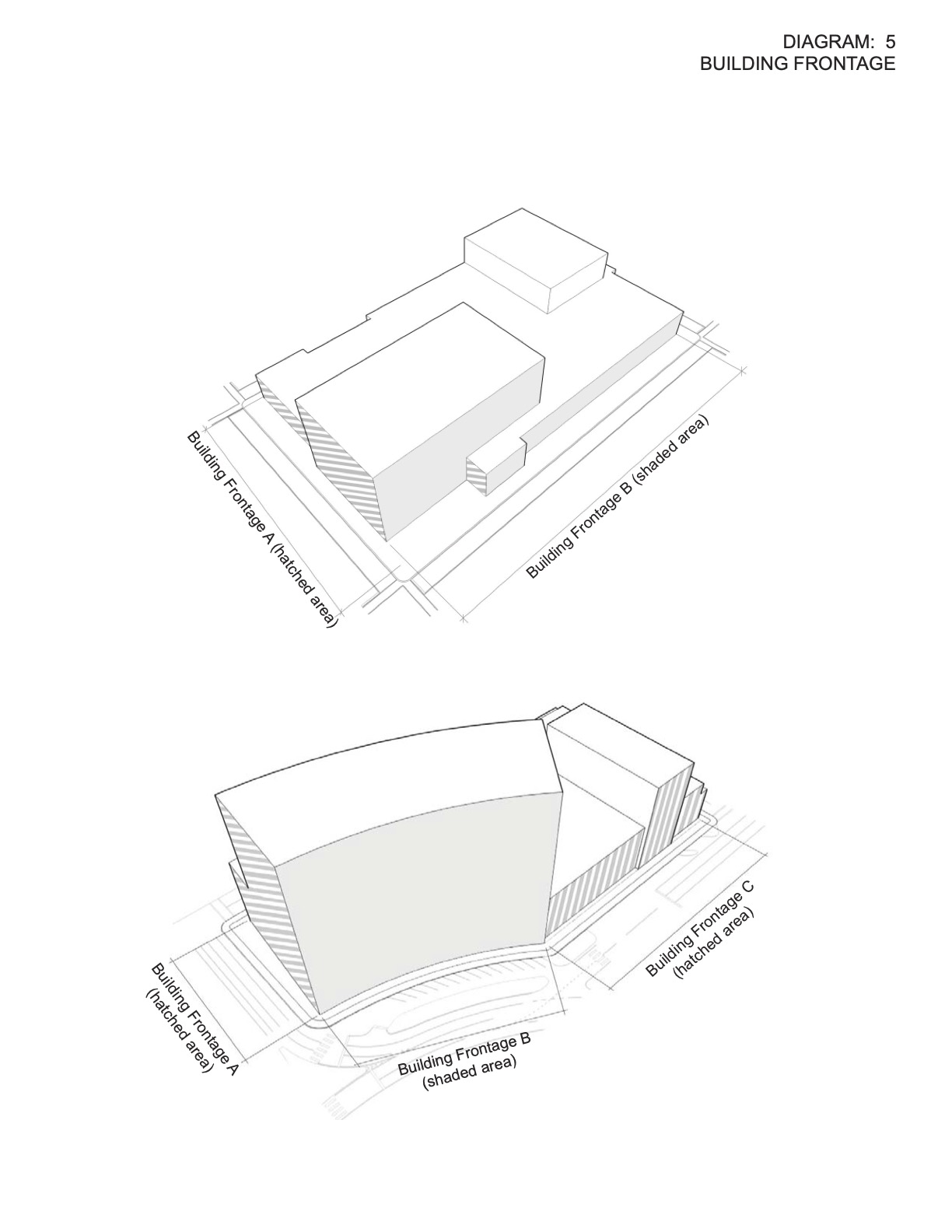

Diagram 6. Footprint.
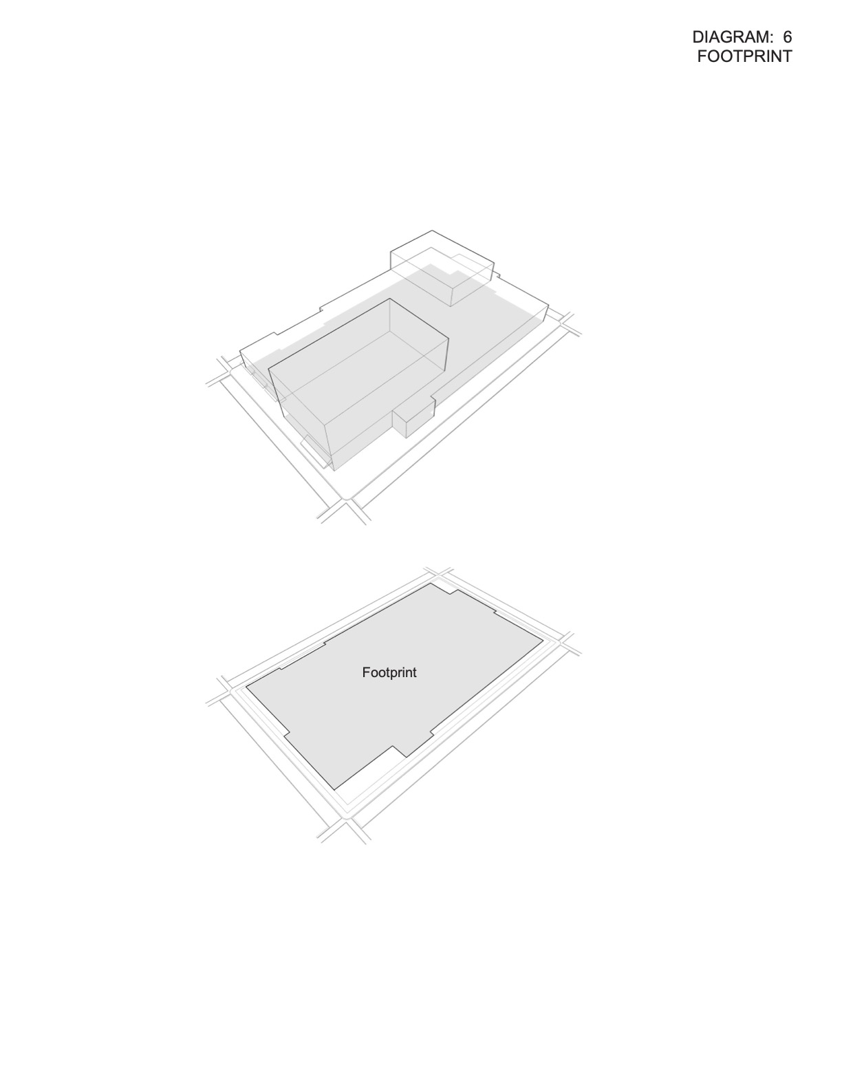

Diagram 7. Ground Floor Uses.
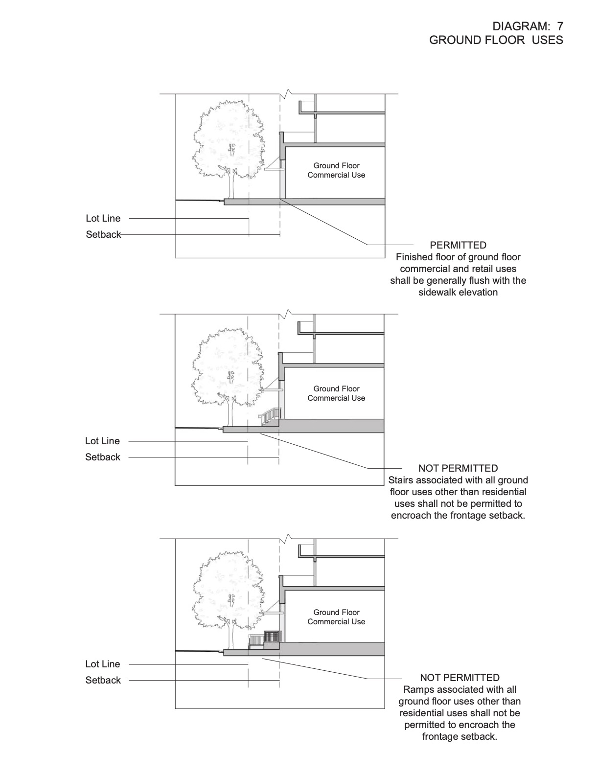

Diagram 8. Lot Frontage/Lot Frontage Buildable.
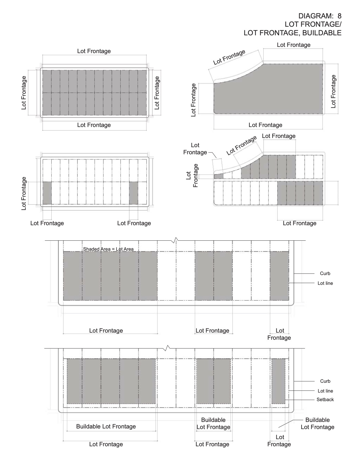

Diagram 9. Parking Stall Dimensions.

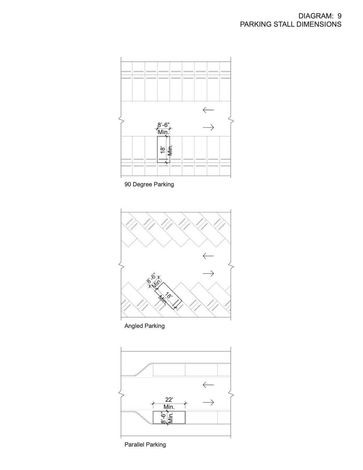
Diagram 10. Setback.
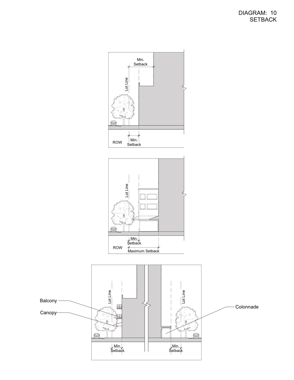

Diagram 11. Tower Floorplate.
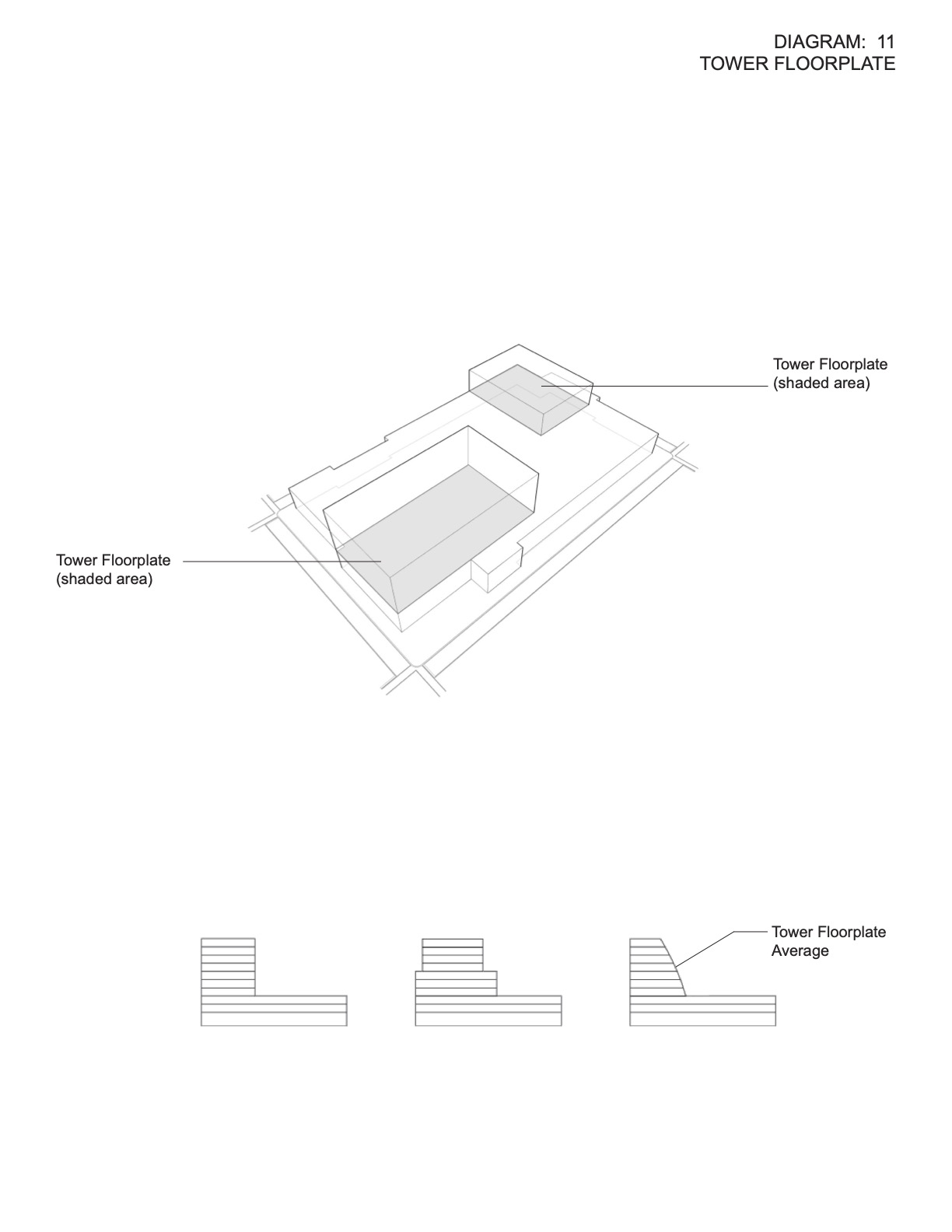

Diagram 12. Tower Length.
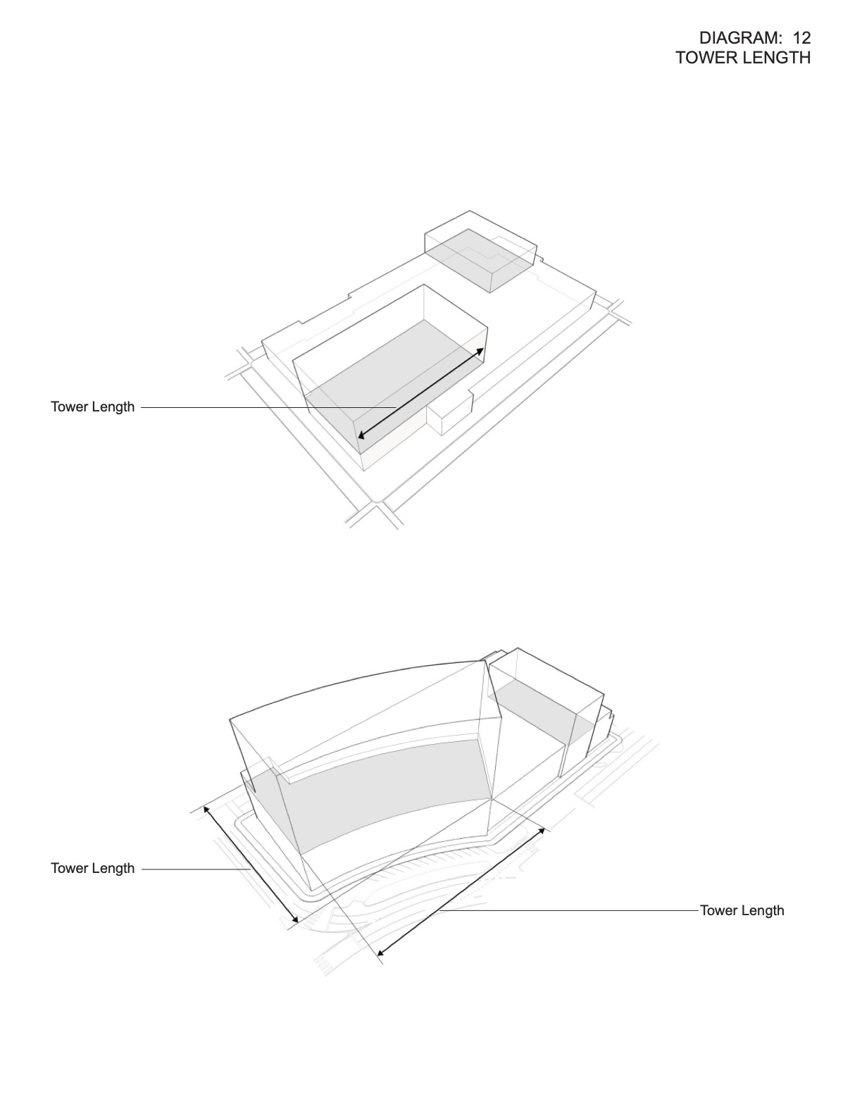

Diagram 13. Tower Separation.
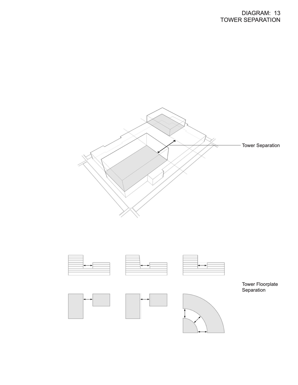

Diagram 14. Transparency/Storefront Facade Area.
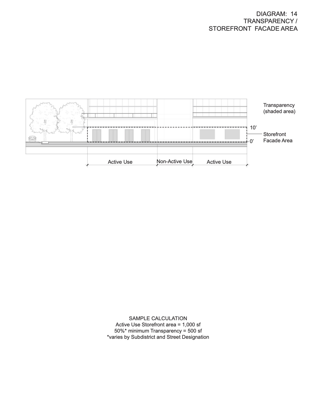

Diagram 15. Young Circle Tower Offset Setback.
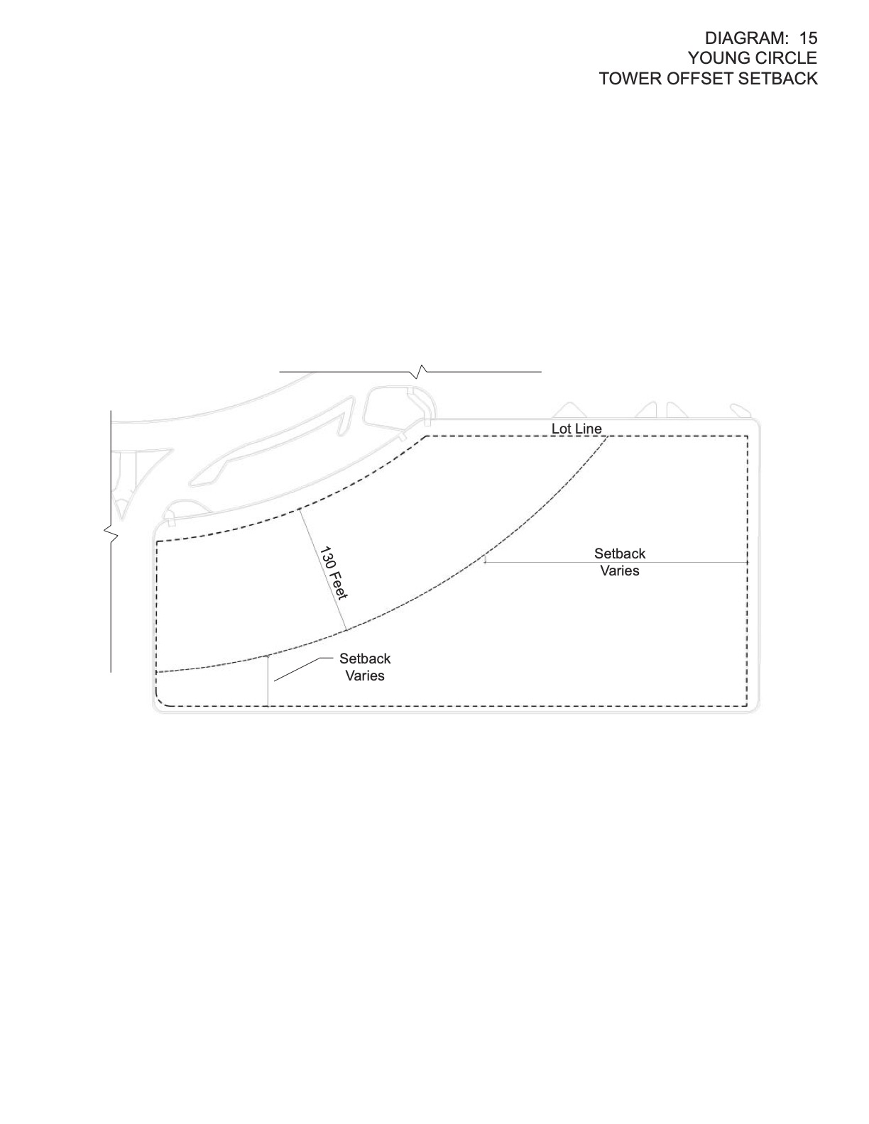

Diagram 16. Young Circle Gateway Setback.
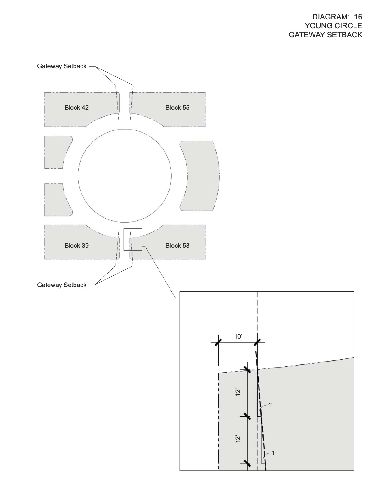
Diagram 17. Walk-Up Garden.
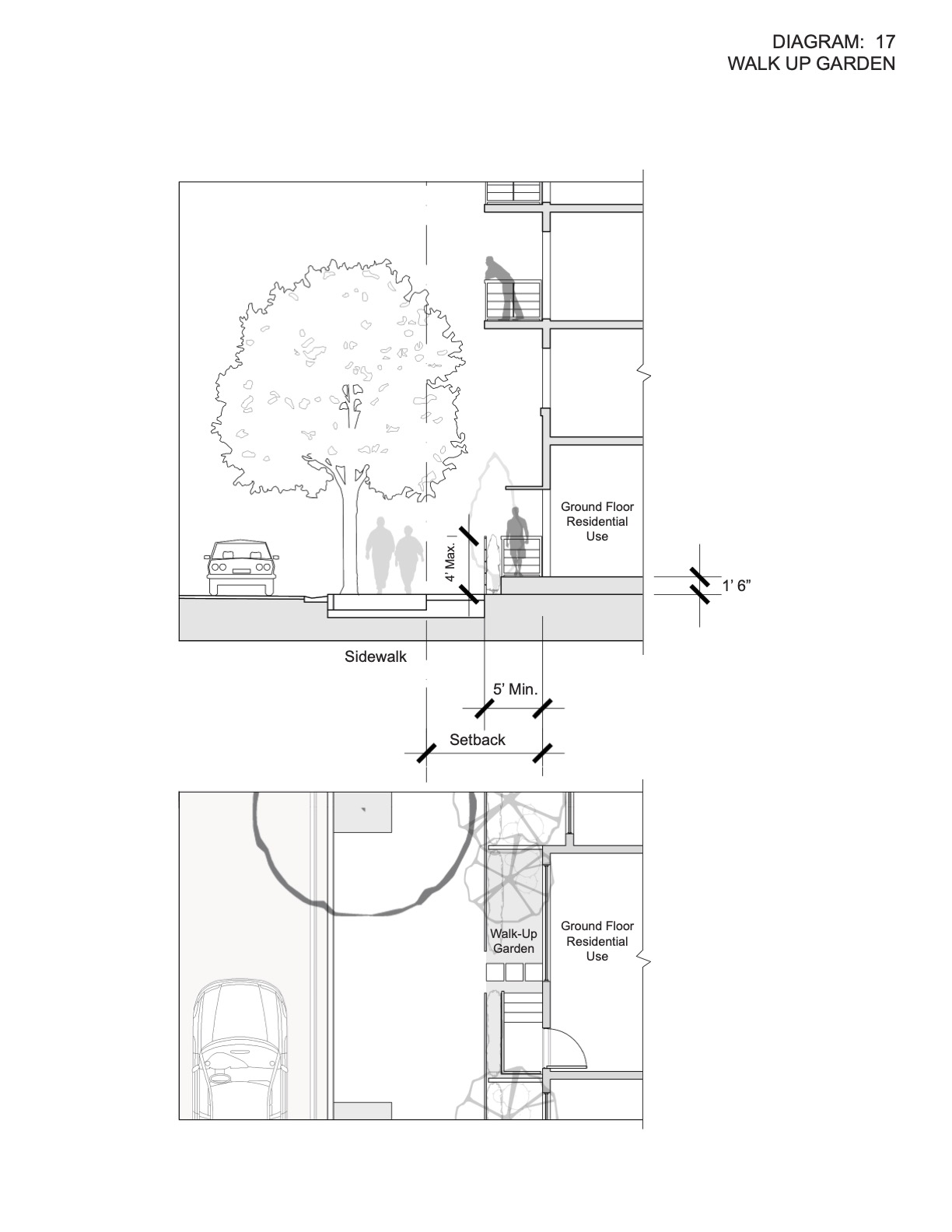

(Ord. O- 2016-22, passed 10-19-16)
1. Active Uses Diagram

2. BRT-25-R - Cross Street Setback Diagram Lots Less Than 120' W and 80'D

3. BRT-25-R - Cross Street Setback Diagram Lots Greater Than 120' W and 80' D

4. BRT-25-R - SR-A1A - Surf Road Setback Diagram Lots Less Than or Equal to 120' W and 80' D

5. BRT-25-R - SR-A1A - Surf Road Setback Diagram Lots Greater Than 120' W and 80' D

6. BRT-25-C - Cross Street Setback Diagram Lots Less Than or Equal to 120' W and 80' D W/O Retail

7. BRT-25-C - Cross Street Setback Diagram Lots Greater than 120' W/O Retail

8. BRT-25-C - SR-A1A - Surf Road Setback Diagram Lots Less Than or Equal to 120' W and 80' D W/O Retail

9. BRT-25-C - SR-A1A - Surf Road Setback Diagram Lots Greater Than 120' W/O Retail

10. BRT-25-C - SR-A1A - Surf Road Setback Diagram Lots Less Than or Equal to 120' W and 80' D W/ Retail

11. BRT-25-C - Cross Street Setback Diagram On Lots Greater Than 120' W and 80' D W/ Retail

12. BRT-25-C - SR-A1A - Surf Road Setback Diagram Lots Greater Than 120' W and 80' D W/ Retail

13. BRT-25-A1A-R - Interior Setback Diagram Lots Less Than or Equal to 150' W

14. BRT-25-A1A-R - Interior Setback Diagram Lots Greater Than 150' W

15. BRT-25-A1A-R - Intracoastal - A1A Setback Diagram

16. BRT-25-A1A-C - Interior Setback Diagram Lots Less Than or Equal to 150' W

17. BRT-25-A1A-C - Interior Setback Diagram Lots Greater Than 150' W

18. BRT-25-A1A-C - Intracoastal - A1A Setback Diagram

19. BWK-25-HD-R - Surf Road - Broadwalk Setback Diagram

20. BWK-25-HD-R - Cross Street Setback Diagram Lots Less Than or Equal to 120' W and 80' D

21. BWK-25-HD-R - Cross Street Setback Diagram Lots Greater Than 120' W and 80' D

22. BWK-25-HD-C - Surf Road - Broadwalk Setback Diagram W/O Retail

23. BWK-25-HD-C - Cross Street Setback Diagram Lots Less Than or Equal to 120' W and 80' D

24. BWK-25-HD-C - Cross Street Setback Diagram Lots Greater Than 120' W and 80' D

25. BWK-25-HD-C - Broadwalk Setback Diagram W/ Retail

26. BWK-25-HD-C - Cross Street Setback Diagram W/ Retail Lots Less Than or Equal to 120' W

27. BWK-25-HD-C - Cross Street Setback Diagram W/ Retail Lots Greater Than 120' W

28. RM-25-SCB - Cross Street Setback Diagram

29. RM-25-SCB - Intracoastal - A1A Setback Diagram

30. RM-25-SCB - Surf Road - Broadwalk Setback Diagram

(Ord. O-2013-13, passed 6-19-13; Am. Ord. O-2020-01, passed 1-15-20)
1. Accessory buildings (all districts).
All Accessory Buildings which are not a part of the main building may be constructed in a rear yard, provided such accessory building:
- Does not occupy more than 30% of the area of the rear yard. Areas enclosed by screens shall be included in the computation of area occupied in a rear yard but an open uncovered swimming pool or deck (pervious or impervious) shall not be included in the 30% calculation.
- Size: Shall not exceed 30% of the floor area of the Main Permitted Use.
- Setbacks: As set forth in this section. If not listed in this section the setback shall be determined by using the setback requirements for a use or structure that is similar to the proposed construction.
- Parking garages in Single Family Districts: See Section 4.1.D.
2. Awnings (all districts).
Awnings attached to, and supported by a building wall may be placed over doors or windows in any yard, but such awnings shall not project closer than 3 feet to any lot line except; an awning associated with a Commercial Use shall be permitted to extend from the entrance door to the street line of any building and setback 18 in from the curb.
3. Canopies.
A canopy shall be permitted to extend from an entrance door to the street line of any building except those located in a Single Family, RM-9, RM-12 or RM-18 districts. Where a sidewalk or curb exists, the canopy may extend to within 18 inches of the curb line. Such canopies shall not exceed 15 ft. in height and 12 ft. in height or be screened or enclosed in any manner and shall provide an unobstructed, clear space between the grade and the bottom of the canopy valance of at least 7 ft. The location of vertical supports for the canopy shall be approved by the Engineering Division.
4. Carports:
- Location. No more than one carport is permitted on any single yard for single family homes.
- Maximum Dimensions. Carports shall be used for shading and weather protection of not more than two automobiles, shall not exceed the roof line of the existing structure, and shall be pursuant to the following the maximum dimensions:
- Side-by-side: 21 ft. wide by 19 ft. long.
- Tandem: 10.5 ft. wide by 40 ft. long.
- Carports may exceed the maximum dimensions as set forth above, provided the placement and design of the carport integrates aesthetically and proportionately with the architecture of the existing structure as determined by the City Manager or his or her designee.
- Design. The design of the carport shall be compatible in scale and character with the existing structure.
- Construction. Carports may be supported by no more than eight metal poles not exceeding four inches in diameter.
- Material. When located in the front yard, the covering of a carport shall only be constructed of cloth, canvas, or similar lightweight material as approved by the Fire Department. When facing an alley or interior side yard or rear yard that is visible from the street, any construction material that is compatible with the construction of the principal building is permitted.
5. Decks and Screen Enclosures (whether or not associated with a pool):
- Maximum elevation: 30 inches above grade.
- Front setback: at-grade only, area not to exceed 10% of Main Permitted Use or 500 sq. ft. whichever is less.
- Side setback: 3 ft., 0 ft. adjacent to water.
- Side setback facing a street: 12 ft.
- Rear setback: 3 ft. If adjacent to water then setback for deck is 0 and setback for screen enclosure is 0 ft.
- Townhomes: Deck setback is 1/2 of the above (a - e) and measured from the line separating the property of each unit. Screen may enclose the area that is owned or exclusively used by owner.
- Arbor: At least 50% of the roof structure shall be open to the sky. Setback as listed above for deck.
- Properties in developments which have Condominium Associations or other forms of Associations which govern the Use of land may reduce the above required yards. Substantiation must be submitted to the Office of Planning.
6. Driveways and sidewalks on private property:
3 ft. from side lot line.
7. Fences and walls:
For height regulations related to residential zones refer to § 155.12 of the City Code of Ordinances.
- General:
- All vertical posts, horizontal rails, or support systems of wood fences must face to the inside of the property.
- The exterior of wood fences or any portion of the exterior of wood fences that face away from the property must have a finished surface.
- When a wood fence is located in the front yard setback or each side of a wood fence is visible from a street, then the wood fence shall be finished on both sides.
- Any portion of a wood fence that abuts an existing fence or other construction barrier may be installed with vertical posts, horizontal rails, or support systems to the outside of the property upon proper determination by the Zoning Administrator that an obstruction exists and that access has been denied.
- Barbed wire or similar materials. Prohibited in all districts except in Industrial and Manufacturing. The height of the barbed wire is included in the maximum height allowed.
- Ornamental fixtures or lamps (on walls, fences) are allowed in all districts subject to the following:
- Permitted to be placed on walls or fences when they are adjacent to a public street, alley, golf course or waterway. The total height of the combined structure shall not exceed the required fence or wall height by more than 2 feet.
- Located with a minimum separation of 8 feet on center with a maximum width of 2 feet.
8. Hedges.
For height regulations related to hedges refer to § 155.12 of the City Code of Ordinances.
9. Lightpoles:
In single family districts only; otherwise height limit as established in zoning district.
- 10 feet maximum height. Lightpoles shall be located 7 1/2 from any property line except that when such property line abuts a public right of way, or Waterway there shall be no required setback.
- All light shall be contained on site or on any public right-of-way.
10. Marine structures:
All districts - seaward side yard setbacks for boat slips, decks, wharves, dolphin poles, mooring piles, davits, or structures of any kind shall not be less than 7.5 feet. This requirement pertains to the enlargement of existing structures as well as to the construction of new structures. It is further provided that any boat, ship, or vessel of any kind shall not be docked or moored so that its projection extends into the required seaward side yard setback. Land side decks may extend to the deck associated with the marine Structure.
11. Mechanical equipment:
Accessory to a permitted use, such as air conditioning, water pumps, and the like, provided that no such equipment encroaching into a required yard (not allowed in front yard) setback shall be located closer than 3 feet to any plot line and further provided that in no case shall the noise level of any operating mechanical equipment be in violation of the City Code.
12. Porte-Cochere:
Shall be permitted to extend from an entrance door to the street line of any building except that Porte-Cocheres shall not be permitted in a Single Family or Townhome District. Where a sidewalk or curb exist, the Porte-Cochere may extend to within 18 inches of the sidewalk. The Porte-Cochere shall not exceed 30% of building core frontage in width or 16 feet in height or be screened or enclosed in any manner. It shall provide an unobstructed, clear space of not less than 9 ft. between the grade and the underside of the roof of the Porte-Cochere.
13. Projections (all districts):
Every part of a required yard shall be open to the sky, except as authorized by this title. The following may project into a required yard for a distance not to exceed 25% of the required yard up to a maximum projection of 6 ft.
- Belt courses;
- Chimneys;
- Cornices;
- Exterior unenclosed private balconies;
- Ornamental features;
- Porches, platforms and terraces;
- Roof overhangs;
- Sills;
- Window or wall air conditioning units;
- Bay windows;
- Walkways: maximum 3 ft.
14. Shed regulations:
15. Swimming pool, hot tubs, spas
- setbacks measured to water's edge (See § 4.23 for setbacks for decks and screen enclosures).
- Not permitted in front yard setback, in a utility or drainage easement.
- Enclosed or unenclosed: Rear setback - 6 ft., side setback - 6 ft., Side facing a street - 15 ft.
- Swimming pool shall be surrounded by a fence with a self-closing and locking gate all of which shall be at least 42 inches high.
- The Building Official may make modifications individual cases upon a showing of good cause with respect to the height, nature or location of the fence, wall, gate or latch or the necessity thereof, provided the protection as shown hereunder is not reduced thereby. The Division may permit other protective devices or structures so long as the degree of protection afforded by the substitute device or structure is not less than the protection afforded by the wall, fence, gate and latch described in division 15.c. above.
16. Tennis courts and similar court games:
The following regulations shall apply for fences, lightpoles or other accessory structures associated with court games in all districts.
- Front yard - Not permitted.
- Required side and required rear yard - maximum height of fences shall be 10 feet and the fences shall be set back at least 7.5 ft. from the interior side or rear property line. When the fence faces a street, the maximum height shall be 10 ft. and the fence shall be set back at least 15 ft. from the property line.
- Accessory lighting fixtures when customarily associated with the use of court games, shall be erected so as to direct light only on the premises on which they are located. The maximum height of light fixtures shall not exceed 10 feet when located in a required yard; otherwise, the maximum height shall not exceed 20 ft. light is permitted to be cast on any public right-of-way.
- All chain link fences shall be coated with green or black materials.
- When fences are located within 7.5 ft. of a lot line, they shall be substantially screened from view from adjacent properties, public right-of-ways, and waterways by landscape materials.
- Any play surface, whether paved or unpaved, when associated with said court games, shall have the following minimum required yards: front - 20 feet; interior side - 7.5 ft., any side facing on a street - 15 ft., rear - 7.5 ft.
- Landscaping, when associated with tennis courts, shall be allowed to equal the height of the fence. The area between the tennis court fence and the front lot line shall be landscaped and approved by the Director prior to the issuance of a Building Permit.
17. Vending machines.
Permitted as an accessory use if the machine(s) is located inside a building at least 10 ft. from a window that faces a street or in a courtyard when the machine(s) cannot be seen from a street.
(Ord. O-94-14, passed 4-16-94; Am. Ord. O-2001-16, passed 5-16-2001; Am. Ord. O-2003-14; Am. Ord. O-2003-31; Am. Ord. O-2004-21, passed 7- 21-04; Am. Ord. O-2011-05, passed 2-2-11; Am. Ord. O-2011-14, passed 5- 4-11; Am. Ord. O-2012-05, passed 3-7-12; Am. Ord. O-2019-16, passed 8-28-19)