
Huber Heights City Zoning Code
TITLE NINE
ZONING GENERAL PROVISIONS
CHAPTER 1181 - GENERAL PROVISIONS[50]
Cross reference— Carnival and festival defined—See §§ 1123.26, 1123.43; Junk yard defined—See § 1123.61; Swimming pool defined—See § 1123.106.
CHAPTER 1183 - EXCEPTIONS AND MODIFICATIONS[51]
Cross reference— Lot definitions—See § 1123.65 et seq.; Lots of record—See § 1181.01.
CHAPTER 1185 - PARKING AND LOADING[52]
Cross reference— Handicapped parking locations on lots and garages—See § 351.04; Parking disabled vehicles on private property more than 72 hours—See § 351.16; Parking trailers, trucks, recreational vehicles or farm equipment—See Ch. 1193; Parking lots—See Ch. 1195.
CHAPTER 1187 - NONCONFORMING LOTS, USES, STRUCTURES AND SIGNS[53]
Cross reference— Nonconforming structure defined—See § 1123.80; Nonconforming lot or land defined—See § 1123.804; Nonconforming sign defined—See § 1123.805; Nonconforming use defined—See § 1123.81.
State Law reference— Nonconforming uses, retroactive measures—See ORC 713.15.
CHAPTER 1189 - SIGNS[54]
Cross reference— Billboard defined—See § 1123.16; Bulletin board defined—See § 1123.24; Freestanding sign defined—See § 1123.45; Nonconforming sign defined—See § 1123.85; Sign defined—See § 1123.96; Sign area defined—See § 1123.97; Special use signs—See § 1135.11.
CHAPTER 1191 - ACCESSORY BUILDINGS[55]
Cross reference— Accessory building defined—See § 1123.01; Reverse vending machine defined—See § 1123.91; Storage shed defined—See § 1123.101.
CHAPTER 1193 - TRAILERS, TRUCKS, RECREATIONAL VEHICLES, BOATS, FARM OR CONSTRUCTION EQUIPMENT[56]
Cross reference— Commercial and heavy vehicles—See Ch. 339; Prohibited parking of large vehicles—See § 351.17 Wheels to be chocked—See 351.19.
CHAPTER 1194 - MOBILE FOOD VEHICLES[57]
Editor's note— Ord. No. 2018-O-2352, § 1, adopted Nov. 28, 2018, set out provisions intended for use as Ch. 1196, §§ 1196.01—1196.13. Inasmuch as there were already provisions so designated, said chapter and sections have been codified herein as Ch. 1194, §§ 1194.01—1194.13 at the discretion of the editor.
CHAPTER 1195 - FILLING STATIONS, PUBLIC GARAGES AND PARKING LOTS[58]
Cross reference— Filling station defined—See § 1123.44; Parking, garage defined—See § 1123.83; Parking lot defined—See § 1123.84; Parking and loading—See Ch. 1185.
CHAPTER 1197 - EXCAVATIONS AND DUMPS[59]
State Law reference— Powers and duties re dumps—ORC 715.47; Excavations within City—See ORC §§ 723.49, 723.50, 743.42, 1723.04.
CHAPTER 1198 - RADIO, TELEVISION AND TELEPHONE TOWERS AND ANTENNAS[60]
Cross reference— Height requirements—See § 1181.03.
CHAPTER 1199 - FLOOD DAMAGE PREVENTION[61]
Cross reference— Subdivision flood hazards—See Ch. 1113.
State Law reference— Construction permits and prohibitions for dams, dikes or levees—See ORC 1521.06; Reduction of assessed valuation for establishing reservoirs—See ORC 1521.09.
1180.01 - Purpose; intent.
(a)
The purpose of the Brandt Pike Revitalization Overlay District is multi-faceted. On a practical level, the Overlay District standards are meant to implement the recommendations of the Brandt Pike Target Revitalization Study (2017) which identify a number of public health, safety, and welfare issues on Brandt Pike, including traffic congestion, changing land uses, aging shopping centers, unattractiveness, and lack of identity. As this part of Huber Heights has come close to reaching build-out, the opportunity to address these issues comes through site-by-site redevelopment, which is an incremental process that will occur in fragments. It is because of this fragmentation, that a cohesive framework that channels or guides new building and construction is needed; otherwise, redevelopment on individual parcels or sites will occur independent of the larger Brandt Pike Corridor context, perpetuating the public health, safety, and welfare issues. The Overlay is such a framework and is intended to supplement the land uses and development requirements of the multiple underlying zoning districts while providing more specific development standards that unify this unique corridor's development pattern by regulating primarily the form (scale, alignment, and composition of buildings); parking and loading; site amenities; landscape design; lighting; and graphics. It is also aimed at encouraging and incorporating environmentally-friendly design, facilitating pedestrian connections to adjacent neighborhoods, as well as better connecting the corridor to its surroundings and serve as a tool to achieve the City's vision for redevelopment and help to create an identity for this vital corridor.
(b)
It is the intent of the City of Huber Heights Brandt Pike Revitalization Overlay District to improve the health safety and welfare of the citizens of Huber Heights through objectives which include, but are not limited to, the following objectives:
(1)
To establish parking standards with the specific intent of coordinating traffic between adjoining properties.
(2)
To reduce access points to improve traffic safety, circulation, and coordination.
(3)
To provide standards for screening of service and loading areas, HVAC equipment, and other areas determined to detract from the aesthetic qualities of the streetscape.
(4)
To regulate outdoor dining activities for the benefit of customers and pedestrians, while also preserving required parking and safe vehicular circulation.
(5)
To minimize the potential for increased traffic congestion by providing incentives that require shared access points, cross-access easements, shared parking areas, and quality public spaces.
(6)
To increase the number of pedestrian and vehicular connections between adjacent properties to provide complimentary and coordinated development of adjacent properties.
(7)
To provide regulating standards which require orderly, well-planned development and to ensure that the new buildings and additions enhance the surrounding streetscape, including incentives for burial of existing utilities within the right-of-way.
(8)
To use scale, building orientation and landscaping to establish community identity.
(9)
To effectively and efficiently regulate the establishment and maintenance of businesses requiring outdoor storage of vehicles, type and heights of signage, equipment or merchandise.
(10)
To establish a walkable streetscape by promoting a pedestrian orientation of streets and buildings and providing a safe and convenient interconnected sidewalk network.
(Ord. No. 2018-O-2335, § 1, 8-13-18)
1180.02 - Applicability to underlying zoning districts.
(a)
The provisions of this chapter shall be applicable to all lands shown as being located within the boundaries of the "BP" Brandt Pike Revitalization Overlay District ("BP") on the Zoning Map and shall be supplemental to the regulations of the underlying zoning district.
(b)
Any and all development, redevelopment, improvements, or the like, including, but not limited to, signage, and any variance, modification, and/or conditional use request for property with the BP shall be subject to the procedures and provisions set forth in this Chapter 1180. Any changes to the underlying zoning of property within the BP shall not remove the property from the BP unless expressly specified in the rezoning approval.
(c)
The Planning Commission shall review the particular facts and circumstance of each proposed conditional use in terms of the requirements contained in this chapter and shall find by a preponderance of the evidence that applicant has either met or made a good faith attempt to meet each applicable provision.
(Ord. No. 2018-O-2335, § 1, 8-13-18)
1180.03 - Permitted uses.
(a)
Uses permitted in the underlying zoning districts; and
(b)
Multi-family residential uses are permitted if incorporated into an overall mixed-use development.
(Ord. No. 2018-O-2335, § 1, 8-13-18)
1180.04 - Requirements for conditional use application.
Any applicant desiring to improve property, submit a land development or perform an alteration to an existing building located in the Brandt Pike Revitalization Overlay District is required to apply for and obtain conditional use approval pursuant to the provisions of this chapter, and said application shall be governed by the standards and criteria set forth below. If a Special Use permit is required for the use under the Underlying zoning, the applicant may submit a single application for special use/conditional use.
(Ord. No. 2018-O-2335, § 1, 8-13-18)
1180.05 - Conditional use general property standards and criteria.
The Planning Commission shall review the particular facts and circumstance of each proposed conditional use in terms of the following requirements and shall find by a preponderance of the evidence that applicant has either met or made a good faith attempt to meet each of the following
(a)
Applicants shall be required to pursue, where physically feasible, cross-easement agreements with neighboring property owners for the purpose of creating a cohesive and efficient parking configuration and traffic circulation plan including pedestrian and vehicular connections.
(b)
Applicants shall be required to investigate the feasibility of and to reduce, to the extent possible, the number of existing curb cuts in order to improve traffic safety and circulation.
(c)
Appropriate fenced and/or landscaped screening shall be required around all HVAC equipment, service and loading areas, trash receptacles, and other areas deemed appropriate by the Planning Commission. A privacy fence, landscaped buffer and/or low shrubs shall provide screening along the side and rear property boundaries to residential zoning districts.
(d)
Applicants shall be required to investigate the feasibility of and, to the extent possible, consolidate two or more parcels, under separate ownership, prior to development, with the purpose of providing a more unified development.
(e)
The applicant shall appropriately landscape along the backside of the public sidewalk with low shrubs, ornamental walls and earth shaping or any combination thereof. In those instances where parking is located in front of the building, vehicular screening shall be provided between the street right-of-way and the building by low brick walls 24 to 36 inches in height from the curb elevation with a five inch limestone cap or by landscaping of 100 percent opacity. The brick utilized in the wall shall match the brick used elsewhere in the corridor. Where it is determined by the Planning Commission that insufficient space exists for such landscaping, they may be located elsewhere on the lot, at locations determined acceptable by the Commission.
(f)
The applicant shall renovate existing building facades to provide a combination of masonry materials, such as stone, stucco, or brick and decorative elements around windows and doors, such as columns, pediments, and shutters, and new roof plan where flat roofs presently exist. All exterior walls of Commercial, Office, and Mixed-Use Buildings shall be 100 percent masonry materials as per City Code 1181.24(b)(1). All buildings in the Brandt Pike Revitalization Overlay District shall be architecturally finished on all sides utilizing four-sided architectural design so that there will be no apparent rear of any building where visible by surrounding roadways, as determined by the City. All buildings shall have a minimum of two distinct building materials from the approved list with secondary materials covering a minimum of ten percent of the total building façades. Window walls shall be considered windows by the City Code. All materials, colors, and architectural details used on the exterior of a building should be compatible with the building style, and with each other.
(g)
The applicant shall bring the front facade wall and sidewalk into conformity with 1180.11 contained herein.
(h)
New developments shall be planned containing new streets and/or pedestrian ways such that no block within the development shall contain a block frontage greater than 600 feet in one direction and 400 feet in the opposite direction without an intervening street or pedestrian way.
(i)
Shopping center out-parcels shall have an equivalent design treatment on all facades and shall be of a complimentary architecture to that of the shopping center.
(j)
Any right-of-way outside of the roadway shall be preserved for sidewalks and green area between the curbline and the front yard setback along the entire Brandt Pike, Chambersburg, Fishburg, Powell, Nebraska and Kitridge Road frontages.
(k)
Minimum green area: 20 percent, which may include any green area in the right-of-way as provided in Subsection J. If 20 percent green area is physically impossible, the applicant shall make a contribution in lieu of green area to the City of Huber Heights. Such contribution will be based on the assessed value of the property.
(l)
A maximum of one 30-foot curb cut per street frontage shall be provided, unless additional curb cuts are approved by the City in order to accommodate existing or proposed circulation deemed desirable by the City, including installation of one-way movements limiting existing or proposed driveways to entrance or exit only. The applicant shall reduce the number and width of existing curb cuts when practicable.
(m)
A minimum of 250 feet must be provided between curb cuts and public street intersections. A minimum of 100 feet must be provided between curb cuts.
(Ord. No. 2018-O-2335, § 1, 8-13-18)
1180.06 - Outdoor dining.
Outdoor dining may be permitted, subject to the following:
(a)
The Planning Commission may limit the volume of music, hours of operation and outdoor lighting of the outdoor dining area so as to minimize its impact on neighboring properties.
(b)
Outdoor cooking shall not be permitted unless specifically approved by Planning Commission.
(c)
Planters, posts with ropes, iron fencing or other removable enclosures are encouraged and shall be used as a way of defining the area occupied as outdoor seating.
(d)
Refuse facilities shall be provided.
(e)
Advertising or promotional features shall be limited to umbrellas or canopies.
(f)
Outdoor dining shall not impede pedestrian traffic flow.
(g)
Floor area devoted to outdoor dining shall be provided with off-street parking in the same fashion as required for restaurant use.
(Ord. No. 2018-O-2335, § 1, 8-13-18)
1180.07 - Outdoor lighting.
All outside lighting on the premises, including sign lighting, shall be arranged, designed, and shielded or directed so as to protect the abutting streets and adjoining property from the glare of lights, and lighting shall be so shielded that the source of the light shall not be visible from any point outside the premises. No flashing or intermittent or moving lights shall be permitted, either freestanding, attached to a facade, or as a part of an approved sign. This does not include digital changeable copy.
(Ord. No. 2018-O-2335, § 1, 8-13-18)
1180.08 - Lots; setbacks; parking.
The following dimensional requirements shall apply to all properties within the Brandt Pike Revitalization Overlay District:
(a)
Maximum building height: three stories, not to exceed 35 feet.
(b)
Front, side, and rear yard setbacks: The front, side, and rear yard setbacks shall be no less than ten feet, unless adjacent to an existing residential zoning district, in which case the minimum side and rear yard setbacks shall be 30 feet.
(c)
Lot coverage maximums shall be those of the underlying zoning district unless a mix of two or more uses is incorporated on site. In such case, all impervious surface areas, including building, parking, etc. shall not exceed more than 80 percent of the site for the entire development.
(d)
Parking setback. All parking shall be set back a minimum of ten feet from the ultimate right-of-way along all Brandt Pike and frontages. The parking setback along all collectors or residential streets may be zero feet from the ultimate right-of-way. A minimum of ten feet from the curbline shall be provided for the placement of sidewalks, landscaping and utilities.
(e)
Up to 25 percent of the required parking spaces may be replaced with landscaped area. This area is in addition to any other landscaping requirement.
(f)
Up to 25 percent of the required parking spaces for any development may be compact spaces reduced in total area, width or depth for designated compact vehicle parking. Each compact vehicle parking space shall not be less than nine feet in width and 18 feet in depth.
(g)
Parking Cap. Parking shall not exceed 110 percent of the minimum requirement. A fee shall be paid for each parking space added in excess in accordance with the fee schedule.
(h)
Curbing. All parking and landscape areas shall be curbed with six inch concrete except in cases where bioretention basins or similar storm water management methods are utilized. Extruded curb is prohibited.
(i)
Decorative, commercial-quality, bicycle racks, benches and trash receptacles shall be required for all retail and office developments unless specifically waived by the Planning Commission.
(j)
Dumpsters shall be screened on all sides by a minimum six-foot high brick or masonry wall with access via an opaque gate.
(Ord. No. 2018-O-2335, § 1, 8-13-18)
1180.09. - Sign and graphic standards.
In addition to conformance with Chapter 1189 of the City of Huber Heights Planning & Zoning Code, all signs and graphics shall meet the following requirements:
(a)
Signs must positively influence the overall character and appearance of the streetscape and must be designed to complement the architecture of the building.
(b)
Franchise logos and identification signs shall be permitted only if they are appropriate in size and are integrated into the building façade and street character. This also includes patio umbrella graphics and signage.
(c)
Canopies designed as signs are prohibited.
(d)
Individual letters (either illuminated or nonilluminated) are considered preferable to sign cabinets.
(e)
Signs shall be illuminated only by the following means:
(1)
By a white, steady, stationary light of reasonable intensity, directed solely at the sign and shielded or otherwise prevented from beaming directly onto adjacent properties or rights-of-way. Light fixtures shall be screened from view by site grading or evergreen shrubs. No exposed light sources (except in the case of a sign made of neon tubing) are permitted.
(ii)
By white interior light of reasonable intensity with primary and secondary images lit or silhouetted on an opaque background. The background must be opaque and preferably made of aluminum (as opposed to Plexiglas) with routed-out or push-through letters and graphics. No additional background lighting or illuminated borders or outlines shall be permitted.
(f)
Ground signs shall be set on grade or be placed on a low masonry base and to take on an architectural appearance compatible with the actual building and the streetscape. Maximum height of grounds signs is six feet from ground level in relation to the back of curb of the nearest street.
(g)
Wall signs are prohibited above the ground floor level or above a height of one inch below the second floor window line, whichever is lower.
(Ord. No. 2018-O-2335, § 1, 8-13-18)
1180.10 - Utility connections.
All wires, cables and lines providing telecommunication, including cable television and electric utilities services and connections of such utility systems to buildings and light poles shall be located underground.
(Ord. No. 2018-O-2335, § 1, 8-13-18)
1180.11 - Pedestrian standards.
(a)
Sidewalks are required to connect the street frontage sidewalks to all front building entrances, parking areas, central open space and any other destination that generates pedestrian traffic.
(b)
Sidewalks shall connect to existing sidewalks on abutting tracks and other nearby pedestrian destination points and transit stops.
(c)
Striped crosswalks shall be installed at any major intersection or other location as determined by the Planning Commission.
(d)
Sidewalks shall be a minimum of four feet in width and separated from the curbline by a minimum of five feet of grass and landscaped area, which shall, in any event, comply with the design standards contained herein, unless specifically waived by the Planning Commission.
(e)
All sidewalks and pedestrian connections shall be located a minimum of five feet from any buildings to allow for landscaping, unless arcades or entryways are part of the facade.
(f)
Pedestrian circulation areas shall be provided and clearly defined by the use of sidewalks, walkways or textured or colored paving materials.
(Ord. No. 2018-O-2335, § 1, 8-13-18)
1180.12 - Exemption.
The following are exempt from compliance with the BP overlay standards:
(a)
Routine maintenance and in-kind replacement of materials, except for the replacement of graphics;
(b)
Properties used solely for one or two family residential purposes.
(Ord. No. 2018-O-2335, § 1, 8-13-18)
1180.99 - Construction or implementation; permit issuance, invalidation.
(a)
The Planning Commission may modify or waive specific requirements of this section as well as the requirements of Chapter 1185, Parking and Loading, if the Commission determines an improved development plan or better vehicular or pedestrian circulation will result.
(b)
Construction or implementation of the proposed conditional use shall comply with the plans submitted with the application except to the extent those plans are modified by the Planning Commission, and shall also comply with all terms of the decision of the Commission.
(c)
The City shall issue a conditional use permit to the extent a conditional use has been permitted by the Commission. The breach of any condition, safeguard or requirement shall automatically invalidate the permit granted and shall constitute a violation of the City's Zoning Ordinance. The penalties for such violations are specified in Section 1125.99
(d)
A conditional use permit shall be deemed to authorize only one particular conditional use and such permit shall automatically expire if, for any reason, the conditional use shall cease for more than one continuous one year.
(e)
A conditional use permit shall be transferable, but only if and when the transferee signs a form provided by the City acknowledging that the transferee is bound by all terms and conditions of the prior approval and permit.
(Ord. No. 2018-O-2335, § 1, 8-13-18)
1181.01 - Lots of record.
Any lot of record, by deed or plat, at the time of the effective date of this Zoning Ordinance, having less area than herein required, shall be used as a building site.
(Ord. 81-O-08, Passed 8-3-81)
1181.02 - Setbacks.
Where the legal Official Thoroughfare Plan for Huber Heights, Ohio, shows a future street with greater than the dedicated width, the setback or setbacks shall be measured from the margin of the future highway width.
(Case 389; Ord. 2001-O-1240, Passed 2-12-01)
1181.03 - Height.
The height of any structure in the City of Huber Heights shall comply with the Federal Aviation Administration (FAA), Dayton International Airport or Wright Patterson Air Force Base height or abatement requirements.
(Case 389; Ord. 2001-O-1240, Passed 2-12-01)
1181.04 - Projections.
(a)
Cornices and eaves may project not to exceed three feet over any minimum required yard, provided that such projection shall not be less than two feet from any lot line.
(b)
Sills, leaders, belt courses and similar ornamental structures may project six inches over any minimum yard or court.
(c)
A bay window, entrance, balcony, vestibule or chimney may project a distance not to exceed three feet in any front or rear yard and a chimney may project a distance not to exceed three feet in any side yard provided that such features do not occupy in the aggregate, more than one-third of the length of the wall on which they are located.
(d)
A carport may extend up to 16 feet into any side or rear yard from the building, but shall maintain a minimum three foot setback from a side lot line and ten feet from a rear lot line. In any case, the carport shall not be constructed closer than 25 feet from any thoroughfare, road or street.
(e)
A patio cover or porch shall not project into the side or rear yard more than 16 feet from the building line of the dwelling provided it does not come nearer to the side or rear lot line than five feet. In any case, the patio cover or porch shall not be constructed closer than 25 feet from any thoroughfare, road or street.
(f)
A front porch cover shall be constructed a minimum of 19 feet from the established or future right-of-way in the R-4 and R-4B Residence Districts provided it is not screened or enclosed on any of the three sides. Nothing in this subsection shall be construed to affect side or rear yard setback requirements.
(g)
An enclosed patio shall not project into the rear yard more than 16 feet from the building line and further provided it does not come nearer to any side lot line than the minimum requirement set forth for the district.
(h)
A cover, carport, or enclosure shall not be taller than 14 feet above grade at any point.
(Ord. 2012-O-1939, Passed 2-13-12; Ord. 2016-O-2214, Passed 4-11-16; Ord. No. 2018-O-2354, § 1, 11-28-18)
1181.05 - Changes in plans.
Nothing herein contained shall require any change in the plan, construction or intended use of a building which is under construction at the time of the effective date of this Zoning Ordinance, provided the foundation of such building has been poured, the walls of the building erected and construction being diligently prosecuted.
(Ord. 81-O-08, Passed 8-3-81)
1181.06 - Conformance.
(a)
No building or structure shall be erected or altered, nor shall any building or land be used for any purpose other than a use permitted in the district in which such building is located.
(b)
No open space provided about a building for the purpose of complying with this Zoning Ordinance shall be encroached upon or reduced in any manner.
(c)
Any building or partial structure comprised of modular or sectional units which is not constructed so as to conform to the definition of "Industrialized Unit" as set forth in Chapter 1123 shall be prohibited.
(Case 389; Ord. 2001-O-1240, Passed 2-12-01)
1181.07 - Agricultural.
Nothing in this Zoning Ordinance shall prohibit the use of any land for agricultural purposes or the construction or use of building or structures incident to the use for agricultural purposes of the land on which such building or structures are located.
(Ord. 81-O-08, Passed 8-3-81)
1181.08 - Conservation district.
Nothing herein contained shall be construed as to prohibit the owner of land within any "C" District from lawfully filling, draining, constructing levees, or otherwise improving this land to eliminate the danger of floods or erosion. Property located within a Flood Hazard Area shall comply with the Flood Hazard Area regulations outlined in Chapter 1113 and the Flood Damage Prevention regulations outlined in Chapter 1199.
(Case 389; Ord. 2001-O-1240, Passed 2-12-01)
1181.09 - Ground floor area requirements.
A one floor single-family dwelling shall contain not less than 1,000 square feet of ground floor liveable area. A story and one-half, or two story single-family dwelling shall contain not less than 800 square feet of ground floor liveable area.
(Case 389; Ord. 2001-O-1240, Passed 2-12-01)
1181.10 - Carnivals, circuses and festivals.
(a)
Carnivals and circuses shall be permitted in any district except residential districts, provided they are operated for a period not exceeding ten days.
(b)
A festival may be permitted in any district for a period not to exceed ten days.
(c)
The operator of a carnival, circus, or festival shall be subject to the following conditions:
(1)
Any structures associated with a carnival or circus shall be setback at least 200 feet from any residential zoned lot and any structure associated with a festival shall be setback at least 100 feet from any residential zoned lot;
(2)
Adequate off-street parking area shall be provided on or adjacent to the grounds;
(3)
Site security shall be provided and the Police Department shall be notified of the dates of the activities;
(4)
All trash and garbage shall be removed from the area.
(5)
All activities shall be conducted within the hours of 9:00 a.m. and 12:00 a.m., and
(6)
Comply with all fire and safety regulations.
(Ord. 2011-O-1910, Passed 9-12-11)
1181.11 - Swimming pools.
No swimming pool shall be allowed in any residential district except as an accessory use and, unless it complies with the following conditions and other conditions as required in this Zoning Ordinance:
(a)
The pool is intended and is to be used principally for the enjoyment of the occupants of the principal use of the property on which it is located.
(b)
The pool shall be located in the rear yard and not be located closer than ten feet to any property line. Such distance shall be measured from the edge of the pool. Accessory buildings associated with the pool operation shall maintain the minimum side and rear yard setback requirements.
(Ord. 2001-O-1240, Passed 2-12-01; Ord. 2016-O-2214, Passed 4-11-16; Ord. No. 2019-O-2374, § 1, 6-10-19)
1181.12 - Outdoor retail sales and displays.
(a)
For the purpose of this chapter the term "outdoor sales" includes any outdoor display of merchandise. No sale may be conducted outside an enclosed building in any zoning district except retail sales in the B-1, B-2, B-3 and PC Planned Commercial Districts and A Districts, except temporary sales (garage sales, etc.) permitted under Section 1181.15, and except retail sales in an I-1 District. Within a PC Planned Commercial District, the operation of outdoor sales shall not require Planning Commission approval, but nothing in this section would permit the outdoor sales in a Planned Commercial District where such sales are expressly prohibited by a given site's basic or detailed development plan.
(b)
All such outdoor retail sales shall comply with the following conditions, requirements, and time restrictions (excluding temporary sales permitted and regulated under Section 1181.15).
(1)
Application for a zoning certificate shall be filed with an accompanying fee not less than ten days prior to the requested sale.
(2)
Only the following specific types of outdoor retail sales may be permitted and only for the time periods described below:
A.
Farm produce and firewood may be sold seasonally as an accessory use to agricultural use, but only to the extent they are grown on property owned or leased by the owner of the Agricultural District land where the sales occur. Such sales of firewood shall be limited to October 1 to February 1. Sales of produce shall be limited to May 1 to October 31.
B.
Garden and landscaping vegetation and materials, including but not limited to, peat moss, bark, mulch, fertilizer, marble chips, soil, sod, power lawn equipment, outdoor cooking equipment and accessories may be sold on a seasonal basis from April 1 to September 30 in B-1, B-2, B-3, PC, and I-1 Districts. Power snow removal equipment may be sold on a seasonal basis from September 1 to February 28 in those same zoning districts.
C.
Christmas trees, tree stands and greenery may be sold on a temporary basis between Thanksgiving and Christmas in the B-1, B-2, B-3, and PC Planned Commercial Districts and in the I-1 District.
D.
Promotional sales of merchandise normally offered for sale by a City business may be conducted on the permanent building location of that business for a period not exceeding three days with a frequency of no more than two in any calendar year. Such promotional sales may occur only in the B-1, B-2, B-3, and PC Planned Commercial Districts and in the I-1 District.
E.
Outdoor sales of merchandise normally offered for sale (within proper zoning districts) by a City business engaged in the sale of farm implements, automobiles, trailers, or boats, or in the lumber yard, greenhouse/nursery, or monument business.
(3)
All cleanup of this area, including removal of merchandise, fixtures, etc., shall be completed within 48 hours after the sales activity and by the date specified on the zoning certificate otherwise no additional certificates shall be issued for 12 months after the date of the violation notice.
(4)
Sales area shall allow for adequate pedestrian walkways and shall not extend into any fire lanes. The placement of the sales area shall not encroach upon any parking requirements of the district.
(5)
The height of any stackable outdoor sales product(s) shall not exceed five feet. Examples include bagged mulch, soil, salt, or similar products.
(6)
The outdoor sales area shall be placed so as not to interfere with traffic circulation.
(7)
The outdoor sales area shall not utilize any of the required parking spaces for the business(s) for which it is located.
(8)
Outdoor sales areas shall be in good order and well maintained.
(Ord. 2012-O-1939, Passed 2-13-12; Ord. 2016-O-2217, Passed 5-9-16; Ord. No. 2023-O-2594, § 10, Passed 7-24-23)
1181.13 - Reserved.
Editor's note— Former Section 1181.13, which pertained to junk yards, was repealed by Ordinance 2011-O-1910, passed September 12, 2011.
1181.14 - Reserved.
Editor's note— Former Section 1181.14, which pertained to waiver of setback violations and fees, was repealed by Ordinance 2011-O-1910, passed September 12, 2011.
1181.15 - Temporary sales.
Garage sales, estate auctions, rummage sales and moving sales (all referred to as "temporary sales") in residential districts in order to allow residents to sell excess personal property are permitted. A temporary use permit shall be obtained in advance for each such sale and no fee shall be charged for such permit and the following conditions shall be met for each such sale, excluding those temporary sales conducted by religious, educational and/or not-for-profit organizations.
(a)
Each temporary sale shall not exceed four calendar days in length from start to finish and only during the hours of 8:00 a.m. and 6:00 p.m. on Saturday and Sunday and 8:00 a.m. and 8:00 p.m. Monday through Friday.
(b)
There shall be at least one-month time lapse between each temporary sale.
(c)
Only two temporary sales shall be permitted per calendar year at any individual location.
(d)
All items displayed for sale shall be displayed on the premises permitted to have the sale. No merchandise for sale or related displays shall be displayed prior to 24 hours in advance of the sale and shall be removed from display within 24 hours after the conclusion of the sale. No merchandise for sale shall be displayed within the public right-of-way.
(e)
One on-premises, nonilluminated sign not exceeding four square feet in size, no more than three feet in height, may be used during the sale. Not more than two off-premises directional signs not exceeding four square feet in size, no more than three feet in height, may be used during the sale. The directional signs shall be on private property and may not be on street right-of-way. All signs shall be removed within 24 hours after the termination of the sale.
(f)
No balloons, streamers, special lighting, noise making devices, advertising displays, notices or any attention getting device or procedure (other than the above signs or media advertisements) shall be used to call attention to the temporary sale.
(g)
Every licensee conducting a temporary sale shall keep posted in a prominent place, the permit certificate and shall exhibit same upon request.
(h)
When imposing the penalty for a violation of this section, a separate offense shall be deemed to have been committed each day on which a violation or a failure to comply occurs or continues.
(Case 389; Case 133, 9-12-8; Ord. 2001-O-1240, Passed 2-12-01; Ord. 2016-O-2214, Passed 4-11-16; Ord. No. 2019-O-2398, § 1, 10-14-19)
1181.16 - Reserved.
Editor's note— Former Section 1181.16, which pertained to waiver of maximum area requirements for a category of wall signs, was repealed by Ordinance 2011-O-1910, passed September 12, 2011.
1181.17 - Street trees.
Any property that is zoned commercial, industrial, institutional or multi-family and that abuts a public street right-of-way and is being developed shall have one street tree per 40 feet of frontage planted at least four feet from the edge of the sidewalk on private property as determined appropriate by the City Engineer. If the location of the proposed street trees is determined inappropriate by the City Engineer, the City Engineer shall determine a location that is appropriate for the planting of the street trees. The City Engineer shall also approve the type of and the caliper of street trees that are to be planted. A list of appropriate trees and required caliper is available in the City Engineer's office.
(Case 389; Ord. 2001-O-1240, Passed 2-12-01)
1181.18 - Screening of service structures.
Service structures shall be screened in all zoning districts. For the purposes of this section, service structures shall include but not be limited to loading docks, storage tanks, dumpsters, electrical transformers, utility vaults which extend above the surface, cooling towers, roof top units and other equipment or elements providing service to a nonresidential (excluding agricultural uses) or multi-family building or site. Structures may be grouped together; however, screening height shall be based upon the tallest of the structures. Service structures located in the public right-of-way or public right-of-way easement shall be exempt from these provisions.
(a)
Screening Requirements.
(1)
Rooftop utilities screening. All mechanical equipment located on the roof or around the perimeter of the building shall be screened by the following means and with materials that are comparable and compatible with that of the exterior building materials. Roof top mechanical units must be screened to the full height of the unit and also be fully screened from view from surrounding public rights-of-way. A sight distance analysis may be required by the City to determine the necessary height or design of rooftop utilities screening. If due to factors unique to the property or the project, it is physically impossible or impractical to screen these utilities, the Board of Zoning Appeals, may approve alternative solutions that render them aesthetically compatible with the principal structure, except for development within a planned unit development district for which the Planning Commission would have authority to approve any alternative solutions.
A.
A raised parapet or other architectural feature is an integral part of the building as a method of screening for rooftop mechanical equipment or to soften rooftop view.
B.
Screening for rooftop mechanical equipment shall incorporate similar architectural features of the building and/or be constructed of a material and color compatible with other elements of the building.
(2)
Waste Handling Screening. All waste, recycling and related handling equipment shall be stored and kept in four sided enclosure constructed of a brick, stone, decorative concrete material or a material compatible with the material of the principle structure.
A.
Curbs to protect screening material. Whenever screening materials is placed around any trash disposal unit or waste collection unit which is emptied or removed mechanically on a regularly occurring basis, a curb to contain the placement of the container shall be provided within the screening material on these sides where there is such material. The curbing shall be at least one foot from the material and shall be designed to prevent possible damage to the screening when the container is moved or emptied.
(3)
Screening of other service structures. A continuous (having 100 percent opacity) planting, hedge, fence, wall of earth, which would enclose any service structure on all sides is required, unless such structure must be frequently moved, in which case screening on all but one side is required. The height of the screening material shall be one foot more than the height of the enclosed structure, but shall not be required to exceed 12 feet in height. Whenever a service structure is located next to a building wall or landscaping material, such walls or screening material, may fulfill the screening requirement for that side of the service structure if that wall or screening material is of sufficient height to meet the height requirement set out in this section. Plant material used to screen a service structure shall be an evergreen species which retains its needles throughout the year. Deciduous plant material cannot be used to fulfill this screening requirement. The height of the evergreen plant material at installation must be equal to, or greater than, two-thirds of the height of the service structure(s), and meet the height and opacity requirements within four years.
(Ord. 2006-O-1672, Passed 11-20-06)
1181.19 - Agricultural animals.
Agricultural animals shall not be kept, harbored or maintained in the R3, R4, R4B, R5, R6, R7, RMV, PR, or PM Districts, except that said prohibition shall not apply to R3, R4, R4B, RMV, PR, and PM Districts in which the actual lot size is one acre or more. For purposes of this provision, "agricultural animals" may include, but are not limited to, horses, mules, donkeys, ponies, cattle, swine, sheep, goats, geese, turkeys, guinea fowl, peacocks, chickens, burros, llamas, alpacas, ostriches and emus.
(Ord. 2011-O-1910, Passed 9-12-11)
1181.20 - Building materials for dwellings.
(a)
One-story dwellings. 25 percent of the front façade of one-story dwellings shall be constructed of full depth brick, cultured brick, stone, or cultured stone. Other exterior wall areas may be constructed of full depth brick, cultured brick, stone, cultured stone, EFIS, poured concrete, split-faced concrete block, stucco, masonry, or vinyl siding. All vinyl siding shall have a thickness of not less than 0.44mm or be insulated.
(b)
Dwellings over one story. The first-floor front façade shall be constructed of 25 percent of full depth brick, cultured brick, stone, or cultured stone. Other exterior wall areas may be constructed of full depth brick, cultured brick, stone, cultured stone, EFIS, poured concrete, split-faced concrete block, stucco, masonry, or vinyl siding. All vinyl siding shall have a thickness of not less than 0.44mm or be insulated.
(c)
Dwellings in planned unit developments. Exterior building wall material requirements for all residential and mixed-use residential buildings shall be established through the Basic Development Plan or Detailed Development Plan approval. At least 10 percent of the aggregate multi-family or mixed-use building wall surface, within the development, should be full depth brick, cultured brick, stone, or cultured stone. Single-family and two-family development front façades shall be constructed of not less than 25 percent full depth brick, cultured brick, stone, or cultured stone. When establishing the requirements, the Planning Commission shall consider the types, location, and layout of the buildings to:
(1)
Encourage a mix of building facades and material usage and discourage monotonous building repetition.
(2)
Encourage higher percentages of full depth brick, cultured brick, stone, cultured stone, or other approved masonry product along the frontage of major public streets and thoroughfares.
(d)
Exceptions. The requirement for certain exterior walls of dwellings to be constructed of brick or other approved masonry type of material shall not apply to:
(1)
Exterior wall areas of the dwelling where federal, state and/or local building codes prohibit the use of brick or other masonry materials such as gas fireplace inserts, cantilevers, gables, overhangs, soffits, downspouts and gutters, kitchen and other bays and other type of protrusion for which it is not reasonably practical to use the material stated above.
(2)
Room additions or remodeling to or of dwellings that do not comply with subsections (a) and (b) above when such dwellings were constructed prior to enactment of this section. Material that is used for additions or remodeling must be similar to the existing structure and maintain the integral look of the dwelling.
(d)
Definitions. For purposes of this section, the following terms shall have the following definitions:
(1)
"Dwelling" means any building or portion thereof occupied or intended to be occupied exclusively for residential purposes, but not including a tent, cabin, trailer, or trailer coach or other temporary or transient structure or facility.
(2)
"First floor" means the highest point at the finish grade of the proposed ground surface.
(3)
"Front façade" means the side of the building facing the lot front as defined by Section 1123.69 (Lot, Front).
(Ord. 2011-O-1925, Passed 11-28-11; Ord. No. 2023-O-2600, § 1, Passed 9-11-23)
1181.21 - Lighting standards.
(a)
Intent. This section intends to regulate outdoor lighting in order to: establish appropriate minimum levels of illumination, prevent unnecessary glare, and reduce both spill-over onto adjacent properties and unnecessary transmission of light into the night sky. It is not intended to eliminate the need for an applicant to seek professional assistance to determine appropriate lighting for the use and design proposed.
(b)
Approved Lighting Plan. Whenever the installation or modification of outdoor lighting is proposed or, for a commercial, industrial, multi-family or special use of a site plan approval, the enforcing officer shall review and approve all proposed lighting as part of the approval process. These standards shall also apply to modifications to existing lighting fixtures, whether or not site plan approval is required.
(1)
A lighting plan submitted for review shall contain the following:
A.
A site plan showing the location of all existing and proposed buildings, landscaping, streets, drives, parking areas and exterior lighting fixtures;
B.
Specifications for all proposed and existing lighting fixtures. These include: photometric data, fixture height, mounting and design, glare control devices, type and color rendition of lamps, and hours of operation. A photometric plan illustrating the levels of illumination at ground level shall account for all light sources that impact the subject site, including spill-over illumination from neighboring properties; and
C.
Relevant building elevation drawings showing all fixtures, the portions of the walls to be illuminated, illuminance levels of walls and the aiming of points of any remote fixtures.
(2)
A proposed lighting plan shall be reviewed based upon the following considerations:
A.
Whether the lighting is designed to minimize glare;
B.
Whether light will be directed beyond the boundaries of the area to be illuminated or onto adjacent properties or streets;
C.
Whether the lighting will cause negative impacts on residential districts and uses;
D.
Whether the plan will achieve appropriate levels of illumination for the use proposed;
E.
Whether the lighting is in harmony with the character of the surrounding area and the illumination levels of neighboring properties; and
F.
Whether the lighting is in keeping with the city' s goal of prohibiting unnecessary illumination of the night sky.
(c)
Required Conditions. When site plan or zoning permit approval is required for the installation or modification of exterior lighting, the following conditions shall apply:
(1)
Light fixtures shall not be mounted in excess of the maximum height limitation of the district in which they are located. Those maximum heights are listed below:
For lighting in residential districts and for uses adjacent to residential districts or uses, light fixtures shall not be mounted in excess of 25 feet above grade. Fixture height shall be measured from the grade of the illuminated surface to the bottom of the fixture.
(2)
Electrical service to light fixtures shall be placed underground.
(3)
No flashing lights or intermittent illumination shall be permitted.
(4)
Glare control shall be accomplished primarily through the proper selection and application of lighting equipment. Only after those means have been exhausted shall landscaping, fencing and similar screening methods be considered acceptable means for reducing glare.
(5)
Outdoor lighting shall be designed to achieve uniform illumination levels. The ratio of the average light level of the surface being lit to the lowest light level of the surface being lit, measured in foot-candles, shall not exceed 4:1. One foot-candle is equal to the amount of light generated by one candle shining on a square foot surface one foot away. The average illumination is determined by: adding the foot-candle value of all the points in the photometric grid, and dividing the sum by the total number of points.
(6)
The use of true color rendering lamps, such as metal halide, is required instead of the utilization of high and low pressure sodium lamps.
(7)
Only necessary lighting for security purposes and limited operations shall be permitted after a site's hours of operation.
(8)
Lighting for security purposes shall be directed only onto the area to be secured.
A.
All fixtures shall be located, shielded and aimed so that light is not cast toward adjacent properties or streets or unnecessarily transmitted into the night sky.
B.
Fixtures mounted on the building and designed to illuminate the facade are preferred.
(9)
Parking lot lighting shall be designed to provide the minimum illumination necessary to ensure adequate vision and comfort in parking areas. Full cut-off fixtures shall be used to prevent glare and direct illumination away from adjacent properties and streets. Designs that result in even levels of illumination across a parking area are preferred.
Cut-off fixture as defined by IESNA.
(10)
The illumination of gasoline service stations and convenience stores shall be the minimum level necessary to facilitate such uses. Unnecessary lighting for the purposes of attraction and advertising shall not be permitted.
A.
Areas away from gasoline pump islands that are used for parking and vehicle storage shall be illuminated in accordance with the parking area requirements of subsection (9) above.
B.
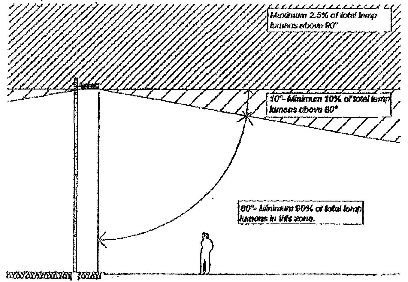
Light fixtures mounted on canopies shall be recessed or flush with the bottom of the canopy. Where a drop-down fixture is used, the lens shall be flush with (i.e., no more than one inch beyond) the casing so that light is directed down and not sideways. All canopy lighting shall be shielded to provide a cut-off angle of 85 degrees. Fixtures shall not be mounted on the top or sides of canopies.
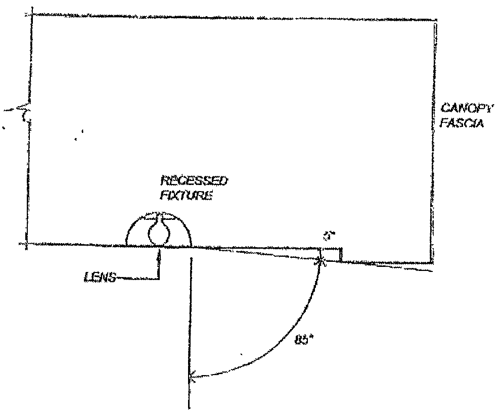
This illustration provides an example of a fixture with an 85 degree cut-off. Other
designs that achieve the same cut-off requirement are also acceptable.
C.
The illumination of canopy sides is prohibited.
(11)
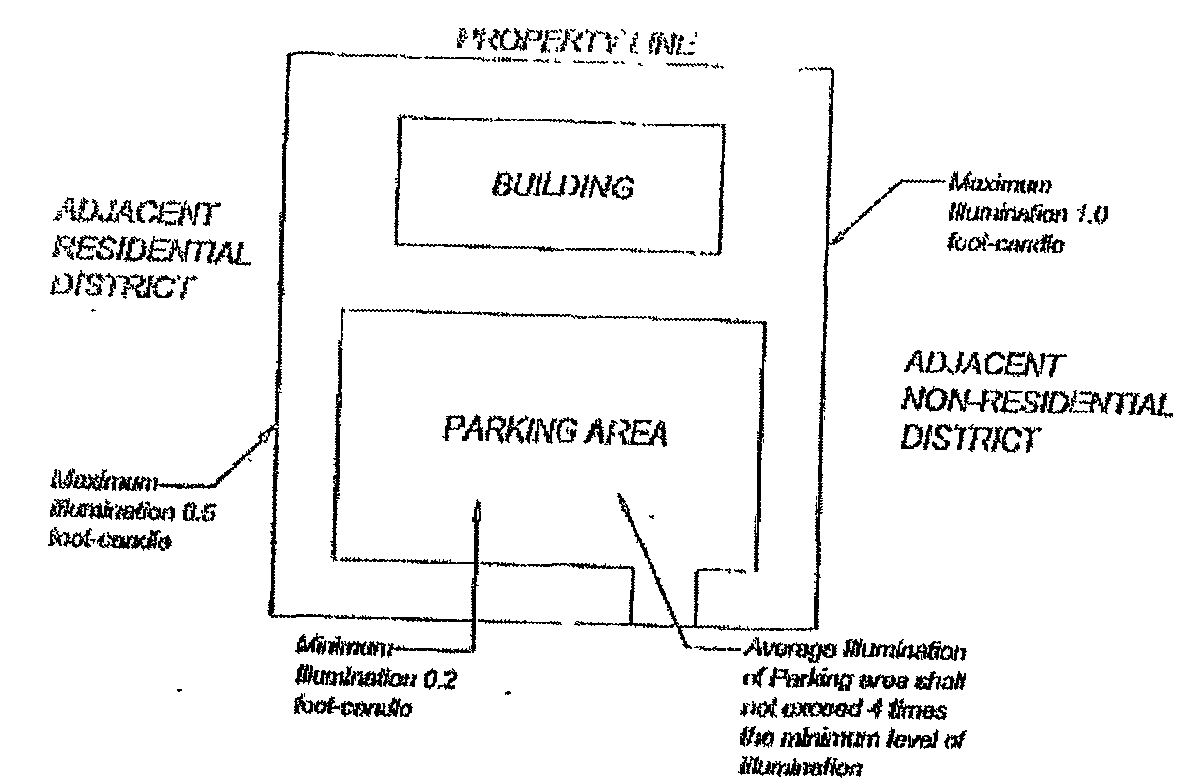
The following illumination levels shall act as minimum standards for all exterior lighting. Maximum lighting will be governed by the 4:1 ratio of average to minimum illumination of the surface being lit. Where a site abuts a nonresidential district, maximum illumination at the property line shall not exceed one foot-candle. The City may modify these levels if such modifications are deemed necessary and appropriate for the use and surrounding area.
*The minimum light measured in foot-candles at the point of least illumination when measured at ground level.
(12)
Where a site abuts a residential district or use, the following special conditions shall apply:
A.
The height of light fixtures shall not exceed 25 feet;
B.
All fixtures shall have a cut-off angle of 90 degrees or less;
C.
No direct light source shall be visible at the property line (adjacent to residential) at ground level; and
D.
Maximum illumination at the property line shall not exceed one half foot-candle.
(13)
The City may choose to waive or alter cut-off requirements of this section when appropriate historic or decorative fixtures are proposed (e.g., use of decorative up-lighting to illuminate the underside of a canopy or columns on a facade, where a canopy or roof projection restricts the projection of the light into the night sky).
Up-lighting of wall that does not spillover into the night sky.
(14)
The usage of exposed neon or similar tube lighting shall only be permitted through the approval of a variance by the Board of Zoning Appeals, or for developments within a planned unit development district, through the approval of Planning Commission.
(d)
Maintenance. All installed and approved light fixtures shall be kept in good repair. This includes, but is not limited to, replacing non-working bulbs, repairing broken or malfunctioning fixtures and similar activities. Failure to maintain fixtures shall be deemed a violation of this chapter and violators shall be subject to the penalty provisions contained in Chapter 1125 of the Zoning Code.
(e)
Exemptions. The following uses shall be exempt from the provisions of this chapter:
(1)
Roadway lighting required by the appropriate public agency for health, safety and welfare purposes;
(2)
Lighting approved by the City as part of construction;
(3)
Flag lighting, provided that the illumination is the minimum level necessary, and that the light source is aimed and shielded to direct light only onto the intended target and to prevent glare for motorists and pedestrians;
(4)
Emergency lighting approved by the City, provided the lighting is discontinued upon the abatement of the emergency necessitating said lighting; and
(5)
Other temporary lighting determined to be reasonable and appropriate by the City.
Example Application of Selected Standards
(Ord. 2006-O-1671, Passed 11-20-06)
1181.22 - Mandatory development under planned unit development regulations.
(a)
Rezoning proposals shall be developed under PUD regulations, as detailed in Chapter 1171 of the Zoning Code, when the Planning and Development Director, or his/her designee, determines that the development proposal exhibits at least one of the following characteristics listed below, or a characteristic or similar nature.
(1)
The total gross area of a development being proposed is ten acres in area or more except when;
A.
A development proposal calls for single family residential development of less than 50 lots under ER, R-1, or R-2 zoning district requirements;
B.
A development consists of 50 or more single-family residential dwelling units and the zoning classification of the property in question is appropriate for the proposed development and the zoning classification was in effect and approved prior to February 12, 2007;
C.
A development is proposed for agriculturally zoned property, with no rezoning sought by an applicant, and the proposed uses for the development are permitted by the A (Agriculture) Zoning District.
(2)
The total gross area of a proposed nonresidential or mixed use development is five acres in size or more;
(3)
The combined total gross area of the footprint(s) of the structure(s) being proposed for a nonresidential or mixed use development is greater than 20,000 square feet.
(b)
The intent of the City is not to allow this section to be circumvented by an applicant by the submission of multiple, coordinated development proposals that, as a whole, exceed the parameters established by subsections (a)(1), (2) and/or (3).
(Ord. 2007-O-1682, Passed 2-12-07)
1181.23 - Performance bond; maintenance and guarantee bond; irrevocable letter of credit; or surety.
When a performance bond, maintenance and guarantee bond, or irrevocable letter of credit is required for the approval of a PUD development plan, special use approval, or applicable provisions of the Zoning Code, they shall have the following meaning:
(a)
"Performance bond"; "maintenance and guarantee bond"; "irrevocable letter of credit" (all also referred to in text as surety):
(1)
"Performance bond" means an undertaking between a surety licensed to act as such in the State of Ohio, acceptable to the City, and the developer, for the benefit of the City, which undertaking guarantees that the developer shall fully perform and pay for all of its obligations under a PUD Agreement or other similar agreement, or a cashier's or certified check payable to the City of Huber Heights provided by the developer for deposit by the City to a City fund, with interest accruing to the benefit of the City, in an amount to cover all of the developer's obligations under a PUD Agreement or other similar agreement. At the discretion of the City Finance Director, a wire transfer may substitute for the physical provision of a cashier's or certified check.
(2)
"Maintenance and guarantee bond" means an undertaking between a surety licensed to act as such in the State of Ohio, acceptable to the City, and the developer, for the benefit of the City, which undertaking guarantees that the developer shall maintain and pay for the maintenance of the improvements provided for in a PUD Agreement and warranting against all defects in workmanship or materials for the period provided for in the PUD Agreement or other similar agreement, or a cashier's or certified check payable to the City of Huber Heights provided by the developer for deposit by the City to a City fund, with interest accruing to the benefit of the City, in an amount approved by the City to pay for the mitigation of any potential defects in workmanship or materials for the period provided for in a PUD Agreement or other similar agreement. At the discretion of the City Finance Director, a wire transfer may substitute for the physical provision of a cashier's or certified check.
(3)
"Irrevocable letter of credit" means an undertaking by a federally chartered national band maintaining at least one office in Montgomery County, Ohio, substituting its financial strength for that of the developer, for the benefit of the City, agreeing to pay the amount of money stated therein to the City upon presentation and demand by it accompanied by an affidavit by an officer of the City that the developer is in default under any provision of a PUD Agreement or other similar agreement. Such irrevocable letter of credit shall be freely assignable by the City to any other governmental body and shall be completely irrevocable during its terms. An "irrevocable letter of credit" may be presented to the City in lieu of a "performance bond" or a "maintenance and guarantee bond".
(4)
All "performance bonds", "maintenance and guarantee bonds" and "irrevocable letters of credit" shall be subject to approval by the City, prior to acceptance, and subject to approval as to form by the City Attorney prior to acceptance. "Performance bond"; "maintenance and guarantee bond"; "irrevocable letter of credit" all may also be referred to in text as surety. The above definitions shall not apply to surety under the Subdivision Regulations.
(Ord. 2007-O-1683, Passed 2-12-07)
1181.24 - Commercial building design standards.
(a)
Applicability. The Commercial Building Design Standards shall apply to all newly constructed or reconstructed/remodeled nonresidential structures located in the O-1, B-1, B-2, and B-3 zoning districts.
(1)
Exceptions. The requirements of this section shall not apply to:
A.
Existing structures as of the adoption of this section shall be exempt from these commercial building design standards unless an exempted structure is expanded by ten percent or more of its original size.
B.
Deviation from the design standards contained in this section may only be approved through the Planned Unit Development Approval Process.
(b)
Design Standards.
(1)
Building materials.
A.
All exterior walls, including parking structures, garages, and accessory structures shall be 100 percent masonry materials.
B.
Masonry coverage calculation does not include doors, windows, chimneys, dormers, window box-outs, bay windows that do not extend to the foundation, or any exterior wall that does not bear on the foundation.
C.
Masonry Materials shall be defined as:
1.
Hard fired brick: Shall be kiln fired clay or slate material and can include concrete brick if it is to the same American Society for Testing and Materials (ASTM) standard for construction as typical hard fired clay brick. Unfired or under-fired clay, sand or shale brick shall be prohibited.
2.
Stone: Includes naturally occurring granite, marble, limestone, slate, river rock, and other similar hard and durable all-weather stone that is customarily used in exterior construction material. Cast or manufactured stone product may be approved, provided that such product yields a highly textured, stone-like appearance.
3.
Decorative concrete block: Shall be highly textured finish such as split-faced, indented, hammered, fluted, ribbed, or similar architectural finish. Coloration shall be integral to the masonry material and shall not be painted on.
4.
Concrete pre-cast or tilt wall panel: Shall be of an architectural finish that is equal to or exceeds the appearance and texture of face brick or stone. Coloration shall be integral to the masonry material and shall not be painted on.
5.
Stucco: An exterior plaster made from a mixture of cement, sand, lime and water spread over metal screening or chicken wire or lath.
6.
Exterior Insulated Finish System (EIFS): A synthetic stucco cladding system that typically consists of these main components:
a.
Panels of expanded polystyrene foam insulation installed with adhesive or mechanically fastened to the substrate, usually plywood or oriented strand board;
b.
A base coat over the foam insulation panels,
c.
A glass fiber reinforcing mesh laid over the polystyrene insulation panels and fully imbedded in the base coat; and
d.
A finishing coat over the base coat and the reinforcing mesh.
7.
Other: The Director of the Planning and Development Department, or his/her designee, may approve the use of other materials not specifically mentioned herein if it is determined that said materials exhibit comparable characteristics as those materials already approved herein.
(2)
Roofing design and materials.
A.
Asphalt shingles, industry approved synthetic shingles, standing seam metal or tile roofs are allowed.
B.
Gable roofs, if provided, shall have a minimum pitch of 6/12.
C.
Pitch roofs, if provided, shall have a minimum pitch of 9/12.
D.
Architectural elements that add visual interest to the roof, such as dormers and masonry chimneys, are encouraged.
E.
Flat roofs shall require parapet screening in accordance with Section 1181.18.
F.
Parapet shall require cornice detailing or similar design.
(3)
Prohibited Materials. The following materials shall be prohibited as primary cladding or roofing materials:
A.
Aluminum or vinyl siding or cladding.
B.
Galvanized steel or other metal.
C.
Wood or plastic siding.
D.
Cementitious fiber board.
E.
Unfinished concrete block.
F.
Exposed aggregate.
G.
Wood roof shingles.
H.
Reflective glass.
(4)
Architectural design features.
A.
All nonresidential buildings shall be architecturally finished on all sides with the same materials and detailing (e.g. tiles, moldings, cornices, wainscoting, etc.)
B.
Structures 20,000 square feet or less shall require a minimum of two distinct building materials from the approved masonry list be utilized on all facades to provide architectural detail and interest.
C.
Structures over 20,000 square feet shall require a minimum of three distinct building materials from the approved masonry list be utilized on all facades to provide architectural detail and interest.
D.
Secondary materials must cover a minimum of ten percent of the building façade on all sides.
E.
No blank walls shall front along any public right-of-way.
F.
All nonresidential buildings shall be designed to include no less than four of the architectural design features listed as follows. Buildings over 20,000 square feet must include a minimum of six of the architectural design features listed as follows.
1.
Canopies, awnings, arcades, covered walkways or porticos.
2.
Recesses, projections, columns, pilasters projecting from the planes, offsets, reveals or projecting ribs used to express architectural or structural bays.
3.
Varies roof heights for pitched, peaked, sloped or flat roof styles.
4.
Articulated cornice line.
5.
Arches.
6.
Display windows, faux windows or decorative windows.
7.
Architectural details (such as tile work and molding) or accent materials integrated into the building facade.
8.
Integrated planted or wing walls that incorporate landscaping and sitting areas or outdoor patios.
9.
Integrated water features.
10.
Other architectural features approved by the Planning and development Director or his/her designee.
(Ord. 2007-O-1703, Passed 5-14-07)
1181.25 - Maximum number of principal structures.
(a)
One principal structure per parcel. Every principal structure hereafter erected, converted, enlarged or structurally altered shall be located on a platted parcel and in no case shall there be more than one principal structure on one platted or unplatted parcel.
(b)
Exception. More than one principal structure may be located on a platted parcel within a Planned Unit Development zoning district with the approval of the Planning Commission.
(c)
For purposes of this section, the term "Principal Structure" means a building in which the primary use of the parcel, upon which the building is located, is conducted.
(Ord. 2007-O-1708, Passed 6-11-07)
1181.26 - Home occupations.
(a)
Home occupations may be permitted with standards when compliant with the following regulations and any other applicable sections of this zoning chapter:
(1)
Such use shall be conducted entirely within the dwelling unit or an accessory building. In all cases, all activities related to home occupation must take place within the enclosed building.
(2)
Home occupations shall not change the character of the residential use and shall not adversely affect the uses permitted in the residential district of which they are a part.
(3)
The nature of home occupation as an accessory use relative to its location and conduct of activity is such that the average neighbor, under normal circumstances, would not be aware of its existence.
(4)
Any home occupation activities on the property shall be conducted only by persons residing in the dwelling unit and one additional person who does not reside at the home where the occupation takes place.
(5)
No building or structure shall be used to operate a business, store equipment or supplies used for a business, or serve as a location where more than four employees meet or park prior to going to work off-site, where such employees do not work anywhere on the property.
(6)
The maximum floor area the use may cover shall not exceed 25 percent of the total floor area of the dwelling unit.
(7)
Home occupations which provide a service shall not have more than two customers (including those arriving and waiting for service) at any one time.
(8)
The storage of all equipment, machinery, supplies, materials, files, and the like, shall be stored completely within the residence or accessory buildings.
(9)
Any need for parking generated by the conduct of such home occupation shall be accommodated on off-street parking spaces or areas that are paved for the purpose of parking.
(10)
No traffic shall be generated by such home occupation in greater volume than is normally expected for the residential neighborhood.
(11)
The following are examples of permitted types of home occupations:
i.
Clerical and other similar business services;
ii.
Instruction in music, dance, or other types of teaching with a maximum number of two students at a time;
iii.
The office of a professional accountant, attorney, broker, consultant, insurance agent, realtor, architect, engineer, sales representative, and similar office oriented occupations;
iv.
Artists, sculptors, photographers, and other providers of home crafts;
v.
Barber shop/beauty salon with a maximum of one chair;
vi.
A licensed massage therapist who provides massage therapy for a maximum of one client at any given time; or
vii.
Any similar use as determined by the Director of Planning and Zoning, or their designee.
(Ord. No. 2023-O-2571, § 2, 2-27-23)
1182.01 - General information.
(a)
Applicability. All of the requirements of this chapter of the Zoning Code are applicable to all new developments located in all zoning districts except for those located in ER, R-1, R-2, R-3, R-4, R-4B, RMV, A, WO, and C districts. For new developments located in ER, R-1, R-2, R-3, R-4, R-4B, RMV, A, WO, and C districts, only the requirements listed in the schedule of required buffers, detailed in figure 4 in Section 1182.05, shall apply. Property owners are under a continuing obligation to ensure that their property is maintained in accordance with these requirements.
(b)
Application Process. For PUD applications and standard zoning permit applications certain landscape information must be provided.
(1)
In a PUD application, proposals in the re-zoning and basic development plan stage need to illustrate conceptual buffering and screening requirements on the basic development plan.
(2)
In a PUD application in the detailed development plan stage and final plat stage, a detailed landscape plan shall be submitted as outlined in 1182.02.
(3)
For a standard zoning permit, a detailed landscape plan shall be submitted with the zoning permit application as outlined in 1182.02.
(c)
Alternative Compliance. It is not the intent of this chapter to establish arbitrary regulations or to inhibit creative solutions to land-use problems. It is recognized that, under certain conditions, a strict interpretation of the requirements may be either physically impossible or financially impractical. Requests for use of alternative landscaping schemes are justified only when one or more of the following conditions apply:
(1)
The sites involve space limitations or unusually shaped parcels;
(2)
Topography, soil, vegetation, or other site conditions are such that full compliance is impossible or impractical, due to a change of use of an existing site, the required buffer yard is larger than can be provided; and
(3)
Safety considerations are involved.
(Ord. 2007-O-1677, Passed 1-22-07)
1182.02 - Plan preparation: landscape plan submittal requirements.
Landscape plans for development must have the following information before the approval process begins. The plan must be to scale between one inch equals ten feet and one inch equals 40 feet and must be drawn on a separate sheet of paper.
(a)
Property lines.
(b)
Zoning and use of all abutting properties, location of buildings on abutting properties within 100 feet of property line; and zoning and use of properties directly across any street adjacent to the subject property.
(c)
Name, location, and right-of-way boundaries of all public and private streets.
(d)
Natural features such as ponds, lakes and streams.
(e)
Delineation of 100-year floodplain and wetlands, and 50-year floodplain information may be required for certain project areas.
(f)
Existing and proposed storm water management ponds.
(g)
Required yard depths/widths (i.e., setbacks from all lot lines).
(h)
Location, height, dimensions, and use of all existing and proposed buildings and other structures (including parking lots, sidewalks, and other paved areas; fences and walls; and recreational equipment) of subject property.
(i)
Proposed grading in two-foot contours or better with any slope at 3:1 or steeper indicated. Storm water management ponds shall be indicated.
(j)
Location of existing and proposed utilities and utility easements, including water, storm sewer, and sanitary sewer pipes; overhead wires; utility poles and boxes; and signs if available.
(k)
Location, size and description of all existing or proposed elements required to be screened.
(l)
Show existing vegetation, including existing trees equal to or greater than eight inches DBH, measured at four feet above base of the tree. Existing trees must be shown at approximate size. It will not be necessary for the owner/developer to survey trees of this size in large areas where woodland preservation is shown on the plan.
(m)
Site tabulations including site square footage, open space square footage, parking lot interior, and quantity of trees required. Required landscape strip width for front, side, and rear lot lines.
(n)
Plant Schedule indicating key, quantity, scientific name, common name, size, condition, and spacing of all plants shown on the plan. See Figure 6 below for an example of a plant schedule.
(o)
Landscape plan symbols must be drawn at approximate mature sizes. The following table shall be used in determining size of landscape symbols to be drawn on the plan. Symbols or hatching patterns must be unique for each of the following categories. See Figure 1 example.
Landscape Plan Symbols
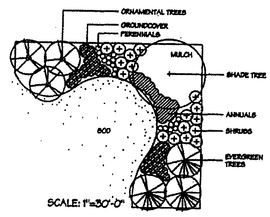
Figure 1
(Ord. 2007-O-1677, Passed 1-22-07)
1182.03 - Landscape regulations and requirements.
(a)
Definitions. For purposes of this chapter the following terms shall have the following definitions:
Annuals. Plant materials that complete their life cycle in one growing season.
Approved landscape plan. Landscape drawings reviewed, approved, and stamped as such by the City.
Caliper. Measurement of nursery grown trees at time of planting at one foot above base of tree.
Crown spread. The greatest distance of a diameter of a plant.
DBH. Diameter at breast height, measurement of tree trunk at four feet above base of tree.
Decorative fence. A fence that may have characteristics such as ornamental railing, outstanding architectural features, stone veneer, and/or lighting. Chain link is not a decorative fence.
Drip line. The outer perimeter of the crown spread of a plant projected onto the ground plane.
Earthen berm. Solid earth mound shaped in a curvilinear form usually for the purposes of screening adjacent properties with landscape plantings. Earthen berms shall not have a slope steeper than 3:1.
Environmental grade. Trees that have branching defects or abnormal growth and do not meet the American Standards for Nursery Stock. (Latest edition) Commonly referred to as "Park Grade Trees".
Evergreen. Plant characterized by having needle-like foliage that remains green and functional through more than one growing season.
Floodplain. As defined by the Federal Emergency Management Agency (FEMA). Floodplains are typically riparian (along streams) or coastal, lacustrine (ocean, lakes).
Grading. The alteration of soils and landforms and topography usually through earthworks construction.
Groundcovers. Grass, sod, or creeping vines, and low growing shrubs. Shall not exceed six inches in height. Groundcover shall be planted at the appropriate spacing to achieve a full green mat on the surface area in two years from time of planting.
Growing season. The first frost free date in the City to the first frost in the fall. Three growing seasons is defined as three full summer seasons, with summer ending on September 21 of every year.
Impervious. Impenetrable ground surface area not capable of passing water downward towards the water table. Parking lots and buildings are considered impervious surface areas.
Interior island. The landscape island in between terminal islands, separating parking bays. Interior parking islands offer opportunities for plantings and traffic control within a parking lot. Barrier curbs are required for all landscape islands.
Landscape plan. The drawings submitted to the City for review illustrating the design layouts, species, quantities, and construction details for installing landscape planting materials, and other information as required by this chapter.
Landscape strip. The area between parking lots and public rights-of-way required to be planted with trees and other plantings.
Louvered fence. A fence that is considered opaque by construction, but designed so that wind may flow through the fence through alternating panels on each side. A louvered fence requires chain link fence backing on one side of the fence.
Mulch. Processed shredded hardwood or other City approved organic material mulch to be used for soil retention, erosion control, and weed control.
Nursery grown. Trees that have been grown in a nursery recognized by the American Nursery and Landscape Association under conditions similar to those in Southwest Central Ohio for the past two years.
Opaque. 100 percent blocked view usually required for screening purposes. Opacity can be achieved by fences, walls, earthen berms, or densely planted massings of evergreens.
Open space. Area(s) within a development not covered by buildings or impervious surfaces that are either landscaped, wooded, or are covered by grass or some other similar ground cover vegetation.
Ornamental trees. Trees, typically deciduous woody trees usually with ornamental characteristics. These trees usually have one single stem with branching stems occurring several feet above the base of the tree or multiple stems branching near the base of the tree.
Park grade. See definition for "Environmental Grade".
Parking lot interior. In calculating the total area of any parking lot, all areas within the perimeter of the parking lot shall be counted, including planting islands, curbed areas, corner areas, parking spaces, and all interior driveways and aisles except those with no parking spaces located on either side. A certain amount of landscaping is required for interior parking areas.
Perennials. Herbaceous ornamental plants which persist throughout the year and repeat or renew themselves for at least three years.
Perimeter parking. The landscaped area required for a linear area surrounding parking areas. This does not include the landscape strip area between parking and public right-of-way.
Pervious. Penetrable and permeable surface area such as grass, open space, landscape areas where water is usually capable of reaching the underground water table.
Preserved tree. An existing tree indicated on the "Approved Landscape Plan" designated to be saved. Guidelines must be followed for the preservation of existing trees as indicated in this chapter.
Replacement plants. Plants that may be substituted due to unavailability or other factors listed under "Plant substitutions" in 1182.10 below.
Service structure. Dumpster, trash pads, trash collection, storage areas, or other structures that are required to be screened per Section 1181.18 of the Zoning Code.
Severely damaged. Over one-half of the critical mass of a tree is dead or diseased as determined by the City.
Shade trees. Large, usually deciduous woody trees with a large crown and overhead canopy typical at maturity. These trees usually have one single stem with branching stems occurring several feet above the base of the tree.
Shrubs. Deciduous or evergreen perennial with multiple woody stems or branches, generally bearing branches from or near its base. Shrubs generally do not exceed 15 feet at mature height.
Standard island. Landscape islands that are parallel with parked cars and perpendicular to interior islands. These islands are useful for providing separation for long strips of parking and additional tree plantings as required.
Terminal island. Landscape islands at the ends of parking bays, usually at the edge of an intersection of aisles. These islands are required at the terminus of all parking bays.
Wetlands. The term means those areas that are inundated or saturated by surface water or groundwater at a frequency and duration sufficient to support, and that under normal circumstances do support, a prevalence of vegetation typically adapted for life in saturated soil conditions. Wetlands generally include swamps, marshes, bogs, and similar areas. United States Army Corps of Engineers (USACE) (33 CFR 328.3(b); 40 CFR 230.3(t)).
Woodlands. Vegetative community comprised of trees and shrubs and ground cover. Woodlands are defined by the predominant tree species in an area and their screening and buffering qualities, as described in Section 1182.05 below.
(b)
Requirements. The following requirements shall be enforced by the City Planner or his or her designee. These are minimum requirements for landscape plans. Creative landscape planning and design is encouraged provided it meets the minimal requirements set forth in this chapter.
(1)
Residential requirements.
A.
Multi-family Dwellings. (R-5, R-6, and R-7 Districts) For multi-family dwellings in any zone, trees shall be planted at the following rate: A minimum of one and one-half shade trees is required per 2,500 square feet or fraction of open space provided. One-half of the number of required shade trees may be satisfied on a 2:1 basis by the use of ornamental trees (not to exceed one-fourth of the required number of shade trees) and evergreen trees (not to exceed one-fourth of the required number of shade trees). The following areas shall be excluded when determining the total amount of open space provided: lakes or other water areas, any required parking lot landscaped strip adjacent to a public right-of-way, and any required interior parking lot green area. This requirement is in addition to other parking and screening requirements which may result in a need for more shade tree utilization.
B.
Mobile Homes. In all mobile home developments, screening shall be provided along all rear and side property lines which abut other residential districts. See buffering and screening requirements in Section 1182.05 below. Such screening shall be in accordance with the schedule of required buffers between zoning districts, Figure 4 in 1182.05 below.
(2)
Neighborhood business district (B-1 zoning district). For neighborhood business districts, the following shall be required. A minimum total of one shade tree is required per 1,600 square feet or fraction of open space provided. This requirement is in addition to other parking and screening requirements which may result in a need for more shade tree utilization.
(3)
Other Commercial and Industrial developments.
A.
In all standard commercial zones (B-2, B-3, O-1, EP), in the standard industrial zones (I-1, I-2), and in the case of all nonresidential uses in residential zones, excluding permitted home occupations, one shade tree is required per 2,000 square feet or fraction of open space provided. A landscaped strip, as described in Section 1182.04(a), shall be provided on the property adjacent to all public rights-of-way.
B.
New Nonresidential Planned Unit Developments or major changes to a PUD have a minimum requirement of maintaining 25 percent open space nearest to any public-right-of way, visible by the general public. A minimum of 25 percent of the total open space provided on the site is required collectively in the front yards and side yards of developments. The maximum permitted coverage by all buildings and impervious surfaces shall be 75 percent.
(4)
Planned Mixed Use Districts (PM). In all PUD's where commercial and residential uses coexist, the areas that are commercial must comply with the commercial and industrial PUD requirements in this chapter. The residential areas must comply with the residential requirements of this chapter. The boundaries between different uses in a PM zoning district must be shown on the landscape plan.
(Ord. 2007-O-1677, Passed 1-22-07)
1182.04 - Parking lot requirements.
(a)
Landscape Strip Requirements.
(1)
When a parking lot in any zone is located adjacent to a public right-of-way or private road, a landscaped strip as described below shall be provided on the property between the parking lot and the right-of-way. The landscape strip may not include any paved area except pedestrian sidewalks or trails perpendicular to the roadway, that cross the landscaped strip.
(2)
The following parking lot requirements apply to all zones. In the PR-(Planned Residential District) or in other circumstances where greater parking lot setbacks are required than those listed below, the greater requirement shall apply. Any of the following landscape strip treatments may be used singly or in combination:
A.
Provide a minimum ten-foot wide landscaped strip between the right-of-way and the parking lot to be planted with a minimum of one shade tree and ten shrubs per 35 linear feet of frontage, excluding driveway openings.
B.
Provide a berm, the top of which is at least two and one-half feet higher than the elevation of the adjacent parking lot pavement. The slope of the berm or any other areas on the plan shall not exceed 33 percent (3:1). Berms shall be graded to appear as smooth, rounded, naturalistic forms with varying heights, not linear in design. Reasonable efforts should be made to avoid narrow bumps that result from creating too much height for the width of space. Plant with a minimum of one shade tree and five shrubs per 35 linear feet of frontage, excluding driveway openings.
C.
Provide a minimum ten-foot wide landscaped strip and a minimum three-foot grade drop from the right-of-way line to the adjacent parking lot pavement. Plant the resulting embankment with a minimum of one shade tree and five shrubs per 35 linear feet of frontage, excluding driveway openings.
D.
Provide a minimum seven-foot wide landscaped strip between the right-of-way line and the parking lot, with a minimum three-foot high brick, stone or finished wall, matching the architecture, construction materials, and colors of the primary building, to screen the parking lot. The wall shall be located adjacent to but entirely outside the seven-foot landscaped strip. Plant with a minimum of one shade tree per 35 linear feet of frontage, excluding driveway openings. Drawing elevations of the proposed wall must be submitted with the landscape plan.
E.
Provide a minimum 25-foot wide strip of existing woodlands. Where the plantings required in Section 1182.04(a) would result in an inappropriate or impractical design due to underground utilities, overhead wires, or other factors, the following will apply:
1.
Two ornamental trees may be substituted for one shade tree.
2.
Two evergreen trees may be substituted for one shade tree.
3.
One evergreen tree may be substituted for five shrubs.
(b)
Perimeter Parking Landscape Requirements. The following options may be used singly or in combination for perimeter parking landscaping.
(1)
Provide a landscaped strip between the parking lot and any adjacent property line, to be a minimum of ten feet wide for parcels over 20,000 square feet, a minimum of five feet wide for parcels less than 20,000 square feet. Within this landscaped strip, provide one tree and three shrubs per 35 linear feet of parking lot perimeter adjacent to a property line. (This does not mean that shade trees must be located 35 feet on center) Any shade tree planted to fulfill another requirement of this chapter, which is located within 15 feet of the edge of the parking lot, or any existing shade tree exceeding four inches caliper, which is located within 15 feet of the edge of the parking lot, may count toward fulfillment of this requirement.
(2)
Provide a minimum 25-foot wide strip of existing woodlands.
(c)
Parking Lot Interior Requirements. A minimum of four percent pervious area of the total vehicular use area is required for parking lot interiors. This requirement is separate from perimeter parking requirements, and shall provide pervious areas devoted to landscape. Greater than four percent may be required in large vehicular use areas according to the following provisions:
(1)
At least two shade trees shall be located within 60 feet of every parking space, measured from the trunk of the tree to the center of the parking space. See Figure 2.
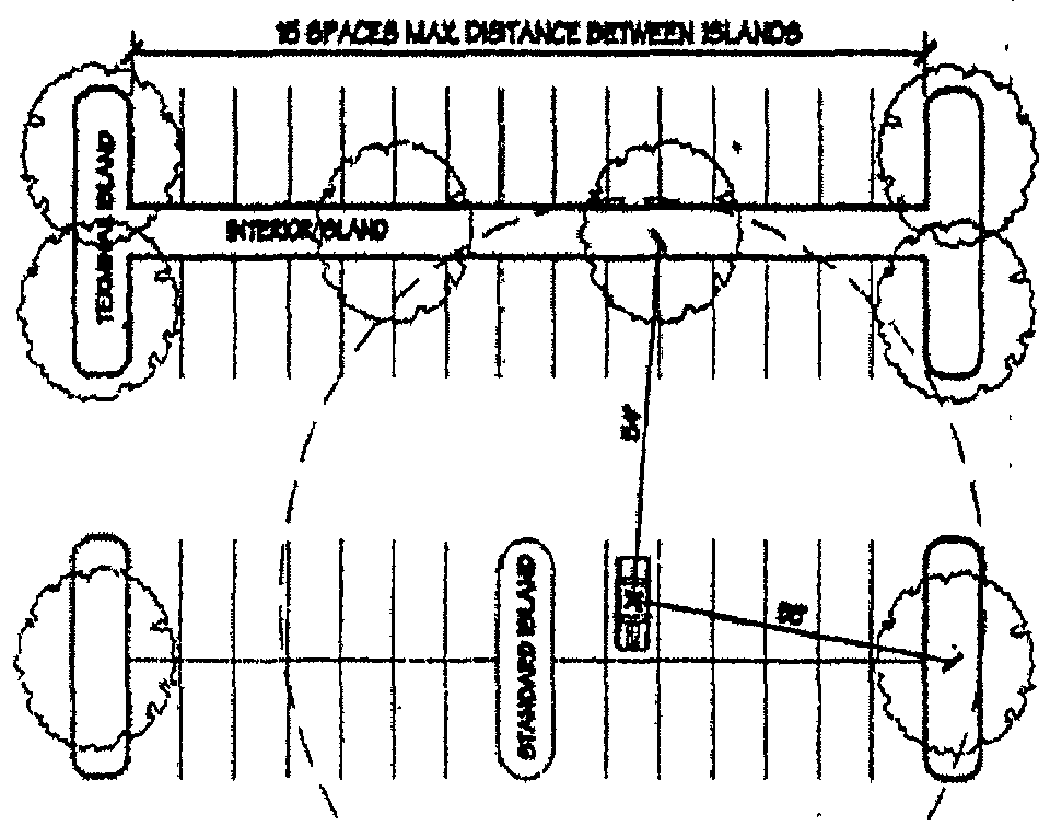
Figure 2
(2)
There are three types of parking islands permitted within a parking lot. See figure 2.
A.
Terminal island. Located and required at the ends of parking bays, these islands shall have a minimum width of nine feet. At a minimum 75 percent of terminal islands shall be planted with perennials and shrubs, not exceeding two feet in height. The remaining 25 percent may be covered with grass or mulch.
B.
Standard island. Located between terminal islands, these islands shall have a minimum width of nine feet. At a minimum 75 percent of standard islands shall be planted with perennials and shrubs, not exceeding two feet in height. The remaining 25 percent may be covered with grass or mulch.
C.
Interior parking islands. Located between bays, these islands shall have a minimum width of eight feet for double loaded spaces and six feet for single loaded spaces. At a minimum 75 percent of interior islands shall be planted with perennials and shrubs. The remaining 25 percent must be planted with groundcover.
(3)
For the purposes of computing the total area of any parking lot, all areas within the perimeter of the parking lot shall be counted, including planting islands, curbed areas, corner areas, parking spaces, and all interior driveways and aisles except those with no parking spaces located on either side. Landscaped areas situated outside of the parking lot, such as peripheral areas and areas surrounding buildings, may not be counted as interior planting areas.
(4)
If a parking lot less than 10,000 square feet is built without interior landscaping and then later, additional spaces are added so that the total of the lot is greater than 10,000 square feet, then the interior landscaping shall be provided for the entire parking lot.
(5)
Planting spaces must be large enough to allow for healthy tree growth as outlined below, and must be protected from car overhangs and opening car doors.
A.
A minimum of 60 square feet of continuous pervious land area shall be provided for each tree. No tree planting area shall be less than six feet wide in any dimension.
B.
A curb shall be provided for all parking spaces adjacent to planting or pedestrian areas to protect those areas from overhanging by parked vehicles.
C.
Planting islands, which are parallel to parking spaces, shall be a minimum of nine feet wide.
D.
In cases where a planting island is perpendicular to parking spaces and the spaces head into the planting island on both sides, the island shall be a minimum of eight feet wide to allow for bumper overhang. If parking spaces are located on only one side of such a planting island, the island shall be a minimum of six feet wide.
(d)
Credit for Preserving Existing Trees. Credit may be received on the parking lot interior landscape by preserving existing trees capable of tolerating adjacent construction. In order to maintain any tree deemed eligible for credit, 75 percent of the ground area under and within the drip line of the tree shall be preserved from the trunk out to the edge of the drip line and shall be maintained in either vegetative landscape material or pervious surface cover, except when the City Planner or his or her designee determines that lesser areas and other ground cover treatment will provide sufficient nourishment for the continued growth of the preserved type of tree. A certified arborist or other third party expert approved by the City may be required to examine the condition of existing trees to be preserved when technical issues beyond the scope of the Planning and Development Department arise. The developer shall incur all costs associated with any third party examination. The developer is required to contact the Planning and Development Department for a tree preservation inspection prior to grading or earth movement near existing trees to ensure that proper tree preservation measures are taken. Grading under the drip line of the tree prior to development is not permissible and will void tree credits given by saving existing trees. Existing trees which were preserved in the approved plan, but do not survive or exhibit characteristics of dying must be replaced by the same number of trees credited toward the existing preserved tree according to the Schedule of Credit for Preserving Existing Trees. See Figure 3. The required number of new trees may be reduced in accordance with the following schedule in exchange for preserving existing trees:
Figure 3
Schedule of Credit for Preserving Existing Trees
(Ord. 2007-O-1677, Passed 1-22-07)
1182.05 - Buffering and screening requirements.
For the schedule of required buffers between zoning districts, see Figure 4. Screening materials shall consist of evergreen trees and shrubs, walls, fences, and earthen berms. Screening fences and walls shall not be constructed of corrugated metal, corrugated fiberglass, sheet metal, chain link or wire mesh. The screening options presented below should not be used to produce monotonous, linear designs. If a long stretch of screening is required, options should be combined or alternated, or plant materials should be varied to achieve a more pleasing effect. Other creative options, such as changes in elevation, existing vegetation, or plant materials within a bufferyard are encouraged, but the applicant must demonstrate that they will provide comparable or superior screening. Screening in addition to that specified below may also be required if, because of slopes or other specific conditions on a site, the normally required screening measures do not achieve the necessary level of concealment.
(a)
General Screening Requirements.
(1)
Screening required. No buildings or structures shall be erected, altered or enlarged nor shall land be used for any nonresidential use on a lot that adjoins or faces any residential district until a plan for screening has been submitted and approved by the Planning and Development Department.
(2)
Purposes of screening. Screening shall be provided for one or more of the following purposes.
A.
A visual barrier to partially or completely obstruct the view of structures or activities in order to minimize or prevent nuisances.
B.
As an acoustic screen to aid in absorbing or deflecting noise; and
C.
For the containment of ambient debris and litter.
(3)
Types of screening permitted.
A.
A solid masonry wall at a minimum height of six feet, matching the architecture, materials, and colors of the primary building;
B.
A solidly constructed decorative fence at a minimum height of six feet;
C.
A louvered fence at a minimum height of six feet, with a chain link fence backing constructed on one side;
D.
Dense evergreen plantings; and/or
E.
Landscaped mounding/berms sufficiently high to fulfill screening requirements. Greater than six feet high walls or fences will be required in areas where additional screening is needed as determined by the City Planner or his or her designee.
(4)
General screening requirements.
A.
Side and rear yard requirements for nonresidential uses abutting residential districts. Such screening shall have a minimum height of six feet and be of sufficient density or opaqueness to accomplish the above stated purposes.
B.
Front yard screening requirements for parking lots across the street from residential districts. All parking lots located within any required front yard across the street from any residential district shall be separated from the street right-of-way at least 25 feet or the minimum distance required by the zoning district in which the parking lot is located, whichever is greater. Screening at a minimum of six feet in height shall be provided along all sides of parking areas facing residential districts, except where a sight distance hazard would be created.
C.
Earthen Berm mounding specifications. Earthen berms provided in lieu of or in combination with walls, fences, and/or evergreen plantings shall consist of a strip of land as wide as necessary to obtain a maximum slope of 33 percent (3:1) for the required height. Mounding shall be planted with a ground cover suitable to prevent erosion. For earthen berms over six feet in height, a reduction of plant materials will be considered.
D.
Minimum required depth for noise screening. Screening for the purpose of absorbing or deflecting noise shall have a depth of at least 15 feet of mounding with plantings, or be a solid wall in combination with decorative plantings.
E.
Protection and maintenance of screening. Whenever required screening is adjacent to parking areas or driveways such screening shall be protected by bumper blocks, post or curbing to avoid damage by vehicles. All screening shall be trimmed and maintained in good condition and remain free of all advertising or other signs.
Schedule of Required Buffers Between Zoning Districts
Figure 4
1.
None Required. Yard requirements of the individual district shall apply.
2.
None Required. Yard requirements of the individual district shall apply. Special uses require a setback of three feet for each foot of building height unless not required or reduced by Planning Commission.
3.
Adjoining 200 feet shall be developed according to the requirements of the lower density residential district, or intervening permanent open space at least 50 feet in depth shall be provided. Special uses require a setback of three feet for each foot of building height unless not required or reduced by Planning Commission.
4.
Buildings or uses shall be set back a minimum of 50 feet from all residential district lot lines and screening in accordance with this section shall be provided along such mutual property lines.
5.
Buildings or uses shall be set back a minimum of 100 feet from all residential district lot lines and screening in accordance with this section shall be provided along such mutual property lines.
6.
Buildings and uses shall be set back a minimum of 75 feet from such mutual property lines and screening in accordance with this section shall be required.
7.
Buildings and uses shall be set back a minimum of 200 feet from such mutual property lines and screening in accordance with this section shall be required.
8.
Buildings and uses shall be set back a minimum of 300 feet from such mutual property lines and screening in accordance with this section shall be required.
(b)
Loading Areas.
(1)
All loading areas consisting of two or more loading spaces, loading docks, vehicular lanes providing access to the above, and service or maintenance areas shall be screened from residential zones and all adjacent public or private roads.
(2)
The following options may be used to screen loading areas:
A.
A minimum ten feet high opaque wall or fence matching the architecture, materials, and colors of the primary building.
B.
Six feet high earthen berm with plantings sufficiently high enough to screen the loading area from adjacent property.
C.
Six feet evergreen screen trees or shrubs, at a minimum of six feet high at time of planting, minimum of 15 feet on center, double staggered row.
(3)
Greater than ten feet high walls or fences will be required in areas where additional screening is needed as determined by the City Planner or his or her designee.
(c)
Service Structures.
(1)
All service structures shall be screened in accordance with Section 1181.18 of the Zoning Code.
(Ord. 2007-O-1677, Passed 1-22-07)
1182.06 - Landscaping bonding requirements.
(a)
Includes all zoning districts required to adhere to the provisions of this chapter.
(b)
Prior to the issuance of any zoning permit for development, the developer/applicant shall submit to the City a performance bond, cash bond, or letter of credit to insure the installation of landscaping as approved. The bond or letter of credit shall be in an amount equal to the applicant's estimate of the cost of installation as approved by the Planning and Development Department and shall remain in effect until such time as the landscaping has been completed as determined by the City. Upon completion of the installation of landscaping as required by the approved landscape plan, the applicant may request release of the cash bond, performance bond or letter of credit. Following an inspection by the City and upon determination by the City that the landscaping has been completed in accordance with the approved landscaping plan, 80 percent of the cash bond, performance bond or letter of credit may be released. However, the performance bond or letter of credit will not be released until a maintenance bond or letter of credit lasting three growing seasons, and equal to 20 percent of the initial performance bond or letter of credit is submitted to and accepted by the City to ensure maintenance of the landscaping.
Total cost of landscaping (including labor, materials, taxes) .....100%
Bond Release
Immediately following installation and approved inspection: .....80% bond release
Three growing seasons following and approved inspection: .....80% bond release
20% bond release
(Ord. 2007-O-1677, Passed 1-22-07)
1182.07 - Administration and enforcement.
(a)
The Planning and Development Department is responsible for the administration of the landscape plan review process and the enforcement of this chapter.
(b)
The City Planner or his or her designee may enforce the requirements of this chapter, before, during, or after construction of a project.
(Ord. 2007-O-1677, Passed 1-22-07)
1182.08 - Plant lists, details, specifications, and tree preservation measures.
(a)
Landscape Standards and Specifications.
(1)
Where to obtain plant material: plants shall be nursery grown in accordance with good horticultural practices, and grown under climatic conditions similar to those in Southwest Central Ohio for a minimum of two years. Trees shall meet current standards set by the American Nursery and Landscape Association (hereafter referred to as ANLA Standards) and shall be freshly dug, have outstanding form and be free of disease, insects and/or damage. No park grade or environmental grade trees are permitted.
(2)
Two inches of processed, shredded mulch shall be applied to the soil around the tree will help conserve moisture and reduce weed growth. Mulching is not considered as a replacement for landscaping.
(3)
Landscape specifications shall be as outlined below. Any item or procedure not mentioned below shall be reviewed and approved at the discretion of the City.
A.
Plant materials. The landscape contractor shall furnish and install and/or dig, ball, burlap and transplant all of the plant materials called for on the drawings and/or listed in the plant schedule. Please see Figure 6 for table of minimum sizes for plant material at time of planting.
1.
Plant names used in the plant schedule shall be identified by scientific name and common name. See Figure 7 for a plant schedule example.
2.
All plant materials shall be equal to or better than the requirements of the American Standard for Nursery Stock, (latest edition), by the ANLA. All plants shall be typical of their species and variety, shall have a normal habit of growth, and shall be first quality, sound, vigorous, well-branched and with healthy, well-furnished root systems. They shall be free of disease, insect pests and mechanical injuries.
3.
Caliper measurements shall be taken 12 inches above grade.
4.
Minimum branching height for all shade trees shall be six feet.
5.
Minimum sizes for plant material at time of planting shall be as shown in Figure 6.
Figure 5
Sample Plant Schedule
Note: all disturbed grass area should be re-seeded.
Figure 6
Minimum Sizes for Plant Material at Time of Planting
(b)
Planting Methods.
(1)
All proposed plant material that meets the landscape standards and specifications in Section 1182.08(a) are to be planted in accordance with the following planting methods during the proper seasons as described below.
(2)
The following planting methods may be inspected at any time during or after the construction of a project by the City Planner or his or her designee. The Planning and Development Department may issue a stop work order on landscape plantings, if it is not being performed as specified in this chapter.
A.
Planting season. A professional horticulturist/nurseryman shall be consulted to determine the proper time, based on plant species and weather conditions, to move and install particular plant material to minimize stress to the plant. Planting of deciduous material may be continued during the winter months provided there is no frost in the ground and frost-free topsoil planting mixtures are used. Evergreens may be planted during the winter months.
B.
Digging. All plant material shall be dug, balled and burlap (B&B) or bare root in accordance with the ANLA Standards.
C.
Excavation of plant pits. The landscape contractor shall excavate all plant pits, vine pits, hedge trenches and shrub beds as follows.
1.
All pits shall be circular in outline, with vertical sides. The tree pit shall be deep enough to allow one-eighth of the ball to be above the existing grade. Plants shall rest on undisturbed existing soil or well-compacted backfill. The tree pit must be a minimum of nine inches larger on every side than the ball of the tree.
2.
If areas are designated as shrub beds or hedge trenches, they shall be cultivated to at least 18 inches depth minimum. Areas designated for ground covers and vines shall be cultivated to at least 12 inches depth minimum.
D.
Staking, guying, and wrapping. The landscape contractor shall follow generally accepted industry standards, such as ANLA standards, for staking, guying, and wrapping, as determined by the Planning and Development Department.
E.
Plant pruning, edging and mulching.
1.
Each tree, shrub or vine shall be pruned in an appropriate manner to its particular requirements, in accordance with accepted standard practice. Broken or bruised branches shall be removed with clean cuts made on an angle from the bark ridge to the branch collar, no flush cuts, to minimize the area cut. All cuts shall be made with sharp tools. Trim all edges smooth. No tree wound dressings shall be applied.
2.
All trenches and shrub beds shall be edged and cultivated to the lines shown on the drawing. The areas around isolated plants shall be edged and cultivated to the full diameter of the pit. Sod that has been removed and stacked shall be used to trim the edges of all excavated areas to the neat lines of the plant pit saucers, the edges of shrub areas, hedge trenches and vine pockets.
3.
After cultivation and eventual routine maintenance, all plant materials and plant beds shall be mulched with a two-inch to three-inch layer of finely shredded, processed, dark hardwood or other Planning and Development Department-approved organic material mulch of uniform texture and size. Large shredded twigs and branches are not considered mulch.
4.
Mulch is not considered as landscaping or as a substitute for plant materials.
(Ord. 2007-O-1677, Passed 1-22-07)
1182.09 - Acceptable tree list.
The acceptable tree list for the City is designed to encourage an imaginative selection of landscape trees. Careful selection will prevent an over-dependence on a few species. Alternative species may be used on the site, but this list represents acceptable trees that will not be questioned. Planting and maintaining a diverse urban forest is one of the goals of the creation of this list. This idea is reflected in the landscape approval process by the Planning and Development Department. Deviations from the acceptable tree list are permitted with the approval of the department.
Figure 7
Unacceptable Trees for Street Tree Use
(Ord. 2007-O-1677, Passed 1-22-07)
1182.10 - Plant substitutions.
(a)
An approved landscape plan in need of minor revisions to plant materials due to seasonal planting problems or lack of plant availability may be revised in accordance with the plant substitution process described below if the requested revisions meet the following criteria:
(1)
No reduction in the quantity of plant materials.
(2)
No significant change in size or location of plant materials.
(3)
New plant materials fall within the same general functional category of plants (shade trees, ornamental trees, evergreens, etc.).
(4)
The proposed new plant materials are considered appropriate with respect to elements necessary for good survival and continued growth.
(b)
A letter shall be submitted to the City Planner or his or her designee requesting a minor revision for plant substitution. The letter shall include a list of the quantities, types and sizes of the original plants and the proposed substitutions, locations of the substitute plants on the plan, reference to the approved permit number, and the name and telephone number of a contact individual, and any other information deemed necessary by the City Planner or his or her designee.
(1)
The Planning and Development Department will notify the applicant in a timely manner whether or not the proposed plant materials meet the criteria listed above. If the substitutions are approved, the applicant will be informed of any additional actions or information required to finalize and document the plant substitutions.
(2)
If the plant substitutions requested are not approved, the Planning and Development Department will supply the applicant with specific recommendations for changes that will make the plant substitutions approvable.
(3)
If the requested revisions to the landscape plan do not fulfill the four criteria listed above, they may not be approved in accordance with the plant substitution process. In this case the Planning and Development Department will inform the applicant of procedures necessary for a formal revision to the plan.
(Ord. 2007-O-1677, Passed 1-22-07)
1182.11 - Tree preservation measures.
Orange fencing shall be placed around preserved trees on site prior to any grading or earthwork. The Planning and Development Department shall be notified to inspect fencing around trees to be saved prior to grading or excavation.
(Ord. 2007-O-1677, Passed 1-22-07)
1182.12 - Maintenance.
(a)
The regular maintenance of all required landscape areas and plant materials shall be kept in a vigorous and healthy condition, free from diseases, pests, weeds, and litter, even beyond the three growing season bonding period. This maintenance shall include weeding, watering, fertilization, pruning, mowing, edging, mulching or other needed maintenance, in accordance with generally accepted horticultural practice and
(1)
The repair or replacement of required landscape structures (walls, fences, and the same) to a structurally sound and aesthetic condition.
(2)
The regular maintenance, repair, or replacement, where necessary, of any screening or buffering required by the Zoning Code.
(3)
Failure to regularly maintain plant materials within the three years that the bond is in place shall constitute a violation and shall be enforced by calling the bond or letter of credit. Owner will be notified by the Planning and Development Department to inform him or her of the nature of the maintenance problems. Owner may be given a maximum of six months from the time of notification, or until ten days prior to bond or letter of credit expiring, whichever comes first, to bring landscaping to a satisfactory condition. All plants to be replaced must be done accordingly in the same amount of time. City reserves rights to cite owner under other applicable code provisions such as the property maintenance code; the bond provision is not a limitation of the City's remedies.
(b)
Required plant materials or preserved existing trees that are dead, diseased or severely damaged, shall be removed by the owner as soon as possible, but no later than 60 days after notification.
(c)
Replacement plants must be the same size and species as shown on the approved landscape plan or must be equivalent in terms of quality and size to any existing trees on site of the same species at time of planting. Such replacement will not be considered an amendment to the approved plan.
(d)
Dead trees may be required to be removed by the owner. The City Planner or his or her agent may require owner to hire a certified arborist to examine the condition of a tree that may cause hazardous safety conditions. The Planning and Development Department must authorize the removal of any existing preserved tree.
(e)
All new development shall require a landscape bond payable in cash, performance bond, or letter of credit for the entire amount of landscaping before the issuance of the zoning permit. See 1182.06 for bonding requirements.
(Ord. 2007-O-1677, Passed 1-22-07)
1182.13 - Repeal of inconsistent provisions; conflicts.
(a)
To the extent the following sections of Huber Heights Code conflict with this chapter, they are hereby repealed: 1123.63 (definition of Landscaping); 1153.05 (references to landscaped buffer zone in B-1 District); 1154.04 (references to landscaped buffer zone in B-2 District); 1155.04 (references to landscaped buffer zone in B-3 District); 1155A.03(j) (screening requirements in EP zone) 1155A.03(r)(1)(B) (references to landscape buffer In EP District) 1155A.03(r)(2), (landscaping performance bond); 1156.03(b)(2)(A) (reference to landscaped area and screening in I-1 District); 1156.03(b)(2)(B) (reference to landscaped area and screening in I-1 District); 1157.05(b) (reference to landscaped area and screening in I-2 District); 1173.03(b)(1) (landscaping requirements in PO District); 1174.03(b)(1) (landscaping requirements in PP District); 1175.09 (landscaping in mobile home parks); 1176.03(b)(1) (landscaping requirements in PC District); 1177.03(b)(3)(landscaping requirements in PI District); 1179.07 (landscaping requirements in PM district); 1185.06 (landscaping and screening in parking lots).
(b)
To the extent the provisions in Section 1182.13(a) do not conflict with this chapter, they shall remain in full force and effect.
(c)
In the event of a conflict between this chapter and any other ordinance in the Huber Heights Code not set forth in Section 1182.13(a), the more restrictive shall be followed.
(Ord. 2007-O-1677, Passed 1-22-07)
1183.01 - Lots.
A lot, having a width less than 40 feet and not more than 50 feet at the building line, may have a minimum side yard five feet in width along each side lot line.
(Ord. 81-O-08, Passed 8-3-81)
1183.02 - Area requirements.
In any R-4 or R-5 District, where a public sanitary sewer system is not available, each and every lot shall have a minimum frontage of 100 feet and a minimum area of 20,000 square feet, when each and every lot is used for single-family residence district.
(Ord. 81-O-08, Passed 8-3-81)
1185.01 - Purpose.
The intent of this chapter is to:
(a)
Provide for off-street parking and loading areas to assure that all development adequately and safely provide for the parking, loading and movement of vehicles on a premises; and
(b)
Off-street vehicle parking and loading space shall be required for all land uses as specified in the standards in this chapter.
(Ord. 90-O-450, Passed 12-3-90)
1185.02 - Off-street parking standards.
(a)
General Standards. Off-street parking facilities shall be used solely for the parking of motor vehicles except as otherwise permitted in this chapter. Other approved accessory structures such as landscaping islands, light poles, shopping cart racks, and ATM's are considered as part of the off-street parking facilities. All motor vehicles shall be in operating condition by persons on the premises in connection with any use of the premises allowed by the Zoning Ordinance.
(b)
Parking of motor vehicles on a residentially zoned premises shall be on a continuous hard surface, as defined by the term "hard surface driveway" in Chapter 1123.
(c)
Garage sales may be conducted on off-street parking facilities located on a residentially zoned premises.
(d)
Festival and fund raising activities sponsored by nonprofit organizations, as well as activities/events organized by government agencies, may be conducted on off-street parking facilities.
(e)
Planned unit developments may be approved to permit other uses of off-street parking facilities.
(Case 293; Ord. 90-O-450, Passed 12-3-90; Ord. 96-O-922, Passed 10-28-96)
1185.03 - Size and design.
(a)
Off-street parking spaces shall meet or exceed the minimum design standards for parking lot layouts as set forth in this chapter. The minimum size for an off-street parking space shall be 18 feet in length by ten feet wide.
(b)
Off-street parking requirements and limitations for semis are defined in HHCO Chapter 1193.
(c)
Minimum Design and Construction Standards.
(1)
Off-street parking may be open to the sky, or enclosed in a building or structure, either above or below ground. Off-street parking areas shall meet City and, as set forth by the City Engineer, Southwest Ohio Engineers Association (S.W.O.E.A) standards. Such standards shall include, but not be limited to, driveway widths, island design, curbs, barriers, grades, turning radii, vertical clearance, stacking, and waiting areas and drainage.
(2)
Nonresidential uses (including multi-family residential uses).
A.
Each off-street parking space shall open directly into an aisle or driveway of adequate width and design for safe and efficient vehicular access to the parking space. No parking space shall open directly onto any public street.
B.
An aisle or driveway shall not be used for parking of vehicles.
C.
All off-street parking areas shall be graded and have a continuous hard surface of asphalt or concrete. When approved by the City Engineer the off-street parking areas for impound lots, junked vehicle yards, dormant semi-truck parking areas, and certain storage areas may be composed of granular aggregate and a double chip seal or a fabric type pavement with aggregate base and surface stabilization or a slurry seal pavement with aggregate base as shown on the attached sketches. A chip sealed lot or a slurry seal lot or a fabric type lot shall be resealed at a minimum of five year intervals or as designated by the City Engineer.
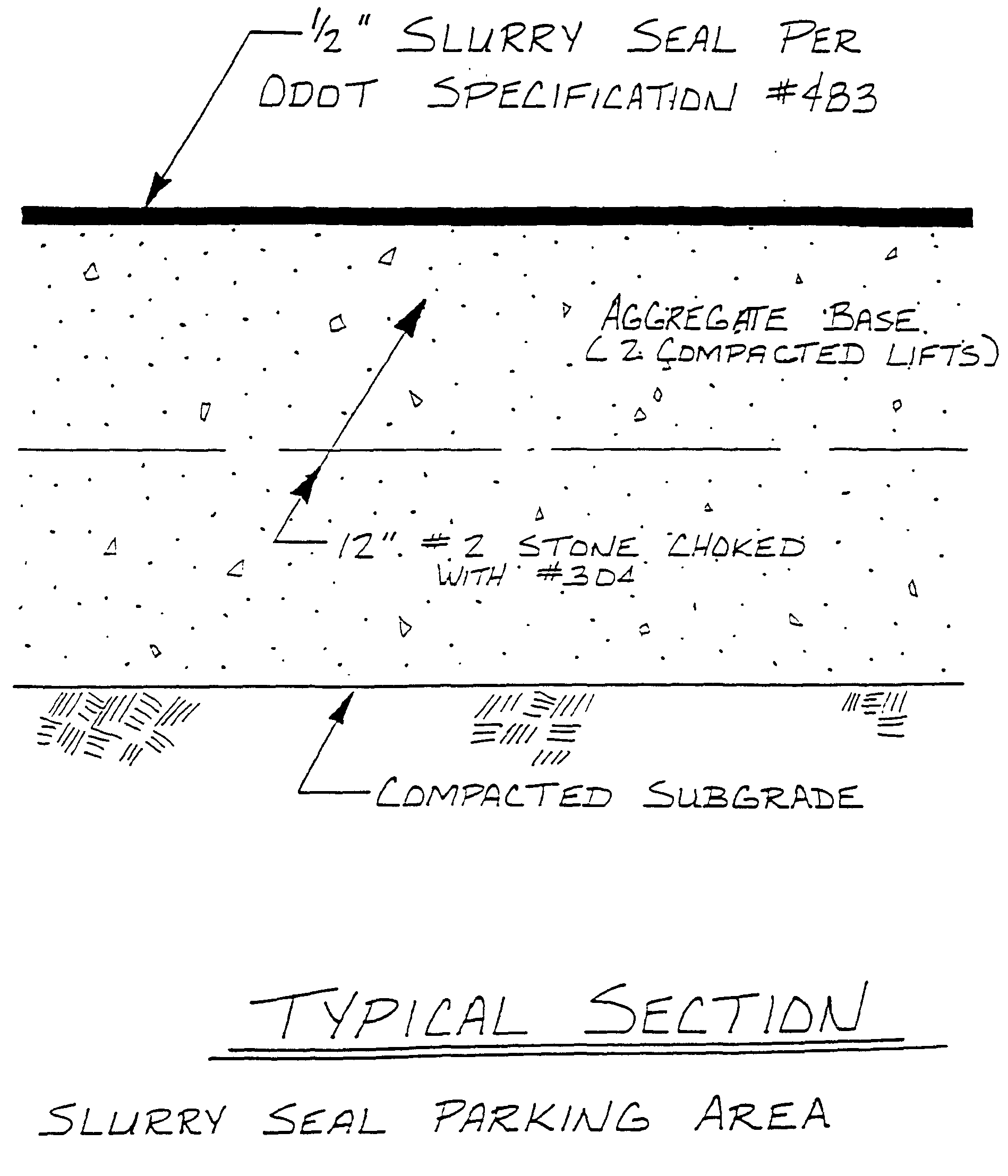
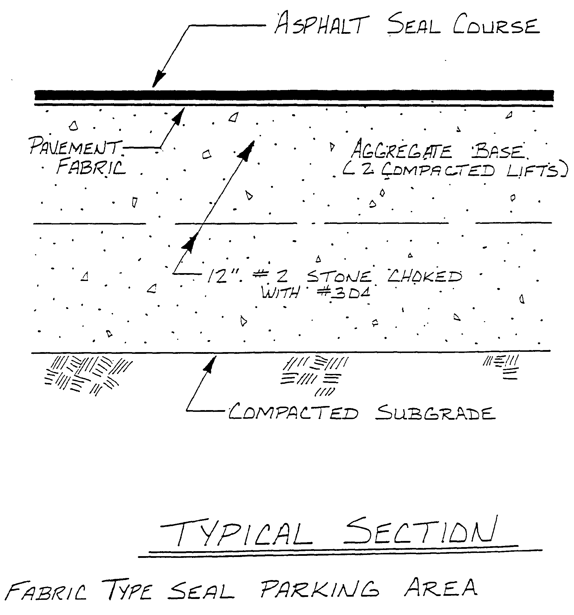
D.
A City zoning permit shall be required for any off-street parking area and any driveway opening onto a public street with a date of beginning of construction after the 31st day of December, 1990. The applicant shall secure all appropriate approvals from the City Engineer prior to the issuance of any zoning permit.
(3)
Single-family and two-family residential uses.
A.
A driveway for a single-family or two-family residence shall be counted as a parking space or spaces for such dwelling unit. Driveways shall be a continuous hard surface.
B.
Additional parking spaces in excess of the minimum required number of parking spaces shall be required to have a hard-paved surface when located in the side or rear yard of the lot, however, total coverage of impervious surface, including the dwelling, shall not exceed 50 percent of the total lot area.
C.
No parking of motor vehicles is allowed within the required setback of the right-of-way except on hard-paved surfaced driveways, roads or lanes leading to garages or carports, carport areas or portions of the houses originally constructed as garages or carports.
(4)
Driveway width.
A.
Residential Uses Single-Family and Two-Family.
1.
A driveway opening for one car or two car garage shall have a maximum width of 25 feet.
2.
A driveway opening for a three car garage shall have a maximum width of 28 feet.
B.
Nonresidential Uses (Including Multi-Family Residential Uses).
1.
All driveway openings shall have a minimum width of 25 feet. This provision may be modified by the City Engineer to allow for a second entrance lane and/or a left-turn exit lane for a large or intensive nonresidential or multi-family residential use. In no case shall any driveway opening exceed 35 feet in width.
C.
Curbing and Wheel Stops.
1.
Where required. A continuous curbing and/or the installation of wheel stops shall be required for any parking lot or portion thereof, as determined by the City Engineer where any of the following conditions exist:
a.
Encroachment of a vehicle into any traffic aisle, pedestrian walkway or sidewalk;
b.
Parking area abuts a wall, light standard, fence, landscaping island or strip, or any other structure; or
c.
A severe grade change or embankment steeper than five percent to prevent a vehicle from rolling down the embankment or into the hillside adjoining a parking area.
2.
Standards.
a.
All curbing shall be six inches in height and may be made of concrete, stone, timber or similar material approved by the City Engineer. The use of asphalt as a curb material shall be prohibited.
b.
Wheel stops shall be made of concrete at least six feet in length and permanently affixed to the paved surface beneath it.
c.
All curbing and wheel stops shall provide a minimum clearance of at least 30 inches from any adjacent sidewalk, traffic aisle, embankment, wall, fence or other structure so as to prevent encroachment as prohibited above in subsection (c)(4)C.1.a. hereof.
d.
A sidewalk adjacent to a building may be used as a curb or wheel stop provided that a curb having a minimum height of six inches abuts the sidewalk and that such sidewalk is a minimum of six and one-half feet in width.
(Ord. 90-O-450, Passed 12-3-90; Case 336; Ord. 92-O-534, Passed 3-9-92; Ord. 98-O-1073, Passed 9-28-98)
1185.04 - Drainage.
All off-street parking areas shall meet the standards for stormwater run-off control as adopted by the City.
(Ord. 90-O-450, Passed 12-3-90)
1185.05 - Marking.
Except for detached single-family dwellings, designated parking spaces shall be marked on the surface of the parking area with paint or permanent marking materials and maintained in a clearly visible condition. Where driveways intersect the public right-of-way, the paint lines dividing vehicle paths and other pavement markings shall be in accordance with the State Manual of Uniform Traffic Control Devices.
(Ord. 90-O-450, Passed 12-3-90)
1185.06 - Landscaping required.
All parking lots exceeding 20 parking spaces shall have interior landscaped areas in the overall design. This requirement shall be satisfied only by those landscaped areas encompassed by the perimeter of the parking lot. Required parking or paving setbacks, screening areas, or other landscaping required by this Zoning Ordinance shall not be utilized to meet any requirement of these landscaping provisions.
(a)
Any parking lot having a capacity of at least 20 parking spaces shall be required to have not less than five percent of the interior of the parking lot landscaped.
(b)
The landscaped area shall include at least one tree (not less than one and three-fourths inch caliper, measured at chest height of a species approved by the City Engineer or his designee) for every 100 square yards of interior landscaped area, living plantings aesthetically located and maintained.
(c)
All landscaped areas shall be designed and located in a manner that clearly defines internal streets, traffic lanes and parking areas and to standards acceptable to the Department of Engineering, Zoning and Planning.
(1)
Landscaped areas shall have a minimum width of five feet.
(2)
A turning radius shall be constructed where a landscaped area defines an intersection of streets, traffic lanes or parking stalls.
(3)
Concrete curbing shall be placed around the perimeter of all landscaped areas.
(4)
Intersection sign distance shall be maintained at all entrance and exit points to a public street and all internal intersections of streets and traffic lanes.
(Ord. 90-O-450, Passed 12-3-90)
1185.07 - Parking spaces for people with disabilities.
Parking spaces designated for people with disabilities shall be in compliance with the accessible parking space design set forth in the Americans with Disabilities Act Accessibility Guidelines (ADAAG) for Buildings and Facilities. The number and location of the designated spaces shall be in compliance with the requirements of the ADAAG (ADAAG 4.1.2) as follows:
Such accessible parking spaces shall be at least ten feet wide by 18 feet deep with a five-foot access aisle on one side. One in every eight accessible parking spaces, but not less than one, shall be served by an access aisle of eight feet wide minimum to provide "van accessible" parking space(s). Both the five- and eight-foot wide aisles shall be connected to an accessible route to the appropriate accessible entrance of a building or facility. Access aisles shall either blend with the accessible route or have an adjoining ramp meeting the ADAAG requirements. Two accessible parking spaces may share a common access aisle. Design drawings for accessible parking spaces are on file in the office of the Zoning Officer.
Accessible parking spaces shall be designated as reserved by a visible free-standing or wall-mounted traffic control sign and by paint marking on the hard surface pavement at the entry point of the space both showing the symbol of accessibility. If designating a van accessible parking space, both the sign and paint marking shall have an additional sign or marking "Van Accessible" mounted or marked below the symbol of accessibility. Both the freestanding sign and wall-mounted sign shall be mounted on a pole or wall least four feet above the finished grade of the hard surface pavement.
(Ord. 2000-O-1172, Passed 3-27-00)
1185.08 - Mixed uses.
The total requirement for off-street parking facilities for mixed occupancies or for parking areas shared by two or more buildings shall be the sum of the requirements for the various uses computed separately.
(Ord. 90-O-450, Passed 12-3-90)
1185.09 - Joint use of parking spaces.
The City Engineer and the Zoning Officer may authorize a reduction in the total number of required off-street parking spaces for two or more nonresidential uses providing their respective hours of operation do not normally overlap. Such uses might include restaurants, theaters, churches, school auditoriums, banks, business or professional offices, and retail or personal service establishments. Reduction of joint use parking shall be subject to the following conditions:
(a)
Not more than 50 percent of the total number of off-street parking spaces required may be located on another premises subject to the location restrictions of this chapter.
(b)
The applicant shall submit data of sufficient reliability to present clear and convincing proof, as determined solely by the City, to indicate that there is no substantial conflict in the principal operating hours of the uses proposing to make use of the joint parking facilities.
(Ord. 90-O-450, Passed 12-3-90)
1185.10 - Location.
(a)
Single or Two-Family Residential Uses.
(1)
Front, side or rear-yard parking shall be permitted for single or two-family residential uses.
(2)
The total paved area shall not cover more than the lesser of the following: 35 percent of the required front yard of a single or two-family residential use; or a maximum of two-car width. These parking surfaces by definition shall be hard surfaced.
(b)
Multi-Family Residential or Nonresidential Uses. All off-street parking shall be located behind the minimum front, side or rear setback line.
(c)
Zoning District. All required off-street parking shall be located in the same zoning district as the use served or a zoning district where the use served is a principal permitted use or a use requiring special approval, and in the latter situation such special approval shall be granted for this parking.
(d)
Proximity to the Use Served.
(1)
All required off-street parking facilities shall be situated on the same lot as the use it is intended to serve. However, if the Zoning Officer or City Engineer determines that it is not feasible for a building or use to fulfill its total parking requirement on the premises, parking may be located off-premises provided that:
A.
The farthest public or customer parking space is not more than 400 feet away from the main entrance to the premises, measured in a straight line.
B.
The farthest employee parking space is not more than 1,000 feet away from the main entrance to the facility measured in a straight line.
C.
Any parking situated on a separate lot shall require a recorded agreement, a recorded easement and/or deed covenant, or other instrument(s) approved in advance by the City Attorney, guaranteeing that the parking of the separate lot shall be available and maintained in good condition as long as the use requiring that parking is in existence. Such deed covenant, recorded easement and agreement, and any other instrument(s) shall be recorded by the property owner in the office of the Montgomery County Recorder and a time-stamped copy showing the Microfiche recording numbers must be filed with the Zoning Department before the parking may be used.
D.
Such parking area meets all other requirements of this Zoning Ordinance.
(2)
In no event shall the required parking for a residential use be located elsewhere than on the lot for which such parking is required.
(Ord. 90-O-450, Passed 12-3-90)
1185.11 - Parking provided under separate ownership.
If a use requiring parking spaces is in one ownership and all or part of the required parking spaces provided is in another ownership, the property owners involved shall submit an easement, deed covenant or other legal agreement or instrument(s) approved in advance by the City Attorney, guaranteeing that the required parking spaces shall be available and maintained, and in good condition as long as the use requiring parking is in existence or unless the required parking is provided elsewhere in accordance with the provisions of this Zoning Ordinance. Such instrument shall be recorded by the property owner in the office of the Montgomery County Recorder and a time-stamped copy showing the Microfiche recording numbers shall be filed with the Zoning Department before the parking lot may be used.
(Ord. 90-O-450, Passed 12-3-90)
1185.12 - Computation.
(a)
Number of Spaces Rounded Up. When determination of the number of off-street parking spaces required by this chapter results in a fraction that is less than a whole, such fraction shall be rounded up to a whole number and counted as one parking space.
(b)
Units of Measurement. For the purpose of determining off-street parking requirements, the following units of measurement shall apply:
(1)
Floor area. Floor area for nonresidential purposes shall be the sum of the gross horizontal area of all floors of a building measured from the exterior faces of the exterior walls.
(2)
Hospital beds. In hospitals, bassinets shall not be counted as beds.
(3)
Places of public assembly.
A.
Benches. In stadiums, sports arenas, churches and other places of assembly in which those in attendance occupy benches, pews or other similar seating facilities, each 20 inches of such seating facilities shall be counted as one seat.
B.
Fixed Seats and Assembly Areas. In cases where a place of assembly has both fixed seats and open assembly area, requirements shall be computed separately for each type and added together.
(4)
Employees on the largest work shift. Employees on the largest work shift means the maximum number of employees which could be employed at a facility, regardless of whether any such person is a full-time employee. The largest work shift may be a particular day of the week or a lunch or dinner period in the case of a restaurant.
(5)
Capacity. Capacity means the maximum number of persons which may be accommodated by the use as determined by Fire Code regulations.
(c)
Number of Parking Spaces Required.
(1)
Residential uses.
A.
Single-family or two-family residential with a date of final plat approval after the 31st day of December, 1990: three spaces per dwelling unit.
B.
Planned Unit Development (PUD) with a date of detailed development plan approval 31st day of December, 1990: three spaces per dwelling unit.
C.
Multi-family residential: two spaces per dwelling unit.
(2)
Special residential uses.
A.
Dormitory, convent or monastery: one space per six residents plus one space per employee.
B.
Corporate guest house: one space per two bedrooms, plus one space per employee.
C.
Residence family or group home: one space per four residents plus one space per employee.
D.
Retirement village or senior citizen housing: one space per dwelling unit, plus one space per employee.
(3)
Institutional and recreational uses.
A.
Cemetery: one space per employee, plus one space per four seats in any chapels.
B.
College, university or seminary: one space for every three student classroom seats, plus one space per employee.
C.
Community center, library, museum, art gallery, botanical garden or other establishments of historical, educational and cultural interest: one space per 250 square feet of gross floor area, plus one space per employee on the largest work shift.
D.
Day care, kindergarten or nursery: one space per employee, plus one space per five children at capacity, plus a drop-off area consistent with the provisions of this chapter.
E.
Elementary or junior high school: one space per employee, plus one space per two classrooms.
F.
High school: one space per employee, plus one space per six students at capacity.
G.
Hospital or medical center: one space for every two beds, plus one space for every staff and employee on the largest work shift.
H.
Place of worship: one space per four seats at maximum capacity in the main auditorium.
I.
Public office or building: one space for every 250 square feet of gross floor area.
J.
Nursing or personal care facility, including a nursing home, extended care facility, rest home or convalescent home: one space per six beds, plus one space for each staff and employee on the largest work shift.
K.
Recreational Uses, Indoor and Outdoor. In addition to the following requirements, all recreational uses shall provide one space for every two employees on the largest work shift.
All recreation uses shall provide the total number of spaces required for the specific combination of recreational facilities, provided, based on the following:
1.
Auditorium, arena, stadium, gymnasium or a playing field with stands: one space for every four seats at capacity.
2.
Golf course: ten spaces per hole, plus 50 percent of the spaces otherwise required for any accessory uses, (such as a bar, restaurant or pro shop).
3.
Park, playground, nature area or open space: one space for every five users at maximum capacity. The City Engineer or the Zoning Officer may waive any portion or all of this requirement for neighborhood parks, nature areas and open space providing there is adequate on-street parking.
4.
Recreation center: one space for every 250 square feet of floor area, except those designed for use exclusively by senior citizens or youth under age 16, in which case there shall be one space for every 750 square feet.
5.
Skating rink: one space per 300 square feet of gross floor area.
6.
Swimming pool: one space for every 75 square feet of water surface area.
7.
Tennis, racquetball or handball court: indoor - four spaces for each playing court; outdoor tennis court - two spaces for each court.
(4)
Business and professional offices.
A.
Animal hospital or veterinary clinic: three spaces for each examination room, plus one space for each staff and employee.
B.
Business, professional office or association: one space per 300 square feet of gross floor area, but not less than two spaces per office.
C.
Medical office or clinic: three spaces per treatment or examination room or chair, plus one space per staff member and also per employee, but not less than five spaces per practitioner.
(5)
Retail commercial and service uses.
A.
Commercial school or studio: one space for every three students at capacity and one space for each employee.
B.
Commercial stable: one space for every two (two horses (or other riding animals), based on the number of horse stalls or maximum number of horses permitted on the property, plus one space for each employee on the largest shift.
C.
Cleaning service: one space for every 300 square feet of sales and office area, plus one space for every employee on the largest work shift, plus one space for every company or service vehicle regularly parked on the premises.
D.
Financial establishment, bank or savings and loan association: one space per 200 square feet of gross floor area, plus one space per employee on the largest work shift, plus five stacking spaces per drive-in window or drive-thru machine.
E.
Funeral home or mortuary: one space for every 50 square feet of public floor area, plus one space for each employee, plus one space for each business vehicle.
F.
General merchandise store or supermarket: one space for each 150 square feet of gross floor area used for sales and display and one space for every 250 square feet of storage, warehouse and office area.
G.
Home furnishing, home improvement or equipment store: one space for each 400 square feet of indoor and outdoor sales and display area and one space for each 800 square feet of office, storage and warehouse area.
H.
Nursery or garden supply store: one space for each employee on the largest shift, one space for each 200 square feet of gross floor area of inside sales or display and one space for each 1,000 square feet of exterior sales and display area.
I.
Pet store: one space for every 200 square feet of gross floor area.
J.
Restaurant, table service or cafeteria style: one space per two seats, plus one space per two employees on the largest shift with a minimum of 15 total spaces.
K.
Specialty retail commercial, specialty food store, personal service and commercial center, shopping center: one space for every 200 square feet of gross floor area less than 2,000 square feet and one space for every 250 square feet of gross floor area greater than 2,000 square feet, except that commercial entertainment uses in commercial centers shall provide additional parking as required in subsection (c)(6) hereof.
(6)
Road service and commercial entertainment uses.
A.
Automobile accessories sale or installation: two spaces for every service bay, plus one space for every 400 square feet of sales area.
B.
Automobile filling station and auto repair, painting, and body shop: two spaces for each service bay, plus one space for each employee on the largest shift, and also one space for each service vehicle; with a minimum of six spaces, plus one space for every 125 square feet of retail floor area if a convenience store is an accessory use.
C.
Automobile washing facility: one space for each employee with a minimum of four spaces, plus five off-street waiting spaces for each car-washing device or stall, or 15 off-street waiting spaces for an assembly-line type washing establishment, and two parking spaces at the end of each washing bay for drying and hand-finishing vehicles.
D.
Commercial Entertainment.
1.
Bowling alley: five spaces for each alley, plus any additional spaces required for a bar, restaurant or other accessory use.
2.
Assembly or exhibition hall: one space for every 50 square feet of floor area.
3.
Game room and sweepstakes cafe: one space for every two patrons at maximum capacity, plus one space for every two employees on the largest work shift.
4.
Golf-driving range: one space per tee, plus one space per employee on the largest work shift.
5.
Miniature golf: one and one-half spaces per hole, plus one space per employee on the largest work shift.
6.
Other outdoor commercial entertainment: one space for every four patrons at maximum capacity, plus one space for every two employees on the largest work shift.
7.
Theatre, concert hall or meeting and banquet hall: one space for every two and one-half seats at capacity.
E.
Convenience food store, mini-market or carry-out: one space for every 125 square feet of floor area.
F.
Drive-thru store, including a photo kiosk or freestanding automatic-teller machine: one space for each employee, plus stacking space for five vehicles, plus one space for each 200 square feet of sales area open to the public.
G.
Fraternal and social association or private club: one space for every 50 square feet of floor area in assembly or meeting rooms, plus one space for every 200 square feet of other floor area.
H.
Hotel or motel: one space per room or suite, plus one space for every three employees on the largest work shift, plus one space per three persons to the maximum capacity of each public meeting and/or banquet room, plus 50 percent of the spaces otherwise required for accessory uses (such as restaurants and bars).
I.
Restaurant, fast food: one space per two seats, plus one space per two employees on the largest shift with a minimum of 15 total spaces plus stacking space for eight vehicles shall be provided for each drive-in window, with such stacking spaces to be located behind the point where a drive-in order is placed.
J.
Tavern, bar or nightclub: one space for every 50 square feet of gross floor area, plus one space for each employee on the largest work shift.
K.
Vehicle sale or service: one parking space for each 800 square feet of floor area, plus one space for each 3,000 square feet of open lot area devoted to the sale and display of motor vehicles.
(7)
Light industrial uses.
A.
Construction trade, contractor office or industrial craft shop: one space for every 300 square feet of floor area, plus one space for every business vehicle.
B.
Lumberyard or building materials sale: one parking space for each 800 square feet of floor area, plus one space for every 3,000 square feet of lot area devoted to the storage and display of building materials.
C.
Manufacturing, printing, and publishing establishment; and laundry and dry cleaning plant: one space for each employee on the largest work shift, plus one visitor parking space for every 10,000 square feet of floor area, plus one space for every company vehicle regularly stored on the premises.
D.
Recycling center: one space for each employee or volunteer on the largest work shift, plus one parking space for each collection vehicle and two drop-off spaces for each bay and/or collection vehicle and container.
E.
Warehouse and mini-warehouse: one space for every 4,000 square feet of gross floor area, plus one space per employee on the largest work shift.
F.
Wholesaling facility: one space for every 300 square feet of office and sales area; plus one space for every 4,000 square feet of warehouse and storage area; plus one space per employee on the largest work shift.
G.
Service yard or garage: one space for each employee on the largest work shift; plus one space for each business vehicle.
All other uses under these categories that are not specifically mentioned shall provide the greater number of parking spaces as calculated by the following requirements: one space for each employee, or one space for every 500 square feet of horizontal building area, or one space for every 1,500 square feet of vacant land.
(Ord. 90-O-450, Passed 12-3-90; Ord. 2012-O-1948, Passed 3-12-12)
1185.13 - Off-street loading.
(a)
Any building or structure constructed, structurally altered, enlarged or having a change of use, which requires a greater number of off-street loading spaces or which also requires the receipt or distribution of materials or merchandise by trucks or similar vehicles, shall provide off-street loading spaces or berths as required in this chapter.
(b)
Design Standards.
(1)
Dimension. Each off-street loading space shall be at least ten feet in width by 25 feet in length with a vertical clearance of 15 feet or more and adequate area for ingress and egress.
(2)
Access.
A.
Each required loading space shall be served by access to a street, service drive or alley in a manner that shall not unreasonably, at the City's sole discretion, interfere with traffic or parking lot circulation. All such openings shall be approved by the City Engineer.
B.
No loading space shall be located in such a manner as to allow a vehicle to back onto a public street or to extend into the right-of-way while being loaded or unloaded.
C.
All access to loading spaces shall meet the access control requirements of the City's access control policy.
(3)
Surfacing and drainage. All loading areas shall be graded as necessary and improved with asphaltic concrete or portland cement and shall meet the standards for stormwater runoff control as adopted by the City.
(4)
Off-street loading areas shall not be located in any front yard or within 25 feet of any street right-of-way, except for areas used for the occasional drop-off or pick-up of goods in vans, step vans, panel trucks or smaller vehicles.
(5)
Marking. Designated loading areas shall be marked as such on the surface of the loading area with paint or permanent marking materials that is maintained in clearly visible condition.
(c)
Utilization.
(1)
No storage, motor vehicle repair work or service of any kind (other than for an emergency) shall be permitted within any required loading berth.
(2)
Space allocated to a required loading berth shall not be used to satisfy any requirement of this Zoning Ordinance for off-street parking spaces.
(d)
Number of Loading Spaces Required.
(1)
Institutional, public assembly and residential buildings.
A.
School, retirement, community, hospital, nursing home or other similar institutional use: one loading space for 20,000 to 200,000 square feet of gross floor area and one space for each additional 200,000 square feet or fraction thereof.
B.
Auditoriums, gymnasiums, stadiums, theaters, convention centers and other buildings for public assembly: one space for 10,000 to 20,000 square feet of gross floor area and one space for each additional 100,000 square feet.
(2)
Offices and financial institutions. one space for 5,000 to 75,000 square feet of gross floor area and one space for additional 25,000 square feet of gross floor area.
(3)
Retail commercial service, road service and commercial entertainment uses. For each establishment, one space for the first 10,000 square feet of gross floor area and one space for each additional 20,000 square feet of gross floor area.
(4)
Industrial uses. one space for the first 10,000 square feet of gross floor area and one space for each additional 50,000 square feet of gross floor area.
(Ord. 90-O-450, Passed 12-3-90)
1187.01 - Intent.
This Zoning Ordinance establishes separate districts, each of which is an appropriate area for the location of the uses which are permitted in that district. Within each established district as well as those which may be established by future amendments, there are and will be lots, uses of lands, structures, and uses of structures and land in combination which were lawful before this Zoning Ordinance was passed or amended but which would be prohibited, regulated, or restricted under the terms of this Zoning Ordinance or future amendments. Since such nonconformities are deemed incompatible with the districts in which they are located, it is the intent of this chapter to specify those circumstances and conditions under which such nonconformities shall be permitted to continue, but not to encourage their survival. Rather, it is the intent of this Zoning Ordinance to encourage either the conversion of nonconforming uses into conforming uses as soon as reasonably possible or their eventual and equitable elimination.
(Ord. 92-O-574, Passed 11-2-92)
1187.02 - Enlargement, expansion or extension.
Any nonconforming structure, or use which existed lawfully at the time of the adoption of this Zoning Ordinance and which remains nonconforming, as well as any which shall become nonconforming upon any subsequent amendments thereto, may be continued but shall not be enlarged upon, expanded or extended nor be used as grounds for adding other structures or uses prohibited elsewhere in the same district except as provided for in subsequent sections of this chapter.
(Ord. 92-O-574, Passed 11-2-92)
1187.03 - Single nonconforming lots.
(a)
In any district in which single-family dwellings are permitted, a single-family dwelling and customary accessory buildings may be erected on any single lot of record even through such lot fails to meet the requirements for area or width, or both, that are generally applicable in the district, if the following conditions are met:
(1)
As of the effective date of adoption or amendment of this Zoning Ordinance creating a nonconformity as to lot width or area, erection of such a dwelling and accessory buildings on the lot would have been lawful;
(2)
Such lot shall be in separate ownership from contiguous lots and not of continuous frontage with other lots in the same ownership; and
(3)
Yard dimensions and requirements other than those applying to area or width, or both, of the lot shall conform to the regulations for the district in which such lot is located.
(b)
Any variances of yard requirements other than lot area or lot width required to permit the erection of such a dwelling and accessory buildings shall be obtained through action of the Board of Zoning Appeals as provided in Chapter 1127.
(c)
No other nonconforming lots may be built upon.
(Ord. 92-O-574, Passed 11-2-92)
1187.04 - Nonconforming lots of record in combination.
If two or more lots or a combination of lots and portions of lots with continuous frontage in single ownership are of record at the time of adoption or amendment of this Zoning Ordinance and if all or part of the lots considered separately do not meet the requirements established for lot width and area, the lands involved shall be considered to be an undivided parcel for the purposes of this Zoning Ordinance. No portion of such parcel shall be used or sold in a manner which diminishes compliance with lot width and area requirements, nor shall any division of any parcel be made which creates a lot with a width or area below the requirements stated in this Zoning Ordinance. If such a division shall occur, the resulting properties shall not be nonconforming buildable lots pursuant to Section 1187.03.
(Ord. 92-O-574, Passed 11-2-92)
1187.05 - Nonconforming uses of land.
(a)
Nonconforming uses of land may be continued so long as they remain otherwise lawful, provided:
(1)
No such nonconforming uses shall be enlarged or increased, nor extended to occupy a greater area of land than was occupied at the effective date of adoption or amendment of this Zoning Ordinance creating such nonconformity.
(2)
No such nonconforming uses shall be moved in whole or in part to any portion of the lot or parcel other than that occupied by such uses at the effective date of adoption or amendment of this Zoning Ordinance creating such nonconformity.
(3)
No additional structure not conforming to the requirements of this Zoning Ordinance shall be erected in connection with such nonconforming use of land.
(4)
No existing structure devoted to a use not permitted by this Zoning Ordinance in the district in which it is located shall be enlarged, extended, constructed, reconstructed, moved or structurally altered except in changing the use of the structure to a use permitted in the district in which it is located.
(5)
Any nonconforming use may be extended throughout any parts of a building which were manifestly arranged or designed for such use at the time of adoption or amendment of this Zoning Ordinance, but no such use shall be extended to occupy any land outside such building.
(6)
If no structural alterations are made, any nonconforming use of a structure may, upon appeal to the Board of Zoning Appeals, be changed to another nonconforming use provided that the Board shall find that the proposed use is equally appropriate or more appropriate to the district than the existing nonconforming use. In permitting such change, the Board may require appropriate conditions and safeguards in accord with other provisions of this Zoning Ordinance.
(7)
Any land, structure or structure and land in combination, in which a nonconforming use is superseded by a permitted use shall thereafter be used only in conformance with the regulations for the district, and the nonconforming use may not thereafter be resumed.
(8)
If any such nonconforming uses of land are discontinued or abandoned for more than one year (except when government action impedes access to the premises), any subsequent use of land shall conform to the regulations specified by this Zoning Ordinance for the district in which such land is located.
(9)
Where nonconforming use status applies to a structure and land in combination, if a structure is moved or destroyed, as defined in this chapter, the nonconforming use status of the land shall be eliminated.
(Ord. 92-O-574, Passed 11-2-92)
1187.06 - Nonconforming structures other than signs.
(a)
Where a nonconforming structure other than a sign exists, such structure may be continued so long as it remains otherwise lawful, subject to the following provisions:
(1)
No such nonconforming structure may be enlarged, expanded or altered in a way which increases its nonconformity, but any structure or portion thereof may be altered to decrease its nonconformity.
(2)
Should such nonconforming structure or nonconforming portion of the structure be destroyed, as defined in this chapter, there shall be no reconstruction or repair of the structure except in full conformity with the provisions of this Zoning Ordinance.
(3)
Should such structure be moved any distance whatsoever for any reason, it shall thereafter conform to the regulations for the district in which it is located after it is moved.
(Ord. 92-O-574, Passed 11-2-92)
1187.07 - Nonconforming signs.
(a)
Where a nonconforming sign exists, such sign may be continued so long as it remains otherwise lawful, subject to the following provisions:
(1)
A nonconforming sign shall not be replaced by another nonconforming sign except that the substitution or interchange of poster panels, lettering, painted boards or demountable material on such nonconforming sign shall be permitted.
(2)
Minor repairs and maintenance of nonconforming signs such as repainting, electrical repairs and replacements, and neon tubing repair shall be permitted. However, no structural repairs or changes in the location, size or shape of the sign shall be permitted except to make the sign comply with the requirements of this chapter or to make it less nonconforming.
(3)
Should such nonconforming sign or nonconforming portion of the sign be destroyed, as defined in this chapter, there shall be no reconstruction or repair of the sign except in full conformity with the provisions of this Zoning Ordinance.
(4)
Any nonconforming sign which is altered, except as provided for herein, relocated or replaced shall comply with all provisions of this chapter as if it were a new sign except as provided above.
(Ord. 92-O-574, Passed 11-2-92)
1187.08 - Repairs and maintenance.
On any nonconforming structure, or a portion or all of a structure containing a nonconforming use, ordinary repairs may be performed, including repair or replacement of walls or partitions, fixtures, wiring or plumbing, provided that the cubic content existing when it became nonconforming shall not be increased. Repairs may not be performed on any structure which has been destroyed, as defined in this chapter. Nothing in this chapter shall be deemed to prevent the strengthening or restoring to a safe condition of any structure or part thereof declared to be unsafe by any official charged with protecting the public safety, upon order of such official, except where the structure has been destroyed, as defined in this chapter. However, any such repairs shall, to the extent reasonably possible increase conformance with this Zoning Ordinance.
(Ord. 92-O-574, Passed 11-2-92)
1187.09 - Avoidance of undue hardships.
(a)
To avoid undue hardship, nothing in this Zoning Ordinance shall be deemed to require a change in the plans, construction or designated use of any building, planned or under construction, which complies with all the following provisions:
(1)
Any required building permit or zoning permit shall have been lawfully issued prior to the effective date of adoption or amendment of this Zoning Ordinance.
(2)
Actual building construction shall have begun within 90 days of the effective date of adoption or amendment of this Zoning Ordinance. Actual construction is hereby defined to include the placing of construction materials in permanent position and fastened in a permanent manner. Where excavation, demolition or removal of an existing building has substantially begun in preparation of rebuilding, such excavation, demolition or removal shall be deemed to be actual construction, provided that work shall be carried on diligently.
(3)
All construction work authorized by the issuance of the building permit shall have been completed within three years of the adoption or amendment of this Zoning Ordinance.
(Ord. 92-O-574, Passed 11-2-92)
1187.10 - Destroyed structure.
"Destroyed" for the purpose of this chapter is defined as damage to the structure to an extent of more than 50 percent of the replacement cost of the structure at the time of such damage, and includes damage due to any cause including but not limited to fire, vandalism, theft, explosion or act of God.
(Ord. 92-O-574, Passed 11-2-92)
1189.01 - Purpose; definitions.
(a)
The purpose of this chapter is to establish regulations governing the size, character and location of signs within the City and to regulate the erection, remodeling, enlarging, moving, operation, use and maintenance of such signs in the interest of protecting the health of its citizens and protecting the safety and welfare of those citizens and the property within its boundaries. It is intended to protect and enhance the physical appearance of the community, to preserve the scenic and natural beauty of designated areas, and to reduce sign distraction and site obstructions that might contribute to traffic accidents and have a negative impact upon traffic and pedestrian safety. It is intended to create a more aesthetically-pleasing City, to contribute to public safety, and to eliminate visual clutter within the City. The City finds that the number, size, design characteristics, and locations of signs within the City directly affect the public health, safety, and welfare. The City also finds that in certain areas of the City, signs have become excessive. Too many signs are distracting and dangerous to motorists and pedestrians and are confusing to the public and substantially detract from the beauty and appearance of the City. The City also finds that there is a substantial need directly related to the public health, safety and welfare to comprehensively address these concerns through the adoption of the following sign regulations. The purpose and intent of the governing authority of the City in enacting this chapter are as follows:
(1)
Permit signs that will not, because of their size, location, construction or manner of display, endanger the public safety of individuals, confuse, mislead or obstruct vision necessary for traffic safety, or otherwise endanger public health, safety and welfare;
(2)
Permit and regulate signs in such a way as to support and complement land use objectives set forth in this Zoning Code and promote community growth, pride, civic opportunities and events;
(3)
Reduce hazards that may be caused by signs overhanging or projecting into the public right-of-way;
(4)
Provide each legal property owner or tenant a fair and reasonable opportunity for effective identification of businesses which are located within the City;
(5)
Enable users of goods and services to readily identify the availability of products, goods or services which are available upon site so as to promote the economic vitality of businesses which are located within the City;
(6)
Minimize the obstruction of views from roadways to adjacent properties;
(7)
Advance and maintain, for the City's residents, workers and visitors, a safe and aesthetically attractive environment throughout the City;
(8)
To ensure the protection of free speech rights under the State and United States Constitutions within the City;
(9)
To establish a permit system to allow specific types of signs in zoning districts consistent with the uses, intent and aesthetic characteristics of those districts;
(10)
To protect the rights of property owners and occupants to display messages protected by the First Amendment to the United States Constitution. Therefore, the purpose of these regulations includes the intention to remove any doubt that it is the public's right to receive and display messages protected by the First Amendment, including but not limited to, religious, political, economic, social, and philosophical messages subject, however, to reasonable regulations to assure safety and minimize visual blight. It is the further purpose of these regulations to affirm that an expedient appeal process exists that addresses these First Amendment concerns.
(11)
To place reasonable controls on nonconforming signs that are by definition contrary to the public health, safety and welfare while protecting the constitutional rights of the owners of said nonconforming signs.
(b)
The following definitions shall apply in this Chapter:
Advertising structure means any sign, billboard, surface, object or structure with a commercial message.
Animated or moving sign means any sign or part of a sign which changes physical position by any movement or rotation, or which gives visual impression of such movement or rotation.
Awning means a roof-like cover that is temporary or permanent in nature and that projects from the wall of a building for the purposes of shielding an area of a structure and constructed of a rigid supporting framework with a canvas, vinyl, fabric or rigid covering.
Awning sign means a permanent sign that is mounted or painted on or attached to a seasonal or permanent awning structure.
Bandit sign is a sign that does not contain a commercial message and that is constructed, in whole or substantial part, of paper, cloth, canvas, plastic sheet, cardboard, wallboard, plywood, or other like materials that is not protected from exposure to the natural elements, but is made of weather-resistant materials that last for more than seven days but less than 60 days without significant loss through exposure to the elements or wear and tear.
Banner means a temporary sign composed of fabric or similar material not enclosed in a rigid frame, secured or mounted so as to allow movement caused by atmospheric conditions.
Billboard means any freestanding sign containing 100 or more square feet.
Canopy means a freestanding permanent roof-like shelter not attached to or requiring support from an adjacent structure.
Canopy sign means any permanent sign attached to or constructed in or on a canopy.
Changeable copy means a permanent or temporary sign on which copy is changed manually in the field.
Commercial Message means any sign wording, logo, or other representation that, directly or indirectly, names, advertises, or calls attention to a business, product, service, or other commercial activity. A message intended to direct attention to a political candidate, election issue, political, social, religious, community of public service issue or idea, aim, view point, aspiration or purpose and not intended to produce any commercial benefit or term to encourage a commercial transaction shall not be deemed a commercial message.
Commercial sign means a sign that contains a commercial message.
Directional sign means a sign directing vehicular or pedestrian movement onto and off the premises upon which such sign is located or within a premises upon which such sign is located.
Deteriorated means showing signs of weathering, rust, corrosion, exposed wiring, chipped paint or faces, cracked, broken, torn, or missing faces, or loose materials, or other evidence of disrepair.
Electronic copy sign means any sign, or portion of a sign, that displays an electronic image or video, which may or may not include text, including but not limited to television screens, plasma screens, digital screens, LED screens, video boards, holographic displays and similar media.
Exempt means signs exempted from permit requirements and not subject to the provisions of this Zoning Ordinance.
Flashing means any sign which contains an intermittent or flashing light source, or which includes the illusion of intermittent or flashing light by means of animation or any externally mounted light source.
Freestanding sign means a sign permanently suspended or supported by one or more uprights or braces in or upon the ground.
Ground sign means any permanent or temporary sign six feet in height or less placed upon the ground or attached to a supporting structure not attached to any building.
Governmental/Community sign means a sign erected and maintained pursuant to and in discharge of any governmental functions, or required by law, ordinance or other governmental regulation and such signs that are approved by the City as part of an annual holiday event or City activity.
Hazard and Prohibition Signs, for purposes of this chapter and section 1523.01 Hazardous and Prohibition signs, means signs warning of construction, excavation, or similar hazards, so long as the hazard exists.
Height of sign means the height of a sign which shall be computed as the distance from the base of the sign at normal grade to the top of the highest attached component of the sign. Normal grade shall be construed to be the lower of: existing grade prior to construction; or the newly established grade after construction, exclusive of any filling, berming, mounding or excavating solely for the purpose of locating the sign. In cases in which the normal grade cannot reasonably be determined, sign height shall be computed on the assumption that the elevation of the normal grade at the base of the sign is equal to the elevation of the nearest point of the crown of a public street or the grade of the land at the principal entrance to the principal structure on the zone lot, whichever is lower.
Human Sign means a sign held by or attached to a human being who stands or walks on the ground at a business or other location. A human sign includes a person dressed in a costume for the purpose of advertising or otherwise drawing attention to an individual, business, commodity, service, activity or product.
Illegal sign means any sign which is contrary to the requirements of this Zoning Ordinance and which does not satisfy the nonconforming specifications stated in this Zoning Ordinance.
Illuminated sign means a sign lighted by or exposed to artificial lighting either by lights on or in the sign or directed toward the sign.
Internal sign means a sign not intended to be viewed from public streets and located so as not to be visible from public street or adjoining properties, such as signs in interior areas of shopping centers, commercial buildings and structures, ball parks, stadiums and similar uses of a recreational or entertainment nature.
Marquee means any permanent structure which projects from a wall of a building above the ground or is fixed at the entrance way to a shopping center and plaza generally ten feet or more above the ground.
Nonconforming sign means any sign lawfully existing on the effective date of this Sign Code, or on the date of an amendment thereto which renders such sign nonconforming because it does not conform to all the standards and regulations of the amended Zoning Ordinance.
Pylon sign means a permanent sign that is mounted on a freestanding pole or other support in which the sign exceeds six feet in height.
Portable sign means a sign intended to be movable and not permanently affixed to a building, structure, vehicle or the ground. Any sign with provisions for attaching devices, such as, wheels for movement or transportation; any sign over six square feet made of materials other than wood, cardboard, canvas or paper products.
Projecting sign means a sign supported by a building wall or column and extending a distance not to exceed 42 inches from the wall or column.
Permanent sign means a sign permitted by Chapter 1189 to be located on a lot for an unlimited period of time.
Sign means any device, fixture, placard or structure that uses any color, form, graphic, illumination, symbol or writing to advertise, announce the purpose of or identify the purpose of a person or entity, or to communicate information of any kind to the public.
Sign area means the area of a sign face (which is also the sign area of a wall sign or other sign with only one face) which shall be computed by means of the smallest square, circle, rectangle, triangle or combination thereof that shall encompass the extreme limits of the writing, representation, emblem or other display, together with any material or color forming an integral part of the background of the display or used to differentiate the sign from the backdrop or structure against which it is placed, but not including any supporting framework, bracing or decorative fence or wall when such fence or wall otherwise meets Zoning Ordinance regulations and is clearly incidental to the display itself. For the purpose of this Chapter, sign area is the square foot measurement of one face. If the sign is multi-sided (more than two) or solid in nature as in two sides of a building, the allowing square foot area shall be determined by adding all the area of all sides of the sign and dividing by two but not to exceed the allowable sign area of that district.
Snipe sign is a sign that does not contain a commercial message and that, in whole or substantial part, is not made of weather-resistant material and not adequately protected from the natural elements.
Suspended sign means a sign that is suspended from the underside of a horizontal surface and is supported by such surface.
Temporary sign means a sign constructed of plywood, paper products, plastic or canvas intended to be displayed for a short period of time.
Under marquee sign means any sign attached to the underside of a marquee.
Wall sign means a sign which is located on or formed by the surface of the wall of a building. A mansard roof facade on a building shall be considered part of the wall.
Window sign means a sign that is applied or attached to the interior or exterior of a window or located in such manner within a building that it conveys a message to the exterior of the structure through a window.
(Ord. 2013-O-2016, Passed 1-28-13; Ord. No. 2019-O-2398, § 1, 10-14-19)
1189.02 - Exempted signs.
The following signs are not subject to the provisions of this chapter:
(a)
Governmental/Community signs.
(b)
Window Sign. Temporary-window signs constructed of paper, cloth or similar expendable material, including signs which are located inside a structure. Signs painted on or otherwise permanently affixed to the exterior of a window or made of metal, wood, plastic, or other permanent material and positioned in a window are subject to the provisions of Sections 1189.03 and 1189.04.
(c)
Hazard and Prohibition Signs and "No Trespassing", "No Parking", and other similar warning signs. The Huber Heights City Council has found that protecting the public safety and welfare of individuals in avoiding hazardous or dangerous areas is a compelling governmental interest that necessitates the permission of these type of signs without an express permit regardless if other similar signs in the same or similar zoning district or area are regulated or require a permit.
(d)
Holiday decorations that do not contain a commercial message.
(e)
Internal signs.
(f)
Official Flags. Official Federal, State or local government flags.
(g)
Human signs outside of the public right-of-way or on a City sidewalk. Provided, however, for safety concerns including but not limited to sight distance, in no event shall a human sign be permitted on a sidewalk within three feet from any traffic ingress or egress way that crosses such sidewalk.
(Ord. 2013-O-2016, Passed 1-28-13; Ord. No. 2019-O-2398, § 1, 10-14-19)
1189.03 - Prohibited signs and sign characteristics.
All signs not expressly permitted under this chapter or exempt from regulation hereunder in accordance with the previous section are prohibited in the City. Such signs include, but are not limited to:
(a)
Any sign or part thereof which is erected within or above a public right-of-way;
(b)
Any sign erected at or near any intersection of any streets in such a manner as to obstruct free and clear vision, or at any location where by reason of position, shape, or color, it may interfere with, obstruct the view of, or be confused with any Governmental/Community sign relating to traffic and safety or otherwise interfere with, mislead or confuse pedestrian or vehicular traffic;
(c)
Any sign mounted onto, above or incorporated into the roof of any building shall be prohibited unless otherwise specifically permitted by this chapter;
(d)
Any lighter-than-air, inflatable or kite-type sign or balloon situated on, attached or tethered to a premises;
(e)
Any sign utilizing an artificial illumination device which radiates an intensity, beam spread, glare or color which interferes with the vision of persons not located on the premises;
(f)
Any sign utilizing a fixed or mobile beacon, strobe light, searchlight, signaling light, spotlight or similar apparatus, equipment or device which is directed above or outside of a premises in such a manner so as to attract an unusual amount of visual attention of persons not located on the premises;
(g)
Any sign or part thereof which utilizes flame;
(h)
Any electronic copy sign where different copy changes are shown on the same lamp board except as permitted under Section 1189.07(j);
(i)
Any sign which conveys visual information that is obscene;
(j)
Any sign which has intermittent lighting, moves, rotates, blinks, flashes or has spinning devices or strings of spinning devices or similar type devices except for electronic copy signs permitted under Section 1189.07(j);
(k)
All banners, except as specified in Section 1189.07(a)(3)A. and 1189.07(e), streamers, pennants, strings and spinning devices;
(l)
Portable signs with a commercial message, except as authorized under temporary signs;
(m)
Commercial message signs located off-premises from the particular business advertised;
(n)
Signs with a commercial message that are painted on or attached to a stationary vehicle or trailer which is located in such a manner as to serve exclusively as permanent, temporary, or portable signage is prohibited. This shall not apply to vehicles or trailers parked behind or inside of a building, or in another manner where such vehicle or trailer is not visible from a public right-of-way. Motor vehicles regularly engaged in the cartage of goods or the transport of passengers is exempt from this restriction. This does not apply to a vehicle parked at a driver's residence and is the primary means of transportation to and from his or her place of employment.
(o)
Deteriorated signs.
Notwithstanding anything contained herein to the contrary, any sign that may be displayed pursuant to the provisions of this chapter may contain a non-commercial message.
(Ord. 2013-O-2016, Passed 1-28-13; Ord. No. 2019-O-2398, § 1, 10-14-19)
1189.04 - General provisions.
(a)
A sign shall be designed, erected, altered, reconstructed, moved and maintained in accordance with the provisions of this section, unless specifically modified by another section of this chapter.
(b)
(1)
Permits required. A zoning permit shall be obtained for erection, construction, relocation or alteration of any temporary or permanent sign unless exempted by this chapter. A sign shall comply with all City Zoning, Building, Electrical and Fire Codes. Application for a permit to install a temporary or permanent sign shall be made to the Zoning Officer upon a form provided by the Zoning Office. This application shall be accompanied by such information as may be required to assure compliance with all appropriate provisions of this chapter. Snipe signs and Bandit signs do not require permits.
(2)
Nonconforming structures. See Chapter 1187.
(3)
Maintenance of signs. Every sign, whether requiring a sign permit or not, shall be maintained in a safe, presentable and good structural condition at all times, including the replacement of a defective part, painting, cleaning and other acts required for the maintenance of the sign.
(4)
Dangerous or Deteriorating signs not permitted. A Deteriorating sign or a sign in dangerous condition shall not be permitted on any premises. Any such sign shall be removed or repaired.
(5)
Removal of dangerous or Deteriorating signs. The City Manager or his designee may immediately remove or cause to be removed any deteriorating sign or any dangerous sign which constitutes a nuisance, creates an immediate or potential danger to persons or property due to structural deficiencies, inadequate maintenance, or because of the location of the sign.
(6)
Removal of unlawful sign in the public right-of-way. The City Manager or his designee may remove or cause to be removed any unlawful sign in the public right-of-way.
(7)
Duration of a permitted sign. Any sign permitted in this chapter shall be considered to be a permanent sign unless otherwise stated in this chapter.
(8)
Variances. Requests for variances from the provisions of this chapter shall be permitted subject to the requirements and limitations set forth in Section 1127.03(c).
(c)
Discontinued signs: Signs, that are part of an establishment that has discontinued its operation for a period of 90 days or more, must be replaced with a blank face or entire sign structure removed within 14 days of receipt of notification from the Code Enforcement Administrator. Any such sign which does not conform to this chapter in regard to size and placement and which is not put back into use within 12 months of the actual discontinuance, in accordance with a lawful sign permit, must be totally removed and surrounding surfaces restored at the owner's expense. The cost, if performed by the city or its agent, along with a $250.00 administrative fee, shall be levied as an assessment against such property and the assessment shall be certified to the County Auditor and collected as any other assessment by the City.
(Ord. 2013-O-2016, Passed 1-28-13; Ord. No. 2019-O-2398, § 1, 10-14-19)
1189.05 - Types of signs.
(a)
Directional Signs. In addition to any other permanent or temporary sign permitted elsewhere in this chapter, signs directing vehicular or pedestrian movement onto and off the premises or within a premises shall be permitted on the basis of a compelling government interest in traffic safety provided that:
(1)
The sign face area shall not exceed two square feet per side.
(2)
Sign height shall not exceed three feet if located within 25 feet of a public right-of-way or eight feet in height in any other location.
(3)
The sign shall be located outside any public right-of-way, but shall not be subject to the general ground sign setback provision.
(4)
The sign shall pertain to the premises on which it is located.
(b)
Ground Signs.
(1)
Setback. Unless otherwise stated in this chapter, any temporary or permanent ground sign or any part thereof shall be set back a minimum distance of 15 feet from any right-of-way.
(2)
Landscaping requirement. A permanent ground sign shall require a single continuous landscaped area to be maintained beneath the sign in accordance with the following standards:
A.
The minimum landscaped area shall be equal to the area of the sign face.
B.
The landscaped area shall include all points where sign structural supports are attached to the ground.
C.
Where the required landscaped area is adjacent to a paved surface accessible to vehicular traffic, a raised barrier curb suitable to prevent the encroachment of vehicles shall be required. The minimum distance between the face of any required curb and any part of the sign shall be 30 inches.
D.
The landscaped area shall include live plantings aesthetically located and maintained. The use of concrete, asphalt or any other paved surface inside the required landscaped area beneath the sign shall be prohibited.
(c)
Projecting Signs. Projecting signs shall:
(1)
Not be less than 12 feet in height above a sidewalk and 15 feet in height above a driveway;
(2)
Be attached to the building wall with the sign face at an angle of 90 degrees and no part of the sign shall project more than 42 inches from the wall;
(3)
Not mask or interrupt a major architectural feature (such as, but not limited to, doors, windows or trim);
(4)
Not extend higher on the wall than the bottom height of any second-story window; and
(5)
Not extend more than three feet above the roof line of the building.
(d)
Wall Signs. Wall signs shall:
(1)
Not extend more than 12 inches from the wall of the building upon which they are mounted;
(2)
Not extend above the top of the wall and shall not extend beyond the limits of any wall to which they are attached;
(3)
Not mask or interrupt a major architectural feature (such as, but not limited to, doors, windows or trim); and
(4)
Have hidden structural supports.
(e)
Vending Machine Signs. Vending machines or similar devices either attached to a primary structure or enclosed within an independent freestanding structure shall be permitted two square feet of sign area for every one foot width of the vending machine structure not to exceed 20 square feet of total sign area.
(f)
Awning Signs.
(1)
Awning signs may be displayed in lieu of but not in addition to a wall sign for an individual establishment subject to the size and number limitations governing the placement of wall signs as set forth elsewhere in this chapter.
(2)
If illuminated, such awning shall have lighting concealed from view.
(3)
An awning sign shall not project higher than the top of the awning of which sign text is affixed.
(g)
Changeable Copy Area. Permanent ground signs located in "B" Districts as well as permitted special uses in Agricultural and Residential Districts may incorporate up to 50 percent of total sign area for changeable copy. All changeable copy signs shall be enclosed and locked securely in a clear glass, plastic casing or other suitable encasing material.
(h)
Major Commercial Development Signs. Commercial Developments in excess of ten acres in area and shopping centers of more than five acres in area located in B, O and I Districts and fronting on an expressway, principal arterial, major arterial, arterial or thoroughfare roadway shall be permitted one freestanding pylon sign per frontage up to a maximum of two pylon signs per development. Whenever possible a major commercial development sign should be located at or adjacent to the primary access road to the development.
(1)
Such a sign shall not exceed 100 square feet of sign area per face with a maximum of two sign faces permitted per sign. The second major development sign, where permitted, may not exceed 75 square feet of sign area per sign face.
(2)
Such a sign shall not exceed 25 feet in height.
(3)
Such a sign shall be set back a minimum of 15 feet from the right-of-way.
(4)
Such a sign shall be an on premises sign only.
(i)
Planned Unit Development Sign Programs. Signs which have been approved as part of a planned unit development sign program may vary from the requirements stated within this chapter. Variations permitted through a PUD sign program may include but are not limited to the following: total number of signs permitted, sign size, sign setback, sign height and percentage of sign area devoted to changeable copy or electronic copy. Such deviations are recognized to be primarily for safety or unique parcel configuration circumstances and are not intended to circumvent the intent of the sign code.
(j)
Temporary Signs.
(1)
Temporary signs with commercial message shall only be permitted to be displayed in conjunction with special events as defined immediately below. In no event shall temporary signs be permitted to be displayed solely as a supplementary means of identifying the existence of any business.
(2)
For the purpose of this section, the term "special event" means any activity held in the City not associated with the usual daily operation of the business Garage sale signs shall be regulated in accordance with Section 1181.15.
(3)
A maximum of one temporary sign with commercial message shall be permitted for any business establishment, at any one time.
(4)
Except as provided for further below, temporary signs with a commercial message shall be permitted to be displayed for a maximum of no more than three months during any calendar year.
(5)
All temporary signs with commercial message must be taken down within two business days following the end of any special event.
(6)
A permit must be obtained for the display of any temporary sign with commercial message in the City. Each permit obtained shall be valid for a period of only 30 days.
(7)
No temporary sign shall be permitted to be displayed in the right-of-way of any roadway.
(8)
All temporary signs with commercial message must be prepared in a professional manner with all copy being clearly legible.
(9)
All temporary signs must be adequately maintained. Signs which are damaged, dilapidated, or destroyed must be repaired or replaced by the owner within five days from the date the damage or destruction is brought to the owner's attention. If not repaired, such signs shall be removed by the City at the owner's cost.
(10)
No temporary sign shall be illuminated.
(11)
No temporary sign shall have more than two faces.
(k)
Snipe signs shall not be displayed for more than five days or until such time as they become deteriorated whichever is less.
(l)
Bandit signs shall not be displayed for more than 60 days or until such time as they become deteriorated whichever is less. Bandit signs are permitted in any Residential and Agricultural Zoning District.
(m)
No temporary sign, bandit sign or snipe sign shall be placed upon any utility or street sign pole or upon any public right-of-way.
(Ord. 2013-O-2016, Passed 1-28-13; Ord. No. 2019-O-2398, § 1, 10-14-19)
1189.06 - Signs permitted for residential districts.
The purpose of the residential district specific sign regulations includes the desire to preserve the noncommercial character of residential neighborhoods as such the regulation of the size, illumination, movement, materials, location and height of signs in residential districts will be different than commercially zoned districts.
(a)
Single or Two-Family Residential Use.
(1)
General.
A.
A sign permit for any permanent or temporary sign in this section shall not be required.
B.
Any sign shall not be illuminated.
C.
Projecting signs shall be prohibited.
(2)
Temporary ground signs.
A.
Temporary ground signs shall be permitted on any residential lot.
B.
The maximum size and height of a temporary sign located in any residential zoning district shall not exceed six square feet in area per sign surface and five feet in height and shall be in accordance with the provisions of Section 1189.05(j). Such signs shall not be subject to the general ground sign setback requirement.
(3)
Wall signs. Only one wall sign shall be permitted on each dwelling unit, and each sign shall not exceed two square feet in area.
(b)
Multi-Family Residential District.
(1)
Projecting signs or wall signs with a sign area larger than two square feet shall be prohibited.
(2)
Ground signs.
A.
Only one sign shall be permitted on each complex.
B.
The sign height shall not exceed six feet from ground level.
C.
The permitted sign area shall not exceed 32 square feet in sign face area or 64 square feet in sign area.
D.
The sign may be illuminated.
(3)
Temporary signs.
A.
Temporary projecting and wall signs shall be prohibited.
B.
Temporary ground signs shall be permitted on any residential lot.
C.
The maximum size and height of a temporary sign located in any residential zoning district shall not exceed six square feet in area per sign surface and five feet in height and shall be in accordance with the provisions of Section 1189.05(j). Such signs shall not be subject to the general ground sign setback requirement.
(Ord. 2013-O-2016, Passed 1-28-13; Ord. No. 2019-O-2398, § 1, 10-14-19)
1189.07 - Signs permitted for business, industrial or other nonresidential zoning districts.
(a)
General Provisions.
(1)
All permanent signs may be illuminated. Temporary signs shall not be illuminated.
(2)
No sign shall be located in such a manner as to be primarily viewed from residential property.
(3)
Number of signs permitted. A single-business establishment shall be permitted a maximum of two types of permanent sign identification unless otherwise permitted in this chapter.
A.
A single business shall be permitted one temporary commercial message banner sign for the following periods:
1.
Three day event twice a year.
2.
Grand opening or relocation of business for a period not to exceed 30 days.
3.
All such signs are limited to a maximum of 48 square feet.
4.
All other provisions in this chapter as they pertain to temporary signs remain in effect as written.
5.
Whoever violates or fails to comply with any provision of this subsection (a) is guilty of a minor misdemeanor. A separate offense shall be deemed to have been committed each day on which a violation or a failure to comply occurs or continues.
(b)
Ground Signs.
(1)
Only one ground sign shall be permitted on a premises.
(2)
The ground sign shall not exceed 75 square feet in total sign area.
(3)
Ground signs shall not exceed six feet from ground level.
(4)
Signs shall be set back a minimum of 15 feet from the right-of-way.
(c)
Wall Signs.
(1)
Single wall signs shall not exceed 75 square feet total area.
(2)
On structures with more than one visible side, a maximum of four wall signs could be allowed, providing that the total square footage of all the signs does not exceed 150 square feet.
(d)
Projecting or Suspended Signs.
(1)
Only one projecting or suspended sign shall be permitted for an individual business.
(2)
The projecting or suspended sign shall not exceed 75 square feet in area.
(3)
Projecting and suspended signs shall be a maximum of 15 feet in height, and shall not extend more than three feet above the roof line of a building.
(4)
Signs suspended from any building shall not project more than 42 inches from such building, and the bottom of such sign shall not be less than 12 feet above the finished grade or sidewalk.
(e)
Temporary Signs.
(1)
Only one temporary sign shall be permitted for each individual business establishment.
(2)
The maximum size of a temporary sign located on any property in a nonresidential zoning district in the City shall be 16 square feet per sign surface.
(3)
The maximum height of a temporary ground sign shall be five feet.
(4)
Temporary banner signs are permitted with the following restrictions.
A.
The maximum height of a temporary vertically-mounted, freestanding banner sign, commonly referred to as a feather sign, shall be 12 feet.
B.
A temporary banner sign, not including feather signs, shall be securely anchored to a structure.
(5)
All such signs shall conform with the provisions of Section 1189.05(j).
(f)
Permanent Marquee Signs.
(1)
A changeable copy marquee sign is permitted only on places of public entertainment, such as theatres, arenas, etc.
(2)
Total sign area permitted for a marquee sign shall not exceed 75 percent of total sign area allotted the building frontage.
(3)
The marquee sign shall not project above the top of the wall to which it is attached and shall not be less than nine feet in height from the sidewalk.
(4)
The marquee sign shall not extend more than 18 inches from the wall of the building upon which it is mounted.
(g)
Permanent Under Marquee Signs.
(1)
Only one under marquee sign shall be permitted per business establishment.
(2)
Signs attached to the underside of a marquee shall have a sign area no greater than six square feet per sign face.
(3)
Signs shall have a minimum clearance of nine feet from bottom of the sign to the sidewalk.
(h)
Permanent Awning Signs. On structures with more than one visible side, a maximum of four awning signs may be permitted (one sign per visible side).
(i)
Permanent Canopy Signs.
(1)
One or more canopy signs per street frontage shall be permitted per establishment.
(2)
Canopy signs may not project above or below canopy facing.
(3)
Total sign area permitted a canopy sign shall not exceed 50 percent of the total sign area allotted the primary building frontage.
(j)
Electronic Copy Signs. Free standing permanent ground signs or wall signs located in "B", "O" or "I" Districts may incorporate 50 percent of total sign area for electronic copy with a maximum letter copy of 18 inches in height.
(k)
Additional Temporary Signs in Nonresidential Zoning Districts.
(1)
A-Frame or T-Frame Sidewalk Signs.
(i)
Only one sidewalk sign is allowed for any one business establishment at one time and shall be located within five feet of such business.
(ii)
There shall be no time limit for sidewalk signs with the exception that the sign shall only be placed outside during the hours of the establishment's operation.
(iii)
Such signs shall not exceed 12 square feet in area with a maximum height of four feet.
(iv)
The sign shall be placed so that there shall be a minimum width of four feet of clear and passable sidewalk or walkway for pedestrians.
(v)
The sign must be freestanding and shall not be affixed, chained, anchored, or otherwise secured to the ground or to any pole, tree, tree grate, fire hydrant, railing or other structure.
(vi)
The sign must not interfere with the opening of car doors in legal spaces, or with the operation of wheelchair lifts and ramps, loading zones or bus stops.
(vii)
The sign shall be internally weighted so that it is stable and windproof.
(viii)
The City of Huber Heights shall be held harmless from any liability resulting from accident or injury caused by the placement and/or maintenance of such sign.
(2)
Canopy signs may not project above or below canopy facing.
(3)
Total sign area permitted a canopy sign shall not exceed 50 percent of the total sign area allotted the primary building frontage.
(Ord. 2013-O-2016, Passed 1-27-13; Ord. No. 2019-O-2398, § 1, 10-14-19)
1189.08 - Signs permitted for undeveloped or agricultural land.
(a)
Residential Zoned Land.
(1)
Permanent signs prohibited.
(2)
Temporary signs. The maximum size of a temporary sign shall be 16 square feet per sign surface with a maximum height not to exceed five feet and shall be permitted in accordance with the provisions of Section 1189.05(j).
(b)
Nonresidential or Agriculturally Zoned Land.
(1)
Permanent signs prohibited. Permanent sign(s) shall be prohibited.
(2)
Temporary signs. The maximum size of a temporary sign shall be 16 square feet per sign surface with a maximum height not to exceed five feet and shall be permitted in accordance with the provisions of Section 1189.05(j).
(Ord. 2013-O-2016, Passed 1-28-13; Ord. No. 2019-O-2398, § 1, 10-14-19)
1189.09 - Signs for property offered for sale or rent.
The City recognizes that from time to time certain parcels of land may be offered for sale or rent and to restrict the ability of the owner to advertise the sale or rental of such parcel on that parcel may present a hardship on the owner of the parcel. As such, in addition to any other sign permitted by this chapter, a parcel that is being offered for sale or rent may have an additional sign provided such sign shall:
(1)
Be allowed only during the period beginning that the parcel is for sale or rent and ending upon the sale or rental of the parcel. Such sign to be removed within 14 days after such sale or rental;
(2)
Be maintained in good repair and appearance by the owner at all times;
(3)
Such signs shall not exceed nine square feet per face in any Residential District, 24 square feet per face in Business or Office Districts, or 32 square feet per face in any Industrial District; Such signs must be setback a minimum of two feet from the existing recorded public right-of-way;
(4)
For property in proximity to Interstate 70 and State Route 4/235 as described in Section 1189.10. If such sign is installed within 200 feet of the right-of-way of Interstate 70 or State Route 4/235, the following regulations shall apply to that sign:
A.
The sign shall not exceed 100 square feet in total sign area.
B.
Such sign shall not exceed 25 feet in height above the natural ground elevation. However, where the natural ground elevation of the base of the sign is lower than the pavement surface of Interstate 70 or State Route 4/235 at the point where the travel lanes pass nearest the base of the sign, the height of the sign shall be measured from the elevation of such pavement surface.
C.
Such signs shall be set back a minimum distance of 15 feet from the right-of-way and a minimum distance equal to the actual height of the sign from any property zoned for residential use. If the ground sign is installed more than 200 feet from the right-of-way, the regulations stated in this chapter shall apply.
(Ord. 2013-O-2016, Passed 1-28-13; Ord. No. 2019-O-2398, § 1, 10-14-19)
1189.10 - Signs in proximity to Interstate 70 and State Route 4/235.
(a)
The following sign regulations will apply to lots meeting all of the following criteria:
(1)
The lot is located within the B-3 Business, PC Planned Commercial, EP Employment Park, PI Planned Industrial, or I-1 Light Industrial and Mixed-Use Districts; and
(2)
The lot either has:
A.
A minimum frontage of at least 100 feet along Interstate 70 or State Route 4/235 and no frontage along another arterial or collector roadway (other driveway openings); or
B.
A minimum frontage of 200 feet along Interstate 70 or State Route 4/235 and frontage along another arterial or collector roadways (other than driveway openings).
(b)
The provisions of Section 1189.07 and the remainder of this chapter shall continue to apply to these lots except as expressly modified below. Where the provisions of this section are found to be at variance with those of Section 1189.07, the provisions of this section shall apply. These provisions shall not apply to Planned Unit Development sign programs approved by the City which differ from the standards set forth below.
(1)
Ground signs. If a ground sign is otherwise permitted under Section 1189.07 and is installed within 200 feet of the right-of-way of Interstate 70 or State Route 4/235, the following regulations shall apply to that sign:
A.
The ground sign shall not exceed 200 square feet in total sign area.
B.
Such sign shall not exceed 40 feet in height above the natural ground elevation. However, where the natural ground elevation of the base of the sign is lower than the pavement surface of Interstate 70 or State Route 4/235 at the point where the travel lanes pass nearest the base of the sign, the height of the sign shall be measured from the elevation of such pavement surface.
C.
Such signs shall be set back a minimum distance of 15 feet from the right-of-way and a minimum distance equal to the actual height of the sign from any property zoned for residential use. If the ground sign is installed more than 200 feet from the right-of-way, the regulations stated in Section 1189.07 shall apply.
(2)
Wall signs. A total of 200 square feet in wall signage shall be permitted per structure provided, however, that the size of any wall sign shall not exceed 20 percent of the area of the face of the building to which it is attached.
(Ord. 2013-O-2016, Passed 1-28-13; Ord. No. 2019-O-2398, § 1, 10-14-19)
1191.01 - Location.
In any "R", "B", "A", "P-PD" or "I" District an accessory building not exceeding one and one-half stories or 14 feet in height may be permitted in any rear yard not within five feet of the side and rear lot lines. In order for any structure to be classified as an accessory building, it shall be at least five feet from any permanent structure.
(Case 269, 7-16-69; Case 411, 6-1-78; Ord. 81-O-08, Passed 8-3-81; Case 95, 3-9-87; Ord. 87-O-229, Passed 2-9-87)
1191.02 - Corner lots.
No accessory buildings on any corner lot shall be erected nearer to the street than the requirements herein contained for side yards on corner lots.
(Ord. 81-O-08, Passed 8-3-81)
1191.03 - Located in side yard.
An accessory building or garage attached to or located on the side of any dwelling shall be considered as part of the dwelling and not an accessory building, and all side yard regulations as specified in this Zoning Ordinance shall be provided.
(Ord. 81-O-08, Passed 8-3-81)
1191.04 - Storage shed.
One storage shed per lot or parcel is permitted in any "A" or "R" District provided it is not within five feet of any rear or side property line.
(Case 441, 4-16-80; Case 48, 8-23-84; Ord. 81-O-08, Passed 8-3-81)
1191.05 - Location for reverse vending machines.
One reverse vending machine is allowed in any "B" District as approved by the City Engineer based on the following criteria:
(a)
Conforms with Section 1191.01;
(b)
Does not obstruct visibility;
(c)
Does not obstruct traffic flow;
(d)
Lighting is not to interfere with adjacent uses;
(e)
Access to utilities;
(f)
Landscaping or screening, if necessary; and
(g)
The fee shall be in accordance with Section 1129.08.
(Case 89, 9-8-86; Ord. 86-O-216, Passed 9-8-86)
1191.06 - Temporary storage container.
(a)
Definitions. Temporary Storage Container("Unit") is defined as a structure manufactured primarily for temporary or moveable storage, including but not limited to PODS® (and similarly designed units) and metal shipping containers with strength suitable to withstand shipment, storage, and handling.
(b)
Restrictions. This is a permit required use/structure approved for use in any "R", "A", or "PR" District based on the following criteria:
(1)
Only one unit may be permitted on any property at any time for a maximum of 30 days, not more than three times per calendar year.
(2)
Each use requires a permit. Permits can be issued, and units onsite, consecutively, but not concurrently.
(3)
Unit must be placed on a driveway in front of or at the side of the building, totally visible from the right-of-way.
(4)
Unit must be placed behind the sidewalk.
(5)
Unit must maintain two feet of separation from any building located on the same parcel as the Unit.
(6)
Unit shall remain closed when not being loaded or unloaded.
(7)
No substance may leak from inside the unit. No trash or refuse may be stored within the unit. If damaged, the unit shall be removed.
(8)
No unit shall be located any closer to an adjacent parcel than the required minimum side or rear yard setback for accessory uses in the district the unit is located.
(9)
No Unit shall be used for human or animal occupation.
(10)
No Unit shall be larger than eight feet in width by eight feet in height by 16 feet in length.
(11)
No Unit shall be located in a public right-of-way.
(12)
No Unit shall be located in such a manner on any property as to create a public nuisance.
(13)
The City Planner is authorized to grant temporary exceptions to or modifications of this section in special circumstances where a necessity exists for the use, temporary building or structure. Such permission shall be limited to the time during which the use of such accessory building, structure or vehicle is reasonably necessary for the project for which such exception was granted.
(c)
A Unit used in conjunction with new construction sites may be permitted for longer than 30 days, but not longer than seven days after construction is complete.
(Ord. 2017-O-2296, Passed 10-24-17)
1193.01 - Definitions.
Trailer means any receptacle or means of transport in which something is carried or conveyed or travels, moves on skids, wheels or runners, without its own motive power and is designed so that it can be drawn by other means of motive power. Trailers include, but are not limited to nonpowered recreational vehicles.
Recreation vehicle means a transportation structure, self-propelled or capable of being towed by a passenger car, station wagon or small pickup truck, of such size and weight as not to require any special highway movement permits and primarily designed or constructed to provide temporary movable living quarters for recreational, camping or travel use, or to carry such equipment but not for profit or commercial use. It shall not be a mobile home but shall include (although not limited to) the following defined types of recreational vehicles:
(1)
Motor home means a vehicular unit built on or as a part of a self-propelled motor vehicle chassis primarily designed to provide temporary living quarters for travel, camping, recreation and vacation use.
(2)
Travel trailer means a rigid structure, without its own motive power, designed as a temporary dwelling for travel, camping, recreation and vacation use.
(3)
Camping trailer means a folding or collapsible vehicular structure, without its own motive power designed as a temporary living quarters for travel, camping, recreation and vacation use.
(4)
Truck camper means a portable structure without its own motive power designed to be transported on a power vehicle as a temporary dwelling for travel, camping, recreation and vacation use.
(Ord. 88-O-295, Passed 4-11-88)
1193.02 - Off-street parking in residential districts.
Except for routine and normal deliveries and service vehicles, the off-street parking commercial vehicles with load capabilities in excess of one ton and non-commercially licensed trucks with load capabilities in excess of one ton shall not be permitted in any residential district. Further, no off-street parking in any residential zoning district shall be permitted for any trailer, recreational vehicle, boat, inoperative or unlicensed motor vehicle, construction or farm equipment, or any vehicle designed or constructed to provide seating for more than nine people except as follows (each such object is subsequently referred to as a vehicle):
(a)
Any number of such vehicles may be parked off street in residential zoning districts as long as they are totally within an enclosed garage or accessory building. While parked within an enclosed garage or accessory building, all propane gas valves in such a vehicle shall be in a closed position.
(b)
To the extent there is no garage or accessory building on the premises that can accommodate the vehicle(s), such vehicle(s) may be parked outside in an interior side yard or rear yard but not in a corner lot side yard. The intent is to allow the owner of such vehicle(s) an option to park in his garage or in a suitable location as defined herein. Outside parking of the vehicle(s) shall be subject to the conditions set forth below:
(1)
The area coverage of the vehicle(s) in respective zoning districts shall be as follows:
A.
R-1, R-2 and Agricultural Districts, coverage shall not exceed three and five-tenths percent of the total area of the lot.
B.
R-3 and R-4 Districts, coverage shall not exceed three and five-tenths percent of the total area of the lot with a maximum of two vehicles permitted.
C.
All other Residential Districts, one such vehicle may be parked outside.
(2)
The vehicle shall be properly licensed and registered as required by the State of Ohio for highway use.
(3)
No business may be conducted within the recreational vehicle while so parked except that a trailer may be used as a temporary office or shelter incidental to construction on or development of the premises on which the trailer is located (but only during the time such construction or development is actively underway).
(4)
The vehicle may not be permanently connected to electricity, water, gas or sanitary sewer lines. A recreation vehicle may be connected to electricity temporarily for charging batteries and other purposes as long as the receptacle and the connection meet requirements of the applicable Electrical Code.
(5)
The vehicle may not be used for dwelling purposes, except that a recreational vehicle owned by and under the control of someone who does not reside on the premises may be used for dwelling purposes by the visitor who has such control for a maximum of seven days in any calendar year. This limit of seven days applies to the residential real estate premises so that only seven days of dwelling usage may take place on that premises in any calendar year, regardless of the number of different recreational vehicles that may be parked there (one at a time) during that year.
(6)
The vehicle may not be used for storage of goods, materials or equipment other than those items considered to be a part of the vehicle.
(7)
The vehicle shall be maintained in good repair.
(8)
The vehicle shall be parked on a continuous hard surface equivalent in strength to the existing driveway. In order to allow convenient access for fire and safety personnel, no part of the vehicle may be closer than two feet to the principal building.
(9)
The vehicle shall be maintained at all times in such a condition that it can be transported. For example, wheels shall not be removed, tires shall not be flat, and the vehicle shall not be fixed to the ground.
(c)
If the measurements or terrain of the side yard and back yard are such that neither one can accommodate the vehicle, or if there is no reasonable access to side or rear yard that can accommodate the vehicle, such a vehicle may be parked on the driveway in the front yard subject to the conditions listed below. A corner lot is always deemed to have reasonable access to the rear yard, and a fence is not necessarily deemed to prevent reasonable access. The conditions for such driveway parking in the front yard are as follows:
(1)
All of the conditions listed above as being applicable to outside parking in the side or rear yard shall also apply to parking in the front yard driveway.
(2)
In front yards, the vehicle shall be parked on the designated driveway.
(3)
No part of the vehicle may be closer than 12 feet to the face of the curb.
(4)
No part of the vehicle may extend over the public sidewalk.
(5)
The vehicle may not impair a view of the right-of-way by persons on the right-of-way or about to enter it.
(6)
The wheels of such vehicle shall be chocked while parked.
(d)
As provided in Section 351.13 of the Codified Ordinances, a recreational vehicle may be parked on the street for purpose of loading, unloading and related activities for up to eight hours in a 24 hour period.
(Ord. 2006-O-1663, Passed 10-23-06)
1193.03 - Off-street parking in agricultural zoning districts.
(a)
There shall be no restriction upon the off-street, outside parking of farm equipment upon that part of land in any Agricultural Zoning District that is actually used for farming and agricultural operations (as opposed to dwelling use or any other use allowed in the Agricultural Districts). Similarly, there shall be no restriction on the off-street, outside parking of sawmill trailers or vehicles on that part of any land in an Agricultural Zoning District that is actually used for the temporary operation of a sawmill as permitted in such zoning districts.
(b)
Aside from the two exceptions described above, all of the language of Sections 1193.01 and 1193.02 that apply to Residential Zoning Districts shall be deemed to apply also to Agricultural Zoning Districts.
(Ord. 88-O-295, Passed 4-11-88)
1193.04 - Off-street parking in commercial and office areas.
(a)
Semis or semitrailers as defined in HHCO Chapter 1123 shall not be parked outside on properties in commercial or office zoning districts and properties being used as commercial and/or office in any industrial zoning district, except as provided below:
(1)
Semis or semitrailers may be parked in designated loading spaces on properties in a commercial or office zoning district and properties being used as commercial and/or office in any industrial zoning district provided the loading spaces meet the applicable requirements in HHCO Section 1185.13 and are approved by the City. Said parking of semis or semitrailers in the loading spaces shall not exceed a length of time reasonably necessary to load or unload the semis or semitrailers.
(2)
Semis may be parked in a parking lot on a property used for a restaurant, hotel, motel, moving service/lease company or filling station that provides fuel for semis as long as all the following conditions are met:
A.
A zoning certificate has been issued for the property showing the location of a designated parking space(s) for semis meeting the following requirements:
1.
The designated semi parking space(s) shall be at least 15 feet in width by 80 feet in length and provide adequate area for ingress and egress;
2.
The designated semi parking space(s) shall not be located in the front yard of the property;
3.
The designated semi parking space(s) shall not adversely affect the traffic circulation in the parking lot;
4.
The designated semi parking space(s) shall be clearly marked "FOR SEMI PARKING" and, the parking surface striped in accordance with HHCO Section 1185.05;
5.
A semi(s) shall only be parked in designated semi parking space(s) and shall not be parked in any other required off-street parking as required by the parking and loading regulations in HHCO Chapter 1185.
6.
Semi parking space(s) and area used as ingress and egress shall be constructed of material and base able to support the daily use of semis as approved by the city engineer;
7.
A semi(s) shall only be parked in designated parking space(s) on a business property while the operator or passenger is using the facilities on the business property;
8.
Semi parking space(s) shall only be permitted on property(s) for a restaurant, hotel, motel, moving service/lease company, or filling station that contains at least one acre. Each business property shall have no more than five semi parking spaces for each acre of the business property. In no case shall a business property have more than ten semi parking spaces. Properties shall be prorated by acreage for the number of semi parking spaces as outlined in the following scale:
For the purposes of this section, all parcels in common ownership and adjacent to the property on which the business is located shall be considered one property.
9.
A filling station that provides fuel for semis is permitted to have semi(s) parked at a semi designated fueling pump(s) or parked waiting in line for the purpose of refueling, in addition to the number of semi parking spaces permitted in subsection 8 of this chapter.
B.
The property must be a single tenant property. On properties with multi-tenants, including, but not limited to shopping centers or office buildings, the parking of semis shall be prohibited.
C.
In the case of a hotel or motel, the operator of the semi has paid for an overnight stay at said motel or hotel and said semi shall be clearly marked with material provided by the motel or hotel establishment, with a date, on the inside windshield verifying paid status.
D.
In the case of a moving service/lease company, said semi must be used as part of a moving service/lease company and shall be clearly marked as belonging to such moving service/lease company;
(3)
Semitractors may be parked in a parking lot owned by and used for a sales company as long as the semitractors are owned and are for sale or lease by the concerned sales company.
(b)
Vehicles that are unlicenced or inoperative shall not be parked off-street and outside on properties in any Commercial or Office Zoning District and properties being used as commercial and/or office in any industrial zoning district.
(Case 146, 7-10-89, Effective 8-9-89; Case 323; Ord. 89-O-363, Passed 7-10-89; Ord. 91-O-517, Passed 11-4-91; Ord. 98-O-1071, Passed 9-28-98)
1193.05 - Fire or safety regulations.
Nothing in this chapter shall be construed to waive the application or to violate any safety or fire regulation applicable to the residential property involved.
(Case 119, 5-11-88; Ord. 88-O-295, Passed 4-11-88)
1194.01 - Definitions.
[For purposes of this chapter the following definitions shall apply:]
Event Holder means a person, group or organization responsible for the hosting or operation of a Permitted Event.
Food shall mean a raw, cooked or processed edible substance, ice, beverage, or ingredient used or intended for use of for sale in whole or in part for human consumption.
Food Service Operation means, for the purpose of a mobile food vending permit, a place, location, site or separate area where food intended to be served in individual portions is prepared or served for a charge or required donation. As used in this chapter, "served" means a response made to an order for one or more individual portions of food in a form that is edible without washing, cooking or additional preparation and "prepared" means any action that affects a food other than receiving or maintaining it at the temperature at which it was received.
Health License means an official document issued by a department of health pursuant to Ohio R.C. 3701. Such document shall be an annual health license.
Ice Cream Truck means motor vehicles from which ice cream, popsicles, ice sherbets, frozen desserts or other similar items are sold.
Licensing Period means the first day of March to the last day of February of the next succeeding year.
Mobile Food Vehicle is defined as a readily movable, motorized-wheeled vehicle or a towed vehicle designed and equipped to prepare, or serve, and sell food to the general public.
Mobile Food Vending Permit means an official document issued by the Zoning Department authorizing operation of a mobile food vending unit within the corporate limits of the City of Huber Heights.
Mobile Food Vending Unit means a food service operation or retail food establishment that is operated from a mobile food vehicle. For the purpose of a mobile food vending permit, "mobile food vending unit" excludes food delivery operations and vending machines, as defined in Ohio R.C. 3717.01(L).
Mobile Food Vendor means every corporation, association, joint stock association, person, firm or partnership, their lessees, directors, receivers, trustees, appointees by any court whatsoever, or their heirs, executors, administrators, or personal representatives or assignees or any deceased owner, owning controlling, operating or managing any mobile food vending unit.
Non-incorporated Children's Stands shall mean a non-incorporated business that is commonly operated by a child or children to sell lemonade or other beverages and snack foods.
Operator means the individual who manages one or more mobile food vending units whether as the owner, an employee of the owner or as an independent contractor.
Permitted Event means a Special Event and/or a Public Event.
Public Event means any public activity or gathering or assemblage of people, other than a special event, that is open to the general public for admission that requires payment for entrance, attendance or participation, and requires the issuance of a health license or temporary health license pursuant to Ohio R.C. 3717.01 for participating mobile food vendors.
Revoke means to terminate all rights or privileges under a Mobile Food Vending Permit.
Special Event means any activity or gathering or assemblage of people upon public property or in the public right-of-way for which a street closure, race event, parade permit or other like permit has been issued by the City of Huber Heights.
Vending shall mean the sale of food to a person who is the ultimate consumer. Such sales do not include those from a vending machine, as defined in Ohio R.C. 3717.01(L).
(Ord. No. 2018-O-2352, § 1, 11-28-18)
1194.02 - Permit required for operation.
(a)
Except as provided in subsection (b) below, no individual or organization shall operate, or cause to be operated, any mobile food vending unit within the City of Huber Heights without a current and valid Mobile Food Vending Permit issued pursuant to this chapter and applicable Health License issued in accordance with laws, rules and regulations established in the Ohio Revised Code, the Ohio Administrative Code.
(b)
Mobile Food Vending Units, within the City, that only operate as part of a Permitted Event shall not require a Mobile Food Vending Permit. Such Mobile Food Vending Units must comply with any health licensing requirements of the State of Ohio and any Fire Code requirements of the City of Huber Heights.
(c)
Nothing in this chapter shall be construed as superseding, supplanting, or otherwise replacing any duty imposed by Ohio R.C. Chapter 3701 or 3717, or rules or regulations promulgated thereunder, upon an application for a health license, or upon a department of health in the conduct of its responsibilities relative to mobile food vending units.
(d)
Any Mobile Food Vehicle shall be subject to inspection by the City Fire Division and shall be charged a fee as designated in Chapter 1509 of the Fire Prevention Code.
(Ord. No. 2018-O-2352, § 1, 11-28-18)
1194.03 - Application for permit.
(a)
An application for a Mobile Food Vending Permit must be submitted by the owner of the Mobile Food Vending Unit to the City of Huber Heights Zoning Department. A separate application must be submitted for each Mobile Food Vending Unit. Application for a Mobile Food Vending Permit shall be on a form prescribed by the Zoning Department.
(b)
The applicant must provide proof of, and maintain during the Licensing period a valid driver's license for all drivers, vehicle registration, motor vehicle insurance, and liability insurance. The Operator shall provide such information for any new drivers that are used during the Licensing Period but after the Mobile Food Vending Permit has been issued.
(c)
The cost of a Mobile Food Vending Permit is $100.00 and shall be valid only for the Licensing Period for which it is issued. As a condition of accepting the permit, the applicant is required to sign the application agreeing to meet all the requirements pursuant to City code and to assume responsibility for the actions and omissions of its Operators in the performance of or failure to perform its obligations under the permit.
(d)
The Zoning Department must examine all applications for a Mobile Food Vending permit under this chapter and make, or cause to be made, any further investigation into the application as is deemed necessary in order to make a determination regarding the application within five business days.
(e)
If a complete application for a mobile food vending permit is not approved, any reason(s) for that determination shall be provided to each applicant in writing.
(f)
A Mobile Food Vending Permit application shall meet the following requirements:
(1)
Provide proof of and maintain a valid driver's license for all known drivers, vehicle registration, and current motor vehicle insurance;
(2)
Provide proof of and maintain an Ohio Retail Food license;
(3)
Provide proof of and maintain a valid sales use tax license;
(4)
Provide payment of the fee of $100.00;
(5)
Provide proof of a Federal income tax identification number or exemption from the City of Huber Heights division of tax;
(6)
Provide address of all proposed locations for the Mobile Food Vending Unit and proof of permission from property owner of proposed location(s);
(7)
Attest under oath that no Operator has had a Mobile Food Vending Permit issued by the City, or a similar permit or license issued by another city, revoked in the past two years; or if a revocation has occurred the reason for such revocation and proof of compliance.
(Ord. No. 2018-O-2352, § 1, 11-28-18)
1194.04 - Operating requirements.
(a)
Mobile Food Vehicles shall obtain all applicable approvals and permits, and shall follow all applicable processes as required by the City of Huber Heights and/or the Event Holder.
(b)
Mobile Food Vehicles shall comply with all local, state, and federal laws, regulations and ordinances.
(c)
Except for Mobile Food Vehicles operating within the City as part of a Permitted Event, Mobile Food Vehicles shall be permitted as follows:
(1)
Shall be permitted within the following districts:
a.
Industrial (I).
b.
Commercial (B).
c.
Planned Districts (PUD) as approved through the City's Planning Commission.
(2)
Shall be located on a lot containing a principal building and must be parked on a hard surface.
(d)
Operational Requirements. Except for Mobile Food Vehicles operating within the City as part of a Permitted Event the following shall apply:
(1)
Mobile Food Vehicles operating on private property in the above zoning districts shall be required to maintain a minimum separation of 200 feet from the primary entrance to, or outdoor eating area of, a restaurant, and 150 feet from residential zone districts. In addition, such vehicles shall also be required to maintain a minimum separation of 200 feet from any other mobile food vehicle and a minimum of 15 feet from any fire hydrant.
(2)
Mobile Food Vehicles shall not obstruct the pedestrian or bicycle access, the visibility of motorists, nor obstruct parking lot circulation or block access to a public street, alley or sidewalk.
(3)
Mobile Food Vehicles shall not locate any vehicle, structure, or device upon a public sidewalk within the extended boundaries of a crosswalk or within ten feet of the extension of any building entranceway, doorway or driveway.
(4)
Mobile Food Vehicles shall not fail to maintain and provide proof when requested of written consent from the private property owner authorizing the property to be used for the proposed use with regard to Mobile Food Vehicle sales on private property.
(5)
Mobile Food Vehicles shall not operate before 8:00 a.m. or after 9:00 p.m. No Mobile Food Vehicle shall conduct business for more than four hours at the same property for more than five consecutive days, nor more than 26 days total in a calendar year.
(6)
Mobile Food Vehicles shall not sell anything other than food and non-alcoholic beverages.
(7)
Mobile Food Vehicles shall not provide amplified music louder than the City's noise ordinance.
(8)
Mobile Food Vehicles shall not place signs/banners in or alongside the public right-of-way or across roadways. Signs must be permanently affixed to or painted on the mobile food vehicle.
(9)
Mobile Food Vehicles shall not fail to have the vehicle attended at all times.
(10)
Mobile Food Vehicles shall not fail to permanently display to the public in the food handling area of the mobile food vehicle the permit authorizing such use.
(11)
Mobile Food Vehicles shall not fail to provide trash receptacles and properly dispose of all trash, refuse, compost and garbage that is generated by the use.
(12)
Mobile Food Vehicles shall not cause any liquid wastes used in the operation to be discharged from the mobile food vehicle.
(13)
Mobile Food Vehicles shall not fail to abide by all other ordinances of the city.
(14)
Mobile Food Vehicles shall not operate in the city's right-of-way.
(Ord. No. 2018-O-2352, § 1, 11-28-18)
1194.05 - Exceptions.
The following activities shall be exempted from the provisions of this chapter:
(1)
Ice Cream Trucks; and
(2)
Non-Incorporated Children's Stands.
(3)
Mobile Food Vehicle's conducting business at a particular property at the request of and with the written permission of the property owner or operator of the business located on the property and which limits the sale of its food to employees of such business or property owner. Provided, however, such Mobile Food Vehicles may operate for no more than three periods of 60 minutes or less each day between the hours of 6:00 a.m. and 10:00 p.m. Provided further, such Mobile Food Vehicle shall be subject to an annual inspection by the City Fire Division and shall be charged a fee as designated in Chapter 1509 of the Fire Prevention Code prior to commencing operation.
(Ord. No. 2018-O-2352, § 1, 11-28-18)
1194.06 - Permitted events.
(a)
No mobile food vending permit shall be required for any mobile food vending unit that operates exclusively as a part of a City approved Permitted Event, within the approved areas and time frames.
(b)
Operation in residential zones and city parks are prohibited unless permitted as a part of an organized nonprofit Permitted Event.
(c)
Mobile food vehicles sales that are part of a Permitted Event are exempt from the requirements above but will be subject to other conditions imposed in connection with the Permitted Event. Those conditions will be identified in the Permitted Event permit process.
(Ord. No. 2018-O-2352, § 1, 11-28-18)
1194.07 - Criteria for mobile food vending units at permitted events.
Before allowing Mobile Food Vending Units at a Permitted Event, the city manager shall:
(1)
Consult with the city fire and police departments and transportation division to determine the degree of congestion of any public right-of-way which may result from the proposed use, design and location, including the probability of impact of the proposed use on the safe flow of vehicular and pedestrian traffic. Factors considered shall include but not be limited to the width of the streets and sidewalks, the volume of traffic, the availability of off-street parking, or any other factor related to the protection of the public health, safety, and welfare.
(2)
Consult with the Planning Department to determine the appropriateness of sales activities within commercial districts based on the impact to the economic viability of existing businesses, the public's use and enjoyment of sidewalks and other public areas for patio and café seating, amenities including and not limited to benches, trees, trash receptacles, parking kiosks, bicycle parking, events, and the mobility of pedestrians.
(3)
Determine whether the permit meets all requirements of this code and other ordinances of the city. The manager shall issue such permit upon a finding that, in view of the location or area proposed to be used and the type of business to be carried on, the sales business complies with all requirements of this code, other ordinances of the city, would not constitute an obstruction of public property or a health or safety hazard, and the public benefit from the proposed use exceeds its detriments. The city manager may impose reasonable conditions in the permit to assure the use of public property and right-of-way and protect the public health, safety, and welfare.
(Ord. No. 2018-O-2352, § 1, 11-28-18)
1194.08 - Public property use permits.
No person shall, in conjunction with a Mobile Food Vending Unit, place for sale or for solicitation of orders any merchandise or other things upon any street, alley, sidewalk, or other public property or suspended from any building or structure over the street, sidewalk, or public property without first obtaining a permit from the city manager.
(Ord. No. 2018-O-2352, § 1, 11-28-18)
1194.09 - Expiration and renewal of permit.
(a)
Each permit issued under this chapter shall expire at 11:59 p.m. on the last day of February following the date of issue.
(b)
Each permitee must comply with the application and inspection requirements of this chapter to receive a new permit for the succeeding permit period.
(Ord. No. 2018-O-2352, § 1, 11-28-18)
1194.10 - Transfer of permit prohibited.
No Mobile Food Vending Permit issued under this chapter shall be transferred or assigned by the named permitee to any other individual or organization, or to any other Mobile Food Vending Unit. Should a change in ownership of a Mobile Food Vending Unit occur at any time, the succeeding owner must comply with the application, inspection and fee requirements of this chapter.
(Ord. No. 2018-O-2352, § 1, 11-28-18)
1194.11 - Permit suspension, revocation.
Permits issued under this chapter may be revoked by the City for one or more of the following reasons:
(1)
Fraud, misrepresentation or bribery in securing a permit or during the course of business; or
(2)
Violation of any provision of this chapter; or
(3)
Failure to display the Mobile Food Vehicle permit as issued; or
(4)
Failure to have valid permits or licenses required by a County Health Department within the State of Ohio; or
(5)
For any of the reasons which could have been grounds for refusing to issue the original license; or
(6)
Knowingly allowing another person to use a Mobile Food Vehicle within the City in violation of any provision of this chapter.
(Ord. No. 2018-O-2352, § 1, 11-28-18)
1194.12 - Appeals.
Any individual or organization who has been refused a permit or renewal of a permit under this chapter or has had a permit issued under this chapter revoked, may appeal such decision as provided in Section 1127.04 of the Zoning Ordinance.
(Ord. No. 2018-O-2352, § 1, 11-28-18)
1194.13 - Penalty.
In addition to any applicable revocation of a Mobile Food Vending Permit, the following penalties may apply:
(a)
Whoever violates any provision of this chapter is guilty of the following offenses and shall be subject to the following penalties:
(1)
For the first offense, a minor misdemeanor.
(2)
For the second offense (whether or not of the same section of the provision), occurring not sooner than 20 days and not later than two years after the first offense, a misdemeanor of the fourth degree.
(3)
For the third offense (whether or not of the same provision), occurring no sooner than 20 days after the second offense and not later than two years after the first offense, a misdemeanor of the third degree.
(4)
For a fourth offense and each subsequent offense (whether or not of the same provision), occurring not sooner than 20 days after the third offense and not later than two years after the first offense, a misdemeanor of the second degree.
(b)
An Operator that has had Mobile Food Vending Permit revoked by the City on more than two occasions shall not be eligible for a new Mobile Food Vending Permit.
(Ord. No. 2018-O-2352, § 1, 11-28-18)
1195.01 - Location; entrances.
(a)
No gasoline filling station or a commercial customer or employee parking lot for 25 motor vehicles or a parking garage or automobile repair shop shall have an entrance or exit for vehicles within 200 feet along the same side of a street of any school, public playground, church, hospital, public library or institution for dependents or for children, except where such property is in another block or on another street which the lot in question does not abut.
(b)
No gasoline filling station or public garage shall be permitted where any oil draining pit or visible appliance for any such purpose other than filling caps is located within 12 feet of any "R" District, except where such appliance or pit is within a building.
(c)
On all corner lots, all vehicular entrances to, or exits from, and curb opening shall be set back a minimum of 25 feet from the corner property lines extended or from the established right-of-way lines as shown on the legal Official Thoroughfare Plan. All curb openings, whether on a corner lot or not, shall not exceed 40 feet in width at the curb line, and 30 feet at the property line. There shall be a minimum of 20 feet measured along the property line between any series of driveway.
(Ord. 81-O-08, Passed 8-3-81)
1196.01 - Facilities prohibited.
(a)
The cultivation, processing and dispensing of medical marijuana, as defined in Ohio R.C. Chapter 3796, are prohibited uses in all zoning districts.
(b)
This prohibition shall not be applicable to the extent it limits any research related to marijuana conducted at a state university, academic medical center, or private research and development organization as part of a research protocol approved by an institutional review board or equivalent entity.
(c)
Nothing herein shall prohibit the legal personal use or legal possession of medical marijuana by individuals in the City.
(Ord. No. 2018-O-2315, § 1, 3-26-18)
1197.01 - Prohibitions; exceptions.
(a)
Upon the enactment of this Zoning Ordinance, no new excavations or earth removal for the purpose of removing gravel or other natural products shall be carried on in any district except when used on the property where excavated unless the same is permitted by the Board of Zoning Appeals, subject to such conditions and safeguards as it may determine for the protection of the health, morals, safety and general welfare of the people of the City.
(b)
The opening of any new excavation; the removal of earth for the purpose of excavating gravel or other natural deposits; and the erection of any building or structure for the processing, treating or refining of gravel or other natural deposits, within 300 feet of any district, is hereby declared to be detrimental to the health, morals, safety and general welfare of the people of the City and shall not be permitted.
(c)
Dumping of refuse or waste matter and/or the burning of such shall be prohibited in any district unless such use existed at the time of the enactment of this Zoning Ordinance, and in that case, the Board may establish the necessary conditions so that such process shall not be detrimental to the community.
(Case 268, 7-16-69; Ord. 81-O-08, Passed 8-3-81)
1198.01 - Definitions.
Antenna means any structure or device used for the purpose of collecting, transmitting or relaying electromagnetic waves, including but not limited to directional antennas and omnidirectional antennas.
Radio and television towers means a tower, structure or similar device erected for the purposes of and/or used for broadcasting, receiving, or relaying television or radio signals but excluding, for purposes of this chapter, satellite dishes, Micro Wireless Facilities, satellite towers and related equipment installed on a residential property and used for residential purposes.
Telephone communication system means a communications system, excluding a Micro Wireless Facility, but including any wireless communication system, licensed by the Federal Communications Commission and/or the Public Utilities Commission of Ohio, including, but not limited to, receiving and transmitting equipment, switching equipment, wires, poles, antennas, conduits, cables, and all similar equipment and site amenities as regulated in this section but excluding, for purposes of this chapter, land line telephone systems and equipment relating thereto.
Telephone tower means a freestanding, ground mounted, monopole tower, lattice tower, or other structure with related antennas erected for the purposes of and/or used for transmitting, receiving or relaying signals in connection with a telephone communication system but shall not include a Wireless Support Structure that is less than 45 feet in height.
Antennas and equipment on existing structures means telephone exchange equipment boxes, towers, antennas, vaults and similar equipment or structures and/or buildings used in connection with a telephone communication system which antennas and equipment are attached to, or mounted on, a building or other permanent structure.
Tower height. For the purposes of this chapter, the height of a radio and television tower. Wireless support structure, or telephone tower shall be measured from the natural grade of the property on which it or any building or structure to which it is attached, to the highest point of the pole on any attached antenna, lighting, or accessory fixture.
Equipment means all radio, television and telephone towers, antennas, and antennas and equipment on existing structures, together with all devices, structures, buildings and equipment associated therewith.
Micro wireless facility means includes both a distributed antenna system and a small cell facility, and the related wireless facilities.
Distributed Antenna System means a network or facility to which all of the following apply:
(1)
It distributes radio frequency signals to provide wireless service;
(2)
It meets the height and size characteristics of a small cell facility; and
(3)
It consists of all of the following:
(i)
Remote antenna nodes deployed throughout a desired coverage area;
(ii)
A high-capacity signal transport medium connected to a central hub site;
(iii)
Equipment located at the hub site to process or control the radio frequency signals through the antennas; and
(iv)
It conforms to the size limitations specified for small cell facilities.
Small Cell Facility means a wireless facility that meets all of the following requirements:
(1)
Each antenna is located inside an enclosure of not more than six cubic feet in volume or, in the case of an antenna that has exposed elements, the antenna and all of its exposed elements could fit within an enclosure of not more than six cubic feet in volume;
(2)
All other wireless equipment associated with the facility is cumulatively not more than 28 cubic feet in volume. The calculation of equipment volume shall not include electric meters, concealment elements, telecommunications demarcation boxes, grounding equipment, power transfer switches, cut-off switches, and vertical cable runs for the connection of power and other services; and
(3)
If the wireless facility were placed on a wireless support structure, the increased height would be not more than ten feet or the overall resulting height would be not more than 50 feet.
Wireless facility for purposes of this chapter means an antenna, accessory equipment, or other wireless device or equipment used to provide wireless service.
Wireless service for purposes of this chapter means any services using licensed or unlicensed wireless spectrum, whether at a fixed location or mobile, provided using wireless facilities.
Wireless support structure for purposes of this chapter means a pole, such as a monopole, either guyed or self- supporting, light pole, traffic signal, sign pole, or utility pole capable of supporting wireless facilities.
(Ord. 2017-O-2295, Passed 10-23-17)
1198.02 - Conditions.
The following conditions shall apply to all radio, television and telephone towers (collectively, "towers" and antennas and equipment on existing structures:
(a)
All equipment, except antennas and equipment on existing structures, shall be enclosed by a minimum six foot high, chain link fence with a three-strand barbed wire top structure or other such enclosure approved by the City. All utility buildings and structures accessory to a tower shall be architecturally designed to blend in with the surrounding environment. If the base of any equipment is visible from any private residence or public right-of-way, then all such equipment shall be screened by a minimum six foot high landscaped buffer or a six foot high non-vegetative buffer if in the reasonable discretion of the City, such a buffer better reflects and complements the architectural character of the surrounding neighborhood.
(b)
All Equipment and Wireless facilities shall be removed within six months of ceasing operations. If not removed, the equipment and Wireless Facilities shall be subject to abatement by the City of Huber Heights on the grounds that it constitutes a nuisance.
(c)
All equipment and the operation of all such equipment, shall comply with all applicable government regulations including but not limited to those established by the Ohio Department of Transportation (ODOT), the Federal Aviation Administration (FAA), the Federal Communications Commission (FCC) or the successors to their respective functions.
(d)
Lights, beacons or strobes shall not be permitted on any radio, television or telephone towers or antennas and equipment on existing structures unless required by the Federal Aviation Administration.
(e)
No sign shall be permitted on any equipment unless required by a governmental agency; provided, however, that signs relating to ownership of equipment, safety instructions and warnings, not in excess of 16 square feet in total sign area shall be permitted as a special use subject to approval pursuant to Section 1135.03 of the Zoning Ordinance.
(f)
The color of all towers shall be light grey except in instances where the color is dictated by federal or state authorities such as the FAA.
(Ord. 2017-O-2295, Passed 10-23-17)
1198.03 - Radio and television towers as special use.
Radio and television towers and equipment may be permitted as a special use in I-1 Light Industrial and Mixed Use, all B Commercial, PC Planned Commercial, A Agricultural, I-2 Industrial, and PP Planned Public and Private Buildings and Grounds Districts, subject to the provisions of Chapter 1135, and subject further to the following conditions:
(a)
Radio and television towers shall be located at least 200 feet or a distance equal to the height of the tower, whichever is greater, from any residential dwellings and setback from all abutting properties a distance at least equal to the height of the tower.
(b)
Radio and television towers shall not exceed 300 feet in height.
(c)
Radio and television towers shall be set back the greater of 150 feet or the height of the tower from the right-of-way of any thoroughfare or collector street as specified by the Huber Heights Thoroughfare Plan.
(d)
Any guywire anchor supporting radio and television towers must be located within the property boundaries and be setback a minimum of 25 feet from any property line.
(Ord. 2017-O-2295, Passed 10-23-17)
1198.04 - Radio and television towers as accessory use.
Radio and television towers and equipment may be permitted as accessory uses in R Residential, ES Estate Residential, PR Planned Residential, and A Agricultural Districts subject to the following standards and conditions:
(a)
Radio and television towers shall not exceed 50 feet in height except that:
(1)
Radio and television towers in excess of 50 feet in height up to a maximum height of 100 feet may be permitted as an accessory use provided that the tower is setback from all abutting properties a distance at least equal to the height of the tower, and provided that such tower satisfies all of the other requirements set out herein.
(2)
Radio and television towers in excess of 50 feet in height may also be permitted as a special use. In no event, however, shall such towers exceed 200 feet in height provided that the tower is setback from all abutting properties a distance at least equal to the height of the tower, and provided that such tower satisfies all of the other requirements set out herein.
(b)
Any guywire supporting the tower must be located with the boundaries of the property and be setback a minimum of five feet from any property line.
(c)
Any such towers must be located in the rear yard of the property upon which it is located.
(Ord. 2017-O-2295, Passed 10-23-17)
1198.05 - Telephone towers as special use.
Telephone towers for the purpose of a telephone communication system may be permitted as a special use in all B Commercial, PC Planned Commercial, I-1 Light Industrial and Mixed Use, A Agricultural, I-2 Industrial, and PP Planned Public and Private Buildings and Grounds Districts subject to the provisions of Chapter 1135, and subject further to the following conditions:
(a)
To avoid potential damage to adjacent properties from tower or antenna failure and weather-related occurrences through structural standards, the following siting, and setback requirements shall apply:
(1)
Telephone towers shall be located at least 200 feet or a distance equal to the height of the tower, from any residential structure;
(2)
Towers shall be setback from all property lines an amount equal to the height of the structure;
(b)
Telephone towers shall not exceed 200 feet in height.
(c)
All telephone towers must be freestanding, monopole structures, unless the applicant can demonstrate that an alternative type structure (e.g. lattice tower) would either better blend into the surrounding environment or be able to better accommodate the co-location requirements set forth in subsection (e) hereof.
(d)
Telephone towers shall be set back the greater of 150 feet or the height of the tower from any arterial, collector, or local street as specified by the Huber Heights Thoroughfare Plan unless otherwise approved by the Planning Commission.
(e)
Co-Location Requirements.
(1)
The applicant for a special use permit under this section shall agree to permit use of the telephone tower by other communication service providers, on reasonable terms, so long as such use does not conflict with the applicant's and/or any other pre-existing user's use of the telephone tower and does not violate the structural integrity of the telephone tower.
(2)
Applications for special use permits relating to new telephone towers shall not be accepted unless the applicant makes a good faith effort to substantially demonstrate that no existing or planned tower or other existing publicly owned structure (e.g. a water tower) can accommodate the applicant's equipment. The application shall include documentation regarding the availability of any existing or approved, but unbuilt, telephone towers within the transmission area including towers located in adjacent jurisdictions that may meet the needs of the applicant. The supplied documentation shall evaluate the following factors:
A.
Structural capacity of the telephone towers;
B.
Geographic service area requirements;
C.
Mechanical or electrical incompatibilities;
D.
Inability or ability to locate equipment on existing telephone towers;
E.
Any restriction or limitation of the Federal Communication Commission that would preclude the shared use of the telephone tower.
The Huber Heights Planning and Development Division shall retain a list of approved applications for telephone towers and shall provide upon request a copy of the list to all applicants for special use permits relating to telephone towers.
(3)
Telephone towers shall be constructed to accommodate both the applicant's equipment and comparable equipment for at least one additional user if the tower is over 100 feet in height. Towers must be designed to allow for future rearrangement of antennas and other equipment upon the tower and to accept antennas mounted at varying heights. The site on which the tower is located must be large enough to accommodate the potential need for more than one utility building.
(4)
For towers over 100 feet in height, the City of Huber Heights may require, as a condition of approval, the dedication of space on the tower for a telephone communications system as needed for public safety. Specific requests for such public use shall be discussed with the applicant prior to formal approval.
(Ord. 2017-O-2295, Passed 10-23-17)
1198.06 - Antennas and equipment on existing structures.
Except for a Micro Wireless Facility antennas and equipment on existing structures located in the public right-of-way on existing utility poles with the permission of the utility provider or on an existing structure shall be permitted as a special use in all B Commercial, PC Planned Commercial, I-1 Light Industrial and Mixed Use, PP Planned Public Private Buildings and Grounds, R Residential, I-2 Industrial, and Agricultural Districts subject to the following conditions and standards:
(a)
All equipment shall be designed to match or be compatible with the color of the pole or building on which they are mounted.
(b)
Equipment on existing utility poles shall not exceed the height of the existing pole upon which it is located by more than ten feet.
(c)
Antennas and equipment on existing structures located outside the public right-of-way (e.g. on water towers or other structures) shall not exceed the height of the existing structure upon which it is located by more than 50 feet and in no event may the total height of the structure and equipment exceed 200 feet.
(d)
All equipment associated with a telephone communication system, except antennas and cables connecting antennas to other equipment, shall be located underground, attached to the structure or inside the building upon which they are mounted.
(e)
An existing utility pole may be replaced, if not structurally suitable to hold the equipment but in no case shall the new pole exceed the height of the existing pole by more than ten feet.
(f)
A right-of-way use permit will be required from the City of Huber Heights for any antennas or equipment located in the public right-of-way.
(Ord. 2017-O-2295, Passed 10-23-17)
1198.10 - Micro wireless facilities.
(a)
A Micro Wireless Facility within the City Right-of-way is deemed a permitted use in all zoning districts;
(b)
A Micro Wireless Facility outside the City Right-of-way shall be permitted as a special use in all B Commercial, PC Planned Commercial, I-1 Light Industrial and Mixed Use, A Agricultural, I-2 Industrial, and PP Planned Public and Private Buildings and Grounds Districts subject to the provisions of Chapter 1135, and subject further to the following conditions:
(1)
To avoid potential damage to adjacent properties from tower or antenna failure and weather-related occurrences through structural standards, the following siting, and setback requirements shall apply:
A.
Micro Wireless Facilities shall be located at least a distance equal to the height of the structure, from any residential structure;
B.
Micro Wireless Facilities shall be setback from all property lines an amount equal to the height of the structure;
(2)
Micro Wireless Facilities shall not exceed 45 feet in height.
(c)
Micro Wireless Facilities within the Right-of-way shall not be permitted on a Wireless support structure more than 45 feet in height. The setback or fall-zone requirements for the associated wireless support structure within the City Right-of-way shall be the same as those imposed on other types of structures in the public way;
(d)
Notwithstanding anything contained in the City Ordinances to the contrary, the City shall approve or deny an application for a Micro Wireless Facility within the following time frames:
(1)
Within 90 days after the date of filing of an application for Micro Wireless Facilities within the Right-of-way.
(2)
Within 120 days after the date of filing of an application for new Micro Wireless Facilities located outside of the Right-of-way.
(3)
Within 90 days for a replacement or modification of an existing Micro Wireless Facility.
(e)
An Applicant seeking to construct, modify, or replace more than one Micro Wireless Facility within the City Right-of-way can file a consolidated request for consent and receive a single permit for the construction, modification, or replacement of the micro wireless facilities or associated wireless support structures.
(f)
Construction of a Micro Wireless Facility approved by the City shall commence within 180 days of the approval of the Application.
(g)
No fee shall be required for routine maintenance of wireless facilities in the Right-of-way or the replacement of wireless facilities with wireless facilities that are either of the following: (i) Substantially similar to the existing wireless facilities; (ii) The same size or smaller than the existing wireless facilities. However, a standard work permit required by all parties doing work with the Right-of-way shall be required.
(h)
With respect to Micro Wireless Facilities, the City shall not:
(1)
Require the Applicant to submit information about, or evaluate an Applicant's business decisions with respect to, the Applicant's service, customer demand, or quality of service to or from a particular area or site;
(2)
Require the Applicant to submit information about the need for the micro wireless facility or the associated wireless support structure, including additional wireless coverage, capacity, or increased speeds;
(3)
Require the Applicant to justify the need for the new micro wireless facility or associated wireless support structure, or to submit business information, including strategy documents, propagation maps, or telecommunications traffic studies;
The City may evaluate the request based on the availability of other potential locations for the placement of the micro wireless facility or associated wireless support structure, when an alternate location is within 50 feet of the proposed location, provided the Applicant can use the alternate location on reasonable terms and conditions and the alternate location does not impose technical limits or additional costs;
(i)
The City can require removal and relocation of Wireless Facilities within the City Right-of-way when required for road widening or municipal utility purposes. Such relocation shall be at the cost of the owner of the Micro Wireless Facilities.
(j)
The City shall not impose requirements for bonds, escrow deposits, letters of credit, or any other type of financial surety to ensure removal of abandoned or unused wireless facilities, unless the City imposes similar requirements on other permits for occupancy of the public way.
(k)
The fee for handling an Application for consent a Micro Wireless Facility within the City Right-of-way shall not exceed the lesser of $250.00 per micro wireless facility or the amount charged by the City for a building permit for any other type of commercial development or land use development.
(l)
The City shall permit an attachment to a wireless support structure owned or operated by the City and located in the City Right-of-way, provided such attachment is for the purpose of providing wireless service and does not adversely impact public safety or other critical public service needs. The total annual charges and fees to the City for the attachment and any activities related to the attachment to wireless support structures owned or operated by the City shall be $200.00 per attachment.
(Ord. 2017-O-2295, Passed 10-23-17)
1199.01 - Statutory authorization.
Article XVIII, Section 3, of the Ohio Constitution grants municipalities the legal authority to adopt land use and control measures for promoting the health, safety and general welfare of its citizens. Therefore. Council does ordain this chapter as follows.
(Ord. 2004-O-1528, Passed 10-25-04)
1199.02 - Findings of fact.
(a)
The flood hazard areas of the City are subject to periodic inundation which may result in loss of life and property, health and safety hazards, disruption of commerce and governmental services, extraordinary public expenditures for flood protection and relief, and impairment of the tax base, all of which adversely affect the public health, safety, and general welfare.
(b)
These flood losses are caused by the cumulative effect of obstructions in areas of special flood hazards which increase flood heights and velocities and, when inadequately anchored, damage uses in other areas. Uses that are inadequately floodproofed, elevated or otherwise protected from flood damage also contribute to the flood loss.
(Ord. 2004-O-1528, Passed 10-25-04)
1199.03 - Statement of purpose.
It is the purpose of this chapter to promote the public health, safety and general welfare, and to minimize public and private losses due to flood conditions in specific areas by provisions designed to:
(a)
Protect human life and health;
(b)
Minimize expenditure of public money for costly flood control projects;
(c)
Minimize the need for rescue and relief efforts associated with flooding and generally undertaken at the expense of the general public;
(d)
Minimize prolonged business interruptions;
(e)
Minimize damage to public facilities and utilities such as water and gas mains, electric, telephone and sewer lines, streets and bridges located in areas of special flood hazard;
(f)
Help maintain a stable tax base by providing for the proper use and development of areas of special flood hazard so as to minimize future flood blight areas;
(g)
Ensure that those who occupy the areas of special flood hazard assume responsibility for their actions;
(h)
Minimize the impact of development on adjacent properties within and near flood prone areas;
(i)
Ensure that the flood storage and conveyance functions of the floodplain are maintained;
(j)
Minimize the impact of development on the natural, beneficial values of the floodplain;
(k)
Prevent floodplain uses that are either hazardous or environmentally incompatible; and
(l)
Meet community participation requirements of the National Flood Insurance Program.
(Ord. 2004-O-1528, Passed 10-25-04)
1199.04 - Methods of reducing flood losses.
In order to accomplish its purposes, this chapter includes methods and provisions for:
(a)
Restricting or prohibiting uses which are dangerous to health, safety and property due to water hazards, or which result in damaging increases in flood heights or velocities;
(b)
Requiring that uses vulnerable to floods, including facilities which serve such uses, be protected against flood damage at the time of initial construction;
(c)
Controlling the alteration of natural flood plains, stream channels and natural protective barriers, which help accommodate or channel flood waters;
(d)
Controlling filling, grading, dredging and other development which may increase flood damage; and
(e)
Preventing or regulating the construction of flood barriers which will unnaturally divert flood waters or which may increase flood hazards in other areas.
(Ord. 2004-O-1528, Passed 10-25-04)
1199.05 - Definitions.
Unless specifically defined below, words or phrases used in this chapter shall be interpreted so as to give them the meaning they have in common usage and to give this chapter its most reasonable application.
Accessory structure means a structure on the same lot with, and of a nature customarily incidental and subordinate to, the principal structure.
Appeal means a request for a review of the City Manager's, or his designee, the City Engineer's, interpretation of any provision of this chapter or a request for a variance.
Area of special flood hazard means the land in the flood plain subject to a one percent or greater chance of flooding in any given year. Areas of special flood hazard are designated by the Federal Emergency Management Agency as Zone A, AE, AH, AO, A1-30, and A99.
Base flood means the flood having a one percent chance of being equaled or exceeded in any given year. The base flood may also be referred to as the 100-year flood
Base (100-Year) Flood Elevation (BFE) means the water surface elevation of the base flood in relation to a specified datum, usually the National Geodetic Vertical Datum of 1929 or the North American Vertical Datum of 1988, and usually expressed in Feet Mean Sea Level (MSL). In Zone AO areas, the base flood elevation is the natural grade elevation plus the depth number (from one to three feet).
Basement means any area of the building having its floor subgrade (below ground level) on all sides.
Development means any man-made change to improved or unimproved real estate, including but not limited to buildings or other structures, mining, dredging, filling, grading, paving, excavation or drilling operations or storage of equipment or materials.
Executive Order 11988 (Floodplain Management) means issued by President Carter in 1977, this order requires that no federally assisted activities be conducted in or have the potential to affect identified special flood hazard areas, unless there is no practicable alternative.
Federal Emergency Management Agency (FEMA) means the agency with the overall responsibility for administering the National Flood Insurance Program.
Fill means a deposit of earth material placed by artificial means.
Flood or flooding means a general and temporary condition of partial or complete inundation of normally dry land areas from:
(1)
The overflow of inland or tidal waters; and/or
(2)
The unusual and rapid accumulation or runoff of surface waters from any source.
Flood Hazard Boundary Map (FHBM) means usually the initial map, produced by the Federal Emergency Management Agency, or U.S. Department of Housing and Urban Development, for a community depicting approximate special flood hazard areas.
Flood Insurance Rate Map (FIRM) means an official map on which the Federal Emergency Management Agency has delineated the areas of special flood hazard.
Flood Insurance Risk Zones mean zone designations on FHBMs and FIRMs that indicate the magnitude of the flood hazard in specific areas of a community. Following are the zone definitions:
Zone A: Special flood hazard areas inundated by the 100-year flood; base flood elevations are not determined.
Zones A1-30 and Zone AE: Special flood hazard areas inundated by the 100-year flood; base flood elevations are determined.
Zone AO: Special flood hazard areas inundated by the 100-year flood; with flood depths of one to three feet (usually sheet flow on sloping terrain); average depths are determined.
Zone AH: Special flood hazard areas inundated by the 100-year flood; flood depths of one to three feet (usually areas of ponding); base flood elevations are determined.
Zone A99: Special flood hazard areas inundated by the 100-year flood to be protected from the 100-year flood by a Federal flood protection system under construction; no base flood elevations are determined.
Zone B and Zone X(shaded): Areas of 500-year flood; areas subject to the 100-year flood with average depths of less than one foot or with contributing drainage area less than one square mile; and areas protected by levees from the base flood.
Zone C and Zone X (unshaded): Areas determined to be outside the 500-year floodplain.
Flood Insurance Study means the official report in which the Federal Emergency Management Agency has provided flood profiles, floodway boundaries, and the water surface elevations of the base flood.
Flood Protection Elevation, or FPE, is the base flood elevation plus one foot of freeboard. In areas where no base flood elevations exist from any authoritative source, the flood protection elevation can be historical flood elevations, or base flood elevations determined and/or approved by the City Manager or his designee, the City Engineer.
Floodway is the channel of a river or other watercourse and the adjacent land areas that have been reserved in order to pass the base flood discharge. A floodway is typically determined through a hydraulic and hydrologic engineering analysis such that the cumulative increase in the water surface elevation of the base flood discharge is no more than a designated height. In no case shall the designated height be more than one foot at any point within the community.
The floodway is an extremely hazardous area, and is usually characterized by any of the following: Moderate to high velocity flood waters, high potential for debris and projectile impacts, and moderate to high erosion forces.
Freeboard means a factor of safety usually expressed in feet above a flood level for the purposes of floodplain management. Freeboard tends to compensate for the many unknown factors that could contribute to flood heights greater than the height calculated for a selected size flood and floodway conditions, such as wave action, obstructed bridge openings, debris and ice jams, and the hydrologic effect of urbanization in a watershed.
Historic structure means any structure that is:
(1)
Listed individually in the National Register of Historic Places (a listing maintained by the U S. Department of Interior) or preliminarily determined by the Secretary of the Interior as meeting the requirements for individual listings on the National Register;
(2)
Certified or preliminarily determined by the Secretary of the Interior as contributing to the historical significance of a registered historic district or a district preliminarily determined by the Secretary to qualify as a registered historic district;
(3)
Individually listed on a state inventory of historic places in states with historic preservation programs which have been approved by the Secretary of the Interior; or
Hydrologic and hydraulic engineering analysis means an analysis performed by a professional engineer, registered in the State of Ohio, in accordance with standard engineering practices as accepted by FEMA, used to determine flood elevations and/or floodway boundaries.
Letter of Map Change (LOMC) A Letter of Map Change is an official FEMA determination, by letter, to amend or revise effective Flood Insurance Rate Maps, Flood Boundary and Floodway Maps, and Flood Insurance Studies. LOMC's are broken down into the following categories:
(1)
Letter of Map Amendment (LOMA). A revision based on technical data showing that a property was incorrectly included in a designated special flood hazard area. A LOMA amends the current effective Flood Insurance Rate Map and establishes that a specific property is not located in a special flood hazard area.
(2)
Letter of Map Revision (LOMR). A revision based on technical data that, usually due to manmade changes, shows changes to flood zones, flood elevations, floodplain and floodway delineations, and planimetric features. One common type of LOMR, a LOMR-F, is a determination concerning whether a structure or parcel has been elevated by fill above the base flood elevation and is, therefore, excluded from the special flood hazard area.
(3)
Conditional Letter of Map Revision (CLOMR). A formal review and comment by FEMA as to whether a proposed project complies with the minimum National Flood Insurance Program floodplain management criteria. A CLOMR does not amend or revise effective Flood Insurance Rate Maps, Flood Boundary and Floodway Maps, or Flood Insurance Studies.
Lowest floor means the lowest floor of the lowest enclosed area (including basement). An unfinished or flood resistant enclosure, usable solely for parking of vehicles, building access or storage, in an area other than a basement area, is not considered a building's lowest floor; provided that such enclosure is built in accordance with the applicable design requirements specified in this chapter for enclosures below the lowest floor.
Manufactured home means a structure, transportable in one or more sections, which is built on a permanent chassis and is designed for use with or without a permanent foundation when connected to the required utilities. The term "manufactured home" does not include a "recreational vehicle". For the purposes of these regulations, a manufactured home includes manufactured homes and mobile homes as defined in Ohio R.C. Chapter 3733.
Manufactured home park As specified in the Ohio Administrative Code 3701-27-01, a manufactured home park means any tract of land upon which three or more manufactured homes used for habitation are parked, either free of charge or for revenue purposes, and includes any roadway, building, structure, vehicle, or enclosure used or intended for use as part of the facilities of the park. A tract of land that is subdivided and the individual lots are not for rent or rented, but are for sale or sold for the purpose of installation of manufactured homes on the lots, is not a manufactured home park, even though three or more manufactured homes are parked thereon, if the roadways are dedicated to the local government authority.
National Flood Insurance Program (NFIP) The NFIP is a Federal program enabling property owners in participating communities to purchase insurance protection against losses from flooding. This insurance is designed to provide an insurance alternative to disaster assistance to meet the escalating costs of repairing damage to buildings and their contents caused by floods. Participation in the NFIP is based on an agreement between local communities and the Federal government that states if a community will adopt and enforce floodplain management regulations to reduce future flood risks to all development in special flood hazard areas, the Federal government will make flood insurance available within the community as a financial protection against flood loss.
New construction means structures for which the "start of construction" commenced on or after the initial effective date of the City's Flood Insurance Rate Map, December 15, 1981, and includes any subsequent improvements to such structures.
Person includes any individual or group of individuals, corporation, partnership, association, or any other entity, including state and local governments and agencies. An agency is further defined in the Ohio R.C. 111.15 as any governmental entity of the State and includes, but is not limited to, any board, department, division, commission, bureau, society, council, institution, state college or university, community college district, technical college district, or state community college. "Agency" does not include the general assembly, the controlling board, the adjutant general's department, or any court.
Recreational vehicle means a vehicle which is:
(1)
Built on a single chassis;
(2)
400 square feet or less when measured at the largest horizontal projection;
(3)
Designed to be self-propelled or permanently towable by a light duty truck; and
(4)
Designed primarily not for use as a permanent dwelling but as temporary living quarters for recreational, camping, travel, or seasonal use.
Registered Professional Architect means a person registered to engage in the practice of architecture under the provisions of Ohio R.C. 4703.01 to 4703.19.
Registered Professional Engineer means a person registered as a professional engineer under Ohio R.C. Chapter 4733.
Registered Professional Surveyor means a person registered as a professional surveyor under Ohio R.C. Chapter 4733.
Special Flood Hazard Area Also known as "Areas of Special Flood Hazard", it is the land in the floodplain subject to a one percent or greater chance of flooding in any given year. Special flood hazard areas are designated by the Federal Emergency Management Agency on Flood Insurance Rate Maps, Flood Insurance Studies, Flood Boundary and Floodway Maps and Flood Hazard Boundary Maps as Zones A, AE, AH, AO, A1-30, and A99. Special flood hazard areas may also refer to areas that are flood prone and designated from other federal state or local sources of data including but not limited to historical flood information reflecting high water marks, previous flood inundation areas, and flood prone soils associated with a watercourse.
Start of construction means the date the building permit was issued, provided the actual start of construction, repair, reconstruction, rehabilitation, addition, placement or other improvement was within 180 days of the permit date. The actual start means either the first placement of permanent construction of a structure on a site, such as the pouring of slab or footings, the installation of piles, the construction of columns, or any work beyond the stage of excavation; or the placement of a manufactured home on a foundation. Permanent construction does not include land preparation, such as clearing, grading and filling; nor does it include the installation of streets and/or walkways; nor does it include excavation for a basement, footings, piers or foundations or the erection of temporary forms; nor does it include the installation on the property of accessory buildings, such as garages or sheds not occupied as dwelling units or not part of the main structure. For a substantial improvement, the actual start of construction means the first alteration of any wall, ceiling, floor, or other structural part of a building, whether or not that alteration affects the external dimensions of a building.
Structure means a walled and roofed building, manufactured home, or gas or liquid storage tank that is principally above ground.
Substantial damage means damage of any origin sustained by a structure whereby the cost of restoring the structure to its before damaged condition would equal or exceed 50 percent of the market value of the structure before the damage occurred.
Substantial improvement means any reconstruction, rehabilitation, addition, or other improvement of a structure, the cost of which equals or exceeds 50 percent of the market value of the structure before the "start of construction" of the improvement. This term includes structures which have incurred "substantial damage", regardless of the actual repair work performed. The term does not, however, include:
(1)
Any project for improvement of a structure to correct existing violations of state or local health, sanitary, or safety code specifications which have been identified prior to the application for a development permit by the local code enforcement official and which are the minimum necessary to assure safe living conditions;
(2)
Any alteration of a "historic structure", provided that the alteration will not preclude the structure's continued designation as a "historic structure"; or
(3)
Any improvement to a structure which is considered new construction.
Variance means a grant of relief from the standards of this chapter consistent with the variance conditions herein.
Violation means the failure of a structure or other development to be fully compliant with these regulations.
(Ord. 2004-O-1528, Passed 10-25-04)
1199.06 - Applicable lands.
This chapter shall apply to all areas of special flood hazard within the jurisdiction of the City as identified by the Federal Emergency Management Agency, including any additional flood hazard areas annexed by the City that are not identified on the effective Flood Insurance Rate Map.
(Ord. 2004-O-1528, Passed 10-25-04)
1199.07 - Basis for establishing the areas of special flood hazard.
(a)
Flood Insurance Study Montgomery County, Ohio and Incorporated Areas and Flood Insurance Rate Map Montgomery County, Ohio, and Incorporated Areas both effective January 6, 2005.
(b)
Flood Insurance Study Miami County, Ohio and Incorporated Areas and Flood Insurance Rate Map Miami County, Ohio, and Incorporated Areas both effective August 2, 2011.
(c)
Other studies and/or maps, which may be relied upon for establishment of the flood protection elevation, delineation of the 100-year floodplain, floodways, or delineation of other areas of special flood hazard.
(d)
Any hydrologic and hydraulic engineering analysis authored by a registered Professional Engineer in the State of Ohio which has been approved by the City of Huber Heights as required by Section 1199.20(f), Subdivisions and Large Developments. Any revisions to the aforementioned maps and/or studies are hereby adopted by reference and declared to be a part of these regulations. Such maps and/or studies are on file at the City at 6131 Taylorsville Road, Huber Heights, Ohio 45424.
(Ord. 2011-O-1873, Passed 3-28-11; Ord. No. 2023-O-2594, § 11, Passed 7-24-23)
1199.08 - Compliance.
Unless specifically exempted from filing for a development permit as stated in Section 1199.14 no structure or land shall hereafter be located, erected, constructed, repaired, extended, converted, enlarged or altered without full compliance with the terms of this chapter and all other applicable regulations which apply to uses within the jurisdiction of this chapter.
(Ord. 2004-O-1528, Passed 10-25-04)
1199.09 - Abrogation and greater restrictions.
This chapter is not intended to repeal, abrogate or impair any existing easements, covenants or deed restrictions. However, where this chapter and another ordinance, easement, covenant or deed restriction conflict or overlap, whichever imposes the more stringent restrictions shall prevail.
(Ord. 2004-O-1528, Passed 10-25-04)
1199.10 - Interpretation.
In the interpretation and application of this chapter, all provisions shall be:
(a)
Considered as minimum requirements;
(b)
Liberally construed in favor of the governing body; and
(c)
Deemed neither to limit nor repeal any other powers granted under State statutes. Where a provision of this chapter may be in conflict with a State law, such State law shall take precedence over this chapter.
(Ord. 2004-O-1528, Passed 10-25-04)
1199.11 - Warning and disclaimer of liability.
The degree of flood protection required by this chapter is considered reasonable for regulatory purposes and is based on scientific and engineering considerations. Larger floods can and will occur on rare occasions. Flood heights may be increased by man-made or natural causes. This chapter does not imply that land outside the areas of special flood hazards or uses permitted within such areas shall be free from flooding or flood damages. This chapter shall not create liability on the part of the City, any officer or employee thereof, or the Federal Emergency Management Agency, for any flood damages that result from reliance on this chapter or any administrative decision lawfully made thereunder.
(Ord. 2004-O-1528, Passed 10-25-04)
1199.12 - Violations and penalties.
Violation of the provisions of this chapter or failure to comply with any of its requirements shall constitute a misdemeanor of the fourth degree. Whoever violates this chapter or fails to comply with any of its requirements (including violations of conditions of and safeguards established in connection with conditions) shall upon conviction thereof be fined or imprisoned as provided by the laws of the City. Each day such violation continues shall be considered a separate offense. Nothing herein contained shall prevent the City from taking such other lawful action as is necessary to prevent or remedy any violations. The City shall prosecute any violation of this chapter in accordance with the penalties stated herein.
(Ord. 2004-O-1528, Passed 10-25-04)
1199.13 - Floodplain development permits.
(a)
It shall be unlawful for any person to begin construction or other development activity including but not limited to filling; grading; construction; alteration, remodeling, or expanding any structure; or alteration of any watercourse wholly within, partially within or in contact with any identified special flood hazard area, as established in Section 1199.07, until a floodplain development permit is obtained from the City Manager or his designee, the City Engineer. Such floodplain development permit shall show that the proposed development activity is in conformity with the provisions of these regulations. No such permit shall be issued by the City Manager or his designee, the City Engineer, until the requirements of these regulations have been met.
(b)
An application for a floodplain development permit shall be required for all development activities located wholly within, partially within, or in contact with an identified special flood hazard area. Such application shall be made by the owner of the property or his/her authorized agent, herein referred to as the applicant, prior to the actual commencement of such construction on a form furnished for that purpose. Where it is unclear whether a development site is in a special flood hazard area, the City Manager or his designee, the City Engineer, may require an application for a floodplain development permit to determine the development's location. Such applications shall include, but not be limited to:
(1)
Site plans drawn to scale showing the nature, location, dimensions, and topography of the area in question; the location of existing or proposed structures, fill, storage of materials, drainage facilities, and the location of the foregoing.
(2)
Elevation of the existing, natural ground where structures are proposed.
(3)
Elevation of the lowest floor, including basement, of all proposed structures.
(4)
Such other material and information as may be requested by the City Manager or his designee, the City Engineer, to determine conformance with, and provide enforcement of these regulations.
(5)
Technical analyses conducted by the appropriate design professional registered in the State of Ohio and submitted with an application for a floodplain development permit when applicable:
A.
Floodproofing certification for nonresidential floodproofed structure as required in Section 1199.20(b).
B.
Certification that fully enclosed areas below the lowest floor of a structure not meeting the design requirements of Section 1199.20(e) are designed to automatically equalize hydrostatic flood forces.
C.
Description of any watercourse alteration or relocation that the flood carrying capacity of the watercourse will not be diminished, and maintenance assurances as required in Section 1199.16(d).
D.
A hydrologic and hydraulic analysis demonstrating that the cumulative effect of proposed development, when combined with all other existing and anticipated development will not increase the water surface elevation of the base flood by more than one foot in special flood hazard areas where the Federal Emergency Management Agency has provided base flood elevations but no floodway as required by Section 1199.22.
E.
Generation of base flood elevation(s) for subdivision and large scale developments as required by Section 1199.20(f).
(c)
The following as-built certifications are required after a floodplain development permit has been issued:
(1)
For new or substantially improved residential structures, or nonresidential structures that have been elevated, the applicant shall have a Federal Emergency Management Agency Elevation Certificate completed by a registered surveyor to record as-built elevation data. For elevated structures in Zone A and Zone AO areas without a base flood elevation, the elevation certificate may be completed by the property owner or owner's representative.
(2)
For all development activities subject to the standards of Section 1199.23(a) Letter of Map Revision.
(Ord. 2004-O-1528, Passed 10-25-04)
1199.14 - Exemption from filing a development permit.
An application for a floodplain development permit shall not be required for:
(a)
Maintenance work such as roofing, painting, and basement sealing, or for small nonstructural development activities (except for filling and grading) valued at less than $5,000.00.
(b)
Development activities in an existing or proposed manufactured home park that are under the authority of the Ohio Department of Health and subject to the flood damage reduction provisions of the Ohio Administrative Code Section 3701.
(c)
Major utility facilities permitted by the Ohio Power Siting Board under Ohio R.C. Chapter 4906.
(d)
Hazardous waste disposal facilities permitted by the Hazardous Waste Sitting Board under Ohio R.C. Chapter 3734.
(e)
Development activities undertaken by a federal agency and which are subject to Federal Executive Order 11988 - Floodplain Management.
Any proposed action exempt from filing for a floodplain development permit is also exempt from the standards of these regulations.
(Ord. 2004-O-1528, Passed 10-25-04)
1199.15 - Designation of flood damage prevention administrator.
The City Manager, or his designee, the City Engineer, is hereby appointed to administer and implement this chapter by granting or denying development permit applications in accordance with its provisions.
(Ord. 2004-O-1528, Passed 10-25-04)
1199.16 - Administrator duties and responsibilities.
The duties and responsibilities of the City Manager or his designee, the City Engineer, shall include but are not limited to:
(a)
Permit Review.
(1)
Review all development permits to determine that the permit requirements of this chapter have been satisfied.
(2)
Review all development permits to assure that all necessary permits have been received from those Federal, State or local governmental agencies from which prior approval is required. The applicant shall be responsible for obtaining such permits as required, including permits issued by the Department of Army under Section 10 of the Rivers and Harbors Act and Section 404 of the Clean Water Act.
(3)
Review all development permits to determine if the proposed development is located within a designated floodway. Floodways are delineated in the Flood Boundary and Floodway Map or the Flood Insurance Rate Map of the Flood Insurance Study. Floodways may also be delineated in other sources of flood information. If the proposed development is located within a designated floodway, assure that the encroachment provision of Section 1199.21(a) is met.
(b)
Use of Other Base Flood Elevation and Floodway Data. Areas of special flood hazard where base flood elevation data have not been provided by the Federal Emergency Management Agency in accordance with Section 1199.07, are designated as Zone A on the community's Flood Insurance Rate Map. Within these areas, the City Manager or his designee, the City Engineer, shall obtain, review and reasonably utilize any base flood elevation and floodway data available from a Federal, State or other source, including data obtained under Section 1199.20(f), Subdivisions and Large Developments, in order to administer Sections 1199.20(a) and (b) and 1199.21.
(c)
Information to be Obtained and Maintained. Where base flood elevation data are utilized within areas of special flood hazard on a community's Flood Insurance Rate Map, regardless of the source of such data, the following provisions apply:
(1)
Obtain and record the actual elevation (in relation to mean sea level) of the lowest floor, including basement, of all new or substantially improved structures, and record whether or not such structures contain an enclosure below the lowest floor.
(2)
For all new or substantially improved floodproofed nonresidential structures:
A.
Verify and record the actual elevation (in relation to mean sea level) to which the structure was floodproofed; and
B.
Maintain the floodproofing certifications required in Section 1199.13(c).
(3)
Maintain for public inspection all records pertaining to the provisions of this chapter.
In areas where FEMA has not identified special flood hazard areas, or in FEMA identified special flood hazard areas where base flood elevation and floodway data have not been identified, the City Manager or his designee, the City Engineer, shall review and reasonably utilize any other flood hazard data available from a federal, state, or other source.
(d)
Alteration of Watercourses. For the purpose of these regulations, a watercourse is altered when any change occurs within its banks. The extent of the banks shall be established by a field determination of the "bankfull stage." The field determination of "bankfull stage" shall be based on methods presented in Chapter 7 of the USDA Forest Service General Technical Report RM-245, Stream Channel Reference Sites: An Illustrated Guide to Field Technique or other applicable publication available from a Federal, State, or other authoritative source. For all proposed developments that alter a watercourse, the following standards apply:
(1)
The bankfull flood carrying capacity of the altered or relocated portion of the watercourse shall not be diminished. Prior to the issuance of a floodplain development permit, the applicant must submit a description of the extent to which any watercourse will be altered or relocated as a result of the proposed development, and certification by a registered professional engineer that the bankfull flood carrying capacity of the watercourse will not be diminished.
(2)
Adjacent communities, the U.S. Army Corps of Engineers, and the Ohio Department of Natural Resources, Division of Water, must be notified prior to any alteration or relocation of a watercourse. Evidence of such notification must be submitted to the Federal Emergency Management Agency.
(3)
The applicant shall be responsible for providing the necessary maintenance for the altered or relocated portion of said watercourse so that the flood carrying capacity will not be diminished. The City Manager or his designee, the City Engineer, may require the permit holder to enter into an agreement with the City specifying the maintenance responsibilities. If an agreement is required, it shall be made a condition of the floodplain development permit.
(4)
The applicant shall meet the requirements to submit technical data in Section 1199.23(a)(1)C when an alteration of a watercourse results in the relocation or elimination of the special flood hazard area, including the placement of culverts.
(e)
Interpretation of Flood Boundaries. Make interpretations, where needed, as to the exact location of the boundaries of the areas of special flood hazards (for example, where there appears to be a conflict between a mapped boundary and actual field conditions). Where a map boundary and field elevations disagree, the elevations delineated in the flood elevation profile shall prevail. The person contesting the location of the boundary shall be given a reasonable opportunity to appeal the interpretation as provided in Sections 1199.17 and 1199.18.
(Ord. 2004-O-1528, Passed 10-25-04)
1199.17 - Appeal board; variance procedure.
(a)
The City Planning Commission, as established by the City, shall hear and decide appeals and requests for variances from the requirements of this chapter.
(b)
The Planning Commission shall hear and decide any appeals when it is alleged there is an error in any requirement, decision or determination made by the City Manager, or his designee the City Engineer, in the enforcement or administration of this chapter.
(c)
Those aggrieved by the decision of the Planning Commission or any taxpayer, may appeal such decision to the Montgomery Court of Common Pleas, as provided in Ohio R.C. Chapter 2506.
(d)
In passing upon such applications, the Planning Commission shall consider all teclunical evaluations, all relevant factors, standards specified in other sections of this chapter and:
(1)
The danger that materials may be swept onto other lands to the injury of others;
(2)
The danger to life and property due to flooding or erosion damage;
(3)
The susceptibility of the proposed facility and its contents to flood damage and the effect of such damage on the individual owner;
(4)
The importance of the services provided by the proposed facility to the community;
(5)
The availability of alternative locations for the proposed use which are not subject to flooding or erosion damage;
(6)
The necessity to the facility of a waterfront location, where applicable;
(7)
The compatibility of the proposed use with existing and anticipated development;
(8)
The relationship of the proposed use to the comprehensive plan and flood plain management program for that area;
(9)
The safety of access to the property in times of flood for ordinary and emergency vehicles;
(10)
The expected heights, velocity, duration, rate of rise, and sediment transport of the flood waters and the effects of wave action, if applicable, expected at the site; and
(11)
The costs of providing governmental services during and after flood conditions, including maintenance and repair of public utilities and facilities such as sewer, gas, electrical, and water systems, and streets and bridges.
(e)
Upon consideration of the factors of subsection (d) hereof and the purposes of this chapter, the Commission may attach such conditions to the granting of variances as it deems necessary to further the purposes of this chapter.
(f)
The City Manager, or his designee, the City Engineer, shall maintain the records of all appeal actions and report any variances to the Federal Emergency Management Agency upon request.
(Ord. 2004-O-1528, Passed 10-25-04)
1199.18 - Conditions for variances.
(a)
Variances shall not be issued within any designated floodway if any increase in flood levels during the base flood discharge would result.
(b)
Variances shall only be issued upon a determination that the variance is the minimum necessary, considering the flood hazard, to afford relief.
(c)
Generally, variances may be issued for new construction and substantial improvements to be erected on a lot of one-half acre or less in size contiguous to and surrounded by lots with existing structures constructed below the base flood level, providing the items in Section 1199.17(d) have been fully considered. As the lot size increases beyond the one-half acre, the technical justification required for issuing the variance increases.
(d)
Variances may be issued for the repair or rehabilitation of historic structures upon a determination that the proposed repair or rehabilitation will not preclude the structure's continued designation as a historic structure and the variance is the minimum necessary to preserve the historic character and design of the structure.
(e)
Variances shall only be issued upon:
(1)
A showing of good and sufficient cause;
(2)
A determination that failure to grant the variance would result in exceptional hardship to the applicant; and
(3)
A determination that the granting of a variance will not result in increased flood heights beyond that which is allowed in this chapter, additional threats to public safety, extraordinary public expense, create nuisances, cause fraud on or victimization of the public as identified in Section 1199.17(d) or conflict with existing local laws or ordinances.
(f)
Any applicant to whom a variance is granted shall be given written notice that the structure shall be permitted to be built with a lowest floor elevation below the base flood elevation and that the cost of flood insurance shall be commensurate with the increased risk resulting from the reduced lowest floor elevation.
(Ord. 2004-O-1528, Passed 10-25-04)
1199.19 - Subdivision and large developments.
(a)
All subdivision proposals shall be consistent with the need to minimize flood damage and are subject to all applicable standards in these regulations.
(b)
All subdivision proposals shall have public utilities and facilities such as sewer, gas, electrical, and water systems located and constructed to minimize flood damage;
(c)
All subdivision proposals shall have adequate drainage provided to reduce exposure to flood damage; and
(d)
In all areas of special flood hazard where base flood elevation data are not available, the applicant shall provide a hydrologic and hydraulic engineering analysis that generates base flood elevations for all subdivision proposals and other proposed developments containing at least 50 lots or five acres, whichever is less.
(e)
The applicant shall meet the requirement to submit technical data to FEMA in Section 1199.23(a)(1)D. when a hydrologic and hydraulic analysis is completed that generates base flood elevations as required by Section 1199.16(d).
(Ord. 2004-O-1528, Passed 10-25-04)
1199.20 - Standards for flood hazard reduction.
(a)
Residential Structures.
(1)
New construction and substantial improvements shall be anchored to prevent flotation, collapse, or lateral movement of the structure resulting from hydrodynamic and hydrostatic loads, including the effects of buoyancy. Where a structure, including its foundation members, is elevated on fill to or above the base flood elevation, the requirements for anchoring (Section 1199.20(a)(1)) and construction materials resistant to flood damage (Section 1199.20(a)(2)) are satisfied.
(2)
New construction and substantial improvements shall be constructed with methods and materials resistant to flood damage.
(3)
New construction and substantial improvements shall be constructed with electrical, heating, ventilation, plumbing and air conditioning equipment and other service facilities that are designed and/or elevated so as to prevent water from entering or accumulating within the components during conditions of flooding.
(4)
New construction and substantial improvement of any residential structure, including manufactured homes, shall have the lowest floor, including basement, elevated to or above the flood protection elevation. In Zone AO areas with no elevations specified, the structure shall have the lowest floor, including basement, elevated at least two feet above the highest adjacent natural grade.
(5)
New construction and substantial improvements, including manufactured homes, that do not have basements and that are elevated to the flood protection elevation using pilings, columns, posts, or solid foundation perimeter walls with openings sufficient to allow unimpeded movement of flood waters may have an enclosure below the lowest floor provided the enclosure meets the following standards:
A.
Be used only for the parking of vehicles, building access, or garage; and
B.
Be designed and certified by a registered professional engineer or architect to automatically equalize hydrostatic flood forces on exterior walls by allowing for the entry and exit of floodwaters; or
C.
Have a minimum of two openings on different walls having a total net area not less than one square inch for every square foot of enclosed area, and the bottom of all such openings being no higher than one foot above grade. The openings may be equipped with screens, louvers, or other coverings or devices provided that they permit the automatic entry and exit of floodwaters.
(6)
Manufactured homes shall be affixed to a permanent foundation and anchored to prevent flotation, collapse or lateral movement of the structure resulting from hydrodynamic and hydrostatic loads, including the effects of buoyancy. Methods of anchoring may include, but are not limited to, use of over-the-top or frame ties to ground anchors.
(7)
Repair or rehabilitation of historic structures upon a determination that the proposed repair or rehabilitation will not preclude the structure's continued designation as a historic structure and is the minimum necessary to preserve the historic character and design of the structure, shall be exempt from the development standards of Section 1199.20.
(8)
In AO Zones, new construction and substantial improvement shall have adequate drainage paths around structures on slopes to guide floodwaters around and away from the structure.
(b)
Nonresidential Structures.
(1)
New construction and substantial improvement of any commercial, industrial or other nonresidential structure shall meet the requirements of Section 1199.20(a)(1)—(3) and (5)—(7).
(2)
New construction and substantial improvement of any commercial, industrial or other nonresidential structure shall either have the lowest floor, including basement, elevated to or above the level of the flood protection elevation; or, together with attendant utility and sanitary facilities, shall meet all of the following standards:
A.
Be dry floodproofed so that the structure is watertight with walls substantially impermeable to the passage of water to the level of the flood protection elevation;
B.
Have structural components capable of resisting hydrostatic and hydrodynamic loads and effects of buoyancy; and,
C.
Be certified by a registered professional engineer or architect, through the use of a Federal Emergency Management Agency Floodproofing Certificate, that the design and methods of construction are in accordance with Section 1199.20(b)(1) and (2). In Zone AO areas with no elevations specified, the structure shall have the lowest floor, including basement, elevated at least two feet above the highest adjacent natural grade.
(c)
Accessory Structures. A relief to the elevation or dry floodproofing standards may be granted for accessory structures (such as sheds or detached garages) containing 576 square feet or less in gross floor area. Such structures must meet the encroachment provisions of Section 1199.21(a) and the following additional standards:
(1)
They shall not be used for human habitation;
(2)
They shall be designed to have low flood damage potential;
(3)
They shall be constructed and placed on the building site so as to offer the minimum resistance to the flow of flood waters;
(4)
They shall be firmly anchored to prevent flotation;
(5)
Service facilities such as electrical and heating equipment shall be elevated or floodproofed; and
(6)
They shall meet the opening requirements of Section 1199.20 (a)(5)C.
(d)
Recreational Vehicles. Recreational Vehicles must meet at least one of the following standards:
(1)
They shall not be located on sites in special flood hazard areas for more than 180 days, or
(2)
They must be fully licensed and ready for highway use, or
(3)
They must meet all standards of Section 1199.20(a)
(e)
Enclosures Below the Lowest Floor. The following provisions apply to all new and substantially-improved residential and nonresidential structures which are elevated to base flood elevation using pilings, columns or posts. Fully enclosed areas below the lowest floor that are useable solely for parking of vehicles, building access or storage in an area other than a basement and which are subject to flooding shall be designed to automatically equalize hydrostatic flood forces on exterior walls by allowing for the entry and exit of floodwaters. Designs for meeting this requirement shall:
(1)
Be certified by a registered professional engineer or architect; or
(2)
Must meet or exceed the following criteria:
A.
A minimum of two openings having a total net area of not less than one square inch for every square foot of enclosed area shall be provided;
B.
The bottom of all openings shall be no higher than one foot above grade. Openings may be equipped with screens, louvers, valves, or other openings provided that they permit the automatic entry and exit of floodwaters.
(f)
Subdivisions and Large Developments. In all areas of special flood hazard where base flood elevation data have not been provided in accordance with Section 1199.07 or Section 1199.16(b), Use of Other Base Flood Elevation Data, the following standards apply to all subdivision proposals, including manufactured home subdivisions, and other proposed developments containing at least 50 lots or five acres (whichever is less):
(1)
The applicant shall provide base flood elevation data performed in accordance with standard engineering practices;
(2)
If Section 1199.20(f)(1) is satisfied, all new construction and substantial improvements shall comply with all applicable flood hazard reduction provisions of Section 1199.20 et seq.
(Ord. 2004-O-1528, Passed 10-25-04)
1199.21 - Floodways.
The Flood Insurance Study referenced in Section 1199.07 identifies a segment within areas of special flood hazard known as a floodway. Floodways may also be delineated in other sources of flood information as specified in Section 1199.16(b). The floodway is an extremely hazardous area due to the velocity of flood waters which carry debris, potential projectiles and erosion potential. The following provisions apply within all delineated floodway areas:
(a)
In floodway areas, development shall cause no increase in flood levels during the occurrence of the base flood discharge. Prior to issuance of a floodplain development permit, the applicant must submit a hydrologic and hydraulic analysis, conducted by a registered professional engineer, demonstrating that the proposed development would not result in any increase in the base flood elevation; or
(b)
Development in floodway areas causing increases in the base flood evaluation may be permitted provided all of the following are completed by the applicant:
(1)
Meet the requirements to submit technical data in Section 1199.23(a);
(2)
An evaluation of alternatives that would not result in increased base flood elevations and an explanation why these alternatives are not feasible;
(3)
Certification that no structures are located in areas that would be impacted by the increased base flood elevation;
(4)
Documentation of individual legal notices to all impacted property owners within and outside the community, explaining the impact of the proposed action on their property; and
(5)
Concurrence of the Mayor of the City and the Chief Executive Officer of any other communities impacted by the proposed actions.
(Ord. 2004-O-1528, Passed 10-25-04)
1199.22 - Assurance of flood carrying capacity.
Pursuant to the purpose and methods of reducing flood damage stated in these regulations, the following additional standards are adopted to assure that the reduction of the flood carrying capacity of watercourses is minimized:
(a)
Development in Riverine Areas with Base Flood Elevations but No Floodways. In riverine special flood hazard areas identified by FEMA where base flood elevation data are provided but no floodways have been designated, the cumulative effect of any proposed development, when combined with all other existing and anticipated development, shall not increase the base flood elevation more than one foot at any point. Prior to issuance of a floodplain development permit, the applicant must submit a hydrologic and hydraulic analysis, conducted by a registered professional engineer, demonstrating that this standard has been met; or,
(b)
Development in riverine special flood hazard areas identified by FEMA where base flood elevation data are provided but no floodways have been designated causing more than one foot increase in the base flood elevation may be permitted provided all of the following are completed by the applicant:
(1)
An evaluation of alternatives which would result in an increase of one foot or less of the base flood elevation and an explanation why these alternatives are not feasible;
(2)
Meet the requirements to submit technical data in Section 1199.23(a);
(3)
Certification that no structures are located in areas which would be impacted by the increased base flood elevation;
(4)
Documentation of individual legal notices to all impacted property owners within and outside the community, explaining the impact of the proposed action on their property; and
(5)
Concurrence of the City Manager or his designee, the City Engineer, and the Chief Executive Officer of any other communities impacted by the proposed actions.
(Ord. 2004-O-1528, Passed 10-25-04)
1199.23 - Map maintenance activities.
To meet National Flood Insurance Program minimum requirements to have flood data reviewed and approved by FEMA, and to ensure that the City's flood maps, studies and other data identified in Section 1199.07 accurately represent flooding conditions so appropriate floodplain management criteria are based on current data, the following map maintenance activities are identified:
(a)
Requirement to Submit New Technical Data.
(1)
For all development proposals that impact floodway delineations or base flood elevations, the community shall ensure that technical data reflecting such changes be submitted to FEMA within six months of the date such information becomes available. These development proposals include:
A.
Floodway encroachments that increase or decrease base flood elevations or alter floodway boundaries;
B.
Fill sites to be used for the placement of proposed structures where the applicant desires to remove the site from the special flood hazard area;
C.
Alteration of watercourses that result in a relocation or elimination of the special flood hazard area, including the placement of culverts; and
D.
Subdivision or large scale development proposals requiring the establishment of base flood elevations in accordance with Section 1199.20(f).
(2)
It is the responsibility of the applicant to have technical data, required in accordance with Section 1199.23(a), prepared in a format required for a Conditional Letter of Map Revision or Letter of Map Revision, and submitted to FEMA. Submittal and processing fees for these map revisions shall be the responsibility of the applicant.
(3)
The City Manager or his designee, the City Engineer, shall require a Conditional Letter of Map Revision prior to the issuance of a floodplain development permit for:
A.
Proposed floodway encroachments that increase the base flood elevation; and
B.
Proposed development which increases the base flood elevation by more than one foot in areas where FEMA has provided base flood elevations but no floodway.
(4)
Floodplain development permits issued by the City Manager or his designee, the City Engineer, shall be conditioned upon the applicant obtaining a Letter of Map Revision from FEMA for any development proposal subject to Section 1199.23(a)(1).
(b)
Right to Submit New Technical Data. The City Manager or his designee, the City Engineer, may request changes to any of the information shown on an effective map that does not impact floodplain or floodway delineations or base flood elevations, such as labeling or planimetric details. Such a submission shall include appropriate supporting documentation made in writing by the Mayor of the City, and may be submitted at any time.
(c)
Annexation/Detachment. Upon occurrence, the City Manager or his designee, the City Engineer, shall notify FEMA in writing whenever the boundaries of the City have been modified by annexation or the community has assumed authority over an area, or no longer has authority to adopt and enforce floodplain management regulations for a particular area. In order that the City's Flood Insurance Rate Map accurately represent the City boundaries, include within such notification a copy of a map of the City suitable for reproduction, clearly showing the new corporate limits or the new area for which the City has assumed or relinquished floodplain management regulatory authority.
(Ord. 2004-O-1528, Passed 10-25-04)
1199.24 - Data use and flood map interpretation.
The following guidelines shall apply to the use and interpretation of maps and other data showing areas of special flood hazard:
(a)
Base flood elevations and floodway boundaries produced on FEMA flood maps and studies shall take precedence over base flood elevations and floodway boundaries by any other source that reflect a reduced floodway width and/or lower base flood elevations. Other sources of data, showing increased base flood elevations and/or larger floodway areas than are shown on FEMA flood maps and studies, shall be reasonably used by the City Manager or his designee, the City Engineer.
(b)
When Preliminary Flood Insurance Rate Maps and/or Flood Insurance Study have been provided by FEMA:
(1)
Upon the issuance of a Letter of Final Determination by the FEMA, the preliminary flood hazard data shall be used and replace all previously existing flood hazard data provided from FEMA for the purposes of administering these regulations.
(2)
Prior to the issuance of a Letter of Final Determination by FEMA, the use of preliminary flood hazard data shall only be required where no base flood elevations and/or floodway areas exist or where the preliminary base flood elevations or floodway area exceed the base flood elevations and/or floodway widths in existing flood hazard data provided from FEMA. Such preliminary data may be subject to change and / or appeal to FEMA.
(c)
The City Manager or his designee, the City Engineer, shall make interpretations, where needed, as to the exact location of the flood boundaries and areas of special flood hazard. A person contesting the determination of the location of the boundary shall be given a reasonable opportunity to appeal the interpretation as provided in Section 1199.17, Appeal Board; Variance Procedure.
(d)
Where a map boundary showing an area of special flood hazard and field elevations disagree, the base flood elevations or flood protection elevations (as found on an elevation profile, floodway data table, established high water marks, etc.) shall prevail.
(Ord. 2004-O-1528, Passed 10-25-04)
1199.25 - Substantial damage determinations.
Damages to structures may result from a variety of causes including flood, tornado, wind, heavy snow, fire, etc. After such a damage event, the City Manager or his designee, the City Engineer, shall:
(a)
Determine whether damaged structures are located in special flood hazard areas;
(b)
Conduct substantial damage determinations for damaged structures located in special flood hazard areas; and
(c)
Make reasonable attempt to notify owners of substantially damaged structures of the need to obtain a floodplain development permit prior to repair, rehabilitation, or reconstruction.
Additionally, the City Manager or his designee, the City Engineer, may implement other measures to assist with the substantial damage determination and subsequent repair process. These measures include issuing press releases, public service announcements, and other public information materials related to the floodplain development permits and repair of damaged structures; coordinating with other federal, state, and local agencies to assist with substantial damage determinations; providing owners of damaged structures materials and other information related to the proper repair of damaged structures in special flood hazard areas; and assist owners of substantially damaged structures with Increased Cost of Compliance insurance claims.
(Ord. 2004-O-1528, Passed 10-25-04)
1199.26 - Use regulations.
(a)
Permitted Uses. All uses not otherwise prohibited in this section or any other applicable land use regulation adopted by the City are allowed provided they meet the provisions of these regulations.
(b)
Prohibited Uses.
(1)
Private water supply systems in all special flood hazard areas identified by FEMA, permitted under Ohio R.C. Chapter 3701.
(2)
Infectious waste treatment facilities in all special flood hazard areas, permitted under Ohio R.C. Chapter 3734.
(Ord. 2004-O-1528, Passed 10-25-04)
1199.27 - Water and wastewater systems.
The following standards apply to all water supply, sanitary sewerage and waste disposal systems not otherwise regulated by the Ohio Revised Code:
(a)
All new and replacement water supply systems shall be designed to minimize or eliminate infiltration of flood waters into the systems;
(b)
New and replacement sanitary sewerage systems shall be designed to minimize or eliminate infiltration of flood waters into the systems and discharge from the systems into flood waters; and,
(c)
On-site waste disposal systems shall be located to avoid impairment to or contamination from them during flooding.
(Ord. 2004-O-1528, Passed 10-25-04)