
Hudson City Zoning Code
ARTICLE 7
Development Standards
Sec. 16-70. - Basic standards.
(a)
This article sets forth the minimum standards for proposed changes to the use of land or structures, and to the development or redevelopment of buildings or structures in town, unless exempted by another provision of this code. These provisions shall also apply to any planned unit development unless the approved planned unit development documents provide alternative standards for regulation of the same use, activity, structure, or potential impact. These standards are in addition to any use restrictions and regulations in article 5, Zoning district regulations, that may apply based on the zoning district in which the property is located or the specific land use or type of development being proposed.
(b)
Applicability.
(1)
The following standards apply to all proposed land use changes and all development or redevelopment of buildings and structures in town, and to all divisions of land in town unless their applicability is limited by another section of this code. Additional standards applicable to subdivisions and other divisions of land are listed in section 16-82, Subdivision standards. Additional standards to changes of use and to development or redevelopment of buildings on platted lots and legally developable parcels are listed in section 16-75, Site planning and development standards. These provisions shall also apply to any planned unit development unless the approved planned unit development documents provide an alternative standard.
(c)
General.
(1)
Compliance with zoning district regulations.
(i)
Each change of land use and all development and redevelopment of buildings, structures, and improvements subject to this code shall comply with all applicable standards and requirements of the base zoning district and any overlay zoning districts within which the property is located.
(2)
Required governmental approvals and permits.
(i)
When this code or a condition attached to a permit or approval under this code requires the applicant to construct or improve access, utilities, or other infrastructure, amenities, facilities, or features, the applicant is required to obtain all permits or approvals required for such construction or improvement by the town, the State of Colorado, or the federal government prior to such construction and shall complete such construction or improvements as required by such permit or approval.
(3)
Applicant is responsible for required improvements and amenities.
(i)
The applicant shall be responsible for constructing and/or installing all public improvements and infrastructure required by this code or by a condition attached to a permit or approval under this code, or by applicable state or federal regulations, unless the town or another governmental or quasi-governmental entity has agreed to be responsible for such construction or installation in a written document in form and substance acceptable to the town attorney.
(ii)
This obligation may include the construction or improvement of off-site improvements necessary to connect the applicant's property to a public street or right-of-way, or to improve public rights-of-way to accommodate additional traffic or revised traffic timing from the proposed development, or to satisfy warrant(s) for improvements to state or federal highways, or to complete, expand, or improve required utilities or other infrastructure needed to protect public health or safety, as determined by the planning director.
(iii)
The town shall have no obligation to construct, improve, or expand off-site improvements necessary to allow a proposed development to be approved, but the town council may agree to do so if they determine that such investment is consistent with the comprehensive plan and in the best interests of the residents of the town.
(iv)
Any requirement to provide off-site land dedications to provide access to the applicant's property shall be subject to section 16-84(e)(2), Road and street land dedications and section 16-41(f)(2), Conditions of approval.
(v)
The town may require the applicant to provide financial guarantees for the performance of all such duties pursuant to section 16-31(a)(2), Subdivision improvements.
(vi)
The town shall not maintain any required improvements related to a permit or approval under this code until the streets, roads, infrastructure, or amenities required by this code or as a condition of a permit or approval has been dedicated to and accepted by the town.
(Ord. No. 25-15, § 1(Exh. A), 10-1-25)
Sec. 16-71. - Access and roadways.
(a)
Hudson Municipal Code chapter 13, Standards for Public Improvements, shall be followed. All access and roadways shall be reviewed by the town engineer.
(b)
Compliance with town road standards.
(1)
All new roads and access to lots and parcels shall be constructed in conformance with all applicable town standards and any additional standards for roadway and access applicable to the specific land use. The town engineering and construction standards are made a part of this code by reference. All access and roadways shall be reviewed by and subject to approval by the town engineer.
(c)
Access to public right-of-way.
(1)
All subdivision lots shall have direct access to a public street and shall have direct or indirect access to the Colorado public highway system and shall comply with the state highway access code.
(d)
Adequate capacity.
(1)
Roads serving the proposed use or building shall have the capacity or provide sufficient multi-modal alternatives to accept the additional traffic generated by the use safely and efficiently.
(e)
Emergency access.
(1)
Emergency access to each lot or parcel shall be provided and shall comply with all standards for emergency vehicle ingress and egress adopted by the applicable emergency service provider, or adopted by town if the town is the emergency service provider.
(Ord. No. 25-15, § 1(Exh. A), 10-1-25)
Sec. 16-72. - Adequate, reliable, and safe water supply.
(a)
General.
(1)
All development, redevelopment, and land uses shall be served by an adequate, reliable, and legal physical water supply, whether potable or non-potable, to serve the use, in compliance with safe drinking water standards.
(b)
Water supply.
(1)
Refer to the Hudson Municipal Code chapter 13, Water and Wastewater Utilities, and adopted Water Supply Master Plan for standards on minimum years projected water supply.
(c)
Water conservation.
(1)
The water supply for the development shall, to the maximum extent practicable, emphasize water conservation, water efficiency, and use of reclaimed water. If the size or complexity of the proposed development may impact overall water availability for the town, the town may require the applicant to enter into a water conservation agreement to reduce water demand and impacts on water supply.
(d)
Showing of water adequacy.
(1)
Refer to the Hudson Municipal Code chapter 13, Water and Wastewater Utilities, for standards on showing of water adequacy. The town shall require the showing of water adequacy at any time including, but not limited to site plan, PUD zoning, preliminary plat, replat, and change of use.
(e)
Determination of adequacy and reliability of the water supply.
(1)
Refer to the Hudson Municipal Code chapter 13, Water and Wastewater Utilities, and adopted Water Supply Master Plan for standards on determination of adequacy and reliability of the water supply. The physical adequacy of water supply for a proposed land use shall be calculated based on the total planned development at full buildout, and for year-round use, using standard engineering practices. Analysis shall consider how both quality and seasonal changes to water use affect water supply. Water availability analysis applicable to a property shall only be valid for three (3) years, unless the town engineer determines that the hydrogeologic or land use conditions have not changed since the time of the last test or analysis.
(2)
The applicant shall submit a the following water demand information in addition to that required by chapter 13, Water and Wastewater Utilities, which shall include:
(i)
A description of the project including but not limited to total number of residences, noncommercial uses, estimated employees and customers per day, and size of lawn/irrigated area, and any other water needs;
(ii)
Annual water use estimate by end use (residential (indoor), multi-household (indoor), nonresidential (indoor), irrigation (outdoor));
(iii)
Water conservation programs and any water conservation and efficiency measures the water provider requires the development to implement that limit outdoor water usage and demand.
(Ord. No. 25-15, § 1(Exh. A), 10-1-25)
Sec. 16-73. - Utility services.
Adequate utilities shall be available to serve the proposed land use change or new or redeveloped buildings. Adequate utilities includes without limitation water supply and distribution systems, wastewater collection and treatment systems, natural gas, and electricity supply systems. Proposed utilities shall follow standards in Hudson Municipal Code chapter 5, Franchises and Communication Services, and chapter 13, Water and Wastewater.
(Ord. No. 25-15, § 1(Exh. A), 10-1-25)
Sec. 16-74. - Site planning and development standards.
(a)
General.
(1)
Applicability.
(i)
All land use changes and development and redevelopment involving the creation of more than four (4) new residential units or any commercial, public, civic, industrial, or other nonresidential use shall conform to the following specifications, except as described in subsection (2) below. These provisions shall also apply to any planned unit development unless the approved planned unit development documents provide an alternative standard.
(2)
Compliance with use-specific standards required.
(i)
If the proposed use of the lot or parcel is one (1) for which Table 16-5.3: Permitted Use Table indicates that use-specific standards apply, then the site plan shall be designed to comply with all applicable standards in section 16-62, Use regulations.
(3)
Missing services and facilities.
(i)
If the parcel or lot for which the site plan is proposed does not comply with one (1) or more of the standards for subdivision in section 16-82 and the planning director determines that the absence of one (1) or more of those facilities or services creates a threat to public health or safety, the town may require that the missing facility or service be installed or provided before approval of the site plan.
(Ord. No. 25-15, § 1(Exh. A), 10-1-25)
Sec. 16-75. - Parking requirements.
(a)
Scope of coverage. No land shall be used or occupied, no structures shall be designed, erected or altered and no use shall be operated unless off-street parking space, as herein required, is provided in at least the amount and maintained in the manner herein set forth. The scope of the regulations herein set forth shall apply and govern in all districts. This chapter shall be applicable to buildings hereafter erected and uses as may be required to conform to the regulations hereof, including the extension and enlargement of said buildings and uses, except in cases where it is impossible to provide additional parking space and the strict enforcement of this chapter should create unnecessary hardship (to be determined by the planning commission).
(b)
Maintenance of off-street parking spaces. The duty to provide and maintain the off-street parking space herein required shall be the responsibility of the owner and/or operator of the property on which the structures or uses are located and for which off-street parking space is required to be provided and maintained. It is a federal law to maintain ADA spaces.
(c)
Scope of regulations.
(1)
All parking spaces, required for any use and provided in compliance with the provisions of this section, shall be considered to be required spaces for the use or uses necessary and shall not be reduced or infringed upon in any manner.
(2)
In a case where any public or private off-street parking facility, to be operated for public use (either free of charge or at reasonable rates), is planned or is in the process of development, and where there is assurance that such development will be carried to completion and will, when completed, relieve the parking demand of an area within five hundred (500) feet thereof, the planning director may establish a reasonable period of delay within which such area shall be provided.
(d)
Approval criteria for the administrative adjustment of parking standards are as follows:
(1)
Vision. The proposal is consistent with the project purpose and vision including priority for pedestrian orientation and creation of a public realm;
(2)
Access. The proposal will not create negative impacts to the abutting properties or right-of-ways, dedicated tracts, or easements;
(3)
Compatibility. The proposal is compatible with the character of the surrounding properties and their parking facilities;
(4)
Intent. The modification of the standards will be equal to, or superior in, fulfilling the intent and purpose of the original requirements;
(5)
Safety. The proposal does not negatively impact any safety features of the project, nor create any hazardous features;
(6)
Services. The proposal will not create negative impacts to public services, including fire and emergency services;
(7)
To exceed maximum. The applicant shall provide sufficient evidence showing that additional parking is necessary to meet the parking demand for the specified use, and off-site shared parking is not available or adequate to meet demand. The evidence shall be in the form of an analysis from a professional with expertise in traffic and vehicular analyses, unless the director determines that a professional analysis is not necessary.
(e)
Location of guest parking shall be dispersed throughout the development in practical locations for visitors.
(f)
Parking shall be provided consistent with the Americans with Disabilities Act (ADA) requirements, including but not limited to the minimum number of spaces for automobiles, van-accessible spaces, location of spaces relative to building entrances, accessible routes between parking areas and building entrances, identification signs, lighting, and other design and construction requirements.
(g)
Structured and Surface Parking Stall and Drive Aisle Dimension Standards. Figure 16-7.1, Parking Stall and Drive Aisle Dimension Standards, describes the dimensions and configurations for parking stalls and drive aisles in either parking lots or structured parking.
FIGURE 16-7.1 Parking Stall and Drive Aisle Dimension Standards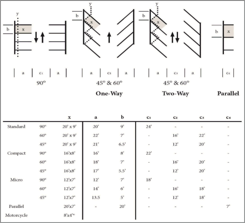
(h)
Minimum off-street parking standards.
(1)
Uses not listed.
(2)
The number of required off-street parking and loading spaces for any use not specifically listed in Table 16-7.1: Minimum Off-Street Parking Standards by Use shall be determined by the planning director based on the size and operational characteristics of the proposed use in comparison to other uses listed in Table 16-5.3 and the need to provide adequate off-street parking to prevent traffic congestion on adjacent streets or overflow commercial parking in nearby residential neighborhoods. If needed, the planning director may request a trip generation study.
(3)
Net floor area shall be calculated by taking eighty-five percent (85%) of the gross (total) floor area.
(4)
Off-street parking stalls. Requirements for parking spaces shall be as shown on an approved site plan, or in the absence of a site plan, as determined by the following table:
TABLE 16-7.1: MINIMUM OFF-STREET PARKING STANDARDS BY USE
(5)
ADA spaces.
(i)
Table 16-7.2: Minimum Number of Accessible Parking Spaces identifies the required minimum number of accessible parking spaces.
TABLE 16-7.2: MINIMUM NUMBER OF ACCESSIBLE PARKING SPACES
(6)
Location.
(i)
Unless otherwise specified by the International Building Code or applicable state and federal regulatory provisions, accessible parking spaces shall be located on the shortest possible accessible route from adjacent parking to an accessible building entrance. In facilities with multiple accessible building entrances with adjacent parking, accessible parking spaces shall be dispersed and located near the accessible entrances.
(7)
Design and construction.
(i)
Design and construction of handicapped or accessible parking shall be in accordance with ICC/ANSI Standard A117.1.
(8)
Minimum width, stall, and access aisle.
(i)
Accessible parking spaces shall have a minimum stall width of eight and one-half (8 ½) feet with an adjacent access aisle five (5) feet wide. Parking access aisles shall be part of the accessible route to the building or facility entrance, in compliance with the IBC or ICC/ANSI A117.1: Accessible and Usable Buildings and Facilities. Two (2) handicapped or accessible parking spaces shall be allowed to share a common access aisle. The requirements are depicted in Figure 16-7.2: Parking Lot Design with ADA Spaces below.
FIGURE 16-7.2: Parking Lot Design with ADA Spaces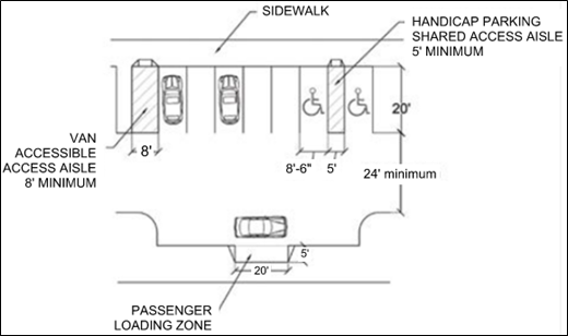
(9)
Van-parking.
(i)
One (1) van-accessible parking space shall be provided for every five (5) handicapped or accessible parking spaces, or fraction thereof.
(10)
Signage.
(i)
Handicapped or accessible parking spaces shall be identified by a sign showing the international symbol of accessibility, in compliance with ICC/ANSI A117.1. Signs shall not be obscured by a vehicle parked in the space.
(i)
Electric vehicle charging stations.
(1)
Where a new parking lot or garage is constructed for multi-household dwellings or for any nonresidential uses, or stalls in an existing parking lot are being retrofitted, the lot or structure shall be provided with electric vehicle power transfer infrastructure in compliance with the Colorado Model Electric Ready and Solar Ready Code.
(2)
Electric vehicle charging stations shall be counted toward satisfying minimum off-street vehicle parking space requirements.
(3)
Electric vehicle charging stations shall be reserved for parking and charging electric vehicles only, and shall be signed accordingly. Electric vehicles may be parked in any space designated for public parking, subject to the restrictions that apply to any other vehicle.
(4)
Vehicle charging equipment shall be designed and located so as to not impair pedestrian, bicycle, or wheelchair movement or create safety hazards on sidewalks.
(5)
Information shall be posted identifying voltage and amperage levels and any type of use, fees, or safety information related to the electric vehicle charging station.
(j)
Location, design, and use of off-street vehicle parking spaces.
(1)
Location of required parking spaces.
(i)
Unless otherwise allowed by these regulations, required off-street parking spaces shall be located as follows:
a.
In all zoning districts except the B district, required off-street parking spaces shall be located on the same lot as the principal use(s) for which the parking is required.
b.
In the B district, required off-street parking spaces shall be located:
1.
On the same lot as the principal use(s) for which the parking is required;
2.
Within six hundred (600) feet of the lot the parking is intended to serve; or
3.
Within a common assigned parking area under the ownership of the individual owners of, and within the same development as, the use the spaces are intended to serve.
(k)
Access driveways.
(1)
Each required parking space shall have unobstructed access from a road or alley, or from an aisle or drive connecting with a road or alley, except for residential tandem parking.
(2)
Access driveways for required off-street parking areas shall be designed and constructed to facilitate the flow of traffic, provide safety of traffic access and egress, and protect the safety of pedestrian, bicycle, and vehicular traffic on the site.
(3)
Access driveways for parking lots and structures serving multi-household residential uses or commercial, mixed-use, or industrial developments shall maintain a clear vision triangle in which no fence, tree, signage, or structure obstructs visibility between three (3) and six (6) feet above grade.
(l)
Minimum dimensions of parking areas.
(1)
The minimum dimensions of a regular parking space shall be eight (8) feet by nineteen (19) feet.
(m)
Minimum width of access driveways.
(1)
The minimum width of the access driveway for parking lot or use to serve a multi-household residential use or a commercial, mixed-use, or industrial development shall be in accordance with the town's adopted street standards.
(2)
The minimum width of the access driveway for any residential use other than a multi-household residential use shall be ten (10) feet for a one-way drive and twenty (20) feet for a two-way drive.
(n)
Tandem parking.
(1)
Tandem parking (a vehicle parking directly behind another) may be counted towards meeting the required minimum off-street parking for a multi-household residential use provided that each pair of tandem spaces serving multi-household dwelling units is assigned to the same dwelling unit.
(2)
Vehicles exiting from a parking space for a single-household detached, single-household attached, duplex, triplex, or fourplex dwelling may back onto a residential street.
(3)
Vehicles exiting from a parking space for any use may back onto the right-of-way of an alley adjacent to the property.
(o)
Backing onto streets.
(1)
All parking areas shall be located and designed so that no vehicle exiting from a parking space shall be required to back onto the right-of-way of a public or private street, except as provided in subsection (n)(2) above.
(p)
Bicycle parking.
(1)
Bike parking location and design.
(i)
Bicycle parking spaces shall be located near building entrances but not so close as to interfere with pedestrian or automobile traffic near the entrances.
(ii)
Bicycle parking facilities shall be designed to allow the bicycle frame and both wheels to be securely locked to the parking structure, which shall be of permanent construction materials such as [3]
(q)
Stacking lanes for drive-through facilities. The following standards apply to properties with a drive-through facility:
(1)
Number of required stacking spaces. Vehicle stacking spaces shall be provided in the amounts shown in Table 16-7.3. Required stacking distances shall be measured from the front or side lot line of the property from which access to the drive-through is taken.
TABLE 16-7.3: MINIMUM DRIVE-THROUGH STACKING SPACES REQUIRED
(r)
Size, design, and location of stacking spaces.
(1)
Vehicle stacking spaces shall be a minimum of eight and a half (8.5) feet in width and nineteen (19) feet in length.
(2)
Vehicle stacking spaces shall not interfere with access to vehicle or bicycle parking spaces.
(3)
Vehicle stacking spaces shall be located to minimize noise, light, dust, and vibration impacts on surrounding lots or parcels containing residential uses to the maximum extent practicable. The planning director may require the installation of additional fencing or landscaping when necessary to minimize such impacts.
(4)
Electronic devices such as loudspeakers, automobile service order devices, and similar instruments shall not be audible beyond the property line with any adjacent R-MD, R-SL, R-FM, and R-MP zoning district.
(s)
Off-street loading spaces required.
(1)
Amount required.
(i)
Buildings or structures that are designed or substantially altered to be served by tractor-trailer delivery vehicles, and that are anticipated to receive service from such trucks more than once each business day, on average, shall provide and maintain off-street loading berths or loading spaces in sufficient number to meet their loading and unloading needs without using public or private streets for loading or unloading materials or merchandise.
(ii)
Where the property or use is served or designed to be served by tractor-trailer delivery vehicles, the standards in Table 16-7.4 Minimum Off Street Loading shall be used in establishing the minimum number of off-street loading berths required.
TABLE 16-7.4: MINIMUM OFF-STREET LOADING
(2)
Minimum dimensions of loading berths.
(i)
The minimum dimension of any loading berth shall be ten (10) feet wide by thirty-five (35) feet long, with a vertical clearance of fourteen (14) feet. The planning director may require larger dimensions if the typical size of vehicles used in connection with the proposed use exceeds these standards.
(3)
Backing onto public or private streets prohibited.
(i)
All loading areas shall be located and designed in conjunction with a driveway, so that vehicles exiting from a loading space shall not be required to back onto the right-of-way of a public or private street. Location or design that requires vehicles exiting a loading space to back into an alley are permitted.
(t)
Parking and loading area landscaping and illumination.
(1)
Parking lots and loading area shall comply with section 16-79, Landscaping, screening, and fencing, and section 16-80, Outdoor lighting.
(Ord. No. 25-15, § 1(Exh. A), 10-1-25)
Editor's note— Section 16-75(p)(1)(ii) will be amended upon adoption of a forthcoming ordinance.
Sec. 16-76. - Site level access and connectivity.
(a)
Applicability.
(1)
These standards apply to review and approval of development, redevelopment, or changes of use on legal platted lots, parcels, or tracts that are already adjacent to one (1) or more public or private streets. Additional access and connectivity standards that apply at the time lots, parcels, or tracts are platted or replatted are found in section 16-82(d), Subdivision level access and connectivity.
(b)
General.
(1)
The development or redevelopment or each platted lot or parcel containing a primary multi-household, civic/institutional, commercial, mixed-use, or industrial use shall comply with the standards for access and connectivity in this section ensure safe and convenient travel for motor vehicles, bicycles, pedestrians, service vehicles, and emergency services, including persons experiencing disabilities, within and between all residential, mixed-use, and nonresidential developments.
(Ord. No. 25-15, § 1(Exh. A), 10-1-25)
Sec. 16-77. - Location of entrance to residence.
(a)
The primary entrance to all single-family and multiple-family dwellings shall be located at the front of the residence fronting the street upon which its street address is located.
(1)
This shall not apply to:
(i)
Dwellings for which building permits have been issued as of the effective date of the ordinance codified herein.
(ii)
Lots platted as of the effective date of the ordinance codified herein that have dwellings already existing on the platted property.
(iii)
Lots located within the R-T district.
(b)
Circulation and alignment.
(1)
The motor vehicle road, driveway, and access system shall provide efficient internal circulation within the development and provide reasonable access to public highways, public roads, and private streets serving the development.
(c)
Avoidance of vehicle-pedestrian conflicts.
(1)
Internal access and circulation systems shall be designed to minimize conflict between vehicular and pedestrian traffic.
(d)
Pedestrian access.
(1)
Developments shall comply with the following standards for pedestrian access and circulation:
(i)
A pedestrian walkway system meeting the minimum standards of the Americans with Disabilities Act (ADA) shall connect each primary building on the lot or parcel to each other primary building on the lot or parcel, and to each sidewalk along an abutting public or private street.
(ii)
Where a walkway crosses a parking area or driveway (a crosswalk), it shall be clearly marked with contrasting paint or paving materials, including but not limited to pavers, light-color concrete inlay between asphalt, or similar contrasting material).
(iii)
On-site walkways designed to accommodate bicycles shall be a minimum of eight (8) feet in width.
(iv)
Grades for walkways and pedestrian paths shall not exceed two percent (2%), or the grade of the adjacent public street, whichever is greater.
(e)
Bicycle access.
(1)
Site development that includes multi-household, civic/institutional, commercial, mixed-use, or industrial development should provide bicycle access routes from abutting public and private streets to each principal building in the development. Bicycle routes shall comply with all of the following standards for bicycle access and circulation to the maximum extent practicable:
(i)
Bicycle paths and lanes shall be a minimum of eight (8) feet wide.
(ii)
The maximum grade of bicycle access routes shall be five percent (5%) or the maximum permitted by the Americans with Disabilities Act, whichever is lower.
(iii)
Where bicycle paths cross private land or coincide with private access facilities, the developer shall provide a public access easement.
(f)
Motor vehicle access to individual lots.
(1)
Where lots are served by alleys, motor vehicle access to off-street parking areas shall be from the alley rather than from a public or private street.
(Ord. No. 25-15, § 1(Exh. A), 10-1-25)
Sec. 16-78. - Trails standards.
(a)
Trails required.
(1)
Each new development, redevelopment, or change in land use shall provide trails:
(i)
In those locations shown on the comprehensive plan or other plan(s) adopted by the town that identify future trail locations;
(ii)
Where determined by the planning director to be necessary to link the property to schools, shopping areas, parks, trails, greenbelts, and other public facilities, to the maximum extent practicable; and
(iii)
Where determined by the planning director to be necessary to provide public access and fishing easements to adjacent lakes, rivers, and streams, to the maximum extent practicable and consistent with state law.
(2)
Each new development, redevelopment, or change in land use shall preserve existing trails indicated by easements or other documentation on approved subdivision plats or as required by prior land use approvals or written agreements with the town to the maximum extent practicable.
(3)
Subsections (1) and (2) above are subject to the provisions of section 16-41(f)(2), Conditions of approval.
(b)
Trail right-of-way standards.
(1)
Trail rights-of-way for dedicated park lands and open space shall conform to the following criteria:
(i)
Construction design and materials shall comply with town engineering and construction standards.
(ii)
All land required for trail rights-of-way shall be protected by easement or in a separate tract.
(iii)
The minimum width for trail easement shall be twelve (12) feet, and the minimum paved width (where applicable) shall be six (6) feet. The planning director may increase the minimum width up to a maximum of eighteen (18) feet if the planning director determines the additional width is necessary to handle the proposed use based on the particular reasonable needs of the trail, its location, the surrounding terrain, and the anticipated usage.
(iv)
Public access to each required trail easement shall be provided within the subject property, subject to the provisions of section 16-41(f)(2), Conditions of approval.
(v)
The trail easement may overlap and include property previously included in other easements such as ditch, canal, utility and conservation easements, and public or private open space provided it does not compromise the purpose or functional use of any easement with which it overlaps.
(vi)
A trail easement may be allowed in a floodplain subject to standards in section 16-86, Floodplain regulations.
(c)
Construction.
(1)
Construction design and materials shall comply with town engineering and construction standards if they are adopted.
(d)
Provisions for maintenance.
(1)
If trails are not dedicated to the town or a taxing or assessment entity responsible for their maintenance, such as a metropolitan district, provisions for long-terms maintenance of trail and walkway systems shall be established through a homeowner's association, corporation, or foundation that the town council determines has adequate legal authority and financial capacity to carry out this function.
(Ord. No. 25-15, § 1(Exh. A), 10-1-25)
Sec. 16-79. - Landscaping, screening, and fencing.
(a)
Landscaping and buffering.
(1)
Purpose.
(i)
The purpose of this section 16-79 is to implement the town comprehensive plan; to improve the visual quality of streetscapes abutting and within new development; to buffer potential impacts of new development on abutting lots and parcels with significantly different types and scales of development; to preserve healthy, mature trees on development sites; to encourage efficient use of limited freshwater resources; to encourage on-site stormwater infiltration to improve water quality and reduce stormwater infrastructure costs; to promote energy efficiency through increased shading; to reduce heat islands; to increase biodiversity; and to protect public health and safety.
(2)
General standards.
(i)
Applicability.
a.
This section 16-79 applies to all landscaping and screening required by this code.
(ii)
Landscaping plan required.
a.
Each applicant required to install landscaping or screening by this code shall submit a landscaping plan as part of the application.
(iii)
Permitted plants.
a.
Where landscaping is required by this code, at least seventy-five (75) percent of all trees and seventy-five percent (75%) of plant material, as measured by coverage area shown on the submitted landscape plan, shall be a very low to moderate water use species acceptable for the region, as defined by a regionally specific plant list.
(iv)
Permitted turf and irrigation.
a.
No more than twenty-five percent (25%) of the total landscaped area of any lot or parcel, as shown on the submitted landscaping plan, may be vegetated with water intensive turf such as Kentucky bluegrass.
b.
No more than twenty-five percent (25%) of the total landscaped area of any lot or parcel, excluding areas planted with low-water use grasses, as shown on the submitted landscaping plan, may be irrigated with overhead spray.
c.
Permanent irrigation installations.
1.
Shall have automatic rain sensors designed to turn off the irrigation during rainfall; and
2.
Shall be designed and located to avoid overspray onto streets, driveways, walkways, other paved areas, and impervious surfaces to the maximum extent practicable.
d.
Irrigated turf shall not be installed in roadway medians, curbside landscaping strips, parking lot islands and swales, stormwater detention areas, or any areas with slopes greater than three-to-one (3:1).
e.
Notwithstanding subsections a. through d. above, nonfunctional turf shall not be installed on:
1.
Any property containing a principal use that is listed as a Institutional, or Civic Use, a Commercial Use (except an Outdoor Recreation and Entertainment Use), or an Industrial use in Table 16-5.3: Permitted Use Table; or
2.
Any property within a common interest community as defined in C.R.S. 38-33.3-103 that is owned and maintained by a unit owners association, such as entryways, parks, and other common elements as defined in C.R.S. 38-33.3-103.
3.
Any portion of a street right-of-way, median, transportation corridor, or parking lot subject to this Code.
f.
Subsection e. above shall apply to:
1.
Each new development of property that requires a building permit or site plan approval; and
2.
Any redevelopment of property that requires a building permit or site plan approval and that will result in the disturbance of more than fifty percent (50%) of existing landscaped area(s).
(v)
Prohibited plants.
a.
The following plants may not be planted as landscaping:
1.
Plants listed on the Colorado Department of Agriculture Noxious Weed lists or in Weld County weed management plan;
2.
Ash (Fraxinus, species);
3.
Aspen (all Populus tremuloides species and cultivars);
4.
Cottonwood (all species, including Populus deltoides, P. fremontii, and P. nigra), unless being used to continue the native appearance along the borders of side or rear lot or parcel lines with open space or natural areas;
5.
Tamarisk (Tamarix, all species);
6.
Siberian elm (Ulmus, all species); and
7.
Russian olive (Elaeagnus angustifolia, all cultivars).
(vi)
Material standards.
a.
Each planting bed shall contain living materials that will cover at least fifty percent (50%) of the gross area of the planting bed at ground level at maturity.
b.
Non-living ground cover used on the remaining area may include decorative gravel, bark mulch, river rock or similar materials, and may include decorative elements such as walks, or decks, provided that the non-living ground cover used is not one hundred percent (100%) impervious.
(vii)
Minimum size of planting materials.
a.
When this code requires that landscaping be installed, required landscaping shall comply with the following minimum size standards:
1.
Shrubs: Minimum one (1)-gallon container;
2.
Deciduous trees: Minimum one and a half (1.5)-inch diameter measured at breast height (DBH);
3.
Evergreen trees: Minimum five (5) feet tall; and
4.
Ornamental grasses and perennials: Minimum one (1) gallon container.
(viii)
Minimum quality standards.
a.
All plant materials shall comply with or exceed minimum standards in the Colorado Nursery Act Regulations (C.R.S. Title 35, Article 26) and the current edition of the American Standard for Nursery Stock (ANSI Z60.1-2014).
(ix)
Location.
a.
All required landscaping must be located on the property for which it is required.
b.
All required landscaping must be located outside of any abutting right-of-way unless the planning director approves in writing a location within the right-of-way.
c.
No landscaping shall be required to be installed where it would obstruct vision across any clear vision triangle between three (3) and eight (8) feet above grade, but any vegetation that would otherwise be required to be installed in a clear vision triangle shall be installed elsewhere on the lot or parcel.
d.
No landscaping shall be required to be installed within four (4) feet of any fire hydrants or utility box, but any vegetation that would otherwise be required to be installed in that location shall be installed elsewhere on the lot or parcel.
e.
No trees shall be required to be installed within any easement for underground utilities or where it would grow within four (4) vertical feet of any overhead electric or utility lines, but any vegetation that would otherwise be required to be installed in that location shall be installed elsewhere on the lot or parcel.
(3)
Credit for preservation of existing trees and shrubs.
(i)
Where healthy existing trees and shrubs exist in locations where this code requires the installation of new trees or shrubs, the applicant shall preserve the existing trees and shrubs to the maximum extent practicable, and shall receive credit against requirements to plant new trees or shrubs.
(ii)
Preservation of each existing healthy deciduous tree greater than six (6) inches diameter at breast height (DBH) shall relieve the applicant of the obligation to plant two (2) new trees that would otherwise be required by this code.
(iii)
Preservation of each existing healthy evergreen tree greater than six (6) feet in height shall relieve the applicant of the obligation to plant one (1) new tree that would otherwise be required by this Code.
(iv)
Preservation of each existing healthy deciduous or evergreen shrub greater than two (2) feet in height shall relieve the applicant of the obligation to plant one (1) new shrub that would otherwise be required by this code. The planning director may extend the credit listed in subsections (ii), (iii), and (iv) as applicable, to the preservation of rare native shrubs or plants if the comprehensive plan or another county plan calls for protection of that type of vegetation.
(v)
Where irrigation is already installed for existing trees and shrubs for which credit is provided in this subsection (3), the existing irrigation may remain in place and shall not reduce the amount of irrigation permitted for new plants and shrubs.
(4)
Protection of existing trees and shrubs during construction.
(i)
Where a landscaping plan indicates that existing trees or shrubs are to be preserved, those existing trees and shrubs shall be protected from damage during construction on site.
(ii)
Each tree indicated for preservation shall be protected by installing temporary fencing at a distance of at least one-and-one-half (1 1/2) times the distance of the dripline from the tree trunk, and construction materials and debris shall not be placed or stored within that fenced area.
(iii)
Each shrub indicated for preservation shall be protected by installing temporary fencing around that shrub.
(5)
Restoration and revegetation of disturbed areas.
(i)
All portions of the site where existing vegetative cover is damaged or removed but not covered with new improvements, shall be revegetated with a mix of native, adaptive and drought-tolerant grasses and ground covers to prevent erosion.
(b)
Installation.
(1)
The installation of all required plant materials shall comply with Green Industry Best Management Practices for the Conservation and Protection of Water Resources in Colorado.
(2)
The timing of the installation of plant materials shall be:
(i)
In the case of landscaped rights of way, parks and open space tracts in residential subdivisions, landscape plans shall be completed, inspected and accepted by the town prior to fifty percent (50%) occupancy of the development.
(ii)
Deferred up to six (6) months after a certificate of occupancy is granted, if the installation would occur from the months of October to May. A request for deferred landscape installation must be made by the permittee prior to any request for a certificate of occupancy, and the request must be granted by the planning director before the installation deferment will be allowed.
(c)
Street frontage landscaping.
(1)
Applicability.
(i)
This subsection applies to all site plans that include the construction of a new primary building, or the expansion of the gross floor area of an existing primary building by twenty-five percent (25%) or more, other than a building with four (4) or fewer residential dwelling units.
(2)
Landscaping required.
(i)
Where park or open space is provided, trees and other landscape will be provided at the entry of said parks and open spaces as part of the entry treatment, while maintaining water conservation goals.
(d)
Side and rear lot edge landscaping.
(1)
Applicability.
(i)
This subsection applies to all site plans that include the construction of a new primary building, or the expansion of the gross floor area of an existing primary building by twenty-five percent (25%) or more, other than a building with four (4) or fewer residential dwelling units, along any side lot line or along any rear lot line that does not abut an alley, where either of the following conditions apply:
a.
The site development will include only commercial, industrial, or institutional uses, as listed in Table 16-5.3: Permitted Use Table and the lot line abuts any lot or parcel with existing residential dwelling units; or
b.
The site development will include any structure containing more than four (4) residential dwelling units and the lot line abuts any lot or parcel containing only structures with four (4) or fewer residential dwelling units.
(2)
Landscaping required.
(i)
When adjacent to less intensive uses, each lot or parcel in mixed use, business, commercial, and industrial zoning districts shall include a landscaping strip at least eight (8) feet in width, with at least one (1) deciduous or evergreen tree and seven (7) shrubs per thirty-five (35) linear feet of each lot line.
(ii)
If the planning director determines that the plantings required by subsection (1), he/she will not mitigate any anticipated impacts of the proposed site development on abutting property, it may require that an opaque fence meeting the standards of section 16-79(g), Fences and walls, be substituted for the required shrubs.
(e)
Parking lot landscaping.
(1)
Applicability.
(i)
This section (e) applies to proposed site development in the following two (2) situations:
a.
The entire area of any new surface parking lot containing more than ten (10) spaces; or
b.
The expansion area of any existing surface parking lot that is being expanded by ten (10) spaces or more.
(2)
Landscaping required.
(i)
Interior areas of the surface parking lot shall include vegetated swales located below the vehicle parking surface, located and designed so that stormwater from the vehicle parking surfaces flows into such swales to the maximum extent practicable.
(ii)
Vegetated swales shall be located so that no more than fifteen (15) vehicle parking spaces shall abut each other. Each group of not more than fifteen (15) vehicle parking spaces shall be separated from others by a vegetated swale or by a driving aisle or driveway giving access to the individual parking spaces.
(iii)
Each required vegetated swale shall be at least eight (8) feet in width, and shall be at least twenty (20) feet in length, located to border the entire length or width of each vehicle parking space or group of vehicle parking spaces for which it serves as a separator.
(iv)
Each required vegetated swale shall include at least one (1) deciduous or evergreen tree, which shall be separated from other trees by at least thirty-five (35) linear feet, and shall include at least six (6) shrubs per thirty-five (35) linear feet of the vegetated swale.
(v)
If any edge of the parking lot is located within twenty (20) feet of any abutting street right-of-way and the area between the edge of the parking lot and the abutting street is not otherwise required to be landscaped pursuant to section 16-79(c), Street frontage landscaping, the area between the edge of the parking lot and the street shall be vegetated with six (6) shrubs per thirty-five (35) linear feet of the parking lot edge.
(vi)
If any edge of the parking is located within ten (10) feet of any side or rear lot line that does not abut an alley, and the area between the parking lot edge and the side or rear lot line is not required to be landscaped pursuant to section 16-79(d), Side and rear lot edge landscaping, the area of the parking lot and the side and/or rear lot line shall be vegetated with six (6) shrubs per thirty (30) linear feet of the parking lot edge.
(f)
Screening.
(1)
Applicability.
(i)
This subsection shall apply to all site development in all zoning districts except those that only contain structures with four (4) or fewer residential dwelling units.
(2)
Ground-mounted equipment.
(i)
Except as provided in subsection (3) below, each lot or parcel shall locate appurtenances away from the street and/or shall screen from view all ground-mounted mechanical equipment, including but not limited to heating and air-conditioning equipment, pumps, and utility connections and control boxes, but excluding accessory ground-mounted wind energy systems. Such equipment shall be screened from view from all abutting public and private streets and from abutting public parks and open spaces through the use of an opaque fence, wall, or a row of evergreen trees at least as tall as the equipment above grade.
(ii)
Ground-mounted community-, medium, and large-scale solar energy systems shall be located so that required screening will not interfere with their proper functioning to the maximum extent practicable. If that is not practicable then requirements for any screening that interferes with their functioning shall not be required.
(3)
Roof-mounted equipment.
(i)
Except as provided in subsection (2) each lot or parcel containing a primary multi-household or nonresidential use shall screen from view all mechanical equipment located on a flat roof, including but not limited to heating and air-conditioning units, elevator lift equipment, and solar energy systems. Such roof-mounted equipment shall be screened from view from all abutting public and private streets and from abutting public parks and open spaces through the use of opaque materials in one of the colors used on the street-facing façade of the building on which it is mounted.
(ii)
Solar energy systems and wind energy systems mounted on flat roofs shall be located so that required screening will not interfere with their property functioning to the maximum extent practicable; if that is not possible then requirements for any screening that interferes with their functioning shall not be required.
(4)
Support areas.
(i)
Each lot or parcel shall orient support areas away form public streets to the rear of buildings and/or shall screen all storage areas, loading docks, trash and recycling enclosures, and other support areas of the site not intended for general use by the occupants or patrons of the building.
(ii)
Such area shall be screened from view from each abutting public or private street and from abutting public parks and open spaces through the use of a combination of the following: opaque fence, wall, or a row of evergreen trees eight (8) feet tall or at least as tall as any dumpsters or storage containers in the area being shielded, whichever is less.
(g)
Fences and walls.
(1)
Applicability.
(i)
The provisions of this subsection shall apply to all fencing installed on any property.
(2)
Fence and wall standards.
(i)
Maximum fence height
a.
For multifamily, mixed use, business, and commercial properties, fences located between any façade of any structure and any abutting public or private street shall not exceed forty-two (42) inches in height. Fences located behind any street-facing façade of the structure along any side or rear lot line of the lot or parcel shall not exceed six (6) feet in height, except, with planning director approval, the height may go up to eight (8) feet.
b.
In the I zoning district, fences located between any façade of any structure and any abutting public or private street shall not exceed six (6) feet in height. If the planning director determines that a taller fence is required for security of operations or materials or to mitigate sound, light, odor, dust, or other impacts of site operations on adjacent properties, the planning director may authorize fences up to twelve (12) feet in height.
(ii)
Retaining walls.
a.
Retaining walls shall be required whenever slopes exceed one (1) foot of rise in three (3) feet of run (3:1).
b.
Retaining walls shall not exceed four (4) feet in height. If a retaining wall is needed, it shall be constructed in tiers so that no section of the retaining wall exceeds four (4) feet in height. Each section shall be inset from the tier below it by a horizontal distance of at least eighteen (18) inches, and the horizontal distance between the two (2) retaining wall sections shall be vegetated with ground cover or shrubs.
c.
Fences may be located adjacent to or on top of retaining walls so long as the height of the fence material, excluding the retaining wall, does not exceed the maximum permitted height of the fence alone.
(3)
Vision clearance.
(i)
No fence, wall, hedge or other structure or obstruction above a height of forty-two (42) inches shall be erected, placed or maintained within fifteen (15) feet of the intersection of the right-of-way lines of two (2) streets or railroads or of a street intersection with a railroad right-of-way. No type of tree, planting, sign, fence or portion thereof or any type of obstacle shall be planted, placed or retained in such a manner which would obstruct the vision clearance at corners, curb cuts or railroad crossings or cause a traffic hazard.
(4)
Fence materials.
(i)
No barbed wire or electric fence shall be allowed within the corporate limits of the town without the approval of the planning commission or unless planning commission disapproval is overruled by a two-thirds (2/3) vote of the entire membership of the town council.
(5)
Emergency response.
(i)
Where fencing limits or obstructs the visibility of the front entry to a residence, the following provisions will be made in order to ensure no increases to response time:
a.
Gate entry most direct route from the front door to street maintained and,
b.
Address numbers at least four (4) inches in height installed at gated entry.
(h)
Dumpsters.
(1)
Except as set forth in paragraphs (2) and (3) below, within the town, it is unlawful for a dumpster to be placed, kept, or used as follows:
(i)
For any single-family residential and two-family dwelling within any R-1 zone district;
(ii)
For any single-family residential and two-family dwelling within any R-2 zone district;
(iii)
Dumpsters may be allowed for any single-family or two-family dwelling in any zone district for remodeling or repairing of residence where a building permit is not needed, or for general property clean up, and for a time period not exceeding one (1) month per year, provided the town has issued a dumpster permit pursuant to paragraph (4) below;
(iv)
Dumpsters are allowed in a residential zone district under the following circumstances and no permit is required:
a.
During the initial construction of a residential dwelling or during the construction of additions or improvements to an existing residential dwelling provided that:
1.
A valid building permit has been issued for construction on the property; and
2.
The dumpster is removed from the property not more than thirty (30) days after the issuance of a certificate of occupancy for such property.
(v)
For any single-family or two-family dwelling in an agriculturally zoned district.
(2)
For any commercial or other nonresidential use in a residentially zoned district, but such commercial or other nonresidential use that allows for the use of a dumpster shall not include any authorized home occupations.
(3)
For multiple-family dwellings and in mobile home parks; provided, however, no more than one (1) dumpster for every four (4) units in any such multiple-family dwelling or mobile home park is allowed.
(4)
Dumpster use criteria. The following criteria shall be met in order to use a dumpster in the town:
(i)
Dumpsters shall have an attached lid that covers the top of the dumpster in its entirety unless it is a roll-off used temporarily in concurrence with an active building permit or used temporarily in concurrence with a dumpster permit.
(ii)
Dumpsters shall be located on private property and shall not be placed in the public right-of-way.
(iii)
It is unlawful to have debris or other material overflowing from a dumpster and such a condition is declared to be a public nuisance under this chapter 7, article 2, of this code, as amended.
(iv)
The town shall deny a dumpster permit application if the proposed dumpster does not fit within the allowed uses or criteria set forth in this subsection (h).
(Ord. No. 25-15, § 1(Exh. A), 10-1-25)
Sec. 16-80. - Outdoor lighting.
(a)
Purpose.
(1)
The purpose of this section is to ensure that vehicle, bicycle, and pedestrian circulation areas, parking areas, public gathering spaces, approaches to buildings, and other areas have adequate outdoor illumination to promote safety and walkability at night; to avoid light trespass onto abutting properties, and reduce light pollution.
(b)
Applicability.
(1)
Except as provided in subsection (2) below, the standards in this section apply to all development involving the installation of new outdoor lighting except lots or parcels that contain only residential uses that contain four (4) or fewer residential dwelling units.
(2)
The standards in this section shall not apply to:
(i)
Emergency lighting used by police, fire fighting, or medical personnel, or at their direction;
(ii)
Any lighting required to be installed by a state or federal government agency, including but not limited to the Federal Aviation Administration (FAA) or other federal air safety authority;
(c)
Public and private street lighting; follow the town's streets standards for public and private street lighting requirements.
(d)
Standards.
(1)
Prohibited lighting.
(i)
The following types of outdoor lighting are prohibited:
a.
Lights that create a traffic hazard or that imitate or could be confused with a traffic control or emergency vehicle light, as determined by the planning director;
b.
Blinking, flashing, or moving lights, including but not limited to strobe lights and laser lights; and
c.
Lighting that creates excessive backlight, uplighting, or glare.
(2)
Fixtures.
(i)
Except as provided in subsection (iii) below, all lighting fixtures shall be full cutoff type. Full cutoff light fixtures are those in which no more than ten percent (10%) of emitted lumens can be detected at an angle more than eighty (80) degrees from the vertical axis of the light fixture.
(ii)
Full shielding is not required for underwater lights in swimming pools or fountains, or for motion detector lighting that does not remain on for more than ten (10) minutes after detecting motion.
(iii)
All lighting fixtures, including wall packs, but excluding motion detector-activated lighting, shall be fully shielded so that the lighting element is not visible to an observer at a point on any property line of the lot or parcel on which the light is located.
(3)
Maximum height of fixture.
(i)
The height of outdoor lighting fixtures shall not exceed the following:
a.
Non-residential, mixed-use, agriculture and industrial districts: thirty-five (35) feet, unless subsection c. below applies;
b.
In the residential zoning districts: twenty (20) feet;
c.
Within fifty (50) horizontal feet of a residential zoning district: twenty (20) feet.
(4)
Light trespass.
(i)
All lighting fixtures shall be installed so that no light trespass exists:
a.
Across any property line, except a property line adjacent to a public or private street; or
b.
Into any designated wildlife habitat area or corridor.
(5)
Lighting efficiency.
(i)
All exterior light fixtures shall generate at least eighty (80) lumens per watt of energy consumed, as shown on the manufacturer's specifications for the fixture.
(Ord. No. 25-15, § 1(Exh. A), 10-1-25)
Sec. 16-81. - Sign regulations.
(a)
Purpose.
(1)
The purpose of this section 16-81 is to:
(i)
Protect the health, safety, property, and welfare of the public;
(ii)
Provide for the neat, clean, orderly, and attractive appearance of the community;
(iii)
Improve the effectiveness of signs;
(iv)
Provide for safe construction, location, erection, and maintenance of signs;
(v)
Minimize adverse visual safety factors to the traveling public; and
(vi)
Comply with all applicable provisions of state and federal law regarding freedom of speech and sign content neutrality.
(b)
Applicability.
(1)
The regulatory provisions of this section 16-81 shall apply to the display, construction, erection, alteration, use, maintenance and location of all signs within town.
(c)
Prohibited signs.
(1)
The following signs are prohibited in all zoning districts:
(i)
Signs that are structurally unsafe or hazardous;
(ii)
Signs that are erected by any non-governmental entity that are visible from any public right-of-way and impersonate or could be confused with a traffic sign or signal or emergency;
(iii)
Signs that obstruct or interfere with traffic signs or signals, or that impair visibility in the public right-of-way, or that are located within a clear vision area;
(iv)
Signs with visible moving, revolving, or rotating parts, flashing or fluttering lights, or other illuminating devices that have a changing brightness or intensity or color, or any mechanical movement or apparent movement achieved by electrical, electronic, or mechanical means;
(v)
Portable signs that do not comply with the temporary sign regulations permitted by this Code;
(vi)
Signs painted on trees, rocks, or other natural features;
(vii)
Any wall sign that extends vertically or horizontally beyond the dimensions of the wall upon which it is installed or mounted;
(viii)
Signs whose expressive content is not protected by the First Amendment to the U.S, Constitution or the Colorado Constitution, including but not limited to signs containing obscenity, as interpreted by the federal or state courts; or
(ix)
Abandoned on-premises signs, including but not limited to any on-premises sign that relates to an establishment that no longer occupies or operates on the property where the sign is located.
(d)
Sign permit required.
(1)
All signs that are not prohibited by section 16-81(c) above shall comply with the standards in this division 5. Most signs are required to obtain a sign permit from the town before being erected, in order to ensure compliance with applicable sign standards, while others are not required to obtain a sign permit before being erected.
(i)
General.
a.
Unless specifically exempted by subsection (ii) below or another provision of this code, all signs erected in town require the approval of a sign permit pursuant to section 16-48(a)(3), Sign permit, prior to installation or placement.
(ii)
Exceptions.
a.
A sign permit is not required to change the message or content of any permitted on-premise sign at any time, subject to section 16-81(c), Prohibited signs.
b.
A sign permit is not required to change the message or content of any permitted billboard at any time, subject to section 16-81(c), Prohibited signs.
c.
A sign permit is not required to perform construction or maintenance on a sign, provided that the activity does not change the type of sign or result in a type, size, height, location, or other aspect of the sign that violates the applicable standards of this code.
(e)
Temporary signs.
(1)
The following temporary signs are permitted subject to compliance with applicable provisions of this Code, and do not require the issuance of a sign permit before installation or placement. Any temporary sign not permitted pursuant to this section, may be approved if the applicant obtains a sign permit pursuant to section 16-48(a)(3), Sign permit.
(i)
Open space and residential districts.
a.
In the O, R-1, R-2, MHP, MUR, and MU districts, and any portion of a PUD zoning district in which open space or residential uses are permitted and general commercial uses are not permitted:
1.
The following temporary signs are permitted, provided that each sign does not exceed four (4) square feet in area, does not exceed three (3) feet in height above grade, and is not illuminated:
i.
Up to two (2) temporary signs on each street frontage provided that each such sign is not remain in place for more than sixty (60) days;
ii.
One (1) additional temporary sign on each street frontage during any time during which all or a portion of the property or all or a portion of a building on the property is actively listed for sale or rent; and
iii.
An unlimited number of temporary signs during within ninety (90) days before and thirty (30) days after any general or special election.
2.
In addition, one (1) temporary sign is permitted during any period between the time a building permit is issued and the time construction pursuant to the building permit ends or a certificate of occupancy for the property is issued (whichever occurs earlier), provided that each sign does not exceed six (6) square feet in area, does not exceed four (4) feet in height above grade, and is not illuminated.
(ii)
Mixed-use and nonresidential districts.
a.
In the MUR and MU, and I zoning districts, and any portion of a PUD zoning district in which nonresidential uses are permitted:
1.
The following temporary signs are permitted, provided that each sign does not exceed twelve (12) square feet in area, does not exceed six (6) feet in height above grade, and is not illuminated:
i.
Up to two (2) temporary signs on each street frontage provided that each such sign is not remain in place for more than sixty (60) days;
ii.
Up to two (2) additional temporary signs on each street frontage during any time during which all or a portion of the property or all or a portion of a building on the property is actively listed for sale or rent; and
iii.
An unlimited number of temporary signs during within ninety (90) days before and thirty (30) days after any general or special election.
2.
In addition, one (1) temporary sign is permitted during any period between the time a building permit is issued and the time construction pursuant to the building permit ends or a certificate of occupancy for the property is issued (whichever occurs earlier), provided that each sign does not exceed eighteen (18) square feet in area, does not exceed eight (8) feet in height above grade, and is not illuminated.
(2)
Removal.
(i)
Permitted temporary signs related to an activity or event that occurs on one (1) or more specific date(s), other than a general or special election, shall be removed within seven (7) days after the last date on which the activity or event occurs.
(f)
Permanent signs.
(1)
All permanent signs permitted by this division 5 shall comply with all of the standards below, as applicable to the district in which the sign is located and type of sign being proposed.
(i)
General standards.
a.
All permanent signs shall comply with the following Table 16-7.5, unless another provision of this Code, including without limitation in a use standard in section 16-62, Use regulations, provides different standards, in which case the use regulations shall apply.
TABLE 16-7.5: PERMANENT SIGN STANDARDS
(I=Internally lit, B=Backlit, S=External Spotlight)
(ii)
Design and safety.
a.
No sign shall be placed so as to obstruct or interfere with a window, doorway, or fire escape.
b.
No signs shall extend into the vertical space between three (3) feet and six (6) feet above grade within any clear vision triangle. Vertical measurement shall be made from the top of the curb on the street adjacent to the nearest street of the triangle or, if no curb exists, from the edge of the nearest traveled way.
c.
Each permanent sign shall be constructed to meet applicable building code standards for wind resistance and wind loads.
d.
Each permanent sign illuminated by electricity or equipped in any way with electrical devices shall conform to the provisions of the electrical code.
e.
Each freestanding sign shall be set back from each lot line by at least two (2) feet.
f.
No signs except those of a governmental entity shall be erected or allowed to extend over a public right-of-way, unless a revocable permit is obtained from the town prior to issuance of a sign permit.
(iii)
Lighting.
a.
Lighting of signs shall comply with Table 16-7.5: Permanent Sign Standards.
1.
Backlighting means that the outlines of letters, images, or other sign content may be illuminated from inside or behind the sign structure, but the entire sign face may not be illuminated.
2.
Internal lighting means that the entire sign face may be illuminated from inside the sign structure.
3.
Spotlighting means that the sign face may be illuminated from an external light source aimed towards the sign face, but the light source itself shall not be visible from any abutting property or public right-of-way.
(iv)
Electronic message boards.
a.
Only freestanding signs and wall signs in mixed-use and nonresidential districts, or for nonresidential uses permitted in residential districts, may include an electronic message board.
b.
Each permitted electronic message board shall be integrated into the overall sign face.
c.
The area of the electronic message board signage shall not exceed fifty percent (50%) of the total sign area of the wall or freestanding sign face where it is integrated.
d.
The electronic message display shall be programmed so it contains only static images, does not change more frequently than once every eight (8) seconds, and transitions between images instantaneously or through dissolve or fade transitions, and without scrolling, flashing, fading, blinking, or other similar transitions. If dissolve or fade transitions are used, the time between messages shall not exceed one (1) second.
e.
The electronic message board content may not move or create the appearance of movement, through varying light intensity or otherwise, on any part of the sign.
f.
Each electronic message board shall be provided with automatic dimming software or solar sensors to control brightness for nighttime viewing and varying daytime lighting conditions.
g.
No electronic message board may be illuminated at a level greater than five thousand (5,000) nits during daylight hours, or at a level greater than five hundred (500) nits during nighttime hours.
(Ord. No. 25-15, § 1(Exh. A), 10-1-25)
Sec. 16-82. - Subdivision standards.
(a)
General.
(1)
Applicability.
(i)
All divisions of land into two (2) or more lots or parcels shall comply with the following standards unless listed as exempted in section 16-44, such as acquisition of right-of-way.
(ii)
These standards shall also apply to any planned unit development unless the approved planned unit development documents provide an alternative standard to regulate the same use, activity, structure, or topic.
(2)
Conformance with town plans.
(i)
The dimensions, location, and design of each block and each lot created in a new subdivision or in a replat of an existing subdivision shall comply with the requirements and intended character of the area in which it is located as indicated in the town comprehensive plan, the transportation master plan, and the trails, parks and open space plan.
(3)
Maintenance of common facilities.
(i)
Maintenance of common facilities (i.e. privately owned and maintained open space, private roads, etc.) within each subdivision shall be accomplished either through covenants and a homeowner's association, a separate maintenance agreement, or some other agreement acceptable to the town council.
(b)
Subdivision blocks.
(1)
To promote walking, bicycling, and shorter automobile trips, the perimeter length of blocks created through a major subdivision after the effective date (excluding blocks to accommodate only parks or open spaces) shall comply with the following standards, unless otherwise provided in the comprehensive plan or another plan applicable to the property approved by town council:
(i)
R-1, R-2, and MUR districts: Maximum block face length of five hundred (500) feet and maximum block perimeter length of 1,400 feet (excluding alley right-of-way width).
(ii)
MU, B, and C-1 districts: Maximum block face length of four hundred (400) feet and maximum block perimeter length of one thousand two hundred (1,200) feet (excluding alley right-of-way width).
(iii)
Block lengths for the districts noted in a and b above shall be broken up by through block passages and walk-ways.
(iv)
Other districts: Maximum block length and perimeter standards do not apply.
(c)
Subdivision lots.
(1)
Compliance with other standards.
(i)
Each lot in the subdivision shall result in the creation of lots that can be developed for use in conformance with all of the land use regulations of this code for the zoning district in which the property is located, including but not limited to:
a.
The dimensional standards in section 16-59;
b.
The access and connectivity standards in section 16-71, Access and roadways, and section 16-82(d), Subdivision level access and connectivity.
(ii)
Each lot shall contain at least one (1) buildable site for the type(s) of structure(s) permitted in the zoning district where the property is located, while avoiding all areas of the property with identified soil or geological hazards.
(iii)
Broadband.
a.
Standards in chapter 11, article 9, Installation of broadband infrastructure shall apply. All lots shall have access to conduit.
(2)
Double frontage lots avoided.
(i)
The plat shall not include lots intended for household living uses (as shown Table 16-5.3: Permitted Use Table) other than multi-household uses, that have frontages on two (2) public or private streets that do not intersect on a corner of the lot to the maximum extent practicable. The planning director may approve exceptions if the creation of such lots is necessary to provide separation from major arterials, incompatible land uses, or topographical or other environmental considerations. This provision does not apply to lots that front on both a public or private street and an alley.
(3)
Flag lots avoided.
(i)
Lots that meet the lot size requirements for the zoning district in which they are located, but that only meet the required access at a point of contact less than twenty (20) feet in width shall be avoided except where essential and unavoidable to provide separation from major arterials, incompatible land uses, or topographical or other environmental considerations. Implementation of a flag lot would require variance approval.
(4)
Single-household attached dwelling (townhouse) lots.
(i)
If the division of land is to allow the creation of individual parcels of land for single-family attached dwellings, the final plat or a covenant applicable to each such lot and recorded with the County Clerk and Recorder shall include a provision requiring that each such dwelling comply with one (1) of the following:
a.
The adopted town building code regarding fire protection of abutting single-household attached dwellings; or
b.
International Residential Building Code standards regarding fire protection of abutting single-household attached dwellings.
(d)
Subdivision level access and connectivity.
(1)
Applicability.
(i)
These standards apply to review and approval of major or minor preliminary plans and final plats for the subdivision or resubdivision of property into individual lots for development. Additional access and connectivity standards that apply at the time development occurs on platted lots and parcels are found in section 16-78, Site level access and connectivity.
(2)
General.
(i)
Each subdivision design shall comply with the standards for access and connectivity in this section that ensure safe and convenient travel for motor vehicles, bicycles, pedestrians, service vehicles, and emergency services, including persons experiencing with disabilities, within and between all residential, mixed-use, and nonresidential developments.
(3)
Consistency with adopted plans.
(i)
The road and street systems shall be in conformance with applicable provisions of the comprehensive plan and any intergovernmental agreements with municipalities that affect the applicant's property.
(4)
Vehicle access.
(i)
Vehicular access to subdivisions shall be provided through a public street system having a surface that is constructed to the town road standards, and that is designed to accommodate the present and anticipated traffic volumes and wheel loads of heavy vehicles.
(5)
Basic roadway and access design.
(i)
Compliance with town standards.
a.
The design and construction of all streets, sidewalks, trails, and related infrastructure shall comply with all town road and street alignment, design, and construction standards.
(ii)
Accommodation for future subdivision.
a.
When an unsubdivided parcel is proposed to be subdivided into larger parcels than ordinary building lots, and further subdivision of the parcel is required or anticipated before development of the land, the boundaries of such parcels shall be arranged to allow:
1.
The opening of future rights-of-way in a logical configuration along the boundaries of the resulting parcels;
2.
The logical further subdivision of the parcel; and
3.
The creation of logical connections of rights-of-way to abutting parcels of land determined to be necessary.
b.
Compliance with the standards in subsection (i) above shall be determined by the planning director based on considerations of public health and safety, compliance with local and state access standards, and the need to avoid traffic congestion on streets abutting the original parcel and the parcels that will result from the proposed division of land.
(6)
Emergency access and egress.
(i)
Streets shall be designed to provide efficient emergency access and egress for residents, occupants, and emergency equipment, and shall comply with town standards for design and location of emergency vehicle access.
(7)
Intersections.
(i)
No more than two (2) streets shall intersect at one (1) point.
(ii)
A minimum offset of two hundred (200) feet is required between intersections with any street with a design speed of twenty-five (25) mph or more, unless otherwise approved by the town engineer.
(8)
Relationship to topography.
(i)
Streets shall be designed to bear a logical relationship to topography, creeks, wooded areas, and other natural features. The road grade shall conform to the original topography. Combinations of steep grades and curves shall be avoided to the maximum extent practicable.
(9)
Erosion and drainage.
(i)
The street system design and location shall minimize erosion and enable the subdivision to comply with section 16-85(c), Erosion and sedimentation and section 16-85(d), Drainage and stormwater.
(10)
Traffic control and street lighting.
(i)
Traffic control devices, street signs, street lighting, striping and pedestrian crosswalks are to be provided in conformance with this code and criteria contained in town road standards and/or the Uniform Traffic Control Manual, as determined by the town engineer.
(11)
Pedestrian and bicycle access.
(i)
Sidewalks at least five (5) feet in width, in accordance with the adopted street standards, and meeting the minimum standards of the Americans with Disabilities Act (ADA) with regard to other aspects of design and construction shall be installed on both sides of each public and private street in each new residential subdivision, unless a plan approved by the town council indicates that a bicycle or multi-use trail should be installed instead of a sidewalk.
(12)
Mailbox installation.
(i)
Locations for USPS-required installations, such as Cluster Mailbox Units (CBUs), shall be provided legal access and easements, as well as installed by development, as approved by USPS.
(e)
Fire protection.
(1)
Fire protection service required.
(i)
Adequate fire protection for occupants, users, and visitors to each subdivision shall be required, through the Hudson Fire Protection District, or another entity authorized to provide fire protection services approved by the town.
(2)
Approval of fire service plan required.
(i)
Fire protection services shall be provided pursuant to a fire protection plan submitted to and approved by the fire protection district, or provider referenced in subsection A above.
(3)
Water for fire protection.
(i)
Water sources for the proposed subdivision shall comply with the requirements of the fire protection service provider, and shall be available in amounts that comply with the standards in section 16-72.
(ii)
Where there is no central water system available, a centrally located fire protection storage tank shall be required. The storage tank shall be designed to meet the fire protection needs of the subdivision and approved by the fire protection service provider.
(4)
Fire protection standards.
(i)
Unless otherwise required by the approved fire service plan referenced in subsection (2) above, each subdivision shall provide facilities to support fire protection in compliance with the following standards.
(5)
Adequate access points.
(i)
Each development shall have primary and secondary access points to escape fire entrapment as required by the fire protection service provider.
(ii)
Fire lanes.
a.
If required by the fire protection service provider, the subdivision may be required to include fire lanes adequate to allow passage of heavy firefighting equipment, in order to reach structure or portions of the subdivision.
b.
Fire lanes adequate to allow passage of heavy firefighting equipment shall be provided where any forested portion of a proposed subdivision joins or parallels national forest boundaries, and shall comply with standards regarding the minimum width, maximum grades, and locations of the fire lanes established by the U.S. Forest Service.
c.
Fire lanes shall be indicated on the final subdivision plat, and provisions for maintenance and clear passage on fire lanes shall be made a condition of final subdivision plat approval.
(iii)
For development that is required to provide secondary access, the secondary access shall be constructed at the same time as the primary access, though the secondary access may be allowed to phase the full improvement of the road if interim street improvements are approved by the town engineer and public works director.
(6)
Fire hydrants.
(i)
Fire hydrants shall be required in all subdivisions serviced by a central water distribution system.
(ii)
All fire hydrants shall comply with the specifications for the fire protection service provider, including but not limited to the required thread size on fire hydrants.
(iii)
Hydrants shall be spaced as required by chapter 11, Streets, sidewalks and public property and the adopted standards and specifications for the design and construction of public works and shall be provided with adequate pressure, flow, and duration, as required by the fire protection service provider. The town may require closer spacing, higher pressure or flow, or longer duration if necessary to avoid the imposition of a higher fire risk rating or higher fire insurance premiums to residents of the subdivision or surrounding properties.
(7)
Timing of installation.
(i)
All required fire protection facilities, including but not limited to all surface access roads and fire lanes, shall be installed and made serviceable before construction of any primary building on any lot in the subdivision.
(f)
Utility easements.
(1)
Designation on plat.
(i)
Each subdivision plat shall indicate the width and location of each utility easement necessary to comply with the requirements of section 16-73, Utility services.
(2)
Approval by utility service provider required.
(i)
The location, width, and design of each utility easement shall be subject to approval by the applicable utility service provider. Where required by the utility service provider, additional easements shall be provided for switching stations, substations, regulator stations, or other equipment necessary to support the utility network.
(3)
Utility standards.
(i)
Unless otherwise provided in these codes or otherwise required by the utility service provider, the following standards shall apply to the location of utility services.
a.
Title condition.
1.
Each required utility easement shall be free from legal encumbrances that would impair the delivery of utility services or other town services, as determined by the planning director and the utility services provider.
b.
Underground location.
1.
All utilities except major power transmission lines, transformers, switching and terminal boxes, meter cabinets, and other appurtenant facilities shall be located underground to the maximum extent practicable. Exceptions to undergrounding requirements shall require approval by the town council.
c.
Trees and obstructions.
1.
All utility lines and facilities shall be located and installed to avoid removal of trees and excessive excavations to the maximum extent practicable, and shall be reasonably free from physical obstructions.
d.
Alleys.
1.
Where an alley abuts the rear or side lot line of a lot, required utilities may be located within the alley, unless a franchise agreement or other agreement between town and the utility provider prohibits such location.
e.
Dimensional requirements.
1.
Each of the required easements shall comply with the minimum width standards of the applicable utility provider.
f.
Installation.
1.
All utility lines and facilities, including transformers, switching and terminal boxes, meter cabinets, and other appurtenant facilities, shall be placed either within public road rights-of-way or within the subdivision easements or rights-of-way.
2.
The applicant shall comply with all standards and requirements of the utility service provider regarding the installation of utility lines and facilities.
(4)
Dedication of easements for benefit of the public.
(i)
Unless otherwise required by the town council, easements that are for the benefit of the public, including public utility easements and drainage easements, shall be dedicated to town and shall become the property of the town. The town shall act as custodian of the easements and may limit the use of such easements to the purposes indicated on the final plat.
(5)
Permit and financial guarantee requirements.
(i)
The town may require that permits for construction be obtained prior to construction within any platted easement.
(ii)
The construction, installation, and repair of right-of-way openings for subsurface utilities shall require approval by the town.
(iii)
The town may also require posting of financial guarantees for work to install required utilities on public or private property pursuant to section 16-31, Financial guarantees.
(Ord. No. 25-15, § 1(Exh. A), 10-1-25)
Sec. 16-83. - Survey monuments.
Permanent survey monuments shall be set within all subdivisions pursuant to C.R.S. 38-51-104 and 38-51-105. All monuments, markers and benchmarks shall be set or witnessed according to standard construction techniques acceptable to the town.
(Ord. No. 25-15, § 1(Exh. A), 10-1-25)
Sec. 16-84. - Public land dedications.
(a)
Dedication or reservation required.
(1)
Purposes of dedication.
(i)
Each subdivision shall dedicate for public use land for the following purposes required to serve the current and future occupants and users of the subdivision:
a.
Public streets as necessary to serve the anticipated traffic impacts of the subdivision and to prevent congestion public streets abutting the subdivision;
b.
If the subdivision contains residential uses, public parks necessary to serve the anticipated needs of the occupants or users of the subdivision; and
c.
If the subdivision contains residential uses, schools necessary to serve the anticipated needs of the occupants or users of the subdivision.
(2)
Dedication to town or town's designee.
(i)
Each dedication or reservation shall be to the town unless the town requests that the lands be dedicated or reserved for the use of another entity responsible for providing the facility or service for which the land is to be used. Designee, such as the school district, must approve of dedication before it is made.
(3)
Cash-in-lieu at town's option.
(i)
In lieu of a dedication of sites and land areas, the town may require the applicant to pay a sum of money ("cash-in-lieu") not exceeding the full market value of the sites and land areas required by this section 16-84, Public land dedications, or may require the applicant to make a combination of land dedication(s) and payment(s) in lieu of dedication.
(ii)
If a payment in lieu is required, the funds received by town shall be spent only to provide the type of land or facility for which a land dedication could have been required, in a location that will benefit the current or future occupants of the subdivision, and within a reasonable time after receipt of the funds.
(4)
Estimated population, student population, and occupancy.
(i)
Where a proposed subdivision and/or existing or proposed zoning would allow a range of housing or building types or intensities capable of accommodating a range of potential population, student population, and occupancies, the required land dedications shall be based on the planning director's estimates of probable population, student population, or occupancies based on demographic and development trends, water adequacy, utility service costs and availability, and site or development constraints.
(5)
Negotiated dedications.
(i)
If the total area of land dedication for park uses and/or the locations of those dedications was negotiated between the applicant and town and documented in a development agreement or planned unit development, those provisions shall apply unless the development is later modified to significantly change the number of permitted residential dwelling units.
(b)
Final plat requirements.
(1)
All lands required to be dedicated by this section 16-84, shall be designated on the final plat and deeded to town or the responsible agency at the time of recording the final plat.
(2)
Title insurance, provided by a title insurance company authorized to do business in the State of Colorado and acceptable to town, shall be required when the final plat is recorded.
(3)
The title of each parcel of land to be dedicated to the town shall be free of all title encumbrances that could interfere with its use to accommodate the type of facility or the provision of the service for which it is being dedicated, as determined by the town.
(4)
The applicant will be required to provide a certificate of representations and warranties concerning the title and usability of the property, in a form acceptable to the town, at the time the final subdivision plat is recorded.
(c)
Amount of public land dedicated.
(1)
General provisions.
(i)
The proportion of land to be reserved or dedicated for public sites and open space shall be based upon the size, location and characteristics of the proposed subdivision, the current and likely future uses of the surrounding area, and the impact of the subdivision on public services and facilities, and shall comply with section 16-41(f)(2), Conditions of approval.
(ii)
All required dedication of land or cash-in-lieu of dedication shall be either:
a.
Determined according to a formula approved by the town council before being applied to individual subdivision applications; or
b.
Found to be roughly proportional both in nature and extent to the anticipated impacts of the proposed development through an individualized determination of impacts conducted by the planning director.
(2)
Road and street land dedications.
(i)
Unless section 16-84(c), Negotiated dedications requires different dedications of land for roads and streets the following road dedications shall be required for each new subdivision:
a.
Unless specifically approved as private rights-of-way and so designated on the final plat, all roads, streets, alleys, or other public trafficways located within the subdivision and benefiting current or future residents of the subdivision shall be dedicated as public rights-of-way.
b.
Land for rights-of-way for perimeter streets and roads in those locations and widths required to meet town street and road standards for the type of street or road to be constructed. If requested by the applicant, town shall provide an individualized determination that the amount of land required for perimeter streets and roads is roughly proportional to the impact of traffic generated by the subdivision on such streets and roads at full buildout.
c.
When, due to topography, hazards or other design constraints, road width larger than that stated in the town street and road standards is necessary to provide for the public safety or to accommodate cut and/or fill area, drainage area, or other appurtenances along roadways, then dedication of such road or street right-of-way shall be required.
(3)
Park land dedication.
(i)
The following dedications for use as public parks, open spaces, or trails shall be required for each new subdivision that contains residential land uses and for each resubdivision of land that increases the number of residential dwelling units.
a.
Amount of land to be dedicated.
1.
Unless section 16-84(c), Negotiated dedications, requires a different dedication of land for parks, each applicant shall be required to dedicate park land as shown in Table 16-7.5.
TABLE 16-7.6: LAND DEDICATION BY HOUSING TYPE
2.
The applicant may present the town with evidence that the estimated population of the subdivision will be different than that calculated based on Table 16-7.6 due to unusual development types or other factors, and if the planning director determines that such evidence is a more accurate measure of the estimated population than Table 16-7.6, the planning director may authorize the dedication of park, open space, and trail lands based on that evidence.
b.
Location and characteristics of land to be dedicated.
1.
To the maximum extent practicable, the lands to be dedicated to town to mitigate the park, open space, and trail impacts of the new subdivision shall comply with the following standards. If standards in the following list are in conflict or would require different areas of land to be dedicated, the planning director shall determine which standard shall apply.
i.
Designation in town-adopted plan or agreement.
a)
If the subdivision contains land identified in the town comprehensive plan, parks plan, or other plan adopted by the town council, or an intergovernmental agreement approved by the town council, the highest priority shall be given to dedication of those lands.
ii.
Contiguous areas.
a)
The land to be dedicated is in one (1) or a few contiguous areas, rather than scattered small sites that would be difficult or expensive to maintain. Narrow strips of land on the periphery of a subdivision or a phase of the subdivision are generally not acceptable for dedication.
iii.
Continuity with existing or adjacent park land.
a)
The land is contiguous to land dedicated to town on abutting land for park purposes and will expand the usefulness or variety of public park activities that can be accommodated.
iv.
Protection of unique site features and natural resources.
a)
Dedication of the land will result in the protection or restoration of natural and historical features including but not limited to streams, water bodies, timber resources, rock outcroppings, native vegetation areas, or wildlife habitats or corridors.
v.
Size, shape, and topography.
a)
The size, shape, and topography of the site will allow its use for the types of anticipated or proposed park uses of the site.
c.
Open spaces in PUDs.
1.
Unless subsection (ii) below applies or PUD document approved by the town council states otherwise, open spaces dedicated to the town part of a PUD approval shall not be counted towards required park land dedications because such dedications are generally made in return for other benefits received by the applicant, including but not limited to approval of smaller development lots, reduced infrastructure, or additional design flexibility.
2.
Open spaces dedicated to the town as part of a PUD shall be counted towards required park land dedications if they are identified on the town comprehensive plan or another adopted town plan as desired locations for parks, trails, or open spaces and are open for use by the public.
(4)
School facility land dedications.
(i)
The following dedications for use to accommodate school facilities shall be required for each new subdivision that contains residential land uses and for each resubdivision of land that increases the number of residential dwelling units.
a.
Amount of land to be dedicated.
1.
The applicant shall dedicate that amount of land required by the school district, provided that amount is calculated to reflect the impacts of the proposed subdivision on the school facilities of the district. The applicant may provide a payment of fees in lieu as determined as the school district.
b.
Location and characteristics of land to be dedicated.
1.
To the maximum extent practicable, the lands to be dedicated to the school district to mitigate the school impacts of the new subdivision shall comply with the standards adopted by the town. If standards in the following list are in conflict or would require different areas of land to be dedicated, the planning director, after consultation with the school district, shall determine which standard shall apply.
i.
Designation in town-adopted plan or agreement. If the subdivision contains land identified in the town comprehensive plan, Resolution 24-88 concerning fair contributions for public school sites, another plan adopted by the town council, a school district facilities plan, or an intergovernmental agreement approved by the town council, the highest priority shall be given to dedication of those lands.
ii.
Size, shape, and topography. The size, shape, and topography of the site will allow its use for the types of anticipated or proposed school uses of the site.
(d)
Payment in lieu of dedication.
(1)
As an alternative to dedication of designation of the amounts of land required pursuant to subsections (a), (b), and/or (c) above, a cash payment made be made by the applicant in lieu of all or part of the required land dedication. Any decision on whether to accept cash-in-lieu of land dedications shall be made after consulting with any entity or district to which the town would have conveyed the land for the provision roads, streets, parks, open spaces, trails, or schools.
(2)
Cash-in-lieu payment shall be in an amount equal to, but not exceeding, the market value of the land that would otherwise have to be dedicated, determined in its current unimproved state, except for schools where the payment shall be made in accordance with Resolution 24-88 concerning fair contributions for public school sites.
(3)
Unimproved market value of the land shall be determined by an appraisal paid for by the applicant and performed within the last twenty-four (24) months by an individual qualified in the State of Colorado to appraise the value of unimproved land. If the town or any district to which the town would have conveyed the land does not believe the appraisal described in subsection (3) is accurate, that entity may pay for its own appraisal by an individual qualified in the State of Colorado to appraise the value of unimproved land.
(4)
If the two (2) appraisals of the value of the land that would otherwise be required to be dedicated differ by ten percent (10%) or less, the appraisal described in subsection (3) shall apply. If the two (2) appraisals differ by ten percent (10%) or more, the dispute shall be resolved through mediation pursuant to Colorado law.
(Ord. No. 25-15, § 1(Exh. A), 10-1-25)
Sec. 16-85. - Natural resource protection standards.
(a)
Applicability.
(1)
The following standards apply to all proposed land use changes and all development or redevelopment of buildings and structures in the town, and to all divisions of land in the town unless their applicability is limited by the provisions below or by another section of this code. When a development site has natural hazards, resources, or features identified in this division, the development proposal may be required to identify a disturbance envelope within which all grading, clearing, excavation, and development will be located on each included lot or parcel, including but not limited to any septic systems, wells, dwellings, buildings, or other structures. If required, the disturbance envelope shall be identified to protect the applicable natural hazards, resources, or features identified in this division and shall be shown on each site plan or other final development document. These provisions shall also apply to any planned unit development unless the approved planned unit development documents include an alternative standard to regulate the same use, activity, structure, or topic.
(b)
Protection of water quality from pollutants.
(1)
Purpose.
(i)
The purpose of these standards is to ensure that water quality impacts are addressed during the planning, design, construction, and post construction phases of development and land-disturbing activities to reduce or prevent water quality impacts by preventing the discharge of pollutants and illicit discharges to the local waters, irrigation ditches, state waters, and drinking water reservoirs.
(2)
Applicability.
(i)
The following regulations shall apply to all nonresidential development, redevelopment, and changes of land use that could affect the quality of water in streams, rivers, and other waterbodies that the town has authority to regulate under applicable state and federal law.
(ii)
Compliance with state and federal regulations.
(iii)
At a minimum, all hazardous materials shall be stored and used in compliance with applicable state and federal hazardous materials regulations.
(3)
Storage near waterbodies restricted.
(i)
Hazardous materials, pollutants, sand and salt for road traction shall not be stored within one hundred (100) horizontal feet of any waterbody or mudflow.
(4)
Spill prevention.
(i)
Measures shall be implemented to prevent spilled fuels, lubricants, or other hazardous materials from entering a waterbody, including groundwater, during construction or operation of equipment and/or facility. If a spill occurs, it shall be cleaned up immediately and disposed of properly.
(5)
Machine maintenance.
(i)
Routine field maintenance of vehicles or mobile machinery is prohibited within one hundred (100) feet of any waterbody or mudflow. Emergency maintenance may be conducted until the vehicle or machinery can be moved. Routine equipment maintenance should be performed in a designated area and measures such as drip pans used to contain petroleum-based hazardous products.
(6)
Fuel storage areas.
(i)
Containment measures shall be provided for all fuel storage areas to prevent release into any waterbody, including groundwater. Inventory management or leak detection systems may be required.
(7)
Waste storage.
(i)
Areas used for the collection and temporary storage of solid or liquid waste shall be designed to prevent discharge of these materials in runoff from the site. Collection sites shall be located away from the storm drainage system. Other best management practices such as covering the waste storage area, fencing the site, and constructing a perimeter dike to exclude runoff may also be required.
(c)
Erosion and sedimentation.
(1)
Purpose.
(i)
The purpose of these standards is to minimize the potential erosion and sedimentation impacts of development.
(2)
Applicability.
(i)
Except as stated in subsection (3), the standards in this section shall apply to:
a.
All new construction, land disturbance and/or lot grading associated with the construction of single-household detached residential units.
b.
All reconstruction and additions to single-household detached residential units.
c.
The construction of, additions to, and land disturbance associated with non-habitable structures such as barns, detached garages, indoor arenas, and any other accessory buildings that require a building permit.
(3)
Exceptions.
(i)
The following are exempt from the standards in this section:
a.
The construction of, addition to, and land disturbance associated with non-habitable and any other accessory buildings that does not require a building permit;
b.
Construction of decks;
c.
Construction of patio covers;
d.
Stand-alone retaining wall projects;
e.
Interior remodels;
f.
Vertical additions that do not change the footprint of the existing foundations; and
g.
Demolition projects.
(4)
Minimize erosion on site.
(i)
Phase construction.
a.
The staging and timing of earth disturbing construction activities such as clearing, grading, road construction, and utilities installation shall be designed to minimize soil exposure.
(ii)
Install erosion and sediment control measures.
a.
Erosion and sediment control measures shall be installed before site grading or other construction.
(iii)
Soil stabilization.
a.
Disturbed areas and soil stockpiles shall be stabilized or protected to effectively control erosion. These areas shall be surface roughened, mulched, seeded and mulched, or otherwise protected from erosive forces if they will remain exposed and inactive for periods longer than fourteen (14) days. This requirement also applies if soil is expected to be exposed during winter, to minimize erosion from occurring during spring snow melt. Disturbed areas shall be mulched, or seeded and mulched, within seven (7) days after final grade is reached, weather permitting.
(iv)
Stabilization on steeper slopes.
a.
On slopes steeper than fifteen percent (15%), or within one hundred (100) feet of any waterbody, exposed soils shall be stabilized using techniques such as hydromulching, erosion control blankets, bonded fiber matrices or other equally protective measures. Grass or straw mulch shall be crimped, tracked, or tacked in place to promote surface anchoring.
(v)
Temporary and permanent revegetation.
a.
Temporary vegetation or mulching shall be employed to protect exposed critical areas during development.
b.
Disturbed areas that will not be built upon for one (1) year shall incorporate a temporary cover crop to promote soil stability.
c.
Areas exposed for two (2) or more years must be revegetated with a perennial, native grass mix (or other grass mixtures as recommended by the town plant list). Within two (2) full growing seasons of project completion, vegetative site coverage shall have a perennial herbaceous component equal to or greater than seventy percent (70%) of the adjacent undisturbed areas.
(vi)
Cut and fill slopes.
a.
Cut and fill slopes shall be avoided to the maximum extent practicable.
b.
Where cut and fill cannot be avoided, slopes shall be designed, constructed, and maintained for long-term stability. Permanent vegetation shall be used as the priority approach to stabilization of cut and fill areas where slopes are less than or equal to three-to-one (3:1).
c.
On slopes greater than three-to-one (3:1), cut and fill shall be avoided, unless avoidance would result in loss of all economic benefit of the parcel. In limited and specific situations, stabilization shall be attained by using a combination of retaining walls, rock walls, up-slope runoff diversions, terracing, slope drains, soil nailing, mulch binders, erosion control blankets, vegetation, or other measures.
(vii)
Protection of irrigation ditches, swales, receiving channels, and streams.
a.
Irrigation ditches, swales, receiving channels, and streams shall be protected from accelerated erosion until the conveyance section has established vegetation and is stable under flows for which the feature was designed. The minimum recurrence frequency storm during active construction for channel stability design is the two (2) year event for the entire drainage area served by that flow conveyance feature.
(viii)
Protection of inlets, storm sewers, and culverts.
a.
The entrance to storm sewer inlets shall be protected from erosive flows and the inflow of sediment. Likewise, storm sewer outfalls and culvert outlets shall be protected against scour and erosion by velocity reducers such as gravel dikes, level spreaders, or similar measures.
(5)
Minimize sediment leaving the site.
(i)
Manage stormwater runoff.
a.
Stormwater runoff shall be managed to minimize erosion and sediment transport off-site. Concentrated flows shall be diverted away from disturbed slopes and the length and steepness of disturbed slopes or use of slope drains shall be minimized. Standards specific to management of stormwater runoff are set forth in section 16-85(d), Drainage and stormwater.
(ii)
Protection of access routes.
a.
Access routes shall be protected to prevent sediment or mud from leaving the site by either immediate placement of street base or construction of mud pads. Mud pads shall be at least fifty (50) feet in length and comprised of angular rock and/or a wheel washing facility.
(iii)
Protection of adjacent properties.
a.
Adjacent properties shall be protected from sediment-laden runoff by using sediment fences, and sediment or silt traps or other control measures.
(6)
Protection of storm sewer inlets.
(i)
Storm sewer inlets shall be protected from flows of sediment-laden water.
(7)
Diversion of runoff.
(i)
Runoff onto and off of the lot or parcel shall be diverted around the construction site when practical.
(8)
Incorporate drainageways.
(i)
Significant drainageways shall be incorporated in site development as open space, wildlife areas, and trails. Whenever possible, drainageways should be left in a natural state.
(9)
Detention and treatment.
(i)
Construction of sedimentation basins.
a.
When the contributing drainage area, including off-site area (unless bypassed), is greater than five (5) acres, one (1) or more sedimentation basin(s) shall be constructed to provide a total of one thousand eight hundred (1,800) cubic feet of basin volume for every acre contributing runoff into the basin. The outlet of the sediment basin should be designed to empty the storage volume in no less than twelve (12) hours. The basin's length shall be no less than twice the basin's width, otherwise a baffle may be installed to minimize short circuiting. If the discharge from the basin is passed through a filtration device (i.e., a vegetated field, forested area, or a constructed wetland) the basin volume requirements may be reduced.
(ii)
No sedimentation basin required.
a.
Where the contributing drainage area, including off-site area (unless bypassed), is less than five (5) acres, a specific engineered design for sediment trapping facilities is not necessary and silt traps may be used to detain and treat runoff. Silt traps shall not be installed in active streams.
(iii)
Removal of sediment basins.
a.
Sedimentation basins shall be removed after successful revegetation of the site. Embankments to be left as permanent facilities shall have a capacity to safely pass the 100-year flood and meet any relevant dam and diversion requirements of the Colorado Division of Water Resources (DWR), also known as the office of the state engineer.
(10)
Construction dewatering.
(i)
Construction dewatering activities shall conform with the Colorado Water Quality Control Division's Colorado Discharge Permitting System for construction dewatering wastewater discharge, which may have more stringent standards than those in this code.
(ii)
Discharges from construction dewatering operations shall be done in a manner that minimizes erosion and turbidity in the water, and uses best management practices such as velocity reducers, sediment basins, straw bales, or other measures.
(11)
Inspection and maintenance of erosion and sediment control devices.
(i)
Inspection.
a.
The applicant shall be responsible for inspection and repair of all erosion and sediment control devices after any precipitation that creates runoff. At a minimum, erosion and sediment control devices shall be inspected every fourteen (14) days by a qualified professional engineer. An inspection log shall be kept on-site for review by the chief building official until the project is complete and submitted to the town upon request.
(ii)
Maintenance.
a.
Erosion and sediment control devices shall be maintained in a manner to support their effectiveness. Accumulated sediment shall be removed periodically from sediment basins and traps; straw bale and silt fence barriers shall be checked for undermining and bypass, and repaired or expanded as needed; and mulched soils shall be re-mulched where mulch has been lost or damaged.
(d)
Drainage and stormwater.
(1)
Purpose.
(i)
These standards are intended to minimize damage to public and private property and infrastructure, to safeguard the health, safety, environment, and general welfare of the public, and to protect water and aquatic resources. They establish minimum requirements and procedures to control the adverse effects of increased post-development runoff and nonpoint source pollution associated with new development and redevelopment.
(2)
Applicability.
(i)
These standards shall apply to any commercial or industrial development, new subdivisions, new development within one hundred (100) feet of a waterbody, and to any development creating ten thousand (10,000) square feet or more of impervious surface area.
(3)
Compliance with state law required.
(i)
All developments shall comply with Colorado state law regarding stormwater management including requirements or limits on infiltration, retention, detention, and discharge.
(4)
Storm water discharge permit.
(i)
Projects that are required to do so shall obtain a storm water discharge permit from the Colorado Water Quality Control Division.
(5)
Professional engineering required.
(i)
Complete drainage systems for the entire development area shall be designed by a professional engineer licensed in Colorado.
(6)
Coordination with area storm drainage pattern.
(i)
Storm drainage systems shall be separate and independent of any sanitary sewer systems.
(ii)
The drainage system shall be designed to consider the drainage basin as a whole and shall accommodate not only runoff from the proposed development but also runoff from those areas adjacent to and upstream from the development itself, as well as their effects on lands downstream.
(iii)
If a development is proposed to occur in phases, a general drainage location for the entire area shall be presented with the first phase and development stages for the drainage system for each section shall be indicated.
(7)
Avoid direct discharge to streams or other waterbodies.
(i)
Stormwater runoff from project areas likely to contain pollutants shall be managed in a manner that provides for at least one (1) of the following, and is sufficient to prevent water quality degradation, disturbance to adjoining property and degradation of public roads.
a.
Runoff to vegetated areas.
1.
Direct runoff to stable, vegetated receiving areas capable of maintaining sheet flow for infiltration. Vegetated receiving areas should be resistant to erosion from a design storm of half (0.5) inches in twenty-four (24) hours.
b.
On-site treatment and management.
1.
On-site treatment of stormwater by use of best management practices designed to detain (see section 16-85(d)(15)) or infiltrate the runoff and approved as part of the stormwater quality control plan prior to discharge to any natural waterbody.
c.
Discharge to stormwater conveyance structure.
1.
Discharge to a stormwater conveyance structure, designed to accommodate the projected additional flows from the proposed project, with treatment by a regional or other stormwater treatment facility prior to discharge into any natural waterbody.
(8)
Minimize directly connected impervious areas.
(i)
Site design shall minimize the extent of directly connected impervious area by including the following requirements. Landscape features can be used to minimize the extent of directly connected impervious areas.
a.
Drainage through vegetated pervious buffer strips.
1.
Runoff from developed impervious surfaces (such as rooftops, parking lots, and sidewalks) shall drain over stable, vegetated pervious areas before reaching stormwater conveyance systems or discharging to waterbodies if not otherwise infiltrated into subsoils.
b.
Techniques used in conjunction with buffer strip.
1.
The requirement in subsection 1. above may be reduced if the outflow from the vegetated pervious buffer strip is directed to other stormwater treatment methods. Examples of other potential techniques to be used in conjunction with vegetated pervious buffer strips are: infiltration devices, grass depressions, constructed wetlands, sand filters, dry ponds, etc.
c.
Grass buffer strip slope restrictions.
1.
When impervious surfaces drain onto grass buffer strips (or the equivalent) the maximum slope of the grass buffer strip shall be ten percent (10%), and the gradient shall be uniform to insure evenly distributed sheet flows. Check dams may be necessary to maintain ten percent (10%) slopes.
(9)
Detain and treat runoff.
(i)
Permanent stormwater detention facilities are required to be multipurpose facilities designed to detain flows to historic peak discharge rates and to provide water quality benefits. Runoff after construction shall not exceed the level of runoff that occurred before construction. The entire drainage area upstream from the project site shall be defined.
a.
Design criteria for detention facilities.
1.
All permanent stormwater detention basins shall be designed by a qualified professional engineer licensed in Colorado and shall meet chapter 11, Streets, sidewalks and public property and the adopted standards and specifications for the design and construction of public works.
(e)
Air quality.
(1)
Purpose.
(i)
The purpose of this section is to minimize impacts on air quality during construction, occupancy, and operation of new development, redevelopment, or changes in land use, and to maintain compliance with applicable requirements of the CDPHE air pollution control division.
(2)
Applicability.
(i)
This section shall apply to all site development, site grading, development, redevelopment, and changes of land use subject to this code
(3)
Fugitive dust during construction.
(i)
Land development activities release fugitive dust, a pollutant regulated by the air pollution control division. Colorado's air quality regulations require the control of dust emissions during all construction activities including land preparation such as excavating and grading for all residential, commercial, and industrial development.
(ii)
State-level permits are required depending on the amount of land disturbed and the duration of the disturbance. For developments that will disturb over twenty-five (25) acres of land and/or a duration of six (6) months, air pollutant emissions notices (APENs) and/or air permits shall be obtained from the Air Pollution Control Division of the Colorado Department of Public Health and Environment. Developments that are twenty-five (25) acres or less and/or six (6) months in duration may not be required to obtain state-level permits but control measures shall be implemented to minimize the release of fugitive dust from the site.
(iii)
Regardless of the size and duration, all land disturbances over 10,000 square feet shall operate under a fugitive dust control plan.
(iv)
The town health official shall review and approve all fugitive dust control plans.
(4)
Compliance with air pollution control division regulations during operation.
(i)
In Colorado, land uses with the potential to emit air pollutants above defined thresholds shall require reporting those emissions and applying for a permit. The permit program is administered by the CDPHE air pollution control division.
(ii)
Developments that have emission sources regulated under the CDPHE air quality control commission regulations shall submit an air pollution emissions notice and, if applicable, an air pollution permit, both of which shall comply with Colorado state guidelines for those documents.
(f)
Areas with archeological, paleontological, or historical importance.
(1)
Purpose.
(i)
The purpose of this section is to minimize potential damage to areas or structures with archaeological, paleontological, or historical importance identified by the town council.
(2)
Applicability.
(i)
This section shall apply to those areas of the town identified as areas of archaeological, paleontological, or historical importance by resolution of the town council.
(3)
General.
(i)
Areas of archaeological, paleontological, or historical importance may be designated by resolution of the town council. Any such designation shall be based on written information related to the archeological, paleontological, or historical characteristics provided to the town by a county, state, or governmental source or by a source with knowledge of the characteristics of the land involved that the town council believe to be reliable. The written information on which such designation is based shall appear in or shall be summarized or referenced in the resolution of designation, and shall be made available to the public as part of the record of designation.
(ii)
Any proposed land use change or redevelopment in an area of designated archeological, paleontological, or historical interest shall be designed to avoid or mitigate negative impacts upon archeological, paleontological and historical resources identified or reasonably expected to exist in areas to be affected by the proposed development, both during development and during occupancy and/or operation of the use.
(iii)
As a condition of approval of a change of use, development, or redevelopment in a designated area, town may require that construction, occupancy, and operation be set back from key areas or features on the site relevant to the resolution of designation, or that physical or other barriers to occupancy and use of such key areas or features be installed in order to protect such areas from disturbance or damage.
(g)
Reclamation.
(1)
Purpose.
(i)
The purpose of these standards is to prevent the spread of noxious weeds and protect the stability and usability of land from which noxious weeds have been removed.
(2)
Applicability.
(i)
These standards shall apply to any change of use, development, or redevelopment of property requiring a permit or approval under this code, and to the following activities:
a.
Any driveway construction that requires a town access permit or a Colorado Department of Transportation access permit.
b.
Cuts and fills, to be used as part of a construction project, that involve a change of eight (8) vertical feet or greater from the existing grade.
c.
Installation of a new or replacement individual sewage disposal system (ISDS) that is required to obtain a town or state permit.
(3)
Reclamation of disturbed areas.
(i)
Areas disturbed during development shall be restored as natural-appearing landforms that blend in with adjacent undisturbed slopes.
(4)
Contouring and revegetation.
(i)
Abrupt angular transitions and regular linear placement on visible slopes shall be avoided. Areas disturbed by grading shall be contoured so they can be re-vegetated, and shall be planted and shall have vegetation established and growing within two (2) growing seasons, using vegetation capable of supporting the post-disturbance land use.
(5)
Revegetation of disturbed areas.
(i)
To the maximum extent practicable, disturbed areas shall be revegetated to a desired plant community with composition of weed-free species and plant cover typical to that site.
(6)
Application of topsoil.
(i)
Topsoil removed or disturbed during construction shall be stockpiled and placed on disturbed areas.
(7)
Retaining walls.
(i)
Retaining walls made of wood, stone, vegetation, or other materials that blend with the natural landscape shall be used to reduce the steepness of cut slopes, reduce erosion, and to provide planting pockets conducive to revegetation. Additional standards for retaining walls are in section 16-79(g)(2)(ii).
(8)
Removal of debris.
(i)
To avoid insects, diseases and wildfire hazards, all vegetative residue, branches, limbs, stumps, roots, and flammable lot-clearing debris shall be removed from all areas of the lot within fifteen (15) feet of residential structures before final building inspection approval.
(ii)
Except as required by subsection (i) above, all brush, stumps and other debris shall be removed from the site within two (2) months after substantial completion of soil disturbance.
(9)
Assurance of completion.
(i)
If any obligation regarding compliance with the standards in this article 7, Development Standards, including without limitation any required dedication of land, construction of an improvement, or payment of a fee, remains unperformed at the time of final subdivision plat approval or final site plan approval, the planning director may require that the applicant execute a subdivision agreement or an improvement agreement in a form acceptable to the town, obligating the applicant and its successors in interest to perform the remaining obligations, and may also require the applicant to provide financial guarantees for the performance of those obligations pursuant to article 8.
(Ord. No. 25-15, § 1(Exh. A), 10-1-25)
Sec. 16-86. - Floodplain regulations.
(a)
Statutory authorization, findings of fact, purpose and objectives.
(1)
Statutory authorization. The state has in Title 29, Article 20, C.R.S., delegated the responsibility of local governmental units to adopt regulations designed to minimize flood losses. The state has, in C.R.S. 31-15-103, delegated the responsibility to local government units to adopt ordinances containing regulations designed to promote the public health, safety and general welfare of its citizenry.
(2)
Findings of fact.
(i)
The flood hazard areas of the town are subject to periodic inundation which may result in loss of life and property, health and safety hazards, disruption of commerce of governmental services, extraordinary public expenditures for flood protection and relief and impairment of the tax base, all of which adversely affect the public health, safety and general welfare.
(ii)
Flood losses are caused by the cumulative effect of obstructions in areas of special flood hazard which increase flood heights and velocities and, when inadequately anchored, damage uses in other areas. Uses that are inadequately floodproofed, elevated or otherwise protected from flood damage also contribute to the flood loss.
(3)
Statement of purpose. It is the purpose of this section to promote the public health, safety and general welfare, to minimize public and private losses due to flood conditions and to minimize public and private losses due to flood conditions to specific areas by provisions designed:
(i)
To protect human life and health;
(ii)
To minimize expenditure of public money for costly flood control projects;
(iii)
To minimize the need for rescue and relief efforts associated with flooding and generally undertaken at the expense of the general public;
(iv)
To minimize prolonged business interruptions;
(v)
To minimize damage to public facilities and utilities, such as water and gas mains, electric, telephone and sewer lines, streets and bridges located in areas of special flood hazard;
(vi)
To help maintain a stable tax base by providing for the sound use and development of areas of special flood hazard so as to minimize future flood blight areas;
(vii)
To ensure that potential buyers are notified that property is in an area of special flood hazard; and
(viii)
To ensure that those who occupy the areas of special flood hazard assume responsibility for their actions.
(4)
Methods of reducing flood losses. In order to accomplish its purposes, this section includes methods and provisions for:
(i)
Restricting or prohibiting uses which are dangerous to health, safety and property due to water or erosion or in-flood heights or velocities;
(ii)
Requiring that uses vulnerable to floods, including facilities which serve such uses, be protected against flood damage at the time of initial construction;
(iii)
Controlling the alteration of natural floodplains, stream channels and natural protective barriers, which help accommodate or channel floodwaters;
(iv)
Controlling, filling, grading, dredging and other development which may increase flood damage; and
(v)
Preventing or regulating the construction of flood barriers which will unnaturally divert floodwaters or which may increase flood hazards in other areas.
(b)
Definitions. Unless specifically defined below, words or phrases used in this section shall be interpreted so as to give them the meaning they have in common usage and to give this section its most reasonable application.
100-year flood means a flood having a recurrence interval that has a one percent (1%) chance of being equaled or exceeded during any given year one percent (1%)-annual-chance flood. The terms one-hundred-year flood" and "one-percent-chance flood are synonymous with the term "100-year flood." The term does not imply that the flood will necessarily happen once every one hundred one hundred (100) years.
100-year floodplain means the area of land susceptible to being inundated as a result of the occurrence of a 100-year flood.
500-year flood means a flood having a recurrence interval that has a two-tenths percent (0.2%) chance of being equaled or exceeded during any given year two-tenths percent (0.2%)-annual-chance flood. The term does not imply that the flood will necessarily happen once every five hundred (500) years.
500-year floodplain means the area of land susceptible to being inundated as a result of the occurrence of a 500-year flood.
Addition means any activity that expands the enclosed footprint or increases the square footage of an existing structure.
Alluvial fan flooding means flooding occurring on the surface of an alluvial fan or similar landform which originates at the apex and is characterized by high-velocity flows; active processes of erosion, sediment transport and deposition; and unpredictable flow paths.
Apex means a point on an alluvial fan or similar landform below which the flow path of the major stream that formed the fan becomes unpredictable and alluvial fan flooding can occur.
Area of shallow flooding means a designated AO, AH or VO zone on the town's flood insurance rate map (FIRM) with a one percent (1%) chance or greater annual chance of flooding to an average depth of one (1) to three (3) feet where a clearly defined channel does not exist, where the path of flooding is unpredictable and where velocity flow may be evident. Such flooding is characterized by ponding or sheet flow.
Base flood means the flood having a one percent (1%) chance of being equaled or exceeded in any given year.
Base flood elevation (BFE) means the elevation shown on a FEMA flood insurance rate map for Zones AE, AH, Al-A30, AR, AR/A, AR/AE, AR/Al-A30, AR/AH, AR/AO, Vl-V30 and VE that indicates the water surface elevation resulting from a flood that has a one-percent chance of equaling or exceeding that level in any given year.
Basement means any area of the building having its floor sub-grade (below ground level) on all sides.
Channel means the physical confine of stream or waterway consisting of a bed and stream banks, existing in a variety of geometries.
Channelization means the artificial creation, enlargement or realignment of a stream channel.
Code of Federal Regulations (CFR) means the codification of the general and permanent rules published in the Federal Register by the executive departments and agencies of the federal government. It is divided into fifty (50) titles that represent broad areas subject to federal regulation.
Community means any political subdivision in the state that has authority to adopt and enforce floodplain management regulations through zoning, including but not limited to cities, towns, unincorporated areas in the counties, Indian tribes and drainage and flood control districts.
Conditional letter of map revision (CLOMR) means FEMA's comment on a proposed project which does not revise an effective floodplain map that would, upon construction, affect the hydrologic or hydraulic characteristics of a flooding source and thus result in the modification of the existing regulatory floodplain.
Critical facility means a structure or related infrastructure, but not the land on which it is situated, as specified in paragraph (e)(2) of this section, that, if flooded, may result in significant hazards to public health and safety or interrupt essential services and operations for the community at any time before, during and after a flood.
Development means any man-made change in improved and unimproved real estate, including but not limited to buildings or other structures, mining, dredging, filling, grading, paving, excavation or drilling operations or storage of equipment or materials.
Elevated building means a nonbasement building: (i) built, in the case of a building in zones Al-30, AE, A, A99, AO, AH, B, C, X and D, to have the top of the elevated floor or, in the case of a building in zone V1-30, VE or V, to have the bottom of the lowest horizontal structure member of the elevated floor elevated above the ground level by means of pilings, columns (posts and piers) or shear walls parallel to the flow of the water; and (ii) adequately anchored so as not to impair the structural integrity of the building during a flood of up to the magnitude of the base flood. In the case of zones A1-30, AE, A, A99, AO, AH, B, C, X and D, elevated building also includes a building elevated by means of fill or solid foundation perimeter walls with openings sufficient to facilitate the unimpeded movement of floodwaters.
Existing construction means, for the purposes of determining rates, structures for which the start of construction commenced before the effective date of the FIRM or before January 1, 1975, for FIRMs effective before that date. Existing construction may also be referred to as existing structures.
Existing manufactured home park or subdivision means a manufactured home park or subdivision for which the construction of facilities for servicing the lots on which the manufactured homes are to be affixed (including, at a minimum, the installation of utilities, the construction of streets and either final site grading or the pouring of concrete pads) is completed before the effective date of the floodplain management regulations adopted by a community.
Expansion to an existing manufactured home park or subdivision means the preparation of additional sites by the construction of facilities for servicing the lots on which the manufactured homes are to be affixed (including the installation of utilities, the construction of streets and either final site grading or the pouring of concrete pads).
Federal Emergency Management Agency (FEMA) means the agency responsible for administering the National Flood Insurance Program.
Federal Register means the official daily publication for rules, proposed rules and notices of federal agencies and organizations, as well as executive orders and other presidential documents.
Flood or flooding means a general and temporary condition of partial or complete inundation of normally dry land areas from the overflow of inland or tidal waters or the unusual and rapid accumulation or runoff of surface waters from any source.
Flood control structure means a physical structure designed and built expressly or partially for the purpose of reducing, redirecting or guiding flood flows along a particular waterway. These specialized flood modifying works are those constructed in conformance with sound engineering standards.
Flood insurance rate map (FIRM) means an official map of a community on which the Federal Emergency Management Agency has delineated both the areas of special flood hazards and the risk premium zones applicable to the community.
Flood insurance study is the official report provided by the Federal Emergency Management Agency. The report contains flood profiles and water surface elevation of the base flood, as well as the flood insurance rate maps.
Flood protection system means those physical structural works for which funds have been authorized, appropriated and expended and which have been constructed specifically to modify flooding in order to reduce the extent of the areas within a community subject to a special flood hazard and the extent of the depths of associated flooding. Such a system typically includes hurricane tidal barriers, dams, reservoirs, levees or dikes. These specialized flood modifying works are those constructed in conformance with sound engineering standards.
Floodproofing means any combination of structural and nonstructural additions, changes or adjustments to structures which reduce or eliminate flood damage to real estate or improved real property, water and sanitary facilities, structures and their contents.
Floodplain or flood-prone area means any land area susceptible to being inundated by water from any source (see definition of flooding).
Floodplain administrator means the community official designated by title to administer and enforce the floodplain management regulations.
Floodplain development permit means a permit required before construction or development begins within any special flood hazard area (SFHA). If FEMA has not defined the SFHA within a community, the community shall require permits for all proposed construction or other development in the community, including the placement of manufactured homes, so that it may determine whether such construction or other development is proposed within flood-prone areas. Permits are required to ensure that proposed development projects meet the requirements of the NFIP and this section.
Floodplain management means the operation of an overall program of corrective and preventive measures for reducing flood damage, including but not limited to emergency preparedness plans, flood control works and floodplain management regulations.
Floodplain management regulations means zoning ordinances, subdivision regulations, building codes, health regulations, special purpose ordinances (such as a floodplain ordinance, grading ordinance and erosion control ordinance) and other applications of police power. The term describes such state or local regulations, in any combination thereof, which provide standards for the purpose of flood damage prevention and reduction.
Floodway (regulatory floodway) means the channel of a river or other watercourse and the adjacent land areas that must be reserved in order to discharge the base flood without cumulatively increasing the water surface elevation more than a designated height. The statewide standard for the designated height to be used for all newly studied reaches shall be one-half (½) foot (six (6) inches). Letters of map revision to existing floodway delineations may continue to use the floodway criteria in place at the time of the existing floodway delineation.
Freeboard means the vertical distance in feet above a predicted water surface elevation intended to provide a margin of safety to compensate for unknown factors that could contribute to flood heights greater than the height calculated for a selected size flood, such as debris blockage of bridge openings and the increased runoff due to urbanization of the watershed.
Functionally dependent use means a use which cannot perform its intended purpose unless it is located or carried out in close proximity to water. The term includes only docking facilities, port facilities that are necessary for the loading and unloading of cargo or passengers, and ship building and ship repair facilities but does not include long-term storage or related manufacturing facilities.
Highest adjacent grade means the highest natural elevation of the ground surface prior to construction next to the proposed walls of a structure.
Historic structure means any structure that is:
Listed individually in the National Register of Historic Places (a listing maintained by the Department of the Interior) or preliminarily determined by the Secretary of the Interior as meeting the requirements for individual listing on the National Register;
Certified or preliminarily determined by the Secretary of the Interior as contributing to the historical significance of a registered historic district or a district preliminarily determined by the Secretary of the Interior to qualify as a registered historic district;
Individually listed on a state inventory of historic places in states with historic preservation programs which have been approved by the Secretary of the Interior; or
Individually listed on a local inventory of historic places in communities with historic preservation programs that have been certified either:
By an approved state program as determined by the Secretary of the Interior; or
Directly by the Secretary of the Interior in states without approved programs.
Letter of map revision (LOMR) means FEMA's official revision of an effective flood insurance rate map (FIRM), flood boundary and floodway map (FBFM) or both. LOMRs are generally based on the implementation of physical measures that affect the hydrologic or hydraulic characteristics of a flooding source and thus result in the modification of the existing regulatory floodway, the effective base flood elevations (BFEs) or the special flood hazard area (SFHA).
Letter of map revision based on fill (LOMR-F) means FEMA's modification of the special flood hazard area (SFHA) shown on the flood insurance rate map (FIRM) based on the placement of fill outside the existing regulatory floodway.
Levee means a man-made structure, usually an earthen embankment, designed and constructed in accordance with sound engineering practices to contain, control or divert the flow of water so as to provide protection from temporary flooding.
Levee system means a flood protection system which consists of a levee or levees and associated structures, such as closure and drainage devices, which are constructed and operated in accordance with sound engineering practices.
Lowest floor means the lowest floor of the lowest enclosed area (including basement). An unfinished or flood-resistant enclosure, usable solely for parking or vehicles, building access or storage in an area other than a basement area is not considered a building's lowest floor; provided that such enclosure is not built so as to render the structure in violation of the applicable nonelevation design requirement of section 60.3 of the National Flood Insurance Program regulations.
Manufactured home means a structure, transportable in one (1) or more sections, which is built on a permanent chassis and is designed for use with or without a permanent foundation when connected to the required utilities. The term manufactured home does not include a recreational vehicle.
Manufactured home park or subdivision means a parcel (or contiguous parcels) of land divided into two (2) or more manufactured home lots for rent or sale.
Material safety data sheet (MSDS) means a form with data regarding the properties of a particular substance. An important component of product stewardship and workplace safety, it is intended to provide workers and emergency personnel with procedures for handling or working with that substance in a safe manner and includes information such as physical data (melting point, boiling point, flash point, etc.), toxicity, health effects, first aid, reactivity, storage, disposal, protective equipment and spill-handling procedures.
Mean sea level means, for purposes of the National Flood Insurance Program, the North American Vertical Datum (NAVD) of 1988 or other datum, to which base flood elevations shown on a community's flood insurance rate map are referenced.
National Flood Insurance Program (NFIP) means FEMA's program of flood insurance coverage and floodplain management administered in conjunction with the Robert T. Stafford Relief and Emergency Assistance Act. The NFIP has applicable federal regulations promulgated in Title 44 of the Code of Federal Regulations. The U.S. Congress established the NFIP in 1968 with the passage of the National Flood Insurance Act of 1968.
New construction means, for the purpose of determining insurance rates, structures for which the start of construction commenced on or after the effective date of an initial FIRM or after December 31, 1974, whichever is later, and includes any subsequent improvements to such structures. For floodplain management purposes, new construction means structures for which the start of construction commenced on or after the effective date of a floodplain management regulation adopted by a community and includes any subsequent improvements to such structures.
New manufactured home park or subdivision means a manufactured home park or subdivision for which the construction of facilities for servicing the lots on which the manufactured homes are to be affixed (including, at a minimum, the installation of utilities, the construction of streets and either final site grading or the pouring of concrete pads) is completed on or after the effective date of floodplain management regulations adopted by a community.
No-rise certification means a record of the results of an engineering analysis conducted to determine whether a project will increase flood heights in a floodway. A no-rise certification must be supported by technical data and signed by a registered Colorado Professional Engineer. The supporting technical data should be based on the standard step-backwater computer model used to develop the 100-year floodway shown on the flood insurance rate map (FIRM) or flood boundary and floodway map (FBFM).
Physical map revision (PMR) means FEMA's action whereby one (1) or more map panels are physically revised and republished. A PMR is used to change flood risk zones, floodplain and/or floodway delineations, flood elevations and/or planimetric features.
Recreational vehicle means a vehicle which is:
Built on a single chassis;
Four hundred (400) square feet or less when measured at the largest horizontal projections;
Designed to be self-propelled or permanently towable by a light duty truck; and
Designed primarily not for use as a permanent dwelling but as temporary living quarters for recreational, camping, travel or seasonal use.
Special flood hazard area is the land in the floodplain within the town subject to a one-percent or greater chance of flooding in any given year. The area may be designated as zone A on the flood insurance rate map (FIRM). After detailed ratemaking has been completed, zone A usually is refined into zone A, AE, AH or AO.
Start of construction includes substantial improvement and means the date the building permit was issued, provided that the actual start of construction, repair, reconstruction, rehabilitation, addition, placement or other improvement was within one hundred eighty (180) days of the permit date. The actual start means either the first placement of permanent construction of a structure on a site, such as the pouring of slab or footings, the installation of piles, the construction of columns or any work beyond the stage of excavation; or the placement of a manufactured home on a foundation. Permanent construction does not include land preparation, such as clearing, grading and filling; nor does it include the installation of streets and/or walkways; nor does it include excavation for basement, footings, piers or foundations or the erection of temporary forms; nor does it include the installation on the property of accessory buildings, such as garages or sheds not occupied as dwelling units or not part of the main structure. For a substantial improvement, the actual start of construction means the first alteration of any wall, ceiling, floor or other structural part of a building, whether or not that alteration affects the external dimensions of the building.
Structure means a walled and roofed building, including a gas or liquid storage tank that is principally above ground, as well as a manufactured home.
Substantial damage means damage of any origin sustained by a structure whereby the cost of restoring the structure to its before-damaged condition would equal or exceed fifty percent (50%) of the market value of the structure before the damage occurred.
Substantial improvement means any reconstruction, rehabilitation, addition or other improvement of a structure, the cost of which equals or exceeds fifty percent (50%) of the market value of the structure before start of construction of the improvement. This includes structures which have incurred substantial damage, regardless of the actual repair work performed. The term does not, however, include either:
Any project for improvement of a structure to correct existing violations of state or local health, sanitary or safety code specifications which have been identified by the local code enforcement official and which are the minimum necessary conditions; or
Any alteration of an historic structure provided that the alteration will not preclude the structure's continued designation as an historic structure.
Threshold planning quantity (TPQ) means a quantity designated for each chemical on the list of extremely hazardous substances that triggers notification by facilities to the state that such facilities are subject to emergency planning requirements.
Variance is a grant of relief to a person from the requirements of this section when specific enforcement would result in unnecessary hardship. A variance, therefore, permits construction or development in a manner otherwise prohibited by this section. (For full requirements see section 60.6 of the National Flood Insurance Program regulations.)
Violation means the failure of a structure or other development to be fully compliant with this section. A structure or other development without the elevation certificate, other certifications or other evidence of compliance required in section 60.3(b)(5), (c)(4), (c)(10), (d)(3), (e)(2), (e)(4) or (e)(5) of the NFIP regulations is presumed to be in violation until such time as that documentation is provided.
Water surface elevation means the height, in relation to the National Geodetic Vertical Datum (NGVD) of 1929 (or other datum, where specified), of floods of various magnitudes and frequencies in the floodplains of coastal or riverine areas.
(c)
General provisions.
(1)
Lands to which this section applies. This section shall apply to all areas of special flood hazard and areas removed from the floodplain by the issuance of a FEMA letter of map revision based on fill (LOMR-F) within the jurisdiction of the town.
(2)
Basis for establishing the areas of special flood hazard. The areas of special flood hazard identified by FEMA, as shown on those portions of flood insurance rate maps (FIRM) Number 08123C2135E, Number 08123C2155E, and Number 08123C2165E, Weld County, Colorado, effective January 20, 2016, that are currently within the corporate limits of the town, and any revisions thereto, are hereby adopted by reference and declared to be a part of this section.
(3)
Compliance. No structure or land shall hereafter be located, altered or have its use changed without full compliance with the terms of this section and other applicable regulations. Nothing herein shall prevent the town from taking such lawful action as is necessary to prevent or remedy any violation. These regulations meet the minimum requirements as set forth by the Colorado Water Conservation Board and the National Flood Insurance Program.
(4)
Abrogation and greater restrictions. This section is not intended to repeal, abrogate or impair any existing easements, covenants or deed restrictions. However, where this section and another ordinance, easement, covenant or deed restriction conflict or overlap, whichever imposes the more stringent restrictions shall prevail.
(5)
Interpretation. In the interpretation and application of this section, all provisions shall be:
(i)
Considered as minimum requirements;
(ii)
Liberally construed in favor of the governing body; and
(iii)
Deemed neither to limit nor repeal any other powers granted under state statutes.
(6)
Warning and disclaimer of liability. The degree of flood protection required by this section is considered reasonable for regulatory purposes and is based on scientific and engineering considerations. On rare occasions, greater floods can and will occur and flood heights may be increased by man-made or natural causes. This section does not imply that land outside the areas of special flood hazards or uses permitted within such areas will be free from flooding or flood damages. This section shall not create liability on the part of the community or any official or employee thereof for any flood damages that result from reliance on this section or any administrative decision lawfully made thereunder.
(d)
Administration.
(1)
Establishment of floodplain development permit.
(i)
A floodplain development permit shall be obtained before construction or development begins within the town.
(ii)
Application for a floodplain development permit may include, but not be limited to, plans drawn to scale showing the nature, location, dimensions and elevation of proposed landscape alterations, existing and proposed structures, including the placement of manufactured homes, and the location of the foregoing in relation to areas of special flood hazard. The following information is required:
a.
Elevation in relation to mean sea level of the lowest floor (including basement) of all new and substantially improved structures;
b.
Elevation in relation to mean sea level to which any nonresidential structure has been floodproofed;
c.
A certificate from a registered professional engineer or architect that any nonresidential floodproofed structure shall meet the floodproofing criteria of subparagraph d.2. of this paragraph;
d.
Description of the extent to which any watercourse or natural drainage will be altered or relocated as a result of proposed development.
(iii)
Maintain a record of all such information in accordance with subparagraph (3)(i) of this paragraph.
(iv)
Approval or denial of a floodplain development permit by the floodplain administrator shall be based on all of the provisions of this section and the following relevant factors:
a.
The danger to life and property due to flooding or erosion damage;
b.
The susceptibility of the proposed facility and its contents to flood damage and the effect of such damage on the individual owner;
c.
The danger that materials may be swept onto other lands to the injury of others;
d.
The compatibility of the proposed use with existing and anticipated development;
e.
The safety of access to the property in times of flood for ordinary and emergency vehicles;
f.
The costs of providing governmental services during and after flood conditions, including maintenance and repair of streets and bridges, and public utilities and facilities such as sewer, gas, electrical and water systems;
g.
The expected heights, velocity, duration, rate of rise and sediment transport of the floodwaters and the effects of wave action, if applicable, expected at the site;
h.
The necessity to the facility of a waterfront location, where applicable;
i.
The availability of alternative locations not subject to flooding or erosion damage for the proposed use;
j.
The relationship of the proposed use to the comprehensive plan for that area.
(2)
Designation of the floodplain administrator. The town council hereby appoints the town manager as the floodplain administrator to administer and implement the provisions of this section and other appropriate sections of 44 C.F.R. (National Flood Insurance Program Regulations) pertaining to floodplain management.
(3)
Duties and responsibilities of the floodplain administrator. Duties and responsibilities of the floodplain administrator shall include, but not be limited to, the following:
(i)
Maintain and hold open for public inspection all records pertaining to the provisions of this section, including the actual elevation (in relation to mean sea level) of the lowest floor (including basement) of all new or substantially improved structures and any floodproofing certificate required by supbaragraphs (ii)b.—d. of this section.
(ii)
Review permit applications to determine whether proposed building sites, including the placement of manufactured homes, will be reasonably safe from flooding.
(iii)
Review, approve or deny all applications for floodplain development permits required by adoption of this section.
(iv)
Review permits for proposed development to assure that all necessary permits have been obtained from those federal, state or local governmental agencies (including Section 404 of the Federal Water Pollution Control Act Amendments of 1972, 33 U.S.C. § 1334) from which prior approval is required.
(v)
Inspect all development at appropriate times during the period of construction to ensure compliance with all provisions of this section, including proper elevation of the structure.
(vi)
Where interpretation is needed as to the exact location of the boundaries of the areas of special flood hazards (for example, where there appears to be a conflict between a mapped boundary and actual field conditions), the floodplain administrator shall make the necessary interpretation.
(vii)
Notify, in riverine situations, adjacent communities and the state coordinating agency prior to any alteration or relocation of a watercourse and submit evidence of such notification to the Federal Emergency Management Agency.
(viii)
Ensure that the flood-carrying capacity within the altered or relocated portion of any watercourse is maintained.
When base flood elevation data has not been provided in accordance with paragraph (c)(2) of this section, the floodplain administrator shall obtain, review and reasonably utilize any base flood elevation data and floodway data available from a federal, state or other source in order to administer the provisions of this section.
(e)
Provisions for flood hazard reduction.
(1)
General standards. In all areas of special flood hazards, the following provisions are required for all new construction and substantial improvements:
(i)
All new construction or substantial improvements shall be designed (or modified) and adequately anchored to prevent flotation, collapse or lateral movement of the structure resulting from hydrodynamic and hydrostatic loads, including the effects of buoyancy.
(ii)
Construction materials and methods.
a.
All new construction and substantial improvements shall be by methods and practices that minimize flood damage.
b.
All new construction and substantial improvements shall be with materials resistant to flood damage.
c.
All new construction or substantial improvements shall be constructed with electrical, heating, ventilation, plumbing and air conditioning equipment and other service facilities that are designed and/or located so as to prevent water from entering or accumulating within the components during conditions of flooding.
(iii)
Utilities.
a.
All new and replacement water supply systems shall be designed to minimize or eliminate infiltration of floodwaters into the system;
b.
New and replacement sanitary sewage systems shall be designed to minimize or eliminate infiltration of floodwaters into the systems and discharge from the systems into floodwaters; and
c.
Onsite waste disposal systems shall be located to avoid impairment to them or contamination from them during flooding.
(iv)
Specific standards. In all areas of special flood hazards where base flood elevation data has been provided as set forth in this section, the following provisions are required:
a.
Residential construction. New construction and substantial improvement of any residential structure shall have the lowest floor (including basement) electrical, heating, ventilation, plumbing and air conditioning equipment and other service facilities (including ductwork) elevated to one (1) foot above the base flood elevation. A registered professional engineer, architect or land surveyor shall submit a certification to the floodplain administrator that the standard of this subsection as proposed in this section is satisfied.
b.
Nonresidential construction. New construction and substantial improvements of any commercial, industrial or other nonresidential structure shall either have the lowest floor (including basement) electrical, heating, ventilation, plumbing and air conditioning equipment and other service facilities (including ductwork) elevated to one (1) foot above the base flood elevation or, together with attendant utility and sanitary facilities, be designed so that below the base flood level the structure is watertight with walls substantially impermeable to the passage of water and with structural components having the capability of resisting hydrostatic and hydrodynamic loads and effects of buoyancy. A registered professional engineer or architect shall develop and/or review structural design, specifications and plans for the construction and shall certify that the design and methods of construction are in accordance with accepted standards of practice as outlined in this subsection. A record of such certification, which includes the specific elevation (in relation to mean sea level) to which such structures are floodproofed, shall be maintained by the floodplain administrator.
c.
Enclosures. New construction and substantial improvements with fully enclosed areas below the lowest floor that are usable solely for parking of vehicles, building access or storage in an area other than a basement and which are subject to flooding, shall be designed to automatically equalize hydrostatic flood forces on exterior walls by allowing for the entry and exit of floodwaters. Designs for meeting this requirement must either be certified by a registered Colorado Professional Engineer or architect or meet or exceed the following minimum criteria:
1.
A minimum of two (2) openings having a total net area of not less than one (1) square inch for every square foot of enclosed area subject to flooding shall be provided.
2.
The bottom of all openings shall be no higher than one (1) foot above grade.
3.
Openings may be equipped with screens, louvers, valves or other coverings or devices, provided that they permit the automatic entry and exit of floodwaters.
d.
Manufactured homes. Require that all manufactured homes to be placed within zone A on a community's FIRM shall be installed using methods and practices which minimize flood damage. For the purposes of this requirement, manufactured homes must be elevated and anchored to resist flotation, collapse or lateral movement. Methods of anchoring may include, but are not limited to, use of over-the-top or frame ties to ground anchors. This requirement is in addition to applicable state and local anchoring requirements for resisting wind forces.
(v)
Subdivision proposals.
a.
All subdivision proposals including the placement of manufactured home parks and subdivisions, shall be consistent with this section and shall be reasonably safe from flooding. If a subdivision or other development proposal is in a flood-prone area, the proposal shall minimize flood damage.
b.
All proposals for the development of subdivisions including the placement of manufactured home parks and subdivisions shall meet applicable floodplain development permit requirements of this section.
c.
Base flood elevation data shall be generated for subdivision proposals and other proposed development including the placement of manufactured home parks and subdivisions which are greater than fifty (50) lots or five (5) acres, whichever is less, if not otherwise provided in this section.
d.
All subdivision proposals including the placement of manufactured home parks and subdivisions shall have adequate drainage provided to reduce exposure to flood hazards.
e.
All subdivision proposals including the placement of manufactured home parks and subdivisions shall have public utilities and facilities such as sewer, gas, electrical and water systems located and constructed to minimize or eliminate flood damage.
(vi)
Alteration of watercourse. For all proposed developments that alter a watercourse within a special flood hazard area, the following standards apply:
a.
Channelization and flow diversion projects shall appropriately consider issues of sediment transport, erosion, deposition and channel migration and properly mitigate potential problems through the project, as well as upstream and downstream of any improvement activity. A detailed analysis of sediment transport and overall channel stability should be considered, when appropriate, to assist in determining the most appropriate design;
b.
Channelization and flow diversion projects shall evaluate the residual 100-year floodplain;
c.
Any channelization or other stream alteration activity proposed by a project proponent must be evaluated for its impact on the regulatory floodplain and be in compliance with all applicable federal, state and local floodplain rules, regulations and ordinances;
d.
Any stream alteration activity shall be designed and sealed by a registered Colorado professional engineer or certified professional hydrologist;
e.
All activities within the regulatory floodplain shall meet all applicable federal, state and town floodplain requirements and regulations;
f.
Maintenance shall be required for any altered or relocated portions of watercourses so that the flood-carrying capacity is not diminished.
(vii)
Properties removed from the floodplain by fill. A floodplain development permit shall not be issued for the construction of a new structure or addition to an existing structure on a property removed from the floodplain by the issuance of a FEMA letter of map revision based on fill (LOMR-F) unless such new structure or addition complies with the following:
a.
Residential construction. The lowest floor (including basement) electrical, heating, ventilation, plumbing and air conditioning equipment and other service facilities (including ductwork) must be elevated to one (1) foot above the base flood elevation that existed prior to the placement of fill;
b.
Nonresidential construction. The lowest floor (including basement) electrical, heating, ventilation, plumbing and air conditioning equipment and other service facilities (including ductwork) must be elevated to one (1) foot above the base flood elevation that existed prior to the placement of fill or, together with attendant utility and sanitary facilities, be designed so that the structure or addition is watertight to at least one (1) foot above the base flood level that existed prior to the placement of fill with walls substantially impermeable to the passage of water and with structural components having the capability of resisting hydrostatic and hydrodynamic loads of effects of buoyancy.
(2)
Standards for critical facilities. A critical facility is a structure or related infrastructure, but not the land on which it is situated, as specified in Rule 6 of the Rules and Regulations for Regulatory Floodplains in Colorado, that, if flooded, may result in significant hazards to public health and safety or interrupt essential services and operations for the community at any time before, during and after a flood.
(3)
Classification of critical facilities. Critical facilities are classified under the following categories:
(i)
Essential services. Essential services facilities include public safety, emergency response, emergency medical, designated emergency shelters, communications, public utility plant facilities and transportation lifelines. These facilities consist of:
a.
Public safety (police stations, fire and rescue stations, emergency vehicle and equipment storage and emergency operation centers);
b.
Emergency medical (hospitals, ambulance service centers, urgent care centers having emergency treatment functions and nonambulatory surgical structures, but excluding clinics, doctors' offices and nonurgent care medical structures that do not provide these functions);
c.
Designated emergency shelters;
d.
Communications (main hubs for telephone, broadcasting equipment for cable systems, satellite dish systems, cellular systems, television, radio and other emergency warning systems, but excluding towers, poles, lines, cables and conduits);
e.
Public utility plant facilities for generation and distribution (hubs, treatment plants, substations and pumping stations for water, power and gas but not including towers, poles, power lines, buried pipelines, transmission lines, distribution lines and service lines); and
f.
Air transportation lifelines (airports municipal and larger), helicopter pads and structures serving emergency functions, and associated infrastructure (aviation control towers, air traffic control centers and emergency equipment aircraft hangars).
(ii)
Specific exemptions to this category include wastewater treatment plants (WWTP), nonpotable water treatment and distribution systems and hydroelectric power generating plants and related appurtenances.
(iii)
Public utility plant facilities may be exempted if it can be demonstrated to the satisfaction of the community governing body that the facility is an element of a redundant system for which service will not be interrupted during a flood. At a minimum, it shall be demonstrated that redundant facilities are available (either owned by the same utility or available through an intergovernmental agreement or other contract) and connected, the alternative facilities are either located outside of the 100-year floodplain or are compliant with the provisions of this section, and an operations plan is in effect that states how redundant systems will provide service to the affected area in the event of a flood. Evidence of ongoing redundancy shall be provided to the community governing body on an as-needed basis upon request.
(iv)
Hazardous materials facilities. Hazardous materials facilities include facilities that produce or store highly volatile, flammable, explosive, toxic and/or water-reactive materials. These facilities may include:
a.
Chemical and pharmaceutical plants (chemical plant, pharmaceutical manufacturing);
b.
Laboratories containing highly volatile, flammable, explosive, toxic and/or water-reactive materials;
c.
Refineries;
d.
Hazardous waste storage and disposal sites; and
e.
Above-ground gasoline or propane storage or sales centers.
(v)
Facilities shall be determined to be critical facilities if they produce or store materials in excess of threshold limits. If the owner of a facility is required by the Occupational Safety and Health Administration (OSHA) to keep a Material Safety Data Sheet (MSDS) on file for any chemicals stored or used in the workplace, and the chemicals stored in quantities equal to or greater than the Threshold Planning Quantity (TPQ) for that chemical, then that facility shall be considered to be a critical facility. The TPQ for these chemicals is: either five hundred (500) pounds or the TPQ listed (whichever is lower) for the three hundred fifty-six (356) chemicals listed under 40 C.F.R. § 302 (2010), also known as Extremely Hazardous Substances (EHS); or ten thousand (10,000) pounds for any other chemical. This threshold is consistent with the requirements for reportable chemicals established by the Colorado Department of Health and Environment. OSHA requirements for MSDS can be found in 29 C.F.R. § 1910 (2010). The Environmental Protection Agency (EPA) regulation "Designation, Reportable Quantities, and Notification," 40 C.F.R. § 302 (2010), and OSHA regulation "Occupational Safety and Health Standards," 29 C.F.R. § 1910 (2010), are incorporated herein by reference and include the regulations in existence at the time of the promulgation the ordinance codified herein, but exclude later amendments to or editions of the regulations.
(vi)
Specific exemptions to this category include: finished consumer products within retail centers, households containing hazardous materials intended for household use and agricultural products intended for agricultural use; buildings and other structures containing hazardous materials for which it can be demonstrated to the satisfaction of the local authority having jurisdiction by hazard assessment and certification by a qualified professional (as determined by the local jurisdiction having land use authority) that a release of the subject hazardous material does not pose a major threat to the public; pharmaceutical sales, use, storage and distribution centers that do not manufacture pharmaceutical products.
(vii)
These exemptions shall not apply to buildings or other structures that also function as critical facilities under another category outlined in this section.
(viii)
At-risk population facilities. At-risk population facilities include medical care, congregate care and schools. These facilities consist of:
a.
Elder care (nursing homes);
b.
Congregate care serving twelve (12) or more individuals (day care and assisted living);
c.
Public and private schools (pre-schools, K—12 schools), before-school and after-school care serving twelve (12) or more children.
(ix)
Facilities vital to restoring normal services including government operations. These facilities consist of:
a.
Essential government operations (public records, courts, jails, building permitting and inspection services, community administration and management, maintenance and equipment centers);
b.
Essential structures for public colleges and universities (dormitories, offices and classrooms only).
(x)
These facilities may be exempted if it is demonstrated to the community governing body that the facility is an element of a redundant system for which service will not be interrupted during a flood. At a minimum, it shall be demonstrated that redundant facilities are available (either owned by the same entity or available through an intergovernmental agreement or other contract), the alternative facilities are either located outside of the 100-year floodplain or are compliant with this section, and an operations plan is in effect that states how redundant facilities will provide service to the affected area in the event of a flood. Evidence of ongoing redundancy shall be provided to the community governing body on an as-needed basis upon request.
(4)
Protection of critical facilities.
(i)
All new and substantially improved critical facilities and new additions to critical facilities located within the special flood hazard area shall be regulated to a higher standard than structures not determined to be critical facilities. For the purposes of this section, protection shall include one (1) of the following:
a.
Location outside the special flood hazard area; or
b.
Elevation of the lowest floor or floodproofing of the structure, together with attendant utility and sanitary facilities, to at least two (2) feet above the base flood elevation.
(ii)
Ingress and egress for new critical facilities.
a.
New critical facilities shall, when practicable as determined by the community governing body, have continuous noninundated access (ingress and egress for evacuation and emergency services) during a 100-year flood event.
(Ord. No. 25-15, § 1(Exh. A), 10-1-25)
Sec. 16-87. - Oil and gas operations.
(a)
Purpose.
(1)
The purpose of this section is to provide a framework for responsible exploration and production of oil and gas resources in a manner that: (1) complies with applicable state and federal law, (2) conserves other natural resources, (3) avoids or mitigates all significant impacts on surrounding land uses, and (4) mitigates adverse impacts the environment, and (5) protects the public health, safety, welfare of town residents.
(2)
The town intends to avoid duplicative permit processes or requirements. The town will review permit applications concurrently with other required state or federal agency permitting processes to the maximum extent practicable.
(b)
Applicability.
(1)
These regulations shall apply to all new oil and gas facilities to be constructed on any property under the jurisdiction of town as stated in section 16-4, Jurisdiction.
(c)
Oil and gas permit required.
(1)
No person shall engage in, cause, allow or conduct any oil and gas operations prior to obtaining an oil and gas permit unless the operations fall within the exemptions below:
(i)
Mapping activities that do not result in any surface disturbance;
(ii)
Operation and maintenance of well sites, wells and pipelines that are existing conforming or legally nonconforming oil and gas operations pursuant to section 16-12, Pre-existing development—Nonconformities, and section 16-87(e), Nonconforming oil and gas facilities; and
(iii)
Coal mine methane venting from a permitted coal mine, that does not produce or distribute methane off-site, and that is an integral and essential component of the existing coal mine.
(2)
All other oil and gas operations are required to obtain one of the following permits as specifically defined in the respective section: section 16-48(a)(2), No significant impact oil and gas permit, section 16-48(b)(3), Minor oil and gas permit, section 16-48(c)(5), or Major oil and gas permit.
(d)
Standards required for oil and gas facilities.
(1)
General.
(i)
The application shall comply with all applicable Colorado Energy and Carbon Management Commission, Colorado Air Quality Control Commission, Colorado Department of Public Health and Environment, and Federal Environmental Protection Agency laws, regulations, and standards.
(2)
Setback requirements.
(i)
All oil and gas facilities shall be located:
a.
At least three hundred fifty (350) feet from any occupied structure as measured from the pad boundary;
b.
At least three hundred fifty (350) feet from the nearest boundary of a platted lot smaller than fifteen (15) acres in area as measured from the pad boundary;
c.
At least two hundred (200) feet from any adjacent property's boundary line as measured from the pad boundary;
d.
At least one hundred (100) feet from public or private rights-of-ways as measured from the pad boundary;
e.
Outside of a 100-year floodplain or at least five hundred (500) feet from the edge of any perennial surface water body, the ordinary highwater mark of any perennial or intermittent stream or the edge of any riparian area, whichever is the greater distance, as measured from the pad boundary, unless Colorado Parks and Wildlife has waived or modified the setback from the stream, surface water, or the riparian area following in accordance with Colorado Energy and Carbon Management Commission rules 309 and 1202.
f.
All access roads shall be at least two hundred fifty (250) feet from each property line of the parcel on which oil and gas operations are to occur, excluding property lines with other properties in the I district.
(3)
Air quality.
(i)
The construction and operation of any oil and gas facility shall avoid causing degradation to air quality, including but not limited to any violation of the National Ambient Air Quality Standards.
(ii)
The installation and operation of any oil and gas facility shall eliminate, capture, or minimize all potentially harmful emissions, minimize dust associated with onsite activities and traffic
(iii)
The applicant shall demonstrate how the operator will prevent and mitigate gas leaks and air emissions.
(4)
Emergency preparedness and response.
(i)
Oil and gas operations shall avoid risks of emergency situations such as explosions, fires, gas, oil or water pipeline leaks, ruptures, hydrogen sulfide or other toxic gas or fluid emissions, and hazardous material vehicle accidents or spills.
(ii)
Oil and gas operations shall ensure that, in the event of an emergency, adequate practices, procedures, and infrastructure are in place to protect public health and safety and repair damage caused by emergencies.
(iii)
Oil and gas operators shall submit to the town an emergency management plan approved by local emergency service providers covering all proposed oil and gas operations.
(iv)
The operator shall reimburse the town or the fire district for any emergency response costs incurred by the town or the fire district in connection with activity at the well site or production site, except that the operator shall not be required to pay for emergency response costs where the response was precipitated by the mistake of the town.
(5)
Adequate water supply.
(i)
Applications for proposed oil and gas facilities shall demonstrate that the available water supply is the least detrimental to the environment among the available sources and adequate to meet the needs of the facility, and any required landscaping.
(6)
Water quality.
(i)
Oil and gas facilities shall prevent adverse impacts to public health, safety, welfare, and the environment and avoid causing degradation to surface or ground waters within the town.
(7)
Grading, drainage, and erosion.
(i)
To prevent adverse impacts to the environment, oil and gas facilities shall not cause significant erosion or sedimentation and shall be conducted in accord with the grading, drainage and erosion control plan.
(8)
Risk Analysis.
(i)
The applicant shall perform and maintain documentation of a risk analysis that anticipates potential risks associated with oil and gas development, particularly in and around land uses, and shall maintain: (1) a safety management plan, and (2) an emergency response and preparedness plan to address each of the risks identified in the risk analysis.
(9)
Abandoned wells.
(i)
The applicant shall prevent adverse impacts to public health, safety, welfare, and the environment, and eliminates or minimizes and mitigates risks associated with abandoned wells.
(10)
Wetlands protection.
(i)
Oil and gas facilities shall prevent adverse impacts to the environment and avoid causing degradation to wetlands within the town. Among other methods to achieve compliance with this standard, the proposed oil and gas facility shall not alter historic drainage patterns and/or flow rates or shall include mitigation measures approved by the town to compensate for anticipated drainage impacts.
(11)
Flammable materials.
(i)
The location of flammable materials on site shall conform to all energy and carbon management commission safety standards and the town fire code.
(ii)
A minimum fifteen (15) foot buffer, free of weeds and dried grasses, shall be required around flammable materials or combustion equipment.
(12)
Cultural and historic resources.
(i)
Oil and gas facilities shall avoid causing degradation of cultural or historic or archaeological resources, sites eligible for designation as a historical landmark, or sites in the National Historic Register. The operator shall obtain and maintain approval from the Colorado State Historic Preservation Office detailing required protection and mitigation measures to be implemented to preserve any historical or cultural resources potentially affected by the proposed facility, and shall provide a copy of such approval to the town, in consultation with the surface owner and subject to any confidentiality requirements.
(13)
Land disturbance.
(i)
The installation and operation of any oil and gas facility shall avoid causing degradation to the surface of the property used for the operation of the facility, and shall minimize: (1) disturbances to the natural topography and existing vegetation, (2) unnecessary or excessive site disturbance, and (3) the amount of cut and fill, to the maximum extent practicable.
(14)
Natural resources.
(i)
The installation and operation of any oil and gas facility, pipeline, workover site, or oil and gas access road shall avoid causing degradation to the environment and wildlife including to wetlands; floodplain; ponds; creeks, streams and drainageways; migratory birds and raptors; prairie dogs; burrowing owls; state and federal threatened and endangered species for both flora and fauna; any other applicable wildlife concerns including den sites for mammals, like coyotes and foxes; fish and other aquatic life; wildlife corridors; significant habitat; natural landmarks and prominent natural features such as distinctive rocks, outcroppings, and landforms; vegetation including grasses, shrubs, and trees; and visual or scenic resources as identified in the comprehensive plan, open space, parks, recreation and trails master plan, the oil and gas location's environmental assessment or twenty (20)-day environmental clearance letter.
(15)
Odor.
(i)
Oil and gas facilities shall control, minimize and mitigate odors to prevent odors, including chemical odors, from oil and gas facilities from affecting the health and welfare of the public and to comply with Colorado Department of Public Health and Environment, Air Quality Control Commission, Regulation No. 2 Odor Emissions, 5 CCR 1001-4, Regulation No. 3, 5 CCR 1001-5, Regulation No. 7, 5 CCR 1001-9, Pt. D, and Colorado Energy and Carbon Management Commission odor requirements. The operator shall notify the town and town manager no later than twenty-four (24) hours after receiving an odor complaint and shall cooperate with the town in responding to complaints.
(16)
Recreational activity.
(i)
Oil and gas facilities shall avoid causing degradation to the quality and quantity of recreational activities in the town, including without limitation designated environmental resources, open spaces, trails, and recreational uses, as identified in the comprehensive plan or other plan adopted by town council.
(17)
Transportation, roads, and access.
(i)
Oil and gas facilities shall be designed and implemented to avoid or minimize and mitigate impacts to physical infrastructure of the town transportation system, ensure public safety, and maintain quality of life for other users of the town transportation system, adjacent residents, and affected property owners.
(ii)
Roadways within and providing access to oil and gas facilities shall be approved by the town engineer prior to use by oil and gas construction or operating equipment.
(iii)
The town council may require the applicant or operator to pay a proportionate share of anticipated added costs to repair or rebuild town roads following caused by the use of such roads by vehicles associated with the oil and gas operation, subject to section 16-41(f)(2), Conditions of approval.
(e)
Nonconforming oil and gas facilities.
(1)
Continuation.
(i)
Oil and gas facilities that were legally established before the effective date of one (1) or more of town's oil and regulations, and that do not conform to the regulatory provisions of this section and section 16-48(a)(2), No significant impact oil and gas permit, section 16-48(b)(3), Minor oil and gas permit, or section 16-48(c)(5), Major oil and gas permit, shall be allowed to continue and to make ordinary repairs and maintenance on those nonconforming facilities, so long as the operations otherwise remain legal and comply with applicable permit
(2)
Extension, expansion, and alteration.
(i)
Legal nonconforming oil and gas facilities shall only be extended or altered in a manner that decreases or does not expand the nonconforming use.
(ii)
Any extension or expansion of a legal nonconforming oil or gas facility onto land outside the originally established area of operations shall comply with the requirements of this section 16-87.
(3)
Relocation.
(i)
A legal nonconforming oil or gas facility shall not be moved, in whole or in the relocation brings the facility into compliance with the requirements of this section.
(4)
Abandonment.
(i)
If any legal nonconforming oil or gas facility is abandoned for a period of one (1) year or more, the facility shall not be renewed until the planning director has determined that the renewed use will comply with the standards and requirements in this section 16-87, Oil and gas operations.
(5)
Damage or destruction.
(i)
A legal nonconforming oil or gas facility that is damaged or destroyed by an "act of God" or through any manner not willfully accomplished by or for the owner may be restored, regardless of the extent of damage or destruction. Restoration of the operation shall be contingent upon the following:
a.
The owner has acquired the permits required for construction and for operation of the restored oil and gas facility;
b.
The facility shall not be restored in a manner that expands the nonconforming use;
c.
The facility shall be restored within one (1) year of the date of damage or destruction. A one-time extension of up to one (1) year may be granted by the planning director upon findings that:
1.
There would be a substantial hardship to the owner without the extension; and
2.
Within the first eight (8) months after the destruction, the owner has substantially cleaned up and removed all unusable portions of the damaged facility.
(Ord. No. 25-15, § 1(Exh. A), 10-1-25)
Sec. 16-88. - Wireless communication facilities (WCF).
(a)
Applicability.
(1)
The requirements set forth in this section shall not apply to:
(i)
Any WCF lawfully operating on the effective date of this code that is inconsistent with the provisions of this code, which shall be deemed a nonconforming use and shall be subject to section 16-12, Pre-existing development—Nonconformities.
(ii)
Any WCF for which a permit has been properly issued prior to the effective date of this code shall not be required to comply with this section except:
a.
Changes and additions to pre-existing WCFs (including trading out of antennas for an equal number of antennas) shall meet applicable requirements of this section.
b.
Any modifications to a pre-existing WCF that qualifies as an application for an eligible facility shall be evaluated under this section.
c.
Amateur radio antennas that are owned and operated by a federally licensed amateur radio station operator or are used exclusively for receive-only antennas, provided the antenna is no taller than the distance from the base of the antenna to the property line.
d.
Antennas used for reception of television, multichannel video programming, and radio such as OTARD antennas, television broadcast band antennas, and broadcast radio antennas, provided that the antenna complies with all applicable standards in this Code related to accessory uses, and provided the antenna is no taller than the distance from the base to the property line. The planning director has the authority to approve modifications to the height restriction related to OTARD antennas and OTARD antenna structures if the planning director determines that modifications are necessary to comply with federal law.
e.
A WCF installed upon the declaration of a state of emergency by the federal, state, or local government, or a written determination of public necessity by the town.
(b)
Operational requirements.
(1)
Federal and state requirements.
(i)
All WCFs shall comply with the current standards and regulations of the Federal Aviation Administration (FAA), the Federal Communications Commission (FCC) and any other agency of the federal or state government with the authority to regulate WCFs or structure heights.
(2)
Radio frequency standards.
(i)
All WCFs shall comply with federal standards for radio frequency emissions.
(3)
Operation and maintenance.
(i)
To ensure the structural integrity of WCFs, the owner of a WCF shall ensure that it is maintained in compliance with the standards contained in applicable local building and safety codes in effect at the time of original installation or modification.
(4)
Abandonment and removal.
(i)
Any WCF that is not operated for a continuous period of six (6) months shall be considered abandoned. If a WCF has not been in use for a period of six (6) months, the owner of the WCF shall notify the town of the non-use and shall indicate whether re-use is expected within the ensuing three (3) months. The town may require an abandoned WCF to be removed at the owner's expense.
(5)
Hazardous materials.
(i)
No hazardous materials as defined in C.R.S. 25-15-101 shall be permitted in association with WCFs, except those necessary for the operations of the WCF and only in accordance with all applicable laws governing such materials.
(6)
Colocation.
(i)
No WCF owner or operator shall unreasonably exclude a telecommunications competitor from using the same facility or location. Upon request by the planning director, the owner or operator shall provide evidence explaining why colocation is not possible at a particular facility or site.
(c)
Design standards for all WCFs.
(1)
Camouflage, concealment, or camouflage design techniques.
(i)
All WCFs and any transmission equipment shall, to the maximum extent practicable, use camouflage design techniques and not be readily apparent. Techniques may include but are not limited to the use of materials, colors, textures, screening, undergrounding, or other design options that will visually blend the WCF with the surrounding natural setting and/or built environment. Design, materials, and colors of WCFs shall be similar to those found in the surrounding natural or built environment on adjacent parcels.
(ii)
The camouflage design may include the use of alternative tower structures should the planning director determine that such design meets the intent of this section and that the community is better served by an alternative tower structure.
(2)
All WCFs shall be constructed from or finished with non-reflective materials on visible exterior surfaces, unless otherwise required by regulations of the Federal Aviation Administration (FAA) or other federal air safety authority.
(d)
Colocation.
(1)
WCFs shall be designed and constructed to permit the facility to accommodate WCFs from at least two wireless service providers on the same WCF unless the town approves an alternative design based upon construction, engineering, and design constraints. Colocation shall not be required when it would materially compromise the camouflage design intent of the WCF. Upon request by the planning director, the owner or operator shall provide evidence explaining why colocation is not possible at a particular facility or site.
(e)
Lighting.
(1)
WCFs shall not be artificially lighted, unless required by the FAA or other applicable governmental authority, or the WCF is mounted on a light pole or other similar structure primarily used for lighting purposes.
(f)
Landscaping and screening.
(1)
All WCF tower and alternative tower sites shall comply with the applicable landscaping, screening, and fencing requirements of section 16-79.
(2)
Existing vegetation and grades on the WCF site shall be preserved to the maximum extent practicable.
(g)
Fire protection.
(1)
WCFs shall comply with the standards and requirements of the fire protection service provider in the area where the WCF is located.
(h)
Residential buildings.
(1)
Attached WCFs shall only be located on structures used principally for residential purposes if the use is a multi-household dwelling, a large FHAA group home, or a large group residential facility.
(i)
Design standards for specific WCFs.
(1)
Facilities attached to base stations.
(i)
Roof mounted WCFs, including the antenna, support structures and screening, shall not project more than ten (10) feet above the roof line of a building.
(ii)
If placed on a structure or building that is nonconforming due to setbacks or height, the addition of antennas or equipment shall not increase the nonconformity.
(iii)
Façade-mounted WCFs, including the antenna, support structures and screening, shall not extend above the top of the structure or the parapet wall, or, in the case of a pitched roof, above the fascia.
(iv)
WCFs attached to base stations shall use camouflage design techniques. If an antenna is installed on a structure other than a tower or alternative tower structure, such as a base station (including, but not limited to the antennas and accessory equipment) it shall be of a neutral, non-reflective color that is identical to, or closely compatible with, the color of the supporting structure, or uses other camouflage/concealment design techniques so as to make the antenna and related facilities as visually unobtrusive as technically practicable.
(2)
Alternative tower structures not in the right-of-way.
(i)
Alternative tower structures not in the right-of-way shall:
1.
Be designed and constructed to look like a building, facility, structure, or trees typically found in the area or other natural feature.
2.
Be camouflaged/concealed consistent with other existing natural or manmade features in or near the location where the alternative tower structure will be located.
3.
Be architecturally compatible with the surrounding area.
4.
Be the maximum size needed to obtain coverage objectives while maintaining compatibility with the context and character of the surrounding area. Height or size of the proposed alternative tower structure shall not exceed the maximum building height limitations of the underlying zoning district.
5.
Be sited in a manner that evaluates the proximity of the facility to residential structures and residential district boundaries.
(3)
Towers.
(i)
Towers shall be subject to the maximum height limitations of the underlying zoning district, unless otherwise provided in this code.
(ii)
Tower structures should use existing landforms, vegetation, and structures to aid in screening the facility from view or blending in with the surrounding built and natural environment.
(iii)
All towers shall be enclosed by security fencing or walls and shall also be equipped with an anti-climbing device.
(iv)
In residential and mixed-use districts, towers shall be set back a distance equal to the tower height or the minimum building setbacks in the underlying zoning district, whichever is greater.
(4)
Accessory equipment and transmission equipment.
(i)
All transmission equipment and accessory equipment shall be grouped as closely as technically practicable.
(ii)
Transmission equipment and accessory equipment shall be located out of sight whenever possible by locating within equipment enclosures. Where such alternate locations are not available, the transmission equipment and accessory equipment shall be camouflaged or concealed from public view from abutting rights-of-way and public lands.
(iii)
Transmission equipment and accessory equipment shall be of a neutral, non-reflective color that is identical to, or closely compatible with, the color of the supporting structure or uses other camouflage/concealment design techniques to make the equipment as visually unobtrusive as possible, including, for example, painting the equipment to match the structure.
(j)
Remedies.
(1)
In addition to any other remedies available under this code, the applicants and the town may bring a claim related to Section 6409 of the Federal Spectrum Act (codified at 47 U.S.C. 1455) to any court of competent jurisdiction.
(Ord. No. 25-15, § 1(Exh. A), 10-1-25)
Sec. 16-89. - Operating and maintenance standards.
(a)
Operating standards.
(1)
All structures, uses, and activities in all zoning districts shall be used or occupied so as to avoid creating any private or public nuisance or any dangerous, injurious, noxious, or otherwise objectionable condition that would create adverse impacts on the residents, employees, or visitors on the property or neighboring properties, as determined by the planning director, and shall further be operated to remain in compliance with all applicable provisions of this code and state and federal law.
(b)
Maintenance standards.
(1)
When the standards and procedures of this code or by conditions attached to any permit or approval under this code require that any building or site feature be constructed or installed, the property owner shall be responsible for maintaining the building(s), site(s) or site feature(s), including approved and installed landscaping and parking lot improvements, in compliance with such conditions, in good repair, and in compliance with all applicable provisions of this Code and state and federal law, as determined by the planning director, and for replacing them if they are damaged or destroyed.
(Ord. No. 25-15, § 1(Exh. A), 10-1-25)