
Indian River Shores
City Zoning Code
City Zoning Code
CHAPTER 160
INTRODUCTION, ZONING DISTRICTS, DESIGN STANDARDS
Sec. 160.00.- Definitions
All terms used herein are defined alphabetically.
Accessory structure. A structure used only for parking and storage that is located on the same parcel of property as a principal structure and the use of which is incidental to the use of the principal structure.
Accessory uses. Accessory building or uses customarily incidental to any of the permitted uses.
Alley. A public right-of-way, not over 30 feet in width, providing a secondary means of access and service to abutting property.
Attic. The space between the ceiling beams of the top habitable floor and the roof.
Base flood elevation. The elevation of the base flood, including wave height, relative to the National Geodetic Vertical Datum (NGVD), North American Vertical Datum (NAVD) or other datum specified on the flood insurance rate map (FIRM). [Also defined in FBC, B, Section 202.]
Basement. That portion of a "building" which is partly or wholly below "grade" but so located that the vertical distance from the average "grade" to the flood is greater than the vertical distance from the average "grade" to the ceiling. A "basement" shall not be counted as a "story."
Berm. Mounding of soil.
Boathouses. An accessory use for a dwelling near a body of water that offers a covered area for storing boats and their associated equipment. A boathouse is not intended for use as a residence.
Building. Any structure, either temporary or permanent, having a roof and used or built for the shelter or enclosure of persons, animals, chattels or property of any kind.
(1)
Building accessory. A "building" subordinate to the main or "principal building" on the "lot" and used for purposes customarily incidental to those of the main building. See "accessory dwelling unit."
(2)
Building, height of. Excluding oceanfront residences, the vertical distance to the intersection of the highest inside finished face of the exterior vertical wall and the highest ceiling, measured from the average natural grade or the minimum flood elevation, whichever is higher. The maximum height of the roof shall not exceed ten feet above the intersection point cited in this definition.
(3)
Building line. A line parallel to the "front lot line" at the minimum required front "setback" line.
(4)
Building, principal. "Building" in which is conducted the primary use of the "lot" on which it is situated.
Building permit. For the purposes of the concurrency management ordinance, a duly issued permit that may authorize the construction of a new building, expansion of floor area, an increase in the number of dwelling units contained in an existing building or a change in use.
Buffer. A permanent barrier, typically composed of vegetation, between a farm field and a stream that helps to maintain water quality; buffer strips slow and filter stormwater while also helping keep soil compact and in place.
Buffer strip. A strip of land of definite width and location reserved for planting of shrubs and trees to serve as an obscuring screen.
Cabana. A shelter resembling a cabin usually with an open side facing a beach or swimming pool. A lightweight structure with limited living facilities, i.e., may include a bedroom, bathroom and associated closet. It may also include a one-piece kitchenette or a two burner cook top, microwave and under-counter refrigerator.
Capacity. Refers to the availability of a public service or facility to accommodate users expressed in an appropriate unit of measure, such as gallons per day or average daily trips.
Coastal construction. The carrying out of any activity within jurisdiction boundaries to modify or improve site conditions including, but not limited to, building, cleaning, filling excavation, beach/dune preservation, stabilization or restoration projects, mechanical beach cleaning, grading or planting of vegetation or the making of any material change in the size or use of any structure or the appearance of site conditions, or the presence of equipment or material upon such sites.
Coastal construction control line. The line established by the State of Florida pursuant to F.S. § 161.053, and recorded in the official records of the community, which defines that portion of the beach-dune system subject to severe fluctuations based on a 100-year storm surge, storm waves or other predictable weather conditions.
Code Enforcement Officer. Any Public Safety Officer or an employee designated as agent of the Town to enforce Codes and Ordinances of the Town.
Common wall. A vertical interior wall that two or more dwelling units share.
Conditional use. A use permitted when the facts and conditions specified in this chapter, as those upon which the exception is permitted, are found to exist by the appropriate administrative officer or body.
Concurrency. A process in which a local government guarantees that public services, such as roads, utilities, parks, libraries, etc., will be available to satisfy the demands of new development; if not, the developer may be obligated to pay for the expansion of services.
Developer. A person or his agent who undertakes the activities covered by this chapter, particularly the preparation of a subdivision plat showing the layout of the land and the public improvements involved therein. Inasmuch as the subdivision's plat is merely a necessary means to the end of assuring a satisfactory development, the term "developer" is intended to include the term "subdivider," even though the persons involved in successive stages of the project may vary.
Development. The construction, installation, demolition or removal of a structure, impervious surface or drainage facility; clearing, scraping, grubbing, killing or otherwise removing vegetation; adding, removing, exposing, excavating, leveling, grading, digging, furrowing, dumping, piling, filling, dredging or otherwise significantly disturbing or altering soil, mud, sand or rock; or the modification or redevelopment of a site. Development may include, but is not limited to, carrying out of any building or mining activity, the making of any material change in the use or appearance of any structure or land or the dividing of land into two or more parcels. Development does not include work by electric utility providers on utility infrastructure on certain rights-of-way or corridors and the creation or termination of distribution and transmission corridors. The following activities shall be constructed to involve development:
(1)
Reconstruction, alteration of the size or material change in the external appearance of a structure;
(2)
Change in land use intensity, such as an increase in the number of units in a structure or on the land;
(3)
Alteration of a shore or bank of a seacoast, river, stream, lake, pond or canal;
(4)
Alteration of the land or vegetation in a floodplain or flood prone area;
(5)
Dredging, drilling, except to obtain soil samples, mining or excavation on land;
(6)
Demolition of a structure;
(7)
Clearing of land; and
(8)
Deposit of refuse, solid or liquid waste or fill on land.
The term "development" includes all other development customarily associated with it, unless otherwise specified. When appropriate to the context, development refers to the act of developing or to the result of development. Reference to particular activities is not intended to limit the generality of the term "development."
District. A portion of the incorporated area of the Town within which certain regulations and requirements or various combinations thereof apply under the provisions of this chapter.
Drive-in, carry-out and fast-food service. Any establishment providing for the sale of foods, desserts or beverages generally contained in a ready-to-consume state and whose design, method of operation or any portion of whose business includes one of the following:
(1)
The restaurants are self-service, food is generally serviced in disposable containers and customers generally do the busing and clean-up for themselves; or foods, desserts or beverages are served directly to the customer in a motor vehicle;
(2)
The consumption of foods, desserts or beverages within a motor vehicle parked upon the premises or consumption at other facilities on the premises is allowed, encouraged or permitted; or
(3)
Customers purchase food, desserts or beverages prepared on the premises for carry-out.
Driveway. Automobile entryway and exit that leads to or leaves a property along a road.
Dwelling.
(1)
Accessory dwelling unit (ADU). A smaller, stand-alone dwelling unit that shares land with a detached, stand-alone single-family home. ADUs are known by a variety of names around the United States, including granny flats, secondary suites, and accessory apartments. ADUs can be new stand-alone accessory structures or renovated portions of existing stand-alone accessory structures (i.e., detached ADUs). They can also be converted portions of existing stand-alone accessory structures (i.e., internal ADUs), additions to new or existing residences (i.e., attached ADUs), or new stand-alone accessory structures.
(2)
Complex, attached dwelling unit. A building comprised of two or more "attached dwelling units."
(3)
Dwelling, multiple family. A "building" or portion thereof designed exclusively for occupancy by two or more families living independently of each other and not more than three stories in height "Multiple-family dwelling" does not include mobile homes, trailers, modular homes or similar structures.
(4)
Dwelling, one-family. A "building" designed exclusively for and occupied exclusively by one family. "One-family dwelling" does not include mobile homes, trailers and similar structures but does include group homes and family day care homes as defined herein.
(5)
Dwelling unit. A "building" or portion thereof designed for occupancy by one family for residential purposes and having cooking facilities. "Dwelling unit" does not include mobile homes or trailers but does include manufactured housing that in appearance resembles housing constructed on-site.
(6)
Dwelling unit, attached. A one-family dwelling attached to one or more one-family dwellings by a common wall.
(7)
Dwelling unit, detached. A dwelling which is not attached to any other dwelling by any means. The "detached dwelling" does not have any roof, wall or floor in common with any other dwelling unit.
Egress. The action of going out or leaving a place.
Easement. A right-of-way granted for limited use of a private property.
Estuary. A semi-enclosed, naturally existing coastal body of water which has a free connection with the open sea and within which seawater is measurably diluted with fresh water derived from riverine systems (F.S. § 373.403(15)).
Family. One or more persons related by blood, adoption or marriage living and cooking together as a single housekeeping unit, exclusive of household servants; and not more than two persons living and cooking together as a single housekeeping unit not related by blood, adoption or marriage.
Family day care home. A duly state-licensed day care center for five or less children during school hours and ten or less children during non-school hours.
Fence. A barrier, whether with rails, logs, posts, and railing, iron, steel, or other material forming an upright structure enclosing an area of ground to mark a boundary, manage access, or prevent escape.
Flood or flooding. A general and temporary condition of partial or complete inundation of normally dry land from: [Also defined in FBC, B, Section 202.]
(1)
The overflow of inland or tidal waters;
(2)
The unusual and rapid accumulation or runoff of surface waters from any source.
Floor area. The sum of the horizontal livable areas of each "story" of the "dwelling unit" measured from the exterior faces of the exterior walls. The "floor area" measurement is exclusive of areas of "basements," unfinished "attics," attached garages, breezeways, common halls and stairways in multiple-family structures, and enclosed and unenclosed porches.
Florida Building Code. The family of codes adopted by the Florida Building Commission, including Florida Building Code, Building; Florida Building Code, Residential; Florida Building Code, Existing Building; Florida Building Code, Mechanical; Florida Building Code, Plumbing; Florida Building Code, Fuel Gas.
Garage, private. A "structure" for the storage principally of private passenger motor vehicles, or for the private use solely of the owner or occupant of the "principal structure" on a "lot" or of his or her "family" or domestic employees and shall be not more than one "story." No service for profit may be conducted within the "structure."
Gasoline service stations. A place for the dispensing, sale, or offering for sale of motor fuels directly to users of motor vehicles, with or without the sale or minor accessories and the servicing of and minor repair of motor vehicles.
Gazebo. An accessory structure to a residence with its roof supported by columns and with no more than 20 percent of its walls or sides enclosed by columns or latticework.
Group home. A dwelling unit that has been granted a license by the State of Florida to service up to six resident clients that are all unrelated but who act as the functional equivalent of a family. Supervisory and support staff may be present to meet the resident clients' physical, emotional, and social needs, however, the staff are not included in headcount of the dwelling unit.
Guest house. A guest house is an accessory dwelling unit to a main residence for the temporary housing of guests of the main residents or owners. The guest house may have living facilities consistent with the temporary nature of this use.
Impervious. Land surfaces which do not allow, or minimally allow, the penetration of water; included as examples are building roofs, normal concrete and asphalt pavements and some fine-grained soils such as clays.
Infrastructure. A fixed capital expenditure or fixed capital outlay, excluding the cost of repairs or maintenance, related to the building, reconstruction, or enhancement of public facilities with a life expectancy of at least five years; associated land acquisition, land improvement, design, engineering, and permitting costs; and associated construction costs necessary to put the public facility into use.
Ingress. The action or act of going in or entering a place.
Landscaping. Material such as, but not limited to, grass, ground covers, shrubs, vines, hedges, trees or palms; and non-living durable material commonly used in landscaping such as, but not limited to, rocks, pebbles, sand, walls or fences, but excluding paving.
Level of service. An indicator of the extent or degree of service provided by, or proposed to be provided by, a facility based on and related to the operational characteristics of the area. Level of service shall indicate the capacity per unit of demand for each public facility.
Level of service standard. The adopted volume of demand required for each concurrency facility to achieve acceptable operational efficiency.
Lot. A parcel of land on which a "principal building" and its accessories may be placed together with the required open space.
(1)
Lot, corner. A "lot" of which at least two adjacent sides abut a street, provided that the two sides intersect at an angle of not more than 135 degrees. A "lot" abutting upon a curved street or streets shall be considered a "corner lot" if the tangents to the curve at its points of beginning within the "lot" or at the points of intersection are not more than 135 degrees. In the case of a "corner lot" with a curved street line, the corner shall be considered to be that point of the street and lot lines nearest to the point of intersection of the tangents herein described.
(2)
Lot, interior. A lot other than a "corner lot."
(3)
Lot line, front. In the case of a "lot" abutting upon one street, the "front lot line" is the line separating the "lot" from the "street." In the case of any other "lot," one line shall be elected to be the "front lot line" for the purposes of this chapter provided that it is so designated by the building plans filed for approval with the Town Building Official.
(4)
Lot line, rear. That boundary which is opposite and most distant from the "front lot line." In the case of a lot pointed towards the rear, the "rear lot line" shall be that assumed line parallel to the "front lot line," not less than 30 feet long, lying farthest from the "front lot line" and whole within the "lot."
(5)
Lot line, side. Any lot boundary lines not a "front lot line" or a "rear lot line." A "side lot line" separating a "lot" from a "street" is a "side street lot line." A "side lot line" separating a lot from another "lot" or "lots" is an "interior lot line."
(6)
Lot of record. A parcel of land delineated on a plat recorded with the County Registrar of Deeds.
(7)
Lot, through. A "lot" having "front and rear lot lines" abutting a "street.
Lot width. The horizontal distance between the side lines of a lot at the setback line, or at the front lot line where no front setback is required.
Low density. Residential districts primarily occupied by single-family homes with less than five dwelling units per acre.
Mangrove. Rooted trees and seedlings of the following species, but only when having a coastal or estuarine association:
(1)
Red mangrove (Rhizophora mangle).
(2)
Black mangrove (Avicennia germinans).
(3)
White mangrove (Laguncularia racemosa).
(4)
Buttonwood or Button mangrove (Conocarpus erectus).
Mangrove, juvenile. A single-stem mangrove with a one inch or less diameter at breast height.
Master plan. A master plan is a long-range planning document that establishes concepts based on analysis and engagement to address future growth and community development.
Mean high water. The average height of the high waters over a 19-year period. The mean high water line elevation along the shoreline of the Indian River throughout the Town is 0.75 mean sea level and the mean high water line elevation in the man-made or natural lakes inside the Town is 1.00 mean sea level.
Mean high water line. The intersection of the tidal plane of the mean high water with the shore as outlined in F.S. § 177.27.
Medical office. A "building" or "buildings" for the specific use by medical personnel in the care and treatment of out-patients. "Medical office" does not include the dispensing of prescription drugs of any type, including, but not limited to, marijuana, in any form.
Mitigation. An action or series of actions to offset the adverse impacts that would otherwise cause a development to fail to meet the SJRWMD criteria. Mitigation usually consists of restoration, enhancement, creation, preservation or a combination thereof.
Motorized vehicle. Includes, but is not limited to, any self-propelled, wheeled, tracked or belted conveyance.
Natural grade. A level that is untouched by building methods like filling, landscaping, or berming.
Nonconforming building. A "building" or portion thereof existing at the effective date of this Code, or amendments thereto, that does not conform to the provision of this Code or the use regulations of the district in which it is located.
Nonconforming use. A use which lawfully occupied a "building" or land at the effective date of this Code, or amendments thereto, that does not conform to the provisions of this Code, not to the use regulations of the district in which it is located.
North American Vertical Datum (NAVD). The North American Vertical Datum is a vertical control datum that serves as a leveling network on the North American Continent, affixed to a single origin point on the continent.
Parking. The act of bringing a motor vehicle to a stop and leaving it for a short period of time, usually at a parking lot or by the side of the road.
Person. Any individual, firm, association, joint venture, partnership, estate, trust, syndicate, fiduciary, company, corporation, group or other entity or unit, or federal, state, county or municipal government.
Preservation. The protection of wetlands, other surface waters or uplands from adverse impacts by placing a conservation easement or other comparable land use restriction over the property, or by donation of fee simple interest in the property.
Public facilities. Major capital improvements, including transportation, sanitary sewer, solid waste, drainage, potable water, educational, parks and recreational facilities.
Public utilities. Any person, firm, corporation, municipal department or board commission duly authorized to furnish, and furnish to the public, under governmental regulations, electricity, gas, steam, telephone, telegraph, transportation, water, communication or sewage disposal.
Retail. A business location where tangible items or services are sold directly to the ultimate consumer. Similar to mercantile.
Retaining wall. Typically found on a slope, retaining walls are a structure intended to keep eroding soil in place.
Right-of-way. Land reserved or to be used for a street, alley, walkway, drainage facility or other public purpose.
Screen. A barrier and visual obstruction created by a living or nonliving landscape material.
Service road. A public or private road that either connects or runs parallel to a main road or highway that helps preserve local road continuity and gives access to the properties close by.
Setback. The distance required to obtain the minimum front, side and rear open space provisions of this Code.
Shrubs. Woody, perennial, evergreen plants smaller than a tree and usually branching from or near ground.
Sign. The use of any words, numerals, figures, devices, designs or trademarks by which anything is made known such as to show an individual, firm, profession, business, product or message, and which is visible to the general public. "Sign" also includes any object, structure, symbol, display, banner, streamer or other thing, with or without lettering, which is intended to or does identify or attract attention to any privately owned property or premises, or is intended to inform the public of sales, rental, leases or other activities.
(1)
Sign, abandoned. A "sign" which no longer applies to the business, property or site due to the closing of a business, lack of business license or a change in business name, or for any other reason rendering the "sign" not applicable to the premises involved.
(2)
Sign, ground. A "sign" which is located separate from the building and is mounted on the ground but not on a pole.
(3)
Sign, illuminated. Any "sign" which radiates internal light, and which is visible from any public property or right-of-way.
(4)
Sign, wall. A "sign" which is located on the facade of a "building" or "structure" and is intended to be visible from outside of the property or from any right-of-way open to the public. Such signs may be parallel to the wall, projecting at right angles to the wall or on an awning.
(5)
Sign, multi-faced. A "sign" which has more than two faces.
(6)
Sign, window. A "sign" mounted on a window or on the glass portion of a door.
Story. That portion of a "building," not including a "basement," between one floor level and the ceiling next above it and which portion meets the requirements of the building code for a habitable room.
Street. A public right-of-way or thoroughfare 50 feet or more in width which normally affords the principal means of access to abutting property. This definition includes avenue, boulevard, parkway, court, highway, lane and roadway.
(1)
Arterial street. A heavy traffic street of considerable continuity and used primarily as a traffic artery for interconnectivity among large areas. Width shall conform to the official map.
(2)
Half or partial street. A street, generally parallel and adjacent to the boundary line of a tract, having a lesser right-of-way width than required for a full width street of the type involved.
(3)
Marginal access street. A minor street which is parallel and adjacent to arterial streets, and which provides access to abutting properties and protection from through traffic.
(4)
Collector street. A heavy traffic road collecting residential or local street traffic and connecting arterial streets.
(5)
Private street. A privately owned access to abutting property platted, but not dedicated to the general public, with a minimum right-of-way width of 50 feet built to specifications not accepted by, improved or maintained by the Town until the time as the Town may elect to accept the road as a public street.
Structure. Anything constructed or erected, the use of which requires location on the ground or attachments to something having location on the ground.
Subdivision. The platting of real property into two or more lots, parcels, tracts, tiers, blocks, sites, units or any other division of land, including establishment of new streets and alleys, additions and re-subdivisions. When appropriate to the context "subdivision" related to the process of subdividing or to the land or area subdivided and filed for record with the Clerk of the Circuit Court of the County.
Surface water. Water on the earth's surface, whether it is distributed or contained either artificially or naturally.
Swimming pool. Includes the pool deck, coping and all other construction accessory to the swimming pool.
Tree. A woody plant having a well-defined stem, a more or less well-defined crown and which has attained a height of at least eight feet with a trunk diameter of not less than three inches, or a cluster of main stems having an aggregate diameter of not less than three inches, at a point four and one-half feet above ground.
Usable floor area. That area measured to the exterior face of the exterior walls on the first "story" and any other "story" which is connected by a fixed stairway or elevator, and which may be made usable for human habitation and included in the "usable floor area" of all "accessory buildings" measured similarly, but excludes the "floor area" of heater rooms, mechanical equipment rooms, attics, unenclosed porches, light shafts, public corridors, public stairwells and public toilets.
Use.
(1)
Use, accessory. A use subordinate to the "principal use" and for the purposes clearly incidental to those of the "principal use."
(2)
Use, principal. The primary use to which the premises are devoted and the primary purposes for which the premises are used.
Used or occupied. Included intended, designed or arranged to be "used" or "occupied."
Violators. Those persons or entities legally responsible for violations of this Code.
Wetlands. Those areas that are inundated or saturated by surface or ground water at a frequency and duration sufficient to support, and under normal circumstances do support, a prevalence of vegetation typically adapted for life in saturated soils. Soils present in wetlands generally are classified as hydric or alluvial or possess characteristics that are associated with reducing soil conditions. The prevalent vegetation in wetlands generally consists of facultative or obligated hydrophytic macrophytes that are typically adapted to areas having soil conditions described above. These species, due to morphological, physiological or reproductive adaptations, have the ability to grow, reproduce or persist in aquatic environments or anaerobic soil conditions. Florida wetlands generally include swamps, marshes, bayheads, bods, cypress domes and strands, sloughs, wet prairies, riverine swamps and marshes, hvdric seepage slopes, tidal marshes, mangrove swamps and other similar areas. Florida wetlands generally do not include longleaf or slash pine flatwoods with an understory dominated by saw palmetto, as defined in F.S. § 373.019(17). The landward extent of wetlands is delineated pursuant to chapter 17-340, F.A.C., as ratified by F.S. § 373.4211.
Yard.
(1)
Yard, front. An open space extending the full width of a "lot" and of a uniform depth measured horizontally at right angles to the "front lot line,"
(2)
Yard, rear. An open space extending the full width of a "lot" and of a uniform depth measured horizontally at right angles to the "rear lot line,"
(3)
Yard, side. An open space extending from the "front yard" to the "rear yard" and of a uniform width measured horizontally at right angles to the "side lot line" and unoccupied from the ground upward except as specified.
Zero-lot line. A term that describes the placement of a structure on a lot when one side rests directly on the lot's boundary line.
Zoning variance. A modification of the literal provisions of this chapter granted when strict enforcement of this Code would cause practical difficulty or undue hardship owing to the circumstances unique to the individual property on which the variance is granted. The crucial points of a variance are practical difficulty, undue hardship and unique circumstances applying to the specific property involved. A variance is not justified unless all elements are present in each case.
Zones of transition. Areas between industrial and residential districts that are composed of mixed-use buildings with commercial and multi-family residential.
(Ord. No. 571, § 1, 5-13-2024)
Sec. 160.01. - Introduction.
(A)
Title.Chapters 160 through 169 of this Code shall be known as the Town of Indian River Shores Land Development Code. It may in subsequent sections be referred to as the LDC or the Code.
(B)
Authority. This Land Development Code is adopted pursuant to F.S. ch. 163, part II.
(C)
Intent. With regard to this Land Development Code in general, its provisions shall be construed and implemented to achieve the following intentions and purposes of the Town:
(1)
To establish the regulations, procedures and standards for review and approval of all proposed development in the Town.
(2)
To foster and preserve public health, safety, comfort and welfare, and to aid in the harmonious, orderly, aesthetically pleasing and socially beneficial development of the Town in accordance with the Town comprehensive plan.
(3)
To adopt a development review process that is:
(a)
Efficient, in terms of time and expense;
(b)
Effective, in terms of addressing the natural resource, urban design and public facility implications of proposed development; and
(c)
Equitable, in terms of consistency with established regulations and procedures, respect for the rights of property owners and consideration of the interests of the citizens of the Town.
(4)
To implement the Town comprehensive plan as required by the "Local Government Comprehensive Planning and Land Development Regulation Act."
(5)
To provide specific procedures to ensure that development orders and permits are conditioned on the availability of public facilities and services that meet level of service requirements (concurrency).
Table 160: Lot, Setback, and Bulk Regulations***
a Density in dwellings per acre is fractional and dependent on lot size.
b Only Covered Buildings such as house, garages, utility buildings and other covered buildings are included in the Maximum Building lot coverage percent.
c Other impervious structures including, but not limited to, decks, driveways, slabs, pools and parking areas. Sand-set pavers are calculated at 70 percent coverage.
d In R2A Multi family Residence Districts, building heights of 40 feet with a maximum of four stories shall be allowed with three habitable stories above a ground story; provided, that the entire bottom story or ground story is used for parking and is completely enclosed, conforming to the general aesthetic design of the building, except for ingress and egress to other stories.
e The living area of a single-family residence may be built up to the lot line on one side of a lot. On the opposite side of the lot, the living area must be set back a minimum of 15 feet. Exception: structures or portions of structures not containing living area, such as garages, may be built to within the fire separation requirements of the Florida Building Code.
f Ground floor only—excluding garage.
g The required residential garage is not included in this floor area. See section 162.05(B) for garage requirements.
h The second floor shall be a minimum of 33 ⅓% of the ground floor.
i Conditional use review will determine lot size and width minimum, pervious minimum and coverage maximum.
j Except when zero-lot line houses are placed in R2A zones.
k Except wetlands which is one unit per five acres.
l All landscaped areas shall be planted and maintained as pervious space that advances the purposes of open space preservation. See 163.02.
* Floor Area is defined in Chapter 169 as livable floor area.
** All structures shall be set back a minimum of 30 feet from the mean high water line of inland waters and 25 feet if abutting a street. See Section 168.01(C)(4) for special setback from A1A.
*** Minimum FFE (Finished Floor Elevation) is to be two feet above the base flood elevation in the Town flood map or 20 inches above crown of road in non-flood locations. Maximum FFE is 20 inches above base flood elevation or 20 inches above crown of road in non-flood locations.
**** Mean roof height. For ocean lots, see Chapter 161.
(Ord. No. 522, § 1, 6-16-16; Ord. No. 571, § 1, 5-13-2024)
Sec. 160.011. - Zoning map established.
(A)
Official zoning map. The Town Council hereby adopts a zoning map, a copy of which shall be maintained in the office of the Town Manager as the official zoning map for the Town.
(B)
Location of official zoning map. An enlarged copy of the zoning map shall be on display at the Town hall and kept in a place of ready access to the public during normal business hours.
(C)
Rezonings refer to official zoning map. Upon adoption of this chapter, all rezonings shall refer to and amend the officially adopted zoning map referred to in this chapter.
(D)
Zoning district map and boundaries.
(1)
Zoning district boundaries established. The boundaries of Town zoning districts, shown upon the map marked and designated "Zoning District Map of the Town of Indian River Shores" which is on file with the Town Manager, are hereby established as designated on the zoning district map. The map and all notations, references and other information shown thereon shall be as much a part of this chapter as if the matters and information set forth by the map were all fully set forth and described herein.
(2)
District boundaries. Unless shown otherwise, the boundaries of the districts are lot lines, the center lines of streets or those lines extended and the limits of the Town.
(3)
Interpretation of boundaries. Where due to the scale, lack of detail or illegibility of the zoning district map there is any uncertainty, contradiction or conflict as to the intended location of any district, boundary lines shall be interpreted upon written application to or upon its own motion by the Town Council after recommendation by the Planning, Zoning and Variance Board.
(4)
Zoning of vacated streets. Whenever any street shall be vacated, the street or portion thereof shall automatically be classified in the same zoning district as the property to which it attaches.
(Ord. No. 522, § 1, 6-16-16; Ord. No. 571, § 1, 5-13-2024)
Sec. 160.02. - R1A single-family residence districts.
(A)
Permitted uses.
(1)
One-family detached dwellings.
(2)
Parks and open space.
(3)
Accessory uses. See (F) below.
(B)
Conditional uses in accordance with section 168.04.
(1)
Community facilities. Public and private schools offering courses in general education, publicly-owned buildings, churches, community buildings, country clubs and golf courses, upon review of a site plan, are subject to the following:
(a)
Act as buffer. The subject property will act as a buffer between a residential development and a nonresidential development.
(b)
Location criteria. The subject property is located so as not to hinder the natural and presumed residential development of the area.
(c)
Yard dimensions. The depth of the front yard and of the rear yard and the width of each side yard shall be not less than 50 feet.
(d)
Maintenance of residential character. The residential character of the area shall be maintained.
(2)
Parking. Off-street parking lots of two acres or less abutting a C1A district upon review of a site plan are subject to the following:
(a)
LDC Compliance. All off-street parking design requirements of this Code have been complied with.
(b)
Access and egress. All vehicular traffic enters and exits the parking lot from the commercial zone.
(c)
Suitability. The residential zone used for an off-street parking lot is more suitable for that use than residential use in light of the character, dimensions, existing use and ownership of the subject property and of the property surrounding the subject property.
(d)
Hardship and nuisance considerations. The use of the property for an off-street parking lot does not work a hardship or create a nuisance for abutting property owners.
(e)
Safety, convenience and protection of residential property. The site plan conforms to all applicable provisions of this Code, the safety and convenience of the public are provided for and adequate protection and separation are provided for contiguous residential property.
(3)
Gazebos. Gazebos shall meet the following criteria:
(a)
Site plan. A site plan shall be submitted.
(b)
Size restricted. The maximum size shall not exceed 150 square feet.
(c)
Height. The floor shall meet floodplain rules of base flood elevation (BFE) plus two feet.
(d)
Location. The placement of a gazebo on property shall be within the center one-third of the lot or property unless there is a finding of a special hardship due to the configuration of property, such as its unusual shape or other factor. The gazebo may be built within the setback lines prescribed for structures within the zoning district in which it is located.
(e)
Setback from water. A gazebo may not be built closer to the water than the mean high water line or the ordinary high water mark except in the case of the ocean where the special coastal setbacks of section 167.03 apply.
(f)
Notice to property owners. Notice shall be required to adjoining property owners with a letter of no objection being obtained from such adjoining property owners.
(g)
Appearance. A gazebo shall be harmonious in color and design with other structures on the property and other surrounding property.
(C)
Minimum lot area. The minimum lot area shall be as set forth in Table 160.
(D)
Front, side and rear yards.
(1)
Front yard. As specified in Table 160.
(2)
Side yard. As specified in Table 160, except in no instance shall any side yard abutting a street be less than 25 feet in width.
(3)
Rear yard. As specified in Table 160, except where a rear yard on a lot abuts a street (through lot), the minimum depth of the rear yard shall be equal to the minimum front yard requirement.
(E)
Area, size and height regulations. As specified in Table 160.
(F)
Accessory uses. Accessory buildings or uses customarily incidental to any of the permitted uses, including, but not limited to, the below. The location of more than one accessory use other than a swimming pool on the same property shall be considered a conditional accessory use subject to the criteria and procedures in (G) below.
(1)
Garage. See section 161.01 for regulations of vehicles, boats and trailers.
(2)
Swimming pools.
(a)
Setbacks for pool and enclosure. Swimming pools, pool equipment and enclosures must be located at least ten feet from the side and rear lot lines, including screening around pools. Pools are prohibited in front yards unless the criteria in section 161.13 are met. Upon a determination by the Planning, Zoning and Variance Board that a pool enclosure for a zero lot line home will not adversely affect the quality of life of the adjoining property owner, a screen enclosure may be located not less than five feet from a side property line.
(b)
Height of screened enclosures. Side walls of screened pool enclosures shall not exceed nine feet in height. The maximum height of a screened pool enclosure shall not exceed 12 feet unless the screened pool enclosure is within the single-family residence building setbacks, and in that case, the screen enclosure can be built to a height of 30 feet or the residence roof line, whichever is less.
(3)
Cabanas. A "cabana" as defined in chapter 170 is subject to the following;
(a)
Setbacks. The cabana shall be set back from the property line by the same distance required for the main house.
(b)
Maximum size. A cabana shall be a maximum of 450 square feet.
(c)
Maximum lot coverage. The cabana will be considered part of the maximum lot coverage.
(4)
Guest house. A "guest house" as defined in chapter 170 is subject to the following;
(a)
Minimum lot size. A lot must be at least 30,000 square feet if a guest house is to be constructed.
(b)
Setback. The guest house shall be set back from the property line by the same distance required for the main house.
(c)
Maximum height. The guest house may not exceed the height of the main house; however, newly constructed accessory dwelling units shall meet floodplain rules and have a height of base flood elevation (BFE) plus two feet, even if the house is at or below BFE.
(d)
Size.
(i)
The maximum size of the guest house on lots between 30,000 square feet and 43,560 square feet (one acre) shall be 15 percent of the main house.
(ii)
The maximum size of the guest house for lots that exceed 43,560 square feet (one acre) shall be 15 percent of the main house or 1,200 square feet, whichever is greater.
(iii)
The measurement to determine the maximum size of the guest house shall be based upon the gross area of the main house under roof.
(e)
Maximum lot coverage. The guest house will be considered part of the maximum lot coverage.
(5)
Boathouses. Boathouses are not a permitted use for any property in the Town.
(6)
Tennis courts. See section 161.04.
(7)
Greenhouses.
(a)
Size. Not exceed 300 square feet.
(b)
Screening. To be screened from adjacent residential lots.
(8)
Gatehouses.
(9)
Permanent emergency generators. A stationary combustions device, such as a motorized internal combustion engine or turbine, that only functions as a backup source of mechanical or electrical power in the event that the facility's primary energy source is interrupted or shuts down due to an unforeseen natural disaster or power outage.
(a)
Operation. An emergency generator shall only be operated in an emergency, when training personnel under simulation conditions is necessary, when emergency demand response protocols are in place, or when the manufacturer of the generator specifies standard performance procedures. It is not acceptable to classify a generator as an emergency generator if it is used as a backup power source during load shedding, peak shaving, power outages caused by interruptible power service agreements, or planned facility maintenance.
(b)
Standards and requirements.
(i)
Permanent emergency generators must follow all locational requirements set by generator manufacturers as well as any relevant national, state, and local building codes. The locational requirements of the manufacturer must be examined alongside any necessary electrical, structural, mechanical, gas piping, and storage tank permits.
(ii)
Submittals. The site plan submitted by the applicant must show the location and size of the proposed generator, the direction in which it will exhaust, the location of any permanent fuel tanks near the dwelling unit and the lot line, and all easements within the boundary of the property. The submittal shall be accompanied by the documented authorization of an easement holder for installation in an easement, if applicable.
(iii)
Location and distances. According to the following Table 160.02(9), permanent emergency generators may be placed in the required front, side, and rear yard setbacks. All setback and separation standards must adhere to the following and be measured from the generator's exhaust outlet or enclosure, whichever is more restrictive:
(a)
The exhaust outlet must be vented outside of the dwelling above the roof line when it is underneath the dwelling unit.
(b)
In zoning districts with a front yard setback of 30 feet or more, generators may only be permitted in the front yard with a vegetative screen and be no closer than six feet from the dwelling unit. The side yard generator setback rules in Table 160.02(9) may be used to allow the generator on corner lots in the front yard with the longest street frontage.
Table 160.02(9) Permanent Emergency Generator Setback and Separation Standards
(G)
Conditional accessory uses.
(1)
Conditional accessory uses are subject to submittal and approval by the Building Official upon receipt and consideration of the following:
(a)
Letter of no objection from adjoining property owners;
(b)
Letter of no objection from any property owner's association (if applicable);
(c)
Survey and other site information to show the location of all structures on the site; and
(d)
Such other information as the Town Building Official may request.
(2)
Review considerations. In considering the request for more than one accessory use other than a swimming pool, the Building Official may consider:
(a)
The size of the lot, its characteristics and location;
(b)
Proposed location and screening of the use;
(c)
Lot coverage and green area remaining; or
(d)
Other factors that may be brought to the attention of the Building Official.
(Ord. No. 522, § 1, 6-16-16, Ord. No. 534, §§ 1, 2, 5-25-2017; Ord. No. 565, § 1(Att. A), 9-26-2023; Ord. No. 571, § 1, 5-13-2024)
Sec. 160.03. - R1B single-family, zero lot line residential district.
(A)
Permitted uses:
(1)
One-family detached dwellings.
(2)
Parks and open space.
(3)
Accessory uses. See section 160.02(F) for additional regulations for each.
(a)
Garage.
(b)
Swimming pools.
(c)
Cabanas.
(d)
Guest house.
(e)
Boathouses.
(f)
Tennis courts.
(g)
Greenhouses.
(h)
Gatehouses.
(i)
Permanent emergency generators.
(j)
Recreational facilities to serve the development.
(B)
Area, size and height regulations. See Table 160.
(C)
Zero lot line design standards. Special requirements for single-family zero lot line structures shall be as follows:
(1)
Placement of windows. No windows or doors shall be allowed on any wall which faces a side lot line and which is built closer than three feet to those side lot lines; however the Planning, Zoning and Variance Board may permit one or more windows on zero lot line homes, only upon a determination that the privacy of the adjoining property is preserved.
(2)
Provision of right of access/egress. As the nature of zero lot line construction requires the entry upon adjacent property for the purpose of constructing, maintaining and repairing that portion of a zero lot line structure built on or nearer than three feet to a side yard lot line, a nonexclusive right of ingress and egress over adjacent property within this zoning classification shall exist in favor of any property owner upon which a zero lot line structure is constructed in accordance herewith for the purpose of permitting the construction, maintenance and repair of that structure, but for no other purpose.
(3)
Common wall prohibited. No common wall between any two zero lot line structures shall be permitted.
(4)
Setbacks. No structure shall be constructed upon any zero lot line property any nearer than 25 feet to any side lot line which abuts or is adjacent to property zoned R1A or a street.
(5)
Maintenance/repairs between structures. The owner of any single-family zero lot line structure shall have the right to make nonstructural repairs (including painting) on any other zero lot line structure adjacent to such owner's lot which is closer than three feet to that owner's side lot lines, as well as the right to landscape any property between the adjacent structure and the owner's side lot lines.
(6)
Other applicable provisions. The accessory use provisions of section 160.02(F) shall apply.
(D)
Additional site plan review criteria. A site plan shall be submitted in accordance with section 168.04. The following additional requirements shall apply:
(1)
Plans for each phase. A design theme or pattern for each phase of the development showing a conceptual drawing or drawings of the type of structure to be utilized within each phase shall be provided. A phase shall be determined at the time of site plan review and once approved shall not be modified unless resubmitted for approval to the Planning, Zoning and Variance Board. The plan submitted shall show the location of structures indicating setback of structures from all lot lines.
(2)
Layout. The site plan shall have a layout reflecting a configuration other than long, straight line rows of houses.
(3)
Filing of restrictions and covenants. A copy of the restrictions and covenants applicable to the zero lot line development shall be filed with the application for site plan review for approval and recorded in the public records of the county prior to the sale of units within the development.
(Ord. No. 522, § 1, 6-16-16; Ord. No. 565, § 1(Att. A), 9-26-2023; Ord. No. 571, § 1, 5-13-2024)
Sec. 160.04. - R2A multiple-family residence district.
(A)
Purpose. The multiple-family residence district is designed to provide sites for multiple-family dwelling structures which will generally serve as zones of transition between commercial districts and the lower density single-family districts. The multiple-family dwelling district is further provided to serve the limited needs for the apartment and condominium units in an otherwise low density, single-family community.
(B)
Additional site plan review considerations. A site plan shall be submitted in accordance with section 168.04. In addition to the criteria in section 168.04, the review criteria shall also include the following:
(1)
Access. The site plan shows that ingress and egress is provided only to a major thoroughfare or service road and that a proper relationship exists between the major thoroughfare and any proposed service roads, driveways and parking areas to encourage pedestrian and vehicular traffic safety.
(2)
Adjacent housing. All the development features including the principal building and any accessory buildings, open spaces and any service roads, driveways and parking areas are so located and related to minimize the possibility of any adverse effects upon adjacent properties.
(C)
Permitted uses. The following uses are permitted in the R2A multiple-family residence districts:
(1)
One family detached dwellings in accordance with R1A standards;
(2)
Zero lot line one family detached dwellings in accordance with R1B standards;
(3)
Two family dwellings and one family attached dwelling units or townhouses;
(4)
Multiple-family dwellings;
(5)
Accessory recreational facilities to serve the development; and
(6)
Community residential home.
(D)
Minimum room and floor area requirements. All dwelling units shall have at least one living room and one bedroom. All dwelling units shall have a minimum of 1,400 square feet.
(E)
Density.
(1)
The maximum density for two family attached and multiple-family dwellings shall be six units per acre. See Table 160.
(2)
In determining density for any R2A zoned lands bordering on the ocean, there shall be excluded from the calculation that area lying between the state coastal construction control line and the mean high water line.
(3)
In determining the density for any R2A zoned lands, there shall be excluded from the calculation all lands being unbuildable because of environmental constraints established by the laws and regulations of the state or of the federal government, as certified by a registered engineer. The engineer shall also certify on the site plan the areas that are buildable.
(F)
Area, size and height regulations. See table 160.
(G)
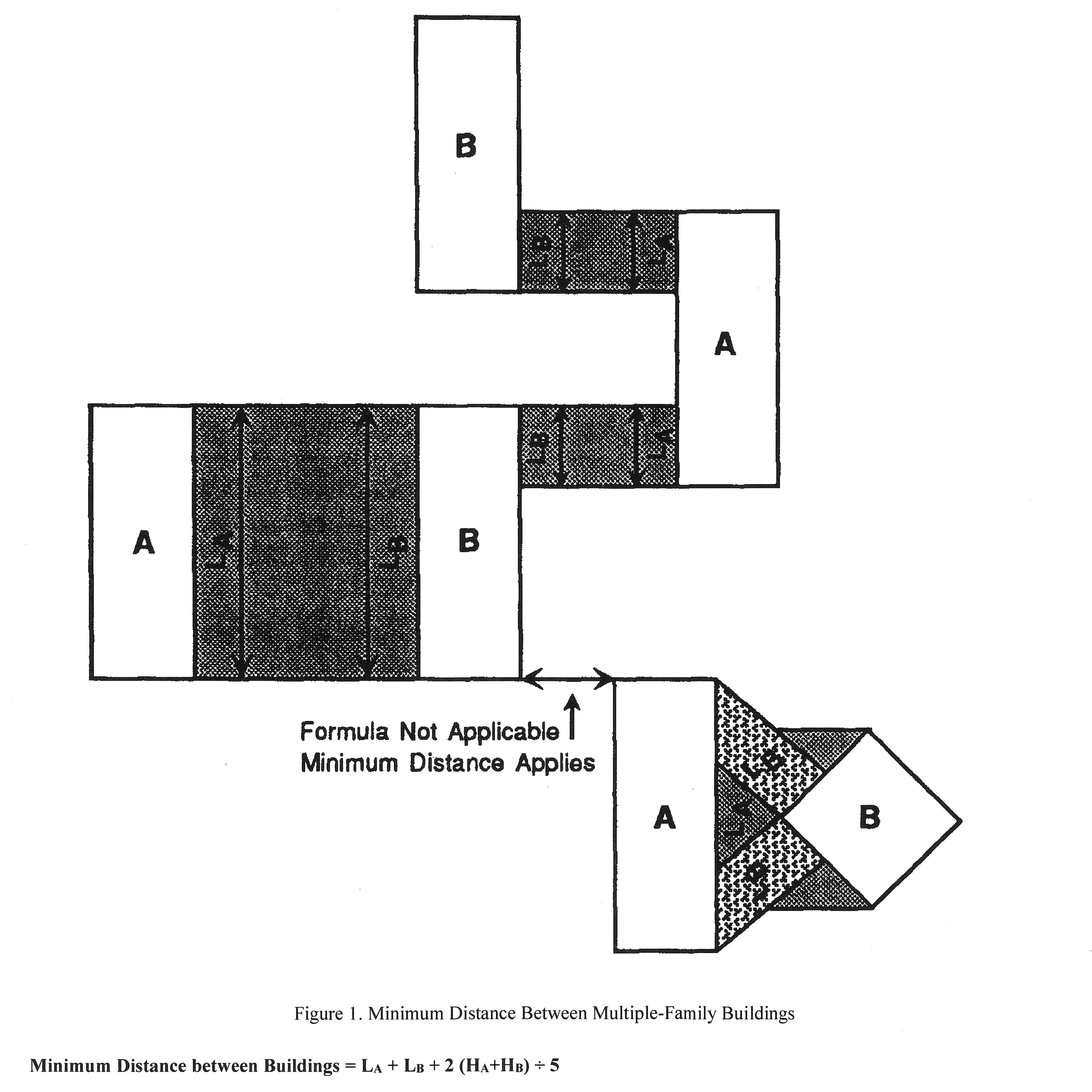
Building distance formula. In all multiple-family residence districts the minimum distance between any two buildings shall be regulated according to the length and height of the buildings. The formula regulating the required minimum distance between two buildings, referred to as building "A" and building "B", is as follows:
(1)
S—Required minimum horizontal distance between any wall of building a and any wall of building b or the vertical prolongation of either.
(2)
L A —Total length of building A. The total length of building A is the length of that portion or portions of a wall or walls of building A from which, when viewed directly from above, lines drawn perpendicular to building A will intersect any wall of building B.
(3)
L B —Total length of building B. The total length of building B is the length of that portion or portions of a wall or walls of building B from which, when viewed directly from above, lines drawn perpendicular to building B will intersect any wall of building A.
(4)
H A —Height of building A. The height of building A at any given level is the height above natural grade level of any portion or portions of a wall or walls along the length of building A. Natural grade level shall be the mean level of the ground immediately adjoining the portion of the wall or walls along the total length of the building.
(5)
H B —Height of building B. The height of building B at any given level is the height above natural grade level of any portion or portions of a wall or walls along the length of building B. Natural grade level shall be the mean level of the ground immediately adjoining the portion of the wall or walls along the total length of the building.
(H)
Design requirements for attached dwellings. The site plan application for two family and attached dwellings shall comply with the following:
(1)
Maximum units per complex. An attached dwelling unit complex, or dwelling units that are located on the same lot and share a wall on at least one side with a neighboring dwelling, shall contain no more than six attached dwelling units.
(2)
Common wall characteristics. The common walls of any attached units shall comply with the Florida Building Code and the Florida Fire Prevention Code, as adopted by the state fire marshal, and shall comprise at least 50 percent of the side wall of each respective attached unit.
(3)
Maximum utility of open space. Any open area separating attached dwelling unit complexes or portions thereof (excluding privacy fences) shall have a minimum of 20 feet of separation along a line joining the closest extremities of the attached dwelling unit complexes. Open space intended for the private use of each individual attached dwelling unit shall be so located and designed as to maximize its utility to the dwelling unit it serves and maximize its privacy, especially in relationship to adjacent dwelling units.
(4)
Guaranteed maintenance of common areas. Common open areas shall be protected by legal arrangements sufficient to assure maintenance and preservation. Covenants or other legal arrangements shall specify ownership of common open area, method of maintenance, responsibility for collection of required taxes and insurance, provisions for compulsory membership and assessment and guarantees that any association formed to own and maintain common areas will not be dissolved without the consent of the Town Council. Copies of the legal documents contemplated by this provision shall be placed on file with the Town. The Town assumes no responsibility for the sufficiency or legality of these documents.
(5)
Design requirements for single-family zero lot line structures. The R1B design standards as specified in section 160.03(C) shall also apply to zero lot line dwellings in this district.
(Ord. No. 522, § 1, 6-16-16; Ord. No. 565, § 1(Att. A), 9-26-2023; Ord. No. 571, § 1, 5-13-2024)
Sec. 160.05. - C1A limited commercial district.
(A)
Purpose. The C1A limited commercial district is established for purposes of implementing the comprehensive plan land use element policy regarding limited commercial development. As stipulated in the comprehensive plan, commercial development within the Town shall be allocated to sites having direct access to State Road A1A (SR A1A). In addition, as stated in the comprehensive plan, the intent is to restrict the scale and nature of commercial activities to very limited commercial development options due to:
(1)
The restricted capacity of SR A1A;
(2)
The relatively low level of access to countywide or regional markets; and
(3)
The potential for adverse impacts upon the natural coastal environment and infrastructure.
(B)
Permitted uses.
(1)
Commercial activities restricted to small retail stores with limited inventory serving the recurring market demands of the Town's residents for household goods, personal services or customized specialty goods. Limited commercial shall not include activities characteristically serving a transient highway oriented market or a countywide market area, or uses such as drive-in, carry-out and fast food service, which typically generate relatively high average daily traffic.
(2)
Food service, limited.
(3)
Medical and business offices.
(4)
Schools, governmental uses, community buildings and clubs.
(C)
Conditional uses.
(1)
Convenience store with or without gasoline pump (see section 161.11 for applicable supplemental regulations).
(D)
Area, size and height regulations. See Table 160.
(E)
Food service review criteria.
(1)
Shopping center location. The site selected for a limited food service establishment shall be located in a shopping complex containing at least 15 retail stores, it shall compliment the stores and other commercial establishments within the immediate proximity to the site, and the primary source of business to the limited food service establishment shall be generated by being a part of the retail shopping complex in which it is located.
(2)
Architecture. The appearance of the site, structure and sign creates a pleasing and harmonious overall effect with its surroundings. Building materials and colors should conform to the dominant existing or planned character of the surroundings.
(3)
Infrastructure. Provision for public services to include solid and sanitary waste disposal, surface water drainage, potable water and fire protection are adequate.
(4)
Circulation. Areas for parking and internal circulation of vehicular and pedestrian traffic are safe and convenient for use.
(5)
Buffers. Adequate screening protection and separation are provided for contiguous residential property.
(6)
Floor area. The interior of the premises shall not exceed 1,000 square feet.
(7)
Capacity. Maximum inside seating capacity at 30 patrons at one seating and maximum outdoor seating capacity at 30 patrons at one seating.
(8)
Hours of operation. No business activity between the hours of 9:30 p.m. and the following 10:00 a.m. No seating of customers shall take place after 8:00 p.m. There shall be no operation on Sunday.
(9)
Alcoholic beverages. The sale of alcoholic beverages shall be limited to beer and wine and shall be permitted only as an accessory to the primary use of the premises as a limited food service establishment for consumption on premises only. Any area for the dispensing of alcoholic beverages shall not be in the public view, nor provide for the seating of patrons at the dispensing area.
(10)
Storage. There shall be no outside storage. Any refuse shall be in containers approved by the Town and kept in a secure place screened from view.
(11)
No drive-in. No curb or drive-in service.
(12)
Attire. Proper dress of employees and patrons shall be maintained at all times. Swimming attire shall not be allowed.
(13)
Loading. All pickup and delivery of items utilized in the business shall be limited to the hours of operation of the limited food service establishments.
(F)
Prohibited uses. Prohibited uses shall include, but are not limited to:
(1)
Commercial recreation activities including bowling alleys.
(2)
Bars and grills unless operated as an accessory use to an approved private club or private multiple-family residential development which does not market, advertise or provide service to the general public;
(3)
Supermarkets or grocery stores over 2,000 square feet.
(4)
No other activity which generates similar rates of traffic to those uses cited herein shall be permitted.
(G)
Conditional use review criteria.
(1)
Landscaping and site improvements. Any use must exceed the minimum landscaping requirements of chapter 163. Said landscaping plus the building facade, parking lot and other premises must be continuously maintained in a satisfactory condition.
(2)
Buffers. Adequate screening protection and separation are provided for contiguous residential property as determined by the Town Building Official.
(3)
Floor area. The floor area of the principal use shall not exceed 3,000 square feet.
(4)
Hours of operation. No business activity allowed between the hours of midnight and 6:00 a.m.
(5)
Alcoholic beverages. The sale of alcoholic beverages shall be limited to beer and wine and shall be permitted only as an accessory to the primary use of the premises.
(6)
Storage. There shall be no outside storage. Any refuse shall be in containers approved by the Town and kept in a secure place screened from view.
(7)
No drive-in. No curb or drive-in service.
(8)
Loading. All pickup and delivery of items utilized in the business shall be limited to the hours of operation.
(H)
Ongoing obligations associated with conditional use. In order to maintain the conditional use, there shall be an ongoing obligation of the conditional user to continuously meet the requirements of (G). All items contemplated therein shall be continuously maintained in a condition satisfactory to the Town and in conformity with any site plan approved. Failure to comply with ongoing maintenance shall be a violation subject to enforcement by the Town.
(Ord. No. 522, § 1, 6-16-16; Ord. No. 565, § 1(Att. A), 9-26-2023; Ord. No. 571, § 1, 5-13-2024)
Sec. 160.051. - Reserved.
Editor's note— Ord. No. 571, § 1, adopted May 13, 2024, repealed § 160.051. Former § 160.051 pertained to the C2A limited commercial district and derived from Ord. No. 522, § 1, adopted June 16, 2016.
Sec. 160.052. - Reserved.
Editor's note— Ord. No. 565, § 1(Att. A), adopted September 26, 2023, repealed § 160.052. Former § 160.052 pertained to dog-friendly dining and derived from Ord. No. 522, § 1, adopted June 16, 2016. Similar provisions can now be found in § 90.18.
Sec. 160.06. - P: Public district.
(A)
Purpose. To provide for those governmental and public utility uses located within the Town.
(B)
Permitted uses.
(1)
Governmental administration and service uses.
(2)
Public parks and open space.
(3)
Public utility uses essential to serve the Town.
(C)
Development standards. All uses shall meet the C1A lot, setback and bulk standards as shown in Table 160 and shall be subject to the site plan review requirements of section 168.04.
(Ord. No. 522, § 1, 6-16-16)
Sec. 160.07. - OS: Open space and recreation district.
(A)
Intent. The purpose of this district is to accommodate major public and private open space and recreational uses.
(B)
Permitted uses.
(1)
Public open space and recreational uses.
(2)
Private open space and recreational uses that are accessory to a residential development including golf courses, tennis courts and swimming pools.
(C)
Conditional uses. Private open space or recreational uses not accessory to a residential development including golf courses, tennis courts and swimming pools.
(D)
Conditional use criteria.
(1)
Maximum trip generation. The maximum average weekday vehicle trip generation rate shall be 27 trip ends per acre per day.
(2)
Impact on residential areas. The use shall not adversely impact nearby residential areas.
(E)
Development standards. All uses shall meet the C1A lot setback and bulk standards unless a part of a PRD District.
(Ord. No. 522, § 1, 6-16-16)
Sec. 160.08. - RC/ES: Residential conservation/environmentally sensitive lands district.
(A)
Intent. The purpose of this conservation district is to assure that any development of these environmentally sensitive lands designated RC/ES or ES in the comprehensive plan future land use element is done in an environmentally sensitive manner including preservation where appropriate. These areas are characterized by wetlands, dune systems, estuarial lands and coastal high hazard characteristics that require special attention during the development review process.
(B)
Permitted uses.
(1)
Open space and passive recreation.
(2)
Stormwater management.
(3)
Accessway to an essential public facility or service.
(4)
Mosquito control activities.
(5)
Accessory uses thereto.
(C)
Conditional uses.
(1)
One family detached dwelling.
(2)
One family attached dwelling.
(3)
Essential water-dependent public facilities or utilities.
(4)
Golf course when (a) accessory to a residential development on the main barrier island and (b) designed to preserve wetlands.
(D)
Density maximum:
(1)
Marginal wetlands. One unit per acre.
(2)
Otherwise. One unit per five acres.
(3)
Transfer of Development Rights (TDR). Wetlands may constitute a TDR generating area at a density of one unit per five acres and marginal wetlands at one unit per acre. The TDR receiving area may be developed at not more than one and one-half times the permitted future land use plan density.
(E)
Development standards. All residential uses (including attached dwellings) shall meet the R1A setbacks, minimum floor area and height requirements unless the PRD District is used. The minimum lot size and width, pervious area minimum and coverage percentage shall be determined by site plan/conditional use application review.
(F)
Environmental regulations. All development shall also meet the requirements of chapter 165 (floodplain management and damage prevention) and chapter 167 (environmental regulations).
(G)
Site work. No residential site work shall be initiated until all necessary federal, state, town and other environmental approvals are received.
(Ord. No. 522, § 1, 6-16-16)
Sec. 160.09. - RESI: Residential Environmentally Sensitive Island district.
(A)
Intent. This district is intended to protect the environmentally sensitive islands (designated RC/ESI in the comprehensive plan) from premature development and when development does occur, to assure that it is done in an environmentally sensitive manner.
(B)
Permitted uses.
(1)
Open space and passive recreation.
(2)
Stormwater management.
(3)
Accessway to an essential public facility or service.
(4)
Accessory uses thereto.
(C)
Conditional uses.
(1)
One family detached dwelling.
(2)
One family attached dwelling.
(3)
Essential water-dependent public facilities or utilities.
(D)
Density Maximum. One unit per five acres.
(E)
Development standards. All residential uses (including attached dwellings) shall meet the R1A setbacks, minimum floor area and height requirements unless the PRD District is used. The minimum lot size and width, pervious area minimum and coverage percentage shall be determined by site plan/conditional use application review.
(F)
Environmental regulations. All development shall also meet the requirements of chapter 165 (Floodplain management and damage prevention) and chapter 167 (Environmental regulations).
(G)
Site work. No residential site work shall be initiated until all necessary federal, state, town and other environmental approvals are received.
(H)
Conditional use criteria for dwellings on isolated islands. No development shall be approved unless a subdivision plat has been submitted which incorporates the following prerequisite conditions prior to issuance of a development permit:
(1)
Vehicular access. A plan for vehicular access to the main barrier island shall receive approval from all applicable governmental agencies and the Town.
(2)
Requisite infrastructure. Plans for the provision of requisite public infrastructure and emergency protective services; i.e. police, fire and ambulance shall be approved by the Town.
(3)
Compliance with applicable laws. Proof of compliance with all applicable regulations and permitting procedures of the Federal, State and regional environmental agencies, plus chapters 165 and 167 of this Code, shall be provided.
(Ord. No. 522, § 1, 6-16-16)
Sec. 160.11. - PRD: planned residential district.
(A)
Purpose. The primary purpose of the Planned Residential District (PRD) is to permit land under unified control to be planned and developed as a whole (as a single operation or an approved series of operations) with a greater amount of flexibility by removing some of the detailed restrictions of conventional zoning. PRD are recognized as serving the public interest and are encouraged for the following reasons:
(1)
To allow diversification of uses, structures and open spaces when not in conflict with existing and permitted land uses on abutting properties;
(2)
To reduce improvement costs through a more efficient use of land and a smaller network of utilities and streets than is possible through application of standards contained in conventional land development regulations and site designs;
(3)
To conserve the natural amenities of the land by encouraging the preservation and improvement of scenic and functional space;
(4)
To provide maximum opportunity for application of innovative site planning concepts to the creation of aesthetically pleasing environments for living on properties of adequate size, shape and location;
(5)
To ensure that development will occur according to limitations of land use, site design, population density, building coverage, improvement standards and construction phasing authorized through the approval of a master development plan; and
(6)
To ensure that development will be consistent with the intent of the comprehensive plan and this Code.
(B)
Unified control. All land included for the purpose of development within a PRD shall be under the control of the applicant (an individual, partnership, company or corporation, or group of individuals, partnerships, companies or corporations). The applicant shall present satisfactory legal documents to constitute evidence of the unified control of the entire area. The applicant shall agree in the application for rezoning to the following:
(1)
To proceed with the proposed development according to the provisions of these regulations, and conditions attached to the rezoning of the land to PRD and the approved master development plan;
(2)
To provide agreements, contracts, covenants, deed restrictions and sureties acceptable to the Town for completion of the development according to the plans approved at the time of rezoning to PRD, and for continuing operation and maintenance of such areas, functions and facilities which are not proposed to be provided, operated or maintained at public expense;
(3)
To bind their successors in title to any commitments made under the above. All agreements and evidence of unified control shall be examined by the Planning, Zoning and Variance Board and no rezoning of land to PRD classification shall be adopted without a certification by the Town Attorney that such agreements and evidence on unified control meet the requirements of these regulations;
(4)
If the developer elects to administer common open space through an association or nonprofit corporation, said organization shall conform to the applicable laws of the State of Florida.
(C)
Permitted uses.
(1)
All residential uses permitted in the R2A multiple-family residential district.
(2)
Real estate sales office to serve the development.
(3)
Accessory uses. See section 160.02(F) for additional regulations for each.
(a)
Garage.
(b)
Swimming pools.
(c)
Cabanas.
(d)
Boathouses.
(e)
Tennis courts.
(f)
Greenhouses.
(g)
Gatehouses.
(h)
Permanent emergency generators.
(i)
Recreational facilities to serve the development.
(D)
Development regulations.
(1)
Minimum tract size. All PRD developments shall contain a minimum of 50 acres of contiguous land unless the Building Official finds that a tract which contains less than 50 acres is suitable as a PRD by virtue of some unusual conditions. This minimum may be waived by the Town Council upon the recommendation of the Building Official.
(2)
Maximum density.
(a)
The total number of dwelling units permitted in a PRD shall not exceed the total number of units permitted by the land use element of the comprehensive plan for the area to be so developed.
(b)
The ordinance adopting the rezoning for a specific PRD shall specify the allowable number of units permitted in that particular PRD.
(3)
Minimum lot area, distance between structures and frontage.
(a)
No minimum lot size shall be required within a PRD.
(b)
No minimum distance between structures shall be required within a PRD. The appropriate distance between structures shall be evaluated on an individual development basis after considering the type and character of the current structure types within a development.
(c)
Each dwelling unit and other permitted use shall have access to a public street either directly or indirectly via a private road, pedestrian way, court or other area dedicated to public or private use of common easement guaranteeing access. Permitted uses are not required to front on a dedicated road. The Town shall be allowed access on privately owned roads, easements and common open space to ensure the police and fire protection of the area, to meet emergency needs, to conduct municipal services and to generally ensure the health and safety of the residents of the PRD.
(4)
Setbacks. There are no required setbacks or yards except the following:
(a)
A setback of not less than 25 feet in depth is required abutting all public road rights-of-way, except in the case of State Road A1A which shall have setbacks in accordance with section 161.08.
(b)
A rear setback from boundary lines of the PRD of not less than 25 feet in depth is required, except for access ways. No more than ten feet of this rear setback may be used for parking or other vehicular use area. The remaining 15 feet shall consist of a minimum three-foot high landscaped berm containing a minimum of one tree per 25 lineal feet.
(5)
Maximum height of structures. The Town Council, upon recommendation of the Building Official, shall determine the appropriate height limitations on an individual development basis after considering the character of the surrounding area, the character of the proposed development and the goals of the comprehensive plan. Notwithstanding the above, a maximum height of 40 feet is allowable.
(6)
Minimum floor area requirements. The minimum floor area per dwelling unit shall be the same as the R2A District.
(7)
Building site coverage. The combined ground area occupied by all principal and accessory buildings shall not exceed 30 percent.
(8)
Off-street parking and loading requirements. All off-street parking and loading shall meet the requirements of this Code.
(9)
Landscaping. All landscaping shall meet the requirements of this Code.
(10)
Underground utilities. Within the PRD all utilities including telephone, television cable and electrical systems shall be installed underground. Primary facilities providing service to the site may be exempted from this requirement. Large transformers shall be placed on the ground and contained within pad mounts, enclosures or vaults. The developer shall provide adequate landscaping with shrubs and plants to screen all utility facilities permitted above-ground.
(11)
Open space requirements. A PRD shall provide and maintain open space at least equal to 35 percent of the PRD gross area, except that lakes, lagoons or other waterways shall not count for more than 25 percent of the open space requirement. In calculating open space, land areas for structures, public and private street rights-of-way, driveways, off-street parking and loading zones, fire protection vehicular access and side yards between single-family residential buildings shall not be included.
(12)
Internal circulation. An internal pedestrian and bicycle circulation system shall be provided within the PRD separate from vehicular circulation systems and at a distance sufficient to ensure safety. Such pedestrian and bicycle ways shall be surfaced with a durable and dustless material. The Town may waive this requirement or a portion of this requirement upon a demonstration that pedestrian and/or bicycle paths are infeasible or undesirable in the proposed development.
(13)
Energy conservation. PRD site design shall incorporate passive energy conservation measures. Such measures shall include, but need not be limited to, the directional orientation of buildings, the location of windows, minimization of radiant heat absorption and the inclusion of energy-efficient landscaping.
(14)
Professional services required. Any plans submitted as a part of a petition for a PRD shall certify that the services of competent professionals were utilized in the designing or planning process and shall state their names, businesses and addresses. Plans submitted as part of a petition for a PRD must be prepared by either a planner, who by reason of his education and experience is qualified to become or is a full member of the American Institute of Certified Planners; or an architect or landscape architect licensed by the State of Florida; together with a professional engineer registered by the State of Florida and trained in the field of civil engineering and/or a land surveyor registered by the State of Florida.
(E)
Procedures and requirements for rezoning to a planned residential development (PRD).
(1)
Required master plan. A master development plan meeting the requirements of this section shall be required of developments requesting rezoning to PRD.
(2)
PRD approval procedure.
(a)
The developer shall submit five copies of the proposed master development plan along with the application for rezoning to PRD to the Town Building Official.
(b)
The Town may establish a fee structure for rezoning to PRD to cover the cost of processing and review.
(c)
The Town Building Official shall prepare a report on the application and submit it to the Planning, Zoning and Variance Board for placement on the agenda of the next regularly scheduled meeting.
(d)
After review by the Building Official, the proposed master development plan and application for rezoning to PRD, the Town Building Official report and the recommendations of the Building Official will be submitted to the Town Council for consideration.
(e)
The Town Council shall consider the ordinance for rezoning to PRD as required by this Code.
(3)
Contents of master development plan:
(a)
Delineation of the geographical area covered by the entire development;
(b)
General schematic representation of the land uses with densities and intensities;
(c)
Approximate delineation of internal circulation with hierarchical classification of streets;
(d)
Points of local street connections to the public road system, including general indication of the necessary improvements to the public roadways to accommodate the local trips generated by the development;
(e)
General location and size of any community facility included within the development such as parks, community centers, etc.;
(f)
Indication of existing native vegetation and any other natural features within the development together with general plans for the conservation or mitigation thereof;
(g)
Schematic depiction of existing and proposed surface water management elements including wetlands, retention facilities, drainage easements and swales;
(h)
Table of computation of land use distribution showing proposed uses, acreage and number of units and density in the case of residential uses; and
(i)
Schematic depiction of the water distribution lines, wastewater collection lines and drainage system, including easements.
(F)
Conformance to approved master development plan.
(1)
Compliance with master plan prior to permit issuance. After rezoning to PRD, no permits shall be issued by the Town and no development shall commence unless in conformance with the approved master development plan, unless a change or deviation is approved by Town Council.
(2)
Minor deviations. The Town Manager or his designee may approve minor modifications from the approved master plan which are in compliance with the provisions and intent of this division, and which do not depart from the principal concept of the approved master development plan. All other requested modifications shall be referred to the Town Council.
(3)
Major deviations. The Town Council may at the owner's request, without requiring a new application, authorize changes to approved master development plans pertaining to location, types and configuration of buildings, landscaping and similar changes when the full character and intent of the approved master plan is not violated.
(4)
Rendering of new application. The Town Council may determine that requested changes and deviations to an approved master development plan constitute a substantial alteration to the character of the development and require that such changes be subject to the same procedures as new applications.
(G)
Effective period of PRD approval. Approval of a rezoning to PRD as provided herein shall be effective for a period of 12 months. Unless construction of some phase of the proposed approved project is commenced on or before the last day of the twelfth month following the approval date, the said approval shall expire. A PRD approval shall remain effective while development on the project continues as defined by permitting and inspection procedures.
(Ord. No. 522, § 1, 6-16-16; Ord. No. 565, § 1(Att. A), 9-26-2023; Ord. No. 571, § 1, 5-13-2024)
Sec. 160.12. - General design standards.
(A)
Table of area, density and bulk standards. Table 160 shall govern the various districts except as for cul-de-sacs or curved streets as provided in (B) below.
(B)
Lot width on curved streets. Minimum lot widths as shown on Table 160 shall be measured at the building line. However, the following special regulations shall apply to single-family detached lots with a curved frontage such as on cul-de-sacs:
TABLE 160.12 (B) Lot Width on Curved Streets.
(C)
Minimum floor elevation. The finished floor elevation for all structures shall be not less than 20 inches above the sidewalk or crown of the road. Special cases where natural topography has an adverse effect upon drainage and where this provision would serve no good purpose must have special approval from the Town Engineer. This approval shall be conditioned upon a determination by the Town Building Official that the proposed grade will not be injurious to the adjacent properties. In all instances, the minimum floor at the building line shall be at least seven feet above mean sea level (MSL). See also chapter 165, floodplain management and damage prevention. On oceanfront lots, two story residences may be constructed with a basement. Basement floors that are below grade on all sides shall be elevated to or above the base flood elevation plus two feet or the design flood elevation, whichever is higher. The garage opening and habitable area entrances shall be exempt from the grade regulations for basements as defined in chapter 165.
(D)
Maximum floor elevation. The maximum elevation of a finished floor of living quarters shall be as follows:
(1)
On oceanfront lots, the highest habitable occupied floor cannot exceed 27 feet above the mean high water line; provided however on oceanfront lots, excluding zero-lot line homes with no windows or doors on the zero-lot line side, finished floors consisting solely of bedrooms and their associated closets and bathrooms shall not be considered living quarters. Finished floor elevation of such floors shall not be limited to 27 feet about mean high water line.
(2)
The maximum elevation of a finished floor at the first story of all non-oceanfront homes shall be as follows:
(a)
Ten feet above mean high water line for lots where the natural grade is seven feet or less above mean high water line.
(b)
Three feet above natural grade, defined as the average elevation of ground at the building site at the time of platting, where natural grade is more than seven feet above mean sea level.
(E)
Height for non-oceanfront residences. Single-family residences may be one or two stories in height, provided that the building height does not exceed 30 feet to the midpoint of the top roof.
(F)
Height for oceanfront residences. On all oceanfront single-family residences, the elevation of the highest part of the house (chimney excepted) shall not exceed 50 feet North American Vertical Datum (NAVD).
(G)
Limitations on non-vegetative decorative objects in residential front and side yards.
(1)
Obstructions. From grade to the sky, the front yards of single family residential lots shall not be obstructed except by:
(a)
Fences and other structures explicitly authorized elsewhere in the Land Development Code;
(b)
Retaining walls and similar structures necessary for the maintenance of topography or stormwater design;
(c)
One flag pole not to exceed 18 feet in height; and
(d)
Up to three non-vegetative decorative objects.
(2)
Height and size. Non-vegetative decorative objects permitted by the above subsection shall:
(a)
Not exceed 24 inches in height above the grade where they are placed. Grade shall be determined by the approximate average grade in the front yard; and
(b)
Not be larger than two cubic feet.
(3)
Petitions for relief from specifications. In the event the property owner desires to vary from the specifications for non-vegetative decorative objects stated in this chapter, the property owner may petition to the Town Building Official for approval of any objects that do not strictly comply with such requirements.
(4)
Violations. Violations shall be enforced under Town code enforcement procedures.
(5)
Review criteria. In making a determination as to whether a non-vegetative decorative object meets the requirements of this chapter, the Town Building Official Board may consider among other things:
(a)
Whether the object or objects are in harmony with the neighborhood from an architectural and an aesthetic standpoint;
(b)
The object or objects would not create a threat of damage to the property on which it is located or surrounding properties in the event of a wind storm;
(c)
The object or objects do not affect the view of or from the roadway or in any way cause a traffic hazard;
(d)
Steps taken to shield the object or objects from the view of persons outside the property through either landscaping and/or fencing; or
(e)
Whether adjoining property owners or others in the immediate area oppose the object or objects. If the Town Building Official determines the object or objects to be in compliance, then no further action may be taken regarding such object or objects. If the Town Building Official determines the object or objects are not in compliance with this Code, then the property owner will be given ten days to correct the situation and to bring the property into conformity with this Code.
(6)
Enforcement. In the event the object or objects in violation of this chapter remain on the property after notification, then the Town Code Enforcement Officer shall present the matter to the Town Manager under the procedures outlined for matters considered by the Special Magistrate. Any violation as determined by the Special Magistrate shall carry with it the same penalties as provided in the Town Ordinances previously adopted by the Town and as amended from time to time.
(7)
Objects in place prior to ordinance. Non-vegetative decorative objects located in front yards on the adoption date of this chapter shall be permitted to remain if otherwise in conformity with Town ordinances on said date. No change or modification to any such previously placed objects shall be permitted unless said object or objects are in conformity with this chapter following such change or modification.
(H)
Care of premises. No weeds, underbrush or other unsightly growths shall be permitted to grow or remain upon any part of the property, and no refuse pile or unsightly objects shall be allowed to be placed or suffered to remain anywhere thereon, including vacant lots. The Town Manager or designee shall have the authority to exempt parcels of undeveloped real property from the requirements of this section (H); provided however the owner shall, at a minimum, maintain a five-foot wide corridor that conforms to the standards of this section (H) where the real estate parcel abuts developed property or a public or private right-of-way.
(I)
Clothes lines and trash cans. Clothes lines, drying yards and garbage and trash receptacles shall be located so as not to be visible from the street or adjoining property.
(Ord. No. 522, § 1, 6-16-16; Ord. No. 565, § 1(Att. A), 9-26-2023; Ord. No. 571, § 1, 5-13-2024)
Sec. 160.13. - Nonconforming uses and lots.
(A)
Elimination of nonconforming uses. Any use existing on the effective date of this Code which is classified as a nonconforming use in the zoning classification in which it is located shall be terminated by the year 2000. By July 1, 1991, the Town Building Official shall issue a special certificate of occupancy to the owner of all nonconforming uses which shall state the future date of termination of the nonconforming use, and said special certificate of occupancy shall be prominently displayed on said property.
Any owner that perceives the year 2000 date to constitute a unique hardship may apply to the Planning, Zoning and Variance Board. All applications for extensions must be submitted to the Town Building Official by January 1, 1992; said applications must be accompanied by an appraisal, and a statement of what is unique to this use and structure. No extension shall be granted beyond the year 2010. The Board is authorized to hire tax, accounting and/or architectural experts (at the expense of the applicant) to assist in assessing the stated hardship.
(B)
Expansion or discontinuance of nonconforming use. No nonconforming building containing a nonconforming use shall be structurally changed, altered, enlarged or moved unless the altered, enlarged or moved building or use shall conform to the provisions of the district in which it is located; provided, however, redevelopment of a nonconforming building or a nonconforming use which results in a decrease in the degree of nonconformity may be approved by the Town Council if the Town Council finds that the redevelopment will not adversely affect adjacent property and that it would not adversely affect the public welfare. No nonconforming use, if discontinued or changed to a use permitted in the district in which it is located, shall be resumed or changed back to a nonconforming use. A nonconforming use shall be deemed discontinued for the purpose of this section if a nonconforming use is not made of the property for a period of one year. For the purposes of this section, "redevelopment" shall mean new construction which replaces pre-existing construction on a site.
(C)
Effect of enactment of code. The enactment of this Code shall not be deemed to affect, alter or change any special exception or variance heretofore granted by the appropriate administrative or legislative body of the Town or by a court of competent jurisdiction upon review of the action of the administrative or legislative body.
(D)
Restoration of damaged buildings. Nothing in this section shall prevent the restoration of a building damaged by fire, explosion, an act of God or an act of the public enemy subsequent to the effective date of this chapter or prevent the continuance of the use of the building or part thereof as the use existed at the time of the impairment of the building or part thereof. However, the restoration shall be no greater than 50 percent of the structure's total current replacement value, the restoration shall be made within one year and the same use shall be made of the premises. The restoration must be comparable in quality to the remaining structure. In no instance shall a nonconforming use be permitted to be restored when more than 50 percent of its total current replacement value has been destroyed. The provisions of (A) above shall still apply.
(E)
Repairs and maintenance. Nothing contained in this section shall prevent the strengthening or restoration of any building or wall declared unsafe by the Town Building Official.
(F)
Nonconforming lots. In any district in which single-family dwellings are permitted, notwithstanding limitations imposed by other provisions of this chapter, a single-family dwelling and customary accessory buildings may be erected on any single lot of record at the effective date of adoption of this chapter. This provision shall apply even though the lot fails to meet the requirements for area, width or both area and width that are generally applicable in the district. However, front, side and rear yard dimensions and other requirements not involving area, width, or both area and width of the lot shall conform to the regulations for the district in which the lot is located.
(Ord. No. 571, § 1, 5-13-2024)