
Jamestown City Zoning Code
ARTICLE 1
- INTRODUCTION
Sec. 82-100.- Preamble.
In accordance with G.L. 1956, tit. 45, ch. 24 as amended and as may hereafter be amended, the Rhode Island Zoning Enabling Act of 1991, Rhode Island General Laws, G.L. 1956, §§ 45-24-27—45-24-72 (the "Act"), and by virtue of the authority conferred by the Town of Jamestown Home Rule Charter, the Zoning Ordinance of the Town of Jamestown is hereby amended in its entirety to read as follows:
(Ord. of 2-3-2025(1), § 1(Exh. A))
Sec. 82-101. - Purpose.
The regulations set forth in this chapter are made in accordance with the Comprehensive Community Plan of the Town of Jamestown (pursuant to G.L. 1956, §§ 45-22.2-3 and 45-24-29) for the purpose of promoting the public health, safety, morals and general welfare of the citizens of the Town of Jamestown and assist the Rhode Island General Assembly in its duty to provide for the conservation of the natural resources of the state and to adopt all means necessary and proper by law for the preservation, regeneration and restoration of the natural environment of the state in accordance with sections 16 and 17 of article 1 of the constitution of the State of Rhode Island. These regulations are designed to lessen congestion in the streets; to secure safety from fire, panic and other dangers; to provide adequate light and air; to prevent the overcrowding of the land; to avoid undue concentrations of populations; to provide for the adequate provision of transportation, water, sewage, schools, parks and other public requirements.
In addition, these regulations shall address the following purposes:
1)
Promote the public health, safety and general welfare;
2)
Provide for a range of uses and intensities of use appropriate to the character of the town and reflecting current and expected future needs;
3)
Provide for orderly growth and development which recognizes:
a)
The goals and patterns of land use contained in the comprehensive plan;
b)
The natural characteristics of the land, including its suitability for particular uses based on soil characteristics, topography, and susceptibility to surface or groundwater pollution;
c)
The values and dynamic nature of freshwater ponds, the shoreline and freshwater wetlands;
d)
The values of unique or valuable natural resources and features;
e)
The availability and capacity of existing and planned public and/or private services and facilities;
f)
The need to shape and balance urban and rural development;
g)
The use of innovative development regulations and techniques;
4)
Provide for the control, protection, and/or abatement of air, water, groundwater and noise pollution, and soil erosion and sedimentation;
5)
Provide for the protection of the natural, historic, cultural, and scenic character of the town or areas therein;
6)
Provide for the preservation and promotion of agricultural production, forest, silviculture, aquaculture, timber resources and open space;
7)
Provide for the protection of public investment in transportation, water, stormwater management systems, sewage treatment and public facilities, open space, and other public requirements;
8)
Promote a balance of housing choices, for all income levels and groups, to ensure the health, safety and welfare of all citizens and their rights to affordable, accessible, safe and sanitary housing;
9)
Provide opportunities for the establishment of low- and moderate-income housing;
10)
Promote safety from fire, flood, and other natural or manmade disasters;
11)
Promote a high level of quality in design in the development of private and public facilities;
12)
Promote implementation of the comprehensive plan;
13)
Provide for coordination of land uses with contiguous municipalities, other municipalities, the state and other agencies, as appropriate, especially with regard to resources and facilities that extend beyond municipal boundaries or have a direct impact on that municipality;
14)
Provide for efficient review of development proposals, to clarify and expedite the zoning approval process and provide for the procedures for the administration of the ordinance from which this chapter is derived, including, but not limited to, variances, special use permits and, where adopted, procedures for modifications.
(Ord. of 2-3-2025(1), § 1(Exh. A))
Sec. 82-102. - Consistency statement.
Drafting and adoption of the ordinance from which this chapter is derived is consistent with the Town of Jamestown comprehensive community plan adopted June 18, 2014 and as amended April 6, 2015, pursuant to G.L. 1956, ch. 45-22.2. In the instance of any uncertainty in the construction or application of any section of this chapter, the ordinance shall be construed in a manner that will further the implementation of, and not be contrary to, the goals and policies and applicable elements of the comprehensive plan.
(Ord. of 2-3-2025(1), § 1(Exh. A))
Sec. 82-103. - Regulation.
The use of any land or the erection, modification, enlargement or use of any building, structure or sign shall conform to all applicable provisions of this chapter.
Every building, structure or sign hereafter erected and every use hereafter initiated shall be located on a lot as defined by this chapter.
(Ord. of 2-3-2025(1), § 1(Exh. A))
Sec. 82-104.1. - General definitions.
The following words [terms] shall have the following meanings [in this chapter]:
Abutter. One whose property abuts, that is, adjoins at a border, boundary, or point with no intervening land.
Active recreation. Leisure time activities, usually of a more formal nature, often requiring equipment and taking place at prescribed places, sites, or fields. A higher level of amenities at a site, and/or a modification to the natural environment are usually connected to active recreation. It includes tennis and other court games, baseball and other field sports, and playground activities.
Accessory building. Any building which is customarily incidental and subordinate to the principal building and does not share a common wall or roof with the principal building. An accessory building shall be located on the same zoning lot as the principal building.
Accessory dwelling unit (ADU). A residential living unit on the same lot where the principal use is a legally established single-family dwelling unit or multi-family dwelling unit. An ADU provides complete independent living facilities for one or more persons. It may take various forms including, but not limited to: a detached unit; a unit that is part of an accessory structure, such as a detached garage; or a unit that is part of an expanded or remodeled primary dwelling. (See section 82-1201- Accessory dwelling units)
Accessory structure. Any structure constructed or erected which is customarily incidental and subordinate to the principal building. An accessory structure shall be located on the same zoning lot as the principal building.
Accessory use. A use of land or of a building, or portion thereof, customarily incidental and subordinate to the principal use of the land or building. An accessory use shall be restricted to the same lot as the principal use. An accessory use shall not be permitted without the principal use to which it is related.
Act. Rhode Island Zoning Enabling Act as set forth in G.L. 1956, § 45-24-27 et seq.
Adaptive reuse. Conversion of an existing structure from the use for which it was constructed to a new use by maintaining the elements of the structure and adapting such elements to a new use.
Adult business. Any restaurant, bar, nightclub or private or nonpublic association which employs topless waitpersons and/or presents nude or seminude entertainment or other erotic forms of entertainment. Also, any establishment which shows, rents, sells, promotes, displays or advertises pornographic material in any format.
Affordable housing. Residential housing that has a sales price or rental amount that is within the means of the household living in it. (See low- and moderate-income housing for the State of Rhode Island's definition of what legally counts as "affordable" housing.)
Aggrieved party. An aggrieved party, for purposes of this chapter, shall be:
• Any person or persons or entity or entities who can demonstrate that their property will be injured by a decision of any officer or agency responsible for administering the ordinance [this chapter]; or
• Anyone requiring notice pursuant to the act.
Agricultural structure. A structure which is reasonably necessary to the conduct of on-site working farms. "Agricultural structure" includes, barns, sheds, silos and other similar structures.
Agricultural land. Land suitable for agriculture by reason of suitability of soil or other natural characteristics or past use for agricultural purposes. Agricultural land includes that defined as prime farmland or additional farmland of statewide importance for Rhode Island by the soil conservation service of the U.S. Department of Agriculture.
Amusement or video arcade. Any place of business where more than five coin-operated mechanical amusement devices and/or electronic video games are located for use by the general public.
Apartment. A residential unit sharing a building and a lot with other units and/or uses; may be for rent, or for sale as a condominium.
Applicant. An owner or authorized agent of the owner submitting an application or appealing an action of any official, board or agency.
Application. The completed form or forms and all accompanying documents, exhibits, and fees required of an applicant by an approving authority for development review, approval, or permitting purposes.
Aquaculture. The hatching, raising, and breeding of fish or other aquatic plants or animals for sale or personal use.
Assisted living facility. A non-institutional shared living environment which integrates shelter and service needs for functionally impaired and older persons who can maintain a semi-independent lifestyle and who do not require constant supervision or intensive health care as provided by an institution. Each congregate unit has its own bedroom and may have a separate and shared living room, kitchen, dining area or bathroom.
Attached (structure). Any structure that is attached to another structure by a common wall. Structures connected by an "I" beam, breezeway, landscape structure or similar connections are not considered attached.
Attic. The interior part of a building contained within the sloped roof of a structure.
Bed and breakfast home. A single building or part thereof used only for residential lodging, occupied by the owner thereof, and made available on an overnight basis for transient guests for compensation, and which adheres to the standards in section 82-1202.
Bedroom. A room furnished with a bed or intended primarily for sleeping.
Bioretention facility. An engineered landscaped depression generally planted with native plants and trees designed to capture and infiltrate stormwater runoff and protect water quality through the use of specified soils, and subsurface drainage/infiltration structural elements.
Bioswale. An extended rain garden or bioretention facility with a linear design that can convey stormwater runoff like a conventional swale but can also provide water quality treatment.
Block. The aggregate of private lots, passages, rear alleys and rear lanes, circumscribed by thoroughfares.
Boat and ship storage (non-commercial). (See section 82-706, Parking or storage of commercial and major recreational equipment) The storage of all boats excluding dinghies, prams, kayaks, canoes, rowboats or the like, and any boat 15 feet in length or under.
Bog. A bog shall be a place where standing or slowly running water shall be near or at the surface during normal growing season and/or where a vegetational community shall be made up of one or more of, but not limited to nor necessarily including all of, the following: blueberry, cranberry (Vaccinium), leatherleaf (Chamaedaphne calyculata), pitcher plant (Sarracenia purpurea), sundews (Droseraceae), orchids (Orchidaceae), white cedar (Chamaecyparis thyoides), red maple (Acer rubrum), black spruce (Picea mariana), bog aster (Andromeda glaucophylla), azaleas (Rhododendron), laurels (Kalmia), sedges (Caryx), [and] bog cotton (Eriophorum).
Buffer. Land which is maintained in either a natural or landscaped state and is used to screen and/or mitigate the impacts of development on surrounding areas, properties or rights-of-way.
Building. Any structure used or intended for supporting or sheltering any use or occupancy.
Buildings of value. Buildings identified in Historic and Architectural Resources of Jamestown, Rhode Island by the Rhode Island Historical Preservation and Heritage Commission, 1995. Also, buildings of similar age, style, and architectural character shall be determined to be buildings of value. Buildings of value shall become such only after amendment to the zoning map of the Town of Jamestown per section 82-1104 A.2. (Note: The town has not currently identified any buildings of value. This definition is a placeholder should the town choose to pursue a buildings of value program.)
Building height. (see also "height" definition in section 82-104.2) For a vacant parcel of land, building height shall be measured from the average, existing-grade elevation where the foundation of the structure is proposed. For an existing structure, building height shall be measured from average grade taken from the outermost four corners of the existing foundation. In all cases, building height shall be measured to the top of the highest point of the existing or proposed roof or structure. This distance shall exclude spires, chimneys, flag poles, and the like. For any property or structure located in a special flood hazard area, as shown on the official FEMA Flood Insurance Rate Maps (FIRMs), or depicted on the Rhode Island coastal resources management council (CRMC) suggested design elevation three foot sea level rise (CRMC SDE 3 SLR) map as being inundated during a 100-year storm, the greater of the following amounts, expressed in feet, shall be excluded from the building height calculation:
(i)
The base flood elevation on the FEMA FIRM plus up to five feet of any utilized or proposed freeboard, less the average existing grade elevation; or
(ii)
The suggested design elevation as depicted on the CRMC SDE 3 SLR map during a 100-year storm, less the average existing grade elevation. CRMC shall reevaluate the appropriate suggested design elevation map for the exclusion every ten years, or as otherwise necessary.
By right. Characterizing a proposal or component of a proposal for a site plan that complies with this Code and is permitted and processed administratively, without public hearing. See "special use permit" and "variance."
Cannabis establishment. A cannabis cultivator, cannabis testing laboratory, cannabis product manufacturer, cannabis retailer, hybrid cannabis retailer or any other type of licensed cannabis-related business as defined under § 21-28.11-3 of the Rhode Island Cannabis Act.
Capacity or land capacity. The suitability of the land, as defined by geology, soil conditions, topography, and water resources, to support its development for uses such as residential, commercial, industrial, open space, or recreation.
Civic. The term defining not-for-profit organizations dedicated to arts, culture, education, recreation, government, transit, and municipal parking.
Civic building. A building operated by not-for-profit organizations dedicated to arts, culture, education, recreation, government, transit, and municipal parking, or for use approved by the legislative body.
Coastal features. A prominent part or characteristic of the land near the ocean shore. Includes coastal beaches, dunes, barrier beaches, wetlands, cliffs, bluffs, banks, and manmade shorelines.
Coastal wetlands. Coastal wetlands include saltwater marshes and freshwater or brackish wetlands contiguous to saltwater marshes. Areas of open water within coastal wetlands are considered a part of the wetland.
Salt marshes are areas regularly inundated by saltwater through either natural or artificial watercourses and where one or more of the following species predominate: smooth cordgrass (Spartina alterniflora), salt meadow grass (Spartina patens), spike grass (Distichlis spicata), black rush (Juncus gerardi), saltworts (Salicornia spp.), sea lavender (Limonium carolinianum), saltmarsh bulrush (Scirpus spp.), [and] high tide bulrush (Iva frutescens).
Contiguous freshwater wetlands are those wetlands which border directly on salt marshes or brackish wetlands and which, except for size limitations, meet the definition of bog, swamp, or pond under the Rhode Island Freshwater Wetlands Act (G.L. 1956, § 2-1-18-24 et seq.). All contiguous freshwater wetlands are protected by this chapter, regardless of size.
Contiguous brackish wetlands are those wetlands which border directly on salt marshes and where one or more of the following species predominate: tall reed (Phragmites communis), tall cordgrass (Spartina pectinata), broadleaf cattail (Typha latifolia), narrowleaf cattail (Typha angustifolia), spike rush (Eleocharis rostellata), chairmaker's rush (Scirpus americana), creeping bentgrass (Agrostis palustris), sweet grass (Hierochloe odorata), [and] wild rye (Elymus virginicus).
Commercial recreation facilities. A recreational or fitness activity carried out for profit and generally conducted within a building or substantial structure. May include activities such as small gyms or personal training centers, yoga or Pilates studios, swimming pools, indoor tennis courts, recreation halls, etc.
Common ownership. Common ownership means either:
• Ownership by one or more individuals or entities in any form of ownership of two or more contiguous lots; or
• Ownership by any association (such ownership may also include a municipality) of one or more lots under specific development techniques.
Community residence. A home or residential facility where children and/or adults reside in a family setting and may or may not receive supervised care. This shall not include halfway houses or substance abuse treatment facilities. This shall include, but not be limited to, the following:
Whenever six or fewer children or adults with developmental disabilities reside in any type of residence in the community, as licensed by the state pursuant to G.L. 1956, § 40.1-24-1 et seq.
All requirements pertaining to local zoning are waived for these community residences;
A group home providing care or supervision, or both, to not more than eight mentally disabled or mentally handicapped or physically handicapped persons, and licensed by the state pursuant to G.L. 1956, § 40.1-24-1 et seq.;
A residence for children providing care or supervision, or both, to not more than eight children including those of the caregiver and licensed by the state pursuant to G.L. 1956, § 42-72.1-1 et seq.;
A community transitional residence providing care or assistance, or both, to no more than six unrelated persons or no more than three families, not to exceed a total of eight persons, requiring temporary financial assistance, and/or to persons who are victims of crimes, abuse, or neglect, and who are expected to reside in that residence not less than 60 days nor more than two years. Residents will have access to and use of all common areas, including eating areas and living rooms, and will receive appropriate social services for the purpose of fostering independence, self-sufficiency, and eventual transition to a permanent living situation.
Compact cottage development (CCD). A residential development that is authorized pursuant to section 82-1203 of this chapter and complies with all of the design standards therein.
Comprehensive plan. The comprehensive community plan of the Town of Jamestown adopted and approved on June 18, 2014, pursuant to chapter 45-22.2 of the Rhode Island Zoning Enabling Legislation Act of 1991.
Condominium. A unit in a multiunit complex of real property established in accordance with the Rhode Island Condominium Act (G.L. 1956, § 34-36.1-1.01 et seq.).
Conservation development. A residential land development project which allows a community to guide growth to the most appropriate areas within a parcel of land to avoid impacts to the environment and to protect the character-defining features of the property. See Jamestown Subdivision and Land Development Regulations.
Conventional subdivision. A residential subdivision in which all land being subdivided is dedicated to either development lots or street right-of-way. Not a conservation development.
Conventional yield plan. A plan of a conventional subdivision or land development project (as opposed to a conservation development) that depicts the maximum number of single-family building lots or dwelling units that could reasonably be built on a parcel of land under current zoning, taking into account the presence of physical constraints to development, such as wetlands, or other land unsuitable for development.
Cooking facility. Any apparatus that is constructed, installed, or otherwise established for the purpose of preparing meals.
Critical electric infrastructure (CEI). Electric utility transmission and distribution infrastructure, including, but not limited to, substations, transmission towers, transmission and distribution poles, supporting structures, guy-wires, cables, lines and conductors operating at voltages of 13.8 kV and above and associated telecommunications infrastructure. CEI also includes all infrastructure defined by any federal regulatory agency or body as transmission facilities, and transmission lines and associated equipment generally operated at voltages of 100 kV or higher.
Day care—Day care center. A facility that provides for the care of children or adults. Those receiving care are not all related to each other by blood or marriage and are not legal wards or foster children of the attendant adults, and for which care a payment, fee, or grant is made. Of those receiving care, only dependents of an attendant adult living at the site may reside there. This excludes any family day care home.
Day care—Family day care home. Any home, other than the home of the individuals being cared for, in which day care in lieu of parental care or supervision is offered at the same time to six or fewer individuals who are not relatives of the caregiver, but may not contain more than a total of eight individuals receiving day care.
Days. Calendar days.
Debris. The remains of broken or discarded machinery and structures, and their contents. Also refers to the accumulation of unused construction material, excavating and natural materials.
Deck. A porch or other structure which is open to the outdoors, whether or not attached to the primary structure.
Density, residential. The number of dwelling units per unit of land.
Development. The construction, reconstruction, conversion, structural alteration, relocation, or enlargement of any structure; any mining, excavation, landfill or land disturbance; any change in use (from one use category to another), or alteration or extension of the use, of land.
Development plan review. Design or site plan review of a development of a permitted use. A municipality may utilize development plan review under limited circumstances to encourage development to comply with design and/or performance standards of the community under specific and objective guidelines, for the following categories of developments:
• A change in use at the property where no extensive construction of improvements is sought;
• An adaptive reuse project located in a commercial zone where no extensive exterior construction of improvements is sought;
• An adaptive reuse project located in a residential zone which results in less than nine residential units;
• Institutional development for educational or hospital facilities;
• Any substantial modification of a municipal property;
• Any development proposals specifically designated for DPR specific to individual districts or uses including, but not limited to, the Jamestown Village Special Development District, the High Groundwater Overlay, and wind energy facilities;
• Proposal for any new multi-family residential building;
• Accessory structures exceeding 1,000 square feet of gross floor area;
• Exterior addition with a gross floor area of more than 500 but less than 1,000 square feet;
• Development within RR-200 Zoning District.
District. See "zoning use district."
Drainage system. A system for the removal of water from land by drains, grading, or other appropriate means. These techniques may include runoff controls to minimize erosion and sedimentation during and after construction or development, the means for preserving surface and groundwater, and the prevention and/or alleviation of flooding.
Drive-in restaurant (no alcoholic beverages). Any lot or structure used for selling, dispensing, or serving food, refreshments, or nonalcoholic beverages to persons in automobiles, or where the consumption of food, refreshments, or nonalcoholic beverages in automobiles is permitted although customers may also consume the food, refreshments, or nonalcoholic beverages on such lot or in such structure.
Driveway. A vehicular lane within a lot, often leading to a garage.
Duplex. See "dwelling - Two household."
Dwelling - Two household. A building containing two households where each dwelling unit provides complete, independent living facilities for one or more persons, including permanent provisions for living, sleeping, eating, cooking, and sanitation, and containing a separate means of ingress and egress.
Dwelling unit. A building or portion thereof providing complete, independent living facilities for one or more persons, including permanent provisions for living, sleeping, eating, cooking, and sanitation, and containing a separate means of ingress and egress.
Earth removal. The removal or extraction for sale of any rock, stone, sand, gravel, loam, topsoil, or other earth or earth products from a lot or plot of land or part thereof; not including the process of grading, or excavation on a lot preparatory to the construction of a structure or street.
Elevation. In the context of building form, elevation refers to any exterior wall of a building other than a façade.
Emergency counseling service. A facility designed to accommodate drop-in specialized care services for adults, children and adolescents experiencing a psychiatric or substance abuse emergency. Services may include initial psychiatric assessment, medication, nursing, psychiatric evaluations, individual therapy, and substance abuse counseling, but may not include overnight stays.
Encroach. To break the plane of a vertical or horizontal regulatory limit with a structural element, so that it extends into a setback, into the public frontage, or above a height limit.
Extractive industry. The extraction of minerals, including: solids, such as coal and ores; liquids, such as crude petroleum; and gases, such as natural gases. The term also includes quarrying; well operation; milling, such as crushing, screening, washing, and flotation; and other preparation customarily done at the extraction site or as a part of the extractive activity.
Façade. The exterior wall of a building that is set along a frontage line.
Family. Two or more persons related by blood, marriage, or other legal means. See also "household."
Farm, crop and nursery. Any commercial enterprise which has as its primary purpose horticulture, viticulture, viniculture, floriculture or forestry, or as the definition of agricultural operations related to such crops may be amended from time to time in G.L. 1956, § 2-23-4 entitled "The Rhode Island Right to Farm Act."
Farm, livestock. Any commercial enterprise which has as its primary purpose dairy farming, or the raising of livestock, furbearing animals, poultry or bees, or as such definition of Agricultural Operations related to such livestock may be amended from time to time in G.L. 1956, § 2-23-4 entitled "The Rhode Island Right to Farm Act."
Fishery equipment. Equipment including, but not limited to, lobster pots and traps; nets and netting; ropes; fishing spears, rakes, shovels, and other stabbers, diggers, and scoopers; buoys; and other such related equipment designed for fishing or aquaculture use.
Floating zone. An unmapped zoning district adopted within the ordinance from which this chapter is derived which is established on the zoning map only when an application for development, meeting the zone requirements, is approved.
Floodplain or flood hazard area. An area that has a one percent or greater chance of inundation in any given year, as delineated by the federal emergency agency pursuant to the National Flood Insurance Act of 1968, as amended (P.L. 90-448) [42 USC 4011 et seq.].
Floor area, net. The actual area which can be occupied, not including accessory unoccupied areas or thickness of walls.
Floor area. The sum of the gross horizontal areas of the several stories and basement of a building measured from the exterior faces of the exterior walls or from the centerline of party walls. Included in such calculation shall be any interior balconies and mezzanines, elevator shafts, and enclosed porches. The floor area of accessory structures on the same lot shall also be included.
Freeboard. A factor of safety expressed in feet above the base flood elevation of a flood hazard area for purposes of floodplain management. Freeboard compensates for the many unknown factors that could contribute to flood heights such as wave action, bridge openings, and the hydrological effect of urbanization of the watershed.
Frontage. The area between a building façade and the vehicular lanes, inclusive of its built and planted components. Frontage is divided into private frontage and public frontage.
Frontage line. A lot line bordering a public frontage. Façades (defined herein as any exterior wall of a building that is set along a frontage line) define the public realm and are therefore more regulated than the elevations facing other lot lines. (See Table 6-2._
Fuel service station. Buildings/structures and lots where gasoline, electricity, hydrogen and other vehicle fuels, along with oil, grease, batteries, tires, and automobile accessories, are sold at retail.
Gambling. Playing of a game of which the outcome is uncertain, for money or other stakes. Any kind of gaming or wagering.
Grade. The average level of the finished surface of the ground adjacent to the exterior walls of the building.
Green roof. A roof partially or completely covered with vegetation and soil, or a growing medium, planted over a waterproofing membrane. (Syn: eco-roof, living roof, greenroof)
Gross leasable floor area (GLFA). The total floor area, measured as stated in [the definition] "floor area," of a building designed for occupancy and exclusive use by a tenant, including mezzanines and upper floors, if any, and excluding stairs, elevator shafts, air shafts, public toilets, and utility and mechanical equipment areas which are used solely for the maintenance of the building.
Groundwater. Water located beneath the surface of the earth in spaces between soil particles and cracks within bedrock which are completely saturated.
Habitable floor area. For purposes of compact cottage development (CCD), the accessible floor area measured from the interior walls of a dwelling unit excluding the following:
• Unheated storage space located under the main floor of the dwelling unit;
• Architectural projections, such as bay windows, fireplaces or utility closets no greater than 18 inches in depth or six feet in width;
• Attached porches (unenclosed);
• Detached garages or carports;
• Spaces with ceiling height of five feet or less measured to the exterior walls.
Halfway house. A residential facility for adults or children who have been institutionalized for criminal conduct and who require a group setting to facilitate the transition to a functional member of society.
Hardship. As set forth in G.L. 1956, 45-24-41, [hardship] is the standard a petitioner must demonstrate in order to be granted a Use Variance from the requirements of this chapter.
Hazardous or toxic material. Any substance or combination of substances which, because of quantity, concentration, or physical, chemical, or infectious characteristics, poses a significant present or potential hazard to water supplies or to human health. Any substance considered a hazardous or a toxic waste under section 3001 of the Resource Conservation and Recovery Act of 1976, 40 CFR 26, as defined under the G.L. 1956, § 23-19.1-1 et seq. as amended, as defined by 40 CFR 116 pursuant to section 301 of the Federal Clean Water Act and subsequent amendments thereto, or as defined by section 101(14) of the Comprehensive Environmental Response, Compensation, and Liability Act of 1989 (42 USC 9605), as amended, shall also be considered hazardous under this chapter.
Heavy equipment sales or rentals. The use of any building, land area, or portion thereof, for the display and sale or rental/lease of tractors or construction and heavy equipment, including incidental parking and servicing of associated vehicles and equipment.
Height, wind turbine. The height of a wind turbine measured from natural grade to the tip of the rotor blade at its highest point or blade-tip height. This measure is also commonly referred to as the maximum tip height (MTH).
Heliport and/or helistop. Any private or public area used for the landing and/or taking off of a helicopter and/or similar airplane vehicle engaged in personal and/or business operations of a person, association, organization or legal entity for the receipt or discharge of passengers, cargo or any other material or products, but not including emergency response or law enforcement helicopter or airplane vehicles used for emergency, rescue and/or law enforcement purposes.
Historic district or historic site. [The term] "historic district" means one or more historic sites and intervening or surrounding property significantly affecting or affected by the quality and character of the historic site or sites, and has been registered, or is deemed eligible to be included, on the state register of historical places pursuant to G.L. 1956, § 42-45-5. Historic site means any real property, manmade structure, natural object, or configuration or any portion or group of the foregoing which has been registered, or is deemed eligible to be included, on the state register of historic places pursuant to G.L. 1956, § 42-45-5.
Home occupation. Any activity customarily carried out for economic gain by a resident which meets the standards of section 82-1210.
Hotel. A building or buildings containing lodging rooms, a common entrance lobby, halls, and stairway; and where lodging rooms do not have a direct egress outdoors, except for emergencies; and where more than 50 percent of the lodging rooms are for rent, with or without meals, to transient guests for a continuous period of less than 30 days.
Household. One or more persons living together in a single dwelling unit, with common access to, and common use of, all living and eating areas and all areas and facilities for the preparation and storage of food within the dwelling unit. The term "household unit" shall be synonymous with the term "dwelling unit" for determining the number of such units allowed within any structure on any lot in a zoning district. An individual household shall consist of any one of the following:
• A family, which may also include up to a maximum of three unrelated persons, including servants and employees living with the family; or
• A single person or up to a maximum of three unrelated persons living together.
Impervious surface coverage. Includes paved driveways, concrete surfaces, rooftops, basketball courts, accessory structures such as sheds, and any other surfaces that restrict water from infiltrating into the ground. Gravel driveways, walkways and patios constructed using permeable pavements are not included as impervious areas.
Impervious layer. Consists of category 9 or 10 soils as defined by the Rhode Island Department of Environmental Management (RIDEM) and shall be as determined by a RIDEM licensed Class IV Soil Evaluator.
Inclusionary housing agreement. An agreement recorded in the town's land evidence records describing how the developer will comply with the provisions of article 16.
Inclusionary unit. An affordable housing unit, as defined in this chapter.
Infrastructure. Facilities and services needed to sustain residential, commercial, industrial, institutional, and other activities.
Kitchen. A living space including a range with either burners or cook-top with the exclusion of cooking devices such as microwave oven or hot plates and a sink.
Land development project. A project in which one or more lots, tracts, or parcels of land are to be developed or redeveloped as a coordinated site for a complex of uses, units, or structures, including, but not limited to, planned development and/or conservation development for residential, commercial, institutional, recreational, open space, and/or mixed uses as may be provided for in this chapter.
Land suitable for development. Land suitable for development means any land area other than land unsuitable for development.
Land unsuitable for development. [Land unsuitable for development] means land which has environmental constraints or physical constraints to development and shall be defined as follows:
1)
Wetlands as defined in G.L. 1956, § 45-22.2-4 (wetland, coastal) G.L. 1956, § 2-1-20 (wetland, freshwater), and as the same is or may be from time to time amended, and in any rules or regulations adopted pursuant thereto. For the purposes of delineating suitable land for the computation of the maximum number of dwelling units, land encompassed by any Rhode Island setback requirement, need not be excluded from consideration as developable land area.
2)
Land located within special flood hazard area (SFHA) as defined in section 82-104.2 herein or shown on the Newport County flood insurance rate map, and any revisions thereto.
3)
An area of the tract proposed to be developed equal to 20 percent of that portion of a tract which is located in an R20 District; ten percent of that portion of a tract which is located in an R40 District; and five percent of the portion of a tract which is located in an RR80 District, as an allowance for public streets or in the alternative the area of any public street rights-of-way actually designed for the proposed project in accordance with applicable subdivision regulations
Layer. A range of depth of a lot within which certain elements are permitted. See Table 11-1.
Lot. [Lot means] either:
• The basic development unit for determination of lot area, depth, and other dimensional regulations; or
• A parcel of land whose boundaries have been established by some legal instrument such as a recorded deed or recorded map and which is recognized as a separate legal entity for purposes of transfer of title.
Lot area. The total area within the boundaries of a lot, excluding any street right-of-way, usually reported in acres or square feet.
Lot coverage. That portion of the lot that is or may be covered by buildings and accessory buildings and accessory structures. See section 82-703.
Lot depth. The distance measured from the front lot line to the rear lot line. For lots where the front and rear lot lines are not parallel, the lot depth is an average of the depth.
Lot line. A line of record, bounding a lot, which divides one lot from another lot or from a public or private street or any other public or private space and shall include:
• Front. The lot line separating a lot from a street right-of-way;
• Rear. The lot line opposite and most distant from the front lot line, or in the case of triangular or otherwise irregularly shaped lots, an assumed line at least ten feet in length entirely within the lot, parallel to and at a maximum distance from the front lot line; and
• Side. Any lot line other than a front or rear lot line. On a corner lot, a side lot line may be a street lot line, depending on the determination of the front lot line.
Lot, through. A lot which fronts upon two parallel streets, or which fronts upon two streets which do not intersect at the boundaries of the lot.
Lot width. The horizontal distance between the side lines of a lot measured at right angles to its depth along a straight line parallel to the front lot line at the minimum front setback line.
Low- and moderate-income housing. Also referred to as "LMI housing." Any housing whether built or operated by any public agency or any nonprofit organization or by any limited equity housing cooperative or any private developer, that is subsidized by a federal, state, or municipal government subsidy under any program to assist the construction or rehabilitation of housing affordable to low or moderate income households. In the case of dwelling units for sale, this means housing in which principal, interest, taxes, which may be adjusted by state and local programs for property tax relief, and insurance constitute no more than 30 percent of the gross household income for a household with less than 120 percent of area median income, adjusted for family size. In the case of dwelling units for rent, this means housing for which the rent, heat, and utilities other than telephone constitute no more than 30 percent of gross annual household income for a household with 80 percent or less of area median income, adjusted for family size. LMI housing will remain affordable through a land lease and/or deed restriction for 99 years or such other period that is either agreed to by the applicant and town or prescribed by the federal, state, or municipal government subsidy program, but that is not less than 30 years from initial occupancy.
Major recreational equipment. See "recreational equipment, major." See section 82-706.
Major repair (of an OWTS). Any work performed on an OWTS, excluding minor repairs, to a system.
Marina. A waterfront facility providing mooring and/or dockage space for recreational pleasure boats; which may also provide other services such as launching ramps, fuel, repairs, sales of boats and accessories, boat haul-out facilities and personal services.
Marsh. A place where a vegetational community shall exist in standing or running water during the growing season and/or shall be made up of one or more of, but not limited to nor necessarily including all of the following plants or groups of plants: hydrophytic reeds (Phragmites), grasses (Cramineae), mannagrasses (Glyceria), cutgrasses (Leersia), pickerelwoods (Pontederiaceae), sedges (Cyperaceae), rushes (Juncaceae), cattails (Typha), water plantains (Alismataciae), burreeds (Sparganiaceae), pondweeds (Zosteraceae), frog's bits (Hydrocharitaceae), arums (Araceae), duckweeds (Lemmaceae), water lilies (Nymphaeceae), water-milfoils (Haloragaceae), water-starworts (Callitrichaeceae), bladder-worts (Utricularia), pipeworts (Eriocaulon), sweet gale (Myrica gale), [and] buttonbush (Cephalanthus occidentalis).
Mere inconvenience. As set forth in G.L. 1956, § 45-24-41, the standard which a petitioner must demonstrate in order to be granted a dimensional variance from the requirements of this chapter.
Meteorological tower, temporary (met tower). A temporary tower equipped with devices to measure wind speed and direction, to determine how much electricity a wind energy facility can be expected to generate. This is not considered a wind energy facility.
Minor modification. Alteration to a building that includes one or more of the following:
1)
That is valued at less than 50 percent of the replacement cost of the entire building;
2)
New construction of single-family homes;
3)
Less than 50 percent alteration of a building exterior;
4)
Less than 50 percent alteration of street façade;
5)
Expansion of use which requires 15 or fewer net new parking spaces.
Minor repair (of an OWTS). Any work performed on an OWTS involving the repair, replacement or upgrade of the building sewer, septic tank or distribution box and/or the installation of inspection ports and/or effluent filters on septic tanks.
Mixed use. A mixture of land uses and/or occupancies within a single development, building, or tract.
Mobile home. A transportable, single-family dwelling unit suitable for year-round occupancy with or without a permanent foundation and having a water supply and waste disposal system comparable to immobile housing. A mobile home is designed to be transported on streets and highways on its own wheels and to arrive at the site where it is to be occupied as a dwelling unit complete and ready for occupancy, except for minor and incidental unpacking and assembly operations, location on racks or permanent foundations, and connection to utilities and water supply and waste disposal systems. Removal of wheels and/or axles shall not change its status as a mobile home.
Modification. Permission granted and administered by the zoning enforcement officer for a dimensional variance other than lot area requirements from this chapter to a limited degree as set forth in section 82-309.
Moped. Motorized multi-wheel vehicles which are or may be propelled by human power and/or motor power, or by both, and which have motors/engines not more than 1.5 brake horsepower or two (S.A.E.) horsepower, and not more than 50 cc displacement, and which are capable of a maximum speed of not more than 30 miles per hour.
Motel. A building or group of buildings, whether detached or in connected units, used as individual sleeping units and designed primarily for transient automobile travelers, and providing for accessory off-street parking facilities and which may include one dwelling unit for a bona fide caretaker or operator. The term "motel" includes buildings designated as auto courts, tourist courts, motor lodges and similar terms.
Multifamily dwelling structure. A small-scale single building upon a single lot, used exclusively for residential purposes, and housing not less than three nor more than four dwelling units. Permitted accessory uses include storage, laundry, and recreation facilities for use of tenants of the building, and such other accessory uses as are commonly permitted in the district.
Multifamily dwelling project. A large-scale complex of two or more duplexes or multifamily dwelling structures located upon a single lot which are planned, developed and managed as a unit, with required open spaces, recreation areas, off-street parking and related accessory uses.
Municipal subsidy. Assistance the town provides for construction or rehabilitation of low- and moderate-income housing to encourage the creation of that housing, and to mitigate the cost of the development, pursuant to G.L. 1956, § 45-53-3(5). Municipal subsidies may include, but are not limited to, density bonuses, permission to construct multi-unit dwelling structures where not otherwise permitted, payments from the Town's restricted account containing fees in lieu of construction to not-for-profit developers for the creation of additional low and moderate income dwelling units, waiver of impact fees, waiver of growth control regulations, and property tax reduction.
New individual sewage disposal system (OWTS). The installation of an OWTS on property where none had previously existed.
Nonconformance. A building, structure, or parcel of land, or use thereof, lawfully existing at the time of the adoption or amendment of this chapter and not in conformity with the provisions of the ordinance from which this chapter is derived or amendment. Nonconformance shall be of only two types:
Nonconforming by use. A lawfully established use of land, building, or structure which is not a permitted use in that zoning district. A building or structure containing more dwelling units than are permitted by the use regulations of this chapter shall be nonconforming by use; or
Nonconforming by dimension. A building, structure, or parcel of land not in compliance with the dimensional regulations of this chapter. Dimensional regulations include all regulations of this chapter, other than those pertaining to the permitted uses. A building or structure containing more dwelling units than are permitted by the use regulations of this chapter shall be nonconforming by use; a building or structure containing a permitted number of dwelling units by the use regulations of this chapter, but not meeting the lot area per dwelling unit regulations, shall be nonconforming by dimension.
Nursing or convalescent home. An establishment which provides full-time convalescent or chronic care for the aged or infirm. No intensive care treatment commonly provided in hospitals shall be provided in such a home.
Office, general commercial. A commercial establishment in which the principal use is a personal or professional service, and which does not include the sale of commodities at wholesale or retail. Included in the definition of office are medical, insurance, finance, law, engineering or similar professional services.
Official zoning map. See "Zoning map."
Open space. Any parcel or area of land or water set aside, dedicated, designated, or reserved for conservation purposes or public or private use or enjoyment or for the use and enjoyment of owners and occupants of land adjoining or neighboring such open space; provided that the area may be improved with only those buildings, structures, streets, and off-street parking and other improvements that are designated to be incidental to the natural openness of the land, if permitted.
Onsite wastewater treatment system (OWTS). Any system of piping, tanks, dispersal areas, alternative toilets or other facilities designed to function as a unit to convey, store, treat or disperse wastewater by means other than discharge into a public wastewater system.
Ordinance. See "zoning ordinance."
Original grade. The level of the top of the geologically deposited mineral surface. This specifically excludes soil deposits which have been placed as fill and/or do not exhibit soil structure.
Overlay district. A district established in this chapter that is superimposed on one or more districts or parts of districts and that imposes specified requirements in addition to, but not less than, those otherwise applicable for the underlying zone.
OWTS. See "onsite wastewater treatment system."
Passive recreation. Any leisure time activity not considered active. [Passive recreation] includes bird watching, photography, hiking, walking, beachcombing, swimming, fishing, picnicking, bicycle riding and cross-country skiing.
Performance standards. A set of criteria or limits relating to elements which a particular use or process either must meet or may not exceed.
Permitted use. A use by right which is specifically authorized in a particular zoning district.
Personal services. Establishments that provide non-medical, individual services generally related to personal needs. May include laundry or dry cleaners (pickup only, no plant), self-service laundromat, mortuary or funeral home, beautician, barber, shoe repair, and similar services.
Personal watercraft. A vessel which uses an inboard motor powering a water jet pump as its primary source of motive power and which is designed to be operated by a person sitting, standing, or kneeling on the vessel, rather than the conventional method of sitting or standing inside the vessel.
Pet grooming. An establishment where domestic pets, (dogs and cats) are groomed and washed and may include the ancillary sale of products related to the service, but does not include any associated kennel, overnight accommodations, obedience training, pet walking or pet food sales.
Planned development. A land development project, as defined herein [in this section], and developed according to plan as a single entity and containing one or more structures and/or uses with appurtenant common areas.
Pond. A place, natural or manmade not less than one-quarter acre in extent, where open standing or slowly moving water shall be present for at least six months a year.
Planning commission. The body established by the Town of Jamestown which has the responsibility, among other things, to prepare a comprehensive plan and make recommendations concerning that plan to the town council.
Pre-application conference. A review meeting of a proposed development held between applicants and reviewing agencies as permitted by law and municipal ordinance, before formal submission of an application for a permit or for development approval.
Principal building. The main building on a lot, usually located toward the frontage.
Principal entrance. The main point of access for pedestrians into a building.
Principal frontage. On corner lots, the private frontage designated to bear the address and principal entrance to the building, and the measure of minimum lot width. Prescriptions for the second and third layers pertain only to the principal frontage. Prescriptions for the first layer pertain to both frontages of a corner Lot. (See frontage)
Principal use. The primary or predominant use of any lot, building or structure, as distinguished from an "accessory use."
Private frontage. The privately held layer between the frontage line and the principal building façade.
Professional office. A facility for professional services, as opposed to retail products, to individuals, business, industry, government, and other enterprises.
Public and semipublic structures. Radio towers, transmissions lines, and other similar structures which are owned by a utility company or other public or semipublic agency.
Public frontage. The area between the curb or edge of the vehicular lanes and the frontage line.
Rain garden. A natural or dug shallow depression generally planted with native plants and trees designed to capture and infiltrate stormwater runoff and protect water quality. (See "bioretention facility")
Recreation hall. An indoor facility, with or without seating for spectators, and providing accommodations for a variety of individual or organized sports. Such facility may also provide other regular organized events, health and fitness club facilities, and other support facilities and programs.
Recreational equipment, major. Equipment which includes, but is not limited to, travel trailers, pickup campers or coaches, motorized dwellings, recreational vehicles (RVs), tent trailers, power and sail boats larger than 15 feet in length, and boat trailers. Major recreational equipment does not include dinghies, prams, kayaks, canoes, rowboats or the like, nor does it include mobile homes in residential districts. See section 82-706.
Restaurant. An establishment that serves food and beverages primarily to persons seated within the building. This includes cafes, tea rooms and outdoor cafes.
Retail, general. A commercial enterprise, not otherwise specifically defined herein, that provides goods and/or services directly to the consumer, where such goods are available for immediate purchase and removal from the premises by the purchaser.
Satellite dish. A device greater than 18 inches in diameter which is used for radio, television, or other wireless communication.
Seasonal high groundwater table. The seasonal high groundwater table shall be as determined by soil evaluation methodology found in the most current RIDEM ISDS rules and regulations and shall be determined by a RIDEM licensed Class IV Soil Evaluator. RIDEM depth to verified water table shall be used as the seasonal high groundwater table when available.
Seasonal off-site marina parking. Any portion of a lot that is used for the commercial parking of vehicles related to a marina use, such parking area not being collocated with or adjacent to said marina use.
Self-storage facility. Any real property designed and used for the renting or leasing of individual self-contained units of storage space to occupants who are to have access to such units for storing and removing personal property only, and not for residential purposes.
Setback line or lines. A line or lines parallel to a lot line at the minimum distance of the required setback for the zoning district in which the lot is located that establishes the area within which the principal structure must be erected or placed.
Shopfront. A private frontage conventional for retail use, with substantial glazing and an awning, wherein the façade is aligned close to the frontage line with the building entrance at sidewalk grade.
Sign. Any device, whether freestanding or attached to a building or a structure, or which is erected, painted, represented, or reproduced upon or in any building or structure, which displays, reproduces or includes any letter, word, name, number, model, insignia, design, device, or representation used for one or more of the following purposes: to identify the premises or occupant or owner of the premises; to advertise the sale or rental or use of all or part of any premises, including that upon which it is displayed; to direct vehicular or pedestrian traffic other than state or municipal highway and roadway markers; and shall include any announcement, declaration, demonstration, display, illustration, insignia, or any representation used to advertise or intended to advertise or promote the interests of any person or corporation.
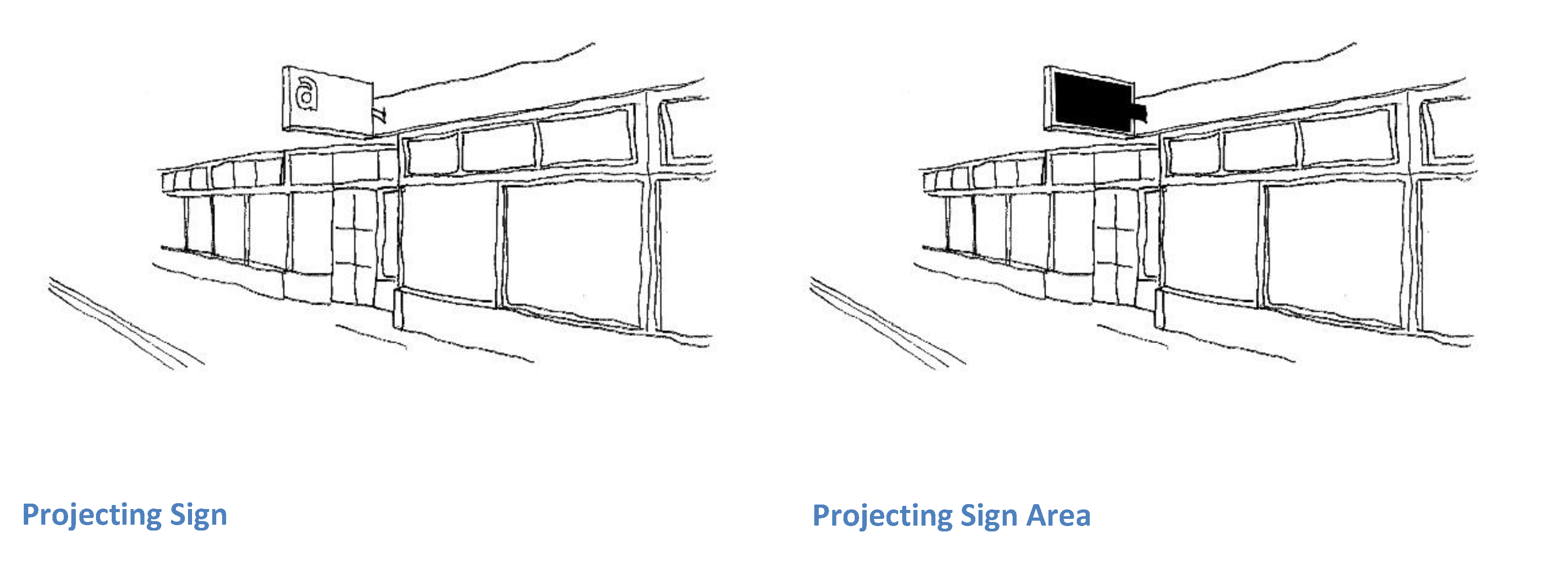
Sign area. The area of a sign is calculated as the total area within a line circumscribing all surfaces or structures used for display purposes, including spaces between letters and/or pictorial matter but not including supporting posts. As used in this chapter, the area of a two-sided, freestanding sign shall be calculated as the area of one side of a sign.
Sign, animated.Signs with moving components that revolve, flash, scroll, or otherwise regularly or intermittently move in a manner that is designed to attract attention are prohibited. Clocks that serve the sole purpose of providing the time and barber poles are not considered to be signs for the purposes of article 14, Sign regulations.
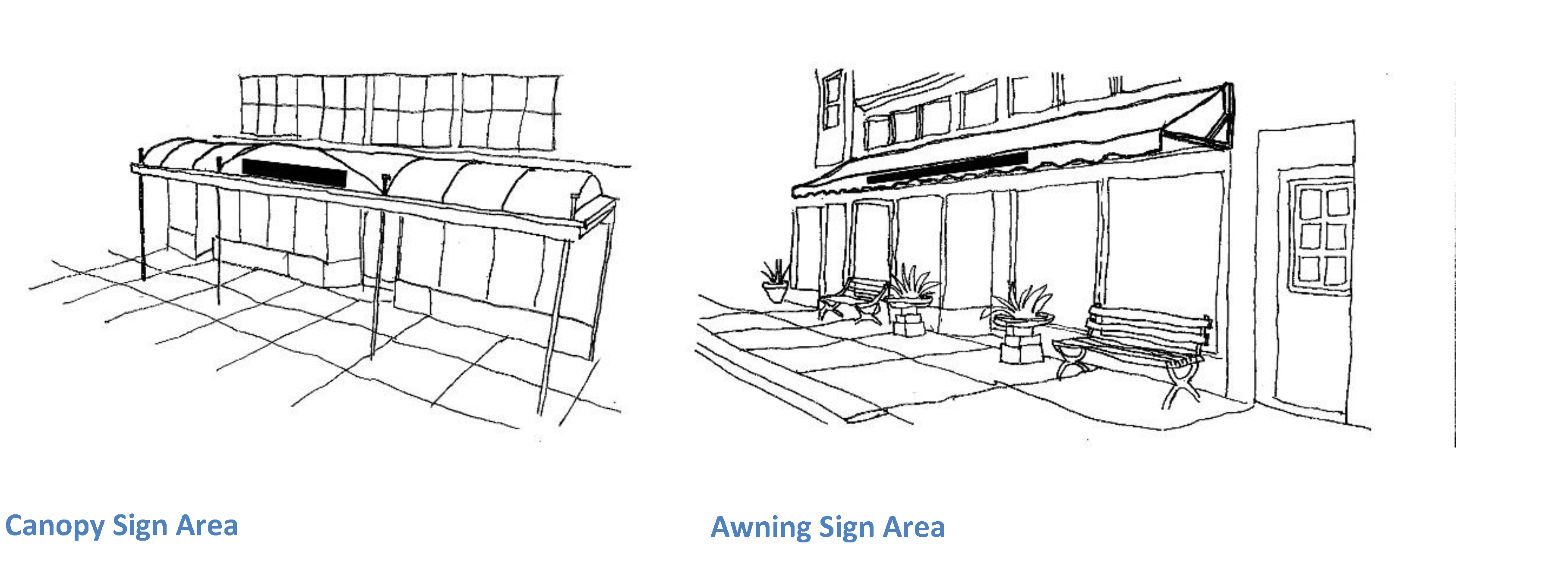
Sign, awning and canopy. Any sign painted on or attached to or supported by an awning or canopy. The lowest portion of any awning or canopy shall be not less than eight feet above the level of a sidewalk or public right-of-way. No awning may extend beyond a point two feet inside the curbline. There is no limitation on the horizontal width of an awning sign, but the vertical height of the sign area may be no more than three feet.
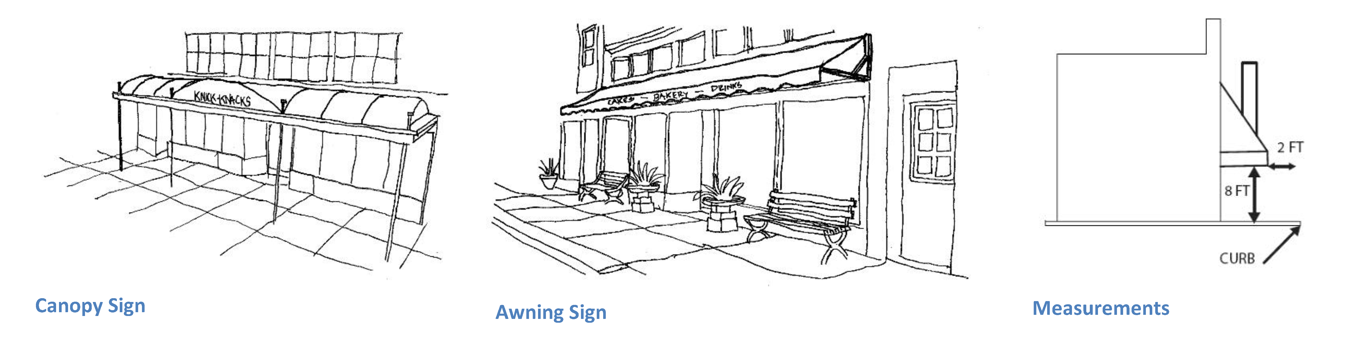
The method for calculating the total area of awning signs is illustrated in the graphics below. Calculate sign area by imaginary panel drawn around copy. Do not calculate decorative graphics.
Sign, billboard. Any sign or advertising device designed as a permanent structure which advertises a use or activity not located on, or a product not sold nor manufactured on the lot upon which the sign or device is located.
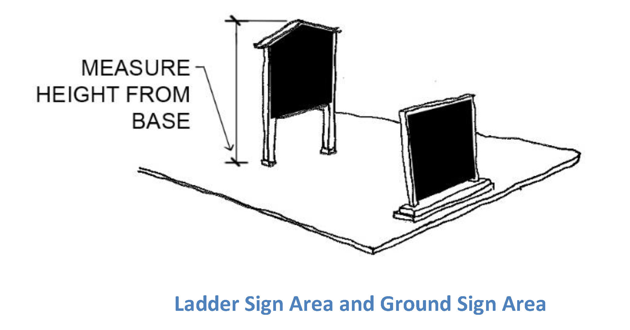
Sign, ground or ladder.A freestanding single- or double-faced sign, supported on the ground or from ground level by posts or similar vertical supports. A ladder sign differs from a regular ground sign in that it has two or more horizontal crosspieces serving as individual signs for identification or advertising purposes. Below are illustrations of typical ground and ladder signs.
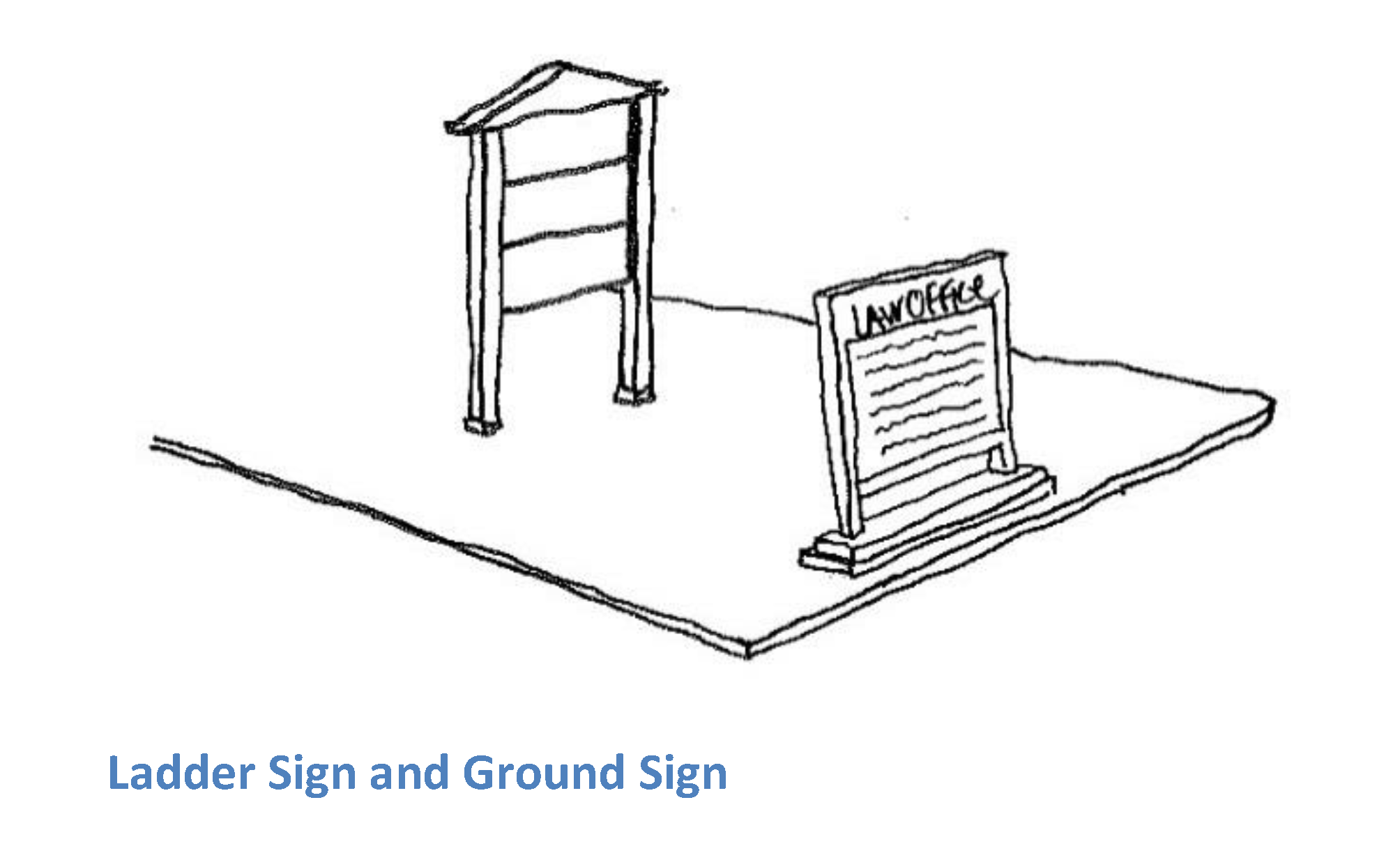
The method for calculating the total area of ground and ladder signs is illustrated in the graphics below:
Sign, interior-lighted.Signs illuminated by an interior lighting source that projects through a translucent sign material; provided that neon signs which do not fall within the definition of interior-lighted signs are permitted in accordance with section 82-1408.
Sign, posted. Signs tacked, posted, painted or otherwise attached to utility poles, trees, sidewalks, curbs or rocks.
Sign, projecting.Signs which project over public ways and are installed perpendicular to the façade. Such signs shall not exceed eight square feet in area, must have a clear height of eight feet above the sidewalk, and must be erected and secured in such a manner as to preclude their becoming a safety hazard to the public. The sign area is calculated including all supports, backgrounds, and embellishments.
Sign, roof. Any sign erected on a roof or projecting above the eaves of a building, or any other such display sign placed above or supported on the top of a building or structure.
Sign, sandwich board. A sign where the frame or support structure is hinged or connected at the top of the sign in such a manner that the sign is easily moved or erected.
Sign, trailer. Any sign which is mounted or designed for mounting on wheels, or which is mounted or designed for mounting on a self-propelled or towed vehicle. Such signs shall include, but not be limited to, mobile signs attached to a truck, chassis, detachable vehicle trailer or other such mobile signs, but shall not include signs painted or otherwise inscribed on a self-propelled vehicle or towed vehicle.
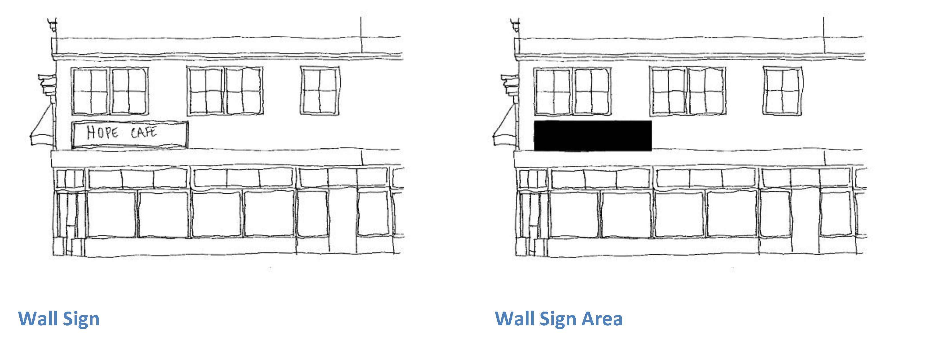
Sign, wall. A sign attached parallel to, or painted on, the vertical wall of a building exterior. The method for calculating the total area of walls signs is illustrated in the graphic below:
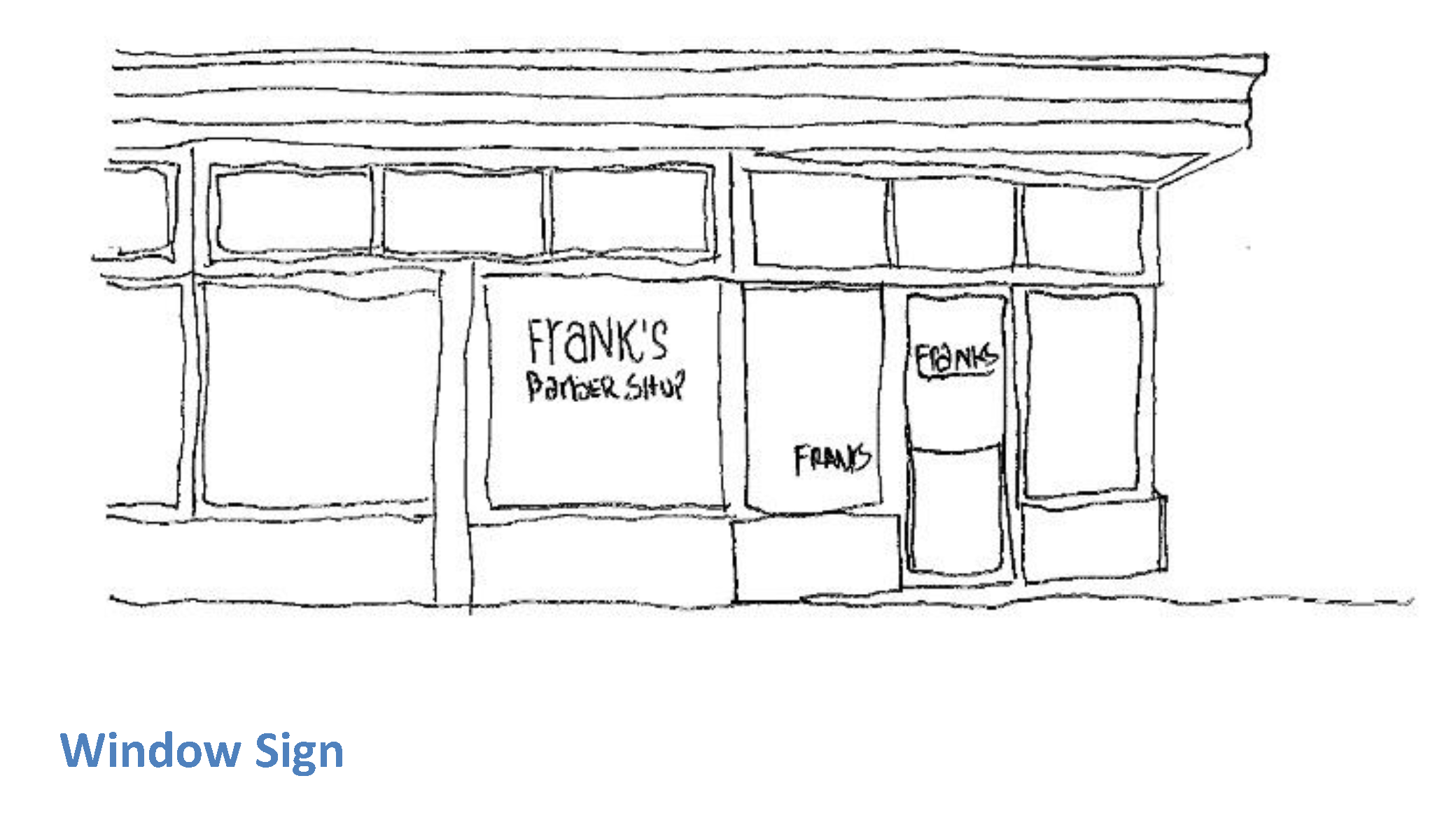
Sign, window. Any sign with its face parallel and affixed to, in contact with, or within 12 inches of depth from a window thereof. Normal displays of merchandise in store windows shall not be considered signs.
Site plan. The development plan for one or more lots on which is shown the existing and/or the proposed conditions of the lot.
Solar canopy. An elevated structure, built to cover a parking area, that hosts solar panels and provides shade. Solar canopies are separate and distinct from solar panels installed onto a carport structure. Solar canopies shall be considered accessory solar energy systems.
Solar decommissioning/restoration plan. A plan for dismantling a solar energy system, along with a plan for the site restoration of the land where the system is located, and a financial guarantee for the completion of the dismantling and restoration after the system is no longer operational.
Solar energy system. The equipment and requisite hardware that provide and are used for collecting, transferring, converting, storing, or using incident solar energy for water heating, space heating, cooling, generating electricity, and off-loading said electricity to the grid, or other applications that would otherwise require the use of a conventional source of energy such as petroleum products, natural gas, manufactured gas, or electricity produced for a nonrenewable resource. This shall include photovoltaic arrays and installations that utilize ground-mounted systems.
Solar energy system, accessory. A solar energy system that is incidental and subordinate to the principal use(s) of the parcel or development, and that may include the following:
• Roof-mounted
• Ground-mounted
• Building-integrated
• Solar Canopies
A ground-mounted accessory solar energy system, inclusive of inter-row and panel/collector spacing, shall not exceed 5,000 square feet or 20 percent of the net buildable area of the lot or lots on which it is located (i.e., the total area of the applicable lot, minus setbacks, vegetated buffers, and wetlands).
Solar energy system, building-integrated. A solar energy system that is constructed as an integral part of a principal or accessory building or structure and where the building integrated system features maintain a uniform profile or surface of vertical walls, window openings and roofing. Such a system is used in lieu of a separate mechanical device replacing or substituting for an architectural or structural component of the building or structure that appends or interrupts the uniform surfaces of walls, window openings, and roofing. A building-integrated system may occur within vertical façades replacing view glass, spandrel glass or other façade material into semitransparent skylight systems, into roofing systems replacing traditional roofing materials or other building or structure envelope systems.
Solar energy system, building-mounted. A solar energy system that has its electricity-generating solar panels attached to any part or type of roof on a building or structure that has an occupancy permit on file with the municipality and that is either the principal structure or an accessory structure on a recorded parcel. This system also includes any solar-based architectural elements and building-integrated systems.
Solar energy system, ground-mounted. A solar energy system that has its electricity-generating solar panels mounted on a structure, pole or series of poles constructed specifically to support the system and not attached to any other principal or accessory structure.
Solar energy system, major. A solar energy system for which the primary use of land on a given lot or lots is for the commercial generation of power, and/or where a solar energy system, inclusive of inter-row and panel/collector spacing, is larger than the definition of an accessory solar energy system, regardless of whether the solar energy system is an accessory or primary use.
Solar energy system operator. The agent or entity that conducts the daily operation and maintenance of the solar energy system under contractual agreement with the solar energy system owner.
Solar energy system owner. The owner of equipment and appurtenances comprising the solar energy system; said entity may also be the solar energy system operator.
Solar interconnection. The point at which the solar system is connected to the electric distribution system. The interconnection of the system by the electric distribution company will generally be located at the street or along an access driveway outside of the fenced area.
Special event parking. Any parcel used to accommodate spillover parking for a special, one-time event such as a concert, festival, wedding, etc.
Special use. A regulated use which is permitted pursuant to the special-use permit issued by the authorized governmental entity pursuant to G.L. 1956, § 45-24-42. (Formerly referred to as a special exception).
Street. Any street, avenue, highway, boulevard, parkway, road, lane, alley or other way, which has been dedicated to the public and accepted by the Town of Jamestown or State of Rhode Island.
Street line. The line separating the street right-of-way from other property.
Street screen. A freestanding wall, hedge or fence built along the frontage line, or coplanar with the façade. It may mask a parking lot from the thoroughfare, provide privacy to a side yard, and/or strengthen the spatial definition of the public realm.
Story. A habitable level within a building, excluding any basement or any attic less than 14 feet high.
Structure. A combination of materials to form a construction for use, occupancy, or ornamentation, whether installed on, above, or below the surface of land or water.
Substance abuse treatment facility. A residential facility with a 24-hour supervised treatment program designed to provide support and address the substance abuse treatment needs of people with substance abuse problems.
Substandard lot of record. Any lot lawfully existing at the time of adoption or amendment of the ordinance from which this chapter is derived and not in conformance with the dimensional and/or area provisions of the ordinance.
Substantial modification. Alteration to a building that includes one or more of the following:
1)
That is valued at more than 50 percent of the replacement cost of the entire building;
2)
New construction other than single family;
3)
Fifty percent or greater alteration of a building exterior;
4)
Demolition;
5)
Grading that disturbs more than two vertical feet of land;
6)
Fifty percent or greater alteration of street façade;
7)
New use category;
8)
Expansion of use which requires more than 15 net new parking spaces or adding more than 15 parking spaces to an existing use; or
9)
A use applying for no net loss of parking per section 82-1307.
Swale. A low or slightly depressed area for drainage purposes.
Swamp. A place not less than three acres in extent where groundwater shall be near or at the surface of the ground for a significant part of the growing season or runoff water from surface drainage shall collect frequently and/or where vegetational community shall be made up of a significant portion of one or more of, but not limited to nor necessarily including all of, the following: red maple (Acer rubum), elm (Ulmus americana), black spruce (Picea mariana), white cedar (Chamaecyparis thyoides), ash (Fraxinus), poison sumac (Rhusvernix), larch (Larix laricina), spice bush (Lindera Benzoin), alders (Alnus), skunk cabbage (Symplocarpus foeditus), hellebore (Veratrum veride), hemlock (Tsuga canadensis), sphagnums (Sphagnum), azaleas (Rhododendron), black alder (Ilex verticillata), coast pepperbush (Clethra alnifolia), marsh marigold (Caltha palustris), blueberries (Vaccinium), buttonbush (Cephalanthus occidentalis), willow (Salix), water willow (Decodon verticillatus), swamp white oak (Quercus bicolor), or species indicative of marsh.
Technical review committee (TRC). Lead by the planning department, a committee comprised of officials from each office having jurisdiction over the permitting of a project, including the town planner, the building official, the public works director and/or the town engineer, the environmental scientist as needed, a rotating member of the planning commission selected by the planning commission chair either by project or other method as determined by the chair, and an architectural consultant as needed, to make recommendations or process administratively applications and plans for proposed projects.
Time-share. A unit in which a time-share estate exists which was established in accordance with the Rhode Island Real Estate Time-Share Act, G.L. 1956, ch. 34-41, as may be amended.
Town. Town of Jamestown.
Town council. The Town Council of the Town of Jamestown.
TRC. Technical review committee.
Underground storage tanks. Any receptacle used for the storage of gasoline, diesel oil, fuel oil, kerosene, natural gas, or any other toxic substance which is located fully or partially below ground levels.
Use. The purpose or activity for which land or buildings are designed, arranged, or intended, or for which land or buildings are occupied or maintained.
Use category. The categories for specific uses as found in Table 6.1, Table of permitted uses:
• Residential;
• Lodging;
• Agricultural;
• Government, Education, Institutional;
• Transportation and Utilities;
• Commercial, Retail - Heavy Equipment;
• Commercial, Retail - Food;
• Commercial, Retail - Eating and Drinking Places;
• Commercial, Retail - Motor Vehicles;
• Commercial, Retail - Commercial Indoor Recreation;
• Commercial, Retail - Commercial Outdoor Recreation;
• Commercial, Retail - Miscellaneous;
• Commercial Services - Professional, Office;
• Commercial Services - Personal Services;
• Industrial, Non-Manufacturing;
• Industrial, Manufacturing.
Variance. Permission to depart from the literal requirements of this chapter. An authorization for the construction or maintenance of a building or structure, or for the establishment or maintenance of a use of land, which is prohibited by this chapter. There shall be only two categories of variances, a use variance or a dimensional variance.
1)
Use variance. Permission to depart from the use requirements of this chapter where the applicant for the requested variance has shown by evidence upon the record that the subject land or structure cannot yield any beneficial use if it is to conform to the provisions of the zoning ordinance [this chapter].
2)
Dimensional variance. Permission to depart from the dimensional requirements of a [the] zoning ordinance under the applicable standards set forth in G.L. 1956, § 45-24-41.
Wall. A structure which encloses an area or delineates separate areas. [A structure] may be constructed of stone, masonry, wood, or other material.
Waters. As defined in G.L. 1956, § 46-12-1(b).
Wetland, coastal. A salt marsh bordering on the tidal waters of the State of Rhode Island and contiguous uplands extending no more than 50 yards inland therefrom. As defined in G.L. 1956, § 2-1-14, as may hereafter be amended.
Wetland, freshwater. Those lands defined in G.L. 1956, § 2-1-20 and in any subsequent amendments hereto, and in any regulations propounded by the Rhode Island Department of Environmental Management and/or Rhode Island Coastal Resources Management Council and subsequent amendments thereto, including, but not limited to, marshes, swamps, bogs, ponds, rivers, river and stream flood plains and banks, areas subject to storm flowage, emergent and subemergent plant communities in any body of fresh water, special aquatic sites, vernal pools.
Wind energy facility. All of the equipment, machinery, and structures together utilized to convert wind to electricity. This includes, but is not limited to, developer-owned electrical equipment, storage, collection and supply equipment, service and access roads, and one or more wind turbines.
Wind energy facility, utility-scale. A commercial wind energy facility, where the primary use of the facility is electrical generation to be sold to the wholesale electricity markets.
Wind turbine. A device that converts kinetic wind energy into rotational energy to drive an electrical generator. A wind turbine typically consists of a tower, nacelle body, and a rotor with two or more blades.
Yard. A required open space on a lot, unoccupied and unobstructed by any structure or portions of a structure from the general ground level of the graded lot upward; provided that drives, walks, and customary yard accessories and other structures or projections as specifically allowed by this chapter may be allowed in any yard. The following yards are specifically defined in this chapter:
1)
Yard, corner side. A side yard on that side of a lot located at the corner or intersection of two street lines, nearest the side street.
2)
Yard, front. A required yard extending between side lot lines across the full width of the lot adjacent to any street line, and to the depth of the required front yard setback.
3)
Yard, rear. A required yard extending across the full width of the lot adjacent to any rear lot line(s), and to the depth of the required rear yard setback.
4)
Yard, side. A required yard extending from the rear of the required front yard to the required rear yard and to the depth of the required side yard setback; and if there is no rear yard, then extending from the required front yard to another required front yard or required side yard or to another part of the same required front yard.
Zoning. The reservation of certain specified areas within a community for building and structures, or use of land, for certain purposes with other limitations such as height, lot coverage, and other stipulated requirements.
Zoning board of review or zoning board. The governing body which hears and decides appeals of the requirements of the zoning ordinance [this chapter] and decisions of the zoning enforcement officer.
Zoning certificate. A document signed by the zoning enforcement officer, as required in the zoning ordinance [this chapter], which acknowledges that a use, structure, building or lot either complies with or is legally nonconforming to the provisions of the zoning ordinance [this chapter] or is an authorized variance or modification therefrom.
Zoning enforcement officer. The appointed official of the Town of Jamestown responsible for the enforcement of this chapter.
Zoning map. The map or maps which are a part of the zoning ordinance [this chapter] and which delineate the boundaries of all mapped zoning districts within the physical boundary of the Town of Jamestown.
Zoning ordinance. This chapter enacted in accordance with the Rhode Island Zoning Enabling Act of 1991, as may be amended.
Zoning use districts. The basic unit in zoning, either mapped or unmapped, to which a uniform set of regulations applies, or a uniform set of regulations for a specified use. The districts include, but are not limited to: commercial, open space, residential, and rural residential, or downtown mixed-use. Each district may include sub-districts. Districts may be combined.
(Ord. of 2-3-2025(1), § 1(Exh. A))
Sec. 82-104.2. - Flood plain definitions.
Unless specifically defined below, words and phrases used in section. 82-801 (community flood plain ordinance for special flood hazard areas) of this chapter pertain to floodplain management, have the same meaning as they have in common usage and to give this chapter its most reasonable application.
Accessory structure. A structure which is on the same parcel of property as the principal structure to be insured and the use of which is incidental to the use of the principal structure.
Area of special flood hazard. See definition for "special flood hazard area."
Base flood. The flood having a one percent chance of being equaled or exceeded in any given year, also referred to as the 100-year flood, as published by the Federal Emergency Management Agency (FEMA) as part of a Flood Insurance Study (FIS) and depicted on a Flood Insurance Rate Map (FIRM).
Base flood elevation (BFE). The elevation of the crest of the base flood or 100-year flood. The height, as established in relation to the North American Vertical Datum (NAVD) of 1988 (or other datum where specified), in relation to mean sea level expected to be reached by the waters of the base flood at pertinent points in the floodplains of coastal and riverine areas.
Basement. Any area of the building having its floor subgrade (below ground level) on all sides.
Building. See definition for "structure."
Cost. As related to substantial improvements, the cost of any reconstruction, rehabilitation, addition, alteration, repair or other improvement of a structure shall be established by a detailed written contractor's estimate.
The estimate shall include, but not be limited to: the cost of materials (interior finishing elements, structural elements, utility and service equipment); sales tax on materials, building equipment and fixtures, including heating and air conditioning and utility meters; labor; built-in appliances; demolition and site preparation; repairs made to damaged parts of the building worked on at the same time; contractor's overhead; contractor's profit; and grand total.
Items to be excluded include: cost of plans and specifications, survey costs, permit fees, costs to correct code violations subsequent to a violation notice, outside improvements such as septic systems, water supply wells, landscaping, sidewalks, fences, yard lights, irrigation systems, and detached structures such as garages, sheds, and gazebos.
Development. Any man-made change to improved or unimproved real estate, including, but not limited to, the construction of buildings or structures; the construction of additions, alterations or substantial improvements to buildings or structures; the placement of buildings or structures; mining, dredging, filling, grading, paving, excavation or drilling operations or storage of equipment; the storage, deposition, or extraction of materials; and the installation, repair or removal of public or private sewage disposal systems or water supply facilities.
Federal Emergency Management Agency (FEMA). The federal agency that administers the National Flood Insurance Program (NFIP).
Flood or flooding. A general and temporary condition of partial or complete inundation of normally dry land areas from either the overflow of inland or tidal waters, or the unusual and rapid accumulation or runoff of surface waters from any source.
Flood insurance rate map (FIRM). The official map of a community on which the Federal Emergency Management Agency (FEMA) has delineated both the special flood hazard areas (100-year floodplain) and the insurance risk premium zones applicable to a community. FIRM published after January 1990 may also show the limits of the regulatory floodway.
Flood insurance study (FIS). The official study of a community in which the Federal Emergency Management Agency (FEMA) has conducted a technical engineering evaluation and determination of local flood hazards, flood profiles and water surface elevations. The flood insurance rate maps (FIRM), which accompany the FIS, provide both flood insurance rate zones and base flood elevations, and may provide the regulatory floodway limits.
Flood proofing. Any combination of structural and non-structural additions, changes, or adjustments to structures which reduce or eliminate flood damage to real estate or improved real property, water and sanitary facilities, structures and their contents.
Floodway. The channel of a river or other watercourse and the adjacent land areas that must be reserved in order to discharge the base flood without cumulatively increasing the water surface elevation more than one foot. For the purposes of these regulations, the term "regulatory floodway" is synonymous in meaning with the term "floodway."
Functionally dependent use or facility. A use or facility that cannot perform its intended purpose unless it is located or carried out in close proximity to water. The term includes only docking facilities, port facilities that are necessary for the loading and unloading of cargo or passengers, and ship building and ship repair facilities. The term does not include seafood processing facilities, long-term storage, manufacturing, sales or service facilities.
Height. The maximum height for buildings and structures erected in special flood hazard areas shall be in accordance with the dimensional table of this chapter (section 82-602) minus the difference between the base flood elevation, however established, and the average existing grade.
Highest adjacent grade (HAG). The highest natural elevation of the ground surface prior to construction next to the proposed walls of a structure.
Historic structure. Any structure that is:
a)
Listed individually in the National Register of Historic Places (a listing maintained by the Department of the Interior) or preliminarily determined by the Secretary of the Interior as meeting the requirements for individual listing on the National Register;
b)
Certified or preliminarily determined by the Secretary of the Interior as contributing to the historic significance of a registered historic district or a district preliminarily determined by the Secretary to qualify as a registered historic district;
c)
Individually listed on a state inventory of historic places in states with historic preservation programs which have been approved by the Secretary of the Interior; or
d)
Individually listed on a local inventory of historic places in communities with historic preservation programs that have been certified either:
(1)
By an approved state program as determined by the Secretary of the Interior or
(2)
Directly by the Secretary of the Interior in states without approved programs.
Lowest floor. The lowest floor of the lowest enclosed area (including basement).
Mobile home. (Prohibited in zoning section 82-601, Table 6-1) A transportable, single-family dwelling unit suitable for year-round occupancy with or without a permanent foundation and having a water supply and waste disposal system comparable to immobile housing. A mobile home is designed to be transported on streets and highways on its own wheels and to arrive at the site where it is to be occupied as a dwelling unit complete and ready for occupancy, except for minor and incidental unpacking and assembly operations, location on racks or permanent foundations, and connection to utilities and water supply and waste disposal systems. Removal of wheels and/or axles shall not change its status as a mobile home.
Market value. Market value is the price of a structure that a willing buyer and seller agree upon. This can be determined by an independent appraisal by a professional appraiser; the property's tax assessment, minus land value; the replacement cost minus depreciation of the structure; the structure's actual cash value.
New construction. Structures for which the "start of construction" commenced on or after the effective date of an initial FIRM or after December 31, 1974, whichever is later, and includes any subsequent improvements to such structures. For floodplain management purposes, new construction means structures for which the start of construction commenced on or after the effective date of a floodplain management regulation adopted by a community and includes any subsequent improvements to such structures.
Recreational vehicle (RV). A vehicle which is:
a)
Built on a single chassis;
b)
Four hundred square feet or less when measured at the largest horizontal projection;
c)
Designed to be self-propelled or permanently towable by a light duty truck; and
d)
Designed primarily not for use as a permanent dwelling but as a temporary living quarters for recreational, camping, travel, or seasonal use.
Regulatory floodway. See definition for "floodway."
Special flood hazard area (SFHA). The land in the floodplain within a community subject to a one percent or greater chance of flooding in any given year. SFHAs are determined utilizing the base flood elevations (BFE) provided on the flood profiles in the flood insurance study (FIS) for a community. BFEs provided on flood insurance rate map (FIRM) are only approximate (rounded up or down) and should be verified with the BFEs published in the FIS for a specific location. SFHAs include, but are not necessarily limited to, the land shown as Zones A, A1-30, AE, AO, AH, and the coastal high hazard areas shown as Zones V, V1-30, and VE on a FIRM. The SFHA is also called the area of special flood hazard.
Start of construction. For other than new construction or substantial improvements under the Coastal Barrier Resources Act (P.L. 97-348), includes substantial improvement and means the date the building permit was issued, provided the actual start of construction, repair, reconstruction, rehabilitation, addition placement, substantial improvement or other improvement was within 180 days of the permit date. The actual start means either the first placement of permanent construction of a structure on a site, such as the pouring of slab or footings, the installation of piles, the construction of columns, or any work beyond the stage of excavation, or the placement of a manufactured home on a foundation. Permanent construction does not include land preparation, such as clearing, grading and filling; nor does it include the installation of streets and/or walkways; nor does it include excavation for a basement, footings, piers, or foundations or the erections of temporary forms; nor does it include the installation on the property of accessory buildings, such as garages or sheds not occupied as dwelling units or not part of the main structure. For a substantial improvement, the actual start of construction means the first alteration of any wall, ceiling, floor, or other structural part of a building, whether or not that alteration affects the external dimensions of the building.
Structure. A walled and roofed building which is principally above ground, including a manufactured home, a gas or liquid storage tank, or other man-made facilities or infrastructures.
Substantial damage. Damage of any origin sustained by a structure, whereby the cost of restoring the structure to its pre-damaged condition would equal or exceed 50 percent of the market value of the structure before the damage occurred.
Substantial improvement. Any combination of repairs, reconstruction, rehabilitation, alterations, additions or other improvements to a structure, taking place within any 12-month period, in which the cumulative cost equals or exceeds 50 percent of the market value of the structure (G.L. 1956, § 23-27.3-106.1). This term includes structures that have incurred "substantial damage," regardless of the actual repair work performed. For purposes of this definition, "substantial improvement" is considered to occur when the first alteration of any wall, ceiling, floor, or other structural part of the building commences, whether or not that alteration affects the external dimensions of the structure. The term does not, however, include either:
a)
Any project for improvement of a structure to correct existing violations of state or local health, sanitary, or safety code specifications which have been identified by the local code enforcement official and which are the minimum necessary to assure safe living conditions; or
b)
Any alteration of a "historic structure", provided that the alteration will not preclude the structure's continued designation as a "historic structure."
Variance. A grant of relief by a community from the terms of the floodplain management ordinance that allows construction in a manner otherwise prohibited and where specific enforcement would result in unnecessary hardship.
Violation. Failure of a structure or other development to be fully complaint with the community's floodplain management ordinance. A structure or other development without required permits, lowest floor elevation documentation, flood-proofing certificates or required floodway encroachment calculations is resumed to be in violation until such time as that documentation is provided.
(Ord. of 2-3-2025(1), § 1(Exh. A))