
Lake Angelus City Zoning Code
TITLE FOUR
Zoning
Chapter 1240. - General Provisions and Definitions[3]
Cross reference— Planning Commission - see P. & Z. Ch. 1220; Zoning Code penalty - see P. & Z. 1242.99
State Law reference— Zoning and planning in home rule cities - see MCL § 117.4i; Regulation of location of trades, buildings and uses by local authorities - see MCL § 125.3201; Regulation of buildings; authority to zone - see MCL § 125.3201 et seq.; Regulation of congested areas - see MCL § 125.3201 et seq.; Uses of land or structures not conforming to ordinances; powers of legislative bodies; acquisition of property - see MCL § 125.3201;
Chapter 1242. - Administration, Enforcement and Penalty[4]
Cross reference— Zoning Board of Appeals - see P. & Z. Ch. 1244; Appeals - see P. & Z. 1244.04(b), 1244.05; Variances - see P. & Z. 1244.04(d); Stop work orders - see B. & H. 1442.01
State Law reference— city zoning ordinances; public hearing, notice; report of planning commission; amendment; vote required - see MCL § 125.3101; Zoning Board of Appeals - see MCL § 125.3601 et seq.; Conflicting laws; governing law - see MCL § 125.3210; Violations; nuisance per se; abatement - see MCL § 125.3407
Chapter 1244. - Zoning Board of Appeals[5]
Cross reference— Zoning Code penalty - see P. & Z. 1242.99
State Law reference— Board of Zoning Appeals - see MCL § 125.3601; Meetings of the Board; freedom of information - see MCL § 125.3701; Review by Circuit Courts; appeals to Supreme Court; procedure - see MCL § 125.3606; Actions for review; proper and necessary parties; notice; failure to appear - see MCL § 125.3607
Chapter 1246. - Districts Generally and Zoning District Map[6]
State Law reference— Zoning and planning in home rule cities - see MCL § 117.4i; Regulation of location of trades, buildings and uses by local authorities - see MCL § 125.3201; Regulation of buildings; authority to zone - see MCL § 125.3201 et seq.; Regulation of congested areas - see MCL § 125.3201; Uses of land or structures not conforming to ordinances; powers of legislative bodies; acquisition of property - see MCL § 125.3208; Effect of zoning ordinance or zoning decision in presence of demonstrated need for certain land use - see MCL § 125.3207
Chapter 1248. - Residential Districts[7]
Cross reference— Area, frontage, setback and height requirements - see P. & Z. 1246.07
State Law reference— Zoning and planning in home rule cities - see MCL § 117.4i; Regulation of location of trades, buildings and uses by local authorities - see MCL § 125.3201; Regulation of buildings; authority to zone - see MCL § 125.3201; Regulation of congested areas - see MCL § 125.3201; Uses of land or structures not conforming to ordinances; powers of legislative bodies; acquisition of property - see MCL § 125.3208; Effect of zoning ordinance or zoning decision in presence of demonstrated need for certain land use - see MCL § 125.3207
Chapter 1250. - Agricultural Districts[8]
Cross reference— Area, frontage, setback and height requirements - see P. & Z. 1246.07
State Law reference— Zoning and planning in home rule cities - see MCL § 117.4i; Regulation of location of trades, buildings and uses by local authorities - see MCL § 125.3201; Regulation of buildings; authority to zone - see MCL § 125.3201; Regulation of congested areas - see MCL § 125.3201; Uses of land or structures not conforming to ordinances; powers of legislative bodies; acquisition of property - see MCL § 125.3208; Effect of zoning ordinance or zoning decision in presence of demonstrated need for certain land use - see MCL § 125.3207
Chapter 1252. - Scientific and Educational Districts[9]
Cross reference— Area, frontage, setback and height requirements - see P. & Z. 1246.07
State Law reference— Zoning and planning in home rule cities - see MCL § 117.4i; Regulation of location of trades, buildings and uses by local authorities - see MCL § 125.3201; Regulation of buildings; authority to zone - see MCL § 125.3201; Regulation of congested areas - see MCL § 125.3201; Uses of land or structures not conforming to ordinances; powers of legislative bodies; acquisition of property - see MCL § 125.3208; Effect of zoning ordinance or zoning decision in presence of demonstrated need for certain land use - see MCL § 125.3207
Chapter 1254. - Recreational Districts[10]
Cross reference— Area, frontage, setback and height requirements - see P. & Z. 1246.07
State Law reference— Zoning and planning in home rule cities - see MCL § 117.4i; Regulation of location of trades, buildings and uses by local authorities - see MCL § 125.3201; Regulation of buildings; authority to zone - see MCL § 125.3201; Regulation of congested areas - see MCL § 125.3201; Uses of land or structures not conforming to ordinances; powers of legislative bodies; acquisition of property - see MCL § 125.3208; Effect of zoning ordinance or zoning decision in presence of demonstrated need for certain land use - see MCL § 125.3207
Chapter 1256. - Public Property Districts[11]
Cross reference— Area, frontage, setback and height requirements - see P. & Z. 1246.07
State Law reference— Zoning and planning in home rule cities - see MCL § 117.4i; Regulation of location of trades, buildings and uses by local authorities - see MCL § 125.3201; Regulation of buildings; authority to zone - see MCL § 125.3201; Regulation of congested areas - see MCL § 125.3201; Uses of land or structures not conforming to ordinances; powers of legislative bodies; acquisition of property - see MCL § 125.3208; Effect of zoning ordinance or zoning decision in presence of demonstrated need for certain land use - see MCL § 125.3207
Chapter 1258. - Provisions Applicable to All Districts[12]
Cross reference— Area, frontage, setback and height requirements - see P. & Z. 1246.07
State Law reference— Zoning and planning in home rule cities - see MCL § 117.4i; Regulation of location of trades, buildings and uses by local authorities - see MCL § 125.3201; Regulation of buildings; authority to zone - see MCL § 125.3201; Regulation of congested areas - see MCL § 125.3201; Uses of land or structures not conforming to ordinances; powers of legislative bodies; acquisition of property - see MCL § 125.3208; Effect of zoning ordinance or zoning decision in presence of demonstrated need for certain land use - see MCL § 125.3207
Chapter 1260. - Nonconforming Uses, Structures and Lots[13]
Cross reference— Special land uses - see P. & Z. 1242.03; Variances - see P. & Z. 1244.04(d); Area, frontage, setback and height requirements - see P. & Z. 1246.07
State Law reference— Zoning and planning in home rule cities - see MCL § 117.4i; Regulation of location of trades, buildings and uses by local authorities - see MCL. § 125.3201; Regulation of buildings; authority to zone - see MCL § 125.3201; Regulation of congested areas - see MCL § 125.3201; Uses of land or structures not conforming to ordinances; powers of legislative bodies; acquisition of property - see MCL § 125.3208; Effect of zoning ordinance or zoning decision in presence of demonstrated need for certain land use - see MCL § 125.3207
Sec. 1240.01. - Title.
This Title Four of Part Twelve of these codified ordinances shall be known and cited as the City of Lake Angelus Zoning Code.
(Ord. 85. Passed 1-11-99.)
Sec. 1240.02. - Purposes.
The purposes of this Zoning Code are to promote, protect, regulate, restrict and provide for the use of land and buildings within the City of Lake Angelus; to establish zones or districts within which the use of land and structures is regulated; to provide regulations and restrictions relating to open spaces and the density of development; to provide for the establishment of a board of appeals and its powers and duties; to provide for the administration and enforcement thereof and for penalties for its violation; and to provide for the repeal of any and all ordinances inconsistent therewith.
(Ord. 85. Passed 1-11-99.)
Sec. 1240.03. - Rules of construction; compliance; conflicts.
(a)
This Zoning Code shall be liberally construed in such manner as to best implement its purposes. In interpreting and applying the provisions of this Zoning Code, the requirements shall be held to be minimum for the promotion of the public health, safety, convenience, comfort, prosperity and general welfare.
(b)
No building or structure, or part thereof, shall hereafter be erected, constructed, reconstructed or altered, and no new use or change shall be made of any building, structure or land, or part thereof, except as permitted by the provisions of this Zoning Code.
(c)
Where a condition imposed by a provision of this Zoning Code upon the use of any lot, building or structure conflicts with a condition imposed by any other provision of this Zoning Code, or by a provision of any other ordinance of the city, the provision which is more restrictive shall govern.
(d)
Nothing within this Zoning Code shall be construed to prevent compliance with an order by the appropriate authority to correct, improve, strengthen or restore to a safe or healthy condition, any part of a building or premises declared unsafe or unhealthy.
(Ord. 85. Passed 1-11-99.)
Sec. 1240.04. - Validity and severability.
If a court of competent jurisdiction shall declare any part of this Zoning Code to be invalid, such ruling shall not affect any other provisions of this Zoning Code not specifically included in said ruling.
If a court of competent jurisdiction shall declare invalid the application of any provision of this Zoning Code to a particular land, parcel, lot, district, use, building or structure, such ruling shall not affect the application of said provision to any other parcel, lot, district, use, building or structure not specifically included in said ruling.
(Ord. 85. Passed 1-11-99.)
Sec. 1240.05. - Interpretation and conflicts.
In interpreting and applying the provisions of this Zoning Code, they shall be held to be the minimum requirements for the promotion of the public safety, health, convenience, comforts, morals, prosperity and general welfare. It is not intended by this Zoning Code to interfere with, abrogate or annul any ordinance, rules, regulations or permits previously adopted or issued, and not in conflict with any of the provisions of this Zoning Code, or which shall be adopted or issued pursuant to law relating to the use of buildings or premises and likewise not in conflict with this Zoning Code, nor is it intended by this Zoning Code to interfere with, abrogate or annul any easements, covenants or other agreements between parties, provided, however, that where this Zoning Code imposes a greater restriction upon the use of buildings or premises or upon the height of buildings, or requires larger open spaces, or larger lot areas, than are imposed or required by such other ordinance or agreements, the provisions of this Zoning Code shall control.
(Ord. 85. Passed 1-11-99.)
Sec. 1240.06. - Vested rights, etc., prohibited.
It is hereby expressly declared that nothing in this Zoning Code shall be held or construed to give or grant to any person, firm or corporation any vested right, license, privilege or permit.
(Ord. 85. Passed 1-11-99.)
Sec. 1240.07. - Repealer.
Ordinances 44, 47, 50, 56, 60, 61, 64, 65, 66, 67, 74 and 75 of the City of Lake Angelus, being the prior Zoning Code and subsequent amendments, are hereby repealed. The adoption of this Zoning Code, however, shall not affect or prevent any pending or future prosecution of, or action to abate, any existing violation of the aforementioned Zoning Code, as amended, if the use so in violation is in violation of the provisions of this Zoning Code.
(Ord. 85. Passed 1-11-99.)
Sec. 1240.08. - Definitions.
(a)
In General. For the purpose of this Zoning Code, certain words and terms are herein defined. Illustrations of specific definitions are provided as Figures 1—5.
(b)
Definitions.
Accessory buildings and structures. A building or structure on the same lot or parcel of land as the principal building, but not connected by an architecturally-integrated structure or a shared common wall of the principal residential dwelling, devoted exclusively to an accessory use.
Accessory use. A use reasonably and customarily incidental and subordinate to the principal use of the premises.
Architectural features. Architectural features of a building or structure, including cornices, eaves, gutters, belt courses, sills, lintels, bay windows, chimneys and decorative ornaments.
Basement. That portion of a building having more than one-half of its height below finished grade (see Figure 1).
Building. A structure having a roof supported by columns or walls.
Building code. The currently adopted code or codes regulating building construction in the City of Lake Angelus.
Building height. The vertical distance measured from the finished grade level to the highest point of the structure, including chimneys. Where the building may be situated on sloping terrain, this height shall be measured from the average level of the finished grade at the building wall at the lakefront elevation (see Figures 2 and 3).
Building official. The administrative official designated by the city council to enforce the building Code.
Building setback line. The line established by the minimum required setbacks forming the area within a lot in which a building may be located.
District. A portion of the city within which certain uses of land and/or buildings are permitted and within which certain regulations and requirements apply under the provisions of this Zoning Code.
Dwelling. A building used exclusively as a residence by not more than one family, but in no case shall a travel trailer, motor home, trailer coach, automobile chassis, tent or other portable building be considered a dwelling.
Dwelling, single-family. A building designed for, or occupied exclusively by, one family. Any separate servant, family or guest quarters shall not have a private direct outside entrance and shall not be rented or utilized independent of the family occupying the dwelling.
Essential services. Services that are erected, constructed, altered or maintained by public utilities or municipal agencies of underground, surface or overhead gas, electrical, steam or water transmission or distribution systems, collection, communication, supply or disposal systems, including mains, drains, sewers, pipes, conduits, wires, cables, fire alarm boxes, traffic signals, hydrants, poles and other similar equipment or accessories reasonably in connection therewith for the furnishing of adequate service by such public utilities or municipal agencies.
Family. An individual or a group of two or more persons related by blood, marriage or adoption, together with foster children and servants of the principal occupants, with not more than one additional unrelated person, who are domiciled together as a single, domestic, housekeeping unit in a dwelling unit; or
A collective number of individuals domiciled together in one dwelling unit whose relationship is of a continuing nontransient domestic character and who are cooking and living as a single noncommercial housekeeping unit. This definition shall not include any society, club, fraternity, sorority, association, lodge, coterie, organization or group of students or other individuals whose domestic relationship is of a transitory or seasonal nature or for an anticipated limited duration of a school term or terms or other similar determinable period.
Garage, attached. Any garage which has a common wall with the principal residential dwelling, or which is connected by an architecturally-integrated structure or a shared common wall to the principal residential dwelling.
Garage, detached. Any garage not meeting the definition of garage, attached, shall be considered to be a detached garage.
Grade. The degree of rise or descent of a sloping surface (see Figure 3).
Grade, finished. The final elevation of the ground surface after development (see Figure 3).
Grade, natural. The elevation of the ground surface in its natural state, before man-made alterations (see Figure 3).
Lake frontage. The required horizontal distance along the shoreline of Lake Angelus measured as a straight line where side lot lines intersect the ordinary high-water mark (see Figure 4).
Lake-side structure. An accessory structure constructed on the lake side of a principal residential dwelling that can be varied in purpose. Examples include, but are not limited to, gazebos, pool houses, and outdoor kitchens.
Lot. A parcel of land occupied or intended to be occupied by a principal building or use, and the accessory buildings and uses customarily incident thereto, including the yards and open spaces required under this Zoning Code.
Lot area. The total horizontal area within the lot lines of a lot.
Lot lines. Any line dividing one lot from another or from a public right-of-way, and thus constituting the property lines bounding a lot.
Lot of record. A lot, the dimensions of which are shown on a subdivision plat recorded in the office of the Register of Deeds for Oakland County, or a lot or parcel described by metes and bounds, the accuracy of which is attested to by a professional engineer or registered surveyor, so designated by the State of Michigan, where said description is recorded or on file with the county.
Lot, width. The required horizontal distance between the side lot lines measured at the two points where the required front yard setback line intersects the side lot lines.
Natural feature. A watercourse, including Lake Angelus or any tributary to Lake Angelus, whether continually or intermittently flowing, and any wetland characterized by the presence of water at a frequency and duration sufficient to support wetland vegetation or aquatic life and commonly referred to as a bog, swamp, marsh or wetland and which is any of the following: contiguous to Lake Angelus or any tributary to Lake Angelus; or two acres or more in size; or determined by the city council to be essential to the protection of the natural resources of the city from pollution, impairment or damage.
Non-conforming building. A building or portion thereof lawfully existing on the effective date of this Zoning Code, or amendments thereto, which does not conform to the provisions of this Zoning Code in the zoning district in which it is located.
Non-conforming use. A use is a use which lawfully occupied a building or land on the effective date of this Zoning Code, or amendments thereto, and which does not conform to the use regulations of the zoning district in which it is located.
Ordinary high-water mark. The shoreline of Lake Angelus at the legally established level of 950.00 feet.
Pontoon. A pontoon boat is a boat comprised of a flat deck mounted on two or more cylindrical sealed aluminum floats, and which is marketed as a 'pontoon' or 'tritoon' boat by a United States nationally recognized marine manufacturer (including member companies of the National Marine Manufacturers Association). A pontoon boat must be from 20 to 28 feet in length. In addition, the State of Michigan title and registration shall indicate the hull type is pontoon.
Principal building or structure. The main building or structure in which the primary use is conducted.
Public utility. Any person, firm, corporation or municipal agency authorized under federal, state, county or municipal regulations to furnish electricity, gas, communications, transportation, water or sewer services.
Retaining wall. A structure above the finished grade on one side designed and intended to retain earth at a higher finished grade on the other side. A retaining wall may be constructed of any material, including, but not limited to, concrete, wood, bricks, masonry and stone, and includes both vertical and inclined structures.
Setback. The minimum required horizontal distance between the building or structure and the front, side and rear lot lines and natural features.
Shed. A structure built for storage.
Sign. A structure or device designed or intended to convey information to the public in written or graphic form.
Special land uses. Permitted uses subject to the special approval of the planning commission.
Story. That portion of a building included between the surface of any floor and the surface of the floor above it, or if there is no floor above it, then the space between the floor and the ceiling above it (see Figure 1).
Structure. Anything constructed, erected or installed above ground level, including, but not limited to, buildings, decks, retaining walls, antennas, sheds and ancillary equipment regardless of whether they are temporary or permanent in nature and regardless of whether they are constructed on permanent foundations, and also including window wells and outdoor swimming pools and hot tubs regardless of whether they are above or below ground level, but not including driveways, walkways and patios which are flush with the ground level, and not including temporary shelters or tents erected for periods of one week or less.
Yard, front.
A.
Waterfront lots. A yard extending across the full width of the lot, the depth of which is the minimum horizontal distance between the principal building and the ordinary high water mark (see Figure 5).
B.
Other lots. A yard extending across the full width of the lot, the depth of which is the minimum horizontal distance between the principal building and the front lot line. In all cases, the front lot line shall be considered to be that portion of the lot which abuts a public road right-of-way or private road easement.
Yard, rear. A yard extending across the full width of the lot, the depth of which is the minimum horizontal distance between the rear lot line and the nearest point of the principal building (see Figure 5).
Yard, side. A yard between any building and the side lot line, extending from the front yard to the rear yard. The width of the required side yard shall be measured horizontally from the nearest point of the side lot line to the nearest point of the principal building (see Figure 5).
(Ord. 85. Passed 1-11-99; Ord. 94. Passed 2-11-02; Ord. 151. Passed 6-11-19; Ord. 160. Passed 6-11-24; Ord. 168. Passed 11-8-24)
Figure 1 Zoning Terms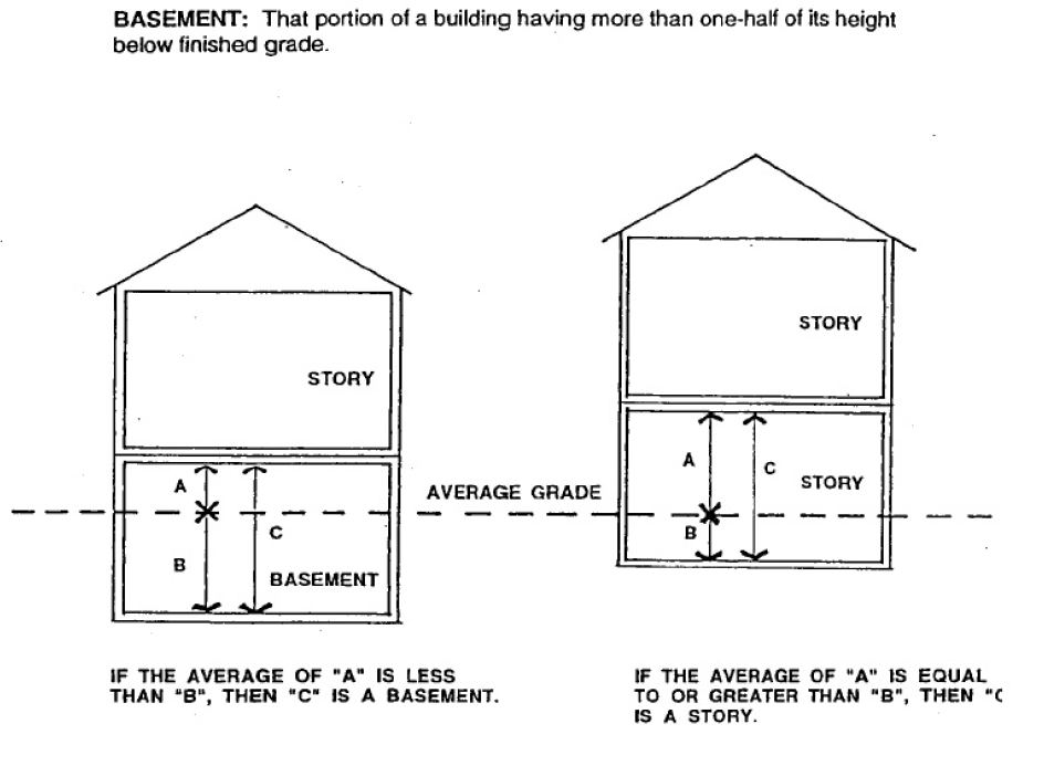
Figure 2 Zoning Terms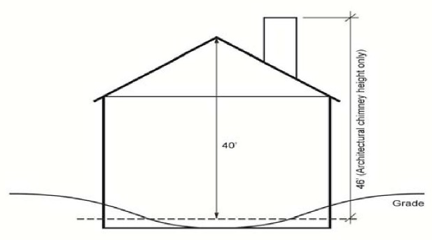
Figure 3 Zoning Terms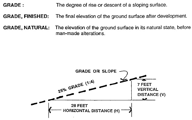
Figure 4 Zoning Terms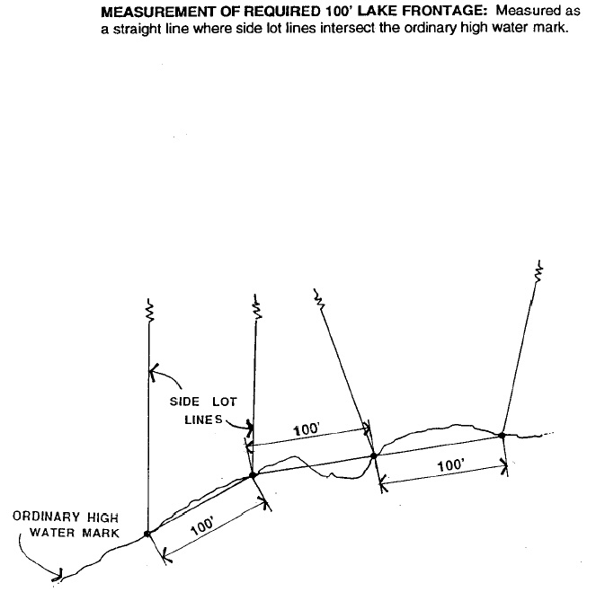
Figure 5 Zoning Terms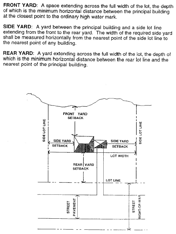
Figure 6 Zoning Terms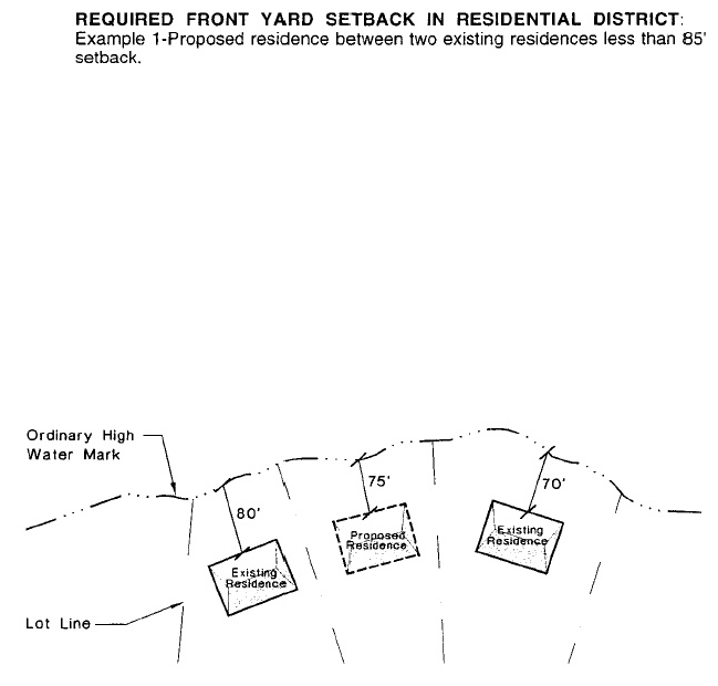
Figure 7 Zoning Terms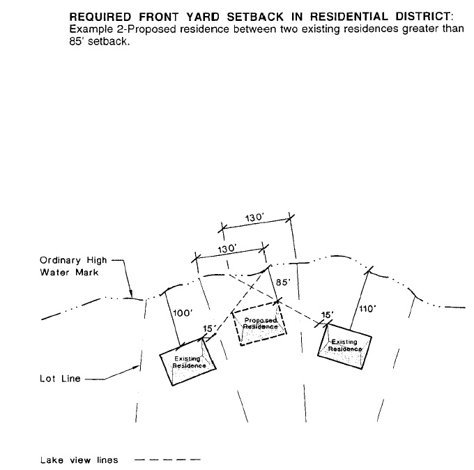
Figure 8 Zoning Terms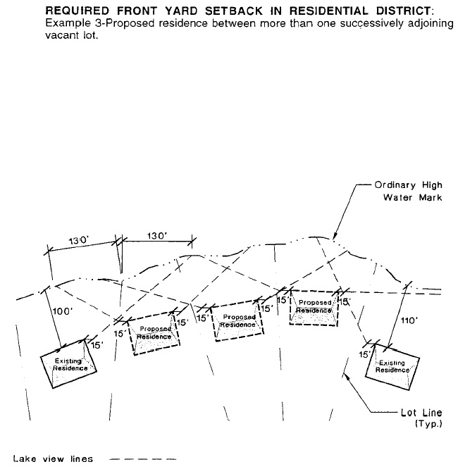
Sec. 1242.01. - Duties of building official.
The building official shall:
(a)
Receive and review for completeness all applications for site plan review and special use permits which the planning commission is required to decide under this Zoning Code and refer such application to the planning commission for determination.
(b)
Receive and review for completeness all applications for appeals, variances or other matters which the zoning board of appeals is required to decide under this Zoning Code and refer such applications to the planning commission and zoning board of appeals for determination.
(c)
Receive and review for completeness all applications for amendments to this Zoning Code and refer such applications to the planning commission and city council for determination.
(d)
Make periodic site inspections of the city to determine Zoning Code compliance, and answer complaints on Zoning Code violations.
(e)
Implement the decisions of the planning commission and city council.
(f)
Be authorized in connection with the exercise of authority to make administrative decisions specified in this Zoning Code to request assistance and concurrence of the "administrative advisory group," which shall consist of the planning commission chairperson and one other member designated by the city council from among its members, and if one of such individuals is not available to assist in making a timely administrative decision, the member that is available may act alone as the "administrative advisory group."
(Ord. 85. Passed 1-11-99; Ord. 141. Passed 4-11-17.)
Sec. 1242.02. - Authority of building official.
The building official appointed by the city council shall be designated to administer and enforce the provisions of this Zoning Code. Reference in the Zoning Code to "building official" shall also include the city planner (including planning consultant) designated by the city council.
(Ord. 85. Passed 1-11-99; Ord. 141. Passed 4-11-17.)
Editor's note— Ord. 171., § 1, passed December 9, 2025, renumbered former Section 1242.01, "Authority of Building Official," as Section 1242.02. This renumbering was made to eliminate duplicate section numbering; no substantive changes were made to the text.
Sec. 1242.03. - Special land uses.
(a)
Application. Applications for special land use permits authorized in this Zoning Code shall be submitted to the building official on a form provided by the city. In addition to a complete application form, the applicant is required to submit a site plan prepared in accordance with Section 1242.04.
(b)
Procedures.
(1)
Special land use permits may be granted by the city council at its discretion.
(2)
The building official shall review the proposed application and site plan to determine if all required information has been supplied, and forward the completed application, site plan and supporting data to the planning commission for a recommendation.
(3)
Upon receipt of a recommendation by the planning commission, one notice that such a request has been received shall be published in at least one newspaper of general circulation within the city and sent by certified mail or personal delivery to the owners of the property for which approval is being considered, to all persons to whom real property is assessed within 300 feet of the boundary of the property in question, and to the occupants of all structures within 300 feet. If the name of the occupant is not known, the term "occupant" may be used in making notification. Notification need not be given to more than one occupant of a structure, except that if a structure contains more than one dwelling unit or spatial area owned or leased by different individuals, partnerships, businesses or organizations, one occupant of each unit or spatial area shall receive notice. In the case of a single structure containing more than four dwelling units or other distinct spatial areas owned or leased by different individuals, partnerships, businesses or organizations, notice may be given to the manager or owner of the structure who shall be requested to post the notice at the primary entrance to the structure.
The notice shall be given not less than 15 days before the date the application will be considered for approval. The notice shall:
A.
Describe the nature of the special land use request;
B.
Indicate the property which is the subject of the special land use request. The notice shall include a listing of all existing street addresses within the property. Street addresses do not need to be created and listed if no such address currently exists within the property. If there are no street addresses, other means of identification may be used;
C.
State when and where the special land use request will be considered;
D.
Indicate when and where written comments will be received concerning the request;
E.
Indicate that a public hearing on the special land use request may be requested by a property owner or the occupant of a structure located within 300 feet of the boundary of the property being considered for a special use.
At the initiative of the city council or upon the request of the applicant or a property owner or resident entitled to notice hereunder, a public hearing shall be held pursuant to notice as required in this paragraph before a decision is made on the request for a special land use.
(4)
After notice, and after a public hearing if requested, the city council may deny, approve, or approve with conditions, a request for a special land use. The decision of the city council shall be incorporated in a statement of conclusions relative to the special land use under consideration. Any decision which denies a request or imposes conditions upon its approval shall specify the basis for the denial or the conditions imposed.
The city council may impose such additional conditions and safeguards deemed necessary for the general welfare, for the protection of individual property rights, and for insuring that the purposes of this Zoning Code and the general spirit and purpose of the district in which the conditional use is proposed will be observed.
(c)
Basis for determinations. The city council shall review the proposed conditional use in terms of the standards stated within this Zoning Code and shall establish that such use and the proposed location:
(1)
Will be harmonious and in accordance with the general objectives or any specific objectives of the Master Plan.
(2)
Will be designed, constructed, operated and maintained so as to be harmonious and appropriate in appearance with the existing or intended character of the general vicinity and will not change the essential character of the area.
(3)
Will not be hazardous or disturbing to existing or future nearby uses.
(4)
Will be an improvement in relation to property in the immediate vicinity and to the city as a whole.
(5)
Will be served adequately by essential public services and facilities, or that the persons responsible for the establishment of the proposed use will provide adequately any such service or facility.
(6)
Will not create excessive additional public costs and will not be detrimental to the economic welfare of the city.
(7)
Will be consistent with the intent and purposes of this Zoning Code.
(d)
Duration, voiding and extensions of permit. Unless otherwise specified by the city council, any special land use permit granted under this section shall be null and void unless the development proposed shall have its first building inspection within one year from the date of the granting of the permit. The building official shall give notice by certified mail to the holder of a permit before voidance is actually declared. Said notice shall be mailed to the permit holder at the address indicated on said permit. Within 30 days of receipt of notice of voiding of the permit, the applicant shall have the right to request an extension of the permit from the city council. The city council may grant an extension thereof for good cause for a period not to exceed one year.
The building official may suspend or revoke a permit issued under the provisions of this chapter whenever the permit is issued erroneously on the basis of incorrect information supplied by the applicant or his or her agent and is in violation of any of the provisions of this Zoning Code or of any other ordinances or regulations of the city.
(e)
Reapplication. No application for a special use permit which has been denied wholly or in part shall be resubmitted until the expiration of one year or more from the date of such denial, except on grounds of newly discovered evidence or change of conditions found to be sufficient to justify reconsideration by the city council.
(f)
Conditions. In its final determination, the city council may require reasonable conditions on the approval of a special land use, to the extent authorized by law.
(Ord. 85. Passed 1-11-99; Ord. 113. Passed 4-10-07; Ord. 136. Passed 12-13-16.)
Sec. 1242.04. - Site plan review.
(a)
In general. Prior to the issuance of building permits or commencement of construction for new structures and for additions that expand floor area, site plan review and approval are required in accordance with the procedures contained in this section.
(b)
Criteria. A site plan shall be reviewed and approved upon a finding that the following conditions are met:
(1)
The proposed use will not be injurious to the surrounding neighborhood and protects the general health, safety, welfare and character of the city.
(2)
The natural beauty and traditional residential character are promoted.
(3)
Proper access to the site by fire, emergency and service vehicles will be provided.
(4)
Natural features, wetlands, steep slopes, woodlands and the essential character of the Lake Angelus waterfront will be preserved.
(5)
Natural drainage and natural vegetation will be preserved, soil erosion will be controlled and the runoff of fertilizers and other detrimental substances into the lake will be prevented.
(6)
Grading shall not materially change the existing character of the site or its relationship to neighboring property. See Section 1248.05.
(7)
Increases and changes in surface water runoff attributable to the proposed construction shall be contained on the site and shall not be diverted onto neighboring property.
(8)
Wastewater treatment systems, including on-site septic systems, will be located to minimize any potential degradation of surface water or groundwater quality and meet city, county and state standards.
(9)
The proposed use is in compliance with all city ordinances and any other applicable laws.
(c)
Information required on site plan. A site plan submitted for review and approval shall contain all of the following data prior to its submission to the city for review. At its sole discretion, the planning commission may waive certain informational requirements, provided the intent of division (b) hereof is met. Site plans shall consist of an overall plan for the entire development. Sheet size shall be at least 24 inches by 36 inches with plan view drawn to a scale of one inch equals 50 feet for property less than three acres or one inch equals 100 feet for property three or more acres. A separate sheet of the same size shall show the area within 50 feet of the house drawn to a scale of one inch equals ten feet. See Section 1248.05.
(1)
General information.
A.
Proprietors', applicants' and owners' names, addresses and telephone numbers.
B.
Date of preparation, including revisions.
C.
Scale, location map and north arrow.
D.
Architect, civil engineer or registered land surveyor seal.
E.
Existing and proposed lot lines on the parcel and within 100 feet of the site.
F.
Centerline and existing and proposed right-of-way lines of any street.
G.
Zoning classification of petitioner's parcel and of all abutting parcels.
H.
Gross acreage figure.
(2)
Physical features.
A.
Existing and proposed locations of the following: driveways, wells, septic systems and easements.
B.
Location of all existing and proposed structures with required setback dimensions, including Lake view site lines as set forth in Section 1246.07, footnote 2.
C.
Location of all existing and proposed structures located on adjacent property and within 200 feet of the subject property.
D.
Transformers.
E.
Outdoor mechanical equipment such as air conditioning generators, and typical building elevations.
F.
Detail plan for soil erosion protection.
G.
Locations and elevations of all grading changes from the natural grade.
H.
Plans for the disposition of surface water runoff affected by the proposed construction.
I.
Location and type of screening of accessory out-buildings where visible from adjoining lots and road.
J.
Proposed basement floor elevation.
K.
Landscape plan showing all proposed structures and any planned removal or addition of trees.
L.
A table depicting the area and percent lot coverage of the following:
(i)
The area of the footprint of the primary residence (including any attached accessory structures such as a garage, enclosed porch, etc.). The footprint shall encompass the farthest limits of a structure, including eaves and cantilevered floor area, regardless of whether or not the extent of the structure is at grade level;
(ii)
The total area of all accessory structures;
(iii)
The total area of all impervious surfaces, including undisturbed land;
(iv)
The total area of all pervious surfaces; and
(v)
The total lot area.
(3)
Natural features.
A.
Existing topography with a maximum contour interval of two feet, both on the site and beyond the site for a distance of 50 feet in all directions.
B.
Grading plan, showing finished contours at a maximum interval of two feet, correlated with existing contours so as to clearly indicate required cutting, filling and grading.
C.
Location of the ordinary high-water mark at the 950.0 level of Lake Angelus, drainage courses, wetlands and woodlands.
D.
Location of the flood plain line as specified on the community's FIRM maps.
(4)
Building information. The following information shall be submitted concurrently with the site plan for consideration of site plan approval. Sheet size for submissions shall be at least 24 inches by 36 inches.
A.
Dimensioned architectural floor plans for each floor, drawn to a scale of one-quarter inch equals one (1) foot (¼" = 1'0"). Alternative scales may be considered if they adequately describe the floor plan. Floor plans shall include the proposed floor area for each floor.
B.
Dimensioned building elevations for each side of the building, drawn to a scale of one-quarter inch equals one (1) foot (¼" = 1'0"). Alternative scales may be considered if they adequately describe the planned elevation.
(5)
Additional information. The planning commission, city planner, or building official may require additional information as a condition of site plan approval where such information will clarify that the intent of division (b) hereof is met.
(d)
Review procedures.
(1)
Building official review. All site plans shall be submitted to the building official at least 14 days prior to the next regularly scheduled meeting of the planning commission and must contain the following to be accepted:
A.
A completed application signed by the owner or the owner's authorized representative.
B.
Nine copies of the site plan.
C.
All items as required by division (c) hereof shown on the site plan.
D.
Soil erosion control and earth change permit application.
E.
Required fees.
F.
Upon receipt of the site plan, the building official shall place review of the site plan on the next available planning commission agenda. The building official may refer the site plan to appropriate experts for review.
(2)
Planning commission review. The planning commission will consider the application and site plan and take one of the following actions:
A.
Approval. Upon finding that the application and site plan meets the standards set forth in division (b) hereof, the planning commission shall approve the site plan.
B.
Approval with minor revisions. Upon finding that the application and site plan meets the standards set forth in division (b) hereof, except for minor revisions which can be made by the applicant and confirmed by the building official, the planning commission may approve the site plan conditioned upon said revisions being made.
C.
Tabling. Upon finding that the application and site plan do not, but could, meet the standards set forth in division (b) hereof upon the making of revisions, confirmation of which requires further technical review by the building official and planning commission, the planning commission may table its recommendation until the revised plan is resubmitted.
D.
Denial. Upon finding that the application and site plan do not meet one or more of the standards set forth in division (b) hereof and that revisions necessary to meet said standards are so extensive as to require the preparation of a new site plan, the planning commission shall deny approval.
(3)
Record of action. The planning commission shall note on a site plan any action or recommendation regarding that plan and provide at least one copy of that Plan together with any required written findings, conditions or reasons to the clerk. A copy of the planning commission minutes shall be sufficient to satisfy this requirement.
(4)
Documentation consent. During the period of time when an application has been filed for a project requiring site plan review and completion of said project, the property owner consents to allow employees and representatives of the City of Lake Angelus to reasonably enter upon and conduct an inspection and investigation of the property, including documentation of existing conditions. Such documentation may include, but is not limited to, written accounts, photographs, video, or other methods of completing an existing condition record of the site.
(e)
Conformity to site plan and expiration of approval.
(1)
After filing the approved application and site plan, satisfaction of any conditions of said approval and compliance with this Zoning Code and other ordinances, a building permit may be issued. All development and construction shall be in complete conformity with the site plan as approved. The building official shall require a complete or partial site plan for all projects that involve new buildings, expanded floor area, or grade changes, certified by a registered civil engineer or registered land surveyor, showing structure locations, grading, drainage and other features. The plans shall be submitted in the following formats:
(2)
Site plan approval is valid for a period of one year from the date of planning commission action, within which time all necessary building permits shall be secured and construction substantially commenced. The planning commission may grant an extension of site plan approval for up to one year. All requests for extensions shall be made in writing and include a statement of why the extension is necessary and confirmation of ability to complete construction in conformity with the site plan as approved.
(f)
Review authority. In order to streamline the site plan and development review process while maintaining consistency with the intent and purpose of this Zoning Code, the City establishes a three-level system of review based on the scope and potential impact of the proposed changes:
(1)
Major site plan review (planning commission review). Major site plans or amendments shall be reviewed and acted upon by the Planning Commission. These include:
A.
New principal structures or additions resulting in an increased building footprint of 200 square feet or more;
B.
Any project that materially alters grading, drainage, or the natural character of the site;
C.
Projects that involve significant vegetation removal or modifications to lakeside or roadside preservation areas;
D.
Any use requiring a special land use permit or variance;
E.
Any application referred to the planning commission by the building official or administrative advisory group due to complexity, policy impact, or public interest;
F.
Any change that alters a condition of site plan approval as approved by the planning commission.
(2)
Administrative review (administrative advisory group). The administrative advisory group, consisting of the planning commission chair, city council liaison to the planning commission, and building official, may review and act upon site plan modifications that are limited in scope but exceed the criteria for minor changes. Any action taken by the administrative advisory group shall be noted on the approved site plan. These include:
A.
Additions or accessory structures resulting in an increase of 200 feet or more of floor area within the existing building footprint;
B.
Tree removal or replacement plans that comply with the intent of Section 1258.11;
C.
Modifications to approved site plans that do not alter approved setbacks, height, or drainage patterns;
D.
Relocation of accessory items such as HVAC units, generators, or mechanical equipment;
E.
Landscape, lighting, or driveway modifications consistent with ordinance standards.
F.
The administrative advisory group may refer any application to the planning commission if it determines the request may have broader community impact.
(3)
Minor changes (building official review). The building official may review and approve minor changes or modifications to previously approved site plans when such changes do not materially alter the intent or conditions of approval. Examples include:
A.
Adjustments in building materials, window placement, or architectural detailing;
B.
Replacement of vegetation in kind consistent with approved landscape plans;
C.
Minor grading adjustments that do not affect drainage, setback, or tree protection areas.
D.
The building official shall provide a record of all administrative approvals to the planning commission for informational purposes and add any administrative approvals to the approved site plan.
(4)
Appeals and oversight. Any applicant or property owner aggrieved by a determination under Section (f) may request planning commission review within 30 days of the decision. The planning commission retains final authority to interpret this section and resolve disputes regarding the proper tier of review.
(Ord. 85. Passed 1-11-99; Ord. 94. Passed 2-11-02; Ord. 110. Passed 11-10- 06; Ord. 130. Passed 2-11-14; Ord. 141. Passed 4-11-17; Ord. 151. Passed 6-11-19; Ord. 158. Passed 5-11-21.; Ord. 171. Passed 12-9-25)
Sec. 1242.05. - Fees.
The city council shall, by resolution, establish the fees to be charged for all permits, certificates, copies thereof, applications and services required or provided under this Zoning Code and under the construction codes of the city. The fees shall be based upon the actual cost to the city, including overhead and administrative costs, of implementing this Zoning Code and the construction codes, including plan review and inspection services provided or supervised by the building official, professional engineering services deemed necessary by the building official, and other costs of implementation and enforcement. The building official may, at his or her discretion, require the prepayment of estimated fees to an escrow fund from which actual fees may be disbursed from time to time as incurred, subject to appropriate accounting.
(Ord. 85. Passed 1-11-99.)
Sec. 1242.99. - Penalty.
Whoever violates or fails to comply with any of the provisions of this Zoning Code shall be responsible for a civil infraction and shall be subject to the provisions of Section 202.99(d) of the Administration Code. A separate infraction shall be deemed committed each day during or on which a violation or noncompliance occurs or continues. Penalties may be imposed for infractions regardless of whether or not the violation is abated upon notice and demand.
(Ord. 85. Passed 1-11-99.)
Sec. 1244.01. - Establishment; membership; general powers and duties.
There is hereby established a zoning board of appeals, the membership, powers and duties of which are prescribed in Section 601 of Act 110 of the Public Acts of 2006, as amended, being MCL § 125.3601 et seq.
(Ord. 85. Passed 1-11-99; Ord. 113. Passed 4-10-07.)
Sec. 1244.02. - Council to act as board.
The city council shall act as the zoning board of appeals.
(Ord. 85. Passed 1-11-99.)
Sec. 1244.03. - Meetings.
(a)
All decisions of the board shall be made at a meeting open to the public. All deliberations of a quorum of the board shall take place at a meeting which is open to the public, except as otherwise permitted under the Open Meetings Act, Act 267 of the Public Acts of 1976, as amended.
(b)
A majority of the members of the board shall constitute a quorum for purposes of transacting the business of the board and the Open Meetings Act, Act 267 of the Public Acts of 1976, as amended. Each member of the board shall have one vote.
(c)
Regular meetings of the board shall be called as needed in response to receipt of an application for appeal.
(Ord. 85. Passed 1-11-99.)
Sec. 1244.04. - Specific powers and duties.
(a)
In general. The board has the power to act on matters as provided in this chapter and Section 603 of Act 110 of the Public Acts of 2006, as amended, being MCL § 125.3603 et seq. The specific powers of the board are enumerated in the following provisions of this section.
(b)
Appeals. The board shall hear and decide appeals where it is alleged by the appellant that there is error in any order, requirement, permit, decision or refusal made by the building official or other duly authorized enforcing agent, in enforcing any provision of this Zoning Code.
(c)
Interpretation; approval of land uses.
(1)
The board shall hear and decide requests for interpretation of this Zoning Code or the zoning map, taking into consideration the intent and purpose of this Zoning Code and the Master Plan.
(2)
A record shall be kept by the board of all decisions made in interpreting this Zoning Code or the zoning map and of land uses which are approved under the terms of this section.
(d)
Variances. The board shall have the power to hear and decide specific appeals and authorize variances from the provisions of this Zoning Code that are not contrary to the public interest. A variance shall not be granted by the board unless all of the following standards are met.
(1)
Standards for granting use variances. A use variance is one which authorizes a use of land on a parcel which otherwise is not permitted by this Zoning Code in the zone district in which the parcel is located. An applicant must present the board with proof of all the following:
A.
The essential basis for variance relief is due to unnecessary hardship in strictly complying with this Zoning Code. "Unnecessary hardship" shall mean that the property cannot reasonably be used or yield a reasonable return for a purpose permitted in the zone in which the property is situated.
B.
The basis for variance relief was not self-created. The basis for seeking a variance will be considered to be "self-created" under the following circumstances:
1.
If the claimed practical difficulty was created by the intentional acts of the property owner or predecessor; or
2.
If the property is capable of reasonable development and use without variance relief, but the applicant simply desires to develop and use the property in a manner that would require variance relief; or
3.
If the property was acquired with the obvious existence of facts and circumstances that make development an unnecessary hardship.
C.
That the plight is due to unique circumstances peculiar to the property and not to general neighborhood conditions.
D.
That the proposed use would not alter the essential character of the area.
E.
Grant of the variance would do substantial justice to the applicant as well as to other property owners in the area or district, or a lesser relaxation of the requirements than applied for would give substantial relief to the applicant and be more consistent with justice to other property owners.
F.
Relief can be granted in a fashion that results in the spirit of the ordinance being observed and public safety and welfare being secured.
(2)
Standards for granting nonuse variances. A nonuse variance is one which provides relief from a specific standard in this Zoning Code, usually relating to areas, setbacks, dimensions or construction requirements and limitations. An applicant must present the board with proof of all the following:
A.
The essential basis for variance relief is due to practical difficulty as a result of circumstances or conditions uniquely affecting the property. If the circumstances or conditions in question have been caused or created by the property owner or his predecessor in title, then it is not the operation of the ordinance upon the particular property that creates a claimed need for a variance. In such case, a variance shall not be granted because the practical difficulty will be regarded as having been self-created. For purposes of this requirement:
1.
The basis for seeking a variance will be considered to be "self-created" under the following circumstances:
a.
If the claimed practical difficulty was created by the intentional acts of the property owner or predecessor; or
b.
If the property is capable of reasonable development and use without variance relief, but the applicant simply desires to develop and use the property in a manner that would require variance relief.
2.
Practical difficulty shall mean that strictly complying with the applicable zoning ordinance requirement(s) would unreasonably prevent the owner from using the property for a permitted purpose or would be unnecessarily burdensome.
B.
That the plight is due to unique circumstances peculiar to the property and not to general neighborhood conditions.
C.
Grant of the variance would do substantial justice to the applicant as well as to other property owners in the area or district, or a lesser relaxation of the requirements than applied for would give substantial relief to the applicant and be more consistent with justice to other property owners.
D.
Relief can be granted in a fashion that results in the spirit of the ordinance being observed and public safety and welfare being secured.
(3)
Conditions and safeguards. In granting any variance, the board may prescribe appropriate conditions and safeguards pursuant to Section 1244.05(f).
(Ord. 85. Passed 1-11-99; Ord. 113. Passed 4-10-07; Ord. 137. Passed 6-14-16.)
Sec. 1244.05. - Appellate procedure.
(a)
An applicant requesting any action by the board shall commence such request by filing a notice of appeal on the form supplied by the city with the building official, accompanied by such appeal fee as is determined by the city council and all plans, studies and any other information and data as applicable, all of which shall be made a part of the record.
(b)
Every appeal from a determination of the building official or other duly authorized enforcing agent shall be made by the applicant within 30 days of an order, an issuance or refusal to issue a permit, a requirement or a refusal.
(c)
The board shall fix a reasonable time for the hearing of the appeal and give due notice of the appeal to the persons to whom real property within 300 feet of the premises in question is assessed, and to the occupants of single and two-family dwellings within 300 feet, the notice to be delivered personally or by mail addressed to the respective owners and tenants at the address given in the last assessment roll. The board shall decide the appeal within a reasonable time. If the tenant's name is not known, the term "occupant" may be used. Upon the hearing, a party may appear in person or by agent or by attorney.
(d)
The board shall not decide an appeal until after a public hearing. The concurring vote of a majority of the members of the board shall be necessary to reverse any order, requirement, decision or determination of the building official or other duly authorized enforcing agent, or to decide in favor of the applicant any matter upon which the board is required to pass under this Zoning Code, or to effect any variance from the terms of this Zoning Code, except that a concurring vote of two-thirds of the members of the board shall be required to grant a variance from uses of land. A member shall disqualify himself or herself from a vote in which he or she has a conflict of interest. Failure of a member to disqualify himself or herself from a vote in which he or she has a conflict of interest shall constitute misconduct in office.
(e)
The board may reverse, affirm, vary or modify any order, requirement or determination as to which it has the power to consider, and have all the powers of the officer or body from whom the appeal was taken and may issue or direct the issuance of a permit.
(f)
The board may impose conditions with any decision. Such conditions imposed shall meet all of the following requirements:
(1)
Be designed to protect natural resources, the health, safety and welfare and the social and economic well being of those who will use the land use or activity under consideration, residents and landowners immediately adjacent to the proposed land use or activity, and the community as a whole.
(2)
Be related to the valid exercise of the police power, and purposes which are affected by the proposed use or activity.
(3)
Be necessary to meet the intent and purpose of this Zoning Code, be related to the standards established in this Zoning Code for the land use or activity under consideration, and be necessary to ensure compliance with those standards. Violations of any of these conditions shall be deemed a violation of this Zoning Code, enforceable as such, and/or may be grounds for revocation or reversal of such decision.
(g)
All decisions of the board shall be in writing and, so far as it is practicable, in the form of a general statement or resolution reciting the conditions, facts and findings of the board. The applicant shall be advised of the decision after the public hearing unless the board moves for a continuation of such hearing.
(h)
Any decision of the board favorable to the applicant shall remain valid only as long as the information or data relating thereto are found to be correct, and the conditions upon which the decision was based are maintained.
(i)
The board may reconsider an earlier decision, if, in the opinion of the board, circumstances justify taking such action.
(j)
No order of the board permitting the erection or alteration of a building shall be valid for a period of longer than one year, unless a building permit for such erection or alteration is obtained within such period, and such erection or alteration is started and proceeds to completion in accordance with the terms of such permit. No order of the board permitting a use of a building or premises shall be valid for a period longer than one year, unless such use is established within such period, provided, however, that such order shall continue in force and effect if a building permit for said erection or alteration is obtained within such period, and such erection or alteration is started and proceeds to completion in accordance with such permit.
(k)
Any person having an interest affected by a decision of the board shall have the right to appeal to the Circuit Court.
(Ord. 85. Passed 1-11-99.)
Sec. 1246.01. - District designations.
For the purpose of this Zoning Code, the City of Lake Angelus is hereby divided into the following districts:
Residential
Agricultural
Scientific and educational
Recreational
Public property
(Ord. 85. Passed 1-11-99.)
Sec. 1246.02. - Zoning district map.
(a)
Identification. The zoning districts provided in Section 1246.01 are bounded and defined as shown on the map entitled "zoning district map of City of Lake Angelus." The zoning district map, together with all notations, references and other explanatory information, shall accompany and be made a part of this Zoning Code.
(b)
Authority. Regardless of the existence of purported copies of the zoning district map which may be published, a true and current copy of the zoning district pap available for public inspection shall be located in the city hall and maintained by the city clerk. The clerk's copy shall be the final authority as to the current zoning status of any land.
(c)
Application of district boundaries. The following rules shall apply in the application of zoning district boundaries:
(1)
Interpretation of district boundaries.
A.
A boundary indicated as approximately following the centerline of a road, alley or easement shall be construed as following such centerline.
B.
A boundary indicated as approximately following a recorded lot line or the line bounding a parcel shall be construed as following such line.
C.
A boundary indicated as approximately following a municipal boundary line shall be construed as following such line.
D.
A boundary indicated as following the shoreline of Lake Angelus shall be construed as following such shoreline at the ordinary high-water mark.
E.
A distance not specifically indicated on the zoning district map shall be determined by the scale of the map.
F.
Where there is an ambiguity as to the location of a zoning boundary due to the scale, lack of detail or illegibility of the zoning district map, the zoning board of appeals shall interpret the location of the zoning district boundary.
(2)
Miscellaneous district boundary regulations.
A.
Wherever any road, alley or other public way within the city is vacated by official governmental action, and when the vacated lands become a part of adjoining lands, the vacated lands shall automatically and without further governmental action be subjected to the same zoning regulations as are applicable to lands to which same shall attach.
B.
Whenever any fill is placed within a lake or stream, the land thus created shall automatically and without further governmental action be subjected to the same zoning regulations as are applicable to lands to which the same shall attach or be adjacent.
(Ord. 85. Passed 1-11-99.)
Sec. 1246.03. - Application of district regulations.
The regulations established within each zoning district shall be the minimum regulations for promoting and protecting the public health, safety and general welfare and shall be uniform for each class of land, buildings, structures or uses throughout each district. No building shall hereafter be erected, altered or moved, nor shall any building or premises hereafter be used, for any purpose other than is permitted in the district in which said building or premises are located, except by appeal as herein provided.
(Ord. 85. Passed 1-11-99.)
Sec. 1246.04. - Uses in districts.
(a)
Principal permitted uses. Permitted uses shall be permitted by right only if they are specifically listed as principal permitted uses in the various zoning districts or if they are similar to such listed uses.
(b)
Accessory uses and buildings. Accessory uses are permitted only if such uses are clearly incidental to the permitted principal uses.
(c)
Special land uses. Special uses are permitted as listed or if similar to the listed conditional uses.
(Ord. 85. Passed 1-11-99.)
Sec. 1246.05. - Location and number of buildings on lot of record.
(a)
Every building erected, altered or moved shall be located on a lot of record as defined in Section 1240.08.
(b)
In all residential, agricultural and scientific and educational districts, there shall be only one single-family dwelling permitted per lot. Construction of a new single-family dwelling shall not commence if there is an existing dwelling on the lot. Where there is more than one single-family dwelling located on a lot of record at the time of adoption of this Zoning Code, said lot shall not be divided except in conformity with the requirements of this Zoning Code.
(c)
For all other districts, more than one principal building per lot may be permitted.
(Ord. 85. Passed 1-11-99; Ord. 161. Passed 6-11-24)
Sec. 1246.06. - Measurement of setbacks.
(a)
Residential districts. Setbacks shall be measured as follows:
(1)
Front yard. The minimum required setback between the ordinary high-water mark and the principal building.
(2)
Rear yard. The minimum required setback for the yard opposite the front yard.
(3)
Side yard. The minimum required setback measured perpendicular from the side lot line to the nearest point of the principal building.
(4)
Natural feature. The minimum required setback measured as the minimum distance from the principal building to the natural feature.
(5)
Accessory buildings. All accessory buildings shall be subject to the same setback requirements as a principal building, except as otherwise provided for herein.
(b)
All other districts. Setbacks shall be measured as follows:
(1)
Front yard. The minimum required setback from a public or private road measured from the abutting public road right-of-way or private road easement to the nearest point of the principal building. Lots which abut more than one road shall provide the required setback from all roads.
(2)
Rear yard. The minimum required setback from the yard opposite the front yard.
(3)
Side yard. The minimum required setback measured perpendicular from the side lot line to the nearest point of the principal building.
(Ord. 85. Passed 1-11-99.)
Sec. 1246.07. - Table of regulations.
1.
Required lake frontage in residential districts. Within the residential district, no principal building shall be erected on a lot or parcel with less than 100 feet of frontage on Lake Angelus. Lake frontage shall be measured as a straight line where the side lot lines intersect the ordinary high-water mark. Lake frontage shall not include frontage on any canal, lagoon, stream, artificial waterway or other tributary or adjacent body of water.
2.
Required front yard setbacks in residential districts. Within the residential district, the principal residence shall be set back from the ordinary high-water mark as follows:
a.
If there are existing residences within 85 feet from the ordinary high-water mark on the adjacent lots on both sides, the setback distance shall be equal to the average of the distance from the ordinary high-water mark of the adjacent existing residences, provided that the setback distance shall not be less than 50 feet. (See Figure 6 following Section 1240.08.)
b.
If there is a principal residence more than 85 feet from the ordinary high-water mark, or if there is no principal residence, on either adjacent lot, the setback distance shall be determined by lake view lines from both adjacent lots (but not more than 250 feet from the ordinary high- water mark). The lake view line from a lot with an existing residence shall be from a point 15 feet from the residence on a line between the lake front corner of the residence, excluding open decks and patios, and the nearest point of the common lot line (or on the common lot line at the nearest point to the lake front corner of the residence if less than 15 feet from the residence) to a point on the adjacent ordinary high-water mark 130 feet from the intersection of the common lot line and the ordinary high-water mark. The lake view line from a lot without an existing residence shall be measured from a point on the common lot line determined as if there were a residence on that lot located 15 feet from each side lot line and parallel to the lake front at the nearest point to the lake where a residence could be constructed behind the lake view line from the next adjacent lot to a point on the adjacent lot ordinary high-water mark 130 feet from the intersection of the common lot line and the ordinary high-water mark. If there should be more than one successively adjoining lot without an existing residence on either side, a series of lake view lines shall be established by this method commencing with the nearest lot on that side on which there is an existing residence. (See Figures 7 and 8 following Section 1240.08.) The lake view line from a lot with an existing residence situated 250 feet or more from the ordinary high-water mark shall be measured from a point on the common lot line determined as if there were a residence on that lot located 15 feet from each side lot line and parallel to the lake front at a distance of 250 feet from the ordinary high-water mark of the lake to a point on the adjacent ordinary high-water mark 130 feet from the intersection of the common lot line and the ordinary high-water mark.
c.
The adjacent lot for setback purposes shall be an unimproved area 200 feet in width at all points adjacent to the lot line, or any adjacent platted lot, or any narrower adjacent lot on which a residence is located.
d.
In the event that the lot's ordinary high-water mark has been obscured by a seawall or other construction, the setback line shall be established by the planning commission at a location which is consistent with the location of the setback line on adjacent or nearby lots where the ordinary high-water mark can clearly be determined.
e.
The principal residence, including decks, porches, patios above grade, pools, equipment and fencing which is part of the principal residence, shall be set back in accordance with the required front yard setback under this section or a minimum of 50 feet from the ordinary high- water mark, whichever is greater.
3.
Side yard.
a.
All lots zoned residential shall have side yards free from structures above grade 15 feet in width at all points to a vertical height of 21 feet above the ground level and gradually increased in width from a height of 21 feet to the actual height of the structure by one-half on the height greater than 21 feet, except as provided in Section 1246.07 3.d.
b.
Chimneys and other architectural features, such as bay windows, and outdoor mechanical equipment, such as air conditioners and generators, shall not encroach into the required side yard, provided that chimneys constructed with their narrowest dimension viewed from the lakefront may exceed the height permitted for side yard setback purposes as necessary to meet construction code venting requirements, but in no case may they exceed the height above finish grade permitted for structures.
c.
Wells and septic tanks and fields shall not be located in a required side yard.
d.
Decorative and electrically illuminated entrance gates and gate posts permitted under Section 1258.03(a)(6) shall be permitted within the side yards as provided in this subsection. Gates and gate posts shall not be located within five feet of the lot lines dividing one lot from another. Any such gate or gate posts shall have a maximum height of seven and one-half feet. Any lighting fixture or lighting embellishment may increase the total height of the structure to not more than nine feet. The gate posts shall have a base area not larger than three and one-half feet by three and one-half feet.
4.
Height. No structure, including cupolas, manufactured or zero-clearance fireplace chimneys, or similar architectural features, may exceed the 40 feet permitted height, as measured from finish grade. An architecturally compatible clay-lined masonry fireplace chimney is exempt from the 40-foot maximum and may extend beyond the structure to a maximum of 46 feet from finish grade (see Figure 2, Measurement of Building Height in Section 1240.08, Definitions).
5.
Alternate rear yard measurement. An alternate means of measuring the rear yard setback is provided for a lot situated adjacent to a subdivision-owned strip of land at least 25 feet wide located between the rear lot line and the traveled portion of a road. For such a lot, the measurement of the rear yard setback may include up to 20 feet of the strip of land. For clarification purposes, this provision does not apply for determining lot area or dimensions, and does not authorize the placement of structures on the strip of land.
6.
Lot coverage in the residential district.
a.
For the purposes of determining maximum lot coverage, the total footprint of all impervious surfaces, including residences, accessory structures, swimming pools, driveways, walkways, patios, tennis courts, and any other permanent built element that does not naturally permit infiltration of storm water into the ground shall be counted.
b.
Pervious manmade surfaces (i.e. porous pavement, grass pavers, etc.) count toward the total impervious surface in an amount of 50% of the area of the pervious surface.
(Ord. 85. Passed 1-11-99; Ord. 88. Passed 9-13-99; Ord. 94. Passed 2-11-02; Ord. 101. Passed 12-13-04; Ord. 120. Passed 3-8-11; Ord. 127. Passed 6-11-13; Ord. 134. Passed 2-9-16; Ord. 151. Passed 6-11-19.)
Sec. 1248.01. - Principal permitted use.
The principal permitted use in residential districts is single-family dwellings.
(Ord. 85. Passed 1-11-99.)
Sec. 1248.02. - Accessory uses.
(a)
Attached garage. One attached garage, subject to the following:
(1)
Maximum floor area. 25 percent of the floor area as defined in section 1248.05(b) of the principal residence or 900 square feet, whichever is greater, not to exceed 2,000 square feet.
(2)
There may be no more than 45 lineal feet of garage door width per garage. There shall be a maximum of four garage doors per elevation. Garage doors may not exceed ten feet in height. Garage doors must be compatible with the character of the principal residence.
(3)
For buildings that are visible from the lake, garage doors shall not be located on the side of the building facing the lake.
(b)
Detached accessory buildings. Up to two detached accessory buildings, subject to the following:
(1)
Maximum floor area. The total floor area of all such structures shall not exceed 3,200 square feet. On parcels of four acres or larger with more than three acres in the rear yard of the principal residence, the total floor area of all such structures shall not exceed 4,400 square feet.
(2)
Building height shall not exceed 25 feet.
(3)
A kitchen and a bathroom may be included but the building shall not be used as a single-family dwelling.
(4)
The floor area of an upper level storage space shall not exceed 60 percent of the main level floor area. The upper level storage space shall not be included in the maximum floor area calculation.
(5)
The design and construction materials must be compatible with the character of the area and similar in nature to those of the principal residence.
(6)
For buildings that are visible from the lake, garage doors shall not be located on the side of the building facing the lake.
(7)
Buildings shall be located behind the lake front corner of the principal residence.
(8)
A landscape plan, prepared by a registered landscape architect, shall be provided which will completely screen the building from the road and adjacent properties.
(c)
Lake-side structure. One structure, such as a pool house, kitchen, or similar, subject to the following:
(1)
Minimum height to qualify as a structure is 36 inches.
(2)
Location. Structure may be located on the lake side of a home and the closest point of such structure must be no more than 25 feet from the principal residence. Structure shall be at least 15 feet from the side lot line, 50 feet from the ordinary high water mark of the Lake, and shall comply with the lake view lines of adjacent lots.
(3)
Maximum structure height is 14 feet for structures with a roof pitch greater than 2:12 and ten feet for structures with a roof pitch less than 2:12.
(4)
Maximum floor area, including the area under any overhangs or eaves, is 200 square feet.
(5)
The design and construction materials must be compatible with the character of the area and similar in nature to those of the principal residence.
(d)
Sheds. One shed, subject to the following:
(1)
Shed shall be located behind the lake front corner of the principal residence.
(2)
Maximum floor area is 80 square feet.
(3)
Maximum structure height is ten feet.
(e)
Swimming pools and hot tubs.
(1)
Location. Structure shall be at least 15 feet from the side lot line, 50 feet from the Ordinary High Water Mark of Lake Angelus and shall comply with the lake view lines of adjacent lots.
(f)
(1)
Intent. To preserve the natural beauty of Lake Angelus and to reduce the impact of reflective wave energy, the city prefers riprap and boulder seawalls to vertical seawalls made of steel, vinyl or concrete.
(2)
Review procedures.
A.
All seawalls are subject to Michigan Department of Environment, Great Lakes, and Energy (EGLE) standards and permitting procedures. Copies of EGLE applications shall be provided to the city when applying for seawall approval from the city.
B.
Application for review of repairs, replacements, and new construction of seawalls shall be made to the building official. Applications must include details adequate to describe the project, including dimensional limits of the seawall and of the property, materials, and a written description of the work to be performed.
C.
Repair, replacement, and new construction of seawalls made of riprap, boulders, or a combination of riprap and boulders may be reviewed administratively. Repair and replacement of seawalls made of materials other than riprap or boulders may be reviewed administratively.
D.
New construction of seawalls made of materials other than riprap or boulders shall be reviewed as a seawall plan by the planning commission. Such an application must also include a written description of why boulders or riprap are not suitable.
E.
Seawalls in an enclosed boat well, along a canal of Lake Angelus, or incorporated into a dam regulating the Lake Angelus ordinary high-water mark may be reviewed administratively.
(3)
Seawall design standards.
A.
Existing vertical and horizontal contours of the shoreline shall be maintained.
B.
The vertical height of the wall above the ordinary high-water mark of Lake Angelus shall not exceed 18 inches except in circumstances in which a higher wall is necessary based on the existing grade of the land or to match the height of adjacent seawalls.
C.
The width of the top of a seawall shall not exceed 48 inches of natural stone boulders and riprap, or 18 inches for other materials.
D.
Sidewalks, patios, decks and other structures are not permitted as an upland extension of a seawall.
(4)
Seawall definitions.
A.
Boulder. Natural stone or rock fragments of spherical or irregular shapes that are larger than 24 inches in diameter. Manmade stone, natural stone cut to regular shapes, and concrete are not boulders for the purpose of this chapter.
B.
New construction. Assembly of a seawall, where one of the following is true: no seawall existed previously; or more than 50 percent of the total length of an existing seawall is being reconstructed with the same vertical and horizontal dimensions as the original.
C.
Repair. Normal maintenance of an existing seawall intended to prolong its useful purpose, including by way of example weeding/vegetation removal, restacking existing stones, re-facing spalled concrete, patching holes in steel, and backfilling behind an existing seawall.
D.
Replacement. Removal and reconstruction of less than 50 percent of an existing structure, resulting in a new wall with the same vertical and horizontal dimensions as the original.
E.
Riprap. Natural stone or rock fragments that are generally spherical or irregular in shape with a maximum diameter of 24 inches.
(g)
Temporary and permanent docks and boat hoists, subject to the following standards:
(1)
Docks extending perpendicularly beyond the ordinary high-water mark of 950 feet may be installed/constructed for the primary purpose of deck areas for recreational activities, and for mooring and providing access to boats, and may be used in conjunction with boat hoists and temporary canopy covers for the exclusive purpose of sheltering boats.
(2)
Permanent docks shall require site plan approval. Temporary docks shall not require site plan approval. Building permits may be required by the building official in accordance with the Michigan Building Code.
(3)
Configuration. The typical configuration of a dock in Lake Angelus is a single linear dock installed perpendicularly from the shoreline. Alternative layouts are permitted when the combined total dock length, dock width, and dock area standards are not exceeded. Alternative layouts may include, by way of example, without limitation, a dock with additional section(s) intended to function as a boat slip, or two separate boat docks.
(4)
Dock length. The maximum length of a dock is 90 feet (including a platform and boat hoist), measured from the water's edge to a point on the dock, boat hoist, or platform farthest from the water's edge. Where shallow water depth is characteristic and the safety of boaters is ensured, and the need for a longer dock is demonstrated based on site-specific water depth conditions, the building official or planning commission may approve additional dock length.
(5)
Dock width. The maximum width of a dock is five feet, not including platforms.
(6)
Platform size. The maximum area of a dock platform is 100 square feet.
(7)
Maximum dock area per parcel. For each parcel with frontage on Lake Angelus, the combined area of all dock sections, offshoots, platforms, and other surface area shall not exceed 650 square feet, regardless of the number or configuration of docks, unless specifically permitted in subsection A., below.
A.
Where additional dock length is granted by the building official or planning commission due to water depth, the total dock area may exceed 650 square feet by an amount equal to the additional dock length in feet multiplied by a maximum dock width of five feet.
(8)
Side yard setback. All docks and moored boats shall adhere to the required 15-foot side yard setback. For temporary docks only, the required side yard setback may be waived on an annual basis with written consent of both the dock owner and the owner of the property adjacent to the side yard in which the temporary dock is placed.
(9)
Canopies. The maximum dimensions of a temporary canopy are 30 feet in length, 12 feet in width, and 12 feet in height measured from the high-water mark of 950 feet to the peak of the canopy.
(10)
Prohibited structures. Structures on docks, such as gazebos, are prohibited. Floating boathouses are prohibited.
(h)
Antennas and related structures and equipment, subject to the following:
(1)
No person shall construct or install an antenna or related structure or equipment separate from the principal residence without first obtaining a building permit from the building official. Such antennas, structures and equipment shall be constructed or installed on the ground within the rear yard and shall be subject to side and rear setback requirements. Applications for building permits shall include site plans and screening plans and shall include sufficient detail regarding adjacent property to permit the building official to determine whether visibility of the installation has been minimized.
(2)
Dish antennas exceeding two feet in diameter may not be mounted on the roof of the principal residence or any accessory building and shall be mounted on the ground subject to regulation under this Zoning Code. Conventional television antennas and dish antennas which do not exceed nine feet in diameter may be mounted on the roof of the principal residence or any accessory building. Roof-mounted radio antennas are not regulated by this Zoning Code.
(3)
Ground-mounted dish antennas shall not exceed 12 feet in diameter and shall not be higher than 14 feet, shall be of mesh or expanded metal construction, and shall be colored and screened by structures or vegetation to minimize their visibility from adjoining property and the lake. All antennas shall be bonded to a grounding rod.
(4)
The zoning board of appeals may grant variances as necessary to permit noncomplying installations which are necessary to provide reasonable access to satellite transmissions.
(i)
One play gym or play structure provided:
(1)
The play gym or play structure is not located in the lake view lines set forth in Section 1246.07, Table of Regulations, 2, unless the ground elevation is such that the play gym or play structure will not be visible from the adjacent lots at a height of six feet from the lake front corner of the adjacent residences.
(2)
The play gym or play structure is not located in the side yard setback.
(j)
One lawn swing provided:
(1)
The lawn swing is not located in the side yard setback.
(2)
The lawn swing is not larger in area than length eight feet, depth eight feet, height eight feet.
(3)
Notwithstanding Section 1246.07, Table of Regulations, the lawn swing may be in the front yard minimum yard setback from the shoreline.
(k)
Accessory rooftop solar energy panels. Rooftop-mounted solar photovoltaic (PV) systems, including the required mounting and accessory hardware, capable of collecting, transmitting, storing, or otherwise utilizing solar energy, shall be an accessory use in residential districts, subject to the following standards:
(1)
On a pitched roof, solar PV systems are not permitted to extend above the peak of the roof on which it is located. On a flat roof, solar PV systems may not project more than two feet above the roof line. In no case is a solar PV system permitted to be installed in a manner which would exceed the maximum height restrictions applicable for the property.
(2)
Ground- or building-mounted supporting infrastructure, such as, but not limited to, battery packs or electrical panels, are subject to the place and manner regulations applicable to all structures in the district.
(3)
Solar panels must utilize a method for minimizing glare visible from adjacent properties or the lake, including, but not limited to, stippled glass, anti-reflective coatings, or light-trapping. Where light reflection may negatively affect the adjacent properties or the community as a whole, such as placement on a roof pitch facing the waters of Lake Angelus, a geometric reflection study may be required to ensure the installation of an array will not create excessive glare.
(4)
Vegetative or architectural screening may be required if, in the determination of the building official or planning commission, the solar PV system is proposed in a location or manner that is reasonably expected to negatively impact adjacent property owners and the effects can be mitigated by such means.
(5)
Review from the public safety official may be required to ensure the location of the array does not affect the ability of first responders to access the roof, if necessary.
(Ord. 85. Passed 1-11-99; Ord. 94. Passed 2-11-02; Ord. 107. Passed 9-13- 05; Ord. 128. Passed 6-11-13; Ord. 129. Passed 6-11-13; Ord. 141. Passed 4-11-17; Ord. 144. Passed 10-10-17; Ord. 150. Passed 6-11-19; Ord. 153. Passed 4-14-20; Ord. 160. Passed 6-11-24)
Sec. 1248.03. - Special land uses.
Special land uses in residential districts are:
(a)
Barns, accessory storage buildings and other out-buildings for the exclusive use of the occupants of the principal building for purposes related to their residential occupancy of the site and not for use or storage by persons who do not reside on the site. Such structures shall be subject to the following additional standards:
(1)
Sleeping quarters, bathrooms, kitchens and offices are not permitted.
(2)
Such structures shall be located in the rear yard, provided such yard is greater than two acres in size.
(3)
The total floor area of all such structures shall not exceed 1,200 square feet, except on lots or parcels of four acres or more in size with a rear yard of three acres or more, in which case the total floor area may be increased to not exceed 2,400 square feet.
(4)
Freight shall not exceed 25 feet.
(5)
The side and rear yard setbacks shall be 40 feet each.
(6)
The design and construction materials must be compatible with the character of the area and similar in nature to those of the principal residence.
(7)
Screening of buildings may be required if the buildings are visible from an adjacent lot or road.
(8)
Out-buildings permitted under other provisions of this Zoning Code shall not be included in computing the square footage limitations under this section.
(b)
Home occupations, subject to the standards set forth in Section 1258.05.
(c)
lakeshore preservation special land use.
(1)
Special land use requirement. Consistent with the authority and standards provided in MCL § 125.3201(3), and generally under MCL § 125.3502, an Intrusion within the area of a lakeshore shall be permitted only if and to the extent authorized in a special land use approval under this section, and shall otherwise be prohibited.
(2)
Purpose and intent. In the deliberations of the planning commission and city council, the following have been recognized as being of critical importance to the future of the city:
A.
The qualities, resources and features that are in need of protection and preservation are identified in this section, the Master Plan of the city and clarified for purposes of this section as follows (Collectively referred to in this section as "preservation intent"):
1.
The waters and associated resources of Lake Angelus define the unique character of the City of Lake Angelus and provide areas for scenic residential development. If the attractiveness, value, and character of the city are to be maintained through the process of development and redevelopment, preservation of the lake and its surrounding resources is imperative. The meaning of "character" in this context can be interpreted from a reading of the Master Plan to be intended to encompass attractiveness and appeal as aesthetic matters, and also intended to embrace the economic value reasonably attributable to the appearance of a particular property as part of a larger setting, including the setting of the shoreline around the lake as a whole. The Master Plan recites the point that, for the majority of residents, the lake and its surrounding shoreline and environment is the very focal point that attracted them to the city, and it is this focal point that has created and maintained substantial property values that must be maintained for the benefit of present as well as future property owners. Development on a single property can undermine the overall unique character around Lake Angelus as a whole, considering that: First, if development of a particular property includes a material Intrusion within the natural setting of the shoreline, it is feasible, or even likely, that such Intrusion would become a focal point of perception rather than merely a peripheral characteristic; and second, when any Intrusion is permitted within the natural setting, other persons who wish to design and construct their own vision of "unique" will add to the scope of Intrusion, and the cumulative effect will soon undermine the fundamental character intended to be preserved, as determined as a matter of policy on behalf of the city as a whole.
2.
Protection and preservation of the city's special natural features are vital to maintaining the character of the community, and preserving natural physical and environmental features relating to and surrounding the lake is a primary goal of the city. A reading of the city's Master Plan and this section make it abundantly clear that "character" is intended to be the natural appearance and setting of the city's predominant resource, Lake Angelus, along with the related natural resources around the shore of the lake. The city has surveyed other Oakland County communities in which a lake is influential in terms of character, value stabilization, and environmental importance, and has found that a common protective setback distance is in the range of 50 to 75 feet. Considering the particular topography and history of development on Lake Angelus, the city council has concluded that it would be consistent with the intent and purpose of this section to establish the area to be protected as the space described as commencing at the high watermark of Lake Angelus and extending in a substantially perpendicular direction away from the lake a distance of 50 feet.
3.
It is the policy of the city to maintain and enhance the unique character of Lake Angelus, and this includes ensuring that new development and redevelopment are compatible with the existing character, natural vegetation and topographical features along the lake shoreline, and thus development and redevelopment along the shoreline must be restricted to activities that minimize disturbance of these resources and features.
4.
The Master Plan recognizes Lake Angelus and its associated natural resources as being the predominant resource and feature of the city. In making land use and development decisions, it is the overarching intent of the city to preserve and protect these resources, as well as the unique character of the city they provide.
5.
Grading, depositing, removing, filling or excavating, or introducing or constructing structures, features, or elements in the lakeshore shall not be permitted to materially change the existing character of the lakeshore or its relationship to surrounding properties, or its relationship to the lake and the city as a whole.
B.
The qualities, character, resources and features associated with the preservation intent of the city as described above:
1.
Are inseparably tied to the character of the city.
2.
Are associated with the natural environment, perform functional services, and establish aesthetic and property value in the city.
3.
Are associated with the historic background, appearance, development, and predominant attractiveness of the city as a place to live.
C.
Such qualities, character, resources and features associated with the preservation intent, and their continuation, have caused the city to be a highly desirable and unique place to live, and have contributed immeasurably to the maintenance and considerable value of property in the city.
D.
If such qualities, character, resources and features associated with the preservation intent are not preserved, the basic foundations of the city's character, environment, desirability, and value shall be irretrievably lost.
E.
Accordingly, the planning commission and city council have determined that it is a critical and high priority objective of the city to preserve and maintain these qualities, character, resources and features associated with the preservation intent in conjunction with future development and redevelopment that occurs in the city. For this purpose, it is the intent of this section to preserve and maintain the identified qualities, character, resources, and features, and to require approval of a special land use for an intrusion in the lakeshore (as permitted in this section) only if and to the extent that such preservation and maintenance will be achieved.
(3)
Definitions for interpretation of this section of the ordinance. The following definitions shall apply in the interpretation and understanding of this section:
Character and appearance shall mean and incorporate attractiveness and appeal as aesthetic matters, and also the economic value reasonably attributable to the appearance of each property as part of a larger setting, including the setting of the shoreline around the lake as a whole.
Compatible and harmonious in relation to the lakeshore shall mean an appearance that minimizes the focus away from, and substantially blends with, the natural character of the lakeshore.
Intrusion or intrusive shall mean an alteration of, or impact on, the natural, visual, or both natural and visual qualities, character, resources and features of the lakeshore, both above and below the surface of the ground, including (without intending any implied limitation whatsoever) grading, depositing, filling or excavating, or introducing, removing, or constructing structures, resources, features, or elements.
Lakeshore shall mean the land, land-related natural resources, water-related natural resources, character, appearance, grade, topography, landscape, and features situated in the area described as commencing at the high watermark of Lake Angelus and extending in a substantially perpendicular direction away from the lake a distance of 50 feet. The direction of measurement is "substantially perpendicular" due to the irregularity of the shore line; the measurement would be perpendicular to an average "traverse line" established for an individual lot frontage, taking into consideration variations and irregularities (coves, peninsulas, inlets, and other similar irregularities) of such individual lot as well as the majority of other properties along a respective road within the city (excluding outliers, as determined by the planning commission) to achieve a fair, largely uniform, and continuous setback line among lots along the respective road. "lakeshore" shall also mean and include resources below the high water mark not more than three feet from the high water mark to the extent they are inseparable in terms of their impact upon qualities, character, resources and features of the adjacent upland.
Least intrusive means shall mean the method of achieving the preservation intent with regard to the lakeshore in a manner that will result in the least intrusion.
SLU shall mean special land use under this section of the Ordinance Code.
(4)
Supplemental Standards for Determinations. In addition to the several standards that provide the basis for special land use determinations as specified in Section 1242.03(c) of the Ordinance Code, in order to achieve the preservation intent of this section, an applicant shall also be required to make a clear and convincing demonstration of all of the following:
A.
The subject matter of an application for a lakeshore preservation special land use under this section shall be restricted to the particular SLUs identified in this subsection (c)(4), below, and all other intrusions in the lakeshore shall be prohibited. The following SLUs may be approved subject to a demonstration by the applicant that there shall be compliance with the standards for review and approval of an application submitted by an owner of the lakeshore.
1.
SLU - Pedestrian access for the benefit of private lot: A special land use may be approved to provide a single means of pedestrian access through the lakeshore to the lake for the benefit of a private lot, provided that the particular means of access is "compatible and harmonious" with the lakeshore, and represents the least intrusive means among reasonable alternatives of providing access to the lake.
2.
SLU - Storm water: A special land use may be approved to make provision in the lakeshore (in whole or part) for storm water detention and disbursement, provided that it serves as a means of eliminating a point discharge of storm water to the lake, the design represents the least intrusive means, and there is no feasible and prudent alternative for placement of such a facility farther upland from the lakeshore.
3.
SLU - Beach sanding: A special land use may be approved to authorize development of a new or updated sand beach area, consisting of an area on the land adjacent to the shore. The sand placed on the beach area must contain no pollutants, and the source of the sand to be deposited shall be disclosed as part of the application. The beach area shall be constructed or updated with dimensions consistent with MDEQ specifications for depth and width, that is, not exceeding 20 feet upland from the shore, and not more than 40 feet along the shore line, with minimum side yard setbacks on each side of 15 feet. The beach shall be designed to represent the least intrusive means of developing the beach, including a design that will minimize erosion or other flow of sand into the lake, and wetlands shall not be filled in order to create a beach.
B.
An SLU shall only be approved if the applicant demonstrates that authorizing the proposed SLU will not unreasonably undermine the preservation intent, as determined in the reasonable exercise of discretion by the planning commission, and that substantial justice will be done for: the applicant; the owners of property in the city likely to be impacted; and the city as a whole.
C.
In the event the law dictates that a reasonable accommodation must be afforded in connection with an SLU, in determining whether and the extent to which approval may be granted under this section, the following shall be determined:
1.
Whether the proposed accommodation is reasonable as defined by law under all the circumstances.
2.
The feasible and prudent alternatives to the specific proposal that could result in the grant of a reasonable accommodation and also result in the least intrusive means.
3.
Provision is made for the removal of intrusion allowed to achieve the reasonable accommodation at such point in time in the future as the basis for the reasonable accommodation is no longer applicable.
(5)
Effect of Approval and Best Management Practices. If and when approved, a lakeshore preservation special land use, including all conditions imposed, if any, shall constitute a relevant part of the land use authorization for the property, and all improvement and use of the lakeshore, and its preservation, shall be undertaken consistent with such special land use. The applicant shall record an affidavit with the Register of Deeds of the County of Oakland, and provide a time-stamped copy to the city clerk, in a form approved by the city attorney containing the legal description of the entire property, specifying the date of approval of the lakeshore preservation special land Use, and declaring that all future development of the lakeshore, and its preservation is required to be carried out in accordance with it, and that the property owner and successors, and all contractors, consultants, and agents, shall employ best management practices in the implementation of the SLU as approved. "Best management practices" shall be deemed to consist of a practice, or a combination of practices, determined to be the most effective practical means of preventing unauthorized intrusions within the lakeshore.
(6)
Exemptions from prohibited "intrusions." The following activities shall not be deemed to be prohibited "intrusions" under this section, and thus shall not be violations of this section if undertaken in the lakeshore with least intrusive means:
A.
The cutting or trimming of vegetation that would leave in place vegetation in a viable condition in a similar form and location as immediately preceding the activity;
B.
The removal of: invasive species; all or part of a tree that has died; all or part of a tree that creates a threat to or of personal safety or property damage as confirmed by the city building official or designee; or any other instrumentality that creates a threat to or of personal safety or property damage as confirmed by the city building official or designee.
C.
The use of hand tools to create or modify a customary flower or vegetable garden (without above ground structural components) at least 25 feet from the high water mark of the lake; or, using best management practices for the planting of native wildflower or other native species of flowers within 25 feet from the high water mark of the lake (without above ground structural components) based on a plan provided in advance to the city building official or designee.
D.
The stabilization of an area eroded or otherwise undermined by natural causes in order to restore, as near as feasible, the natural shoreline condition existing before the event of destabilization, based on a plan confirmed in advance by the city building official or designee.
E.
The installation, repair, or replacement of a private irrigation system on a lot in a manner designed to avoid the removal of trees and shrubs.
F.
The planting of trees and other vegetation that would be permitted outside the lakeshore.
G.
The management of trees and other vegetation in the lakeshore that is administratively approved under this subsection in order to achieve tree and vegetation health, remove problematic vegetation (e.g., poison ivy), or establish reasonable views from the home on the lot, all subject to the following: the applicant shall prepare and submit to the city planning official a management plan for the respective area of trees and vegetation, including a specific description and timing of the management activities proposed, a sketch plan of the area and proposed activities with sufficient detail to clarify for the planning official the specifically proposed activities, and a statement explaining why the action proposed amounts to the least intrusive means of achieving the proposed management. The city's planning official shall review the submissions and take one of the following actions: (i) If the preservation intent of this section shall be substantially achieved by implementing the plan, the planning official shall approve the plan; (ii) direct that further information is required and ask for a resubmission when such information has been provided; (iii) If there are protected trees (six inch diameter at breast height) proposed to be removed, require review under the woodland management provisions of this Zoning Code, Section 1258.10; or (iv) deny the plan with an explanation of the reasons for denial.
H.
The construction of an enclosure for a pump to draw water from the lake for the irrigation of vegetation on the lot on which it is placed provided that the city's planning official approves the plan for the following: location shall be the least restrictive intrusion to the neighbors and to views from the lake; size shall not be greater than four feet by four feet by three feet high; and materials shall either be natural in appearance (e.g., the appearance of a boulder) or match the materials of the residence on the property.
(7)
Minor deviations by city council. The city council shall be authorized to make minor deviations to the requirements of this section 1248.03(c) where all of the following have been demonstrated by an applicant as part of the public hearing on the special land use application:
A.
It is found by the council that the proposed deviation will not result in a conflict with the preservation intent of this section.
B.
The proposed deviation is required in order to achieve an important and reasonable development objective.
C.
The proposal is unique to the property being improved, and the same deviation would not be generally required for other properties to achieve the same development objective.
D.
The proposal represents the smallest deviation necessary to achieve the development objective.
E.
The reason for the deviation was not self-created by the applicant or the applicant's predecessors.
F.
No adverse impact will be caused to any surrounding property or the city.
G.
No impairment of riparian rights will be caused.
(Ord. 85. Passed 1-11-99; Ord. 136. Passed 12-13-16; Ord. 140. Passed 4-11-17; Ord. 153. Passed 4-14-20)
Sec. 1248.04. - Area, width, setback and height requirements.
The minimum required area, width, setback and height requirements are set forth in Section 1246.07 (Table of Regulations).
(Ord. 85. Passed 1-11-99.)
Sec. 1248.05. - Supplementary use and development standards.
(a)
All principal buildings shall be constructed in a manner that preserves or restores the existing land contours and topographical features of the building site, except as permitted by this section. Excavations to permit access to structures at locations below the natural grade (walk-out basements) are permitted, provided that the floor level to which access is provided is not more than seven feet below the natural grade and that the land adjacent to any such excavation or integral retaining wall is graded by excavation or fill not steeper than a ratio of one vertical unit for each four horizontal units at any point between five feet from the side lot line and the perimeter of the structure and the lowest grade level of the excavation site. The seven foot cut from the natural grade is intended to be a maximum over the life of the property; subsequent projects are not permitted to take additional cut beyond the maximum from the natural grade.
(b)
The principal residence shall be limited to 60 square feet of floor space for each foot of lake frontage as described in 1240.08 Figure 4, Zoning Terms, and section 1246.07, Table of Regulations footnote 1, subject to the following:
Floor space shall be measured from the exterior walls of a building, including hallways and stairways, provided that stairways shall be counted only on one floor level, but shall not include open areas of any floor level where there is no floor. The floor size of basements, garages, screened porches, and decks shall not be included in computing the size limitation, except that one-half of the total square footage of any walk-out basement shall be included in computing the size limitation. Where a principal residence, as provided for under Section 1248.02, has an attic truss system, storage truss system or conventional framed system which allows for utilization and/or conversion to space with a floor to ceiling height of seven feet or more, such area shall be included and calculated as part of the total square footage calculation used in computing the size limitation of the principal residence. In the event that a person utilizes trusses with webs that prevent conversion to space with a floor to ceiling height of seven feet or more, such floor space area shall not be included in the calculation of the total square footage allowed for the principal residence.
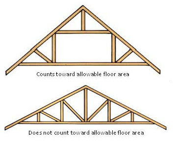
(c)
No grading shall take place on any residential zoned property from 50 feet or greater from the lake until a site plan is approved.
(d)
Any moving of soil or grading at any time on residential property within the city which requires obtaining of a soil and sedimentation permit or disturbs the soil or vegetation in a way that may allow erosion or runoff of soil shall only be done with proper soil erosion control measures in place.
(e)
Driveways and parking areas shall be designed and constructed on the road side of the house as much as possible.
(f)
The existing grade shall not be altered in elevation for five feet from each side lot line. From a point of five feet from a side lot line, the grade may change with excavation or fill not steeper than a ratio of one vertical unit for each four horizontal units, with a limitation on any increase in elevation of the grade to a maximum of three feet above the existing elevation five feet from the side lot line. No grading shall take place within 50 feet of the lake except to the extent authorized by special land use under Section 1248.03(c).
(g)
No motor vehicles, motor homes, house trailers, boats, boat trailers, boat hoists, rafts, watercraft or similar equipment or vehicles shall be parked or stored outside of an enclosed building in any required side yard setback or within 15 feet of a public or private road, unless it is in a driveway and it is in regular use.
(h)
To the extent feasible natural grades should be maintained during and restored after construction. Cut and fill of existing grades should be avoided.
(Ord. 85. Passed 1-11-99; Ord. 94. Passed 2-11-02; Ord. 96. Passed 4-14-03; Ord. 106. Passed 9-13-05; Ord. 114. Passed 7-10-07; Ord. 117. Passed 11-11-08; Ord. 119. Passed 5-12-09; Ord. 131. Passed 2-11-14; Ord. 151. Passed 6-11-19; Ord. 136. Passed 12-13-16; Ord. 155. Passed 1-12-21; Ord. 160. Passed 6-11-24; Ord. 172. Passed 2-10-26)
Sec. 1250.01. - Principal permitted uses.
Principal permitted uses in agricultural districts are:
(a)
Farming, gardening and animal husbandry, including the raising and keeping of horses.
(b)
Single-family farm dwellings.
(Ord. 85. Passed 1-11-99.)
Sec. 1250.02. - Accessory uses.
Accessory uses in agricultural districts shall be permitted to the extent they are reasonably and customarily incidental and subordinate in all respects to the principal use to which they are accessory, including the following:
(a)
Barns, stables, silos, sheds and outbuildings that are incidental to the farming conducted on the premises.
(b)
One attached garage designed for the indoor parking of no more than four vehicles.
(c)
One detached garage designed for the indoor parking of no more than four vehicles and which shall not include quarters for human habitation.
(d)
Outdoor swimming pools and hot tubs.
(Ord. 85. Passed 1-11-99; Ord. 141. Passed 4-11-17.)
Sec. 1250.03. - Special land use.
A special land use in agricultural districts is a home occupation, subject to the standards set forth in Section 1258.05.
(Ord. 85. Passed 1-11-99.)
Sec. 1250.04. - Area, width, setback and height requirements.
The minimum required area, width, setback and height requirements are set forth in Section 1246.07 (Table of Regulations).
(Ord. 85. Passed 1-11-99.)
Sec. 1252.01. - Principal permitted use.
The principal permitted use in scientific and educational districts is a single establishment, including the necessary buildings and structures, for scientific or educational research or study purposes, which involves not more than 30 persons engaged in such activities at any time.
(Ord. 85. Passed 1-11-99.)
Sec. 1252.02. - Accessory uses.
Accessory uses in scientific and educational districts shall be permitted to the extent they are reasonably and customarily incidental and subordinate in all respects to the principal use to which they are accessory, including the following:
(a)
One single-family dwelling.
(b)
One attached garage, provided that such garage is designed for the indoor parking of no more than four vehicles.
(c)
One detached garage designed for the indoor parking of no more than four vehicles and which shall not include quarters for human habitation.
(d)
Outdoor swimming pools and hot tubs.
(Ord. 85. Passed 1-11-99; Ord. 141. Passed 4-11-17.)
Sec. 1252.03. - Special land use.
A special land use in scientific and educational districts is a home occupation, subject to the standards set forth in Section 1258.05.
(Ord. 85. Passed 1-11-99.)
Sec. 1252.04. - Area, width, setback and height requirements.
The minimum required area, width, setback and height requirements are set forth in Section 1246.07 (Table of Regulations).
(Ord. 85. Passed 1-11-99.)
Sec. 1254.01. - Principal permitted uses.
Principal permitted uses in recreational districts are private recreational areas such as arboretums, boating sites, picnic areas, and wildlife sanctuaries.
(Ord. 85. Passed 1-11-99; Ord. 152. Passed 6-11-19.)
Sec. 1254.02. - Accessory uses.
[Reserved]
Sec. 1254.03. - Special land uses.
[Reserved]
Sec. 1254.04. - Area, width, setback and height requirements.
The minimum required area, width, setback and height requirements are set forth in Section 1246.07 (Table of Regulations).
(Ord. 85. Passed 1-11-99.)
Sec. 1254.05. - Supplemental use and development standards.
The use of property shall be restricted to Lake Angelus residents and taxpayers and their guests, and shall be subject to the rules and regulations imposed by the City of Lake Angelus.
(Ord. 85. Passed 1-11-99.)
Sec. 1256.01. - Principal permitted uses.
Principal permitted uses in public property districts are buildings housing governmental functions of the city, County or State, public schools, libraries, police stations, public parks and playgrounds.
(Ord. 85. Passed 1-11-99.)
Sec. 1256.02. - Principal accessory uses.
[Reserved]
Sec. 1256.03. - Special land uses.
[Reserved]
Sec. 1256.04. - Required area, width, setback and height requirements.
The minimum required area, width, setback and height requirements are set forth in Section 1246.07 (Table of Regulations).
(Ord. 85. Passed 1-11-99.)
Sec. 1256.05. - Supplemental use and development standards.
The zoning of property as a public property zone district shall not be deemed to constitute a dedication of such property to the public and shall not be deemed to waive or forfeit any proprietary rights to establish rules and regulations governing the privileges of use of such property.
(Ord. 85. Passed 1-11-99.)
Sec. 1258.01. - Intent.
The intent of this chapter is to provide for those regulations which generally apply regardless of the particular zoning district and to those special uses which may be permitted in certain zoning districts.
(Ord. 85. Passed 1-11-99.)
Sec. 1258.02. - Nuisances prohibited.
Land shall not be used for any of the following purposes, which are hereby declared to be public nuisances:
(a)
Any structure which is unsafe or which is a danger to the health, safety or welfare of the public is a public nuisance.
(b)
The unauthorized or uncontained depositing or storage of rubbish, garbage, toxic substances or other offensive or dangerous material in any public or private place is a public nuisance.
(c)
The launch and/or use of internal combustion engines upon the waters or ice surface of Lake Angelus for purposes other than, (i) the operation of conventional watercraft (other than pontoon boats) powered by inboard four-cycle engines, provided that such conventional watercraft shall not exceed 25 feet in length or exceed 6,100 pounds dry weight, or (ii) the operation of pontoon boats (as defined herein) powered by an inboard four-cycle engine, or (iii) the operation of pontoon boats (as defined herein) powered by one outboard four-cycle, CARB 3-STAR rating or better, maximum 200 horsepower engine is a public nuisance.
(d)
(Division (d) was repealed by Ordinance 126, passed May 14, 2013, which adopted new provisions on outdoor lighting. See Chapter 660, illumination control.)
(e)
The use or maintenance of any septic tank or septic disposal field which causes or threatens to cause pollution to Lake Angelus or its tributaries, and the construction or installation of a new septic system or the extension of an existing septic system after February 14, 1989, any part of which is located within 100 feet of the waterline of Lake Angelus at its normal level of 950.00 feet or within 100 feet of any tributary to Lake Angelus, or in any floodplain or other area subject to seasonal flooding, or between the principal residence and Lake Angelus, is a public nuisance. In the event that the city council should determine that practical difficulty or unusual hardship prevents strict compliance with the foregoing prohibition, the city council may approve septic system locations which fail to comply with the foregoing restrictions, but which have alternative safeguards to assure the avoidance of pollution of Lake Angelus, and such approved locations shall not constitute a public nuisance.
(f)
The installation or use of permanently or temporarily installed storage tanks for the storage of gasoline, petroleum products, toxic substances, chemicals or other pollutants at or near the shore of Lake Angelus or its tributaries, or in any location where leakage of such materials from storage containers could contaminate Lake Angelus or its tributaries, is a public nuisance. The temporary storage of fuel in legal portable containers is not prohibited.
(g)
The operation of any motor vehicle, all-terrain vehicle, snowmobile, power-driven ice boat, or other motorized vehicle, upon the ice surface of Lake Angelus, and the use of any such vehicle upon any public or private property or private road within the City of Lake Angelus, are public nuisances, provided that this provision shall not apply to the use of such vehicles on private property which is owned or occupied by the owner of the vehicle, or to the use of such vehicles by members of the police department in the performance of their duties, or to the use of licensed motor vehicles for transportation purposes on public and private roads and driveways. The parents or legal guardians of juveniles shall be responsible for violations of this provision by juveniles under their legal custody.
(h)
The open storage of any motor vehicle, motor home, house trailer, trailer, boat, raft, watercraft, aircraft or similar item, which is not directly or indirectly owned by the owner or occupant of the property where it is stored, is a public nuisance.
(i)
The open storage for continuous periods of five days or more of commercial equipment or a boat or vehicle which is unrelated to the residential use of the property where it is stored, and the open storage of a boat or vehicle which is not currently licensed for use under applicable licensing laws, are public nuisances.
(j)
The mooring, docking, launching, storage or use of any aircraft, airplane, sailplane, seaplane, helicopter, ground effect vehicle or lighter-than-air craft is a public nuisance.
(Ord. 85. Passed 1-11-99; Ord. 126. Passed 5-14-13; Ord. 157. Passed 2-9-21; Ord. 163. Passed 7-9-24)
Sec. 1258.03. - Fences, walls, screens and clear vision.
(a)
Fences that meet all of the following standards shall be permitted by the building official:
(1)
Fences owned by a single property owner shall be set back at least six inches from the property line. Fences in common ownership between adjoining property owners shall not be subject to a setback requirement.
(2)
The property line shall be surveyed and staked by a registered surveyor or civil engineer prior to the construction or replacement of any fence within five feet of a property line.
(3)
Manmade fences constructed to enclose property or to delineate property lines may not exceed four feet in height and may not be of a material or design which materially obstructs (i.e., is more than 50 percent opaque) air, light or vision. Such boundary fences may not extend into the front yard of the property on which they are constructed or into the area next to the front yard of the adjacent property based on the standards set forth in Section 1246.07, Footnote 2, except that fences not exceeding six feet in height may, upon receiving special land use approval under Section 1242.03, be permitted along a lot line adjoining a public road right-of-way. Fences constructed prior to July 13, 1992, which do not conform with this provision may remain at their locations as of that date, and may be repaired and maintained at such nonconforming locations, but may not be replaced, extended, increased in height or substantially reconstructed, except in compliance with this provision.
(4)
Decorative architectural and landscaping fences shall be deemed to be structures which are subject to the setback requirements of this Zoning Code and all applicable provisions of the construction codes. Such fences may not exceed three feet in height.
(5)
Fences may not be constructed of barbed wire or other inherently dangerous materials, and may not be electrified, electrically illuminated or used to carry electric current.
(6)
Decorative and electrically illuminated entrance gates and gate posts shall be permitted (see Section 1246.07(3)(d) for additional requirements).
(7)
Enclosures required by the building Code for private swimming pools, spas and hot tubs shall be permitted.
(8)
With respect to landscaping along a common property boundary between two residential properties, landscaping located along (six inches from) the boundary shall be planted so that when fully mature, the plants will not exceed 50 percent opacity over any 40-foot distance in that portion of the common boundary situated between the lakeshore and the point on the common boundary established by the intersection of a line drawn between the adjacent front corners of the respective two homes on each side of the common boundary ("point") (see diagram), provided in all events that plantings shall not violate the requirements of either the lakeshore Preservation Ordinance (see Section 1248.03(c) or the requirements for maintaining lake views (see Section 1246.07, Footnote 2). The desired planting pattern along borders is groups of three—seven plants in an offset (non-linear) configuration with spaces between groups. Along the balance of the common boundary (toward the street), the spacing restrictions set forth above shall not apply.
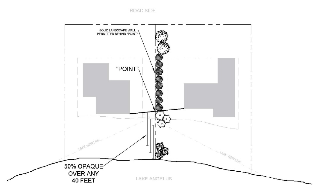
(b)
Retaining walls shall be designed and constructed in accordance with the setback requirements applicable to structures and in accordance with applicable construction code requirements.
(c)
On any corner lot, no landscaping fence, wall or other structure shall obstruct the visibility between the heights of three feet and ten feet above the road grade level in an area measuring 30 feet from the point of intersection of the road right-of-way lines and the tangent connecting the 30-foot extremities of the intersecting right-of-way lines.
(d)
Private security gates shall be installed with a means of readily available access for fire and emergency vehicles.
(e)
The building official shall enforce the provisions of this section and shall demand immediate abatement of nonconformance with this section and may issue municipal civil infraction citations for any violation of this section. In the event that any nonconformance with this section continues after such demand for its abatement, the city council may, by resolution, require that the nonconformance be abated within 48 hours from receipt of written notice of such resolution, and in the event that such nonconformance is not abated within that period, the building official may take whatever action is necessary to abate the nonconformance. In the event that the public safety requires immediate action with regard to any nonconformance, the building official may take whatever action is necessary to preserve the public safety without demand or notice.
(Ord. 90. Passed 3-13-00; Ord. 141. Passed 4-11-17.)
Sec. 1258.04. - Buildings to be moved.
No permit shall be granted for the moving of buildings or structures from without or within the limits of the city to be placed on property within said limits unless the building to be moved will fully comply with the building code and other codes regulating the health, safety and general welfare of the city.
(Ord. 85. Passed 1-11-99.)
Sec. 1258.05. - Home occupations.
All home occupations shall be in single-family residences, subject to the following requirements:
(a)
A home occupation must be clearly incidental and secondary to the primary use of the dwelling unit for dwelling purposes, and shall not change the character of the residential nature of the premises, both in terms of use and appearance. All activities shall be carried on inside the dwelling unit and shall not exceed 25 percent of the total floor area of the dwelling unit. There shall be no internal or external alterations, additions or changes made to the dwelling unit to accommodate or facilitate the home occupation.
(b)
A home occupation use shall not create a nuisance or endanger the health, safety, welfare or enjoyment of any other person in the area by reason of noise, vibration, glare, fumes, odor, unsanitary or unsightly conditions, fire hazards or the like, involved in or resulting from such home occupation.
(c)
No employees shall be permitted, either gratuitously or for compensation of any kind, other than members of the immediate family resident in the dwelling unit.
(d)
Home occupations shall not generate vehicular traffic greater than that which is customarily generated both as to volume and type of vehicles by a family and its guests using a home for exclusively residential purposes.
(e)
Fine arts instruction shall be considered a home occupation.
(Ord. 85. Passed 1-11-99.)
Sec. 1258.06. - Essential services.
(a)
Essential services shall be permitted as authorized and regulated by law and other ordinances of the city. The construction of buildings associated with essential services shall be subject to the provisions of Section 1242.04 (Site Plan Review). Otherwise, the construction, maintenance and alteration of essential services shall be exempt from the provisions of this Zoning Code. Commercial communication towers are not permitted as essential services for the purposes of this Zoning Code.
(b)
Transformers shall be placed no more than ten feet from a side lot line. Where a transformer serves two adjacent parcels, the structure may be placed on the shared lot line. In no case shall a transformer be placed within 50 feet of the lakeshore or within the lake view setback.
(Ord. 85. Passed 1-11-99; Ord. 141. Passed 4-11-17.)
Sec. 1258.07. - Animals other than domestic in a residential district.
No animals other than household pets shall be kept or sheltered in any district except upon issuance of a special use permit by the city council in accordance with Section 1242.03. Any such permit may be conditioned upon reasonable limitations and restrictions imposed by the city council to preserve the residential character of the area, including restrictions upon the species and number of animals, the size and location of buildings and fenced areas where they are kept, the location and control of manure, odoriferous matter and food, and other factors affecting the character of the neighborhood and its residential use.
(Ord. 85. Passed 1-11-99.)
Sec. 1258.08. - Signs.
(a)
The following signs shall be permitted in all zoning districts and shall not require a permit:
(1)
Nameplates not exceeding two square feet in size.
(2)
Street numbers.
(3)
Political signs.
(4)
Permitted real estate and construction signs.
(b)
One nonilluminated sign advertising land and a building(s) for rent or sale or listing firms performing construction work shall be permitted in any zoning district. Such signs shall not exceed six square feet or four feet in height, and shall be located at the street entrance to the property, and shall be removed within 60 days of substantial completion of construction work or issuance of certificate of occupancy.
(Ord. 85. Passed 1-11-99; Ord. 132. Passed 2-11-14.)
Sec. 1258.09. - Natural features.
The city council may designate an area as a natural feature which is essential to the protection of the natural resources of the city from pollution, impairment or damage, by making a determination that one or more of the following functions are applicable to the site:
(a)
The site supports state or federal endangered or threatened plants, fish or wildlife appearing on a list specified in Section 6 of Act 203 of the Public Acts of 1974, as amended, being MCL 299.226;
(b)
The site represents a locally rare or unique ecosystem;
(c)
The site supports plants or animals of local importance;
(d)
The site provides significant groundwater recharge;
(e)
The site provides flood storm water control by the hydrologic absorption and storage capacity;
(f)
The site provides wildlife habitat by providing breeding, nesting or feeding grounds or cover for forms of wildlife, waterfowl, including migratory waterfowl, and rare, threatened or endangered wildlife species;
(g)
The site provides protection of subsurface water resources and provision of valuable watersheds and recharging of groundwater supplies;
(h)
The site provides pollution treatment by serving as a biological and chemical oxidation basin;
(i)
The site provides control by serving as a sedimentation area and filtering basin.
(Ord. 85. Passed 1-11-99.)
Sec. 1258.10. - Lakeshore watercraft launching.
(a)
Findings, legal considerations, and intent.
(1)
In its deliberations leading to the adoption of this section, the city council, following recommendation of the planning commission, has recognized and concluded that the appearance and natural condition of the waters and associated resources of Lake Angelus are central to maintaining the property values and unique character of the City of Lake Angelus, and provide areas for scenic residential use. The city council has also recognized that the use of private land at the lakeshore, and the water resources associated with Lake Angelus, must be regulated in order to retain and maintain the physical and aesthetic characteristics that have established and now maintain the character and property values unique to the City of Lake Angelus. Moreover, it has been recognized that discerning and regulating the type, nature, aesthetics, noise, and other perceivable characteristics of watercraft and personal watercraft launched onto the lake, particularly considering the cumulative impact of all watercraft and personal watercraft that could be launched, are critical to maintaining the riparian rights, property values and character of the city as a whole. It has further been recognized that the present lack of regulation is likely to result in an impairment of riparian rights, property values, character of the lake, the lakeshore, and the city as a whole, and thus result in an impairment of the public health, safety and welfare of the persons residing in the city. Accordingly, it is the intent and purpose of the city council to adopt reasonable regulations for watercraft and personal watercraft launching in the city.
(2)
City resources and features that are in need of protection and preservation are identified in the Master Plan of the city. Relying on the evidence received during the deliberations on this section, and the city Master Plan, the city council recites the following findings that support the adoption of this section.
A.
The waters and associated resources of Lake Angelus define the unique character of the City of Lake Angelus and provide areas for scenic residential use. If the attractiveness, value, and character of the city are to be maintained, it is clear that preservation of the lake and its surrounding resources is imperative. Therefore, it is the intent and policy of the city to maintain and enhance the unique character of Lake Angelus, and this includes ensuring that actions that regularly occur in association with the exercise of riparian rights, either directly on private land, or by usage of city-owned property, are compatible with the existing character of the city and its lake resources. Implementing this policy requires that the exercise of riparian rights must be subject to and enhanced by the regulations in this section, which are intended to protect and promote the city's resources, character, and property values.
B.
The majority of residents in the city believe that the lake and its surrounding shoreline and environment represent the very focal point that attracted them to the city, and it is this focal point that has created and maintained substantial property values that must be maintained for the benefit of present as well as future property owners.
C.
Following the recommendation of the planning commission, the city council finds and determines that the type, nature, aesthetics, noise, and other perceivable characteristics of watercraft and personal watercraft launched onto the lake have a direct impact upon the character of the lake and the desire of individuals to reside on the lake, and correspondingly upon private property values. For this reason, as far back as 1954, the Village of Lake Angelus (predecessor to the city) enacted Ordinance No. 18, effective September 4, 1954, requiring village licenses for motor boats, with a prohibition upon licenses for outboard internal combustion engines (this ordinance was passed by referendum vote, 42 in favor to one in opposition). The evolution of watercraft regulation can be traced to the use of a set of "rules," rather than ordinance to achieve the retention of the desired character for the lake. These "rules" have now been in effect for some time. The regulations contained in this section substantially correspond to the rules, which enjoyed very substantial voluntary compliance for the duration of their existence. The rules have been recognized to be important for the maintenance of the character of the lake and city and of the values of private property in the city. It is the intent of this section to confirm the efficacy of the regulations, and later rules, together spanning more than 60 years, and to effectively restate them in the form of city ordinance to achieve the purposes long recognized to be accomplished by having them in place.
D.
The city council finds that the unique distinction, formality, scenic harmony, and decorum of the lake, lakeshore, and city itself, which were achieved in part by compliance with the earlier village ordinance and later by the rules which are now being formalized by the regulations in this section, are indispensable and compelling interests relating to the maintenance of character and property values in the city. Allowing watercraft and personal watercraft launching prohibited in this section would, considering the long-term cumulative impact, materially undermine those values. The city council recognizes that views on the type of watercraft launching that would provide distinction, formality, scenic harmony, and decorum, will differ among various people, and in the formulation of this section the council was placed in a position of having to draw lines consistent with the traditional function of a legislative body exercising zoning authority and responsibility. In this capacity, the city council has attempted to exercise its discretion and make value choices in a manner that reflects the views of most property owners and riparians in the city.
E.
The city has determined that it is necessary to regulate boat launching in order to preserve and protect the health, safety, and welfare of persons living in the area of Lake Angelus, and that the lack of regulation would result in the destruction of property values, and a threat to the public health, safety, and welfare.
F.
The city planning commission and city council have taken testimony from residents and riparians in the city, and have consulted with experts on the relationship between the regulations provided in this section and the promotion of the goals and objectives of the Master Plan, including the promotion of property values and character of the city, the lakeshore, and Lake Angelus. On this basis, the city council has concluded that this section directly and materially promotes and furthers the legitimate objectives of the Michigan Planning Enabling Act, MCL 125.3801, et seq, the Michigan Zoning Enabling Act, MCL 125.3101, et seq., the city Master Plan, and protects private property values throughout the city and the unique character of the city.
(3)
In the enactment of this section, the city council has relied on the legal authority provided in Square Lake Hills Condominium Association v Bloomfield Township, 437 Mich 310 (1991) as adapted to cities:
A.
There is regulatory authority to enact ordinances regulating boat launching on inland lakes as a measure to protect the public health, safety, and welfare of persons and property within a city.
B.
The delegated police power authority in the City Charter enables cities to regulate launching boats for the protection of the health, safety, and welfare of persons and property within their communities.
(4)
In the enactment of this section, the city council has also relied on the legal authority provided in Hess v Charter Township of West Bloomfield, 439 Mich 550 (1992) as adapted to cities:
A.
The term "land," as used within the Michigan Zoning Enabling Act, includes those rights or interests that attach to the ownership of land, which extends to riparian rights.
B.
Land which includes or is bounded by a natural watercourse is defined as riparian.
C.
The Legislature must have been aware of the importance of riparian rights with regard to the overall use of land. In a state such as Michigan, with its abundant bodies of water, there would be no way to ensure that land uses are compatible with surrounding properties unless water activities are evaluated. Similarly, the conservation of natural resources, which clearly includes water, cannot be undertaken if there is no means for regulating riparian rights. The Michigan Zoning Enabling Act allows cities to balance the most advantageous uses of the lands, resources, and properties within their boundaries and to create zoning ordinances in accordance with such evaluations. Such a balance could not be achieved if riparian rights are excluded from any zoning control by the township.
D.
The Michigan Zoning Enabling Act authorizes cities to regulate riparian rights as part of their zoning power.
(5)
In the enactment of this section, the city council has also relied on the legal authority provided in Gordon v City of Bloomfield Hills, 207 Mich App 231 (1994), and Davenport v Grosse Pointe Farms Board of Zoning Appeals, 210 Mich App 400 (1995), and specifically the proposition that "harmony" means more than technical compliance with zoning requirements, and the courts should give due regard for the city's judgment on this issue.
(6)
In the enactment of this section, the city council has also relied on the legal authority provided in Penn Central Transportation Company v New York City, 438 US 104, 129 (1978), and specifically for the proposition that "cities may enact land-use restrictions or controls to enhance the quality of life by preserving the character and desirable aesthetic features of a city."
(7)
In the enactment of this section, the city council has also relied on the legal authority provided in Village of Belle Terre v Boraas, 416 US 1, 129 (1974), and specifically for the proposition that regulations based on the city's police power include the public welfare, which is broad and inclusive. "The values it represents are spiritual as well as physical, aesthetic as well as monetary. It is within the power of the (local) legislature to determine that the community should be beautiful as well as healthy, spacious as well as clean, well-balanced as well as carefully patrolled."
(8)
In the enactment of this section, the city council has also relied on the legal authority provided in Kyser v Kasson Township, 486 Mich 514, 537 (2010), and specifically for the proposition that local legislative bodies in the exercise of the zoning authority must balance various competing interests and factors, make policy judgments, and exercise discretion.
(9)
In the enactment of this section, the city council has also relied on the legal authority provided in Gackler v Yankee Springs Township, 427 Mich 562, 572 (1986), and specifically for the proposition that achieving the objectives of improving the aesthetics of an area amounts to the advancement of a reasonable government interest.
(b)
Conflict with state law. This section is not intended to conflict with and/or preempt application of state law, but intended to supplement state law in a compatible manner so as to enhance the exercise of riparian rights in a manner consistent with the public interest.
(c)
Definitions. The following words, terms and phrases, when used in this section, shall have the meanings ascribed to them below, except where the context clearly indicates a different meaning:
Character means, and is intended to encompass, the impact on the lake, the lakeshore and the city as a whole based on the type, nature, noise, and other perceivable characteristics of watercraft and personal watercraft launched onto the lake, including without limitation the economic value reasonably attributable to private properties and their associated resources relating to the city and the lake.
Lake means Lake Angelus, wholly situated within the City of Lake Angelus, Oakland County, Michigan.
Launch means to physically move a watercraft or personal watercraft from a location on a launch site into the waters of Lake Angelus.
Launch site means a private lot or parcel of land that has frontage on the waters of Lake Angelus, and shall also mean property owned by the city that has frontage on the waters of Lake Angelus.
Personal watercraft means a vessel that uses a motor-driven propeller or an internal combustion engine powering a water jet pump as its primary source of propulsion and is designed to be operated by one or more persons positioned on, rather than within, the confines of the hull.
Riparian rights means those rights which are associated with the ownership of the bank or shore of an inland lake or stream (compare MCL 324.30101(s)).
Watercraft shall include, but not limited to, a motor-powered or engine-powered boat, rowboat, motorboat, raft, dinghy, pontoon boat, or similar vessel. The term "watercraft" standing alone shall not include a "personal watercraft" as defined in this section.
(d)
Regulations. Launching from private property and city-owned property.
(1)
Authorization. The following watercraft shall be permitted to be launched from private launch sites and city-owned property subject to the limitations stated in this section and otherwise restricted in this Ordinance Code and by law. Considering that zoning along the lakeshore permits single-family residential use, and not multi-family residential use, this authorization shall only permit an occupant of a property to launch from a respective private launch site.
A.
A watercraft (other than pontoon boats) powered by an inboard internal combustion, four-cycle engine, provided that such watercraft shall not exceed 25 feet in length or exceed 6,100 pounds dry weight.
B.
A watercraft powered by electric motor.
C.
Pontoon boats (as defined herein) powered by an inboard four-cycle engine or pontoon boats (as defined herein) powered by one outboard four-cycle, CARB 3-STAR rating or better, maximum 200 horsepower engine.
(2)
Prohibition. Watercraft not specified in paragraph (1) above, including the following, shall not be permitted to be launched from private property and city-owned property, nor permitted to be placed on Lake Angelus in any other manner.
A.
A watercraft powered by diesel engine.
B.
A watercraft powered by two-cycle engine.
C.
A watercraft powered by an outboard internal combustion engine except as provided in (d)(1)(C) above.
D.
A personal watercraft, including, but not limited to, a vessel commonly known as a jet ski.
E.
A watercraft powered by one or more water jet pumps as its primary source of propulsion.
F.
A watercraft understood to be a houseboat, characterized by the features of a galley (kitchen), bathroom, and sleeping facilities.
G.
A watercraft or any other vessel leaking or discharging a petroleum product or other pollutant unintended by the manufacturer in connection with normal operation and usage.
(3)
Registration to permit enforcement. Prior to launching a watercraft from a launch site on private property, the owner of the property shall register the property as a launch site with the city clerk.
(e)
Special exception for limited usage.
(1)
Despite the generally applicable prohibition stated above, upon application to and approval by the city council, the following types of watercraft may be approved for launching during specified days and times, with the approval of an application specifying any applicable time restrictions for removal from the lake:
A.
A watercraft launched for use in maintenance or construction on the lake or lakeshore, such as installation and repair of docks.
B.
A watercraft launched to carry out a fireworks display on the lake for the benefit of residents.
C.
A watercraft launched to undertake scientific purposes such as water testing or application of weed control.
D.
The launching of other special and limited purpose watercraft identified by resolution passed and published by the city council based on a showing that such watercraft are not expressly prohibited in this section (above) and are reasonably needed to perform important functions on the lake.
(2)
The city council may pass and publish a resolution identifying particular watercraft that are expressly authorized in paragraph (e)(1) above that would be permitted without the necessity of filing an application or securing other approval before launching. Such resolution shall state the reason for identifying the particular watercraft, the reason for the launching authorization of such watercraft, and any time limitations for launching and removal from the lake.
(f)
Penalties for violation. Any person who shall violate the provisions of this section shall be responsible for a municipal civil infraction, subject to the following penalties:
(1)
Fines. The following civil fines shall apply in the event of a determination of responsibility for a municipal civil infraction, unless a different fine is specified in connection with a particular ordinance:
A.
First offense. The civil fine for a first offense violation shall be in an amount of $150.00, plus costs and other sanctions, for each offense.
B.
Repeat offense. The civil fine for any offense which is a repeat offense shall be in an amount of $500.00, plus costs and other sanctions for each offense.
(2)
Enforcement. In addition to ordering the defendant determined to be responsible for a municipal civil infraction to pay a civil fine, costs, damages and expenses, the judge or magistrate shall be authorized to issue any judgment, writ or order necessary to enforce, or enjoin violation, of this section.
(3)
Continuing offense. Each act of violation, and on each day upon which any such violation shall occur, shall constitute a separate offense. For purposes of this section, an "act of violation" shall be deemed to occur on each day a watercraft remains in the water after being launched in violation of the authorization of this section.
(4)
Remedies not exclusive. In addition to any remedies provided for by this section, any equitable or other remedies available may be sought.
(5)
The judge or magistrate shall be authorized to impose costs, damages and expenses as provided by law.
(6)
A municipal civil infraction shall not be a lesser included offense of a criminal offense or of an ordinance violation which is not a civil infraction.
(g)
Severability. If any provision of this section or its application to any person or circumstances is held invalid or unconstitutional, the invalidity or unconstitutionality shall not affect other provisions or application of this section that can be given effect without the invalid or unconstitutional provision or application, and to this end the provisions of this section are severable.
(Ord. 139. Passed 12-13-16; Ord. 157. Passed 2-9-21; Ord. 163. Passed 7-9-24)
Sec. 1258.11. - Woodlands management.
(a)
Findings, purpose, and intent.
(1)
The unregulated and unnecessary removal of protected trees is a threat to the public health, safety, and general welfare of the citizens of City of Lake Angelus through the elimination of important physical, aesthetic, recreational and economic assets for both present and future generations. Specifically, it is found that:
A.
Protected trees provide for public safety through the prevention of erosion, siltation, and flooding in woodland areas;
B.
Protected trees aid in the protection of public health through the absorption of air pollutants and contamination, including the reduction of excessive noise and mental and physical damage related to noise pollution;
C.
Protected trees provide a significant aspect of the character of the city; and
D.
Protected tree growth serves as an essential component of the general welfare by maintaining natural beauty, recreation and irreplaceable natural heritage.
(2)
The purposes of this section are as follows, to be applied throughout the city:
A.
To provide for the protection, preservation, proper maintenance and use of protected trees through effective management of woodlands in order to minimize disturbance to them and to prevent damage from erosion and siltation, a loss of wildlife and vegetation, and/or from the destruction of the natural habitat;
B.
To assist in the sustainability of protected trees in woodlands to ensure their crucial role in contributing their economic support of community property values when allowed to remain in place, and for their natural beauty, character, and geological, ecological, or historical significance;
C.
To provide for the paramount public concern for these natural resources in the interest of health, safety and general welfare of the residents of this city, in keeping with Section IV, Section 52 of the Michigan Constitution of 1963, and the intent of Public Act 451 of 1994, the Natural Resources and Environmental Protection Act.
(b)
Definitions. The following definitions shall apply to this section, with some of the definitions being illustrated at the end of this subsection (b):
Across road preservation area. Any area of private property that has both of the following characteristics:
A.
The area is owned or controlled by the owner of a buildable lot (with or without a home);
B.
The area is situated across the road from the buildable lot, whether or not the property across the road is technically a part of the legal description of the buildable lot.
Affected tract. A property that is vacant with no buildings or structures.
Diameter Breast Height (DBH). A tree's diameter in inches measured by diameter tape at four and one-half feet above the ground. On multi-stem trees, the largest diameter stem shall be measured.
Drip line. The points on the ground where water drips off the widest-reaching branches of a tree.
Lakeshore preservation area. The 50-foot lakeshore setback as defined and regulated in the lakeshore preservation special land use provisions of this Zoning Code (Section 1248.3(c)).
Minimum view shed preservation. The prohibition on removing protected trees within a view shed that results in the retention of less than 50 percent of the number of protected trees within each of a series of contiguous ten-foot widths within the view shed, with such ten-foot widths to be measured on lines parallel to the lake shore. This calculation shall be made [as shown on the accompanying diagram] by preparing a plan with an arrangement of ten-foot wide contiguous rectangles having lengths perpendicular to the lakeshore within the view shed, and extending lines through the length of each rectangle toward the lake, and in this manner separately selecting the trees to be retained in order to achieve the 50% preservation within each ten-foot wide rectangle.
Outlot area. An area that consists of a parcel of property that has road frontage but is unbuildable under this Zoning Code due to its lack of lake frontage, and is owned by the owner of a buildable lot in the city.
Protected tree. Any tree having a diameter breast height (DBH) of six inches or greater.
Removal. The direct or indirect act of removing or causing the removal of a tree by digging up, cutting down, or other activities that damage and cause the eventual death of a tree.
Roadside preservation area. The area of a buildable lot (with or without a home) that abuts the road providing access to the lot, with borders as follows:
A.
The line representing the frontage of the lot on the road;
B.
The two side lot lines between the road frontage and a line parallel to and 75 feet from the road frontage; and
C.
A line parallel to and 75 feet from the road frontage.
Side yard preservation areas. The two areas that are coterminous with those portions of the side yard setbacks on a buildable lot situated between the upland border of the 50-foot lakeshore setback as defined in the lakeshore preservation special land use provisions of this Zoning Code (Section 1248.3(c)) and the roadside preservation area.
Transplant. The relocation of a tree from one place to another on the same property.
Tree. Any self-supporting, woody plant of a species which normally grows to an overall height of 15 feet or more.
Undeveloped. A property which is unimproved by virtue of building(s), structure(s), or other improvement(s).
View shed. An area that is visible from a specific location. For purposes of this section, a "view shed" will involve the visibility of the lake from the residence of an applicant seeking to remove protected trees from the "view shed" envelope.
View shed envelope. That part of a front (lakeside) yard on a privately owned buildable lot (with or without house) with the following four borders:
A.
A line parallel to and 15 feet toward the lake from the front of the house, and if there is no house on the property, a line parallel to and 100 feet from the lakeshore on the lot (the "front of house line");
B.
Two side lines coterminous with the two side yard setbacks in the area between the front of house line and the 50-foot lakeshore setback as defined in the lakeshore preservation special land use provisions of this Zoning Code (Section 1248.3(c)); and
C.
The border of the 50-foot lakeshore setback as defined in the lakeshore preservation special land use provisions of this Zoning Code which is closest to the house (or closest to the line 100 feet from the lakeshore if there is no house).
Diagram of Areas Referenced Throughout Ordinance Section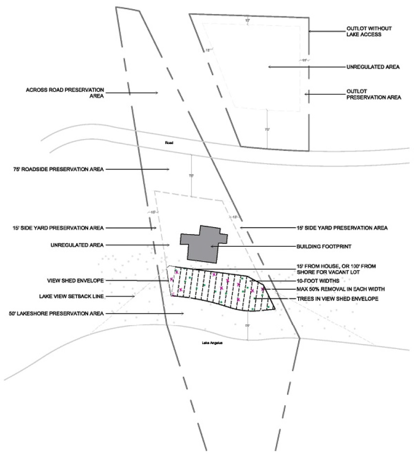
(c)
Actions requiring a Woodlands Management permit. Except as otherwise provided in this section of the Zoning Code, no person shall remove, cause or knowingly permit to be removed, or destroy any protected tree without first obtaining a woodlands management permit.
(d)
Actions not requiring permit.
(1)
Unregulated areas. Removal of trees in an area designated as unregulated. Protected trees shall be unregulated on a buildable lot within an area enclosed by the following borders:
A.
A line at the edge of the roadside preservation area closest to the lake;
B.
A line parallel to and 15 feet toward the lake from the front of the house, and if there is no house on the property, a line parallel to and 100 feet from the edge of the lakeshore on the lot; and
C.
Two side lines coterminous with the two side yard setbacks in the area between the lines described in subsections (d)(1)A. and (d)(1)B., above.
(2)
Occasional removal. The owner of a lot may, in the exercise of good faith discretion, and without advanced approval by the city, remove a protected tree on an occasional basis in areas of a lot other than the lakeshore preservation area, which is governed by the special land use provisions of this Zoning Code (Section 1248.3(c)). "Occasional basis" shall mean the random and infrequent removal of an isolated tree that does not immediately, either on its own or together with other protected tree removals, impair the screening effect of improvements on the lot as viewed from offsite, and does not otherwise alter the natural character of the lot as viewed from offsite. Each protected tree removed under this provision shall be replaced on the lot by a minimum of two trees having a caliper of three inches or more.
(3)
General exemptions. The following activities, unless otherwise specified by statute or other ordinance provision, shall not require a woodlands management permit:
A.
Tree removal and transplant activities not involving a protected tree.
B.
Protected tree removal activities protected by rights accorded to citizens by the Right to Farm Act.
C.
Protected tree removal activities necessary by an emergency, such as tornado, windstorm, flood, freeze, dangerous and infectious insect infestation or disease, or other disaster, in order to prevent injury or damage to persons or property or restore order.
D.
Protected tree removal performed by, or on behalf of, governmental entities or agencies.
E.
Repair or maintenance work performed by public utilities necessitating the trimming or cutting of protected trees.
F.
Removal demonstrated to the city planning consultant to be needed in order to remove an obstruction from the functioning of the on-site sanitary sewage disposal on the site.
G.
Removal or trimming of dead, diseased or damaged protected trees, where the damage resulted from an accident or non-human cause provided that the city planning consultant, with expert advice deemed needed by the consultant, has verified in advance the condition that is the basis for removal.
(4)
Areas on which a generalized woodlands management plan has been approved. A separate permit shall not be required for the removal of protected trees undertaken in accordance with an effective generalized woodlands management plan.
(5)
Outlot areas. In outlot areas, protected tree removal shall not be permitted in any of the following areas: within 75 feet from the road on which the lot is situated; and within 15 feet of any other outer boundary of the outlot, however, in other parts of outlot areas, protected tree removal shall be unregulated.
(e)
Prohibition on removal in preservation areas. Subject to the provisions of subparagraph (d), above, and to a generalized woodlands management plan, removal of protected trees shall be prohibited in any of the following areas:
(1)
Across road preservation area.
(2)
Roadside preservation area, subject to the following: protected trees may be removed within the area 15 feet of the house on the lot, even if such area is within the roadside preservation area; and second, if the distance between the house and the road frontage line on the lot is less than 75 feet, the roadside preservation area shall be reduced to conform with the actual distance on the lot between the house and the road frontage line.
(3)
Side yard preservation areas.
(4)
Lakeshore preservation area. The provisions of the lakeshore preservation special land use provisions of this Zoning Code (Section 1248.3(c)) shall govern activities within the lakeshore preservation area.
(5)
Outlot areas. In outlot areas, protected tree removal shall not be permitted in any of the following areas: within 75 feet from the road on which the lot is situated; and within 15 feet of any other outer boundary of the outlot (in other parts of outlot areas, protected tree removal shall be unregulated).
(f)
Permit requirements for removal within "view shed envelope" areas. Removal of protected trees shall be permitted within the view shed envelope (as defined in this section) if and to the extent the requirements in subsections (f)(1), (f)(2), and (f)(3), below, are satisfied. The plan and calculations made in the administration of this subsection (f) shall be retained in the city's file for each respective property in order to provide an understanding of the history of protected tree removal on the property for the benefit of city officials, owners, and subsequent owners.
(1)
View of the lake. Removal in the view shed envelope to establish a view of the lake from the principal residence, provided that such removal shall not violate the minimum view shed preservation, as defined in this section; or
(2)
Leisure activities. Removal in the view shed envelope to establish a reasonably-sized area for leisure improvements or activities, such as a patio, deck, or garden area. An area shall be considered to be reasonably-sized if it is not greater than the larger of 1,000 square feet or ten percent of each acre within a contiguous area of the view shed envelope; provided, considering the location of protected trees in both the view shed envelope and the area of lakeshore preservation, removal of protected trees within the view shed envelope of the property shall in all events not violate the minimum view shed preservation, as defined in this section.
(3)
Restorative removal. The issuance of a permit for the removal of protected trees under subsections (f)(1) and (f)(2), above, is intended to be a one-time occurrence on a given property (with permits under (f)(1) and (f)(2) being considered as separate authorizations). However, after a period of years following the removal of protected trees by permit, if the growth in diameter of trees preserved, or the planting of new trees in the view shed envelope, causes an unreasonable reduction of the view shed or area for leisure improvements or activities as intended in this section, the owner of the property may apply for variance relief under subsection (m) below, to obtain a new permit for the removal of additional protected trees to update or restore the view shed or leisure area. In determining the scope of protected tree removal to be permitted by the grant of variance relief, the council shall be guided in the exercise of its discretion by the extent of view shed or leisure area shown on the plan and calculations made for the prior permit, and by the intent of this section of the ordinance as stated in subsection (a) above.
(g)
Application for woodlands management permit.
(1)
Applications for woodlands management permits shall be submitted, along with the required fees and escrow, to the city planning consultant for review and approval before removing protected trees in accordance with the review schedule established by the city council.
(2)
In cases in which site plan review is required, review under this section shall be part of that review.
(3)
In cases in which site plan review is not required, the city planning consultant shall conduct a woodlands management permit review based on the standards of this section in order to provide for a streamlined administrative review process based on a woodland management plan as specified in subsection (h), below, including both specific plan and generalized plan.
(4)
Standards for the review of applications and approval of permits. The following standards shall govern approval of a woodlands management permit based on a specific plan:
A.
Construction of a building, structure, or other site improvement. Removal is necessary for the construction of a building, structure, or other site improvement permitted in this Zoning Code. The determination that removal is necessary shall be made by the planning commission as part of site plan review based on a showing by the permit applicant that there is no reasonable and prudent alternative location on site for improvement; such determination shall be made by the planning official if application is made after site plan approval. Where the proposed activity consists of land clearing, it shall be limited to areas to be improved for street roadways, sidewalks, drainage and utilities and areas necessary for the construction of buildings, structures or other site improvements as shown on an approved site plan or subdivision plat.
B.
Health and viability of the protected trees. The density of protected trees is proposed to be reduced to preserve the health and viability of the protected trees in accordance with an approved woodlands management plan, as provided in this section.
C.
Importance of preservation. Protected tree preservation and conservation shall be of paramount concern and importance, provided, that an application shall not be denied solely because of the presence of individual protected trees scattered throughout an affected tract.
D.
Reasonable and prudent alternatives. Preservation and conservation of protected trees shall have priority over land development when there are reasonable and prudent location alternatives on site for proposed buildings, structures or other site improvements.
E.
Diversity of species. Diversity of protected tree species shall be maintained where essential to preserving protected trees.
F.
Compliance with Law. The proposed activity shall comply with all applicable statutes and ordinances.
(h)
Woodlands management plans. Two types of woodland management plans shall be recognized under this section of the Zoning Code:
(1)
Specific plan. A specific plan to be approved by the city planning consultant for the one-time removal of protected trees for the purpose of reducing the density of woodlands so as to promote and maintain the health and viability of the remaining protected trees. Following the establishment of an escrow to cover the anticipated cost to be incurred by the city, the city planning consultant is authorized to engage the services of a registered forester as a woodlands consultant to provide scientific expertise and analysis during permit application processing. As part of a permit application process, an applicant shall provide documentation of the means and process by which protected trees shall be removed from the property without damaging remaining protected trees.
(2)
Generalized plan. A generalized plan to be approved by the city council intended to last for a period of time in the future specified in an approved plan for the purpose of achieving stated objectives according to conditions and principles specified in the plan documents that are found by the city council to be consistent with the findings, purpose, and intent of this section of the Zoning Code, as particularly stated in subsection (a), above. An application for a generalized plan shall include a statement specifying the manner in which the objectives, conditions and principles specified in the plan are consistent with the findings, purpose, and intent of this section of the Zoning Code. Following the establishment of an escrow to cover the anticipated cost to be incurred by the city, the city planning consultant is authorized to engage the services of a registered forester as a woodlands consultant to provide scientific expertise and analysis during permit application processing. An approved permit for a generalized plan shall serve as the permit required for the removal of protected trees during the effective period of the plan. The permit issued pursuant to an approved generalized plan shall specify its duration and clearly explain the protected tree removal authorized under the permit, and shall specify whether periodic escrows and expert monitoring of the plan shall be required.
(i)
Unauthorized removal; replacement obligation. If protected trees not authorized by permit and a permit is not exempted as provided in this section, are removed, the city planning consultant may require replacement of such removed trees with comparable protected trees to the extent required by the city council. Replacement shall mean that a sufficient number of new trees shall be planted so that the aggregate caliper of the replacement trees shall equal or exceed the aggregate DBH of the protected trees removed without a permit.
(j)
Performance guarantees.
(1)
The applicant shall post an acceptable form of an irrevocable letter of credit, cash escrow, certified check, or other city approved performance security in an amount determined by reference to the city's fee schedule resolution to complete all woodlands management activities as specified in the permit, together with reasonable administrative expenses. Required performance guarantees shall be provided to the city after approval of the woodlands management permit but prior to the initiation of any of the activities governed by the permit.
(2)
After all woodlands management activities are completed in compliance with the woodlands management permit, the letter of credit or other securities shall be released.
(k)
Woodlands management permit; contents and requirements during implementation.
(1)
The city planning consultant shall:
A.
Attach to an approved permit any reasonable conditions established as necessary to ensure the purpose of this section will be fulfilled.
B.
Fix a reasonable time for permitted activities to be undertaken and completed. Permitted activities that are not completed before the permit deadline will be cause for the permit to become null and void and will require new application.
C.
Identify on the permit any performance guarantee requirement in accordance with paragraph (f) above.
(2)
Protected tree conservation during construction shall be specified in the permit.
(3)
During construction, no person shall:
A.
Conduct any activity within the drip line of any protected tree designated to remain, including, but not limited to, placing solvents, building material, construction equipment or soil deposits within the drip line.
B.
Attach any device to any remaining protected tree except for the protection of a tree in accordance with forestry procedures.
(4)
Street right-of-way and utility easements may be cordoned by placing stakes a minimum of 50 feet apart and tying ribbon, plastic tape, rope, etc. from stake to stake along the outside perimeters of areas authorized under the permit to be cleared.
(5)
Large property areas separate from the construction or land clearing area onto which no equipment will venture may also be cordoned off as described in subsection (k)(3)B. above.
(6)
Protective barriers shall be required and maintained in accordance with permit conditions established by the city planning consultant.
(7)
Display of permit; stop work, certificate of occupancy.
A.
The woodlands management permit shall be conspicuously and continuously displayed on-site during the active timeframe of the permit.
B.
The permit grantee shall allow the city planning consultant and building official to enter and inspect the premises at any reasonable time, and failure to allow inspection shall constitute a violation of this section.
C.
The city building official may issue a stop work order or withhold issuance of a certificate of occupancy, permits or inspections if this section is being violated and/or until the provisions of this section, including any conditions attached to a woodlands management permit, have been fully met.
(l)
Fees. The city council shall establish by resolution a schedule of fees and escrow requirements intended to cover the costs of processing and approving a woodlands management permit, and permit compliance monitoring. Fees and escrow account payments shall be sufficient to cover administrative and technical review costs anticipated to be incurred by the city including the costs of on-site inspections.
(m)
Variance and appeal power of city council. The city council shall have full power and authority to vary the application of the provisions of this section. The city council shall hear appeals from any requirement, decision or determination made by the city planning consultant, and from decisions on a generalized woodlands management plan made without considering the grant of a variance, in the enforcement and administration of this section. In passing upon such matters, the city council shall consider:
(1)
All technical factors and standards specified in this section.
(2)
Danger to life, health or property by improperly managed protected trees.
(3)
Special conditions and circumstances which are unique to a property and which are not generally applicable to other properties.
(4)
Restorative removal of protected trees under subsection (f)(3) above, shall be a sufficient basis for granting a variance.
(5)
Other factors as are in keeping with the purpose of this section.
(n)
Violations; civil infraction. Any person who shall violate the provisions of this section shall, in addition to other obligations imposed in this section, be responsible for a municipal civil infraction, subject to the following penalties:
(1)
Fines. The following civil fines shall apply in the event of a determination of responsibility for a municipal civil infraction, unless a different fine is specified in connection with a particular ordinance:
A.
First offense. The civil fine for a first offense violation shall be in an amount of $1,000.00, plus costs and other sanctions, for a tree removed in violation of this section.
B.
Repeat offense. The civil fine for each additional tree, or any offense which is a repeat offense, shall be in an amount of $5,000.00, plus costs and other sanctions for each tree removed in violation of this section.
(2)
Enforcement. In addition to ordering the defendant determined to be responsible for a municipal civil infraction to pay a civil fine, costs, damages and expenses, the judge or magistrate shall be authorized to issue any judgment, writ or order necessary to enforce, or enjoin violation, of this section, including the replacement of any and all trees removed in violation of this section.
(3)
Remedies not exclusive. In addition to any remedies provided for by this section, any equitable or other remedies available may be sought.
(4)
The judge or magistrate shall be authorized to impose costs, damages and expenses as provided by law.
(5)
A municipal civil infraction shall not be a lesser included offense of a criminal offense or of an ordinance violation which is not a civil infraction.
(Ord. 145. Passed 10-10-17.)
Sec. 1258.12. - Prohibition of marihuana establishments.
(a)
Marihuana establishments, as authorized by and defined in the Michigan Regulation and Taxation of Marihuana Act (the "Act"), are prohibited in all zoning districts, and shall not be permitted as home occupations.
(b)
No use that constitutes or purports to be a marihuana grower, marihuana safety compliance facility, marihuana processor, marihuana microbusiness, marihuana retailer, marihuana secure transporter or any other type of marihuana related business authorized by the Act, that was engaged in prior to the enactment of this section, shall be deemed to have been a legally established use under the provisions of the city Zoning Code; i.e., that use shall not be entitled to claim legal nonconforming status.
(c)
This section does not supersede rights and obligations with respect to the transportation of marihuana by marihuana secure transporters through the city to the extent provided by the Act.
(Ord.147. Passed 1-8-19.)
Sec. 1260.01. - Intent.
Certain existing lots, structures and uses of lots and structures were lawful before this Zoning Code was adopted, but have become nonconformities under the terms of this Zoning Code and its amendments. It is the intent of this Zoning Code to permit such nonconformities to remain until they are discontinued or removed, but not to encourage their survival or, where discontinuance or removal is not feasible, to gradually upgrade such nonconformities to conforming status. Nonconformities shall not be enlarged, expanded or extended, except as provided herein, and shall not be used as grounds for adding other structures and uses of lots and structures which are prohibited. Nonconformities are declared by this Zoning Code to be incompatible with the structures and uses permitted in the various districts.
(Ord. 85. Passed 1-11-99.)
Sec. 1260.02. - Nonconforming lots.
In the residential district and agricultural district, notwithstanding limitations imposed by other provisions of this Zoning Code, a single-family dwelling and customary accessory buildings may be erected on any single lot of record on the effective date of adoption or amendment of this Zoning Code, subject to any restrictions lawfully imposed by the zoning ordinance in effect prior to the adoption of this Zoning Code.
(Ord. 85. Passed 1-11-99.)
Sec. 1260.03. - Nonconforming use of buildings or land.
Where, on the effective date of adoption or amendment of this Zoning Code, a lawful use of land exists that is made no longer permissible under the terms of this Zoning Code, as enacted or amended, such use may be continued, as long as it remains otherwise lawful, subject to the following provisions:
(a)
A nonconforming use of a building or land shall not be enlarged or increased, or extended to occupy a greater area of land than was occupied on the effective date of adoption or amendment of this Zoning Code. No existing building devoted to a use not permitted by this Zoning Code in the district in which it is located shall be enlarged, extended, constructed, reconstructed, moved or structurally altered, except in changing the use of the structure to a use permitted in the district in which it is located. Any nonconforming use may be extended throughout any part of a building which was manifestly arranged or designed for such use, and which existed at the time of adoption or amendment of this Zoning Code, but no such use shall be extended to occupy any land outside such building.
(b)
A nonconforming use of a building or land shall not be moved in whole or in part to any other portion of the lot or parcel occupied by such use on the effective date of adoption or amendment of this Zoning Code.
(c)
A nonconforming use of a building or land which has been discontinued for a period of more than one year shall not be re-established.
(d)
If no structural alterations are made, a nonconforming use of a building or land may be changed to another nonconforming use of the same or a more restricted classification, provided that the zoning board of appeals, either by general rule or by making findings in the specific case, shall find that the proposed use is equally appropriate or more appropriate to the district than the existing non-conforming use. In permitting such change, the Board may require appropriate conditions and safeguards in accordance with the purpose and intent of this Zoning Code. Where a nonconforming use of a building or land is hereafter changed to a more restrictive classification, it shall not thereafter be changed to a less restricted classification.
(Ord. 85. Passed 1-11-99.)
Sec. 1260.04. - Nonconforming structures.
Where a lawful structure exists on the effective date of adoption or amendment of this Zoning Code that could not be built under the terms of this Zoning Code by reason of restrictions on area, height, setbacks or other characteristics of the structure or its location on the lot, such structure may be continued, as long as it remains otherwise lawful, subject to the following provisions:
(a)
A nonconforming structure may be enlarged if the original nonconforming structure remains in place as part of the enlarged structure, unchanged as to structure, location and height, and the addition is in full compliance with the provisions of this Zoning Code.
(b)
A nonconforming structure which is demolished by any means can be reconstructed, if such reconstruction is limited to the location and height of the original structure, however, the planning commission may in the exercise of reasonable discretion allow a change in location and form if it is demonstrated by the applicant, after public hearing, that the new location or form shall be less nonconforming, i.e., shall be less intrusive in all respects to surrounding properties and to the city as a whole. A nonconforming structure that is demolished by any means may not be replaced by a larger structure unless the nonconformity is eliminated for the entire structure. Demolition for purposes of this section means the complete or partial destruction of a structure to the extent that it cannot be used or occupied for its permitted purpose.
(c)
Should any structure be moved for any reason for any distance whatever, it shall thereafter conform to the regulations for the district in which it is located after it is moved.
(d)
Any structure, or structure and land in combination, in which a nonconforming use is superseded by a permitted use, shall thereafter conform to the regulations pertaining to the uses permitted in the district in which such structure is located, and the nonconforming use may not thereafter be resumed.
(Ord. 85. Passed 1-11-99; Ord. 88. Passed 9-13-99; Ord. 141. Passed 4-11-17.)
Sec. 1260.05. - Uses allowed as special uses are not nonconforming uses.
Any use for which special approval is permitted as provided in this Zoning Code shall not be deemed a nonconforming use, but shall without further action be deemed a conforming use in such district.
(Ord. 85. Passed 1-11-99.)
Sec. 1260.06. - Change of tenancy, ownership or management.
There may be a change of tenancy, ownership or management of any existing nonconforming uses of land, structures and premises, provided there is no change in the nature or character of such nonconforming uses, except in conformity with the provisions of this Zoning Code.
(Ord. 85. Passed 1-11-99.)
Editor's note— To view the zoning map, please see the Code of Ordinances on file with the city clerk.

