
Longwood City Zoning Code
ARTICLE III
- DEVELOPMENT DESIGN STANDARDS
3.1.0. - Generally.
3.1.1. Purpose. The purpose of this article is to provide development design standards applicable to both public and private development activity within the City of Longwood.
3.1.2. Principles of development design. Development design shall first take into account the protection of natural resources as prescribed in this LDC. All development shall be designed to avoid unnecessary impervious surface cover; to provide adequate access to lots and sites; and to ensure appropriate site design. All engineering plans submitted pursuant to the requirements of this article shall be signed and sealed by a registered professional civil engineer or architect.
3.1.3. Applicability within existing neighborhoods. Where standards are provided that require new development to be consistent or compatible with an existing subdivision or existing neighborhood, the greatest weight shall be given to development within the city limits of the City of Longwood. This means that, while a study area that defines an "existing neighborhood" or "surrounding neighborhood" may include territory that is both within and without the corporate limits of Longwood, determinations of consistency and compatibility shall be based on the development patterns and other required features, as they exist within the corporate limits of Longwood. Refer to the definition of "surrounding neighborhood" in article I, which also applies to the term "existing neighborhood" or "neighborhood."
3.1.4. Applicability within land use districts and overlay districts. The design standards described for a land use district shall apply to all development within that district. In addition to standards for all development within a land use district, supplemental standards are provided for specified individual uses. These supplemental standards are described in article V. Where conflict arises between standards for the land use district and a specified use, the stricter standard shall apply.
3.1.5. Applicability of design standards. The design standards contained in this Longwood Development Code and the City of Longwood Manual of Standards (for the design, construction and maintenance of water and wastewater systems), and the public works design standards (for city streets, stormwater systems, subdivision and site development) shall be utilized for all development within the City of Longwood.
(Ord. No. 07-1828, § 1, 5-21-2007; Ord. No. 10-1929, § 1, 9-27-2010; Ord. No. 12-1992, § 1, 9-4-2012; Ord. No. 14-2049, § 1, 4-20-2015; Ord. No. 22-2219, § 1(Exh. A), 4-18-2022)
3.2.0. - Site design standards.
3.2.1.A. Table of Dimensional Standards.
A35 = Setbacks applied to buildings above 35' in height
A35R = Setbacks applied to buildings above 35' in height and adjacent to a property in single-family residential use
NR = Non-residential building height, including multi-story apartment and condominium buildings.
R = Residential building height, including single-family homes and townhouses.
SF = Single family detached and duplex units
MF = Multi-family, including apartment units and townhouse units
* The setback for the Transit Village Neighborhood district shall be modified within the range to be consistent with the required street sections where applicable. Where there is not a specified street section, the front setback shall be no less than five feet.
A.
Application of setbacks. Setbacks shall be applied as follows:
1.
Setbacks are measured from the vertical plane of the structure.
2.
Eaves and overhangs are allowed to encroach into the setbacks by no more than two feet.
3.
For zero lot line developments with multi-family buildings, including townhome subdivisions, setbacks shall be measured from the outer edges of the multi-family building without regard to the individual lots created.
4.
For the purposes of this section, "residential" means any property that has a future land use of LDR or MDR, CON and in single-family residential use, or is part of a legally conforming single-family residential or townhouse subdivision. Properties separated by a right-of-way of 60' or less from residential properties will be considered adjacent for the purpose of applying setbacks.
5.
Where residential subdivisions dedicate five percent or more of the site area to usable open space, the required side setback may be reduced to five feet in LDR and three feet in MDR-7 and MDR-15 to accommodate the open space.
B.
Where buffers required under LDC 3.5.2 exceed the setback requirements stated herein, the applicable setback shall equal the width of the buffers.
C.
Setbacks may be reduced to zero feet for liner buildings or multi-unit structures including condominiums that are otherwise allowable. In these situations, the setbacks will be evaluated from the external walls of the structure, and the building will be required to meet primary structure setbacks as applicable. In zoning categories under the downtown historic and station core land uses, front setbacks may be reduced to zero feet to bring the building up to a sidewalk meeting appropriate streetscape standards for walkability, and where otherwise consistent with neighborhood characteristics.
D.
A current survey, prepared by a surveyor, licensed in the State of Florida, should be submitted for all applications proposing construction, showing all setbacks (front, sides and rear); showing all existing structures on the property, if any and proposed additions or structures, all being fully dimensioned. However, a scaled, proportioned, accurate representation of a survey, or a survey that is re-printed so as to not be to scale but where all relevant and necessary information to review the proposal is delineated on the survey by the surveyor, may be accepted for minor residential construction projects (i.e., fences where a permit is required, sheds, or utility buildings, but not accessory dwelling units) only where sufficient information is present to apply the relevant codes.
E.
Building height.
1.
Height calculation. Outside of special flood hazard areas, building height shall be measured from the average grade of the street or streets abutting the property, measured from the centerline. Within special flood hazard areas, building height shall be measured from the required design flood elevation line to the roof peak. For structures other than buildings, including accessory structures, height shall be measured from the mean elevation of the existing (pre-construction) grade to the highest point of the structure above the existing grade.
2.
Exceptions to the height limit are as follows:
(a)
The height limit can be exceeded by up to five feet for incidental structures such as stairwells and up to two feet for architectural features.
(b)
The total amount for all incidental structures that exceed the height limit shall be no more than five percent of the square footage of roof area and shall be located to the center of the roof area and/or hidden from street level view to the maximum extent practicable pursuant to LDC 3.2.3(D)(6).
(c)
Architectural features can only exceed the height limit over 25 percent of the length of the building.
(d)
The maximum height for a project developed under the Live Local Act shall not be restricted below the highest currently allowed height for a commercial or residential building within 1 mile of the development or 3 stories, whichever is higher. For purposes of this paragraph, the term "highest currently allowed height" does not include the height of any building developed under the Act or that has received any bonus or special exception for height. If the proposed development is adjacent to, on two or more sides, a parcel zoned for single-family residential use that is within a single-family residential development with at least 25 contiguous single-family homes, the municipality may restrict the height of the proposed development to 150 percent of the tallest building on any property adjacent to the proposed development, the highest currently allowed height for the property provided in the LDC, or 3 stories, whichever is higher. For the purposes of this paragraph, the term "adjacent to" means those properties sharing more than one point of a property line, but does not include properties separated by a public road.
F.
A single-use, infill residential subdivision of five units or less in the MDR category shall be calculated at the highest allowable density for the category.
G.
Minimum dwelling unit size. The minimum living area square footage of single-family dwelling units or townhouses shall be as specified in LDC 3.2.1(A) for any new dwelling unit applying for a building permit after March 4, 2019. Single-family dwelling or townhouse units built in accordance with a valid building permit issued prior to March 4, 2019 that are non-conforming to the aforesaid minimum living area square footage requirement shall not be required to come into compliance with such minimum living area requirement if the "substantial improvement" threshold of LDC 9.1.2 is triggered.
H.
Calculation of density. Density shall be the method of calculating allowable space by which residential and residential components of mixed-use projects will be calculated. The calculation of density for projects shall be as follows:
(1)
Net developable area. The net developable area shall be based on the calculation of the total area of the parcel or the total area of contiguous parcels under common ownership and submitted for approval under a single development plan, including retention/detention areas, existing ponds, lakes and streams, wetlands, future public rights-of-way, parkland dedication, circulation, recreation facilities, etc., but excluding land in existing public rights-of-way, and any parcels with no allowable density.
(2)
Calculation. The total amount of units allowed is calculated by multiplying the allowable units per acre for the parcel by the amount in acres of net developable area. When calculating allowed density for any given site in the City, the net developable area is multiplied by the allowed density per acre that applies to the zone where the site is located. The result is the maximum number of units that may occupy that site. For the purposes of this calculation, fractional values shall be rounded to the nearest whole number (0.5 and above, round up; below 0.5, round down). All development must be consistent with the standards of the Longwood Development Code.
(3)
Live Local Act. The maximum density for projects meeting the standards of the Live Local Act shall be permitted the highest allowed density on any land in the municipality where residential development is allowed, which for interpretative purposes is 15 dwelling units per acre pursuant to LDC 3.2.0. Projects developed under the provisions of the Live Local Act may be eligible to apply for and receive a density bonus beyond the 15 dwelling unit maximum through a Planned Development at the discretion of the City Commission pursuant to the standards found in LDC 10.4.0.
(Ord. No. 05-1746, § 2(3.2.1), 4-4-2005; Ord. No. 07-1828, § 2, 5-21-2007; Ord. No. 10-1929, § 1, 9-27-2010; Ord. No. 11-1956, § 1, 3-7-2011; Ord. No. 11-1961, § 1, 5-16-2011; Ord. No. 11-1969, § 1, 8-15-2011; Ord. No. 12-1992, § 1, 9-4-2012; Ord. No. 13-2002, § 1, 3-18-2013; Ord. No. 13-2016, § 1, 11-18-2013; Ord. No. 14-2027, § 1, 10-6-2014; Ord. No. 14-2049, § 1, 4-20-2015; Ord. No. 15-2065, § 1, 8-17-2015; Ord. No. 16-2088, § 1, 6-20-2016; Ord. No. 16-2093, § 1, 8-15-2016; Ord. No. 16-2107, § 1, 2-6-2017; Ord. No. 18-2136, § 1, 6-18-2018; Ord. No. 19-2151, § 1, 3-4-2019; Ord. No. 20-2170, § 1, 2-17-2020; Ord. No. 20-2189, § 1, 10-19-2020; Ord. No. 21-2202, § 1, 8-2-2021; Ord. No. 22-2219, § 1(Exh. A), 4-18-2022; Ord. No. 23-2240, § 1, 10-2-2023; Ord. No. 24-2254, § 1, 8-5-2024)
3.2.2. Lot design standards.
A.
Lot area standards. There shall be no minimum lot area, provided that all of the following requirements are met. Tiny home communities and zero lot line developments, such as townhome subdivisions, are exempt from the lot area requirements where the use is allowable and the overall development is consistent with setbacks, buffering, impervious surface, and other requirements.
1.
For residential land use districts, lot area shall be consistent with the maximum density of the area. Should cluster development be proposed, appropriate and adequate open space shall be set aside either through dedication to a public agency or homeowners' association, or through a recorded conservation easement. The purpose of the open space set aside is to ensure that the gross density is maintained where smaller lot sizes are proposed in order to achieve cluster development. (Appropriate and adequate open space means the amount of open, undeveloped land necessary to maintain the required gross density and to meet any minimum open space requirements set by the Longwood Comprehensive Plan or this Development Code. Such open space shall be considered appropriate and adequate if it is contiguous rather than in scattered, small portions of the overall development.)
2.
For all land use districts, lot area shall be sufficient and adequate to accommodate all site design standards and requirements (such as, but not limited to parking, landscaping, buffers, and stormwater retention areas).
3.
For all land use districts, lot area shall be consistent with the density for the land use district and compatible with the predominant lot area of the surrounding neighborhood.
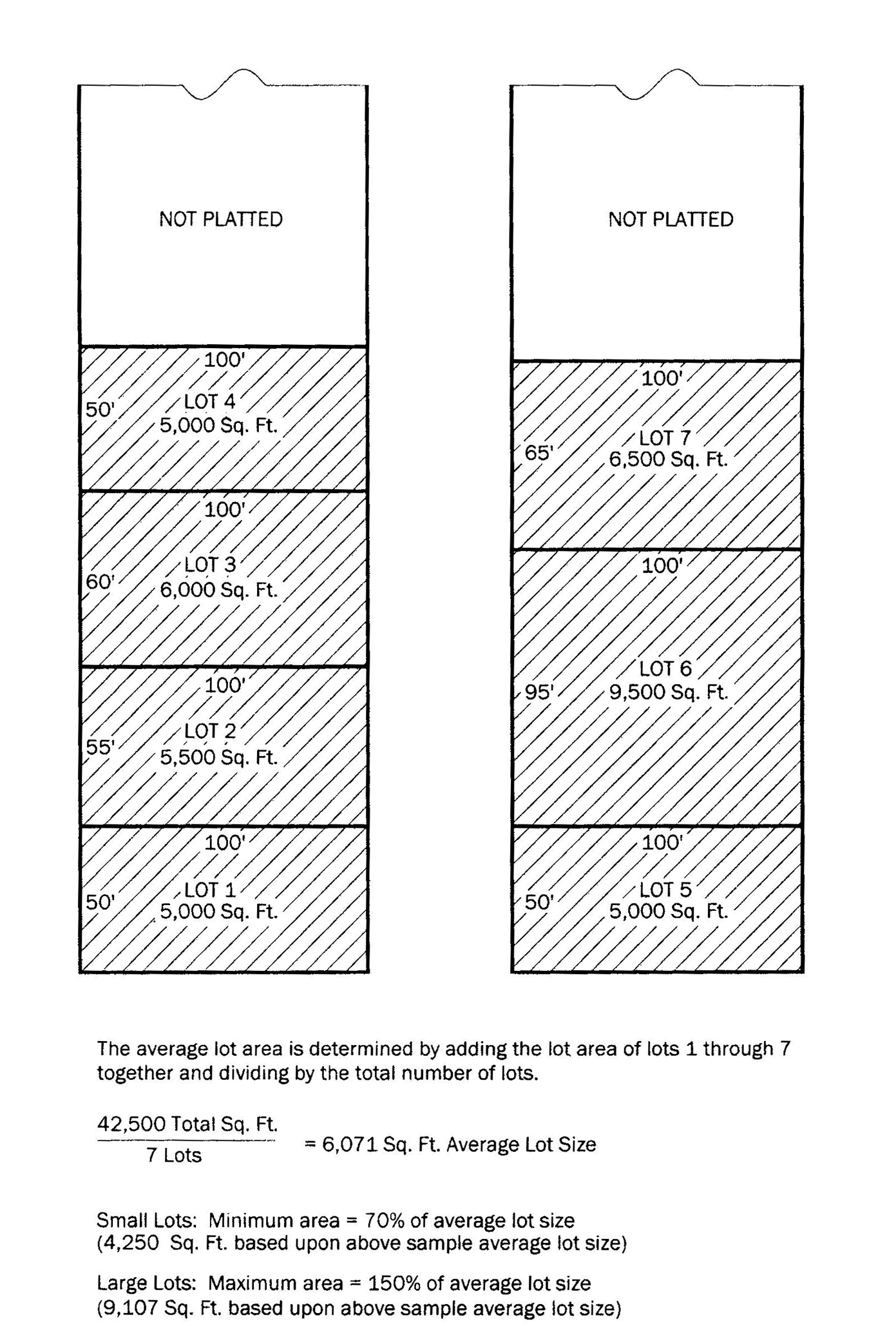
a.
Where larger lot areas are proposed, the proposed lot area shall not be greater than 150 percent of the average of lots in surrounding neighborhood.
b.
Where smaller lots are proposed, the proposed lot area shall not be less than 70 percent of the average lots that are in the surrounding neighborhood.
4.
In the historic district, the minimum lot area shall be 4,000 square feet.
LOT AREA STANDARDS
B.
Lot dimension standards. There shall be no minimum lot width or lot depth, provided that the following requirements are met.
1.
Tiny home communities and zero lot line developments, such as townhome subdivisions, are exempt from the lot dimension requirements where the use is allowable and the overall development is otherwise consistent with setbacks, buffering, impervious surface, and other requirements.
2.
Lot width and lot depth shall be sufficient and adequate to accommodate all site design standards and requirements (such as, but not limited to, parking, access drives, landscaping, buffers, setbacks, and stormwater retention).
3.
Lot width and depth shall be consistent and compatible with the predominant configuration of lots in the surrounding neighborhood.
a.
Where large lot widths or lot depths are proposed, the proposed dimensions shall not be greater than 150 percent of the average dimensions of lots in the surrounding neighborhood.
b.
Where smaller lot widths or lot depths are proposed, the dimension shall not be less than 70 percent of the average dimensions of lots in the surrounding neighborhood.
4.
The minimum lot width in the historic district is 40 feet.
LOT DIMENSION STANDARDS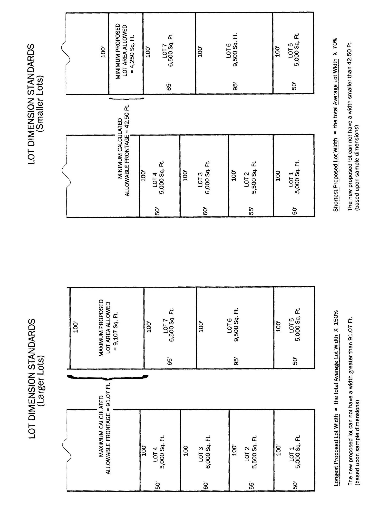
(Ord. No. 16-2088, § 1, 6-20-2016; Ord. No. 16-2093, § 1, 8-15-2016; Ord. No. 16-2107, § 1, 2-6-2017; Ord. No. 19-2151, § 1, 3-4-2019; Ord. No. 22-2219, § 1(Exh. A), 4-18-2022)
3.2.3. Design standards for non-residential, apartment, townhouse, historic, and mixed-use developments in the City of Longwood.
A.
Purpose. It is the intent of the City of Longwood to establish development standards for properties in the city. The specific objectives are enhancement of the visual appearance of development; enhancement of landscape and streetscape; reduction of visual distraction through uniform design for buildings and signs; reduce the apparent size of buildings and create visual interest; provision of design standards to achieve a traditional urban character over time; protection of adjacent residential land uses; and protection of property values.
B.
Applicability. The standards of section 3.2.3 apply to all new nonresidential, apartment, townhouse, historic district, and mixed-use development and redevelopment.
C.
Alternative building design. To provide flexibility in building design, an applicant may submit an alternative building design to the community development director for consideration. The alternative design will be considered where the building meets some or all of the following criteria:
1.
The design meets the intent, if not the letter, of the design standards set forth in this section.
2.
A façade or façades are located in such a manner that the architectural standard is impractical, not feasible, or wholly screened from view by other buildings or other permanent features.
3.
A variety of other building elements or design techniques, additional screening or landscaping or other site design features are used to mitigate the difference between the standards of this section and the proposed design.
4.
The design standards of this section are incompatible with a proposed land use or inappropriate for the location, particularly for areas in the Industrial (IND) land use where the project does not face an arterial or Florida Central Parkway.
D.
Design standards for non-residential, apartments, townhouse, and mixed-use properties.
1.
The following materials shall be used as finish materials for buildings.
a.
Concrete masonry with stucco.
b.
Wood, painted, natural, or stained.
c.
Brick.
d.
"Hardie-plank" or similar siding.
e.
Decorative block.
f.
Stone.
g.
Vinyl siding.
h.
Seamed metal paneling, defined as decorative, vertical metal panels with seams, is only allowed in the following situations:
(1)
In the form of seamed metal awnings to maintain consistency with metal roofs.
(2)
As an accent material representing no more than 25 percent of the total square footage of the primary façade in all districts, however, in no circumstance shall seamed metal make up more than 75 percent of the total square footage of any architectural element (i.e. parapet wall) except as allowed in subsection (4) below.
(3)
For properties with frontage on 17-92, seamed metal is allowed on no more than 25 percent of the total square footage of any façade, and seamed metal may be used for the entirety of an architectural feature such as a parapet wall.
(4)
For properties in the Industrial (IND) District, façades other than the primary façade may utilize seamed metal paneling as a building material on the secondary or tertiary facade when that façade is not visible from any properties in residential use or any public right-of-way, including SunRail.
Corrugated metal paneling, defined as sheet metal that has been rolled into a parallel wave pattern for stiffness and rigidity, or seamed metal paneling is only allowed as a building or accent material when not visible from any properties in residential use or any public right-of-way, including SunRail.
i.
Architectural insulated metal wall panels
j.
EIFS (Exterior insulation and finishing system)
The community development director may, at their discretion, accept other appropriate finish materials consistent with existing neighborhood characteristics.
2.
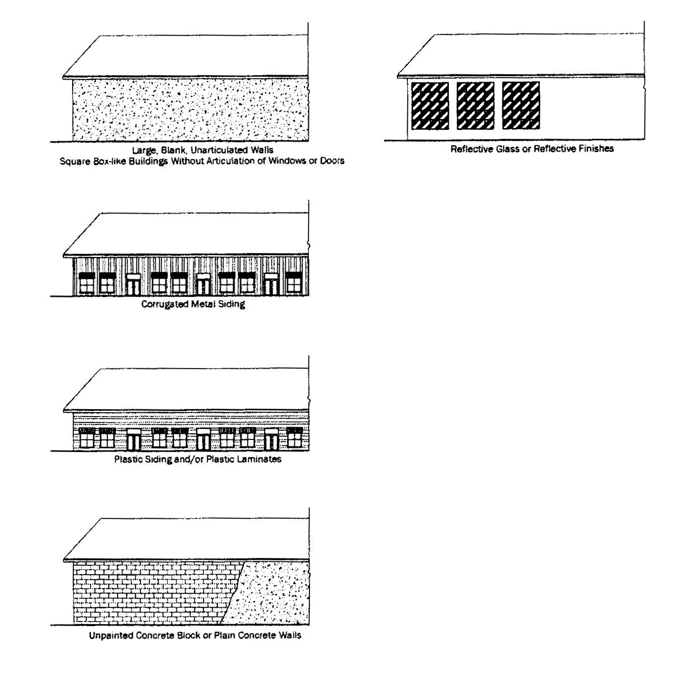
The following features and materials shall not be used on building façades:
a.
Large, blank, unarticulated walls. Articulation shall be achieved through the use of windows, awnings, or similar features (see subsection (D)(7)).
b.
Metal exterior finish unless consistent with the Longwood Design Guidebook or subsection (D)(1), and except metal awnings as part of an approved color scheme or aluminum siding as part of an approved color scheme.
c.
Plastic siding and/or plastic laminates other than vinyl siding.
d.
Unpainted concrete block or plain concrete walls.
e.
Reflective glass or reflective finishes except as trim or accent.
f.
Plywood.
g.
Corrugated fiberglass.
h.
Square box-like buildings without articulation of windows or doors.
i.
Brightly colored glazed tile.
3.
Building colors, including roofs, must be approved by the community development department and must meet the following criteria:
a.
A maximum of five colors may be used on the exterior of any building, excluding the color of unpainted natural stone or roof material. Color selections must be complementary.
b.
High-intensity primary colors, electric, neon, fluorescent, and metallic colors, and black shall not be utilized as a body color. These colors may only be utilized as part of a corporate color scheme and in this instance, only as a replacement for either the trim or accent (not body) color, and only up to 20 percent of the total square footage of any one building façade.
c.
Reserved.
d.
Non-shingle roofs and metal awnings shall be consistent with the color selection criteria in subsection (b) and shall not be high-intensity primary colors, electric, neon, or fluorescent. Roof color selections shall be complementary. Shingle roofs shall have a neutral finish.
4.
Primary entrances shall be prominently located and shall be covered, recessed, or treated with an architectural feature in such a way that weather protection is provided.
5.
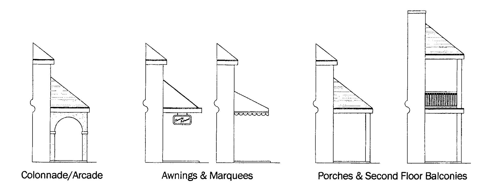
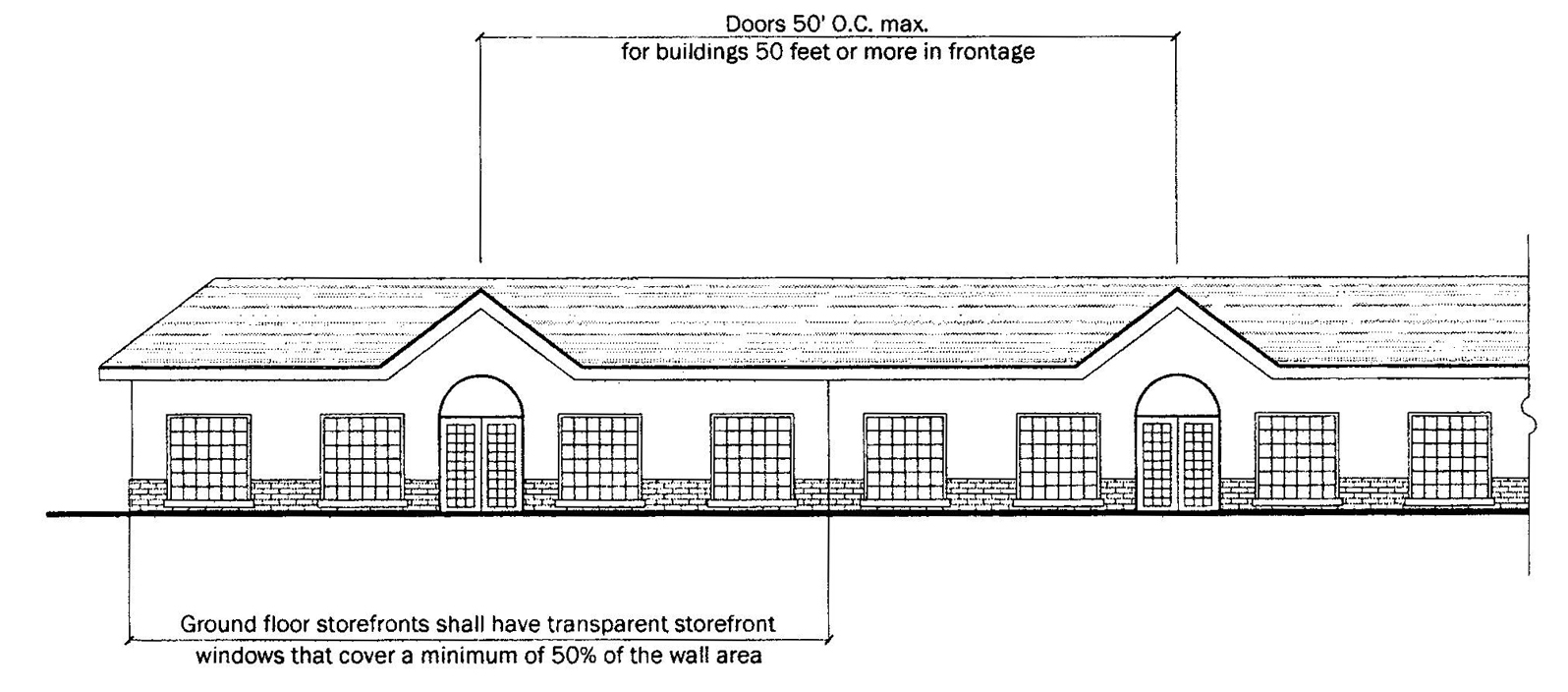
Multiple-unit centers that abut sidewalks are required to provide shelter and shade to pedestrians and articulation to the façade by means of arcades, colonnades, awnings, shade trees and/or balconies along no less than 80 percent of the primary façade.
SHELTER
6.
Windows.
1.
Buildings located within ten feet from the front property line with ground floor storefronts shall have transparent storefront windows that cover a minimum of 50 percent of the wall area.
2.
Windows may only be covered by temporary materials such as paper or boards during active, permitted construction activities, or to secure a vacant building.
STOREFRONT WINDOWS AND ENTRANCES
7.
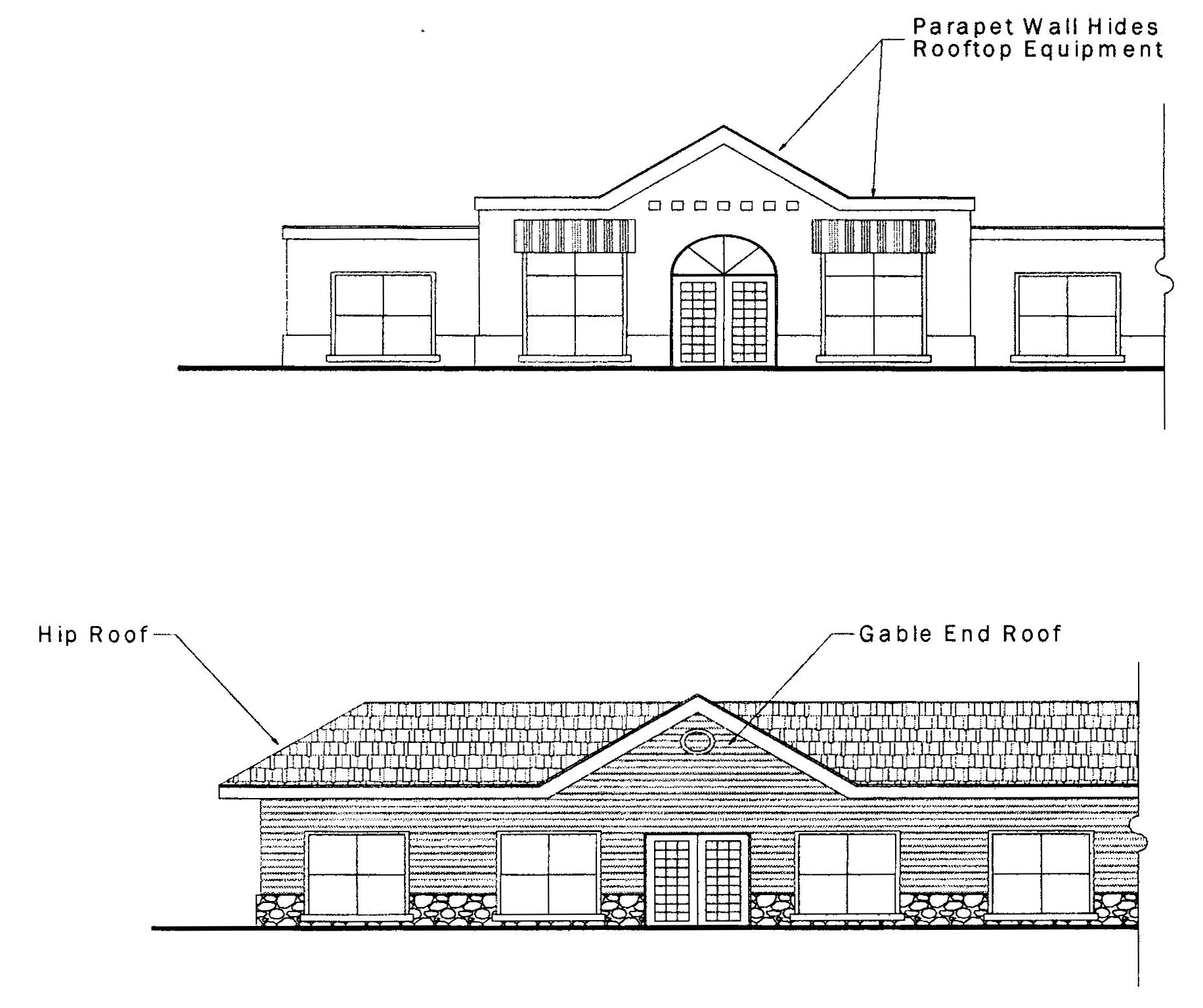
Roofs should be peaked or pitched, such as gable, hip, or barrel vaulted. Rooftop equipment shall be screened from view by architectural features. Flat roofs may be allowed with the following articulation:
a.
Flat roofs shall be screened with parapets on all sides of the building. Parapets shall be a minimum of two feet in height. All parapets shall feature an articulated cornice line, and shall include a cap element to define upper edge of the building.
b.
Long, unbroken, monotonous, horizontal rooflines are prohibited. No parapet shall run unbroken for more than 75 feet and shall vary by height or other treatment.
ROOFTOPS
8.
Façades shall have a traditional base, middle, and top delineated through a change in material, texture, color, and traditional expression lines. Architectural elements and variation shall not be restricted to the primary façade. All sides of a building shall display a balanced level of quality and architectural interest, in accordance with sound and generally accepted development and architectural practices and principles. The following minimum number of architectural elements from subsection 8 are required and must be applied consistently, thoroughly, and in an architecturally compatible manner across the façade:
a.
Primary façade: Three elements.
b.
Secondary façade: Two elements.
c.
Rear facade: One element.
d.
Rear facade visible from a right-of-way or residential property, but not fronting a right-of-way: two elements.
e.
If the building is placed in a corner of two rights-of-way, an additional corner element is required.
f.
Apartments and townhouses where the total amount of square footage associated with the primary use exceeds 20,000 SF are required to incorporate wall offsets with a minimum depth of two feet in the form of projections or recesses spaced evenly across the façade plane, spaced no more than 30 feet apart.
9.
Architectural elements.
a.
Solid color fabric, metal, or glass canopies/awnings providing shade to pedestrian ways and/or to accent doors and windows.
b.
Porticos or porte-cocheres integrated with the building's massing and style.
c.
A prominent architectural element, such as increased building height or massing, a cupola, a turret (this element is required when a building terminates at a "T" intersection or is located on the corner of two rights-of-way).
d.
Colonnades or arcades.
e.
Cornice, a minimum of two feet in height with 12-inch projection.
f.
Arches with a minimum 12-inch recess depth.
g.
Curved walls.
h.
Columns.
i.
Architectural features of like quality and aesthetics.
10.
Non-residential projects shall incorporate signage areas into the architectural design of the building at the planning phase, to ensure that signage will be consistent with the architecture of the building and not placed as an afterthought.
11.
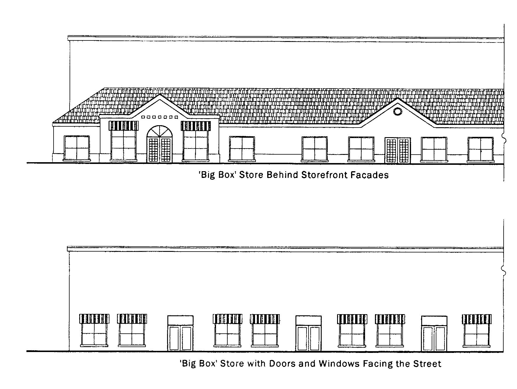
Buildings with a footprint of 20,000 square feet or more may be allowed, provided that such buildings either have windows and doors facing the street, or have smaller buildings with doors and windows facing the street to "wrap around" the larger building.
WINDOWS AND DOORS FACING THE STREET
12.
Light posts and fixtures shall be of a style and type consistent with the architecture of the development. Poles shall have grooves, textured finish, or variations in width throughout the length of the pole. Building and pole fixtures shall have shielding to reflect the light down towards the ground and avoid shining light towards the sky or other properties and shall match the style of the pole. The total height of light poles shall not exceed 25 feet.
13.
Dumpsters shall be enclosed on three sides by a masonry wall consistent with the color and design of the development of a height sufficient to entirely screen the dumpster from view. If additional dumpsters are added following the initial development process, these dumpsters must also comply with the standards of this section. Where a new site development plan, site construction permit, or change of use permit is required, any existing or proposed dumpsters are required to be enclosed pursuant to this section. Where a site construction permit or change of use permit is required for an individual tenant that is part of a multi-unit center, the individual tenant shall not responsible for enclosing a common dumpster.
14.
Utility apparatus, such as pumps, valve boxes, switching boxes, backflow devices, but not including telephone or utility poles, placed above ground shall be fully screened by landscaping of a sufficient height at planting to hide the apparatus from view. All utilities, loading areas, or other functions with the potential to impact neighboring residential properties shall be oriented away from the residential areas to the maximum extent practicable. The building may be designed to have a second primary frontage, where the building is designed to hide these functions from view of the residential property.
15.
Structured parking/parking garages. Where structured parking is provided either as part of a building or as a standalone garage, the building shall meet the design standards for a primary structure including exterior materials to the maximum extent practicable.
16.
Townhouse developments. Individual dwelling units shall be distinguished from one another through the use of variations in façade depth and design treatments. Primary façades shall have variation in both the horizontal and vertical planes. Windows and doors shall be articulated.
E.
Design standards for historic district properties.
1.
Architectural design and materials shall be applied as follows:
a.
New commercial, multi-family, and mixed-use construction. New construction in the historic district shall select from one of the four accepted styles in the historic district and follow the relevant standards of this section, as well as the standards related to the specific styles in the historic district addendum.
b.
New single-family construction. New single-family construction shall meet the architectural standards detailed in this section. Single-family homes do not have to strictly follow any of the four accepted styles in the historic district, but the design shall be generally consistent with and draw cues from those styles.
c.
Supporting structures. Rehabilitation or improvements to supporting structures shall take their architectural stylistic cues from one of the representative architectural styles recognized within the Longwood Historic District as appropriate with the original design, but otherwise shall be designed to make the building more consistent with the architecture, form, massing, and other characteristics of neighboring properties.
d.
Contributing structures. Contributing structures in the historic district shall have an additional level of review including the four treatment approaches of The Secretary of the Interior's Standards for the treatment of Historic Properties.
e.
The community development director may consider substitutions for the materials and applications below with a justification provided by the applicant, including examples of existing structures in the historic district that are in good order and demonstrate desirable characteristics common to the district.
2.
General principles. The following principles shall act as guidance for the community development director and other staff in the consideration of interpretations, waiver and special exception requests, and other relevant decisions.
a.
Proposals shall take their architectural stylistic cues from the representative architectural styles recognized within the Longwood Historic District.
b.
The rehabilitated existing or the new building shall contribute to the character of the district by respecting the location, design, materials and the other character defining elements of the existing contributing buildings without copying them outright.
c.
The new building shall be seen as a product of its own time while being a good neighbor by enhancing the character, respecting the context and emulating those elements of the existing district that give it its charm and enduring value.
d.
The architectural style, mass and scale of a building shall respect neighboring structures. Scale is relative to both location and to building use.
e.
The amount, location and elaborateness of facade elements such as bays, windows, doors, storefronts, details, and ornamentation in new or rehabilitated supporting structures shall be considered in light of the existing contributing structure examples.
3.
Access.
a.
Each residential unit shall be accessed directly from the street.
b.
Entrances shall be in full view and oriented towards the street as shall the principal face of the building.
c.
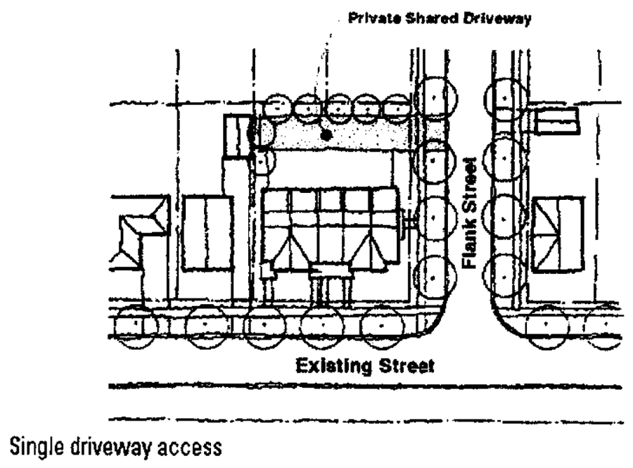
Garages and parking shall be accessed through an alley, or side (not frontage) street. In mid-block locations without existing alleys, access shall be from the frontage street by a driveway of not more than 12 feet in width.
d.
Garages shall not be located in front of the primary structure.
4.
Façade materials and applications.
a.
Wood or cementitious clapboard or ship-lapped siding with a minimum three and one-half-inch—eight-inch exposure. Wood, cellular PVC or cementitious elements must be painted or stained.
b.
No aluminum, vinyl or other metal siding products shall be allowed.
c.
Wood or cementitious shingle with five-inch—eight-inch exposure.
d.
Clapboard and board and batten finished walls shall have minimum three and one-half-inch trim at corners and openings.
e.
Brick selected from the city's master list-laid in a common bond pattern.
f.
Brick mortar joints-joints are be struck as a flush with rodding joint and shall not be more than ⅜" wide.
g.
Mortar for brick and stone masonry shall be tinted to complement brick and stone material.
h.
Stucco finish for the body of the structure shall be allowed with the Craftsman-Bungalow Style only and shall be a blown stucco finish.
i.
Chimneys shall extend to the ground.
j.
Masonry wall shall have a projecting water table to grade.
k.
Undercroft of decks and porches less than five feet above grade shall be enclosed by wood lattice or louvers.
l.
Foundation walls, piers and chimneys shall to be brick or finished with blown stucco.
5.
Exterior elements.
a.
Buildings shall have a covered porch on the street facade, open or screened, a minimum of seven feet in depth, measured from the building wall to the outside edge of the column. The porch shall extend a minimum of 40 percent of the street facade of a building. Porches shall be oriented to both the front and side streets on a corner lot. Screened and open porches may encroach seven feet within the front facade setback.
b.
Porch openings shall have a vertical proportion.
c.
Gutters and downspouts shall be painted with the exception of galvanized gutters and downspouts for the Florida Vernacular style or copper gutters and downspouts that are intended to weather.
d.
Awnings shall be canvas.
e.
Piers shall be brick, stone or stucco, and those elements shall match other instances on the principal building. Piers visible from the civic realm shall be no less than 16 inches × 16 inches.
f.
Arches shall be no less than eight inches in depth.
g.
Wood, cellular PVC, metal or cementitious vents shall be square or vertical in orientation and shall be painted. Triangular vents shall be acceptable for gable ends where architecturally appropriate.
h.
Wood composite, cellular PVC or fiberglass columns of classical proportion shall be acceptable. Round columns or squares plasters shall be Tuscan or Doric orders.
i.
Cantilevered balconies of metal, wood and concrete shall be supported by brackets.
j.
Exterior hardware and lighting shall be of non-plated metal (no bright finishes). Galvanized exterior hardware and lighting may be used. Spotlights attached to building walls or roof eaves shall not shine towards the right of way or adjacent neighbors. Accent lighting shall be directed towards architecture or landscape.
6.
Windows, doors, and shutters.
a.
Windows of painted wood, aluminum clad or vinyl clad shall be acceptable.
b.
Wood or masonry sills shall project enough for drip kerfs.
c.
Masonry walls shall have lintels or jack arches above all openings.
d.
Windows shall have a rectangular sash with square or vertical orientation and a simple muntin pattern, i.e. 2 over 1, 1 over 1, 3 over 1.
e.
Multiple windows in the same opening shall be separated by a minimum four-inch mullion.
f.
Divided light window mullions and muntins shall create panes of square or vertical orientation.
g.
Windows on the second story shall not be taller or greater than the windows on the first.
h.
Doors shall be painted or stained wood, fiberglass or aluminum clad.
i.
Wood, polymer or cementitious shutters are acceptable. Operable shutters shall be sized to match their openings. Shutters configurations shall be consistent with the architectural style and shall include louvered, flat panel or board and batten designs.
j.
Each residential unit shall be accessed directly from the street.
7.
Roof materials and colors.
a.
Metal standing seam or 5-V crimp, 24 gauge or heavier. A metal roof is the preferred material in the district.
b.
Concrete tile, slate or wood shake where architecturally appropriate. Reference Historic District Addendum.
c.
Dimensioned "architectural grade" five tab shingle on new construction where architecturally appropriate. Reference Historic District Addendum.
d.
Principal roof: symmetrical gable, hip slope 5:12-12:12.
e.
Ancillary roofs: porches, shed, hip or gable with min. slope 2:12.
f.
Flat roofs are permitted as a habitable deck enclosed by balustrade or parapet.
g.
Dormers to be a minimum of two feet from side walls.
8.
Sidewalks, aprons, and curbs.
a.
Concrete for all sidewalks, curbs and driveway aprons shall have integral color Mesa Beige (C-12) L.M. Scofield Company or functionally similar.
(Ord. No. 05-1746, § 3(3.2.3), 4-4-2005; Ord. No. 06-1800, § 2, 8-7-2006; Ord. No. 07-1828, § 3, 5-21-2007; Ord. No. 07-1826, § 2, 12-3-2007; Ord. No. 08-1874, § 3, 10-20-2008; Ord. No. 10-1929, § 1, 9-27-2010; Ord. No. 11-1956, § 1, 3-7-2011; Ord. No. 11-1976, § 1, 11-21-2011; Ord. No. 12-1992, § 1, 9-4-2012; Ord. No. 12-2000, § 1, 12-17-2012; Ord. No. 13-2002, § 1, 3-18-2013; Ord. No. 13-2016, § 1, 11-18-2013; Ord. No. 14-2025, § 1, 5-5-2014; Ord. No. 14-2049, § 1, 4-20-2015; Ord. No. 16-2088, § 1, 6-20-2016; Ord. No. 16-2107, § 1, 2-6-2017; Ord. No. 18-2136, § 1, 3, 6-18-2018; Ord. No. 19-2156, § 1, 9-16-2019; Ord. No. 20-2170, § 1, 2-17-2020; Ord. No. 20-2189, § 1, 10-19-2020; Ord. No. 22-2219, § 1(Exh. A), 4-18-2022; Ord. No. 23-2240, § 1, 10-2-2023; Ord. No. 24-2254, § 1, 8-5-2024)
3.2.4. Design standards for residential infill development.
A.
Applicability. The standards of this section shall apply to residential parcels in the City of Longwood which are designated for infill development. Infill development status may be recommended by the community development director if the following criteria are met:
1)
The property has a MDR or LDR land use designation or a Transit Village Neighborhood zoning designation.
2)
The property is located in an established neighborhood.
3)
The total area of the proposed development does not exceed five acres.
4)
The site will be developed in a manner compatible with the design standards of this section.
The community development director shall consider the character of the neighborhood and the compatibility of the proposed development in their recommendation to the city commission on whether to grant infill development status.
Any property developed under the design standards for residential infill development shall comply with all dimensional and design requirements of this section. Where there is no standard specifically enumerated by this section, the standards of the underlying land use district shall apply.
B.
Design objectives. The objective of this section is to promote the grouping of separately owned single-family dwelling units into a group of detached, attached and semi-attached housing forms that will be both aesthetically pleasing and consciously designed to promote the health, welfare, safety, and convenience of the surrounding neighborhood. There shall be an efficient and harmonious grouping of structures and space which encourages the individuality of separate dwelling units within a unified design concept. The spacing between structures within the project should be compatible with the spacing between structures in the surrounding neighborhood. Maximizing the efficient use of buildable space shall facilitate the incorporation of open space, scenic and recreational areas, and other amenities.
C.
Site design standards.
1.
Setbacks.
a.
The front setback is a minimum of zero feet and a maximum of 25 feet to the property line.
b.
The side setback is a minimum of three feet to the property line, except for where shared wall units are proposed subject to the standards of this section.
c.
The rear setback is a minimum of 15 feet to the property line.
2.
Dimensions and density.
a.
The maximum density and impervious surface ratio shall be that established for the underlying land use district.
b.
There shall be no minimum lot size provided that all other site design standards are met.
c.
Shared side wall development shall be allowed on medium density residential (MDR) parcels. The maximum number of shared wall units for each building shall be six.
d.
The minimum individual dwelling unit width shall be 20 feet.
e.
A minimum of 200 square feet of private, usable yard space shall be provided for each dwelling unit.
f.
A minimum of two entrances shall be provided to each dwelling unit. Primary façades shall contain the primary entry and shall face a public or private street to city standards. The principal orientation of the front façade of all buildings shall be parallel to the street it faces.
3.
Parking and access.
a.
Two parking spaces shall be provided for each dwelling unit. In order to meet this requirement, parking spaces may be provided in a commonly owned and maintained off street parking facility in addition to private driveways and garages. Required parking may not be placed in any front or side yard.
b.
Garages shall be accessed from the rear yard by the use of joint-use driveways or alleys. Garages may be attached or detached. Two car garages shall be accommodated when possible.
c.
Where possible, one or more of the following access configurations shall be incorporated into the design of the development.
d.
An enclosed or appropriately screened refuse area shall be provided in a location accessible to refuse collection vehicles.
e.
Two way alleys with no parking or parallel parking shall be a minimum of 18 feet in width.
f.
Alleys with angled or 90-degree parking shall be a minimum of 20 feet in width.
g.
Two way access driveways that connect a city street to a rear alley shall be a minimum of 20 feet in width.
4.
Streetscape.
a.
One tree a minimum of three inches in diameter shall be provided for every 35 to 50 feet of street frontage depending on tree selection. The trees may be one of the following: Live Oak, Live Oak cultivar, Magnolia cultivar. Tree selections shall be reviewed for appropriateness to the environmental conditions of the individual site. The trees shall be placed so that they do not interfere with overhead utilities, driveways, or root systems of other vegetation.
b.
Crosswalks shall be designated by the use of brick pavers installed to city standards.
c.
Consideration shall be made for safe and efficient access to the development by pedestrians and bicycles.
d.
Sufficient lighting shall be provided in alleys and parking areas to provide for safe ingress and egress at night. The police chief or his designee shall determine the necessary ambient lighting.
e.
All light poles and fixtures shall be decorative in nature of a style and type compatible with the character of the development as determined by the city.
D.
Maintenance. There shall be an appropriate document setting forth the criteria for the support, upkeep, and maintenance of any common land, area, or facilities. Each attached dwelling unit shall possess a perpetually binding common party wall agreement as a covenant to each deed establishing the rights and obligations of each owner relative to the common party wall and foundation, and providing for easements for the purpose of maintenance and fire protection.
E.
Architectural design.
1.
Primary façades shall have variation in both the horizontal and vertical planes. Windows and doors shall be articulated.
2.
Buildings shall have a peaked roof form.
3.
Individual dwelling units shall be distinguished from one another through the use of variations in façade depth and design treatments.
4.
The primary entry shall not be recessed more than six feet from the primary façade.
5.
All dwelling units shall have a front porch a minimum of five feet in depth. Front porches shall comprise a minimum of 50 percent of the width of the building's primary front façade. When attached units are proposed, porches may be shared by two or more dwelling units.
6.
When a building is located on a street corner, appropriate design treatment should be provided to both street façades. The design of a corner building shall be distinctive and may include features such as towers, corner bays, and gables.
F.
Administrative variances. In recognition of the unique nature of parcels designated for infill development, the community development director may determine that waivers to the requirements of this section are necessary to provide the best possible development scenario. If the community development director determines that extenuating site conditions exist or determines that an opportunity to promote compact and walkable development patterns exists, he or she may make adjustments of up to 25 percent to setbacks, dimensions, density, parking, access, and streetscape during the development review process.
(Ord. No. 05-1747, § 1(3.2.4), 4-18-2005; Ord. No. 11-1956, § 1, 3-7-2011; Ord. No. 11-1976, § 1, 11-21-2011; Ord. No. 18-2136, § 3, 6-18-2018; Ord. No. 22-2219, § 1(Exh. A), 4-18-2022; Ord. No. 24-2254, § 1, 8-5-2024)
3.2.5. Tiny homes and tiny home communities.
A.
Applicability. The standards of this section shall apply to tiny homes, and tiny home communities, further defined as subdivisions under 10.14.0Plats between one-half acre and six acres for the purpose of siting four or more tiny homes. Tiny home communities shall be developed under applicable standards for subdivisions, including LDC 3.3.0, with additional flexibility provided through the standards of this section.
B.
Location of tiny homes and tiny home communities. Tiny homes may be located and tiny home communities may be created within the Medium Density Residential Future Land Use District for parcels that are not part of existing subdivisions that have been subdivided by a final plat recorded after January 1, 1950.
C.
Site design standards for tiny home communities.
1.
Setbacks, buffers, open space, and lot sizes.
a.
Tiny home communities are exempt from the lot size requirements of LDC 3.2.2 (A) and the lot dimension standards of LDC 3.2.2 (B). Lots in a tiny home community shall be a minimum of 1,600 square feet with a minimum width of 25 LF, excluding those lots required for open space, stormwater management, and other site functions.
b.
Where a tiny home community borders property that is designated Low Density Residential (LDR), there shall be a minimum 20-foot Buffer Yard D along all property lines that border the LDR property or properties.
c.
The developer may opt for a five—ten foot range front setback in all districts for some or all units to support a more walkable development. In this instance, all parking shall be in the rear of the unit or in a common off-street parking area, and the application of this standard shall be uniform along the same side of the street or block.
2.
Parking and access.
a.
Two parking spaces shall be provided for each dwelling unit. In order to meet this requirement, parking spaces may be provided in a commonly owned and maintained off street parking facility in addition to private driveways, garages, and carports. Required parking may not be placed in any front or side yard.
b.
Designated common area for the parking of campers, travel trailers, recreational trailers and vehicles, boats and boat trailers, and other similar vehicles may be provided by the developer. Where these dedicated common storage areas are proposed, they shall be screened from view from adjacent properties by a minimum eight feet tall opaque fence and a 20-foot Buffer Yard D.
3.
Open space.
a.
Tiny home communities shall provide a minimum of 250 square feet per unit or five percent of the site area, whichever is greater, for usable, common open space that meets the standards of LDC 3.3.1 (H).
(Ord. No. 06-1800, § 3, 8-7-2006; Ord. No. 12-1992, § 1, 9-4-2012; Ord. No. 14-2049, § 1, 4-20-2015; Ord. No. 19-2151, § 1, 3-4-2019)
3.2.6. Reserved.
(Ord. No. 06-1807, § 1, 8-21-2006; Ord. No. 08-1874, § 4, 10-20-2008)
3.3.0. - Subdivision design and layout.
3.3.1. Design standards. The layout and design of a subdivision, plat, or replat shall conform to the standards and criteria of this LDC and shall meet the following additional requirements.
A.
Blocks and lots. The lengths, widths and shapes of blocks shall be determined with regard to:
1.
Provision of adequate building sites suitable to the special need of the type of use contemplated.
2.
Lot area and dimension needs of the proposed use.
3.
Needs for convenient access, circulation, control and safety of pedestrian and vehicular traffic.
4.
Limitations and opportunities of topography.
5.
The lot area, width, depth, shape, and orientation shall be adequate to accommodate the proposed use(s).
6.
Reserved.
7.
Each lot within a subdivision shall have frontage on and access to an existing public street, except as provided in B.2. below.
8.
Double frontage, triple frontage, and reverse frontage lots shall be avoided.
9.
Side lot lines shall be substantially at right angles or radial to street lines.
10.
No lot shall be divided by a city or county boundary line.
11.
Flag lots are prohibited except for lot splits on existing lots as of August 17, 2015.
12.
The finished grade of all lots at the slab location shall be a minimum of one foot above the crown of the adjacent street.
13.
For residential development, all parts of a retention pond, including slopes and berms, shall be constructed entirely within a dedicated tract or within a dedicated easement to ensure the perpetual maintenance of the retention area.
14.
Drainage swales in the back of commercial and residential lots are prohibited. However, and based on site specific conditions, some combination of drainage inlets, pipes and swales in the back of residential lots will be considered at the sole discretion of the City Engineer or their designee.
15.
Each platted lot in a subdivision with private roads is presumed to have the right, without further approval or execution of a permit application by a homeowners' association or the developer, to make a driveway connection meeting code requirements from the lot to the private road that is adjacent to the lot. The lot owner or the lot owner's contractor may be the applicant for and obtain a permit allowing a driveway connection between the lot and the adjacent private roads subject to meeting permitting requirements.
B.
Rights-of-way and access.
1.
The arrangement, character, extent, width, grade and location of all rights-of-way, streets, roads, alleys, or other uses of the rights-of-way shall conform to the City of Longwood Comprehensive Plan and Manual of Standards for Streets and Stormwater established by the city engineer.
2.
Prior to issuance of a building permit, all parcels, lots, or new development shall have access to a dedicated public road or street, or to a private road or street which shall be developed to city standards for a public road. Townhouse units may meet the requirements of this section through driveways that allow for rear-loaded garages meeting city standards that provide access to a dedicated public or private road, provided that all units have direct sidewalk access to front entryways.
3.
In an effort to improve connectivity and improve access for police and fire, the use of cul-de-sacs in new development shall only be allowed in subdivisions less than five acres and when no reasonable opportunity for connectivity with the existing street network is available. Where a cul-de-sac is allowed, it shall be located in a manner whereby connectivity to future development is possible. The requirement for connectivity shall be noted on the plat and the development order for the project.
4.
Street signs meeting city standards showing the names of all intersecting streets shall be erected at each intersection by the developer at his expense.
5.
Sidewalks and driveway approaches shall be installed by the builder prior to issuance of a certificate of occupancy. All sidewalks and driveway approaches shall be of concrete construction and conform to the standards of the City of Longwood.
6.
Any trees, plants or shrubs located within any public right-of-way are the property of the city, regardless of the cause for their location therein.
7.
Sidewalks at least five feet wide and street trees shall be installed on both sides of the street in new subdivisions. Street trees shall be installed at no less than 60 feet on center and shall be placed within a tract or a separate easement, at least seven and one-half feet wide, that is dedicated in perpetuity to a homeowners' association (or similar entity) or the City of Longwood upon acceptance by the city commission. Street trees shall be a minimum of four inches DBH at installation and no less than 12 feet tall, and shall be a canopy type tree. Street trees shall be planted to maximize shade for pedestrians while not interfering with the installation and maintenance of utilities.
8.
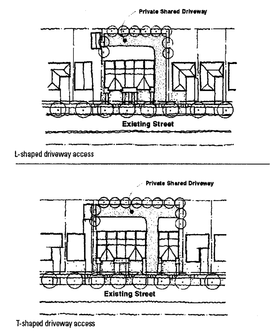
The city may require the creation, use, and maintenance of common, joint-use driveways or other ingress/egress facilities to provide access to two or more lots, parcels, or developments.
9.
No person shall erect, or cause to be erected, any building, shed, fence, formation of materials, or structure of any kind within any public right-of-way. Sheds that are not on a slab and fences may be allowable within easements; however, the risk of removal in the event such structures interfere with the easement shall be borne by the property owner. Mailboxes, conforming to U.S. Postal Service requirements shall be allowed in the right-of-way.
10.
Pedestrian and bicycle access are required between residential areas and commercial, mixed-use, or other residential developments where these connections do not presently exist or are substandard.
11.
Bike lanes consistent with NACTO (National Association of City Transportation Officials) standards must be installed. Shared-lane markings (sharrows) may be used in lieu of bike lanes on roads with design speeds under 25 miles per hour. This requirement shall not apply to streets inside private gated subdivisions.
12.
All parking for single-family, duplexes, and townhouse developments, shall be accommodated off-street in a garage, carport, or driveway, commonly-owned parking area, or in dedicated on-street parking spaces pursuant to city standards and outside of travel lanes, and shall not be located in the front yard, except the designated driveway. Where parking in the garage is proposed, the driveway shall be large enough to provide no less than one nine-foot × 18-foot parking space, except where there is a rear garage. Parking shall not be located in the right-of-way, except where designated off-street parking spaces are proposed. Parking areas cannot include the sidewalk.
13.
Cross-walks shall be clearly marked by FDOT approved pavement markings. In addition curb ramps shall be provided with one ramp in each direction of travel and meet Federal ADA standards. Exceptions may be made on an as-needed basis at the discretion of the city engineer.
14.
Front garages are prohibited for townhouse developments. Driveway and parking access shall be from the rear of the unit. Townhouses may front a common area with a reduced front setback where a sidewalk provides pedestrian access to the front entry.
C.
Easements.
1.
Easements across lots centered on rear or side lot lines shall be provided for utilities where necessary, and shall be a minimum of 7½ feet wide on each lot, or as required to accommodate the utilities installed.
2.
Where a development is traversed by or adjacent to a wetland, a drainage way, or stream, there shall be provided a stormwater easement or drainage right-of-way conforming substantially with the lines of such wetland or watercourse.
3.
For subdivisions with private roads, the plat and/or the declaration of restrictive covenants must dedicate non-exclusive vehicular and pedestrian ingress and egress easements over and through the private roads and sidewalks for the benefit of each lot and each respective lot owners and their tenants, guests and invitees. The right of a driveway connection from each lot to the adjacent private road through the unpaved portions of the private right-of-way is implied even if not expressly dedicated.
4.
For subdivisions with private roads or alleys, the plat must have the following or similar dedication: "There is hereby granted and dedicated to the City of Longwood and other public service and emergency service providers, a non-exclusive easement over and through Tract ___________ (Private Right-of-Way) and any other privately owned internal roads, alleys, paved areas and sidewalks for vehicular and pedestrian ingress and egress access for the purpose of providing public and emergency services to the subdivision, including but not limited to, postal, fire protection, police protection, emergency medical transportation, code enforcement, garbage, utilities and other public and emergency services."
D.
Utilities.
1.
The following basic utilities shall be provided to each lot within a subdivision and to each use within any development whether subdivided or not.
a.
A source of electric power.
b.
A telephone service cable.
c.
Central potable water. Each lot shall have and maintain central water service meeting city standards and provided at the developer's or property owner's expense.
d.
Central sanitary sewer. For subdivisions with 21 or more lots, each lot shall have and maintain central sanitary sewer service meeting city standards and provided at the developer's or property owner's expense. For subdivisions with 11 to 20 lots, where sewer is available within 1,000 feet, lots shall have central sewer meeting city standards provided at the developer's or owner's expense. For subdivisions with ten or fewer lots where sewer service is available within 500 feet, lots shall have central sewer meeting city standards provided at the developer's or owner's expense.
e.
Lighting shall be provided for all streets, driveways, sidewalks, bikeways, parking lots, and other common areas, including lighting at entrances to these facilities. The subdivision developer shall install and be responsible for all costs connected with the installation of streetlights. Streetlights, poles, fixed equipment, and any and all fixtures and equipment applicable to the subdivision development will be installed at no cost to the City of Longwood, except as hereinafter provided. The City of Longwood shall pay only the electric cost and equipment rental (including pole and light) costs associated with the operation of those streetlights that are installed in accordance with city standards within subdivisions located within the territorial limits of the City of Longwood. Where other installations are proposed, all ongoing costs shall be borne by the developer or a homeowners' association.
f.
Fire hydrants or fire protection shall be provided as required by the National Fire Prevention Code.
2.
All utilities required by the LDC shall meet or exceed the minimum standards established by the city manager.
3.
Utility apparatus, such as pumps, valve boxes, switching boxes, backflow devices, but not including telephone or utility poles, placed above ground shall be fully screened by landscaping of a sufficient height to hide the apparatus from view.
4.
The city shall have jurisdiction over the locations of poles, braces, guy wires, meter boxes, valve boxes, light standards, fire hydrants, and other such equipment. The city shall have jurisdiction over the locations and elevations of water piping, sanitary sewers, fire mains, underground cables and conduits and gas mains. The city shall also have jurisdiction over the top elevations of meter boxes, inlets, catch basins, manholes, valve boxes, etc., to the extent of requiring that they be flush with the finished construction surrounding them; jurisdiction over the scope of utility installation to the extent of requiring that all water, sewer, gas, electric and communication stubs which cross under the pavement be provided as part of a subdivision's development. Where any of the above is located under a paved area, the minimum cover from top of future pavement to top of the underground installation shall be at least 30 inches.
5.
The city shall have jurisdiction over the sequence of construction to the extent of requiring that all underground installations of every kind that come under the pavement to be currently constructed, or within eight feet of its edges, shall be installed prior to the stabilization of compaction of subgrade and construction of pavement to the end that the subgrade or pavement shall not be cut after it is built.
6.
All electric, telephone, cable television, and other communication lines (exclusive of transformers or enclosures containing electrical equipment, including but not limited to, switches, meters, or capacitors which may be pad mounted) and gas distribution lines shall be placed underground within easements or dedicated public rights-of-way.
7.
Lots abutting existing easements or public rights-of-way where overhead electric, telephone, or cable television distribution supply lines and service connections have previously been installed with city approval, may continue to be supplied with such services using the overhead facilities, provided the service connection to the site or lot is placed underground.
8.
All necessary drainage facilities, whether underground pipe or drainage ditches, shall be installed to city standards and specifications, and shall be subject to inspection by the city manager, so as to provide positive disposal of surface water and to maintain any natural watercourses. All lots shall drain to either the street or to a drainage easement.
E.
Entrances areas. Entrances areas for subdivision entrances may be allowed in all subdivision developments whether residential, commercial or business, or industrial. In the event such entrance areas are approved, the city may require dedication of the entrance area to the city with such conditions as may be necessary for maintenance and upkeep. When entrance areas are dedicated, an assessment district shall be established in order to ensure perpetual maintenance. Clear visibility shall be provided as required in section 3.8.0 of this Development Code.
F.
Monuments. Monuments shall be placed at all block corners, angle points, points of curvature in streets, and at intermediate points as shall be required by the city manager. The monuments shall be of such material, size and length to comply with the generalized standards of licensed surveyors.
G.
Limitations as to city maintenance. Nothing in these regulations shall be construed to mean that the city shall take over the maintenance of any road, street, alley, parking or other area, lighting, subdivision entrance or drainage facility related there, except by specific city commission action.
H.
Usable open space. The intent of these requirements is to allow for the usage of centrally located unencumbered land as neighborhood open spaces and not to permit the use of leftover or otherwise unusable land to fulfill the requirements of this section.
1.
Usable open space shall include:
a.
Parks and recreation facilities including landscaped open areas, ballfields, basketball/tennis courts and similar facilities with opportunities for active and/or passive recreation.
b.
Greenways, defined as spaces designed to incorporate natural settings such as significant stands of trees within a neighborhood. Greenways shall have sidewalks or shared-use paths parallel to or integrated into at least 75 percent of their length.
2.
Residential subdivisions with 20 or more units, including townhouse developments, shall provide 2.5 percent of the total site area in the form of usable open space. Where residential subdivisions dedicate five percent or more of the site area to usable open space, the required side setback may be reduced to five feet in LDR and three feet in MDR-7 and MDR-15 to accommodate the open space.
3.
Open space may be provided in multiple locations within the development, but no open space area shall be less than 35 percent of the total open space requirement.
4.
The location of the proposed open space shall be determined primarily by the potential for protecting significant, existing stands of trees and other valuable topographic and environmental features. An applicant may request a waiver from the community development director upon providing satisfactory evidence that the location of open space in existing treed areas is not feasible and unnecessarily restricts the development of the site, or that the proposed open space provides built amenities (basketball/tennis courts, pools) that necessitate the removal of trees.
5.
The open space shall be owned and maintained by a homeowners' association or similar entity. Landscaped areas shall be maintained in good condition and the entire area shall be kept clear of debris.
6.
All lands within areas required to be maintained as open space shall be protected by a permanent conservation easement.
7.
Open space parcels shall be convenient to the dwelling units they are intended to serve and shall be accessible to all residents of the subdivision by sidewalks and/or pedestrian walkways or greenbelts.
(Ord. No. 05-1746, § 5(3.3.1), 4-4-2005; Ord. No. 10-1929, § 1, 9-27-2010; Ord. No. 11-1976, § 1, 11-21-2011; Ord. No. 14-2049, § 1, 4-20-2015; Ord. No. 15-2065, § 1, 8-17-2015; Ord. No. 16-2107, § 1, 2-6-2017; Ord. No. 18-2136, § 1, 6-18-2018; Ord. No. 20-2189, § 1, 10-19-2020; Ord. No. 22-2219, § 1(Exh. A), 4-18-2022)
3.5.0. - Buffer, wall, landscape, and open space requirements.
3.5.1. Generally.
A.
The intent of these requirements shall be to enhance the visual and aesthetic appearance of the city; provide space definition and landscape continuity within the built environment; provide appropriate buffers and relief from traffic, noise, heat, glare and the spread of dust and debris; reduce the impact of development on the community's storm drainage system and reduce flooding; provide for a more pleasant and relaxing urban environment; and increase property values. Furthermore, the intent shall be to create an effective buffer between residential districts and other land use districts or to screen certain uses in order to minimize potential nuisances such as noise, dust, odor, and light glare; to reduce the visual impact of unsightly aspects of adjacent development; to provide for the separation of spaces; and to establish a sense of privacy. The design and installation of required buffers and landscaping shall be consistent with the following standards.
B.
The requirements and standards of this section shall apply to all new development and redevelopment, including expansions of commercial, office, industrial, or other nonresidential developments, as well as all multifamily residential development including apartment and townhouse projects.
C.
Single-family detached and two-family dwelling units are exempt from requirements to provide buffers and screening.
3.5.2. Buffers and walls required.
A.
Buffer and wall standards.
1.
Buffers shall be located on the outer perimeter of a lot or parcel, extending to the lot or parcel boundary line, or between differing land uses on a single parcel, but may not occupy any portion of an existing, dedicated, or reserved public or private street, or right-of-way without written permission from the city recorded through a development agreement or development order.
2.
Buffer width is normally measured from the property line; however, design variations are allowed where the variation does not materially affect the screening provided by the buffer at any one point. Average width shall be measured at the two end points of the buffer and two additional points which are each approximately one-third of the total linear distance from the end point. The average width of the buffer shall be that shown in the Table of Buffer Design Standards.
3.
The buffer shall be designed to eliminate or minimize plantings within drainage, utility, or other easements.
4.
Buffers shall be designed taking into consideration the site's soils conditions, topography, and natural resources. Native vegetation shall be used for landscaping and buffering unless the applicant demonstrates that the use of nonnative, drought-resistant plants would best serve the site.
5.
Landscaping within buffer areas shall conform to the plant material standards shown in section 3.5.4. Plant material selections for buffers shall be evaluated on the opacity of the buffer, with an emphasis on plant material that will provide the maximum opacity at planting.
6.
Buffer encroachment. All off-street parking and/or loading, unloading and service areas and all other vehicular circulation areas shall be located, designed and arranged so as not to encroach upon any required buffer. Stormwater management facilities may be included as part of the buffer area, but only if the required plant material and desired screening is provided.
7.
Protection of existing buffers. Where there is significant existing vegetation in a required buffer area, the intent of this Code is that the natural buffer is to be maintained in its current condition. If the applicant chooses to remove the natural buffer area, the applicant must provide a letter from the landscape architect and/or engineer indicating the necessity for removing the natural buffer and replacing with the code required buffer. Where an existing buffer is removed, the canopy trees included as part of the rear buffer shall be a minimum six-inch DBH at planting.
8.
Berms in lieu of hedges. In lieu of a vegetative hedge, the community development director may approve the use of vegetated berms or other appropriate landscape materials in a manner that results in the equal or better visual separation of the premises from the adjacent parcel.
9.
Walls. Required buffer walls shall be eight feet in height and comprised of brick, stone or a material that duplicates the quality and material of brick or stone, including stucco, split face block, and precast concrete or synthetic walls. Any walls visible from the public right-of-way shall be decorative, in a style, material, color, and finish consistent with the buildings on the site.
(a)
The wall may be on either side of the required buffer.
(b)
No hedge required when the buffer is on the interior side of the wall.
(c)
An exterior continuous hedge is required when adjacent to public right-of-way.
(d)
Where there is an office use proposed, the applicant may seek a waiver to place a fence rather than a wall pursuant to LDC section 9.2.4(C)(3).
10.
Where a proposed development is separated from areas with a future land use of LDR or MDR or currently in single-family use by a right-of-way that is 60 feet wide or less, a wall is not required, but the development shall be required to screen that area to minimize impacts on the existing residential development. This shall be accomplished by maintaining an existing opaque vegetative area in the buffer area to the maximum extent practicable, or by providing a perimeter landscape Buffer F.
11.
If the development borders a lake or conservation area, those sides which front the lake or conservation area shall not require a wall, but any existing trees and buffers within the required buffer area shall be protected. This shall be accomplished by maintaining an existing opaque vegetative area in the buffer area to the maximum extent practicable, or by providing a perimeter landscape Buffer F.
B.
Table of required buffers between uses. Where a specific use is not represented, the community development director may choose the use that is the closest fit, with a preference to more protection for a residential use than less.
C.
Buffer Yard Construction.
D.
Right-of-way adjacent perimeter landscape areas. For the purposes of this section, right-of-way adjacent perimeter landscape areas shall mean property frontages adjacent to any public right-of-way, including SunRail. A minimum ten-foot wide landscape strip adjacent to the property line adjacent to the right-of-way (except in permitted accessways) shall be provided. Width of sidewalks shall not be included within the landscape area. For new construction, with a zero front yard setback, a landscape area shall not be required, however, street trees at 30 feet on center must be provided.
1.
Plant material: A right-of-way adjacent landscape area of including no less than four ornamental/understory trees (minimum ten feet tall planting height) and 33 shrubs per 100 feet of linear frontage is required. Trees in the landscape area may be arranged to promote visibility of the business or signage. A continuous hedge of shrubs at no less than 30 inches planting height and planted no more than four feet O.C. containing no deciduous vegetation shall be installed. Shrubs and other plant material may be staggered to create visual interest, but the resulting condition must create an opaque buffer suitable for screening parked vehicles from the right-of-way. While evergreen plants and shrubs are required to meet the buffer requirements, where the buffer can sufficiently be maintained utilizing evergreen plants and shrubs, additional deciduous plantings can be substituted for some of the required plants. Deciduous plantings can be utilized in addition to required plantings at any point. Within one year of initial planting and installation, shrubs shall have attained and be maintained at a minimum height of 36 inches and shall provide an complete, opaque vegetative hedge. Canopy trees may be substituted in place of the required ornamental/understory trees, but shall not be installed so as to interfere with power lines. Plant material shall be selected and placed in such a manner as to most effectively screen parking and loading areas and drive-thrus from view at planting.
2.
Ground cover: Grass or other ground cover shall be placed on all areas within the front, and other landscape areas not occupied by landscape material.
3.
Front perimeter landscaping in station core and historic district. When fronting a pedestrian network street, the front landscaping shall be consistent with the streetscape requirements for those districts.
4.
Historic district front parking areas. All parking adjacent to front property lines or street frontages shall have a minimum five-foot landscape buffer between the parking area and the property line, which includes a continuous hedge of shrubs at no less than 30 inches planting height and planted no more than four feet O.C. The buffer shall incorporate a white picket fence of no more than 42 inches in height behind the hedge.
(Ord. No. 10-1929, § 1, 9-27-2010; Ord. No. 12-1992, § 1, 9-4-2012; Ord. No. 16-2107, § 1, 2-6-2017; Ord. No. 17-2129, § 1, 12-18-2017; Ord. No. 20-2170, § 1, 2-17-2020; Ord. No. 22-2219, § 1(Exh. A), 4-18-2022; Ord. No. 24-2254, § 1, 8-5-2024)
3.5.3. General landscaping and open space requirements.
A.
[Intent.] It is the intent of the City of Longwood to maintain and improve the appearance of the city, to protect and improve property values, protect existing trees and tree canopies without unduly restricting development, and to establish an integrated system of landscaping for all development sites.
1.
In no case shall any development or redevelopment site within the City of Longwood contain fewer than ten trees per acre located throughout the site. These existing or newly planted trees may be located within the required buffer, the perimeter of the site, or interior landscaped areas. Where the total number of trees required by this section exceeds ten trees per acre, the trees above the per acre amount may be met through a contribution to the off-site tree mitigation account.
2.
An irrigation system, capable of ensuring the establishment and continued growth of the plant materials specified in the landscape plan, shall be constructed within any required landscape areas.
3.
Landscape plans shall be prepared by a landscape architect, or professional engineer registered in the State of Florida. A landscape plan including all current and proposed utilities shall be submitted with the development application. The community development director may waive or modify this requirement in cases where an approved code compliant and fully implemented landscape plan is on file with the city.
B.
Foundation landscaping. The following provisions shall apply to all multi-family or non-residential building facades with frontage along SR 434, Ronald Reagan, Hwy 17-92, and Dog Track Road, Lake Emma, or Longwood Hills Road.
1.
Required landscaped area. Excluding space necessary for ingress and egress, a minimum five-foot wide landscaped area shall be located along 100 percent of a building façade with frontage along a street right-of-way.
2.
Required trees. Within the required landscaped area there shall be at least two understory or three palms for every 30 linear feet of building façade.
3.
Required shrubs. Within the landscaped area there shall be a minimum of one shrub for every 20 square feet of required landscape area. In addition, a minimum of 50 percent of the area shall contain shrubs with the remainder to be ground cover.
C.
Reserved.
D.
Parking lot landscaping. Parking lots for all new development and all redevelopment that is a change of use or an expansion of an existing use that generates a need for additional parking and requires additional parking areas to support the use shall provide landscaping for the parking lot. The landscaping for a parking lot is based on a performance standard as follows in addition to the plant material standards of LDC 3.5.4.
1.
Landscape plans shall be prepared by a landscape architect, or professional engineer registered in the State of Florida. A landscape plan shall be submitted with the development application.
2.
When shade trees are planted on the perimeter of a parking area, they must be planted no closer than five feet and no farther than nine feet from the edge of the pavement, and must provide shade to either the parking area, the primary structure or an adjacent pedestrian area. If an existing tree is used, it should be in the vehicular use area, or within nine feet of the vehicular use area.
3.
Ten percent of the total parking lot area shall consist of internal landscape islands. There shall be one tree required per 200 square feet of internal landscape areas. Landscape island minimum width dimensions shall conform to the minimum planting area and planting strip width requirements described in section 3.5.4.C. Each landscaped island shall provide a minimum of one canopy tree (12 feet tall at planting, four inches DBH) with shrubs, dwarf shrubs and/or ground cover plants.
4.
Preservation of existing trees or tree groupings is encouraged.
E.
Open space. All apartment developments and multi-tenant shopping centers of more than 20,000 square feet in GLA that are within one quarter mile of SR 434, Ronald Reagan Blvd., or U.S. 17-92, shall reserve at least five percent of the total site area for landscaped and useable pedestrian-oriented open space area(s). Open spaces may include parks, recreational trails, courtyards, landscaped gardens, outdoor dining areas, plazas, and amenitized water features; but shall not include parking or required landscape buffers. Retention ponds may be utilized as part of the required open space only when designed as a feature utilizing features including, but not limited to, fountains, trails, and benches. The open space may take multiple forms and be in different part of the development, but in no situation shall any section of required open space be less than 35 percent of the total amount of required open space.
(1)
Where site conditions or elements of a particular use result in a situation where it is determined by the city that open space requirements may be better met off-site, some or all of the open space requirements may be met by the contribution of fees to an appropriate fund to be used by the city for the acquisition and development of land for open space or parks, or, at the discretion of the city, in the form of direct contribution of funds to a city project that advances the city's open space goals.
(2)
The fee-in-lieu-of calculation shall be (¼)A × V = M, with "A" being the amount of land, in square feet, required for dedication as determined in section (D), "V" being the fair market value of the property as determined in subsection (3), and "M" being the amount to be paid in lieu of open space requirements.
(3)
For the determination of fair market value or "V" in the equation established by subsection (2), the applicant may select either the actual purchase price of the property to be developed as evidenced by a purchase contract, or a closing statement dated within one year of the date of the application or the current fair market value of the property to be developed by a qualified real estate appraiser.
(4)
Fees-in-lieu-of open space shall be assessed at the time of application or during the period of project application review and paid prior to final approval of the application for the development.
F.
Maintenance required. All landscaped areas shall be continually maintained in a healthy, vigorous growing condition, free from disease or pests. Required plants that are diseased or dead shall be replaced with plants of similar species in a substantially similar size to the lost plant. Adequate irrigation shall be required.
G.
[Minor modifications.] The community development director may provide for modifications to the landscaping requirements of this section. The director may adjust requirements as they relate to size, type, and placement of landscape material where the applicant submits an alternative landscape plan with detailed justification for the change as well as evidence provided that there is no net loss in the total amount of landscape material and that the modification will not result in a reduction of the effectiveness of required landscape buffers between the project and adjoining residentially zoned or utilized parcels. The applicant must make a written request of the director indicating the specific changes requested and demonstrating compliance with this section.
(Ord. No. 10-1929, § 1, 9-27-2010; Ord. No. 11-1969, § 1, 8-15-2011; Ord. No. 11-1976, § 1, 11-21-2011; Ord. No. 12-1992, § 1, 9-4-2012; Ord. No. 15-2065, § 1, 8-17-2015; Ord. No. 16-2088, § 1, 6-20-2016; Ord. No. 16-2093, § 1, 8-15-2016; Ord. No. 16-2107, § 1, 2-6-2017; Ord. No. 18-2136, §§ 1, 3, 6-18-2018; Ord. No. 20-2170, § 1, 2-17-2020; Ord. No. 20-2189, § 1, 10-19-2020; Ord. No. 22-2219, § 1(Exh. A), 4-18-2022)
3.5.4. Plant material standards.
A.
To ensure that the goals of this section are met, particularly as they relate to screening and buffer performance, trees and shrubs required as part of this section shall be evergreen species. Deciduous vegetation is allowed and encouraged for variety and visual interest, particularly as part of right-of-way adjacent buffers, but only in addition to the evergreen trees and shrubs specifically required by this code.
B.
Unless otherwise provided herein, only Florida No. 1 or better plant material as described in Grades and Standards for Nursery Plants, Part II, Florida Department of Agriculture, shall be credited on the landscape development requirements of this article.
C.
A minimum height of 12 feet and four inches (DBH) at the time of planting shall be required for canopy trees unless otherwise specified. Other trees shall have a minimum height of ten feet at the time of planting, with some variation allowed for different species. A minimum of three different species of tree shall be provided per site. Understory trees may be substituted for conifers but, in the case of perimeter buffers, the proposed tree must add to the opacity of the buffer at planting.
D.
The planting area for each tree shall be as follows.
1.
A minimum of 200 square feet around the trunk of canopy trees, with a minimum planting strip width of ten feet.
2.
A minimum of 100 square feet around the trunk of understory or other small trees, with a minimum planting strip width of five feet.
3.
The planting area for each tree shall be maintained in either vegetative landscape material or pervious surface cover. Trees and shrubs may be grouped or clustered to provide desired landscape design. Tree groups shall be allowed to have a reduced minimum planting area as long as the minimum planting strip width is maintained. No large trees shall be planted closer than five feet from the edge of pavement or curb line. The minimum planting strip width excludes curbs, curb and gutter, or similar edge treatments.
E.
Shrubs, ground cover, lawn grasses, turf grass, and architectural planters shall be subject to the following:
1.
Lawn grass shall be perennial species capable of thriving in Seminole County.
2.
Grass and ground cover shall be perennial species capable of thriving in Seminole County.
3.
Grass shall be sodded according to city standards.
4.
Ground cover shall be preferred over grass. Grass may be used in areas proposed for recreation use or to provide erosion control on slopes or in swales.
5.
Shrubs shall have a planting area of not less than ten square feet with a minimum planting strip width of five feet. Planters may be used, provided that the planting area is provided as required, and the planter has a depth of not less than 18 inches.
6.
Spacing of shrubs and ground cover shall be typical of the selected species in order to obtain 80 percent surface coverage by the end of a two-year growing period from the time of installation.
F.
To the extent that is feasible, the performance of development activities and revegetation of altered sites shall be consistent with the following standards.
1.
Development shall not involve the unnecessary removal of any native vegetation. Where removal of native trees is necessary, efforts should be made to replant native trees.
2.
Site alteration shall occur in planned stages or increments and not exceed the minimum area necessary to prepare the site for the succeeding phase of development.
3.
Adequate erosion control measures shall be put into effect prior to commencing site alteration on each increment.
G.
Water conservation practices are recommended and should be used in landscaping, including the use of native vegetation, xeriscape design, and the use of recycled irrigation water. Where recycled irrigation water is available, the use of the recycled water shall be mandatory.
(Ord. No. 16-2107, § 1, 2-6-2017; Ord. No. 17-2129, § 1, 12-18-2017; Ord. No. 18-2136, § 1, 6-18-2018; Ord. No. 20-2170, § 1, 2-17-2020; Ord. No. 24-2254, § 1, 8-5-2024)
3.5.5. Tree protection standards.
A.
Applicability. Trees protected under this section are those with a trunk diameter of three inches DBH (diameter at breast height) or more.
B.
Tree removal permit. A tree removal permit shall be required prior to the removal, replacement, or alteration of trees not otherwise exempted from the provisions of this section. Alteration includes damaging, topping, root pruning, cutting, hatracking, poisoning, or grade change that can be expected to adversely affect the health of protected trees and vegetation. Ordinary maintenance such as seasonal pruning or customary care shall not require a permit.
C.
Tree permit requirements.
1.
All tree removal permit applications shall be filed with the community development department, whether or not a site plan or other development approval is required. Review and approval shall be according to the procedures in section 10.1.4. Tree removal and/or replacement as specified on the tree removal permit shall occur within 30 days of the issuance of a tree removal permit not associated with a site development plan. Tree removal permits associated with a site development plan shall remain valid for as long as the site development plan or site construction permit remain valid. The community development director may grant a one-time 15-day extension upon a written request from the applicant that is received prior to the expiration of the permit and where demonstrable circumstances have prevented the removal or replacement of a tree during the 30-day time period.
2.
The following information depicted on a tree survey, prepared by a landscape architect or engineer licensed in the State of Florida, shall be submitted with the application, unless otherwise waived by the community development director:
a.
Location and identification of all trees four inches DBH or greater (using either common or botanical name), designating trees to be retained, altered, removed, relocated, or replaced. Groups of trees in close proximity may be designated as "clumps" or "dense tree cover" with the estimated number and type(s) of trees noted. Only those trees to be removed, relocated, or replaced, or otherwise count to the requirements of this section must be named on the tree survey or site plan. The tree survey may show only that portion of the site directly involved or affected by the tree removal, as long as the survey provides sufficient information to demonstrate compliance with these tree removal permit requirements.
b.
Location of all existing and proposed structures, improvements, or uses of the site.
c.
Proposed changes, if any, in site elevations, grades and major contours.
d.
Location of existing or proposed utilities.
e.
Location of irrigation system, or drawing notes to indicate method of maintenance.
3.
If any approvals have previously been provided for the site, such as a site plan, development order, variance, or plat, evidence of such approval shall be provided and may be utilized in place of the information required in subsection (2)(a) if appropriate.
4.
The applicant shall flag all trees to remain on a site in a manner sufficient to allow field verification of the tree survey and in such a manner that does not damage the tree.
5.
A copy of the tree removal permit shall be posted on site during construction and tree removal activities.
D.
Criteria for approval of tree removal permits.
1.
Approval for tree removal shall only be granted on a developed lot or a lot with an application for development approval where such tree or trees unreasonably restricts the otherwise allowable use of the property.
a.
Where landscape buffers are required, healthy, existing trees shall be preserved as they provide a more substantive buffer than newly planted trees. The burden is on the applicant to demonstrate in writing that the trees in these areas unreasonably restrict the otherwise allowable use of the property.
2.
A tree removal permit may be issued where the tree is diseased, injured, endangers existing structures, interferes with the safe provision of utility services, or creates a hazard to visibility for motorists. In this case, the application shall be accompanied by a letter from a certified arborist and photographic evidence indicating that the tree meets these conditions for removal. The city may require additional information, including from a site visit, to verify and confirm the findings of the arborist letter and may deny the tree removal permit on a finding that the proposal does not meet code requirements.
3.
Replacement or relocation of trees is required as described:
a.
New developments in site plan and/or subdivision review. Site development plans will be required to show all trees proposed for removal and replacement. New developments shall save, plant, relocate, or replace trees pursuant to the standards of this section. If it is not feasible to place the required number of trees on a developed site, the developer shall make a contribution equal to the number of inches that could not be placed to the off-site tree mitigation fund pursuant to the fee schedule established by the City Commission, but the total number of planted trees on-site cannot be below ten trees per acre.
1.
Replacement of non-specimen trees in good health shall be based on a one-to-one or two-to-one ratio of the cumulative DBH of the trees to be removed to the cumulative DBH of the trees to be installed, pursuant to the tree replacement table in LDC 3.5.5 (D)(3)(d). (For example: a 21 inches DBH tree to be removed shall be replaced by seven 3-inch DBH trees or three 7-inch DBH trees, or any combination of replacement trees that total the total DBH removed.)
2.
Specimen trees (defined as trees 24 inches or larger) in good health shall be replaced pursuant to the tree replacement table in LDC 3.5.5 (D)(3)(d). Specimen trees shall first be protected, and the tree removal permit application shall include justification for the removal of each tree.
3.
An applicant may appeal for a reduction of the tree replacement fee through a special exception application to the city commission.
4.
For subdivision applications, all trees intended to meet the requirements of this section must be placed within a common area or conservation easement that ensures the trees will be preserved and maintained.
b.
Developed property with an approved landscape plan. All sites with an approved landscape plan shall replace trees proposed for removal according to the original permitted landscape plan approval. If the removed tree equals 24 inches or more DBH and is in good health, the table in (3)(d) will apply. If it is not feasible to place the required number of trees on a developed site, the applicant shall make a contribution equal to the number of inches that could not be placed to the off-site tree mitigation fund, but the total number of planted trees on-site cannot be brought below ten trees per acre by the removal.
c.
Property without an approved landscape plan. Where a developed property is not subject to an approved, documented landscape plan, replacement of a live tree in good health shall be consistent with the tree replacement table in LDC 3.5.5(D)(3)(d). Where a tree proposed for removal is dead or diseased and the site does not have an approved landscape plan, a tree or trees totaling the amount of 10% inches DBH of the removed tree shall be replaced on site pursuant to the tree replacement table, with a minimum replacement of one 3" diameter DBH tree. If it is not feasible to place the required number of trees on a developed site, the applicant shall make a contribution equal to the number of inches that could not be placed to the off-site tree mitigation fund, but the total number of planted trees on-site cannot be brought below ten trees per acre by the removal.
d.
The tree replacement table is as follows:
e.
Plant materials used in conformance with the provisions of this Code shall conform to the Standard for Florida No. 1 or better as given in Grades and Standards for Nursery Plants, State of Florida, Department of Agriculture and Consumer Services, Tallahassee.
f.
Fees collected in lieu of replacement shall be placed in an off-site tree mitigation account. The fees shall be established by the city commission.
g.
Trees removed illegally without a permit are subject to a three-to-one replacement, i.e. three inches replacement for each one inch removed. The established fee schedule would apply to this requirement if replacement is not feasible.
h.
Any retained or relocated tree shall be replaced if the tree dies within one year after final approval and replacement shall be consistent with the tree replacement table in LDC 3.5.5(D)(3)(d).
i.
Replacement trees shall be of a similar or greater canopy and shade potential as the tree being replaced.
j.
Where evidence exists that a tree deemed diseased or dead by the applicant's arborist became so through deliberate action including damage suffered through construction activity or poisoning, the tree will be considered a live tree in good health.
E.
Approved trees. The following trees are generally approved for use in landscape plans and tree removal permits under this section, subject to review of appropriate placement on the site. Evergreen species are required for replacement trees, and installation in required landscaped areas, and buffers, however deciduous species can be used in landscape areas in addition. The Community Development Director may also accept requests to use approved Florida-Friendly Landscaping species for replacement. Certain understory trees and shrubs may be interchanged as appropriate. Cultivars not listed here may be accepted where appropriate. This approved tree list does not apply to single-family or duplex properties.
_____
_____
F.
Credit for retained trees. Healthy trees retained on site and protected pursuant to this section shall count toward any required trees for buffers, parking lot perimeter landscaping, parking internal landscaping, or other requirements. Plants on the prohibited plant species list in this section will not be counted for credit.
G.
Exemptions.
1.
Emergency removal due to storm damage as well as removal by the city from the right-of-way shall not require a permit.
2.
Owner-occupied single-family dwellings are exempt from the tree protection requirements of this section and are not required to obtain a tree removal permit. Where the occupant of the single-family is not the owner, the owner may provide a letter requesting the exception for that occupant. Staff will review the application to ensure that the removal is limited to the minimum amount of tree removal necessary and not intended to avoid requirements for the construction of a subdivision.
H.
Prohibited plants. The following plant species may be removed without a tree removal permit and are, therefore, exempt from the tree protection requirements of this section. These trees are also prohibited and shall not be installed in any landscaped area or buffer area.
_____
_____
I.
Maintenance.
1.
Crown trimming shall be limited to removal of less than one-fourth of the tree crown. Hatracking is prohibited.
2.
Trees and other vegetation shall be maintained to ensure that such trees and vegetation continue to be viable and thriving.
J.
Protection during construction activities.
1.
Each retained or installed tree shall be protected during all pre-construction and construction activities. The area to be protected shall extend to the drip line of the tree, but shall be no less than a six-foot radius from the trunk of the tree. Where trees are located in clusters or groups, the outermost drip line shall be the area of protection. The location of tree protection areas shall be depicted on the required landscape plan.
TREE PROTECTION DURING CONSTRUCTION ACTIVITIES
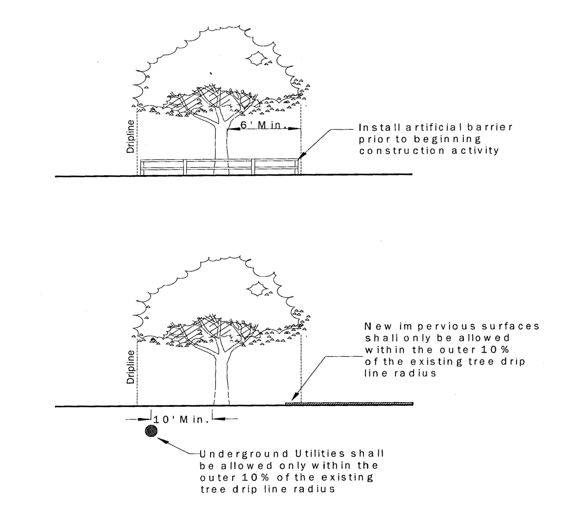
2.
All development activities, including construction, grading, paving, compaction, trenching, installation of stormwater retention ponds, or the like shall be prohibited. Any existing brush and weeds to be removed inside the tree protection barrier shall be removed with hand tools only.
3.
Wooden barriers shall be erected around all protected trees or other vegetation during the period of construction activity.
4.
Barriers shall be constructed of upright posts and railings constructed of lumber at least two inches by four inches in cross-section marked by ribbon, flags, or other easily visible connecting material, and shall extend to or beyond the drip line of all protected trees on the property. Reference "Tree Protection Manual for Builders and Developers" from the Florida Department of Agricultural and Consumer Services, Division of Forestry, for additional guidance on methods of tree protection during construction.
5.
No excess soil or additional fill, building materials, or debris shall be placed within protective barriers.
6.
No tractors or heavy machinery shall be allowed to work, park, or locate within barrier areas.
7.
No attachments or wires, other than protective guy wires, shall be attached to any trees or shrubs within protective barriers.
8.
Installation of artificial barriers such as protective barricades, fences, posts, or walls shall not destroy or irreversibly harm the root systems of protected trees. Footers for walls shall end at the point where larger roots are encountered, and the roots shall be bridged. Postholes and trenches located close to protected trees shall be adjusted to avoid damage to major roots.
9.
Construction activity, including underground utilities and new impervious surfaces, shall be allowed only with the outer ten percent of an existing tree drip line radius. In no case shall construction activity occur closer than ten feet from the center of the trunk of existing trees to be preserved.
K.
Planting requirements.
1.
Tree species with a height greater than 20 feet at maturity shall not be planted within a utility easement when power lines lie directly overhead.
2.
No tree shall be planted within ten feet of a fire hydrant or utility pole, within 20 feet of a traffic sign, or within 25 feet of an intersection in order to ensure adequate visibility. Should this requirement severely limit the location of trees on the property, the community development director may adjust these specifications.
L.
Off-site tree mitigation.
1.
Tree planting requirements for development as described in this LDC may be met by the contribution of fees to an off-site tree mitigation account or, at the discretion of the city, by off-site tree mitigation in the form of either the direct contribution of trees to applicable city projects.
2.
All funds collected as tree replacement fees shall be administered by the city manager or designee. Disbursements from the tree replacement account shall be made only for the following purposes:
a.
Purchasing trees for planting and any associated costs in accordance with the city's tree planting program; or
b.
Protection of trees and enforcement of this ordinance.
3.
Fees for the off-site tree mitigation account are established by the city commission in the schedule of fees.
4.
Fees for the off-site tree mitigation account shall be reviewed annually by the city commission to reflect the cost of living adjustments and/or market conditions and may be modified by approval of the city commission. In establishing fees, the city shall consider the cost of material, labor, transportation, planting, watering, and mortality rate of replacement trees.
5.
Trees authorized for off-site mitigation shall be planted in city-owned properties and parks, city rights of way, and preservation and conservation areas owned by the city. The city may also plant trees within the medians and rights of way of state and county roads where an interlocal agreement authorizes such plantings.
6.
Fees for off-site mitigation shall be paid to the city prior to the issuance of any tree removal permit or building permit for new construction with an approved site plan or plat.
7.
The city may agree to allow an applicant to provide trees to satisfy landscape requirements directly to city projects in lieu of a contribution of fees when consistent with this LDC and the following guidelines:
a.
Trees provided as a contribution in lieu of fees must meet all applicable requirements for size and planting described in this section.
b.
Applicants wishing to contribute trees in this manner must, on forms provided by the community development department, detail the number and specifications of trees provided.
c.
Contributed trees may count up to 50 percent of the trees required by this section.
d.
Contribution under this section will only be allowed for applicable city projects as determined by the city manager. Contribution may be made in advance of a proposed development and a record of all such contributions shall be maintained by the community development department.
M.
Establishment of a tree preservation board.
1.
The city commission may establish a tree preservation board by resolution.
2.
Should the city commission choose to designate the members of an existing board or agency as the tree preservation board, the terms of office of the tree preservation board will be concurrent with those of the existing board.
3.
It shall be the responsibility of the board to develop and/or maintain a written plan for the maintenance of trees, placement of trees, and will provide recommendations for programs related to the city's off-site tree mitigation account.
4.
The tree preservation board may periodically conduct educational programs and/or publish educational material as to the importance of trees to the City of Longwood and the requirements of this section.
(Ord. No. 09-1894, 6-15-2009; Ord. No. 10-1929, § 1, 9-27-2010; Ord. No. 11-1956, § 1, 3-7-2011; Ord. No. 13-2016, § 1, 11-18-2013; Ord. No. 18-2136, §§ 1, 3, 6-18-2018; Ord. No. 20-2189, § 1, 10-19-2020; Ord. No. 22-2219, § 1(Exh. A), 4-18-2022; Ord. No. 22-2227, § 1, 9-7-2022; Ord. No. 24-2254, § 1, 8-5-2024)
3.6.0. - Mobility and parking requirements.
A.
Applicability. All new development and redevelopment shall provide mobility elements as provided by this section, unless such standards are modified according to section 3.6.4.
B.
Generally.
1.
Minimum required parking spaces to be located in off-street parking lots shall be determined according to the table of parking space requirements in section 3.6.1. Where calculations of required parking result in a fraction, it shall be rounded up to the nearest whole number.
2.
Minimum required parking spaces for uses not specifically listed shall be determined by the most similar use listed, considering trip generation and intensity characteristics as well as similarity in type of activity.
3.
The community development director may consider a request by the applicant to increase or reduce the required parking based on parking analysis utilizing the latest ITE Standards or other methodology as approved by the community development director and prepared by a certified traffic engineer. The analysis shall include evidence that the change in available parking will not have adverse affects. The provision of multi-modal transportation alternatives to reduce the need for parking is encouraged.
3.6.1. Parking space requirements.
A.
Table of Parking Space Requirements for Residential Uses.
(1)
All parking for single-family, duplex, and townhouse developments, shall be accommodated off-street in a garage, carport, or driveway, commonly-owned parking area, or in dedicated on-street parking spaces pursuant to city standards and outside of travel lanes, and shall not be located in the front yard, except the designated driveway.
(2)
Where parking in the garage is proposed, the driveway shall be large enough to provide no less than one nine-foot × 18-foot parking space, except where a driveway provides access to rear garages as part of a townhouse development.
(3)
Parking shall not be located in the right-of-way, except where designated off-street parking spaces are proposed. Parking areas cannot include the sidewalk.
(4)
The required parking spaces shall be reduced by 20% pursuant to the Live Local Act for projects developed under the Act if the development meets the following requirements:
(a)
The development is located within one-half mile of the SunRail station.
(b)
The development has available parking within 600 feet of the proposed development in on-street parking, parking lots, or parking garages that is available for use by residents of the proposed development.
B.
Table of parking space requirements for nonresidential uses.
(1)
* Where parking ratios are based on seating, the number of seats to be used in the calculation shall be based on the occupancy rating of the fire department.
(2)
** Where parking ratios are based on number of employees, the maximum potential number of employees shall be used.
(3)
Pursuant to the Live Local Act, parking requirements are eliminated for a proposed mixed-use development, as defined under the Act, within the Station Core Future Land Use.
_____
C.
Parking lot design and maintenance.
1.
Each parking lot shall meet design requirements of the City of Longwood in order to provide appropriate access to a public street, maneuvering, and access aisles.
2.
Parking areas shall be designed so that no more than ten spaces occur in an unbroken row. All parking lots shall provide landscaping as required in section 3.5.3.
3.
Aisles, driveways, loading areas and access, circulation areas, parking spaces located in front of buildings, and areas subject to ADA regulation shall be paved on all properties. Parking spaces located to the side and rear of a building may be paved through the use of "eco pavers" or like semi-pervious paving materials that are determined by the city engineer to be adequately durable for the intended use. "Eco pavers" used in this manner must be properly maintained, stabilized, and otherwise kept neat and orderly in appearance.
a.
Historic district. For new commercial and multi-family construction all of the private on-site parking shall occur to the side or rear of the primary structure.
4.
All parking areas shall be used for parking only, with no vehicle sales or other sales activity, storage, nonemergency repairs, or other similar sales or service uses conducted in designated parking areas. Seasonal sales, such as Christmas trees, and other approved uses may be allowable, subject to obtaining a temporary use permit.
5.
A church or other similar institutional use without daily parking needs may be allowed to leave all parking spaces beyond those which are required unpaved. The design of the unpaved spaces shall not have a detrimental effect due to erosion, reduced air or water quality, or other significant degradation of the natural or built environment. In no case, however, shall the unpaved parking area be calculated as a minimum required buffer, open space area or retention area.
6.
Parking lot design shall conform to the dimensions described in the following tables. Painted lines, curbs, or other means to indicate individual spaces shall delineate all parking.
7.
Traffic control signs and other pavement markings shall be used as necessary to ensure safe and efficient traffic operate of the site. All traffic control signs and other pavement markings shall be installed at the applicant's expense. All required signs and markings shall be shown on all applicable development plans. All traffic control pavement markings to be thermo-plastic type paint.
8.
Each parking stall shall be accessible from an aisle or driveway and designed so that no automobile shall back into a public street or public right-of-way, except for officially designated alleys or designated city or neighborhood parking areas, in order to exit a parking stall. Each parking lot and stall shall be designed to avoid conflict between pedestrian and vehicular movements, and shall be designed to avoid conflict with ingress or egress from the site.
9.
No door or pedestrian entrance at ground level shall open directly upon a driveway or access aisle unless the doorway or pedestrian entrance is at least three feet or more from the driveway or access aisle and unless appropriate improvements are provided to allow for safe pedestrian access to the door.
10.
All required spaces shall be used for automobile parking only, with no motor vehicle sales or any other sales activity, storage, nonemergency repair work, dismantling or servicing of any kind.
11.
Parking areas including all spaces and drive aisles shall be set back a minimum of five feet from any property line. This requirement is most often met by required landscape buffers.
12.
All parking areas shall have a system of lighting to provide adequate illumination for the entire parking area. Such lighting shall be directed away from adjacent properties and public streets. The lighting plan shall contain a statement that the lighting conforms to the Illuminating Engineering Society of North America (IESNA) recommendations and shall be based on the proposed activity level of the site. Photometrics shall be certified by an engineer or architect licensed in the State of Florida and qualified to attest to the adequacy of site lighting. A table listing the IESNA recommendations for the site shall be included on the photometric sheet. The community development director may waive this requirement for existing facilities or minor amendments to existing development at their discretion.
13.
Adequate drainage shall be provided for all parking areas and shall be approved by the city engineer.
14.
All paved parking spaces shall have lines between spaces to indicate individual stalls, and each stall may be required to be equipped with wheel stops, concrete planters, or bollards according to the following standards or where deemed appropriate by the city.
a.
When adjacent to a required landscaped area, wheel stops are required and shall be located two and one-half feet from the front end of the stall to prevent encroachment into required landscaped area.
b.
When adjacent to a curbed sidewalk, concrete planters or bollards are required at least three and one-half feet tall and shall be located at least two feet from the front end of the stall to protect pedestrians along the sidewalk. Alternatives to planters or bollards shall be considered at the discretion of the community development director.
c.
In parking areas where the front of head-in parking stalls meet, wheel stops are not required.
d.
All wheel stops shall be centered in parking stall to ensure a three feet pedestrian clearance between ends and shall be colored or covered with reflective material to provide contrast with adjacent pavement. The recommended maximum height for wheel stops shall be four inches and any deviation shall be at the discretion of the city engineer.
15.
All traffic control pavement markings coloring to be consistent with the Manual of Standards for Streets and Stormwater.
16.
Access. Where there is a conflict between the cross-access standards of this section and applicable standards of the Florida Department of Transportation, the more restrictive standard shall apply.
a.
All new commercial, industrial, office, and mixed use developments, or additions to existing developments; and all nonresidential subdivisions, including group developments and integrated multiple use developments that front arterials must be designed to provide cross-access to above mentioned developments.
b.
Cross-access is not required when the subject adjacent properties have one or more of the following conditions or barriers:
(1)
Significant topography differences in existing or proposed conditions;
(2)
Significant natural features;
(3)
Vehicular safety factors;
(4)
Existing cross-access provisions;
(5)
Other safety and security factors;
c.
For redeveloped properties that front arterials, the redeveloped parcel must connect adjacent parcels where cross-access is available and when a site plan is required. Where a cross-access drive connection is not available, the site must be designed so that a cross-access aisle may be created when neighboring properties redevelop. The community development director may waive this requirement where site design, safety, or security requirements preclude such a connection.
d.
Projects in the industrial future land use shall not have access to residential streets.
e.
Historic district shared driveways. To encourage parking on the side and rear of buildings, two adjacent lots may share a single driveway access. If two lots are to share a single driveway, the side yard setback, parking setback, and landscape buffer may be reduced to three feet to allow an additional five feet per lot for the shared drive.
17.
The minimum standards for the construction of driveways, curb cuts and other similar alterations on nonresidential and multifamily properties shall be as follows:
a.
Properties developed for commercial or industrial use shall have curb cuts for driveways of not less than 24 feet or more than 36 feet; however, where separate driveways are provided for one-way traffic, such driveways may be permitted with a width of not less than 16 feet.
b.
In measuring the width of curb cuts, the distance shall include the transitional slope from the high curbline to the lowest point of such curb cut.
c.
No driveway for a commercial or industrial use shall be made within ten feet of the side property line of the property to be serviced by such driveway unless a common driveway for two adjoining properties shall be located on the common property line by written agreement of all the owners of the adjoining property using the common driveway.
d.
There shall be no more than three curb cuts/vehicle entrances for the use of any single property fronting any single street, with no curb cut any closer than 300 feet to another on an arterial road and 150 feet on any other road. For each additional street faced, the total amount of curb cuts for a development will be increased by one to a maximum of five total curb cuts. The city engineer may approve additional curb cuts or adjust the distance between cuts where a demonstrated safety need exists and where the site is safely designed to accommodate the additional entrances. On corner lots, no curb cut or driveway shall be constructed or maintained closer than 75 feet to the point of curvature of either street.
18.
Parking lot maintenance. All parking and paved areas including drive aisles, parking spaces, curbs, and wheel stops shall be maintained in a good state of repair free of potholes, substantial cracks, ruts, broken pavement, accumulation of pools of water, and other potential hazards. Parking spaces, stop bars, directional markings, and other striping shall be routinely maintained and clearly visible and delineated.
D.
Parking spaces for persons who have disabilities (handicapped spaces). All land use subject to the provisions of this Development Code shall meet the following criteria for handicapped parking.
1.
Spaces and access aisles; design, designation, location, and markings. All spaces shall comply with ADA Standards and Florida Statutes (F.S. § 553.5041).
2.
Signage. All spaces, in addition to the required signage by Florida Statutes, will be required to provide a sign marked per Ordinance No. 750, indicating a $250.00 fine.
3.
Number of spaces.
a.
One handicapped space for each 25 required parking spaces up to 100 parking spaces.
b.
One handicapped space for each 50 required parking spaces over the next 100 parking spaces.
c.
One handicapped space for each 100 required parking spaces for 300 or more parking spaces.
E.
Bicycle parking.
1.
Bicycle parking shall be provided by all educational facilities (as well as vocational, business, or technical schools), multiple-family dwellings, commercial, mixed-use, and institutional and industrial uses. Facilities shall be installed so as to resist theft and damage by rust, corrosion, or vandalism. The community development director may waive requirements of this section, when alternative adequate facilities are provided.
a.
Spaces. Bicycle parking spaces are comprised of Class I, Class II or Class III facilities. Facilities shall accommodate a range of bicycle shapes and sizes and allow easy locking without interfering with adjacent bicycles.
(1)
Class I. Bicycle lockers are generally rectangular enclosures, each holding one or two bicycles.
(2)
Class II. Bicycle parking racks which allow all three major components of the bicycle, back wheel, frame and front wheel, to be locked, without removal of the front wheel.
(3)
Class III. Stands and racks such as hitching posts, rails and inverted "U" racks. Common properties in a class III facility include its support of the bicycle with or without the front wheel removed, its attractiveness and post or pipe dimensions which allow the use of the popular U-locks. Class III facilities are recommended for short-term parking, although, in combination with shelter, they may be adequate for long-term storage.
b.
Number of spaces.
(1)
A minimum of one bicycle parking space shall be provided for every ten required vehicular spaces or two spaces for each public and employee entrance, whichever is greater. The development review committee may require additional spaces for educational facilities, libraries and recreational facilities.
(2)
For multiple-family dwellings, a minimum of 25 percent of the required spaces shall be Class I bicycle lockers or sheltered Class II or III facilities to provide for long term storage.
(3)
For nonresidential developments requiring 30 or more spaces, a minimum of 25 percent of the required spaces shall be Class I bicycle lockers or sheltered Class II or III facilities.
(4)
New retail, office, institutional and industrial buildings of more than 50,000 square feet in area shall provide employee showers, lockers and changing areas to facilitate bicycle and pedestrian commuting. Buildings with a single shower shall have a secure unisex facility. Buildings with multiple showers shall have gender specific facilities.
c.
Location of facilities. All bicycle parking facilities shall be located to provide for convenient bicycle parking which shall be separated from automobile parking by a physical barrier or by a minimum of five feet. Bicycle parking facilities shall be located on the same lot or parcel of land as the use for which such facilities are required and as close to the public and employee entrances as possible without interfering with the flow of pedestrian and vehicular traffic. For nonresidential developments, any sheltered spaces required shall be connected to the building where possible without interfering with the flow of pedestrian and vehicular traffic.
d.
Surfacing. The minimum parking area shall be provided with a hard-surface, all-weather pavement of asphalt or concrete, and shall be so graded and drained as to provide for the adequate runoff and disposal of surface water. Supplemental parking may be on alternative surfaces.
e.
Access to facilities. Convenient access to bicycle parking facilities shall be provided and shall minimize travel distances from adjoining sidewalks and pathways to the bicycle parking facilities. Where access is via a sidewalk or pathway, curb ramps shall be installed as appropriate.
F.
Sidewalks and pedestrian connectivity.
1.
An internal pedestrian network shall be provided that is separate from the vehicular network and does not require pedestrians to mix with vehicular traffic except inside of a marked crosswalk in order to access buildings or other points of interest on site. Sidewalks shall be constructed adjacent to the curb shall be a minimum of six feet in width. If a buffer strip is provided between sidewalk and back of curb, it shall be a minimum of three feet which may be reduced to no less than two feet at the discretion of the city engineer or a designee when a physical constraint exists. Sidewalks may be a minimum of four feet when physical constraints exist at the discretion of the city engineer or a designee provided that the sidewalks have passing spaces of at least five feet by five feet at internals not exceeding 200 feet.
(a)
All auto access drives shall have an adjacent sidewalk that will connect the internal pedestrian network to sidewalks, trails, or other pedestrian paths whether existing or proposed as part of the Bicycle-Pedestrian Master Plan.
(b)
Sidewalks shall connect the entrance of all buildings on site to the entrance of all amenities within the site (pools, parks and dog parks, clubhouses, gardens, etc.) as well as all parking areas in as direct a manner as possible. Where appropriate (for parks, dog parks, etc.) established trails of a minimum of three feet may be substituted for sidewalks.
(c)
For nonresidential projects, sidewalks shall connect all parking areas to any entrance, public or otherwise, wherein pedestrians might reasonably enter the building.
(d)
Pedestrian areas, such as crosswalks, courtyards, drop-offs, or entry areas, shall be identified or marked through the use of stone, brick, pavers, or stamped concrete.
(e)
Reserved.
2.
The developer shall be responsible for constructing a sidewalk along any street frontage where one does not exist. Sidewalks shall be a minimum of five feet with a three-foot planting strip adjacent to the road, or otherwise consistent with adopted plans and standards.
(Ord. No. 24-2254, § 1, 8-5-2024(
_____
3.6.2. Loading space requirements.
A.
Table of Loading Space Requirements.
_____
B.
Loading space calculations for buildings with multiple uses shall be calculated applying the standard resulting in the largest number of spaces.
C.
Each loading space must be a minimum of ten feet wide, 25 feet long, have an unobstructed vertical clearance of 14 feet, six inches, and be surfaced, improved, and maintained as required by this section. Loading spaces must be located so that trucks do not obstruct pedestrian or vehicle traffic movement or project into any public right-of-way. All loading space areas shall be separated from required parking areas, designated as loading spaces, and shall be located in close proximity to a service entrance.
3.6.3. Handicapped access. Each new development or redevelopment shall provide off-street parking spaces as required by state law.
3.6.4. Shared parking reduction.
A.
On-site shared parking. Parking space requirements may be reduced or waived up to 20 percent by the community development director based upon a mixed use, multiple tenant establishment, shopping center, or joint use of two or more adjacent or adjoining uses that are not separated by a road. The property owner shall provide the following information to support a request for reduction or waiver of otherwise required parking, and shall meet the following standards in addition to other applicable city standards:
1.
The hours of maximum (peak) parking demand of the respective developments do not overlap.
2.
Where more than one owner is present, a cross-access and cross-parking agreement, in recordable form acceptable to the city, shall be executed by the owners of developments involved. Said agreement shall guarantee the joint use of a specified number of parking spaces and shall be approved by the community development director.
3.
The development is a multi-tenant or mixed-use development. Cross-access and cross-parking agreements shall only be recognized between like uses or commercial and multi-family uses. Cross easement agreements shall not be recognized between commercial/multi-family and single family and/or duplex residential uses.
4.
Where a cross easement agreement is proposed, the proposed required landscape buffering scheme shall be submitted to the city for review and approval. Landscape buffering requirements between parking areas and the property line shall be modified to provide the buffering between both the parking area and the buildings and the parking area and the street.
B.
Off-site shared parking. On-site parking space requirements may be reduced by utilizing an off-site and noncontiguous parking facility or parking lot upon review by the community development director. The property owner shall provide the following information to support a request for reduction or waiver of otherwise required parking and shall meet the following standards in addition to other applicable city standards:
1.
The availability of the off-site parking areas must be guaranteed in perpetuity, by virtue of common ownership with the primary site, recorded easements, or other binding agreements acceptable to the city.
2.
The off-site parking areas must be located within convenient walking distance of no more than 300 feet of the primary access to the use to be served.
3.
The off-site parking areas shall be clearly delineated, and consistent with the city's requirements for parking spaces in LDC section 3.6.1.
4.
The primary development site, independent of off-site parking areas, shall meet all applicable development standards of this LDC, with the exception of minimum parking requirements.
3.6.5. Parking Alternatives.
A.
On-street parking. Required on-site parking shall be reduced one for one by any new public on-street parking provided by the applicant at the time of development subject to compatibility with the city's street design standards and upon review and approval of the city engineer. New public on-street parking spaces must directly front the project in order to be credited towards the required parking requirements. On-street parking within the public right-of-way cannot be reserved for a specific private purpose.
B.
Historic district public parking credit. Required private parking on-site for commercial uses along the West Church and Warren Avenue corridors shall be reduced by half a space for every available one off-street public parking space, upon the review and approval of the city engineer. The total reduction under this provision shall not reduce on-site and new on-street parking to below one space per 500 square feet of building area. Each public off-street parking space can only be allocated to one project. The city shall keep a log of the public off -street parking space assignments in order that double counting does not occur. Public on-street or off-street parking that has been created or credited to a specific project remains a public common area and shall not be assigned, reserved or otherwise promised to any specific property owner or business.
C.
Historic district tandem parking. For contributing structures in the mixed-use lot type tandem parking may be requested as employee/staff parking when the lot size, building placement or existing landscape features inhibit creation of an effective and aesthetically appropriate parking design. The city engineer shall review requests for tandem parking and approve, approve with conditions or deny the request. For supporting structures and new construction in the mixed-use lot type a variance requesting tandem parking may be requested. Where tandem parking is allowed required ADA compliant parking shall be separate and distinct from the tandem parking spaces.
(Ord. No. 06-1800, § 4, 8-7-2006; Ord. No. 10-1929, § 1, 9-27-2010; Ord. No. 11-1956, § 1, 3-7-2011; Ord. No. 11-1961, § 1, 5-16-2011; Ord. No. 11-1976, § 1, 11-21-2011; Ord. No. 12-1992, § 1, 9-4-2012; Ord. No. 13-2016, § 1, 11-18-2013; Ord. No. 14-2049, § 1, 4-20-2015; Ord. No. 16-2093, § 1, 8-15-2016; Ord. No. 16-2088, § 1, 6-20-2016; Ord. No. 16-2107, § 1, 2-6-2017; Ord. No. 18-2136, §§ 1, 3, 6-18-2018; Ord. No. 19-2156, § 1, 9-16-2019; Ord. No. 20-2170, § 1, 2-17-2020; Ord. No. 20-2189, § 1, 10-19-2020; Ord. No. 22-2219, § 1(Exh. A), 4-18-2022)
Cross reference— Parking, stopping and standing, § 86-31 et seq.
3.6.6. Traffic Impact Analysis.
A.
New development that will have an impact on any transportation systems within the city shall be required to provide an analysis of those impacts. The threshold for transportation system impact shall be established in the Longwood Development Code. The traffic analysis shall include the following, unless exempted by the community development director:
A.
Total projected average weekday trips for the proposed development;
B.
Pass-by capture rate (commercial land uses only);
C.
Internal capture rate;
D.
Daily external trips based on the most recent edition of the Institute of Transportation Engineers Trip Generation Manual; and,
E.
Projected peak hour peak direction vehicle trips on all segments of the arterial and collector street system affected by the development proposal.
1.
Design capacity of the accessed road(s);
2.
The most recent available traffic counts of affected road sections as well as any major private development projects or mobility capacity projects approved by adjacent municipalities and relevant agencies where applicable.
3.
Analysis of traffic distribution on the road network, including all links impacted by more than ten percent of development traffic or 500 trips per day, whichever is greater. The trip distribution shall be consistent with the "presets" contained in the approved trip generation model;
4.
Necessary operational improvements to the city, county, or state maintained transportation system, in order to maintain the appropriate level of service for the roadway;
5.
Justification, including appropriate references for the use of any trip generation rates, adjustment factors or traffic assignment methods not previously approved by the city;
6.
The latest edition of the ITE Trip "Generation Manual shall be used to calculate these estimates. Adjustments to these estimates may be made based on special trip generation information supplied by the applicant; and
7.
Other related information as required by the city.
F.
Determination of demand. In determining demand for available capacity for roadways, the following criteria shall be used:
1.
Residential development. For proposed residential development, the following trip generation rates shall be used to calculate the impact of the proposed development:
2.
Nonresidential development. For all other land use categories, the impacts of development shall be measured by utilizing the average daily trip generation rate associated with the land use designation in which the proposed development shall occur, using the most recent published edition of the Institute of Traffic Engineers' Trip Generation Manual. Internal capture rates may be considered in determining traffic volumes for mixed use developments; however, the applicant shall bear the burden of demonstrating any internal capture rates of the total nonresidential trips.
3.
Other methods and procedures.
a.
If the preliminary level of service information indicates a deficiency in roadway capacity based on adopted level of service (LOS) standards, the developer may at their option, prepare a more detailed alternative Highway Capacity Analysis or conduct a travel time and delay study following professional standards and procedures contained in the Florida Department of Transportation, Traffic Engineering Office in its Manual for Uniform Traffic Studies at the discretion of the Public Works Director.
b.
For all new developments, including new subdivision plats that are anticipated to generate 500 or more trips per day, the developer shall be required to submit a traffic analysis that identifies the development's impact on the city's transportation system.
c.
The Public Works Director may also require the submission of a traffic analysis for developments that generate less than 500 trips per day if the site location, anticipated total trip generation circulation patterns, or other such factors, warrant a more extensive review of traffic impacts.
d.
The impact area for the traffic analysis shall include adjacent and connected roadway segments, as determined by the Public Works Director. The applicant may apply alternative trip allocations, together with a statement of trip allocation methodology consistent with professional standards at the discretion of the Public Works Director.
e.
If the alternative methodology indicates there is no deficiency in the capacity based on the adopted level of service standard, the results of the alternative methodology will be used. However, the city shall at its discretion reserve the option to have the methodology reviewed by a professional transportation engineer or transportation planner, prior to accepting the methodology. The cost for such review shall be borne by the applicant.
(Ord. No. 24-2254, § 1, 8-5-2024)
3.7.0. - Standards for drive-up facilities.
A.
All uses and facilities providing drive-up or drive-through service shall provide stacking lanes in according with the following standards.
B.
Restaurants shall provide sufficient stacking space to accommodate eight vehicles. A bypass lane shall be provided.
C.
Banks and financial institutions shall provide stacking spaces as shown in the following table. A bypass lane shall be provided.
D.
Free-standing ATMs shall be required to have a stacking area for a minimum of three vehicles. A bypass lane is not required. The style shall be generally consistent with the style, color, material and finish of the principal buildings on site. Where a canopy is provided, it shall not extend beyond five feet. Where walk-up service is provided, at least one parking space shall be dedicated to the ATM.
E.
Drive-thru lane table.
F.
For new drive-thrus, a decorative wall shall be provided along a property line abutting residential uses in order to block lights from vehicles in the stacking lanes or drive-through facility. For freestanding ATMs, the front perimeter landscape buffer shall either be or made to be consistent with current standards to the maximum extent practicable.
G.
Stacking lanes shall conform to city standards for design and construction Manual of Standards for Streets and Stormwater and must provide for vehicles to leave the queue if necessary.
H.
Drive-through lanes that obstruct the pathway between parking areas and entries into the building shall be designed with a pedestrian crossing that is delineated by landscaping, curbing, raised or decorative pavement, and signage.
I.
No drive-through speaker shall be oriented to face a single-family residential use or neighborhood zoning district.
J.
Drive-thrus are prohibited in the transit village neighborhood, station workshop, downtown neighborhood, and downtown storefront districts.
(Ord. No. 10-1929, § 1, 9-27-2010; Ord. No. 20-2170, § 1, 2-17-2020; Ord. No. 22-2219, § 1(Exh. A), 4-18-2022)
3.8.0. - Standards for clear visibility at intersections.
A.
In order to provide a clear view of intersecting rights-of-way and/or private driveways to motorists, there shall be a triangular area of clear vision formed by the two intersecting rights-of-way, driveways, or combination thereof.
B.
On any portion of a lot that lies within the triangular areas described and illustrated below, nothing shall be erected, placed, planted, or allowed to grow in such a manner as to materially obstruct vision between a height of three feet and eight feet above the grade at the right-of-way line(s). This prohibition also applies to vehicle parking spaces.
C.
The triangular area required for clear view shall be as shown in the following figure:
Cross reference— Traffic and motor vehicles, ch. 86.
ILLUSTRATION OF SITE TRIANGLE
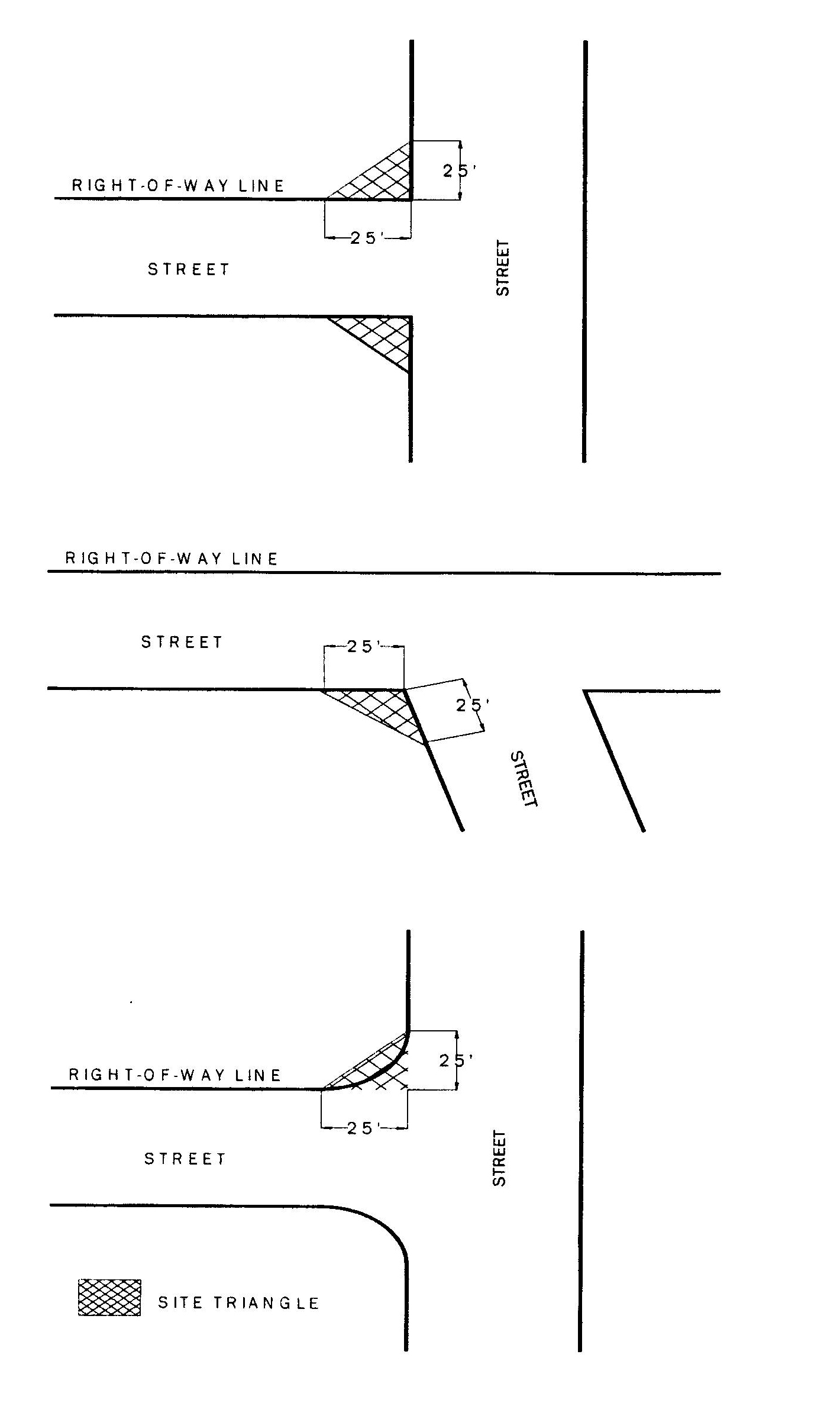
3.9.0. - Stormwater management.
A.
Applicability. All new development and redevelopment, except single-family and duplex structures, shall comply with these regulations for stormwater management in the City of Longwood.
B.
Generally. All stormwater management facilities shall meet the level of service requirements of the Longwood Comprehensive Plan, comply with the Stormwater Technical Requirements of the City of Longwood, Department of Public Works Design Standards and shall comply with the water management district regulations pertaining to such facilities.
1.
Alternative standards to those presented in the Manual of Standards for Streets and Stormwater and the LDC may be considered based on unique site-specific conditions or when supporting documentation demonstrates that an alternative analysis or design meets or exceeds the applicable performance requirements as determined solely by the city engineer or an agent acting on behalf of city staff.
C.
Requirements. In addition to meeting requirements for retention or detention, all facilities shall meet the following requirements:
1.
Detention/retention facilities located within the city or county right-of-way shall not be located at intersections.
2.
Detention/retention shall not be located adjacent to transportation corridors unless designed as an amenity by a registered landscape architect and does not interfere with optimal bicycle/pedestrian access. To be considered an amenity, the retention area must be landscaped and include seating area(s), passive recreation areas, and pedestrian paths. The city engineer may issue an exemption to this requirement where it is determined that such a design is not practical and/or creates a public safety issue and no reasonable alternatives exist.
3.
Retention/detention basins shall be of irregular shape and shall have no parallel sides, when visible from public right-of-way or lands. The city engineer may approve other designs when determined that no other design options exist, in which case additional landscaping and barriers may be required.
4.
Retention ponds that are placed in the front yard should have a landscape barrier rather than fencing, with rotunda holly the preferred landscape material.
5.
For new development or significant redevelopment, those stormwater management system that eventually discharge into the city's MS4 (municipal separate storm sewer systems) should mitigate any increase in pollutant loads to the maximum extent practicable. To meet this requirement, the city encourages the use of best management practices (e.g., stormwater reuse and baffle boxes), as well as low impact development technologies, including but not limited to: replacement of traditional paving materials with porous concrete/pervious pavement, grass swales, bio-retention, etc.
6.
All facilities have a perimeter planting area between the property line and the top of the slope of the retention pond. The planting area, if grassed, shall be of sufficient width to accommodate mowing equipment. Excavation to the property line shall be prohibited.
7.
Use of semi-pervious materials, semi-pervious concrete, semi-pervious asphalt, "turf block," or similar materials may be used subject to approval of the city engineer. The burden of proof shall reside with the applicant. The applicant shall demonstrate that the material is designed consistent with accepted industry specifications. The material shall be designed to retain its porosity, stability, and durability for a reasonable period of time based on professionally accepted principles and practices.
a.
Historic district. Semi-permeable grass, gravel, and impervious brick are all allowable materials for parking areas within the historic district, subject to approval of the city engineer.
3.9.1. Stormwater management plan requirements.
A.
Building permit applications for any development activity which disturbs the existing grade of a piece of property shall require a stormwater management plan. The community development director may waive this requirement upon the advice of the city engineer only if adequate information exists to determine pre and post development drainage patterns without additional survey and design.
B.
The city engineer shall review the stormwater management plan required by this section. No clearing permit, building permit, or development plan approval occur for any project which requires a stormwater management plan unless the city engineer approves the plan.
C.
The stormwater management plan shall consist of the following:
1)
A survey that indicates the current grade of the affected property.
2)
A grading plan showing the proposed changes to the grading.
3)
The measures being taken to ensure that the grading change does not adversely affect the drainage of stormwater from the area.
(Ord. No. 05-1746, § 8(3.10.1), 4-4-2005; Ord. No. 10-1929, § 1, 9-27-2010; Ord. No. 11-1956, § 1, 3-7-2011; Ord. No. 11-1969, § 1, 8-15-2011; Ord. No. 14-2038, § 1, 8-4-2014; Ord. No. 16-2093, § 1, 8-15-2016; Ord. No. 16-2107, § 1, 2-6-2017; Ord. No. 18-2136, § 1, 6-18-2018; Ord. No. 22-2219, § 1(Exh. A), 4-18-2022)
Editor's note— Ord. No. 11-1956, § 1, adopted March 7, 2011, repealed § 3.9.0 and renumbered §§ 3.10.0, 3.10.1 and 3.11.0 as §§ 3.9.0, 3.9.1 and 3.10.0 as set out herein. The former § 3.9.0 pertained to fire lanes, addressing and key boxes and derived from Ord. No. 02-1599, adopted May 6, 2002. The historical notation has been retained with the amended provisions for reference purposes.
Cross reference— Stormwater management, ch. 74.
3.10.0. - Mobility design.
A.
All new development and redevelopment must include provisions for transit and pedestrian/bicycle mobility including bike lanes, minimum sidewalk widths, safe crosswalks, pedestrian scale lighting and other bike and pedestrian friendly features, and access to adjoining properties.
B.
Applicants of development or redevelopment exceeding 20,000 square feet gross floor area along an existing or proposed LYNX route shall provide space for a bus shelter if needed to place one.
(Ord. No. 10-1929, § 1, 9-27-2010; Ord. No. 11-1956, § 1, 3-7-2011; Ord. No. 20-2170, § 1, 2-17-2020)
Note— See the editor's note to § 3.9.0.
3.11.0. - Reserved.
Editor's note— Ord. No. 20-2170, § 1, adopted February 17, 2020, repealed § 3.11.0 which pertained to the Opportunity Node Overlay Zone (ONOZ) and derived from Ord. No. 16-2088, § 1, adopted Jun 20, 2016; Ord. No. 16-2107, § 1, adopted February 6, 2017; and Ord. No. 18-2136, § 3, adopted June 18, 2018.