Manatee County Unincorporated
City Zoning Code
City Zoning Code
SECTION 403
- Overlay Districts.
403.1. - Overlay Districts Established.
The following overlay districts are hereby established:
(Ord. No. 15-03, § 5(Exh. C), Amd. 1-5-17; Ord. No. 19-05, § 3(b)(Exh. A-3), 2-7-19; Ord. No. 19-03, § 3(Exh. A-4), 3-21-19; Ord. No. 22-06, § 3(Exh. A), 4-7-22; Ord. No. 23-15, § 3(Exh. A), 2-16-23)
403.2. - Airport Impact Overlay District (AI).
A.
Purpose. The purpose of this overlay district is to facilitate proper land use planning and zoning to prohibit the location of incompatible land uses and structures in areas surrounding existing or future airports. Airports may produce noise levels that are not compatible with residential uses and certain commercial and industrial uses. Hazards reduce the size of the area available for the landing, take off and maneuvering of aircraft, which impairs the viability of the airport. In the interest of the public health, safety and welfare it is appropriate to establish regulations to prevent or minimize the creation of hazards and the placement of inappropriate uses in the vicinity of airports. Pursuant to Chapter 333, Florida Statutes, and 14 CFR 151 the purpose of the Runway Clear Zone is to protect people and property on the ground, prevent the future erection or creation of hazards within the vicinity of a public airport that have the potential to diminish the runway capacity; and, to provide an opportunity to ameliorate obstructions created/existing prior to adoption of this section.
The Airport Impact (AI) Overlay District is comprised of two (2) primary components based on the category of airport and adopted standards for noise compatibility (i.e., 14 C.F.R Part 150 Noise Compatibility Study). Additional standards including limitations on building height may be required for those lands and uses located in proximity to the Sarasota Bradenton International Airport. Sections C.2 of these regulations generally apply to land use and noise considerations ("Noise") (i.e., 14 CFR Part 77) including the airport surfaces as defined in Chapter 2 of this Code; subsections C.3 of these regulations generally apply to height of structures ("Height") in proximity to the airports (i.e., Chapter 333, Florida Statutes).
B.
Applicability. The regulations of this section apply to all new and expanded facilities within the Airport Impact Overlay District. The approximate boundaries of the AI District, Noise and Height, are indicated on the Official Zoning Atlas Maps. The overlay district regulations shall be applied in conjunction with the regulations of the underlying zoning districts. In the event of a conflict between the Airport Impact Overlay regulations and the regulations of the underlying zoning district, the more stringent limitation or requirement shall govern and prevail.
The purpose of this section is to establish protections in accord with the provisions of Chapters 330 and 333, Florida Statutes (as amended), as well as Federal regulations (as amended) including 14 CFR Parts 77, 150 and 151 and FAA Advisory Circulars 150/5300-13 and 150/5200-33, which address height obstructions, airport hazards, wildlife attractants, noise, runway protection zones, light emissions, reflectivity and power interference, aircraft overflights, and the public investment in air transportation facilities.
These provisions are intended to supplement the state and federal regulations regarding airport protection and specifically to:
1.
Promote the safety of aircraft arriving at and departing from public airports;
2.
Promote the safety of residents and property within areas surrounding public airports;
3.
Promote the utility of public airports, to ensure the welfare and convenience to Manatee County areas and its residents;
4.
Provide building height standards for use within the approach, transitional, horizontal and conical surfaces to encourage and promote proper and sound development beneath these areas;
5.
Provide development standards for land uses within prescribed noise zones associated with the normal operation of public airports;
6.
Provide administrative procedures for the efficient and uniform regulation of all development proposals within designated airport noise zones, runway approach zones and airport height zones;
7.
Prevent the creation of hazards and incompatible land uses;
8.
Conflict: In the event of conflict between any airport zoning regulations adopted under this chapter and any other regulations applicable to the same area, whether the conflict be with respect to the height of structures or vegetation, the use of land, or any other matter, and whether such regulations were adopted by Manatee County or by some other political subdivision, the more stringent limitation or requirement shall govern and prevail;
9.
Definitions specific to the terms used in this Section, as defined by Chapter 333, Florida Statutes, and other applicable sources are provided in Chapter 2 of this Code under "Airports"; and
10.
Interlocal Agreement: Pursuant to Section 333.03(1)(b)1, Florida Statutes, Manatee County and the Sarasota Bradenton Airport Authority have entered into an interlocal agreement specific to the administration and enforcement of airport zoning regulations contained in this Chapter.
C.
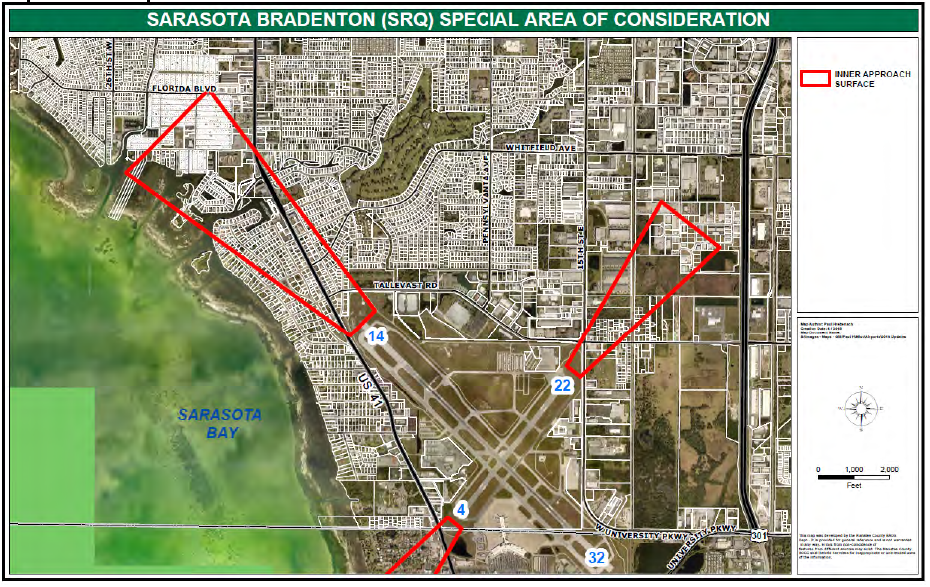
Sarasota Bradenton International Airport (SRQ). Lands adjacent to and surrounding Sarasota Bradenton International Airport (SRQ) shall be subject to four distinct but overlapping Overlay Districts: (1) SRQ-Special Area of Consideration, (Map 4-1); (2) SRQ-Special Area of Consideration specific (Subarea identification) (Map 4-1a); (3) SRQ-AI Height Overlay (Map 4-2); and (4) SRQ-AI Overlay (Map 4-3).
1.
SRQ-Special Area of Consideration, Map 4-1 and Map 4-1a. The maximum heights set forth in this subsection 403.2.C. are established to ensure safety within and around the airport.
a.
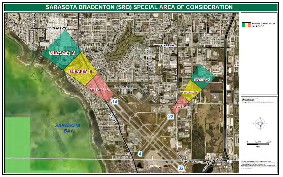
The SRQ-Special Area of Consideration shall consist of lands lying beneath the inner approach surface of Runways 14/32 and Runways 4/22 of the Sarasota Bradenton International Airport (as depicted in Map 4-1 and Map 4-1a). The inner approach surface represents the portion of the approach zone extending horizontally and upward to the horizontal surface, located one hundred fifty (150) feet above the airport elevation, which is thirty (30) feet above mean sea level (MSL). In plan view, the perimeter of the inner approach surface coincides with the perimeter of the approach zone. For purposes of this section, the lands lying beneath the inner approach surface (identified on Map 4-1) are divided into three (3) subareas identified on Map 4-1a specific (Subarea identification), as follows:
i.
Subarea A consists of the lands lying beneath the portion of the inner approach surface that extends to an elevation of fifty (50) feet above the airport elevation;
ii.
Subarea B consists of the lands lying beneath the portion of the inner approach surface that extends to an elevation of between fifty (50) feet and one hundred (100) feet above the airport elevation; and
iii.
Subarea C consists of the lands lying beneath the portion of the inner approach surface that extends to an elevation of between one hundred (100) feet and one hundred fifty (150) feet above the airport elevation.
b.
Within the SRQ-Special Area of Consideration, no building or structure, or portion of a building or structure, tall towers or antenna, or other appurtenances above the roofline, shall exceed the lesser of the maximum height permitted under 14 C.F.R, Part 77; Ch. 333, F.S.; and Section 403.2.C.1 of this Code; or
i.
Within Subarea A: The height of thirty-five (35) feet above the airport elevation (thirty (30) feet MSL);
ii.
Within Subarea B: The height of forty-five (45) feet above the airport elevation (thirty (30) feet MSL); and
iii.
Within Subarea C: The height of 55 feet above the airport elevation (30 feet MSL).
c.
The maximum heights set forth in subsection 403.02.C.1.b above shall be measured in accordance with the definition of "Height, Building" contained in Section 200; provided, however, that any structures projecting above the roofline, such as mechanical equipment, antennas, chimneys, spires, belfries, steeples, minarets, clock towers, or cupolas, or similar equipment or ornaments or appurtenances shall be included in the measurement.
d.
Where the maximum heights permitted in the underlying zoning district are more restrictive than the maximum heights set forth in this Section 403.02, then the maximum heights in the underlying zoning district shall prevail.
Map 4-1: SRQ—Special Area of Consideration
Map 4-1a: SRQ—Special Area of Consideration, Specific (Subarea Identification)
2.
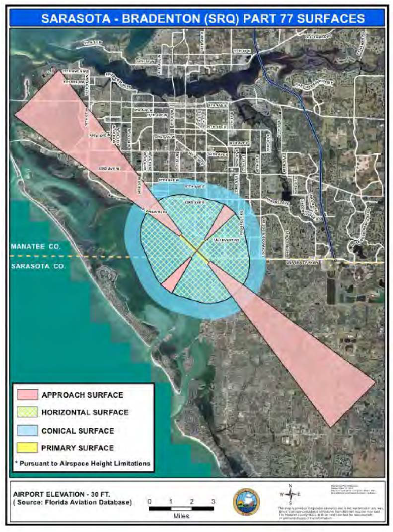
SRQ-AI Height Overlay—Part 77 Surfaces. Lands including structures located within those areas identified by Map 4-2, Sarasota Bradenton (SRQ) Part 77 Surfaces (i.e., 14 C.F.R. Part 77) shall be subject to the AI Height Overlay and the following standards:
Map 4-2: Sarasota Bradenton (SRQ) Part 77 Surfaces
a.
Permits Required. Permits shall be required from the FAA, FDOT-Central Aviation Division and Manatee County, as may be applicable, for the following activities. Applications for development or redevelopment shall be provided to FDOT-Central Aviation Office within 15 days of receipt by Manatee County and may be submitted via the following: DOTAirportZoning@dot.state.fl.us.
i.
A person proposing to construct, alter, or allow an airport obstruction in an airport hazard area in violation of the airport protection zoning regulations adopted under this chapter must apply for a permit. A permit may not be issued if it would allow the establishment or creation of an airport hazard or if it would permit a nonconforming obstruction to become a greater hazard to air navigation than it was when the applicable airport protection zoning regulation was adopted which allowed the establishment or creation of the obstruction, or than it is when the application for a permit is made.
ii.
Each application for a Permit shall indicate the purpose for which the Permit is desired, with sufficient particularity to permit it to be determined whether the resulting use, structure, or tree would conform to the regulations herein prescribed, including height relative to Subsection iii(a) below. If such determination is in the affirmative, the Permit shall be granted. Vertical height shall be measured from the highest point on the ground along the periphery of the structure or tree to the highest point on the structure or tree.
iii.
Within fifteen (15) days after receiving an application for the following items, Manatee County shall provide the Airport Authority with written notice and an opportunity to comment on the application:
(a)
The application proposes vertical development in excess of forty (40) feet above the Airport Elevation (which is 29.9 feet above mean sea level) on a parcel that is within a horizontal distance of less than four thousand two hundred (4,200) feet from the end of an Airport runway; or
(b)
The application proposes a land use or activity deemed incompatible under Table 4-13 on a parcel that is within the outer noise contour depicted on the Airport Authority's Noise Exposure Map; or
(c)
The application proposes development on a parcel that is within an Airport Runway Protection Zone; or
(d)
The application proposes the development of an educational facility of a public or private school at either end of an Airport runway within the area contiguous to the Airport defined by the outer noise contour depicted on the Airport Authority's) Noise Exposure Map and Noise Compatibility Plan; or as also may be identified in Table 4-13 and Map 4-4; or
(e)
The application proposes the development of a sanitary landfill located within ten thousand (10,000) feet from the nearest point of any runway at Airport, or located more than ten thousand (10,000) feet from the nearest point of any runway at the Airport, but still within the lateral limits of the civil airport imaginary surfaces depicted in the Airspace Drawings, or as also may be identified in Table 4-13 and Map 4-4; or
(f)
Or any application proposed within the surfaces identified in Map 4-3.
iv.
Failure to provide such notice to the Airport Authority shall not constitute a jurisdictional or procedural defect in an approval of an application for Development Permit.
v.
If it is determined that a nonconforming obstruction has been abandoned or is more than eighty (80) percent torn down, destroyed, deteriorated, or decayed, a permit may not be granted if it would allow the obstruction to exceed the applicable height limit or otherwise deviate from the airport protection zoning regulations. Whether or not an application is made for a permit under this subsection, the owner of the nonconforming obstruction may be required, at his or her own expense, to lower, remove, reconstruct, alter, or equip such obstruction as may be necessary to conform to the current airport protection zoning regulations. The requirement to remove nonconforming obstructions shall be enforceable by the County utilizing the County Code of Ordinances, Chapter 2-6, Article II, Unsafe Structures and Section 107.6.E, Unsafe Structures, LDC. If the owner of the nonconforming obstruction neglects or refuses to comply with such requirement for ten (10) days after notice, the administrative agency including but not limited to FAA and or FDOT may report the violation to Manatee County.
vi.
Owner(s) of the obstruction shall be required to install, operate, and maintain thereon, at his or her own expense, marking and lighting in conformance with the specific standards established by the Federal Aviation Administration.
b.
Consideration of Issuing Permits. The following items shall be taken into consideration by the Manatee County Planning Commission and the Board of County Commissioners during the review, including subsequent approval and or denial, of any permits within the SRQ-AI Height Overlay—Part 77 Surfaces.
i.
The Board of County Commissioners may defer review and approval or denial pending information from the Applicant and from FDOT and/or FAA, as may be applicable.
(a)
The safety of persons on the ground and in the air.
(b)
The safe and efficient use of navigable airspace.
(c)
The nature of the terrain and height of existing structures.
(d)
The effect of the construction or alteration on the state licensing standards for a public-use airport contained in Chapter 330, Florida Statutes, and rules adopted thereunder.
(e)
The character of existing and planned flight operations and developments at public-use airports.
(f)
Federal airways, visual flight rules, flyways and corridors, and instrument approaches as designated by the Federal Aviation Administration.
(g)
The effect of the construction or alteration of the proposed structure on the minimum descent altitude or the decision height at the affected airport.
(h)
The cumulative effects on navigable airspace of all existing structures and all other known proposed structures in the area.
(i)
Additional requirements as may be adopted within these regulations pertinent to evaluation and protection of airspace and airport operations.
c.
Airspace Height Limitations. Buildings, structures or similar shall not be permitted within the surfaces identified below except as may be permitted in Section 403.C.2.a above.
Zone Classification and District Boundary Map for the Airport Environs Outside Airport Zones. This map shall be prima facie evidence of the boundaries of the zone and surface classification districts and the height limitations applicable thereto and therein, but in the case of conflict with the written provisions of this section, the written provisions shall prevail. The underlying zoning district for the Sarasota-Bradenton Airport shall prevail where that district imposes more restrictive requirements than those provided in this section.
i.
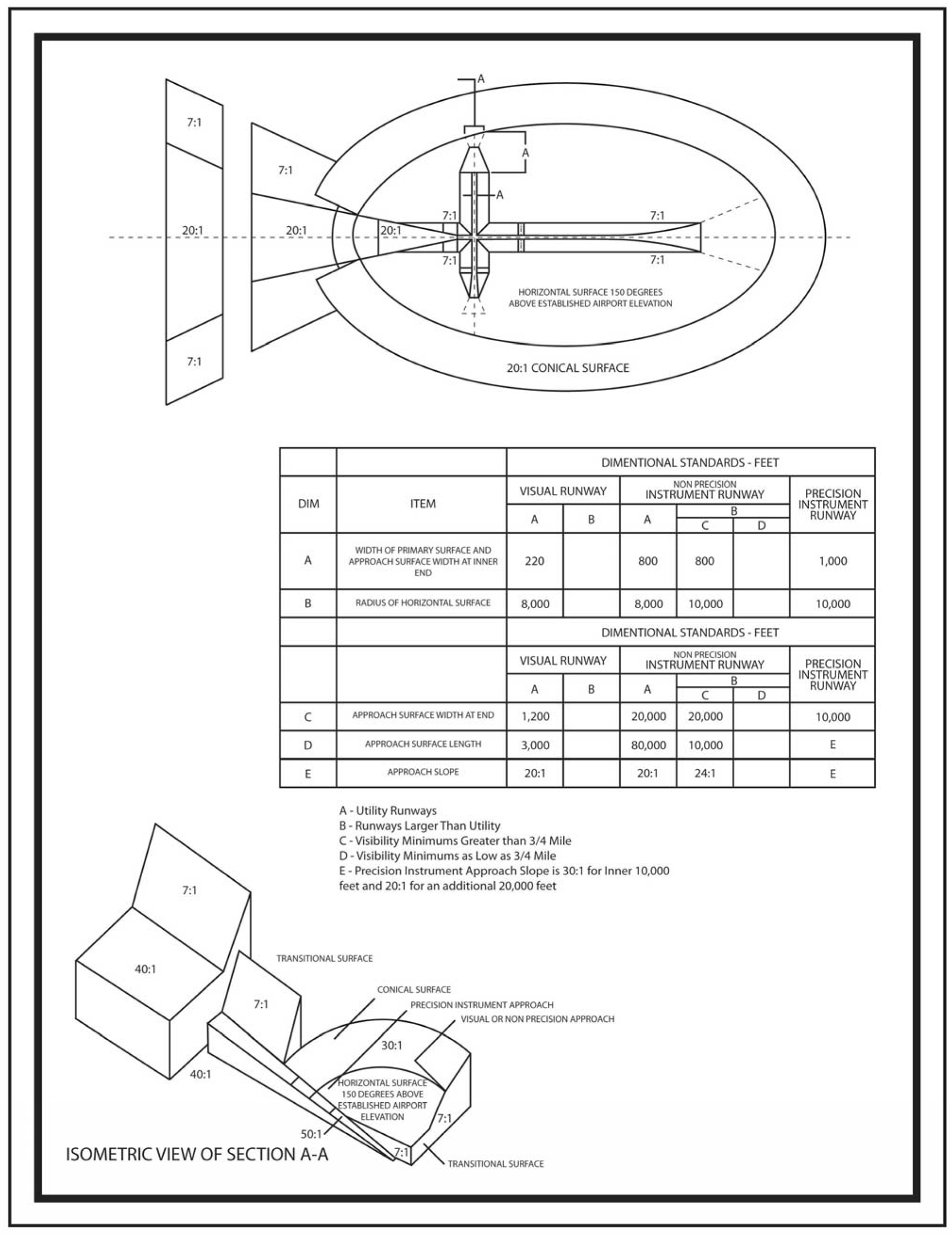
Airport Surfaces. Airspace height limitations shall apply to all sites lying beneath the primary, approach, transitional, horizontal, and conical surfaces shown on Map 4-3. An area located in more than one (1) of the described surfaces is considered to be only in the surface with the more restrictive height limitation. The various surfaces and height restrictions are as follows, and are generally depicted on the drawing designated as Figure 4-5, "Civil Airport Imaginary Surface". The Surfaces are generally described on Map 4-2 but are more specifically described herein consistent with 14 C.F.R. Park 77.
ii.
Primary Surface (PS). An area located at each end of a runway which is longitudinally centered on each runway, extending two hundred (200) feet beyond each end of that specially prepared hard surface runway with the width specified for the most precise approach existing or planned for either end of that runway. The primary surface ends at each runway end for all runways without a specially prepared hard surface. The width of each primary surface is as follows:
(a)
Precision Instrument Runways: One thousand (1,000) feet.
(b)
Non-Precision Instrument Runways: Five hundred (500) feet.
(c)
Public Utility Visual Runways: Two hundred fifty (250) feet.
(d)
Private Utility Visual Runways: One hundred (100) feet.
iii.
Horizontal Surface (HS). An area around each airport, at a fixed elevation of one hundred and fifty (150) feet Above Ground Level (AGL) with an outer boundary the perimeter of which is constructed by swinging arcs or specified radii from the center of each end of the primary surface of the airport's runways and connecting the adjacent arcs by lines tangent to those arcs. The radius of the arcs specified for each end of the runway will have the same arithmetical value and the value will be the highest composite value determined for either end of that runway. When a smaller arc is encompassed by the tangent connecting two (2) adjacent larger arcs, the smaller arc shall be disregarded in the construction of the perimeter of the horizontal surface. The airport elevation is identified on Map 4-2 and is based on information obtained from the Florida Aviation Database (FAD) which is subject to periodic adjustment.
The radius of each runway arc is as follows:
(a)
For utility runways, a radius of five thousand (5,000) feet.
(b)
For other than utility runways, a radius of ten thousand (10,000) feet.
iv.
Conical Surface (CS). An area extending outward from the periphery of the airport's horizontal surface for a distance of four thousand (4,000) feet.
v.
Approach Surface (AS). An area longitudinally centered on the extended runway centerline and extending outward from the end of the primary surface. The approach surface area and height restrictions are designated for each runway based upon the type of approach available or planned for that runway end, as follows:
(a)
Approach Surface Width. The inner edge of the approach surface is the same width as the primary surface. The outer width of the approach surface is prescribed for the most precise approach existing or planned for that runway end expanding uniformly outward to a width of:
(1)
For a Precision Instrument Runway, a maximum width of sixteen thousand (16,000) feet.
Precision Instrument Approach Zone—Runway(s) 14 and 32: Slopes fifty (50) feet outward for each foot upward beginning at the end of and at the same elevation as the primary surface and extending to a horizontal distance of ten thousand (10,000) feet along the extended runway centerline; thence slopes upward forty (40) feet horizontally for each foot vertically to an additional horizontal distance of forty thousand (40,000) feet along the extended runway centerline.
(2)
For a Non-Precision Instrument Runway other than a Utility Runway, a maximum width of three thousand five hundred (3,500) feet.
Non-Precision Instrument Approach Zone—Runway 22: Slopes thirty-four (34) feet outward for each foot upward beginning at the end of and at the same elevation as the primary surface and extending to a horizontal distance of ten thousand (10,000) feet along the extended runway centerline.
(3)
For a Utility Visual Runway, a maximum width of one thousand two hundred fifty (1,250) feet.
(4)
For a Utility Non-Precision Instrument Runway, a maximum width of two thousand (2,000) feet.
(b)
Approach Surface Length. The approach surface extends from the end of the runway primary surface for a horizontal distance of:
(1)
For a Precision Instrument Runway, a maximum distance of fifty thousand (50,000) feet and reciprocal slope delineated as follows:
(i)
The first ten thousand (10,000) feet with a slope of fifty (50) to one (1),
(ii)
The next forty thousand (40,000) feet with a slope of forty (40) to one (1).
(2)
For a Non-Precision Instrument Runway other than a Utility Runway, a maximum distance of ten thousand (10,000) feet.
(3)
For a Visual or Non-Precision Instrument Utility Runway, a distance of five thousand (5,000) feet.
vi.
Transitional Surface (TR). An area extending outward and upward from the sides of each primary surface and approach surface, connecting them to the horizontal surface, or outward five thousand (5,000) feet horizontally from the side of that portion of the approach surface of a Precision Instrument Runway extending beyond the Conical Surface.
d.
Height Limitations. No structure or obstruction, including, without being limited to, tall tower or antenna, shall be erected to a height which would cause such structure to exceed any of the following:
Figure 4-5: Civil Airport Imaginary Surface
e.
Appeals. Appeals of permits shall be filed and subsequently heard consistent with the provisions defined in F.S. Ch. 333.09 and consistent with Chapter 3, Part X of the Manatee County Land Development Code.
3.
SRQ-AI Noise Overlay.
a.
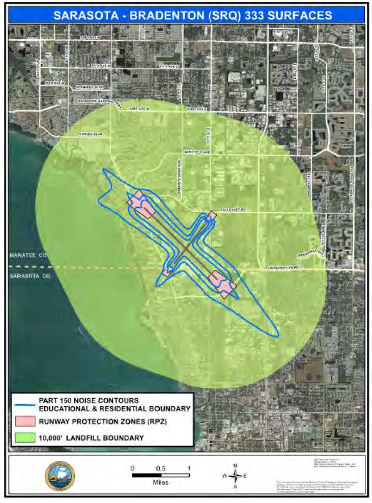
Lands subject to the SRQ- AI Noise Overlay including the Land Use Compatibility Standards provided in subsection b below include those identified on Maps 4-3 Sarasota Bradenton (SRQ) F.S. Ch. 333 Surfaces and 4-4 Sarasota Bradenton International Airport (SRQ) Noise Exposure Map. The SRQ-AI Noise Overlay is understood to include standards based on the potential impacts from noise and land use compatibility.
Map 4-3: Sarasota Bradenton (SRQ) F.S. Ch. 333 Surfaces
b.
Land Use Compatibility. The following Land Use Compatibility measures shall apply in addition to the specifications and limitations identified in Table 4-13. Table 4-13 specifies the level of review required for each proposed land use based on its location within the contours.
Notwithstanding any other provisions of this Code, no use may be made of land or water within any zone established by this Code in such a manner as to create electrical interference with navigational signals or radio communication between the airport and Aircraft, make it difficult for pilots to distinguish between Airport lights and others, result in glare in the eyes of pilots using the Airport, impair visibility in the vicinity of the Airport, create bird strike hazards, or otherwise in any way endanger or interfere with the landing, takeoff, or maneuvering of aircraft intending to use the Airport. Except as otherwise provided herein, the following land uses, structures or activities shall be prohibited:
i.
Any sanitary landfill:
(a)
Located within ten thousand (10,000) feet from the nearest point of any runway used or planned to be used by turbine aircraft at the Airport;
(b)
Within five thousand (5,000) feet from the nearest point of any runway used only by nonturbine aircraft;
(c)
Outside the perimeters defined in subparagraphs (a) and (b), but still within the lateral limits of the civil airport imaginary surfaces defined in 14 C.F.R. s. 77.79;
(d)
Located more than ten thousand (10,000) feet from the nearest point of any runway at the Airport, but still within the lateral limits of the civil airport imaginary surfaces depicted in the Airspace Drawings; or
(e)
Where any landfill is located and constructed so that it attracts or sustains hazardous bird movements from feeding, water, or roosting areas into, or across, the runways or approach and departure patterns of aircraft. The operator of such landfill must be required to incorporate bird management techniques or other practices to minimize bird hazards to airborne aircraft.
ii.
Restricting new incompatible uses, activities, or substantial modifications to existing incompatible uses within the Airport's Runway Protection Zones.
iii.
Non-compatible land uses, within the boundaries established in Map 4-4 and identified in Table 4-13, which is derived from the Sarasota Bradenton SRQ Noise Exposure Map and Noise Compatibility Plan, are not permitted within the noise contours established there, except where such land use is specifically contemplated therein, with appropriate mitigation or similar techniques described therein.
iv.
Residential construction and any educational facility facilities as defined in Chapter 1013, Florida Statutes, within the area contiguous to the Airport defined by the outer noise contour depicted on the Airport Noise Exposure Map that is considered incompatible with that type of construction by Table 4-13 with the exception of an aviation school facility. Provided, however, that this restriction shall not require the removal, alteration, sound conditioning, or other change to, or interfere with the continued use or adjacent expansion of any educational facility or site in existence on July 1, 1993.
v.
Any lights and illumination used in connection with streets, parking, signs or uses of land that are arranged or operated in such manner that it is misleading to or obscures pilots' vision during critical take-off or landing stages of flight or is otherwise dangerous to aircraft operations or flight operations at the Airport.
vi.
Any use of high energy beam devices where the energy transmission is not fully contained in a building or some type of absorbing or masking vessel.
vii.
Any activity that produces interference with navigational signals or radio communication between aircraft, the Airport, or an air traffic control facility.
Map 4-4: Sarasota Bradenton (SRQ) Noise Exposure Map
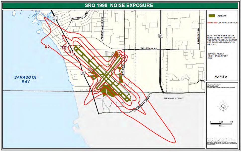
Table 4-13: AI Noise Overlay Land Use Compatibility Guidelines
LEGEND: X = Use not permitted; P = Permitted use with no special consideration.
SC = Special consideration: acoustical analysis required to show that the structure's design will limit exterior noise to the prescribed allowable interior level.
Table Note: The uses in this table are grouped for user convenience and do not necessarily correlate with the land uses as categorized earlier in this Chapter. Proposed land uses which do not appear on the list will be reviewed as the most similar use, subject to the discretion of the Department Director.
Editor's note— See the editor's note to Table 4-1.
c.
Review Standards.
i.
Allowable Interior Noise Levels. Interior noise levels attributable to exterior sources shall not exceed forty-five (45) Ldn in any habitable room. Habitable room shall be defined to include all living areas in residential structures, and the following portions of all non-residential structures: all areas where the public is received, office areas, classrooms, sleeping areas, medical treatment areas, areas of religious worship, and all noise-sensitive areas or areas where the normal noise level is low. Proper design may include, but shall not be limited to, the following specific noise attenuation techniques:
(a)
Architectural design features such as the provision of additional building insulation; the omission of fireplaces/chimneys, or doors with mail drop slots from building design; and/or the use of double pane windows.
(b)
Orientation of the habitable structure, including setbacks and shielding.
(c)
Placement of habitable rooms toward the internal portions of the proposed structure(s), situating porches, garages, or storage areas between these habitable rooms and typical airport noise sources.
ii.
Uses Requiring Special Consideration.
(a)
Acoustical Analysis. Prior to the issuance of a building permit, the applicant proposing to develop a habitable structure requiring special consideration (SC) shall submit an acoustical analysis showing that the proposed design will limit exterior noise to the prescribed allowable interior level.
The acoustical analysis report shall be prepared under the supervision of a person who is a Member of the Institute of Noise Control Engineering and experienced in the field of acoustical engineering. The report shall show topographical relationships of noise sources and structure sites, identification of noise sources and their characteristics, predicted noise spectra and levels at the exterior of the proposed habitable structure(s) considering present and future land usage, basis for the prediction (measured or obtained from published data), noise attenuation measures to be applied, and an analysis of the noise insulation effectiveness of the proposed construction showing that the prescribed interior noise level requirements will be met.
If allowable interior noise levels are met by requiring that windows be closed, the design for the structure must also specify a ventilation or air conditioning system to provide habitable interior environment. The ventilation system must not compromise the habitable room noise reduction.
iii.
Field Testing. Prior to the issuance of a Certificate of Occupancy, the applicant shall submit a field test report showing compliance with prescribed interior allowable levels. Should the test report reveal non-compliance, the Certificate of Occupancy will be denied until compliance is demonstrated or until a waiver is obtained pursuant to paragraph c, below.
Field testing shall be done under the supervision of a person who is a Member of the Institute of Noise Control Engineering, experienced in the field of acoustical testing and engineering. Documentation of field test results should generally follow the requirements outlined in relevant ASTM standards.
iv.
Interior Noise Level Waiver. Should the required field test reveal non-compliance, the Department Director may grant a waiver of the allowable interior noise levels if:
(a)
The property owner has made a documented good faith effort to achieve the interior noise level standard;
(b)
The property owner meets the requirement for a Noise Report;
(c)
The property owner can demonstrate that a substantial and unreasonable additional expense would be involved to achieve the required interior noise level; and
(d)
In the case of redevelopment, the property owner/applicant will also need to demonstrate that the redevelopment is being done in a manner consistent with its prior use.
v.
Exemptions and Waivers. Notwithstanding any other provisions of this Code, the following activities shall be exempt from the noise requirements of this section:
(a)
Non-substantial improvements of existing non-residential structures and parcels provided the principal use of the property has not been discontinued for a period of one hundred eighty (180) consecutive days or more.
(b)
Non-substantial improvements of existing residential structures and parcels.
(c)
A use not prohibited by Table 4-13 may be exempt from the maximum allowable interior noise levels if the Department Director determines that:
(1)
The property owner has documented that he has made a good faith effort to achieve the interior noise level standard described in this section;
(2)
The property owner can demonstrate that a substantial and unreasonable additional expense would be necessary to achieve the allowable interior noise level; and
(3)
The property is being redeveloped in a manner consistent with its prior uses.
d.
Appeals. Appeals of permits shall be filed and subsequently heard consistent with the provisions defined in Section 333.09, Florida Statutes, and consistent with Chapter 3, Part X, of the Manatee County Land Development Code.
(Ord. No. 19-05, § 3(b)(Exh. A-3), 2-7-19; Ord. No. 19-03, § 3(Exh. A-4), 3-21-19; Ord. No. 23-15, § 3(Exh. A), 2-16-23)
Editor's note— Ord. No. 19-05, § 3(b)(Exh. A-2, A-3), adopted Feb. 7, 2019, repealed the former § 403.2, and enacted a new § 403.2 as set out herein. The former § 403.2 pertained to airport impact (AI) overlay district and derived from Ord. No. 16-06, § 3(Exh. A-3), adopted Nov. 15, 2016 and Ord. No. 16-24, § 3(Exh. A-4), Nov. 15, 2016.
403.3. - Florida International Gateway Overlay District (FIG).
A.
Purpose and Intent. The purpose of the Florida International Gateway Overlay Zoning District is to encourage growth consistent with the long term needs of Port Manatee and the economic health of the County as a whole. To achieve that purpose, the overlay district allows for a range of light industrial, mixed-use and other employment-oriented uses which would not otherwise be allowed in the underlying land use category. This section sets the development standards and alternative review procedures for approving those uses within the overlay district and ensuring compatibility among uses. This section, however, shall not be construed to grant entitlements to any property in excess of any statutorily prescribed threshold for a developmental-regional-impact review under applicable State law.
B.
Applicability. All properties within the FIG Overlay District are eligible, but not required, to be processed as specified in this section.
C.
Standards.
1.
Uses Permitted in the FIG Overlay. Properties within the FIG Overlay District may be allowed the following uses, in addition to the uses permitted in the underlying Future Land Use Classification. The range of permitted uses may be limited or certain uses prohibited by the Board at the time of approval of the Master Plan as determined necessary by the Board to meet the criteria in Policy 2.2.2.9.4 of the Comprehensive Plan.
2.
Buffering and Screening Standards:
a.
Land proposed for residential and other low intensity uses shall provide the buffers required in Chapter 4 and Section 701.
b.
Land proposed for industrial, warehousing, wholesale trade, utilities, building materials, industrial services, construction services, vehicle repair, fuel pumps, and transportation uses shall not have a requirement to provide buffers, except along the boundary of the project where adjacent to developed residential uses.
c.
If the adjacent parcel is undeveloped, the developer shall reserve the land for the buffer but may defer the planting of landscaping material and construction of any berms or walls until such time as the adjacent development commences. If the adjacent land subsequently develops with a compatible land use, then the developer may use the land reserved for the buffer for other purposes.
D.
Master Plan Review and Approval. Applicants desiring to develop under the alternative provided by the FIG Overlay District shall submit a Master Plan to be reviewed by the Board in accordance with the requirements of quasi-judicial decisions pursuant to Chapter 3.
E.
Completeness of Application. The Master Plan shall have sufficient details to ensure compliance with the goals, objectives and policies of the FIG Overlay District contained in the Comprehensive Plan. The Master Plan may meet all requirements of the Code for a General Development Plan or comply with the information required below, at the option of the applicant. A FIG Overlay Master Plan shall contain the following information:
1.
Demonstration of how the Master Plan implements the goals, objectives and policies of the FIG Overlay District in the Comprehensive Plan. In the event the FIG Overlay Master Plan requests approval for the range and intensity of uses eligible under the IL (Industrial-Light) Future Land Use Category, the Master Plan shall demonstrate specifically how compatibility between residential and non-residential uses can be achieved and how provisions have been made for all required public facilities.
2.
Floor area ratios or residential densities for the various land uses or their categories.
3.
Categories organizing the list of land uses into groups considered incompatible where adjacent.
4.
Buffering and screening standards:
a.
Providing alternatives to such requirements of the LDC, Section 701, Landscaping Standards and any applicable provisions contained in Chapter 5.
b.
Applying the categories of incompatible adjacent land uses in a matrix or table indicating the appropriate buffer and screening between such land uses.
c.
Graphically and textually describing the design of the buffers and screenings between such land uses.
d.
Describing the relative location, responsibility for installation and maintenance and timing of buffers at a minimum with detail to demonstrate compliance with the buffer standards listed above (subsection C.2).
5.
Notwithstanding, the minimum submittal requirements for a General Development Plan contained elsewhere in this Code, the FIG Overlay Master Plan is not required to contain the following information:
a.
Location of land uses, buildings and structures.
b.
Quantities of land uses, e.g., land area (acres) or floor area (square feet).
F.
Certificate of Level of Service. The uses proposed within a FIG Overlay District shall not be eligible to receive of Certificate of Level of Service compliance due to the general nature of the submittal requirements. This section, however, shall not be construed to prohibit an applicant from entering into a Local Development Agreement with the County or the Florida Department of Economic Opportunity for purposes of qualifying for an exemption from the development-regional-impact review process in accordance with applicable law.
G.
Specific Approval not Required. The standards and designs provided for in the FIG Overlay Master Plan are alternatives to the previous development approvals under the UF-3 Future Land Use Classification and as such, shall not require the Board to make a written finding to grant specific approval.
H.
Effect of Approval. Upon approval of a FIG Overlay Master Plan through adoption of a resolution, the applicant may apply directly for approval of a Final Site Plan or, at the applicant's option, Preliminary Site Plans for phases. Subsequent applications may depart from the phasing plan if each site plan provides access and other common improvements adequate to serve all cumulative developments in the event other phases fail to develop timely. The approved Master Plan shall supersede any previous approvals (including Planned Development site plans and stipulations).
I.
Modification. Minor modifications may be made during the development process. Such modifications may be approved by the Department Director after a finding of consistency with the Comprehensive Plan.
J.
Expiration. FIG Master Plans shall not contain an expiration date.
K.
Other Permits Required. Nothing in this Section shall eliminate the obligation of the applicant to obtain any required permits from Manatee County, State or Federal agencies.
L.
Revocability. In the event the Department Director determines, in his sole discretion, that the applicant has failed to suitably monitor the progress of the development as approved by the FIG Master Plan, the Department Director shall notify the applicant in writing of his/her determination. The applicant(s) receiving such notice shall have the right to appeal the decision or interpretation pursuant to Chapter 3, Part X.
(Ord. No. 16-24, § 3(Exh. A-4), 11-15-16; Ord. No. 19-03, § 3(Exh. A-4), 3-21-19)
403.4. - Parrish Commercial Village Overlay District (PCV).
A.
Purpose and Intent. The purpose of the Parrish Commercial Village (PCV) Overlay District is to provide an administrative approval process as an incentive for appropriately scaled and compatible commercial development along U.S. 301. The purpose of this section includes:
1.
Provide a vehicle for applications meeting the standards of the underlying zoning district and this section to obtain administrative approval;
2.
Promote new and renovated commercial development that will be harmonious with the existing Parrish community and its evolving vision for its future;
3.
Provide standards for building placement, architecture, landscaping, and signs for commercial development that enhance the community by being visually distinctive and drawing from the historic, rural heritage of the Parrish community, while remaining flexible enough to encourage creativity and diversity;
4.
Encourage the establishment of functional outdoor gathering spaces at appropriate places in the Parrish community;
5.
Create pedestrian-friendly places, conveniently located pathways, and increased accessibility for a range of travel modes that contribute to the character of individual sites and the overall built environment in Parrish; and
6.
Promote building-to-street interaction and greater visibility of businesses by encouraging parking to be located away from U.S. 301, ideally at the side or rear of non-residential buildings.
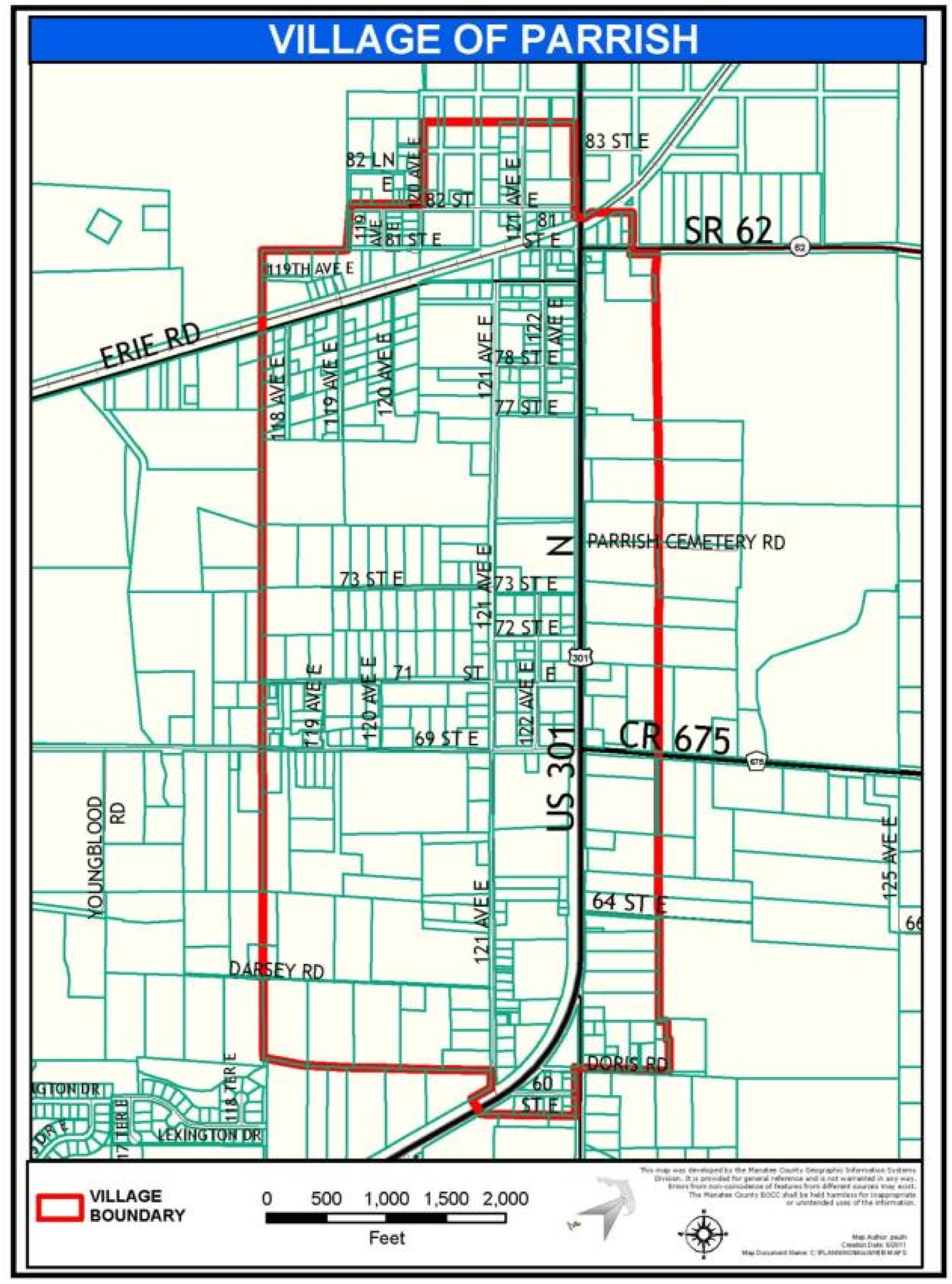
Map 4-6: Village of Parrish
B.
Applicability. The requirements of this section apply to any new or improved commercial, multi-family, mini-warehouse, and mixed-use developments (if they include a commercial component) located within the PCV Overlay District and requiring Site Development Plan approval. The provisions of this section are intended to supplement the regulations in this Code. In the event of a conflict between other provisions of the Code and this section, the more restrictive of the provisions shall prevail unless where specifically provided otherwise.
C.
Exemptions. The following development is exempt from the standards of the PCV Overlay District:
1.
Development that has obtained General Development Plan, Preliminary Site Plan or Plat approval prior to January 1, 2009.
2.
Structures and uses that do not require Final Site Plan approval, as specified under Section 320.2.C.
3.
Projects with a valid Final Site Plan as of January 1, 2009.
4.
Structures for which building permit applications have been received prior to January 1, 2009.
5.
Community Service Uses, Open Uses of Land, Recreation Uses, Residential Uses except Multi-Family Uses, Residential Support Uses, and Transportation Facilities.
6.
Historical sites or districts as designated by federal, state, or county governments or other structures deemed by Manatee County to be culturally or architecturally significant, including those historic structures on the Florida Master Site File identified in the Survey Report, Manatee County Historical Structures Survey, Phase I Project, prepared for Manatee County, dated August 29, 2008, a copy of which is on file at the Building and Development Services Department.
D.
Development Standards. The following standards shall be met if the applicant wishes to take advantage of the expedited review incentive. It is recognized that there may be circumstances where property configuration prohibits complete compliance with these requirements. Additionally, it is recognized that dedications to the public may place constraints upon projects in the planning process. These factors may be found to be adequate justification for the Board of County Commissioners to approve deviations from these standards.
1.
Site Design.
a.
Orientation. Buildings adjacent to U.S. 301 shall have the main entrance face U.S. 301.
b.
Access. To minimize access points onto U.S. 301, shared access shall be provided whenever appropriate as determined by the Department Director and permitted by FDOT. Stub-outs for driveways and a cross access easement may be required to accommodate future shared access as a condition of site plan approval. Where stub-outs for shared access have been provided by adjacent property, the owner of the subject property shall connect to the shared access unless substantial evidence can be provided that the two (2) uses are incompatible due to health, safety, or welfare concerns or that connection to the shared access substantially limits proposed development of the site in question. Shared access may or may not be accompanied by a combined or shared off-street parking plan pursuant to Chapter 10 as determined by the Department Director.
c.
Dimensional Requirements. In addition to the standards contained in Table 4-4, commercial, multi-family, mini-warehouse, and mixed use projects containing a commercial component in the PCV Overlay shall meet the following dimensional standards:
i.
Commercial Building Footprint: Twenty thousand (20,000) square feet max. (larger buildings require Special Permit approval).
ii.
Front Yard Setback along U.S. 301: The twenty-five (25) feet minimum setback required by the zoning district may be reduced by the Department Director to ten (10) feet min., provided that:
• The site is located on U.S. 301 between Moccasin Wallow Road and CR 675,
• A ten (10) feet deep porch or gallery is provided along forty (40) percent or more of the building frontage, or
• A ten (10) feet deep outdoor gathering space (subject to approval by the Department Director) is provided along U.S. 301. The space shall include street furniture such as benches, tables, or resting area for the general public, or a fountain, public art, or other visual focal point for the enjoyment of the general public.
iii.
Front Yard Setback (build-to-line) along Other Roads: Fifteen (15) feet; eight (8) feet for corner lots on roads intersecting with U.S. 301.
iv.
Side Yard Setback (build-to-line): Eight (8) feet except for the following:
• Twenty-five (25) feet if adjacent to residential uses or zoning; or
• As prescribed by the Department Director for the provision of gathering spaces.
v.
Rear Yard Setback (build-to-line): Fifteen (15) feet; twenty-five (25) feet when adjacent to residential uses or zoning.
vi.
Open Space: Twenty (20) percent minimum.
d.
Parking.
i.
Parking in Front Yard. In no case shall parking in front of the building adjacent to U.S. 301 exceed one (1) double-loaded bay of parking.
ii.
Parking Setback. Except for the double row of parking allowable by paragraph i, above, all parking along U.S. 301 must be located behind the required front yard building setback. However, if the building setback is ten (10) feet as permitted by paragraph c, above, the parking setback may also be reduced to ten (10) feet as long as the width of the parking area along U.S. 301 does not exceed fifty (50) percent of the lot width. Any remaining parking must be setback twenty-five (25) feet from U.S. 301.
e.
Pedestrian and Non-motorized Circulation.
i.
Walkways shall be provided to link the building main entrance directly to the street.
ii.
Walkways shall be functionally separated from parking lots and driveways, except where they cross driveways or parking areas.
iii.
Pavers, texturing, or color changes shall be used to differentiate walkways at driveways.
iv.
Buildings shall be linked to one another by a secondary walkway system.
v.
Public sidewalks may be considered part of the walkway system if they provide convenient pedestrian connections between structures.
f.
Landscape Design Standards. Landscaping shall conform to the requirements of Section 1002, Visibility Triangle, and Section 701, Landscape and Screening Standards. However, screening buffers shall not be required between properties with adjoining outdoor gathering areas. In addition, buffers shall not impede pedestrian or bike circulation along roadways or between parcels.
g.
Roadway Buffers. Landscape buffer shall be provided within the front yard setback, based on the depth of the setback as follows:
Table Notes:
1 Where parking areas are adjacent to the required buffer, a continuous hedge shall be required with shrubs planted at an appropriate spacing. The hedge may count towards the required shrubs for the selected buffer option.
2 Once the minimum tree and shrub quantity requirements are met, the remaining space may be planted with additional shrubs or ornamental grasses but not turf grass.
3 Once the minimum tree and shrub quantity requirements are met, the remaining space may be planted with additional shrubs or ornamental grasses. Turf grass may be used as well.
4 No minimum caliper if multi-trunk form.
h.
Additional Landscaping Design Considerations.
i.
Planting Arrangement. In required landscape areas, tree plantings shall be staggered and clustered in natural arrangements rather than in long, straight, formal arrangements. View corridors to buildings or ground signs are encouraged.
ii.
Plant Selection. Plantings in required landscape areas shall be with plant species that are native or naturalized to Florida. Landscape plant material shall be a minimum Florida No. 1 Nursery Grade, as identified in Grades and Standards, Florida Department of Agriculture. All required landscape areas shall retain existing native trees, shrubs, ground cover, and grasses to the greatest extent possible. Existing trees and shrubs meeting the minimum standards of Section 701 may be counted towards fulfilling planting requirements. Native plant species typical to the vegetative communities found in non-coastal Manatee County shall be encouraged.
2.
Building Design. Buildings shall be designed in accordance with the requirements in this section and any adopted Parrish Commercial Village Design Manual. The Board of County Commissioners may adopt by resolution a Parrish Commercial Village District Design Manual to clarify and illustrate the design alternatives of the PCV District. This PCV Design Manual may be amended from time-to-time by the Board of County Commissioners by Resolution. Amendments to the PCV Design Manual may be made to reflect the design concept of a particular project, provided that sufficient detail is provided to enable adequate review of the concept as applications are made.
a.
Architectural Styles. The following architectural styles, which reflect the historic and rural characteristics of Parrish, shall be used in the Parrish Commercial Village District.
i.
Cracker. Cracker is a traditional architecture typically found in the rural areas of Florida. Elements of the Cracker style include:
• Large open porches (Generally with a lower pitch than main roof);
• Simple trim - Corner boards, fascia boards, window and door surrounds;
• Horizontal siding;
• Large window openings;
• Metal or flat shingle hip or gable roofs;
• Shed dormers;
• Cupolas or roof monitors (Preferably functional, rather than decorative).
ii.
Folk Victorian. The Folk Victorian style combines simple building forms with the use of decorative detailing. Typical elements include:
• Porches with spindle work or jigsaw cut trim;
• Horizontal or brick siding;
• Architectural details along eaves and gable edges;
• Steeply pitched hip or gable roofs;
• Side or front gables;
• Multiple cross gables;
• Brackets under eaves.
iii.
Florida Ranch. The Florida Ranch style borrows elements from a variety of other architectural styles. In particular, it is heavily influenced by folk architectural styles such as Cracker combined with Colonial and Victorian styles but not Mediterranean or Spanish Colonial Revival. Elements reflective of this style may include:
• Low buildings;
• Walls of brick, stucco, stone, or horizontal or vertical siding;
• Simple trim and shutters;
• Metal or flat shingled hip or gable roofs or flat roofs with parapets;
• Wide overhanging eaves.
b.
Roof Materials and Design. Hip and gable roofs are preferred. Shed roofs are permitted. Flat roofs, with staggering heights, are permitted if the parapet wall fully screens all rooftop mechanical equipment, as viewed from adjacent properties. Mansard roofs shall not be used.
Standing seam metal or traditional shingle roofs are preferred within the Parrish Commercial Village Overlay District. Roofs may be clad with flat ceramic or cement tile with the appropriate style of architecture, but not barrel or ribbed tile.
c.
Massing. Reducing the perceived mass of the building and creating interesting building design shall be achieved by application of two (2) or more of the following architectural features or treatments:
i.
Canopy, awnings, or roofed promenade spanning a minimum of thirty-five (35) percent of the wall length. Minimum pedestrian clearance height within the first story walkway shall be twelve (12) feet;
ii.
Horizontal shifts in walls equal to or greater than four feet with a shift or alteration in the roof design;
iii.
Roofs that have a pitch of 4:12 or greater with multiple articulation;
iv.
Vertical shifts of single run of ridge, cornice, or fascia that include a transition in height equal to or greater than four (4) feet; and
v.
Cupolas or similar roofline features reflective of Cracker or Folk Victorian architecture.
d.
Additional Architectural Design Considerations. Regardless of architectural style, the following principles shall be taken into consideration in reviewing building design:
i.
Consideration shall be given to compatibility in style, materials, rooflines, colors, and other finishes with adjacent buildings that also meet the general site and building design criteria of these regulations.
ii.
Materials on all façades (except windows) shall be limited to pre-cast concrete, decorative concrete block, stucco, quarried stone, cast stone, brick, wood, and wood-like materials.
iii.
Building color shall be compatible with the neighborhood. Muted shades shall be used for the primary building façades and roof. Non-vibrant, richer or complementary, hues shall be used for architectural accents such as doors and shutters.
iv.
Accessory uses shall match the principal building(s) in form, materials, color, and detailing.
v.
Tenant-specific building styles or motifs that are inconsistent with the architectural style of the Parrish Commercial Village Overlay District are prohibited.
vi.
Neon or tube lighting, exposed or concealed, shall not be used for architectural accent purposes, such as outlining architectural features.
vii.
Awnings shall not be backlit or otherwise illuminated from behind unless the awning fabric is completely opaque.
viii.
Any window glazing shall be clear or lightly tinted glass with a visible light transmittance factor of 0.6 or higher. The use of reflective, translucent, or mirrored windows is prohibited.
3.
Signs.
a.
Prohibited Signs. In addition to signs prohibited in Chapter 6, the following signs not representative of the character of the Parrish Commercial Village District are prohibited:
• Pole Signs.
• Neon signs, except for those designed within the overall allowable area for signage and occupying no more than four (4) square feet of sign area individually and a total of twelve (12) square feet cumulatively; neon may not be used for architectural accent purposes.
• Florescent Signs.
b.
Ground Signs. In addition to the standards provided in Chapter 6, ground signs shall be limited to a monument sign nine (9) feet in height and no more than forty-eight (48) square feet.
A ground sign may be shared by multiple businesses located separately on individual lots or parcels. The shared ground sign may be located on the lot or parcel of any of the businesses in lieu of a ground sign on the lots of the other businesses sharing the sign. Shared signage shall be limited to a monument sign eight (8) feet in height and no more than seventy-two (72) square feet.
The design of ground signs and their support structures shall be consistent with the style of the primary building onsite and use natural elements, such as stone, wood, or similar materials.
c.
Wall, Gallery, or Awning Signs. Wall signs shall be limited to no more than thirty-two (32) square feet per façade and be limited to wall surfaces parallel to the roadway frontage and parking areas. Where two (2) or more non-residential buildings are located on the subject property, wall signs shall not exceed twenty (20) square feet per unit in a multi-tenant building and up to sixty (60) square feet for all buildings combined.
Signs painted on, attached to, or otherwise permanently displayed on a canopy or awning shall be allowed, provided no such sign exceeds twenty (20) percent of the area of each awning or canopy (top plus all sides). Such signs shall count towards the maximum allowable wall signage for the building.
d.
Hanging Signs. In addition to allowable wall and ground signs, buildings containing a porch, gallery, or promenade may erect one (1) hanging sign per tenant (unit) at the covered building entrance. Hanging signs must not project beyond the footprint of the gallery, canopy, or awning and must be rigidly fixed (no swinging parts) to the underside of the structure. No individual hanging sign shall exceed six (6) square feet in area. Minimum pedestrian clearance of eight (8) feet shall be provided below the sign.
(Ord. No. 16-24, § 3(Exh. A-4), 11-15-16; Ord. No. 19-03, § 3(Exh A-4), 3-21-19; Ord. No. 22-06, § 3(Exh. A), 4-7-22)
403.5. - Historical and Archaeological Overlay District (HA).
A.
Purpose and Intent. Within districts now existing or hereafter created, the HA District is intended to:
1.
Effect and accomplish the protection, enhancement, perpetuation and use of structures, landscape features, archaeological resources, areas, neighborhoods, and scenic vistas which represent distinctive elements of the County's historical, cultural, archaeological, aesthetic and architectural heritage;
2.
Safeguard the County's historical, cultural and aesthetic zones;
3.
Foster civic pride in accomplishments of the past;
4.
Protect and enhance the aesthetic and environmental character, diversity, and interest of neighborhoods;
5.
Stabilize and improve property values in neighborhoods and in the County as a whole;
6.
Protect and enhance the County's attraction to residents, tourists, and visitors and thereby serve as a support and stimulus to the economy;
7.
Promote the use of historic resources for the education, pleasure and welfare of the people of Manatee County;
8.
Provide a means for determining historical and archaeological significance;
9.
Provide a means for the Historic Preservation Board to recommend appropriate changes to historic landmarks and historical and archaeological overlay districts and to encourage historical and archaeological preservation;
10.
Provide protections for historic landmarks and historical and archaeological overlay districts to ensure that Manatee County's heritage is preserved; and
11.
Provide methods for designating historic landmarks and historical and archaeological districts.
B.
Purposes of Regulation Relating to HA Districts. The purposes of regulations relating to HA Districts are to:
1.
Prevent destruction of historic features and historic landmarks within HA Districts without due consideration for values represented therein or the possibility of preservation of such features for use in an economically productive way;
2.
Assure that alterations to existing features and historic landmarks within HA Districts are compatible with the historic character of the HA District;
3.
Assure that new structures, uses or landscape features within HA Districts or their visual environs will be compatible with the character of the HA District;
4.
Promote the preservation of historic features and historic landmarks by providing for incentives such as, but not limited to, economically productive adaptive uses, transfer of development rights, floor area bonuses, and special regulations relating to parking, yards, and other elements of zoning authority.
C.
Effect of HA District Designation. Such HA Districts and their designated transitional areas may either:
1.
Supplant districts or portions of districts and the regulations applying therein at the time of creation of a particular HA District, or
2.
Have the effect of modifying requirements, regulations, and procedures applying in existing districts or districts hereafter created, and remaining after HA Districts and their designated transitional areas are superimposed, to the extent indicated in the particular HA amendment.
D.
Historic Preservation Board. The Historic Preservation Board as established under Section 303 of this Code shall carry out duties as assigned by this section.
E.
Procedures for Designation and Adoption of HA Districts. All applications shall be reviewed individually as outlined in Section 303, on a case by case basis.
F.
Criteria for Designation of HA Districts. To qualify as a historic site, historic district, or archaeological zone with an HA zoning classification, individual properties or groups of properties must have significant character, interest or value as part of the historical, cultural, archaeological, aesthetic, or architectural heritage of the county, state, or nation; must possess integrity of design, setting, materials, workmanship, feeling, and association; and shall meet one (1) or more of the following criteria.
1.
Historical, Cultural Significance:
a.
Is associated in a significant way with the life or activities of a major historic person important in the past;
b.
Is the location of a historic event with significant effect upon the community, county, state, or nation;
c.
Is associated in a significant way with a major historic event whether cultural, economic, military, social, or political;
d.
Is associated in a significant way with a part or continuing institution which has contributed substantially to the life of the county, or
e.
Exemplifies the historical, cultural, political, economic, or social trends of the community.
2.
Architectural Significance:
a.
Portrays the environment in an era of history characterized by one (1) or more distinctive architectural styles;
b.
Embodies those distinguishing characteristics of an architectural style, or period, or method of construction;
c.
Is an outstanding work of a prominent designer or builder; or
d.
Contains elements of design, detail, materials, or craftsmanship of outstanding quality or which represent a significant innovation or adaptation to the Florida environment.
3.
Aesthetic Significance:
a.
By being part of or related to a subdivision, park, environmental feature, or other distinctive area, should be developed or preserved according to a plan based on a historic, cultural or architectural motif;
b.
Because of its prominence or spatial location, contrasts of siting, age, or scale, is an easily identifiable visual feature of a neighborhood or the county and contributes to the distinctive quality or identity of such neighborhood or the county; or
c.
Has yielded, or may be likely to yield, information important in pre-history or history.
G.
Procedures for Designation of HA Districts: Preparation of Recommendations for HA Rezoning. Properties which meet the criteria for historical and archaeological overlay districts set forth above shall be designated according to the following procedures:
1.
Preservation proposals for designation of potential historic landmarks and historical and archaeological overlay districts shall be made to the Historic Preservation Board on forms provided by the Board. The Historic Preservation Board shall conduct a preliminary evaluation of the data provided in the proposal for conformance with criteria set forth above and may, if appropriate, direct the Department Director to prepare a preliminary designation report and resolution. The Historic Preservation Board shall require the party initiating such proposal to provide any necessary documentation, and to pay any applicable fees.
2.
Preparation of historic landmark designation report. For every proposed designated historic landmark and historical and archaeological overlay districts a designation report shall be presented to the Historic Preservation Board at a regularly scheduled meeting.
3.
The Historic Preservation Board upon approval, shall recommend Zoning Atlas Amendments to the Board for consideration subject to the requirements of Sections 303 and 342.
H.
Description of Historical and Archaeological Overland Districts. The location and boundaries of the Historical and Archaeological Overlay Districts shall be as shown on the Official Zoning Atlas. The following general descriptions are of areas in the Historical and Archaeological Overlay District that have specific provisions relating to them in the Manatee County Comprehensive Plan.
1.
The Whitfield Estates Historical and Archaeological Overlay District includes lands generally located south of Bowlees Creek, in Township 35, Range 17 and specifically delineated as an Historical and Archaeological Overlay District on the Official Zoning Atlas.
2.
The Cortez Fishing Village Historical and Archaeological Overlay District includes lands generally located east of Anna Maria Sound, and north of Sarasota Bay in Township 33, Range 16 and specifically delineated as an Historical and Archaeological Overlay District on the Official Zoning Atlas.
3.
The Terra Ceia Historical and Archaeological Overlay District includes lands generally located southwest of U.S. 19 in Township 33, Range 17 and specifically delineated as an Historical and Archaeological Overlay District on the Official Zoning Atlas.
I.
Specific District Standards. The following standards shall apply in each historic district. Only districts for which specific standards have been developed are addressed in this section.
1.
Cortez Fishing Village Historical and Archaeological Overlay District. The Cortez Fishing Village is established to preserve and protect the cultural heritage of the Cortez area, to recognize the continued use of the area by commercial fishing families, to encourage the preservation and reuse of existing contributing historic structures and low density non-historic structures and to preserve the historical physical character of the Village. All development requests shall be reviewed for consistency with the Cortez Design Guidelines, as incorporated in Chapter 9 of the Code.
a.
New Construction. All new and re-construction development in Cortez shall be subject to the following requirements:
i.
Pervious parking surface shall be required for all new uses that require off-street parking as follows: Parking lots created or reconstructed after January 1, 2005 shall include no more than fifty (50) percent of the surface as impervious material. The remainder of the parking shall be pervious paver block, #57 rock, or some other pervious material as approved by the Department Director. In every case, however, handicap spaces and their access areas shall be paved in accordance with the requirements of this Code and the Public Works Standards Manual.
ii.
Sidewalks and curb and gutter will not be required along local streets within the boundaries of the overlay.
iii.
Schools within the overlay district are not required to screen from adjacent residential properties.
iv.
Should a maritime museum be developed within the overlay district, access shall be allowed via residential streets and parking aisles, which may be located within five (5) feet of property lines.
v.
Docks shall be allowed as accessory uses on all waterfront properties in the LM zoning district of the Cortez Fishing Village HA Overlay District.
b.
Special Regulations for Residential Properties. Residentially zoned and residentially developed lots in the Cortez Fishing Village Historical and Archaeological Overlay District, hereinafter referred to as Cortez or the Cortez Fishing HA Overlay District, shall be subject to the following special regulations:
i.
Exemptions. Certain exemptions on residentially zoned and residentially used lands are made for Cortez to recognize the unique development patterns of Cortez and to allow the continuance of commercial fishing practices that have been characteristic of the area for over one hundred ten (110) years.
(a)
Commercial fishing vessels may be parked in front and side yards of vessel owner's residential lot in conformance with the requirements of the Manatee County Property Maintenance Code.
(b)
Storage of commercial fishing equipment in yards is allowed as provided in the Manatee County Property Maintenance Code.
(c)
For the purposes of this Code, Cortez shall be treated as part of the Urban Core as identified in the Comprehensive Plan and those lots meeting the standards of this section shall have reduced side yard setbacks. Homes which would be considered legally non-conforming due to side yard setbacks may be renovated and expanded at existing side yard setbacks provided that the renovation, expansion or addition meets the standards of Sections 107.6.A and B.
ii.
Restrictions. The following design standards shall apply to residentially zoned and residentially used lands to protect the existing neighborhood character within the Cortez Fishing Village Overlay District.
(a)
New and relocated homes constructed in Cortez are prohibited from using fill to elevate except in cases where the existing grade of the lot on which the structure is to be built is below the grade of adjacent lots. If the existing lot is below the grade of adjacent lots, the lot may be filled to the average height of adjacent lots. Concrete slabs on the ground level shall be discouraged and pervious surface encouraged for all parking and driveways.
(b)
New residential construction shall be limited in height to no more than twenty-four (24) feet over the elevation required by the Floodplain Management Ordinance.
c.
Special Regulations for Commercial Properties. Commercial properties within the Overlay along Cortez Road shall be subject to the following limitations.
i.
Design of new and redeveloped commercial properties in the Cortez Fishing Village HA Overlay shall be in conformance with the Cortez Design Guidelines Manual and shall include:
(a)
Properties shall be developed with no more than one (1) aisle of parking between the building and the street. Parking shall be provided in the rear yard of commercial development that abuts Cortez Road.
(b)
The street facade of new commercial structures facing Cortez Road shall be broken up to look like a series of smaller structures, rather than one (1) long unbroken facade. Added elements such as porches and windows shall recall proportions found in other structures in Cortez.
(c)
Front entrances shall be of pedestrian friendly scale and be visible from Cortez Road.
(d)
New commercial construction shall be limited in height to no more than twenty-four (24) feet over the elevation required by the Floodplain Management Ordinance.
ii.
All commercial projects in Cortez shall meet the landscaping requirements found in Section 701.
d.
Special Regulations for Waterfront Properties. For new development or redevelopment on the Cortez Waterfront each project shall consist of a mixture of uses and is subject to the following regulations:
i.
Commercial fish houses are exempt from the twenty-five (25) feet waterfront yard setback.
ii.
Development of the South Cortez waterfront, which includes all land contiguous to Sarasota Bay between 124th Street West and the east side of 119th Street West shall be limited to water-dependent uses and the following additional uses: Commercial fish houses; boat building and repair; aeration/shellfish aquaculture; marine research and development; low intensity recreation; maritime museums; restaurants; bed and breakfasts in existing homes, and residential development. Watercraft based hotels shall be prohibited.
iii.
Development of the West Cortez waterfront, which includes all land contiguous to Sarasota Bay between the Cortez Bridge and the east side of the end of 125th Street West shall be limited to water-dependent uses and the following additional uses: Commercial fish houses; boat building and repair; aeration/shellfish aquaculture; marine research and development; low intensity recreation; maritime museums; restaurants; residential development as allowed by the LM Future Land Use Category; RV Parks; small tourist cottages, compatible in size, intensity, and density to current development and set back from the water.
iv.
Marinas and other permitted uses within the Cortez Fishing Village HA Overlay shall be subject to other requirements of this Code and to the following limitations:
(a)
Marinas shall be limited in size to no more than twenty-five (25) wet slips.
(b)
Enclosed dry storage and elevated storage of multiple boats and watercraft shall not be allowed.
(c)
Hotels, motels and other tourist-oriented uses will not be allowed.
(d)
Personal watercraft rentals, airboat rentals or other rentals or amusements that increase noise levels coming from the water will not be allowed.
(e)
Public address systems, unless required by law, shall not be permitted on the South Cortez waterfront.
(f)
Marinas shall participate in the Clean Marina Program.
(g)
No marina activity shall significantly increase traffic by more than ten (10) percent of a base line traffic county (established in 2005) on residential streets in Cortez but shall attract trips from the water, rather than from streets.
(h)
Hours of operation of the marina and accessory services of the marina shall be between sunrise and sunset unless otherwise approved, and shall respect the residential character of surrounding neighborhood,
(i)
Privacy fencing and landscaping that block views of the water (or that negatively impact the open space character of Cortez) shall be prohibited. All fencing shall be shown on Preliminary and Final Site Plans for approval.
(j)
New construction shall be limited in height to no more than twenty-four (24) feet over the elevation required by the Floodplain Management Ordinance.
(Ord. No. 19-03, § 3(Exh. A-4), 3-21-19; Ord. No. 20-12, § 3(Exh. 4), 9-3-20/Amd. 11-10-20)
403.6. - Historic Vista Protection Area Overlay District (HV).
A.
Purpose and Intent.
1.
To protect and perpetuate certain vistas for designated public places within the County in the interest of County, State, and National pride and the general welfare of the people.
2.
Preserving such vistas will protect and enhance the County's attraction to tourists and visitors and the overall visual quality of the County.
3.
That those designated areas should be established by protecting such vistas from avoidable visual encroachment and physical obstruction.
B.
Designated Areas.
1.
Those areas designated for historic vista protection area are as follows:
a.
Desoto National Memorial Park; and
b.
Gamble Plantation State Historical Site.
2.
An area constituting a five hundred (500) foot radius and semi-radius (Desoto Memorial) from the property lines of the designated sites above and any other viewshed directly associated with the purpose of designation. These viewsheds will be graphically delineated and on file.
C.
Review.
1.
All projects, including new construction, modification of existing structures, design changes and landscaping especially involving cutting of vegetation or other similar type activities, shall be reviewed and approved by the Historic Preservation Board, by Certificate of Appropriateness per Section 347 of this Code. The Board will coordinate with and consider the comments of agencies with jurisdiction over designated areas.
2.
All projects located in historic viewsheds shall be reviewed for visual impacts. This review will include but will not be limited to:
a.
Height;
b.
Waterfront structures (length, location and height);
c.
Location;
d.
Design;
e.
Scale;
f.
Color; and
g.
Historic Compatibility.
3.
Changeable copy signs required to be reviewed by the Board pursuant to Chapter 6, shall be reviewed based upon the above criteria a through e.
D.
Criteria for Designation of Historic Vista Protection Areas. To qualify as an Historic Vista Protection Area, the historical integrity of such historic resource under consideration must have the potential of being affected by development within the views of or by the historic resource.
E.
Procedures for Designation of Historic Vista Protection Areas. Properties which meet the purpose and intent for Historic Vista Protection Areas set forth above may be designated according to the following procedures:
1.
Preservation proposals for designation of potential Historic Vista Protection Areas shall be made to the Historic Preservation Board on forms provided by said Board. The Historic Preservation Board shall conduct a preliminary evaluation of the data provided in the proposal for conformance with criteria set forth above and may, if appropriate, direct the Department Director to prepare a preliminary designation report. The Historic Preservation Board shall require the party initiating such proposal to provide necessary documentation, and to pay any applicable fees.
2.
Preparation of Historic Vista Protection Area designation report. For every proposed Historic Vista Protection Area, a designation report shall be presented to the Historic Preservation Board at a regularly scheduled meeting.
3.
The Historic Preservation Board, upon approval, shall recommend a Land Development Code Text Amendment with appropriate notice, to the Planning Commission and Board for consideration subject to the requirements of Sections 303 and 341.
Figure 4-6: Desoto National Memorial Park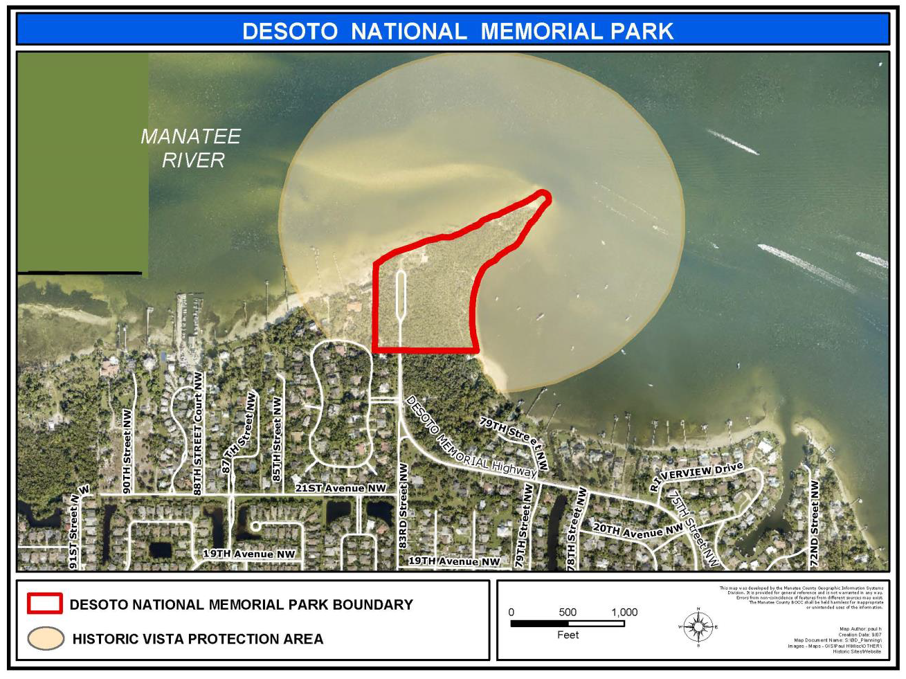
Figure 4-7: Gamble Plantation State Historical Site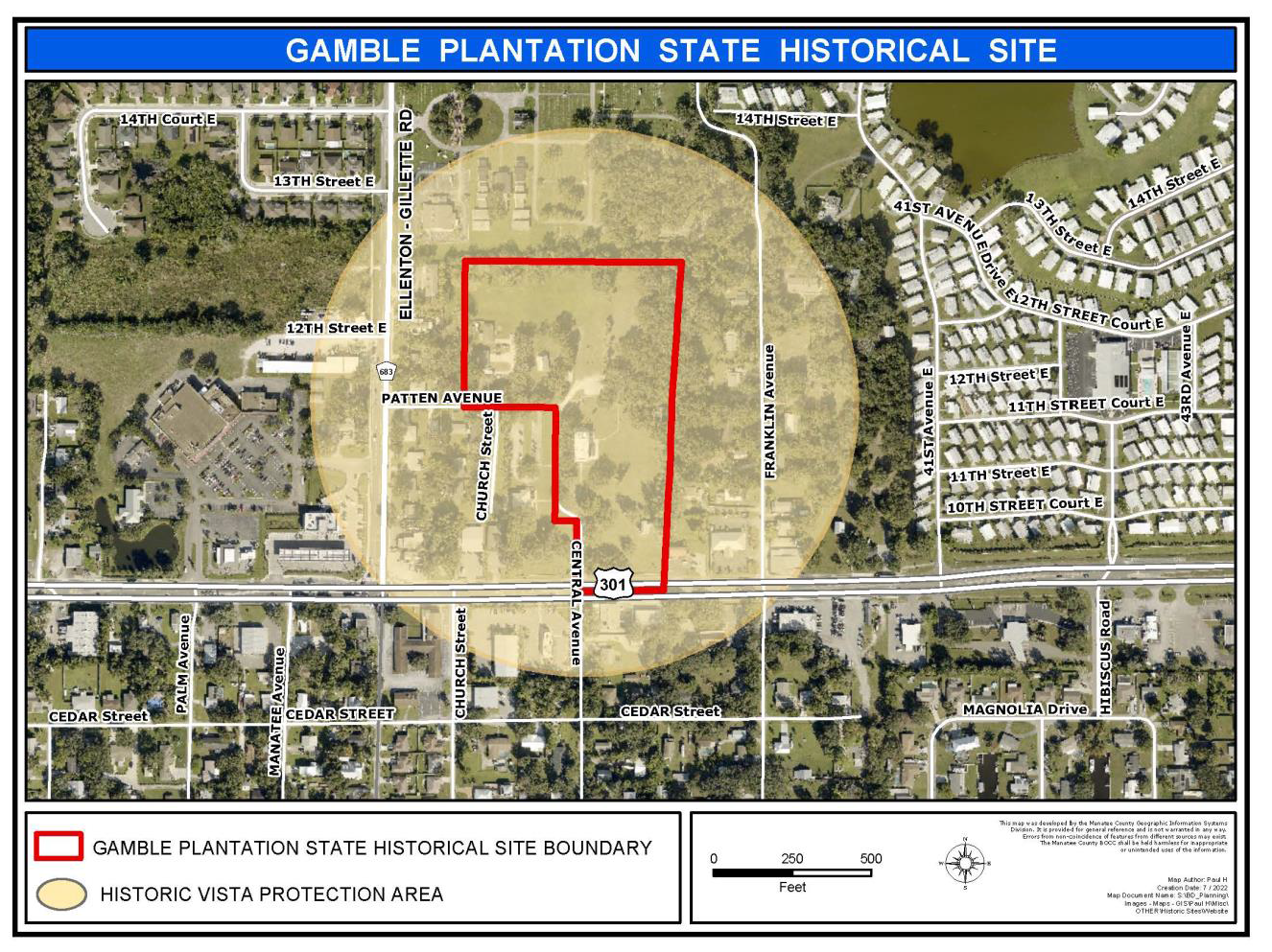
(Ord. No. 19-03, § 3(Exh. A-4), 3-21-19; Ord. No. 23-15, § 3(Exh. A), 2-16-23)
403.7. - Duplex Access Overlay District (DA).
A.
Purpose and Intent. The purpose of this District is to allow an existing duplex to be sold to two (2) separate individuals as single family semi-detached units. To qualify for the Duplex Access Overlay District (DA) relaxed frontage and access limitation requirements, the side of the duplex shall face the street; consequently, the rear unit does not have street frontage.
B.
Boundaries. The Duplex Access Overlay District corresponds to the area outlined in the Official Zoning Atlas.
C.
Frontage and Access Requirements. The rear unit of an existing, qualifying duplex is exempt from the provisions of Section 401.3.B.4, Minimum Front Lot Line and Section 1001.1.B.3., Ingress and Egress Easement, provided that:
1.
The owner of the attached lot fronting the street, shall grant the rear semi-detached unit a non-exclusive ingress/egress and utility and drainage easement. And, if the parking for the rear lot is located on the front parcel, a parking easement is also required;
2.
An appropriate party wall agreement is provided; and
3.
The common wall meets all Florida Building Code requirements.
(Ord. No. 19-03, § 3(Exh. A-4), 3-21-19)
403.8. - Coastal Overlay Districts (CHHA, CEA and CPA).
A.
Purpose. It is the purpose of this section to promote the public health, safety and general welfare, and to minimize public and private losses due to flood conditions in specific areas by enforcing the provisions of this section which were designed to implement the goals, objectives and policies of the Coastal Management Element of the Comprehensive Plan.
The approximate boundaries of the Coastal Evacuation Area (CEA) and Coastal High Hazard Area (CHHA) Overlay Districts are indicated on the Official Zoning Atlas Map. The Coastal Planning Area (CPA) map is found in the Comprehensive Plan. The extent and coverage of the area designated as a Coastal High Hazard Area is subject to a more precise determination for any project based on an evaluation of a predevelopment topographic survey of the site submitted to the Manatee County Department Director for review. Should such an evaluation of the topographic survey indicate that the extent of the CHHA District is somewhat different than what is indicated on the Official Zoning Atlas Map, the predevelopment topographic information will prevail without the property owner having to pursue an amendment to the Atlas Map.
B.
Effect of Mapping/Approvals Required. All properties or portions of properties within the coastal areas listed above (CEA, CHHA and CPA) are subject to the standards and procedures outlined in this section (see also the elevation required by the Floodplain Management Ordinance). For projects partially in the coastal areas listed, the standards of this section shall only apply within the confines of the area boundary.
At the Applicant's request, projects within the coastal area may rezone to Planned Development.
C.
Prohibited Uses/Activities. The following uses are prohibited within the CPA, CEA or the CHHA, as noted below, regardless of the underlying zoning district.
1.
Prohibited in the CPA, which encompasses the CHHA.
a.
New mobile home developments.
b.
Acute care medical facilities, such as hospitals, nursing homes and assisted living facilities.
c.
New wastewater treatment plants. Expansions may only be allowed if it can be demonstrated that they will not adversely affect coastal receiving waters.
2.
Prohibited in the CHHA.
a.
Uses which generate, store, or dispose in excess of 45.4 pounds of hazardous, or 0.45 pounds of acutely hazardous waste materials per month. As used in this section, hazardous and acutely hazardous waste materials shall be defined as substances listed in 40 CFR 261 and adopted within Chapter 403.74, Florida Statutes.
b.
Non-water dependent development activities in submerged areas containing significant seagrass habitats except where necessary to facilitate the continuing use of existing channels, to correct environmental problems caused by limited tidal circulation or other deficiencies of the environmental system or in cases of overriding public interest as determined by the Board of County Commissioners. Overriding public interest cases shall be reviewed through the Planned Development process.
c.
New boat ramps in areas characterized by insufficient depth, sensitive bottom or shoreline habitats, such as seagrass beds.
d.
Development which requires the issuance of a point source discharge permit for discharging into receiving waters which flow into a "prohibited" Florida Department of Environmental Protection shellfish harvesting classification area, except where the "prohibited shellfish harvesting" classification is entirely due to potential for contamination by sewage effluent in areas receiving effluent discharge.
e.
The dredging and filling of submerged lands, except for uses classified and prioritized as water-dependent. Dredging and filling for other uses may be considered upon a finding of overriding public interest by the Board through the Planned Development process. All dredge and fill activities within or adjacent to the Terra Ceia Aquatic Preserve shall be submitted to the Florida Department of Environmental Protection for comments which shall be considered by the Board during project review. For those projects which require dredging or filling activities, an operational plan shall be prepared to prevent degradation of adjacent waters, and to assure placement of soil material on suitable upland areas.
f.
The alteration of coastal wetlands except in instances of proposed water-dependent uses, or in cases of overriding public interest as determined by the Board through the Planned Development process, such as natural resources restoration activities, the location of public access facilities for public recreational facilities. Any alteration shall be subject to mitigation criteria.
g.
The removal or manmade alteration of sand dunes is prohibited unless it can be shown that such removal or alteration would not increase potential flood damage, damage to plant life or increase soil erosion. Under no circumstances shall any use and/or development be permitted which adversely affects the capacity of the channels of any watercourse, drainage ditch and/or other drainage facility in the Coastal High Hazard Area Overlay District.
h.
New asphalt processing and recovery plants and concrete processing and recovery plants shall be prohibited.
3.
Prohibited in the CEA.
a.
The construction of new seawalls and the repair and reconstruction of existing seawalls in the CEA, except as permitted by applicable federal and state regulations.
D.
Use Limitations and Standards. The use of land shall be permitted in accordance with the provisions of the underlying zoning district subject to the following additional restrictions on density and use:
1.
All developments within the Coastal Planning Area District shall be required to remove nuisance exotic plant species.
2.
Densities for single and multi-family boat docking facilities shall be limited to no more than one (1) boat slip for every one hundred (100) feet of shoreline owned unless designated and used for "sailboat only." Property shall have a minimum of one hundred (100) feet along shoreline to receive dock approval. All sailboat only slips shall be clearly posted with a minimum of one (1), three (3) square foot weather resistant sign per slip.
3.
Docking facilities in excess of twenty-five (25) slips shall have basins designated and posted as idle speed zones and access channels designated as slow speed zones.
4.
The density and intensity of development in the CHHA district shall be governed by the underlying zoning district and the policies of the Comprehensive Plan. Development clustering to transfer density and intensity out of the CHHA district is encouraged.
5.
Density of new residential development within the FEMA Velocity-Zone shall be limited to a maximum of three (3) dwelling units per gross acre or to the maximum density allowed in the underlying Zoning district, whichever is less. Any reduction in residential development potential within the FEMA Velocity-Zone resulting from the limit of three (3) dwelling units per gross acre within that area may be re-captured on the subject site in areas outside of the velocity zone where consistent with other provisions of this LDC and the Comprehensive Plan.
6.
Non-industrial redevelopment activities within the FEMA Velocity-Zone of the Coastal High Hazard Area shall be limited to the density/intensity in existence for the development site prior to the effective date of the Comprehensive Plan; or be limited to three (3) dwelling units per gross acre or the maximum Floor Area Ratio associated with the zoning district and Future Land Use designation(s) on the project site for only the area within the velocity zone, whichever is less. All such redevelopment activities shall also be subject to compliance with other applicable goals, objectives, and policies of the comprehensive plan, and all applicable development regulations.
7.
Industrial uses shall not have adverse impacts on coastal resources except where such impact is unavoidable and a finding of overriding public interest is made by the Board of County Commissioners through the Planned Development process.
8.
New residential projects shall have thirty-five (35) percent landscaping/open space, and new non-residential projects shall have thirty (30) percent landscaping/open spaces, unless a stricter standard is required elsewhere in this LDC. All such open space shall be improved and maintained by the developer/homeowner's association.
E.
Setback Requirements and Wetland Buffers.
1.
Minimum Setback. Minimum setback lines shall conform to both the Coastal Construction Control Line, where designated by the Florida Department of Environmental Protection and the wetland buffer established in this subsection.
2.
Wetland Buffer Adjacent to Special Waters. Wetland Buffers of fifty (50) feet shall be required from the post-development jurisdictional wetlands on the development sites within the Coastal High Hazard Area Overlay District which are adjacent to any Special Water as designated in accordance with Rule 62-302.700(9)(i), F.A.C.
Buffers for isolated wetlands shall be thirty (30) feet.
F.
Upland Preservation and Vegetation:
Upland Preservation. Land developments within the Coastal Planning Area shall preserve representative tracts of native upland vegetative communities.
1.
The size and type of tract to be preserved shall be determined after review of the site, the proposed use for the property, and the viability of preservation.
2.
Vegetation. Fifty (50) percent of the required minimum open space exclusive of areas used for surface water retention/detention shall be retained in the natural vegetation of native upland communities including understory vegetation. If the native upland community areas are less than fifty (50) percent of the required minimum open space exclusive of surface water retention/detention areas, then all of the vegetation shall be retained.
G.
Application Submission Requirements. In addition to the materials required to be submitted with an application for plat, site plan, planned development and/or floodplain management approval, whichever comes first, the applicant for a development in any of the coastal areas listed above shall submit the following:
1.
Evaluation of the impact of the proposed development on hurricane shelter capacity and evacuation clearance times.
2.
Description of special standards for the design and construction of all infrastructure associated with the project intended to minimize risks of damage to such infrastructure, where increased risks of damage due to coastal flooding or wave action can be reasonably anticipated.
3.
A preliminary wetland survey showing the following:
a.
A signed and sealed survey or a delineation performed by a professional qualified for this purpose.
b.
Native upland communities located within project boundaries.
c.
Upland vegetation preservation areas.
4.
The location of any existing seagrass habitat contained within the proposed development site or within fifty (50) feet of the development site boundaries.
5.
The location, size and type of native upland vegetative communities found on the development site.
6.
The general location of all identified cultural resources shown on an appropriate site map including information regarding evidence of on-site cultural resources. Site Development plans must show all identified cultural resources within the project boundaries and include a plan to ensure the continued protection of such resources and/or provide for the mitigation of adverse impacts upon them.
7.
Other documents, as determined by the Department Director, that are necessary to establish that the performance standards for projects within the coastal area are met.
8.
All development applications shall indicate the general location, maximum density/intensity, maximum percentage of impervious surface and type of land use for each portion of the site. Maximum effort shall be made by the developer to minimize impervious surfaces along coastal areas. Included with each application shall be specifications of the measures being used to limit the amount of impervious surface that is directly connected to any drainage facility discharging into any coastal waters.
H.
Review Criteria. Applications for development in the one hundred (100) year floodplain will be reviewed for compliance with the Floodplain Management Ordinance, the Manatee County Building Code, and other applicable flood control regulations. Development orders for projects located within the coastal area (CHHA, CEA and CPA) shall not be approved unless the following standards are met:
1.
The project minimizes the disturbance of natural shoreline resources that provide shoreline stabilization and protect landward areas from the effects of storm events.
2.
The proposed development will not adversely affect existing seagrass habitats.
3.
A Hurricane Evacuation Plan has been prepared in accordance with the requirements of the Division of Emergency Management.
4.
The project conforms to adopted standards for available hurricane shelter capacity and evacuation clearance times.
5.
Provision has been made for the use of special assessments to recoup expenditures for repair of storm related damage to public and private infrastructure within a reasonable time.
6.
Provision has been made for notification to prospective residents and businesses that specific standard and additional costs may be associated with the development project. This notification shall be recorded to run with the land.
7.
Provision has been made for the preservation of a representative area of predevelopment natural vegetative communities.
8.
Developments which will discharge into receiving waters flowing into a "Conditionally Approved" or "Approved" DEP Shellfish Harvesting Area have demonstrated that water quality non-degradation for all applicable parameters will be met. Non-degradation will be assumed when compliance with State Outstanding Florida Water or State Class II water quality criteria is achieved, whichever is more stringent.
9.
Developments adjacent to the boundaries of the Terra Ceia Aquatic Preserve will not result in significant degradation of water quality, shoreline, or estuarine habitat that is either attributable to the development alone or in combination with other developments.
10.
The cumulative effect of the proposed development and existing development will not have a significant impact on adjacent natural resource reservation areas.
11.
Provision has been made for the protection of identified historic resources and/or for the mitigation of impacts upon such resources.
I.
Reconstruction of Structures. When any habitable structure sustains substantial damage due to a natural disaster, the habitable structure shall be relocated to a new location that is outside of the Coastal High Hazard Overlay District provided that sufficient land is available on the subject parcel for such relocation.
J.
Warning and Disclaimer of Liability. The degree of protection required in this section is considered reasonable for regulatory purposes and is based on scientific and engineering considerations. This section does not imply that land outside the CHHA, CEA or CPA will be free from flooding or flood damages. This section shall not create liability on the part of Manatee County or any officer or employee thereof from damages that result from reliance on this section or any administrative decision made thereunder.
K.
Cumulative Impacts. All applications within five hundred (500) feet of natural resource reservation areas as defined in the Comprehensive Plan shall be analyzed for the following:
1.
The density/intensity of existing or planned development adjacent to the natural resource area.
2.
Direct or indirect impacts from existing adjacent development upon the natural resource area.
3.
Estimation of direct or indirect impacts which may result from the proposed application.
4.
Compatibility of proposed application to any management plan for the affected natural resource area and to other aspects of the Manatee County Comprehensive Plan.
5.
The extent to which mitigation measures may compensate for adverse impacts from the proposed application.
L.
Development adjacent to Terra Ceia Aquatic Preserve. In addition to the requirements of subsection J above, all proposed development applications within five hundred (500) feet of the Terra Ceia Aquatic Preserve boundary shall be reviewed by the Florida Department of Environmental Protection and Manatee County for the following aspects:
1.
Consistency with the objectives of the Terra Ceia Aquatic Preserve Management Plan.
2.
The extent to which hydrologic and biologic functions would adversely impact the quality or utility of the preserve.
3.
Existing water quality with respect to Class II and/or Outstanding Florida Waters (OFW) criteria.
4.
Predicted effect from proposed development application upon Class II and/or OFW criteria for affected areas within the Terra Ceia Aquatic Preserve.
5.
Applicant shall be required to conduct surface water quality monitoring program approved by Manatee County, and submit annual reports to the Department Director beginning at the time of Building Permit issuance.
M.
Temporary Dwellings. The provisions of this section shall not apply to a postdisaster temporary dwelling with a valid temporary use permit that meets the requirements specified in Section 521.11 of this Code during the period of time such temporary use permit remains in effect.
(Ord. No. 14-35, § 2, 6-17-14; Ord. No. 19-03, § 3(Exh. A-4), 3-21-19; Ord. No. 20-12, § 3(Exh. 4), 9-3-20/Amd. 11-10-20)
403.9. - Special Treatment Overlay District (ST).
A.
Purpose and Intent. The Special Treatment Overlay District is established to:
1.
Provide additional protection for specific areas of, or resources in, the County that are especially sensitive to or subject to damage by industrial, mining and major earthmoving activities;
2.
Provide procedures whereby Best Possible Technology designed to protect the public health, safety and welfare can be established;
3.
Permit all beneficial uses of such lands consistent with standards and objectives of underlying or otherwise applicable zoning; and
4.
Otherwise implement the stated purpose and intent of this Code. This district shall be applied and operate in conjunction with any other zoning district in which such lands are classified, and that such lands may be used as permitted by such other zoning districts except as limited or qualified by the requirements of such districts or of the Special Treatment Overlay District.
B.
Definitions.
For the purpose of this section, Industrial Use shall mean the industrial land uses identified allowed in the LM and HM zoning districts. Major earthmoving shall be as defined in Section 702.
C.
Exemptions. All earthmoving operations accessory to agricultural activities are expressly exempted from the requirements of this Overlay District.
D.
Considerations in the Review of Atlas Amendments. In addition to the provisions in Section 342 of this Code, Amendments to Official Zoning Atlas, the following factors shall be considered as part of the review of proposed designation of lands as a Special Treatment Overlay District:
1.
The environmental characteristics in an area which require special treatment to protect them from adverse impacts of industrial, mining or major earthmoving activities;
2.
Archaeological or historic characteristics in an area which require special treatment to protect them from the adverse impacts of industrial, mining or major earthmoving activities;
3.
Important public facilities or resources and their location and proximity to proposed industrial, mining, or major earthmoving activities;
4.
The cumulative impacts of industrial, mining and major earthmoving activities which can reasonably be expected to occur in an area; and
5.
The impact of industrial, mining, or major earthmoving activities in a particular area on the public health, safety, or welfare.
E.
Use Regulations. Specific uses may be permitted in this district as allowed by otherwise applicable zoning requirements or districts in which the particular land has also been classified, subject to the following use limitations:
1.
Restrictions on Industrial, Mining and Major Earthmoving Activities. The designation of a Special Treatment Overlay District by the Board shall create a rebuttable presumption against industrial, mining and major earthmoving uses within such district. However, nothing in this section should be construed to bar the County, upon the required showing, from authorizing such uses or from issuing approvals or permits in an area so designated.
2.
Conditions for Approval of Industrial, Mining and Major Earthmoving Activities. An applicant seeking to initiate industrial, mining or major earthmoving activities in a Special Treatment Overlay District may rebut the presumption against such uses by affirmatively demonstrating to the applicable approval authority that Best Possible Technology will be employed to ensure that the proposed activities will not be contrary to the public health, safety, and welfare, and will not cause a degradation of water quality or adverse impact to water quantity or ecological functions. Submission of rebuttable presumption information shall be included with the appropriate application for the specific activity as follows:
a.
Major Earthmoving at the time of Special Permit application in accordance with Section 702;
b.
Phosphate Mining at the time of application for Master Mining Plan in accordance with the Manatee County Phosphate Mining Code (Chapter 220, Code of Ordinances).
c.
Mining Activities, other than Phosphate Mining, at the time of application in accordance with Section 355.
d.
Industrial uses at the time of application for Special Permit application in accordance with Section 316.
3.
Determination of Best Possible Technology.
a.
An applicant seeking to establish the Best Possible Technology for industrial, mining, or major earthmoving activities in a Special Treatment Overlay District, shall provide the Director with the following information in addition to any other information deemed relevant by the applicant, or otherwise required under this Code:
i.
A description of the technologies being used or proposed for similar industrial, mining, or major earthmoving activities;
ii.
Review of current literature relating to technologies being used or proposed for similar industrial, mining, or major earthmoving activities;
iii.
The applicant's proposed determination of the Best Possible Technology achievable for the applicant's activities in the Special Treatment Overlay District; and
iv.
The technical basis for determining the applicant's proposed Best Possible Technology, considering each of the potentially applicable technologies including the factual bases for determinations regarding technological feasibility.
b.
Following receipt of all required information, the applicable approving authority shall determine the Best Possible Technology. In making the Best Possible Technology determination, the following criteria shall be considered:
i.
The specific factors herein enumerated in this section;
ii.
All information submitted by the applicant;
iii.
All scientific, engineering, and technical materials; standards, guidelines, and requirements of other information available;
iv.
The archaeological, environmental, and economic impact of the proposed activities on the public health, safety and welfare; and
v.
Economic disadvantages shall only be considered relevant when analyzed in relation to other activities, or major earthmoving activities authorized by this section in other areas designated for Special Treatment.
F.
Effect on Other Laws. The requirements of the Special Treatment Overlay District are intended to be minimums and shall not abrogate, repeal, or adversely affect the requirements of other applicable federal, state or county laws, or county zoning requirements.
(Ord. No. 19-03, § 3(Exh. A-4), 3-21-19)
403.10. - Watershed Protection Overlay Districts (WP).
A.
Purpose and Intent. The WP Overlay District is established to:
1.
Protect the quality and quantity of potential and existing potable water supplies within public surface water reservoirs and their watersheds within the unincorporated area of the County;
2.
Provide performance standards and best management practices designed to achieve such water quality and quantity protection;
3.
Permit the beneficial use of such lands consistent with such standards, practices, and objectives;
4.
Provide additional protection for specific areas of, or ecological resources in, the County that are especially sensitive to or subject to damage by industrial mining, and major earthmoving activities;
5.
Provide procedures whereby Best Possible Technology designed to protect the public health, safety and welfare can be established; and
6.
Otherwise implement the stated purpose and intent of this Code.
It is further intended that this district shall be applied and operate in conjunction with other applicable zoning districts in which such lands are or may hereafter be classified, and that such lands may be used as permitted by such other applicable zoning districts except as limited or qualified by the requirements of the WP District regulations set forth below.
Should an evaluation of a topographical survey submitted by the applicant indicate that the extent of the watershed (WPE, WPM, WPR) district is somewhat different than what is indicated within the Manatee County Comprehensive Plan Watershed Protection Overlay Districts Map (Map 3-1) and the Future Land Use Map Series, the predevelopment topographic information will prevail as to the specific property. The County will periodically amend the applicable maps to update the boundaries of the Watershed Protection Overlay Districts consistent with previous approvals.
B.
Designated Watershed Protection Overlay Districts. The following have been designated as WP Overlay Districts and are depicted within the Comprehensive Plan on Map 3-1:
Evers Reservoir Watershed Protection Overlay District (WPE);
Lake Manatee Reservoir Watershed Protection Overlay District (WPM); and
Peace River Watershed Protection Overlay District (WPR).
C.
Use Limitations and Standards. Specific uses may be permitted in this district as allowed by the underlying zoning district in which the particular land has been classified, subject to the following requirements; provided, however, that lands with stormwater runoff not discharging either directly or indirectly through surface watercourses of the surficial aquifer leading to said reservoirs, and which do not have the potential for such discharge during a twenty-five (25) year storm through failure of natural or artificial control structures or systems, shall be exempted. Development is permitted if it meets the following minimum criteria and maintains or improves the water quality of the Lake Manatee, Evers Reservoir or Peace River, whichever is applicable.
1.
Agricultural Uses. All agricultural uses in the WP overlay districts shall require Development Review Committee review and approval regardless of the underlying zoning classification.
2.
Public Sewer Required (WPE only). Any project within the WPE district which generates wastewater shall use the Manatee County public sanitary sewer system, unless one of the following are applicable:
a.
The proposed project is located entirely within the Agricultural/Rural (AG/R) category on the Future Land Use Map;
b.
The proposed use consists of a single family dwelling unit located on a lot of record which is not subject to any change in property boundary lines during the development of the proposed land use; or
c.
The proposed project is to be developed without generating a requirement for either subdivision review, or site development or development plan review.
3.
Septic Tanks and Drainfields. The isolated single family dwellings which are permitted septic tanks shall meet the following requirements:
a.
All new septic tanks and drainfields shall be located a minimum distance of two hundred (200) feet from the Ordinary High Water Mark (OHWM) of all surface water bodies that directly or indirectly discharge into a reservoir or surface water tributaries thereof and a minimum of five hundred (500) feet from the OHWM or a minimum of fifty (50) feet from the tributary stream valley, whichever is greater, in areas with an average depth to water table less than three (3) feet in September; and
b.
All new septic tanks and associated drainfields shall be located no closer than two hundred (200) feet to any DEP jurisdictional wetland, including inflowing watercourses. All new septic tank drainfields shall be elevated no less than thirty-six (36) inches above the seasonal high water table.
4.
Stormwater Management. Stormwater management shall comply with Section 801.
5.
Stormwater Runoff (WPM only). Stormwater runoff from a site shall not cause the receiving body of water to violate applicable Federal, State and local water quality standards. Developers may meet this requirement by appropriate analyses of their proposed stormwater management systems, by compliance with best management practices for stormwater runoff in the WPM District as established in the Manatee County Development Standards, or as otherwise approved by the Department Director consistent with the Manatee County Comprehensive Plan. Refer to Section 801, Stormwater Management, for specific performance standards.
6.
Industrial, Mining and Major Earthmoving Activities. The designation of a Watershed Protection Overlay District shall create a rebuttable presumption against industrial, mining and major earthmoving uses within such district.
a.
Conditions for Approval of Industrial, Mining and Major Earthmoving Activities. An applicant seeking to initiate industrial, mining or major earthmoving activities in a Watershed Protection Overlay District may rebut the presumption against such uses by affirmatively demonstrating to the relevant approving authority that Best Possible Technology will be employed to ensure the proposed activities will not be contrary to the public health, safety, and welfare and that such activities will not cause a degradation of water quality or adverse impact to water quantity or ecological functions. Submission of rebuttable presumption information shall be included with the relevant application for the specific activity as follows:
i.
Major earthmoving at the time of application in accordance with Section 702.
ii.
Phosphate mining at the time of application for Master Mining Plan in accordance with the Manatee County Phosphate Mining Code (Chapter 2-20, Code of Ordinances).
iii.
Mining Activities, other than phosphate mining, at the time of application in accordance with Section 355.
iv.
Industrial uses at the time of application for Special Permit application in accordance with Section 316.
However, no application for development approval shall be approved for any mining, major earthmoving, or industrial activity which would violate applicable Federal, State and local discharge standards, including Sections 801 (Stormwater Management) and 706 (Wetland Protection), or cause the receiving body of water to exceed applicable water quality standards.
b.
Determination of Best Possible Technology. An applicant seeking to establish the Best Possible Technology for industrial, mining, or major earthmoving activities in the Watershed Protection Overlay District, shall provide the Director with the following information in addition to any other information deemed relevant by the applicant, or otherwise required under this Code:
i.
A description of the technologies being used or proposed for similar industrial, mining, or major earthmoving activities;
ii.
Review of current literature relating to technologies being used or proposed for similar industrial, mining, or major earthmoving activities;
iii.
The applicant's proposed determination of the Best Possible Technology achievable for the applicant's activities in the Watershed Protection Overlay District; and
iv.
The technical basis for determining the applicant's proposed Best Possible Technology, considering each of the potentially applicable technologies including the factual basis for determinations regarding technological feasibility.
c.
Following receipt of all required information, the applicable approving authority, as specified above, shall determine the Best Possible Technology. In making the Best Possible Technology determination, the following shall be considered:
i.
The specific factors herein enumerated in Section 342.3 of this Code, "Review Criteria for Zoning Map Amendments," above;
ii.
All information submitted by the applicant;
iii.
All scientific, engineering, and technical materials; standards, guidelines, and requirements of other information available; and
iv.
The archaeological, environmental, and economic impact of the proposed activities on the public health, safety, and welfare.
7.
Industrial Waste. Non-residential/non-agricultural development which requires a Chapter 62-4 Florida Administrative Code construction or operating permit for industrial waste treatment may only be allowed if the use is approved through Special Permit to demonstrate that there will be no water quality degradation or adverse water quantity impact.
8.
Hazardous Waste.
a.
No agricultural or land development activities shall dispose or store hazardous materials in excess of two hundred twenty (220) pounds or acutely hazardous material in excess of 2.2 pounds per month. This does not apply to the application of herbicides or pesticides to agricultural lands in a manner consistent with applicable regulations and storage required preceding such application.
b.
No storage area for hazardous or acutely hazardous material may be located within the One Hundred (100) Year Floodplain of any inflowing watercourse or within two hundred (200) feet of the Florida Department of Environmental Protection jurisdictional line of any inflowing watercourses, whichever is greater.
c.
All applications for site plan approval shall show the location and quantity of all proposed storage areas for hazardous or acutely hazardous material.
d.
All storage of hazardous material by new development shall be kept in non-discharge storage facilities as may be required by Section 542.7, Hazardous Materials and Toxic Substances.
9.
Nonpoint Sources. No application for development approval shall be granted where any nonpoint sources, including stormwater runoff from lands during or after mining or reclamation, will cause the receiving waterbody to violate applicable Federal, State and local water quality standards. In connection with such approvals, the Department Director may consider and require establishment and maintenance of filter strips, field borders, and other management practices.
10.
Landfills and Wastewater Treatment. New sanitary landfills and wastewater treatment plants require a finding of overriding public interest from the Board and shall be rezoned to Planned Development.
11.
Treated Effluent and Sludge. Disposal of treated effluent from a public wastewater plant or the disposal of any sludge is prohibited; however, beneficial reuse of reclaimed water from any public wastewater treatment plant shall be allowed in the WPE District as follows:
a.
Such beneficial reuse of reclaimed water shall be limited to public wastewater treatment plants that attain Advanced Wastewater Treatment (AWT) Standards as defined in Section 403.086, Florida Statutes (or successor Statute), and that provide reclaimed water pursuant to Chapter 62-610, Part III, Florida Administrative Code (or successor Rule);
b.
Such beneficial reuse of reclaimed water shall be limited to the portion of the WPE District as generally depicted on Map 3.2 of the Comprehensive Plan, entitled the "Beneficial Reuse Area of the Evers Reservoir Watershed"; and
c.
Such beneficial reuse of reclaimed water shall be accomplished pursuant to a surface water monitoring program approved pursuant to an interlocal agreement entered into between the County and the public entity proposing such beneficial reuse.
12.
Impervious Surface Reduction. All applications for plan approval shall indicate the general location, maximum density/intensity, maximum percentage of impervious surface and type of land use for each portion of the site. Maximum effort shall be made by the developer to minimize impervious surfaces within the WP district. Included with each application shall be specifications of the measures being used to limit the amount of impervious surface that is directly connected to any drainage facility discharging into any inflowing watercourse. The use of one or more of the following strategies shall be considered:
a.
The appropriate use of pervious materials for pedestrian pathways and driveways;
b.
Site design which utilizes the joint or shared use of parking areas or access roads where appropriate;
c.
Clustering of uses within single instead of multiple structures;
d.
Use of native vegetation within buffers and setbacks; and
e.
Utilize development clustering to maximize the preservation of vegetated open space areas in their natural state.
13.
Aviation Facilities. General and commercial aviation facilities shall be permitted only when a finding of overriding public interest has been made by the Board through the Planned Development process.
14.
Feedlots. New confined feedlot operations shall be prohibited.
15.
Watershed Acreage/Open Space. New residential projects shall have thirty-five (35) percent landscaping/open space, and new non-residential projects shall have thirty (30) percent landscaping/open spaces, unless a stricter standard is required elsewhere in this LDC. All such open space shall be improved and maintained by the developer/homeowner's association.
16.
Asphalt and Concrete Plants and Recovery Facilities. New asphalt processing and recovery plants and concrete processing and recovery plants shall be prohibited.
17.
Recreational Uses. Limit recreational uses in the WPE Overlay District as provided for in Section 531.41 (Recreation Uses and Facilities).
18.
Clay Settling Ponds. Use of any clay settling ponds within the WPE watershed is prohibited.
D.
Effect on Other Law. The requirements of the WP District are intended to be minimums and shall not abrogate, repeal, or otherwise affect the requirements of other applicable Federal, State, or County laws and regulations.
(Ord. No. 19-03, § 3(Exh. A-4), 3-21-19; Ord. No. 23-01, § 3(Exh. A), 4-27-23)
403.12. - Reserved.
Editor's note— Ord. No. 22-06, § 3(Exh. A), adopted April 7, 2022, repealed § 403.12, which pertained to North Central Overlay District (NC) and derived from Ord. No. 16-06, § 3(Exh. A-3), adopted Nov. 15, 2016; Ord. No. 16-24, § 3(Exh. A-4), adopted Nov. 15, 2016; Ord. No. 19-03, § 3(Exh. A-4), adopted March 21, 2019; and Ord. No. 20-12, § 3(Exh. 4), 9-3-20/Amd. adopted Nov. 10, 2020.
403.13. - Whitfield Residential Overlay District (WR).
A.
Purpose and Intent. The WR District is established to: (1) officially designate areas having special and substantial public interest in protection of existing or proposed character, or of principal view of, from, or through the WR Overlay District; (2) provide additional land use controls to protect the established, primarily residential character of that part of Manatee County previously known as the "Whitfield Zoning District."
B.
Boundaries. The WR District corresponds generally to the area outlined as WR in the Official Zoning Atlas. This zoning classification is not intended to be applied elsewhere in Manatee County.
C.
Use and Dimensional Regulations. In addition to, any other requirements of this Code, the following regulations shall apply to all land in the WR District used or developed for residential dwelling units on individual lots.
1.
Front Yard Setbacks. The front yard setback shall be thirty (30) feet except that the front yard setback shall be forty (40) feet for all property platted as part of Ballentine Manor Estates Subdivision, as shown in Plat Book 2, Page 136, of the Official Records of Manatee County, Florida.
2.
Minimum Floor Area.
• Single Family Detached: 1,400 sq. ft.
• All Other Residential: 950 sq. ft./dwelling unit. The construction of an Accessory Dwelling Unit is prohibited.
3.
Accessory Uses and Structures. This section applies to all residential uses.
a.
Accessory uses and structure(s) shall not be located in any required yard other than a rear yard except for statues, arbors, trellises, flagpoles, planters, mailboxes, outdoor lighting, or similar structures; or fences in the side yard.
b.
An accessory structure(s), when allowed, shall not occupy more than twenty-five (25) percent of a required rear yard area.
4.
Fences and Hedges. No fence or hedge shall be erected or maintained in the front yard of a residence. Shrubbery and trees may be planted around the building foundation and may be used as accent plantings in ornamental islands and along entrance walkways or driveways. Plantings along driveways and entrance walkways shall be limited to thirty (30) inches in height. In no instance, however, shall such shrubbery or hedges be planted along front property lines or sidewalks. No fence within the WR Overlay District shall exceed six (6) feet in height.
For the purpose of the Whitfield Residential Overlay District hedge shall mean a row of closely planted shrubs, bushes, or other vegetative screening, forming a boundary or restrictive barrier.
5.
Parking of Restricted Vehicles. No restricted vehicle, shall be parked or stored, on the streets and lands within the WR District, including front, rear and side yards, unless the vehicle is contained entirely within an attached carport or garage on the premises.
This restriction shall not prohibit the outdoor parking of:
a.
Commercial vehicles engaged in construction, transportation, or other temporary service at the premises where they are parked.
b.
Vehicles whose registered owner or lessee is the guest of the owner or lessee of the premises; provided however, that such parking in no case shall exceed forty-eight (48) consecutive hours nor more than seventy-two (72) accumulated hours in any one (1) thirty (30) day period.
D.
Temporary Dwellings. The provisions of this section shall not apply to a postdisaster temporary dwelling with a valid temporary use permit that meets the requirements specified in Section 521 of this Code during the period of time such temporary use permit remains in effect.
(Ord. No. 14-35, § 3, 6-17-14; Ord. No. 19-03, § 3(Exh. A-4), 3-21-19; Ord. No. 21-11, § 3(Exh. 2), 8-21-21/Amd. 10-12-21)
403.14. - Restricted Vehicle Overlay District (RV).
A.
Purpose and Intent. To provide for more extensive review of the location of Restricted Vehicles within any residential area, the Restricted Vehicle Overlay Districts are hereby established.
B.
Boundaries. The Restricted Vehicle Overlay District corresponds to the area outlined in the Official Zoning Atlas.
C.
Additional Boundaries. Specific uses may be permitted in this district in accordance with the regulations of the underlying zoning district, except as qualified herein.
1.
No restricted vehicle may be allowed unless it is stored in a completely enclosed garage, building or is located in the rear yard of the dwelling. When located in the rear yard of the dwelling, the restricted vehicle shall be completely screened from view of any adjacent dwelling.
2.
One commercial vehicle, one ton or less, and under nine (9) feet in height, with no attached, visible equipment or machinery when parked in the driveway.
D.
Exemptions.
1.
Commercial vehicles which are engaged in active on-site construction, transportation, or other temporary service for the premises where they are parked.
2.
Outdoor parking in the driveway of restricted vehicles whose registered owner or lessee is the guest of the owner or lessee of the dwelling; provided that such parking in no case shall exceed forty-eight (48) consecutive hours nor more than seventy-two (72) accumulated hours in any one (1) thirty-day period.
E.
Minimum District Size. Five (5) acres.
F.
Temporary Dwellings. The provisions of this section shall not apply to a postdisaster temporary dwelling with a valid temporary use permit that meets the requirements specified in Section 521 of this Code during the period of time such temporary use permit remains in effect.
(Ord. No. 14-35, § 4, 6-17-14; Ord. No. 19-03, § 3(Exh. A-4), 3-21-19; Ord. No. 23-15, § 3(Exh. A), 2-16-23)
403.15. - Manufacturing Development Overlay District (MD).
A.
Purpose and Intent. This section establishes the Manufacturing Development Overlay District (MD) for purposes of implementing the Local Manufacturing Development Program, established pursuant to Sections 163.325—163.3252, Florida Statutes (the "Manufacturing Competitiveness Act" or "Act"). The boundaries of the (MD) and the areas of land included in the (MD) shall be as set forth in Map 4-7. The (MD) shall also constitute the County's Master Development Plan Eligibility Area (MDPEA) for purposes of Section 355.3.
B.
Applicability. Lands included in the (MD) shall be eligible to participate in the County's manufacturing development plan program, subject to and in accordance with Section 355 and the Act.
(Ord. No. 15-03, § 5(Exh. C), 9-3-15/Amd. 1-26-16/Amd. 1-5-17; Ord. No. 19-03, § 3(Exh. A-4), 3-21-19; Ord. No. 23-15, § 3(Exh. A), 2-16-23)
Map 4-7