
Manvel City Zoning Code
ARTICLE II
- DISTRICT REGULATIONS3
Editor's note— Ord. No. 2020-O-15, § 3, Oct. 19, 2020, amended art. II in its entirety to read as herein set out. Former art. II, §§ 77-25—77-36, 77-39—77-40, 77-42—77-54, pertained to similar subject matter, and derived from Ord. No. 2014-O-21, § 3, adopted Aug. 11, 2014; Ord. No. 2014-O-43, §§ 4, 2, 3, adopted Nov. 17, 2014; Ord. No. 2015-O-13, § 3, adopted April 27, 2015.
Sec. 77-25. - Official zoning map; establishment of districts and boundaries.
(a)
Official zoning map. The boundaries of the zoning districts of the city are shown on the official zoning map, which, together with all explanatory matter thereon, is hereby adopted by reference and declared to be a part of this article.
This official zoning map shall be identified by the signature of the mayor, attested by the city secretary and shall be on file in the office of the city secretary.
If changes are made in zoning district boundaries or other matters portrayed on the official zoning map, such changes shall be entered on the official zoning map promptly after the amendment has been approved by the council.
No changes of any nature shall be made in the official zoning map or matter shown thereon except in conformity with the procedures set forth in this article. Any unauthorized change of whatever kind by any person or persons shall be considered a violation of this article.
(b)
For the purposes of this chapter, the city is hereby divided into districts, as follows:
(c)
Rezoning.
(1)
Rezoning is the process of changing the zoning designation of a lot or parcel on the official zoning map from one zoning district to another.
(2)
Rezoning shall conform to the provisions and requirements of Chapter 211 of the Texas Local Government Code, the City of Manvel Comprehensive Plan, and this Zoning Ordinance.
(3)
Applications for a rezoning shall be on a form approved by the Zoning Official and may be initiated by motion of the City Council or by Petition of the owner(s) of the property which is the subject of the proposed zoning change.
(4)
Applications for rezoning shall be accompanied with detailed legal description, survey, or plat.
(5)
The City Engineer may require a traffic impact study for rezoning proposals that may result in increased traffic volumes with significant impact on the capacity and/or safety of the street system.
(Ord. No. 2020-O-15, § 3, 10-19-2020; Ord. No. 2023-O-40, § 3, 12-4-2023)
Sec. 77-26. - Permitted uses.
(a)
Use of land and building. Buildings, structures, land, or premises shall be used only in accordance with the uses specifically permitted in the zoning district classification for the site subject to compliance with parking regulations, height, and area requirements, special conditions and other requirements of the zoning ordinance.
(b)
Permitted use table. The permitted uses in each specific zoning district are shown by means of symbols in the permitted use tables as follows.
The letter "P" in the zoning district column opposite the listed permitted use means the use is permitted as a use of right in that district. The letter "S" in the zoning district column opposite the listed use means the use is permitted in that zoning district only by obtaining a specific use permit as set forth in section 77-50. No primary use shall be permitted in any district unless the letter "P" or the letter "S" appears opposite the listed permitted use. The letter "O" in the zoning district column means that the permitted use is for office functions only.
Parking requirements are in section 77-45.
(c)
Uses not listed. Primary uses not listed in the permitted use table may be permitted by the zoning official in any district where similar uses are permitted. The function and location requirements of the unlisted use must be consistent with the purpose and description of the zoning district, compatible with the permitted uses in the district, and similar in traffic-generating capacity, noise, vibration, dust, odor, glare and heat producing circumstance.
(d)
Accessory use. A use which is customarily incidental to that of the primary existing use, which is located on the same lot or premises as the primary existing use and which has the same zoning district classification shall be permitted as an accessory use without being separately listed as a permitted use.
(e)
North American Industry Classification System (NAICS) Codes. The activity descriptions in the (2022) NAICS Codes prepared by United States Executive Office of the President, Office of Management and Budget, (https://www.census.gov/naics/) shall be used to determine the primary establishment uses when reference is made to the tables to a designated standard industrial classification. Annually, staff shall determine if the manual has been revised. If the manual has been revised, such revisions and changes will be summarized in a written report and presented to the planning commission. The commission will make recommendations to the council regarding adoption of the revised changes to the zoning ordinance permitted uses.
(f)
Permitted use table.
Legend:
For business descriptions visit the NAICS website: https://www.census.gov/naics/?58967?yearbck=2022
(Ord. No. 2020-O-15, § 3, 10-19-2020; Ord. No. 2023-O-40, § 3, 12-4-2023; Ord. No. 2025-O-16, § 2, 5-15-2025)
Sec. 77-27. - Open-single-family residential (O-SFR) district.
(a)
Land uses allowed. Uses permitted in the open-single-family residential (O-SFR) district, are set forth in section 77-26(f), permitted use table. Only one single-family detached residence is permitted per platted lot, tract or parcel.
(b)
Minimum lot size.
(1)
The minimum lot area is one acre.
(2)
The minimum front lot width is 120 feet measured at the front setback line.
(3)
Minimum lot size exemption. Existing conforming lots that becoming non- conforming due to reduced lot area resulting from required right-of-way dedication for development shall be considered a conforming lot if:
a.
The resulting reduced lot area is not less than 0.85 acres, and
b.
For lots not served by public water and sewer system, the reduction in lot area does not restrict installation of an on-site sewage facility in conformance to Article IV.- On-site Sewage Facilities of the City of Manvel Code of Ordinances.
(c)
Setbacks, minimum.
(1)
Principal structure. The minimum front yard setback shall be 25 feet. The minimum side, corner side and rear yard setbacks shall be 20 feet.
(2)
Accessory structure. The minimum side, corner side and rear yard setback shall be ten feet.
(d)
Parking. A minimum of one off-street parking space is required per dwelling unit.
(e)
Maximum building height. The maximum height of any building in the open single-family residential district shall not exceed 40 feet measured from the finished grade to the highest point of the roof, not including ancillary structures such as chimneys.
(f)
Accessory dwelling unit (ADU). One accessory dwelling unit is allowed if all the requirements of section 77-37 are satisfied.
(Ord. No. 2020-O-15, § 3, 10-19-2020; Ord. No. 2023-O-40, § 3, 12-4-2023; Ord. No. 2024-O-24, § 3, 8-19-2024)
Sec. 77-28. - Single-family residential (SFR) district.
(a)
Land uses allowed. Uses permitted in the single-family residential (SFR) district, are set forth in section 77-26(f), permitted use table. Only one single-family detached residence is permitted per platted lot, tract or parcel.
(b)
Minimum lot size.
(1)
Minimum lot area is 6,300 square feet.
(2)
The minimum front lot width is 60 feet measured at the front setback line.
(3)
Minimum lot width for a cul-de-sac lot is 20 feet measured at the street edge and 60 feet measured at the setback line.
(c)
Setbacks, minimum.
(1)
Front yard: The minimum front yard setback shall be 25 feet.
(2)
Side yard: The minimum side yard setback shall be five feet.
(3)
Corner side yard: The minimum corner side yard setback shall be ten feet.
(4)
Rear yard: The minimum rear yard setback shall be 15 feet for the principal structure.
(5)
Accessory structure. The minimum side and rear yard setback shall be five feet and corner side setback shall be ten feet. Accessory structures shall not extend past the front line of the principal structure.
(d)
Parking. A minimum of one off-street parking space in an enclosed garage is required per dwelling unit.
(e)
Maximum building height. The maximum height of any building in the open-single-family residential district shall not exceed 40 feet measured from the finished grade to the highest point of the roof, not including ancillary structures such as chimneys.
(f)
Accessory dwelling unit (ADU). One accessory dwelling unit is allowed if all the requirements of section 77-37 are satisfied.
(Ord. No. 2020-O-15, § 3, 10-19-2020; Ord. No. 2023-O-40, § 3, 12-4-2023; Ord. No. 2024-O-24, § 4, 8-19-2024)
Sec. 77-29. - Planned unit development (PUD) district.
(a)
Purpose. The purpose of a planned unit development district (PUD) is to promote diversity and creativity in site design. The PUD process is provided as an option to encourage unique developments which may combine a mixture of residential and non-residential land uses and building functions. The PUD allows flexibility in the application of development standards by permitting departures from the conventional siting, setback, and density requirements of a particular zoning district in the interest of achieving site development not otherwise possible.
The purpose of the PUD is to:
(1)
Encourage greater innovative design for new development;
(2)
Allow for a mixture of compatible land use and building functions;
(3)
Promote the highest and best use of the land;
(4)
Protect open space and areas identified as needing additional review based on environmental conditions;
(5)
Facilitate adequate provisions for roads and public facilities;
(6)
Promote alternative transportation methods for circulation and connectivity;
(7)
Protect and enhance natural, historic, and traditional community features; and
(8)
Promote a physical form in the community that supports the vision of the city.
By allowing flexibility in the application of development standards, this process will promote developments that will benefit both the citizens that live, work, and play within the city and visitors coming to the city.
All PUD applications shall be developed in compliance with the standards of the major thoroughfare plan, the city's comprehensive plan and vision statement. The future land use element of the comprehensive plan shall also be considered in all PUD applications. A planned unit development manual ("PUD Manual") establishing the procedural process and requirements for application and approval of a PUD may be adopted and amended from time to time by resolution of the council.
(b)
Effect of ordinance on prior PUD approvals. The ordinance from which this section was derived and the city's PUD manual shall not apply to any PUD application approved by council prior to the city's adoption of the ordinance from which this section was derived. In the event that a previously approved PUD is modified or requires a series of approvals, the application or modification will be evaluated under the rules in effect of the time of the original to the extent required by V.T.C.A., Government Code ch. 245, as amended, or other municipal ordinance.
(c)
Underlying zoning. PUDs are created as an overlay district and the underlying zoning classification shall remain in place. The establishment of a PUD overlay district will supersede the underlying zoning classification unless the PUD expires or is terminated; in which case the underlying zoning classification and related regulations will be enforced. PUDs may be located in any zoning districts, pursuant to the terms and provisions of the ordinance from which this section was derived.
(d)
PUD development size requirements. All PUDs shall meet the size requirements listed in Table 77-29.1. All land within a PUD shall be contiguous unless divided by an existing railroad or publicly owned or regulated right-of-way.
Table 77-29.1. PUD Minimum/Maximum Acreage Requirements
(e)
Eligible applicants. PUD applications may be initiated by a property owner(s) or the city. If the ownership of the land is not under a single ownership, then all owners shall either join in the application or provide a letter of consent to submit with the PUD application. In the event the city is the applicant for a PUD, consent of the property owners is not required.
(f)
PUD approval process. All PUDs shall meet the detailed requirements listed in the PUD manual and are summarized below:
(1)
Pre-application conference. Prior to the submittal of a PUD application, the applicant shall attend a pre-application meeting with the development review committee (DRC).
(2)
Formal application submittal. The applicant shall file a formal submittal of the PUD application and accompanying documentation to the city.
(3)
Planning commission review. The planning commission will conduct a public hearing on all completed PUD applications in accordance with public notification procedures contained in V.T.C.A., Government Code ch. 211, as it may be amended. Prior to consideration of the PUD application by council, the planning commission will provide its final report recommendation to council for action.
(4)
Final approval. Council is the final decision making authority for all PUD applications. Following the receipt of the final report from the planning commission, council shall consider the application in accordance with V.T.C.A., Government Code ch. 211, as it may be amended.
(5)
PUD review criteria. A PUD application shall be evaluated based on the following criteria:
a.
The proposal is unique in design to warrant the use of a PUD and the development is not possible using the existing zoning regulation of the property;
b.
The project depicts creative land development, providing a variety in the development patterns of the city which conform to the intended purpose of the city's comprehensive plan and vision statement;
c.
Mixed uses and building functions if proposed shall be complementary, and pose minimal impact to adjacent uses or functions;
d.
Development within the PUD encourages the use of alternative transportation circulation between structures and open spaces, including pedestrian and bicyclist;
e.
Landscaping areas shall visually enhance the structures within the development and conform to the city's comprehensive plan and vision statement; and
f.
The proposed project is in compliance with the minimum development requirements described in the PUD Manual.
(g)
Administration. The council shall administer the provisions of this section. Council, or its designated agent, may prepare or modify development policies or minimum standards within the PUD Manual deemed essential to the effective administration of this section.
The city reserves the right to waive one or more of the required items of a PUD application as deemed necessary due to the size of the PUD, proposed use, or availability of existing infrastructure in the immediate area; and retains the authority to request additional information deemed necessary to provide a thorough review of the application.
(h)
Zoning map. Every PUD approval shall be considered an amendment to the zoning ordinance for the property involved, and as such will be indicated on the official city zoning map with the approval date and ordinance number.
(i)
Modification of approved PUDs. A modification of an approved PUD which does not deviate more than ten percent from the approved table of land use acreage and/or building function square footage, may be reviewed and action taken by the planning commission without further action by council. Requests for modification of an approved PUD shall be considered in accordance with the procedures outlined in the PUD Manual.
(j)
Monitoring PUD development. The owner or owner's designee shall submit an annual progress report to the city on the PUD anniversary date (the date of final approval of the PUD). The progress report shall provide the percentage of project completed, expected completion date of uncompleted portion, and status of the development.
In the event the owner or designee fails to provide the annual progress report, all permits and plat recordation approval may be frozen and no further permits will be issued or recordation of plats allowed. Should the owner fail to submit the required progress report, the planning commission may consider recommending to the council that the PUD be terminated. If the council determines that an approved PUD is not being developed in accordance with the conditions of approval, the council may terminate the PUD.
(k)
PUD approval. PUD approvals shall be valid from the date of council approval in the following manner: a small PUD shall be valid for four years; a medium PUD shall be valid for eight years; and a large PUD shall be valid for 12 years. All development of a PUD must be completed within the original approved timeframe.
(l)
Extension of PUD approval. PUD extensions may be requested if the project is not completely constructed by the end of the original approval timeline in accordance with the PUD Manual. The owner or designee may apply for multiple two-year extensions provided that building permits have been issued or subdivision plats have been recorded within the time limit of approval. Extensions shall be requested for and approved prior to the expiration of the original PUD approval.
(m)
Dedications and improvements.
(1)
All public dedications and improvements, including (but not limited to) rights-of-way, easements, streets and roads, alleys, pedestrian way, bikeways, sidewalks, storm drainage facilities, sewer systems, and water and electrical distribution systems, shall be provided in accordance with the requirements of this Code and the PUD Manual.
(2)
In conjunction with the open space requirements in section 62-109, each PUD shall dedicate a public safety site to the city for future municipal uses. The amount of acreage required is specified in the PUD Manual.
(n)
Issuance of permits. The approval of a subdivision plat, or the issuance of building or other development permits for the development of an approved PUD may be delayed or issued contingent upon the applicant's providing for adequate access, storm drainage facilities, water and sanitary sewer supply systems, and electrical power supply systems.
(o)
Open planned unit development (O-PUD).
(1)
Development plan. Any property that is currently zoned under the former open planned unit development (O-PUD) district may be developed according to the development plan approved by the council upon recommendation by the planning commission.
a.
At a minimum, a development plan shall include the following:
1.
Scale:
2.
North arrow;
3.
Owner, applicant, engineer, architect and surveyor information;
4.
Name of title of project;
5.
Property lines;
6.
Existing and proposed easements and rights of way;
7.
Roads, driveways, sidewalks, parking, loading areas, and water bodies;
8.
Trash receptacle areas;
9.
All proposed land uses, buildings and structures;
10.
Façade treatments;
11.
Area map of adjacent uses;
12.
Existing trees (tree survey for all trees over four-inch caliper);
13.
Proposed landscaping including plant materials, location, and plant sizes;
14.
Open spaces, parks, trails;
15.
Signage plans including sign locations, materials, colors, and dimensions of such signs;
16.
Detention areas;
17.
Lighting plans; and
18.
Identification of adequate water, sewer, and storm sewer facilities.
b.
Setbacks—Setbacks shall be as specified in the development plan. There is no minimum setback.
c.
Minimum development size or minimum lot size—There is no minimum project development size in the O-PUD district; there is no minimum lot size in the O-PUD district.
d.
Maximum building height—The maximum height of any building in the O-PUD district shall not exceed 90 feet measured from the finished grade to the highest point of the roof, not including projections such as chimneys.
(2)
Land uses. All uses allowed in the open single-family residential (O-SFR), single-family residential (SFR), and light commercial (LC) district shall be allowed in O-PUD.
(3)
Recommendation. The planning commission shall make a recommendation to the council on whether to approve or deny the open planned unit development plan. In order for the open planned unit development plan to be approved, the council must adopt an ordinance which includes all pertinent written and graphic maps and materials identifying the development project.
(4)
Open planned unit development plan conditions of approval. Plan approval in the O-PUD district is subject to conditions of approval by the planning commission and the council which are deemed necessary to make the project in conformance with the required findings of approval.
(5)
Findings of approval. In order for an open planned unit development plan to be approved in the O-PUD district, the planning commission and the council must make written findings that the development conforms with the following findings of approval:
a.
Development within the district encourages pedestrian circulation between structures and open spaces;
b.
Where a mixture of uses are planned within the district, they shall be complementary in function, shall encourage complementary use, and shall be planned to pose minimal impact on each others quality of life;
c.
Vehicular circulation within the district shall be pedestrian friendly, emphasizing slow vehicular speeds, and safe crosswalks where necessary;
d.
Development within the district shall emphasize professionally designed, constructed, and maintained landscape areas with shaded pedestrian gathering areas, landscaped parking lots, and landscaping which visually enhances all structures within the district;
e.
Open space, either active or passive, shall be included and shall be designed and located in a manner to best serve the prospective users;
f.
Signage within the district shall comply with all city regulations governing signs, shall not compete with view of buildings, shall not impede pedestrian or vehicular flow, and shall use natural products to the greatest extent possible;
g.
Development within the zone shall be visually and functionally compatible with surrounding developed property.
(6)
Future revisions. Future revisions to the open planned unit development plan may only be approved following a recommendation by the planning commission and adoption of an ordinance by council.
(Ord. No. 2020-O-15, § 3, 10-19-2020; Ord. No. 2023-O-40, § 3, 12-4-2023)
Sec. 77-30. - Multi-family (MF) district.
(a)
Land uses allowed. Uses permitted in a MF, multi-family district, are set forth in section 77- 26(f), permitted use table. This is the only district permitting apartments as a permitted use.
(b)
Setbacks, minimum.
(1)
All setbacks adjacent to a street shall be a minimum of 25 feet.
(2)
Rear or side yard setbacks not adjacent to a street shall be a minimum of 15 feet and ten feet for accessory structures.
(c)
Density.
(1)
Apartment density. Apartments shall have a maximum density of 15 units per gross acre.
(2)
Condominiums, townhomes, and patio homes shall have a maximum density of seven units per gross acre.
(d)
Maximum building height. The maximum height of any building in the multifamily district shall not exceed 40 feet measured from the finished grade to the highest point of the roof, not including ancillary structures such as chimneys.
(Ord. No. 2020-O-15, § 3, 10-19-2020; Ord. No. 2023-O-40, § 3, 12-4-2023)
Sec. 77-31. - Light-commercial (LC) district.
(a)
Land uses allowed. Uses permitted in a LC, light-commercial district, are set forth in section 77- 26(f), permitted use table.
(b)
Minimum lot size.
(1)
The minimum lot width is 60 feet measured at the setback line.
(2)
The minimum lot depth is 100 feet measured at the setback line.
(c)
Setbacks.
(1)
Minimum front yard setback is 25 feet.
(2)
Minimum rear yard setback is ten feet.
(3)
Minimum side yard and corner side yard is five feet.
(4)
Accessory structure. A minimum side and rear yard setback of five feet and corner side setback of ten feet. Accessory structures shall not extend past the front line of the principal structure.
(d)
Maximum building height. The maximum height of any building in the light commercial district may not exceed 60 feet measured from the finished grade to the highest point of the roof, not including ancillary structures such as chimneys.
(e)
Open storage and display of new or used cars for sale shall only be permitted where in compliance with section 77-52.
(Ord. No. 2020-O-15, § 3, 10-19-2020; Ord. No. 2023-O-40, § 3, 12-4-2023)
Sec. 77-32. - Heavy-commercial (HC) district.
(a)
Land uses allowed. Uses permitted in a HC, heavy-commercial district, are set forth in section 77-26(f), permitted use table.
(b)
Lot size. The minimum lot size is one acre with 120 feet of frontage.
(c)
Setbacks. A minimum front yard setback of 25 feet is required. The minimum side and rear yard setback shall be 20 feet. Accessory structures shall not extend past the front line of the principal structure. A minimum side, corner side, and rear yard setback of 10 feet shall be required.
(d)
Maximum building height. The maximum height of any building in the heavy commercial district shall not exceed 70 feet measured from the finished grade to the highest point of the roof, not including ancillary structures such as chimneys.
(e)
Open storage and display of new or used cars for sale shall only be permitted where in compliance with section 77-52.
(Ord. No. 2020-O-15, § 3, 10-19-2020; Ord. No. 2023-O-40, § 3, 12-4-2023)
Sec. 77-33. - Commercial activities; garage sales.
(a)
Permanent structure required. Except as herein provided, every business within the city must be operated out of a permanent, stationary, site-built building.
(b)
Restroom facilities. Every business within the city must provide permanent restroom facilities on-site available for use by the customers of that business. These facilities shall be located within the same building as the business. Restroom facilities shall be in compliance with all applicable state, county and city building and health code provisions, including restroom facilities for handicapped individuals, for the size and type of business to be conducted at that location.
(c)
Garage sales. Garage sales shall be allowed at private residences as provided in this section.
(1)
As used herein, the term "garage sale" also referred to by such names as "back yard sale," "estate sale," "yard sale," or "porch sale," shall mean a sale or an offer for sale of miscellaneous items to the general public, upon residential property not otherwise being used for commercial purposes. "Occupant" shall mean either the owner-occupant of the premises whereon such sale is to be conducted, or the tenant of the owner, provided such tenant is actually residing upon such premises, and dependent members of the immediate family of such owner, occupant, or tenant.
(2)
Garage sale regulations. No person other than the occupant shall conduct a garage sale. No permit or fee shall be required however there shall be a maximum of six garage sales per calendar year. No garage sale shall be conducted for a period in excess of 72 consecutive hours.
(3)
The garage sale shall be conducted in such a manner by the occupant so as not to create a disturbance or become a traffic hazard or nuisance in the neighborhood.
(Ord. No. 2020-O-15, § 3, 10-19-2020; Ord. No. 2023-O-40, § 3, 12-4-2023)
Sec. 77-34. - HUD-Code manufactured home (HCMH) district.
In addition to any city regulations of mobile homes and HUD-Code manufactured homes, the following regulations shall also apply in the HUD-Code manufactured district:
(1)
Existing mobile homes. An existing mobile home may only be replaced by a HUD-Code manufactured home, as defined by these regulations;
(2)
Non HUD-Code manufactured homes. Mobile homes that are not HUD-Code manufactured homes may not be installed within the city;
(3)
Lots that have a primary building. HUD-Code manufactured homes shall not be permitted as accessory buildings on a lot, which has a primary building;
(4)
Lots with other residences. HUD-Code manufactured homes shall not be located on a lot with any other residence;
(5)
Compatibility. Skirting or screening materials shall be compatible with the design of the HUD- Code manufactured home;
(6)
Attachment. Skirting or screening materials shall be attached to the HUD-Code manufactured home to prevent the passage of animals beneath the home;
(7)
Removal. Tires, wheels, axles, towing and like mechanisms shall be removed from the HUD- Code manufactured home and placed out of sight of the public;
(8)
Land uses allowed. Uses permitted in a HCMH, HUD-Code manufactured home district, are set forth in section 77-26(f), permitted use table. This is the only district permitting HUD-Code manufactured homes as a permitted use.
(9)
Maximum building height. The maximum height of any building in the HUD-code manufactured home district shall not exceed 40 feet measured from the finished grade to the highest point of the roof, not including ancillary structures such as chimneys;
(10)
Parking. A minimum of one off-street parking space is required per dwelling unit;
(11)
Minimum lot size.
a.
The minimum lot width is 120 feet measured at the setback line.
b.
The minimum lot area is one acre.
(12)
Setbacks, minimum.
a.
Front yard: 25 feet.
b.
Side yard: five feet.
c.
Corner side: 10 feet.
d.
Rear yard: 15 feet for the principal structure.
e.
Accessory structure: Five feet for the side and rear yard and ten feet for the corner yard. An accessory structure may not extend past the front line of the principal structure.
(13)
Replacement. Replacement of existing mobile homes or HUD-Code manufactured homes. Nothing in this section shall preclude the replacement of an existing mobile home or HUD-Code manufactured home in any zoning district with a HUD-Code manufactured home. The mobile home or HUD-Code manufactured home that is being replaced shall be removed within 30 days from placement of the new HUD-Code manufactured home.
(Ord. No. 2020-O-15, § 3, 10-19-2020; Ord. No. 2023-O-40, § 3, 12-4-2023)
Sec. 77-35. - Highway mixed-use (HMU) district.
(a)
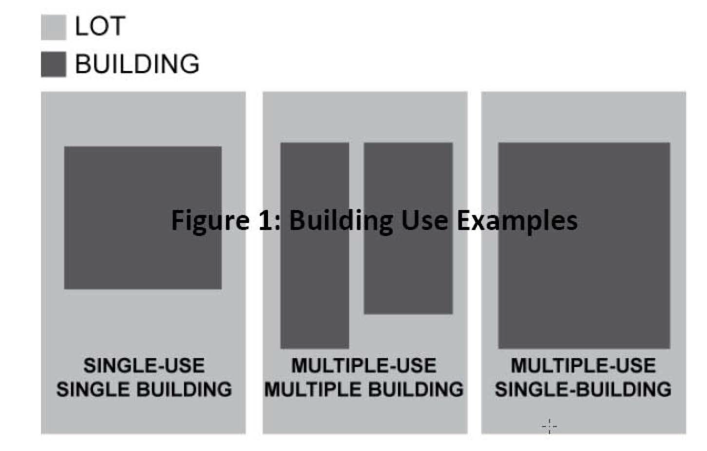
Purpose. The purpose of the highway mixed-use district (HMU) is to allow a mixture of residential and non-residential development along state highways or farm-to-market roads, as designated by the Texas Department of Transportation, either as a single use or multiple-uses within the same building or located on the same lot (see Figure 1: Building Use Examples). It is the intent of this section to allow a use in existence at the time that the HMU is adopted to remain as a conforming building use, even if the use was non-conforming in the existing zoning district prior to the adoption of the HMU.
Figure 1: Building Use Examples
(b)
Location. Properties with the zoning designation of HMU district must be located adjacent to at least one side of a state highway or farm-to-market road. To be eligible to be zoned or rezoned as HMU, a property must be within 700 feet from the state highway or farm-to-market road right-of- way line. In the event a parcel is bisected by the 700 foot distance limitation, the current zoning district will remain in place for the portion of the parcel that is located outside the HMU. However, when considering specific parcel physical characteristics such as size, width, and shape or physical barriers such as, but not limited to, drainage facilities within or adjacent to specific parcels, the council may deviate from the 700-foot distance, either less or more, to accommodate parcel-specific characteristics. Additionally, when considering multiple contiguous parcels under the same ownership, with at least one parcel being adjacent to one side of a state highway or farm-to-market road, the council may deviate from the required adjacency of all parcels to accommodate the multiple contiguous parcels and single ownership characteristic.
(c)
Land uses allowed. Uses permitted in a HMU, highway mixed-use district, are set forth in section 77-26(f), Permitted use table. Only one single-family detached residence is permitted per platted lot, tract or parcel.
(d)
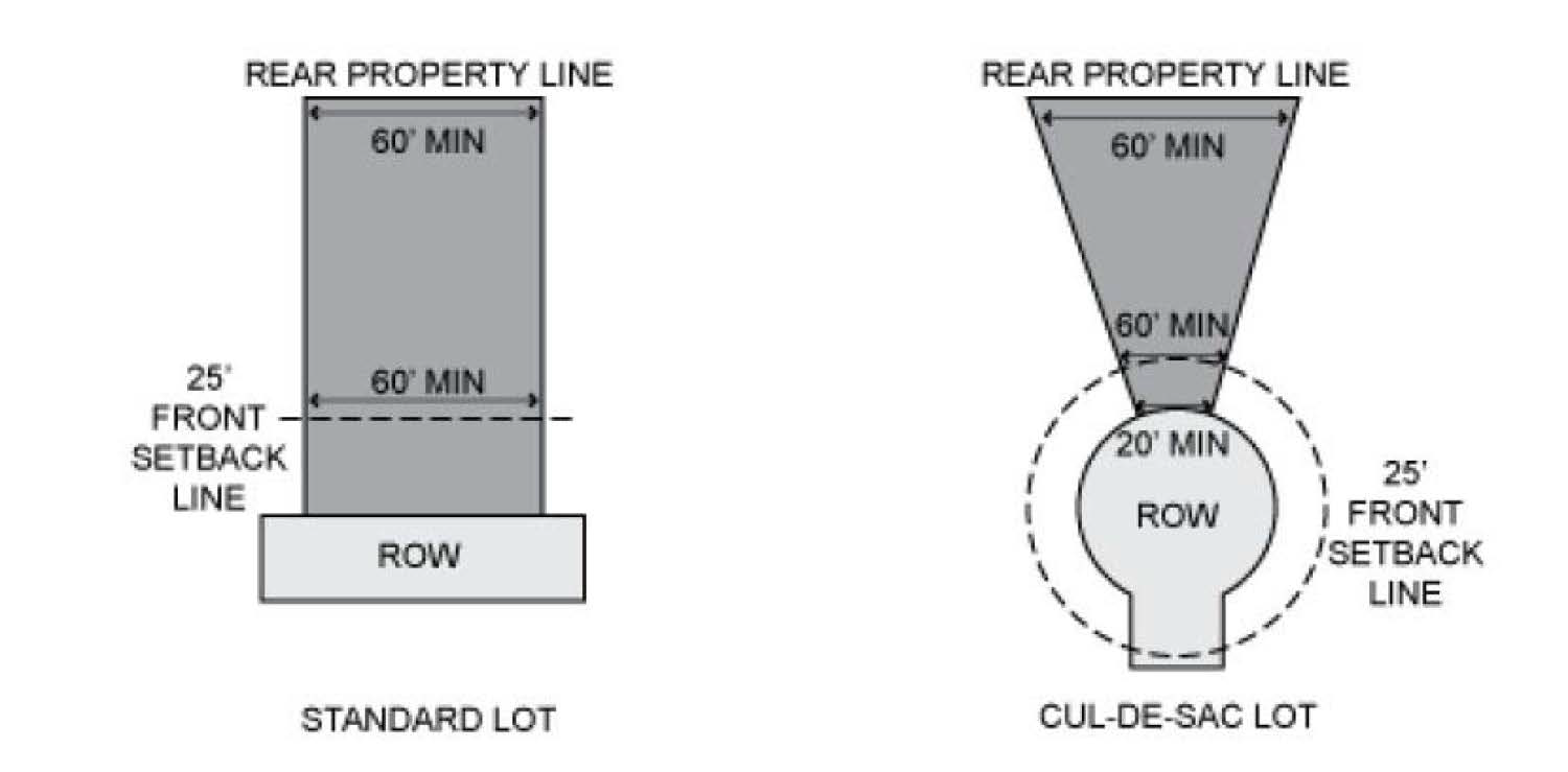
Minimum lot size. (See Figure 2: Lot Size Measurements)
(1)
The minimum lot area is 6,300 square feet.
(2)
The minimum lot width is 60 feet measured as a straight line at all points between the front building setback line and the rear property line(s).
(3)
The minimum lot width for a cul-de-sac lot is 20 feet measured at the street right-of-way (ROW) line and 60 feet measured as a straight line at all points between the front building setback line and the rear property line(s).
Figure 2: Lot Size Measurements
(e)
Setbacks, minimum.
(1)
Minimum front yard building setback is 25 feet measured as a straight line from the front property line.
(2)
Minimum rear yard building setback is 15 feet for the principle building measured as a straight line from the rear property line.
(3)
Minimum side yard building setback is ten feet measured as a straight line from any side property line.
(4)
Minimum corner side yard building setback is ten feet measured as a straight line from the corner side street right-of-way.
(5)
Minimum side and rear yard building setbacks for an accessory structure are five feet and the minimum corner side yard building setback is ten feet measured as a straight line from any side or rear property line. Accessory structures cannot extend past the front line of the principle building or between the building and the street ROW.
(f)
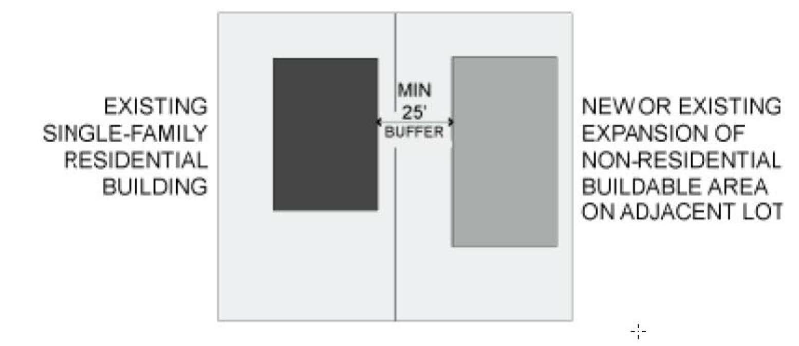
Buffers for existing single-family residential.
(1)
All new non-residential development or non-residential redevelopment or expansion is required to provide a minimum 25-foot wide open space buffer from all adjacent primary single-family residential buildings existing at the time the HMU is designated by council (see Figure 3: Single-Family Residential Buffer Example).
(2)
Buffers required in subsection (f)(1) above, will no longer be required if:
a.
The pre-existing single-family building is expanded, and such floor area expansion or addition is greater than 35 percent of the original building square footage or greater than 800 square feet;
b.
The use of the pre-existing single-family building is completely changed to a non- residential use; or
c.
The pre-existing single-family building is removed completely.
Figure 3: Single-Family Residential Buffer Example
(g)
Parking.
(1)
Refer to section 77-45, parking, for on-site parking requirements for this section.
(2)
All new non-residential buildings within the HMU will locate parking behind the primary building but not between the primary building and the street ROW.
(h)
Building height.
(1)
Maximum height for any single-family residential building will not exceed 40 feet measured from the finished grade to the highest point in the roof with a maximum of three stories, but not to include ancillary structures such as chimneys.
(2)
Maximum building height for any non-residential building will not exceed 60 feet measured from the finished grade to the highest point in the roof with a maximum of five stories, but not to include ancillary structures such as chimneys.
(3)
Maximum building height for any building containing a combination of residential and non-residential uses will not exceed 60 feet measured from the finished grade to the highest point in the roof with a maximum of five stories, but not to include ancillary structures such as chimneys.
(Ord. No. 2020-O-15, § 3, 10-19-2020; Ord. No. 2023-O-40, § 3, 12-4-2023)
Sec. 77-36. - State Highway 6 overlay (SH-6) district.
(a)
Purpose. The purpose of the State Highway 6 (S.H. 6) overlay district is to manage critical visual elements and to promote future development that showcases S.H. 6 as a high-quality, mixed- use, multi-modal transportation corridor in Manvel. This overlay is intended to direct development in the S.H. 6 corridor toward compliance with the comprehensive plan.
As an overlay district, the requirements specified herein are in addition to the existing zoning districts, and as such, do not replace any current zoning or any specific requirements of the existing zoning districts.
(b)
Location. The S.H. 6 overlay district will extend along S.H. 6 from the eastern city limit to the western city limit at a depth of 700 feet from the right-of-way along both sides of S.H. 6. In the event a parcel is bisected, the current zoning district will remain in place for the portion of the parcel that is located outside the S.H. 6 overlay district, and the S.H. 6 overlay requirements will not.
(c)
Exterior building materials.
(1)
All building façades must be constructed of a minimum of 90 percent masonry materials on all non-transparent portions of all exterior walls. The percentage of masonry materials is calculated on a per façade basis. Permitted masonry materials include:
a.
Stone;
b.
Brick;
c.
Concrete;
d.
Hollow clay tile;
e.
Decorative concrete block or tile;
f.
Glass block;
g.
True stucco.
The use of any material that is not specified on the above permitted masonry materials list is prohibited.
(2)
Up to the remaining ten percent of all exterior walls on non-transparent portions of the building may be constructed of materials not listed in the permitted masonry materials list but under no circumstances will the following prohibited materials be allowed:
a.
Sheet metal material; coated, galvanized, or uncoated with a metal thickness less than one-quarter inch;
b.
Smooth concrete masonry units (CMU) or block, painted or un-painted;
c.
Exterior insulation finish systems (EIFS);
d.
Plywood or oriented strand board (OSB).
(3)
No more than 75 percent of any façade may consist of glass.
(d)
Parking.
(1)
Refer to section 77-45, parking.
(e)
Dumpster/mechanical screening.
(1)
Exterior trash receptacles and recycle bins should be located behind a building and not visible from S.H. 6. If an exterior trash receptacle or recycle bin cannot be located behind a building, it must be enclosed on all sides with screening material at least as high as the top of the receptacle/bin and composed of the same materials as used in the building façade. The enclosure gate must be of solid metal painted to match the color of the enclosure material(s).
(2)
All building systems and mechanical equipment must be screened from public view by being located at the rear of a building, on the roof out of public view, or fully screened by the same materials as used in the building façade.
(f)
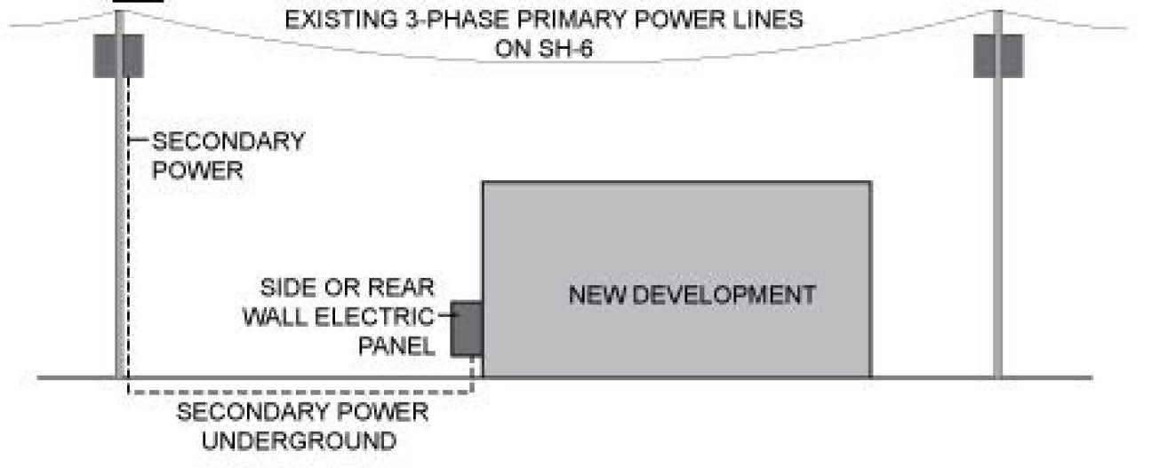
Electric, phone, utility and cable line location.
(1)
When determined by the utility provider as physically possible, all new three-phase (primary) overhead power lines will be located at the rear of new developed property.
(2)
Secondary power connections for new development and substantial improvement from existing power poles will be placed underground.
(3)
Electrical panel boxes will not be located on a building façade facing S.H. 6.
Figure H.1: Electric, Phone, Utility, and Cable Line Location
(g)
Vehicular access and circulation.
(1)
All developments must provide public access easements (PAE) allowing reciprocal travel between adjacent parcels that meet the following minimum standards:
a.
The PAE must be a minimum 25 feet in width;
b.
The PAE must be continuous between property lines;
c.
The PAE must be paved;
d.
No parking or loading activity within, or with direct access to, the 25-foot minimum PAE is permitted; and
e.
All PAEs within a property must connect to each other and a connection must also be made to any existing PAE located on the property line of an adjacent development.
(2)
Perpendicular PAEs (providing circulation and access perpendicular to S.H. 6):
a.
All developments located within the S.H. 6 overlay district must provide at least one PAE, approximately perpendicular to S.H. 6, from the front property line to the rear property line if any part of the proposed development is more than 1,000 feet from either an existing perpendicular PAE that intersects S.H. 6 or an existing paved public street that intersects S.H. 6.
b.
Perpendicular PAEs must not be more than 1,000 feet apart.
(3)
Parallel PAEs (providing circulation and access parallel to S.H. 6):
a.
All developments within the S.H. 6 overlay district must provide at least one PAE, approximately parallel to S.H. 6; from one side property line to the opposite side property line located no more than 700 feet from S.H. 6.
b.
Parallel PAEs are not required on parcels less than 300 feet deep from S.H. 6.
(4)
In heavy commercial zones only, in lieu of a PAE, an emergency assess easement (EAE) between adjacent properties is required and must meet the following standards:
a.
The gates must be 20 feet wide, marked as emergency access, and equipped with a Knox box.
b.
The EAE must be an improved hard surface incorporated into the fire lanes and able to accommodate emergency vehicles.
(Ord. No. 2020-O-15, § 3, 10-19-2020; Ord. No. 2023-O-40, § 3, 12-4-2023)
Sec. 77-37. - Accessory dwelling unit (ADU).
(a)
Accessory dwelling units may be permitted within open single-family (O-SFR), single-family (SF) Districts, and single-family districts within planned unit developments unless specifically prohibited, provided all the following conditions are satisfied.
(1)
Occupancy: It shall be unlawful for the accessory dwelling unit (ADU) to be leased or rented, whether compensation be direct or indirect.
(2)
Number: One accessory dwelling unit is allowed in addition to an existing single-family home and other accessory structures.
(3)
Maximum size of an accessory dwelling unit.
a.
Open single-family (O-SFR) district and single-family residential lots one acre or greater.
1.
A maximum of 650 square feet of conditioned space for any accessory dwelling unit or 20 percent of the square-footage of the first story of the principal structure, the greater thereof.
ii.
Single-family residential (SFR) and single-family residential lots less than one-acre.
1.
A maximum 650 square feet of conditioned space for any accessory dwelling unit.
2.
A maximum of 50 percent of the backyard area can be covered by buildings (area behind the principal residence to the rear of the property).
iii.
A garage apartment proposed as a second-floor addition to a pre-existing garage which exceeds the square footage specified in this section are permitted to match the square footage of the footprint of the garage.
(4)
Maximum height: Accessory dwelling units shall not exceed the top wall plate height of the principal structure. In the case of a garage apartment, the maximum height shall be 30 feet.
(5)
Setbacks: All accessory dwelling units must satisfy the minimum setbacks for an accessory structure within the zoning district or planned unit development.
(6)
Utility connection: An accessory dwelling shall not have separate meter services for gas, electricity or water and shall connect to the utilities of the primary structure.
(7)
Kitchen facilities: An accessory dwelling unit may include a kitchenette or cooking facilities.
(8)
Address: The address is the same as the principal residence.
(b)
Drainage: All Accessory dwelling units shall satisfy the minimum requirements for flood damage prevention (chapter 32) and all requirements from the Manvel Engineering Design Criteria Manual.
(Ord. No. 2024-O-24, § 5, 8-19-2024)
Sec. 77-38. - Reserved.
Editor's note— Ord. No. 2014-O-21, § 3, adopted Aug. 11, 2014, repealed § 77-38, which pertained to unspecified land uses and derived from Ord. No. 2001-14, § 15, 6-28-2001.
Sec. 77-39. - Prohibited land uses.
Notwithstanding any other provision of this chapter to the contrary, the zoning official, the planning commission, and the zoning board of adjustment shall have no authority to rule that the following uses are allowed under any zoning district with the city; and the following uses are hereby explicitly prohibited:
(1)
Mobile home;
(2)
Manufactured homes in any district other than a manufactured home district.
(Ord. No. 2020-O-15, § 3, 10-19-2020; Ord. No. 2023-O-40, § 3, 12-4-2023)
Sec. 77-40. - Underground utility lines.
Utility lines serving new buildings or other facilities, including signs and outdoor lighting, outside of the utility easement, shall be placed underground from the building, sign, outdoor lighting, or other facility, prior to occupancy of a new building.
(Ord. No. 2020-O-15, § 3, 10-19-2020; Ord. No. 2023-O-40, § 3, 12-4-2023)
Sec. 77-41. - Reserved.
Editor's note— Ord. No. 2012-O-21, § 3, adopted Aug. 13, 2012, repealed § 77-41, which pertained to noise levels in land uses, and derived from Ord. No. 2001-14, § 17, 6-28-2001.
Sec. 77-42. - Selling merchandise in public right-of-way.
No merchandise, materials, goods, wares, vehicles, or services may be sold in any public right-of-way.
(Ord. No. 2020-O-15, § 3, 10-19-2020; Ord. No. 2023-O-40, § 3, 12-4-2023)
Sec. 77-43. - Fences.
(a)
Permit required. A fence permit is required to authorize the construction, reconstruction, modification, enlargement, extension, or alteration of a fence. Upon completion of construction, the fence shall be inspected by the city to ensure compliance with the provisions of this ordinance and other applicable codes. An application for fence permit shall include the following:
(1)
Location of the fence identified on a survey, plat, or an approved site plan;
(2)
Drawings showing construction details and dimensions necessary to show compliance to the requirements of this section. Engineer stamped drawings, by a professional engineer licensed in the State of Texas, are required for masonry fences that exceed six feet in height; and
(3)
If necessary, photographs to explain the scope of work.
(b)
Exemptions.
(1)
A fence permit is not required for regular maintenance and minor repairs.
(2)
A fence permit is not required for agricultural fences on agricultural properties that are at least two acres in size.
(3)
A separate fence permit is not required for a new fence that has been reviewed and approved as part of a Building or Construction Permit application.
(c)
Location restrictions.
(1)
No fence shall be built on any lot or tract outside the surveyed lot lines;
(2)
No fence shall be built by a private party on public land without the specific prior approval of the public entity. Removal of any such fence or wall shall be at the expense of the private party;
(3)
Fences shall not limit or obstruct the flow of water in natural drainage courses, or drainageways created within easements; and
(4)
Placement of a fence within sight distance triangles is prohibited.
(d)
Design and construction standards.
(1)
Single-family residential zoning districts. Fences in any single-family residential zoning district shall not exceed six feet in height, except when located along a major thoroughfare where fences shall not exceed eight feet in height. Community fences shall have a minimum height of six feet.
(2)
Other zoning districts. Fences in other zoning districts shall not exceed eight feet in height. Residential uses in other zoning districts, including Planned Unit Development (PUD), shall conform to fence standards for single-family residential zoning district.
(3)
Wooden fence construction.
a.
Fence posts shall be installed with concrete footing with a depth of at least a third of the fence post's height above ground.
b.
Rot board shall be installed for wooden privacy fences with pickets/fence Boards. Top cap not exceeding two inches in height may be added to wooden privacy fences.
c.
Height of the top cap and rot board shall not be counted towards the total height of wood fences.
d.
All wooden fences shall be designed in conformance to the specifications and standard details adopted by the City Council and included in the fence permit application form approved by the Building Official.
(4)
Allowance of barbed wire fence is limited to:
a.
Agricultural acreage properties that are at least two acres in size. The barbed wire portion of the fence shall not exceed 52 inches as measured from the natural ground.
b.
Placement of barbed wire cradles on top of fences enclosing public utility buildings, or other public facilities where the City Manager finds such are necessary to address security interest.
(5)
Opaque privacy fences restricting visibility of a vacant property completely from the abutting street are prohibited. Fences along front or street side of a vacant property shall be designed to allow visibility from the abutting street.
(6)
The finished side of all fences, including community fences, shall face outward (posts and supports faced inward to the lot) toward adjacent right-of-way.
(7)
Masonry fences and masonry pillars for fences that are taller than six feet above ground shall be designed by a professional engineer licensed in the State of Texas.
(8)
For masonry walls used as community fence, irrespective of fence height, the city engineer may require that the foundation be designed by a professional engineer licensed in the State of Texas, to ensure structural stability and safety. The city engineer's decision shall be based on factors including the span of the fence; proximity to buildings and sidewalks; abutting land use; soil type; and proposed construction details.
(e)
Maintenance required.
(1)
All fences, including without limitation, fences existing on the effective date of this chapter, shall be kept in good repair. All fences must be maintained to be free from rot, mildew, termite infestation, rust, vandalism, and other sources of physical or visual damage.
(2)
Owner of any fence within the city shall be responsible to maintain the fence in a safe and presentable condition. This shall include, but not be limited to, replacement of broken or defective boards, posts, wire, or other fence parts that may cause the fence to be unsafe or unsightly, and correction of any unsafe lean or structural defect in the fence.
(Ord. No. 2020-O-15, § 3, 10-19-2020; Ord. No. 2023-O-40, § 3, 12-4-2023)
Sec. 77-44. - Tree preservation, landscaping, fencing and screening.
(a)
Intent and purpose. Certain species of mature trees greatly contribute to the image, aesthetics, and identity of the City of Manvel. Development will invariably result in the removal of trees, however, uncontrolled and indiscriminate destruction of trees would detrimentally impact the aesthetic value and enjoyment of the natural environment. Protection and preservation of mature trees along with planting requirements for new development will benefit citizens by maintaining a positive image of the city as a place to live and locate a business. These standards and regulations are intended to:
(1)
Prohibit the indiscriminate clearing of property and promoting responsible design decisions that will preserve as many protected trees as possible;
(2)
Protect the natural ecological environmental and aesthetic qualities of the city;
(3)
Establish the permitting process and standards required to preserve protected trees during construction; and
(4)
Establish planting, screening, and buffering requirements for new development.
(b)
Tree preservation. Any tree that qualifies as a protected tree as identified by this ordinance shall be preserved unless the removal is unavoidable based on the tree removal criteria in section 77-44(b)(6).
(1)
Applicability: Tree preservation requirements only apply to City of Manvel city limits.
(2)
Exemptions: The following are exempt from tree preservation requirements:
a.
Individual lots and lots of record that are less than 20 acres in lot size that are existing as single-family detached or attached dwellings;
b.
Non-protected trees;
c.
Any tree damaged by natural disasters or by disease/ rot and deemed to be a hazard by the zoning official;
d.
Any tree that requires removal by public works, fire, police, or other emergency services personnel actively engaged in fighting a fire or other emergency services response;
e.
Any tree that requires removal or trimming by the Texas Department of Transportation or other state agency with authority, a railroad company, or any public or private utility company with a state or city franchise agreement, where the tree was trimmed or removed according to the entity's adopted tree trimming/removal policy or practices.
f.
Any tree planted, grown and/or held for sale as part of a licensed nursery/greenhouse, retail or wholesale business;
g.
Properties for which construction plans or final plats have been approved prior to the adoption of this section;
h.
Properties identified on a master plan approved by city council prior to the adoption of this section.
(3)
Protected trees:
a.
Any tree with a diameter at breast height (DBH - 4.5 feet) of 19 inches or a circumference of 60 inches, or more, identified in the list of protected tree species in section 77-44(b)(4).
b.
Any tree shown on an approved landscape plan that is necessary to meet the development standards of the zoning ordinance (chapter 77 of the Manvel, Code of Ordinances) or to meet a condition of approval of the development to which the landscape plan applies.
c.
Any tree identified in the list of protected tree species located in the public right-of-way or a property owned by the City of Manvel.
d.
A tree of any size that serves as a screening between commercial and residential uses and zoning district.
(4)
List of protected tree species:
a.
Oak (all variety).
b.
Pecan.
c.
Magnolia.
d.
Elm.
(5)
Clear cutting and burning prohibited: Clear cutting and burning of trees on undeveloped land is prohibited. Parcels proposed for development that include stands of trees shall not be removed in preparation for development. Development shall be designed to, completely, or partially preserve existing stands of trees unless:
a.
No reasonable alternative design at the same density and intensity could be approved.
b.
Relocation of the protected trees to another location on-site or within the city is not practical or economically feasible as certified by an arborist or a landscape professional.
(6)
Tree removal permit required:
a.
No person shall cut down, burn, destroy, remove, move, or effectively destroy through damaging or encroach into the protected root zone of any protected tree on any public or private property unless a valid tree removal permit has been issued based on the tree removal criteria provided in section 77-44(b)(9).
b.
Before a permit can be issued, a tree survey shall be submitted as set out in section 77-44 (b)(7).
c.
The zoning official or designee may require an applicant to provide aerial photograph interpretation of the site and/or additional data for preliminary analysis of large-scale development projects involving tree removal.
d.
For applications that do not meet the tree removal criteria (below), the applicant shall have the right to appeal to the Manvel City Council. An appeal to the Manvel City Council must be filed within 60 days after receiving notice of permit denial. A final decision on the application shall be made by city council upon receiving a recommendation from the City of Manvel Parks Board.
e.
Where the dangerous condition of a protected tree requires its immediate removal to protect against a serious and immediate risk to health, safety or property, a property owner may remove a protected tree without first obtaining a permit. However, within 14 calendar days after removing the tree, the property owner must apply for a tree removal permit and file a written statement describing the protected tree by size, species, and location and explaining the emergency conditions that required its immediate removal.
f.
A tree removal permit is not required for the removal of a non-protected tree.
(7)
Tree survey and preservation plan required:
a.
Generally, all applications for a tree removal permit must include information pertaining to specifications and location of all protected trees; identification of protected trees to be removed and preserved; reason for tree removal; details and specifications of proposed tree replacement; tree preservation plan showing tree protection measures during construction activities, and any other relevant details.
b.
For removal of one or more protected trees from a property proposed for construction, a property owner must submit a written application accompanied by a current tree survey and a tree preservation plan prepared by an arborist or a landscape professional.
c.
For removal of an individual protected tree from a property not proposed for construction, a property owner must file a written application that may accompany a survey, map, or plat of the property showing the location, species, and size of the protected tree that is to be removed and explaining the reason that removal is desired in lieu of a tree survey and preservation plan.
d.
The city may accept a partial tree survey in lieu of a full tree survey if the zoning official finds that protected trees only exist on a portion of the site.
(8)
Tree protection requirement: All existing trees intended to be made part of a proposed development shall be protected during construction activities. The following minimum standards apply to tree protection during construction activities:
a.
Barricades made of wood or fencing material, not less than three feet in height with horizontal and vertical structural members shall be installed at the critical root zone.
b.
In situations where a tree remains in the immediate area of intended development activity where tree protection fence is not feasible, the tree shall be protected by enclosing the entire circumference of the tree's trunk with fence pickets, at least six feet high, banded by wire or other means that does not damage the tree.
c.
Barricades shall be removed only to prepare development site for final landscaping.
d.
Parking or storing vehicles, equipment or materials within critical root zone is prohibited.
e.
Parking or storing vehicles, equipment or materials within critical root zone is prohibited.
f.
Protected trees shall be pruned only for clearance, dead, or hazard branches. Corrective pruning should occur after construction is complete.
(9)
Tree removal criteria: No individual protected tree shall be removed unless it meets one or more of the following criteria based on which a tree removal permit is issued:
a.
The tree is infected with an epidemic insect or disease where a recommended control is not applicable, and removal is the recommended practice to prevent transmission.
b.
The tree poses an extreme public nuisance because of its species, size, location, or condition.
c.
The tree poses a severe safety hazard that cannot be corrected by pruning, transplanting, or other treatments.
d.
The tree severely interferes with the growth and development of a more protected desirable tree.
e.
The aesthetic value of the tree is so low or negative that the site is visually enhanced by the tree's removal.
f.
The tree is in, and within ten feet of, an approved building footprint and results in a dangerous condition.
g.
The tree is located within six feet of a utility easement, and the tree would interfere with the use of the easement.
h.
On properties proposed for development, no reasonable alternative site design at the same density and intensity could be approved and relocation of the protected tree to another location on-site or within the city is not practical or feasible for the survival of the tree.
i.
The tree has a negative impact on the aesthetics and visibility of an existing or proposed development in a manner that the intended purpose of the development cannot be achieved.
(10)
Tree replacement requirement and standards:
a.
If a protected tree is removed in violation of this ordinance, it shall be replaced in accordance with the requirements of this section.
b.
If a protected tree is removed with a valid tree removal permit, it shall be replaced in accordance with the requirements of this section. Tree replacement requirement for removal of individual protected trees with a valid tree replacement permit may be modified or waived when a replacement tree can potentially result in hazardous and unsafe conditions due to existing development or insufficient area for healthy growth of existing or replacement trees, as determined by the city council based on recommendation from the City of Manvel Parks Board.
c.
On properties proposed for development, replacement trees shall be counted towards the landscaping requirements of the zoning ordinance based on its location.
d.
Tree replacement shall be based on the following standards:
•
0—10 inches DBH - one 3-inch or more
•
10—15 inches DBH - one equivalent caliper or two 3-inch caliper
•
15—19 inches DBH - one equivalent caliper or four 3-inch caliper
•
19-inch DBH or more - one equivalent caliper or six 3-inch caliper.
e.
On properties proposed for development, replacement trees shall be installed as part of site development.
f.
On properties not proposed for development, replacement trees shall be installed within 30 days of removal.
(11)
Tree preservation credits: On a site proposed for development, preservation of protected trees specified in section 77-44(b)(3)a. may qualify for tree preservation credits towards development landscaping requirement if the site development plans indicate compliance with tree protection standards of section 77-44(b)(8). Tree preservation credit shall not be used to substitute for tree planting requirement of section 77-44(c)(6). The tree preservation credit shall be based on the following standards:
(c)
Development landscaping. The following regulations shall apply to all new land development projects, except new single-family residential:
(1)
Planting of new yard trees.
a.
New trees shall be planted at the rate of one tree for each 30 feet of street frontage along front and street side yards.
b.
The minimum planting size for yard trees is 2½ inches in caliper measured at the base of the tree.
c.
No new trees shall be planted in public rights-of-way, utility easements, or existing access easements.
d.
For new development, if planting yard trees is not possible due to existing easements along the street frontage, additional parking lot trees at the rate of one tree for each five parking spaces shall be planted. Such trees shall be a minimum of 12½ inches in caliper measured at the base of the tree.
(2)
Planting of trees and shrubs for new parking lots. Trees for new parking lots shall total at least one tree for each ten parking spaces and at the end of each parking row. Trees and landscaping must be located within the parking area in nine feet by 18 feet planting islands protected by a curb or other vehicle obstruction. Such trees shall be a minimum of 1½ inches in caliper measured at the base of the tree. Shrub plantings shall be placed along the perimeter of a parking lot in an amount to provide a visible screen for the parking lot. The shrubs must be maintained at a height of 30 to 36 inches for safety and visibility purposes.
(3)
Maintenance of landscaping. All landscaping must be perpetually maintained in good health by the property owner on which the landscaping lies or by the adjacent property owner. In the case of street trees planted within the right-of-way, the owner of the adjacent property shall have the responsibility for tree maintenance. Trees lost for any reason, with the exception of street or utility work, shall be replaced by the property owner within six months. Replacement trees must be a minimum of three-inch caliper. The responsibility for replacement of trees removed because of natural disaster, vehicular accident, or other similar circumstance, is that of the adjacent property owner regardless of whether that owner is reimbursed by the responsible party.
(4)
Planting areas.
a.
Site areas. All site areas not covered by buildings or paving shall be planted with trees, shrubs, grass, ground covers or other plant materials. Special ground covering materials are permissible in playgrounds or active sports areas or other areas as determined by the city zoning official.
b.
Landscape plans. Landscape plans shall be submitted to the city zoning official at the time of submittal of all other construction plans for all new construction. In the open-planned unit development district landscape plans shall be submitted to the city zoning official prior to consideration of the plan by the planning commission.
c.
Irrigation. All planting areas shall be irrigated. Irrigation plans must be submitted with the landscaping plans and all irrigation materials shall be installed prior to occupancy of the building.
(5)
Required landscape screening and/or fencing.
a.
Air conditioning and other mechanical equipment. Ground mounted mechanical equipment of all types must be fenced or screened with shrub planting from pedestrian view. This requirement does not apply to traffic control equipment boxes, telecommunication housings (smaller than three feet by six feet) or similar public facilities.
b.
Utility facilities. All utility facilities must be screened from pedestrian view subject to a screening and buffering plan approved by the zoning official.
c.
Parking lots. All parking lots for non-residential uses must be landscaped according to these regulations.
d.
Drive-through facilities. Where drive-through lanes or stacking bays and/or service windows are within 50 feet of a side or rear property line that adjoins an existing residential use, a six-foot-high wooden fence must be constructed and retained adjacent to the property line.
(6)
Transitional buffer yard between residential and non-residential uses.
a.
Non-residential development shall provide a ten foot-wide landscape buffer yard when abutting an existing residential development or undeveloped residential zoning district. The buffer yard shall include one tree per 30 linear feet. A screening fence in accordance with section 77-43 is required when a fence is not already present on the abutting residential development or undeveloped residentially zoned land.
b.
New master-planned residential development shall provide a ten foot-wide landscape buffer yard when abutting undeveloped properties zoned for non-residential uses. The buffer yard shall be maintained by the homeowner's association and shall include one tree per 30 linear feet. A screening fence in accordance with section 77-43 is required when a fence is not already present on the abutting property zoned for non-residential uses.
(Ord. No. 2020-O-15, § 3, 10-19-2020; Ord. No. 2023-O-40, § 3, 12-4-2023; Ord. No. 2025-O-14, § 3, 5-15-2025)
Sec. 77-45. - Parking.
(a)
Number of spaces required. The required number of parking spaces are as follows:
(b)
Americans with Disabilities Act (ADA). Parking for land uses, which require handicapped parking spaces shall be provided in the amount stipulated by the Americans with Disabilities Act or other applicable law.
(c)
Shared parking.
(1)
Shared parking is encouraged and intended to make use of parking areas that are not used during certain parts of the day. Shared parking is permitted only with a written agreement between the subject landowners. Such agreement shall be maintained in the office of the city secretary.
(2)
Property on which shared parking is proposed shall be no further than 300 feet from the boundary of the principal property, as measured along public rights-of-way, such as streets or sidewalks.
(3)
No more than 75 percent of the total amount of parking spaces required for the principal use shall be shared parking spaces.
(4)
Required handicapped parking spaces shall not be used in the calculation for shared parking spaces.
(d)
Parking space dimensions.
(1)
The minimum size of a car parking space shall be ten feet wide and 20 feet long for residential or commercial land uses.
(2)
The minimum size of a handicapped parking space shall be as required by the Americans with Disabilities Act.
(3)
Compact car parking spaces shall not be credited to the overall parking calculation requirement.
(e)
Parking lot aisle dimensions.
(1)
The minimum unobstructed aisle width for angled parking shall be 18 feet with the maximum angle being 60 degrees or 15 feet with the maximum angle being 45 degrees.
(2)
The minimum unobstructed aisle width for 90 degree perpendicular parking shall be 24 feet.
(f)
Vehicular backing. No parking space shall be designed so as to require a vehicle to back onto a public street or across a sidewalk, except for residential parking spaces.
(g)
Replacing existing parking. Additions or remodels of an existing land use shall not replace area that is devoted to parking, unless additional offstreet parking is constructed in conformance with this section.
(h)
Parking requirements for unspecified land uses. If parking for a specified use is not identified in the subsection (a) table above, the zoning official shall determine the parking requirements based on the most closely associated land use.
(i)
Mixed/combination of land uses. Where a mixed or combination of land uses is proposed, parking shall be calculated based on the respective requirements of each land use. Shared parking is encouraged, if appropriate.
(Ord. No. 2020-O-15, § 3, 10-19-2020; Ord. No. 2023-O-40, § 3, 12-4-2023)
Sec. 77-46. - Gun ranges.
Gun ranges shall be allowed in the appropriate zoning district, as set forth in section 77-26(f), permitted use table.
(Ord. No. 2020-O-15, § 3, 10-19-2020; Ord. No. 2023-O-40, § 3, 12-4-2023)
Sec. 77-47. - Animals.
Animals, including but not limited to, livestock like cows, horses, donkeys, sheep, goats, buffalo, and exotic animals such as emu, peacock, camels, and lions are not allowed on property less than one acre in size, with the exception of Future Farmers of America (FFA) or 4-H animal-related land uses intended for education or competition.
(Ord. No. 2020-O-15, § 3, 10-19-2020; Ord. No. 2023-O-40, § 3, 12-4-2023)
Sec. 77-48. - Nonconforming land uses and structures.
(a)
Purpose. The purpose of this section shall be as follows:
(1)
To regulate the continuing existence of nonconforming land uses and structures by prohibiting their enlargement;
(2)
To preclude the re-establishment of nonconforming land uses and structures after their abandonment;
(3)
To allow the continued use and normal maintenance of nonconforming land uses and structures; and
(4)
To regulate development that is not in compliance with the city's development regulations
(b)
Applicability. The burden of establishing that any nonconforming land use and nonconforming structure legally existed prior to the effective date of these regulations is the sole burden of the owner.
(c)
Authority to continue.
(1)
A nonconforming land use or nonconforming structure may continue to exist as long as it remains otherwise lawful, subject to the city's regulations.
(2)
No accessory land use or accessory structure shall continue after the principal use or structure has been terminated.
(d)
Maintenance, repair and structural safety. Normal interior and exterior maintenance and incidental repair may be performed on any nonconforming land use or nonconforming structure. Nothing in this article shall be construed to prevent the strengthening or restoration to a safe condition of a structure in accordance with an order of a city official who declares a structure to be unsafe and orders its restoration to a safe condition.
(e)
Enlargement and improvement of a nonconforming land use or structure. A nonconforming land use or structure shall not be enlarged, expanded or extended unless such enlargement, expansion, or extension complies with the city's regulations and the zoning official determines that such enlargement will not result in an increase in the degree of noncompliance with the city's regulations; provided, however, that a nonconforming residential use located in the light commercial (LC) district may be expanded if such expansion does not exceed 50 percent of the current use and the zoning official determines that the expansion complies with all other requirements of this chapter.
(f)
Abandonment. When the use of a nonconforming land use or structure ceases for a continuous period of 180 days or more, it shall not be reestablished or resumed. After abandonment, any subsequent use of the property must conform to all of the city's regulations. The presumption of abandonment may be rebutted upon a showing, to the satisfaction of the zoning official that during such period the owner or agent has:
(1)
Maintained the property in accordance with all city regulations and did not intend to discontinue the use; or
(2)
Has been actively and continuously marketing the land or structure for sale or lease.
(g)
Change of land use. A nonconforming land use may not be changed to any land use other than an allowed land use.
(h)
Damage or destruction of a structure. If greater than 50 percent of the floor area of a legal nonconforming structure or structure containing a legal nonconforming land use, is damaged or destroyed by fire or other casualty, the structure may not be reconstructed and the land use may not be resumed, unless it complies with all applicable city regulations.
(Ord. No. 2020-O-15, § 3, 10-19-2020; Ord. No. 2023-O-40, § 3, 12-4-2023)
Sec. 77-49. - Calculation of measurements.
(a)
Minimum requirements. When a regulation is expressed in terms of a minimum requirement, any fractional result will be rounded up to the next consecutive whole number. For example, if a minimum requirement of one tree for every 30 feet is applied to a 50-foot strip, the resulting fraction of 1.37 is rounded up to two required trees.
(b)
Maximum limits. When a regulation is expressed in terms of maximum limits, any fractional result will be rounded down to the next lower whole number. For example, if a maximum limit of one dwelling unit for every 3,000 square feet is applied to an 8,000 square foot site, the resulting fraction of 2.67 is rounded down to two allowed dwelling units.
(c)
Underground structures. Structures or portions of structures that are entirely underground shall not be included in any measurement.
(Ord. No. 2020-O-15, § 3, 10-19-2020; Ord. No. 2023-O-40, § 3, 12-4-2023)
Sec. 77-50. - Uses requiring specific use permit (SUP).
(a)
Certain uses of land, buildings or structures may not be appropriate under all circumstances in any given zoning district, but may be appropriate where adequate precautions can be taken to assure compatibility with surrounding uses, public need, and the orderly development of the city as a whole. This section provides council and planning commission the opportunity to deny or to conditionally approve those uses for which specific use permits are required. These uses generally have unusual characteristics or are of a public or semipublic character often essential or desirable for the general convenience and welfare of the community. Because, however, of the nature of use, the importance of the use's relationship to the comprehensive plan, or possible adverse impact on neighboring properties of the use, review, evaluation, and exercise of planning commission judgment relative to the location and site plan of the proposed use are required.
(b)
The council, after receiving the recommendation of the planning commission, may by ordinance, grant a specific use permit for the permitted uses, as herein qualified by the permitted use table, in locations and zoning districts to permit a use where they are not otherwise permitted by this article, and may impose any appropriate conditions and safeguards to protect property and property values, and in the interest of health, safety or welfare.
(c)
Where provided for in section 77-26(f), permitted use table, a specific use permit shall be required before that specific use can be permitted within the district specified. A building permit or certificate of occupancy shall not be issued for any use to be located in a zoning district which permits that use, unless a specific use permit has been issued in accordance with the provisions of this section.
(d)
Application procedure. An application for a specific use permit shall be filed with the city. The application shall be accompanied by a conceptual site plan that, complete application, and fees that will become a part of the specific use permit, if approved. Verification of all information contained in the conceptual site plan shall be required to be certified by an engineer and/or surveyor, as applicable, as a condition for the granting of any specific use permit. The accompanying conceptual site plan shall provide the following information:
(1)
Data describing all processes and activities involved with the proposed use.
(2)
Boundaries of the area covered by the site plan.
(3)
The location of existing and proposed building and structure in the area covered by the site plan and the number of stories, height, roofline, gross floor area and the location of building entrances and exits.
(4)
The location of existing drainage ways, and significant natural features.
(5)
Proposed landscaping and screening buffers.
(6)
The location of all curb cuts, public and private streets, parking and loading areas, pedestrian walks, lighting facilities, and outside trash storage facilities.
(7)
The location and type of each wall, fence, and other types of screening.
(8)
The location, height and size of all proposed signs.
(9)
Show all existing or proposed water, sewer and electrical.
(10)
Show all dedicated easements.
(e)
Criteria for approval. In considering any application for a specific use permit, the planning commission and the council shall hold public hearings as with any amendment request and consider the following criteria:
(1)
Conformance of the proposed use with the city's comprehensive plan and land use policies;
(2)
The character of the neighborhood, the zoning and use of nearby properties, and the extent to which the proposed use would be compatible;
(3)
The suitability of the property for the uses permitted by right;
(4)
The extent to which the proposed use would detrimentally affect nearby property, including, but not limited to, sound, light, traffic, aesthetics, odor, dust, vibration, and dangerous or hazardous activity;
(5)
The extent to which the proposed use would affect the capacity or safety of that portion of the street network, other public facilities or utilities, or present parking problems in the vicinity of the property;
(6)
The extent to which approval of the use would harm the value of nearby properties;
(7)
Whether the establishment of the specific use will not impede the normal and orderly development and improvement of surrounding vacant property;
(8)
The extent that adequate utilities, access roads, drainage and other necessary supporting facilities have been or will be provided;
(9)
Whether the design, location and arrangement of all driveways and parking spaces provides for the safe and convenient movement of vehicular and pedestrian traffic without adversely affecting the general public or adjacent developments;
(10)
The extent that directional lighting will be provided so as not to disturb or adversely affecting the general public or adjacent developments;
(11)
Whether there is sufficient landscaping and screening to insure harmony and compatibility with adjacent property; and
(12)
Any other any appropriate conditions and safeguards to protect property and property values, and in the interest of health, safety or welfare.
(f)
Use of property permitted by a specific use permit must commence within one year from the date of approval, unless extended by action of the council.
(g)
In addition to other conditions the council may impose, the following conditions shall apply to the land uses specified below:
(1)
Accommodations. The conditions for hotel (except casino hotels) and motels and all other traveler accommodation shall include:
a.
Hotels (except casino hotels) and motels as defined by NAICS No. 721110 in section 77- 26, permitted uses, shall include the following conditions:
1.
All guest rooms are accessed via interior hallway;
2.
All interior hallways accessed from a central lobby;
3.
A minimum 1,000 square feet dedicated to meeting and event space;
4.
The use of a kitchenette is not permitted;
5.
Maintain a copy of guest registration information for a minimum 30 days which includes guest photographic identification, guest vehicle license plate number, guest permanent address, guest bill including method of payment, guest check-in and check-out dates and times, and number of persons staying in the room(s);
6.
Install and maintain security cameras in each interior hallway, lobby, parking lots, and exterior door;
7.
Require all guests to enter through a central lobby after 11:00 p.m.; and
8.
A hotel owner, operator, or manager must be present and accessible in person on a 24- hour basis.
b.
All other traveler accommodation as defined by NAICS No. 721199 in section 77-26, permitted uses, shall include the following conditions:
1.
Maintain a copy of guest registration information for a minimum 30 days which includes guest photographic identification, guest vehicle license plate number, guest permanent address, guest bill including method of payment, guest check-in and check-out dates and times, and number of persons staying in the room(s);
2.
Install and maintain security cameras in the central lobby, parking lots, and exterior doors;
3.
A facility operator, owner, or manager must be present and accessible in person on a 24- hour basis; and
4.
Require all guests to enter through a central area after 11:00 p.m.
(2)
Adult entertainment business. The conditions for an adult entertainment business shall include:
a.
A business license; and
b.
A minimum of 500 feet from any school, day care, place of worship, or residential neighborhood or other district.
(3)
All other general merchandise stores. All other general merchandise store as defined by NAICS No. 452990, Permitted Uses, shall include the following conditions:
a.
There shall be a minimum separation distance between "dollar/general store" uses of two miles. The distance shall be measured from the nearest dollar/general store property line to the nearest dollar/general store property line; and
b.
A minimum 10 percent gross floor area shall be dedicated to fresh produce, meat, and dairy products.
(4)
Ambulatory health care services. Ambulatory health care services as defined by NAICS No. 621, Permitted Uses, shall include the following conditions:
a.
Unless otherwise required by state law or regulation, the facility is only permitted to operate during the hours of 7:00 a.m. to 10:00 p.m. each day;
b.
All waiting and/or lobby areas shall maintain an unobstructed view from the outside; and
c.
All doors shall remained unlocked and accessible during normal business hours.
(5)
Convenience stores. Convenience stores as defined by NAICS No. 445120, Permitted Uses, shall include the following condition:
a.
A convenience store shall not be located within two miles of an existing convenience store and gasoline station. The distance shall be measured from property line to property line.
(6)
Game room. The conditions for a game room shall include:
a.
A business license;
b.
A minimum of 300 feet from any place of worship, daycare, school, or hospital; and
c.
All doors shall remain unlocked and accessible during normal business hours.
(7)
Gasoline stations. Gasoline stations as defined by NAICS No. 447, Permitted Uses, shall include the following condition:
a.
A gasoline station shall not be located within two miles of an existing gasoline station and convenience store. The distance shall be measured from property line to property line.
(8)
Hospitals. Hospitals as defined by NAICS No. 622 in section 77-26, permitted uses, shall include the following conditions:
a.
Unless otherwise required by state law or regulation, the facility is only permitted to operate during the hours of 7:00 a.m. to 10:00 p.m. each day;
b.
All waiting and/or lobby areas shall maintain an unobstructed view from the outside;
c.
All doors shall remained unlocked and accessible during normal business hours.
(9)
Nursing and residential care facilities. Nursing and residential care facilities as defined by NAICS No. 623 in section 77-26, permitted uses, shall include the following conditions:
a.
Unless otherwise required by state law or regulation, the facility is only permitted to operate during the hours of 7:00 a.m. to 10:00 p.m. each day;
b.
All waiting and/or lobby areas shall maintain an unobstructed view from the outside;
c.
All doors shall remained unlocked and accessible during normal business hours.
(10)
Other personal care services. Other personal care services as defined by NACIS No. 81219 in section 77-26, permitted uses, shall include the following conditions:
a.
Unless otherwise required by state law or regulation, the facility is only permitted to operate during the hours of 7:00 a.m. to 10:00 p.m. each day.
b.
All waiting and/or lobby areas shall maintain an unobstructed view from the outside; and
c.
All doors shall remained unlocked and accessible during normal business hours.
(11)
Place of worship, private school, or governmental agency with an oversized sign. The conditions include:
a.
A minimum of 2,000 feet when the main structure is located 200-feet from the State Highway 288 right-of-way;
b.
An approved site plan; and
c.
Approved sign permit application.
(h)
Time limit. A specific use permit issued under this section shall expire one year after its date of issuance if construction or use authorized there under is not substantially under way prior to the expiration of said one-year period. If prior to the expiration of such one-year period, the owner of property to which a specific use permit applies in writing, for an extension. The council after recommendation from the planning commission may grant such extension for one additional year.
(i)
Revocation. A specific use permit may be revoked or modified, after notice and hearing, for either of the following reasons:
(1)
The specific use permit was obtained or extended by misrepresentation, fraud or deception; or
(2)
That one of more of the conditions imposed by the permit has not been met or has been violated.
(j)
Amendments. The procedure for amendment of a specific use permit shall be the same as for a new application provided however, that the city manager may approve minor variations from the original permit which do not increase density, change in traffic patterns, or result in any increase in external impact on adjacent properties or neighborhoods.
(k)
Application fee. An application fee is required for the processing of each specific use permit request.
(l)
Religious institutions, private school, or governmental agency signs. Consistent with section 53- 17, where the main structure of a property of a religious institution, private school or governmental agency lies within 2,000 feet of the S.H. 288 right-of-way, a sign that exceeds the height and/or area requirements of the sign ordinance may be permitted by the council by approval of a specific use permit incorporating an approved site plan and sign drawings. The procedure and criteria for approval of this section shall apply to an application for this type of specific use permit.
(Ord. No. 2020-O-15, § 3, 10-19-2020; Ord. No. 2023-O-40, § 3, 12-4-2023; Ord. No. 2025-O-15, § 2, 5-15-2025)
Sec. 77-51. - Plan review, landscaping and building facade requirements.
(a)
Site plan review. All site plans and drainage studies shall be approved administratively by the building official, fire marshal, and city engineer and shall be submitted to the appropriate drainage district for non-residential development within the city limits.
(b)
Building setback lines. Building setback lines shall be determined by the property's zoning district.
(c)
Landscape site plan. Prior to the construction and erection of a nonresidential building or structure, a landscape plan shall be submitted to the zoning official for the consideration by the planning commission. The landscape plan shall contain as a minimum the following information:
A conceptual plan of the landscaping identifying the general layout and description of the trees and plans specified.
The plans should contain dimensions and elevations of special structural elements, such as building facades, walls, planters, foundations, berms, walkways, irrigating systems and property boundaries.
Building outlines, parking areas (in accordance with the standards and specification adopted by the commissioner of licensing and regulation of the Texas Department of Transportation, relating to the identification and dimensions of parking spaces for persons with disabilities, as amended, or as otherwise required by federal or state law) and arrangements, fences and structural features to be constructed on the site shall be on the plan.
Landscape plans shall be prepared at the shall of one inch equals 40 feet and on a sheet size of 24 inches times 36 inches. The plan sheets shall contain a scale, north arrow, name and address of the licensed landscape architect, designer or architect and the site owner and/or developer. The plans shall also identify the development and provide a brief description of the property and its location.
Plan shall also include names of owners and/or business of adjacent property owners.
(d)
Minimum landscape requirements. Up to ten percent of the entire area of the side not covered by buildings and not a part of the right-of-way or dedicated public streets or three percent of the gross area of the site, whichever is greater, shall be required as landscaping to meet the requirements of this section:
Trees with a minimum two-inch caliper measured 12 inches from the ground shall be provided along street frontage(s) with the total caliper inches equal to one inch for each 15 feet of frontage. Where intensity of site development makes planting the required trees impractical, an alternate plan may be developed with the approval of the planning commission.
Landscaping and/or decorative fence shall screen outside storage areas, loading docks, garbage collection bins and delivery entrances from adjacent property and public street right-of-way.
Landscaping shall be located so as not to interfere with the act of parking or with parking area maintenance and so as not to create a traffic hazard by obscuring driver or pedestrian vision of the intersections of walkways, driveways, collector lanes and streets or any combination thereof. Landscaping is discouraged within three meters of the state highway right-of-way due to utilities. Plans are required for any type of landscape development on Texas Department of Transportation right-of-way and must be submitted to:
Director of Maintenance
Post Office Box 1386
Houston, TX 77251
Artificial plants and trees shall not be considered in the satisfaction of the outside landscape requirements.
(e)
Maintenance. The owner and tenant of landscaped premises and their agents, if any, shall be jointly and severally responsible for the use of high-quality, hardy and drought-tolerant plant materials. These plants materials must be maintained in a healthy, growing condition at all times. Regular weeding, mowing of grass, irrigation, fertilizing, pruning and other maintenance of all plantings such as free of refuse and debris is required. Any plant that dies must be replaced with another living plant. Failure to maintain the landscaped premises, after written notice allowing up to 60 days to bring the premises into conformance, shall be grounds for the revocation of the certificate of occupancy by the city building official.
(f)
Landscape construction. Prior to issuing a certificate of occupancy, all approved landscaping must be in place, or if seasonal considerations prohibit the completion of the planting of landscape material, a temporary certificate of occupancy may be issued for such time as is reasonable to complete the landscape planting.
(g)
Permits. Building permits and all other necessary permits shall be obtained from the city before construction begins.
(h)
Inspections. The city inspectors shall inspect each phase of construction and certify that the building is constructed according to the city and the standard building code. (A schedule of which may be obtained at city hall).
(i)
Enforcement of violations and penalties. Any construction that is erected in violation of this section shall not be issued a certificate of occupancy, shall not be permitted utility service and shall be fined not less than $5.00 nor more than $200.00 for each offense. Each day that a violation exists shall constitute a separate offense.
(j)
Grandfather clause. Buildings pre-dating the passage of this section shall be grandfathered to their existing conditions unless they impact health, safety [] and welfare. They are encouraged to update their facilities when possible. For expansion and/or additions they must comply with subsection (1).
(k)
Variance and appeals clause. If there shall be any special circumstances connected with any provision of this section, the individual shall have the right to a hearing before the city planning commission to request a variance. This request for a variance must be submitted in writing 72 hours accompanied with any and all pertinent documentation for the city planning commission to review before the hearing. A determination will be made by the commission that granting this variance will not result in increased flood issues, additional threats to public safety, public expense, create nuisances, cause fraud or conflict with existing laws or other ordinances. If the commission should deny the requested variance, the individual shall have the right to appeal the request variance to the council who will have the final judgment in this matter.
When seeking a variance from the city planning commission, it is necessary to bring documentation to explain your circumstances, such as:
(1)
A deed of ownership of the property.
(2)
Paid tax receipt of last year's taxes.
(3)
What is the function of the building?
(4)
What is the setback distance?
(5)
How will the building aesthetics fit in with the surrounding area?
(6)
Is there a general theme that needs to be followed?
(7)
The building is within 600 feet of what thoroughfares?
(8)
Will there be ample parking?
(9)
What utilities, if any, are available?
(10)
Is there a large vehicle access?
(11)
Is there a fire hydrant nearby?
(12)
A copy of the drainage district's drainage study.
(13)
Is the property in the flood plain?
(14)
Will this type of business impede traffic?
(15)
Landscape plan? Who will be responsible for the upkeep?
(l)
Severability clause. In the event any section, paragraph, clause, phrase, provision, sentence, or part of this section or the application of the same to any person or circumstance shall for any reasonable adjudged invalid or held unconstitutional by a court of competent jurisdiction, it shall not affect, impair or invalidate this section as a whole or any part of provision hereof other than the part declared to be invalid or unconstitutional; and the council of the City of Manvel, Texas declares that it would have passed each and every part of the same notwithstanding the omission of any such part thus declared to be invalid or unconstitutional, or whether there be one or more parts.
(Ord. No. 2020-O-15, § 3, 10-19-2020; Ord. No. 2023-O-40, § 3, 12-4-2023)
Sec. 77-52. - Open storage and display of items.
(a)
Open storage and display of items not for sale. Open storage and display of items which are not for sale shall be permitted only when incidental to the principal land use located on the same property and must comply with the following:
(1)
Items may not extend past the front line of the building;
(2)
Items may not be located in any required parking or landscaping areas;
(3)
Items must be behind a fence or wall;
(4)
Materials shall not be visible or protrude above the height of the fence or wall;
(5)
Mobile homes, manufactured homes, and HUD-code manufactured homes may not be stored in any zoning district;
(6)
Storage cargo/shipping containers shall be prohibited, except that the temporary use of such containers may be permitted for up to 30 days total per calendar year.
(7)
Hay and similar items are exempt from this section.
(b)
Open storage and display of items for sale.
(1)
Boats, recreational vehicles, campers, jet-skis, and similar type of vehicles may not be stored in front of the front line of a building of a commercial or residential land use unless such items are for sale as part of a continuous business operation, in which case the items must be set back 25 feet from the front property line and ten feet from any and all side property lines;
(2)
Open storage and display of merchandise for sale or display is permitted only when incidental to a commercial or residential use located on the same property and must not be located in any required parking or landscaping areas and must be set back at least 25 feet from the front property line and ten feet from any and all side property lines. Open storage and display of merchandise for sale or display on property located in the heavy commercial district may extend to the property lines but only when the storage items are behind a chain linked fence or wall of at least six feet in height;
(3)
Mobile homes, manufactured homes, and HUD-Code manufactured homes may not be stored and displayed as an item for sale in any zoning district;
(4)
Storage cargo/shipping containers shall be prohibited, except that the temporary use of such containers may be permitted for up to 30 days total per calendar year. Exemption, heavy commercial district when used as part of the business operation;
(5)
Commercial temporary uses permitted by section 77-54 are exempt from this subsection (b);
(6)
Automobiles, trucks, boats, recreational vehicles, campers, jet-skis, and similar type of vehicles stored or displayed for sale, new or used, shall be on at least four inches of paved asphalt or concrete. Storage and display of items is prohibited within parking and fire lanes as designated by the fire marshal. Nothing herein shall be construed to prohibit the private sale, by owner, of a personally-owned vehicle, boat, trailer, or recreational vehicle, provided such is in operating condition, and when parked, is parked on an all-weather surface on the owner's residential property.
(7)
Garage sales shall be limited to six per calendar year as permitted by section 77-33(c). More than six per calendar year shall constitute commercial use.
(Ord. No. 2020-O-15, § 3, 10-19-2020; Ord. No. 2023-O-40, § 3, 12-4-2023)
Sec. 77-53. - Home business.
The city recognizes that home businesses are becoming a more common method of employment. Home businesses help alleviate traffic, help decrease the cost of doing business, allow people to work who might otherwise be unable to work, and are appropriate within residential areas, subject to certain provisions which are established to maintain the character, quality of life and property values of existing residential areas. A home business does not include a resident occasionally working from home where the resident has a place of business at another location. A home business in a residential home shall be approved by the zoning official if it complies with all of the following standards:
(1)
The home business shall be within the principal residence or a permitted accessory building;
(2)
The home business shall not occupy more than 50 percent of the gross floor area of the principal residence;
(3)
There shall be no exterior indication that the home business is taking place, except that one nonilluminated sign is allowed with a maximum area of two square feet;
(4)
Home businesses include:
a.
Consultant;
b.
Accountant;
c.
Lawyer;
d.
Seamstress;
e.
Hairdresser;
f.
Writer, artist, musician;
g.
Realtor;
h.
Collections/billing;
i.
Therapist;
j.
Day care, with specific use permit;
k.
Teacher/tutor;
l.
Caterer/cook;
m.
Other traditional home occupations, with specific use permit.
(5)
All parking for home businesses shall be off-street. A permit for a home business is only valid so long as the home business remains in compliance with this section.
(Ord. No. 2020-O-15, § 3, 10-19-2020; Ord. No. 2023-O-40, § 3, 12-4-2023)
Sec. 77-54. - Temporary commercial business.
Commercial temporary uses, including, but not limited to, carnivals, circuses, Christmas tree sales, plant sales, pumpkin sales, and agricultural products sales, are allowed in any zone, except residential zones, subject to the following conditions:
(1)
An application must be made to the zoning official, and the appropriate fee paid;
(2)
The zoning official shall approve the application if it is demonstrated that the commercial temporary use conforms to the intent of the comprehensive plan and these regulations, and that the use will not constitute a nuisance or be detrimental to the character or welfare of the community;
(3)
Commercial temporary uses may be approved for a period not to exceed a total of 60 total days per year;
(4)
The temporary commercial sale of vehicles is not authorized under this section;
(5)
The temporary commercial sale of mobile homes, manufactured homes, or HUD-Code manufactured homes is not authorized under this section;
(6)
Christmas tree sales, plant sales, pumpkin sales, agricultural products sales, are allowed in any zone subject to the above conditions.
(Ord. No. 2020-O-15, § 3, 10-19-2020; Ord. No. 2023-O-40, § 3, 12-4-2023)