
Mascotte City Zoning Code
ARTICLE VII
OVERLAY DISTRICTS AND AREAS
Section 7.1.- Special Overlay Districts.
Special Overlay Districts may be created by the City of Mascotte to facilitate unique development activities where there is need for coordination between different land owners in the development of projects where there are special issues of infrastructure, environmental protection, employment activities, protection of historic resources, or other public issues deemed by the City Council to be appropriate for special treatment. There are two (2) current Special Overlay Areas:
(1)
The Community Redevelopment Area; and
(2)
The Green Swamp Overlay Area.
It is the intent of the City that the designation of a Special Overlay District shall put landowners, developers, and the general public on notice that special opportunities exist for the development of the area and, concurrently, that special provisions or limitations may be placed on projects within the area; identify specific standards to be followed in the development of the area, which standards shall supersede conflicting general standards of this Code, but which shall not be inconsistent with the Comprehensive Plan.
A)
Establishment Procedures: The City Council may, from time to time by ordinance, create, dissolve, and/or modify Special Overlay Areas. The following procedures shall be applicable to the adoption of any such ordinance:
1)
The proposal to create or modify a Special Overlay Area shall include a statement of intent, specific boundaries, and a special development plan identifying the proposed special regulations to be applicable therein. Maps and diagrams, in addition to text, to explain the general intent and the specific regulations being adopted shall also be included with the Plan to delineate the conceptual spatial and aesthetic aspects pertaining to each Special Overlay Area.
Special development plans formulated for all Special Overlay Areas shall, at a minimum, identify specific standards pertaining to potential uses of the property, setbacks, size/height/bulk of buildings, provision for mixed and multi-use development, including housing options, master infrastructure requirement, stormwater management, vehicular access provision including cross access, shared access, limited access and planning for future roadway improvement, architectural compatibility, historic preservation, signage, landscaping, pedestrian access, parking, lighting, and the protection of natural resources including trees, lakes and wetland areas. In order to promote flexibility and design innovations, each special development plan shall identify areas where the strict application of standard land development regulations may be waived in return for alternative development options which promote the intents of each Special Overlay Area.
2)
All notices regarding public hearings to consider the creation or modification of the Special Overlay Area shall include reference to the plan and to the location where it can be reviewed. All notices shall also explain that the plan can be modified at the time of adoption of the ordinance, within the limitations of F.S. Ch. 166. All owners having properties situated within the proposed boundaries of each Special Overlay Area shall also be notified by mail at least ten (10) days prior to the public hearings before City Council for adoption of the ordinance. Individual properties do not need to be posted and no notice to surrounding property owners is required in connection with the hearings before the Planning and Zoning Board and the City Council.
3)
The boundaries of the Special Overlay Area shall be shown on the Official Zoning Map along with a reference to the existence of special development standards and the location where the special development plan containing such adopted special standards can be reviewed.
Where the establishment of a Special Overlay Area, or the subsequent approval of a development within such Area, is inconsistent with the provisions of the adopted Comprehensive Plan, the City shall consider the amendment of the Plan and may review and approve the proposed Special Overlay Area and/or individual developments therein in concert with the approval of any necessary Plan amendments.
B)
Administration of a Special Overlay Area: The designation of a Special Overlay Area shall not establish any special requirements for development review procedures except as may be contained within this Section. Before any change of zoning, subdivision approval, or site plan approval is granted within a Special Overlay Area, the approving authority shall review this Section and shall find that the approval is consistent with this Section, as well as with all other applicable requirements of this Code. No approval shall be granted which would violate the provisions of this Section and the special regulations contained within the individual special development plans.
It is the intent of this Section that there be substantial coordination between the City and the different land owners within the Special Overlay Area during and after establishment of each Special Overlay Area. To accomplish this, the City Manager shall have primary oversight responsibility for each area and, from time to time, convene meetings between the various land owners within the Special Overlay Area and interested governmental agencies to implement the provisions of this section.
Additionally, it shall be the primary responsibility of the City Manager to recommend to the City Council each special development plan in consultation with area landowners. In order to expedite the formulation of each special development plan, owner or owners within each Special Overlay Area may contribute funds to permit the City to retain a consultant who will assist Staff in preparing the required documentation.
(Ord. No. 2017-11-574, § 3(Exh. B), 11-14-17; Ord. No. 2018-09-587, § 3(Exh. B), 9-26-2018)
Editor's note— Ord. No. 2018-09-587, § 3(Exh. B), adopted September 26, 2018, enacted the same amendments as Ord. No. 2017-11-574, but provided an updated effective date of September 26, 2018.
Section 7.2. - Community Redevelopment Area (CRA) Overlay District.
A)
CRA Overlay District Legal Description: A portion of Sections 10, 11, 14, 15, and 16, Township 22 South, Range 24 East, City of Mascotte, Lake County, Florida, being more particularly described as follows:
BEGIN at the South ¼ corner of said Section 14, being on the centerline of Avondale Road, a 24.00' right-of-way as shown on Midway, Plat Book 11, Pages 10 & 11, Public Records Lake County, Florida; thence Northerly to the Southeast corner of Lot 23, said Midway; thence Northerly along the East line of said Lot 23 to the Northeast corner thereof; thence Westerly along the North line of Lots 14-23, said Midway to the Northwest corner of said Lot 14; thence Westerly to the Southeast corner of Comunicasa Subdivision, Plat Book 30, Page 77, said Public Records; thence Westerly along the South line of said Comunicasa Subdivision to the East Line of the Southeast ¼ of said Section 15; thence Northerly along said East line to the Southeast corner of the North ½ of the Southeast ¼ of said Section 15; thence Westerly along the South line of said North ½ of the Southeast ¼ of Section 15 to the Southwest corner thereof; thence Westerly along the South line of the Northeast ¼ of the Southwest ¼ of said Section 15 to the Southwest corner thereof; thence Northerly along the West line of said Northeast ¼ of the Southwest ¼ to the Northwest corner thereof; thence Northerly along the East line of the Southwest ¼ of the Northwest ¼ of said Section 15 to the Southeast corner of the North ½ of said Southwest ¼ of Northwest ¼; thence Westerly along the South line of said North ½ of Southwest ¼ of Northwest ¼ to the East line of the Northeast ¼ of said Section 16; thence Northerly along said East line to the Southeast corner of the Southeast ¼ of the Northeast ¼ of the Northeast ¼ of said Section 16; thence Westerly along the South line of said Southeast ¼ of the Northeast ¼ of the Northeast ¼ to the Southwest corner thereof; thence along the West line of said Southeast ¼ of the Northeast ¼ of the Northeast ¼ to the Northerly right of way of State Road 50; thence Northeasterly along said Northerly right of way line to the West line of the Northwest ¼ of said Section 15; thence Northerly along said West line to the Northwest corner thereof; thence Northerly along the West line of the Southwest ¼ of said Section 10 to the Westerly extension of the Northerly right of way line of Lotus Path, a 60.00 foot right of way as shown on Mascotte Hills Unit 1, Plat Book 8 Page 70, said Public Records; thence Easterly along said Westerly extension, the Northerly right of way line of said Lotus Path, and the Easterly extension thereof to the Northeasterly right of way line of Hibiscus Road, a 60.00 foot right of way as shown on said Mascotte Hills Unit 1; thence Southeasterly along said Northeasterly right of way line to the Northwesterly right of way line of Jefferson Street said Mascotte Hills Unit 1; thence Northeasterly along said Northwesterly right of way line to the Southwesterly right of way line of Tuscanooga Road said Mascotte Hills Unit 1; thence Northeasterly to the most Westerly corner of Tract A, Courtney Park Phase 1, Plat Book 41, Pages 90 & 91, said Public Records; thence along the Northerly line of said Tract A to the North line of said Section 15; thence along said North line to the Westerly right of way line of Sunset Street (Groveland Farms Road, said Midway); thence Northerly along said Westerly right of way line to the North line of the Southeast ¼ of said Section 10; thence Easterly along said North line to the West ¼ corner of said Section 11; thence Easterly along the North line of the Southwest ¼ of said Section 11 to the Easterly right of way line of County Road 33 (formerly State Road 33); thence Southerly along said Easterly right of way line to the North line of Tract 4, Bluff Lake Estates, Plat Book 11, Page 79, said Public Records; thence Easterly along said North line to the Northeast corner thereof; thence Southerly along the East line of said Tract 4 and the Southerly extension thereof to the South right of way line of Underpass Road; thence Easterly along said Southerly right of way line to the Westerly right of way line of American Legion Road; thence Southerly along said Westerly right of way line to the South line of the Northeast ¼ of the Northwest ¼ of said Section 14; thence Easterly along said South line to the Southeast corner thereof; thence Easterly along the North line of the South ½ of the Northeast ¼ of said Section 14 to the East line of said Section 14; thence Southerly along said East line to the Southeast corner thereof; thence Westerly along the South line of the Southeast ¼ of said Section 14 to the POINT OF BEGINNING;
Containing approximately one thousand (1,000) acres, more or less.
B)
Maps of the CRA Overlay District:
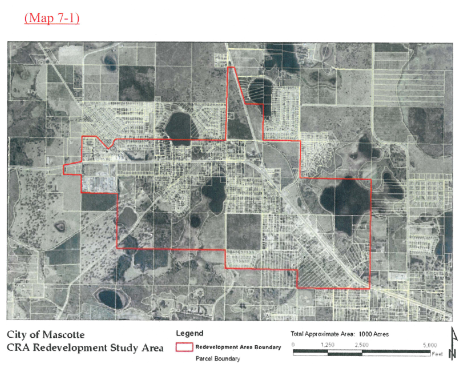
C)
The Community Redevelopment Area Overlay is established to facilitate development and redevelopment in the City's Community Redevelopment Area (CRA). Development of land use within this overlay shall be regulated by this Land Development Code and Section 3.10, Part A.
(Ord. No. 2008-03-460, (Exh. A), 4-21-08; Ord. No. 2017-11-574, § 3(Exh. B), 11-14-17; Ord. No. 2018-09-587, § 3(Exh. B), 9-26-2018)
Editor's note— Ord. No. 2018-09-587, § 3(Exh. B), adopted September 26, 2018, enacted the same amendments as Ord. No. 2017-11-574, but provided an updated effective date of September 26, 2018.
Section 7.3. - Green Swamp Overlay Area.
A)
Green Swamp Area: The GSACSC was designated in 1979 by the Florida Legislature pursuant to the Florida Statutes. This legislation set forth the requirements of the designation that are also found within the Florida Administrative Code. The boundary of the GSACSC is legally described within Rule Chapter 28-28, FAC, and is also described as follows:
All that certain lot, piece, or parcel of land situated, lying, and being in Lake County, in the State of Florida, being more particularly described as follows:
Beginning at a point in Section 34, Township 24 South, Range 24 East, which point is the southwest corner of said Section 34, and running thence in Lake County, north along the west boundary line of Sections 34, 27 and 22 in Township 24 South, Range 24 East, a distance of three (3) miles; thence turning and running east along the north boundary line of Section 22 in Township 24 South, Range 24 East, to the point of intersection of the north boundary line of said Section 22 and the westerly right-of way line of the Seaboard Coast Line Railroad; thence Northwesterly along the westerly right-of-way line of the Seaboard Coast Line Railroad to a point in the north boundary line of Section 4, in Township 24 South, Range 24 East, a distance of 3.5 miles, more or less; thence turning and running west along the boundary between Townships 23 and 24 South, which boundary is the south boundary line of Sections 33 and 32 in Township 23 South, Range 24 East; thence turning and running north along the west boundary of Section 32 in Township 23 South, Range 24 East, a distance of one mile; thence turning and running east along the north boundary line of Sections 32 and 33 in Township 23 South, Range 24 East to a point in the westerly right-of-way line of the Seaboard Coast Line Railroad; thence turning and running northwesterly along the westerly right-of-way line of Seaboard Coast Line Railroad to a point, which point is in the boundary between Ranges 23 East and 24 East, which point is also in the west boundary of Section 31 in Township 22 South, Range 24 East, a distance of six miles more or less; thence turning and running north along the boundary between Range 23 East and Range 24 East to a point in the southerly right-of-way line of the Seaboard Coast Line Railroad, a distance of 3.25 miles, more or less; thence turning and running east along the south right-of-way line of said Seaboard Coast Line Railroad to a point in the east boundary line of Section 16 in Township 22 South, Range 24 East; thence turning and running south along the east boundary line of Section 16, in Township 22 South, Range 24 East, a distance of one-half mile; thence turning and running east along the north boundary line of Section 22 in Township 22 South, Range 24 East, a distance of one mile; thence turning and running south along the east boundary line of Section 22 in Township 22 South, Range 24 East, a distance of one mile; thence turning and running east along the north boundary line of Sections 26 and 25 Township 22 South, Range 24 East and Section 30 in Township 22 South, Range 25 East, a distance of three miles; thence turning and running north along the west boundary of Section 20, Township 22 South, Range 25 East to a point in the south right-of-way line of State Road 50, a distance of one-half mile, more or less; thence turning and running east along the south right- of-way line of State Road 50 to a point in Section 23, Township 22 South, Range 25 East, which point is the point of intersection of State Road 50 and the east boundary of the canal which connects Lake Minnehaha and Lake Minneola; thence turning and running south along the eastern bank of said canal and continuing south along the eastern shore of Lake Palatlakaha to a point in the westerly right-of-way line of State Road 561, a distance of one-half mile, more or less; thence Southerly along the westerly right-of-way line of State Road 561 to a point in Section 11, Township 23 South, Range 25 East, which point is the point of intersection of State Road 561, a distance of one-half mile, more or less; thence turning and running west along the north right-of-way line of State Road 565B to a point in the west boundary line of Section 11 in Township 23 South, Range 25 East, a distance of one-quarter mile, more or less; thence South along the west boundary line of Sections 11 and 14 Township 23 South, Range 25 East, a distance of 1.5 miles, more or less; thence East along the south boundary line of Sections 14 and 13 in Township 23 South, Range 25 East, a distance of two miles; thence North along the west boundary line of Section 18 and 7 in Township 23 South, Range 26 East, to a point in the north right-of-way line of Hull Road, which is depicted on the February 1969 edition of the Florida State Road Department General Highway Map of Lake County as a graded and drained road skirting the south end of Lake Susan while running approximately along the north boundary line of Section 12 in Township 23 South, Range 25 East; thence turning and running west along the north right-of-way line of Hull Road a distance of one-half mile, more or less, to a point in Section 12, Township 23 South, Range 25 East, which point is the intersection of the north right-of-way line of Hull Road with the east right-of-way line of Lake Shore Road, which is depicted on the February 1969 edition of the Florida State Road Department General Highway Map of Lake County as a paved road running west and then north of Lake Susan; thence turning and running north, then easterly, along the easterly, then southerly, right-of-way line of Lake Shore Road a distance of 1.5 miles, more or less, to a point in Section 6, Township 23 South, Range 26 East, which point is the intersection of the southerly right-of-way line of Lake Shore Road, with the west right-of-way line of Lake Louisa Road, which is depicted on the February 1969 edition of the Florida State Road Department General Highway Map of Lake County as a bituminous road running in a north-south direction to the east of Lake Susan and skirting the northeast shoreline of Lake Louisa; thence turning and running south, then southeasterly, along the westerly right-of-way line of Lake Louisa Road to a point in Section 16, Township 23 South, Range 26 East, which point is the intersection of the westerly right-of-way line of Lake Louisa Road with the west right-of-way line of United States Route 27 (State Road 25), a distance of four miles, more or less; thence South along the west right-of-way line of United States Route 27 to a point of intersection of the south boundary of Lake County and the north boundary of Polk County; thence turning and running west, then north, then west, then south, then west along the south boundary of Lake County, to the point of beginning, specifically excluding and exempting Lake Louisa State Park.
B)
Map of the Green Swamp Overlay District.
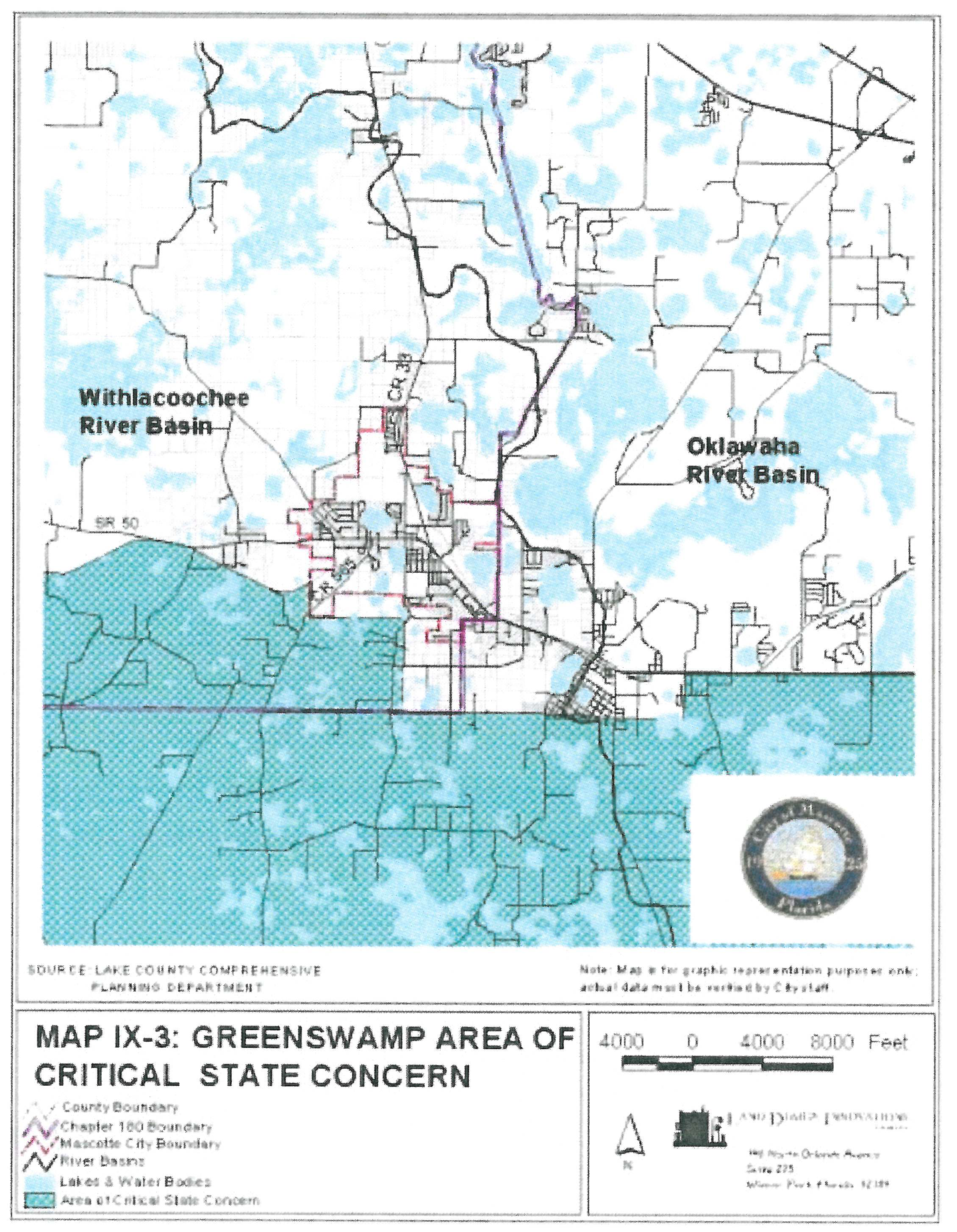
C)
The Green Swamp Overlay Area is established by the City of Mascotte to effectively and equitably conserve and protect the Green Swamps' environmental and economic resources, provide a land and water management system to protect such resources, and facilitate orderly and well-planned growth. The City adopts the Principles Guiding Development within the Green Swamp Area of Critical State Concern, as follows:
1)
Minimize the adverse impacts of development on resources of the Floridan Aquifer, floodplain, and wetlands.
2)
Protect or improve the normal quantity, quality, and flow of ground water and surface water which are necessary for the protection of resources of state and regional concern.
3)
Protect or improve the water available for aquifer recharge.
4)
Protect or improve the functions of the Green Swamp Potentiometric High of the Floridan Aquifer.
5)
Protect or improve the normal supply of ground and surface water
6)
Prevent further salt-water intrusion into the Floridan Aquifer.
7)
Protect or improve existing ground and surface-water quality.
8)
Protect or improve the water-retention capabilities of wetlands.
9)
Protect or improve the biological-filtering capabilities of wetlands.
10)
Protect or improve the natural flow regime of drainage basins.
11)
Protect or improve the design capacity of flood-detention areas and the water-management objectives of these areas through the maintenance of hydrologic characteristics of drainage basins.
D)
Development and Land Use within the Green Swamp Overlay Area shall be regulated by Section 3.10, Part B, of this Code (Green Swamp Overlay Area) and Section 5.7 of this Code (Green Swamp), as well as other Sections of this Land Development Code and the Comprehensive Plan. Where there is a conflict in policy, standard, or regulation, the more stringent shall apply.
(Ord. No. 2008-03-460, (Exh. A), 4-21-08; Ord. No. 2017-01-556, § 8(Exh. D), 3-20-17)
Section 7.4. - Reserved.
Editor's note— Ord. No. 2017-11-574, § 3(Exh. B), adopted November 14, 2017, repealed § 7.4, which pertained to the never-created commerce and industrial overlay area and derived from Ord. No. 2008-03-460, (Exh. A), adopted April 21, 2008. Ord. No. 2018-09-587, § 3(Exh. B), enacted the same amendment, but provided for an effective date of September 26, 2018, which was unspecified in Ord. No. 2017-11-574.