
Mascoutah City Zoning Code
ARTICLE VI
OVERLAY DISTRICTS AND SPECIAL PROVISIONS
DIVISION 2. - AIRPORT OVERLAY (AO) DISTRICT[2]
Editor's note— Ord. No. 11-09, § 1, adopted June 20, 2011, amended division 2 in its entirety to read as herein set out. Former division 2, §§ 34-6-2—34-6-16, pertained to similar subject matter, and derived from the original ordinance adopting Unified Land Development Code; Ord. No. 10-08, § 1, 5-17-10.
Sec. 34-6-1. - Purpose.
Overlay zones are designed to provide additional regulations for certain areas of the city which require special protection during development, or which receive consideration for a modification in the strict interpretation of district regulations. These areas include the airport overlay district, whose boundaries are depicted on the city's zoning map, and areas which have or will be designated as planned developments based on the procedures in section 34-6-30 et seq. Once established, an overlay zone will appear on the city's official zoning map.
(Sec. 6.1)
Sec. 34-6-30. - Purpose and intent.
The planned development procedure, or PDP, is intended to provide for development incorporating a single type or a variety of related uses which are planned and developed as a unit. A planned development may consist of conventionally subdivided lots or provide for nontraditional techniques of development which are consistent with the intent of the city's Comprehensive Plan and meet the spirit and intent of the Unified Land Development Code. The further purpose of the PDP is to permit the following:
(a)
A maximum choice in the type of environment available to the public by allowing a development that would not be possible under the strict application of the provisions of this Code.
(b)
Permanent preservation of common open space and recreation areas and facilities.
(c)
A pattern of development to preserve natural vegetation, topographic and geologic features.
(d)
A creative approach to the use of land and related physical facilities that results in better development and design and the construction of aesthetic amenities.
(e)
An efficient use of the land resulting in more economic networks of utilities, streets, schools, public grounds and buildings, and other facilities.
(f)
A land use which promotes the public health, safety, comfort, morals, and welfare.
(g)
Innovations in residential, commercial, and recreational development so that growing demands of population may be met by greater variety in type, design, and layout of buildings and by the conservation and more efficient use of open space ancillary to said buildings.
(Sec. 6.3.1)
Sec. 34-6-31. - PDP size and density controls.
(a)
The minimum size of any PDP shall be five acres.
(b)
The maximum residential density of any PDP shall be controlled by the underlying zoning district(s) and the maximum floor area ratios listed in subsection 34-6-35(h).
(Sec. 6.3.2)
Sec. 34-6-32. - Application procedure and area plan.
(a)
The amendment of an area plan or the designation of a portion of the city as a planned development must be initiated by an application with the proposed area plan, accompanied by the required fee and filed with the development administrator. The application must be verified by the owner or owners of record or the contract purchasers. The application must be filed at least 20 days prior to the planning commission meeting at which it is to be first considered.
(b)
Applications. The application must include the following information. The city may require that this information be included on or filed with designated forms:
(1)
The name of the proposed PDP development.
(2)
Names, addresses and phone numbers of the owner(s) of record, and engineer, surveyor or designer responsible for the planning, engineering, survey and design.
(3)
Acreage in the entire planned development.
(4)
Legal description of the entire planned development.
(5)
Five copies of proposed deed restrictions, protective covenants, and homeowners' association Articles of Incorporation and By-Laws.
(6)
Signature(s) of applicant(s) and owner(s) certifying the accuracy of the requested information.
(7)
Payment of the required application fee.
(8)
A recent certificate of title to the property showing ownership.
(9)
A list containing the names and addresses of all owners of property located within 250 feet of the property to be designated a planned development.
(10)
Any additional information deemed necessary by the development administrator.
(c)
Area plans. The application must be accompanied by 16 copies of the proposed area plan. The scale for all plans shall be no smaller than one inch equals 50 feet, and the plans shall include the following:
(1)
The name of the proposed PDP development.
(2)
Scale, north arrow and the date drawn.
(3)
Proposed use and development of the planned development.
(4)
Boundaries, dimensions and area of the planned development.
(5)
Location of the planned development in relation to the surrounding uses, buildings and zoning.
(6)
Location of the planned development in relation to major thoroughfares, and any roadways or drives connecting the planned development to those major thoroughfares.
(7)
Names of adjacent subdivisions, layout of streets (with names and rights-of-way widths), connections with adjoining platted streets, location and widths and of adjoining alleys, easements and public sidewalks, and location and dimensions of all existing sanitary sewer, storm sewer, and supply facilities within 250 feet of the planned development.
(8)
Existing conditions in the planned development area showing all easements, streets, drives or alleys, bridges, and existing structures.
(9)
Existing topography (at least five-foot contour intervals). All topographic data shall directly relate to USGS data.
(10)
Boundary lines of school districts, fire districts, and municipal limits must be identified on plan where applicable.
(11)
General plan layout of the entire planned development showing proposed land uses, streets, parking areas, open space areas, sidewalks and highways or other major improvements planned by public authorities for future construction, with significant dimensions indicated where appropriate to clarify the plan.
(12)
All planned use areas must be clearly labeled as to the proposed use and all parcels of lands to be dedicated or reserved for public use or for use in common by property owners in the planned development shall be indicated on the plan dedication or reservation.
(13)
Proposed stages of development.
(14)
Subsurface conditions on the tract, if required by the development administrator, including the location and results of tests made to ascertain subsurface soil, rock, and ground water conditions; depth to ground water unless test pits are dry at a depth of five feet; location and results of soil percolation tests if individual sewage disposal systems are proposed.
(15)
Site plan data must be indicated on the area plan and must include the items below:
(a)
The total gross land area of the planned development area plan in acres.
(b)
The breakdown of total gross land area by land use type, such as townhouses, single family, retail shops, open space, church, school, etc.
(c)
Residential data:
(i)
The estimated total residential units.
(ii)
The average square feet of residential land per each type of residential unit.
(iii)
The breakdown of non-residential land by type of use.
(iv)
The total parking by land use type and parking ratio per dwelling unit.
(d)
Commercial and industrial data:
(i)
The estimated total building square footage by land use type.
(ii)
The percentage of building coverage by land use type for business and industrial uses.
(iii)
The total parking by land use type and parking ratio per floor area.
(16)
Any additional information deemed necessary by the development administrator to adequately illustrate the planned development.
(d)
The area plan and final development plan required in this section shall replace (for a planned development only) any other site plan required by the city.
(Sec. 6.3.3)
Sec. 34-6-33. - Review of application and area plan.
(a)
The proposed plan shall be referred to the planning commission for study, a public hearing thereon, and recommendation and report to the city council.
(b)
The planning commission shall not act on any proposed plan before holding a public hearing thereon and, prior to holding a public hearing on any proposed plan, at least 15 days written notice thereof shall be given to all property owners within 250 feet of the boundary of the premises under consideration and at least 15 days written notice thereof shall be given in a newspaper of general circulation.
(c)
After holding a public hearing on any proposed plan, the planning commission shall submit its report of such action to the city council for consideration and action. Said report shall include all documents comprising the proposed plan referred to the planning commission, the recommendation of the planning commission with respect to such proposed plan, and the reasons for approval or disapproval of such proposed plan.
(d)
If no report is transmitted by the planning commission within 65 days from the date that the application is first reviewed by the planning commission at a regular meeting, the city council may take action on such proposed plan even though the planning commission has not submitted its report to the city council. If the planning commission fails to hold the public hearing required by subsection 34-6-33(b), the city council may assume that responsibility and hold such a hearing after providing the requisite notice.
(e)
Upon receipt of the planning commission's report, the city council shall either approve the application by adopting an ordinance amending the official zoning map and authorizing the PDP development in accordance with the area plan, or deny the application. If the application is approved, the matter shall be returned to the planning commission for consideration of a final development plan.
(f)
Minor, technical and mechanical changes to the area plan may be approved by the development administrator without review by the planning commission or the city council so long as the changes do not materially affect the PDP development as approved by the city council. Within seven days of such approval, the development administrator will advise the chairman of the planning commission of any such change.
(Sec. 6.3.4)
Sec. 34-6-34. - Final development plan and section plans.
(a)
Requirements for final development plans and section plans shall be as follows:
(1)
Final development plans must include, in addition to specific information required by the ordinance authorizing the PDP development, the following general information:
(a)
An outboundary plat and legal description of the property.
(b)
The location of all roadways adjacent to the property and general location, size, and pavement widths of all interior roadways.
(c)
The general design of the PDP development including unit types (i.e., single-family detached, single-family attached, apartment), number of each unit type proposed, location of units, minimum and maximum size of single-family lots, approximate size of multiple-family structures, and location and size of common areas and recreation facilities.
(d)
The location and size of any commercial uses, types of uses proposed, and general parking layout.
(e)
Any floodplain boundaries.
(f)
The density calculations.
(g)
Concept landscape plan.
(2)
The planning commission must determine if the final development plan complies with the conditions of the ordinance authorizing the PDP development. The planning commission's recommendation of the final development plan shall also be based upon whether the plan is consistent with good general planning practice, consistent with good site planning, can be constructed and operated in a manner that is not detrimental to the permitted uses in the district, would be visually compatible with the uses in the surrounding area, and is deemed desirable to promote the general welfare of the city. The planning commission must also consider architectural, landscape, and other relationships which may exist between the proposed PDP development and the character of the surrounding neighborhood and must prescribe or require such physical treatment or other limitations as will, in its opinion, enhance the neighborhood character.
(3)
A section plan for each plat or phase of the area plan must be submitted to the planning commission for review and approval. The section plan must contain such information as is required by the ordinance establishing the planned development, in addition to such other information required on a preliminary plat by the subdivision regulations contained in article XII.
(4)
The planning commission shall submit its recommendation of each final development plan and section plan to the city council. If the planning commission does not approve or disapprove a final development plan or a section plan within 35 days from the date that the plan is first reviewed by the planning commission at a regular meeting, the city council may approve or disapprove such plan even though the planning commission has taken no action.
(5)
All plans shall be retained on file by the city clerk. An approved final development plan will constitute an approved preliminary plat for purposes of the subdivision regulations in article XII. No building permits or authorization for improvement or development for any use authorized under provisions of the ordinance governing the tract shall be issued prior to approval of such plans.
(6)
Where elements within the designated planned development boundary are necessary to the support of a given section, but not included within the section boundary, these elements shall be included on a site plan accompanying, or a part of, the section plan.
(7)
If a final development plan includes all the information required for section plans, the section plan requirements may be waived.
(Sec. 6.3.5)
Sec. 34-6-35. - Site design requirements.
(a)
All paved and landscaped areas shall, at all times, be kept in good repair and in excellent condition, in accordance with this or other ordinances. The continuous maintenance of said areas is to be the responsibility of the owners and lessees of the property.
(b)
All landscaping plant materials shall be kept alive and in excellent condition.
(c)
All lighting shall be served with underground cable. All parking areas and walkways shall be illuminated so as to produce a uniform illumination of two foot-candles within said areas. All exterior lighting shall be shielded and/or otherwise designed to direct light downward and within the confines of the site area so as to prevent or minimize glare or spillover to other areas.
(d)
Access requirements. All developed parcels, except those developed for single-family, shall be provided interior drives with a minimum width of pavement of 24 feet. Driveway openings shall be limited to not more than 36 feet in width and shall be limited to one drive per 100 feet of lot width. All roads and drives shall be paved with concrete or asphaltic concrete material as specified by the development administrator. Concrete curbs shall be provided along all drives that do not abut parking spaces. All parking areas shall be edged with concrete curbs. Surface or underground storm drainage facilities shall be provided for all roads, drives, and parking areas as approved by the development administrator. All storm drainage will be directed into established surface or underground storm drainage facilities.
(e)
Underground utilities. Telephone, electric power, cable television, and all other utilities, except surface stormwater facilities, shall be located underground. Except, however, that the following shall be excluded from this requirement:
(1)
Poles used exclusively for street lighting.
(2)
Antennas, associated equipment and supporting structures, used by a utility for furnishing communication services.
(3)
Equipment appurtenant to underground facilities, such as surface mounted transformers, pedestal mounted terminal boxes and meter cabinets, and concealed ducts.
(4)
Temporary poles, overhead wires and associated overhead structures used for a period not to exceed six months which are necessary to provide utility service until the permanent service is completed.
(5)
Poles, wires and controller cabinets necessary for the operation of traffic signals.
(6)
Poles, overhead wires and associated overhead structures used for the transmission of electric energy at nominal voltages in excess of 34,500 volts.
(f)
Ownership and size. The site of the planned development must be under single ownership and/or unified control and be not less than five acres in size.
(g)
Setback requirements. Building setback requirements within a planned development may deviate from the minimums required in the underlying zoning district.
(h)
Floor area ratios. Floor area ratios shall be observed as maximum density controls for the following uses:
(Sec. 6.3.6)
Sec. 34-6-36. - Criteria for reviewing applications.
In considering whether or not such application for a planned development should be granted, it shall be the duty of the planning commission and the city council to give consideration to the effect of the requested use on the health, safety, morals, and general welfare of the residents of the area in the vicinity of the property in question and the residents of the city generally. In considering the planned use or uses, the planning commission and the city council should consider the following:
(a)
The appropriateness of the proposed use or uses for the site in terms of land patterns in the entire city and the community's Comprehensive Plan.
(b)
The compatibility with surrounding uses and the surrounding neighborhood.
(c)
The comparative size, floor area, mass, and general appearance of the proposed structures in relationship to adjacent structures and buildings in the surrounding properties and neighborhood.
(d)
The amount of traffic generated by the proposed use or uses and the relationship to the amount of traffic on abutting streets and on minor streets in the surrounding neighborhood in terms of the street's capacity to absorb the additional traffic and any significant increase in hourly or daily traffic levels.
(Sec. 6.3.7)
Sec. 34-6-37. - Performance and maintenance guarantees.
(a)
All public facilities and improvements made necessary as a result of the planned development shall be either constructed in advance of the approval of the final plan or, at the discretion of the city, escrow deposits, irrevocable letters of credit in a form approved by the city attorney, or performance bonds shall be delivered to guarantee construction of the required improvements. Any such guarantee shall be 110 percent of the estimate approved by the development administrator of the cost to construct said improvements.
(b)
In addition to the deposit provided for in subsection 34-6-37(a), a deposit shall be made to the city in cash, irrevocable letters of credit in a form approved by the city attorney, or maintenance bonds equal to 15 percent of the estimated costs of public facility installations. This deposit shall be a guarantee of satisfactory performance of the facilities constructed within the planned development and shall be held by the city for a period of 18 months after acceptance of such facilities by the city. After such 18 months, the deposit shall be refunded if no defects have developed. If any defects have developed, then the balance of such deposit shall be refunded after reimbursements for amounts expended in correcting defective facilities. The deposit under this paragraph shall be made immediately upon completion and approval of the construction of said public facilities, and the performance guarantee for the public facilities shall thereupon be released.
(Sec. 6.3.8)
Sec. 34-6-2. - Airport overlay (AO) district established; purpose.
(a)
There is hereby established a zoning district entitled airport overlay (AO) district, including subarea districts, with the expressed intent to provide for uses and unique design requirements for lands adjacent to and within runway protection zones, accident potential zones, airspace zones, and noise zones for the environs of Scott Air Force Base and the MidAmerica St. Louis Airport.
(b)
The purpose of the airport overlay (AO) district is to establish land use controls that promote and protect the public health, safety, comfort and general welfare, and including:
(1)
To provide for and protect the long term mission, operation, and viability of Scott Air Force Base (AFB) and MidAmerica St. Louis Airport from hazardous, injurious, and/or other conditions that could adversely affect airport operations and safety and/or that would be incompatible with airport operations and functions.
(2)
To protect the use, enjoyment, and values of land and development in the airport environs from injurious and hazardous conditions and incompatibility of uses.
(3)
To promote proper land use arrangement and development, public and private services and facilities, and a desirable environment to achieve and sustain physical, social, and economic activities, which are compatible with Scott AFB and MidAmerica St. Louis Airport.
(4)
To provide standards for new or redeveloped buildings within the noise attenuation zone to be constructed with materials and in such manner that aircraft noise be reduced by the structure to an interior level that has no adverse impact on the health, safety, and general welfare of the residents.
(5)
To maintain an open process of regional coordination, negotiation, and interpretation of airport influence districts and cooperation with other affected local governments to achieve these goals.
(6)
To inform citizens in the vicinity of Scott AFB and MidAmerica St. Louis Airport of the potential impacts of airport influence districts on the use of their properties.
(7)
To preserve the economic development potential that Scott AFB and MidAmerica St. Louis Airport brings to the area.
(Ord. No. 11-09, § 1, 6-20-11)
Sec. 34-6-3. - Interpretation; definitions.
(a)
Words and phrases shall be construed according to the common and approved usage of the language; but technical words and phrases and such others as may have acquired a peculiar and appropriate meaning in law shall be construed and understood according to such meaning. Except as otherwise specifically defined below for purposes of this division, definitions generally applicable within the Unified Land Development Code shall apply herein.
Nothing contained within this division shall be construed as or applied to be substantially inconsistent with an airport approach plan adopted by IDOT Division of Aeronautics, pursuant to 620 ILCS 25/12.
(b)
Definitions.
Accident potential zones (APZ). As applied to military airfields, those areas which are identified as being significantly impacted by accident potential from aircraft. APZ-1 is an area normally beyond the clear zone that possesses a significant potential for accidents. APZ-2 is an area normally beyond APZ-1 that has a measurable potential for accidents. Both the APZ-1 and APZ-2 are the same width as the clear zone. APZ-1 extends from the clear zone an additional 5,000 feet. APZ-2 extends from APZ-1 an additional 7,000 feet.
Air installation compatible use zone (AICUZ). A study conducted by the Air Force to evaluate the effect on noise and accident potential on surrounding property and to promote compatible land use that reduces the risks to public health and safety.
Air Force. the United States Air Force as represented by the Base Community Planner for Scott Air Force Base or such other designee.
Airport. Any area of land or water that is designed and set aside for the landing and taking off of aircraft and related use associated with Scott Air Force Base or MidAmerica St. Louis Airport and utilized or to be utilized in the interest of the public for such purposes.
Airport environs. The geographic area that is affected by the airport air traffic operations and defined on the basis of those areas immediately affected by noise exposure, clear zones, runway protection zones, APZ-1 and APZ-2 areas, height hazard zones, and areas of airport influence property. These areas constitute the airport overlay (AO) district established in this division.
Airport hazard. Any structure or object of natural growth or use of land within the airport environs that obstructs the air space required for the flight of taking off, maneuvering or landing at an airport or which is otherwise hazardous to such landing or taking off of aircraft.
Airport hazard area. Any area of land or water, or both, upon which an airport hazard might be established if not prevented by this division.
Clear zone (CZ). A defined area extending outward from the end of each runway of Scott Air Force Base. The clear zones are considered an area of high accident potential. The clear zone starts at the end of the runway and extends outward 3,000 feet at a width of 3,000 feet.
Decibel (dB). A unit for measuring the relative loudness of sound or sound pressure equal approximately to the smallest degree of difference of loudness or sound pressure ordinarily detectable by the human ear, the range of which includes about 130 decibels on a scale beginning with one for the faintest audible sound.
Decibel A-weighted scale (dBA). The unit of noise level measured in accordance with the "A-weighted scale" which replicates the response characteristics of the ear. This scale is a quantity, in decibels, read from a standard sound-level meter with A weighting circuitry. The A-space weighting discriminates against lower frequencies according to a relationship approximating, and more accurately reflecting the auditory sensitivity and response of the human ear. The A-scale sound level measures approximately the relative "noisiness" or "annoyance" of common sounds.
Development application. Any request to the local governing body for rezoning, subdivision (major or minor), zoning variance, permit for a non-conformity, final site plan approval, special use permits, sign permits for freestanding or illuminated signs, mobile home permits, or in the case of building permits, permits to increase the existing square footage by 50 percent or more or over 35 in height, or permits otherwise determined by the director to have any potential impact within the district intended to be addressed by this division. A request to approve a change to the future land use map of the approved Comprehensive Plan shall also be considered a development application within this section.
Director. The public works director, or other designee, as the staff person assigned to administer, interpret, and implement the standards, criteria, and procedures of this Unified Land Development Code.
DNL. Day night level. See level, day night sound level (Ldn). Acoustical industry standards often use the abbreviations DNL and Ldn interchangeably.
Electronic display signs. Signs that show changeable copy, graphic displays or video displays.
Federal Aviation Administration (FAA). The federal agency responsible for the safety of civil aviation and the regulation of U.S. commercial space transportation.
Height, airport. In the airport environs, for purpose of determining the height of any structure, tree, or other object, including communication towers, the height is the elevation above mean sea level (MSL). For calculation purposes, this is the sum of the elevation of the site and the height of the structure, including any appurtenances.
Level, day night sound level (Ldn). A basic measure for quantifying noise exposure. The day/night average level, or the 24-hour equivalent continuous sound level (time averaged A-weighted sound level) from midnight to midnight, obtained after the addition of ten dBA to sound levels measured from 10:00 p.m. to 7:00 a.m.
Noise contour. A line on the AO-4 map linking together a series of points of equal cumulative noise exposure based on the day/night average level (Ldn) measurement. Such contours are developed based on aircraft flight patterns, number of daily aircraft operations by type of aircraft, and time of day noise characteristics of each aircraft and typical runway usage patterns.
Nit. A unit of visible-light intensity, commonly used to specify the brightness of a cathode ray tube or liquid crystal display computer display. One nit is equivalent to one candela per square meter.
Noise level reduction (NLR). Amount of noise reduction required through construction and incorporation of sound attenuation material to reduce interior noise level. The difference between the exterior and interior sound level, expressed in decibels.
Owner. Any person, group of persons, firm or firms, corporation or corporations, commanding officer of any local military base, or any other legal entity having legal or equitable title to or sufficient proprietary interest in or to any property subject to this Unified Land Development Code.
Participating local governments. The coordinating local governments in St. Clair County, Illinois participating in the RAB and adopting an airport overlay code substantially in the form of or consistent with this division.
Primary surface. A ground surface longitudinally centered on the runway. The dimensions and limits of the primary surface shall be those prescribed in Department of Defense (DoD) height and obstruction criteria for Scott AFB and in Federal Aviation Regulation (FAR) Part 77 for MidAmerica St. Louis Airport.
Runway. A defined area on an airport or airfield prepared for landing and takeoff of aircraft along its length. For purposes of this division and compliance with other applicable laws, the runways of Scott Air Force Base or MidAmerica St. Louis Airport shall be considered Precision Instrument Runways unless otherwise hereinafter designated.
Runway protection zone (RPZ). An area off the runway end of a civilian airport designated by the FAA to enhance the protection of people and property on the ground.
SLCUM. The Standard Land Use Coding Manual, which provides a general numeric coding scheme that uses two, three, four, or more digits to identify land use activities and allow for the flexible categorization of new land uses.
Sound attenuation. The reduction in sound level which occurs between the source and the receiver.
Sound level. The level of sound pressure measured with a sound level meter and one of its weighting (frequency) networks. When A-weighing is used, the sound level is expressed as dBA.
Sound transmission class (STC). is an integer rating of how well a building partition attenuates airborne sound. In the USA, it is widely used to rate interior partitions, ceilings/floors, doors, windows and exterior wall configurations.
Structure: Any object whether permanent or temporary, including, but not limited to a building, tower, crane, smokestack, earth formation, overhead transmission line, or flagpole; to also include mobile and tethered objects.
Unified Land Development Code. The Unified Land Development Code of the City of Mascoutah, Illinois, as amended, including this Division.
(Ord. No. 11-09, § 1, 6-20-11)
Sec. 34-6-4. - Acronyms.
AFB—Air Force Base.
AICUZ—Air installation compatible use zone.
APZ—Accident potential zone.
CZ—Clear zone.
dB—Decibels.
dBA—Weighted decibels.
DoD—Department of Defense.
FAA—Federal Aviation Administration.
IDOT—Illinois Department of Transportation.
Ldn—Day-night sound level.
NLR—Noise level reduction.
RAB—Regional advisory board.
RPZ—Runway protection zone.
SLUCM—Standard Land Use Coding Manual.
STC—Sound transmission class.
(Ord. No. 11-09, § 1, 6-20-11)
Sec. 34-6-5. - Airport overlay district; district boundaries.
(a)
[In general.] Certain airport environs are identified and established by this division for property within and around Scott Air Force Base (AFB) and MidAmerica St. Louis Airport (MidAmerica) within St. Clair County, Illinois. These environs have been identified through Federal Aviation Regulations Part 77 and data provided to St. Clair County by the United States Air Force as part of the 2008 Joint Land Use Study and the 2009 Air Installation Compatible Use Zone (AICUZ) report. Areas within the airport environs are subject to regulation beyond the other requirements of the Unified Land Development Code. These additional restrictions, designated as the airport overlay (AO) district, provide an enhanced level of protection in support of the continued operations of Scott AFB and MidAmerica St. Louis Airport.
(b)
Establishment and interpretation of district boundaries. The boundaries of the airport overlay (AO) district and subarea districts are hereby enacted and established as set forth on the series of four maps incorporated in section 34-6-7 of this division (district maps), with precise boundaries being determined by scaling distances and features shown on these maps. Where interpretation is needed as to the exact location of the boundaries of the airport districts, as shown on the airport overlay (AO) district maps, the director shall make the necessary determination of the boundary based on the purposes of this division and underlying mapping data. Any property owner contesting the location of a district boundary affecting his or her property shall be given a reasonable opportunity to present their case in accordance with the appeal procedures established in the Unified Land Development Code and in subdivision 9 of this division. The adopted district maps may include areas outside the territorial boundaries of the city in order to promote coordination with other participating local governments. The regulations of this airport overlay district shall not be deemed to extend to any property outside such territorial boundaries to which the city lacks jurisdiction to impose such regulation.
(c)
Split parcels. For purposes of regulation of parcels that appear split by the district boundary lines, only that portion of a parcel that falls within the district shall be subject to the provisions and standards of this division.
(d)
Boundary changes. The boundaries of the airport overlay (AO) district may be subject to change reflecting new military mission activity and/or aviation operations at Scott AFB and MidAmerica Airport. Scott AFB and MidAmerica Airport shall communicate the results of updated analyses of noise and air safety zones, including AICUZ reports and FAA studies, to affected local governments. The Director shall notify the Air Force, MidAmerica Airport and other local governments that have adopted airport zoning regulations in the environs of Scott Air Force Base and MidAmerica Airport of changes to the district boundary lines as shown in the maps in section 34-6-7 to promote the coordinated and consistent application of airport overlay regulations. Other coordinating local governments may adopt more stringent regulations than the minimum requirements in this division. Boundary changes to the AO district or subarea districts shall be adopted pursuant to the procedures applicable to amendments to the Unified Land Development Code.
(Ord. No. 11-09, § 1, 6-20-11)
Sec. 34-6-6. - Subareas; overlap.
To carry out the purpose of this district, the airport overlay (AO) district is composed of four overlapping subarea districts that establish different levels of restrictions based on airport boundary areas of influence, safety areas based on hazard zones and structure height regulations, and noise contours as follows. Properties or portions of properties located within multiple subareas shall comply with the standards established for each of those subareas in which the property is located.
(a)
AO-1 primary planning influence area. The primary planning influence area designates the subarea that primarily includes standards for avigation easements and lighting as described in subdivision 5 of this division.
(b)
AO-2 safety zones area. The safety zones area designates the subarea that primarily includes standards for land use, density, and design as designated in subdivision 6 of this division. The boundary of this area is determined by FAA and DoD imaginary surfaces definitions for military and civilian airfields (clear zone, runway protection zone, accident potential zone 1 and accident potential zone 2) in effect on the effective date of this division in conjunction with any other relevant safety area data obtained by the director.
(c)
AO-3 height restriction area. The height restriction area designates the subarea that primarily includes standards for controlling height as described in subdivision 7 of this division. The boundary of this area is determined by a combination of measurements including a 1,500-foot buffer around Scott Air Force Base and Imaginary Surfaces definitions for military and civilian airfields in effect on the effective date of this division, in conjunction with any other relevant height restriction data obtained by the director.
(d)
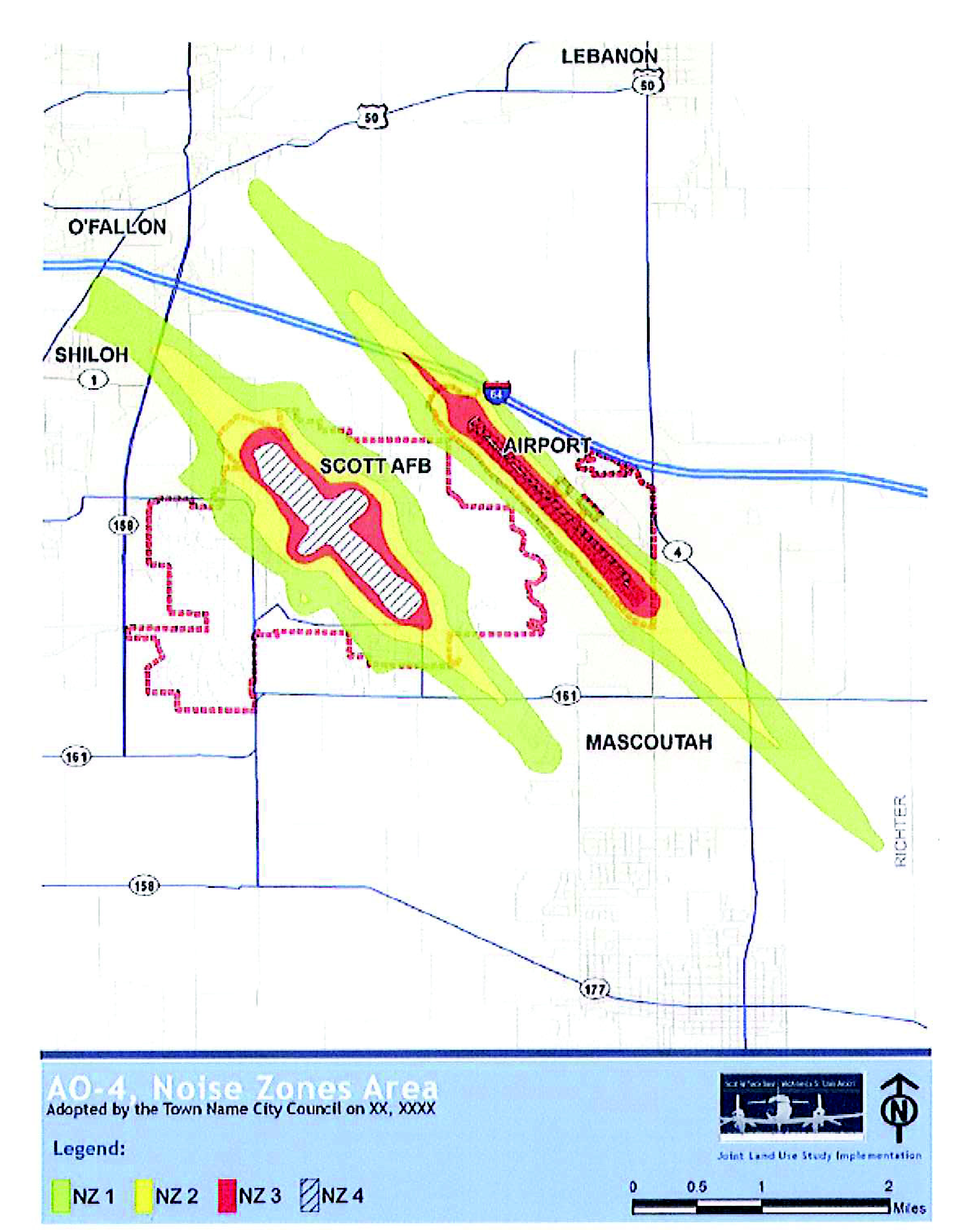
AO-4 noise zones area. The noise zones area designates the subarea that primarily includes standards for the attenuation of noise and residential land use controls as specified in subdivision 8 of this division. This boundary is determined by applying the noise contours published by the DoD for Scott Air Force Base in conjunction with any other relevant noise data obtained by the director.
(Ord. No. 11-09, § 1, 6-20-11)
Sec. 34-6-7. - Maps.
The following four maps, Figures 7.A — 7.D, are incorporated as an integral part of the Unified Land Development Code. These maps are hereby adopted and incorporated as an amendment to the official zoning map whether maintained separately or integrated within a single document:
(a)
AO-1 primary planning influence area.
(b)
AO-2 safety zones area.
(c)
AO-3 height restriction area.
(d)
AO-4 noise zones area.
Figure 7.A
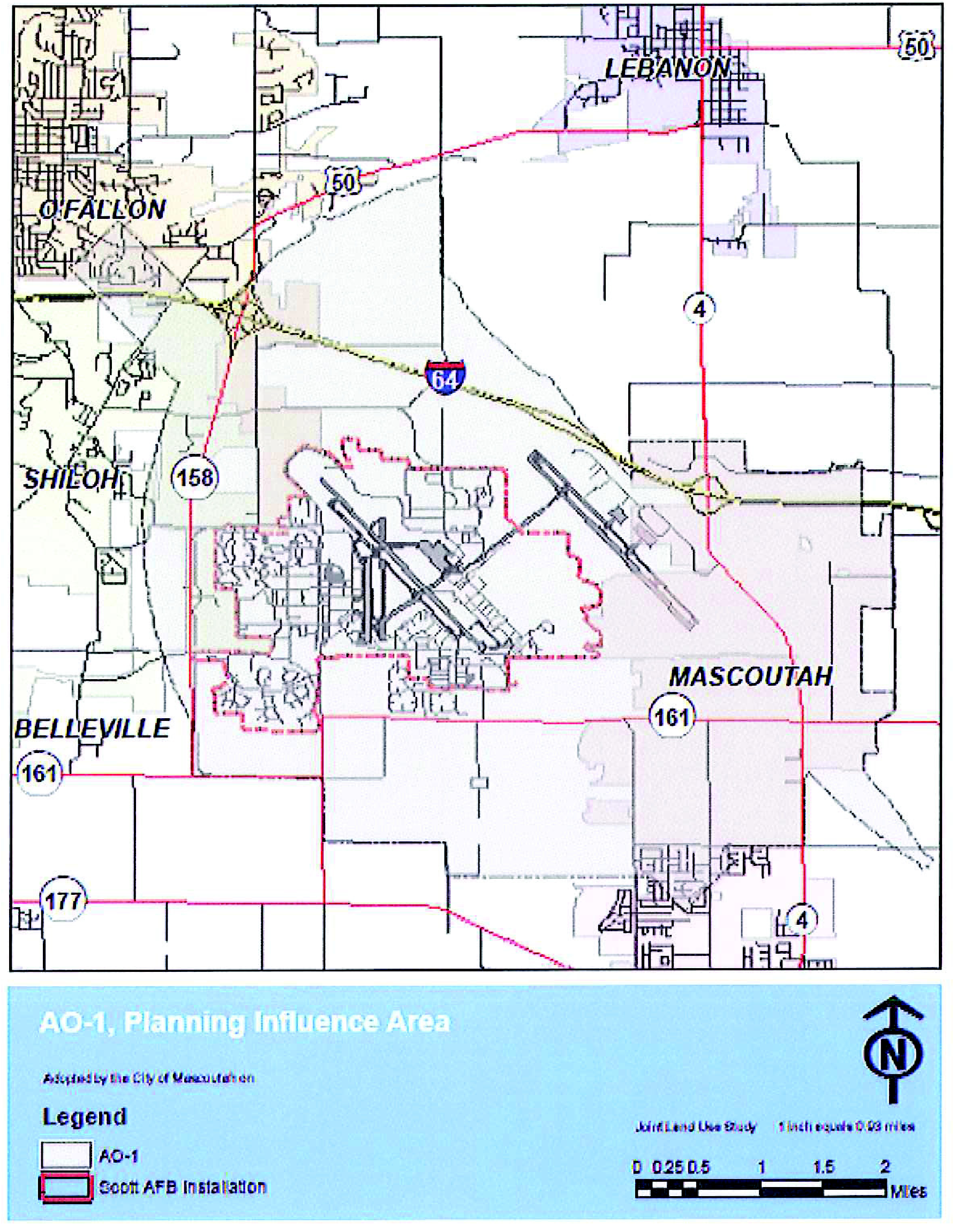
Figure 7.B
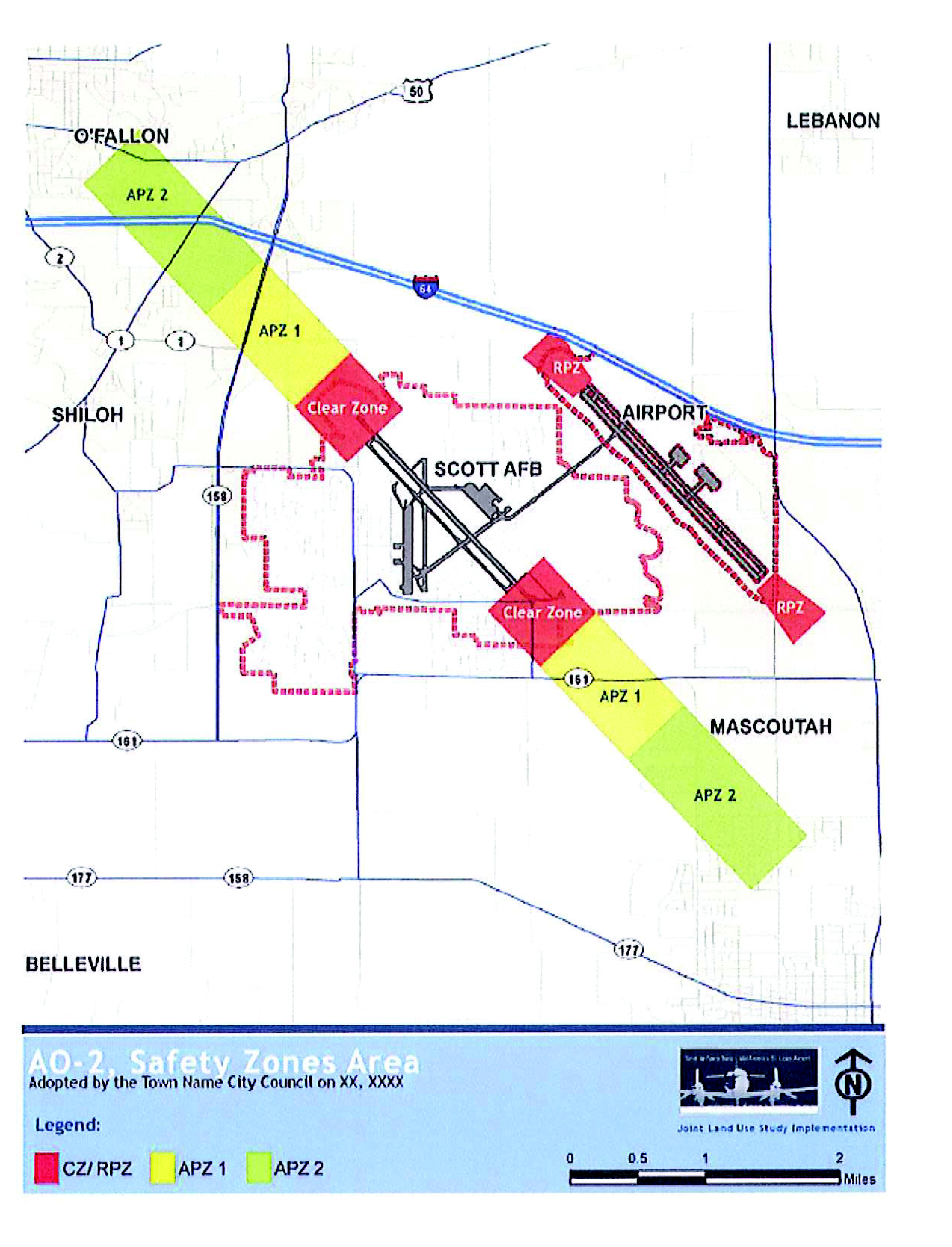
Figure 7.C
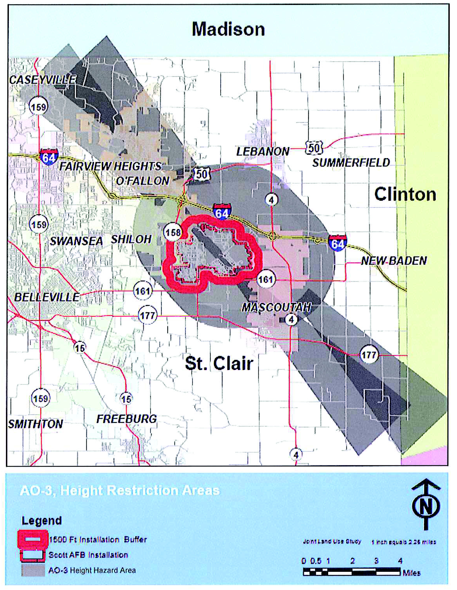
Figure 7.D
(Ord. No. 11-09, § 1, 6-20-11)
Sec. 34-6-8. - General use restrictions.
Notwithstanding any other provisions of the Unified Land Development Code, no use whether permitted in the underlying zoning district, or by planned use, special use permit, or otherwise, may be made of land or water within the airport overlay (AO) district so as to:
(a)
Create electrical interference with navigational signals, radar, or radio communications between Scott Air Force Base and MidAmerica St Louis Airport and the aircraft.
(b)
Cause confusion or otherwise make it difficult for pilots to distinguish between airport lights and other lights.
(c)
Result in glare in the eyes of the pilots using the airport.
(d)
Impair visibility of the airport.
(e)
Emit or discharge smoke (e.g., exhaust from a smoke stack), that interferes with the health and safety of pilots and the public in the use of the airport, or that is otherwise detrimental or injurious to the health, safety and general welfare of the public in the use of the airport.
(f)
Emit thermal discharge (e.g., steam from a power plant), that interferes with the pilot's vision in the use of the airport.
(g)
Cause significant air turbulence (e.g., exhaust from a peaker plant) where aircraft limit loads may be exceeded.
(h)
Cause any other kind of emission that may cause a safety of flight issue.
(i)
Create a bird or wildlife strike hazard that in any way endangers or interferes with the landing, takeoff, or maneuvering of aircraft using or intending to use the airport.
(j)
Create a vertical obstruction that physically intrudes on protected airspaces around the airport.
(k)
Concentrate people within zones to unduly expose them to noise or aircraft accident risk.
(Ord. No. 11-09, § 1, 6-20-11)
Sec. 34-6-9. - Administration and enforcement.
(a)
The director is hereby granted the authority to issue clarification and interpretation of this division and the items and uses set forth in the attached land use compatibility tables consistent with the intent and language of this division.
(b)
Notification. The director shall make reasonable efforts to provide notice to all person filing a development application in the AO district that the respective property is located either partially or wholly within the AO district, and may be subject to aircraft over-flight and the standards and requirements of this division.
(c)
Field testing. When field inspection indicates that the construction is not in accordance with the approved plans, the director may order such corrective action as may be necessary to meet the height and noise attenuation requirements, including but not limited to, stop work orders until such corrections are made.
(d)
Inspections of height and of noise attenuation work shall be performed during the required building construction inspection process.
(e)
Any person who violates this act or any orders, regulations, or rulings promulgated or made pursuant to this division shall be subject to the penalties and enforcement procedures established in the Unified Land Development Code.
(f)
State airport hazard zoning regulations. In the event of conflict between any airport hazard zoning regulations promulgated by IDOT Division of Aeronautics pursuant to 620 ILCS 25/17 and contained at Title 92, Part 16 of the Illinois Administrative Code and any airport zoning regulation set forth in this division or any other applicable regulations provided in the Unified Land Development Code, pursuant to 620 ILCS 25/18, the more stringent limitation or requirement shall govern and prevail.
(Ord. No. 11-09, § 1, 6-20-11)
Sec. 34-6-10. - Development application consultation procedures.
(a)
The director shall submit to the Air Force a copy of development applications for properties within the AO district as graphically shown on Appendix A ("Process Chart") and implemented as follows:
(1)
AO-2 district. If the application or impact is on property within the AO-2 district, all development applications relating thereto, shall be sent to Scott AFB for review.
(2)
AO-1, AO-3, and AO-4 districts. If the application or impact is in an AO district subarea other than the AO-2 district, development applications that meet one of the following criteria shall be sent to Scott AFB for review:
(i)
Increase of an existing structure or construction of a new structure whose height is 100 feet or higher above the ground level of the runway. Towers, antennae, lighting, silos, or any similar structures that are 100 feet above the ground level of the runway or higher shall be subject to review.
(ii)
Request for any outdoor lighting applications, temporary lighting, obstruction marking or lighting, and illuminated signs that do not meet the lighting standards established within section 34-6-14.
(iii)
Application for a human-made use that could attract high levels of birds or wildlife, such as retention ponds, roosting habitats on buildings, landscaping, putrescible-waste disposal operations, wastewater treatment plants, and surface mining.
(iv)
Application for a use or permit that could create electrical interference with navigational signals or radio communications between Scott AFB and MidAmerica St. Louis Airport and aircraft, including emergency and public safety communications systems, power lines, transformers, television broadcast and radio transmitters, and telecommunication towers.
(v)
Applications for a use or permit that could create air-borne emissions or materials limiting visibility such as smoke, steam, dust, gases or projectiles of any type.
(b)
The director shall send all appropriate development applications, as determined in the above section, to the Air Force for review. Applications can be mailed to:
Base Community Planner
375 CES/CEAO
702 Hangar Road, Bldg 56
Scott AFB IL 62225-5035
618-256-4270
(c)
Optional consultation with MidAmerica St. Louis Airport. For any development application within the height restriction zone, airport overlay (AO-3) district or the noise zones, airport overlay (AO-4) district, the director may choose to mail and/or email notice to the MidAmerica St. Louis Airport at:
Director, Engineering & Planning
MidAmerica St. Louis Airport
9768 Airport Boulevard, Box 3
Mascoutah, IL 62258
618-566-5325
tom.goode@flymidamerica.com
(Ord. No. 11-09, § 1, 6-20-11)
Sec. 34-6-11. - Regional advisory board.
The State of Illinois allows for the use of eminent domain authority to resolve incompatible land uses in the environs of Scott Air Force Base and MidAmerica St. Louis Airport pursuant to 620 ILCS 25/33. To reduce the need for the use of eminent domain and to better coordinate airport zoning and planning, a Regional Advisory Board (RAB) is established. The purpose of the RAB is to review potentially incompatible Development Applications within a specific geography around Scott AFB and MidAmerica St. Louis Airport and provide comment to the applicable local government receiving the application.
(a)
Established. The regional advisory board (RAB) is hereby authorized and established as an advisory intergovernmental body to coordinate and review land use decisions in the AO-2 district. The RAB shall be deemed to exist immediately and shall include all qualified members similarly authorizing such establishment.
(b)
Membership.
(1)
The RAB shall consist of one representative from each of the following five entities, appointed by local governing authorities ("participating local governments"):
(i)
St. Clair County.
(ii)
The City of Lebanon.
(iii)
The City of Mascoutah.
(iv)
The City of O'Fallon.
(v)
The Village of Shiloh.
(2)
In addition, one Air Force representative and one representative of MidAmerica St. Louis Airport shall serve on the RAB as non-voting, ex-officio members.
(3)
The RAB shall designate a chairperson among the five participating local government representatives to conduct meetings and coordinate with the Air Force on administrative support and the distribution of background materials. The RAB chair shall rotate among the participating local government representatives every two years. In the event that any member fails to adopt authority for the RAB or subsequently withdraws from participation, the membership shall continue with the remaining authorized members.
(4)
The representative on the RAB for the City of Mascoutah shall be the mayor, who may from time-to-time designate another person to attend meetings of the RAB and act on the RAB on behalf of the City of Mascoutah.
(c)
Meetings.
(1)
The RAB shall meet if the Air Force renders an opinion that a development application subject to review under section 34-6-10 is incompatible.
(2)
The RAB may also establish and publish a regular meeting schedule. Meetings shall be public. Special meetings may be called by the chairperson.
(d)
Rules.
(1)
The RAB shall adopt operating procedures for the conduct of meetings and business of the RAB.
(2)
The RAB shall adhere to the provisions of this division with regard to the review and approval of site development plans.
(3)
The RAB shall keep a record of its transactions, findings, and determinations, which record shall be a public record.
(e)
Duties.
(1)
The RAB shall review development applications and present an advisory finding to the local jurisdiction responsible for approval of applications in the geographic areas designated as AO-2 district.
(2)
Any time the FAA, DoD, or IDOT Division of Aeronautics, amends, deletes, or creates regulations affecting the standards set forth in this division, the RAB shall review such amended, deleted, or new regulations and advise the participating local governments as to necessary or appropriate changes to this division.
(3)
The RAB shall act only as an advisory body.
(f)
Procedures and responsibilities.
(1)
Within the airport overlay (AO) district, the members shall consult with the Air Force on those development applications that have potential impacts on Scott AFB based on criteria established in section 34-6-10.
(2)
The Air Force shall review these actions within a 30-calendar-day period commencing on the day the Air Force receives a development application, and then render an advisory opinion of compatible/incompatible for those actions inside the AO-2 district. The Air Force may recommend conditions of approval to mitigate any negative impacts of those actions within the AO-1 district.
(3)
The Air Force shall evaluate the compatibility of the development application based on consistency with land use guidance established in the joint land use study and air installation compatible use zone program.
(4)
If no response is rendered from the Air Force within 30 days, the local government may consider the Air Force recommendation as being compatible.
(5)
If the Air Force finds an application within the AO-2 district to be incompatible, the RAB shall meet within a 30-calendar-day period following an incompatible finding. The Air Force shall provide administrative support for the scheduling of the RAB meeting and the distribution of necessary background materials.
(6)
The RAB shall render a recommendation, which the city shall consider.
(7)
The city shall not make a final decision without a recommendation from the RAB; provided that if the RAB does not provide its recommendation within 30 days of receipt of the application, a final decision may proceed without such recommendation.
(Ord. No. 11-09, § 1, 6-20-11)
Sec. 34-6-12. - Purpose and generally.
(a)
The purpose of this subdivision is to require that new or redeveloped facilities within the primary planning influence area, airport overlay (AO-1) district, be constructed in such a manner to mitigate impacts on aircraft operators and therefore protect the health, safety and general welfare of the residents.
(b)
The AO-1 district designates the area that primarily includes standards for consultation with the Air Force, notification, and lighting.
(c)
Establishment of primary planning influence area. Buildings, structures, or land shall be occupied or used only in conformity with all of the regulations set forth herein for the district or districts in which they are located. The boundaries of the AO-1 district are shown on the map in subdivision 3.
(d)
Consultation. Development applications on properties within the AO-1 district shall require consultation with the Air Force to the extent required per section 34-6-10 of this division.
(Ord. No. 11-09, § 1, 6-20-11)
Sec. 34-6-13. - Avigation easements.
(a)
All applications for subdivision approval for any structure requiring plan approval in the AO-1 district, to the extent consistent with applicable requirements of law, shall include the dedication of an avigation easement to the city. The dedicated avigation easement shall allow property owners to develop land in accordance with the applicable zoning district and regulations, and shall also convey a clear right to maintain flight operations in navigable airspace over the property, consistent with federal statutes and regulations, and shall submit the property to compliance with the regulations set forth in this division. The easement shall be recorded with the deed to a property and shall run in perpetuity with the land.
(b)
The applicant for all final subdivision plats within an AO district shall place a reference to the applicability of AO district regulations to the subdivision on the recorded plat.
(c)
The city shall maintain publicly available maps of the airport overlay district to facilitate the disclosure of potential airport environs impacts as part of real estate transactions.
(Ord. No. 11-09, § 1, 6-20-11)
Sec. 34-6-14. - Lighting.
The following standards shall apply to all lands within the AO-1 district, unless otherwise stated.
(a)
Nonresidential uses and multi-family residential.
(1)
The light source of outdoor lighting fixtures shall be fully shielded and downward facing so as not to allow any light above the horizontal, as measured at the luminaire.
(2)
Outdoor lighting fixtures shall be placed so as to not cause excessive glare or light trespass.
(3)
On-site parking areas shall be constructed of asphalt, dyed concrete or other non-reflective paving surfaces.
(4)
All light fixtures that are required to be shielded shall be installed and maintained in such a manner that the shielding is effective.
(5)
Canopy lighting shall be designed to conceal the illumination source and the lighting fixture shall not extend below the canopy skirt.
(6)
Exterior sign lights shall be shielded and oriented downward with respect to the sign.
(b)
Single-family and agricultural uses. Single-family residential and agricultural uses are exempt from the standards contained in this section 34-6-14, provided that such uses do not affect the safety of the public or persons utilizing Scott Air Force Base or MidAmerica St. Louis Airport.
(c)
Electronic display signs. Electronic display signs shall be permitted within the AO-1 district under the following conditions:
(1)
The maximum brightess of electronic signs shall not exceed 5,000 nits (candelas per square meter) during daylight hours, or of 500 nits (candelas per square meter) between dusk to dawn.
(2)
Any image or message or portion thereof displayed on the sign shall have a minimum duration of fifteen seconds and shall be of static display.
(3)
Electronic signs are prohibited in the AO-2 district.
(4)
Electronic display signs shall comply with all other applicable regulations set forth in the Unified Land Development Code.
(d)
Temporary lights. Special use permits shall be required for temporary lights such as spot lights. A permit may be granted if, upon review, the Director finds that the proposed lighting will not create excessive glare, sky glow, or light trespass.
(e)
Lighting plan. Within the AO-1 district, a lighting plan shall be included as part of the required site plan submittal or subdivision construction drawings which shall contain but not be limited to the following:
(1)
The location of the site where the outdoor light fixtures will be installed;
(2)
Plans indicating the location on the premises of each outdoor light fixture, both proposed and any already existing on the site; and
(3)
A description of the outdoor light fixtures including but not limited to manufacturer's catalog cuts and drawings.
(Ord. No. 11-09, § 1, 6-20-11)
Sec. 34-6-15. - Purpose and generally.
(a)
The purpose of this subdivision is to require that land and structures located within safety zones around the Scott AFB and MidAmerica St. Louis airfields are developed to protect the health, safety and general welfare of the public and to mitigate hazards of potential aircraft mishaps.
(b)
The safety zones area, airport overlay (AO-2) district, designates the area that primarily includes standards for land use, density and design, in addition to those requirements established for all properties within the AO-1 district.
(c)
Establishment of safety zones.
(1)
Buildings, structures, or land shall be occupied or used only in conformity with all of the regulations set forth herein for the district in which they are located.
(2)
The boundaries of the military safety zones as determined by the air installation compatible use zone (AICUZ) program are shown on the map in section 34-6-7. There are three military safety zones:
(i)
CZ: Clear zone.
(ii)
APZ-1: Accident potential zone 1.
(iii)
APZ-2: Accident potential zone 2.
(3)
The Federal Aviation Administration designates a runway protection zone (RPZ) for civilian airports as shown on the map in section 34-6-7. There is one civilian safety zone:
(i)
RPZ: Runway protection zone.
(d)
Consultation. All development applications on properties within the AO-2 district shall require consultation with the Air Force as per section 34-6-10 of this division.
(e)
Design regulations. Properties within the AO-2 district shall also comply with all the standards established per subdivision 5 of this division.
(Ord. No. 11-09, § 1, 6-20-11)
Sec. 34-6-16. - Use regulations in safety zones.
(a)
Use regulations in AO-2: CZ and RPZ. No uses or structures shall be permitted in the CZ and RPZ except roadways, underground utilities, agriculture and permanent passive open space. Bridges above the ground level of the runway, timber activities and silvaculture shall not be permitted.
(b)
Use and design regulations in AO-2: APZ-1.
(1)
Permitted uses. Permitted uses are listed on Table 16.1, provided that no uses shall be allowed where not permitted in the underlying zoning district.
(2)
Prohibited uses.
(i)
Manufacturing or above-ground bulk storage of flammable liquids, gases, or other explosive materials is prohibited.
(ii)
No use shall be permitted that emits smoke, steam, dust, gases or projectiles of any type that may interfere with safe aircraft operation.
(iii)
No residential development of any type is permitted. This includes short-and long-term hotels, lodgings, campsites, RV parks, mobile home parks, group homes, dormitories, or any accommodations where over-night residency is expected.
(iv)
Active parks with facilities intended to support organized activity or concentrations of users, such as athletic fields, buildings or structures for recreational activities, concessions, courts, or playgrounds are prohibited.
(v)
Places of large assemblies shall be prohibited to protect the general public against the grave consequences of an aircraft mishap. Places where the mobility-challenged and youth regularly assemble are also prohibited.
(vi)
Public transportation passenger terminals shall not be permitted in the APZ-1.
(vii)
Regionally-significant above-ground utility lines or sub-stations, such as high-tension power lines or public transportation transmission wires, shall not be permitted in the APZ-1.
(3)
Maximum assembly. Maximum assembly shall be limited to 25 people per acre per hour over a 24-hour period, and shall not be more than 50 people per acre at any one time.
(4)
Lot coverage.
(i)
The maximum gross acreage for all buildings on any single lot is ten percent. Use restrictions shall comply with Table 16.1 of this division. Height restrictions shall comply with subdivision 7, height restrictions, of this division.
(ii)
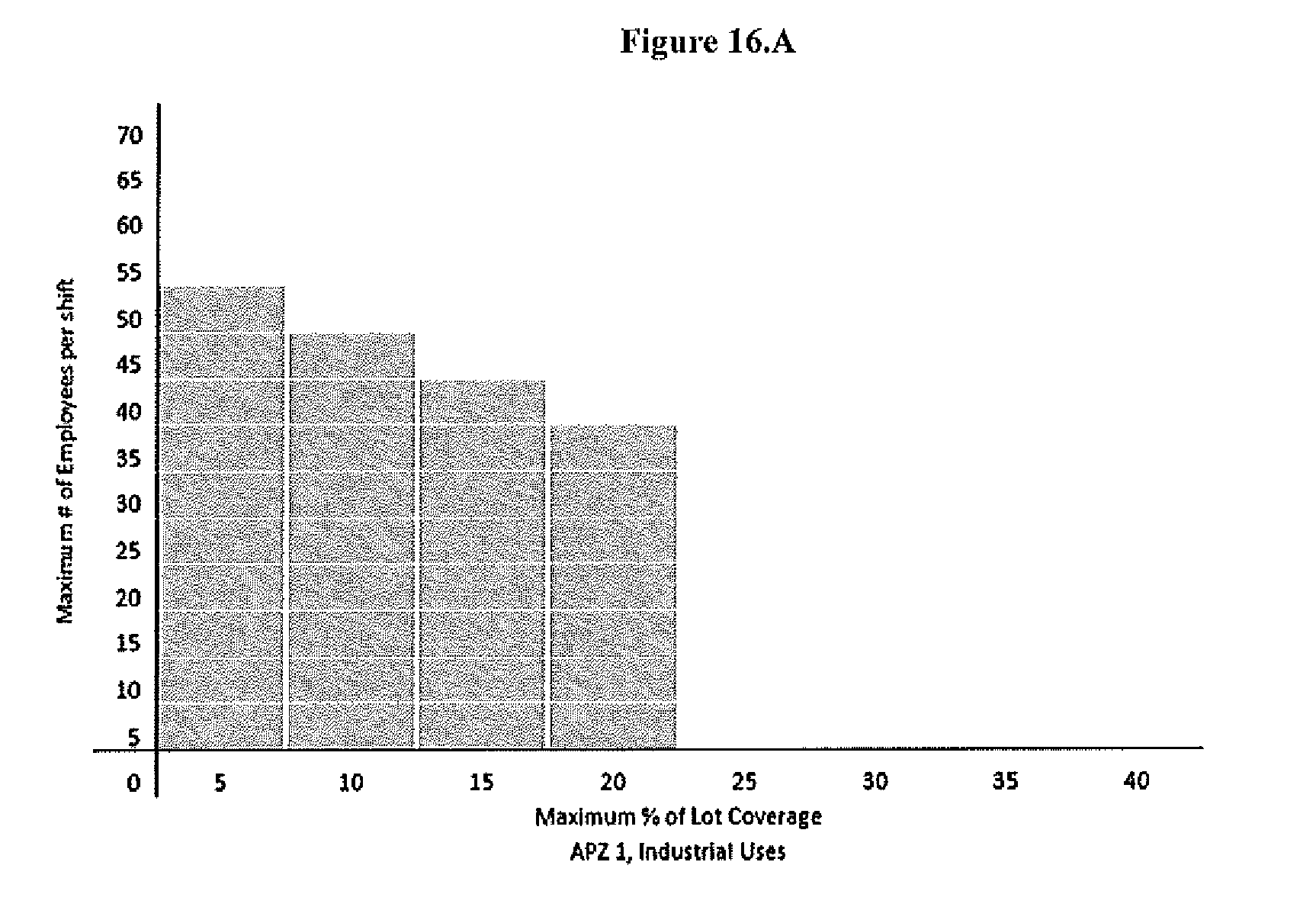
For industrial uses, in addition to all other limitations on concentrations of people, a sliding scale of employment density per shift and maximum acreage coverage shall be utilized as shown in Figure 16.A.
(iii)
A planned development approach is encouraged to maximize flexibility in layout and guide buildings away from the centerline of the runway.
(c)
Use and Design Regulations in AO-2: APZ-2.
(1)
Permitted uses.
(i)
Permitted uses are listed on Table 16.1, provided that no uses shall be allowed where not permitted in the underlying zoning district.
(ii)
Single-family residential density shall be limited to one dwelling unit per acre within the APZ-2, provided that any smaller subdivided lot existing as of the date of this article shall not be prohibited from use for single-family due solely to failure to comply with this supplemental density limitation.
(2)
Prohibited uses.
(i)
Manufacturing or above-ground bulk storage of flammable liquids, gases, or other explosive materials is prohibited.
(ii)
No use shall be permitted that emits smoke, steam, dust, gases or projectiles of any type that may interfere with safe aircraft operation.
(iii)
Higher density housing is prohibited. This includes multi-family housing, attached single-family housing, short- and long-term hotels, lodgings, campsites, RV parks, mobile home parks, group homes, or dormitories.
(iv)
Places of large assemblies shall be prohibited to protect the general public against the grave consequences of an aircraft mishap. Places where the mobility-challenged and youth regularly assemble are also prohibited.
(3)
Lot coverage.
(i)
The maximum gross acreage for all nonresidential buildings on any single lot is 20 percent. Use restrictions shall comply with Table 16.1 of this division. Height restrictions shall comply with subdivision 7, height restrictions, of this division.
(ii)
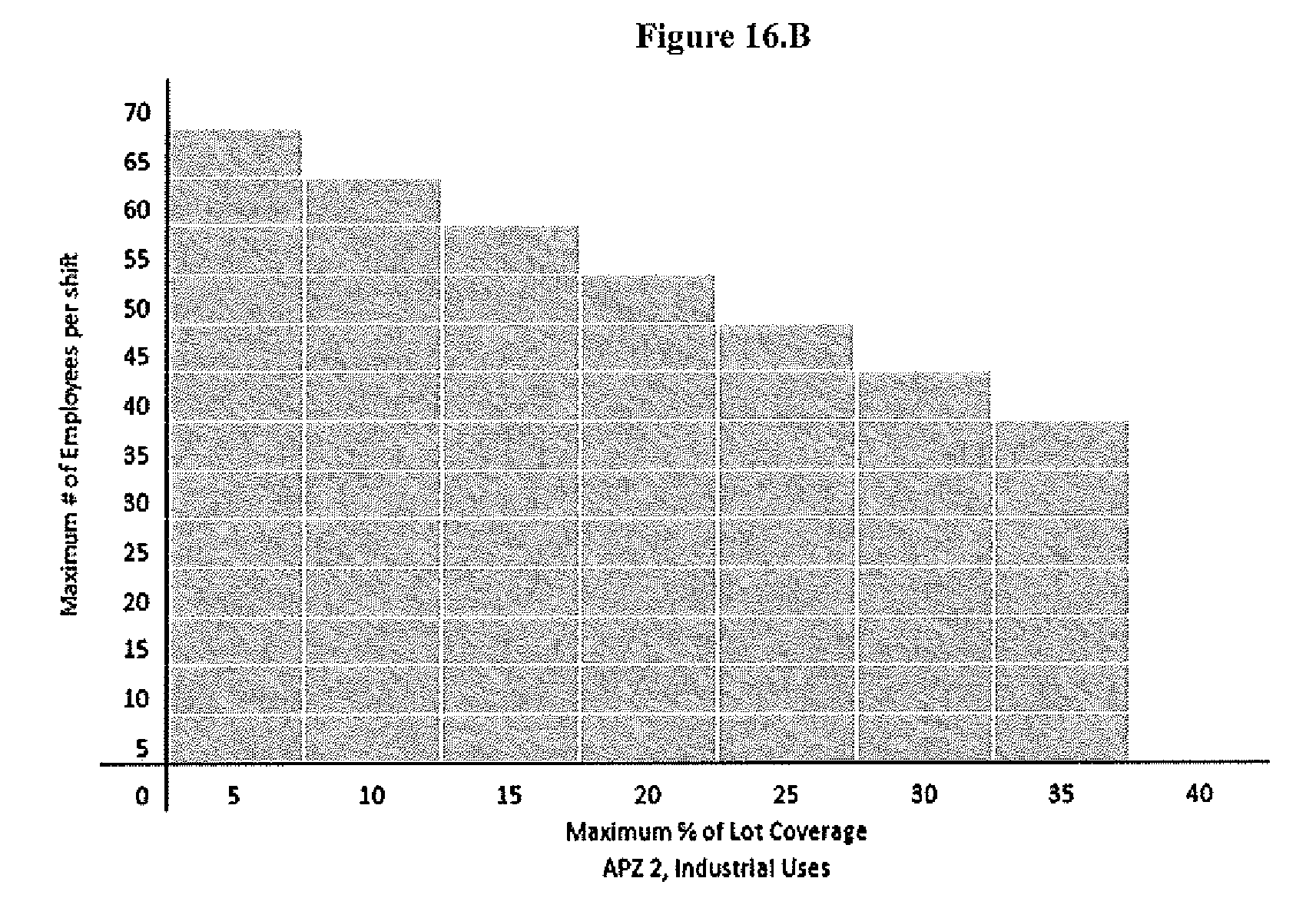
For industrial uses, in addition to all other limitations on concentrations of people, a sliding scale of employment density per shift and maximum acreage coverage shall be utilized as shown in Figure 16.B.
(iii)
A planned development approach is encouraged to maximize flexibility in layout and guide buildings away from the centerline of the runway.
(d)
Permitted land uses in AO-2: Safety zones.
(1)
Table 16.1 describes those uses that are permissible within the areas designated as safety zones. Within Table 16.1, the designation with the letter "Y" indicates that the land use is permissible, subject to compliance with the standards of the Unified Land Development Code and this division.
(2)
The designation with the letters "PS" indicates that the land use is permissible, subject to compliance with the standards of the Unified Land Development Code, and the supplemental standards specified for the use. Supplemental standards are contained in sections 34-6-16(a), (b), and (c).
(3)
The designation with the letter "N" indicates the land use is prohibited.
(4)
Any land use that is not identified in Table 16.1 is prohibited unless it is found to be substantially similar by the director. A requested use shall be considered substantially similar when the characteristics of the requested use are equivalent in type, intensity, degree, or impact when compared to a permissible use named in Table 16.1. Such characteristics include, but are not limited to:
(i)
Typical numbers of employees and public located on the property at any given time;
(ii)
Typical hours of operation;
(iii)
Generation of noise, light pollution, odor, smoke, dust, electromagnetic interference, or vibration;
(iv)
Bulk of structures and large equipment storage;
(v)
Use of outdoor storage;
(vi)
Typical airspace intrusion;
(vii)
Attractiveness to birds and wildlife;
(viii)
Customary functions of the use.
(5)
Accessory uses and structures incidental to a permitted principal structure or use are permitted so long as they are within the intent, purpose, or objectives of these regulations.
(6)
Temporary uses and structures are permitted so long as they are within the intent, purpose, or objectives of these regulations.
Table 16.1
(Ord. No. 11-09, § 1, 6-20-11)
Sec. 34-6-17. - Purpose and generally.
(a)
The purpose of this section is to require that new or redeveloped buildings within the height restriction area, airport overlay (AO-3) district, be constructed to prevent interference with safe aircraft operation and to maintain a visually permeable and physically secure buffer that lowers the vulnerability of personnel on the base to outside attacks.
(b)
The AO-3 district designates the areas that primarily include standards for controlling height. Except as otherwise provided herein for this district, no structure shall be erected, altered, or maintained in the AO-3 district to a height in excess of the applicable height limitations established in this subdivision 7 or those established and enforced by the FAA, DoD, or IDOT Division of Aeronautics.
(c)
Establishment of height restriction areas. Buildings, structures, or land shall be occupied or used only in conformity with all of the regulations set forth herein for the district in which they are located. The boundaries of the AO-3 installation buffer and height hazard restriction areas are shown on the map in section 34-6-7. There are two height restriction areas within the AO-3 district:
(1)
"Height hazard area": A height hazard area as shown on the map depicted in Figure 7.C encompassing all of the AO-3 district and defined by the airport imaginary surfaces described in sections 16.50—16.110 of the State Airport Hazard Zoning regulations, Title 92, Part 16 of the Illinois Administrative Code.
(2)
"Installation buffer": A subarea of the AO-3 district being a buffer extending 1,500 feet from the boundaries of Scott Air Force Base, as shown on map depicted in Figure 7.C and establishing supplemental height restrictions in the AO-3 district.
(d)
Consultation. Development applications on properties within the AO-3 district established by reference to Scott Air Force Base shall require consultation with the Air Force to the extent required by section 34-6-10 of this division.
(e)
Design regulations. Properties within the AO-3 district shall also comply with all the standards established per subdivision 5 of this division.
(Ord. No. 11-09, § 1, 6-20-11)
Sec. 34-6-18. - Area regulations.
(a)
"AO-3: Installation buffer area."
(1)
Permitted uses.
(i)
All uses are permitted as defined by the underlying zoning district, except for those listed as a prohibited use below.
(ii)
Single-family residential density shall be limited to two dwelling units per acre within installation buffer.
(2)
Prohibited uses.
(i)
Manufactured housing shall not be permitted within the installation buffer.
(ii)
Multi-family housing shall not be permitted within the installation buffer.
(iii)
Group homes, dormitories, or hotels and overnight lodging sites shall not be permitted within the installation buffer.
(3)
Maximum height. The maximum height of any structure within the installation buffer for shall be 35 feet.
(b)
"AO-3: Height hazard area."
(1)
Maximum height.
(i)
The maximum height of any structure or object of natural growth in the AO-3 subarea shall be determined by the limits of the airport imaginary surfaces described in Sections 16.50—16.110 of the State Airport Hazard Zoning regulations, Title 92, Part 16 of the Illinois Administrative Code.
(ii)
The airport imaginary surfaces are based on the imaginary surfaces in 14 C.F.R. Part 77, effective October 1, 2002, and are visually represented on the Airport Airspace sheet of the Airport Layout Plan for MidAmerica St. Louis Airport dated January 7, 2009 and adopted by the Illinois Department of Transportation, Division of Aeronautics. Sample graphic depictions of the airport imaginary surfaces are contained in appendix B to this division. The drawings in appendix B are for illustrative purposes only.
(iii)
No structures are permitted within the clear zone/runway protection zone as defined by section 34-6-16(a).
(Ord. No. 11-09, § 1, 6-20-11)
Sec. 34-6-19. - Height exceptions and limitations.
(a)
The building height limitations stipulated in the AO-3 district, shall apply to all structures within this district, including, but not limited to:
(1)
Air conditioning units.
(2)
Antennae.
(3)
Chimneys.
(4)
Church steeples.
(5)
Communication towers.
(6)
Elevator towers.
(7)
Flag poles.
(8)
Parapet walls.
(9)
Silos.
(10)
Utility transmission towers.
(11)
Windmills.
(12)
Similar structures.
(13)
Landscaping.
(b)
No structure shall be erected to a height that would encroach into or through any established public or private airport approach plan, prepared in accordance with the criteria established by the Department of Defense and/or the Federal Aviation Administration.
(Ord. No. 11-09, § 1, 6-20-11)
Sec. 34-6-20. - Purpose and generally.
(a)
The purpose of this section is to require that new or redeveloped buildings within the noise zones area, airport overlay (AO-4) district, be constructed with materials and in such manner that aircraft noise is reduced by the structure to an interior level which has no adverse impact on the health, safety and general welfare of the residents.
(b)
The AO-4 district designates the area that primarily includes standards for the attenuation of noise.
(c)
Establishment of noise zones.
(1)
Buildings, structures, or land shall be occupied or used only in conformity with all of the regulations set forth herein for the district in which they are located. The boundaries of the noise contour zones are shown on the map in subdivision 3. There are four applicable noise zones:
(i)
NZ 1: Area within the noise zone where the DNL is between 65 and 69 dB.
(ii)
NZ 2: Area within the noise zone where the DNL is between 70 and 74 dB.
(iii)
NZ 3: Area within the noise zone where the DNL is between 75 and 79 dB.
(iv)
NZ 4: Area within the noise zone where the DNL is greater than 80 dB.
(2)
Other industry-standard noise zones exist around the airfields. However, all land uses are considered compatible with noise levels below 65 dB. Noise zone 4 is only located on federally controlled land.
(d)
Consultation. Development applications on properties within the AO-4 district shall require consultation with the Air Force to the extent required by section 34-6-10 of this division.
(e)
Design regulations. Properties within the AO-4 district shall also comply with all the standards established per subdivision 5 of this division.
(Ord. No. 11-09, § 1, 6-20-11)
Sec. 34-6-21. - Use regulations in noise zones.
(a)
Use and design regulations in AO-4: NZ 1.
(1)
Permitted uses.
(i)
Permitted uses are listed on Table 21.1, provided that no uses shall be allowed where not permitted in the underlying zoning district. When regulations within the airport overlay district overlap, the more stringent standard shall apply.
(ii)
Single-family residential density shall be limited to one dwelling unit per acre within the NZ-1.
(2)
Prohibited uses.
(i)
Manufactured housing shall not be permitted within the NZ-1.
(ii)
Outdoor amphitheaters shall not be permitted within the NZ-1.
(3)
Sound attenuation.
(i)
To the extent permitted by law, sound attenuation standards to achieve an NRL of at least 25 dB is required for all new or expanded hospitals, clinics, nursing homes, child care centers, schools, movie theaters, auditoriums, churches, and places of worship and meditation. The requirements of this section shall apply only to the area of expansion. Expansion shall include any such work that results in an increase of the cubic content of the building or the floor or ground area devoted to the noise sensitive use or in any way increases or creates a site-related nonconformity.
(ii)
Sound attenuation standards to achieve an NRL of at least 25 dB are required for all new residential construction within the NZ-1.
(b)
Use and design regulations in AO-4: NZ 2.
(1)
Permitted uses. Permitted uses are listed on Table 21.1, provided that no uses shall be allowed where not permitted in the underlying zoning district. When regulations within the airport overlay district overlap, the more stringent standard shall apply.
(2)
Prohibited uses.
(i)
Manufactured housing shall not be permitted within the NZ-2.
(ii)
Outdoor amphitheaters shall not be permitted within the NZ-2.
(iii)
All residential uses, including hotels and overnight lodging sites, shall be prohibited within the NZ-2.
(3)
Sound attenuation.
(i)
To the extent permitted by law, sound attenuation standards to achieve an NRL of at least 30 dB is required for all new or expanded hospitals, clinics, nursing homes, child care centers, schools, movie theaters, auditoriums, churches and places of worship and meditation.
(ii)
Sound attenuation standards to achieve an NRL of at least 25 dB is required for all new or expanded structures containing office, business, retail and wholesale trade uses. Within new or expanded industrial structures, those portions of the building where the public is received, offices are located, and other places where low noise levels are normally expected shall utilize sound attenuation standards to achieve an NRL of at least 25 dB.
(c)
Use and design regulations in AO-4: NZ 3.
(1)
Permitted uses.
(i)
Permitted uses are listed on Table 21.1, provided that no uses shall be allowed where not permitted in the underlying zoning district. When regulations within the airport overlay district overlap, the more stringent standard shall apply.
(2)
Prohibited uses.
(i)
Manufactured housing shall not be permitted within the NZ-3.
(ii)
Outdoor amphitheaters shall not be permitted within the NZ-3.
(iii)
All residential uses, including hotels and overnight lodging sites, shall be prohibited within the NZ-3.
(iv)
All hospitals, clinics, nursing homes, child care centers, schools, movie theaters, auditoriums, churches and places of worship and meditation are prohibited.
(3)
Sound attenuation.
(i)
Sound attenuation standards to achieve an NRL of at least 30 dB is required for all new or expanded structures containing office, business, retail and wholesale trade uses. Within new or expanded industrial structures, those portions of the building where the public is received, offices are located, and other places where low noise levels are normally expected shall utilize sound attenuation standards to achieve an NRL of at least 30 dB.
(d)
Use and design regulations in AO-4: NZ 4.
(1)
Permitted uses. Permitted uses are listed on Table 21.1, provided that no uses shall be allowed where not permitted in the underlying zoning district. When regulations within the airport overlay district overlap, the more stringent standard shall apply.
(2)
Prohibited uses.
(i)
Manufactured housing shall not be permitted within the NZ-4.
(ii)
Outdoor amphitheaters shall not be permitted within the NZ-4.
(iii)
All residential uses, including hotels and overnight lodging sites, shall be prohibited within the NZ-4.
(iv)
All hospitals, clinics, nursing homes, child care centers, schools, movie theaters, auditoriums, churches and places of worship and meditation are prohibited within the NZ-4.
(3)
Sound attenuation. Sound attenuation standards to achieve an NRL of at least 30 dB is required for all new or expanded structures containing office, business, retail and wholesale trade uses. Within new or expanded industrial structures, those portions of the building where the public is received, offices are located, and other places where low noise levels are normally expected shall utilize sound attenuation standards to achieve an NRL of at least 30 dB.
(e)
Permitted land uses in AO-4: Noise zones.
(1)
Table 21.1 describes those uses that are permissible within the areas designated as noise zones. Within Table 21.1, the designation with the letter "Y" indicates that the land use is permissible, subject to compliance with the standards of the Unified Land Development Code and this division.
(2)
The designation "PS 25" indicates that the land use is permissible, subject to compliance with the standards of the Unified Land Development Code and demonstrating noise reduction materials have been incorporated into the design and construction of proposed development in a manner that achieves a noise level reduction of 25 dB.
(3)
The designation "PS 30" indicates that the land use is permissible, subject to compliance with the standards of the Unified Land Development Code and demonstrating noise reduction materials have been incorporated into the design and construction of proposed development in a manner that achieves a noise level reduction of 30 dB.
(4)
The designation with the letter "N" indicates the land use is prohibited.
(5)
The recommendations for permitted and prohibited types of facilities or land uses by noise level reduction are based on the U.S. Department of Transportation and Federal Aviation Administration (FAA) charts for aircraft noise avoidance.
Table 21.1
(Ord. No. 11-09, § 1, 6-20-11)
Sec. 34-6-22. - Attenuation.
(a)
Minimum noise attenuation requirements and standards. Where a particular structure contains different occupancy uses, the more stringent requirements shall apply, except where it is architecturally possible to achieve the appropriate noise level reduction for each different use and the uses are acoustically separated by a wall or partition with a minimum STC of 25.
(b)
Compliance use above minimum. In any instance where noise level reduction is required by this division, all plans and specifications are to be certified by a recognized acoustical specialist for compliance.
(c)
Noise reduction.
(1)
Buildings, structures, and active outdoor recreation space shall be located at the greatest distance from the noise source, taking maximum advantage of existing topographical features to minimize noise impacts, and within zoning district requirements such as required setbacks.
(2)
Buildings and structures shall be oriented to minimize exposure to the noise source and building openings, such as windows, shall be located away from the noise source. The amount of passive outdoor recreational space where individuals would be subject to noticeable or severe levels of noise should be minimized. Landscaping materials should be used to deflect noise. Noise attenuation shall be accomplished as follows:
(i)
All mechanical ventilation systems shall provide the minimum air circulation and fresh air supply requirements as provided in the Building Code for the proposed occupancy without the need to open any exterior doors or windows.
(ii)
The perimeter of all exterior windows and door frames shall be sealed airtight to the exterior wall construction.
(iii)
Fireplaces shall be equipped with well-fitted chimney cap devices.
(iv)
All ventilation ducts, except range hoods, connecting interior space to outdoors shall be provided with a bend such that no direct line of sight exists from exterior to interior through the vent duct.
(v)
Doors and windows shall be constructed so they are close-fitting. Weather-stripping seals shall be incorporated to eliminate all edge gaps.
(vi)
All penetration through exterior walls by pipes, ducts, conduits and the like shall be caulked airtight to the exterior construction.
(d)
Existing residences. Any existing residence may be added to, structurally altered, or repaired without conforming to the referenced specifications provided the property owner signs a waiver indicating notification of said specifications and provided that all generally-applicable requirements of the Building Code are complied with.
(Ord. No. 11-09, § 1, 6-20-11)
Sec. 34-6-23. - Generally.
(a)
The purpose of this subdivision 9 is to provide mechanisms for obtaining relief from the provisions of this division. There are several ways that potential relief from hardship is addressed, including through nonconforming development, the grant of a variance, the grant of a special use permit, or through appeal.
(b)
All cases shall be administered in accordance with the appeal, variance, nonconforming use, and special use permit procedures established in the Unified Land Development Code, provided that all such procedures shall comply with applicable procedures set forth in the Airport Zoning Act, 620 ILCS 25/24, 27, 28, and 29.
(c)
This division provides supplemental requirements beyond those required by applicable state or federal law. The failure of the city to specifically or precisely conform to any notice, review, or other procedural requirement herein shall not invalidate any action or approval of the city unless such invalidation is required by law.
(d)
Avigation easement. As a condition of approval of a development application in an airport overlay (AO) district subarea, including the application for a variance, rezoning or special use permit prior to receiving final approval of the application, the applicant may be required to convey to the appropriate authority an avigation easement consistent with the avigation easement described in section 34-6-13 of this division.
(Ord. No. 11-09, § 1, 6-20-11)
Sec. 34-6-24. - Board of appeals.
(a)
The board of zoning appeals established and existing under the Unified Land Development Code is hereby established as and shall serve as the board of appeals under this division. The board of appeals shall exercise the following powers:
(1)
To hear and decide appeals from any order, requirement, decision, or determination made by the director in the enforcement of the airport zoning regulations of this division.
(2)
To hear and decide specific variances under this division.
(b)
All appeals and variances shall be administered in accordance with the appeal and variance procedures established in the Unified Land Development Code, provided that:
(1)
The vote of a majority of the members of the board of appeals shall be sufficient for all purposes, including the reversal of any order, requirement, decision, or determination of the director, or a decision in favor of the applicant on any matter upon which it is required to pass under the airport zoning regulations, or to effect any variation in such regulations.
(2)
Meetings of the board of appeals shall be held at the call of the chairman of the board of appeals and at such other times as the board may determine. The chairman, or in his absence the vice-chairman, may administer oaths or affirmations and issue subpoenas to compel the attendance of witnesses. All hearings of the board of appeals shall be public. The board of appeals shall keep minutes of its proceedings, showing the vote of each member upon each question, or, if absent or failing to vote, indicating such fact, and shall keep records of its examinations and other official actions, all of which shall immediately be filed in the office of the board of appeals and shall be a public record.
(Ord. No. 11-09, § 1, 6-20-11)
Sec. 34-6-25. - Appeals.
(a)
Except as provided below, appeals shall be made in a manner consistent with procedures for appeals established within the Unified Land Development Code, article XIV, division 2.
(b)
All appeals must be taken within a reasonable time by filing with the director and with the board of appeals, a notice of appeal specifying the grounds thereof. The director shall forthwith transmit to the board of appeals all the papers constituting the record upon which the action appealed from was taken.
(c)
An appeal shall stay all proceedings in furtherance of the action appealed from, unless the director certifies to the board of appeals, after the notice of appeal has been filed with it, that by reason of the facts stated in the certificate a stay would, in the director's opinion, cause imminent peril to life or property. In such cases, proceedings shall not be stayed otherwise than by order of the board of appeals on notice to the director and on due cause shown.
(d)
The board of appeals shall fix a reasonable time for the hearing of appeals, give public notice and due notice to the parties in interest, and decide the same within a reasonable time, consistent with the times and procedures for notice, hearing and decision of appeals provided in the Unified Land Development Code. Upon the hearing any party may appear in person or by agent or by attorney.
(e)
The board of appeals may, in conformity with the provisions of this division and the Airport Zoning Act, 620 ILCS 25/1 et seq., reverse or affirm, wholly or partly, or modify, the order, requirement, decision, or determination appealed from and may make such order, requirement, decision, or determination as ought to be made, and to that end shall have all the powers of the director from which the appeal is taken.
(Ord. No. 11-09, § 1, 6-20-11)
Sec. 34-6-26. - Variances.
(a)
Except as provided herein, variance applications shall be made in a manner consistent with the procedures for variances established within the Unified Land Development Code, article XIV, division 3.
(b)
Any person(s) seeking a variance from the height limitations of this division shall include as part of their variance application a determination from the FAA as to whether the proposed construction or alteration for which the variance is being sought would be a hazard to air navigation, pursuant to the standards and procedures set forth in 14 C.F.R. Part 77.
(c)
All persons aggrieved by a decision of the board of appeals on a variance requested pursuant to this division may appeal the decision to the city council. The city council shall hold a hearing on the application on appeal. Notice of the hearing by the city council shall be provided in the same manner that notice is provided by the board of appeal and hearings shall be conducted following substantially the same procedures provided for hearings on variances by the board of appeals.
(Ord. No. 11-09, § 1, 6-20-11)
Sec. 34-6-27. - Nonconformities.
(a)
Structures and uses existing on the effective date of this division shall not be required to change in order to comply with these regulations, except where otherwise required by law or where a threat to public safety warrants a determination that the ongoing use is a public nuisance. The nonconforming use requirements of this section shall otherwise apply to the future applicability of the standards and requirements contained herein, provided that the requirements of this section shall be supplemented by provisions of the Unified Land Development Code governing non-conformities which do not conflict with the provisions of this section.
(b)
Before any nonconforming structure or object of natural growth may be replaced, substantially altered or repaired, rebuilt, allowed to grow higher, or replanted, a permit must be secured from the director, authorizing such replacement, change or repair. No permit shall be granted that would allow the establishment or creation of an airport hazard or permit a nonconforming structure or tree or nonconforming use to be made or become higher or become a greater hazard to air navigation than it was on the effective date of this division or than it is when the application for a permit is made.
(c)
Whenever the director determines that a nonconforming use or nonconforming structure or tree has been abandoned or more than 80 percent torn down, destroyed, deteriorated, or decayed: (a) no permit shall be granted that would allow such structure or tree to exceed the applicable height limit or otherwise deviate from the zoning regulations; and (b) whether application is made for a permit under this section or not, the director may by appropriate action compel the owner of the nonconforming structure or tree, at his own expense, to lower, remove, reconstruct, or equip such object as may be necessary to conform to the regulations.
(d)
If the owner of the nonconforming structure or tree shall neglect or refuse to comply with such order for ten days after notice thereof, the director may proceed to have the object so lowered, removed, reconstructed, or equipped and shall have a lien, upon behalf of the city, upon the land whereon it is or was located, in the amount of the cost and expense thereof. Such lien may be enforced by the city by an action for the enforcement thereof, as in the case of other liens.
(Ord. No. 11-09, § 1, 6-20-11)
Sec. 34-6-28. - Airport hazard marking.
In granting any development application, the director or board of appeals may, if it deems such action advisable to effectuate the purposes of this division and the Airport Zoning Act, 620 ILCS 25/1 et seq., and reasonable in the circumstances, so condition such grant, consistent with 620 ILCS 25/25, as to require the owner of the structure or tree in question to permit the state or the city, as the case may be, at its own expense, to install, operate, and maintain thereon such markers and lights as may be necessary to indicate to flyers the presence of an airport hazard.
(Ord. No. 11-09, § 1, 6-20-11)
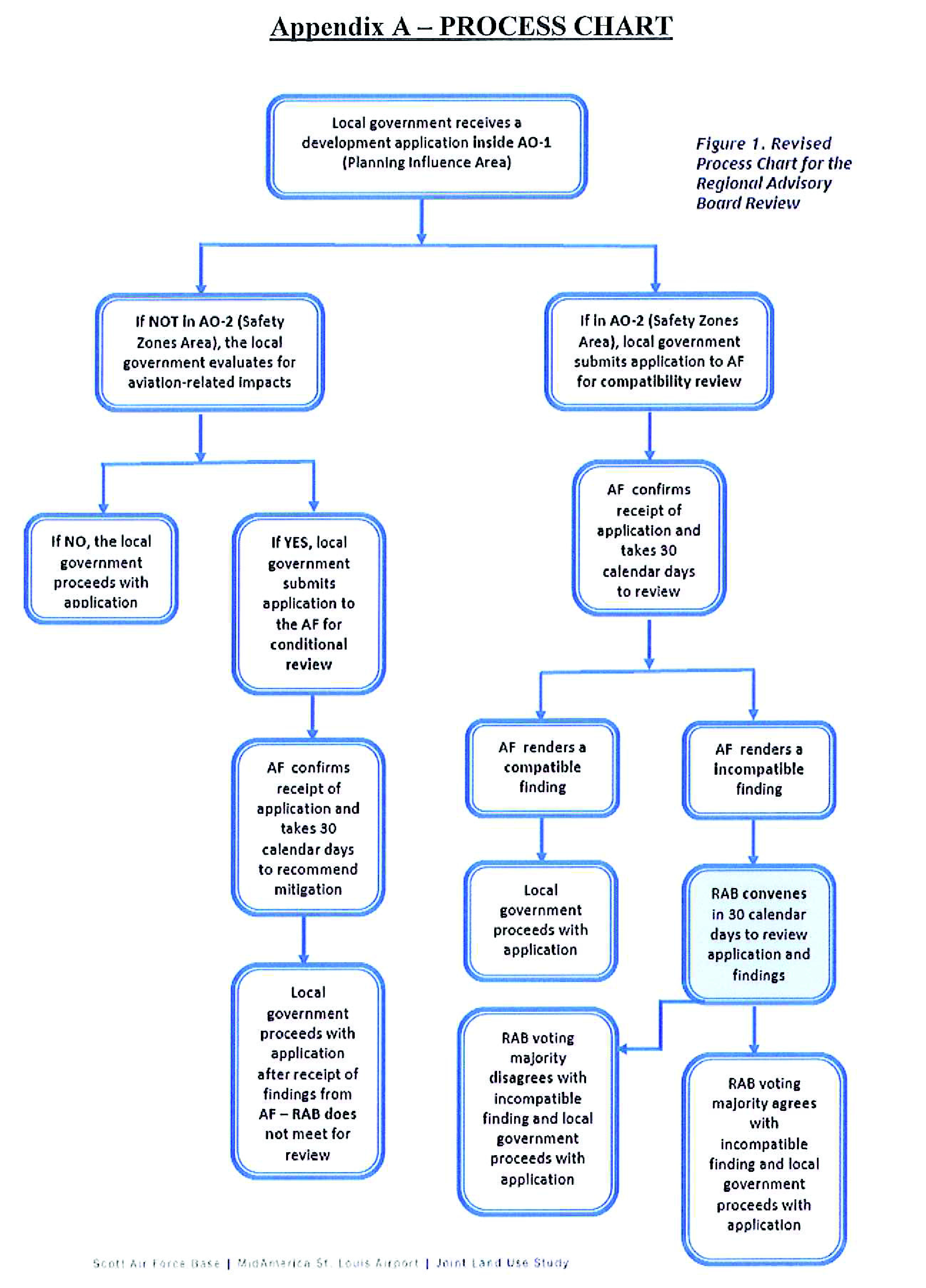
APPENDIX B—AIRPORT IMAGINARY SURFACES
OBSTRUCTION IDENTIFICATION SURFACES
FEDERAL AVIATION REGULATIONS PART 77
• A - Utility runways.
• B - Runways larger than utility.
• C - Visibility minimums greater than ¾ mile.
• D - Visibility minimums as low as ¾ mile.
• * - Precision instrument approach slope is 50:1 for inner 10,000 feet and 40:1 for an additional 40,000 feet.
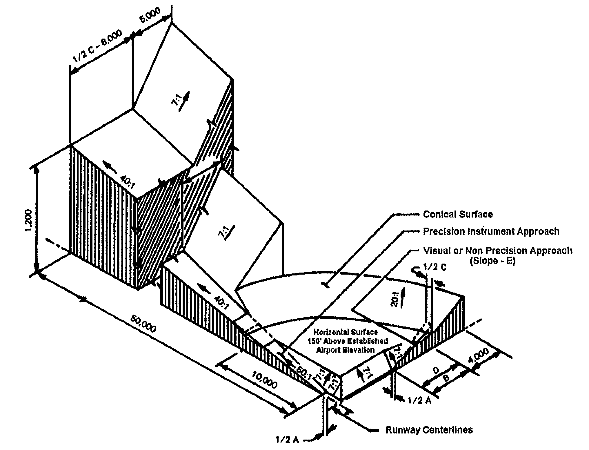
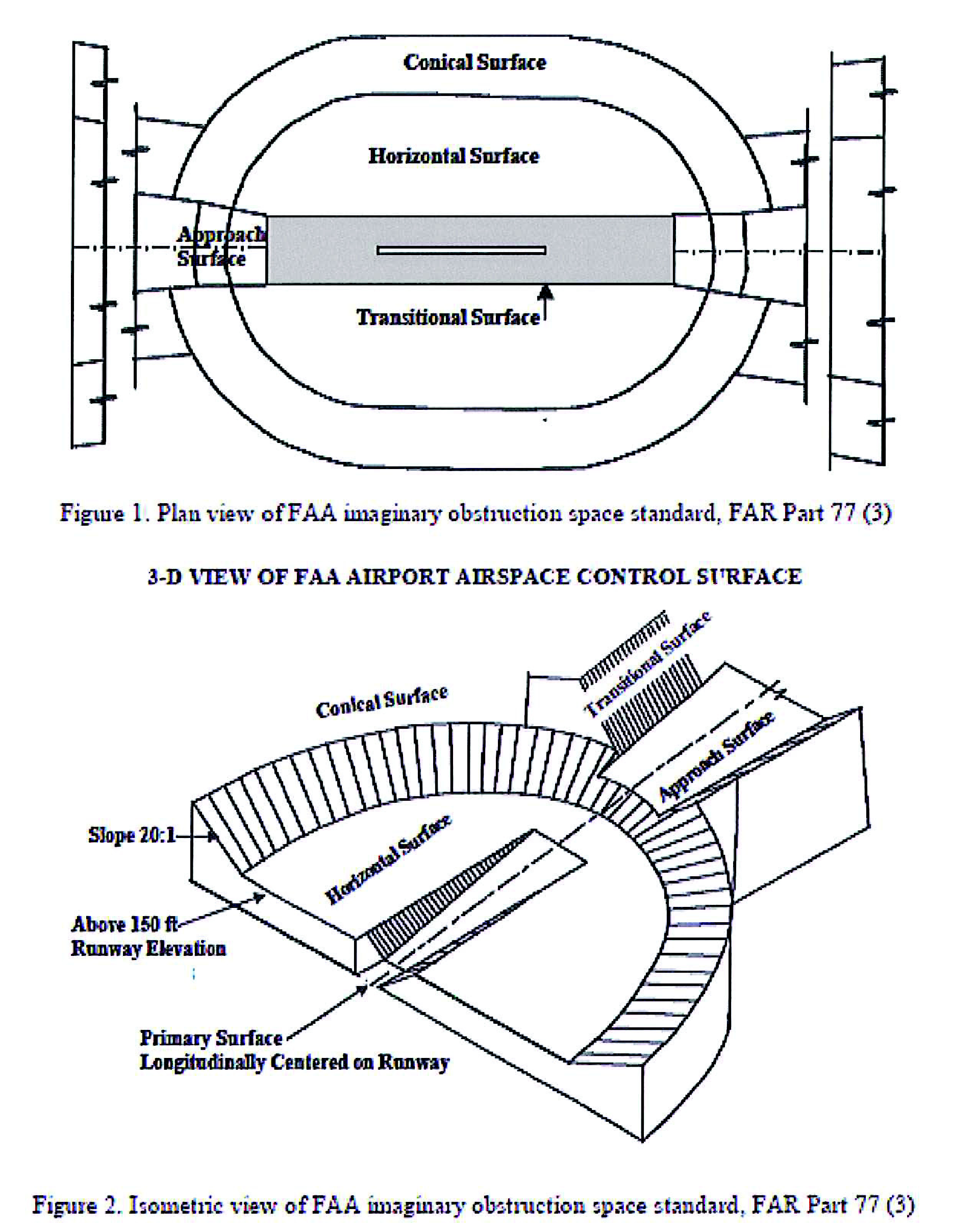
(Ord. No. 11-09, § 1, 6-20-11)