
Maysville City Zoning Code
CHAPTER 320
- LAND USE MANAGEMENT
Sec. 320.400.- Purpose.
The purpose of this section is to protect and promote the general welfare, health, safety and morals of the public by establishing regulations and standards to:
(A)
Preserve and protect the aesthetic quality, natural beauty and character of the land and the natural resources;
(B)
Preserve, enhance and protect the character and quality of life of the community;
(C)
Encourage the harmonious interaction of residential, commercial, industrial, public and semi-public, and agricultural land uses;
(D)
Promote and protect the safety of the public against fire, flood or other hazards;
(E)
Promote and protect the safety and convenience of motorists and pedestrians; and
(F)
Encourage the best possible use of the land while avoiding the undesirable effects of overcrowding, congestion and mixture of incompatible uses.
(Ord. passed 12-12-2002)
Sec. 320.401.- Procedures.
This chapter consists of two parts:
(A)
The written text portion of the chapter contained herein; and
(B)
The Official Land Use Management Map which accurately portrays the land use areas and districts as described in the text.
(Ord. passed 12-12-2002)
Sec. 320.401.1.- Amending the text.
A proposal to amend the text of the Land Use Management Regulations may originate with the Planning Commission, the City of Maysville Board of Commissioners or the Mason County Fiscal Court. Regardless of the origin of the proposed amendment, it shall be referred to the Planning Commission before adoption. The Planning Commission shall hold a public hearing after notice as required by KRS 424, and make a recommendation as to the text of the amendment, and whether the text amendment shall be approved or disapproved, stating the reasons for its recommendation. In the case of a proposed amendment originating with the Board of Commissioners or Fiscal Court, the Planning Commission shall make its recommendations within 60 days of the date of its receipt of the proposed amendment. It shall take an affirmative vote of a majority of the Board of Commissioners or Fiscal Court to adopt the proposed amendment.
(Ord. passed 12-12-2002)
State Law reference— Zoning Regulation Amendment, see KRS 100.211.
Sec. 320.401.2.- Amending the Official Map.
(A)
Prior to application for amendment to the Official Land Use Management Map, the applicant is encouraged to have a conference with the Planning Commission Administrative Officer to discuss the proposed land use change.
(B)
Amendment application. A proposal to amend the Official Land Use Management Map may originate with the Planning Commission, the Board of Commissioners, the Fiscal Court or the owner of the property in question. The application for amendment shall contain at least the following items:
(1)
Interest and ownership. The applicant's name, address and interest in the application and the name, address, and interest of every person, firm or corporation represented by the applicant in the application, the name and signature of the owner or owners of the entire land area to be included within the proposed district and all encumbrances of the land and the names and addresses of owners of all adjacent property. If the applicant is not the owner, then the owner shall submit a notarized affidavit certifying the person acting as a representative has the authority to act in his or her behalf.
(2)
Property survey and site plan. A property survey and written legal description shall be submitted.
(3)
Reason for the amendment. The reason and justification for the proposed amendment is consistent with division (C)(4) below.
(4)
Effect of the amendment. A statement giving the nature, description and effect of the proposed amendment on surrounding land uses and properties must be included.
(5)
Development plan. A development plan may be required by the Planning Commission in conjunction with the application, and shall be reviewed in accordance with section 320.401.3. If a development plan is approved as part of the land use map amendment, a certificate of land use restriction must be filed.
(C)
Planning Commission action.
(1)
Following receipt of an application for a Land Use Map amendment, the Planning Commission shall fix a reasonable time for a public hearing. The applicant shall then give public notice thereof in accordance with KRS Chapter 424; the notice shall include publication in a local newspaper at least once and shall be made not less than seven days or more than 21 days before the date of the hearing. The applicant shall also give notice at least 14 days in advance of the hearing by first class mail, return receipt requested, to the owners of the adjacent property. Copies of all returned receipts and affidavits of publication shall be presented to the Planning Commission as evidence of compliance prior to the hearing. In addition, the application shall post a notice on the property for 14 consecutive days. This notice shall be in compliance with KRS Chapter 100.212 and with any requirements established by the Planning Commission. The Planning Commission shall conduct a public hearing within 60 days of receipt of an administratively completed map amendment application unless the time frame is waived by the applicant.
(2)
If the property the classification of which is proposed to be changed adjoins property in a different planning unit, notice of the hearing shall be given at least 14 days in advance of the hearing by first class mail to the Planning Commission of that planning unit.
(3)
If the property the classification of which is proposed to be changed is part of a proposal for annexation by the city, the city may amend its Comprehensive Plan and official Land Use Management Map to incorporate and establish land use districts for the property proposed for annexation. If the city elects to follow this procedure, the Planning Commission shall hold a public hearing, after the adoption of the ordinance stating the city's intention to annex and prior to final action upon the ordinance of annexation, for the purpose of adopting the Comprehensive Plan amendment and making its recommendations as to the classification of the land which will be effective for the property upon its annexation. Notice setting forth the time, date, location, and purpose for the public hearing shall be published as required by KRS Chapter 424 and shall be given to the owners of all properties within the area proposed for annexation and to adjoining property owners in conjunction with KRS 100.212(2). The City of Maysville Board of Commissioners shall take final action upon the Planning Commission's recommendations prior to adoption of the ordinance of annexation and shall include in the ordinance of annexation a map showing the land use district which will be effective for the annexed property. If the city elects not to follow this procedure, the newly annexed territory shall remain subject to the same land use restrictions as applied to it prior to annexation, until those restrictions are changed by an amendment to the official Land Use Management Map or other regulations in accordance with this chapter.
(4)
These Land Use Management Regulations are based on recommendations included in the Comprehensive Plan. Before any amendment to the official Land Use Management Map is granted, The Planning Commission must first find that the proposed map amendment is in agreement with the Comprehensive Plan, or in the absence of such a finding, that one of more of the following apply:
(a)
That the original land use classification given to the property was inappropriate, and that the proposed land use classification is appropriate; or
(b)
That there have been major changes of an economic, physical or social nature within the area involved which were not anticipated in the adopted Comprehensive Plan, and which have substantially altered the basic character of the area.
(5)
The Planning Commission shall hold a public hearing and shall make a finding of fact which shall be recorded in the minutes and records of the Planning Commission. The Planning Commission may vote to approve, reject or defer action on the proposed amendment. After voting, the Planning Commission shall forward its finding of fact and recommendation in writing to the Board of Commissioners or the Fiscal Court. The findings of fact shall include a summary of the evidence and testimony presented by the proponents and opponents of the proposed amendment. A tie vote shall be subject to further consideration by the Planning Commission not to exceed 30 days, at the end of which if the tie has not been broken, the application shall be forwarded to the Fiscal Court or Board of Commissioners without a recommendation for approval or disapproval.
(6)
A Planning Commission recommendation relating to the proposed amendment shall become final and the map amendment shall be automatically implemented subject-to the provisions of KRS 100.347, all as set forth in the Planning Commission recommendations, unless within 21-days after the final action by the Planning Commission:
(a)
Any aggrieved person files a written request with the Planning Commission that the final decision shall be made by the appropriate legislative body or fiscal court; or
(b)
The appropriated legislative body or fiscal court files a notice with the Planning Commission that the legislative body or fiscal court shall decide the map amendment.
(c)
It shall take a majority of the entire legislative body or fiscal court to override the recommendation of the Planning Commission.
(d)
All procedures for public notices and publication as well as for adoption shall be the same as for the original enactment of a zoning regulation, and the notice of publication shall include the street address of the property in question, or if one is not available, or if it is not practicable due to the number of addresses involved, a geographic description sufficient to locate and identify the property, and the names of the two streets on either side of the property which intersect the street on which the property is located. If the property is located at the intersection of two streets, the notice shall designate the intersection by name of both streets rather than name the two streets on either side of the property.
(7)
Action by the Board of Commissioners or Fiscal Court. In case of deferring proposed map amendment final decisions to the appropriate legislative body or fiscal court as described by sections 320.401.2(6)(a) and 320.401.2(C)(6)(b), the appropriate legislative body shall not act upon a proposed amendment to the Official Land Use Management Map until it shall have received the written finding of act and recommendation from the Planning Commission. It shall take a majority vote of the entire membership of the legislative body to override the recommendation of the Planning Commission. It shall take a majority vote of the entire membership of the legislative body to adopt a Land Use Map amendment when the Planning Commission forwards the application without a recommendation due to a tie vote.
(8)
The Planning Commission, legislative body or Fiscal Court may adopt provisions which prohibit for a period of two years, the reconsideration of a denied map amendment or the consideration of a map amendment identical to a denied map amendment.
(Ord. passed 12-12-2002; Am. Ord. 15-30, 10-8-2015; Am. Ord. 17-09, 6-8-2017)
State Law reference— Similar provisions, see KRS 100.213(2).
Case Law reference— City legislative body may approve zoning map amendment by ordinance only after receiving Planning Commission's approved minutes before city has first reading on the ordinance, see Helm v. Citizens to Protect the Prospect Area, Inc., 864 S.W. 2d 312 (Ky. App. 1993);
Danville's approval of Planning Commission's detailed findings, which were supported by substantial evidence, that the prerequisites of KRS 100.213 for a zone change were not met, was upheld, see Danville-Boyle County Planning Commission v. Centre Estates 13 KAM 14-4 (Ky. App. 2006);
Planning commission erred in refusing to consider impact of zoning map amendment on traffic and drainage, and limiting its consideration solely on accordance of amendment with recommended land use element of Comprehensive Plan, see 21st Century Development Company v. Watts, 958 S.W. 2d 25 (Ky. App. 1997);
Planning commission in considering applications for zoning amendment may rely upon staff reports which have been made available to interested parties; unsworn testimony does not violate due process in such administrative hearings, see Danville-Boyle Planning and Zoning Commission v. Prall, 840 S.W. 2d 205 (Ky. S. Ct. 1992);
Property owner filing legislative appeal from Planning Commission denial of zoning map amendment was denied due process when legislative commissioner relied on information outside the Planning Commission record and made ex parte statements that they would never vote for the proposed use, see Hilltop Basic Resources, Inc. v. County of Boone, 10 KAM 42-3 (Ky. App. 2003);
Property owner seeking zoning map amendment is entitled to procedural due process, and if Planning Commission holds trial-type hearing and makes factual findings then legislative body may follow Planning Commission recommendation without hearing, or may make different findings based on a review of the Planning Commission's hearing record or based on the record of a trial-type hearing conducted by the legislative body, see McKinstry v. Wells, 548 S.W. 2d 169 (Ky. App. 1977); City of Louisville v. McDonald, 470 S.W 2d 173 (Ky. 1971);
Thirty-day appeal period in which to challenge rezoning decision commenced to run upon second reading and final passage of rezoning ordinance rather than upon first reading, see Leslie v. City of Henderson, 797 S.W. 2d 718 (Ky. App. 1990);
Timely adoption of resolution by city legislation body, as opposed to ordinance is sufficient to override Planning Commission recommendation for zoning change, see City of Lyndon v. Proud, 898 S.W. 2d 534 (Ky. App. 1995).
Opinion reference—Planning Commission, as quasi-judicial body, may deliberate rezoning application in closed session after hearing and announce decision in open meeting, see OAG 84-162.
Sec. 320.401.3.- Development plan requirements.
(A)
A development plan shall be prepared and submitted to the appropriate Administrative Official whenever a person wishes to:
(1)
Develop land within a Conservation Overlay District;
(2)
Develop a Planned Commercial District;
(3)
Develop a Planned Unit Development;
(4)
Develop within a Corridor Overlay District; and
(5)
Make application to amend the Official Land Use Management Map, if required by the Planning Commission pursuant to section 320.401.2(B)(5).
(B)
An application shall be submitted as part of any development plan, and shall be made on a form provided by the appropriate Administrative Official. The application shall contain the following information:
(1)
Name, address and telephone number of the owner of all land within the building site (and developer, if different from owner);
(2)
If the developer is not the owner, a notarized affidavit signed by the owner shall be submitted stating that the owner authorizes the developer to act on his or her behalf, and that the owner agrees to abide by any restriction or condition placed on the development plan;
(3)
A legal description of the entire area to be developed;
(4)
Copies of any documents pertinent to the development of the property, including deed restrictive covenants, easements or encroachment permits; and
(5)
A brief concise description of the proposed usage of the property, including the anticipated number of employees or families, types of products produced or sold, services rendered or any other related activities.
(C)
The Planning Commission may require the following information to be shown on a development plan drawn to scale and bearing the seal and signature of an architect, engineer or land surveyor duly licensed by the Commonwealth of Kentucky.
(1)
The boundary lines of the building sites and all lots or parcels which comprise the building site;
(2)
The area of the building site in square footage or acreage;
(3)
The type, location, and size or all utility and right-of-way easements, which shall be labeled as existing or proposed;
(4)
The deed book or plat cabinet reference numbers for all deeds or easements;
(5)
All existing and proposed final contours;
(6)
All existing natural features such as trees, sinkholes, streams, creeks or other bodies of water;
(7)
The sizes and locations of all proposed or existing site improvements, including but not limited to:
(a)
Off-street parking and loading areas;
(b)
Buffer strips and open spaces;
(c)
Service roads, fire lanes and sidewalks;
(d)
Vehicle entrance and access locations and dimensions;
(e)
Paved areas and curb cuts;
(f)
Fire hydrants and Fire Department connections;
(g)
Landscaping;
(h)
Guardrails, fences or hedges;
(i)
Signs;
(j)
Exterior lighting;
(k)
Electric, water and gas meters; and
(l)
Trash collection areas.
(8)
Provisions for drainage of all surface water; and
(9)
Floor plans and elevations of all proposed and existing structures, and the proposed uses of the structures.
(D)
Development plan review procedures. Upon receipt of a development plan prepared in accordance with the provisions above, the appropriate Administrative Official shall immediately forward copies to the following agencies who shall review the development plan for compliance with any applicable codes, ordinances or standards.
(1)
City/County Engineer (as appropriate) or Projects Coordinator, who shall review and make recommendations on the drainage, traffic flow, structural and pavement design or any other engineering related criteria.
(2)
City/County Codes Enforcement Office (as appropriate), who shall review and make recommendations on compliance with the terms of this chapter or any other codes or ordinances under his or her jurisdiction.
(3)
City/County Fire Department (as appropriate), who shall review and make recommendations on the accessibility of the development to emergency vehicles, fire hydrant types and locations, water supply, fire lanes or any other related standards under its jurisdiction.
(4)
City/County Utility Commission/ Agency (as appropriate), who shall review and make recommendations on the water and sanitary sewer services.
(5)
The Mason County Health Department, if private sewage disposal systems or private water supply systems are proposed.
(6)
Any other agency the appropriate Administrative Officer deems to have an interest in the development plan.
(E)
Recommendations. The reviewing agencies shall review the plan for compliance with the standards, codes or ordinances which they are responsible for administering. The agencies shall, within seven days of receipt of a development plan, make a recommendation to the Planning Commission, in writing, to approve, disapprove or approve with modifications or conditions.
(Ord. passed 12-12-2002; Am. Ord. 17-40, 11-9-2017)
Case Law reference— Submission of proposed development plan with request for zone change must comply with plan requirements of ordinance as enabled by KRS 100.111 (8), see Davis v. City of Danville, 995 S.W. 2d 404 (Ky. App. 1999).
Sec. 320.402.- Certificates of land use restrictions.
402.1
When land use restrictions are imposed through approvals of variances, conditional use permits, conditional land use management conditions, unrecorded preliminary subdivision plats and development plans, but not including land use management map amendments which impose no limitations or restrictions upon the use of the property other than those generally applicable to properties within the same land use district and not including any recorded subdivision plat, a certificate of land use restriction must be completed by the appropriate body (Planning Commission, Board of Adjustment, City Commission or Fiscal Court) which finally adopts or imposes the land use restriction.
402.2
The certificates shall be in the format provided for in ordinance codified herein, and shall be filed with the County Clerk within 30 days of the date upon which the body takes final action to impose or adopt the restriction. The Administrative Official shall collect the County Clerks' filing fee (not to exceed $10.50) from the applicant at the time any processing is initiated which may result in the imposition, adoption, amendment or release of any land use restriction. The fee shall be refunded to the applicant in the event no land use restriction is imposed or adopted as a result of the proceeding. The County Clerk shall upon receipt of the fee, file and maintain these certificates among the official records of the office. The County Clerk shall index the certificates by property owner, and if applicable, name of subdivision or development. The County Clerk shall maintain in the office a record of the name and address of the agency having custody of the official land use management map for each planning unit within the county.
402.3
When a restriction reflected on the certificate is amended, a new certificate shall be filed. In the case of the amendment or in the event the original restriction is released, the previous certificate shall be released by the secretary of the body which amended or released the restriction in the same manner as releases of encumbrances upon real estate.
402.4
The failure to file, file on time or to complete the certificate properly or accurately shall not affect the validity or ability to enforce any land use restriction or regulation. An improper filing may be cured by a subsequent proper filing. Nothing herein shall affect the running of time for any appeal or other act for which a time limit is prescribed in these regulations. It is strongly recommended that a certificate be filed, particularly with conditional use permits and variances, so that subsequent developers and/or owners are aware of the stipulations on the property.
402.5
When a land use management map amendment is filed for more than five contiguous properties, or a land use restriction is imposed upon two or more properties or lots in the same proceedings, a single certificate shall be filed for all the properties or lots collectively, and a single fee shall be paid.
(Ord. passed 12-12-2002)
Sec. 320.403.- Conditional use permits.
403.1
The Board of Adjustments shall have the power to hear and decide applications for conditional use permits to allow the proper integration into the community of uses which are specifically named in the Land Use Management Regulations which may be suitable only in specific locations in the district only if certain conditions are met.
403.2
The Board may approve, modify or deny any application for a conditional use permit. If it approves the permit, it may attach necessary conditions such as time limitations, requirements that one or more things be done before the request can be initiated, or conditions of a continuing nature. Any such conditions shall be recorded in the Board's minutes and on the conditional use permit along with a reference to the specific section in the regulations listing the conditional use under consideration. The Board shall have the power to revoke conditional use permits, or variances for non-compliance with the condition thereof. Furthermore, the Board shall have a right of action to compel offending structures or uses removed at the cost of the violator and may have judgment in personam for the cost. If an applicant for conditional use permit submits a modified plan to regulatory authorities in order to comply with relevant housing, building or other code requirements that expands the previously established geographic boundaries of the conditional use permit, the modified plan must be submitted to the Board of Adjustment within 14 days of submission to regulatory authorities for review of the expanded geographic boundaries of the modified plan. The Board of Adjustment may deny the applicant's conditional use permit for the expanded geographic area. Failure to provide notification to the Board of Adjustment is grounds for the Board to revoke the conditional use permit following a hearing before the Board of Adjustment.
403.3
Granting of a conditional use permit does not exempt the applicant from complying with all of the requirements of building, housing and other regulations.
403.4
In any case where a conditional use permit has not been exercised within the time limit set by the Board, or within one year if no specific time limit has been set, the conditional use permit shall not revert to its original designation, unless there has been a public hearing. Exercised, as set forth in this section, shall mean that binding contracts for the construction of the main building or other improvement is under construction to a substantial degree or that prerequisite conditions involving substantial investment shall be under contract, in development, or completed. When construction is not part of the use, exercised shall mean that the use in operation is in compliance with the conditions as set forth in the permit.
403.5
The Administrative Official shall review all conditional permits except those for which all conditions have been permanently satisfied, at least once annually and shall have the power to inspect the land or structure where the conditional use is located in order to ascertain that the landowner is complying with all of the conditions which are listed on the conditional use permit. If the landowner is not complying with the conditions on the conditional use permit, the Administrative Official shall report the fact in writing to the Chairperson of the Board of Adjustments. The report shall state specifically the manner in which the landowner is not complying with the conditions on the conditional use permit and a copy of the report shall be furnished to the landowner at the same time it is furnished to the Chairperson of the Board of Adjustments. The Board shall hold a hearing on the report within a reasonable time, and notice of the time and place of the hearing shall be furnished to the landowner at least one week prior to the hearing. If the Board of Adjustments finds that the facts alleged in the report of the Administrative Official are true and that the landowner has taken no steps to comply with them between the date of the report and the date of the hearing, the Board of Adjustments may authorize the Administrative Official to revoke the conditional use permit and take the necessary legal action to cause the termination of the activity on the land which the conditional use permit authorizes.
403.6
Once the Board of Adjustments has completed a conditional use permit and all the conditions required are of such type that they can be satisfied completely and permanently, the Administrative Official, upon request of the applicant, may, if the facts warrant, make a determination that the conditions have been satisfied and the and the conclusion in the margin of the copy and note the conclusion in the margin of the copy of the conditional use permit which is on file with the County Clerk as required in KRS 100.329. Thereafter, the use, if it continues to meet the other requirements of the regulations, will be treated as a permitted use.
403.7
When an application is made for a conditional use permit for land located in or abutting any residential district, written notice shall be given at least 14 days in advance of the public hearing on the application to the applicant, Administrative Official, and owner of every parcel of property adjoining the property to which the application applies and such other persons as the regulations shall direct. Written notice shall be by first class mail with certification by the Board's secretary or other officer that the notice is mailed. It shall be the duty of the applicant to furnish to the Board the name and address of any owner of each parcel of property as described in this division. Records maintained by the Property Valuation Administrator may be relied upon to determine the identity and address of the owner. In the event the property is in condominium or cooperative forms of ownership, then the person notified by mail shall be the president or chairperson of the owner group which administers property commonly owned by the condominium or cooperative owners.
403.8
All conditional use permits approved by the Board of Adjustments shall be recorded at the expense of the applicant in the office of the County Clerk.
(Ord. passed 12-12-2002; Am. Ord. 15-30, 10-8-2015)
State Law reference— Conditional use permit, see KRS 100.237.
Case Law reference— Board of Zoning Adjustment hearing on conditional use permit is an evidentiary due process proceeding for which there must be transcribed minutes, see Gentry v. Ressnier, 437 S.W. 2d 756 (Ky. 1969);
Refusal of a zoning permit for a drug treatment facility is a violation of the Americans with Disabilities Act where the denial was based on the city's fear that the clinic's clients would continue to abuse drugs and attract more drug activity to the city; equating client's status as recovering drug addicts with criminality was based on fear and stereotyping of the kind the ADA was intended to address, see M.X. Group v. City of Covington, 293 F.3d 326 (6th Cir. 2002).
Opinion reference—Boards of Adjustment must hold public hearing in connection with granting or withholding conditional use permit pursuant to KRS 100.237 and a dimensional variance pursuant to KRS 100.241 and must satisfy requirements of procedural due process, including adequate notice given by the Board, making transcript of evidence, and incorporating in minutes a summary of testimony, findings, and determinations, and roll-call vote, see OAG 79-75.
Sec. 320.404.- Variances.
404.1
The Board shall have the power to decide on applications for variances. The Board may impose any reasonable conditions or restrictions on any variance it decides to grant.
404.2
Before any variance is granted, the Board must find all of the following, which shall be recorded along with any imposed conditions or restrictions in its minutes and records issued in written form to the applicant to constitute proof of the variance.
(1)
The requested variance arises from special circumstances which do not generally apply to land in the general vicinity, or in the same district.
(2)
Special circumstances are not the result of actions of the applicant taken subsequent to the adoption of these regulations.
(3)
The strict application of the provisions of the regulations would deprive the applicant of a reasonable use of the land or would create an unnecessary hardship on the applicant.
(4)
Reasons that the variance will not adversely affect the public health, safety and welfare, will not alter the essential character of the general vicinity, and will not cause a hazard or a nuisance to the public.
(5)
A variance applies to the property for which it is granted, and not to the individual who applied for it. A variance runs with the land and is transferable to any future owner of the land, but sit cannot be transferred by the applicant to a different site.
(6)
All variances approved by the Board of Adjustments shall be recorded at the expense of the applicant in the office of the County Clerk.
(Ord. passed 12-12-2002)
Case Law reference— Board of Adjustment grant of dimensional variance under KRS 100.580(1)(c) (repealed) without evidentiary hearing and finding of fact was arbitrary and denial of procedural due process, see Morris v. City of Catlettsburg, 437 S.W. 2d 753 (Ky. 1969);
Notice of Board of Adjustment hearing on application for dimensional variance from building setback line under KRS 100.082 (repealed) sufficient without newspaper notice where notices posted on premises and interested parties had actual notice, see Stout v. Jenkins, 268 S.W. 2d 643 (Ky. 1954);
Revocation of a building permit improperly issued and requiring removal of a mobile home was justified because the city official's belief that a zoning regulation concerning minimum required living area had been amended was in fact erroneous, and therefore did not alter the requirement to comply with the literal language of the regulation, see Hamilton v. Thomas, 9 KAM 31-39 (Ky. App. 2001).
Opinion reference—Board of Adjustment not required to hold a hearing on application for dimensional variances under KRS 100.241, see OAG 67-528.
Sec. 320.405.- Non-conforming uses and structures.
405.1
The lawful use of a lot or a structure, existing at the time of adoption of any land use regulations affecting it may be continued, although such does not conform to the provisions of such regulations, except as otherwise provided herein.
405.2
A nonconforming use may lapse for a period of one year without being considered abandoned. The property owner may appeal to the Board of Adjustments for an additional year prior to the end of the first year. Any lapse of a nonconforming use for a period of more than two years may result in the property being required to conform to existing land use requirements regarding appropriate uses.
405.3
A residential dwelling may be built upon a lot which was nonconforming at the time this chapter was adopted even though the lot fails to meet the requirements for area or frontage, or both, that are generally applicable in the district. However, dimensional requirements other than those applying to area or frontage (or both) of the lots shall conform to the regulations for the district in which the lot is located. Variances must be obtained from the Board of Adjustments as described in section 320.302.
405.4
The Board of Adjustments shall not allow the enlargement or extension of a nonconforming use beyond the scope and area of its operation at the time the regulation which makes it nonconforming was adopted. Nor shall the Board permit a change from one nonconforming use to another unless the new nonconforming use is in the same or a more restrictive classification.
405.5
Should any nonconforming structure or nonconforming portion of a structure be damaged, destroyed or demolished by any means, it may be reconstructed or repaired, but not to exceed the number of cubic feet existing in it, and not to extend or enlarge the scope and area of its operation prior to its damage, destruction or demolition.
405.6
The Board of Adjustments shall have the power to hear and decide cases where it is alleged by an applicant that there is error in any order, requirement, decision, grant or refusal made by an administrative official or the Board of Architectural Review in the enforcement of the land use regulations. The appeal shall be made within 30 days.
405.61
Appeals to the Board of Adjustments may be taken by any person or entity, claiming to be injuriously affected or aggrieved by an official action or decision of any land use regulations enforcement officer or Board of Architectural Review. The appeal shall be taken within 30 days after the appellant or his or her agent receives official notice of the action, by filing with the officer and the Board a notice of appeal specifying the ground thereof, and giving notice of the appeal to any and all parties of record. The officer shall forthwith transmit to the Board all papers constituting the record upon which the action appealed from was taken and shall be treated as and be the respondent in such further proceedings. At the public hearing on the appeal held by the Board, any interested person may appear and enter his or her appearance, and all shall be given an opportunity to be heard. The Board will rehear an appeal only in cases where new evidence is available, or where the appealing person or entity desires a complete transcription for the court record.
405.62
The Board shall fix a reasonable time for hearing the appeal and give public notice in accordance with KRS Chapter 424, as well as written notice to the appellant and the Administrative Official at least one week prior to the hearing, and shall decide it within 60 days. The affected party may appear at the hearing in person or be represented by an attorney.
405.63
Any person or entity claiming to be injured or aggrieved by any final action of the Board of Adjustments shall appeal from the action to the Circuit Court of the county in which the property, which is the subject of the action of the Board of Adjustments, lies. The appeal shall be taken within 30 days after the final action of the Board. All final actions which have not been appealed within 30 days shall not be subject to judicial Review. The Board of Adjustments shall be a party in any such appeal filed in the circuit court.
405.64
Subpoena requests shall be submitted to the Board of Adjustments at least ten days prior to a public hearing.
(Ord. passed 12-12-2002; Am. Ord. 14-03, 1-9-2014; Am. Ord. 15-30, 10-8-2015)
Case Law reference— Owner of property, who has begun construction to convert use of property not permitted under new zoning use, had acquired vested right under Fourteenth Amendment to improve property without complying with the newly adopted zoning regulations, see Darlington v. Board of Councilmen, 140 S.W. 2d 392 (Ky. 1940).
Sec. 320.406.- Land use classification and designation.
Editor's note— This section contains no text but is retained here to preserve the numbering of the Maysville-Mason County Land Use Management Ordinance.
Sec. 320.406.1.- Land use areas.
Areas are relatively large segments of the county landscape describing very general land use patterns. There are five such areas recognized:
(A)
Urban area. Includes the City of Maysville and the surrounding unincorporated portion of Mason County within and along the highway loop. The boundaries of the outer portion of this area extend 1,000 feet from the centerline of highway loop as indicated on the Official Land Use Management Map. This area contains most of the more intensively developed land in Mason County, with an adequate level of support services/ infrastructure to meet the needs of the area. This is the area that contains the urban population and the greatest potential for future urbanization.
(B)
Urban corridors. Designated areas along Highways 9, 11, and 62 which are within close proximity to the Urban Center, or are presently under development. These corridors are 2,000 feet wide (1,000 feet from highway centerline), and contain the needed infrastructure to support fairly intensive urban-type development.
(C)
Rural corridors. Designated areas along major highways extending beyond the urban portions. These corridors are 1,000 feet wide (500 feet from highway centerline), and do not have infrastructure of sufficient capacity to support intensive development. Note: Corridor widths may be reduced and development limited or prohibited due to topographic limitations.
(D)
Rural-agricultural areas. The most extensive area in Mason County comprised largely of land used for agriculture or dispersed single-family residences. This area includes idle land and a significant portion of the county's natural resource base.
(Ord. passed 12-12-2002; Am. Ord. 07C-11, 8-9-2007; Am. Ord. 08-C-01, 3-13-2008)
Sec. 320.406.2.- Land use districts.
Land use districts are smaller sections of the county in which more specific land use categories are identified. There are 16 regular land use districts, and five overlay districts. Overlay districts have been established to provide additional regulations in order to protect certain areas which warrant special considerations. Each of the districts is described below with the purpose it is designed to serve.
(A)
Single-family residential (R-1A, R-1B, R-1C, R-1D). The R-1 districts have been established to provide quiet, low to medium density single-family residential neighborhoods and protect them from the encroachment of non-residential or higher density residential uses.
(B)
Two-family (duplex) residential (R-2). The R-2 districts have been established to provide for medium density single and 2-family residential uses by permitting smaller lot sizes and the development of duplex dwelling units.
(C)
Multi-family residential (R-3). The R-3 districts have been established to provide for the development of high density residential uses and to meet the demand for rental dwelling units.
(D)
Manufactured home (MH). The MH districts have been established to provide for the integration of lower cost affordable housing in areas of the city, subject to design and location prerequisites to provide for the safety, health and general welfare of the public and of the users of the structures.
(E)
Oldtown residential (R-4A, R-4B). The R-4 districts have been established to preserve and protect the still vibrant older residential neighborhoods which evolved since the earliest settlement of Maysville. These areas, while mainly consisting of medium density single-family dwellings, have interspersed multi-family, commercial, and other non-residential uses which are vital to the neighborhoods and need to be protected.
(F)
Townhouses (TH-1). The TH-1 districts have been established to provide for the development of medium to high density single-family residential uses while encouraging the development of areas of natural beauty whose topography tends to limit the construction of lower density detached single-family residential districts.
(G)
Professional office (P-1). The P-1 districts have been established to encourage the clustering of professional, medical and related uses in areas which need to be protected from the encroachment of heavier commercial uses.
(H)
General business (B-1). The B-1 districts have been established to encourage the development of commercial activities which tend to attract lower volumes of traffic in areas which are likely to be surrounded by medium to high density residential areas.
(I)
Highway business (B-2). The B-2 districts have been established to encourage the development of commercial uses in areas that are readily accessible to the main traffic corridors and highly visible to vehicular traffic.
(J)
Neighborhood business (B-3). The B-3 districts have been established to encourage the development of stores providing convenient-type goods and services designed to meet the daily needs of nearby residential areas.
(K)
Downtown business (D-1). The D-1 district has been established to protect and encourage the revitalization of the central business district which has long been the heart and core of Maysville. The intent is to encourage the development of specialty shops, financial, governmental, professional, cultural and residential uses, as well as maintaining and preserving the existing uses.
(L)
Light industrial (I-1A, I-1B). The I-1 districts have been established to preserve and encourage the revitalization of the tobacco warehousing industry and to encourage the continued recruitment of warehousing, storage, transportation processing and manufacturing uses which are clean, quiet, and free of hazardous or objectionable elements such as noise, odor, dust, smoke or glare. The development of these uses is encouraged in areas that are readily accessible to rail service and the main traffic corridors.
(M)
Heavy industrial (I-2A, I-2B). The I-2 districts have been established to protect existing manufacturing industries and encourage recruitment of new major manufacturing industries in areas which are accessible to the facilities they require, such as rail service.
(N)
Transition (A-1). The A-1 districts have been established to provide for areas that are within or adjacent to the Urban Area and are either in transition to urban type uses, or have a high potential for urban uses in the near future, as infrastructure becomes available.
(O)
Agricultural (A-2). The A-2 districts have been established to preserve and protect the decreasing supply of prime agricultural land and to minimize urban-type development into rural areas until utilities and other municipal services can be provided efficiently.
(P)
Rural residential (RR-1). The RR-1 districts have been established to provide for medium to low density residential uses in the unincorporated parts of the county where public sewer is available.
(Q)
Rural residential (RR-2). The RR-2 districts have been established to provide for low density residential uses in the unincorporated parts of the county where public sewer is not available.
(R)
Communities (C). Selected rural communities, while they are described earlier as land use areas, also serve as districts due to their small size. The boundaries of communities are determined on an individual basis, and they are considered to function as small compact settlements with mixed land uses.
(S)
Overlay districts.
(1)
A city legislative body, except for urban-county governments, may by ordinance create one or more overlay districts pursuant to KRS 82.660 and 82.670 to provide additional regulations for design standards and development within any area of the city determined to be:
(a)
An area that has historical, architectural, natural or cultural significance that is suitable for preservation or conservation; or
(b)
An area that is located near a river or other body of water, or along an established commercial corridor that has a special character related to the location that is suitable for conservation.
(2)
Upon the establishment of an overlay district, development within the area shall conform to all zoning regulations applicable to the area and shall also conform to all overlay district regulations.
(3)
An ordinance establishing an overlay district shall, at a minimum, include the following provisions:
(a)
An accurate description of the boundaries of the district;
(b)
A description of the historical, architectural, cultural, aesthetic, natural or distinctive characteristics of the district that are to be preserved or conserved;
(c)
A delegation of responsibility for the administration of overlay regulations to an appropriate entity of city government pursuant to KRS 82.670; and
(d)
The standards, guidelines or criteria that shall govern development within the district to preserve, conserve, or protect the historical, architectural, cultural, aesthetic or other distinctive characteristics of the district. These standards, guidelines or criteria may be set out descriptively in the ordinance or by illustration, and may incorporate by reference established architectural standards or guidelines.
(4)
Any city participating in the Certified Local Government Historic Preservation Program shall comply with the regulations of the Kentucky Heritage Commission.
(5)
Upon the effective date of the establishment of an overlay district, no person shall begin any major structural change or any ordinary repairs to any building or structure or change or create any surface parking lot, or clear a parcel or lot of trees or other major vegetation, or change the appearance to signage within an overlay district until the city has issued a permit, without cost, certifying that the person has complied with the provisions of the overlay district regulations governing the district. This prohibition shall not apply to emergency repairs that need to be made to a building or structure within an overlay district.
(T)
Historic Overlay District (HOD). The Historic Overlay District has been established to protect and preserve certain areas or individual structures and premises designated as having historic or architectural significance and to encourage uses that will lead to their continuance, conservation and improvement in a manner appropriate to the preservation of the area's heritage.
(U)
Conservation Overlay District (COD). The Conservation Overlay District has been established to protect environmentally sensitive areas, including but not limited to those areas identified with steep slopes, wetlands, dense forests.
(V)
Flood Prone Overlay District (FP). The Flood Prone Overlay District has been established to guide development in the flood prone areas of any watercourse, to minimize the expenses and inconvenience to individual property owners and the general public through flooding. This district is designed to protect certain areas which have been designated as being susceptible to periodic inundation which may result in loss of life and property, health and safety hazards, destruction of commercial and governmental services, extraordinary public expenditures for flood protection and relief, and impairment of the tax base, all of which adversely affect the public health, safety, and general welfare.
(W)
Planned Commercial Development Overlay District (PCD). The PCD Overlay District has been established to provide for commercial activity that is planned, developed, operated and maintained by a single entity, on larger tracts of land, and which accommodates retail, service and office uses, or a combination of such uses in one or more structures.
(X)
Planned Unit Development Overlay District (PUD). The PUD Overlay District has been established to allow the mixing of uses and densities on larger tract developments and to allow higher densities than otherwise provided for in established districts.
(Y)
Corridor Districts (CD). The Corridor Districts are linear areas that parallel major transportation arteries, serve as locations for public utilities, and often contain much of the development. Corridors may be designated as either Urban or Rural, depending upon their function. Urban Corridors are those that are located in the urban (city-like) environment, and have a high potential for future development. Beyond the Urban Corridors are the Rural Corridors which are usually in agricultural or natural resource areas, often with scenic views, and less amenable to intensive development because of their distance from urban centers and the lack of necessary infrastructure.
(Ord. passed 12-12-2002; Am. Ord. 07C-11, 8-9-2007; Am. Ord. 08-C-01, 3-13-2008)
Cross reference— Maysville/Mason County Comprehensive Plan, see March 2001 (p. 76).
State Law reference— Urban Residential Zones enabled for regulation of individual structures to stabilize and protect an area's urban residential character, see KRS 100.201(3).
Sec. 320.406.3.- Districts allowed by land use areas.
Land Use Areas
The districts allowed by areas are designated with the letter X.
(Ord. passed 12-12-2002; Am. Ord. 07C-11, 8-9-2007; Am. Ord. 08-C-01, 3-13-2008)
Sec. 320.406.4.- Dimensional requirements.
(A)
Residential areas.
*Where deed restrictions or restrictive covenants have been recorded and are in conflict with these dimensions, the more stringent requirements shall take precedent.
**These side setback dimensions shall apply only between blocks of attached dwelling units and the nearest property line. The setback between the attached dwelling units may be reduced to zero feet where the common wall is designed and constructed to meet the fire separation requirements of the Kentucky Building Code or Kentucky Residential Code.
***One acre (43,560 square feet) is the minimum building site area for all land use activities in all districts of the unincorporated areas of the county that are dependent upon on-site sewage disposal systems.
****These height limitations shall not apply to church spires, belfries, cupolas or domes not used for human habitation, nor to chimneys, ventilators, skylights, water tanks, parapet walls, cornices, radio or television towers or necessary mechanical appurtenances usually carried above the roof level, provided that such features are limited to that height necessary for their proper functioning.
(B)
Non-residential areas.
*Where deed restrictions or restrictive covenants have been recorded and are in conflict with these dimensions, the more stringent requirements shall take precedent.
**These side setback dimensions shall apply only between blocks of attached dwelling units and the nearest property line. The setback between the attached dwelling units may be reduced to 0 feet where the common wall is designed and constructed to meet the fire separation requirements of the Kentucky Building Code or Kentucky Residential Code.
***One acre (43,560 sq. ft.) is the minimum building site area for all land use activities in all zones in the City limits dependent upon on-site sewage disposal systems. Five acres is the minimum building site area for all use activities in the A-1 Zone of the unincorporated parts of the County.
****These height limitations shall not apply to church spires, belfries, cupolas or domes not used for human habitation, nor to chimneys, ventilators, skylights, water tanks, parapet walls, cornices, radio or television towers, or necessary mechanical appurtenances usually carried above the roof level, provided that such features are limited to that height necessary for their proper functioning.
(C)
Rural areas.
*Where deed restrictions or restrictive covenants have been recorded and are in conflict with these dimensions, the more stringent requirements shall take precedent.
**One acre (43,560 square feet) is the minimum building site area for all land use activities in community districts of the unincorporated areas of the county that are dependent upon on-site sewage disposal systems. Those sites with public sewer shall require one-half acre (21,780 square feet).
***These height limitations shall not apply to church spires, belfries, cupolas or domes not used for human habitation, nor to chimneys, ventilators, skylights, water tanks, parapet walls, cornices, radio or television towers or necessary mechanical appurtenances usually carried above the roof level, provided that such features are limited to that height necessary for their proper functioning.
****Please refer to the Maysville/Mason County Subdivision Regulations for lots on new roadways that will ultimately be dedicated to the Mason County Fiscal Court.
(Ord. passed 12-12-2002; Am. Ord. 07C-11, 8-9-2007; Am. Ord. 08-C-01, 3-13-2008)
Sec. 320.406.5.- Types of land uses.
406.51
Types of land uses.
(A)
Permitted (P). These are uses that are deemed to be the most appropriate uses, and are allowed in a district subject to the restrictions applicable to that district.
(B)
Conditional (C). These are uses that are allowed in a district but which would impair the integrity and character of the district in which it is located, or in adjoining districts, unless restrictions on location, size, extent and character of performance are imposed in addition to those imposed within this chapter.
(C)
Accessory (A). These uses are subordinate or incidental to the principal use and are located on the same lot with the principal use.
(Ord. passed 12-12-2002; Am. Ord. 07C-11, 8-9-2007; Am. Ord. 08-C-01, 3-13-2008)
Sec. 320.406.6.- Land use classification.
The purpose of this section is to regulate the use of land and structures conducted within the different districts, to insure that they are in keeping with the purposes of the district, and are compatible with one another. For the purpose of determining which uses shall be permitted in the different districts, the uses shall be defined and listed by categories in:
406.61
Unclassified uses. The Administrative Official may determine in which category an unclassified use shall be classified. In making his or her determination, the Administrative Officer shall consider the characteristics of the site, the surrounding area, and the proposed use. In addition, he or she may refer to the detailed list of uses provided in the appendix. When a new use is discovered, the Administrative Official shall determine if this chapter needs to be amended.
406.62
Allowable land uses.
*Includes modular homes.
**Public utilities operating under state authority, shall not be required to receive Planning Commission Approval for the location or relocation of any of their service facilities. However, the utility in question shall provide the Planning Commission with information on the proposed change (see KRS 100.324).
***Cellular Towers are permitted ONLY upon approval from the Mason County Joint Planning Commission. Cellular antennas are permitted on existing infrastructure WITHOUT planning commission approval (co-location).
****Adult entertainment uses are not permitted within 1,000 feet of any residence, school, church, public recreation area or other public uses.
*****Public schools are exempt from the zoning process by KRS 100.111 and 100.324.
******Residential care facilities defined and permitted by KRS 100.984.
*Must be located at least 1,000 feet from any residence in the A-2 and C Zones
**Permitted in I-1A, Conditional in I-1B, Permitted in I-3 if site is over 50 acres. Conditional under 50 acres.
***Permitted in downtown Maysville D-1, Conditional in Old Washington D-1.
****Where an Integrated or Rooftop SES is proposed to be installed on a structure located within a designated historic district, the proposed installation may require a Certificate of Appropriateness issued by the Maysville/Washington Board of Architectural Review.
*****Utility scale SES facilities are permitted ONLY upon approval from the Mason County Joint Planning Commission.
(Ord. passed 12-12-2002; Am. Ord. 05C-28, 1-12-2006; Am. Ord. 07C-11, 8-9-2007; Am. Ord. 08-C-01, 3-13-2008; Am. Ord. 11C-08, 8-11-2011; Am. Ord. 14C-05, 1-9-2014; Am. Ord. 14-24, 10-13-2014; Am. Ord. 14C-25, 10-13-2014; Am. Ord. 16-11, 2-11-2016; Am. Ord. 17-09, 6-8-2017; Am. Ord. 18-07, 2-8-2018; Ord. No. 20-16, § 1, 12-10-2020; Ord. No. 20-20, § 1, 12-17-2020; Ord. No. 22-09, § 1, 7-26-2022)
Sec. 320.407.- Official Land Use Management Map.
407.1
Official map. For the purpose of administering this chapter, the City of Maysville and Mason County are divided into land use areas and districts, the boundaries of which are shown on the Official Land Use Management Map.
407.11
The Official Land Use Management Map for the City of Maysville shall be identified by the title "Official Land Use Management Map of Maysville, Kentucky" and shall bear the signature of the Mayor attested by the City Clerk and bearing the seal of the city following the statement "This is to certify that this map is the Official Land Use Management Map of Maysville, Kentucky, as adopted by Ord. 89C-24,25,26 by the Board of Commissioners on July 1, 1989."
407.12
The Official Land Use Management Map for Mason County shall be identified by the title "Official Land Use Management Map of Mason County, Kentucky" and shall bear the signature of the Judge Executive attested by the County Clerk and bearing the seal of the county following the statement, "This is to certify that this map is the Official Land Use Management Map of Mason County, Kentucky, as adopted by Ord. 02-07 by the Fiscal Court on October 15, 2002."
407.13
If in accordance with the provisions of this chapter and KRS Chapter 100, amendments are made in the district or overlay district boundaries or other matters portrayed on the Official Land Use Management Map of the City of Maysville or Mason County, such amendments shall be made to the Official Map promptly after the amendment has been approved by the appropriate governing body with an entry on the Official Map as follows:
"By official action of the Board of Commissioners (or Fiscal Court), this map is amended as authorized by Ordinance _______, which entry shall be signed by the Mayor or Judge Executive and attested by the City or County Clerk."
407.14
No changes of any nature shall be made to the Official Land Use Management Map or matter shown thereon except in conformity with the procedures set forth in this chapter and in KRS Chapter 100. Any unauthorized change of whatever kind by any person or persons shall be consideration a violation of this chapter and punishable as provided herein.
407.15
Regardless of the existence of purported copies of the Official Land Use Management Map which may from time to time be made or published, the Official Land Use Management Map which shall be located in the office of the appropriate Administrative Official shall be the final authority as to the current land use classification of land and water areas, buildings and other structures in the city or county.
407.16
In the event the Official Land Use Management Map becomes damaged, destroyed, lost or difficult to interpret because of the nature or number of changes and additions, the appropriate governing body may adopt a new Official Land Use Management Map which shall supersede the prior map, but no such correction shall have the effect of amending the original Official Land Use Management Map, or any subsequent amendment thereof. The new Official Land Use Management Map shall be identified by the same signature, seal and wording as provided in the original map.
407.2
Interpretation of boundaries. Where uncertainty exists with respect to the boundaries of any of the land use areas or districts as shown on the Official Land Use Management Map, the following rules shall apply:
(1)
Boundaries indicated as approximately following the center lines of streets, highways or alleys shall be construed to follow the center lines.
(2)
Boundaries indicated as approximately following platted lot lies or property lines shall be construed as following the lot lines or property lines.
(3)
Boundaries indicated as approximately following city limits shall be construed as following the city limits.
(4)
Boundaries indicated as following railroad lines shall be construed to be midway between the main tracks.
(5)
(a)
Boundaries indicated as following shore lines shall be construed to follow the shore lines, and in the event of change in the shore line, shall be construed as moving with the actual shore line.
(b)
Boundaries indicated as approximately following the centerline of streams, rivers, creeks or other natural drainage courses shall be construed to follow the center lines.
(6)
Boundaries indicated as parallel to or extensions of features indicated in divisions (1) through (5) above, shall so be construed.
(7)
Where physical or geographical features existing on the ground are at variance with those shown on the Official Land Use Management Map, or in other circumstances not covered by divisions (1) through (5) above, the Planning Commission shall interpret the district or overlay district boundaries.
(Ord. passed 12-12-2002)
Sec. 320.408.- Supplementary use regulations.
Editor's note— This section contains no text but is retained here to preserve the numbering of the Maysville-Mason County Land Use Management Ordinance.
Sec. 320.408.1.- Home occupations.
Home occupations shall be permitted as an accessory use in all land use districts, provided they comply with all of the following.
(A)
A home occupation permit shall be obtained from the Administrative Official who shall inspect the site where the home occupation is to be located to insure compliance with this section of the chapter. If the terms of this section are being violated, the home occupation permit may be revoked.
(B)
Allowable uses include but are not limited to professional offices, workshops, studios, and personal services. Neither retail sales, or processing (manufacturing) of any product shall be allowed.
(C)
The use shall be conducted entirely within the principal dwelling or attached garage. In rural districts, the use may be conducted in an accessory structure.
(D)
The use shall not occupy more than 25 percent of the gross floor area of the structure.
(E)
There shall be no evidence of the use visible from the exterior of the dwelling except for one non-illuminated sign of not more than eight square feet in area.
(F)
There shall be no noise, odors, fumes, dust, or vibrations emitted from the building.
(G)
There shall not be more than one employee who is not a family member residing at that location.
(H)
Two off-street parking spaces shall be provided for customers and clients in addition to off-street parking for the residents.
(Ord. passed 12-12-2002)
Sec. 320.408.2.- Accessory structures and uses.
Accessory uses or structures are subordinate to the principal use of the land or building, are located on the same lot, and serve a purpose that is customarily incidental to the principal land use or principal building use.
(A)
Residential accessory structures shall be permitted in all residential and agricultural districts (except where prohibited by private land use restrictions/covenants), and include but are not limited to the following; detached garages, storage sheds, carports, patios, picnic shelters, playhouses, tree-houses, satellite dishes, swimming pools, greenhouses, swing-sets/slides, radio/television antennae, heating/air conditioner units and basketball goals.
(B)
Residential accessory structures may be located in a side yard or rear yard provided they comply with all setback requirements and do not occupy more than 25 percent of the yard area.
(C)
In-ground swimming pools shall be completely enclosed by a fence or wall at least four feet in height. The walls of an above ground swimming pool may be considered part of the required fence height. All gates or openings in the fence shall be equipped with self-closing and self-latching devices. Pools shall not be located beneath or within five feet of an overhead electric line.
(D)
All ladders shall be removed while the pool is not in use; and decks, steps, or other means of access to an above ground pool shall be secured within a fence or be equipped with self-closing and self-latching devices.
(E)
Non-residential accessory structures shall be permitted in all non-residential districts and include but are not limited to the following; storage buildings, storage silos, heating and mechanical equipment, conveyor equipment, trash dumpsters, compactors, incinerators or electric substations.
(F)
Non-residential accessory structures shall be permitted in all non-residential districts provided they comply with all the district requirements.
(G)
Small-scale WECS are permitted as accessory residential uses provided that the following conditions are met:
(1)
A site plan be provided that indicates the tower can be setback a minimum of 1.5 times the height of the WECS to the top of blade from any structure, property line, power line, or road right-of-way.
(2)
Evidence is provided that the WECS has adequate overspeed protection system(s), does not exceed five kW nameplate capacity, is not capable of net metering, is covered under the owner's liability insurance and conforms to the district height standards.
(3)
If a WECS is inoperable for a period of one year it is considered abandoned and just be removed from the property. Abandoned WECS are considered to be a public nuisance.
(4)
The owner of a WECS is responsible for mitigating any adverse effects of electromagnetic interference affecting another property owner as a result of the operation of the WECS. If the electromagnetic interference is proven to be sourced from the WECS and the problem is not rectified the WECS must be removed.
(5)
The owner must demonstrate that the equipment will operate at less than 30 dB(A) and 50 dB(C) at the property line.
(H)
Mid-scale WECS are permitted as accessory non-residential uses provided that the following conditions are met:
(1)
A site plan be provided that indicates the tower can be setback a minimum of 1.5 times the height of the WECS to the top of blade from any structure. property line, power line, or road right-of-way.
(2)
Evidence is provided that the WECS has adequate overspeed protection system(s). does not exceed 50 Kw nameplate capacity, is not capable of net metering, is covered under the owner's liability insurance and conforms to the district height standards.
(3)
If a WECS is inoperable for a period of one year it is considered abandoned and must be removed from the property. Abandoned WECS are considered to be a public nuisance.
(4)
The owner of a WECS is responsible for mitigating any adverse effects of electromagnetic interference affecting another property owner as a result of the operation of the WECS. If the electromagnetic interference is proven to be sourced from the WECS and the problem is not rectified the WECS must be removed.
(5)
The owner must demonstrate that the equipment will operate at less than 30 dB(A) and 50 dB(C) at the property line.
(Ord. passed 12-12-2002; Am. Ord. 14-24, 10-13-2014)
Sec. 320.408.3.- Roadside sales.
(A)
All non-residential uses shall have a permanent location from which to conduct their business, except those permitted as roadside sales uses. Roadside sales are temporary stands and temporary places of business for sales of locally-grown fruit, flowers and vegetables; locally produced crafts; seasonal items such as Christmas trees, Memorial Day flowers and fireworks, and similar seasonal merchandise for which there is not a year-round market.
(B)
Flea markets shall not be a permitted roadside sales use.
(C)
Roadside sales shall be permitted in B-1, B-2, B-3, D-1, I-1, A-1, A-2 and C districts, provided:
(1)
A roadside sales permit shall be obtained from the Administrative Official. The Administrative Official shall approve the site, and may issue a three-day or 21-day permit; however, not more than three permits may be issued to the same vendor at the same location during any calendar year. A person who obtains three permits for the sale of locally grown fruits, vegetables, flowers and/or crafts shall be allowed to obtain one additional permit for the sale of seasonal items, including but not limited to, fireworks and Christmas trees.
(2)
A roadside sales permit shall not be required for vendors participating in an organized event or festival sponsored by a governmental agency or civic group.
(3)
The Administrative Official shall inspect the site before sales may begin.
(4)
Sales may be conducted from temporary structures such as booths, tents, trucks or tables, but sales from campers or manufactured structures shall not be permitted.
(5)
One sign not more than 12 feet in area may be permitted. No merchandise or signs shall be displayed on any public way.
(6)
Adequate off-street parking shall be provided for customers.
(Ord. passed 12-12-2002; Am. Ord. 07C-11, 8-9-2007; Am. Ord. 08-C-01, 3-13-2008)
Sec. 320.408.4.- Yard and garage sales.
Yard and garage sales for sales of unneeded personal or household items may be permitted in any residential district, provided that:
(A)
No more than two sales may be permitted at any address during any calendar year. Sales shall be limited to three consecutive days. Sales shall be permitted during daylight hours only.
(B)
No vendors, merchants or retail sales shall be permitted. Retail sales shall include the re-sale of merchandise purchased at other yard sales. No merchandise or signs may be placed on any public way.
(C)
One sign may be permitted, not more than four square feet in area and posted not more than 24 hours prior to the sale, and shall be removed immediately after the sale.
(Ord. passed 12-12-2002)
Sec. 320.408.5.- Fences, walls and hedges.
(A)
Fences, walls and hedges serve to enclose similar land uses and to separate different land uses. They also serve as buffers that screen activities that might be inharmonious.
(B)
(1)
There are two types of these devices;
(a)
Type 1 fences are those that do not impede visibility by more than 20 percent, and include but are not limited to chain link, woven wire, split rail and other similar fences and low density vegetative screens. These devices shall be permitted in any rear or side yard in any district, and in the front yard of a R-4A, R-4B, I-1, I-2, A-1, and A-2 district.
(b)
Type 2 fences are those that do impede visibility by more than 20 percent, and include but are not limited to masonry walls, board and stockade fences, chain link fences with inserts, and dense hedges or vegetative screens. These devices shall be permitted in the rear yard in any district provided it shall not exceed six feet in height in a R-1, R-2, R-3, R-4, TH-1, P-1, B-1, or D-1 district.
(2)
Except for permitted agricultural uses, barbed wire, electrified fences or other similar protection devices shall not be permitted in any residential district or adjacent to any residential use. Barbed wire and electric fences shall be permitted in A-1 and A-2 districts.
(Ord. passed 12-12-2002)
Sec. 320.408.6.- Storage of recreational vehicles.
Storage of recreational vehicles including campers, boats and trailers, motor homes, off-road vehicles and other non-licensed vehicles may be stored in any district, provided:
(A)
Recreational vehicles shall not be stored on the driveway in the front of the dwelling. Not more than two recreational vehicles shall be stored on any lot, nor shall their storage impede visibility of vehicular or pedestrian traffic.
(B)
Recreational vehicles may not be stored on any public way for more than 24 hours.
(C)
Only operable, functional recreational vehicles possessing current vehicle registration, when registration is required, are permitted.
(D)
Only recreational vehicles registered to the occupant may be stored on the occupant's lot.
(E)
Recreational vehicles used for more than 21 consecutive days shall conform to these regulations in regards to a permanent structure, and therefore require onsite sewage disposal.
(Ord. passed 12-12-2002)
Sec. 320.408.7.- Outdoor uses.
(A)
Unless specifically permitted elsewhere in this chapter, all usages, including storage or displays thereof, shall be conducted entirely within completely enclosed structures.
(B)
The following shall be excepted from this requirement:
(1)
Uses located within a B-2, I-1, or I-2 district;
(2)
Agricultural uses within any district;
(3)
Storage or display of automobiles, trucks, boats or recreational vehicles;
(4)
Fuel pumps for permitted service stations;
(5)
Displays or production of trees, shrubs, vegetable plants and flowers; and
(6)
Trash dumpsters, compactors or receptacles. These uses shall be located in the rear yard and screened from public view.
(Ord. passed 12-12-2002)
Sec. 320.408.8.- Separate building site required.
Unless specifically permitted elsewhere in this chapter, a separate building site shall be provided for each individual building or use, except for permitted accessory buildings or accessory uses. This includes land uses that may not require a building. All land uses, unless inherently compatible, proposed to be in mixed-use zones, or specifically permitted elsewhere in this chapter, require separate building sites/lots.
(Ord. passed 12-12-2002; Am. Ord. 18-07, 2-8-2018)
Sec. 320.408.9.- Visibility at intersections.
On corner building sites, no structure, fence or planting which creates a material impediment to visibility shall be permitted within the triangular area formed by the intersecting street lines and a straight line connecting the street lines at points 30 feet from their point of intersection.
(Ord. passed 12-12-2002)
Sec. 320.408.10.- Yard requirements at district boundaries.
Whenever two different districts adjoin, the minimum width and depth requirements of both adjoining front, side and rear yards shall be the more restrictive of the two districts.
(Ord. passed 12-12-2002)
Sec. 320.408.11.- Projecting architectural features.
Every part of a required yard shall be open and unobstructed from the ground to the sky except for permitted accessory structures and for the ordinary projection of sills, belt course, cornices, buttresses, eaves and similar architectural features, provided that the projections shall not extend more than five feet into any required yard. Open fire escapes may extend into any required yard not more than three and one-half feet.
(Ord. passed 12-12-2002)
Sec. 320.408.12.- Landscaping.
In the City of Maysville, a landscape plan shall be submitted with the development plan or the building permit application for review and approval by the City Engineer or Projects Coordinator, in accordance with the provisions of the city's landscaping regulations.
(Ord. passed 12-12-2002; Am. Ord. 17-40, 11-9-2017)
Sec. 320.408.13.- Buffers and screening.
(A)
Whenever a commercial or industrial building site adjoins a R-1, R-2, or Th-1 district, or an existing single-family dwelling in any district, there shall be provided on the commercial or industrial building site a buffer strip not less than 20 feet in width and parallel to and adjoining the common boundary line of the residential district or use. Any required yard may be included as part of the buffer strip. Buffer strips shall provide protection to adjoining residential building sites from the glare of headlights and the blowing of dust, paper or other debris. The protection may be provided by the construction of a screening fence, or by the planting of trees and shrubs.
(B)
Where the commercial or industrial site is located across a public way from the residential site, the width of the buffer site shall be reduced to the width of the public way, however, screening shall be required.
(1)
Screening fence or wall. If a fence or wall is used to provide screening, it shall be constructed such that visibility through any portion of the fence or wall is not greater than 80 percent. The fence or wall shall be of sufficient height to accomplish the purpose for which it is designed but shall not be greater than eight feet, nor less than four feet in height. The fence or wall may be constructed of wood, masonry, metal provided it is aesthetically pleasing.
(2)
Landscaping or screen planting. If trees or shrubs are to be used to provide screening, a species shall be used such that visibility through the screening is blocked by at least 80 percent throughout the year. The effective screening height of the trees or shrubs shall be at least four feet in height at the time of planting.
(3)
Landscaping of buffer strip. The remaining portions of the buffer strip shall be planted in grass, ivy, flowers or other forms of vegetation.
(4)
Maintenance of buffer strip. The buffer strip shall be maintained in a neat, clean and sanitary manner.
(Ord. passed 12-12-2002)
Sec. 320.408.14.- Regulations by land use.
(A)
Salvage yards and impound lots. In consideration of the potential impacts, environmental or other otherwise, upon adjacent properties, salvage yards and impound lots shall only be permitted as conditional uses in districts specified in this chapter and, in the case of salvage yards, where applicable authorization is obtained from the Kentucky Transportation Cabinet, in accordance with KRS 177.905 to 177.950.
(1)
Salvage yards and impound lots shall adhere to the following regulations:
(a)
Operations must be entirely screened from public view with a fence that is at least eight feet above the highest point of the lot and must meet all city or county landscaping requirements.
(b)
Salvage yards and impound lots must be operated on a hard surface, i.e., gravel, concrete, asphalt, etc.
(c)
Neither salvage yards nor impound lots are inherently compatible with each other or with any other land use unless specifically permitted elsewhere in this chapter.
(d)
As salvage yards and impound lots can be a threat to the public health, safety and welfare in a variety of ways, such as groundwater contamination, eyesores, etc., any impound lot or salvage yard must meet all applicable state and federal environmental standards.
(e)
The surrounding areas shall not be adversely affected by, and shall be protected from, noise, odor, glare, dust, gas, smoke, vibration and fluids.
(2)
Salvage yards shall adhere to the following regulations:
(a)
No person shall operate a salvage yard which is situated closer than 1,000 feet from the right-of-way line of any road unless a permit for the operation is obtained from the Kentucky Transportation Cabinet in accordance with KRS 177.905 to 177.950. The operation of any automobile or vehicle salvage yard without a permit is hereby declared to be a public nuisance and in violation of this chapter.
(b)
All salvage materials and activities involving the same other than loading or unloading shall be within fully enclosed buildings. Enclosed buildings must be permanent structures specifically constructed for the purpose of storage. In no case shall salvage materials be stored in inoperable automobiles, buses, mobile homes, trailers, truck or rail freight cars or containers, or dilapidated structures. No rubbish, junk, salvage, or miscellaneous material, because it is discarded and incapable of being refused in some form, shall be placed in open storage.
(3)
Impound lots shall adhere to the following regulations:
(a)
Impound lots are limited [at] a maximum size of two acres.
(b)
All vehicles must be parked as would normally be the case in conventional parking lots.
(B)
Auto mechanical repair and auto body repair.
(1)
There may be a maximum of 25 automobiles on the premises, not counting employee vehicles.
(2)
Any automotive parts or road unworthy automobiles must be screened from public view with a fence that is at least eight feet above the highest point of the lot.
(Ord. 18-07, 2-8-2018)
Sec. 320.408.99.- Penalty.
Violation of any provision of section 320.408 shall be enforced by the Code Enforcement Board or Mason District Court and shall be punishable by a civil fine under section 11.01(A) Class IX or section 11.01(B).
(Ord. 07C-20, 12-13-2007; Ord. No. 18-31, 10-11-2018)
Sec. 320.409.- Overlay districts.
Development plans are required for all proposed development in overlay districts, in accordance with section 320.401.3.
(Ord. passed 12-12-2002)
State Law reference— Overlay districts authorized to supplement zoning regulations, see KRS 82.650—82.670.
Sec. 320.409.1.- Conservation Overlay District.
(A)
Land in these districts has been determined to be environmentally sensitive and warrants special development considerations. However, it is not the intent of this section to prohibit development entirely in these districts, but to encourage projects that will not have a detrimental effect on environmental quality.
(B)
Hillsides within the City of Maysville and Mason County are of special concern in proposed development projects. These hillsides are linked together into an open space system that provides wildlife habitat, scenic values and dense vegetative cover.
(C)
In reviewing plans for development in a Conservation Overlay District, the following principles should be adhered to in order to protect these areas from environmental damage:
(1)
The overall density or intensity of development should be less than that which is permitted in more level topography.
(2)
When possible, development should be confined to slopes that do not exceed 20 percent. Any proposed development on slopes steeper than 20 percent must provide information on special considerations that are to be given to provide information on special considerations that are to be given to reducing problems of soil erosion or slippage of slope material.
(3)
Certain hillside areas are so special either for geologic or aesthetic qualities that they should be preserved entirely in their natural state.
(4)
Buildings that are part of the development should reflect the scale and proportion of surrounding trees and should be clustered so as to minimize the loss of tree cover or changes in topography. Buildings, streets, parking areas and other features should be constructed in such a way as to be harmonious with the natural features of the site.
(5)
The overall development plan should include a detailed soil conservation plan that provides for adequate drainage control measures and timely replanting of appropriate vegetative cover.
(Ord. passed 12-12-2002)
Sec. 320.409.2.- Floodplain Overlay District.
(A)
The purpose of the Floodplain Overlay District is to protect the health, safety and welfare of the general public and to minimize damage to property by regulating development within the floodplain boundaries.
(B)
The boundaries of the Floodplain District shall be determined by the Federal Insurance Administration employing customarily accepted practices of flood protection, and the results plotted on the Official Land Use Management Map of Maysville. Boundaries for construction or use restrictions shall be determined by scaling distances on the Official Land Use Management Map. Where interpretation is needed to determine the exact boundaries of the Floodplain Overlay District, the Administrative Official shall make that determination.
(C)
The floodplain areas within the jurisdiction of this chapter are hereby divided into two subdistricts: The Floodway District (FD-1) and the Floodway Fringe District (FD-2). The FD-1 districts are adjacent to the stream channel and are the areas of most frequent and severe flooding. This area is required to maintain stream flow at flood stage. The FD-2 districts are areas of streams, overflow and backwater. Construction in these districts would not inhibit stream flow not significantly affect flooding on properties upstream. The districts established by this section shall include all areas designated as floodway on the National Flood Insurance Program Floodway Boundaries and Floodway Map, City of Maysville, Kentucky, dated 3-7-1980, or an approved subsequent amendment to that map. Where floodplain districts are designated, regulations for these areas shall be in addition to the regular district requirements.
(D)
In all areas of special flood hazard where an applicant wishes to establish a permitted use, he or she must conform to the following requirements as applicable:
(1)
Encroachments. All encroachments including fill, new construction and substantial improvements are prohibited unless permitted by the Kentucky Department of Natural Resources and certification by a registered professional engineer or architect is provided, which demonstrates beyond reasonable doubt that the encroachments shall not result in an increase of more than a one-foot rise in flood levels during occurrence of the base flood discharge.
(2)
Residential construction. New construction or substantial improvement of any residential structure shall have the lowest floor, including basement, elevated to or above base flood elevation.
(3)
Nonresidential construction. New construction or substantial improvement of any nonresidential structure shall have the lowest floor, including basement, elevated to the level of the base flood elevation, or together with attendant utility.
(Ord. passed 12-12-2002)
Sec. 320.409.3.- Planned Commercial Development Overlay District.
(A)
The purpose of the Planned Commercial Development Overlay District is to provide for commercial development that is planned, developed, operated and maintained as a single entity and containing one or more structures to accommodate retail, service or office uses, or a combination of such uses, and appurtenant common areas and accessory uses incidental to the principal uses.
(B)
The minimum area required for a planned commercial development shall be five acres in a B-3 district, and 15 acres in a B-1 or B-2 district. The planned commercial development shall meet all of the requirements of the district in which it is being located as provided for elsewhere in this chapter.
(C)
If construction of the planned commercial development has not begun within one year of the recording of the development plan, or if construction is suspended for 180 days, the approval shall become null and void, and the developer shall resubmit a development plan for review and approval.
(Ord. passed 12-12-2002)
Sec. 320.409.4.- Planned Unit Development Overlay District.
(A)
The planned unit development (PUD) district is designed to provide for the mixing of harmonious non-residential uses with residential uses on larger tracts of land. The primary use of the development is to be residential.
(B)
The objectives of the PUD are as follows:
(1)
To provide a more useful pattern of open space and recreation areas;
(2)
To allow for a development pattern which utilizes and protects the natural features of the site;
(3)
To encourage a more efficient use of the land than is generally achieved through conventional development, resulting in substantial savings in infrastructure costs; and
(4)
To create a mixed use development pattern that is in harmony with surrounding land uses, that is in keeping with the objectives of the Comprehensive Plan.
(C)
The PUD shall meet the following requirements:
(1)
Compatible residential, commercial (B-3 district), public and semi-public uses may be combined, proposed location of the non-residential uses will not be detrimental to the character of the residential areas.
(2)
The project land shall be owned, leased or controlled by a single entity at the time of development.
(3)
The minimum area required for the PUD shall be five acres.
(4)
A minimum of 20 percent of the site shall be reserved for common open space and recreational facilities on as determined by the Planning Commission. The common area shall be retained in joint ownership by the occupants or shall be dedicated to the city for maintenance.
(5)
The Planning Commission may place limits on the amount of commercial development that will be allowed, and shall not allow the development of the commercial portions of the PUD to take place until completion of the residential areas unless the project exceeds 750 acres.
(6)
All utilities serving the PUD shall be located underground if possible. Any above ground utility equipment necessary to serve the development shall be screened from view.
(7)
Failure to begin. If construction of the Planned Unit Development has not begun within one year of the approval of the development plan, or if construction is suspended from 180 days, the approval shall become null and void, and the developer shall resubmit a development plan for review and approval.
(Ord. passed 12-12-2002; Am. Ord. 08-C-01, 3-13-2008)
Sec. 320.409.5.- Corridor Overlay District.
(A)
The purpose of the Corridor Overlay District is to protect and enhance the character of selected corridors by insuring that proper planning and management principles are followed in future changes proposed for these areas.
(B)
Both Urban and Rural Corridors have been identified as distinctive areas in the Comprehensive Plan. Within these corridors there may be sections that have a character or quality that is distinctive from surrounding property and in need of special consideration:
(1)
The need for providing buffers/screening in order to protect the character of these areas from adjacent land uses that are not compatible;
(2)
The need to require setbacks that are in addition to the normal setback requirements provided for in § 320.406.3;
(3)
The need to require additional landscaping beyond that which is required elsewhere in these regulations; and
(4)
The need to modify other requirements included in sections 320.408 through 320.408.13.
(C)
Corridor Overlay Districts may be proposed by the City Board of Commissioners, the Fiscal Court, or the Planning Commission, by filing application with the appropriate Administrative Official. The application shall clearly identify the essential character or qualities of the area that are to be protected by establishment of the district (historic, scenic, aesthetic, etc.). The Planning Commission shall review the proposed designation in a public hearing as spelled out herein. The City Board of Commissioners or the Fiscal Court shall act on the Planning Commission's findings in keeping with that section.
(Ord. passed 12-12-2002)
Sec. 320.409.6A.- Downtown Maysville Historic Overlay District and landmarks.
(A)
Purpose. Historic Districts and landmarks serve the following purposes:
(1)
To preserve, protect and utilize the historic districts and landmarks that have a special historic, architectural or cultural value to the city, county, state and nation;
(2)
To promote the educational, cultural, economic and general welfare of the people and to safeguard the history and heritage of the City of Maysville and Mason County, as reflected in such districts and landmarks;
(3)
Stabilize and improve property values of such districts and landmarks, and in the city and county as a whole;
(4)
Strengthen the local economy by protecting and enhancing the role that these sites play in attracting visitors to the City of Maysville and Mason County; and
(5)
Enhance the visual and aesthetic character of the local area.
(B)
Designation of Historic Districts and Landmarks. The Board of Architectural Review (City of Maysville) and The Historic Preservation Committee (Mason County) shall make recommendations to the Planning Commission and to the appropriate local government, the designation of historic districts and individual landmarks, and the appropriate local government may make these designations by the enactment of ordinances. Each designation of a landmark shall include the land on which the landmark and related buildings and structures are located, and the land that provides the grounds or setting for the landmark. The recommendation from the appropriate city or county agency described above, shall identify the property that will be included as part of the designation and will be subject to the provisions of this section.
(C)
A proposal for designation of a historic district or landmark may originate with the Board of Architectural Review or the Historic Preservation Committee, or by the filing of an application by a property owner (see Form 44 for copy of the application form). The criteria for designation as an historic district or landmark are as follows:
(1)
Its value as a reminder of the cultural or archaeological heritage of Maysville, Mason County, Kentucky or the nation;
(2)
Its location as a site of a significant local, state or national event;
(3)
Its identification with a person or persons who made a significant contribution to the development of Maysville, Mason County, Kentucky, or the nation;
(4)
Its identification as the work of a master builder, designer, or architect whose individual work has influenced development of Maysville, Mason County, Kentucky, or the nation;
(5)
Its value as including buildings that are recognized for the quality of their architecture and that retain sufficient elements showing their architectural significance;
(6)
Its distinguishing characteristics of an architectural style valuable for the study of a period, method of construction, or used of indigenous materials;
(7)
Its character as a geographically defined area possessing a significant concentration of sites, buildings, objects or structures united by past events or aesthetically by plan or physical development; or
(8)
Its character as an established and geographically definable neighborhood, united by culture, architectural style, or physical plan and development.
(D)
Procedures for review. The following procedures shall be followed in the review of a proposal for designation of a historic district or landmark:
(1)
The applicant shall provide the appropriate reviewing agency with the names and addresses of the owners of the affected property and the owners of all adjoining property as well as property across the street from the affected property. The reviewing agency shall promptly notify the owner by certified mail, to the addressee only, return receipt requested, that the property is under consideration for designation and that a public hearing will be held concerning the proposed designation. Written notice shall be considered sufficient when it is mailed to the owner's last known address, relying on tax assessment records if the address is otherwise unknown.
(2)
Before its first public hearing, the appropriate reviewing agency shall adopt general guidelines which must be approved by the Planning Commission, that will apply to historic districts and landmarks in Maysville or Mason County.
(3)
The reviewing agency shall hold a public hearing concerning the proposed designation within 60 days after the application was submitted to the appropriate agency. The reviewing agency shall review the information received, and vote to approve or disapprove the proposed designation. It shall then forward its written recommendations to the Planning Commission.
(4)
The Planning Commission shall hold a public hearing on the proposed designation in accordance with the provisions hereof. The Planning Commission shall forward its written recommendations to the Board of Commissioners or Fiscal Court.
(5)
The Board of Commissioners or Fiscal Court shall act upon a proposed application for the establishment of a historic district or landmark within 45 days after it has received the written recommendation thereon from the Planning Commission. If the Board of Commissioners or Fiscal Court approves the establishment of the district, the Official Land Use Management shall be amended to reflect the new district or landmark.
(6)
The Administrative Official shall certify and file all approved designations to the City Clerk and Mason County Clerk who shall preserve them as permanent records.
(7)
The amendment or rescission of any designation shall be accomplished through the same steps as were followed in the original designation.
(E)
Effects of designation on land use regulations. The historic district or landmark classification and regulations thereunder shall be established in addition to the land use classification and regulations applicable thereto as shown on the Official Land Use Management Map for the subject area and buildings. Where there are conflicts between the procedures and regulations established for historic districts and landmarks and other procedures and regulations in this chapter, it is intended that provisions as set forth in this section shall apply.
(F)
Approval of changes to designated property. The Administrative Official shall issue no permits for the construction, demolition, alteration, relocation or change in the exterior appearance of a landmark or a building in a historic district until the applicant shall have received a certificate of appropriateness. Approvals shall be required for fences and items of street furniture, but shall not be required for sidewalks or mailboxes. Street furniture to be reviewed shall include objects to be located in public ways in front of designated landmarks or within historic districts. (Please refer to the Historic District Guidelines for further information).
(G)
(1)
The application for a certificate of appropriateness shall be filed with the reviewing agency, which shall meet within 30 days of notification. Based upon the scope of the application/project the Board shall require the submission of any information they deem necessary to adequately review the application/project and may require the following items: a drawing of the proposed work, architectural plans, plot plans, landscaping plans, plans for off-street parking, proposed signs, elevations of all visible portions of proposed structures facing streets, photographs of the existing building or structure and adjacent properties, and information about the building materials to be used. In the event work is being performed without the required certificate of appropriateness, the Administrative Official shall issue a stop work order on behalf of the city or county. No additional work shall be undertaken as long as such stop work order shall continue in effect. The city or county may apply to the Mason County Circuit Court for injunctive relief to enforce its stop work order.
(2)
The reviewing agency shall hold a hearing and act upon each certificate of appropriateness application within 30 days after it is received. The reviewing agency may extend the time for decision an additional 30 days when the application is for demolition or new construction, however, the 30 day period does not begin to run until such time as the board has been provided all information deemed necessary to review the application/project. The reviewing agency shall recommend approval, conditional approval (based on suggested modifications), or disapproval of an application, and shall give the reasons for its decision. Failure to make a recommendation on an application within the specified time period shall be deemed approval of the application.
(3)
If the reviewing agency approves the application, it shall immediately forward the certificate of appropriateness to the Administrative Official, who shall then issue the certificate to the applicant. If the application meets all other requirements of law, a building permit may be issued. If the reviewing agency disapproves the certificate of appropriateness, the applicant may appeal to the Board of Adjustments. If the Board of Adjustments upholds the previous decision, the applicant may appeal to the Mason County Circuit Court. If the reviewing agency approves the application, it shall immediately forward the certificate of appropriateness to the Administrative Official, who shall then issue the certificate to the applicant. If the application meets all other requirements of law, a building permit may be issued. Work shall begin within six months of approval from the Board or the application shall be revoked. If the work to be done that is approved by the Board is not completed in six months after the start of the project, the certificate of appropriateness shall be null and void and a new application must be submitted. This shall apply to all approved projects except for new habitable buildings and additions which will be given 12 months to complete.
(4)
If the reviewing agency disapproves the certificate of appropriateness, the applicant may appeal to the Board of Adjustments. If the Board of Adjustments upholds the previous decision, the applicant may appeal to the Mason County Circuit Court.
(H)
Standards for granting certificates of appropriateness.
(1)
In making a recommendation on an application for a certificate of appropriateness, the reviewing agency shall consider historic and architectural significance, architectural style, design, arrangement, texture, methods or materials to be used, method of construction and color scheme.
(2)
When an applicant wishes to move a building or structure in a historic district or a landmark, or to move a building or structure to a property in a historic district or to a landmark, the reviewing agency shall consider, in addition to division (H)(1) above:
(a)
The contribution the building or structure makes to its present setting;
(b)
Whether there are definite plans for the site to be vacated;
(c)
Whether the building or structure can be moved without significant damage to its physical integrity; and
(d)
The compatibility of the building or structure to its proposed site and adjacent properties.
(I)
Applications to demolish designated property. When an applicant wishes to demolish a building or structure in a historic district or a landmark, the reviewing agency shall negotiate with the applicant on alternatives while it prepares for its hearing on the certificate of appropriateness. The reviewing agency shall negotiate with the applicant to see if an alternative to demolition can be found. After its hearing, the reviewing agency may recommend that a building or structure may be demolished because it does not contribute to the historic district or to the landmark.
(J)
Ordinary repairs and maintenance. Any work the purpose of which is to correct deterioration or to prevent deterioration of designated historic property. The work shall restore the property to its appearance prior to deterioration or shall result in the protection of its present appearance. The work shall involve the use of the same building materials or available materials that are as close as possible to the original. Work that changes the external appearance of a property shall be considered an alteration for purposes of this section. Ordinary repairs and maintenance may be undertaken without a certificate of appropriateness provided that work on a property in a historic district or a landmark does not noticeably change its exterior appearance that is visible to the public. The reviewing agency may adopt guidelines on acceptable color schemes that it shall recommend to property owners, provided that the use of the approved colors is not required.
(K)
Emergency conditions. In any case where the Administrative Official determines that there are emergency conditions dangerous to life, health or property affecting a property in a historic district or landmark, he may order the remedying of these conditions without an application to the responsible reviewing agency. The necessary action may include the demolition of a building or structure. The Administrative Official shall promptly notify the chairperson of the reviewing agency of the action being taken.
(L)
Condemnation. Notice shall be provided to the Board when the Codes Enforcement Office files a condemnation order for a piece of property located within either historic district. Notice of condemnation orders or applications to demolish property shall be given to agencies that request such information at the beginning of each year.
(M)
Conformity with the certificate of appropriateness. The Administrative Official shall inspect periodically the construction or alteration approved by the certificate of appropriateness to ensure that it conforms to the provisions of the certificate. If the work being performed is not in conformance with the provisions of the certificate, the Administrative Official shall notify the chairperson of the reviewing agency, and shall issue a stop work order on behalf of the city or county. All work on the designated property shall cease until the work is brought into conformity, as determined by the Administrative Official. No additional work shall be undertaken as long as the stop work order shall continue in effect. The city or county may apply to the Mason County Circuit Court for injunctive relief to enforce its stop work order.
(N)
Prevention of demolition by neglect. Designated properties shall be maintained by their property owners in accordance with the provisions of the International Property Maintenance Code, as adopted by the City of Maysville. Every owner and other person in charge of a property shall keep in good repair all of the exterior portions of such buildings or structures, and all interior portions thereof which, if not so maintained, may cause the building or structure to deteriorate or to become damaged or otherwise to fall into a state of disrepair. The reviewing agency shall request a meeting with a property owner whose building or structure in a designated historic district or a landmark is in poor repair, and discuss ways with the owner to improve the condition of the property.
(O)
Building codes.
(1)
The provisions of this section shall be in addition to provisions of the Kentucky Building Code and this Code of Ordinances concerning building permits and requiring buildings and structures to be kept in good repair and safe condition.
(2)
The boundaries of the Maysville Historic Overlay Districts are shown on the Official Land Use Management Map.
(P)
Assistance for the Board. The Board shall receive regular assistance in the performance of its responsibilities from the city staff. In addition, the city may, by contract, obtain assistance on preservation matters from a professional with expertise in historic preservation, architecture, or a closely related field.
(Q)
Signage.
(1)
Purpose. The purpose of this division is to encourage the use of well-designed signage within the Historic Districts which will enhance the architectural styles and historic atmosphere of the district, rather than detract from them. It is recognized that commercial signage is, and always has been vital to the character and livelihood of the Historic Districts and of their merchants. It is also recognized that poorly designed and haphazardly placed signage cannot only destroy the atmosphere of the Districts, but can spoil their beauty and character.
(2)
Certificate of appropriateness required. Except for the signs listed below, the Administrative Officer shall not issue any sign permit unless the permit application is accompanied by a certificate of appropriateness issued by the Board of Architectural Review:
(a)
Residential nameplates;
(b)
Real estate signs; and
(c)
Incidental signs.
(3)
Prohibited signs. In addition to the signs prohibited in § 320.411.4, the following signs shall be prohibited in the Historic District:
(a)
Off-premise signs; and
(b)
Any sign or sign support which conceals any significant architectural feature or detail of any structure.
(4)
Sign regulations.
(a)
Single family and duplex uses. One non-illuminated nameplate shall be permitted for each dwelling unit, not to exceed two square feet in area.
(b)
Multi-family uses. One identification sign shall be permitted for each multi-family building or complex, not to exceed 20 square feet in area. The sign may be a ground sign, pole sign, lamp post sign, projecting sign or fascia sign, and shall not be internally illuminated.
(c)
Non-residential uses. Signs for non-residential uses shall comply with the following regulations:
1.
One sign shall be permitted for each 100 feet of building frontage for each establishment or tenant space provided the signs are located no closer than 60 feet from each other.
2.
One sign shall be permitted for each street frontage for double frontage building sites.
3.
Signs may be ground/post signs (only permitted on the Old Washington Historic District), fascia signs, projecting signs or canopy signs.
4.
In addition to the signs permitted above, window signs shall be permitted provided they do not cover more than 25 percent of the window pane area.
(d)
Multi-tenant commercial developments. Signs for multi-tenant commercial developments shall comply with the following regulations:
1.
One joint identification sign shall be permitted for each frontage or entrance to a multi-unit commercial development, up to a maximum of two signs.
2.
The joint identification sign may be a ground/post sign, fascia sign, projecting sign or canopy sign, not to exceed 20 square feet.
3.
In addition to the joint identification sign, one directory sign, not to exceed four square feet in area, may be permitted for each tenant space.
(e)
Sidewalk signs. "A frame," "sandwich" or free-standing signs may be used to advertise daily specials or special events provided:
1.
One sign may be permitted for each establishment or multi-tenant commercial development.
2.
The sign may not reduce the passable width of a sidewalk to five feet or less.
3.
The sign shall be a minimum of four feet in height.
4.
The sign may be double-faced provided the area of the largest face does not exceed six square feet.
(5)
Size and location requirements. Unless otherwise specified in this section, the following regulations shall apply:
(a)
Fascia signs.
1.
Maximum sign are shall be 20 square feet.
2.
Sign face shall not extend more than 12 inches from the building wall.
(b)
Projecting signs.
1.
Maximum sign area shall be 12 square feet per face.
2.
Minimum clearance above pedestrian walkways shall be eight feet.
3.
Minimum clearance above vehicular drives shall be 15 feet.
4.
Maximum projection from building face shall be five feet.
(c)
Canopy or awning signs.
1.
The sign shall be painted onto, sewn into or fabricated as an integral part of the canopy.
2.
The copy area of the sign shall not cover more than 50 percent of the area of the canopy.
(6)
Variances. The Board of Architectural Review may permit variances from the regulations of this chapter.
(Ord. passed 12-12-2002; Am. Ord. 06C-3, 4-13-2006; Am. Ord. 09C-22, 12-10-2009)
State Law reference— Conservation easements for preservation of historical aspects of real property, see KRS 382.800—382.860;
Kentucky Heritage Council, see KRS 171.3801;
Kentucky Historic Preservation Review Board, see KRS 171.384.
Case Law reference— Historic preservation law which permits continued use of landmark buildings as used in the past for a reasonable return on investment constituted a reasonable restriction for a substantial public purpose, and does not constitute a taking for which compensation must be paid under the 5th Amendment by imposing a restrictive servitude upon the land, see Penn Central Transportation Co. v. New York City, 438 U.S. 104, 57 L. Ed. 2d 631, 98 S. Ct. 2646 (1978).
U.S. Code reference—Certified Local Government Program, see 16 U.S.C. § 470a(c);
National Historic Preservation Act, see 16 U.S.C. § 470;
Participation in Certified Local Government Historic Preservation Programs requires compliance with regulations of Kentucky Heritage Commission, see KRS 82.650—82.670.
Sec. 320.409.6B.- Old Washington Historic Overlay District and landmarks.
(A)
Purpose. Old Washington Historic District and landmarks serve the following purposes:
(1)
To preserve, protect, and utilize the historic districts and landmarks that have a special historic, architectural, or cultural value to the city, county, state, and nation.
(2)
To promote the educational, cultural, economic, and general welfare of the people and to safeguard the history and heritage of the city and Mason County, as reflected in such districts and landmarks.
(3)
To stabilize and improve property values of such districts and landmarks, and in the city and Mason County as a whole.
(4)
To strengthen the local economy by protecting and enhancing the role that these sites play in attracting visitors to the city and Mason County.
(5)
To enhance the visual and aesthetic character of the local area.
(B)
Designation of Historic Districts and Landmarks. The Board of Architectural Review (City of Maysville) and The Historic Preservation Committee (Mason County) shall make recommendations to the Planning Commission and to the appropriate local government, the designation of historic districts and individual landmarks, and the appropriate local government may make these designations by the enactment of ordinances.
(1)
Each designation of a landmark of a landmark shall include the land on which the landmark and related buildings and structures are located, and the land that provides the grounds or setting for the landmark.
(2)
The recommendation from the appropriate city or county agency described above, shall identify the property that will be included as part of the designation and will be subject to the provisions of this section.
(C)
A proposal for designation of a historic district or landmark may originate with the Board of Architectural Review or the Historic Preservation Committee, or by the filing of an application by a property owner (see Appendix for copy of the application form). The criteria for designation as an historic district or landmark are as follows:
(1)
Its value as a reminder of the cultural or archaeological heritage of the city, Mason County, or the nation;
(2)
Its location as a site of a significant local, state, or national event;
(3)
Its identification with a person or persons who made a significant contribution to the development of city, Mason County, or the nation;
(4)
Its identification as the work of a master builder, designer, or architect whose individual work has influenced development of city, Mason County or the nation;
(5)
Its value because it contains buildings that are recognized for the quality of their architecture and that retain sufficient elements showing their architectural significance;
(6)
Its distinguishing characteristics of an architectural style valuable for the study of a period, method of construction, or used of indigenous materials;
(7)
Its character as a geographically defined area possessing a significant concentration of sites, buildings, objects or structures united by past events or aesthetically by plan or physical development; or
(8)
Its character as an established and geographically definable neighborhood, united by culture, architectural style, or physical plan and development.
(D)
Procedures for Review. The following procedures shall be followed in the review of a proposal for designation of a historic district or landmark:
(1)
The applicant shall provide the appropriate reviewing agency with the names and addresses of the owners of the affected property and the owners of all adjoining property as well as property across the street from the affected property. The reviewing agency shall promptly notify such owner by certified mail, to the addressee only, return receipt requested, that the property is under consideration for designation and that a public hearing will be held concerning the proposed designation. Written notice shall be considered sufficient when it is mailed to the owner's last known address, relying on tax assessment records if the address is otherwise unknown.
(2)
The guidelines to be adopted by the appropriate reviewing agency and which will apply to historic districts and landmarks in the city or Mason County shall be the most recent general guidelines which have been approved by the Planning Commission. [N.B. Said guidelines were first promulgated in 1992; Agencies and applicants are expected to use the most recently amended version of said guidelines.]
(3)
The reviewing agency shall hold a public hearing concerning the proposed designation within 60 days after the application was submitted to the appropriate agency. The reviewing agency shall review the information received, and vote to approve or disapprove the proposed designation. It shall then forward its written recommendations to the Planning Commission within 30 days.
(4)
The Planning Commission shall hold a public hearing on the proposed designation in accordance with the provisions of § 320.401.2(C)(1) within 60 days of receiving the recommendation of the reviewing agency. The Planning Commission shall forward its written recommendations to the Board of Commissioners or Fiscal Court within 30 days after holding the public hearing.
(5)
The Board of Commissioners or Fiscal Court shall act upon a proposed application for the establishment of a historic district or landmark within 45 days after it has received the written recommendation thereon from the Planning Commission. If the Board of Commissioners or Fiscal Court approves the establishment of said district the Official Land Use Management shall be amended to reflect the new district or landmark.
(6)
The Administrative Official shall certify and file all approved designations to the City Clerk and Mason County Clerk who shall preserve them as permanent records.
(7)
The amendment or rescission of any designation shall be accomplished through the same steps as were followed in the original designation.
(E)
Effects of designation on land use regulations. The historic district or landmark classification and regulations there-under shall be established in addition to the land use classification and regulations applicable thereto as shown on the Official Land Use Management Map for the subject area and buildings. Where there are conflicts between the procedures and regulations established for historic districts and landmarks and other procedures and regulations in this chapter, it is intended that provisions as set forth in this section shall apply.
(F)
Approval of changes to designated property.
(1)
The Administrative Official shall issue no permits for the construction, demolition, alteration, relocation, or change in the exterior appearance of a landmark or a building in a historic district until the applicant shall have received a certificate of appropriateness.
(2)
Approvals shall be required for the construction, modification, or demolition of features contributing to the historic landscape or streetscape within the Historic Overlay Districts or landmark properties. Said features include existing greenspace, existing levels of settlement density, fences, items of street furniture, well-heads, sidewalks, stone culverts, surface drains or other historic drainage devices, and mailboxes. Street furniture to be reviewed shall include objects to be located in public ways in front of designated landmarks or within historic districts. Approvals shall be required for the construction, modification, demolition of outbuildings such as (but not limited to) garages, barns, springhouses, car ports, storage sheds, and summer kitchens.
(3)
In an effort to preserve the existing levels of settlement density, the Board will not approve proposed new construction that requires the subdivision of existing parcels, or that results in a net increase in the number of dwellings within a parcel. Washington was originally platted into "inlots" and "outlots," which are reflected to this day in the relative density of settlement. Outlots included lands to the east of Green Street and west of Water Street (now US 62/68). Inlots included properties between US 62/68 and Green Street. Proposed new construction must maintain the historically given inlot (i.e., if historically a row house, then a new row house; if historically single family, then new single family). Historically undeveloped outlots ideally should be maintained as greenspace. The approval of any development of an outlot will take into consideration historic levels of settlement density.
(4)
Any application for a zoning change within the Historic Overlay District must account for the above historic precedents. To that end, the Planning Commission may invite comment from the Board of Architectural Review for any proposed construction within the Washington Historic Overlay District. Any rezoning request within the Historic District must be accompanied by a development plan. Said request and plan are to be reviewed in a public hearing called jointly by both the Planning Commission and the Board of Architectural Review.
(5)
The Board shall not limit new construction to any one architectural style. However, the Board seeks to preserve the character and integrity of the historic districts and landmarks or properties by requiring new construction to reflect the proportions, setback and design motifs of the historically significant architectural periods represented within the Historic Overlay District. Any new construction on a previously built-upon lot shall be similar in appearance to the demolished or destroyed property. The new construction shall have the same front setback as the demolished or destroyed property. (Refer to the Maysville/Washington Historic District Design Review Guidelines for further information.)
(G)
Application for certificate of appropriateness.
(1)
The application for a certificate of appropriateness shall be filed with the reviewing agency, which shall meet within 30 days of notification.
(a)
Based upon the scope of the application/project the Board shall require the submission of any information they deem necessary to adequately review the application/project and may require the submission of any or all of the following items as part of the application process: a drawing of the proposed work, architectural plans, plot plans, landscaping plans, plans for off-street parking, proposed signs, elevations of all visible portions of proposed structures facing streets, photographs of the existing building or structure and adjacent properties, and any information about the building materials to be used. In the event work is being performed without the required certificate of appropriateness, the Administrative Official shall issue a stop work order on behalf of the city or Mason county.
(b)
No additional work shall be undertaken as long as such stop work order shall continue in effect.
(c)
The city or Mason County may apply to the Mason County Circuit Court for injunctive relief to enforce its stop work order.
(2)
The reviewing agency shall hold a hearing and act upon each certificate of appropriateness application within 30 days after it is received. The reviewing agency may extend the time for decision an additional 30 days when the application is for demolition or new construction however, the 30 day period does not begin to run until such time as the Board has been provided all information deemed necessary to review the application/project. The reviewing agency shall recommend approval, conditional approval (based on suggested modifications), or disapproval of an application, and shall give the reasons for its decision. Failure to make a recommendation on an application within the specified time period shall be deemed approval of the application.
(3)
If the reviewing agency approves the application, it shall immediately forward the certificate of appropriateness to the Administrative Official, who shall then issue the certificate to the applicant. If the application meets all other requirements of law, a building permit may be issued. If the reviewing agency disapproves the certificate of appropriateness, the applicant may appeal to the Board of Adjustments. If the Board of Adjustments upholds the previous decision, the applicant may appeal to the Mason County Circuit Court. Work shall begin within six months of approval from the Board or the application shall be revoked. If the work to be done that is approved by the Board is not completed in six months after the start of the project, the certificate of appropriateness shall be null and void and a new application must be submitted. This shall apply to all approved projects except for new habitable buildings and additions which will be given 12 months to complete.
(H)
Standards for granting certificates of appropriateness.
(1)
In making a recommendation on an application for a certificate of appropriateness, the reviewing agency shall consider historic and architectural significance, architectural style, design, enclosed structural volume, external proportions, the arrangement of massing, texture, methods or materials to be used, method of construction, and color scheme;
(2)
When an applicant wishes to move a building or structure in a historic district or a landmark, or to move a building or structure to a property in a historic district or to a landmark, the reviewing agency shall consider, in addition to division (1) above;
(3)
The contribution the building or structure makes to its present setting;
(4)
Whether there are definite plans for the site to be vacated;
(5)
Whether the building or structure can be moved without significant damage to its physical integrity; and
(6)
The compatibility of the building or structure to its proposed site and adjacent properties.
(I)
Applications to demolish designated property. Every effort will be made to encourage the preservation and repair of historically significant properties. When an applicant wishes to demolish a building or structure in a historic district or a landmark, the reviewing agency shall negotiate with the applicant on alternatives while it prepares for its hearing on the certificate of appropriateness. The reviewing agency shall negotiate with the applicant to see if an alternative to demolition can be found. Applications to demolish must be submitted at least 14 days prior to being heard and the applicant must post a sign to be provided by the City Codes Office and paid for by the applicant) at least seven days before the hearing which sign gives notification of the application to demolish and a time, date, and location of the hearing regarding such application. After its hearing, the reviewing agency may recommend that a building or structure may be demolished because it does not contribute to the historic district or to the landmark or is beyond reasonable repair.
(J)
Ordinary repairs and maintenance. Ordinary repairs and maintenance are identified as: Any work the purpose of which is to correct deterioration or to prevent deterioration of designated, historic property. The work shall restore the property to its appearance prior to deterioration or shall result in the protection of its present appearance. The work shall involve the use of the same building materials or available materials that are as close as possible to the original. Work that changes the external appearance of a property shall be considered an alteration for purposes of this section. Ordinary repairs and maintenance may be undertaken without a certificate of appropriateness provided that work on a property in a historic district or a landmark does not noticeably change the construction materials or exterior appearance that is visible to the public. The reviewing agency may adopt guidelines on acceptable color schemes that it shall recommend to property owners, provided that the use of the approved colors is not required.
(K)
Emergency conditions. In any case where the Administrative Official determines that there are emergency conditions dangerous to life, health, or property affecting a property in a historic district or landmark, he or she may order the remedying of these conditions without an application to the responsible reviewing agency. Direct recourse to legal sanctions under all applicable planning and zoning ordinances apply equally to historic overlay districts and landmarks; indeed such districts and landmarks require particular vigilance, as they are vulnerable to various natural emergencies and neglect. The necessary action may include the demolition of a building or structure. The Administrative Official shall promptly notify the chairman of the reviewing agency of the action being taken.
(L)
Condemnation. Notice shall be provided to the Board when the Codes Enforcement Office files a condemnation order for a piece of property located within either historic district. Notice of condemnation orders or applications to demolish property shall be given to agencies that request such information at the beginning of each year.
(M)
Conformity with the certificate of appropriateness. The Administrative Official shall inspect periodically the construction or alteration approved by the certificate of appropriateness to insure that it conforms to the provisions of such certificate. If the work being performed is not in conformance with the provisions of the certificate, the Administrative Official shall notify the Chairman of the reviewing agency, and shall issue a stop work order on behalf of the city or county. All work on the designated property shall cease until such work is brought into conformity, as determined by the Administrative Official. No additional work shall be undertaken as long as such stop work order shall continue in effect. The city or county may apply to the Mason County Circuit Court for injunctive relief to enforce its stop work order.
(N)
Prevention of demolition by neglect. Designated properties shall be maintained by their property owners in accordance with the provisions of the International Property Maintenance Code, as adopted by the City of Maysville. Every owner and other person in charge of a property shall keep in good repair all of the exterior portions of such buildings or structures, and all interior portions thereof which, if not so maintained, may cause the building or structure to deteriorate or to become damaged or otherwise to fall into a state of disrepair. The Administrative Official shall assess the exterior of all buildings in the historic district and landmarks at least once a year to ascertain those being neglected and report these neglected buildings to the reviewing agency within 30 days of the assessment. The reviewing agency, after confirming the report of the Administrative Official, shall, within 45 days of receiving the report issue a registered letter of warning to the property owner, stating that said property has been placed on a watch list, and that if the necessary actions are not effected within six months of the letter's receipt, the reviewing agency shall request a meeting with the property owner whose building or structure in a designated historic district or landmark is in poor repair, and try to reach agreement with the owner to improve the condition of the property or demolish it if the property is beyond reasonable repair. Landowners demonstrating a consistent pattern of neglect, such that the structural integrity of their properties are compromised may be subject to legal sanctions at the discretion of the reviewing agency. If no agreement can be reached, the city or county shall proceed to the Mason County Circuit Court to obtain relief.
(O)
Building codes. The provisions of this section shall be in addition to provisions of the Kentucky Building Code and this Code of Ordinance concerning building permits and requiring buildings and structures to be kept in good repair and safe condition. (The boundaries of the Maysville Historic Overlay Districts are shown on the Official Land Use Management Map).
(P)
Assistance for the Board. The Board shall receive regular assistance in the performance of its responsibilities from the city staff. In addition, the city may, by contract, obtain assistance on preservation matters from a professional with expertise in historic preservation, architecture, or a closely related field.
(Ord. 06C-3, 4-13-2006; Am. Ord. 09C-10, 6-11-2009; Am. Ord. 09C-22, 12-10-2009)
Sec. 320.410.- Parking requirements.
Editor's note— This section contains no text but is retained here to preserve the numbering of the Maysville-Mason County Land Use Management Ordinance.
Sec. 320.410.1.- Purpose.
The purpose of this subchapter is to establish requirements regulating the quantity and design of off-street parking areas, to relieve traffic congestion in the public ways and to minimize potential detrimental effects of off-street parking on adjacent properties.
(Ord. passed 12-12-2002)
Sec. 320.410.2.- General requirements.
(A)
The provisions of this section are the minimum permissible off-street parking requirements and shall apply to all districts except D-1, A-1 and A-2, and within an approved PUD or PCD.
(B)
No building or structure shall be constructed, enlarged or altered, or its use changed or enlarged, unless off-street parking has been provided in conjunction with this section.
(C)
Each application for a building permit shall include sufficient information or plans to enable the Administrative Officer to determine whether or not the requirements of this section have been met, to include:
(1)
Location and dimensions of all parking spaces, driveways, aisles and pedestrian walkways;
(2)
Provisions for pedestrian and vehicular circulation, lighting and drainage;
(3)
Number of anticipated employees, company-owned vehicles, building rooms, offices, square footage or other related information for determining the number of spaces required; and
(4)
Landscaping plan.
(D)
All required off-street parking shall be located on the same building site, or on as site adjacent to the land use served.
(E)
Collective off-street parking may be provided; however, the required number of spaces provided shall not be less than would otherwise be required individually.
(F)
Upon written application and certification by the owner, adjacent off-street parking spaces may be shared if the hours of usage for the uses in question do not coincide.
(Ord. passed 12-12-2002)
Sec. 320.100.- Mission statement.
(A)
Code of Ordinances Chapter 320 is designed to guide land use decisions in Maysville and Mason County as a means of implementing the Comprehensive Plan. It is the desire of the City of Maysville, the Mason County Fiscal Court, and the Mason County Joint Planning Commission that, through the use of this document, future development in both the city and county may take place in an orderly fashion.
(B)
This chapter will also serve as a practical guide for understanding the land use process in Maysville and Mason County. It has been written in such a way as to provide flexibility in design and development while being careful to protect the health, safety and general welfare of citizens. One goal of this chapter is to avoid excessive regulation and costs associated with land use. A second goal is to recognize the differences that exist between the City of Maysville and the unincorporated area of Mason County, and to take these differences into account in guiding land use decisions. Finally, this chapter attempts to spell out in an organized manner and in sufficient detail, how the land use decision process works.
(C)
The chapter shall be known and may be cited to as the "Maysville/Mason County Land Use Management Regulations".
(Ord. passed 12-12-2002)
Sec. 320.200.- Title.
This chapter shall be known and may be cited to as the Maysville/Mason County Land Use Management Regulations.
(Ord. passed 12-12-2002)
Sec. 320.201. - Authority.
These regulations are adopted under the authority granted in KRS Chapter 100.
(Ord. passed 12-12-2002)
Sec. 320.202. - Purpose.
The purpose of this chapter is to promote public health, safety, morals and the general welfare of Maysville and Mason County, Kentucky; to facilitate orderly and harmonious development and preserve the visual or historical character of the area; and to regulate the density of population and the intensity of land use in order to provide for adequate light and air. In addition, these land use regulations are designed to provide for vehicle parking and loading spaces, as well as to facilitate police and fire protection, prevent the overcrowding of land, blight, danger and congestion in the circulation of people and commodities, and prevent the loss of life, health or property from fire, flood or other dangers. These regulations are used also to protect airports, highways and other transportation facilities, public grounds and facilities, historic districts, prime agricultural land and other natural resources and other specific areas of the city and county which need special protection.
(Ord. passed 12-12-2002)
Sec. 320.203. - Jurisdiction.
On and after the date of adoption, these regulations shall govern the use of land and structures in the City of Maysville and the unincorporated portions of Mason County, excluding the incorporated areas of Dover, Germantown, and Sardis.
(Ord. passed 12-12-2002)
Cross reference— Adoption by City of Maysville Ordinance 02C-15, effective 12-19-2002; adoption by Mason County Fiscal Court Ordinance 02-07, effective 10-15-2002.
Sec. 320.204. - Minimum requirements.
In their interpretation and application, the provisions of this chapter shall be held to be minimum requirements. The Planning Commission may require standards above the minimum contained herein whenever it finds that the protection of public health, safety and welfare warrants the increases.
(Ord. passed 12-12-2002)
Sec. 320.205. - Consistency with other provisions.
Whenever there is a discrepancy between minimum standards set forth in these regulations and those of other lawfully adopted rules, regulations, resolutions or ordinances, the most restrictive or highest standard shall apply.
(Ord. passed 12-12-2002)
Sec. 320.206. - Relation to the Comprehensive Plan.
The implementation of these regulations is closely related to the attainment of goals and objectives contained in the 2001 Comprehensive Plan for Maysville/Mason County, Kentucky. The section of the Plan dealing with the use and management of land and development should serve as a primary reference in administering these regulations.
(Ord. passed 12-12-2002)
Cross reference— A Comprehensive Plan for Maysville and Mason County; adopted by City of Maysville Res. 2001-11, 3-8-2001; adopted by Mason County Fiscal Court Res. 01-08, 3-13-2001.
Sec. 320.207. - Effective date.
This ordinance shall become effective from and after the date of its approval and adoption by the City of Maysville and the Mason County Fiscal Court.
(Ord. passed 12-12-2002)
Sec. 320.300.- The City of Maysville and Mason County.
The Board of Commissioners of the City of Maysville and the Mason County Fiscal Court are the two bodies of elected officials responsible for overall governance of their respective jurisdictions. Their specific responsibilities as pertain to planning and development activities in their respective jurisdictions are as follows:
(A)
Development, adoption, administration and amendment of laws, regulations and rules for conduct of governmental affairs;
(B)
Adoption of the Comprehensive Plan which serves as the general guide for future growth and development; and
(C)
Make the final decisions regarding all applications for land use changes, and oversee the administration of subdivision regulations, building codes and this chapter.
(Ord. passed 12-12-2002)
Sec. 320.301. - The Planning Commission.
The Mason County Joint Planning Commission is an eight member body, with four members appointed by the Mayor of Maysville and approved by the Board of Commissioners and four members appointed by the Mason County Judge Executive and approved by the Fiscal Court. The Commission's responsibilities as provided for in KRS Chapter 100:
(A)
Preparation of the Comprehensive Plan;
(B)
Review and revisions to the Comprehensive Plan;
(C)
Review and act upon all applications for the subdivision of land;
(D)
Review and make recommendations to the appropriate governmental body on all applications for amendments to the land use regulations and official land use map; and
(E)
File certificates of land use restrictions.
(Ord. passed 12-12-2002)
Cross reference— Planning Commission, see §§ 71.040—71.049.
State Law reference— Special meeting requirements, see KRS 61.823.
Case Law reference— KRS 100.171(1) is designed to prevent conflicts resulting from (a) zoning official using his or her official power to further his or her own interest, (b) a particularly personal relationship with one of the parties or an interest in the subject matter, (c) the official's ownership of land that would be directly enhanced or diminished in value by the zoning process, or (d) the direct or indirect financial enrichment to the official or his or her business associates who have property or matters to be considered by the zoning authority, see City-County Planning Commission of Warren County v. Jackson, 610 S.W. 2d 930 (Ky. App. 1981).
Sec. 320.302. - Boards of Adjustments.
There are separate city and county Boards of Adjustments. The City of Maysville Board of Adjustments consists of seven members appointed by the Mayor of Maysville and approved by the Board of Commissioners; and the Mason County Board of Adjustments has five members appointed by the Judge Executive and approved by the Fiscal Court. The Boards have the following responsibilities as pertains to this chapter:
(A)
The power to hear and decide applications for conditional use permits;
(B)
The power to act on applications for changes to non-conforming uses and structures;
(C)
The power to act on applications for variances from the provisions of this chapter; and
(D)
The power to hear and decide cases where it is alleged by an applicant that there is an error in any order, requirement, decision, grant, or refusal made by the administrative official or Board of Architectural Review in the enforcement of these regulations.
(Ord. passed 12-12-2002)
Cross reference— Board of Adjustment, see §§ 71.075—71.081.
State Law reference— Appeals to Board of Adjustment from action of Zoning Administrator, see KRS 100.261;
Board of Adjustment, see KRS 100.217;
Meetings of Board of Adjustment, see KRS 100.221.
Opinion reference—Board of Zoning Adjustment may deliberate in closed session after public hearing, then return in open meeting to formally announce final decision; members may not vote by secret ballot, and minutes must indicate how each member voted, see OAG 91-196.
Sec. 320.303. - Planning and Codes Offices.
303.1
The City of Maysville Codes Enforcement Office shall be responsible for administration of the Land Use Management Regulations and Subdivision Regulations within the city limits. The City of Maysville Board of Commissioners shall appoint an Administrative Officer to oversee the duties of this office.
303.2
The Mason County Planning and Development Office shall be responsible for administration of the Mason County Land Use Management Regulations and the Subdivision Regulations in the unincorporated areas of Mason County. The Mason County Fiscal Court shall appoint an Administrative Official to oversee the duties of this office.
303.3
Interlocal agreement. The city and county shall adopt an interlocal agreement which shall define the financial responsibilities of each entity, the location of the Planning Commission offices, and coordination of services in the city and county.
303.4
Bylaws. The Planning Commission shall adopt bylaws for the transaction of business and shall keep minutes of all proceedings of the Planning Commission.
(Ord. passed 12-12-2002)
Cross reference— Mason County Joint Planning Commission, see § 70.040.
Cross reference— Amended Interlocal Agreement RE: Mason County Joint Planning Commission; adopted by City of Maysville Res. 02-44, 11-14-2002; Adopted by Mason County Fiscal Court Res. 01-08, 3-13-2001.
Sec. 320.304. - Administrative Officials.
The Administrative Officials of the City of Maysville and Mason County Fiscal Court shall have the responsibilities of administering the Land Use Management Regulations within their jurisdictions, and shall work closely with each other. The Administrative Official may be designated to issue building permits and certificates of occupancy in accordance with the literal terms of the regulation, but may not have the power to permit any construction, or to permit any use or any change of use which does not conform to the literal terms of the Land Use Management Regulations.
(Ord. passed 12-12-2002)
Sec. 320.305. - Penalties.
305.1
Violation of any provision of KRS 100.201 through 100.347, or any of the regulations in this chapter adopted pursuant to the statutes, for which no other penalty is provided, shall be a Class XII violation punishable under section 11.01. Each day of violation shall constitute a separate offense.
305.2
Violation of any other provision of KRS Chapter 100 shall be a Class I violation for each lot or parcel which was the subject of sale or transfer, or a contract for sale or transfer, punishable under section 11.01.
305.3
Violation of KRS 100.3682 or 100.3683 shall be a Class I violation punishable under section 11.01.
(Ord. passed 12-12-2002; Ord. No. 18-36, § 1, 12-13-2018)
Sec. 320.500.- Definitions.
For the purpose of this chapter, the following definitions shall apply unless the context clearly indicates or requires a different meaning.
Accessory use or structure. A use of structure on the same lot with, and of a nature customarily incidental and subordinate, to the principal use or structure.
Administrative official. An individual appointed by the planning Commission to act on the Commission's behalf in carrying out the provisions of these regulations, or an individual appointed to assist the Administrative Official and authorized to act on his or her behalf, or to perform the duties of the Administrative Official in his or her absence.
Agricultural use. The use of a tract of at least five contiguous acres of land for production of agricultural or horticultural crops, including but not limited to livestock, livestock products, poultry, poultry products, grain, hay, pastures, soybeans, tobacco, timber, orchard fruits, vegetables, flowers or ornamental plants, and aquaculture, including provisions for dwellings for persons and their families who are engaged in the above agricultural use on the land, but not including residential building development for sale or lease to the public, and shall also include, regardless of the size of the tract of land used, small wineries licensed under KRS 243.155, and farm wineries licensed under KRS 243.155. Commercial feed lots and the raising of fur-bearing animals are not considered to be normal agricultural uses. For the purpose of this chapter, a five acre or larger lot the principal use of which is for single-family dwelling shall not be considered an "agricultural use."
Alley. A marginal access street which provides access to the properties which it abuts.
Alteration. Any change, addition or modification in construction or type of occupancy; any change in the structural members of a building such as walls and partitions, columns, beams or girders, the completed act of which may be referred to herein as altered or reconstructed.
Assisted care facility. A residential care facility and grounds that combines housing, support services, and health care for elderly or disabled adults who require supervision or assistance with the activities of daily living. "Assisted care facilities" may provide apartment living (multi-room facilities) or individual units such as cottages that are separate from the rest of the facilities.
Auto body repair. A repair shop that fixes or modifies the structure of automobiles. Auto body repair shops may repair automobile body parts or frames, and refinish automobile interiors or exteriors.
Auto mechanical repair. A repair shop where the inner mechanical workings of automobiles are repaired and serviced. Auto mechanical repair shops may conduct general automotive repairs and servicing, or they may specialize in specific parts or making mechanical modifications to automobiles.
Babysitting service. Facilities for the care and maintenance of three or less children, not related by blood or adoption, whether conducted during the daytime or overnight.
Basement. That portion of a building which is partly or wholly below grade but so located that the vertical distance from the average grade to the floor is greater than the vertical distance from the average grade to the ceiling. A "basement" shall not be counted as a story.
Bed and breakfast establishment. A building occupied as a dwelling unit, but which also has guestrooms or suites which are used, rented, or hired out to be occupied or which are occupied for sleeping purposes by persons not members of the single-family unit. The building shall be further defined as either a "bed-and-breakfast inn" or a "bed-and-breakfast home."
Bed-and-breakfast home. A bed-and-breakfast establishment having five or less guestrooms or suites.
Bed-and-breakfast inn. A bed-and breakfast establishment having six or more guestrooms or suites.
Billboard. See sign, off-premise
Brewery. Any place or premises where over 25,000 barrels per year of malt beverages are manufactured for sale and includes all offices, granaries, mash rooms, cooling rooms, vaults, yards, and storerooms connected with the premises; or where any part of the process of the manufacture of malt beverages is carried on; or where any apparatus connected with manufacture is kept or used; or where any of the products of brewing or fermentation are stored or kept.
Brewpub. A restaurant/brewery that manufactures up to 5,000 barrels of malt liquor per year. The beer is brewed primarily for sale in the restaurant and bar, and is often dispensed directly from the storage tanks.
Buildable area. The portion of a building site remaining after the required front yard, rear yard, side yards and building setback lines and buffer zones have been provided.
Building. Any covered structure, either temporary or permanent, intended for the shelter, housing, or enclosure of persons, animals, chattels or property of any kind.
Building frontage. The linear width of a building facing any right-of-way.
Building height. The vertical distance from established grade to the highest finished roof surface in the case of flat (or nearly flat) roofs, or to a point at the average height of roofs having a pitch of more than one foot in four and one-half feet. Where a building is located on sloping terrain, the height may be measured from the average ground level of the grade at the building wall.
Building, main or principal. A building in which is conducted the principal use of the lot on which it is situated.
Building permit. A written permit issued by the Administrative Official authorizing the construction, repair, alteration or addition to a building or structure.
Building site. The lot or tract of contiguous lots, which comprises the land occupied by a principal building and any accessory buildings and including open spaces, yards, minimum area and off-street parking facilities.
Carport. A shelter for one or more vehicles which is not fully enclosed by its walls and one or more doors.
Cellular antenna tower. A tower constructed for, or an existing facility that has been adapted for, the location of transmission or related equipment to be used in the provision of cellular telecommunications services or personal communications services.
Cellular communications services. A retail telecommunications service that uses radio signals transmitted through cell sites and mobile switching stations.
Cemetery. Land used or intended to be used for the burial of human or animal dead and dedicated for cemetery purposes to include columbarium, crematory, mausoleum and mortuary, if operated in connection with and within the boundaries of the cemetery.
Clinic, dental or medical. A building in which a group of physicians, dentists, and allied professional assistants are associated for the purpose of carrying on their profession; the clinic may include a dental or medical laboratory, but it shall not include in-patient care or operating rooms for major surgery.
Co-location. Locating two or more transmission antennas or related equipment on the same cellular antenna tower.
Completely enclosed structure. A building enclosed by a permanent roof and solid exterior walls pierced only by windows and customary entrance and exit doors.
Conditional use. A use which is essential or would promote the public health, safety or welfare in one or more land use districts, but which would impair the integrity and character of the land use districts in which it is located, or in adjoining land use districts, unless restrictions on location, size, extent and character or performance are imposed in addition to those imposed in the land use regulations. Such uses may be permitted in a district as conditional uses, only when specific provisions are made in this chapter.
Conditional use permit. Legal authorization to undertake a conditional use, issued by the Administrative Official pursuant to authorization by the Board of Adjustment, consisting of two parts:
(1)
A statement of the factual determination by the Board of Adjustment which justifies the issuance of the permit; and
(2)
A statement of the specific conditions, if any, which must be met for the use to be permitted.
Condominium. The ownership of a single unit within a multiple unit structure or complex in which all common elements are held in joint ownership by the owners of the individual units.
Conference center. A facility that is constructed for and devoted to meetings and meeting space. Such facilities may be part of or adjoining hotels/motels or other structures utilized for transient stay.
Convention center. A facility designed to accommodate multiple groups or extremely large groups; exhibit halls, meeting rooms, ballrooms or banquet space; no sleeping quarters permitted.
Day care center. Facilities for the day care and maintenance of four or more children or adults without living accommodations for the clientele. The definition shall include day nurseries, nursery schools, kindergartens and related facilities but shall not include facilities providing overnight care.
Detox facility. Programs/locations offering short-term medical and/or nonmedical detoxification from all substances in preparation for transition into a sober living facility. The participants of such a program should not leave the facility for the duration of their detoxification, unless doing so is essential for immediate medical needs or counseling related to detoxification, and stay only as long as is necessary for detoxification. Non-hospital detox facilities are licensed by the Commonwealth of Kentucky Cabinet for Health and Family Services.
Developer. Any individual, firm, association, corporation, governmental agency or any other legal entity commencing proceedings under these regulations to carry out the development of land, as defined herein, for such entity or for another.
Development. Any man-made change to improved or unimproved real estate, including but not limited to buildings or other structures, mining, dredging, filling, excavating, grading, paving or drilling operations. Agricultural activities such as plowing, cultivating and gardening activities are not included in this definition.
Development plan. A development plan is a written and graphic description of a development, including any and all of the following items; location and bulk of buildings and other structures, intensity of use, density of development, streets, ways, parking facilities, signs, drainage of surface water, access points, a plan for screening or buffering, utilities, existing man-made and natural conditions, and all other conditions agreed to by the developer.
Distillery. Any place or premise where over 50,000 gallons per year of distilled spirits are manufactured for sale, and which are registered in the office of any collector of internal revenue for the United States. It includes any United States government bonded warehouse.
Drive-in restaurant. Any place or premises used for the sale, dispensing or serving of food, refreshments or beverages in automobiles, including establishments where customers may serve themselves and may eat or drink the food, refreshments, or beverages in automobiles on the premises.
Duplex dwelling. A building and accessories thereto principally used, designed, or adapted for use by two families, the living quarters of which are completely separate.
Dwelling. A building or part thereof used as a place of habitation under one of the following categories:
(1)
Condominium. The ownership of a single unit within a multiple unit structure or complex in which all common elements are held in joint ownership by the owners of the individual units.
(2)
Duplex dwelling. A building and accessories thereto principally used, designed, or adapted for use by two families, the living quarters of which are completely separate.
(3)
Group home. A dwelling unit housing persons unrelated by blood, adoption or marriage, and operating as a single household. Group homes include sorority or fraternity houses, hospices or orphanages.
(4)
Multi-family dwelling. A building or group of buildings designed or used for rental or lease as dwelling units for three or more families with separate living quarters and cooking and bathroom facilities for each family.
(5)
Rooming and boarding house. A building designed or used to provide living accommodations for not more than six occupants in which there are no cooking facilities for each occupant, or in which all occupants share common cooking facilities.
(6)
Single-family detached dwelling. A building and accessories thereto principally used, designed or adapted for use by a single family.
(7)
Townhouse. A group of three or more attached single-family dwellings each separated by a common vertical wall and each having a separate lot and entrance at street level. "Townhouses" may be owner-occupied or rental properties.
Erected. Built, constructed, altered, reconstructed, moved or any physical operations on the premises which are required for construction. Excavating, filling and similar earthwork shall be included in this definition.
Establishment. The place of business of any non-residential use, whether an entire building, or an area within a building which is separated by walls and designed to be used solely by the persons who own, lease, rent or otherwise occupy the area. When more than one non-residential use occupies the same area, it shall be deemed one establishment.
Exhibition hall. A large hall for holding exhibitions. Such facilities may be included as part of conference centers or convention centers.
Family. One or more persons occupying a single dwelling unit, provided that no such family shall contain over five persons, unless all members are related by blood, adoption or marriage, but further provided that domestic servants employed on the premises may be housed on the premises without being counted as part of a family or families.
Garage. An accessory building or a portion of the principal building used by the occupants of the premises for the shelter or storage of vehicles owned or operated by the occupants of the principal building.
Grade. A ground elevation established for the purpose of regulating the number of stories and the height of a building. The building grade shall be level with the ground adjacent to the walls of the building if the finished grade is level. If the ground is not entirely level, the "grade" shall be determined by averaging the elevation of the ground for each face of the building.
Gross floor area. Total gross area on all floors of a building as measured to the outside surface of exterior walls, excluding crawl spaces, garages, carports, breeze-ways, attics without floors and open porches, balconies and terraces.
Group home. A dwelling unit housing persons unrelated by blood, adoption, or marriage, and operating as a single household. Group homes include sorority or fraternity houses, hospices, or orphanage.
Halfway house. See sober living facility.
Historic overlay district. An area or neighborhood designated as historic by the Maysville Board of Commissioners or the Mason County Fiscal Court through the creation of an overlay district.
Home occupation. An accessory use that may be permitted to be operated within a dwelling in any land use district.
Hospital. An institution providing health services, both for in-patients and out-patients, and medical and surgical care of the sick and injured, which includes, as an integral part, such related facilities as laboratories, training facilities, central service facilities, staff offices and other related functions.
Hotel. A building occupied as the temporary abiding place of more than six persons, for compensation, where rooms do not contain independent cooking facilities, and which is open to transient or permanent guests, or both. The term includes motel.
Impound lot. A holding place for cars, trucks, or other road legal vehicles until they are either placed back in the control of the owner, or auctioned off for the benefit of the impounding agency. Refer to § 320.408.14 for regulations regarding impound lots.
Indoor storage units. Including, but not limited to, climate controlled areas inside buildings and partitioned off, that are leased to individuals or businesses for storage. Access to units is accomplished via entry on the inside of the building. Buildings in a historic district retrofitted for such use must comply with applicable and existing ordinances.
Inherently compatibility. A term that describes the compatibility of separate land uses on one lot and/or in one building. According to § 320.408.8 of this chapter, separate land uses are required to have separate lots or building sites. However, some land uses are inherently compatible, because they are commonly found in the same lots/buildings due to the nature of the land uses, or because they exist and/or are permitted in mixed-use zoning classifications. Land uses may be deemed to be inherently incompatible elsewhere in this chapter otherwise the decision as to whether or not two or more land uses are inherently compatible shall be made by the Administrative Officer.
Internet sweepstakes café. An establishment where computers, devices, phone-cards or software are provided by the business or patrons to access games or similar sites; whether free or by purchase; and where cash, merchandise or other items of value are redeemed or otherwise distributed; and whether or not the distribution is determined by games played or are predetermined.
Landmark. A building, structure, historic site, or public improvement designated as historic by the Maysville Board of Commissioners or the Mason County Fiscal Court. Property eligible to be designated as landmarks may include a brick street, cemetery, fountain and other public improvements.
Loading space. An off-street space or berth on the same lot with a building or contiguous to a group of buildings, for the temporary parking of a commercial vehicle while loading or unloading merchandise or materials, and which abuts upon a street, alley or other appropriate means of access.
Lot. A parcel of land occupied or intended for occupancy by a use permitted in these regulations, including any principal buildings together with the accessory buildings, yard areas and parking spaces required by these regulations, and having its principal frontage upon a publicly maintained street.
Lot lines. The lines bounding a lot as defined herein:
(1)
Front lot line. The common boundary line of a lot and a street right-of-way line. In the case of a corner lot or a double frontage lot, the common boundary line and that street right-of-way line toward which the principal or usual entrance to the main building faces.
(2)
Rear lot line. The boundary line of a lot which is most nearly opposite the front lot line of the lot. In the case of a triangular or wedge-shaped lot, for measurement purposes only, a line ten feet in length within the lot parallel to and at the maximum distance from the front lot line.
(3)
Side lot line. Any boundary line of a lot other than a front lot line or rear lot line.
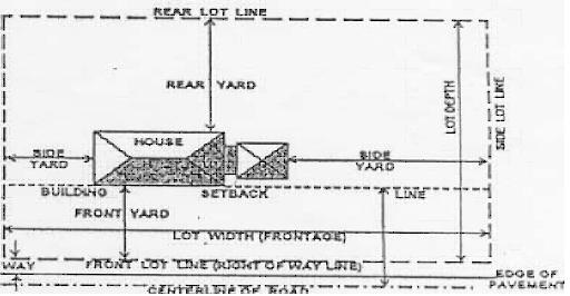
Lot of record. A lot which is part of a subdivision plat recorded in the office of the Mason County Clerk, or a lot or parcel surveyed or described by metes and bounds, the description of which has been so recorded prior to adoption of these regulations.
Lot types. Lots described in this chapter are as follows:
(1)
Corner lot. A lot located at the intersection of two or more streets. A lot abutting on a curved street or streets shall be considered a corner lot is straight lines drawn from the foremost points of the side lot lines to the foremost point of the lot meet at one interior angle of less than 135 degrees.
(2)
Interior lot. A lot with only one street frontage.
Lot width. The linear width of a lot or building site as measured at the front setback line. (Also see street frontage.)
Manufactured home. A single-family residential dwelling constructed in accordance with the National Manufactured Housing Construction and Safety Standards Act of 1974, 42 U.S.C. §§ 5401 through 5426, as amended, manufactured after June 15, 1976, and designed to be used as a single-family dwelling with or without a permanent foundation when connected to the required utilities, and includes the plumbing, heating, air conditioning and electrical systems contained therein. The term shall include house trailers and recreational vehicles.
Manufactured home park. An area of land upon which manufactured homes, manufactured home space, or both, are provided for rent or lease by the owner of the land.
Manufactured home subdivision. An area that is subdivided into individual lots which are offered for sale for the placement of manufactured homes.
Micro-brewery. Any place or premises where up to 25,000 barrels per year of malt beverages are manufactured for sale, and includes all offices, granaries, mash rooms, cooling rooms, vaults, yards, and storerooms connected with the premises; or where any part of the process of the manufacture of malt beverages is carried on; or where any apparatus connected with manufacture is kept or used or where any of the products of brewing or fermentation are stored or kept.
Micro-distillery. Any place or premises where up to 50,000 gallons per year of distilled spirits are manufactured for sale, and which are registered in the office of any collector of internal revenue for the United States. It includes any United States government bonded warehouse.
Micro-winery. Any place or premises in which up to 50,000 gallons of wine is manufactured from any fruit, or brandies are distilled as a by-product of wine or other fruit or cordials are compounded, except a place or premises that manufactures wine for sacramental purpose exclusively.
Modular home. A single-family residential dwelling constructed in accordance with the International Residential Code, without a steel chassis, and designed to be used as a permanent dwelling and placed on a permanent foundation also constructed in accordance with the International Residential Code. A "modular home" may consist of two or more sections constructed at a location other than its permanent location, and transported in sections to be placed on the permanent foundation at its final location. Removal of the chassis and placement of a manufactured home on a permanent foundation shall not be deemed a "modular home."
Multi-family dwelling. A building or group of buildings designed or used for rental or lease as dwelling units for three or more families with separate living quarters and cooking and bathroom facilities for each family.
Multi-tenant commercial development. A development containing two or more non-residential uses on the same building site such as shopping centers, shopping malls or office complexes.
Neat floor area. The total area of all floors of a structure as measured to the outside of exterior walls, but excluding rooms designated as and used exclusively for storage, mechanical or janitorial rooms, uninhabitable areas or rooms which when occupied would result in a vacancy elsewhere in the structure, such as restrooms, dressing rooms, locker rooms and employee cafeterias. Areas not to be excluded are hallways, corridors, vestibules, lobbies or other space occupied by partition walls, furniture, fixtures, appliances or machinery.
Non-conforming use or structure. An activity or a building, sign, sign structure or a portion thereof which lawfully existed at the time of adoption of these regulations but which does not conform to all of the regulations contained in this chapter which pertain to the district in which it is located.
Nursing home, intermediate and skilled care. Any institution, however named, maintained for the care or treatment of four or more individuals unrelated to the owner or operator or their spouses, which employs nursing services or procedures in the care of such residents that require treatment, judgment, technical knowledge and skills beyond those possessed by the untrained person.
Nursing home, personal care. Any institution, however named, maintained for the care or treatment of four or more ambulatory individuals unrelated to the owner or operator or their spouses, who require supervision, not nursing care.
Open space. An area open to the sky which may be on the same lot with a building. The area may include along with the natural environmental features, swimming pools, tennis courts and other recreational facilities that the Planning Commission deems permissive. Streets, structures for habitation, and similar structures shall not be included.
Plumbing/electrical/HVAC. Any person or business engaged in plumbing, electrical, and/or heating, ventilation, air condition. Any person or business must be licensed by the state.
Private clubs/lodges. An organization catering exclusively to members and their guests or premises or buildings for social, recreational and administrative purposes, which are not conducted for profit provided they are not conducting any vending stands, merchandising, or commercial activities, except as required for the membership of such club/lodge. Clubs and lodge shall include but not be limited to service and political organizations, labor unions, as well as social and athletic clubs. The definition of "private clubs/lodges" shall not include adult entertainment/oriented facilities, shooting ranges, nightclubs, campgrounds and airports.
Public facility. Any use of land whether publicly or privately owned for transportation, utilities, or communications, for the benefit of the general public, including but not limited to libraries, schools, streets, fire or police stations, city and county buildings, recreational centers and parks and cemeteries.
Public utility. Any person, firm, corporation, partnership, municipal or county board, department or commission that owns, controls, operates or manages any facility for the production, transmission, or distribution of electricity, natural or manufactured gas, steam, water, telephone or telegraph messages, cable television signals or the treatment of sewage for disposal.
Recycling center. A completely enclosed facility that is not a junkyard or wrecking yard that collects, sorts, and processes for shipment to a recycling plant, recoverable resources such as, but not limited to newspapers, glassware, plastics, and aluminum cans. Material(s) not being stored inside must be completely screened from public view.
Recycling plant. A completely enclosed facility that is not a junkyard or wrecking yard and in which recoverable resources are recycled, reprocessed, and treated in order to return such materials to a condition in which they may be used in the production of additional goods. Materials(s) not being stored inside must be completely screened from public view.
Residential care facility. A residence typically operated and maintained by a sponsoring private or governmental agency to provide services in a homelike setting for persons with disabilities.
Pursuant to the Fair Housing Act, amendments thereto and relevant case law, people recovering from alcohol and substance abuse addictions are classified as having a disability. Therefore, sober living facilities are considered residential care facilities and residents of such facilities, although likely unrelated by blood, marriage or legal means, may collectively be considered families under the policies of sober living facilities. Dwellings for sober living facilities must adhere to the requirements of the Kentucky Residential Code and the International Property Maintenance Code.
Residential treatment centers. Programs offering medical and nonmedical detoxification from all substances, and long-term treatment following detoxification, which includes individual, group and family counseling. The residents of such treatment programs do not leave the program premises for work or other assignments or activities (see "sober living facility" definition). "Residential treatment centers" are licensed by the Commonwealth of Kentucky Cabinet for Health and Family Services.
Rooming and boarding house. A building designed or used to provide living accommodations for not more than six occupants in which there are no cooking facilities for each occupant, or in which all occupants share common cooking facilities.
Salvage yard. An individual or entity engaged in the business of acquiring or owning salvage automobiles for (a) resale in their entirety or as spare parts; or (b) crushing. "Salvage yards," also known as motor vehicle junkyards. Refer to § 320.408.14 for regulations.
Self-service storage facilities. A structure containing separate, individual and private storage spaces of varying sizes leased or rented on individual leases for varying periods of time.
Semi-public. Uses that are quasi-public, to include churches, parochial schools, colleges, hospitals and other facilities of an educational, religious, charitable, philanthropic or non-profit nature.
Sign. A sign is defined as any object, device, display or structure or part thereof, situated outdoors or indoors, which is used to advertise, identify, display, direct or attract attention to an object, person, institution, organization, business, product, service, event or location by any means, including words, letters, figures, design, symbols, fixtures, colors, illumination or projected images.
Sign, animated or moving. Any sign or part of a sign that changes physical position or light intensity by any movement or rotation or that gives the visual impression of such movement or rotation.
Sign, awning, canopy or marquee. A sign that is mounted, painted or attached to an awning, canopy or marquee that is otherwise permitted by ordinance.
Sign area. The entire face of a sign, including the advertising surface and any framing, trim or molding, but not including the supporting structure.
Sign, billboard. (see sign, off-premises.)
Sign, bulletin board. A sign that identifies an institution or organization on the premises of which it is located and that contains the name of the institution or organization, the names of individuals connected with it, and general announcements of events or activities occurring at the institution or similar messages.
Sign, construction. A temporary sign erected on the premises on which construction is taking place, during the period of such construction, indicating the names of the businesses/contractors that have role or interest in the project.
Sign, directional. Signs limited to directional messages, principally for pedestrian or vehicular traffic such as "One-way", "Entrance", "Exit", etc.
Sign, facade/wall. A sign fastened to or painted on the wall of a building or structure in such a manner that the wall becomes the supporting structure for, or forms the background surface of, the sign and that does not project more than 12 inches from the building or structure.
Sign, face/area. The area or display surface used for the message.
Sign, flashing. Any directly or indirectly illuminated sign that exhibits changing natural or artificial light or color effects by any means whatsoever.
Sign, freestanding. Any non-movable sign not affixed to a building.
Sign, governmental. A sign erected and maintained pursuant to and in discharge of any governmental functions or required by law, ordinance or other governmental regulation.
Sign, ground. Any sign, other than a pole sign, in which the entire bottom is in contact with or is close to the ground and is independent of any other structure.
Sign, home occupation. A sign containing only the name and occupation of a permitted home occupation.
Sign, identification. A sign giving the nature, logo, trademark or other identifying symbol; address; or any combination of the name, symbol and address of a building, business, development or establishment on the premises where it is located.
Sign, illuminated. A sign lighted by or exposed to artificial lighting either by lights on or inside the sign, or directed toward the sign. Illumination must be consistent with the guidelines provided in § 320.412.
Sign, off-premises. A sign that directs attention to a business, commodity, service or entertainment conducted, sold or offered at a location other than the premises on which the sign is located.
Sign, pole. A sign that is mounted on a free-standing pole or other support so that the bottom edge of the sign face is six feet or more above grade.
Sign, portable. A sign that is not permanent, affixed to a building, structure or the ground.
Sign, projecting. A sign that is wholly or partly dependent upon a building for support and that projects more than 12 inches from the building.
Sign, roof. A sign that is mounted on the roof of a building or that is wholly dependent upon a building for support and that projects above the top walk or edge of a building with a flat roof, the eave line of a building with a gambrel, gable or hip roof, or the deck line of a building with a mansard roof.
Sign, temporary. A sign or advertising display constructed of cloth, canvas, fabric, plywood or other light material and designed or intended to be displayed for a short period of time.
Sign, vehicle. A sign on a vehicle not customarily and regularly used to transport persons or properties.
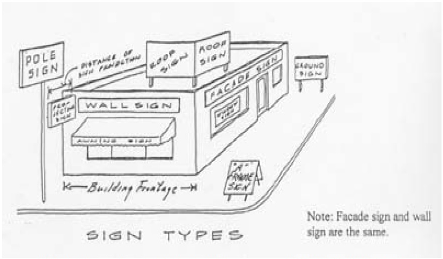
Single-family detached dwelling. A building and accessories thereto principally used, designed, or adapted for use by a single-family.
Sober living facility. A transitional facility where a resident is involved in school, work, and/or training. The resident lives onsite while either stabilizing or re-entering society substance abuse free. The resident usually receives individual counseling, as well as group/family/marital therapy. Also considered a residential care facility as defined in this section.
Story. That portion of a building included between the surface of any floor and the surface of the floor next above it, or if there is no floor above it, the space between the floor and the ceiling next above its. A basement shall not be considered a "story."
Street frontage. The linear width of any lot or building site where it adjoins a street or public way.
Structure. Anything constructed or erected, the use of which requires a fixed location on the ground, or attachment to something having a fixed location on the ground, including buildings, radio/telecommunications towers, swimming pools, signs and includes earthen berms, excavations or embankments.
Tenant space. The area within a multi-tenant commercial development or multi-family residential development which is separated by walls and designed to be used solely by the persons who lease, rent or otherwise occupy the area. When two or more persons lease the same common area, it shall be deemed as one tenant space.
Townhouse. A group of three or more attached single-family dwellings each separated by a common vertical wall and each having a separate lot and entrance at street level. "Townhouses" may be owner-occupied or rental properties.
Uninhabitable areas. Areas of a structure not designed or used for human occupancy, such as walk-in coolers, crawl spaces or attic spaces.
Uniform application. An application for a certificate of convenience and necessity issued under KRS 278.020 submitted by a utility to the Public Service Commission to construct an antenna tower for cellular telecommunications services or personal communications service in a jurisdiction, that has adopted planning and land use regulations in accordance with KRS Chapter 100.
Use. The purpose or activity for which a building, structure or land is occupied or maintained.
Variance. A departure from dimensional terms of the land use management regulations pertaining to the height, width, length or location of structures, and the size of yards and open spaces where the departure meets the requirements of KRS 100.241 to 100.247.
Video/audio theater production facility. A place where theatrical, film and video/audio production occurs. It includes, but is not limited to, constructing and rigging scenery, hanging and focusing of lighting, design and procurement of costumes, makeup and recording and mixing of sound, pre- and post-production and editing. This does not include any aspect of Adult Entertainment.
WECS. All necessary devices that together covert wind energy into electricity and deliver that electricity to a utility's transmission lines, including but not limited to the rotor, nacelle, generator, WECS tower, electrical components, WECS foundation, transformer, and electrical cabling from the WECS tower, substation, operational meteorological towers, communications facilities, and other required facilities and equipment, as related to the WECS project. Additional definitions applicable to WECS regulations contained in this article are set forth below:
(1)
Critical wind speed. The wind at which a WECS turbine sound pressure levels are at greatest variance with ambient background sound pressure levels.
(2)
Decibels, A-weighted. Abbreviated as dB(a) are an expression of the relative loudness of sounds in air as perceived by the human ear. In the A-weighted system the decibel levels of sounds at low frequencies are reduced compared with unweighted decibels in which no correction is made for audio frequency. This correction is made because the human ear is less sensitive at low audio frequencies, especially below 1,000 Hz, than at higher audio frequencies.
(3)
Decibels, C-weighted. Abbreviated as dB(C) is a scale at that measures peak levels of sound and is useful in measuring sound pressure waves at lower frequencies that may be inaudible to the human ear.
(4)
Industrial scale WECS. A wind energy conversion system constructed on the property of another by a company or corporation or other entity, whose general intent is to capture wind energy and place it on the electrical grid for resale to a public utility or other energy marketer.
(5)
Meteorological tower. Towers which are erected primarily to measure wind speed and direction plus other data in order to validate a proposed WECS project. These are intended to be temporary in nature, are allowed as per table 320.406.62 and permits for which must be renewed after the expiration of five years with the option of an annual permit extension for year six and seven. Meteorological towers must be setback a minimum of 1.5 times the height of the tower from any structure, property line, power line, or road right-of-way.
(6)
Meteorological tower, operational support. Towers which are erected primarily to measure wind speed and direction plus other data in support of an operating WECS. These are generally considered to be in place for the life of the project and should be included in the site plan subject to general project approval. Meteorological towers must be setback a minimum of 1.5 times the height of the tower from any structure, property line, power line, or road right-of-way.
(7)
Mid-scale WECS. A wind energy conversion system with a generating capacity up to 50 Kw. the installation intended to collect wind energy for the purpose of supplying energy to the owners and shall not entail net metering. Mid-scale WECS are considered a non-residential accessory use.
(8)
Non-participating landowner. A person(s) or entity who has not entered into any contractual agreement with a company or entity with the intention of developing a WECS project on or near such person(s) or entity's land and is not participating contractually to receive certain economic benefits to accrue from the development and operation of the WECS project.
(9)
Operator. The entity who runs the day to day operations of the industrial WECS. The operator may or may not be part of the parent company and may operate the project on a contractual basis. For the purposes of this ordinance the operator is understood to be a responsible party and all applicable provisions of this ordinance and all agreements shall apply equally to an applicant owner, operator or successor.
(10)
Owner. The entity that currently owns the project, which could change over time, but is understood to be responsible to operate according to the provisions of this ordinance and is bound by any of the agreements entered into by itself, its predecessor(s), successors or assigns.
(11)
Participating landowner. A person(s) or entity who has entered into an executed contractual agreement with a company or entity with the intention of developing a WECS project on or near such person(s) or entity's land and is participating contractually to receive certain economic benefits to accrue from the development and operation of the WECS project.
(12)
Small-scale WECS. A wind energy conversion system designed to provide power to a home or other local site for use by the owner. Small-scale WECS may have a generating capacity of up to five kW and shall not entail net-metering capability. Small-scale WECS are considered non-residential accessory structures.
(13)
Successor. Any person, partnership, LLC or other corporate entity that purchases, leases or otherwise acquires an interest in all or a portion of a WECS project from an applicant, owner or successor. For the purposes of this chapter all applicable provisions of this chapter and all agreements shall apply equally to an applicant, owner, operator or successor.
(14)
Substation. A structure containing apparatus that connects the below or above-ground electrical collection lines of the WECS to the electricity grid, with or without increasing the voltage.
(15)
WECS Project. A collection of multiple WECS as specified in the application for development plan approval and/or improvement location permit.
(16)
WECS Salvage value. The net value of towers, nacelles, generators, turbines; blades, wires, transformers and all other salvageable parts and commodities which make up the WECS whether sold as used parts or on a commodity/scrap basis or any combination thereof (whichever is greater) after deducting all estimated costs and expenses of dismantling, removal and transportation and all costs and expenses of sale (including but not limited to all commissions and fees) and the amount necessary to pay and satisfy all liens, security interests and all other encumbrances attached to the WECS. The commodity/scrap value shall be based on the five years average scrap value of the commodities.
(17)
WECS Tower. The support structure to which the nacelle, with turbine and rotor are attached. Sometimes the term is used to refer to the tower, nacelle, turbine and rotor collectively.
Winery. Any place or premises in which up to 50,000 gallons of wine is manufactured from any fruit, or brandies are distilled as a by-product of wine or other fruit, or cordials are compounded, except a place or premises that manufactures wine for sacramental purposes exclusively.
Yard. A required open space unoccupied and unobstructed by any structure or portion of any structure, except as otherwise permitted.
(1)
Front yard. An open space extending the full width of the lot, the depth of which is the minimum horizontal distance between the front lot line and the nearest line of the main building.
(2)
Rear yard. An open space extending the full width of the lot, the depth of which is the minimum horizontal distance between the rear lot line and the nearest line of the main building.
(3)
Side yard. An open space between a main building and the side lot line, extending from the front yard to the rear yard, the width of which is the horizontal distance from the nearest point of the side lot to the nearest point of the main building.
Yard, required. The minimum open space as specified in this chapter for front, side, and rear yards, as distinguished from any yard areas in excess of the minimum required.
Zoo. Any facility, other than a pet shop or kennel, displaying or exhibiting 20 or more species of non-domesticated animals for admission by the public, on a plot of at least ten acres of land.
(Ord. passed 12-12-2002; Am. Ord. 07C-11, 8-9-2007; Am. Ord. 08-C-01, 3-13-2008; Am. Ord. 08C-13, 7-2-2008; Am. Ord. 14-04, 1-9-2014; Am. Ord. 14-24, 10-13-2014; Am .Ord. 14-27, 10-13-2014; Am. Ord. 15-30, 10-8-2015; Am. Ord. 16-11, 2-11-2016; Am. Ord. 18-07, 2-8-2018; Ord. No. 20-16, § 2, 12-10-2020; Ord. No. 20-20, § 2, 12-17-2020)
Case Law reference— Berea's ordinance restricting placement of mobile homes to areas zoned for mobile homes upheld, as to a 1,232 square foot double-wide manufactured home, against a claim of city's unreasonable exercise of its police power, see Harrison's Homes of Berea v. City of Berea, 7 Ky. A.R.1 5-14-2000.
State Law reference— Horizontal Property Law, see KRS Chapter 381;
Non-conforming use, see KRS 100.253;
Residential care facility for handicapped persons allowed in residential districts and subdivisions, see KRS 100.982—100.984;
Persons allowed in residential districts and subdivisions, see KRS 100.982—100.984.