
Melbourne City Zoning Code
Appendix B
ZONING1
Editor's note— Printed herein as appendix B of Part III. Land Development Regulations is the zoning ordinance of the city, as derived from Ord. No. 2005-120, § 1, adopted November 8, 2005. Said ordinance is included herein as enacted. Absence of a history note following a particular article or section in appendix B. indicates that the article or section derives unchanged from Ord. No. 2005-120. A history note enclosed in parentheses following a particular article or section indicates that the article or section is new or has been amended by the ordinances included in such history note. Obvious misspellings have been corrected without notation. Words appearing in brackets have been added for clarification. For stylistic purposes headings and catchlines have been made uniform and the same system of capitalization, citation to statutes and expression of numbers in text has been used as appears in the Part II. Code of Ordinances.
ARTICLE II. - DEFINITIONS
For the purposes of this code, the following terms, phrases, words, and their derivations shall have the meaning given herein. When not inconsistent with the context of this code, words used in the present tense include the future tense, words in the plural number include the singular number, and words in the singular number include the plural number. The word "shall" is always mandatory and not merely directory.
Accessory structure. A structure on the same lot with and of a nature customarily incidental and subordinate to the principal structure on the lot. Accessory structures may include, but not be limited to, detached private garages, storage buildings and sheds, garden amenities, swimming pool screen enclosures, gazebos, bathhouses (used in conjunction with a swimming pool), boat houses, noncommercial greenhouses/plant nurseries, and similar uses.
Accessory use. An accessory use shall be determined by: A use which is customarily incidental, and subordinate in purpose, area and extent to the principal use served; contributes primarily to the comfort or convenience of the owners, occupants, employees, customers, or visitors of the principal use; is located on the same lot, as defined in subsection 89 below, that houses the principal use served; and may or may not be located within an accessory structure. All accessory uses shall be subject to the district regulations of this zoning code.
Activity center overlay. A designated overlay district on the city's future land use map (FLUM) where distinctive floor area ratios (FAR) and residential densities have been established to encourage and facilitate urban development and urban redevelopment in order to prevent urban sprawl and encourage the use of alternative modes of transportation. Four activity centers are established in the future land use element (FLUE) of the comprehensive plan: Downtown Melbourne, Eau Gallie, Midtown, and Community.
Adult day care center. Any building, buildings, or part of a building, whether operated for profit or not, in which is provided through its ownership or management, for a part of a day, basic services to three or more persons who are 18 years of age or older, who are not related to the owner or operator by blood or marriage, and who require such services.
Adult entertainment establishment. An adult motion picture theater, a massage establishment, an adult bookstore, an adult motel or an adult dancing establishment. Any commercial establishment that displays a sign or engages in any other form of advertising capable of leading a reasonable person to believe that said establishment offers, presents, permits or engages in any form of adult entertainment shall be deemed an adult entertainment establishment under the appropriate classification.
Affordable housing. Residential dwelling units with monthly rents or monthly mortgage payments including taxes and insurance not exceeding 30 percent of the median annual income for low, moderate, or very-low income households in accordance with F.S. § 420.9071, as amended from time to time. Median annual income shall be determined by the Florida Housing Finance Corporation for the Palm Bay-Melbourne-Titusville Metropolitan Statistical Area. Income limits are updated periodically and are available from the community development department, upon request. See Appendix B, Article V, Section 4, Affordable Housing Development.
Affordable housing development. Residential or mixed use developments with at least 30 percent of the dwelling units upon completion shall be occupied by households with annual incomes at or below 120 percent of the median annual income for the Palm Bay-Melbourne-Titusville Metropolitan Statistical Area.
Agriculture. The production, keeping or maintenance, for sale, lease or personal use, of plants and/or animals useful to humans. The term includes animal and stock grazing, bee keeping, citrus cultivation, dairy farms and sod farms, farms, forestry, groves, riding stables, and truck gardening. Roadside agricultural stands are considered intensive retail for zoning purposes.
Alcoholic beverage. As defined by F.S. § 561.01(4)(a), (b), means distilled spirits and all beverages containing one-half of one percent or more alcohol by volume.
Alley. Any public or private right-of-way set aside for secondary public travel and which is less than 30 feet in width, not generally used as a thoroughfare by both pedestrians and vehicles, not used for general traffic circulation, and is not otherwise officially designated as a street.
Amusement center. An establishment where the principal use is the operation of mechanical, computer, internet, electronic and/or video-type game machines that may provide tickets or coupons redeemable for prizes.
Animal hospital. See Veterinary clinic.
Apartment. A customarily renter-occupied dwelling unit constructed as part of a group of three or more dwelling units, having common utility service and maintenance furnished by the management.
Assembly, light. The limited forming, putting together, fabricating, or making secondary modifications to pre-processed items or pre-cut lumber as a last step for items intended to be sold as finished products, provided all activities are conducted within an enclosed structure. Typical uses are small in scale, utilizing handheld or portable tools (tools that are transferred and manipulated by hand), excluding the use of equipment such as drop hammers, automatic screw machines, and punch presses that exceed a capacity of five tons. Also includes assembling cabinets, furniture making and welding of pre-made parts, but excludes metal extrusion, sawmills, and manufacturing.
Assisted living facility. Any building or buildings, section or distinct part of a building, private home, boarding home, home for the aged, or other residential facility, whether operated for profit or not, which undertakes through its ownership or management to provide housing, one or more meals, and one or more personal services for a period exceeding 24 hours to one or more adults who are not relatives of the owner or administrator (F.S. § 429.02(5), as amended from time to time).
Automobile. SeeVehicle, automobile.
Automobile service station. See Service, vehicle.
Awning. A sheltering screen, usually of canvas fabric, supported by a rigid frame attached to the walls of a building for protection from sun or weather.
Bar/cocktail lounge/saloon. Any establishment which is devoted primarily to the retailing and on-premises drinking of malt, vinous, or other alcoholic beverages and which is licensed by the state to dispense or sell alcoholic beverages.
Bed and breakfast. Part of a dwelling unit in which overnight lodging and breakfast is provided by the resident owner or operator. Such lodging is provided on a short-term basis, usually by the night, to tourists. A "bed and breakfast" is not a rooming house or a permanent dwelling except for the owner or operator and his/her family.
Boarding house. See Rooming house.
Boat. A boat shall refer to any watercraft.
Boat house. A boat house is a structure built out over the water, usually at the water's edge, and used for the covering, sheltering and storage of boats. A boat house extends from a seawall, dock or the shore over the water. A boat house has a roof and is partially or totally enclosed by solid permanent walls. A boat house is not a covered boat mooring space.
Boat lift. A boat lift is a structure used for storing boats on or above the water, which may extend from a seawall, the shore or a dock over the water. Boat lifts shall be considered a boat mooring space.
Boat mooring space. A boat mooring space is any place where a boat is moored. A covered boat mooring space is a structure constructed over the water used for the covering or sheltering of boats. The structure may extend from a seawall, dock or the shore over the water. A covered boat mooring space has only a roof, with no walls or floor.
Breezeway. One or more open space areas, unoccupied and unobstructed by any portion of a building, structure, fence or sign over four feet in height, except for the projections of uncovered steps, uncovered balconies or uncovered porches, being the minimum horizontal distance between the side of a building or structure and the adjacent side property line or between the adjacent sides of two buildings on the same parcel or project area, extending from the street right-of-way line to the rear property line. A breezeway may include required building setbacks, buffer areas, landscape areas, surface parking lots, driveways, vehicular use areas, stormwater retention areas, swimming pools, pool decks and uncovered patios.
Brewery. A heavy manufacturing facility producing and/or packaging malt beverages of low alcoholic content for wholesale distribution, with a production capacity of more than 15,000 barrels (465,000 gallons) per year, and regulated by F.S. chs. 561 and 563. (See also definition of "micro-brewery.")
Brewpub. A restaurant that prepares handcrafted natural beer as an accessory use intended for consumption on the premises.
Building area. The portion of a lot remaining after required yards have been provided.
Building official. The official charged with the administration and enforcement of this ordinance as provided for in the Melbourne Building Code.
Building. Any structure used or intended for supporting or sheltering and use or occupancy. This term includes mobile homes, but does not include awnings, canopies, or similar structures.
Building setback line. See Setback line.
Business service. See Service use.
Car wash establishment. An establishment that is designed to wash automobiles. It may stand alone or in combination with other uses. Car wash facilities of 450 square feet or less, which are provided in combination with other businesses such as auto sales, convenience stores or automobile service stations, shall be considered to be accessory in nature.
Carport. A roofed structure, not enclosed, covering a parking space.
Child care center. Any child care center or child care arrangement that provides care for more than five children unrelated to the operator and which receives a payment, fee, or grant for any of the children receiving care, wherever operated, and whether or not operated for profit. The term includes day care centers, nursery schools and kindergartens, when not accessory to an elementary school, but does not include the following:
(a)
Public schools and nonpublic schools which are in compliance with the compulsory school attendance law of the State of Florida.
(b)
Summer camps having children in full-time residence.
(c)
Summer day camps.
(d)
Bible schools normally conducted during vacation periods.
Clinic. An establishment where patients are not lodged overnight, but are admitted for examination and treatment by a group of physicians or dentists practicing medicine together. The term does not include a place for the treatment of animals.
Communication facility. A communication facility includes either a communication monopole or tower, the purpose of which is to receive, relay, or transmit communication signals, including but not limited to, cellular communications, television signals, and telephone signals.
Community center. A building used for recreational, social, educational and cultural activities, usually owned and operated by a public or nonprofit group or agency.
Community residential home (one to six residents). A dwelling unit licensed to serve residents who are clients of the department of elder affairs, the agency for persons with disabilities, the department of juvenile justice, or the department of children and families or licensed by the agency for health care administration, which provides a living environment for one to six unrelated residents who operate as the functional equivalent of a family, including such supervision and care by a support staff as may be necessary to meet physical, emotional, and social needs of residents. Homes of six or fewer residents shall be deemed a single-family unit and a noncommercial, residential use.
Community residential home (seven to 14 residents). A dwelling unit licensed to serve residents who are clients of the department of elder affairs, the agency for persons with disabilities, the department of juvenile justice, or the department of children and families or licensed by the agency for health care administration, which provides a living environment for seven to 14 unrelated residents who operate as the functional equivalent of a family, including such supervision and care by a support staff as may be necessary to meet physical, emotional, and social needs of residents.
Community residential home resident. A frail elder as defined in F.S. § 429.65, a person who has a handicap as defined in F.S. § 760.22(7)(a), a person who has a developmental disability as defined in F.S. § 393.063, a non-dangerous person who has a mental illness as defined in F.S. § 394.455, or child who is found to be dependent as defined in F.S. § 39.01 or F.S. § 984.03, or a child in need of services as defined in F.S. § 984.03 or F.S. § 985.03. No person shall occupy a community residential home who would constitute a direct threat to the health and safety of other persons or whose residency would result in substantial physical damage to the property of others.
Comprehensive plan. The City of Melbourne's comprehensive plan, and any amendments thereto that meet the requirements of F.S. ch. 163, as adopted by the city council.
Conditional use. A conditional use is one that is conditionally permitted within a zoning district after public hearing and city council approval, which use meets certain conditions and would be proper only in limited locations within the zoning districts.
Condominium. Form of ownership of real property created pursuant to F.S. ch. 718, as amended from time to time, which is comprised entirely of units that may be owned by one or more persons, and in which there is, appurtenant to each unit, an undivided share in common elements.
Convalescent/nursing home. A building wherein for compensation, nursing care is provided for persons suffering from illness, other than mental or contagious, which is not of sufficient severity to require hospitalization, or persons requiring further institutional care after being discharged from a hospital other than a mental hospital.
Convenience store with gas pumps/gas station. A business primarily engaged in the sale of gasoline. Without gasoline sales, see "retail."
Corporate logo/caricature. An individual display that is characteristic of the organization, business or restaurant which presents some type of information about the products or services of the business, restaurant or organization.
Court. An unoccupied open space on the same lot with the principal building and fully enclosed on at least three adjacent sides by walls of the principal building. Also referred as "plaza."
Courtesy notice. A notice of a public hearing, not required by law or this code, mailed at the city's discretion to property owners within 500 feet of property which is the subject of the public hearing noticed in the courtesy notice.
Day shelter. A facility, open to the public providing a temporary location for activities of daily living typically performed in one's home to persons who may have been displaced from their habitual residences as a result of domestic violence, condemnation, court ordered eviction, or other urgent or chronic needs. The term excludes shelters providing overnight lodging, soup kitchens, facilities that are licensed by the State of Florida (such as day care centers), and temporary housing created in response to acts of God, such as hurricanes or acts of terrorism or war.
Day care center. See Child care center,Family day care home, and Adult day care center.
Density. The total number of dwelling units or living units permitted per gross acre of the parcels of land under consideration. In calculating gross acreage for parcels of land abutting waterways, oceans, or lakes, only that portion of the parcel lying upland of the mean high water line of said parcel shall be included.
Development. The term "development" means the carrying out of any building activity or mining operation, the making of any material change in the use or appearance of any structure or land, or the dividing of land into three or more parcels. The following activities or uses shall be taken for the purposes of this code to involve "development," as defined in this section:
(a)
A reconstruction, alteration of the size, or material change in the external appearance of a structure or land.
(b)
A change in the intensity of use of land, such as an increase in the number of dwelling units in a structure or on land or a material increase in the number of businesses, manufacturing establishments, offices, or dwelling units in a structure or on land.
(c)
Alteration of a shore or bank of a seacoast, river, stream, lake, pond, or canal, including any "coastal construction" as defined in F.S. § 161.021.
(d)
Commencement of drilling, except to obtain soil samples, mining, or excavation on a parcel of land.
(e)
Demolition of a structure.
(f)
Clearing of land as an adjunct of construction.
(g)
Deposit of refuse, solid or liquid waste, or fill on a parcel of land.
The following operations or uses shall not be taken for the purpose of this appendix to involve "development" as defined in this section:
(a)
Work by a highway or road agency or railroad company for the maintenance or improvement of a road or railroad track, if the work is carried out on land within the boundaries of the right-of-way.
(b)
Work by any utility and other persons engaged in the distribution or transmission of gas, electricity, or water, for the purpose of inspecting, repairing, renewing, or constructing on established rights-of-way any sewers, mains, pipes, cables, utility tunnels, power lines, towers, poles, tracks, or the like. This provision conveys no property interest and does not eliminate any applicable notice requirements to affected land owners.
(c)
Work for the maintenance, renewal, improvement, or alteration of any structure, if the work affects only the interior or the color of the structure or the decoration of the exterior of the structure.
(d)
The use of any structure or land devoted to dwelling uses for any purpose customarily incidental to enjoyment of the dwelling.
(e)
The use of any land for the purpose of growing plants, crops, trees, and other agricultural or forestry products; raising livestock; or for other agricultural purposes.
(f)
A change in use of land or structure from a use within a class specified in an ordinance or rule to another use in the same class.
(g)
A change in the ownership or form of ownership of any parcel or structure.
(h)
The creation or termination of rights of access, riparian rights, easements, covenants concerning development of land, or other rights in land.
Development includes all other development customarily associated with it unless otherwise specified. When appropriate to the context, "development" refers to the act of developing or to the result of development. Reference to any specific operation is not intended to mean that the operation or activity, when part of other operations or activities, is not development.
Dispensing unit. Dispensing units (also known as pumps) shall include, but shall not be limited to, devices through which gasoline or diesel fuel is pumped or injected into a motor vehicle, said device usually including a hose, nozzle and metering mechanism.
Dock or pier. A dock or pier is a platform extending into the water from a seawall or the shore. It is used to secure or provide access to boats. A dock or pier is supported by pilings or pillars and has no sides or roof. Dock and pier shall be interchangeable terms and shall also include boardwalks and catwalks along navigable waters.
Dog kennel. See Kennel.
Domestic violence shelter. A residential facility serving as a center to receive and house persons who are victims of domestic violence, including dependents of the victim, to provide temporary boarding, lodging, counseling and day care. The facility shall meet all certification requirements of the State of Florida. Domestic violence shelters may provide meals and temporary housing to the victims of domestic violence.
Dormitory. A building intended or used principally for housing accommodations where such occupants are enrolled in an educational, religious or public institution.
Drainage facility. A drainage facility is any manmade or artificially improved water body used solely for the purposes of drainage or stormwater retention or detention. Public drainage facilities shall be those drainage facilities controlled and/or maintained by a governmental agency for the conveyance or storage of stormwater.
Drive-in facilities. Any use which, by design or physical facilities, permits customers to receive services, pay bills, obtain goods or food or be entertained while remaining in their motor vehicles. This term includes "drive-thru" and "drive-up" facilities.
Duplex. See Dwelling, two-family.
Dwelling unit or living unit. One or more rooms connected together, constituting a separate, independent housekeeping establishment for owner occupancy, or rental or lease, and physically separated from any other rooms or dwelling units which may be in the same structure, and containing independent cooking and sleeping facilities.
Dwelling, accessory. A dwelling unit that is an accessory use to a residential or commercial use. The term includes "guesthouse" and "tenant dwelling."
(a)
Guesthouse. Living quarters within a detached accessory building located on the same premises as the main building, to be used for housing members of the family occupying the main building or their temporary guests.
(b)
Tenant dwelling. A single-family dwelling to be used by year-round employees.
Dwelling, mobile home/manufactured home. A dwelling built to the U.S. Department of Housing and Urban Development standards; are usually installed on temporary foundations (concrete pads, dry-stacked blocks and tie-downs); are usually not considered real property; and don't meet Florida Building Code standards. Upon installation, the wheels and axles of a mobile/manufactured home may be removed, but the integral chassis must stay in place. A mobile/manufactured home must bear the HUD label and be installed by a mobile home installer licensed by department of highway safety and motor vehicles.
Dwelling, modular home. A dwelling designed, built, permitted and inspected to the Florida Building Code standards, installed on permanent foundations (e.g., poured footers, stem walls and poured piers or engineered slabs, the same as a site-built home)*, designed and built specifically for that home by a contractor licensed by the department of business and professional regulation (DBPR). A modular home must bear the insignia of the DBPR on the inside of the cover of the home's electrical panel. (*NOTE: A few modular manufacturers continue to produce their homes on a mobile home type chassis (called "on-frame" construction, which is allowed in the Florida Building Code) and transport them on wheels and axles just like mobile homes; as opposed to most who construct [without the chassis] on typical floor joist type construction and transport the modules on a flatbed trailer, lifting them into place onsite with a crane. No matter the method of construction, the modular home must be installed by a licensed contractor on a permanent foundation, as specified in the Florida Building Code - Residential Chapter 4.)
Dwelling, multi-family. A residential building designed for or occupied by four or more families, with the number of families in residence not exceeding the number of dwelling units provided. The term includes apartments and condominiums and does not include duplexes, triplexes, or townhouses.
Dwelling, single-family. A detached residential dwelling unit other than a mobile home, designed for and occupied by one family only.
Dwelling, three-family. A residential building designed as a single structure, containing three separate dwelling units or living units as defined in the zoning code.
Dwelling, two-family. A residential building designed as a single structure, containing two separate dwelling units or living units as defined in the zoning code.
Electronic assembly. An establishment whose principal purpose is the processing or assembly of finished or nearly finished goods into a functioning whole, where such processing or assembly occurs wholly within an enclosed space, and the total floor area within which assembly occurs does not exceed 75 percent of the gross floor area. Processing of the already manufactured components by machinery shall be restricted so, to the extent that any related noise, vibration, and smoke, electrical interference, dust, odors or heat shall not be discernible beyond the boundaries of the building within which such assembly is located. Activities include but are not limited to the assembly, measurement, testing, analysis and control of components, circuits, sensors and accessories; optical instruments and lenses; surgical, medical, and dental instruments; ophthalmic goods; photographic equipment and supplies; watches and clocks; and electrical instruments, components and equipment.
Family. Family means a group living together as a unit whether or not related, and including a single individual. This term includes community residential homes occupied by not more than six CRH residents; but does not include any fraternity, sorority, club, convent, monastery, or group housing.
Family day care home. An occupied residence in which properly licensed child care is regularly provided for children from more than one unrelated family and which receives a payment, fee, or grant for any of the children receiving care, whether or not operated for profit.
Farmers' market. A designated area for farmers and gardeners to sell fresh agricultural produce to the general public from trucks, open booths or temporary structures.
Farmer's stand. A roadside stand (motor vehicle, stall, building, tent, counter or other similar method or device) operated by the landowner of agriculturally zoned property to sell produce grown on that site to the general public. The term includes roadside stand.
Floor area. The sum of the horizontal areas of the several floors of a building or buildings measured from exterior faces of exterior walls or from the centerline of walls separating two attached buildings. The required minimum floor area within each district shall not apply to accessory uses; however, the floor area of accessory uses may be computed as a part of the area of the principal use.
Floor area, gross. The area of all floors of a building, including finished attics, finished basements and all covered areas, including porches, sheds, carports, and garages.
Floor area ratio (FAR). The total amount of nonresidential gross floor area of all buildings on a lot in relation to the total square footage of lot area. FAR is expressed as a ratio and is calculated by dividing total floor area by lot size. For example, a FAR of one means one square foot of floor area for every square foot of lot area. The total gross square feet calculated using the assigned floor area ratio shall include all enclosed areas including mezzanines and lofts; mechanical rooms; closets, storage areas, and built-in cabinets; and floor areas used by interior and exterior stairways, elevators, and escalators. The calculated floor area ratio shall not include such features as parking lots or structures; porches, balconies, and patios not enclosed by solid walls; aerial pedestrian crossovers; open or partially enclosed plazas; and exterior pedestrian and vehicular circulation areas.
Garage apartment. SeeDwelling, accessory.
Garage, private. A building or part thereof accessory to a main building and providing for the storage of vehicles.
Garage, public. A building or part thereof used for the storage of motor vehicles and in which service station activities may be carried on.
Garden. An accessory use of property for noncommercial horticultural purposes.
Gross acreage. The total area within the perimeter boundaries of the complete parcel of land under consideration, including easements and obligatory recreational and open space areas, and including rights-of-way which are to be dedicated.
Group home facility. A building used for housing accommodations of not more than six unrelated people, not living as a single housekeeping unit but sharing kitchen or dining facilities. A group home shall be owner occupied and occupancy shall be prearranged, which shall be for lengths of stay at least one week or more only. This term includes boarding houses, lodging houses, rooming houses, and hostels, but does not include any community residential home, shelter, or assisted living facility.
(a)
Group home, low intensity. Any group housing which meets all of the following standards:
•
Owner-occupied.
•
Intended for or occupied by not over 12 people.
•
Occupancy pre-arranged and for lengths of stay of at least one week or more only.
•
Contains kitchen facilities.
(b)
Group housing, high intensity. Any group home that fails to meet all of the standards for low intensity group housing. This term includes youth hostel.
Guesthouse. See Dwelling, accessory.
Hedge. A row of bushes or small trees planted close together in such a manner as to form a boundary or barrier.
Height of building. The vertical dimension measured from the established average sidewalk or street grade or finished grade at the building line, whichever is the highest, to:
(a)
The highest point of a flat roof;
(b)
The deck line of a mansard roof; or
(c)
The average height between the eaves and ridge for gable, hip, and gambrel roofs.
Hog farm. The keeping of more than four pigs or hogs, six months of age or older.
Home-based business. Any gainful occupation, profession or use conducted entirely within a dwelling unit, as an accessory use, and carried on by an occupant thereof, which use is clearly incidental to, and secondary to, the use of the unit for dwelling purposes and does not change the character of the residential unit.
Homeless shelter facility. See Shelter.
Hospital. A building or group of buildings, having facilities for one or more overnight patients, used for providing services for the inpatient medical or surgical care of sick or injured humans, and which may include related facilities such as laboratories, outpatient departments, training facilities, and staff offices, provided, however, they are accessory to the main use and are an integral part of the hospital operations.
Hotel. A building in which lodging and/or boarding are provided and offered to the public for compensation, and in which ingress and egress to and from all rooms are made through an inside lobby or office supervised by a person in charge at all times. As such, a hotel is open to the public, as opposed to a boarding or lodging house, apartment, or multifamily dwelling.
House of worship. A church, synagogue, temple, or other similar religious structure, dedicated to divine worship and in regular use at least once per week for that purpose, but not a chapel occupying a minor portion of a building primarily devoted to other uses.
Intensity. The amount or magnitude of a use on a site or allowed in a zoning category. Generally, the development intensity is measured by the amount of floor area constructed on a site. Intensity may also be measured by such things as number of employees, trip generation, hours of operation, noise generation, smoke and fume generation, glare from lights, odor creation, and the amount, location, and nature of outside displays or storage.
Kennel. A premises where five or more domesticated house pets (excluding farm animals) over six months of age are harbored, whether for profit or for personal use. The term shall also include the keeping of more than one dog on vacant property or on property used for business or commercial purposes.
Laboratory, research. A facility in which the principal use is the testing and analysis of medical or dental samples and materials. This term includes analytical chemists, pathologists and bio-analytical laboratories.
Leadership in Energy and Environmental Design (LEED) Commercial Green Building Rating System. LEED Green Building Rating System means the most recent version of the Leadership in Energy and Environmental Design LEED Commercial Green Building Rating System, or other related LEED Rating System, approved by the U.S. Green Building Council.
Length of marine facilities. The distance from the mean or ordinary high water line at the average point where the marine facility intersects the shore to that point of the marine facility closest to the center of the waterway.
Living area. The floor area of dwelling as measured by its outside dimensions exclusive of carports, porches, sheds, attached garages, patios, lanais, and similar appurtenances.
Loading space, off-street. Space logically and conveniently located for bulk pickups and deliveries, scaled to delivery vehicles expected, and accessible to such vehicles for parking when required off-street parking spaces are filled. Required off-street loading spaces are not to be included as off-street parking spaces in computation of required off-street parking spaces.
Lodging house. See Group home.
Lot. A lot is:
(a)
A single lot of record; or
(b)
A portion of a lot of record; or
(c)
A combination of complete lots of record, or complete lots of record and portions of lots of record, or of portions of lots of record; or
(d)
A parcel of land described by metes and bounds.
The boundaries of a lot shall be determined based on the aggregation of parcels as set forth in appendix B, article IV, section 7. The existence of multiple zoning districts on the lot shall not affect this determination.
In order to be developed, a lot must be of sufficient size to meet minimum zoning requirements for use, coverage and area, must provide such yards and other open spaces as are required by City Code, and must have minimum frontage on an improved public street or on an approved private street.
In no case shall the division or combination of any land create any residual parcel which does not meet the requirements of development.
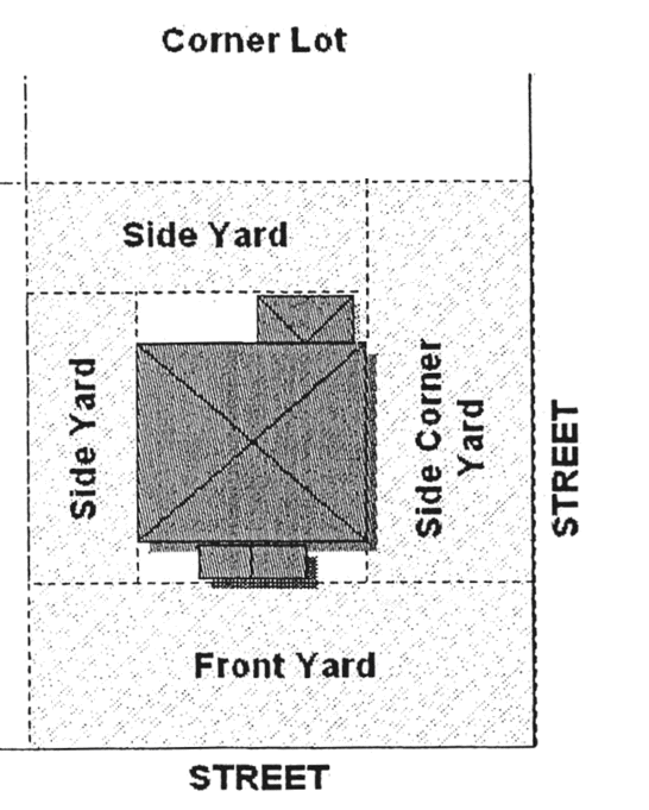
Lot, corner. A lot whose lines are adjacent to two or more streets, excluding alleys, from their point of intersection.
Lot coverage. The percentage of a lot or parcel of land that is covered or occupied by all buildings, including accessory buildings under the terms of this comprehensive development code. Fences, shuffleboard courts, swimming pools and the like shall not be included in computing lot coverage.
Lot depth. The distance between the midpoints of straight lines connecting the foremost points of the side lot lines in front and the rearmost points of the side lot lines in the rear.
Lot, flag. A lot or building site with a minimum frontage on a public or private street, which is reached via a private drive or lane, and whose width some distance back from the street boundary line meets all ordinance requirements.
Lot frontage. The linear distance of a lot adjoining a street right-of-way. For the purpose of calculating setbacks, corner lots and through lots shall be assigned a primary and a secondary lot frontage. The primary lot frontage shall be determined based on the location of the main entrance to the house and the address of the property.
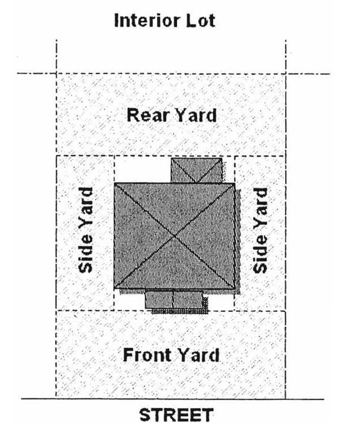
Lot, interior. A lot other than a corner lot with only one frontage on a street.
Lot line. The boundary line of a lot.
Lot of record. A lot whose existence, location and dimension have been legally recorded or registered in a deed or on a plat.
Lot, reversed frontage. A lot on which the frontage is at right angles or approximate right angles (interior angle less than 120 degrees) to the general pattern in the area. A reversed frontage lot may also be a corner lot, an interior lot, or a through lot.
Lot, through. A lot other than a corner lot with frontage on more than one street. Through lots abutting two streets may also be referred to as a double frontage lot.
Lot width. The distance between the side lines of a lot if such sidelines are parallel to each other; if sidelines are not parallel, lot width shall be construed as mean width.
Low-income household. One or more natural persons or a family that has a total annual gross household income that does not exceed 80 percent of the median annual income adjusted for family size for households within the metropolitan statistical area.
Manufacturing, heavy. An establishment whose principal purpose is the mechanical or chemical transformation of materials or substances into new products, including the bulk storage of raw materials, and which process may emit noise, vibration, dust, odor or pollutants. Activities include manufacturing, assembly and fabrication, including large scale or specialized industrial operations, processing and compounding of semi-finished products from raw material in bulk form to be used in an industrial operation.
Manufacturing, light. An establishment whose principal purpose is the manufacturing, assembling (excluding light assembly as defined above), compounding, processing, packing, baling, repairing, storage or distribution of products made from previously prepared basic materials, such as bond, cloth, cork, fiber, leather, paper, plastics, metals (not involving punch presses over 50 tons rated capacity), stones, tobacco, wax, yarns, or wood (except where sawmills or planing mills are employed).
Marina. A place for docking pleasure boats or providing services to pleasure boats and the occupants thereof, including servicing and repair to boats, sale of fuel and supplies, and provision of food, beverages, and entertainment as accessory uses. A yacht club shall be considered as a marina, but a hotel, motel, or similar use, where docking of boats and provision of services thereto, is incidental to other activities shall not be considered a marina, nor boat docks accessory to a multiple dwelling where no boat-related services are rendered.
Marine facilities. Marine facilities are docks, piers, marine pavilions, marine platforms, boat lifts, covered boat mooring spaces and similar facilities.
Marine pavilion. A marine pavilion is a roofed shelter which is associated with or built out over a dock and is used for sitting, fishing, shelter and similar uses. A marine pavilion is a covered marine platform without walls and screens.
Marine platform. A marine platform is an open deck, without a roof, wider than a dock or pier which is associated with a dock and is used for sitting, fishing and similar uses.
Market, outdoor. Any use where items are displayed for purchase on or in other than an enclosed structure.
Mean high water. Mean high water, in accordance with F.S. § 177.27(14), as amended from time to time, means the average height of the high waters over a 19-year period. For shorter periods of observation, mean high water means the average height of the high waters after corrections are applied to eliminate known variations and to reduce the result to the equivalent of a mean 19-year value.
Mean low water. Mean low water, in accordance with F.S. § 177.27(16), as amended from time to time, is the average height of the low waters over a 19-year period. For shorter periods of observation, mean low water means the average height of low waters after corrections are applied to eliminate known variations and to reduce the result to the equivalent of mean 19-year value.
Medical marijuana treatment center. An entity that acquires, cultivates, possesses, processes (including development of related products such as food, tinctures, aerosols, oils, or ointments), transfers, transports, sells, distributes, dispenses, or administers marijuana, products containing marijuana, related supplies, or educational materials to qualifying patients or their caregivers and is registered by the department of health.
Medical marijuana treatment center dispensing facility. A facility that is operated by a medical marijuana treatment center or other organization or business holding all necessary licenses and permits required under state law from which marijuana, cannabis, cannabis-based products, related supplies or cannabis plants are delivered, purchased, possessed, or dispensed for medical purposes and operated in accordance with state law.
Membrane structure (tensioned). See Tents.
Micro-brewery. A facility that produces and/or vends malt beverages or wines of low alcoholic content as regulated by F.S. chs. 561 and 563, for wholesale distribution, with a production capacity of not more than 15,000 barrels (465,000 gallons) per year. Breweries that exceed these parameters are classified as manufacturing, heavy.
Micro-distillery. A licensed manufacturer of distilled spirits, as regulated by F.S. ch. 565 that produces 75,000 or fewer gallons per calendar year of distilled spirits on its premises. Also known as craft distillery or boutique distillery. Distilleries that exceed these parameters are classified as manufacturing, heavy.
Mini-storage. A fully enclosed structure, each unit not to exceed 400 square feet, used for short or long-term storage purposes. This may be a detached structure or unit or a multi-unit complex. The term does not include structures used for any wholesale or retail operations; however, it shall not preclude use as a depot for such purposes as franchised distribution.
Mixed use. A FLUM category that is established in the comprehensive plan. This future land use category permits the consideration of residential, commercial, recreational, and institutional uses.
Mixed use development. A development on one lot that combines residential with commercial or office uses in one or more buildings.
Mobile home. See Dwelling, mobile home.
Mobile home park. A single parcel of ground ten acres or more in area upon which there are mobile home sites to be leased or rented to occupants thereon.
Moderate-income household. One or more natural persons or a family that has a total annual gross household income that does not exceed 120 percent of the median annual income adjusted for family size for households within the metropolitan statistical area.
Monopole. SeeTower, monopole.
Motel. A building in which lodging and/or boarding are provided and offered to the public in contradiction to a boarding or lodging house, or a multiple-family dwelling; same as a hotel, except that buildings are usually designed to serve tourists traveling by motor vehicles. Ingress to rooms need not be through a lobby or office, and parking is usually adjacent to the units.
Multifamily. See Dwelling, multifamily.
Nonconformity. Any lot, use of land, use of structure, use of structure and premises, or characteristics of any use which was lawful prior to the time of enactment of this code, or which was lawful prior to annexation into the city, but which does not conform with the currently effective provisions of the district in which it is located or other provisions of this code.
Nursing home. See Convalescent home.
Occupied. The use of a structure or land for any purpose, including occupancy for residential, business, industrial, manufacturing, storage, and public use.
Office. A room, studio, suite or building in which a person transacts his business or carries on his stated occupation. However, this term does not include any facility involving manufacturing, fabrication, production, processing, assembling, cleaning, testing, repair or storage of materials, goods and products; or the sale or delivery of any materials, goods or products which are physically located on the premises. This term includes administrative, business and professional offices, and radio and television studios, as well as medical, dental and governmental offices, and banks and savings institutions.
Open space, usable. Open areas within a residential development that include, but are not limited to, improved play areas and wetlands or other natural features, which are accessible to the residents of the development. Retention areas, required buffers, rights-of-way, and other code-required tracts shall not be included in the calculation of open space.
Outdoor caricature/logo design. See "corporate logo" definition.
Outdoor display area. An area used for the display of merchandise or tangible property normally vended within the contiguous business or organization.
Outdoor seating area. An area of designated size used as a seating area with tables and chairs for the contiguous restaurant. This seating may be in addition to the indoor seating, or it may be the only seating available for the restaurant.
Overlay zone. A zoning designation specifically delineated on the city's official zoning map establishing land use requirements in addition to the standards set forth in the underlying residential, commercial or industrial district.
Park. A noncommercial facility designed to serve the recreation needs of the residents of the community. Such facilities include subdivision recreation facilities, neighborhood parks, community parks, regional parks and special use facilities, all as described in the recreation and open space element of the Melbourne Comprehensive Plan. Such facilities may also include, but shall not be limited to, school and religious institution ball fields, if they meet the above definition. Commercial amusement facilities, such as water slides, go-cart tracks and miniature golf courses shall not be considered parks (see Recreation, commercial).
Parking space, off-street. An independently accessible off-street storage space, either outside or within a structure, for the parking of motor vehicles.
Parking area, off-street. All areas located outside of right-of-way which are designed and constructed for the circulation and parking of automobiles, motorcycles and bicycles, unless otherwise authorized by the city for other vehicles (i.e., boats, heavy equipment, etc.), and all land upon which vehicles traverse as a function of the principal uses.
Patio or terrace. An open unoccupied space adjacent to the principal building on one or two sides, prepared with a hard, semi-hard, or improved surface, and used for the purpose of outdoor living.
Personal service establishment. See Service use, personal.
Personal storage. See Mini-storage.
Petroleum products. Shall be defined as set forth in F.S. § 376.301.
Plant nursery. A full service retail establishment that sells plants that are purchased wholesale offsite. Accessory items can include packaged fertilizer, seed, mulch, and topsoil, as well as other packaged items commonly associated with a retail plant nursery, as long as such items are stored inside of a solid or screened structure.
Pool enclosure. A frame erected of metal or wood whose framing and overhead supports are only covered with insect screening of metal, fiberglass or other approved insect screening.
Porch. A roofed-over space, made of pervious or impervious materials, attached to the outside of an exterior wall of a building, and with no enclosure other than the exterior walls of the principal building. Open-mesh screening shall not be considered an enclosure.
Portable storage units. Storage units which are delivered to a site for temporary use of limited duration, then returned to a central keeping/facility.
Principal structure. A structure that is occupied by a principal use as defined in this code. In a residential district any dwelling shall be deemed to be the principal structure on the lot on which the same is situated. An attached carport, shed, garage, or any other structure with one or more walls or a part of one wall being a part of the principal building and structurally dependent, totally or in part, on the principal building, shall comprise a part of the principal building and be subject to all regulations applied to the principal building. A detached and structurally independent garage, carport or other structure conforming as an accessory building may be attached to the principal building by an open breezeway.
Private club. The term "private club" shall pertain to and include associations and organizations of fraternal or social character, or which are maintained in connection with a golf course and shall not include casinos, nightclubs or other institutions operated as a business.
Private heliports. Sites used or intended to be used for the landing and take-off of private helicopters for residential purposes.
Public use. Any use of land or structures owned and operated by a municipality, county, state or the federal government or any agency thereof and for a public service or purpose. This term includes, but is not limited to, community centers; cemeteries; civic clubs; museums; libraries; fire and police stations, public or private schools (except child care centers); botanical gardens; zoological gardens; and public or private parks or playgrounds.
Public utility service facility. A facility provided by a public agency or private corporation, other than an administrative office building or a transmission or distribution line and its supports, which is required in order to provide adequate service for the public health, safety and general welfare of the community. This definition includes, but is not limited to, water and sewer treatment and pumping facilities, electronic utility facilities and substations, telephone exchanges, cable television equipment transmission facilities, telephone switching centers, and other similar uses which are 15 feet in height, or greater and/or occupy 1,000 square feet or more in total area. This definition specifically excludes office buildings, electric and telephone transmission and distribution lines, communication facilities including monopoles and towers, cable television distribution cabling, poles, towers and other similar structures which support transmission and distribution lines, and other facilities of a public utility which are located within public or private easements or public rights-of-way. Office buildings for public utilities shall be deemed to be commercial or professional office land uses which shall be governed by the provisions of this code relating to such uses.
Public utility service facility, minor. A public utility service facility that is less than 15 feet in height and/or occupies less than 1,000 square feet in area.
Putrescible waste. Material which is capable of undergoing the process of decomposition resulting in the formation of malodorous byproducts.
Recovery home/halfway house. A facility conducted as a group home with professional services as needed, having one or more supervisors residing on the premises and providing board, lodging, medication, counseling and other treatment for persons progressing from relatively intense treatment for criminal conduct, delinquency, mental or emotional illness, alcoholism, drug addiction or similar conditions and intending to return to full normal participation in community life. A recovery home shall not include facilities licensed as a community residential home or a family day care facility.
Recreation, indoor. An indoor public or private establishment designed and equipped for the conduct of sports and leisure time activities. Some examples include bowling alleys, theaters, gymnasiums, pool halls, and skating rinks.
Recreation, outdoor. Any premises where the principal use is the provision of outdoor amusements, sports, games, athletic facilities, or other outdoor recreational facilities and/or services. This term includes botanical gardens, zoological gardens, skeet and gun clubs, gun ranges, golf driving ranges, miniature golf, go-cart tracks, drive-in theaters, and water slides; but does not include golf courses or any public parks.
Recreational equipment. Boats and boat trailers, watercraft, travel trailers, open trailers and box trailers, golf carts, off-road vehicles, motorized dwellings primarily used as temporary lodging, tent trailers, and like, and cases, boxes, or trailers (open and enclosed) used for transporting recreational equipment, whether occupied by such equipment or not.
Recreational vehicle. A unit primarily designed as temporary living quarters for recreational, camping, or travel use, which either has its own motive power or is mounted on or drawn by another vehicle. Recreational vehicle-type units, when traveling on the public roadways of this state, must comply with the length and width provisions of F.S. § 316.515, as that section may hereafter be amended. The term includes travel trailers, camping trailers, truck campers, motor homes, private motor coaches, van conversions, park trailers, and fifth wheel trailers, as defined in F.S. § 320.01.
Recycling facility. A facility, other than a facility open to the public to receive household waste and recyclable material, where any method, technique, or process is utilized to separate, process, modify, convert, treat or otherwise prepare non-putrescible waste so that component materials or substances may be used or reused or sold to third parties for such purposes. Does not include long-term (not more than 30 days) onsite storage.
Rendition. The issuance of a written order, including approval, approval with conditions, or denial of a variance, rezoning, conditional use or site plan, or other land development permit as defined in F.S. §163.3164, or a final letter of determination by the community development director or city engineer, effective upon the date of signing as set forth on such order or final letter of determination.
Residential street lights. Lights installed by the City of Melbourne or Florida Power and Light in accordance with the National Electric Code, Florida Department of Transportation and City of Melbourne standards for the purpose of providing lighting.
Residential zoning district. Any of the following districts: AEU, REU, R-A, R-1AAA, R-1AA, R-1A, R-1B, R-2, R-3, R-4 and R-P.
Restaurant. Any establishment selling food and drink for consumption on the premises, where the food is prepared on the premises and served continuously during operating hours, which contains a fully equipped kitchen in operating condition, including restaurants, lunch counters and refreshment stands selling prepared foods for immediate consumption. The sale of food and non-alcoholic beverages must constitute at least 51 percent of the gross revenue of the establishment. Soup kitchens shall not be considered restaurants.
Retailing (use). An establishment where the principal use is the selling or renting of goods or merchandise to the general public in small lots (as opposed to bulk quantities) for personal or household consumption, and rendering of services incidental to the sale of such goods. This term does not include service uses, restaurants and bars, vehicle sales/rentals, or any industrial use.
Right-of-way. Land reserved, used or to be used for a street, alley, walkway, drainage facility, sewer lines, water lines, or other similar purpose. A right-of-way does not include utility or drainage easements.
(a)
Right-of-way, street line. The property line which bounds the right-of-way set aside for use as a street.
(b)
Right-of-way, centerline. The midpoint between the street right-of-way lines.
Riparian rights. Riparian rights, in accordance with F.S. § 253.141, as amended from time to time, are those incidents to land bordering upon navigable waters. They are rights of ingress, egress, boating, bathing, and fishing and such others as may be or have been defined by law. Such rights are not of a proprietary nature. They are rights inuring to the owner of the riparian land but are not owned by him or her. They are appurtenant to and are inseparable from the riparian land. The land to which the owner holds title must extend to the ordinary high watermark of the navigable water in order that riparian rights may attach. Conveyance of title to or lease of the riparian land entitles the grantee to the riparian rights running therewith whether or not mentioned in the deed or lease of the upland.
Rooming house. See Group home.
Satellite dish antenna. This is a device:
(a)
Which includes an antenna or dish antenna, the purpose of which is to receive, relay, or transmit communication or other signals from orbiting satellites and other extraterrestrial sources;
(b)
Which includes a low-noise amplifier (LNA) which is situated at the focal point of the receiving component, the purpose of which is to magnify and transfer signals; and
(c)
Which usually includes a coaxial or fiber optic cable whose purpose is to carry signals into the interior of any building or other structure.
School. A facility used for education or instruction in any branch of knowledge, and including the following: elementary, middle, and high schools, whether public or private; colleges, community colleges and universities; vocational, technical and professional schools. This term does not include childcare centers if separate from elementary schools.
School, non-academic instruction. Dance studios, karate studios, ballet studios, piano/musical instrument lessons, voice lessons and similar instruction.
Semi-public use. Any use of land or buildings owned and operated by an individual, firm, corporation, lodge or club, either as a profit or nonprofit activity, for a public service or purpose. This shall include privately owned utilities, transportation, recreation, and cultural activities and services.
Service use. An establishment where the principal use is the provision of services for individuals, business and government establishments and other organizations; as opposed to the selling of goods or merchandise. This term includes automotive services, business services, major vehicle service, and personal services, but does not include retailing uses, restaurants, community residential homes, shelters, assisted living facilities, group home facilities, or any industrial uses.
(a)
Service, vehicle. Where the provision of services is focused on the repair and maintenance of automobiles. Examples of automotive service include detailing, mechanical or interior repair, tune-ups, tire sales and service, and car washes, etc. For the purpose of this appendix, automobile service stations are considered separately from automotive services.
(b)
Service, business. Where the provision of services is focused on support to professional office establishments. Some examples include copy centers, secretarial service, computer rental-repair service, etc.
(c)
Service, major vehicle. Vehicle service activities that do not meet the definition of automotive service or the design standards of article VI, section 2 (automobile service station standards) shall be classified as major vehicle service. Examples include bus terminal/maintenance facilities, truck terminal/maintenance facilities, and body and paint shops.
(d)
Service, personal. A service use primarily engaged in providing services involving the limited care of a person, his or her apparel, pets, or small appliances. Some examples include barbershops, beauty shops, shoe repair, alterations, pet grooming, appliance services, window tinting, and similar uses. Personal services do not include public showers, or services provided within a day shelter, soup kitchen or transitional homeless shelter.
Service, public. See Public use.
Service stations. See Automobile service stations.
Setback. The horizontal distance between the front lot line and the front building line, or the side lot line and the side building line, or the rear lot line and the rear building line.
Shelter. A facility providing temporary room and board (or just room) and onsite supervision to persons who may have been displaced from their habitual residences as a result of domestic violence, condemnation, court ordered eviction, or other chronic or urgent needs. The term excludes community residential homes licensed by the state, day shelters, assisted living facilities or group care facilities. The term includes the following types of facilities:
(a)
Temporary homeless shelter, pursuant to appendix B, article VII, section 3(B); and
(b)
Domestic violence shelter, pursuant to appendix B, article VI, section 1(F); and
(c)
Recovery home/halfway house, pursuant to appendix B, article VI, section 1(I); and
(d)
Transitional homeless shelter, pursuant to appendix B, article VI, section 2(W).
Shoreline. The mean high waterline or the ordinary high waterline, as shown on a signed and sealed survey.
Sidewalk. A hard surface constructed for the purpose of moving pedestrians and constructed to a minimum width of four feet.
Site plan. A scaled and dimensioned drawing showing in detail the proposed use of the parcel, including the location of all structures and their setbacks and height, all parking spaces, sidewalks and driveways/streets, and conservation areas.
Skateboard ramp. A curved or flat surface, elevated on one or more sides, greater than three feet in height and/or occupying more than 64 square feet, for the use of skateboards, bicycles, or other non-motorized wheeled vehicles in the performance of various maneuvers.
Soup kitchen. Any building or structure or portion thereof, which contains a fully equipped kitchen in operating condition. This facility must be used to prepare and serve food on a regular basis either without cost or at a low cost insufficient to generate a profit. Soup kitchens shall not be considered to be restaurants.
Story. That portion of a building included between the upper surface of any floor and the upper surface of the floor immediately above it; or a basement used for human occupancy.
Street. A path for vehicular traffic, whether designated as a street, highway, parkway, thoroughfare, road, avenue, boulevard, lane, or place, designated public or private. The term street includes avenue, highway, road, boulevard, lane or thoroughfare, but does not include alleys or driveways to buildings.
(a)
Streets, major arterial. Designed primarily to carry volume of local vehicular traffic for long distances within the city.
(b)
Streets, minor arterial. Designed primarily to carry volume of local vehicular traffic for short distances within the city.
(c)
Street, collector. A street which carries traffic to arterial streets, including the principal entrance streets of a residential development and streets for circulation within such a development.
(d)
Street, marginal access. A street which is parallel and adjacent to arterial streets, and which provides access to abutting properties and protection from through traffic.
(e)
Street, residential. A street that provides for only local traffic movement with direct access to abutting property.
(f)
Street, dead-end/cul-de-sac. A street with only one outlet terminating at one end with a circular turnaround.
Street, unplatted. An unplatted street is a drive, driveway or accessway located on private property, which provides access to a building.
Streetscape. That part of the urban environment which is within the normal field of vision of a person walking at ground level and which can generally be considered to include everything within public view extending upward from ground level to a height no greater than the width of the street that the pedestrian is standing or moving along. The elements of a streetscape include, but are not limited to, building facades, landscaping, paving, street furnishings, and graphics.
Structure. Any thing constructed, erected or placed, the use of which requires more or less permanent location on the ground. Among other things, this term shall include buildings (including accessory), swimming pools, mobile homes, marine facilities, walls, fences, signs, tents, lunch wagons, roadside stands, dining cars, and camp cars or other structures on wheels or other supports and used or intended for business or living quarters, but does not include paving and sidewalks.
Structure, enclosed. A structure with a solid roof and a minimum of three solid exterior walls; provided that there shall be no more than a 25 percent opening along the perimeter of the structure calculated by using the total lineal footage of the sides of the portion of the structure in question. The three solid exterior walls, excluding windows, must provide a visual screen of the activities or items displayed within the enclosed structure.
Swimming pool. Any constructed or prefabricated pool used for swimming or bathing over 24 inches in depth.
Tax parcel. A tax parcel is a designation that the Brevard County Property Appraiser gives to a particular piece of property for tax purposes. A tax parcel is by definition not necessarily a "lot" as defined by the zoning code.
Temporary labor agency. An employment agency, which on a regular basis provides day labor services for various users whose clients are routinely on-site awaiting job assignments.
Tenant dwelling. See "dwelling, accessory."
Tent. A non-pressurized membrane structure wherein the membrane is pre-stressed and the structural support system includes cables and/or rigid elements to maintain the structural form. When supported by columns/poles permanently secured to concrete footers or slab, they shall be considered "structures." Tents that use tie-downs, straps, stakes, augers, weights or similar devices to secure the membrane in place shall not be considered structures (see article VII, section 3, temporary uses).
Terrace. See Patio.
Timeshare property. Any establishment where any arrangement, plan, scheme or similar device, whether by membership agreement, tenancy in common, sale, lease, leasehold, deed, rental agreement, license, use agreement, security, or by any other means, whereby a purchaser in exchange for advanced consideration receives a right to use a timeshare unit as regulated by F.S. ch. 721. A timeshare property may function as a hotel or motel provided it is licensed as such by the Florida Division of Hotels and Restaurants, or its successor agency, and meets all hotel/motel requirements of applicable Florida law. For zoning purposes, timeshare properties shall be classified as hotels/motels.
Tower. Any self-supporting structure or structure supported by guy wires and/or more than one support column.
Tower, monopole. A single self-supporting structure that contains no guy wires and not more than one support column.
Townhouse. A single-family dwelling unit that meets the following characteristics:
(a)
Does not exceed three stories in height;
(b)
Is constructed in a series of at least two attached units with property lines separating each unit;
(c)
Each unit has a front and rear access;
(d)
No unit is located over another unit; and
(e)
Each unit is separated from any other unit by one or more common fire resistant walls.
Triplex. See Dwelling, three-family.
Use. The purpose for which land or a structure is designed, arranged, constructed, altered, converted, rented, or leased or intended to be occupied or utilized or for which it is occupied or maintained.
Vacant. A building or parcel of land which is neither occupied nor used or is in a non-operative state for a period of 90 consecutive days.
Variance. A relaxation of the terms of the zoning ordinance where such variance will not be contrary to the public interest and where, owing to conditions peculiar to the property and not the result of the actions of the applicant, a literal enforcement of the ordinance would result in an unnecessary and undue hardship.
Vehicle. Any self-propelled vehicle or conveyance designed and used for the purpose of transporting or moving persons, animals, freight, merchandise, or any other substance. The phrase shall include passenger cars, trucks, buses, motorcycles, mopeds, scooters and boats, but it shall not include tractors, construction equipment or machinery, or any other device used to perform a job except as stated above.
Vehicle, automobile. Any four-wheeled passenger vehicle, for use on roads and streets that is self-propelled by an internal combustion engine. The term "automobile" shall also include motorcycles, trucks, and other vehicles with no more than a ton payload capacity which are single units with one rear axle.
Vehicle impounding yard. A parking lot meeting all the code requirements for parking and landscaping where automobiles are temporarily parked while awaiting repair or retrieval. Impounding yards are not junkyards. An automotive impounding yard is considered an accessory use to a body shop (major vehicle service).
Vehicle repair facilities. See Service, automotive.
Vehicle sales and rental. The display, sale and/or rental of new or used vehicles.
Very-low-income household. One or more natural persons or a family that has a total annual gross household income that does not exceed 50 percent of the median annual income adjusted for family size for households within the metropolitan statistical area.
Veterinary facility. A place used for the care, grooming, diagnosis, and treatment of sick or injured animals. This place may also treat animals that are in need of medical or surgical attention, and may include incidental overnight accommodations on the premises for treatment, observation and/or recuperation purposes. This use includes veterinary clinics and veterinary hospitals. Any sole or principal use providing facilities for the overnight boarding of animals or providing outside pens or dog runs shall be classified as a kennel.
Wall. This shall include block walls which shall have the exterior faces finished and of professional quality such as stucco, pre-finished block, stacked block with joints, shadow box, painted or similar, installed in a workmanlike manner and meeting with the approval of the building official, as to manner and quality of construction meeting the requirements of the Florida Building Code.
Water buildable area. That area in which marine facilities may be constructed within riparian right lines. The riparian right lines of both adjacent properties shall also be extended to determine if any overlap in water buildable area occurs, in which case the water buildable area becomes further restricted by the adjacent property's extended riparian right lines.
Waterway. Any natural or manmade navigable water body, including, but not limited to, canals, lakes, rivers, the Atlantic Ocean and the Intracoastal waterway but excluding drainage facilities.
Waterway thread. The main navigational channel and a median line of the waterway halfway between shorelines.
Waterway width. The distance measured perpendicular to the centerline of such waterway from the mean or ordinary high water line on one shore thereof to the mean or ordinary high water line on the opposite shore thereof. If either shore consists of a bulkhead or seawall, the width of such waterway shall be measured from the seawall or bulkhead. Waterway width for lots at the perpendicular end of a man-made waterway shall be measured consistent with Florida Department of Environmental Protection standard regulations.
Width of docks and piers. The distance from one outer edge of the dock or pier to the other outer edge of the dock or pier, including support posts, if any. Similarly, when measuring for compliance with square footage requirements the marine facilities shall be measured from outer edge to outer edge to include roofing, and support posts.
Yard. An open space on the same lot with a principal building which is unoccupied and unobstructed by buildings from the ground line to the sky except as otherwise provided in this section.
(a)
Front yard. The area extending across the entire width of the lot between the front lot line and the part of a principal building nearest to any part of the front lot line, including covered porches, sheds, carports. Said distances shall be measured perpendicular to the front lot line. In general, the front yard borders on and is addressed on a platted street right-of-way. A corner lot shall have one front yard along the primary lot frontage (see "lot frontage" definition), one side corner yard along the secondary frontage, two side yards, and no rear yard.
(b)
Side yard. The area extending along the side lot line from the front yard to the rear yard and lying between the side lot line and the part of the principal building nearest to any part of the side lot line, including covered porches, sheds, carports, garages, and storage areas.
(c)
Side corner yard. An area that extends across the side of a corner lot between the principal building and the secondary street right-of-way line, and being the horizontal distance between the principal building and the right-of-way line.
(d)
Rear yard. The area extending across the entire width of the lot between the rear lot line and the nearest part of the principal building, including covered porches, sheds, carports, garages, and storage areas. In general, the rear yard is that portion of the yard that provides ingress and egress to the rear door of the principal building or units thereof. Corner lots do not have a rear yard.
Youth hostel. See Group home.
Zero lot line. Building may extend to one or more property lines.
(Ord. No. 2005-120, § 2, 11-8-2005; Ord. No. 2006-79, § 2, 8-8-2006; Ord. No. 2007-33, § 1, 5-22-2007; Ord. No. 2008-70, § 1, 1-13-2009; Ord. No. 2009-31, § 1, 8-25-2009; Ord. No. 2010-14, § 2, 4-13-2010; Ord. No. 2010-37, § 2, 6-22-2010; Ord. No. 2010-13, § 1, 9-7-2010; Ord. No. 2011-18, § 2, 6-14-2011; Ord. No. 2012-24, § 1, 6-26-2012; Ord. No. 2013-20, § 8, 3-26-2013; Ord. No. 2014-28, § 1, 5-27-2014; Ord. No. 2015-34, § 1, 8-25-2015; Ord. No. 2016-49, § 1, 7-26-2016; Ord. No. 2017-31, § 1, 7-11-2017; Ord. No. 2017-41, § 1, 10-10-2017; Ord. No. 2018-12, § 3, 4-10-2018; Ord. No. 2018-63, § 1, 1-8-2019; Ord. No. 2021-47, § 3, 10-26-2021; Ord. No. 2022-01, § 2, 1-25-2022; Ord. No. 2022-47, § 3, 10-25-2022; Ord. No. 2023-21, § 3, 6-13-2023; Ord. No. 2024-07, § 1, 1-23-2024; Ord. No. 2024-20, § 1, 4-23-2024; Ord. No. 2025-05, § 1, 1-28-2025)
ARTICLE V. - DISTRICT REGULATIONS
No building shall be erected, nor shall buildings or premises be used for any purpose other than a purpose permitted by this code in the use district in which such building or premises is or are located.
(Ord. No. 2005-120, § 2, 11-8-2005)
ARTICLE VI. - USE STANDARDS
The intent of this section is to ensure that uses, whether permitted by right or through conditional use, shall only be permitted on specific sites where the proposed use may be adequately accommodated without generating adverse impacts on properties and land uses within the immediate vicinity. Therefore, the city's purpose is to establish and enforce review criteria and standards to ensure that proposed uses are compatible with the character of the surrounding area; have sufficient land area to accommodate the proposed type of use, including its scale, mass, density and/or intensity, as well as requisite project amenities, infrastructure, parking and internal vehicular and pedestrian circulation; provide adequate screening and buffering; and avoid or successfully mitigate nuisance and other adverse impacts. See uses specified in this section, whether permitted by right or through conditional uses set forth herein.
(Ord. No. 2005-120, § 2, 11-8-2005)
Sec. 1. - Short title.
This Code shall be known and may be cited as "The Zoning Code of the City of Melbourne, Florida."
(Ord. No. 2005-120, § 2, 11-8-2005)
Sec. 2. - Repeal.
It is the intention that this code shall replace in its entirety and be substituted for Ordinance 83-36 which is hereby repealed; provided, however, it is not intended by this code to repeal, abrogate or annul any ordinances previously adopted relating to zoning classifications, land uses or conditional uses with respect to individual parcels of property, which ordinances, together with the current official zoning map, in effect as of October 12, 2005, are hereby preserved.
(Ord. No. 2005-120, § 2, 11-8-2005)
Sec. 3. - Scope.
It is not intended by this code to repeal, abrogate, annul or in any way impair or interfere with existing provisions of other laws, the City Code, or ordinances, except those specifically repealed by this code, or with private restrictions placed upon property by covenant, deed or other private agreement, or with restrictive covenants running with the land or equitable servitudes on the land, as the case may be, to which the city is a party. Where this ordinance imposes a greater restriction upon land, buildings or structures than is imposed or required by such existing provisions of law, the City Code, ordinances, contracts or deeds, the provisions of this ordinance shall control.
(Ord. No. 2005-120, § 2, 11-8-2005)
Sec. 4. - Comprehensive plan.
The zoning code is consistent and implements the Melbourne Comprehensive Plan in a manner that protects the health, safety, and general welfare of the citizens of the city and of the region.
(Ord. No. 2005-120, § 2, 11-8-2005)
Sec. 5. - Interpretation of zoning regulations.
The interpretation and application of the provisions of this code shall be held to be the minimum requirements adopted for the promotion of the public health, safety and welfare. To protect the public, among other purposes, such provisions are intended to provide for adequate light, pure air, safety from fire and other danger, undue concentration of population and ample parking facilities.
(Ord. No. 2005-120, § 2, 11-8-2005)
Sec. 1. - Zoning map.
The boundaries of these districts are hereby established as shown on a map entitled "The Zoning Map of the City of Melbourne," on file in the community development department, which map, with all explanatory matter thereon, shall be deemed to accompany, be, and is hereby made a part of this code.
The official zoning map shall bear the seal of the city under the following words: "This is to certify that this is the Official Zoning Map referred to as Ordinance Number 2005-120 of the City of Melbourne, Florida" together with the date of the adoption of this code.
If, in accordance with the provisions of this code and applicable Florida law, changes are made in district boundaries or other matter portrayed on the official zoning map, such changes shall be made on the official zoning map promptly after the amendment has been approved by the city council. A zoning number and an ordinance number shall be given to each change and a file of such changes kept by the community development department. Any amending ordinance shall provide that such changes or amendments, including rezoning of a parcel of land or issuance of a conditional use on a parcel of land, shall not become effective until 30 days from the date of rendition of the ordinance, and if appealed or otherwise judicially contested, until resolution of any judicial contests or appeals. The change or amendment shall be duly recorded within five business days after the 30-day period has expired and resolution of any judicial contests or appeals.
No zoning changes shall be made on the official zoning map or matter shown thereon except in conformity with the procedures set forth in this code. Any unauthorized change of whatever kind by any person or persons shall be considered a violation of this code and punishable as provided under this code, the Melbourne City Code, or Florida Statutes.
Regardless of the existence of purported copies of the official zoning map which may from time to time be made or published, the official zoning map which shall be stored in the community development department when not in use and readily available to the public, shall be the final authority as the current zoning status of land and water areas, buildings and other structures in the city.
(A)
Replacement of official zoning map. In the event that the official zoning map becomes damaged, destroyed, lost, or difficult to interpret because of the nature or number of changes and additions, the city council may by resolution adopt a new official zoning map which shall supersede the prior official zoning map. The new official zoning map may correct drafting or other errors or omissions in the prior official zoning map, but no such correction shall have the effect of amending the original zoning ordinance or any subsequent amendment thereof. The new official zoning map shall be identified by the signature of the mayor attested by the following words: "This is to certify that this Official Zoning Map supersedes and replaces the Official Zoning Map adopted (date of adoption of map being replaced) as part of Ordinance No. 2005-120 of the City of Melbourne, Florida." Unless the prior official zoning map has been lost, or has been totally destroyed, the prior map or any significant parts thereof remaining, shall be preserved together with all available records pertaining to its adoption or amendment.
(B)
Interpretation of district boundaries. Where uncertainty exists as to the boundaries of districts as shown on the official zoning map, the following rules shall apply:
(1)
Boundaries indicated as approximately following the centerlines of streets, highways, or alleys shall be construed to follow such centerlines.
(2)
Boundaries indicated as approximately following platted lot lines shall be construed as following such lot lines.
(3)
Boundaries indicated as approximately following city limits shall be construed as following city limits.
(4)
Boundaries indicated as following railroad lines shall be construed to be midway between the main tracks.
(5)
Boundaries indicated as following shorelines shall be construed to follow the high water mark and in the event of change in the shoreline shall be construed as moving within the high water mark; boundaries indicated as approximately following the centerlines of streams, rivers, canals, lakes, or other bodies of water shall be construed to follow such centerlines.
(6)
Boundaries indicated as parallel to or extensions of features indicated in subsections (1) through (5) above shall be so construed. Distances not specifically indicated on the official zoning map shall be determined by the use of the scale shown on said zoning map.
(7)
In cases where the actual location of physical features varies from those shown on the official zoning map, or in other circumstances not covered by subsections (1) through (6) above, the city council shall interpret the district boundaries.
(C)
Water areas. All areas within the city which are under water and not shown as included within any district shall be subject to all the requirements of the district which immediately adjoins or abuts the water area. If the water area adjoins two or more districts the boundaries of each district shall be construed to extend into the water area in a straight line as projected until they intersect a projected line from other district boundaries.
(D)
Vacations; built-up land. Whenever any street, alley or other right-of-way is vacated by official action of the Council of the City of Melbourne, the use district and area regulations governing the property abutting upon each side of such street, alley or public way shall be automatically extended to the center of such vacation and all area included within the vacation shall thereafter be subject to all appropriate regulations of the extended use districts. In all cases where land is built up by fill upon areas formerly under water, the use district and area regulations applying to the land immediately adjoining such built-up land shall be automatically extended thereto.
(Ord. No. 2005-120, § 2, 11-8-2005)
Sec. 2. - Zoning districts and intent.
For the purpose of classifying, regulating and restricting the location of trades and industries, and the location of buildings designed for industry, business, residence and other uses, the City of Melbourne is hereby divided into the following zoning districts, which implement the City of Melbourne Comprehensive Plan. The designation of use districts and uses by letter symbols as set forth herein, when used throughout this code and upon the zoning map shall have the same effect as if the full description of said district were stated.
(A)
AEU — Agricultural Estate Use District. The AEU agricultural estate district encompasses lands devoted to agricultural pursuits and single-family residential development of spacious character. The AEU zoning district is intended to be similar to the Brevard County AU zoning district in rural areas.
(B)
REU — Rural Estate Use District. The REU rural estate district encompasses lands devoted to single-family residential development of spacious character. The REU zoning district is intended to be similar to the Brevard County RR-1 zoning district in rural areas that are transitioning from rural to suburban use.
(C)
R-1AAA, R-1AA, R-1A — Single-Family Low Density Residential Districts. The provisions of these districts are intended to apply to an area of single-family residential development. Lot sizes and other restrictions are intended to protect and promote high quality residential development.
(D)
R-1B — Single-Family Low Density Residential District. The provisions of this district are intended to apply to an area of single-family residential development with incentives on lot size for affordable housing projects. (See appendix B, article V, section 2, Table 2A, footnote 6 and article V, section 4. Lot sizes and other restrictions are intended to permit a flexibility of design and a variety of housing styles, promote affordable single-family housing, and encourage the preservation of natural features such as scrub habitat, unique hardwood canopies and wetlands.
(E)
R-2 — One-, Two- and Multiple-Family Dwelling Medium Density District. The provisions of this district are intended to apply to an area of low or medium density residential development with a variety of housing types. Lot sizes and other restrictions are intended to promote and protect low or medium density residential development, maintaining an adequate amount of open space for such development. Some nonresidential uses compatible with the character of the district are also permitted as conditional uses.
(F)
R-3 — Multiple-Family Dwelling High Density District. The provisions of this district are intended to apply to an area of low, medium, or high density residential development. Lot, height, and other building restrictions are intended to accommodate a variety of residential development, maintaining an adequate amount of open space for residential uses. Some nonresidential uses compatible with the character of the district or as accessory uses to serve high density residential are also allowed.
(G)
R-4 — Two-Family Dwelling District. The provisions of this district are intended to apply to an area to be developed solely for duplexes at a low or medium density. It is intended that this district accommodate a compatible development of residential use at a higher density than single-family use, but at no lower standard of quality. Internal design, attractiveness, order and efficiency are encouraged by providing for adequate usable open space for dwellings and related facilities and through consideration of good functional relationship both between dwellings and surrounding uses.
(H)
R-A — Residential Holding District. The provisions of this district are intended to apply to a sparsely developed area capable of supporting single-family residences at very low densities. This classification is also intended to place land in a holding pattern until such time that a specific development request is presented which is consistent with the comprehensive plan.
(I)
R-2T — Planned Residential Development for Mobile Home Parks. Mobile home parks developed in such a manner as to make efficient, economical and aesthetically pleasing use of the land, so restricted that same will be continually maintained by the owner, and when such is provided for in a carefully drawn plan, the city council may permit upon recommendation of the planning and zoning board such development providing the conditions contained in article V, section 2(G) of this code are met.
(J)
PUD — Planned Unit Development District. The planned development is a concept which encourages mixed uses and unconventional development designs in those cases where the developer can demonstrate improved living environments, protection of natural resources or increased effectiveness of service delivery and the reduction of external trips. The purpose of a planned development is to encourage the development of large tracts of land as planned residential neighborhoods and communities that provide a more varied and interesting urban pattern and a full range of residence types as well as commercial uses designed to serve the inhabitants of the planned development. It is recognized that only through ingenuity, imagination and flexibility can residential developments be produced which are in keeping with the intent of this section while departing from the strict application of conventional use and dimension requirements of other zoning districts and subdivision regulations.
The standards for planned unit developments contained in article V are intended to achieve the following objectives:
(1)
Accumulation of large areas of usable open spaces for recreation and preservation of natural amenities.
(2)
Flexibility in design to take the greatest advantage of natural land, trees, historical and other features.
(3)
Creation of a variety of housing types and compatible neighborhood arrangements that give the home buyer greater choice in selecting types of environment and living units.
(4)
Allowance of sufficient freedom for the developer to take a creative approach to the use of land and related physical development, as well as utilizing innovative techniques to enhance the visual character of the City of Melbourne.
(5)
Efficient use of land that may result in smaller street and utility networks and reduce development costs.
(6)
Establishment of criteria for the inclusion of compatible associated uses to complement the residential areas within the planned unit development.
(7)
Simplification of approval procedures of proposed developments through simultaneous review by the city of proposed land use, site consideration, lot and setback consideration, public needs and requirements, and health and safety factors.
(8)
Economical and efficient use of land, utilities and streets with resulting lower housing costs.
(K)
R-P — Residential—Professional District. The provisions of this district are intended to apply to a transition area between commercial and residential uses. Principal uses and restrictions of the district are intended to promote and protect low or medium density residential development in combination with low intensity commercial development to provide a buffer area between residential and nonresidential areas as well as to facilitate cohesive grouping of more intensely developed commercial activities with high traffic generating capabilities.
(L)
C-1A — Professional, Offices and Services District. The provisions of this district are intended to apply to an area adjacent to major streets and convenient and complementary to major commercial, industrial and/or transportation facilities. The types of uses permitted and other restrictions are intended to provide an amenable environment for the development of professional offices and services separate from the intensive development of commercial and industrial facilities.
(M)
C-1 — Neighborhood Commercial District. The provisions of this district are intended to apply to an area adjacent to arterial and major collector streets and convenient to major residential areas. The types of uses permitted are intended to serve consumer needs. Lot sizes and other restrictions are intended to reduce conflicts with adjacent residential uses and to minimize the interruption of traffic along thoroughfares.
(N)
C-2 — General Commercial District. The provisions of this district are intended to apply to an area intended to be developed and preserved as a major commercial center serving the commercial needs of the community and region as well as the motoring public. The types of uses and other restriction are intended to promote adequate protection from conflicts with adjacent residential and other noncommercial uses, and to minimize the interruption of traffic along adjacent thoroughfares.
(O)
C-3 — Central Business District. This district is intended to apply to the central commercial, professional, financial, governmental and civic core of the city. Lot and building regulations are intended to permit intensive development of the area and to discourage uses not requiring a central location and which would create friction with performance of central functions.
(P)
C-P — Commercial Parkway District. The provisions of this district are intended to apply to areas located adjacent to a main highway. The types of uses permitted and restrictions are intended to serve the needs of the motorist and provide an amenable impression of the city. Large lot sizes and other restrictions are intended to minimize frequent ingress and egress to the highway from abutting uses, thereby allowing the thoroughfare to serve its primary function of carrying an uninterrupted flow of traffic.
(Q)
M-1 — Light Industrial District. The provisions of this district are intended to apply to an area located in close proximity to rail, air or major roadway facilities and which can serve intensive commercial uses and light manufacturing, warehousing, distribution, wholesaling and other industrial functions of the city and the region. Restrictions herein are intended to minimize adverse influences of the industrial activities on nearby non-industrial areas and to eliminate unnecessary industrial traffic through non-industrial areas.
(R)
M-2 — General Industrial District. The provisions of this district are intended to apply to an area located in close proximity to rail, air and major roadway facilities and which can serve general manufacturing, storage, distribution and other general industrial functions of the city, state and region. Restrictions herein are intended to minimize adverse influence of the industrial activities on nearby non-industrial areas and to eliminate unnecessary industrial traffic through non-industrial areas.
(S)
I-1 — Institutional District. The provisions applicable to this district are intended to apply to an area which can serve the needs of the community for public and semi-public facilities of an educational, recreational, health or cultural nature. Since the site and building requirements for such uses vary with the size and type of use, a review and approval of the plans is specified and the zoning itself is predicated upon the approval of the site plan.
(T)
C-E — Integrated Commercial Edge District. This district is intended to apply to an area that has historically served the heavy commercial and light industrial needs of the community while providing for supporting accessory residential opportunities. This zoning district is generally located just outside of a central business district or in an area that transitions between industrial and lighter intensity uses.
(Ord. No. 2005-120, § 2, 11-8-2005; Ord. No. 2009-31, § 2, 8-25-2009; Ord. No. 2010-14, § 3, 4-13-2010; Ord. No. 2017-31, § 2, 7-11-2017; Ord. No. 2019-30, § 1, 6-11-2019; Ord. No. 2023-21, § 3, 6-13-2023)
Sec. 3. - Consistency with the comprehensive plan.
This section is intended to correlate individual zoning classifications with land use districts. The following table shows which zoning districts implement the various land use categories. No real property shall be rezoned, and no amendment to this code shall be adopted, unless such action is consistent with the comprehensive plan of the city. The planning and zoning board shall include in its recommendation upon any rezoning application, and upon any ordinance amending the zoning code submitted to the board for review, a finding that the proposed action is or is not consistent with the city's comprehensive plan.
C2 zoning is permitted in the mixed use future land use category only on those properties that were zoned C2 as of June 22, 2010.
Note— (The following was moved from the definitions section.)
Densities within each comprehensive future land use category are as follows:
(a)
Urban edge—One unit per 100 acres.
(b)
Estate residential—Up to three dwelling units/acre.
(c)
Low density residential—Up to six dwelling units/acre.
(d)
Medium density residential—Six to 15 dwelling units/acre.
(e)
High density residential—Up to 30 dwelling units/acre.
(f)
Mixed use:
• Up to 100 units/acre in the Downtown Activity Center.
• Up to 100 units per acre in the Eau Gallie Activity Center when zoned C-3.
• Up to 30 units per acre in the Midtown Activity Center.
• Up to 30 units per acre in a community activity center.
• Up to 15 units per acre outside of an activity center.
(g)
Commercial—Up to 15 units per acre.
(h)
Office/Professional:
• Up to 15 units per acre in an activity center.
• Up to ten units per acre outside of an activity center.
(Ord. No. 2005-120, § 2, 11-8-2005; Ord. No. 2010-37, § 3, 6-22-2010; Ord. No. 2015-54, § 1, 12-8-2015; Ord. No. 2017-32, § 1, 7-11-2017; Ord. No. 2019-30, § 1, 6-11-2019; Ord. No. 2022-48, § 1, 10-25-2022)
Sec. 4. - Cap zoning and conditional zoning.
Zoning ordinance relating to particular parcels of land placing a cap on the maximum dwelling density currently in existence are hereby ratified. Zoning ordinance relating to a particular parcel of land placing a cap on the maximum dwelling density are hereby authorized. Said ordinances shall reference the placing of cap on the zoning density using formats such as "cap 2" or "cap 10," following the zoning district designation, meaning the maximum density is two units per acre or ten units per acre, respectively. Zoning granted subject to conditions set forth in the ordinance, rezoning of a parcel of land, or issuance of a conditional use, are hereby authorized. All currently existing rezoning or conditional use ordinances containing conditions of approval are hereby ratified.
(Ord. No. 2005-120, § 2, 11-8-2005)
Sec. 1. - Exceptions and variations to height regulations.
(A)
Exceptions. The height limitations contained in the schedule of district regulations do not apply to spires, belfries, cupolas, antennas, parapets (as defined in appendix D, chapter 11, section 11.04), water tanks, ventilators, chimneys, or other appurtenances usually required to be placed above the roof level and not intended for human occupancy.
(B)
Multi-story developments. Developments in the R-2, R-3, R-P, M-1, M-2, C-P, C-1A, C-1 C-2 and C-E zoning districts that exceed one story in height, except for two-story single-family homes and two-family buildings, shall provide the following minimum building setbacks:
This regulation should not be misconstrued to represent that all tall buildings must utilize a "step" design; the setback on the lower floors could also be the same as the top floors without any "steps" (see graphic below).
These standards may be modified for building heights approved through the conditional use process (see next section).
(C)
Additional height through conditional use review.
(1)
General. Should additional height be requested through the conditional use process as provided in Tables 2A and 2B, article V, section 2, the following standards, in addition to the conditional use review criteria, shall be considered:
(a)
The proposed building shall:
1.
Preserve scenic views.
2.
Maintain character of adjacent single-family residential zoning districts.
3.
Minimize blockage of breeze and light to adjacent properties and sidewalk area.
(b)
The lot shall have a minimum size of 22,500 square feet.
(c)
The lot width shall be at least 150 feet.
(d)
Parking areas, including surface parking and structures, shall be screened with landscaping to minimize their visibility from adjacent streets.
(e)
No shadow will be cast upon any solar energy panel for which a building permit has been requested or previously granted, and which is located upon any adjacent structure or property.
(f)
Conditional use requests for additional building height shall be required to meet additional criteria related to the public benefit of the proposal. Specifically, conditional use requests to increase building height by up to 100 percent of the permitted height will require meeting additional breezeway and landscape requirements and/or other public benefits as deemed necessary by the city. Conditional use requests to increase building height by up to 100 percent of the permitted height will require meeting extraordinary public benefit requirements including breezeways and landscape. In addition, approval of height increases over 100 percent of the permitted height shall require a five-sevenths vote of the city council.
(D)
Reserved.
(E)
Melbourne International Airport area height overlay standards.
(1)
General. The intent of this subsection is to preserve and enhance the unique features of the Melbourne International Airport by establishing a height overlay for the diverse aviation, industrial, and commercial uses within the area. Such standards will assist in the timeliness of development processing and permitting by the city for future economic development projects that require additional height, while also providing separation from adjacent single-family residential zoning.
(2)
Applicability. This article will apply to development in parts of the Melbourne International Airport as more fully described in the table below (and as outlined on a map attached to Ordinance No. 2013-41 adopted July 9, 2013). The areas specified herein will continue to be subject to all non-height standards of development, as well as federal or local aviation height zone restrictions previously imposed. In addition, projects with conditional uses already approved for height will comply with the ordinance for each project's specific approval.
(3)
Height restriction setback. Structures exceeding 48 feet of height that are located within the overlay area and located adjacent to a single-family residential zoning district shall provide additional setbacks.
Area A: 500-foot setback
Area B: 300-foot setback
However, other project-related improvements such as parking, stormwater, and other structures that do not exceed 48 feet of height may be located within the height restriction setback.
(4)
Conditional use within height restriction setback. A request for additional height within the height restriction setback will require a conditional use approval, pursuant to appendix B, article IV, section 1(C) and appendix B, article IX, section 5.
(Ord. No. 2005-120, § 2, 11-8-2005; Ord. No. 2007-92, § 1, 11-27-2007; Ord. No. 2009-31, § 3, 8-25-2009; Ord. No. 2010-37, § 4, 6-22-2010; Ord. No. 2013-41, § 1, 7-9-2013; Ord. No. 2015-32, § 1, 9-8-2015; Ord. No. 2016-04, § 1, 1-26-2016; Ord. No. 2020-38, § 1, 7-14-2020; Ord. No. 2022-01, § 2, 1-25-2022)
Sec. 2. - Building setbacks.
(A)
Measuring building setbacks. The setback requirements stated in this section shall be construed as a minimum setback and shall not be construed as repealing in any manner any existing requirement or zoning ordinance of the City of Melbourne. If there are conflicting setbacks, the most restrictive setback, i.e., the greatest setback, shall apply unless specifically stated otherwise.
(B)
Setback encroachments. Every part of a required yard shall be open and unobstructed except as hereinafter provided or as otherwise permitted in this code.
(1)
Sills or belt courses may not project over 18 inches into a required yard.
(2)
Movable awnings may not project over five feet into a required yard, and where the yard is less than ten feet in width the projection shall not exceed more than one-half the depth of the yard.
(3)
Chimneys, fireplaces, bay windows, or pilaster may not project over two feet into a required yard.
(4)
Fire escapes, stairways, and balconies that are unroofed and unenclosed may not project over five feet into a required rear yard, or over three feet into a required side yard.
(5)
Hoods, canopies, eaves or marquees may not project over four feet into a required yard.
(6)
Fences, walls and hedges shall be permitted in required yards subject to the provisions established herein.
(7)
Setbacks to waterways. On all building sites abutting upon a canal, waterway, river or other navigable stream, the minimum setback from the waterway for all buildings, or portions thereof, shall be:
a.
Single-family residential uses: 35 feet from the shoreline/mean high water line.
b.
All uses other than single-family residential uses:
1.
Structures/uses with no interaction/interconnection or passive use of the waterfront: 25 feet from the shoreline/mean high waterline.
2.
Structures/uses that necessitate closer proximity to the water's edge to activate/utilize the waterfront: 15 feet from the shoreline/mean high water line. Structures/uses that activate the waterfront include docks, marinas, piers, boardwalks, marine platforms, water-related retail, outdoor dining, pavilions, covered porches, or other uses/structures approved by the community development director.
3.
Structures/uses that abut a single-family residential zoning district or use: 35 feet from the shoreline/mean high water line. The setback shall be maintained from the side yard of the abutting property for a distance of 35 feet at which point the setback may shift to (7)b.1. or (7)b.2. above.
(8)
Existing or new porch areas in the rear yard of single-family and duplex structures may be screened provided that the enclosed area does not extend more than 12 feet into the required rear yard and that the area of the enclosure does not exceed 240 square feet.
(9)
Setbacks are subject to reasonable accommodation as set forth in appendix D, section 1.01.
(C)
Additional setback. See article IV, section 1 for additional setbacks required as a result of increased building height.
(Ord. No. 2005-120, § 2, 11-8-2005; Ord. No. 2009-31, § 3, 8-25-2009; Ord. No. 2017-31, § 3, 7-11-2017; Ord. No. 2019-57, § 4, 12-10-2019; Ord. No. 2021-57, § 1, 1-11-2022)
Sec. 3. - Buildings and structures.
(A)
Buildings required. All residential, commercial, industrial and institutional uses shall provide at least the minimum size building required for the district in which the use is to be located except where the use does not require a building such as vehicle storage, land excavation, land alteration/non-household waste landfill or agricultural uses. Said building shall contain plumbing facilities adequate to serve the needs of the customers and employees of the commercial, industrial or institutional uses.
(B)
Erection of more than one principal structure on a lot. In any district, except AEU, REU, R-1AAA, R-1AA, R-1A and R-1B, more than one structure housing a permitted or permissible principal use may be erected on a single lot, provided that yard and other requirements of this code shall be met for each structure as though it were on an individual lot. The separation between structures shall not be less than required by the Fire Code, or ten feet, whichever is more.
(C)
Structures to have access. Every building hereafter erected or moved shall be on a lot adjacent to a public street or with access to a city approved private street, and all structures shall be so located on lots as to provide safe and convenient access for servicing, fire protection, and required off-street parking
(Ord. No. 2005-120, § 2, 11-8-2005)
Sec. 4. - Density.
(A)
Designation of lesser maximum density. Any person, firm or corporation owning an interest in real property that files an application for a change in land use classification to R-2, R-3 or other land use classification permitting multifamily dwellings may, at its option, request such change with a maximum density limitation of less than that permitted in that particular land use classification. Said request shall designate an exact lesser maximum density limitation in terms of a specified number of dwelling units per gross acre. Said request may be specified in the application for the change in land use classification or at any time prior to final action by the City Council of Melbourne on said application site plan approval. Upon final approval by the city council of a change in land use classification with a requested designation of a lesser maximum density limitation, such designation shall become a binding condition on the use of said land and the designation shall be noted on the Official Zoning Map of Melbourne. In such an event the maximum density specified in the specific district involved shall be rendered inapplicable to said land and the lesser maximum density limitation designation shall control.
(B)
Density calculation.
(1)
Adjacent to waterways, oceans, or lakes. In calculating gross acreage for parcels of land abutting waterways, oceans, or lakes, only that portion of the parcel lying upland of the mean or ordinary high water line of said parcel shall be included.
(2)
Clustering. Density may be clustered on an overall development project as outlined in the comprehensive plan.
(3)
Within established subdivisions. In calculating gross acreage for parcels of land within a subdivision, the following acreage may be utilized to determine the total density:
(a)
Subject property. Acreage of the subject property.
(b)
Adjacent right-of-way. Half of the width of any immediately adjacent right-of-way, multiplied by the length of the right-of-way running parallel with the subject property.
(c)
Portion of common infrastructure and property. A proportional share of any common infrastructure and property areas shown on the recorded subdivision plat, such as retention, open space, recreational facilities, common parking areas, conservation areas, and any other area used to calculate initial density during the subdivision process.
(4)
Future Land Use categories. Dwelling unit density shall be additionally classified according to the following categories:
(a)
Urban edge (one unit per 100 acres). This density allowance is intended to provide a clear separation between urban uses within a master planned community and nearby rural and conservation uses.
(b)
Estate residential (zero to three units/acre). This density is intended as a transition between the remaining rural areas and the more intensely developed sites in the city. This density range accommodates detached single-family houses on larger lot sizes, and accessory agricultural uses.
(c)
Low density residential (zero to six dwelling units/acre). This density is appropriate where urban services are provided in a neighborhood setting. This density range accommodates detached single-family homes, patio homes, zero lot line houses and other forms of detached or semi-detached homes.
(d)
Medium density residential (over six to 15 dwelling units/acre). This density is intended to provide a buffer between low-density residential uses and more intense uses such as high density residential or commercial. It is also suitable at major intersections when adequate buffering from the highways can be provided. Low-density residential uses may be permitted in these use areas.
(e)
High density residential (over 15 to 30 dwelling units/acre). This density is intended for areas close to major intersections and commercial areas where a slightly higher amount of residential trips can be allowed due to proximity to shopping and major roads. Apartments, high-rise residential structures and other intense housing product types are typical uses, although low and medium density residential uses may also be permitted.
(f)
General commercial (up to 15 units per acre). This density is intended to permit the consideration of limited medium density residential uses along major transportation corridors as part of mixed use developments.
(g)
Mixed use (varies per location).
Downtown Melbourne Activity Center (DMAC)—Up to 100 units per acre.
Eau Gallie Activity Center (EGAC)—Up to 100 units per acre when zoned C-3.
Midtown Activity Center (MAC)—Up to 30 units per acre.
Community Activity Center (CAC)—Up to 30 units per acre.
Outside an activity center—Up to 15 units per acre.
This density is intended to encourage mixed use urban development within designated activity center overlays and along major transportation corridors. Higher residential densities are permitted in the urban core areas of the city while lower residential densities are allowed outside of the urban centers.
(h)
Office/Professional (varies per location).
Inside an activity center—Up to 15 units per space.
Outside an activity center—Up to ten units per space.
This density is intended to permit the consideration of limited low density and medium density residential uses in areas where such development can be utilized as a buffer between lower intensity residential uses and higher intensity commercial uses.
(C)
Transfer of development rights (TDR) for properties.
(1)
Purpose. This section provides a means to transfer development rights regarding density or intensity from eligible sending sites to eligible receiving sites through a voluntary process that permanently preserves the natural environment of uplands along the Indian River Lagoon that provide a public benefit. The intent of this section is to:
(a)
Recognize there are coastal wetlands in the city that warrant protection.
(b)
Offer an incentive-based alternative to development of coastal wetlands by allowing development rights to be transferred to the adjacent upland areas suitable for development.
(c)
Direct development at the future land use densities established on the future land use map, from coastal wetlands to the upland portion of the site, consistent with Comprehensive Plan policy 1.1.15.
(d)
Provide a mechanism by which the city can obtain the rights to protect the coastal wetlands for conservation uses.
(e)
Recognize that that the conservation element of the Comprehensive Plan supports conservation uses along the Indian River Lagoon.
(2)
Applicability. The sending and receiving sites for the transfer of development rights shall be located north of Carolin Street and south of Laurie Street, having land on both sides of U.S. Highway 1 and abutting the Indian River Lagoon. The sending site means the area located east of U.S. 1 and abutting the Indian River Lagoon. The receiving site means the area located west of U.S. 1 and abutting U.S. 1.
(3)
[Subject to approval.] The transfer of development rights from the sending site to the receiving site shall be subject to city council approval by resolution.
(4)
Evidence of transfer of development rights. The certificate of transfer of development rights shall document the development rights that have been removed from the sending site and transferred to the receiving site and shall be executed by the community development director and the then-current property owners of the sending site and the receiving site. The certificate of transfer of development rights shall be recorded in the public records. The certificate of transfer of development shall be valid for transfer purposes only.
(5)
Calculations. The acreage for development rights that a sending site is eligible to send to a receiving site shall be determined by applying the sending site's available acreage for purposes of establishing density and/or intensity pursuant to this Code to the area of the sending site.
(Ord. No. 2005-120, § 2, 11-8-2005; Ord. No. 2010-37, § 4, 6-22-2010; Ord. No. 2015-35, § 1, 8-25-2015; Ord. No. 2015-51, § 1, 11-24-2015; Ord. No. 2022-48, § 1, 10-25-2022)
Sec. 5. - Intensity/floor area ratio (FAR).
Intensity calculation/floor area ratio (FAR). In calculating a development's FAR, the assigned FAR shall not include such features as parking lots or structures, aerial pedestrian crossovers, open or partially enclosed plazas, or exterior pedestrian and vehicular circulation areas. Maximum allowable FARs shall be classified according to the following future land use map categories:
(Ord. No. 2010-37, § 4, 6-22-2010; Ord. No. 2022-48, § 1, 10-25-2022)
Sec. 6. - Breezeways.
Breezeway requirements for waterfront properties: (Indian River Lagoon and Atlantic Ocean). Development sites (not including single-family detached residential lots) abutting waterways and located within a C-1, C-2, C-P, R-2, or R-3 zoning district shall be designed to maximize the preservation of views and breezes. All development within these areas shall comply with the standards contained in this section, in addition to the conditional use criteria, contained in appendix B, article IX, section 5 of the zoning code, for those uses that require conditional use review.
New multi-story developments, as applicable above, fronting on waterways, shall include a breezeway. For the purpose of this section, a breezeway shall consist of one or more open space areas, unoccupied and unobstructed by any portion of a building, structure, fence or sign over four feet in height, except for the projections of uncovered steps, uncovered balconies or uncovered porches, being the minimum horizontal distance between the side of a building or structure and the adjacent side property line or between the adjacent sides of two buildings on the same parcel or project area, extending from the street right-of-way line to the rear property line. A breezeway may include required building setbacks, buffer areas, landscape areas, surface parking lots, driveways, vehicular use areas, stormwater retention areas, swimming pools, pool decks and uncovered patios.
(1) Landscaping refers to perimeter or interior landscaping.
(2) To be planted between the right-of-way and the principal building.
(3) Not allowed adjacent to single-family districts.
(Ord. No. 2010-37, § 4, 6-22-2010)
Sec. 7. - Aggregation of parcels.
Two or more parcels of land in close proximity to one another shall be aggregated and treated as a single lot under the zoning code and land development regulations when the parcels of land are determined to be unified by ownership and determined to be part of a unified use or plan of development. The following criteria shall be considered in order for the community development director to determine whether there is unified ownership and a unified use or plan of development:
(1)
Unity of ownership shall occur when one of the following factors is present:
(a)
The same person or entity has retained or shared control of the parcels or the development; or
(b)
The same person or entity has ownership or a significant legal or equitable interest in the parcels or the development; or
(c)
There is common management of the parcels or the development.
(2)
Unity of use or plan of development. No one factor listed below shall be determinative of the existence of a unity of use, nor is it necessary for all of the following factors to indicate a unity of use:
(a)
Intent of the owner or developers, to unify the parcels, as evidenced through word and action; and
(b)
Adaptability of property to unified use or plan of development; and
(c)
Interdependence of the parcels; and
(d)
Highest and best use of property; and
(e)
Appearance of the land; and
(f)
Actual or proposed use of the land; and
(g)
Possibility of parcels being combined in use in reasonably near future; and
(h)
Interconnection, interdependence, or relationship of the infrastructure serving the parcels of land.
(3)
The following activities shall not be considered in determining whether to aggregate two or more parcels of land:
(a)
The sale of unimproved parcels of land, where the seller does not retain significant control of the future development of the parcels, shall not affect this determination.
(b)
The fact that the same lender has a financial interest, including one acquired through foreclosure, in two or more parcels, so long as the lender is not an active participant in the planning, management, or development of the parcels in which it has an interest, shall not affect this determination.
(c)
The existence of multiple zoning districts on the lot shall not affect this determination.
(d)
The existence of multiple tax parcels on the lot shall not affect this determination.
Notwithstanding the foregoing, to aggregate two or more parcels, the parcels of land in a development must be in close proximity to one another. Close proximity shall mean that two parcels of land in a development are within 500 feet of each other. Measurement of the distance between two parcels of land in a development shall be by the straight-line method of measurement, meaning that by drawing a straight line between the nearest part of any of the boundaries of both parcels, said boundaries are within 500 feet of each other. Remote parking lots must comply with the code requirements for off-site, off-street parking (per appendix D, chapter 9, article V, section 9.75).
(Ord. No. 2010-13, § 2, 9-7-2010)
Sec. 1. - Application of district regulations.
Unless the context expressly indicates the contrary, the regulations set by this code within each district in this article shall be minimum regulations and shall apply uniformly to each class or kind of structure or land, except as hereinafter provided:
(1)
No building, structure, or land shall hereafter be used or occupied, and no building or structure or part thereof shall hereafter be erected, constructed, reconstructed, moved, or structurally altered unless in conformity with all of the regulations herein specified for the district in which it is located.
(2)
No building, structure or premises shall be erected, altered or used so as to produce greater height, smaller yards or less unoccupied area, and no building shall be occupied by more families than prescribed for such building, structure or premises for the district in which it is located.
(3)
No part of a yard, or other open space, or off-street parking or loading space required in connection with any building for the purpose of complying with this code, shall be included as part of a yard, open space, or off-street parking or loading space similarly required for any other building.
(4)
No yard or lot existing at the time of adoption of this code shall be reduced in dimension or area below the minimum requirements set forth herein. Yards or lots created after the effective date of this code shall meet the minimum requirements established by this code.
(5)
Every building or structure hereafter erected shall be located on a lot as defined herein. Every building hereafter erected or structurally altered shall be on a lot adjacent to a public street, or with access to a public street.
(6)
A lot with multiple zoning designations. When a lot includes two or more parcels reflecting different zoning districts, the applicable zoning regulations of this zoning code shall be applied to the area within each respective zoning district. Each use must comply with its underlying zoning district. Additionally, no accessory use shall be located on any portion of the lot unless the principal use is a permitted use, as established in Tables 1A and 2A, section 2(D), article V of the zoning code, in the zoning district underlying the accessory use. Notwithstanding the foregoing, as set forth in chapter 50, Stormwater Regulations, and appendix D, chapter 9, article V, parking and loading, City Code, parking and stormwater as accessory facilities may be located on any portion of the lot, provided that the principal use is a permitted use (P) on any portion of the lot and the principal use does not require conditional use (C) approval per Tables 1A and 2A, section 2(D), article V, of the zoning code.
(Ord. No. 2005-120, § 2, 11-8-2005; Ord. No. 2010-13, § 3, 9-7-2010; Ord. No. 2017-31, § 4, 7-11-2017)
Sec. 2. - District use and dimensional standards.
This section defines and prescribes the specific uses allowed within each zoning district identified in this code, as well as specific standards required to develop within each zoning district and a methodology for uses not specifically listed. In addition, this section contains the use standards for the rural zoning districts, and the use and dimensional standards for planned developments.
(A)
Uses not specifically listed. In the event that a particular use is not listed anywhere in this chapter and that no listed use describes the land use activity in question and that such use is not determined to be an accessory use, then it shall be considered the same as the use having the most similar characteristics. An unlisted use shall be determined to be a permitted use, prohibited, or conditional use based on the similarities to other uses listed or defined elsewhere in this chapter.
(B)
Criteria for reviewing uses not listed. Upon application for a use not herein listed, the community development director shall determine whether or not the use shall be allowed in the specific zoning district and whether it shall be listed as a permitted use, a permitted use with conditions or a conditional use.
The basis for reviewing unlisted uses shall be the North American Industrial Classification System (NAICS), which shall be used to determine the general classification of uses. Other factors which may be considered shall be traffic generation volume, type of traffic attracted to and generated by the site, parking requirements, compatibility to surrounding land uses, noise, lighting and visual impacts, hours of operation, and intensity of use. The community development director, or designee, may after review of the criteria herein set forth determine that certain uses are prohibited uses and shall not be allowed in any zoning district. In the event that any use is determined to be a prohibited use, record of the reasons given for that decision shall be kept on file and shall be used as guidelines for subsequent use determinations.
(C)
Appeals of decisions on unlisted uses. Such decisions may be appealed to the planning and zoning board in conformance with the provisions of part II, chapter 2, article IV, boards and committees.
(D)
Use and dimensional standards tables. Tables 1A and 1B contain a list of uses allowed in each district and specify whether they are permitted by right (P) or if they require conditional use approval (CU). Tables 2A and 2B contain the dimensional standards for the various uses allowed in each district.
* See article VI, section 1 for special conditions
P - Permitted uses;
C - Uses that require conditional use approval;
N- Prohibited;
P/A - Permitted as accessory use;
P/C - Permitted or conditional use
NOTE: See detailed use requirements for the AEU, REU, R-2T, and PUD in the sections that follow:
1 No commercial agricultural use activities shall be allowed.
2 Shall be constructed as a condominium or on platted (subdivided) lots.
3 Affordable housing development only. See appendix B, article V, section 4.
4 Two-family dwellings only.
5 City council approval required. See appendix D, chapter 9, article V, section 9.77.
6 See article VII, section 2(J), retail and service establishments in multi-family developments, for special conditions.
7 Allowed only as accessory use if directly associated with a principal use that is allowed.
* See article VI, sections 1 and 2, use standards, or article VII, section 2, standards for specific accessory uses and structures, for special conditions.
P - Permitted uses;
C - Uses that require conditional use approval;
N- Prohibited;
P/A - Permitted as accessory use;
P/C - Permitted or conditional use
1 Outside storage areas shall be screened on all sides where adjacent to rights-of-way or non-industrial uses, per appendix D, chapter 9, article III, section 9.45, to avoid any deleterious effect on adjacent property.
2 Provided that the minimum floor area for hotel and motel units shall be 230 square feet.
3 Financial institutions in R-P require conditional use approval.
4 Allowed only as accessory use if directly associated with a principal use that is allowed.
5 Except vehicular sales and rental. See article VII, section (2)(G) for outdoor display standards.
6 In enclosed structures, including refrigerated storage and bulk storage, excluding hazardous substances, hazardous wastes and petroleum products.
7 Affordable housing development only. See appendix B, article V, section 4.
8 Single-, two-, three-, and multiple-family dwellings existing prior to 2019 are permitted in C-E.
NOTE: See appendix D, land development code, for additional setbacks and right-of-way dedications.
1 R-2T and PUD zoning districts. See standards in appendix B, article V, section 2(G) and (H).
2 Ten percent usable open space required except affordable housing developments. Shall include but not be limited to improved play areas and wetlands or other natural features, which are accessible to the residents of the development. Retention areas, required buffers, rights-of-way, and other code required tracts shall not be included in the calculation of open space.
3 If calculated a mean width, the width at the street line shall not be less than 80 percent of the required lot width except for lots on the turning circles of cul-de-sac or on the outside radius of a curve; in such cases the lot width at the street line shall be no less than 25 feet.
4 No more than half of the lots shall be allowed to have 50 feet in width; the other half shall have a minimum lot width of 65 feet. For affordable housing developments, all lots shall be allowed to have a minimum 50 feet in width.
5 See article V, section 4, affordable housing development.
6 Plus 100 square feet for each additional bedroom.
7 See article IV, section 1, exceptions and variations to height regulations.
8 Additional height may be allowed subject to conditional use approval and the standards set forth in article IV, section 1 (height regulations).
9 Structures accessory to agriculture (AEU) may be 45 feet in height.
10 See appendix B, article IV, section 1, multi-story developments; appendix B, article VI, section 1, residential uses; and appendix D, chapter 9, article XV, section 9.273, landscaping design standards.
11 Townhome setbacks are determined between buildings; interior townhome units do not have side setback requirements.
12 If the building envelopes are depicted on the approved final plat recorded in the Public Records of Brevard County, the sum of the side interior yards on both sides of the residential unit shall equal at least ten feet.
13 See setbacks to waterways appendix B, article IV, section 2.
14 Notwithstanding the setbacks required as noted in the table above, multifamily, nonresidential, and mixed-use developments, subject to formal site plan approval, shall provide a visual screen and buffer area within their yard setbacks abutting residential uses and zoning districts, per appendix D, chapter 9, article III, section 9.44.1(a). This does not apply to projects located within redevelopment districts. New affordable housing developments are subject to the visual screen requirements identified within appendix B, article V, section 4.
1 If calculating a mean width, the width at the street line shall not be less than 80 percent of the required lot width except for lots on the turning circles of cul-de-sac or on the outside radius of a curve; in such cases the lot width at the street line shall be no less than 25 feet.
2 No more than half of the lots shall be allowed to have 50 feet in width; the other half shall have a minimum lot width of 65 feet. For affordable housing developments, all lots shall be allowed to have a minimum 50 feet in width.
3 Except for required yards.
4 Except where no buildings are proposed.
5 See article V, section 4, affordable housing development.
6 See article IV, section 1, exceptions and variations to height regulations.
7 Additional height may be allowed subject to conditional use approval and the criteria standards set forth in article IV, section 1, exceptions and variations to height.
8 See article IV, section 1, exceptions and variations to height regulations, for additional setback requirements (except affordable housing developments).
9 Affordable housing developments see article V, section 4.
10 Residential only projects in a C-1 zone must meet the yard requirements specified for the R-2 zone or affordable housing development.
11 If abutting a residential district that requires setbacks, use the setback required in that district along the abutting property line. For multi-story developments, see article IV, section 1, Exceptions and Variations to Height Regulations for additional setback requirements (except affordable housing developments). Townhome setbacks are determined between buildings; interior townhome units do not have side setback requirements.
12 See setbacks to waterways appendix B, article IV, section 2.
13 Notwithstanding the setbacks required as noted in the table above, new multifamily, nonresidential, and mixed-use developments, subject to formal site plan approval, shall provide a visual screen and buffer area within their yard setbacks abutting residential uses and zoning districts, per appendix D, chapter 9, article III, section 9.44.1(a). This does not apply to projects located within redevelopment districts. New affordable housing developments are subject to the visual screen requirements identified within appendix B, article V, section 4.
(E)
Standards for AEU—Agricultural Estate Use, Single-Family Residential District.
(1)
Principal uses and structures.
(a)
Agricultural pursuits, including the raising and grazing of animals and fowl, and the packing, processing, and sales of commodities raised on the premises.
(b)
Houses of worship. Houses of worship shall be located no closer than 25 feet to any property line which abuts on a public highway or alley, or 50 feet to any property line abutting a lot under different ownership than that on which the structure is to be placed.
(c)
Community residential homes (one to six residents).
(d)
Dwelling units — single-family detached residential.
(e)
Farmer's stand.
(f)
Landscaping business subject to the following conditions:
1.
The minimum site size shall be five acres.
2.
There shall be a minimum of a 200-foot setback from all property lines for the storage of heavy equipment or for the location of any structure which is intended to be used in conjunction with the landscaping business.
3.
The retail or wholesale sale and storage of all products incidental to the landscaping business shall be permitted on the premises. Such items as sod, fertilizer, seed and plants are examples of such products permitted under this use.
(g)
Plant nurseries.
(2)
Accessory uses and structures.
(a)
Barns, subject to use standards in article VII.
(b)
Dwelling unit, accessory (tenant dwellings or mobile homes/manufactured homes), subject to the use standards of article VI, section 1(A).
(c)
Home-based business, subject to the use standards in article VII.
(d)
The keeping of horses and sheep, not to exceed four per acre, and limited to the personal, noncommercial use of the occupant of the property.
(e)
Parking, locating and storing recreational vehicles and recreational equipment (including horse trailers) on developed single-family properties, subject to the following standards:
1.
Use. The recreational vehicle or recreational equipment shall:
a.
Be owned or used by the property owner, occupant, or guest residing with the owner or occupant;
b.
Be for the personal off-site recreational use of the owner, occupant, or guest residing with the owner or occupant;
c.
Not be used for residential or commercial purposes;
d.
Not be connected to utilities to accommodate residential use; and
e.
Not be parked on vacant property.
2.
Number and location. The maximum number and location of recreational vehicles and recreational equipment is as follows:
a.
Unlimited number in a garage or other completely enclosed structure;
b.
No more than one per one-quarter acre of lot size, or portion thereof, in a side yard (except side corner yard) or rear yard if completely screened on all four sides by, and does not exceed the height of, an opaque visual barrier; and
c.
No more than one which is visible anywhere on the lot if located in either:
(i)
An unenclosed carport.
(ii)
A rear or side yard if not completely screened by, or exceeds the height of, an opaque visual barrier.
(iii)
A driveway area if set back a minimum of five feet from the front and (if applicable) side corner property line and parked perpendicular to the street upon which the driveway is accessed, except where parked at least 100 feet from any street frontage on lots at least one acre in size.
(f)
Parking and storage of commercial motor vehicles or heavy equipment where accessory to a primary agricultural use, subject to chapter 56.
(g)
Skateboard ramps, subject to use standards in article VII.
(h)
Tennis courts, as an accessory to a single-family residence. A minimum of one-half acre shall be required for an unlighted tennis court and one acre for a lighted tennis court.
(3)
Conditional uses permissible by the city council.
(a)
Bed and breakfast, subject to use standards provided in article VI, section 2(D).
(b)
Boarding of horses and horses for hire. A minimum lot area of five acres shall be required for boarding of horses and horses for hire, and all structures for the permanent or temporary housing of horses shall meet the setback requirements for such structures. A conditional use permit shall not be required where the number of horses does not exceed four per acre.
(c)
Community residential home (seven to 14 residents).
(d)
Composting facility. A minimum of ten acres and an eight-foot high visually opaque vegetative buffer is required. All processing activities and structures shall meet a minimum setback of 300 feet.
(e)
Assisted living facility.
(f)
Convalescent/nursing homes, subject to the standards contained in article VI, section 1.
(g)
Farmers' market. All sales booths, temporary structures and trucks being used to sell produce shall be a minimum of 50 feet from all road rights-of-way and 30 feet from all other property lines. All parking for salespeople and customers shall be on the property of the landowner and there shall be no parking on the right-of-way. A site plan shall be submitted in accordance with article IX of the zoning code.
(h)
Hog farm. A minimum of ten contiguous acres is required before a hog farm may be considered for approval as a conditional use (see definition of "hog farm").
(i)
Private or public club.
(j)
Private heliport.
1.
No more than one helicopter shall be permitted and that helicopter shall not be designed to carry more than four persons.
2.
Takeoff and landing areas must be 500 feet from all property lines and shall be encircled by a fence or vegetative buffer not less than five feet in height.
3.
Fueling facilities are prohibited and a conceptual site plan shall be submitted to include the approach zone and its relationship to existing homes and a noise exposure map prepared by a certified engineer.
4.
Each heliport shall be limited to two round trips per day during daylight hours only.
(k)
Public or private school, including kindergartens, primary and secondary schools and colleges.
(l)
Public utility service facilities, subject to use standards provided in article VI, section 2(O).
(m)
Roadside stand.
(n)
Security trailer on properties larger than five acres.
(o)
Veterinary clinics, kennels. Veterinary clinics and kennels shall be located at least 300 feet from the nearest residentially zoned lot. The minimum lot area is 2.5 acres.
(4)
Prohibited uses and structures. All uses not specifically or provisionally permitted herein.
(F)
Standards for REU — Rural Real Estate Use, Single-Family Residential District.
(1)
Principal uses and structures.
(a)
Community residential homes (one to six residents).
(b)
Dwelling units - single-family detached residential.
(c)
Parks and public recreational facilities.
(2)
Accessory uses and structures.
(a)
Barns, subject to use standards in article VII.
(b)
Home occupations, subject to use standards set forth in article VII.
(c)
The keeping of horses and sheep not to exceed four per acre, and limited to the personal, noncommercial use of the occupant of the property.
(d)
Parking, locating and storing recreational vehicles, recreational equipment (including horse trailers) per section 9.74(p).
(e)
Parking and storage of commercial motor vehicles or heavy equipment where accessory to a primary agricultural use.
(f)
Skateboard ramps, subject to use standards in article VII.
(g)
Tennis courts are allowed as an accessory use to a single-family residence. A minimum of one-half acre shall be required for an unlighted tennis court and one acre for a lighted tennis court.
(h)
Dwellings, accessory, including mobile homes/manufactured homes, subject to the standards of article VI, section 1(A).
(3)
Conditional uses permissible by the city council.
(a)
Bed and breakfast.
(b)
Houses of worship.
(c)
Public utility service facilities, subject to use standards provided in article VI, section 2(O).
(d)
Raising and grazing of animals, subject to a minimum lot size of 2.5 acres.
(4)
Prohibited uses and structures. All uses not specifically or provisionally permitted herein.
(G)
Standards for R-2T — Planned Residential Development for Mobile Home Parks.
(1)
Ownership. The site proposed shall be, and remain at all times, in single ownership. Should any portion of a site approved and certified by the city for a mobile home park be sold so as to create more than one ownership of said site, and thereby affect the improvements and protective devices that this code provides, then the previous certification shall be revoked and said property shall then comply with the provisions that apply to the R-1A zone classification.
(2)
Site and building regulations.
* Not including required buffers and roads.
(3)
Mobile home park standards.
(a)
Perimeter setback. All perimeter yards shall be landscaped and maintained and shall otherwise be unoccupied except for utility facilities, signs, entrance ornamentation and/or landscaping devices. Landscaping shall constitute an effective opaque screen for the protection of the inhabitants of the mobile home park, and may include, but shall not be limited to, decorative fencing and/or decorative trees and shrubs.
(b)
Street right-of-way widths and improvements.
1.
Right-of-way widths of streets within a mobile-home park shall conform to all applicable minimum standards of the City of Melbourne, and requirements for such streets.
2.
Dedication of streets inside mobile-home parks is not required, however, street construction shall meet all minimum standards of the City of Melbourne subject to the following conditions:
a.
Variation from street drainage design requirements of the subdivision regulations, to provide for center street drainage may be made only when provision has been made for adequate reinforced pavement edges to prevent pavement breaking due to absence of standard curb and gutter.
b.
Streets in mobile home parks shall be constructed to meet the following standards:
(i)
Minimum right-of-way width: 40 feet.
(ii)
Minimum paving width: 24 feet constructed to conform with adequate construction standard approved by the city engineer.
(iii)
Sidewalks shall be required and shall conform to the specifications contained in the subdivision regulations.
(4)
Mobile home stand. The area of the mobile home stand shall be improved to provide an adequate foundation for the placement and tie-down of the mobile home, thereby securing the superstructure against uplift, sliding rotation and overturning.
(a)
The mobile home stand shall not heave, shift, or settle unevenly under the weight of the mobile home due to frost action, inadequate drainage, vibration or other forces acting on the superstructure.
(b)
The mobile home stand shall be provided with anchors and tie-downs such as cast-in-place concrete "dead men," eyelets imbedded in concrete foundations or runways, screw auger, arrowhead anchors, or other devices securing the stability of the mobile home.
(c)
Anchors and tie-downs shall be placed at least at each corner of the mobile home stand and each shall be able to sustain a minimum tensile strength of 2,800 pounds.
(5)
Mobile home unit standards. Each mobile home used for human habitation shall have minimum facilities consisting of:
(a)
Inside running water and an installed kitchen sink.
(b)
Inside bathing facilities which shall consist of an installed tub or shower.
(c)
An installed flush toilet.
(d)
Installed electric lighting facilities.
(e)
Screening, which shall be provided to effectively cover all outside openings such as windows and doors, with a fine mesh such as is ordinarily used in dwellings to prevent the entrance of flies, mosquitoes, and similar pests.
(f)
An enclosed body or shell, which shall be in good repair, to effectively protect the occupants from the elements.
(g)
All mobile homes shall have suitable skirting between the base of the trailer and the ground. This skirting shall be made of block, wood, lattice or other approved material. Openings in the skirting shall not be more than two inches square.
(h)
Transient or travel trailers shall not be permitted unless as provided in appendix D, section 9.74(p).
(6)
Utilities and services.
(a)
Each mobile home shall be independently served by separate electric power, gas, and other utility services, wherever such utilities and services are provided, and no mobile home shall be in any way dependent upon such service or utility from lines located within another mobile home or mobile home site, except as may be installed in public easements.
(b)
All mobile home parks must be connected to public water and sewer lines.
(c)
All electrical, telephone, cable television, and other utility lines in a mobile home park shall be placed underground.
(d)
Proper and adequate access for firefighting purposes, access to service areas for garbage and waste collection, and other necessary services shall be provided.
(7)
Site plan required. Concurrent with the request for rezoning to R-2T, a scaled and dimensioned site plan of the development shall be prepared by a registered engineer, land surveyor, landscape architect, or architect, and typical tentative floor plans of permanent facilities shall be submitted. For site plan requirements see article IX, section 6.
(8)
Assurance of improvements. A statement defining the manner in which the City of Melbourne is to be assured that all improvements and protective devices are to be installed and maintained shall accompany the request for a planned mobile home development. The city council may require the posting of a performance bond, letter of credit, tri-party agreement, or other security instrument acceptable to the city attorney, not to exceed 110 percent of the cost of providing:
(a)
The public services customarily supplied by the City of Melbourne to fill respective needs for stormwater, sanitary sewage, disposal, potable water supply and other utilities.
(b)
The public improvements necessary to ensure proper ingress and egress for the site. Subsequent to the compliance of the aforementioned conditions, the planning and zoning board shall certify that such planned development is in accordance with the requirements and intent of the zoning code, and the customary procedure for obtaining a building permit shall take effect.
(9)
Expansion of existing mobile home parks. Whenever the owner of a mobile home park proposes expansion, plans for such expansion shall be submitted and approved in the same manner as plans for new mobile home parks. Mobile home park expansion plans shall comply with new park requirements unless such compliance is found too impracticable by the planning and zoning board, in which case minor variations of new park standards may be approved by the board of adjustment.
Improvement of substandard conditions in existing parks may be required as a precedent to expansion of such parks.
(H)
PUD — Planned Unit Development District. This section establishes the standards for planned unit developments. The review procedures are stated in article IX, section 6, formal site plan review.
(1)
Definitions. For the purpose of this section, certain words and terms used shall be defined as follows:
(a)
Planned unit development or PUD. Area of land developed as a single entity, or in approved stages in conformity with a final development plan by a developer or group of developers acting jointly, which is totally planned to provide for a variety of residential and compatible complimentary uses and common open space.
(b)
Common open space. Parcel or parcels of land, or a combination of land and water within the site designated as a planned unit development, and designed and intended for the use or enjoyment of residents of the planned unit development. All common open space shall be improved to the extent necessary to complement the residential uses and may contain compatible and complementary structures for the benefit and enjoyment of the residents of the planned unit development.
(c)
Common recreation and usable open space. The total amount of improved usable area, including outdoor space, permanently set aside and designated on the site plan as recreational or open space of the PUD. Such usable space may be in the form of active or passive recreation areas including but not limited to playgrounds, golf course, beach frontage, nature trails and lakes. Common usable open space shall be improved to the extent necessary to complement the uses and may contain compatible and complementary structures for the benefit and enjoyment of residents of the PUD. Easements, drainage ditches, dry or wet retention areas, swales, parking areas, road rights-of-way or minimum yards and spacing between dwelling units may not be included in determining usable open space. Water areas may be used to partially fulfill open space requirements. If golf courses and/or water areas are used to partially fulfill open space requirements, calculations for said water areas shall not exceed one-half of the required open space. All water areas included as part of the open space requirement shall be permanent water bodies and shall be improved with docks or piers, and planted with grass and maintained around all sides so as to prevent mosquitoes, insects, rodents, and reptiles.
(d)
Developer. Any person, firm, association, syndicate, partnership or corporation, who is involved in the construction and creation of a planned unit development.
(e)
Development agreement. An agreement entered into by a developer and the city council to guarantee that the regulations existing at the time of execution of the development agreement, or the regulations established as part of the PUD review process, shall govern the development of the land for the duration of the agreement.
(f)
Development plan. Site layout of a planned unit development drawn in conformity with the requirements of this code. Said development plan shall specify and clearly illustrate the location, relationship, design, nature and character of all primary and secondary uses, public and private easements, structures, parking areas, public and private roads, and common open space.
1.
Preliminary development plan. The conceptual site layout required in conjunction with an application for rezoning to PUD.
2.
Final development plan. Site layout approved by the City Council of Melbourne and recorded with the Clerk of the Circuit Court of Brevard County according to the provisions of this code.
(g)
Development schedule. Comprehensive statement showing the type and extent of development to be completed within the various practicable phases and the order in which development is to be undertaken. A development schedule shall contain an exact description of the specific buildings, facilities, common open space, and other improvements to be developed at the end of each time period.
(h)
Phase/stage. A specified portion of the planned unit development that may be developed as an independent entity. A phase must be conceptually delineated in the preliminary development plan, defined in the final development plan, and specified within the development agreement.
(i)
Site. The actual physical area to be developed as a planned unit development, including the natural and created characteristics of said area.
(2)
Unified ownership or control. The title of all land within a proposed site for a planned unit development shall be owned or controlled by the developer submitting the applications provided for under this section. The term "controlled by" shall be interpreted to mean that said developer shall have the written consent of all owners of property within the proposed site not wholly owned by the developer. Said consent shall contain a statement that said developer is authorized to represent said owners in the submission of an application under the provisions of this section, and that said owners shall agree to be bound by the decision of the city council in the event said application is approved.
(3)
Permitted uses. Uses permitted in the planned unit development may include and shall be limited to the following:
(a)
Residential/primary uses.
1.
Single-family detached units.
2.
Townhouses.
3.
Attached dwelling units.
4.
Multifamily residential dwelling units in single or and multi-story structures.
(b)
Nonresidential/secondary uses.
1.
House of worship.
2.
Public or semi-public uses.
3.
Cultural, recreational facilities.
4.
Personal service centers.
5.
Offices, commercial, and professional centers.
6.
Hotels and motels.
(4)
Common open space.
(a)
All common open space shall be preserved for its intended purpose as expressed in the final development plan. The developer shall choose one of the following three methods of administering common open space:
1.
Public dedication of the common open space to the city. This method is subject to formal acceptance by the city in its sole discretion.
2.
Establishment of a corporation/association of all individuals or corporations owning property within the planned unit development or phase/stage thereof for ownership and to ensure the maintenance of all common open space.
3.
Retention of ownership, control and maintenance of all common open space by the developer.
(b)
All privately owned common open space shall continue to conform to its intended use and remain as expressed in the final development plan through the inclusion in all deeds, or through the use of recorded covenants and restrictions running with the land or serving as equitable servitudes upon the land, of appropriate restrictions to ensure that the common open space is permanently preserved according to the final development plan. Said deed restrictions shall run with the land, or serve as equitable servitudes upon the land, and be for the benefit of present as well as future property owners and shall contain a prohibition against partition.
(c)
All common open space, as well as public and recreational facilities, shall be specifically included in the development schedule and be constructed and fully improved by the developer at an equivalent or greater rate than the construction of residential structures.
(d)
If the developer elects to administer common open space through a corporation/association, said organization shall conform to the following requirements:
1.
The developer must establish the corporation/association prior to the sale of any lots, parcels, or tracts within the PUD.
2.
Membership in the corporation/association shall be mandatory for all residential property owners within the phase of the planned unit development for which said association shall have jurisdiction and said association or corporation shall not discriminate in its members or shareholders on the basis of race, creed, color, or sex.
3.
The corporation/association shall manage all common open space and recreational and cultural facilities that are available without payment of club membership assessments to lot owners within the PUD or conveyed public ownership and operations, shall provide for the maintenance, administration and operation of said land and any other land within the planned unit development not publicly or privately owned by individual PUD lot owners, and shall secure adequate liability insurance on the land.
(5)
Development standards. The PUD concept allows for deviation from the traditional development standards that apply to conventional zoning districts. However, the purpose of providing flexibility in the application of development standards is to encourage mixed-use quality developments, superior urban form and innovative development techniques. Therefore, the proposed development standards need to be justified and consistent with the criteria noted below.
(a)
Criteria for approving development standards. To ensure the PUD objectives are met, the flexibility of the standards shall be based on the analysis of the following:
1.
Comparison with the existing and surrounding zoning standards.
2.
Adequacy of existing and proposed public facilities and services.
3.
Site characteristics.
4.
Compatibility with surrounding uses/use of mitigation strategies.
5.
Provision of multiple uses on single site.
6.
Substantive features or amenities that result in a direct community/municipal benefit:
•
Public space with seating area (plaza or green, 250 square feet minimum).
•
Tot lot with playground equipment (300 square feet minimum).
•
Fountains, sculptures or architectural features in conjunction with a public space, vista or parking area.
•
Use of pedestrian arcades.
•
Additional public amenities to be approved by city council.
7.
Affordable housing.
8.
Shared parking (typical operating hours for uses sharing parking cannot overlap (i.e., house of worship and office uses)).
9.
Increased landscaping (must exceed minimum required plant material volume by 20 percent and provide variety of species).
10.
Residential above commercial or office.
11.
Shared stormwater.
12.
Multi-modal or inter-modal facilities.
13.
Outstanding architectural design.
14.
Unique/imaginative features not normally found in similar developments.
15.
Land dedication for public use.
16.
Restoration of an existing historic structure details/features such as restoring original storefronts, porches, balconies, window or door openings and other major architectural details.
(b)
Base standards. As noted above, the PUD process allows the developer to propose his/her own development standards (lot size, density, etc.), except for the following:
(c)
Maximum density. The average density permitted in each PUD shall be established by the city council upon recommendation of the planning and zoning board. The criteria for establishing an average density include existing zoning, adequacy of existing and proposed public facilities and services, site characteristics, and the recommended density of any land use plan involving the area in question. In no case shall maximum density permitted exceed ten dwelling units per gross acre.
(d)
Perimeter setback. This standard may be modified (increased or decreased) based on the following criteria:
•
Lot sizes within the development and adjacent areas (existing or permitted).
•
Structure type and massing.
•
Structure height.
•
Provision of opaque buffering or screening to protect the privacy and amenities of the adjacent existing uses.
No buildings, parking lots or other structures may be located within the perimeter setback area. However, swimming pools and pool decks may be permitted subject to the normal residential setback requirements. The buffer area may be included in the calculation for the required open space, if the area is intended for common use and not fenced for the private use of the adjacent residential unit.
(e)
Minimum lot size, lot width, lot depth, and setbacks. There shall be no pre-determined minimum lot size, lot width, lot depth, or building setbacks required within a PUD district. The criteria for establishing these standards include existing zoning, character of existing and future developments adjacent to the PUD, site characteristics, and the intended character of the development. The general location of proposed structures and proposed setbacks shall be shown on the development plan and the standards shall be stated on the developers' agreement. Properties bordering the ocean must meet the department of environmental protection setback requirements.
(f)
Minimum lot frontage. Each dwelling unit or other permitted use shall have access to a public street either directly or indirectly via an approach private road, pedestrian way, court or other area dedicated to public or private use or common easement guaranteeing access. Permitted uses are not required to front on a public dedicated road. The city and other governmental agencies shall be allowed access on privately owned roads, easements and common open space to ensure the police and fire protection of the area to meet emergency needs, to conduct city services, to provide emergency medical services, and to generally ensure the health and safety of the residents of the PUD.
(g)
Off-street parking. All uses shall meet the parking and loading requirements of appendix D, land development code, article V, unless modified through the PUD review process.
(h)
Underground utilities. Within the PUD, all utilities including, but not limited to, telephone, television cable and electrical systems shall be installed underground. Primary facilities providing service to the site of the PUD may be exempted from this requirement. Large transformers shall be placed on the ground and contained within landscaped pad mounts, enclosures or vaults. Any required substations shall be screened by walls designed to be compatible with the design of the PUD.
(i)
Infrastructure. The minimum construction requirements for streets or roads, sidewalks, sewer facilities, utilities and drainage shall be in compliance with the requirements of the City of Melbourne Subdivision Regulations, except as noted below:
1.
Proposed vehicular alleys shall meet the following minimum standards:
a.
One way alley—16 feet right-of-way width with 12 feet pavement;
b.
Two-way alley—24 feet right-of-way width with 20 feet pavement;
c.
Parallel parking shall not be allowed within alleys.
d.
Garages shall be oriented to alleys where provided.
e.
Driveways to alleys shall be either three to five feet long or greater than 16 feet to avoid creating an unusable area in front of the garage.
(Ord. No. 2005-120, § 2, 11-8-2005; Ord. No. 2006-79, §§ 3—6, 8-8-2006; Ord. No. 2009-26, § 1 (exh. A), 7-14-2009; Ord. No. 2009-31, §§ 4—7, 8-25-2009; Ord. No. 2010-13, §§ 4, 5, 9-7-2010; Ord. No. 2010-14, § 4, 4-13-2010; Ord. No. 2010-37, § 5, 6-22-2010; Ord. No. 2010-49, § 1, 10-12-2010; Ord. No. 2011-17, § 1, 5-24-2011; Ord. No. 2013-20, § 9, 3-26-2013; Ord. No. 2014-28, § 2, 5-27-2014; Ord. No. 2015-34, § 2, 8-25-2015; Ord. No. 2015-35, § 2, 8-25-2015; Ord. No. 2015-52, § 2, 12-8-2015; Ord. No. 2016-49, § 2, 7-26-2016; Ord. No. 2017-31, § 4, 7-11-2017; Ord. No. 2017-32, § 2, 7-11-2017; Ord. No. 2017-41, § 2, 10-10-2017; Ord. No. 2019-30, § 2, 6-11-2019; Ord. No. 2022-01, § 2, 1-25-2022; Ord. No. 2022-08, § 1, 3-8-2022; Ord. No. 2022-47, § 3, 10-25-2022; Ord. No. 2023-21, § 3, 6-13-2023; Ord. No. 2025-05, § 1, 1-28-2025; Ord. No. 2025-27, § 2, 6-10-2025)
Sec. 3. - Overlay zone regulations.
(A)
Eau Gallie art overlay zone.
(1)
General. The intent of this subsection is to identify 21 square blocks of existing residential housing as an area that supports a live/work environment for artists, limited office, and low intensity commercial uses while maintaining the residential character of the neighborhood. The zone shall promote a scale of development conducive to pedestrian activity and encourage the use of consistent sidewalks, landscaping and business signage. Utilizing the existing scale of structures, new structures and buildings will provide the opportunity to create a focus for revitalization and promotion of the historical, cultural and artistic environment.
(2)
Applicability. This section shall apply to property located west of Pineapple Avenue, east of Avocado Avenue, north of Creel Street and south of McClendon Street; the properties located along the west side of Avocado Avenue south of Law Street and north of Creel Street; and the properties located along the east side of Guava Avenue north of McClendon Street and south of Mathers Street.
Overlay regulations only apply to properties with a mixed use future land use classification and C-1 (Neighborhood Commercial) zoning.
(3)
Overlay regulations.
(a)
Permitted uses.
1.
Bed and breakfast.
2.
Community residential home, one to six residents (see article VI, sec. 1(C)).
3.
Dwellings, accessory (see article VI, sec. 1(A)).
4.
Dwellings, multi-family.
5.
Dwellings, single-family.
6.
Dwellings, two-family/duplex.
7.
Laboratories (research, medical and dental) and clinics.
8.
Office.
9.
Parking facilities as a principal use.
10.
Restaurant, 30 seats or less.
11.
Retail.
12.
Schools, including non-academic instruction, ten students or less.
13.
Service, business.
14.
Service, personal.
15.
Studio, art.
(b)
Conditional uses permissible by the city council.
1.
Restaurants, 31 to 50 seats.
2.
House of worship, convent or parish house, 30 seats or less.
3.
Public utility service facilities.
4.
Schools, including non-academic instruction, 11 students or more.
5.
Assisted living facility.
(c)
Prohibited uses. All uses not specifically or provisionally permitted herein.
(d)
Maximum height permitted. 40 feet; requests for additional height will not be considered.
(e)
Maximum allowable density. Maximum allowable density and intensity standards for the Eau Gallie art overlay zone are established in Future Land Use Element Policy 1.16.3 and are regulated as follows:
1.
Density—Six residential dwelling units per acre. A permitted accessory dwelling unit shall not be deemed to exceed the allowable density.
2.
Intensity—0.5 FAR for commercial development.
(f)
Property setbacks.
1.
Front - 20 feet generally, or 15 feet for a single-story porch;
2.
Side corner - 20 feet generally, or 15 feet for a single-story porch;
3.
Side - Zero feet generally, or 7.5 feet when abutting single-family residential, per R-2 setbacks;
4.
Rear - 15 feet generally, or 25 feet when abutting single-family residential, per R-2 setbacks;
5.
Rear-abutting alley - ten feet.
(g)
Parking.
1.
A change in use from residential to the following nonresidential uses shall not be subject to additional parking space requirements if the building footprint remains the same and on-street parking or public parking lots are available within 500 feet in an appropriate area, as determined by the community development director and the city engineer:
(i)
Restaurants with up to ten seats;
(ii)
Schools with a single instructor and no more than five students;
(iii)
Retail uses of 1,000 square feet or less; and/or
(iv)
Bed and breakfast up to three rooms;
(v)
Personal service with either 1,000 square feet or less or with two stations or less; and/or
(vi)
Business service of 1,000 square feet or less.
2.
Parking in the overlay zone will be monitored over time as properties change to nonresidential uses to assess the need for amendment to the parking requirements, and the need for additional on-street parking, including angled spaces.
3.
Required parking may be placed directly adjacent to the property in the right-of-way in lieu of on-site parking and some accommodation for on-site employee parking spaces shall be made on-site if physically possible, as approved by the city engineer and community development director. Parking in the right-of-way must be designed and built in accordance with the city engineering and planning department requirements.
4.
See appendix D, section 9.72(a)(57) for additional parking regulations that apply in this overlay zone.
5.
Parking requirements in the Eau Gallie art overlay zone will prevail when in conflict with other portions of the code.
(h)
Signage requirements for the art overlay zone. Signage requirements for the art overlay zone are subject to the city's sign regulations, and are further regulated as follows:
1.
Permitted signs.
(i)
One detached ground sign, per property.
a.
Must comply with the Downtown Melbourne and Eau Gallie District Architectural Guidelines, as amended from time to time.
b.
Sign setback shall be a minimum of five feet from any property line.
(ii)
One mural, per property.
(iii)
One building sign, per licensed business.
a.
Sign shall not exceed four square feet.
b.
Sign shall be located in proximity to the business entrance door.
(iv)
Up to two flags, each secured to a flagpole.
2.
Prohibited signs.
(i)
Window signs.
(ii)
Neon signs.
(iii)
Reader boards and changeable copy signs.
(iv)
Flashing and internally lit signs.
(v)
Flags flown from a flexible rod or pole.
(vi)
Additional signage or increased sign area is prohibited.
(vii)
Any sign not expressly permitted is prohibited including, without limitation, the signs listed in appendix D, chapter 11, section 11.19.
(B)
Central business overlay zone.
(1)
General. In an effort to protect and enhance the core areas of downtown Melbourne and Eau Gallie, the city council has adopted a special set of development and design standards to apply to all areas within the central business overlay zone (CB-OZ). The development and design standards for the CB-OZ build upon the Melbourne zoning and land development regulations.
(2)
Applicability. This overlay shall apply to development within the Melbourne Downtown Redevelopment Area as defined in sec. 20.40, and the Olde Eau Gallie Riverfront Community Redevelopment Area as defined in section 20-202, City Code, excluding the Eau Gallie art overlay zone as defined in section 3(A)(2) of this article.
(3)
Special uses.
(a)
Accessory residential.
1.
One accessory dwelling (such as a garage apartment, mother-in-law unit) may be permitted on an existing developed single-family lot. See article VI, section 1(A) for additional regulations.
2.
Accessory multifamily residential dwellings will be permitted on properties zoned C-2, as part of a mixed-use project with a maximum density of 15 units per acre.
(4)
Special setbacks.
(a)
Property abutting New Haven Avenue and Highland Avenue. Newly constructed buildings must be located on and oriented to the street and any associated surface parking lots must be located in the interior of the site or at the sides of buildings. For CB-OZ projects with property lines abutting New Haven Avenue or Highland Avenue (from Montreal Avenue to St. Clair Street) the following principal building setback shall apply:
Front and side corner: Maximum = 5 feet*
*Additional setbacks for multi-story projects (article IV, section 1(B)) shall not apply.
(b)
Additional R-P, C-1 and C-2 allowances.
For the R-P, C-1 and C-2 zoning districts within the CB-OZ, (except where vision clearance conflicts occur), the following setbacks are identified:
1.
Front and side corner: Minimum = zero feet*
2.
Abutting single-family residential zoning districts: Minimum = 20 feet*
*Additional setbacks for multi-story projects (article IV, section 1(B)) shall not apply.
(5)
Special height standards. In the C-1 and C-2 zoning districts, an additional floor of building height (up to five floors or 60 feet tall) will be allowed without the conditional use approval requirement if:
(a)
A retail project incorporates an additional floor of office use and/or an additional floor of residential use; or
(b)
Ground level retail is incorporated with any multi-story non-retail project.
(6)
Parking. See appendix D, section 9.72(a)(57) for additional parking regulations that apply in this overlay zone.
(Ord. No. 2007-92, § 2, 11-27-2007; Ord. No. 2010-37, § 5, 6-22-2010; Ord. No. 2011-05, § 1, 2-8-2011; Ord. No. 2014-27, § 1, 5-27-2014; Ord. No. 2014-43, § 1, 8-12-2014; Ord. No. 2015-32, § 2, 9-8-2015; Ord. No. 2015-35, § 2, 8-25-2015; Ord. No. 2017-31, § 4, 7-11-2017; Ord. No. 2019-44, § 1, 9-25-2019; Ord. No. 2022-01, § 2, 1-25-2022; Ord. No. 2023-21, § 3, 6-13-2023)
Sec. 4. - Affordable housing development.
This section describes options and incentives for affordable housing development along with the process and approvals necessary to obtain these allowances, compliance and monitoring, and enforcement. Unless otherwise stated, terms are defined in appendix B, article II.
Affordable housing includes residential or mixed-use developments containing residential units that are occupied by households with annual incomes at or below 120 percent of the median annual income for the Palm Bay-Melbourne-Titusville Metropolitan Statistical Area. These categories include moderate-income household, low-income household and very-low-income household, as defined.
(A)
Applicability. A development may be considered as an affordable housing development, based upon the total number of units set aside for a qualified household.
(1)
For single-, two-, three-family, townhomes, and multi-family residential development proposed in R-1AAA, R-1AA, R-1A, R-1B, R-2 and R-3 zoning districts, at least 30 percent of the dwelling units upon completion shall be occupied by households with annual incomes at or below 120 percent of the median annual income for the Palm Bay-Melbourne-Titusville Metropolitan Statistical Area;
(2)
For multi-family and mixed-use residential development proposed in the R-P, C-1A, C-1, C-2, C-3, C-P, C-E, M-1, and M-2, at least 40 percent of the dwelling units upon completion shall be occupied by households with annual incomes at or below 120 percent of the median annual income for the Palm Bay-Melbourne-Titusville Metropolitan Statistical Area.
(3)
Multi-family and mixed-use residential development proposed in R-P, C-1A, C-1, C-3, and C-P zoning districts with at least 10 percent of the dwelling units and less than 40 percent of the dwelling units upon completion, shall be occupied by households with annual incomes at or below 120 percent of the median annual income for the Palm Bay-Melbourne-Titusville Metropolitan Statistical Area.
(4)
In the I-1 zoning district, for multi-family development proposed on properties owned by a religious institution as defined in F.S. § 170.201(2), which contains an active house of public worship as a principal use, at least 40 percent of the dwelling units upon completion shall be occupied by households with annual incomes at or below 120 percent of the median annual income for the Palm Bay-Melbourne-Titusville Metropolitan Statistical Area.
(5)
An affordable housing development as identified in F.S. § 166.04151(7) may not be located near a runway at the Melbourne Orlando International Airport within one-quarter of a mile laterally from the runway edge and within an area that is the width of one-quarter of a mile extending at right angles from the end of the runway for a distance of 10,000 feet of any existing runway or planned runway identified in the airport master plan.
(B)
Incentive options to develop affordable housing. To promote affordable housing development, there are optional incentives available for the development. All options require an affordable housing use certificate. A development may utilize one or more of the applicable options.
(C)
Provisions for affordable housing incentive options. This section further describes optional incentives available for the development of affordable housing.
(1)
Use of specific zoning standards and land development regulations for affordable housing. This option is available for all zoning categories that permit residential development or provided under the Live Local Act allowance.
(a)
The development of single-family residential infill lots and single-family residential subdivisions as affordable housing in R-1AAA, R-1AA, R-1A zoning districts shall comply with the standards located in appendix B, article V, section 2(d), Table 2A, for all dimensional standards, except for minimum living area identified in Table 1A below, setbacks identified in Table 1B below, parking identified in Table 1C below, and landscaping/amenities identified in Table 1D below.
(b)
The development of single-, two-, three-family residential, townhomes, and multifamily, mixed-use residential affordable housing in R-1B, R-2, R-3, R-P, C-1A, C-1, C-2, C-P, C-E, M-1, M-2, and I-1 zoning districts shall comply with minimum living area as identified in Table 1A below, setbacks as identified in Table 1B below, parking as identified in Table 1C below, landscaping/amenities as identified in Table 1D below and dimensional standards as identified in Table 1E below.
(c)
The development of affordable housing in C-3 zoning shall comply with the C-3 standards for lot areas, width, depth, coverage, and height identified in appendix B, article V, section 2(d), Table 2B, and the Central Business Overlay Zone identified in appendix B, article V, section 3(B), except for minimum living areas as identified in Table 1A below.
1 Plus 100 square feet for each additional bedroom.
* Additional setbacks for multi-story developments (article IV, section 1(B)) shall not apply. Notwithstanding the setbacks required as noted above, new affordable housing developments requiring formal site plan approval shall provide a buffer width of no less than 30 lineal feet, along with a six-foot high 100 percent opaque fence, and vegetative landscape buffer adjacent to single-family residential uses and zoning districts. This does not apply to projects located within redevelopment districts.
1 Townhome setbacks are determined between buildings; interior townhome units do not have side setback requirements.
2 See setbacks to waterways appendix B, article IV, section 2.
1 A single-family dwelling and customary accessory building may be erected on any single platted lot of record. This provision shall apply even though such lot fails to meet the requirements for lot area or lot width, or both; provided that yard dimensions and other requirements not involving lot area or lot width, or both, shall conform to the other regulations for affordable housing development.
2 If calculated a mean width, the width at the street line shall not be less than 80 percent of the required lot width except for lots on the turning circles of cul-de-sac or on the outside radius of a curve; in such cases the lot width at the street line shall be no less than 25 feet.
3 See article IV, section 1, exceptions and variations to height regulations.
4 Additional height may be allowed subject to conditional use approval and the standards set forth in article IV, section 1 (height regulations).
(2)
Deferral and waiver of impact fees. This option is available for all zoning categories that permit residential development.
In order to partially or completely mitigate for potentially adverse effects on the production of affordable housing that may be due to the imposition of the applicable impact fee, the city may, as a component of approval of an affordable housing use certificate, defer payment of a percentage of the applicable impact fees according to the provisions described herein.
(a)
Impact fee categories considered per this subsection.
1.
Water and sewer—may only be deferred in accordance with chapter 58, article III, division 2, section 58-131 and article IV, division 2, section 58-242.
2.
Mobility—may be deferred and subsequently waived in accordance with appendix D, chapter 3, article X, section 3.106.
3.
Transportation—may be deferred and subsequently waived in accordance with appendix D, chapter 10, section 10.103.
4.
Recreation—may be deferred and subsequently waived in accordance with appendix D, chapter 10, section 10.20(3).
5.
Public facilities—may be deferred and subsequently waived in accordance with appendix D, chapter 10, section 10.43.
(b)
Deferral allowances by income category.
1.
Newly constructed principal residences. For the purchase of a newly constructed principal residence, the sales price or value of shall not exceed 90 percent of the median area purchase price for existing or newly constructed houses in the Palm Bay-Melbourne-Titusville Metropolitan Statistical Area (MSA). The City may defer payment of the applicable impact fees imposed by this Code for any property owner that qualifies as an eligible household as set forth as follows:
i.
Moderate-income: 25 percent.
ii.
Low-income: 50 percent.
iii.
Very low-income: 100 percent.
The duration of the deferral will be as determined by the affordability period table in subsection (D) of this section. Payment of the deferred portion of the applicable impact fees shall be made in accordance with the timeframe established in the approved affordable housing use certificate. Payment of any non-deferred impact fees shall be paid prior to issuance of a certificate of occupancy for any unit.
As a condition of receiving a deferral of applicable impact fees pursuant to this subsection, the owner/developer of the newly constructed principal residence shall execute and record a land use restriction in favor of the city stating that, during the applicable affordability period and prior to payment of the deferred impact fees, any sale of the subject principal residence complies with the maximum eligible sales price, and the new owner qualifies as an eligible person or eligible household as defined in this section. Such land use restriction shall be in favor of the city in a form and substance approved by the city attorney. Said land use restriction may be released by the city upon compliance with the requirements of this section.
2.
For an affordable housing development comprised of affordable housing rental units, the city may defer payment of the applicable impact fees imposed by this Code for any unit that qualifies as an eligible household as set forth as follows:
i.
Moderate-income: 25 percent.
ii.
Low-income: 50 percent.
iii.
Very low-income: 100 percent.
The duration of the deferral will be as determined by the affordability period table in subsection (D) of this section. Payment of the deferred portion of the applicable impact fees shall be made in accordance with the timeframe established in the approved affordable housing use certificate. Payment of any non-deferred impact fees shall be paid prior to issuance of a certificate of occupancy for any unit(s).
A developer of a housing project including units dedicated to occupancy for eligible households may apply for deferral of applicable impact fees associated with such rental units. As a condition of receiving a deferral of applicable impact fees pursuant to this section, the owner/developer of the housing project shall execute and record a land use restriction in favor of the city stating that, during the applicable affordability period and prior to payment of the deferred impact fees, the owner/developer shall comply with the applicable City Code requirements for affordable housing rental units in this section. Such land use restriction shall be in favor of the city and in a form and substance approved by the city attorney. Said land use restriction may be released by the city upon compliance with the requirements of this section.
(c)
At the completion of the affordability period for low and very low-income households in compliance with this section, the applicable deferred fees may be administratively waived by the city if the development has remained in compliance with all standards within this section. This waiver provision shall also apply to applicable, existing, approved affordable housing developments that are subject to an impact fee deferral agreement. A written waiver stating satisfaction of all affordability and City Code requirements shall be completed by the community development department.
(3)
Density bonus. Density bonus may only be considered for properties with R-1B, R-2, R-3, and I-1 zoning, if located within a future land use map classification that provides for a residential density.
Based upon the future land use designation on the property, the following residential units per acre (UPA) could be permitted for affordable housing utilizing the 30 percent density bonus:
(4)
Live Local Act allowances. The following special development allowances may only be considered for multi-family and mixed-use residential development where at least 40 percent of the units occupied by households with annual incomes at or below 120 percent of the median annual income for the Palm Bay-Melbourne-Titusville Metropolitan Statistical Area, in the following zoning districts: R-P, C-1A, C-1, C-2, C-3, C-P, C-E, M-1, and M-2.
(a)
Density. The maximum density permitted shall not exceed the maximum density permitted within the city, currently 100 units per acre.
(b)
Height. The maximum height permitted is consistent with Table 1E in this section, unless the development is located within one-mile of a C-3 zoning district, which permits a maximum height of eight floors or up to 96 feet in height.
Notwithstanding, if the proposed development is adjacent on two or more sides to a parcel zoned for single-family residential use that is within a single-family residential development with at least 25 contiguous single-family homes the maximum height will be restricted to the maximum height allowed in appendix B, article V, section 2, Tables 2A and 2B. A conditional use for additional height shall only be permitted on properties zoned C-3.
(c)
Mixed use development requirements. For mixed-use residential projects, at least 65 percent of the total square footage for all building area must be used for residential purposes. For mixed use development projects, the maximum permitted floor area ratio (FAR) shall not exceed 150 percent of the maximum FAR permitted within the city, currently a FAR of 6.0.
(d)
The allowances within subsection (4) above are effective during the effective period of F.S. § 166.04151(7)(i).
(D)
Affordability period.
(1)
The duration of the affordability period for an eligible affordable housing development on property zoned R-1AAA, R-1AA, R-1A, R-1B, R-2, R-3, and I-1 is outlined in the following table based upon the number of options selected for the proposed development.
The affordability period is equivalent to the cumulative years of affordability, based upon the development proposed, with a maximum timeframe of 60 years.
The affordability period for a development with a combination of units dedicated to occupancy for various income categories of eligible households will be determined based on the largest number of units serving the lowest household income category.
(2)
Development considered under the Live Local Act allowance. The duration of the affordability period for an eligible affordable housing development of multi-family and/or mixed-use residential development in the R-P, C-1A, C-1, C-2, C-3, C-P, C-E, M-1, or M-2 zoning districts is outlined in the following table based upon the number of options selected for the proposed development.
(E)
Process to obtain an affordable housing use certificate. An affordable housing use certificate includes an initial review and consideration by community development department staff for a proposed affordable housing development that meets the criteria to satisfy appendix B, article V, section 4, and provides assurance to an applicant of future development allowances for an affordable housing development.
(1)
Pre-application conference. The applicant is encouraged to meet with the review staff of the city to discuss affordable housing development requirements.
(2)
Affordable housing use certificate submittal requirements. The following must be submitted to the city:
(a)
Completed application through the city's online citizen self-service portal.
(b)
A narrative of the proposed development, including but not limited to the following:
1.
Property location;
2.
Property size, in acres;
3.
Type of residential development (i.e., single-, two-, three-family, single-family residential, attached or detached; multi-family residential, mixed residential, etc.);
4.
Number of residential units proposed;
5.
Whether the proposed residential units are to be owner-occupied or rental;
6.
Household income levels proposed for each unit of the development (i.e., moderate, low, very low);
7.
Building style of the proposed development (i.e., single-story or multi-story; number of building floors; townhome style; garden home style; etc.); and
(3)
Staff review. Applications for affordable housing qualification shall be submitted to the city's citizen self-service portal for review of certification by the community development department for administrative approval. Staff shall ascertain compliance with City Codes and shall determine whether the proposed development request may be certified as affordable housing.
(4)
Community development department final consideration. Community development department staff, upon review of the request, shall approve, approve with conditions, or deny the request for an affordable housing use certificate.
Specifically for certification, the following shall be determined:
(a)
Maximum permitted density;
(b)
Maximum number of units;
(c)
Type of units proposed (single-family, townhomes, multi-family, etc.);
(d)
Maximum height permitted for the development;
(e)
Household income served for each unit;
(f)
Affordability period; and
(g)
Impact fee deferral amount.
Upon certification as an affordable housing development, the applicant will then proceed with the appropriate development review process, which shall commence within a three-year period.
(F)
Development timeframes for construction/occupancy of affordable housing development.
(1)
At 50 percent build-out of a project phase, 50 percent of the affordable dwelling units must be built.
(2)
All affordable dwelling units for a particular project phase must be built at 100 percent build-out of the project phase.
(3)
For the purposes of this paragraph, a "dwelling unit" shall be deemed to have been "built" upon the issuance of a certificate of occupancy for said dwelling unit. A "development" shall be deemed to consist of the aggregation of a number of housing units being constructed as part of a common scheme or plan of development. The number of affordable dwelling units to be completed shall be calculated for each phase of a project.
(G)
Monitoring and compliance. Each affordable housing development will be required to provide documents to the city showing compliance of all criteria throughout the affordability period.
(1)
Income restrictions and rent limitations.
(a)
For affordable housing developments of newly constructed single-family homes, the owner/developer shall provide income verification documentation for the new owner and sales price verification for the home purchase prior to the transfer of property.
(b)
For affordable housing development projects with rental units, the following income restrictions and rent limitations apply:
1.
Income restrictions. The tenants of the eligible units shall meet the limits of the respective income categories for which those eligible units are designated. Compliance with this provision shall be documented as set forth in subsection (3) below.
2.
Rent limitations. Monthly tenant rent shall conform with any income or rental limitation requirements of any funding source for the affordable housing development project, or if no such requirements exist, shall not exceed the amounts as annually established by the Florida Housing Finance Corporation. If the Florida Housing Finance Corporation has not established updated amounts, the community development director is authorized to set income and rental limitation requirements for rental units. Further, monthly tenant rent shall not exceed 30 percent of the household income occupying the unit unless required by local, state, or federal funding agency for low income households or below.
(2)
Tenant selection. Project owner/management with rental affordable housing units must adopt and follow written tenant selection policies that:
(a)
Restrict affordable housing units to tenant-applicants in the appropriate income category;
(b)
Are reasonably related to the tenant-applicants' ability to perform the obligations of the lease; and
(c)
Do not exclude a tenant-applicant with a certificate or voucher under the Section 8 tenant-based assistance for low and very-low-income households.
(3)
Income certification and compliance reporting. The property owner/manager shall certify the income qualification for tenant-applicant at initial lease-up and re-certify annually thereafter for each affordable housing unit. The property owner/manager shall provide the city with annual income compliance reports to satisfy this requirement. Annual income compliance reports required by other federal or state agencies, including but not limited to, the Florida Housing Finance Corporation, the State of Florida, or housing and urban development may satisfy this requirement.
(H)
Recordkeeping requirements.
(1)
Affordable housing development projects with rental units shall maintain records on each affordable housing rental unit, including a copy of leases, all income verification documents and rent calculation documentation.
(2)
Affordable housing development property owner/manager shall maintain and retain no less than the most recent five years of documentation throughout the affordability period.
(3)
Affordable housing developers of newly constructed single-family homes shall maintain records of income verification and transfer of property documents for each property.
(I)
Enforcement.
(1)
Violations of the provisions of appendix B, article V, section 4, are subject to enforcement per section 1-14 of City Code and F.S. ch. 162.
(2)
The continued eligibility for deferral or waiver of applicable impact fees requires the affordable housing development project to satisfy the affordability period and other requirements in compliance with this section. Failure to comply with those requirements requires the current property owner to pay the applicable impact fees, or be subject to enforcement pursuant to subsection (k).
(3)
Use of specific development regulation allowances, such as density bonus, relaxed setback standards, or other, requires the affordable housing development project to satisfy the affordability period and the other applicable requirements of this section throughout the affordability period.
(4)
At the end of the affordability period, projects that utilized specific incentive options per subsections (C)(1)—(3), shall have the following status:
Where a structure or associated site improvement exists by reason of the structure or site improvement being granted allowances under the zoning code or land development regulations as an affordable housing development project, and the affordable housing development project has successfully completed its affordability period, and such structure or site improvement no longer serves as an affordable housing development project, such structure or improvement may continue so long as they remain otherwise lawful, subject to the following provisions:
(a)
No such structure(s) may be enlarged or altered in a way that increases its nonconformity.
(b)
Any structure(s) or portion thereof may be altered to decrease its nonconformity.
(c)
Should such structure(s) be destroyed by any means to an extent that 100 percent of its replacement cost at time of destruction, it shall not be reconstructed except in conformity with the provisions of this Code.
This subsection (4) applies only for certain circumstances involving non-conforming affordable housing developments. For all other non-conforming uses, structures, and/or site improvements, please see appendix B, article VIII.
(J)
Expedited review. All development permits for affordable housing development shall be expedited through the review and approval process.
(Ord. No. 2023-21, § 3, 6-13-2023; Ord. No. 2025-58, § 2, 12-9-2025)
Sec. 1. - Residential uses.
(A)
Accessory dwellings.
(1)
Purpose. Accessory dwelling units are allowed in certain situations to:
(a)
Provide an additional dwelling unit for an owner-occupied property;
(b)
Increase the housing stock of existing neighborhoods in a manner that is less intense than alternatives;
(c)
Maximize allowed density to support infill development in urban areas;
(d)
Provide a mix of housing that responds to changing family needs and smaller households;
(e)
Provide a broader range of accessible and more affordable housing;
(f)
Provide on-site housing for agricultural employees in AEU; and
(g)
Provide supporting residential units in C-E.
(2)
Design standards for single-family dwelling properties located within R-A, R-1AAA, R-1AA, R-1A, R-1B, R-2, R-3, REU, R-P, C-1A and C-1 zoning districts, and the CB-OZ or Eau Gallie art overlay zone (with the exception of C-E zoning, which is described in subsection (4) below).
(a)
Purpose. Standards for creating accessory dwelling units address the following purposes:
1.
Ensure that accessory dwelling units are compatible with the desired character and livability of the city's residential neighborhoods;
2.
Respect the general building scale and placement of structures to allow sharing of common space on the lot, such as driveways and yards; and
3.
Ensure that accessory dwelling units are smaller in size than single-family dwelling units.
(b)
Requirements. All accessory dwelling units must meet the following:
1.
Creation. An accessory dwelling unit may only be created through the following methods:
i.
Converting existing living area, attic or garage;
ii.
Adding floor area to the living area or garage of an existing single-family dwelling;
iii.
Constructing a detached accessory dwelling unit on a lot with an existing single-family dwelling; or
iv.
Constructing a new single family dwelling with an internal or detached accessory dwelling unit.
2.
Property size. Single-family properties must meet the following property size requirements to be permitted an accessory dwelling unit:
i.
R-A, R-1AAA, R-1AA, R-1A, R-1B, R-2, R-3, R-1B, R-P, C-1A and C-1 zoning districts: minimum lot area of 14,520 square feet.
ii.
CB-OZ and Eau Gallie Art Overlay Zone: No minimum.
iii.
REU zoning district: No minimum, except that an accessory mobile home/manufactured home requires a minimum of 2.5 acres.
3.
Density. Density, including the accessory dwelling unit, shall not exceed the future land use allowance.
4.
Parking. No additional parking space is required for an accessory dwelling unit.
5.
Maximum size. Accessory dwelling units must be accessory in size and scale to the principal dwelling.
i.
For properties less than one acre, the size of the accessory dwelling unit shall not exceed 600 square feet of living area.
ii.
For properties one acre or greater, the size of the accessory dwelling unit shall not exceed 50 percent of the size of the principal structure, or 2,000 square feet, whichever is less.
6.
Number. One accessory dwelling unit is permitted per lot.
7.
Utility meter. Accessory dwellings shall have no separate utility meter.
(c)
Newly constructed attached dwelling units. Accessory dwelling units created through the addition of floor area must meet the following:
1.
Setbacks. An accessory dwelling unit attached to the principal structure must meet the principal structure dimensional standards of the zoning district in which the property lies.
2.
Exterior finish materials. The exterior finish materials must be the same or visually matched in type, size, and placement with the exterior finish materials of the principal dwelling.
3.
Roof pitch. The roof pitch must be the same as the predominate roof pitch of the principal dwelling.
4.
Trim. Trim edges of elements on the addition must be the same in type, size, and location as the trim used on the rest of the principal dwelling.
5.
Windows. Windows must match those in the principal dwelling in proportion (relationship of width to height) and orientation (horizontal or vertical).
6.
Eaves. Eaves must project from the building walls the same distance as the eaves on the rest of the principal dwelling.
(d)
Detached accessory dwelling units. Detached accessory dwelling units must meet the following:
1.
Setbacks.
i.
For accessory dwellings 600 square feet or less, the structure must be located behind the principal dwelling and shall meet accessory structure setbacks defined in article VII, section 1.
ii.
For accessory dwellings greater than 600 square feet, the structure shall meet principal structure setbacks defined in article V, section 2(D).
iii.
Accessory mobile home/manufactured homes in the REU zoning district must meet the following setbacks:
a.
Front: 50 feet;
b.
Side corner: 50 feet;
c.
Side interior: 30 feet; and
d.
Rear: 40 feet.
2.
Height. The maximum height allowed for a detached accessory dwelling unit is two stories or 24 feet.
3.
Character. The design, character, color and treatment of the detached accessory dwelling unit, including an accessory mobile home/manufactured home in the REU zoning district, should be as close as reasonably possible to those of the principal dwelling.
(3)
Requirements for properties located within AEU zoning.
(a)
Purpose. Provide adequate, accessory, permanent or temporary housing for property owners or agricultural employees working and living on the same property.
(b)
Number. One accessory dwelling unit, plus one additional unit per each additional five acres of land under the same ownership.
(c)
Setbacks.
1.
Detached or attached accessory dwelling units must meet setback requirements for a principal residential structure.
2.
A mobile home/manufactured home that is installed as an accessory dwelling unit in AEU zoning must meet the following setbacks:
a.
Front: 50 feet;
b.
Side corner: 50 feet;
c.
Side interior: 30 feet; and
d.
Rear: 40 feet.
(d)
Parking. No additional parking space is required for accessory dwelling units.
(e)
Utility meter. Accessory dwellings shall have no separate utility meter.
(4)
Requirements for properties within C-E zoning.
(a)
Purpose. Provide adequate residential units to support on-site and adjacent commercial and light industrial uses.
(b)
Density. Density, including the accessory dwelling unit, shall not exceed the future land use allowance.
(c)
Setbacks. An accessory dwelling unit attached to the principal structure must meet the principal structure dimensional standards of the zoning district in which the property lies. A detached accessory dwelling unit must meet accessory structure setbacks defined in article VII, section 1.
(d)
Parking. No additional parking space is required for an accessory dwelling unit.
(e)
Utility meter. Accessory dwellings shall have no separate utility meter.
(f)
Character. The design, character, and treatment of the accessory dwelling unit shall be as close as reasonably possible to those of the principal structure. A mobile home may not be used as an accessory dwelling unit.
(g)
Height. The maximum height allowed for a detached accessory dwelling unit is the same as permitted for a principal structure.
(h)
Number and size. The square footage of accessory residential uses shall not exceed the square footage of the permitted non-residential uses on the same property. The minimum living area for an accessory dwelling unit shall be 450 square feet. More than one accessory dwelling unit may be allowed as long as density is not being exceeded and the square footage of all accessory residential uses is less than square footage of the permitted non-residential use on the same property.
(5)
Requirements for all other non-residential properties.
(a)
Purpose. Provide adequate permanent or temporary housing for the property owner or manager to keep watch over the property or from the proprietor of an on-site business to work and live on the same property.
(b)
Number. One accessory dwelling unit is permitted per property.
(c)
Setbacks. An accessory dwelling unit attached to the principal structure must meet the principal structure dimensional standards of the zoning district in which the property lies. A detached accessory dwelling unit must be located behind the principal structure and meet accessory structure setbacks defined in article VII, section 1.
(d)
Parking. No additional parking space is required for an accessory dwelling unit.
(e)
Utility meter. Accessory dwellings shall have no separate utility meter.
(f)
Character. The design, character, and treatment of the detached accessory dwelling unit should be as close as reasonably possible to those of the principal structure. A mobile home may not be used as an accessory dwelling unit.
(g)
Height. The maximum height allowed for a detached accessory dwelling unit is two stories or 24 feet.
(h)
Maximum size. Accessory dwelling units must be accessory in size and scale to the principal structure.
i.
For properties less than one acre, the size of the accessory dwelling unit shall not exceed 1,000 square feet of living area.
ii.
For properties one acre or greater, the size of the accessory dwelling unit shall not exceed 50 percent of the size of the principal structure, or 2,000 square feet, whichever is less.
(B)
Reserved.
(C)
Community residential home (one to six residents). Community residential homes with one to six residents shall be allowed in the districts specified in Tables 1A and 1B, subject to meeting the following general provisions:
(1)
Homes of six or fewer residents shall not be located within a radius of 1,000 feet of another existing such home. Measurements shall be made from the structure of the community residential home (one to six residents) to the closest point of a second structure used for a community residential home (one to six residents).
(2)
Residents of community residential homes (one to six residents) shall be limited to the following: frail elder as defined in F.S. § 429.65; a person who has a handicap as defined in F.S. § 760.22(7)(a); a person who has a developmental disability as defined in F.S. § 393.063; a non-dangerous person who has a mental illness as defined in F.S. § 394.455; or a child who is found to be dependent as defined in F.S. § 39.01 or F.S. § 984.03, or a child in need of services as defined in F.S. § 984.03 or F.S. § 985.03.
(D)
Community residential home (seven to 14 residents). Community residential homes with seven to 14 residents shall be allowed in the district specified in Tables 1A and 1B, subject to meeting the following general provisions:
(1)
A community residential home (seven to 14 residents) shall not be located within a radius of 1,200 feet of another community residential home in a multifamily zone; and
(2)
A community residential home (seven to 14 residents) shall not be located within a radius of 500 feet of an area of single-family zoning.
(3)
Distance as referenced in (a) and (b) above shall be measured by measuring from the nearest part of any principal structure utilized as a community residential home with the single-family or multifamily zoning district, as the case may be, nearest the community residential home.
(4)
Residents of community residential homes (seven to 14 residents) shall be limited to the following: frail elder as defined in F.S. § 429.65; a person who has a handicap as defined in F.S. § 760.22(7)(a); a person who has a developmental disability as defined in F.S. § 393.063; a non-dangerous person who has a mental illness as defined in F.S. § 394.455; or a child who is found to be dependent as defined in F.S. § 39.01 or F.S. § 984.03, or a child in need of services as defined in F.S. § 984.03 or F.S. § 985.03.
(E)
Convalescent/nursing homes. Convalescent homes shall be allowed in the districts specified in Tables 1A and 1B, subject to meeting the following conditions:
(1)
Property must abut a 60-foot right-of-way.
(2)
The minimum area is five acres.
(3)
There shall be a maximum of 25 patient rooms per acre.
(4)
Setbacks shall be no less than 25 feet from any property line which abuts on a public highway or alley, or less than 50 feet from any property line abutting a lot under different ownership than that on which the structure is to be placed.
(F)
Domestic violence shelter. Domestic violence shelters shall be allowed in the districts specified in Tables 1A and 1B, subject to meeting the following conditions:
(1)
The facility shall be located in a structure that is detached from any other building or use.
(2)
Twenty-four-hour staffperson coverage on-site shall be provided.
(3)
Maximum occupancy of any facility shall be limited to one person (adult or child) per 150 square feet of living area. This total shall include any live-in staff person(s).
(4)
One parking space shall be provided for each 525 square feet of living area.
(5)
The facility shall conform, to the maximum extent practicable, to the type of outward appearance of structures in the general area in which it is located.
(6)
The facility shall provide a minimum of 1,500 square feet of usable open space adjacent to the facility.
(7)
The facility shall meet all certification requirements of the State of Florida, Department of Health and Rehabilitation Services in accordance with F.S. § 39.905.
(G)
Dwellings, (including multifamily, single-family, two-family/duplex). No residential district or use shall be located less than 500 feet from a day shelter, transitional homeless shelter or soup kitchen. Distance as referenced in this subparagraph shall be measured in a straight line from boundary to boundary relative to the parcel boundary of a residential district or use to the proposed location of any structure to be utilized as a day shelter, transitional homeless shelter and/or soup kitchen.
(H)
Family day care home.
(1)
Family day care homes are allowed as noted on Tables 1A and 1 B, subject to the following: Per F.S. § 402.302, a family day care home shall be allowed to provide care for one of the following groups of children, which shall include those children under 13 years of age who are related to the caregiver:
(a)
A maximum of four children from birth to 12 months of age.
(b)
A maximum of three children from birth to 12 months of age, and other children, for a maximum total of six children.
(c)
A maximum of six preschool children if all are older than 12 months of age.
(d)
A maximum of ten children if no more than five are preschool age and, of those five, no more than two are under 12 months of age.
(2)
A family day care home shall be a permitted use in all residential and agricultural zoned districts pursuant to F.S. § 125.0109.
(I)
Recovery home/halfway house. Recovery homes/hallway houses shall be allowed in the districts specified in Tables 1A and 1B, provided the following conditions are satisfied:
(1)
The operation and location of the facility as proposed is consistent with the comprehensive plan and applicable land development regulations;
(2)
The facility will not create or cause a private or public nuisance to adjacent properties by creating noise, odor, health hazard, glare, unlawful activities, harassment of residents or business occupants in the vicinity, or other adverse condition;
(3)
The facility will implement adequate security and supervision measures to address the needs of the facility's residents as well as residents of adjacent lands and their property. Prior to approval of the conditional use, the owner/developer of the facility shall provide to the city a security plan in form and substance acceptable to the city addressing the needs of the facility's clients, including, but not limited to, a statement describing special supervision to be provided for clients, as well as protection from decrease in property values, harassment, theft, arson or fire, crime, or other adverse condition to be provided to persons in the surrounding community;
(4)
The facility will be of adequate size and design to reasonably accommodate its projected capacity;
(5)
The facility and its features are designed to be compatible with the general architectural theme, appearance, and representative building types of adjacent properties and uses; and
(6)
The intensity of use of the proposed facility does not adversely impact upon existing uses or change the character of the area in which it is located. Intensity of use of the proposed facility shall be determined based upon the size of the facility, the number of residents to be accommodated, and the type of accessory services to be provided, either by itself or relative to other group homes, community residential homes, soup kitchens, homeless shelters or other recovery home/halfway houses, all of which are located or permitted within a 2,400-foot distance of the site boundaries. Adverse impact shall be evaluated particularly with respect to existing residential uses and districts within 250 feet of the site.
(J)
Recreational vehicle (RV) parks. RV parks shall be allowed as specified in Tables 1A and 1B, provided the following standards and conditions are met:
(1)
Roadway standards: Each RV park shall contain a paved roadway system, consisting of:
(a)
Two-way roads—22 feet wide.
(b)
One-way roads—11 feet wide.
A paved vehicle parking pad shall be provided on each RV site.
(2)
Park entrance: The park entrance shall be designed for safe and convenient movement of traffic into and out of the park. Entrances shall be from a major street.
(3)
Accessory uses: Shall be limited to park management, recreation and the sale of convenience goods and services for park users.
(4)
Setbacks: The setback shall be maintained in native and natural vegetation with additional landscaping as necessary to provide an opaque screen from adjoining properties and public streets.
(5)
Utilities: Water and sewer facilities, toilets, showers, and dump stations shall be installed and conform to engineering, building and health regulations.
(6)
Permanent structures: No permanent structures shall be attached to the RV or installed on the RV site.
(7)
Site plan: Site plans shall be submitted and considered in accordance with article IX, section 6, formal site plan review.
(K)
Residential uses in nonresidential districts. Residential uses shall be allowed in nonresidential districts as specified in Tables 1A and 1B, provided the following conditions are met:
(1)
The established land use category is mixed use, office/professional, or general commercial. Accessory dwelling units may be permitted in any land use category.
(2)
Density of development shall be limited to the maximum permitted density under the adopted land use as identified in the comprehensive plan.
(3)
Mixed uses that include residential may utilize the non-residential standards shown in article V, section 2, table 2B.
(4)
Single- and two-family units shall construct at least one enclosed garage space per dwelling unit (except affordable housing developments in accordance with article V, section 4).
(L)
Adult entertainment distance requirement. Notwithstanding any other provision of the Zoning Ordinance of the City of Melbourne, no residential use is permitted within 1,000 feet of an adult entertainment establishment as defined in chapter 4 of the Melbourne City Code, or sexually oriented business or the adult entertainment district as such inverse distance requirement and measurement is described in section 2(A) of this article.
(Ord. No. 2005-120, § 2, 11-8-2005; Ord. No. 2009-31, § 8, 8-25-2009; Ord. No. 2010-13, § 6, 9-7-2010; Ord. No. 2010-14, § 5, 4-13-2010; Ord. No. 2010-37, § 6, 6-22-2010; Ord. No. 2015-35, § 3, 8-25-2015; Ord. No. 2017-31, § 5, 7-11-2017; Ord. No. 2019-16, § 2, 2-26-2019; Ord. No. 2019-30, § 3, 6-11-2019; Ord. No. 2022-01, § 2, 1-25-2022; Ord. No. 2023-21, § 3, 6-13-2023; Ord. No. 2025-05, § 1, 1-28-2025; Ord. No. 2025-27, § 2, 6-10-2025)
Sec. 2. - Nonresidential uses.
(A)
Adult entertainment establishments.
(1)
Definitions. Where applicable, words or phrases used in this section shall be defined according to chapter 4 of the Melbourne City Code.
(2)
Prohibited locations. Notwithstanding any other provision of the Zoning Ordinance of the City of Melbourne, no person or entity shall cause or permit the establishment of an adult entertainment establishment or sexually-oriented business outside of the adult entertainment district, nor within 1,500 feet of any pre-existing public or private school, 1,000 feet of any pre-existing, public park, or area zoned for residential zoning district or residential primary use, or within 500 feet of an establishment selling or serving alcoholic beverages for consumption on premises. This provision shall also apply to adult entertainment establishments and sexually-oriented businesses, public parks, areas zoned for residential zoning district or residential primary use, public or private schools and establishments selling or serving alcoholic beverages for consumption on premises that lie outside of the City of Melbourne. An accessory dwelling unit used in conjunction with a non-residential principle use shall not be subject to the inverse distance restriction.
(3)
Permissible locations. An adult entertainment establishment or sexually-oriented business shall be allowed only in the adult entertainment district having the following described legal description:
A series of lots, parcels, and rights-of-way residing within Township 27 South, Range 36 East, Section 23, City of Melbourne, Brevard County, Florida; being more particularly described as follows:
Commence and begin at the Northeast corner of Lot 2, Block "A", North Drive Industrial Plaza Subdivision as recorded in Plat Book 43, Pages 28-29, Public Records of Brevard County, Florida; thence run south along the East line of lands described in said Plat Book 43, Pages 28-29 and also the East line of lands described in Plat Book 34, Pages 20-21 for a distance of 1,859.92 feet more or less to a point, said point being the Southeast corner of Lot 3, Plaza North Subdivision as recorded in Plat Book 34, Pages 20-21; thence run West along the South line of said Lot 3 for a distance of 649.32 feet more or less to a point, said point being the Southeast corner of Lot 3 and also said point lying on the East right-of-way line of North Drive (60' R/W); thence run North along the East right-of-way of said North Drive for a distance of 150 feet more or less to a point, said point being the intersection of the Easterly extension of Digital Light Drive (80' R/W) and the East right-of-way line of North Drive; thence run West along said Easterly extension for a distance of 60 feet more or less to a point, said point being the intersection of the North right-of-way line of Digital Light Drive (80' R/W) and the West right-of-way line of North Drive (60' R/W), said point also being the Southeast corner of Lot 27, Block "B", North Drive Industrial Plaza Subdivision, as recorded in Plat Book 43, Pages 28-29; thence run West along the North right-of-way line of Digital Light Drive (80' R/W) for a distance of 585.89 feet more or less to a point, said point being the Southwest corner of Lot 26, North Drive Industrial Plaza Phase One as recorded in Plat Book 47, Page 73; thence run North along the West line of Lot 26, North Drive Industrial Plaza Phase One (Pb. 47, Pg. 73) and also North along the West line of Lot 25, North Drive Industrial Plaza (Pb. 43, Pgs. 28-29) and also the West line of lands described in ORB 4178, Pages 2026-2027 for a distance of 621.80 feet more or less to a point, said point being the Northeast corner of lands described in ORB 4178, Pages 2026-2027; thence run East along the North line of lands described in ORB 4178, Pages 2026-2027 for a distance of 315.88 feet more or less to a point, said point being the Southwest corner of lands described in ORB 4252, Pages 0041-0042; thence run North along the West line of said ORB 4252, Pages 0041-0042 for a distance of 245.00 feet more or less to a point, said point being the Northwest corner of lands described in ORB 4252, Pages 0041-0042, said point also lying on the North line of Block "B", Tract "A", North Drive Industrial Plaza as recorded in Plat Book 43, Pages 28-29; thence run East along the North line of lands described in ORB 4252, Pages 0041-0042 and ORB 4110, Pages 1269-1272 for a distance of 556.38 feet more or less to a point, said point being the Southwest corner of Lot 3, Block "B", North Drive Industrial Plaza as recorded in Plat Book 43, Pages 28-29; thence run North along the West line of said Lot 3, Block "B", and Lot 2, Block "B", for a distance of 478.64 feet more or less to a point, said point being the Northwest corner of Lot 2, Block "B"; thence run East along the North line of Lot 2, Block "B" for a distance of 194.96 feet more or less to a point, said point being along the West right-of-way line of North Drive (R/W varies); thence continue East for a distance of 70 feet more or less to a point, said point being along the East right-of-way line of North Drive (R/W varies); thence run North along the East right-of-way line of North Drive for a distance of 67 feet more or less to a point, said point being the Northwest corner of Lot 2, Block "A", North Drive Industrial Plaza as recorded in Plat Book 43, Pages 28-29; thence run East along the North line of Lot 2, Block "A", for a distance of 190.23 feet more or less to a point, said point being the Point-of-Beginning.
Said description contains: Land: 38.05 ac. and R/W: 2.35 ac.
(4)
Measurement of distance. The distance between any nonconforming adult entertainment establishment or nonconforming sexually oriented business and any religious institution, public park, school, establishment serving alcoholic beverages for consumption on premises or area zoned for residential use shall be measured in a straight line, without regard to intervening structures, from the closest exterior structural wall of the nonconforming adult entertainment establishment or nonconforming sexually oriented business to the closest property line of the religious institution, public park, school or establishment serving alcoholic beverages for consumption on premises or the nearest boundary of the area zoned for residential use. The distance between the adult entertainment district or the closest property line of the adult entertainment establishment and any religious institution, public park, school, or establishment selling or serving alcoholic beverages for consumption on premises or area zoned for residential use shall be measured in a straight line, without regard to intervening structures, from the closest boundary line of the adult entertainment district or the adult entertainment establishment to the closest property line of the religious institution, public park, school, or establishment selling or serving alcoholic beverages for consumption on premises or to the nearest boundary of the area zoned for residential use. In the event that an establishment selling or serving alcoholic beverages for consumption on premises and the adult entertainment district are within 500 feet, but not within 400 feet, of one another and the majority of the structure in which the establishment serving alcoholic beverages for consumption on premises is located more than 500 feet from the adult entertainment district, the 500-foot distance requirement in sections 2(A)(2) and 2(Q) shall be deemed to have been satisfied.
(5)
Nonconforming establishments—distance requirements. Any adult entertainment establishments or sexually oriented businesses existing and operating as of the effective date of Ordinance No. 2004-98 which are not located within the permissible locations identified in subsection (A)(3) of this article shall be classified as nonconforming. If any such nonconforming adult entertainment establishment or sexually oriented business voluntarily ceases to do business for a period of 90 consecutive days then it shall be deemed abandoned and thereafter shall not reopen except in conformance with these location, distance and dispersal standards. A nonconforming adult entertainment establishment or sexually oriented business shall not expand the square footage or cubic footage of the establishment or business beyond its existing dimensions.
(6)
Distances between schools, public parks, residential zoning districts or uses and establishments serving alcoholic beverages for consumption on premises, and an adult entertainment establishment and the adult entertainment district. No person or entity shall cause or permit the establishment of a public or private school within 1,500 feet of an adult entertainment establishment or sexually oriented business as defined in chapter 4 of the Melbourne City Code or within 1,500 feet of the adult entertainment district, as described in subsection (A)(3) above. No person or entity shall cause or permit the establishment of a public park, or residential zoning district or residential primary use within 1,000 feet of an adult entertainment establishment or sexually oriented business or the adult entertainment district. An accessory dwelling unit used in conjunction with a non-residential principle use shall not be subject to the inverse distance restriction. No person or entity shall cause or permit an establishment serving alcoholic beverages for consumption on premises within 500 feet of an adult entertainment establishment or sexually oriented business or the adult entertainment district. All measurements herein shall be made in accordance with subsection (A)(4) above.
(B)
Agriculture as a principal use. All lands used for agricultural uses shall be allowed in the districts specified in Tables 1A and 1B, subject to meeting the following conditions:
(1)
A minimum of 40 acres shall be required.
(2)
No planting, other than trees, shall be permitted in a required yard or within ten feet of a lot line, whichever is greater.
(3)
Erosion control methods meeting the requirements of appendix D, City Code, shall be provided.
(4)
All access drives to the agricultural uses shall be paved within the right-of-way.
(5)
No structures, except those permitted in the specific zoning district, shall be permitted.
(6)
No ground disturbing activities shall be permitted within 35 feet of a jurisdictional wetland boundary or wetland drainage corridor. Trees within areas proposed for such agricultural use shall be retained if trees are native hardwoods exceeding ten inches in diameter four feet above ground surface.
(7)
No conditional use for agricultural uses granted by the city shall be effective for more than three years.
(8)
Upon discontinuance of an agricultural use, the city will notify the property appraiser of the expiration of the agricultural use conditional use and existence of the agricultural exemption.
(9)
No person, firm, corporation or other entity shall, within this use district, keep, possess or exhibit any poisonous or venomous reptile, other than persons or entities properly licensed by the Florida Game and Fresh Water Fish Commission to keep such reptiles, and provided the reptiles are kept in accordance with all applicable state statutes, rules and regulations governing such reptiles.
(10)
Stalls or barns for housing horses shall not be permitted within 100 feet of any existing residence under different ownership.
(C)
Assembly, light. A light assembly use as defined in appendix B shall meet all of the following standards:
1.
A site plan shall be provided, consistent with appendix B, article IX, section 6.
2.
The minimum lot size required in C-2 or C-P: 22,500 square feet. The minimum lot size required in M-1 or M-2: 10,000 square feet.
3.
The minimum distance from any single-family or multifamily zoning district: 500 linear feet.
4.
The maximum number of light assembly employees onsite: 20 persons.
5.
Excluding heating and air conditioning needs, total horsepower requirements shall not exceed 50 horsepower.
6.
Such use, as a part of the assembly process, shall not utilize or produce significant quantities of toxic or hazardous materials.
7.
Noise levels shall not exceed 65 decibels at any frequency at the property line. Further, impact noises as that from a punch press or a forging hammer, are prohibited. Vibration levels shall not be discernable as specified in chapter 26, environment, for more than ten seconds during any one-hour period.
8.
Any odor that produces a discernable objectionable olfactory response from typical human beings shall be prohibited.
9.
Other than use of typical hand-held flame sources as utilized for traditional hand welding, the burning of combustibles shall be prohibited.
10.
In addition to the above, the community development department shall make findings and place limitations on each of the following:
a.
Traffic impacts shall not be incompatible with or deleterious to the neighborhood.
b.
The building site and parking should be properly screened from adjacent uses to reduce any negative visual impacts on the neighborhood.
c.
There shall be no operations, work or activity between the hours of 7:00 p.m. and 7:00 a.m.
d.
Activities of the light assembly use shall be prohibited outdoors, and there shall be no outdoor storage of materials.
11.
During the site plan process, an engineer's certificate may be required regarding noise, dust, vibration and odor for review. If it is determined that a certificate is required, the certificate must certify that the proposed operation will not increase the impacts from the above noise, dust, vibration and odor beyond other permitted uses detectable at the property line.
12.
Any change to modify or increase a property/project approved for light assembly use, other than those uses permitted by zoning, shall be considered a substantial change to the site and will require review and consideration by city staff, the planning and zoning board, local planning agency, and the city council.
(D)
Bed and breakfast establishments. Bed and breakfast uses are allowed as noted on Tables 1A and 1B and subject to the following conditions:
(1)
There shall be no more than five rooms used as guest rooms;
(2)
The owner/operator of the facility must physically reside on-site during all periods that the facility is open to the public and that guests are housed on-site;
(3)
Adjacent residential homes must be separated by a visual screen consistent with the visual screen standards set forth in appendix D, chapter 9, article III of the City Code;
(4)
Signs shall be limited to one wall sign of no more than nine square feet; and
(5)
The facility shall maintain the residential character of the area by adopting a residential scale and style of construction.
(E)
Brew pub. Brew pubs are allowed as noted on Tables 1A and 1B, subject to the following:
(1)
Production capacity of malt beverages shall be limited to not more than 5,000 barrels per year.
(2)
The brewery shall not occupy more than 30 percent of the gross floor area of the restaurant.
(F)
Car wash establishments (free standing). Car wash establishments shall be allowed in the districts specified in tables 1A and 1B, subject to meeting the following conditions:
(1)
Customary services.
(a)
Washing and waxing of vehicles.
(b)
Interior detailing.
(c)
Accessory vacuum services.
(d)
Accessory air compressor.
(2)
Prohibited services. Any of the permitted uses of an automotive service station.
(3)
Additional standards for development.
(a)
Drive aisles designed for queuing into the automatic car wash facility shall be a minimum of ten feet wide.
(b)
Site is to be designed to eliminate overspray from the car wash facility on adjacent properties. Additional setbacks or a physical barrier may be required to eliminate overspray.
(c)
Buffer requirements when abutting residentially zoned or developed property: A 15-foot wide vegetative buffer area with a six-foot high masonry wall set a minimum six inches inside the property line and one additional tree for every 25 lineal feet of the property boundary planted along the yard area abutting the residentially zoned or developed property, along with sod or other ground cover. ("Additional" as used herein means in addition to the requirements of appendix D, ch. 9, art. XV, of the City Code.)
(d)
Locate stacking lanes away from adjacent sensitive uses, such as residential and outdoor amenity areas, to reduce the impacts of noise and pollution that could be caused by stacking cars near such uses.
(e)
Locate access points for stacking lanes away from rights-of-way and driveways so that queued vehicles do not block the traffic along rights-of-way or the movement of other vehicles on-site.
(f)
Provide escape lanes and the appropriate number of queuing spaces to create efficient stacking lanes and to minimize on-site conflicts.
(g)
Allow a sufficient driving distance from the car wash exit to the rights-of-way to minimize tracking water onto the street.
(h)
Provide separate stacking lanes when two drive-through uses exist on the same site.
(i)
Separate stacking lanes from parking areas and driveways by using landscaped islands, decorative pavement, pervious islands or painted lines.
(j)
Design the on-site circulation to minimize the conflicts between pedestrians and vehicles.
(G)
Convenience stores with gas pumps/gas stations. Specific uses utilizing the following standards include convenience stores with gas pumps, gas stations, and neighborhood gas stations (existing developed commercial property previously utilized as a gas station).
The identified uses shall be allowed in the districts specified in appendix B, article V, section 2(D), Table 1B, subject to meeting the following conditions:
(1)
Permitted uses/services.
(a)
Retail sales of goods.
(b)
Dispensing of gasoline.
(c)
Outdoor seating areas.
(d)
Accessory car wash.
(1)
Car washes are not permitted within neighborhood gas stations.
(2)
Accessory car washes shall not be located in any front yard and shall not be located in required side or rear yards within 25 feet from all other property lines in areas zoned C-2.
(e)
Accessory compressed air.
(f)
Accessory water hose.
(g)
Accessory freestanding propane fueling station; and accessory sales of propane exchange tanks, not to exceed 36 individual 20-pound cylinders enclosed per federal requirements and not located closer than 20 feet to the front door. (Pre-filled and exchange propane tanks only within neighborhood gas stations).
(h)
Accessory ice freezers containing individual bags of ice, not located closer than 15 feet to the front door.
(i)
The rental of moving trucks or trailers; provided, however, that no more than two such motor vehicles are visible from the rights-of-way. (Except within neighborhood gas stations).
(2)
Prohibited uses/services.
(a)
Any of the permitted uses of an automotive service station.
(b)
Diesel fuel sales within neighborhood gas stations.
(3)
Minimum requirements to develop.
(a)
Minimum lot size:
(1)
Twelve or less fueling stations: 20,000 square feet.
(2)
More than 12 fueling stations: 40,000 square feet.
(3)
Located in shopping centers with no direct access to rights-of-way: 25,000 square feet.
(4)
Neighborhood gas stations: 15,000 square feet with a maximum of four pump islands with eight fueling stations.
(b)
Minimum frontage on an arterial or collector street: 150 feet, except for redevelopment sites, which may be smaller.
(c)
Minimum floor area of principal structure:
(1)
Gas stations with convenience store: 300 square feet.
(2)
Gas stations without convenience store: 185 square feet.
(d)
Maximum height of convenience stores: 30 feet (excluding signs, which shall be subject to the provisions of the comprehensive plan and appendix D, chapter 11, of the City Code of Melbourne).
(e)
Underground storage:
(1)
Underground storage is required for all receptacles for combustible materials in excess of 110 gallons.
(2)
Underground storage of petroleum products and dispensing of petroleum products shall be prohibited in any primary or secondary aquifer recharge area as identified in an environmental impact assessment.
(3)
All gasoline storage tanks capable of storing in excess of 110 gallons shall use at least a stage one gas fume recovery system in accordance with ch. 62-252, Florida Administrative Code.
(f)
Minimum setbacks for tanks and dispensers. Unless otherwise specified, the following setbacks shall apply for gasoline storage tanks and dispensing units:
(4)
Minimum performance standards and design features for development of convenience stores. The following shall be incorporated into the design of structures and/or the site:
(a)
Architecture and facade.
(1)
In order to break up the mass of the convenience store, no building wall or roofline that faces a right-of-way or connects a pedestrian walkway shall have an uninterrupted length exceeding 50 percent of the length of the building wall.
(2)
Storefronts with a front face of more than 75 linear feet shall be broken into smaller individual windows or groupings of windows; use panes, wainscoting, framing, or clerestory windows; or use deeply set windows with mullions.
(b)
Building entries. Each building shall have a clearly defined, prominent, primary entrance that features at least four of the following or equivalent design elements:
(1)
Canopies or awnings.
(2)
Porticos, arches, or pillars.
(3)
Decorative doors.
(4)
Entry recesses or projections.
(5)
Raised cornices or parapets.
(6)
Peaked roof forms.
(c)
Multi-sided facade treatment. Each building shall incorporate similar material types and design elements on all sides of a building. Facades fronting a right-of-way, or adjacent to residential zoning shall incorporate the following design elements in order to break up the wall plane and provide shade to the site:
(1)
Change in wall plane by including the use of awnings, dormers, arches, or window (eyebrow) overhangs.
(2)
Mix of building materials in keeping with the architectural style.
(3)
Decorative building materials.
(4)
Decorative windows or doors.
(5)
Clearly pronounced eaves or cornices.
(d)
Rooflines. Rooflines exceeding 75 feet in length fronting a right-of-way or adjacent to residential zoning shall incorporate at least three of the following elements:
(1)
Change in roof plane.
(2)
Mix of roof styles.
(3)
Architectural or decorative roof materials.
(4)
Dormers, gables, gable vents, or mansards.
(5)
Cupolas, steeples, or clock tower.
(e)
Shading and massing techniques. To reduce the perceived building height and bulk, all of the following design treatments shall be used:
(1)
Low-scale planters, window box, or raised planter or planting beds and site walls.
(2)
Reveals and/or projections of building massing.
(3)
Subtle changes in materials, color, and/or texture, but in keeping with the overall architectural color and design theme.
(4)
Differing materials and/or architectural detailing and not through applied finishes such as paint.
(5)
Building colors should emphasize earth tones. Bright or brilliant colors shall only be used for accent purposes and shall be limited to 25 percent of the building facade.
(6)
The use of highly reflective or glossy materials should be limited and will not be appropriate in all contexts.
(7)
Transparent windows and doors for retail buildings shall be used to ensure visibility between the store, the pump islands and surrounding streets.
(8)
Trees should be used throughout paved areas and along pedestrian pathways to provide shade, to reduce heat build-up and to cut glare.
(f)
Access and parking.
(1)
Parking calculations per appendix D, chapter 9, article V, parking and loading.
(2)
No parking area shall block ingress to or egress from pump islands.
(3)
There shall not be more than two vehicular accessways to any one street for each development site.
(4)
No driveway access may be located nearer than five feet to the beginning of a curve of a street corner or nearer than five feet from an interior property line. (The outer radius of any turning area to all pump islands shall be a minimum of 25 feet.)
(5)
Drive-thru elements should be architecturally integrated into the building rather than appearing to be applied or stuck on to the building.
(6)
Separate stacking lanes must be provided when two drive-thru uses (such as a car wash and a drive-thru convenience store) exist on the same site.
(g)
Canopy requirements.
(1)
Canopy.
(a)
The canopy design shall be integrated with the architectural style of the building and site walls and shall not block the visibility into the storefront for safety purposes. Multiple canopies, a canopy that expresses differing architectural masses, or a canopy with a roofline are encouraged.
(b)
Exposed lighted bands or tubes or applied bands of corporate color are discouraged.
(c)
Canopy supports must be at least 25 percent clad in brick, masonry, wood or other similar material that is compatible with the architecture of the building.
(d)
All downspouts shall be integrated into the canopy structure.
(e)
Canopy fascias shall be finished to complement the building architecture through the materials and colors utilized.
(2)
Canopy height.
(a)
The lowest point of the canopy fascia shall be no lower than 14 feet as measured from the finished grade.
(b)
Fascia shall be a maximum height of four feet.
(c)
The highest point of the top of the canopy shall be governed by the following table, but shall in no circumstance exceed the height of the convenience store.
(d)
The maximum height of the canopy shall be 18 feet unless additional height is achieved through the canopy height table. Neighborhood stores shall in no circumstances exceed 18 feet of canopy height.
CANOPY HEIGHT TABLE
(e)
Additional site, architectural, or design features required to obtain maximum heights provided for in the canopy height table. The applicant must graphically demonstrate how the project integrates the features being used to obtain the maximum height allowed for the canopy. No features may be duplicated.
(1)
Increase the required number of trees and square footage of interior landscaping by ten percent of that required by appendix D, chapter 9, article XV.
(2)
Provide additional pervious areas for on-site retention and treatment of stormwater (for example: low impact design for stormwater treatment, pavers, underdrains), as approved by the city engineer and St. John's River Water Management District.
(3)
Provide public artwork, site sculpture, or artistic exterior site treatments.
(4)
Incorporate at least one decorative water element, such as a fountain or statuary.
(5)
Integrate specialty pavers or stamped asphalt/concrete into 25 percent of the pedestrian areas surrounding the building.
(6)
Provide a decorative shaded and landscaped outdoor plaza with seating comprising a minimum of 100 square feet in size.
(7)
Utilize decorative site and building lighting.
(8)
Canopy supports must be at least 50 percent clad in brick, masonry, wood or other similar material that is compatible with the architecture of the building.
(9)
Break up canopy/pump islands into multiple locations to reduce mass.
(h)
Pump islands. Pump island components consist of fuel dispensers, refuse containers, automated payment points, safety bollards, raised curbs or platforms, and visual displays.
(1)
Minimum standards for islands:
(a)
Colors, materials, and detailing of the various components of the pump island shall complement the building.
(b)
Either a pump island curb or bollard must be used for the protection of dispensing units.
(i)
Landscaping. These requirements are in addition to the city's landscape code, appendix D, chapter 9, article XV. For convenience store sites over 20,000 square feet, there shall be a blend of in-ground, planters, planting beds, and specialty materials to enhance the site. Planters and raised beds shall also be integrated into pedestrian and seating areas for shade. All plant materials shall be live and maintained.
(1)
The equivalent of a minimum 250 square foot landscaped area shall be provided around the perimeter of the convenience store, except where accessways are required. This may be in the form of in-ground planting beds, or decorative planters, planter boxes, or raised beds. Plant materials shall include a minimum of five hardwood or accent trees, as appropriate, meeting the minimum requirements of appendix D, chapter 9, article XV. Drought tolerant species are encouraged.
(2)
A 20-foot-wide buffer area with a minimum eight-foot-high masonry wall set a minimum six inches inside the property line shall be required along with one additional tree for every 25 lineal feet of the property boundary including sod or other ground cover in areas abutting residentially zoned or used lands. No improvements other than stormwater shall be permitted within the buffer area. ("Additional" as used herein means in addition to the requirements of appendix D, chapter 9, article XV, of the City Code.)
(3)
Landscaping and/or architectural treatments shall be provided to screen storage areas, trash enclosures, utility cabinets and other similar elements.
(4)
Trees with a three and a half inch trunk caliper measured six inches above ground/grade shall be used in buffering adjacent residential uses.
(5)
Proper maintenance and timely replacement of plant material are required.
(6)
All landscaping and yard requirements must be met unless it would entail the removal of an existing building.
(j)
Lighting. Notwithstanding the following requirements, lighting shall be consistent with all applicable standards set forth in City Code, chapter 26, article III.
(1)
Submission requirements. A site photometric plan shall be provided with the formal site plan.
(2)
LED lighting required. All exterior lighting shall utilize LED bulbs and fixtures to reduce glare and undue light pollution.
(3)
Foot candle levels. A maximum of 60 foot candles shall be permitted at grade for the canopy, and a maximum of 30 foot candles shall be permitted at grade for the convenience store and adjacent pedestrian or seating areas. Lighting shall be no more than one foot candle level at the lot lines where adjacent to residential zoning, per chapter 26, article III.
(4)
Architectural compatibility. Outdoor lighting fixtures must be compatible with the architectural elements located throughout the development. (Light bands and tubes are prohibited within neighborhood gas stations).
(5)
Prohibition against glare. Outdoor lighting may not create a glare that may be hazardous for motorists, bicyclists, or pedestrians. Canopy lighting shall be shielded, covered, or recessed in order to protect neighboring properties from glare.
(6)
Lighting exceptions.
(a)
All temporary lighting needed by the police, fire, or other municipal departments, emergency services, as well as all vehicular luminaries, shall be exempt from the requirements of this article.
(b)
All hazard warning luminaries required by law are exempt from the requirements of this article.
(c)
Lighting associated with a holiday.
(d)
Other exceptions as required by law.
(k)
Signage. Notwithstanding the following requirements, signs shall be consistent with all applicable standards set forth in City Code, appendix D, chapter 11. Gas station and convenience store signage plans should reflect a balance between allowing adequate signage for business identification while protecting the visual aesthetic of Melbourne's streetscapes. Other forms of branding or business identity not falling under the sign ordinance will be viewed as architectural elements and features.
(1)
Business identity, either by awnings, accent bands, paint or other applied color schemes, signage, parapet details, or materials should not be the dominant architectural feature. The architecture of the building should be viable and appropriate for its location and use regardless of the business identity.
(2)
The use of super-graphics is discouraged.
(3)
All signage should be architecturally integrated with their surroundings in terms of size, shape and lighting so that they do not visually compete with architecture of the building and design of the sight. Signs should be integrated such that they become a natural part of the building facade.
(4)
When multiple corporations share one site, signs should be integrated as one unit to create shared identity for the property to the extent permitted by the City Code or be located and/or designed as a package where signs do not visually compete with each other.
(5)
Identity signs for projects shall utilize low profile monument signs rather than pylon or pole signs. Ground mounted monument signs are encouraged over canopy fascia signs.
(6)
Signage at the pump islands apparatus should be limited to oil company or convenience store name/logo. Safety and operational, and product labeling signs are allowable but should be scaled for the visibility of the immediate user only.
(7)
No corporate sign or logo may be placed above 18 feet on any canopy, regardless of overall canopy height, and such sign or logo shall meet the requirements of appendix D, chapter 11.
(8)
New construction design should anticipate signage. Designs should provide logical sign areas, allowing flexibility for new users as the building is re-used over time.
(9)
Repetitious signage information on the same building frontage should be avoided, regardless of the sign area square footage allowed for by ordinance.
(10)
Signs composed of individual letters are encouraged. Back lit or indirectly lit individual letters are desirable.
(11)
Visible raceways and transformers for individual letters are discouraged.
(l)
Hours of operation. Business hours of neighborhood gas stations shall be limited to Sunday through Saturday, beginning at 6:00 a.m. and ending at 10:00 p.m. when abutting a residential use or zoning district.
(m)
Outdoor speakers.
(1)
If outdoor speakers are utilized, they shall be low volume and located in the front areas of the store and canopy areas only so as to not affect adjacent property.
(2)
Convenience stores may not locate speakers on any building/property side that abuts residentially zoned property.
(3)
If low volume speakers for communicating with customers are located within 200 feet of a residentially-zoned property, those speakers may only be used during the hours of 6:00 a.m. to 10:00 p.m.
(H)
Day shelter. A day shelter shall be allowed only as a principal use with conditional use approval or as an accessory use to a soup kitchen; provided that the soup kitchen has been approved for a conditional use allowing for the day shelter.
(1)
Permitted uses/services for a day shelter.
(a)
Hygiene services (such as public showers and personal grooming facilities).
(b)
Cleaning and distribution of clothing.
(c)
Mail or delivery service.
(d)
Temporary storage of personal belongings.
(e)
A common area.
(2)
Accessory uses/services allowed for a day shelter.
(a)
Food bank or food pantry (i.e., packaged, non-prepared foods).
(b)
Social services (such as food stamp and utility assistance, legal veteran services, etc.).
(c)
Counseling (such as psychology, psychiatry, Alcoholics Anonymous).
(d)
Life skills training.
(e)
Employment training and assistance.
(f)
Educational assistance.
(g)
Medical services/screenings.
(h)
Telephone or computer services.
(i)
Offices/administration.
(j)
Mobile social and medical services for on-site clients.
(3)
Prohibited uses/services.
(a)
Overnight lodging, temporary or otherwise.
(b)
Outdoor uses/services.
(4)
Minimum requirements to develop.
(a)
No day shelter shall be located on a site less than 500 feet from a residential district or use. Distance as referenced in this subparagraph shall be measured in a straight line from boundary to boundary relative to the parcel boundary of a residential district or use to the proposed location of any structure to be utilized as a day shelter.
(b)
The day shelter shall not be located on a minor local roadway.
(5)
Submittal requirements.
(a)
Site plan application. A site plan application, in conjunction with a conditional use application, pursuant to appendix B, article IX, sections 5 and 6.
(b)
Floor plan. A dimensioned layout of the proposed use shall be prepared, identifying the following:
(1)
Location of uses/activities within and adjacent to the building, with square footage of each use; and
(2)
Description of permitted and accessory uses/services provided; and
(3)
Projected capacity served.
(c)
Management and security plan. The facility will implement security and supervision measures to assure neighborhood compatibility and crime control on-site and in ways to impact the surrounding community, to the extent of impact by the use. Prior to approval of the conditional use, the owner/developer of the facility shall provide to the city a management and security plan in form and substance acceptable to the city addressing, at a minimum, the following:
(1)
Narrative description of the nature and characteristics of the principal and accessory uses/services; and
(2)
Rules of conduct and registration system for guests, including proper placement of signage stating rules; and
(3)
Communications plan detailing the coordination of meetings with both the City of Melbourne and surrounding community which shall occur at least twice a year; and
(4)
Security provisions on-site shall consist of adequate lighting and adequate video surveillance; and
(5)
Facilities shall provide adequate indoor waiting areas and restrooms for guests and prospective guests such that outdoor areas are not utilized for queuing or waiting areas; and
(6)
Maintenance plan establishing standards for regular building and site maintenance, including daily removal of litter. Employees or volunteers of the facility shall cooperate and work with the city to stop all littering with at least a minimum 250-foot radius from the premises; and
(7)
Adequate staffing levels shall be provided based on the number of guests to be served; and
(8)
The facility shall implement other conditions as determined by the community development director, in consultation with other city departments and neighborhood groups, necessary to ensure that management and/or guests maintain the quiet, safety and cleanliness of the premises and the vicinity.
(d)
Landscaping plan. Required landscaping shall include an opaque buffer screening the day shelter from adjacent properties, subject to the following:
(1)
Abutting nonresidential properties (zoned or used):
(a)
Side and rear yard areas shall include at a minimum:
i.
A six-foot high fence. Where adjacent property contains a soup kitchen or transitional homeless shelter, the fence between the properties may be eliminated with written consent of all applicable property owners.
ii.
A minimum ten-foot landscaped area. Notwithstanding this requirement, the required side and rear landscaped areas may be modified for existing, developed sites, based upon the location of existing structures, as determined by the community development director.
(2)
Abutting residential properties (zoned or used):
(a)
An eight-foot high masonry wall along the perimeter of the lot; and
(b)
A minimum 25-foot wide vegetative area along the perimeter of the lot; and
(c)
A minimum of one additional tree for every 25 lineal feet of the property boundary. ("Additional" as used herein means in addition to the requirements of appendix D, chapter 9, article XV, of the City Code.)
(6)
Review criteria and findings. Before a conditional use permit for a day shelter may be issued, the city council must find:
(a)
The security plan fully addresses the needs of the facility's clients, including, but not limited to, the provision of supervision to be provided for clients, as well as protection to be provided to persons and/or property in the surrounding community. Surrounding community shall include all properties located within 500 feet from the facility.
(b)
Consistency with the comprehensive plan. The operation and location of the facility as proposed is consistent with the goals, objectives and policies of the comprehensive plan.
(c)
Consistency with the land development regulations. The facility shall be of adequate size and design to reasonably accommodate its projected capacity, including the standards for development (including, but not limited to, setbacks, parking, landscaping, etc.), consistent with appendix B and appendix D, City Code.
(d)
Abatement of nuisance. The activities on the property of the facility shall not create or cause a private nuisance to adjacent properties or surrounding community or a public nuisance or a violation of City Code by creating adverse conditions such as noise, odor, health hazard, glare or unlawful activities.
(e)
Appearance and architectural features. The facility and its features shall be designed to be compatible with the general architectural theme, appearance, and representative of building types of adjacent properties/uses and surrounding community.
(f)
Compatibility with the character of the area. The intensity of use of the proposed facility shall not adversely impact upon existing uses or change the character of the area in which it is located. Intensity of use of the proposed facility shall be determined based upon the size of the facility, the number of clients to be accommodated, and the type of accessory uses/services to be provided, either by itself or in conjunction with a soup kitchen. Adverse impacts shall be evaluated particularly with respect to existing residential uses and districts within the surrounding community.
(7)
Findings of violation.
(a)
A day shelter shall not operate in violation of its conditional use permit.
(b)
Any one or more of the following matters shall be deemed a violation of a day shelter conditional use permit:
(1)
Substantial change to the approved floor plan or approved site plan, per appendix B, article IX, section 6(E); or
(2)
Failure to notify the city manager of a change to the approved site plan or floor plan within 30 days of such change; or
(3)
Failure to cooperate with the city's evaluation of compliance with the conditional use permit; or
(4)
Failure to comply with the approved security plan, the approved landscaping plan, any condition set forth in the conditional use permit, or any requirements of applicable state, county, and city codes, ordinances and regulations.
(I)
Drive-in theaters.
(1)
Points of ingress and egress to the site shall be spaced at least 400 feet apart.
(2)
A visual screen, meeting the specifications of appendix D, chapter 9, article III of the City Code, shall be provided to enclose the sides and rear of the parking areas.
(3)
The movie screen shall not be visible from any public streets.
(4)
Adequate provisions shall be made for ingress stoppage lanes so as not to interfere with traffic on abutting streets.
(J)
House of worship.
(1)
A house of worship must comply with the inverse distance requirements in regard to the following:
No lot may be developed for use as a house of worship within 450 feet of an existing establishment that sells or serves alcoholic beverages for consumption on the premises of such establishment and defined as a "restricted establishment" in subsection 2(Q)(1) of this article, as such inverse distance requirement and measurement is described in subsection 2(Q)(2)(b) of this article. Properties located within any of the City of Melbourne's Community Redevelopment Districts are exempt from the distance requirements of this subsection.
(2)
Prior to establishment of a house of worship within or abutting the adult entertainment district as defined in chapter 4 of the Melbourne City Code, an acknowledgement shall be submitted in writing to the city that the subject property is located within or abutting the adult entertainment district and that there shall not be any objection to the location of any existing or future adult entertainment establishment or sexually oriented business within the adult entertainment district.
(K)
Laboratories, research. Research laboratories are allowed as noted on Tables 1A and 1B, subject to the following conditions:
(1)
The use does not involve the operation of heavy machinery or equipment.
(2)
The use does not include the creation of noise, explosions, toxic gases, fumes, dirt, or dust.
(3)
The use does not cause damage to or interference with other properties.
(4)
All work is done within the building.
(5)
No product is manufactured except purely incidental results of such research, design and development activities for the purpose of these activities only and not for sale.
(L)
Marinas. Allowed on sites abutting a waterfront, provided that piers, wharfs, and other structures projecting into public waters beyond the mean waterline:
(1)
Shall have no superstructure, building, equipment, or facility located or maintained on any pier or wharf over five feet in height above such pier or wharf.
(2)
Shall not be constructed to interfere with the riparian rights of other property owners.
(3)
Dock must be at least 30 feet from the edge of any established channel.
(4)
No major repairs are permitted at dockside. Minor maintenance at dockside will be left to the discretion of the management and limited to normal working hours.
(5)
Sanitary sewer pumping stations must be provided.
(6)
No watercraft may be used for dwelling purposes.
(M)
Plant nurseries.
(1)
Commercial plant nurseries, landscaping businesses and garden centers in the C-P district, which sell plants that are purchased wholesale from off-site are subject to the following standards:
(a)
The sale or outside storage of bulk items, and/or the on-site storage of commercial vehicles or heavy equipment, shall be prohibited.
(b)
Except for plants, no outside display of merchandise or display items shall be contained in the required setbacks. Plants may be displayed within the building setbacks, subject to a review for visibility near access points to rights-of-way.
(c)
Accessory items can include packaged fertilizer, seed, mulch, and topsoil, as well as other packaged items commonly associated with a retail plant nursery, as long as such items are stored inside of a solid or screened structure.
(2)
Plant nurseries, landscaping businesses and garden centers in the C-3 district are subject to the following standards:
(a)
The maximum site size in C-3 zoning shall be two acres.
(b)
The exterior facade of all structures shall be designed for consistency with area downtown retail establishments and avoid an industrial, wholesale appearance.
(c)
Plants may be displayed within the building setbacks, subject to a review for visibility near access points to rights-of-way.
(d)
The sale or outside storage of bulk items and/or the on-site storage of commercial vehicles or heavy equipment shall be prohibited.
(e)
Accessory items can include packaged fertilizer, seed, mulch, and topsoil, as well as other packaged items commonly associated with a retail plant nursery, as long as such items are stored inside of an enclosed solid or screened structure.
(f)
Up to 50 percent of the required parking for plant nurseries in the C-3 zoning district may be a stabilized surface approved by the community development and engineering departments.
(3)
Plant nurseries, landscaping businesses and garden centers in the C-E, M-1 and M-2 districts are subject to the following standards:
(a)
On-site parking of commercial vehicles or heavy equipment shall be effectively screened on all sides where adjacent to rights-of-way or non-industrial uses, per appendix D, chapter 9, article III, section 9.45, to avoid any deleterious effect on adjacent property.
(b)
Except for plants, no outside display of merchandise or display items shall be contained in the required setbacks. Plants may be displayed within the building setbacks, subject to a review for visibility near access points to rights-of-way.
(N)
Reserved.
(O)
Public utility service facilities.
(1)
Public utility service facilities not meeting the definition of minor public utility service facilities (see below), shall be considered structures subject to the same zoning requirements as principal structures within this zoning district, including, but not limited to, setbacks, minimum lot size requirements and maximum lot coverage requirements. Erection of such structures and facilities shall require a building permit issued by the City of Melbourne.
(a)
Minimum setback requirements:
1.
Setbacks for fenced facilities shall be measured from the property line of the parcel on which the facility is located to the fence, which surrounds the facility and setbacks for unfenced facilities shall be measured from such property line to the perimeter of the foundation of the facility or structure.
2.
For those public utility service facilities abutting property which is zoned for residential uses, the minimum setback for any structures on-site shall be 20 feet from the adjoining residential property line plus one foot for each 1,000 square feet or fraction thereof of lot coverage occupied by the facility.
3.
For those public utility service facilities abutting property which is zoned for commercial, industrial and institutional uses, the minimum setback shall be ten feet from the adjoining commercial, industrial and institutional property line plus one foot for each 1,000 square feet or fraction thereof of lot coverage occupied by the facility.
4.
For those public utility service facilities abutting a public right-of-way, the minimum setback from the public right-of-way shall be that required for the district in which the site is located plus one foot for each 1,000 square feet of lot coverage occupied by the facility.
5.
The setback for each non-retractable tower supporting a communication, radio or television antenna which is more than 40 feet in height shall be a distance from all site boundaries equal to one-half the height of the tower or antenna.
6.
Driveway access and parking areas shall be subject to the setback requirements of appendix D, chapter 9, article V.
(b)
Minimum landscaping and fencing requirements:
1.
Public utility service facilities shall be subject to all of the provisions found in appendix D, chapter 9, article XV, and shall be treated as an industrial project for purposes of such chapter.
2.
The uses on-site shall be completely fenced on all sides with a minimum fence height of six feet, which is setback a minimum of 20 feet from any property line. The fencing shall be completely opaque unless prohibited by another building or safety code, in which case the fence may be chain link. The fencing may be topped with barbed wire for security purposes where necessary. Fencing shall not be required for those uses which are completely enclosed within a building.
3.
The perimeter of the fencing shall be screened on the exterior with a continuous irrigated hedge of not less than three feet in height upon planting and of a variety able to grow to a minimum of six feet in height, and at a minimum one hardwood tree per 50 feet of fence perimeter planted around the entire exterior of the fence in order to act as a screening buffer. This tree requirement is in addition to the landscaping requirements found in the vegetation code. Access roads and turnaround areas may cross through the landscaped screening or equivalent natural vegetation or other buffers in order to provide access to the facility. Additional landscaping shall be placed around any turnaround areas to provide screening and buffering in compliance with City Code. The requirements of this paragraph shall be deemed to have been met if the site in question has equivalent natural vegetative or other buffers to accomplish the intent of the said requirements.
(c)
The uses shall contain no advertising or signage of any type other than safety or instructional signage.
(d)
All uses shall be of a non-reflective surface material whenever possible and shall be made to conform and blend in with the surrounding area, to the maximum extent possible, taking into consideration color and location.
(2)
Minor public utility service facilities shall be permitted in all zoning districts and shall comply with the following conditions:
(a)
Structures which are six feet or less in height and occupy less than 25 square feet in total area shall be exempt from all setback requirements if the structure is locked or otherwise sufficiently secured to prevent access by the general public.
(b)
Structures which are less than 15 feet in height and less than 100 square feet in total area, or not sufficiently secured to prevent unauthorized access, shall be setback a minimum of ten feet from any property line.
(c)
Structures which are less than 15 feet in height and less than 1,000 square feet in total area shall meet the minimum front setback required for principal structures in the zoning district and set back a minimum of ten feet from any adjoining property line plus one foot for each 200 square feet or fraction thereof of lot coverage occupied by the facility.
(d)
All uses shall be of a non-reflective surface material whenever possible and shall be made to conform and blend in with the surrounding area, adjoining properties and neighboring structures to the maximum extent possible, taking into consideration color and location.
(e)
Components of a minor public utility service facility shall be required to have a hedge which is a minimum of three feet tall surrounding the exterior of the facility or structure except for those uses which are locked or otherwise secured to prevent access by the general public and uses of less than 25 square feet. Such hedge shall not be required immediately to the front of any access panel or door when the presence of the hedge would obstruct opening of such access in the event of an emergency.
(P)
Recycling facility.
(1)
Lot size. The minimum lot area shall be one acre.
(2)
Setback. All buildings, structures, storage containers and areas, and vehicle loading/unloading areas shall be located a minimum of 150 feet from any zoning district boundary that permits residential uses or a legally occupied residential structure.
(3)
Landscape buffer yard. For facilities not adjacent to a zoning district that permits residential uses, the entire facility shall be enclosed by an opaque fence at least eight feet in height consistent with appendix D, chapter 9, article III. The fence shall be patrolled each day to remove all windblown debris captured by the fence.
(4)
All compacting, sorting, processing or storage shall take place within a completely enclosed building. The term "completely enclosed building" means a structure with at least four walls and is totally enclosed when all doors are closed. The enclosed area of a recycling facility shall have concrete floors or floors made of some other hard material that is easily cleanable. All loading and unloading shall take place:
(a)
On a partially enclosed loading dock when the loading dock connects directly to the completely enclosed building in which compacting, sorting, processing or storage takes place; or
(b)
Within a completely enclosed building.
If a recycling facility utilizes a loading dock for loading and unloading, the loading dock shall not be used for storage and shall be cleaned of all materials at the close of each business day. The areas around loading docks and other high-traffic areas shall be paved.
(5)
Hours of operation. The hours of operation for any recycling facility located adjacent to a zoning district that permits residential uses shall be limited to 7:00 a.m. to 6:00 p.m.
(6)
Lighting. For any recycling facility located adjacent to a zoning district that permits residential uses, all light and glare shall be directed on-site to ensure that surrounding properties are not adversely impacted by increases in direct or indirect ambient lighting levels.
(Q)
Sale or service of alcoholic beverages for consumption on premises.
(1)
The sale or service of alcoholic beverages for consumption on premises requires a conditional use in the following cases, which cases are referred to hereunder as the "restricted establishments":
(a)
Private clubs and lodges.
(b)
All bars/micro-breweries/micro-distilleries/other drinking establishments unless qualified as a restaurant or as accessory to a hotel/motel of 100 or more guest rooms.
(c)
All recreational establishments and amusement centers including, but not limited to, golf courses, marinas, tennis clubs, and racquetball complexes, unless qualified as a restaurant.
(2)
Distance requirements.
(a)
No sale or service of alcoholic beverages for consumption on premises at any commercial establishment, is permitted within 500 feet of an adult entertainment establishment as defined in chapter 4 of the Melbourne City Code, or sexually oriented business or the adult entertainment district as such inverse distance requirement and measurement is described in section 2(A) of this article. This distance requirement applies to all commercial establishments selling and serving alcoholic beverages for consumption on premises and is not limited to the "restricted establishment" as defined in subsection (Q)(1) above.
(b)
No sale or service of alcoholic beverages for consumption on premises at a restricted establishment is permitted within 450 feet of an existing house of worship or an existing school or other existing restricted establishment as defined in subsection (Q)(1) above. No lot may be developed for use as a house of worship or school within 450 feet of an existing restricted establishment. The distance requirements of this subsection (Q)(2)(b) will be measured by following the shortest route of ordinary pedestrian travel along the public thoroughfare from the main entrance of the restricted establishment to the main entrance of the house of worship, school or other restricted establishment. For purposes of this subsection (Q)(2)(b), "school" will be defined as any public or private elementary school, middle school, junior high school or high school (kindergarten through twelfth grade) accredited by the State of Florida. Properties located within any of the City of Melbourne's Community Redevelopment Districts are exempt from the distance requirements of this subsection (Q)(2)(b).
(R)
Service, vehicle. Service stations for vehicles shall be allowed in the districts specified in Table 1B, subject to meeting the following conditions:
(1)
Permitted uses and services.
(a)
Sale and servicing of spark plugs, batteries, and distributors and distributor parts.
(b)
Tire sale, servicing, or repair, but not recapping or regrooving.
(c)
Replacement of mufflers and tail pipes, water hose, fan belts, brake fluid, light bulbs, fuses, floor mats, seat covers, windshield wipers and wiper blades, grease retainers, wheel bearings, mirrors, and the like.
(d)
Radiator cleaning and flushing.
(e)
Greasing and lubrication.
(f)
Providing and repairing fuel pumps, oil pumps, and lines.
(g)
Servicing and repair of the carburetor.
(h)
Emergency wiring repairs.
(i)
Adjusting and repairing brakes.
(j)
Air conditioner servicing.
(k)
The rental of moving trucks or trailers; provided, however, that no more than two such motor vehicles are visible from the public right-of-way.
(l)
Storage of vehicles not in operation limited to seven days in each 90 consecutive day period, unless such storage is at all times in an enclosed structure. There shall be no more than five automobiles stored on-site at any one time unless stored in an enclosed structure.
(m)
Accessory convenience store, subject to the design guidelines contained within article VI, section 2(G).
(n)
Accessory fueling stations: A maximum of one pump per each service bay, subject to the design guidelines contained within article VI, section 2(G).
(o)
Accessory car wash, subject to the design guidelines contained within article VI, section 2(F).
(p)
Accessory sales of propane for filling of individual propane tanks (not to exceed 36 individual 20 pound cylinders) enclosed per federal requirements and not located closer than 20 feet to the front door.
(2)
Prohibited uses and services.
(a)
Body work, straightening of body parts, painting, welding, storage of vehicles not in operating condition.
(b)
Outdoor display of products, including tires.
(c)
Outdoor repair of automobiles, except for washing windows; changing light bulbs and fuses; and replacing wiper blades.
(d)
Businesses solely selling and installing automobile stereo systems or window tinting.
(3)
Additional standards for development.
(a)
Minimum lot size:
(1)
Four or more bays: 40,000 square feet.
(2)
Located in shopping centers with no direct access to public streets: 30,000 square feet.
(3)
Less than four bays: 20,000 square feet.
(4)
Vehicle service uses on sites zoned C-E, M-1 and M-2: 10,000 square feet.
(b)
Minimum frontage on an arterial or collector street: 150 feet except in C-E, M-1 and M-2 zoning districts.
(c)
Minimum floor area of principal structure: 300 square feet exclusive of interior servicing area.
(d)
Maximum height of all structures: 25 feet (excluding signs, which shall be subject to the provisions of the comprehensive plan and appendix D, chapter 11 of the city Code of Melbourne), not including accessory residential permitted in the C-E zoning district.
(e)
Additional setbacks for automotive service areas, unless otherwise specified:
(1)
Fifty feet in the C-P zoning district, and 35 feet in the C-2 district, from any lot line on the perimeter of the site, unless otherwise specified.
(2)
One hundred feet from any lot line of an adjacent residential zoning district, principal residential unit (not including accessory dwelling units), school, house of worship or hospital.
(3)
One hundred feet from the mean or ordinary high water mark of any surface water body.
(f)
Landscaping. An opaque buffer to screen the use from adjacent properties with the following requirements:
(1)
Abutting commercial properties: A 15-foot wide (ten feet in C-2) vegetative area including a six-foot high opaque screen from abutting properties and a minimum of one tree for every 25 lineal feet of the property boundary. This subsection does not apply in C-E, M-1 and M-2 zoning districts when abutting properties zoned C-E, M-1 and M-2.
(2)
Abutting residentially zoned or developed property: A 15-foot wide (ten feet in C-2) vegetative buffer area with a six-foot high masonry wall set a minimum of six inches inside the property line and one additional tree for every 25 lineal feet of the property boundary planted along the boundary abutting the residentially zoned or developed property, along with sod or other ground cover. ("Additional" as used herein means in addition to the requirements of appendix D, chapter 9, article XV, of the city Code.) The term "residentially developed property" does not apply to an accessory dwelling unit.
(g)
Distances between residential districts/uses or houses of worship or schools or hospitals and automotive service areas/bays. No automotive service areas may be developed or expanded within 100 feet of any lot with an existing principal residential unit, school, house of worship or hospital located thereon. No lot on which a principal residential unit, house of worship, school, or hospital is proposed may be developed within 100 feet of any automobile service area. These distance requirements do not apply in the C-E zoning district.
(h)
Miscellaneous standards.
(1)
Underground storage required for all receptacles for combustible materials in excess of 110 gallons.
(2)
Outdoor speaker systems shall not be permitted.
(3)
Covered accessory gas pumps will require a photometric study. All lighting must be restricted to the site without glare or direct illumination onto adjacent properties.
(4)
Underground storage of petroleum products, dispensing of petroleum products, servicing automobiles, including but not limited to oil changes, tire or brake work, radiator flushing or air conditioning repair shall be prohibited in any primary or secondary aquifer recharge area as defined in the Melbourne Comprehensive Plan.
(5)
Accessory car washes may not be located in any front yard and may not be located in required side or rear yard 25 feet from all other property lines in C-2.
(6)
All gasoline storage tanks capable of storing in excess of 110 gallons shall use at least a stage 1 gas fume recovery system.
(S)
Service, major vehicle.
(1)
Permitted uses and services.
(a)
Body work, straightening of body parts, painting, welding, storage of vehicles not in operating condition.
(b)
Sale and servicing of spark plugs, batteries, and distributors and distributor parts.
(c)
Tire sale, servicing, repair, recapping or regrooving.
(d)
Replacement of mufflers and tail pipes, water hose, fan belts, brake fluid, light bulbs, fuses, floor mats, seat covers, windshield wipers and wiper blades, grease retainers, wheel bearings, mirrors, and the like.
(e)
Radiator cleaning and flushing.
(f)
Greasing and lubrication.
(g)
Providing and repairing fuel pumps, oil pumps, and lines.
(h)
Servicing and repair of the carburetor.
(i)
Emergency wiring repairs.
(j)
Adjusting and repairing brakes.
(k)
Air conditioner servicing.
(l)
The rental of moving trucks or trailers; provided, however, that no more than two such motor vehicles are visible from the right-of-way.
(m)
Storage of vehicles not in operation limited to seven days in each 90 consecutive day period, unless such storage is at all times in an enclosed structure. There shall be no more than five automobiles stored on-site at any one time unless stored in an enclosed structure.
(n)
Accessory car wash.
(2)
Prohibited uses and services.
(a)
Outdoor display of products, including tires.
(b)
Outdoor repair of automobiles, except for washing windows; changing light bulbs and fuses; and replacing wiper blades.
(c)
Businesses solely selling and installing automobile stereo systems or window tinting.
(3)
Additional standards for development.
(a)
Minimum lot size:
(1)
Major service stations with four or more bays: 40,000 square feet.
(2)
All other major service stations: 25,000 square feet.
(b)
Minimum frontage on an arterial or collector street: 150 feet, except for redevelopment sites, which may be smaller, and except in C-E, M-1 and M-2 zoning districts.
(c)
Minimum floor area of principal structure: Minimum floor area of principal structure: 300 square feet exclusive of interior servicing area.
(d)
Maximum height of all structures: 25 feet (excluding signs, which shall be subject to the provisions of the comprehensive plan and appendix D, chapter 11 of the city Code of Melbourne), not including accessory residential permitted in the C-E zoning district.
(e)
Additional setbacks for automotive servicing areas, unless otherwise specified:
(1)
Fifty feet in the M-1 zoning district, and 35 feet in the M-2 district, from any lot line on the perimeter of the site, unless otherwise specified.
(2)
One hundred feet from any lot line of an adjacent residential zoning district, principal residential unit (not including accessory dwelling units), school, house of worship or hospital.
(3)
One hundred feet from the mean or ordinary high water mark of any surface water body.
(f)
Landscaping.
(1)
A landscape buffer should be provided to buffer and screen facilities uses from adjacent residential uses. A 15-foot wide vegetative buffer area with a six-foot high masonry wall set a minimum six inches inside the property line and one additional tree for every 25-foot lineal feet of the property boundary planted within the yard area abutting the residentially zoned or developed property, along with sod or other ground cover. ("Additional" as used herein means in addition to the requirements of appendix D, chapter 9, article XV, of the city Code.) This section does not apply to accessory dwelling units in the C-E zoning district.
(2)
Proper maintenance and timely replacement of plant material is expected and required by ordinance.
(g)
Miscellaneous standards.
(1)
All lighting must be restricted to the site without glare or direct illumination onto adjacent properties.
(2)
Servicing automobiles, including, but not limited to, oil changes, tire or brake work, radiator flushing or air conditioning repair shall be prohibited in any primary or secondary aquifer recharge area as defined in the Melbourne Comprehensive Plan.
(T)
Soup kitchens. A soup kitchen shall be allowed only as a principal use with conditional use approval.
(1)
Permitted uses/services for a soup kitchen.
(a)
Preparation and service of food for immediate consumption on-site. Any food preparation, service or distribution facilities in a soup kitchen shall be licensed or approved by the Brevard County Environmental Health Services Department.
(2)
Accessory uses/services allowed for a soup kitchen.
(a)
Food bank or food pantry (i.e., packaged, non-prepared foods).
(b)
Offices/administration.
(c)
Day shelter, consistent with appendix B, article VI, section 2(H).
(3)
Prohibited uses/services.
(a)
Overnight lodging, temporary or otherwise.
(b)
Outdoor uses/services.
(4)
Minimum requirements to develop.
(a)
No soup kitchen shall be located on a site less than 500 feet from a residential district or use. Distance as referenced in this subparagraph shall be measured in a straight line from boundary to boundary relative to the parcel boundary of a residential district or use to the proposed location of any structure to be utilized as a soup kitchen.
(b)
The soup kitchen shall not be located on a minor local roadway.
(5)
Submittal requirements.
(a)
Site plan application. A site plan application in conjunction with a conditional use application pursuant to appendix B, article IX, sections 5 and 6.
(b)
Floor plan. A dimensioned layout of the proposed use shall be prepared, identifying the following:
(1)
Location of uses/activities within and adjacent to the building, with square footage of each use; and
(2)
Description of permitted and accessory uses/services provided; and
(3)
Projected capacity/number of daily meals served.
(c)
Management and security plan. The facility will implement security and supervision measures to assure neighborhood compatibility and crime control on-site and in ways to impact the surrounding community, to the extent of impact by the use. Prior to approval of the conditional use, the owner/developer of the facility shall provide to the city a management and security plan in form and substance acceptable to the city addressing, at a minimum, the following:
(1)
Narrative description of the nature and characteristics of the principal and accessory uses/services; and
(2)
Rules of conduct and registration system for guests, including proper placement of signage stating rules; and
(3)
Communications plan detailing the coordination of meetings with both the City of Melbourne and surrounding community which shall occur at least twice a year; and
(4)
Security provisions onsite shall consist of adequate lighting and adequate video surveillance; and
(5)
Facilities shall provide adequate indoor waiting areas and restrooms for guests and prospective guests such that outdoor areas are not utilized for queuing or waiting areas; and
(6)
Maintenance plan establishing standards for regular building and site maintenance, including daily removal of litter. Employees or volunteers of the facility shall cooperate and work with the city to stop all littering within at least a minimum 250-foot radius from the premises; and
(7)
Adequate staffing levels shall be provided based on the number of guests to be served; and
(8)
The facility shall implement other conditions as determined by the community development director, in consultation with other city departments and neighborhood groups, necessary to ensure that management and/or guests maintain the quiet, safety and cleanliness of the premises and the vicinity.
(d)
Landscaping plan. Required landscaping shall include opaque buffering to screen the soup kitchen from adjacent properties, subject to the following:
(1)
Abutting nonresidential properties (zoned or used):
(a)
Side and rear yard areas shall include at a minimum:
i.
A six-foot high fence. Where adjacent property contains a day shelter or transitional homeless shelter, the fence between the properties may be eliminated with written consent of all applicable property owners.
ii.
A minimum ten-foot landscaped area. Notwithstanding this requirement, the required side and rear landscaped areas may be modified for existing, developed sites, based upon the location of existing structures, as determined by the community development director.
(2)
Abutting residential properties (zoned or used):
(a)
An eight-foot high masonry wall along the perimeter of the lot; and
(b)
A minimum 25-foot wide vegetative area along the perimeter of the lot; and
(c)
A minimum of one additional tree for every 25 lineal feet of the property boundary. ("Additional" as used herein means in addition to the requirements of appendix D, chapter 9, article XV, of the City Code.)
(6)
Review criteria and findings. Before a conditional use permit for a soup kitchen may be issued, the city council must find:
(a)
The security plan fully addresses the needs of the facility's clients, including but not limited to the provision of supervision to be provided for clients, as well as protection to be provided to persons and/or property in the surrounding community. Surrounding community shall include all properties located within 500 feet from the facility.
(b)
Consistency with the comprehensive plan. The operation and location of the facility as proposed is consistent with the goals, objectives and policies of the comprehensive plan.
(c)
Consistency with the land development regulations. The facility shall be of adequate size and design to reasonably accommodate its projected capacity, including the standards for development (including, but not limited to, setbacks, parking, landscaping, etc.), consistent with appendix B and appendix D, City Code.
(d)
Abatement of nuisance. The activities on the property of the facility shall not create or cause a private nuisance to adjacent properties or surrounding community or a public nuisance or a violation of City Code by creating adverse conditions such as noise, odor, health hazard, glare or unlawful activities.
(e)
Appearance and architectural features. The facility and its features shall be designed to be compatible with the general architectural theme, appearance, and representative of building types of adjacent properties/uses and surrounding community.
(f)
Compatibility with the character of the area. The intensity of use of the proposed facility shall not adversely impact upon existing uses or change the character of the area in which it is located. Intensity of use of the proposed facility shall be determined based upon the size of the facility, the number of clients to be accommodated, and the type of accessory uses/services to be provided, either by itself or in conjunction with a day shelter. Adverse impacts shall be evaluated particularly with respect to existing residential uses and districts within the surrounding community.
(7)
Findings of violation.
(a)
A soup kitchen shall not operate in violation of its conditional use permit.
(b)
Any one or more of the following matters shall be deemed a violation of a soup kitchen conditional use permit:
(1)
Substantial change to the approved floor plan or the approved site plan, per appendix B, article IX, section 6(E); or
(2)
Failure to notify the city manager of a change to the approved site plan or floor plan within 30 days of such change; or
(3)
Failure to cooperate with the city's evaluation of compliance with the conditional use permit; or
(4)
Failure to comply with the approved security plan, the approved landscaping plan, any condition set forth in the conditional use permit or any requirements of applicable state, county, and city codes, ordinances and regulations.
(U)
Temporary labor agency.
(1)
Provide a lighted gathering area, screened from public view to the greatest extent possible without limiting police visibility into the area.
(2)
Provide sanitary facilities available to the gathering area (one unisex bathroom) in addition to the minimum sanitary facilities required by the plumbing code for the occupancy. Portable toilet facilities are prohibited.
(3)
Provide garbage and cigarette disposal receptacles in the gathering area.
(4)
Provide secured bicycle parking per City Code.
(5)
Provide a pick-up area on the site, which does not impede traffic on public streets.
(6)
Prohibit laborers loitering around the area by providing transportation away from the agency location for those not receiving employment for that day as well as for those returning to the agency at the end of the day following employment.
(7)
No pay phones shall be available in the gathering area.
(8)
The gathering area shall be maintained in a clean and orderly manner at all times.
(9)
A full site inspection will be required prior to the opening and operation of the facility.
(V)
Telecommunication towers and facilities. The communications facility may include a structure to house the cellular switching gear. Such a structure shall not exceed 800 square feet in the area or 12 feet in height.
Towers and antennas for telecommunication facilities shall be permitted according to the regulations in appendix D, chapter 9 of the City Code.
(W)
Transitional homeless shelter. A transitional homeless shelter shall be allowed only as a principal use with conditional use approval.
(1)
Permitted uses/services for a transitional homeless shelter. Permitted uses/services for a transitional homeless shelter are limited to on-site clients and may consist of the following:
(a)
Overnight lodging within an enclosed structure.
(2)
Accessory uses/services for a transitional homeless shelter. Accessory uses/services for a transitional homeless shelter are limited to on-site clients of the overnight lodging and may consist of the following:
(a)
Food services. Any food preparation, service or distribution facilities in a transitional homeless shelter facility shall be licensed or approved by the Brevard County Environmental Health Services Department.
(b)
Hygiene services (such as showers and personal grooming facilities).
(c)
Social services (such as food stamp and utility assistance, legal and veterans services, etc.).
(d)
Counseling (such as psychology, psychiatry, alcoholics anonymous).
(e)
Life skills training.
(f)
Employment training and assistance.
(g)
Educational assistance.
(h)
Cleaning and distribution of clothing.
(i)
Mail or delivery services.
(j)
Medical services/screenings.
(k)
Telephone or computer services.
(l)
Temporary storage of personal belongings.
(m)
Offices/administration.
(n)
Mobile social and medical services for on-site guests.
(3)
Prohibited uses/services.
(a)
Accessory uses/services shall not be located outdoors.
(4)
Minimum requirements to develop.
(a)
No transitional homeless shelter shall be located on a site less than 500 feet from a residential district or use. Distance as referenced in this subparagraph shall be measured in a straight line from boundary to boundary relative to the parcel boundary of a residential district or use to the proposed location of the lodging area of the transitional homeless shelter.
(b)
The homeless shelter shall not be located on a minor local roadway.
(5)
Submittal requirements.
(a)
A site plan application, in conjunction with a conditional use application, pursuant to appendix B, article IX, sections 5 and 6.
(b)
Floor plan. A dimensioned layout of the proposed use shall be prepared, identifying the following:
(1)
Location of uses/activities within and adjacent to the building, with square footage of each use; and
(2)
Description of permitted and accessory uses/services provided; and
(3)
Projected capacity/number of occupants.
(c)
Management and security plan. The facility will implement security and supervision measures to assure neighborhood compatibility and crime control on-site and in ways to impact the surrounding community, to the extent of impact by the use. Prior to approval of the conditional use, the owner/developer of the facility shall provide to the city a management and security plan in form and substance acceptable to the city addressing, at a minimum, the following:
(1)
Narrative description of the nature and characteristics of the principal and accessory uses/services; and
(2)
Rules of conduct and registration system for guests, including proper placement of signage stating rules; and
(3)
Communications plan detailing the coordination of meetings with both the City of Melbourne and surrounding community which shall occur at least twice a year; and
(4)
Security provisions on-site shall consist of adequate lighting and adequate video surveillance; and
(5)
Facilities shall provide adequate indoor waiting areas and restrooms for guests and prospective guests such that outdoor areas are not utilized for queuing or waiting areas; and
(6)
Maintenance plan establishing standards for regular building and site maintenance, including daily removal of litter. Employees or volunteers of the facility shall cooperate and work with the city to stop all littering within at least a minimum 250-foot radius from the premises; and
(7)
Adequate staffing levels shall be provided based on the number of guests to be served; and
(8)
The facility shall implement other conditions as determined by the community development director, in consultation with other city departments and neighborhood groups, necessary to ensure that management and/or guests maintain the quiet, safety and cleanliness of the premises and the vicinity.
(d)
Landscaping plan. Required landscaping shall include an opaque buffer screening the transitional homeless shelter from adjacent properties, subject to the following:
(1)
Abutting nonresidential properties (zoned or used):
(a)
Side and rear yard areas shall include at a minimum:
i.
A six-foot high fence. Where adjacent property contains a soup kitchen or day shelter, the fence between the properties may be eliminated with written consent of all applicable property owners.
ii.
A minimum ten-foot landscaped area. Notwithstanding this requirement, the required side and rear landscaped areas may be modified for existing, developed sites, based upon the location of existing structures, as determined by the community development director.
(2)
Abutting residential properties (zoned or used):
(a)
An eight-foot high masonry wall along the perimeter of the lot; and
(b)
A minimum 25-foot wide vegetative area along the perimeter of the lot; and
(c)
A minimum of one additional tree for every 25 lineal feet of the property boundary. ("Additional" as used herein means in addition to the requirements of appendix D, chapter 9, article XV, of the City Code.)
(6)
Review criteria and findings. Before a conditional use permit for a soup kitchen may be issued, the city council must find:
(a)
The security plan fully addresses the needs of the facility's guests, including but not limited to the provision of supervision to be provided for guests, as well as protection to be provided to persons and/or property in the surrounding community. Surrounding community shall include all properties located within 500 feet from the facility.
(b)
Consistency with the comprehensive plan. The operation and location of the facility as proposed is consistent with the goals, objectives and policies of the comprehensive plan.
(c)
Consistency with the land development regulations. The facility shall be of adequate size and design to reasonably accommodate its projected capacity, including the standards for development (including, but not limited to, setbacks, parking, landscaping, etc.), consistent with appendix B and appendix D, City Code.
(d)
Abatement of nuisance. The activities on the property of the facility shall not create or cause a private nuisance to adjacent properties or surrounding community or a public nuisance or a violation of City Code by creating adverse conditions such as noise, odor, health hazard, glare or unlawful activities.
(e)
Appearance and architectural features. The facility and its features are designed to be compatible with the general architectural theme, appearance, and representative building types of adjacent properties/uses and surrounding community.
(f)
Compatibility with the character of the area. The intensity of use of the proposed facility does not adversely impact upon existing uses or change the character of the area in which it is located. Intensity of use of the proposed facility shall be determined based upon the size of the facility, the number of clients to be accommodated, and the type of accessory uses/services to be provided, either by itself or in conjunction with a day shelter and/or soup kitchen. Adverse impacts shall be evaluated particularly with respect to existing residential uses and districts within the surrounding community.
(7)
Findings of violation.
(a)
A transitional homeless shelter shall not operate in violation of its conditional use permit.
(b)
Any one or more of the following matters shall be deemed a violation of a transitional homeless shelter conditional use permit:
(1)
Substantial change to the approved floor plan or the approved site plan per appendix B, article IX, section 6(E); or
(2)
Failure to notify the city manager of a change to the approved site plan or floor plan within 30 days of such change; or
(3)
Failure to cooperate with the city's evaluation of compliance with the conditional use permit; or
(4)
Failure to comply with the approved security plan, the approved landscaping plan, any condition set forth in the conditional use permit, or any requirements of applicable state, county, and city codes, ordinances and regulations.
(X)
Vehicle impounding yard. Vehicle impounding yards allowed as principal uses are subject to the following standards:
(1)
The vehicles parked in an vehicle impounding yard must be licensed vehicles, and no one vehicle may remain in such lot for more than 120 consecutive or non-consecutive days during any one non-calendar year period (one year 365 days).
(2)
No servicing and sales of vehicles or sales of parts shall be allowed in or from impounding yards.
(3)
Vehicle impounding yard lots must meet all applicable code requirements for parking lots including but not limited to stormwater retention, parking space size, landscaping, and paving requirements, except that no internal landscaping shall be required.
(4)
Vehicle impounding yard lots must have a six-foot high opaque masonry wall and a continuous irrigated hedge of not less than three feet in height planted around the entire perimeter of the lot, excepting any points of ingress to or egress from the lot. The landscaping shall be placed along the exterior side of the wall and perpetually maintained in a healthy condition to satisfy the foregoing standard.
(5)
Vehicle impounding yards shall meet or exceed the setback requirements for parking areas set forth in appendix D, chapter 9, article V, City Code. When lots are adjacent to a residential zoning district or use, the landscaped area shall be increased to meet the applicable yard requirements of the abutting property.
(6)
Each vehicle impounding yard lot shall be allowed only one point of ingress from and egress to an improved public or private roadway, which shall not be a residential street as defined in the City of Melbourne Comprehensive Plan.
(7)
No vehicle impounding yard, or part thereof, shall be permitted within 100 feet of the right-of-way of any scenic corridor roadway as designated in the City Code.
(8)
No vehicle impounding yard, or part thereof, shall be located in any primary or secondary water recharge area.
(Y)
Vehicle sales and rentals. New and used motor vehicles and agricultural equipment, major recreational equipment and mobile home sales or rentals with accessory uses subject to the following restrictions:
(1)
All outside areas where merchandise is displayed shall be paved.
(2)
All servicing and repair facilities, except gasoline pumps, shall be located in an enclosed structure.
(3)
There shall be no storage of junked or wrecked vehicles other than temporary storage for those awaiting repair. Such temporary storage shall be in an enclosed area so that the vehicles are not visible from outside the property.
(4)
Ingress and egress points shall be placed so as to cause minimum interference with the movement of pedestrian traffic on public sidewalks.
(5)
All landscaping and yard requirements must be met unless it would entail the removal of an existing building.
(6)
All new or used vehicle facilities must have a minimum frontage of 150 feet on a paved street.
(Z)
Veterinary facility. Veterinary facilities are allowed as noted on Table 1B provided that the following conditions are met:
(1)
All animals must be located in a completely enclosed and air conditioned building. Outdoor kennels/runs are only permitted according to Table 1B, Tables of Uses, Nonresidential Districts.
(2)
A veterinary facility must be located 50 feet from any residential zoning district. Outdoor exercise areas used for recuperation purposes must be located 100 feet from any residential lot line.
(3)
If a veterinary facility abuts a residential zoning district, all outdoor exercise activities must take place between the hours of 7:00 a.m. to 10:00 p.m.
(4)
All outdoor exercise areas must be enclosed by a six-foot opaque fence. Exercised animals must be on a leash and accompanied by an employee at all times. Odor and pest control measures are required for outdoor exercise areas.
(AA)
School. A school must comply with the inverse distance requirements in regard to the following:
(1)
No school is permitted within 1,500 feet of an adult entertainment establishment as defined in chapter 4 of the Melbourne City Code, or sexually oriented business or the adult entertainment district as such inverse distance requirement and measurement is described in section 2(A) of this article.
(2)
No lot may be developed for use as a school within 450 feet of an existing establishment that sells or serves alcoholic beverages for consumption on the premises of such establishment and defined as a "restricted establishment" in subsection 2(Q)(1) of this article, as such inverse distance requirement and measurement is described in subsection 2(Q)(2)(b) of this article. For purposes of this subsection, "school" will be defined as any public or private elementary school, middle school, junior high school or high school (kindergarten through twelfth grade) accredited by the State of Florida. Properties located within any of the City of Melbourne's Community Redevelopment Districts are exempt from the distance requirements of this subsection.
(BB)
Public park. A public park must comply with the inverse distance requirements in regard to the following:
No public park is permitted within 1,000 feet of an adult entertainment establishment as defined in chapter 4 of the Melbourne City Code, or sexually oriented business or the adult entertainment district as such inverse distance requirement and measurement is described in section 2(A) of this article.
(Ord. No. 2005-120, § 2, 11-8-2005; Ord. No. 2006-79, § 7, 8-8-2006; Ord. No. 2006-115, § 1, 11-14-2006; Ord. No. 2007-55, § 2, 7-10-2007; Ord. No. 2009-31, § 8, 8-25-2009; Ord. No. 2010-13, § 6, 9-7-2010; Ord. No. 2010-37, § 6, 6-22-2010; Ord. No. 2010-49, § 2, 10-12-2010; Ord. No. 2012-18, § 1, 5-22-2012; Ord. No. 2013-20, § 10, 3-26-2013; Ord. No. 2014-28, § 3, 5-27-2014; Ord. No. 2015-34, § 3, 8-25-2015; Ord. No. 2016-09, § 1, 2-23-2016; Ord. No. 2016-49, § 3, 7-26-2016; Ord. No. 2016-66, § 1, 9-29-2016; Ord. No. 2017-31, § 5, 7-11-2017; Ord. No. 2019-16, § 2, 2-26-2019; Ord. No. 2019-30, § 3, 6-11-2019; Ord. No. 2023-21, § 3, 6-13-2023)
Sec. 1. - Accessory structures.
(A)
Height restrictions.
(1)
Non-residential: 24 feet maximum.
(2)
Residential:
a.
Accessory dwellings: 24 feet maximum.
b.
All other structures: 15 feet maximum.
(B)
Number and size allowances.
(1)
Residential and non-residential zoning districts, not including AEU and REU:
*Detached accessory dwelling units are calculated separately and are not counted toward the maximum number of accessory structures. An accessory dwelling unit connected to a detached garage, shed or other accessory structure shall count as one accessory structure under this calculation. Garden amenities, such as pergolas, arbors and trellises, shall be exempt from this requirement.
(2)
Properties zoned AEU or REU. Except as provided in article V, section 2(E) and (F), accessory structures shall be smaller in size and scale to the principal structure. There is no limit to the maximum number of accessory structures allowed. Provisions for accessory dwelling units are provided in article VI, section 1(A).
(3)
The size of accessory structures in all districts shall be additionally limited by and included in the calculations of impervious surface area ratio and storm water runoff.
(C)
Permits. A building permit shall be required before construction or placement can take place. Accessory buildings must be constructed simultaneously with, or following, the construction of the main building, and shall not be used until after the principal structure has been fully erected.
(D)
Use restrictions. The use shall be clearly incidental to the use of the principal building, and shall comply with all other city regulations. No accessory structure shall be used for activities not permitted in the zoning district. Sanitary facilities and/or human habitation shall be prohibited in accessory structures, except for properly permitted accessory dwellings (see standards in article VI, section 1(A)).
(E)
Setback and location requirements. When an accessory structure is attached to a principal structure by a breezeway, common load bearing wall, or common roof, it shall become a part of the principal structure and shall be subject to the required setbacks and other requirements applicable to the principal structure, with the exception of a swimming pool enclosure. Unless otherwise provided for in standards for specific accessory uses and structures, the following setback and location requirements shall apply:
(1)
Location:
a.
AEU and REU zoning districts. Accessory structures may be located anywhere on the property as long as setback requirements are met. No screening is required.
b.
All other zoning districts. All accessory structures, with the exception of detached garages, shall be located behind the principal structure or screened by a solid or opaque fence (screened by landscaping as approved by community development), so that the accessory structure is not visible from the street.
(2)
Front yard setback: Accessory structures permitted in front of the principal structure shall meet the required front yard setback of the zoning district.
(3)
Side yard setback: Five feet or the side yard setback of the zoning district, whichever is less.
(4)
Rear yard setback: Five feet or the rear yard setback of the zoning district, whichever is less.
(5)
Side corner setback: Accessory structures shall meet the required side corner yard setback of the zoning district.
(6)
Easements: No accessory structure shall be constructed or placed on an easement, unless the easement expressly permits the accessory structure to be constructed or placed on the easement property and the required setbacks set forth herein are satisfied. If an easement exists along the boundary of the lot where the accessory building is to be located, and the width of the easement is greater than the setback addressed above, then the interior easement boundary shall constitute the required minimum setback.
(7)
Waterfront: Accessory structures except for pools and screened pool enclosures shall meet the following setbacks from the shoreline/mean high water line:
a.
Single-family residential uses: 20 feet from a canal.
b.
Single-family residential uses: 35 feet from any other navigable waterway.
c.
All uses other than single-family residential uses: five feet from a canal.
d.
All uses other than single-family residential uses: ten feet from any other navigable waterway.
e.
Accessory structures for all uses other than single-family residential use that abut a single-family residential zoning district or use: 35 feet from the shoreline/mean high water line. The setback shall be maintained from the side yard of the abutting property for a distance of 35 feet at which point the setback may shift to (7)c. or (7)d. above.
(F)
Structure separation. In no event shall principal buildings and accessory structures be closer than five feet to each other in a front, side interior or side corner yard.
(G)
Exceptions.
(1)
Detached accessory dwelling units. Regulations for detached accessory dwelling units in article VI, section 1(A) prevail when in conflict with this section, including but not limited to height, size, location, and setbacks.
(2)
Existing sheds. Existing sheds on an existing concrete pad may be replaced in the same location as long as no increase in square footage occurs, and the existing location is not within a government-owned or public drainage or utility easement.
(3)
Swimming pools and swimming pool enclosures. Swimming pools and swimming pool enclosures shall not count toward the maximum number of allowed accessory structures and are not required to maintain an additional setback from navigable waterways.
(4)
Garden amenities. Garden amenities such as pergolas, arbors and trellises do not count toward the maximum number of accessory structures allowed on a property, and are allowed to be located in front of the principal structure, as long as they meet the front yard setback.
(5)
[Bat/bird houses.] Pole mounted bat/bird houses that do not exceed 2.0 cubic feet (calculated as (L" × W" × H")/1,728):
a.
May be located in front of the principal structure, as long as the structure meets the front yard setback;
b.
Will not count toward the maximum number of accessory structures allowed on a property;
c.
Must be pole mounted, not to exceed 15 feet in height, measured from grade to the top of the structure;
d.
May be placed in the side or rear yard setback area provided the bird/bat house front faces inward. If abutting property is not an established single-family lot, then it may face outward; and
e.
Will not require a building permit.
f.
Any bat/bird house exceeding 2.0 cubic feet in size will be subject to the accessory structures standards as provided in this section, including the requirement to obtain a building permit.
(Ord. No. 2005-120, § 2, 11-8-2005; Ord. No. 2015-35, § 4, 8-25-2015; Ord. No. 2018-63, § 2, 1-8-2019; Ord. No. 2021-57, § 1, 1-11-2022)
Sec. 2. - Standards for specific uses and structures.
(A)
Air conditioning units in residential districts. In all residential districts, the exhaust or mechanical part of any air conditioning or heating unit, other than window units, may be located in the required side yard adjacent to the permitted principal structure except that no exhaust or mechanical part of any air conditioning unit or heat pump may be placed in an easement. Further, any such unit placed in a side yard shall be screened from the street by a lattice fence, solid fence or opaque landscape barrier.
(B)
Barns. Barns are allowed in AEU and REU zoning districts as accessory uses. Barns and stalls are not subject to the accessory building size limitations, but shall be setback 50 feet from all property lines.
(C)
Detached garage. A detached garage is considered an accessory structure. Detached garages shall have a door designed for an automobile and a concrete floor. Paved access to the detached garage shall be a minimum of ten feet in width. Sanitary facilities or human habitation shall be prohibited in a detached garage unless it is connected to a permitted accessory dwelling unit.
(D)
Dwelling, accessory. See article VI, section 1(A) for use standards associated with accessory dwelling units.
(E)
Home-based businesses. Home-based businesses shall be a permitted accessory use in all zoning districts. Home-based businesses are subject to the provisions of chapter 54, article VIII of this Code and the following performance standards:
(1)
Performance standards:
(a)
Home-based businesses shall be located on property that is developed with a residential dwelling. The business activities shall be clearly secondary/accessory to the property's use as a residential dwelling.
(b)
All employees of the home-based business who work at the residential dwelling must also reside in the residential dwelling, except that up to a total of two employees or two independent contractors who do not reside in the dwelling may work at the home-based business. The home-based business may have additional off-site employees who do not work at or visit the location of the home-based business.
(c)
Consumer walk-in retail transactions at the home-based business shall occur only in the residential dwelling. Incidental business uses and activities may occur elsewhere on the residential property.
(d)
Home-based businesses involving the visitation of clients, customers, salesmen or suppliers or any other person coming for business purposes, excluding up to two off-site employees, shall not generate vehicular traffic in excess of two vehicle round trips per hour or more than ten vehicle round trips per day. Generally, this trip generation rate is consistent with a single-family detached residential dwelling (Land Use 210) as identified in the Institute of Transportation Engineers Trip Generation Manual.
(e)
Deliveries shall be consistent with the normal residential character of the area, based on vehicle type and frequency.
(f)
Parking related to the home-based business shall not generate a need for code-required parking that exceeds the volume expected at a similar residence where no business is conducted. Vehicles and trailers used in connection with the business must be parked in legal parking spaces that are not located within the right-of-way, on or over a sidewalk, or on any unimproved surfaces at the residence, except as regulated by appendix B, article VII, section 2(l) and chapter 56, article II of this Code. Parking of large trucks or heavy equipment is prohibited in the residential zoning districts per section 56-63 of this Code.
(g)
Home-based business signs are prohibited per appendix D, chapter 11, section 11.20(C).
(h)
As viewed from the street, the use of the residential property for the home-based business shall be consistent with the uses of the residential area that surround the property. External modifications made to a residential dwelling to accommodate a home-based business must conform to the residential character and architectural aesthetics of the neighborhood and the requirements of this Code. There shall be no display of goods visible from any street, side yard, or rear yard at any home-based business.
(i)
No equipment, chemicals, or process that generates any noise, vibration, odor, heat, smoke, glare, fumes, radio or television signal, or electrical or electromagnetic interference detectable by normal human senses off premises shall be allowed in conjunction with the home-based business. All home-based businesses shall comply with the requirements of chapter 26 of this Code.
(2)
Application. The following shall accompany the application for a business tax receipt for a home-based business:
(a)
The location of the dwelling unit where the home-based business will be conducted;
(b)
A description of the exact nature of the home-based business, including the location of all business activities and storage of products and supplies;
(c)
The number of employees that are working at the home-based business location, including the number residing and the number not residing at the location; and
(d)
A notarized letter of approval from property owner if other than the applicant.
(3)
Appeals. The denial of a business tax receipt for a home-based business may be appealed to the board of adjustment.
(4)
Recorded property restrictions. Nothing in these standards shall be construed to supersede any provision of any current or future declaration of covenants or restrictions adopted pursuant to F.S. chs. 718, 719, or 720 that govern a property developed with a residential dwelling. The issuance of a business tax receipt for a home-based business does not authorize the violation of any private deed covenant.
(F)
Marine facilities. Marine facilities utilized as an accessory use not located within a marina must meet the following minimum standards:
(1)
Permits required:
(a)
City permits—A city building permit shall be obtained for the construction of any marine facility. No building permit application shall be deemed filed complete unless the following items are appended thereto:
1.
A survey prepared by a State of Florida registered land surveyor (showing the straight-line water frontage of the lot subject to the permit application, mean high or ordinary water lines, seawalls, bulkheads, property lines, riparian right lines following the Florida Department of Environmental Protection's Land Boundary Information System's allocation of riparian rights, and the waterway width up to 2,500 feet); and
2.
Plans showing the height, width and length of all proposed structures to include pilings, boat lifts, platforms, pavilions, seawalls, detail and construction specifications and all other information deemed necessary by the building official to properly evaluate the plan.
The design, construction, alteration and repair of marine facilities shall conform to the provisions of appendix D, chapter 13 of this Code and water quality standards set forth in F.S. ch. 403, and Chapter 17, Florida Administrative Code, all as amended or superseded from time to time. Pile dimensions, spacing and embedment shall be designed according to engineering practices generally accepted in the engineering profession in central Florida.
(b)
Federal and state permits—A dock permit and submerged land lease or exemption letter shall be obtained for all proposed construction of marine facilities from the St. John's River Water Management District, Army Corps of Engineers, and the Florida Department of Environmental Protection, acting for the trustees of the Internal Improvement Trust Fund and on its own accord.
(2)
Standards: The following are standards which shall govern marine facilities:
(a)
Setbacks—A side yard setback shall be required for all marine facilities together or in combination to include boat mooring spaces and pilings. Side yard setbacks shall be equal to the side setback of the zoning district in which the marine facility is located or 7.5 feet, whichever is greater. Riparian right lines, identified on a survey, following the Florida Department of Environmental Protection's Land Boundary Information System's allocation of riparian rights, shall be extended into the waterway for purposes of the setback measurement. Regardless of setbacks, no marine facility shall be constructed so as to encroach upon the riparian rights of other property owners, unless said riparian property owner shall consent in writing in form and substance acceptable to the city attorney to such encroachment.
(b)
Permitted uses—Only the mooring of boats, and recreational, pleasure, or sport fishing use of the dock, piers, marine platforms and pavilions as an accessory use shall be permitted. Use of marine facilities to moor boats as living quarters, boat rentals, boat repair, boat sales, associated boat supplies storage, or the rental of boat mooring spaces shall be prohibited. Boathouses or other structures with walls or sides shall be prohibited.
(c)
Number—Only one covered boat mooring space or marine pavilion shall be permitted on, abutting or serving a lot. Overhangs shall be included in square footage calculations with provisions for a maximum two feet overhang which may extend over any side of the covered facility. Only one marine platform and/or dock shall be permitted per lot, on, abutting or serving said lot. Public drainage facilities used solely for the conveyance of water shall be prohibited from containing any marine facilities. Private drainage facilities shall meet the same requirements as a waterway.
(d)
Length—Marine facilities, alone or together in combination to include the boat, boat mooring spaces and pilings, projection into the waterway shall be limited to the lesser of the following length allowances: 25 percent of the waterway width as defined in appendix B, article II, 500 feet, or terminating at a maximum water depth of minus four feet (mean low water), all measured from the point at which the marine facility is proposed to be extended into the water body. Within a man-made waterway, marine facilities, alone or together in combination to include the boat, boat mooring spaces and pilings, shall not project into a waterway more than 25 percent of the waterway width as defined in appendix B, article II, measured from the point at which the marine facility is proposed to be extended into the waterway. Marine facilities shall also be setback at least 25 feet from any channel established and physically marked by either an agency of the State of Florida or the federal government. Regardless of length allowance, no marine facility shall be constructed so as to encroach upon the riparian rights of other property owners, unless said riparian property owner shall consent in writing in form and substance acceptable to the city attorney to such encroachment.
(e)
Width—All docks, piers, boardwalks, catwalks and similar facilities shall be limited to a maximum deck area of six feet in width and a minimum deck area of three feet in width.
(f)
Height—No marine facility deck shall be higher than five feet above the mean or ordinary high water line. Piles and pilings and a guardrail may be permitted up to four feet above the height of the marine facility deck. The guardrail may be no more than 33 percent opaque in any ten-foot increment. No boat lift, covered boat mooring space or marine pavilion shall exceed 14 feet in height, as measured from the mean or ordinary high water line to the highest point of a boat lift, covered boat mooring space or pavilion except in the Indian River Lagoon which may be up to 20 feet in height. Roof pitch on any marine facility shall be a minimum of 2:12 and a maximum of 4:12. All roofs for marine facilities must be designed and constructed as a hip or gable roof. Structures shall be limited to one level and shall be prohibited from utilizing roofs for decks and other recreational purposes.
(g)
Boat mooring spaces—Any single-family dwelling, two-family dwellings, three-family dwellings, or multiple-family dwellings up to five units shall be limited to two boat mooring spaces. Residential uses above five dwelling units shall be permitted boat mooring spaces at a ratio of one boat mooring space per two residential units up to a maximum of six boat mooring spaces. Nonresidential uses shall be permitted boat mooring spaces at a ratio of one mooring space per 25 feet of water frontage measured as a straight line up to a maximum of six boat mooring spaces. Any use consisting of or proposed to consist of or include more than six boat mooring spaces shall be considered a marina.
(h)
Maximum square footage for docks—The maximum square footage of the surface area of any dock or pier, (including any walkway attached thereto which extends out over the water) shall be limited to six times the total length of the marine facilities permitted or 400 square feet, whichever is greater.
(i)
Maximum square footage for covered boat mooring spaces, marine platforms, and marine pavilions—The maximum square footage of the surface area allowed shall be five hundred (500) square feet for a covered boat mooring space or 400 square feet for a marine platform or marine pavilion. A covered boat mooring space or marine pavilion in combination with a marine platform shall have a maximum square footage of 750 square feet. The square footage permitted in this paragraph shall be in addition to those listed in paragraph (h) above entitled "maximum square footage for docks."
(j)
Lighting—All lighting of any marine facility shall be shielded or shaded in a manner such that the light source is not directly visible from abutting or adjacent lots.
(k)
Completion—Upon completion of the boat dock or pier, a final survey prepared and certified to and in favor of the city by a Florida-registered surveyor showing the as-built location and depicting compliance with the minimum setback and length allowances of the boat dock or pier and to include the water depth/bottom elevation at the terminus of the marine facility shall be submitted to the city's code compliance division for final approval and inspection.
(l)
Maintenance—No owner, lessee, or other person otherwise occupying any lot shall permit any marine facilities under said persons control or ownership located on or adjacent to said lot under said owner's control to become dilapidated, deteriorated, structurally unsound or a safety hazard. Said marine facilities shall be kept free from debris, derelict vessels, storage, signage (other than directory) or other attachment or condition which would otherwise cause an unsightly appearance.
(m)
Compliance—Building permits or certificates of completion issued on the basis of plans and applications approved by the city authorize only the use, arrangement, and construction set forth in such approved plans and applications, and no other use, arrangement or construction. Use, arrangement, or construction which deviates from that authorized shall be deemed a violation of this ordinance.
(n)
Nonconforming structures shall refer to appendix B, article VIII, section 2(C) and section 3.
(G)
Reserved.
(H)
Outdoor display and outdoor seating.
(1)
Commercial establishments within the Central Business Overlay Zone (CB-OZ) and Eau Gallie Art Overlay Zone may utilize outdoor display and/or outdoor seating as an accessory use on private property (on-site) or within public right-of-way (sidewalk use). Commercial establishments outside of a CB-OZ and Eau Gallie Art Overlay Zone may have outdoor display and outdoor seating in accordance with the provisions of subsection (2) and (3) of this section. As an accessory use, all outdoor display and outdoor seating must be incidental, smaller in area, size, scale, and seat number, and meet the following criteria:
(a)
Outdoor display. All outdoor display, either sidewalk use or on-site use, requires an online application with a sketch, layout, drawing or plan drawn to scale prior to issuance of an outdoor display approval by the community development department, if all required standards are met.
1.
Sidewalk use display process. It shall be unlawful for any person to operate, install, or place any outdoor display within the city sidewalk, or right-of-way without obtaining a sidewalk use approval as required by this section. Sidewalk use approval only allows for a display on a public sidewalk and shall not grant nor shall it be construed or considered to grant any person any property right or interest in the sidewalk or right-of-way.
a.
Application. Prior to issuance of a sidewalk use display approval, an online application with all applicable attachments must be completed. The attachments include, but are not limited to:
i.
A survey or drawing to scale identifying: the sidewalk area along the street frontage detailing proposed merchandise displays; location of doorways, trees, bus shelters, sidewalk benches, trash receptacles, fire hydrants, signs, news racks, public fixtures and any other obstruction within the sidewalk or pedestrian area. The scale must be easily interpretable by the reviewer and must delineate curb location, right-of-way lines, property lines, and right-of-way dimension measured from the inside of curb.
ii.
Photographs, drawings or manufacturers' brochures depicting or describing the appearance of all objects intended to be part of the outdoor display.
iii.
All A-frame sign requests as allowed by the Olde Eau Gallie CRA [see (H)(1)(a)3.j.], shall require a copy of a certificate of architectural appropriateness issued by the historic and architectural review board for the proposed A-frame sign structure, including an image or drawing depicting the A-frame sign.
b.
Fees.
i.
The application shall be accompanied by a non-refundable processing fee of $30.00. This processing fee shall be in addition to the annual fee established in this section for use of the city sidewalk or right-of-way.
ii.
The annual fee shall be $100.00.
iii.
The annual fee shall be paid on or before October 1 and shall cover the period from October 1 through September 30 of the following calendar year. For an approval issued after April 1 of the following year, one-half of the annual fee shall be paid.
iv.
A sidewalk use approval not renewed by October 1 shall be considered delinquent and subject to a penalty of $30.00 if paid within the month of October. If the sidewalk use approval is not renewed by November 1, the approval shall be revoked.
c.
Insurance. Liability and insurance for a sidewalk use approval.
i.
The sidewalk use approval holder shall indemnify, defend, save, and hold harmless the city, its officers and employees from any and all claims, liability, lawsuits, damages and causes of action that may arise out of the sidewalk use approval or the approval holder's activity on the right-of-way.
ii.
For the approval period, the sidewalk use approval holder shall maintain at its own expense, the following requirements:
(a)
Commercial general liability insurance in the minimum amount of $1,000,000.00 per occurrence for bodily injury and property damage.
(b)
The city must be named as an additional insured on all policies. All policies must be issued by companies authorized to do business in the state and rated B+:VI or better pursuant to A.M. Best's Key Rating Guide, latest edition.
(c)
The city must receive 30 days' written notice prior to any cancellation, non-renewal or material change in the coverage provided.
(d)
The approval holder must provide an original certificate of insurance approved by the city's risk manager in compliance with the insurance requirements set forth in this section prior to commencing operations. In addition, the approval holder must provide the city with proof that all policies have been endorsed in favor of the city.
d.
Review. The department shall review the application for compliance with city ordinances. Other city departments or regulatory agencies may be involved in the review at the determination of the community development director. Also see section 3, standards for all outdoor display areas, below.
2.
On-site use display process. On-site outdoor display requires an online application with a sketch, layout, drawing or plan, drawn to scale, prior to issuance of an outdoor on-site display approval by the community development department if all required standards are met.
a.
Application. Prior to issuance of an on-site use approval, an online application with all applicable attachments must be completed. The attachments include, but are not limited to:
i.
A survey or drawing to scale detailing proposed merchandise displays, location of doorways, trees, trash receptacles, fire hydrants, signs, news racks, public fixtures and any other obstruction within a pedestrian walkway. The scale must be easily interpretable by the reviewer and must delineate property lines.
ii.
Photographs, drawings or manufacturers' brochures describing the appearance of all objects intended to be part of the outdoor display.
b.
Fees. The application shall be accompanied by a non-refundable processing fee of $30.00.
c.
Review. The department shall review the application for compliance with city ordinances. Other city departments or regulatory agencies may be involved in the review at the determination of the community development director. Also see section 3, standards for all outdoor display areas, below.
3.
Standards for all outdoor display areas.
a.
Outdoor display areas are only allowed as an accessory use to a business with a business tax receipt on the same site and the merchandise or services displayed must be vended by said business. As an accessory use, it must be incidental, smaller in area, size and scale than the business.
b.
A minimum five-foot wide sidewalk must remain fully accessible within the right-of-way in accordance with ADA requirements, including areas that are partially in the right-of-way. The five-foot area must be maintained at all times as a clear unobstructed pedestrian path. Outdoor display may not be placed within five feet of a pedestrian crosswalk, corner curb cut, bus stop, fire hydrant, alley, or building entrance/exit.
c.
A maximum of one, contiguous, 25-square feet of area may be used for an outdoor display area.
d.
Umbrellas and other decorative materials shall be fire retardant or manufactured of fire-resistant material and shall comply with applicable building and fire codes. The lowest part of the umbrella top must be a minimum of seven feet above the sidewalk.
e.
There shall be no display of signage, merchandise, or tangible property located in any parking or landscape areas on public or private property. Displays must be located on a solid paved or paver surface, e.g., concrete, asphalt, brick or concrete pavers.
f.
There shall be no display of signage, merchandise, or tangible property that would obstruct pedestrians or the vision of motor vehicle operators or create a traffic hazard.
g.
Merchandise, signage, or tangible property may not be stacked in an outdoor display area. Merchandise displayed on a rack will not constitute stacking.
h.
Landscape materials, not for sale, shall be exempt from an approval, however, it must comply with all other standards and criteria.
i.
Variances shall not be granted to standards required for outdoor display areas.
j.
Businesses in the Olde Eau Gallie Riverfront CRA are eligible to apply for one A-frame sign in their approved outdoor display area. The A-frame sign shall be subject to the following regulations:
i.
Height not to exceed four feet.
ii.
Sign area not to exceed six square feet.
iii.
Must meet the adopted architectural guidelines and obtain a certificate of architectural appropriateness from the historic and architectural review board.
iv.
Advertisement and signage shall not be allowed in an outdoor display area in any other area, except as stated above.
(b)
Outdoor seating. All outdoor seating, either sidewalk use or on-site use as accessory to a restaurant, brewpub, cocktail lounge, saloon or bar, requires an online application with a drawing to scale, prior to issuance of outdoor seating approval by the community development department, if all required standards are met.
1.
Sidewalk use seating process. It shall be unlawful for any person to operate, install, or place any outdoor seating within the city sidewalk, or right-of-way without obtaining a sidewalk use seating approval as required by this section. A sidewalk use approval shall be a license to use the sidewalk for seating and shall not grant nor shall it be construed or considered to grant any person any property right or interest in the sidewalk or right-of-way.
a.
Application. Prior to issuance of a sidewalk use seating approval, an online application with all applicable attachments must be completed. The attachments include, but are not limited to:
i.
A survey or drawing to scale identifying: the building with dimensions, the sidewalk seating area dimensions, accessible pathways, table and chair placement and dimensions; sidewalk area along the street frontage detailing proposed seating location, dimensions and number of tables, chairs, and umbrellas; location of doorways, trees, bus shelters, sidewalk benches, trash receptacles, fire hydrants, signs, news racks, public fixtures and any other obstruction within the sidewalk or pedestrian area. The scale must be easily interpretable by the reviewer and must delineate curb location, right-of-way lines, property lines, and right-of-way dimension measured from the inside of curb.
Based on the provided survey or drawing identifying the building's dimensions facing all paved rights-of-way, excluding alleys, staff will then compute the allowed number of outdoor seats. (Also see section 3, outdoor seating calculation standards, below.)
ii.
A minimum five-foot wide sidewalk must remain fully accessible within the right-of-way in accordance with ADA requirements, including areas that are partially in the right-of-way. The five-foot area must be maintained at all times as a clear, unobstructed pedestrian path. Outdoor seating may not be placed within five feet of a pedestrian crosswalk, handicap corner curb cut, bus stop, fire hydrant, alley or building entrance/exit.
iii.
Photographs, drawings or manufacturers' brochures describing the appearance of all tables and chairs or seats intended to be part of the outdoor seating.
iv.
If applicable, a copy of the state alcoholic beverage license.
b.
Fees.
i.
The application shall be accompanied by a non-refundable processing fee of $30.00. This processing fee shall be in addition to the annual fee established in this section for use of the city sidewalk or right-of-way.
ii.
The annual fee shall be $100.00. Additionally, for outdoor sidewalk seating, the annual fee shall include an additional fee of $25.00 per seat above the annual $100.00 fee.
iii.
The annual fee shall be paid on or before October 1 and shall cover the period from October 1 through September 30, of the following calendar year. For an approval issued after April 1 of the following year, one-half of the annual fee shall be paid.
iv.
A sidewalk use seating approval not renewed by October 1 shall be considered delinquent and subject to a penalty of $30.00 if paid within the month of October. If the sidewalk use approval is not renewed by November 1, the approval shall be revoked.
c.
Insurance. Liability and insurance for a sidewalk use seating approval.
i.
The outdoor seating approval holder shall indemnify, defend, save, and hold harmless the city, its officers and employees from any and all claims, liability, lawsuits, damages and causes of action which may arise out of the approval or the approval holder's activity on the right-of-way.
ii.
The outdoor seating approval holder shall maintain for the approval period at its own expense, the following requirements:
(a)
Commercial general liability insurance in the minimum amount of $1,000,000.00 per occurrence for bodily injury and property damage.
(b)
The city must be named as an additional insured on all policies. All policies must be issued by companies authorized to do business in the state and rated B+:VI or better pursuant to A.M. Best's Key Rating Guide, latest edition.
(c)
The city must receive 30 days' written notice prior to any cancellation, non-renewal or material change in the coverage provided.
(d)
The approval holder must provide an original certificate of insurance approved by the city's risk manager in compliance with the insurance requirements set forth in this section prior to commencing operations. In addition, the approval holder must provide the city with proof that all policies have been endorsed in favor of the city.
(e)
Workers' compensation and employers' liability, as required by federal, state, and local laws and regulations.
d.
Review. The department shall review the application for compliance with city ordinances. Other city departments or regulatory agencies may be involved in the review at the determination of the community development director. Also see section 4, standards for all outdoor seating, below.
2.
On-site use seating process. On-site outdoor seating requires an online application with a drawing to scale, prior to issuance of an outdoor on-site seating approval by the community development department, if all required standards are met.
a.
Application. Prior to issuance of an on-site use seating approval, an online application with all applicable attachments must be completed. The attachments include, but are not limited to:
i.
A survey or drawing to scale identifying: the building with dimensions, identifying: the on-site seating area dimensions, accessible pathways, table and chair placement and dimensions; dimensions and number of tables, chairs, and umbrellas; location of doorways, trees, trash receptacles, and any other obstruction within the pedestrian walk area. The scale must be easily interpretable by the reviewer and must delineate property lines.
Based on the provided survey or drawing identifying the building's dimensions facing all paved rights-of-way, excluding alleys, staff will then compute the allowed number of outdoor seats. (Also see section 3, outdoor seating calculation standards, below.)
ii.
Photographs, drawings or manufacturers' brochures describing the appearance of all tables and chairs or seats intended to be part of the outdoor seating.
iii.
If applicable, a copy of the state alcoholic beverage license.
b.
Fees. The application shall be accompanied by a non-refundable processing fee of $30.00.
c.
Review. The department shall review the application for compliance with city ordinances. Other city departments or regulatory agencies may be involved in the review at the determination of the community development director. (Also see section 4, standards for all outdoor seating, below.)
3.
Outdoor seating calculation standards. To determine whether outdoor seating is allowed in a particular location, the following criteria shall be evaluated to calculate the number of outdoor seats allowed. Not all locations may qualify for outdoor seating.
a.
Outdoor seating areas are only allowed as an accessory use to a restaurant, brewpub, cocktail lounge, saloon or bar, with a business tax receipt on the same site, and services must be conducted by said business. As an accessory use, the outdoor seating areas must be incidental, smaller in area, size, scale and number of seats than the restaurant, brewpub, cocktail lounge, saloon or bar.
b.
Based on the provided survey or drawing identifying the building's dimensions facing all paved rights-of-way, excluding alleys, staff will then compute the allowed number of outdoor seats. The calculation is the building dimension (or combined dimensions) divided by two, as shown in Figure 1 (below).
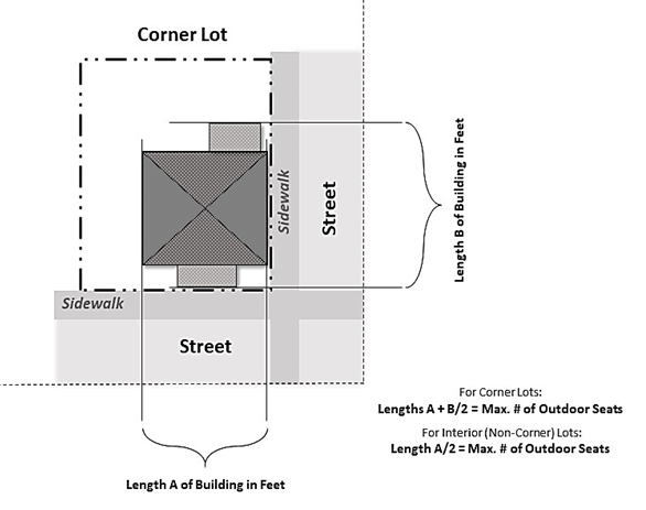
c.
In addition, all outdoor seating, as either sidewalk or on-site use, may be further limited based on the property's proximity and availability to public parking, as follows:
i.
Public parking must be available not more than 500 feet away as measured by following the shortest route of ordinary pedestrian travel along the public thoroughfare (right-of-way) from the main entrance of the proposed outdoor seating establishment to a public parking space.
ii.
A public parking space is defined as a space in a public parking facility or lot, or designated as "marked on-street" parking spaces. Under no circumstances shall unmarked/undesignated parking on local roads within an established single-family residential zoned neighborhood be counted as public parking spaces.
iii.
The parking requirement for all outdoor seating shall be one public parking space for every three outdoor seats desired.
iv.
If no public parking spaces exist within 500 feet of the subject property, no outdoor seating shall be granted unless parking is provided on the subject property or in accordance with this Code.
v.
Under no circumstances shall an outdoor seating approval allow for more seating than the allowable indoor seating unless additional parking is provided on the subject property or in accordance with this Code.
vi.
Requests for outdoor seating beyond the public parking availability as provided in this section shall provide additional parking in accordance with this Code.
d.
In the case where outdoor seating is provided through both a sidewalk use and on-site approvals, the maximum number of all outdoor seats approved is limited to the on-site seating allowance.
e.
Allowed outdoor seating through a sidewalk use approval shall not be used for the following:
i.
Calculating seating requirements pertaining to applications for, or issuance of, an alcoholic beverage license;
ii.
Computing required seating for restaurants and dining rooms;
iii.
Grounds for claiming exemption from such requirements under the provisions of any city ordinance or state law.
4.
Standards for all outdoor seating.
a.
A minimum five-foot wide sidewalk must remain fully accessible within the right-of-way in accordance with ADA requirements, including areas that are partially in the right-of-way. The five-foot area must be maintained at all times as a clear unobstructed pedestrian path. Outdoor seating areas may not be placed within five feet of a pedestrian crosswalk, corner curb cut, bus stop, fire hydrant, alley, or building entrance/exit. Outdoor seating shall be within areas accessible to the public and shall not be located within easements.
b.
Umbrellas and other decorative materials shall be fire retardant or manufactured of fire-resistant material and shall comply with applicable building and fire codes. The lowest part of the umbrella top must be a minimum of seven feet above the sidewalk.
c.
There shall be no seating areas located in any parking or landscape areas on public or private property, except as provided below. Seating must be located on a solid paved or paver surface, e.g., concrete, asphalt, brick or concrete pavers that are ADA accessible.
i.
Outdoor seating, accessory to cocktail lounges, bars and saloons on property zoned C-3, are permitted to remove up to 15 existing, on-site parking spaces and associated landscape areas for provision of on-site, outdoor seating as permitted within this section.
ii.
Outdoor seating, accessory to restaurants and brewpubs on property zoned C-3, are permitted to remove up to 15 existing, on-site parking spaces and associated landscape areas for provision of on-site, outdoor seating as permitted within this section.
d.
There shall be no seating areas that would obstruct pedestrians or the vision of motor vehicle operators or create a traffic hazard. Sidewalk seating shall not obstruct benches, fire hydrants, landscaping, bicycle racks, pedestrians or other right-of-way utilities.
e.
Whenever practicable, outdoor seating must be located adjacent to the building. Exceptions will be considered on a case-by-case basis, if an alternative location provides enhanced safety or accessibility.
f.
Outdoor seating areas shall comply with the state building code and National Fire Prevention Association life safety code.
g.
Outdoor seating areas must have a 50-foot minimum setback from the property line of any abutting single-family residentially used property.
h.
Sound mitigation shall be provided between the single-family residentially used property line and the seating area in accordance with this Code.
i.
Variances shall not be granted to standards required for outdoor seating areas.
(c)
Application approval; issuance of approval; conditions; transfer.
1.
Once an applicant has submitted all required documents, met all conditions, and staff concurs with the issuance of an approval; an on-site approval or a sidewalk use approval shall be issued. The sidewalk use approval shall be valid for one year (October 1 through September 30 of the following year).
2.
Special conditions may be imposed on an approval including, but not limited to:
a.
The hours of operation of outdoor display or outdoor seating areas are limited to the legal hours of operation of the business holding the approval ("approval holder").
b.
Alcoholic beverages may be served or consumed in an outdoor seating area provided that the outdoor seating approval holder holds the appropriate license from the state and/or the city to serve alcoholic beverages. The proposed area must comply with state alcoholic beverages and tobacco requirements.
c.
Only the items specifically shown on the approved application and not otherwise prohibited may be allowed in the approval area. The approval area may not be used to store food, beverages, chairs, tables, dishes, flatware, or other items.
d.
The city may require the temporary removal of outdoor display and outdoor seating areas from the public right-of-way during street, sidewalk or utility repairs, or during emergency situations.
e.
Upon the issuance of a hurricane or high wind warning, the approval holder shall immediately remove all items from the right-of-way.
f.
Umbrellas or similar fixtures that are sensitive to windy conditions must be sufficiently weighted to prevent movement.
g.
The use of public sidewalks for outdoor display and outdoor seating areas may be temporarily revoked by the city when it has been determined that the number of pedestrians using the public sidewalk may be too great to allow any obstruction, e.g., parade, art festival, street festival.
h.
Tables, chairs or other fixtures may not be attached, chained, or in any manner affixed to any tree, post, sign or other fixture within the public right-of-way.
i.
The approval area within the public right-of-way may not contain signage which would otherwise require a sign approval under this Code or be prohibited by this Code.
j.
The approval shall be specifically limited to the area as depicted on the approval.
k.
All objects associated with the approval must be maintained in a clean and attractive appearance and shall be in good repair at all times. The area covered by the approval shall be maintained in a neat, clean and orderly appearance at all times by the approval holder. There shall be no illicit discharge into the city's stormwater system.
l.
The approval holder must inspect the approval area and the area immediately adjacent to the approval area daily for hazardous conditions. The approval holder must notify the city in writing immediately of any hazardous conditions.
m.
Cooking facilities are prohibited within the approval area. All food or drinks served within the approval area shall be prepared inside the building associated with the approval.
3.
An approval may be transferred to a new owner for the location listed on the approval under the following conditions:
a.
The current approval holder must provide a written request to the department.
b.
A transferred sidewalk use approval shall be valid only for the remainder of the period for which it was originally issued.
c.
The new approval holder must comply with the insurance and liability provisions of this section and agree in writing to the conditions of the approval.
d.
Approvals issued under this section of Code are non-transferable to another site.
(d)
Revocation or suspension of an approval.
1.
An outdoor seating or display approval may be revoked or suspended, if it is found that:
a.
The approval holder is not in compliance with the insurance and liability section;
b.
The approval holder is in violation of any conditions outlined in the approval;
c.
The approval holder has failed to correct any violations of this section or conditions of the approval within 72-hours of receipt of a written notice issued by the department;
d.
The city shall have the right to revoke an approval for any reason with 30 days prior written notice to the approval holder;
(e)
Enforcement. The police department or an authorized code enforcement officer is empowered to investigate any situation where a person is alleged to be violating this section.
(f)
Penalty. A violation of this section shall be punished as provided in section 1-14 of this Code, or F.S. ch. 162.
(2)
Outdoor display outside of the CBOZ, and in the C-E zoning district. Retail stores in the C-P, C-E, M-1 and M-2 districts, except for plant nurseries, landscaping businesses, and garden centers, using outdoor display areas shall comply with the following provisions:
(a)
An outdoor display approval is not required.
(b)
The display can be located on the subject property and shall not encroach onto abutting private property, public property, easements, or rights-of-way.
(c)
The outdoor display area size shall not exceed one-third of the indoor area of the principal structure.
(d)
The outdoor display area shall be located on a solid paved or paver surface, e.g., concrete, asphalt, brick or concrete pavers, suitable for pedestrian traffic in accordance with the state building code.
(e)
The outdoor display area may be open along the front of the lot but shall be effectively screened on the sides in order to avoid any deleterious effect on adjacent properties.
(f)
The outdoor display area shall be combined with the indoor floor area for the purpose of calculating off-street parking requirements.
(3)
Outdoor seating outside of the CBOZ. Any restaurant, cocktail lounge, saloon, brewpub or bar may provide additional outdoor seating on the subject property, provided they meet the following criteria:
(a)
An outdoor seating approval is not required.
(b)
The outdoor seating shall be located on the subject property and shall not encroach onto abutting private property, public property, easements, or rights-of-way, nor shall it be located in parking spaces or landscape areas.
(c)
The outdoor seating area shall be located on a solid paved or paver surface, e.g., concrete, asphalt, brick or concrete pavers, suitable for pedestrian traffic in accordance with the state building code.
(d)
Outdoor seating areas shall comply with the state building code and National Fire Prevention Association life safety code.
(e)
Outdoor seating areas must have a 50-foot minimum setback from the property line of any abutting single-family residentially used property.
(f)
All outdoor seating shall be combined with the indoor seating for the purpose of calculating on-site parking requirements. Additional parking shall be provided at the time the principal use is increased in capacity by the provision of outdoor seating in accordance with article V, sections 9.72. and 9.73 of this Code.
(I)
Parking of recreational vehicles, commercial vehicles and heavy equipment. Commercial motor vehicles or heavy equipment of an agricultural nature and accessory to a primary agricultural use shall be allowed to be parked or stored in the AEU zoning classification only. The parking of such vehicles is prohibited in all other residential districts (see chapter 56 of the City Code, Traffic and Motor Vehicles).
Recreational vehicles and recreational equipment in any district, except AEU and REU, shall be allowed subject to the standards of appendix D, section 9.74(p). Recreational vehicles and recreational equipment (including horse trailers) may be parked, located or stored on developed single-family properties (not on vacant residential properties) in the AEU and REU zoning districts only (see article V, section 2, district use and dimensional standards).
(J)
Retail and service establishments within multifamily developments. Retail service establishments shall be allowed as an accessory use only when operated within a single complex of 40 or more units; includes drug and sundry shops; confectionery and coffee shops; newsstands; personal services; delicatessens; eating and drinking establishments; laundry and similar uses, provided that no commercial display is placed outside a principal building. Such accessory use shall not exceed two percent of the gross floor area of a principal use.
(K)
Satellite dish antenna. Satellite dish antenna exceeding three feet in diameter shall meet the following requirements:
(1)
The satellite dish antenna shall be considered a structure requiring a building permit to be issued prior to installation. Subsequent to installation, the antenna shall be maintained in compliance with all applicable building and electrical codes.
(2)
The satellite dish antenna installation and any part thereof shall maintain vertical and horizontal clearances from any electric lines and shall conform to the National Electric Safety Code.
(3)
The satellite dish antenna shall be of a non-reflective surface material and shall be made, to the maximum extent possible, to conform and blend, taking into consideration color and location, with the surrounding area and structures.
(4)
The satellite dish antenna shall contain no advertising or signage of any type.
(5)
The installer of any satellite dish antenna, prior to installation, shall submit detailed blueprints/drawings of the proposed satellite dish antenna installation and foundation which shall be certified by the manufacturer or a professional engineer.
(6)
The satellite dish antenna shall be considered an accessory structure and meet the requirements for accessory structures.
(7)
The satellite dish antenna shall, to the maximum extent possible without interfering with actual reception or transmitting, be screened from view from a public right-of-way and adjacent properties.
(8)
Dish antennas in single-family residential areas shall be limited as follows:
(a)
One dish per lot.
(b)
Maximum height above mean average grade of the lot: 15 feet.
(c)
Maximum diameter: 12 feet.
(d)
Dish antennas may not be located on the roof of a structure.
(e)
Dish antennas may not be located in any front yard or required side yard.
(L)
Skateboard ramps.
(1)
Maximum size of the skating portion of the ramp:
(a)
On lots of less than one acre the skating portion of the ramp shall be limited to a maximum of 384 square feet (i.e., 16 feet by 24 feet) and six feet in height.
(b)
On lots greater than one acre the skating portion of the ramp shall be limited to a maximum of 768 square feet (i.e., 24 feet by 32 feet) and 12 feet in height.
(2)
Skateboard ramps shall include a four-foot safety platform the entire width of the ramp at each end of the ramp.
(3)
The ramp shall include four-foot high safety rails around the safety platforms.
(4)
Setbacks. The ramp must be located in the rear yard and shall be set back 20 feet from any side lot line and 20 feet from any rear lot line.
(5)
The ramp must be anchored to the ground and meet the wind load requirements found in the City of Melbourne Building Code. A building permit must be obtained in order to ensure that the wind loading requirements are met.
(6)
The use of the ramp shall be limited to daylight hours and in no event later than 9:00 p.m. or earlier than 7:00 a.m.
(7)
The ramp shall be screened from adjoining properties by an opaque fence or wall, which is at least six feet in height.
(8)
The ramp shall be enclosed on all unfinished sides and shall be adequately insulated in order to reduce the amount of noise produced by the structure when in use.
(9)
The exterior portions of the ramp shall be painted to be consistent with other structures on-site (i.e., earth tones and non-reflective finishes).
(10)
The ramp shall not be used for commercial purposes.
(11)
The ramp shall be used solely by the occupants of the residence and bona fide guests.
(M)
Swimming pools. For the purpose of this ordinance, swimming pools shall meet the following requirements and shall be measured from the water's edge:
(1)
Location on a lot.
a.
Lot with frontage on one street. Pools shall be placed in the rear yard.
b.
Lot with frontage on two streets. Pools shall be placed in the rear or side yard.
c.
Lot with frontage on a navigable waterway. Pools shall be placed in the rear or front yard, but in no instance shall the pool be located within the required principal structure front yard setback.
(2)
Structure separation. Generally, pools shall be located five feet from any structure. A pool may be setback closer than five feet to another structure, but not less than three feet, if an engineer's certification is included with the building permit. No structure separation is required between a pool and pool related amenities such as a swimming pool enclosure, pergola, cabana or pool house.
(3)
Property line setback. Pools shall be located according to the following:
a.
Lot with required side yard setback of 7.5 feet or greater: Ten feet from all property lines.
b.
Lot with required side yard setback of less than 7.5 feet: 2.5 feet inward from the existing side yard designated by the placement of the principal structure.
(N)
Swimming pool enclosures. Screened pool enclosures must meet the following requirements:
(1)
The insect screening shall have at least 50 percent open area per square inch.
(2)
The framing and overhead supports of the screened pool enclosure shall be solely for the purpose of supporting such screening.
(3)
The square footage of the screened pool enclosure may not exceed 500 percent of the two-dimensional area of the pool.
(4)
Screened pool enclosures shall be permitted not less than 7.5 feet from the property line. If the side yard setback requirement for the zoning district is less than 7.5 feet, the screened pool enclosure may be located in alignment with the perimeter side walls of the principal structure.
(O)
Utility poles. In residential or multifamily use districts, utility poles and lines shall be placed in rear yard areas reserved for utility uses by easements granted for that purpose. However, in any use district having alleys, the utility poles shall be placed in the alley.
(P)
Vehicle impounding yard. Vehicle impounding yards allowed as an accessory use to a body shop (major vehicle service) are subject to the standards contained in article VI, section 2(X), of the zoning code.
(Ord. No. 2005-120, § 2, 11-8-2005; Ord. No. 2006-79, § 8, 8-8-2006; Ord. No. 2009-31, § 9, 8-25-2009; Ord. No. 2010-49, § 3, 10-12-2010; Ord. No. 2010-22, § 1, 1-11-2011; Ord. No. 2014-43, § 2, 8-12-2014; Ord. No. 2015-35, § 4, 8-25-2015; Ord. No. 2016-37, § 1, 6-14-2016; Ord. No. 2017-31, § 6, 7-11-2017; Ord. No. 2018-12, § 4, 4-10-2018; Ord. No. 2021-47, § 3, 10-26-2021; Ord. No. 2022-47, § 3, 10-25-2022; Ord. No. 2023-02, § 1, 2-14-2023; Ord. No. 2024-07, § 1, 1-23-2024; Ord. No. 2024-48, § 1, 8-27-2024)
Sec. 3. - Temporary uses.
(A)
Portable storage units. Portable storage units may be permitted provided such units comply with the following provisions:
(1)
Size: Portable storage units shall not exceed eight feet in height, eight feet in width, and 16 feet in length.
(2)
Number of units: One portable storage unit may be located on any lot occupied by a single-family dwelling. The number of permitted portable storage units for all other uses shall be based on one unit per each 10,000 square feet of building area, or portion thereof.
(3)
Location:
(a)
Within residential districts, portable storage units may be located in a required setback; however, they shall not be located in such a manner to impair a motor vehicle operator's view of other motor vehicles, bicycles or pedestrians upon entering or exiting rights-of-way. In all other districts, the unit shall not be located in any required landscape, buffer or parking area.
(b)
Portable storage units shall not be located in such a manner to obstruct the flow of pedestrian or vehicular traffic.
(4)
Wind loads: If the National Weather Advisory Service or other qualified weather advisory service identifies weather conditions which are predicted to include winds of 75 mph or greater, all portable storage units shall be removed from all properties and placed in approved storage locations at least 24 hours prior to the predicted onset of such winds or as soon as reasonably practical if less notice is provided. This requirement may be modified by the building official upon receipt of adequate documentation from a registered architect or engineer or other professional qualified to give such opinion that a greater wind loading pertain to a particular portable storage unit model or manufacturer so that the portable storage unit is unlikely to be moved by winds greater than the predicted winds. As an alternative to removal, the portable storage vendor may submit a tie down proposal for approval by the building official and each portable storage unit not removed shall be tied down in the approved manner.
(5)
Time frame:
(a)
Portable storage units are allowed in residential districts for a period not exceeding 14 days and no more than two times a year on residentially zoned property. For nonresidentially zoned property, portable storage units are allowed for a period not to exceed 30 days and no more than two times a year.
(b)
A sticker shall be affixed to all portable storage units indicating the most recent delivery date, on which the portable storage unit was delivered to a property.
(B)
Temporary homeless shelters. Such shelters shall not provide lodging on a regular basis and shall not continually provide shelter for the same individuals. Temporary shelters shall operate no more than a total of 30 days per year, a year being the period July 1 through June 30. A temporary overnight shelter shall be used only as an accessory use to a house of worship or nonprofit agency which was established for a period of at least 12 consecutive months prior to 1991, and where specifically permitted in this code and shall meet the following requirements:
(1)
Any temporary overnight shelter for the homeless shall comply fully with the requirements of applicable state, county and city codes, ordinances and regulations; and
(2)
Any temporary overnight shelter for the homeless shall be contained within the structure of, and operated by, a not-for-profit corporation or charitable organization.
(C)
Tents. Tents are only permitted as part of a special activity permit. Tents that have columns/poles that are permanently secured to concrete footers or bolted to an existing concrete slab are considered structures and are subject to wind load requirements and all other zoning and building code standards.
(Ord. No. 2005-120, § 2, 11-8-2005)
Sec. 1. - Intent.
Within the zoning districts established by this code, there may exist lots, structures, or uses of land and structures and characteristics of use which were lawful before this code was passed or amended, but which would be prohibited, regulated, or restricted under the terms of this code or future amendments. It is the intent of this code to permit these nonconformities to continue in their present condition until they are removed, but not to encourage their continuation. Such uses are declared by this code to be incompatible with permitted uses in the districts involved. It is further the intent of this code that nonconformities shall not be enlarged upon, expanded or extended, nor be used as grounds for adding other structures or uses prohibited elsewhere in the same district.
For certain non-conformities related to an affordable housing development, after the affordability period is satisfied, please see Appendix B, article V, section 4.
(Ord. No. 2005-120, § 2, 11-8-2005; Ord. No. 2023-21, § 3, 6-13-2023)
Sec. 2. - Types of nonconformity.
(A)
Nonconforming lots of record. In any district in which single-family dwellings are permitted, notwithstanding limitations imposed by other provisions of this code, a single-family dwelling and customary accessory building may be erected on any single platted lot of record. Such lot must be in separate ownership from adjacent lots and not of continuous frontage with another lot in the same ownership as of the effective date of this code, or amendment hereto, at which time standards for lot area or width were set, continuously until the date that a building permit is issued. This provision shall apply even though such lot fails to meet the requirements for lot area or lot width, or both, that are generally applicable in the district; provided that yard dimensions and other requirements not involving lot area or lot width, or both, shall conform to the regulations for the district in which such lot is located. Variance of area, width, or yard requirements shall be obtained only through action of the board of adjustment.
Single-family homes may be constructed on any substandard, vacant platted lot of record, platted prior to November 1983, as long as density on the affected platted lot does not exceed the land use density designated on the future land use map by more than 25 percent. Platted lots designated as mixed use or general commercial on the future land use map, shall be considered to allow a density of 15 dwelling units per acre for the purposes of this section. In addition, all other requirements set forth in this Comprehensive Plan or in the city's land development code, including, but not limited to, lot coverage and yard requirements must be met, unless as permitted by the land development code, or if a variance is granted by the zoning board of adjustment.
(B)
Nonconforming uses of land. Where, at the effective date of adoption or amendment of this code, lawful use of land exists that is made no longer permissible under the terms of this code as enacted or amended. Such use may be continued, so long as it remains otherwise lawful, subject to the following provisions:
(1)
No such nonconforming use shall be enlarged, increased, nor extended to occupy a greater area of land than was occupied at the effective date of adoption or amendment of this code; unless such use is changed to a use permitted in the district in which such use is located.
(2)
No such nonconforming use shall be moved in whole or in part to any other portion of the lot or parcel occupied by such use at the effective date of adoption or amendment of this code.
(3)
If any such nonconforming use of land ceases for any reason for a period of more than 90 consecutive days, any subsequent use of such land shall conform to the regulations specified by this code for the district in which such land is located regardless of whether or not a property is licensed for business. In determining that a nonconforming use of land has ceased for 90 consecutive days, it shall not be necessary to prove or ascertain that there has been an intent to abandon the use on the part of a property owner, lessee or occupant.
(4)
Additional structures that do not conform to the requirements of this code shall be prohibited in connection with such nonconforming use of land.
(5)
Subdivisions and lots developed in the R-1B zoning districts, approved or platted before March 11, 2003, where density exceeds four units per gross acre, shall not be deemed/considered to be a nonconforming platted subdivision.
(C)
Nonconforming structures and site improvements. Where a lawful structure or associated site improvements exist at the effective date of adoption or amendment of this code that could not be built under the terms of this code by reason of restrictions on area, lot coverage, height, yards, or by other characteristics of the structure or its location on the lot, such structure or improvements may be continued so long as they remain otherwise lawful, subject to the following provisions:
(1)
No such structure may be enlarged or altered in a way that increases its nonconformity.
(2)
Any structure or portion thereof may be altered to decrease its nonconformity.
(3)
Should such structure be destroyed by any means to an extent of more than 50 percent of its replacement cost at time of destruction, it shall not be reconstructed except in conformity with the provisions of this code.
(4)
Should such structure be moved for any reason for any distance whatever, it shall thereafter conform to the regulations of the district in which it is located after it is moved.
(5)
If any nonresidential principal structure or premises remains unoccupied for a period of 90 consecutive days, any subsequent use of the principal structure shall conform to the parking and landscaping regulations of the district in which it is located regardless of whether or not the property is licensed for business. In determining that a nonconforming use of land has ceased for 90 consecutive days, it shall not be necessary to prove or ascertain that there has been an intent to abandon the use on the part of a property owner, lessee or occupant, or that the characteristic equipment or furnishings have been removed from the structure.
(6)
Existing single-family, duplex, or triplex units not having a garage shall not be considered to be nonconforming structures. Existing carports and/or garages constructed prior to 1984 may be enclosed and become part of the dwelling unit as long as the enclosure will not violate any other provision of this code and the proper permits are obtained.
(7)
Subdivisions constructed between 1991 and 1997 utilizing the concept of a detached townhouses in the R-2 zoning district shall not be considered to be nonconforming. Additional development on these lots shall meet the setbacks already in existence in that subdivision. In no event shall there be less than ten feet between primary structures unless a variance has been granted by the board of adjustment.
(8)
Nonconforming signs shall be governed by appendix D, chapter 11, section 11.07.
(D)
Combinations. If a lawful use involving individual structures or site improvements, or of structure and premises in combination, exists at the effective date of adoption or amendment of this code that would not be allowed in the district under the terms of this code, the lawful use may be continued so long as it remains otherwise lawful, subject to the following provisions:
(1)
No existing structure devoted to a use not permitted by this code in the district in which it is located shall be enlarged, extended, constructed, reconstructed, moved or structurally altered except in changing the use of the structure to a use permitted in the district in which it is located.
(2)
Any nonconforming use may be extended throughout any parts of a building that were manifestly arranged or designed for such use at the time of adoption or amendment of this code but no such use shall be extended to occupy any land outside such building.
(3)
Any structure, or structure and land in combination, in or on which a nonconforming use is superseded by a permitted use, shall thereafter conform to the regulations for the district in which such structures are located, and the nonconforming use may not thereafter be resumed.
(4)
Where nonconforming use status applies to a structure and premises in combination, removal or destruction of the structure shall eliminate the nonconforming status of the land. Destruction for the purpose of this code is defined as damage to an extent of more than 50 percent of the replacement cost at time of destruction.
(5)
If any nonresidential principal structure remains unoccupied for a period of 90 consecutive days, any subsequent use of the structure shall conform to the parking and landscaping regulations of the district in which it is located regardless of whether or not the property is licensed for business. In determining that a nonconforming use of land has ceased for 90 consecutive days, it shall not be necessary to prove or ascertain that there has been an intent to abandon the use on the part of a property owner, lessee or occupant.
As used in this subparagraph, the term "unoccupied" means lack of active use. In determining that a principal structure is unoccupied for 90 consecutive days, it shall not be necessary to prove or ascertain that there has been an intent to abandon the use or occupancy of the structure by the property owner, tenant, or occupant, or that the characteristic equipment or furnishings have been removed from the structure.
(Ord. No. 2005-120, § 2, 11-8-2005; Ord. No. 2006-79, § 9, 8-8-2006; Ord. No. 2010-37, § 7, 6-22-2010; Ord. No. 2017-40, § 1, 9-20-2017)
Sec. 3. - Modifications to nonconforming uses and structures.
(A)
Extension and enlargement. Nonconforming structures, site improvements, and/or a nonconforming use of land, shall not be extended or enlarged after adoption of this code by attachment on a building or premises of additional signs intended to be seen from off the premises, or by the addition of other uses of a nature which would be prohibited generally in the district involved.
To avoid undue hardship, nothing in this code shall be deemed to require a change in the plans, construction, or designated use of any building on which actual construction was lawfully begun prior to the effective date of adoption or amendment of this code and upon which actual building construction has been diligently carried on. Actual construction is hereby defined to include the placing of construction materials in a permanent position and fastened in a permanent manner. Except that where demolition or removal of an existing building has been substantially begun preparatory to rebuilding, such demolition or removal shall be deemed to be actual construction, provided that work shall be diligently carried on until completion of the building involved. In no event shall the time of such construction exceed a period of one year except for a demonstrated cause approved by city council.
(B)
Repairs and maintenance. On any land devoted in whole or in part to any nonconforming use, structure or combination thereof, ordinary repairs, or repair or replacement of nonbearing walls, fixtures, wiring or plumbing, may be done provided that the cubic content of the building as it existed at the time of passage or amendment of this code shall not be increased. Nothing in this code shall be deemed to prevent the strengthening or restoring to a safe condition of any building or part thereof declared to be unsafe by any official charged with protecting the public safety, upon order of such official.
(C)
Variances. Establishment or expansion of a use otherwise prohibited shall not be allowed by variance, nor shall a variance be granted because of the presence of nonconformities in the zoning district or uses in an adjoining zoning district. Under no circumstances shall the board of adjustment grant a variance to permit a use not generally permitted in the zoning district involved, or any use expressly or by implication, prohibited by the terms of the code in the zoning district.
(Ord. No. 2005-120, § 2, 11-8-2005)
Sec. 4. - Temporary uses.
The casual, intermittent, temporary or illegal use of land or structures shall not be sufficient to establish the existence of a nonconforming use. Such use shall not be validated by the adoption of this code unless it complies with the terms of this code.
Any house of worship which has used any structure on the premises of its sanctuary as a temporary overnight shelter for the homeless during the calendar years 1988, 1989, 1990 or 1991, may continue to utilize its premises periodically for a temporary overnight shelter for the homeless without violating this code or being declared to be a nonconforming use.
(Ord. No. 2005-120, § 2, 11-8-2005)
Sec. 5. - Classification.
Whenever the boundaries of a district shall be changed so as to transfer an area from one district to another district of a different classification, the foregoing provision shall also apply to any nonconforming uses existing therein.
(Ord. No. 2005-120, § 2, 11-8-2005)
Sec. 6. - Condemnation.
In the event that the Florida Department of Transportation (FDOT), Brevard County, the City of Melbourne or any other governmental agency with the power of condemnation condemns private property to acquire road right-of-way, and the condemnation results in the elimination or decrease of the required perimeter landscaping, results in insufficient yard requirements (setbacks), or results in a parcel that does not meet the minimum lot size, such private property shall become nonconforming and may continue as long as it remains otherwise lawful.
(Ord. No. 2005-120, § 2, 11-8-2005)
Sec. 1. - Zoning code; map amendments.
The city council may from time to time on its own motion, or on petition, or on recommendation of the planning and zoning board or any department or agency of the city, amend, supplement, or repeal the regulations and provisions of this ordinance.
(A)
Application.
(1)
An amendment or rezoning may be initiated by a petition of property owners or authorized agents of such owners for rezoning of any land to a less restricted district provided that said land is adjacent to or directly across the street or alley from property which is already zoned in the same or a less restricted zone as that to which said property is proposed to be rezoned.
(2)
Every such proposed amendment or change, whether initiated by the city council or by petition, shall be referred to the planning and zoning board who shall study such proposals to determine:
(a)
The need and justification for the change.
(b)
When pertaining to the rezoning of land, the affect of the change, if any, on a particular property and on surrounding properties.
(c)
When pertaining to the rezoning of land, the amount of undeveloped land in the general area and in the city having the same classification as that requested.
(d)
The relationship of the proposed amendment to the purpose of the city's plan for development with appropriate consideration as to whether the proposed change will further the purposes of this ordinance and the plan.
(B)
Planning and zoning board action. No recommendation for change or amendment may be considered until after a public hearing by the planning and zoning board, at which parties in interest and citizens shall have an opportunity to be heard.
The planning and zoning board, after conducting the public hearing as hereinabove provided, shall submit the request for change or amendment to the city council together with its written recommendations for approval or denial. The recommendations for affordable housing projects will go to city council with the initial public hearing held simultaneously with the first reading of an accompanying rezoning ordinance.
(C)
Limitations.
(1)
A proposal for rezoning or amendment to the official zoning map affecting a particular property or properties may contain conditions, limitations, or requirements not applicable to all other property in the zoning district to which the particular property is proposed to be rezoned.
(2)
Unless a parcel of land has at least 40,000 square feet of land area, no amendment shall be enacted to change the zoning classification except to the existing zoning classification of property adjoining said parcel. Notwithstanding the foregoing size limitation, a less intensive zoning may be recommended by the community development director, the planning and zoning board (local planning agency) or city council, subject to consistency with the comprehensive plan, greater compatibility with the surrounding area, and other site specific issues deemed appropriate.
(3)
Whenever any application for a change of zoning has been finally determined, no other or further application for a change of zoning for the same property, will be considered for a period of six months following the date of such action. Should conditions affecting such property materially change, in the opinion of the city council, or should a modified plan for a rezoning be presented to the city council, any of which, in the opinion of the city council, would justify action before the expiration of such six-month period, the city council, by a five-sevenths majority, may permit the filing of such application for a rezoning, notwithstanding the provisions of this section.
(D)
Protest by property owners. In case of a protest against a proposed change of zoning signed by the owners of 20 percent or more either of the area of the lots included in such proposed change, or of those extending 500 feet in any direction shall not become effective except by the favorable vote of six-sevenths of the city council. All written protests must be filed within 21 days following the date of the public hearing before the planning and zoning board. After submission to the city of the petition and the supporting signatures, no additional signatures may be added as supporting the petition. Once the petition and the supporting signatures have been filed with the city, any person who has signed the petition may remove his or her signature from the petition; provided, however, that to remove a signature supporting the petition, the individual must write to the city community development department prior to the city council meeting to request the removal of his or her signature from the petition. Signatures may only be removed prior to the vote on second reading of a rezoning ordinance. However, intent to file such a petition must be presented in writing to the city community development department by an individual or individuals residing within 500 feet of the proposed change within seven days following the hearing before the planning and zoning board. If no intent is filed, action may be taken by the city council at its next regular meeting. No zoning application may be changed or revised after the public hearing.
(Ord. No. 2005-120, § 2, 11-8-2005; Ord. No. 2007-87, § 1, 11-13-2007)
State Law reference— Minimum mandatory procedure for adoption of ordinances, F.S. § 166.041.
Sec. 2. - Notices and advertisements required.
The following notices shall be provided prior to the consideration of such applications by the city council and planning and zoning board.
(A)
Zoning code/map amendment applications.
(1)
Newspaper advertisement: Zoning code and zoning map amendments shall be advertised one time in a newspaper of general circulation in the City of Melbourne at least 15 days prior to the planning and zoning board public hearing.
(2)
Property posting: If the amendment petition is initiated by an applicant other than the city, a copy of said notice describing the petition shall be posted on the property and at city hall at least ten days prior to the planning and zoning board public hearing.
(3)
Courtesy notices to property owners: A courtesy notice may be mailed to the property owners of record within a radius of 500 feet provided however, that failure to mail or receive such courtesy notice shall not affect any action or proceeding taken hereunder. The notice shall state the general nature of the proposed amendments as well as the text.
(B)
Conditional use applications.
(1)
Newspaper advertisement: Conditional use requests shall be advertised. The community development department shall cause the notice to be published one time in a newspaper of general circulation in the City of Melbourne at least 15 days prior to the planning and zoning board public hearing.
(2)
Property posting: A copy of the conditional use notice shall be posted on the property for which a conditional use is sought and at the city hall at least ten days prior to the planning and zoning board public hearing. All notices shall state in substance the conditional use desired, and a legal description of the property.
(3)
Courtesy noticesto property owners: A courtesy notice may be mailed to the property owners of record within a radius of 500 feet provided however, that failure to mail or receive such courtesy notice shall not affect any action or proceeding taken hereunder. The notice shall state the general nature of the proposed development.
(Ord. No. 2005-120, § 2, 11-8-2005)
Sec. 3. - Building permits and certificates of occupancy.
Administration and enforcement of building construction and development shall be in accordance with the provisions in the City Code of Melbourne Florida.
(A)
Consistency with approved plans and applications. Building permits or certificates of occupancy issued on the basis of plans and applications approved by the city authorize only the use, arrangement, and construction set forth in such approved plans and applications, and no other use, arrangement or construction. Use, arrangement, or construction in variance with that authorized shall be deemed a violation of this ordinance.
(B)
Uncompleted building. Buildings which do not fully comply with the plans and specifications upon which a building permit was issued, shall not be permitted to remain on any land in Melbourne for more than 24 months after the commencement or erection of such new building, except upon permission of the building official as provided in the building code.
(Ord. No. 2005-120, § 2, 11-8-2005; Ord. No. 2017-31, § 6, 7-11-2017)
Sec. 4. - Planned unit development (PUD).
(A)
Processing and submittal requirements. This section contains the required submittals and review procedures for rezoning applications to PUD. Five steps are generally required to obtain final approval for a planned unit development:
•Preliminary conference;
•Preliminary development plan;
•Preliminary plat;
•Engineering drawings; and
•Final development plan including the final plat.
(1)
Pre-application conference. Prior to submitting a formal application for PUD approval, the petitioner is required to attend a pre-application meeting with the following:
(a)
Community development department.
(b)
Engineering department.
(c)
Developer.
(2)
Preliminary development plan (PDP).
(a)
PDP submittal requirements. Applications for rezoning to PUD must be accompanied by a preliminary development plan (PDP). Applicants may submit concurrent preliminary and final development plan applications if they wish to expedite the process. The PDP application submittal shall be submitted at least 30 days prior to any scheduled meeting of the planning and zoning board, and shall include the following:
1.
Application form. The applicant shall submit a signed application form and shall include a statement describing the type of development proposed.
2.
Development agreement, if applicable. The development agreement shall include the following:
a.
A legal description of the land subject to the agreement and the names of its legal and equitable owners.
b.
The duration of the agreement, which shall not exceed ten years.
c.
The development uses permitted on the land, including population and unit densities, and building intensities and height.
d.
A description of the public facilities that will service the development, including who shall provide such facilities; the date any new facilities, if needed, will be constructed; and a schedule to assure public facilities are available concurrent with the impacts of the development.
e.
A description of any reservation or dedication of land for public purposes.
f.
A description of all local development orders or permits approved or needed to be approved for the development of land.
g.
A finding that the development permitted or proposed is consistent with local government's comprehensive plan and local development regulations.
h.
A description of any conditions, terms, restriction, or any other requirements determined to be necessary by local government for the public health, safety, or welfare of its citizens.
i.
A statement indicating that failure of the agreement to address a particular development order or permit, condition, term, or restriction shall not relieve the developer of the necessity of complying with the law governing said permitting requirements, conditions, terms or restrictions.
j.
A statement that the burdens of the development agreement shall be binding upon and the benefits of the agreement shall inure to, all successors in interest to the parties of the agreement.
3.
Boundary survey.
a.
Legal description of the proposed site.
b.
Boundaries of tract shown with bearings, distances, closures and bulkhead lines.
c.
All existing easements, section lines and property lines, and all existing streets and physical features in and adjoining the project.
4.
Vicinity and existing conditions map. The vicinity and existing conditions map or map series shall include the subject site and surrounding properties (located within 300 feet from the site). The map shall be no less than one inch equals 100 feet scale and shall include the following:
a.
Property lines of the proposed development and surrounding properties.
b.
Names, and location of surrounding developments and subdivisions.
c.
Location and names of all existing streets.
d.
The location and use of all existing principal buildings.
e.
Generalized soil types in the development area and surrounding area.
f.
Any existing recreation or open space areas.
g.
The location and size of all existing drainage, water, sewer, electrical, and other utilities facilities, including fire hydrants.
h.
Existing easements, watercourses, bridges, lakes, marshes, wooded areas, sinkholes, and other physical conditions affecting the area.
i.
Current zoning and land use of the subject site and surrounding properties.
j.
The location and function of all other existing public facilities that would serve the site such as schools, parks, fire stations and the like. Notation of this information on a scaled map or by written description is acceptable.
k.
Existing topography on the subject site at a scale of one inch equals 100 feet with two-foot contour lines and a slope category analysis for areas of more than ten percent slope (if any).
l.
Information about the type and location of existing vegetation within the subject site, including the approximate size and location of major tree groupings and those trees with a circumference of at least 18 inches, measured four feet from the ground (aerial and on-site photographs may be used to show vegetation).
5.
Preliminary development plan.
a.
Proposed name or title of project.
b.
The name of the surveyor, engineer, architect, and developer.
c.
North arrow, scale (not to exceed one inch equals 100 feet, unless otherwise permitted by city staff) and date of plan preparation with adequate space for revision notes.
d.
Tabulated site data including the following:
(i)
Number of gross acres in the project.
(ii)
Acreage and percentage of land to be devoted to each of the residential and nonresidential uses, including open space.
(iii)
Proposed density/intensity of development.
(iv)
Total number of dwelling units by type (single-family attached/detached, duplexes, townhouses, apartments, condominiums, etc).
(v)
Total square footage of commercial, industrial, or office space.
e.
General location of primary and secondary uses within site.
f.
Vehicular and pedestrian circulation systems.
g.
Proposed parks, school sites, or other public or private facilities.
h.
Proposed common open space, including the proposed improvements/amenities and any complementary structures (e.g., conceptual lighting, facade materials, street furniture) and open space accessories. Areas qualifying for usable common open space shall be specifically designated on the site plan.
i.
The proposed method of dedication and administration of proposed common open space.
j.
Preliminary development schedule delineating proposed dates for development phases.
k.
General statement indicating proposed means of drainage for the site to ensure conformity with natural drainage within the vicinity area or with the drainage plan established within the vicinity.
l.
A generalized landscaping plan.
m.
Conceptual building elevations indicating styles and materials to be used within the development.
n.
Table with proposed development standards such as building height, lot size, lot frontage, building setbacks, minimum living area, and floor area ratio.
o.
Notes specifying standards for signage, landscaping and buffering. Standards not specified on the development plan will revert to the standards for the zoning classification that better matches the type of development proposed.
(b)
PDP review procedures.
1.
Staff review. The preliminary development plan (PDP) shall be reviewed formally by the engineering and planning departments and any other division or department as necessary to determine the feasibility and suitability of the plan prior to the submission of the PUD zoning application to the planning and zoning board.
2.
Planning and zoning board review. The planning and zoning board shall then review said preliminary development plan to determine its conformity with the official plans and policies of the city and the requirements of this section. Upon completion of its review, the planning and zoning board shall recommend to the city council the approval, approval subject to conditions, or denial of the preliminary development plan application.
The decision of the planning and zoning board on the preliminary development plan application shall include the findings of fact that serve as a basis for its recommendation. In making its recommendation, the planning and zoning board shall consider the following facts:
a.
Degree of departure of proposed planned development from surrounding areas in terms of character and density.
b.
Compatibility within the planned development and relationship with surrounding neighborhoods.
c.
Prevention of erosion and degrading of surrounding area.
d.
Adequate provision for future public education and recreation facilities, transportation, water supply, sewage disposal, surface drainage, flood control and soil conservation as shown in the preliminary development plan.
e.
The nature, intent and compatibility of common open space, including the proposed method for the maintenance and conservation of said common open space.
f.
The feasibility and compatibility of the specified phases contained in the preliminary development plan to exist as an independent development.
g.
The availability and adequacy of primary streets and thoroughfares to support traffic to be generated within the proposed planned development.
h.
The availability and adequacy of water and sewer service to support the proposed planned development.
i.
The benefits within the proposed development and to the general public to justify the requested departure from standard land use requirements inherent in a planned development classification.
j.
The conformity and compatibility of the planned development with any adopted development plan of the city.
k.
The conformity and compatibility of the proposed common open space, primary residential and secondary nonresidential uses within the proposed planned development.
3.
City council review. Upon receiving the recommendation of the planning and zoning board the city council shall, at a regularly scheduled public meeting, review said recommendation and preliminary development plan and either approve, approve subject to conditions, or disapprove the preliminary development plan application. Approval of the preliminary development plan indicates approval of the PUD zoning subject to acceptance of the final development plan. The decision of the city council shall be based upon a consideration of the facts specified as review criteria for the planning and zoning board.
The city shall have the right to evaluate the physical layout, architectural characteristics, and amenities of the planned unit development and to suggest changes or modifications designed to create compatibility and conformity in the variety of uses within the development to ensure, protect and promote the health, safety and general welfare of the property owners of the planned unit development and the residents of the city.
4.
Recording of preliminary development plan. In the event the preliminary development plan application is approved by the city council, a copy of said application and required exhibits shall be certified and approved by the mayor and said certified copy shall be filed with the engineering department as a permanent record. A notice of said approval and filing, containing a legal description of the site, shall be recorded in the official records of the City of Melbourne, Florida.
(3)
Preliminary plat. The preliminary plat step may be omitted if the parcel does not need to be platted. However, the developer has one year (one year = 365 days from the date of approval of the preliminary development plan in which to file a preliminary plat application. The preliminary plat submittal and review shall comply with the subdivision code (appendix D, chapter 8). An applicant for PUD rezoning may submit development plan and plats simultaneously.
(4)
Engineering drawings. Engineering drawings of the following proposed utility system improvements must be presented to the engineering department 30 days before the final development plan is presented to the planning and zoning board. Engineering drawings must include:
(a)
Water.
(b)
Sanitary sewer.
(c)
Storm sewer.
(d)
Bulkheads.
(e)
Sidewalks and bicycle paths.
(f)
Streets.
(g)
Lot grading plan.
(h)
Drainage.
(5)
Final development plan (FDP). The developer shall have three years from the approval date of the preliminary plat or preliminary development plan, whichever is later, in which to file a final development plan.
(a)
FDP submittal requirements. If no platting is required, a site plan must be presented in accordance with section 6 of this article. If the property needs to be platted, the applicant must submit a development plan that complies with subdivision ordinance of the City of Melbourne. Additional exhibits required for the final development plan may include the following:
1.
Development schedule. The development schedule shall contain the following information:
a.
The order of construction of the proposed stages delineated in the development plan.
b.
The proposed date for the beginning of construction on said stages.
c.
The proposed date for the completion of construction of said stages.
d.
The proposed schedule for the construction and improvement of common open space within said stages, including any complementary buildings.
2.
Deed restriction. Deed restriction proposals to preserve the character of the common open space. Said deed restrictions shall include a prohibition against partition by any residential property owner.
3.
Association or nonprofit corporation. If the developer elects this method of administering common open space, the proposed bylaws of the association or the certificate of incorporation and the corporate bylaw of the nonprofit corporation shall be submitted for approval by the city attorney.
4.
Instruments. Instruments dedicating all rights-of-way, easements and other public lands shown on the final development plan from all persons having any interest in said land and instruments indicating that all necessary off-site easements or dedications have been acquired. In lieu of originals, "certified true copies" will be accepted if the recording information from the public records of Brevard County, Florida, is included thereon.
5.
Bill of sale. A bill of sale, conveying to the city water and sewer utility lines, mains, lift stations, and other personal property required to be installed by this chapter.
6.
Title opinion. A title opinion from an attorney showing the status of the title to the site encompassed by the final development plan and all liens, encumbrances and defects, if any.
7.
Tax receipts. Paid receipts from the city and county indicating taxes have been paid in full up to and including the current period.
(b)
FDP review procedures.
1.
Staff review. The engineering and planning department shall recommend the approval, approval subject to conditions, or disapproval of the final development plan application based upon the conformity of the final development plan with the preliminary development plan, sufficiency and accurateness of the required exhibits, and the requirements and purposes of this section and ordinances and regulations of Melbourne.
2.
Planning and zoning board and city council review. The planning and zoning board and the city council of the City of Melbourne shall review the recommendations of engineering and planning department at regular public meetings of the planning and zoning board and city council and shall approve, approve subject to conditions, or deny the final development plan application.
3.
Recording of final development plan. After approval of the city council of the final development plan application, the city engineers shall verify that all requirements of F.S. ch. 177, have been complied with before the final development plan is recorded in the public records of Brevard County, Florida. No final development plan of a planned unit development within the city shall be recorded unless it shall have the approval of the city council inscribed thereon.
The transfer of, sale of, agreement to see, or negotiation to sell land by reference to or exhibition of, or other use of a final development plan of a planned unit development, or portion thereof, that has not been given final approval by the city council and recorded in the official records of Brevard County, Florida, is prohibited. The description by metes and bounds in the instrument of transfer or other documents shall not exempt the transaction from such prohibition.
4.
Building permit. No building permit shall be issued by the city until the final development plan has been approved and duly recorded as provided in this section.
(B)
Simultaneous submittals. Applications for preliminary plat or site plan approval may be submitted for review simultaneously with applications for preliminary or final development plan review. In such cases, any approval of preliminary plats or site plans must be conditioned upon the approval of the development plan and rezoning. If the approved development plan includes any additions or conditions by the city council, the preliminary plat or site plan undergoing simultaneous review may be referred back to the planning and zoning board for further consideration.
(C)
Termination of PUD Zone. Failure of the developer to file a final development plan (FDP) application within the time period specified shall automatically revoke approval of the preliminary development plan and the city may take the necessary steps to return the land to its previous classification or one which is deemed most applicable.
(D)
Enforcement. In addition to any other method of enforcement, the city shall have the power to enforce the provisions of this section by an appropriate suit in equity.
(Ord. No. 2005-120, § 2, 11-8-2005; Ord. No. 2006-79, § 10, 8-8-2006; Ord. No. 2017-31, § 7, 7-11-2017)
Sec. 5. - Conditional uses.
The city council may permit a conditional use as provided herein, by ordinance granting permission for such use after a public hearing before the planning and zoning board at which persons interested shall be accorded an opportunity to be heard. Any ordinance permitting conditional uses as provided herein shall be construed as permitting only specifically named or described conditional use, and not any other conditional use. Any property or premises designated upon the zoning map by the letter symbol "C" alone shall be restricted to specific conditional use permitted and may be used for no other use whatsoever. Any property or premises designated by the letter symbol "C" before and in conjunction with the letter symbol for a residential, commercial or industrial district shall be restricted to use for that particular conditional use specified or the use permitted in the designated use district, i.e., the letters "C-AEU" shall denote a conditional use permitted in an AEU use district, and the premises so designated may be used only for the specific conditional use permitted or for single-family residences as provided in that use district. In granting any conditional use, the city council shall prescribe any conditions that it deems necessary to or desirable for the public interest. A conditional use shall not be permitted by the city council unless the following requirements are met.
(A)
Submittal requirements.
(1)
A written application for such conditional use must be submitted, in duplicate, providing the following information:
(a)
Lot, block and subdivision, or other legal description of the lands desired for such conditional use.
(b)
The names and addresses of all the owners of said land.
(c)
The conditional use desired and the reason for requesting the conditional use.
(d)
The application shall be signed by each and every owner of said lands and notarized.
(2)
A site plan showing the following must accompany the application:
(a)
For an existing structure not to be expanded by more than 50 percent of the gross floor area, a scaled dimensioned sketch plan 8.5 inches by 14 inches may be presented which delineates the following:
1.
Parking.
2.
Landscaping.
3.
External structural changes.
4.
Ingress/egress.
(b)
If the request for a conditional use is for multifamily, all requirements for multifamily site plan shall apply (see section 6, site plan review).
(c)
If a conditional use is requested on an undeveloped site or if the structure is to be expanded by more than 50 percent, a reproducible formal site plan, in accordance with section 6, signed by a registered engineer, land surveyor or architect must be presented, along with a rendering, elevation or photograph of the proposed project. The following must be detailed and dimensioned in a scale not greater than one inch to 50 feet on a 24 inch by 36 inch site plan:
1.
Structure.
2.
Parking.
3.
Ingress/egress.
4.
Yard requirements.
5.
Refuse.
6.
Screening.
7.
Height.
8.
Stormwater retention area.
(B)
Review process.
(1)
All applications for a conditional use shall be submitted to the community development department for study and written recommendations to the planning and zoning board. Staff recommendations shall become part of the official record of the city in connection with said application.
(2)
Upon receipt of the application, a date shall be set for a public hearing before the planning and zoning board at which parties in interest and citizens shall have an opportunity to be heard.
(3)
The planning and zoning board shall conduct a public hearing to consider the request for conditional use. Any party may appear in person or be represented by counsel at the public hearing. At the time of said public hearing, and in no event later than one week from the date thereof, the planning and zoning board shall forward the request for a conditional use together with their written recommendations to the city council.
(4)
After the public hearing before the planning and zoning board and upon receipt of their written recommendation, the city council may by ordinance grant permission for such conditional use and in doing so may prescribe appropriate conditions and safeguards in conformity with this ordinance.
(C)
Criteria for reviewing conditional uses.
No conditional use shall be recommended by the planning and zoning board, nor granted by the city council, unless the following factors are considered and satisfied by competent substantial evidence:
(1)
The conditional use shall be consistent with the area's future land use designation and the goals, objectives, action strategies and standards of the city's comprehensive plan, any adopted special area plan and these regulations.
(2)
The conditional use shall not have a detrimental effect on the surrounding area, public facilities, and private, commercial and/or service facilities available within the area. More specifically:
(a)
The overall residential appearance and function of the area shall not be significantly lessened due to the increased proportion of nonresidential uses in the residential area. Consideration includes the application itself and in combination with other nonresidential uses in the area and is to be based on the number, size, and location of the nonresidential uses and the intensity and scale of the proposed and existing nonresidential uses in the area.
(b)
The application is sensitive to the preservation of any city, state or federally designated historic, scenic, archaeological, or cultural resources.
(c)
The proposed development shall be compatible with adjacent residential developments, if any, based on characteristics such as size, building style and scale; or whether such incompatibilities are mitigated through such means as screening, landscaping, setbacks, and other design features.
(d)
The application shall not have significant adverse impacts on the livability and usability of nearby land due to: noise, dust, fumes, smoke, glare from lights, late-night operations, odors, truck and other delivery trips, the amount, location, and nature of any outside displays, storage, or activities, potential for increased litter, and privacy and safety issues.
(3)
The proposed use shall not have a detrimental impact on the transportation system, considering the existing uses in the area already being served by the system. Evaluation factors include street capacity and level of service, access to arterials, transit availability, on-street parking impacts, if any, zoning lot access requirements, neighborhood impacts, and pedestrian safety.
(4)
The use shall provide the minimum off-street parking area required for the type of use, and shall provide the amount of space needed for the proper and safe loading and unloading of trucks.
(5)
The use shall not be a detriment to the public health, safety and welfare.
(6)
The applicant shall demonstrate the financial and technical capacity to complete any improvements and the mitigation necessitated by the development as proposed, and has made adequate legal provision to guarantee the provision such improvements and mitigation.
(7)
The proposed use shall comply with all additional standards imposed on it by the particular provision of these regulations authorizing such use and by all other applicable requirements of the regulations of the city, including, but not limited to, article IX, section 6, site plan review standards.
(8)
Conditional use requests for building height shall also be found to be consistent with requirements of article IV, section 1(C), in addition to the previous requirement.
(9)
Conditional use requests on a lot with multiple zoning districts shall be found consistent with appendix B, article V, section 1(6).
(D)
Limitations. Whenever any application for a conditional use has been finally determined, no other or further application for a conditional use for the same property, will be considered for a period of six months following the date of such action. Should conditions affecting such property materially change, in the opinion of the city council, or should a modified plan for a conditional use be presented to the city council, any of which, in the opinion of the city council, would justify action before the expiration of such six-month period, the city council, by a five-sevenths majority, may permit the filing of such application, notwithstanding the provisions of this section.
(E)
Expiration and violations. Violations of such conditions and safeguards, when made a part of the terms under which the conditional use is granted, shall be deemed a violation of this ordinance and punishable as provided herein. The city council may provide a time period with which action must be commenced in connection with said conditional use, and may further provide that upon cessation of the conditional use for a continuous period of six months the use of the premises shall revert to, the previous and more restricted use classification. Required plans approved in accordance with section 6 will also expire as stated in section 6(F).
(Ord. No. 2005-120, § 2, 11-8-2005; Ord. No. 2010-13, § 7, 9-7-2010)
Sec. 6. - Formal site plan review.
(A)
Purpose. The purpose of this section is to establish review and evaluation procedures by the planning and zoning board and city council for the development projects defined below. The review shall focus on permitting a desirable living environment for the residents of multiple-family zoning districts, to provide timely logical large-scale commercial and industrial development and to encourage a harmonious relationship with surrounding developments. A formal site plan approval is a quasi-judicial decision and shall be administered accordingly.
(B)
Applicability. A permit for building or building expansion of the following types of development shall not be issued prior to following the appropriate city approval process listed below. Only one site plan application shall be considered on the same property at the same time. Development plans below these thresholds shall only require city staff approval:
* For the purposes of this subsection, the term "new development in the downtown redevelopment area" shall include renovation of any facility requiring an increase of 25 percent or more of the gross square footage of the floor area.
(C)
Formal site plan submittal requirements. The following must be submitted to the city:
(1)
Completed application form.
(2)
A statement describing the general character of the intended development and the proposed method of preservation and maintaining open space shall accompany the required number of copies of the preliminary site plan.
(3)
A reproducible scaled and dimensioned site plan drawn to a scale not to exceed 50 feet to one inch, prepared by a State of Florida registered engineer, land surveyor, landscape architect or architect. The site plan shall include:
(a)
Name, location (including a vicinity map), owner and designer of the proposed development.
(b)
Location of the site in relation to surrounding properties, including the means of ingress and egress to such properties and any screening or buffers on such properties.
(c)
Future land use and zoning of the subject property and all adjacent properties.
(d)
Date, north arrow and graphic scale (not less than one inch equals 50 feet, unless the parcel is over 50 acres, site plans over 50 acres may be presented at a scale of one inch equals 100 feet.
(e)
Property size and parcel identification information. Location of all property lines, existing streets, easements, and utilities, as well as proposed drainage structures and culverts, and proposed streets, driveways, structures and general site layout.
(f)
Location of all trash receptacles.
(g)
All structures and major features shall be fully dimensioned including distance between structures, distance between driveways, parking areas, property or lot lines and building height.
(h)
A rendering, elevation or photo of the proposed development.
(4)
An environmental impact assessment in accordance with appendix D, chapter 9, article IV, City Code.
(5)
A digital version of the site plan.
(D)
Formal site plan review procedures.
(1)
Pre-application conference. The applicant shall meet with the development review staff of the City of Melbourne to discuss basic site plan requirements and consider preliminary features of the site and the proposed development.
(2)
Staff review. Applications for formal site plan approval shall be submitted to the community development staff who shall send copies of the proposed plans and related documents to the appropriate review departments for their written comments and recommendations. The development review staff shall ascertain compliance with all city codes and shall determine whether the proposed development is harmonious with the adjacent uses and to the area. Staff shall then submit a recommendation to the planning and zoning board and/or city council (see applicability section).
(3)
Planning board review.
(a)
The planning and zoning board shall review the recommendations of city staff and, if the project does not require city council approval, approve, approve with conditions, or deny the plan or portions of the plan submitted.
(b)
If the site plan requires city council review, then the planning and zoning board shall submit a written recommendation to the city council for final action. The recommendations of the planning and zoning board shall contain in detail the findings.
(4)
City council review. The city council shall review the recommendations of city staff and the planning and zoning board and approve, approve with conditions, or deny the plan or portions of the plan submitted.
(5)
Review criteria. In addition to the above general considerations, the planning and zoning board and the city council in the exercise of their authority, shall also consider the following specific standards and factors:
(a)
Ingress and egress to property.
(1)
Generally, ingress and egress to property and proposed structures shall be designed with reference to automotive and pedestrian safety, traffic flow and control, provision of services, and access in case of fire or catastrophe.
(2)
Access may include a divided landscaped entrance.
(3)
Auxiliary lanes. Auxiliary lanes refers to acceleration, deceleration, and storage lanes. Developments that generate a.m. or p.m. peak hour traffic that exceeds the following thresholds shall provide the following site-related acceleration, deceleration, and storage lanes:
a.
If more than 20 left turning vehicles per hour on a two-lane arterial or collector roadway, then left-turn lanes are warranted.
b.
If more than 50 right turning vehicles per hour on a two-lane arterial or collector roadway, then right-turn lanes are warranted.
c.
If more than 80 right turning vehicles per hour on a four-lane arterial or collector roadway, then a right-turn lane is warranted.
d.
If more than 100 right turning vehicles per hour on a six-lane arterial or collector roadway, then a right-turn lane is warranted.
e.
If an applicant for a development objects to the requirement for a turn lane, then a traffic analysis shall be submitted per the requirements outlined in the latest edition of the Transportation Technical Manual.
f.
A left-turn lane is recommended for any intersection that exceeds 30 vehicles per hour on multi-lane roadways. Exclusive left-turn lanes are identified as a required base on Highway Capacity Manual Level of Service (LOS) analysis for multi-lane collector roadways. Two-way continuous left-turn lanes shall be designed as per the FDOT guidelines.
Notwithstanding the above-referenced thresholds, the city engineer will make the final determination whether to require an auxiliary lane in the interest of public safety. Special consideration will be given to urban, downtown areas containing substantial pedestrian traffic, as well as roadways that are maintained by other governmental agencies.
There may be cases where it will be desirable to provide room for right-turn deceleration, but an entirely separate deceleration lane is either too difficult to install due to design constraints, or is not reasonable. In these cases, a right-turn curb taper shall be provided in accordance with FDOT standards.
Right-turn acceleration lanes shall not be provided.
(b)
Off-street parking areas, with attention to automotive and pedestrian safety, traffic flow and control, access in case of fire or catastrophe, convenience to the units it is designed to serve, and landscaping for the buffering of abutting property where applicable.
(c)
Recreation and open spaces, with attention to the location, size and development of the areas in regard to their adequacy, their effect on privacy of adjacent living areas, and their relationship to community wide open spaces and recreation facilities.
(d)
Density of development, within the framework of the permitted density.
(e)
General character and compatibility with reference to ensuring the proposed development will be designed so as not to cause substantial depreciation of property values or reduce the safety, light and general convenience of neighboring developments.
(f)
Existing uses and structures on the site illustrated on a separate sheet.
(g)
The environmental impact of the development on the total land area of the property including how development will affect protected species, wetlands, surficial aquifer recharge areas, physical features, and natural resources.
(h)
Rendering, architectural elevation, or photograph of the proposed development.
(i)
Other requirements deemed necessary by the planning and zoning board and city council.
(j)
Affordable housing projects shall be given high priority in the site plan review process.
(k)
Where justified, the planning and zoning board and city council may modify the strict application of the open space requirements upon finding that such modification would not be contrary to the intent and purpose of this ordinance.
(l)
Modification of the strict application of the provisions shall be limited to those provisions specifically referred to herein and shall not permit required yards of less than the minimum requirements of that particular zoning district, unless approved by a zoning variance by the board of adjustment.
(m)
Luminaries, including street lights, shall be installed along unplatted streets and shall conform to the latest National Electric Code, Florida Department of Transportation and City of Melbourne design standards in effect at the time of construction plan approval for residential development or commercial development, depending on the type of development. All street light utility systems shall be provided with minimum separation and shall be designed to reduce glare on non-public property. Street light locations shall be approved by the city engineer. Luminaries shall be provided throughout the development upon the issuance of a certificate of completion. Luminaries shall be placed no closer than 300 feet to one another except in culs-de-sac or as determined by the city engineer during construction plan review. For the purposes of uniformity in street lighting standards, street lights may be installed in strategic areas in the development prior to a certificate of completion.
(n)
Energy efficiency, in regard to how the site plan addresses streetscape design, multi modal accessibility and interconnectivity, whether the new development is LEED certified and if alternative energy and conservation techniques have been incorporated into the design of the project.
(o)
Design standards, including whether the site plan ensures appropriate urban form in the Eau Gallie, Downtown Melbourne, and Babcock Street Community Redevelopment Areas.
(E)
Final approval and modifications to approved site plans.
(1)
Reserved.
(2)
Changes to the approved site plan. Upon the formal site plan being approved, the development shall be built substantially in accordance with the site plan and the plans and specifications. If after such approval should the owner/applicant or his successors desire to make any changes to said site plan, such changes shall first be submitted to the community development department to determine if the change can be approved by staff, by the planning and zoning board in the form of a resolution, or if it requires another hearing before the planning and zoning board and/or city council. In determining whether a change qualifies for administrative or board approval, staff shall use the following criteria. Modifications that do not meet the criteria need to be processed for reconsideration of the new development plan through planning and zoning board or city council as appropriate. Any proposed modifications to a site plan shall not violate any other provisions of this ordinance and the city's comprehensive plan.
(3)
Formal site plan approval expiration. All site plan approvals, unless otherwise noted, shall expire automatically upon expiration of the capacity reservation period as defined in appendix D, chapter 3, Concurrency, unless building permits have been issued.
(4)
Approval extension. Site plan approvals may be extended in accordance with appendix D, chapter 3, section 3.06, City Code.
(5)
Discontinue or stoppage in work. After the capacity reservation period, a site plan approval shall expire automatically if during any 12-month period less than 25 percent of the total remaining cost of construction, erection, alteration, excavation demolition or similar work on any development authorized by the building permit has been completed on the site. However, a six-month extension of the site plan approval may be considered provided that a written request is submitted 30 days prior to site plan expiration. Consideration of a site plan extension shall only be considered if the site has been properly maintained during construction. A site plan extension may be provided under the following circumstances:
(a)
Delays attributable to governmental permitting agencies.
(b)
Natural disasters.
(c)
Conditions or circumstances peculiar to the applicant's land that are not a result of the land developer's actions.
(F)
Phased developments.
(1)
All phases shall be shown to stand alone, according to the development requirements of this code.
(2)
If a development that is to be built in phases or stages includes improvements that are designed to, related to, benefit, or are to be used by the entire development (such as a swimming pool or tennis courts in a residential development) then as part of the application for site plan approval, the developer shall submit a proposed schedule for completion of such improvements. The schedule shall relate completion of such improvements to completion of one or more phases or stages of the entire development. Once a schedule has been approved and made part of the development order by the order issuing authority, no land may be used, no buildings may be occupied, and no subdivision lots may be sold except in accordance with the schedule approved as part of the development order.
(Ord. No. 2005-120, § 2, 11-8-2005; Ord. No. 2006-79, § 11, 8-8-2006; Ord. No. 2007-33, § 2, 5-22-2007; Ord. No. 2007-54, § 1, 7-10-2007; Ord. No. 2007-74, § 1, 9-25-2007; Ord. No. 2009-31, § 10, 8-25-2009; Ord. No. 2010-37, § 8, 6-22-2010; Ord. No. 2011-18, § 3, 6-14-2011; Ord. No. 2019-18, § 2, 3-26-2019)
Sec. 7. - Variances.
To authorize upon application in specific cases such variance from the terms of this ordinance as will not be contrary to the public interest where, owing to special conditions, a literal enforcement of the provisions of this ordinance could result in unnecessary hardship.
(A)
Variance criteria. A variance from the terms of this ordinance shall not be granted by the board of adjustment unless and until a written application for a variance is submitted demonstrating:
(1)
That special conditions and circumstances exist which are peculiar to the land, structure or building involved and which are not applicable to other lands, buildings or structures in the same district.
(2)
That literal interpretation of the provisions of the zoning ordinance would deprive the applicant of rights commonly enjoyed by other properties in the same zoning district and would work unnecessary and undue hardship on the applicant.
(3)
That the special conditions and circumstances referred to in (1) above do not result from the actions of the applicant.
(4)
That granting the variance requested will not confer on the applicant any special privilege that is denied by this ordinance to other lands, structures or buildings in the same district.
(5)
That the reasons set forth in the application justify the granting of the variance, and that the variance granted is the minimum variance that will make possible the reasonable use of the land, building or structure.
(6)
That the granting of the variance will be in harmony with the general intent and purpose of the zoning code and will not be injurious to the neighborhood, or otherwise detrimental to the public welfare.
No nonconforming use of neighboring lands, structures or buildings in the same district, and no permitted use of lands, structures or buildings in other districts shall be considered grounds for the issuance of a variance.
(B)
Notice.
(1)
Notice of public hearing shall be given at least 15 days in advance of public hearing and shall be posted upon the property for which the variance is sought, at the city hall, and shall be published in a newspaper of general circulation within the City of Melbourne.
(2)
In every case where a variance from the terms of this code is requested, the board of adjustment shall define limits of the specific area, if any, which may be adversely affected by the proposed variance, and may provide that individual notice of the consideration thereof be given to the owners of all property in such affected area in person or by mail as the board of adjustment shall prescribe; provided, however, that in case of notice by mail such notice shall be mailed not less than five days before the date of hearing, and provided further that failure to mail or receive such courtesy notice shall not affect any action or proceedings taken hereunder.
(3)
Any party may appear in person, or be represented by an agent or by attorney at the public hearing.
(C)
Re-submittal of application.
(1)
If a request for a variance is denied by the board of adjustment, no application for a variance from the same ordinance section will be considered for at least six months, unless waived by the city council. The city council shall consider the following in granting a waiver of the six-month waiting period:
(a)
Whether conditions affecting such property materially changed.
(b)
Whether there has been an error in substantive or procedural law before the board of adjustment.
(c)
Whether competent and substantial new evidence is available which was not presented to the board of adjustment.
(d)
Whether a modified plan is presented.
(e)
Whether the particular facts and circumstances otherwise warrant another hearing before the board of adjustment.
(2)
If, in the opinion of the city council, any of the circumstances identified above justify action before the expiration of said six-month waiting period, a waiver may be granted by a five-sevenths majority of the city council, and an application for another variance on the same property may be made.
(D)
Application. All hearings for variances before the board of adjustment shall initiated by:
(1)
The owner or owners of at least 75 percent of the property described in the application.
(2)
Tenant or tenants, with owners' sworn-to consent.
(3)
Duly authorized agents evidenced by a written power of attorney.
(4)
City council.
(5)
Planning and zoning board.
(6)
Any department or agency of the city.
(E)
Board action.
(1)
A variance from the terms of this code shall not be recommended or granted by the board of adjustment, unless the board shall find that the requirements of (a) above have been complied with. In granting a variance, the board of adjustment may prescribe appropriate conditions and safeguards in conformity with this ordinance. Violation of such conditions and safeguards, when made a part of the terms under which the variance is granted, shall be deemed a violation of this ordinance and punishable as provided by this ordinance.
(2)
Under no circumstances shall the board of adjustment grant a variance to permit a use not generally or by special exception permitted in the district involved, or any use expressly or by implication prohibited by the terms of this ordinance in said district.
(3)
In exercising any of its powers, the board of adjustment may, so long as the action is in conformity with the terms of the City Code, reverse or affirm wholly or partly, or may modify the order, requirement, decision or determination appealed from and may make such order, requirement, decision, or determination as should be made, and to that end shall have all the powers of the community development director or building official from whom the appeal was taken.
(4)
The concurring vote of five members of the board of adjustment shall be necessary to reverse any order, requirement, decision or determination of the community development director or building official, or to decide in favor of the applicant on any matter upon which it is required to pass upon, or to effect any variation in the application of chapter 50 or appendices B or D, City Code.
(Ord. No. 2005-120, § 2, 11-8-2005)
Sec. 8. - Administrative waivers.
(A)
The applicant for a waiver from the administrative review committee shall submit a letter to the community development director setting forth the specific request and need thereof. The letter shall include the following documents as attachments and/or exhibits:
(1)
A signed affidavit (submitted on a form prepared by the city) from all abutting property owners indicating no objection to the requested waiver, except for sidewalk waiver requests.
(2)
Failure of the applicant to obtain signatures of all abutting property owners will require a public hearing before the board of adjustment for a variance under the provisions of this article. For the purpose of this section, the term "abutting" shall include those properties directly across the street from the property requesting a variance but shall not include lots that touch at only a point.
(3)
Verification by survey of existing lot size and dimensions, existing setbacks, and the percentage of lot coverage for all structures, drives and parking on the lot.
(4)
A fully dimensioned and scaled sketch plan depicting the variance request.
(B)
Applicability.
(1)
Setbacks. In any zoning district, side, side corner, front and rear setbacks may be partially waived by a unanimous decision of an administrative review committee consisting of the code compliance director, city engineer and the community development director, or their city staff designees, under the following conditions:
(a)
The waiver shall apply only to the following:
1.
Setbacks identified in article V of this code for principal structures.
2.
Setbacks identified in article IV of this code for yard encroachments and article VII for accessory structures.
3.
Setbacks for parking identified in appendix D, chapter 9, of the land development code.
4.
Setbacks for signs identified in appendix D, chapter 11 of the land development code.
(b)
The waiver shall not exceed ten percent of the required minimum setback in the specific zoning classification.
(c)
The waiver shall not, in the opinion of the administrative review committee, have an adverse effect on the neighborhood or general welfare of the area.
(2)
Lot area. In any zoning district, a waiver of minimum lot area, width or depth, if the lot does not meet the minimum size, width or depth required of the zoning classification as specified in article V, may be partially waived by a unanimous decision of the administrative review committee under the following conditions:
(a)
The waiver shall not exceed ten percent of the required minimum lot area, width or depth, as required in the specific zoning classification.
(b)
The waiver shall not, in the opinion of the administrative review committee, be inconsistent with the general lot sizes in the neighborhood or have an adverse effect on the neighborhood or the general welfare of the area.
(3)
Designated historic districts. In any district designated as a historic district pursuant to chapter 20, article VIII, City Code, certain setbacks and lot area requirements may be partially waived by a unanimous decision of the administrative review committee under the following conditions:
(a)
The waiver shall apply only to the following:
1.
Setback encroachments identified in appendix B, article IV, section 2(B), City Code.
2.
Dimensional standards identified in appendix B, article V, sections 2 and 3, City Code.
3.
Affordable housing dimensional standards identified in appendix B, article V, Section 4, City Code.
4.
Dimensional standards for accessory structures identified in appendix B, article VII, section 1, City Code.
5.
Setbacks for parking identified in appendix D, chapter 9, article V, section 9.74, City Code.
6.
Setbacks for signs identified in appendix D, chapter 11, section 11.20, City Code.
(b)
The waiver shall apply to all properties within the district, whether the property has been classified as consisting of a contributing resource or a non-contributing resource.
(c)
The waiver shall not, in the opinion of the administrative review committee, be inconsistent with the guidelines for the historic district established by the historic and architectural review board and adopted by city council or have an adverse effect on the neighborhood or the general welfare of the area.
(4)
Sidewalk waivers. The following criteria will be considered for a sidewalk waiver on eligible infill, single-family residential lots (per appendix D, chapter 9, article VII):
a.
Physical impediments in constructing the sidewalk, such as a canal or ditch.
b.
Properties with excessive street frontage.
In review of the waiver request, the administrative review committee may reduce the trust fund fee to the minimum amount required for a 75-foot-wide lot.
(C)
Action. Denial of the request for an administrative waiver under the provisions of this section shall not preclude the applicant from requesting a variance from the board of adjustment under the provisions of this article. In such cases, the petitioner shall submit a formal application for a variance consistent with the requirements of the article.
(Ord. No. 2005-120, § 2, 11-8-2005; Ord. No. 2009-31, § 10, 8-25-2009; Ord. No. 2013-23, § 3, 4-9-2013; Ord. No. 2014-43, § 3, 8-12-2014; Ord. No. 2015-32, § 3, 9-8-2015; Ord. No. 2016-22, § 6, 4-26-2016; Ord. No. 2017-31, § 7, 7-11-2017; Ord. No. 2018-04, § 1, 2-13-2018; Ord. No. 2023-21, § 3, 6-13-2023)
Sec. 1. - Provisions of ordinances declared to be minimum requirements.
In their interpretation and application, the provisions of this ordinance shall be held to be minimum requirements, adopted for the protection of the public health, safety, morals and general welfare. Whenever the requirements of this ordinance are at variance with the requirements of any other lawfully adopted rules, regulations, ordinances, deed restrictions or covenants, the most restrictive or that imposing the higher standards, shall govern.
(Ord. No. 2005-120, § 2, 11-8-2005)
Sec. 2. - Complaints regarding violations.
Whenever a violation of this ordinance occurs, or is alleged to have occurred, any person may file a complaint. Such complaint shall state fully the causes and basis thereof shall be filed with the building official. He shall record properly such complaint, immediately investigate, and take action thereon as provided by this ordinance.
(Ord. No. 2005-120, § 2, 11-8-2005)
Sec. 3. - Penalties, remedies and miscellaneous violations and penalties.
For any and every violation of the provisions of this ordinance, the owner, general agent, or contractor of a building or premises where such violation has been committed or shall exist, and the lessee or tenant of an entire building or entire premises where such violation has been committed or shall exist, and the owner, general agent, contractor, lessee or tenant of any part of a building or premises in which part such violation has been committed or shall exist, and the general agent, architect, builder, contractor, subcontractor or any person who commits, takes part in or assists such violation or who maintains any building or premises in which any such violation shall exist, shall for each and every violation and for each and every day or part thereof that such violation continues be subject to a fine of not more than $500.00 at the discretion of the circuit court judge or the code enforcement board. Legal remedies for violations shall be had, and violations shall be prosecuted in the same manner as is prescribed by law or ordinance for the prosecution of violations of other ordinances of the City of Melbourne.
(Ord. No. 2005-120, § 2, 11-8-2005)
Sec. 4. - Remedies.
In case any building or structure is erected, constructed, reconstructed, altered, repaired, converted or maintained, or any building, structure, or land is used in violation of this ordinance, or any other ordinance or lawful regulation, the proper authorities of the City of Melbourne in addition to the remedies herein provided for, may institute any appropriate action or proceeding to prevent such unlawful erection, construction, reconstruction, alteration, repair, conversion, maintenance or use, or to impose a penalty for such violation or to restrain, correct or abate such violation in order to prevent the occupancy of use of such building, structure or land, contrary to the provisions hereof, or to preventing any illegal act, conduct, business or use in or about such premises.
(Ord. No. 2005-120, § 2, 11-8-2005)