
Mercer Island City Zoning Code
CHAPTER 19
11 - TOWN CENTER DEVELOPMENT AND DESIGN STANDARDS1
(Prior legislation: Ords. 02C-04, 02C-05, 03C-01, 03C-08, 04C-08, 07C-02, 09C-17, 11C-04, 13C-01 and 15C-18)
19.11.010 - General.
A.
Applicability. This chapter establishes development and design standards for the Mercer Island Town Center (TC) zone, the location and boundaries of which are set forth in MICC 19.01.040 and appendix D, the Mercer Island Zoning Map. The general purpose of this chapter is to implement the land use policies of the Mercer Island comprehensive plan for the area referred to as the Town Center. The development and design standards are not intended to slow or restrict development, but rather to add consistency and predictability to the permit review process.
B.
User guide. The Town Center is divided into subareas mostly for the purpose of regulating maximum height limits. A two-story height limit applies throughout the Town Center. Only by providing certain benefits to the community can a development project add additional stories up to the maximum height allowed in the particular subarea. These community benefits include affordable housing; green building features; stepping back of upper stories to reduce building mass and maintain light and air; provision of public open spaces as gathering places; and provision of through-block pedestrian connections to break up larger blocks and enhance pedestrian access.
C.
Town Center vision. The Town Center vision found in the Mercer Island comprehensive plan is adopted herein by reference.
D.
Design vision.
1.
Development and design standards. The development and design standards that follow are intended to enhance the Town Center for pedestrians and develop a sense of place. To accomplish this vision, new or redevelopment is encouraged to orient buildings toward the public right-of-way with buildings brought forward to the sidewalk or landscaped edge; parking placed behind buildings and in less visible areas or underground; design structures with varied mass and scale, modulation of heights and wall planes; and pedestrian through-block connections that will break up very large or long blocks for improved pedestrian circulation from one side of the block through to the other side.
2.
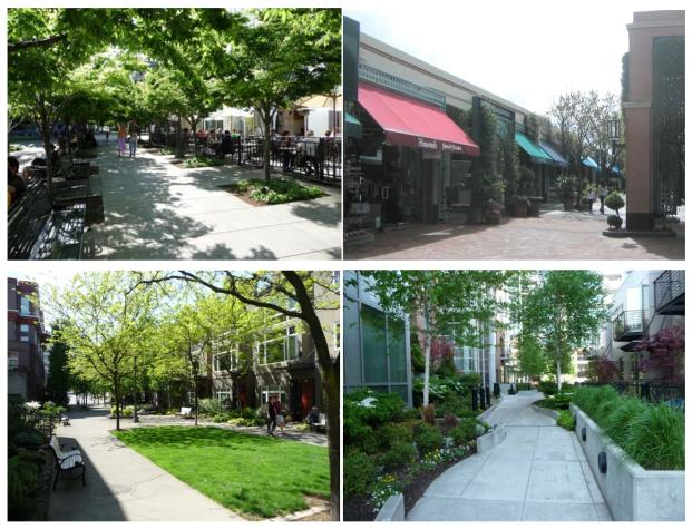
Function. The design of buildings, structures and streetscapes within the Town Center is intended to support a built environment that is convenient and accessible to pedestrians, motorists, bicyclists and public transit users. Development should enhance the Town Center as a vibrant, healthy, mixed use downtown that serves as the city's retail, business, social, cultural and entertainment center and ensures the commercial and economic vitality of the area. New or redevelopment should increase the attractions and pedestrian amenities that bring residents to the Town Center, including local shopping, services, offices, specialty retail, restaurants, residences, festivals, special events, and entertainment. Outdoor spaces should function as social settings for a variety of experiences, adding to the comfort of life in Mercer Island, while maintaining a human scale and an ability for easy pedestrian circulation.
3.
Site features. New or redevelopment should include public amenities, such as storefronts with canopies, street trees, greenery, seating, fountains or water features, outdoor cafes, sculpture or other forms of art, and places for gathering and lingering. The use of materials, color, texture, form and massing, proportion, public amenities, mitigation of environmental impacts, landscaping and vegetation, and architectural detail should be incorporated in the design of new or redevelopment with the purpose of supporting a human scale, pedestrian-oriented Town Center. New or redevelopment shall be coordinated and consistent with the downtown street standards.
4.
Pedestrian orientation. Pedestrian-oriented and customer intensive retail businesses and offices are encouraged to locate on the street level to promote active use of sidewalks by pedestrians, thus increasing the activity level and economic viability of the Town Center. New or redevelopment should also enhance and support a range of transportation choices and be designed to maximize opportuni-ties for alternative modes of transportation and maintain individual mobility. Even with a healthy variety of development in the Town Center, each individual development or redevelopment project shall favor the pedestrian over the automobile in terms of site design, building placement and parking locations.
E.
Scale. The design of all structures shall consider how the structure and site development will be viewed from the street and adjacent properties. Scale is not simply the size of the buildings, it is the proportion of buildings in relationship to each other, to the street and to the pedestrian environment.
F.
Form. Building forms shall not present visual mass impacts that are out of proportion to the adjoining structures, or that appear from the street or sidewalk as having unmodulated visual mass. Building additions should complement the original structure in design.
G.
Style. The objectives and standards do not set or encourage a particular style of architecture or design theme. However, building and site design shall be pedestrian in scale and address design features such as sloped roof lines; distinctive building shapes; integration of art, textures, and patterns; treatment of pedestrian and public spaces; interface with the public right-of-way; landscaping; signage and facade treatments.
(Ord. 16C-06 § 2 (Exh. A))
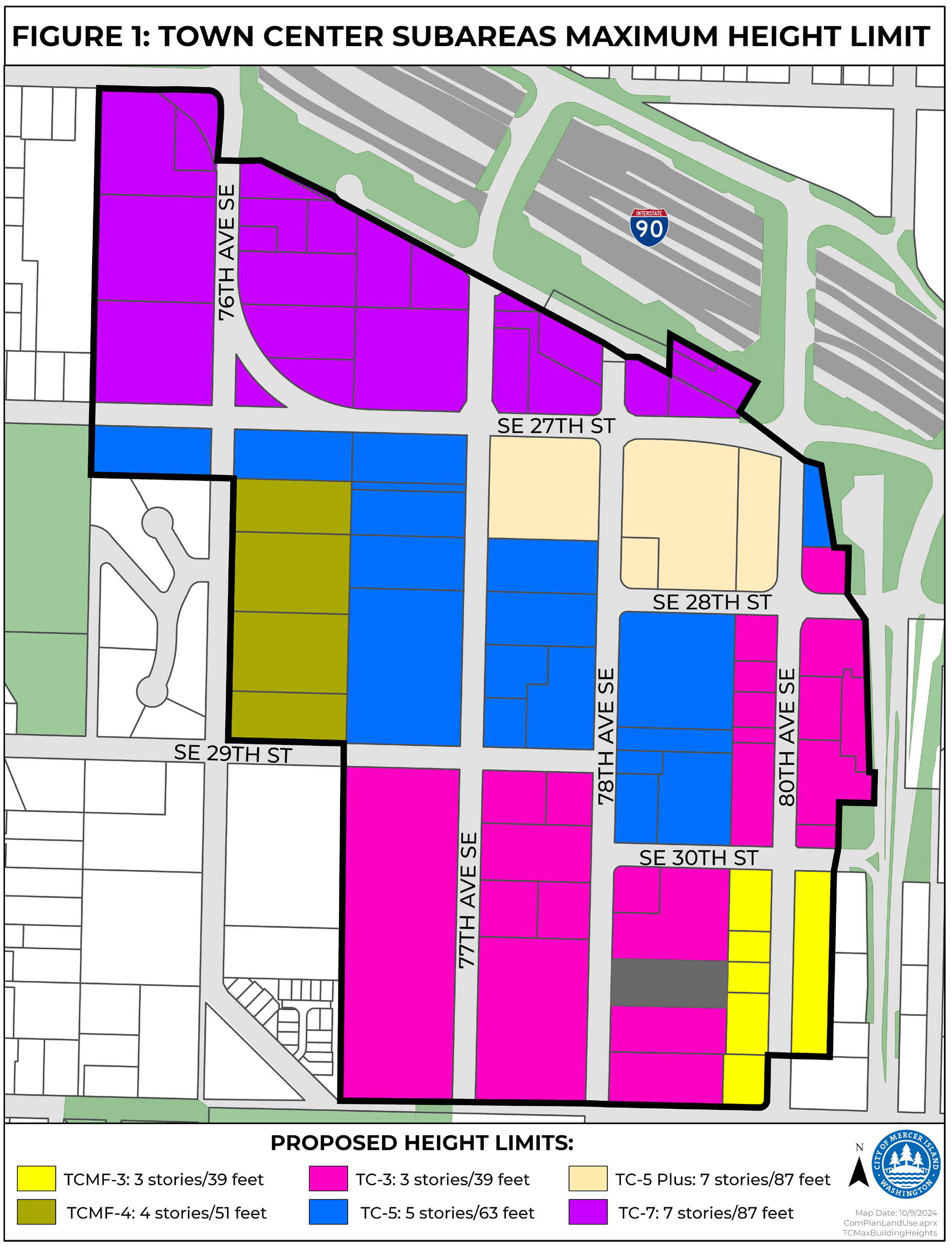
19.11.015 - Town Center subareas.
A.
Intent. The primary intent of establishing subareas within the Town Center is to provide differing building height standards and land uses within the Town Center. Buildings within the Town Center are limited to two stories in height unless community benefits are provided as discussed throughout this chapter. The purpose of the different height standards is to locate taller buildings on the north end of the Town Center, and step down building height through the center to the south end of Town Center, bordering Mercerdale Park.
B.
Subareas established. The following subareas have been established and are depicted on Figure 1 below.
1.
TC-7 subarea. The purpose of the TC-7 subarea is to create a focused mixed use core, oriented toward pedestrian connections and regional transit access. A broad mix of land uses is allowed. Buildings may be up to seven stories in height.
2.
TC-5 subarea. The purpose of the TC-5 subarea is to be a transition between the taller buildings in the TC-7 subarea and the lower structures in the TC-3 and TCMF-3 subareas. A broad mix of land uses is allowed. Buildings may be up to five stories in height.
3.
TC-5 plus subarea. The purpose of the TC-5 Plus subarea is to be a transition between the taller buildings in the TC-7 subarea and the TC-5 subarea. A broad mix of land uses is allowed. Buildings may be up to seven stories in height with the provision of additional affordable housing units and public open space.
4.
TC-3 subarea. The purpose of the TC-3 subarea is to create an area of transition between the Town Center and adjacent residential neighborhoods. A broad mix of land uses is allowed. Buildings may be up to three stories in height.
5.
TCMF-4 (Multifamily residential) subarea. The purpose of the TCMF-4 subarea is to provide for primarily multifamily residential housing of up to four stories. Street-oriented housing, live/work units and limited retail uses are allowed at the street level.
6.
TCMF-3 (Multifamily residential) subarea. The purpose of the TCMF-3 subarea is to provide for primarily multifamily residential housing of up to three stories. Street-oriented housing, live/work units and limited retail uses are allowed at the street level.
Figure 1: Town Center Subareas and Maximum Height Limit
(Ord. 18C-14 § 1 (Att. A); Ord. 16C-06 § 2 (Exh. A); Ord. No. 24C-18, § 2(Exh. A), 12-3-2024)
19.11.020 - Land uses.
A.
Permitted and conditional uses.
1.
Use table by subarea. Permitted and conditional uses are allowed in each subarea as shown in the use table below.
2.
North American Industry Classification System. Questions as to the inclusion or exclusion of a particular use shall be determined by the code official based on North American Industry Classification System (NAICS) — United States, published by the U.S. Department of Commerce.
B.
Required ground floor street frontage uses.
1.
Retail, restaurant, personal service, museum and art exhibition, theater, bar, financial and insurance service, recreation, and/or service station uses, as defined by Section 19.16.010, are required along ground floor street frontages as shown on Figure 2.
Figure 2 — Uses Required Adjacent to Ground Floor Street Frontages
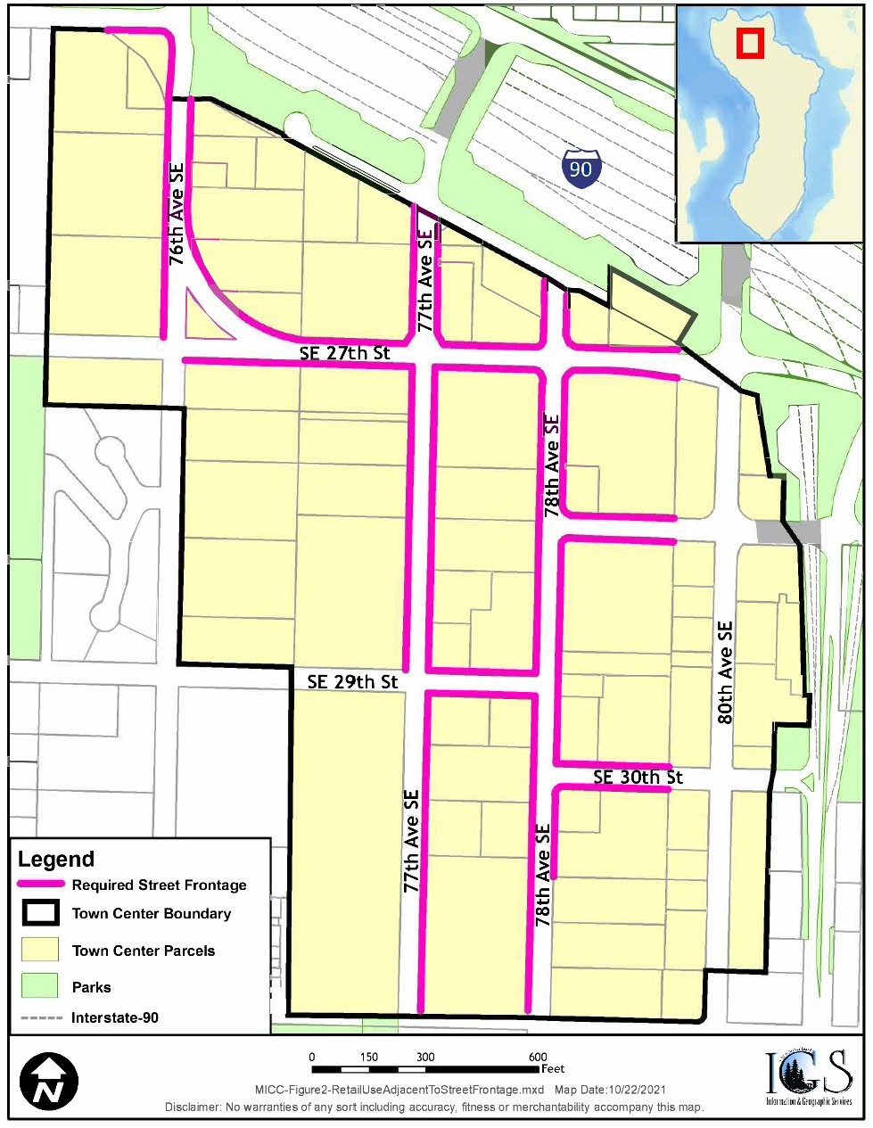
a.
No use shall occupy a continuous linear street frontage exceeding 60 feet in length, with the exception of museum and art exhibition and/or theater uses. The design commission may approve up to an additional 20 feet in length if the use incorporates a feature to promote pedestrian activity, including but not limited to: an additional pedestrian entrance onto a sidewalk or through-block connection, or additional ten percent transparency beyond the requirement of Subsection 19.11.100(B)(1)(b).
b.
The minimum required depth of uses along street frontages is 16 feet.
c.
Required driveways, service and truck loading areas, parking garage entrances, and lobbies shall be permitted.
2.
The identified parcels as shown on Figure 3 are required to provide a minimum floor area ratio (FAR) equivalent to 0.2623 of the gross lot area as provided by King County for ground floor street frontage for retail, restaurant, personal service, museum and art exhibition, theater, bar, financial and insurance service, recreation, and/or service station uses, as defined by Section 19.16.010, upon redevelopment. For the purposes of determining redevelopment, the value of redevelopment shall be an amount equal to or greater than 50 percent of the total assessed improvement value at the time of the application for redevelopment, as determined by King County.
Figure 3 — Parcels Subject to FAR Requirement for Ground Floor Uses
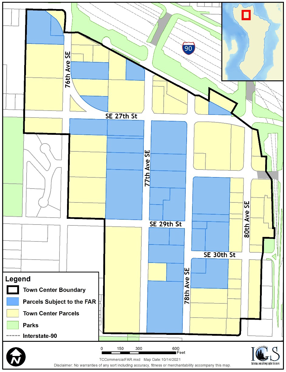
a.
When a FAR calculation results in a fraction, the fraction shall be rounded to the nearest whole number as follows:
i.
Fractions of 0.50 or above shall be rounded up to the closest whole number; and
ii.
Fractions below 0.50 shall be rounded down to the closest whole number.
b.
Each individual museum and art exhibition or theater use shall be limited to a contributing cap of 5,000 square feet towards the achievement of the total minimum ground floor FAR requirement for the corresponding site. For example, a site with a minimum FAR requirement of 20,000 square feet may only have one of these identified uses contribute a maximum of 5,000 square feet towards the necessary minimum through a 1:1 contribution. The remaining 15,000 square feet of ground floor street frontage must come from retail, restaurant, personal service, bar, financial and insurance service, recreation, and/or service station uses as defined in Section 19.16.010.
3.
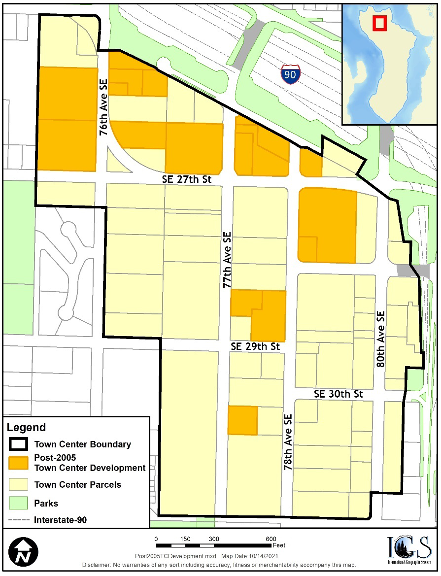
The identified parcels as shown on Figure 4 are required to provide a no net loss of existing floor area for ground floor street frontage for retail, restaurant, personal service, museum and art exhibition, theater, bar, financial and insurance service, recreation, and/or service station uses, as defined by Section 19.16.010. For the purposes of determining redevelopment, the value of redevelopment shall be an amount equal to or greater than 50 percent of the total assessed improvement value at the time of the application for redevelopment, as determined by King County.
Figure 4 — Parcels Subject No Net Loss Requirement for Ground Floor Uses
4.
A review of these requirements shall occur five years from the date of ordinance adoption or after 75,000 gross square feet of floor area for ground floor retail, restaurant, personal service, museum and art exhibition, theater, bar, financial and insurance service, recreation, and/or service station uses adjacent to street frontages has been authorized through building permit issuance.
C.
Reducing continuous retail frontages through the use of smaller retail spaces is intended to encourage pedestrian friendly retail, ensure that the retail spaces are appropriately sized for small retail operators, and limit large ("box store") development. Figure 3 provides an example of how a building floor can be designed. Smaller retail spaces are provided along a street and larger nonretail space is provided in the back of the floor.
Figure 3 — Retail Frontage Standards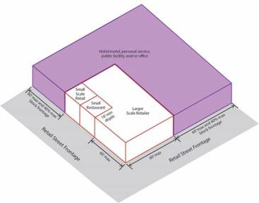
D.
Accessory uses.
1.
Outdoor storage and display of merchandise. The total area allowed for outdoor storage and/or merchandise display shall be less than five percent of the total gross square footage of the use; provided, however, that such area may exceed five percent if it is fenced, screened, and located in a manner that is acceptable to the design commission. This standard does not apply to temporary uses such as material storage during construction or street vendors.
2.
Commerce on public property. Commerce on public property may be allowed pursuant to MICC 19.06.050.
3.
Transit facilities. Bus parking/loading space, and shelters and facilities for transit users should be integrated in the design of major new construction. Plans should be coordinated with transit providers to maximize the interface with community-wide and regional transit systems.
4.
Bicycle facilities. Parking and facilities that support bicycle use, including racks, covered and secured bike-storage areas, and in the case of office buildings, lockers and showers, should be included in the design of major new construction.
5.
Utility and equipment cabinets. Existing or proposed utility and equipment cabinets or boxes, including wireless communication facilities, shall be placed inside a building or placed underground, if physically feasible. In the event the city determines such location is not physically feasible, the utility and equipment cabinets must be screened by fencing, landscaping and/or stealth screening technologies so that they are not visible.
E.
Objectionable or hazardous uses. No use shall be allowed which produces excessive odor, dust, smoke, cinders, gas, fumes, noise, vibration, refuse matter or water-carried waste. The standard for "excessive" shall be based on the average or normal production of these items by adjoining uses permitted in the vicinity of the proposed new use. A use is excessive if it is likely to unreasonably interfere with the ability of the adjoining property owners to utilize their property for working or living activities or if it is likely to unreasonably interfere with the ability of pedestrians and residents to remain in or enjoy the area.
(Ord. 18C-14 § 1 (Att. A); Ord. 16C-06 § 2 (Exh. A); Ord. No. 22C-09, § 2(Exh. A), 6-21-2022; Ord. No. 24C-18, § 3(Exh. B), 12-3-2024)
19.11.030 - Bulk regulations.
A.
Bulk regulations by subarea.
1.
The bulk regulations for properties in the Town Center are as follows:
2.
Base building height. A base building height of up to two stories (not to exceed 27 feet) shall be allowed. One-story structures located adjacent to the public right-of-way in the TC-7, TC-5, TC-5 Plus and TC-3 subareas shall be a minimum of 15 feet and may be as tall as 27 feet with approval of the design commission to ensure the taller facade provides features that ensure a pedestrian scale.
3.
Calculation of building height.
a.
The intent of the building height calculation in this section is to limit the visual mass of a building so that it does not appear to exceed the maximum height limit in subsection (A)(1) of this section.
b.
The maximum allowable building height in subsection (A)(1) of this section shall be calculated as the vertical distance measured from the base of a building facade to the highest point of the roof structure excluding appurtenances. The base of the building facade shall be measured from the adjacent public sidewalk if applicable, or from the lower of existing or finished grade along building facades that are not adjacent to a public sidewalk. See Figure 4.
c.
If the bases of the opposite building facades are at approximately the same elevation, then the building height at any point between the facades can never exceed the maximum permitted building height. If the bases of the opposite building facades are not at approximately the same elevation, then the building must be configured to go down in height as between the higher and lower facades in a manner similar to Figure 4 or in an equivalent manner such that the average of the building heights calculated between the facades is approximately equal to or less than the maximum permitted building height.
Figure 4 — Maximum Building Height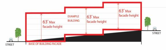
4.
Mezzanines. A mezzanine shall not be counted as a story for determining the allowable number of stories when constructed in accordance with the requirements of the construction codes set forth in Title 17 MICC.
5.
Rooftop appurtenances. Rooftop appurtenances are discouraged. If necessary, rooftop appurtenances may extend up to ten feet above the maximum building height allowed, provided there is a functional need for the appurtenance and that functional need cannot be met with an appurtenance of a lesser height. This provision shall not be construed to allow building height in excess of the maximum limit. Rooftop appurtenances should be located at least ten feet from the exterior edge of any building, and together with the screening provided for below, shall not cover more than 20 percent of the rooftop area.
a.
Screening of rooftop appurtenances. Appurtenances shall not be located on the roof of a structure unless they are hidden or camouflaged by building elements that were designed for that purpose as an integral part of the building design. All appurtenances located on the roof should be grouped together and incorporated into the roof design and thoroughly screened. The screening should be sight-obscuring, located at least ten feet from the exterior edge of any building; and effective in obscuring the view of the appurtenances from public streets or sidewalks or residential areas located on the hillside surrounding the Town Center.
b.
Wireless communication facilities. Wireless communication facilities (WCFs) shall be governed by MICC 19.06.040; provided, they shall be screened as required by subsection (A)(5)(a) of this section.
6.
Setbacks.
a.
78th Avenue SE. All structures shall be set back so that space is provided for at least 15 feet of sidewalk between the structure and the face of the street curb, excluding locations where the curbline is interrupted by parking pockets. Additional setbacks are encouraged to provide space for more pedestrian-oriented activities and to accommodate street trees and parking pockets.
b.
All other public rights-of-way. All structures shall be set back so that space is provided for at least 12 feet of sidewalk between the structure and the face of the street curb, excluding locations where the curbline is interrupted by parking pockets. Additional setbacks along SE 32nd Street are encouraged to provide space for more pedestrian-oriented activities and to accommodate street trees and parking pockets.
7.
Average daylight plane.
a.
Block frontages along streets must integrate average minimum upper level building stepbacks to:
i.
Reduce the perceived scale of building facades along streets;
ii.
Increase the amount of light and air to adjacent streets;
iii.
Promote modulation of building facades along streets that adds variety and provides visual interest;
iv.
Encourage the integration of courtyards and open space along block frontages; and
v.
Allow for flexibility in the design of block frontages along streets.
b.
The average minimum upper level building stepbacks shall comply with the following:
i.
From a height of 25 feet at the front property line, buildings shall step back at a 45-degree angle up to the maximum height limit.
ii.
Calculations for determining compliance with the average daylight plane standards shall utilize cubic volume (cubic feet) and shall consider only the first 30 feet of depth along block frontages.
iii.
Only the development site's applicable block frontage may be used to determine compliance with the provisions herein.
iv.
Since the daylight plane standards above apply a minimum average, portions of block frontages may project beyond the daylight plane concept described in subsection (A)(7)(a) of this section, provided the applicable block frontage as a whole complies with the minimum average. Figure 5 illustrates the concept.
v.
For each cubic foot that part of a building protrudes beyond the daylight plane ("debit"), the project must include an equivalent cubic footage of open space ("credit") either on the ground floor adjacent to the street (such as a public open space, courtyard or through-block connection), and/or by setting portions of the building facade farther back beneath the daylight plane. For the purposes of this section, the cubic feet of a portion of a building is measured from floor to the top of the roof, and along the outside of exterior walls. The cubic feet of open or credit volume is measured from finished ground level or top of roof to an imaginary line representing the daylight plane as defined in subsection (A)(7)(b)(i) of this section. The intent is that the required open space or credit volume be open to the sky; however, the design commission has discretion to allow eaves, pedestrian weather protection and landscaping within the required open space as long as the objectives in subsection (A)(7)(a) of this section are met.
vi.
Daylight plane debits and credits shall be applied on the same block frontage and cannot be transferred to other block frontages.
Figure 5 — Illustrating the Average Daylight Plane Standards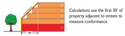
The average daylight plane extends vertically from the applicable property line 25 feet and then steps back at a 45-degree angle to help reduce the massing of buildings fronting streets.
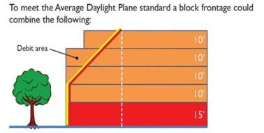
The amount of credit volume shall exceed the debit volume to comply with the "average."
Figure 6 illustrates how a development with multiple block frontages and a through-block connection could meet the average daylight plane standards. The image focuses on the foreground block frontage and illustrates that the block frontage features a combination of debit and credit volume (individual facades that project into average daylight plane are "debit" volume whereas facades that exceed the setback/stepbacks of the average daylight plane are "credit" volume.)
Figure 6 — An Example Development Massing Model with Block Frontages That Comply with
the Average Daylight Plane Standards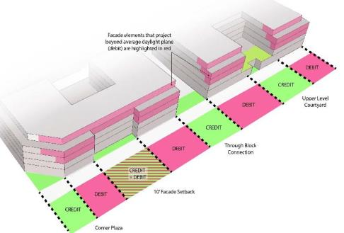
(Ord. 16C-06 § 2 (Exh. A); Ord. No. 24C-18, § 4(Exh. C), 12-3-2024)
19.11.040 - Affordable housing.
A.
Purpose and intent. The incentives and regulations offered in this section are used by the city as one means of meeting its commitment to encourage housing affordable to all economic groups, and to meet its regional share of affordable housing requirements. The purpose of this section is to: (1) implement through regulations the responsibility of the city under state law to provide for housing opportunities for all economic segments of the community, (2) help address the shortage of housing in the city for persons of moderate-income households, (3) promote development of affordable housing that would not otherwise be built in the city, and (4) offer incentives to encourage construction of affordable housing units in Town Center.
B.
Affordable housing ratio. In order to qualify as significant affordable housing and in order to qualify for bonus building height over two stories, a development that contains dwelling units must provide affordable housing units equal to at least fifteen percent of the total units in the development. The number of required affordable units shall be rounded up to the nearest whole number.
C.
Affordability level. For a three-story building the required affordable housing units must be affordable at the 70 percent of median income level for rental housing or 90 percent of median income level for ownership housing. For four- to seven-story buildings, the required affordable housing units must be affordable at the 50 percent of median income level for rental housing or 80 percent of median income level for ownership housing.
D.
Design elements.
1.
The affordable housing units shall generally be intermingled with all other dwelling units in the development and are not required to be located on the top story or bonus stories.
2.
The tenure (owner- or renter-occupied) of the affordable housing units shall be the same as the tenure of the rest of the dwelling units in the development.
3.
The affordable housing units shall consist of a mix of the unit types (by number of bedrooms) that is generally proportionate to the mix of units in the overall development.
4.
Affordable units may not be smaller than other units with the same number of bedrooms in the development, unless the code official determines that rooms within the affordable units provide adequate space for their intended use. In no case shall the affordable units be more than ten percent smaller than the market-rate units having the same number of bedrooms in the development, or less than 500 square feet if a studio unit, 600 square feet if a one-bedroom unit, 800 square feet if a two-bedroom unit, 1,000 square feet if a three-bedroom unit, or 1,200 square feet if a four-bedroom unit; whichever is less.
5.
The exteriors of the affordable housing units must be compatible with and comparable in quality to the rest of the dwelling units in the development and shall comply with any design standards for the underlying zoning district. The interior finish of the affordable units shall, at a minimum, be comparable to entry level rental or ownership housing in the development.
E.
Availability. The affordable housing units shall be available for occupancy in a time frame comparable to the availability of the rest of the dwelling units in the development.
F.
Agreement. Prior to issuance of a building permit, an agreement in form and substance acceptable to the city attorney shall be executed providing price restrictions, homebuyer or tenant qualifications and long-term affordability. The agreement shall be recorded with King County department of records and elections and shall constitute a covenant running with the land. Affordable housing units shall remain as affordable housing for a minimum of 50 years from the date of initial owner occupancy for owner affordable units and for the life of the project for rental affordable housing units. At the sole discretion of the code official, the city may approve a shorter affordability time period for owner-occupied affordable housing, not to be less than 30 years, in order to meet federal financial underwriting guidelines.
1.
The agreement shall provide the city sole discretion to establish monitoring fees for the affordable units, which fees may be adjusted over time to account for inflation. The purpose of any monitoring fee is for the review and processing of documents to maintain compliance with income and affordability restrictions of the affordability agreement.
2.
The city may agree, at its sole discretion, to subordinate any affordable housing regulatory agreement for affordable ownership units for the purpose of enabling the owner to obtain financing for development of the property.
G.
Impact fees. Affordable housing may be exempt from impact fees pursuant to MICC 19.17.090 (schools), 19.18.070 (parks) and 19.19.070 (transportation).
(Ord. 16C-06 § 2 (Exh. A); Ord. No. 24C-18, § 5(Exh. D), 12-3-2024)
19.11.050 - Green building standards.
Any major new construction shall meet the LEED Gold standard. Projects that are primarily residential (at least 50 percent of the gross floor area is composed of residential uses) may instead meet the Built Green 4 Star standard. The applicant shall provide proof of LEED or Built Green certification within 180 days of issuance of a final certificate of occupancy, or such later date as may be allowed by the code official for good cause, by submitting a report analyzing the extent credits were earned toward such rating. Failure to submit a timely report regarding LEED or Built Green ratings by the date required is a violation of this Code.
(Ord. 16C-06 § 2 (Exh. A))
19.11.060 - Site design.
A.
Minor site features. All major new construction regardless of its height shall have at least three minor site features that contribute to a well-balanced mix of features in that subarea as determined by the design commission. Minor site features may include, but are not limited to, the following:
1.
Decorative landmarks. Imaginative features that complement the building design and create visual focal points that give identity to an area, such as decorative clocks, special paving in pedestrian areas, art features, water features, drinking fountains, or creative designs for necessary building features or functions. Art should be integrated with the public street improvements. Examples include sculpture, murals, inlays, mosaics, friezes or bas-reliefs. The location of art shall provide for public view but not hinder pedestrian traffic.
2.
Kiosks. Community-oriented kiosks, which may include bulletin boards and newsstands or racks, creatively designed and consolidated and placed in areas where large numbers of people gather, and which complement the site design and streetscape and reduces visual clutter.
3.
Additional sidewalk setback. At least five feet of sidewalk width, in addition to the minimum sidewalk setback provided for in MICC 19.11.030(A)(6), may be provided along 78th Avenue SE, along the entire street frontage of the development site. Such additional sidewalk should be designed to provide additional pedestrian access where parking pockets narrow the sidewalk, to accommodate street trees and benches, or to create spaces for more pedestrian-oriented activities such as outdoor dining or seating.
4.
Impact on public open spaces. Minor site features may not occupy space in a public open space to the extent that doing so reduces the actual space that is usable by the public below the minimum required area.
B.
Major site features. Any major new construction in the TC-7, TC-5, TC-5 Plus or TC-3 subarea which exceeds the two-story base height and that includes or abuts a preferred through-block connection location shown on Figure 7 shall include a through-block connection subject to design commission determination that such connection is feasible and achievable. Any major new construction exceeding three stories in height in the TC-7, TC-5, TC-5 Plus subarea shall include at least one of the following major site features, subject to design commission determination that such choices contribute to a well-balanced mix of features in that subarea:
1.
Through-block connection. Through-block pedestrian connections will qualify as a major site feature upon satisfaction of the development and design standards set forth in subsection E of this section. If the on-site area of the through-block connection does not equal or exceed three percent of the gross floor area of the development, then public open space shall also be provided so that the total area of the through-block connection and public open space equals or exceeds three percent of the gross floor area of the development.
2.
Public open space. Public open spaces will qualify as a major site feature upon satisfaction of the development and design standards set forth in subsection D of this section.
C.
Other site features. The design commission may approve other major or minor site features in place of those listed above consistent with the provisions of this chapter.
1.
Major site features. Site features other than listed in subsection B of this section will only be considered as a major site feature if it is of equal or greater public benefit than one or more of the major site features listed in subsection B of this section. Underground or structured parking that supports park and ride use may be considered a major site feature. The amount of park and ride parking qualifying as a major site feature shall be determined by the design commission.
2.
Minor site features. Examples of other minor site features include contribution to a public art or design project within close proximity to the new construction, such as the city's I-90 Artway; and/or transit-oriented development (TOD) amenities, such as facilities that support bicycle use.
D.
Public open space. Refers to plazas, parks or other spaces intended for the use and enjoyment of the public in the Town Center zone. Public open spaces serve as public gathering spaces and, depending on their size, could accommodate a variety of public events, as well as provide space for informal gatherings and quiet activities.
1.
Size. A single public open space shall be a minimum size equal to three percent of the gross floor area of the development and shall be at least 20 feet in width. For a fifth, sixth, or seventh floor in the TC-5 Plus subarea, public open space shall increase to a minimum of seven and one-half percent of the gross floor area of the development. The design commission may allow a development to provide two or more public open spaces so long as the design commission determines that such multiple public open spaces will have an equal or greater public benefit and each is at least 1,500 square feet in area. The primary purpose of the public open spaces shall be as public gathering places. Other uses of public open spaces whose primary purpose is not for public gathering including but not limited to lobby entrances, stairs, and cordoned off/private outdoor restaurant seating shall not be included in calculating the minimum size of the public open spaces. Such areas shall be in addition to any area required as a minor site feature under subsection A of this section. If a development is required to provide both a public open space and a through-block connection, then the area of the through-block connection that meets the requirements of subsection E of this section shall also be counted towards the public open space requirement.
2.
Design elements.
a.
Public open spaces shall be at the same level as the public sidewalk, serve as a focal point for pedestrian activity within the Town Center zone, and should be fully integrated and designed consistent with any pedestrian connection or other public amenity.
b.
Public open spaces shall be designed with sufficient pedestrian amenities including seating, lighting, water features, special paving, landscaping, artwork and special recreational features, as determined by the design commission. At least two linear feet of seating surfaces per 100 square feet of space should be provided. To qualify, seating surfaces shall be a minimum of 18 inches in depth. At least half the seating should have seat backs and have surfaces made of wood, rather than metal, stone or concrete. In addition, moveable chairs may be provided and shall not be for the sole use of an adjacent retail business.
c.
Pedestrian-oriented frontage is required on at least two sides unless the space is linear in design, in which case pedestrian-oriented frontage is required on at least one side.
d.
At least 25 percent but not more than 60 percent of an outdoor public open space should be landscaped with shade trees, ground cover or other vegetation.
e.
The public open space may not be covered by a roof, story or skybridge; provided portions of the public open space may be covered for weather protection, or be enclosed pursuant to subsection (D)(2)(f) of this section.
f.
Enclosed and/or covered public open space may be approved by the design commission; provided, that the space is available for public use.
g.
All city approvals or permits for any structure shall be reviewed for compatibility with the alignment of any existing or approved public open space.
3.
Public open space plan. The applicant shall submit a plan with a minimum scale of one-quarter inch equals one foot for the public open space which shall include a description of all landscaping; lighting; street furniture; color and materials; relationship to building frontage; specific location of the public open space; and the relationship to and coordination with any pedestrian connection or other public amenity.
4.
Public access. The entire public open space should be open to the public 24 hours per day. Temporary closures will be allowed as necessary for maintenance purposes. Upon city approval, portions of the public open space may be separated, as required by the State of Washington Liquor and Cannabis Board or its successor agency, in order to allow outdoor seating for restaurant purposes.
E.
Through-block pedestrian connections. Through-block pedestrian connections are intended to provide convenient and safe public pedestrian routes through city blocks.
1.
Location. Connections shall be located on the lots eligible for through-block pedestrian connections as shown on Figure 7 and in other locations based on the following criteria. The actual location of the pedestrian connection on the lot shall be determined by the design commission based upon the following criteria: (a) the connection will connect with existing or future rights-of-way, other pedestrian connections and/or public open spaces; (b) the connection has the effect of dividing a large city block approximately in the middle of such block in approximately the preferred locations shown on Figure 7; and (c) it is likely that the remainder of the subject connection will be developed in the future based upon development conditions on surrounding lots.
Figure 7 — Preferred Through-Block Pedestrian Connection Locations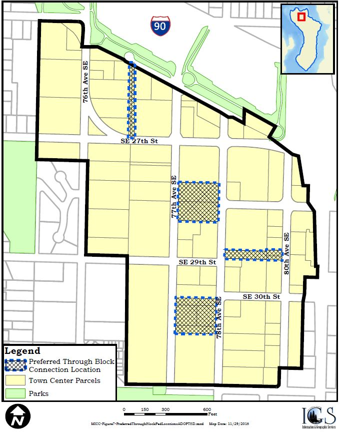
2.
Design elements.
a.
The connection shall be the length necessary to provide access between existing rights-of-way; provided, however, that if an applicant does not own all property necessary to make the connection, this option will still be available if an easement is provided to the city for the remainder of the connection. If the applicant cannot obtain the easement after using best efforts, the city may still approve the connection. The connection shall be a minimum of 20 feet wide unless the design commission approves a lesser width because the applicant provides other site features of equal or greater public benefit as determined by the design commission. The area devoted to a connection shall be in addition to the area devoted to any other minor site feature required pursuant to subsection A of this section. The primary purposes of the connection shall be as a means for pedestrian access between rights-of-way and secondarily as a public gathering place. Other uses, including pedestrian access to parking areas, lobby entrances, and stairs, must be secondary to and not conflict with the connection purpose and areas required for such uses shall not be included in calculating the minimum size.
b.
The connection shall be at the same level as the public sidewalk and incorporate sufficient pedestrian amenities such as seating areas, landscaping, art features, water features, weather protection and pedestrian scale lighting, as determined by the design commission.
c.
The connection should use special paving, such as decorative colored concrete, concrete unit brick or stone pavers and coordinated design features such as uniform treatment of signing, landscaping and lighting over the entire length of the connection. Pervious paving is encouraged.
d.
At least 50 percent of the ground level building frontage shall be designed and constructed to provide occupancy by active residential or nonresidential uses.
e.
Where ground level residential uses front onto the through-block connection the building must feature at least one of the public/private space transition elements described below:
i.
Raised deck or porch option. Provide at least a 60-square-foot porch or deck raised at least one foot above grade. The porch or deck must be at least six feet wide, measured perpendicular to the building face. A low fence, rail or planting, which is two feet to four feet high, is encouraged between the through-block connection and the deck or porch. A porch roof or weather protection is encouraged. The design should consider accessibility.
ii.
Private open space option. Provide a private open space at least ten feet wide between the face of the residence and the edge of the through-block connection. The space may be paved or landscaped. A low fence, rail or planting which is two to four feet high shall be provided between the through-block connection and the open space.
iii.
Landscaped area. Provide a landscaped area at least ten feet wide between the face of the building and the edge of the through-block connection. The plantings must reach three feet high within three years after planting.
iv.
Raised ground floor. If the residence's ground floor is at least three feet above the grade adjacent to the building, then the landscaped area in option (iii), above, may be reduced to four feet wide.
v.
Other transition design measures that adequately protect the privacy and comfort of the residential unit and the attractiveness and usefulness of the pathway at least as effectively as options (i) through (iv) above, as determined by the design commission.
Figure 8 — Acceptable Public/Private Transitional Space Design between
Through-Block Connections and Ground Level Residential Units
The upper left image uses a low fence and landscaped setback. The right images use landscaped terraces and elevated ground level units. The lower left image uses a landscaped berm between the pathway and semi-private open space.
f.
Where ground level nonresidential uses front onto the through-block connection the building must feature:
i.
Transparent windows along 50 percent of the ground floor facade between 30 inches and ten feet above the through-block connection.
ii.
Entrances facing the through-block connection are required for each tenant adjacent to the through-block connection.
g.
No more than 50 percent of through-block connection ground level frontages may be occupied by vehicle parking areas. Where surface level parking areas are adjacent to the through-block connections, landscaping and building design features shall be included to add visual interest and screen vehicles while designing for safety of pedestrians along the connection.
h.
The through-block connection may not be covered by a roof or story; provided portions of the public open space may be covered for weather protection, but not enclosed, and skybridges connecting two buildings are allowed if the skybridge is less than 20 feet wide and less than 14 feet in height.
i.
All city approvals or permits for any structure shall be reviewed for compatibility with the alignment of any existing or approved through-block connection.
j.
The connection shall be for exclusive pedestrian use and may not be used by vehicles except as necessary for maintenance or emergency purposes. Dumpsters and other service areas shall not be located within a through-block connection, but may be totally enclosed within a building adjacent to the through-block connection.
k.
The design commission may approve a connection that is not in a straight line.
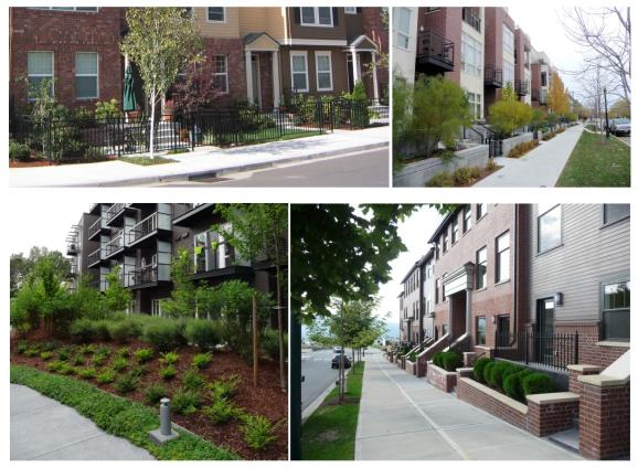
Figure 9 — Examples of Acceptable Through-Block Connections
The upper left image features trees on both sides of the connection and outdoor dining area with adjacent restaurants. The upper right image features retail shops fronting onto a corridor. The lower left image features a double pathway with central lawn and adjacent townhouses. The right image features adjacent apartments with a landscaped buffer.
3.
Connection plan. The applicant shall submit a plan with a minimum scale of one-quarter inch equals one foot for the connection, which shall include a description of all of the following elements: landscaping; lighting; street furniture; color and materials; relationship to building frontage; specific location of the connection and the relationship to and coordination with any public open space.
4.
Public access. The entire connection should be open to the public 24 hours per day. Temporary closures will be allowed as necessary for maintenance purposes. Upon city approval, portions of the connection may be separated, as required by the State of Washington Liquor and Cannabis Board or its successor agency, in order to allow outdoor seating for restaurant purposes.
F.
Legal agreements required for public open space and through-block pedestrian connections. The owners of property to be used for public open space or through-block pedestrian connections shall retain fee ownership of that property and shall execute a legal agreement providing that such property is subject to a right of pedestrian use and access by the public. The agreement shall be in form and substance acceptable to the city attorney and be recorded with the King County recorder's office and the city clerk. The obligations under the agreement shall run with the land and shall terminate upon demolition of the structure for which the through-block connection or public open space was provided. No modifications to either a public open space or through-block pedestrian connection shall be made without approval of the city other than ordinary repairs and maintenance.
(Ord. 18C-14 § 1 (Att. A); Ord. 17C-24 (Att. A); Ord. 16C-06 § 2 (Exh. A); Ord. No. 24C-18, § 6(Exh. E), 12-3-2024)
19.11.070 - Greenery and outdoor spaces.
A.
Objectives. Outdoor spaces and landscaping should be designed to achieve the design vision set forth in MICC 19.11.010. Development should provide for private open space for employees and residents. Plant materials placed in horizontal beds and on vertical walls/trellises/arbors areas should be used to frame and soften structures, to define site functions, to enhance the quality of the environment, screen undesirable views and create identity sense of place. Trees and landscaping shall be incorporated into the site design in order to soften and screen the visual impact of hard surfaces such as parking lots, service areas, and walls, as well as to enhance a sense of nature along pedestrian walkways, public rights-of-way, sidewalks and outdoor gathering places. Outdoor furniture and fixtures should be compatible with the project architecture and considered as integral elements of the landscape. Whenever possible development should include seating areas and be enhanced by such features as trees and flower displays, fountains, art and open spaces.
B.
Development and design standards.
1.
Landscaped area requirement. Landscaped surfaces equal to 25 percent of the development site shall be provided. All required plantings and landscaping shall be installed according to sound horticultural practices in a manner designed to encourage quick establishment and healthy plant growth, based on local and regional best landscaping practices. The following landscaped types and credits may be used to meet the standards:
a.
Ground level planting beds qualify as landscaped surfaces at a 100 percent rate. Ground level planting area that supports trees (which will require deeper soil depths) may qualify for bonus credit. Specifically, planting areas that support a large tree (height greater than 30 feet at maturity) may be counted at a 200 percent rate (includes planting area under projected dripline at maturity) and planting areas that support a medium sized tree (height greater than 15 feet at maturity) may be counted at 150 percent rate. Terraced or other raised planting surfaces qualify as landscaped surfaces at the same rates as ground level planting beds depending on the soil depth (shallow soil depths capable of supporting only ground cover plants qualify at a 50 percent rate).
b.
Green roof. Green roofs qualify as a landscaped surface at a 50 percent rate (i.e., two square feet of green roof qualifies as one square foot of landscaped area). Green roof areas supporting large shrubs and trees may qualify for bonus credit (up to a 100 percent rate) as determined by the design commission depending on the planting's visibility.
c.
Green walls/trellises/arbors.
i.
Artistic green walls adjacent to ground level publicly accessible space with decorative patterns qualify as a landscaped surface at a 125 percent rate;
ii.
Standard green walls qualify as landscaped surfaces at a 75 percent rate;
iii.
Vine trellis/arbors/walls qualify as landscaped surfaces at a 50 percent rate. Planter areas must feature minimum soil depth necessary to maintain healthy vine growing conditions as determined by regional best landscaping practices.
2.
Landscaping standards.
a.
Suitable plant species. Plant materials for required landscape surfaces shall be selected from a city approved palette of species and minimum size at time of planting. Plant materials should be native or adaptive drought-tolerant species.
b.
Trees and ground cover.
i.
Prominent trees should be preserved to the extent feasible.
ii.
Trees planted within five feet of public curbs or in paved areas shall be installed with root guards and grates to prevent physical damage to sidewalks, curbs, gutters, pavement and other public or private improvements.
iii.
Ground cover shall be planted to have 100 percent ground cover in two years.
iv.
Any tree cutting or pruning shall be consistent with chapter 19.10 MICC.
c.
Soil quality, depth, and volume. Applicants for new projects in Town Center must include the relevant provisions in construction details, based on regional best landscaping practices, including:
i.
In planting beds: place three inches of compost and till to a minimum depth of eight inches.
ii.
In turf areas: place one and three-quarters inches of compost and till to a minimum depth of eight inches.
iii.
Scarify (loosen) subsoil four inches below amended layer to produce a minimum soil depth of 12 inches of uncompacted soil.
iv.
After planting: apply two to four inches of arborist wood chip mulch to planting beds. Coarse bark mulch may be used but has fewer benefits to plants and soil.
d.
Irrigation. All landscaped areas shall be provided with an approved automatic irrigation system consisting of waterlines, sprinklers designed to provide head to head coverage and to minimize overspray onto structures, walks and windows. Water conserving types of irrigation systems should be used.
e.
Maintenance. All landscaping shall be maintained in good condition. Maintenance shall include regular watering, mowing, pruning, clearance of debris and weeds, removal and replacement of dead plants and the repair and replacement of irrigation systems.
3.
Surface parking lot landscaping. Surface parking lots shall be landscaped to reduce and break up large areas of asphalt and paving.
a.
The landscape design shall be incorporated with low impact development techniques designed to manage runoff from roofs, parking lots and other impervious surfaces.
b.
A minimum four-foot-wide (interior dimension) landscape bulb should be provided at the end of parking aisles.
c.
A ratio of one tree for every six parking spaces should be provided throughout any surface parking lot. Of the total number of trees required, 50 percent shall be a minimum of 24-inch box in size, and 50 percent shall be a minimum of 15-gallon in size.
d.
Planting areas for trees required within the parking rows of a surface parking lot should be achieved by one of the following acceptable methods:
i.
A continuous landscape strip, at least four feet wide (interior dimension), between rows of parking stalls; or
ii.
Tree wells, eight feet wide, resulting from the conversion of two opposing full sized parking stalls to compact stalls; or
iii.
Tree wells, at least five feet square, placed diagonally between standard or compact parking stalls.
4.
Landscape screening. All grade-level parking should be physically separated from the street and visually screened from pedestrian view by landscaping. The landscaping must include shrubs and trees, be located on private property and be wide enough to maintain the plant material and screen the view but not less than three feet wide.
5.
Building entries. Building entries should be emphasized with special landscaping and/or paving in combination with lighting.
6.
Building facades. Building facade modulation and setbacks should include features such as courtyards, fountains and/or landscaping.
7.
Continuity. Landscaping should provide design continuity between the neighboring properties.
(Ord. 16C-06 § 2 (Exh. A))
19.11.080 - Screening.
A.
Objectives. In order to obtain the design vision set forth in MICC 19.11.010, any storage, service and truck loading areas, utility structures, elevator and mechanical equipment on the ground or roof shall be screened from public view in such a manner that they are not visible from public streets, sidewalks or residential areas located on the hillside surrounding the Town Center.
B.
Development and design standards.
1.
On-site service areas. All on-site service areas, loading zones, outdoor storage areas, garbage collection and recycling areas and similar activities should be located in an area not visible from public streets. Consideration should be given to developing common service courts at the interior of blocks. Service areas should accommodate loading, trash bins, recycling facilities, food scrap composting areas, storage areas, utility cabinets, utility meters, transformers, etc. Service areas should be located and designed for easy access by service vehicles and for convenient access by each tenant. Any emissions of noise, vapor, heat or fumes should be mitigated. Loading activities should generally be concentrated and located where they will not create a nuisance for adjacent uses.
2.
Garbage, recycling collection, composting and utility areas. Garbage, recycling collection, food scrap composting and utility areas shall be enclosed and screened around their perimeter by a wall or fence at least seven feet high, concealed on the top and must have self-closing doors. If the area is adjacent to a public street or pedestrian alley, a landscaped planting strip, minimum three feet wide, shall be located on three sides of such facility. Any emissions of noise, vapor, heat or fumes should be mitigated.
3.
Meters and mechanical units. Water meters, gas meters, electric meters, ground-mounted mechanical units and any other similar structures should be hidden from public view or screened.
4.
Fences. Fences should be made of masonry, ornamental metal or wood, or some combination of the three. The use of chain link, plastic or wire fencing is prohibited.
(Ord. 16C-06 § 2 (Exh. A))
19.11.090 - Lighting.
A.
Objectives. Lighting shall be an integral part of any new or existing development. Lighting shall contribute to the individuality, security and safety of the site design without having overpowering effects on the adjacent areas. Lighting is viewed as an important feature, for functional and security purposes, as well as to enhance the streetscape and public spaces. The design of light fixtures and their structural support should be integrated with the architectural theme and style of the main structures on the site.
B.
Development and design standards.
1.
Pedestrian-scale light fixtures. Pedestrian-scale light fixtures should be incorporated into the site design to give visual variety from one building to the next and should blend with the architectural style.
2.
Light type. Lighting should use LED or similar minimum wattage light sources, which give more "natural" light. Non-color corrected low-pressure sodium and mercury vapor light sources are prohibited.
3.
Building entrances. All building entrances should be well lit to provide inviting access and safety.
4.
Building-mounted and display window lights. Building-mounted lights and display window lights should contribute to lighting of walkways in pedestrian areas.
5.
Parking areas. Parking area light fixtures should be designed to confine emitted light to the parking area. The height of the light fixtures should not exceed 16 feet. The design commission shall review and determine the adequacy of lighting in parking areas based on best practices.
6.
Neon lighting. Neon lighting may be used as a lighting element; provided, that the tubes are concealed and are an integral part of the building design. Neon tubes used to outline the building are prohibited.
7.
Shielding. All lighting fixtures should be shielded or located to confine light spread within the site boundaries, to the extent possible, especially when adjacent to residential uses.
(Ord. 16C-06 § 2 (Exh. A))
19.11.100 - Building design.
A.
Objectives. Building facades should be designed with a variety of architectural elements that suggest the building's use and how it relates to other development in the area. Buildings should be oriented to the street frontage to enliven the street edge as well as to maximize access from the public sidewalk. Building facades should provide visual interest to pedestrians. Special care should be given to landscaping, mass and roof forms of buildings to provide visual interest from residential areas located on the hillside surrounding the Town Center as well as from public streets or sidewalks. Street level windows, minimum building setbacks, on-street entrances, landscaping and articulated walls should be encouraged. Building facades should be designed to achieve the purpose of the development and design standards and the Town Center vision described in MICC 19.11.010. Architectural features and other amenities should be used to highlight buildings, site features and entries and add visual interest. Within the Town Center, all development shall provide elements that attract the interest of residents, shoppers and workers.
B.
Development and design standards.
1.
Fenestration.
a.
Transparent facades. Articulated, transparent facades should be created along pedestrian rights-of-way. Highly tinted or mirrored glass windows shall not be allowed. Shades, blinds or screens that prevent pedestrian view into building spaces shall not be allowed, except where required or desired for privacy in dwelling units, hotel rooms and similar residential uses.
b.
Ground floor windows and doors. Major new construction along 77th Avenue SE, 78th Avenue SE and SE 27th Street, within the TC-7, TC-5, and TC-5 Plus subareas, shall have at least 75 percent of the length of the ground floor facade between the height of two feet and seven feet devoted to windows and doors affording views into retail, office, or lobby space.
c.
Upper story facades. Upper stories of buildings above two stories should maintain an expression line along the facade such as a setback, change of material, or a projection to reduce the perceived building mass. Upper story windows should be divided into individual units and not consist of a "ribbon" of glass. Upper story features such as balconies, roof decks, bay windows or upper story commercial activities should be used to visually connect upper story activity with the street.
2.
Street-facing facade elements. All major new construction shall include at least seven of the following elements on the street-facing facades, both on the ground floor level and on other levels, as may be deemed desirable by the design commission taking into account the nature of the development and the site.
a.
Window and door treatments which embellish the facade.
b.
Decorative light fixtures.
c.
Unique facade treatment, such as decorative materials and design elements.
d.
Decorative paving.
e.
Trellises, railings, gates, grill work, or unique landscaping.
f.
Flower baskets supported by ornamental brackets.
g.
Recessed entrances.
h.
Balconies.
i.
Medallions.
j.
Belt courses.
k.
Decorative masonry and/or tilework.
l.
Unique, handcrafted pedestrian-scaled designs.
m.
Planter boxes with seasonal color.
n.
Projecting metal and glass canopy.
o.
Clerestories over storefront windows.
p.
Other elements as approved by the design commission.
3.
Major facade modulation. Block frontages shall include at least one of the following features (subsection (B)(3)(a), (b) or (c) of this section) at intervals no greater than 120 feet to break up the massing of the block and add visual interest. The design commission may approve modifications or alternatives to the following features if the proposed modulation is at least as aesthetically acceptable as one of the following features:
a.
Vertical building modulation at least 20 feet deep and 30 feet wide. See example on Figure 10. For multi-story buildings, the modulation must extend through more than one-half of the building stories.
b.
Use of a significant contrasting vertical modulated design component featuring all of the following:
i.
An extension through all stories above the first story fronting on the street. Exception: upper stories that are set back more than ten feet horizontally from the facade are exempt.
ii.
A change in building materials that effectively contrast from the rest of the facade.
iii.
A modulation horizontally from the rest of the facade by an average of 24 inches.
iv.
A design to provide roofline modulation.
c.
Building walls with contrasting articulation and roofline modulation that make it appear like two or more distinct buildings. See examples on Figure 11. To qualify for this option, these contrasting facades shall employ all of the following:
i.
Different building materials and/or configuration of building materials; and
ii.
Contrasting window design (sizes or configurations).
Figure 10 — Illustrating Maximum Facade Width Standards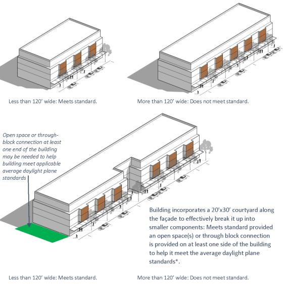
Figure 11 — Facade Examples Employing Building Walls with Contrasting Articulation
That Make It Appear Like Two or More Distinct Buildings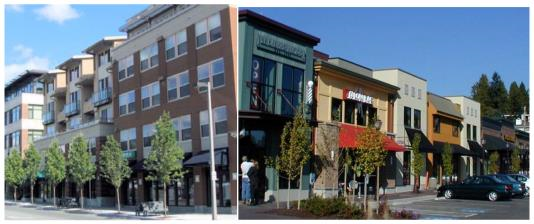
Figure 12 — Examples That Do Not Meet Maximum Facade Width Provisions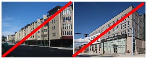
4.
Minor facade modulation. All buildings shall include articulation features to reduce the perceived scale of large buildings and add visual interest to facades. See examples on Figure 13. At least three of the following features shall be employed at intervals no greater than 50 feet subject to design commission approval taking into account the nature of the development and the site:
a.
Window fenestration patterns and/or entries;
b.
Use of vertical piers/columns;
c.
Change in roofline;
d.
Change in building material or siding style;
e.
Vertical elements such as a trellis with plants, green wall, art element;
f.
Vertical building modulation of at least 12 inches in depth if tied to a change in roofline modulation or a change in building material, siding style, or color; or
g.
Other design techniques approved by the design commission that reinforce a pattern of small storefronts (or residences, if residential uses are used).
Figure 13 — Minor Facade Modulation Examples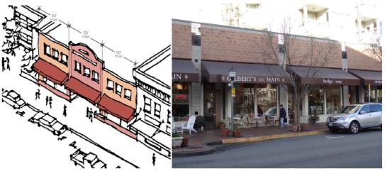
5.
Walls. Untreated blank walls are prohibited. A blank wall is a wall (including building facades and retaining walls) over six feet in height, with a horizontal length greater than 15 feet that does not include a transparent window or door. Methods to treat blank walls can include but are not limited to:
a.
Display windows at least 16 inches of depth to allow for changeable displays. Tack on display cases shall not qualify as a blank wall treatment.
b.
A landscape planting bed at least five feet wide or a raised planter bed at least two feet high and three feet wide in front of the wall with planting materials that are sufficient to obscure or screen at least 60 percent of the wall's surface within three years.
c.
A vertical trellis in front of the wall with climbing vines or plant materials.
d.
A mural as approved by the design commission.
e.
Special building detailing that adds visual interest at a pedestrian scale as approved by the design commission. Such detailing must use a variety of surfaces; monotonous designs will not meet the purpose of the standards.
6.
Entrances. Building entrances should concentrate along the sidewalk and should be physically and visually inviting. Entrance doors shall be recessed from the facade surface to emphasize the entrance and provide a sheltered transition to the interior of the building. Special paving treatments and/or landscaping should be used to enhance the entrance. Pedestrian walkways with wheelchair ramps at least eight feet wide should be constructed between the sidewalk and building entrances.
7.
Roofs. Roofs shall relate to the building facade articulations. A variety of roof types and configurations should be used to add interest and reduce the perceived building mass. Varied parapet height or roofline is encouraged. Sloping roofs are also encouraged.
8.
Residential uses on ground floor. Where permitted, residential uses on the ground floor shall comply with the standards in MICC 19.11.060(E)(2)(e).
9.
Identity emphasis. Public buildings, unique community structures and corner structures should have a prominent scale, emphasizing their identity.
10.
Corner lots. Buildings on corner lots should be oriented to the corner. Corner entries and/or architectural treatment should be used to emphasize the corner.
11.
Franchise design. Prototype design for franchises should use customized components consistent with the design requirements for the Town Center that achieve the purpose, intent and vision set forth in MICC 19.11.010.
12.
Harmony. The elements of a building should relate logically to each other, as well as to the surrounding buildings. A single building or complex should be stylistically consistent; architectural style, materials, colors and forms should all work together.
13.
Weather protection. Specially designed all-weather features that integrate weather protection systems at the sidewalk level of buildings to protect pedestrians from the effects of rain, wind, glare, shadow, reflection and sunlight and to make spending time outdoors feasible in all seasons. All major new construction shall have awnings, canopies, trellises, pergolas, covered arcades or all-weather features along 80 percent of a building's frontage along the retail frontages shown on Figure 2.
a.
Any canopy or awning over a public sidewalk should be a permanent architectural element.
b.
Any canopy or awning over a public sidewalk should project out from the building facade a minimum horizontal width of six feet and be between eight to 12 feet above grade.
c.
Architectural details should not be concealed by awnings or canopies.
d.
Awning shapes should relate to the shape of the facade's architectural elements. The use of traditionally shaped awnings is encouraged.
e.
Vinyl or plastic awnings or canopies are prohibited.
f.
All awnings or canopies shall function to protect pedestrians from rain and other weather conditions.
14.
Courtyards. Courtyards are an outdoor covered or uncovered area easily accessible to the public at the same level as the public sidewalk or pedestrian connections. If a courtyard is being provided for purposes of meeting the public open space requirement in MICC 19.11.060(B), then the courtyard shall comply with the design standards for public open space in MICC 19.11.060(D). Other courtyards should:
a.
Be at least ten feet in width, with a building facade on at least one side;
b.
Be covered with trees, ground cover, or other landscaping over at least 50 percent of its area;
c.
Include seating, special paving material, pedestrian-scale lighting and other pedestrian furnishings;
d.
Manage runoff from courtyard pavement with low impact development techniques when allowed by the code official; and
e.
Not be covered by a roof, story or skybridge; except that portions of the courtyard may be covered for weather protection, but not enclosed.
(Ord. 16C-06 § 2 (Exh. A); Ord. No. 24C-18, § 7(Exh. F), 12-3-2024)
19.11.110 - Materials and color.
A.
Objectives. Textured high quality materials and colors should bring a visually interesting experience into the streetscape. Color should be carefully considered in relation to the overall design of the building and surrounding buildings. Color and materials should highlight architectural elements such as doors, windows, fascias, cornices, lintels, and sills. Variations in materials and colors should be generally limited to what is required for contrast or to accentuate architectural features. Piecemeal embellishment and frequent changes in materials should be avoided. The materials and colors selected should be consistent with the intent, purpose and vision set forth in MICC 19.11.010.
B.
Development and design standards.
1.
Building exteriors. Building exteriors should be constructed from high quality and durable materials. It is important that the materials and colors weather well and that building exteriors need minimal maintenance.
2.
Regional focus. Materials and colors should reflect the city's regional setting.
3.
Attention to all sides. Materials and colors should be used with cohesiveness and compatibility on all sides of a building.
4.
Concrete walls. Concrete walls should be architecturally treated. The treatment may include textured concrete such as exposed aggregate, sand blasting, stamping or color coating.
5.
Harmonious range of colors. A harmonious range of colors should be used within the Town Center. Neon or very bright colors, which have the effect of unreasonably setting the building apart from other adjacent buildings on the street, should not be used.
6.
Bright colors. Bright colors should be used only for trim and accents if the use is consistent with the building design and other design requirements.
7.
Undesired materials. Beveled metal siding, mirrored glass, and vinyl siding should not be used. EIFS, stucco and similar materials should be limited to use as a minor building facade element.
8.
Variation of materials. A variation of building materials should be used to assist in the creation of a visually interesting experience.
(Ord. 16C-06 § 2 (Exh. A))
19.11.120 - Street standards.
All major new construction abutting 77th Avenue SE or 78th Avenue SE shall improve the right-of-way adjacent to the property as required in Figure 14. Major new construction abutting all other streets shall improve the right-of-way adjacent to the property as required by the Mercer Island Town Center Streetscape Manual. The design commission may require or grant a modification to the nature or extent of any required street improvement for any of the following reasons upon recommendation by the city engineer:
A.
If unusual topographic or physical conditions preclude the construction of the improvements as required; or
B.
If the required improvement is part of a larger project that has been scheduled for implementation in the city's six-year capital improvement program; or
C.
If angled parking is required but parallel parking would enhance pedestrian, vehicle or bicycle safety, or result in a more desirable pedestrian environment; or
D.
If other unusual circumstances preclude the construction of the improvements as required.
Figure 14 — Town Center Street Standards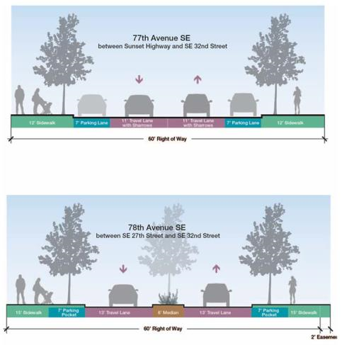
(Ord. 16C-06 § 2 (Exh. A))
19.11.130 - Parking, vehicular and pedestrian circulation.
A.
Objectives. The Town Center should be accessible for vehicles but have an emphasis toward the needs of pedestrians. Clear, easy to understand circulation should be designed into all development to allow drivers and pedestrians to move safely on and off the site, and within it, without confusion and without disrupting on-street traffic flow. Development should maintain mobility and maximize opportunities for alternative modes of transportation in the Town Center. Placement of structures, landscaping, circulation patterns and access points should collectively seek to promote an integrated, multi-modal transportation system. The harmonious integration of pedestrian and transit user circulation should be considered in every aspect of site design. Development shall provide adequate parking with safe and convenient pedestrian access. Parking stalls shall be located within a structure, underground, or behind buildings, except for residential developments and developments containing residential units, which shall utilize the residential development parking standards contained within MICC 19.11.130(B)(1)(a) and MICC 19.11.130(C). Parking structures should not dominate the street frontage, and must blend with the building's architectural theme. Creatively designed, clean and functional pedestrian connections are encouraged to provide access through-blocks, between properties and/or to and from the public right-of-way. Parking shall be designed consistent with the urban design vision set forth in MICC 19.11.010 and complement the pedestrian activities.
B.
Development and design standards.
1.
Parking requirements.
a.
Minimum number of parking stalls required. All new development and remodels greater than ten percent of the existing gross floor area shall provide at least the number of parking stalls set forth in the following table:
b.
Determination within range. The code official shall have the final authority to determine the number of parking stalls required within the ranges above to accommodate typical daily peak parking demand based upon the applicant's submittal of a completed site plan and detailed parking analysis.
c.
Underground or structured parking required. If the applicant for a mixed use project or for a residential project provides more parking than one and one-quarter spaces per dwelling unit for any part of a project consisting of residential units or two and one-half spaces per 1,000 square feet for any part of a project that is not used for residential units, then all such additional parking shall either be underground or on the second or higher story of structured parking. This subsection shall not apply to additional parking spaces that may be required pursuant to MICC 19.01.050 or the residential development parking standards in MICC 19.11.130(C).
d.
Parking lot configuration. Parking lot design shall conform to the standard stall diagrams set out in appendix A to this title, unless alternative design standards are approved by the design commission and the city engineer, or if the development utilizes the residential development parking standards in MICC 19.11.130(C). No more than 50 percent of the required off-street parking spaces for office and residential uses may be designed for accommodating compact vehicles. No more than 25 percent of the required off-street parking spaces for all other uses may be designed for accommodating compact vehicles. Such parking spaces must be clearly designated as compact stalls.
e.
Shared parking.
i.
The amount of off-street parking required in subsection (B)(1)(a) of this section may be reduced by no more than 50 percent, as determined by the code official upon approval by the city engineer (and design commission for major new construction), when shared off-street parking facilities for two or more uses are proposed. A parking demand study shall be prepared by a professional traffic engineer and submitted by the applicant that documents parking demand for all land uses shall not significantly overlap and that uses will be served by adequate parking if shared parking reductions are authorized.
ii.
The determination whether shared parking will be allowed shall occur at the time the shared parking is proposed and when a change of use occurs.
iii.
If shared parking is requested, the parking facilities for the multiple uses shall be designed and developed as a single on-site common parking facility, or as a system of on-site and off-site facilities. If off-site facilities are used, all facilities shall be connected with improved pedestrian facilities and no building or use should be more than 1,320 feet walking distance from the most remote shared parking facility.
iv.
If the shared parking is on one or more different properties, a covenant or other contract for shared parking between the cooperating property owners must be approved by the code official. This covenant or contract shall be recorded with the King County department of records and elections division as a deed restriction on all properties and cannot be modified or revoked without the consent of the code official.
v.
If requirements for shared parking are violated, or the parking demand for shared parking exceeds the shared parking supply, the affected property owners shall provide a remedy satisfactory to the code official or provide the full amount of required off-street parking for each use, in accordance with the requirements of this chapter.
f.
Access restriction prohibited. Restricting vehicular and pedestrian access between adjoining parking lots at the same grade is prohibited.
g.
Surface parking lot location.
i.
Behind structure. All surface parking lots shall be located behind building structures.
ii.
No corner parking lots. Parking lots shall not be located on a corner facing an intersection.
h.
Design of surface parking and pedestrian access.
i.
Entrances.
(a)
Shared. The number of parking lot entrances, driveways and curb cuts should be minimized in favor of combined driveways and coordinated parking areas among business owners.
(b)
78th Avenue SE. Individual parking entrances and curb cuts on 78th Avenue SE should be consolidated.
ii.
Pedestrian walkways. Pedestrian walkways should be provided through all parking lots. Raised concrete pavement should be provided where the walkway traverses between parking stalls and/or is adjacent to vehicular circulation.
iii.
Landscaping and lighting. Landscaping and lighting of surface parking lots should be in conformance with MICC 19.11.070(B)(4) and 19.11.090(B)(5).
iv.
Concrete curbs. All parking areas, landscaping areas and driveways should be surrounded by six-inch-high vertical concrete curbs.
v.
Wheel stops. All landscape and pedestrian areas should be protected from encroachment by parked cars. Wheel stops two feet wide (as measured outward from the paved or planted area) should be constructed for all nonparallel parking stalls.
vi.
Amenities. Amenities such as seating and planters should be provided to encourage pedestrian circulation.
i.
Design of structured parking.
i.
Relationship to main building. Parking structures should be architecturally integrated or designed with an architectural theme similar to the main building.
ii.
Screening. A floor of a parking structure should not face the street. If the design commission determines that there is no feasible alternative to a street-facing floor of a parking structure, then the perimeter of the floor of a parking structure facing the street should have a screening mechanism designed to shield vehicles and any mechanical appurtenances from public views.
iii.
Street side edges. An architectural treatment, landscaping and/or space for pedestrian-oriented businesses along the street-side edges of the parking structure shall be provided.
iv.
Pedestrian access. Where possible, pedestrian elevators and stairwells serving structured parking shall be located in a public lobby space or out onto an active public street.
2.
Signs and wayfinding. Signs indicating the location of parking available to the public shall be installed as approved by the design commission and city engineer. Such signs shall be installed at the entrance to the parking lot/garage along the street and within the parking lot/garage and shall comply with parking signage standards for the Town Center approved by the design commission and city engineer.
3.
Loading space. Off-street loading space with access to a public street shall be required adjacent to or within or underneath each building. Such loading space shall be of adequate size to accommodate the maximum number and size of vehicles simultaneously loaded or unloaded in connection with the business or businesses conducted in the building. No part of the vehicle or vehicles using the loading space may protrude into the public right-of-way.
4.
Drive-through facilities. Drive-through facilities and stacking lanes should not be located along the street frontage of a building that faces a right-of-way. Stacking lanes shall be designed so as to accommodate all vehicles on site, and no part of a vehicle using a drive-through facility shall protrude into the public right-of-way.
5.
Public parking. On-site public parking consistent with and complying with the requirements of this section shall be provided in any existing development desiring to provide public parking consistent with the requirements of this section and in any new mixed use or nonresidential development. Nothing contained in this section shall be deemed to prevent a building owner from designating parking spaces as being available to the public exclusively for electric vehicle charging or as being available exclusively to an operator of a car sharing service that makes vehicles available for public use. Further, this section shall be interpreted and enforced in such manner as to avoid conflict with the shared parking section in subsection (B)(1)(e) of this section.
a.
All parking stalls provided for nonresidential uses, or if the primary use in the building is office then for nonoffice uses, or if the primary use of the building is hotel/motel then for non-hotel/motel uses, shall be available for public parking; provided, however, parking stalls that the code official concludes were required to be dedicated for the use of a specific tenant in accordance with a written lease provision in effect as of January 12, 2013, and which were specifically signed for that purpose on January 12, 2013, may be excluded from this requirement until the earlier of the expiration, termination, modification or amendment of the lease.
b.
Public parking stalls shall be available to motorists for such maximum time period as is determined by the owner, which shall not be less than two hours.
c.
An owner may require that the motorist patronize at least one business in the development but otherwise the motorist will be entitled to leave the development without moving the parked vehicle, subject to the maximum time period specified by the owner as provided in subsection (B)(5)(b) of this section.
d.
Once public parking is provided under this provision, it may not thereafter be eliminated unless the development changes use that does not require public parking.
e.
Public parking under this provision shall not be required for a new mixed use or nonresidential development that is: (i) two stories or less, and (ii) no greater than ten percent of the total gross floor area of all existing structures on the parcel as of October 30, 2015.
6.
Repurposing of parking stalls.
a.
Parking stalls required for nonresidential uses in a new development or existing development by the foregoing provisions of this section must be kept available exclusively to provide parking for nonresidential uses in that development, as applicable. For parking stalls required for office use, this requirement shall only apply on weekdays between 7:00 a.m. and 6:00 p.m., excluding national holidays. Up to 50 percent of such stalls designated for office use may be allocated for residential use during the hours of 6:00 p.m. and 7:00 a.m. weekdays and at all times on weekends and national holidays.
b.
Owners or operators of developments in which such parking stalls are located are responsible for ensuring that such parking stalls are, in fact, occupied as above required only by vehicles of persons associated with the respective uses and are not being occupied by other vehicles. Compliance with, and allowing public parking in accordance with, the provisions of subsection (B)(5) of this section or shared parking in accordance with subsection (B)(1)(e) of this section shall not be considered a violation of this exclusive use requirement.
C.
Residential development parking standards.
1.
Garages and carports are not required in order to meet minimum parking requirements for residential development.
2.
Parking spaces that count towards minimum parking requirements may be enclosed or unenclosed.
3.
Parking spaces in tandem shall count towards meeting minimum parking requirements at a rate of one space for every 20 linear feet with any necessary provisions for turning radius. For purposes of this subsection, "tandem" is defined as having two or more vehicles, one in front of or behind the others with a single means of ingress and egress.
4.
Existence of legally nonconforming gravel surfacing in existing designated parking areas may not be a reason for prohibiting utilization of existing space in the parking area to meet parking standards, up to a maximum of six parking spaces.
5.
Parking spaces are not required to exceed eight feet by 20 feet, except for required parking for people with disabilities.
6.
Required off-street parking shall not be a condition of permitting a residential project if compliance with tree retention pursuant to MICC Chapter 19.10 would otherwise make a proposed residential development or redevelopment infeasible.
7.
Parking spaces that consist of grass block pavers may count toward minimum parking requirements.
8.
Existing parking spaces that do not conform to the requirements of this section by June 6, 2024 are not required to be modified or resized, except for compliance with the Americans with Disabilities Act. Existing paved parking lots are not required to change the size of existing parking spaces during resurfacing if doing so will be more costly or require significant reconfiguration of the parking space locations.
(Ord. 16C-06 § 2 (Exh. A); Ord. No. 24C-08, § 4(Exh. C), 6-4-2024)
19.11.140 - Signs.
A.
Objectives. Signs shall be distinctive, finely crafted and designed to enhance the aesthetics of the Town Center and to improve pedestrian and motorist safety. Signs shall be designed for the purpose of identifying the business in an attractive and functional manner and to help customers find the specific business locations; they should not serve as general advertising. The size of signs shall be in proportion to the size of business store frontage. Signs shall be integrated into the building design, compatible with their surroundings and clearly inform pedestrians and motorists of business names, but should not detract from the architectural quality of individual buildings.
B.
Development and design standards.
1.
Freestanding ground signs.
a.
Number. A building or complex may not display more than one ground sign on each street frontage.
b.
Design. The sign shall be architecturally compatible with the style, materials, colors and details of the building. The sign content should be integrated in one design (in contrast to displaying two or more separate elements). Use of symbols is encouraged.
c.
Size. All signs shall be:
i.
Proportionate. Proportionate to the street frontage of the businesses they identify; and
ii.
Maximum size. In no case larger than:
(a)
Twenty-five square feet. A maximum of 25 square feet for individual business ground signs, shopping complex identification ground signs and signs within a ten-foot setback from any property line on a street.
(b)
Fifty square feet. A maximum of 50 square feet for joint ground signs (identifying more than one business): six square feet for each business included in the complex. When more than five businesses are included in the complex, one additional ground sign may be placed on the street front, if signs are located at least 100 feet apart.
d.
Maximum height. The maximum height of any sign within ten feet from any property line on a street shall be 42 inches. All other ground signs shall be a maximum of six feet in height. The height of a freestanding ground sign is measured from the top of the sign to the existing grade or finished grade, whichever is lower, directly below the sign being measured.
e.
Backs of signs. Exposed areas of backs of signs should be finished to present an attractive appearance.
2.
Wall signs.
a.
Eligibility. A wall sign shall be granted to commercial uses occupying buildings facing the streets and are limited to one sign per business on each street frontage. Commercial uses occupying a building adjacent to a driveway shall not qualify for a second wall sign. However, a commercial use occupying a building whose only exposure is from a driveway or parking lot shall be allowed one wall sign. Businesses that demonstrate that the entry off a driveway or parking lot is used by customers shall be eligible for a wall sign.
b.
Size. All signs shall be:
i.
Proportionate. Proportionate to the street frontage of the businesses they identify; and
ii.
Maximum size. In no case larger than:
(a)
Twenty-five square feet. Twenty-five square feet for individual business signs.
(b)
Fifty square feet. Fifty square feet for joint business directory signs identifying the occupants of a commercial building and located next to the entrance.
c.
Determination of size. The sign size is measured as follows:
i.
"Boxed" displays. "Boxed" display — total area of display including the background and borders.
ii.
Individual letters and symbols. Individual letters and symbols — total combined area of a rectangle drawn around the outer perimeter of each word and each symbol.
d.
Placement. Wall signs may not extend above the building parapet, soffit, the eave line or the roof of the building, or the windowsill of the second story.
e.
Signs above window displays. When a commercial complex provides spaces for signs above window displays, these signs should be compatible in shape, scale of letters, size, color, lighting, materials and style.
f.
Design commission discretion. If an applicant demonstrates to the satisfaction of the design commission that a wall sign is creative, artistic and an integral part of the architecture, the commission may waive the above restrictions.
g.
Master sign plan. When multiple signs for individual businesses are contemplated for a major construction project, a master sign plan stipulating the location and size of future signs will be required.
3.
Projecting signs.
a.
Sidewalk clearance. Projecting signs should clear the sidewalk by a minimum of eight feet.
b.
Maximum size. Projecting signs shall not be larger than six square feet.
c.
Projection from building. Signs should not project over four feet from the building unless the sign is a part of a permanent marquee or awning over the sidewalk.
d.
Awnings. Awnings that incorporate a business sign shall be fabricated of opaque material and shall use reverse channel lettering. The design commission may require that an awning sign be less than the maximum area for wall signs to assure that the awning is in scale with the structure. Back-lit or internally lit awnings are prohibited.
4.
Window signs.
a.
Area limitation. Permanent and temporary window signs are limited to maximum 25 percent of the window area.
b.
Integration with window display. Every effort should be made to integrate window signs with window display.
5.
Parking lot signs. Signs within parking lots should be limited to those necessary for safety, identification and direction. The code official shall specify required wording for signage identifying public parking required by MICC 19.11.130(B)(2).
6.
Directional signs.
a.
Minimal number. To avoid a cluttered appearance, only those directional signs necessary to protect the safety of pedestrians and passengers in vehicles will be allowed. The code official may, however, require directional signs as necessary to provide motorists with required information to find parking area entrances.
b.
Size. These signs shall be no higher than 36 inches and no larger than four square feet.
7.
Temporary signs. Unless prohibited by this chapter, use of temporary signs in the town Center shall be governed by MICC 19.06.020, Temporary signs.
8.
Prohibited signs.
a.
Roof. Signs mounted on the roof are not permitted.
b.
Moving signs. Animated, moving, flashing, blinking, reflecting, revolving, or other similar signs or signs that incorporate these elements are prohibited.
c.
Pennants and inflated signs. Pennants or inflated signs, balloons and figures are prohibited.
d.
Vehicles. Signs attached to or painted on vehicles parked and visible from the public right-of-way are prohibited if, based on the relative amount of time the vehicle is parked rather than being used as a means for actual transportation, the vehicle's primary purpose is as a stationary sign rather than a means for actual transportation.
e.
Phone numbers. Phone numbers are prohibited from permanent, exterior signs.
9.
Lighted signs. Lighted signs shall be of high quality and durable materials, distinctive in shape, designed to enhance the architectural character of the building and use LED lights or other minimum wattage lighting, as necessary to identify the facility or establishment. Channel or punch-through letters are preferred over a sign that contains text and/or logo symbols within a single, enclosed cabinet.
10.
Street numbers.
a.
Use. City-assigned street numbers should be installed on all buildings.
b.
Effect on permitted sign area. Street numbers will not be counted towards permitted sign area.
11.
Design commission discretion. If an applicant demonstrates to the satisfaction of the design commission that a sign is creative, artistic and an integral part of the architecture, the commission may waive the above restrictions.
12.
Master sign plan. When multiple signs for individual businesses are contemplated for a major construction project, a master sign plan stipulating the location and size of future signs will be required.
(Ord. 16C-06 § 2 (Exh. A))
19.11.150 - Administration.
A.
Design review.
1.
Authority. Design review shall be conducted by the city's design commission or code official consistent with the procedure set forth in MICC 19.15.220(C). The design commission or the code official shall review the applicability of the development and design standards and determine the project's conformance with this chapter. The degree of conformance with all of the development and design standards will vary on a project-by-project basis. The design commission shall review each project on the project's degree of overall conformity with the objectives, standards and the comprehensive plan. The design commission or the code official has the authority to approve, approve with conditions, or deny projects based on the criteria set forth in MICC 19.15.220(C).
2.
Applicant's responsibility. It is the responsibility of the applicant to design a project in compliance with the objectives and development and design standards of this chapter.
3.
Shall/should. When a standard uses the word "shall," the standard is mandatory. When a standard uses the word "should," the standard is mandatory unless the applicant can demonstrate, to the satisfaction of the design commission, an equal or better means of satisfying the standard and objective.
4.
Development agreements. An applicant may request modifications to any development and design standards set forth in this chapter by requesting a development agreement consistent with RCW 36.70B.170 through 36.70B.210. All development agreements shall be in form and content acceptable to the city attorney and shall be reviewed and either approved or rejected by the city council after a public hearing pursuant to RCW 36.70B.200.
5.
Changes of use and tenant improvements. It is the property owners' and tenants' responsibility to ensure compliance with applicable development regulations when a change of use and/or a tenant improvement occurs.
(Ord. 18C-08 § 1 (Att. A); Ord. 17C-12 § 9; Ord. 16C-06 § 2 (Exh. A))